# leaflet-elevation.js
[](https://www.npmjs.com/package/@raruto/leaflet-elevation)
[](LICENSE)
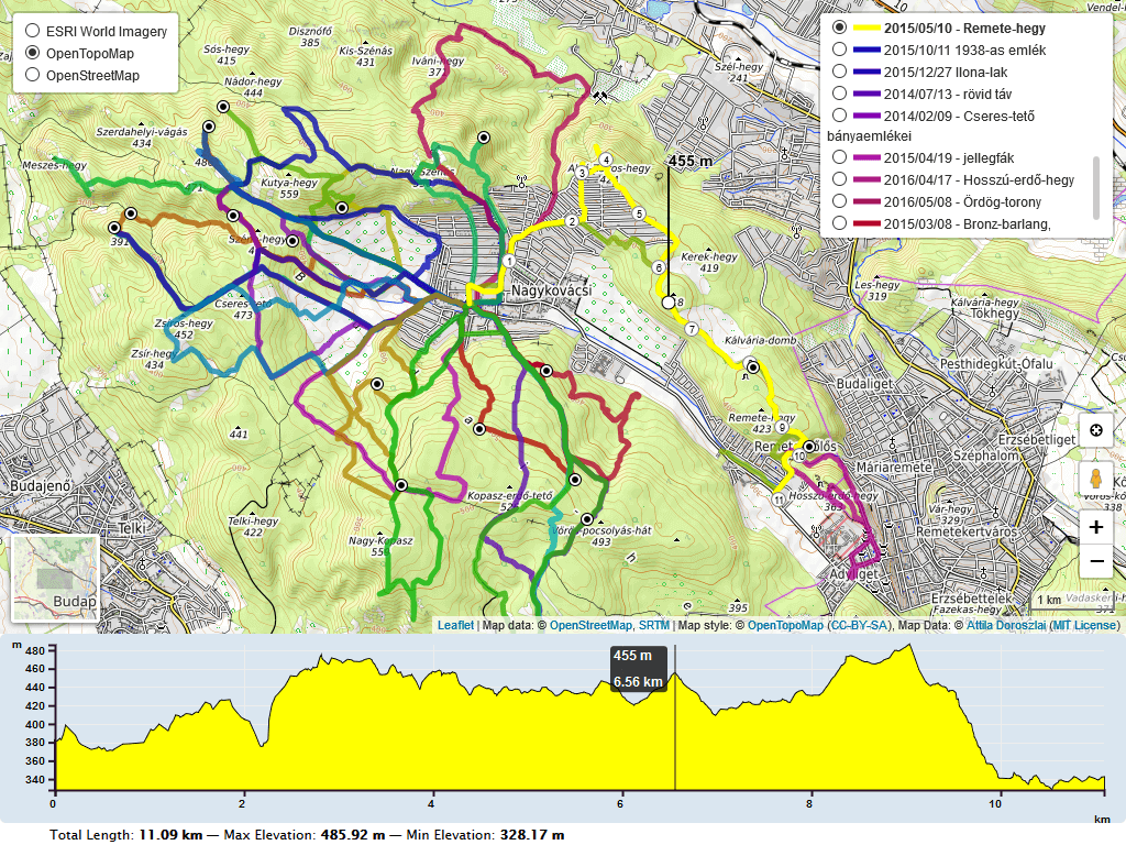
A Leaflet plugin that allows to add elevation profiles using d3js
---
_For a working example see one of the following demos:_
- [loading .gpx file](https://raruto.github.io/leaflet-elevation/examples/leaflet-elevation.html)
- [loading .geojson file](https://raruto.github.io/leaflet-elevation/examples/leaflet-elevation_geojson-data.html)
- [loading .kml file](https://raruto.github.io/leaflet-elevation/examples/leaflet-elevation_kml-data.html)
- [loading .tcx file](https://raruto.github.io/leaflet-elevation/examples/leaflet-elevation_tcx-data.html)
- [loading a local .gpx file](https://raruto.github.io/leaflet-elevation/examples/leaflet-elevation_upload-gpx.html)
- [loading data from a textarea](https://raruto.github.io/leaflet-elevation/examples/leaflet-elevation_string-data.html)
- [loading individual .geojson tracks](https://raruto.github.io/leaflet-elevation/examples/leaflet-elevation_geojson-group.html)
- [loading individual .gpx tracks](https://raruto.github.io/leaflet-elevation/examples/leaflet-elevation_toggable-tracks.html)
- [loading multiple .gpx tracks (hover to toggle)](https://raruto.github.io/leaflet-elevation/examples/leaflet-elevation_hoverable-tracks.html)
- [loading multiple .gpx tracks (click to toggle)](https://raruto.github.io/leaflet-elevation/examples/leaflet-elevation_toggable-charts.html)
- [loading multiple maps](https://raruto.github.io/leaflet-elevation/examples/leaflet-elevation_multiple-maps.html)
- [stacking multiple charts (elevation, slope, speed)](https://raruto.github.io/leaflet-elevation/examples/leaflet-elevation_multiple-charts.html)
- [translating plugin labels](https://raruto.github.io/leaflet-elevation/examples/leaflet-elevation_i18n-strings.html)
- [rotating chart labels](https://raruto.github.io/leaflet-elevation/examples/leaflet-elevation_chart_labels.html)
- [using custom colors](https://raruto.github.io/leaflet-elevation/examples/leaflet-elevation_custom-theme.html)
- [using .gpx extensions (cadence, heart, pace)](https://raruto.github.io/leaflet-elevation/examples/leaflet-elevation_extended-ui.html)
- [using .gpx waypoint icons](https://raruto.github.io/leaflet-elevation/examples/leaflet-elevation_gpx-waypoints.html)
- [using .geojson waypoint icons](https://raruto.github.io/leaflet-elevation/examples/leaflet-elevation_geojson-waypoints.html)
- [autohide map](https://raruto.github.io/leaflet-elevation/examples/leaflet-elevation_hidden-map.html)
- [autohide chart](https://raruto.github.io/leaflet-elevation/examples/leaflet-elevation_hidden-chart.html)
- [clear button](https://raruto.github.io/leaflet-elevation/examples/leaflet-elevation_clear-button.html)
- [collapsible button](https://raruto.github.io/leaflet-elevation/examples/leaflet-elevation_close-button.html)
- [custom summary](https://raruto.github.io/leaflet-elevation/examples/leaflet-elevation_custom-summary.html)
- [edge scale control](https://raruto.github.io/leaflet-elevation/examples/leaflet-elevation_edge-scale.html)
- [follow marker](https://raruto.github.io/leaflet-elevation/examples/leaflet-elevation_follow-marker.html)
- [layer almostover](https://raruto.github.io/leaflet-elevation/examples/leaflet-elevation_almost-over.html)
- [linear gradient](https://raruto.github.io/leaflet-elevation/examples/leaflet-elevation_linear-gradient.html)
- [slope chart](https://raruto.github.io/leaflet-elevation/examples/leaflet-elevation_slope-chart.html)
- [speed chart](https://raruto.github.io/leaflet-elevation/examples/leaflet-elevation_speed-chart.html)
- [temperature chart](https://raruto.github.io/leaflet-elevation/examples/leaflet-elevation_temperature-chart.html)
- [bathymetry data](https://raruto.github.io/leaflet-elevation/examples/leaflet-elevation_bathymetry.html)
- [walking marker](https://raruto.github.io/leaflet-elevation/examples/leaflet-elevation_dynamic-runner.html)
---
Initially based on the work of Felix “MrMufflon” Bache
---
## How to use
1. **include CSS & JavaScript**
```html
...
...
```
2. **choose the div container used for the slippy map**
```html
...
...
```
3. **create your first simple “leaflet-elevation” slippy map**
```html
```
### Build Guide
Within your local development environment:
```shell
git clone git@github.com:Raruto/leaflet-elevation.git
cd ./leaflet-elevation
npm i # install dependencies
npm run dev # start dev server at: http://localhost:8080
npm run build # generate "dist" files (once)
npm run test # test all "*.spec.js" files (once)
```
After that you can start developing inside the `src` and `test` folders (eg. open "http://localhost:8080/test" in your browser to preview changes). Check also [CONTRIBUTING.md](.github/CONTRIBUTING.md) file for some information about it.
### FAQ
1. How can I change the color of the elevation plot?
There are multiple options to achieve this:
* You could either use some default presets (see: theme: "lightblue-theme" option in readme file and the following file `leaflet-elevation.css` for some other default "*-theme" names).
* check out [this example](https://raruto.github.io/leaflet-elevation/examples/leaflet-elevation_custom-theme.html)
* Or add the following lines for custom colors.
```css
.elevation-control .area {
fill: red;
}
.elevation-control .background {
background-color: white;
```
2. How to enable/disable the leaflet user interface customizations?
These customizations are actually part of the [leaflet-ui](https://github.com/Raruto/leaflet-ui) and can be toggled on/off using e.g. the following options:
```js
var map = L.map('map', {
center: [41.4583, 12.7059], // needs value to initialize
zoom: 5, // needs value to initialize
mapTypeId: 'topo',
mapTypeIds: ['osm', 'terrain', 'satellite', 'topo'],
gestureHandling: false, // zoom with Cmd + Scroll
zoomControl: true, // plus minus buttons
pegmanControl: false,
locateControl: false,
fullscreenControl: true,
layersControl: true,
minimapControl: false,
editInOSMControl: false,
loadingControl: false,
searchControl: false,
disableDefaultUI: false,
printControl: false,
});
```
3. How can I import this library as ES module?
Usually, when working with a js bundler like [Vite](https://vitest.dev/) or [Webpack](https://webpack.js.org/), you need to provide to this library the full path to some dynamically imported files from the [`srcFolder`](./src/):
```js
import './your-custom-style.css';
import 'leaflet/dist/leaflet.css';
import L from 'leaflet';
import '@raruto/leaflet-elevation/src/index.js';
import '@raruto/leaflet-elevation/src/index.css';
const map = L.map('map', {
center: [41.4583, 12.7059]
zoom: 5,
});
const controlElevation = L.control.elevation({
// CHANGE ME: with your own http server folder (eg. "http://custom-server/public/path/to/leaflet-elevation/src/")
srcFolder: 'http://unpkg.com/@raruto/leaflet-elevation/src/'
}).addTo(map);
// Load track from url (allowed data types: "*.geojson", "*.gpx", "*.tcx")
controlElevation.load("https://raruto.github.io/leaflet-elevation/examples/via-emilia.gpx");
```
4. Some real world projects based on this plugin?
- https://parcours.scasb.org/
- https://velocat.ru/velo/phpBB3/map.php
- https://plugins.qgis.org/plugins/track_profile_2_web/
- https://wordpress.org/plugins/os-datahub-maps/
- https://wordpress.org/plugins/extensions-leaflet-map/
- https://github.com/der-stefan/OpenTopoMap
- https://gpx.n-peloton.fr/
- https://walkaholic.me/map
_Related: [Leaflet-UI presets](https://github.com/raruto/leaflet-ui), [QGIS Integration](https://github.com/faunalia/trackprofile2web)_
### Changelog
All notable changes to this project are documented in the [releases](https://github.com/Raruto/leaflet-elevation/releases) page.
---
**Compatibile with:**
[](http://leafletjs.com/reference.html)
[](https://www.npmjs.com/package/d3)
[](https://www.npmjs.com/package/@tmcw/togeojson)
---
**Contributors:** [MrMufflon](https://github.com/MrMufflon/Leaflet.Elevation), [HostedDinner](https://github.com/HostedDinner/Leaflet.Elevation), [ADoroszlai](http://ADoroszlai.github.io/joebed/), [Raruto](https://github.com/Raruto/leaflet-elevation)
---
**License:** GPL-3.0+