# GemGIS - Spatial data and information processing for geomodeling and subsurface data
 [](https://www.python.org/downloads/)



[](https://www.repostatus.org/#active)

[](https://doi.org/10.21105/joss.03709)
[](https://www.python.org/downloads/)



[](https://www.repostatus.org/#active)

[](https://doi.org/10.21105/joss.03709)
## Overview
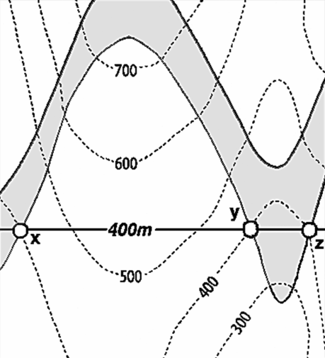
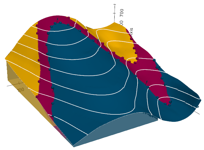
We attempt to simplify the access to open-source spatial data processing for geological modeling and for subsurface data (wells, seismic, etc.) with the development of **GemGIS, a Python-based open-source library**.
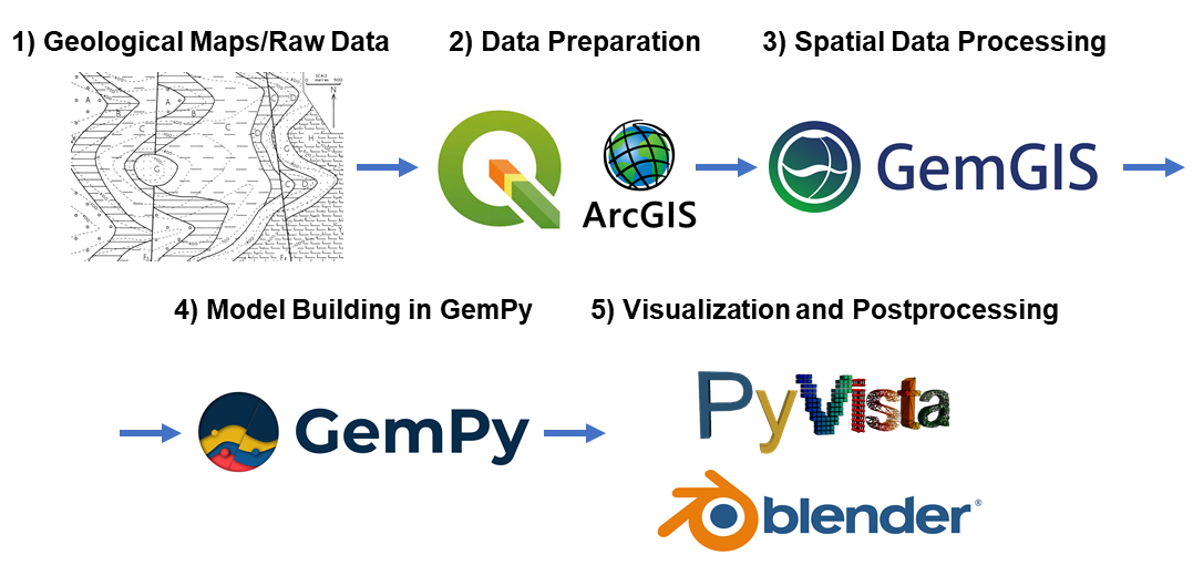
GemGIS wraps and extends the functionality of packages known to the geo-community such as [GeoPandas](https://geopandas.org/), [rasterio](https://rasterio.readthedocs.io/en/latest/#), [OWSLib](https://geopython.github.io/OWSLib/), [Shapely](https://shapely.readthedocs.io/en/latest/manual.html), [PyVista](https://docs.pyvista.org/), [Pandas](https://pandas.pydata.org/), [NumPy](https://numpy.org/) and the geomodeling package [GemPy](https://docs.gempy.org/). GemGIS works with the latest release of Gempy (2025.2.0).
The aim of GemGIS, as indicated by the name, is to become a bridge between conventional geoinformation systems (GIS) such as ArcGIS and QGIS, and geomodeling tools such as GemPy, allowing simpler and more automated workflows from one environment to the other. This also includes making it simpler to visualize the results obtained from GemGIS and GemPy with PyVista or Blender. Further, subsurface data processing workflows are implemented for integrated data analyses.
 ## Resources
[Find the documentation of GemGIS here](https://gemgis.readthedocs.io/en/latest/index.html). It includes introductions to the main libraries used and to introductory topics like "What is vector data?" or "What is raster data?".
In addition, [tutorial notebooks](https://gemgis.readthedocs.io/en/latest/getting_started/tutorial/index.html) provide an overview of the different features of GemGIS. The notebooks can also be downloaded directly from [here](https://rwth-aachen.sciebo.de/s/AfXRsZywYDbUF34/download?path=%2F&files=tutorials01_53.zip).
Furthermore, many [example models](https://gemgis.readthedocs.io/en/latest/getting_started/example/index.html) showcase a variety of geological structures that can be modeled with GemGIS and GemPy. The [API Reference](https://gemgis.readthedocs.io/en/latest/getting_started/api.html#) provides an overview of the implemented functions in GemGIS and how to use them.
## Installation
It is recommended to use GemGIS with **python">=3.11"** in a separated environment. The main packages and its dependencies can be installed via the conda-forge channel. GemGIS is then available through PyPi or Conda.
1) `conda install -c conda-forge geopandas">=1.1.1" rasterio">=1.4.3"`
2) `conda install -c conda-forge pyvista">=0.46.3"`
3) `pip install gemgis` / `conda install -c conda-forge gemgis`
Check out the [Installation Page](https://gemgis.readthedocs.io/en/latest/getting_started/installation.html) for more detailed instructions.
If you are an open-source software developer, please install **GemGIS** and its dependencies, also for building the documentation, using the [development YML file](https://github.com/cgre-aachen/gemgis/blob/main/environment_dev.yml).
## Contribution Guidelines
The Contribution Guidelines for GemGIS can be found here: [Contribution Guidelines](https://github.com/cgre-aachen/gemgis/blob/main/CONTRIBUTING.md)
We welcome issue reports, questions, ideas for new features and pull-requests to fix issues or even add new features to the software. Once a pull-request is opened, we will guide through the review process.
## Citation
If you use GemGIS for any published work, please cite it using the reference below:
Jüstel, A., Endlein Correira, A., Pischke, M., de la Varga, M., Wellmann, F.: GemGIS - Spatial Data Processing for Geomodeling. Journal of Open Source Software, 7(73), 3709, https://doi.org/10.21105/joss.03709, 2022.
```
@article{Jüstel2022,
doi = {10.21105/joss.03709},
url = {https://doi.org/10.21105/joss.03709},
year = {2022},
publisher = {The Open Journal},
volume = {7},
number = {73},
pages = {3709},
author = {Alexander Jüstel and Arthur Endlein Correira and Marius Pischke and Miguel de la Varga and Florian Wellmann},
title = {GemGIS - Spatial Data Processing for Geomodeling},
journal = {Journal of Open Source Software}
}
```
## References and published articles utilizing GemGIS
* Jüstel, A. et al.: 3D structural and probabilistic modelling of geothermal reservoir horizons in the Northern Eifel and its foreland. Zeitschrift der Deutschen Gesellschaft für Geowissenschaften, 176 (1), 115-146, https://doi.org/10.1127/zdgg/2025/0436, 2025
* Marquetto, L. et al.: Developing a 3D hydrostratigraphical model of the emerged part of the Pelotas Basin along the northern coast of Rio Grande do Sul state, Brazil. Environmental Earth Sciences, 83, 10, 329, https://doi.org/10.1007/s12665-024-11609-y, 2024
* Jüstel, A. et al.: From Maps to Models - Tutorials for structural geological modeling using GemPy and GemGIS. Journal of Open Source Education, 6(66), 185, https://doi.org/10.21105/jose.00185, 2023.
* Jüstel, A. et al.: GemGIS - Spatial Data Processing for Geomodeling. Journal of Open Source Software, 7(73), 3709, https://doi.org/10.21105/joss.03709, 2022.
* Jüstel, A., Endlein Correira, A., Wellmann, F. and Pischke, M.: GemGIS – GemPy Geographic: Open-Source Spatial Data Processing for Geological Modeling. EGU General Assembly 2021, https://doi.org/10.5194/egusphere-egu21-4613, 2021.
* Jüstel, A.: 3D Probabilistic Modeling and Data Analysis of the Aachen-Weisweiler Area: Implications for Deep Geothermal Energy Exploration, unpublished Master Thesis at RWTH Aachen University, 2020.
* de la Varga, M., Schaaf, A., and Wellmann, F.: GemPy 1.0: open-source stochastic geological modeling and inversion, Geosci. Model Dev., 12, 1-32, https://doi.org/10.5194/gmd-12-1-2019, 2019.
* Powell, D.: Interpretation of Geological Structures Through Maps: An Introductory Practical Manual, Longman, pp. 192, 1992.
* Bennison, G.M.: An Introduction to Geological Structures and Maps, Hodder Education Publication, pp. 78, 1990.
## Resources
[Find the documentation of GemGIS here](https://gemgis.readthedocs.io/en/latest/index.html). It includes introductions to the main libraries used and to introductory topics like "What is vector data?" or "What is raster data?".
In addition, [tutorial notebooks](https://gemgis.readthedocs.io/en/latest/getting_started/tutorial/index.html) provide an overview of the different features of GemGIS. The notebooks can also be downloaded directly from [here](https://rwth-aachen.sciebo.de/s/AfXRsZywYDbUF34/download?path=%2F&files=tutorials01_53.zip).
Furthermore, many [example models](https://gemgis.readthedocs.io/en/latest/getting_started/example/index.html) showcase a variety of geological structures that can be modeled with GemGIS and GemPy. The [API Reference](https://gemgis.readthedocs.io/en/latest/getting_started/api.html#) provides an overview of the implemented functions in GemGIS and how to use them.
## Installation
It is recommended to use GemGIS with **python">=3.11"** in a separated environment. The main packages and its dependencies can be installed via the conda-forge channel. GemGIS is then available through PyPi or Conda.
1) `conda install -c conda-forge geopandas">=1.1.1" rasterio">=1.4.3"`
2) `conda install -c conda-forge pyvista">=0.46.3"`
3) `pip install gemgis` / `conda install -c conda-forge gemgis`
Check out the [Installation Page](https://gemgis.readthedocs.io/en/latest/getting_started/installation.html) for more detailed instructions.
If you are an open-source software developer, please install **GemGIS** and its dependencies, also for building the documentation, using the [development YML file](https://github.com/cgre-aachen/gemgis/blob/main/environment_dev.yml).
## Contribution Guidelines
The Contribution Guidelines for GemGIS can be found here: [Contribution Guidelines](https://github.com/cgre-aachen/gemgis/blob/main/CONTRIBUTING.md)
We welcome issue reports, questions, ideas for new features and pull-requests to fix issues or even add new features to the software. Once a pull-request is opened, we will guide through the review process.
## Citation
If you use GemGIS for any published work, please cite it using the reference below:
Jüstel, A., Endlein Correira, A., Pischke, M., de la Varga, M., Wellmann, F.: GemGIS - Spatial Data Processing for Geomodeling. Journal of Open Source Software, 7(73), 3709, https://doi.org/10.21105/joss.03709, 2022.
```
@article{Jüstel2022,
doi = {10.21105/joss.03709},
url = {https://doi.org/10.21105/joss.03709},
year = {2022},
publisher = {The Open Journal},
volume = {7},
number = {73},
pages = {3709},
author = {Alexander Jüstel and Arthur Endlein Correira and Marius Pischke and Miguel de la Varga and Florian Wellmann},
title = {GemGIS - Spatial Data Processing for Geomodeling},
journal = {Journal of Open Source Software}
}
```
## References and published articles utilizing GemGIS
* Jüstel, A. et al.: 3D structural and probabilistic modelling of geothermal reservoir horizons in the Northern Eifel and its foreland. Zeitschrift der Deutschen Gesellschaft für Geowissenschaften, 176 (1), 115-146, https://doi.org/10.1127/zdgg/2025/0436, 2025
* Marquetto, L. et al.: Developing a 3D hydrostratigraphical model of the emerged part of the Pelotas Basin along the northern coast of Rio Grande do Sul state, Brazil. Environmental Earth Sciences, 83, 10, 329, https://doi.org/10.1007/s12665-024-11609-y, 2024
* Jüstel, A. et al.: From Maps to Models - Tutorials for structural geological modeling using GemPy and GemGIS. Journal of Open Source Education, 6(66), 185, https://doi.org/10.21105/jose.00185, 2023.
* Jüstel, A. et al.: GemGIS - Spatial Data Processing for Geomodeling. Journal of Open Source Software, 7(73), 3709, https://doi.org/10.21105/joss.03709, 2022.
* Jüstel, A., Endlein Correira, A., Wellmann, F. and Pischke, M.: GemGIS – GemPy Geographic: Open-Source Spatial Data Processing for Geological Modeling. EGU General Assembly 2021, https://doi.org/10.5194/egusphere-egu21-4613, 2021.
* Jüstel, A.: 3D Probabilistic Modeling and Data Analysis of the Aachen-Weisweiler Area: Implications for Deep Geothermal Energy Exploration, unpublished Master Thesis at RWTH Aachen University, 2020.
* de la Varga, M., Schaaf, A., and Wellmann, F.: GemPy 1.0: open-source stochastic geological modeling and inversion, Geosci. Model Dev., 12, 1-32, https://doi.org/10.5194/gmd-12-1-2019, 2019.
* Powell, D.: Interpretation of Geological Structures Through Maps: An Introductory Practical Manual, Longman, pp. 192, 1992.
* Bennison, G.M.: An Introduction to Geological Structures and Maps, Hodder Education Publication, pp. 78, 1990.