# [PouchDB Geospatial][pouchdb-geospatial-github]
[](https://github.com/dpmcmlxxvi/pouchdb-geospatial/actions)
[](https://coveralls.io/r/dpmcmlxxvi/pouchdb-geospatial?branch=master)
[](https://badge.fury.io/js/pouchdb-geospatial)
[](https://www.codacy.com/gh/dpmcmlxxvi/pouchdb-geospatial/dashboard?utm_source=github.com&utm_medium=referral&utm_content=dpmcmlxxvi/pouchdb-geospatial&utm_campaign=Badge_Grade)
The [PouchDB][pouchdb-site] Geospatial plugin provides spatial querying of
[GeoJSON][geojson-site] objects. GeoJSON objects within a PouchDB database
can be queried against an input GeoJSON object to test if they satisfy one
of the [DE-9IM][de9im-wiki] spatial predicates: `contains`, `coveredby`,
`covers`, `crosses`, `disjoint`, `equals`, `intersects`, `overlaps`,
`touches`, `within`.
Any GeoJSON object inserted into the
database via the the plugin API is spatially indexed using an
[R-Tree][rtree-wiki]. Spatial queries are then processed by querying the R-Tree
for candidate geometries and the final query results are returned after the
candidates are filtered by the appropriate spatial predicate. The spatial
indexing is performed by [RBush][rbush-github] and geospatial predicates
are computed with [de9im][de9im-github].
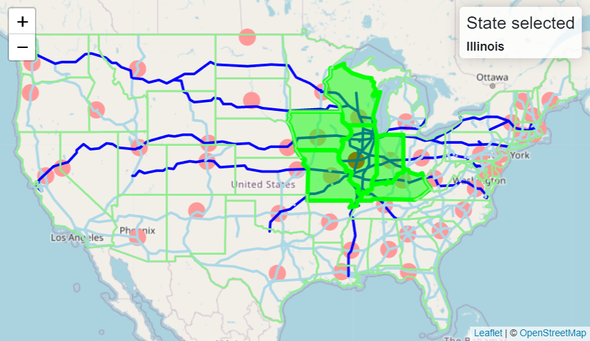
A sample of how to use the plugin is available at the
[examples page][pouchdb-geospatial-examples]. The API is described below and at
the [documentation page][pouchdb-geospatial-api].
## USAGE
### In browser
To use this plugin, include it after `pouchdb.js` in your HTML page. This plugin
has two dependencies not bundled with it that must be included
[Turf][turf-github] and [de9im][de9im-github].
```html
```
### In Node
To use it in Node, install it
```shell
npm install pouchdb-geospatial
```
then attach it to the `PouchDB` object:
```javascript
import PouchDB from 'pouchdb';
import PouchDBGeospatial from 'pouchdb-geospatial';
PouchDB.plugin(PouchDBGeospatial);
```
### Create database
The plugin methods are exposed via an object API. All methods return promises.
```javascript
const db = new PouchDB('dbname');
const api = db.geospatial();
```
## API
### Database methods
The database methods accept the same options and return a promise with the same
response returned by their corresponding `PouchDB` methods: `put`, `post`,
`bulkDocs`, and `remove`.
```javascript
api.add(geojson, options);
api.load([geojson, ...], options);
api.remove(id);
```
### Indexing methods
The underlying R-Tree can be accessed using the `tree` attribute. It returns
an `GeospatialTree` which allows a user to directly use it's methods to `add`,
`load`, `remove`, and `query` the tree. However, care should be used when
modifying the tree directly since the tree and database can become out-of-sync.
The primary use of directly accessing the tree is to reload data from disk after
a page reload or application restart. Otherwise, it is preferable to directly
use the database methods to add data.
```javascript
api.tree.add(geojson, id);
api.tree.load([{id, geojson}, ...]);
api.tree.remove({id, geojson});
api.tree.query(geojson);
```
### Query methods
The query methods accept a GeoJSON and return a promise with an array of
database document IDs that satisfy the spatial predicate. For example,
```javascript
api.contains(geojson).then((ids) => {
// Do something with document ids.
});
```
The following spatial predicates are available:
```javascript
contains
coveredby
covers
crosses
disjoint
equals
intersects
overlaps
touches
within
```
Each predicate takes one GeoJSON argument. The predicate should be interpreted
as the database GeoJSON operating on the argument GeoJSON. For example,
```javascript
api.within(polygon)
```
should be read as
```shell
any database GeoJSON within polygon?
```
## BUILD
To build and test the library locally:
```shell
npm install
npm test
```
After installation, the bundled plugin is at `pouchdb-geospatial.min.js`.
## LICENSE
Copyright (c) 2019 Daniel Pulido
Source code is released under the [Apache 2.0 license](http://www.apache.org/licenses/LICENSE-2.0)
[de9im-github]: https://github.com/dpmcmlxxvi/de9im
[de9im-wiki]: https://en.wikipedia.org/wiki/DE-9IM
[geojson-site]: http://geojson.org
[pouchdb-site]: https://pouchdb.com
[pouchdb-geospatial-api]: http://dpmcmlxxvi.github.io/pouchdb-geospatial/api
[pouchdb-geospatial-examples]: http://dpmcmlxxvi.github.io/pouchdb-geospatial/examples
[pouchdb-geospatial-github]: https://github.com/dpmcmlxxvi/pouchdb-geospatial
[rbush-github]: https://github.com/mourner/rbush
[rtree-wiki]: https://en.wikipedia.org/wiki/R-tree
[turf-github]: https://github.com/Turfjs/turf