AgriFM: A Multi-source Temporal Remote Sensing Foundation Model for Agriculture Mapping
[](LICENSE)
## Introduction
This repository is the code implementation of the paper
[AgriFM: A Multi-source Temporal Remote Sensing Foundation Model for Agriculture Mapping](https://www.sciencedirect.com/science/article/pii/S0034425726000040).
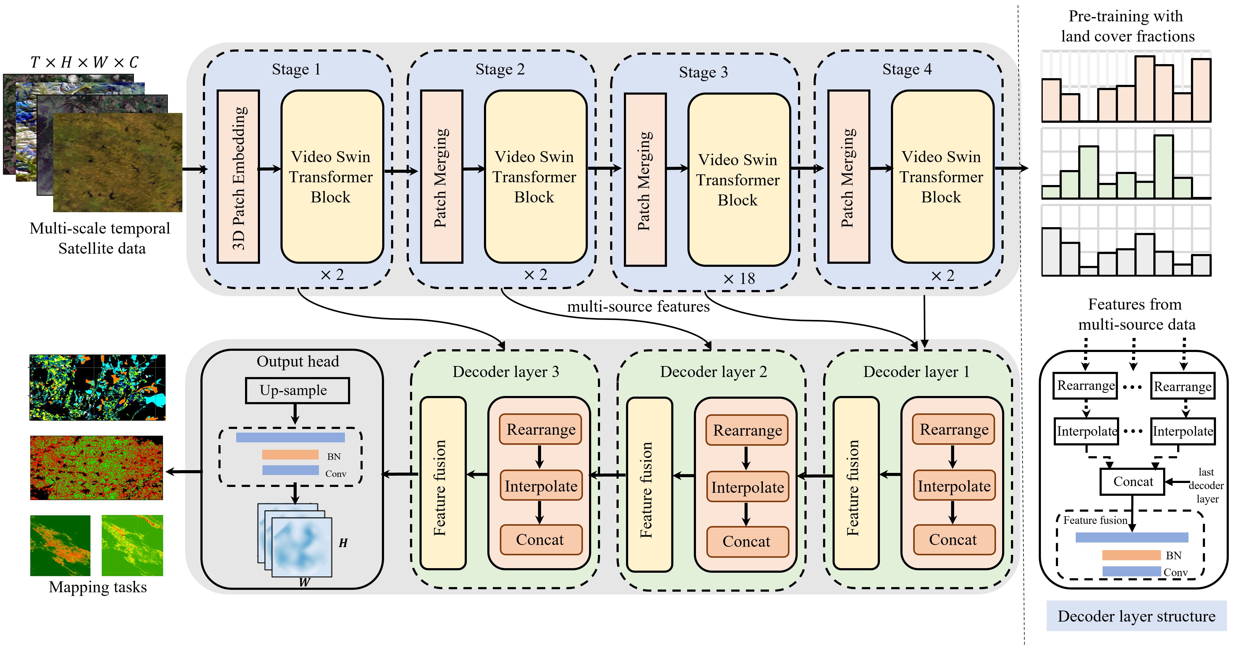
AgriFM is a multi-source temporal remote sensing foundation model
specifically designed for agricultural Agriculture mapping.
Our approach begins by establishing the necessity of simultaneous
hierarchical spatiotemporal feature extraction, leading to the
development of a modified Video Swin Transformer architecture
where temporal down-sampling is synchronized with spatial down-sampling
operations. This modified backbone enables efficient unified processing
of long time-series satellite inputs while preserving critical multi-scale
spatial patterns and phenological dynamics. AgriFM leverages temporally
rich data streams from three satellite sources including MODIS, Landsat-8/9
and Sentinel-2, and is pre-trained on a global representative dataset
comprising over 25 million image samples supervised by land cover products.
The resulting framework incorporates a versatile decoder architecture
that dynamically fuses these learned spatiotemporal representations,
supporting diverse downstream tasks including cropland mapping,
field-boundary delineation, early-season crop mapping, and
specific crop mapping (e.g., winter wheat and paddy rice)
with difference data sources.
## Table of Contents
- [Introduction](#Introduction)
- [Table of Contents](#Table-of-Contents)
- [Installation](#Installation)
- [Dataset Preparation](#Dataset-Preparation)
- [Model Usage](#Model-Training)
- [Citation](#Citation)
- [License](#License)
- [Contact](#Contact)
## Installation
### Dependencies
- Linux or Windows
- Python 3.9+, recommended 3.9.18
- PyTorch 2.0 or higher, recommended 2.1
- CUDA 11.7 or higher, recommended 12.1
- MMCV 2.0 or higher, recommended 2.1.0
### Environment Installation
We recommend using Miniconda for installation. The following command will create a virtual environment named `AgriFM` and install PyTorch,GDAL and other libraries.
Note: If you have experience with Conda, pytorch and have already installed them, you can skip to the next section. Otherwise, you can follow these steps to prepare.
**Step 0**: Install [Miniconda](https://docs.conda.io/projects/miniconda/en/latest/index.html).
Then you can quickly create environment by running the following command in your terminal:
```shell
conda env create -f environment.yml
```
If it does not work, you can manually install the dependencies by following the steps below.
**Step 1**: Create a virtual environment named `AgriFM` and activate it.
```shell
conda create -n AgriFM python=3.9 -y
[conda] activate AgriFM
```
**Step 2**: Install [PyTorch](https://pytorch.org/get-started/locally/).
```shell
conda install pytorch==2.1.1 torchvision==0.16.1 torchaudio==2.1.1 pytorch-cuda=12.1 -c pytorch -c nvidia
```
**Step 3**: Install [MMCV](https://mmcv.readthedocs.io/en/latest/get_started/installation.html).
```shell
pip install -U openmim
mim install "mmcv==2.1.0"
```
**Step 4**: Install other dependencies.
```shell
pip install ftfy tqdm regex h5py prettytable timm scipy einops numpy==1.26.2
```
## Dataset Preparation
### Data Download and Example Data
You can download the dataset from [OneDrive](https://hkuhk-my.sharepoint.com/:u:/g/personal/liwayne_hku_hk/ESVBYsFqQB5Nscyox2wMxnUB5LYD1oszKBt-VCh-xGE0tQ?e=UTgfvM) or [GLASS Website](https://glass.hku.hk/casual/AgriFM/).
The dataset includes example data for quick start,
formatted as H5 files that follow a unified multi-source remote sensing data structure.
### Dataset Structure
The example dataset is organized as follows:
```
example_dataset/
├── data_lists/ # Text files listing sample filenames (one per line)
│ ├── train.txt # Training set samples (e.g., sample_001, sample_002)
│ └── val.txt # Validation set samples
│ └── test.txt # Validation set samples
└── h5_samples/ # Directory storing H5 format samples
├── 2018_T31TDK_2560_2304.h5 # Single sample file (contains multi-source data and labels)
├── 2018_T31TDK_2816_0768.h5
└── ...
```
Each H5 file contains multi-source remote sensing data and labels, structured as follows:
```
h5_file.h5
├── [Source1] # Customizable data source name (e.g., S2, Landsat, Modis and etc.)
│ shape: (T, C, H, W)
│ - T: Number of time steps (T=1 for single-temporal data)
│ - C: Number of bands
│ - H/W: Image height/width
├── [Source2] # Customizable data source name (e.g., S2, Landsat, Modis and etc.)
└── label # Mandatory label
shape: (H, W)
- Type: Integer (pixel-level classification labels)
```
For example, a Sentinel-2 sample with 10 bands and 256x256 pixles is provided.
It can be loaded and processing using our provided dataset [MappingDataset](AgriFM/datasets/mapping_dataset.py) class,
which handles multi-source data and labels.
### Custom Dataset Preparation
If you want to use your own dataset, you can implement a custom dataset class by inheriting from the `MappingDataset` class.
You need to ensure that the outputs of the dataset class follow the same structure as the example dataset:
1. A dictionary containing multi-source data (each value is a tensor of shape [T, C, H, W])
2. A label tensor
```
# Output example
{
"data": {
"source1": torch.Tensor(T, C, H, W), # Multi-source data dictionary
"source2": torch.Tensor(T, C, H, W)
},
"label": torch.LongTensor(H, W), # Label (long integer type)
"file_name": str # Optional: Sample filename for debugging
}
```
**Notes: source names in the data dictionary should be consistent with the names used in the model configuration.**
## Model Training
The pretrained AgriFM weights can be downloaded from [OneDrive](https://hkuhk-my.sharepoint.com/:u:/g/personal/liwayne_hku_hk/IQBmnMhsLRy6QabkuxMmJi8lAZigBqnMkaQuefCLR_AGzt4?e=MyKeCK) or [GLASS Website](https://glass.hku.hk/casual/AgriFM/).
### Model Architecture
The AgriFM model consists of three main components:
1. **Multi-modal Encoder**: Processes different remote sensing data sources
2. **Fusion Neck**: Combines features from different modalities
3. **Prediction Head**: Generates final crop classification maps
#### Configuration Details
The model configuration is defined as follows (in [cropland_config](configs/cropland_mapping.py)).
### Key Parameters Explanation
#### Encoder Configuration
| Parameter | Description | Example Value |
|-----------|-------------|---------------|
| `patch_size` | Spatiotemporal patch size | (4,2,2) |
| `in_chans` | Input channels per timestep | 10 (for Sentinel-2) |
| `depths` | Number of transformer blocks per stage | [2, 2, 18, 2] |
| `num_heads` | Attention heads per stage | [4, 8, 16, 32] |
| `window_size` | Local attention window size | (8,7,7) |
#### Fusion Neck Configuration
| Parameter | Description | Example Value |
|-----------|-------------|---------------|
| `embed_dim` | Feature dimension | 1024 |
| `in_feature_key` | Input modality keys | ('S2',) |
| `feature_size` | Input feature map size | (img_size//16, img_size//16) |
| `out_size` | Output map size | (img_size, img_size) |
#### Head Configuration
| Parameter | Description | Example Value |
|-----------|-------------|---------------|
| `num_classes` | Number of crop classes | Varies by dataset |
| `loss_model` | Loss function type | "CropCEloss" |
### Training Command
To train the model using the provided configuration:
```shell
python train.py configs/cropland_mapping.py --work_dir ./work_dirs/cropland_mapping
```
This command will start training the model with the specified configuration file and save the results in the `work_dirs/cropland_mapping` directory.
### Training Tips
1. The default configuration uses Sentinel-2 data ('S2' key) - add additional encoders for other data sources
### Test and Validation
To evaluate the model, you can use the following command:
```shell
python test.py configs/cropland_mapping.py work_dirs/cropland_mapping/best_mFscores_xx.pth
```
To get the visualization results, you can use the following command:
```shell
python inference.py configs/cropland_mapping.py work_dirs/cropland_mapping/best_mFscores_xx.pth path/to/your/visualization_output
```
## Citation
If you use the code or performance benchmarks of this project in your research, please refer to the bibtex below to cite.
```
@article{li2026agrifm,
title={AgriFM: A multi-source temporal remote sensing foundation model for Agriculture mapping},
author={Li, Wenyuan and Liang, Shunlin and Chen, Keyan and Chen, Yongzhe and Ma, Han and Xu, Jianglei and Ma, Yichuan and Zhang, Yuxiang and Guan, Shikang and Fang, Husheng and others},
journal={Remote Sensing of Environment},
volume={334},
pages={115234},
year={2026},
publisher={Elsevier}
}
```
## License
This project is licensed under the [Apache 2.0 license](LICENSE).
## Acknowledgements
This project is built upon [OpenMMLab](https://openmmlab.com/). We thank the OpenMMLab developers.
Our model is built upon [Video Swin Transformer](https://github.com/SwinTransformer/Video-Swin-Transformer).
## Contact
If you have any other questions or suggestions, please contact Wenyuan Li ([liwayne@hku.hk](mailto:liwayne@hku.hk)).