Manhattan's buildings at their surveyed roof heights, colored by construction era, with the subway network. Browse the demo's maps.
GeoLens is for teams whose spatial data is spread across file shares, PostGIS databases, web
services and STAC catalogs. It puts that data in one searchable catalog, records where each
dataset came from and checks whether the source is still current. Teams build and share maps in
the browser, and QGIS, scripts and AI agents read the same data through OGC API and STAC. It runs
on your own servers with Docker Compose, sends no telemetry and is licensed under Apache 2.0.
The [demo](https://demo.getgeolens.com) needs no install or account; sign in with Google, GitHub
or Microsoft to use the map builder. Demo data may be wiped at any time.
## A closer look
Search by meaning: "where storms hit the coast" finds hurricane tracks and coastal exposure layers.
Each dataset has a page with its metadata and source, plus a map preview when it has an extent.
Before you import a service layer, GeoLens previews its columns and first rows.
Each replacement is recorded in the history, and you can restore the previous version.
Layers render as points, symbols, heatmaps or clusters, and the ramp list can be limited to colorblind-safe ones.
3D terrain from your own elevation data, here the Matterhorn from swissALTI3D lidar.
Sentinel-2 scenes referenced from a STAC catalog. The imagery stays where it is and is tiled on request.
Keep a map to yourself, open it to your team, or make it public with a link and embed code.
The admin overview shows service health next to dataset and storage totals.
Viewer, editor and admin roles, with each capability switched on or off per role.
## How it fits together
```mermaid
flowchart LR
subgraph IN ["Bring data in"]
F["Files GeoPackage · Shapefile · GeoParquet GeoTIFF · COPC · 3D Tiles"]
DB["Existing PostGIS tables"]
SVC["Services ArcGIS · WFS · OGC API Features"]
ST["Remote STAC assets"]
end
subgraph GL ["GeoLens"]
CAT["Catalog search · metadata · provenance"]
MB["Map builder styles · 3D · analysis · sharing"]
STD["Open APIs OGC API · STAC · DCAT · tiles"]
end
subgraph OUT ["Use it anywhere"]
WEB["Browsers and embeds"]
GIS["QGIS · ArcGIS · CesiumJS"]
CODE["curl · Python · TypeScript · DuckDB"]
AG["AI agents via MCP"]
end
F & DB & SVC & ST --> CAT
CAT --> MB --> WEB
CAT --> STD --> GIS & CODE & AG
```
## One catalog for scattered data
- Upload Shapefile, GeoPackage, GeoJSON, GeoParquet, FlatGeobuf, KML/KMZ, zipped File
Geodatabase, CSV, Excel or GeoTIFF (converted to Cloud-Optimized GeoTIFF). 3D Tiles and COPC
point clouds are hosted for CesiumJS, QGIS and Potree.
- Serve tables already in GeoLens's PostGIS database in place, import WFS, ArcGIS and OGC API
Features layers and refresh them on demand, or reference remote STAC assets without copying
them.
- Draw new datasets in the browser.
- Find data with fuzzy search, or by meaning once an embedding provider is configured. Filter by
type, place and time, group datasets into collections, edit metadata and restore a dataset's
previous version after a replacement.
## Know where every dataset came from
A dataset imported from the USGS earthquake service.
Each dataset records where it came from: an uploaded file, a database table, a service, a STAC
item or a drawing in the browser. Imported datasets also record when they were last refreshed, and
with an update cadence GeoLens marks them fresh, due or overdue. For services and
STAC sources, GeoLens also checks that the source still answers, and for services it flags upstream
schema changes before they reach your maps. If a service disappears, the imported copy keeps working.
## Build and share maps
- Point, symbol, heatmap, cluster, line, arrow, fill, 3D extrusion, raster and hillshade layers,
with data-driven styles, labels, icons, patterns, filters and popups. Terrain comes from your own
elevation models.
- Buffer, centroid, clip, dissolve, spatial join, select by location, measure and intersect. Most
operations preview on the map, and each result is saved as a new dataset, from the builder or
the CLI.
- Public links show the map's title and image when pasted into Slack, Teams or social posts, and
maps embed in other sites with private tokens.
- The interface is in English, Spanish, French, German and Simplified Chinese.
## Use the data from anywhere
Vector datasets are OGC API Features collections, the catalog is OGC API Records and STAC, and
every layer has a tile URL. You can try this against the demo without an account (the second
command needs `jq`):
```sh
# Search the catalog (OGC API Records)
curl "https://demo.getgeolens.com/api/collections/datasets/items?q=volcanic%20eruptions"
# Read the top match with a CQL2 filter (OGC API Features): eruptions of VEI 6 or larger
ID=$(curl -s "https://demo.getgeolens.com/api/collections/datasets/items?q=volcanic%20eruptions&limit=1" | jq -r '.features[0].id')
curl -G "https://demo.getgeolens.com/api/collections/$ID/items" \
--data-urlencode "filter=vei >= 6" -d limit=3
```
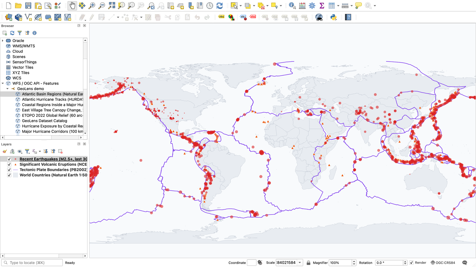
QGIS adds the same API as an OGC API Features connection, as the
[QGIS guide](https://docs.getgeolens.com/guides/api/qgis/) shows. The
[GeoLens plugin for QGIS](https://github.com/geolens-io/qgis-geolens-plugin) adds catalog search,
private datasets and edits that sync back to GeoLens.
QGIS reading the demo over OGC API Features, without a plugin.
| Standard | Where | Use it with |
|---|---|---|
| OGC API Features, with CQL2 filtering and queryables | `/api/collections/{id}/items` | QGIS, ArcGIS, GDAL/OGR and other OGC API clients |
| OGC API Records | `/api/collections/datasets/items` | Catalog search from other portals and tools |
| STAC API 1.0 | `/api/stac/` | STAC clients such as pystac-client and STAC Browser |
| DCAT 3, DCAT-US 3.0 and GeoDCAT-AP as JSON-LD | `/api/datasets/dcat/`, `/api/datasets/dcat-us/3.0/`, `/api/datasets/geodcat-ap/` | Harvesting into national and EU open-data portals |
| Vector tiles and COG raster tiles | a tile URL on every layer | MapLibre, OpenLayers, Leaflet |
| 3D Tiles and COPC | each 3D dataset's page | CesiumJS, QGIS, Potree |
Data exports as GeoJSON, Shapefile, GeoPackage, CSV, FlatGeobuf, GeoParquet, PMTiles or
Cloud-Optimized GeoTIFF.
The `geolens` CLI publishes files and applies catalog manifests, Python and TypeScript SDKs cover
the API, and a read-only MCP server lets AI agents search the catalog. The
[API reference](https://docs.getgeolens.com/guides/api/) and
[SDK guides](https://docs.getgeolens.com/guides/sdk/) document them, and the
[examples gallery](https://geolens-io.github.io/geolens-examples/) has runnable code for
MapLibre, Leaflet, OpenLayers, the ArcGIS Maps SDK, QGIS and DuckDB.
## Optional AI
"How many of these hurricanes made landfall?" returns the count, a table and the assumption the answer rests on.
GeoLens can answer questions about a dataset, edit maps from plain-language requests, draft
metadata and search in natural language. It works with any OpenAI-compatible endpoint, including
a local server such as Ollama, and with Claude through Anthropic, Microsoft Foundry, Amazon Bedrock
or Google Vertex AI. AI stays off until an administrator configures a provider, and every workflow
works without it.
## Install
You need Git, curl and Docker with the Compose plugin. The
[Install Guide](https://docs.getgeolens.com/guides/quickstart/install/) lists the versions, memory
and ports it expects.
```sh
curl -fsSL https://getgeolens.com/install.sh | sh # clone, generate secrets, start the stack
cd geolens
grep '^GEOLENS_ADMIN_PASSWORD=' .env # the generated admin password
```
Open http://localhost:8080 and sign in as `admin` with that password. Each
[release](https://github.com/geolens-io/geolens/releases) includes a `SHA256SUMS` file for checking
`install.sh` before you run it. To build from source instead, clone the repository and run
`bash scripts/install.sh`; the first build takes 5-10 minutes.
For production, read the
[cloud deployment guide](https://docs.getgeolens.com/guides/quickstart/cloud-deployment/), which
also lists what an external database needs. Docker Compose is the supported path, and
[geolens-deployments](https://github.com/geolens-io/geolens-deployments) has a community-maintained
Helm chart and Terraform recipes for AWS ECS Fargate and Azure Container Apps.
The bundled database is backed up daily, and the
[backup guide](https://docs.getgeolens.com/guides/admin/backups/) covers off-site copies and
restores. [UPGRADING.md](UPGRADING.md) covers upgrades and rollback, [RUNBOOK.md](RUNBOOK.md)
covers operations, and the
[Configuration Reference](https://docs.getgeolens.com/guides/quickstart/configuration/) lists every
setting.
## Your first dataset
With the [CLI](https://docs.getgeolens.com/guides/cli/) installed, publish the sample file from the
install directory:
```sh
geolens login http://localhost:8080/api # your admin username and password
geolens publish examples/manifests/first-catalog/city-parks.geojson --name "City Parks"
```
`geolens publish` prints the new dataset's URL. To manage a whole catalog, describe the sources in
a `geolens.yaml` manifest and run `geolens apply`; [`examples/manifests/`](examples/manifests/) has
templates.
To load the demo's maps and datasets, export `GEOLENS_ADMIN_PASSWORD` from `.env` and run
`python scripts/seed-showcase.py --username admin`. The script needs Python 3.10+ and `httpx` and
downloads public data from about a dozen sources; [scripts/README.md](scripts/README.md) has the
sizes and options.
## Privacy and access
- GeoLens sends no telemetry. Apart from the default basemap tiles and the remote services or
STAC sources your users register, it makes outbound calls only for features an administrator
turns on. [EGRESS.md](EGRESS.md) lists them and explains how to run air-gapped.
- Your data stays readable without GeoLens. Vector datasets are ordinary PostGIS tables in a
`data` schema, rasters are Cloud-Optimized GeoTIFFs in your own storage (local disk, S3/MinIO or
Azure Blob), and the catalog exports through OGC API, STAC and DCAT.
- Sign-in uses local accounts or OAuth 2.0/OIDC (Google, Microsoft, GitHub or a generic provider),
with roles, per-dataset permissions, per-user API keys and an audit log. Self-registration is
off by default.
- Features released in this repository stay free.
[EDITIONS.md](EDITIONS.md) describes the optional paid support and add-ons.
## Known limitations
- One PostgreSQL instance, with no built-in high availability or clustering.
- One organization per deployment.
- Terrain rendering assumes elevation in meters; other vertical units render exaggerated.
- GeoLens's own REST API can change between minor releases (the standards endpoints follow their
specifications). The [CHANGELOG](CHANGELOG.md) lists contract changes, and a breaking change
keeps the old form working for one more minor release.
## Contributing
Bug reports, fixes, translations and docs are welcome. [CONTRIBUTING](.github/CONTRIBUTING.md)
covers setup, tests and DCO sign-off, and [ARCHITECTURE](.github/ARCHITECTURE.md) maps the code.
The [QGIS plugin](https://github.com/geolens-io/qgis-geolens-plugin),
[examples](https://github.com/geolens-io/geolens-examples) and
[deployments](https://github.com/geolens-io/geolens-deployments) repositories take issues and pull
requests too. Ask questions in
[GitHub Discussions](https://github.com/geolens-io/geolens/discussions), report bugs in
[Issues](https://github.com/geolens-io/geolens/issues), and report security problems privately as
described in [SECURITY.md](.github/SECURITY.md). The [roadmap](https://docs.getgeolens.com/roadmap/)
shows what's planned.
## License
GeoLens is licensed under the [Apache License 2.0](LICENSE). The GeoLens name, logo and brand
assets are not covered by this license; see [TRADEMARKS.md](TRADEMARKS.md). Sample-data
attribution is in [THIRD_PARTY_DATA.md](THIRD_PARTY_DATA.md).
Project policies: [editions](EDITIONS.md) · [support](SUPPORT.md) · [governance](GOVERNANCE.md) · [maintainers](MAINTAINERS.md) · [security](.github/SECURITY.md) · [release process](RELEASE.md) · [egress & air-gap](EGRESS.md)