# vapour  [](https://github.com/hypertidy/vapour/actions)
[](https://cran.r-project.org/package=vapour)
[](https://CRAN.R-project.org/package=vapour)
## Overview
The vapour package provides access to the basic *read* functions
available in [GDAL](https://gdal.org/) for both
[raster](https://gdal.org/en/stable/user/raster_data_model.html) and
[vector](https://gdal.org/en/stable/user/vector_data_model.html) data
sources.
The functions are deliberately *lower-level* than these data models and
provide access to the component entities independently.
For vector data:
- read access to fields alone
- read raw binary geometry alone, or geometry in text forms (GeoJSON,
WKT, GML, KML).
- read access to the extent of geometries
- helper functions to summarize feature identity and geometry status
- limit/skip control on records read
- execution of
[OGRSQL](https://gdal.org/en/stable/user/ogr_sql_dialect.html) with
control of SQL dialect
- read in the context of a [bounding box spatial
filter](https://gdal.org/en/stable/user/ogr_sql_dialect.html#executesql)
can be applied via the `extent` argument
For raster data:
- read access to the list of available rasters within a collection
source (subdatasets).
- read access to *structural metadata* for individual raster sources.
- read access for raw data using GDAL’s [RasterIO
framework](https://gdal.org/en/stable/tutorials/raster_api_tut.html)
and its dynamic image decimation / replication resampling algorithms.
- read access for raw data using GDAL’s [Warper
framework](https://gdal.org/en/stable/api/gdalwarp_cpp.html) and its
dynamic image warping, a superset of the RasterIO capabilities.
The warper works for data sources that contain *overviews* (or pyramid
levels-of-detail) as it automatically chooses an appropriate level for
the request made, files, urls, database connections, online tiled image
servers, and all the various ways of specifying GDAL data sources.
The workflows available are intended to support development of
applications in R for these vector and raster data without being
constrained to any particular data model.
## Installation
Install from CRAN, this should work on MacOS and Windows because CRAN
provide binaries.
``` r
install.packages("vapour")
```
The development version can be installed from Github.
``` r
options(repos = c(
hypertidy = 'https://hypertidy.r-universe.dev',
CRAN = 'https://cloud.r-project.org'))
install.packages("vapour")
```
To install the development version the more github-traditional way:
``` r
remotes::install_github("hypertidy/vapour")
```
You will need development tools for building R packages.
On Linux, I’m using latest ubuntu and R usually, check CRAN on ubuntu
(search for “ubuntu cran”).
then
``` bash
apt install --no-install-recommends software-properties-common dirmngr
add-apt-repository ppa:ubuntugis/ubuntugis-unstable --yes
apt update
## Install 3rd parties
## NetCDF and geo-spatial wunderkind
apt install libgdal-dev
```
then `install.packages("vapour")` or whatever you use.
## Purpose
The goal of vapour is to provide a basic **GDAL API** package for R. The
key functions provide vector geometry or attributes and raster data and
raster metadata.
The priority is to give low-level access to key functionality rather
than comprehensive coverage of the library. The real advantage of
`vapour` is the flexibility of a modular workflow, not the outright
efficiency.
A parallel goal is to be freed from the powerful but sometimes limiting
high-level data models of GDAL itself, specifically these are *simple
features* and *affine-based regular rasters composed of 2D slices*.
(GDAL will possibly remove these limitations over time but still there
will always be value in having modularity in an ecosystem of tools.)
GDAL’s dynamic resampling of arbitrary raster windows is also very
useful for interactive tools on local data, and is radically
under-utilized. A quick example, topography data is available from
Amazon compute servers, first we need a config for the source:
``` r
elevation.tiles.prod <-
'
https://s3.amazonaws.com/elevation-tiles-prod/geotiff/${z}/${x}/${y}.tif
-20037508.34
20037508.34
20037508.34
-20037508.34
14
1
1
top
EPSG:3857
512
512
1
Int16
403,404
-32768
'
```
``` r
## we want an extent
ex <- c(-1, 1, -1, 1) * 5000 ## 10km wide/high region
## Madrid is at this location
pt <- cbind(-3.716667, 40.416667)
crs <- sprintf("+proj=laea +lon_0=%f +lat_0=%f +datum=WGS84", pt[1,1,drop = TRUE], pt[1,2, drop = TRUE])
dm <- c(256, 256)
vals <- vapour::vapour_warp_raster(elevation.tiles.prod, extent = ex, dimension = dm, projection = crs)
## now we can use this in a matrix
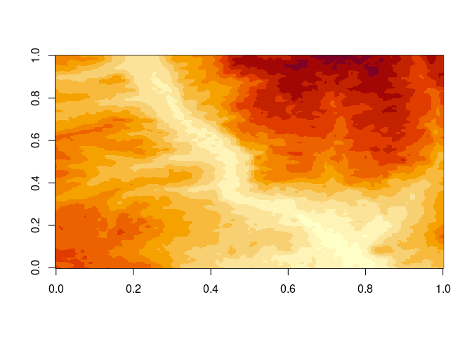
image(m <- matrix(vals[[1]], nrow = dm[2], ncol = dm[1])[,dm[2]:1 ])
```
[](https://github.com/hypertidy/vapour/actions)
[](https://cran.r-project.org/package=vapour)
[](https://CRAN.R-project.org/package=vapour)
## Overview
The vapour package provides access to the basic *read* functions
available in [GDAL](https://gdal.org/) for both
[raster](https://gdal.org/en/stable/user/raster_data_model.html) and
[vector](https://gdal.org/en/stable/user/vector_data_model.html) data
sources.
The functions are deliberately *lower-level* than these data models and
provide access to the component entities independently.
For vector data:
- read access to fields alone
- read raw binary geometry alone, or geometry in text forms (GeoJSON,
WKT, GML, KML).
- read access to the extent of geometries
- helper functions to summarize feature identity and geometry status
- limit/skip control on records read
- execution of
[OGRSQL](https://gdal.org/en/stable/user/ogr_sql_dialect.html) with
control of SQL dialect
- read in the context of a [bounding box spatial
filter](https://gdal.org/en/stable/user/ogr_sql_dialect.html#executesql)
can be applied via the `extent` argument
For raster data:
- read access to the list of available rasters within a collection
source (subdatasets).
- read access to *structural metadata* for individual raster sources.
- read access for raw data using GDAL’s [RasterIO
framework](https://gdal.org/en/stable/tutorials/raster_api_tut.html)
and its dynamic image decimation / replication resampling algorithms.
- read access for raw data using GDAL’s [Warper
framework](https://gdal.org/en/stable/api/gdalwarp_cpp.html) and its
dynamic image warping, a superset of the RasterIO capabilities.
The warper works for data sources that contain *overviews* (or pyramid
levels-of-detail) as it automatically chooses an appropriate level for
the request made, files, urls, database connections, online tiled image
servers, and all the various ways of specifying GDAL data sources.
The workflows available are intended to support development of
applications in R for these vector and raster data without being
constrained to any particular data model.
## Installation
Install from CRAN, this should work on MacOS and Windows because CRAN
provide binaries.
``` r
install.packages("vapour")
```
The development version can be installed from Github.
``` r
options(repos = c(
hypertidy = 'https://hypertidy.r-universe.dev',
CRAN = 'https://cloud.r-project.org'))
install.packages("vapour")
```
To install the development version the more github-traditional way:
``` r
remotes::install_github("hypertidy/vapour")
```
You will need development tools for building R packages.
On Linux, I’m using latest ubuntu and R usually, check CRAN on ubuntu
(search for “ubuntu cran”).
then
``` bash
apt install --no-install-recommends software-properties-common dirmngr
add-apt-repository ppa:ubuntugis/ubuntugis-unstable --yes
apt update
## Install 3rd parties
## NetCDF and geo-spatial wunderkind
apt install libgdal-dev
```
then `install.packages("vapour")` or whatever you use.
## Purpose
The goal of vapour is to provide a basic **GDAL API** package for R. The
key functions provide vector geometry or attributes and raster data and
raster metadata.
The priority is to give low-level access to key functionality rather
than comprehensive coverage of the library. The real advantage of
`vapour` is the flexibility of a modular workflow, not the outright
efficiency.
A parallel goal is to be freed from the powerful but sometimes limiting
high-level data models of GDAL itself, specifically these are *simple
features* and *affine-based regular rasters composed of 2D slices*.
(GDAL will possibly remove these limitations over time but still there
will always be value in having modularity in an ecosystem of tools.)
GDAL’s dynamic resampling of arbitrary raster windows is also very
useful for interactive tools on local data, and is radically
under-utilized. A quick example, topography data is available from
Amazon compute servers, first we need a config for the source:
``` r
elevation.tiles.prod <-
'
https://s3.amazonaws.com/elevation-tiles-prod/geotiff/${z}/${x}/${y}.tif
-20037508.34
20037508.34
20037508.34
-20037508.34
14
1
1
top
EPSG:3857
512
512
1
Int16
403,404
-32768
'
```
``` r
## we want an extent
ex <- c(-1, 1, -1, 1) * 5000 ## 10km wide/high region
## Madrid is at this location
pt <- cbind(-3.716667, 40.416667)
crs <- sprintf("+proj=laea +lon_0=%f +lat_0=%f +datum=WGS84", pt[1,1,drop = TRUE], pt[1,2, drop = TRUE])
dm <- c(256, 256)
vals <- vapour::vapour_warp_raster(elevation.tiles.prod, extent = ex, dimension = dm, projection = crs)
## now we can use this in a matrix
image(m <- matrix(vals[[1]], nrow = dm[2], ncol = dm[1])[,dm[2]:1 ])
```
 ``` r
## using the image list format
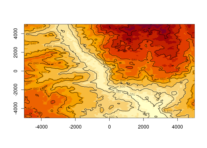
x <- list(x = seq(ex[1], ex[2], length.out = dm[1] + 1), y = seq(ex[3] ,ex[4], length.out = dm[1] + 1), z = m)
image(x)
## or as a spatial object
library(terra)
#> terra 1.8.76
r <- rast(ext(ex), nrows = dm[2], ncols = dm[1], crs = crs, vals = vals[[1]])
contour(r, add = TRUE)
```
``` r
## using the image list format
x <- list(x = seq(ex[1], ex[2], length.out = dm[1] + 1), y = seq(ex[3] ,ex[4], length.out = dm[1] + 1), z = m)
image(x)
## or as a spatial object
library(terra)
#> terra 1.8.76
r <- rast(ext(ex), nrows = dm[2], ncols = dm[1], crs = crs, vals = vals[[1]])
contour(r, add = TRUE)
```
 If we want more detail, go ahead:
``` r
dm <- c(512, 512)
vals <- vapour::vapour_warp_raster(elevation.tiles.prod, extent = ex, dimension = dm, projection = crs)
(r <- rast(ext(ex), nrows = dm[2], ncols = dm[1], crs = crs, vals = vals[[1]]))
#> class : SpatRaster
#> size : 512, 512, 1 (nrow, ncol, nlyr)
#> resolution : 19.53125, 19.53125 (x, y)
#> extent : -5000, 5000, -5000, 5000 (xmin, xmax, ymin, ymax)
#> coord. ref. : +proj=laea +lat_0=40.416667 +lon_0=-3.716667 +x_0=0 +y_0=0 +datum=WGS84 +units=m +no_defs
#> source(s) : memory
#> name : lyr.1
#> min value : 562
#> max value : 742
plot(r, col = hcl.colors(24))
```
If we want more detail, go ahead:
``` r
dm <- c(512, 512)
vals <- vapour::vapour_warp_raster(elevation.tiles.prod, extent = ex, dimension = dm, projection = crs)
(r <- rast(ext(ex), nrows = dm[2], ncols = dm[1], crs = crs, vals = vals[[1]]))
#> class : SpatRaster
#> size : 512, 512, 1 (nrow, ncol, nlyr)
#> resolution : 19.53125, 19.53125 (x, y)
#> extent : -5000, 5000, -5000, 5000 (xmin, xmax, ymin, ymax)
#> coord. ref. : +proj=laea +lat_0=40.416667 +lon_0=-3.716667 +x_0=0 +y_0=0 +datum=WGS84 +units=m +no_defs
#> source(s) : memory
#> name : lyr.1
#> min value : 562
#> max value : 742
plot(r, col = hcl.colors(24))
```
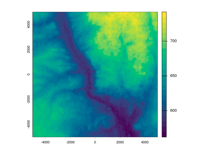 GDAL is obstinately *format agnostic*, the A stands for *Abstraction*
and we like that in R too, just gives us the data. Here we created a
base matrix image object, and a raster package *RasterLayer*, but we
could use the spatstat im, or objects in stars or terra packages, it
makes no difference to the read-through-warp process.
This partly draws on work done in [the sf
package](https://github.com/r-spatial/sf) and [the terra
package](https://github.com/rspatial/terra) and in packages `rgdal` and
`rgdal2`. I’m amazed that something as powerful and general as GDAL is
still only available through these lenses, but maybe more folks will get
interested over time.
## Examples
The package documentation page gives an overview of available functions.
``` r
help("vapour-package")
```
See the vignettes and documentation for examples WIP.
## Context
Examples of packages that use vapour are in development, especially
[whatarelief](https://github.com/hypertidy/whatarelief) and
[ggdal](https://github.com/rgdal-dev/ggdal).
Limitations, work-in-progress and other discussion:
We’ve kept a record of a minimal GDAL wrapper package here:
# Code of conduct
Please note that this project is released with a [Contributor Code of
Conduct](https://github.com/hypertidy/vapour/blob/master/CONDUCT.md). By
participating in this project you agree to abide by its terms.
GDAL is obstinately *format agnostic*, the A stands for *Abstraction*
and we like that in R too, just gives us the data. Here we created a
base matrix image object, and a raster package *RasterLayer*, but we
could use the spatstat im, or objects in stars or terra packages, it
makes no difference to the read-through-warp process.
This partly draws on work done in [the sf
package](https://github.com/r-spatial/sf) and [the terra
package](https://github.com/rspatial/terra) and in packages `rgdal` and
`rgdal2`. I’m amazed that something as powerful and general as GDAL is
still only available through these lenses, but maybe more folks will get
interested over time.
## Examples
The package documentation page gives an overview of available functions.
``` r
help("vapour-package")
```
See the vignettes and documentation for examples WIP.
## Context
Examples of packages that use vapour are in development, especially
[whatarelief](https://github.com/hypertidy/whatarelief) and
[ggdal](https://github.com/rgdal-dev/ggdal).
Limitations, work-in-progress and other discussion:
We’ve kept a record of a minimal GDAL wrapper package here:
# Code of conduct
Please note that this project is released with a [Contributor Code of
Conduct](https://github.com/hypertidy/vapour/blob/master/CONDUCT.md). By
participating in this project you agree to abide by its terms.