 Skyfall-GS: Synthesizing Immersive 3D Urban Scenes from Satellite Imagery
Jie-Ying Lee ·
Yi-Ruei Liu ·
Shr-Ruei Tsai ·
Wei-Cheng Chang ·
Chung-Ho Wu
Jiewen Chan ·
Zhenjun Zhao ·
Chieh Hubert Lin ·
Yu-Lun Liu
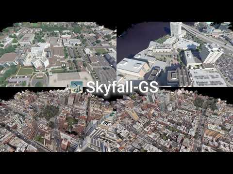
> Synthesizing large-scale, explorable, and geometrically accurate 3D urban scenes is a challenging yet valuable task in providing immersive and embodied applications. The challenges lie in the lack of large-scale and high-quality real-world 3D scans for training generalizable generative models. In this paper, we take an alternative route to create large-scale 3D scenes by synergizing the readily available satellite imagery that supplies realistic coarse geometry and the open-domain diffusion model for creating high-quality close-up appearances. We propose **Skyfall-GS**, the first large-scale 3D-scene creation framework without costly 3D annotations, also featuring real-time, immersive 3D exploration. We tailor a curriculum-driven iterative refinement strategy to progressively enhance geometric completeness and photorealistic textures. Extensive experiments demonstrate that Skyfall-GS provides improved cross-view consistent geometry and more realistic textures compared to state-of-the-art approaches.
## Table of Contents
- [Installation](#installation)
- [Dataset](#dataset)
- [Running on Custom Datasets](#running-on-custom-datasets)
- [Training](#training)
- [Stage 1: Reconstruction](#stage-1-reconstruction)
- [Stage 2: Synthesis with Iterative Dataset Update (IDU)](#stage-2-synthesis-with-iterative-dataset-update-idu)
- [Automated Training Scripts](#automated-training-scripts)
- [Fused PLY for Visualization](#fused-ply-for-visualization)
- [Evaluation](#evaluation)
- [Rendering and Visualization](#rendering-and-visualization)
- [Online Viewer](#online-viewer)
- [Useful Scripts](#useful-scripts)
- [Acknowledgement](#acknowledgement)
- [Citation](#citation)
- [License](#license)
## Installation
1. **Clone the repository:**
```bash
git clone --recurse-submodules https://github.com/jayin92/Skyfall-GS.git
cd Skyfall-GS
```
2. **Create and activate a Conda environment:**
```bash
conda create -y -n skyfall-gs python=3.10
conda activate skyfall-gs
```
3. **Install dependencies:**
```bash
conda install cuda-toolkit=12.8 cuda-nvcc=12.8 -c nvidia
pip install -r requirements.txt
pip install --force-reinstall torch torchvision torchaudio
pip install submodules/diff-gaussian-rasterization-depth
pip install submodules/simple-knn
pip install submodules/fused-ssim
```
## Dataset
The datasets required to train the Skyfall-GS model should be placed in the `data/` directory.
### Downloading the Datasets
The JAX and NYC datasets are available for download from Hugging Face or Google Drive.
1. **Download the zip files:**
[Download from Hugging Face 🤗](https://huggingface.co/datasets/jayinnn/Skyfall-GS-datasets) *(recommended)*
[Download from Google Drive](https://drive.google.com/drive/folders/1Uugwpf7n5fj7k4UJRBuKUyrmkYcDRScQ?usp=drive_link)
2. **Unzip the datasets into the `data/` directory:**
```bash
unzip datasets_JAX.zip
unzip datasets_NYC.zip
```
### Directory Structure
After unzipping, the directory structure inside the `data/` directory should look like this:
```
data/
├── datasets_JAX/
│ ├── JAX_004
│ ├── JAX_068
│ └── ...
└── datasets_NYC/
├── NYC_004
├── NYC_010
└── ...
```
## Running on Custom Datasets
We supports training on custom datasets from two sources: COLMAP reconstructions and satellite imagery. For detailed preprocessing instructions, please refer to the [SatelliteSfM repository](https://github.com/jayin92/SatelliteSfM).
### Data Format Requirements
Your custom dataset should have the following structure to work with Skyfall-GS:
```
your_dataset/
├── images/ # RGB images
│ ├── image_001.png
│ ├── image_002.png
│ └── ...
├── masks/ # Binary masks for valid pixels (optional: if not provided, all non-black pixels are considered valid)
│ ├── *.npy # NumPy format (for processing)
│ ├── *.png # PNG format (for visualization)
│ └── ...
├── transforms_train.json # Training camera parameters
├── transforms_test.json # Testing camera parameters (optional)
└── points3D.txt # 3D point cloud
```
## Training
The training process is divided into two main stages.
### Stage 1: Reconstruction
This stage focuses on reconstructing the initial 3D scene from satellite imagery.
```bash
python train.py \
-s ./data/datasets_JAX/JAX_068/ \
-m ./outputs/JAX/JAX_068 \
--eval \
--port 6209 \
--kernel_size 0.1 \
--resolution 1 \
--sh_degree 1 \
--appearance_enabled \
--lambda_depth 0 \
--lambda_opacity 10 \
--densify_until_iter 21000 \
--densify_grad_threshold 0.0001 \
--lambda_pseudo_depth 0.5 \
--start_sample_pseudo 1000 \
--end_sample_pseudo 21000 \
--size_threshold 20 \
--scaling_lr 0.001 \
--rotation_lr 0.001 \
--opacity_reset_interval 3000 \
--sample_pseudo_interval 10
```
### Stage 2: Synthesis with Iterative Dataset Update (IDU)
This stage refines the geometry and synthesizes high-quality textures using an iterative dataset update strategy. This stage uses a pretrained model from Stage 1.
```bash
python train.py \
-s ./data/datasets_JAX/JAX_068/ \
-m ./outputs/JAX_idu/JAX_068 \
--start_checkpoint ./outputs/JAX/JAX_068/chkpnt30000.pth \
--iterative_datasets_update \
--eval \
--port 6209 \
--kernel_size 0.1 \
--resolution 1 \
--sh_degree 1 \
--appearance_enabled \
--lambda_depth 0 \
--lambda_opacity 0 \
--idu_opacity_reset_interval 5000 \
--idu_refine \
--idu_num_samples_per_view 2 \
--densify_grad_threshold 0.0002 \
--idu_num_cams 6 \
--idu_use_flow_edit \
--idu_render_size 1024 \
--idu_flow_edit_n_min 4 \
--idu_flow_edit_n_max 10 \
--idu_grid_size 3 \
--idu_grid_width 512 \
--idu_grid_height 512 \
--idu_episode_iterations 10000 \
--idu_iter_full_train 0 \
--idu_opacity_cooling_iterations 500 \
--lambda_pseudo_depth 0.5 \
--idu_densify_until_iter 9000 \
--idu_train_ratio 0.75
```
## Automated Training Scripts
The `scripts/` directory contains scripts for automated training on different datasets and configurations.
- `scripts/run_jax.py`: Runs Stage 1 training for the JAX dataset scenes.
- `scripts/run_jax_idu.py`: Runs Stage 2 (IDU) training for the JAX dataset scenes.
- `scripts/run_jax_naive.py`: Runs a naive training for the JAX dataset scenes without advanced features.
- `scripts/run_nyc.py`: Runs Stage 1 training for the NYC dataset scenes.
- `scripts/run_nyc_idu.py`: Runs Stage 2 (IDU) training for the NYC dataset scenes.
- `scripts/run_nyc_naive.py`: Runs a naive training for the NYC dataset scenes.
## Fused PLY for Visualization
Do not directly use the raw `.ply` files under the training output directory for online visualization.
After training, you should fuse the model first, then visualize the fused file.
Pre-built fused PLY files for all scenes are also available for direct download from Hugging Face:
[Download fused PLY from Hugging Face 🤗](https://huggingface.co/jayinnn/Skyfall-GS-ply)
1. **Generate a fused PLY file from a trained model:**
```bash
python create_fused_ply.py \
-m ./outputs/JAX_idu/JAX_068 \
--output_ply ./fused/JAX_068_fused.ply \
--iteration 80000 \
--load_from_checkpoints
```
2. **Use the fused PLY (`*_fused.ply`) for visualization/rendering tools that expect a standalone PLY.**
## Evaluation
The `eval.py` script is used for evaluating the performance of a trained model. It computes various metrics by comparing the rendered images with ground truth images.
### Downloading Evaluation Data
The evaluation data, which includes the ground truth videos and the rendered videos from other methods, can be downloaded from Hugging Face or Google Drive.
[Download from Hugging Face 🤗](https://huggingface.co/datasets/jayinnn/Skyfall-GS-eval) *(recommended)*
[Download from Google Drive](https://drive.google.com/drive/folders/1hSFe9yGOwJCLBK7ZLHB-49_x73Ebk_VV?usp=drive_link)
After downloading, unzip the file and place the `results_eval` directory in the root of the project.
### Usage
```bash
python eval.py \
--data_dir results_eval/data_eval_JAX \
--temp_dir temp_frames_JAX \
--methods mip-splatting sat-nerf eogs corgs ours_stage1 ours_stage2 \
--output_file metrics_results_JAX.csv \
--frame_rate 30 \
--resolution 1024 \
--batch_size 64
python eval.py \
--data_dir results_eval/data_eval_NYC \
--temp_dir temp_frames_NYC \
--methods citydreamer gaussiancity corgs ours_stage1 ours_stage2 \
--output_file metrics_results_NYC.csv \
--frame_rate 24 \
--no_resize \
--batch_size 64
```
The script calculates the following metrics:
- **PSNR**: Peak Signal-to-Noise Ratio
- **SSIM**: Structural Similarity Index
- **LPIPS**: Learned Perceptual Image Patch Similarity
- **CLIP-FID**: FID score calculated using CLIP features
- **CMMD**: CLIP Maximum Mean Discrepancy
## Rendering and Visualization
The `render_video.py` script can be used to render a video from a trained model using a specified camera path.
```bash
python render_video.py \
-m \
--camera_path \
--load_from_checkpoints \
--iteration \
--save_images \
--depth
```
- `-m`: Path to the model directory.
- `--camera_path`: Path to the camera trajectory JSON file.
- `--load_from_checkpoints`: Load the model from a checkpoint.
- `--iteration`: The checkpoint iteration to use.
- `--save_images`: Save individual frames of the video.
- `--depth`: Render depth maps instead of RGB images.
You can also render a video from a `.ply` file using `render_video_from_ply.py`:
```bash
python render_video_from_ply.py \
--ply_path \
--camera_path
```
For models trained with Skyfall-GS, use a fused PLY generated by `create_fused_ply.py` (not the raw training-output `.ply` files).
## Online Viewer
Use the fused PLY generated in [Fused PLY for Visualization](#fused-ply-for-visualization) for online viewing.
### Option 1: Mip-Splatting Viewer
Use the [online viewer](https://niujinshuchong.github.io/mip-splatting-demo).
For optimal viewing, use the following settings:
- **Up vector:** `0,0,1`
- **SH degree:** `1`
- **Camera origin:** `0,0,200`
### Option 2: SuperSplat (Alternative)
You can also use [SuperSplat Editor](https://superspl.at/editor), an open-source web-based Gaussian splat editor/viewer from PlayCanvas.
Recommended workflow:
1. Generate `*_fused.ply` first (see [Fused PLY for Visualization](#fused-ply-for-visualization)).
2. Open `https://superspl.at/editor`.
3. Import the fused PLY by drag-and-drop or via `File` > `Import`.
4. (Optional) Publish with `File` > `Publish`, or export a standalone viewer app from `File` > `Export`.
References:
- SuperSplat repo: https://github.com/playcanvas/supersplat
- Import/Export docs: https://developer.playcanvas.com/user-manual/gaussian-splatting/editing/supersplat/import-export/
## Useful Scripts
This project includes several other useful scripts:
- `align_ges.py`: Find optimal target altitude by comparing with ground truth.
- `convert.py`: A COLMAP converter script.
- `dsmr.py`: Functions for DSM registration.
- `evaluate_gs_geometry.py`: Evaluate geometry accuracy for a single scene.
- `gen_render_path.py`: Generate a camera path for an orbit view around a target point.
- `render_videos.py`: A script for batch rendering of videos from multiple models and camera paths.
- `sat_utils.py`: Utility functions for handling satellite images and georeferenced data.
- `scripts/merge_images.py`: Merge two frames into one.
## Acknowledgement
This codebase is built upon the following open-source projects:
- [Mip-Splatting](https://github.com/autonomousvision/mip-splatting)
- [WildGuassians](https://github.com/jkulhanek/wild-gaussians)
- [FlowEdit](https://github.com/fallenshock/FlowEdit)
- [MoGe](https://github.com/microsoft/MoGe)
- [SatelliteSfM](https://github.com/Kai-46/SatelliteSfM)
We thank the authors for their contributions.
This research was funded by the National Science and Technology Council, Taiwan, under Grants NSTC 112-2222-E-A49-004-MY2 and 113-2628-EA49-023-. The authors are grateful to Google, NVIDIA, and MediaTek Inc. for their generous donations. Yu-Lun Liu acknowledges the Yushan Young Fellow Program by the MOE in Taiwan.
## Citation
If you find this work useful, please consider citing:
```bibtex
@inproceedings{lee2026skyfall,
title = {{Skyfall-GS}: Synthesizing Immersive {3D} Urban Scenes from Satellite Imagery},
author = {Lee, Jie-Ying and Liu, Yi-Ruei and Tsai, Shr-Ruei and Chang, Wei-Cheng and Wu, Chung-Ho and Chan, Jiewen and Zhao, Zhenjun and Lin, Chieh Hubert and Liu, Yu-Lun},
booktitle = {European Conference on Computer Vision (ECCV)},
pages = {431--454},
year = {2026},
publisher = {Springer},
doi = {10.1007/978-3-032-37627-5_24}
}
```
## License
This project is licensed under the terms of the [Apache 2 License](LICENSE).