{
"cells": [
{
"cell_type": "markdown",
"metadata": {},
"source": [
"# Water Survey of Canada Usage"
]
},
{
"cell_type": "markdown",
"metadata": {},
"source": [
"This notebook demonstrates methods for accessing and processing data extracted from the HYDAT database. \n",
"\n",
"\n",
"### Table of Contents\n",
"\n",
"* [Reading Cached Data](#data): Reading the cached data sets.\n",
"* [Mapping WSC Stations](#mapping): Produce a map of WSC monitoring stations.\n",
"* [Viewing Station Data](#station): Extract station data from `WSC_STATIONS.csv`\n",
"* [Plotting Level Data](#plottinglevels): Example of plotting lake level data from `WSC_LEVELS.csv`.\n",
"* [Plotting Flow Data](#plottingflows): Example of plotting stream flow data from `WSC_FLOWS.csv`.\n",
"* [Example: Comparing Levels on Rainy and Namakan Lakes](#lakelevels): A comparison of historical levels on Rainy and Namakan lakes.\n",
"* [Example: What was the highest water events on Rainy Lake?](#highwater): A history of high water events on Rainy Lake.\n",
"* [Example: Distribution of Inflows on Rainy River](#rainyriver): Distribution of estimated historical inflows on Rainy River, comparing 1970-1999 to 2000-2014.\n",
"* [Flow-Frequency for State-of-Nature Streams in the Rainy River Watershed](#streams): Flow-frequency behavior for unencumbered streams in the Rainy River Watershed, comparing 1970-1999 to 2000-2014.\n",
"* [Annual flows on Rainy River](#flowtrends): Trends in annual flow on Rainy River.\n",
"\n"
]
},
{
"cell_type": "markdown",
"metadata": {},
"source": [
"\n",
"## Initialization"
]
},
{
"cell_type": "code",
"execution_count": 1,
"metadata": {
"collapsed": true
},
"outputs": [],
"source": [
"# Display graphics inline with the notebook\n",
"%matplotlib inline\n",
"\n",
"# Standard Python modules\n",
"import numpy as np\n",
"import matplotlib.pyplot as plt\n",
"import pandas as pd\n",
"\n",
"# Modules to display images and data tables\n",
"from IPython.core.display import display\n",
"from IPython.core.display import Image\n",
"\n",
"# Module to request http data using Google maps api\n",
"import requests\n",
"\n",
"# Module to manipulate dates for historical comparisons\n",
"import datetime\n",
"\n",
"import seaborn as sns\n",
"sns.set_context('talk')"
]
},
{
"cell_type": "markdown",
"metadata": {},
"source": [
"## Read Cached Data Files"
]
},
{
"cell_type": "code",
"execution_count": 2,
"metadata": {},
"outputs": [
{
"data": {
"text/plain": [
"STATION_NUMBER\n",
"05PA001 KETTLE RIVER ABOVE KETTLE FALLS\n",
"05PA003 NAMAKAN LAKE ABOVE KETTLE FALLS DAM\n",
"05PA005 NORTHERN LIGHT LAKE AT OUTLET\n",
"05PA006 NAMAKAN RIVER AT OUTLET OF LAC LA CROIX\n",
"05PA007 CROOKED LAKE NEAR CURTAIN FALLS\n",
"05PA010 FRENCH LAKE NEAR ATIKOKAN\n",
"05PA011 LAC LA CROIX AT CAMPBELL'S CAMP\n",
"05PA012 BASSWOOD RIVER NEAR WINTON\n",
"05PA013 NAMAKAN LAKE AT SQUIRREL ISLAND\n",
"05PB001 SEINE RIVER NEAR LA SEINE\n",
"05PB002 LITTLE TURTLE LAKE NEAR MINE CENTRE\n",
"05PB003 MANITOU RIVER ABOVE DEVIL'S CASCADE\n",
"05PB004 FOOTPRINT RIVER AT RAINY LAKE FALLS\n",
"05PB007 RAINY LAKE NEAR FORT FRANCES\n",
"05PB009 SEINE RIVER AT STURGEON FALLS GENERATING STATION\n",
"05PB012 LAC DES MILLE LACS ABOVE OUTLET DAM\n",
"05PB014 TURTLE RIVER NEAR MINE CENTRE\n",
"05PB015 PIPESTONE RIVER ABOVE RAINY LAKE\n",
"05PB018 ATIKOKAN RIVER AT ATIKOKAN\n",
"05PB019 NORTHEAST TRIBUTARY TO DASHWA LAKE NEAR ATIKOKAN\n",
"05PB020 EASTERN TRIBUTARY TO DASHWA LAKE NEAR ATIKOKAN\n",
"05PB021 EYE RIVER NEAR HARDTACK LAKE NORTH OF ATIKOKAN\n",
"05PB022 EYE RIVER NEAR COULSON LAKE NORTH OF ATIKOKAN\n",
"05PB023 RAINY LAKE AT NORTHWEST BAY\n",
"05PB024 RAINY LAKE NEAR BEAR PASS\n",
"05PB025 RAINY LAKE AT STOKES BAY\n",
"05PC009 LA VALLEE RIVER AT LA VALLEE\n",
"05PC010 STURGEON RIVER NEAR BARWICK\n",
"05PC016 LA VALLEE RIVER NEAR DEVLIN\n",
"05PC018 RAINY RIVER AT MANITOU RAPIDS\n",
"05PC019 RAINY RIVER AT FORT FRANCES\n",
"05PC022 LA VALLEE RIVER NEAR BURRISS\n",
"05PC024 RAINY RIVER AT PITHERS POINT SITE NO.1\n",
"05PC025 RAINY RIVER AT PITHERS POINT SITE NO.2\n",
"Name: STATION_NAME, dtype: object"
]
},
"metadata": {},
"output_type": "display_data"
}
],
"source": [
"WSC_STATIONS = pd.read_pickle('../data/WSC_STATIONS')\n",
"WSC_LEVELS = pd.read_pickle('../data/WSC_LEVELS')\n",
"WSC_FLOWS = pd.read_pickle('../data/WSC_FLOWS')\n",
"\n",
"display(WSC_STATIONS['STATION_NAME'])"
]
},
{
"cell_type": "markdown",
"metadata": {},
"source": [
"\n",
"## Mapping WSC Stations in the Rainy River Watershed\n",
"\n",
"The following cell creates a pandas dataframe of monitoring stations from the STATIONS.csv table extracted from the HYDAT database. The extaction searches for all stations with a specified region bounded by latitude and longitudes.\n",
"\n",
"For reference, this is a map of the [Rainy River drainage](http://www.ijc.org/files/tinymce/uploaded/rl_basinmap.pdf) basin available from the International Joint Commission. \n",
"\n",
"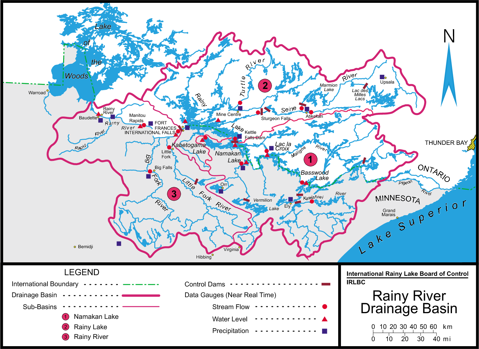
\n",
"\n",
"The following function maps a list of stations identified by their station numbers. In extracts latitude and longitude from the STATIONS table, then calls the google maps web api to create a map image."
]
},
{
"cell_type": "code",
"execution_count": 3,
"metadata": {},
"outputs": [
{
"data": {
"image/png": "iVBORw0KGgoAAAANSUhEUgAAAoAAAAGQCAMAAAAJLSEXAAAC/VBMVEUwPQA+NyMsPFg/UnRVFxRv\nJSJwJyREUwxSQRFKQi9WTj5Cfgh1exlISkVKTVBNUEpMUFVSXENXWlVAUnRZXmRZZElbYlFiWkpp\nZVVqdlh2YF9mZ2duc2V1c2N5eXd2fo1kfqsXkmJOhhNWjiNrgB54jQh1jht6lwl7lhVtgiVily9q\nmzt0iyR+mSV2hV98g3F2pEZ+rFJ6hpdogKt3j7Zri8JukMtnlth0lst5m9Z+oNN5oeeGeC+rRDuj\ncyKCfm6mSEOiWk2vVFWyUUe1U1qyW2G0bUWwZ3nLPTfROzTKQjrDWjzYRD3AaD/hQjnHSUTMU0rK\nWlbXTUXWU0zTWlPEXWHGZ0nNYVnGfUPQYVfGa2vPcGXKc3TQa2bRc2vVeHTrXFTyTUTzU0vzWlLu\nY131YlrlZ2Doc2z0amP1c2z2e3WUc5W8fI+Ciw6JhhiAng+BnByEmiSAnTabkTSCowmGpRaNsQuU\nthiIoiaLpTSbuieatDigvjKMiX2DlGmSl3qDoU2Fo1WWrEmZr1CasEybsVKOoXKKtGKSpnaXu26b\nsH2hu0aitFamuWSjwDiqxUivyFOyy1q3zmOywnnWh331hH2JjYOLkoCWl4qXnJCGl7SKtIKco5OQ\nsomUq6y3hpmtlLinq5OmvIWiuJimrKWtsqWwrKO1u6y4uLGAn9eMpMeFpNaSrNaat8WStNiAo+GD\nrvuKs/yZvOuWu/2otdinvuGoxoa0yo23zJG81pelxb66w6S6wLK82aq927mewP2szMO4ytu73ce0\n19anwO2jy/6s0eup0fm5zOO31+m21PfEkIfYiYPamY3ZmpTZppfZr6n2ioPorqvJyo/EzpbA3IzD\n3ZzDw7vI0q7J17PZxr3R27fG4p/L5qPE47XR6KrS6bPgyL3Hy8LM0cbL19vay8fR1svX3NLG2+vM\n3vfR3uPH48Pb68Xd5NjP4uXW5OXU5PfiyMHj08jk29Ti7szj6d3n89To7OTk6vPu8+rm8v7z7+/y\n9ez5+/j////hyr/xAAAAAWJLR0T+0gDCUwAAIABJREFUeNqcve2LJUt6J1YDXg1z6w/ogqEvTLfY\nGXVZcHu+L1dfdxCrkTQw2NjSSsY7sr74XhhJfbVzYXdANIWYl11bUNBgczEUhf6AboqBctOHrOQE\nsuX1hzq73jpVZ0/iiDynK4j0eqLiZFUm+HmNzFPdM9I67+3q6vOSLxFPPC+/5/c8sVPwsdqU9FeM\nsW1j9DHhD++cg58zWwd4wxRFmVKyEzMxyeDHy8Kk5OCT3kd6wWw671PqUsITWDpnYUJdjI7a4xfg\nxPAners0zgRnylWAb8SY6GeMLiY4q51ZODV+IcHN+BD4Wkk/h7eIJ4Nr0auhMF30wZgY4H5WXarL\nEm4aPh4rh2enr9KX/R2fDL6X2rTEs1i8ksMnMXwN7xJcGL/o+dsef9CFfW3gtdBsmtWqSfgO3Sef\nkj7cxuFIOLwm4dk9f8YlHmF6Hm9dyk+Ol1j+7HRyen6Kg+fopvE/76/mV4vzK37wCHNj49L7pXPV\nMg8JjL7nW000mniVaZR71gv41PZ9TzeAQ81v5Hf5N35u/u3eQc+H87H9jfcdes1EQ8T/pBmlG4MT\n7YhUmI1RAez1MTz+hd+uywDf8FOcUu9e4+dSMnDgqOIM0mkNS3Lqug5H2i1NqSdfqfCxlAa6i8rx\nYMErwZrC0H3KDZJcOfwP7hyFD2841KaoeYZ9ymPhdEzg1YBLxMUa5I/vBe4RT+9kVpJMCQ46LijD\nYtUmW8nl4K9QlHWyqfW8ChJdzNMpvMsDCxdILJLJ00r1PI9ep9PFLo1mKMBg1HGYDbqNBIMGo8FL\njJ+bV191Mp/Pr+bFNMAtJH5aFxdX5/PFIkstruElLBsvT0VTbFO+SRV2U8etQ9du6rOMhGkYCY18\n3d97YfSBRFOU7kun9+//V5Zwkj2P6izxy0kFUGQFBKtPWexhzuEp1zDtE5wHU5SgXtwE5rTpUMxI\nOPDJ6ZFTIPFKXZtAV03xjKUxq9WmYdkByTOJr1M7Vhe4yhL8uwNJSaJdHI1tZV09MWteKPKgLsB5\ncClEfVFmXuXVlyTjoL7oN3ioEkUfNA9KkZe5Z0UBp4P3DF2gcxVdmpQkDY93HU57nUhp0YyjTvGe\nxd/ziLramCCTlafd5xlreSSDF4kt6+h0VvmvVNPt8Ze9KCdU/P784nIyOV3QyoM7t7i+rt9MUFpp\n+nGxLEXXxqw9ac3wJKPx4vExxUi4aABIeaF66XkoaHKGD23d4pbcDS86VYCi/LeeKv7CA++tLgue\nBLI+O0Yk8K+/tn289jCqlSkmU5JOeHAHcmdxsJILoFNw0D1JRV66Ka1K0yV4dFSNm8QyShdziQeu\nEU1Io8Bmjgx7E8Z2AIYt1DVMb4pZXiKqrGmSpZF0yCu3Dm4J2hTmVp+lqPW3ZlU0Ndh2XCIkSDo6\neO94L6QcWkcWHuQp4GzAx1xowIw7uL6IDHzc0QPjH/4lopg3/PA++w4uK8nUsfCUgW9/rZ8jBUjf\nRx+ldmp78cNwo7CmrT15U765WPCi9KofA4s7vO8qWKNOVAvpU5oLWtKsg7P6gYHUG8JlxLpL9BhK\nIPzFoxVUfvw7opePtYgpPKXLU+W35W98iDJLI6EENVVmdQgCqLOmgpf0lxiXMAOqIBtwssC/sqh5\nwD7hoLFzsnRmLVZYpI2NWyDps/rkPI9WH7ZIYYLqDV61pCjx+XGAnCyzxOoRB0zEmyyswUF27KCx\n3arAM1ivp2sc/E1TbB+mq1ckBqBCvHg2nq6Dl1jDhUE6E2pseMk6Xhlm09SkQAPaLtJNduLc2EeS\nsa/J41QxyJOw5jmH88Ldu0DOBXzEss1hccNZtpVF7eQGzWFZr/jq9M2b+cVC3vI822y3eWBI9+ns\nkpOAT4AuMg80P+Y9USDjbK2zbH/o5D1q0zUPlqoyd1+Q1O1dm2liPQi6YTDU7KP44ZLqR6X8fb91\nM2H0kR1P7nphVPH1r1UA0ayJ+K3ASwdTDL4SyzL47JaEI/kZiAU6Zg7mkh35BIoz8Dg7K/dOdtKi\nbAbRgKh9yIJbEcnAliGKjvMaMKjcoCSARLi86lkMLCySEv4HO5/U1cy+51236VqH7rpXAcp2BBRZ\nnTpQsiiAuEIs+rgrCKOyGNeiDRyMg6nDvVnxcdrcjdw89m68l4eJGImBgxZq9q88y3BiHelYCAb1\nxM/CFt+5BbiAC/gy+2d1vZYrOvYGwUHxiXWAjhUZN0P6ObEujX5LleE7lXj/yYudBo+/hV9Kmg0y\nxquwpcjUdeb1VrOTjqrfyAfceEzu60A/uvbYNKcsgHGHYkeYQBK6Fz0eL1gAYYySSMtdh2EfrT+K\nekH8+NmTW5IjTVEeCELABenoKT0v38CxFupCR1Y3oRKcovNTstcOjpBpSlJupOFRnXLYd++owZ2m\noEMMsOPJMBR8w/I2Gk+pmgVNViaIED17dqRCkoSLvGLvkpnCKnLs15WwxEBxq5sQdBA5xOcnyZNK\nBqAbZhonHf2tQJqXomDyw3JggQ8vgyJ6DD0FIyqGhwJ1NXzInZ/MQf/JzAcTVKt5GkSCBkiKRdTk\nGjV5FNk0xqQzHXNkR0vZy8DTN9sevzilMaEgLo5FRQSQ1k6Zz74usgBui92WAL4bPW//SlOwQ8Ed\nxA8kdBMSwIloQD/liWwS+nUVu9rJL1HEvGU3FDReBcJUllu+HS0xNsYQldKDVgnDNUQcaDLRSIfE\nYa+twXGkNeUNiBibW9IRNLcMvmAsZNhVZhPsaISjP4Yxg4hIo3CYg032BSmuJ4u1JvdRxNqTqWdT\nGOs6oVGCx5mSGo2WPAJwOkhiRVxCs8rOgGhQUkBZwMgQujrAd8ti04mOxi+EYczRgoDr5ix7bPAJ\nuLrqAla2S7oVCIGvXZU0XhUThuJXscJzon2SylEkHKLUiyUnkZrj52UtSUtAgyhGBjxIYPKBPo1L\neNPdlxueJbCUBbuR6zUunFreS2PBuq8Asw1O99/2qqF2xMYFEro1CeDrb4oGlJh1kxQAo7tfgjRZ\niMfopOD9+zHKlyonjjNPVjCig30Cby3RIoMDlhC7zqGCMBvCIpSZhhYxSKbEdrL+yT0m8TI1oYhJ\n7S+tZhDA7g5GrZYwPozFr6ARBdkIg8ESRaKD4kOLMgF3YUpc/iCrIaBl9oqrRdbcDBp6NSg+WYoZ\n8kJXDLHpEk6iwIC01AT5Q5vieTCdtSPdBLNbe1qQtOzS4uoK0b6k4bbnW6YBRxl1bhnFo5RLk07n\nWDZ7hzHLtriSfkCJokgVDaPCMTDIDWFo2xoQbjmAvBmEDJxOdp2vcN9dGgvu6Dx+S1OygoFn2lGf\nE4Tvda/HBLRgtbRdIH9qw2FbIhOBPytbYSgdWan78ZQ32R/ncMRngMrZuohy/yVY3bsNxgG1I69Q\n0JnAPiIHvxrpwsODdzMl8CiU+OT50dDnnIEsgwA6UdZxS/7MyphOULcML4n9UbiO9BwsflzXU1ID\nUUMcKw/jYo7GnZ5B4pPx0qZlYkgvCIIaEQhnz51CiRtUk/DI06mh0MRa9JK9AecFL8tBWPKL+cX1\n+AJZ9GOcVRXaHo3uEil4AfMIU1RASMJiv+2kbUlHFs5eF/s0wwtjnYYmBcQbTZTTkQ1bn3gP8sJI\ny7A0vWY34uCc+vVIAAfxIy34tdm0QBgXHKKuhQmyaKYSzon3YE6nhoarojA12tA0kvUgy1WJmklR\nAHC4BlpqXT/mDJ4GEwPTuvLbElOzymCsNll1V9j9hGVjpvkx8LxVVZHOsRMO5Nw6n6o0TQvK6I6/\n6kcIoK5Iskbk1NboFYCQNwmVkYxOxuycU03ICCwDkVaic51PQhsDoYh1XTMIGNgGyBBcFnOIbV3k\newwciKBA1jAWNQfLdJnJZJE1heJOMpQVv+EEfRZnmQysoMlqttlptO/HVCjDk6HL1LN/EdOWRdXz\nUIxCDqZMlqnvn9X5e+DNPZHUoeSnzI6MKXZkjXgJQPT42tcqlqhVXSRZbzDbGKfh8nMOgyZXkZ/s\nIBRmTJXmXcKOrHHItYl+BsPjye1eNWgsTAkqsDYZ6VE/suYwh49qKxghz23qxXpYjK3hoJQbr0wz\nnGy1SSLEoryS4tnD6SyKQEsAoslKjD9U52Dc8wp1HLjovWVFM8QUODDs6oM2TZ2+50OemcXZ1fwC\nogsjKSG8z8jxrN4aisViUpyp7aUbsp5hBJSnJftuGc8h6DoJ/BxZFG2ecI7978XvKmdD5gUchq7v\nWo6P9bWkEwj+kQH3hMw76GrTdBkAuq/x3nNsiTM89tZLKICODE2UAGTQgKJsV94khhutGCCLK6ci\nyMnSbc4oMp2QJTVNEmxc15IMi63UhrsQJyQrDVqPQf+tOtaiRuYCLykCntc160MKLyFysIS6ksnO\npkHET/BDwm6TGFrWXX5wiDkRB1OKVj6/jFdcD1GepqJTEu9fwhdezKIEJShd1xgwgT4jL9BvDT7c\n6+JsfnExn58vwAFJK0kTDhi24Gnzy8nlQgSKlp8ThUeeI+vDDAWQBnSDoxAZo0jyeIw430vF8UAO\nKktRSLjrXrI3mCvuuh7jfHAKN5jc31BaKGzoHZZZZA1gXrntOvwzDl/uyWb+tS7repQarM1OZTk4\n39aA6Wtfm4pYoC9Xw2BNpzVCGRAN8zMiXgpxGvywpMyXhVmfFRvKnlqM4MZjj15zEgxpUngDDwNu\nILhAY/cR9Bj4QjInMi+eU45sg9Vjk8WNPypPmRQ/FkAIZpNn2wNOI6OeWV1EASfgvyWCSXHpNO+Y\nxQ20VqjT1vohp1FUhqTVGbFQAYRnhivSAgcT0I6ZCDy9sFQWkysIb+HP26A+LkYeMAyO8hrkmC/g\n/fm1DAELNiwIUmLLYycWQWJbcW0lDFeVjHrBMdBHLwmeNGj/LWuprhrnCkAIO5h/kaW279whHK5N\nenSHh/0eZbja2WGLg9LiR2Y9vNqmOBgdHZw0cgZpNYyzfqHekd+qHAOz/vva19QpA/9qNmREjEMs\nK2HuylZW8iHkqy9DChiEwEBbRQ2iYAYgf04f3xqE3LuExBWOiTH83GxQdaIvBFZJsBxBKjI0j6cW\nT0x1CgJBeIbpEAih+NHsScIruai5/2ECLOLiTnSJGr8omTa2fCASeCR2AZ0Cty4LHedYBz2Cv1Fo\ngZPzjspxYEivJ1enl2iF5zEVCNbnLJu6Y6ih4e0rsrDom6JD4tclpULtTFaP05SyqyzqD+sEJUfk\n22WVKXGzM1n8tqNUjc0kM/c+ZzH1ywez2TL1qONQ0XU9CKADTQlyCgKIMtfO4CMPjnoPcgufobfg\nF00hDKKg5wzji+0k4UxQFuQ9AgguG+bMQk6vmpohfVQ+EWdpaVEAqxlZeMPOET2+Jh/QXOJiZxmo\nQMN51OkpJJtYx3LmJDVglb0xeXhymksDaQqtKQ9IaQFLsNC28UUHRW2T0q9Spp8ILYhmCVVkm6NM\nhsckSHMaYCIwzAia2lNBh13ahn3ZfkYKAxI7gFsDT4jc9enV6WSOR0QNm+IIE0kcdMPz0ft4CRso\nU4d0AsO2gD+WB5YWBIicawgWcYqVOQpmEnjQ5EHW7HaIe5sTz2JLknfvC5R56EHN7YE09UdHDx+m\n/njv449RAPf69PHeYb/8/OO9qsOPdB18bK9/2LWHDt467o8O91odf59SXrb3FwEIIMkRDJnA0GGt\nuZDxrJo1PpRoGcx3oOapiS5AGTiOZFzRNCsI8UBEheuAc2qd5AAo8eH8xPCyY1dxiobMBcrqoTEN\nkUJgnjMfs7pT8gR+EYkQzi5ns7qe1MbcEz+Rj+STWqgxIEU+JUqu45SKREioUyxCc5R7o5BZr0uO\nGYuKz7eD518rvcoNcV2gS7aDmzkoXnChF6dX87Or8/OLBQPXTgkluADcDCEFzBiBDR4xmXBcQQ6J\nI0E4gPjEDBr6CjwqBkk5mLQsngPxrvZplBfGwRM6ngDpzvr7ipG+Gjj9Mvvg8PCoP/wYTG/8IMYP\nUAC/BD+6h0fLBwlkjwXwY3z1YdU+6PeO0148fDjrBrOTxljQPTHcITPddXecinvxtdf442vbAkiK\nj/iAgrVxgoIAvSS+POIXSAbkaFiCyqX11soF64LlFLSdZ0VCrgqSTihPjBwbTG1NgyBUGdcUR4g9\nQVS7ICpL8F3D/VvcUCCH8rwV7W4ZYGJ6qXOQWLTSkNHlZCH7Fn5glbh7uX1CrguT/HgsvUA9qX1f\ncgDOt0CK3+X88uo6SZCURErhfMtqMV9cvjqZn5ycL9S5I5qBK5D/O2X0x7HCypwyX9Q20MjVBD9I\nMMX0xSXyEEfyl3ihj75e+WoQv8FX876u+dbQvtr+cNkvD5efd+0eC+DyweczeCW1oOja2Vf2PnjY\nw6vHnx9/3n/p8HDvCxDQNp+T2MLxnQERAaRs091dJsEoF+GeAJoQymGi+SxTzIYkISjjI9emuxNq\nRcjXSjL6gXPkHjPatPbItSKPgAZMrJwLOZ7f/os9NBQbizwxpGLfFz+Uh9oEmAk/Eikv2UyaHlIg\n4ueJ6kG1Z0eXSxgYZ6Xr7iH8Io+kAU1yMfptWaOUB1tBzUTlD1xeLS6KN28mVzck6WI4PBlLBGnw\nMSbzyeQMVSvFJZylKjQVrVQMXikB7E9Ihikw6NIECVuyyKGjsFJPOg6JYEVB3XodxgKhkTHyfGQ0\nUL21KICzw+XHrQqgg9ePl+ADigZ0H6AA9g8+tv1XZrNZBAHMg8n38X6MhjQgxLVdKO/zAf96e3ZX\nW3DxRmc1ITTvmaKA2XUchnpqSuIaC1kYp8RQlpisX1Enp8Gscg4k6zUAHjQK25E8KAIcZZDbyRqD\nouQpONdlserIawdVEQxpFCEvMUSMjqq1nGhwOk2xlUCTZIbBQnYwq5Sz+Jql1ZCU/80pOxO3xFwl\nw7VxQHXVGuJ4gAI8L86mE+GZijShJw0S7y/pOaaLt5hvRAszXWuCC21sEhpqlDNzIhlWfc5Hw9jH\njAY6kbFpcCkrWu9dNi4g32ujjIthCfFEZLYVacBZOpx1s8P04OjoK2KCP6y2BLClV/uPH/T954ez\nj7MAit6IOZOYti4mAugaw9Gu5SFr29ms+GVH0/LIVTPwxBStGgBZtMIlu70CicJKFdeFEDZxSV2g\niKKq1+BNwkDlgYzWCbgh7jNpWBCthAmVsphGWu6ehNWI8yc+W1lgKB1H5tunqloSI8ttMd0grKOw\nKRGSRo4lryM2fKILJOOYSaFekvxRNeBIMPWK7ZiinA8HHuD8Am727JxWp/j+ShxaUC7nbLKYTwpW\nHBtTTh0H4ZicHp2MNJnlbKcTYm++flLQneTNIHtT14/3EqlQAibV98n6ObmcnykRDBOXrnPL3h0e\n7fXLZX/YQ5Qx6+Oy647ABLsjcH2+6A+73s0gBD5Cez3rsjH39y5xTwADc0TNJhFPETNucP8jgsu7\nh+n0MdjjTVwVASqG4lTCbEqKH9nlJZYVV/Y4h8wfWcXOEIa/lNOuVdelDE5lrofnbBlmUkEzGMUU\nyfHkq0miwxcGme9IQWF/xzN9Ipg8tJJ06jrLmUE8G5pgsqtOVV/OgUUNf9LWzKAAlumdUWXRTkj0\nGlKhEj8vFhfzOQrZAhU5p8/ojQn+mJ9NJpfzBXzoxGg2ndccXa1OdpSk4AlQoG9czqQpAMFWUiPU\nCdXdSzZE5CW+J00n6y2v1EQYMwIs8OPh8Reg4rq+5QNfBlcPYi74jzIp8GJCRLrr2jzao/HZupy4\nCTsoaJS3wmStpL9dD27UXflLdCAGv6FirwynzU4mBP7h0kxU1cM52AxvEbiLc1+bpGvZFMj6dxM5\n51SBErm3kUuMJCCmoHFUKmkxHFqSoVUS+hPG4CCnKTDLCdN1Du1xnQuC2NVE2p87Y7d2NficEnYw\nIiOCn+d8bERYAxbdgFWzjHGAiqb9rhsEnn85vcIAGK94nYQezS7BKZrcxXy+oP+uzomIgN/q7soV\n6IWayUjixfJJbSR761JOEssoO88aumLA0HDEl2+E1O56StG0t9s5uqRpZPeuYLLGOPwiKb5HP9uO\nXkfp6wePnQN0GW3n7y/PbZW4k7ELCz6wfNZWcOJN8XcfsD7DenJ2RkoIBzVRSEn+8Z1YZsrkM2yG\nqm/NJDsYuLUBiayE9m8aqf8ZvK9B/NAAMoAuiIUU9iHBl2SIy04wV4iROgy/CaJFMYdA+JGCxiwh\nIB2z14zcMAFOXT1ZNBJPCBOeagO8H7HyUeeHaX3Pzrqaw38qdFL5E6gl+osFJuJwrM69ZDTYkzkr\nzlD+ruAADTg/ubjmEis4D6wOGB86A2XhZPLAPYRnrLlaMIfqejfi/tE9lkmL6GCgTT0FzYKlNry4\n3ZYFTgNZMr738AhGj7Iaxx9+uOwlh8zFlHoijtQVRPBZ7O4Fc54FsGiYZVVTHonGzPbKr/vlxxAD\noAiRhnO0ruEh+axE+C/Rg3EMlW4jQmBRHaVucx4x+yCDFaTx6zYmCXaraUykXpMFJqXK+KwB7Yvj\nrusPOZrEvuYXyEjQKhYCtRk5PQN1LuuusSOznTt9L7BQS/zfjnJ/egq0v3CgAJ4usshGf40W4JKq\nMK/w/6uLC7wY5TYaAmAEUnBauIl8oYQGpM53PhaTPOGgDIwJg89A6w0DRC+1wP4+qYXWxJqpb/Gd\nc967UPyw7z8cfbcbfT4P5f3SzHeOnUIj/BjPKD1ESYHUJ/P3EMB7R1lbVxGDShExwW7AJJNjb4nM\nr3cyNaljG4r1O16idU3jeQ3K2M6LhNpqGGNyrlclrSBKSaEIBHTnCKTBbNoEJ8mIo4fip0V6sByw\nakoyWHwtyVyNF4LQBrdrLjUrp4m0YV6oGrTmahldO/Ite44puPkFqLs38/m1fPH0cnKGSnsKBlgk\ndDE/vyZW49l0PUWiJE0Kcx+Ia879AbDME2EwliTygJ2GnOIdgqiGmshDicr8Cecn5nny5FB6YZ55\no+V2oA+mNF8jmSRlvK79OxL0YUojAYx9UuKY06d2IzD+XbXqVQBrXawIwYFHjCTn0LXh/4cIGixW\ndRy64USbMiHZUoo9KAMRFRWI1FcB4W2kwktlV2ITYnOpmNB+BcTBNLNqUUzUJhCjFUy5q7IUrFER\nNejlO+tgipjx2lCGViMKsJVl6jR1rlJlt7TZEP0KhuCJnSMGikN6p6KpxjGUBhFcqmrPKpRoBpeo\n3i7mJxNOBt/ANy4X89eo/EAFvr24WlxcXMGHrs7hI/OR+WlkvEzBDQ6wdspI2DvVeRS0zemqpYw9\nuolkCxKVTaMPhHYYF7vl0qM1o328Qtl0lix+o2IwV1NpxrsKDEzw8eifqRcjrjh/HNhrozW8jQj6\nHeTvbSXqC1Mb5PSltk/Nf7oM1nwHviJdOiVYuS6LkIQVFXPaITB6ErxrRb5IBAkwWdfUFCEObhcK\nwZIkAt/BdK4hVJBpNZUAywlDblzqBivYEc5yLIAJtZ/XkViXFKZzPOFd1mk5wMgyJraMsOUhRHE5\nP8Iw3WKBWksd8Ig2eBQwYIRxjiSYi3PScSfni4sF1r1dnLwm43s6QZkEH3EyPz8/eQM6cjSgG1Gy\nZ1SlB48MAlgvZ55w0Gwd2flxGmowAkaLLxBbBPQAErNB8jBurQJnTbhpB1fHE5MBy0pWSXJErP22\nOfiq5N5nTzER4H1O/BIcpHmwd/EXOXZMUsyD6MG+FscoEU/2P00CwctdNZwtoyCVsrq+LrmqyFus\nyRHmhUNnGKMfLyEJs1IwquvSCm128nGk9S1yPqrciQP+ZYg/n9BaGV6wfJZ1LUNWJszWwlyUZmOQ\nYJQdE1gHjeo/x8WPGiqwDs6un6Mg2gtp0gv+ETPhAj8BsoTabbFYXOO/UE6vr4c8IgowKr2LuXCx\n8O+LKai5i8tJOWHnDyzvxeLqvIR3TouzrUHdsMfG1Z5Y1rtmfR6xjplDpNwMhGeReA1M74KHRwF0\nK+4AAmPdYf1gZaSquq5rLuPzrGdrrMD1Iseey0R0crPy2qJXjWQq9cKfGzx5l0lQW3jMFhuGjRld\nLDTIkqwbpmbAcN/elz8wlpt6C59Z1cMtYlui2DHHN9lIeJ0LU1MqWYgKIthrCYEzuy5yoRdNMSEN\nHazWIKEGj4snB68267jGyDMhtcmva0NLPkiEqxXaw/2gj+NwkLseq1+1pYxjFIbDPm9zzwQNLrwC\ngIxoyOWZgKMqYHD8iLyCLt31AjTZ5Aw9PJDGDCeSdJPiIzLq5Smqvvl5IXUwJb3B75/Pp/OrkzeL\n09GSLouGHBpJfJt6TQ9M6btpUWhZcFraymdL5mNFpSbcZgF1AHqLvM7vGJ3hBwlBy7RZBYWCCk21\nVw2HkHpk1ylmPXAP4Gs7iqFdrhrLERhDqe/EcQkzIU5J64GZr5jsqpaW6yU4FjGrzQa7DhhsCbNd\n9VN2oMuCUFJMwp4qlHOwsyq6Ah8VI62g1s0JWoiWhJVRYp40VkYSowbFk8cjiS3BcySGy8tyw5ac\nqXyuJjo9e0JUBh4pmOe5ldyBDy2pP/zVCKned8kxycVV0zSgrnmIc4ZjGGixcLm8V3x+lKcrH2SU\nQRsu8HSLrSD4GhUk2OHLy/NyARb4as5pt2Ia0BHk4wqU4en5OaZLJrzEp03bEfoOdrDOzIswJVlA\n61YX4vt5rJITjggJDthcKllhw+qGxmMVDZNhL8+vFUWgiCQ5s+py7M+VmJSFLYkCxfQlnwmxg/rT\nMqjIKpCrY9KI58X+4BAcD8s3KiFVoHUUvhlob1uvWXn2HHN1dxDRU3Xcdg1RsQIFAz7FUrRisHaG\nvjBn0AyVMJca7MPtzEKUblNVmUNc5hAY8lZUwWTuJ7d8KVnEDQMo0kTL1iWZCBFp8dzYFwCTI0mN\n2HaK5Xgs9kVfPTN2QYZL7ZSiDvSQ1CJXXhm3auZjDtXpGRdkUs1WoTbqwyEnESMVgsDxFiJbVHcL\nbLx2Nnl7hZ9C9hUdU8Rg5sX1v9d7AAAgAElEQVSEZn6KpPEETgQyAtcGK/kN+UMGax+4k5dvCq/d\nJGzcgo0sJ3cSt4OJmleyXNOznlKpixOCHVVEldgKp2zTuBYFr0mc/BS0E4DS0eJgNHzI0uR7pdk5\nJl0qHeEd0Cpo2nqHc1i8ulHxUdBDUCUphr4QnJDcVm0jouoPZHNaJrukAiZiBiBzF301v0QCTOA6\nYCNAFq498tlAOBzGJZa7+jn6mKEAI3lZLjkzPjBOV3daykWhCCLZiJKJCiOplPsjfIVpDgrd84B2\nmHFcqpOdMA+ocZFUkg8OtuN8rVCG0Q4mscSZXwJfAAM8v5gwZXQ0zG0e7XR9Op/TE4GJviSH72RS\nXhIxmh6WsJf5Yor+4KR4w6aSsdkJCmCFIUAtOVO41xKCLgK1NgWjVzZazQ+JuqnWUrtinSoggYUS\nlVNIwpjaWWD9TMK+THWxkRIyKiENxHWIQ02rtuLiPIcGbd4MHHvWgZG5bKPEUa4U1QVC5eL06o4W\nXiABfS30ToQoOg5aW+axCFnEjdFps1lRGVptqzN8jLuuU/c04d0HDmuwUDFJMTeIQHC45CoY2ikD\nH+ixOExhTIc6L6U1gKNXr2spIUNFHF1Fayc6OG3tsUir4YpzrsZWhlateXUmx09LUlAwop23MTsp\nOsNK6xM4cDRyHHJoDTmpX2Qi+iTV3/DR8wWI0BtkxowFkLp8ooWGAHgymXNoA4J4fnUxh9ijmKDf\nd83PezVfYArkdQFeZFG8vYlaReWwbWLwlkoFufBqBT4aLDx4HLu0TRFGiSMpHqBZxp5Llnh4WaNT\nyxT6V82rlZP2JnPm16UhrUMd77C93pTz6Uql8tTehOVpFNIaZojKkfpWGV9ZKO/1pEP9V+SmiDtU\nWltlZjHZOsyOMvLrU8dX5fY9Ep/VoamngbBQ/EoN8WwrPcd4ASQbyiL4AYqUlBEWLMKfDUwpallj\nRLUnssBSK2RJ0+Ai1HiC2ych1L7m7n8RizFByFbcjFVURuTmc2bVhKTyx00icxjECfiUNLkxOyvq\npE4yj8iAXKmrYm0c+dPSCc3rJ06wgm1xucjZDZU/ED7UbpdnxSXhznFxyhEHjWI5mbCjmNw1QjAo\nfG+uYD1cXesMgylhVIvwF7e0BVVuUSsKYgytyEG0I1hEDP+yJDMsHaGsLiZW2nUhqDM11VEoGw1w\nytkOHvgYdR2jYE/L4n55HQaYRbkZFdIm7HY0/GNL7kZSW2dW2E5tpkM+zTR3K1bzatRj5xhsoATv\nlJvtapSIUDI3/RHfyMeksaKtgyYKklTVRuw3WFMpOGe2kHOzicw0wGTyKG+DfmR2N9OG/AC4YKiR\n2IXWF0TKNdx/kOy2F/hnalgP86Sw/fV1yNCB9dr5CH1164OyGnTEvLa4FWs0ru3mUSM002OrUjzP\nOVIH4uJC/Dw6EGsD9/Aqok0tzkTTLS7Z2UPWKR43qlnOLxYQ/v4MQuIJqMafKbLsqfoa3QqEsZi7\ng+0XE4YhKKMrrphV9oqXWjisYqwEt3RCjhb3As5iEGMg8qAW0FDM4KnGipFOrUEjVakVnoIWZmGi\nuyyEyzEOSkgCs9CloX3Oe7BDEMAhpiCHs2EtGKmemgh7w+onNQZPb7RAAptTammcgrCe+4wKJjpq\n8+oJPA7i4JJvtSZ4iftaGfXaOB+CzUcV0CvuyANlmGtN/X+Q17+mAmlHRUpC44M/JelEtZlpq9IN\nzy9oBbcE1OaKTkrvBwhQeZS5uUV+nZwrcP0WF3OarHNRLHN09FQB0hcmb+YXV1eLay9RDAS/IoCX\n52B1b9jyr8HSXS/OL15eFMUbcAHPF2wIIycvuH0f0f64AS0E/+g3VPAMjR+ZwyQ8bPzdTC3Tz3md\nramMActll/Vq41fY9xcimhXbB+4ExRxoVrzTEfSXJx97QynTUiMVbGz7Tj267wZfNOev3y+A8L62\n6AUNc3cH/99Jt0ys1cA2PfWKeGjSXIBMV9DUHaEengCB4W32lWgMU7YLogptENhKb8ZQ3scaoUTp\n0ofBRvkL4hcQwwS86bCOmKpEFgoMdt10wtyyRONza/y9XmnZvloPfX7pfamqziVxllN2udiChTGN\nyiq45jWvTq16o4UAFk0nZnB1NEdGmNsilMXZ4oZHimX4enF9vUAI5vJ8odqeS5v8OXiHZ8XZWfFm\nfq2TRWU3SOEI6POxywbztHSIBDLSQFEumRTH4kaluwF9RnF1qZ8Qm6aEFGpMYNZrwrRM3aylaZ2j\nyk8qGLTVUOi1Vl88UilFCJoIV7Z6JpFs+b+DgAmSNvTi2ArUSAMq3kkgy91dxySE2mEOCAuGyl6w\nH6/wiIYIPJ/igvEUw91bLvnheH9qtDbEazV7JJgeQp5AJGekktao4zK4Qj4sh15hXU8h/iPE0NUU\nYsdQevYmN13OF8HQ33mqpnOmky5WQ1osPzWJo9Ysowq2hDV7bqTJSZl15qhT1tr6betBSTlkjy7I\njbjG9Me7hoWJIQvsgMgj5jK0BKe4fEsOI93HmrOUGEtfzYkYOZ2TyqQw3yG7DJM5ESXKilaqGIqu\nwBlZUo8tR/39kfwIywqcunSGI4Vrh0KIikIypF6uAzaQw4hSWymyb4KjG4Qfho1qMhOvzuWsDmTX\nZ8uWW7tpSUXuYYNHH/+eB36BBXAVyJh3KIAdGTis4iBvtWjqzAxR/aU7ATAo4cdaWJMxlkqXaPyy\nInZc+gOTfteAx5scN+ZEmGXDZ/LZjWHfRwB4Xs6RKX2Y/0BKW6dNh/Dcdxuqz4ugFnMLSGQEjAh7\nElNUQ6W0X8J/YlESgeTOmoznoetktUXhIIAoGYs5C1CegPGixrvHcmP/psAWL/Ug0UK49f5aP+yp\njTZM6g0yFZiZC5KIYY3HyCVRRSYKoEmalMURhmGrSgq8sTu2KWvSsCiFNbjS1MCfi05hxCti6Ari\nuqbOPQEpRGbFGS+kyg01WcQYzi1ic+8HoRcOK3Pclv3+0ca/18EOtwhgojCgXmEqztB+FjXpQW+L\nJmiTKsFzubY75d5MnLVV0JWNLbXU31CezHhu8MMEGRalJiHOakHFgT3HK21ckt5vHMLwYoQ7CiG3\nPJGTB/KHNx1PPYI9MDgrKhDCuUDniKCDxNmOkWyQqaUcgJTyER8uNzircmDLzzl2rVPMNVL+Cqzl\n9eDZ3HOBSPhb/CrI08SaQoo3Vf8zai5fHXT0yembOafg3l6ReM/PTq8xNc9uF1J/JSarkeRTUz60\nthad4YK7I9OlgyG2Aq176uvPRTjU3ZcCjbSeCgWer82EBk7FJzBfFXh1pXZ5MjknzO1m1KsfFwHp\nYA2D194bkl985G0aVnGryHbFCY96XUwD0ndiRtm5Gi637htg7pFeYXGUCBe9jUYLo3jUfZwioIdQ\nIdE7UPY3xGhzXjqfSxiOezdwRGP1DChTNQWDntJ3AYEsyiCS/1aUhXChseTNsX7k6IR9EclKcSEL\nFsknBsgQ1ggDuOqHbqg586QuLfhrVxRwvAPvR2lElVpYXIvMKQhj+8S/WeHdEMKKzwTaUgRwShrw\n8rR4c43xGXetJL0XqQc2dhI0IoxYMoztZZIPWka5oRobw4lsGNLNZq2xPQItXLa9GUQ/8PKj6rFU\nJYy78YSsbkNS9UL2adROHVtUpXdWn9xD36d3R+Y94odjqBqwbZrSNEp+aVa0qQfZyKJHNdO2Hf6H\nJ+6oGCVlpFa8e84eg3snnJwUsAEbZXvq4CRJSZ7guk7Wzaas4VOqiqksWHIDhVvpbF1iFxAZRwZO\nkWpHSwU7AnIH9HqakdIELtOmkLpi1EIuZp6VpzuMmIFOXuQPt5Mo18Lp8xZCTiJoumFBS/cYF5Mf\nCZyfX1ycj0CXEQLtqU12bEGd2i07lpgYQK0TeGuTmB/Vc1vOcyEhzK9AAM/PCqzepFADWVL8QTJL\nVB3DH53WZkp+nuUtfOgWsfWYAnMWO4YKvcpTMEK94TSKJOd8aaM29F76CasVLAzeJNYEjluKUb8P\nLkCLEtL5bfzlF4jgL5NAr1Fwuv1ms2pmy77B1HNpTLlq+g59rdL0blrHdnZ4+Dl2Q0oR+yN9idqP\nDeXfnsmZnh0EFcFEbaoIQBJjxw8E8+yOKYlGufJpTCFJQx0srYvYSLlG/9hXLJnW4hBURN0mz7C7\nc1jt4YZEEY3HpOymIoxdjnnI8lMXSANOfxroVpWl1eG406DhztVrbfws6T1ZNkJiYIKpJ2bf1fV9\ngD8KmoYtZwaLsupoBeA8GmoLkSs+FdKJ2NapmLO4TsDD9B6TxRoOYyGggAfo3pEAKkTPCCta+pJx\npxSZFJL4402y7KZj+7IGWz5QqR3LkFAqkohicssgWXVYjUJY89yeTz1AlSs76nL3Pm2Xur+XCGoQ\nUqz6Lx02zTcP+1tsDdPcNk0z22u7Hv6+7dtmk7rDj5ezGdXhUWkyNUBqufMqk9w5m+yogyc3Jmea\nc4q8DR131eQJRc/cFELJICXHVH3Zkc1JCpYYzVGqCHHLphhl5wjMAGSSl2ghsAlnpmP/hOABbibq\nRL/RZm1m7LssxdExUoG66boGW2D4vAtLlB5nSXxupxWOIH2gBheyjEfjWQucqR4bFgzUSZhI6yLk\n+iHeC42LzVm1XXKG5PzKc5eE8lo3RaDmVxzzB9oFLwtgydcig1kzTjthBVfTVmpJtn3ArLdpSPOv\nOVxTaXHM6qV/Lbm1Eo71huJC7gcQ4iTE7R4QhHtFv+1bDALIX+3/LmeQTLBZYdMD0z/4YHJ7eHg7\nefjQ3tqHe8f2wVc+74/3vlphp6M+daD+QCBnDx9WXBuP/ZGo8ALnxi5dVc1clQtKvbL/OFYxBW0r\n57x0VAvUJZr6nKSl8+s1t/NDRVTlzHXl12hzXc57cXa5ZDQMAcE0RKGMbZ818viYCrN2QO9438QV\n42m6KVilGaCSQi8e/bQKwuOgs1qnxQIZTsE3z5EGDSJ4PYzlQPpQD5ZSB2Zo2kAOFzNIc2sgUvcR\ncxtnl2yCL1Gs6ddraQ/mqimBfJjEIZ5fDJkTRyADI4Ql5TLdWUHzTvQQieoQql9OqB8oxNVlUi6B\nNFrAWcJmJI5L3clb3hTiZKFnYoz6OIPtHIH2W1owZOQZN6P75QExbdOwaag532Zv9gBs6+aD2j3o\n95bpg7jc6+2DevlBok5H6fOPj2e+f5iSNmc4bB8eSUUjQ+lrTF7WuPMUe10V9tBnahhuuoah/1qI\ndEEyLwhOzaasILFIc/BxOWbm0i5OUwSDdojalJti5Rx3hNdUDbsjZ1IMREVOx5yc4tFgHRGo6iUy\nW91xt6WNoaoEdYtSY1LePoZb22drya/Btxfn+HlsJbkYZ92Vc0I37hJteoBtELskGBY3baESIboC\nkzHALk6K6eWbi8kpKL4JCjVFMNpnCCuo8FGqgHlI1p6SrMDiK6fdOcsAIjopKNPGvd6TlFEvo59R\nTynMv4VMcvQKraU0i8pzIQJ4bIz0eLUwGGWtK0yO3MQCd5nYLlYK3G1BLfbf4QzSbpklYpftXvv5\n4eHh8oPDb37gvnhw6Pol9qFpur0liBo8yeHe54fL/vjh3peG/kgclFCjIXb0guFlKPPhnBfiJx5r\nwhDIocUu3is4QpRNsUIYwkIuoqFhdqru2RRxk8Kmu0sbjNOCmHjZdAFEynQud4MBjeyzAIJeKMyq\nXlMxdxS2Ok2cQeg9RK1zw4C4yVn3oXPe6Dd4pitBFhcXi+31L/h8ayk7aLD1IeUGnVpTslw4JtOV\n1KLgi9WkIEY01YLgHS8uC15gfFaqLKBsmRpO5V96LAfMHKV18qYx2M8DrVqLABoN58wJAwjt75Af\nlXovJKVXozQFEuRXKwZZafxqbT2Y7QJ/EgEfc79YLmy3m/klziBvVihBGvbZ+uDh4XIP+2Eu0/ED\n1ICH37ztUQDxXuBn1/sHMYkAWuyPJKTBapKNGVV/ODtAv1G4KsRqQxBhvYb/6ykRsf3ACI+CYEfe\nKjZJzksmlQSdP9x0uCWxC6hyfYZEKctra3EBkYMwM4WQDHAdk6rjXoZOkFVkQ9S4CU8ygilFUQmp\naYZyTGmFPi7MZBDG590ShOM9tIJoFSqNqUQFyA3oNINKzuQavBKY4DVRNuzkdI51I2pV3QJR6Voz\nRw4pj9hIzGsjXgmxVwQeDX3eMYGQJiWyLXHnXVjvyL61S+4Biao0Q63o6DrJmhMOlTUF1bMT+cN7\noeLqLnWcpNb9G+m62wSZbWGUHHz3CywxZbx2mE2Yur22nX3psN87Ov643zs8/sC7By5+gM1AQPSc\nw/6EVXIfHB+KAB5+PNs7asHts1ZYU8TdDgpRUhdx57VURj3+fDTkadVKyfWce/Lcfhx7fdT1xHGX\ns7Cu8amRSNhsZIu0NdGxSKE4KYZHDajwJLwwo0qbis5AXvrGlBhZJ96myK6ZZWphyTZdGpImXqqQ\na1gkQ48ktb/Et7+41o/mYR+Ca1Jr4n472kGbxZJ312UX0JGIGIhQJ5jpthbLlc6Zp1WU4AReXlzC\n/8qhmBgzmXimkjEw7NQCo8Xzmrkw1J+shiB4PSUucE2bmjqBJWYSukr6DNvWChMX18AyO3U+eW5K\nIxnLNcXGHMtRqxP+NZTFmB/zPgHT39r3i6DigBhitUcQ1R7N+vQFWF/60X9x1NXfPKz75XEXi2Y2\na9FWHM6OEvVH6o4OZ8R62+rO7HUzBBIkL91TUWZGQDfB7GtdBGBXV9zYgFupSj5EStq5lbyhlm9l\nw3Az+vA1oaRZ/dBYuUravLRIvJlQkFLRDJDTntAJTFJSSZQ6OsAH7lImIwz8iXpkSsYtU7HN5Dsj\nHKVNp/YhwltAPU0kbPHuhdJOxeWU7w8QJhHDxFFIc3V5xs/8ZgE6tsDdWjlcta+RVLiQTZHJjKsA\nriiXqWNL4fbSCmZu62CxPIK6EDmKYfjRcNSJi550p2eqX9oSnVK2EEBsn/qok9/glqGegglL0Ynd\nD/e13i9Qh6n/Be/vcEyJLSsit9vHBkfwC3Y5ig0cqW+w9BZepdruFrQDCDT1rMbx2WpTWttRg5+I\nm8qIqkCIJMtfl+42lBOXOJ4pFUmAQokcMCG5ktQgCSE3H5dVSX1EvNpoR4U7VTVZqS2NS3dmWBQc\ndVrG/P1ovZLL2mC56BSN+ohiLvC+ukNeO6NL1OeppkNmaT0aYG91Zza6A9oCFvfVobSST1pKxaeC\nuLfGTT4xVBZQzsfrhdjg6fl8DreFl1nT4F3O55OzRcqOgJeWOGKxswCGqFs2kOsgIGHELvMpe0R8\nY5YcvLzvzQxNhahH3GLbK8RliXoU1QN0tBMabrwd1F34pcmOXyKBfiSAzKnG1NiKNrrworaocZq5\nxW1VVpKTQZ6tECgkdzoyrbhdgtWTI69Rbw2t8UQ3ZzHM2BNx0s3mPXMXqTyLGhiBBAbqeHmHXP82\n6WlZBtciTPSSoc3I0e8mo4kQzNIViaEZL9vCmCRUYHR3OAzf0A5ZZcojf295uoy+em0term4JtoV\nonqYhVCBG2iXskhaxKSWtlQBdGsMDogOgU68p00+WwjCUsrtNC4njASeEDHm8ho8yJq4N/P56fRE\nW2GlqF0RVeq0UMdICy1KAnCdP53aWlkEUYBHS/WyiM5QS8i0nLlj7geDJkk3r0+CICpsGTm/TFCC\nj3xB1f3xnj2IQ/Jc//WuBJIACv+PqR2NFpiwq4LD8NcffvjX3IwEcRVcSJUkhp38bfIORZshSUyO\nWdbP8KjrclML5tZ06gyRHHqXH4/xU0pXBWRMgnSs5bMjeiErXmkErRG4DxrOIDpp7UpwBEFgcB86\nz0/pwfVCeqXZ3G1KWlsCMgxWSPlu411tKD98PfeSV+DNUYeAXwD4LIfcfTVwag7HQ7jj1LKAOhAY\nKmQIeeKqixPyqvz1+SUDgvR1GJvz+dXbkvp4KTvKKmeU/Oc1x38Gd/9KjF7SOaVUzknKyosN580G\nsHUE82AqW6HHI6uTaz25MsrH3I865p51qCOqKmILo3TPEx70Hb4z3rgGv9q/T1fuRNmeiFoipa5h\nYjYtHdx/rcQWSAG7DzsWK1AetbVDEicRZ4A2OWqIW0RkervU/TeYRIGNNO6wZUsH6kxNLfORORbT\njgfUzmlrByUhUccMtJGhC+VQwhvwEGfAcI96+H7SnXuo3UmjypOBI3gOuJHuDpecCDaXguV9yPmP\nk0Sf4oTnc8LaGZ3QvVFJyazJN7AD1aWlC6WOL8xBfw4MwfEF7wbbPqaGOg+hdFzPcfk1ryUjf7mI\noYExbW+ur29u4EXyebgihbalagL7fSyAARciqVPeokcyOFJllAt6EdKkDiYryZH45YwaE/DqXJeI\nymHTGHIQWWRxm0BxrMgNcD7zT7b7nY0EzvmwGbWZx1/uk1cTC2CrTW5ZdTVmStvtIS6MtCdqgaSl\nkBVP80SEQch0XMIEKgcm1DJIJA5dhi89dmsL5q67u0tKFpWdfogmsFxa4TRIU2mBFrAifoOjukZs\nGNc4nH8CMtll5DjjI8jqLbhCxds1oh9CmzTMN4zKKZPOIUmJPcKWY5VH7kJUcee6eQSWlhCWr99e\nYoU5hjtEfQpqasADBAO7dFx/IfWwHaehKWji3VicREt4G33zYv+jfTgC+tbUOMO3IHBNvdv4U1QK\nbxcwG/iRg5vucr8xprtDlABpp+QbMYcOJ2tNe9xiWx+UT5dTkI4pmI677KjLQpbcEfKAeEOlahx3\nd+cSN+cIxE4iuZZy5aAnHe8swfgsve10W7pxPpzK8spBpBQgyNvCjgV1B16/w/3KTXMH63Jar1cU\ndRr50c24BZLAR4kzYYHHVbEFHmlqzaqBJNsuJ6k6kAGwH+uN1LDJLauHBSIl3gS/g/Enb32xuesa\nQvAxc0zhdpBaaikBHXcbrNIGAtq2ZYLDhvqgsPAX0pGRqbyOGSheu8wIC1Y51JniJj6klhRwD+dy\ngXVt137w6QkXwT0/uaaCC/xRfVCLLBZwIQfw1AvjrD89Pd2FP7fwJD1SP7q+P33U3L5+kn7+85um\nMWcGQr7dV6cnTw66xcFts0l2gSmDtnUrjA575ExRcnuN/Cxkr4PLXCWumcIdS+uaNiheStPUJKYQ\nb8msWl67ogJ44KnVHXMbFG9wvKGon9SZImSXJOLWai3UPfuLhynynoaSJ00xZkiaHOyUBRAMaOpW\nRXN/3w2OWD1SrJPeI9URIRsU94Si+mhNk1NfIfW7BG711J6KegAiPVR30fV5wzN6zHUGlEgoDHaT\nRA1Yog4j32S9nhY1yWSZ72tYS2KgYcaDPLSrTMedeCNuzYSFg/jylFhNmW4lGT+xB0llzfPSIRzT\nCZ6EL15fT86ww/jF1TUccgIMB2pU+swtk/+oAYaAgahxPCeAdN8vYud1m9vTR10LgpgaMLvx4PTA\nHTx5ffvio5ub64MXNai82J7utunnB/vd5eL2NYQHk3XfvTo4hc8fHf2sxwwyFX9gVw0YwGmB0sFB\nOygsJKRTa8GlXDah/87POSmRsphkDz5heSKbEE0FViNzw1rEK7Ecj+omg7adYnRUC7q2zaos4GCC\n9qOIWoQmTPFtYfXcmqNWBiLGi2bUEgvn0fVMdmENaEqCbStLjncOZaNmQWXDbjJyyABAlwIbsW0M\n7cMq7Qc4IcdAE6EkwWfnKWJLIaL1GrbEtCkRePxD2yHUpwJ6jFaZlyphxyUOIlrOSuWgp6a2nAhT\n05Bdy4xgC/greEcYekJx5Wc9eUMwTFaVhmgoWKC4EnfEq1EYUYPJCCc3Hvu66A/2k0cZa8MuCOPj\njw4eP35++/RFt3j09PkjkMDYvtpPN/75R93Tg9vHr5vm8WX/ZP/gEUjpoycHPUGVMuC1ARms65rv\nwDqsyUm4/zQIneXKhVw9hp20G3IFpe30UAhDemHCuXF2hpDlz2M+HZyu+J5j+9UkrTW0awy/2d9X\nll4EEGma3aZpNl0HUeEd0ZLYB0OfAmyJzZQxypMRisl7PGZwkzfm0OaESJGpzupmA6JiPdOSKG3h\neFP6qJuDu4DGIzDDSnMJPlGzZwJacayiWRfTsqRSaiQ1lJKE5l6kWYxwhXEDQWzFaBPDCYh0cHsN\nybjUeahzHMPDovWcw+KuKbUjCWWRzev5nPdVpa+FaUkZMlYRbOEZLE65CoRbWSRn8+zBJyamf/58\nU3ev9tt0+vj2xX7b9/sHze2T191HBzf+6YumWPjn+6cnB48W3ZOf3X70onm537/cT+2rp7f7L9AE\neyGC04YDbhoEVeTNG5CmSg9JmIsbx1KeqlxhBkk5uyEvwFqyVso7TlYOt3nzEq2+G3XmF2h7S64i\n17wqWVkHvMuZwPxB2rAaebC8xWbXbYoGAgUqjisNcvU9Cq7ubxK5mRrOLbZJmKacGOSno8cmMaNQ\nH85z10kPkoLwdCpXZ568hCLsTdYF7SkSkASNKaIBZ6C0LPOPEBsEgW6M1F4Go5WrQykJ6d6KxlOa\nWPGn0ZpSV2+qwokKKNxfktpUVoe33Mqs86pZzBfXC2YDCvclIk2RSB1UkB+ZiQYXJAavNEsbLkZ/\nwF3Yf9WUm4PnXXr50e3TAwiJH4N13Q1x9/nBAYhYcdnsP95//Hhxc7M7uX3xonn8pn/y0cHB8/3b\nR6+b1cD6SH4gjFJ6cum4ITLviy4JSWd1CyWnEQnO0VLQHInL8iZCtBJHvahMGkTHbfnfaVT7m5Wh\nLO2soHhZdkO+WfYyRQ2I5aIquGiLV3dYCY4dYpAxBc/QahqHQiUmyDlilHLujBksSawe8aKJCGip\nKCMmboKDmqTmNp8jteyTpdXJcY2ZUvdim7tymEYXWSixGT7o6EiNnh1h4IacZCe7qbZJ4lap8uJ7\nLtWfZsnnDYkpo5nyJqwyWpX1OULi513XI1dTfmA98MVp+Xb0ItLsmNNVcbdRai0CJr+lsTJhRtPm\nh0AcV+fuaWOa/YM2PYHh7ZYAACAASURBVH95++QElslu3UzAGu8ePH/x4nUDDw+CNtm9vpnvgtu3\nf7TfdCibBycJPig8Klk22CMg1FpFUNG2nV73sZFGAOzDkW8rQVli0gbrN0mghqCtDuyMcPySO2eE\nDFPIiveaukoj9acfecdA849+gFg5YGMTvE2gMdz8HmlENHqJBDfQ3pgQJbOXkeRbeANWSFG5c5Vu\nvsYc4iRIoxB/KbWj+Auxb0HtBV5Oay6OZvuLtVviybKNB8fOdZjY1MRWjbsYsMWXHHBV4ykrN7xG\n+XmXTQSOGiW/uMWR3GWUJp2Z2y8EVI+9x9L2KEasSprDI12NB3yChX0Qg1aBoBEiMeIKTR2aoqKY\ncLcXxYPxAVq/261AAE/b9OS0332TwBI3tz/bv3W716GpEYivUdAev2xP9pumfvT49aZ9DHLqu+pR\n00PUL6WhSNmferQzgSsVYUilzwsik+xqp9xjw/uh0gr14obTyF4bAuDiIa4M89mQ+gb3Uqfh+bfl\natjqMal43jv+w+9997d/+7u/9x8oDMmKmz34nbGdEb3M/TkQd+fNyil+HigHNTlpuFJYFcKHlkuq\nNWdoE4fZUnyCfWIV0StW3BC/1nQSkvDtejI1SA4sTPj3P/zs2bPPfvjvSXQQRNowkTNSW7XaS54Y\npJgyYG5dwteaqLs2EAfFmZLQr8i5TM++qWwAJ2PleCfDmhsgDbYjaVztiYk9cmvUaNDmL3hwrvZq\nPBHr0KErtkQHv8DJrXyifVRoVgoG6rK3Qj+7k8etMc1HT08/2l243U2bLh+9uH3xtNnsPz198Rgm\nvXm926xuDp7cHDxtVs3j/SZ0B09OXz7yLz/quV0Px/yB0HtDe/14JgAHxWAtV+vk3gEsAImhTHym\nCXnWXrysUPNu82gNqqiabsvlG+xBUhKrFqZvy57+4/e+81f/Bo6/+s5/6b/4cHR84SQKDsrp4swY\nWUzO+1g2Z2DbolJway4hEAIZHeFsjW6Gs9VxVVU0q8yjmvHWbuLLMY7H8gcLD3dN5VNOTQz+h5/9\n9F/D8dPPfggWoqXCc97NDztpKWGa/FpTwnhawgmxg/cosG9hAbPnOxWaBhW0RqfhLSeZCMo3o17Q\nefXxJE3HO1HnDAIBuvzRK9rv42oAA0kMYN6XzJMgRxTzzR0jT+D5hpCkiEvbgMT29FWbwOY+fXoC\nEe2rHobl5Re3P4Ng17/Yf4oasJkcNe5mcXDz6jXY6qNJM7/pXu5/ZPu3p53syoGZjzVughFKpuA7\nalJbK/JcWa1z1XFCC+LsDFE03CvaBjNlFThah9iQm/oCB117iZLAgZ23scH1A4gftWh4pB3h529/\n79/I8b1vH/Wj4+iLFIcOqaIWcUQp9Gw63iyBenulXrYBplBVuhHNaI0hjLKhfTos+xbJc5EpbcNZ\n2RA2G6ZUFVoPzY1Yfcx74ZhQf/aX/0qOv/wMLrsWRCWuuUckBEcoFJMpT2duBMhMSXp+hM1oe3rs\nnVXQdp3Cg5OcKGc9EOUKMJbcPW4YrDTgSEFCG4/7odZetyq0uq8wdUVdTKgzdDYnFCES/9iJ7BuK\n7CurnetYSlWuEX5FOht6tbz1GkoJAsymbOgv7KrVrBbXNzcJ/7VqmuniBosN2u624bYGLHAB6V2F\nUPCdA9l0nEX0brmkfcM89yCRtZTSsWyGxu1IDO9FQsgur1GLQ1bzfFMihwLdGgmukdFfJ/Z8EEO1\nqqOcOq3Q3/veX+Xje78/FsD+w7EApqRGh7f/27CzIDW/HSHQQfpgVcTwrSgWQDrJxnWyqZW0o+Ji\nq6rirOREPDrEqRVmI7EaAO9/meUPJPCHDHJSFt3UwskF+UqomnC3Qhwk4rgY9RE97TzXJktpxClt\n0DKoG2X+rvD+bVnibsx5myGl2PixcZG/M71csigMSbtr6qq7GH84l3FGv+QqUMdsEUc9CnNtgPQx\n4XQMESeY/1iQ73YivaONeTs15eXV/PVkPj8/f82vlZMFM6PAR2oU53XUZX1F2ysQAB0a8e7Iv+YG\nWG7YPhkNwtEyCaDH5VcGOfcQcrjq+LjCJstUBhEZY2ArT/1hQ1BKrM9gqfc5JPF5X7jBE/T/13f+\nanR85//ZEsAMRI9GEJ30FbFfUt7Y2dGeJIhystKruEKMd/1OoV5pnp1L+vhE8Dis/NdC1eo6+gi5\naElrEfn4X5/9q9Hx7N/7vJ5ww1JMG0BI6Kk7d7S8TXZdYoPWbhAWwsAq3B1I93ilbW14zZOnQnWJ\n2EwAkUeTdFvJnIS757oMZTi0d0liZIvElXZ987LaMUKvjTTTc6xvUYGYFalq6fUpZxMCk/CEcEni\n1pLIQKZ0H/GwsIHq4ubm5urqYjJBqv4ZwQFN85b3jUinvWkyhYJv3wdB7kKJT0Y5nApxvs3a6850\n9KzcA9w5bTYuhUvwi+V4dgbvW4HwmIeGzW4ZIXGzodld9lBGozZCEDRP+Xvf++M//uPv/cav/Mpv\n0C+/j5W9PWjmpQMB9N6PTbCOt23KodMGXdfwtmBMkJANGaMCuLJ5UeAbW1rBkeyyTnfcm4PaLOjW\nf1aEEAE5bY35L//ypz/96V/+2pe//Gv0yw9zFicQ+mQpLnKBGjFLmtJv7oz2hqWwzhBSpSqW1orV\nUcB1UJmC+xswIhTEexHNHSV7zSxZ3SQihyGJ/RHNHKfFydxrG8TE9FBD+RRLlCHsVlWTE20rz7wE\nDrcDk56m0i2hjUhHeNkm2S7o5Bxl7fK0vLo5eX5zdXGB/QK5Y0Lz+kWzIN86+d1bI5lLwr6INsXp\nMZg6cv8Ejgg8wCyqJFAVM7W87GkhfkHEHW21VhQxsenUVVMsuaunJbe/JlNybAeZ+wX5kK2/YYx+\nG8Tuj3/jP4PjN/C373QffmXZHx0efvWQd5rbec85KsOAIekIsGfWl8iJoQlxCr2mFEpsRllxhGmp\nSYul57TLYxDDmSkYzUM0pXPSMoH+MGkcXtAtYT/9CRy/tgPHr+Fvz3RBYK9xHF1seVe4iINbazdm\nLHvcKMALg7eu6zZzkr2SqXLK2C+nFHc4t6Je3EU99Lix1lZu4GMzVWFAbpy0pXDSARJl0FIHISSo\n4iWnhTbqxvb0gYrYgnczKk2GR+ec3DRFqrdD1T+l5d4iHeHkyfO+JzK6v26MWa0Wc//zm/NXHSjB\n0Ji3C+TIlM3kNRZQIXH95Am4hIzJMvkGNFTFMJ5Rn4G6220wDxVqbghOUQe2Yq6ZIhG141TlievJ\nEIN1NZHdAuX5XL3GnV+S2GR7VJohMP6F4rf1/u+i2P0KCuCv4G+/G93hEs3vV2MWwHEWhcKDOnRi\nwlxibgzSUmVbMHFaIjaOMZzhwYh2SfTsqnZa2OaEgo+uH9dZOm6Yw+uT9yjXRnQkgF9GAfwyCaCA\nrFrB5tNdQmombTZljMT+qSzGitpLY9JBe9VTKfAkoVz6hjGjRPXItE9Y10mTN6aICHvu3REVnOF6\nYcXjiYuL+QL3prmgfzLbH+4Ped815cOYxIABJ+2SiCNHLV+NpzLKwBX7L/dB7k4e9a9+9vK0d0hB\naCb25vr6sru8vnl58hJeWPn6Bb2OHdYPXqbrHz579uyzf/HvJOeOo1livTDGHKbOla28X6Twe4SO\nJR3ohTTNfZLt0lrw/CqUUNxz3JfGaQ+sJD3QEhO8/PHk3m4UW+Z3sMZqRfCdb/93cLAA4m/f7nsS\nQNxqs0edtrPV/Y5uwgUJkdyIb99J+0gGP/HUU9rZgwhoDqELUIBLQ8EnfrI6y+KHjEmsSK9kaXKx\n4dK6wQv8ZFsAP4k+KmHGZZEWmFhAI9Su5Ub2ueTnTa0sP37VTWvU5EwWi+5Y7LLgCAVvKBsVmxEf\nTdPB4xAvKp8dJBC35LomJ1D2PqJT4lrACTYUnJcdaJcqMKUOswliJXj+8TwkKLAK2ufP29S+etI/\nebR/YpGC8Pr26YEPTw+6x+c3+/vPP3oUbl8+evH0SXP7+LR/9ejg6a9nuCoqXwCTVnjDljrryQ48\nnE9UD4M4VZLykCf2UjeqHBDHewXhnjiiKTKzDsvWYTktX7+3CE4ctZilMANYaPZIANkE42/fEQH8\nkH7AHezEOGDZPrYdE+2Qd4besQqgaZlHhDu4E1HW1QQY0NKqQWtTs2BqKZuQ8k58RGqBKAF8dNJM\nNRKCz8T+HIW83wRHLGrzwyYKiiYz1QJZmEbxUEpB8ZYMTOPDfwdKRIsJdjZ3SfADJiNUmDyCftiu\n3qUcoUTZQc5xN4TxsWAfE+HRnDddEWGatwmsltwbCG0KJSRDDkiQLbZ/0Lanj1/2u6+b2/2DJh18\ndPvFR0396OZm96bdffXzZvdNePS6aZ68aXZT//y0G8NVukYQHLAxj2/U7Ri2t+uQqjAZMkyASpFI\n7rebU+BSPpKydC29tEtmIEDfyB74VtuEkVTC8d0/ArH7Z//oH/yDf/TP4Jc/+q9ZALsHFAWD6yE+\noDxK1x0dHkvN0Gyv/9y2UwoUzK2kL9rZrKMeJSk033y9whZuIeC2qyUNMXIn4MGw4KZkI0MouXfS\nAFsCR25IEuq62XCa7rMf/PjHP/7nv/rlL//qP4dffvAZs5Qxsyrz7rPmpGHCskYsq9AdtoXZIAOi\ndVEupYz7yI0MeY8RjiXxexy4G9JtSSSXvFD5nkuYCZ6f0v5I8+sFnwYftQpaKUTNM7HbRiJaXpSN\nZQl236j80RR3u3A8PujtLjKhQ3Nzsn/7+kkEBXjy6Mbt3jTN7ub0SbNqmtvTR32XXrH8/fQZHT8U\nGTAlU+YphZZjVM/RBYVXXnopGN0b2lNvec/spBG0nKR2bxzV0mAwNgd+7dJhl/pM6klpRDd43/G3\nv/tHo+N3/08WwMOjjANykxq+aNvtHc4eft73CHeCAHqQ0A0oult4pUeFGNvDwxbuvcPGWd98jb2z\n4M+KdpHD7Ab6QsEhDbDWigGO/Y2kI2gOPbfHYALr3QZG5X969uPR8eyV10okOzxJZn9HzzQpnNCc\nJaNBaPlfTuA92l2MDSiq3O3aBT9KHBHmJHxzkreYjbWE+0NnGNwc7hJ7iWN3Ns5Ek+fv1kFwzZIh\n4jOMeSpwAQOWE7iWK6h5L8AkHrbfDYhC96+fNM3r3Zuf37zcv212F4+uu4P97vQxvPjo9sV+Y5qm\nf7nf+0f/guCqZ4MVplvCBMXUZIJLNhOiD9klKpFkSrRt3eOAs1GU4skBMUN5me/OSCqGUgnBVawG\nlrbxOdzAbacGGvnIGuvf3x4L4LfR/ev63gkO6HinJHW5umqvbdOXevfx3jH2hvncuc8ffnWCnbCO\nsUlW8t3hIcoNNsm6PXzdfLXqD/cOQQJXxJHGplcJo9NaTK+4og5xL1ptEMVOQhROPN0j2nxT/PoP\nBvn7wafyLNx6m6kLTsgO6l8gJj5BdTvS9hqSaLphU0hJE/FllvwhmzVxllsx4Ul7HI7GkilwTotX\nIrYuPaUOLm+usgooaUZA3gqzwbIiTtGd8QhYpjJRqVRalXfM3+NMfHf6iFo9pBcfQZCxe3Pjkef3\n5MnBzc3zg+4AXjzav/3ZftPYl/3BQX/w/IeIUn06ssKigKPsf8GkDS45V7IB4kL2GEIY6gYWhpwF\n4qpm2Pzb+WFAHDVwovQ3RPKzypIL75da251JapxR0BHV9TpifkT/f/zOIH+/8z9vp+LAoOwILk82\nr6U+RF3/+bJ74EAA95bLh3H2Qb83S3uRmmSBAIKB7h6m+BUQwA+Pbg8/bz88ahCXr7CRVwIVXRvJ\nqkjLKvZ33YRoeFT+4c107aTLNS7VTfGzT36Qj09eZeeCWDW6nZwmWfL6dabQ3cu8rvmo+0VGIok2\nmySZNKpj8Nkl4h3Flb4hhbBYXK6l35nYI2eWW5pnnuJCl7iT5AWq5LzZCRF0l0vHHUkwbmopyUdU\nk7iecLHmwf6G8LiPXjSrtP/05OCJa5qnj65vbvZfdU9BGF887/yjF6dPDvqPXvUvHz9DB3kraSSF\na7SjjVbJqG+nWC2nXGijJeN8XvqRtmul7Y4Md/KWFAemVyoOGblpEbZEgP9U/KajasB8jCl2IzsD\nJ/zuP/1v5fin3/3iwyPP0peOP/wCP7wjEBGFTCiA2FHLfrz3lSUL4GHXPui/dHi49wW8BxEbCKBL\nLTbJuj188NXmdu/jw48fEuFzWReI4cSU9y/LHgQpICEigAfBZf1mqntw+9jEz/48H585MZEUmaVc\nXj16ZNl7NhRjje8HBjwPecJUHScw7FKZKHwy3hyn4LaAKaq3XsmWO+MMnWytIzD69aQoWQav9Sa5\nKtfU2LAlpEnNZaWCXmjZtcgHCGDgCgsisJyeEuGnPaqb8ub66f7z62Ca05Ob65uD65uXE9CArzc3\nlx/tv+r7A9ung09+8pO/zEmjn6Af+NkP/23UXM6oYz8HUE6gauJmVlMs29TuMAJ3svUMGGLk6teY\ntFTWO9kvg2ptuQkLtWy0efeopKGL8APHIilxw//7WyqAv/Ufozv+HKKMvjr88IhFfGcI9bxvq4fg\nkez1H7huLwtg+qAHaTyObHxBAFtskrX5Un/4BRjmvaPlrEIm/NKU9SRq509CZ0Q4cOcQ2mUFM7co\ngLxLCtXwRonVptffUPn7xr9LaQQMCV4lrrFIoef6Cl87ryUvkSuQRPtTRNhgzxEqkK8VrdGdgbyP\nOWQlJJNkzVUpRzKcqfeYtZiO3Gws1r86v5xQA10GPEge6XtomUDDr6WG2lejrRVIB3ozbIs2ZUyB\nTg1+9uTqxt/8/PoMgrebxdUNHbj//PXiBr1v7JfSpk9QAUrSaITHDJPP3oIT9h/GedxoF1QZuqh1\nHCU/ZN9cSYsMbCDS/9ILQZhsstVTnNbcXq6yOSL02nNbV/5oHYjX/Te/89/Q8Tt/Q9e2X3z44eEs\nSqZvR30bNOYahDz44kg14IPZIfiCh7OPI2pH8AE/ns2WkZtkzdIH8fjh7PC4JYeCG9ZLImhod8AX\nIFeo8Wu1YE0qCsEbGVz+0Z+w/P3JjzhAIdGj/tmKKClKwGOFhIgkMNcoWpOmJnQHdZEMaqZgco8Q\nbsRKz+s3yLxlun7WnDJ63BudZVkoSdKW250WBbZSKyZzSRURMWxF9YCgSIh9FqTtt3ZkarJOwIYI\nWG9Tm2JoiUAlgJfz86sF/P928nZ+ccl7el0trhbzGy41xKvXn/7kJ58IYvUPx3hMzDqEnpGdWtyO\nxoShALHW7fgkb6+MXa2LzvGz46DEGcw88bbDs9yFwGZ+F+s3q4szY9cCII5Y0t9iAfzWwNYSnwfu\ncScrFdS2BMN0fTo8mjl/1B/55eeg+MBdPJz1CMDEdHwIR28Pl0dp6drquJ8dHtHmRLE21GuPoy7p\n5i3eWuStRouho47pImU0pKU4xHDxG3+G8vdn34haeSUbo9PTOqc7aCkSLrV3g+eLMbDXjaNp+k3Z\nYD8MuPR0wKq8lMsHbLgl3mpe/dytGonBxag1lgggy+1ifjm5ungDYfCcOe2Y1yg7Zu9Ks+Yks1Kx\nlm1alY4Wt+NL1I5G5I/OgAD+9fnF/GIOaq9pbkLx9goPkMDr1C3wyRx1Mv/sBz8WzP5Xx57gXyhu\nz3iX48qsRJQtmQxsFj/lhlDZNZT+6+SQjHZYZRQ6cFWYq9AfXC6FvG6juGsombkEcu01iFHaq0yc\nONR/+5sof7/5t1khealNdJIL1v2aEX1GTU86vwdB7JfYGbrDXRmoJ3mkt7gEHQmUuHMDItNUb9Fp\ntwLPRS8pO/L4nFvtAZHuT7tRGB+E+B5fff3P4Pi6RCBC6lLnoqrrkQMoUu2Zdi9AFHiA5KQIfQim\nYMXtAqdcOCmIolMsiL6i7rS42lEqaGsigKRB+mLUXTGuL87O5hfT4vLN2Sm1PEA8ndi7WK2FFzOq\n+i03w2k6bkRFJr5NrAbricQCMEszKjBfzOfn19dETkhhQQqQzGO3ixqtomqq/+WZCOCXt+lD/1bV\nOrpygsTcdbkGrua+77S6GF7Ch6wyR9eNOAZSkR/hvkuKkpn1H0UhJHaFPW9NTMUPCVOBeRy1twlb\nJsFCvv2HcPxWFnAWQGbQ78Scfto6WIZbN0vU1ihvU5NEo9FEedpxxa/B97G6pQl6qFSXYa0dwMx7\nAriRFCxmR3WTxvQJCuA3vK+HhFiWuYpL2bwsFqZ2YAM4k3T3shaiAcxc1yq1uNF89HlHb7JMuWWT\nBruSf8t1S05DpwwpyIedAgzgBF5eEW/vzFNtNLZVQS/for+IbKguiSSXigpSBznE0ELy1ZoNAWNf\nKH8TRmpA6H5+sntycvLk+c3Pb24SkU9Tv9htkVDIffI//QGb4F+9Rx/ShmzcbDSyOuDRpxaWQtfM\n4RmWi1l1aqwbRiSKv42l4g1C6RWhWpatq6ViP2R6srpjA2QR7JIN/rSdU5TNlBhJ+99/8w//8Df/\nNxlyoXVIh4odsexbjLiYJwlHthcURFLTectB3AEU7w89nbWTqfVy7VG/cVpBYSyAplPMpEZdIxf+\nH77/Z3/2/R+5uvYx+yoxcld7V2oKSSH6xMWcRIgQC7wuOsOQB31bM20lCyAT6kHm/djfEaCS6K8T\nU1uvqb7RTrPJDxQF73EDhTnt6/ZW1jwvCQRkayPtN2ht4t2tpG2EofZwxbRNUnAlXbOiZ/mjssd6\n83IfjPDJo5ubxcFLMDqvTl5enj5pU/Vmw407X33yCSWNvvG+3KW0DOo62oKOSWqu1ubvSV0WgizE\n+FIC2A4oJ+fUPbtxVL21JG5gxbGixQ5pucO2t5SuXIcV9wNCJwQDZNx3Rd1CiUS/9Qd/8K2RksvO\nLxJSrRiYbc9x2Jugy5li2SXOW2Z7cO0xrIq6YHoRk76V3CC1VxwND9xTsyrLNCIyD4LrwQZ/3buy\nlgZYahJwta3DWnJYYt2Rdx+c7kVA3gMYIGzd5dUFkQIcS1SpXH3ZqD0ecndRNk6S5m5JN8DQMnt1\n25nhgvJyhlJ0ea0rhbnSWBPM+/HQ5puxwi1weUMfLNgo4XYhJsD0OvXalEyLHRp3GtM8fwoC+PJJ\nh7SDJx1xFA4+2rx8ZKUVjvvsGSWN7rE3ng2+Sbrjrcu4DdY6+Ny+SSM2bjkiWBZNIjf/FVDfZ5SP\nVvDMSe1ltNpLJoqeI21Ezr3A4FYyKRWXf7JjSDf17T/4g28PFiWLmcMomFvLcoMBP8Dh2QJ1g8Bm\nYi2XCEXZ3nLKoEJM2Y8dweGibMqs/NqU4jDzUbZXww9++qd/+mnErdBjGt+FPESIGXL3vAOYhJzy\nuVb7/0WlvfCVMWWMZn5dckcEs8qnHt9G5nkN77LE6bbW/go/tLh4I09yOR+XxbGmXK9ZGyJrCxRq\ndydOcaCmhxQ3toFiZoIxw5gVjoPT7B+AAnx80D09bdtd3++etv3Tg+dP3na5r/M3vvGDdwXwEzU2\n/FTal047jcWRbpEWaz4OIcPQepHGq6zDeAAUg/LDJjCcW+fEeZ1TIzkMl/BKD3zlb/7JP/kfx0OV\nO72CAIqP5tN4OLPH55FkN+RMo4DsRoWemAaSmkl2JIDskORzClo71TS81z2IQTuAUcTiF/+j73//\nR1NCDkao3wgjyTrTC08MuyQ00mwG7zNTi/ww5LhRTFmsSWDpEdardsTDT5KJw56rmb46NJADbwdJ\ncoTA4J4gEKjKjm5nyMZa5CeU1tacdsZ+ZnZZqDOYow1mwGKrkEgtSdKW+CHng8kJXR9fHRzskvvX\nPXnyKG8LDTL1oz/BpBEI4A+effrpp7/+D//zrAGHBtcSPTnJlPGAyC+5G9N6zHwZYn3e5kNGP7lK\nqUIDTZID3mo5o62yaeOMTXeXpDpMKF65+JZf+b//8T/+j2MBtNKEIaadUdbungAyRDfs/jreFthR\njR5/BgyhbFCkqVrhtSNtV+rIcKGshP+kTSRkUWMeyBhcla+//vXXrM6HWAq7iQZWabXWseH3izqw\nIskRFDMRdFdECR4IJV4F6Q5MSrQ2LW52Jfsg5odDL3NQfaosop40YkOEi/Pz+aVKy9lZiXW4+ihJ\nv+A5Z40dQaTPhZTwELMCxtNjIQGCN8Zsy19xG3cJWOj9o+cnL5/04P517e7+o1PN8SD37xsI2X/y\ng8xIeIb0IV58mmaUz7oR34cDWAFP6JANvWS0k7ROzULAXkwV1a3PFC0pYJCnctg3YYPi16YoO9TJ\nPVAULFrIf+tb48H1lp3nkDIQvXVoMoBGtFXFOljOHFVRFqEuZLd3p4Co7u061QehLrrSLJSXpw4S\nq4fALXK+/nVww9bDdhv0EdxgDcWq4EJKXqdYP90IoievttJ/12vCF1NhlHBrgjZ1w8sa03KZlKlF\nWBlXHFVHx0GBjkYHdzW/mmf50xxvFExXMhHyExR7J9w5p0ZGxod5/+v70leUm576tYEJPXjeti/3\n+4OP2vZ0tzt4QtsRgJLGbNqL//7rKIEDDv3Jj5+9Ej0+6AkvPLhB5xDPZ9iEjNuxUJdhbBoTq61V\nr75azB3WXdI0ZZSQgZ3kdLdCAeySMD63Q1muJoZQ59vfZrMoeFdNQ16DPz4WwHthilB02pH+U58B\nbZKVXg+S6xwgEqbShZE7CFcqjZRQZhIyo/WqYyhp8Ou/bjRVxOfxpLH4n5T4TdrdDRfcNnzUiii6\nXE2K+MLWNFM1CdKoaSMrs6rz5ogSBw4rzGcnhk0bruTFtc+FBu7659QRNwr/U2KwSqBPdrAqmXrG\nJb30Z2hxJ+P6vvjB0mv7g30apPbl49ODRwfg/rXYPKt9/Aod3GmzwV0D0id/8id/vsVIePbpoLJT\n7gDj3LC9GCPzo9wErGcyYLUEq5Tx2O4qrsvQqdHJ7Ys5QiUkx2LJX7FhZ3dQfyNGh8Xsd+3/i+/6\nwQ/F0BxUL7FxdlRjZj9PqXh88WED9vwZ6wZ9ToqLqPkuZhyAWqBNs0TTph5TI4Um2w/ILh0OFo7v\nZ5+pnvc6aGh5oVCoPAAAIABJREFUpc9ZPd5SffT9mC2EfMuzbKeK9uEYHQRmO6TkBez70enug3IX\n2XhpujgvIBR/MlZyOjK9nraUYXdWkEQyWXiP68CNYpLuN6YhEfMD2ul75A803ykb2zYd7B+cnvav\nPLz0OqXTV90GLDppx5T+9fe//ufbOPSrLFYi/VLvMcJSrctBB70zFS6vLHVEhXMXnGGSuNUKdupQ\nfZglE4sbSZ+mO2pYKpqXsu6OmUeWu9Kh8qj/q99XjaIAac2l5jtb540aXau3LwI4Egs4O24jT7AI\ns9DLTbFdH0q7moUh7qIS+zLlfEu895yybrq7v/gLXo05+MJ5C1G3Ux5xxO8PlfetV/qDUwTGxvF2\nBoUkRHTjAQIsskJO3vnhrOOKTHmmkn0msL2TYnpDk0h7SidFhkiGl6JubJn8snKhTeP1EnV/73a1\nJXyrtGmov3vLzl6iTgkscE1jsCS42DCyjJDJ17//jXdw6Kit0LYb9bEkgumtYIWuGo4SyJVUjzcD\nIj4nH0cnGDtD48lzUfUTli5uUhZu3i/Z59vJVrOu64zBIP8LtQGCozvD+HhNFEcVQHqNBDD3s2IW\nFG6wS+As+fhdOUqT0fiPiXHYOxt7PufWoTk4Rygb/+ewim24zjeHvLwLl/X+vtimgYDBr44YNJRl\nitIU1I0nek2gvjoTSam8ZDK8tE/Qe8sSI7xnhsvddAFhsIzxhJPM0avN8HbJCn3pqIsF1ga70X17\nZbymNNZ9mxEwlaeaTzgsoM3dnWRy3LM/fR8OPULO86hIk3HsQLZC5vkqCVHLDHu8iVX0Cr5k3JAb\nK9ktkpc0wou08VK+imzuh+u70KqT7bJhGtTAiBt49Qk0usEQiIuS0tbTj9Qsfa3NL3OvC60lMnAL\ntElZk2qtGtMWDbzdaXI8/Bx8cqcrnlzRO14pFiLYdViv5dbFmeeCEoh/bX4QbbE3qvmNOdq2Fe8E\nV9d33BZUnDZT17TXRIqjuHlYapbSymmk+obqa5/hfL71yzeqPCZFrYuBHXVrqeeFqyaeCKIQ4dfO\nj+y5QqWpNSP1l7aGfTxrSar6SQCzf/qj778Xh373YBmhULwhJkhHncEIoMicZtX08lTODnjL/8fZ\n28VIkl3ngTPrxXqnsW966AIKXaMXbXOB9Utrsc3WmGwvtLA5I5ndQ1KiOKJHsuSFJVnSzixlg7Nw\nwbYs7tPqSTSQGGAl1UuiPK1tk63RtgoEaouVygxnSLYEQ8gCzcyqVKUcNzKrryOlVczNrIoA9p6/\n+xOZWd2cIKe7uiorM+LGF+een+98B+RVxDHBpxSYlTDKD0VoUy2QoPiljw286SLyzPmB5m6bHPVm\nExigbAEIYzsYgMHrfTLBAVD7sgH1fpHYUEnj6hJTFiXr9nBVQMx6J8VxsiiyFO29HItPpN4vrPci\n52QIpepzTOTgHJoZ0ScksekSH5xspTo0dF3TCA9rpNMFpkup0LXQ0oJpwjBIGRc+UidEKTNeAhpC\niHD796gj3xzLqfDMeJVN0jm8RS/HuhSOFJRgTPiZ9MHLIjR/4epHNwIVu02Foxa9DN93b6/LQ/uB\nnvIOUJ2G5nLoP5120+l84X2YovmhORGTMlQNkWACfAqX/M0ov2dIHrTE3LoRhThD/KJUKF8O3M68\nwHUCH0eBoIUqExidNjVCx/JUCPe3AGop9Xr+TkFjwO0eTNsbX5XbxkshKyrVTUCvFlXIOXwIFgly\nvMal68XFLFDIEvuWqM5RGeekB8tlxCNUnCvCXbRLQ8dgrAUnvns9Goc9D0yMYYUuOlMonGF5mD1M\nnx3UoovlnlE80dMO3x4hk8gyT847WBLAUZMwBAt6ZOYee+59DQbxeWD+SqZcy96FXfX9Pm6ahhxZ\nGLohcdbtNVuwWtmBbYAIiii4EmmSwGSecuVwoVtR0M0D1qDYPBA7N7z1GVITkDyMDtwVv0Dwd8E1\nBroif9esyw390FSVTUu5qS/JwobPvcsC+bDBcCkGdkpQ1ChKHlM7pSplOccxc5H7lPbL75Dq5Hcw\n1xF6uaTq5B5bf9fBOyF7zcWOvjUCXW6zC11NabvD8HWJv4MTaeBlGWnMeQbi1KUkeDYNteCX2LdG\nghb0AIhoj/abgfQ6cW5wLD0VjmHCl3vOS5tii1aZldmUG+SMe37pSjHeMEWK5o/7ntBPn7kISCxk\n0NHuY7B3PtFoYw08QHdGKsOllNHWObAUXDwXws95bFh15MZNKHKABr1yGwEBkA8eRqSdFJU7N8qC\nKe3aYHnKhTY2mgKlfTodvL5p1wGwaZAZ5rL+hjcPata7Ml2Q4HATY0o3WasIMGwB+J9/NaCNg8Iu\nBxmK+Y88Hw8MXy5Ri4JVo2cS397gHm8RL8PhiWA0k5QLFmrNEpdEMnP2hSD3D7/Po3SnlXfrAHUT\naoli+lAu9AD5BLlNuG2kxkeX4/H4lLm/AkD2AtQ5T0RO7EkrmiGUTmXsnwk2ppKVp5a8cetiZo1d\nQcl6uxKIQp6JQhpE9KQb96QyI8G1sf6+uzj7llNDm2cGU0Iy0adNmVyvSH8kqILjxUzkthQyBFIh\n+8CEIYEvrGTCg46sAi5TRnGC3+o4uLSRQwKRB58PjSu1gFkjTuQsoavsGNbwsk4JyTbkqiiIbWmY\nL87vW9BmXJAebdjGr6CiQYx4RuEszd3jmqYCedA3mdGJp6iTTmWWaZksaA2wqlvwZGx6ArVZ0g3I\nU5ZCyJOcOljN1Lv6kvSenJ9DvPAIjz8HPIClLUnZVSrz3o5PPTQVaiFwZoUzRVhgQ8dcKhoGg12g\nFCeS5DHyODMAiS+2RDk18QYTiTfsg4pk0HmXVWZSZwCpBPa1r70btbHKKhaQs4H6S3ZyksHwDzWR\nhHdhXFVEyx5ZOs56RrNstAn3UkzjKW/ivY3SrNnIDSNBUlaT4AITL2DqNwmJQ2YOxgUlbrQxsDS5\nEiKQM954sfg1f187/wWZ6vjYpvROCxRfhI/O0+l0WuCkWRyBaj/yX0YNhGl3VkobDPoc+dzbBaLU\nAp6gQ5AyRhpnMvQxWZ8ZbbdRXTL7Ii1S4kCSsrgujairEcNI5pdOxV/lSa5w6pNOD67i0SP6/qNH\nGBQuGc4uBS97zyRdaPEetDo85eEMQoGgaWxYrJd7PcdALHXpZanS+eSEeI2gdRVM/pUD5mjaDcsU\nhDqlExibxhQ2DD71n4ZtrH/KThR9IKSNM5bQcQuRSnVCnh5dzpI0ZxJeJmFgFfhsiD+vRhEcHKeZ\nKxd4Ovw5w8eU/xQ6P+GmzNA9p1g8gdEHC7sd574S4t3swODy7h6wp3j2E5ipGW/ALiy4ugI3E7Yz\n+4MP3/rim28+/PEAgV897hbOrcIUUOXbKJnYgGMcujTXFE5pLrs/ZpGwHZ96S+yzhHrFSlL+y2CF\ndObmicPYrzkP3UHGjp6cw+mV5tETud1PHpWqb3dNBpwqHayB6W0mON0mIQllfdp75hKRdCGStdDA\nOAMrNsUHVmhKQq12qXU2pmyQwRUMsQdP8dTw0L2826eNKLG2QlTucTKTKj8RtLEKNwAJP2riKzhu\nmnjfuIyylnAK5gNicyj8CrgjQOZWLmhFty0TdfeAk6SyzLllUQQfhCScAdJZKqQTjSQn9KrmV5DS\nhO0Xpo43tmDd+IeE3fgBoLnB7Wp9HpK8cL9i9+IFjLjBB/ot0UX/8SBd35VeabiKxFRmxbrTRp5I\nGKaF04NTNcxCXgH4owmAkjNRSyM+CqiXsPWZJuRHcto3QRsGTMLU/M4Tf9Of/E4GqtBGWDQc5MJA\n6gLUOnHhyDNSg66wlVjCLMgbpAlsmjC5BE666LI+jrS3yOuowU+u3Swrl2xOWVKCxHl4v8EXYcMh\nXWGXIuJf822sf17wR+BjPFFl7pBA65lrEg2mnYezp6CanhKNBJ+hnMpjDMA8LbmQW645/NlfhT83\n7i/MAMFi58Fr3d2DiakwQwU+P6yEyGrKDWAvnADID1RqaO6JYSXpubsBdkOddpPpHHznQBf9h32u\nIPUxtsqnQop2RZeSE19OsF2XoYNBselM8Ef31MIJnQxSZoOFAwpwStHvonA98HSDNUk6XpnFn/9Q\naHYe/blJpJvTRXOGCYsZpJmkwJQNOrln8rhlEqMIUJqzcjL05BkWgpQQmoOviHUC+7Dr3ixIO4s3\nhKQrK9MnUSPthqOnxrexYombC0H2zps5ahU6AM5JCpULF30/+skiFeTNjAJh7QJ1/IE4AD/PUxxn\n3cwsemzIrTMNhHJFWVo0iyLgd4iBIV1bmCuVui3Y2zzngorLLqra8N+scFJVYFvSRSXng9SGhHed\nL4e66J9y6XqafYCzmUsffjjOEN0kTPq7qopIv7D7RLuMENJKmmSWEyG/lA0KtMsXU1TpmxUm7EVh\n+Qp7Rb/zu2D5fvD7vu8HwRL+7u9Y5BhJcwWJP3xLWC4eCVZmw9FHwbPq87r8PejQ5GyEYoqCV7R1\nmS7JvbgcWrWc281bDD/guKDHnVnGihR5VYpVAMqpuDbWgmdP4VpNlLmaC/GRqvAYkqsSxTtoUhUf\nGWlbqUmRixNm8mBmkVEqSK/wqfvWXr6AGIEZ1cA0ldrLsAAB44jIHOB7dhfzPNkAQKEg+fUqtWwi\nmubHgjzfVEaS4x0Sfke6+MtIF/3z/7Wk64lqP0NKSsG5SrAKM2SactErp0mEmnVyORUsXPAydQlp\n7AtBNS5DFWt4Gcx47wJ9Zkoz5oigIQCcsztr9D345w/+F/b4QfjqnppiAn/imL+MESjbA/b6Bf3z\no8EoStlHbg/sWAneYC2p9ZJS7y4F7/l4ca3UWDO4WIgjaxLoHtAp6/gC/zsF5k7ShfDuKqUlkDbW\ngh5BMHEQOlXV1TylDlV7Ckl3CjOgi5mN0Qtpe4kQA5kXI3SiIvyxyoQtHpo4KW4on3gMOAoZpzPs\nb11VeJv9GxZivPHnopYZATBi9LvFwQCRB+9oEfJSynrbV+ThGBgbgz0auIU0dNE/FVfMbSwRJP/z\nDm26zk50aUaxJJ2M2EjDPdWpJ3oDqSihEXNlWZXw7CmeoKslI6jx2WcALhB8MEYcAfh9AMDvIwAu\npuzVaS0tA3xCuKIzzsSMB6Nn0VLxdcj1gAlJizzt07IYzlQ6vWkucMqdc29B61xxWFbgjG5mdODL\n4WoK8iys3aAdosQ21ndKIrZY1zcDBwO6gSsezmRvv7BuchK0k1haOo+gl3RKFnQ9/kwZSeSx7EBJ\ng9tXmE0ac22UwoOzkPnQIQJTyQoU1meO0jBuPcsyNIC+WIqFP46PrPuPMw35V2x0oqHOh7/Y0EV/\n4NP1BEBH01dZMIqxdM+FWyRXP6VrjyJ0CkO5PqKIX4JaGLjRg4gikHFzDJVnkp/jRzhTTQDqHL0J\nJRU5IGeBpgKMeUvlM6EKMhz9leBKVrVAt1IACEuQcw+z4cckJoaUUZm5UZkAWQBqKgK6MKU5Umhq\nSnCo/TzPE74ObmP9DQQg5MEnZQlpwClNEDHYjCrxjbX9OdZvF24mc0oop/HgvMTTEH9KC7XahRFc\nTo0sfHQo1Kw1KDhowhwhHTkP05Esv7kmEe0P6jCl96XBSeRUd9OrK3mkC0e/sif2MNZFfyiqk5RB\nLAtx91yW3i4tc4EIKsa5YZzHFZpx6e4ZWWHMU1A4uixxHiw1wIEFXGis6kljUrfLSMpgzs69/9ce\n3w8A/H746l4JBZ2CpU4pLsq7SJ7Jg4E28NeIVtRPC0e1F+6+RJTS4E8WCfc+YER/9DnBZgUXmiuW\nSDBOcyZ4gCtoHwccZm5SKYnYA9pY4QkAz2ySyUw0dD0WKQ5o5gTUwlxdYYCeVK69aY6TUMGsCj3j\nalEFcOFOcS26xnwLYs8sPqCQR0G2xewVdoZK8lzWqrsgOSY0GVdX9uXPBaCpxS0HdyyjaNT6KBkl\nARF/MNjGb98NXfQHXnXSyNQs/D+pfU3nc/dQcPPmFEHG7CnDYiVcWeT/FI6qR1k7bjDUWDYIeG4F\nTsTU/OR1yfs25Tl07T76XQu7J9//1/7a9z+xX/zuI2OD8lnCo1kopYHzS2GMFZY8HE6GnG9196SL\n5Mh0XrhvSUyFPQJaJi1zLBVYQ801v5Ubaapa6u/0CamjreEsTrqtRfFVaGPFszn3JQ+0/LSO8nxT\ngRSUlNPKJW6nKCknPy3NYjqNciroACrXChyZAA+/OG0HsvDIhy+vroIRkWFWaOEcY2ypiy3gylaB\nn1SXim5dlgv5BDLYE2sB6QlVKZPd+Wjooj+kdP3vy3VhJwjOogCmEfTzwUg2XCgZiCipCIm2PPOK\nvKkiT1Auu0szWLAWrPHZ71AAqLFo6EjpPviCqQnWzn373/xucPybb+cLmDNSCE9MU2kGnhdIzrrM\nif3B4Bm3W/PrcEADlZ37ha8Zg+dnWKEzI8W0yP/DXy+0VuW6nays6qXxx2IunC3kZ9GX/byENlZc\nmEyVAf5KysVSaW+RUt7F/rGAsQJ2vWd4O8k7lKAX0Il2150fDnlUTs56BRaEON/fS0mIkrW1Kk5l\napS/dO/qRp8xfy81kQ+4Bn8Qn0G+GvHX57Q/FGnLc/RFWBAqFZkQ+PyGLvqPULpei3lAqkcfRnJC\nGA3LK56yqwlY56VAuRmfwdWek02ZFaMzPx5miRLg1nJOZM4gXLUUy/AMGR32Cs6tyb0XAvCeyqmr\nhrn1lNOlyS9c5BOyVnk6DkyYMZQXqqZS9iCDDIOv0+6cPp20a5D6EywwzrQr9LqbC6sO6lCLud0c\nBIjoHCLMaNoxxEbfvX37u7KoDD9MseHOMucCMkMXBXcgh1AktBXkstK0sBy9OkZ6ppjJusbSlRSN\n+ECYdRUUOlIKZsGLPj18ct/12+mAdo3rnZv0JY/n9WtRXqYov6izrvCScR/AxmoikcJD5kv95k9i\nXfRfwnT9M5KuJ5mDhAUqF3kepOl8m2yfBn5zPsOU3jjjFZGVzDSn9thC0tBbEZoRVxUus0s0SSYf\nFYl1or4dIPDet/W8AmtO81gwZcsuLU5Vx1o05yHL8TgiFmoaklotwNzM7bPkLYp9HgzGkiG3gZ1a\nikmdFMPKk19MeU+IzIOF4TylC6RM4e3bvOY6deaP1ofdv6krl2FN7CpdLPhdDe46SSkbJQFPc3pf\nZeKG0wm6llW+Bmq1Cp0OzJhh25jKExhLLb4MnSD/rZ0FJEtmn5KIjLBmDzZlbaAJt8zShN8Im70L\nqs765WEeJZibSBf9DVadVH6lVzpiOUr1X6ULTdcUXrUYeqooAnUyxSQMl0Ew5288P4hfDf57KUqN\nhH7AxaNvCv6++cgU7H6f0930Pg+yzyha5LUZj8K1gf46qiBIvMmOg4VimnLtI8CYsJpx4y4kno0a\n/dwCpZKGkVuGvsgSpU1Kyve+8478bDGXPBMHcs6b5rtNgy9tFGyj6Cv4MrHWBxKNLimSgk5UwV5O\nkI0v3YQ7hxOmAkV1EqjSINFSybQcch9JCkQuNM3FFuJf9lwDC7imrcVQlQvtKebZ8K6AASMxj0L7\nFgKxgN1upIv+S6I66V6jNwAwgCI9lLNcmSCG0orTubDEqVaF7M2UPYPSh5LpQP7GoQUrusT8gPo6\nkca1M4H3IOKdp/0815lbX/dQMQXA5y5HrkrkiUt2MRaJuK9U96dkStPHky+B67zod92Yk0gMB8Qh\ni9xaL7jrsySfSZO0Zm7TkpvnyvcwtQXsFMT/VMIUd0xpH8hKTKdnRXduo+H0qqJiC9gjWduETC5r\nJvH1yUXLiQbXoHQk3USOBtYdLVpRRRWbEo2S3mrCF4/vEA0HBGBQbVm1gPCNGuuF0OKAcxNwAmNq\n2CpoJ0Ylv5F2q0AX/VOsOhmAQqGNm5vpRgCmV/jiPjQP+B41FwEnLqeC3+XsLRc9y7iAaZj2y/6k\n3WZxqGapP3yN8Pfah/aU51em6Ce5orwJNZjQb6G6gZJtSo/DLdjfENCHpUg7oJ6asPARwo/2YMjs\nSV9V3P0IR5pQOnSGEm+warC3uHega/7a1zD1ek4jctAR1/00cGs4Y6NwUCIYf6zVg4vW5ZHyfLLA\n8QWt8pI3U09BoQciuAjBkttYlQCQPirv8s6kOIwRKGsCYOksnf1otoDOyqwLQywAKe+gSKfY3vuC\nNf10wB5xgLDPbul10d+ldL0JgkCV9GnXAqsxXwtAgk2eT+39n/HNdAWavuRU6PNoA0bunC5DMy6c\ngpJ7zjUm9TvdOUnUfPKbeHyyZJmUsiQt+9JImgU/kUSlScR2PBiO6Lo9EcHdmAqdYarhSTWJnW9q\nEY2WqfCBuTxY4Q0oujlFpQV0xcBV4fCzK/eBUgWFSL2TkPUy1NFSJMGTbHjfhxfOEvCGYYDalTGI\ntSAj7jbZLKjwrvXJXGHRYU7cQbBRpQzsRDphA3+axUzkRpmu8wHXZmDkcQsfZQ6X1vN08H3y1Hhd\n9P+L0vWBF+V/GxRS1/Axu/Sko65vCl63CGlRUGDDqq5QEOBlS954phX+27Wruvqxry2Cbl+ny7g5\nugf4u/dtd+1auLxIhcPCO6nSkv6GRtncEHLBqmmChMxWoqKe0lr2c+ldd79ZdrtC+3GWPcjS9LtQ\n1jQw7RuablQnQYL03JObhAei9AQb/yz2QbywDDcWtqLE/4LzSSBVZbx6asm08uBKKPPHNRDXa6b7\nnkQD6eAsfPxQ2ahgSZ8+yyT4GxE0dFGhigdo0fzElwLwxXlSv5fUWvKREHlIr39AMJfiWEl6h/bB\nE110SdeLWGYUVZRCf7ER2TQNkcgTHYli6Tdg0YxOUXiU8jJGXojutOJBcaKCHcf2UBjuyZR1RQD0\n+6JirSPEPioyyu5v13uMovVjHV6CXzehmLrirfbVKiNFTP8L8CFe2lDJCQfeA/wMfzrD0ngO+2vR\n7cqEbmf4Tab1Oe+/CiZdmnD/ZdpCKXRf6z4F+ijuATVxX3rpaiDOCcwbY1rDwF44Mik6hUUCqW7k\nasoPfTMAAlAk4woamPJSADpdxgiRYKiSEj2LWTaefr4FWqoVQIr7D04XHdL1ICusSDAkLOuQ6Ao8\nkJW5mkemcC6OfleKJIrVY8F1ST2bVYiANLy6VAEq/C2X/R8c5574RdnRa9/85mtHeDHUp8nblWYt\nGplCZc8cRrSGpbQYgKXE2zotbcjgHzSXyAx3WKqtz7tBcVow5axk4d1+0MnN0qQqqJMRK7iUIcbM\nYFaqc0oFIVsS0qquE3DOlVedmvDDMYLwzyVJGLJtQj/fNRzKiwpUJgsMXgwXmuWQYoeFPUGsqgfC\nHFq5NhuokkMXVpB+e6lBtwmXWdwpI/IwPho08ujI72AfDkbfU1xa1EV/aH8Spusj8wHxeaZmMFxt\nYYrGTpwsJIc3x9ydU1yzD7ENtBPHV1i6AH8hUHMnxX5JoHVgDYYYERujWRN4j5Mp8CPqUsch0zST\ngLXWxmfj2OWI3RXthWSKLpGMhZBZBD5WaQJQUtcbDz4OHnn3nnlocYB5BCkTzMDP4b0zapQA9XIa\nBob7L/RWSVIcN2BI9VdYVZbToA/LzCL4LDwjyuuQhlHpGB7ymiQxs/B8HAboOvFy02RxZdJE5iaF\n6+M+HIURAmGmpJv4PGAchpiw8rwM3izKQLiXKMrh6hlnk1PSRYe1un2bpIOz8JwAUDyCNk4BuoNS\nwbD3uNXB34QmXkcKDATpmGDE5jl4PKPpgxaAEsaZ8t43vnFPM/NPYS+F+Yu33nzzzS++9RcGqhn4\nxIzPnpGNXF+1ED1MzqZBgSHlHdn6b6mPFV1ug5Lr4umurX82v419NgXXgOZmlnYlLDU4GpdakVAM\n1kRR3RxKndYqw5thBS5jzE2bWyqvXhY8CT5uMmkQ9ck2VgReIfw5hblngQJAkRfBivE9McY1D+L5\ndVMHwEZnuu/fCAHo5+bGS6Qoz+uwnU5noIuOP7t9m6gEE5f0RF7085KB3ISRAuufCh4IIOhbSrsi\nI1guy4ZBEmMno1sCVrWCLGuekkxmVpTqw9de+5AqJprzpm9LL8tbGYVdFn7y0bpp+tYiRkOQSR3D\nqitCPf4QouvcXWE8389tx/nMrzCQLnKk2Zs8ndMWK2MqKyoLwPgEes/oWV5wMsWAHlte+i7LgLQR\nGPc4oRacWOEzQHj08zL136HLnS+s8Z2D8iWp/OZcGXRPJ6FLYdVwiqeZmACAKwsafB0BcM1dAD5C\nwR+aTKlbnXTRS0zXY2ySkdIxRTq6uA57ILLArQDAAU4lEiHptS66xFhUDs7MnbX2uqfsHCia6oX0\nhM60IiTn1lzfvTsTu49rH/SyvInpl9HZR9zPyMre5Xp/xX+Hh0WV3OJXBJ5KKfsvhHILntUVPufG\nN2FoYIOx86hUkhrHbBJqj9gLsLk5Up+o43FlQ0kxoO871QC8HuPUiSJen/t4T8KCL/IkKgqSSU7i\nDUEtzBW0W5LiCNsXnmAT+i/AzkwWVYrpoCLcgvHTfByyBoBSfXGRmH8FN7NggT3FOTRf/+xnv44v\neO89oNqrGcQagcN5DQLTK3aYkTSD3wlvuc5FGldCkOgK3C11RGVETpbAiunOgpjV0Lxk7t7j6uwE\nt5G3w16Wt6HsNjYNF3nTjulOD6uhAtQiN5FkC+cT6XX9UkVGld11ybm67gzg8BrPLXYkXri5yBqd\n5/iZsvfCgLIIf1jHQs2d0kcHZk4DgkKRhCxgx3rPGRUI0hgQhTPg7uQ1EAqNb4BIUuTwmDLOgLK8\nspl2gXAx63ZXLKAnj5dNHzDUHHZ7uj8H9hxUngDQ/uPrr3+Iz83XvoZPlF2XKiA86qAinKbTabQj\nz1MigNEgMkJg0C6QpkbqwhEAZccKbrd2v6c0VjutdUUFBMhrmXv36EeTc7gtfxb1snzhL2j7DUQs\n5ATCSGo9DN3agPCoHxZg/5pk5YaD5Sx0JrM1mCECrf6hBaFpr1htoJnLPC1NdLDncySfijMOFhnk\nCnLNKXnN+8jKAAAgAElEQVTJoid56bvatCj6+hiA7zHCrxup/thHGJWxAvCVMieTqWnThc9ToM2V\n24CWxfoLC3Cr1CxKRAdtDo3VXcq/XZFJXtlIx9DZYEWheOONlIbQUosfPYyBPdAMPrvHThdNyWQi\nT9E2SuwXLl/DPUoKSditA2AYBzuJF6IypW5IlsLBFv/6UfjrjV6Wt0bP6C5o4aCXIRO18VmBp+Nu\n8mSC/F2aqcKMwH5uXI6Qou/gDQt/i5iHQPuu7L5Omw5IvIGSH9C1Ft1HP/RD9+49msGtRz4ee4El\n6TW68hd+8pXBrhnDHRpuogz/59UIcPXNNLzV5JQYL8rvUrRFTkywsOebPCAR0CFqgg0k50Cog+pi\nIFLuHu4oURkAsJH7Q++G56gG36Yr0vrhw+ARmmJyIJmmQVm76GJ7jVlXCyEGJj7jGZEXUhZDTPuo\nwcd3IxYca6Qm3bMMd6uAZARTCeGz4duPHhuX1VzpZXn4kWQUFG9ISjf2Y1+HDD1t7id1wmAawD5D\nqgn6ypn9GqulYWakRAqXeFoGdmDxHpUiSSHfUEwT01RAHsm81MjvVAYJM9gKkySQnYrSyNC3lKYL\nTB6mJB2ivQKHdu/PB+zsVbgLSOMgU7a85oLnxMLarrQUy66uC3o27KZmkhCAcc9PdDR15YL9maPN\nRj0YnJMvfYkw2wh3g6IPVdnXsbOSyhWDOLVNASU20bi+dSgqRZ+rCr/Jh56g8+7JmFbA6cbXa34d\nlmk+3+hlMf6NNmy1UcuvAI75H4EwWNGVvB9mdGeUTJGFdgN3IYAUfAF6JE5F2BV5v3D4o6myk8Aa\nq1BqhMZGTgzuxPYhLxh/Jkea+dW8y+EKDHgxPCDUlZYaZVbTdRHwjMxy5gS86aMlW+wVHjiNiGjD\nbE1BGtz2BixMyr0C1j+GE3Fb8HXetd/oVl+0pjcFxJJV/uUv5/lsxvI4iTNzHiETfMhn/VUAJtKa\njoNcDe/WMLg8z1U3NxwK2Y9uABAgrVbPlAlSJasizpOcLbEN3ZRrnGn0sjyUN9VKx2+2cr3wZ6hE\nZ78RCoOR9BLyBgtMIOHUHlnxjPIk8YqCdJ1PtqIORV+4pRyXn59DQaEg2xtLjVDMTszUPPG0Mdwg\n1RXuRnND9GrD03WpGKRUQ/EFS8t8Hmnibos7i2CCUqAI30dxBZMn/Bj1uaum6Hpn35Btemkt/hqL\nHAHQn96aKa/yMhWMJwQpk2rhAgwuGVuQEoF7FX+pcTsauG5JmjsCTAFOoxOXNuVSl64ZQGN31KIM\nT5Z9CpwsoSkFZY1CV+ZaZylPBIcqTrOXhfio7oF3ef8A3X4riABXlpEw2NeEUKxFxKsI+iRU4+9o\nnV0qJk3DdB38uY8LRzeiKTXC8otwlNynCW8IZqAgAAKWrEMitG/uNaVRh2EHLJF/6WvpU9YkdDwJ\nhPX5yPOFMLkXqP7D2WqO6MN7DUJI3e6aKJifwQhay8CxN1EoG9yZALpaadNMBSTCuZ+7cTY0yWE1\nHzPFIa6EsiBaxovARS8SyWkZZk9Srxo+rqkJz6rgJhE8b80/LubUFwHSVyJRWjZ7Wb6opMbYeDBX\nqeZNwKnvxnM8vuvYa0aLzI6zeVzdXJXYlcAY5UaLIlh2eGWGJbiESrOPYqmRR4WLvbICOFkM3hQp\nqMY1CaY55Qe48KiwrV2cOliVGboLjB54jIqZBl0VXJgM6lRF86wLNhWRJSXj4SGBImLE29mQiNYB\ntmAGh/u+CXMppZxoWWod8mNVw7ODT4NSYVn0E2FJgqZ4AVoS64mpLHUJhj2hnAKug3UBC58XNXJD\n8Qx8GyIJFEM0l5CAlzELoDwIAaBMqNIHc7ANCwapP457Wf6YVCB0WILzxCICDXvlZQNw3/nVlTke\ngc3UzXQDP7Or+wmP+qL9wBtAvOAJRnc57YVNqRF7nZxi2c/RoaYGf57bLWq24IfwJAyKDa6oVCD0\nNd7ExHxjRoNqMtQni+Fjv5mJK/KcpeBldAbc9hB+SAKFjaibbAKgjm3bMmrEacJPbgrpRXIMCFk3\nbwGx/Y0rIdABWLCOaqp1soEZ7Wv34PvqgpvwSLJM6pBLE/gBIoCQJLhvAqtgQXyunNVH7d+0QxvR\noc2T+ZyhlKmol+WhCImWRgsvywj8OPhQ8pw3AffVhoi4vxWlxD2ydlGeOv6C8adIiz4w7OS3pdQh\nBwhtKj0U3Juis0xEMt3tUgTAHNX5+OPg2kh0zP5r5jpacdStL5mUmrcQ5qSgsTM+t2bC1J/hW0M4\nhOnXDoHzgos1aZV2r21Ml2e9uu4VAWC1zCimT5bAIzGkz07XRyEt1qH63RTGB6wHoHED8VCTqyD5\nBOWqciUXQoS+gQ8sUP3hEZ2laT+fJtMpDujxD9+c3Xhxa3JqaUYtvDLqZfkThhjmTX1zkXf7OKOG\n32oC7quNOR7aDfoLMIcnrtW6RaW/0T0FjUgvz8I6OSBfCs+xIpWUFakRoT+h+Emg0UdNuzRkA1bF\n+8mmEFmhgmYaQf+QBUqeBz4NYKjvU78JKuWJRGcAv7L0qvPycuMgOMf20ITaWNPrAOi2mqp8zrE+\nhHaatZXxAUGfI+IkF21QhkcSTy+9YuIZKMjk1GCKbEYpbytkBbvtEJI19i0hfQMdDFkAtxCACaBY\nG8NPNWQ7pIHYvmHQy/JFd2nKc3sdAMtwyTUDMABcc46HNsWUOsS1XyxmQotD4r/tHmf6w1BrO6Zw\nM67WZYA/65Uh/PSK1Ii4ldmsG/V2ki1P0RMxSZAebIb2KNBdoI9ZSO8e5bCMnDixZJ0fwrGLkR0w\nbGqUghI1YRgwEZAjWoBpbALQ5/SCrOtzAbj2IqRbeloF9Qr7wVPuIHM1c87RoMRK4Dby7YIpCnQB\nBQ1Tp+vNOAsonwqkcA7mcmlckmcyqrPkPCSOfqvLxBLcJP/S97L8pbNTWTbR116u/WkTcA2L+K5r\nmdPBbwdQdq3b4cOspCqRkbg1tMXl2AUK/m2aQ4CBihRGrUiNyMOTpJj9EcNN7w1bjilNCE2jwnwa\nNvb3c7Kec9k2gl4w/MY8vOEIv8yNVsNnJTDccqlz7CrAwjalzFQMwPgk3Oq8GABLHVPmgALUxcaY\nMK9kEnMFbbHzqUsNuhRNMr9y30w4G0AqG7yr82gs3ITksSI/g/YragXXEpAIAiMAFkQLI2VzheOy\n+zTjsSx9L4vbQYxjX5Zl0IgQP2/NLfi9xhyPrgAwhG+YXtSravTu9ilqL1PMIJLEsV2CPgecWUNq\n5N9y7I5U+pAUy2hg4mDc9h7uY/SAQjIctinQYCmg8zjNKUtuVhNw2AKIDeoZT0KIC6NU6M6mDGYK\nesCqNwAYn9GLAHCl9BD+zAasSRS1wLQSu0+CDXauXxHgIyAlpKZgbe9UWppWFJmWxpXDlPRenWMG\nJw/taAjAFFe3Wi5BwcTUcxIGYbKDll4Wn+wzgURs7GvI+Bm71k3APY3nePwmu73+9rqORV67cByj\nHJ4bVZK2NYZShWHWnkJiTEpfxlIjRlQxof7o9O2W9qINUevtMwcpuqLwtT8d1Lnpgot4pmw6p65B\nY/bLsmxyKqTTA78uYiigRiJdUhHGzDht4fnybNcD0AQuuaR9w5+xueEzybECWbEuGF4W6hb4g/zD\nBWmNwZ5loIMQePu5N0NlMJVBnF7XSTixvvGU/UsWt8+DDR9HQCxVyyxNdd6q2+05MHn7YBDtov57\n7mUpZdIF8t5Z6s57Nb7zl25cA3BPy2iOx9/ocqts9MiqhtG5FoCoWgm5hEKcfmszJzjPAfN2DakR\nCtshYeylSiq111JVykQDPIq070ToTcrzouQxL3LkOBPsUy7M4OO4H4ZFayCRhjRcXqNGaMIXluWb\n0jDrALiJPK4iZ6axprr0Gq4iUwXj3QuOEgCkK2yEqeEmkSmopIhqVhhlUUq3XDZumy7/DDj1b771\nYQLj0eYMfUzQ4LgGao8olycv71l7sPXy5Xx6Oa9rkAJaLq1HMn8AvSwPajCRIBBU1ydb8OOqXlY8\nkkeeNlPSLopfx4NjyjKe45GSsnrEdXJM7VXkhesqt43pT8jtwyFLwLGdz+c1TykLpUbKFU1JuGR1\nY3//5uQShFgrurpqubisKzyWoD4Aqxl1HrgVd7wOAN75iWl03MsrcSapSbtJVCEJyGUOIBA5ZYrZ\nMKvgaxaGr03D+L0+zMhIgo43TrLCBcIgSakNq4szXdZQU0HTSWrIXSdaxFcl9x2XZdk8G8+p75qq\nku7+mey9Yg+WJzdvVEtlAdhuX+62ttp11dpqmSqd/0/Qy/J36v2t+6aGH6ibr+yq3VvK3N/aX4q0\nq886yVe/3xgcU74XzPEg3f6FT8c5wp9jPcV3MwBhCMRSJkMtVXsJTXH27OstnHRtikBqhIcll8GW\nAZd8f1nvty/bWzsFXFmrrttb9xfl7nJi/9/CK65IUBNgxKFeJM+D6Z9Sn+tQ5yugxCD9Jp0uVq5I\n8anDb8OfwA/rp4SBdRZwxdJtBmDE942jbu1SrrrMJpmazfKUkqLkebgqY75qAOG3GpoJqasBOu0m\n5Xvi+Cchp95bLGUx3w9bZMzyZOv+yXK3/fJlq3X5SmZeqVs78912ndb/JfSyVOdbZv9+/crE/uB8\nqz6/cWK29s2WWoYrE0ZpOgIcfOeZn+PxDOZ8ADHKgHApTv4Sn299e7+7gySSRo3XofO53H25rJet\nO5fWAm4twU7XtZMa+b0leA2gHxNteEuzdaudX2a78/1b9dZJeautdpf2yxvL3RvLvTZe8dJQb6/T\nptBZlChXNEFuFSsGVcDyXBIR/E3jnxnBhbV6faZlFrj1vbgPeC1fJmQm0OPnhy+gK2j9XazwBg9m\n0aVaZLpiAHFCTePbprpizE9oDD3eGLcHI9wjTv1PGUxD9GcK7n2YsQFzsGUNwo0lAnDLmK16a6d1\n/9blZfUy9LLU1kC0XrHGZbmFANyq6pdbra09N5VCFDf8ekeAgx/7OR4l3poyTwqX8cw37Lyc72AE\n8kBRP1JP84RZc2Nvr27fuNEGC7jc362zW1v7LDXyP6Lt3t/atRY+vGMWkZPdG1m9t3XTXu1iud+i\nL+9Pbu3t3yrxiqHLE5a1Tz2JiqT3hcfH2odBG6qv6cD0x1nBrZtKcyeIKUXEjd0HLGVx4wrvbGsB\n6LiUcvLPwV9sh7wURimWyrskOhyIR0c3XWzQiAmPeRU0VdOdp/ZsyVxq/R8bnHo/BSutAqcITMj+\nVnVjb7cmAFa1vSXto5PzeVXd+vJnP/tWu7V7sn8OxoUBWFevnJycqMpoL/xSCvyo7u8Bx1cvczyo\n70LHD1qxfh2peCV0NCF6hh2ROCd1/765YZ2GO/bs663JlqlvZPrmh6T08H4NFq5dbZ2YLOw/X7b3\nq+Veq32/Otmyl7xs2y/tc1i3d++r+1s1XPGJIUV/aMYG5dHObGZBZf/L+31k1uC/YL+34YkOWZIF\nzUhgw0LMHZoF6k4cGeAaM6/YLLqYT+27JGuj4IDaxid/rfGjoCCokfrMk6vnukPhqJrQsMOGbJ2O\nVcglUXACjIQUl2E6nS9kWBIAEJwKkF0tfrLBqZdA25r8eRXlrowFYPsVVb9cAwDn863L/e2j1r6N\nPU5uvv76Xy/Lrf12iyxgdjMDAO62Tu6rJY+8RIg5yR1eYQGc1E1+g+d4EKfBPjdBOT4tA4KBlwii\nO2YwOPMyCTr3BrBUuTbVrUl16xxO3QLwxisTMNGm1UITeI8s3LJqncSdzMvJ1v7JTRuHnNyyP987\nuXlOX5Yv7y+3dmsFV8zTdJtLv/bImRKPG5xTmS/RoyrcdHenz4EnD/Y0S7mCTRhdJ1LeoLZBON+o\nmq8crofqzx89evSvYQaqw32MPyjqrn38AwBOMfyHqQ9FtA0j/qaLxZzEyXIoqxXWK1nMKVXQbXDq\n32RLD5W3wkRna1S7Mu26btUnJ5ft+dz+/+hO24aUplKf+YyqK9XaM3V7ubSv2Wtr+4Vpt06WpsFN\nlcGGmGiQwTEcxGn1CRIG06DaSo5cwWO0Sfsm0BeURcQHNAWlQ3r/DAdZS9M43M2sSJfqla2tmzuX\nDMD9mxaApmy1/m+QGvnN+9aBtc+UBeDSZabwUyANc1LX+y21Z31A92W1t1xa276EK65YyQMG3QSN\n2+kqZROL+V4VoPB+CdSraO+FVtwAgPB0wXXnQUOo/XMVgBG17V/i6S+b5NMGlci1y/kZqMELg3Fq\n1Cy7DsrWQww2W8JqnoQtrqk4EtSQJOiEyRicsGrOh8AumVTGHQsdBb+yHlFlXfU5HtakzqfwRZrb\nvx4+XJI+3pK0mfELTF2b0BExAd+IvoeDYz6BDD6glCQkDKb1jBPWJddhQ+lmShIEC4KpCQ4BsFBj\nNzYWFmOWXjrfa1XV8obZ25nBFrxs7dY3W/s39Pndb37z7v7N81sWgMtla38Zpj5KnEGyJLXp2rq9\nl9MpxC7Vcknfh2QMd1cUjCxQD0pQExge4Vw4RSil6goAfHGSTWSbyN1HvFQl78ZAcCjPu2UQlawC\nsMmlhO8tryE/u4fX/i+ageo/wzdVQEK/IbS0agRTnCRgLKqmhXGwTFzRw8eegsElxSAbOPWUC/Vq\nbUw1UrmPCcANkI9/88cahLPoN92DTpV35cdQGxwc8+tO4Nb8ZxQGgwF7ROqjX0YxabfB5vk8XYSf\nhorqc0almoC1NBlVTci0ZsWirWygu1+alvVL67ZZ7hm7Aaul+uQ3vvFJMmvtylq1KEBzzwngYtme\npzzzUXDEDq2R3hD751/85BfffPOLb/+ZPLe0Qi56D3PNgb6b1IdKIgC5d2MAgtIST1ejM3qpGY2t\ncilpVs1zAAh/NhoTgh+Hr0uLTe/CJAWgTBegWFRGAgpJXgpxnN+ycACki2hy6uV14kFEIgSmkCNM\nvBb7Oz/8lgkXc/UyhfxowTCBnJb7MQBOg9Hlf4MwGAiCcJsm+kxIv50WkqGEyTp+9yr5inMqOtst\nzP6jQxeRTajUqgqQiabBXpCGqTAjuATr9eFrr/0eGLWqrkxIHOYhf7ChQ16vSK2xT5L9nZ19uSyZ\naqQC3qtLqb4tr8Lbs2AFTyc1FYORP5H+EBOJf0HxHuVppl2vDLzGAjbr6gjAa/Cn3SPfaEzwNybE\n3xqJH/fjK0IgKBhDDQ38dr8D97kWoJGdZ+8D9aBCZgd8M7vlzZqcegcrbubg/UH6vxq4ou/s1PXO\nupNcg8OSkhKeH/3uP/knf4Om7tLx67/yK1+b5Dh3UUTljejZTynjoQomOPFTBRrfzDI2oANJXT1Z\naPULqvhDXhdU3OyLMFkyHl8c373r2gKN29kxRkPVNeZ2YF0pKeBKhbbF6bKQvhKmVGm9aDOa09u7\ncoPbeFcOFT+9E1myWa4lPDdGrwdgQG2D710XBfufNGegrutPo6A3vv3yhSFJiZRozPaWzAPRShkm\nR5selFMAgNiSbbIJvjD5DzGn/k/cJygfJrHKlUTuUWkcAWjMTrnCDNictOObLYD7P7qJ0xLV37l9\n+zv90MKZoFUGh6GyWwTKzkwWRC0MJIogsHAuPPCbGPjahl4o8CDpHPqBtWbtw8PDu/eWwSnRk5oF\nbEayhJiALehKo0uh+UGIVvWTsUwJLZ91BPsUkhtSFWTFkDVju8rVwi9+a4bjI11+SKkVADapbSUR\nj5/jBMLRbEwg7ng41gofQZy6F9Nu6AXikhHg8kgylYagoi8Hps/eZex7wmv3Iw8fRJx6KQ16E0W7\nMFE98tCH4ZtmV8ZvTM893AYjbTzZ7dvH3r+wH3v7NgrtBoFuwM3mc8KykCatIBEnRVLZBJmwM3ax\nXPhDlABIE1AsgAdYM7vM9+6hJSNrxuz0lfqzHHilOrwUFNFNkP7blClZYQIo4Goz9JCmwTPYEC52\nS7KBTYS+DEQiMmXDvrQIt239IluwMWX5HCfQATAcQamD8bL+QLcubp7UuQsQ1x4p9L/ihC+tcxkR\nDLPi7LVCNkCg+tsxp77oR+fsuBGI9iRyo22Qa4rZ/PJyee3mu4q/6ODBMXQvVWHeeYfq4MHFB/NB\nKZfOS4DZZvdCpc4nMFaWpTOM4ByDkzXmBqyZMtWjR/gWGRbxHF59FtEzpoyR3aRxc2b0vDZkSt6G\nHJJI09MZgiUomKgGVEBfMzGqbeZLiJTY01WooWQ9z4WZ73SmhkIsvowVADapbZ7o9L0CUK7JiP/P\nV5t3u6G2F+4LaX4NAPPoY/LCPw0VxW0LzE3b3/+xmFOfSMAjlSB/KYVkw+3l1UDP4XA7RW6MT6W/\nAP60+w8Gx1CDo4J+xuK99xrMTGiTFENvmNnCuEAvUTI7mZqATVwk82ohe7OC5qhCucRPeFPAmlm7\n8/ixzFJlrxYbwTwjIRBjDeKDdTWuZkqV9jEYhiz5I/u1ZhnjhqiGOdlapvOtkxrSO5BavLwE2g6l\nvPL5ZQXEIiPDkVcAuEJt21QyX7lBKzNQGTCsC+bPM/Dp5G1s1Gtv2YfMpYrN34LmV7ArRX4M3QWv\nzgZ6O/bO/kHAqScN7CKgg8mVBJZvWddL0I+XWadIG7UxZV2tCL818Bdmj+V47z2YKoEpM6zZ/OrX\nXF1SccYPsuLoXMwr1gbGsYaKhhpAH5GNds9PaL4dFnEK96Rk9rvpzPEIZQQCxwFVUD0Rx8zeaRHW\nN5Q4Em5jsBjrLExDpuTzsmgF6fqBF1S45rMIEgYAaBYWgJc7C7Nbt1tbl5Ptrf3LrLWzdV7vZkDC\noWo1JlZXE9FNatsLA7DZmMDfTnnaqNeSD30gl9qw8HnLc6mCIyGDyQloRX0vmKhQzJLgNYB79ouO\nU5/7jS6GDHyFdLgaVb5LTTxZDz+GJtHk4M+6xntW1cu6dm9GRWG6JEHhr/4L1wVgHBAoA8KGi3Zc\noMwhLTeDCDUjBwpp35PJyQTjBp9/WpSOWELtbKFDFMgl+IQ2oauYzYD7tqhCTdE1QirrfIm1KVW2\n4RQq9gnMUuEtvUSWMic3Wq07N06oxtnaPrm80clvnp/fNOdb9da52q2wWr3cOoH87SoA/7RJbXvR\nLbg5A5UvO3GK71zEV25fDQKEUv9BGPg3nUD2g1SO/p8meVFHhqFHGSH3QOZDSFNIWI0Cy1bT3El3\nQkrPEv8pFCY3b46B5BpZjVoYMa42gaRp3E9gQAW/K1kaSe9IzYottzV5rLSBCfEMUuI2ppiheKON\nLGYQuUA5NgHdROYlKCpHBMzqoMwJ7hxko/TeTnC838Us+7zwEvfw/mlabLihxrmGKzIlKPaSz/A3\nzRzJmfSIoZ6h5vksaBTNyc2jo6ObFoCX9VbdatXnW4tFq3XeqioAIPNxlgaq1WvbMpvUthcFYKMx\nQb7rSh9efjZleikbRbpREZfqrQYCcSHR8JOsIc5x0E4hFZGERuMPhVPPfpYgCXZbLvHpIgSgVxxF\nf8k4e6F5TkGUJy7LZU1EV67TVZgCns2AIgG6moDG2oAbibgUG1pVlX8S4MTT6RVWlg2I/U2xfxmw\nB9XuHBtj5tOEBrOuoGQZlDj4ijAgtWux166Do/1+YNjlbqTTSyRA0yVGeiCSuslT00ypGsNNmTb2\nVaSzUnBBSbsAW/aOE2v65hZpW7UAsKo8AImEA8VCawGLYg0AY2pb2eAXXHPEjQnu2zp3d1u+I4K+\n/qfNwP/D7roDx2H0fWQi8mzgmiviUON8iAe0hTmkOfSh+UyMJ29nwZtT9kzLD52z5BJFErU4IhaY\nEzg6feiXtHYSkadTYW8LKwn/AncTkypqgvQlFEc0eZIGZhw/gOYuRNCg3Iq9DPu/wgZKRJBToVth\nlhrSMeGxQxfmJr2By8sPQlUjePIowKP4CcgQKylV7FxMQBTYutacXKJcERKEMxB1x+y5PRMA4NIC\n8JX9PaAb1dXNvf0bpQCQ+TgAwPVkhJhLucovuOaIGhPCg/ZeHX+DXCgZwtPUJ10bDkc7zJ6OmkIU\nia/9Fs6HKJ32GKC0XjriBvC2ctIvR7MZJBuTshQetwDC8ElaE5MpOTwdE5yJQmoswSfkPnBw9pMK\ncQRCLPCgWTJF4bZq2SUTbmEKIgpIt3PYiKYohQfKuFQv1vqVUasATItCkoW4DPQJOXRh1Uul0piZ\npEST25hYpqRUCMCpsVgrApFRzA3ZPTgj7Qi7SBP7VADVqGrrWrXa7fr8xJ73XkvV+qSq2rX9NlWr\ngYOz3ABAx6UETK3yC1YPd0fCGagrL4qeacerLdiYNQP/NeZPN3aYPe2bbrRL4/B8CM5SwbIH9ou1\n7VzqxKV+EnYBJVskrBvCXEa94VoGyBjae1LuMnbRYOTUBkN9OOjkWMbeEfblvHk0RFaBj8fJ20gr\nV3QBVR0mE1nZBX4By74VJ9uAs4QAhKiJ/tiR+lHJ5rfEAXRULlSmnjbU75kNCBFiLFOiYK4lSPyQ\nQIA7Z7gmuzb2oZ7lMzWZTDDlV8GEXyhQA/EGtgTgHuEf2A4FX9TYEwVrvBaAQm27hl8Q408WXRoT\nfvOfx5Tq0OwFX+OF8Hba1CddcQLzcuUB906gUq7IBZx6YU1TkoU/V/uCHOfJoO7a7ePWXiW0U/Fk\nGSF0cLEXZtTODakNYwVBlBwLF2v4N/e2QbskocyLJdQtiTHAzmFVUcrWQs5G2UYVqZC9DOYkPfpw\n2wdPI2dmGKdbKmvO8FrtAlU7r5zTH1DVpl+raxHRKWCCHAax9m2m8HG+aMwHWecopZppoARiRIch\nDNWTsMloMun0RQ9deH4nJ0VRrlog1AqJwa43AJCobe+s8As2+IHBulNjwj9vUqrX/I77ChSYCqay\n+MD/QWz8UlByy5sALJ18tXK0hfSPPvvZr8P3IGdihAhmQvQTMjQ71hrXtkp51q/0MJCHzRtun40k\nHFjEd+ylDYcjIvn/SiU0GRVvBVJjo4Yx9BegzYhaL/0vOPWVcMiMZKBSfEFlz61UrXP6AxcoiL1Q\nRvcZJwUAACAASURBVJxsfVGSaAxdxoI6UN39QApqmFJFv4AyCrBMyKmBX5xGVFUbykNTCKSoiyYu\npMIZVWXxWA/A3+Ahqyv8gmiR1/zit6Ex4X9rUKqfB8BF/uHfewjHF3zgH2/BLE3X3GGwHcyuXgn4\nk16rv3z9dbtiuOVkQoMyK+cNc64neDPAFqQgL4tEXqVEAj7YTvGeyLlA2UuCENWsIjA1xCV/nb4f\nEA64CxB+Z+ZmN3g0OjuH3l6km+AyLlhhSVcuRkbL4QIh9giAgD4tw1ERxbSX4DXzKPaCEJfPa59O\nhYX5xUimZJHTTt8t+DxNpReoPk81KOycQrUFeT64GV3Lie0EZx3c/g1dcTxktckv2AQif1gA/osG\npbp5hHNx8YLnbz+UFPSD/4oD/x+Ltl+iMc2bOwxtREW5RBbxglPWb7xRUpoB2ghneSfNyzXnrauT\n7rTC0jiO/kIRHyyhOmjJSbLXhZ19/fQD+zA3/T2HvVJSgG4PdslAVPvnCTsFb1gySg4US3InNhoU\nkBuSMahIGBEYGYD8zyYASXySeWz4IpqxpMBBVpgLc1tHXtqN2mjfJfsgkCkRc1MU7nONnkJcrA3S\nthvPuGnUV4R6A60WcWJpAwCBS1luLO9ecxy99mgNpbp5+9nV19R+9+7f9ilojr4+/9tR9EsyVmZl\nh4Eo2rputTUuC+uNJ5i+ePCwJq8GCuZeYtZ9PlseBeOcDRHdUg43WQgrzI+R9HbC26cjNGqqsAdr\nHBDxTPBRXP/CflseW0n+wtzITlSw8VYy7MX4AtHKAnt2gf8oh9wmAFV5Bf1noHyqKXil3VGDuAbO\nG3Bwm9nYAvYS373HKdU/lJksIb7AGYCnJqV+exMzsvABirLHvAVDv1P/hQDIQ1a/dwDqe7trKNXR\nK3yrnmu/+4pPQVMCKnYBC8yNpVcrD3i5QGBUBWTVKlBCt3f6S1+aUYkfF8HkOd9VE3ol5qTXNVc0\n1EQnHNvq8z6tLWvewRZfwSen0K8UeC5Yy6uW1CcSKNQEf69JA8jfZHT4PoBoMZn5dOYQxTF49C5F\nKj9aLS7KsbJA6bS6WtjFuSLBDH8BKkOxu8IvsT0TGxjjZxIq+yRTUiA5LJZlwvnruKZXLi0fAdQv\nRHSORboSdW8A4Hdv3wbTtYFfcN1x7901lOrwXISdHrXfvesQ+Pl/AIH/b4edgSlp6c+r5vqaqZTP\nKFIxRW6W1dtfBjo1TOTSlJ/gB5RVo+lczvcLogNYY6nIhy/LCXRKWJtRUCdOrfdaGgPF+XzLSRTB\nGyxVqwV9ZVs0nt7lpgP1DZ/OkdWWO1iI8BL8mIZUUFdKQHGVPwJHMEkcADcuPi5QWckfO6hxsOAo\nrpTQE4kPkKzUIvlGfJG+3T9qI1IBeYEjd/89EaqCR4gIkETlMuU1Z+PQuvq0YEoIjccmZQSitm3g\nF1x3fPjuGko1H66bA/+I2u++4lLQn7eB/4+BEkK1gHY3uDXI4u2aFQA6jc/aOmcJtJ9b50+l3Slw\nqRPmqgkXX1YMb8IEBQZYVkkXRJfIaNIj7rmQAylRzgczJXOFEkUVNMdBR8bJzZOTm+1aY1sZKhfV\n3HQmKfZmnUsrDk+IvZi7zGFZNF0ElywKv503aWnr7nUzUUqqxbLvpbiaWnjRhMiC8Iff7dvzswuI\nqUAIySClauTcIzxlwFfcRIVeOS3Yq/NpRAHOsDOg2AxAoLat8gte4NPUGkp1vLj8daP9zqWgbfj/\n4A9sfICdglfSUG7XabGyBbt4sMZXQJ9h7knHaSmpEl2WOtT4ofliBrNSGBJRbDALcwoWbuf3l9V+\nm4SKtup2+9YtU09u3ZpUUO6sKqho1reWyxYqFwHvCJldLsmehakfUcizm9YC1J1LjibVxoWMmV7W\nXEyT5y6+bu20NaHP7O/s6SsWnCDqkQjUgdlSrkRPX/DzYB/SeplL4kFG7kb4w2+cZ+v7ZpqX42WA\nnJ2l1dAyT2QTAN+jBMp6fsH6i2dJj3e/+k9Xt+CVKWsr7Xf/jaSgP/ezn/tF0QYAP59GPMEqLps7\njMtHVDZ+u0ovL9MgXUKjhYIdsRQ+TsZ5tYlmsGBjdTTCOMVmk61bbVOTUNHLdet+1WqZG0rdrJYG\nAHi/Zb97a7K8WYNykW5tHy0c4QA2e7vLOfddJD3Mld3hIW4yRZKusWiFVxhYWTKz2NhP6G+s2t9t\n7dvnxCIxmAGErAyRPzZXUL9gf4wLG0TG7+cwpNjUcyjWpTP9dUqpBgEF428SODPcruzWObocco1k\nGJZDIOQu7B4FzVebAAhDVst1/AJdrk2/IKQkpvhqRKkOTyz41Qb3/xMuBf2zDwgCFXPxsG4DnNpl\nc4fxzyWEC5eR0GUeKLfwocg8Sbu+moR3t1SuTTih+Qck56NIqMgC8KQ6aZ3faLVuTCwAX9m6cau2\n393f3d8l5aLWnblMGAN2nFKTNKTdiENI4mAagwqA58yPetEuZm/sbI0F5x/G/rx2W3e2t7PTego8\nkmBQhgXdXL68MiY0VZQmLF05Q+slVazL/4QpVc1TGSQ810hBCAsoWq2HBKuEEjs3D3pY4FgssIjw\nPHWsjfyC1SOIKd6JKdXBMvn1bLTfvSMp6M/9KKVgEhskWPxhezpsHwuzyN+Pd5ilMKQttqKJw2lh\nAkYefzQlmbXuUDLEpXppVVTYrYGptmV7f7nca7V2T07OHQC3Tk5ObAxsLaC6Udnv1jfvZzUoF+lW\naynPJzTpdPKcxzDxwNe18bEOyxr91WjkmgM0jrnikEto5xzQ8Wg0GrtNFy9qnsAgVUyd9IOxudpp\n3ovjAk+LQept+pk3qKlMEpyQWc0mWdCJtf5MSTwF5qrNFxvdRNqengfAa/kF0fGrYUzx1YhSHbyd\nvwNNX1G4Z5+TFAy4dPOEH6KUouInH7zKO8y+MjimAVOtsYhMvyjDBJlsggoVgmywwrecue05SoXo\nTrj94s9ZzoeEigCAy5NWvdUGGT0LQOv7wXfr+zfrGpSLSgtALSQb+2EpOlt+A9bxGsjdD/hQOgwz\nmvuvS/X5+zdnYmkeelf0q+PhCI5xEbUWTnEQnMFxK+Gr4bEEY4WJ/EJoPUD8evBAa95tsWaM7ciu\nDUCtl9fENgeoweCj1Bys5Q0+TRW+HoDG8wte+z0SEdn00kZM8b+HlOq1R2MLfke4Z5/7LcLcwkaY\nV7gNLxbBkJ0Cd5gTLpJyw1W897r75OkHGJSK4k7hkrwYASN5ykuAuLabcqn2INhBoaJWfa6W6rwG\nZpFdXtUGklHdqip1Ys+w3Tqpz09cG4mmuYjFOptXbrRveTf0/+KfhfjlZMiU0UoXH79+NDztHB4e\nDkdjYJ/x8gS2yDQSKJR5SVN+ZqjlN1PmS18clz6tp0AF0DB/AmV+sbOhWlZ8INFFIML0r/hic8yq\nChv0ajFPXrre2mvhF3zzk5D6anGvXdjxwEcjpvjHIaV67dFov3uXAfjGG2SGoN5bWXflygbCV049\ncCoiDXpyfo4KOAZ4BP7InbtMAS6ZuSyzfkvO0+S7pbNJWsh8jpfV5zoc5gxRsId5RDUrkWKRGcq1\nJZKKkJ+MWemlCYaK6iLsu4rQ55tc3cPBSFqHPx08LOE3vMA9tZlHx3g4oKs5Hg3HmEPI+2lYQm5Q\nYCkZlKciIoSdnVk2PvvJL5uPnj3Dlyi7hHl/fvnR+Axs6/jZeIy7/KbnBA7fQ0NnSvTd6XQ6L1Ak\nFnIcLyHFfCP+NPMLvnnv30Lq68TUhHIie4WdY02D5inVG45G+91PMPfsp5GGkC6gja+g2oCpjG/b\nKIp+wU0XhX1BsZiH+OsbP0JUKRoPgHsvmwG7vfZTv/b43qijMoXJuuiCS7MsfAIrdT6rAGQMv6Vv\n7whgoVS8HSHhL2ihdHgvHfxJ6dvdMoco4SyG+NPltQ5QfAPHg0GPluO0k3RG42fuA1xue3UuU0k0\nCvoXJKjGQ/BKRuOPPhqPTu0SwpRbCz/EnxwNAGpdNAN1IePIR8ihdegDNl7VOAiA0O1pbUC7dev+\nya1bWW3ub7XC3sVmTOEo1RuPqP3uHeaevfHZX6S9dk2X8HROQCwxnWHM6iugZSzhfh81ySDQAFFP\nRl8yBc8ZyZzUEc4dXgnOIkiNxJWutumVOu0D1zLY4PCyTDQNCiMliT5HjpiwqaVzIvT6ueAcwG0V\nUjEAm0hr3K7gnzZKOBh0GID4V+9w9My/Kvq4gM4jLDR8bDM9HiH+Ts/OzkbPrBksZ90pwi/EXwxA\n7fi68blV9ZoWV3kWRaDSxMYyOo5A+PBDbLZr163d5e4NC8b6Vru63wpw+84qAJFSvfmI2u9+ggD4\nxuuv/x5i4rK7Bl4FzdmDpJ+FwTyW8QTTbu3ZnKIIYKU1fnueTDFeQdrVRIemM0WRI/98UmwdKnUu\nJzdrTQCkmoeQe2kbAN13Vklk82Y4rxsQYEuOxfkXirXxoRFxjgidzia7J4TcWlYA9/U+a/dHg8PT\n4Lp7FxYzZ+OS7XAYAhHdcTwYBRsVdrZDEA3g7aDBOxiOP6oX9V810DcaDkMAogixKYs1yUpmxK65\n0lAhdVlvEMPX1gTe00vYgicUC4J28stQCghikuYWzJTq646g/e6XmXv2i5/5zEYDCDYQJ1Jbp7Ba\nrLwgraq5w1NTYjZJFxXU45mqNplR1gaB5+I+1z1JnmMU1n9td49avF6uDc442N+6f78GNXNAIAS9\nhXeO3W4WCen7v5BjbYPOfoOZxjQTQqnXNPRpOx5rx+VZYstihODNqdKDUQDAzukIUHM2agIaOjg0\nY200PNP87tAkmpyORqcJ4294cDAYWTto0XcWAXA4HJ0FwIWrhflyyXqDvm6TxasNo+BNZvDeN74B\nAMQteCMAGzHFO0Spvvbw7Xe3eUTWg/zhg40GEH+Af8xj40e2LqmuzKbfmtJ+CfNFUayfgEfBnY4c\nLJ/PbYT1f92gorT9o92udvfKG0rdwP2gbVcWC6ppCo6BIzGH8QXDqJS0pf0znxtK+wY/N1yyDkMU\n4E7pyeHhYDS0SDgkXTZkw5Nm0bOz4WA4gLBgTJ3yo8HxmeSU+hZKZwTAwBLrcb8zGnT6/ZkC+A0Q\ng9YK4kdDk/7x6Wm317mwgAP4WfCB7Wviz8Iy2IKZeVHEBjCwzNwbZjhkpqvVK+pYy3W28sPXXntc\nLikIcQDcvX9ycz8AYCOm+MdEqb7+cO13uz8q7bxf+nsoIbJZqGjF8M0lRjaL9b/F6TKFNKN5VbCZ\ncWiLTsnfp0ZY/24tADS7Wzda57uwCFv3W/dv4TySPEXfkwRfxB00HKU0KTFEn8m7kVo767gqiWzA\nCKqxRdDgYJB0e/3hYdKxflnncDA4REUFeJHFjv3n0VGnc3R0NIKsy3jQGY0IgJ3xWOASANDavE6v\nc2j32M7x6Rmav9Hw+Pjw8GBsnyTYeI/Pxhdj+B2LsoFF9qix9VrjNxgA/tZEwfFqLqhvVfJLy2rp\nnAiI6WC1XtqFY88e7QntIdB6irwO9zbF3bvW8GMapoRs2AmId1eo2h18WCzpwZTq5xyu/e7BZ4B7\n9rA0P/VTLwi8VR33tfBL0OXDuVCzNOHOGjF6kUPUTNc1R67WFQPwfnvZap3fRwC2rVtSObVG3BDV\nTAxu6f9oHKgx1zeuPhJ5iiqbWItnj6POUadnsYIx7eFhx+Km1+slySFgwAa3zzQD47SDhw03huPh\nsX3taHzRObY2cTh0oHlGFzw+PnTfOgaQWftpQUyITTBoOfaB7hAs6wixNvJvZU3xkCzruLz2yHl7\nWlvD1mWWWRwCAHe26dhp7eed88lJu71f1hWpp0DaYXn3HnIwLYAxye2OaGFjSQ+mVD/ncO13/+5H\nkXtW1z7l133ywftyfNCAVa9zOj676HSfd6Q0nsEGxAXOSUx56AvTY3xo0ACgLleVOisB4O79/Zst\nc7PdfqXev3XS2q+CXidDKe3EsEe5mi+VhzotInvBLQTleHBwMLQ3u3G9/Q7aIXTFRrAlklUCU3Rw\ncIgmbjQ6tB98fEi2z1ou+4oDD5sxGT+MbXsd6xraLzvwDog/eZxt+Hzs7ab9pDP7K7yLMyzxBHk/\nbmzBK4WRObrG6/HHLXISBZd6vyVARDDuTa64+GzMvXu1KJZdk66JJD2QUv2c4l3p2+/KNz4DI7J8\n6ejx++HZbN8JjRo51vAQHj4HgMAlnaY5iNsVLsdSrmVUBN8iYDTD+mXVqs/Paxt/7O1N9qHrequu\nT1rthhIjzUg2MisvPtZwDCT8geZj+3+wLRYVx3yp/c7xBRgkuN/8FxshOqyV7CXdDuNFnsjO+OwA\nkXIwsIZUAAjxxuBYlgYQmPRgFU/9g9yRSIM+hpN+Z3wGQ9iTLfzOXDzyzKkUa3990WVvJPBIhBX5\ngJO2NX4n5xMLRrjrrRND47EePUK1KBSJKjdqiEaSHkypft4h7XflQwvAN5MIfHc+kKbkJxECj93T\nOLzOBqaLaULhSRqG98ys12sAGH75Z29Dm96P/01PKzNAzQHuKfZb17f2927S1+EvaiRzYjnPRCm8\njRV5hl8G4hYqG4NzZVHBTtwZVBsAbYc2APH7KcAPYt3O6QX8vAebLh64hSbH6Ls5QHbQlxugvez5\nx5j23dNj/61uj4IN2X1HZwcDwR8cFtQh/IYIwBRVYsKFvN7seLlaswrA8DjZIxO0Y/fo/+F9i8z2\nycSuEdKSd+ipDQ7ckSNJj9vPdwHhXGiUgdZff/2zmIJ+8v4dBN/7T0IwxQiEB354an2itfN8nrz/\nGBd4HrHhgqhgQ+o3+qaTiP/hmFZW8u8bHOzSqIxjdgWnIlLUg38I70StEYsVYCpJ6Gm4s/j/056F\nw+Dg6FtP0Y5ZLNqbDxEH2DXeAxEIZ+PB2GKoAz8dSfqlR2kSeBf+16gzHg6i5zVZfXovvG0bHsB5\nHBAg7VsN4YBTwHwMZ2FGz6i9IMnXrWFzdaO8gBNrfanyZrOJKL3fbrcgRgk3w23osKuYf97ohAgk\nPZhSfQ36MG9A7Xf265PXX3/9ww8QfDuEoBhVMQIt9J48tseTlRc+tm+xs2IMp65rf+OzEKEyUIp7\n+E8drcwELzQbmBmugqF5SGmzdXPNZ2cT2cSsozc8syFFD/fVgyO82GO09L3RwXB4ALEJZFzwOBtK\niJvQxmDjCnom0eQNIb5AKzcC7PUOna3rrd85OuMg00KRByQAR2Q98e2cEzAcwhf8PgLA58s4u1e4\nDOhL2OVQedmOCFjh2mXn55PMQnJ7Z+dkw9t7SQ9HqX4eAKn9Ti+Xb3zmjf0dAR+E7t0pjTHyCATM\n2Yjk1VdfjZ8I+41XMVZ5/MEO/HM7Rh/8N/P74ZoiaBOckVLcjzOt7DkcvejHcRKwEWvrYFemAN1J\nXQJSQBew07mwdmckFj7hx+742MZegDy3CzIEB6f2GJO/dtrpn44OD0/xX8e0Y0S2r3e64rpYX/OC\n3jfItZyNxgMwgLgPI/4gJqHPtVg8kw3dPdwbn+5V/PlFeqkMRko8F7/w4tb2+9WahDW+g4spHKX6\nOgBCHp18RaNab3zmU3udngUezKGHTGA6b9+5c6cNDEoobTxBRSyLrx0LuDsQGT9+jGHynVdDRL76\nuPv+dmgYE1Osm466ug97jmasFPf5iFa2cZWvCdKCSm7sfXKCqOQ6aucUsi6dUzQ7owE5cT2LKKyK\nnaI5Go84IjhDo+TCVfvvsbdPkMvz9rAXWjzrIZ6dHccIPCbo+UQLhSCEvcEBIg7gJ7vvAe7PhxH8\nng+exsoxlf+lJkif/0Y725mpG9/j+4kxxVOXpqndV9XqfoUGsDS3bwMd5fzmm2/8rf1LErKeX4LC\nXDrfah0dTeR7c9RwfJIDNqfyvbgiwnvy4+1wC39RgnGgZd9Qivu7GNYLreDalWoCcKW7TUdwhN13\nAuXb8SkGz/2LEWZarPN1dNTrAA4PMQI4PYY8zFgcNPpzQAAU2AwGHkA9SJ+MRhcXmK85E2cQ4Ee/\nGxaLu/3x6IyM6YDfEVMskCPEPI79azhCy0slEBuIjEcHHYJfI9jftNRaNfuVsgiA38txDm5gvf5n\n1+Sfm6VmBuC7n7Bben2+9faDt8r5zlarvtze3b35ys5iOt86slic7Gyr2c7W/uWktbPVuZzCl4vW\nVuvysrW1k68bM/xk+/2uG/GYXLcq4eFFMHRDKe5hSCt7zpNqNn1DB1qw9ANM1Eyy8eloQN4ZxKAD\nwksHfbqzAVsfyv2NzgJzBxnA4dAbQdgUB0PG5IBKHAhUMpVn7K71Tl3Cpt9Bu3rc6Y/F+mGwQTUO\n8CztWx5Ygzk4gKSi8LAgC22/POyDsdbmmiWJvr8agn2PAAx/ub3d2tQQel3+2cQbN/mA9bv/rY2q\na2j2aZtbbQOtZvszqDsvarCA8/Mb52a3M785ObmZH21dbu3n21lrZ77TtlbS/r2u/GHjlWR+RR0x\nYedZQzQjxl8AwKZS3HNoZS/kHQa1Dl/kzTJ1IZFBH0grsO8OD45457ROHyVExI5JzDHyyBP8dTpU\nH7H/Hx50ks6YQwWIRqCe5owg5gzBJ+ygFXTpZVdlsx8F4AYAYvRzPMRisMffCOISysY8K8uNWYUg\nrSpBb/S6bE0e8Loj+GWzs603AJAlPTYcke84Rh2g1n/339uoOtt/5dbuHrRYnG/Bn0BzsFvwTqtl\nsXh52dnZeuX8pHVZb13emM/z2dbOnZ1bi5s77fVFYxvLvMrFExmVbhoH1M3DDkiLvyt3bk2luOto\nZaEqx3o5itDfDJkHSD45xTi1c3wRuv8XFxeHhwkZRQgrRiulWALekCkB9i/wx3rHQ0TfyEbRffdC\nTDX3cIsGk5ckvcPD4cC+O5rEjrw1AzmxsIcNl63sAb3mzIUnB08H3gsFMoLeiD9P/BGeWvzjjIZV\nvQTR6Ph7cAFh9U6298167tZz8s/QUFB777A+397ebdnQYq91s6yh2g/d3i8vAYb1fL51Ui0tFueX\nN9Ry6/z8Dqj+v4IAbFvncJZ3dtZZwE738R0ISnYAgsj/ni/sMUXSqf03TFvHPonQOGoksoQA9Epx\nP3ItrYzj3RVplNV70XAPIfH3DHbI094x+XADt/8NDshcXfDWN/R56CDyoMgUYHGQYHnSvpmNTJPT\nMJnMG679x9OODTYu4ujXVd34pcizx0ofOIT2Weh0Ov3jkTPOTwdUkuFPGG/Gn2/Ri1/g/pGVyMZ4\nCU9hhVpdrv0dt8LbuxsA+AL5Z/du1VVre3sfJf/M/hbIMiLDBohe2c2Jxd7WeV2aoy0QuW5bC4gA\n3N092prtbx+19k9uHjUB2OlA0guobMmTOwzBjUeIvz9764tfePPhwy/QeNyGRPyPbMhorsYbwUyY\nDdfs/4nNAnQzR8ensFMC26BnMWJhJSm7Dv3cemHONfORBgAWgTCwAcsFGikolyENPzisJetZK2ZD\nV1icBKNiWYPThm2FNzgTlxB2YQtI64Z2joeQFzx4egDo9JZ4MN6cegkAGK6Xz01lOCwhJwCONkFt\nw9Lvbm8C4DvPpSDwZ1S1sltlCQLIy3Kp2tDbs4TuMmg1W+7Zf1dtVZnLYt/is9U+yYrzy8v25Xzv\nn40/+uhb/2zPXB7dsVtwhCkgUuITPzq2sci1EGRZMfIKoe7x9a+8a4+vfP0Lb5d/HEvEf/o3oge5\nyYan2YDMeok7hzavAQnHjIcjThYzhx4IVNauYYIDnPzjMe2zQxf7Dg+P8RIPbIAyRO/QIveU6Qmy\nUY4v6G/6PWA2dCyIISeYEEeQK8L9Jv5GvhTnKsIWkYNO8q3hePCUcpCCPnuMr7vExko0NwA2HS89\nYy4jfHO0UiBtGFD5x/72yQYAvvfV8gWOSQvLK23UoDLYRQolVRz4sqSOJyzGmBxr0DWZyXR+OZ9+\n9NFH42f2j78af1QWRd9Dqkf5sh4447TA10Ewwe6s6bQoZhrqHl9xSnH/8M0ykoh/43aDthKnHdy6\nXj0/1uY0DrHBjB5hgMApOQu3C4DRACtmnQF6f/bfCDEHwEMKNqBSRizUERVnOUQ47JxKmEx7NLhz\nhOfj4TGR7NG0jXHhjpv4C8xb5HQedLq9b1n3TxIxFNnYIGTzNQdz5mWhmG2GTYc8VCPpogWkl1go\nrlbo1z/Karu1AYC/9n++CADb1vfb3TvH90D9s2pDlYpvMRB9R2cYtjWWhtILx8ed/iFUUOkGjE5P\nD5E/9/yN2K4B1D3eDZTi/uHbkUT8L70bUj0a5+n3XG2ei0AZAcHkL3DrLCoAeRejsyEWt4BeRSnB\nsbAAsPQrRocyL4ODA4pah0+fHnKuBdAHFAOxXuLZDSnpR2yF07Fj9uEuH2/WuK2vAyCg7fRwQPCE\n2jRs/mAMn21sqmqk/YyMMyDdZPtTMoDz6UsY5uPyNIORa7YRGwdvSASWzxnyR8f+9gShB19X7o91\nH1RKT6LdjAanBED2wyHmG43QcWos2GGnlzy+e/cxW8FXH1+Dv/Q/feFf/auvREpxX/iLL3qJ+E/9\nyq9vXIgw2kigUepFrp0ByIUzsnPW8xoOx2OA34DCX6QkMyc5dPqGfIE2NoCCsfUZx2gAD4VS2j9l\n4wdJQcmudBiOYa1jcNyFst+xpJ/ZBjqEsoNJX0AqBvOSB0h6OOO0zLhZ7Pb4i78rKj2GR4OiaGEX\n+HIvMa3GP6Orq7Vm5dvb5xtWdxOUoiPb3ndDZqoXgS0+Z8+gtHkWruKQnb7R2SgsJcGl3X385O5d\nKIw8efU6COZQ9/h63P7x42//pZOIf+N/vf2dTYyqUAS6QOGLJiw3ZKt0Sb1AmGsDtx7BMnpqnfxD\n8QXPQouU2Ah3iHEw/h7XMRJgDwAAsbKGBbcORcBgIglVA8wjC34js3ZqwXfR62POjxKNWOkdEMYg\n+IDtH5risDDM50L1YCpED8eurzPWzQy1EUXbg8akIw2wECGf1EbBhHt44bPxyh68yZk22XZ7nDlv\nAQAAIABJREFUA1ReyAKW8OsMVbSDK7Bt2GJNqTykFskykjnoy6NLMMSuCbu7PLkLILyLl/n41e1X\n10MQdBTe/IVf+Erc/vGVN8s/chLxt2+7vseVxQif8yLQPg4KBCvFOJwcAawXdNWg1EHk0kO7KXJ0\n2ndVL8wKg5k/RZcPTSb83QdqPu2n1hr2rWNIwRe2J43AjkqaWpI3ZLqCbOPwlHlaI+z9xf0efQDM\nAsJvwJNhf+kAOFkD3PUZesMDyhjZLSlzoVn4pEXanNJvTA8jVr4DYXQjAHxGp/UcMqFbRbO9s+E1\nLwTA5XbLgc7UIAi25pNc9RX+UaRzczWFNXP7BbkyHcQd8XVh/fjSEHuwCT/B8vDddVYQ+0PM53/h\nFxqqwu9+vizfkKmbTCtbX8+N2jCFf09k1MKR5OIKHDS5aeT82fsLIe0hspqtzRt3kDSQAC+F1YXQ\nmtl7ba8V+uJG2KZGIDq2MT/g7PQ02BCGTFZl8wdIIWuGiJRiBvmRp645pEMfhVUT9C4R/4PRwdOn\nkPxD/OGzQObxAJNC6A+4KDhou2LFHvdvegLFJSRpPFEuLASAo5J8kucA0C+jaW1n63/0YgDc2UUA\nkgzTkiROw1uMABTbhrqiZkrqTRexu+f7DvGPg44D4F3rBVpDeBeg+PjJ4zUb8RxlOR7+/M83VIXf\nfViWfyxtegGtLNplRPe8XLgmcmY3s/nrd8VsGi2+LP1wjGdtEXgghKsEKv+jp8ej014HiX4HYTAw\nGJ5hZDxmmwYwO4bUyjCiT3EtF1/AFP4BdS4EZGo5MHKRmLdzPBwcHn7LepZH2C0Clg8YL8x/QWM3\nlAYmpEo7Sj4/g04IEeVQ3CyBMsrDSCCCBgWvuzQegPp7A+AeOYGrLs71ANxvwSec7Oxs299tMbXf\nbsLBFuwzP4IxA7qiV1fMLhitHLK6dkeTJpEnd588FvtnAWidwbvvv/pqCMG7KBc1T9M3f/7nm+0f\nMB73AbXplb/2awyjuLcc91nwaQzUV2D3FRlRUXMs85ziJya7jdnV1s8Gwx45U09HR3Qyp3YvPhwe\ndYHzMgAGPoT0Q4l/B/ayevB6TA/j7npsvcLx+MxnTWDXJZ9kfOZIe4c9ChWa8AuLGaNOcuj5gX1M\nNAMdmnvRsUAz8rXiEfF1HABZp0TQx13NLBHRAGDJsoQ8H6cPYhTsA460fpEtOADg7nYjz/NCANzf\n3ttu7e3s7O9st1v2a4dAr2ymlOsNZ/klgp9r+u01bKD4OkgiGpzZPalHOzCEIHfRAj6B/9ug5NXt\nuxaCyBZ8bF9AHVBv/hwBMFB1+KL99H9HUzcb4iyUSRHFPDR7C0Pj3mST8ZpsMtQen3p04cf2p2NI\nNCNQBk8H5DH0zpitkmAGOemdjlCSYEQIswiA9hBiyfQ6wKg6tYELhAid40PiBiBplNIjzNWysO13\nLiCWwP8YeU0sHkKnZ8e1M/XAzI0c9cAHyNA8zEXoMZtXVEbAq+V91QfECrQatImWDqCKw63lB3Sz\nX6K4Sh6lFwbgx/IB97ct1s73VV3Xav/cOn+MQJlD7r0+eo5Go16az6fThsyLffoPmfIbgRAWBS+k\n1717mAAIEYeP8f/4FfiCd+522T2k47c//3PvxqoOv/yHcBYiEe9QRVurcWOE2dlGMfXqCgFovHSy\n0+VA5sMYKXXYzYuBEtqzg4PxUPqGMB/dGeNjhGIuGA1g5g0aL7tjdLqSrjCXqRQ76PdOkb0yYlMJ\n/Bmo2WEYAq+yRpT2bAwhmOonloy3Yuj4vLg4PaVSitT8Rp5wjbvucGSh2sdzEu+R2DCy40rqD6kd\npZJh2rrkQRaojqzDgYVwvCTe3/cGwAyrGOuO69IwO5HGM8g8M4xhUl7UJU4H7A8phOz6mcqbtIMO\nLx87gJgVHEA+DaLGo7NTAuCTx7wDP6G/Ht+5Cxvxk7v+jR7+3NdjVYdPo4AWSMTDGJYy0EL2+Xx8\nzEm8ljAosPQGUKfUFm+DjsHTg05nODzAR/3gKbZpWAMHjwvaHfvNHvQEgXtv/b+DpwcQD4AaB/6j\n100gsQ7ZFmAneJfugD0PyQ52u4ewJBRzQER7xE2EwyFyVIm7wMeYqDZk5yTdSNmYyLXhgIZKNscA\n4+Mu1WNGDEALOJ1NMtGnUYrEajRnXVxzNLC/VRbnBV569nEAuNzfPv8YAFTbDQBuaxxYulzWDcoE\nmUBwm2z4kV6gy3TRi8zgGLMufnNh4tIQdgtapaNT3IJhuwXAIRQtBF8FK3hXQpW76Z987ufeCVUd\nfvm3uwtr0f7os5/9I6LI+P2XJlHjwsKI8KDzQzxxGdIKeqwFi19a62VtWPfQAtB+9fRbWBI7Rq8B\nb2v/8OjoCKgUR0edQzrwa9gdMTUDtZGejQ5Oexaq4yAjTakZrPkygeGUiSvYwQsecYd3ZOqUw/1c\n2otGQV4GyVeHhwHheujz/cTX72EtD5f4GOvu4tTS0yjDRFCpzukMasPyOyR7o1Rj+p34gN8rAHe3\nN2lPX+sD7qoaxxrzuEu1u+G3CH+QGjoDDMjZnTqdym43x6UauLrTUPYlZF9aAB6MgQZi4xCIRGDH\nxf/gj8c723fvkCdov9Pr/s8//ROhqsPfxvyM+fbrr/9/VahsUKDGiWb1Ku/JBC+BTZgcP07QQtkT\nk2jwaUDEO/W9pL1ji8tOr9s8UGajz9ijGGXUGVMj0AX1ZDAfejCQhw6u//T0GPZ2Nl1gBTvY7oF9\nHYPOCDOKAzSrB5jUGXkYAzE68WIyrg9TitAUWYMNvEC6RIdyiB6Arh0BPUEl4jusB4sj6nHoPL6q\ncMkrl4b5XgG4vbP8GADMrAXcb7V2WtXOjQlaQBX8luZuw2e8AVNq0ly5fMxI2mymJk007QvkgvNj\nO0BHGQM/u9Jn3BQGbONje6OD1PQH4As+oSTNk+4nH/wvvxQoxf1BFwV1up95o6I9VfbgIi/LOAUo\nYn6R2K0KSc+6xNxZp7/SCQkMqtPTC/BmOyEMLyD5AV0/+BsIQwTZgJl6ACdrOA8xFQc7unAV8FdA\nWg1gc/Ct48641+1D98Zo4IpruGbQgBJmDw9GriWAQ48DYvdTPW/IDVDS4zmgL6H+OQ5E5Lz4q1x5\nKc4ypAOyicLdF7YIls9G7/jjAfDcuoAfA4CtfRo0bYxqIQD3WyEAR83jTI9Hqoh/cGGtg/2rGI+Y\nljscjmQzhp6KAT6wZ9zDSrITHXCWYLMT1+/uXWjgfP/uB+/fubPz6t2/87l/4JXifkuQ8OBBuS7P\nFGhErqwBx8jY9crfGdswALIpDQD2WPRsNBxEjVW9C2IgDA6THshywPVAOwg2RQr+MNuJmi2Av9Hh\nMXH3R6ew4RIN2r7kAtom7cZ6wHxXcepwhIMkAYfgahLwxw6hg6Gvt2NYRCH8sbQfw7cQwWOlSp+E\nKcuVPmhaoJyEyTNKhII0Imv02n99PAC2tzOzAWkyHL4s4xwNfN62wREfMPCIAGi2rwXg+K80DI1x\nP/CqJRFMR7LvgHAJpAnGFoAk5WP/BU7WKaxml4vDmIS5e/fV7VeBqGCPu3c/9bOfFlWHv+mw8Oab\nq9hb6TIPSPiaZ0b43Aus/+jQOnNjr4nRGV+gc4dcZwgXXM8uyKVZjJ0ewm0/JZWC4YgcWmv0DqnP\nwzqRlDzsYVEWoMG8FmsWEWTHvTOA5cUZQBsMJbw1EWMwu0fCRcQ6IOsJSzTGRifwEaWOdyb1atzq\nMSNtwxzIBw0kuX2qylhqOCYh8Jgr67xMF/brGWvCwnAwEdpUHw+A1gVcF21ogRLdE1ZYQH35JYyW\noRhkZ+IAWD8HgPbRt4/dOATgaNRgI7hgjXwVYO4OBgJLeXL7F9YffCL465Jv+AHuwJAk/Ec/+jM/\nQKoOP0BTcmBgzNtvr7t0iXTNiguoeaaVdqVg2G6O4OZ6/FELGlBfMF18APtjkvQ7QCo9w7AYFfoc\nLZR1Mg4Oex3rP9oY5VtH2Mpm8TeWpl0s4GFUM+qNznrIPh2BQBHGIKRWeThGGgFVNs6atL/ehV87\nKjoTGZHCD8eLGSDXFRkKWIw7OC2FrMSuX4ME40KOqjJKkXg3DO7KCR6g9/rxAAiNmdcAsKyXJ9t7\nEGlkICrTPj8//wCVZpBYin++GACJsC58A6m3RQe6KQPaVUZUXxqe+eQM/QXxW4+2YxABAFCy3bGO\n4OOke/fBz/xdUnX4NHxzwQkVLwnurJ1jJviLltyfeEO0FbEStD60eBhjyQ3cwGSMRm1IxQpIxYwh\nm3wGX/CFWc8topchUwEVsBJxEgFyx1DmhRZdkLcilvQAE4zH3VO7rfagpgJR8BltsNZWUneJ+Mvh\ncTjGghtG5SOpQp9x+Y3/hckcos2Q2cSqS8lXydNbm+wVXyuHUWgwAqMk9Trj1Js+HgCRTL+6BzMA\nwdqBuNaVbgUKGq192oLJEWxuwWYtAPlv8ZhXtt8hi+QEtnGIPdSwB42GTCECPB5C/NjpXBygRzNw\nmox9aKHtP/mtH/2ZXwIA/gB6gPOGc3fdv2jUkeTPjfeFeEWOgLOHFtCek8U+hqIHg6cHyCu1uIO0\n4PGANzxE4YXjsKDCGnwB1Vru7B1L/a6DvJWxWxvw+7rg99oP6qEmFpjAixEkcfpcvBgeDEcbjkFI\nC0RFmKFsLGdj4uIPiYzlCivEooqmQDke6soYdUW5aBgd68TWP3YUbCyyTuq1XuDS1Nbcbm9nO9u7\n29s7J0WhT87PJxNQ/0XsKZr1VkVBiFkHwPFHjW+EbKIR7wmY5T8c+O9ibn9IHbFDZweHLO+I3A54\nmI97HVTBwPLA8fEbf//ToOrwaRC17KbXX3wIQZ566jVfOP+Qsd4LbMHd5KjT5WIagB8EB5CKZf2t\n4cH/g8kSTsuNse7v+T5jzocMR9in2QOezFPGH/Lvz4TlN8RcY490nXuUEMQ9GLUGj11HkyirNR9l\nR+Ea0fbribBYFUYe9mBIhJgIgOvXSDDmcqgqw3tcOPQxbD8mAJf7YOEkn1zVLMKBqDKAvxOQ8Ng+\nQVVVLJVi0XqnjPLQ5Y4roK4BYH/xVw38yWLJHepZA3bcIVnjAKQYKg5ZTnSAZS357aENTwbc00qm\n8YwyiA///k+DqsOn7PZQrWrKGuEYhHq7KPPy/7P2fr9xZFma2PTOU5ce+0GCE8pqqLwYQ3opqR+m\na8aGBl4bRreB7hqsdxqza8/+AV4bfljsm0DYLwIBP/YDoQK8S2BByCqPZls9yMRtemKIjM1IJwf2\nLDDrK3gREfdCApiUmAFyFsxMsSoF+H7fOTciMklKlGqjShKZTGZGRnz33PPjO9/RqVOVfhsfn6jg\ny6IYpEpWBnaEOr+XBjOGCkeiacBBER0vlEHUg+DpMqoqap01pDctY2B4bdEv46FpZ6/4I1mLUGWx\nRTf4PKrKnA/l2qj0PrJP6xakXCxiblZMaAuAq5tva0yo4m/SJAwlRNDvPg6AAYHBwnWhLC0CbvGI\n++1zYO6FZMlazuLLzuNFDb+FEPMbAEbZMcXf/uI8+PIGf3nRzuEOVp9nyed1sXHWeb2p8HEc/fHo\nDDmyfYtf/uxn/9M/+2f/wx+gCLK/32isRYJVtZbvm2m2JV7T1pzzqsHiQgvtAYNjii1btk0OmU+u\nk3+DJiYAp6XOxlklM4dVFNvUbTIe2xIKG6tGLJilkkRqOB9ZNh4PkaQnEo+wTrWbLdGwoojeYHN5\nW2Vf6UOOcUiNzws27wjAarLGwV8oKVUfnEzaRSNxsCei1fSRAMRAzujgddsIZNCx87y1Ala5spS9\nBBsGktQrSin14Xmhiuxk2rpASEz7Nv5W9XUiAhnL0W8C1GwM6ZrXocRP7urG19g38W9/8pP/5Z/+\n0//0PzpcBgDG3aMpAnMy0zkI1ks6uoASDDZCCJqfNEK8B1eHYWgZSQAlUjKDKKNRsEuTPoGEHoku\nK3H/gv2DlStMcRSb4+KCC0gdINjBexgIGFuWRAhAUGckg4jKSBkrcM0Oq2hfsYKqjJrXjmFeazFc\nAMBqcq57rWZliUPSHrneVC2FDfNxAGzELlRTMCoLnrtBF2Ssn0eFwRWpihYAy1FaZsftT1rFoSqX\n4A99h9xtcwkx6WYJQalMylr4mFtvjnR1nZeVW5H/9Kf/7+/8zn/WOVgujuNYSWWRc9D5YrFW74hn\nTynKieYApUxX44/GSyyO8FqitriVx6QLl3k1KvGGzXkklO/gZ0nZgWF+wfwNdtewo+NsU11wcbMe\njCWRuGt0xZkBPnI/U9q97CriI2psk2uWRQRQo+Vrsc3p7kUpVoEgcy81cF2cE7JOwG8tzoXgTyrF\nUY643pZRGfmtj8Tf1Y9LBxZf9iRcrMFwtWu1psfEEvk5/GlxKWxgxsVkvjXqIRaiEMXrlrMyFa5u\n38BWWgXgf/1l/jt/96edx98eq54MBU3E6oFtNatHaMXBNnGvrarzHTg4plKa8bGVIpgp8qzo1sXG\nHrEtnqBMiBc+Tr1d9pgiJknZpWRiM2ZaJtKeutLG64/K5EhdDWeZCSCNutlFS9W9DFenFOFxPF1o\nzuf3VxZfVJXfuVoXpP1EUPLP7b4rNqqarAx8ghLkpK6mMwBYAeB3xN/K5agflaKxP3+0J2mK3FvV\nvMzxcNjqWXUr5WEe5wDY2kwa1ttoOE5TuZFOk4JIRRgwt9DbmCSJRn9/9GXvP/m7f9DZeSOa5gud\ndSRTwRdrzl9LeqLdgqM+4wLYraRLqqj9KHVHLTvJmfXg/9JgQdce6qY03kjxtXh7HgIJdXMbyrAB\ngGPu6hIDC5biL7GFMqy+3WE2qJ1ix7dSZS3jh0419yVV0E7ANPDSlROe30fkKx0BLfiF15kcHFTr\nl6a+p3JlagV9qV42E4LkWW0AvmfsyDuP6jwAowYH/y7OHytvd9Z0hQTXCNSMNgB99PIbdvk5gfJR\nmti4QUcFHbbuqFyF/su8RS5zr9AUjmT0460H9//gDzr/8f/4n997NsKQD8oXjeKMpeZDVlWcRRgr\n7q09txkcWLHv19EDVHdf9A1EYoiZkvD+2mbrw0rI63tvBBBRAJoRU4HUW6M0lGIzHfuwjBR/1O01\ne6VkeQpJxezB3DHbTRgC6OUgDe+awjcslL5hhRVzwe0RqUzbx0ahLU5gNK7o+PpJrDheYP5mdV1Y\n9l6hTh40E9fPAbB4x3TfizBX1JoyF1pAffezKwFw1nR1+2a8QG2aawDWD43XATgoy3GWlpqtJ1Mr\n3LRxHeDlqrttWDrhZojNKLsnkdS9R0//5/9VBKkX9biShWJtVW6oasMPB3tCWvoJAKCoQ+ZafZCe\nsyK6g0xmeMNdsSzg2ZVyioU2RXLITOFqKZYm9ZayK0a3VuXBTKv5fOpHw1Tgh+ebcTqdOl/NoV6S\nkPKCy1qWiWFJRm1YTfmLRq2xgDKoUNR41S8Nq4Y6mVH5w5bR5F+Mv/qCTWQ75iDYNfXx7+ADTt8D\nwGjbrgbAprIyne6nAxDi3gnA8hy/KYFhUJEoYSBp9p8hnVZVnbSS1eMQ7E6nu/M4fXWCSTaLcWyY\n1n9mYuCiwl3s9W1EJ2kN90fHs9Xth52/sgOzVuhIGq1FILmd5jBrY8oRYeQOfxKTvLA9prnTUvLV\nj02R05LuJSNnm5/Oe5/f6R2/ApVQMiqmn6anp7463v0K+mGpXoTiSBvfZXGDuGHbggl5kwNiLnpv\nFK8bjPUu6RKmrd7h1T857wWuPrYQ/NW9hItmaMFHR8GzmWsBMPZ9XYCut+8DYHxPUBaWZxgvf7z+\nzPP4wwJdh+DYR+kYKcQp5ur8v9M0QtPqEP7b6kzQ09GUfTnxNmy/aDSvG9wamdOY3JIdBt9BA322\nPq5aDaAuBSeVhKJQcomlVq5xJXWgnS98s0b40fAsfTh+nrVL4nMBJfB393avd/urk5NXVXlYTb2f\n+zez09PNz09O0r2T/ZOTN6cuFUEnpV6JLiDZhGp5ZanUBpAuJUfUCS5TcVYk1k4iITv3zYyxdQCu\niMNwQrj00yzI7B3GAuZ6Ke4DNmEWLt5lAa+2Ba+d+tuz4+HxOY2mdfw5yNj4Yn1S12iEZK00x0ov\nq9BiYlE4t/pw0aiHdjvLFQDKTspZrlrODH/XUvBVPdx1UR3I2V8wgSScqYApefLk9774+kmims5F\nlLFKNGgPzp+LTWY1G6GIrXCNXTLnLp62DpeFPZr3PgvoSm4FuB3Pq/TgbG42e/Ol+fxu+k16eDLz\nX/Wm85MTPHgykDa8Ui8CZo/UbNa2ckf4bm+YHQ1SVXsi4aa+zlmi+UERFYq+78qtVPwdq/0T/ImO\nHceOH2ur0hoA3dUB6N8HwFmLHnMJAC8wuAGBF7ASptNptYAk23yO2xT+WUCuCEzy9enUNddXO6rR\n15PLJhhLKIyUxRqaztYSXZ8Xf8aJRryHWvCNeUHW1V+2svvHx4eN4CVo0ATTk6/llL5+Am8/4ot5\nFc5qK4aZa6dSclD0M/L+bKQnRHXArC1kJUFUMYCE+PHis97cT06uHX9zbe/kze3km4effXX74fLO\nrdu9bz7b+6Z366u7t+ff3P1s886dk/0sGwRfsa70mroFTvpENFRjk9SA3oFUqdOAxrxounIyWS6N\nRvSicY1bC/IQK5f4O9C9V1QUuWgXr/YPzxFSP2APLtpb8CUAfI8FvFB65u1ZW467OaZ+O6zzrTky\nOPON3bOFpz8/Ozk5kcE2IzLpVbFHVZ6c91o/Yc7Pamo/l+lpwbQ86jzZf/PtmzfrZ9FWFp9Ux4cL\n5gX1Mksm4WWz0Ed0GFsGkKf+e/W8kmdPmPhGrMEaoO5tIQRZERwNcICLFxUyRGRIETdsucR10BBe\nxB4fXPOn5avDayfH104W82vVwa3DY3/rbHFt8M2baycnt/ZO5rfL5NbxYnprcFw6H1DfEBjqLhCh\nkPtcHORE6ioo4RBq0KEJiziOOoylPb9CPj53N8fD8UzikUPlojY0mPAXBtaeA+CV92BJybXQ/sE+\nYHzmSm4wHPOGg9AWFJvu3phXn7yY8wgAXM5hD+dv7t2TkSH7Ojpk3jrg+My9Iq4lmxedwGR4r8PN\nZaUBWL+S3Vc2mIXmU6tYH15MGJaIYz3bJ+W8uTTc9p+05uU8e2Id/C+k7vK8lG7wmhTRzoOAWGpR\n2SCfyg6yUiZltSxg9GklmXi8dy0EGid7t74ZfDafF9fefnX7q83Na9+8DuALDya3cUmWdx/OT+d3\nzLTw+TBqeDQtwPUYLlKGChuWAZvTbc3cF2dRNnCq1xSDbNACYBt/EWvV8Uh4f4cj0DtaDA8S8k/2\nMeh2HYDBLE2n/iowdA0AZxfmAd9nAS895jHfnMerogCcXn/+9u2Lmzdfvt16cON+tUxu3jzY+eST\nHYwMefVN2ul0X36zfeNmtXywdWNjB8/YvXkzmbPd28Y4OM9rFn/YCTtdDLsZfatx2eLbk+Mafd8u\nv61ReECyHzMJ2mPI0Liq1nYecCokzkl+r+0YfP0XOaRy1Rm1kcmHf61gwVJ0CtPMByHYLEthZaSC\nxLw8L2cKC5gUOQG4f/LV599s3pnPe3e+uXNnMxxnQN5Xd5bhwSoA8M5mWK+fBQCG3yGl1EIVqe7A\njPaPKNsFtHQzdpI8t7lMShwNRTsuYNMPk9y3qkDtpSsXYjKj3TvGxhQeRU9XzECjynmyRIr4ty7G\nwAW6+ety5+d9wFUgx+PSRPQ7EFjbwGYimjvdvX59Y7Fc3lwsvh8AuNy6P/vEv7z+zdbWN9vdk50b\n33yyO735/GX35PHN5Y2d6Y2b842t5c3p9PtTb5mtMEpAcJqdw819iu6qV8P9N7hExB81w/ahrU8C\nwreKweOTw/19STvPtPlaNuNKaiV1ZOyt6gM9+TUs349+8IMfwRL++oktyvGYnXs0xs6pzI+WAnM6\ngKkKFfjof+QlZe/LVU2cWMXOhmn+6jBssifprcFyc3M+f/jwm2Dsgulfbt4N33217N05nfve8vOv\n5nNzaypLO1wKkZtVxVSkXzzz46jD7Mlghubd7O5emhx5EeMfCrUBjXHGlDKARoK1ahV/sXHrEBIw\nXMY6pFvnhqhP+FuXgaCBYHBpPH3DEOE3/I8LxM0vBuCHW8CWDawPFwD4vY1PqrfLxzdvfO/t1vPl\n4sbzTzY2PnkZAIiRSt/75vrJ8cbzYAyv33h7Y3a6sTvf3VruhCcfv2ab7VEc/m2lUZYUk0cY6zUa\nISyDGsIbKifu64BETnU4kQEPMS/YorpogHLcfIMeiMV8Kpfmx/iNH/2dcPwIX/1YB2vlwnSPdZn2\noJiUXeQsWiDGsPr4IESdKzokuU00PY39MBi/EGaEQGS++ZnZvLa53L1lzO3ecjP8udObT29t2hCS\nJLd2w4NzqQ8Gg+rCctDOE3QhqfIRG47SbLASGoHgD/6hFfzRrUYNp2+sr5TnXOnMuwg7rbxNFiev\nZAGT13FY+8kSNuMplwKQzlnwyOJSmK7Mc5jqo++3gLoePgyAIcxVlxD/yzEPPuD2jbfV9cUZAHg2\nufH8xu7u7qwG4CcnJ/ee73RPME/p5OTB4+PHW5Prr0++d7IfNg1oCghNVSr/0toYLGAz2RDYG100\n+6s59pvLp8zn/chelQZszef8u3/0iz/8wz/8h38+/AEA+AP86hcSd8ce5loyLTb04euyHIhqKqom\nnFbN1eLdWheRHUsYKzHBq5O9rzZvBQBWd+9s9tKTE/P5HROM4KZZbh4Er/DzO71qfrJ35/P+XHSB\nw9sF8OWxEAKGLu5yApTlqvbRejcULYdpktT2j7RZo3d5wXGfcJR1Jn2Nv7Aej09i2UO0w45bO7Xk\nuQ5+q/iwg10Ak/p6vN8CfhwA/fl5nGeY33V/a/bJ460AwBu797eWN7Z37i+3u68fX9/rPvjm5tbj\n68/Dlx0C8N7eyd7Wazz5ZD+sJettLZhi8qIe3vxkdbrwm/3huxF4HFeufvB9kRlUSY64nOdBAAAg\nAElEQVSF4K8ed/0P1wEoefBch/lG/Mk5icPHrRk8iViKlJRL3soLWjtEZ2c9MP54MZ+Xn8+nJ8fz\nKgRjx/MQb4SVexpAuPCM1EIoiyep2bB4p9I6U7LJlxREHKOB17ikDUBjWnV3hh95Hok5ECkfDUfs\nNuKVU8ak+M0vJyKZE3FQrbiKYiKffygAgazW7KgrWMD3RcEXv8viHAIxS+RssbWYbD3fWTzf3dgO\nF3Rr42h5fO85R4Z882prq/v8m8f3Dre+2QkB4OHJ4d436cbj7cmrpKDArDZYh/s2rvP6IQxuIXB/\n8R4AcoOOy5o2cH+4/616iWG74Zm2xl3/FwDgD/8yHF/kqjFVpigmrCiDF9GrS6mOHw5Oz2TXkcWQ\n6kIRqkZUsyGJpkRAmEKCNN130HFPB/TRKO3shbNloPLUHstVpqMj7OCiOtnkvXIlircUt42W5nFG\nA27V0n6tiejg4lGi85hX7ph9WUBWrHzU9k77lVoAhGF8+cEALNru6eUWcFo35AmSJN1Sv8bKi1wI\n84jA6HVVoLyiXPcWrSfMscjiDov+mPmX7s7jTw5l3CuTMvsxKzNNqfIujldSj2sej6l7ca89i/3k\n21fttDYGZGMYcTPpYT+Yu+PjWcPoWOzvU58tBNP7OvamPe76v/zt3/7hs4C/Xz+RezvgPOq2S+eK\nmiDvpBuDX5d8FpijJYZw5Q25O2+rLBB+jpt08N0G6B5hy0jYMhVBmPorUIVdbRBfGmUcXTSZwZH/\nQNWsvhhAUW91uU7IEdu9Us4/bA0PntRKdjqHdLE4pELMWq/SxwBw5bjAAgZYnBZuEUevL98SSQXR\nEv3J8OX7ABinOLQgXjXJpkKaa8nrA7Ud3tvh1r3Di2bHFcJ/lmRCQN8oEmmyARJdWbdzrxFOPUEY\n8uzpk0f3Pu3GGdifthzF48hMXUROOK7uEmK/J0I4Wh13/d/8+a95/NlvwhkkYzmh6P219Kl0QKD2\nqoS/yhB4xG3Y5/Ut5w9bn27sYqIqwEtECyJXNytUHBVFXXKox6KYqq8T3qFMBukqACU2D2cD9ThS\ndg1fj8rBvl2UdqoP2BzHjYtHhZz4NS7L4eiEX2qCH2Wj4DseHPwHAGCTnFF0+e0QQSweHLwNlir8\nf+MFkOjmyScPEFmgOHG6uzF/txH0je1s2dgmDSS6RMpzKba73ScBgScXD8/MSkiZB/CVaCVT6zGS\nqmiKbQ9IIwZh8O7F6etdzGXnBOzoKCLdvOYY1ET9RV1NXht3/V8JAH9ctHSxYKDKQrqhRHuA/JhI\nniBSR4PBGMOTBKiNAgQmybU+3FGLuKo5HRdFxEAThB0zAONgHIxeuP42bgUCztHQ1UE1Dy3SgS+e\nQolIJssB2z43ZrUo7dbzxarYNKtVe+Nd2+fWUTuExxLNXdAT8sEAbKcGFYAhWg0ArDD8EvMGb7xE\nz+Z8vrEzX8YKxfONlj28DIBrNrAF9Wqm7UnOk23Qffu2ex536Xj1WxgBk0t/I9K68fFg8R51mwb6\n7qePHj15+mzlte51Hp3MVnls5y59/Gpt3PUfEn9f7K3LsA0KnYQkJGWLJmVFGM0T+C7MjrA8JlTC\nQsTpmx049S1nTX6bdLMRhw37SJlJodIWJ49wIGZhBZwozlgzrrvbw36tRRLKDWZCQ8g4t8S2OTl5\n6za1rkILhrVauyBuv9WNNGv6Xr8rAFdS0ysAfDC58b0bD75/fRIw+PjG/dnOJ9d3lhuoTjzYeBAA\nGIIIf/nrTtv+4wVHXULixeouFt2mSSRT04ZSm7Q+ghssJc00+GCjAZx9KKcMGog+C75eMHhPs1XU\nxi86nYPF+VrnalefqpZ/uTbuGvj71e8N1viLZd0SJNpnFnMyixZbzImIlRRxapAFT0/NWzBMma9h\n00YGuIRCKXC6ZZZDleWwqiPhemy+y7Fdh72BZb5kLL+BsCdsF7hyoywRD7Sg+Wvv1fl5H7CVjK4b\nMKvInQw2rykGvx7VvzP5eADyOtUv1IBJARhwpxbwxYsbi8f33269eLt9f7l9Y3lj4+Xzje3789N3\nvLja9ksQSMlKIUpSAzlswdvRMx9IeiyBe8c9Okmw0iX5TKGicHs4n3KMht0VJg2nU7YfkYlqwXY+\nhRrOuiFGEkwXevOzan3cNQ0gzrVlA7PY6+N0C1a2NpMzLQJtbs9LafBzjktX12nrqoVWjVwR6VtI\n9/BndexBWnb4kH3hTY+lbQ7qbvkoG3FWOhquM+maEjEtnqPMDGnh7xwAmW6u2Qbs6BJWasssCmvm\noGEOVZoH9O8NSy8B4ZUAuHVja+v7AOCN58v595Y3dufPr3//nTtw88kuQGBFY+uUUylDe8IxqGMO\nprkK264zhOWLFiRQi48wpTwrU+hF5SIDmaHRNi2lywymVO1gFl6/zHCLko3OzlJy/rOmrWZVDK+i\nLupkbdw1tuDf/1PcrsZGj6PwWSEUZABQdahEuCOiibpostrrjt08GenIy6KFP5F2zvOo1Ck/aho+\nnJAk5UuTG+kWoTJ6hva7PB2Mx8xBekbZR9E/BS/fWtO2f3l8m3ibFrNKa+az2AouLa2TyUpieiZN\ndJPDWslkohaQlOOpf8eeeMlxCQBPT5cA4FJ8wK0Hz58/FwCeCQB3b248eNcO3E4jLi9AIBiDJbNq\ndNLlL/HydfwUBp16nZKRh2taqubtmMM1hmlez39OJTD1OvgALFHv2E53JJJQZYYsSLfzvO0CNpNY\nFtobErUa18Zd/4Nf/epXPxYclHEqcNScin/ZCEC1UjVFTyOTfEU3SMEp/mNcxSK5EWMEG0Wuml/L\nlQNZyLgjltOYjQ+WGYA+KoYDaVSw+R7XMXM7NgokrVpiVTKf1kJ1TWKUACRho8JkzJpV3uriP4xl\nzIODNgBxfKgdvBCA13d3d2EBv//i7c3txY2X1Y3HO1sA4OPrz+8/IAA35jd2LkdgnAFVrW3DTf+9\nXgBRQBDuM6h2WMu1CIejCYCJ8Ya8J4cddd87M5I5Hbrvid0UrT5d564YZMrgh3UCQelZp/O4WrZT\nqxWW/XIpjUssRpEZsjbu+l/86ldf/CZXi+Ugxjyot0yVG+C+u+LGKWSkUoZ9uJ21tmL8hTkVq8o4\nzaZdg8q6CDVMLfRcxO68go1GGM2J8bZpivGwMoNEGqMMq5SlbPD9nqFav12lS/NvbOYosdU6WJUK\ncOjWG67JSxVqQsalxRs8bnV1rQHwygjM1wCoxxRpmI1wVDvV28dbbw+2Zjuzt5Ot7cXb55O3Z8+3\ndpZvdyZvJ7vz6dY6AEUbesoS8ErFf7k6B1U61OPIqHpelS9isiLq8FgZNZSDzEZllvDg4f4Y9F7c\nHaFHO7qMWS2dwP/C7cniRkZPKGzETxAhH+iAdLmUY8R2HI3WDA5erI67/jkMYF77ZyrJUW+wRaQn\nnJcLyusu8Fq0j6vN1p0icchlbTkHK/RmEu7bkGFZBK4Iolp2Edtg7pEZx2skGY1xuGgDpl2wQHt7\nqfSGkSxT7/lCx89J3qvbFmRohbBjQMo4PpRjPE7H6WGE3KTubJUY5BwAr4rAXMii53bHQjLO8+Xb\nJdSylktKsYl01gLjzynhcbaYnk/D1KHTEtKWSw5w4Auo+FaT+JV+FNc06kPuhXGeRia8QM4Wsf5L\nZ8sItTdcygT5LNtMw0jDliyCAuRSsWE78apm67Vbp0ye3Os8Gu2fqAoeBhJCalG1UBtvcGXc9aNf\n/er3/zeRtI011nokr3PnNkqFXjRqRW1rxPbZFXnTJviVl7UYJUrVGOs4xjD3tSqbWETMvkxlGrGV\nageiEPYoaRRE/GXSFmX6dJB9Xo/SFLDQUQnXJhmWsc8Ix2vBH757OeE0uFfI6pOtPqSBhE5+xX/q\nSsh5AFYf5Aie889qc9Y8dNFoa3+BRF1YTJDyPVusZ/+azvooRXPWpj2fenHmXRF7vOK6b1wXFjAx\n/gUqEz4O0PWavWVTpM31rohRyaljZNl+ZoRMOB52HtGJU0222Wz/ZNGoIVSxPac17voXX4Qd+LSI\nQ5ycvqFsjLEq0ciB63mtK3HayGDwIr0RqVyrzzIpBm2F1cRvxtTbNy2Ac/iSGaSlDCmRMHs4ZmtX\nStBztkiWHRUyN1jEqL03GqLqTAwvvibYWUldcT0eYzpo3Ao4DOlwuMBcangpx8qUYdxx8PJlbTSj\nRG9VfRQCnb8AWecAeDZ73O0+br7HW1/wHlPUs2ZXO6pYmce19fPltIjeuoueFS+R5GmtqLTlfStx\nLjYyGZEbg0wjDZtMk8l40rDTJZTMcMIDSLNBPgIAwb2vz/O4Tm4tqlq9tzqox13//N9/8a/+1RcL\nsMynfiodB0IwaxPN5KsW2+UCJXYqL3G2Ops8a2Bi8nnsFuGkN9KkWf0YilaTWMhcmrTSEWs/YXMW\nQ2rSYCuZcJKuwSIbHblcdSgTLbWsugcyRTi4jwV26nhDxmDdTyax1saoA5Xh/ZMl72vjx09mtX4l\nhv0QgNPqYxCYXybm0drjaQErVCpmMF6ysYawYv0t3OlyWs3ejT8xFo2EYN788dzPQRNqM+esXvic\nmQSgSRShHAv7GsSQDaLbMWvGEo8GIKcZosXcJMFbssyhPOs82l/K0KnWYqolBOPHP/kn9bjr2Z//\n/u//ea2kX6tJz2Zar6dFoFTPrCii92rjkMBWDGuKqFLFPB9zT0nUGmZX+wCZaem4glpgKqMbmtoZ\nfndwVCJNOra5Jg/7aQhGqB/MBcuZ670+X8GUwyyVFr12gJTLiwavJbiKR63bfCyU1Pao4MPZbLZW\nPao0SgE75sXLifSE+OqjAFi4K6nJYC7DYtFdtrbWxdvpSitSwM80r33Ai5o18VgrvlhfCOA35CK/\nUzQ8u+jn26a0IOkKyvS4vJ5i7/vOME9malEg1L8SyIunbGCzpISghW4xYfa5Le2qObBq/Eaol6Ph\nz+O469nkd3+3XaLXBRotwayV1tbPIgOKJHZtPqi1DYkVH0ozOke5GKOyLAbp0dGRxk1NzGzN2nVi\nOnJQ05F6qaoPYj4sGadICDhGPaPBmv5WIX2GWA1gfYXwZRq5kcjsHdATbgtGr91ALjdOklvIF5Pq\nQgBeBX/5RbXAC1s6z5az5fOVLRi3bQ2AfMtq9UUW668tZbf8klM5nYvsXh7HQ8ZkqSbMsHPEzZlT\nx2NvtQvgM97wnuTSjZHLrcbdpM9eOClAdDrD4PQxDn5Rn2Ulfvhkcrg/egMW+qvh8K/iuOvZ7He/\niNyZBoAKvEXMK/EetgEon6uFI1sXClzwCFxdLxRp4nSkJYtLVIZkrF5Mc0KwVwHoemkZtX29TJsP\nr+hzdGUO1myfHkIY47L0vhKqPcUhEPnOJheDgMjjT9jctWA0LNPMuAWvIHBaXP1w1WXvV+PvbYsp\n0jx5BeSRpFWXFuos0Qpoo8hBeznXqQEXbGBRrE4a509FErVQFQoWm4IzKHuVlfiQCQlhG6mT5bUC\nlme2UN2gAUgxjzgtDifzYrUGUh0cHI9O9jkDGyr7X+q469nsiy9iO3ZN5W/6yKrWOougO4+h3CZp\n/cElfVIXllN28Y6jZtWqzilzJbHgbJUsM+JUak3M9NI0RMIlc9EmijJaQ/aBXxnu2uAP1c8ROuu9\nm9KOHx8iBXqwKpyj6tmqBc22whmjDiZrGtm281HwB+CveHcf8QLsUflilYZ4AQjl8tf2bP2lzsd8\neqVrolyeT+dw+mJhKqpHOfKPQnQiVCKm3KieanT+CoTpsekI283R/hV9SmeBjKQDrKwbDrudZ0gn\n0It+OftWk/8HIl602OcIuzcn5KX+PzLuOhxff71opqhJpPxa19lCvCT9mcxlqwnJODDdEEe6Mtot\no1MQK8volrNp3V6u5Jp6BebCESRueSGwA9cAdBvp0IxTZOjF2JcFKAjoWS5W5lLVkBaqdUlytC+Y\nr0WEe3BwOFmTaTuWXumFdhGqv3u8H2JjgnVVJd9/JP4uB2BA3/Ks+aZlLC4FYOvQwRs1ZOt+nqJY\n3RdUDhC7z/b2PKz43W4Idp3d2HbRYnpmVyVF7Sn3DuUz2DjaRIbAnN2L7ILTqpgkc8I9yVjWyhOX\nPu3ce3Wsab/Zi/H+qxMu49eH4ToDf6C87Y+Gh8Qlxl3z5P+Pp9H6I2H9+pBZMWUOB7dR/0VgX5s/\nBWCjBpSW9YjqsFSyALqWCXR1QW5Na62IOolCxgjubHiuSZumy/CxvgovhjqIGZSFQc6ZFfVx0R4G\nsvqSKFWXY5Q0XdM5OZmMDzUl2BiZY7GBB/GuhyiZQ591tLUSZSIbZlWh/r1HzQ+vvcC1vfhslUVw\ndk47pAGgW/uXAFyTPWw/JY/jQNqHLbY7252N7fvdx93u9kb4elsFVETfwuTKTsi1eIypVMIdCfeU\ne7Ttc9Y40thGSCOIjwfpICASbWGfdp6dQRIGi/klBv5QYAcJ18OqYjddgN9I52Bg3LW6E7WianUY\nUTOKMvyiOTOpDg8nDWpU2Wgg6CuVllKESIMC12U4lzavpk5sW+lxW1mbvDbMgQdPMXO5GaWFb3aT\nHuFW2F4x2jPgiI0V06aWsmkmdcnZ2QFL6qiee737B4ejsZbkzuvDMNgKNv/wEL7Iyf5otoj6+dCX\n+Eg6Vn1OFwNwsVyjEJy1NEEut4B5nZc9vwXXFzWXy9mk+3LF3+zt4sVjjMGZPH6xeDsLCKxtJmlN\nVlsdBHXCzpIuHBH17YOHLvmOnN08ts87Xo5SsLb2Op+eIHZN99HKsI+JP/KBwlYzO46dw0JKqqpf\n/uxnv6w3Ws7KDVt1lB08PI4uyeiYXIbDRvmlEQUsMChdNCpp/0qEqoixyqYpZMwJ6kpNy9t8hBYA\nccWSQVr6cQgv0lqfGsZ+d0iZJNMn3EdHhfCJgtc5qH85iinKX7gUws+vbeAklc9dl4PjZjdTACLc\n3R8eUm17WY8wZM149pEArC2Qb71Vg7/zLW0XpPhqAOZFnJBcr/4WqqsGgE0Q4tZddX9/5+3qsXM/\nr/M2FrqOrG5q+RVGz1gZhJFDNBW+tWcp3opoiuGghGGIS+wR7/WjzhPWOEfDEyT+a04vSHAT6CId\nigaAXI6//clP/j2vzOLbxbGkHhZ1z/H+a1rGEDgP5fdghXTwgq81IosyXZ3UwRABrquOvmFJrVEX\nousQo7BYNXPxV6k16U2p1R96i6a3R86Z7SfB7UuVgZuNWSCWALshhMmgqSJD8yY1gWGNLVQODnT4\nm1CCtOoRvqY2VtiCsddm2k5DpYlaTHZSfTQAz23Bl2+/CsB1lJ5L98RFhpdemeYUAdjci9zlrV/g\nP6azBsCOiScKnpZYGEtqjD5svQimcmIMmCP8EXUqQGTImZiFkq5LJAn4YrF4EyLd/YXW3lRx4oC5\nmFksi8LhDiv+pz/l8qfXMxztrbWrBEfx5LB5JIVbnw1Wruwa03k8KFiXaLw/aAS5WKWI4pKRipqv\nXLE81ZmjudhLqgta00MG5gi1xgQVD4xjSuvh2QMnrSrN2FieXKl9PYxwQIc5OBgh+FdF/PCZxnrP\nDkm8P2DcW2XSwK+peBX0qL4DAGuO+Dn4XcTgIwDX8Derp36skN1Ev3m9KFdfTM0MuDzyXmpqUzfs\nvpOXL8PbvwQDYtLVkyzD5nMkV98aSj5Zrl5vpf8ruNuD4BiRPNwPb+4GpZTicqmrcvR6AVL0I/h4\nGKOkau+itsipcNrnL4RLcI8mX35Ze31P73U6T9vwG+634BhizkFYI8nKSjxfFg4misoEdUtSSomC\n1YijqJtH2Nyepa0fy6ASTe7hsxsT4uPBKHzqgFr0y+WDIQeTcr2NRFbd64BMFNYpacSxhZSRAaEG\nvsV4eLKo6RiiFyt7b0ypYZHuD4d620VSVb6ZzD5+C74MgBez6N+5BRfKSVJyHEL9qjpYKei1MO8a\n7d36t51awOtbWy8nnS1O5eyYok4l6LyOQhLVnI2AgiaFKIQdTD1nOo1JsJZWqOkAIL5AZWAw7Hw6\nHJ0s91/JFIc6g3ygn5tX9AAyFZhgWP3xHwd0HqLZBDQuZTHE4+mjZ600Xu315cqwanLRdSiACTUI\nEDJWeQV+bRtXm0u9igrTlhWNbSK20LKzdZwSS9KLTZBlGA/lRdG4ICqoktRCTOy0nKRLWTJgCQJ7\nbAlcdwcxjcvSIgE4kfLwJACw7gOpODpJs4IfD0C9/eca8y7ivmgU3HSZnwNg61VzOChurV26Ravk\n7llfav2t3G9gEidAGGwgZ8E+3mj580g0k1mO2pX8Yl/rDpQfoNEJl9WgBkx6Kl83yRwm7/J6Dz7t\nvFl+izSf6AXq59HtBJB8fTgeHz7eeQGRgP1//I9ncPqeBfg9ejZgrx2anp4+Gz6BLn+36R9ofRYU\nYsq0xX9u8QBKScwMihTdmn6VEN0cwXYH2xeQkkmM3KCbLjY2aU2xoPZhAgj7OkEpz3k+OZfrQEjR\nql2dKwAdxt6VLrJrzS5MHjiR1Xj/uIohSMx3coQUNoaXh1WAqa5ajk06qLRv5DtYQE1MXcX+rVvA\n6jIAKs4aBmY9EaB52/rONNoq+JtW7/ud65O3i60OWYid+qpjFHmtDZMrGdTG/IVEhHXvrQvRp9eQ\nGSTq8E0ft9psdQ6/DU7gKzh/iCriao+DB5gLZFfxPTFwTwLk7sH2DWzdbczj/tYDmsRUhs1arQqK\nt5WPRkn0cNcRFrw0el9q/Vx7ZWoaUTgsowGYgdwuvQj0C0eaANQrF65ICL6CFZRoOtgzTg/JVS46\niy30TvSouSH7bBzbOzmgM3h6I042O4S6WFsuNQIC9i+E88cQmWVEHJPQko7+SADW8eV6Y95lfZTv\n3oLX1rGrJ3LXjl++ut9QsWc1ENYY5Hk3+IBdTsPu1K+O2LcOSZyrbyxi4XqyTSEkXxYLxnhDEadK\nIahMxape516TbWg3QMhHr0KE/LTT+fQpm4y79548FbQ9Gw5KbZgKBhCgfBZOvtORFPPK5yYND3XW\ncZqtuBnNNnrU3rIvqv1anWzoRGiB3J+oDUHgGtZ9SD5gC2c/G6YllVvTTEgKMIae3YEZk/cygwkM\nSSKaEousJVkfvI0TSavs7werp0TJSWtsdfgrFUKqAHMig29rPHwcABvfeKWMPLu0j7cGYItzdWGt\nUUx7PT7P6f9KwG4RiH3rZCIAFy9D7BG24OdbBGAM3Qqy7VjpMqoanXNv8bnTXCE6tV0uuUUEv0fB\nMpBYbccqal560+08229xCujzBfP3LTMQwQeqgrsnvt6Te+x0l8hjvSUdEbnbkmdmbW6p5Ik0zF1Z\nnC7S750/D7n6mU7DkFSdS01gc+khzvHKfcSfsMbCJx+kud0bItkIA5cMXZOjZkv1wKmWXUHz50U6\nJOoDG7t/vP8qRB8vxhNO6wkxcIxxG5WE8H0bgNVMNGIm3wmAF18Fv1zFU2vPbUe10U5f3pNki3bu\nndgpGj9ddyukTfiI7FfYgpch/nj+UoOQRYc/iP0SHEsoWQWJE+lbm74aW8tKfbj9wcsfMAaUVWBS\nqi+ko2Gy+6Rzb4gNp+4CgyV8E/AX3CDInDzqdJ8xhRYs2OjZo3v3uBf69WEScK5cXwA4aIUIgMFf\nQ1cQwoLDFf2iJtq/+MqXir84FbQsfc0fZGo6H6U6qbWQuAtcq+DoBcc4hxw5KJLB8pcyQB5wO4KQ\nl9Oxc1Z03ylNqROHKaM5Rga6mmRsjeF4lcOZDiHkqvzbPwmf5xfh47QV3INreNDEbh8FwNxeRA1Y\nx1+7nNEA8LIgJF/9QikF9S1omPZI5Xkdu9y6HQxCEIEEOwgXMAQheqr8O8A1gLAvrOL4e8ZoVY8x\nD2/UeMhJVuH+533s/MFJQnYQsBmQjTCM0wa4tpH3gqAqZiqljCyyshz4SBXIjsKrXwBA57bFPLpG\n9ACf6he1sODANz+qh81edCDbomhdAXPeln+Gurg2erDV0+fc+48G8IsZ2QY3MSlo8UBaM+nIi9Fz\nzAhw82363+m24nINRpyANF6oaPbwGGmpOECu+u/qjwMANrT8SVXTIT8OgK3GrHfgrw3AszYARdX2\nHWSEGnnKfG5zM4W1p4U1nTnDBdmdreShZ11TxGmBhTSNFHK1rQSXOW1DrrUmw21ZlKAwjSA1FmhF\nfAxKPqjC6QAm8HDRUL6r2WuMhzhmDW62o/vvUZQuHQcrkoxFWTTAusSLD5KUsemGRCGuteC8bwkL\n/mEtlBWvx4UAlGb3cnUJyz1acSJtBq/CScMmTL/o3frYA+8Qs9hRKrwMdPHHvZv+hzYpmbiWrVzQ\nPDkmniZUSUXQu4As5UQtTvvjzKJAb5Q4q74TAC8wgOfxdzEAY4b8UgCu5vjyWA33K09hmOzR80Fx\nY1JHO48XNfwWjztG91+9xxCGIt+UNQ6rxXbtpAvfO27ToP1lhfHZCA95KcsxQAyeej7odjJhkR6E\naz1jc9fi8BDKeMP9ZbdD84YxbrlPOa+EEUWWlOkRfDfy+tOM9JMeguVniVKnYISc+6O2sOA/wo0f\n+PZ6vCDkaOFv7QquItZmYgBx4ZyMTgEQcxMbNm04K3Q1AYBhl4UmeRS1Fq6uXEQExLkw1sKl7Jdh\nK3358oWkpCbV4evJi8lB3CJWdBL/BGEK7nsdvn03AF4Ff5cA8Hi/NTACx9q1y+MIXKlZRjhGdQAn\n43tE4UR3T51PuMXw8zH/3sKlpXJCLaAClqnzfUcfyFMxgS1Izuo8Sye55wzbdnok092MDPl1iBds\nMIFbMgP3xfAQWw9zD8H9QV3jWefeUcqhXDmz3i7s4bYYB4PI9yFXjwgsRHlyC9KDT6QCwtjzb1aE\nBf/+31iUxrIkErvbVNVSMZdR3Ssr3nfkOQNdHAOJOMAbD4ZQOgSDsfMQCgwbM+V0yOPVlsLwxLpj\nijM/9RWxWff97OAFfb5gAl8eVOPhcewsO6eT+LcxbOOkwiYd/JFb8Lqq5kX4W85gD24AACAASURB\nVAFgywCu4e8i9d46zSWBct0DJ5/dCmZy2WKL2E0uh+n26fggw1I30VIJCHqLqD/RruVG1DiY4ZM3\ntAgxrctSFKxU01JeEv7O0cAladntHDDBuo9ZwovZ4SFzEBU24XudvfAC0vaUcyosb2QSQOlF49m5\nsMWnTjpywbAOS6X7aDjmPO3c/mJVWPAXGg4PkiLij1ekHMjAzCIOEUFuWK6X1+TUeu6Uii/iwgGI\nmExioRYYcMdNGNL4wBsFJLga+DHyJElQcsMvcLSma1G2KeYfk3BaBj88WcaSa7Wuk/gn8ryD8fEC\nFIx6EvPHRcHnUvAX4a8NwFZ5+ByJ/zz44pYj9bD2xpNr05hRUpbV5FajIOpXWhngunD5UgrFko6q\nk8W9yEhhtLhkBLGmSTgiKUZ6Y+VNpdXMjg5D7LDFcs6xTEBDdI/iG0punW5G1z+cGjT4+h4YDjeY\nzpMJfj2a2Gw5oA1hRXeU7QUzeE90cq39clVY8EuVgh6zPGGVbTDIhnWhJh0202uyqLbg2vWfeNXg\n7/JBZlq4x4RX194YofiHWBiKMV4cX0cOJWp/I201ycusqLPdTi5RUc5iDXJese8UF19v8LpOIvFX\nZcFbZoH88DsBcH0T9hcq7l4MwNl7AFisrd1VBAp0lDVHnQDEFkJCIvfc+3oYsO7fTkusOGejbUpk\nXkl3uIWgAJhKpB6ZuL59lILXYCAA+egod90O2mlUDeU5fJoD9B+SrZVKxpseUgCe4c00PB8PKjIm\nmiepSAwcYRZWWBqIaxByh19cFxbMS0khlmlrAx4Mmx13MKLlK9NxOgCbOY8e5ToAmcZkRg+eqYRu\nJsTOFvUhMoDSQYnYw68M5oJ40bjmg+monDxKKPDahLU4LXkj+n2T7I0RxuiE9L+/9nGYIcQH2hci\nxrjdE/KdAXhhQLG+BZ+r06wB8NzC1atn8lVIipaKi6F4XrMwBYCYRCVRpcljS3ZslIiDUb1UpKAg\nGpDh1S93QgSWRI0plAqirxt+J9gbmMDY5DZ5TIm2YATHAOCnaSFyktzb+6oBw140A8YJXtawxAGu\nSgINfJveQzpGWoDWhAW/hFnjHjxKWg5Ik6Iu6uBjELOLIPAkKqjfupAmZwUNY399/FE/RXcmBeCa\nho+INlOEReHgrtSZb6EhoHSu6Z1CsqtJOgCDYy8KZw68JkrXPw5u9f7wVZONEomi/zAAPL0SABV/\n63MVz/9iHtdyG4iF1qqasIQkoZzrVfWi2LgeZ5HCx3aiZSHFc2lRyuNyQWIaMtzjUbjKts95GblS\nhbnVEOPY5M1ASmboz+yGYHvJOnD14gXjKWHBDT/tPFFX0rmsNOnYSeMC+wGwAwIBwe5Aw0uDV7s3\nFFYCLK5ZExb80hWq3MVhvTgDDk7lrpukOvNcr43oOGMLQPZxj4SLMsLWmpIlZFtkDb+VTegiqNUk\n+Ezrh6XjZUXDKubKRYVAqQrLLm7MgLBraXpmR1OtFa1/HOJv2JqDcfgdtuD1GtrFmveXAHDdF2y2\njBYtafVw9c9bT6WRkmDX+ziAFC5z3VcEMZWYplHeIcI+UXpColnoc5J9xQuZQmcQEKu83mQOlymi\nUTPC153OcwCwmrx4Ph7uS0L1+Hi8/6zTGajawmCY5llK5g0TtvC1wkniTiMPozegDBbpkRZEsBb+\naFVY8BdEDG5vIk9pdctloxaThkeqZRXJeg/QO1fqlYMOIMtwdmU8BIVfBjk4C1EHLI9GlZQv5kbR\nzGB76GSKFDH6o/DOddjUao7dU64F6ak1ncRfcI7D4eK4IUUuPh6A63mYjwFg/fVFiDt3uDi/uVaq\n4+5BdReXR1JfEQcEe32qkIRtvWYQJBDG1kbFdxc7Q5Dzd8YWkWJjImgDZOENHR8Ok/DMfifYQDLd\nJiO0Iy1O6N28HnY7I2Z9vIM8Zog5eArB/JTGUi8zILJdFUlMkUjucJjBi/3lqrDgX4t41VjVpcui\nnq9ZIAoONnAACCuPuuDEBgFg+KU8z8qatGaLEdchRGPKiFs5lbTMoOchgYUzqNxgq9gTEAf0gX0V\n9gUKfqpgYlGisSRPzsMPDcfTmc6SWtNJ/DezCWPfRW0uR9yqPwaA9px6zocA8NxRtain514jj6UK\nBUuURqgrHIWLQntyyEw72wpfJPCwMgYIuoyxd0cUBZvZMDCNgj/+2HjtEvZRtWJIhrEisFq8hh+z\nQDd6+O71sxBOJFgI9MFMUmr+yNDHK8iocb6lgT7OkDtUa4iz/nn7jn3JT1E6r3Np9OOVBGAmnz9t\nCbKPGJuQiJoiXmCXsy6sAQyTtUBXtgrADIWbPC3F2o+GwnroZxzTZKkdyFE4seyOtDTec0VzfZzK\nAVKDVuHQKbyik4gd+M1S/EA1gMcYYfgxAMytXw8XvhMAVdV/cSEAp9OpEyUrheDpdOrV0InQWa18\njL3B5nMhmdaeMoWIar1o9oDopuw4wAtWtFdojd2oh2lJjJH0tuRgZN8cA6r5bqeDFfMGu8jkjY4w\nPIRuQkbHyJM/wsAb9icEAKzckNWZN7LoWZk97WwdJaKMYYr0X7aFBf+akEiybI979lhWWw5AUM+Q\nnyIBQMak/3F7ddgV8UApElaSujHos3QU6UyjtL7oQw8xIHYwSmVVj7OBR7aPg0XKJC/G6ZHEZ03A\npx0B6NeXr5hJp6tt/TQ2G1XBZUz/efvj/JtJJTqjlXz+0RtJBH6MSv75QtzFWZg2VfAdaRi06i0W\nyzO2sSuUWq9spvOAHQ7c4yfFAzlVMFujxnMZwIqAZE68xE5FtYKmIXAWkq4BIsCN8ZDO6pcD9iGZ\nOLbPaoFAas54pgy4GQlT9klnp5otxkipswiC1P7BvU6Sjkob+1z4fphCbY4YcluRjaTdGnmACnrj\nnW1nw20OZ7g39sk/aAkLipkaY2BXqVVjWOwh+qcgIi7BKy9KqqY57IyA1YA8KhvFhsMHPGLWCQW1\ndJwqCy4y+4/Cs5UhLaWjcLZ7iCtS0ZRJfQzwdKSs2NzgGlLJw2slEbYvCrBUZR8d/eP2xxkO3xB/\ni4ov8CoqjX5MX/D52WIXZ2HeB0A937PFnYDBgzsHSwlIVgrv0/k1Pw3rb/55Qc0ahwdOrTwgeJI8\nnVUutRhj7SVspEVV1zGv2byEZSFZhjwEc2IpXWSbe+MLoS8wFLTqs8tdsUWnG7luSkSoDg4+7Rwh\neygjYTV9Y0hyzeU9UQ6BIU/Q1m1Z3so7XaoKmQFj2L1aWPCnfyMAPGIRnKr1Mmk2hB8YczLiR4mX\nHXN3XFEG0GC8ByeIBACKaQqfIMGbZuNCkgTkpBFk8EPhE8gUQxexZPsjTDMDSyt32ZBuoUh2qSAI\nXFB2bIUYhklW35KEAc0znAWoF//6p7VO4v81PFGdjInuvhEFHwXAdQt4+kEAXNdQSK4tzw5u9SEe\neBZeKc4XhYivnxbX8I+f96aneGDaeoDyqAGW4ZlhX47kJTHGyhtWanVjsoXdFoe/AASWCeisRT8U\nNQ80BDkp9wHG9YwFdFLkG53nkmxYjF6N9kUV6p7QH6iLTo8hZ/QCfVHvJCEJxGNQ7IDvGh5IuveJ\nc+NBXcjNfx+FBX9ZCBXZCS6yIdsKYIEwbXOEUedeNOT4Acn1AySSgQ97fCZvk5WM7w3tQ1aSV0Au\nBoj5shMeuRGSQJY0tVxIp6aPeAYtx+ElsybvzUAlQc0kxvEDNfS+NUqt4myV8Drhx7+MH+efjE6i\nVAFC4VkrE/dRW/D6Ixe7gJcAsFr7ctm7c2YC/t4uq82AqvDf5qYP/8x7m2Y+N3cM/pmWc3lg0Tzg\nN/1mDxjsbfoCw+gJOr8UIrpCKdeeVq+V5Riv5GINUHzHXUzKuhNI3EKRiCQTifayDl3h3DvT2RKJ\nQAhNoBxXzSZPOtuWDe1IYlMRKCdrtk/p1fCDcGNSuJ0oiSDtgzlOn3aE9oSqSAiw/3UUFtRTMWLg\n8yQDMaIOqwbKY6WaK+BUlk47oLGLQqoIY1MyStIJ+1sGdEnnFdjeu/JxIIWQWmNiiz4Z1Am0slQ+\nJm1Po1NldzGD6dG5O03JF/bueb8YhN/8qXycn79aRPXb6rVEILOZ6Np9VBBy7pGPBSA34rOHD/u3\n+sH89W89fHhruixu3X14yyyntz/f/Ky33Pzs7sNrJoB0Wa0/YD77fPPWZnjinc3bt4pTJ7Nagpfo\nxAmTFLSjxrZ3ceON1Q0nUoC1GIhWmfMW/4DcJZgNW6/50nKLNfc7ojO2P+bYb3ystPPAShxjCSeZ\n8IBgGsV8w5lLo0EIBrIQa0L0A1StRx2Koee9bQRE/fRfiLDgLxWAku0VI+aEW0tafs1OEwBKpbgQ\no17I1gxj7UQl26kgr4stTDaPKbwk4aLIdX1Kx2/S6tYrV9wrDC+G+8psON6amsO+Se1Wx8E6H2Wp\nnS6qEJL8tXycv2rGFM4kDwhFkteUUvggAGpivbhaEHxVAN65fa23XJwtbiXL5Z3e8s7mfL75+XLz\nDszf8vOH8/mdzeXDh3ygv/LA7dP55p0AxfDEa/Opj80jCFKKdgeYdVHzVnTycFe4LebCUtG0Evvn\nctkuG4ULS7KMDqBM2KobALXd2cEKroRb+5xppG5HqOqRqo3aqoygQVM3wtOSwUDw95I+SYgA4B5T\nlf10nEMucvhzCAv+XHN7VGmRLkswgJw0LvMkV2+BKDqUI7Qa2cF45GGyS2FT5KVMqdCclHzUsAok\nu4gSMAa9FnXa1Ab38MjXfnj7jZh6Hg0kJUkfYOVmhn13zLJOOOGpKAM2Oonx7h9C+iNswtCFSA8P\nDj4MgDUp/p0AdOcBuLg0D7NY3rr18NbibNm/fXZ2trlZXZueAnm3zfx0Pl9+FrbbO30AMzwwXXng\n7mYA4MPwVQDg7Tml8rn287kOJLW0GcI4UmKWzHJwjA0wDNeayHiVHzo2yFuWLviBacJgFljsklEb\nSHF0uq3OrgOGVFudLYQJfXH9hVBDVjZlCIojcUwNSaqc1pVTbiFBGJ5iQwMA/zmEBf+KOcSkGKG3\nDVxYNKwZo0VGtrM19iBXRSXK5grlcADeF+chUs25zF1NL1W+r8kyerWe0VWq3UzaNJIixpbcl/rP\n5PLLBJvMW9WcwVWsGqZ7mYxGmdQVB4mDf/yyrP7vWidxFnfgfchMjEKcE1A+Hu5/EACtptXWDvd+\nC9hqi1vTIl9U1w7Obm+evQ3G7CyAqrw2DxHGneU1cxoAGGLe8KeY3yrWH7BEXsDhNQOLOXfawoq/\nl749wY+1k5iCyVW7PJcmEC9aedKow+yEpgIZvJKyikQ0XiIlYZ1cQVMYhiGRXXFATZhJt7NLwQUy\nbVh0EdMKa2tl8APpN24AkgkYeSBx7ViTJbQorhfABmHBknhJszG9uQAlMlNHCGAteTqN7ldBhk1i\nvSszhMK+ZJc50swsZYjcldNG2igZjS0YAIQuTDYiXbsWPSl6iHy9zJYyDNs4KUkaE9gyXdPTvQht\nVLNpKzGduKQsCEDrZvg47FmtogeYskkmJabDL30IAHWAyrmQ9xJVQb9q6M7J9MYg+NYy/KneBtCd\nzW6VHlFu2GNh6Xq+vBVC3vBI+P/cAwGG88+K5a3w+Oeb9dQbJwiMgt6CN+kQ00tsYi3HKExZr7Uc\nE2hclP6INTnaTEUSrrzMpesZsGJqlUX54nmnk+CeJ6Vs7FZJYI4irAHMnGHu+4Uppek4z4YQ7ngS\nQhtGof0QREBYkD9j8iWYUjvWxk4oNJhksJeme4MyjynOggFHFjUTXc6915YpFcuDkU3Lsdw22HFD\nmTqnPuARIo4xxwo3HVB5D05q3X4eh6rg54Rs0bAXCi9tl9XKLNqk0PkdpZlSJxFPmRxSF/rwZCRB\n9D62EaT3PwSARpJp54Lg6RUAuLIJt4WylrB8Z3cfvl3c6iV37wbw3TXBuwsenundqvpw8D5bFp8F\nK9d+wH42nwKp16r53dtmM1jBos63wEgsyUDWa+pZ/9UqHha1eHysTIQ7wv6QmgfD6gho00zD5kq+\npjyKqJLxXvW8hCEqzaEVgO3OPY90XMbRNuAYpszL2D43YSt12z5Vc1n+y0Q75tmRhEa9gMJf/uxn\nfySpn2AoXNFU/EfBNu0FVxSlFGVVxYE7wZQOpKsgvKjgLfY0jSiJX3ipOPIukm4qKh/w/zypj/Fi\nedcPyyBSfHPK58QiPJyBGPwUQjXjJThaqQojVUrhg1lSzKiTiDs+GYp60WJ/osnsccLc1pUBiFzC\nJTNdL96B11U7zi52A5eJOVss/eZ0XnweNtXT+fTunYfI8W3eueuXFpmY3tL2zj/gw2M+BCzh+b1r\nfhovi0w4mHoxecwMs6yLS5+TrO+EXYwAQT8Q9dg4CsHosCQyiEkDJOXGS28OsxgGjpFx251t2X44\nb0BKiWETfhR+eTCU7LO3g0x9TuRSUAlDVNHnJBzeY5q2J517OxtbveA79sJP/uYnP/m38F9LJFW8\nbSp3YVvsj8gf4D1O0lwTYhRtHhHC1ur4vCicVYqYOHPYhh+4Dyz1BIAuT47I00J/SBzl2s/Z/mtU\nNcTI3AAs13Q4jFURBtUWuvKzanXmMqznTAaGBAN58O9UJ5Et6yApHL+pG6UxrP7qAKyVCj8WgLPV\nkYONZQw77wLpPI7dYtUNY2dO+S1SzzKPy8UH/LSZ0RWCkil25s/m7bURrnd5SpkV7f0QSXwZJplr\nRhUqqLnCgwO8rOzXeVQ/omwvHX76hU67PKVbxLi80xGRiVomC35gsGZpMmC0Em5in92N0EXKWfVT\nyRuZZI6FIHtrVzQ8dgnA/Kc/ZQbHj0BTNfV9BZEVBS5WZ7FARplWGNFxn4yYc8o1jhVJWIe1MNQy\nuQwC9abnioHtS227LH3UeBM5FFwGIxwePGTsINWoGb8+igaQzYWok/hJ5VfM36gkS7sMuAxXbVod\nTEQnEYJhQkD9djEt2r/xAVuwu+zxKwJQN+GqugCIfB1tfValaq+D0ZrXi76mdV5dHlTePrtz+7Oi\nDUDcBG7JAjYWi0Cr5u133FqxKUEZUGXYkDu2MgDNRmI/c2hs/2dzkyBPfCPPbX6j8xgNcfXImhAM\n7zwQbY6UokCgVwM1pu6q9Ej4SuMtxfoDAINLhDmcW/2tTrfo4Qy//KmkI1NwqPaGjQEsKJHBGa34\nLKkWwpBJoqCXkGj5LJWygqC5NIvEtFL4obdp+KhKKWB+VGyfuCABaFICCSESdD3FsHJjKIfDKK4f\nGyP8pI2/R89AGgtucJmk42w4dvnLSfUlkzAVlMJGyFkt3izc6KMAaC8D4GVzf89LB57Nao3MlkMY\nAXge2W0AxnSAq/W4xZqEHdmgdNfKTOCicnSXDC2Q9jbvIXIQYAXwIb3cJzZyVBMgfUL/XKaDx5vl\npAFe6mjh2Y4i+yAvQ+Cn33kA4TvkYPCJHrMp9NNH9O3FF5DTN80I87D7oplRNBiQ7skGMHJpt2P2\nwi/3eygefvklVQoxQpojGY48VcEFwhrScy0NFSl0zuI9EI1h05fCthGRNXHfo10MgYw04A+PvE5c\nlvnBhZIshXukHBxlDoUrZQd7Skhv+sYOmhXyLHz+veDhblA/QqS1prPZH/8xRHtfLzhGAI2E3y5X\njObVt+DCuYt8QHe6vIK4vsgInl0QBV8CPgXSCjU/MoJd+wmSjNdzVJZBuExT2U1dpKXAyYmzVxh3\n9CkDTdcW94wVDrT1ou8RgzIQjDgrA6+d2lKGhCrzYW0IQ6hKhOaQB1Rle5JpbBnMRcl4J5duZF0b\n7G40DHjY7m6zrAzbXGG2k6edR8g3m43u3/t7W9u5GfJdd5XsF7xBXWAhfi0KdhwHh1Inn+SkBRQJ\nCKfeuSZLUjAZYyN33ItfaOzISBcJViTNufOaf+JETrgkJi+VUe2F6OaMMtxyaY0QhkVDsA1mPFyE\njU4UZUqRpQ6A+5P/tqVNDBmd5dQdfCgAPV20aeRExZnATH3M386X8/n7EDhdTQZeDYAXALKtmODO\nReR5DTnrvbIK+IuxGmplGAxWEtLLUykQSIYFVPqRmj0nF5/F+1y6T/j67HS3kgrOQxgym7yczZ53\nKfm3iy2NJXpCAO2Mlj2Q0m1rKQILAygg4GukGQEWnv2087QsEiRl7oc/G0Kot+lwZLXnygr8EpBR\nTZ+zdqS0oXW10RF1Jj19TokXHZB5ZGVOI40cebZ9TsBL4VXWW2o4Se7gwjKXk3OkcTML1ccG4C2J\nGFZrejinfo2je51OLwRmnW6IpuCGpH4uKRrMrd7fj0ME9oeHU5e3IHm1RDSHoO/O5zfmOktkvoup\n6PjOvd3aWn5v/r4RI7IdLxaz9/cFrwBu7cjbD7tzNZk8ojBcybkowZAvgyV8Oj89ZQmE+zV8bXt6\nejq1WjIWyvRAesRjR7A6RzpJiflEw9x0H4zXEIZUs4NqKyz9bet6A/CQ06zUdiHoM2MXppdJBIAu\navuGzr20FrhSGNkhLnza6d6D+XiU5GXWBVEaPXaD9MiE22/VkyClf8z8kXHq4poYTI+xETO7JhOf\nCglh1EyWR6hPI3zqYePOhoOhb0nwG3ZwsYIpowpRHmb4a0yJMaNe9B00kiuYmDb9WCJ/0u3cN1KU\ngVDZI9g/8a/icNY3UZIdzTXDGo77y6sBcPf67s7150s1fKfFfOP+7u6ujEbfAAAlUL0CAFEIWdPL\nvxR+FwCwGUIVRWTs+Z/SBM6ZiJn67TmDDne6sXuKCz4P501+QYi3w0MuThDWMopXooJVQnQhu5Az\nYm/zvtSkYCctwpDH3U63jz70vhsc8bcTURxK0UDCHElSUpw13LJw8dMjR0IvaxJpIvIjIBdTUfAR\nK13JkJrSo0QAZmUEKBqmTCbtl8wSqdgC2VrgpJrg9suw+IRUQNKjMzMajQd5Ogj4C+C3/V5/HCxh\nAGbWshnBYhK0bOKCI4pdQOj8GOKVc6KjcmFYEUL3vdmlXXtGQc6NeB/Cx+lsFXGQaix7Ve1EocB2\n9GYxHH777RUBeGM+D5buxrK6f2Njex4AuAHs7d68ebCEBeTj83eMOVQAnlWTunBAFL7TbLp1GLKk\npqhYa8yroUm92/AX4uJgAB98rzotuT5gwgMYw6lXufFI6MhDiymWlIuk3zzyRgR/aLPDdF0jw63h\n/kkMC2yEDQeX3kr9zXLscIg8eS5lMIiMawqfjSjMUI4g/Ia0N8gxJDYLJ8eyYDZ89pRN53AFnnU6\nTwaiVi5Lg8k+hLcpEtJykpKyJADLYjBMzBC69QiPhXZPaY+UBjAD/kzf9Hu7IUBloc4dtTct2Z0L\nO5BStyAJGN9DOx71m2TWoTKik7AYEH9gAAB2gLrBC/8HAIZ/VkWZx8PRq5M3Jy0cDk9OMNzsigD8\nZOPBjSoA7f4GsCcW8GB5c7r4vgBwa2N+c3t++StoRHxWRZXMy3Wia/jVCourj0bAufPPF7EOcWa2\nu91tN51/srU1nyc3b+yE87x500/taTj/3M/D2kmWW7vVzZfLjbB2TqlNJE5fLHLl0sZE8wjUCI1G\nM72sZMBd67FOx75Qj3lzTqT3inw0drtDGfc1tGHTlns3Zm7bkGEwGDvt0MtlDx1pRc2lAYE7Kj/n\nktEYKwqGI8Q3A3iHSkSV/DhDXItOTHx6Iw317GUKXgHzkRhPGFaACxBkeNAHpbq9Ayv9LLyE14Ho\nhfTMZKPIzFJXOGZQssHo2SMIX3c3evU9UopCpwvHYlHNVAUIXKEFpHwXosoxHAkQR5cDkK+X1g35\n2IIf33gcgHZjGtw/APDGxsbz5c7NG98TAD6/fj9Yk/cCcBHnhcTl8U4ArsbAzbm1hKJWutedVcrb\nIE0zTGkv5js3p58E33V3+km1dT+snVMa72AZb06nYe3s3t9ebj2YP9ieQ97DSu+1JnyYBvSqrSAt\nicxtI2A2LIqY7c4DZS0j4CD3MDw/lXMZY/Jkym7Hsgw2lzwVtvdatj0mVlgK7OnLsqiyRmFnM37G\nuyh7OROLVsgDwU9NlV2LKfA5CT1eZKyzsNeLs4rybp6OimFJzjfdOXTHU5C8NGY0zODWRQDiNZAt\nov6Lk4Qbk4ftIZ2Dsff0AWLaBejbVoHB+Eq8Nd2uY/xxOGyJle9L3YgjSGgJ8dWrby8jpJbsLcgS\n6mRiCz6d790EAL0CEFvw5PpirgB8EZ6y834AzhYNMfAdW3D9gS7uF46yWE5iWk0JyjhmpsFYXlgs\nuqfzm8kclu76hg9ow6k7oND6uayd6zfnyxv3N27ehMdolHQsFq4RCtZygzYKa7kY+QqSZdhvQrpD\nTrGXwu+J9ThCI8bQShsAXqg/To844kA6IkV+OXfKj20+Oz7EOISVJQmgo6dPh9K5zrIaxo4xLQlV\nDKW8MrxFnSQL/yVO1AbDt0meouyLiJvxLa7NUYl5FWzhjQVfDgAuyPkZp40tU083nhl604t+M6Xu\nSaez3ZqL2FgE57pd4Qke10Nrqmr/zUwrInD+OFP5+HD/5JK2zLxc1TyEBdy9vhOAtn1z96YCMDj4\nn+xuKAC37u/euMIWXNes3uv/XQ6/5odwxpyLAsrwzRiFOTKSsAW/ffn9Gzeu31/uTneuT7b26rUz\nDWtnyrVzY3d5Y3t3N5mHG9pvLiK0sqz1IqNPK2g1ySOZbLYpcr41qc+iQgjRBWT++hS2LQZg+Sfs\nKoIYQ98K4yTYKiNVCBncGZXHdR0pMw9U1adPHz24z7zaI5qtEKqw2Z2mzO5B8zSYuURSedh806Fw\n6RFXe9tP6LZJORDBCjOb+DmygGx2U9UlKrQhM1Xw9wvWLfvkGCqNHCeVluAsxMRf8P36PgZpzT5F\nAke3k/qWkSH+Xi1k46sWb94sv11wuuvKuNZ1E9S+0/k0QRrmzXxjOd/e2MZdDKFk4ZcHG7vbs+fP\nl3x89/1BCLyBs7MrbL/vOiQrbIUcXI/jq9lW4a4PIHuBN327DUP9yezGwfh2+AAAIABJREFU1s4n\nr7f2Th5vTM30wc3d3efVJztYO2Frnjy+uRvOvcjjYOpIi5OirzN1MUBEPmyuZD/ccoVLLBpK7rvP\n1cDRgjLVKmxwnHTAlYKkd5Zh1IxMTmDsbfM4BFTLP7Qw2OO6W9sh0Ok+HSLfd++BMT2EIjY5YuOG\nyaUjk4xUI3kYJ3Tcr/qcgrQ3GnhTkqZgmGSBo8uBl4WwcancDqNpOB1AP4ghndbaxBbavMUtv26O\n+bRz39Qi1i1DwdzkRmd41M50BPyNFg0b70y0nagpeMVpmZJ+qeany4Cz62GrZTLNL+f1cTp/dzK6\nVZb7rgCMQ0qcbsTaeWRFhIJvRiUAnPaOn4a/qtnWxsE3zw9PDvdOxgumMJcvuHb8PNlZPg9x/bSQ\nIYaSbBFyVIzs8sYlYLbWSDpCZH1UUSHcJM4cIZK8koch9muskgHYGgJLSM0jANOwtCwbfC6UnCi/\ngULFo62nz6TCZgMEH2X9DQKSWcd0WO5he0UlohQMeWpe5trrUvS+ogIqNYaSVBqn9dXpCB6BZOt8\nko33Uk1ShxfJ9INy9/WWYjLUewoxbwhcSPkK13q3GzxUJ+ygFWMlIwgedUYYyCcU1OPj48n+8KTN\nQoYigsqofoBEr4NI6Ox4e+txbMJcXgVBOge7PdEr8rJ8cS6SveKpuMhpFja9VOAUf1bnqODqnL7F\nOiGNZn58crJ/cjwthEuzODk5Pj5DfYc/nbJaEHmbSiyEXxW1trwR00uuCL10iszUPdutThk8CVyC\nYOZKJVgQmcjpIpEoA6gLKPg6MSuSlC5i+juX9u/URZ6pT592OyHi7D4Jfz1A1u0JSAYCwDSnVUUx\nI5PaLUHQIz3QZOxDTslxlLk0BcdQDKVpGHxBZGoQ+sqCEgmOPuvHJk3R+cnmGjMcpwMNW3qdzoYX\nRq3WKF2zD4Vrs9VhGz25utVwv3r96qQ2gJUoe86iJ/ahGtHT+WJ2HFzdJ93u4+Pk/c+/YJprtVAb\n+LFbsKtHeWmMwNvmY3mIsaWGrdNTNZdelc4K6WoLMSrCQacilE7kxhyFKXKJDACw4P6Z2IahlQfu\nYyKarntQHlOI5NbAfW5MpvQ9kb0ipx1gPnBRvAstd+PROH4S0gHw296QJZPno+FgjNFsKYjTnz4Z\nFMN7jwYpCna745QMv2xYSnXM5xj5NrDjPXbRGfgB7EM2SQbdD8YiAi8zHo2GbJlyrBZ71i1xIWJm\nELaZWW8UPwS0JmOfimcJsrOtBeLaQczrHIyDhuJjfCGVkEOxeZiq3OQ/agAuPkakHPcZSY6U0oTv\njhXOA7AK5vfsgwFYm0oElLGF1zcqGDQHSEpQyliL/+EKz5HTQkrFiOKy1+njSGpk8RIChpJ2pFyt\nMETCPaNub9T3oKS30U5J0rVyGdksY0zFCIfQ2CYD+mEcx64+IskpOctUJZx5xKbcykGkGokusxTC\nkiFvdykV10FalFmK4XXDR4/RKITSmssHjzrbUFpFdzky13QS+hDUHaUBUICgjbpzrOKZveDfmUQn\nJQWXEFNAtZMiG4t+MYhBagDZrmUssC9XAPSNcLM5MyB/0OmQJK07UBEpb8pXgRPc6QOOavFiCYxS\nRBGAsRrxUeJEQAOSHNIJ+QEArHwh1Znlx1hAV8RAwSjkFJWCR/GoYwOwdFjnVhxTNhy58shJSyOL\nbqDTRe6MzipkpTOqtsU2HsYlsq2aXPK1LPFKfFhzIjg7WjzHNKUNEn4yeSPGKnEAZboyIzWKUlzl\nWFjuTt7eFgmFmBljWyV0pVRGOkKVA+Nm8IOtzm4xKDi7eiBkK4qa1qzQJEmPcqlpwDzmSRa24ZEI\nSjO6QKO7E0H/5KgQk+fzKIZf9GV5C5dfr/Jelm/f75J3wUZTneEgaweT1DkBnO5ALwTIK9XW9pii\nFgBf739cYzoO1hm8n6v5vRSDvjX0VxRs4HkuuTL8arR9EebaZThbKwMaBU3ejIqUOnpe/1jrxM7P\nZciKTlpzQmOng4dbTWVyp7nXhnBIlBs0dRqxqpaZPBOB3ozqlU5Q8p19HlPRqdcGQkosGJkzhjhp\nkCEvLFoD8PGTyN7yMlEwvEdGGwLmal8Dfoc+I8phORssnnXoCSU+0r/8+ve+/t+/frKXJEm/Dwt/\nBJ574n02EO8Mlt3LhGEMWpW1CO8hWx8GhLXpnUgpUq3kyJtaL59tdE+h6d/d2NoupHooxr0QriTG\nfIVrZEGvzoMFNN2dyaQ6B8BIRsa4OEzz3v/oiemqh+VjM9q7kLS+DQcn8MP9v3ZJpGHWq7MlMaW0\nbUA3gNuoVKUWQjlysaqm0EF6T3olohuZy51n36TnPCXLZJh0w5TaZZyXg0LyxyJDFPd3JiUt6xEi\nBuKjNBozNpyjalKRARqP5fcMNe9HrtB+DaYbx9RJtyrqK66VRZ0OgA2mcOzRErqNpyZffy0Wj//C\nqR17Rk3hdXMOQ4K1g9YQsz5WQgVaSzOoiRaFjIIS8RLDlWigS+kpp4Xonm3NO/cC/IwA1ruIv7xe\n6wN631jiHsIlAGs/lr8W6yw8DpLf3z88Pv4oHxDnvWyA6NLs3XBaB+AkRCGX9NGRXQqCKRUfNIDG\nn/q7+FC1crCvSzrbqNArxGFQP6EZw8FIOuZaNFaQFUNGOQdNWtrZpYXESk+czGsp6loBdUfTNAET\nRGVTjNW6MLl+UXal4GwSNv5Iisi4SDnERpqRTjKm2QUFzzmaJUr5SfEFSgW5dIaSgA2X18ZuNLCo\nwhsHJwwf48fP6qrYFyH+hSSQE1JE7Khn5k6Eh7yT3dTIdl3bP0MHWKXvqUVTmF4Ifz1mTVAhDMN6\nTHD8uruywwzY3MJro80GykjSfD269kOYvBEiJdF9XO/HJfx0fObH+YBtFr4/bcm+XhGAs0sBuBKs\nrC6a+iO05jxxTBGeOM3jQDlhKfUVPAFkc65UJ0xhclIdZS+52yCsyEmQziPtgRXhuNtH/mGsgI6O\noltexz7EqqGalpIEHEfyxpyKZ4LQCzllRHm2VCvNMXutOW591Zytuz4mqMN2l4w9WYjIy4XX3Q4G\nMM2KJzX+AgK/LhBOUG2pkBx9HKRnRXJEc0WW/YFo+xAqgt3LcCDU5rujdNJLRqmrN1/IuIe4N7yn\n59gohElGhlo3TDjlVALypo9+ra4tep2tBn1CSOCdOzw8RrgUI+KPAuDpaQs0p3lelO96tmv5gVcH\n4AVi0qvHQuJ4frKpQCZiIpggS8pa+GtO7U600BVI+HG39KdmTnvQJwXBq3JKTuEDF53MvHYrfVmW\nR8mIzUZG55rLCctQEs8+Yul4ckUchSixEDSBqYqGXvEjcp1YhRBaoFIQvbhmrta/xg6fyxwe6QQB\n20ZkV8nB6Wz/f7/XpjZ9/RfhLUBVINNfFiLO3dT9KIV0WBWi1iosbaM6vUcRkIatfMKLkPHZptff\nvsmyby4pRjOWmpOUyhl55ZKVrUd/291PnwWb1O0u6lsl+oETDFhHXub4cF8j4o/agqcrRd/T9wcT\nq9BCE+1VAPjuY6HtaGwPL21ciWQfmz7LX+x286fhgen0znQ+L+4Up7wJp+ba3OeiiEDWtBAC6RQ6\nVYwWP02iFBpPix5aZvSsbpNU+yuY/uHZs9AqPSRGwaQznqntUdBZxMgkzL/Kc8mluWgAGVlLhccL\nvStOarIaKUm22u082g5e4JNfw/L96Ac/+BEs4a+fcBiX55wTTWfnfUlyK6lCa8G48smAe4HtlyxK\nw2/00hLnil1YeznvghTC+2SbWpeLE2kZQsE5SEaldMNLMpS91nIdDPebB52X0XBMav3AOFSd4PtI\nC7iKv8JPL20YvgxalwFw+gEAlI9Rica5j7IHwhY2Rt0dtAUtwzIG4ubFrV41J/t0CkWtqTeE3vQU\nIh+sl4RPgn9OT8vJInwnLcqn/JXcV9PTKVvntIXWynCbot4pxYgyFYY+EA72IEPVuFrLBYlhmVCe\nq4cZy7+8hbnaRcTB8Oa1t02sYiGc+sIM3HZn98ewXT/6O+H4Eb76MaHvaYLVJQPaE5Pn2uwh3c1M\ngqaQ+YAdzAR/GhIhwAdRbHwkncem1wvhbIg9HFu48oZ3AHdgzE4oJx3t1tV+IAowSD3lvc72453t\nl2sRyLHMSo2y4B9hAdfwd5k+6sUA5EIIUch3t4Acexw8QAyrnfmmMpKL/5ZTFRIu92m4K/PNO6fm\nFuQVPEQw55sPe5ulamEupwb6RpC5RGtL72GSvD45ttS+3PS9zWl4EjBoNnunUziIea6MYb0ZeauB\n1KlVDOhBsZaZNfYBOyk8emtGQ+/rbVFKv6jTRTVN+H5IyYHyJZDhZmetSgUxVt/omC8Aux8AgD/A\nV1/E/iKQ9sBUDetvNChqPqll4KqZvr1hAjiK2BXcCh/TpdkQnaJS/Oj1TPKs29kogh3MhlbAVqeU\nrKNsnCiAIP/p4wQ1rBsokxSkU+yo+Yvt09VweNzCwocD8Bz+GIdcQBxdfU47Zj2YnanQ/Vqf5/st\n4JovODmQbNPKWF1j67EN9Nfm4f+Hd3vEX+/Ww89vzxd3bj28e8svPbQwq/7tW3fmJWUxF6J2ebS8\ne3vz9sP5/Fr453b4EwymPDItYuIX98urFo1TpWohKdLohFuEzJhEOjEcgKtUImlgZYaIDI3VIdwF\n9Yu0rEdRe3BdmUyOb4KhRQ6ssfsdew6AuscGJ84gfwluy5j1njpXFYVIUGODBWTm0EurPd6jT6W2\nCMa+KZJnqPrCsxjsMa7jgJBcHEAv2ney9G2WSMOIiw5JeOJWd2u7s7OoDiazg2AlNBJYmdb74WmY\n8/i7mglsHbmya5BvmZ+2MfheAMbKTvw25jr1xlnNPxTyLbV6Q8gevDyIYELK464JG+50/lmPClyf\nbwZg9Zabn8+XdyA2+LmqXS7nwWU0n83trfDPNd96hJpFJIFqCZQE5LyeSoyaa99SDMvK4A5XF2bi\npESZ3C4FD+nGYy2N2idWHEjxX6VXUrO9rPthn0WJ5X6wgH8Zjh8CgD/EV19Q129cUhiBv5JkR7ko\nwHidc8GsiuecQq9jFjhGnQJN6FdKR0fySbBhBztqQvQRU32MQMZxYBhO0MiMFdoeMAxLh5Hr0kkY\nRzr3OzvJXuInk7BfrQrzLXQb/mAywkXmbVp8ALHFmLbLGHyvpjfmHQBcS8pUrYlzVazqadwgh9f0\nFxT1/RwimB4DRXubm1B2C2/7cHN+7eHmZsDh3c25V1lMUbtczsPz7or4av92eOTWfMFH5mKyxO+p\npz5IbxpSMdh9JNkNwdJ6xeVakZPJCnlkUCvXOsqO0f/DF8KFKixk1nK5nVK1lsRRAOB258GTXwfY\nPfvhb//2D5+FL379hM1xQ9Zu+KY28aicsP1cFyQL3iAmIGFjhOLPughrnMHklV64QDqvbLvTeYKs\nvJA12EwwELqhlZKeV9HfXKRmUs52kC1aFcgesEndTxZxpHBt+SIn8MMAeCH+JC14dQCudRA7fxrN\n4FWDkJjWqaI1jzOsRApZ6VhRFsFCUbCc3w7mzt96aHq3l1Tav9Mrr22Go4D2qqllMakPbG5tmrsP\ngcz55l3ocukjaClmOts4qQRS2AhhSbiNmNliuFnmNZOfMo+GkUFMLmqDHcMQr3EIWV+5rkzXk554\n7HfWaoAi0QOM1eAo/Ga38y//7Net489+QxZQoh1tQv5jG4lM8JJgJndSbgt+nkxD8qTzS5ZIpgUz\ne00n2nwVHDhq5PSRJR2MatmJQttaJR+P06wFEo5EXtHpUMMHnfvJ+DXHKos6Wwt/zFEvPkwj+hL8\nFX76AS9iolBd6/c9tmJ3dQDOmErCICmJ6htIW6FMMhshWbSwkb0NJiyYMb9UNMGyBZtXhc04RCKL\na8EbVFnMW2Z++vkmDSH/OT3FNv3woT5y6mtZCs07a/UDEQNOJ82VFdyoiHhw9EWSQarRRkj7ea5a\n5lwk5DkLu8f2pcN7MJYqMwMb1o4BxwGlAPud7o/bAPxxrpKb1BFisG5EF32YaZI7XAh0GoPmk3lr\nBH+ii0P1KxL/0EEvwnbAHwaMYNCshap+lruYp8zRVMJKj3SUpuNhJqPjSoWoTE6+3+lWMjhuJgCs\natsXIlFwtA4+CICX4Q9u1pVfxLLBcWUCMDEYtuKrBCFxGR3WOVggsLUAyKriYDheUrpVi4C40/nn\nd5e9zwyE9R9e2zS3VQvzs/ni1sNqSVnM+VLULpeff27uBmMIe0hN6p4+MiVTidIehQhXqMudFyqg\nHPN1hWZmLWS4yGTRecXID1vuaV60CugKRgVW0SIQVn06ZACimxlDEptTJDJYrc7G//lFg78vfqMU\nC9K80ixNy3FsoBzHe+NC/CP5wNRL/wjo3VakcvjmjPEdO4jJumJ2q+eLPcjqllZnVeGzjTFsli6w\ndpl7fpHFJhFu993gQorfF/OAVU1M4IYcYsgP2YIvxx/crCu/DKl1scOgdbhgjq5k+1bwJzFVHcmw\n8q/sPuUZhB1vXpqww0LNMrh8xix7NvwL6/fwzt3wj3k4nXuRxRS1y2X4rt+bzjeZiZmfbvIR0yun\nkvfXcU7wM40kJeB5pVlSUzO0t0zmMBW1todra4yJYoxEMq18AHI2DKepEC2un7PCpkBYDFaZ3er0\n3ZNfRfz96omyM/rs18NEQpEfEqU4uUWAr/KYU+JYh2/mhr9GfxmDkcG/t8VGp7tHh4JyND4vS6pe\nSthrbZlB96HRWSuFsqOvKE00FopN27xdE5FSnNQ8aMDv4OXLlx/ChnkH/oDA6YVNvBccVuukbkVW\nQ17kYvWi88ca/mZRL1BrIdpcQeuBrJyfv51GQSUmlnl4x+9YCdEfqtrl6en8tDpFp0v8mf5OTDqQ\nr5rHVk3VS/ER8kXNT0MwK2chjBPt/JDTc0IvVLkpbaxnBk7zvbKoqYZEEeFcV1h41ZsdV/xFbQK/\n+As+0/T30OxGeo5qGERJ3byUBg7Qp03O8TSqgAjntE9JLHQwZfjlnrHdTneYGeQUjdkbHynL18ok\nvJziwuPW+KiUXx+xPJTrwgprZbvTjdNbaTsOopYxdt+XLw5eTj6gEvJO/BWoD6/pSV56iJnWxbKK\nwMXZlSBY4y/2nfrIBpdOGSnXGlt32Phy7oRw7mw/Nhtxp+bkNASHOObl7bt3PrOVlyqFhpOyCXon\nfBIl/ltq/YmgYEx88e3zBoDCJXaiSpDHXIYQtepysiY4TB7Zf84a5d6WURXL5ZEfgU43a/q9zkZ4\nxp/+vuDv9/9UWCig149TZ1MhXmXDoc4bCe5k6rT0kkNpKGUtjiWjsN3iEWsgND7yvt/vmbTb+RSg\nwl6SK5+NRFanlB9Ld6NuEs4Km47As3Uie5zL5/S9TtdUTdVj8mJR42/y8sXLgxdVdeU5Ie/D34dt\nw3rl3RqV1UM74d0QlNij5f7VUXAL3YIugQL1qHIzn7LI5otSSrCAjZeShBgf1t2WyyrYOyqjUWw0\nDiDC39PYSFmbWlCk5VILpYVvbDDHSMkuYQWgCc5RszRiUn7H1RLjNa8hhi2mrxEMal3MEmqdy8rs\nh3BSYQc2293ej3/F48cs/VkMaj/Kit2RWKsBZlnyVJOMklpW+kI4MV6Y43D9+tz/pVMJnca9ntnr\ndu6FX8UrjEk+M9IwEu+SpLAz8hR5JDKv06mvCnE4z0zYVmdDo91VAAbz9/xF8ABnsxdXBOD78Veg\njvqBXW7rT2cpbvEuBLZVlrD9tnrca1+b5FInlCE2uNKKvQ1e3F0LFFY6OiTqHUpX+XR6B0d/7l2k\nIujW50hsmM6ruafyEdNchY7QFY1ST1oM25PYM+fijAjDIalGzG0z4SLXruN4ys5LXEy49w1zNDYZ\nqN6cFUVD2dxgDYtuh/7Vb74A/r74DT253TQb+kG5h84rSMlItKINWw6tKNYOWNbwcSX8/719W2/c\nSJZm1WOXoPHKGLtkqKReyG8WMJYKGPRg+0G/TO23VWf/gB6VXTuAZrtURgFbmC4sMpuwl9CSSCZS\nPyA0AzAYAXshyZWZUD4oyaKaCey5RZCpu+zeZXfJUl6YTPLjiXP5zncAmaESLg6VReB4OyjW+gKn\n+5hBFxXn4BbuUMaI/AU56ARDmKi+FslA+GfcrGVllJLaXHot8Ds+Pj58T4vx8eTo8PDwaIQxyfud\nuwHwLvjT185ruGFTM8K/TkPregiezOJvclnjSLrXVMATgZkKaMzZcLUFETAEFusja1nhXK2eoc45\nuIFwAc+COXR4bH6Kzw2Jk3B2NsqH9GowoMEqC9BJYYH7h1NKjVBTJEaUyjEH3JQR7Ro8uSXJqNpT\nla/MK3Ctk4HigzzKlXKIPG2CPohqYIhPjYzPzZWlQP8TG0A39wOWX5LM7SVxTzLQAZH48OkQMAkG\nLWLejyUhnDDjabSAlf2kP8BoCvH3AxaC4QxCNG2DTkeJPjd+ZdQLwsqJJXoseZksyOBVTbggzgxH\nA0f6HgzeMcQbx0fv2fkDANJwvaOj+OXS0m0ANPfAn7b3bvWdDUO8gsy1EKy1NU+aUfHMQD0qu3OL\nONUWsIFG5Rvb+XC01g7XN7IqJ6pB1noW5EWGVAOwWDmmaiD6KE5ardFpAVegXfHAzrOs1R5W9Gov\n6CMEBIaMcqpZFINbZmPJ2SMqFlcIXbZcrIirFsgx1rJIndQaXwDjLgNDM3VSMqzwSLCyE1iwU7v/\n8ts///m3barC4QRBGzTUl2PmYFG7FDG6u0lmbdRl/PGNEmAGndxgcofRkO7h4JxY6T7nLNttzkJK\ngISluLiXydIec0uLHbisp5UajxU6qwkgDjlC7B0dHb/HfPTo+N3hmzeZPXq3v4/Sbru3WkD4yvkd\n8Ue0hE9ZhWs2TFFdCcHTuvOraOCPl2DX4cGrH19wOh/o1Ofb6yOAV7W2+qzNVINq++nTjSogdgLG\nyNsbFOi2V19trJ5W26vwimdrrdUAiyDrz+jVuRWiv2IyjNAeuJrLNE+eTJKy3p7Q/N15DFwfU93S\nl7LKh2uvJeexxdU0qxxX3pDAlZBwaNYRvnwXO9R+8+c//0bHKdq9JDPBD6iY9pPDnxGwK5ZpgFgW\nxzYwhYBEWgPqB9jvRSScRWyK3aWl1zbuRXGi+8l+GGLOjMRjKXeb9gBuOFtJiG827huW52HGOdWf\naFKe4dbpF+2tpb3Dw/gYSUuj93u7e69/wmEOYfwTNpnsaXOHJTi/c53DDu+UiLmA8BqDM+MNqxK2\nYrajpbEC95qkipoNU4eWTKfjqnmqc/v0aXuYV/mcLphYUOVrrYJKH081AnBtrQXGcLIaTAqe2UkF\nk/Y6je9cg+fhn7qB3DDHz2kC8ENKdGs4fmxEREb6QqxqpIvYa7IuA8OHDThoW6lyEdOQNTIoDgmY\nX5YS0R9TO7sr//hv//aPP8QRqluSWt/S0q+XVjD6GMiiEGZMuyKFN03WisIlksxH7gDpSyPlGtdN\n9QLwG4JJHCSJiimXjYT9eMCeYxri2AZHhMTDYJERmbjHg8xQsAll7VJUYw0GPy0t0XTWycimrmL3\nE90oK3so5H67Bbw7/nRDcu7yU9eoSKeNfPRF2ipt5ZUWsJGDmcxUQnzBEp1mYafCvY22bW1VV3Zu\nhKRAJBbkT8m6tVpPg6Gy+eoG/FoFz/KzvEU1ufzZOr6uaj1t2bzAkohJRcScavaSjubsHN34Il3J\nc9Z1MzKSHmNkcGlOPzkVDuuaujW1amIm2SrjmkUU9zzxZEXqu+JZi5i3QX/nf/z2t/95Zddhb2c3\nQLeKOVYENx0kUb9PAGSvhDtEqCAXQmzMg3ASy9K82Hv0U0JqMCqLtZuSE2eWE1AB61+zsXNLjuUg\nh8njDEDdpmoKiTiFO0svi8nRG3Q5+3iffM1zeX79A+lxq1sBeA/83cTLclxAanebgUvqFs1rCKkz\nE77EBzygfw/8w06mxik1kHFJqaJAnBSbTyGIzdfXEWC5EAuGczYHcMFmh3DoVBjGqcR2tNFCzlY+\nh5DsVHmwgVzCueHQDcEGSxdGShh9NNWaAOiaxIiRqGpGAnsE3OPuS8SOZO8AyRuVh2g4MCVgWCCJ\nxnsgerE51AasDsHBzX/85jf/TJfz5Q/7YKaCGBa2Hwl+AS2DmLGLuGAh2Secpq1owitq78ZEyOKk\nTHt3CxuOcQv3sVTCkq4xJVQCUguOGXSut5WyLVZkxKjLkHX12y8C1Qmo0x9imJUlanzaf7nF98nK\n1y9/RDchpH3cBsD74M+eXf/cTBflzDNK3BtzDRumav5xIvk/BuKB8wGHlVCgJAFC5DtcCcMu9Z9b\nnKd5Bn4g0RGYWID0vqqNBm+I0tEQ5FoIRXAs9nA1w6GcVAYeVmGbJmerp2dNFXaUqw/doHF5LKBC\nNybqjJue7W8zJbRAFwAzDZ/DJV7RtQSRrLmrpK04xlsJucf4EmxeQ8kayuNRA7P9zW/US+qPgyU2\n6ID9W9m3XP+hVHyAjZ46jqMsg3dkIc8JayM6YN+Z6nU5DLdGtTubSyudN/vwYbhME2h7JDMmNRBV\nc91IjJMWPMtsRmxISa0bnMr+JEougt2LflhaERO9AvfJj7Kqo1lFX+AWAN4Hf/VY7iuemm3jbT6V\ncuiMp+R2AJ4eHKD1Ozg4PWhmoi12X9LllGiS2i1ZZQo7DtVZZzXIWnNB2XrWcVQDvdqqcjCG6xBc\n6LMWkf0AfO0AWQtrAEuez5mtBsGz7SJbbWHPiGGFIa27/QEDBowK8gONcTNgAy68MnvJmWYyYUbs\nnjGOTEgOO92G3DxJgxWtktgYbiBy8qlPDTAJKFMkG+wYOTr4p3+KHecA6RBfkzCVIu+DWPcsZ5Ny\ntQU1BWHvbVrLMXCJMZ2MlJig0w42l76OUcMVe5vSNIvjfkj6IXT8mPPLeF6o8erdWpiR5Km6Ox+z\n2gESgDo8CAjFBNE9ePka7oPBwMo4SGGV37IE3wt/yIm5zgUczgCy6oOfAAAgAElEQVSwsVcHWHrr\nlUvw5RmHfXb/Tg96dRAiAGSGA936geYxjjQ1webB+tqGzovTV/vnx0g1sOAUYlixsdYajZLeJMAk\ni9Fneh2jDfjLnIHXuK6LAt7ZOoNXt3PLE+WY8MpdREpMlXaGTaUyhkE1vyALmYn4mfKzjDVc5hgM\ngryMm88wRSI+V7DfpX2GSB1IMxQcTHncnZSN9X+R7kyIDhAkv15BLy2CvYKBi2AHYdzdl+w5A5AS\n3XB/7O9H2UDcuCBWwS7ijzFFUS9bOF5IDOecyVO0LptEzcVI60ExOst1bZpB34H1ty3jdQx8wyx8\noxi1zLoIsDKkSKYMDuxGAN4Pf3degRtrsBe7Jwbf1T7gJQCeXuoStnbIQKCrHnWTOAp9pVK8QHAD\nAWJj2CZMPDgbnRLRYDRCmzrOSVfSOr6C5VKJDOek1PSQJIBtzYX27fAMMvoekmuR1k6n1OXklJR1\nRppDXzlEeZZAh+UL1v2iaXIZ8VHQk8BglsjLJmXVaUzX/PBbjhPQjoFNW/o1fF1m5u1345RvQRc1\npDFyFXB4MR+PpU5OZaIfX2Kv8dfMnU45uuKoRAVM+3O8Lm5YSmm0HnExSN6Oj1WLmBvPIwMD6NkZ\naFSpjcS4+WiZ4mH05kYf8H744zrI1UvwBSWNxhpsGnHi1UvwbfQEakrKjVeKy2ohd5eRhS9ssFZt\nSOmsa1hSV3XiEKf4Zr1eFBMKFOuLWndoNMyU2qd4WAz73F4Xys3PsiwKwhaRLBRT6EX0Sr6f8O+5\nvqxZm2oghyhN3po67pQbEY23VNaLNVdeU+KQ0vfkobJBBzkAQrpC0CAAXwJOCIA41lrIen0ibcOb\nMpoJF8iaT8ZIB7s0323r5U99zuIZ7rYHl7L9qs0Cr8ZmSF/AhDhPdAyJFIO2jimq1IlDvcbEqFY8\nIdQlRRSVdGCVb3c6YYgmP6a+P9je7N8AwHviT1ipVy7C1wPQb2gL72gBL2+28pV9sXtJVOOQ6lIK\nY3SanpaI4JMKYpxFlPUiwNwAvSORR/VkltRxYki4gAK+VDcUQZm7TqqVaT3zVDlVBPrmxpNqXG+c\nw6bWYqRRSlXUFFjGmX1pJek/RBnmRtAMWaa7sqIkTjLAULWX8VKIA79edge671KlLo8Scu2ZWS+B\nKxRBtNre3aSw9PWAced6ufDrADj2cfiTNUIyIANnKbLo81U1PIKTU4HuhIhTK/3ImufNBxDd7PeJ\nswoBkUuT4nY9AO+Lv5tW4DsAEKnD2dUALG6FoM0FgH56d6IvGMIks0OSEePJp6RkZ3WWhRjo4fBo\nEUsJGsMmHRSpY5xNj3E65jR53bix1j6jUi8BhnvQxBeUacW6KXuEEqhdRyOWO5dmwlrf2Ufq4yYg\nTZiYD52yOWlAtg/xSFN/0TmAkP+HpR9jW8/ycGyBJHWfgPSxzu4OC/1xPu7lT0lGwSwrLOLHdd5E\nAJZ4wElyTYNuSU8pSuL9DCnXrhE6VY4jTfrDaZaE/EWFRqGkMIpSwKjuBCtROyDKtzNU1wLwvvjT\nN7GxbgUgMTvVlRawKMuKayITz6ctZjS/ikLU4nSzFHphIe72hjl+6yweUGWfzhjeh1bYoOzd8NGk\nPk2XuuBOsio0T9INFnaZljRgVkUqN76Tr7TaSyK4ApzsUD4I7xcemEk944aXK3w36cEJcwttoKXu\ni4xb1XXMNYpuAvCOietMY9O7L5dgIfUA/OmlQ9nSLrdAIeV+h9X3V17s7u62O0ibcUwqAhWERfj+\nOJRpxERWoCoCKsRGMdyyIWrKEbhClghjlXSsVccJMl+xO54hz8ImuJOB0NWEnhOj1b8JgPfGH+qg\nXVuIG93FAsIZutbEYUWkdDB0fS0TJtvCZs+o5T/rXrfFUfdgOuOjCvuJxQKky9cESjVozdopMLre\nblFaccJQzGEmLigDzgtGpU40QVSsWa5B6hupbhSM4ghiJtk1BVFIPICLmpBUKnH3sGabRDTclWYI\nOivfS23ck1CVfTMAIJPzCH5Y63+J287u0kqA40IgVO2A6esYnt5N48Xgyw+0dVJKhgdvDiwbcExI\nOvYgKSQFMiGYhmgnMaWew6zTcRwvtmyWOvAcHUjgzeeAdUKifhwLWfYaAN4bf5SIu/bZ0aXt8uxr\njMhQa+Po+E4wnBlEoU1O3z++Gn79zGTdcyuxqXexOF2cslILy6Jq35vGqTsjDaeWaH4pzz0yqZgL\nVhTExUuz6yQun3GaHSIZJ1aUvnIQ0t7qjZ0CkfimLgy8JWI5APw0lRrHIoeDq2eUY8FswI1IHRKo\nIgDy9iMVWxPqfUv110s/dXEGd4CzZRU7EIaGSYTKMSOI8c0UqwHPzKSVgdrP8bW7mNtrv2L06xAd\nVzooFIlJslQZJxxLDavK+yMUsItb3DD+WpKJVwPw3vjjKpy5Jga5AoCwXaKj6nAyOb4efj7mRRwW\n3ByM+zkeTbLUVkNERHIlAHHaxQ8rK7u1x0JClVbavEztIvnzwxaROzwps5im0lJPWgeB41nx3CLH\nSjDGMQ8ct4pBV6MSHLXYX4MQL2JCB0h3AAmXi/Y+DQ6TlIgWFg5ZyWzApKuERN6MCEQbrJd4AP4A\ndu7Xu2K8AcAcnAS7K0srb5z3FlCLXRKL66A5VGaOH5ldzEmmPFyERFtRKiugEdVJIskVWogxriN9\nCNb31SR0Y2oSkPV+TK1IwNNM8MtdCcD7488Or+tIInXTKwF4eR3GCYvE3b4WhU5kuJShwyNHSE11\nXlmV6usASLr+DifUxiH2jz0d6aR0YxCNuASp6GeQOcqITqGMi/OocOsaT0zjpmaSleVkGscufC0w\nH4TXV3LXWdyVnu5ISXEEoUaS1D744Tcq6/os0mBfkkvItcf2DEwC6yiG4D5iAOIA369/jOSaIzBC\nsIYvaCBxhmw9CYjQD7PeS+NPSiTjlyINOiApJtbZwnuw0xadYesE9xV9AW4CIK+QT0wgrEwOtpRq\ngEO+qKiFXAlA8xH4u54xOLp2uwKAIp9Oylc3WsGCRk2QQocXJ7JVLtczzuK6cQSJmnAaUNdfc2KP\nqq9cTZUxSIo4oMw+FnvoppSL/cIt5vEH5JkJ7UouhWV7wMil+a1EBEDpWHcdpGpMx5W5SSL4nqyX\nZA16ls8B+d5ODrsVk/sD9gB7GaZKYCnMyBqRBgy8c2fpJ4o8XoRZ1lhglEYG/9LXL3/kwTskT0ka\nh6nlL25YpEHpQZahe4YRFs/wcrNUaH4gzduEewQCkZRY3sqIwoxN93uxLLvcBpGaeniP9renYdKq\n/AH7uAxAc6cJSLPb9TQYcx8ADj0AR9chb0SCWPQyJDkyAF1lxcKhYw0Tv1oWu+U4IUyhrr9m2i/3\nDad+CCu38cOPyNGgLnSMisWKQ76a2ksEUIhK8ubKerEXcTPRoYpJ8TxlKj4hO67zLqqxJFnhJlgX\nc3PbCH+wogiUi6zs5fZ1CFtC8leoWi1jpOMfJeSVc0+yQUiXt8HO3j6u2uAtBkQCQKNGxkgm1Bgr\nraVicllURDvpBxyWKcn32L6hk8qOTGoywCuu1WTIqSwSaNd7asSfYNkUKwDkojgNxVDhJQB+DP5u\nkOaw1wPw8puGfsL78dXoI8cP31uIQJEswf7T8sbRG+swSO5yTrjqpAE7f1Ru0k4YEnHbwwvkmtTS\nBlFWGo3TKKH6Re2ye2ePhc8D5/5xqYIuGqkg8JsobUhKFhfDNTfQixZ94z3poOZrBQEVcYXRyaND\nULE6JMunfHvQD0srP4TS34lWCw9BxKZ1HxX20QXoJSGGH+Qc4H3HOnnif/BH9y13Cjv0gKH23gmP\nfUAE4Xx5nKeNFSUWQkqitOlQNwqVJhXVao4EqZEfQ6SLAPwY/JkbuuHuBUDrcHc8upR7rtFGAq/F\njJWsiXewDjulNMyLclFgRK3lHN3aWj2DyE9UfkCziSQhGcLpIKiZbhCk0l7R5zQg7d0qJ8ODD/L4\nLePojWS7QvLmZZ4Ni/ErYiBn7iOcfpYf+YUTByMhVDCFy/KsEk2jqTnNlAysUjRxlZo90KvLul6J\nI8m8QABN42HLi1NFwPWknqU+UhnhqSSUBl76DCWizxRaxT3Dqc5GasNVsBVXsHmYkzIyUNvlYGMZ\n9mjpC6Us0MPLDA37TiM80/Egoj6SML7oA34M/m7UBzTN8QrXURI8ABsCXjc5gZfqc9rfqNorIOBd\nwSflw2T3xR7aRl4FRNWPU4F4E3NlVtIEMn/QOLqAgyOcP1YbFfeZv1ydbHBc09TXgYOoH6damkJw\nNBtHLL2uk8SPiKyoXYaGxlCHnADEfYjqPopJK5z8kDL+aEqrYgiASexxfdAVfmYGFnjKNizeIXqN\nZCmTGDEaUnoKc1BWoi+ekEcebr9PA66171Wuu/gwLqYPCjOKhDVKbsqZy8Io4khJTpojCrnzCCs9\nchOty0ldSsN8FP70XXuWLtrDKwA4a/LuA8DGssbuO66zeMLjYbW5+W55a4qN5whMVplya50zYjRK\ngYiJDb1diW055ReFzZMplQ1OCrI9VcxG4FAQ38KlrNTtjZuXoliiw6jrACjpbG7bdNJh1PLE9gTT\nH4KxmKmAZHZSirliqqBRAqqfdBvzCuqmAAiRkdHK+URmmJKmubFuQIDrYyANGxPogWbqKwewRqW+\nla+d1lMruj3ujLEsiaiEwIFiTDSmLvV3AXFe+YMdfYFv1tkg5GPwl3IS+G8AQLhgDVjhNKfrDeEV\nAGxs7E/nKdmMJD9exLHVo6Ot5aOtF1tnirNrzkPm6E8k7finRLmpO1uMryRzsOQkYco5trr7yI2Q\nk/NLpouhVSdg4YfvFxLnlDuQ3HgvIWvhpRebGrQDHozsWC8px/o9zSqTZPVSmhuH4w0d+tylp9RK\nTNxXMk3GCVYaTCxpzp2k2t+JpLGa8gwBh7sgda5v6odWJ0g7kplxrq+HDCpW9RVLntdFJTK0qStX\nKprvSNWAJgA/zv6Ze6gD3kCMxkO7SMcaXZsQvBmAvOXirVS7L85svvju8Is3xeKLd7l15H06Yzxm\n2jA7QLGyo6d0uPOHWVvwwCLJH/DRKgd1JqZHCUvm1cJElN8g8ooXf9bNdT2LnIUFNJLtEaoU21TJ\nkAcdyU3rmD0IuMA9CUU6KPvC+gU8rwol3aytl8yUreWAp5FQ357Td8UYiWq2GW6hX0LQTROhNzGN\nyqWHSIDcCOEIPiVMMpczYsohidJ2ZFhVWt+OBGKwitjS7rKcQjVqAPDj8HcvecpZYvTlWsgM+oob\nluHiVgAaPYX7HctE0xcvcgLgYl4tvslZ4cWyLjPZMJpqCfd+hmUvVk3yi0czwRph9cHbTfc5EAJk\n+HzSDbVnLmgHTpOyW+/toHWoNl5DjlI8NAKHR9NRniTlSbEpDUPXTuDBkOJbz9k9+gsOS2ns+YA3\nUGEDPcmIEWPQWiauQ5pvCU0NU/AxOEAOjCsvqG7cFRHaMtVRKnO+sD9iblIB/xMCXxQXxOIV0vv4\nvrJ8b6YdElGk4k1df5MGgaZ3zXdiDcCPxd8nAPAiAi+NNWz8NovF2wEIlmCKdzf8E/ISDADMF98M\nmR/J4xG4g5cv9X4PEUmipXLGreBPOzppn6cNzuCcwkCc5pz03GOikcKXRTlR/eazWnuzwUUsHYN3\nRaUVYVHz2keyqrRkkUtJYA0C32kgS2Q3RhJK2kmxLGJNFoWcmKZ5rZoShZrzfNKrVIssqTDj1E4S\ndTkdzg5ehhadvbYYYhYZqYnzZLt4Tlkmluw0fFafB7sSRlmBkG855b+4W6BdGZBzYFQx8gD8aPxp\ne/c33lIPvrgEH3v1oYuW8FYAYq6Yhs/gtrz5ZnlzKgD0JogXhg5PrcpwnG6ItTGWtuNzJfxPKSCl\nGiV4uYJSM7ljFqLXSaTYS6q1/QyFFRQgs8JBYyicYJyLy7DqGSIhKKdVyTGRShtVac4kBsy2ip2Y\nG1zDHlnDgPgqqN4WSbCCdJcgQSCmhvvJcQnEr8wcIAx5uz0GYJRw6STtc6GFF+hUvSEHkkIVqp70\n+lomIvFthotHJplld0Zo7Q18VwxOZsr6JB6b+giL0kp4dzkAfjz+7gnAyQ3lkMsW0AvhF9cBsJgF\noO97VG5eAAqvYRpmOtiFX8Bc0/rD4YVzlEkfAMt3CTcZkp4MD4lBgmYqHFRAaC0px2E0xLJ97iBK\nMpdbpK/i6Fe+F4l2YKQBleFppBtTq/4An6ART1yMwClPyg1xTXm/bKkDyqTIjqmrLh6gWUNGOY3Q\n4uC/G8M17uDcQREyUGkYAxqROi3pKHAPQrB7WbcfWSzdEYoS5jnYuI9KwCkrD1kJyVRmualP+7Mg\nMVPqGI/axRnsDWdxnyAcRyQ941JV3JufZqFLRH8C/m7WxGqS6bQRAsFsPrp++yU+oK+M3OAD4trs\nTog09khB3z86FI1T1AjktINN69VXGy/yTgIWhvV6hCRHHCnJGQiyFRk26sFLo95AczSc4KXshjWZ\n1ZUg6qijkWThaISF9pHJN6Ap60oKpACdKPQelITidKNbFfdi4Q+Qge7wAAeqB2JJ1lIZHOV9DXaR\nJFaSMan0yiSxkL+JMUHTYmPpG8BIRBFcuCmOOD9hLC3MOPqGXumcCyGG+0o3r8uGJ/VIHIUl0T6G\n5wNjPeOX6qQ4eRaTAJ99Mv7uKMrGHvilTTB4jXCHcjfbpXDFzuxX+HzMKzCNx+s0lM6d/adzgJX4\nQERDozh2ECQxPxdLuFBZibKzVGYVl0vIuct6xF+BtTvmuTCyxtZlPPebyUJmIaJYOD+VSruksvtd\nzHQo164e0GxqVJX0B0zSu8S8CrULkliTgI2OldIDrviDiHueiKdiiWmpG7pZfR4KQZXBjFrz+HiQ\nmg33EdhEy0OpOxizsuOJnkRGHQH+fDaIfe4oU25HJkcBPRv0XLl7XQaQeA6CtnwSZAn+JPzdAMD0\nyl9ntpsqczx2IL1AqmgC0FzataIxK416mtai4pIHLsVGGiwNnxi3TGgLyNQ3pGohBY5U0jOyxkRR\nbeHg+tEEc6HehIq61mjipXH217UNwyKfacYgrNp09NgTbFm/Mk5wvpI3TPgssl7i+gsa42fgxUwQ\n4LtHpFZ5tnXjrkyZvDyQPYa9hpHHuyiqm5CyvhQ8Em5YI6KQCjqs0RXxh5Fil0nNzA3GfzipIoo9\nMHPtpulxMVvz6JA0dWGyZEmZxUtByL3xN4um++qi3geAbBEuf4CzgG5dvHBojYd84j1vdGMoJxdp\n2XmBS5dhLOGk1limnt/NrdeUPFVoVSLjRoVgv3Zc25bM9LsDX4LnxKI0bpJblskLAa9s2wa9iJjH\nKgCnH9ytRgROK10YWUelNlaATHkVqQkSEHFoKqyYqUwScXcN9t4mFB3hQTR7Zcgl7CPbAHVmbJBm\nLtFC8Uck4m2SgiY5IqW4t4rSAoF2eXymltdaWZLZC0gTKc6UCrOGlSQbKAco1wHrf58xielTtrsX\nQm4E4JUHQUOc1cVHjW1a3auMaxiHEj8ynxIu88i/TlobhRvNMA1UlhG5QyrDHADTnSwD1fneDSnr\nm8oQHDYCvLBRH7j7gEbvCVdOMtLB6McZeYrdKJVoh+ASWtXpJKRBzX4CxR6q7s9z1H5KXSrMBkn0\nkiXeTsLKvh8nnJ8z3IDaF7+rwRPHT6GDIcF8NHRGUswi+ZwRGdqHsDzNwQm/KiXtfalkkNx8HDlM\nblbXpGIeY91Xsj1EeKArkWapNPCD/xLFSfezT8bf3wiA1yq7pXr2GQuhxNlQ1qW08Sp3vTWe4ajx\nIN9w9WHSfaiMWFYjiO1L3KpYtN4jIU0FbHwgvKwxr1qiSww6B8QUjpnfZRrwc8fommCMIUYU2Tgr\nLBHwNN70iG8XhpnLTXPBUAmaWX2Vww2NlQ0U6qAcXuy/JBJcfA4gFrDBn747k7ry8ThosAdOQ+8o\n7eYqsHpfxqUhqsXBJQmRIcQnomYp+nJ4KqU6NvmpG4WCi4bF2IWCdUWTA4gcxjVpdhazOAzRnf3s\n3sriF7eb+oHvDMBbc9nUUE3bmcwT5VPQoMEI/tTVO7hQsZZErwg+ImT72vUZkSPNSTaVegYWg8hE\n3T4uxa5oRoDtgX9H4uBG6Ff+Q92naW6C4sR2PCDciWQQ6aiHYK2wMTUTZVPx9Kkx2Eu4OcHAoE8w\nw0pelvQ5G5RqcN8izgumxFVAZSsGDft//YxMNSEo6kYkPeO8BSTnxYkwJ536mtx5EpcbR6F0JDQq\nuCmZOEGWWeJtxQLD1gZd7h82rCIWU3eYkYCJI+U0+OyT4ENX5d4E/uabb1p//bWrg+baktXO3uwS\nPNub0iBU5TXrQ8I2rvxL9SyKa0oI+p7WyNrCLqKXQghwaFWqVGMqChH/0ALGtPCnum75Exam0xGl\n693PvHwlKQN1AiSakt+FOT03+JH123E4pr8FDHUKBElkHFOLWlb4puF0NBMLIaANHfvda0UwOS3E\n2lyc0BJRSxoIcy3TqXXSXQ1FByYGUmHESqpI+zcyl0OxJgyt15jBoUEtcWzdBSFpBeq9wmbEFFwO\no9ptuI3vOa71owBorrCxjl52HTOr8W58Fan7Iwv/5KS4Kpl4h6100MRTR3UCrXs8Dqs548nUTg3e\n3tJwSVU6BA1GANzuwzFpSpeeIgwKhge8F4Vdi2w73FxJyRUplIqUJDbjr4PL5YAHwRrv9qmQzSXn\niqwMRWQiXx15WV+YRpwxpR4u/UAQTq2hWKoJs6jLhjCS2m/iP4qXYFKyo3SiYbdZFgQjU09Esoi6\nASUGT2d8DeY5SNqRh07AMssNJZr7WeC7xtihgzKKnNU09m8AwFtdyBvWeHubAWQLOGEC9OjkoP9L\neTriEfDHV5AVuNJyNX/BcpMNDZ4nSAUKFR85VVcrmlIdwnB7ONbPJXlIo2BShToyupEDcs57IoRg\nyaIo1GlmIoOoq/iLHfVT4uAw3SCgRjOu7AY8y436cDXOOwpUAL6hlAHl41R8cGIiJtRrcULoI1GL\n031UKuNROFCmbiGqcEQDI1SGqLZglE/EnFAmJDRVk4U0qx4IHQYHuVMDk6tQUmMeAQ6iaexhp6yo\n6zMmZ5cVfPGNOG4x7ROjjCYvppTV+f8BwJvePAvAa7KF0oJ5egqGsCx+PjilppFjxt9oNLo4zrrx\nbw3IwnImVDJZUpDTPpVj/OrNEQqbDyGXipOtJf5TdBFUyswZp0bFXT+c9EoiaRCxXsxNdh5oJ6pP\nc8MUdsr1UKlKxOhJMW4ySLDlHDuHhXVN8qaIUnh+3BM+qt8pepcJMXN0EMWxWybZjwstC/z1UIgB\n++IHsXUZYeEAoj9J3D4agZnq1K+clATlXnal3ZwzBiB6Ip24LwkWkjW0MqwL0R/wrBKa6Kja5FkL\ny9voQBQd9O0a0bdu959OM4PemSLIdQCcFCNXfyuLyYkoo4pZvLpYR2TCum9phADU3Dsk7j170L4R\nx+VIaaJVXeF0fGgtspFargBfX7oe1ic5fE6WKMVk6XTDIxSvLbUS4iJPHz4qQ8GuNJBiEQ7u3AhP\nT2iGpeEXa4yShD2RB9vjA86XeDBoI05WEquwn9i6/MxpY6bmDigOIM6yI4QbSSj1QpH9l4N06HP0\nW/ed+Q1UZ8kMt8WHGdPCUnd7y/gTxp+Fb5h2cGJe0NYkHE2HRO38SIDsfDoAz2yz+enTtmv2UrNk\nCtIsPzjxNJlictc+kqKGecqCuq6WKU3A7NIjXvpEljdEQ20qFWl2pk0jNUSXx+V5B8afiTT1GZTG\nV5NELNH7aNdWdeCiAQBpLCAuS3lGI52yYmjNGdN5hkNjhuNxPjo5zc/yKtsfH4zHRc4jnFDZ2rUk\nY8OF0dY0yDpOaEGjxFvGPbw0j1MiHTK7Gss0TG0mqiB5I3HqrHcauhKafD0lAg/kzKC7aYkwbShO\nUZSIUEGfGtaRVNFp4wxE1E51XWFgsqn2/TcJQliV5f/phgBEfioJw0xQnLeJt2JST4Mf1QyZBlfh\nAgCFsGasoxkop7lGqxLcuglJkmIgUMtdBaG7rE5DkFIK2H/ed0UGinrFeXfir16SSEvLnSSKkY6k\nsRaB3huNQCKZpHx9+yw/W2tXAYArwHnFrXY+HI33W+1xYQGb1eBkPD551cZBx23UDSZGhbUSgWhX\nx5aRiAx+xhgyA9C/rO8KuiMwhyMvU2I2lY562MZEi0CEaliOmibpc9WltkDxQLkTnb4joirg8d0Y\nWaUGhy0Zzk6x+BKKR3eCDg9mCv42APyErdl5dt1rrOCokrk1YAoumLwLbC2Hw+bDha3jBs0JLuXz\nONhmiX1eeEkweUCBMhUTpNka/t+37IfXg5GpJyn0dYYspSbPULJ8dSKc5yUZLx0jVToi5MCKHCOl\nWYvjlW+sn+HA4mwOTN9cla2ut55uF+NXT3G4U7D6dK16un++t7q9sZrTOKdcB43vRe2hngzr7S7+\npIKJFeKLNAilTPJKxc2gGyTjd/VYNCbqh1hvFMURcZbRyPGUD0rKMOlNRCakeqmiOAFXoKM4GEKE\nUvc/88u555RaQz4ZgE6V4wJT/S5b6k7TrZ+BCkSYSZGMyvHkdHRZvGN0gWgzHNpalmbifED6YEtj\nealER1IKmRbRjF7oetqwCuDa2jlijOOAAgEpTXASuVHl7/JZyCA8UG56tYiTS4aCPTW+0ri+W5Lr\nRtIU9o5EEAZk8fiERzp11nIc59R+dpYHq+eD1WFuV6vW2vj8l7nJBMfo8DgnVO4naT6uGKM0uUTF\nsmYaLRqmptFEyreIROnM1FeMv1AENrIee+a4kIZ0xE5bjLP9uNYqnhmaMtNWzfD3FbOjST4pbYuG\nrApJYAEX9aQr5Z5PB2CdBrw/BBtNB7eBlQgt8gcux6enP59eAGBzv1YyEvXO61CnTrbRvZvFPePS\ntUJLR+4mSl3Qlsmpj6UTQ9LVlIxRzTIrO+exzGlzy6DUbaA0+CYAABmlSURBVKRt3fDOKBeNvLlw\ngCSaJMOFDpWqDz6Mx3trqxkNNGmtVdvbgMO5avtZq9WaqzZejcf7q1XnGSzPNM7pTAsli8ikTLXB\njo2M6aou0W7r6ooAkMX6AqkmMt8sJc4gca50HPKSi3r7rryXulNLOXrW00qJoE+Kc0iJcM2b2ks6\nEH0tIjnonmtdjnrMNUPB6DsAML0RVrN56Hs7g3XEf/mZWQDqBgBZJosi4xLHGqJsYNEEIHrnWutm\ndHSxZNhQKsVYuO7rDplelWTSfqlF+Y4hKqdYaOlNAHIRjRq+ef+Bk3Y0PMFZHC4wc1j45XmBohKd\nJNzp0UMV/zGOdALrdrbRon+C1YoG2bWqZ/vj8as1HOd0ltM4p6EoqwsJBp0sumdYmwgbOh0U6h4C\nrl8at1pqyY0onkON/qgBf8R4Pu7MxRXKr58MTwMkDC/LNCvK1YllASC3sLMfNdWiuKVYRJbuAsAb\nn/2kNOA9tlkA0vqLEkXl8U5RTsr3O1UxouI+Z9jzFy9yOjFWRqvoprPKavb+y+GpdoxUL2kUMYMD\nmxe4L8hrTxCoKBaGBdS9PCZPCYnRnKLjZk8fK1st4rxppPrdKAoxCsF88gVJzYNi/dU4x5FOa0F+\n9iygmXUbG9XG9mh8en4+F58W2y2aojhczcLVnLvnsKzjKmdhqI2j9bOB8/zGtHEqG/dfJtQoB0DE\nami5HDTrWPHKznXFlHM9A7CQ3E+KT7Zdv68TNqR3xVHYvXqLb52UdPt2EYAfFxDf+i46DQ0LWDgA\nHn6+W5XV4ufVtOQBHzkN/wAA8iaNSfaKaIlzLyxVe1FbNeZikqNa4o+QKx5SqxciSBINEkoAZkRR\nQZWZiJjFmivATXI0JYWTtBtZZnpdVhROLDh87aA1p3Cc0/qczefWgzYsyG9W9/efvTmCwAR9v3qc\nk3U9J052nqJd8r68mAEbQVM7cC5cYDpE2KWOe841EgBRUBBz8fwWCCeI2ib1bGmlIgEY41RJmd9r\nsU+Zz5cSjIdxP2poNl6wg9GsQGX7d08Wn/zD769ik9yAj0t56I/ICKYz1djrtwYAJy4zc/jlF1V1\nvPj5dLqzCKDbXdwcVaPN5eWdKlxe3Kt2wnwzzLewFylvokG6Yhy81CUkNGmWhgiG6NxlqdSAKXxk\nZw41qDJkBSYD0ktQLOPmro52ASmZBjAYkWPsXFyViL8nI51yvb7ebuV6rrO2rvLT8f762ptq1Ebf\nz+KTOE4WxzkxpMCCi68GtxK4DgrTbr6wk2oXl5uaQ8WlR3wUV0KarSTEQY0lCks6wsz/YolZAp0/\nK1q0mJjqHKQ8hDiQpkBqkILno25vkBq3/qIebIRzC2URpgXLAzB4ssDbo9/fhKff02v+cAMAHXfu\nnhC84rFLv14AIC7E5eHi5mG5tff5dGcr39o72sr3lqvl3RwA+EU4/PJwd2f4q538S5oD545PfLqG\ngfATX3xGhXS2U9dQxao+5CHOilvLbHOimQL+FEtzgw/WjO5NzRbmPzkAuCRojcSIwILNPqMk83CI\nI4uHZL6Hk6KAXyZnaN0zP85pKBCPEtKZ5r0ToT4IwwwlJXU/4YJ385oY3xyFnGX6vhHRY8JuP060\nzKpxh5ui4KJQMqSPhhe+gCJpLOi26ylR7k2c3B9Y8guNjeLYLwjoEXD529a14PajhUe7R8XkcGth\n4XfXwu8KAF5JJzQfZQivh6f7rAsAPCYAHm6WX5SfTxc3X2wuVzuLXy5Wn8MSvINtwC92Rst7u4vh\nZm4NZyy03CBO/FZoIzhVsoFBcqylOymtPbXQeTakMc3lOiqe4rsz7hDDtAa1ivjzYGS1cxaVL5uC\n1bjbo7mzBwfMD8AyISAnG8QofIWSCBMIgomug1F9Pjwh/RerrfUEB+bjRIA/53KiZhZKUCEBIQmJ\ne6hrVVw+gYqdWKWQycjRf0ihK7OrB5w0rmfvuNMm4GI5E84GYB6Hpn+RXrtrCeN1QpRS6XcK0EJU\nxtKU284Yfw6Af3m0sDXl7d2jhefXY+H3C7vTnRkAXvfKj66OXHhjwzi6zxoKwYABWH6xu4UA3Hvz\n5mhvM3+zOP1VWe7svCMAVl9u2s3NvdycWZG+To2kQJWonUq+39QlNUrLpY5oXge6DVqLlIup/Yap\nwESSoYQGkQXrIGfGvaiJrvD+PkS8B8nJ6elpDAZLYdvt8QE+FuOamnQPxqHNuWhj4Oij8QGEyeLW\nkqhaSPbKURVRyjDIrO1H8lGELG6X9+FQKqsp20T4bpnjSadCUNQRSwjz1DvLNs4wgUgGflrPAyN6\nX8DxMrIljZQ1FTMasNyD2cX9OOl1e+yb4Ptip6Dt8oBPFv55Ov3T4sLC82MA4H+Ft/7lL+5U/0Wu\nhMJfHACVPHoPaaw746/JpJ/ZmtaWKVlFAQDc+9UxAPD18psXr19/+WZ5cbq1efjlzvTLnb0vbLX5\nZb73qyFscA/m1vgI2NPKGySYOhRJ4pgpcbqe+0LT+rRjbrH+d0Ck1lSurNNlM9rVDNzn1CA0iodp\nY1L2w8naPoRMAZg5OgxaWsfr8Qfh7nVPRkMrOgwmb69NbHg63liDbTsn2fQojlCsd39fdh7h6jx2\n+aiQzKpz2kRhJDDu1NIhJszjiWReLGaMs1hLs56rIxrtRp7gHzwx030vykhTvSMNjFR8xIwgq98J\nJYWRjHVggi8TIjrtjpAR2guL0yksvo9gIV4A/P3lH9AZfA4Y/D2AcmER3EJ+CF6AAPwd/bGlb6Cj\n3imquPwu7RNXV2xNf9MVgo/3ymKvqnam08MXu3m198LuTqd7u4eH09HOC7gc4RuITMBqEBgqK3m/\nZnDa7Hpq+mUcG1oZuNbLWA6Du8VJ9ooacKhc12AZeI3fdPZLeBsUaFbdg32O9+c2MKzYQH8vP7Nn\n+RyEH62T8Qc0gwc81tPSvE5w/ra3z2w6zOdeYbE1n+Bj8P0m4/GHU/hdoxAJshTmMjeziuQeDDec\nO2eWUOK7CZSz7zQ2mFBqVCKkn8DdMQJXT7+wpta3Zo3zAPPR2JTJIl2u+Vf7cXp6ZmFDDRIAH1Ei\nGYC/A1i9BuwBvghm8N9XX8Gff4DIZHEZMPjkD/AX/rJAAITnl+GpJ+n1acBP8AGvXby9rosRAI6K\noqpolBdO8yK/Pc8L/B3z03T1WA+BbWeqSCZV4g5/WryopGa9eZcqxQfCNJD4I8UR6Ww+mcyldJ29\noXGDxmtPuHrDVWeBBYcMhjXjV0/n7NkZVtRsqz2sbDAXwC0D6Nt7tT8u8pZuI+cgD1oY/sLLdDrU\nc+PJcPjL+OTVq3j8y6AVvqrk+WG7dXR+sj8XYHqaDGQ4AFxQF6jjUWndYDFrorxQ4jKWciEyC0Oe\ngu67j1xjKzFVaf1N/e1k+Y7GzmZZQRKeL2pIhFwKzrqh2U/dI0EcuzCNAfhk4Xi6vPCvC37bqabT\nEoH25D24he8Red+if1gdMwDBykyPn4CzOLwJgP6rZnfHo3GqVNcBkKtONH+ElTvAH8R5clUph2KF\ni5B73FkW5EDjX/GxpXp2oLQ/YqV4zCZ6RkgRiXuIMWzjSCFm6MU0XIYk7rLMxj2IGDLu94WHSdgx\nFEvC+Q7PjDLucyl+AdcIy27jje2NjbOz1SBvr7bWn1WdZ6treWft/PTZ2qungMq59dbaepVvPGs9\n285zLLzF4zdPx+PT8The3dheDZmdsE1EBbu6vb06wl0MeVViVoL04Dnit246p9xinFBog2ewKul/\nFd3U/s9S7vCKn+LHSzrj/Atu5+cV/jg/5x3wg/TSqvR/ySvP4Yd/iAH4aKGYPl5QCwv08DGArfz+\nuwqQ9qiYvt99Py0e4UPffQ+oIwB+Oy12v8NH/3JtT90M4kTd9mbciYHgybxX7nboU2u8d89FLY93\ndnYO8yH1JAxpqiGmLRZz9kHOZPoAZqsqEei88LHNLYsTmfqc0ITRHucxUHsPHLeE7FooXdxUpU+6\nA4GZwkS1p23VDDp/SlCfCt0wTH4cjNfawdxwODfMN8DyzY2q1npebb86f7VWVtnqNJsrpmquyteG\nuXoKzw9Hvd5p6+mrV6/Cc7SarXUsylVHqye/IFFhPc+335zjP1Z5Jqmi5lvy07Qbz1YfUo/iX8r9\nVQ2YeAxVApvKoYdB5bBYPwqQwl/PBaLutfJK/OXcoY8AWPqXMQAXFybTJwt/WVhAvhMAazrFBXY6\nfYQr88LC6+kuPARmcEsAWMAfW8X024UtX2C1F8jNs9c2ifW1m9GXgXB1YnroGJLi4PMyTLHwl4cQ\nf5AEdA7mkEbKVfkih4tnQ0cLweOsjOsqr4vB/JGNozCNMkUsZTQkycfcUesyNjJYmoRxcUWO2Jli\ncrDSTl+BQpKABC4CcdMzAuCcgoU1WKXlszWXFxstrHRMnyIXcI4JMc/yPGu3NtaK8OnpQdfm62sA\nwNFo7nQ8CtaqdXjD9rNXr1pzlV7dzsbjCnZhhbjnv14syd9+A4D4BGc3e5i0EQvoUeaAxzjiP8Uw\nuudr8DkAVuezT1RVA4/nzYfYruK/n9Hh/MPCW0DTc1p9F6dHy9N3C0+eLLybLr+ffgUPw9/Pp4cL\nT8BQEgCfTI92AaffPFpYvGIFvmLm5ei02x+Nhji1aziD01orZDZqqYu1lyxg442ekYrJmHJnp1re\n3KteLG7CsW0u7lTVYr63mdvhGZdaFEe8YAO18dyiC5/a9JQHNBA6si5jHWPmrouL8EycAjDDluKM\nJsdg/BziXIVO4MbBOmgrHbhPpLJrEo/s3NkoWG2t4fLZaQHUngHyVrMpuHG5nWNCzDoss61gY/t8\nd218kAzzp/vgIp6HcxBvtNcqfIMQFXK7/XSjwF00bmj6RK4hgiMWa5eU5GcZgBkFDGW59B2g4rul\nyluxyq3A5byYvBX/BPz3dh62t+X7pQdL78v3f/93S4dVOXoIT+Dj8wTatw/mHxw6U3leI7Ka95/B\nFvD3C8+nxSK7f7vT3dsBCDEnwvXR9zcAcIawdzrDnRohW4+3JoHPysP2ig0fzkd2SFpa8qKaj3r4\nxc7WYjH9/PVkd7PcW5wu75WbO9PF94uTElmEtrlLJLNnlz+AD943oRNcG/F4HMeXy5k96y9wXcWL\n44R71jALRgRhJcIyqeYWb1ibB5k1eQALa/706TZAbXgGqymswtN8LicGAsASl1kkxECEsf7qfOPV\nuDeAIDj+0O1+AACOx2utCqPmje3TyTAftfLxyRzsworf4bBPQtlJlDVWmvo2S3jQIGxlNb80KSeL\n884ZdMYO/5sXqzUvKyo++/bB92X5/YO3i28Rtc//VPzLSvka3n5e5mX13S6+Bl/y/cJhwxw6CPKn\nVOCoMwDVIzCBIyrG7cBay+stL8HfN5fg57IEl1OA3+IWrMn6egDesI2a9u/ajTPoFywgp6AvzGst\nDr/c3198Pf28nC7CHff59POqOlycfvGr92UxqZzSpXtDOb1Oe3pEpNYjkS1U3PVAR3B5/jW8tItU\nZqNtFCdOfC+iPuEehwAz+M4spQxQzpnutLPhBDE36cy1qtbToLXamlar26MMQNl6ptpPswpX4rUA\naQkbc+D17Y179iwA0xdnw3xtIwSTaefyYR6u7r951slX2/sbYERXt+2Q3AEnUkh2LsmyCydXzmvc\n5flkCMBv35Zvd+bL918tPPy+nD98+NUQgTP66uHr+er9MjyIho2fhe3B27fzD3bePgAc5Qvlw6Kc\nPC5/fTyPHl519BXga5I/eA2ve71bjpYXlkfyc7j08E/z5Tz9deR9QP2HhUfvptOj798WU8TW7rT8\n059KWJUhCHn37TsMN3Yp7hAA7sAfsAhvPVq+EYDNjiHfRIT/8wBs6LheOD8zRDRx7AmADio1iEaj\nYn+xKA+Xp5+PAYBlCQAsSwTg6y/LEgF4YSvdQ1fiUHY8pGSpUJAu4e+gqP76C5eHWU7L2Jgo0Sx3\neUKc2ZPTmQ/Atub+zxgfYQZ9Uoz398F7mLZsPmyttTKN+ZZcE+GA+AitIVEPso21oP3zeWtwGpkz\n28JsOrxjY20b1ul2bk+QqABQ1fQI7IKD4IxqYFbMXDeaWZSdG53W05oAgEd/LP94OF8ufp+/f1jO\n70y+WUE7tfLt5Jv5auktPAiGC34p4Vm0iuX865IX08M/VvOAuwcAPgJgubIPxm5CzyFWn38z+eY5\n/Cy+eV7B7zsIwOff598v1wDUvwPbV1Al7gnmojHNAvgDM3gMvxw9WeCH3gkAF77h5x//r9ssYHHl\nJT6S6RTqkhVsNnTpmSoFWUCLIgnFrGzqiIOQwy/3pp//cv76y8PNLaqFvJ4uljtbEJBcxllVTm7p\noQNbSNkSVC3V6QX89Q66B3/9a/VBAmElnH0SZ+PE2sFk0sefIx7qTmWbo/jgBFubeeo7fASsonAF\np9Mqryh8oowz/nuWc1qaim6UxsQuuBzlHM7yM+qFyoV3dpYluPN8aE/HkprOeV4DxH0ptemmTsLI\n10BqG+jbrDQ6eivlEkBj8u3WY4AI3LgLuGQuwMI8X02+ff54HgHIvyDyyvm3b+H1cC6fTwh88F+F\nT5X/Z+mcVul5dgirh5OyeHj+8LSaPITdVRME4EN4YqEs88/cEvEKYLf4fPkxYO7f//XRwqPnz+HH\nfwPkffWceTKPHj//6hEAUDgz9PwbeysAL3SoiUa0d1BQ/UKYtjOWT2LWBjpTyv0Nifzc/ASc28pp\nmHK6U47Lw529alrt7RxOp3tluVtQH93FbXrVg7OblfkMWPWoBfYgMOl9KIoemMDJ5IQYCkg6SuL9\nOOz1Q1JE7h2MweMtRifFMXxjbE8+Pn5/hFZP5iHzjQmGG4e/TwrngxrretpkfhEKDigkffbQgrn8\nE/eWuZm9MRXO4rjfs7Vqk/TKC6PFYJjb7V9MhTX4qQzAcvc7MGXV8neHR4A1BCA6agxAebCUX+CJ\nB2+/n3/4v18/KEdbo7J8fHo+eYgARK/xm3+BmBg8wfm3gENYpB/SvvinA+AC9ziWn7lgYPgfW4uP\nYVv+7/D7vz/HX5//x3D4Ch9cfPX48etq+fHjb6ff4ROPd+T56qrVswnAy/2SZA08e17UNI1UG2ca\nRK6m2eDbvU2j6db4LznLiM3TMd6C+OWqgu1/cSXWbkfg0B0h5/LdLDYzhv0WJ70DxNjP9NAl9/Dg\ntMC5spOffz49ORmN3h8djfhYR8dsDXHe8dERGmJsLJB5DVpGDxuv6KNpkEwiCcdGRcv1RcGGk4Pp\nNSTZJnQCPqQolcnIRBHrs6ycT4unDnuc2UILOHr4FgC4cDTZAoisjL7ZwiX4+c4RhBb0IKJy4T0+\nC8CE+OP8/H8uvH27jL3aW38a/+nXALt5POVfvcNLUEEAAl7lg7ew7JY7y+UKLL4rsBAPv0IArnwz\n/m4ZdjPDiA5IL4425X+lxoJ/wODk3dG0WlxoN56/konQAODoGG5+ly4+xo1nUTsAMhXcuhGyOr2M\nuovZGDSipTeol9VhTi4t+tWV+KqmxZXuQcMCNq2vcwMT/deqEEcWfLruNRvzrOBfOhxchQs/B75w\nAVHFsiGjC+2imrPxRMHD4eZRl6Ws3P8bCT5UCaSMJgmBK54fqFE6uIcyW1SztW5MTV2H8/FwKhUb\njYlosGsrOfz87uHDXcDadxgywD08Wl58Tw9C7LCywM+S7Xr9d/PzgK7HlHR59/fzD9+dlwRAMpo5\n3v2YqQEreLQ8/9XR5Gj5wfIQdvf4+wfgKv689J+WGkHIbVvwaGFrMp1CCPSk+fBtAOTgExeiEU+Z\nBv+bHnKngF18Zo4xT4+rFLM54uaGBeCSjF9RlPSjlMQzbcXp65WV11cA8LLHBxC8IwBJUEwZHCYe\nm78Wo9PTUY2+a0GIsQj7qwVbPzGDKGoD6/HI+bKTmXo6acI615fCIFQFTh36xHC586dimXeIygYq\n8Ro7ooOjGlJxnv3dmKutnT6MMa705jJ9LvNSNmtrLj19zr+d16npRn3NF0t8weTC9t0Sv54+6649\nIW0kKGBQMjP25xYA+jDh+JhWIUwH1gBMneqSItWalEeG1m5gqq4qh8jCy+Cj3+QS81YWK9PpCv2a\ny5efIkAdRIvmmZhOuZY8ugWAWhpt6HrBtzmoYXfwy00APKiK43eEtDpqlyGMR+QGkm3kYokTLFA8\nL4lxhAdBY6/5RphZH4jm34s901X3u/LGTGvnO3AzgLulWdzFqUN6jT9EoVQ4fIVtvlGMEwz5soYr\np7lHJ1zg9QW4RtXkEv7++PDBV0eNnd25KSn4HeDvySxd/xYAXh4vM4Hw8WQyswTzv4alqLwq2PV0\nLplWzROrG8hxl7cE9K0odxz44mlx3TYp0AqOrjaQM/GVkD6R34Ev9gttUdyEv273lwq91PewiVQX\nMXjolqkoJEHlQ89SQBpq31O7NFlAiH+Sxuw6QZ67MbJuxp1rNEEzoc6imDRq0pCUHEiirSaGsOyf\nN36NL+gQNlNGqw1a2SiMMOegrrLleRN/jrtQ47VqluVclVks7d0BeOV26xJcQ49NzckBVURGTfTR\n+VeGlVOsTm/+SGcBi4uwcYlGWIJ35Tj46fK6lZb0EqazLmKtteWYN3Kpvdo+G/Lx+AOS9j5cbCw6\n+OWXDx8+CMke04WjY/dRdNDsN1CMVFAADweHHJoozkgkKGneemABqV80adwEzQ3Q2efaGg8uR2ai\n6ZMMb9bv2jRkuLlWlJkb6uLOLuDPkRLKuiLi1lPiEzTgxA/NvLMqmwAtG1XlJn+BTO3/BTkxZQqR\nGS4rAAAAAElFTkSuQmCC\n",
"text/plain": [
""
]
},
"metadata": {},
"output_type": "display_data"
}
],
"source": [
"def mapWSC(stationList,zoom=8):\n",
" # returns a .png map image \n",
" locs = [\"{0},{1}\".format(WSC_STATIONS.ix[s,'LATITUDE'], WSC_STATIONS.ix[s,'LONGITUDE']) \\\n",
" for s in stationList]\n",
" \n",
" flows = [s for s in stationList if WSC_STATIONS.ix[s,'Flow'] == True]\n",
" levels = [s for s in stationList if WSC_STATIONS.ix[s,'Level'] == True]\n",
" \n",
" rSet = set(levels).difference(set(flows))\n",
" gSet = set(flows).difference(set(levels))\n",
" bSet = set(levels).intersection(set(flows))\n",
"\n",
" google_maps_url = \\\n",
" \"https://maps.googleapis.com/maps/api/staticmap?\" + \\\n",
" \"size=640x400\" + \\\n",
" \"&zoom={:d}\".format(zoom) + \\\n",
" \"&maptype=terrain\" + \\\n",
" \"&markers=color:red%7Csize:mid%7C\" + \\\n",
" \"|\".join([\"{0},{1}\".format(WSC_STATIONS.ix[s,'LATITUDE'], \\\n",
" WSC_STATIONS.ix[s,'LONGITUDE']) for s in rSet]) + \\\n",
" \"&markers=color:green%7Csize:mid%7C\" + \\\n",
" \"|\".join([\"{0},{1}\".format(WSC_STATIONS.ix[s,'LATITUDE'], \\\n",
" WSC_STATIONS.ix[s,'LONGITUDE']) for s in gSet]) + \\\n",
" \"&markers=color:blue%7Csize:mid%7C\" + \\\n",
" \"|\".join([\"{0},{1}\".format(WSC_STATIONS.ix[s,'LATITUDE'], \\\n",
" WSC_STATIONS.ix[s,'LONGITUDE']) for s in bSet])\n",
"\n",
" return Image(requests.get(google_maps_url).content)\n",
"\n",
"\n",
"display(mapWSC(WSC_STATIONS.index))"
]
},
{
"cell_type": "markdown",
"metadata": {},
"source": [
"\n",
"## Viewing Station Data\n",
"\n",
"The HYDAT database is a collection of data associated with monitoring stations located throughout Canada. The STATIONS table contains a list of stations and attributes, including the latitude and longitude of their position. As an example, here we list attributes for 05PB007, a station monitoring the level of Rainy Lake near Fort Frances, Ontario."
]
},
{
"cell_type": "code",
"execution_count": 4,
"metadata": {},
"outputs": [
{
"data": {
"text/plain": [
"STATION_NAME RAINY RIVER AT MANITOU RAPIDS\n",
"PROV_TERR_STATE_LOC ON\n",
"REGIONAL_OFFICE_ID 5\n",
"HYD_STATUS A\n",
"SED_STATUS NaN\n",
"LATITUDE 48.6345\n",
"LONGITUDE -93.9134\n",
"DRAINAGE_AREA_GROSS 50200\n",
"DRAINAGE_AREA_EFFECT NaN\n",
"RHBN 0\n",
"REAL_TIME 0\n",
"CONTRIBUTOR_ID 647\n",
"OPERATOR_ID 600\n",
"DATUM_ID 10\n",
"Level True\n",
"Flow True\n",
"Name: 05PC018, dtype: object"
]
},
"metadata": {},
"output_type": "display_data"
}
],
"source": [
"display(WSC_STATIONS.ix['05PC018'])"
]
},
{
"cell_type": "markdown",
"metadata": {},
"source": [
"\n",
"## Plotting Level Data"
]
},
{
"cell_type": "code",
"execution_count": 5,
"metadata": {},
"outputs": [
{
"data": {
"text/plain": [
"STATION_NAME NAMAKAN LAKE ABOVE KETTLE FALLS DAM\n",
"PROV_TERR_STATE_LOC ON\n",
"REGIONAL_OFFICE_ID 5\n",
"HYD_STATUS D\n",
"SED_STATUS NaN\n",
"LATITUDE 48.5\n",
"LONGITUDE -92.6389\n",
"DRAINAGE_AREA_GROSS NaN\n",
"DRAINAGE_AREA_EFFECT NaN\n",
"RHBN 0\n",
"REAL_TIME 0\n",
"CONTRIBUTOR_ID 647\n",
"OPERATOR_ID 647\n",
"DATUM_ID 100\n",
"Level True\n",
"Flow \n",
"Name: 05PA003, dtype: object"
]
},
"metadata": {},
"output_type": "display_data"
},
{
"data": {
"image/png": "iVBORw0KGgoAAAANSUhEUgAAAoAAAAGQCAMAAAAJLSEXAAADAFBMVEUZFg4jIBkoJB4sKSI+NyM0\nNDI6ODE9PThVFxRvJSJwJiNwKCVKQi9DQjtWTj5CfghHSUNISkRMTkhNUElSVE1RXUFWX0laV0tS\nVVFZV1JaXVZcXlpPWGFVYURZZEpdaktbYVNeYFpiWkphZF1ka1xqZVVlc1Fqcl5se1t2YF9lZWVh\nZm1laGJpa2RtbW1qcGNucWpuc3d2cmJydW11fmx1dnVwdn51eHF3eXx6fnR+fnpvfo92fo4XkmJO\nhhNWjiNily9qmztzg118gHZ+gnh2pEZ+hIB6hpdml9m/QT+Cfm6Af3uvVFXIPTbHQzzLQTnIUD/h\nQjrETEvIRkHPVk3JVVLNW1TUTUXdTkbZU0zSV1DVXlfCXmLOYFnxS0L0U0vzWlL1YlrlZ2DmdG/s\ndG31Z2D0a2T1c2z2enT2f3mFiW+BgX2EiH6Oin6Fl2uSl3qCrFKPo3KKtGKUpnmXu26bsH2fw3r1\nhH2EhoKGiYCHi4uJjYaLjIqPk4yWloqUm4yRk5CVmZGZnJWdnJqGl7SKtIKYoau5iZ+zn72ko5eg\npJykqpygsoSmp6amqaSpr6GsraussaOpsa+wrKOxsqyzuaqytLGwt7+4uLO8vLuOpMeStNmbv+qo\nx4asxIq5z5y60pW71Z6/2Ze+2Zq7w6S7wbG927mszMO9x9S73cew1d202dW42dGjzP6ozPus0euo\n0fOq0fyw1eO70emx0ve41fO41fu92fW72fv3iYPOzpfD3ZzCwrvGzbzH45/H46jL5qPM56jE47LD\n47vR56jR6azR57LV57/S6rHZ77vGy8LIycfMzcvM0cbO08rQ1sXR1cvR2cvY387T09HV2tHZ3dPb\n3drD2ezL3urM3vfR3uPH48PZ4M7b7MTc49Te5Nnd6dHV4+PR4+nZ5ube6ePV4/PS5v3j78zi5t3h\n6dfj6d3l89Hu9t7l5ePm6+Lp7uTu7urk6vPu9uLu8+3n8vXm8v7q9PHy7u7y9O3w+OTx+Oj19vL3\n+/f4+Pf+/v7///9BbZ+nAAAAAWJLR0T/pQfyxQAAIABJREFUeNqcvc2LHFeyPuyFlxfrfxD09i4M\nv41hZGlhBvy/GAYjtOydFl5rIy4Y5HeGFpI6S053VlVDF61qWf1xCxIyIQ+ZVabzdH1OcjSczKJo\nOqGayxtPxMnqksfz3t+8aVnqro/8OCdOxBMRT8T5zJi253vNERhjtE50MW7x776RQyutipR/tNYY\npfFTlz+S2VVpCq3ohXAQ1RMPp1tWpTX4L7e2tIW2YRz6ni0NfTIxJh8Hm0t6c10Uhk5hTGltTh/A\nFayhSyRx6pnkgG/FP/C6N0t6Y5QpM2157qazsTG41y5dTA66hBlnRqftNJvS56e+l+F8+IMnyZOo\n53nVTV0qPvG8NFs3Q0Mw7BzW1hq7+Yqle8I3+Z7o36SwtrA6aXtD+mbX5Cpo0VX5bR3xF0xB41FW\n+L4uEmML+od+ph/lXAU+S49d6LzNo14aq22Fz5jU9/E4OJkyif54dWWVMuP0IODZiaMIN9T2g2ng\nmSLPVU5X1Gcnx5f0Nl22yDGWOtfaYDRN0QvDhM4VF7guT0uBCaT3i6kXTPFRxQ+a06uqoOcpTHPc\n/SRDiC/xQ92WPNLFNKUxL7c/iictlh2vpTUNDg1Xy43sdOsTRSFjaz7TMvxBhz+T8hQpEpmZzErm\nvpPTXQYifzSaIoBWvpLUBd9ekvQOvODg0Jt7Xr2iCYojElu656jQOrRJGvC5QxIweoxoNp+LDAVz\nnDWkN+k/xTOPgaNrhEmrpQ7k7rtvvW7RpSc9SEP9qcRkdK/tCe4M/8daY3IhxpZEmm4r6NL88oxj\n2JMwDEns6irmMweFGm1O5Xfnq9rWNzxLNi9FoEXucHt4choIaxNTpK3WpB2k6dxqM8madZoX7gea\n0hwCqEk4WHjxc6z5ZCyCltcyDcUE60SnabbieZwZMwncrWrz3jvpH58rM+JZHCuSNjojnT0LLP3P\n04V7vHr95sKwhLGIWJ4pLBQ6Tyj3RANa8BixCOI0Rk+6M57Jwj0lvVToON8Suy0BpIdQjWxqe2sh\n4vwQBcn8pwJYYmqzFOKTy2QdZvrT09EiyOmjnwWaPuvPq428Yf4s3awNGpWIh9Kz1A9s82VeMdp2\n/utPnx7/xScZZl6pIrlIGEaQwSQ2KsnwQ6hEhfboCmkz7xPbPL8sNfysCt07mBidBdBKcw0h9EkF\nZt1kI3++U4OQiOYIeYQ3d5rkdB2N4aOzxjSniVKK7rGuRAEGdycbLis6irJkQYaM0JBjMu/mQ0eK\nhmaVJLQGAjeiMg2FSZ3KhKBihRaq4jetkskh0VXuG07+aHaSOGdVF7QyW7v3jB6zvsS3zt5+6B/3\nL8hMtTrNfdLoycLgyxUQi/N97+0VRA+qFjcU08XyhG8mHtDj4CKFsw90WZvTiGkIc8FrpIjkrugE\nNO702vifxI8fTetmORqzqtekZzCyunCvlaURLVsdet0OzQ6dBtqiPb+pimIzwcWWgH/mYQLm1Y3T\nM1k2Il1ioK7n/MpSFnGGN0v3JaVjXKeaN4JXNj+IAOoAKyzBx2guaISihMYipIWuSBLxLD1oCLuP\n4fS688paVn+lWz/8OLmJIEsYa6sm5g1dn5RrRRe/03/DekEi2PLa7tFIQUQs4MlGnGWZatwOXVxF\nJBtJ7nkdUo3bapTEr6p4fM0E2pQ+78bc8tJvrGbCwkZTSkpP20acsKRGXps1EP2VF6L0Sst6RvHf\n+GTabb6h5SGVGqXjGVaVtXXpXr6bHqXP354cH/f7R+et9k017Hbw7FMt8lAUJGsY6auTX9+8v4AF\n5XvB8wtMwk9RzNbOku4iNGTlA1gUeJU0uQVaIAGEjJqkMEru9J+MsIYRdAvDCRw9YVWvV5YFqlyt\n13W9Lgu8nmdzWsvLDNebTSzugL9qdeFM8J0AykzOt+aC1gvuSSwsSR0W8RgfYsVo4jDCUqaz+k7s\nXv7Py08EkEBBngUB2ac0ndKXQyCLIsalw5DOTmqxgAQOvGD01ltC05BqCWVVy80VJC9YuTnP/L6n\n28ObKvO6OorbW/CR9JgfzNyc8LzQ4BDMxANbeW7Flk70MU6WhDlpU7/Salv85jdlDgtJszTxp2wB\nm9vJZc402Zl8EBdJUQwSwXlOAAUhTiep0+O6ETIygNBK2il1wkS+CCJeI4RG60EbrwWFY81qZT61\nfFgE+nz/w7v+hw/9/m/j6gYKujTjGWBNlKhQ0TcUrbULer9/SdNKQ1Cw/VS0ICY4yeB54iyCEg2G\nESrdPVrrVHIOg5VozQsVD92eNffQiB/jti1tCOAOHUO/lSR3JHwlC+tqzYNuP/2+bQSZrG7RWO5t\nAdzyQwhpJAmmqpLfbowmN8Ie1nSUDkOLrQs8Frqn/4Pj6Z0Aduoy7m3spH+QQKBtkrPs0oVJJ5I0\n0nANJnYMJ4QGOsptwUpGTAKphmTQPIWJ2l26bF0RZK5zXir+oe8vl7TKbBrcmJbPwFGJkFnBaoWM\nWwIwSLJjRbIJleYGouend44QIZAKBldENYd+cF7IRglokhYybAkUv+IR5ZWOiWG9AInKkxD2HZAD\ny0tBEUIA1Ubo2t6kkMmUk2Iqgi5PR7n6vdGjQYv05f7p3q+wwn1jW8HMihuA86rEOHtnr+jtD1c4\nCV0qI69A6ZHvzeB49MTtyJOEjQJAURTRmWOVjZ1oKHqqRmVCBUJYg434fIIHN76ZhkZhSdp6u2AL\nUK7XPAn8gt36cmHMnf3eMsH/fGQAh7pbilAepsPhYadDFqomdCQWURB9RwRwnwVw/04ACbKN6EYn\naeD8nyBV/BVyQLTBLA0iqMOwZzSps0Oah0TcRBJ85y2SuaRHnchzhK2p1lVdleXURpZOSjcTTKEN\nyrk3tznPYSHig+nJGw2CdU/3q20C14nUqYpyWuj6U+NLelTGtWDIJ+6BZQwvow6RJvkrVEx3txIH\nls4CFM34ByBZOduGM0Va1JesJ8OggL5tTeoNHcrAWtNsw8lG4Bq1ER/ibopowSbF5d6HvTd9HOTp\n4PRKNx+A75kzotHv8D6uFE3brSmtXhUAvetC9D9UlWlWJNkAFalk7rUyUzg7jQWjGViG/IkoE9jh\n4G2jzqyzJZYX2D8d4lnTGK7XgpuLT+Ce/vTxfqcBt495QY/a9kw6r5xi9Gcc0TBs3HKWI5JHXwRw\nxAL48s93AohvtEcqKfS047zLGRZYApsM0zxjOaGHSLzFfGgIPqVsNWEECGoQ0icATY/pQ5YSvU/u\nD9kNXbKTlnp+adQUcqV1i+7NdCdOXWkrJtC61afzHO9oq6BT40Gvt58epO3gd+In+JFP6IIvdsv6\nQIOqhGAHqbeiqEr2kDBnKo/jOGcQXvDKlO8g6oSbUM78AuMD3NtSjyCAYiLFctP/U77kqiwKnp5i\nc+GCkHh+vvfh3dsPR0fHZ7iRXIweCx10YC8kF9iS+Tztn+i8UUeQMc+bmKxtWKmTtCgtC5R+1joM\nUnYNyI1iuxwTQhfh4cWrTYZxvHt+JQidBJ6WBMyDeE6fKEaW1umMx4aEfs0OlSnr2/V6VZotRakb\nbfivBdCvS6/b9jrGVvWQxHE+DDg8A72E8/Pd2romv+VPo/XL/1n/jxz76/0/fXKirtXOz52TDwRt\nMcHpMyuABABvQoCxthwHCWSJDuI8imStFGlLgmFthDqMIh8rorHVpPCwAklFqumMsHtOAs2mSRTg\n5jFhJiBRNKhJFEUDwq7T3z1rZ8mOHORZYhGb5XlngOkOwijRjPnJRSaZISVa2mYKCo4LWrob8rfY\n5WG9Uai88fnkc4qkeETOzwYlimcssUu7gtf1OzNFHk9+/u60773vvz+9hCbPGzgJVVioQXhxcvb+\nxYv+ixdH57hhBGShV3PlBbbtpRz9ITWnYFk5CpsDnXhpPJuOyaJlHH7QDiHTBQo9MPnYL/Xm3q0s\ndCdlOWPoUBd3A+Uehi6cZgKB8VdJmLC+BWZj76RxXxlR32lA+4cCOLyZw5Hgz1cBmbu6upnMGghA\nDj78QnNzc+P55H5sHy8/EcBgNt0gy2Ap95l2Jvh2LiqGHjnt1DdaAnEwRRxQEoBFSmYGOSCQ5WU8\n4FZBBdH6mroBy9nKmWRmG3FxQtRgXs0gTBc2Ujpsd0hiW78Tv4q+nwXjdGb1RqSMG29GMpo0XwGz\nLeaDBE/jsraJODdGeuAur501bubIWZ0CoRMNAVQOhbOB4rfwlYqtYO4c6ztD9f704th79erN6Ude\nis5wYFkhunfxFo+x399/8zZl3RAqRgRm0urSkzKCoVd0E5wsZu0gGFu4GKRKySmeTrSLCjUiB6Aw\nhKJzTwC8x5YJokM/JaPRZFv95Q4S6KzVNY0CFu1Xbj5kCRiSs8wOiN3GhfkfCWB10/WCqvlq0K3I\n/Wq+IDFoUgmmznxv4RyQ5vjTtgB2hu3t2V7yrJZ4QNMLIcSA+kZlZWXHZJh9r42pgUHDJGrV9toA\nbuQuR15KsleIibPOqaPhEyDF3qYLcOUbLVZg7WrVgoYh2/l6ROdrkeRn7aDTLIshoUoIC7kGAYyL\nBMHlKnRnBFSjOM/xwIgvazYbq9LZ1TwRe43nwL+htc4FLho1oN1kyO8AMCSAd3EWN3PwJpVaFfmW\nbyihI0jauw/9I+/tL/sXbE0tdCy0DfkSJPH5e36OXy5+Y+BOFiYd8d3DSwk4nCE5rMI0zkOW0Vky\n9n4hqSSCTURIG8HpWh/MlN0oWuDzxriQ3z0icDnZ9kvge1tyDmw34AkuPzEk9g5PWFKElUthNENA\nN/ZZmvm/E8Bu5UwuH7PA797cyTKjhlypOYG7oHYOyB9rwE+OxYoHOA97hMSaaNUmIFuUGYG5ioc+\nlhnrdmcCXZCpaBsODpDxG1sAujAejYZpOoZG5KgSKeZEomuFg8+sYQMPxjtMfC8lGZ3M2D6VVceB\nP0HX1m9l3buEh4h0GA4SUhJKcUi5gdKr1QoT261I5FlgVYJ1VHJ8w6WpJJXIeoNvCKoDwgftyBrQ\nXaO4iyfQDytEDQs3o5spVHsf+v1jutm3Rwkn9ZSbV3b59dlrPMjb/YuT157M9TLwD5Q44bMgsMXG\nhy3gCZPWhkUlCKEalMvv07otbG6N86a65OklDr7i/sVT0bBANmtnRbla1TQSpbt3cqDq9a1AmWpV\n12yBETOp8TErks4+iS7rtVu0zgaQAJpio7IabE4W2N8SuWBeb35OInIkxoVts1m1f3q63pK/8k//\nUgC7NceG6TFidog5G5cnURyzn6pwPv+mKiItkNeMZghfQDkkJIBdmTZrk4Bj+AM5a2skQ8iDb60T\nO+1UpCkOPG9GVi3R0zSQmKKBK8xA0K8qEVWrvbafEWSb8sAA3ZMyIf0yblvbWHJ2rGlUoyTjx6FP\nwo9nu6qc6iu0Qw989Zw11sbOslyRAPqVUwB6W42wANqbygXoCuNAfnJ2cdzvQ8gI4iUS0BaD/gZ/\nnbx9vf9r/+Li4vinrljQ6ubQm1o2l4XOkJZ0cRTkSzQ/PQf6tiCudV4bdB3fqJ0DNDcCSOpvwJYc\nLiM5PDSsK7VLh1oJei3Lst7dXe9USFyuersrnIw/0luvd9Z4sNKlSRG5XvPduOQzCyBGdul7nblL\nvnkbQNZI3exOq2p2K3wfeSvySTc+MB3rl3/61wIIeW2nk0koqAzTFu3vR7kLKtlxy8+qmiTQmmQz\nLkZPJgi/H7SdeTMmaJkkD5PXGzfHBUoK3YBaZ9dwmREkBQaJLiM+MUdizJDtbynf0+SDB95Y21km\nYhuT/iiSQqVsBgpRZnQ+Er8yeSv562EjmnRuyKaWg7GnNs4TwiWVw1EFnHIIoFc3htrNAKtYeMG6\nuKkbBNiEWvZO4QDjipfWRIJpYRWSPS/T+Vn/5KJ/cXJxcnrERATcSX3jD6tIZQzhbOJClSzxpP7G\nJJnKCYPejLJir91yEjNPkjbC2RKDRbZW1O4oZW9ax2OSrt79Xq9XrUnD4U9d35IAqnpNinFNArgi\n8Mcfuf/sVt2uV6QV6a0V/idpXEGb2RJ5vFssxs/kmaetLlLIdxLY3jbVW8ZpNhwebmIXMWdB/i8F\n0CmtidXT0cEB0LNPhpMuqnNb0uKbdYObQtLkWG1QLCMvs+S/jZCcRTzFjtpTrUMjQe7O3MoUy2iy\nosmbGyW3och4HbHzqPA7kqEhvccydMPRlZh+xZIiEQUyZy2qRrNCI0o95fUPU1mQ2aFh7b3kZ/CX\ndROidZl/RgKwKBq5Z4l3ICaUJ42PyClTM+5m5aeOrkpbnFO2lSlqB7XzxAlHfnyBRBzG6uiKfG3m\nVOC9q7fe26uzfv/D6YfTk4uL/ovjS0KHMPpViYRV12MFG0eAg6Jrp+nImiCzYn6Mc4SaZKJiFyO3\nOdkH+MCMw+nuSGukB2ObkTmXxa0yCOAOCd7ts2dfflnePt/59ts1NOCt/XZndz347tudsCZNuLOi\n/293br9crXaT8tud57fPdndWva++GqyRQ2YLe0sD8BnCxPRz5vlTUw4bOfE7M1EkDViUg8zEDX9m\nzupXuzD0dESWeP30/0YAvW5whzk78zGsG80ZrcKsGyB/aEEGoRugR+anJe2jmvwcD0GlkESjdS5e\nVrEJnEFNiacg9ImiXnascI/YqvKA0+kmAnQxNQqZ98DzM20mvrgxiuCAP8lajopG2A1wp1wB5yWc\nBTwsy0bLNo6EbkCiM9aNFmtSBc7bLRwWKrYSAiT+LZiblSmq5ry5gE59fswhaAjg3oX7Mgl7fokk\n+q/9/snpyYcP9OfD8TG8JMJGyOAfwpJN+EQkyZxUKCZdum0yII7d1LhHLlTsyAR0XYKynWC2wQw5\nywLNWCDuCZ0y1SSAX+zuPrvd/ZZMb/GFUl9AAD8nNbj68tngviXxtBUE8Nvd289vvwxX9293ntud\nYvfL3uqH9fqrO9ta1hyGgXhjwL3undd6WG/L39axdEpyxrMuqbinf3qJv/70fyWAvzv8JFJhjGnT\n7EshFSv8v8xyRCsqyPaoBsemXVsr1lk3q9IiqIU4vQQvkKwtXGQfU+8k1MRhsUn+IyWvhz5YgDaK\nNVvIdErXMEG3JLCok3AfGYLAAT2IX2nLqkTSNStqUvwSA7KCkATKqO3gT+70ceIMCBQl0wRyiCZz\nXzCujQhqJi7h6XUpboHL7NGNH50cn/RPjkndveqfXEK/08t7v+6//YW+80uf0J9I6EX/6BKpA+9t\nd9T1aPyCCeKUzH2Amw/OoX9T6jEJ05iTKQX0s5AWHExkh5lubDJLmTyEGEWeg6lEFqOLk8QMnyaZ\n2NfX691e3dsdfFetdkgArz+/Hdz/rrce7Nb1Dnl3vf/Y+eLLmsTy+XfPv7v9fHd35wcS0NVX1m4J\noLm15rPWGBTI3+O1G/E7iup3lETHRGllonUaEkzDRfhT+98RPnetZKA5CJZI2ijwbdfvTg0n03MV\nIekJPZZDKxBWveHwtj+H1wmiBE94AqJU0SS5tAQdwO8kiBUhwsd5YhIi5OTqekj4ToUbSziCBZhX\nyBhESTAjKQX3gkCxrVbW5WzJVvo3JNLC1dICuXS8rf4Y64n3y7fE8CpWVgvkTjTfTyGkrMI69Tnx\nO0MI4Eo7xckfg1i///Ch/+G4/9f996eQxI80Br+enRAMeN9/43m/HZ9eHB9/eP/h9PToxZv379K7\nIZ1bjsSQSEo0I6b3DisxuGmDABjYJ1bJSioJ9WHN2FkBW2Dwi1ZDTHQSdMnf0NGUAc6ozSZ4ubje\nfQkB/LYsd653oesi0n09FsBSL3s7i4Mv1refr9f3v41u/4MwY7G7W5vnX331vJEmSP2t/UxoqtNJ\n2rkDgCR/Dg/DVdzME4ZM1NbUOVEbwWsE8bacH/67EtjiGCqtLhBltErHSPJmvscsnpylz3ntkAtE\nT6ZarTiwbyRLhGBJMkoTrTh8rDfIVZkBcrKIhdEpSLgsnMmqSr0gF/ljB3o0QUqvk8H2BIFOEhbA\nm5JAs0gFycPIh+Pskm1IKIN0pZ3aa5wfF+VihkJic6WcISZPRbn8iAupXZ2fQWtxCIr1XrHiYE1z\nAn3ePwIJ5viILG2//9eji+Oz83f0+4uXML79vTeQyeOL/pv+0dGLV6Qjt0Z06eKjb6FbET0kARwO\negCl4LDmoqIJlYCY4dAC6IER+y1jD3S0qIAewJRHs5ruLRxPAM/zPGUN+PLlcrdHPm95/9mz/7gW\nE/xtb+fZYHdV7Sz94cudxQJiuV5/e3+9/m639y0L4JZjwcu2LskLzvwgJQc13aLZ3Sy7jQBW01mz\nvm0hOYtAElU53w8BV6y9tjAByrWdd/8d6et00iGUWQ6CLM3slF2K1EfqBfrDxs4vptEa27Q7r8uS\nSca2tMJKUbaq6moIm20ddpb7jRT9CUmExU4mRYT4pk5owpGqFz+Rqayj1KkP347oI0mh/WB5uK7L\nJmdB+qy4cZwFmk8Vwz1MhOFWsA6WFA7H0aBIIfx5DKow+HacReG4sjxIcn7WPyX8dnZ+fnmVJOck\nnFeXl2UTMMMz5KT0+scnH07AxaK/yBL/8uZ9//j9/s9vAP7olf7F8cWHo59PTo73vLefDOqS6UA5\na4t5EUXgfM+ZJZG0Wq6mgq+VKwn1IUqeRyEGmtwR8gZo0IdeMOMlqkkbaRVKlUBusmyZ7P75z38e\nDXStBmu1+2zndjBY796un+321rq3Wv2w8IcHPywWwx9ud+u16tWrFb11O+jVd+Ln4J29/axh1n9y\nzAV20jRXS4lcwemgG0VyrSthIVo9ea7H82E7CFJ2SMGns9fB787lz2+Ww09s/HC4+UxX26ouapoj\nRJFiw/E6RYvBH7tIRm45l467GU91WcpMhuLpRkbyZXXV9afsaWgJA2oNgFekwagYpRkTMAnCjLIu\nG+OZgHRY6hLZr3hzP8A4hNzTYb1er7C+eG6g2SwbBSbRR0Lb3IRT2PeRAKDihAdfnkMgtmHfO0Yg\nj/0VcBtBuqvLs5O9N6/fvn1Fqu30QgQwZytsVB+aj3zgk5P3exf4whHd3s+4x5+hEgEO++/eHfV/\n6X/466uLvbvRPfS9Ocei9ViGOBuZCRiTNHZhivQIZ5CsHcShbjiP9EIYwccG04n9yzSYisdskxtQ\ne1Qgmn46nnYWOMAAXK3XXz7/4f5tDceWo9P1qiLJ8+gjQ3+xoDdKesngLVITq8YfM5uE3eqzwHHS\n/d8LTmuCEH7mdRAdkJgFgkPtFgckJco6tcubms2aCgeRQtCuvL1hosVwuVzOUfBR13Vx8IlE1snY\nTg7kekGpVW2Rc0iiXmhUi0YuyOjuZi5GYBMkn9kOq1TAlRWetIoTxDkMh1i6zJFETROIRYlqjyqy\nIbiavxR+M3OZlcoSUKq7rK3AHyAZZhXOS6RTsYzk49Ut1B8u1wWiBFavESKHZlNhapuMkmlyVs4f\nYU5ZAwAgtxxQorXAAEvsnTkn4Tm9GvNkXJEt7p8lV8aclS4zwSDw8gOJ5NV5//37o5/P+i+OPvQl\n7eb9Mrl6fybS2f9AynDv6Gjv9OTdm5/l3fmqhrCRcU2zSTPiExp/ZFpIJw+9EsaPEIkaOEKjZHrJ\n1UOUGeocowJ2BpYOTXJYkT6M21zZlWuS5hZbQSyzWVmmuz/YlVgKUIH53WB4iDqP7kSY7hKjTZzb\nLbkXF4nWW7ng+c0nUnI49OcTmKYhRw51FEZqPI1pVaVNTITxDElOEvZCVUSjkWLW5xpRlKqsb6qg\nswSe+7SGyBsWKSGTcCBasTWOop6iGdVc3EKSMYILLMgeEZje1LA/TBjRL6RCTeeIZJH33qL3OMQr\n2TAnBbT44fZ1JVqIAAqTuzBCceprup2WE2mRHS7bOuyS7yhJDcJj4kBjbvy5YPWichUVSh34kjPI\nJQKUbFGXNEN55YoahJ0j+WWOhkvg97zfJ9Pa9oItshypvktwWVwSx5ABPsO7v3lvf6Gf+xdHpOTe\nvvntwyXu7BRK8OTk5Jd3px9O33lvIEHTtMMFaiMEMJGzpckLGA91SxJAEkmQceeexLKNFYb6Juat\nI+Z1AVprKegq5FNQO3ky6sJ3T1Q+6zgUlnX9gFyzBUwFjwZWTpGiwoJ0DkG30vGwHSsoKRyNGhcb\nF/qfBNBfbsnIsqSziOWcMw06SrJuq1vAoW9Z6whvdDZSfEmSgOXXraqCI6hr/hK5LzNeRXq0zUkg\nKH+T+mU0CLFkg06HnA3STwmIkAPyEMfka/Eimjn0r6IOIgzBVNnEGxOMYbYnMPMMHnSOOH6ujUu4\nilMAmuAGzlYmaUCkpnmZYjnMrXIlCvDr5MN25oylBjmvodVnXreuIqUHTlzBe2l5jV/EqRRd2E1Q\nBaRHJsPk7AQnieQF2Q0X4SbcQib48uR4XyijdzGGq9XGNtnLvXcnV3iivdf77z8A8P0/b35+z8Ro\noLcrjr30L355Q1L42nt1xaZSYrMHwBchPVOWTQ3XmlUlYdocBJA8Xnol6jJI8TvD0hQR6HCUSFlO\njKhS3tS6cI4ENDj+eG4hEv4QIpAGM516y4rvWGHd6XGWWZR1bWpatWqof4kS3c6vBi7VVnxCx7rD\naXOYVVQS2WoezOUuRm3YLVKAhyj0BepWIYneyNE7fTLFZKuBfFakS0ou5eElsG1+O8shp5zTOHyL\nWPJNzRkVTrTqcZxOOZJrx9mU1T2sGa2pWQJTHdLQpkwBZsRCLkCKVNwdf8nl28ijGKWewxUEPIwK\nJxNoIjVOxynpP79Da0o5No7Z1CaljHiQM1tBCaY+s4uy7KbOI1J7Vtjw9Ndrz5tJdU1DOKXRdSm3\nxhPWkaSHORORDBDptMIAgE44ujBXJ69oPDfsZoZDK5IsmqPzs3dHb16fXMG1udo7OTn6cNwn38N7\nQ+J3cinP+6F/cdq/uHjpXfRJM/72sWiqqFRMi3WmIy4VlMKrYV3mo2DcMUU8iObepKHtMIeDPHV2\niI05mHF+O9JOZXGOPXG/HTjGluINx5viAAAgAElEQVQAqZBT6OlHfpeGEnmERKtp6iPsY61ToOyS\npRMnxRvQQpcjEzQv3dL7I0b0gvBPEg4O2iPCnPNl7QK6GPWglZUVl9aG+weOWex3D0GSL4tKakZs\njUokxxqOnH+WTefDg0mpJyznfpZ15yukPeBlCJSKyPMZI4+gZGw00weK5MDLkjY5dpHuBl3bbk/Y\nEiqkh7yplfxHBPBvyadTjS/PBR+HNzUNUhvJrpz0YAsBX5QWANmIygBsyXyUfU6kJITeqMG4MoE/\n41mwlY3zgvleElPpvfVSF+t2fBGz4ac3LxXg1DrxKgophC6Y2sNz/ddz+vf817ML86n8meL8HC7K\n+7fe+0s+0dkebK1k47yfX++fCZlEXZIbcgHhe3X6xvNOL90MFyoJWxmorBx/SQaRTKfWGdQ2DdPQ\nm+hcxaLPXTobOUoz8JEuJgBRFLHVsTObkkfOR5ysKWzVhhKpCnEKiyTwRYUiks0h4BZLtmge5GZY\nJIttav4YzDt/WVn1Txpw47WSUxrKRCIp0bmpyAuZjGBmRY2l7fQun3Y45+RcwxBGjKnGoqJFQQIx\n7qZzzrKwaSwJCPitTjYVFY3IPxMhLeeebJxNXcUNyy8/Wx6SzJP6qGAzc07ckldRMNPA820TOGOX\nAlG3Bm5WS/CwUXI4y7rjpID19aeFIuUO2obKrVCHc9JYaQd6WMjThP/YG9UpYp1iiaG+HH+sMFGs\nJ5oDQUlT6VoIlxWxcsgYMotRk3ZDgMkIt9XmF+f8tOYI1AFzfnzcP9+EJRBrK/TZqTnp7xPau+Qa\nLXP2K6c6+p63/w5+x0eXvM2Pji9OTl/8RC7xvvf6+G/aNCYv4RzBCG5+HiEA6B3WpbJwQxD2GwZc\njcxeciGhBC5116MgzBMm3iopT2AbhHdi1aWhg4mpMs9f1OKAWp0THps75qNWLgWRmYZshfooz8VM\nnJHixDnjorJJIv2RBuzM00+8hmFnUxJNru1NfXMX6AvmZERRpuZ3AGjGpAzGVpebyi/JfFuyiLyW\n4CWQXgljoRvbDc87VM6PlODolj6JkmAqgQ1OKhWQu4DUI2xBMGnMHgdfVBIEaebQ3001n0L8NBvl\nCSlr8sn0aFFXIPVbpvHRhOeAzj6pbls4LMSBnkKwuWanoHDRCri+cLBF5hWX3jdJPidrfLnEsSYd\nMwLJEVTl6fzkv49PeLKOrvgUVyRRVxsFyJd/8+rk+PTD2eWV82JO++/fiQD+enRycfpRUjAjQgeX\nF0fHPx573iuCgEfnTLZiqnDaynLEa1uojhf8c2MV+EOzkJ5hznfooCdISYlT1MFBxJIj8N6MNCqK\nUS47SIdLPRzTcJFHMySkxeyfHKlJmgl5SpU0eZi2aVR/gYqzTou7GWhUZAg3twoOq2qLFP1HJvhf\nH2SOqzv5m1c3N/THvTDRQQCPYxYPy5izYZYLEXDtsUvdGdSlw8kiHc8pfWsdqxmKgZnuxnUw0VLf\nHc+E4rSpPYCLnRlCOsOqqWMH3kh0chB0s/FQcAEzTGLSwCPMiTdLEaVWB/MaTjkq5S3Kq5IRCobS\nocMYVipvzCZVK8AFJXuFhLy5A0khkUYllsYyX23LAscN6ZxTp4WgeAQbTy/JdJ68Ozk/P25Gf8sI\nc5D26mfv7cVHGSmW4avL88vLi5P3EMCLK0c1G3Hu6Oqof3T61nv71nt1ctl4L3nOYYpCTWYBmUyh\nDc3tIJnQBKlcl5LPAkyDV4xHKchfrOqpl6KNCaBuUVoSYy4LwURlYJTbbBQw2hrORzMXjh/5rRlX\nsUZReBA0SmpkNr6NJjQwm/B6lmA3r9MNVV///xDArimti9Yc+kADFQlgXbEEZgo5oKBjlL8upOqD\nnR4tisE2JUOcL2vI2jqhu49i1nqRKsk4pNB4vGbYg4rdzcYhuTxTJCY9vyxRxnTDqN7lFvj5ODI5\nytJWyh0IdEIQBP7+2GcbqbpLmFpH783LGx1MmeMK54md2cL1lthUD8KrKfLIkR2ggmOQlrjwOBZX\nmNRqe+KECNlsoHi9XX+IVjvwU07OOHp4eXZxfmn+6bBosFOcE9C7kuJAKSwR7XT162/vL87FHzWj\nlLOU8KU/9JkY+cvJBVSm5r4j5gD+FH0bXkgkU2VChKLHOgymKDQAoVCTAqdHjklPluTI2rfeGIkE\na0uuNwFaBmoNRzObANJr6/ROkE6E8Z2kE4ElGo1qNiGUtCwd21WNMsFlSqiY4rchaib015wVzb8n\ngARkjatXH6JDFWlkCGDdhYEjq9hNW7PCeIu0IZq53j7W8ZFdwaPWd8UCbrkQXoxa3aUB0SBzHFAM\nQeQSDNXNPPBLmwB7DkuEWZYlPBUITpKzrRTsI3eJ8yvScUzpy7tkMMhnqZBLKziIRN+4WfpwJop4\nXqvCFUCAEdBQ5IzQmmnIpGWD2OgB/bcpgEWQXEWoShaMTUsrj7UITi5miAuItbo6P7lg6rveqrMV\nGRfTT643LYpXHlq8JIQtBEImjnCrr5zM0oNWHDlQ5uNp//R4n5/3hDxizOivl9B6LcJ/EMAuaXmZ\nK6Q4aFhD8rZAcA4T3fZT1NgbSGHmV8gNWcY4CFabsO3NtJXQnh35iKZNEZIjX42dsaCNXPGGTUg3\nfLPprOGXzfApqaaT2Cmj+ib8vH38mwJ4OBm5zN2wRPzMHw6H3U6nA64FI95U5bG3mDZNqhyvlmMY\nRoq9jaOTSA1zUxCDzD4pt2WBUHqbtbbSiBHgOxCledUdIk4wHU2yEldaKqmSdxiGs9NaeX46mTBL\nVWpveYZnjIeXtfCdRmMSd10NvYCLdwlgh8jn4rYA17dlo2BTG7NsSkCfG1xJgTjJVqgbw+tsrnRB\nYBhhTdM8xlx9IGt5mTe5uEYAG0aeUKLpfgvyaN8gL9h1Ll3crFBr3CtkL13Jd/5i71VfUnC/nfbP\n6IWTt3uXuszTgBk8KIfJXQc9Fakg4+KfNIoAhtFSzEgGxIwPS566rBCwoBMuwiGFRf/rdmtajg6Y\nAn9TiRXNuuzqSmltHCdhYCu/6a/WMVKsn+tIOoXkgupt06NuA1fkn39TAO+OodHbRbbDirscZKNW\ndxwcrlxZhMxPgWEr0S2vqd8wrgKsaPLz+BR6FaH91QhhIhmchoaTm26FhPE4yZjeAUW3ZEYbsl2F\nNGLj3lBBYCX4qSLteJeQqQwlVBU5HzFSpIG1pA0rjmeOydUfG8Fzq1Kj1s0IfxW2hRXsxDk6nA1/\n3RUEBHGM1KQJrhaS0pLHceE+F+imuyG89qH/7urOLjcrj0so+ZMrG5nzDadgqu/acrlJi13Vu0X9\nEJ6JtGX/J/70Lx9Ozox+v+e9ukRqChorUR6rMKYPt6eB15EAQYu0YoD2MlaPpf9GUS4RWyd4hag5\nnT5ZLkesGmxeqMCveLlzx0cn+hOG64arxyz67lk0IHK9zpiqLC1JuHi+6YcIAr1iFF04Uu6/1oC+\n7/3vx9CuFgu/u1g4+tV82PIOu2wjW966GE0KZKbpP8QTuGyqFjITyCEO3UfAbjoKQ3oFjSjs/JAk\nUM9o3aYzJUnKAjHeaJRVUdJLmcaPZoKtLsJdOTvTwGHoWVgkUeoHmUrwG86GJG4Aqp1GC8t5beMk\nwh2ge4pooQLdMpaIzUpJF1BcbsR5sFBxMUKLGMqCQYxWKvH9kZLKHgLoXjpmMlnTDkSof6QckP3V\nd410rk6Oj4/6dy7HVgRa++0p3ceK1Gm8mQEQQNDpBRhmys0NpImB4eK1BA0UsfyPHAnh5MNZcXX0\n1ts/J+WeY1giHZScF0coJBshdCDxgYO4k3KoOGJ6NNcvmdfI1yXi/0W0+qUCgu7ywKvoKbrcTUxg\nLhw0NYidt2+KgX4taoXAEzkFUsmdSEsxeNiMefhp88SReAuzCT79cRxw+L8JHy+l6vrPi+GiN1jP\nkXr26Rgu1jUBf98P1qo7NKve7u53uyvYvRrUsJr5bnYTtOAil4T/4UJW6LPyZl4hbOqh76QYO6wn\nZcdDkzwn1Thl8xcTyJzABiQ0E1EcI+MQJnGGfh1hxjooiiCWIfC6JNvqG6VG4yIxm+anPB4Hfp3K\n4IIgHjvMwqktVaTk2I8y1zwORxiPO8AZBXrMoNR4FnjBCK2XNqVsFoi0YLaM5fQTorSKJPCo3z+9\ndEx4p/44XhW0prRGCQNuyAPesJY0O91qO+AqN1YjRc48UYED+PQ7/vTPb876Z/oKyeJLKfcsVD7u\nGmkKQpAGFiNo+sBOC+6CEiFd3jAiW15Q5kwuN9PWvIwEppN00S8xma/D1sz5jEqUu5V+l2RSBhPG\n1SaPUlrjpchtm/GHW2UN4SZ2HRg2YbZ/YYIP5/+79PEg3X6+u1j8eXd9vV7frhfXi+vr3s6qXi8W\ni+v1arEs691vB70emsatuGiAKTsr5sqJE6IYpoWgJpOSURLs1RqlcUtWwkGaiw3XJsmCaUFrFk5U\njpZXBglKBL8SCZEocRsjQvBQ8hiphCQuwIS0xKppJSSvDXhG2OFtt3a16AgPhDxEOFeho5S5Z4Hk\nCkVlDhyHJ/hZrMSyrueHXgrFp5r+A4Z7nDHzXXFHDs4UXJ2cXvaPjy/MNmrkg7sTlSBXCmJDwcDQ\numYjyEFox+li0wbNDAPC6vJXyZAcnZJ1h/3++dJZfZ1wMx/2+UkUp+3WRgB9KRBkg5mxXrevveCG\n1sAwoMOvmGuG3CM97YIevapG/tDeOfbo4aE4VE0vDcYMpmjI1BJ5YfZjFN30wdhxfzY6XzFZWEL2\nRYM//kgA/xcD3A06TOg7XN//Yv96d/f69ZdfRtfRlzvPo/v/8d36+c5/hiiAWlf1dyjRu+19+WV4\ny+RYlE1x4QX8oWiQhGFPha7dTiG8cG1VUgJtlB0P2ZY2MB4pm0JNPD/zutznxA6UHo3AuSuY6xQW\nSP3jacJ8hMY7SjKyaFfC2WV+okWlDrypde2vhLlPH3w7d/kMpMKimMWd2/wUMXvc4za353EOVdgM\njk+eVyfAd6vqZjhF86ym20vMnaYKjmajcQxKcumdoytzdUEieGk2JuCuGt5WPAiQwA7obMPaSg/J\nYmodg9RKQkUx9Sfk9rJvfxUT/Cu5IIZ/vJT2YDQmKceUI7qTiJX9zDTlEhxkUJLpmnE9w1sPVWoF\nni1AoFTzI9vBPpLmukpaPsyBNIbjvqsFAoYDw6QGJooSctFLz3l5ccp1RnfqTzzRXJiTn1YF/rte\nMJZnsJxzc77lTu8+2dblFwfJ/dudgf2iGOzcRveHgy+q3S97dVl+922vp2+/tPY/bu/KpmoZdaR8\nknREOihMR4kt+aE1KaCQFkoJc5xWFbn+rRE3y5QqDa87v6ERCXtSxBJ0J4gxNkpNs8/MAmQVbGkx\n7aYwBROfVo03VNwyioAjq888F/bW28oRVlD38JyRgTBBDIc4yKfmfnSRIDvptrQMuCqhgUUEXatJ\n6tpE52TKuKzUco2PlLfFpjg7wufPT0/IYdV3RX6OwGMAPAhpBFCqGTlMtXUxLGnagryNPsAzcevj\nPC5Jbf3y/tXx/h4pvtcQavZgcrknlYA7iVZ442AsjeM2jaIC6K8mQOOPSUT3Pc60TVj6S6nxIvHK\ne+Ch5Hba8qeupoaXp5Xso+05+YLxAeaYd2rJkceTNPXhU3MYVZrOSWAdSjPLmsAFv/dPAtippKrD\n94I/EsAbnnp/WZpytbP6bnd3d/DF7p+/SH64v5vckgDu7i7qnQGJWmXt7s53u4P18y93PhcBRNnU\nqhYXkTQdsmZBOun6U0dnwmTQ2DjiJ+4O3m6qGNDqNE2HdExcCdV4PBW30HC5rNUC7rjDu0aaQ0zR\nFC2mvUV9Y5fWZqB+SR4D7XfI4TOqXbPtJ0fdKNLIrhMFusLRhB4O09GE2QZwOlA2gYkLalJSU8Tt\nGCGQ7bVzH1EMnnvlai/vGnqjMZH6wEk3fXV2fL7tCxeOK12sIlQHlMGwqto++egoKme0pNlyYUzS\noU5cDZu24WvvXf/kqM+1IHTu/AyM1fFGuWS43SQFhc6tE6e8pzk6VG5KmEY2b8+7NMiawG13Resq\n4lBtTyXCABr5GWpgmjqbArkiaOcw1BtVhn62ejhkOZcyp7RpESxjofPI0Xbpwu2muVvxB07I0Oqq\nvpkfdm/8eeef5S+ogM640SwE0H7x5e5gp9cbVAP7/D404O6fr9cQwIpME/1dr/X9ovp8vSmbel5K\ndVi4vzFmY1ZeEXcna9ARtI5lVhtSvqPRdDRK08RWReWgetDEi6VZjUueNxWaTammkt0mFnVNcpeM\nFanc3HCXf+FGkeOZOgi4oq/0up7V0tXNgNHkLbvtlLsJ8NrlVH2WzUGn6VTcgpC9J+QTq/nccpmD\n5n0OUBmSJJtJM+bdiRb9wbsluJXDuLcQiV2V3Jv15sZYv0MKEA1QY+uYxozK0MLBJy94xJyh+PVe\n/0P/WNyQIQn52TH5slnkVGsytnCcyzG4KcyHjNwEF5EaG7XRLrNSdcsDn9Q23jNeRnKnTDwIOZuq\nQG5out4A6CrXBcCi+1xiHaOR3p/5KHVF9iCWCWw6IytEEKT/Q8Ep/K3GQ/8kgP6SO0eUJIM38+Xv\nBXC4XFYu78tOI4rfP9+93Xn2/NvbnR+ef6GT+0nxxfMf7pO8lYlC2XJYJl8833UCyGVTKxXmceQa\n+B4Ou743LVyilyYtVhykET7k4HdFnnPUGZlMiM6l9CglBJknCcqEkvggHe2jiSRqV0YZWQWVtLzO\nfFly5oBcwdZIfG006tUsJoXqSGa8LGmceq02OlRw+I898WXHT8doAQmyr4pGbEaSqJh2FrW9S5pw\nHo8AUEaLBAYcSexqQ8bC2J8L9NMb48MFUVKfJnFQwwWgcABm6HEMArH0x0AkvkjyBIRc8okic+C1\naZZj8qk/HAlPy/PPjXl//J7+OA5FsR8Er99ccS8X43o/OwhfTQGTG08zMOrA2rRr81E6gSOewVfg\njg6olunF2jUjZrurotKltACKo8EmOkCAo8tNaQpJIiJhzJUMiNyTiWYDnMdjf6M7/jAOeFjWlUQI\nLGjVvwvHdGrC227lEPouV89Q7tS7tT/sKv5rvf7hWZ3++YfsdvC8LlqLXm9ldBXu9p5ZLpuqn+32\nAPXJL9tI/Nxq1yOIqysJZI2lPRVphtnWnWExjARkaT3OOkMQ7aFmuAmtZWKVa0coVS5dbvmG7s8M\nDzUafXhCEzfGdeOlWQ2H8tJKk3S/BuXahHBgSUvQWSparjSsQoDJmMmPgzBwXSkjbIuGDEOrP8Wu\nGy54XErLVG7KkZ/3Tx3o+aS1KByKJlihzCov0EmJrnNYg7XhIgXCN7Q6A80iiyK6ry4H4Mml+fD+\nrdSCvDorTt55r44v5Gl0/BKkwnMmXiXCFXI92Ts0q6ndJBEyjMQgcjHzOJ1GJOi5Ki3JjS0i8cc4\nfqbjSLqkSnMjk29tjcEunS9tRyHF2HeDjC4WkBqM03Q0msBRTmGPQC3cIoJ/IoBLMi6b92CJt3Qg\nTeV2dQep29VqhWAzYisrdOxCAVRdoGCqWi8Ib3XpVTRPonfrarWWoilkCifbHP00si7nCj8pCaTL\nIZo4JXaTGCDZv1lmY+NC7GjMXpomR8U0PgQ5KzTW5IbWOOSenZLCPJIG5AgQo5JkAjJ/GB4MXX6m\nMAP1lntN03qdtAlN0dmmqDd14wHU1J1PJgV+mtfKBRls86dpdoF6SDR/FPYR8OS74z6If+yhjO6S\nAOhxyfrYSCfSFdcJJKqNxkkch9OMPTljVMDvJd+ni/4aE2nors3lhbPBvxz13/3iee/OUGUPG/K+\n399/e4FqsaRp1XkX3cjuslgkDSUSlwU3SUhmhs2qsXFP2U33SYZ1ScQAz4WqjOnBVDgYbsyMrI5D\nFjFTj4ywlGik7awNs5uosbu4+dde8PBm2zxbe1cm4s9oMJlm7Lioc8R8phk5BtlkKnlQjBk3Tute\ney1yO0tybrF0Itu0zAulQnarctgn/eJY9vhs0m0yVCpSpJGcwHctEvC560llXbNFhl+KvzcZ0WsV\nSeA0yYSiQzIvRC7H19Pc5c0Jd5GjIUyBXi8Bh4FWBcEe5aG6BG0yQTaEi0TLyPWSVxz49TpLP5h1\nPf9mM/JbB1OS3X4GJVs9zui9P788PzdCYQ/Spg+rVCRvmu9gdFahVskg8tGeFk2AFX084RsOEXPS\nIYJfK5P5VhqwYT2+Z1/956MXfe4Xc0kIMgPb5aTf3/vlr0WCbidoGklI8M6pnDWsjZbXJjRXlEI2\ns0XSFI8W2A9Mb/xwWlERMjOTEh3amFA+6CXP07HIth63OU7FCTelHE3NtRMgYJ4jU0e/ic2XRW7c\nstgSwOFwvqSBLbmrIDoMWl3fvduVPdlQPecy3Gyt7dx1wuH+TkpjGP7rq6/+C6Jl0cmKK7dDKb8q\nlCvD6m72Bltu9nezDMxmjseJwPTIX7Kz5nc687pwJonDE7ly7B6uG+oGwYRNNt3LkKRjBBTLrfbu\nZhuK15u4Ju+KncAOZ+gYktgy0VE87KICFSwh8RHJoOqJTAlBL+yN1FnekBPWbg0rI0GGO3aH67Ts\ndrURyeL88GX/yuUVUN+SNaCp4N4gKDtNmsQw92HIx/4hVzTYRKObO7sAEfIIbaSbFitr55umu+Hx\nC5jg7tXlEVdt/nqmp74/owE6Ojn9DdT3umraXccbxzeAb8sDO217k0RhqPJIAulSSgDQwWMH/gr4\nq9wGW6czPDRvcBCFxcSXiSfV3GJqJruOeaGaAZf8eCGUzzwMi3YKCtc2Ev7EBM94GxT0FiRrUEe7\nEEDJseHwutMAfQEJIFtpktfpdLMZSeocK4o7yeUG+6/5X63XX00nE+zSx2JFyiMjv0NAj9irblDV\nOMucDDfKxnOdx4PEKRXuHkYjEqAVF/mcpM44D0AoCzXAbpHlLsyhSPw098DaLPH22Fk/kzdbzqAc\n3b8r4Z1Mxui9MOWeTIgBkgnKAzCd5AO8fZlUnLvaS9ICqKGqbyoS80ocDJWrAoUHTjHL/8p1C2/i\nhEd90N8hT3Qv5PJvArHxiPcFxEZGLj+54qriqpYL40RCP+YvTLMuysHrVV0tuPMQkguX/fTw8HDx\n0mXkf70w0wX5/KuPl5cfPy58b8VF3cgGKt6Waj5h3CcC2JqqjGscjduih3f1QfdoAKB8U9ALggx3\nMBkiQkDQKB/0gL7BSqBZH/n+0nLTGAuKDFxItMSBEBdMhknIo0/udqdh/oio/U/jgC6SSp7tD/SU\nO5+TJlxzDfzi+pp+OHQ/E5hbN01uebrKeUAOFHoxTXNkeJZogVQ0pZChTPNrJwyOTEfCVNUlqZz6\nhhy1PMo3gM5snEt0a5t2wTispKm5dTv9QEfm0WAQOU5DzlspuuA+fPXlEvpxhNgw+TtT0iAH7VlR\nN52GN5tc6GTkAwaxuoxGh2DalVKODt3MGoDvrJBNF0DvtrDwJRPXi2b3KRUlDQdfs9wgCq3iwX4S\nj3779d3p+VWuEg6bSbN37mqtIzKwA8X1F4XrWlrDC0ZRgOINEXUhjR+Eml2tl08fffOIjvmK4EZn\nguFczWhO0nuLqz2owt/OTLnAR558rN8/Whwe1je0thMSLwXCizesRmKBIYBYt9prww0SZQxflf7j\n1q94imRT75AwvzK4wYRGeRI2Vb0q1siNzyG1rYB5MBDfHA5LohPSkwh4YflxxrTE20m84eBxj+gt\nd8Bw86JV7/4Xda12Pr9d7e78n+H1V7vf3fIPr/9z5/l1+AMaEJJ/4nvB4fzGTNI0G8FdDnhTQfxV\n96QFkpWGZFYyYVMG1VqKjaRoDs2F6TBNFa5wZbBWEHFre8vajpbYn6ZpcSEkVe4lFr9xTdnFEmfY\ndZQR6vKmns8rhOHbXopOg95kxt3SO1C2hdnmROrQLsmhXaEvkIq62DOsZmp8Hkjz1U07VyMpbNeN\nzUg20bhl0aTbNeffOStoEf7Nz98wQDtDJ43Lq6JoMD3HRUJu0FAwJ5GdZgDNFVelcGUjgulW+pky\nn5Mw7npv76d7e3t713VZrodLdMS43XuwuH750P797x8Xi87bNrmG917svXj4uD5/cr1YVvF5iZ7O\nq2TI7TSqVDAHCWCg222ToKNOyDCQrhmSfsvAI7UD1zTVumZjiL60hysJp7hKOCZbcqs7dF5Gtb/l\nVB2SrVg/+X6qXa8bFQ1C5r/SSkUBWiOA5hMNGBgN41n1dr7t1d89+3z9w7f1s53bnd2wt3O9+9X1\nF0l1fyANCCsyoNhEZP4HxIUOyhrXru0DJmPE4J3cVvIraM4l6CLbGIGXB382F/3B+0UFAZQ2YFhd\nKVvpsqmORucE5xRiJypXcAVWEHpMGg6u+qD58SaNo1HqpSyTzvtjgHfXUZKb8CV2NZ1LjUISdmtA\ne3BiirBFVoXXQwovOOGdJZuAhGoaZjY7VjoOPkxNpOizHJjkHOHl5f5bdBg/Pr2kw/kt1rZbKYwe\ns4fd9krcZT8x0jkUVQtcb2AL3mqUPRGLjpvXew/qVXW7Vy2WL+fmyd4T9eThy+sn3/zjH5dPnqaL\nTmBWe/dW5d8fP6rfn1+/vLoa749u6xeP90hKnz372y24fYgsq3xisZdI6kE6FA+yCmPsAjRFpG/g\nthujf8JC8OuBv6oiIxlCtysLL74lTAVBL9ewVqHjW5ykBxj2GUemoQWBP0i5OJ54AwB/5wUXGsZz\n1dvpfbv6wn6+3unVt5/f7gxul/f/zw/XvZ31and3sLta7WDKsrLZbTVAIV1nSwDpkmshu7Dd1wE6\n+uoiRCuh0LhQnAuiSRkaGxqoPhv5nOjjRmzLDu/Dal1thNWuoAPbXU/MeJpbl60yxSRLcq7M6iaQ\nwxa25CABLLI7hxuhYyuht43fgL6QteT6k2RcOZ+iSCIyVnxHJuAaYLWp1C6aDUN0I3+22SrOdTsZ\nuy4+vJcl5xD3X3EYZqMqQSZB1F0AACAASURBVNzVvBff0Lh4CydvAN9Xm+7wbIQJUzWN7tmHWT95\nVGnI2Cq7R8L49TePv/76++tvntbnD/7y/YN0QQL44lH58er7b+q/PLn++uVi8fWvtw8fPX7w8vrp\ng4eP14STJq6iyqSBTbw0S3O+gyiJSeWWkxS/hDEn1fBXxO3j0El7XmFhJNwnOB8FTWsDhnX7/rTk\nvUFzdjyahpNdXpx58WkF/pbjtiWAvLmrmOCd+osfvluR6IkA9tZq9Pqr7wY7q0YAEeAATbNezlG3\n3kFtSD13PsCwwr4rK/RuFMqYFJnGyCLG2OOx6YDM88qrEWaVvKdcR+HbdL4kbRlroSXx9h0KuILF\n0HWjGWOvJBLRCTtpLhRgxXftAg/MS7LAI6/r+2UX+Raf938qsBkuJtZR1QDZyhW3lCTInJK6ibkW\nns7kc1KeBII75OUqM4UQspSDP6qh0rtKq0Q1IWbSIUYeit0ygIGry5MTtIa5ulJIjUxTBLUqFNdM\nS1qAyF/nHBKkP9Knl80uSp1dJkOg2MHh7fffL9P6xaNVuff19ZNHq9vbR0+urx++rL95/PHqL08X\n3vnV94/2fnr84Lx++DcSzMWPj9Y/PipXL765fvSUTLDNuS4CETPVsepgbLqgWHLIRDFNFUtHRaQm\nRAFuqsfG4EFbG2HHsQTxq2aLAqQ9Q1JHJX8Sgcd0E+fNculCyJuXFfau2b11hPk7AYRHnk7ECdmp\nn/2Hqj+/fX6/9+13EMDe/ZfffXt7H9k2EUDSDQc4S1lW6CHjzclRQIbe8w/B1acBWzvuF999yEX3\nBNwOePvXRLkICnuKeGwQjxNx9ava3pCukl3qSvhn6Vi7Qh+mjPNWbAjvpy3eU2QWZAmCpDbeNAFZ\nlMw/woqw5ZywZDXvDmt+/Gk7aJSfuBClC96FI5Yx1mNJe1izOTGau3rrQEiBMMCFgwt3sfykqWhy\nmgrJ7U0XPHIDkfs+Ozm/PD8+Pm+cZcg51tgStQQRPaHhPnTYaHdVQtLDmKMXeQOWmF02ntePXiz8\n5ZPv6+rHb66/eULO4td714t7Y3Pv+8ePScS89/NHXz/6+uvzf3y8t3/99Oni61e3D7958uT7R9cP\nXi6GVRMEAm3WuiXDrZ/UQElDZNkX3SUkVYSGY9a4gj9hwVg9kBw973iFcUoKWzauo9rKVgQg57qR\nYIaJuhNADhzfecEBYl8pz81KPVsVz0jbrde93Wf17TO1XtEPa8m2oQHhs5XVWbqpHivtkFTgTTXN\nPL+q23MmAqxMJKXISL/DeWC9H7Qy6WHiWvZIfKSQnj4KO+5EqoSuqJh149siyTNs6+iWYeOtxLzR\nMnc5SYJUR+TtxMm+Sx0fznnqLbrfYv8W0tHFitshcOFTm0Gygn2l82HnIw7qyM5bhcRDfJRn5kr2\n7OMt7maIHcAZ4ALwphM5erXFbo8vt/044dOsUVoN2CYw2CdHZO/n3xp5QhWf8vwxF0+HLcBZhn2q\nnZYrXmDtac9wG7WmuAuuZFXf21v4i0dPVuX3T64f/kTL5F52vU/W+N7j758+fbnwDhckaPv3Lv/x\n7h7BvkfPHl3X975/8uTJi+petrgppCed5JzV2BTjVKoIChuadFoIqwM5cq3d/gMIzStkBZxThjHv\nCeBKeXRIc0xnbr8CE/ew72ngd1l/zFyYQrQ41y6aTV8FvR2GQf4BBkxYLivpNbiqVvIjOmXR3/Ii\nH2Saxm6F8z+B10GCBC0GWNKsJixfTDO08yAvWWNfLWhhAAfSYaVsOIepSWQLJG4BARHgrWuTJtKI\nzi0cuLLScIRjwmDfToJ0KstpNJV+yKL+/KFsoSDBHDKdU6vqykYYtxx901KCCAnzwgXXrch8oHoh\n5KRrIpOTHJRWbTqXIRCDHLHhLDWDyKbjdLPbqeNBY5TJ3EybLeuKzb4RV0f9dz973qksI8FE+yjs\nIx80RDycnHibxKbtZeQGoUeG1zrgarLEVT5zk8PV1b16SAK4tyof7t3ee1XZva8X1397dJ3cuxwv\nskXXG2b30oX9+keCgotF9uDrl8vV1z/RrNThg8WavH4jQFrpcTelaSHcJd3jEjX1rfSuQK2mEW8D\ndTGO2MxGVDa9VhFnyIZcbK2TFHs4gBdCTgb4bOQ4LW1FXkFmN3StreSvABcpMaChFAHE/hGZQJJx\nFoyNg9DbDcqd6mw0qr/ZUhtgqJL+HIi7cwqRHmVtNxRcZL1gP7FSRBUS3B0MuNacO5Ggs5eJQm4i\nG2JXSffNoTTEz1w/TJRsqGh0cNAmBZx53dnWDkmJRVwSnRsMNxpMW+1Ms6xDOva73JNs5GeZN5cA\nvZaWDCvV9hXz5iWXCUYnh72QmSrcWCnZyTDFylXmrtZIEoy8vkfdTCL/jg7lSEq8+Qsk8ajf/4UE\nsOnEwdsmzescDYQ0alYw8aEuEa7iYlC01w2mulB3EQvs2f3T16uuv/jmm71v7p2re8uVff/g6fWT\nv1wvH/1l7+nXi0Nv8fLeYvjx8cN/PP7LYrj4+tFiVj95uPfjA/3jN2vNpU1SND7m6D1XgNLDoY4p\nm7gYbBFD1eeJdemMRNrPWQllkkiG+yBFdTUntgrSM9iKBaSXkOYQ1s5tOWk3UETfiZ6RaIbibb63\nC9PbXNVL7ktr3Lgod0jmTgBdl61pw+nihaLLG9/JH6oHUduckzvXeMmZlBBoUyYNDJ28HRHMSFQU\nPg/DkPlXCe8W2dMEf5q0+ZzjeHPeEMrmCj0ypb4jSFFaiDwnipqwBXay6gRo1sr1aTrO216r0wF4\nVATByCaQVo6YJIMO3gyoxAKsVBoknOxMkVhiYYoKaV2TuxFDZ0bgxDbz7IuNDDW5DwThmeTWNOnX\njgjHAV358OlJ/+StB1aqvhtYsvHFAAoma5EtICnIEHui4aRVlE6mM+miwdiJG8eZ1d6LVZkt9r/5\n5qcn6/zFuizLH59e/42c3fzpo79kC99b7D9bJB/PHv/jx5eLzuLZ/uLkH/WPj76Jb3/bq12LZpT4\njVISOhQKYycVEsu6Upl1G52TC1wKuVc7fQ0LoqIeomhJmOt42pGKEod6uZ1EYpD8IM06FeGR/YMm\nk1mhNxuMOSnUd0H8rZoQfzobZ6RNG/nbVG8WW308zTYFxylX7gTPrue8xlZw0FOQ87WEabpT7EGG\nviP0V49bIOppu7WsyijWEXoQlgimxDx9CMmH8WS6XHJ7044nW4Jx6zXynx1QYBGcpDPGYIq3uqAl\nOyor2Xp6ZEAFteQcQSj2UYOps9mmEaAwJVkIut2C/KmAUyJQBsIa56wu8ADiExXqjWN0ChhPW+Oc\nO0vIsAhVvuCSYj3pOtGbdQl06Garwjh3XcP0Rb//4ewNOkM7JZkr6ZkQc9p3KrHdgD37MF6VaNEi\nikPJF0DkssjT0wWXtUNDNPdXi+vF4tDnLJWPrlrz4fnlx48l6mWHi0X34mO1qqpVfb2UtgYscNjz\nkSmZATcRVISSE8kiajUY2BWTHbA83PZjpA2fu83QpB0Jtqok453EqiltiZBGzlpoTqg5kcMcrtTL\nMBk6zK1UbblAlzauO9xGAIO76hGtN+J6J4CNj3MngIUL0OG0zNxDUTnAgqCWuOZOVhPLiWxoO0P2\nFUGAZIoWCKpO8kKIs4VUoZODn4QhU7dtg+iQneWICeK/iEJvMblSrjxTLuINZiokMc/bGfetqqpO\nF6U7GdQ2tziCjDHZ07jNgYKWWdkIii9LZ4RYEex1jR4TF50bQi9Evq+zzKAmzzi451zT4s64uHGd\ndKem6ZolnGIubr48RZOrs60PN56KpWcbSBUolkgbygQ9CrWROtpCSggLScdA3lWJbbN1C2pK/eR6\nR/vBb2ng//qh/3K/3z86eimhNf/NOXAcImYojOar5gpaIhkG3OkUIfjpnHOB7A0nqqy5l40U+stE\nG/VsYIVbxiqGfIAMPeJ7ZHafPw+jqJegBQ72ODVOWJAoT7SdThtKrOZYk2okzHUeUI0A3rVxoyMN\nmhKbjeZz9/4pKNzsN2anQ7SF5q0mpQ2wKhBTzDLpPocECPd/4eYCxs6yYVFpl+Ux2BeVLRoZU+nc\nIWQhHywE6RGecPs/KbPeOPmozmf+LTaxcZRvOg/anpBOJVgaoBCHbi8KsPW1Tv3lEPt2mkZoAm9S\nmTA3s7Hb45VGLRI3UUnsIWBGgvLa7Y5RgZUyG2ylZYtPMI5brnfdonnvEjJz3IYPWRHs+nbC6ZSE\ng84oVpFmegk4KNyGKQ2GqNFEWZbU9/Auh7JtnxpLChV7JsIn1NDKKAVhHtabn739//748ePph+P9\n1/3T/jGolMje/3alQRKv9taHc0H+kGumhOQzW3KaZ+Kj5TgWeB7GylbLkWbgZ8U9LNADPGGOgtAy\nmP/LKCXmliV5j96PBMhIYiihBV1I0XHSy10Zqt4oOGmaIy9sNOAncoU6qE8F0JUc2t/5JQ7hmGju\nV9VdVylswIq0XsGLtNCyISNXaPPeGbx5UWKmfC/5ALV9mNJ4kFY3ZEMPOHfbRUSbsUTMNd4AS91O\n545XSaccMFlAKYetsaxmXcDNyJIAttQEGoVwozQ4Xd50hceI+8yxXQiuIR22pCcVelsJTRnrIAw8\nznPoVotcRPThYPSijTTXdAUowpLVTT+PZpyt4BHEQ9mcnf+1f8XeM/ObuQayzfmUGEyZBN2qMgbR\nccjGtkE8E9lK/sC3Qls1oCP8uLJcmFeYF0eQtfd7P59+fPH9x9Pj4zfeqyPpmLB4+XRxATyiy6t7\n14eHzJnicDOawsvW4+TVzVH1iw1CeQAnEkGRUA0LFJC3RABRrSgOBpTBwCVIJVE9TVMVYl/TJD7w\nvS5nFmD6nkdNpU/h0IdgO1cs1whgZ1vjFTQz6e+3iXN7rTShxE+QIfqYVjWHaoHxsnQc5z7Sejwh\nrrIBYz31ycdQoeLdzuNxKyjLGCVVOho8H0RFr+0labsl0ZQaaVUu1ME0RUa2WpUAoRzLklkc5FHn\neYMKDPZyQ1ixrCeep4yfIUMSgBdRcNnj0jqqFkj6WbbSLhRphPaSSFtDWbKD9BA3oJIhvqa91FaO\nvmjiCP6642OjR7QWNOz8VQwUaioU+ithpziajhgWWBdX78/RZBBgVlZ5RDI4yZBjmeqkF0cMaRPJ\nyR1Y43Mhb4q2f7jwau/e3t5PD79fr5mMfnU5PzwcDv/75Orv/zh6UZMSnC4Of7uYABEu9l/Oy7oE\ncf2nhwQJsTENOrCB438wNaGE8brdJqBBDz5bIg81de3tInSWRStmbv2MGEUurXBCKPeQ29zRMksO\naJ2M/WkOSohKRmVdkFOT88THz/wuO8Z3SeBGfsRqfObg1CcHnM/gk+wdhDhBz/emqcDdBmkYrTCd\n1o7YoUrhxoCW+txJhXLdsZTvtRUTwFUcRgP0bDYhdtgykvp0FHx/eFNzwIMrcaWMM5G6XGu2evl3\nK4GksB2ChHk7cI69kWNu/cOZTUH4bwdsTlRS+d4Na0AhvWrXmNTt9ks67CA1FcNKXmgDPUeSjcRs\njmI+bl9cS48biQyBiiVVVFsjZVwpEgvj5XnsEE9xftw/yy/P+sfoAIhds0kl0f2pg1Y7480fmcSg\n4XCiSx/uzAbYKKObo4yyNWUZKH98RHL304Pbv/3tx721evw0XVzvxx8vL9/X7y//8eNPP9ILw6v0\n6dNssdjPyvrq8Y92VT/5ZuEHUwHMqBEyfjBjRz85zIQNwQwepALgMBaSI6XXOZfuW6FxKkalOh7E\nESG/kCRUqSiKtN9Ocob+UHnYH6Eoy5AbzOnnr0H5+X00BRi8kC1N/1AADZPtPyWcF4W0myxcGG0j\nfrEiX2gmLlKp7ro0e7VQBaQ/KDuF6eEhugqDgJZgPwFS2IPAC5TQrcK3G/EjB3CEivTQLc2IH2EQ\nk3BtoUB/2Z3DJAgZT9ovF5w8Ziyoq8qFiWfyfHB1/WXlAgFgEco0a8edxo6EGTS5ZaRTqOfMB8zF\ndTeGUMGcdzV3LQ0c4uOaFI61Kmnvw+jd8dkNSdzp2fnllTnr89aWx8d9bn9k/RamNQh4lxK/LmId\njrskAVb3CCWGCScJg1azb2yQSUOW1fffr+zqxcP1wwePXsSgILy8/stjPf3Lk/rro388evT9Nw/m\n1z8+ePqXh/Prr/fWLx48+eZhXX/zdDmzvOEwtLHOp6iFQAuxIOha145bCtgdz6WwGB0rAdmMi0Yk\nviRxa5cQVzHvk5ESclVNaZngD9uDBU8GL1uB/b1scZu2ZptdEcD2J6b2Xx4W1tLtSGCb4Cj2zC6F\nTYofVw3/pLMSn7lEFgV7RKqU7ELXB3neZJlCJ7XS5hPEk3ICQohK+Z3hnLvQkb5tIVzgqj9ChrYg\n9qfbBU0oztOm2TbLHaHNXeNU4/JOXASHy45A427ioRpPUvLeHJa7dECPTewN2GRiglXEoQOJhuWa\ne8yJu6OLu5oQjeI6MTDKFk0CXHrtcZXw+Wn/k+OMOcpVNwPldMPgUISQJ94MbTcG0huodt0yuEFk\n00yxqh89Wa32vn6yvvfy+vrR44V9/M31028W6YOPH+99XN178ff5vVezBy8Xi4ev5vfK9fd79ere\n1RpZO50ON8UYiFtG5BW68WVMV7DmY8Qus90EIwIpQLEEaUsmFeim/uAuBS41B+yui6c60GPewaOF\nQEDuwqmN07BhWzcCuOWCbKnJf5ZFtZVTcQGZun62+9zWCKaUvZ31d9GqCwK/d3iNTkmg+Pd6Nfco\nsdPFn18O/a5VMzTLsH5Vo/aVjAvpehTcoPCOTADvMakRnjNNs2bBnomapsP5cr5BgfMNd515DBKX\nCx01ConySHQ3r9m03UVZhef81pyZDWUlQTnsK4gm9wqbOLjaWsNN4yVnLtRnYxxeNMZtCdu0kTZu\nl3Qp4MQmYtzhkS+vLDLB/T3eH+nk8py7ehuQR8Jps0f9knvPHyAYkYQRUgUcIOXtBpdWgo4s9FV9\njw6Sv/je4jq7N55/fPHo+uVD85fH9U8P/pHc+zhf3FsS4hsuFtd7D9a1ffHkyb31+l6+Uqo1V27Z\nFIFPqxtcAt5AKZehxtJKXJtyjsT4Eot1/RHDiHPviNSoRtXxsChRnkVTpCM7fKmphJd1MkjSVqCc\nC5LL7iPN8iUBPFzOh/N/ofJ+74i4ydOMV1iHruqd3d6X363X1aqsSAA1gePlYnF4fXtbraEQzWp3\ndxVGVb2q19d/fglS/wLb2XkB9q9Q0bjlBdMk9r0WB6VMAh2D3UIwF/QkvJ64Y0bBFcB1bW+WUgEx\nd8xC5SLr7B7oaONpMbvc9e0TmhTyKE0puHx3Jb8pV5Znux1u8ZRjBvJQmW1fyyEJ4WQjO+f45uh6\naVwv7k3DIW6Y4iLWZ7z1x6uTD2SJOY9MqBS+0mji4pp+xSHitygXClVsZ6M0NcmqMKhDrKUpluG2\n9+TPzhCFXr98uFi8vPfx7x9/fHS9uHf24LJ+/Kje+3q+ePng+skjFFDc/vhonT/4/qcfH96e36uL\nxEwdJmFyFbYjdL9IUdimbR23LQEk+tkjiIONRWVfkJwBV0iQC9OT5425ZXoGFFCiJf1DoxmRerVp\ndzJDA31eZG3t8kS09gd33EgSQMR6S/Ovjk/bWbpZk5gZa9863Fmtys/X6tud5+gN812SfPflf+7f\nVvj92e6O1fXubmXLGk2yrndfLv4zvN3d2SUJBOMpiaYt8lOVbUP8rMAM2fRNjbG9mEIuKzkYs9LI\nGeBjw+m6IhFcyLgVaCLQZEy59baRPWeYKqhUk4hEgRu2LVCb7qTGNSU32mkuwy4OvEKN7eWwnR+O\neNOsdSO3ghJQwZPcbQLUXAief8LWn8f86te9Pe7g8kq4CAhSofEbwWVrvO4y6wZdsLN0/vaGq1Ai\nKdazK8jLkEtApRIQPeT2HizQ6qEks7vYv/fx49Wjp9eLhw8f/+Pj94/rx/Tis0fXf3u0WMQ/3j5+\nvH7y/WpFcvjiEdJJUhUDVce1R8GE4aoVGbLWuV6AJlbl8fODzHI3sFlTAAIU3yKfQqxAAi6GK5Hg\ngDv6JkF1hL047oURnYYw06Cp7fabDBvoM01GrijsZ91mI6T/j+NTOqszPcwcY/1G4nX7/7L2Ni+S\nXFfauBZaivb/IKiNF7No0EYLj70wA/pfmtcMRstavbOodW2aFww2/JCxrUw5piMzClTIkmbU0hQk\nZEIEEZmm43Z+1VyuzI1IgiYDsnj53eecc29EZlW1pOENy9VV+Rlx49zz+ZznPLtp30+dAJ7d3DzV\n10/uzq6rM00kWU4AnYFun1r9nhPADy7fnD9rPrzYOf1nJrNi6MLAm6xIpKriaZbh/NvsUyI6nL1A\nt0D8YpFmAh0ydb0b3FYeEzo13D+jORE0FY8pFZWlQgHSBUzxwJshiqlIAOlrSVMCJLrF9DOap3sz\nMSKKXPcBcLSuBX3AhG1azYx4xYokRIpXgRkFw1n/3bsM33p6aGIpGGKsBbUIiTZQaa1vblLmIETc\n1FSmXI8JamIWbhe6l9W//dXOxSmq/vW/3c7tr37z+9/+Mru9/c0vXv3j+1/9rv3Nv93e/tu/tuoX\n//aHX/727te/O/zunz/5+Bcf3338mwZVI4wcSpEyoiFWuUdyZHJPqVeFGvOQLHdOwg22QpL5wg8l\ngTerJaAAo3gYc3RfEh8cdOOEsisgLcK+y9yVZCJ+w2TFyoK8Ga/O6PPe2VVvDzwelkhUcxBVKQig\nrg9304/O3ru5OTs4ATxvm/fv3j0/P7twz7mIzQlgZhuQZL05f/+fbt+cfXT+0VNIfXZTDFPMKbQb\n4knxdVKC7GYmvRkOVmhrzQdjLYSVBSsud/e3kiEkmmLuc+PRvtmUUcpBLfHVlcRsaZZDI4h5erLx\nlN9MK2Ht4Kqta5B+lNObNOD8SFNI9XQcxzKJrOTJxZlsScKPkke4lMQ2p9Ff/WXwV5bBV0aS19yV\nGxdlBvjLpwSsw/iHqpoYIZKkYQhgJL+q7TKn9Pto7cLxTz5pAcltLvPb6PtXv/nVv75aRbef/P77\nV9//9tU/fvep04B/3H3/9a9/9fvD4bezg/34Vx9/8snd7z+ppmU63tZGpsb6hqoAo+XdVFL7KTpE\nkPKZTpIc3Q3Wc3hlUvl1/y1Xzqfe8IRWwyka8hCp5ODn+ii9IQBIYZCAnPrxOFpCF3rvOz9V9rg8\n6ccels3kqfNIzu6epK2TPdKA52315M5J47WG8bXQgA1Isnbv3p1fOMN8dnlzPWncyd6MouKF8cyf\n2IDSGaynU0wziolZHLEYsb1EY+rh5ctFXywhIUpkcqeV7RJDXDXiHiepltGfCDrd2zLl5y4Zns4h\nSU1MjtPbwdbJX+pWLhGtqag+TLlkI40vc5RBshnJWjaxvgFYCfu/NnmUh4ZigMEGg28+/4+/EIEu\nJzyQhR6CtUZHKzA0xwuCf7pTm/g8E7+3qdVVEoKuhHMKeKK6vR3/5ZvvX3//368+++vSfv9f33xP\nRz6/ta/+6x/wvgnPWTlD3hycHtB2gcQ3aWlKGsktxGIRQIGymiZb5fOWRWgy2TgXNffxBhQhVYg0\npxeEnEkEWHF/BUVjGSdFeJKUC/Yx2yeb0Pg8WnTykXxPzY8UwJOcIMc7zkHTEoTcvX9x+Z4I4PvX\n584XPL/+SEM7Oh/wo+vrGw2SrLvza/tEXz+9Pn/eYE70cItaCLlrqYCOeu4U8Ylt1cJnXrYWtQMY\nXsAXYoqS8wRof2BYNSOK05sZ0KYl8uaS2NICT9UTRG9Uu7MSnMACZ2rNDe6GhirVSRTnah3HSjxM\n2rksbKWLfsZjDFbSnvuPh3fD4tCwdEa5r1d8DeQdqvSTweCTLzHWFxNYobdnSK/Nne+jnTGLqX9s\nNWNbmC59gM+KuXJxcnSFfhvny2/CaDwDyOTXX37+zXeff/Pt3z/9+1dffM1T5f7z5Tffffk9uVX0\n7UXCcwWxw2JPM2mM7+8St7acUZOGu4R4cLXpGhBzMPHJkDWgcYg5xgj9g3jrJAyUQNdl+gKVJwKX\n22sOjZ2+m0451205jWhmmvMxBHb8sRrw2A3UogctUE+X58/bgz2/vE7V5d2lunl2fmEPLgC5vkMC\nxlTX5+44TM9vLuubrJk8J6Q/ChRudbZ75BDhTxrG1XBOz3lbVpOjFIW837jVCRSgJMipf0Al8OVL\nbp5QBLbIfECXZczho4nJCaKREpmGX3jDMbBKhiOvOXWWRNs4X5psCLy55KpQBaWRIevCmcLEyhA/\n2ZZkUmfO9BTDZahP+gYClttvv/z6L9988afBnzAajni/CqSe26oCF4tA65hVz0zYAN82XjoazH92\nchHV1UoqhNixzlG8evX5F1998Ten9m5vv18N/v6fOL785rtXVfutbajPAYQ2I8thu1Yrsh2csOch\nkXTZMYkCdWbZ+ZYG7XLOWakZeuhKzZ4FEx9720GlHu/nZMTMuqIUcJxOsulkcnPD8/uyGUj1uPV0\nqq2wL+gFMBLuI8r/mQBKUozCdkLqW9L5h/ZQH9C21LYHF6niCee2E56fWtAPdYWX4++U+i0ohU3Z\nIW56sezQU/dAZo4oWqO6tZsNqOzUEtSkJbcFxjznlwIQYiAWTJ+zIEUeYJB+iiCaZDKRQpx6Zdax\nN3dYjWxO/ehAHeYCUcioMUNskKkau/E2hz47Jag8aAtzogU3hvH4dMck2fDqi88+++qLfx98/afP\nPkF0nIJ8cIdLn+CFQBczIYOTZJrUEFELKQVj6aQGONAJ4Dh/UXJGuDLp9QuQhb788svPX70COOFj\nu/nuqy+/+hKQa1W1P5vVYN9ENxXgiTK6k/QRYOEbG7L3Tv7ijXsLDIvet3XFSfRlYTXCFZz+lIc2\noqowUZLF56F/vhEQfoo7s0GEFG2CxgYlnfw0PZ72vC2pLqHSSQrmkigWuMuPEkB7In46TLvvHylx\nAjTZdVVWB396MjQu49OaiAAAIABJREFU5Z9Up506FbJwUfnUOi8IJQaVIU+NDOxs6tt4UNdK+gK4\na3kSNwZijqTkCvMQJe6Liq4gJoALXU6SmJGCQp5A0I7SZKOYuoMVjcdaDFG5LjLh0bJ27U5Ol0K4\npGaUwBdHkt0nKQKw56fSEqlcJY+I4JHwaQrD6e68/stg8B//Sbi9z14Df+ceXwLWMJsB5bL5a4wR\nTSzJVPqoqV6dLVX2YjRY12qyYDeQy43u9K+JEyu2L7/823//4Wd/+MPvf/mv3//3999X/6iauqoP\n3/6sAaBwTcIq+CRG1ZvprAD20zLnqttfK6K5b52KZ2YcVHqWo5xHavrBv7i4aYYEg0x6m3ER3re+\nkFrUhbVbpNInlNWaol3N2Ck1+9lsMgErt5XkwXQwXnEv7Y/TgEejHdAYwphha09fmDGzxB0PSZGK\nvQkjB7OZc90nSPINhhj3Yr24oRruFbrcx2zV14BXiEbomSLP83WA3Tl/y1m/QgkRCJeBbAZJi2Lf\nuSudlJTOwPR1SQ5WTgAH7ZhTHtjCyjI/OchENtR1RBoN7TtMlSfOLyUqMVwsexHnNLuLGkzLbio4\nZTSEgke9xgCFv9Fct7+TfhcNnCEhm48x9qDWxAQzzcEguaeJxc7LA3MBaBYZBh5dbTiCVNefsmMS\n29f57uNfOSP8+1/84x8vf/s72za//8Pv/uOTXzb15E87HmSGuJYI2WmEM7i2fb8AXQrqRE70nNoE\nOalGz1eerDh7RQUN+Re9KzxUF0wKM+7E4R2vfFLKCTHuzM0MAA2AZTLtPOgJ711q81RT4h9cFHOe\neWaz+wLYUT31Vd7RMRMDw9RlwVvn6qf721mXkrwvPyVOTddMy8Ip2imaHyi+spw3FnCD4gZmGvBk\nQpfvIJlH0Z7bernfRXkr5+6x06BZlNOoCkkwEwJcqcV2YTlfnpLxKTGzepkxpwfzkjcqS+rNsFBG\n+DYUz8xB+LNhSDN08dbb49CmrQ0P7sqo1E40+p79iXueaVqMek2+RUbEVJ8hE/P1KyXlfqy9U592\ntsA8ngr0j/AAh9t6TwGEWqE0vk6jZF2hvB7dIgPJDNfTQNwZx9Htv/7GCeDvftky7IAwCh//eve7\nX8yoQq8YwYI+GZ5TynOLFOc2ybjqel9jdJkFgjazC9Cadfx9hNIC4oSpsy1N9QN/+axkwVKcd2J1\nQJiO67SSDM+UGMwEjsfjeTEVlU59Q2+dvaMDPtAfPQ79hw9mgFNEMMC4o/AZfKPakH7zKZ9SjUZr\nRVAaUgC5pFo5AUM9eAK3MB6/qHz2Ydw2geROnNGNSAEwoKVOkGXv8jAU/5E63UiwxCuNstaIJvbJ\neFXtYvRVZcJ3ypxqTSVjIOKcu4TXVeN5tz17p1GW8ShAcv3mRW4AQGiiq/sGubWXX/xJruRr8tH6\n6CQL1A/pFaC2shfjdi+5mxWRHqJyapsNxcxQnauNOcZjXN3+6rfff/+Hf/5t+5tPmuZn5eFnnzR3\nv/n4X3/5dxnagbVYxjQd1RsEHRADFJ+ATrMm4hzNeh0FRqri+KnjitmTtRTAGclOVR4mH4qjIjRJ\nGtKz8isDwjk9j/4wyqyWotDJZdYPmGAPqjx18kIzlxaAAFks3XvaSANU0wUtkurE2EVMOCfFUIIs\nPaLcuJ35V6IYlS2X3Xg1HrAVAS7kP8L34K4jZxTR/OIucOEi4XjFfdFebWeygWhIEZ9YqdAoNxg6\n33+7rSSB0Gjh5uPqHOcaNNpJ59FgAWbZmC5hMW9YGXATC/MjQaMOpF2D+g7wJIgQJpN0OuPy8Fcv\nzesvv5CZloPPgMZ6GdZGRn2S/VLTqUpnN0MXaWXGTwbj1hQ0RuXRHjnkZRzXx3CgwdUbAif8tj0Y\ngh3A/Wt/+ctf2FDfytRqCC6aYOAMxzf8h7jMQmqqM9pA/n7KL4Huf9EhX0R8yXVOCv/J+JlOBKVm\nSvkaglaospzcXNOobGp13LVO77qlDALYCZJXgCcaUIWnhAHAmKNARInCK0kATUemGxZis1wLnXca\nDWRAUSr+peDa4wHFDNhW2CjzPaP3wvAG3tRJPEziBDQkI8A1hjQxOgv1DecirLmqXCwDrYDWg2IF\nRcJZFXpdQ5LHmBcp92aGOI7mBXH00uANU74YN5gJ9yJLPQyJOFHSKKCI/MMeqctdcfrVl198/vmX\nX3tp+eyzvw7+3QopNbM0KW7W0QBIghGEODCoTYsumwhLdaO2Mg43OR3e8sb8jBILh9cMO/jDL91f\nP/vVLz5pvKout/A5mFbNJ82VgPes8mVGVgLS+CQaIUWvgNUz/7QmvuyC4lfK2QLX34tQuRw18RVS\nAcOFgQ18G0udgTcBs19Bonw/DeM/7nELbE6DEr8bREhZA9LWqro4BXUpzfqD7vGKiztGEqKKJhdp\nlfsLAUxrsGeyUFktbw/Ipi4V6LzZFV9IWCenXC6c3ICfeThYeXXujG1R1VvnSJXGeu3eMKYcfTVl\nyhtmoonncrsM/E7uykbjZsH9yIUIK428TldFuHoTKkRhEqFBHfjL//zPvwX5o4wfu16WfWjDdJma\nOjeWUVvBSlmhm2EUWom4Do4CtY4eH9HuQHxtddUy7ODu4183zSc/az/+Jfo3nTpbAFIdizKynULw\ndWDuBpMZ6LQVU98RaWY6nWXlNPWbi8MXYhnOwOs6kV1/JDpUIGUiisz6MqVBwp6/U6eq3s8hgM7q\nZ2X2aBT8mPxZrmudiCv/ihgCzkUjLw3kjc5GwSbNKArXhAFesjfs9w+gdAK7oBvo5M9ZX7YjjHXk\nL1EetwI+NZY/3z/Ln4OzQ5Iay7Ya8LtJL9GGk5BYmtgaCQgQJQqmxS330W0eEb/8riY+6Xg8LxQT\nvKXClRIWmJWWkC5QMXq11ublq9e+IB+lr/4bTXqEd1KMhcD3T1hxlNwhOCGTOOWTUooJv03TOHXz\nYngqf/G+OXz8K1qkRmAHv/64AXlW88+/dw7uMt/u5vME3Uh8K7y0BP+KIlhKrWvA/JxA9FrIZTyc\nkYYgNaTUHdrRdYptPGUiiXu6iVPNuNNl2pXqwL+TWTVzCrWtB7DAJE3/g1JcMIeqe1L6kLmc5ARQ\n91/j4rYUY1KRL586fwA13oGzxqnv/gG1g0rzvPtwQ+Zm22rdk3HvzsL9Ryvnyq1vTVA6z5KmsdN1\nmW9A+G6xWORnlfCVxSfyvEJuParKo6xIbFEJmNAcjt5Byey0rZTegPejZeyIEdIdv8E1F3I6Mhl4\nn6sBGSuhGSHT+3rwV7QGM62UrNmEK/3lYslEMcRzaxg1jHNFB3umqiY/Fb9B4sxY+wkb28bDDsqq\n/eSPdf3J79td4hwOF78h2yqRaNgsQVyY7tCZH6Is42+Uy5g6hajrIEAu+DFeWdACZqneBPkKNylD\nkxlIzZijuZMcZabuqmcIi6t9QhQ+OKF3HlV1x49358xMyJ1Eyv33vdrKsAbkhzlrkk1yF0qsFhaF\nCnTVR7uBzKAQw11mxZACc9ZPiJJHm8jWpZFh5ifXyQ9V7X674+KSUZmnUVGoOZVZp598xHf8Eaps\nlMyX5pSsqVFW9n0QXgDx+rSuZZ+hX6CSKhxS0D4IRoKkVCEDw/Y4GklV5bNPB//+PSG7Phv8+SUP\nqbO+L+CGPyCdRlbdTLJVYz1emPV0SjOdTHM8Nmi+322RZ6mbhrLWlomkSOBub6/QEjzYMed6ZoVQ\npXOHBBUGPmRBY3Q0LBTEImM3cbpxvmV8gdso68G4u184nJOz7MmElxpr0p70dDcvM9z1j0ur17ua\nqd3MjzXBvRhFhYYSP+qxA9fwuZAAEkrWC+USBJhDLCWNJJ23UThn9hycWV73pGQQLw3GHpfGe4gl\nF1ay6TSdTWEuiIvTWVbetMwcQLM5ULCcltLC3C2YDQAM+Q5becJY6KsJKCMJSpT2b/QCGZ2Zrahr\nTFseqWG4nVyhvbQ0nkvCizbeYbHRGcqe5t+6MHjDWew/O1X4mkFklq9rdkNimN1kwxwJ8rytsl6y\nAQlKUtCV7dveXWU91WzYkwLorYIG3+33Uq3mBGCnQpQ3suwh9+41iLncac1cgLee72IaHUOfq0eD\n0Lqr5Dp98iXQvjOx0uwI5JVxwwl83mlALGWUYXJRojoVQH3y7yOC2Q9vJR7nM6N70RgBAZCLh6aD\nXByqKQ8p29bgBqtZoAnekxXUuWYzZp+hQljBIwf55nKiQETeO4Rmla8WC1GcmfRSQ6/F+Ub58gvc\nK0r2GmICoOnjOFuetVDOJlOCwebFvq6QgRWnLZnnq/WKlAVOVfxTy6Qbzk0jHjLKY4rq885pSbNo\njfFRk7Ff/ymRlfoU2U/NiRYqzM+mNzSBevIpLtfYMk6KTJpEtaQKpWzTuQbzOmz7k1ujFM+joSks\nztH3TRR0w0KhJsQZ9yPNWSkC5SI2Ytdu65IwZioeLLVfUflUSQKks0DY4hyfbOIdExp57BSq0xdT\ntG2meSxeP0fb5Gi9c+8a+B/vpPa2h+KOPq/Nu8ZgGemkgIMSAVRd2QDMCCNG9MVmuhTiybUuycBK\nwiv1av3Po9zStMFlT31rb/PVdOJhKIpxbGaZR3R3NbXgYRI9wYictC+4JV4ppumsrMdy01mqqsK/\n+SjOLVEJL4dRskMrEhUu3O0r5fy1R1jyZqcB9STFpWFa5JlXJLZTD7RI3t3821/8g9964jKZGZ9N\nJ/EWGvsFijmps+rIk/uMK5cyxV42fsIZqb9whK/jdj0a8rStW6zArpbWRT55z9QFRlMlS9ZraKYP\nm02R5XeSsq3r+eBqvt1Z32dK2f8g0Dhy5nOZpSut/Zge57/eaJ/8LWeS+rFULNKjZE2/kHGCVl7l\n+YMCqB/Mwah+QMADn43f+Ogpk5Sv9kzbsFsUMWhQIBCYU1EAzKPdncnT3kDOZn5phlHhguFlPKQZ\nQWWpddYtUjaZCJZFlUwPizcvMT2yJGZEgtatW2n1GVk6D3ENKu8RZgQw1egVBU0uyDr0zL1fYMqf\nfUafQg3Mfk0ss3q6NZzNiKtnOuNBYYbyZaXAFWiPZhLmcL6PTvTrT6W+qYJLwR8+ucFgn43zNjBH\n0U7tdI0BOUH2QtDg/nJB/DyoP8qUKrD/KlFJiBLcAaOJgUNwZKOtld4Dw7ZccoBTscBZ2rufsv6j\neGwV5ZziKKr2ROmmjxskrW/BWa7IRZoCNRgY22egS2YAiGU2AS/2MiImEAxxUeW+AGr9mP2Vvk8R\nO1+BO/LuOUdXCdE2YqsSdYIlCAS3wETSEoICxb1wOy9AH2e6Iks6okjYatTAwFXsnQyGU81ohmmW\n8c0OLjW8Eyr/KIofdm77J7D0eVV17jFV3akMTyRaumqobDsiRWEIdspuvq8AzlUaAn7qF09nzpTA\n9Zuk02yUbDR7BNqT9lDRj1LRprYMAiOecmVeymg3k4W8DXOv3DCqxflXQLmaqZnOIxqLwpSIvs2J\nk3ZVU28SUn+IWsk5dDK30IRuxsA2OXH6AlroaG+17L/QT6u50kFhm4gC+0JYmhkIkzI/2rpADyLX\njXtq3UhzGCmgFPmIIfcnoshBXI10gcTuakwouhgGbTBrk/GxpeoJIGMvtXpLDThETJ0f0KOhJQli\nd4vX0PqOK5Pt64FzbThzjHHMNBAEfzAdYaihJTx2LqOAxDkNK84WEgt9CWRksfTCviy4nUeb1DlW\nPKkIg6iu2moYWQxQ3uS1kFHqVVyYBXtqKQqUClAYLEkxGOyZRVWB7h/iILNP5q32ORs8PZmk1J4E\nUXTrWNAoTpI4diSoFZkT/zpPeN5SiQdevvz2axlYwQJYaYqT3KfdcP+Rk/lxi2rr1OgxiG+JCKMK\nk+05zeO2S9XYmmxpuVw4ZbfKmFZ5yVI44t1DTAS8uPPa71StpSqvy25IAcmftvV+ThLuArx8uLaz\nVDoPYidPCP9R78i6AM7XlCesVstyNWRTrFKrwSWtu2wjgngvf1P+WqZa9t5keaQBsX3fUgDRrOjV\nY8+TGqC317XmBBwRs6ycWFamyJZLHj24F7w4w/2cBCrElmvw0TpdSdfIJ5GhokGwHdbbZbaIi0CK\nxlR0iDnT8VzTLOHSrbv7+GRAvNFzE+24CXE5QrPlEG1lYGigMq1t+EryuIWvVqoiynkWdjXvXH1v\nviY3NynG3Yk7WKKdbdeidOpxhsZvRKfY4nkVKpfZ3zAkhG+6EO4SITq42/0QaXfSFOxu8iFPo5c6\nhcd5GMFJaAW9nfkqDQ8uvQL9gPOtAAbF5lnRrqcmmlqaTgONXkhWkQ8PLbzcbpPYKS41u76eLuKN\nc3N8wnFlA+eNkL72MOvKBU8alBBV56tbJ7yZ8bD9o0OV5GRVRH1sArOd6mtAIix6WwHu/pOh0sH7\nrNRCl1DxtGY68sGKp3imI7YRu7bmQNHk4/l8vl0ib7dMaHBrYdbUrGqJSNZZVB5xzlMRnM+R09Bi\n3gLxhmUDBeEYkFTcIMxksDlxx86sGs6Zkob07pqgvwTQoPigZuwXYzZVufCWd5DIOFAQKdG6uxD1\nBSFoBISquGrdcCiUCeyVWIwoRp7EO3daDLlR2Sf/8Z2IlIcQp1OJhFMPOdtSyMgJyMT6ZjUtWToW\nARrThHyf6U3+9UcE2prtGJErS240iItEGCnzEYeIilC5PilKfHKs6Zz/kc1KvUGeRfmFGFtvPkV8\nlVlEo0KYW0G65qySrVsvf3gQ1n3qXbyOYwOVCG57pdq+r1VS4v5EAM3bjqNnrc8QB5VYemsMiqUA\nW3ox2FCyIh0VdGkJuRWGT2fvzojMGS+Es5Mmd7ZyjUSVu8TCqbIy0Mvl47ptwu5aLUUBAh4yztdc\njLGo2kv5w2nVMUFHCVWzs9ZF1tSrRGF72fSAVOUsFYjn3FmyaCtDd6iZupzc4PR8TVGCojSJ21QE\njmCO1IKpgPS2k8QJt4qYQll9/dkrcSXlQswsoO2AYI/QZocN62FKHlqtJEiQKQe+2mObatWXPexi\nMMnSSNF8wHBTE62KQc38wE4bDnPCYrI5Ec0BLDpcxcRtsNL3DvqZvO4d1oo6kQhX4XTj8SBeAwg4\noYrQNhpXmfXKDB9pZ1mo/vpblTnjwcrKYtRjJ2+wp+90sxfkOMg4BuryaOXAA3cnxlci5iNgAq2T\nrWpZRLexMKqjxIiNXIYk74LTWLX1DiNuug29omnkOVgTyIka+F5p7N1IOKCPjpLURuTDMGlppZp4\naasd6DDJNwLTNIZgZDNxvbOm8q02KruRSZvjeaTIj9zXLAyGNN76ylMYa95nWs9WCbH09OtC1ixG\nGPYz3VqtV06VUSfA54NclI6SxG/gsFSjCNFSXFNTpAaZSrQS509pntCA/ALFDSEAtE0bhk/HLmqo\nqlrT0iiyN6IfloOEH5INSHGCzyisltRSrs0aCfJJqovSg6A4eilwQhmXNNSGu/fNakWTD9aENHUP\nEbay8OnOIiE/eNpLnnUasEupVfsggeYn1ILxMY3HsYUfYTWtJJ4FxQZqbwnh1tDwGQMFaeNiDK8I\nYLG180E037LvvM2Lce1igqsBzSonwt+Y/HECUGbFvBWXxvS46kt2t8PYnKq7U8wsSCaF5I8Qbs7/\nXxO9uWJiLFPmi6VCeQaruVsPRmTghmKFsYWUdYu287AdqUhnVkhks9Bjx51mzr7MdhUGwm0ogzb7\n/NPCVwYkh0qhCyO6NEaJbalA5YKSkRMTUt8zCjSpJMZT1yWZoQUI1jTbodjuNTELmg2fTTTwWiJn\nKk6lZd/TFpJU9AbzgjyEV02n3MrB54jteuucJIyP4w2Qe7pc593qPMZez6YYtrxcrbHdNxQNFiPM\ne7KnmcUAE+Tbg+7CoAPpHv5IAURCunnQQEvropauIMLhV7XcFK0Wq0BVBd0y3lFiiXrroe0i8cHn\nLg50uwPULPOCiCBxmoqcElMWuHUFp18BTyhLYcOgm4QlA78D4279EDd2n9wFIzO7rwUUmNGw9Jxc\nskaLgQI2ItnNiaVvsbLLpIOdFOwxY3CC+CeUT4HGGg/xHFo9dWfXmIZ4W2kdJ0yDPPviy+97e9XK\nqYUNhK/lNBQ8TmJg9d1mkjMTvJQip03Ki84ZuR1HIDXiRbEJpROWg1jaOdPRGJQXKUhNwHA1yAW9\nY+hluWY2L3gYab3fEvBRu/UGC/cVheSZSWnSDE2qEilwGwOF5XSyLLwTZos45Mpo/HvozZKHrGQA\naAPSlR3ZsR8hgH6tmgefFeo3RVTh8hgJIPw4Ys1EKa5EJWgBPGgtG8LdIe+Cxy4uGUeQTLSKxO02\n9vNwNgSEXhAkZSOeM5zfBebHIQFSlvhYTGnlqikEkAD5Rij7oNzivTjE7taCNAyU5VSxxsumOIv5\nxiILuEVggtUJyKetNANY5s5H+h2WHNCeOfVsE0+tgO0MKtZue6yu3BfnS04ZfP/5l6/FunE1+ziP\nMLURNoQm6RJDlWY8JYgSnmqKZgzNhKK6uyG2aprdzjuyNkLm1EVtudwOFbsdXabRYIPEwFV8dNNX\n/DKoOLeYNcY/O3FFy4I7hWgwz1/ki9WiTDEzIu0xTPJumCpVDC0DTsGm2/vkbGY8xVR3pB4xEBLf\nREYg1/LDAhj0XiOic3T4Lg7di0bQPWu4+Z4YG0sGFaTZYI7+F+bWm8ZO7wyTfMnDGquoNjLvcn/c\nbKeyVexhZ0ie5S9icpJL6YYC5VqCLkTpnJTyG6VMiDEN5lw2Y4lJoivujjatKQrGGReAe+SSEURD\nROZTETtGvaArh2wjMauQc5TtMPpP0XxwKTx5xZUANrKQjq1vP//ylZx8mDzo7xA6ZLSdX8WbIs55\nZACH2dyzTUtbah4+JFcQPgKXXlGLNf5Ybym1NWQXENI7HNQW6SfMHJ1HuyMCKqJudxv5ZppOld1j\n/DOuhZxw61E3hcmHIHG7EnC/QF/sbOb2aiFAZ7M5lj/NiYJZ9xiR7BFWF2Qm95BN6idwwzykAWUc\nnxagqhzOfDI4kAp/WHiQFkwzzDT049Gn0VAhdpU3qmXlKxlbu1318BQQQBks4xTYNIClRuL2jSi3\nHVIBVqIQzaWY/tWSGRsik0i4wcoOhm5brIDy0GDlSGp0ZC/R9SV+U1TJFkZzP9o0uXeEpqflu5a6\neIRfDwD1HHR4aTmMje8yUfrbL776b74rAQuwWrq37JmGEOPEdIXZvSQ35MKqEy0ZuhTlnmW6B46r\niADGtoTZd7ErLWaCscWRC1qT7bbIYaqPlMmKcLbpzUSb7TYZz3lmN3TxytTi/W4rW1D9dleLwK+S\nLW0PZ1MicYfd7tmH/Jz2HOIqVJ2NpCMQBJTlkfz5lMtPF0D1eKXOH22leVAx2HhpcBJFdaWLLvfc\nfIHC0YrL9+S5SSwdA7UV8exIv4Hc2S859HA+SBrCv6s5t8axqOyV+Eoeq8BwSD8Vi1jdwBeZFQhO\nORxtDMoIKgLOTWNc1k6pBIBznAvL+ZhtDoaXWs5sqVD5uWpbuwariGUmQIUQFBxcBVNua0axmNdf\nckU6DBTGVYKThKhkSEp58Kc7LwRvpKc9uMjfR+7PZSOTquPVtpUTQnTT6aRgyLlCJ4HKVzsoPptg\nruDRndqs6zotJzM/VxpdWnaX0IBmSUDt6j08w9hG3msyZpvghcvxYCj3p97v+tx+0ileYshiqHX0\n9tIxhIrJOx+H5N8veDSncvbYYQ+GWW0tkrYzjkadjzJDFc6w/M2ReGabhCVzlmbtYq1o7szluqhs\nl3NAZpNcIsDmlzTAa77d1nXFrZzSvDknQrfNxrOHEVmJIoAvfFFqzKZR9c7wC2t9VSlwo5kX4ODm\n61rD0yS0ls7FDOHTbpxt4cEgcu/JuZi39SJiTKqioHWN3jMnAaMBdQdn3lJ+8RpRr5QgIMM0HXxw\ntV1nYeqrYZXZUL9eSufAhWblCY/oIBac9D4Qy1TtgXGpbE6ISEuqBEjubPjWr3y4oNL0Jpt4vvex\nRaMh/XolWUDia7LuwXHSunvGGhfxUlIMB0Oy87razef7uicR5ACGUjNvwlCyDS3VR4L1qAA+lJNu\nH3jdQ4U56wQwo6ZfM8vFXpWY1TEZjPcV8WdAkRWhdIUYO0M5w6ysd1h7ZmjKnSDuc9bRGFQ9zo8s\n4pi61pZ+ICJuH9ZX3lxyu2SmfNPbJkdCMkXti16hEQQTy++nhISFy4XmOiEUYblOGE42xZx6qykk\n5cGlTmcVO6sX+YpjMFoH93Zo9GkUV5nPnMB7+/wVZr6XIQWIZEDNqD2aVC0eoQsu04pUYqYxzQN1\ndWNUrz3WfQ0G72lj7f1Vbw8Nw54qHLvtjhEhNH9O/LQ8DENwrkxqUg/vsmx+nfhRac+pQkzVhd3Z\nYayAW+8F7UT2DoXURS+dpfKUqyKAIAFIvQ44VVZcfit90ydnMIwI4A9rtccE8L7oIj7LMX8U8pdL\n2h9FWnMzjPaULSwo0+eFTRPzqbu0BYRQ/GynQjycDg6EWg4TZKxdGG3rercVT3kYagIuRl6t0fVk\nfARsZJ43JH4FizqsyqmMh8HgSQsBnBs9iWWrxtS+TW+lIGS8Zulw9+pm67xZ0nUzw7n3rOCuGuZU\nwloul4YnvxjB0Vox2V9/1wHWcXkJUs+tQG8qGFwn29lk6lTnll5JM2xLam/pyD7cRaDbZaXMA9KH\n+4tqwe729rZuKj7IOUQWcEhMJsu4o6IH+RrPHXWKGPsEiZox1X+ivaR2TIGs8ZXbLAXNyjE1n/La\ng93jpNNBiqpJ1A7S0SWenCBN5pVSIAFfEcrlP80H7DkeD2Jy5fLejAAKsuV0uOaASKMMvEk3I5rO\naDYFNpnvzlWpXVIIRvtrE76AGMtwb0CWBaKKBHnEIh93Zag4oIRzk/DEScI/e+CzLzCRnozNFIs+\nJ+NMg8VoJHa6Ch6zd9t0OgQfmpHEsrNPcxoMy62G1Liotm73K8aEcIVLsDkAE6Mcr2fCB2Bevuwh\n1N22I8RK3e4QzBqVAAAgAElEQVSgbrZuL0ntAlwcc3xCOvOT1uWseJ2LwVqrODEP316zmlPP8LCb\nsQYXpaqbbbImJR0PeuPXlICRnHgZWZ/tXhA03C3lNDqAWvtktxswj3CdYLkjAs6GPC8paJC7ZTMP\ng+QTXPZnz1CiAzsqIBBT4HKcKfyJAngq1L04s/9tB7uBwzWLI8mRUbM3gL6rEWfXaREU91NA3Syd\nUMZHEghuOV5pABSPGoW6oyviRcmOPK2ei+FBArDxQBM7ASwGoy3lgSw17oHonGETshUYamlLF57H\nlC7kqlgEAjdgEUG0UxLn0nLXEvvgDVv6AMkgqngi4Em9f/LtlyIQdE5OfWyWVEHYx155UyXJieI4\nZryK6smYtdynBcNtl4NIGrDLEBrzQbHraMjy59cgI+A3Zt5b8McdKYlsB9jZEHkmqZWIN80n6q6W\naBPr8c4ZHlguU7ltCDY8ywSWehmP8rwAWUjWOUzeO1gOl92XMWiFcHn9lo9S64X9nwqg17PZfU1L\nVS4agok8W0oNj1BgROahVsQvbfwSI7+aCUOf3cIJiUWldwMWjFHx4AcOQI+cAC5yAqd4VCNxjmay\nxLHK1h5Z0lCqexC13DCtggDSeUCA1sMxl9CUnZE2pNOaUdO1hs7YJnmeg7pA90BBPExIUX7GP/T6\nS48j6AGX3K3Y8R2PqesMaSHMKCH92vfxfPUPWOddzh4s05Ue+d+rfJU75Q75W0T5gslJnGDkhOIh\nc9y/S7NUkfzDHOhlv+F4znZg6kw2XrdymnE7SDA7LRms3I1Y+jSkihJyw/n10soXcFbDoTm+BhrP\n7TUgTSSBNKqfIoCH8Gk2FJTuM8iQ3BxsZZG7ddvZ2RO1Acd2Av8IIV1Jw397m9E5Py3DJat6G4cp\ndT2hQD09utru548KYLKnFzu5qIkXSJfMzsVakDixggukVEOVtaV7MZnrzG9MH3iTTqzJtcu0nQyS\niq1pWvppF6PtvlrnUUH5aUVD6nimjeURwcTZTfb725ffmZMho1yzK9iXKLjOJk+oWXb6Sv9vgeA5\n5rUvje3mRso/cTSmjMkCoB4CZ6bOFw8ggCCBWOmbtcWslRh4GZXHeUfFOOe41m0D1Ned8p9vh1Qa\nJYLkrvXWCahTL5tlwftcpVbmOLINWvX0rTQnZB1jXeYFsMsDvnbHo6LHIP2jIEQLSkWrh95wqIjo\nwaREyJEPE2dh11SuLVXoMAqHKrjRAR9VuY3Jzi0PSuUsTRblq0ojukOu6iEBjHkGS5HP6yxdyM1U\nslycVOliwKohE+JiItq4ZfBMPKaAes4JTAIf9lNYakKiT6X72Zk8vp0bzzgg2CnySKbKsxGW5bef\nf/GVMR5S5tP13PlQt+tiHG0oWVuKivWwAxr81K+BoYLLKRPDys9DOnwQuhzMEwqMnNKCIDr/CnZn\nH1DVkqyHAp99GkH+hjQ5033RuvNlxnsrdh+k7Qsn8jxADakHYwKlI128/+QZj/KS3R1OOiRg6EHw\nu/mB6cQXyAsCAXwpQ8xePxINyye1R2KjH4iA6Zx5u/W38igRpqKwlv3Tw+cUcQc0dX4GXxmcVBVe\n57teRsUDeMwBG3FA80bx1jlvKnTjUC9OAdBg7vMDqhHDM2/p75n3SyXNpwT7S8s2tfrPg9qQQi0z\nq4F/C5UInu9CiGqwVDj33LkbNNGJ+DdeY2W/em163NFhw+IXgoYbj/7DZqMBRCx4aS+dQe/UwwGj\nI1jOIYBp2Tnh+aBYr6qqtgtqukkxtXfL1Ww+eAQxOWMTKsNHa6es0xdd9Q2PkRbVjP9C+itC01Zt\nJR1NNS94TWnv/nPmj9R6lnrtolQeBDRLy3I61caG7g10zyl4wqYvgN+ahw/5plbkoNcczyRyPfnz\n63FQnpqwNHrNHLldj4OffEIQedQl0uHV3m91bXLOooLOlHpqup3E30w5g3Eyv+pLIsMzNEMsyQdk\n8RXO6PHVvPINCZQhA0qGQDIZB+pEdWj7HAo8PsRZis9iUf5kVssewU9mOfWChSCyoSmRaRjq8/v2\nqy8xKPN1P2RVoa9RemfUKggUe/KsUrmIWepQd4KnFQ1kxDBfFGAZAeGH4u+aOycXw7it1YvBVW2R\nhN76QoaqeTLjTCnqRUnIWciLum9/4zGjpZb8PUqtxy1vuO62K8n1Fz7O8ALI07D5NfnQEymE/dbr\nHsJWNeaq5jwgCeBXJICdCux+85qp7f7suG1Mf3m91XPCqqVEzwzDghn036+1sKkYbluE1Gxbw3OE\n3IML4kLGHGKRVvnmkkaimk0NAHC93x6pwq10cFhShkwvQdw7oDNXcd1WHjnC0ZQLbGhIT9Z9vgxt\nDVdJLMY6+2zO9xCj52T6BVOOqZTMlfLkAwZj/MhxTCcvv3vVOTVdYbu3rO7/zrWMTb5IM9PDdCke\nGdjzhBlhAtcj4jWVFD5jd/jDVz4+MZj7o2ejqC1iMxQJ5NaVmjKDM5MB4z3GeAK1GO7rbvzjfDtw\nAgi9nHgAn7Q4ZqruJhoxheGGqRKc1vNszVnnXC2R9Qi6yY/fCOIC0jd32516FgH85iXPEX3o8J/C\nrH9McxoMSd8U0x7gtak8PQzPkZWcgQq3gmqaQE4Raf2cEqAC7Q42uqRwubNZVFpzjy2KJI53dXFi\niaOdQKcxRBPTxz1KSi0TF2hHHq8ATizu4Y13vf0lppfegl3huQ7sVA23XM2lUtPUSjIFT2XMGY4h\n05DBjGaTuE3y7TffHseyx+4KpZ6VyA3Kzisx/9Yuremu2XZCqYlNn2+57uKUzktURW/mrjuV4Xzs\nnA6qXW5xU2bc6gn28vQGWa21RXfCcLDzSXEywEj1t5hO7ONMcdtmdtddTklnVDBMcEpFHlaAvROK\nIrvonU8aJISvky43iXZ7FkDnp7w+EsDe2gUJIChpPzXPuOSg12woJJhezkaVcld7iQqStHTCUfRi\nJAnAHU6OOoa4oqDMrK+G0czLI2hPUoD+GDK5zGyQ1ErTUC9JN2Zxshx4RFxWVR5drFZBOCw3/cnc\nqaPpg1MFmJZ4gDS5kKIGdDdNlHgzdH9VOiG/9/W3/0kjkfwsoXsbWvgw+ckN+LITblW31plPZUIz\nms9tUHK98p7uQ7nXo50EtbDAAqG2nZBxWIyGubjTVTVhA1xOqSdkXh9FddsW9bWciIOpAscjb1U9\nHx9/G6y0DtArj3sO7klyNAadL3i7OhbI+VVyxQL4jTHfORXY/3wf3PNloTmERi+UnVXvUGp+uVQX\nE3dJw7Sj0FSBm8+dwoh80EA6djXfhrtVEr4EaM86DETWKv+hZGDMTRgJUP/D3KeXZ5mLsmNncRh3\nrBuRrH4QxErJrx+jqqkPdO2U9KfOBcSzsw3NNqAReTytgauMGE9BQzOZyvHlN6/8V6uHqDzvSYzC\npRNq06I8m5jeGvPOJVTF1sfAwjrsXxIciHwhwZOLedIXgySncQy2SLZkYofo4IO9aqkssHEKsKLP\nrI/28q7mviF3N3NSuNJlqZNATqRDW6XhGSl9QfOvKYCZ6R1OIyQDnwkS7v3trp1DAL+C9/fVsQAe\ny19Awij1UKCsT779VABV/3XihWfxcIVfi+EgmgMG3gP2UAHNxZNT4s7WHPKp9fAtsjefE8oO1hUY\nYMrlkJaBvVLDAn9TUZkEsH8R7P+XLIC8UxmRbgWe8GLesiQXJXEUeHeGB8JrhB9ov1Y3SL+8/uqb\n74kHhWoa3IL8kLj0HrEuZmWrmpX5YLgxZd8CkbWDzlvvkAkulRT4/LOpTH8zZTFcstuLsDNKqjLA\nVxn2knMfintPQQj9VJHoRfE9g0JwOC5Qsb9LUcbV0M/o6TFkdIy+mfJqC5FpQUwYvQOtj9HxXNZs\nV++hAZ3ue/X6WwQir05TgaH5p/Hyp+69Qvll1Q8IIEcN3YL2FIJd5gzfLTZljMFB9PHe+Lnbmi0w\nf6kD9ZnV4wKY7MVbB1iJMvux8f1DhhLUhdSF7b2KIsVBynO7MKFLCrdpGsHnVy/AZedesRAggEau\nyU4kfZ2hyy7LgLQxKLv9F2f1+vvyuNv/ZAeDA9IyPRLOdF3YNOvZUmVkEo77pU5MpsxJsZFGNWUE\n/yritd/d6wQEDrLqM1/IjMYbwFWqeovpzKnytjeOtv2hQAngCGm2GSa0HKkgyaptzBsvMDY6q1B2\nvB1h2IZa5lT51H1Dg5uX9AUQu73e796B89cdJxIYVo4DkPsgLUYVqlA8VycSW/IETL9cgTNSHhHP\nISuillCiRTxcSucXqBOiLelFfyN7FeHxeD6/OnJdRgWlfYBcZpBqIqqH8H1xbP2cgiMB5J2ju9og\ndVrSkBOcD6qdi3i+SJ2jm+VrLepPgSqBG9wN9QkpzJZ0fzjvzxITttcEVPIsddfFd8+B02Hv0mQi\nsEWb5drfVTwxmZpHDvih0H2zjPtDPUJEleu+95kVRKEwGG8rcCCUGDHZNk4ARe3FW5TbBmNhQE+Q\nLwAEvKDaDqVjiRmgigqSPsH1gdE3FZvBUaaMUIWFjwfLLuYls5Gs+gzVZGjQn/QOYuCvHhHATuE1\nQf5sB3ZleQtJor788RuY0S1In+Qxj3cGfyJm5LkQw8UYI/CkUotfNeD2/F4WjZnC48RZ7d0pZe2S\n68dkRum5UclDtiBd0don7I4E0ONxgnQI8wREoa5RQBmHIVmZ+wxtpz2x8f9QAgb6ZvblKwZkUyOq\nFGLAQtrbuGGFwtg1Q3yuFL/pyWSGTHSy5BwmXG7173lFPgLde2WM6U9OW3sIo81WJvDYyXgx9i7w\nhXW93aI8H6oDVWUbX4ze79p6X2NuX+AuI75GQJs15zwsegjmKJ3sE/bLEUKrkIZjAkKx+Qiq93Pj\nEx+0QsSM6rk+APo2RBuj1+8cyd+Xr4+MhTrWgH4L6x7gmosCviGu2+gssarb+1pKCzRB8RjIxUUn\nhmzSFirYqyOrMU96Ze0VGA48fPLk2KETxVBydVYmrAOpgpbGebJVAtU6hTX6hCb/rkLGCEZohVm3\nG+aLQWYLDyObQYUnLVdDy57SkJLZy+8rqfNmYpAyVZ64zT4y1mUnfyhQMo+9YvJZBU6GRZ6vlsBw\nr8x0UeQuaLPiwwSjsop8Izog+PHa57ncCjvPAKMfPDtahSzoNO2miemZts02GTr5Q1K1QZovox7q\naIe0dtI753rf2vF4R8nDOCG8ugoMHLxofbg9LLskvfw4a5Xi/vOMZaYopmddAPDOy5ffvfruQQ3Y\nt7g9AVRB0DokgjrSCDiYV+4o7eojGIk2bV+PwJXP6ErK+9iX7uNT0P4YczzGUPwbpk2AwsFpxWKF\n4SSNBkXteywszajujmzdWmk3DClv5sGQGgPAs4NxWzqtSq9XYYZ6Jj0oFboOXGxcfv0q+EblAygN\n/mjB+Ki+AsxUL4FFD66GlCJxnutqONgoGtCw9dVFzozwuDJJxsGNXHQNvCmedQZl6VnqLU+VnWTd\nboAMNE0C+asNj9qeWCc7V+NoVy1F/myxwkCjPXmLCFcQW9AMBgHtCOS3321kQCbMqXu9YDKzqQBR\nS3ZKUim+A5HGYISHBPCIJ/CBjrijdPS9o3tDeJE+Luse3xdVTrNiPM+LxULocaKg5mr//nIy2jjT\ntMjvwwOl8ZD6hsGCxdYaFON5ng2LSkIh99U9AdTEZLX3LmDZK1DTJsWJssu5jYoRa+J0xwRPoekI\nk+nINE6+64YTZUd6z8qX9a5Xd3OdjOom8YQ1o9k7q6U74/UISsbtg7n1HRYzRiR0a8+6sVgGCjUn\nb5shQl1fQifaspubVZEnSxZ9VkY1gPy6ZJcuo3h5W0S+fsxTjeKMYUhbi90IRaxoui6TdqaZJZ0Y\nBpBRaZnFR8VcuhEvgemXPSaGvj7pBPCrr44EUGvzdgE8iYhPhOpIADuJ6zVvnkitc417Xl20rdtd\nCDBqht6qckYjkR5AB8aEwbNsP13EH+dUbkcqdDmIR6NALm1Nw2xqsjDlfBDtwhlpiSjcL2iaQCSE\nj3FKYZAInGuaGMYAoltYctvk60y+QgSDmFjNPPJc+xGGpu85nySzyEU8Elf3rrUoM5COccJ6lAR/\nwTtyYQB6b525EQblvFHcrTsb+Oe0cOFG0GphprOL+Z27CY8Oo0gLM98G5Ay45ZcsgEiibMbE0pSl\nzAAFVDMmB8hsJ2a8XQ889E0rql2j7MO+ykSpzUnDEQvgtyiZv+wLoNZHe/aBfpDjiNjaYzvcBEFz\n0UQvxSdhp4QvXe0fdey+YR3va2SpxkSTsa0Ua9B0SSnB9T0BnM/neb7hWl/ZWWhykPAJzlta83fZ\nWuj8eKoJbdeka+JyX7KmKrq7HxYDTCF/NTq/ebiinaCkQqUJL4B2grxfBgOckWfXBzv6LinvC6uj\nvC0dM5alnprE2m/kjWQ9SVjWIfgQADagJ6fGR1HXT4YOp/W6Uwq0EWY3SBxEXJoVnlknRDSHabUk\njx/KbLoexvtaKuexil38xu0gw0IbzIUr3TbDPGt3ZGhrJwJ0SYeoBdwFyRgqoAKXC/flBfN0TZ1y\nGK2OFNc73R46FsBjCbuvAe9lZHrDd9x/PQGs27bvIXByhqhFeyUvLNuRYptbO492+9qskoj7WhGP\nOUc7y2z7MDB1rXl2ujMcUZxACmkdkkG+KoK3TkC70gidrnzlcMWFZiAonNwTE5F1waE7c1Sp6bQj\nwhabSYIUm6KoIWO3EQKorr+zFHIwC6DnFtFdjx+PJRUUXPhhyKPLmNTMEybonqPtM+Wm94g8nvYy\n0v77mNKQC8sdrIfj8QkRwBVsC703mLvPblqMJI44lNXPc+dQV9LgTzxOM3slC5wMDHHMlpRtXloX\nnhDft/QS6oKLBV59I48/AlOhs/KWPAP4VXk/E9dDRPcF8NgA+6zKW45gVjTrtqa7elsdJ8A95wTj\nj4iEgps3R3FnhGPnGtuqJt2JptVkTeHjehUrFT2CjO5q9wtkJ1bDqGaLjFVcC3YI87p8+Vp7AoQo\nQlMXTsXuGM/FqbN45P5lC22lDJbm0ZZy/KhVo1xiCKY6+fx7suicerDELIXcAOOXS98kQLOVjhu0\ny1SlM8937g03jyNmMSWiLJ8w8u2Mspl7doaOlOUvYy76rlPF0Ow2HbutRvFfqqazGSB6SU6Qn6ZZ\noYkDJz+dImPcnSOGWNkxi5W7Pz5vCWMT7Wq6ty5IWsq5of1x4NufKPFAHZCaxzxq+JiFU7MeAmz7\nAvjty5cvXwkw+kQB/rAAhoWQzdrZ7PuaUpK5/FeGplkGP7vr94FHVFMLOw1j0aynxltUpPLBeD5I\nHhbA2tqQQQFWbpOAPkGnviqHcwFMRzN8Q3ONKkq2de6WaBHHeT6PYMyLvja+ZXVVS1wItqgExeCM\no9HSGZZyOvnDK09lSmWrNKWd5cF/dLlaM/+Q7eQFvxNh4dGj8qasYwD1O4YgC30rfpRUJMAOUkWp\nk15OWLqbWArKeppm0SBeZtDdU5SFsQg5jQPV2JeKsUjplHq2uz2C66AZB2MgMYc+7+fOeS2NmYi3\nC4IXFahCFYX3aYD3SMjD8aSoETGFeopOHtV1dHwpFeEHBPDHyJ8WArGHm4hP5PDojfKvb9YHqDwE\nBLlExFFuxfsT8YjG474A7gV4prLpqKDPRwlYZZIPRUXTtjwWkG+xHkU5UTvCV5n5gIeOLs6ORiC6\nqustnyZyZbHP8rG5dP/9/WVPrbkbPhVb6rM/2k+dOWGVZQJAn8Et+8tjV/MrpAN12b1esJj8TWXZ\nPewzXCl/PYYSEYjBbe6ZC+8Qt06d/CVqmaMpLPPNZBvBcNmmYvxtNoVVWId7oqnlFOhdF886A9r1\nFp+mMuDPRE7+nI+5jfb8XrJoCYOwoNcLQiF6ND5NSXxYALU5EbiHqdnCmfj8V+nl7zEB1KdvPfkm\n6Zaet70vtNvBXJL2oWYuOZp463yQzm1EYxxu1ywDOx+NsYk2Happ6nzstrd0mVqLPVQ5+k6wy30C\n4qjO4hTCvvIWDS300NsIhEtBTZTgAOyA+tPpRJ1c9BHUWpCzhnswlSQHjmJjQTsmPcfPmiPXMIxK\nZVgSPZr6qsSUfAHMM8vz1WpD6DY1LuxsNSiAMQ820OcJG+uDpCheETeUTCDhXQGTU2tLQw1EM9ms\npya5sT8vRsg81Fvax87cRHwJ4Xu2famlHTJ7VAD1jxTA/jijXmbmxwlgt539n9xCvu/T2bmwoN6v\nIG3zkBoMKZpouw8PRpiboMjoxCtNjRqGOmk075EZMPmVEWtvyYJabgVXRgKSK6Zy00cCuAHflxWc\nYjp2esBZa8XJDW2m0/Tla9mFjJ8SAyNC14ERwlLJze7Wq1RH+i98fR+DZ3kMnf8IdZ+NPtCigScS\nFSdF05WGnLjDCYEagmg2/CtlaG7VCPe1uwEjCZx6uoEoZOfVttf2zrvBp89lFDQ68gqAbeJ9pZbo\nPI4p5qFW9tPMPFoA0/RBAdTmJwhgJ1r9b3ibCe4pgnvlArvJo6ju0Qhrux1fuWAkd9cUXL9t0UnH\nvDPDV/VaMQ1QTEyVyhh7mvVuQiMQJrqS61/e5JDX3IffRgrqISACLLFqm6ZUVVsfbm/pPEbG13pt\n9Q8wpBm/An5GQFdXMV42metUB0yq6D57st4SHCVrLwHS2p36SI8qtPfRrgFUQczXap1QKXttFbWk\nmdTAwSMrGqp55Jw0TZVlPKVjGeeeGgH8g+6ZDe2TJE6qYm1WKy+DtpSJA+EETbk8LtDH241wkz83\nkm7qCzDVZB8SQH3PAr/VBHfre18AH+LdF1y27s2YLPvPmaruIjiF3sIYo0XUWjy/OFmafimE/cMd\nGy1wC1S2dgFb7NSUN/LS6ENl+Uq2gPaul1YT5xvPLaO9IqabznsGH6kv02TnzlFqb87vLi9uoyge\ng4qvmmqd7Wb/6yJrK00IaGIHaloiyebqu49EfK1D0ZQjCcTApKCOQavkEiCHNN5Ye6w60yPA0QNw\na19ioDhFr7Yos9m1d/qdNzxxAf8WdWGuDFUVbdK2YXYRwGy1DenDqs0uzrP2ivIYLnQFsekmSoh4\nxlYuCokiDBayYZsv5/OrGAdlEIoND7bFzL3nGOL1kMzoBwRQ31eAvin9LccJUrWVVT8RQHZsOQHY\n1ejKvgBqZcKYNC00VbETwIwb+DEpRKt7aIR55daGfjHreTzYMP2v7wRlxD0VRJvj24ZvQ+KBxC3G\n3eH7Sjpoux1jIemB5vrdC6cPzt59s52/ub07gAqoaTKT3j5///+7fJIdahoq0DSHw/XZ4a5t2kPT\nykgeI200lhKBTHjKTWSnXJS8BBlVu5HkCItEM7dowrcfinj/0B1PBa50U7EAWBp+2dQVyEJvb28P\ndUNtTdZg9oF7G4zCMaekoJCzJ8+fvz95UzetjExwGnH35iCDEw51jSH05qjzgPeMDogd5nO6ubbS\nptvJFtczRw8JoLmP3H1rUKuP+pR+6A1hyUUIA7tCIEvlHQXCmwzdVdttEoFWQRMkmoLR5an8RXsr\nM/ZIbY2FZnHtb6lhwhW3LE23EWS8hbrxzEh7QJLYei7YyrotL4vbXL//pG0yJ4CXl2+enZ9d3rXn\nZ+e2vbp9et225+eH52cf2Ts8kb7/3rP02dO0+ujseVPLJFfPyUvJGZl59gBeQeJbo0QCa+q0Joys\n1PytNfa+AHY+CwqtpYyioO/JUhjuJrtsqqap31xc3p0Bgu00tbumcyeLGnhbbRmvEJo76JI/ag7P\nL99cnH2wxpWdHw6XZx/t9LNm4v7jK27d59CcxNVSQr2054rBlM9SrHBHS+QRMsR3vBg8EoScLs0P\nmGCtTrGqjwqg7gEyunQEp+8UoJuE41R6Nplmi0URD+La2TMeSwMdmBCO/54CRBpLn3AmXNW+BKPS\nKfvUmRYN2O96TAVqzW0BTC8UR+MkX/Wy6c312UfXzbPLd9+cn795b2rfO5x/uHt2ebg6vEvTVW7O\n7POPDu9N3BM3Z4ebJ9fV2XN7ljX9lexjszgysdZ0ptSnExA/2SUBo2y9S6KrOXPkC67goVXdeQ5e\nUjQ0RLMrkwBL2jx7V9815//yZrs9nOF83VEfnAA2zd2dE0znNYA/RvVJRBp79vRi/mb67Pb507uz\na/30Mn3WXD69e9I8e9JcXNIVo8/TqdPNkGkGkQLoC4+zdRl7AKHZUftZTWBtKXrsWAEZbR7I+f2w\nD3hytHyXH2wh8UcXGPH2K9Ow/NgC6+UatfF1b2Muh/Dr1D00QrQnQNQJSqtu96wI0glMDlxmrUzg\nSKFyIPJ4nhH6FtTCaRTni8zd+7qfsYE6OHMK4UlDAni2r8/uzj44/+jpmzftu43z+g5OQZy/55RL\nc3YHATxr7949Pz+78GwE4o1a2y+EiIduGafbfZ0inNXGFJHwxwyiF8VDPp9/C2oS5FFlIOnD0NEw\nLIUnzFb2ycXF3eWTJ5eXTgM2z5/dTZ+ePT/cnLfnl3dOrdnDs+dnz9om7WtlJ5GTZ0+mdxdn758d\nznbN83P69e6jydOL5081XTG6PN2OLXNiw7KZRq+dR5fRhiM31+PQeLQnXSOmPy5WiwcF8H5w+pMF\nsDEdP+sjkYjpaUDP4uI9w6xTC1bJuNLu0MNkNxg+yBHTP2jYCIihla21rd3/gEg37LgYGRWVOddQ\nYrdK6yp0Po1bP26ctZQTwPbJxbMDC2B7cAJ48cfrm13bPr2x9eXl+bPr6xt3b5sz0oBnh/a96+vr\nrLUy/pzRyj7vaEzgs7bci8qtAy6yLEti/CWu8v6O6mdAOg3BIJAKBQZKJPOzHReqpvBCO11lnxxa\npwHPz+/OJmf13ZOpev/m5vzyo0P67O7508PZZXt2Xc9Ub6Gby+dtc+Fe0l6fuUtuLt2vbhnuLp99\nlH50docrvq7Ra4dhDltttVp8ulg4oXL/z+Wgv5x9d475iBqqBPnjou0h4pR+KU7k79VDEvPTBTC0\nEvU/rTSuSMgAACAASURBVB+/UXO2txOMrjRBAPsAR9Tci6NNgbpuvn6gRyk6Ck6isTuwCpiJuNv5\nAdq2semM/P/lerWd53ks43Lm8/FYRsZdRRDffu6qen7WXr6XHd69gwDe3p69ef5Pfzx/frDt9fuX\nl0+0Pnt+eU4a8DB9fwoBfHZ+/VEGf19xJ5EuwwAzCYx5eJPyM01QriX/gzENqbKbTtXHVCn2jaPS\n78ZjILWpKTijYXm04Cr3wED3/7RQtn06cRvl4E7deatP3ps4Ld3a8/Ob999rDi1ruKY9v7ZlX802\nk7Pn1+9fu/+euucvrt+/4V/1u8+bs2eHDFdcs9YYniz9g0fhR/VYKvzTgCVzTwBfmf8HAqhUzZ1c\nnQAS6K0nilw+8sO3yyCuirLGtucnZmY1XD3wJT0BnM8TF/wna1NtjqxzHGOS3263ZXKyIhrlq7Xz\nSna3cfzQggnjaqyqarPqJ+fcBaWXrb08HM7vrq/fXNzeXrx588d/udgdbN2m/3KRHdrs/MLeXTaN\ne83FpXK/1Jfn186ryo7akDJquWMrlSlqqCMx4YFcitNsKlsTz7kCnmTu757pzQ6o/WmxBCeDSJzu\nbIoqr1qymZtO3arOlnGTvnd29v4Hb0gA7548f9+p6Eo7AXx6/uzOabgbp+FunQA2vdGXkoa5Phye\nn2cXh7Pr8+s792t64SS2aZxub3DFLWv0OLZ6XYyHJwt5dIw31NMvl7ARv+QeP6B+0GT+JAHUJdAw\n5ij3fRym0CYPuNgjl1MHvK68OyuLwfAhX3Kd52GgESMOS2YkC8uQiJGTXiW74vRhnMxv55SvSthO\nRN0bzDLHYnKd0lfMKJ2E+Y1Nu9+9ub19czuf3966/25vk3y+vb3dNQpEgaBnrkHA4uS90khd133g\nOPftcO94b2mIx8kJ5mKE88DtLBecB+AsAfftBtfRLaQLjnu43iwruOORcsFpPMqXNmN/htN/Krm9\nOG/b5kl98cECJrhxYvf+xeUTdfO/qjOn4W6eOgFsGieA/eKaphkkuCQELWf1/s18frg7HGS8ZVUh\nGSPdFSueImDWxQjJQYsmFLjwCeckYvjyXT8MXxy7Iw8K4P2b/dY0jH3AP2567XOnMsbrSONBVMiE\ndS/2eHcPl1GrQfLAt+IjPbfnFY2AtfP4ar62IUSOan/NIc+oCka2JY3m+jjwmyKWeV6su3Nwzlja\nSxdRK1bmyRlcoAJK/qCDI3t0WpSP86i+Dn1PA818+dcTppIjIi66da4T7s2CWHsF2WyofXxbVRV/\nTpFvk13/2yiG2nJbh8kmAwDupgTMojkWpZqtd5dZUzXPtT13btvdZd1c1PbiPG3S51Zf3EHD3V22\nTquFJKnHN3OZIMuy5nJ3RZlJG+RIHFrre0MoJag8fxqXgjbDgae/teaoozmTD/+RDKlHAvhQNKZO\nZKy15oE0lyya75AzvnX23ud2jbRQGKP7Flj2iYAUtpXSm2RMDYU9uHRUyIxpUrbQwUsRwCu/1JYn\nJA46GWcVLACxIxICu1ytlu5YbboztXbz/MMPnweNdJql89uIGytVOZ1Ms073E8uBcmoj6X2LylY8\nWojfXRH8dr60NMeLJkjExJ3hwdNqOeCpqWTFAep5wfdjNkHrkIsSNk53W02Dvd68uXUqDLW3xlmN\nqiqr5u7u0LaHFhyAAbiZSpVxmrmPKPUqcco+inCl/rKsiF1q+/ctO6JsViXdnh0zeGZ+jqTpzU38\nHwngQzLVt7Ca3vC4/LHWC2FHeE//1HtAt/sUP75fVJs9S2CrbRIVFvFuj+wzWVs/OopabpZQYMPY\nKboKvtniRbQAVKmmVMe653Z6NKiMLg97/FSu+JEPD4cPj07yAQsS8lHw/AJ6Srvbm4946m440skL\nmrsIMUX2qJakUzwn7Wmy1eAK6UolHO5OwEaCMraqnE0j+rRZaH5wfuQa2nsGYZoth0PnGs7UrDSv\nv/3273//xDQ+WWqtZ1HLpqnzVNOZFi40HqUdrXGlAgliBUZ1Dg9EpnNS/fhcyuvM0eHhwqwTgtj+\nPxJAIwMdgwPZPCp/0pf+UL0lVNN77SVORW426Kzug7Z8eG23pNCunHkYXIFSdZt08ifjWbCU7o67\nZ2IQ8eP6m2o6ofse7Xe7+Zw6v455hDAP1gMHheXKUs9oHwIghvVDaz8095ABjyft5GbTv0uapu25\nRImrM33BZy7ukgrDqQcV9aKhbR+XlQOFLFZ+VWzhs06nTrCcuLkTn3rYr1ZFBB+skPL5UIjanTa7\n/OSTT/4egG/U2ZGVkNJZd19YE7owcOyCVrpSuTE+j5YZDSa8dJZms7TfDcOu1WZV5FzLtMwqaJUU\nCDsB/DFI0x+qhHRdlyLnjTb3ATjyYv3gB1BTGg++6hQ5wmNUfuOrPpRMIhStvUtGP0esTHpRv6EJ\nXypbFuNBlGzS0t1MlOAxqvP4GNJsIEH0SR6VWqk5c0p6dJV3nr+cTFXrrCTDpO9dzoMC6Kug1sMB\nrC1W4U2AbObOu0QSIPCvdLnALX9sSt0FKqEuF09OinTMdJLqqTILjRl9uqsD0A1XIwoF5h5gA23m\nFGzTkCZjbZamhE7325+Dmt7p05VKc4sXQGVW0ahggpKTTtQTHeQEEPxh5EnA0SD4tnrnIdaIHyWA\n+niZ/chE1oJVFU5Av+VtoRMsgEMYLmuP30axRud4U/N6oToBfCihUsQbsLvA4jlDMFoxmW42qrDk\ndX2ShPEm0AlZP1pnT1qg8XFkOrtmbN029WqxffOmqd6yhY9bB98mpBjDvbS+Dt49vgoXeUWjDAW3\np2nwhw7ykWY3k9QJob3aC5jIetfBqgfqd9BmqYXXlzGUX81k21f9ikyn07hrShoNeo2km0Vouepe\nShFAudkWYQoQarBOE2ykR7WcZtkMQWjfBD9qNB/uiut/ZzgfzXoEAtiTyLfcn5Cm8EZMg7TR+//y\nHPVuHPV2ajQgPCqAgSKATwspT97XWoMGwBn0HeWm/fu7KDuKl52wUDoy3Dy06kquvHY+u04lCxRt\nkZqwP7CCffmTMYRSENZgVnXWazEaDDfUsVoq/yoCcm8SH9VXlrCmmgkeyUu04rDO0slouNK7aNvu\nVrKlM6tmai0o1vJ4A0CbNQ0FzqYXh2Nj1aSp2cr2yFitpyvURvVzmywJ/Z5ctFWXPDeggO0SZFMR\njxXTGAsABW/8H5tg/eDfHkoYGuGO5e/eDXqYXiGnUSE0MU2eZQXQv39mE8eLRwRwvFsvcy9E3o/h\n9FvHzuaiyr3c2bhmL2JZwIVcdnAw4+WvC/Kr5nBwIUyZhexhDExc4+LI5u1L2eOI7ZKt0CkLswZj\nATKSRaZ9E6ViEkeLwYsbci62rdXWg2CdvUwhdugjmmTpzTXNt0sGcUIdqBLjzbJiGC9S3xYlPMBW\n4oDW/yLShgZzjE+vAyRG+XQdp4z4EkqjzH2d2nfqe1BPs3bO93xbOR80WjHzdh/E7ARQ6/sfdO/X\nHwlIDe6DF8Dj0PgBAXyQOm9E44OMjIqEPg/RlPY3COn3wSOUlRGn5oTCPmPStYJZqxglIcZfJgby\ngmtOICY2zPvpVplG8rbNAflX6gMJ4jdedn0VDJPDz8MB96xqD83hrvLyR/2nJH7EukuPZvnQExj0\nxu9pePWSKKCcTWkTFzEBljt1lrKcZUyWDrzrZHI9SV1c28OowVtxsqppBhACrL5HJt+Gyl9Vd7A9\nyigtFtvtVbRr6x6M+wEiFfOA9PVEzn+ouNS2YvbBnIUZP4ho1xIR9zuPqLIfEMCHt3qXveNJCPot\nwv3QA/6yI+aPCMpAZ7SuFPz1YHRvHeAVV5ry8c6ywf9zd2JDuTUBw3C2m0Vu19Ki6YRj56NqFDTb\noWG5k1N0ccfCi1/CjFwds7q/OZUzy8zLbw8eEUNWEWtS1ZSTs1qnKdFQgULQ1nVVeTYpSexqjzHN\nMptc1ZZNKzrc8ngYJ2ByVksXZi4Xq5WtUY6NENTTxfG8kuUqH2361CjdQJk0tY0ThYsPesf/xn5M\n5tvVUvlOp41TzPFoddzbHQ4m6GCIt+dIY13o3p67sGeBpKmutoPI71RgU6l7jYLtewKoH8AOYPaW\n+cGjP7eLBfD+S374U3CshsItkvnbigRKRF36Aiemb9q8lTUaA34Q/qKuCqzqljzjSvYS5nlllLRO\naO6qYg6PKOCY3Lc4bSaUR8vOfhoTYugIY89pVJcfTae82T8q6kMWK2D1UadzwUtb6WqxWKCe5zxZ\nWzspd14lxqw2nQ5tJS/MfDWltuP5vgaIurb2dosa9xw2e5UX+JXos+YR+fyb3lKSd+a+tStx8NZT\nzni7tdDm4vLwf8NxuPzffv9ugvnaJPM37qxYk6vjVLOkbrJ8ZH27v2boorJckoorO3MeA1rH4iX3\n1csq0eTje3nAQE5iTN9iQhM8sgcePKq3vPhHSKHiIKKD6ruIitMVdDdy/yH2B4cYwqKajAH6c3qL\nr9qDBZiBgDuqv9IorOHaS1rlpY/UZ2SNkDVqM+2pWdIAqfLpm5CwVt5tpJ+glqyJQsWURU5V6PhF\nni/X67sDfMfKqtijt7sOC/ceuJuwplk6WaI7YEf8q/NIGr89AQj4L3DqR6JBDDhAKrr/rce3ByJn\nV1lPG9qqKc0HPflzEvjBIBgbvwxYB6otHGiL+amb/NWYTJGmMbHjWdCbE4kUOpw0VZgikALno6hY\nrsgepMgVOdmbldMpiCXMOycJLIqvNXO3HD/1iEzph2y2rn5IWvUPiSG7FL1ETpepKULUquttMnyb\n+A2LIwtzobgpRKK2TLMi43tCI2UZAwDnLTQCu69c5RBAhrOlf+0pWZbP4PwY8dzh7E3TGWJbOkJu\nrUyZuUeKqNp3vii3vfyU4KA/uRDnhNCiwRmbiWYSL5EnZFMtEocn440v2/DbK+t0LQfnpIoSbCgb\ncg2QQ2fXU/PB/z06PnB6apVLapKWgX5b5Umc20OTZSMh2ZH7h/oaZclqu93ubZ3EyZbSlDojAZzb\nbKqWSL96nWGIGcFpYKCCVPrOA7TjDwvHYzKlj976YwXw8UJJ/0W2n0kkdC0eWPu8ncrQ4/YWLRir\nEwtzgQyR9nVoLVGwyPOa6glORx4a3c2KVeQrMxFoAKdIqEMli1L76StoraBuQxehTmf4w7lHRayl\nOI9IPGHcAH8W6UrkQPwe84h468MC+q2GlrRFsumpR+dGVgxWUQTHixXDyjHJzsJvrXVIJvIpFzS1\nlcq+LVG6OAfHaUUSwLb1Pz5IvAdcQfLd2aw3dU2917nOqsM8OhZA4hnDx2+183bq/RbtOBjC6a51\nQBQ/dLUrFnqBL8ymAGMu8kU2mbxzIgj60Wz0YxowvF6d+oCPHvd7mB57oer1G4fBhRWthvGtXI8K\nYOTE9NTCKE+Tr92bfUcxPCeCqlWWlj1UqhXlh1W3YyxZc2Lh3rcRW6qSI1UhqMtKzHR1/y2TaFsp\n4otHzs19X2YhNWvbNWkrP3iFRZSAYwTQKNlue9I/a2EJ2+AcOtVWozXSKne+dZWtEq4wODt/IJOO\nsqThm+4WEZ5GwaqZBBuTiWun3A53TeUEsP3gvRv+4QSQT8x9TCMXvRzMKV2Vo+lrfrhDrFRVR7eP\ntDM8GAM3d78dLF0MT5IIhoEijuEdUB3AhU96MvnUzxuKl+Yd59yFuNwcZxjfJoD3sHxa9WsIVW3e\ncjw0ZvjR14bfOocQDEzQ8xlAZo8I4FUSr7M0P7Uwxkf0ZRZgC7F3i9xddvdUH01W9dUsyopXFvI3\nRHlsXLcxUZCCnogxjCgblkTerXxjMfsHKHtVQCx7s+7J1Pq2JjArdf832Wgku6VvlgKfL9AJ01TB\nUMJXwz+eZzDzGT8IUT3mreKNIH7FREh3m1q3QDo9v+EftECIvSgTzdDtJev6tUEgtzHUFVztqAP1\nTm4Rcj1jCOkSbCXOMXeuCUbAJtQdHTvhz1LkB2pbz4+gqi6Udz6g5Amo6pk9LhhHAhjo7zoBfIu0\ndov8wML/KOk7xnCOBrtitMYcajzxsAAuKU0Tn1oYagdzq2fSVTSQcZsyUYWcrRkZxPIk1cUTl8um\nngwxehsqZVxXI3IZs1TGlSJCDW1vCS2vnAvKXtBYZIbLk80n0BDJPUrFUDKdubgHOKnFypPPdH2F\nSvRc5cSh8u8i5a1CxiVbjIY9TiHvX+bid9ACkeyxAEL6FM/XER5rtiXQf2jXokoVYp54lG8lxxm6\n+Fcy04AayXY5uwvDNZMmmbpVO4zEmt9SDWpUYM+9c3F5Oanumu74UQIYGmv1TxLABzLRP0oQM3Xk\nNOZIqbggLx2sPXnbPfOL8ruTrVMLw+NwlqYhApMdp6xxEQ1F+W7p00X+YlScnCVVZlR7PZy3W4QC\nsRNAswSJjws2uC6A5q9wkiMJJTfLrXPf/w8Qg4wDL48j1R6009tgLboeLbUqFndXmfUQBgtaokQp\ny1TbJMlXATeAd7LPlx1tHby6a242wYeUPIOxpwJIw5acsqrDi3jGUjpfYZQYcmFLbzpyc9cgElr4\nVV9zN5nPrNPP9Tp8r8UEh2it6mwEcA09/87P3fHBBXCG7uKWxZ///Pzy+VsFUIArb5Mg/VAQ8rio\n/ZAQwiPi5neR4BVYc5fr1Wiw0I8IoFs6F3AO9vcsDKJoJxmHHAnoFqCErS2Vvau4+lemy9FQqFXD\nIXKVZX+NmZDWBeJjbrM004kULDq9ZGkCbxSx2lE+OQ1MojriqukB8fpQZKl/afTbythK9he2lW81\nXAnsLBWqfsrwdADubmV1T877XxUAtKcCmJk9BriC+VTFQ7wkZp5nkGuM4Ep6/pfhwmxM22q38Xwq\noijVMo/i3M9k6V0qIvCy3ibjcbSr956AFYno6vrin37+8386f35x/i8f/JyOD54/kHdmmdKd8TVv\nSab8YBT8UwSwBw5xWwT4rEHUgsjtKorjR7IwGxLMZH9vg+vdGManXQ3i3b5td8Ohs3iHekGAppTy\nZLYo5K5akEqGNbx+Maz3oNt2EYJIl1U3+Z6mvcs4K5j4Fi5idHuora+K0jOUZG45J2z9WKGeHJ6I\njsf00zPsr274maWvA0ajRZAobrM4/pRVUstToZvp3o29t0DJvN3vBuPd3m2jaGOkIuLONpsuo7U2\nvnEVM61WeWbB2qKkjJkX6LNZrgkcduToI2Byt9FFSbXwT1hO+VMiurq5INH74Nn55fPryfnPf/7h\ntSlPMmgMcPmR7tvbg5AfL4A+Excg/PlgpJFXqLEPr6pV3sNV9ToDxyZVNAX7dH2rOdN3VjUNlEvq\nZWGbthzlzoV6kUqhIPNahcYt+Jt283wF9niL5FCWx3R2ejIaRLv93i5jZ491fVAX5+rgoo369vZM\ntCVLSJOdn59fH8CLgdtBY4/4EDpwZ3y1TDMI202JJLL8sddmqTFlGOfLTU94PaKgN77Z7RJGEFlr\nrHnsoDSBbuXH4YM1sBlI4SUJmIc0M7vCzZ0pZzbLTHEjTkwJiny4rO4qd97Q+cNi6feCERJ0yenJ\nNJ+0a8sMxzsNdXs1jQunghuonAhenGbQwKWufmz08FM04Ns+EsBKHswkDvgGNMc6GczF53A+RqBn\nq51C286Tcb5aQ2kuQfZyKoCRT/od1uiGG7e2ubPpaDAHljpirJrMnXJ+T9bV/RRGtlU14UlKp4kZ\nLjEjezSHzR2icqGJzocyJbsMDEZut2N1K2do0GF7eaeI14iYiw6Ux2McPNH3qvS4pSLVHJ4QenFY\nSObQvXB56iKEQYH9ukAuxZ+3Hfb0NtNABhDTUNY7caEG6sJMjbRc0VdAAkfilefu/O4qnmaxtAwe\nZ6fhCP7tTmp6M+Fg7XgzvNN7VTjqJvvg56cZNCRwf5T4WfNozuYnHpp58HqqHC2v8SARN4R1mfcB\n59RX0+5bTqfp1XCwu2eCQxEFlmONvNYhV4HsbSR4DeknS8PUS83zxWw245yIYv9cLTr9O0icuN18\n1LTPL++IqOjs7vLy6VN7N3n6dNJWYFZor88OZ3dPm+Y8rT86e364PD8jZBe3vrjbPPXVEPrJU511\nXSNYcp7YhhOOp4Meej7RERfKMh7PI1nH7ufpoS4+vFR8j/fPP7xQeyGc4NSAJ6iD2krXUqI3SyAo\nNFN8YaDdocENQfN2oKpP+/KHnymm2dr+GXs41kNH1d78/DSDxlxyP/LoCeARXvHk4t8mnx3ONjy/\nKqSNl90QMUleALYYtYy+JEuCQ0N/mlMLE6CnrYvf9ldv3lwNhkH+hkkvHuC2OMHjTCWvNiFnAENE\nEMSpZc8DjZ0uA53Ppb0j2p67d+/OP2rPz+snWfZ+21QQwI/O3aNPJ837d2AuUuf/9EdmFaLEs7PK\nU1UE991TetR7FxXMkWleRXFxf7nW+bK/ZEfP1bse2/Mjy5ylz5+dP98fJucfXqZdRBftUVPxtgUo\n65lZJ0QAQyMSkfddu3ijwJDi+rBd5aM4XigtU+i7mrPI30R1IEJpV9aPC6Cx7bPTDFpV/QRNdiSA\n9+vKPSl7bGXCSM1jXD+aXMTm0i5UtmPMT/YtY/EqlAuaN7e3h+aeI+E/HrWFw5v+yNeoYPHrt0pl\nilCxUyFXzCb9NTKp70lx5nsIz5vpfFImKnICeN1en988OT9/Mmnq6/fOnjw9uEefP3v+jJmLzv/l\ndmeFJM756Gk2oYquH+xYChqvqjcrWodNQqHGIox60WoJ47/8/3l7n9820jRNMA952JkpOP8HAzos\nDz4Y0EUwsioPBbuN6tqd3O6e6Znt6t3p3t6dg+FCIVF948mJbp11EWwJoEiDAskIk2IqrewJIRhB\nRpCRAgTIgAhJFsiQJUsmKC9JgRBEgEJi3+f9vi8iSP10Vm9HVVq/KIqMeOL9+bzPG1zngJg8dsIl\nxWdkvFU4bg47N6anJuMvIYoRns1lAt2hOrFnQk0tcm2AddnOQKbS5471+/b7V8IBNxXHUSRiG+v1\ndjuYumvJ0el2AMC9WgNHjQ7pdTqdCxW0SBnmEwDYukRvNfKza34YQnQ0QfSlQDT7Az0qsbF0OOgN\nzocrKzv7lL8u6Se9k+1nox6mrxjShK2RjcOv92Vm5kf+tCgy+01NFENUqbctbE49MJ0rstTWn5nt\n96fjQqhIAXBidXW104cLrt8ZnH8+HN59vHEO5SI/HuelESgwY0jnu+2tZV561eywwnDz0vyYAoaw\nSolxly2W8xiNrC4udmY47MjlUUJsx1dFHf6Atam1wOniTfUOyfMf9g5fL79e2grW5kpCvu8HMsa8\nmdnv0I3fatGLo5hisxkUOH2sQVl/E5nE6oyU8QQAowtb5Q964xW0nwfAa9NmWce+1LMHu+/8dnvE\nKLWDRd/b7XY0BkMYSCHdoZQaer0ssuK55w+kh5klvzAQFRO/dRjd8PBq631QoQ26zxAWo6Svd0A+\nX15yoeza3NaZFfZdaC2k/ZFyPkKoCADsr8bPJ2Ygo0cApNgvDgA+vjscQrmoRQBsspAfWHI+7Ok2\nKtESEhF3Gnn7vlqQyV9EiFMtf1QMLzhnneCq9Q6XuUeBhUbL0rNI9qhfM3lhoPduZLRwBzu7Oh1I\nRtQjLwHDmE00f7mQv8/EHnqa/nn/gFKWpvS2PGi8sbG5WVdjAK36BXnNz2D2qhd3pre64+E7krZb\n5LadEIBdKSJyNQBbMlW/GoAX7uTInUfR24go9tLJ+flAuOGTk8C6Hb7fh4eZXhUXAvM/ze6IlODS\ndsgg5eSjKZgvZAChuMMJnlhtx2sZ/P3vecop+NtL+2rspt2vT8fXhsN6fLp7Hj9fq/fra+ed6TiE\nMeozg35nehgfDDZX6RXOxFeHa6tB3wnjeyiAqzDdH41+O5ednFZrK1RtuqDFGOJXbbHq7Ejosut8\nFUnt6LDMci6dTptWrenvb8ny6knoyTqtUEBTPD2e5fXKq21BmWArvlE/6+3V2m0lvNnaXF+v+13J\nn2CZX55sGPQH8uh/FjF+IxbwAgAZUQNBlLvu8AMAcumLTn5ElfGSYYJbN4bF2261RxTKt0I3ujw8\nRxJ8RlH7oHcWqAfuDIQqXdtfX1tDuwx2MIq/7bAgjB6+yH39N2821je3xeqGHb0d9EbJQnYhhhny\nspCLY/oTKsBCsAcrKAeizDLkA2UYOtktEPwHHWgWcVW6340sFYWmyPKlp1apurVVmqH2Dokmhbov\nA5cRdEQCzg2f4vf7qngDnc8RucF2q2oa4t1kLLMKDBxQPBDyLoO5lyi+KR5f4ZI6G8cNSGHW3Mp+\n77ghJNbqGxvrb7YOTz/+6BKwqtVGrWpbtbHr/1njUgC2LvZogtPRZYp5FEPRJ/QjAETpa7U7lKXG\n7rWt5tscEqvSR6ysLC+98gOBoOWT88PDw/234OVitlB5kh+6+/tbZMHASu7sHx68PTg5jOJvq+MH\nZgRz2Rz11ZubvkAfhUJdWXUW5wXPTf8Nejs6aodYJlmXEmxSfRKULyiv9CkePR8Oz6UTEC3+cJ0N\n7zyNnLzt5X2pnSVVLyIzZC3oVlL2/abOq5nkb8lyYEvCL6za83DniDjZhXM56pdqhpEXp6OsFbKl\naiP4A6I02hYCcgrrgbZFp600gFCgqpk5egb7x48ff7TK9WadvPkPpx89zw3WAVtjAGz5n7WrowBU\nD7gSgOIAaeIajAgXjLCnfz4Tv/949f79jfPO44n44E9CoDgEfF6Jq9oJQpajaE6hzN+hAGKbyxm9\nzsVHLJP3WFrpcQ9hc/0NEg2Iekoli6WdXq9df7WFVhLIv62uEAOhCJOyHzJYaopY9TZZ+Z5cxTS8\nbrw3cY6wj1tPPCOE0oba1tX0VcVFaUp0xNVtshxEZOe1uuRS1WjU2wYOpBMCsK2sX6t9oeE3DkAM\nPr1JGJoEIH/Ip+1GoHHVCnZ4ivsmoPNIFhrLoNff7HmWmaXfrbiuaze6xw0K0HfI+nmOa1+CL/XG\nuajeFQAAIABJREFUPguledVRhQtqdcYraBduoeE1UyI8vNhdvROPz5zHn/Sf3OmsTpzfnxk8jg+u\nd+C3RyBXYd6Grbil04vo0l8f9ACY1/02Fot2D0cFEV7v7OzQt7HQB2V2RZMMf364tENXcp/nyjbX\n/ZPDiGLp8tbWfies38uiocBKp/9kut9fvzv0BQDZCfTY6wZuwN/c3uJwXnp3tPvht0ICbDA5vFkX\n8NuSE7ut8RpLJ+hvtQK+TcQmt1Q9ROyG3AS5oxvMk7Q36yUjXYm87/wu2Syn1pZ2OKoqz/MFzaph\nN8K/DyWlPbJjJYBXY4OXNL2Pw5PhB88dQZ9lmlEAYr8XZcHeOAJr/LLGK2iXAKF/fpVoEQDYZBe8\nLnLBfn+CLsSAbOK/AgB5h8G7dmtkMP0yAwgbyBupKSgcnKyM/+yHwUCFissrY2Id+tLKyaDzPdOq\ncT7W3+6IHuzr7e39fTXOodqsPmvrt1TW7/frd/sEwqGwgOcd7DhAf+TxEGrmQKBfX9YPsB9abSXj\nNbKsZaOiYuXyBMGv6b/Tl159V/dH2byCc+qz+hk+CLTAbivIiCSU86+WYMtyhiAZHtiVs2eU0uXg\njWcrNlDj2ALQCn97SJTeNAXWCEruHt9F9Hff1LcKZcsqY1gmR/gzEwnDcl3nR9dxRgBompYTAS6i\nBACwOZ6H8F9uz0yOVNBG1/kEQBszgyp15cZxX7jgf20A4vSz5+M8bGlLNIMvNYD8A/7ncNT4iTWb\nS4Oz3lW/tYNF4tgPuXTCYv0rK1vbEAZsyegsXFYulf9GXmK3f7fev9NBKQYAnJkZPJlu3anX77A/\nmCE3gCbK8vJK9+ysI8vErNg7otEVMqd4ecXK4Zko+0Z+LoaLlMinoK602s1ec30hbZTMFEHrDZaz\nsnhVi9OFZsMxDdMo2dWqt9eCKnrJyDiafOPFsm07DoHAtfZaQQbd9Iq5kqF9993bOuBnCKPVEICG\nF8qUy3o+t0vuF/BzXM9zHHoe+ieCP4KlXYucN1hm1AFr4yZQrAyenro3KSpokzP1zpW46Z/3Q/AF\ng+mIpkUS0gsA+OTx6t3ZPw2ArQib398G+uiT0yOo5r7Wb3u8PlQ58tnJ5b/1+oAxQeZkB5SafWlm\n2qp90AoqaO1gXG/0HunPxFfJ3EkAdp9M3ImvPcFJmHgcf3yf95Fsryy97vAcBzZMS+R1ZPI6Sonh\n73e7ne1XI2rteFHNTd47JcfX23v1arlUMlJGQc8XzXRBo7wgmzaMNBQV2LbWbIu+XFzUtMXFxVKp\n1vRrRs62BAC1qifTBdthGHC5mmxeLq+lycdqmQogZbqWmcmk06kqvQQ43oxb3SVkOkCZYXme7TpW\nJPOA8TMM4C+MAUWHlld1jSfC6kEd1M/oiIXH5BN1TNMxsy64Cxg9hXhA0KzjpZStHpdhWqiGrfb7\nM+eoffVvw9O6ojAzSgZrtbZ52XL3/OiWwCtcBNqlxo/Hz5pQvHsLx7wCTSAO0tqK9dlSBXT/8pdM\nN1/nzuPZ4UAC8PFMPx5fe8wAnKGwZNAJRk2a5Hk338LgCk60VMIfv01bLK+5wsLVwcwmjzPjiTY3\n1tfTC+l0ejG3mMsTVjinTac1wk0+ny8U0iXbMim5bey54hKXNT4o3TCrZoYea3u72YzneaYp3SAZ\nOADWb9Yy6ZIlgFTKkHkkjNFjDIHYAictGS+wdKZlE/4MYBGfq++m6HcYlbXIxcRHAPBCGmKHb3xj\nbW1tfUYdcQU/BUoykVva2vrqzMxsazgQ6ilDLN7pou7B5RdUwULC/43zwp9oEjvDYVjy0+eeP1PH\n8zFY5XMVz9nN3ojS5SNsF/Hr62/eYf3h8vL32x0m66OyoRTvxYR6M9hk3m6PtnP8Vrf/+C6dDwnA\nJ49n78Z7d2dmfnE+e381PjtQs07MlmYBUghai2FhgcyLx/7KQTvaHum0xda92sLCgknwGnu/Rc2z\nXMd2XaShDrlEm/0hTFEisQATR1+lCUKZNB6f88hyua6VskyJP6uGBk3NMjU+fRqFeaaWxTMAfzl1\nO+fyhL8wj3A9l9Jhi2M/lf/SHzRtGQ/WAvgJ586tuHEAWmgN70Xee0usgewPIvaLTtxsfMQ6Tq+j\nccMMge5AzTT7rU/yubcn3PDRHx4E2cOLZ9FXE3sYtX1aGeebTpyTvgGA5BEPd5a3Wv7+O8W6YwA2\neQB4/LUG4cCFBfCD9dlBfxA/X1s7j58Pp6fXZ8/r8ZmJ4XA1PjNSDfXrYq94V+3Ku0ZTUK14bQtR\njM2Njc03b2CPCBUZ+VaLWma3SqaGsgCYIbrs0ggl+FhIL2bzBT1XEt/NybetVd0EISWZTBlkSAUA\nq5xvGBl1aoDAQr5Ef64c3sia66DuApeNQxT9bIKhjT9twicnkia9GFfEgw3uhYYyxZcDMNoSGTkb\n/cHIbFy7Des4u7q27s/Gmdi/2jlTP+W+SQ+7HUNx68iv3pZcfd0xPFqKgu/ew+dzyhbeiyIwgwsh\nLsN1NnD5ZGfpB9H8iKb3XFxuXpylD8sTF7WGufPRATUH3FPeJnd+f3b6rvg8iiift8QvQROkE47D\nR6E3dpokpb++sfHmTb2+UUNwRfeWDOJcz7Y820yl0inDUv4UPpByg1K6olV2bdtDwSQtnCq70EKm\nhNgtAGTWRixnlGAv8+FtXDLw43Im/Jae99jK2oj28MfcpMH4E3Ake2qlEqbD+IP5ZQB+ry/vB7Ud\nBmD1tgBs827jq+CwKoj9sakgRlxd39ionw1YxhsXRR6drhzrv4VPHrvmykT4e5gkYvLQ3LOHbPGe\nzUXBNIpADdegnM7lCpfgjp7hBQd/h0Elh5evizfst8dqYVH0KIi0ro0deFqzw4td+qOwwk/2VyiY\nFUkH1/uk/E9LfHLRf4hHsuwH+iqwcLB0ViWv56vGwuJLGDojreccOwmrZhhJMnzwinRQXmo5nlEl\nDGUXUggGFZJKXCaxyqISDQRoVdPIRc9TQbtw6pD3CnCRiaXM2UoJQNJTmTgseglkDqX3txy7IWbq\nlhSj4lMBCMO2ygYtKHR2OgJWTOaflYHivag3nOx0pgZiuUnkEJH78Gb56eA61mq1vfDzRr+zNff8\nIf7SpEDQKKpGEJjNFvS5F3TMXXjgC8Lv5Pg3V3Ze74+hTKAiFIIItO7HfzIGFsVrQUgcqQGERINA\ngqaFgctmfaTzcEkAQ9HoxnpTUvlqlmO6Zco24FetxCK/WTJoWWAqYZoJ8qgLpaonDleaRKdUEI7B\nsjLinoQJNEzkF0BZhSxgljKUwNblL2IPR85zZb6LUM+ClyFEUhJicKzI6Qo8tM34Q0yoSVlZAcCW\n/xld1MalAKQ4EKEgPsAzNBpBCREGrT+QW4z7AbBGFkFy9Z0ymPWN2Znp2OTU6pUIG14y8H41AAM4\n7PX75/13s1MKfD9gypyXFx3thAgE5igjefDgwegdQd94wLnKi+eT+DI2clqRHC+/DVtaoe7nOOMk\niswLFNAxBvqFtzaCrYjA4yjqOfuR7V/xpH79zaYvcd0l4MCsF7LarkuZiLLw4mMul8mUPQfI40MU\ngwVaKnTwhXeqFa1YLqXTFU4iOOTLloxorJKvXAhdKNbcrXpR/HF1xjNcinZSBv8lwh9yEnoIXDrl\nIcqhL0t9GXpfn1k3H5wUW3ZgEjHo34kui7rmYHGTeOzZ4PzirSyv5nm3dcV4+/jj6V4JvuiixjM1\nnc0vLelLS0tHvEnlaPrhw4fTRz+I781N0UH4on8ePHiIzPjFC06THwJ/ARofvNCfxaKGcanzDlth\nxylQgWRjcIQjRBcUndQvt8I5iQuHLDOP/50RALLghx/I4vD05eYbqYG/9b1W1vL5rIb+qwcTZMF+\n5auVHC50rsLmyLM9TkbIDbJTlLURykopWLS5VmzbJdTy7MAe0pNGsJah58mMIjDjcXZjhiDBsxIe\nE4ZNWa/FBUGCHxCK8BCe2LbSUfjJmZBbANDDg0P8yZzidvkqFxubk7GN3vkYmsLF6cOILkP4+eBi\nfCj42qC79HqDNWwbnT1lm3d0ero6cXT0+mgivri4LgrTMIXffbe1PbeFlW7CNjJMR9yv8MkvYlEX\nfti+3PON48iPcjQvgEzuIWvdIAQ2BkCl3BUivRnJdpAOvVlfb7br9VqliNda3AWUgLCFxcW8Rngr\npZGI2uVMUSPoudJEiYqIwQAMYGMYIYDyVaQv9u4u/TaDppxX8BPttHL0vBU91ANN8ZSwb5wE06+a\nRrLEqW+Kgk5YXna+BiUinrXAGF456IRMidsBcA833rE6IV1FUlSfdG+YwaS/s0ZhYPf88h/7fn/M\nfQXuDKI10Z+IELB3RkHo6nBtorUx2zqcnIgPT+89eXL3F1MnO0cTi4S99al7m28nJ2ZP1+OTE9nT\nHXx6Ep+In57GJyZ3Litbz8WgDLoi6tJL7cjQ+DUAbNUj3QploIIPrZasm980S9i56huC1hDpzXGZ\nsLm+US2XDBGdEWpcwybbZpU0jukcyjgIfaZB34LtkyUYC7kHKoCmyAyEwyT4GabEpCFaHMgfbDKN\n9E1H5tX5sng4fVUEgrLljFasEkL5aTjZMET0R4kQPWWKDKaRNAj7kodF2Ylh0qfpYj6f0/YEvyuk\n5N/gfb3j42OhHKu0tpVl6soUtntVKhs9s9OxeO9KnPbHLm34Vfd85HfEyMpwFkHoEMM+M2f3Z3oY\nNZt9i77zyRAW8HDtzlrvSfbo7vrq3Z3FidOJ2e17G/Gpo6kZspLxyaOlSxBI+crS4ZkY799WY2R4\nAbyEV5Kgxl52vR5URcd+1AlIoLdG3SU/jsjCSR4qtk+/2dxVmUFxF6bJILwlFqXnzGqZEps4Mj2R\n8Aw10AB5pnCXZi6bFtaQMLSQLWgoJvPjDBwlsofSCGpsLQl8GltBPC2yCi7bWKWSadKfArgJhQaX\nrTMmPL8b4o9uBsImZ+ENHnQPT+ZNAGxUnz59+nI4nBj0O11RjZ5gTjR98jmmqvGR+W4XT2PksnSn\nYn7vKgBetwdsEFWnrtX32l2KKCmrntyY/cX9J9Pnnw/P1yZ++vz8nADYJRc8GY8TFk9Ps5MTv1hb\njZ8OJ07vHB1993Zi8uHk/ZO7k9NHlwJwkhIR2Tx5PegJKQp29d2ePDrtbu8g3GoEklTvLJh8ibzi\nbkBfvgZdIRG1M/IhOHVhx5tbznI+DuJvZc5Tc5ldVWEGCnZ3d9PpgjCK6Eaw6Qt4ADZ7S+l8TYN7\nICbisXwGFiyVK2nZfNGSFo0fVc6XLMplUYUpFPLptGnQs3NNRnNkxCcNaYEyZHK4XHemX1/gHAZR\ngSPwn0oYCAW4JE7fqo3ozF8KwBFyTOPl3Zczd9fO67xScYiZ/gkkvcdk9wTPbTj4nKcgw3KKmAMe\nyQs7q7HZXgi00UHhawsx3XMpISCiw/O1e7EncUotpuN3W+fnBMDB6sT5533yyOfDo6OJ1UH/HAC8\nU+9PrK09xGbzXzAApyk4fPtddmrqEgBq+ouHSJMnAcEfsF/98ISOnZXXS/rrH7Dx+qy3v/P6VWQC\niALbDogsl1KNb9DflPlu9Jcv24UgYRkh40E4oYEuVzmfAQRE4cQouXTNjJQwV7tIepEeJIM6tBmp\nRyMzBf6SCwVuT5I5o8y0ULFVoV4igDBOsE1kM1VndzT7DUom8kmrVfQ/EDna8MCl3ZymFTN8B7Bx\nBjcGJtgSnZCakIQdBaBtXXk0Xk4cH2PJ8flMfOJ8A8TmidmJJx8/zkzEFc/t83NBcosQBfxIxCQK\nCLEnvass3Y0kaV8R7QZn07HY7Dm2JndmJ8gm95lhA6LXxt11wt7E2rDVXZwYDu5Oz5AFZAA+eTI7\n8Xb23mJ8dvXu4tSYC85mUfQCla0w91BC8MpjRLSt2Ttb+/pv/uqv/ubr/xH9dqcrE4mryoIhbUgs\nQVH1lTHIjhYZeBvp5marvedym9/KlOEp0xolwZSQEqxUyU4r8XU2UgZCM1EhDq4mAMv5iLGYz+1W\nUUF2XNOqaAUtaoEoXszrWRCrdL3MlZ18UBCsOGMIIffLzlaYTofAaCVsO5cxURdMzCdtT3aK+aUY\ntbF87QYXTAC88/TJBBPb7q9277x5c/d8Yvp4YnXjbmcdPLc+3KAkuYX4i1o4KaH4JNa5GoDXhuk8\n2Q4ADs7rk7Gp1pDccr/dr8/0O+0+aE9DjJr1p2f63cFMfdA9PZghfMZnVjferZ2ezpweTT+tfvz4\n8ul073TxIbngEUyBSAkfppUylItcC8GlE9HE6QjH2zr7+r/+47/Q8Y//9evo6+8oCl3oacbMW0fs\nBuyIrWxBkfGKN69uaX8TnNeqieQBKUdOYCJX9WDXuMCBID9TRZBnivyWvaCZzpRx8ZMGJaOIDkHH\nKiNIY8Kew9Co7jqWyJPZuJWAZCOBmiDhr1ghxMu407EvANASwSY8u+2wc3Y9I1t4aXrGPNcgJWY5\nuBwbSroCgHYEgHdfrk7MMrNysPr4+DjdnegeP12Lk8UjCwieG/2MSW5yXdqYPoT6Yja2eiUAL8+B\ng6/46/XpJ09isdgM/ZHesNvHZBQsJ6b8sFIebYYe/ulA7WowJO9MQUNv5ej0aIfyKK9B/3z48bj9\n/iCc5qUEjych8gjGxQm+DoJLr1/zdo7t/bcQUf1///Lv/0Uef/9XkVfcFVI+I7SVkZu+E/jeswgy\nr7gHm1IWsclLO5s2JwiyK0Epx24VeDLxHY1CLRtEUAExBhJd+lI6mwMZi/wpGKHg6iVNEAhkipDO\nlnG5UaVmE2WmTBkgUi7BXd9cFW1et8pln8w4Uuj5LsMPeW89v0Dhn+gKi8SGLLLT6Iy+3c8uhn0X\nXHB39f7g8yEB8OV9AmCbfPLT1WkG4OPpY6YbMcmt32G+6BUFwnosfgUA/atdcASMM7HYkyfTa/wc\nQzT/Bu2xtyKfTVxijCnQ9eBJh8h54ZY5X79MRiumydmUNVFmqFTSzJ+72RETFEH4+frv/jE4/u5r\niSz867eC2y6YZYy8SCXFS4/pnV1gR47VA1i9oNUWA8ntPYR1hAogb9dy6XMX7DwjJUqCHrNQLMT9\nKeF27aDyYiRTImslv5rm9rHL6CMLx9+G5cL/RVbMRb80J7uVKltRGDb28gXFo1GnlGBlj3xDOnvD\nKqcN4X1TySRehw1j2BBNx+C63uyC7758eXeGEo3404/HE9MzEwMGYPPO7DR4bjN3AUAmufWFOtgV\nt3J38t7wCpBdAcDR6uBsDLosop8ykP9c+qdEEoootEbnvywAKONw5HwUYCNwUniUH9NavvDi0aMX\n0go+eHEN/jCN66/9l3+MHP9lLSDQC+GUq4KKSLbRWuqeCX7bxYglPAcSiPg/M9fdqg12HyIv0/Q8\nwM8Q6e+uJyifktfC78uQZT4yhLmcVkTDOJ+pehT8eU5a9DYK+WJF9mpRFJTVFTvLp8a0An6qzcws\ntP0yovwc2EDu8MnTK4rWiDTp5vAsl15eIpESBC1+YE2ILt62DmiJMszHj08Hqy+Pjxvx+N5g+vj4\nZe3jm/jqtOS5xQOSW3SYZhyA07G1Ky7KzevY6diIzZLD7YW/oGB7qayC2P7cbjcccq1OeBbF7S1i\nFyaQ8zfpnsalePRi7tEjNEbmHlwDQV4F6/tf//1//+///e9+8x/+w2/+jj75+6/FG/ebTblkMrgZ\nIi9K6pjKM3QA4QsBwEgL3R+ZFQ4OvyVmgVBr47CewWIl5hMl0d/SVNlXwq+Qrbgm58FshGQfo5Cr\nujyvwZ01ihlRWOZQESZSoMpAHVmcrLBVIgBYJvDt5osG+roO111czL0ZiUQCD0oAjbaBoTgyvo58\nLQJ7qHAD47VmXc45iYGumwCIQjQB7/j44/Hxj+4HCqQ+8JeNYyYh0M+wRaXHJDdZrx1raygAbsQu\nG6yLQunaoxWbCaDKtcHBuLEdUbj1Wb6u1ztjapECoDAHRa6jiitDMDQ1PQvvMvcIIHzEF+rFg9iD\nyyEoFrkcLP/l/0PHb/4nOn6Dz/5KTmgw6lrBmPiFUS6x1U98/j4iT+CH6roX5JiwZKNZs10TTQrH\nSKHGkkilFtKltMpOi1WJPzZCeJe5Mod8FteA8aZBza8I6nw6W8xqab4PcwY/ivITQ5Wp+RwRWFKp\nVNK23DDrMMuCp2VbFRS52d9zDJAwRa07gTuD7F0iQfAk25c0mIrlMiWfK0bkkjbU3Ki4624C4JVH\ntdUQryzsEV9Lmet27022Lz9uBcB+LB4AsDvkBt7Fv7RHR1NNbh+sHPbOdnDOAn/BH9NZNI1c5uvy\nhIOEFmMPTniO28OPLrOCy9ho2eudLOl/Adj9ewDw3+Ozv25HWrb+uOaSH5EKCuSagVTJv2cF+fZB\nQJIb0fjGfi1/D/aabJdFKa2VZlazRqDTmCZV2AXVSpTwuMhC15reazpN4ZnjEFodDjYyesUiM1cq\nlyMOwWQ4c4zGZ4iQApqglWREylkPGUeW0yrE0xAIug53TRJJQzKhDSs5Pw8iluuKig9SGyNBIWnC\n4DTEjMwFy/PwswFoKxrhVbzBsaPbjcc2fi4AKRzsTz1hAPLLhrsfjvxcjAztqbsDonpnhD5Wb9od\nfeVldDwtS9TIXCuZDQD4iKJAMoSPAMUXcy8uccSHA/AgsN3h6/+bDgFAfPYXsrLnhwBUKIsgSc6J\nn3QFrabJq7k6YsbYh9aQDCPbHcFR2GsKnFL4h1dNCEzYknBVqLqEsfmMVc7nqjyMa9hhMmCYDnpn\nuaq0aYAZBSM5y3TC/gknHKb4v4l2MQopzK62nAiZWl1wptTInBd1PiO98DKtaYtargJvkkSs5yI8\ndTgzQiVIDjAh0KGndwUlX96DYjGKpGNdU4mOvILRL+n8fRoAZRB4sXtwPQBn49hTuTo5GWu3e/FZ\nYWiHXbaGUiUqXL8hX2O5A13RszPJLihdeC+m5A+5rqGGROYezb1Q9o8ASMHgo2cPHkQhSN896XUO\nV5i0/5eAnXDBDECmvTSFhIEfGEBJ4JaF6SbjsdlZ0pchAN5Ww66+ypa3t5l9JSqFrVYN1wsd4IZh\nwvdR5pCwFsWLqbjGQtpc1DF7ZJipRDpNAMXch4jj6G3l4f/MUkmAwMoUcmWK/mRRGBFd0pD9YcKM\nkDBAPbsKhHrj8HP4fhXdv1K2kA75gfD+XOQBNZr5gYYIHSPZsctBIP6C3RB3oVC7bDXrt7WAFyG6\ntzfugm8A4JOYjHHGWSVXAhD4mr03fS8+PTU1OxWbidPnswJ0551Q2YziqiYOn1UeYOMF/AIphPzu\nhdl7W9z28BtuqVLJCw+MFOQRW8A5/J+SkgexRwRBZgu+oAcEE1Bzf/kPBLv/9mf/7t/92X+jT/7h\nbxh1fjtcQ6b0HJmRhTWGHVUf6p30mMzbVXSuUIfynRQkYnPOIbxHP62h0Mz5pjFviIgh70q2SgEy\nGlYhXyEYmcmUJWwUOVpdY5YWmNG5DEVyFUpc6BuGlkkTkm0R+5miPOIKq0mwLWq7lEtYdkqdKNca\nx2I6S+FkzlYIzIODRX+cvDWH1kGCjOFh4eJtZgVyzuc0xLvdkJeueVsA0pmo1Rry9qnyzJQC4m0B\neG9KXpJxmF0HwNl7rZ+6a7P1n376qT671v2pRQjEM3SHwgLKundTHPDB+e+3D3d2Xo/qcCzlUOaL\nxD7SDoJVhDdVyuuP0gWAkHH4gv/PnyEWfPhIl+GhPF7rj/7pr/8hcvz1v3BfrXfWC3b4Kkq00NxX\n5Wde+NxhAJ51WC80lE5W20CF4kHNSOIGMa1aw3LJ4NgOi154pihD55ifQvYH3tMCCl3OBrgwTGlp\nWq9y0FXQs4K5LKyXZxTzSHs5SGRTmUNVBUwqjO5SkkMphDCM9BCCsG1aYRrC/tslf+qRUdvdrVSY\n4GJxz088KEAfHm2WCKpFfk1p9QwNgTuxvadevx0jOgAaZDTBTL1E0fJGAG5wF+Oy46oyDC7l1Myo\nVvpPMxLG/fPRlYcSgralLS3vLOuv/Mbm1vgOJY19iYWCgGPJqqCBehq9reyiWxYAnHshPfCc+PDi\n4SM44rlH4ROdbT+a+zoKwK/1LYo6OztnWMPSa4V0cV9s0ZSCkpstsS28yRhUS62U4BCkUvSl76HD\n4O8RhnI50wS7z7NSL3lMI5EkI2bZbHdqViKPmaAkgq0EPZqyBwODcJQTJOYX8noBhfUMoRXEPDuY\nN08iHnEcmfOiFpgmRLmUsXIz11hY5EIfEgxwVHF+QlYNnC2BT9g5We/BwC9S7QB34syyQ2crmYEl\nzuhM/oIL5mnm+mbH31jfqH9CEuIpKVV6jp8BwP5sbO0KPtZ1dcDNeyPbIn4a3vN5YWm/fz4qUiZN\nIL2yRu+su4zEw/F28yNm0KMb1RWlPxvOBa0rgiPh0LWdqmtn9MUyu2C4WwCOoUgQfAAr+EilKo9W\nTugH//yf/q/g+E//rJ8Mzig5PoEIXDs6L7z9nsVWWQRtoy7UFeQt2VaLMXkpRKtebx/syy0RNUou\nKThNU2hFn82/xPvAqBH5S76sxfTiIiElpy0uamlxaDn6HN6RSzPojeS1CqUoec/2bCuoSKPCZ7vc\n85UEhgoI1MIfp/BH9RxzuQyTay4mc1zEeBG3lh1XcfotHnniVpto95phvR8PJQPIvTyUGtDqLEsA\nir3LrTovE7k9AKMmMRpS3RaAT2KdKwB4wQVHC3xP6j/V19fX61Ksv/5EPWTst0QQCJURFzQp9eoq\nhcBr6tt8qgzbkve06cipbQphLAxOJKqggVCAh0wEHpf/wz8vJmOPHopIkL6Txw9e/OZ3/6c8fve/\n66/BGfwB6+e63GkT7+BgReflGRSj8uL0qAsI92gI4n5LrHlt15v+ZgnqBfhrIOKVw1nSfIZwqeX1\n8SMHmY2ixJ7IUUpalbMPd5crwAnJh4a3ZDo9v/9KhUykpToZiYQBhcmM5xicomjkRE2uJpucaUTV\nAAAgAElEQVSJ1AKKOkFLiT4tZ3LFAurfgdETnFdT+mr6vOS4sIG7TJfIillPnuqRtyBy/J8FwJHj\ntgCMTfVvCcAo/t6QBZyNxyenB1N31tkCbkZ+q1kTR2NPHELlpnsWqo3Ythiz2emtLO0JQpCg57Lv\nQNUBJw43NX0TE12K9bGbyeX1SGn6OWLBOVGkATofPXjwWwXA/w3ribGgmQAofKrywfvbEXMYrMRs\njZRn/GaLpfil7IzfbHPtLFe8MAmZ3fXcSmWXzF0ll43AcBfNjZQt0xKGYc0my27AaXKGQfGkoaW5\nFEf2MCk7HA5hT9MLFQHAxMuMVs3rRTo9CT4vtiU9N90ERcQA4oziG8lSMBIg1TdSgt0v+nnco8ZR\nYslKMYuSZSYDE1I3w07RvxkA12Izl3HyWwqAkbm44FM64rNiTU6nU48DgITGCAD3Lrwad+9He/Mg\nCkDL3tVyRUrQ3lXp5PEYNU6ry84YdRjw1uhqISxCp6EseL8Y6gchWIV+jx5hgPPZo+fPHj6cfPCI\n0uPJ3/zn/4OP//xZAIXtdvsSun1kZwY32qKNX055m1g4FOgB1igNQDNrbBIy73APGHgYGa/P7yIB\ntRJGukD57i4aH/RACxpsjsJfIgVslkwU6uiRVjqjCV5LWddgrFCsSWT1XYxNUuCZZGK/UFywOAql\nzBODd2LEKGkIIRo2bQKhhhn228HR51+2qxk5fsypDCO4trnZDrULW/92AJyJbXQvSXclAAMZ2Aid\ngT6n1LkL1HWmoBTMAOzeuxaA3gd/SX/1LvgBRy22LZuZSnoMkzd8ViwIl4Aj5xEA0d50PNOqYv6m\nTMFPSZfNYS7CEOjuPQBRgQ6uVT/6MwHArwMsvNoef3+ja0ujwkNyZr3OexqC2guS5dLCYi5XDTUx\ntOou+BN55jq75CgDvYK8lil7XrWSRnRYZpUCx8S9BUZW0kxrHKyTOxfFwzw3ZQEN5rVoJTKLRolg\nmck7gOWuC2jDUKJ2UzKZhsWTnZgxEmQCU1hPxKEohaOYY7D2FZ9tMVfi2DynxBVpSnM0+k3DkmN0\n5c2W3F/NjfNbZcH/KgB8Eutdlm34DCW5SqnTlgoLTPXvDzuzUzE2gFPrAQB/il0PQLr1M4VXgeQh\nDzBYdoTTIYcexFSDi1lZshjklHDeLHbKtoU7t7hL8eCcwp8uYsPn7IHnRIry6J9+C/z99p8Ze8tb\n++8vf+sq01XLjIIZc9bMFbVB3kIoHtNcxMUN8Vek6BRdbE/MeFMqbJQKhWIOpFKy3J7N7jCj1G/4\ng03JcDqfpfhRSy+8XNRzlQzFYFUPQ7so8XEDL5uB7cuXnDwZfCNRypEfh6N3OXLT0x5LXaGZa5vu\nmI5uKb/LAhyG7SZESdFiCS6L1S25syLDa6uK6RVDcgKT5baQRoXkMAHw5kK0LaKsq3sltwRgbAoU\nvojpC5kzAGB72F+NTQ8pwd1gIbi1tbXnUxgb54Vh/O/tAMhvO1NUrxc8X6bqsuUTIOQwhYu8HMHA\ntVAUyEmxMIuwjsjf8hW+EhABoPOoRrMpEHxR0B/N5R+9+Ppv6WADeNKVwV8AusDa+e1xtwxRQDn4\nJmbbYRFYnp9VztN6liJSOC/MQRaqDtcDXWiOoteBaDWbcVMJ+WbpfsmHRFG8x1QimUhTgmApoYRd\np4TsglIbwh9mQsrZTBnnxKDcAGIIZSNh5HP0xMiCXeYG6WQrwZoWXtYZZeKX0lXMuaPorCqKsHjc\nfrMlF5YcD9rtLubzhNnEfzWhMopCDGuQ3ARANY9evfIRtwTgVGyqJbVUhTSmmPYSAGz3h91ZQtv0\nmT8dUdCIz3bYBU/P/nSJC+5eCkD5sawAaI9Mh8n+J0owiifOXyNoShrCKQOawGMa1d2ctrtAPo0V\nqKRaRREjtMW5OWfh0We//du//e0/4ZuHY2NF1321JTZtcv0ctq8FlwSDIG/JRcp2PbaApYRB2DdR\nCkGpD7zSRML2UgmgyRZWiVBol3aDASQjJainppaRdTiyfLbs3+UWTCuo2aGOQnGfTnFvhRwwzCB9\nA3C1UMQpgmylKNIXcYH/jAgtkLsrktAPohYr0aDExWSsRPCwmuweqJNxEwA9uUTu51tA1RiIx+6t\nMgJbgZa3FJXqd88H3c3YvY2p2JNYbHL13YG/ura2vo7VT5yE1Nn0dQYjSUj3MgBWj8fOU0S6hIuj\nJUPOJqaNAIBAKQWBYiIWnCcxcwgtHXQ3mdsBklMmn9O0CoWJOK+ZDD1q4X/53e/+XNeXD/Xla89A\nJ8re3uf9L2JBphz95ergm2aLtab3gJbCYhbTjfBpAL9JtouuKkhTKTM5n0WxRFAqXI/7/kpxw0Qb\nV46f85xmvlr1GFZwrmmtUrJcxfIzudaYh+VKoqqNgiAemWWtwYyYfuLyn9ReGz3MgMLF8PMcRYQF\n2QNtGzqfFByiU5IYAeAING4C4M3HLS1grz8LCzeUB494sgLHcHg+7HU378VW2/4UgRSiHOfcKoVq\n7eZka6QQ3ZpUZZhLAGhvnXwY/Y7qIqnJRAqXipkMV9IyCpq26FOiNMNyoohXHFPYQSZR0pkVLSf0\nASiBcYFNrnRZf/G73/2ZvtQb6Pr7yEkVRq/lSy8cSnSyzAuGi+Wkh1iRDq1Vnz0wENixM5okK1c9\nj9krNuhXVVzHRFqWATOY78WrBw0mhUK6NPVmKiHQWFaFErJuKaaf7godmIAlkOCys4YO3wIeXLET\nxjx+yUKSW/K44sw0GUTK49NwVjgabHHsLdmnikAIcjVTYSjNC35hZE8I33f/ZgBsd/tk4aagGhgq\n/eJQ/nYVio5rLR56jwSL6/dmuwH8urP3goWpvAlC1gFlgFBc7kUstVIGDfFnlqI13IzCn/gITQsw\n3SHpxLe0K4caDcRfZGkcuEJWvbXk1TDtf/yP//E3aIK8fi23xfkylZX4G6FjIRqsK1kUsSpVAJBX\ns0qv1PUEV5YwWMRVxX2BUvQuPG1Qg86EOQE4LSpCAzuPWx1kdeSYum2ki0WjTPHsmBEzUokyD9Uh\n+Mjni0Xddg0blpB8cB5/nAd50zZTDE3mj0efwbXlDLE0p+z4Hc+LqmVd4rwVAP3N+ubtASjoB38a\nANudfkcFeJNRBE5z1rGqckTfb3WjszpNlr0EGwYqwCHFOFpVrFFUXLKs/GFEb91tNvca1Sj+RvV1\nRH1KdJQMbLZA4ZZ5bOEdboluHU9goCllIXoM5ibop//jz//8f94aDM5WxIvxQ9Fov8dLdsch2FRv\nkleeonnIIxLNpjSdexR44Q9RQOpBsd5wLU5Dy7ZgpFpllGQk/rjvQDcMUwMpPU4mFtIZWRjmSk2+\n5qTIypWS1m5a09KigyWZ+wkjo2e5u2ukymTXDbTMBABdqwxBQeQ8GiaBuZblwHKKcyKYB9LjSqUP\nS+CPNToCbrUlpT8CHAUq+djIx3fcbQBY3bsmCbEvXyByKQKVNCX73l5PKAuORO+iv3uhYt1qr05K\nhcGgATwKQKtc0Mr5g+itxs3h6tX4w9whylPor9KZcwxQ2gRBqZyuOCyr6DIn3QM2DctQ5RzbsKXc\nhfXbP49tDHrbJz0x7IZ97eJt9M4g5xGSH4WBa8pVrC2sl/M3my1eMVJXnYH2HvqEBo95u9zkYrk9\nrv6K7zn8NcVbNsykCcVnyDYTChJJ0XYQQuRwosUq4SFlZXjoHJItgoErOH0ZnqTL5xaS8o5LZECF\nmc9LeVQxbokYkSn1yH7A5rLFGLCU+rAV70AgDeFLAkoxrisVeYXQjLok6HwCgK1W+I5vZQHH6Acj\nP7q1ARw/Wld/s3cL3d6WAGBLAdDK6KNTq3uKHqNa5Bfwx80lm9DnpBxVzDcWMjlRVhMKUTjJrsmd\nKZzdJDkuwxAWkK/B//rb2OzZ/muWbsLwuNxr2iWr2GvLrltbbQ5EyAfOVStsRolMRO7TwpSD46Az\nLaVVjKSBypqJYjmhDlC0uTxsIh4l5IBOkC/xTG8CmmxZbqvRLZTDyg8nmUyKq6+V02I8NdSzp6eq\n7lbSu1WXa1WOgUoAsmKtGgrLlHPZXYfNrFFxPTkH4giaczgXpz5y88Vl1WgPFXERQoeShChy1bBa\ndHPz1lmwPFyv4V72/Z+PP3FEcR2Gp31u6FeDo6aOUJ+y1eowJ98PAGi9FXwr+V5dgT8/dMqlCwAs\niUSP2+0wDPyrBb2oaTwsbHLPnksRCfofRWNpSoPT6QWV/SXmp3/zm9jMyavXCFo7LSGuK7aCdxTJ\nqtUKdtnIlYMtwQpstxV7Gvwrv972a6IU6XmScGIKLhRKd8h4ER7g/0kesGDqs+uVc1XHpWyTQtgI\nb68KgQQjpWxPVscuhiKP04kcGCL2Hv2eJcrWlNrj7nup5zNif4PFiRgiSlAmTTNZfcVzSDztMYo/\neRJFUiI40fR4EPS5hReNA00zVa2/eRNdN3ArAFYbzSuccK398w//IgClfx2wYbvshQTwa6F2GMyt\n16yyVlySQmLyoZIg2KwGZ+CCQHkhmzYseYc6rK5jgblWhkmgw5O1QgfFGahIGXY6n9fQRZh7Hn/y\nGNHsb37zcG4JSz46nXfb32N7ayfS1RbzUYI0K6IL8YXCX70uN05yO66GQMthrUfRrcaVZokhVHQT\nSUIDC44nrCrdCYJOgBJ7yoBVNKUAtA22C9nQRBh8ZSnYSzN5NSU7adzi8BKLZTFCjkyX/sAimTvb\nLdnmAtYK2AB6OaPRX9VKqTwMqOvIxwf4C+r74kzBSiJZN0TmC9OdsDCGLB9kW9X6yCKoW7TiGH3t\nq6LAxk0wG3GbexZmSa62gNIwi3r1NQAUwquY6lYAFMyRbPjQPQXAcBFZ8UIMWKkU81oZQ65Qh3L5\nzNrFgIbO+jp00lLcOkGnjp1R/qHIpB4+e/HdmRCk7m0rsn6HFzq0BO00vNkUT98X2a/Pq6bVJnM5\nRoouFrkxVvpBMVdyPkU4yMUML4UdHbmKRZFdlmvtBL2EMNNkm5I8OCdl2xLB+87qBbr8uoYE1Zaa\nHY294+NGraBn8SdYRTeRLGqNhlvbO35fZFkEkGGRg5TTC9ySiXjUiAE0+YYRyYlYVJhIKrqvxXr9\nHjiXMk8nRAv8dW4bA4Y5xuUA/CQf3GrcAMDWLQEo9aUChf1G47WWASEu8roDCxh8r3xhR0gaUTZE\noiwuNguSjCVa7DY3k3jA2kRIjVPosl2aoWx8Vts53Mc+ZzGipL+SS4xXWsz9YwrgprLzjEWpnMPr\nJ/3lJQAw6op8csAoiFtIeRBLsdyoIVNxk8srJjoKRZYjoheS5lkrVeRF2SiBIqWqyCSDt53LIzKs\n0I8MkTkb5ofj+V9/Nf9+B1TCEhP/E/M57cOH2t7By2+hH5YVJ8Gyd6Wws16UuPOMiGCCJahX8hVQ\nbrRYKMkNhaA0vsQ8SjkRpiF8lTk+kWs9bwCg27gcK5ci9BaHGwGgfzUAhzcBUA13g7Iw6Lffb2/t\nj9WJahcNoF2rurkxBBariARxpAzRQ7I5bBH0X5svjW2GuR7XPeKx+iCUjG2THd5/hz3uy1vvQjmY\nbbXSjcW9pNpfvSmYL98zbWtkvU2zzRJ9jilvBfKJ6LzxleU+vp6nBDfhlqEDzbUhS0gK8YGiHT1K\nfhtHwhg7d2SfTIFV4O/3v5qf/9W3R0c7fmXbb1R/PK6dtD98+ObXR6fa4tHK0dHJB1djQSdPUq8K\nVdHI9Ni02swW9NRgF2OFQkquZ6cFLnP5XEDayaUVIdusiVPUlAC82gXXQPCMGK8r8+BPcMJ7lnWt\nBWzdzgWPaS8M+/uvDtR5D9ItAb+94A+4P/64167a45u6CgVoiorhWDHLanAHRDSFebuA+La4/VkZ\nefIe8Bds3u6I3AK7XNXmdPr3+wN53nhLDd8xHf+NuHneKcxF8OfX5GY1ybFjqgmPCQnKQVom7VnN\ndFih3uUxORlaVcWchhU2fpIXTh56JvShXDJ2j+d/SehKf0lwe3e8p73pHye+mf84SPz699qptn3a\nrn77x8bx4dHCN/PHRxkxhlcRJwHxiAmpIhvtIyNMcEEBXNTzuxkeE7Yk4SY4z/m0rA9yGcZXse/V\naxrsUVy1rgage3sAVm8AYFsuvboOgJcIzwz7B3vB61Yg5HV3XUiyHR/jCkLrmv6cCYlt3ikSOdS0\nHLOIDYxGUBCNJlhw34pMWRS/ErH4AFOf4b0ZPeoy491abvGcEVdYmr6QhVlnYRjxC+/2t0P2IAWO\ntgCT4wabPMDQlp+C0Q4AmiU970ZWA1JmlMZ6TC4ZGopnIG+YfFR10mTNVCsDCfF3nV/OH3ubR1+8\nPf1i8fDkV+nTP/zy21/9YfDVl7+aP/3l4un8l9/+/lfHp7//5TdffXX0Qz6fKeiaK/yojRI5uwlb\n/BlXpmqelRJbC2EkEa5ohEbTCqdy8jYq2zyUJNjfTEPzrwCgbdO1ro0UQa7shTTH9qhefXBwej0A\nb7KAl+o4DvuuAt+IfmKjOk33efz4R8r4jp++7HeqCFRK7aOjI+wR0fEPVopQeC5XCpRMPMJj4gLF\nXZg0k6V9TAMxCBemY8+XT85OTsbxF25RBdtofwu7WDf5NLO4H37GfURBB8YtEDAYWlgLKFNuGV7Z\nLpq9ZkYri8kM4dvsiqZFFPlATraz+TL34ITTNZIJ1aHQw5A4SBpK9CTG/psvah/KO9tfHL774qhz\n/MXemy+339e+7He+yJyefHF4+OXi0fGvyukv33UaX2b8suvpeTlGRychpf6+yRtYQeXl8nRa12zB\nKaI4gN5LuQaauZsJgh2Pi9O1djDM2IS5ucoCwtjcSi/hE3ywKMnJW/5yAMr1DFcBUN4dYYWw6sHS\nNT4qDoIo0ooJaSFuuHdn7eNHMn8fCYCDY9jDjycPH4o9Ij/I1SHHkQOBz3GVIz/TsILGZjDvmtYf\nYq3Skh60C7sBDjvdHho7wsF00OLAjk3R8CW3vAnhhFZdFKtXlle23kVOjRNpWZkiBDUoaQAjwUZv\nBpRojRVtmBQRrcPlsGoQnY0ciPVGJl8Wm7KEBZSxqy2Xl+OO2l/84mhFP1r88jTzy+Pj0hfDb3/1\n7TfffHH69oujU/rmwq+ODo8/Dn7/h+MPx18tNCzP1G2p4WGpjQxiTg7UA6wVoZeYy5c9LsI4UnzB\npFQdAnEi0oF6jZXJZyIA5Oj4agDal5DtroBqa6/RqN4Ghk4IwPaldUB5Ka+0gFe9VvtjQ51pvnYy\n6ScANu6uDodr9++vn8efTDzeG6Tv39+YuXNnhleGnGbv3ZtaP52euL83eBKfeDqDR7y8fz99jL3N\njuEG04ZsWvEFecLY1CGM51lXSOZ3zw6ZCcOi+meDMyjq8z6jDZD9Ws3NOrq9aMptgn3AeciYHd+r\nhpVdkYXLPwupXNl0le6OseQaAgsGi05ZGqWaWqZSqQg15pxAolnWM1YYoqk6XDptmQzAH46+/fXp\nN18dH89/dfrVV9/Q0SfknX771YC+uUcA/Oobul9/SQCk33FQCzVK6fRiyXUV/kBTYA0Pm7KPDJPR\nbZZHssSQUpJfI+JArYrikFHV02Yt7AKxz7gSgFa7iTTEs25x8JurBilLsL3P9yNibS3ZsBh1yhcA\niIcPPhGAdAQ2UOoiM83vw8u7d592B4P7nc4vCICD+OP2ner63dN4/HR68mh64vTOy8b91fWpo9n7\ng4mZxsT946fxwf1G4xeNqsHVipRop2PSwmMTlcVWpRmIbv1wsvwKr7J3dqi/opT3NbT1KTLsYTKY\n9zocHO6s/CDKzvC/zXpd7l3HLI4aFkE9omaYaqRHCFaZwlaRBS4XixbXotGRcIR7VrQAetwCBYA5\nkBmRq3DyhN8vQ/beKnP1T8HPlgkKeKfmzjY52SPty8zgm2+Oj//wh1MydmT6B9/8/vjjH74dzH/1\n4bg2P/j1t8fHC182Gvz7ZsIUcrMVz5E3B/9VM+m4RmJRz/G6puAPGi8XtfQuxYWpAv8O70mkWyWZ\nKLfhFmSy1rwWgHzUrNsf1abaztDcq1XtPTrNe42qLHb5vsxII/bvMgBeGwNeh8CGOtfqo0MA/Pzp\nneZwMHt/4vPz+OqgM7F65+nTO+sEQKxU+vz07tH7p6tkDO9ODCfaH56+PH4ZH8zQgw/eatliPr/L\ny78dHvGyjYTBDONnWOu1tITy33a72zvZ4dWGckGivgwgigUP4uuWL9ptShYf/+7LaLHFy1l73WOp\neSLmu2FuTcHU5iaNWDqJQEuQWYJJSAsGOYcfMCcrKXvUSDUo66xEp7dNQwyQW1jjUXh99C2lGZSI\nfPzjLxe++eKbwcKXicSv5gd/pP++mv/Y+PKPC5SSpL98Sd88xktDc63sWBWsX+DJJBBNPUf2VIxS\nLp8ZSY3I/uXBPzQSjD8OqyGVSnFqzd/kfIzykPpG/ToA7l0I0m4BwSoY1FXxXu1GzRbZDBs21Uy+\nwQK2A57LpwHQ+ngs2sW839Orgk90TDHgzMTQv9vpA4D9+sTqxMuXL9sBAO8cHT1cnZk8wj6lo6Mn\nswez8frdt0efH/2Qq1bzec4tefUAR99CyO1F7J4aVHoFFC4d6tcdK+H9JoJBf0XX3wUeyO8MhEzv\n3l5Drhu0LKV4K/JuQ9AQMWwhZ8/EA/ixlTKatxYTyUo5h4VhMA7suqPi4UZRpLEiJ9g5Wvz2my8J\ngHu//+qP89rRUeLXXyWOPza+SQy+eUNR4a+/mt87Plr86teJ4x8Z9PTnCHymaoQYBjfdKPEglImK\njxvlCqQM5CTpNNu/sifU40TFHHVArFskv9Bs7e9/AgBd62ceVTigevBEN1vAnwfA2vACh6aP/V2P\n4607s3EC4MTLx/HBxPTM48H05NvZu4uTT07vx2fvrtKn9xiADxePFuNv8eCjFYpojKqRkoIpqQUp\niYHj+eh24ZPX1wJQ/x7V6Vanp0j5ACBkBttdSHK0egM1NUzvezztU3uLTKFrYKj+L3xyitutGk+x\nQY0yp2mqFSlKLvxwW7IaDB2yHbZSVdvvHB+Xf33cOHp/vHd49Hr7mPKNhtf4QCDs/MiquDXrx/f0\noIbYwGDgL1UMN1HO8NOZsgJZyDATmllr4ctOJEphBRDpB906CZmdQ6R8SV/awrtG9+h6ADYbwSmp\nfpotHEEgeXI7eH03x4Cd4c8CYOd8HIHYJdLvxHub8dWZ3urLp9MfPzbiT3cHhw9XeWXI6U48PrV6\nOvvwu+nTmaOjxe+Ovls8zT6dna7vpLFiiht0XI7O6kUtaOQ9jCJwpbes33S83jkU275EArisL4sw\n8eDwcCfk3vqtTk7CLtT4QXMYPcR8Lq2Ez9QlEQ+iVyauDMQL9CxQaSTT6XTJSCZN+RwEGFkNScuS\niGs5XCDVll3ouOcyoA6KDQ0e+iolO1HKLS1pTvi3yrnCLjw4i8qa0hyVQKc0BROfG9N8JC3RA8Er\nymCqBv5XqnbUWq2trf0TXKr3y9cCsNYcWWTd+HkAFPmJG2FMXGkBG5IV15ZIohPx449BYPHjjzeY\n4Jr6Pabc8UcwX9Gu4w1jqMU0+Ob+ce/o6D3XX6amZ+98J/a9HqEBxXWZQzxQY5V3lw1/uiwl0fRi\nkXUvHkZ3sR+e7UTL2liQjWXE4aaH14Ne592+SJMhj9M6W14+QyuFkukVqdjrb0Pe8iSvRM4UEE1Q\nR7HGKVeOnFDHUgR527GrniWbDJVCtmKVsKOhnM9VQM4LPXqkDU7w42Er1ytl85kM9sLh7RHEFyTw\nXSchdTvTWjYXhNVmGS4VVnZ0M4M4yDAnpWpWQhCPMlYlzxMnYkOOiB1G+FNb1wFw7E80PxmA9qWf\nWjJFjlpAgsUHy+mq1euD8yHsghBIl7BDee4mAGL3tUq50YVoqVYsfweDEqbjpUwbATToqUtHO/GH\n3x1ddKEaS8VLEdEUoa+giDT5TMlw3fxk7GEoFni4Q3fy3Ivnzx4+mFQ7sB/cCwJF/aCjVLB4AWKH\nlfGhzkYJdEfu6NrGFjr/UPVkeEqKY7Y0/2WtJEdvxdI14f6SJiuNeKJ1Qv+U0+WSJilpGPKzbFXH\nNM3IuyuC+sO1grSmOVWIFiiubp5/E+zWPDboEYSKrJiq/Fc5XamkMzkr2meW3CEyt4kEr4ZLLST4\n+TSPBVmT4YMdqQ8YHu/eXQ3A0aP6ienI1Uc7ukZDoqs6fex53ScbQ7JUWIe41ifL4Byn7zxBFwNT\nux9ePj0eGXi5FIAjXtgXvTCFSKG4CBI+POv81NRznfesXxbC5ct0cUoEvjJGyaT1KIiuaK5E5oSQ\ndo8xCIPHiw6ZoIW97LwBWwWKy8sr2+OLurqKsDAIXyyzE/xtwZrH9WZRtLIWaaayrL0Jgo4jCDsQ\nhRZEO1MgtZDJFHMarwsRDRVbWVIj2gLfjRBXba7pWE5Z/qEqneoEbjyAMVO0zQolc4ZyBTZX/Qo6\nncV0qBqohkOM+RSFyWXLEJvlig4ET0DOitohZ7xefDUAPdabUrBrfCoAr2yjjEj0yienbJUA6J8P\nPz8/n1g7n1jHzObH46czxwPZoPi4+hQfnKv/lrDtY3Gg7wfL/uR4kgN5CtfCyuGLuMuNUAaZe5pJ\nmmK+EWVd+X1C5NwzYFDNWD149uz5i7mR53oYe3YoeQmRY2RlV3fsu632claeNzQAM+MybNCNZE6f\nEL8wtGxZdSXwbxl8F5MHmT3TFYp/XAoWnWRl3atuOEgkBUpM17ULvGy4qigzOT3jiT9GT4HmGzl6\nAU46CZ6RKlalzITruEnZJGG5wbzN7p58L9oiEfMn/+jtdsWFF1ThaO/nWcBLYDgiET0CwCebE59P\nPPnF3U3C4OzE4/bMnbszg6foTjx5+oQA+HT62Lv0+Vl5Q9xaoQ1sjV13K9w4QCdrqtOZCodE+FJn\nedIoLZYAYhTC5pamRjFYIWNretFNEQhCiM5RrEcG70V+FLXqk3uxjV5ogNXHyPaFDm6+N0kAACAA\nSURBVKuTd9oRodcDPSsF1cuZTKY8qs9WYdYpk2f5XRjYkymYUexubVRebHhk2zGC5TyEHKUvSIYp\nL8cbXTdSNTbRu02wSSNTJ3j8Zb0qZDl4vybc/jyYsqZZorNGvoHbfOliCYscUpRjpMldYGi0kE9T\nBKrRneF4ZmqEEya0fkcB2LlGoJIfuSe/qH5qRfDSg+9UsceoHX1CCcCJNWUB19YmOrOPz+Nr59OP\nB9MTg4mn66tPpx8ff7jmyaVtVwgc2diJmpsttHmxEoiu3vTU1LSkUZNlsZEkptHHZB+dTid4fhuz\ni5ZHALRSYBJq+WLJE3oDwZHF8EX0O2KjWi6nv4hNdnpSBsIP1k63O77YEKSEeZUutKAr7GDpoKlE\nXK2IDcxXwdfnHQjCBVOQ6tqyJ4sXjcDOsuTamMidb1siJy1WXMOVdBnXE3I5tuhqsL6+vESG2Cds\nZYPUAx7Wo+iOW2zJIo9BWRoFC2YhX3Awh0nYyudLTL1nqXxe1w469Cj+7HEAYt35DQD0wqs7BsBq\nrfqzKoNmYA8uBeBwyACMT8TjvwAAJ1YHx58PJl5+XL37i6s8cOT1Ki88xs7BxSVvURUnQiztoUPW\nJpDXlXKIXnCnO4LRBU5WNquhnGHtVkwrl69k01DdEzKQeQzaahWeq7XQo5J2ME/PXyFLQyh+Gpse\n9LpyKqTNdWi/WfcVC1C2RuoQKOLZEB7XfK0LoSsBjkqYOVTZX7LzdSUA6VHcJrEEcVVIikACVXZr\nlQ00zHQBG0Mkd5THkSzOZVwWj2a+vMSKqwY+bCGnJmjRDuUYCR7PSuDNa/kyvXVTyxSLXIP0OMve\nxdXBgJ5jYjlhKpkK8WeaSuFXUk6wfacD5sYNAFQ3knfBBTPluFG7emLdvuKbASpGAfjhwwAAHIgY\nMP5kdXWVADicWO0LAL68//SJKMtf8ddqStyyM7woA+e3fYsVi1weaHRtrDa1qkL9Ns/agWW6KlLP\nkUIpz7TLUvO2WCO7UdI1uete1jSytgnalsdKHjmt6tgYp9tlb2VW8qiCTMZWe5zyCiEmJiS05Nnn\nveH1zXZrU1lo+RElHc2xpWhSRWohaFKHwBGj9NygMdyAQWMa4UpecaHNEd0g0UbAlClZTUdKhWF1\nDAY/5HYFJXIV/popOZAYSE0mEtxO41WxpTyFknZpt6RnxKCCYUKwGouVXF4AkWTjN6qL4NpMk2l0\nWnJlQAciGFfxASUA9yJXeAxQaups73o7eBGGlwLw7suXL2EBf7F2fn+6N7HuT8zOxAHA2burj58w\nAJ8eT8wcX8mNwA6oloyxWt1hNxS55GSY/k/3e9UWm4Cgd4ErWCWDVtHKODcWc93AiTd4m5CXZN6T\nC4+6XHMXCmDuI6zG1SwJuwkvYxvSzzhWJi+kyXC301Mb2bnYvVmfjGAwJ9fx/U63Nxh0MSTXZNZW\n3Y/Cjw409mzRdTMFciqZbEbl/9wktqXfjXAfVeVawM6AH47M7dqGcL0OC6Q6ti1JPggxVEmPlXWR\naiQCoWdLkovQ2sACEg84L2u5LNbDeg75YZ03YWMQie7JMggRtjU/nzSShhKyVOhjJMC81tqbIjXD\nfy3/Gn1AsO6uYQQGY49XIfDC78rQZNw4NeRKzqf+jD+cjZ9vxFszrWE9Pt05X60P+6vxmcH5TH1Y\nf3nciI+bQKEN3eAWsCLjMAEnJMwLGPr+niVXRrk8ZMQvz1NylfKK0BkSq4ZMkNlYmcUy7a3lrVJW\nz5sIhGAs6MLDd+d5HNzlJUIwqR6WGQkwsg5wOa8/h6bIRk8sSMfRbG29/oGMIhTLpWpCJxwjESNy\nhz/sMvOfNWtMOfHmSRsmKh6mBOD4mTbVzFoo2sd3m2EHjWF60UxWUw/LBKVCgZeEKemU4tvcFjEI\nc/kcfUyAd29lURwqYGwhnWdjbCSTWAMG/VbLmF/MIR60BEUnmBcBwwdVnFKNfG9XlQfqzWvGMr1Q\n9ftaAN5kA0MAimGfcQDuqZWcWLvZ7w8Gg/PheW8gpLO6XaxEh5BHv9sIy9Lq2BOj353uANKWA17g\ngA/DwflPfVXXFq1lANByFMME5QOTQ3HRVBJzrFCSNZJKS9E0nQQeUa7VbDe9kEA9Qt1KdpZcssuC\nAsylgjcz0lWpZuuJaR2nnH7+MPZsaeUQioxsAdvv9aUzwcTqdMfI3fLL3lm/wfriDkMM3BdeZWRL\nKlboKBXvh6HnqNWDfDgq/DIMB/Km6qGstcWEehQU6f3mCes5DTRpcJ4rZdMTisY8aSxGkBKI+/Ks\nPe2izYYsRC+Q/zJk1JlIZKC+6vKqMK7BeDyhzlr5lkyuWTDdSOtlgE/phb1t35QFt0MEXjV2NjL5\nGDnsS79nXwBg0I6LlCiH7fYF6Y7aJRJ1e50upHz73c7IL/iy0h2Voulj4SxXFHnWC6ULbgdAsFbc\nGba8cPLawkEl5lOGQZmn6RmyPuexxaNzi6FIw6SIh4cpYQ1RY8Q2LQu1tJRhorFV1GPP4K9fCfYz\nYez7w55kSHeb8MRiPIczFWkJzwa93gfeJWF6Mn5z+M6R8g2R/dBhnjHOFTEUgwEaQ45UL1CsaEtF\nVMlsHojOsWpHosh6+0lpLRjH8OXJjFbWcxlbZD+WqRd5RbHGyiW8WySf34WEUiBGXfWSHEzbYsKL\nJ00TfJsX9HRDVUbfby1t3VwHDCI1bxRl9l7zJgReikqnegGAYa07OPrt2amp2fBrxKuXMBMbFE6N\n9hkumUyR5Zg91ZnHxfOOBw0htYZZRttRQQ9FdIJ4ytQTKIgaIs+FI3PYFxpyg26CjQQTBMQoJSZG\n0iyZ4QgeQC6fMQsA4Mr2+1AK4EBQ+HlBa0up9/r1Axan5OE50LN67T3ogjZqPHEAgpkimgk5uio+\nCzUfosMDVuSbPKfuiCn3AJjYfC6nRUq86Q2UZ/omqIKUmknGg2PJZbZaIQsqjJ2QhjShuQZ39rhZ\naRqlfGHXNaUOJXdcdqEpHVxxmwVpkhip10pIp5SV2FrS37c3bwLgXmBsRkHWaDZ/BgLNYLR3DCly\n0W9gAX10KtowXsKxds+7Y3/Cdj4MKO7rXAM9MQNgUjCL8Sr599V/P3485ppGKuFEmZTw0lBAwMYr\n7L5inQIHq60Mof8rVgqZLmyhzT1ji/NRnHMnm0+lEp6ZSqfIlnKdey72bHnArzLYTKiWlXZaQVna\nP3z1vq6k3Hq9ptKn67TVJjl+ZF0Wsjff+P7mZr2FYM1RWDPU3aXOdcoSspoWhx4prj2lhdawxsO7\nlDbBWyLaKFHiWtbE6oakpZYJIN/K7FbAIiyigc7+O5GjZIT1g3E2FrAUtjyfYH+RKut5RItBCGkJ\nSW6bdRo0MqOEzsis78Hmxo0AVCZ7rBdcHcVf85bEaZQ+2jcfw2EPnQqIpAY28Lzx48hx/LFhKlmG\njtqHOnLQ98TqW0vK844ljY2PJiv9SLkKSTg2gwkMuXVArBtgmR6XW1uciXgJJ8F1skRKdeo90yml\ntZKHKg0sClNCnsWer3TrXH3elK+QiQndDuiA/tYJ5EXq3SV9uR4YyV6nFyTGTRVU4B8u2bRaQSmR\nswXJEpW5awhAyLqKWp7Nb6osKjq7dMtZdjlXLpcy2u7ursybQgmrUFKBlbgAxTJqk3Iluz2fleqD\naTq1zHjWs3RqjBJlGIVMVH9LnWvwylN4Eo3Sl4bIf9utbb/detO6KQZs7skUY6wOWPt0/Mm3OALA\n1mVDlu3+oD1YHXHBuGxjAGR3sCeRJqU6xrTo2y3RdosKJNphrG5/+Chk98yUXA9pKlI8WiYuew5T\ntjCTCcdWtCfyakkrScESronJ3GPHdEU/1C6VEjnUo10eYNLv3dMPCX7Ig9fUO0ENtkOeuL65vbx0\n0mvVOzs6iFnBK4c8XUcIbMkT5MuyNW41sdGiIwBoWWYYC0aCQnqtAXXDpczeCfqFQpo4V+D9H+64\niqm8SSFwBG/MhSd0UpBZCWP6x2w5mRLavp7YNp9xKL9N61opU+V203j4LyS5coCs5+3xzSjEIeqb\nN7bi2jJEu9CKG0Hg1bnyyHsTIw2jeguX4Y9SkK5iioQIjf59pYfT2Nur72H2RCqTNptiCEoJo1vR\naUcZ5sl1GhCebXy0pbRscPIRZ0MSFfMOnp3AGYdMGQWD8FW2KG+Qg0ZBgtlGFDSi++qC58W5S96w\ntQrDPANSzDP9QLTZOmvRu40ivo2Ng6XD5Vcnvd6h/iqqsu9LdTe148H3g1Ye2/qOOnUKdKO9N/6u\nsaAFbxwC55YRNJazPMVbZOFVS1WOImrPvOmG+TQc7xqsWCdL9PTjP2rZRClfzutZOj9KlNFI5rMe\nlmuatjuefeI+TmBvrF62PafBS733t1EC3bhuLHMUgBdbcREE7t1ygFge1w1wdsAexSfdficAYAhT\nsa0zsvRDGS6MkYoecytkejlyS83opZETc9xGbRwjifXEthALH+GOXQPhDmUnyQRfP5RZkrgWKbkG\nEsL05HTgolMG3Qwu8sGEy40rAw1/UQ52dX0yNqd3pGTgeguiqWj+bmyiD+J3l/WdLtnAQ32Zu1IK\noE3ZLZb9klazvvm23pQVa1/KKeAnYi+bKM8Ic1fCdkMc6CyG3GlyvmnbVp3lAhJ4TZWUDEtulpGq\ngCDTcEMOZT8X6r/wwKzYi/PuPM3qqWIOFXrbSuYgKwEKQj5rScpWoAuvzjgCapPdOAaXGngf7+im\n3NjY3LyZjCAvut2+SEao/Uz8RQDYuoC+QbDNK9zrFZmilQC89OA4SciwsLUwg+KqImZGz4yQUZye\nPibv8XJynq6C8XRetKzY9lH+keBPUUOF0hOdSDDWAUnIUJlIgz0bAzmOaRti4T0Ld2h6nttaZtrN\nvog93DnsylU1a1vLO4c8FPx2a+uA/PCKri8PzpaXCIZCIVDQF1u+sv4tFKzfbn+/rOuvvhcy/H5z\nS54UQrIZmD9BMA14z/lsDhrDkuDiUs5QUFtOYAJRmAmJXLYdpfqD7MByq9ghamc1ivNyGDsRBpDe\n1rf0ZDq09zMVO5EnFHJHvUi3cVSOJurZsWOiXMTGJwc9XXF96ptb24gGrwRgoLumEtQLie6Nmh2j\nh2lI4ZaANTAWAPZHuXx91g4JUuNWVCBJcolEB01aRBUYKVzLhwoFUEu0NCWHTY01Tt+bvvd0+vHU\n7NTk9FP6fN6UHhlavBa407i0EA13hRhVgpujWClnEOzIEs6jAMdqpUkeRiMD6hiZbMZw3AU9m34Q\nm6O30VxHrW99A/XAA7zId7q+5fs8Tfd6SV864K5USyxt5fPCo6zgLjS3FGqWZC/FX24L7Y/t7Xpw\nbh2haC+wkNcq3Iqhb5XLTGShhFwLKan5qiAjiKYdmbVQPS3MRLgGbmULeddMFLJc5ZM/+6POUm3G\nvFVYXNDLDssuZslrpwIpG7GpK/A9DlMbi1W6Yz3vR3E5NzaXtpiNcBUAL+r+/al0LFNN7l0OwM5g\njELQ74SJhdpgKF5D2JaW6wMsQfOSSB1h+9usqcynE+sxVX+Ka6Tz91o/dddmsQanPrvW/al1b5r1\nJjhhRgm2ZHDZl9NdlzWiySrwFI7NCmrQhkykzCRGcihgt20PlpICoXIht0Axz2LswWG7WW99t9xq\n1deX9aWt90KO8vuV7daBnCR5jcvgi+K5oM20ehhrqb/ZfFNvyomnlZ39juh1t5YOusDmlp4vqQts\nqVFhC4vS0RID1RlkRqSqkCmtlIIQsAjWs8z5DVBRzUQ49aFuT9N0S+lMtlItVs2FrCVETnlAynip\ns0xSIsFwL+yWBJXSNJRAP58tR9C6OdQBgQ3rIHjXol1jGeMshR0dLIK5AoCX6E7+6XxAmZXVhAsZ\nffbuxZG2i2tPw9cgQj92QLj7rRCA4B74IQDdoLNB8CuNuG/v8cxPo8fMYzPoCxtlqJ0gC5TtV5eM\nXtJwxfYCgp5RtVIJSIUnWTKaHpZIJFGKtROescvX+lnsebde73SW9KNWe3/lILjZKM3YXF5e/n5r\na/ugK2SigrvH9ztnZweQU6ALFMwcf/+2RXaxWa9v68uvl7e2tvRiqZRNizdiqp6rXdGYjRe8R04R\nCICltAQgWmrAn3iPXFxPGpFJKFsJrNoELnj2arLMHH/XRU5iJecXQR+i23Mhn7VzkoGbL2rgFYkE\nOySEgftAmM0XMlWLNYE9/E1yapsbZNE57G1eDsDLdE//ZADK93mprnR/eKGjAd8VZU/DPgSvQTKh\nZZWVp7Q6KjaSDxcPCPyAyQAM7kr8XurecAR/w3sp8UJ5BhEsLXxBnky0pwzuxJncogVtumobKdtL\nCNlaskIGxYgGheUoErppUQRc6/ZODl/rKz2pRC7UA9tvoE6p5ATxous+1jawqkR9m61eYfHw8Ico\n9XWn1zncCkdAswjr8xl5ZgORPidEn13MWNyXCKM/aAQ5qkvBe325Rhzkc6GVsMwsRXrMEffEkAnU\nBY3EfDKNUV+669LYnYN1TDlN7c/JuLydCw4BNVNHEMcs1qyB2UUD3qq26xtvlrDdkU5I/Qo6VqA/\nRZHeJ6YYVx9mFIAj+ccFBl9LANAffZzfCrZ+hJUHm5Uc6ZyKVdDh4wOkSR6miyoKOgeycEz+ZIq8\nb319vfPTYB176OpT0gxUMlplV7ROjATv3jV4utpjCcgElHIzFBgZGI8lU+g6GRZIMxDNA4C8et3W\n9BexZysU460snzHphet4gOAbliyXAOSdQRubG3QxWEyHo74XD2OxF1H46T8chtNT+XwuY5e1dHhu\nI9UmI5Coy+e4Fl4JRpIwp2EmoiwpV/RrLVEuTWvZfFb9mIJDnAKDG3COkL9MJByD3jp4aKVSHqWC\njM6LSfl+K7gswe+B4IpF4KB2oIPEawshs+6AUNOsb9S39CMudYbbMu2fxW7+eccFC3jR/UoAXqgT\nRq2wWA5vCUVnuvX29t7sRVVdwy1SyFNFEK2SYq41Cwt4Nx5fr8fisQ5bQFFIRbriOobtSbXtJC8s\nMO1ECobARu7rWCXWc+ZEO63neYxI0GSY20knny5O7IG+dDR4vcNbHKQaEb2tDXnf8V218WaTwsSD\nV8swj63OFoZN7sVik4LFEBwvns2FZbxQiAB5ultynbAWbQQ2MKNxgpDHjJvOYZgblVC0HRk6yrMo\nYcra2AKAQnkSpUBPPDtl+8mkVTUTlBkbaaxrLeosxGJjcEGooGLHhE1pTsoS/WdX6AlyBRUbFDcp\nsddXurjvyBTWP6tWa429oJvb+BQxok89JBwaF/A36nsjMSB46tFwUdUBx57VxGSCmAPjB4gsIqRV\nsvcMTrUtZQS9p9jEiVXEZAN5F+zsU1fF82IYDOs3EmYqJf1TQvYdMJFrsNGh05oiT5PTNem7zHTe\nNfIaARMbNR/ETgZnh/rrLmTzfV5OBYbspi+bwSjIbG3PzqwdLGPnJuHvEO3j2L1ncxmetcPQ04s5\n/flDQDKYH7CC9wIUeXY5F+E/BzwA2ypbnHtkbC2r7dY8nim2RyQ8LSEnbqSzWsmpcjhXdQOdF1aA\n9vC+XRGcoPeRcJ1UQm5QMk3woDm/NJCTZEuiE+fA3llSvMhOaxWH/RCo/S8pyl1epuzD31p+Txf3\nsxE+QeOTi3rWpzxexKa1cfxdkm2MJSGqbV+N/MEw5WLp5oCBycsOuEcq7uNwM7CYoLZdWyTPNu8i\n/kXsbv2nTjw24F3EQozKEqvIPcUNNCUZlAdkeY89ZtBMhzXPYINKeb3KEyVMfUvTF2iVuMl4bOOs\nc3K44zc7bZRd5WpCLPTC0WqiFvgghiFjYeCeE+QewvZljIcPIpuTY4/jT9gkZsWyWUN0BWHEsF+x\nUEgLmQRYLSc4PfiPojTsnJN1PLHOPCgGiDKi4LAUMrapIVkFa5q1slHlZjJQUvgOsmsGOQPPSSxw\nNk0WLq2XcCbQFzKxilTP8Qg98Gdw65J+Pw8pBkuQ0SlJa7W3lk7gB7b1bboHQwASAhu3pxV8MgBN\nxQtQAGxdjz8BwNaoVQwB6Iy8AEg2WqrErOTsnfBxYpTDTAYGkI+YyD1WpygGnORt2DHRZ8HqPoOp\ngsx3YX/HpVv6ieFKb+dwWdFjyrJZplDI5GIh/WYuhwWvUKyajz38vtfroc7crAupaI7+JPOvWe/0\nXtyLPXiBIePY5MPnLwTa5vRMWQ5MkQEEKOcsM3XvHpeYNbkxkD84LPyIPmsxl3dD3oXY+m6z7PWu\n60bEq6KLs+RhiDZd3uFF02DQcFov1w+iycN9nzQq8JREONBNyJbR4TVzeUFSQFXf4+nAPBfvHQr2\n8D2kvlWxN51XsSSNWvsd+o4QCfx+2W83IwBs7snlav9/4A/0WflgMfEuj/ZV+BMxINdlWx3FNqjK\n4dLoC0D46thJU1FBBPvS5eKzqYowfNa9AHtGAMDO+k/1SXLBq3EGoEzdbATOppiTSCCKAcUZ6MLI\ntynU6D2wsExBJTQoJtqlsAeJsG0US6IsU64mJmNzrzGc6YdLC9/4vR72aGIm6Y3/LCZjvecPWddD\nZB7jI+nQzHDi4pH5CLfUZha8IdNcdWI4KGMWGVtI7wKRN3AiDq+fA80eKQp9yXOVDjOyShmrrAnR\nyQQ9NGHpRZi5jGYaizqKjTBwaR23gAyKeKQ643jwRxQqIh/xPF5zq0JWcinL75d3ul1/bWvT979/\nH3XBn8Ys+ET4jY9IqcMbjBIpQ6fr9zqRL/ygEG1f+jdNHgaTsbMIzkw7jNPhpF2sVLO5A8p7BhwL\nLnhA+cfqukhCyAVzX1XNSyQor0Xt2RVDFCA/e26Sh0YYdbzRgy4/RfkZ5IC4CwjrSQ201VKuoKdf\nPo891OFwBAVQLMhonZz1OisrnfqbjfVnsck5nrHQi1ph7tnDh+wLvfFlEoi03HkBwIyyZQ7vhoEW\nVkEAthKeHJ60dGx5Mi47oELDaOMqqmuVK1XxNX4DADQLml5R5Ft8C1wrCvSqFJdAjhwUSbL8ZYQl\nIoneJUtXhhHlJZlC952lKS05vwcZzeKr192Ov/kd2D/1fcqCLwBQRYE2iLefAMYb8Gc4Y6br/+Pt\nbXrbOLNt4Qzu8KL9HxrIhAMPAmhiBLI1MAL4vxgyDEFDj9wDjT0JHBMosoQSSBZTbJ6cty/wBE9V\nkVWlUgMHSAAbyT0ELfVJn6agIqQcCAeXQHrw7rX2UxT15Y9051R3LImi+FHctT/XXote5Ir9reD1\njy8McKUIuWR+9vI32SXMubagbf1pqIKVpRivfi5pwiIEFYj4QaSAUoQgAlOUKyHJE/Yd4ADFM1j9\nI/mZbGQJ1zFRNUshKPGvD6wHWhw2M0UGSS34lA7RCF+fnp4uIdFvDv8VfG39/p/ksvqXu6gsotG4\nU9RQgWgij37NAFH6NtU95ksefTpA0+72h+K6xpNOkTuNMcg6reICrngKdFucUqgL1KpFbDO3WMJ8\nxmC3AyM4IiTltz38ctJBXsymnqSJQQyEAUFrXjgo1Oll7AiAFbVG0KQqtYMxUdL546nY3+sfuJME\nmYZr9ldfYADuHf3TDBA9jWu+65r9JVdCsPN/YoP/wRh2Y1NSU55Ms7ekdPneikxjid5xZrVKMDX5\naJK01o4vNaKP1yAemdmaa5lIeyq1GS0uLQkEbKqjTp9hWZmgMqyF+aYJCSOpjz2fy8Nh2IEL/L+n\nCl5hBnjy72KAf/zr12AWPHnh4u9EuRnEksWLBMNAcZ7DcIwH7wS9Pnpum7xzuGz5iYPD9kkLf87r\nr6yJstJEmXSzG06UU60dr1y5LqlEz93dyNo4QlaRUw4Eeso+T36JpnyqyBfbDc0AqC8PhJjdrhir\n7z5tNP9gu35b4bBtXVLJ5N39ROH4N4evv3vz9vD49Se32d8/2wDz7Npt1+2vNsDjSwZ4cvLD13+5\n1ge8OK0p919sekGuh/ItQzKyvJOYEmrW0pP6lrKSSAO9u1+eLc3v7Mu7nsbf1M3v5ArGsBT72ADE\ntA2TnVw3vOV6hqyNT+7HKPGLaCB3ydmrlhIEBWI/HNvOWiM6Q+/l5Ls3b05PvmcH5scfwYzX/9Ni\nrcH4OsKIoAgHvQL5P3bQgnE4Qe5mwI0QRoO+XERNFMuvAkd5AGhTBg3NUII/J7UZMDxJp9Dr0Z2L\na/E3XrG/i3NYrx2vGKSJ6ADFLmObUTqFRYX1FJYgZ2XQLzwpfWCAkuGDk9y6lmKbjpCmjNY3fKZV\nwXdvdHLy/b/925/fAsF5+Obwh09ujr+/gQF+iP3d6AFPTn765q+XC5TlidNuqZLRZuy4EEqacuxS\nswOAgAI0z4AJeKwyjNPHNM+Q+d/78h6K0Gc+tdpS1VtLoc1cenCAOOXWB04VLi+HeC+HHqhBcJKx\nNCxuL5ygN+4lPlckgQaMciMucEeqjbfHh3/++oe3r9/8gN4DuPEx13jV+GLSDbjxhgiB5oUks8P+\nJMV2JLuMORxWmEC/2Pef3W00Pn/Z4wSEtSe4H6FiJFcKBrDGYDQWBbFTWV8BSCejEVshaJVE3X4U\nLy/f+kzWPy3bWyh0cXPc0YpDMlxb5p5FPJAir110wgTpIOl0cmLYtPXvWcsajiadO9FDLM1IsG7u\nH3/359dv3sD6vvu379/+y2UDnK6EOMkB9z9IpOHDDPASqaHa3xWbTK8Y4MW3P16xv5PkUlaTqnQZ\nbKbu8SXLHTgHbYEQOf1immlLS0kgeXhrHhMfg3rN1vw96EDYptQgvke/BhskGwdM2GMExJwKHC1R\n18D94C2iGw4Ev9Q78aSTt8LRWuM7UiD8y9ff/CSJz48/nJ3Kj29/6oPCbU8egKaEQaHHcX9SBr2W\nPCPmDGLj7ZFEXbIwA378Ui6Ytef9IYXRLVBjXtCb5HGw1+sWme/K4U6Q1vbHqDrqdCNHmt9lt1gK\n1lESU983ITEv08V0tV6xSWFVOBuGmBly0IyBAEeCm4IaH1HVB+qQNGL4L7NBuhHEnwAAIABJREFU\nEFgPgAjqz8cFOB7q6yCHAnHdBXZj8B8vGeD7eoD/yFg4u7q5eoP/u2SAK+Pha5sjK7bHx76gAsUY\nLF1d29bGLVfPLeVQjWPZc6wncmC/ZNkkQsfMkiWUVCiGcFSC2nGNk0ZKPosWeCaAHU69XPWvkO4g\nZbrY8cEfDn7MdhrPADY9xGrm2enrt6enx9+9OXzzIxzgWoS+TiYvDaq6Xgle1hIe13qSRnohltjM\nqGOBNuBEdxDtPWtIWkmeXGy4oYMXZPkECVtSU0EPw7jm2hDDBRivq+vmuHsNmkrEC2q1BQb+Gu63\nPGvId51KIigHeQV2+pLd5ro7aEKpjErfQ5mbsyXVBoYSs79BoasmdhQ5hWGrgcrHbuaJm0EeVUfY\nO70wwKNfyQL9oYe5bHDljYy7Nxvgya0GmNSdl4spr0bfFRNFpVe69W50TIkusAAhoa8MAzxYigHn\nbPEBOYMoliFxaGcUDU6JvNLtcGMi8JSWbUm60tyr6XNLMUIyxbhiILHFZGLztcbrw0PsvAF/9C3A\nwN8dnwBz8Lzxske0VxtTFSzatflh4l88n6R3Y/A+djEftMkEWlhyaaCu6Y8SWGWW9AfdsMD+eJxh\nbjPSFuIoXAnAnZp+Cd8PRiRi6g3DDhg0aoGcelHm4tNCGxNv2Qx6PF9ymxf1RwbzIYzDbdgZo/Zw\nynE28WMqGYakQOcRO6kcq/KGum+4fyKWNoLt22azFezRAI9uoVr7pwFh+JYuP8XBjUxXV0Jw3cA9\nvM0AV1o7uu+mwwtUDZfCCblU5GMs9W3ZJR+eGqDk/jxJJVaLyDCU67XL4ETCrIwrSqAi89N2rw9b\nSEjSTCAwBFSt1MUJbCehk0D+XaadJBEXeHz88xkbMW++PIRU1enx9zTAz3tEb0rsB9jGi8kBIwlg\nlorP9dpxkeeZzxGHsXEQhC3xqr0v0I4J0WOTKF2gN66vlL43YpHRGQTxBc7+okWdjJZABZ0rcw+9\nG/h1b3N5eDYacmcujMr6gvZ62M4kAdzyrm7EJxlq3B+ledvLi7x0w5i8VPSSZ/PlLiLKtqDbsRI1\n9rqo9T/5FdO3X2mAlz3gbCW/vLCiqwboQvDhyfENxKqrx1LsqjY598hZWffN+PaRTcEWwT2UkiFF\nrOjgIHMkUWXmkTGGZTD8pa4oobulHGZAxHnGHw5yjOWhl6HwutxqroPVJgAfM68T8o1hP3Ot8eXP\ni5+xXPD2z3/+5i98Q4dA9n3eeElEnhHzjcZeOES/LIXOi+SDiICoT9pRP7dO7H0MTV5FJYj3Kz0P\ndZHU3pqBqHAq62r0JQeha4z2iBoMul09UXpuUI1g18OwLo72CLgYqSayxHtvxBGyiaNi+bmBI6Zr\nsHsQ12a3bLzAOvujzMMlXsq/JgmCdi3gmSS1yon1Wx22mJacnp/8T9mfvZID3sx5v2qAxxfjKzVF\nGKHb98jyeghcJ39XJyRuLILlbDeByzKuEqU+wi2gBtq4sZkYoOVcA01oS10fpXFzuVyJ9RzIQhJL\nR/iceJ824JwSgBOnQYDRi55vpEjeuCvVaOwN4ixp3W18u/hZ8sDXf/72h/43lIo7+emnH/706m6j\nUyoir9Pv2Sj0rOfrBpTXlsTMYkFU7KNXj+bG1vaeu4GIOEmPlwdfjxZbeCjcd8BOdgfv2YGzgmiw\ngqThQaAM5Y70ztZ1pzOOzLocwxmoT9cVc0Lil454xZDEYehJ2XisLsTD7+I2GTPlymz2pDh3q3Y6\n0wRc0m+tyEXUBvgxo7d/4LjiAJP5bQZYY0pXquCVCKywmDSt4a3XswSdcuDkgBFR4UY13xA1nQ2W\nGAFNUMreJIMaifZpcFe8Tt+hNJXWMfcYViWw++6R3WYImfgyXua65ePXRismKxXp8Kd/6QfyMTTv\nNr78f9jDfvPmj/0fDw9P/xMAyDf/3l+7O0B3Rx5uLElQL+BClBjgeOQZ8mVKJbI6FQnaSaC9w35E\n/fPRWO4uOSAKL9ainhjg0LFLj5TXjXlJNE7SoNfrjKztOhx1TMUGNUD5I2vlPjVozcSDAmh6kMaM\nat1rgmD64SgCn4cqiOZ+pF1ws6dGLCE26I6w2zkqco4AElWQQFYaXDO//vCTj8Zf/TrzM1chr+/3\ngNdKj+OlTzy6gJ4er5iefmE0JmozUSyWsS4/zB0rfO4SYuc1pwduQXuZCPnKtgycqwXolKSCGJBy\nApWWS20Y5HwUfuCvUx8QVnQHy5q1oh/iSoEFnsnFc/rv/f5fsY8JRo63//5KyokAaAcpedPUC8ZK\nYJ/44qzwHOieZ8UKB/owQu/QecMSNlS2ev0CodCVAyYdZaVVVmh3WkZ4yChSCFqoVQrK5GTAtSYC\nUcP+IEkLEJS7C6sTSo5pzASxuudOrF4LESYvNhyptx/02USisEhXPB9WQwbIHnWPkKWQz3DfGfVW\n3kioR5B98j9if9aUV6uc9xng8dIAj5e05hfi5Kc1nv16PphOp1PEy9Q19NJsNp0SEcethPyC+Thn\nr8LYKgboxda0odRJ5UYmN8FyDD7c7EQ+Z+Dc5KNpkhJNXKjvMkyD0llCYa7TPpsYjZtDmKrdvdvA\n2tt/fd3//05f/1e//6945d+DNyFCYuSVoDmL4Wjl3qmRAgBorhQMDNZe0KJH4+irxs4kgCX0ynbc\nRWCV+1qtXmgSQRTtcUljyNeVWDGIArKalrVDAAMZAvKQdLG7nmG5HDeMlMJKSfHbXagpebGcMswB\neR4tuf/6EIjtDLqMKvEw6oi5l7nxMNIObDwMJwXrs4xJNs+M+nB5FAe67oLajvyBppx+8j9hf0pt\ndum4uQuzShyzuOT6TlYN8GyxWPx8tjjnGntywdTB46BqTas8z6HJhZ/zg8qbVuLIeINuYWtdxzaf\nfFPRXlwz1m1IpG12xmoy0QzwSkw9DTfVvbY36oixgYdNifASUxpCbLCmnvCeOT+vgSJlXzZeHB6f\ngqjt5A3qj78AjP9FIwgH4kpSSgRrOwQq1O0JSu6UvFsgrY+7/UEBo4qNbTV2cjPsTdKktTcsgr42\n9pCgaj/EGw4kb+MEj9OJFFRqBRK+iRavHOliUI0fgjBFadEhjsrtB+MSbU3g631Jh+Nw2NPuu6Z5\n/bCYyL1b+imCFYfcG3uoK3oI+XkalmVNBoBHVMcXSs7KNqVYbEp3UOyD3Ox/yACv3XJzF+YWA1we\nbjp3frpxulh8v/E97gNQW7rSkJlWd/anmdjhw3jKGIwbZiblDY74IHekRRpzeS0YN7/nS+WQI1VY\noYKaXID20I+Bg/M6A3pKckeii52XbVz3WWokpqrw6p6e+RjE3fHdtZqM90e58ZvTk8Pvv/+8McmS\nwhLxgHo1B0EhQa5WXxKoluHcArg5UxaAWDTu5Vkp5XqnP8wzQElTunsHA0zbEyCa8akDHYVAKF6y\nE/f6A5L2ufl4DN2dPBkN+mFbLBsKIvti+xjyYezjBWJaQYR9I2CaiUmjkSEPLYfg46Wplm4qbbwB\n1MxCYPazqD/RrouyoKjMz4i+FbYukUJqt/0TZbl5B0XvP9UAry09zT7KAK9yKAR3Fuffr3sgDzyf\nlUrxe5CUIPE9mMZ35EtZVtvTGW6Y6g0HuIEkqdM03Z9WEpcdeCmptLIAeTfsR9fdl6s9UDIwbMcg\no0Yn2KBSTaJsia7GeS5Jagl8PHJzNFOWOjgFVpc2G98q2dXpH//vH785PTt+c3L4RQMTFS4wQQME\nAB6TlqbEeAGgHPm5hatFzEyKXp8+OFh7hI5m4hUhKJQATsZoWs9vJsEwZ2dQLAxtPATPXio1yQBS\n5xA8cly+cX9M8FbYDzqlxPioyKFHG42h7gbXByNFV8YH3JbSAi6pneTyNcbSm6Jv8Fo9T+qZZFLg\nZCVRP6o/T8LFpfQI47qO7xCrk2Wl+1DfwZL/TzXAa5RJN6eAtxjgSg+Q3y6aG+ctsb9fFkfbzWkl\n/9veKuRL1dzyq7m30dpqiZ2NKtzQqs70hvl0NN/f2t9qwgabW/sxxOgxxMvKBbqFSswG75YTkZXp\nijYGairqYml/BsN35IvByJB60RHRltyhSMkITvhWvCxdIdiXe41npyQp+tMfyZL83eHJm5eNHYzT\nvLb4qjYZgSxRs80EioomaQdiXrGH8cI49ZDDBWH0eQM5Px2POJkmVAWTC4JU8aAUS7JBJGnlsqxK\nOx3tS2UE/Yk5jVHxyDsbdePcxiEonzEyKWB/RH9zvah0m1dl5pMSAQYImlMDXk8FvICeWMqTsEyV\nv82GWBjmgbNGGI3aXxROltO+fZdQvYMl/595XAfl3tyFuc0AL6eCp+dPn3rrnrg/b/3p0/XpIl5/\n8nS9tZg+eLh1v7nYuv/k6Z2WGOni6OoNrfsPt9a35I4bWw/W4xmqDImP2cE8c7IILEwkyKbkztPA\nm3IyhnicZUoRre8o1ilz6kRRPeOxVS0hRoKwWaocjSWSSpD2HjXeUCrkmx+OxQC/hy5St/HYkAkI\ngbZ0vXQxijaH+W1qLg06WeZH/QwdzBKab88bQSkvxDa30edtouGyJ8FTm3UxCyAOkosSl4oq0mDi\n7GoyIrUwQ3GNFKZwUgHHbGEXOS+DJPNspvvAboXJuBJEricxtsTzrNLFABqUoVcU1rZlR8WqWLvx\nggDpa7fDddekIOfw/lLT4Lc2QLdPmnxYEfweA6xrkPONB3eai7Pz0/VgsdhoLja2qmrr4WJro6q8\njcXDp1W1sbV4+vSGGx7Mqq2NxTZuv1NNsSeLj8BKkcIxm2RIba1PsprzFncgzsUyLFpVIjfqcywm\nLVbDpdMLQRgFWCYfa8QKuKpbZman8QLMlEAlyFv5lvjUe3djhKR2alMu0WK2Sgkaye5IZzUcQUpC\n8r1u4CFDNDDAPTy15/WGYig0QKkv6t5eN0aLKQhDtKgzk+niMl5kvvIR6J6HmOBogFUj0xkOJGxD\njo5oCiv+NlXQM55JMQsS7Plc47HUw/IEubZNc85N9oCFSB2ioe784/DbXVxEI8ykqFSzv8LEfHK8\nv/+bG6Cb1F+FvlzxgNl1A/z5ohF4WXdLiuD19afrp+cL78H5+fnW1tGd6axqbSweeNWsmi/uS/yF\nVTZxw3Tlhu3Fky0xwKfyKzHAB9UBl4fZqp0fcLWJjWWMhL2EnhCvCZgkC2CmfES+8dtUdFBkF3+Z\nc0HeeJycUUMmQTzNbIuicZxNyYfpe3fXVjhcsZt+erzTeIYywWNnRxwnahwsvXPJz0smMUESbYJU\n+xCoFBf4VeN5AGmYsDcBX2lPh7ohe4hBPMBum9TGPduN4rZXSGXB4ty3K/5Aqnh0HzOkqb0kI+w6\nB7R7TNkAqVjGNl/CS9V52HYUMastWF2F7GsYp/sglfQkzbl9V1pFNhDLrwo2UWHIOUNcyP7hEmh8\nNA4Gg9/aAE2qbbUrN2dXPGB63QBPzmu+hLeHJ5dkGH4+uvP9+YPt81+2NxbnYlSjO9VBJQH2Tmsm\nBji/s19Vd+L5enz1BkPLE1O804LHrHK3worXszhwc3UGCs5O3CqSriORAISa4JCjytSD+DylvueW\n7myKiXCJHngJ/ZCkN8AaL+pYCc8eyxDHXnj4Pd7S29drjV0KPSeE5Ymd+xos4G0Bes1U4s3kHbBa\nyS0jgLhemFYUIHco8yaMbZSXI7Bi2jAadkuuc4yJTB0UaDXJywHSdQUwZIJuYMp8FHUk5yhH3DIH\n7S5HGUhee3zDBJLX1DHiymCAE3msaEC4duKWF/JUMlEINQDDk6EHwFYrtL7Zgylw/urR/74Svx6e\nTHVc8xsbIHa60zS5Bmy9uQtz2QBPa7Wjw0sBGEXw+kL+O/q7GN35yfpoH1WuxFh4uub+aL2qijvz\n6s58fu2GO3FV3Y8X63L7w62qJlDlWtiiVH0shERDNiicT3eK227CC44Abioa46u8mvHAjKDAT/So\nyddBVT+j+50ZAdZZUjalDDk5ViKsU3ddnXzbuNuCZQcjDewG2aY44ZwkrFILAFEHh+yNuFRjbCQx\nuHH3pZQ2WJayzXGYummMYZtjIq7UDN1iJxgavKCz1+3tdUbMVd0EUwqOKLWxVmEWri8zo96E8bfX\n742HnCPBj7ex3yInRGUKUV94wRCywn5eb93kKIUwd1PjTsu662YJdJiwoqnxXgXf+5ujei7yGxug\nTy2r9Br2dPoBBnhBknp8mc5tAc93/vDp38/Wm8HDJ/P5xpOWZHeS4bW21488SfBa9xfx/fn80g3m\n/nwKS71zNH/yoLV1x6t0LMd+aZYUC2vsEmdU5m0GF7qN3E8coyNIYazfxsZmrmsOAFgT9NHOSrg6\n6BLlHGjloEdJuZjoo+HRLB81Xis5BxZDFGh2utP4okA7LpIHgSJq6YcZMDvGQ26YGM3tPCSROv6L\nlDvm1QT4CMkBUSxJ/ZNTiE2cWJ74rXrmNciT5p6kohilREUC+F8tuCOutAMkGKCmdjzEScgcjHEg\njlDqiFInjgQaSFIKOhi6SMn/sJyAdUE9WWXW9MZhXuOtErByaLvRYAjS0wWHVDV27D5PwWQ5Ff4t\nDRAd1jK78Vc31yBXNRzOz0+uOD81wKB1frootqbz+OHGtuR90ycbT9Hy29p4UiyMJ/bWXJim3rB/\nccN8f1t84VY1l/s37xRAYajYFCu96UGm0lIl9+fa9NqIi1QFUSZCrB0y6aEqCEwiAxxGFeNsm5Ty\nym3uIQ4xGsFLgvjby//Q2DnlkvPrQ2rFYZT4+l7jeZxIhC24yVeaToScE/xS6IaUcagUXTkpt+Qx\n6dpeNr54sfms2UyS7UwhXOKxzCjGKrm5mNxN0rKJH3pjKVzzMuhZhwlBcBwNCq7FGCefV2bKHDEC\nigFzMiSnfMNeEsem2aYB5jaYoDwhC5Hhklbqe5brv75jDfFQQOfEXHaZM7I8IWeMSafiSo5WNJd/\nSwMEAuEWhd+buzDXRETIlX981QJ/xgzuDO089JVnWU4JrjyZ8Ue0ninINcvqGw70BvxwUFWLqVjk\n9v3qoCYPVM6e0SzPtBvjAZNvFTzpJnPkFYFsAeWpMqkVQY7PKZv7B74lZ8GJNVmvDVcA/58zhTQk\nMb97l6yAx0uaLOhF3r37qht0JOsqsdbjhSFUScqyDXVYiaAxgyYelZxbaoD9tcZd8CjsJk2CpXN2\ncIpBt5AcbPnZRhLPpQiIJmVeAJfiDSKdMMKxiZ0SDWmJFuUOtE9+/A5QDByTQ0NFntpvZknHNHW2\nPRqB6pSmmhntKcsfIieBvkguZ6zTjQls8+R78aY9Tb+wfSLvyuYHrw/3V1AJv3EIvo30LftAAzw9\n15T9cJW/w1kjPpeaDrRUdZSSWt0Xu5gQt1ATQ3S0TPdsUsX3Nx7cjyulfVegDDK4uYP2MxBLJgYi\nHvbyTVZyC7IEM6DSsKU+IIQqgAaCc5J5ZJzj+cpcbxW/gAqAyg/Atmw2vsRC3Mnr+m0cf/fisXJz\ndCH2J9YDbGrSbrv0VCy+jWfm4q1UOHlbDHDQi6HD+az5rLGWbGuvWUVow4GcgL3+hQMUw2rF4CiA\n6htaxB2r7R7QyfTSTEG0EOfWeJpJpOcgg8SpehKN1y5NT96qGjVMWVljVfBCHrhtykTXNkchZioo\ng7kJjPq6yHVzlj0DiIa/3l8BZT1/9ZsaoLnNAG9Tnr4mo8Q08PDk9DKBzAoF76WD87SL59QTlKXK\nYsUWLa1VIrJUIWW6pI1RAsZ5phAs/TxBileKn4NZwfjE/bU9MDOCDybL2pIe+kCyU9NLP6yU0GYE\ncFQlmCL7GUn2CV6WP/Iaj09PXn+PHgxoyb/cwVLo58+Z2+dI0YC7QY8uy+v5OQgyU68JtL/COqOO\nxMR+d63h7Ukx4jVzzExIEhwkySShJMOkICs4/p47VbyKWBIUailMzuoVIIv0M+E2C2YsqjzNegv4\nRnSdcilkdAGfq0/af6d+MF+VSXXnl/OOYeoiguQc1nT2HFtDLVKcxN9fXCGvxJH/lgaI+X55gw3m\ns8XBwcH7/lppBM9PbliKu7SUtLLZmjpCyZqoLVkq1mb1HRF2SzTjS73FKMoARjqNjYZaukoJMJLk\nlPSc8kkgHGNFE1yBCQArhrLXcRhIyhaPO1HUS+RGLCxR8DpXXyq1oQFXD0OcMVKGQKDrjeR+Xz4m\nK9vLyNWWST4GgLSNbMx3vDaWl41l6YNsDV43ikZt00m8neCrxvNuL878zXuPHj3bsS2pPyQct2hA\nEOMqaspKsIxz4zjpJUo2bC1hAUkAwCla1LWga5qwGYMT0WZhZVEMpZ4ZUJOmD5QgOir0qn5bjRnL\nqnKmfDsaaTpTKp9C7mUqAoHdmVL7XYm5ANiKG3/c+K0MsGSKhiTNtWAOKpepif/7+3xRVe/bOXYG\neCN51oe9BqU7tcnFwhL842qf3rHGqYfcP3CoAl4kmE9hqcaoGIx4wtSTkzjVAYFSv4kfACiGbi+n\nOpLUyM7X5m4/M6MMOVJ1CaE7jZ2TN/92cvLtPVL+7SKkcUSPkWCCdUZQEIqxE4poSAJbQGcoxcIZ\nWfl7kcROSS7iwVeNr8ZJIBXx3UfyaJsA1KcYnwwM8/9UkWXWDwBG9b3MR76G1yRJgo+eymACnkn0\nlbDrZjkXwrBvQqkbz8ZwcgCBe15axL1+CJFu51Gk1PdzRnBk+iUqpDbnQqmOiOU159gzhZskaMiN\nJMxFivpF424za/5WBkgR9N35/NPqgOzoSbULVXT8lP3y7Nnif/H2dz2CbjBDrnCF3MxlgLV9XYPk\nX6iE1vSUiLrqTzARSC8UDRTLYh2ZKordKiHvjlw5NB0zq2YzTE7l2jlISXpgZrPZ1KgVo7xNc9sZ\npcp6ktYLOET1AVWQUhAGXAJyi4fdMClDDk++O3wml/4LkzU72FvsRuMeQe826lk2TpllIgWVOOeF\nkoNJQurrZo/UShapbVoG/a8aa19sivk9D+woWgNQuhdb2wknHoIqlWjh+QIEYww+2rlLcb26mB7K\n7/ZLtpF83QrMYR9Ji0KYownm0yiftuMSoV1K9fIionlgSWCvvmTjKQE0ErhY226NjMcdfuaeWskl\nbEy3vXpE/nKt8ciTv/7NDHD397svfv/totDyc5ZUm492d8UipR5dbMIAKRyd3f4IzgB/Pjl8S35v\ntb7jd3lAIurI17Hq4qjhphweS23TpPaK9mJEZaQsgYBcsSMpKjQtZpu7M3RXq93dSjwBavpKbhK/\nEKcKQQBpVkwm6SxXUJWW/ejKZl5G/gUU1abteVC8MVKGHH+51ljz5ONpNrPOJCnjLAnYRQM0CmFK\nSsxghCVfye5aURCHk5wbU9iGT7pBCiU3MjqDUfDuc066gj45pQcBJSSYWCCvk1oAn3iPKFN0I0m2\n4BOlJz4wbPWHJPeHxBcvHExuI4D7OjbsiP015W03m96wtO1+P41WfIZ4TA/Jny0K6GQQEJ4pnD/A\nwrFYZTvRjDMOpW7CTrXxdtl/eUVCzk1+Dr+dAX5aVeLpPl0cPfp0c6cSA9yE7e1+9tl3C3hA3l69\nYyNq39XBkjE54TRNBt+5Pl+T1C4NkCM1ZX3K7CpdVHqRK5LvVv6pDnLgpx//r6PZiNrqm7tMIeSl\nH1lvHw0dvelsiksqV+0lAywyt0JAfA4vk5HUqATRQcZZliU/j0Xx3Li3g1MPURH8LWWHcxPxtYzE\nIbZbuGMRDaC65I8GQ7EItL0NaLCArBcDQkeDA7P+q6+4dI6tuld3Gy87pGJBWzBGd0Ysy2/Fea8/\ngJwxTYc1Fnb7olHS6be8foFRm2SEEYHSpPbo+TEAVLA/T47mbtAdkpU3mywNEJk06NoxU2GvwSP2\nF4uHZg/reORvUq3D0OHwpdZG/fEV+K4bj3fcPudvZ4C/23z86ZEY2qNN2J56wO8Xn03P/rca4LPN\n6rOd6vZHcCQi55waUEntgif6NvPD+GypaK9nKl1hilq1v1Q5KxGejdJHmBf37u1k0+p3z55VVfDZ\npy/kdX722f7UzOT127KSaydYPNs9+uzfFpty7cxyaBRmaMUYk9YbTbmi6zE2NgACGIXMUVwEdi7p\n2t2mJbKfbW0LGLXt6QscDLNdkE1LAtk3mecrmn0IR+L5LaDoO0O8ZjAIW42hgyhWKH9XLPBFQkBt\nkgeDIa4orHNKfdPBuqVbedH+eOKJ3zWd2EZ4922xHl1wDyXMDlApG8gTogRvcxUuxNrvIKklWxVO\ng/YfEgdYJcfZVNHzokHo7mF1EbtuOkedwavnIL5e22wuP6Ns1QBvJh/9wIM7KmG9kM8Q/OWnu2Jo\nn04l/YMBfrq5+e3ixWef/i81wG9//0i8yXsN8Oy81jdwSeAtBoi4m2crNfDFbxKnqbRkb1u+ZEmu\nUt1S6oS9CCrtafXis+nvqvmnu9PfvX32SK6dGZ23pIafTady7ew+EsN8XD3eqUDvQVE5t52csR3Y\nBhxEcf+qocDBvHgzDkW8PzQeF4paztGlAt+ZTfMePbUZjgH2BOLQH42tVxKnAn8ipgznEZgEy5Js\nRSZRhJFFSi5AiXf+8NXde4ogjXusV0uj4IHMdnpSQ+HC9OHs2z6F4AFSMJFkawA3I+WQV9IbpP0x\nJkHtAnWxh9YTssKx7w36EdK6+hr2JUVFt8iO2TU0Sk0mVjleyX46w6L0vAu+YblGJAJ4aqrukVYM\nMD36h1bUxz3sFkQBeTIRgmfV3mcwwMIZIELwm9//XDkD/LPc5cX7DfDk7AIY+I4QnNWLSTcT0hJr\natk2dWxNJADk7MyTqpBdVqi0z6rPggqe7vebhVgbXnoOKzRlpdfO7z+rFp8+2vzss6rMM88QCUPs\nEfuHTsDDjRuQhVlK5KDLhn4F+d1geWh9SAZJspek3ONH0p5gEaNvmDqhl5N6w3AygiHrRmRe6vpd\nlunwb4Wwvd0eSlk5Qt84GHz1Fe1WQjiZAK0Zc0YtoTxwkFeEV7n02r2ENPtJAAAgAElEQVSoF3UD\nXA8lfwxsiLEvRt3ISnhuJuNS0j1s35X1wBeAVF5jxgxD12cAMNprsyPgbAsqm0kzCVfaLjumdhc1\nd8qKAU5rsZCPO5xfgTDjyi3wgLu/fyGGtvPZ7mfOAKU2/t3upjPAZ492P/2AEHx8fHp2XLu/4l0v\n4Qq/2A2vkYhPmxF9z0iNeVEbUBYikpr37r345d/+96ef/v7RYnf64vdvnu0tr52pXDtTXjvi1j/d\n2d0Nqtx4teoQUajyCZuSTB5g1wINV6oa7Lmh6yDCvY2lJoL7MRcA6YIvtrtbwCEmHaD8gwmTPE5i\nPTYljclautiYU8oOIORSF75T68hhTQKo6ldfPX/8CCmW1Cb9UduTUoXL7iD68MweKLSs7QZFViph\nnt8DWICICbTdvYDDUy8McX1IseIxV0Bx3KFPre2PIyCQQ3sxsfi4CYUWyfjR+NSrojuyvpcGF22X\nXafrVzdlLhkg9H+PfoUB6ud7CfBiUzsN0Ib5r/nmYr6zuYNPUUrJpFx8t7m7c/LttwvevvveIuRY\nauC358tm4O0Uve88SDfEFWCMg9xJoNvSMsJiX3CMarn8RV5rVf3u5NNnL37378/2/ra7OfWnjz/b\n3f327e9e4NqR0Pzmy8925bUnTvsa/izRNWOjI4CkHgYoFyugppijwcbanEmRwZanzJAJyYtRE8Vw\nW0DVoXch2ZN+nmTVM1EUToqSonhQBnEdaoCpUpU3j+lhkGHde7bzTL581W9JFf3FY99vwjJMMOHi\nhmd1Wd62sfiLgUjJfEAe4g+eL6WFvzfolN6YKo0eluIwz8ZCUgh5bl5ynPzk8ItQB9BoKldjmzDI\nwJClAVdIig5MvRzzeeNRK6v3wC4cxdIAiw9iCPxQi0y17/y2mi3Ezn4vofaAe2sLVpdzYgXqxd13\nGKBTZzj/+SL/+1V5qrabuc6Rk8UC5mAp/ku8UVqQCQD98xfF9KB68fZkZ/P7//72X/72L3t/G56y\nhbn4M6+dogpeLL6Vun4KFp5EiQ9zqVlB5+bAm06oT0cviPheqY0eQ3Q8ThBJW8GISd4u8YR+m0sX\nUdzmp0sMDFZDxL1ApgN9HTEYk3NwUU8WafqcYnDl9vmzr17phM2ICT6PdjfB/7qGmlPq29FeT8Ir\nJhGjFDvR8hrg2CzratA3/IEMqPLr3A+6qj7hyD08H9kkQLZ5GUTDvZDM2XCQceRmn54HRQhjuiO1\nv0xq3m5/QI5MOde7a417AL+SnftCy2nFAPdvVT9Pf6VVyhUeTzonf9159uXMPcTiAyhXa6HEVUWv\nGpdVJDZ7/yPccOTKNKWzATL8JUo2bhT0p+tJctPs71WRHBBGU/30t7/9n7/9NE0IuqlO//aff/3r\nOeY7/O2U0wKFQvDCznOdn4JOlCiSNvFvCbEihEFlmZ/rzEuxBsaRGeBOnjVxKG5u7AAWtEzxPB4a\niSOoT4LbFeOFpGXqpjRpGFLttlPpI+v0I81uw6/WGlJxrr2Ufx6j6/ZSMvQUWWvQ72JIwVa5FAjD\nOFY4rW1akk6jISO+0qOuER2gvDqYN2hXYY5Q/+XKiKcXlNLCcxlaLqIQm5/AgLS9/jDsFGptzbuN\nTRL+GifekjuN96se8DpVUbr/D9IXTavTk7+EUfjy3r0v/xK8655ahV8DJIBTxcHzf4UHTDkRXkp5\n5YqLZC5M6HiqsIOMp1p+nM6YuGEXLtZ1C8PFcalRUQ5mktVgKpEr3VhGYgoaC1pAXi7pX5v2lyV+\nzmQIjeiEmxIlwAnk78+USMMQW4P0WQWx8XItXyqJl3Fn1C7tTl6Td2HlbjgYxngTmFzgkhrBmXpA\nycjvB/3OsDfK0y6A05+/7MT9L553wtbzu41dKRfkFZhIkg0DdsuSU5KOGe75baR7TZzcdlJIYI7C\nAvyEHke+CekWBn2uTOVEvRbIapkh1p1Buau8HR+SZTmHesb3Iu6pYM1+p9FocrfG1NA2/SI3LQ0Q\njuemD/cjpWsuf/hLviD5Hk2OMOwsufpuO64b4OHhqeKyPsoAXfcPw3CMxrQLU1IKTnEwWMAApMVy\nmKSNK1NmldfmME0+K9ZvRaaykmhqRPUplJPfRoc7J32zbs0ZP/Ey1CJOATWVDwLLP7opSd0Cq5LN\nKmNqHHFZaYIO8zADW86U0YLgFMDusniUhGOxbzES65cpFpQGeLklnwls/JIGGm8MW8zTTi8ZRb0c\nqiPPv5zIK8doLbed542dIJTft6iDbLj57IFQd9ATg9rzPc843jn5ZSyvd894YTtQtJvnjfOwzwsV\npzRiZ1IsDBzFDsbgoQaRkngEtk1u7VnT7fBsGfu4cZfEgS4C8TLL9dq/MMBbjvIfMcAVa0gSNDmq\n6UH+UQZ4VKQnFOtavK8JndS2WevsKHG5VS+nS2EciaRadiAc+FbFXnSEi9+2rQFKIgUtUAL1l0xX\nGlOwiHcBICFWBv1rah9STqndds9M2Af3sHKslgO6L17D41kHblRNjsRxTtYDykS5n4Y9ry2uVfHJ\nJTADbfkc8ag+xnQj0Fx65Kg2o6Gi3DN9epMEEU9oCTg1R8lZEpIZaVIClAcNCfnFs8Zu0kmoXd1B\nsMQcwlvuzvcHQdCdkOUAwVkqoyAK+r2BEkpzWQ+L7mR2slLOJIALgpO4JsPHq5OPjtvsdbMw3Yvs\nziOkoI1HXDS1NXM8rjM5n5FcOOV7DLD4WPGu24+de/ea+cFBlac1xviWp1wR/d0Xt3xEOoTFCW4s\nktUx26q9JS6CZys5InyNMhElbWVPUaio/hmtE2yygBul7g+xwlshIpNRmtJVlrwOQGim+KhzbGvm\nrvfK9mtOzeyUKZNhdtVuc1UzJ3wloaHrEF97P4k6A6Txmbaik16hXETE/UPSitWFxOFOBO4Y5RqQ\nXymYCT+Rhx7c4HFECEDp51BvZ4iXpL9P9qE8N+LxjHjPxhpXw5ApgmsmDIJgl1XPRCy0FxRl1NHs\njNJQhm2f/SToIcH0sFnlR07wkGwHCUcrwGZRggblijETKcqIvlVGXq/71T2pge5tPtshPY4qaWt6\nYinwOJbg9B4DnP7zDPBAe34lEFlxnKTvqiauhuG3EoKX3u+2IJxemeSsjkRMDXZm1QqcFjI2MRIf\n9SsMwfB/cvqTs6xUPgFtWCuqFkM3W+iuRJ4q276SopE6CsBBkHNA0z7RbZiR0lfKie7EzH4o6UDs\nocR3cKRD5cMYDvIxp2ZKiu4z1jNBcZj4YiI9PP1waJn1eeS8H5BkSMfL8jqGqUR68rTqgh4uHYM5\nHQxWXOFQrGez0cRdA9IEZYkj08d/ZVxI1ZSmHfHzEuE9aMyY5iDqTYrSILFFXphKuO6oAarkPDqg\nkjWI//ZSwwlIO+hJ+guvnpS87r0XX4j5eapexcKM9uf2XeXdd5CqvMcDph8tX3jrkS0uDDELo+Kd\nudxVA3xzen66En5XYm2xP9Vjn4wPeuCbi5/qm44uHXK2PPqzlJ0RpmX48HMLzhiYEotNioy0EVDF\naNBRtoBJ6zp7TvSHgS1hK43rz7X+A9uvUS8MegPsTZYwWs+Q9Qh9G0nlatqVhNokHp4z4zXSRlpF\nNkkEUsifJuEQvALyVJJf5SAbxfw2YQ5okjHQpjlF4QnARsprAPLXUa2E3La5e9cHtjkAn2lZ+vSj\nQySKRc5n5ohDXj/g3fKYMcBAoGjleA2XlJ8sGfaA9gLCRw3K46S66fW6JbQmSjS4pICx/mOpwXdL\npDpQusGDU6lBycascdPi93jAwgk47Bf/yJiYx3zZgTmYQSfg3c+7iv6T/96cXDLAlWNV/frt20vL\nS5RmW5Ls17BqyKMcvj05mVrXEEAANZZ0P8zVTDnnlZqXbM1wA0x+I/YNeqpUsjoslaGArWEPYqy+\nqXmAa4R/PQEdTHItTJJa9TmjrbbJpsVIllKIF+mgMuSKC8rJD4SMbQBzDMKUpC0pm74kzyw1i1fS\nJKzuohukpHMS7oJhYcV6xO90x/I2dho7cTdKVG4Wskos79M4GsJvU13QOiE95bfB+rNTWDVtME1i\n7UPBgGYvwtEdO4l4jOCawaCbcSNac0bjS917dweTHwsBb0DK9WnUdWCA7QTRYIA5hQ3T5Cp+vtg/\nIrW7dqgPwGd29Sin0/di63nMZhffH8ys47a+7cjFRa1yiFw3wBrzt2KAx7WuurO/45OVdTqye1Cb\n5+T07eHhyelUTUbtJQezuyFkTf6poBBSYoUuRcMPjWF7MPOqAte8XNticEVJMjUESmCYSZng5DnJ\nv5gU4/F4Egz6vYIrxujFKpUWpnJYUvSwR5xicleq+lzqiFvhxcguI651HE6wBNmOQxQHmSETIFHb\n4lPaUIfLHOEBc0n4RMMrCpsgQNt4PjlhAZlu7PB68jiZCXVjxACqQKQ/W09omZCe2NTZDLIUIrot\nFlXQ6WwrT++kdNgYD6t8XeIiYEAQmGh6f7gr5mdYcclL9sH+rxw7ACBZaI+CBYCDgE8UPV9VZ9VB\ndQknn0O/+vD8/PyMYbisyGd25aiK+L3YehzTS2tws+KakuO7fdubk7Oz93vApc9cWpwjlalZtUiP\nhkc7PDkeubE4N5GM1/YQouRiRkNwJjdMpxvTqoo34hlUbpNZ6051gEDs4W8OKgcIBCVZljnGaGX6\nyFClZJzvG+zQwt0BrNoGZBPNE8CPxc4pV5uVWhICCaCMMKiAQIGeMyUw3Mb0uoFtI7rSVhEvMw5U\nMGI0hCWKwyLtPzucKPBdpcT+Yp69eL6z2djB6BmvH6c+hhSA5BNZiXLWkZMntgm9CgM+GarbesCc\ncrMw6FC1wXA3KQIymkhGi3H1Lrx9ytctf9L0m4+INhU3bnDliZlTKwiccYMxlUZ5tjgQRgiWUy1H\n83yxv3FpNgYDPDl/2jxnGD6o7reuGWAGipUPMMDL9id+M8k/ygCPT05vMcDpyQ3H8e0/EtUK6dR9\nTYiVucG2/Xai6Y74HrtITRsWV8XrzSMstsziKRi1pkW7gOlNZ9UdufBmZLvM8WU2G70+lZ90RRnE\nmLPU7h9NZ1NfxRT4VEZFJ5NlpFQnSuY04+UZ8hIWNkj2NBwirHlBPyDvsiYJ3EHjZIcyh7lRVGNe\nAhPPJnnu1DtgYvSqrU6+09hNlGhdUtIRJVHQBpKKNytdYx6d5sQGvrVu2YPiyLqe0gPNB3QAIrU/\n+DKPBT6JYIe40mCwzabXWmvcawF6E7NSSdT150DOcBMKu58JMl5SBokByqlutbwHTxfV9nzuuEZx\nUmGAp+f3g/MzcYOnp+CgmirVKEdRCc+8o1j5KPu7rFLzPgNkWH1zds4N+/S2e737cNH4+M1bZIBv\nXh++OdlP6oyMPDqJbjBC/w8e2uTV9sbMWwe9wv7WtrzvrafNrZHjwlxMvTtgvAQt5v5+sf00aP37\nf/+1Be7L+db+9vZ0uo0/mckts6nB1iM/eQUHJonuHbsF0pSaD+IVxRvtdXPFZ3mokCXAskQy3gCI\nAeMa+5liT6wr0qGIoM6sBOTLS5VvA/BCNLYp8gmz3my0uERAkjQuXnqqRYi4DG4D+cN2a9BJBl2n\nC2KoHuU6fXv9wPfIUKT+z9OetPXiqB91Chgxgm/TD16tNTalfveiPrWWkSNk2lIyedDtEaHBhDMj\nD6sYoJzqanbWWv/7UbHwmyATnfE0n0n2d3Zy5+iXc28rOF+01qs5GUfnxVYh51rvdL9VJe87rtmf\nGPjlLslNR7las35/IgaYMlnNL1nh9L3Gd3jZDN989/rNWwnNnE7XlR1qCP0uxdg1n+d59fRJk/bX\nXH/68EF1trH+9Mn6/qIAF+ZR88H6RjXGt96Zsl1OFk8ebD14Oq/uyJcH8t/GfM5b5EpNJYY5l9RW\nmj5DiUnS+RIv6HFB3Bp0xpCAtR2XFRFdZtyLlKWFQtAQR0o5N8TqMWoV0q6YDDJF0K1hMzlRZvi0\nDcgDupGPGiTQzLklH41S9ExSTtMkg2h6YF4w7V5/iHlP7Oh8sswhoEEOWMADhoS4lirOKr8AyB5q\nsSxpgccKXmHqCwhXZ89Tgt7EbVrhWsrYqtZSJwqwjfiJpIBPn8iV3XyweLq12HpAMlGe5v2zo7fn\nwZ1fFg8ebq17i+2N+Uy/W+UZVYqVj7Q/usCPqaut2+pEv6WalTUhefp+Azx260yn9Y9vnEHuKzGM\nSRxGIWGPG7y8UhrMs7LaeHBnG1QeT1oScKfz+9tk4BKPXz1pLrYezhcbIBt86NguF5WkjN79uVmf\nVq07hfznbqkOSDOO06+SfSDVk0qCjolbtD4AoCTDMiRXtrkbzIj9+HBSAMPAj7BzrrWKwj5VJBjG\n0kY8Rtxu5w5ySueVQh/DShWUmkcNz4J1CyZgoq5ulfuwOGwuaRYYRBOrDDC8TjIwFFlynosBlk5m\nATLqSdvnkqDX7A4migdEK0ByAO9uY8e1+lB4ZOmwm6jZS4EE7H9ZOubPjhTio9zAAEEw2rq/tXjg\nLTaeXpzm7SrJz5obi2D9/Kz5FASjrScSip6IlYL2R/lH79wAqbocKG+yPympk48AtrT91ZRR8oOD\nZQh/hwHWrk9TQOR9xzXb9CE9YOp20jHSJcgTwHRmKKVUZCDB3IegaHNrC8xuxax6ulXdebq1JSfo\nydZ839FiKtvloiq2t55sLJob5L6sWuvzs33cUtFlJWSATpaqD/KRtLm+ZiVrS61xC/UjbtdzYQoV\nJUpP1iUIq+AQcgvrhrRjmBViOoaJjJSoUlWnZpRpWZyrPiPrah8NarPTeAzsPsFjEtMJuEnQCeTs\nhufSBCUmJ1w/d5NMn/y+vhjgUEK8QvwpfM4ZZ7vZHhUlWeyMT6vaudt4ia482vbGQivMdBL6UTRL\n24RBsv9llWqmN/hEfMsdOe5vzRd3CjLqbbTcaa7gHZ/Op+tPvGoOxtEqdmcfKdHigZz55sYNNcj7\n7U/ifnk7c8y1w7uyQZwdzGYH3Lr/gBDs9DbfupbgX04uPCDHC6RChrsBp1PmVEEqsa9R9WBLvq4/\n9bYfLMi0v9Ec3dmSI5Zrdd5a0mKSH9hb32o9earnRq7T7Q3JWXALKEA4g29nOgkEsRGotcQHev1u\nQO5Baq+nSmsDnBKaNBkFgRmtuGCXK0mDopIzRX1Zj/jWNG8ykCfoURu6RPE3BDxBb9t2JvJW1xq7\nbKSIbXooBtCUE3sISp3jkoky5xpJf+iy0zxFexL0WGAEoRoS8M+lRaIsVYZHtWB5BpdEe39o3H0B\ni9QuaWeAFIJjo8S2YizJ5ZRiDMI4qXHSnyTT4g4Bb/OY13lV3dnX09yCAW5sLyTXe/Cgmq+b+dMH\n2y24yRWe0SfvKYJvsT+6wA8+2pwkXjrKA4TiLP1gA5R/f/rhX//Y7//xh5+cAfIsk44SIGPjSHfQ\nr2rnf5eUV9zY/sJZEwKt+LwjnKvp/OyOZIOOFnNdcuaHWzwp/DKbIX48fepumZVsj1lt/6fMhtwM\nxPjQtepZrUpSJ8DIYaqHporhVEOqjLSdeawyreMyp2S5ZFzgTOU0ppmCdjfpDLmYkkMrDMbKUV/a\nIRVgs3FPnJrPPjNRZjrL8FT/oQ2em3YrUDr7zIn5yCsM0JBM2lFh2mp/GAhiCojVppwUgh6waOgU\niv21CG31U9MyrX5k88zUDwW7Vv42YCC6w35E6bhPEjnN1fRAaltvQzIYkolOeZolfZZAFC+k1Kse\njI6cea7HqzyjcJO/xv7EBX6w/8M1bdjVvGKDEoo/wAA1CTxWgRgeX4MmfJouB3r4kAFDsZanFNze\n6Rkqs+rhk0XzfgsJ79M7cu05Lsz787P1p0eLjSeeJCMLZbtcPHzoPbnTmt/x5NzgxGzLLa0nd7wp\n5qRtm7kpvfLf44lt4vusKemwHCcSrSlFQwUpluoVsz9sGNNK5SpAb5gq0LqKBtxqTmIN6Ma1jeol\nMOyDuijgOof1GpugehEPNLJYAza6qO9hv8jrRb1wNKwXKIe5o53IRl3Iocjjd0uwefTQzJO6BU1T\n1tQpa/xcHrfpAXXVKjFlbJbJXi8P+mNDuS7dpRr2R7D92DjNkEHBaZEY4BbDaI7sDhlM64E7zZLd\niXes8MP2+tHo/ny+vuVt3HE8o7P5kw058+8ugm+3P3GuH9LA1sNi0d5tGKzensl18l7/V4uMLO3v\nG9jfSS2Dm6INbH2f5S9X6ySbL001akmELRBQN7ZarUWzJV9xWT7deCJfvKfT+b7SYpLtcn8hP3nN\n6XwLtJhFNdt2t4ymANRkqcqQIM8EogAOF7t4YRQ46lrHd5s6HaaUgOVEMc8XqtzKGMNKBjE4dewk\n6Nmgy50Pu4VCjdD7VjSFlMUFUGXmmYRgsWrxcR0bxU5FUxwj9/XiKIyVfqiP4Q2J6xIqpRdofxnb\ngx0PnfimBVrVYJdJHrETwmPLo2w21vaYUEBgIirseIzLzrIWkqcYRwEgF0tqyjGogfs9eMAWvFFZ\nNVsLn2Si9WkuxQDBJyo/xCAYrVoPH8Zb8+kKz+jW9enIUovknfaHJ5ym9n29GOcCcy70IEO7Gomr\nJZX5LfZ3fNX+/kT7A7o/0dXGjFIfyjBmuM4ridN+9fdpTahUzVRiqaoOcv6U4xful47tcjarZkcz\nbLqU7ncK5HcscAh4PhyHUU1XRU0nhTYDM8dMSEtMfFRBkgggKNIxKqUSstXctsEDScw2Esks08IG\nuwFozsTaXIBmtrhxUmWk1A+TbO7uXYTJSRhGRVlkDsfne3u9sohzE+Pq7ioBVr3nWCRaLmBGBHma\nHoKDhiTlfpEcdG8QyYXiNdvmXmOtH/lSqvhtb28IcCFfmUl17d9KwTNM0qV8VJiCi3ViP9FtITl0\nD+JAfpxpq7nUKZ3+MFN20WrJM+puvzGSfoj9yb1mszJ7/0iOrk4bpmlyLRDvn53fTKC1NED9srS/\nH90vCuLu8X+K+XDrAp7EfS5ZOaoyAjQl22p6clucxozU6PGzauEEfT568GTjvjlCjyWuryejhN1Q\nJijJ2VF/agxGQJxYvz5RgHXWIF0iXVNoxJCVwDopEiomJFndxqaAG8GzuCJT0tJ4LK+ljG4nDnKH\nzQCWBlBVl0DZbGzqunyWUayN98Jgtxh2MxPmFFmIVPoQR2fYzd3oxUpGUIScxclV4SFqt4GY8KDj\nPsDuedPvrTU+7/dS4gmtggpyz1eAhKr5dCmYWZNTRokJB1GcpZ8kSxrRS57l4ra8PJAMUXdpykuU\nz+V18r9VTN577C8BMuvDkAwXh82u7P7ugzvh/PT4ipTIagXyF9YeLv37j5OlAdbNRBUWBrGBqlVj\ntwGs8NWUQ7YyHh3kDt3qy7lAQyFjiQl3OF8sjvarCkvRhmSjKkCke3jT8kBbcjp/xbDAB3KFiktG\nkyP0UEpLbqNUd9aR02dSZzrBcTRM2laXMZ3/d4bozj/cm0dlWWyxdLhMAkqMxO0AyYPJi3rWaPo7\n98gKUmIEKIWW3KfT702iuDUo6K060LJkcyKISKlluKPO1TwnHSV/HnMVJNdNJWwabzf9vbXGF52C\njzDEeBtGins5KrwyYX8xIk6RR0C9Tok+nzhvlx9c9NYusUeWtde71YpW7v1x9geqyg8Y5F06sivT\nOI7izm6Nw2KXhxeEsP1vfjpZ3XGv08Cc4NKsrc1dNPRhHwe/SBb3xHAq6aRDprpKmrKLbHWIvuHN\n93MFdqXYEAF/PiinpEKvjqqSzEdg5nO76U49DdA5GgrJS8m576bEHgtejxcEmH8vtupN4ohYEw4p\n4A3IRJPBAPGoJuiw7UEuVTAaEiwlluybdK0BRswd9hk9qyCu3TDqF53RHmpiObparRh9kVkcjuSq\n6xQYa6hsF8jeoj6210mswLFIKqervcelt3aSTcQl8hL2oHYGWUeOQBLKxfUK27n4LKIJqYs+qQo5\ny/FqNF1hlUxqqMJG87Zi4/K9P87+klv1Gt5xmEvEvzWH1u2p4I8X71nTv2scR5lL3AkY9bn8CsD0\nbLq+JRWwFBYPjw4ONPNorc+Qf0gaKB8gh+itVlH9BEc5JSZhNjuqxPExO5y11qsZ4ddMh4h50aUk\nEGVkklkhTmapD5tRqa8scRQ3UKrmBZEb3aDLklrjQzOGxPFk8P5NnyNbknYAFANID0fclnLbTS/1\nsJmx1mjJNfJ4E5gLS9b7fpiRdaY/iKB13sWD+hLcM7ARiamF/eF+0mH7W2IuNqWCEUDkJN3ei4aT\nDOFd7O8lBsFyBqNuWHoobHRfTkJFDLEyyWdNofzBgMqCkKFgLEs/ifUsL7YeVlPmzjjLmuXN8EnX\nZ5l0fnpmFZPAFF2+xb0vGWD2EfYHxRr7IQ2ZC8s2l36qwQint6aC3/QvpX81ZrBYeWiO3RNdEYdU\nDBdoTPXkaTU92oAUyWgxb2015/PR1gNvfjYCOkECJIfos9n89Iet7aOfzlrNZnPBaXk1w10Wcm8p\npUG6AvSiDqi4apTmzM3RmIWLgnNMPbftgmoCa8vEy5Xslqe1HmJmVa/EoF7X7WO2dsGByaEyfwuV\njgzLGlBeoGOVW7x7z7yy0djc8R81Gtif50JIt1N6K5ThAJWKY+S6FBHd/Whclp1+rjhGdo/a6KAz\nDcb/2yiJdxqNl/2eSYdIL6UgaRJjnitoJwnl9XcH4yJFqcXWH0SSJ5iGA5f6CZT80OJ/KJVuBUDH\nIpbzNp8XPMsOqjCduhvmK2e5Ki7O8iVjkbdcfaD9EZZwNQqn10Evq8eltaQLNMzZ4kYT/Ovy9P7x\nlIo37vYypTxwrkohiQ5pqWWBdMvPk3j+9OGRmNdiY/1BU6EGi6f37z+BROfDB9VUh+gV4Qp/eLL+\nn4un63KPBxuYlnvrWw8f8N7VAQyAa74pIPyEPXAnPWcc9LhhSUUVJVxRmH/Ns9ROahFZhUWRjTXh\n7qYl5aYipbc9g9ArdQFoxYHNkhyvpGwnRg8eEadpRlL0xlrjXiiKbusAACAASURBVBxa+L1olHsv\nn39+9+4rtT8WIgyZxidNg9SymURNQgjooo2HfQCpfTuUjUdyYXcad78swkGnFyXDaC8Qh0d4D7XG\n5NUOxO0HwxJVGrBZRW+YcYkaFCkSpj958pCp9NWz3OJZPqjP8nzeBBpkettZvuKs5h885yin9uPR\n/itT5FU4lpgg8LNnZ6vheCUC//EvK7qHqp+iHds6yypzbuPmSr89379/f3s6X8zvxGcAFrTuL+Yb\n22ccfdyPYYAbG1tbW9OT9dbJqWp2spHafLjYAHJhf44veI6UiVWeKfBdKQyVaT6jCrYj0/UdsCVx\n5OrcCylpWgjNBDUlDG5cVa5PRrttt0v+DE3hhDvy2AuCjgw6xqr/aTlKae3cexzfa7wMO2C3FNuD\nRX7eWEP1MXGZVDCS+yG/6wGvn8NbsVzCHkhr0AM2EJkemJjKrDSbjbuvAuObSRSZHnvZAOz3CJmW\npw0iLJMWJYWqQceE9gzmeyyVxQALPctQ87s4y3OOOVbO8lG17iQnbzzLl32Y/XD7Qwi+IQK7faOi\nuBGFalf60ZfxgKenp7C/85WbflqpQb7+8eL2aepcrWOKdgw7KGB9+BGbzjHqXo8X+3eOqorAAqjP\n4brb2rrfmpr9av2JfLvwHlSzSr6ue1X14OEWIAlb97eL6gyT9VzFV63yd6jZ5FzNBlS5RDAFjp77\ncBkrjqVhJbp651ObybL5rC+11EmZ0lGL1zOpKYm9gudU9XRuX3hc/+XGFZgIQeIsTyaurLHWrG3v\n2Quv+7xxlxir1KAnlfpRZzgMuTXCrCQl+TgKinbQH8bKMg5QIJZmvMdif1GKdrMZdeOWO9O9cakN\nKL/bUzgqCcxzR6TDpQJ4ezFAPcvz/TvVXAEdl84yhnGXz3Jrfuks494rTM+0nI+wP6LzbzmO3jq2\nkOl0/9K9avi7TW4BpK4aYJ0DfsOvf1revDhQ2E7N1MBWt2RXGdZV0MSrfpEitnr4EG99rlCD+fTO\n/nzrPgblxTSZ7XNiCVTQ/tGTrQo/3cHJ8haV92S9OZdbpmpYxNEHHeMQfVS1xsdRtnNnbNzQtMob\n4m4yKsCUXQhNYCPUukwvZTLJBFb1NHMOdzMQJKUq7wEwP5ZDS1xP4mx1xVLMYpO29/zlnrgpr/tF\n4+5XBcyvjZolt1J5dHRg4bpPUNM2Esf9uBNTEL3IXFNme/uxxHN86HGwJ1ljl1wSw5DQIjR/TBxy\nvpRlKqKB1YGcDX8it00JA7x+lqcXZ9lBFXCWD6orZ7mFsyz3vmJvH2N/5a3dHbcS6o6jS78CyA2t\n3OwWONZi9QfG4K//4gzxmzoHnC5qTRFtgEB3lWrhQZ/75yXA3rPq6UPAEeYKLJi37ov/x6U4layj\n8tYlw2MpUk3XRxDlrO57MMmgSaFsc382y+sdUipwDAMnHK0bdJDHlo8XiFFLpF5eV7oKXeAeXO6q\n9ITuw2q5pBkludowV4FhZUbR+l4ol1IMyWoE/e4oBz++Jeu61a0Av/X85SsNsW34v7W9Quc/kpd6\npm3kCox7YWc8LnI7opBIKoUtwrvXG5lBn2U4qESa3qPGmre7J082kayARjvooW+jwI7UkBorI28O\n2+slwVyUtcBCirjkT1CD6FleXD7LlZ5lKXIPtBS5cpZHPMu49+VpyMfYH2Vbb5nGFasGeJk6E0zH\noCqwH2KAP30jx9df/+mb//jT13KC6k50UVY6M1WgjZwTHwVgigRnhPM389a90dYd73xbsmMCC1rz\neH1rUa1vtx4+qYp4JhdlgYkib0BiMq2kImuuH43WvdaDp2ej9S3sjORkGPKTuD+EqjMHowaoQwxW\nEqKWPR28sjRm6avFBjxlSrEHlB2ZNuEpbc3LEFbFGgTYmYTMGWJHwRDLw+KKxhKObT8sTQraYBJ+\npFRT8JxW2zCDnvQXjS7YbAwYU/0WVjy9mP0A4MXb4BTEpjq2/li49PoR5H/zNtY/HjW+6IaTUSZ+\nTa6hcdgdBgnFYxNHGDdOkSeSWk5T3zTlRkjKTBXv45P1JiAFi8tnee7OcllDFWa3neU5zvJqDfJR\n9gdMzG2d6OklA1x5VFv3YpEu3RiCF9fK4R80/fuPP/1Rfz6WImROA1SgDfZxfNNOVMaxCyKng6r1\nEB3Ssx//sPffrwEsKOZVc3texU82to6OosFJy6sOpB6YUbNz7kvCN5ML9WF8dubJLTPcW04NFeX4\nARS6RcQVOgd1T4gqtYyOTvCrroqUyIzjfxJmWY7gknQchl1J8/U8gBdJahtJ3DCsSFGa7vXJrdQC\nVN6OxJ1j9IIFEwqZIfg5KF5U0Eg+X+tid7zXDSUcd6QUCrr9PX2NNMAu5xpY/dvb64wn2jlI/J7x\nd2B/yk+HK9mqh0MggW4je87MFInYpxZQSR4ySxW+Et5WDFDP8ny67Sl8Q8/yHGcZxUUVtM5PpvvT\nimd5cXGW53OP513P8q+0vw+NwHJcCC/UNTARfDfngNe60j9dk/sqDqZqCPzUO/2o2wmWdMakGz6o\nJA2sDoq/yXGiwIPZ0V8JNDg6koD+f/6zKjA2Keve6IG25atSVTzxZWogcwSwkZshEs1XKz1z/za1\nvnLGGPLrKwGl9pjZezH0jQmbuqg03EtM6LYh1mo9jC+U94tqciPDiUWUspvcQr6YW5KEAfyc+q5O\ngE6r+LTG5/J26RNHe/2e1UuQ6/OIy70u59JWxbzBLV2idOp89Ry7xl90Id+NziX6kahKUg8bfYr/\nA3wmJYEM3x03D0CXzVYDX2siIdihPGZKWVqptqniDtCIrtxe8MnZ2fIsz2rUApRmppemdB9nfzoH\nuTkEF1cM8CIGL/mH8Ic3huB3whNOFJ1aVPmSKW50QeTuoBryu7FUa3JiMqLWyBoJzY9eABXf8WDQ\nQaMsRpaTZ7oVQYvAgMwmMekH4MXAdVUmS14ox1IDqnKrIsOA+RG6ontIUNqoz4hlAmlSnS+DBUm+\nmbiXSGlBrpTbNqp3ekoGzvGgF7OLx12ifsjeNzgHAd4DBkDfIjs3MMDnEotpgJC1dowOQ4K25Y9G\nYDVsey7my5uDYOPOpkp9vBoCIEJcBpf7y3bzD00f/k+sd9TtFFhwQPJo/XZAUIwaoUoEsaGUfpKt\n4A5W0AWpMg9e+CFxIW+n+04ojKCE7DoY4SPtL6kcZfUHGOCSpnVVBCm/xQO+xwBxlIvlZN/5vahz\nYYddcCKbZFamGcboUem4s7xuAKDSoCM2N+kWlNHMlyU5kaUOYwZxrJJ041bXc7SaNZqIgbVSh66Z\no+xRVgSe+WwJqql345TTiL/V/C3qjpSXX8kYOGW2KrmTm5hWFsU2hRsqFO5KRslWGIGwRmxtTFrN\nNgS/nvcnydC970HdRwl09qyoF98keoHkSbO5A9e39sXLieQUKhKV6qqlSaQe2YP4E/ozYM3Elg0f\nQI4hP7oyVwlOlCVqPZ+8x0T2r9jB0bso+j7W/lwEvrETvX+rB1wekkf4o5tQMOc/n77XBPfnzgCX\n6t1RfMURRqODqTikkVM+BXuBKePRKAiBp8NWB5d3TNtlam6Aw/4I0PQ0H2oTGcLOqLyeK7dGxvUT\nxwlXvyF06+BxHHOPoZJJyjGKY64BBSpemV6zuhbjgcyjNPUcFGxqWd7ugRMmBAVRqt0c26LvK+RJ\n0MXL0ViRkv9l46uwvNDyqNECkXXKM1zd9HaePbp3j51DNnBeRWOgEzmKow5Au7nbGUb9Llc2JRBT\n6JaKFJ2ouzeyXjdi8pi4BnyJ8aLnZx+gFXfVEN5hYx9rf8m7QNHvNUCbePImbvSAZ+fnGIqcnSIX\npCmeikWerljl6em+Dgvj1VHolUDcH0wrOZmS9k+guKpnDANRpDVYJCErjK0HZCQmt1SBThTCyCkH\n/hRLHxYMRu3U8cSDOdU4FISyFoLVhWuXdHdpPYAjDJDu1S6vl6hPMSIAEFC8kO7fJKOY8ZhcBqn4\nwILbFyNqt2dxqDOKftQyaViSKEiCe9B/3ngl1XBtgK+e11YGJg/yAraNfQbhh3v37m3u7Ow0mwY0\nCTblW0eFLueni7/vBkhFrApTG0pUgiG205NLNoBcGHuKgVE+bYyTwUryXgNMiqPLlnDr5Oyj7Q8N\nxFsR0Vee9e3+tecFOi6/nRnh9AyMDufnP2Mypwaot+OH07NyRlDwuH/b0e30//T3cvnBp8oywZEr\naC0VN2dB80u88lKS2DjNirq+NxTyMi7g5oq/SlNP+VKXhFG2Jk0ge16WKl2DBmgugbh0J03DjtRM\nnOGwiwP0K4wsiyJ1m5I2pKYdRh0PmH9qCNZefmCL7iBlqZohsbMtMUAF59H8voDCCI5nO3fXWt2Q\nGN3mWuPuLqhnSicvlqbFhGgbFNZ5psKbk1K7RR6InUAok4NTy2BQo1V3iQwnCguQMQYjsK6S4u79\nBqgsRe8PwR9tf2zErShOv9sA3x7tX5vZSUW2D66N719fD8TKTXRcm+HZGZSij+vfnBzG+RwsmWl4\ns/kNR9mo/98HrE3RvCITvSGPSqI9VbTKJOr60PtyAmFs3TEvT0iYa0iODq+Wk0wyVaCq8bG4mDgd\nERIkpFnN2WG12afuT/eOvCDFo10cmhRkFBFBD9GQ1qrrXgD4EozVWjov5DK1FxrlRWlGk9RD9PUo\nG0AD1OMrsOq/gAIYtK6/aLyCRJzvQVsWPF5Kq+/5YYAYmiuHZ1o6iBVib55w4TTzUUFIePa20aBs\n/kGtPwmiUMWMcpDERCPJBCXf/QADTNILYzi6FTr10faXzFACZ7fUINcN8KZnL5Pg5OTNmxv834pF\nHjp3CAvEbrocbw6PR/ZgMYVTi240QChcvbx3r+kyFlzuIKrUgi0v1V7qGQVjJt0epr3y8ROg6lsb\nS9BGqIKfwjxMIVRta5UInfQD3DhPOFmj8+P2UgqgiSPylkStWzcH4yAcp6xUx0p/bcGwkasST5vC\nnFbFQUuHpYGXHE9aXdf5w/pS4secyZk46C0N8OWaJHcv9NqBAWtx4u+sNdZ2HY2N9bliF4UudaCG\njdENcyjcQdXTkvcLq+sAXWOAQrG5fhQpiRfHOGB/j3A9yn0+xABxIe3TIKb/vPibHExv20giu+nb\nm47r7nf/9JCx9UYrpB0eHp660lgXNA9V/rqQE1gtJKTEtxhgmoDXv7YTLIEnuvtoFdMMLrRUped4\nipgSZKSQ0kUkuX1UkOAyc2wUnE+JnShdJUuITFlwFWSFWrtQJRtHVwUoAfZ4utq7Tkfdfqo73R2T\nOXXikjBGq+BUcMywzs4NNogxdy1te881l6BFJxbQLYDM73SjIuuoAULA94uvOsxbM/JiB+INNwHf\nej4Cuz+79XkchmMqg9ABYlNR3qmGYHJjWWo74L0Q3CsJaXMb05ZeVndYKMMTYJUEgEAxxg8zQBxp\nsX+rYk328fZXVrcF3+Tw7W3H9Rewf/LmVA3tzeFVB3jMo/aCZ8cQHob/o0+kLZeLyn2e4ag3uDC/\nXgfwXfD6J9rY4/SVaiJYzQAtOSTuCbPDBjg1sSlGo9yz7fra6vlk+iW21MGudJUDu7u0ZxbJ4EUD\nENaaUQhDVililQZRudOR1clPIlVsMhpEoyRZwrNcJp07XgfqoOAHA8rmpO1pBjgYYwbR78cjeKMM\nqYcYnBQYr1h5bAZjx3kqr0nKmRQI/rtfPAdOwUBiDO0mDwBXngajpHJovkzG41DyUkwbUVlg0aBN\nO7PjEbeUWn0J6VKIWErtmMwxzJR2b9D9oBD83iNbfDSw3tET3QQ9zd9+hAFO1QBPVlmwLvk/+f+b\n71+/efvmVGzxzZs3CMO40f39gbz0UdgDmDcZ9epwHDEna967t4OMxbcJdfgwTFURVkY2oPfjTq6K\nb+mVjVHlG0+6VOZR5IfaJHCl6E+D9ZZDeYWegskbnjMKyXiO3jRavAjuMJVIcYLGEXwjMywdNqG0\nzpvq2ogiElAHeFxNbzvI8zAO5Ij6Qym7euLDtZ/Y7X3VuAs2XX4QKd923MF2cdl69mIPUdva3RYo\nc0hxzZE0BF/h0bT1U2YK6c1SokzJLMHXEkpc1vo9LFs8qewsyZsf9zocjeAa+GcYYPYhClxXjndQ\ncxS3G+D1P5oeHqsBvn1zlZcS6PvjQyZ+8HtnjqDIlSL1A5QSh10LT85/ETobZLqMPRhoffhaspEF\nOckdMaTYbXfQj0pXjCjZOB8y1UVjDkQjzi8YZTNdSmKPJqeQqziNmq6Ipa5UuNiXBQsCx1uwVLFQ\nplgONltvXWPCz8EHmHmzZSbtkRQ1U7I0DHHbrrOs0iH9wQT+p6MbcC75a6y9DPSywmsZ9frd1Kkh\nJsNhkZKSaBC12pgCJWQOpkASWznMP7hWmA4l3RDH6Nkl8954mZ2o7ANyS+jLQ08bEyUSIa0Y4K/l\nIf819pe/g5lj/2MMcP+1s7bXh6u9Z/F2x8e0NheID49/Pj1esiTAAFNHNGglDpd1UmbtSIcCh0QD\naXWrYziV7gCKnuOHsbjNKIpCJ8LJw7q2njFtS+yKHw/ZBszJyg1xQq0fcWOeGtX9tY7qQKwOqugo\nqt18A9mmIQJ5XCMwalFcMilgKg7FwY4DVFAZG01uycNAruB5SjYESmcDk+vJY0KsULzYqL9k4pCC\ntE4ZbNyVwJwrD3UShvJeSIDagSRd2I8wUAPJljwHtpsNYRYsrboDQnlV/+miI0WKYPmqaQRCgYGO\nGLU36YU/ST7yuBY0f439aQV8m3EWF8f+5WL46LoBHp+uhttL8ff40rYwlodXfp2sUGQeYONqrnuB\nGrD+78nO5ov5QrLtg5LZT2rcai+5WUoF4hkCVNJSF8yxXpLntUKYogtCWjb2PrLS0ZFmDoKdEj/F\nTz1VPt4s9zvDkJ0Y5dMyEJ7LIA+YW/XSHQQyvVjYBxGna4KIWkl4DPZgOGuWGsSDP1P3V0ACCqWV\nNX7QH5Q6EXTOvrv6qbKCptiI8YJxbhXUEoWw0YDtKdDnlIkT/kY3PmeGOxziSms7ovzkAvSIIkgN\nsBeMqc2emDEo+y12Tkf/sAH+KvtLqg92t5cD8nUDXLW5wxvywBUDvOQgk3TZBdceM9KZA/Im9nvT\nxaNHf/7s8S9ilAsYJmHB7OCnurSUqH2VihhoIzW6gIixlcKWXyeoJcNq8DVl0omIIRbBKBpBiTrA\nHK+jLAf4yYnolIfp6mo7rCGqEasAPaVc21xSh5ENAS+Byh2es7GwQPZKd9OzrLm6LU6k8cthhGyj\nvmgyt5YFeFbUi8FtnXPqT/YQQEgzTji0+US3jv1lXDrJBC/GyxRtBiiiS4pz27RLY4fshMo2m4wS\nLO+dBb/PAH+N/ckH+W5OrdWnuGyAV+zW2v0Vs5IgvKoIcrsBwhVeeUbm0weVpc+IqtefQrb68LvH\nn333ePPxzJAnjfwdbpIGEjRVJVSaVVflcikodcupeRJpxMQOEQyQBEKWvBwOeW/VuepD4r+Su+2J\n7rmnDq+TTpRNNVGtX9UVS/2C9Ao0X3Qh8dFz2TGF+dGNWTW/nJqG+PSTsk2nGMYJ+XalDu50HbYf\neUI9nAaKBmw0WuNkBF0lSERGUM02LtBmmm2CmtpjE9w4jAWX35nFwp0uRaujMQgxtSVV7/V8tAFe\nPn6d/8vK6XVLu8UIL2eEVxqB9ho92+FqQ/BSVXIFJHjl2bQIqVy2stjZnJXVp3/+9ne7p59u/rkq\nFbzPDh10teC1MkUHADLCJrSSqeHBciLqoXM+knw/5zxXP1dSN/P5AEzPOpFS5l0QE6GxQ0qWkuTP\n6lY1beRdRh16U36yAaU6QQuYagmcO4n2xPdUDj5NwgJoZDHxQpG2pKHsQCQTv4xwOsN+4Ug+rLsQ\nUkBuJhj/AM8DV1WS0T6XBDEsSy9NR2M5grTGNRrbCfGsnq3pHUzdHpKsBLqLTGy+LrIkkISTJoD+\nKh7/Vxng0m5+nf1Rp+FdD+6W1XhcBkZfnYWkl0Pw6eUwfEmq5uwdBqhPlid/l+sdY6K/b25WBzDA\nT6vFp7sVGV5Scj5i1qYxMwduYARqcSUtqyVvyOVsHOt5B9MHdUGreZYdj/D7qB8k9UJKootuKXU4\nM12ocH6wTNxdMrVlLtiK5QCcR6Uty6YIJi14CDQVAQfAmgnlFuVNxWp/KbWSxAT7kUlGY2JfI+C/\nM8kkO3wkhOsA/IGabPCSEAtGPW6TYgJwVarj334td2VhXyNom41iZsJ8O0pzDm2bbib552AYFpYQ\n1ACI7pQ4C3kBv8oA648t/5X2944mzLXu9GUDvGaBV8EIh0ubO6QtXjjB9xtgmZR/T5PRKC1/CTQE\niwFWn+5OE9SrCixn8BGvw496b4A0riid78soSOm60VznSMWcwzxN04snYfwEU9Q4T6OBa6ukTkGB\nHxkiMEkI6uaQ21NXA8wIuhFHF3clu8IeidM7do1I0qoiEALjSiYFKYp9tT9dw5K7xf1uLxqXYOc3\nPTHeUScgObnqtcZsFCbs83FrIbOeYiwQhk0wVnRB1EH6KLcpjE1K607EKUnS641gafxrI+Ysth4r\n5zVz36ALkFhZoqn6Xr3gdx2/1v/pLtKN5rdCLuiOqzPhKxZ4NQS/Oa7Zh95e+c3tBugMBL3i0sHC\nq88e7X726BdngEsXREPzPA9BMR0P5BMLMBuDRJE4SMqflY7ulEPezMaD0CpfLoEw9O1wGB1AuaKO\n0SyJbpCYQomXGReMEDfhS1QTaek8+QTsRHbCjCAEduVUB5YoO+teak7GNax6+oq26mba7IMdDECl\nRhwD9BeN39FihXCXVgRDBHARK3SQkJJ/2ooBwqC7P1AD7ERjJTZk42oAXD+5jSCc1CXkhrwj/mDo\nuK21LYNl92LMFlJm/yED/PX2d7sBXrHFhIrtJ5ct8JJw4nUPeFjb3+ltBnjKKtg9m26dOdFBvi18\nSlW1s/mi+mWyI98UU0pyaGs2NZ7aF/kBML6LMmqtUpVdRWLkM/YtMahiREGowuY6qsi1lh0W3CCK\nxkkWJ66u0XS/FrMnsRlJxnN0MRxggyuOipMxwwn5dtvkgMHUReoOj7yrVlWDM7bG4T85h+ix+ZOV\n3KrrTXKQH0EPs6T5s9vSNRa6g73MKToZG4RRJwZ0Gq0/JG0WzLvJuD/sFKMxIaYZq2nJNIrecL+0\nPhDk3ZL4IQKIRkWuJF2pQnVTh/0mkiL9B4qQX2l/TO+m5a2/dNlO6hhgcjqyq/3oCxu8hgc8PNHZ\n8LVa+MIAOQxJknookelggwN9vTUl+W8FXlRwBGrboVT+DA+hNclqkncymhkykWFanDpZUk+hqNjv\niAkJpGNDgSsJ+2CCR5CnEwMcAf3OaYL6J6vrlll9MnSX3eXEea6EbLDiVn8imQDp+0A7gHWLTqtt\nXeKoexcKuStNdxAWWrjQQXsq4IB5IJAFtiBYVXI0MfZW1I9KdjahdKy5XhQS/O0QE/9/a9/+3cZ5\nnqms1fgXWxQjqas1m1SXsO3hWokr2ZuVu4cSa2t/0P4ndVRxWa5OUidw4y57juw6sUqnq/QcJeBF\nw8XNoFjV8jlDD2aAGXCoWF1rLZqSWBDUhSSMgQAKMK1hwMXZ9/J9gwEJUpSTsSWBuAyGM8+833t5\n3uelabGRtEltetg2jCWWKHHvcTomvEmJmOiooiMcjESxwwBb8jiHYImRwaQEsGkQYgjdCmMDqaDf\nwv7pGwHQaHxEZqOek5Yb83LwUTNuoiojzrWlFmF1PTFcjVnMBhe85PexaDlHmoYjEnSESQuH8g5p\nNGUU1r+ohCDc4EMGj0zn8XtkOwymvDCJBVs1aL45sqCSoyhGpMHaHeW5MGmL0CKVDw1P+caEy6sx\n7TQZ5ZfoJsEanT0SQ8qWSqIXKGdPs6nBt+JfQmP0WRAxwHcqWBykhRzn06lMotFokTSZaDYTSuBy\nqRFPxSampT4QqbMjeSgEnigziXdHDOMPI4HUbLiPYimDumNwuhy8KY1REnkSKVTlFfOomPTD95IY\nCID3wTZ5uUksy+A6ty8KNUzhl/1O8s+PAaAEwbqHDVvdK2wWymCLGOY71rEMBQDNdbtWacxKvZ5G\nfg2uN7ozpIrlAl2XIUrBkE4QvZESavGEqQYHMTPDXR7shXF6hiGuh0KaIagqcOqTKCE6IKg3Cg6W\n5gkRPP0araZsG4ZFPmUkFaq5hWJo9I1kNBpNE8VFD8cHIexESQOa/IIXCFkvEQo+iV2IsTQlnLVE\nNKGp8m7A0XJEj8C11xIXghql1EEkL88IU6fU2UFhLN+oIe7ywDswOcYa70Y8GonHI2lq91WHeOJN\nOsRfBt6AkTA1dmK5gUXX2aO1RSODsY6OZXjV7gbA/fb1t0Y0PcGMhvXb7OYAJAEVdT3LVfqd2lqd\nac33t0CkMF6OJhdlXWffD/XDablGrzqJQ62YosLpC4MEgmg1R0RTMgatSojUoEjlCqAU1QelbUlZ\nY7EZLuPqjA6Nk4XCLUsKvjbgdYyOYmY0RMxjdWA0pQc1dPpl3htnXBtKKM1pHYsApovCmoJNJGyi\nVQQqZo/oZZuFpDl20bA/FaMjPAh/rwy6hMbYGEok2EEcIpEU3ZHcTRcS4+lE6SOM1hHuXFLctA2a\nRIuqwzR8zOakkeBWwME3AtDwQMi2cKNMsf1b2T+mmWxxWx8X+9hZzSiFNqqkqGuft2yhxeot7ms3\nBalTQo1P4xl+c147CFKOTeozlGKRyH1LJYncYdP6opHAvk7y4zSEgctyKDYzqnNCgoMDWHK5MDAW\ni4Kd8VQ9ZWGQmsItsrDhWHwsmkpS50oIB2Pqsst7IA3LXTxNQkeqKu4rLIrZYieMah4pBxFLLELc\nLjgCrEZEiCuGK/tIOM75OQwwsImOpv4afp54HGngSSyNEPFCHQzCqqiRcj9LPqdwSrVKXEAdUzwR\nOiOcSiIKrooWGekZpDLC83F0oUu2zY+0hiCUxpaZTT3AsMPNRAAAIABJREFUyd8Sf1sHoMyg+Y/C\nFw43YfMbvAA1mFgbQonFDIuwmR74hMsnvHMsWtShyYbP8Y6AWoRQBMPXyKyExzQxugP/xnHrKq9l\nGhH52dLCSs7LmmkJJSuqHCAnMxKLmokIMQoMmpVEuyVSP4cQrEEOx0yMqATaOJK9VVF5Uh0eJb7d\ngJKkeXG0cqJCgcqz2w0chE19ytgLCoYWG0zjlMMT9APsI4nRpBIK71UexUq/vdedSV35WBymwR7q\n0AWcYY0eCpp6oieAGafSENXi4O5X4hF5ItgNNogqLs6rJkrEGtO9VZ0AyP8xDk3pEupNPD/eFgtP\nqCy+dttEkWMDGPoAaHjr72OUVKmhmg+YBdhFFdejwQgOoOlpf6/1cx2/80EBLulvi1ZM8OZoreMg\nFktilGSjJnNVaO9T20QoNoZLcTDoKXLgvJaUPgJGRaVl3WeSLcMz0oZKg88x/R2ZoWAJ3T2srA0N\nBmFZHbNRMzIFFse0uCWF4+Qhz+Nn/hMc4wAOP9L0VMgECzjG49C1RDweDlFeB3ZLqpORtMiXsP83\nliJTndDVBEAyhCogQVYWQYc2Eg9zcwrewwZXEukLSV7Tot4AUuxAgUEK7IhDTkE+vaqiJu024rMa\nsu4osGdscnHNwhPCR193Ze3HE/j9X994H0h2Qnoj/4CuZnoCwub0hJ1OGwnNqT9fVxb0vV+KpXEW\nqG48He/N3CmkC+IKxinwLiyA8rIGVx/WJapHDPIOqdZLYNP0oYFYEj9oW3x7G8QqiGLi1opEFFoo\nbVmNwyAYYweb5neaVCtOjKVw8bIpssDvgg32gKK5YFGiM9yHR/rtiLsgERMMIcmH9PyBeMji8Bqz\nOLYuZkmMUn+xRpyIeCyskFwBCvYLHzXOXdMK1uYicVoiMBPJg5QMZq6l0AkxmcyqsRnH+IvCN40K\nI3ZQ5Wq4JaharH9tEb+IlmBx94uV2JQYbL7ZG9Pvja2+8HgAmqb/01JC1w/AuU2+EkWLZovFPPIS\npqZuXilRH9LcE28VyRhEzwuFFW09gTVNHv6jGzxa3LC4O1JIWuE8QJ5jRGpQyH8KG3TtaIQC5fGo\nNAsRBgXDM3zCVexaNOn6q54CLxkn8LRImJJCWJwkduEC9pXN8Oxq1FLg06AqXAccYm1fMRSRiXxS\ncYZHXfO9hjhjtQzA+QxN7DF40iu8EFJSoRgbwpCo/cbpq+iTmPmmOCWFJWfuu1c5qcUkQXJLye5R\njVrG4Jyl4igDh80iG8aor7v1a74hAJ84/DDWPdi4EFL/kGk02UMDACc2/jQrpxa5IWT6gysPK3dR\n2iY3hYW62cYxwnnmTTelcOVK6SC1c9DgeVxMjSE1muLpWejQaWJ+Av4TtLg9HDt3WMhfG8Rxb5oa\nSvNcEY+DZfK8ljiHuFEWzMLnQjYTGVhdRfzy4NeFxpAORjx9k7hWKCGOqn6oukuowcExOs47GlKD\nA6NRoo6JVKhhqtHL01YorEj/1iPggGEzqJ/XIAUOmrKELR1wmyFDgSocoRlTUBlCngWjYWB6MhqN\npAQJTdVkBpSiniFWdzWopojTDLHwKDXplHiCblGIpk3V3ibzfbpwFA3D2MS3yvy27t/WALjZNtFI\nzGoW0MLhz6HRy2Xv3QVDWCndvnwvN3sjByaRCAqiMYlRhuz9fNZjMKB2lgRkaZLFe20iJFPWlgua\nnMoxLEOs3jpHKNRfzq4ild8sfoytPHC30whgjSgNrIfEMi9UCkM/Pk4NTlhzMUzT/4tpQwkSFaWD\nofGUgIjRtG0GkZWIfGRUjMvPxGeQiKVEU7ZIgmOdAlE66Tjzl4iPWvdtNFQyiCP7PqUPhMJRrKiY\nVL/D+0dJs8DfKAoxKBC5zxCvEJ1NzmKr6E8aqMpKzD4qALKiHGWhyBswVKIKDnIVh6EJt1cwPIaK\n2TjN3Qjq24z1V8/njje+aiwWmj6/ta3+mczWrGjzLxElEe/qNP/sXL6IDSDFYo6oqDffv08QE2aR\nwSZ7N+sluqkboocJUZlFAOrcO0QT2TgWpowxp3ulkh+AYlBlgjKaKWywNOhqBEmMm88nDYSAN1B2\nIu0lOdJe+mUGkz2Ua/F5hOxZITtQozE0yNMHEwnxLNwVQa57pGnYkHJvWicdKxu1yEl1DhfehGEE\nnWDPwiXKl7C3xaViShzZyXhYVcaQNGaLtZCFCZmaO4M9eWNIwte4kk10BFxsE6OKZcn0vaF5+jUa\nESD54LF/VecPYECupXCEJ4BOSTItTGtKRtjEBMrw46u1L9U/tWiL5OtX3XwHsMFeMt4aWyTN8ss3\nvSFdxXyumPMw19A3QtawziYseZaapm1xJk/kqVVLnHYbo7sEsggTOLkXc5AazfCgRQcNpyEk3CxZ\n0TV0b2jfDI8L4Z5yXdUt3yw8jtpZTw/nt9qU67DVoGmmAYAQjiMDWrOcJA0bSpYyE+Yi03kyGcvM\nLCw42en7zqLjJkcWriwsFB0eNOTYzNPCA0pHoyGcumShnoKMAnh0BMQocSr3zKBE5qApZkiQFroG\nv0CKFnODPBEMavVEVEukce42/KgkLCIjSjlOFfOhURLohfsD5yYTYdrUmlnA5o+/Uvdv831jVGp+\nVRzrzf3KtTRCBBcgjoRh8qgUnZNLLGGw6Hl9bAj91Jns7DoAGqwxhGpRHBmrBEGLwkLDGhol4Snk\nHSgJKXcFrpBiCjIz1+HIhtAYF9F7F4vYuLCr3EJiSvFX7jWm9Z5tDBEQLOzHBTQHwaUE7w2rz0PI\noLGdEz2LzmLXBRenBw04hd507wUnM7cw0nthoTTRG+x1Z24uL0z3yUFDjo2MCpQZoVuDldGZkWGy\nkjRlMyFKT+l6KjqG/mX9rqBlAKev8j0i2Bc45ic0qiRNFgwJoRqWQdQ0+kO1vBi2BYr2PT04yMv1\ntmZXr+m2Nvz4yvDBlqT6uPJN4LX+FdERVvdDN7SiE+jp5VEumlXZstN36oxVglfRH4rUcehHIgDQ\n8JT4mA+q8g1NWQxbxT4vvCQRiIxRJZK452MhlYM+TRtLsx/uDUZGiqCpKV6dIYnDMzVdQX4Vcmdo\n5xwrU7pQpxCVcoNUpcOvBwCCDxkXzZsABaf7BABwsZBsAdPX4iY7T/Qe6yk97DuGY4eCnce63GMj\ny/04aMihQUNOYpD7Bnj4DU6C4AKKyULChqBMJaLoNdi2UEqyxVApjZxhK2FSERoLvkmmbo9GSZcy\nNKaEYhHhK6JLQmEX/J+iqAT5OyZRASlO2uZlnddXQ9bg73cRfvCuRF7ONDcKITbcNPK8TOOx6Lfn\n5qYokyIyKlP5OyhJ1IC5fH4u3bChKE1mYkJ8JCd9QPpiXKXAoaYyA8R/Y7AAGSx5oajYNIvrkyWR\nlTQwD2Po0UgQAwFRaKNsmTroq/Kj0jNcjWQsrNGobKmWytlIm9LQGkumYm15CGPxwSHYB5hb1H0O\n6aaajC5M47AhHiA0cMy9cHzRCXYuz3RmnIlOt7drfvlhSz5fHzTkZPDmoSl12JWhD0ZDCU2XYoQ6\n831Unq1gM7UBzwDeIpwVJ71UQ+WUO9w9EHXjG1LEo9GxPjyq0BEL3WvaM403xOlKJs9nRhYjriHb\n1l3y5kbldxP+CnBkvG+0ntgTpHrilo6FWJCy6DcHlu3+ndt3GhMtc76348Bak2UlRZuYL1o3JW2E\nhdSSkVFLdNrgMkX3uoKiCuEobUlx6qMsSsBXF0sBOtPnvDIrMqCppQKrGWIZtHiMMFVb0Z2ySAJJ\nT2IpdQizejNIoomnDFjoUKn60q2Fhf6uziSO2nDOdLk9PY4TbHF7jvf29ra4J/oWFkY6cQ6M4/Se\ncTsHFlHYWuVOJ7JtGO6OjkWxWcgiHRg6XDoXwvCTj0rcGlTI4qSRoZI9JM7gGF3JiELFcAt+f4Ml\n2Q1VE83QOC7UGMSoB85fMkUla5uU9bdt7bJvefiguPabwqohD208MbBFxN/0lYafcM8eAFkmCxfg\nUgXHGqJsYNEPQPTOmbHGyyB2A3k1H87We0qlBqYvNNnXbSQUplfFk9x+iV3C5OVzRUFlPgOddUP1\nAzBMPiI1fPMqOygGQxs4GNOmABKzfyogPgyHNohtmFFRpY1zp8clVPGfx2FDYN0Wu3txhNriQKdL\nI9Z63eMjCwt9XThoaNHpPoPDm5AjbXK9mRh+qh6NRqKpVIrSmReGqEormgp08XtrXGg2JMdMpd9S\n1TmfFEdelxrGvihR9pXJPfpVLPJBeDK8gWpzUYskirGFeYsAfFLxK23T5XxdGnBL7qSx7udN6Dq0\nNQKQIosbGJdMBYqVfOVawC3N2dR8gzUu2zl92sFUK6qu2Dz8z0eaoE7MOszxVEtGalgiKkTgwTcO\nUWCoCvXLCE+ap1h4cNDr0Y6EICzETEacU3Tc7CmuH66NJjeLaCF1LBYKKfDeITMUUeo8UdouF0/0\nzdOwoa4BZ/H4AM2s6+52u3uy83eXl1ui94s9va4YNKTg2CE0qljWEcujqigG1+B0fZBk1bAyoone\n+vqp1D1umnD6cJll3UH0GJQ0NZlQnJXQZXcjjfG2uK6I4S+c75loFG8BnLWpb60v+HcQ/m4GwIay\nx6YAbAhdTLlQbrTR6fJZwKIE4Pj2s27Fbd/uViti+LGDqdzTp1EEwSl48yrEp/0xN1c8Wap2raR0\nxDZlPkwX7b8KVzyo1oC9R/RkPDQTpwRgEqtwmpaKREPELEampiUaO/n7OCkc12IhZOSBfUzG1m7x\nNDh8PGzoxImBEy0TTsuJgTOwIA90jowcH76OMwDB96sPGkrLnpOhoUSC2AuYUUGy6aAnZkDyz6ag\nyNKkbc0glUqeoAQxeErnkniKAQjx0QB4eTye2FBDTG2jCUk42tMgB1dHXUGex2hYKBGLdnPbBHje\nYkMHnP+Inyfo54zrbMR/3wQtm6ys6/LQkgu/+S4Nf9McpTqMde9YC1kfADkNU8wBAA/scN2p9u2r\n1UD76ULhbPvJOXfu5OHDAVc53N7vBhTnpOKcwl4kx5TELiotcMpfwEtdhwTba+0mpCoRJYrCg+zg\naxw+ajiARNeSYVT8Q9Ug0ktQIyTjRo2ZYm41N1ri14UjiZBFncmiJubfxmxzQox0KiROnLjQW0i0\nBLtOqM69hZETXcPu3AX0/SYc36AhsklowcNhvqH0cMrCCkuQ/Fapj46sL6ZUSQ4VD1PEZzH2CqGv\nJwRmdRSdtklHmNtNWGKWQGcbkgSCCSukRKB5tQdJ9UkPbpNJiGbjDjgXscr/blJ8bYanTbb1hRCz\nXiv38Z82x6S3PHifMPzfLB76LCAnntECtp8cr5zq374aOOWc6v/klNN/2D181gEA7lAyB8bPBjLP\nBJwDOCy5IA7CQi6CIXVLidkEoGlEQxJu8iGiZnFQwpQ6ZAfbpneYTErHoVnJJJYzZrghxdSjqSRL\npTIVyZS8MU18I2ajteA6Hf8IWrJJsNmLNDkoA7HwmS606baeyReL8CC/iNY9mZbjnDLC6w7F0e8k\nEQdTT4MnMDSoKCmID/TEWDySMsUtI6+BKZsG9YEkATCWCqGwB7LCIrgEp2kGIdf6TC06ZtL4EMxe\nMjfC4DFeFEmD5bMucK1YAnDjrVIVeYutAlB7rDFz1llHvvG/wujqtXvxHQV7oWsAiAQZAOD4ycqO\nyvbV9pOnTx52z7YfaHe3wxIcwDbg04HZw/1n25WTjm05hQyfO0xOkPgtQs9gnb9BVU/5MIiOtREU\nuAlFFUGmVzSWMiLm8hB3mFDxVIVQOkXEKwspwkls1eR7EUc9mILIoouFmPK5KqzGsUuXsKjGf8dQ\nlzQ4OKCkZiJJLAiqRjoPQfAkTc+yJ20nM436LwYYJ/jJMr3anqWHIHYVLieqXyvRSAhQZ8TjSnQm\nQar/Jon0SwdJJScWYihkMhIADYU01aPErp7BoxYqSWBfE2RJsBbEWRiN5Uy4XQDZkiqJ3OnqYwFY\nquaeEICPDyka+dBeC5SxAcF5C5vZ+F6tfhPI78rMzSEGcwzAyo6zpxCA/cPDn/SfdIbbV5+pVAKB\nqwRA98DJ9MmT/Y61OEnRF7EQsIpOeng4iEpwONF2SZsUh1NsYKMu/TL1QNfmLDIejehwokGzxEs3\nia2F4wbhyqW9jJQ3bEmcAVYBYvW1xDSEvFfiN+/fvxdRlCQcU9K+cRme+zAMa2oE8LmgpB0q1oLJ\ndjKhhUuxS/NiDBuJqsGbMJOqi+4VVR0MJtPpsRCzYBOUxFR57ITojDVZiVD0KiFHJsk8aQoxeJxs\nKEUzQ4boSqAvjHGHhrGuwRYetapNWVy0iEdBUsLatnoVIJ9fpzGK6698bqNAWFvX1POYzfJrs3ny\nE08Atyb48zPpdb836G9/mkMl6VyxBADsf+YGAPD84eHT588fGD7cvnrq5PiBQPVAoH/HhHvygNP/\nDDrBYL0Kk3KemyFjA62eBYIL4K2K8XB0gJMQ1pAHwDH+emZuWQTdIJFaNXFlyWRY1PkuagYyBpH0\nTtJ05NYPJRy7dbNrBEKmYI9jEz+aJiXOn4jeEty92M25DM6vQYxZzoWuvK3cme/ugq3HwfenQtGQ\nrijKyIggM4ZS4CDOz4lTpJBZ5T4nrK4R82yQxch19oIRgfhdIWw+RqLQEMqq4mg3eKdO5QWD5LIt\nLPZy2ZzGJrGOMMbgNtxw6iAz1rZJ5JFwcm4NCNH/8wGwGT4ku2frAKqnAevunjjlXwWAgoS2QdCT\nset4nOPfrjTVXyn2u26gWh0/fbbg9p9On12t9p8dH1+dDZxOOwVl2HHO4iBGZIW4tsj7ebPMyctW\nZbeU4ffLUtSQYvNU+9hoKhY1BTGeUm4UwwwlqFwnIgzd697U63NA5X0lvzFIbybztDDS0o1hRTf6\ne87i5KLTkig4Z24u3EIzeGmexnraNK8TnL+enkVbyzgtfQMDAwknjx8ATzG/sHDrPs6YRCGS+SsL\nCy0pRwwpJrkHkxvOqVkej2rQqvcRwr0jJprFAZ+kXaSbajzN5nJQJCh42JMmbSjNhSMZdjxhNp2H\nIOajYW/bfAVS0hTN+vghFH9ktwTAJi0VG20bsgEbjehaSs6GMYlHZdwQgGIayRzHwSXXpVFeOM2L\n/HbHKeFjeKJUKBRsm/UQ2HZqqjtpcCuaIUJg1sQTPetgF315uVE0K4rGAIyCsz6miASiyQMySANX\nxA9JJBZr3IducMOckN6VogDyN2bBIRPDmoW+Yy0Ti4tdvQVnovdMxp0Itgw4jgLo6+8bmS86vYkz\nZ1DRYaAXw18IfHUtk2iZz2cyD5dv9vVF5x/O9Cp9boFfz5zpvb58c6RlgKbeo4FUZlIpPYpdoIJ4\nZTJJun6lIxohEMsdlNxEZqHCU9B1mYZWRfsNMVVp/aXiG+3FtllhRw9j9sbYtsbmScHbnBf/Pm4J\nboDhVt6TsTd4v79bI5Hc8qJukFLyBhUVAiAyhOC2w1IvS8ZkZ3NFAJxbmeQDmRDq0Q7jDtYGmwU5\nMOvl6oIdMiQg56OKUnld5TGb2O+IhJjwKEJyLElDcEZHIwklzKU5uOfT4VGIGFIpQmE4pZOwo5Kg\nMepM7yKpDZKZNL3Uj86MQyy7LXT3dHcvLnYOFC509p447gaPd3Y5wa7l+eNdfcd6C4WWE71dJ9xC\n9/He4z2FAhbeIgvDxxYW7i8sRzu7ezoHmJ3QQ0SFic6ens5Z3EWGry6zEqgHj6Ih00joqpcmIx4L\nkariuFAbPEDRDGL7Hdi7QVLdZvVh8XbTYmlVSoTKKQLkzcIKHEU+TWRNENK4/jbI+9SDkCboeYK1\n03SsDd6t+W1eSNnkGwzdX8MTk3mbIjDj6TxyQDYnLX5lKhAIjDsZbOu1M/ibFjFt0e5MUhFtcVKw\nOZCGYVCPuSA/+77GnJwUi2QyEk9x5Tc+Rmr0KcqfxSOWAY5bHIv3uiK6uKlKH4/N8AFbajyK+jQs\n42uJoUf+e3IoiOJAOiU/PlzoOjPQksm0ZArdQ47TMuf2nnDcnr7lvq6Km+xcTbWUqgMtrtOVcQaO\nFZyWzNzopfu9x/r6+pRl5CH0nsCinHu98+bDdKd75oTj9Awvwy4cW/WYpGoyFI7H0khA08Mheb7l\nIYH7l0ygqyj6CVV9iCi6Gk+N0Jj9R1NNDE30zqAtNeT0d0Pjs6kqMTgtM9vqmPvoJ0dfOPLDn816\n+GvE5uOi4K1isF5glSSU+gX17yYeFftdsxYLFpG+tn6iNa0PZwS/XSSH2Q/MUix8YBziD5dqH6VK\nhUbKuU47h4uLGVNIFcAB2S4JRpoWKRb5KDz4s+/g62WKqCijIUk+yh21Yk50jH9bLYS9uThFOkTO\nlEmTuSyVtbkMkYRDpZ9BnGuP/BMjSQCEFberd6CzUMhc6O1tcUrdvchyWT02AOtuixvsKjgDxwtO\n8kxvd9eScuzeh7EJ50QXAHB2ruXmfHagyz3R6xR6jvf19ba4ic6e5MKCC7uwifsgXFE8sZF4nCcg\nGXUnHw0EZzdHw9FQUoJSJZa3QVoMUkpHpx48MaWB6NQWqRfxq5SPURMxnCjiWcB/fbWNt46fNbN/\nEoB/tQe3/+GFm1tEnW/zu4Dy4+n1FnjuTmx6bo7qMZk6ThF8pjfLtAFyXrG24Zgytodf6reck54G\nJmMqgYB7+GS/e7r9ZHG1eLI94LrtTv9JZzKzyKUWlSNe26XVJkOabYsGad/hPMjMMJaPpXOKQyQj\nOBA6lJYZ62gCCVphXalHKqQabWljcBMlaXIM1uqUQVUbDAaDQ1JPQIga6UOyl1nDun88MpduWZwb\n6OztwuUzeOZ4oXA8CCttqgpunDPR4vZ2F9DKBTt7g909YBYXLsUzzrERcBGXlZaFDxcudLnHg4BY\nJioUJnqOdZdgF47vhqZv5BqinkpFxfgQXdh/BmDKFGrs9AGkjFmCykWCR5q4I9lUMEeGKozYQ8Ig\nxfwTzdTeJiKO8Y6259/59MGDq6+3tf24if1DH9AC7AgAPq4pvNkmwsZFu+GZBgBm/S7Anfv+r59L\npzP+EuGEKBSKwqHvOY/eh087cxMZwDG/C6W15Biv0viOwKn2YnX7+dzZk5X+9tXD/ZWTgdX2a+35\nCrIIJ/y7LBUmJpJzpfbA+OFThUKpVHKoglwAAIJNlMGqSpkU0VAJ5ycS4fikoWQymvYucL2KFwnH\nuWdNGxrCmtjgoCqEZUiyDXwxWKNnkrblBI/BNx471gNQyyye6QKnb67qtBRcpPsBLLvOFBwkxECE\ncaJvubtv4dIMBMHRW7HYLaVlfgEWcLcl4TjdPffzmcJcrzN/swV2kQa/w5SlTvxKjLfjoZSYTEFo\nko2SGIHEpXgeb5aKg5mIREiz8ixq0aeGEFLk4DmMGimtCjNB4/dCkYiMgvPXDrb9qFqrwf+1jzva\nfpgrrYKHXlyquEs4XgivWdHBfoLMX+15u/YGAPArbAxAu9mEhnSJt2KzXKQAIPeqmJax2f7JLoqV\nnM4Y+oBzhOtikTnS4o4rjR8YGWk/X91eqbaPu+721e2uO96+uuOZa5VS3qXeOMxN8ZtzlWo2W7nW\n7uIb0VRWV68dhg9fDVQC/aW5iYnryGDN2FQvMLHAAIe6rm52KTsxEUMqs6WnQ9G4yGZEQnChRmOj\nlOC2J+wJ+N9O2zh3KJlOpNOJhJpIJjNpuIcWM/leWGPzF1rOuGeODfR29lbdzp655LFCoff4wIVj\nSRdX4q4g0hK6W8Dr618YtRcHWhauhFMZp6tb6T0OZhJunoHOkWGwe51nRrrBiHb2pDNUnrGYn2kZ\naOfiyaRheB26huE170ZjIdPjqXrEEEoSUMGOnraJkM8vkTYHC7Tz2B7uUlWVhGkmBQCPtv1Nrfbu\nd9rafvDZr/e3vQXr79RrS5XK+Hglf+PjG3DxSm7p367/xfAiA/DvdeNXwwmmrtmW7bsdHmsXJxt0\nFWyhiOu61WpldRWJenVSvNdEhP/NsXacaaqDavM9e1EIdz2jZ49SmAYloPM8qEvuena2NNK+VBk/\nvLp9AQBYqQAA4dcFAJ4/UKkgABvug1yu4ubdQAA8xaowlTuuFQ9cvRroP4ktJ2LHGeoeYzVBax3+\nPlxyHz2MkTIL2wMzHYlxyQEN4k1sYbl3+15d5RqPefryP0/fxvhoCoeCFhdGRpbgbuhNFzK9Xb3J\nBHh8vU6CCAdd3QnAYQb+TBSS3V3BC7eXe2fuhczF9BkHYiXbyXR39WQKExccexqJCrB0J/AZTNlg\nEGwYSVo9aYHCmyNk1lVCdJEYp96WVIJRqQnOHRULg9wVjGG8NHj4BpOjRUNlxU41yGQ2lGZVoxDh\nhBmAF9sOVWt/Df7f/rb9bYC/z/7sD3Zue/pHECj+I07sfOk9d/Wz3V8/+PSubx/c93btzX1vvLZv\n375v9y2KjNniE5BKMw1ZwEz6NGxT7skDN27sONXfL1s41oTluVz2uphOoepykZNwJ41TjyUjhTZE\nTTozadtzRRxXnWMqghcFQxAyfqB/dfvD5fMHxk+eolrI+dX2SuAUwCyXXWuI3YoE4HYXkHoVrGEg\ncPXAM64rjzc7O6EOBofgD3Z3rxmEfemD2JVHj9xbIhDG7knsIyNxNp54ejmf/+f34e/ZHA11x/7l\nG5/887/cvHO/yCcFh93BKlqBm3XVLbhuAcKOScAP/kva1ov496KQdXXmFyConzQteHIR3TO+12EZ\nW0zG0RN2Mvb9BfwQrmw2NerFowmcsYTigOg5JLjlvm7oCEpCXLLxGoh4zZQ8KE1KnNAEa12XY/QG\nDU1J2DbJlFyIhA0jto2ucaDt3dr/2vt826EODEP2Pv172/7gP7d+bW/Hkd0de5/d3daxt/Xff/1r\nTx3a/fRTTz33bu2/PbXz4HMHdj/V+uyBfrdwuv00/BZb3pwGKkxm+MDw8HDePbC6Gji/ulSswiLn\n+tXEabgq2q45USyhsgf2CKLgDVM3mWwizoHMzggkY0dOAAARrUlEQVR3ZhJcPwxwl/wxDs5t5TRM\npRqoLFTGA/1u1e0PjFer/ZXK2SL10a29DXDVhR2181otAHg4cMpd8sVpPJ8Bqx6ql5/GCu2tR48u\nxa7AO6eJoQC+/Gg8PBJVRseUCOZtLl2Zv5/PFbM3i1PZbO7GVD5748a167T0ZHPilqQZFHBs4KgU\n7cnJSSbTmkKeBlm1GmWGMF05M30JtQtNvhNR2AhcgwQNOIQIN4qFs0h07NIEB6ZEjiaLPcqMFt2M\nRkLJ2JgiHXdxSiUWLT7bGo+FElVKbj+vm0ydX9T4giOjUFcHtVAsjJVHWxu8EI7pEQHA77V9Vvuz\nvedFGPx7HR0/AG9w6WjH00+/NE5u4dd2dwTgqV9UP3363drftP27d+CHz76+98fPVAOnCqf6C4uZ\nrW5uoz0cbodb2G1/pr1/x4H+/n64yIevoU3JSZVnXJPRHM3Jj2BoOsglR5PUR6RXSHWE9S6AaeD9\nXpEBDk23Rh+QSiHgZlTuzYN1q2ADp7vkUkmk2AyAgEAKQoSpPHD2/I7c1YDbfr4+gikjj5CuQUpU\nhKPm/CPXXbp16fI9+Prb7+NT69zDK/eWcK5s/vbtu9PT2ey1T67D8RZxvuJUscg+bG7q+vUcHCg2\nFhBfkHmexFKxpQavMWkPcbEsRNlzQ6ZB2U2ju3M0hWFCHNvOdS1J8YKuf7mMW6WM2wpvX35RWfFt\n5RV6oSz+9r3Re4L+obfwv/x2+o8fl79YXv4NPVcolOHrlpe3VdD1/07bUm3nH9xoa6vi9nHbO7Xq\n+b+t1n70dOuD2qfv/rr2YHvHO7Wlf/xZtfbZ02/BEhyoLb35j7UH39632yVKk7N1wZhGKkxmeMfp\n02BG28ECjq8GAks7pm4cKPEZh/M8BdsNnkU9J5w71iKxiXHBTU2+xUAuw43bLCy9DCkKQ2azuUYP\nb9rr0JRVSHc9/AABq6v9gfNsKt1q8WxgqpodrxTP1i22P1ePLRSie8N45C4Vc2C34Oun/yW2wXbp\n8mX+92aRHV9UV7qRo6+nE4KLsgveKw6hlZV9i6t4BmfjsY1oEoebhwh/pBrI3EIKIkTHbzJGslRj\n+BZVSRnEWLYAC4w3hMpvGDwSdgS9clkAitAl0Oi9Tf4oQChQKtC6UhaABcwB/vCJQrkM3/jl8pfb\nSrhAHWl7UPvTvdfa2pZgqz34erX6UsdTR2tL29+svdPR8fR7tdefr1Z3H3z6FQHAperBr7/+oPbW\nvmfd9rPDw8pvAUBYgpVCod2tEgCv7ggEdlyrZKfgNGensjiMGvxvtIVzZt29IEHSoaAgsooqhSem\nu27DFnUEILiCJbzfKOe8VJHb0p3zL798vgFrrvQUfc/B5yFMqqKpxAyBtw+3bgF9uXoT289VM5WK\nRiLmo6Xs3XvZOvouxzbepkulJdIUwRUXf3NagGFNBr8h6znItu3Fp6jNT/k1zoxRGISqwJoogfPC\nacpwQFcj1FIOMQcWeOJy4ED5N55pkzAsC7O14sfRSuPmAVEYPMaahGrdKpa/rAC8y5Uvf+MZQzCA\nleUyBSGlHx28Wnur7QcHO8AH/E7t09dqH+9/eXvHx7Vnf11rffY7Xzta+8UPar/Y/sKzrUufwRL8\nelvt07ce1B689u19T7nDh4dP929dctdYC0AsPRRK6FGNV5GRNz4+DmiBlQcWHJp0dPeOBKAQJMDP\ngafPkyapTO+NNZCTFhqD8TzPaCDwFVEtBpe2fFFuleLL1erLlAYqoAsKoKoiuCRE61CFbXW1RJ7p\nbF1ey8vsNBSL+KagDK0OHt2V2PsSdlcebgbAD9zijauziDT4EinkgKO3c9lPciUaRwYvcrFEFU4Z\n+Z0iVsU8fyIW5eFL5CALvhstxhiIjkZl0UhLjMXEB5MrK4fOASrOHapDhzGF/7eKp476sFa+uKu1\nddfFlWuHdh26Vr62f9fzH62szD4Hr7bC9g36BLxl10cCbctfSOMJH27FBXgZrCADMH9u/w9qS99B\n+D0H4ci7ryIA/wMA8NDHtaPPPvfca7Wrr9eufr1j7++XPmsFAO4Gv3D8+/ue3fft1wqF4dNnna1J\nVhobWMDhObe9wgCstvefP+mPQor5yzHUdfF8QGnjNIuU7FRPFayhMNIIwCwDsIRhcF2ITcbEpcrL\nxeLLdL3SpBZTLFaLG235Iqy+ZDFzvj2tt4C61KcchIAXIfu+dPaWHm2Gv1jsIbjAuRvXYMuSI4w0\nueISWr6Si8Ex2sG8YCmgDVPCYwlJ7dKx0KSpEM+SPg3LJ4mogc2eriZjKaxOYs5cQSItPJsMx2YA\nZYeKXxQOtor1trzis22tYgFulYst/Hhx90VA2O6LBy8Wzj1ffuVc/q1XVi7Cxwlh594m/MFbfr77\nI3b9lnl3vyEM7ix8KRxOBuDs821Xaw++BxHIc39bqx7qqFZf6Oh46f9VO96t/aKjo+MXtXdhCf7u\nwYPfr2X3/RSWYLf22r593/3xvn3fp5JAZqPsX0NMwI/XAFCkYfohspyqjl9dRdeKExtFmkEN69aV\nu3kJQA9huPSqFiun2E0W3gaBQ2kBS/XQhnEjE40AqLM6A5BfrqwpQ/qCcjCdVbSYfhxThifHADRF\nTG6IlCzeFuha3r8zP3/r1jz8dWkN4q48fHjr1q0rH4jnPyhhqTonFGoQ8qXKUhGXfJc0N0k9BDk0\noUjKRHZXPKF73FVdsyepXzSeoNkwlv86UGJAjYxZ1NRiJShOHwvp5lgsZpTLrX/3T79578et5Wsv\n7H7u5+XWj/Z+dxaxNPvC7vfEk2DZVugBAnDXxYu7dgUu7oLHhd3l5/Ll2f0rR6+3kpG7foRguOsi\ngO782+XZl3b+6e0vZl/c/b1Z2N1z51pXdlZu/6edR657AMz/Q9vBj2u1T38x/qBW/WFb209r1Xf/\noVp7p+35pdrH73xcW+rY+7Pa0tvnIAihRPQb8MPbS7XX9vzRY2zeemT6AGh4ieiCS46V2EqeScnW\nF7s5z8KRJ4Oqj3ZQo+FqGmm2bJyLRADCJaRRSRtooYp3psU3V4obIZDsHVrMBliKksmE7rPDdXus\nXf/kkxt4EPPNbN8HsOoXc0veunwJuWKUfC+ioGY+V3Gzt29O4/EXi/LM6InoGA1Khy2h14ecgAW0\necJCPG0J/BnenDtSOxJZA9NKzIRIzMGwRmOj5kp55/Tr5b/+3zu/OPhe+dreldY38m8eRTQd7cu/\n0Vp+/r3y/4EnyyvPX4QHiK7W8jcuwstoHD/6YXkXvBWwiO+A6OLoR7zQCj/x1Tfzf/Nf4O/Cm6+W\nX3kTdreys/xf/6n88yN1AOZ/0rH/zQc1TLm81HZo//6fYl3uHbCIRz6D5z59AR79dLVW+7UA4B7M\nyVT79nzzV/qTbs3cRSNdv5YN7Xm0ADEWJgyiLMkcc3yG0m2GzS0Lqq5vXISBXS4huosI4wabvK7Z\nHWvG8CcvlGVmZR68cdkGizneDJkMwKZ3QD43C3dS8e6Vtfbv0qNHS7nZ2xJ+H8xjIhQzLVmKmZAl\ne/vy+7G7BEguucCywOVhoWtNslYyAWBP6jwEIsRZOUOKf2uizcmUqKRJdqRjkwxHDFiCK0eX/+MX\nrSv5t17d37rSml/J70ZrthsetJY/74MnAW0r+b5XD7bycrzr4vhBQFw5/0q+vJsAuII/lpenny97\nAASrWd6bL+f3wt+wx/Luz8uft5Z35vfCC7vgTRKApff2Q/zx2svgBr40/vf79n3rxcPf+v1v9f3J\nnt//41cO7tmza8+ePd965Y+/VftkD2/ffPHFb+755t8/CfQ4Smsar6TzIhDNNWZIKAPBDzMeXGhY\ncyweDSkDpmVTY5epqJt8cb4+KM4PwE0Ir7JxdCJfr8U0tiusGX8tj3GjAxDC6rimftAIwHl3qViH\n30OXNpIOgXumRFYPtvsoagjIE9O4cx4VRWd6oWyL0YhsFKY0oOENlBb1IU2ePam4oSMHP2nQZDmw\nZZW/+4cfAoKOnPvo3wBrBEDYdgN66MnrregL0gN0CHEJfu4jWII//z4s1QfhXW1oF9Hi/c+/W/4S\nPwpLMPiKu8q4i90SgPny5zvzO+Ff9gYlAKv5fw08j2nol36ay+i/eg1B9ue/0vS/+kN48Id/uWfP\nzyt/DIavdo7g95d/zq9vEXR+e1Nolp12KuhW0Qn3bez25+jfekcAMTZZXi9q6cSvsKxkTNkYTw0A\nrGNP3QiCRgMAm9MjSs0BaGxwAHK2yVQ2V5pfm4OW8PsQ4VdEZ6GIAccNOfdzihcDckDFlpa/Bw+P\n8TXTTNoazrWJNrRIUP+SVGK1qY5hGjx4LBobjeLdC7aqMrv3Yrm1vPva598HAB6dfeNVRMirb1w/\n6D2ZFw98QchHRz6Hn77/s8LPXi2zBSx/539/UcFoA14F/F3EZfcnR1dgCX7je7AQ/98jsKPy0Z8U\nzvESTL9UiTJfn1y9egPu9AlNXQz+8pdKlFyL4C+DuvYKuH3Vq5/U3IN7fkm/hnoBVWyeDID0t9Os\nPjdZRLeqSH6Oh7/GJEiJOqsFMAT1M4qKtZTvwgG4LKPYBAJ1vOTm6s+uH2dY3xiAxrppxPVtXbGE\n4G00p2Vj8jtLAMxhNc1z9+Zv+ZzCK0vuEgS7PB0Udj9L3Ils9nZ9PagHUGnh0qFkm5Bs5ftKm0T9\n0XjY1JN80mkBVpmYbPGQSjIFSOhD3XUczwXLiUGh7osFWGXP7X3ubTB253a/iEFIefbIwWutZXqy\nfHQXPdhZrqdhyvsx67LyUds39l+TAIRVG8Jdsn6t33gPd7HrCIQf39t15N/g8f7zu+Btsy/uOuQL\nQqp+pzuDpD1irEUT4r4Z+Oaev8jVav/63T1/4l2/NT1Ej8NfslkULDZegsUq5+XXcvKexxNP/lV6\nkakMgmkSTSTU0AzEdEM0yAgbfNbJcxjNLaCB730MAMkCNpq/+mlym4Qpc5K6vmbP+CvIRRj3t0Sc\nhNi/5O+iR3j51jwsyx8sLS2V8p9Q8FGqYLSBAXd29m7sXpai9+wdwaeAJ6eSlEbReD6WWm+M1ZBz\nsJhJw+8W9V0WVef5n0Rc1iyPs2zRlG7yGOtFNk65tHLipTGvXP9LJArlP5ydqb+B0i3yo17NTuQW\n3zskM9wSgMVqRTraFMyZcAVELT2c5Kv4y2+C3wfL7h8FvUur6Zs4/uu3sO4D4JrPpbFYK5iijaKl\nXjjK/pVFNRf2smOjSlQZjeG8NhJEM3ztQnUcWtp6AIqpkRsfa+MS3LBJK+RW8uvkTHjva4DNd8BN\nABpW0YhScPNDPPz3c9NIQniEFej5Sx8gCeNGETN9lQoLqRexdIgEGdjuTF+S2oboCKY1UohUZduA\n4EJiD5opGB/xukCZFjJ1JZqmseoG2UBu2bVopiDPqvbKZyL711r28CTLb/U6sK/OwT/Uq3P1Opz3\nsv+J8ut7d71wzcM5A9BF+1fP6yOpw854vdWCEjbwl+AN/tF/993gWmMU+ZgmNiUiANjsujMA+QC8\nOyHrU8zNsQ9oGpMIROYTR7WxpB6KkZYjudamVIJo2FRjPQAtT7tjcwBm5Cmpr4JT4sdqkzV4rsmp\nwEI/4Od9BGCeU5t4y9+7c+/eZcw601YqLj10K9ks2b8KJQIFLfAuOIkIxDvTN3kN5oU5iVPMNY/z\nI2491Nin/PfkoqnHkrqcsafGxmLhNGfGqTtSI/V6JoYGma9dL9jWKyEeAOvlXH9pd6UxYb1SN45+\nukK54cEa/FIUzHwinzr8hKVaGYm/sJDSpWGla0Bm1IOrxzZRRqP+a9vUAtaPIE8nupj3pY0zolWW\nTGB8NAbgC4cl18O3O7shullEmg6VgHkFRYikJZOfePpMvd+6BZSnqrIJABs3MMFZ9PWmhTshDP1d\nrI186D5aYrp2PvcJ8hXgWBvyUPDJD29NTwP8SpSiohdvXFe55ohy85rmeTp125vJaNQ4yQANoRq/\nUJs0aMlm1UgTNVqUaCgJLk1lLf5WyhWfBfSTX8rl5S+9Ol3ZK44I4ovAJNINPOPpW4DhJQx/C3Kv\n/x9OD1yDTtWLDAAAAABJRU5ErkJggg==\n",
"text/plain": [
""
]
},
"metadata": {},
"output_type": "display_data"
},
{
"data": {
"text/plain": [
""
]
},
"execution_count": 5,
"metadata": {},
"output_type": "execute_result"
},
{
"data": {
"image/png": "iVBORw0KGgoAAAANSUhEUgAAAm0AAAEOCAYAAADbgyDXAAAABHNCSVQICAgIfAhkiAAAAAlwSFlz\nAAALEgAACxIB0t1+/AAAIABJREFUeJzsfXd4FcX+/rt7WnoChColSAnSEQRFEEVAEZCr93rv15+g\ngKiIXq/3qqhYQBTF3kApdsEGxBi6FAGFIFIFFJAOoYWEhPRzzu7+/tid3ZktyUlyIIHM+zw8wJ7Z\naTvlnU8bQVEUBRwcHBwcHBwcHNUaYlVXgIODg4ODg4ODo2xw0sbBwcHBwcHBcRGAkzYODg4ODg4O\njosAnLRxcHBwcHBwcFwE4KSNg4ODg4ODg+MiACdtHBwcHBwcHBwXAThp48Dw4cPRpUsXHD9+3PJb\nSkoKkpOTUVJSYvntrbfeQnJyMj777DPLb8eOHUNycjKSk5Px66+/2pb7/PPPIzk5GW+88Yblt4MH\nDyI5ORlDhw51rPN///tfy/NffvkF7du3x3333Qe/38/89u233yI5ORmTJ0+2zbNv377o3bs38vPz\nLb+9//77uPbaa23fA4Bff/0VycnJ2L9/v2MaGo899hiSk5OxYsWKkPPy+/2499570aFDB6xfvx6A\n2g+kn+3+kHSlIZS+pvNs27YtevfujUmTJtn21enTp/HCCy+gb9++6NChA/r27YvnnnsOR44c0dMc\nPXoUycnJmDVrlmO9hg0bhnvuuadS7STjcO3atcxzRVHw9NNPo02bNkhNTQUAPPXUU6WWMXfuXGZc\nO/0ZPnw43n///TLTpaSkONaPBpmDTn8ef/xxx3dLa1P//v0t6X/55RckJydj7Nixtvn17dvXdr4S\nhDoPDhw4gP/973+45ppr0L59e/Tt2xcvvfQSsrOzS33P3J62bduiR48eeOCBB7B161bH98qa+/Q3\nscOMGTOQnJxsu+bY4cSJE+jSpYulH/Lz8zFhwgRcffXV6Nq1K8aOHcvMCzMmT55sW+auXbswatQo\ndO/eHb169cK4ceOQlZVVZr1CeW/9+vW47bbb0KlTJwwZMgSrVq2y5PPFF1+gb9++6NSpE+655x6m\nnaWN/eHDh5dZR47S4a7qCnBUDxQWFmLSpEmYPn16SOkVRcHChQvRsmVLpKSkYMSIEbbpBEHAihUr\n0KNHD+a5LMu2hIUgLS0NLVu2xO7du7Fr1y60a9euzDpt2bIFDz/8MLp27YqpU6fC6/Xa5rlgwQI8\n8cQTlt8BlXC88847ePbZZ8ssr6IoKCjAypUr0bJlS8ybNw/9+vUr8x1JkvD444/j119/xdSpU9Gz\nZ0/9t549e+I///mP7XstW7YsM+9Q+pouIxAI4ODBg3j33Xdx9uxZvP3223q6vXv3YsSIEUhISMCY\nMWOQlJSEjIwMfPnll7j99tvx4Ycf4qqrrkKTJk3QpUsXLF26FPfdd5+lvJMnT2LTpk145ZVXwtZO\nGq+88gpSUlIwadIk/O1vf9Oft2rVCi+99JLtO02bNkVMTAy+/fZb/dny5cvx0UcfMc9iYmIQExOD\n3r1768+effZZNGrUiCFDTZs2RWFhYch1nj17Njwej+V57dq1S33PqU0+n8/yjIyFNWvWICsrC3Xq\n1Am5fqHi5MmTuPPOO9GuXTtMnDgRCQkJOHDgAGbMmIH09HSkpKTY1o2Abk8wGERmZia+++47DBs2\nDDNmzECvXr0c21Xa3Cdr1e233275bdmyZSG3LysrC/fff7/tt33yySeRnp6ORx55BC1btkRaWhru\nvPNOLFiwwPIdv/rqK3zxxRe45ZZbmOcnT57EPffcg06dOuG1115DQUEB3n77bdx///347rvv4HK5\nbOsVynt79uzBmDFjMGjQIPz3v//FkiVL8O9//xtff/01OnbsCACYO3cuXn31VfznP/9By5YtMXPm\nTIwcORJLlixBdHQ07rjjDmbsA8DmzZvx2muv4e9//3vI/chhD07aOAAAsbGx+Omnn7B8+XLbE7gZ\nmzZtwvHjxzFr1iyMHj0aO3bsQIcOHSzpOnfujJUrV+KZZ55hnm/evBmSJKF+/fq2+S9YsAB33XUX\nUlJSMH/+/DJJ2+7du/HAAw+gbdu2+PDDDy2LfkZGBjZv3oyZM2dizJgxWLVqFW6++WZLPrGxsZgz\nZw6GDh1q255wYPny5fB4PHjooYfwxBNPIDMzE3Xr1i31neeeew4rV67E22+/jeuvv575LSEhAZ07\nd65wfULpa3MZV111FWRZxsSJE/Hiiy8iJiYGwWAQjzzyCJKSkvDxxx8jMjJSTz9o0CCMHTsW//vf\n/7B48WLExsZi6NChmDhxIo4ePYomTZow5S1evBgREREYMGBA2NpJMHXqVHz++ecYP348/vWvfzG/\nRUVFlVkG/fuff/5peUbQoEEDJt/atWtb0pWHtHXs2LFUMuOEUNoEAEVFRVi+fDkmT56MF154Aamp\nqbj33nvLXV5ZmDdvHjweD2bMmKGT0B49eqBTp0647bbbsHTpUkepL2DfnptuugkjRozAs88+q88v\nglDnfufOnbFu3ToUFRUxYzcjIwO7d+8O6WCwZs0aTJgwwfa77t27FytWrMCrr76qHxR69eqF//u/\n/8PMmTPx1FNPAQBycnLw1ltvYe7cuYiJibHkM2/ePPh8PkybNg0REREAgCZNmuCOO+7A5s2b0b17\nd9u6hfLexx9/jFatWumHpeuuuw7Hjh3DRx99hPfeew+KouCDDz7A3Xffjfvvvx+AuhZcf/31SE1N\nxV133YUGDRowY7+oqAiPP/44Bg8ezByQOCoGrh7lAKAuHt26dcNLL72EgoKCMtOnpaWhXbt26N27\nN5KSkhzVCv3790dGRoa+uREsW7YMffv2hdttPTds2bIFR48eRa9evXDLLbdg4cKFFlUnjcOHD+Pe\ne+9FUlISZs6ciaioKEsacpLt3bs3evTo4Vjf2267DU2bNsWECRMgSVJpXVBhpKWl4ZprrsGNN94I\nn8+HH374odT0U6ZMwffff48pU6YwJCYcKG9f04iLi4MgCPr/V65ciYMHD+K5555jNj0A8Hq9mDBh\nAjIzM5GWlgYAGDhwIDweD5YuXWrJe+HChbjxxhsRHR1didZZ8eWXX+L999/HY489pqteOVSsWLEC\ngUAAvXr1Qv/+/R3nSGVB1HHmy3jatm2LcePGoXnz5uXOUxRFPPjggzhx4oRFVR7q3L/hhhsQDAax\nbt065vny5cvRtWvXMiWaADBmzBhcd911mDJliuW3AwcOAFCJEI0uXbowZX755ZdYv349Zs2ahbZt\n21ryadKkCUaNGqUTLwC4/PLLAagE0wmhvJeeno6+ffsy7/Xt21fv08OHD+P48eO48cYb9d9jY2Nx\n1VVX4ZdffrEt97PPPkNWVhaefPJJx7pxhA5O2jgAqKqBSZMmISsrC++8806paf1+P5YtW4bBgwcD\nAAYPHoxFixbZ2r21atUKSUlJjCpUURSsWLHCkYCkpaWhdevWaNWqFQYPHoxz5845qlJPnjyJkSNH\nonbt2vjoo49sT6aAunDfcsstEAQBQ4YMwS+//IJTp05Z0vl8PkyYMAG7du3Cl19+WWo/VASnT5/G\nhg0bMHjwYPh8PgwYMKDUzXHatGn49NNPMWnSJAwZMsQ2jaIoCAaDlj+hkM5Q+5ouo6SkBHv27MGs\nWbNwyy236H2enp6OxMREXHHFFbZlNWnSBG3btsWaNWsAqJKzPn36WEjboUOHsGvXLsupvDLtBIDU\n1FRMnjwZY8aM0aUEdqhMGecTkiTZ1i0UhPJeWloaevXqhbi4OAwZMgT79u3D9u3bw90MXHvttcjM\nzMSdd96Jb7/9FkePHtV/u/fee3U1XHnRvXt3uFwuS51DnftxcXHo3r27Zfz/+OOPuOmmm0Kqw4IF\nCzBp0iTbw0ZiYiIAWGyHMzIyGLI1ZMgQLFmyxFbNCwBDhw61SEBXr14NwCBhFXmvsLAQp0+fRrNm\nzZg0jRs3Rl5eHrKzs3Ho0CEAqmrfnMbONi8vLw8fffQRRo4ciXr16jnWjSN0cNLGoaNFixa49957\nMWfOHOzatcsx3erVq5GXl4dBgwYBAG699Vbk5uZi+fLltun79evHLIQ7duzAuXPnbA37A4EAlixZ\nohMUYvs0f/58S9qzZ89i5MiROH78OHJychzru2vXLuzbt0/Pc8CAAfB4PLoBuhk9e/bEkCFD8O67\n7+LkyZOO+VYEixYtQnR0tK7ivPXWW7F//35bI+o5c+bg/fffB6C21QlLlixBu3btLH/I93FCefqa\nLqNjx4649dZbkZmZif/97396muPHj6NRo0alltm4cWOcOHFC///QoUOxc+dOZuNeuHAh6taty9jt\nVaadgCoFHD9+PACUOla2b99uW0Y41LKVRZcuXWzrtm3btlLfc2oTfcjKysrC+vXrceuttwJQCVDD\nhg1tx0Jl0a9fPzzxxBPYt28fnn/+efTr1w99+/bFK6+8gszMzArn63K5kJCQwBjWl3fu9+/fHz/9\n9JNO0jMzM7Ft27aQTEaA0m0rO3bsiKSkJDz77LPYtWsXcnNz8c0332DNmjUoKirS0yUlJdnaLjrh\n9OnTeO2113DllVeiU6dOFX6POBWZCSf5f0FBQalp7DQ033//PQKBAIYNGxZyvThKB7dp42AwduxY\nLF68GM8//zzmzp1rmyYtLQ1XXnklIiIicO7cOdSqVQtt27ZFSkqKLn2j0b9/f3z00Uc4duwYGjdu\njB9//BHXX3+9rTHw2rVrkZOTgz59+uDcuXMA1EX+jTfewMmTJxlbifT0dCQlJeGLL77A6NGj8cIL\nL+Ctt96yre9ll12G5s2b63lee+21SElJwQMPPGDbxqeffhpr167FSy+9hKlTp5bdcSEiLS0Nffr0\nQXFxMYqLi9G2bVvUrl0bKSkp6NKlC5N2zpw5ePrpp7Fnzx6899576NOnD5KTky159urVC48++qjl\nOa0GsUN5+pouQ5IkHD9+HDNnzsSwYcOQkpKCWrVqQVEURyNoAvPv119/PeLi4hiHhEWLFmHw4MGW\ntBVtJwB88803GD58OBISEvD++++jX79+FmNpAGjdujVefvlly3NRrPrz7ddff227mbdo0aLU95za\nRM+/RYsWwePxoFu3bsxYSE1Nxfjx40Pq4/Jg9OjR+Oc//4mffvoJP//8MzZs2IDPPvsMqampmD17\nNlq1ahWWcso792+88UZMmjQJmzZtQo8ePbBixQp06NDB0fa2PPB6vZg6dSoee+wx3dnhyiuvxOjR\no/HJJ59UKM8zZ85g1KhRkCQJr732GgBVIm2WDJvNUJzeA8CYPJghy7JjGrtnc+fOxaBBg0JSLXOE\nBk7aOBj4fD5MnDgRo0aNwpw5cywnqnPnzmHNmjXw+/246qqrmN9EUbSVtnTq1An16tXDihUrMGLE\nCCxfvtzRdZ7YO5ETP42UlBTG+65hw4b47LPP0LBhQzz88MN488030a9fP8bbSpIkLFq0CJmZmZb6\nAqpDRbdu3SzP69Spg8cffxzPPfecrct7RbB//3788ccf+OOPP7BgwQLmt8WLF2P8+PGMLdi///1v\njBgxArm5ufj5558xbtw4zJ0710J24+LiKuQ0UZ6+NpfRuXNndO3aFTfccAPmz5+P0aNHo1GjRrq6\nxQkZGRkMGfR6vRg4cKBO2v78808cOHCA8Uh1qkN5cPvtt+OZZ55BMBjEsmXLMH78eCxcuBDx8fFM\nusjIyPPmgFJZtGvXrkKOCKG0KS0tDUVFRbZEdtmyZaU6BlQUcXFxGDp0KIYOHaqbTIwbNw7vvPMO\npk2bVu78/H4/cnNzdaeeisz9+vXro1OnTrrH+48//hhWO9JWrVohLS0NJ06cgCRJaNy4Md59913E\nxcWVO68jR45g1KhRKCwsxKeffqo782zcuBF33303k3bPnj1lvkfWerMTBZGgxcbGIjY2Vk9D2w4X\nFBRYTFOOHj2KvXv34oknnih32zicwUkbhwXXXnstBg8ejHfeeccSjmHJkiWQJAkzZ85kTt/FxcUY\nM2YMUlJS8PDDDzPvCIKAfv36YeXKlejZsydOnjxpMcYF1BhGP/30E0aMGGExhp06dSq+//57PPjg\ng/qJrkuXLmjYsCEAYNSoUVi6dCleeOEFXHXVVfrCnZ6ejszMTLz66qt6WoKHH34Y8+fPtyVtAHDH\nHXcgJSUFL774oq23WXnxww8/ICEhAe+99x7z/Pjx43jqqaewbNkyxo5r4MCBAID4+HhMmDABDz/8\nMKZNmxZyrKjSUN6+tkP9+vURHx+v27L06dMH33zzjWPYkFOnTmHXrl14+umnmee33nqrbtu0aNEi\ntG7dGm3atKl0G2kMHDgQgiDA4/Hg5Zdfxr/+9S9MmjQJb775ZljLuRhx8OBB7NixA48//rjFnmzi\nxImYP39+2EibJEm48cYbMXr0aEZlJggC+vfvj1tvvRW//fZbhfLesmULgsEgrrzySgAVn/v9+/fH\nV199hYcffhi//fYbJk2aVKH6mFFUVIRly5ahV69eTH12795d7vG+d+9ejBw5Eh6PB7Nnz2Zs2dq1\na4d58+aV+72YmBjUrVuXMVUA1FiHCQkJSEhI0O3djh49qtvokTRmB5K1a9ciJiYG11xzTbnaxlE6\nql7mz1Et8fTTT0MURUvw07S0NHTr1g19+vRBjx499D/k/99//73FKwxQF8ItW7YgJSUFvXv3tvXw\nXLp0KUpKSnDPPfcweffo0QP/+Mc/cOTIEccF3e124+WXX0Z+fj4TYy0tLQ1NmjTB3/72N0ueAwYM\nwNKlSx3DLhDnDBIHqjIgce369u1rqQfxWC3Nfqh///64+eabMWvWrDJtmEJBZfqa4MSJE8jOztZP\n6tdddx2uuOIKTJw40dKnwWAQEydORK1atSwOFV27dkXjxo2xatUqrFix4rxIdWh06NABI0aMwMKF\nC209V2sa0tLSEBUVheHDh1vGwpAhQ7Bx40YcO3YsLGW5XC4kJibiu+++s3VcOnz4cLlj7gHq/Jo5\ncyaaNGmix4Ss6NwnHu8zZ85Eq1atLOFoKgq3242JEycyMd+OHDmCn3/+GX369Ak5n+zsbNx7772I\njIzEV199ZXE+iImJQYcOHZg/obwHqKFXfvrpJ2YNX7Vqld6nzZs3R/369RntQ15eHn777TdLLM6d\nO3eiXbt25bLP4ygbXNLGYYvExEQ89thjmDBhgv6MxDt67rnnbN8ZNGgQnn32Wfz6669o3Lgx81v3\n7t0RHR2N2bNn29rXAOoi26FDB1tj9n79+iEiIgLz5893jEPUpk0b3Hffffjwww8xd+5cDB48GMuX\nL8edd95pm37w4MGYN28elixZ4hj0sXXr1hg5cqRFsuiEH374wWK/kZSUhOjoaGRkZDhK7AYNGoTp\n06dbTrk0nn/+eWzYsAFPPvkkUlNTdVVqTk6OI5GrX7++RcoAlL+vzWVkZmbigw8+QHx8PG677TYA\n6qb05ptvYtSoUfjHP/6BkSNHonnz5jhx4gRmz56Nffv2Ydq0aRaVJPHqmzNnDo4ePeroJVuRdjrh\nkUcewcqVKzFhwgR07dpVl8wWFhY6llGrVi2LZ124sGLFCj0kBEFiYiJjI/r777/bboAejyek4NNO\nWLBgAa677jrb8T148GC8++67SElJwSOPPAJA3YztbkG566679H87zYPrr78eTz31FEaOHIk77rgD\nw4cPR1JSEnJzc5Gamort27fjm2++KbW+9DeSJAmnTp3C/PnzsXHjRsyaNQsul0uPOVeRud+sWTO0\nbt0an3/+OR566KFS61IeeDwe/P3vf8fUqVMRFxeHyMhIvP7660hKSsI//vGPkPN55513kJmZiZde\negmnT5/G6dOn9d+aNGniGBA5lPdGjRqFf/7zn3jiiScwZMgQLF26FFu3bsVXX30FQJ2ro0ePxpQp\nUxAVFYXk5GTMnDkTMTExlsPWvn37bEOWcFQOnLRxOOJf//oXUlNTdc/GBQsWQBAERxuPm266CZMm\nTcL8+fMtkevdbjduuOEGLFq0CDfccIPl3ZMnT+K3335jvBFpREdH44YbbsCyZcscSSOgOlIsX74c\nr7zyCs6cOYPCwkJHotSjRw/UrVsX8+fPLzVS90MPPYTFixejuLjYMQ3BjBkzLM9uuukmxMfHIy4u\nzlFVMGTIEHz44YeYP3++Y5o6depg/PjxGDduHF5//XU8//zzANRrZ5yucbrvvvss1xxVpK/pMgRB\nQHx8PLp06YJXXnmFUZO0aNEC8+fPx8cff4yZM2fi1KlTqFOnDnr16oXXX3/dEiqAYOjQofjwww9x\n7bXXOhp9l7edpSEiIgKTJ0/GsGHD8Nxzz+k3gfz111+WgLsEt9xyi62tXThA36hA0K5dO4a0OXng\nJSYmWmKLhQoSp89pLDRt2hQdO3ZEamqqbvaQnp6O9PR0S9o77rhD/7fTPLj++uvRrVs3zJ07F9On\nT8d7772Hs2fPIiYmBt27d8fcuXPLlLTR38jj8aBevXq44oor8NVXX+nq3RUrVlRq7vfv3x/Tpk0L\ne1zExx9/HIqi4JVXXoEkSbjuuuswbtw4W6csJ6xcuRKKolgClgOqOtuJqIbyXrt27TB16lS88cYb\nWLZsGZKSkvD+++8zavO7774bRUVFmD17NvLz89GpUyd88sknFpu27OzsCtnqcZQOQbHTZXFwcHBw\ncHBwcFQrcJs2Dg4ODg4ODo6LAJy0cXBwcHBwcHBcBOCkjYODg4ODg4PjIgAnbRwcHBwcHBwcFwEu\nee9RRVGQlVVgGzuspkMQBNSpE837h8MCPjY4nMDHBocT+NioPARBQGJijOPvl7ykTRAEVINrA6sl\nRJH3D4c9+NjgcAIfGxxO4GOj8iir73jXcnBwcHBwcHBcBOCkjYODg4ODg4PjIgAnbRwcHBwcHBwc\nFwE4aePg4ODg4ODguAjASRsHBwcHBwcHx0UATto4ODg4ODg4OC4CcNLGwcHBwcHBwXERgJO2MODY\n6XwEJbmqq8HBwcHBwcFxCYOTtjDg+U824otle6q6GhwcHBwcHByXMDhpCxNiIj1VXQUOjvOCo6fz\nq7oKHBwcHBzgpC1sqBMXUdVV4OAIO2RZwYRPNvJ7BDk4ODiqAThpCxMCQW7TxnHpQdbImsxJGwcH\nB0eVg5O2MIE7InBcitBJm8xJGwcHB0dVg5O2MIGTNo5LEYo2rCVO2jg4ODiqHBeUtC1evBgDBw5E\nly5dMGjQIKxYsYL5XZZlDB8+HK+++qr+zO/3Y/LkyejVqxe6d++OMWPG4Pjx4xey2iEhKPFNjePS\nA5e0cXBwcFQfXDDSdvDgQYwfPx6TJ0/G1q1b8cwzz+DRRx9Fdna2nuaTTz7Bpk2bmPdmzJiBHTt2\nIDU1FT///DPq1auHxx577EJVO2RwSRvHpQhC2rikjYODg6Pq4b5QBTVv3hzr1q1DdHQ0gsEgzpw5\ng+joaHi9XgDA7t27kZKSgv79+zPvFRYWYuzYsUhMTAQA3HXXXbj99tshyzJEsfpodyUuaeO4BEHU\no1zSxsHBwVH1uGCkDQCio6Nx9OhR3HTTTZBlGRMnTkRMTAz8fj+efPJJvPjii5g7dy7zzpNPPsn8\nf9WqVWjVqlW5CJsoCmGpf2lQoMDlOv/lhBOkXy5E/3BcXCBjQiFDQ8BFN745zg/4usHhBD42Ko+y\n+u6CkjYAaNiwIbZv345NmzZh7NixaNasGVavXo1evXqha9euFtJGY/HixZgxYwZmzpxZrjITEqIr\nW+0y4fG6Ubt2zHkv53ygPP1z6MQ5FBUHcUXz2uexRhzVBbGxkQCAmNhI1K59/ucRx8WDC7Guclyc\n4GPj/OGCkza3Wy3ymmuuwYABA/Dyyy9DFMVSyRoAzJw5EzNmzMB7772H7t27l6vMnJyC867eKSz0\nIzv74oocL4oCEhKiy9U/z364DrkFfnz+zI3nuXYcVQl6bABA9tkCeAWuIuWo2LrBUTPAx0blQfrQ\nCReMtK1ZswaffvopPvvsM/1ZIBBA586dsXDhQvTs2RMAUFxcDEEQcODAAcyYMQOyLOP555/HunXr\nMGfOHLRp06bcZcuyct5tzoLS+S/jfKE8/UNEtxdrWznKB/KdAwGZf3MOBhdiXeW4OMHHxvnDBbPk\nb9u2LXbu3InU1FTIsow1a9ZgzZo1GDFiBLZu3YpNmzZh06ZNGDx4MIYNG4YZM2YAAKZOnYr09HR8\n9913FSJsFwo1JWK8i9sq1Chw71EODg6O6oMLJmmrW7cupk+fjpdffhmTJk1CUlISpk2bhhYtWji+\nEwwG8cknnyAYDGLAgAHMb+vWrUNUVNT5rnbIqCmiYJer+njscpx/kHFdU8Y3BwcHR3XGBbVp69at\nG1JSUkpNM2XKFP3fbrcb27ZtO9/VCgtqyqbmrmEehEdO5aFp/diqrkaVgQiQuaSNg4ODo+rBxSZh\nQk3Z1GqSetQfkDDx09+quhpVCn4jAgcHB0f1ASdtYUJNsWlz1yD1KCHiklxzb7uQeR9wcHBwVBvU\nnB34PINL2i49kG8aCNZcwsIdETg4ODiqDzhpCxOkGnL3KJG05eSXVHFNzj/IfbLBGuy6TgTIXD3K\nwcHBUfXgpC1MCNaQTY1cZfTxoj+ruCbnH4S01WQpEyFrNWV8V1fkFwVwOqeoqqvBwcFRxeCkLUyo\nKZIIt3bnq1IDbPh0m7YaIkW1g64ercHSxuqAGWm78NT09KquBgcHRxWDk7YwoaZsasSmrSaQVB6j\njLZpq7nEtTqgsDhY1VXg4OCoBuCkLUyoKZsaUY/WBB4j8xhlRpy2GnIoqa44eOJcVVeBg4OjGoCT\ntjChpmzsLk09WiOkT9xz0rBpq8EqYg4ODo7qAk7awoSasrG7dUnbpd9e0sKa8m3tQFrOSRsHBwdH\n1YOTtjChpqiPyN2jNUPSpv5VI9paBmpy2BMODg6O6gJO2hyQlVuMd+duDzl9TbFpc4s1T9IWrCHf\n1hYKCflRg/uAg4ODo5qAkzYHHDhxDtv3Z4WcPjfffx5rU30gCCppE4VL/2YEhd+7SalHa24fVAfU\niYuo6iqpsK0dAAAgAElEQVRwcHBUA3DS5gCfxwUA+GxJaEFkFYQ/dtnUlB0Y9+H6sOZZWSiKgms7\nNKhRNk5Vrfren5GLhesPVWkdanKsuuoAn9dV1VXg4OCoBuCkzQER2iK5dvuJMtMS4/xw31G5ZW8m\nzuQWhzXPykIB4PW44K8B93Hq4S6qUBXsD0iY/OVmpKw9UCXlk6YHOGnj4OCoJA6fzKtRB/7zAU7a\nHEDikSXGl62WUBQg0udCkV8639WqeiiAz+1yJKjPzNqAzEvsup1wSNomfroRa7ZllJpm1JRVGDVl\nFSOxLSypHkFVq1raWNNx6RsjcNQEvPDZb0jfebKqq3FRg5M2J5QzsGpRiYTjmfnYeSB0O7iLBbMW\n/IHf958BAChQ4PWIjqTtRFYh/jqWcyGrVypWb8vAovRDIaUtMhEkBeGzaTtyKh+b92aGlJYec+Y6\nVRXCfToOSnLYJdOXNDhr47hEUJNDKIUDnLQ5gAg7EmJ8IaedtfAPvPVd6B6nFwPem/c70nedxDtz\nfwdAq0edpYrnCgIXqHZl44ulezB/TWiqxYfeXsuQE109GibPyYKi0vuFXBFGkxl/oGqJDZH6hdsR\n4Y2vt+LFzzeFNc9LGZyzcVwqqAn3Vp9PcNLmAFlREOF1IVAKOSFQoKBjizqI9LnDWofLEqNDTvvg\nm2uwaffpsJYPANv2nWEfKIDHLcIfkB3JTF7hhfeklWS5UtIgpZSL0fcfr9wVQiTvQLD0xYqo5Ol2\nVLX9x/kKrnvoVB6OZeaHNU8ODo7qDy5oqxw4aXOAoijweVyhSToU1XEh3Jc6l8djrCQgYfeRs2Et\n3w4KjFhtm/fYq/vyy5AonQ/MWvAHnpyebnlev1ZkSO+Tw1/qLwcsz5b+eqRSdQvVmD8YtEq1qpq0\nEYS7HgKXHeH02UKUBEK1g+X9xcHBwUmbIxRFDftRmhqQRoTXhYIwkzaPq3yf50LYCiiKAmgx2pxs\nvarCVmlfRi7O5pVU+H0SLHjZxqP6s3CJ8cl3KUtqS+oQYCRtVXwsVc5TPTgHwVMzNuDblX+FlPZS\nCYu440AW/jiUXdXV4KhC1ITA7OcTnLQ5QFEU+LzOXpJMWqh2XuGWRpBQIqGSh/MRBNZNEcegJENR\njP02McFeilUV4UCyz5VO2A6eKF3FadfF9KPfKqF61slYGf3SSFOHB4OVU4+OmrIKqT+HJ0QI6YNw\nE/FLhINUGqFKpS+V/nr7u+14pxw3zXBceuCcrXLgpM0BMlRJW0mIhuC0VCxshpYCsXEKLb/KnGCD\nkmxrE9eqcbz+72K/BEBlba0bxzsGXPWHrPK5cDh+pqDU321Pf9SjSpE2OTTS1rR+DACzTVvFxlLa\nukMVes8OLlEIybazPLhUJEeVRchfl/cXx6UCztoqBU7aHKAoCjxuEZIklyrOJQTNLJEKUyUAlK1W\nI8gqQ9pUGl6dswUfpO60PCdBhmvF+lBcEtQlbS6XiKCDZK86Bt6NjvCU+rsd0VaoLTUh2lvhsol6\ntPsV9UpNt2HXKQCsenTP0fNvp1gaFEWB1xOaxLl8uDRZiCwr5bBTQ8is7VKyAeR7ds0Gd0SoHDhp\nc4ICiKIAj9s5JpmWDIDh+QeEz/6H5BIqCWqbVKvCZdV1UHUCwEO3tUd0hBuFJUEoUO8fdbtER0lb\ndbryiPSh2136pmcraKOeOamCQwGRtLlCtFGk1aPF1SBgs9cthp2IXzoUhMW81fvx4JtrQk5fEyVt\n3KapZsPugPz1ir/C7sh3qYKTNgfImr29Gt6ilI1TkzydD0mb7nUY4oZZmbWwnoOXpaKol8NH+Nwq\ngdDKcLsER3JalVcemTeEYi04bVn2fmVtJCX+ii8oRNJW1q0CZAzRV5e1vMxQT5dH7V5R9eOoKass\noVw85SBtOfklOHIqr8x04VCPpu88We1iPp3IKl0Nb0Z56x9K+lFTVmHbX2fKTFdVqGafjOMCw+7z\nL990FAeO517wulyM4KTNAYqiQBSEMlVDisba6LAQYZO0aatbqBtmZTYwQhjM5EZWFAiigEgvkbQp\nEARNPeooaau6Vdks5ZN14lt6newlbQoubxSH9s1rY3EFw37k5pfgsEZiygrS26yBatP28aI/mToQ\nrN52PORyK7Mx0mFudC9qh4OLOSbf/6auw8RPf6t44eXArIV/hN1ju7IQyslGQ/1OZByEKqXKOFM9\nY+BxW0YOx32Kj42QwEmbA4jtVllSBjWdgFuubqY/C1cEfYJQbdoqYytANgOzPY6skddIn4uyaRM0\nSRvbTj2IbBVI2mIiVZs1M2Fu1iBWe156nZw2Q7coYOfBbJRUUE350cI/8N489TaJdTvKuHOvDA/W\nL5ftKfX1gyfO4c1vtlZ4Y3TycvV6XDibV2JxVPnrWA7+894vFSqrvOTGjEtFxRbqQYskC3VpqWz/\nni9cIp+NoxJw2qcuJbvN8wlO2hygKAoEQYDX7SxlIBAE1mg9XJImssAFy5QSaafwSrA28q7ZhkqR\nFYgCEOlzo8gvgYRpc4uihSCFGtrifOCadg3Usk3kTJJk1Ir1lUna6M2EhGFQVAM+/POGlqgTV/Z1\nZnYoKUdf2H2+8mxyL36+CbsOna3wxmhIdiXmWXSEetPHAdPNEOS6slPZhZa8yiJVleUUxO7vQpG3\nX/84hexzxWUnLCfsar9s4xFLWAy5nJK26qY25uAg4GOzcrigpG3x4sUYOHAgunTpgkGDBmHFihXM\n77IsY/jw4Xj11Vct78qyjIcffhizZ8++IHUlNm1eT2j2PPQ4DJ9NmwIBZUuuwhFLixCGYpPtlqxA\nVY/63Nrl5Zq3rNvqiECIHyG5sqLg21V/XZBJSsp41CT5CcradWRUXWVFsUgvZVlBpE/1lN19WPXY\nVKBKW+vXikSTerEVqhdNpBNiyvJAVXBz96ZoWCfKeEL1Xa3Y8hPHs3klGDVlFeat3o9jp0tXmREp\nTspaNsYbuRPVLIUldftlxwlLXuaxGJQqd82YGSSv8xGb0A4z0nZhYfrhsOdrN2c37DqF3/dnMc8M\nSVto7eUeelWPnPySsGtdLgU4bgdc0BYSLhhpO3jwIMaPH4/Jkydj69ateOaZZ/Doo48iO9uILfbJ\nJ59g0ybrJdIZGRkYM2YMli9ffqGqa9i0uUUESpG0kQG475hhRBlO71GP29l2zKiDVUJS7rJIHgEr\nERMFAZFeF4p071FVbWhupySrJJOQ3FPZhVi28SiOZ1klMeGG00IgSTIivC7GI3PJhsN44A3Ww49c\nW2bOVBBUglpRle/lDeP0f9MbtCwrFqmJrKjELCrCuMNWUYBubeqhc8tENKLIXKg4qUnBFm84jOc/\n2VhqWlIfEnoEMA4ECTFeximCTm8HM8F7/euteGX2Fv3/lV2fA1Jozh3hhPnw4Q9IGDVlValpCL5Z\n+RfW7zyBhesPMc//PHzWIsGzy4M4s4QsWTwPByVZVlBQfOGvqLtY8b+p63Dfa6uruhrVDk5zhHO2\n0HDBSFvz5s2xbt06XHnllQgGgzhz5gyio6Ph9arSh927dyMlJQX9+/dn3vP7/bj99tvRunVrdOnS\n5UJVV92sBMDjdpWh4lI39sSECABA84axYbtOSidtpvL/O/UXbN1r3PtZXi9TOzgFgFXJK1Tv0RJJ\n85ZVQ34EZSvBi/CpBElWjHhVOZW4XgpQveHK8sqTHYInSJJKxmiCueugNQixoqghXgTBcMogb7hF\nwSJVHDVlVUjxuGrHRej/puswc8EufL5kt6kSgMcjMupwWVEQH+3FzT2aaqrP8o0tIiUzY+veTGze\nw9qo2eatqPZR7ZvXcSSui2wkUH6Tmv2vY7nsrRTl1I8GgjJTP/I9zpkcIc4nzP1Dvif93Mkx4sff\njuKjhX8iZe0Bi7Tsu5/2Mf8/aiMRJZLhUCVtoQ6T6T/sxBdl2EoSrNxyDP9+5+fQMr7IseTXw7Zq\n/0sRr321Bb/+carshGEC90OoHNxlJwkfoqOjcfToUdx0002QZRkTJ05ETEwM/H4/nnzySbz44ouY\nO3cuW0G3GwsXLkTdunUxfPjwCpUrOmxcpUEQSJw29V06DhsNSRYgQPWuBNQNX4HimL5cUFTSKCls\nfrn5fuw6lI1uWrBWiSJt5SmX9IsoCjpBCcpsHjJUSVNMpAeHA3mAAIguNX6dLLP1UgC4RBEetwJZ\nVnT7OEF07r9QcTK7EI3rxTj+Tudurr/P44JEtWv3kRxLOkFUQ5t0a1NP7wNRVP94vSrpc5muFVPz\nLGMKURWj67DxT5UwjR7SVv9dgaHKJekEQSVegna8EkUBOfklyC8KoFFiNBNqpk5cBOJjvLrtmcsl\n6MGRzX3zfsoOAMDnz9xoVJUiUmRsCKJaB59XlfjSfUabDZi/b0CyH4t6uxzec8KoKavxwNB26Nm+\nAegMXvx8E54b0c0iBawMNv55Cqu3Hse4/8ceEgVBYOp7Ils9SLwyewueG9ENAJClSc1Ka5cMhblB\nRRSNfEv8km3sx8LioPqOYDwvLA7iwTfXoG5CJN54qCdbiBBa32788zQ8bhEjb2lTarpffj+Br1f8\npdeX/rsiCMv6eB4x96f9OJtXguE3JVc6r+re1t1HchAT5UHPDg0qnVdIY8M0Nsl6KohCte+rC4Gy\n5tUFJW0A0LBhQ2zfvh2bNm3C2LFj0axZM6xevRq9evVC165dLaRNFEXUrVu3UmUmJESX+53o6BxE\n+DyQZBmRUV7Urm1PGIr9QQgC8Pd+rdGkYRx+3nYckVE+x/TlgcstIsLngi/CY8kvv1jSnxGJT0CS\nK1RuQkI0vD51KHh9bFkuUURCfBQUUYR0IBs+jxuxMRGILQpCVsCkVVxF8LhFCAIQFROB3CLVLicc\n/RER6fwNSL0J6HSCICAm2geP12hX+xZ1sHN/FpOuRBbgdovYdywXiQlRGNirBaIzC+H1uFG7VjQg\nGPkSaWRMbCRqx5cedDeCuolBkhVLG2rVitbJksslolZCFBSqXyMjvYgokdC1XSMAWxCfEI1Jn2/C\nwePnMLBnEsb+vRPVViAmyrCbq107Bqfz/EiMj9Bjv5nLp//voaRWZM5ERUXA61W/ucfr1tOnrtmH\nT6jQJHHxUXC7RL1vPT7770WekcX5nskrMWH01eh2Rf1S+xEA8qgxX0wJ/eb+tB+vP3Kd/v/0HSdw\nNq8Yt/RszryfumYfBvRohqhSbsdQFAXTUnYydSU2ml6q/QCwdL5KfPdl5FLtEvV2/b+b2uDOAdZN\nPz4+iqmDjxqbdAgV8iwoyfAHZcRHe7H/RD6u71oLHreINz5YBwDIzCmy9HVkGfPF3Oay0h7PLtL/\nTcZGQkI0jp/Jx8ufbsTUJ/qGVBYAJMSEZ30833C5XSHVMxCUkZGZjyTKFIJGuNu6/a9MtG+R6ChF\nrwhcrtDaGipK23MjTPtZoaZyj46JqFAdFEVBUUmw1Hl9KeGCkza3Wy3ymmuuwYABA/Dyyy9DFEUL\nWQsncnIKym2wnJdXjEBADXGRm1uE7Gx7I24SCkKQJPRoUxdrtx7D2ZxCx/TlQTAgQRQE5J4r1vMj\np5JGdSL1ZyV+NV2JXypXuaIoICEhGjk5BSjSNousswVMHv5AEHl5RQj6JeTmFyMuyouCgmL4/UEU\n+YNM2uzcYjVMikvE6cw85OerRCGnEv0xZ/leAEDuOedvAABFRcZmR6cLBiUoioy8fKMPvRphoNOd\nzSmEIis4m1eCJemH8H99WyDvXBECQQmFBcUoLjHaWqQF7D19Jg+CVLqKtKCgBL07NsSNXRvjhU9/\nw5kzecxJatPO42ihSYkCQRn+4gBKqH4tKCiBvySIgrwieFwisrLydP3CX0fOsm2VFLgpg4fs7Hxk\nny1A7TiDtJn7kP4/TRhycgqQkBCNggJtHkgSzlLz4OO0XUw+v2w5io4t6uh2gCczz6F+vEogzxVY\nvw2tWd9z8Awur68u8r/+cQo/bz+OO/u1wmV12QW8qKhEf//sWUNdXmIah9NTtiP7XAmubmMc9mRF\nwcdpu3D05Dnc1b818gsDeOjttXj0jo7o0tpI98H3xlVuJM8sre+WbzyCu/q11Ek2CdxMp02M9+FM\njkpwdh88g+zsyyw2qWey8vUQNYA6x8j7tCkBeZZfGECEVw278t532yAHg7jqivo4k1NoSUtQWOgP\nec4FJcWS9puVf+FsXgke/Ft7AIBE2cuSsZGTU4AHXllpW37psJZXHbF26zEkN45H1+TShQY/bjyC\nOcv/YqTWNCrSVkVRUFAcZMYJwbPT1+OJOzuj/eV19Gf5hQHERHmY93cfPosrkmqHVF5hUejjpTTQ\ne4pdzE8A2Lr7NAZ2bwyXqC5WP205BgDIza3YPrFlTybenfe7Y/9fbCB96Pj7harImjVrMGLECOZZ\nIBBA586dceTIEfTs2RPdunXDwoULMXv2bDzwwANhK1uWFUhS+f8AqsosEJQd0wQlGRCg/1+AgGAp\n6cvzR1YUuF0CAgFJf0YcBUqoZ4GgrKsrA4HQyyaTSpYV/R7RYr9kSqP2occlosQvQVaMWxLMZfkD\nkqpS9qhOC8Tmx1+OOpn//LjxaEh5KIqCv/Vujrhor6WNXpfIvC9qmy7zHYMyIAi47brLMeiaZupz\nmRoDVFqi9i0ulkJqQ3yMD03rx8LlEuAPSIyNYn5RgGmDSxTgp8ePrACKWldBVIkdcZjYfyzX0ge0\nM0UgKMMfkJkTOT22AWDOj3upcUTZ0lFjQ1FUtT895gjaNVc3hegIt97f0REenMkp1tPSdlBGHwap\nsoznv/x+AjsOZGP8zF8tc1FRYFvXU9lFTFrSB/SzkS+rDgPtk2pDkhSdoL4z93cmHW3bYy4fANbv\nPKk/O0rd/ECe0Wra+BifNrbMDgwyk6dIrR90PEB9XgVluKlvSPqLVmeb6/rDLwcx7oP1lrF4KqsQ\nx07nW9plTrdkwxFs2HVK/7+LKd8aYoh+90DGOXy/5oDtXABU6Tf5/9m8Ejw2dR1m/LCLSffmN9uQ\nVxCwzeNC/AGAohIJ780zxseBjHN4bc4WS1py/ZJdHnbPQ/mzfsdJPPTWWse6BYLG/zf+cQoPvc2m\nPZVdhClzttq+v+dIDiZ9+huT344D2WHZt+ixYf6NrHv7MnKx8Y/T+vPcfL/WpoqVn6sdCqtqrIT7\nT1kCpgtG2tq2bYudO3ciNTUVsixjzZo1OpHbunUrNm3ahE2bNmHw4MEYNmwYZsyYcaGqZgtZUQmY\nSxRKdSwgwWYJRCF8jluKopIl2oCdTDK/n41aL4qqEXtFPUhl4vlp9h7V+sHndaEkIOuNc7sEZmEC\nVPWfyyWqd1UGZCPOXBhCPZTlNScrqu2X2VhcVtQLz+k62N0BKivqt4vQvGQBI8Cy28U6g2SeVSUp\nJaa+zj5XrC8gdPlkv3Npse3oPi4xfUevm60riYsHqORRltVgtwAQbTqFK4qCCK8hPJckGZIkM3Zv\nZvz421HmfbI5m/vR63YhELB+R0mSkdQgVif3iqKqPp3mDPmOdDxAOsahncJnzbYMyzOFyr+Qknj5\nAxJOlOKtTFTbIkV4MjLtT/ekDzLOFFBpjX+fK7R6Utq12zImtTRet/UWEuLs0aB2FJOeJmjkG5Wl\nHTt1toj5/1PT0zFuejqemfVr6S/agB5D5wpKd/5YufkYUn85aHlO+oHu+9VbM3Amtxjrd7KBp3/f\nn4XjZ8p3JRiN+Wv2M7fUAGqg61FTVulxGAm+Wr5Xl/aUhu37zmDXobOW56Gu90FJxqTPrLeFjJqy\nCnNXs84o5bnpYxolHabLUutmrdzOA1nYb4q5CAAbKuGMsPvwWYsntRl0VWgnrib11XBKFQ3f43HX\nrHCzF6y1devWxfTp0/HFF1+gW7duePfddzFt2jS0aNHiQlWhXFC0Tby0DUgHtXgKghC2gJ8KYPHS\nJIs6PegVqMTK63ZV+GJv4vlpJn2yokAUBfg8Lt1ImlwYbwlkK6ubvlu74or0Q0W9aWlpjFJGHiRE\ni7nrFUWd1HRdRRvPRfJ+pNdNEQqVtZm/wUptgZ/8xWYmj6dmpGPyF2zIGlkxyiMHALpdXo8xBRVF\nUesalJlnZMMWBQEKFD2MiDkEiKxAdzxwu0QEgoqqMjUZ9zqNT1lWdCL4lxbChnxv84EgNsq4gcIl\nGmNeURTUivE5etbaLszUIzsitGTDEb0sug2EvHRsYaiJyjogkPlBq6i/XvmX/u9oKtwKGbdRPjeS\ntJs1EmLsY+WReFwKVTwpwdzfuieyliCdCrFC2uijHEgUbQ4SEDUYI2kLIR7Y6ZyiMtM4gR5DZtID\nsG00jzcCu7AlpW3UoYTZyc0vscQVBFSP5gWm8Cp1NE/u17/eyjxfsfkYFm8oOwaf47wJcb0v9ks4\ndDLPNv2SDUcYguV1ICKllUW/bxyY2fT3vroKaesO2b5fmcP1a6Y+tQP9relDMJlzoewTZ/NKcCaX\nHcfEqaewhoSjuaAUtVu3bkhJScGWLVuQkpKCq6++2pJmypQpePLJJ23f//LLLzFs2LDzXU0Axmbp\nEgVmsOUXBXD/6z85viea0le2Dm63WdJmQ9oUw9u1omXLmpTGLE2RtRsRfB6XWqYmfXK5rGEwZI20\nkdhyZBGp6GJAS2PoZuUW+PHo+6brkxTNCzYESZvPYyNpk1VbrAivSy+XSFHdLoFZZGo5bNxBSbFI\nIRRFvbsVMA4AxX4J9RIicWXrusxtG4qiBS2mYriRIM+A+jf5vp1a1EGR+fYKRdE3e59HhCTLmsen\niJfvvxr1a6lOE2YJKd1XZMOd8+Ne/bkAdRPxB1kJIKBurAI17ghxtLv2i6jwAaA2dcMEXRu7DZ+Q\nDTogsqwoiNScZxjVXRnD34540iSkA2UnROaYJMvwelzo0bY+E0OPBiHakqzgH9erB1FRl1qyaSWd\n4FrzCUqqOpueW7S0FrAnOgVFlbuDVSmDSJVQ64IdaaPjVBJJtjmYM91HBCs2OUu4Pky1SpDMmPDJ\nRkvsO4KikiC+W2VIsMiYs5PgZZ0rOyxRRa4Go7239fY7rIfbqYDKXnPMSA1kvaDz6NetsfqbKQ4k\nACxcf8giuXeCOU7lmdwi5OSXL1xTaZoeuuw/NQ9+uq6h7F2vzN6McR+mM8/Iwbewmt1DfL5Qs+SK\n5YACqOEtTAtoIWWrBRgqNAJRCOPVOpp6lC7fTtImOxDM8kCWtc02aCYC6mJFLg0nuXtcom4HRyDJ\nqkTA41LtAEldKhpsmCZKdJ/m5JVYyJGskTZz81WVI6vepFWIdDr1jlW3oR4F9LhtdFtbNnYOL2E+\nLbLqUXUsERtEr0dkL2eHOn7c1DdnJG1a+2RFQWSEUU+6DURV4HKp5E/SJG0ipeZ3ItGkD7ol18WV\nxDhfIao8l0V1TvJyCTRpU8m/3eJN16FRnWgkxquSD3qzsNsWG9dVjXKXbTRUuWS8AqzkVGI2KLWs\nr1aoBPTqdvX1NtB9lUdJ9+hxRognkSZGel2M80FCjFeXwJExLitqOI+7b07WN2mFIphq3Q2pZFw0\ne0tGIChrYV9oqaI6B8lVaqQP6U0qTyNSFZUG0SpgO6ld3QQj3uD+jFzL7/ThQ79BwzQGAkEZggDL\nemrG2u3HAdiTQzNu6tG01N+XbjRUpKTfe3dqpD876xBDMt7m9hInb007cwsCmugdPqnaQD41Y4Nt\n2nxqHBJ1tFmqNG/1fgCsFJLMA3pskjGyYP0hZIYoYZ3+A+tcNO7DdFt1bml4/StniRs9Bul7jMmh\nLBRJm10sUtL/5bky8GIGJ20OIEFl3aJoO5iMjU9h4oSq0p4w1QGG5MUo17rxElWuKFSctKn2UNaN\nmahHPR5RJ2JEPWre/F/8fBMOn8yDx63GGiP94HSyNOPgiXPMhsFcPUW1iyyefpOKWFWPmkiTrKik\njdoESbgJRg0JtV20pI0wVLNNm0McXwDWhYcQIbXe6rckceC8bpYkE4LmcQvUhm8QGfr7Rvnc1nti\noeiLvUoQVUcZtyiqxIqSfEbbSIxkzfOzSb0YnXSRw4vXpB4l/RwIyioZo9SjbgeTAlFg1ah335SM\nAVc1KTModM/2DW3rqhMhJhaeYvk32Qzjo70MkSK2qEFGqmXkRUva3C4REdr9uwRetwv33NxG7weS\nrygKml2npOdJ7/dE0qkowPP3dGPqEJRkxEZ5mQ2YqO5fH3st2iXV0sdAFnWTwnxtM3ea/zsPWANK\nA4YUN4/28C0jGPYeSkpCQJMvMgZ/3s5eb+YPSojwusvcnD8zB50uBdFamAdC9AholTmBJKvzY/VW\nw0bSUXhmU0VCjr5avpd5vmGXao9ndxiisyfX0DkRxYDN/PrAZK+2aotad3qdJmvbf6eu05/RBMnO\nHIQGTcjNyMkvX/DqvUethJ7AKTD42m3qtwtl77LrY2I6Yz7ELko/5GivejGDkzYHEAmT2aaNbN5k\nQVZ/MSZFWG3aFAUel8AMVPJvO7snF7V5lhe6hMRki0TUo6KgxjHzByU14KuNIwKBm0jayMZummgk\nro4ZL36+iZn0gaCsL3RBG2kjQ1oU4ohgbZdZPUpQZPJgNNSjRNKmaI4IgkVlaQe7kzhtRE7GUl5h\nACUB2SJpg2JI9gKSQW50RwRN/SsrQJQmaWPUWgp0L0PVfk5GUFZJFD2Og5KqdrerqygI8HndjHpT\ngBrkmVad6+pRjbSRhZOoeO0WYFoSrEoxBc2Gj5Ia2/SrrChoVj+WuXtVllUv0dgoD2sro/2bjEEA\naH95bVzTrj48bpdBpKD29YCrmhhSRa2/b+vdHPExXp20EbtAemyQekVFuFEnzmfYtFFEP0BJ31j7\nM+M5sZEjkmMy5vOLAsZ4k+kxYH+I3LbvjJ7WDjsPZlmeKYrqGdy8YRw8lLRzqhZ/DjDCndDzqlkD\n6z289HwmdTUTqU27M1FUEmTq3+Iy1T7T7hARCiSb9dAJdDBws0qOdvwA1G80Zmg7JDdJ0J8RcrRi\nMzuUYGgAACAASURBVKvSJY4vdmSM5ktl7Qu0epPY0JptQ4n5QMBmT6BBjwM6X7NkFwDio33oVkpY\nk7JuYXGS5I2asoqRqNFDs1l9Ywz1vVJV7/78u/UOYzNIf5jXPcBK2uavOcDYq14q4KTNAYQIiYKJ\ntJETMbVJWdSj4bJpgyblkazlB0z2RZW2adM2Qes1VsZJjXiF6h6VDhI0t5s4IrCbJ8Hv+7Pw0Ntr\nbd+l0wYkGQkxXjSrH2vbB6yERLG1aSNqMDu7DsaDUXs/kpZgacRdJ8QUkSKgVVR20byJFBQw1KOC\nACREe1WPTJOdlkqQDCJD9z8ZW6rDgguCYJa4KjishaEg6lFi00aPDSJ9s62rKMDnEXUbJtJUi6RN\n+zuv0M/MEUVR4BZZ0ta+eW08+Lf2TB0UBWpkdJN3tp1UVlEUxMd4TXeyqoeJewe1tdjy1KsVqd2C\nQc1RQW2Xn5aICeq1ZWu2HWfeb5QYjXoJkZR6VNbUo24UlVAhOTSS6xJFY2xo38lDSWfJGJg48ipc\nlhhtqhfpx4BeVoTXBZ/HpY8tovoHwDh9EFzXqREGXdNMr5MdWjdOsBAjIlmNjfIwMfpoQkDuGpUV\nBZclRuOadvVt5z1R2zFlUoQHMDZV+rBXJy4CIwa2sSVddl6Bh0/mYQYVI5C8Z75yyi4/SVHQopFK\nEul13O0SmQMcoEpXI7wuxgHJab27uXtTS5l6lH8bsm7Oi9iamkOoANBjOBrvGRJuArs1X2JImzFm\nL0u0xv9SFAVtmtVC47r2gW3LIsR2ZJS0jz4s0OkaJhokmXiPN3cITkyjUR21/mbzIMBK2gDgD5O3\nryTLWLDuYJnlVGdw0uYAYgCuSiisUh56ojDq0TBK2qARDok5Vank6tDJPMY2RicWFXZEACJ8LsvJ\njpYSeDRJGwRyYbz9ZPa4RP2uSNUWjk2XZbogm4ZV7SvgyuS6rLRRW0QCprSCYNVqqOpRlymttvDZ\nOHO4XYb3Jp2X20T8iCfa0dNGrC57IkRJ2jQpCSGSXoocERiqZ0ICDCmLIAiQYZCACBOJUBRDlegW\njVhYbhdLOiXZ/po18q11pxOjUjaeyWpeHrfIEAlC1M3jMMLrUuOR0WMWBrkkCARlJMZHsBIKmaju\nJeYZUUPS31H3YKa8cAk58bgN72jyvVteFo/6lJSFjLmjp/ORmVOsvy+KAiJ8rE0bee6ipOHke9Pj\nhTxrWj8WET6XTrzJN23WIJaRSnvcInxUewnBBNiDGRmDdRMiGLVzpM+NgVeztl6BoGy56kuW1baa\n5yi9eQf0NgCtGsejcb0Y5gDVtF4MYiI9jHdrbU0iuvcoq0ZtUi8GXVvXhawY7Q8EVVW9+W5ZQF0L\nzIRk61+ZTCy9gKbqN5OuPw9bQ3PIsoJmDWIR4TUIveoxrd2rTEHS1lk6xp7Temcn+bfbA+i20CE9\nFAXofkU9hhyR+v1ikj61aBSH1o3j2cOerODa9g1weSOD9NB9SUvI7QiYrCiI8rlREmDHNoE5jJEZ\nQUlBQ82TnYxJcuBoUs+QqNFdQhN30tZQ/DwaaaSTIcja+05qZxo7DmTj+58P4s9D9uYCFwM4aXOA\noigQbeK0kcFGEyYaQhht2lRvPpOkLSjr3jLZ54xNJRySNtWA3N6mDTAIjQABLpNxPt0PxONVVbmy\n0iSSjxPMkiM15AZLEInaibYzU+Acp83jEZlFgiRhJDSE+LoEW0kITVJlRUHzhlpsIao4ZyJk/C5p\nG7ZAiFCAlfYJsEppmJAf1PuRPhezWSmKguYN4/DJU331catKiURVGkZt7HaecIQMmkmbIf2zSisl\nTXVHzwczESMqXrOjjKD1q5m03XNzG0YVqiiw2FsS43yPR7RI2lyioNqiSmwfEkkx3QfxMT7EUBIo\nWVG9fYv9kj6/yPuRXtamTdGIo5tqL2krLYmm1ZsqcZeZseWh7N+CQXXO09+AVY8a/dWkXgwevr0D\nvBTpIqT1tt6X6/UBVGIRaSNpE0XBIkVtWCcKt/VujlqxPv0762TUJGGXFAV9OjdCm6a1mG9jB3JY\noNdU1SnHxbSL2I55zYcHWE0Q9mecQ1SEG+cKynZaMIckAlTJbpRPdZxhJF3aemhnlkH6gyCokzZj\nLhLS6CRFpsNTyNrhlrZvJfZ3ZpQEZERHeiwEz+t1WZ5d0awW2jevzcwPOo2xnqkHwMycYiNMExUq\naFH6IUs9aPgDErxuF4YNaI2OLVVbQiL12rzHUI/a9RlgrB1mG107RGh2rHaStm8pT2ECsz0f8fzf\nZxOn7mIBJ20OIIsqrfoAjImrL9IwXbQdTu9RaJ6EMrtIktL0RURRQ1OYVbnlgU6wTIukIhvej6oU\nEXrsMrMEEACuaVcfLkHQJUpejzV2XGmGsdbAstoia3PiZb14FVsnEEXRvEdNqlQAFsIkkjbqfWiQ\nG3PoFUEQ0PKyePaiehubNpp0EeJHpLg+E+EgY8lNxZWjSZ+gSbTI2Iz0shICmgi4XAKCsqyTGMae\nTOXCeO6eboxtCbG/c5m8V0ndGc9MAMMGtMa9g9pqkjajDm4XS84IwRKZeG4AtGf0/FJtENm+Vjc1\n1iNVJxxul0VVJJr6kKhSvR5D7Uy+gccUb5B4+17boQFqkbAkWn+pqnPWQ0/UDxUKla8aJoaWUtHq\nTWIfKVLjgvbsdbtYz2Ii/SPv0wSZSMpogkc8kAFDouMPSIg0eU0b0kqWEJMg2Q1qR1E2RFR/mfo7\nOsLDSplkBR1b1NG9g83fhpb6BiUZHhcrGb2uUyP884aWVokvrGE3tu07g8ycYl2NS5AYH4E2TVn1\nLF1+kJI6E5JcTKnDJVkdh4ztWFDBbdddrvWnlQjRUm8idWeIoKKgXVIttGgUx4RoIaF6aImYJMno\ncLn1Cip/QFJJm4n0RHhs5oFotRml55D+bWUFkT6VKJM6ELMKAGjTzCDkdvAHJHg9rAkGyXu3KbRH\nguaVS+8Bsla+U2xHGrK2Fy7eYHgFk7kTb7LXc7vU9YZe+0mxRCV9MYKTNgcQKY9Z0kZEsU7EjEhD\nwlMHaxgLRVFQN0EdcGThIEbV9KZYXhAVlNltWlagxxkTBLX9xDifvkooEJQR6XPhviHt4NI2bVlb\nEM11IhOHDQZpnLzpZyKswW11uz4bVaq5LFlRtFsGrP3CbtbQpCaGOpyQG4DcTMESqZPZhThCxaKy\nOxnTgVFVMqTom63XY5a0WTdGesMmNm36bR0ugYk5RRMBctigpbC0TZ4gGM4K5vcZaSM0tbGJtEIB\nrmnXAFe1qadJSQyC5LaRtIlgjegVrT3mOqikjz0QyAqJ/Wao0MgG7HWLtmSOvrHDkLS5GEmbqJEr\nhvxr+XooMqhorE29LYONHagSYupQoFC3aND9DVa9yUhxqf4KSDI8LpGRMtEmCoyKWfs2Fk9V6vDw\nh6YGCkgyE8iZ/t5eD0vEJMmIt+g31cEiaZNU9WKRyUEjPtrLhFKhvw1tchKQZLjdIkOeyUFDta00\nkzbYwrxunMktxs09mjGqXhKQ2U3FmCRhirwUuSnQQo2YbWFpr+v0XSeZ5y5RYAh9QJLRqnG8RUvj\ncomIjvQwJFNWACjAEepaNFlWr78zxy0sCUqIifCwBI+QPpOkzVhj2OdEjUpsNmVFPZB43MY6K8kK\n3KKABrWjcK4MD1J/UI1jSB947ZzUyH52xw0tEOEzHF8kWUFRicSovQE1tIz5pgiSbxx1zypZ881q\nXBJKaA+lpiffY/GGwxY7yIsFnLQ5QNY2S5dFamBsGgAsRlSCiWRVBqpRt4k0ahOs5WXxlH2OcYKs\nbHBds/cobU8jaBI0XRpjsvUjkanJJq4oVpUYaQNglpRp+VgcLKzBbXVJm2mhJt6j5ojr5sVXtx+y\n9cBliQVhbS4XbaOk1iu/KIBvKO8kO8NpWlLmdhkSSEGADWkjIT9YeyhSB0LgyfsHT+Rh1sI/TP1F\nlaVJ9UTRJOUCqG/IfgNRJBJBdnybN2va1k71HjXycLtYRwTSX7STDiFf5vEhK9r3MpE+t1tUY3xR\nhyZRIHaWJimRyN7YQdTOXsYRwSCjrDOIOofNxFmAgAiTpM0If8M6YgiCYEvySXuDlIrb3LdBSYbb\nLcBnIkzEXJL+jqR8Vj3K3jVLOy553GzwVCKV87it9oKkD1niC7jdrKmCJCuIifBYbP0ifepaQs9F\n2nGDfF+iDvZQsRQlhdzC4rYN0mzGkJ5JzBggtnSRPherpZAJaTTGPSEnXo9xYJUVNU4bbaZA+pBI\nQekVzR+QERftZaSNJX4J0REe5mBKDhoRXhcTg05WFKzYfAx7qQDFkiY9AwRmfObm+xEd6WYOnJKk\nSdpMa5xOvE32b6MHt0WduAjGE1O9DcZlfANN0nYyu9D2xgka/oAMr1tkDs1kHpIySZ0ECEiI8bGS\ndFmxdYJYtSVDvw1Fb6s2l5dvomM2Gqpcur9JPM7s3GImLQAcOZWP41kVvyatKsFJWynQJRSMNEL9\n23zaJahMrDQzFKhqLlpyRxZqf1C9EgUwFtTK27RZvUfp4LBkwxDs7MyCkhHYVTRst1wuK4ml44WZ\nn/ktRMoayNc5Vp3ALP7kuddtJSdqnc02bZo0USN+ZLMHoIVeMYgM+ea0cbc9aTMkZWRzNmza7G8Z\ncNsQBsAYWwqltqX7CjDUR/Q3IF7Qej/r0iCratIgrrRKQdDJhlEgWy+aTJkdERibNooLEuIYNH0b\n1fmGrZdoIrmyDM0ey8UGYZZtJG0g4UVY436DXFmlgrT0icyvCEqFptdLZNXJRO3qdrN2iYz3p0nS\nRofPCerEwMV48DqqR0UgLsqLU2cLmfYTxGjXkqX+fBBb/8oEDULozWp6SVY3bFrLQDZ2j3Y9Gp02\nOtLDSiBldd57PCJLBkl/0epRWT3s0epk0gaf107Sxo77ZvVj0bR+DENsyDuRPtYmTSWjosWmTVcj\nau+RA6iqYjfaejK7EB6XiC6t6jI3HUiygugIltAX+YOIinDrc5Ckc7kE7MvI1UO0qH0L3fuXztPl\nEhDlo7yItW8RG+W1qEJ9Xvt54DM5EBFBQFSE29DUKKodJ21SQMLc3NyjqaVuZqjqURczv4OSrHvq\nElszMl7t7CLrJkRY1Ok2fl2qpgKqKpqEyZFlY0+g20rbjOrvU2sNETJcbLg4a30BwHhkmtQnAC1p\nUxi7JrsArxWvhFXlSRb7I6fy8fWKv6x1rbCkDRYPPQBa/DJDPSrLlLE8besXNC4md2khH2RFDf9g\nVhfTRshGu7RJRy/yoG3arDYkFsNgBxsls6SNHJPNUj01BITpm5PN0iw5AfC3Xs0Zew+v23r1DB1n\njdjS6JI2N7upKSA3IgiMVI+1KWQ3fLr+9DNChsw3MqikD7rqn1Y76zY/FEElX878DWgpJD1GJVm9\nEYCRdoKyaTNJqC2SNu19RmUqQ1fjlZjUm2YbKyLNoccB09+2kjYbWyAXlVaL1+fxWNOqTg90f1kP\nNbR6k7SXfkZvYgFJbb/PY3i60rH+RCqciqxJMGOjPboqkrQfANo0TWA2pozMAvzfja302GOkrccy\nC5i7N4Nau1xmUwEBDEEleURHeiwSSFEQEOFhrzMj5dH5BoNqoGmP2yAdhnrUxqYNLPxBCVERrGE+\naX+ElzWL0CVt1PciZdG2t5JmV2gmF/sycrHjQJZlTwhKMmIiWbu+Yr9qQ0gOgaR8lyigT+fLmLhw\n5wr8uLxhnE5y6D6MjPDodokBSZVomQ/Xkqx5ukrmeWAzZhViBmKoQskaQ6v0icQ20lv2fdbFAQk+\njwuCaNicEbtIwJCK0ZoTsw1kTKQHZ3KL8Tt1lRc5cNCg1woSOFdWFFzboQEAYNr3RozBoCTjytZ1\ncZJSg9L7o/kawIsFnLQ5QJcoiSITsNZO0kbvloJgpAlHHVyijX2Qaccmp/vK3z1qtWmjbbIEaKTQ\nYfEm6YgnmKoqsxJJST/N0e+rf5tPhcZiYqMepck06GCtxmYJENsUmkRopNFE+swbK6WZZNRdoMqi\niYzdnaaMlEQjI2TDpqUppA4wtYGuFyFHZAz8+/YOOlGWTeOCbCyE8JA6k3ATAqxONvlFAezLyLVI\nWASwnq+kXaQ0WrpM1NHm66REgXWUITdY0F6DJK3LJQKKSa0iEKkBuaWAJgAmqZxF+mX0t+GIYFVj\nAgbBZL6tQnmfmlRNIpEWSmxaDxMg2SDeQUmBPyjpY5t8K32zlLTbMigpFZNWMEm/oB4W9KCxlFSP\nDvBLcFliNBNgVhQEixE/sWkzxyY02sWSA1XKJBn2htqY93ldKDaHYzEdLlWJjo2kTdBIm9+0HlF9\nDxghQ8wekp1bJsLjdlnWKN2mjVKPulwic4BSD6CGWQZ9CG/TrJbFDlOSVXUwTTBL/BJ8Xhcz5gkR\nion06OpRfY0yhf8hxDkmwq1L2sjB2OIMomgxNs0ONaJgORgazkbGt9XnAjXmyXexI85mBLUwNeo6\nYDwze9OTck5kFWLXQSPkhiQbQab3UVek1YpVJW/vzt3OpL2zXysAhicpkaAC7M0fkqygdpyPcfqQ\nZcOm72wpoaeqMzhpcwDZbM3ebbQhNEnHSNpMkrHKwhxMkxC0yxKj9ZMIbdNWUUmbIhs2bWy0aVo9\nahhVmw246c2C9pBz2Tgi0AsuXQ4AS9R93abNjrRZJGWsjZPeLy4ziVDryEpNTOoqWWbstuggwUbc\nL3bxtLuDkLFpo8gsUfexV9dYPRoZNZpJtdYwMVq/BNsiadM2FsaIXaTt/ayEZ6e2kJr7CwIsXncA\nK0Gk1aMet8tExIgnttl71Ag4bPSXdup3s31A+sswnlZ0Wz2aTNLSL1tJW4DN023aAA1HBFO8PkEl\nR4GAuonLikLdTcu236wepb/Btn1nsHrrcZPa3CABkrYBed0GoScSNQCaNIMiRyJr80nar+bLEtKh\nvZoDAHYfzjH6UBAw6OpmaEXdp0vIBX1gdDKLIFIeQaDmB1HNmWzSSIgU+rBA214RD3FJU6OphIGN\nv2Z2QvIHZUSbDPOLAxIivC7rGiUbhJ4OrmuRtMkqYXGJIkDZUcbHeNGxRR2LLagkyYj0uS3hNEh8\nRFoKLZpIG6l33fhI64FAFBBNpw2q5MjsESrJ2g0n9EFHNvrVvM6K2vygPcRF07oj0f1i8pSlHSbo\nsuh1QJJULcs/b2ipx3AjNpREDUrCgpD3+3drwgSAJm3ZTknfJFlB/VqR6oGAvK8YY56GJCloUDsK\nWyizAEmW9SDdZXnFVldw0uYA1sOOJTGAKfJ4mGzaRk1ZxUR1JuSCVi8SIjKoZzO0TaqlpxOEypWt\nEiwr8WPVo9oCpEkg7VRrAE0uFNsI7kRyaT4ZArC9i9MsMXBUj8IkaZONTdWc1mr7ZvK8lBXjWA+Y\ngqWqUkezkS95n/WKBWhJGfEeNccN09sLVjIoU/Zroqaept+3k8gBRtBaq3qUIiwm27X2zWujc8tE\ni/OL3gc2zhik3fS8cLvtbNpY9Sg57NhJks1t0yVtVBgMsgGQWw3MGyPt7aqrUt2iPr6MsWW9okwQ\nwXxb8l0ISQxKij7eiQ0gq85W48TZqbiv79wIV11RzyTZpb639r3o4Lpko9W/odZdjEcntVnrZJAa\ns03qxaBLq0QcPZ1PtVUlR5Gme2yJ9IlV8RpX2bE2beQmEZeubjLawNqkETLmspBcouamwpaIqqTO\nHHzafBsK8VqXFUV3QCBSLvMapTupUIRFV49Sc5E29fBQzhiBgEqaGEcdqMRPdbywlkWPeSIRivn/\n7L17sGZJVS/4y9x7f49zTp1TdfpF00A33dAIiDQ0YgPGXJDXKCHqHTQuhopO6BiKYdiAgvSEAYIC\noxg4I8NjhkdgEAM0wQAiCtG0DX3VewlEvINcrhdongLdVade53zn+779yPkjc2WutTK/qlPVNFDY\n+Ud31a797Z2vnfnL31rrt6ZNzIdL/aODksgvcOfUAl/4+snYZgJtRW3CWoIuH11dZfdak9wn/DX/\nLX/xG6dxyye+Gt9VKTM94E2dL3mLTCJPc0CuAx74X3HJOraD4C4dMh770MsApGwb9PvN9Sb6qdEz\ndOkH74P40AcciXOW2vqbz/oBcW83DPjKnbtCdNcHnli8+UU/ggdclqdjuxDKvaBtRaGNWUeP0n7M\nnYEl0yY37YMWyvEn83Q6sUgD6cRrkDTJ+KZ43j5tAznyV0XnYSDJDURzWeYsLsHJMPiNXvu0Ud+V\nBBa1/4UxqzXhZMJ3X7+vH5vhv335eOwXWkycS+PiHLFc+bti/QcXTa4AMgdsD+jLOTYzx3YOZl1i\nykh3jZcIUrt8w6d6UV2b2sYFqci0kf+cleCKJCwqxURwdkBEDYZ/bxT7RUWAscGhqaoiOyx1BF1R\nUofAAd/EaByn4zomJi/JmwAJtOQA04MYHQ1J/c1NqZFpo99DOjW3ZN4Mq6cUZPb/91GWbI0w5GdV\nB5ObZFDj7wc/XiMFGuUckEyyAAbse20UO2yNweO+/z6prwcHay0m41ocFpN5VIsG5+bkjiRKmCM/\n1aGk6RYDEQr+VC0bw8oG05zyO/rA33nfu3hwC+wTANz6SQ84FkHsNVujBsa8R5MlZ9qSThtFI/Io\n5Db4uuksOX0/ZCLiBHwF+xTetT6pI2AhmQudh5hMyV+9axcf+vhXYlspSGVVxDQXdLbWBJ82GR1N\nTFv8PpC+JZIyIXHdUWPFGJSyQnCASmt913vQOR3XiRFjB4orLl6PoItA5+b6SIK2gmwIzY3P/+tJ\n/B/v8f5rxOBeengqfAW7zuHhV3mtuxgM0stAnQux3AvaVhQCR5mzNjulUuEMh8H5SX7EEHAB0JCZ\nsFz46IxJt0am7W6YZrlmE3f2BrhOmImnMm4Cjb8Ps6m2Xn3fa3aVfNoKoCvcIgIhAmCoa8mUlXKP\n8o2Rsxa0MRv2Duec32QKfldAiiCl9wMEWHr1XGSAGgA++S93sWtqc+6DyRIGFhL8RJBaSIFEv+dR\nrWQSIHOdYNqYeVSnQIoHEis3tbjRqI2ZeoGzk06ZR0UgQq0lPxi4YMB5laQOAVIdNLAxbaKGFgej\nwjzLTTUKNHEGkfdXUyfNQTKPCtFexipSMANFrwKKgQSZki0cHAs68I8aBe0xMa4MBKTvMPlzcbab\nB24Qk8yvcamFLCtDAIPjEPlIrMt0VEnQRn2osoNEhoZ9f7QeceaG/Ch16rcImniuVgKDjFklJ3rN\nPgHAEwLoTL5XnhF64nX3xf0v3Yh9yM11cW66PHCEokePn15Epq7rg7kR8lsUYFZ9N9Ox9Kuje21h\nbHjaMMrBOaolo0WM0k/+8APxdJbbtAmadqVI0YabyR0yBpH6hg41/KBD3xd/f2VzgEiZShaaFQxt\n7R1vq8V0VBUPWpNRFYXBI1urMo50g8OTHn2F0GQjczbXACQGdzKSItPOOVz/kEtEH/BDzYVa7gVt\nZyjG5B+o9mnT5XyDAfipOnuek++nJObJ8TdFj94d82gKEZfghAo5shskX7O4+A5Q4GAIC4fNQGx0\nQi74tOWSH3KBAfyJdzyqFGgDYIDHfN+lUXV70HU6A9PG2RSKAHYMtQnWIGzi1piY7DjWARAJrUtm\nVzIfGfV7wIM5qRGW6kCRg8QArk2a2J+ckQOSeVQwdZzpMglsxU2tzzdrXoSZ2SXJD+ln5dAUDhoa\nXFBflQIRollHCbuuTxrsUgLzgferBGPRz4sBITJvCrmM2C4eGZxHlQrplwDmeJQm5XnlbQWSjxAB\nVP97/1wO5sUGGurPmR/JdueacNoEJ8EkPTf5fPKN3VqK0uTMzZBcJdThoWEm02U7iDZEcBNBRG5K\n1fOLAINmRq01+MbODO/9j3eAF2Jn2j4FCFhjcGhtxJhNzqIaycJa6dNG4OJfvnICH/3Uv/pr/RAz\nGkggxJlC1q7eZT5t9C4RiBBYHm56nzQ1rrliMx5uI3gPByju9xrNoyrtGHcJ0LIp2jxKh5KKfR/U\n3//rcx4T/c1I8mOsgDP1xS4HTayt3IpSB6Ztn4O28NFxzUOq62RcZVHIa+NaBLNwn03R18br3/Gs\nFlVlYYzBlDGb3jx6L2j7nixDYaMB0mbDT6C8WOZfcy4lyQuk4jV1rPJpCwsSu5n2dWl+OrciwvHj\nIpc2G4CYJcawaBkM2liiac7FVCLiXeHvrTJdAErygzZQFbHWdQOmKuydNuGmYs7mjPb37Fna7DIH\n3SExH8S0Mbwk/MwScNZMmf8LPxnyf+dRtcaWfl9i2pCBEy4jMgp5VR2S6n68N/hecZ8651JUrJY3\n6YYQNadMcMk0yLMEIHaOZn/q2oK7o5TM91EagwED+r21WgjXg9z1aR2ZNgFkCmyGPmwldjj3yasV\nSKZMC7KtJvb3shuE87OUT8ilPDirR5uoNptzEGONzorhVh4+rE3zY3BOgkkOhJhpktg/2uyaOkQ1\nc7bSGAWG2bfYpY15PRwcBDhibA6x0/SM3AkeSSet40DK4PhpGd33qc8dxT8EFptL58RxYeb0kih2\nMiMaofyfRzlKQM0BoqG28gwtwxCkMSRTVpPJMPz21GwZMlNU0P6auUgymW1zX7uSn5oPOqgUW5nn\nlSXgpINBdGQw5SweqawU9N7T+9L3LGMVQ/aH6bjGiZBRgR/sp+M6SpkQAzoZycCVfvB5YdtuEM+l\nYA4+XnTQWYQo5q53aGr/rvVJEyNw7zWPfg+XVX5ifGEDpJkIoI3x3N+XFhxeh3IghIFJQQGsrneL\naQubxSr/GEACOEAlURfMg5dJ8RvbwXTaVjFtNp6WpXnUC2dqMGtEvkA6xVPdaZ11AMZZAvTUVu8v\nSM/ON/aBgR4ZdJA2uNJzyRRIIISPIVXMZBs2k9Zg5k3e151KQA5IgMdZGs/UceDNIhd7P16V0uCL\nwFXLnlC9OJswBPOo02OjAmUcmWilpI4M0khCul5QeoibNs3X1AbO3JQBR+6jlbeLDh8yEEGZ3IJG\nKAAAIABJREFUyUNycW7eFCxPuJciSP1m5a8RuODjVVmp6RZFouM8Lvu/0VoApLnBv1mevYCea8hs\nGYCnd7Ug+ZlkriIzuWb1+IGi7ZM/Wa36kIAYzxmczKMKvEP7Yw2RbeVFp3ni5jYOeOT3oQCxAvQE\njm78mUfimis2Y1tlMEcycUdBaG4eJaZNS3Yon7a//s9fxt988mvFCHfAr0l0nQNqGhfqbx1ERQAt\nC9QhU6zQRKM25KZvkZWCQGOdR48CkmlLrGJaxwnIkQjxHV8/JQ72XsqkFb/nTBn1K7GNYm5ag1//\nye+X7w+HhKry6wSBTgBYY0zbqkjTC6ncC9pWFJrI2umUPtVebD6pZBvxAYswh7F3afNoMq0xHy0g\nAq7+PN4dn2tlBBDf2IC0cRi1oPF6AXwDCUBFM22MQo9tDbdosdnEtKVntL0LwpnalAqhbE4nMEA6\n/Tvn/GlXvT+1DxhUm3SYvTG5Txu14Qeuuaj4XO8f6SLAtIppIzmVM+m0aaaN5B4yn7aKSX6Ea9aG\nyF3GMnEgQwsiLd7eRJxKXXvH9sg6CPbH3zMMee7RaL5XOU1jmxT41v5Q1N5F2+Nrd+2FZ2oGkpmV\noglO9iF9M4NzUY8tjq2IkszlXCKjEzYxHdGpzYg0Ni0xbTYxbdSHhh0IErDImSfNtKWUYZJt7Acn\nzEeNOGjkDBw/aIm0WbQJsrGh9ZBHxVLOTUAe4FwA1FpyJPqaZZGLhTGwPvKQl0nIJbkxbSJjTWXc\nVCoy2F/XTFu0JkTmxrfh8MYYXwl5hGndkX2l5psK4JmM5HpS8mkDguAx+7744aMETiajpP/WdT7o\no6TTRsEUPF9tuqZ82qwMvhEafMxXMJpHuwLTpsyjdNhLrL23svBALj7f1iYNdon9CsyuzziS+1by\nTCQEBi/aShkU+JxvuwEn95bRlAwA6+OkdUdz4EIu94K2FSU5L6sNiJ1yAdp8JBt1PmyXTh8VKhHY\nGXEpmtZ0Xe8e04bMWVybR/Vkr63NzBwAj1zMN3AgBSLoBd2gnA+0rixO7S0jde6jtWT+Pb/QSh8O\n7t/jAVLagPRplbMW0ZTqkHzaFEA1oKhUOTeue9DFUQco3ssWey7ZkTF14d08cpCbaqwhB1sGusKp\nnzZVKsQm8HGJTBtng5hZqx+8+YVA07IbZB8EB2g9w9JzXfBpsxj4QYcOQMosZswKJjmyjYkps8bg\n+6/ykiR6bEWEnsvZFHo//0Z4RGZmRjTS1MTnBoELvlHwOZ5v+E74zxHLMkCCee6Yr3XihEuCyRlE\nIB2U+KYkFe7zqFLuY5QlqLcyCEtIpLCUWzF1XaW+D5sL8QoWVLe3ylme/+nfXQNeTs1a/Pv/4Wpc\ntj0N6xw3O1tlrUjAmVsDSlGWlbUwAGPqnAAbqa/yQwLVdzyqVHCCBxd3Ht/H/xPyE19/7SX4kUff\nL0awtnEesHnETbmVz0hA0ZdtP6COOm3p8ERjy4E3XZuMKuwvk08ZgAjI9YGbM8Z9OHzp6FE6uO4r\n37PKStBHrD0AXH3fTcxDHlr65iYjprlIdS1Jz1iSfmGRpop944ciAHjXrZ8TB4o1llWCrxsXarkX\ntK0o0aSjNhX+oQBykQbO36ctnTL5BkaO/PL91lCUKjPJmLvp0xYWT2uk+UX6tCVQA4QFkZtqjNxE\nh3Da0nI7xAaKpMmDw2Scy414ps0/9/+9/Qv+90Ng2lT0aQI8ucnWM4jhXiBTEOegxxgDRMyWFlQZ\niCDZTv8MygagmSP/Z5JrGM7w+8g6sChNLRnCN3Hyz9E6bXXYcPm9xIjxAAtumqMwfcD3Iy2q1AcR\nHDkIdllLmeR+oLRZc3CTHzQ4gycd05NUAwcRPMBD+GNZKcisI3CjX2FkjE0043HzKB9vnrLLDZIh\n0aZB6u8Ictm7KCJS1L9KenkEmDKWjDFqvL9iuwJDLtwUMjAa6sWAJzcvJskNREaMm9CI9ab8uaSa\nn/XBQGypFOIVkb2xvZ4B1k70ZCI3SGviqdkSm+ujAFyHyIqmfqVvJl2vlSk0+dRJdvkyJhWRfV/9\nUBgvzrS57BDJ+4ZSM0nfRr9OOTGPlECx8UCGIirbwLRZK912iC0UQCb8fn3a4M7j++KabwMP1GEH\nGufC2KZn6mwT3GTL+5WzpRw0EfDk81jmESZWscLevEt7bO8DYjjAiwCVmYJ1cMG19z/s08ER08ZM\nscTqXcjlXtC2otDpWlPh3AwEQO668CyYUyDlIEVsEKyUAiHI1JOu5VFk51p4ZFTJ/AIUzKNaF0iY\ny1z0ydMRscTCUCJh//4gZFloKy1+BPLoZJuZRyFTsXDQqX0AR03u05aJCAOCadMRnZopGwKDJ8zp\nRcDgYFFg2gJDIN8l2ZQUESrZFH4fkHT0+L1a8sPXyWaLP5CyD/CRixGpCrVRVDH51nBzKW+DiEoN\nj6gU8E/tUrk7be7sbkgnTW3C2m+qxEjlbIrURBN+hUjN5TISnHmRkYtsbBRwjps1q1MeiCAjAfkY\nVja5QHDQUjKPanFcY1O9KIJV9LdyYuf9Gtllf2LEMLioW5beJcdR56uNLGjBV05rylXWRP8xYp/2\n5x3WxrVyE0ggqGUgnUqlmTaqF+U+DYxWXfkvYqBDCetvkniJQM5KMNoPQ5b7s2N9Q4Uf4CgnqB4X\n7arA5Vi8TxtjfBWo5wCL5sGh4LAf2WWSZWKmTGKXKSK+D99yVXng3LFAgGXn86wuCowYl9YgnTcA\n0UTLLTc8QCKC6dBfwmeyssJsSgCNosudcyK44IaHX4aNaR3WMu7Tdi/T9j1f+EbDgVAyHaZrkmkz\nyA1IZy9c5ynVIc8owKONBrV463vPpdCJz5qkRM03OyB9cHEDyyLGwvVgBiPzqK4TLUxX3ScpUruh\nkPKKMTcApHmUMQPh1shSSakEqnvC14OD1OGCPF3TvVzqQUTthb5YxbRpcd20OSeTpTHEyvLf5/49\nIhKOAQ4qic3ROm02buKCjaEX0jMLeRiBtKgKyRHDWCoVqUqO4VwfS/atihoMdSiZTIGCBITJzVql\n6MsYJVkABvzeQb0rskzhXQLUs9+TKVhGaXIwyliawOA5l0zUJHYq6lTIPCCYtiE901gTDz1ucBkg\nFyxRXe6v6FzPNrDMh85SJDk/ALH+6obgY8UBBwcRJHnC5sGQDoYyclHpoa2ol4+89L5TyU1A1on3\nYZpHYX6HdtUMXHQhItMYE6U0+HP/+YvH8b+/+7+IA4XO6OCc/150cnodlapB5rLrIQ8qKoK2yk2D\nlqRIsmhbWwRynLXWfnlizimhaDJvGmMw4lIaAbQJ7beBpczqme9Zxevai4MOl5nRMh6UTi/mP2V+\nfVFexMrsJCKSu3cC4PLoUU1EXIjlXtAG4P9876fx0U99TVyL5hujAhHCd0mnXQ2RrEEWLXmQUgxE\ncDlopNMaBwzfGqbNbwjaqVz4tMWdw/8vM4kw5oE2Rm1KAPyH94BLN3Dt/Q+z97uMaeORskBKcRWZ\ntgJTpk+bgmljm3iTMW0saMGQThtjFyF94ozJg06ILZS+evLUfmaftty/RzJlSacttssmkylfixLT\nxqJimfmDbhX6Wn0yM4zriplH2TNDHwowH9ifYXBpDuk5i5CuSQEp6YTPIx+Vj5QxRXAT30/AkwPH\nQkQnZ2lKZkQuf7BkIECzYgObL1L6hgU4MLkIujaOgQwScGgtMRE9ygGDSe4G3JcnzS31fmb2tWoe\n8k1U5530fk/KPMru7QYXtbB8G/JIcp5/la5r8yjNbw1Sta4dkMyDUvomvw8qZ3A0A4b3rzHtMJK5\nAZIcC/dhjHUXzOqZM3AAkrWmwtcTnsdWgH8eQWulDAg3yct0fcH3i2kbSt/GxA4bNmdXHmp6J0Cn\nj+r0/RWZtqJ5NNW1G9JaEoNv2LiOdF35ghKWji748I0ZaOQAjcR0yX/Qt9WPA0We8vuK77oAy72g\nDcAnPnsnPvHZO8W1xLSljcZfLzBt7AMvpSY6SCkybSBfrBLThojaInOjGI5zKbT4aJ+ZonmU/Lys\n9BvSm2hkClWdhsFHb2rfr1UAlQr3a9A+abQJytMmc8K3DCA5v3nqjAhap42LkXkhXHYv8ujPITBt\n2geSPrJowoqgTzN1/nUNq5v2W0r+WOGZJt+saWyi/xzkvalVyFgPzgjpFEK02fL3x74N7JPW9/Ld\nzaJHFZDi5i/+XC17Yg1FLuYAj88bus6Znyx7g+pDDpBi5GOdfLd4iaZ/vSny8aIxIIaDsV8NYzAj\nMClEedaZiZx/W6xf1NjKyGItw8HHkdiUBJI1S8NN19Kny0RfPQlcGVtpVwUicOFnOgDkILUUAev9\nqarY1oGtD2IMGTriEY0ELqbjZHLsuuR75iPPh2zd4fOC918cA5sf1shk+B+e/GDc8LDLWPsTyMzM\nroyZpG9JByUJVo6DZEtMYZmJpnkopFCUOTu1bRACwyd3l9G82HYDjp2c42/+MZEcPOo8BSIopk19\nB6PG4h//+9H0/tC5D7h0A4fWR2m8g3l0oaJHAcS0dtxC8F+/uIN/+G93RdMqACFGzN91oZZzAm23\n3nor7rrL6yS9853vxHOe8xz80R/9EZbL5Vl++d1fNNaJzs8KdBCA4r45vHA9sHMp5Agt9wgXfMJ4\nvcKGz9Jl8ejRUr62gxRiKDhI5B8ZwNgdWrx46L449dt4kq+r3KetH1zm+1Vi2rTJjxbaPjj+8lM8\njYPY7AXTBtGuLEGz46A0mD3AwRFjNpGYNq3TVgpE4GYw8gkjH5LE3iUwlfm0hWdR5gEpA0ImGjlW\nNDYceMuAAcmKUr9ERqipsGi73Peqp802vcwaCD8vzmqmPpBRd9SH2heq5C8ZWbmMfQr1Ymy435hz\nPzO9KTn1LqHBF76D6HSvQB8xETwQQuja8TYo37Ekrss2ayF34euvU25pwKX7i3zdOAurmXDa7FKk\n6VAER9KMudp0LR328wjcLI2VYkE1cNbvj9d7DtrKTNuqfL2l5PBd7/B3n/Y5NrthEKBNuwT80o9+\nH57wiPtkvmeamaX68nlYVRaba43wpY3RujXLYcvawKNHufRLlAfh/ZJpqtnMuT8+d5DBM8QOO+ey\nb3wYXPT1A4DxqIo5QduuxwPucwjTcdLQ48E/5DrQsQNBE8zR/BC9cyoJJ/esrmuTOko2kezIxrTB\nqdmS3es7cTqusT/vxLd47NQC//VLx2MQA5DY7Ti3LmzMdnDQ9trXvhbPf/7z8bWvfQ0f//jH8dKX\nvhRXXXUVbrvtNrziFa+4J+v4HSmCvVKbMCCZNs6kaxmIg5aSEy1NcgEaB9rwIe6LzM15+NMBaaHl\nbB3f7ADJrgBpU0r18tcjOHEU/Sp/Nww+92en2lVVFs4xM6R659rYS2n0w5DrtAUgNFKnKu6LFEGX\nQzEQwTJWjW6MgEkDrMiU8TYg88sTPm1GMlXWpMMCwSACJ1oxHSDQJTdQE9qlmTbaGLk/lDUosjEy\nS4C/Porm0QTQKsvTaKVxIfZpGBzabljph1kp3y8giQPHMYgbmDS3JYAn2SBAHR4GHoiQs5U8mCMB\nBiO+P26aI9kT/Xv+/lr4ODHAEHTasme2EjSWDholn744XlwuQwExDjg4IM4ZW8mU5eZYGaQiARJF\nVKpABgW+eXADwHTSeB/GflFq/gVwQpIXfH0pgT4N5sTcsLlOWzKPBoCEwkFLMY28XzhjSofvlBLO\nirkRx7xhplg1X6iuXpzXMl/SFeysAnhA8t+j+nqQzcabxhBp3fH32sDCJkD/4Cu2YhuW3YD7X7KO\n/UWPD/zdF8X7yS+wbXthXi1FK//g910a+4+D0a/etYdv7MwAJPPo4Y0RTgbQyIMOKEXWwN71H578\nIDzxUVd4fzhL/rm5ft2FXA4M2t797nfjNa95Da677jq8//3vx/XXX4+XvvSleMUrXoG/+qu/uifr\n+B0pXJdIJIxnCwCQ+7RxRudcCj/Rpkoosx6SqUeDiMTcnPOrAaTTvDUm+uRp9qYo+VEwrdEiQ5If\nJZ+2pqlElgO/gUhzMAcsv/XTP4BRUNfuhyAPonzSgLD4i+TAVHc5LuMm/30CQv7vjjeWATTarLxP\nW2qXQ8EvD3IDWOXTxjdbHknHWYMkGZI7xvNrfmw8GOPMS9zY2VhIRor5nLCQeioR0DP2j9fhn+/Y\nwaLtyz5tBAL69N1YI02m2twVgRSS31Osq3Kqjt8lsTlK8T0xCTbrL3H4YAwebeIDA+9RdoUzbQVW\nEOAmVg6G82ulKE+umSWCSaxRIECOjZ9GfL7l7JUMWsiZqmEgsdTyu+hebQrmjFYKRJBrZxzzYTVw\nXc209WhqW44AVuZRXi+dxupBV2zhiovXwzO5eTQJH1s9X/ihVLB32vJAPl2ewZMCxclVYhTBewJS\ndS1Nudp0zSOmudh3ZNq0Py/9Pnx3OhhF+1tS27qBfNpyOZe2G7Cx5s2X7/nYF2Jbqa7D4DBf9sK8\nSqwiB0xrkybuH7ytu/st/vzD/xLHpqksNtdHkenjAI18Ezv2++moxnzRRcAHlCNVL+RyYNC2s7OD\na6+9FgBw22234YlPfCIAYGtr68Dm0Q9+8IP40R/9UTzqUY/CM57xDNxyyy3i34dhwM///M/jVa96\nVbzmnMOrX/1q3HDDDfjBH/xBvPzlL0ff9/rRd7tkshQu+UjxVCxRQ4YDG/Y7LXdw0FJi2hxc0F/i\n9QyAAYylCYsUN+Gda4npTaze7FLrokO7UHLP2QAOTurKig0cCD5pdSHowGifurSJT0ZJeLHvHaaj\nWmZPCOMlddoYYDFyYx+zRMz+97nkB99YJVPnwayFZtoccr+83NdPMKNsDAXrUPJpi5sVA3IGsa58\nLaIFkW/4SadNMwkFpq1kHmXmXT7pac6c2F2IdkpAasKGwOa5kRIaOZCSoCXLdcv7VfktlXIr8rry\n/hKJ1QcIIBCBPd+wI9MWfq/MiGkMbDYGPIWUBnfU1hQEIP3caAxKzCT3bZRmYz8OHLyTKZUDVJGR\nYCCmTfrqabMrXx848Pynzx/DzqmF6FffjqD/RiBiBUgfXNLSaiobD2ExEMHI7yj+nmkbivmt/CCn\nozqKw/oox8S0JdM166veFecQvSuxX0w2pU+Hh058XwyMqiji2ubBILEPFFNVMievMo+SbyJnZun3\nHHSm9g4iKIkD4rYbsM7Ew/n7AW9KnS1aaV4NGQ34d0DXF20vfs8LyaZsrDXY3W/jukp9MBlX2J23\nol8mwV9RSI6wg7wb8G8HtF1zzTW4+eab8fa3vx1Hjx7Fk5/8ZMznc7zxjW/Ewx/+8LP+/o477sCL\nX/xi/MEf/AH+8R//ETfddBN+67d+Czs7O/GeN7/5zfjEJz4hfvf2t78dt912G97//vfjgx/8ID75\nyU/izW9+8zk08fxK8mmzcHBiYwO0eZQBG2MykHKQwh20Ux0KTFtkadLNq6IRz6VEfySrmC52D2ei\ngLIJC2AbG1bptOWBCCkQQgJieuhYOaNOx7VgyojzLIW9A9SP4U6H6HuWgFzuv8YBOevu8P+c2XQO\nGUjVLA/3xZFMW3oO15pz9HIkBpP7lCVNPHViZj4rSfYkMWXxPivNbVySgHTaOMtUkvwgMHjVfTbj\nezQgNUab9pg5WGjK+d9k4rpWMbt8U2Km0BSIUGbaCOBlkYfiXXJj4+2NLNWQgAV3wpebuI0mKMvG\n0FrPpEbAwqI8ieXJgjaiT5vqQ/bN0TzgQsAxSlQcvrhkBqur8uvLDnCgsTHMjBiuWSnv8dArj+Q+\nbRGQehChHfOL5lHmXE8+bcQ4a6aP69qZwjwi534fiMBZquSwnsmxsINWModbxYKGd9UcdHkwWFX6\n+/L3ikhV9nvtfxf7pi37RtJabY0RMkYyEME/V0SfVoxVZCCG5FQ4e6ZZWEph9dArj7C6+j48cmiC\n+aIXOmncjGkZ4iC/4lXsV9t5towO7BxgA8B/+udv4i0f/Kxg3zwg7z3gCy+bLTp8OaQo+16IHq3P\nfosvL37xi/Hc5z4XJ0+exM/93M/hqquuwktf+lJ87GMfwxvf+Maz/v6BD3wg/vZv/xbr6+voug5H\njx7F+vo6RiNPtX72s5/Fe97zHjz1qU8Vv3vf+96H5zznObj0Um8D/9Vf/VX86Z/+KX7lV37lXNp5\n1qJxVr6JOlQj6cxeKhpkHbRwUxCvg2buEktjQMshLZ4cWJxL4R++9kfiQECHwevUNZJRGsraa+CB\nCJJpo9N9TOzOFt/JOIWdd4PD2rgu5Ck1YUORquDUDu4QTBFrbTdgPKrE4iUkPyCv0btsZMokoK6t\nKSZAB7gjf/h9eJZ/hjIVCX8mxN+3CgRIn7bUx8T+DGxjJoBnscrErZm2nl4Snpk2Fc20DYPDB//T\nl+I1Aoj0PSQ/s/ywwwFmcvZWJkMj8yVKnx2Zu7MKhy1hsuR1jaweUn8XzKMxRyTrr8iWcvPTCoBI\nZlcNqOvg8F4KuqC2CgaSm7WELETBVw+cJbJBigVis+SO/BEkK6ZN+2OJeczHizFa8zBfpuMKhzdG\nOH56kWkhkk/ZQumhCaaM9e2EzUOKCJQ6bRJ0Ohpb6mubu3B4EEC6XelbGnE5Fsjx1m0VFgZlhgSS\nyVIEQrCxIcmhylZpbK2R0aPc1y6ALuov0m/j83DEAG7PmWBi3QsHlVKwWT9I82jDMlv0g8P3BbDG\nrU5choOYrgikxjX2F312eBgxpo1+/zNPehC+9M3TADzT1lQ2CgyvAnccYE7Hfmwp9ykAPOCyjXjv\nKlbvQioHBm1VVeH222/H/v4+tra2AADPfe5zcdNNN6GuD/aY9fV1fOUrX8HTn/50DMOAl7zkJdjY\n2MByucQLX/hCvOxlL8PNN98sfvOFL3wBD3rQg+LfH/jAB+KOO+7IFsIzlYMOkhBDDKfdqvK+NINL\nk9BHRPp/t9bEkzE9w+lnHaDQ4mgM/60HN469G0i0O73PGN9GW5lY74MU3i/ka8Ipdf9c2Tb6f1V5\n0MP7ha6PGovB+2/HP/M6kXlSnJyM3wy8Q2t6P7V1feJPW2R+XF/zTBt/blUZTMbetMj7hcYp9q3x\nY9g0Fr0bUFV1NNXR74z1izm1v6oMHOtba33AAB/rwfnF2LEF17Nvqb9ooaPfGwC2MjAu1W889gu6\nX3SDQ3I4tdOiTHWi8TI2jSFCv/dh92nCvRTJa42N/eLby8YwXPfaRgMam+Ykjbe1JmYzAPyGPwwO\nj33opem51vj8lex70POlZvWiuU9tGDVV3Lgc/AI8Htk4tnCpD2r2Dgfn8zM25blZxXeZWNdRY7Hc\nb8PcQnR2H9UVumHwY2TpXTaah9Pv01x2Tn4HPRvv6Jgd2Jc43iGopgrj09TW18GmfonfXHgmtbUJ\ndeX3Uh/WtYnmLz43Sn0wbmxsA0nXjMLBis99Wg9pE6fvYzqucWJ3KfpwPLKxXfTdU9vcPPiwsjGg\ne3vnA5X891xj2fWwFmjbAeOxRVP7e2zF1q0qZWvg/VWzOTcMXp+xaWzsK7+22tgH3TCIdYPmkV+L\n2DwO/SL7O72r7701gY8XnBdc9u+iQKpK9MGgxsDXwc8vv27Z+H223SDWrXG4RvOQ5rFfp5LCgP+9\nB7l+/0pzg76lYWDvr9O3ODiHjWkdfmNTv4Z7yc+sdy4IIRtsrDUx8p9/g+OwRvG2bm+O8aVvnkZV\neaA4GVUwNsk91cHXEgB+499/P97/t1+MlpOqMlibBoA4DPHa+rSOe9nA5tZ3azkbXjkwaPu1X/s1\nvOUtb8FDH/rQeO3iiy8+5wpdfvnl+Kd/+id84hOfwK//+q/jyiuvxG233YYf/uEfxvXXX5+Btv39\nfUwmk/j36XSKYRiwXC4xHo8P9M7Dh9fPek9VWWxvJ0Q+GtU4tDHB9vYGxqMK64cm2N6aYjxp/II2\nrrG9vYG91sHa9NvNQ6dR15V41kEKAdBDm9P4W+eAiy/agAPitcnEM5Nbm2uxzuvrpzAe19hYH2Pe\nunN+9+bmGqw12N7ewGTSYDodY3t7A6cXg2jLdOJTohw+vI7t7Q1srI8xHjfY3t7AdDrCdDrC9vYG\nXFV5NsgabB9Zx+BknarKYmtzAnPnbry+cecexqMaTVXh0NYURw5NwjM7bG9vYG1jgsWyx/b2BobB\n4fLLttD1Aw4fXvcLj7U4vLWGtUkDY3xbNnb2MRr5+je1xaFDvm/rqsLm5hSTUY219Sm2j0x9v4Zx\nHDU1NjammK4tMJn7d25sTDAa+TGfTBtU1ooxALxJ6cjhNZjQlwBgK4utw2vY3t7A4a0ZbGUxmTSo\na/87/5v1ANLS74wx2Dq8jqr2dd3e3sChjTE6R/3nnzke11hfH+PQoSkaNlZHTi5grAdnm1trcYwm\n0xHWJg1GjW/LdDLCdM2PN5/zm4cm2NtvsXl4ismkie/vncPhI+uiroe39mBri83NKS6/eAPb2xu+\njjQeYf5ubp5EfXxftHt7ew2jusLG5jSKtW5vb+DI1hpMdSI8q8LW1houuXgTBsDW4XU0rK5r0xEm\nEz/3mqbGoUMTHNlai9/leNxgI37LNdbWx1ibd5iGdm1uTrHf+Tnq4HDxRYdgrcHa1H8Lk+kITT/4\nb21thPG4wfrGBJMw90/s93Awoa4GW6G/NzbGqIzB2vo4vgvwDMN4Mopj4KoqfiOmsjgc5ktTW2xu\nrWE8abDmfB8e2W3j/HYO2N5ex9qk8fNgY4K1WYfp1L9rZ9aFebTmN8S4hvh22bpLY3uIfV8OuOii\nDSydX5N8XXy/bm9vYDKu0XYDpmvp+98+vIavh7F1zuGii/za6Az7FqzF1tYUJ/c77C16P7/DPNrv\ngT600Tlg+6INbEwbbB2aoG5qbG75OXfJxZvYOjSFrStsbq6hqi3rV4uNQ1OMRw3W1ydpjQptHBxw\n0fYGtjbGaCqLQ1trqOoKW+H72lgfYzRu4KzFdNb6b/bYPqy12Nxci2vhXuvieLuqinMnpjodAAAg\nAElEQVR2Mq6xFt47hLV7CFkFtrc3YNnc2Do0QVVZTNfS3NjanIYxTWv+9vYapuG543GDadh3Ng9N\nUI9qbG2lNeji7TmG8LuatWstjPehzUlsw0WnlnDw9anYt+zbMA79Monf/SiMs4Pvw9//1cfhXbf8\nS/qWj6zFe/fnHWD8Wri9vYHLdlu0/SD2CABYn44wmozCvX5P2T6yDphj2N7eQDc4XHLJIfSDw7zt\nsbkl19sr77fEZPxVGGviN2NqD/JH4wbr60O8t6ks1jemYrwv1HJg0Ha/+90Pd9xxhwBt5/XCwMo9\n7nGPw9Oe9jT84R/+Iay1GVijMplMsFgs4t/39/dR1/WBARsAnDixd1Y/s2XbYWdnN/59Pm8xmy2w\ns7MLawzuOroL0/fY31/CGoO92RI7O7s4eXKGYRjib2d7c8wXrXjWQco8nEROnphhZ833kXMIz3fp\n+bMFrDU4vbuPtu2xs7OLU6f9n/f3l9jfXx743dYaHD68jp3je7AG2NnZRdf2OHV6Hzs7uzge+o2e\ntwwmhVMnZ9gZW3Rth1On59jZ2cXpvQXape/DU7sLtF2Pth2wtzcXzwCAtu3RLjvMF6nPT57cR9d5\niYljx3bh2g67ewssQl8657V/7jp6Cm0/4PSpGZrK4pt3nfKsXd/j1KkZ2oXPO+fHZh995/88DA4n\nTvq+XbYddnfnqK3BXUdPo3I99mbelLOzsxuftbe3wGLu3z+b8T8v0dRWjAEAdF2P+WyJ5ZJda3uc\nPrWPnZ0ae3tzzBcdZrMlRo3Fzs4uDIBjO7v+1OwQf9dUFt+88xSWyw57u76P5/MWs/1lqL8fo77r\ncfLUPmrj/S7TPFxgvmhRVzb+3vUDTpzcR992sd5d+P3Ozi7mizTnh77Hou39+8IYLJcd9hcdju/s\nirrO9uZYLHyftuE7sgY4emwXG9PGBykc38N8f4lZmJ99N+DkyRlqDOH78iYROBfausQsfGNt22E3\nzMmqsrjzrlNirvM5O9tfYn+2xN4sfYf78yX2qV3DgBMnZzi9m+brctFid3eBY8dOwzng+PFd73Po\nHI4d38NstoAL7V0uO7hhwKlTfr7u7Oxib3cfi/Csthtw+vQ+dnYadMsOe22P9XEl1pfKGuyc2Iu/\n350tsQjj0S77+Hsb5ufe3iL++97uHIswv4bB4eTJGeazCkPv+3N3d45l+K72dudYth2OHduFgYnv\n7zvfX8tuiH3QLTucOr0I83/AyROz8Ps+mxvOOXTd4Mebft92OLUbfj84nDwxC2thavdy2cVvitZP\nwPfrbDfdOwwOJ0/sYblfA27AseMz3HnXKTS1jXPz5MkWx0/swbG1pa4s7rzrNPbny1jXru3i/O77\nAadOzdAvPat69OjpUKfwfQwDjp/ch3Mu9iGt53wt9GPg/33n5DzOWeMcdo7vYWe9RkdryO4c8zBe\nbVwL/He7O1tgZB2W4Vmu73E8jEHbhjUOnuk9GtYg64Z074kZjh7djWv3fH+B2T7N+RazvTBeg8PO\niT2Ywfvr7ezsYn+2wP68xc7OHmDSt2wNcGxnD/v7S8zDesfX+a7zfcjftVz22A3/XhnvQ7ZYdPH9\n7WKJ07Ol2CPoXUd3dtl6ZrGcL7Ebv3vfB9YY7C863HX0dGwrACz3l9idtVibuPiuxbLHbN7575t9\nc5NxhX/9xkns7S8xnx98j/xOFNqXV5UDg7ZrrrkGL3jBC/D6178e97///QX7BQCvfvWrz/j7j370\no3jLW96Ct771rfFa27a47rrr8IEPfACPf/zjAQDz+RzGGHzhC1/AG97wBlxzzTW444478MhHPhKA\nD2i4+uqrD1ptAJ7qPZvobNsOmWO8cz5AoAlO2d5xPfh0dP7+mNdO/BZnfV/2fuYz0DOnZudk/aMj\nJbve996Hww3y9wctfT9EB21jEJ9Jz6XnEWlL77XGJ1Pue4eeRU2Rj1U/eO0z3f/kV0DpRgDvv0Bm\nqK5L74dL7x+PLPb2u3Ddm6X25x1q602ww4D07hBKTnUyQHzuMHhF+6a20f9iEO9KGmf0LFL859fd\n4Ol26RjuTTc8cpGeYUJfi3oZE+cS9T3g6X6KuHIDG4vOxXb6a2blWLWdgzXOz4sQzbZse/R9XewX\nGru+96H2i/D+waXft91QmPO+Dfy6tcZ/UyMXzS3GhBD/Pl0j35dlO0Q/QZpbLc0tNg51ZbCkfnE0\nDxH7kNpkkX7Px7GKz03zdX/R4V++cgJt501j3l3JRz5TH8j+km01Jo2BG3h/Wyzb1s9tNo/rymCx\n7ON4GbA5P6R5WFvfVj9fTHwXfTeDQ5wb1njHbfJri9/O4GK70tzI+6CyNn7LMaAhfJcxYIeNAflI\n0e+pr/jv+RgC3hcVwY+t63zuUuo7Cs7gc7DvHUa192eaL/oYyDKqLE7tLdF38ptJ44VivXjfVjZc\n53PLWiyXfQxaimvBINeiurI+fVLvRBsq/q7ewTgTxo36kNXLmngv/Z7a6u8d4pg3tcVi0Yc5Z+L3\nOV/2WHZp7a4rG75vJ8bWz7chBr/EtaDz12gNAfxhcX/RoWXriTUmPTf0YWXSuzr2fUwa3wa/nvN2\n9ejVu0a1DUELsm+XbR9TfMEFN5u6wulZKyLF/b7cYdxUbB7772PZ9mLvmI59BGrX+UPiue6R303l\nwKDNWouf+ImfOO8XPexhD8OnP/1pvPe978Uzn/lM3H777fjoRz+Kd73rXXjZy14W73vRi16EI0eO\n4IUvfCEA4JnPfCbe9KY34YYbbkBd13jDG95wt+qxqlB0CRWt9s2FGylkPlwQv+MO7+dSeGJmKs5R\n9CXENYoeTVXgEaXn/GoRUaPFdbnbIJfEAJQ2k0uRTaSI7xAc0SEDFZxLfj1UKHepNYbldZWOq+Rs\nTP4VXEvMIQVocKkJ7kDOIzV9IALTNeL3Gt8e3n7uP0nOy8bIABbKAHHG6FGnMhrEd0kfzegE75T8\ngPq9r8NqnbbBWRGd1vUq04NlARqsv3kggmHPJF8mPi+ihASfR0YKkJJ/IpeQgHpuXVkpn7BCXLbr\nnZhvPKepVpL348KDMXIn9s9/7RS+dnRPvIfGgKJHY9BD2OyEBAYTCObBHFyElgIsfNtC3ZhTeEpj\npx3+pUaY1v0qt4uNyyAjH/29yPogpXBysR9k9KjSdFPiupMg68B/z/XvgBRgQFHUvK94uiaegWLS\neDX+rvc+SrG/lGwK71cdBR2d85nDexWAZ0lMedxUsg97GdnM0yppcdyo0xYOI7WYxy4GNjVNFbTX\nWLAVy7HJ60rt4kEy46bC6SCDQfd5nbaU8opHf2oxZN5XfG6MQr149GdTW8yCJShGZ4tIWRWIMG/R\n9ikQgLTTeHAEvWvRkn4by0rRDlFImcZxOq6wt98KYVyKKl2fpkAEY3ygyf6ix2SUsjasjSvM5h5M\nVrwSF2A5MGi7u1kPLrnkErz+9a/HH/7hH+L3f//3cdVVV+G1r30trrnmmjP+7md/9mdx9OhRPOtZ\nz0LbtvjxH/9x/NIv/dLdqstBipjgYlGVYp6A3NDvjuQHBTjwojMsUASRgQYhFFF67u8WwptGS37I\ntgFyU5ot8pxu1pjIElqT+sQqh2SexopHGHKdNgEOwkJDzr8+7L1HvBkKSDkONBMgJhAxDurdvk6I\nukQl6RT+3BhMoO5zg4spY2Lfio01z3tJ7woxA7HIZONgv5fCrFHyY5A6bVUEDAUBU9a0Vf3NNZ+4\nWCttdLwk/TgJ/uN9jiIiWTQiOPgPTIWV2mU8mjGPtEx1qBhQpnnIhUZ5H/JUXPTMH37E5SBJBA2c\nKVrXxHdZDEsZ+Uj94tul9ddklCZdXzLJDwJHnZZlqBM4KsqbqINGjHIM7+HyJByMcnkQEX3Jognj\neHEWmeovomL9NYpmpPso2lfn40ziunK+8ATq/LudjDxA4gKqdNjiQCr2VyejP5u6inkzM8HZQUZk\njhqL/UWPUWPZgSBpE+rIz6iLx8FR50ARrDFlV5yb+vuS+UCFFuUgwWTbD3BDAv+jEcllJMBCz/Rt\nHZRECYnzymfyOtEzFiqjAZfqofeN+KGI1WES8oF2XQLZPsjERZaLyrixmeQHAU86xFGZjmucnrWo\n2DUCuVy2ha7PFi3WmJ7cJGjz8XZdqOXAoA0APvaxj+Gtb30rvvjFL+LP//zP8e53vxv3ve998dM/\n/dMH+v1jHvMYvOc97znjPa985SvF36uqwo033ogbb7zxXKp6zuWiTekjl50sOdNWyc2HF2uQbWoH\nKV3Y8OmB9AxjkiwEyTtQJCRhAwJX/t3n/GpxgssBKYp/9vcyAVO2yFDdaBO0NpfGKEl+GKOZPolk\n6spg0ZUXKQIBHEjxxZuL41LoPWfaot0m1lGe+PlzHXItMnpfpZi2gW0sQqgTqa/oGbx/I8sDxhIZ\nJj+AdI3MtIJpszmrJnJpUr+sYFNIF49PJ5L84HXiz+AbQLZZAXGzpv7V9fIna3aN5eOV8gV5podo\nch7yPIz8AFYV6srBET+EN/EZrjwGbH2IUij8uQURWrqfawxSVJ/Oz5hAiEPN2bd4euCA2kazcy4k\n7BTTRlkhcskNnqOUj5cWl21Vu0ZhvvDDGz/sAkxKxJIcjTyQeJcJeYAZj7zUD09ATtIWJSmVNgB6\nDsToXi1SnBi0BFxPdkusuVrNY3VQMgajUWKJNPClOZgBXygg1vVwgwK+SyaOW6V1LjFt4fusfXS3\nkPxgh1gJ+sxKcV4OnGkcl21IGM9AmxD91Uw2q8PauMLJ43MBuozx2nh78y4COarvIrgl6TW96wY0\nDFytjWvsziXTVleeiVsse8XAeVbNHoa4tqBMDRc4aDswT/iXf/mXeN7znodHPOIROHbsGIZhwOHD\nh/Gyl70Mb3vb2+7JOn5bCs+DCciTpU6RUlcp1RMgGRJrz49pI/o/sUHpxMo39gTQPJtF91p/83kB\nxmFIJ7A8jZRsGyBNKjJ9D+IznEubhWfa0nN8H+bJpGnhdmyz5wsK+TvwU1nUEov9xYEUNyOycQkL\nMD8t8vGOwJttinRPamsuZux12lYnvU/mTa2zVjZvxtQ1bGPzZmfJ1CXWBOz3OZsRTTVOAsGSwHDT\n+BM375iUS7NgHu0lOJDfgW8b16wCY4Tq4IfC9bmyhPHgG4jvQ5GlgO4NGxOZeej3sa7BhOWci7lm\nKUemHoNRyEzhWIfzrBR8Y+8K4EYmVk/PpQ2bX1ufNj5ZOd9YuVmMA6kIAiDGRqfH4uK64js2SFkd\nyFzHtMC4bpjMeELvSmmJOOgjpjBjdkOJOm1RZBoKMJCJlJlHRxXmwXeKK/S3bZ/NQwLq3BzuGbyk\nEVYem9CGpsrMq7IPGTCIpj12KKuSv2EyTUozP++vZScFc1eaR+t8HkhhWgZmYwo/ZR6Nv0f+TN6H\ngUUUosPMHE1jxrOFdOze9WmD3VnrhXEFK1ZjNu9EH87bHncenyng6ecWmUepfPEbp/HFr58W4Iz6\nbG/eZWbT/UUnDirEYvKcpBdqOXDt3/CGN+D3fu/3cOONN8ZJ8pznPAcvf/nLvydAm3ZM5BujSOjs\n0uYbb2TFmyjP7/11lXS8eKogDqRo8TQmZWXgPm3nw7Rp1kKay9gJnQBQ+Ds3C/HFx9ctgT6eZcHf\nm5sRKZckpaihCkhwYMOpys+/cTARUH8ZE8zGyEGINdo8aoLaOkuJxgCeAzJwpLMXlJi2ul6dML6k\nxu/rBU30CeaDs0SDQ+H3LhurKrA/eqPQJhEupswBnj/J5z5t3mnYiYNKSbA2T4emrrH+JvaIM5A6\nOXx6LrUr1YE/lzNti5YDDsN+L0GXZ2jyzAF19POCZCYVyOZMmwQ3JvnE8bFlZn4qo7iJpwMUbWC8\n/gSkIhPPnxn7JX3LJXBk4zyCymUp378qW0ZM7ccONXVkMJmoa50SoNPYWANhHpV9UMV8nIhg0ptN\nRZYELgzLZiKZxPncGDUWi04yUnl9NUjmpm8OMFNdIxOtQXY/CP1J4RLA+pCyF/BvbhJYReecaC+Z\n07npfDyymTAtgaRoZhcHIC3SbFe4BPg1tWPAk5z76V3GmCxXLN27PmlweiZ9EIHgkzZvRR/u7bf4\nzBePex07YR71gT4c9F16ZBr0+nLQtr/QoK3CbCEBohdn770Q778Vpu1LX/oSHvWoR2XXr7vuOtx5\n553f0kp9Jwr3rwKUeZT51zgU8mmKU6xk4Q5ausGrP6f3SxCUTH5kcmRpmcI92sfqoIX73JCTMj2Y\nL6q0wMfTPVPIF35xlpi2BMR0gAWlkaLC2yXZRrbQVgbLLlHh5PxM98JIszHUZktVoEWZOynzjZkA\nGjfPctNzAs4lMFpKlp7mkWZD+Lv4UpJMdrJftWkv+ckpv6mC/1kyOaZrOUj310eNzc2j0bwKMTFE\nloACgxdBGzPt8f6uGcAUTAAHQnHDTgcFwbRxpiuYb8gEx8G3BAxps02O2oUxgASjg9rEua9fHmBR\nYlF9MINg9QJzojMytGpjjaAz/C73n0Ohrvrwk/sgNiEQIDMhMpAtWaK+CNJ57lZySUjMvR9HYlz1\nQYMnQY/zkIFZncJJj1c0ibPnEivHmSs5Zun7jBkFWLsI3GWBQg0D2WoMOPNUCxPzij4Mc34yqjFn\nfoHC30+NDQFcnZaJwLf2iet6yeoZk8S6tZ/ZovO+cgSaGjrUKOBMhyd+fYOYNmWGnIxr7M0l+/WY\nh1yKq+5zSIC+GIjQSdD3kAccgYGJbGt8bgg20L5us3kn2jWJZnYJBi/EcuDaX3nllVleUAD40Ic+\nhKuuuupbWafvSOk008Y/sHBipusZY8CKsatTXJ2pUGg3I5li8UwbXQ+K9Ib7bqWF43yYNr3Q0rtW\nBiKEv/toqVSHZPJDXKyNkT5H1Iam4LBPCunSjybVsw7sCX3445EEbSa8m/sFCvMoZ9pg4ikekP5r\nBPw4aNRRqTC5DyG1a1BtTfMobMKQG4BzySePimA+CpuwZt8G9XsOsGTkZSEitcQEBBDhwTA9kxJP\nS5cAXy/5XAm+fX+TGVX3i2ekVJodFnko/Kl4G7g/l2LavM9iioiMG6vl6b1kX2nWIZrP+bfIGBr+\nzURfNxRA+pDPYy+1kIqIVI2bbZWZsCKQUmMQgwMUwCRzvGbMtZ8W3+xl0ENyrBcRmdE8ycYgAFwB\nDNihgJzjq0IfAoll0WbXCFg4oG8HYY0APPsV01AZ9UzFtFWFMRcR2wW2MmdGiQUNYxBSp3HzaMXN\nowxIjZo8n6hwrGeAh4AMRdj7vnT43NdOggIeRB+q9FbcFMz7oAlBB5rtbFtt4k1R+9xFhvpQR49+\n4V9PZubRtXGNmfJJm4w9I0aSL/QuY4DZvMWkSdGfk6bCbN4WmLY6jhO/tr/oBKDn5lFtYr3QyoED\nEW688UY873nPw6c//Wn0fY93vetd+PKXv4yPfOQjeM1rXnNP1vHbUrh/FSA3CuFQ63TEnWRItP/W\nQUs/eBt+OqlzEFGKFJXMT7p2vkxbWqQ4gBVMG1uMAel3xBeExB7RhgbBPjrnTSe8z2kD0MyPcDy1\nXi+IrlHEWuwv1VfSPCoDCYyRp2CxMVP9eftNuoWu5z5tEgRRHYRPmWIIbBgzDo6Asnm0FH26imlL\nzIfaAEmyg5pVYMSAYP7JokfLuUc5kInJ6W3O0njAIR3wfb+QPAmTtqhTAvKB9RdPws7HNgEDyQZ4\nNoOzT57t4+CiZgBZb2rLbsCkqSRILrBXdcHkF0E6mwN0fXe/zQAibbZG1asEsgeFnHlqKXFvDHyR\n4zU4wIo1rooRkVw+IQI3ZpobNRVmywFrjRVBNpQEPpuHvUNdBTMabfaDE+NK/U0gOUpjUB8wwMIB\nkwR9niXiwHVUAKMABNvHwWCJQUzjzeeGBzd2ZFK+3LCmcfMoZxtl9GaVBVOMmwrLkOxcyHDUFqdn\nrVint0PgnM7HOaqDOdhJv7rZohdjGNu7lCZHchnR0aME+ip1sFwqMHfRltdv1Ws3+Z7x74BSXmng\n2dQWp2YtxkyyY9R42RENuEYhJVkGBuedkNmZjCqc2l2Gsfk3wrQ96UlPwjve8Q7s7u7iwQ9+MG6/\n/XbUdY13vvOdeMpTnnJP1vHbUjTWESeoKiVGJ/Mo35ih2Kjzih4NgokSiNHiiQgEuRP8wG6OkZPn\n/Ga5WQtwkwFS/3+6JpyiGbgw8Bs1bUDG6qT3BaYtnEIrDiKgN8YQiEAn0yYlkXfhxdZw7TS3sg+t\nMVI2BXIDcA5iUkjzKDk1K5+2wUcW5z5tbANSMhzRf44tyACZP/qMVdOmGskEpN/HDbfnvlcp8nKl\naZHVlSLZUv8nMyCfFyXHcr7Zpfpw/x7+3ALLpAIRuMmulKycRzHTxjJqcr8hHjWowRX/5uN18nlk\nILnkJyZ9CBkYVewTkNwt+Nz2IFkCx1IgAh9X+UyTJQDnByDh72jzAIV0SFCMVAR+SICjykETJbIn\nE2jqF2kejEyb0kgDgDExeKy/yRTaD8mMJ1nJ1IdkMuTmUYqoLDFtke2DEe/S89gfKAqmWMWCRkaK\nObsbY6KkjXNpwyV/RQ5yrfV+ttpHS/obhr4a1dhcawTIBvw8ahXT1gS3CA4a6fqiVWZ6it7sU5Q+\naSZqgMjnDGflUi7hdO90XGNPHVSmZDI1RtYhaPMRiwaEQIYSaKurOE7p3kow3nQtmUflMy60cmCm\n7b3vfS9+7Md+DK961avE9dlshre+9a34xV/8xW913b6jJdtsV5hHdTHm/MyjXfAB4BGhNLV4pCix\nBhZp46Nr58u06XB+sbGyiR8/WAFmcxMWBUVEx2Or/bxcNB3xaxQ9GsV1FRAhqYQS00YmjYyV5H3I\nriM0jeE7xj4hY9rKgQgFX73MPKrMcJ1kYwj48fuobeTjJCJ7yawV7lvFBAB+w+TgQOprJdAnRWz9\nvaPGRtDIf98qNofXQfs1krmQ15VHPmrAoP1Iqa6iDkHKhI8Xj3LsGcAhzSnet5zt02axzCm7IdmV\nNJ7StJf62kfWSkAbzb7KPNpU3jTGxT/jeLNNfBU48ayWpPPpW7SmEnIwg8vfb42Jume5E33u+9XH\naNvULx5cpUGobO7sTu+KYxPmBz1T16sk6Bw10Tigr/MoT/p9/GaoX87AtJG/IRdO9v6CacKkA0k5\nAti5WrkfBJ+2in8fTGrHpLlJAFFHPs7mHbjuGGmX8b4dNzaT/KB6RfaLf0u9ZO3TvX0GfKm/yLzJ\nRZ6FKbbAtAHA2qTBqb0leNlaH8XsDVSm4xq7+7nJ89TeEv/x//s67ntRSuU0Dn5qF23KTEzExuk+\nBOQ3MyXz6DBc8NGjZwRtd955J/b29gAAv/u7v4srr7wShw8fFvd89rOfxZ/8yZ9c0KDNIPdNW7VZ\nOSA4cHbp93xBVKzSQQqliKk408YWRM8SJTaETiYi6g/EHJ3bu+Mz2Uk+MV1y4kdQxiLGImhTHy75\n+Bgrsxz49/nN14MVF9oSwCgDeHpjrKIDt//7uKmwu9+y+imzMTjo4tGjuXlTR+t6ps23ln7PWTmr\ngDPVlzML/l0SEDvnBPu1KhCBoh/1SXxwyNgUYgIUZkNtKUqRnbiJZaI+tcrUT2DOUCYL9jzGJvGS\npEjyQAQezCHNo4nhkHITaQxSgANjdOpkHuXvj2wOm4ejgoQDOfIba9j3zTZwvqlVVTJPIo1hMlHL\nA0WndPXIrWLV4WM6TsvvmEtI0KGErikwSU70GgjOFz2aWh406DvU0aMuspVIdY0RigpwqPaSj5Vn\njhJIt8Zkpr2KHWJobFZLflRRsoLP2VzuIgEeCfpSNLgeA90u6d+Z+rUv+GZqZjbWVQH9ujKYtX3I\nJiAPNdovjjTZBpc0+AAyI7ZlRov1FzHxXHQ49SFlGUhgklhYDdq8T1sZ9GWSIyWAuPQ+cYLVGtcZ\naCPSQwCpwL6VAgPc4KLpE/AgdbaQ5lXfDwQsZR8CyMyj82UXM1VcyOWMoO1Tn/oUfvM3fzMO6rOf\n/ezifT/1Uz/1ra/Zt7Fo3ySABEHlpAUCS6REQnnh/jUHLeQDIYABWziMSWCMFlqK0Ez3KuboHIpY\nuNQmLtuGUJ9wLzMba70fz7QN0Ulb+rSFYAogMjG0oMj355tdy05rwsnZJbOxDhgAZPQogQsP5Fgf\ncIDG6gb4fxvYGIDeBdlXlU0+LBTUwTdRWhQj6Apgkm/2gEzxIpgAZe4SAqpqQSMx4ghOCtGQtKlT\nG3hdKxYdTM/reid+T3XoCFzVbGxcbjItRtJFBlCNd52YLuEXqAAHN7tyNmDEwAU9tQ51rY00Y9Iz\ntbgu1xkDVvsQSoAW6nUOzx3z8SY2ZZQL1lJ7fZCG6qt+wEQddMhHVY9XBBFsjVt2uV8fN2XSM7jp\nnj+XomI1KygAtWHmUWimLIAI1i8ExEpaXiVdvdm8y+ZW2w1CVsKPTR7xLMGkuq/ItA1iHoyaCjun\nF0LjjPoliQnLA4UGQpOmysyA0RSrmOy69kBd+LQ1+b30zeh30fchwGjoWy5mTHNbs5WU/1SbLKeM\nQabyozdcib/6z19WTFuFfnAYNfL3T3zUFfjMHTsienTc1F7uSQEuMo9qU2h+zTNtfT8UQeKFVM4I\n2p72tKfh1ltvxTAMeMpTnoKbb74Z29vb8d+NMVhbW8vYtwutGEIPpeugyekZHecShRzvY7/hYOqg\npQvJhiPDA2Xa0wANq3KPnr/kB4+WiowU5CaqaWwtOsz/3Rjyu0Gm05YxXQHU0YltleRIbY0QJaXI\nyVhZJNY0BUKk+pyJaeNFsF8KqMrfl4JBTGyDrUwGprRfHgFyXY/pyCdILgUi8E0pMVo501ZVFh0T\ntIx6YuxVktnUINkv9hqE6MhF7iPFNxWqV7qPybxwBq8QKQswR35mRuP+pdpXD5CZOcispP3fFl2P\nylbCiX4YXAA3clNrFaMjWRO5gaU2GFF/Do6ovn4ep7YSaONzbjry+SUzyY4gEHt2fo8AACAASURB\nVKz7Ko2NBF2+b+S3WfJpI3+sknmURydTpgg9X6pKfp/x/WF+EXCSjFZqw4i0AQXo8+tiy6QphO5Y\nujWmRSq5tuS+ehxQs0NFpqMYXD0U8C0J+W6tj/Dfv3oymBZ5v+Rg0BoTouF7rE+beG9JrqIJfnl0\nAE7tzTXKxjUT3eX9VRDSpXHU72qjTtqZ+7CpLeatNOUCnmnTZSO0kZhUGgMgDwI8NG2wc3oeARng\nden8b9Qe1CTfQSrTaB6VQG6+zJnJC7Gc1aftvve9LwBvBgX85vLVr34Vl19+OYZhwGg0umdr+G0o\nNLb8Y9X+NZxpGzdVclAuPOtcfdr6wat9G3DmLpegAJI0RilKkt93LiUzwRWYFwACaAC0IUimi9/b\nDkMAMUz7DRxkSr+8eArn7Bnk4sdP8sZ6Hy/fWwk00d85EOJ1KEl28A2kNIaawTOQQJAzJCUWlEqt\nmDbfB1IqAvAL350n9rPnalatqvKNKvZXuD/6IhGIgBxDaWZndQ2boxZQDZAp9a1gn9gGOHi+UgQM\nRNO7BAwkISEEUHm0LTP1JMmPVM+eAQMRPdrKSNOoc1ZJEzV947nPT572axjOkEKJjbfMtJD6lcYh\nY5mWvQDp41GFu07OM1+k2vrninlVlYEvzRnNfhH4p43ZGhMBbca0qbFN/liawZNMeOqvMObRPMoj\nm1UftL345mkcFsvke5UY61793gdz8EPFKl+9WjBoof4rwCQBPCHky8Vxw3PXJl7WomQe1cEz1I++\nXfK739tvM8mPth3QNFYwtqMQtCDmbEPyICoQQfnvAYig8azm0RV9GMdFgaCTuwusKhQ4xotmnTfW\nGnS9i6ZPAJg0HqpkoK3AmkWmzcpr86XPiXqhM20Hrn3f9/jjP/5jPPKRj8TTn/50fP3rX8dv//Zv\n4wUveAHm8/k9Wcd7vND+nEs1+D/rhPFRhBHSFwog5uPc3t8FKlr6WKUTM3eiJyaBA7Rk7jtfpg3M\n2Z0BFnWSTptcaqusF9i96Z6SDAYBLA6ErDWCleMnU4BO8mljzbIn8Hc7CCCkWUyr3w/+e2K/mG+L\nUabUDPStCOaABJ6k+adN384PeCx0MtTmUS03IX2sIArP/Uf9l5Tsw/icxRzd9UO8OUZ5AkVg4H3P\nEPtbs4I8YIDPrRJLBZSjbcmBXPvKRU03Ng+jA7di2mI0pAJSS8V+cQkKqDmX/b4UTBE3S2SbpTZL\npYTraby96n6XR58S6BPmUZ7GSoEuBRAp2KfkXK834VIGiQiyocBkNI/m7wdYwnj2TAFCam8O1vPY\nMzrKDFhT5CP7fWG869qUmTYu6Ky+2/ywKBnn2AcKJK+NG8zmXQhEsOJeEqfV9Z23OeO6yjzKdd7o\n3v1FJwDeqK6w6JRPG31HOhCh8vNQA0GK1uVprMpMW1U0j3bd6g1wXohI1+VQYOVEntLAqJWsPbpQ\nIAKf2z6RfZ+xoBdiOTBo+7M/+zPceuuteN3rXofx2GvEPPvZz8anPvWpLKL0QivkB1Nig4C0qdD1\ncaPNo2xBNCZjac5WKAxZADFhApNO9OT0m/m0Aefl1MZpcw46B2UGiyfd8HcOsLSTKwd4HDD5+rpA\n9UsG0ZjVjvFAOrFyJ2GGAZL/mkn5OFMwhxJ7VcCXb8yc/eILqgB4CvR5NgSsXpIFpVIH84VR9dJt\nnQaBSK6tRP5nEkyWfW6AtCDGzTZqnDHAwwGmYk7Ih43/vR9yhoUOER2TZYjBAaz93DzK55bI/qBB\nY6eEcGuWtJ4YwCplWujZhhl92lgf8jRQmilbtoPalEKEIHKQS8E/8V6mycbBTYlhiWms2FhFyQ+2\nMUfgrjb7yPwr0FkC1MSGa5BNQN+qZ+jk26UMEqOQiUQfNOoQFZuBPsacJ/NoSVw3F3sFGCOlWaKl\nYtq4DyObcwYmYwB59Ghpfor+tj4K26q6JnFdf319UgexWJkqiftsSv+zKmfaSM+sMA8Hdrim3+8v\nFcAj0V7h02aLuXVXBSJ4n7bksC+El9W9JdD2f930VLzpRU+CLtfebwsPf+C2uDZucv+3Q2uj+Hze\nL0AyqfI66FL2afMAl5LMX8jlwKDtL/7iL/CSl7wET3jCE+K1G264Aa94xSvw4Q9/+B6p3Lej0Oac\n5cIsLL7+H1KEDt3HC/cJO2ihMGRDFBGkac9v7P7PQwFwcJ+285EbESBAsGKKRUz2Cf93DroGuSBx\nU0aeezRn2sg8Kh3j1eIZAxH836VpD4Jpi0xZ9NVDdm/ObIbfI/mZpWcmDTx6Lr3H198JtpIDIXm6\nlWyEFXVNJTFtjAW1ua8d97HSrhqVYtriiZv1izEsMpndS7/3ZqHU/0luQ76MnOPjQcOyfKQUeVnJ\nucW/L53z0feVjawaD0SI+SwJiDHRXx2IoDc7EnbNAYsp+PckkyeXtigp5Cc1/TRnuBmQv6sumPYS\nq5aeS87TmuGoC6CvZn3Fr5Okiz78lAVjA6OlmTIVnRzrqsB7ZU0mIcHZK+ozDpz5BuR92qT/na+X\nN20J0FSSq2Drsh6beSvBhQf6EiSvApMl4EviutzEO514uQ6u0wZI6Rj+3YwD6BFMW4ge5eBIZHUw\n8vc6MTrp0ok0ViSOO+QBMSWftmXrDwRJYsX3dTfkh5r5ssvYL6/VlkOLF/3c9XjE1ReJa6MiaGuy\nfyNwl5lHzwTa1Hh/r5QDt+To0aO4z33uk10/cuQIZrPZt7RS385Cm6U24WkzR2TaEE4znALmwMbk\nQI6Xrx/bw//yR38jrlEYMgcBfvGmjT03Q4prjhitM797VTmTP5bWXOLN5VGhGpwkEJhH1NK9or1h\n8RMRocgXT25atGrMOHvlnNxYyQwJJKZM9BfbmMX1whhEZtMo8y4DUiXGFKC5lDbsWFfI+6bjGvNF\np6LbmGlOAaGST5tm2lLkJWciygnj6f6eUWIy96h4VWRBy5GuENdobOghkQFUm5KUOuB1kLIlHMhx\nvxvyceLggMx1GdNWeTV93oXRb4mZzquQyktv7HyNEL5yBZMhiWiLzbqpcPz0Is4ruraIeTOt+L3O\nXSrz2irAoYIWVgWvNME8qTe7rndibOhAodeHyFYK4M80/MLBkhitQdXVR8t2GdNWVzkLmoIWOLix\nmXnUt6tg9uWCt8RIRTCp2MqKDiQaNEoNPVL41zptZHrXhxJiLIUZj3TaKvkunc4MAEYhaEEzbSTS\nnMyjKyRtQh+KZwb2Tcu+GHgXhMynrc2ZtnMpx0/n/m/EtHEWbm3iTZ7a/afo0zbOddqo8Gj4C7Uc\nGLRdf/31eMc73iGutW2L173udXj0ox/9La/Yt6uQzxA3afnrkmlLIq5OOKHqQpFZq8qXvnE6y3Pq\nHVdtlL7w7+GAQzrMZ4CHFimTT+qDlBJzQ++SbaM/hP8p86hhs4kzbRwY8LZJpi2AUQshrqtP7a1g\nqSRo5CZZ56SzOzdb841ttU+bBAYSUJfMu3mUp64XwAIR1HM1YBI+bYXnivHq843G/5tk2qKZRjnW\nn4nZ5JFdtLn1g9OYDdZ6cVl+0ND+d94PMAdz9QqmjetLST8xKVTKI0qlTlvaLCOYrEyRKSsBjhSI\nkPqQ93cm49FLgBnboFg17WsY36/A3YQkP4bciT7LXRqDTAqBCJl51H9j2nerZO6i9mqmjeamBLm5\nuU0Ez2RjoOQuRhX2F302t0gkWjCjRbmKlNFA9E0AbZy9okOGFBa3KGVqSG4Z8pladoQYpj2VY7OU\nmcNft1i0kqmaUvRoZh7N5VjGTYV9NV4kx6IDEeLc5M8tgH96lz4AluZGU5AcOddy5NA4u0ZMG2fH\nmhBJuqNA3pmYNn2yNOa8vIe+68qBMyLcdNNN+OVf/mXcfvvtWC6XuOmmm/ClL30JAPCmN73pHqvg\nPV1oUymKopIJCcDJIBbogOCXwU7W7Hlnk/wo0bSU5018KMo0d2Y9MmbuO6fWx1fJzZYBmTMybUig\nR1P3nKGyphw9qkFPbQ2stQKI8ZWyCosPZ7RKADP5iTHzqIECeCo4AZwhQdBpY5sSA8QusHJZRKlg\nxJIUiljsK9psqC9N2jzZfZNxjf1lJ1kxk5tvyFynN2CAMW309+AQLVnFM/gQVnnUHPnHaIRYWX8S\nj2NDGzOkKbUEmqI/lmYCGlKdZ+ZRm7OF3DzK1dnJqVtsrJHlcVm7lsrZnUyeQp6kWqGQX9ks20R8\nbpdv+HxcAODIxtjnS+Sgbex9lnhErP99lUmGiGTnRcAhgVTRp41YFg3aBimcTOMyDBr0BeaGLXEU\ncdwz09yqrBLkx5kxxtZLiWTCriVzdicBPeC/Ax3IUFcpW0Y2Z9UiWllTiPZNuUP5c9cmNU7vLTNm\nVEvHAB5gafPoKAQXrE9qcZ/XqpPM5qj27Ky103ht3CT/M6qCSCJfYCC5Yz7tTxmjVZgbTWUzpu9c\ny6MefDFu/eTXxLVVdQCAYydl0GMJtNHvexURSFHAF3o5MGi7+uqr8dd//dd4//vfj89//vPo+x7P\neMYz8MxnPhPT6fTsD/guLcSQ8I0WEH7pOLQ2iqc02rA5Pc6LByKroVNJjZlSWBn2W246yEyWVkcz\nFsx959QHqyQ/VNssgZpUrxLTpEuJxbQl0GOtiAjNmR/PMEyapHgtNeXC+1g/RJZH1TWmvKIdWYC+\nMA7smow+pUAE7tPG3m8lyM7Zm2SSSHWVGyAxbfS81N9l8U+9Afv+IkYn/T0mWyfzqu4XBTC1L0/U\nbpOvimY4bcrNTE2WaWGRebROCamFo3Xwr+FRqd4M6MShhgdMcFZq3FQ4cXopQN8qH8DEMMi6Ds4D\nDsP6OzE0rF+YvyAvJNegQQQg+2V9Qil90rXJqMZ8sZpp4yWyoqq/SVyXb22VtWWftmIgQu7DZ42J\n4s/cPFWSsLCWUlYlfyRiXL2cDG+vBywl03urpBoiq8fu47p6cmyrYoBFN5c+aVLehL2/ohRh7JmF\nIBnAm0hPzVoBhKJPm+pvknnR68N82WFzfSSutW2BaSuYRwk4k0XGvydlSchAW9ujqZNOHBWdpnEl\n03Y3zaPX3v9wBtqoEOPGy76SDCmBNipkHaPi14nzqOR3WTkwaAOA0WiEZz3rWfdUXb4jhT6kkk+b\n8OFg5lFjmL8P5EfrWbGzv7djyszkuMr9rvzD6JnK4b3AtFX2bkp+cKZtBWhKOm2srZxpW/Hx8kAK\n/9ySThuZRyXzo30rum6AHSfNngQG+QbgwZhI9wRpotWgi4M+GoeMfYugjYE+l9f1bMEUvL+pDy2M\nuG9UJ0ZIRGQqnTWu5q8ZCr5JAmmjCV0U67qyvyuT+YCQFpfG59Ya4fezyneMwJ1jdRDmH9UHWgur\n5FcXRX8RdNpMAm3zthOgr1rRX02V+/IYY6IZLALEFSmYuOlZ+wUuMud82mjSxbUA2ng+UgLufZ+L\nmmY+bSH3aSZXYQqSHwZFpmtlIEJfBnjLdhACqDEaUTB1+TwG2Hzh5tHALGYHgsBUccf0kv8dn3M6\nslazRMS48vESYFL1gTYZJokVFRwQgNSYjSP5tGVMW2Dr9Hc/V+0i9x2tIzguJJcfNeH3JlluKE+p\nG6QLC80jvW7rvZDu9f0tgXMpEOFcymMfehke85BLs+uvfu4TMtPpdFzj4i1JEJ0pwIAL+QJ5EMOF\nWs4I2n7hF37hwA9629vedrcr850otKDT6ZMK/8AonUy8DsM2UDm5zxY9SiHli7aPE65jaawi8cMW\nAwMFjoxk5SjBscH5+bRppq1nQMSITSz8n9pqcpNjqeg+ob4VoCdQ/9qnjT8ymSlYXQUrSKAp/J2D\nI1sGvkmTTpqjCbXFa1CRpkZHzzpRr8GlsdA+I7wvKaqVxjT1tcF0TOH//hqZ5gy7N26qQNb/MeEz\nY+qMMYI14GOjp443GeYn25KJgSLskgnMlk1NFZNVYO9JDAnfGFm0q6F7mQ+fCmQAFNMWvtuyP1UO\nprVPGz377//5m/gvnz+GJz36fjHvZyaPUpusrrFtimkjtp3vISUV+bqyqCqTMRxkos5Y0QIwsNYH\nTuhrzhFrr5gXtQmXokfpXm+iTWyId6zvMtAXAxEUW9gpGQ1vHs0lP7Qvq39XDjCT/1z+zWmmraaA\nEmXpL2myedO/y/qbtMs06NLmTaFzxkFXIQXTKhkNz8p16l1VHj3alK8tu14caKgNi2XuQ1jXFr3S\nUyuxaiUG83xKCfSVfN3+t197XPauB1x2CI/5vhz0ATnTVp0B4F1I5Yyg7eMf/zistbjuuuvw6Ec/\nOjvJfy8UOmnR5hevM8Ayqiuc3PNmFtoco/4QP/Ijj5TUhUDGsh2wPvHXfMoQK8AZ3+ys5SwPjx71\n14YBsDWZ+869cBOBtRB5QvViH676/x7QPJqL6+ayJXTtjE78VR6IwJPbS6ZMyh+UGETNtNEDqF5c\nz4zXNUW/arO1ie1dLXibTvXUp24ABpP7pK1PGg/aGFPWdgOaOmkNSf8gdWKu0j3x/TWZ1uTvU3/z\nulrM5rmsg/bvKV0XPm3imYm9iwwgmUcLGyCZdTiz2CotrUqZR2kcJqMqRtJF0BcOWzoy2Ud5FjTC\nGg+cb3jYfeL7NWgEpF9exkh10rQWx4N/W+E3Wnx0ShIQCrRlkh/BX1H7cyUQooHYCsmPZS82t2Qe\ndRmgLqX9mi/Lkh+9Am1xvrA2kHlUa3d5KRElN1FZzBbL6Crh77MgzUOZ2SP3aSPGtZRrVc/vkphx\nU1cRpJdAkxa8LWnoRcFYI5/bK3BH1+fKlDoeeaaOz41xZOrSb60x3odPMXhNCNTJJDusgY7pbEq/\nD+8qaa3dE2V9kptLN6YNfv0nv794/2J5diHfC7GcEbTdfPPN+PCHP4wPf/jDeO9734unPvWpeNrT\nnoYf+qEfEjTphVxoo8jNo+kDm4z9pORmFQplBzSwObNPG/nNcbaC8v1JECGj7rSvG49+JCaB//5c\nCl94uGlvYKCH/o23V8qOrDaPahMcXct+b6TJU5/udZocLVeR+isSZQkcmTxoIJPxoPqCR49ykCUB\nNe9vbpYi4KlNQkAKUaeu8j58A6qqygADzbsIWAKb4/PUht+z1Du6+0krSm923LxprASzZfOo3MC0\nLxK9gzMnZKpq2x6nZ216JjE/vE+EeVRudpR5JAYiRNDEfNpYHkkdiDBfdsKBe6VOW0Fcl/rrfpds\n4CEPOCzqXzItzhYycITe13bSZBh9DVUvksQHL5NRjdP7y2LUH38RsW8ZO20K0aPGp+IqsWe7+y0O\nsU24FuZRsOs2i+gc1RVO7S0VOMoTs1O/aNA3GdXCf1D0YZauqcJy2WONMZTJlAvRMNJ5y6Niy5Gi\nvZrfUc5GHT7aLjdHj2qL46cXwmwX00VBMoCj6JubnktMfJ4Y3eLEvM2iR6l+vF90W+ne+bIX9SKz\ncX7Yy/f2kmwKXZsWWOLvdPkfH/sAPPZhl4lr3yvm0TMir0c84hF4/vOfjw996EN485vfjIsuugiv\nfOUr8fjHPx433XQTPvrRj6Lr8lxiF1IhwKI1v/jp3hqD9Ukt8trR4q0xEjFgq8yUxOYJ0DZQGiv2\nOwYYvBkuAY4UEEByEbm58Wxl59QcfxMcQLUgqCAK1YLGL/F6ZdGjrB4i56Qr/94NHkAIfzDohV6e\nzkWAgwJYUQuMATktpyJBbplV00Aw9lfGtEl5kZIJDsjlHjjAy0BbxjjwqKgAYiwTVV3BtJ1JmLUy\nHCTnTFurNjDKp1lyFu+Y7xUdgr7w9VNZG3hqLHpmNC0WNgXN1EWH/wjkyGRJZmt/PUb4sXmUtOpK\nUZ75BkaO4dSXNdf3UoxaKUJQiykDaVxWgXR9bX+RO4BnKbfOFIgwFKJHXe7DGP3E1DffRe0y1l91\n7ufVNCWNrxS4oUGTNvES86QPvdE8KlJeFfzvGLtr1XO1NIV3NRgK5tE8L2yJrUwSL1KwdtRUmM3b\nLGhC+yACwN7cH2bkQWVFYvTAbOp5ACimr7YZIwd4vzbvfyaf6V0CxK3FNFQpObx8fwkgfjeUn/mR\nB+GKi9fFte8Vgd0Dt+Laa6/Fb/zGb+B973sf3vnOd+Lqq6/G6173OjzhCU/A7/zO79yTdbxHC4Ez\nYiyo6BPrOCScTeZRZuZh9xmjE7/LEtPtMFNsih5N5s0BmtHi9U3Xueq8gUwYf/z0Av/zK28t1uOW\nf/gq3vpXn01tjSza6tyfESwycBTTSDmXffxUeF9xNoUHXgykfWZNBq6oEJtQYgW5lZpAlzeTMHB0\nFvMmvYquc6bRoAD6wnsJIObm0RxIxYXWsL4JtKC+dzzKT7BN9JEKv1+R5JraTP3E+7Dt004lfRjV\nxhxYreKmpuoVHcvZff3gcP9LN8R9JGqamZoKgQhRZkAxNNGHT9XT50uUQKpTfkfRAb3AlBV92oKP\nUvIPtEG3LP99CTyTBp0AvlE/T/bhtDDelEdRAI5a9jVdawtm38gc8TG07FDB21rlfktSvJk/Q2bL\nAII/V4GNafvcnyuJ/qZr9OfFUjmQVyQnUwL0EoxSXXkZEdOWgclcKy4FHci2ltKGJR9CCZpmi05G\nj0b9OlEt/P2nv+HrrdpFbdFtANShpsoB3rjg0waQ2TaPVAXydWe2yImYpsrBYGm+fDeX7xX3rvOC\nnhdddBEuvfRSXH755WjbFn//93//ra7Xt60QMNlf9NEUAyDzPxg3yakZMMqnTZYzBSMQeOkYQGy7\nAU0weSWmLf2egwtu6uFMmzWhvux3n//aSQDwYfSq8A9N5t/LTZnZbwSYzH2J8nfZItPGmUXKD+nf\nT10gdxXabLg/l/BTg6yXZNokQKP3M6KOsV9M8oMBTF6I2STgJphZy3TiVJfQ5k9ikTbKL2TkFcZN\nWYPIgZn7uO6YrmP26+CL1Em20jHgKwFaSVoiZ1ioHjwjApnVAOCyI1N2nwwmARJLpNkr8mnTPmKe\nUZKBH8bk+SUbnh+S6sVEcDVA1erwAIG2HrVNYwsDMQ/p920r85TSda3/lpg2+TIeOcr7i/8/vqvT\nfmreJzYX0iUzpgRHpUNFiZEikKx9VolxLTn8a/auJAybsgxkTS4ybdr3KiWRZ201wU92yNulwaSU\nv0mFGNPMZDrkqciKJv0AjjKmrWCGjOZRBf4BCIAJ+Lmsr9d1OkjwZ+ro01SvXLQXyAHitfc/DF3I\nf63I1F0goO3fPfK+uOHhl539xu/ycmBj9De/+U3ccsst+MhHPoKPf/zjuOKKK/DkJz8Zb3rTm3Dd\nddfdk3W8Rwt94P96dA//9LmjePhVPqFtSW7i1KyNAEmY5tScpUURBf/MvsC0LdoB46YSum98Y6aF\nKNYrmillsnFjDPgW+39/4DMAvHOz9jvgbePPFIEA6j465aUNv6wrp4s0j6YFVTBtwTQmNc6QLZ6+\n7vR+Do7lZqUwlzfFinZJ0Kk12YZBsjkc4A1ZG2hTS/VcmcS9JtBmz3pvycG3qS2wSO1apYdGdct+\nT+ryyozp+yyPLtN+R6Vk5/QcHnVHTMrg5KZATJXcqAyLxOOgK0+zQ6Yqnfi5rgwWbc60td0A0yQf\nUGkeRXav7vNR7Z3buZ9PBE0T3gYbU2mVAhE0YwyUQHo+3lsbo9Bvql2FCF5vspTggLPc/NrgKI2U\n7IOiuK7KHBD7oM2FYTWjxJONS8kNmUHjTKWyebaIkrgu1TdL7l5XmCvAkg4f2uxLUbHsmZXBYp5n\ntUjpvXgf2Pjv/JmLghlyc30UUpflQEr7tEVf2ALTJv3cyuZVYuD49b19f5jPD5aFdaO2OHZqgUsP\ncyHfcj7Q79by1B+8/3e6Ct+SckbQ9rnPfQ633HILbrnlFnzmM5/BQx7yEDz5yU/GC1/4QjzkIQ/5\ndtXxHi20UT32oZfi6vtuiut8Mk9GLHWVSUCktOacKRiBNkju07Zse4xHVdKfAgRLdEbz6CB9eTg7\nRsyhdm72dUwV54ArCxrgi5dinbh59EyBCDwdkmTaZBosa4wQ14XaKLSPljUQDB5VlhhLLuAqtdPS\ncxNmc4J9GhygMweUTakBIDLzDwHPEntGC22MHGOmVN194wLzon3iama+0htYaTRI2mIt5ufT0brp\n3ir4/fDnRE009XD7/7f37uF2VeXd6G/e12XfsnMj3NIQApIIuRBCYlJAgkEloLSKIKcaTyNBbPKh\nn34gVMspptpa4Aklinzg48FT8YEexFaw5QFrarG1X45cioJfhdAGgZBkX9de13k5f4w5xhxjzDHX\nWvu2di7j9zw+krHHnHOMMcea852/931/r/SyZFmHqQB0mumZfgHKLjQ3ftmlmbYIcngKZbRk1oFm\n29K1TVymEnNkxwXjOVFTIGFE+ZdwEmMlGxFp5oi5RyUDE0Dqbaksnp0n45FZItW1VAa1GTOeSmkM\nyDFtcS1JfqymiVLVT4VKWJaJcrWRcg3KLA+rm6lyjwZpQ4b+nnhQVk82WGr1NMtD58svAmXa5Jg6\nmVGj563URYHf5INE3och+9ikoIaM7B5VMW0fu/RM3P5/75XWK2HgebgKVsy2kw8vdn03LSNC1+Bw\nWazUQGO+0pVUVIkIFsYqDeHDgsZgHitSGkcLmhptmzdvhuM4WLNmDb70pS/h5JNPBgAcPHgQBw8e\nFPpu2LBh+kY5jaBGUFryQ/wCm9XtoVLzmRuNSgdYsVQHD5MzZmQk7lHeuAqYjIPwAo3/TlietHuU\n6C1FSRyL9MC7cMWJ2PPcG6nUZzJGcQ1U7BUxOsSHPR0PnafgHuXZO+5a/NqKCR6c0RQbwHI2I7+y\nSSyQaBxRCMYgZAMxIxGBr4jAzyt+qbHrG5wrFyqmTUxcoS/FrJg23jWh0pYC1MwLZeoYo8W5Ftth\n2qh7EFn3WzIu5FgeWkZK3vNUy0pg8BRuW3Y8d7hh0MLqQSqTTi6LROfrOqbEXhnKMjsNnwabG9z8\n0wZLlnuUrrdc6kdV3otUupBfgOJvBlDfVyAx5HlQvS/+ZcvYIMXLVmb1lG8MFAAAIABJREFUlDpt\nRqKdJqyhbaaMUbrWKvkd+T66ikQGmlWbSkRQuFfp2ALJamNZ41xXJ2ZA00ybmZov1U6T2S9V4olt\nG2iUZfeomZoriyGMkrhZgDfaePeoFRttwqXQG38gqOLM0u5RRaaoIqYtSVYS11AV61bMEwkNWQhC\nxZw5Nqmpyu9RNtejhGk7VtDSPdpoNPDMM8/gmWeeyexjGAZeeumlKR1Yp0DjaCgzkLSLWXN5z8LA\nSJUZEjSA3ALSrIPRJKaNuUd5pi1EwXPir0zeCOGNs3hcEI2ehM1If6XSH3W1no5p43+8fCyRzF4J\nzIv04yRGTxKIn+XpyHLBCbF69D6YIvumZNqM5Lxi32RuzOji2xiBRxg4nsEkNluy3onGGD9Wfr3A\nxkKSHtJuW5mdAJKXOP2iZuKjUZq1VTFtDlsD0ThSJT2o7gdlmuifxPudzh6V5Q+SRAbxvPReGNy9\nIaKsYnYdDQCXh0ZdjirmRzSOjCRLEvzeIOyTKH+QjjuyTU5nTTICVBl+qmy+hKVRHZ+eFyCFGTCW\nV3xG8NUFKPK5dCKCLNvCX0tmdFQskcXvT4ktlOfaVXCUHwVEyiQt3ZJK0LDStTDJNdKGEJ2nbHBY\nlkKnzU6vK5tvSoiXMK6pDNxGmDJYHNUaxvIevHHGjKNArDKglOFQMMYAH5OmuAcKyQ8yX+54hXuU\nQo5F9Zx0FnJXbLSlxpUh+TFWFTX0aJKMqjSjxvShqdH28ssvT+nFnnjiCfzVX/0V3nrrLZx44on4\nzGc+g0suuQQvv/wybr/9drz00kvo6urCRz7yEdxwww0wDAPlchl//ud/jieffBKmaeKDH/wgPvOZ\nz8C2p0Ybhj5kKHOWtEup1A51X5L+ZhwArlrBpokIzD2a/D0ISMF4Yuwl1+eZI5HRIu1UnoPFgxlq\n96gs2AmkY9p44yYJzpd02iSmjcTRgWWwyg9QCj4zl4/94o1MaszxD+2US6YZ08a9xJmRGIlGl1yn\nlDeS+ZeSaQA+DYqjc4c4VjnBgTcwm2WPJokIyUuHlUVSxKHIYA9UhXGUZTTzIC+gQGLayH+ng83F\nTNPkeHX2KJ0P7Uf0uaS4RMpSKdZFjltybaLFJRssfpw9Kmfz1SSmi3yMia7MpHJBOlZPZmOA5D4J\nLI1CAoIaTLI1qzLaKPa+/DY+/t53sH+rjPSEaeOuFc9BBmVR+StZpoFaPRJerGbG/lS54OjxqvWS\n14B3+bN+scEUhenzqox31R5msayCcZPWOGPnldwc1O3Mu/GyNMpsanzzbQp2GFCzq8w9KbmI66ok\nFyttiGXFhyndowqmjUI22mi8ocpAbEeENgnrEMusketr92gn0bHV3rdvH2655Rbs3LkTzz77LG69\n9VbceOONOHz4MD71qU9h06ZN2Lt3L773ve/hoYcewo9/TKQq/uIv/gL//u//ju9///v40Y9+hF//\n+te48847p2xc1DijtDqF/JDq787h8EgtYeY44yL1AjMgVBXgodJpCzmDJTFCRLefIMPBPcSSeChD\nPoz9cFUxbfzceLcYOSdN3xT7JTpt4osxilrEtMVaYuRanGsRElNmQtANU7lk6DXp/6skPwTtM2Gc\n4nl59oy30BhTBt7ATIrL8+tFDU9yX8Trq9hH+qBMXnDINPDOWjgLc/tyQhtzj7I1UdfCBIC3ByuQ\nkcQ98QYmjTdUM5v8WWkRd3le8t4Qak6mXtZpps62DEHKBFBLJWS5gy3LiGPaxBPL56AvGF/KsrTj\neCzZRclcUBY/hzTTRQPus17MKmNkrCoy4GctnJUy1AueE19TNJhUTJvD1lA00GRpDsElzx/P4qmS\nNpr5zX9sAYnxzre5qrJMjGlLa9WpjHeVSz9JQBLPK7exuQXp2EhAdONlJTKo1jZhBdMGucwOU0NG\nTm5QGYiq7E3ahw/VIX3Ta6ti6ijqUmV0T2FQU7RT7kl+bgFqA1Vj+tExKeNFixbhmWeeQbFYhO/7\nOHToEIrFIjzPw+OPP458nmSlDA4OIgxD9Pb2AgCefPJJfPWrX8UJJ5AyMjt27MB1112Hz3/+88of\nuAr8pnproIz/5x9+jc9dsxJAHMBvGrBt8lKnD+coIi8S+m83lg8AyAOHBIESQ8MwkPqShdRGwbM9\nwovAMmKjhIwhAljtQVItgYwliiKu3QQMcj7LJMdHSObgByFzhchj4f8dgbxYLYsUyI6i+O8GeYCz\nckicwCgfv0UZK9s2lNehmXWWZcTyDIj/G+y6dL5RRDTb+GvS/2Zp73Gb43Bj5cZlxetvGAbMuC+9\nBllDsLGy+2Ak/ZKHVrIulm0I17LidtMw2B6gzA69D6ZibyT7KYl9oQYnPZ5i0Yk9+MtPrxfWk76s\nbO4hSgOv6VgpPv6+M/HB0iKhzYljuuh9tW0TYcitS7wGpmkI7hd6DlIQu8H2I4XNxpXcG8r+8cfb\nlsmM6fS4AuRzlvCbo8kNyfVp7dKI3QO6LnSPySWEKrU6HNsU+/qh8PumxpLrmMLx9MXkOcm4bNtg\n9YL5daEJB8K8uGxCvv3EOUX8j4+uFNrWLpufkiToKtjsPPzeocaCvIakDBW/3gbL3GTzt0mMGt37\nyRqkx0rvI/l9m8Le8KX1ZoHppthGjXRxXCb8METOtsXfB8fU8vOic+H3gdxG/12pqcfFr6Hnko8P\n+X677Bljivdbsbdo1rPN7S3qzubHRcqpBcKzFEiSDUzpvID4DOTny8+BGoj89YEkPIdvo65MR+oL\nkI971Xqrfgd5L7lfVmzyh2FyLZ5Q0JgYWq1dR+tPFItF7N+/H5deeinCMMRtt92Grq5EfHPjxo14\n/fXXcfnll2PVqlUAgCAImEEHkBfx4OAghoeH0deX1pNRoa8vUUauBMChkRr6+8l1hyoBHNtCV9GD\n6zms3TAMzOovYlY3YToWntSH7z71Hzh1fjd6ewrI51zk8h56unNwHJsdB5AHUk9vAf2zCqmx2PHL\nIZdLruW4Nrq7cijXQ3geOdehUoP9t+c6KBY90t8wMGtWEf39RTiOie7uAhzXRldXDn19RViWyc77\nv15+O76WK4wPALqKSUHeXM5DPh5PYFiIAPT3dyGXd1EoeOzYN4dIRbrZs7vZsaZloK+vSNarryis\nH+LzdHV5GKs00N/fBcOusjE6joXu7jz6+7tg2xZ6uvNo+AEcm8zbciz09OTZOSsBHS8Zq+U6CCNg\n1qyiMC7XtVHsyiGXd2DE1+oqehit+ujv70IEYHZ/F3q6RuE4Fvr7u+A6ZA1p35ofIYSBYtwWWRYM\nw2Bj7e0l4zJNMv/RWgjXJePOeS7yBQ+9fUVYpimsfbEwzNYFAAp5F/mCi2JXjt3vZqCFxWm/fM1H\nEEXI5Vw4YSgcrzpXseDiwGAF+TzZE6FpAQbpK+95+gVfKCT7p6c7h1LVhxuvG0U+rgvY21NAf38X\n+npGYVommZebzCufd+DlXJimIRzvOjZgmihy+22g7CMII2FPF+p+/AI10dtbYO25nA3HdWDb4rg8\n1wLGyB7p7SJ73rGJNU33HgDM6iW/1Z74flP0xGsxZ043euLAcdexEcFg+wUge9OPjSPV8fw+BoBv\nfuGS1L1R4cQaYUHnzO5mL9P+WWX4YQRPcQ9KVV8YVyHvwjCryHHPNt8wEcGAI/2++meVAQBdXZ5w\nvw+P1snf+7uYdBBlmfhrDVfJD5TuLQCY1TcKGCaKxRxybjKGfM5BGEXsuUNBX/58W3dXLh5Xcq3+\nwSqZH7dfAMS1O+vo60v2xuxZJXYe2mZ7LhpBiHxO/M0VCx6bN23vKnoIwkiYF0D2gWGZKHK/j3ll\nwp7ye6vsR/CDEDlX/fvu7sqn2uV3Sk83eQfOmd3NXuqRRd4lvdLe8lyiLci39fXmU/OiCCGuN303\n8G29PeT42f3F1PGmZaba+HeuxtSi40XDFixYgOeffx579+7FDTfcgIULF2LdunUASMzbgQMHsG3b\nNuzevRvbt2/HxRdfjHvuuQd33HEHHMfBN77xDQBArSaXtM3G0NAYc7mVS1XU6j4GBkrsb1EYoVH3\nMRoErN0PQgwPlRE1yI8waPgIwwivvTmCUqmCwA8wPFKBY0RoNJLjKAYHx2BH6biTsTJ5AA6PVNgx\nlUodlUodtVoDoU/ONTg0higMMTBQgu/7rH8QhBgZKcMzSczVwGAJ1VoD5XINIyNlNPwwNRb+WhSV\nSp0bUxX1eE1GR2vw43OMjFbhN5K18swI8/vzwrkMAIcHSmj4IUZHKxhwKFNJ1ntgoIR6rYHSWI3M\na7QGRBEGBkoIgxBDw2UMFG3Uaj7GxqoIwgiVap0cV/dRKlXZ9UqjxN3XiMc6VmkgCEIcHijBiK8F\nAFEYYmiojPJYHY2AzIWscQMDAyVEYYTBwTGMlauo1ci5avUGxuIxVqt1lCs11BshynHb8GgNQXyu\nesNHaTQZ18BACUPDZQTx/vF9H6Px36MIwnqNlCrsGABoNEhf1wR8P72PZFBXJjveD+H7IcrlmtCe\neXwQolrzUas14nuc3O8gTPY8DRkAgGqlzs4b+gFGx5K1oPBjFnosvl/lcg3VagPD3LoAYL8beaym\nAZTGaqgWXdY+Vqqi3giQd43k+DBEIwjJfhupYGAgLiIdRRgcKrO9RUENz5HhMoI6KRtkWQbKlTq7\n3wBQq9bZ+IR5xb//0ZEy/BrpYyBCteqjUq4Je7NeDwCI12/ESUD8Ph4PGvE1h4fG2Mu6WqmjVg/g\nWKZ4zihCre6jzI2r0fBRrfmoc7/jkZEqfD8gvzluXHQN6rWkb7VSR7lcQxhGGBoaQ8WxYJoGXIcU\nNi+Xk71Rifdgg3u+1ip1jFXqwu8DIB/jlVqAgmsp14Vvq9UabCzytWrVRup43w8xMlLBQI4YNXU2\nr6QvjePinxsAEAbxPub2Rr3uo94I2W+GwjKA0VINrpXsz3r8XC2PJetaHquiVg/hOerfZ71aT7WX\nK2KbH+/doaEx1laK3yX8PgQo6y3u45/8f/tJ30r6WnXufgHJnuXbBobKmWMtcdenH7H8O1djfKBr\nmIWOG200gWDdunXYtGkTnn76aWa0eZ6HU089FVu3bsW3v/1tbN++Hbfeeit27tyJK664Ar29vfjE\nJz6Bp59+Gj09Pc0uIyAMIxYjYBqE0k5iy4hriaamB1zsVRQlsQXFmEkgfwN+9uJbGByt4fJ3/Q4A\nMQbBMCBcg4cfC3jWG8nfWdA8iLEYBBF8n8QX0ZI/QUDmQLJFyfVMk8SwhPHxUUhi6eh5HdvEumXz\nUVeMhcZyBXF/I54DjU8LggiNuKwPPba36OEr162T5poIo/Lrxc4fx5fQ9aBp/kGs1eXH7XQOiM8R\nxMKVUZTMh88WpGMNoojVwpTvMT0nv86+T7Twwngd6d4I4yxcut5UN4xei2SIJn3pcYYB+H6EwCfz\nCWLBUDpfwxD3BhsLNyffD8n9RjqWRQaNaRHOGUbwg0ioQpAFoi4fsnsVcXtAvoc0hlBuq8WaV/y1\n2Nd/3JeuAZmXkbo38lxtyyCxcsLaAA0/QsHj+ybzD7m9YZlJmR3+vNTwDEN+DiSbLxKOT9x2wrho\n8gs/B9MgJe0icc/V/QCubYnXN9JrOB7kHDt1PF1Dug7JGpKMSPk346f6JjGf8nkBEugsXivuKz1b\nAPF5w2QquD1vmSTWkIo0t5qDKqaLj+Pi77fcRvtG8ri4BCa2LvEpTVO9X/g1NI0kY1noayWF4Pm9\nRY7n1hBJZrW8B667YilOntuVag+CULkGwlololCpfSD39bhYWPla+94cleSuotTxtKqJ/PsAILzL\nKPh3rsbUomOJCHv27MGWLVuEtkajgUajgY0bN2JoaEhop0bZ22+/jZtuugk/+9nP8KMf/QgnnHAC\nfud3fkdwmY4HNGCYguqL0QBr1h6Jgbd8KR76YGEK6NI1eMFSGUEYwXNMIXs0imUR+KxTXvdMTETg\nqhcYNEMvSrIhuWv5PqHk+aQHft4AYvmDiAlE8skQci1HFUwDSSJCRldeTkXUhEuMuzAeA589SjJo\nuXgXOUORD/iH2C+pMgB2DI3jMUAzX6UsX9YXscEo/olLVBWyUqmQr5DVm5GIoJIoCCIxmaQZ5OxG\n0zBiQ0VdEkh1vFAw3uQTPzIkXrg217FQVWXdmclepf+m9yBVvkixH60sjbGsAHBJJ40mIsiJbCx5\nxZSO99MK90ASM0ihiu+xWSKCeLyc3JB1/fHAcy186+aLpXOmC8Yn80qXYPJDMUszqwqHKjCeZidH\n0m9RFnkGkjhNZRmrlLhuXBlDmq9qDysTETJKMCV7Nj0u2xSvD6RF0JP7n36eqO6tvN40NlK5roq5\nrV16gjKGKS17kp0coEq+kfGJ959FxiD1/cPLzsJtnzhPaFtz1nysXSrGVlIxblVG+wuvHE61aUwf\nOma0LV26FC+++CIee+wxhGGIPXv2YM+ePfjYxz6G2bNn46677kK9Xscrr7yC+++/Hx/60IcAAPff\nfz927tyJer2O119/HXfccQeuueaaCY9DNtpo1h8JTA249nTZljynIr9yyRy8PVBWlR4VZBRkBGEU\nuxZEA9GIX758hQE+1T0xbpLnkay3xEuDUAOFFrKWQR9WrOYjkgcj/RuRImm+RaggsPxQ5sGzMmLm\npVwRIZZT4LIZ+aurgl2pwSG/7JN2zvCVsjQNg5fxSAw/g2WPigLHFLxECjGo01UlWJFt6bV07plz\ncdNHV6bGGkH9wkqtpZXuZFm0nmfrE7ByS5wxywrGI4KsfQaIBrFL60vKL0spm48a6molfIUUikmk\nSGSDgT8n62uRYt18My0XJY9LZVywvvzxVPRYyh6VpUzI3NKlkhIR3Yzrp8yTicOOk0bS10prnBEm\nKQRvhJjxR6BcgqkcZ7PKJbtYFrByvsnxiZaYuF9owXhZXFe1Z1XPEKXkh0Iug55XbnedtOFNIX9c\n2woDS7WH6Bhk0VyaMNDO8c2Quo9NjFn5tKoPbSqkK/9t/dkLcOr8bqFt0YIeXHfFMqGNvvtUVTtO\nnqvj1zqJjhltc+fOxb333osHH3wQq1evxq5du7B7924sXrwYu3btwoEDB7B+/Xps27YNW7ZswZVX\nXgkA+PznP49SqYR3vetduOaaa3DppZfi4x//+ITHQb+aBkZIICv92nRjfR4KFUuybBGpS2oYwLP/\ncQgj5Qb7Nw+qqK9CGEUpQ4q+2NJMG+Lzqxm4JHWfSlhIbBDoQzfNbNCHAi3NlbgLOC25MGqpdk3H\nTKVTVKBf64CkCQdOJy2elx2Lv5K+0tc9c3Mk16bSBfKYqEwBPZpKk/D3lRht1GDhzkuNZ8nA5OuU\n8gaazLQxyRGk94ZtmTjz1FmpsaokP1SwFZRNlgSE8ngmrst9EAjMZtJX9fB37XR9SXJe8QXCV0Qw\npXNmaV6piqDz5+Sv1ZA+RCxLLeEgy8SQvumi9/TWykybCmwNlS9msW8zlmWiYDIiGe2ykSyzRGR/\nJvqOFLSMn6gJZ8a6duLcVNeicxX62SYJ4ZAYV5sZ7+IclEab9LHGX0tVxoqMgTcc01UKKFLSGgrj\n27HV621bxCUvljiLJWW457+tYL5aQTYmDcUGYiLNUrssJQNMXlMtn8G07f7MBfjjj62e0Dk1JoaO\nxrStXr0ajz76aKp9wYIFuPfee5XHzJo1iyUfTAXoRv+bn7yC665YlrhHHUsQGVS9RPmX8tbNZ+E7\n//C/kbIYIBpZMkIl00YeaLxblboL6XV5Bi1hmsC5B0XDgo6fpsDLoIYRq59HGRKTY/vCCGaLBw51\nj8rrJX9p+hlMm8AgmoZg0KZrYYovYNMwYrel1I+to1huikoXCNenB3H3yzQSBjMx5PiC8aLhx4pv\nm9waxhZiK0OKVURQuF+U/RVsQZbmlAqUjeEN1KyC8Yw9426m6xCmLYtREspYhXGNT5lhUYjzqsR1\nVS9r2rdal92bRqoigjiHpE1l5C4+iRgs8u9WtaKqouSZoqjO1GtZMSNANmYVRhMz2pBuk5lseg//\n/ZXDuGD5iWT8tsk8ELL2mHwtVTwaZXblgvGWaSrLWKm2MDU0lO5RBWMLiEvDmDaFwSIzWky0V3h+\nqRkt2zYxVKopjTKfIwASDc32Y7zSTFv2/pH/cuLsAkbG6kJbEms3sTgzWj0hJwlAU2NOo3M4blec\nVgmgTIDnWIIgoSpGi68IMDhaU4rWkn7NC8a7thzTRowCkWmDUKBd6R41+BJIhGljpTTjfkQYspEa\nB43H85kAKti1eMOx1ctGdI+K7RS8EHEYye5JzmAAebi89tYI6as4j3xuGkicaqMMHDVGLbpWnPFt\ncO5R7rz0/kmvE9EgFtzJosEjius2Xz/TNOLg8fZe7Fl1AeuKMjkqyGKvfCmwrJg2kTmxlOWaUvGG\nTPQ3HctUDYLUG1BVGsqWzsnarbRgLCn03SzWjjfw0nUn6X+PVSSWQmVEKIw+erzMkKhinCaLLJdr\ncm/l30eYmmuz/bnunScI11LdbyfDcAQgVCSgHxR+rItHkbhHxWNVvwGVezTL5ShXbQG4knGKD55A\nqp6gcnNnVbWwTQPlmq+MIVPFbarCVLIgM1pZRts5i2dj4Qmie/O/fXg5qrU02zYZ5D0bu3ZsyKyb\nq9E5HMdGG9nU9GXpOqaQiKB6oDEjCgZWnTEX//zCm+qYNiNhq2SEUcRKYrG2kBgdpsElCHBfpgbX\nHmYYB6YhMnyUUSLMleoBQjO3xCBjVg0gah6nJsxV4R6V2RXqoo04o8kwSGF3Mi9yTLnmC0ybsmaj\nVL0gCNOle+Tan1QMNMW08S5P7pxhvP48o0avyrtS+aQD/vqqQG8VhNqjbcQ9ZdUFrCkC05XHsxcM\nbzgjxULy1xIDrdUvMEsyBmkmK88Y03bZ4CLHp12W2e7RtNHk2haGSvVspk1iiUgcp4iuvIOF80W9\nKdU9yYopA0S3GKAu7TRZZFVZkKtlAPSjLRIak5AGNbt7Qn+iL8lqdGYxq6o1CESjrRGEqMdZ88m4\nyD5QJebIUMWpZbJfCmNO5SKnSDNt6TVUuX0Bst6Vms9i+XioyoypnsMqfGXbWnTnXaEti8m98cPL\nU22eY2UaV60Sy5qhu+C27qQx7ThujbYzTiHCvElMmyXU6FTV0jQ4I6rg2ajUfIGhoeAZMxlhSEQx\neReCUMaKMWWccca58XiXIZ95aBiGUB+TMkqWZSi/8Hw/jmmLg4R5d5mBpDRTK0OAZICmA5VTmWIK\npo13+ybtIgOpsmN4NoNlm0ovJZLxlvSjAfDNYtr4sVODVY5dI+NSxBWCz/blEiGarl7inmyWfctD\nybRZ7TNtCUsDNlY6X/l+q1gL5j5KnVdkQxL3qBTTRvdjhiEmG/uAOhFBHpjjmKjVfSY+zOagWBIV\nIwUAd/+33031VS1pVgA4kI6RSpi2dN+JglRjUcdYkWtJTJvkHqVVTOjHIo+vXLcW8zmjjWXqtmEc\nUfiye9QP4woUXOyXpY5tVBptZtrwzWI2VUYX/7yRIT+mVUXYmyUi+EHEfhM8ePcohWwgZmG+QpRd\nrrE6Edx87SqcfnLv5E+kMaM4Lo22969dyH7c9OXsuRZeP1jCr/9rEGeeOqupXINpGsh7NsoZFHQz\nyQ8a05aqPWqKx/EMheCyDPlxmGLmoZGwUCymzVQnIjD3aJyIYEoP+lZF4CkM6h4MZVYs6UPdWWRc\nItPGiK74+EUx1U918lSX52MPLSPRsmNtlP1CslY0K1Vm2ngjmTdcw0h0kZKXHO2L9LV4t7WZsI+t\njV7u+Hbco01i2toxDFQsDclOTt9vS+EqymKOkiSR2GizSC3fdO1RU8mw2JaRkrFgxlEqpi1ttLhx\nCacCp6eoGqc4r9SfUlh1xtwUa9KMZZLdbaxY+RQybYlchdjuKOZFjWfVs8wP0r9v3mADqKxFdgyj\nalb888YyTZgG0bXj3YiUAZSZTFXcWTOmTGY2E1Ys3TflOTHT2bZKiZcsZpPKxEhM2yXnnoxzFs9J\nXb9do00FWoN2MqBEhcbRjY5ljx5J8NyEVaNGBKW43xwoM0YlO14iqdHZUHxR8QySjDBMZ4+SMaSz\nR0XJD47lEdiMiHOvckZQbDDYttGUqvdpkLBstCleuCpQQ5OPi+PXio5TVQSed0+SQH6gkHPEQGnF\nw5c3ls2YbUwzbeR42m4x6QIupg3yfUrWmxndRnLO5B4kD/DE6OIYxBbj5yHqtDXtGvdXu0flIP4s\nqIKmacawbCTL2bpA8jtJvQAlFxbLHg3Fly0rGC/PK647q3KHyzEIsisWiPXjFFIkqjVp9mKXkfds\nXLTiJPH6TZg2+WfvOZPL2msG2UBUBdEnTHvaYPEVxpwMm7G4UnuTNZSNE9s2Ua76QmauZRqpDFw6\nXtUYALUBLn+QZrmOgSSYnh+DDFbbl7tfThbja6uNto++5wzM7s2lzj2ZCgFnn9aPO6Q6xBrHJ45L\no+0nz/4Wj//LfwLg3KPxw5UGhSvdIhzNbhiEbatUfWUwbaa4bhTBs6XsUc7oEmLaGCPFZy5GSoOB\nFCeXmDrDgGNZSsOywbJHyfH8A4wZHWFrQ4KxNKHklslwj/L2lTwvXjTXD7LvQ7kqGW2BIqaNZdXG\nTFvcL200IhmXwLRFghHBG2IRl5VKX34ppk1hBGWuH5UnacOIUCciWHFGZ8vDlYHWvFGtSvyQxVJJ\nP/m8sk4b7/YV2TulUKnCBUYhfwCpZDlIsXS/rdgxp4kR0A6y3GVKiRSWuTh1TBuF7IqlmX2yJh2Q\ndg2qEnhUUEmxNDsvkDZO3LjajMC0WUZmaIlqDORarQ3ELIP8nhsvSAXsq66lYtqSPa9mfFUxbSpk\nhcy0A8MwMKvba91R45jHcWm0Ub01ACzgnH4R1xpBpluQxhXQH28hw0XKu91khGEExxFLgVCWhc86\nFRIOmBGhNiToC5+n+xmD6JhKo83n3KNyOj6N35KDyFWghpfMysl7eAJNAAAgAElEQVSxSb5kTPLX\nAUT3Kp95KLtP1pw1DyuXJK4HtQ6VmXZZxu66rJg2gE9ESALz+TUhc41inTZ6fZNLJEj6MqavRVRb\nK1ZRRlYigpwNmQWle9QgumdZrAffTBMRsgwW3pgNwjDFwDKdNnletiGch4f8W1K6bW1axko6WLEk\nWUry7cJ11GyOiiViTJvib5OFzLSp4ueSLM/0/Wq0kbxC3dby3myWPRrIRnbMtNmSe1QxrKQUljQG\nQG1kpQ1E9UdFIZeOBFIb2Wl3NoshlLrT9VZlj6owCZtNQ4PhuIxpu3jVSfivt0YBiEr8AHBwqJLS\nB6NIjCjy73yOGG1yV+rmrNZ9jJQbmNeXlMAKQ8SSH1IpLVNk2qJIDASPaOwaxBcjY9qQyFrQeRGm\nTW20UZcpTUQQjTbEbtfsVHN+Teg1xUSEpA/P5ND5sHnFzQHH9tmWwVyZ8uWv/8A7pesjHdNmJMkB\ndK1oXF0qpi0+hnelUnFkmQkQDDTOcJZZKjmrt531a4eVI2NQswMkw6+N4xWxSFbMQqYz+dIGGmUd\n5GvJemSkTFGUinXM0udqxn5Fkn9UZXi6sRSJvD6qJcnS+GoXbgbzog6iJ21DozVlgPlkICcYuaoS\nShmxZ65joabICpVhM7d1ul2+FkU6OcBCpZZ2j6qOz4rZBNS/JZUrFmj1qUSvlTa2KFvJfxxlzZXW\no1YlIsigH94aGpPFccm05VybaaxFMUtFf5D//MKbqXpyFLLaNs0gTfWLX8S3/s+f4+Z7/0X4Gy1j\nxQfQUj0yPnuUZ79YYLyU7ZUwOmDuVZlpY2WLJPh+CNchSQqhFEtkmWntsSyYhjo2Ro6RE7NHSTvv\nzg2CZL5MngNtXF/JtPHuUQI7dtHyhiDPtBGDWGQweRkQui6BdF5VnVMmOYLW7ica06bK5FNBFSuZ\nlNNpn2njF8zKyBBUBezzReSF80qyCNQNGkjzshTVDPjjlUyb9GJWGZ5uhhSJCs1ipNqBqlwToI5b\nMwwDH71kCZZMQxC4bLDQEkr8qLKEeCkz2Wq5styNlH1SLWFqb1gmxqpp96jq+KbuUSUL234igoys\nDyBAFJHNipMr5u347+3sualnWjWOTxyXRhtfsop36128igQcD4zWlD96OQA579kkvkoR6+AHkVDL\nlCKKiLguH0BL2QjK8ABSuSqDlkqCFOzP19MUaw/yOm1q92iEvGvHauUiQ2FwiQitnn1GzHSl5FEk\nI5DNl4vdMowkxjwMI/Ygp0Wu24sJM1NuImoICW5My2Dxe4LbmT+UY9pim01tDHLtIquWZtpaffKL\niQzN+wJp1xNAXjTyWLOgetkmQeFq5kiVHCAnE8iGjGkY6ioHpoGxaiM1VvpiVBk+8pTZC1DBAKbd\n+U2YmwkabY6jZhuz3K2XrD5lwqxeM8hGm4oBzCx5ZVvKLF4ZWXNqxrSlYhBtE5VaQyr3lHFeZfZo\ntkGuMhDJuJSnF6Aawwn9BXxy81JBkyzr+lRLzXNbO6ymwz2ucXziuHSPeq6FwdEaALHGJ2XfhkZr\nyh89H4sFAHnPUsa0ObaJwdEqcq6VqgPHmDZJp80w04wU0/0yaamkKGUMhVEkMHVJjU/y4HJssaYq\nRSMIUcjZqDfS7tFE8LX1i40mAmTVAASSGDV+XHQd6QM+CCMWz0LrpUZtWG3MPSoxe6T2J5cwwM4p\nGVx8RijEdjkmjY8/E2O3RKOLZ+Ra2QUJU9ceS3TumfMwXBJL1IzH3aeKiUuKuKv7qk4r7ylX4TZ1\nKJsjXTIIotQLUxUATiEbASq5CTeDqVONfbL1QFtl0HYKqY8VlQhtxli9jLg8GfS4lBsyY2/M6c1h\nyckiq6hKRMisMtDMPaq4YQulYueTZdoMwxAqQgDqkl0A0F0k7tGeQms5DvIxoq6go6ExHhyXRht9\nwVTrvsCQVGrkR/Vfb5eUP3r6GzeY0WZjaHQs1de1LXz3qf9QXjuR/OBj2sCYNqEwPMd0RJHIvgFc\nwD3P1EWiur1jm/D99MPCj422WiNQJiJQl1177tF0P6FkjSG5Rzk1fiHxgotp8yV5jizQ7E05CYK5\nN+NmqsQvl6CizCZxZUJol21G1Xn5mDTw85KMu8z1Y+xde4kI8/ryuHrjEqEtS7FdBZWwbOIeVRve\nqjnIJdxcRYKCa5M6pfy8egou/DCEZYlxQPQlbituuOwCUxpt46jxmbB6EzOy3AzB3OnIEG0GOXtU\nxVJlM23tGzdAmllNRGzF4//iU+9Kj8E2UakFePPwGIC54rjkDwVFUL+qOD0AfOvmi1N93XH8FlQx\nbSpkiTGfPLcL5y+d356BqJk2jSnCcekepQZFrREK7NWnr3wn3nv+qXh7sKI0FhIjivybZY/Krp4m\n2URhFMG1LeHLlbrsUtmjXPgRNcSETDyDyx41kwxSpptmEDeI0j3qhyjmHNTqAalzKhk9UdieThtz\nj0pTVsk88MfQPiwRIUhctFYc04Y2jR6ZJeITNGizHbN9IXd93mgEb3Rx94G/ulByKsW0Jfsi0V5r\nx73La+0175uFrJeKCiqDh7pHU+6+JiK0jYb6Jc7vF8c2UWuI2mmuYykLzjeLactyj8oGIpCWA1Gt\nyOQTEbIyaDv7OE2zX+l1yYxpG2elBvkZ0oyFlcELmVOoMoD58wptsUtfZdBlXaudabV7/52MChSe\nY2HbFcvaOofqY0RDYyI4Lpk2wzAwry+PSs1PFUs/4+Q+/O0z+1rEtCVMW7kWoCiJNjYz2oIwgueY\nqYoIhpEYS4Aqpo1qt4nGFcse5Y2IIElOcKyMRIQgRDFno9bwlSWoqCHRTvajKjbmDzefhcPDVTYm\ntbguRPcoZVssfg6try9nPrIi7Ejula2IaaMJF4AYv0Zj3WSmTJWIwLtSU9mjaF1PlNd0m3CM1TjY\nBZW7LJHhSDPGgPrlVpfYW5V71HUs1BuBIGrqOsSQSzM/2UxZpnuU6+pQPTSJ0VAyN5OMaUvi98T2\nTgabq7IRbYUxyqokpO7teFzq6VJ4+bhcWLsCxQCw8dyTuXOq96zq2UmN4bzbOktzXO7RNu8XHetk\ncj/bZfU0NFrhuDTaAODtoQr+10sH0FVwhQdXMW8rA6WB5AFH/1bwbFSqDRjIC/2oq0gF6h4Va4+C\nSX4kbkTRPRXGRhTPRKgYHcpq0RirLJ22RhChEDNtxD0K4byyuGwWTJNmj4r95vTmMac3n4wzpIkf\nicHDi9vyhqMdlzpqt+B6M6aNVUQw1TFtjK3gWLkk+xPC53Ui76GIXwN3DxQ6cVngRXsnyrSpXtZZ\nUGW6ZdWXTMRa0+eR91RiNCUbica08XvLcyzluniK4ynkl6XKOKJGo+wivOrdp2PlkrniWO3JlZZy\nFNIa5HydezFbloHQV7tHBWM2Q7csq10FEs4RpNqA9uICu+OYL5crYp4V09bsnsgfx1ljBdozyOf1\n5fHmobGW/VjyjeI52i467TrXOHZx3BptAPD9n+7Dte85Q3j45j0bB4eq6Cm6qf68vhftW66l48VU\niu0UYUQlPySdNoPGtIltQBxsj0hgowAp85CL0wqYQr/BlRMSXZ1jlUbMtAWpvzEjsQ2jKXGPZvej\nml0AYpdncixlC/jg9KROaGv/valgiXgpFF6hnzJtgrgvi2mDmD0qMWpkHkZcT1PMFCWacmJMnJyw\nkDl+I0n6aMXKZSHvts96qBiOxPAVj/cUCvsUcmY0q2jAszzUPcq7MR01W9KsRqcs+aHKXKQfSrJB\nl/dsnLN4ttDG3MmTZNpSMW0dZNos00BDakuyatNtWUZyuzIxFaiNtnaO/9/7h+Kx8IkI6bECwNmn\nzcavXhtMnUMVv5Y1VqC9D5itm89i5Qzbgcpj0S42nnsyXvnt8ISP19CgOK6NNgAp1+AJccFk1U+e\nTwwAiLiur2AomokthmEUi+uK2aOmma49KjJtqkQEviICabMsUQCWyX4EITyTjOvAYBlBGKGQszE4\n1ogZPN4YTLJVW5EH1EBp9v7jY9popiudF4tp4+ZLYtra1znzgzDNFLLkAK4torphpM1IZY9yhliY\nvj5vJMvnpUYy6Qel0Zc1flZ7dIJGBGUy2jla5S60LHVMG33Jqkqy1STWoZCzcfO1q4Q2Nw5AF4y2\nDFawWbmndExbeg70vKq/yWhWfaEdqERsgYm7WycCpZCvwmDJShgYL9MmYzwxbQqVGi62UjzB2afN\nxtmnzU4f0CacccTqObbVljAuhcpj0S4uXnUyLl51cuuOGhotcNwabe9beyoafogojARJAvowGR6r\np44ZimVCePeoCvJDjjfAgjCC41iiThuNaeOYnzCKYHNsThRFQtUAgDNOIMW0SYHxVKuNll35x1/8\nFgDQXXDx1lA1ZXSR8yKlZq9CluRHqg81doTMyyReiddpSyQ/Wj98aaFw2biihlDC6hmsKgLPYApx\nQXFfO87ula+frHfywmalw6TkBNLU2uXJ5EkioM1qOClQTal2WA86dz770zLjuEfpeHo+FcMgZy4C\nwBmnyFIPFoZLdYHRonswLfZKyz0p3KMZMW38lmumGyZjPGyMCplM20T92xOAap1UrBpd13Qiwjhi\n2hSGjZVhdKlwyx+ci9GyyAtmxQVOFpOtK9sMcgathsZM4LiNjuzr8jBWabStjwUAB4crAHidNlv4\nN4VcQJh/QYZRBE9m2qjkBxdjJTJtMfMlS3PwgfGUaTOpMG1iRMgCu/vfLsG2THgOkWRI1Q3lXXat\nskcB+GHzgHvTSOp2qgq2B2EIGMk62pZBymu14V7Mx1UpUvp1Cu0zixW/pv1MMUEi7seSN7g2el55\nvXmjS2wLBVYxC0Km6wRf+l156h5t/xjRaKPGrLqvimGQNcJUYEXcufPSfSafkxoRKlZHJvpU4rqJ\nnlg742pfHkQFJi8ix2N12D0qQ8Ve0TnK8VhZGbAqqMI96PXbKc1kW2aq2HlWXOBkMZ74zvFC9aGi\nodFpHLdGGwC8NVBpu1A3AKw5az6A5F2Rz2LapEQEPv6HJCJYwsuFumjTkh+JOzaK0qKkpgGWoKCq\ne0nHKZeyeuk/BzGr243rDwapBAfqpm1Lpy2O6WrlRqVxbelEhAj1RpgwAgC68g5K5UZbTFvOtVCu\npg0D6t7kx2+bRmy0cUwbL0VC+8XuwsxEBClTlBV8jzszXbo2dOYSA7l1pm4WaID2eF5UNS6Wh7pH\ns16gsoF14YoT8bvnnNjyGq5DExHS500bbXHx7XEwbarRKjy5KUy2YHyWZEgn3aOqZAxWwUIxDjnb\nN6uGrApNs+EnyD6Np3LBeDCdGbyaadM4EnDcukdf+e0w9r05glVnzEkptt/9335X+TD59X+RANmk\n9mhGZlYsHLrtimX4f/e8IsT/kIoIphAUz2LajKSsEl+snSYGBKnsUZPTb+PcdZSlil9rrm2lAscX\nzC4yzSxkSX60YUhkSX7IYG5E8Ewbeck24jqoFF15h7hT2mHaXBsj5XpamiNIa59R/Tcxpo38d8Sl\nfzo2vT+SNIZBkjxCidkMw4gwkhL71k5FBz4DeKLsQNbHQzPITFtjHEzbx9/7jrauQV3XqnnVpABw\nLzYiVAZCWsuL3sD0NZslAbE+k2RjsowYlbjtdEGV0EHXSVWfti7p6o0nEUH2HPBQ1ZFtByox5qnA\ndN4D+WNcQ2MmcNzuQj7IWn54d+UdFHPp9PIPbFgEIPmipV+rsoZRkslmwnMt1Ou0OD15OVumwRkx\nSXF3vqwTz7Qx96jsxlS6R81UTBvVxuLxifefRRTrG0EqCD7RHmv9UDUMMYkgC3y5JuZGBGXaAuHF\n4DlEEDhsh2nz0kybIFnC/cG2ZKaN048Dz7SZXPUE7ryWyVg12k5Lhwk6b7Eh1s74KcvVbsF4Fej+\nrdbTJdVUeO/5p+KilSclYzBNZfYoRTsuRxW8WERaabRJ+9HJyP4EVHpoaqPLAHDaiT0tx2Vzv6uJ\ngF5XjvXrJNOWy8jCBaDMiJTLjk02EYFiouzTeCoXjOu802RY/dl1a3HF+kXTcm4NjfHguGXaTj+p\nFz978S28ebiMOX351geABHyrUs8r0ssyyWQz4NoWe0FRWQjDMEhGZRDBtsBe2KnsUSmwPc20ZSv0\n0+sAxAjiv7RtyyDVHKqEabM8K+0eDSM0grDpA5v2bYtp4/Xj4jYjzrKs+aHAHLiOhbpfbct1nXdJ\nVQpBBZ4yahCNTtskMW10qha33rwUCR8Tx1890WkTExFkgWOTJnK0MX4vdlG34wpuhYqiDq4KV737\ndOHflpV9D2+48p14x6mzJjQeFuyuMGZkNX/TMLBu2QlqBkk6nhptsnvzgTZlIaxxJC00g5xVq8qy\nnS5kSafM7y/g1PldqXbZoB8P09W0wssE58wEa6d4yboLLnbt2DC1J0WiKqChMdM4bpm2C1eciFPm\ndWFgpDrpDKaqpNVGg2Ft20QhZ7OXKe/ytEyTabVRpitVMD4eGDVCVIkITE0/brOsdEwbjV2j1yLG\nosEU6wOJ5aEMVL0RZL4c+L5ywXYVWFUEjr2jAf8NPxBi2miR+/HEtIluUCMVP0fbmzFtFIZhwLZN\nNHwxK1XJFhrqZBCaZdoKOddGtR6MK7YyC63uVRaSWL/0385fOl+oaDAe0ExR2WjLYkM+eflS5Rpk\n1bWdaPxS3pvYOsnISQr9+98uTcl524GXca+/ct1a5Nz0t7jMtKkqWGQhy2j77EeWY8WSOa1PoABL\nHJmGODGaTa2hcSziuGXaDMPArG4P//H6MJYu6p/UuVJfsUyd3UAxZ6NUJenuoqxFUhqGxo7xgfF8\ncgCN0VIxbbKeGDP8OKaNGmcAcWdYlgnDMJjbtBjaSgavWg9Y7EsWDANxwfbma5TE2kkJEn6IeiMU\n4kXcuJ2Py8sCzR7tKiSGBTVyHcMUa2FacQkl5sZMEj94GQ96DtmQSYy8ZFyWacQGpijaG0jsWxY8\nl4yJF+edCO7avoHptY0Xlklj/abWV0XFeWVGjMRYtv+ylodlMaZtYt+cOdduW6w1C3dt34BeSYB7\n5yfPx2AsCzTdOGvhLLz0n2kR2izI2aPOOMV1VVh++pxJZ1TKjKuGhkZzHLdGGwDM7snhhdrhSb+s\nylW1e9SyTBRzDvs7b3RRLTIgLu1kGKyoOQAhiJ6WgQpCUQ9NUO6nhlDMXpmmxb6ic3FAOAA0/IgV\nQPYci9RfLbpSRQRizNQbQeYXPRuDSYzP1okIZioRwbFNlGs+uQ73Ne/EiRNyVqsKOc9CudZAT5Ez\n2mKXrW2Zwgs/J8mDUNFiAKlaSU7MyolzSDNtdiwgG0pxbklMYNPhwzJNYkwqiqiPB7IBMR5YloFK\nLZiU0aiCl1HlwHVMoNL+eVLSGtwHykxBtd6uY2F+h9xo7znvFLznvFPa6vvB312E0xaIsX7eOEp5\ntQqRmAy0yaahMT4c10bbyfNI7Mdkn/1lKZaIlxQo5GyMVWKmLRLj1Hzqmovj13hGTOgbG3NhKL6o\naOYhH8TuOSTxwbVN1pZzOaMtCNmXc84lIr+1RpBm2iK0FdPmWCbqDbWsA48kpo1n2iw0xuqoSzFt\nnkPcowHHTGaBMG1ihiKtqCDrvOVdC+Waz1zJfAxhBJHpojIpgntUqutK50+NOzmusJ1EDoAwUuWa\nP2NGiOtYGCrVplzbKtNoG4cK/abzTsG8WWLM6VQbl8c6VAH046nRqaqiMVVQZbpqaGhk47g22ub0\n5gBM7ouduud48EZbMedgqERcJnyWpci0EZ0z1zBZ7AlvsFD3qOxu46Ul6Hldx0TND1CMHPZyy3k2\nc+H6fsgewoZhoKvgYrTcUJTHCuH7UcuyQLZtolRptHyRJiW3OBFb24Tvh6g3AsE4pDF47WSl0ngr\nuQ5l3Q+QiyxhXrIQr2kQJ2dIKzVwrljbtlAq10X3qCouzzbRCIKUuG4kJV00Q8614nG10Xka4MV6\nalN9fRrzJav3vzVQbvscV29ckmprp1SVRnM0KxsmY1qZNm2zaWiMC8f1049+wR8erk74HPNnpTNP\nXc71UMzZGONi2hKjjYtpC4kRQGO8qMFCY3YE5oa7jqr2qBtnivIxVnnXYskSPNMGkLqVpUojLSUS\nG4mtHuqkKHi7Om0iI+VYxEiVmbZizsZouQEDrbW0EqMtaaMxU7zsCaBOWmCGLyAsbt61iMuQa7QM\nUsieT3Cg94xfbyquy8uANENP0cVQqT4tKu7tQFUKbCqQFdPWyuXeCoXccf2tOSVwxpFB2zONgf1y\neSsNDY3m6KjR9sQTT+B973sfVq5cicsuuwxPPfUUAODll1/Gtddei1WrVuGCCy7A7t27GW3u+z6+\n/OUvY/369Tj//POxY8cODAwMTMl46MNo8Ym9Ez7HjR9ejv/r/1wjtPGuh2I+iWkTkwtMpnFEmTL6\nAB0t18W+FhV1VWd58gycFwvmhpzBQtyjZAwNjmkDkkwr/sXq2ibGqj5szsWaBRrc325MGx9wnyQi\niDptXQUXI2O1tsoCUWFZ/ovddUjmp6x9lvPS8iCGwcUFSucNpcZEdDcxvh3bio22ZL2TmLb2tNf6\nujwMjFZnkGmz4pi6qT8vkDbalp8+8YLgABGGvn3r+ZM6x/GOvm4PFyxvXdUCAC5ZfTK+ct3aKR/D\nLf/HufjQRadN+Xk1NI5ldMxo27dvH2655Rbs3LkTzz77LG699VbceOONOHz4MD71qU9h06ZN2Lt3\nL773ve/hoYcewo9//GMAwEMPPYRf/vKX+NGPfoR//Md/RBAE+NrXvjYlY8p7Nv7yhndh3TtPmPA5\neoouTpkn6iLRF3oUkWs8+x+HUKo0EHDGlW0lbBYv7LrwhG6MjDUE1yAtASUXILdMI6Xx5drENcgb\nDDnPRqWeZI+KTFtcbJx7seZcG6VKvS1JBScW6G1LXFeqMsCMNgXTRgLjW1+frifvoibu1TA2ZpO+\neddCqdwQ3GtJBqlooFHXHj8Em7FqUuJHzLQl50zH7zVDX5eHehts5XSBlJvyp5xpS9yj4nk3nLMA\n554xd1LnPmlOcVLHH++wLRNb3tdeZQvLNKclweL0k3uZyK+GhkZ76JifYdGiRXjmmWdQLBbh+z4O\nHTqEYrEIz/Pw+OOPI58nbsbBwUGEYYjeXsJ+vfbaawjDEEEQwLZtmKaJXC43rms3MyjmKtybU4UI\nEXtx/fgXr2PdshNgWURY17ZNhIhgmOTFTtmvvqKLsWoDYRTBtU1YFpHmCGKDjR4PEHHaWj1ABBJ7\nZsXaa1TywzRJ30LOJiK6MWPnxOc1TYMZbfRaAHE/DZVq7JzN4LkkeaIr7zTtSwxAMgc6Ls+14Ich\n/CBEzrWSGD7LggHCCrZbhHus6ifj92yWHGDx88o7GCzVcMLsghAvyCcQ0HZaz5Nv8xyLMZ62bcI0\nDHiuCT8U5+XYJjOwTe74LNBMRP7edhL5WCuukEvuIat7O4l4T+rG5PcWQKQilp8+MX0vjZnHVOwN\njWMTem9MHq3WrqPBIcViEfv378ell16KMAxx2223oasrYak2btyI119/HZdffjlWrVoFALjqqqvw\nD//wD1i7di1M08SSJUvwla98ZVzX7evr/Ff5yjPm4oxFczAU6zb954ES3rM2B8e20N/fhbznoFDw\n0NdXhGUa6O8n6zB7VgGjtQCmaaKvt4D+/i7MGiW1NQvFHDzPYX1PWVCHGbNG/f1FFHIOerpzRLes\nKwfXIdeaP6eKRhiR6x4qo5BPzkH1zfr7i+jvzcdjKOLAUBVefHwz9PXk0QgieJ7dtG/Oc1Ao5lAL\nwfrOHqwiggHTstBddIXji3kSa9fq+hTlms/6hmGEuh/AtEz09uRZ+5xZBYyWG+jtzrE2yzTR01uA\nZZnojdebzIt8GPBtPd055oadM7ubrNVQDREAL+fCtU3093fBzdURRkCh6CHH3a8snDCX/L27O9/2\nfKcSc2aXUfcDtl94TOa3ky+SNezqmpl5aUwvZuK5qnF0QO+N6UPHI3oXLFiA559/Hnv37sUNN9yA\nhQsXYt26dQBIzNuBAwewbds27N69G9u3b0e9XsfFF1+MP/qjP4LjOPjCF76AL33pS7jzzjvbvubQ\n0FhHS8wAwI0fPgfVcg05C7jsXQvR8EMMDpWBKMLAQAlRSP59+LAHAwYGBoiaumsZOHh4DNWaj7Gx\nKgYGShgrVVGr+xgdrcBv+KxvvVpHqVxHEEQYHiqj6lrwGz5GSlWMjFQQBCEGBkqo1+oojdUxMFDC\nwGAZCMkYTNNAT8zyjI5UYARx1YQgwOGhCgwjGVcW6rUGKrUGAj9o2jcIQgwNl1EqN9CokzlUyzVU\nqg0Mj1ZRcE3h+FIsk9Lq+kAscNsQr29bJsbKDZRKVdYe+mR+BiLWZhjkGg0/xOhIBQMDcWJDbJ3x\nbX7DZ5my9PhKPIdyuYbQtTEwUEKl5iMIQpRKVdS5+5UFMyKsYHms2tZ8pxrkHgZsvwDka6+vrzip\n3w6VU3HMaEbmpTE9mIq9oXFsQu+NyYOuYRY6brTZNrnkunXrsGnTJjz99NPMaPM8D6eeeiq2bt2K\nb3/729i+fTu+8IUv4NZbb8W8efMAADfffDPe+9734k//9E8Flq4ZwjCatHL3ZHDS7CKe+80hNBpE\n9ysISLxavRES1X0TbHwn9Bfwm9eHEYQhDMQlouL/J9mmBuvr2iTrL4yS8lSmYaDRCFlmahBEcG0r\nNiQi1OpBLDdC/t4Vu0dtM2nzHAuj5TqLu2sGyzRRqydjze5HxxWycZkGWYNaQxwTj3buWzFnY6Tc\nEPrmXCK6G0XJOWbH7JlnW6zNMAwWkxZGkbAGAIQ2yyTSGLR0F0AyRammHL0HiOvEsv9uMYdijhiF\nURt9pwMOrSxgpK8/2d8OrTwwk78/jenBTD9XNY5c6L0xfehYIsKePXuwZcsWoa3RaKDRaGDjxo0Y\nGhoS2nt6iIL3G2+8gXq9zv5mWVZcXP3oUSvp6/IwNFoTBCwSUG0AABd3SURBVHNJ9YNQqEcKAP3d\nHg6PVJlhB5BYp9FKIxVY78WiuXzSAS9BQc+bdy1W1L4RyNmjxGDgy0jlXQuj5UZm+RoeJKMyZPIO\nWRBlS/ixBqnsUQD40EWLUfDa+6bIK/rlqGQHt17zZ5Fgar72JSsdJum00VhEm9tnjm2iLmVZOkJy\nQhLPEUqZss1ADecZS0SI5/rbg5oN09DQ0DiS0THLZ+nSpXjxxRfx2GOPIQxD7NmzB3v27MHHPvYx\nzJ49G3fddRfq9TpeeeUV3H///fjQhz4EALjoootw9913Y2BgAKVSCXfccQcuuugiFAqdKRczFZjV\n7WGoVGciugAxxPwgFAw5AOjvyWFgtCZIfiQZiqKuUs6N5T3C5BxOXHeTz1ykorJRFMH3xexRWlya\nH0POs1GqNNpSQqfyJrLRJYPVRIVUezQgbKNc7Pz9axfins9c0PL6ADC7N52Y4jk2ylVfmBc1LPmy\nYxaV55COn9tH4vv4NVDJm1CjjU8+VYnwNgM1nKc6e7Nd5OK1r8RafhoaGhoaRyY6ZrTNnTsX9957\nLx588EGsXr0au3btwu7du7F48WLs2rULBw4cwPr167Ft2zZs2bIFV155JQDgtttuw5lnnonNmzfj\nPe95D1zXHXciwkyjr8vDYKmGiGPVbDMptcRni/T3eBgcqQp1SvNxFp7M3FgmKYjOi7iqxF5dh7CT\n9UaYybTxyLtJwftWoAZgq9JEKq05qnGmYtrGgxs+eDb+TNKRynlWyiAGCMvWzYmFCjptXFeq4cfL\nnjg2EQMWCsvzxe35SguGQWrAtsO0xe7Rgjcz8geTFbvV0NDQ0OgMOhrTtnr1ajz66KOp9gULFuDe\ne+9VHtPT04M/+7M/m+6hTSs8l5RTKtd8podm0zqWYSSp9tuwLRPDY3VBaqLO9NhkdXnCrNF2O2av\nZCOkEFdmkJm2Mxf248+vXyeck8W5jYNpa1XqRtRpi4+NGcSagmkbDwo5O6WSr9JZA4C/vGE98pxx\nROu6yqWraYIGv1aObaZEaB2LrHeYcl2TvmijkJVpGvjDy87CGaf2tew7HeBd4xoaGhoaRy7007pD\nKORsjJbrsOI3frUe4J9feIOURJLomP4eD6VKg9VspGKwDT8twJqTYsmoISRXT+jKkcoMhGkTz3HC\nbNHV3JWPXabjqEvYltEWRQA3Ls81EYYRRsfqQpzZVEDl9gVI2SuLi1NzKTMJ0SBmsX4cg5j3bIxV\nRRFaWj81ku4jTRJpV65o/dkLhHF1EnSNPnvV8hm5voaGhoZGe9BGW4dA62lSQ+hff3UA+94cFeLR\nKPrjLEfePUnqQ/opI4AaJxQ0MUCuu0mZtobEtKlAjYdavXWMU9tGW5wdytfttEwTJ8wu4MBgZcqV\n0bOYNhnU5SkVRIBtmbj9D9cIDF533sFouS6sK42JCwLRoPbiovczFac2Xnz2quVYuqh/poehoaGh\nodEE2mjrEBzbwuGRasroUsVd9Xd7AMCYNoBIegyP1dPuUYlps610TBtAZCXGYqatlYFFUeZKQ2XO\ny2ovEYGW1wJEQ+rCFSeReUwipk2FxGhrbjS5tolGI0gVjAeAk+aKkjJdBQcj0j0wDIMVvheK1jtE\nHqQN7+gRgXeeNnvGslc1NDQ0NNqDNto6hN6iiyoX03bOYlI0m9QYFfvyJZQoZvfk8MahsRRzlJfd\no3EtUDmmrchi2qK2pDwA4LcHx1r2aZdpcxQB+wCwdul8Mr58OiFiMmDu0Rb+Sce24hjAqKV91V1w\nUlmm5Bwm6hKrRpk282ix2jQ0NDQ0jnhoo61D6OtyMVppMDbjxg8vR96zcHCokmI4qO4Yn7k4b1Ye\nw6V6qm8hJxo7OdfCm4fLxDjiDIZCzsFYxU9lj04WlOlr5d6kmaKR5IbMezYeuOndSq21yYAas60Y\nQGJwEcHfVr5U6jam1RoobNtErSEzbRYx0rXNpqGhoaExReh4RYTjFcW8g/88MIreosfaZnXnMDha\nS7FBVFSWD0yf25fHq2+OpNx9MkM1ty8PA0gFwRdzNsq1dPZoFnbt2IBKG+5RKhdhtWC0XNtEqdwQ\nEhEopiPu69BIFUCSBdpsXCzbto3zdsU1UXkUPBvlakPUunMtjFUaR01Mm4aGhobGkQ/NtHUIxZwj\nJCIAwLy+PIZLtUymzeKYNtsyMVyqp5gbmunJo7voEnkRPqYtn8S0tcO0dRdczJvVWsCYXqMRl6fK\nAjWOwqh1csBU4MTZpHab3cJAdYTs0dbnVenaFXMORuOapHxbqaqZNg0NDQ2NqYNm2jqEYs7GoeGq\n8BLvKjgYUiUXxOwVb8zN7cul2oBEmJVH3iW1RlM6bRVSn7PdmLbxoOE3N9psFvDfXmmnyWLjuSfj\nXe88oWU/Go+mYgBVkPXgaNubh8eEe9OVd1Aqp41sDQ0NDQ2NiUIzbR0CjT07OFRlbd1xNqKciMAz\nbPLxshGgCuDPuXZstInZo+VxZo+OB0FLps1KpDU6ZMm0EyfnskSE9tyjOYUIMEny8FMG+UhZu0c1\nNDQ0NKYO2mjrEKgbc9N5p7C27ryL4bF0ckGvIg7Li8Vn5fi3hfO7U31zMdMmx7SNVX2i0zbFRtt/\n/8gKXLDixKZ9XD57dEqvPjk4tolGI2y7uLvKCCvm0rVDu2Jj+kiaq4aGhobG0Q1ttHUI9MXOsz/d\nBQdDo7UUs3binCKuuWSJ0EYLmMs2w8nzuvCtmy8W2nKulYppo+K6dT9oGec1Xixb1J8S+ZXhOCYa\nvroU10zCdUwMjNYAtDculYQIdZnyh3fnZ7YIvIaGhobGsQcd09YhUDdmQTLaBkdrmNObE/ralon3\nrD5FaOvrolmnrY2AnGfj0FAFBlfKspgn7lHXtlKlrzoBKkDrB6EgZTLTcCxaQaI9BnDFkjnwJVcw\nvbdCTFtB7c7W0NDQ0NCYKLTR1iEUYzami8s+7C64CMKorRJOlKEbqzZa9Mxg2jwb5aoPz7GQm2JN\ntHbgOkSnrRGEguE605jTl8fL/zWUqj2ahYtWnIQLl4uuYHpveYmWLs20aWhoaGhMMbR7tENwHSr2\nmhhoVD5iPMzTP/7ity375BTZo7ZlwnFMDJVqymD66YYbV2ogMXWdv34WugsORiv1VAWJZkhp5cWu\nb97N3V0gcYnaZNPQ0NDQmCpoo63DiKKkENKsuMZouzUfXcfEBzYsatmPZI8GCnkQO2b2On/b856N\naj2IxX2PHFOmp+BidKyRKq81HlCjjTe+aZxbK/06DQ0NDQ2NdnHk+KmOA2xcdTKWnNzL/k3daaOV\n1i5PALj3v1/UVr+cS+peyjZIIefg8EitZfWC6UDeIzIkDX9qy2hNFt0FFyPlOjzHmnD8WTHODLY5\n9yg1mA8OViY9Rg0NDQ0NDUAbbR3FtZvOULYPj9Wn9Do00SDtxqM1TTtvNHmxIVmbBsmRySDvWfAD\nUjd0oqYs1dCT5zW7x0Nft6c6RENDQ0NDY9zQRtsRgJEpN9rSEhRAksygkq2YbpiGgZxroVSuw7GO\nnJg2wzDQU3QxMFKbhHuUrKtcLeFLW85jsYwaGhoaGhqThTbaZhinzutCyMW5TQUo0ybHtHkzIPXB\nI+faGB6rw7GPnJg2AJjbm4+NtokdT5lLuToFTUbQ0NDQ0NCYCmijbYbxhT84F5hamy3TPToTWaM8\nCp6NwdEaq616pGDerDx+vX9oUvIc//N/XCRIfmhoaGhoaEw1tNE2w5gOA4a6R2Uv6Ewzba5D9ONm\nehwy5vcXAExOCFcbbBoaGhoa0w39pjkGkfPURlG+Ramp6ca+N0cATI+hOhnQihQzUSlCQ0NDQ0Oj\nXWij7RgEVeOXpT0oozRTuGL97wA48oy2njj2TLNlGhoaGhpHMvRb6hgELRNV90Vh13PPnIsdv3/O\nTAwJALDhnAUAZt5NK+PMU/tw87WrZnoYGhoaGhoaTaGNtmMQNKB+cLQmtNuWiRVL5szEkAAA/T3E\nDXmkMW2GYeCMU/pmehgaGhoaGhpNoRMRjlF4jjUjlQ+awTQMfOvmi2d6GBoaGhoaGkcltNF2jOL2\nrWtYFqmGhoaGhobG0Q/9Vj9GMac3P9ND0NDQ0NDQ0JhC6Jg2DQ0NDQ0NDY2jAB012p544gm8733v\nw8qVK3HZZZfhqaeeAgC8/PLLuPbaa7Fq1SpccMEF2L17N6K4tNNll12GlStXsv+dffbZOPPMM3Hg\nwIFODl1DQ0NDQ0NDY0bRMffovn37cMstt+Bb3/oWVq1ahZ/97Ge47rrrsGfPHnzqU5/Cli1b8J3v\nfAdvvfUWrrrqKrzjHe/Axo0b8fjjj7NzhGGILVu2YOXKlZg/f36nhq6hoaGhoaGhMePomNG2aNEi\nPPPMMygWi/B9H4cOHUKxWITneXj88ceRz5MYrMHBQYRhiN7e3tQ5HnzwQZRKJezYsWNc1zaPsCzK\nIwV0XfT6aMjQe0MjC3pvaGRB743Jo9XadTQRoVgsYv/+/bj00ksRhiFuu+02dHV1sb9v3LgRr7/+\nOi6//HKsWiWKnQ4PD+Oee+7BAw88AMsan85XX19xSsZ/rEKvj0YW9N7QyILeGxpZ0Htj+mBENHis\nQ/B9H1EUYe/evbjhhhvw9a9/HevWrQMA1Go1HDhwANu2bcP73/9+bN++nR33jW98A3v37sUDDzww\n7msODY0hDDs6zaMCpmmgr6+o10cjBb03NLKg94ZGFvTemDzoGmah45Iftk0uuW7dOmzatAlPP/00\nM9o8z8Opp56KrVu34tvf/rZgtD366KO46aabJnTNMIwQBHoDZUGvj0YW9N7QyILeGxpZ0Htj+tCx\n7NE9e/Zgy5YtQluj0UCj0cDGjRsxNDQktPf09LB/v/LKKzh06BAuuOCCTg1XQ0NDQ0NDQ+OIQseY\ntqVLl+LFF1/EY489hiuuuAI//elPsWfPHjz88MN46aWXcNddd+HWW2/F/v37cf/99+PTn/40O/a5\n557DsmXL4LruhK7d39/VutNxDL0+GlnQe0MjC3pvaGRB743pQ8eYtrlz5+Lee+/Fgw8+iNWrV2PX\nrl3YvXs3Fi9ejF27duHAgQNYv349tm3bhi1btuDKK69kx/72t7/F3LlzOzVUDQ0NDQ0NDY0jDh1P\nRNDQ0NDQ0NDQ0Bg/dBkrDQ0NDQ0NDY2jANpo09DQ0NDQ0NA4CqCNNg0NDQ0NDQ2NowDaaNPQ0NDQ\n0NDQOAqgjTYNDQ0NDQ0NjaMA2mjT0NDQ0NDQ0DgKoI02DQ0NDQ0NDY2jANpoOwbxwgsvYMOGDezf\n+/fvx9atW7F69Wps2rQJ3//+99nf6vU6du7ciQ0bNmDNmjW4/vrr8cYbb7C/b9u2Deeccw5WrlzJ\n/qdx9GI8eyOKIqxatUq491u3bmV//+EPf4iNGzdixYoV2LZtGw4dOtTRuWhMLcazNy677DJhX5x9\n9tk488wzceDAAQD6uXGsYO/evfjwhz+Mc889F5dccgm+973vAQCGh4fx6U9/Gueeey4uuugiPPLI\nI+yYKIpwxx13YO3atTjvvPPw5S9/GUEQsL/r58YkEWkcMwjDMHrkkUeic889N1qzZk0URVHk+360\nefPm6Oabb47K5XL06quvRu9+97ujn/zkJ1EURdHdd98dfeQjH4kOHjwYVavV6Itf/GJ09dVXs3Nu\n2LAheuGFF2ZkPhpTh4nsjX379kUrV66MwjBMne+ll16KVq1aFT333HNRpVKJbrnllmjr1q0dnZPG\n1GAie4NHEATRH/zBH0R33nkna9PPjaMfQ0ND0XnnnRf97d/+bRQEQfTiiy9G5513XvTMM89E27dv\njz73uc9F1Wo1ev7556M1a9ZEzz77bBRFUfSd73wn2rx5c3TgwIHo7bffjq688srovvvui6JIPzem\nApppO4ZAy4Rdf/31rO21117Db37zG3zxi19EPp/HokWLcM011+Bv/uZvAADlchk33HAD5syZA8/z\ncO211+KFF15AGIY4fPgwBgYGcMYZZ8zUlDSmCBPZG7/61a9w5plnwjCM1Pn+7u/+Dhs3bsTy5cuR\ny+Xwuc99Dj/96U/1V/NRiInsDR4PPvggSqUSduzYAQD6uXGM4I033sCFF16Iyy+/HKZpYtmyZTj/\n/PPxi1/8Ak899RR27NgBz/NwzjnnYPPmzXjssccAAD/4wQ/w8Y9/HPPmzcPcuXOxbds2xtLq58bk\noY22Ywi///u/jx/84Ac4++yzWVsQBLAsC67rsjbTNPHaa68BAG666SZccMEF7G8//vGPsWTJEpim\niV/96lcoFovYtm0b1q5di6uvvhrPPvtsx+ajMXWYyN546aWXUCqV8IEPfADr1q3Djh07mPvr1Vdf\nxemnn86OmzVrFnp7e7Fv377OTEhjyjCRvUExPDyMe+65B3/yJ38Cy7IAQD83jhGcddZZ+NrXvsb+\nPTw8jL179wIAbNvGKaecwv62aNEivPrqqwDSz4ZFixZh3759iKJIPzemANpoO4Ywb968FCty2mmn\n4aSTTsIdd9yBarWKffv24eGHH0a9Xk8d/8QTT+Cb3/wmbrnlFgBArVbDihUrcOutt+Kf/umfcMUV\nV+CTn/wkDh482JH5aEwdJrI3XNfFihUr8MADD+DJJ59EoVDA9u3bAQCVSgW5XE44Xz6fR6VS6cyE\nNKYMk3lufPe738Xy5cuxfPly1qafG8ceRkdHcf311zO2Tf7t53I5VKtVAOlnQz6fRxiGqNfr+rkx\nBdBG2zEO27bx9a9/HS+//DIuvPBC3Hrrrbj88svR3d0t9LvvvvvwxS9+EXfffTfWrFkDALjkkktw\n3333YcmSJXBdFx/96EexYMEC/PznP5+JqWhMMVrtje3bt+P222/HnDlz0N3djZtuugnPP/883n77\nbeEhTVGpVFAoFGZiKhpTjHafG48++iiuueYaoU0/N44t7N+/H1dffTV6e3txzz33oFAooFarCX2q\n1Sr77edyOeHvlUoFtm3D8zz93JgCaKPtGEcYhiiXy7j//vvx85//HN/97ndRrVaxdOlS9vc//uM/\nxkMPPYS//uu/Flylf//3f48nnnhCOF+tVoPneR2dg8b0oNXeuO+++/DLX/6S9acsi+d5WLx4seDS\nGBgYwPDwMBYvXtzZSWhMC1rtDQB45ZVXcOjQIeGZAejnxrGEX/7yl7jqqquwYcMGfP3rX0cul8PC\nhQvRaDQElYF9+/Yxt6f8bNi3bx9OO+005d/0c2P80EbbMQ7TNPHZz34WDz/8MMIwxL/927/hkUce\nwVVXXQUAuOeee/Av//IvePjhh/GOd7xDOLZcLmPnzp34zW9+g0ajgfvvvx/VahXr16+fialoTDFa\n7Y1XX30VX/3qVzE4OIjR0VHs3LkTGzduRG9vLzZv3ownn3wSe/fuRa1Ww5133okLLrgAs2bNmuFZ\naUwFWu0NAHjuueewbNkyIe4N0M+NYwWHDh3C1q1b8YlPfAJf+MIXYJrEXOjq6sLGjRtxxx13oFKp\n4IUXXsAPf/hDXH755QCAK664Ag888ADeeustHDp0CN/85jfxgQ98AAD0c2MqMNPpqxpTj3/9139l\nqftRFEUvvPBC9Hu/93vRihUrove///3Rk08+GUVRFDUajWj58uXRsmXLohUrVgj/Gxsbi6Ioiu69\n997owgsvjJYvXx5dc8010csvvzwjc9KYGrS7N6IoikZHR6Obb745Ov/886NVq1ZFn/3sZ6OhoSH2\n98cffzzatGlTtHLlyuiTn/xkdOjQoY7ORWNqMZ69EUVRtGvXrujGG29Unks/N45+fOMb34jOOOOM\n1LvhzjvvjAYHB6MdO3ZE5513XnThhRdGjzzyCDvO9/3ozjvvjNavXx+tWbMmuv322yPf99nf9XNj\ncjCiKIpm2nDU0NDQ0NDQ0NBoDu0e1dDQ0NDQ0NA4CqCNNg0NDQ0NDQ2NowDaaNPQ0NDQ0NDQOAqg\njTYNDQ0NDQ0NjaMA2mjT0NDQ0NDQ0DgKoI02DQ0NDQ0NDY2jANpo09DQ0NDQ0NA4CqCNNg0NDQ0N\nDQ2NowD/P4hff4/gbHr8AAAAAElFTkSuQmCC\n",
"text/plain": [
""
]
},
"metadata": {},
"output_type": "display_data"
}
],
"source": [
"s = '05PA003'\n",
"display(WSC_STATIONS.ix[s])\n",
"display(mapWSC([s]))\n",
"\n",
"plt.figure(figsize=(10,4))\n",
"WSC_LEVELS[s].plot(lw=1)\n",
"yrA = str(WSC_LEVELS[s].dropna().index[0].year)\n",
"yrB = str(WSC_LEVELS[s].dropna().index[-1].year)\n",
"plt.title(WSC_STATIONS.ix[s,'STATION_NAME'] + ' ' + yrA + '-' + yrB) \n",
"plt.ylabel('Meters')"
]
},
{
"cell_type": "markdown",
"metadata": {},
"source": [
"\n",
"## Plotting Flow Data"
]
},
{
"cell_type": "code",
"execution_count": 6,
"metadata": {
"scrolled": false
},
"outputs": [
{
"data": {
"text/plain": [
"STATION_NAME RAINY RIVER AT FORT FRANCES\n",
"PROV_TERR_STATE_LOC ON\n",
"REGIONAL_OFFICE_ID 5\n",
"HYD_STATUS A\n",
"SED_STATUS NaN\n",
"LATITUDE 48.6085\n",
"LONGITUDE -93.4034\n",
"DRAINAGE_AREA_GROSS 38600\n",
"DRAINAGE_AREA_EFFECT NaN\n",
"RHBN 0\n",
"REAL_TIME 0\n",
"CONTRIBUTOR_ID 647\n",
"OPERATOR_ID 5\n",
"DATUM_ID 100\n",
"Level \n",
"Flow True\n",
"Name: 05PC019, dtype: object"
]
},
"metadata": {},
"output_type": "display_data"
},
{
"data": {
"image/png": "iVBORw0KGgoAAAANSUhEUgAAAoAAAAGQCAMAAAAJLSEXAAADAFBMVEUwPQBEUwxFVA5TRChKSklO\nTk1PUE5RUlBUVVNUVVRbW1tbXllcXlldXVxCUmdDVGlJVmVQWWFdYFtfYV1nW0BhY19hZF57c1th\nYWBiZGBkZmJmZmZlaGNmaGZoamZpamlqbGhsbWtub25ucGxwcm5ydW9yc3FzdXB0dnF2dnZ1eHJ3\neXR4eXZ5fHZ5enh8f3h9fn1Zb4tfdpR3f4trgB9wiw91jxl4lwJ/nQ55lRVsgSFugyd0kCV+gHx/\ni59yj7OFniWCpAaRtBCTtBaWth+XuByHoCaJpSCJoiyLozOOpTiRpjiRqDmZuSGbuyWcvCmevS2g\nvTGAgn+BhX6Xq02YrEiguEOlv0aiu0qjtGStvWmwvHeiwDWkwTmmwj6oxEKpxUarxkqtyE6vyVKx\nylazy1u1zV+3zmOBgoGDhIKGhoKFiIGIiYeJioiKjIiMj4iOj46OkYyRk5CVmZGZmpeam5mbnJqd\nnpyOmKSDl7SeoJ2jn4+jp5+io6CjpKGlpqOmp6SipqqlqqGnqKaprqWoqKiqrKmsrautr6yusqmv\nsa2wsq6xsrCztLG0tLS3vLO4uba6u7m6vLi8vrq9vryLqMSTtNqSt+W8yIe+w7m+wL2bwOufxPWf\nxviiyv2jzP+s0fu01fu41fW82vHAwb7AxbvDyL7Eyb/N0bbY3bjM5qPV6bjBw8DFxsTGy8DIycfI\nzsPJz8TIyMjLzMnNzsvNzszM0cbP1MnQ0c/R1cjT2c3U2c7R0dDU1tPV1dTV2tHa2tXZ39PZ2dnb\n3drd3Nrf397E2u7R4sjR5MjV5sza4NTa5NHd4tXd5tXe4Nvf4dzd5NnR4uTR5v/g3t3g4t3g5tri\n6Nzk6t7u7N/i4+Hj5eDm5OLl5uXm6+Dn6uXp5uTo6Obo6+bq6ebp7uLq7ubu6+Tu7ODo6Ojp6uvr\n6ujq6urq7ejs7urt7e3v8uLu8Ozv8PHp8f/x7uTx7u7w8u7x9e7x8fHy9PD09fH19vT2+PT3+Pj4\n+Pf5+vj+/v7///8/IfgtAAAAAWJLR0T/pQfyxQAAIABJREFUeNrsvctvI8ua4Ffd2p21AC30F2h9\nZrqnu+3CvdPt29PjadsNdM+0x3b70bYH0IrbAtfccncKA5yClUz2YuaeHXfakAJBpMSHgEzSmWkg\nQZAgRaOohQGJEMENCccX74iMfFGUSqp7A1UUmZlMJjN+/F7xxRcfgtdrYVh8T8rZlve4LUedyT1r\n0xHeOlNOGIbspeFzQrGXvhTH+aQVuSqvbl2gVqs7noc32DX5g/Zp5FJc1xcNvRjAdUUXL98s/PkR\nadbBT//hFWk7LIBBOKPURZ2IwzjFf8MEAPVPVfqYbqLXg/rXLw6gd2Ex8tiW5wJI3u3L/CEAR3Bd\n0UsDWIf/+POBvsn08Py9JoAxDFIlU56PmHG5R8GLIgpiaP6c2Mdr/NErgU1Sh2MAcl2Rd2Hrm+oX\ne4s++dp8XwUQX9bkcAAa0XLC0Kt7+BIQf4uX4O/FAIz3edqW/SRgGI4pgUskBNGfyYip4mW2BDTh\nxwFUVB7u/zxX5F04+iYkQ+I0BQXkIWXfj7fggBrRC2z8x1a2SvbJS/H3ggDqpJGbKak0qUf2BTBk\nhuD9pDOaTqkc1Ak0ABgm8BcwDewO3MIC0MCfgzr1WQBS9s381Q4EgeXSS0VfQWp16ZqjaPki/L0W\ngOyZBqDx6PwfAWcQargzEs6IQqABszBNAGIAe8UBrF3oWzyVv30UsJ8sAO3ndz9u9GeDbVeZMvnG\nvYT/8aIABqHxuWrTPx9A9Iep4fsR90UIgfqBAiN4HVJtq5+SXJc/4ADmvpbwoiYRDc8Ef/v6IMn8\n+aq0ekbz5F8hnNQS2wWAL8TfywFobgkdui+A5O+SKuGoI+lg5AqLIwlokuxVP1QyBegzd8BUcN5L\nAdwcxaoIkQFYF1LWQFcBAehKXjlpB+Kvxn6f9MKtugeG64XljeWfwEvx9zoAKhLQtONZAAYhicBM\nQA1HAsCxcqz02XG9K0ktcpnCBMwPoENkhnTSmi3UvAmvbP4kCRi8BICWwz9KuifuxYU9HssAvhh/\n3xrAlDCMuedM3GAJOIqINzziangWAzBI+DQdQOQCKxZgLv4Cq6ZdcmDvH33m/DEAAw3AQwShax7D\nTGuOM5/DjnFIPrr+Yvy9CoCh4oToPY+2hCkAxjtFPy1Wu5MRU8RiXCSMfVASgNJHgqGoxWCY7ZgG\nIwQwXOXSTYaf+lG5+JM+VOEvWDy36+vBeGwGcDyfCwBdH642GjnfBYBaJ4bkC+4lALnHgH3gDrP+\nlpIvMpURE11p9o/oGUWgVwcwRRp61kXdk08jAAzMV58HP/33qgrAxXPUolUPwvHYDCDaRgFEOwMX\nAAzCKDqUz6MDuNcYxN78xff4A/dZAIZCAfOROe6LzKQ3xAAMjQAqY65MAeoAenXbkQbcvJqnncZ4\n8XsBaJaAiIjF/nrR9ih9cwBQY5DxRwEcDPAVjKMxe7cTjSPPO5RW/mC2kF8LwAACbknvQnsdL/m6\nyEscB4xG91KTfJGlQfmHMQCFCaiYfyqA/P0ei//a9Oqcuq5n0349mehJxyoAKtcURJM9dSLyO6js\nA8qSAcRPQ7/X8+lNYxIX/9gOJg9fAUBDY+4o9jdTTKs6JGOk4UsU8KQjh19UX4SpYUkAhtLbpdwX\n8nsYxPjjYxGUP3RNYgii5nhWPfHW7SP66Du426HRxzZE+2Ui1L2Q8TcmYg4DKC6L8scAdHtEQOCg\nEqhuj92EZzaLpA0lAPjC/CkAuskAwlf2Uq8GK+BlZ3KvNeGLTKdhEJgCkAp/PAUB4n+6sFFHgy2s\nbz2Hj0PUE+9d6rYMAagCGPtRBHulwsCYB3UxiAIOGYD8usaqBHRbXEN5Fjc7nuuQWM708fHRsy6Y\nDfjaAEooJgMYAn+19IuZ6QYgb1QNT6fTpRKEFiAEYuSX/fcJf4GmgWUAnTq/X4FHfyGxe5e4KR9/\nEvVpABb2QvClUgEnPBCw9FQAiW2Ir6TXasVNpGfaf97ykbSpnQDgK4BntLLl5tb5bza5jYkBuDQA\nSH0RBKAaklY+nwHIvrTbiwPoKwB6YAKJO+VdeIHp5LGbmVPzinfwyDN5EY9MFs5FsCT+5jJ/MQmI\nd5FfZK8Vt9Hz8OdETtLvw/q6Wm02my1qu93ug+nuvB6AibENZmR4qSchpE1N/N1PJ5AqPZ2q8Rj1\n4xmF9Ev7gx62SHEYRgw/uBKANUu9X8brM9zLPQBUhLAJwGKK0IKL4BaeFIIhALIr5HvwjXEJgEov\n5eHPQvJNArBWqw1Re3h42OnNBOAr8Jc9+EYJdPVDw+l0hsQafj67T26ge3Gq9BSE4DI0frwSgUbc\nMQHoKoagVecAOiCSs27WMwWgohuYEMY/CdWULRiZ80LB33wcaiFAnUB6Eb0e+klqI0J5AIweV6sa\nQS7OHNqGdtURlRfYCdG+vOwdHojF+LB/nlODDPf0ORtU6sEoRzi9TwNwMqVZglgLa2o4jF0XsQAZ\ngJIehiizRQWdazlu5q81dj8LtoABGEgAKvZoARKETCJwMQXMPkv+UIlAehXIB44Piidxj4CqE+a2\nBuSAOXRETC+nA3go/mLZJvnY9pi9FQdwuby/T+cPAMQhwQkGcIqJvL+XyFNOjHMAB7KcYffdgvQQ\nGx9ieyol+b58XvA0AMUfzSGnrZgGdhQASTqa9PPgt4UbhRjAwcAwKO7YNcFcupgbEjGX0l4bwNgm\n9ciE/osDmNWmBDvsixAUJxKA2tXQF4MeTgJUh/6Rqxvg4LMHY/Qpgi+TvwwWg3QA6atsQZTQqGxj\n/OkXGH8tR+VVI/Du6WlbTMzlBzB4GQBjz+TfXBISbItmAyaZfLoFyDZMyLRNE4DqR4HBI/QN++G7\nNdbflmUV5q8IgMq5FeKMArAYf/WQWXcqf7FfuCyHfPl2kN3z1XYPMVccQFMH7c+fCUATcXk6NheA\nEn/YG46MAGpt0Gr1RLQNfvyu59SYHx4GdaGAUyPLxo3ZCliSRbLJJwMo81ewy3nugfAwzL2sACgH\nowR826d1vZiYSwNQ/eScFByqxboym8MkAHUBKFuD2BfJABC5wK3WAGsbl/Bn25ZdY8H/RLFn5C/m\nCBvEoCR7QtUaE73uavmo9DO9XLkA2HPyoDmOI/M3Tri/vgKgFg2922wJfHc4+edg7Q0BqHRHUQBj\nApExiMnDvogBQNGnvj/otXoD33GBPdxsP4hf3MEAlN0rVQBKgx4SgLIfkEv61dUrNPKnfin8AYoZ\nwD/3jsKHdxw0MUsFkPzNOQt7D9zUeyJS+hTw0n8BhQCExwkmL+pE0xiAsnHv9sAE9OpI0RL+/Lp6\n7Xvzl2r98TuvC0B1MFriz81l/mHxx85JxnXHoQKgfL38dpgBDJHw29yF9Ar2GIizEodF4gC+oADU\nAdQ8kpyfbNC4JgAnFEDgD46mAlAGUDG1SMjLRmrPsRzsDNfkT001+wIDUfnGffnRRgGopMLQz0bO\nUA4CHPlDeM6LGOQIFNJiAEofi9oaCb+QXcM+6tdZPiZe8ysCqBCnAkj+5DuNwec18QfYYfwoeUwl\nq7db8IdDXp6DnjmOZ9tuUK8nXoJJ6MX2G0A16GGF1kAHUP+lBPnUrzYXhYedZQCN/DEdLAM4RuJv\nxcdi9lC/Ns58yQXgS6GXAGCODzbsMvm8Bv4AO4yhcEjws/hnwF0GUx3dYBtcEMfyA7du5eYvNO9P\nBjCIAyj1e5w/bio4Xh4ALD0/xwSg4cr5J4byhiekfelPdL/ZSRZOfEmcRP+tAQzDfQBMdHmF48tM\nQIlPA4D4ztrIS0SuooX+A4D2hZmzdDWaRGcWfzkA5E9V+hRdKKq6OImXwBMQzJ3NP5C7Ar5/t91t\n70goGgDcJw8rekwTgAqAL8ufEa0M6k177+O0TeP8kdEPTVJOTAC6tkfjfnULb3FIEmwO7FhnGawL\n7UDlTarwkaSlxh+bEGUC0HZc+aXFdtZSSoEo6QeZ/QMfvdntnnhyLEjA4gFnG/L+kg1H64P8ia/f\n0u9EuBeATAFz2TcVB05jYRg6oUgKeQQwWzsLQP06E7Ne5O0ypDkAFC/pobQbeWayy/sVp03amvPx\nLP7QESvkfMzle0WThAs1K9VpsZuvXJqDfznTSIghZ8bwbpO6jfM3lTdMEwB0bdvxXOn+kla380tA\nhaEg8bhEGHUAfQOA7EjPgfwDpQIhU7x0pkbqVZsBTIwuzZHz8SRvIz7yIYOAVtN+7dowogOkmF+o\nq2P9r9Jmok2ZmytvMfCXAKBv69MByBU41h5pVIH5HdIXjj0Xd0NIxViCbiz/Sk2BZRLJCVKumCWe\nagmA7AvHw75oP3I+tlomOQnSHI5Au2m9enEiHUC2IR+Aht5RE4XYRvOb9O2+rb6VceRdSFnSyV8g\nib+kw4Mgib8wmT+pQV4iFBNSG+tNL4W/sfwnduGGAnQhcj52d/oFEAAlxf9s8XfxVgCU/8hHajcg\njhqtVStvim8wvx+9sJXhF3ZZCMDaAQE0ykh1L//jpwDoIAcDQajPARA6eC8AReardM4xcj42sl/P\n7xh5eojChFj8fRMAlf6QviD/Ix2pvrN7fX19Q1qXAGXiT32PvEF66tbrthuQ9GaFEtxSy0qaOzoo\npLPVuxFIFmDSXfNqdfMEfiJN3CBTA4dmAejHAbxD2vcuTAHwAMWKmiyd9ls4ITphzB5Rvm0Q18Bd\nzh8A6N/G9a+fIkKY8HDJtN7AQw4Ir6em9opzYYVZLZZvkBdA/RYYwlF6IBouPulrgRyxC3y8di1s\nsomofwMjH09yFia7Nl8A+Fw7kIm/bwxgaNBxofzFtX3dm5sYgOoRaSrMQ8TB37oDgRfQvp5lJ7Bj\nXRRxgtXLz6JVf0P8u/pxAGuJswMdmveSnzoSi6bjfq4rMm7wA8Re7jRFRC8bH+B2Ou2rq6Zj42ZZ\nEL6v28XMwqY0m+CNARgaJD9vOoAKb7YNRcLTbHgvcEBU2FBLzSHDpW4CgJ6d1YvJX6kYgPhN2msD\ngMnjgi4tC1eAPz4PmBXiZB8aMPGn94PvA3atZrN11e50YMySNKfZbF51b3CdN8/LaRpK4u/bAkh7\nI56kJb642voCwH4Q3N4qO22vVtNMdJdYTfU6lnwwwwlZUnVPJczYeV49qxv3bsb7YAQw5220rILa\ndyzuuz9gAJK0Kxx74UN1BLsrgOwKYxewH4s0tOtdN1u0U/LVzGyqk6k+eDm/5wtymMSfAcBrAWD/\nlsAFrY7xcvEMNty8Otpk1Twk6RwHC7+6Z3QsBH7yJ5lMLnFQJmLm3K3E7/+8QVDHKW7+sfvuklm/\nlD8SewHsOjJ2hFnpE/1QAnB5c9Nqkm65zqGIVfEHANrOnl/8QC1UAUzoF/y0f3MtA+iIlCmvxohB\nBCL46ujRRk+Rm1G38QJuyFApAuCF8UITx9vSZNxLA+i6YeFG3+rDYhTkme/igV+XYNcRqalYZo7l\nnBHfnyy4FLMiII8IwXQVbNl1+8KJzSX9UHubAOo0wmP/WgYQcVar85186pDNSpXivyFYT2EA7NUS\nADTyYTD68wLIjw/Uo1NuwDOH4fcF0CfTfgMsACH2Mm12xOl4Kj8tX8Te5rujgVwVpI765LrVur5p\npdDn4HpEk2ac0Q/WN9bBcaUrZ8kpB/VFGKaPfC8vdgalK5zYTU8HUN1sNgJz9HaQdNgzAEw/SXH+\nWNYDA5Ak3a+vrtRpSSqA4zEEYqJggJpi7VkeFoLXNynRQQfht+h0DEbih4tvbgTG72dg1MAMQHjo\n1+uWrx+vNidnV5i3OxlHZ1x/TvhYf2ffkoPyR2LeMPGFAghJ96OmK5+Qnxc83AmslTmJBgM/8ged\nzkALBFIhmJIqYyHxdzUx5aV+sII31kQH6nuoF4y+LbLy3P6LAmhnHJ3B00EBTD/PfgAS/lxcCwfy\nXpD25QnRIjQwhlQPulTwJELeCQKwc4UA1Er0W2ADNtspRuC0017geoAxAOvBG2lSDwsA5WwZ5FfU\n63a9eXPjeMgDvjX3dW4Ag9T313Lgauh+80mzvnfiHp2w+OH74McD0PgRYi9P7at46CcMJ1ju8Ta4\nQgAOrgwAghC0LadpJtCyPQ/t8qamnR/c4G00Qz+rNIYhkYB1+8a6QfTd3rLt5pYRyuN9b9zrJQEY\nJL6KY5iLv2QAQxOAhk8bhwWbWAkK8QdJ96MrHnqs48XeyQUw8OgLv9NERiIF0IxaLMiCW7QYdWpg\nKxoB/NbgGQBMuum3VAVbDvKCKYCJEJgBFIenAxjUlDeJB/lSkz47jSrTF08nMwuncXEAfVYK23U3\nu92q3WEVMFmeC/JMQ44fG5cZXLU4gJMEbWuZhGDUjrB1aL1lAM2UqAAGYiQEwZcFoEkFi49iT5Le\nrq7y+5IAJkEYxgWgmb+CAAak6hpoPt/fIPHX8emcGF/K9HMEfwPaOs3m1cAnACZXZ3WaOpNOM62Q\nyJsHUNr5TAADjb8C6SsSgDqYxjcU5i8ZwKTzCwALwOdWzqRWHiD1S/DDLokydcgmmhf4Q27vgAyO\nXKEnV2AJphRIR0IQchNsppSb6XUM3wqAiTxKr3wdQHGsAag4gNKp5cPTMwUEDKGuwQ8RRBanz7oR\n2g9ir1apSMXVtpXKbu2zefmIPw2kEd6F+fO89hUCEAZJ0N+Bn16gH+cotIFDp+lY1tJ77wCyZxqA\nfR2CXADGOjErzMEJUY7VP/u53zb7RhwCwDOlquT27Mnl4s91Y2x4mL9BZ8DtOpx/ZTtO1qCv9/jo\noOOwQVh/fNcASi9iAAq5J+OQCGAYxoujFQMw0ARgUVWbevr0+3AQAIMztabpmbwsmRtzHyzCX6f4\nsjSWNBXdeUwdI37jACq9HwMw1m4hZbDbx+/JF4iWwzxxm0sB5NUBTLzgPQEMCIDrNXtQAPTjnIyw\n77FP+nNE10HCNKYe+UYBjHVPDgCDfpenrPaDggAae/31vmHC9zZebFAUQKFCEIDrs6MGedABjAs6\nBwBs78EfroewzNTU7wbAIAeAMFAnALzpBjkBDFQA9X2v9y0N39t8sUFBAAMuYgHAqFlqkAcKoKjG\nHlOkoIFH+03CxBVhpjne+70ACCGabldO2s8citO7J9a1r/slE/MINQGYNvyYBCDB23exCsbsUQBF\nOXbDTCMPAegXqQYj8WbjmljfhwQUHSQBGAS3Xfku93UAb9KH4oIYgJI4lPgr1NXZIAQJBl+c94RT\nSD+deBunfCzOP9AB9NMAtGBX/gmYsAKmpMVTiwK+SwADGUDIiL6R7jIepVMBtIPE3sA9qQQEjQy8\nFH95ANznE0wxaUwe488AoCjLFKPFiQK/gAMS3N7cSkPEtpdvqty7B5DsJuSpErAbmvtD6WEOoLb7\n4PylO86HANDAX0DRSwQwIImpJv4uoiga5efvgvTLRdGqCe8UQFDBCLgbtSmvTQDGulZ0vnn/YQFU\nUUwDcJ8PUPkTXg2vdO76OBAdrenD9ozw59uOgT8nKrQaokUzRW4LOi3vBUDcVCdEFXixVjfECXMA\naJQhB2rJp9S2HwB20Xih1fFWG4orB0QAItriZBScbG5x0+f3ABJpWDfPyzBviANo1Z3g0I5wMtIH\nAlD/CDnJNNzsdrPyeaVD8FtVz8s9csjzK71IAF7/HsCUMEyQDqDU96B9vJcAMGPPs4Z6xYkYeQJA\nmPU294NW9bxUXW0bpfNKi63BpSHhTIuPvaFmw1ydVuHCWe8awJscAJq6OjeA8TekB0vkTYW+mf7m\n5whArSQdmekGay1AmXH0+rJ8flZuCOGoW3rTx3SRaHvTqcnFtdFdLx61flcAimmZtzw/Og3A1C7X\n+l4RkKRXHL4/iT/TzoMAmPgR2QJQL0kHz9fb3TbkafhkISgKoKuLOyudPyu67Xdvuv3beNgG3fXi\nsvNdAdgtAGA/Y8J9GoABWQ3aM/R/nJsEAIt9Mw3A5I9I5y9gawzyt+OF3hB+Kx/PAwkEf7DXNQzX\nOnH+bHGYFTG909WPgs4pnrjwvgAUeGUCeJsTQEV1qgCyQr0JjAVpABb8ZgZ685OnfaImAEO21Axe\naUYqge6akwXiG62+kGye6APH8SLJ5LOunYKO83sGsKsk6Juan1cCSgxIvYjEgDQ1WE8PS5VB+7gu\n/E178iedShOAIP7mfKUZUfsybzE11OpCtUr83Yxvbw9QsPy7BdDbB0DxqiaV6TUcaO57unuPbyYG\nShI+JRd70FT+IPbyhGWiLAFdp4izigQgqFYL5JsnbvCFZdVliVffL23mewWw72WUHMkA0Lq4SHAn\nMvg7UNuPPxF8IS+h3OmYj8TRvwVkHwcQvA4wSywJQO2o5eNe8cR3CmA/A8BusA+A4oUjLTrEeDCj\n8UJfVfuMpA/VPt6Xyu2ScqcrecUl8qQwI6wwKJ7hkQSg9/j4uE/88DsFMNgHQPHcw8lIyk5zzuqh\nv2EsM1u+upRP5AtbS3/WeKkZec1r/KS43daSkbs2A2hHObNffjcADLIBjDW5a2vagkQvKetSrsig\n/Q2HYQOPPJE4pEvNxJac22PgzSE39ZqQliAB923fJYA4ve0ZZeeMAlBKHXzRFhbYCk04HZIABOdj\nQ8ra011szUu/uJyizDkGeSg3y/H20MHvCMAw9HIB2MX3/JkAqkXDGICvIAmTsmWSjo/xx8qdfiW+\nr7wGAzxzizNidbkJeCH8kNhRUb//fccBw9DJ9oKvu7d0hDMOIGQQ3ub5JO8ioWznWwNQqanGYYOB\n3ydYiVGIPZp2gB72cRT6CnHgh7TiQRckHZrFTvvOAAzlwQ8TgN1uv9/ngOkAhrS+ZR4CEYCJ1/B8\n/sJn7NWabP5RGMlSM/PAs1wJTf6410qDWOsKuoxRRAhR73Pu7wdAjSwNwJAbkDkI9GJrUopreDaA\nRc6Qdayc9EKjzDj2AlvcumOo/biXp+pcN7NcXAf9vFv7nPvdABgqAMZswK5+vApgGCSSamhe/QUL\nZx+QP954ADrAA7/QcKUNW/8e+41W5HgXmOffdRgmTAcwDpWj3vvuTRECX/SLkD8Fjs1szBT059vd\n9g5rWq4l6/Iv8TAr/ZoQ5WGa7xrAfhKA/fgb1KFgNXfVcPhrR/kO+nnE9gvYwC/J5ZEaMygOkntv\nbs510ckg7wvAMF0CGt6hANi/UVvXj53/tb/PAU/G7L8tHvj1g7ijSw88QPJKCoL7ve19ABhyAOk8\nEBVAg0RTAYwFa3RkX52/A30gj7L4vrvdbSDR1EQZXfhp/GIqeP/2XQBoeosMYCx39VonsIBhdqiv\ndIiTMNkHiVeIP1zjwAyZ7ULZ8RcVgd8xgHzon1ffUAE0eRUygH0DgKbVUCkUInoh8odvb9kT8thP\na930Jl2FLL+LI6ny95RQZI0hCCXH354I/BB8q6H2/C3MAjBLBXfzAQg3AVi16THX8jtUaK715+zl\ntfq21KYCWLwLpAGO8Xa3wj+XFBkHhe/3NNReFsAXzWs7JH8SgF2lWJuJJhlAU8+bAAxUAFWrUYbm\nOhFA2dPBQzMpc0evlZ/PngKQTDvCwWc/UQHjZiH+9vNUXwPAb03Z8wBMD8P0Tb2fsCA5OrbpKFyp\ncF3LGGq7FOknX9Jt6gxm7eKLRJ/JH+BvTp6lz6j81rDF2s8/ffzw5gWgBiCVLkXigMbuTwawbtCh\n19eJr66N22WzFG4uY/D2NvZz2B9A8gcyT8fk2Rt0MhLbl8+ffjw9PX3zElDJPxadpgJo8EIkAI1y\nJxHAvk2fSr6zpl2v49Bdq9tNRHUpbOkA5uoK5eI3RP5Be3syLqER+E4//vTz9wGg4X0ioc+ogZMA\nRD4wf2cygDEYFaNQG5gOxfnwDj0o1DcfndbkZS03uy17zwuOdBwUvo8Yvk+f4dWHA+UYvVQLzQAG\nCoBdwxs5RgkT2DUAxR0QY6cG9OLS7/omfljCYHOfXGeomQT9oHCTAJT4ewcKGBl9AN+PBD4M4Bs3\nAc0AdpWBYQqgqMYNx3IVbOZPA1Cekh5I74wFVfhrCOjJ/kduopQr3xdAfrInwV/wHDJeoX35/PGM\nwPdF2vrhHfEXhrKIkfuQMxTqACYW8NAAFE81AJMEIBQJNgPYzfhG+jXtASA/2Vbi700rYGL0nSGj\nT9vx4S3jF5ueLQHX12nSVtHAACpdrQ5HaB/EH6WKCjeStaeFYRiAzAW5lnwRw9dQX/iHAlDhLyiy\noMI3gI8ZfXEAg9dPRsp9h80AQpeRETEW3Ah0AANnn48LlDxCifG4F4LLpHPJdy28kNuYJxv7iR8I\nQJW/t6mBqcfxoxE+CcA3SqABwG63r9j4XdaHdOo2fVewR04zfrOUxp4Yh7mOASjcYHYppPlwsbGb\nexgANf7enguCPI6zVPgwgLSfX42pgkiozehe9qXhVHnlo1jz5YY3kBQD/mmxM0Pcu9vv3/JUBHX/\nbZ8sT3ctxkY0/mBrP3bVBwFQ4y94W8O8Xz5/OsNGn+JxpAAYqsGlN9LwhYVycRQZji6bZNnvi6MD\nAWDqCJgP9S4V5yH26Z4DrV5jTQ7zyrOWoGTotbAFpMaUOGJQZiUzPzuHStL5e0s+iAgzZx8rScA3\nCqAaiOGdTh2LW36cXL4AU3GT2uIA6gSm6jR92hz+uJj/K69d1xe3N1sCZgIY4++tjIKkehzJAAZq\nYc1vQVgh/kTXdm+VA/HbMukzA6gRWAhAaPH7p4ecb41bTd/ceLe4JeAHMf7egg/yc5bHkQRgEGiF\nDb8BgMX4k4UIQlA9Ipu+BABVAgsDGG9xG8CwtETXkMxK/0CP3N7Eoo3X/Th/L+WD1IbDfPD9ZAoz\nFwPwW/JXEECVMYFgVupTBoA0h6/fxxUGXwLAG6yob/NcIT70VvHA6fX24vy9lA9SGzrD2gVYwCkH\nfeFh5mLwyQB+E/4KCsBEABmCnL7+fipYatfXLwZgP9BD0elNGXzGq8EY+HupMHRtWHKGuCU5Odzo\ny+FxJAP4rfkLU3fGjzEARnOPaZg3lED1AAAgAElEQVSwn5EYf337GgAaT10QwFjuV2tq4O+FTECk\ngCuNh2GlVGoMDYhnhpnfDYBJ++QFmuW9Zgknx6jpDI3EftUBxJWNfH7e65uMUqL7A9gtCKDMH3rR\nam938ft1eBPQQg3xZ1crD43K0CnpAMYTW54B4NvjT1lBix/Ej4wbUdoASXCTD0ABRcjQviZrgB0A\nQDNn3SCrwr9R+tGXrfYdrf7ysgDWQe0+OKVK5fzBG6JHR3JGvuzpcaQA+E35SwZQfuQA3mZOCAmo\njMwL4K08fEIHSYIXAzAMc0rA6/gIYKsdbKD0rt4OGIYGuYdaA6ndh2p1OCx5DyV7WKkOSaTxS2Ji\ny3MBfGUIw2wAZT0sxti6qhEV63Wp8zMB5M9Nod/U0O5zAMyrguMCEPEX7rax0kvPDkNb1M9Fahex\n51QdJPuGzjkGEBmB50O7hHXwMz2OJADpyOg3A9D04TJ5yhhbV7XiY/KPnambG8CkibmpkY1c33Ef\nAOWoi7oB8xfcwQzMmBP0PAqIzBtaWO02KqVqyfOcRuW82SwhAMsPjVLFcZzPBzH63iaAfj4AyTxb\nBcDYedmZ+nkB5ANorwVgqhNynZwD2+0h/hCAd3EAn2cCWsjHKJUqQ3B3Kw8YOqx9q9WHcqVSKT08\nOAjH0sHhIwB+myEQFUA/BcBABpBJrBQAWbs1daYMoE8AFPzpAKb26ssBmLChH7jAHwFQrzz5vDD0\nEAf7kMlXasDjOTIAKw/I6ygh9Br20GmUzs5Ozw7gcZgA9N8EgG4igPw5/DHMSmdvdC2tT/qpAvDm\n1ve7Cn/FAKwHeVrSSEiKFxyfhHJNBTbhjwCot+eFoZGFh5XvQ8MBEVi2h8Pzh8Z5qdEYeo1q+fzs\nUB5HEoDfmj9YydEIoP7cdjAzsht5K2DRaqKmV2mhAKZN4EgG0MqZ7loQQNMFczOB8mcG8HkQAIA1\nC0ddHOp5INcXSb5G5axAYst7BRC9cAeJAEqCEHVo00YMylb8dV9ixfMkwXSTB8DUCUSJAOZO9zd+\nciKApgum2/qcPyOAeyz+oQA4RFq3Nqx61cqwce41K8gRdqql0tlLGH1vEUCykmgOAMEGRAx6ogev\nCUJcBfEVjvoZZaoAwIwJbAlyJa/4SxCAaQAmbutz/owAPjMMXUNOxxCknnd+Xml4D8joK52/Anzf\nFMBAtgAHiQBSN5hRRXrQq9ebuHe4BBRfqM76Pg+AGZdovGP5ZzslZETEADSX11JqLfQ4f0YAnxmG\nBi+4YVfADUZ6Fxl9L+VxJAD4TfiThh5M/OkOMGm3vAftJlFPfXz5XALYDjsuq04fAJhVLt+G8Gzd\nYc2D5ga5W8In6wCaL1TZ2hL8GQF8bjZ0behUkBCsfwLJly+V/mAAfhv6ZAD9wcA17k4D8Ma6JhnG\nuCg8XkalxocHMkKADMBnzAjP05KS/jQAzb8UZavgD717bgDw2RjUwOMoF0ml/x4ApE9MFqAZwFAC\n8Noi5p/ve1CCW14NIw9/AOALi/6kYF8MwCwBKPTvLdo8jgP43EwEyKo6ew2P400ByBD0fRN/ZgCp\nVYXTSVr2NWxzQesqupQclA7g9SsAmE8FZwrArmT/QZajAcDnhKFzTd41Ncs6yDSotwCgnxdAZtbj\nMkXXzXrddhy7h31Nbs/lS8m/hpGQlwYw4Up0ADP4cyX7r2sGcN/Cu7kn78ZbLS1J+n0BmLjTMMlc\nApAkkypFWYrUB88H4E1WqSFyVTCRxLA9wQjMBaCRvyQA9xJFRSbvStjVL3DKAvJazEnS7wrA1J1a\nCirpagqgyGY2FCvNCWAOFcyHns3NhyxYPg0lP4EqgMbL4/kHCn8JABYPQxedvMva0LEBPtt5eIC4\nzXsHMLXpaYKhBGBAMlmutd7K3xC8t9n8MX6SAZQbEqkwqTIHgUHKWLD6ZTT+sFKPA1jMB9ljHodF\ncwVrw0bFeRiWKpCx0LARjM83A98ygOprDUDRWS8GoEArD4CMGeUQYyw6BcB0/owAegWq3xf3OGim\nIIzUQbZC6bz6UGkM7fOHZrVaqfwOAUiT8WUARW2+PfhDAGZdAYenEICaLjY5IskAqt8lxl8CgPka\nLVCa1+MgUq+O9K09fKg2aK6gV3IeyqVSpfHQdGCi0ncMoNZCucs1APcRgJkACm/6OulIM4DaQQUB\nlF/1dP6MAOaKwRT2OLCngeRfo1SplLxqCQm+6rBSfaiif5Cr4HmlUsn53gGMeSm0y30JwD0F4HXy\nMNyturzRdaIfbARQPy8zA3GZjW46gOpXacX42w/AvTwOa4ikHgLwHHFYbVbPISm6Uio9NEoP3nml\nCtlaoJefzd+bBjDMAPA5AjAZQF1ppqBqmh6fcFBXOnmgAdilwKu/pVbLfG2FAPyy78xx8DeGNQSg\nDabfQwlmKdkIx4fzqjeEhMG6Vq/uuwQwtkUC8FkucAqA8YUNk3V1HMBu0hl5nDwGIHkLVBvmyfe3\nmL8b86kKAfixoLvLkEK2n3OOIEMq+PwcT8+E2en2eePBqULOzCFk37sCkOUtxAHck78kAOPHa0y5\nju2wlJg4gInn5C9uVQDls0uyEvjLCWAqCmdnucc4arQCDJ8VDFPRScz53GuWwAOu2A7Ad9BKhG8Z\nQKnFAMxVgi2BPxKGMX6OwWlVD6SjT5ZETOKxvN3KmlkBUJeY/i05BfBnOFtRAD+ffsxNwtBxHmzI\nS7WrjQew/WAqOiJxSKamIwIPZPW9RwDDQwJ4kwKg4Q1KvJCPfmIC9YvIld/VlwFMINZtmfcWBfDT\nabb6ZQUAhw0HqdkGcjMalSpMzQQjEMGHPA6cqYrgO4jR9z4BpH+fDyAfQU6qd663vgKg6G3T4VkJ\nrvQzAiFpzYe47a75hEUB/HiaroERUlAAkESZhw2vjIy8smNXzmFqJpkoMmw00AHWi8D3fgBkzef9\nsieAlL8k3zauga/9AgDm+g5dCUAmMv2+PD/FbYvq5up7+wYA03r39MfUzsdG37AEhl0D+RagaSHO\nXGkMH8oVp4I8YBIPfMklcN4lgP1nAEgh7Bp927gLrArAdAD7uVa7uIkDeKPMkIfxD3HmWKpjAQCz\nTEDQsrgKQqmC2gMuh4AnZTa8h0oJJN8LkvcuAQyeCSBTwEnWWmYMJh3Ax8ccBMYB5EWS8Cs8/iad\nWSawIIBZJiCEWnAVhHIVT0WHSoDI2y0xo+8V+PudA5DwlzcIGFPUWQBmE+jLANJiriyWBC/J+K80\nyCL/Vm6LAfjjaXrn0/q7gB7yNpreOfJ+y96DA0bfgRKefw+gLgDhf+LptbPGDUUOoGM4/OYxB4F9\nGUAsX69lAFn+gTipEqnpdvVJSSnJgF8yTECYD1wFI7DpIacXaV8Y73Be2uj7TgDMW2de5+8mWf+q\n/c4FlNJ4zzCYlLYAAsfp3+BWB/BWLtPqtuNXolkB2rTMlGSYz6efMnqfG4HnEP57cA6VZ/87AGCh\nOvMagCl5MBJSrOSv2QnRj8ZtDAA+zrO+QsABxCfhgzm3gTL/g1219nvJD+DHzCggUr8OjjNXHByI\neQ2j73cUQDF/5Do1WuLf4tVipILTBQC8xQA+LtK/A+hUvsanvOZToOb/3dJfjXa9+QHMMgFxykEJ\nCuAPcXLBN1ns63cGwGs+gSnHNCOp+QUAvJkTArNdka64jCT+Arpku24y5Abw5xzjcHUyAPxaHsf3\nAmDBhQ5uuPvBSu3t1WDmZwaAN495CeSNncPAHytxqP5iNACTk2F+yjQBLy4uagfKqvo9gJn88XS7\n/aYDAyjZAHYLE5jCHymxdJOugpMB/Hj6iiVefg9glgLmLkgxDSxQwOhmAXjTHVMCxwXOm8QfLFQY\nC1rmBvDs7FvD9X0AqMzP3A9APgKcEYRJaLd9PnChAmiMBfWDAgT2OX9N8wHd2O8lL4B5TMA30N48\ngOo6IoYi0cUE4HVBAejL80O6GoAJUzu6YR5nGBqfeey2O3mvSAMwMWb86fSnbw3X9wxg3sWuGH8M\nwkLy77Z7reT86xIwMRy+yGkICv6CgwOYlYr1RtpbB1BbSGkfAEUKVtpcuFjzb3H5Dznn/1YFMFw8\nJtQf6udyRRi+t4g/f18AEwcussbh3kh70wDKK3mRx/0A5BDml38+KTKoznlSvWBQtHOqdPWaXHmc\nYcYfrv/s5vbNc8YBi2Tj/x5Ac1P5kwBMra5iBLCPh0Ly23+3bOgkGUBi6JHrAL9jLjPIAHwcj5OS\nBHnOKfZ/cwvAWInehI7Nk43/FtrvBIBdH4bYbvPr3y5V3VqpDKkQWkDDLaHgbW4CkA7OLTQQxcLE\ntyT+0s59bTqACcUBs8fh3kZ7wwCGcQ28F4CFhz7YICyL3bCGLDt+3xhaXTYAjJoUFpQk4Hgc3EIL\n0DMYqlsAuiwDoTuPRvi40eLxMUYttJgIvcs3L/idmIC/CwAWHPm47UpFj7IAvL0xAtgVuw1t/Lig\nAPYfKX+Pi06qxEwB0JwQmJ2K9Uba2wXQuJrwHgAWk3+8QIEyekfPFAMQtG7IsRFGIPOC4U23t/Gs\nrUWfnpDxh0TgJJ27RADN9VGzU7HeSHuzAJpXsy4OYLHAH0GPPWo+SH+sAwhXMecAKrISCzKijMfS\nOeCMY8oq4W8xI9xd5VyBJAagMRDzXkzA9wagWqEyT0s4fd+kmHkGnkkBY5b5ojWMsL7QwHEAx1RB\ny/wRADl/i9FVu9m8uup03GYzlysMAPa73RtlnUa9fXknQZg3CmAoN5WbogAmGIBd445uertFVzOO\nOwvE2kNOdgzAgARoJN2MkV4Q3Yz4Q/hFECz0/U7n6qrZbLazxSAAKMKh0AzdmisV6020D6+9UHpR\nANU9twUBTIr8pbomYhcQhxp4o4/pbT6W2zzhKH4ezF8H44fD1beI7/5t4LvtZquT3iMAIJXMVAQa\ndPD7SMWiAL45AsNMAP28ACZ8wm0igIBcOCYRkCzoUhs+WxJ/j8HiMWpe8dgLHxQB/DutZlpqwgoB\nKB0eGHXw+0jFwgB+s8UKXwPAJA+krwGIhRwmRGDyPACD30KjBLITyWccNUXoT56EiaVa5ypZEG53\nY1/7fcV69Z2kYr1RAEMVQOXy+oUATBx6041DRUIdgj8FwMVMF4CIPynyrHn0hEEsCA0W4Xi3Fblo\n9AcWy4h5J6lYFMBvDVw6f2rDKQJ5AUyMAN5qALJQHkNPl1apzXwgBXA2Q9TNpuxQwV8kHXuLZ+JJ\nfgoT3MgivNIF4dNuJSVDkm2xwZB3kor1PgG8zglgXPzd0smWtzcagGNFQsl6OA9/KQB2p9BmsSM4\nfzNKKLQxXfxEmQUSE4TbXSgBiL5QOH6c6r36Xsbh3iKAqfxJAGbV5tDNPzIeccv4UwBcMJQWXE49\nUwAqAKbwN5XbmIzDxKatIEHIvZK73Ub+7t0gitDJtMGQ95KK9RYBDA8EoKp+b/u0mHQ/YO80ApiF\n1WEA5Pwtp2oL4eKuTbaD22k2OyAINzAO4pNANP4aCMDFo6aDXzYVq/7c5Yk1AL81cmkAxnZTADMr\nVEryj2Q+SRXQbiE9UAHQwF8OAFMPQSeYI91uApDxp+MHIhBfboLv3kGC0EUuiPSrQt8EATh5jNRO\n/fElTUB7HO67PKwRwG9NXCH+AB6cX5ofQFp8jw2q4ZOg/zKAoWAuLgtTEFuk7sWPGoCLZP0LLXMm\nnTvb3QuLMIr8PqhgJAJVHZxoAh6gAIIVjvdYnvO9ABiSoYck/PBkuFwAUiuK2lTSqC7TbnKF1LFE\nTBEAs3cuqBMCbTbDTzvc/zUAuMgiELkgnSvqlUS8TR4VmWRKxbIcx/PQPX0ugYi/8HlLtL9lAEMC\nYDJ/uQGENCiy4tY1KwqoikYZQDn6nIe//F7KQkds0hbxl6kBwEV6OtaYaGA8YBdJ7VExy0ypWF9n\nM3JXn0sgjswe0Ap8mwAGKQDe5AOQNrosDU9rYQDK2TCSAMzDVoE44SLO33RmAHAyIQCKj1gQRcDA\nG2MPBQcBaYvazc6IAbhYyn1qSMWylhhAeOMzCXQRgO4Bq8m8PQBNK6U/G0D+2vSpj8VCgNJwSUEA\ngT8WF1zMZP4m5ngNhXHOfOTtTr7maNTsMB0sySRTKpa9pBLw2TLQC333oE7IWwrDyACajygKYJIA\njAPIlWumAQj780apTfxhBmfTOH+SCFQbPZgEAW0oaFWzcfNGVyNKoEiJMZmADpOA6OF5+rMe+ge0\nAN8mgClHCBswX41eHUDTOdUUvwzn9lEErHO0WQJ/mmCccC5jHyadZYwE4FybBGdHnatIc4QNJqCN\niJ8FIa2z8ywCrWcCHAfwW1O3J4C5isNQ+OQqzPGmJB9kBVeM9l/ie3LyxwFUROACBOVysWDxwiBE\nLkhM+tSpEFwsGYFaKlbNiZZI/hEAsWZ5FkIHB/BbQ7cXgDmrE1HpJ0lAU37CQoYoFcCFCuAi6z2L\novwpAKphmkkYrHYrQ+dbXufKByVMR4TlVCzL8Wa84VtLbq5X27cOvoXOcdiRkG8NXRzAtCN8vqhQ\nIQDFJnWcwfd9150ktlkqgNmKWEIoSuJvKvOnAChtns1D7IJExj6MJu0RKGECxk80Fcuqe1+Xs5kC\nILat8Q3eM5ZsJepw2/Gcfah+mwAmQuhfFwDw+lo3Abkj4hNR2L5CrZ3cRgp9arpCpiMi+blRO4G/\nifbaRC8iFJd6u9ttzQ6stVx0rkajGXFESDa+F8yI4t1u10shAUMG4J6LMdD4mKdeCGIdT11ADo5T\nL+hkv0kAU6QgrzOeC0BDfRd4Nzxw23ecYgGOOgvBn5amj57+57/7q3/1r/7q7/5zhvwbNbPdDy7r\nluxCJBW9wABud0nup/048WFSU9uxbQuPw3njECGHyFvttlv0b4Ve0Qh/8IxooMdHSfn7EXyAHp0M\ng89dSBT+LgJ4owCoWnUaRJP2LBHA6d/91T/+B9T+8a/+7v9NMQFHzc5kmsRf0h7lILgECEI/JIOx\nwH7IZGI7zdPzZrPdcf0Ii8DVFnG4RgyCGBwLEyfTjnOdOKOMPyg3gr1xpHfDcD4fhxRAmsGOYz11\naUwfjk0wO98mgMmHFAPwOpE/AaBMXlyrzujYGWZPBnAx/au//z9p+/u/MhOIhGASfhOzANTEIR5F\nxj+BINjtkqWWNRXh6B9PLctGIOLWjjajaDKbrXe7jQJgFoE2QCTpaQuzxvhDJ2nV65xHpd98HwSI\ne2GNOX9eDd5slt9vEsCUVgBAHoNJlYBhRgLCotNZGABcNP/23/4fvP3bvzW/N1H65RF9eGSEfWK4\n2qUtY2QtMIDQxzwM6MEwyWrbaTebnelys0N6WL69jpMWUPbGBB2LsBfL03R75tIB4NWhPb7rMS6J\nTY82JwDY2bO5/gu0IIs/AWB2bY58AI4VAGfcA45GrGFJQluHb/1Pf/m/S+0v/xMSNBNN/I2uRgmc\n5dK9FEBysvFWFYBfPqnRZpKTACuf18sNquymSAdvNrPVajlqIoWM9LA0vBzUx6GXLFOF+AoNDRfU\nNAFIehHtduV9rufYSR+1N4DYgTx0axZoree1Hv0WgJXp9JJzPBKtwzf+7b/7x3/8x7//0z/8wz/9\ne/Tk3/0teVcnwuTic7ZHi3g6TBEBOF1IclmzAD+enn6U5557EwTgtDasVqvlKlntsra8BwCXm9Fo\nM2l3JuBGIx58FyOChVqSM1yX05KMAPpK7iav3xhQSeJSWYJEJZJ9abr+zalg8iRZAhL5hWVhZnPo\n32QAO1SkJQZiEvn/zf+G2p99QO3P4NlvlJ1tJA81V3gPATiVVP5W1cCfT388Oz39JBKf65NoMbVq\nw6Pjk+OjxtCq1Wpf79fr1Xa73pRKm9Uqisbjp932bkwBJDfbKATrgZm/U73pVAoAqX7x3V4vSFX1\nbw7AIAPAGw5gDgVcv4kVGIqp4JSoMoyBIcEyYQ7wAr1ArBK0fvO/ovaHAOAfwrPfSPFrkVr9aBSB\nefkDAtm17HZKt50hQ+/T6ekZ18PWYoFYQgBWh42zM1gA7mGz3Ww22y3+s0Es3m+ekCH4RAC0vKD/\nyy+//eWXvm3ETwg2CcCd2mQAeeRCog8JQq9uObb97gAMDwngTSqAYUp21QyhArY9eSSakzP1q/8F\ntT8AAP8Anv2KR2vgAaG71KOBhRUwjsDQ61qrAvATHm77ghD8kSE4hW4GAJ1q+eTBOzs6rm4bJ+dH\nx61tubydoSeVTfnkuLwF9Qj8/fJb0n7xSL0vnGRTq8dMOxXAdWNNH1QAhSVI5SvW0l52vPuNAUj/\nJh9yaADHiQJwQflD7GEKieiaMQB/8z+j9qcA4J/Cs9/gtywl3GaHABCfaLlYbHdyFO3nUzrr6POP\nyBQkT7EqBQCrlZPSQ7myaR5tG8eXu/IJAHheWo+OR+Xj3hantNqQnc8ATLT0mDSQAGz+UPohWsND\nHECmg4UoCf3aRa3uvB8Ac7RcFSpZhb96sgZmAM41AMmo1WIxm0wZfxHjT4HnX//NP/zDP/zmn/3B\nH/yz36Anf/NfE5Ut40ZOVZg60/H3qgvyUWT8fQZTkO9AAKJ2PnwYNsrlo0bjZLNrYACPzsvlY7Tt\n6Q4T6GBeTADe0fYkN7oNAVhp7krlcmVXLSdKQAYt/IVpKOH4XQGYFYbJA+B1DgDZkjVagtVC7n8i\n+SKqf0mDUYXdFrV/+sv/SWp/+U/4zbNZMk/PAXCjaODPyqw32RREAJYbpZPhw/lJtaEAiLApewjA\nMER24PYBQfX4NEf3+ulpA99myw27LW0Sf2wTsQFPo1Jj1yjBM8ke3MptQ943xwMk87GXNj78fgHs\nZgB4c91y8gD4mAagsP9wW4uO2v3qb/5H3v6GmIDTWT6ecvEnv0ENAp6pGadfPnJTsOYclYfOcePh\npLqayACeVDabxkO5vEZf+W719PDAGXuk4s0UcwkCFybTebRnMHDnlR0HkB84vpMbuCTz+Xx7h33p\nOYwQu867ATBjf5cr0G4afxi7VitZA1MAQwae5jJMqAaeYApBny5mK6BvO+8+Pq6g/dOv/oa3X/0T\ndjUNbb0q1JZG/taKBv4Um/MBpiAOydhV5AUPK8cPleOTEwBwSwG8RK+Pv5bLq8DDP/Ia15qh/kzV\nqS64EbRrAMDK+W5XLu8qWAXLKxlIkoMal08EwHE4DluX9nsBkH7XRA6zASTDHwRA0yiIsmz1WPM/\nZqL/qeyjAD5uAL+n7i+//MKKuf2bv/7vaPvrf7MzAbher7epTVNxkiLUm+SCcA9EQRCbgl8q1aoz\nHA6rwwensblcrS4329nldjRCV9e4XD84ztfAshz0K/ds2c2F5IJAHfSQZEHtwiOHIQCrR6VSxeCE\nKIvqUgB3d2SX615Wmy+ugsMs3XkY/nIByCADAJP4owAutEFgzh/XvRhArHq34S+k0WP/7z/5b2n7\nk/9vxxS4OtkoXc3SniqfSa0yigvAlSIAPxrLP0NI5uzHUyT/LDweNxyuVzgOvUJ/1qslelh/HX6N\n2iCK6m4A2QH8pmIAA2Nh+BAyt+pB3XaCAAEYNRqNJg/DBGqsUAcQz68N/EGvcfniNuBr8ZcN4LUC\nYJJ9yACU+RPsTKjtRwCcYfweu7/8IgCMYHj4v//1f4Pbr//9ZrcmZ5gZJltmAFiuSIJvW6nE0d3u\npHDa56S6Gz+DKQiy0Qs9GHsNwHDYbrA3DqeEBJzZpEmMsZpnq70Xhq40K5F3AEl/ttCbahhANRAd\nGPgLg1sGIEmOcXutlv2+AExrWQDKk5DMAN5IAIZyAEbij0dfkPjBwm+zCBh+NH/rEfH1J3/x16j9\nxZ901rvNY7zaUJbfQQA8UxTv9gybn/Jh97ttsgei6GEyNOcQ02u8RG23lkNB6GmTDczW61LvQfSu\nNeDDHwRANoPJw6lbIAH1FpjkX9BnAJLBkF6vRz2QmmMY+PsQZHuebwnAjBq9yiQk5IQkCkAGoNC/\nszh/0WQGQZf1/Qwdh+nr8mq+IDr/47/4r1D7F/8xGu22SeO+2QCqYuUsJjeVYeC4B4Kb7GQ6ITbr\nwtlyudoBhTKAbZ6Nb7MiR6jvWqUzglSpIfwJ7pog/mp1fLRDU+/dHk+njAlNJgCRBHQhE6HXI8xb\nwdg0K14CMFTWpSwEX/iGAJTCMDEAr/mbiBc8ll0Q5oDQyDMMe6wQfvdIDsJAMLIAu3xZrqXnRWjb\nr/78L/7iz3+FNPIaEbgsCuBCALhes4cYgEtZAH45Na2/UFOSPUkqC0i+5Wa7xATOGH8AIE1AqNe5\n0qyeVu8x/ZvGWZkBKHxjT/i4iL/A7/VaPbnzxVSn29tf2Ajfb3+7HSP2AEHiQXnkUEGghzNeP+jg\nFWbpVfnLAFCZBhwDEJhj66QSABUHZCHzh5MPNqhLFospHn9bPN5y/KY4smrZzv/w6z//81//B7Rl\ntEVWIOnnCQyCRnnifgDgLwECcH121CAPAKDGnyIANQ+khvPcnbGS8IQd3BDht1xuN4K/GQUQugqE\noFNn3Vc9v+cCeHNeDjQeZAmFN/ruIF49HR8i6IMwDEhApIMdKpfHam0abz6GKkfvFEBTbQ6ifPlC\nbzEV7OsIa+t4LLDpRQDEufBI/a7hr1oxYykZMv/XH//Lf/nH/w8WnzAYsEauy4A3jaR40G8NOn2F\nAIyapQZ5QABqx+zkVPzPp8qkcw9mY4C27Umajc7FGEP683bFxR8WgM6sTSQW+g6B5xDV2Tq9l0Tw\n5rQl8YAe5nhcThnieFqLoDOHIA4gpDjYtVrdQT8TS5Tdc3Bw20WytDdwiAqWTvHGNXAKgNcKgNcx\nAK/VUwCAoUIWZENPcc5VBOr1cYvUKsnElw6a8mGlL58/f/r0R7/+9a9YvtSeDatgzB4BMHaAFIP5\nUfZALODPDzXNRqAkbb67Y/jN4F/dpgACgmFok74rVXfr8x8a5GG3q5bggLu7FaYu99fAgD7KBK6f\nMHOUu/FYTjDEVqrb6jncC0yI63AAACAASURBVA6fKQDfDIAILd8nGDZlAK+76jkAwLGa/YL0JiT9\nzSaggfE0Hj1HRgg/GHxA7U9//et/T969260228weMjQdwNgBIgiteCDW1/k4wBMw8O13iGAJJf7C\nxy3nDxRw5E0FgGDb4ZyE8Ox+N2mjz8YPu939mYYdiZjf3Y3nKzY6vEmOnG/mFEI7fCLIsbKjEoAE\ns0HPtWUAOU778PfNARTub8BmjtSvzQDit+oALhYRBnDCzb91pJVGWPJwHAy/fvz0+fPF5z/+4589\n2BftIBa92wyCKBoERQZ+dQC13TOxBoPigVh3iD+fTc3AfUvWq5PCydvtVPBHvWDYTvLpA9fGLJyq\nF0BzDLC+vbub86iM71iS3yz1N94/B328okCGiD/rFwQgPsxnElDBj0zgrF18mMv8FQZQjp0rS7+8\nNoCS+xuwxP26sl8uTHTbxwU6xBJaJN15glQv4Q/dyRVEARXtawlJxBNQ/vkfI/savBAKYOFYTAxA\n7QRSBXzFA8GTwH02NWjMHuRO2ezuuPcLPgg4JO0xBhCOvnPWIMp2MQAfEXaqVEGcI3MNKX2a75fM\nyJzETX+xfvnt/ElxXpRJcuwM1sWH3TwQFUklcRYamsacukuu8/ZyAvE2EUDuewQsVauu8GkoDajx\nh+d2U/G3XeCBDIk/DgIe+mcv/uifg4f3uFoBgBuIRxclEAeiozV92J6ppXuXouya6oEgE8r35alp\nureK+FsFBD9G3/J+GT0+Yg0qG6H3CoD3Z0JGIaGCXN5e23bpPGLPBSno9yCr2sdOrqGPntBZ7pAT\n8mQCST30AgEIY8acG01K5m846i0AfCn+2HRgHUA5/pcAIM2/GlSUodeIlTyY0fAf9j52mwUeDhMq\neMpGk2DQVZqP9l/8ETx/4PZScQAr2lCcegKp9KnigdRCt6dMjZSmpnH+wmA8hZIcd6sVzA7RLTaw\n7VZ3d8gJkQEEJ4SdEan4nuvUoMpW4Hp4GNlDBPrIehv0Bi5qvqm3xxC+D7d3YqQOpzwYtKt38WED\nBMYALNzMAB4exEQAOX+gavH60hxAWs6INL2/xYyjGbjBRPzNqBHHAeTex09c+xIy/ss/g1fslNsN\nTktd5mQPf8qocl7pkLevqufwi5COWIj69+oYSE3RWAYVtdo9BXODI7vdbCD5bx7YLu0dHIaZgAie\nsDAMbh6MD9MonuV6nuPQa6nVHSQEB3hyk0GqoWav4KMeqVQmALLKHZgSzor3AQTm/Nn8aQDqIL4E\ngLcaf91+/1a9BPSzRUd18Q6+UR96XahthYN/zImgAC4ZBSzxDmadrddDi9bDteBMANDdmuRh5SOQ\nBKuXj6PGeam62jZK59XRozKRbiaWgdPGQOrGBFJB5QqRpqQ5P63vICp81esBOq5ji3QYLRBN8bNq\nYCz2PDWRwAJHrOaJbAUdf3LjwzH6He+exgGv2EEAJOSh6+DHfoBrBQKfQx8R13EAX8AUpADqtTn6\nxpUxvXrd07fpQ68qf9j6E6P3xAeJLKF9f0QUeKt1A9oMhihALg3RuyC3OHjqwfZWPleEZsvgz7iq\nnJ+VG0pOGN43lQrvKmMgjhpX0wTg+ImCByqWrT0CCtu/8rHnggu98HuiDsVRAC9qISsqLVLqraCO\nXJGQ2Whcwyodjb3r8A7/JJllyvhzwaoE1c1ggTDMakdzB58HoBsj8AVMQQOA3f5t8vFe3VY36EOv\nYwk/qCK1krOoZrL38fkMa19rulxvjk5Qu1wPa7XSj7Xa1/XWqT49hsFT+RhtL+E86CX8X9I8Z/xi\nOkOP9/hxBUMtE5lyOSLOxy44f18+allYjljPhz0EbFI/xW+7YuiJ4YpOm4CoSqxASUagO+mQCg0Z\nkgiUFYZ1T+pzcxSuRjfDZWzH1BPBtdvcAUjfgTSS5+E44ApQzdFSijVA4qvrS9821g4jDmMA9rPe\n4dUUKagPvQay8t1tNNG14MGXn6n2dRBACECS8/wwHDaqjWq1OWqcPD3dhU/lMg7TPuEZ4aKtsGpe\nEf1MNrGCbzPz6gx45JY7IF9+JKl+onlMAnL+Qqrt5hssyx5NPRDCqpsIQLlGTOwYpcPHjFfvgtZH\n9S5sB4dxdNHL+RNltLAepgCGmD8EIPJgHLvu1CFwblsYwPAuJ4E69/JG5hIlAngI/ih2ffbsNs97\nbJlAfeh1foeHXLG9tLnXcgiWzPvgc8A9iGasAMA1wq90dHRSbZ+cHJ0dH508IRVMANwclY62Vyd4\nUjjaebLcXqIXl9vlOUwXX6HH8mbNUVs+JjTO32c++1cAOCc2vdwjcIvvNljzjk23GyQgXvaVqMM8\nAM6DHh1rCSh/oA9Ivk0CgII/dEGgh7d3+LSQmYo9l4FHD/HAlCTpWILALFvQcJUMwIHrp/F3IH0s\nU4cl7vhOD2yltsSh1+16qecwL5j3AVMuoPJy7SuOpq3WR+Vyubqtnnx9OD9/ODlbtqsnw6c5AvAE\n7fC3R+XN9qS1qZwgAGebk8r2uLq5PN6elzaj46hyslkctzaP6W0qrP+fTvUs/BrwNxZTMeT+RqpX\nRYK/YgAiruJr0nENrva12yLSDgZCYFud8DfG2+LjsKEn8Yd3YD08xzk0gB/6U6+L3wsGEL9CBG7k\nL5PCn3mrrwAYGr7goQCUpV64yj9cbgaQDmlucFFchb8ZE3+Q7I6TjZ0Zou9+OppSAE+q62Xz+OHk\n8qFZPhkiOcsBRL+Jp2r5/GhbLm825XLjGCndBp0e3jguNZAA9RwvipZJ8EnpLZ9Oadlx7gF7YmQ1\nkDptRfFTE0oUFgFAzJ+rxsyS+tofDLDlhcQL7lqb8oc/3HHUARMQajXpVASGMZ7N9XQ3R58KcwVs\nT3kTAxB+PJtMAPXfiHwqAqD6rWNi7/lyUOaP6BuIMMwzlplkhqAf6AAizwmCVgupKjNSvfBy6XAA\nsPa1vOk98iQ6zdF0dQR6e3NS3aw7R9uTy2G9fDpEH8FVMHo8KTUqEoBrJKXx9PBoO6qcHTs8yQ/K\nmToCxshTS+nBsLOShF8X5XCZIMEaEXseRN1Jt1m530QChvM5AssPWG+LpOZ4p+Ij5uNBr9cLaM4N\n5y+0rEA9MFD447zcyZFXktoAs5FJx3zg7xgDgekAcoZMHCEJK+VpG77+QfgLuNMxfsJew1xURUxt\ndScBQCw31nj9LSX8Qr0PXvvCRlwCfh3wQo5Wk2i6Lp+sN+WT3UkD5uI6wzoGEP0ungDAo/FTlQG4\nPR5tZidkevi2UhkOT6rGeqdWrI6y5n5YTijnOHENTD2Pufjha7eaGorIC4aaziRmJnQoLS8e448+\nb12ivsX+B/oV4mIHIVHHngjzwXGeHRiAQW31ZE6d2W4fpElJISZQod/UjHtxck1LnWA4iB2bdeoC\njVo7+Hm+1cYcEo/Rh16xgmDLdREEcRaWw8Jv1P5H6vd+OWo2O+gQDGCnfT86OT45vtwhmobO0fGw\n5sgAwj4AcAv/q+hFdXuFp4c34dFJK7grmup+4N4nxMi9TEXM01gKD2s9xQRl5woUsBi5p6eYz0M3\nzg5/6vr0ZJ43ns/xJM4x5rHOLS544tV1SRrrhPkdT2+lDMqz4hCBOyjosQclyMnp9fQJhiZMExEu\n1PBg4xNVu3lXu/NqEH7Sh+KQ3Bj7vkhNnRHxZzP1S4peWBGSfhHirw2IrjaNzQoJxM3msoEEaNMZ\n1oYNqIy77vUwgI0ndJsvL58a2yja4v+rxmLz9PBQbcAgShWm7+bhT3E/bE8LgxFGghX7LSrSSO/F\nEAdfAEDY4TJtxU7VGySpPvShtNwpLMYwBwDRBiwyvUDuUMqfBKAJFLn7veHdnTItE4cON/M9iAAA\nW/ooVxJ/zwUQwkvbO/4y93KLLhiCA3XodbudY29apAYupKFfNv5V/wrZJFEz6uB547P1eg0pxni6\n9273gGiqOZXylwt7tYJBpcfVIzKqwUx8gvKQ2816tVkPnQsLpoxb6NGpfpRmN/6ot4+faJPcDytu\nEOFHgt+dxBLbJfU5ya1HzCAAIWI7YPY6e48fE4CCP5x2zSTvHNd6GfC8VwlAO1CCkjqATChL/AGx\n2rzgEAyrTYpFb4YHnchvtfRRrvhBhwAQfiXbVdF3kSFwHBFsVfnQ62pLf21KLJgnnlqfiADylrPo\n/j5qTmfRSB9kQz+GKRWWn/DsWbUt1itwb+RFNz5/gmzqMwbZpxh/Z4JN7n7YRnuc2sF3nCVeYEO5\ny5gc7KdhAAPX1eSfqjiVV0jf1m1S5kpYiz1iBrLuJAEb7hOnCEDRXK+OJWZ8Yvpqq8iXfFCEoUsB\nlEa5Ygcdgr8nbLPlxc6Xn/g+pCfAWORl+fys3ERf02fz0015984lLsNifV0uVxD/m0K+jMYfjKEu\nccT4yxlIS33seQw/dEHfz5+w6Pv4k2FyZVpzTOO+WGExcRHqEAWBFNlD/ME3pwDK/WZuCoAeDvyN\nQ5eOoPmuTwQi+NI8gIiLaKWYf3Kr1/nSD6bKCBjBVUZgwwygMsqV4K7kiBEmXD5Jt33KTbBcrhj/\nt/FzPGg9Rl1H98/N+M2a51io3VP+lrHqf1EnghDOtlOzLAsZbB8hb0n9Il8la+/zJ5BtP376XAy+\nC3mJLNGI4/s0l1MCZIKkEWA8AwhP5UUA5sBP0cBSTp8PigSnwQKPoPSkwdd6wKVwRre4tsSquTQH\n8TG3q0RzUGOcA6iMciX5y3sBOKch502BH4bMHzzgHymJ2SA3ZkvTy434XTirRrWCiPq6nN0jS49U\nGFBKD41GUafZnII/jTAb1i6wCITF09jne3V7WCX+LtG7SPR9KUwfST8x40clXciDejEBxDAinmzn\nSuvDJAB1Q448xffRxak048BvXQ4kkwMDmKHfyFRkmb8wqTbM3aboEEPCIMOBGvFrnljurHA8TB6I\nrx1EFXBQ4/yB8hr7+sQkuXTJZfWk5OCxN5xJsI7Jv8mog5dkmCBvZv1w0hgiEcgyVmpIwXisavjw\ny08f9xV9mL84HzQINeasBEHMiZAw41G+4KrFpUCa/AtiAHKTD9kxkIsYDC4bjZZ3IYir03elAYgn\nw9eVdZdSihON756KQZg5w/U5TcCnARgn0E8AkAnAYA42xhzHYiXfV8bvy8ez6nFpOKSpK0cNktCy\nRsIQe7VQeXI0mqCNqxXs3VRwKKbq1MDTRc2if4dHlQq4HB8/a6LPgkmUUn36xLBMPPWUxV00YAJN\nBQv+xGFXVwyTFP5CcQx765jl05P1rILWJWo9Hxd5IxLfc4I89r0DS8zlBDClqVIef3DvsqUDeFek\nzefztN3aN0uVgHSnBqnv2/T5EzEk0TMp+CLjZ/10enrunJS2o1GjXN2uGkeV0XaDniL2GqNyFKHN\nldVqPauWG7C33Nk2nOHQOT+vVJtOwylVcJlI9KdZPSqXP37SXQ7LwVkNrE0jmLoBxTSmnke4FOaf\nxt9cGnLTta0st5SxDHacDwCGaQIwkOUfD3vPqdOLS234/gDBNwCvA2/0HE+6ghzsMJvhmQCqL5FB\nEAMw6eONLcdomny04VkChxxAjwzGEfGHty+MytdunJ+efrKGJ2VIpiofl69Ojk6q2+oxerXdHp2c\nXJHN2+XxOdl7XN0eNR6qx+fnR+Vm+fj47Pjk4eEE/TluNI5ig26CPr6Y+TSKphxH9FqqoLJUACRj\nHiRUS8SS3ikqgJpYIxIwVfbJ4o8CSPnDEUTIORn0WsSz9zQMcqKjXMAh6gPCOQcAoDbKVRDAA1yJ\nchY6/YUDCAIwXOEcSbw1XJjwu7ArOPG+9oAB3GyqJ1ukZLero97T03Fje3S5YZurJfwHwbdGRzwc\nV3B55upxpVo5alePq9Xq0fBBA9BypgI+WjuShHdmMzJ1cjqZLqc9MihswYRKnndKon7bp5BG9hT+\n+PwfRSxq/GEnhEk6k/iThCOZ5Q65g3MOIOQz9/ii6BY7q5PUHfJHG34RBwTQ77VaOYbikt6vobN3\npFAVo4I9JPa2WzZ3cjvGWyXxJwGCvdVPkPm3AQDLm3WDANiADKzj8ubocb1hm0eV8rkA8Ai08NFD\n42RowxIJjXKpdPSgAGgr9LEZ4/h5BK/wLsTictax8eSzr/jIMb5HOPVnt71jeMzHxniCGUC2H1Ly\nU+RfKNwZDN4YMhfw8C8RM62eO5ACBfSkbs3cb3xghHeyIv/IPJHDAIgEIAKwp45yDcykmU5wgIug\nACqv+MOd+GFsaIw9xt9nxB4eg/j45cL2lisdwGMEYLnxdISEKN3cPC41KhzA1RH2OQBA+OMdnyMJ\nKAFoe18VtSu1KS7KhQGc4eWYZqP6hT1jh4P4WVHdy3pvnJRVrxGnA9jJAWDA+CO1PmjyF8wGbvVg\nEI8bqDbp0XotLlPj2l+Nbo/pY3AAAEPigkBUXIxyVVrG4/Lxlx9IX/2juiZcAiL+tl+H87uAy0gp\n+IcH0mitoR8/fkLeah3H/jQAm0cwtXj+dBRwAMtcBYOfvD2uIseDA9g4xvKQAmh7U4U4gh2Vgzio\nQ4zAGdSnns6Wbe/CWdL944A6Hqux3IEp3UGCxoI/sbPTSfd/WbyG8DcfS6mHqI8vWzTpk2WNkQgR\nVcEybzxNUUZbXDw+Kf4O7kEkYOAj+UeD4pd4gqH5ziS+P+eBMfwITZ457kIp9H3gL7RdX7xlLuQf\nTvv7hKN0JExnf51N8bwPCcDjcrQ7O7lsHAfboyecX7VBmyvIzDs+3m6PyyME4bZygl5WOIBHlerx\nkQcA1j1B3Ww6jVGIIYxmZKxlglVwswYD0Hj/mOjejTRxUfBnMJwpf3xJVh1ADoSJv3no4j+kqfg1\nGi2fjSJDoZg6DsKEfNBPUrJqlrUQfuSExKYMIKkmOIQEhFWJW6JoK3ekko8/kMql/GFzyZMB9FUA\nYdAjsKk16Cvi73FpqUnHyOwidtpqU0V6t7FZj6qbbeOkuttVTs4udztYoeUS/Z2iLeWT80v0Gu3d\nIgaRNDyBFTqQLzIsPTxUT86qJe+h3F4LRTtbUqdDU8AwSZgWc4aCIEtYTOEr3rkkK0Q8yb4w4S9F\nBMryT73bFECzHgY0AMCxwI8B7LaQUdsL5MxfzrHGgnIlFEDxeTidFU+28wMYtTyIDQjZ0C3J4tOz\nIV+IP0IT9yAsKQBI/5IX891uHNBYFeyRh34XNs55/vFnKUBCBn6XtMgBVFUBBHBO/RZWnoG/uNQK\nd7lwvhWZern+itfqfXiATK01Xqt3ReoDUdlHa/Up9GHuRDHxZQTruoAAXG6J7o0Za1jt+H68br1y\nf0P5FX7R7iTwN6bSCY4jy2uNmZyFQveIv8ueuLO6eWfIteKHyUeTgA4kePV6vt87JICxfPw0G+U5\nH+U5Ngt8KvwpAAYygEQA8o9XMl/qWP2SpE8Lacrl/WoJzoBUWHQKBVPu75Fevr+HdYDvoS0Wk2CA\nfnOQ+LPZbSY4URofQIMpMCUdXFpI4ydnom6vwJDqYTYFCm8kz9pQl342W2uOh9rrII3iK3fIt5eN\nv0nEXHWYjabJPprojx3uMVW+ZCIvog9p38alK37aWt5DbFxCBpCYlEz4AYDjEMHi9og6Hz8TQKrr\nVADT35LBXywemBFp5gDWdADptSEBeBfwYL1SFHVaF+rX8nD5Mpx0tZQKiwJ/OzEMfM/mmsMczmix\n64y2o8522u7wd2jaVapQz+J+VCDSIyYSgBT69si5cDZsvDeIsacAuG7sduraRWomgoLbVSeQgVRM\nMyKbMH9wDATWEHwtXIUEuR9KX8hXFBIRGHclhdyjp8UAQsQOHdwjg3rzZwHITAIVwCz+wjynTAZS\n28WrltYTAMQCkEWqhO3nLSBb4DOp9gJJB7N7KUjCZdYUSlXuRAoC8k1OcPWNe5INiKPV2/X0ntYU\nV1eL08vYxnIsYEE55R2klMdq/aA7HrqUgdQoADD6ofTDuqmu3sZutaR/KWxXHbFLjdVAwinyC9xB\nAJOAoSogtEtc64Z3ri+9QUYwjLnb/CBQ5liGY+EH5+6Bw+q2sD89fpYE5LAUALAofykAkkNdnr9n\nBNAPQQCyFUcXku9LvV+S8ryagvSTRRcVSFAtZrqb8kXgVpujCkgEXGFjvUIAIlfkoFkXIvsipnuV\nb08BLFV35QpeR5oAKM1IZCagdAYGoBygoZkGMJiKxxNI4T+ke0H1Ik4MSzIoac/SXxN/TLYiuerj\nggwDdMoeUungDj4rEO0rALp5AUw+X2AUgCkA0ie0eKcu+kjABQtAkq0rFgUh7/jyI1G/FhJ/8RAx\ndgfQu5ENt2Pm4GyGc1+Qe7HdXJYrsw0FcLuulDtMpnHxh5yTFS5HxHRsbKEGqVaMJDKhrYeGLKzY\n/UIAliu7Cl68V0hAdUxO+RsHkGlpv9WCFJcWZBsQAEmtFXOgJyGMowMYEPAI5OjMIYsQuWxlumdI\nQGk2LgaQf7D2N3btaTxxI5cBFMtsiX869UPiANKk9XmAE7FCvtwCLbjxmS7uV/s6myH3QY7OYfzI\n4ujgQ+yELUeSrxAo5ePyyfGSquDpcal0XN0wf4P83+5WwqzTjEOB+SSCve1oNooiXpMB+8FZAAYY\nwPUPP/xQxutIMwADapPJ48QMQQlA4SzCgm4t5OX2kFuF/QXwD1h/GgFMzmOVD8J/iMfL+oNt7fGo\n9N4Akix3BuBASECeB2QGMJU/+ajU9BhpJyuhotPqk8Tu7ZgkwojQMy33x9Svs5wsV0z+MVAIfcgK\nw0ypKvgcV984udxsjhsUwOrJalWldiH3XpDxyF9y/mJyNpoA9O0R+icBODIBGL8NxAs+a+J1pHfS\nCr6cOA0YVQKK2+mSes+heYRZ68MgSQjK/c/KUkKqfM8PxLQB3DMtnwwljvd3Qoh8igMYpgOY59RU\nUOfjz5J9EEVchjjvilTycPSaU0z9XnizpfA+mLdK6NuySqdxACHsDHVeKIBXx+dIH2+WGoBKBrUG\nHgvCwBjwdNYcTQWAyB7ooKtUom3m24nXMD87J+tI75QlpNm7Qp6hEOgASneTKJ4xXTg4K1AmKW8d\nQV0MgmofkKr8dPANUzAIyYIS86IA6jl2BgBTUcsJoMkbMQPI4oCedHE+T0B4gvUtw/FiIQCMFPVr\nIdU36kRTHpHD0m/L6SOKdycmg3AVfH5SbZw0uBeM9HGVS0DCsgJgPDojAThDAEbtkXRsuyPPREq8\ncQBgM2LrSJsB5M9jALLQCRu1g+SXMfkszzXf+FB6b6IpKA4Fl8MNqDFIpSuEZVyczTN4HoD8QVPB\nWWjl/SA/dS9/SmPI8luwtQHiD9b4vYVCkJEnD70J9Wt/Xd43q1XUe1T80MDzVqryDCjNFADX2BdB\nEo8D2Gjcr6onMoBTGUDD0Bs3KgmASPyNRtJHFgBQCUSr0ogDE7BsAM0JkXsGz8AcQw3dwKs5uu3H\n4onivXHuyDlCJVjDDsZpXXyzi2WtC7HB5wHInoup9ocDMOeBsBieo74FPQHxt8Er/N7Cam82L4Nm\ny+rXgXIvncly2gEJEpGQ8CZeJ1UKRGMA4c/xeePkqMpswGMkDs8FgHgCnQKgwFBYhfAX0rCWEHpW\nAJx1ZACTb2dsKE6Bj/rDQtpJAOqnDnG4bjCAIdp6bHazMPoSAQy4vHUH8kEkb5aMwfmkBSybAjDM\nAjAxLLwfgHn5K9CE5ccBDHHBq5ADGDmyAcjU7wUeequWmlE0aZw12u3JqFQF9bvSJ8ApgejyaA0D\nIpcnJ0h07iBjobpdV09OyjPOLc45WGk2oAoglYCwPA4yQCMAsCMdOurULjzR5+Z7q0++VJUvFUos\nV1oNw8iRY1yoDc/zBXcV4RfnTzL6gkDW7LoDAmn7kJci8lrnJJqJugfWue4N0D88h7fVwrpZAdCA\nh58PQN/VTcCsO3Zw/qRLw5PFHxccQCEAp4Q/rH6tr+B8VE/Lp6XK+Vn17LxSQs8bu+2S5Q5wS02I\nMihIBHWJpisWtyPLMmzuV2xxBpbnt9ptTQAqQhGSryYwKandiUZt+eAri0rA1LuZIJCkTGjhGuDN\ncRVMg3RjdrakMV2J6EBwGAT6IJzrSqUHQ273DXrBOLxsAHg9v9e6RH/JGnLpAKaMS6izLzQAD0Za\n9nl0AMNHXNfh8XEREACR3+FIBiDSvz+RvKv7e+Av2t03qm2EbLvauN9Fpw3mpApoiAoWSfS4kdQE\nuhxgZ9keSQbg0gSgKv9og1IfSFwiCThSJCDEAb0s/lT81CFjeVMQB5DpR56EYPQj4njHtoufgegr\nLPBYYj/dAJkNl2Btw8geDMbh2Z0qgKEJwMQNMQB96RyvB6AvW37I333ERVNxptWCAcgFIIwbfyQL\nDtmIn/vljMRvpVY5Z97wNOKKUtOlUiMARp1psy04w0EdBuAsmb8JWSoEcYwBFF7wctq0nQvHxB8z\n5/Q0F9pOjS3gARkVwDGrNI0LXin8iruvi1YFmBiY5Lyh68u2IUn0ajUQgCAABxAYhDAyKGEZwDTy\nEgH0OYC+OMfBVG0BAENcZBKLv4UCIBeAHvZ/afhlicc+rk43Cn+b0yuCxhTPEyKacpIFIGKHA8jn\nfTAA5biL/nayVBI6gQzgDMm/tjeznNjv2NjbiuzT3WKapMU8YgogfQ/JTgazDd3HVhiqCIbxDdq1\nKKpZuaag5zIBS+dPjcduo9roBVBrEA9k4/ooiPsPSf2aE0D/ZQHMgo+HUPlCR2D9PSoAOlORfP+Z\nFvybMkzO27s2UgttWtGrfU64gCEy7BXjHPkcALY5gIwyDCCXh1MTf/QdcAJZAk68+vI+su1YLE7l\nj9lwigTExOGvsmuwh1NuvckAjml2ChhkfjDoBaERQWWqh3o1CXliuGvgdGzqB05C9avVFn8f+K0B\nybNOAjDI2q4Oe7lu7rjJQQGEP2Mq8BYrav1R/hiAUxoEtHAJNRx/iWZ07BckYLVUOivT9eqxBAS9\niPmbUDeBxwFjDAkA8nlLPwAAIABJREFUm2xTRNt6tyWDb8sZtwtTAEReCHnp2Xj2ZgQFmbUJtzp/\ncXGFEwRJcbLyEXs4DVnCXnjFgs4BLtg2DnvYH/V9beVNw6kFd7HPjyMIANLJdBiOoNeo9qQoNilz\nNOhdNp43FCcG/l8SwERp7FO9S4AD8SdW30DOL7cB8Qbngi+45k1XdFAWL1W6251N6Hr1iEZID5iK\nFUPg2W7Jo3da2wkA+UguSTadrncbOvqboH8Zf+iTOqNROyIy1KuTN02meHksaaEx1s/yfA8xlTzg\nAJLiZOvTH+gDloCEnLAjZTRD6oHP11xNDO6Nx3G+6NlU61AF0A9pLWrXDdzeJVa/KrjwRQb7T0rS\nc+9egL+kTBh+D8ZSYVNF/GH+OIBYB1MDEDvAEc99OcWL9E1gKJ8AeH9qYGQHOQMmATjdbeCxDSo4\nkviDtqEASsmFpjaLIALT6bSJCvZsPliMKPGsi7rOX8Bq8jHbS47zERUMX+U0+oE+IADHtKYdBZBC\nSH7bZNnrpOENYiSanMosCTgmq9NA4pU7uGzpydRsyonBCUkYBswP4OEmHcVOLdibY7OPA6eKP9IY\ngKCDqQEIDogt5f6RDjsX69XvTg0O6w7P1p0aKMIATprtqMMA5FM7ZACnqfw1EYCTDi4/jfjjRTtw\nP3l1KFUEFYtoxwmnS/Q5qWdUR14LB7Ba2v1AHjCAZAaaCmCYqEwZe3ihOAxKr8cPNWch6PwN8KXi\nzEIXWZmXvv5huMz5wJecEHYKmBBjx8diMgB0XwDApBaO2Up/ivh7XCQACDrYxhXHafqpBuD6dGcE\nkLOzw2rZpIQxgKOoGY2wCp6xzD/0NweAM8pfB9E3Qn9A/4prYzYYIYyVoKeuHqy0hpirO2TRP8Yn\nB/D8hx+OzvEDeMEunrQoA8iQMdt7VPZh7yHsXV42GpemfkgAEKvdkJazxFl7rvYeQglkEOCJ6UoI\nj+aXpJBXFMCDKmemdhX+cKXuRWzRSQ4gWev7R2IAfp1JyadYBZerO1kFa1lTU2Us2CQB2wjBEVfB\nDLktA5AdO4nxO1ti/mAgrg1/o/qSzg7mAPLudQQhpB/lOo+8b4UK3mHhRyRgj+QLawDGnVh5A50b\njEsBIj9Z69uYzo71ON+m7JdfQJ0tN4gDiJdDTJGA2QBqxx8OQMnmkwCk4i8FQO9CGICeSP9D/Yyd\nkDbuNbxoPdJa8cSVZXIYBgCcdCCQLFQwTe3a7ta8ChHmTwMQL/yA+OtM2xNEYGfUnji0PAc4IUsF\nwMCvKzN/0B9H73+ghgCIK5TtmuzhtDdgw0SKBNTpkayzMZuc7l42LluwYqYAj2MohKVBUIRcW8tV\nbCSpTlPuPsSMLKeeqn+VSbevCKDicRAAJfH3aGpdLgEvuAHozUaziShP1TmLlJhtdHY1nclGIBlU\nM2lfCuBsBplcHfCCVbkJACoKWACI1xhZTkdN4G/SGXUixGBn1KzTKDapoKUi4tXlMAzqRH2gBGtN\ncyBa5Ap39InlMf7YpGCgbx62qoi/AZ9vIYSaAqxYqS8+PE2CgT1f+gzFp/nwTA82G8DDwycDiOdt\nPD6mAjhDDsjPxACs309HjUZzAmRMprP1LmKr1WP9Wz29nKrSD9pqy1BU7Dd4AAAhfBI1mx0m/uib\nEYACPPnvjMi+JnJ90bs6yAUBAkft9sihDgieoDwLVBVbJ6W92S8/tOOzIOfjxKE4avV1XI0P3o8c\nQKmFvVbgX7ZEphNLrlGghwMve6L/5QJsuNwMMkEvpTWciPpnB38w8VcApqxQySHa2AAX5S9Z/HEA\nx3jiJjEAa/fLq/ZshlOgEBDIdV6PylCT7ayKH8sjk99gBJBAiACcwJz0SZtEoqV3b8mUkIm6BiwW\nfYi+DtCH3oQsvyaShO0IPZ/UZzR0DXbg2CW/PT5Jg3iGPnE+6kgCSiDgzsUugx9cQkx20Gi0XLCy\n+AGYrfZAy6VSAFZ8EMgsRR7sZaNFhi3ENBNFZiLpB7OH6bSPuHEZwhBcy+VvYBwzVk0AFqHpgACG\nd09Pd4o5QU46XpjWtIdt612y+GMA9qkB+JE5wMhgW0aQgQJzLlcUuMZZI3mwDANId4ohkRmVgKMJ\n1JREIjBSAzh0UpwCIKavzehDT5Dz0mwjAmHBh9HUYQDCsRGPDzOBUEPcYZ8XfOA6VsGKe4lQgCo9\njYCWsqLzGnDCVRBASnLYdMOY/xBzQAIaJEEbYRY5VF5RAFQ0MTYSGeYqgCQNAQpLs0yvkM1UEgB/\nMCjP1wdwvBIF+fW1GMYLI4DE+ditk/lbYJgxfz+dnoEBCGsuzCDfHcba7vGcSyHx4skqbDSEAijC\nMgzGGQCIlCeiqYN1sCw9d2xW5kTQF43QkSMm+0YdYLEJFiD60556HgniLLHHEpF5jFCsQMgPkTjl\ngQp2AqnHYWi/RciDxckFmQEOREPhg86Vm7A+Nd/ESkfSqmwBronf4r8F3YQLocYa/mG4gQCUGJNE\nP7MEQkH6WAA4Hn9w97be+OxbA4FaKYeMNmfssToW2w1fI0eNN0ttmyr+FlSUOnQK0mfsAC+hehCy\nAqdtcBQ3ky4dkcP6dbmC9WjW6/Xs/n692dzjVCn0crXGoEqMigIvUJcI+RHTCKiKprIC3+1mqs8L\nZh+CDtt+kP1CXiEewQtuticIQGIhzkBqTiLa5TzhguNBmlX3LMeuy4u+uE1cxUVeP5nx5WJX9SoJ\nwJgFSKpC0z7G8yo1n4eyDa1elz5pzIrZ4FyHOZZ2IJtFBBz7LHQJznmQCaCf8Fya/h0HsJhcnGPi\niNwLxeIksLI2LD9uWrKGHLDKoI9OGqY5qN798h6PZ0TN6WSz23aDX37bFSGX1WYzgjIFI5zp3IDE\ne8h/bi4h7XnFkVNqO892az4IPAIlymIwBECB3wTMvtEIJF6bgTciliBsHuEpcQ6TrpAoGEWx3lab\n4+GOR480auHZNtqC85L0YAvqOUi577gdP0wDkEVgWJoq7cZBII2BaBiiz3cCiV8yr46fKsSzL/1L\neQhw0Gqh30MLH9X74KaPvKlVv5UkVBlAc+Z+PgCBP/VbzVc5lsjZbjLo80g59y+fTrEBWF8tV5sV\nmPfRBLT3L7+FFnAxtR6dHSP80MO2WdqWG5vNerpenpTOy9vyaD2Tm6h0sLtvcxMPGXdInXLqBIAT\nBN6I0MfA4yx2yHJLGGKb10SCFBw2fKvnhVL1CJFpurdG6COmYWDSO2S0129DHNA87ktDdiz+QhOp\nBMiuMo1Egs8LJODmGEAowUGEKF1oDrlCYY99B6hOBGVAGi4m80OWBk4A0DfrXPVVLgBXMf5Iu1uB\n+CNFIpX2mNIWuO4wQo9UMf7y088IP+IAA38bMt9oTaYMEwAZMEj9nmw26GG7PT++LFfL1c1q3Shv\nNueXxxVSZVKOUBMQWaiFjMJ1OEtTPisTK15Y6ppJO0YfIQ//pYlYDg/wAIBT2rOB5iXM5wHg4IlJ\ncwg+mw2LABPgqBjkgY/kDgZQXZuanJs60UptaKjRwT4ZaU6/pyNoB4Jc/Cb8xh6e7oGrbeHF1l1I\nu+ldhoqko/U63N6HREgM26X094OFXZL4gzZ+zNvASlwg2ec5NiugfQGLo0Lt8U9fyBQkXNrvHnED\n611vqYbfynWBTqD6KQKwcb4tnzdORsgmPCmPttFJZbOamdqaZMPwAExEoAIGkY+Dc5s70QSsPVDB\nEZKRwGJ7hDbBcTCCh01IcoY6r1mO3R/1XghiWpfgmXrSCoaebiB6Dk+iYdPOkf2HsMCBaCX7XvIH\naFlUXps8COVK0/OwpWfFUN07nos3oVctCApSoQqBHMjC95Ft2hLhbOFK+4kAmra/DH+bPflbyP+j\nSEEP0/f540eKH56CRGpRLZe45BCrVCXXpgL2AMDdZXlXvtyWL/HY3El5d0I9JIMhqgAIth4gBW20\n2zZztjZt/39z5//lyFUdeJ/jtgePZZPFYxq7EweHb+5AgN35mdn/Af4J0yFZEb5laMdhgzskfFFC\nwkxOZmbT092z2XNwIEllCSgLUqfTUY5lzUZaUVUH5EKimjlYbc9hz2jQVPeiOvvufd/ue/WqVOoZ\nsvswGnWpVN/eR/fde9999/I3+33R9rH5ZguxXBHGImSGUWKh4MQJpXevgVDs+0FAQk8N0zTTAulg\n5Ks22012/jbteoyXDXk5kQNM/AzBhXXPFwcMu23MM9is15UrUF8TP/pJALzH/OV9JsLsSbPAYxug\nGjmTejJBzJXLAB68ucKk39mVsxy/bYbf4USspExx4XlmwhfW+i4nE3hJvHXQAde9aVJrJMnybJlx\nq1UAnGJGBfKr19XKN5H0VNvBdElIXvZUZmlAscId3rZ7GEndNwHcNVrTYtf8dJ+0Xkuxyw4C/j8J\nYFYF5A47DaFQB8Ukr1iL1G3Dqt6mDSDWwuaRM3y5Zd3zfJFmBlJuNdvwg/HbGWSEbnHfSWC6Z/wd\nLMTfDR5nKsBjUo+gxxNenb8AxF25snnxwvmV1XMXLl4QyXcPxxMuAUF2TWSJBBNBDWB/uS4AbCzX\n1pdnazU6BH9VtevxLFUuQiv/+AQj8nXkVyY/G/InTWvDAyn2zShpDtPBFI/7RmtJPBmnfb763AAw\nIgkw1firU+OjCdHmThIwXTs4mBpyTAAoBKDfhrCZer2x5/N8gB5MJDc7XBaGbatwkZjIORGA94zD\nH0H2SHcLb7gBvMFzvbSgvukVswDvlfNQ7+gyw46ZHmfPX7xymW252htOJoewBhicexg2PbIBFNko\nYc35YcJkXtIfDMZJfzydJGPPS2ZTN4DXIehvPLKc2QRAuUKOiU+RuhzeciTZb4IXiJOUStVPHcHg\nrygZkKXRSaaCLRXE2mUysLnnM0XQV3O1TGr5wrwQ1oPBH3wLStNw5KAQTLtu8QcAKvMXMqzW6vVu\nt7UN3kkfJmPqvVa3GyCd7W7dLF0kb+0uALwHA7EbQD/LXwyDE5bX3d7euiJL70oA2cB7EQffixfP\nnzt/7uy5lbOrTBYy+Xel9SpM/GLlhXiSzOjsh5k1EkTgZMKGTmZ5TLEeMHuDxdIhHep0nAXwOi78\nmCj5Zo6xCCDna6rzoOJbXDEiEkLHshwEuv8MEWkQNR+9jEIYNLd6Cic2dnZ3AwFgIOwG7hSMiN+F\nFObCOEBgrotTe7xAsNlRLTlWB8hbzQP8wADv7my3Gqyrej32I2AHBy2wbaiP4f/PALZl0VxmV7C2\nabaL51lTKh8bdC9unr944RyofAy9syurZ8+eOweykInAnVfH4/3Bocg/OeHqnxKAavwjCVv0eCgs\nUvjeTBDGUdP8wSGnzvEVTO2ZfJfUlpPZeK26Ppv0mXI5nYxHk6S2Wh0zE3wyhkSDbMDPKonUUnAC\nGGT/0rjCdFwgp+4i7lDZZf/jGh0nrhvi4nBdO0vOggBQdfTWwagLqyfr9vCrAAyxVGUdVp23WzqU\nvtfqIWDbPfEhG4yVGaxlu3tR0r3S8cIwLN7BAeDO5pwGFbXOX77MKGSKHhN3IO9YW2GvjMbzl/Fz\nJHSrBwNevxHzhZHA39RaoqtycAjY6Dyv5HHEAFQBCEoCXufSTcXdZwGUnyQ1qGhYrSVru3W0bpJk\nnHirYw+sGyYTlzc8r59gjTgXgEEpAANq0cqBO5KFzkOelJmNxErj4ykROugxyQjANhZnYDKPWRGd\nTluVaXACCJ5lLCTScq7kaG0DfnUolQ5hFGL8x8vq9na2FwRwsTm2xQHszcMPJdsF4G6F/Y8JPSgw\nyNpljuYVNvAyAC9f5rbHBOLqPCwfE2Pwi7RYDZWfsij5U+kquQRUhq4EkPPHANSORNNfPqN+m2VI\nObi/PK0y62YNyl7PvNXZbL9+Zh0+rMMuxCE0zg7BGf7kJD9R/kKZOoNojnzpG6+lxmTdXkN+GRak\nt5mS1wbPjigHLLHs1Dl+vEAI5C5vumsgbOPXurCDH7TyFhLBlDUUF+rKtVPwX6vH4AN/uQvAeaU5\nFgBwzg4WgD0cbi+cJ+3CRd3Oc+7O4kCL2F0Au+OclHiA3sXLl7mG2IKwToy+b3DBhQnvYynoMgDq\ndFjWnzGNB4yDl14k/CHVdoL7zJx1io7E+vo6Ohi9tAoOxvXlasIdjFB3xMwPkhmC1WIKyZooF6fL\nnurZ3DAUeZ7lz9/v6h7bVVR3QKlDwyBUiXlx9IWJYyjMBbWpGbZQIL2d0909nryh2wFRlh9H37U+\nggvoQt54OOyiABbAZqROym6aC2AXR19RODWnrYJ+d5nJu/NXNs8z2gDA8xw9phJqMdka8LJHIEwG\nezAET9P0MCYCL6fFSvppHjmAnMYXqfzDFETmNDFX+lBuSlc3M2KYzNtlo3Adh+DZmscEHhOCZ2B7\nIiQgqe5gAejU9nhNIyW5YCDE9yDMDkJfBThLQSB6Ylf2MI9ZkBFfPLMTHKnLxGKbmbOdoExjNgaM\no2x0LbeWV1ARSpJ8G8AFlL9sQHhofziXPwPAnsTv3GWq8NGGhDH6mHl7nsnDzQuXwQ5mu3N/8+bW\n1jauUXx1MDoU/EFyl/5kDArgVNdGLeRPS8nYkoASwOsatrGyNWwA1R5Q+XU2W6uNlwd1jHJYZmrg\nxkYyljqgh6axjHBI0p9GkQIwkOodNTSkGDwQk/34xkeCDrjGJ/nr9VTnhBpAM5MKjKK+1Au7vDZX\ne17Pye9COEJuXsF5LSMBF7FrMytisgDObxMNIIy+l88xU+JisQoIADLgrlyWzhhG3fnLjDpRI1BU\nftYCcDQajkdjmDSz4aP2LpV/sUMCSlP3RZM/GNnH1KrOAMgrvzIreIMJvsM1r9ZIqo3pNFlfW/Vm\nG6sAIGuNqWKcAWjbGlbwgBhpleDDiVg+swV5mDH1mdxZL94MNIB2z0G0IJ8E9tueYXH8/LNMnRTA\nsAjA+WOvaD9VEyE9Hje1ikvHt4oAxNCCrS3UY3Huah+qUg54MrUhxH2OZRNZBhhUTFUztT81eWEr\ng7E1BI8QQMXTixZ/sfQEEjegJQFhCga8ihNwL8qUqmhyzIiDUF0VM59zAZROFBkzIH0qBzxCy1e/\nfP0V5Y3GLVkAOWPS+sUEkuWG37tqmg8TwAWOYK0uCemGBQD8qTjzVcgctMJnzlinDW/00PG8TdyA\nkrpX1cpFaKP+Lhd3XOKxDfvjgc7SF4ssBUwBjEemckedMYZUpHl0MXqLjLIvWvyxsV0CmDsEy3xZ\nw1GMZpFeegmeaK4pxkUAWgIwUvEn0iLm7zBKQfav2n2LLq7b1d0X0oxC+KePdi+1OOZ1o7S7F+ZP\nn1oBuKDvrxDA0pJbAQgK4FlMHdl6FVAa7O8P1DA6fhWo47gNh5BVXhi4KNL2BxMl8TDt3wBKrhql\n36apNBVMADOuGDlDJ6Uh3ymhAAJ/YxeAeTogphociHSDeSW7yOnnAMhj7w7kpJl8gYeo5xrod3pb\nZAxWAJpKu1wAx8tSl+w+6SE6QSPcSgBPNK2ROf2i16MAhNB5yFyw9aqYNhtB+QQg6ZAJkCEGaOJw\nJlk75KHNkI5P4ReLaVX2tbHJCCiAuiD0KDP/YWmGUlkUIysFKrDRmQ9gbArYAgA57ghgkAFQe/14\nzOgBib5CsxIce9nEBzJ0lW/fpUvalPEQoluwjkkQ5LY5AJmZEkohZ6OyAIBEi6V/WWLvbgCEIRYC\n54XQG2MhZ1yfyMfVQw7dKNNpA2lzjI2BmQIIvrqh/k5s6XnWGExs4Vyg6IdlAMxvMkcIGf9zAPRx\nzjZQQcsHB1FIyMQYY70cxJCgO7pbdvN7CgL3FsryuMDw68DPBrDw6+R3FtgaieGBKet+sQFEF8zK\n+c2tyaGmRws7iygqNBSAsfGdEfnCDFZnmILGZo4MxrFSA2OHVZsVYeUAzFy9vFpxVH0ZWSuY2x4+\nD7kLVdB8RkJ2ebbkbOzWTpAFkDJxwnF0EeCsTwgyOQC6l8zn8mdbxIsCiIuHGICtQ1OYqX8kPYQB\n3mcoJy2JJ0Zj8ScogEMNoOUMjPMkoAwxNYAalQJwlhgX44TPktTk3EwCRmFPN/GoeK2hQPIXZiAV\nAKoZOaIFtlSHOKzggHZmabyUhztnD/cHwvCha4vvy9/RyV9mPcu9ABAE4NWLDMCe7hYtB00Nzc53\nazAaq68QQCBsXskvS+2LnQCOCH0UQJcO55gKUfkWYrfsVp/oP4mGCAC2qN+pF/J4gQNwNWfkn5SQ\nKj1PZtUbpJEpADBcGMASiOYYoxJA8sl9Od+X69nLCUC9d7DICCwB3GH8BRdXLkLtVNJnIxM2malA\nokA6zcGf+NI4TWdZq1fogESsZlvWsey0ISbZeBgBoEMdtSSjEszE6M4CeJUvcjwQQStCANqCQWnx\ndFpYeAqVGM1xRC/IXzivi7Vm4DyXse2+wuNkrjCfv7sBEJ7y1bMMwJgCOLLgGGrJZBiurv5VK2yZ\nAng4chm90ig2BJBhCatjcQDzzmQByC5+NqHWkFv9o6XAzAZGiAZwu9WLBi0UfcLlcqCq7jq60ydd\nFPF1udAfaoVSBkAS6OAALXAMcPYOOfy5vke2FEvAzO7529SGE8lwDqBIn3F286rRX7ZwGipKVIaC\nXADlB5D/KsOfPG5M5n6NgdhGIsmTf+MkmUI4zNRQQWfTEvy5oqhxa5LOBIBbDL4Ic+Vj4UK/2+74\nJFsWDVUVfepnVCQuF1Wu/V2LGyJJy1Iwv5tzharrJIsBmM/f3QCIJghU8NiG7LkMNDqNMTIBlORQ\nC4IuRzNHtKlQAB2jrBalcWyTJyUwBdA9/iY1xku/lkyV+BsbAMZFbewEcIIAInywuFtKwiCS1V06\nuji9AtAxRAnFEHfutQQ7AkCnjZnLUoY/VXdkDjgZp85CALoG3dyBeHEPjAZQ5E87D/V7cXYjq58b\nbpKswWB7R0TYARggs6zhovZXn5hyb6zsHrFfvl9vOj5TYwCuric48TwmABaix0vXjHkySpUfiV8J\nAKhimSMdodvi/ee3O13D2WcQpEdf7ruR9VtkGq2m7KzQiqB2glY4/uY3DWCJnef6AUvxdxL9TwEI\nY8xlTKDLbJDhyBYd9uCY8eM5Oxg+H0sFMDO8ksE9w188HlsSsQBAb32tyobg5WQiwx+4DlimZUdp\nPCcAqHzMBEBSPVMG8tkdosPdo7YqnwG79mT+oIbopUh7sW0r0+r5LJXzAVwkiGYegIvydwIA4eHy\n/FWQv8LpoMhMmlEu3QCy7TNUALnWCHnWDmHOX3+HDONxPKKntcguBDCpriVjDmDM3UdxOQDHVsPT\nDoZcAjoA3IosIGgHaKEGCTXa3U7TJ8HrkKgjNAE8CH2XCLSCijMxxiSMoKinFwWwgJs5AFrYnQTA\nrrBAWBsfjvsDMRPnnqkweaTTFVkAuQIoVMTpuMGjnogjm+b6G8vFkYRAuVWFK1tZkiZjADCtnTlT\nSybkN7MIgCJlP/EcIYCSLuKQ6Rkls9Tz981HDzVlmm1T+dppqa9oCShGY7N3HSWwF+rPEwJIz2Od\nsowANOaCF7tQlIBXQQOEOMCt8WTcHw9G8dBMq5xxuhQNvgpBoQCKpUZTr5o0lscJCMKpaBOdb4Oh\nVl1ereFSXeX5jiezlKSOca36SGIjY5zYPkuShRjkFyzCZQiAAQFwO6IPXYVF04R5HcZeExZ68NKl\n8qMtksNyV/QghD77VmeqEyw+N3J3ANJzzT9r4cUteslSB7yII3AL6ydA1Zf9/mDkalYEVRzHeRCC\nBzo9VACOmKwaLzdmSd9LZkmjMZs1xn0MCJURokyPG695GCIqT5JAEqNCepJdCGdennHJCSQnA48h\nWOsvQiCuHIAsq1ig0xyCFYChowUqFyrPQoX0iWrQEsDe1V4giQ0QQP5dX/NHAruUJPw3aycF8N6c\nXVrBl3kKSRx+R4fjOJ87/bc2dp0QQhIEMmgmXnW5kcxqqxtrs3VIOnmmuurNlqvL9dmZVTaEAoCw\nSuP+5Y2En208S5N57GA4M5Otmrapd6Y2m3nL42lcooH8g7QhEC847DcgapVpDjP9jCMZj9uKHPzJ\n1DC4ygiTUDXbJOMtOmBUPCpSpQEUnWnnJFJmzl316+ISUOM199jmYGycMDMklwIQrJDV1U0sYy71\nIqEauQFU63etsCnaJsgfGTXrZ6rrabrs1ZfjM/X6menyrL6e7rMXfMfX7qbL6f2kgvqkGB2IaIZs\nW7NlA8B1RjckNipB3+FYrJ3a3YOlBR4AGGsJCHxs5QvAINC5ibgAbPsZ10fXNHJ3TaM3JNkQiI3z\n8636Mh/AQgFnKcLyDflnYQAxHB+ioYf2BIKeLFNDq1w/XqgFggWs1lKOuA64nrAheNnzaoMz6+vr\n9eWZx9hjtOC72XQmJCDOasxTMeVFTvvsUOtnTACT2iokt8zubbVDFWi25zUghRpUixuN6RAcRju5\nAlA+Q6Cvgyt4XVVFLS1+l/xNhZ9Oiw8Ha88F8N6N0S43TMkRNswBcIEBmgO4I62QHoXPZkr685Tk\nK0JkwhVAnQULwOgvT9arDLblmrdRX0689d3VPqDI3vEheK3GAJzEcTyHPw3guF6veRMK4G5tlg7W\nPb5JR3DbLpdYeQ1hWcve3v5eo8Hk4DCOKYAR1wG3ewX8YQrIdtuZbD4Tz7+rV5DwRPiRTo0FQa9d\nSL9aQv79fABc0JtMh2LznwUB7IEVArkNWqMC/qTtEReNvFJKzoQHUIPBbI7Eq89q6/3ZeGNjMqgx\ne4T9tbGxy8xj0AGry8tMe6tCQvw5AGqOJrNJbX13luhLTiaQcGCAZol0s5hiT397NODzIENmde0D\nf324KwPAsMfoC6Mi/iBvZNeRMzS0i5pzANViEh7UpaNrfFwQ7LXLjL730Ei5zwy1JwCGrubi7+QC\nkETDoCOQWyF5AMYkjEUlcnHyF09JDJaABpZFCm/eFFdEThPi5JuOdWYW5Zyeg98YsF6uQo4NIgFh\nUF5mQGsFLysQjupsAAAgAElEQVT9xB0N+UKBEWRFBQB5lQdjCA5VhiGlFpJ+8CV+DkTo3gRAPeLy\nYgxcAmJ6IUghVHJF5gkAzPuKBaCejXHyF5Y5+AJXJwDcgqkQsEL6qo+y/S9dLyM5tKo1lFkCZzoG\nxsUy+f8hJjCC9XRgjY7GYqld7rfHRpgfeBdTzOCrAMQiIxuJkHEjurcBoPZpwqK5/V0m//g5TQCz\nT5+/8bnq13bpa9llTMYQrMphSgADQV8p4ccvYWH6cr9xH/XAuAPx5wN44iYAbEklsD8uEIF69k2F\n8uVMg0xJEGAW45GSo/Q9oTO/2YJs2l9LZtNVMofCJGCtvraRQDFOdObonbXPT/MH/zAAwfEJ+XrR\n+50DID4wvuIDFL+OUP1cY292HZ3IEhju6xz4st5IV6TvK5/dZWEBGN4zAO8xfyQknyuBPdcaiuzC\nDRnLl8cJmsA54k+nX9MRqXqhehF8Jn94ldPG/ffffwZTawjGpgM2BNcgHiam60g1gLECj7chF4GQ\n1WGAP6kcADl/SJswOzp07JXrNJwjr8pAHuxGIpqa84f0YTaEBfA7CYD57JgA2l9yPYUCHBcmVC5K\ngiVJ53hSqzhDYMYdrQOZ4zwndOICkCzG1EGoufpeZqOpySGCU61Eij2mM0ZgndkgY72clEpAY2EK\nAjjkZWlg/Toiy/TXIIc/DiHyp4MCqRPWPfIKqRdEYXuXL7/Eb/OV6F5e9sl8+qyomTLfyN/bsILL\nHLSQv5MCCEoguKK3+44hmACog031+kkngNMRXdSRkaZybbC5IN3YP4Oly5yAyeTZbDIRmcfRMbNc\nqy97ifkNeQQpbbngoxBifSQcsOVMiEximn3Yvkxdb8oF3gE2gIEo/dtuNzvN5i46rDH3roCv3iyt\n+mmgFm0FZJRZF/zzB7AFrmjIarpvj8GUEL2gPC5us3ScpwFSvW+kRvfscE5PMsrjDyTgdIbJyMdi\niJ5669OZt55MJ/EodgBohvlQ75I8BwNQqWjumXffCiMg/NEB+OBAeGIinsS0zayW3d0O2i4872mO\n93oOaXbY1vyvQVVr3/40tAAM875v/Zxy+AtPFJRPFqZf4FbIaBznAUhkVW7jn81yVUAyx2HIv+xu\nRsbm8dgRvsdaAkUceAS+iKiaxstefa3m9ZPYuS6O6n7cFaNqM4hdpyogVT/9LAO0Tywc1bh7wHod\np+L8Dg66zHDeVauSOrSoaw5H2fOWihbI8sduqJ4zzEsAQ6oL5t2rQx+kX1pcNJPUHBdRCez1Hf0V\n81HKwKcIwtEcAPVAaEhXolGSs4xi91waB7CxfKY2xQJgYnc+OQdp7wv4G9LRF8dftTOGY+mafDld\nbAkFRydhAiOIDQxo0Ezgq2IdJcbdjCQKSCB//rcynzPxx+zsnJyXLgAL+QuIUZNL7bzWqa6a7dwV\n7opu7dHEVkRVHwzzhFVGAiKA+XSO7INnbWrjPGN3w48Ye8vrZ9YafAKZZ0MVZsk0JrO9Rqj1kIY7\nDsVSK2mhDBBACYmbktAGMIsf5lHwO02rOkwQNMpgJ6Wq/UGe7mXulN1YhxIOOV/QADpRCvMALKR2\nbqttWMV/Ny5wV/T23kD318jqJ2Ym6iVw+ZYrAFiMaObwUsOcy1+sXmOR/HR5NqudgRAuPmZDMkqo\nxWSP2ZQ/KgTlWlMZ/DMYjXXW2DIC0AUj2rzc3DAHvjBoFEu+MPPqOG3hAZwfF8wu32d/jwi5/IHX\nDntZVP3b8CwAvfPcFX11f2ALDNJdsQqSKWxREYCmOHQN6tYGy+4VAPJPQALW1pZr4wTQgW3Tfi2Z\niSVKdCpOmu8o/obDoRn0zWPy+Qfj/PJlc/lTa4W73MYwi8vAB7vFHpdQ925mmaNT93Jcmuug+e0+\n9+4Z6Cw4F8It26r7aTptsP97U/6yf064okf9sb1IAuvXc1VdOzKKWlgWQEKbCSJF0K398Q+SxuqZ\n9SGYIQrAcXV5vQ9luIyJYCHC+Z0MbP7gzriiOxgVAWiuB3EDiH3T7fD4BMvOYJ/t7xdyIXW8ULu2\nLfwK1yLlAGgdag6AmXt0fXaXAK7O0o3TG+n0dPX0oAEvs1WeH3Czt48yLI51mbgbsOXGDRI45Kis\nx5oQf+zdbBadtBHJJ38G9gQcoZNZwRh5PR4JNzIMwevrIBOnXP4dHh7GkDndaFIMGla4kIuDuRIw\ncLPnbr75xaBLknOE7mO7Pw+DefzlXkqRzMzPjpV7b3PVgPmts5YOTkOxlo20tr7RSKvr6doVrgS2\n2iL8Q5WlvnFjGAyHN25BcdEoLPj9C/GHAGY/ddcd0apTQA/CqVM5j7RCZyX6g4hrr7qaHI6ELQsE\nrtcH1TON6SEvEsuE3zjGqV7NX6gjQSV/kOkQCWQApgsDWO6x446N+UfWO+tpj9D6cAEAw4UAdKy8\nzBP3weK6n2heNa2dPn16UPVS9jZNVwZp9SJ3RW93Az4DcEPx5+82dxvBDXRpBWSu3dYOlAB0A5g6\n2op9i8bAq8utZv0pAsA+G3A9COEaismZSTJeO7PGNk2xQuzkMGaWU3/X4C/K6f0AAYwNAB3P19EX\npUqI88fVKN5DR7tnrg4+jIq+LMMbcu7OLXLvs49S6PS0ADypKGRGcHUtrVUFgGsbaAZfgKVxV4MO\nP3p0g1dFv9X36r1Br7fXaLRF7WTrQqTuowRgPoBToXI2PM9raADd/PFV5jTzb8ZESWrL1f2ZXEeH\nOmBjuTaF0m98+B2PoAb6Xp+OwaNR3nNB7XBQJAHlHIihewTtubNp7BEd8M7azUxJKM8L/U27weeV\nzy0xJ2RlGIm8mU4zJ3dB+/8TADdqjD7G3vp6usH+W2Mo1C6IpXFBmx+eA3jrRuB5OzuvDl599dWd\nnW7g58y3lwJwunq/x/XOjWp1pZoFkHj46HwMsWSFBig/nCazenV5A3RAYcsAfMMNDEjFPP4DjDYd\nCAB50FWcCyA2CWDofLwcP6r9+iVmcyGwlXviiBXiPHYgPc7WZioc3UFTmEspDNtOj1/uPEUGwAX4\nWzz6RbQqkz6MgwbCULu/Wt1IG+dEVHSvKY4vhuC6t73D30ZdWGJtjZnmAxC9kgPgoMFELuqdfNi3\nAIxIxOjYwd9YhWGrD8dMCUyTejJWlsl0woQiDMoo/2KOXZ+jBy+4W95z4ZYJBZA+bbnJtL6Cdr1Z\nJprA73KfdJcA6ABJmgwugvR+TnscQ76CACtrGqWpNbMOYIoB1E/AxV9gPJlFAByC62/Ah8MBDofD\nNbE0rtX2CYA3mjXJ360fhVELyjMW+imLAExTBqAY9gerqQ2gI9mvpQCOtEooJOB49cz91clsLAXj\neNpfrtZnDECMsx4ifMbwi2I6F0BwTAsAZU+b+FnWP64iKlm6VIDoTBNNJjkcypr9E8jgIX4YTBg3\n201YIGX7v/MFVmE0TOYXWLTnAgCuOuyB1avcFb3VBRHIfkLIXwP4mwgCYft2S+YmK4BwNssyagG4\n6nEAddBwrESbSmhJ1cFYfk7NkWRjw1uvbSTaVGFD8ICvCcFg+74JIJ8tydUBuUnMATSAEBsy3icm\n/uql6wqKAzmsEBJJqDZYn5OjhMrUCFWpYX05GHbTNs9r0FGsA7oBvMf8BWvDDH/DtR3hig6aWLgn\nPGDI1Rl/Ej8EMISl/vTScgGkz4UCyPXO6WluBZtCXoOn46SF7LOCEqQRsu5563EVUhOJDyZMK6zP\nprMxn8HmNZK0AORKpKsr4Alyt7sNoOzsjOcTxV/ZWFJFc36ecotIB6b8Z3AAsa3cHDqAmC9VG5Hn\np+l0/QyA+deVDUZw9K+ru41v2QDOwbG2tmq3tVpPKIFBm1eY94c39nH8VQTynI2tcG6zADQkIOqd\naXUjtYZg5cihmRfIxIgxIayt4PXa2rKX6HCtabK8urw8ScTkNRF+gj8CoPGk4AnCdwbcChbXRCyA\nSGaJFtcLoQZlh99AznGwA+759gcZF3N+9+GFMKs7jKAuXYT8BUGnqyjjiRpsAAuuay6AWRyzANIv\nSzuqVJulP9J/iKVxPXY7UDiqVvNql/X4CwMy3mXLsUo7C2BmGwI4EG6YtJGmadYKjskATGOzhqOR\nJfrEiDxN+t5GzBfFcX/N1GODsreRDOUcopr8EAPwyAWgOD+gP4yzADqePqaCAfO37NCjEm5lzWAL\nv7xJOnWdPpNybSZ6Q4j48ru+ipBVO3eN05qZW3KG4BMB6BCA4ckBvMqsEKYEtrr1trexvl7zvCvb\nt4yGJ270wnmNA2hed5Ej2g2g9saMTM2PmCdQgDWdkNCZaWPdY9eejAwAhyL8QEw50+csXsX54RRp\nGobmamAipXlZ1m5bpoIp20I1Fvp78/grMIL5v34Xms8vhV9Eh7sJxRX5hhVcKhihiL8SI7B1uhMB\n2OJZ2rYCht+G12u1dloTKgAVgKUkoH0rRVNxoSAgzjQaeeDgD1qSDvXyE0ZkrbG8Icr/ZgAUcT2Z\nzlE/ALBdGIB81jsU63bVIw9xMhIzwTSbnVLTH1kAM0pgyN0nJY8iCQMI+QuWqUNdVBu/XXnoSGf1\nd0ctEwB75ETz+DPAC+0RuHQzAOxJV/TOzk6r1QvCG4DfDfwvC2CRHTKbqauxJQj5h24VHrY4t2X9\nM3JMRgDpqIxB+iK2CkJfMPca5S+SfWk/Ya54pqnIVmUavPLxSvxOUGGXH8aMUUUqIyqzZJR/Pn6S\nwm4HJWEHQr86wJ+KpO1K/iAsu9BOkgBCOYqtnnMX+gDydljsUbgBDESWtuAg6rZ9dum37IbjT7MV\nzeHPDaBTjpcE0OUglM5pC8DJZDqDPKuxWG+J6OkSJ7BrpFU/M/iNf44ARla+SMVHh4f5nWAlm+zG\nvexHZNAMc8lzdLLPAeRlOn2aLjNQBotKuODGhAMoU2G7EJzL3z0DcIu7onsibUQWwBsgAJrb7MVO\nL5sDoNTlez2QqPktWBRAoRUCMUlKAxTVSuGpDDxV/KkFfdqNZnjVg5Bb3gaA/Db4QAfjXpunrzpB\n/j51uP2sGRwQwrO9WTzt5Us10OcYw7rljpwxhiLGagGz89AmgFfzLtzRZfeCQBPAFndFtwKfdwB4\nAnlp3OvYXmLtxRdfbO5st0ja40IAxUTQdk6OWyIJuYs1dsa7uviTQcw2gN792Lyp5k8JQHFsGjJC\nBHMUoYvnUAPI+1fJFZ/nAZyr++UYsVK2+aYZbCpm+V3p3M5298kI63OhqKsm8ksVYtzBXxiKIVgX\nZiwBX4bAzJHL8mgC2OOu6C0EMLz+8ot5LQp7TE0sLQHDsCfLbBTKQHRFu8KtMwMwWT0S2wB6SX0d\nMqQORwZ+POg5NgCkFwBaH4/j5wAeRD7rT7/DDU4fS87wt/MeqjtYT5raQXYMNvu77FHlhfd2CkNQ\n6S1GDrwEgFuyFMo9AbC0RDQBDKQruhv6L71Y0PAErZ51PTkSENvVVvHkiRSVuUOwkZpfzdUVAaiW\nUvEVwFj+XQ3B1tMVIg8xBQkIOcTbTaZbwYJexI69o/DlPt9M19B3JwHQFZ4QUo26dzV0HYd6DtUs\ntoNUPRXX690r/k4M4LZwRTeL+XvxOl7ClnUpTgDVR73NnaDgbgTBo2L+zM18SxbA3dqUA0gXkor6\nS1oC0pMf8E0Y0MAAZGp9E5Q9MDcgBxHm4G3rzM3ukCXKmAtANQZmS2bqHfLRpLubj84FgLGnmMcO\nXcXjzNwwJwPQsYCvHH82gEIJ3Gk2ywDYa+UEphkAyuvFurtFN4OPnwyxo3mL72QhL5XMHAZqbYQY\n/JF18CJqW8o+3oVcr4O5u2E/TTFpRpsXXWi2RSK2HLcLSd9BA59c+8me2XccSCrB1jBpzBS6AIz0\nyfWpQzr6CnM40iqhcYL7nKdz8Gf+XcxVaZPEAlAogZvd+r+UADDc1oWYzWvNDsEQR2MM2YHxiAKp\nKFs6nhKBVk1s2qZGNv3xZBLPeFEwe8WnSMcRx4HSZZU2CB61Tqff3+/3B2mK2LVl9haeiy1X9aP3\nVNA1MuQ5oP5icgwRZ3AQ5i2Gd4MRyekZcm4Tl0CBagAofg5hcblW9f2T+lkWAzCQWdq69UIAXxb3\n1msxWwQhZPqDlvtOAAsEOHlmOSNwEYCTdKqCVXmbTZxJHNSWUOmyATfvrwdoPXagUs2IAQgxdbzq\nRxtTCXXyTQ/3rbktVjVYumeDRdrUoGlpmubUlimJ+CoxE0D5TqwQCaUAdCsOZQEMi/a7ZwDu8Cxt\nV4NyAMJldRl7rVarR/18CwOofrJ5ABZUTJoigLQirAQwhz8NoHFD7AL4QM0AxOxV4HARNnCwIH+u\n/tK+x6wVggJQVm1oez4hz+7izDwS5r5yPGLpyUTzKmexUiGA4bwmL5ywb97nfDptAHt8aRwzQ75a\nEkBny7hhrAt3eRSCXCNYLQdxf4oAxkMbwKzKqDYG2RvilxGLcKxdUAG7ogKNn6P6FfIXZKUgmfvb\nC3I+48B4dkKZkGp31pwSxMSEfmiHyhoA5ogwPFIugHP5M2Wxgk1uty+9FIBdkaVtp1sI4Es5F1QO\nwMxVqesnsBBlUESkFgDI/lGxfgLAXP5eeul61sJ6iUPGtMR+owESUMxtBe4cauJX5LqzfABJf2SH\nYHwVExrddrPTyX5JK3WG/4hXfhXwcRuG2B0hWcBnnS0w/IB3CyC5b0NlWBDAQGRp2wxfXBzAIAtg\n7mU7eoUKQEe6SkecqgRwMpKJOXhzlWtVc3HO+7nOL2TA8GvspymZ/ijXNzxlhGUD5HwvKMgVhDK3\n40d+symmMGwATfcyD5oIxPnRIIFAGF8bHiSGVtJHbZV8AEvxFxgC5V4AuMVd0Zu9+kkAlNdNJKBU\nE4Iw15zSXzUEIFkfYuVxcQA4LAUguKVd98OnUNvNRr2xuz/kAJaGL+S2A95aJ7CEgv1l3jN+/tJM\nIKgThE291MR+wiZ/B7TYDa/RqQQgL4ijBJU8fhDozoiinFJdJRr5rZl/UACdv8MCAHe4K3pz+18W\nBpBctykBM1pzbs9SANVKTDoLAlNrdlT0JJ1A3F8hgDrNV+QG0O+C13mftcGoYGF6NghIyR5o7abq\nvZwJuZBrwLlzIfh8IHs5AKjkCq73pVJMgR+Rcl8aYXVhGhT9oQFwMYAB6b4MnOpyiwEsbhkAe6Jg\nyNXrhUpg/u/BloA5grIYQJoLYUzLdo5o+ky+YzxJE54+MxdAKj4D1+3ANG+nywyOfr+PAal4QX7O\nVZrST8g+aN12N6C954Q3sAA0tWE+SwiLnYJISzIwM/TCI0PwStMZ1qh06QUKdVCeUeFv8TcfQKvb\njL9/HgByV/Rm8NWvngRAfi1FAOZeCwGQpFUz5n1HrriE0Sy1RmYLQGP0zgAItyltDizXqgCcw57q\nZXVTruTlmjAZ9wjv9wLzM3UCTjPQhhlWiXOwreb7FPq81lIoAnfamRi5gGp81F1SFsCiRoim16U8\nM64bLAFgILK0bUJHgWp+QBquAkTfbT6A+FpkhLjuV+5p4zc2kpXLhZmGUYuTwVZtYA6gmWh46JaA\nX4VWb4tgzgFTJcexG0BXJ4D4o/v4WQDCUMY3h+Q9n4wLyf2LkTNSgoeN5+2uOlC76Yc9KpJkzGZk\nPVgqteR1WzdAheTJAKS7mf9oAE1vYHkArwolsCc0PXM9CIQGvvzyy9fta7SuWwJYkj/yVCFBoIAP\n8vuB0meOuI4creN05gKQSkAdlhrB9b/8sghtZATWv/riS8L89AeoYi4AoMGf3y0O0yUPoEuXrblr\nAwaY31wmXG1tX4VATfKguPyLzEObPhp51Mj6ZRAlMnJaweGc+yh4JKaSeAIAt6Urmo1NqpfmGSH6\nekwruBSA9h4HPCwUCBwNDOPCXBmnB91ZOrYBHFP8RiIp6lAkKAKLt4vRzTDdxllAAHmn2ACGYc69\nRI7bcdyx+Qc/G82TGrr7G0/s++I94+9qS56VSd6DA8vvnOl/fdRI5dTSXSAPFZbIkPpvCmCLZ2nb\nbL1c3grOXE/uVFzuXZKxBQEUqa36/WGsvdAWfwrAqTUGQ242k7+hyo8AuTogfUA34PxJbwfx+1lW\nsNWt6jqjiBDlzt7rIETst0uPrkWS1Xk0pGCnp3MzGBUP7VPSyD+xsd0kAKIbUp/mBABau5h7W2by\nwgDKpXE710sDmP3VGUaIdXXGXTpcugggiL8YmVELg2NMuEb1wVhGyVhj8Hg2zfAncmTha38fglv4\nNBtd6IivNoA5fUC63p76zTDq6r5d4/nYKLlPHun9VKXXzAlAK4hgLZKvjxAQ+xjedCk8BSl69Zg2\nB6OcGdcSC2dcAHJX9JZf5IaxdG2bf7kwvVD+qb0DOpEpAcTUfsORVPoklGaTgs4cg8czXbcG83MM\nueQTAPb3d3mxwDxncy6AkZrXV7KNzI/NFRx0xz29fxYjdW5arA6cgcrpchAJHG3hLMMb200FoHQP\nEWudSql8AIMgKDWMum4bv1pi6VYGQAgcxaVxV4NCCejSaSmAuU/eecncmSYB5IWrsXoqzRfoWpmu\nxuCEbKVDsMwPg/z1ResWLyvKA9CQOMrJa9xdHnSZx7DfDYQhTBalm3vxjKcCQ7R6A30R6gerf718\nGb0wcpjMU/EpuGwzh5g5AIojzBtKc7r6BACy74osbZthQVD0y+bZMn84AcwnUPQr/20fHJA5EMWc\nM0m5fq/HYNhpNpVjNPI3HCj0uBj0Xd3hBDC0rzLI3FMhf3rYIw8Bz76rLeacfsR8p0xfA4VOSL0g\nMAFUTw21PpSLgVgYTJjxO113PAVefhGAmr05UjCkQ4A67wmGYPbtbeGKDq+fGMCghATMqkqRGFwO\n5FBL0kJTBF1tZkRFazcMGYD3RaZA9mf28UVhb1stiVUAhhaADmvYgCjLnu5J/QR4vzTtfELKCyhP\nxxNfQc74UAa7SHEngx9CMR/HZ2OgNqJIg2D0ve/KjKBOPE8CLjSxIQ7szwnmKAAQF4jyVL2FABpD\nTy6AjoHapk//mOUv+UBG/5lOZ+2aJh4+8W9tPZmNY2/VY+/71RoCyN3UwvTd3+9DpYYhzxKTlcVR\n0O215J8iOxa9yJ2tHCkn//Z9xycaPPID5B0T7msM1B5GNB/nT4zAkT3ySl1UZLHhLLaDLq8NZva9\nyljk4mwOgKpLF2GwPH8OIwRrV69wAHMn4162Rg8y2oR5AGrBYHUuCZzkzgWah1dV1ZQC0SjjKt7W\nVtZX1jfWVmuraxtV9t6b6NofOOwy/pj847k6aG4Y9bOToxTeEgMwc+U79kgZGHeIer1h8gdk8pf8\ny/ljf+3rjqWRy5o/HsVCvS34gAI+7xbKfIUAqixsHLTb3VAxXrLlAqj/XRBA/+4A3NkUS+PCfACv\nk8esuoS0eQAGbgD5SBLFY6Xg6TJeQgJaq4wEf4P00KvtpWm6V/MO08FKTThf+gI/AHCgZ4Slk0zf\ndLfT0fF3mJ4tzFyhGQyQmXOLsgAaYlIcXorKfbWrssBkQq5QRRIgXiHR8w5Cn+CKTwzj8fEmIGsD\nel8cvR/m1TIJCwHUMqX8Qrcc/txAOgDsbYr8CPlWyEv52nMJCRiEhm9JPfIf/YgxF9FiXdLZPBqO\nVHSWXmWpAFzLlP5ck54/GHqx9bHa3VABaFy+9dgdAGrwQl0XxbhrDY96NOYuEu+Aj5374K7TP7wo\nsmSdtMjAEOEjA774QUgAhGFaZlqC2R0myQUCWWAsJNQS57k5oo1nVQJDyp8+Z45ItAH0EUC+NC54\naZ4AtK5U/9jdVrCNKQmcQO+L0Pkykx2av7ESiRTA3ZXE4C9Z2ZOuFy78gD9VGY7BK+VZ5oG6AYxM\nAHNux9pka5Gi9/xAWNP78gJwUpf6UiLlcsYw0wMF4IFEnbgi1R1gPBnxpruwcCJWsChJA6gfUFkA\n5fvFAMR9GHu4NK53PS8iKzKvinYef9bFAJLJLfE9eJg/ypYIkbQNceOhmpSTVYvleLyGo6/nDXn6\n373qRAC4v7eP7r/BUNUHhv113itrYob/SQHMNXJdANLfYmYGGD+X/MnE4oI/mopQjscH/AVCscTf\nsPZDO/tCmT1JsILT2x0xAjsgNAjQCz+jgjUhVAVU51mokTOWGoJxp61NHo/QCyBYycFfeENPgWYg\nxE/mSkDSnZF80KQyDZlHw0iqQ1F2RghF+SJ44hLwdLXq7a1UV4ZMAu6C4bu3t8drFPaHelFJrADM\n4KeGGg2gYbkH+XdD9vLzOeWnFNF7XZ/7Vw40gKLUTBSqAZc4X3AvX9jEHB3ldkbDA2YXu2oxlYMF\nNeiGRi64fAADBaCx7Z42hw4YtDY3L3Al8GU3gbdu5VyHImsBAPHJitAiVAFRCSSZNIA/0cb26hAO\nYLWG6aah9s4Q8vCntWq/v9eQjr+BqBTca8no1shSQ0n8UcDdMK4LLgZQdvOcWXxucgQYkMXjWkhU\nqR6CZbSfEXIvCAzR6SOQVfxx9rgx7yTQDWCxDmjwd8/hywEwRCUQE1XCbFwWwODWLesb6sbkgy4P\noOCPzoZGslKDBDA+HA4EgSMXgCuHAOD9K6f30mF1hY3Bhyt9XaAGw7B6OzvbvYGUsFEQmCqEads6\nALRDDrJ0Oj+xhaSSfwzAXV9HNWtPXyD3UqHOobZJ8Jswc+dzr7WORmToyentPHNX81dSAmqtSj2j\nfxsAQQk8z/MEvuzSAG/ZElBrU/JBzwFQdZToAIM/BNCMox+P9nMIRJ5k/n1vjemAWIFppY+CD8NQ\ne63t7VaPlpgbRZYGq6QYv4A0/VHuZTsws/osJwDG+oLf2e3aTj71CzAzo3MftQw+DA9g4aVvKgdi\n/XwYCgFY0OOhlIBy/cB8AOUfZaFaJHusawgON7UIZGe9bsyIvPQyxEjbeebUs7AkYK48EJ7UgwMJ\noC0BDcqYFMwlkP0fARx66d4qG4J5/WNELx70tnd2egPtOhQL7IRRa3QJubzZPABz5Z/lTVa7ZomF\ndG9Uz+5WPgIAABItSURBVDO5NdfyqncQQRaE4Glp+0Zkm9D7wrDdme+GZqcSsWh42LkAqsdUlr+7\nBnBbiUDx07sOyVJfun5dxuffOHDjZwzBhlvWBaB0pcI8Ov00tgGEsJg8GYgAwhA8ZfaH56ERwobg\n0YjnTVKuHLLIBNww1tWbF2oDqLXDUvxReEz+iEnd9ptN8KsoAPNxV8IHqpNA0q42zHhEGUEDxXPq\n8wDkeiikOgSfdbfjd8sCWJrBuweQWSGbl1fQE8MXPge8crVKVX7jhs2f1YfzAPTVHKbj+WcMDQ6a\nk0DclxshYIEwOTiF2sfncNDVgzRZZYf5ATP8Ga70HAmYueOsUKR6HOUvyEyctP3d9kHkAjDTz+o8\nACDmimvW/U7YyVQJ67JP+dL0PBTwUB2/WWcHgtRLcKwSAC6mBTrnoRcBkGdMP4c1a4TRdgOaoBDf\nG5fZw9yuhgyZOScMQqVKR0YzhQ3bQOiaQyC03dWB4YgerO7zOQ8aokUk4IgAaIoolwSkM2r6O5G1\nhdyMdVALWb6FSaDdbhRKrx89lhHHYnp4MFlNt8urhDUVgNLp27SQNLzAeBX4BxO+Xl2vhVkAwFL8\nmefOzIiUARAzpgsRiHOcQUTY0wCy62pttzA1WxbAIAsg4c1UfkwQ2F+RNjLKEFhfqR0q/A5rK4PJ\niPJnrCUBNPnsKZmt0BM5GQCJ9MoAqDYYPybnPJ8FIKNot0uej0huL3Q53/qaxgizJQU8W78dZNW1\ntvh8YiQzMwvSr1nny5QCIxjhLz/2a297x6+/0Ja42aJ4cQDn8ZcD4FUtArEOYxCKkZc1pt2zV+y8\n3s5OTuZ7boRYz90x2WnbjPI3Fwn5ZxrDo/1hDoH99dWVlZXVGr5uJOkUvytjGgz+QKPUyfJsAUgB\nVKOzNfNtC0TIj3ZgTQNTZFT3yY+7kPO3s6uVF7Ri27wZsaPmASVKWC6iY/PHBmjj5DKpIQFQSMCO\nL2on4d8KwG++rwLt4YefeAHrJm33CHX6wM/hXn84D0AXh6UBbBER2MQfyi1F4FCKwN52K0fFcxQr\ntEapAt1bAmg5A5HAYS6B2LzViz0enYrlC8eW/BPO7eFgSOo9O/gTAEpBZs+0GVTgD+vggFaNlg8/\nNMwBefCAlzlkCtguKfLbxXEVIaQAZoUQPyKWjMh0eTb+hHPZlWJVOIDYuWj+QQngf31z5Zc+851X\nvve1j1QqH/0LLNqw41L/ygFocZi7gxtAXjSCi0BYHh0EN5QE5CPxqLVdVPYDASRdHJoLj6Q8dKCn\nAXTpgYUEDrZbYtRlhshERjZI/qRFDTH6kX1tTgD1FVkyWk9EynlE04iQjxsrxhj+X7BTIfE0YLbv\n68o1mIfV7mlxODOe2XfPdIhrtXTAQKwH4QCqXZgAJmQLAP/+zZWPQi1d9uv1njh1FgnsuaZBnqt8\nNv1kWQDnthwAu1QEwn1EHMA5FS8JgKEFYEiiyJ3WseEakTpgvIAMbG1rh58kUIfxU6fOIFJ9pgSg\nfqcloOxbp9nLJyNodozAlFcYnmLm9uX48a20wJEYJA2BrKwP16xaZgsfxx2f+iBTu10hykF1DEJm\nLBOoBYDvqfxWOvuDpx+ufHjvrx979D9ubv6XP7vcDXo9tuc//M0/8H3af/tNDSD74wT1ykoCyAdh\nFIFXecoxxt9wOChT81cCqPkLbP7czQmg7Y3JI7C31ZM58CWBdCmd3M3x4zFCPlwAys0B3db1IxoO\n73iEPD6K8IEF1tuKM1lESzPkfiah+/AuLH0qHLm22Gn7fsiQZ4pfiBGr7NqbhgHDAfzzylNH6W9W\nHn7yTZXHKoy/P/sPbzxVqZz9s82/+L23shH36d/zw7/5EHvz+JsfQwA/Bn88+enuvEs6KYBoh1zm\na0PqcNGMv6CzywGcqrLnnjfIA9B6qPk6n4M/A0AZR1VIIBt9Tb8LEkhtDwFg9seT7XkE0Hga+gLV\njGNE5rBVl+vHbpqeaHrwsoFS3kcq6QZ5Uvyd9mRnnk0RjaHfpZF4qPuBVgnp1jsd9N3U27BknQFI\nvsYBfLbyufTLlacqTz3BwPp3jz76xkcfffe73/joG8/9+0rlre97qlL5wB8+Vnn8vW8D/Q8ArFSe\neN8zlcp7OkFRuwsA0Rd4FkLzr/qgBTKzo1FvQP9NV+/30unp6ukBRkC5AIwIgGLS7QQACq/JcGgg\n6CSwNRgRAMeSQOH2k2Mva3gD6KxOvRzpLQFUNU41gPIfHkAr+dOPm/jdOvbaY7/Z1gkJMJ1kl9x2\nmNH9nA/HNLEN+th/oEbyQq0Bz3co+EO3CnDosZ6ERJw6+6oC8Fcre+kHKn/0MDeEf+EXfuG32UP6\n37/96KOPvu1b7Dl962m2+XeO2FOb7nEAP8v++Od3VT5ayN9dAIiD8EUuApsw8Tis7/a2oP8GDUbd\n+kZaW09Pu4fgiAGoTcFQE1jEnw2gklxDSwiOh/sjm8CWIf74N1EGKvhE5Ux2Aw387aTr9y8GoFw5\nH+lUGgdWcizpcoCwKLOiKxSea3aVcsefxb6hogTHd92So+MjaPwVWnInSWDrneQY3iXH7C3fpBsH\n8KnK6+lTD//jw5UptL3K8+m09qVpygj8cfqt3/92+sqTld9Jp1/88s/Sf0YAn09vbnxpNnqi8vd3\nxV8BgDgIcxHYqbMj7W3v/K9bfARjALL/vGp6/+nTDdmJ5lzCzNcAWpSV4I8BSNwmIqpFUTgeZAhE\nANkGCiASaPEHAG400up6Ol05LQHM/C4AQLQaZTRcSP1GEbXnzQeu1uPINU66tds0UhCnS/bN2MG7\nBxCRO9INkQMebydHye0juZP1LQ7g2yrfT9/+8N9WKq+zlv7g8aOjt1cq7/o/0zf+5/RPmPD7SvqZ\nJ46O2AD8EQHgzaOnK7/5Svp85WP3CMCsbtHTIrDueVe3B8wQtgBM09oq60R5AAeA1gcl+QuswSbQ\n4gi7TxEYCxIG8HIoCZRyD1RVSTCPDBQ64MqA/ScBjHIANJ2D1l5y0k1WEiYPPbsmTGdp0bfrB3xV\niP4BnBw7JQEZZ4nB3xGIRSb0ir7PAVyrXEufe/hDOAK/NW18IPUq73pH5Rvpe76dvrvykcp70288\nm36t8qtPVl5HAN+eNj47Sl/59BOVJ+dDdkIAYX2mEIGtq63xrcmEALi+nm6sD7wUtMJiAC3EKHN5\n8GkKdZ8a2zWBZFaXA8iPSAmE1IAiLnUU4A2sMf2hmp4mQ7BJG38oJm3aA2gCaF6wnE3LLECjtyrf\n7JNHgwC+9UuMhy897aJkSfz7frrx2oNLSw9eO/rW06d+5TvH337LA7/8d0fJ9x5m5C2x9gBKw0sP\nLD34teQo/4ASwBcqH0xvPoX8VTbSDQDwmXcxAN8HAP4nAHAt/avKu3+xMhIAprOvfRgM4S/cGwCd\nGFyVIrB1cHDr1oRKQDRC4KVmAhhoAFWt7oCHkYu5KF3dce7F8b7h5pz5iYPAUMhEDSAThBOUgUO5\nJHOIAG6sMQZPn75/rRBAU9zpCH71b6SddL7wgHSabXfeI+dvcN+Mr2FQPP2T45+sLBUBSD+8dura\n8dGlU9dW/mr6xV8+fvbzrz3//qNLTyxx8ffFz8DrV059Jfnyqb8rAWDnSSYCv/cM8Pep2fQpPt6+\n/WfTxzbSP2bbvpx+9omfTd9aqXxYDMHT9INMVH60UvnQzxHAnjaE2zwYiwM4kG6YFLwwHEBrEJMA\nqs4VZ5GWSFDsUQj0RfnOIuUZAsOxWDcSA+jKOgECufQbSgBr91ersJBYSMDAADDgAN7KqAi+Ff4Z\niNB37gHmeh/3s+T9lKjHJbIBDBDA568dX/qtpeNvv/PUI3/8s6VvnH77d4GQ77/zoa+IjUyy8Tew\n/cG/uvbgqd+69CAD7ScP3XlknPzg8eP3/tMSaH5H//RO+Cd54BJT//70heT7q294z/fF63ffdvrz\nS8lS8v33vuGZ/8n2EY7oP6w85jEL7cvXXkmPnq1UPpNO/+DzU6bj/dLN1Hv+G+mPf7HyQvr6xheP\nBICfTG9+buP19COVdzlvuLSLWgCof53Gp9tKC/QDAqDtSzP4CzIASp1Hm8Kuc7kb6vOuukIji8BY\nLlxiBCoAh0jghA/AoAwCgAPP85jplDbItdvBCD81FIfQnd+n28EZLlyNhiWt27luWSry1aH3zT0Y\ngP9cPa7+96Xjp64ljdPHS5+4+Skccd//3E8+uXT8S5eS75wGwcXfoBB78BpjjRF39Ne/cecBNuA+\neIR/Mtv3/R4zO27fWbrNrBC24YOfeP2TH5Svn3r94wDg2p/c/pP3aACDj1UqH3+FPZLZN56pPPWm\nymeO2G/3eSb83g5rXhtvh6H5Z2n6jRkHsPJpkELPVR77G3e3LQhgXkMReJmJwGgfRaB7Ki4wxhj4\nhwKoJIsKlyvfoIRqTrfGg/5YE6gWzrEWKj82UDcWMhD/ClacPx4rKuenCKCOg85Z5oOimYm9rpjL\nLajsRUYY/UCyADIV75eTpePXfvfDb1k6Xnrt+PVTYGGcunn8mtp4fPza88++BQbQo6WjBy59bQWI\ne+2Drx2dSo4YhHeSJQBu961gkty5vXSH7ba0lJx6LXntIfH6BvYKAJ5iH5wiAAbPvalSefqD73vi\n4coz3/rCmyqPf+ADj1cee+HXGILPov+58tiTH3zm8bTBFUXx+R/dHX/zAMQVmudQBPY7w1u62U+Y\njmAh1glRKqDqRsHfAhOIKP7yOjbuawJDjd+IqYFRLGd92X8xI1DVaHD+eHhYWEABjIjkzhXVfODt\nzh9wwiAj/ywAuQ54/Nkv/SZ7feaLf/evjLXXjxkuDMCHXgcAxcbj42e+4LE3zPh94NpXHnzEu/TA\n0Ssf+e6d5C0/TF555A4TesntO8knf/eI4Xfz6MG/YjheejB5iEH3Bv36QwDwoR/gKK0BDL757JPg\nhX7HC+yWvo4G8Yf+NvSfA9PkqY8zPXDKxOCn0y8gfh8Tn+c8mHsFIGiBqygCh7v13Rt5AFrulcCH\nHNFEAAbSlQYzoAvNYBflMh1pAhWA4A1kAHLv9ZAnJx9zbwwCaKoK4uqFXDYBJBP8aiCe18J5H5LT\nGyUz4XIAwO+dvsZeH2r88DcYa+///ifWYKh99hP/xCyTh77zw48sHT/wmnjDwPrKqWtH7OXS11cH\nd+7c+fXP/eSF9//4xz9eunnzztGveLdv3ryZHDMTJbl26lLyATb4vle8rn3qX98JAL7/Ez/5wjsN\nAIHB//b1prii9te/LqqFffMvvxkEH6p8PD1iuguzRP4c92Cf/+MiXelucwCEMZiLwFs3bt3QItBa\nEyKfvXq2tExDILJQ8FQSfnchAAubJjCmALJTySXBAyzPcKgItH4SeN2SPwNAKahVcu8iuMLMG3sH\nI8JFXoCuloQXgpbpu2+z1y+ceuRzDMAvvuG9PwAAX1l98ltLx58/9cjvszH6VPIHD7E3oOcdfeWB\npaUHLh09Bl6XO94jDzzi3WQA3j46Pjr1vdt3YPQ+uvTg0oOXkuS7q6fe9V3x+v3Vx//0FAPwu+8+\n9fSuDSC5ZMtE/OabK89+L519+92V992zDgzmA3gVRSAACNgpAKPMjuT3HVAA5ceylO1iAnDO6KYJ\nJPyN2QeDgUIQCGSWyEwDaDi5SbUjxQYDUDofZR5n+2tmX8knULSDyR/8tS/PyofofEeJdDjDHBvO\nrB0Bf3fugJS7fZPZGqDu3Wbw3b5zE2fcbotpj6PE2X76pV8hf83PEc3f/PkTTAtkw+47msE9bPMA\n5Cs0BYC6ZVc80A4kAKpexiYfeOk2L89hlsBDNvT6HUxHCQCKCbzJjBMohZHxnKU/WepmAKCslE4V\n2SL5FgT5t5UVf8IKliKY71UCQDXFwXgD+m7eZmMv0/vYn0DjbQYl0pkcF/D3nx568G3fKQOgcXus\n/Y+PMW3wXc/NicBasM0DsFUSQP5iAyiNSJlKTC3yysR5Ow7HaxfNkZgZAgHAod8H9GAGRM4gjzmB\nmXOKC1Y1tnAjAEj4c8ajGscovESVCM4NoNqtzJSbDDBA+pC/m7e5IGRi8Mia582Rf3YrDeAC7Z65\nYdAKEQBOHEYwDQOma3cMAFWIG42rC4KgSK1Sy7nm3QAj0AIQQ7aEF3AYy5yUnMCcx+nz0HkxiDId\ncNoxnN8Z/AzveqHtEVrDAwXQeB5lAOTxBXeS2z/+MUOOyTv2/ljM/2bme0vyl/xf2iySCbSOTFAA\nAAAASUVORK5CYII=\n",
"text/plain": [
""
]
},
"metadata": {},
"output_type": "display_data"
},
{
"data": {
"text/plain": [
""
]
},
"execution_count": 6,
"metadata": {},
"output_type": "execute_result"
},
{
"data": {
"image/png": "iVBORw0KGgoAAAANSUhEUgAAAnQAAAEGCAYAAADsawiYAAAABHNCSVQICAgIfAhkiAAAAAlwSFlz\nAAALEgAACxIB0t1+/AAAIABJREFUeJzsnXd8FEX/xz936QVSSECKCAQIIB3EUKPAow8dRRTRHwLi\nQx6wUJVIkRZBQJqUIAJKe5QqAUIv0puAIKEnQIKQkJ5Lv7v9/XG3m93b3bu9u73KvF8vSDI7O/Pd\nmdnZ73znOzMKiqIoEAgEAoFAIBBcFqWjBSAQCAQCgUAgWAdR6AgEAoFAIBBcHKLQEQgEAoFAILg4\nRKEjEAgEAoFAcHGIQkcgEAgEAoHg4hCFjkAgEAgEAsHFIQodwS34v//7P0RGRnL+NW3aFF26dMHk\nyZORl5cneN/48eMRGRmJw4cPC17v2rUrFixYwMmnVatW+Oeff3hxd+zYgcjISJSWluLcuXOIjIzE\n/PnzBdP97bffEBkZiaNHjwpenzRpEu95mjRpgg4dOmDMmDF48uQJEzctLQ2RkZE4ceIECgsL0bJl\nS0yfPl2sqPDVV1/hX//6l2g+7H9bt24FAJw/f17weuvWrfHOO++Ilp8QgwYNQmRkJG7evMkJf/jw\noVFZIiMjMXToUME0z5w5Y/S+q1evcuLv2bMHgwcPRuvWrdG2bVsMGjQIO3fuhOEuThMmTOCl9fLL\nL6Njx44YN24c0tPTJeUfGRmJyZMnC8q+detWo/c9e/YMANClSxfetWbNmqFbt2747rvvUFZWJpj+\nO++8g8jISNy5c0e03L799lvBe7t06YJFixZxwtRqNTZu3Ii3334brVq1QocOHTBy5Ehcu3bNZNmx\n/+3YsYOJm5eXhzlz5qBr165o2rQp087v3r0rKJcQBQUF6Ny5M86cOcMJLysrw4IFC9CpUye0atUK\nw4YNQ1JSEieORqPBwoULmTiff/45U+40K1euFHyOhw8fGpXrwYMHGD16NNq3b4+oqCiMHj0aaWlp\nnDjXr1/H+++/j5YtW+KNN97glI0h165dQ+PGjaFWq0XjpKSkoHnz5ti1a5dR2QjuhaejBSAQ5KJD\nhw744osvmL9LSkpw7do1LF++HHl5eVi2bBknfmFhIY4cOYL69etj27Zt6N69u6R8ioqKMHPmTMTH\nx4vGiYqKQv/+/fHLL7/g7bffRkREBHMtOzsbCxcuRK9evdC1a1fRNBo0aIDZs2czf5eXl+P27dtY\ntmwZRo0ahZ07d/LuCQgIQLdu3XDo0CFMmzYNSiV3zFZaWorDhw9j2LBhovmwqV27NufvRYsWoUaN\nGgAAiqLw7NkzbNiwAZ9//jm2bt2Kl19+WfR5ACA1NRVXr15FREQEtm/fjilTpjDXqlevjt9++435\n+8CBA/jll1+wefNmJqxSpUpG01+yZAleeOEFXniDBg2Y36dNm4bt27fj3XffRUxMDADg9OnTmDZt\nGk6cOIHvv/+eU26RkZGYOXMm83dZWRlTD6NHj8a2bdvQvHlzjuwbNmzApUuXsGTJEiasSpUqRmXf\nvHkzPDw8eOHBwcHM72+//Tbee+895u/CwkKcPXsWP/30ExQKBb788kvOvSkpKbhx4wbq1auH7du3\nIzY2VjDvjRs3on///mjSpIlRGUtLS/HJJ5/g9u3bGDp0KJo3b47CwkL8+uuvGDx4MFasWIEuXbow\n8Q3Ljg3dtrRaLT7++GOoVCqMHj0atWrVQlZWFn755RcMGjQIW7Zs4bw/QhQWFmLUqFHIyMjgXZs7\ndy62bNmCmJgYtGrVCsePH8eHH36Ibdu2oV69egB07Xrz5s2YNGkSgoKCsHDhQsTExGDbtm1QKBQA\ngDt37qBLly4YPXo0J/3q1auLyqVSqTB06FCEhYVh1qxZAIBly5ZhyJAh2LNnD/z9/ZGeno4RI0ag\nTZs2WLJkCc6ePYvY2FgEBwfz+oeUlBSMGjUKWq1WNE+KojBt2jSUlpYaLTOC+0EUOoLbEBwcjJYt\nW3LCoqKiUFhYiFWrVqGwsBABAQHMtUOHDsHLywujR4/GxIkT8ezZM4SHh5vMp1KlSjh27BgOHTrE\nWLqE+Oqrr3D8+HHMnDkTv/zyCxNOW+3YyowQ/v7+vOd55ZVX4OPjgylTpuDu3bscRYWmX79+2LNn\nDy5cuICoqCjOtePHj0OlUqFv375G8xEjMjKS93Ht2LEjoqKisGfPHpMK3a5du9CgQQO89dZbWLVq\nFb788kt4e3sDALy9vTly/P333wAgWTYAaNy4MV566SXR6zt27MDWrVuxcuVKvPbaa0x4ly5dEB0d\njY8//hgtWrTgWAIDAgJ4MrRr1w6enp6YPn06kpOTUa9ePU6cAwcO8J7HFC1atICnp/EuuWrVqrw0\nO3bsiMePHyMhIYGn0CUkJKBRo0bo0aMH1q1bhwkTJsDLy4uXrr+/P6ZNm4YtW7bwBgFsFi9ejBs3\nbvCUrG7dumHo0KGYOnUqDh8+zOQhVHaGnD9/HtevX8e+ffsYBQsAoqOj8cYbb+CXX34RVQoB4PLl\ny5g6dSrPogYAubm52Lx5M8aOHYuRI0cC0JVXeno6li5disWLFyM/Px8bNmxAbGws3n33XQBAw4YN\n0aNHD5w6dQqdO3cGANy+fRv9+vUzq0737duH7OxsbN++nVHomzVrhujoaBw+fBh9+/bFpk2b4Ofn\nhyVLlsDLywvR0dHIzMzEqlWrGIWOoijs2rULcXFxjIIpxrZt20xaDQnuCZlyJbg9gYGBAMCbTktI\nSED79u3RrVs3+Pj4SJ6e6NSpE9q2bYvZs2ejsLBQNF5oaCgmTpyIc+fOITExEQDw559/YufOnYiN\njUVoaKhFz8NWSoXo2LEjwsLCsH//ft61vXv3olWrVjzLmzV4e3szSpkpdu/ejU6dOqFHjx7Iy8vD\nkSNHZJNDCqtXr8a//vUvjjJH06FDB/Tu3Rtr1qzhtRUh6HblDIjJQpd3z549kZOTg+PHjwvGGzt2\nLK5fv86xhhpSWlqKX3/9FYMGDeIp9R4eHpgwYQL69esHlUplluxZWVkA+O9nQEAAYmNjORY/Mdnr\n16+PVatW8a49ePAAFEUxShlNmzZtcPr0aQDAlStXUFJSwrGG1a1bF/Xq1WPilJWV4eHDh2jYsKFZ\nzxYWFoZhw4ZxrLPVqlVDQEAAHj9+DAA4e/YsunTpwlG0u3btir/++ospy0ePHmHatGn44IMPMHbs\nWNH8nj17hvnz55scLBLcE6LQEdwGiqKgVquZfwUFBfjjjz+wbt06dOnShfPRy8jIwLlz59C7d2/4\n+PiY9Ftho1AoMHPmTGRlZWHx4sVG4w4YMABt27bFggULUFJSgri4OHTq1An9+/eXlBf7eQoLC3Hx\n4kUsWbIEkZGRHGsGGw8PD/Tq1QuHDh3iTM2oVCocP35cMG92PvQ/jUbDi6fVapnrZWVlSE1NxfTp\n01FUVIR///vfRp/l2rVrePDgAXr37o3q1avjlVdewfbt2yWVg1Q0Gg3vOWhFIT09HcnJybyPO5s3\n3ngDGRkZPP8+w3q4cOECli5diiZNmqBOnTqyyM4uW0PZxWTJycnBrl27kJCQwCv/y5cvIzU1Fb16\n9UKtWrXQqlUr0fLu1KkTevXqhUWLFjF+gYb89ddfKCoqEi2/Fi1aYNy4cQgJCRGVV6ht0Vbn4cOH\nY9WqVUhKSmLabe/evU26QqxZswZLliwRHCCFhYUBAM/nNS0tDfn5+VCpVHjw4AH8/PxQtWpVTpxa\ntWoxlq779+9DrVbjwIED6Ny5M5o2bYrhw4ebtIS9/vrrPAXs0qVLUKlUzPv74MED3gCrVq1aoCgK\njx49AqCbrj948CDGjBlj1Io7a9YsdOnSBR07djQqF8E9IVOuBLdh37592LdvHycsICAAb775JiZN\nmsQJ37t3LwICAhhLTd++fbFz505cuXIFrVq1MplXREQEPv74Y6xevRr9+/cXnWqklb9+/fph2LBh\nSElJ4fnyifHXX3/x0vX19UXnzp0xZcoUQX8rmn79+uGXX37hTLsePnwYWq0WPXr0MJkPoLO8Xb9+\nnRPWu3dvXryGDRti2bJlaNGihdHnSUhIQEREBJNX3759MW3aNKSnp6NatWpG75WK4bMBwOzZszFw\n4EDmo077AApRq1YtAMCTJ08Yf7LLly8L1kN0dDQmT55sdIrSHJo1a8YLW7duHTp06MD8HR8fz/Pd\nDAkJwQcffMDxHwV05d2wYUM0atQIgK68Z8+eLepaEBsbixMnTiAuLg5Lly7lXaf904yVnyFCZQfo\npnivXLkCQGexWrZsGb7++mssXLgQCxcuRHBwMDp37oyPP/4YjRs3NppH/fr1Ra/VqlULbdq0wZw5\ncxAcHIzIyEicPHkSv//+OwCdP6xKpRK0egcEBDDWw9u3bwPQLd6YN28ecnNzsWzZMgwfPhx79+6F\nr6+vpPJQqVSYMWMG6tSpw1gEDV1B6Lzpa4DOAmvKInzkyBGcP3+e1wcSnh+IQkdwGzp16oQxY8aA\noihcv34d8+bNw9tvv43Jkyfz/E4SEhIQHR2NkpISlJSUoEmTJggNDcWOHTskKXQAMGrUKCQmJmLa\ntGnMalAhaOUvPj4ekydPlvxBbNiwIbP6MDk5GXPmzEG7du2wYMECk1OcL7/8MiIiIrB//35Goduz\nZw9ef/11BAUFiebDRkhRWbp0KWrUqIGioiKsXLkSKSkpmD9/PqM0iKFWq5GYmIh33nkH+fn5AID2\n7dvDw8MDO3fuZBYnWMvy5ct5ymHNmjUBVEzpGVOE6Wtsy1ijRo2YRSP379/HnDlz0KFDB8ybN0/Q\nH81ShPzX6taty/l7wIABeP/990FRFE6cOIGVK1ciJiaGt/q3vLwc+/btw+DBg5ny7tSpEwDg999/\nxyeffMLLPzw8HOPGjcOMGTPwxx9/IDo6mnOdlk3IcisGu+zYGNZBly5dcOzYMZw5cwYnTpzA6dOn\nsXv3biQmJmL+/Pno1auX5DwNWbBgASZOnIgPPvgAgK69jxo1CnPnzoWfnx8oihL1S6PDO3TogFWr\nVqFz586M7M2bN8ebb76JnTt34v333+etOjW0pKlUKvznP/9BWloaNm7cyLQdrVZrMn9TqFQqzJw5\nExMnTkRoaKhRVxCC+0IUOoLbULlyZcbK0bx5cwQEBOCrr75CeHg44xAN6D7KSUlJSEpKwu7duzlp\nJCYm4uuvv4afn5/J/Hx8fDB9+nQMHz4cmzZtMurb1qFDB8THx5s1FeLn58c8T7NmzVC9enUMGTIE\ns2fPNuokTtOvXz+sX78e06ZNQ25uLs6ePctZdSmUjynq16/P+E+1bNkSAwYMwCeffIJdu3YZ9Qk8\nffo0srKysGrVKp6vk5wKXYMGDUQXRdCKHXvLF0Novyb2ykV/f39OPVSrVg3Dhg1DcHAwvvnmG1nk\nBnRKuKlFEeHh4Zw2rtVqMWfOHFSrVo1jnTxx4gRyc3OxYsUKrFixgpPGjh07BBU6QLelzK5duzBj\nxgzs3buXc40eiDx9+pSnaAI6RS87O5tj/WOXnSnoBQG0Innz5k2MHTsWcXFx6Nmzp2TlxpAaNWpg\n06ZNyMjIQFFREerUqYPffvsNHh4eCAgIQGBgoKACVFhYyKyqrlq1Km9KtmbNmqhbty7u3LmDhw8f\n4o033uBc/+OPP5gV15mZmfjPf/6DlJQUrFq1imO1DAwMRFFRES9v+poUvv/+e9SsWRP9+vWDWq1m\npqwpioJGozE6iCG4D8SHjuC29O/fHx06dMCyZcs4vi67du1CcHAw1q9fz/k3d+5cqFQqHDhwQHIe\nHTt2RO/evbF48WLBLRPkpF27dhgwYAB+++03XLx40WT8Pn36ICsrCxcvXsSBAwcQGBjIs7pYA63Q\nZmRkcPbqE4KebjUs8/Hjx+PBgweSnsdaqlWrhsjISKMLMY4ePYrw8HCj03zt27dH//798b///Q9/\n/vmnLUSVTExMDOrUqYOZM2eioKCACaenWw3Le+zYsUhOTsbly5cF01MqlZgxYwbS09OxfPlyzrWm\nTZuiUqVKzEIBQy5cuIBOnTrhxIkTZj3Dp59+iokTJ/LCGzdujFGjRiErK0t0H0lTaLVa7N69G6mp\nqahatSrj73jr1i00aNAASqUSderUQVFREbKzszn3pqWlMfEvXrwouMiotLQU/v7+qF69OrZt28b5\nRy+EePLkCQYPHoy0tDT8/PPPaNeuHSeNl156Campqby8PTw8JC9eOnLkCP788080bdoUL7/8Mtq2\nbQtAt9LelG8rwX0gCh3BrYmNjYVarcb3338PQDdi3bNnD7p27YpXX32V8++tt95C7dq1zXbUj42N\nhVKpxOrVq23xCBzGjRsHf39/zJ071+RKzBo1auCVV17BkSNHcPjwYfTs2VPWKUIAaNu2LXr06IGd\nO3fi1q1bgnHo/f569uzJK/MhQ4bA399f8oIUa4mJicHhw4dx6NAh3rWLFy9ix44dGDZsmEm/uHHj\nxsHPzw/z5s2zlaiS8Pb2xldffYXs7GzG8qlSqXDs2DH06tVLsLz9/PyMlnejRo0wZMgQrFu3jqNI\neXp6YtCgQdi8eTMePHjAuUej0WDFihUIDQ3lbZVjipo1a+LQoUM8pQbQbTYdHh7OcxOQilKpxKJF\nizguEdnZ2UhMTGT8Z9u0aQMvLy+Oop+SkoLk5GS8+uqrAIBTp04hNjaWUx63bt1Camoq2rZtC29v\nbzRr1ozzz8vLCyUlJfjkk09QUFCADRs2CPqZRkVF4cSJEygvL2fCjh49imbNmsHf31/Sc/74448c\nZXLTpk0AgM8//5ynmBPcFzLlSnBrGjZsiP79+2PHjh24cuUK1Go1Hj9+LDpq7dWrF+Lj45GamooX\nX3xRUh5hYWEYP368rNNvYlSpUgUff/wxfvjhB+zdu1dwkQKbvn37Yvny5cjKysLnn38uGKeoqIh3\nkgJNSEiI0X3dAJ1yc/jwYcyfPx9r1qzhXT906BCKi4sFy9zX1xfdu3fH/v37MWXKFJNbslhLz549\nceXKFYwZMwbvvfceXn/9dXh6euL06dNYv349unXrxtl0WYyqVati6NChWLFiBfbt2ye4GMNedO3a\nFa+88grWr1+PDz74AKdPn0ZpaSnefPNNXlx/f3907doViYmJoidXADpF4MCBA8wUNE1MTAzOnDmD\nQYMGYfjw4WjWrBmysrKwceNGXL9+HT/99BPHv7OwsFC0bYWGhqJ27doYMWIEDhw4gPfeew/Dhg1D\ns2bNoFarcfLkSWzcuFHS3mvGGDRoEFauXIlatWqhWrVqWLp0KXx9ffHRRx8B0O0rOWjQIHz77bco\nLy9HlSpVsHDhQjRt2pTxO6QV2ZiYGMTExCAnJweLFy9Gq1at8Prrr4vmvWbNGty9excTJkxAcXEx\npyxeeOEFvPDCC/jwww+xefNmjB49Gh988AHOnTuHPXv28KbKjWHow0pP2daqVcvsrVYIrgtR6Ahu\nz5gxY5CYmIh58+ahfv36qFy5Mtq3by8Yt0+fPli5ciW2b9+OMWPGSM7jvffew++//86s3LMlw4cP\nx6+//opFixbx/HYM+fe//41Zs2ahRo0aoqtQ7969yzl9gE3Pnj15Rz8ZUrt2bQwaNAgbNmzA6dOn\neX6C9HSr2GrE3r17IyEhAYmJiRg4cKDRvORg8uTJaNeuHdavX489e/ZAo9GgQYMGmDFjBvr37y9Z\neRgxYgR+++03LFq0CN27d5fd+mkOX375JQYOHIjFixfjyZMnaNiwoaCfG6Ar771792L//v2iq4v9\n/PwwdepUnm9jYGAg1q9fj3Xr1uH333/HypUrERAQgGbNmmHLli28Fa23b98WbVt9+vTBggULEB4e\njm3btmHlypXYunUrfvjhB3h6euLll1/GihUrrHYTGD58OAoLC/HDDz+guLgY7dq1w6JFizg+n19+\n+SUUCgWWLFkCjUaDDh06YOrUqUxbqF69OjZs2ID58+dj/Pjx8PDwQPfu3XkbORtCW/2EXBJiYmIw\nduxYVK9eHT/99BO+/fZbfPrpp6hRowbmzp1r9BQZAkEIBSVlB00CgUAgEAgEgtNCfOgIBAKBQCAQ\nXByi0BEIBAKBQCC4OEShIxAIBAKBQHBxiEJHIBAIBAKB4OIQhY5AIBAIBALBxXmuty159qzAdCQX\nQaFQoEqVAGRlFZrccJZgX0jdOCekXpwTUi/OCakX5yA8vJLoNWKhcxOUSt0LZ2KDe4IDIHXjnJB6\ncU5IvTgnpF6cH1I1BAKBQCAQCC4OUegIBAKBQCAQXByi0BEIBAKBQCC4OEShIxAIBAKBQHBxiEJH\nIBAIBAKB4OIQhY5AIBAIBALBxSEKHYFAcAr2nn2A7PwSR4tBIBAILglR6AgEglOw/Y9knLr+xNFi\nEAgEgktCFDoCgeA0XLmT6WgRCAQCwSUhCh2BQHA4eapSAIBGS44UIhAIBEsgCh2BQHA4jzMLAQAN\nXwxysCQEAoHgmhCFjkAgOJw7qbkAgKBAHwdLQiAQCK4JUegIBILToNFoHS0CgUAguCREoSMQCE4D\n8aEjEAgEyyAKHYFAcBrK1cRCRyAQCJZAFDoCgeBwKL1hTlVc7lhBCAQCwUUhCh2BQHAaPJQKR4tA\nIBAILolDFLpr166hU6dOzN9Pnz7FqFGj8Oqrr6Jjx46YNWsWysrKAAAURaF169Zo1aoV82/EiBHM\nvXv27EG3bt3QsmVLjBw5EpmZZGNSAoFAIBAIzxeeYhfYCpcpTp06JSkeRVHYvn075s6dCw8PDyZ8\n4sSJaNCgAU6cOIH8/HyMHj0ay5cvx9ixY/Hw4UMAwOXLl6FQcEfvt27dwjfffIO1a9ciMjISs2bN\nQmxsLFavXi1ZdgKB4DxQZE0EgUAgWISoQjd+/Hjm99TUVPz88894//330axZM3h6euLGjRvYvHkz\nhg4dKjmz+Ph47Nu3DzExMYzSVVZWBj8/P/z3v/+Fj48PwsPD0adPHxw6dAgAkJSUhMjISJ4yBwC7\nd+9Gt27d0KJFCwDAhAkT0L59e2RmZiIsLEyyXAQCwbHQehxFNDoCgUCwCFGF7q233mJ+HzhwIGbP\nno2ePXsyYd27d0fjxo3xww8/4L///a+kzAYMGICYmBhcuHCBCfP29saPP/7IiXfs2DE0atQIAHDz\n5k2oVCr069cPGRkZeOWVVzB58mRUq1YNycnJaNWqFXNfSEgIgoKCkJKSIkmhUygUULqJF6FS73uk\nJD5ITgepG9PQ4zVKAXh42KecSL04J6RenBNSL86PqELH5u7du4yCxaZevXpIS0uTnFnVqlWNXqco\nCnFxcUhOTsb8+fMB6BS+li1b4osvvoCPjw/i4uLw2WefYcuWLSguLoavry8nDT8/PxQXF0uSp0qV\nAEHLnysTHBzgaBEIIpC6ESe4sh8AwNvLE6GhgfbNm9SLU0LqxTkh9eK8SFLomjdvjmXLlmHWrFkI\nCNBVZm5uLhYsWIB27drJIkhJSQm+/PJL3L59Gxs2bECVKlUAAJ999hkn3ldffYWoqChkZGTA19cX\nJSUlnOvFxcXw9/eXlGdWVqFbWeiCgwOQm1sILdmc1akgdWMaX0/dwKqktBzZ2Sq75EnqxTkh9eKc\nkHpxDowNeCUpdDNnzsQnn3yCTp06oVatWqAoCqmpqXjppZdkWYCQm5uLESNGwN/fH7/99huCg4OZ\naz/++CM6duyIl19+GQCY1a8+Pj6IiIhASkoKEzc7Oxt5eXmIiIiQlC9FUdBorBbfqdBqKWg05GVz\nRkjdiFMtRDcIc0QZkXpxTki9OCekXpwXSQpdnTp1kJiYiNOnT+P+/ftQKBRo2LAh2rdvz1mtagkU\nReGzzz5DWFgYfvjhB3h5eXGuJycn4+TJk1i6dCk8PT0RFxeHbt26ISgoCL1798aHH36IAQMGoFmz\nZli4cCG6dOmCkJAQq2QiEAj2hdIviyBrIggEAsEyJCl0AODl5YXo6Gh07NiRWYmm0Wig0Wjg7e1t\nsQBXrlzBhQsX4OPjw5m+bdKkCTZt2oQpU6YgLi4OPXr0QHl5OV577TXMmjULANC4cWPMmjULkydP\nxrNnz9C2bVvMmTPHYlkIBIKD0CtyZJUrgUAgWIaCktCDXr9+HdOnT0dSUhInnKIoKBQK3Lx502YC\n2pJnzwocLYJseHgoEBoaiOxsFTGHOxmkbkxz/3Ee4jb8iTYNwzH67WZ2yZPUi3NC6sU5IfXiHISH\nVxK9JslCN3XqVAQEBGD58uUIDLTvCjQCgeD+0J8HLbHQEQgEgkVIUuiSk5ORkJCAOnXq2FgcAoHw\nXMJMuTpWDAKB4LxQFIVH6Sq89IK4lep5RtKmHfXr1zdrvzkCgUAwh4pFEUSjIxAIwiQ9zMGMny86\nWgy7I3WbGEkWuiFDhmDatGkYMmQIXnrpJd5KVHPOfSUQCARDaD2OqHMEAkGM59V3b8bPF9GxWXW8\n8cqLRuNJUugmTZoEAJg7dy7vmisviiAQCM4F8aEjEAhiuNnBTpJJzVDhbmquPArdrVu3ZBGKQCDY\nh8KScmTmlrierwnR5wgEggjPqT4nGcn70AHAnTt3cO/ePWi1WtSrVw9NmjSxlVwEAsEKNh+6g7M3\n0rF2UldHiyIJ2neO+NARCARRnmONTkrPKEmhy8/Px8SJE/HHH38gKCgIGo0GKpUKrVu3xqpVq1Cp\nkotZAQgEN6e41DXPtCNHRBIIBDEUz+ucq0QkrXKNi4vDs2fPsHfvXpw/fx6XLl3C7t27UVJSgnnz\n5tlaRgKBYCZ+PtYdyWdvKBucFLFi53XcSMmWLT0CgeBYJCksbsrlO89MxpFUPkePHsU333zDOfS+\nQYMGmDZtGg4ePGi5hAQCwSa46khWzhnXS7ef4ehlst0SgeAuuGq/Zi8kKXSenp7w8fHhhfv6+qK8\nvFx2oQgEgnW4WrdHQSez3D50UvdvIhAIzo9S6Wo9m32RpNB16NAB8+bNQ25uLhOWnZ2N+fPno0OH\nDjYTjkAgWIir9XsUBaVSAa3Myf51P0vmFAkEgqMgBjrjSN6H7qOPPkJ0dDRq1aoFAEhNTUX9+vXx\n7bff2lSxKFA2AAAgAElEQVRAAoFgPgoX0+go6KZTyCpXAoFgiuJSNfx8zNqk47lAUomEh4cjISEB\nJ0+exP379+Hj44N69eqhQ4cOZE6bQHBGXOy1pAAoFSD70BEIBFHo8V5RCVHohJBcIkeOHIG3tzdG\njBgBAJg6dSqKi4vRvXt3mwlHIBAswxp9LqegFJUDvOChtO+aMoVSQbYtIRAIJiHKnDCSeux169Zh\n0qRJHB+6ypUr46uvvsKvv/5qM+EIBIJlWGM4H7/8NI5csvPqUEpnoSNTrgQCwTSknxBCkkK3YcMG\nLFy4EG+99RYTNnHiRHz33XdYs2aNzYQjEAiWYt2cq6pELZMc0qBAQalQyLptCYFAcE9INyGMJIUu\nJycHL730Ei+8fv36yMjIkF0oAsEYw+cexePMQkeL4dS43Op+SrcoQks0OgKBAODGg2zRjcGfx26i\njoRzuSUpdC1atMCaNWug0VQcJ0RRFNavX0/Oc3VC0p6p3H7qas+ZB44WwbmRMOd6/3EeMnOLRa7a\nt/0wiyIIBAIBQPzvf+OHHdc4Ye7+XTOGlAWokrctGTp0KE6dOoXGjRsDAG7fvo2ysjL8+OOP1klJ\nkJ1pay5g6kdtUbd6ZUeLYjPupeWajvQcI8WHLm7DnwCAtZO68q45pN8kU64EAkFPmVqLcrXwzpTP\no2InZcArSaFr1KgR9u3bh8TERNy/fx9eXl6Ijo5Gnz59EBgYaK2cBBugcdPlgvSLnJVf6mBJnBtr\n+zt7T31SlMvttEIgEGyIh1IBsXOo3PPrZgK5FDoACAkJQffu3REREYEWLVqgsLCQKHNOjLt+HJ8H\nH6v95x+hRlgAmkdUsTgNq0ewdi9motHZm4MXU1E1xA8t64c5WhQCgYenhxKARviiAz4DV+9mIiO3\nGG+88qL9M4e0KVdJPnRFRUUYM2YMoqOjMXz4cGRmZmLatGkYPHgwsrOFnRYJjqWkXORFcHGeh7M5\ntxy7h8Vb/7IqDWvLKVdlvgW0sKTc4sUqFAUoFWRnYXvy65G72Hki2dFiEAiCeHqIKzCO6CW2Hr+H\nX4/cdUDOOqQoa5IUuvnz5yM9PR379u2Dj48PAGD8+PEoLS216Oiva9euoVOnTszfeXl5GD16NNq0\naYPXXnsNW7duZa5RFIXvv/8eUVFReOWVVzB79mzO4ow9e/agW7duaNmyJUaOHInMzEyz5XFHdp9K\ncbQINuE5MNDJgrXFdPZGutn3bDhwG1N/Om9RfqRaHYPOCkIgmIc9BtZqjZE8nsMPgWwWuiNHjiA2\nNhZ169ZlwiIiIjBjxgycPHlSskAURWHbtm0YPnw4yssrZsenTp0Kf39/nDlzBkuXLsWCBQtw9epV\nAMCmTZtw/PhxJCQkIDExEZcvX8batWsBALdu3cI333yDhQsX4ty5cwgLC0NsbKxkedyZujXcc0HE\nc/geuwylZdZZhRUKotjZm5Qn+Y4WgeBiqDVajJh3zOb5+Hp78MLo/t8xa7Yc6xMiJXtJCp1KpRL0\nl1MqlVCrpW9AGh8fj/Xr1yMmJoYJKywsxOHDh/H555/Dx8cHzZs3R+/evfH7778DAHbt2oWPPvoI\nVatWRXh4OEaOHImdO3cCAHbv3o1u3bqhRYsW8PX1xYQJE3Dy5ElipQPQsFawo0WwCRT55EvC5dzR\nbORCV79mkA1SJRCeX+gFd2qN8ApUe+CIgf0/Dt77VLZtSzp16oT4+HjMmTOHCcvJycH8+fPRsWNH\nyQINGDAAMTExuHDhAhP28OFDeHp64sUXKxwN69ati4MHDwIAkpOTUb9+fc61lJQUUBSF5ORktGrV\nirkWEhKCoKAgpKSkICzMtKOvQqGAnY+rtBlK/Zpm+qdCqYCHER8EV0XJWrvtKs9nWDdSseb56Jdf\nqTTeEUTUrCyYz6tNqpmdP52PJXIrlNbdbwi9KKRMrRFNz9J6cSdqhQc43XtE6sU5Yb4t+mrRaCn4\neNuujuh82O1T6VHRRziq3ToqX6WEb7okhW7KlCn49NNP0b59e5SUlGDEiBFIT09HvXr1MHfuXMkC\nVa1alRdWVFQEX19fTpivry9KSkoAAMXFxZzrfn5+0Gq1KCsr412jrxcXi22WyqVKlQCHm1HlJijI\nHwAQEOCD0FD3W4VcWFwxVe9qzxccHGBWfGuez9fXCwCgVXoiPMRPNF5lkXZSOdD89uPtretOLJE7\nMLAAHh5KeHgoZalXVVEZI5Op9MytF3ciqJKv3d+jsnIN8gvLEBYs3i4B166X6/cz0bReFbf7vgBA\npUq6b0yVKoHw85G8UYbZeOj9O9nts1K27tseHOyP0CDj7cdWOOq74yOhL5NUG1WrVsWWLVtw9uxZ\nJCcnQ61WIyIiAh07drS6wfr5+aG0lLuirqSkBP7+ukbj6+vLuV5cXAxPT0/4+PhwFD/2dfpeU2Rl\nFbqVhS44OAA5uTqzcH5BMbKzVQ6WSn7YCp2rPB9dN7m5hWY5E1vzfKWlunJ6llkAD0rct02t1nDy\nufUwBwBQVqY2O/+ycp37hSVyFxSUgKIoqNVaWeqVbieUVjw9S+vFmTl34yl2nEjGvP92kBTfWPnY\nio0HbuPQpTT8Mrmb4HV3qJevV5zGjOGvoI4bbe5u+I3JzlbZVKF7mlXE5ENTkK9T6HJyCqHQmO+z\nq9ZorV4I5KjvDt1XG1PqzKqN9u3bo02bNrh79y5CQ0NlGX289NJLKC8vxz///IMaNWoAAFJSUphp\n1oiICKSkpKBFixbMtXr16nGu0WRnZyMvLw8RERGS8qYoCha0CadGo/drUKspaIytEnJR2CufXO35\ntFrz6sSa56OnHNUardF0KIN85my8rL/fgvz10S2Rm/3hlqNe2TvMm0rP3HpxBOnZRVAogKohxger\nK3+/AUB6GSoUCrs/e16hznrqDvVijNIy4++eq6JWa5mfGk/bPx+7DGm3PY3G/LZBURQ+/u4Yfpz4\nmsVKnUJh2+9OUYkaa/Ym4bMBzQWvm8rb6FNt3rwZffr0wePHjwEASUlJ6N69O9555x107doV48eP\nR1lZmYWi6wgMDES3bt3w/fffo7i4GNeuXcOePXvQp08fAEDfvn2xZs0aPH36FJmZmVi1ahX69esH\nAOjduzcOHjyIS5cuobS0FAsXLkSXLl0QEhJilUyuDLMKiCwHJcC0I61YB2HvmSL6pAi52q23J3+F\nnLk8Ez3n1v7E/ngO36y9KHu6HsRPTXboxQKOXDRgS+jBl0OMp/r+wZJuorBEN4NgzSlKSht3jKkZ\nBbhyl7uo05zN9EUVum3btuG7777Da6+9hkqVKgEAJk6cCK1Wi507d+LgwYNITU2V5SzXWbNmQa1W\nIzo6Gp9//jkmTpzIWOQGDx6Mrl274p133kGvXr3QunVrDBs2DADQuHFjzJo1C5MnT0b79u2RkZHB\nWbjxPELXvbueqOCuzyU/0jqe7ALhDYTt7/tD2USLVFi4djY7vwRfxZ+VWRrrKJWwWXjTuqFmpekI\nhe7h0wK752lPFvzvCgD3Veg0jFLluL7Ykt0Okh7oDkGwZhrf1kdqlgu0GXPkFZ1y3bx5M6ZMmYKB\nAwcCAK5evYr79+9jwoQJaNSoEQBg9OjRmD17Nj799FOzhH711Vdx/nzFBqTBwcFYsmSJYFwPDw+M\nHTsWY8eOFbzes2dP9OzZ06z83Rn6JdO6Z19CNiozE1Ofa7FO2ZLPvDX6mO6kCMvvF8XCNF31Y2zu\n6+GIlaQZOc5j+bQFD/QKq9DH2R2gFQyHjq0tyPvFqjrfM2uUMi9P2zrdX7uXxQujzLBKikqXnJyM\nqKgo5u/Tp09DoVDgtddeY8IiIiLw9OlTM8Ql2Bq6zo9deexQOWwFmUqWirRyElXoXHwmjuxXaJzC\nEt2iESkWugdP81Guls/ZuHa1SrKl5Ywo9GXqjv5zAFuhs8/znb3B1zEsyZmeLrVGofPxst6VwxhC\ni0xo44yUPk1UofPy8uL4x509exbVqlXj7AmXmZnJTMcSnAP6JXPXHeDds4t0HM5kyVUoFLKP+l1c\nL7UZ9KkeUnyCZv58CfsvpMqW98N0955ypXVktTO9XDJCu73Yy4fu8u1nzO+UwU9zoO9x5pXTtBWR\nDeNmZI2Frk2bNkhISAAA3Lt3D5cvX8Ybb7zBibNhwwbG143gHLi7Acvdn8/eOIsljoJ1yle5Wiur\nFcndoVf5SX2ddp5Itp0wboatHecdjcbOFjpBi5oVeWtkVLRzCkqtPvKQjZDvsjl+46I+dF988QWG\nDBmCQ4cO4enTpwgPD8d//vMfAMAff/yBdevW4cqVK9i0aZMFYhNshbsrPGTK1UxMfFsa1XaOFeEU\nRVl1luv8/11Bcakas0a8qk9PF+7en1bLoX3npL5PoZV9bCmO2eQUlIKiKIRW9jUd2c7QH2VLF+Q4\nO/b2oRPyZ7XIQsf4l1u/HRTN+OWn4evtgRXjoi1Okw29L66uP9S1H6a8JdwvqtA1btwYe/fuxcGD\nB6FQKNCzZ09mO5Dbt2/D398fGzZsQNOmTa17AoKsuLvC4+aPJxtSFRoxY4IlxWz9yliFhTnrpvHY\ne88RpCH129Y2kn/KD6DbHy+0sg+8ZNgmxhzGLz8NAFg7qatd85WCu+8EY28fur9TspnfKd4v5iP3\nStUSGS10NBotBU/9MV+MuBLK2+jGwlWrVsWHH37IC6ctdQTnw931HeLsLi8nrz3BsJ6N+RcsKGZr\nOnhmlauFaYje5ibTX1FNquFcUrrJeFKfllk5J/HjVlBULhge++M5dG9TC4P/1VBizu6P0MDm3uM8\n7D79AGPfdX0XJbrJ2Gv4VNnfixdmmYVO99MaC51Q3bZrLDzYsQi2jB6s3yHtmd3k4CsCDd1Rv92l\nnoMlsQ3O7NDqTLhkKdlA93IPdc6M/eIkRmMcxA004fuP8wTj5xUK71cIABlOtAGzUyBQB5fvPMP1\nZP6WFK6IvS101avwz/S1JG/6DmssdEL5yrlnp5CMsmxbQnBNzFgQ45JcNdhF213xl+uMRDtaqKzp\n2ChQUEAhW7ul3wMPDwtlcjLLntTnkOyQz5woUxGUU1CKuA1/CkavVyNINKlr9+2vqFQNdszB7FKg\na4BdFebua1hUokZ2fonpiGZAb1VjLVozFAzZsSZPG8ktZ08hdNKTOUYMotC5GRXavHuqdFJ2yyeA\n6ficSy0xgrXLXEUI9ONP17giHkp5u2q2hY5+p2groNCqOtkGGDLhiA2RpUIPbNjFePhSmllp/LQn\nCRNWnJFNpr9TsvDZ4pOypGXvVa5CuViTteynDdmgKbIl1JrxTZfUS/z8889ITzftv0FwPEydu6c+\n99zgaAORXM1nwa9XcOGm6b6DAu1Dxw23fIrdvV4AqVOukr9V+ojX7mfhv9//ocuDdsIWKHNn05+c\n+QxaOd7dgiLrzkg3RFXMt85l5hZbZLVz6FmueqzZh865bR18K6I55SxJoVu2bBlKS8V9KAjOg7vr\nc/RqOlsfweJorPXLoBePWLwnlgW9nlBOSQ9ycO6GhMEgxU/hblouRsw7ZrYc7ojFU8ciGLN6CFa9\no0cYBji1hU7fjh8+LcCthzkAgMoB3malIffzCfUDX8afRfzvf5udlr196NhQQr4C0m/W3yqv3Lae\ncpXdhy46OhqbNm1Cfr57nj7gTrj7lGvjl0JcZxqRAAAoKVNLiqfbh66i3WblmeND5J7tnUbqnmZS\nV4Eb6x6EpqScTJ/jlcbwuUeRnl3kEFkMoctq/4VHmPe/KwCA8CDz9suT2wIptrVGgYDlzhTMSRH2\nMtEJtEfnstDJ/3Jwp1z5YWJIcox4+PAh9u7di/Xr1yMwMBA+PtxNJk+dOiVRTIKtce/Pmu6D9UIV\nfzzLlddh2O1wREMQ6dekWBt1iyIMwyzHNaZXrIMetHHK14rnFdp41VkHhuxnpmU8cjkNg7u7x/Yp\nclvoMvOEVyJbcmiCxs4bCwtmY8W2Si6x9RVLRMqo6ZyLJIXugw8+sEgmgv0xxzzrilCUvMvEHU1h\nSTmy8kp4B5bLtVmlqc6rbWS4yH32hbLRogh35ud9t3D7US7mxrRnwqS70InH5PrvOOeyeXYX4NBV\nlwLIcfSX3MeHRdYOwZ4zD3nhliwQqNgXzQEFLkNzNOeR1+xJwodvRsLHS3zjbDmrSshlypxXUJJC\n99Zbb+kTppCWlobq1atDq9XC29s8vwCC7XHS/ldWdC+Qcz9hWbkGZWqtyVWWmw7ewbmkdN6O99Yu\nanSm0hHq8LYdv48eUbUR4OvFiqfgdrZmPIRhJ23te2Av3XLLsXvo27EOfL3NX0V6Jy2PtwfcDdau\n+ubCXvlKQ1twnKk9AVwnfyG/I0fijONNsVXKlkybOoMCbd0m5tLvPf33U7zWuiYijGzbIydC1rgK\ny6JpJH02NBoNFixYgBYtWuDNN9/EkydPMHHiREyYMAElJWTqy5moaAfO0bnJDUW5hiFn9e4kfL7E\n9DYBYsdV2e0cSJGvD92O8grLcOzKY2lJmRGeeO4hbj3M5eTnTPWaVyjvKkMx9p9/hEu3nkmOL+Qs\nbQmCt+rDOAqdk/rkZgr4VxpKKLSy0y44oUYnJpI1FjrZt/8QQa5cmJMizEyQrfQKzQ7ZoraFLHRS\nCkLyKtejR49i5cqVjP/c+++/j6tXr+K7774zU1SCLXH7KVdQfEuOEyL0wbEncpXPqWv/YMOB25Li\n5osoQeJT5Fwh+T50MjyEhQVhbIpFLvL1W1OsTbxp0f0ajRUKnUDZCvkd2vsgdqswkPHzJSdl20zX\nHORwf5O7uMUGiJZY6OztQ8dGDt9Ycwcnpsro9N9P8eftDMsFEoAtIv2uSukPJSl0u3fvxvTp09Gx\nY0cmLCoqCnPmzMHBgwfNFJVgS1yh37UKyikHwBbz5x0R64xcz2jHBvFPlsgqQwnPQglUrCOVCHu0\nsWc50o/MqujUK7DKQmLkVvYHzFktdKYo1fugig0ynB1rps5tjbNNcUtF6B2SghSdd1XCDfMFEkCo\nSGW30GVmZuKFF17ghYeEhKCoyDmWihN0MCvVXOxlk4rOd94FNDorRbR+lC+x/kXbifntR0wJEnPw\nNvSXUyrkU+LM8TtxFGJ7KW49dg+Ltvxl8n5r3nHBOwWUN3tPr0kl8sVg5nchf8kytU6hk2txkTk4\n86ItOZQwu1vohJQcC95sSxVRe7Z9RukUcnuQcL8kha5Nmzb49ddfOWHl5eVYuXIlWrduLVFUgj14\nLk6KkPHDbzOslM8llFYZMae4tBSFcrV8H+rs/BJkOuCAeU8P4e734q0M0YPcOXutyWygE14U4Zwv\nGndbD52MzqJH2UuOj787ikMXU826R45+06EbC/PXDFiQiJnRHbyND+1fLNvRX5MnT8b+/fvRp08f\nlJWVYfLkyejevTsuXbqE2NhYa+UlyIgrWCaswsmc550VZ6p/qfWls2yYlnzXyRSMXPCHVTKx+XbD\nn/gy/qxs6UlFzEInpBDQffnk1ecrwqzJXGizVgGnca1AmLOiZLU0WlxHKHm2GIylZqh4gw6KAlKe\nmLfZvxx+qfY++kuu7VEsXfmuYT2oh8ggTDYEFFaKoqBUSvMbl7RWvl69eti/fz8SEhJw//59aDQa\n9OrVC3379oWfn58lYhNshLtb6JhFEc7+gFb26c5ibTAH0VWuEh9G6jMfvWz6oHOK94s4YiuNbY3Y\n80o+FUL/speWa+ChVIha/ATvNXaN7UNnA2uMp4cSao11Zc5d7av7Wad6JV48R1i6bfHufrP2AsKC\nfDHvvx0MMjMvHVksdHbwqzSVtqmsKYpCRk4xqoX6m522IVqudmWRPFKpWPTBbd+6b55pJPcA3t7e\n6NatG7p3746ePXuiV69eRJlzQir0OSdXeCyEcpVFEY4ufgtHo8ztltwoUjFS6ouidCdFcNzqRGRo\n26iq2aIZz1vW5KzG3OO7xi87jR93J5mbiaRLtthzrHlEFX2a8ha8JXv52QJbtSdH+AMKYQ8fOq4S\nxb5Cz0AZz/xuWh5ifzzHCavwTzNTFpGxhy1967j9IKXbl1QuC51KpcLXX3+Nw4cPg6IoUBQFT09P\nvP3225g6dSq8vIxvnmqKhIQEfPPNN5yw4uJiDBw4EO+++y7effdd+PpWnIU3cuRIxMTEgKIoLFy4\nEFu3boVGo0G/fv0QGxsLDw/bbzngrLj7tiWAXkFw4+cDgMISaeef2gp7Fy8F3YciO7/UZFxJ+ryI\nQqvWaPEstxjVqwSwojqoMcmUbVGpGpdumbdtgqAPnYDlhT5PV07li+0WYu3YLDu/BAHM5t18GR0z\n+LNNe5LDkuwqFjqTR5KZyFqwrCwc5BYUsVZKsxqUTfxLBWSkKN3CMtl86L755hskJydj7dq1uHTp\nEi5evIj4+HhcvHhRln3o+vbtiytXrjD/li9fjrCwMIwePRo3b95Ely5dONdjYmIAAJs2bcLx48eR\nkJCAxMREXL58GWvXrrVaHlfGnRU5gLbkuICJzgVElBurHpkCVMVqgyCR6Q2hMInt/tDFVI4fGmDZ\neZbOgD12y7/5MEcf3+KseGhknMa98cB5t/eQmzKBhUB/J0t7/op3yfE+dGqNFvfS8oznYWrK1UQe\nGoGXWmg6Uwo5BaWCJzhobKDQMfVksIG4Us4p1+PHj+Pbb79FVFQUAgICUKlSJXTq1AlxcXHYvXu3\nJXKLUlhYiEmTJmH69Ol44YUXkJSUhEaNGgnG3bVrFz766CNUrVoV4eHhGDlyJHbu3CmrPK7G82Kh\nc9fHk2vU65DyEdHoHqWrTN5Ksf6XA7HOu1hg2soV9tMyuj+VLfNlfopn5mHmHju09UQO+cvKtYKO\n5Df0io4jthCxVbUIlZe5p2HIUeaP0gv0aVmW2Nm/n+LbjX8ajcO2fgm6YZjIWinUJi3UaatX8Re8\nxRa+t0ILN7SAvIsigoKCBPebUyqVzMkRcvHTTz+hYcOG6N69OwDg5s2b8Pb2RteuXaHVatGjRw+M\nHTsW3t7eSE5ORv369Zl769ati5SUFJ0VR8KLrFAorD4z01lgGrD+uRUKwMPD/cxECqWCqVtneb6/\nk7PQpG4oZ781+jcPDwVTN4KdDCsewB31WvN8tChKpcJoOgqF8HWFPn9zypr9zGwavhgkeL9SWRGX\nXTQVYcJ5i4Wzw+j1AYbPR+fDrhfaGsCORysptmxjSnZ+Rp4FABRK4XCx+KbkNmyLhu3UWL0YotFS\nZpUTXd4KpXCaUt4XurFpKQpKvYeN0qNC7n0XHgEAHmUUCC6WsCWGUnt4KJhAc9uTYXxT7UQMpkw9\n+O87+++P4o5g6tC2qF+Tf3Ypncb5JN30vqXfGHpwYLxfYv3OikvLINZ2DGUVeocUJvpEobRoPYFi\npcneWkiu763QO6hQ6M/2lpCHJIVu/PjxmDp1KsaOHYs2bdrA09MTSUlJmDt3Lj788EOkpKQwcevW\nrWvho+iscxs3bsTq1auZsJCQELz66qt47733kJWVhS+++AJLly7FhAkTUFxczPGt8/Pzg1arRVlZ\nmSRFs0qVAKfeBNISAgN15eHj64XQ0EAHSyM/lbKL4e2t68Gd5fnmxx3BvE87o3HdUCbMU78lBVvG\n4OAA3r00dDz2yNSa5/P28tTn6Y/QUPF8vb09BfPx8dG1H39/b8myKJX8Z2anZUhgoB8T7h/gA6UH\n937/AB/h9Hy9+OF6v0o6TOGpe34vLw9OPD8//vPQI192WEGpVjBvOSlnTZCw8xEqR19fL15cwwE7\nO74puVVlXOtCaGgg1Hp5goL8mft99eUlVoc0/gG+8BU5AN4QT0/d+xsSEmj0iDVj74uXvn7v/1OA\nt7rq5AoM8GVkbF4/DGkZKpz5Ox39X28oSS65UBqsNg4NDWSe2dz2RMcPC/JFZl6J4P1S0swu1Lkz\nBAcHwI9VT0oPJe/+HSdSMHd0J5NpBgT6WvR++AfovlHG7vVQVfjSenhWyFipkkr/08/o/ZUyinh5\nVM7TpRkQ4GOW3AGBvggJ0fcrCgXv3dChkKWvCND3eex3MDCjEJ4eSngK1JUhkhU6ABg3bhyjANHm\n1oULF2LRokWMVezmTcvOJQSAw4cPo0aNGmjZsiUTFh8fz/zu7++PkSNHYuHChZgwYQJ8fX1RWlpR\n8cXFxfD09JRsNczKKnQrC11wcADyC3R7FRUXlyE72/RUl6tRkF8Mtd6XxJmeLy+/CNnZFS+4Wm+O\nz85WMXWTm1vIc6T19/VEUYmaeRb2dWuer7RM14Hn5hbBWyFuqy8rUwvmU1pajuxsFYr0DsFSZKnk\n54Xs/BJe3FKRPFSqYia8UFUKXy8lJ6/CwlLBvEv153NywvWPSIfl6j8I5eXcvIuKK56HrhfaF4Yd\nLy+vSPJzW0oua18xdj4ajZYXVsKaWqPD6T7Y21OJMrWWE9+U3Ll53BmX7GwVcvOK9XIVIsBL188X\n6+u/uLgMA2P3YPYnryI8mL+7QUZmAQL9pC2OKy9XM3kKKXTG3hfDNNj1W8BqTyX6NqLRaGxah8Wl\nasQs+AO/TO7GhKkNpuKys1UW91lMv0Dx26hhHGOw2zNbodNqtLz7bz/MFkyTrpfWDcNw+U4mVAX8\nd10KRYUlJuXOYyl0albbLijQ3ZufX4TsbPHvPP0dZOeRn68LK1CZJ7eKFZ+iKJYsFe8vO9waVCrd\n8+XmFsLPo0JuigLUal1bNqbUSVLojhw5YrWgUjh27Bh69OjB/J2Xl4f4+HiMHj0agYG6hygtLWUU\ntoiICKSkpKBFixYAgJSUFNSrV09yfhRFQeMcK8FlQ6s/sFurpaw6vNtZ0Wgo5uOtVmudxsJ64uo/\niKjBn6Zg14FQnfh6e6CoRM2Esz9gVh2+rv8AaEy0A907wL9OUbr8mXQkyFK7WiAephfw44rkodFW\npKvRUqgW4o87qXm8sjC815hMzL1MGtx4QvcKhWlE8pYTTn5GngXgOomLyWQqPbG49N8aNV0XrHKk\nKo+JQkoAACAASURBVMqxpEyDtAwVQiv5whCNRnp/QzdxjZqCRil+j7E+jO1PpBGoa+Y1omxbh6ev\nP+XIoJONX7Z0n2WuLEL1ZCqOYDqs9syVlX+/2kRd0nu7mepbxKDXKxi7t1zNLU92P0Hfa+x+ob6D\n3TeYI7dWSzFKOru82DKaeh6pCD2fWkMxxyKaykOSQlezZk0rxZTGX3/9hUGDBjF/V6pUCYcOHQJF\nURg/fjz++ecfxMfH49133wWgWx27Zs0aREVFwdPTE6tWrUK/fv3sIquzYukBxK4CZfC7c6hzwMlr\nTzCsZ2Pmb6nlb+joKvsWGhY6Llt0VqJFOVWgUCjMdrCvyNtA6TPjXqFVrs7SrhiMPZAlwvJ0blYJ\nCrQZsf3oPJQK3YfdnBV/MjRxoSSEzqC1NaZWazobhvUnNB7u0qK6pDQsXmAhob3aov7MPee8YmUr\n+5kr7q1SuWJgI7ddwfCkCKkbCzvHTozQmcafPHmC8PBwJkypVCI+Ph6zZ89GVFQUfH198d577+Gj\njz4CAAwePBiZmZl45513UF5ejj59+mDYsGGOegSnwP1PitB9+J3ugysTsu04bm061nbaHIRry9CS\noVA4ZnW2K6xyFYL+iFjyNhg+McUK4wyaTLSD6lX8kfasEF5mOIRXDDqtL/fQSr4iK4D1gTa24Fs4\n/nAghtZufoywIBsfGCCh2rUUJdwf2PFVrXgfhFtqWBDfUm0OGq0WT7OKUDOcNYVKcX7ofqfAWXBn\nDKdR6Dw8PHDr1i1eeP369fHzzz+L3jN27FiMHTvWxtK5Ds/DWa6c3520Q3VSsWyLFY2uYhQqT8s1\nR0dztnfFLtuR8E3DkuLT0YbPPYqZw9sx180yqMg4WKgRxj/aSa603REpxSK96OQrZFVxOa7fz0L7\npi8A0K9eViigoSjZtuwx27LIii806LP26c/8/RTrEm9h7aSuvDT5R39JG3i6yZIAAk2Fhc49ezTd\nWa4Q1Zh+O3oXl+88s6tMQqgl+lPY6jgfR9S+NcoYBTB+Io7AcAAs1LE6EqNSyDB6oDjzSgbh7CDW\ntYTTKZxy0lIU77glW6NTJPnTwXS92XxgJbTdmXM0GUGcQjaBMvvj6mOs3lNxfJ1WSxl1v7DmMaS+\n0+yjwoSUQW46xlva8LlHcf8f7vS80X3sDPIxuoUPC4sUuqKiIly6dAk5OTmW3E6wIc+DhU7B/Mp/\nygMXUnHwYqrdxBHb2DPtmbQVT8Wljj3iy2kOxqWs2wRWrI+W2nlLndKwD+a9vRa50PF86ISnXCus\nFLpfMvMqVva9WJW79YtWSyE9u8hkmcvSN5nIw1oXrIycIpSVmx5sCU1326PvlSKbEHIMUOyxeb2W\n0u0Xx8tbonlX0Kpn8NMUQn5z1vCMtaodMN7nGE5E6Y7+Mp2HJIXu3r17ePvtt3Hp0iXk5+fjrbfe\nwocffoiuXbvi3Dn7jsgIxnFzA53u+RQKo35Dd1Jz7SbPsctpsqYnW71JVexFMrRIDJGbxPottiM9\ne/bc0HnZHlYy3ghYwJfFlpgcAAgKIrcntngQ/bMWy9/nxWqVeAqfpGxknHLVatmHWrHbk3WJT1p1\nDvG7bmD43KO4cDNdPKKdxgGG2ag1lp1SIKlUJCrkZ288tUgGSVAU458oJI2p51i7N4kfKGCBliQK\nhA0l7GKyZDwoZHUTOk9Z6kEJgESFbtasWXjxxRdRr149bN++HYWFhTh16hRGjhyJefPmScqIYB8q\n2oF7anQU20LnBI/4TH94uath0opih7Jdvdug0xXpwC0RRcxSLfZcjjDQsUVJzbDvnoq8VcEiU0l+\nRjYL1u/lDMBci5i5thLxFMQUKjnWRFy9lwkAeJLFPyXJaPZ2eHnMsWbHbbiEP2/r3VBkFO3K3UzZ\n0hJ+HsunXPOL+DMnQoq/MTjvhOBvFb9LqQ1DI4TQIwtJptUrt1KklqTQ/fXXX5gwYQJCQ0Nx5MgR\ndO3aFWFhYejTpw/u3bsnJQmCnXgeznKFwnlmCi3dZkMceSpO8rSCLLkZT0tSCbF9ngy+93bxYzOc\nghQJtxWhlSw/QtGSd4FfpMKfuZfrhNKXAXCPO+KmZ76FTg4U7PRE/ZuMM3zuUdxNE7fqGytee/VD\nWfmlpiOJcP9xPq7c1Sl0/FKxoDIEbpn/vyvY/sd989PSY1iMbIs9b/5RRAZTmD97VTFTULEwgXXV\nbEsf9wajU64G+SgkOhhLUuj8/f2Rl5eH7OxsXLlyBdHR0QB0G/mGhoaauJtgT+ScznBOnOvB5Pa9\nsle9OVcp0h247sxLY9YjADb5ipbZ4KBtc2BbKISnmPihUkvh5sMcZJmwJGspYSXIcFHEvcdcx27D\n1XhSsN4+ZzxdAPAw8wigtGeFNpHDWdCar81I4vjVx3jwNB83H+ZUWAFNINhuBTQ6Y6+5RVPqZn4b\n2QMFSr/qVhQLuiTBvRuFgkzlzULStiVvvPEGvvjiC/j6+iIkJASdO3fG7t27ERcXx9kImOB4GL8j\np+xWrEc35eok5jnYboTO3rTSIqR+NUWvS52WoEw77UooI3oErAA/HanWFjmtpRTnPXKe9iaMcfnm\n/+8KGr8Ugonvt2LCaNcFIUukYHHrA7u0qCGYh67fMU+jk0O3EJ96lK//+/1UCvp2EjujXOK8mYMR\nXyxn/qIO9rdl/f7bVsllDOaYUWPOnTaE3YVS0Fvo2NfNlMHwu1VUwl8QJzQtTFGQPOUqSaGbOnUq\nNm7ciLS0NAwaNAje3t7QarX47LPPMHjwYClJEOyNE3YqckC/WIBzWCFlt9DJmprtM/p53y0kPcjG\n/FEdZUmPXZy0iNasWJTaRqzdJFROjK3QE0JKC9QYONHrtv9RGCiuQsJw//Q2OHtVcDsHiTLJBXtH\nfxq6zdjraEC247rcg2mpJxtIQWiq3fxEuH82qBWEuzKfmCEmlTXWXbM3tGbaNqW3GHK1KmvrOTxY\noM8RcJmiBPIWQ5Jdety4cejcuTMmT56MiIgIAEC/fv3wwQcfOM1ZmgQdFi7kcR2YjtqxYtD4ePMP\nF5cH62pQ6t0WG/D03P8nn+XfIxxbqkVVTFG35Bggub6B9ho0bDgo3dJhyZYVvH7aYEqLvdeWQTTO\nz5W//827prtfeANYIeRQeOgUxPoBe+8faMvc7HWMmTHKyjWi1jitqPVPOoZ9hE5BFo9vSfUu/O0v\n/c3S4nP3oROQh5WOJbNGAb5e0uRgFkWYFlySQnfu3Dl4eUnLnOBY3H1RBAWK9eq44UPaSSGXy4og\nl15Ny6PgrIowMw1Xaw4sgR+b4cNVqlfojH/wuIUhZQBE3zHj54sC6Rm/h72PnZg8hpY0a5Qudj8n\nNE1VYaGzOAupknB+0DLJgY/eGlooNDVnYR6SylwgytPsIhz5M03wstBZyMb4ReI0LTMIERTZirYj\nNZ6h1dngJBtbdDfs94kdJnVjYUlTrkOHDkVsbCyGDh2KWrVqwceHuyKrbl0x/wKCvXH3bUsY07eT\n+DXJrUTId/SVtHTE4lk2pWEFlG6Uq2D74lkxODF3eiXTCbef4ew/ZeQxKiyb3I+NghPHwAICvoXO\n7Lle5kbT04KfLT6J11vXxIDoCKumzQyy5SQktvWKPbClr6WcFjo5ioVnQZchUSHFW6g0HbHoj17l\nqlQAHM8FM2UoKCrj/C10e8WYhz04obj9ohEkKXRLliwBAFy6dIkJo/0vFAoFbt68KSUZgh0o17c4\nN1XnrHJKtQW2sgDINmXI+j1XVYrKAd7Sdh03uH72xlO0f/kF5u8tR++hX+e6UjdgkianwmAbChv5\nJEnBkavF6Q9kSZnG6D5whpglK13gktUr49czcooRWkncD7GoVI2UJ/m6lOxRpnauN1s+k7eXDCd0\n6uV78LQAVWT2F6VkUDgNLdQUSz8WVHysztE0hqtcFdxlRFxFVoK13NNDej0a+tBJXe8lqbc4cuSI\nZEHcDYqioNFSZlWGI2FGc06g7NgCZjWkxFU/tkZ2C50NH2rcstMY2qMRZ6Wi4eag3C6rgtW7kzgK\n3f4Lj9A6MpwbyQrZdR0mONuW+Pl46K9ZkqD1Mjmaco0WfmbE53xgDAxGfBc6ivORoACkPCngpcn2\nIxKCDg6p5FOheIsYqyqmjazvo7z0/TG9ytoQuiwkj7csfPEEjZpO3Cd4ecoxAuUKpJVh9OPrw/dF\nNiqplX2NpHhM29e3JQu/OfT2JGbda2BtVihlPPqrZs2aqFmzJtLT03Hu3DkEBQWhqKgI4eHhqFmz\npjliuhyHLqZi/PLTjhZDMnSn6cLfMUk4x4Sr62Fo9udhRsFqtZRcBjomImfbEqdoxA4QQuD5BWYY\nGZjVlZz43Fg8f24DpYuigJsPs/miSDDceXtKG+wqFdy+ydqSrRkewElj3/lHFWK5kYVOJEczY+vi\nVw3x54QLbVhs7qPI8ezVqwTwwoQXXJrnSiGE1DvZLp9lai0KS9Si0/rG+rhy/R6XUhRJoVXnOgud\ntF5U0puYnZ2Nd999F0OGDMHUqVORk5OD77//Hr169UJqqv0OQncEvx69hwKBY0ScFaGz4NwLka+c\nm2Ft/Ynd/jBd2pmhxnLP1yuFZWoN2F0ZfU9eoQml0RiC25bYvvN2JiyV2egmvwIfBPbKPIqijG4P\nI3iJmRoXydOsxMxDp4/qTSb6jP/JrJi2Y8rCxqsiGOVUyKlPrjxk3bZEulIhfp37tyzbqhikYajQ\nWEp+YRmGzz1qkJd5aVAUcNXEMWeGzezh0wKmHOlzd81Zj8KOqzv6S2zuhIskhS4uLg5hYWE4f/48\nsyDiu+++Q+3atREXFyclCYKdEGoQ7oRuylVBTHQSMeycn+UU68NF4hveZ8RRPuWffAPHeuFpLkkr\nLCn9ogh2llaYcqxt/qamGuVANGlmlM4PM3YjO7iwmDsI5U25UtxtGCiY+JCzLuWzFPaK/ezEbxVP\n07rCNX6SgD6OHIlJwHbqnPMNSgzl0VoypWgqD8qE35jEzLIL+IudpFvoKqxloZXphaDSFM0ZP1/E\ng6c6Fwa1RuyFlTj1S0mf7pWk0J05cwZjxoxBQECFWTQoKAiTJk3iLJQgOAFmVL6rUuGJ435PyTbz\n2yR9OVLWV0DSgxzB0xksOlsUFb6RhtMqPGOTaBpCyqcLtxETsvNWrrLie3lyfZKE9sni3E4ZX03J\nLtvFW/+iE2WmgyiYsw8d96c1UCLpmG01ktUKJltSsqVny9dADgudcAq6Bpr2zMSsghGsOVWIYv1S\nIywAVUP8pIyrGAynWiWVkz7KgQuPWGGUtIVskKjQaTQaaAU2mykoKICHh602VnUOGtUOdrQIZkFB\nP98u4xucU1DKN1s7CApgfK2cAfmVSl16eSrLpy1TM1Ti1haK94vZ0Eoc3+oDfTjPRmc60YqlrXwr\nM286RkJyEuJIEceR6qBY3jwFV2DK07AKhOuKO10ueLSkQEHQlgcmbUjrbpiBGOMWUnEtI6cId1Jz\nTSdSIZjumShhRZIOe6GKP/+inBgrM9ny4KdnaQ6yiGaQBqMaWJG2kFxCA0NZ3kszRx6U/j/+5tzs\ndMzY6FFCFPZiNY2WgoeHjD503bt3x/z585Gdnc081L179zBr1ix069ZNUkauitQN/ZwFeipFzi7l\ngX67AWdAo9WyRj4OFsZJ+WbtBdz/x7o6Mzr7JjqDQHF+mgs9k8730bEoOZ0slt8KgD91aQ+E9FhJ\nSqyRchfa5J7TtVGUUQud4CVGgecGWDLImbTqHOZuuix4vqUYCpbyzxNNXxYNask3IC8r1+DYlcfc\nfAQkcMYpVwnbGVqB/Kk6xNVBJB69ktrIQRHG06EVQ5GBKSdc4MHLNVpmVbcpJMX6+uuvERgYiI4d\nO6KoqAh9+vRBnz59UL16dcTGxkrKyFWhK7G0zPzjdhyF1HPfpFI50Fu+xKzk1yP3cO1+ltP70HVq\nXt2i++SqtnKN8PbtZndmAtfEpg6s6YQZ+5yEepVU9TLJeORymnk3yIC5MtLloTXyXTBuXYBJHzox\nJY32aaUo021LaDWuIWLtli+PTiYxJVTsI2osPVPcepSLDQe4pxwIKqBOOOWqEDLjWogtXF34yg5l\ndGWn1McwZuWTIBTzgzGUGNe9DG7nDnAsHZhqNDoLnZS2LGkfusDAQCxZsgSPHj1CcnIy1Go1IiIi\nnosTIug9ZIrL1DY8t1M+Knxa3JN8a1ZQ2gKRgj517Yn1SVOUwPSlxHtNfuikpSOYv8jUqlVnOrKm\nAA2n5Kw7IsriWwE4diBndNUqGwW33CSlDW79UZTYlCvrBiPZm/ORF7RM8DI0zaN0FR6lqxDF2h+x\nIhnzKn7jwTvo2rqW0ThCkzV/pwhs9WJWzuLIqTgxyrSUfE0qKtbLw0tTKFCGjejkGGRW7EOn8xWl\nj95j148lvTT71TLYoZEXT+o3XZKFrlu3bsjNzUXt2rXx2muvoXv37qhbty7S09MRFRUlJQmXhR4x\nlriIha5iJOGuKp0OZzPQ1Qzj76NkCeZOs9kKjb7dCy16ED0uTERgqeeIKkB3mnQYV7GTlAj/V6tw\nRB0IlW9ZeUX/o1aLWF85t3HT4G8szA8z5rQtdI3S28noGQFzLR+Cl6QmwUmOf5dNzrMXaMe1wgOE\nBJI1W6HnMzcLaz2H6Pr/J9PyBQpGMXweyvF9vKG/Hi3PzJ8vYvq6i2Y3VikKunC9UpJXmola6BIT\nE5kTIh4/fowpU6bwznB9/PgxvLy8JGVkijVr1mDRokWc9FavXo0GDRrg66+/xrlz51CpUiWMHj0a\nAwcOBKBr6AsXLsTWrVuh0WjQr18/xMbGyrpQg15y7AhfGktgtHk5+xQn1Q2dSWd1IlF0iLz/Ug1+\n9ADG2MfS21OJ4lJ2uEEPaAb0QISz3ZIMFjpLkWKZMsZf9zLRpE4Ib7UpNxOJMgA4l5TO/G44LWls\ndE/zKN3gFAiDDyZFUcKKg4As7Iu0YiibAi1TQrLsjcbiUXqB4EKsejWCeCdsGOacU8DfvNfeSDkT\n2BhSvoNyWhQNLci869ZY3sy9WT9YofumJ1lFjIw0UrbQ4WXL7t9MPKvEbejELXRRUVHw9vaGt7fO\nf8rLy4v5m/7XtGlTrFixwnQuEkhKSsLYsWNx5coV5l/btm0xdepU+Pv748yZM1i6dCkWLFiAq1ev\nAgA2bdqE48ePIyEhAYmJibh8+TLWrl0rizw0ao0WPt4ezNSr0yNdmTcnSaehX6e6eCHUHyVlGpv4\ncjgVtpjakKhz+XiZPnbL18eTs4lwoJ/w4M6c5lhQVI7/HbnLkXHnyRQzUtDj4KaxZNs1XLiZYVUa\npto3854z7lEUAnw94efjwbvT8EQAev84GrVGK6K06a2krKCgAG9OmFIhzb+nIm9O0gbZSUxHJFrF\nJq66CNf+n73vjreiOtd+ZnY9vcGhd0QEkSYCiqBoLFExUdSo1xBIFKyRa4l6c41JNGIXNQb1ahKD\nicYaoxgbIgiCIL0ICIdeT2/77Dbz/TGzZtasWWvK3vsAJt/z+8HZe/bMWmtmVnnXW553W43ndjmh\nJZbkd2QPVuM/fpBdrvPc+NDpZXmpj3OsIBoUtoUcOlxv53xjIXKZ4dXp4O3hCtJet7rSioJYnB+I\nQ/rQxp11enusZk+/XZXt21+s09xy2Dy29nZ4N7kK77q8vBwPPvggAC3117Rp05Cf334h4Js2bcKl\nl15qOdbS0oJPPvkEH374ISKRCE466SRceOGFeOeddzBs2DD84x//wJQpU1BZWQkAmD59OmbPno1r\nr702Z+1KpVXkR4KenXWPNlRokbm53qEeKygpCGNAj1IcqG3Fl+sP4OyTexyxuv84bxOi4SCuPPs4\n45iRpy9Hz9viN2XxrsgMcz/agjuuHG589yrsG/5wXHOPeYzWPuSqyy3beBDTJw02vtu0SwLkVilt\nF2S8wsgjypAu//ShzzDntgkIh5wtCC3E0V5QOY/2g3wPBWUkkh7mKqZrfbJiDzbpC5dTnQDQsTQP\nDS0J3VkchrO4qF0EEqNKzHZDNnFEN2zb12ip7+V/bca0C04w6liy/gB+duGgrOoBtHGeKeNBZWke\ndh7w1od5yMXG1Ui7luEg9RMM4ITD9TFB+WxnzrwOADhrZHe8u3gH/0eq7LcWbscHS3fhpbsmCsva\nsrte2wDp3yPhgO5b66+R7C0uo7TuZtN4WnKToscNnnzobrrpJsRiMcyZMwd33XUXampqMG/ePGzZ\nssXL5a6IxWKoqqrCyy+/jNNOOw3nn38+3njjDezcuRPBYBA9epiLdp8+fbB9+3YAwPbt29G/f3/L\nb1VVVTk10aRSCvIiQYMq41iHqjpHB2VWaG6LywS//uNybKiqtfj+xI6wX+Oitfvx+RorbcFHy9sv\n9V0uujG7SGdgbbBBvFkQCEEe+qPTBmRvdQumzZpvcCGy1BFOyHouyOD6tIgZHpSw5qVqn/XSQTSu\nju2wbhVE2lWuNk2/sKYhpn/17nCvnSc+07vWQ0V+NIQipt07Dmh0Pbne0BbkhRxNgAdqW8225Xoz\nfQzMv1YtU+YN8hrkxWqQ2wskcw63Dfptnje6pxHNDZj+iPRr5rVVZQZP1EtQJVdL7p131VOU68aN\nG/HjH/8Y/fv3x/r163HjjTdi8eLFuPvuuzFnzhyMHTvWU2UiVFdXY+TIkbjyyivx1FNPYe3atZgx\nYwamTp2KaDRqOTcajaKtTVPtxmIxy+95eXlQFAWJRMLm78eDJEmQXUTatKIgPxJBWlE8k/sdDRi7\nR0n7rKrIWXtlvR8ero+1P1GnADsPNmHjzlp0LM0zBFZZEt9ju70r5rl261hgqMx5dQYCkvFunHb4\n5Fr6nEBAysl90GVI+jMLKOYxWeZlHbDfD6+NBNv2NRiCW0Dm1+nUtveW7LQd583ndDmi5023UZKs\nz1CSzfPY+6DPI7+1tKV8vwOyl5dls27isSFTz0YWPF+6Dby6yXHyfMhkL8maJsZ4x9S1vToX2d4J\nvfHr07WY2xbzGZkrDTny6vxvUVYU0XwfZTOARtRvV22ttj1j2z0H4Gm8SJAQDGiWCJlaJ0mZ9GLr\n9f05nVdUEDKsNJbzJK2iDTtq0bdbMe9S7T4kf22h2yRz+nxAth9zAvF94z1z2zvgjFeyTqr0jlrQ\nXicEBeNXYp6PLFvHPzlu9HnZuS5D+KLGu/GbTJcn2X4nIP1KlrTnzY43p/kDAH7/9jo8+fNxxnkd\ny/Icx7PWNvvzIeNZFbSThieB7sEHH8SUKVNw8803Y/hwzXzzwAMPoKysDI8++ijefPNNL8UI0aNH\nD8ydO9f4fvLJJ+Piiy/GihUrEI9bfT/a2toM0280GrX8HovFEAwGPQlzAFBRUeC6C0grKkqKIghH\nwigvL/R6S0cNeXkRBAIyQqFAztpb3KD5PazdUYdBx1XmpMxMEI2GkZ8fQTRPe+d5+fx3Eg7K7feu\nJMlSdiSkDaFAgF8nfay0VBwJS84LhM3+XFZWiFDQG6GkvZlmv6bbENSfTRvlN1JeXmgbB+S8vLyw\nrZyEqp171im9DLNBPA2E9WdRWlqAsmJzoxWNhoTvw+l4fr59HJeVFVjOEZUXS5P7sI6DaCTkei0A\nFDdpfX7r3gbffYn4cRUURI1rCV9aSUkBysvyAABtjIKZraekJB/l5fY+U1ych/LyQgT01YpM8sXF\n+QgEZUhJCaWlBSguMN9dkBkTRUUtkCmy0oIC67Mm5xZVa5qnUMhcKoJUoIckSQgGZRQV5Rn9u7y8\nEEEBEWp5eSEkvd28+yspKUBpqTa/O42XQFBGYWEEgUAApSXmeeR9B6hx4/X9OZ1XUpKPlG7Qos8L\n6/0pL4+ai5ixFI2EjGfmpy9J+lwTV+xjORhJ2I45oXfXEtRuPoQive/QYL9H8+zzalNc79N5IWOc\nE8iCuYaH2lbrvEOQlxexHCuqj1v6EDleWNig/4061hXVNbclJfncusj3cCQobHdSf9+RaBhFxXkI\n6n2KCF2FheYcJzHrAqBtBlU5iJIS7d3T8wGNoiLznfDm20g0LKyDhSeBbsOGDbj//vttx6+44gqL\nIJYpNmzYgMWLF+O6664zjsXjcXTp0gXJZBL79u1D165dAQBVVVWGmbVfv36oqqrC0KFDjd/69u3r\nud6amhZDgv9ywwHkR4IY2r+D5ZxkSkFQllBX34ra2nYK2c4BZFmbxFtb44CqIpFM5ay9DY3apB6L\nJY7qM4i3JdDcLCMR13absVZ+exIppf3aqaqWslMpbVVOp/l11tY2G++mvr5FSIRKrqWdhmtrmzMW\n6GjVvbW9WjtpfrWa2mabmT6RTKO2tlnrT0w5dXVaf1BS5uTc3NKGeEJ7L3X1LVCp3+JtSeH7cDre\n0mJ3sq6hzhc9bwCor9e0psmUdRy0tSWN88h74ZXXqJsTRe/VCUSga2lpM64l772+vgUBNa1/brVc\nx9ZTX9+CiGzvL/UNrSgMy4Zpj5RdU9sMGZq5qr6uBam42Ze27WlATU2TIbg3NsYsXIUNjVbTk9Ef\n9eNxagOQTpt9R1EUqIqExsYY6kKSca1IoKutbYaiP5+GhlaEJev9kXt2Gy+pVBqJtiTiiSTq6k2n\n8rTev5MUzYvX9+d0XkN9K5qa47bz4np/amtLUO/a6p7TFk8a84SfvqTqcw3dT8j1za1J2zEntMS0\nvtDY0IrafOuyz17Pm+frG/Qxr6rGOCegAwbd2tJE9TP6XDLPmP2u1fLujftu1uaEpqY2x7pirdr9\nNujtZusi3xOJlLDddbo5NhZLoKGhFem0YnEuaLSMGZVbRn19izEVNzXFuOc0NLSitiBotI2951gs\nAVky+4OTUOdJoCspKcG+ffvQq1cvy/ENGzagvLzcSxGOyM/PxzPPPIOePXvinHPOwbJly/D+++9j\n7ty5aGpqwmOPPYb7778fW7duxXvvvYfnn38eADBp0iS8+OKLGDNmDILBIJ577jlcfPHFnutVVa7t\ndAAAIABJREFUVRVkbprzzgYAsDlHJlMK8sIBxJNpR9+YYwWKojlQKoqas/aSctQclpkJFFW7L2JO\ncbrH9mqnypRN5hxV5ddpOddDe2lfzXRayYk/JF0naScd2XWwNobK0jzLNaStdCwQKactrg0ahbk3\nMgGn0yq3Tre2scd5cUjplGo5R1Se2Wft9+92LWBdpPz2JboN5DN5NqmUYv7OCCtsPexztB1nukY8\nobuFqFrZ7LV1jXGUFEaMuumutXmXNY+q2W7tO+2TZslIAQCSZHlf6bQqTMqVTpv0KCnO/aVSivGs\nHOcwrWLbfarQviucfusGp/PSigpVsZ/HG/+8YBXyODLpS5Z+mSbPTrEdcwJ5v7x+wX7nPfcUlW7R\nyUXQrS2KYFyR/sWOX/ZcT32DKk/hvDP6mTrPB2bEND1WicmVPiaa41LUsfqmOL8exT5P0G1SFBWS\n7kbg9nw9bf+vvPJK3Hvvvfjwww8BAJs3b8Yrr7yC++67D1dccYWXIhzRp08fPPnkk/j973+PESNG\n4L777sODDz6IwYMH47e//S1SqRQmTJiAW265BXfccYehkbvqqqswceJETJ48GRdccAFGjBiBqVOn\nZt0eAvIio5GgkMzzmIPaDjx0xwgkwJWfiODTr/dgz+H21yb2E/jNZIqNO0zm+fZ8h3fO+dL4/KsX\nv7L9Thbd95bssP22cM0+7RzbNda/7QG/EX/s2Z7l4xzciyUyMIOo2cMNAodtvRD2VvYcajb8OV3J\ndpmfRcE9ZtoisWBFtAdeH5ZBoeLAe+cGFXo0PzMtmwEaOe6EqqDvZHEPPqrOXVkOhXkJ5sg24EO0\nQf1yvT3iMxde0GbGM//tJleYArlkaZTnAB79xN0CehIv5XilBvKkobvuuutQUFCAWbNmIRaL4aab\nbkKHDh0wY8YMTJkyxUsRrpg4cSImTrSHDpeWlmL27NncawKBAGbOnImZM2fmpA0sUmkVAVlCOCgj\nQQl0zbGkMCrsaENRVT0oIveratNRJlc+UNuKksKIOaYcVudXPt6CMYM64TqK/iIXYB/rsP4d8Pnq\nfTkrn12g/KKhmU9iOm8pCTrQboA2udJZCIx2OHSfSt0HjH4YTonSM56Z9fLzIkFDo+g7SvcY29n4\nac9bn2/HiX0q7GXofwkHIBkGJPrXy4bHoELwCEtEn/73wlN7YeGa/QY/l98nzT3fRyGypM13vEva\n47XzIg1JNZZnydSdrWCSXeo779eSM7lZQYgmizMx+Gqf4GEM7FmKPYeb8c6i7diwoxaTJ/TL6sGR\nJpGxINqQrPjGgSuS0URLktYHzLgFav4TtJV+Nv268jf/bin+CDWQF3gS6ADg6quvxtVXX43W1lak\n02kUFRV5vfQ7g46l1ojaVFpBMCAjFJTRqi8o+6pb8Mv/W+bIW3O00V7h3kfb5Hy4vg3H91A9D/Qj\n2dr2qCuTMhsExJ1vLNgmvojzPJ0m6Z6dtLFvVfh419B4BSlNFuyKdx9qRo9Kvj+JSFvIjo3WNudN\nCh1Y4Be0qGG0x8f1vTvz51j23ZA7Gj+0Kw7WtWpmMffGeZsnjOdovxdCPi1R52ULzxo6VYs8FOcs\nzn1fzCrR+1ECaV9xfgiNrUnn9nrQSosyingF3eemzZqPIX0rMPPyoSjQFSSrtlZj96FmC02ItX73\nNrLtBawbZa/aW4uGDrApEvw+BpFQ6aA414+p8LroCQW65cuXeyoAAEaNGuX53GMZbL7WLbvrEU+m\nEQ4G0NCsLZREsIvFU8iLeJaHjxhUkJ1rDstU/ZuL2gP1zXG9a7ePwJoJjGeSo5ldZbeFmSJD7YvT\nMds51Od0WqUmQL7A4QfTZs1Hny7ajlYSqD9+9dJXrhsrt7aI0jKRuzllYBZR3Rk+VwMCgcvkt7JW\nEwkHcHyPUnzD+MOJmublvbCLGkCTaWv/kdzRnvqM6ty//QgLsiwhLTD1HqlcrjzYBIYspyvu+PR6\nLWPqd+QAJOdyzcjmO2d/pb/HE2lEHPjWWCaaddtrLHXyNMG5gOLS73gw1z3zpiWJ3y6ntroKoW7t\nUYlbg8t5cBDorrnmGstEKhpokiRh06bsUpscK2B3BPuqNZt3KCQjoUcpEfPU/ppW9BWoUHOBWDyF\nSCjgn51cJcmyj7b4lXs0x5JW9TNzj2wfbR9zm+r4NVvQm4qjmdrMb91pxYtayB+q9jfajuVqV2z8\n7rbyZ2P24R3zcQNOVcfiKY4PI0XG6lKNSAMiPl+1fVZ1cyebEsmxHP1vRXE0y+6i6j50IpPrkRk7\npB56k5nrqrMpzo9Gy+lccow7nqhDybSCCLLJpW4KoM75UZ1viL0Xepz7fp6qXh/hoeMNMYfNFzlP\nNBdZhU2eMO19jAkFuvHjx2PZsmUYNGgQzj33XHzve99Dx44dPRT53UWUScnTUzd5RIIBw4eOpNVJ\npto3S8GNTyzExeP64OJxfXxdp2noJLRLCMcxICTSvj+7DlqDHhJHMXClIEc+lXTuyUwed67M7Z7q\ntsxDtIaOaVOWe21LCi2P15iTqMt5IjOIfrgkC5Pr9n0NGD+0K7dcp7oJeolMrlCxemu17TiJcPfS\nBdKK4i7Mgr/Im2nhtO9sEFY6rSIoWtP1dTEY0CJUF6zeizOGdbPV5wWyJNner9ELcy1UqapnHzqn\neyBuPF6QSCqobWzLat4llzYT/2cPRTltglTFWxnisgXl2ncnlrns270N6Ne12PP7NTWTYq2jG1g5\nyyDw9ptGjaN9FJ4qOCh59GsQ9qznn38eixcvxtVXX42VK1di0qRJmDp1Kl599VXU1tYiHA4b/77r\nEHXgdFrBkL4VCAVlJHVBjmjq4l7yJWYJUd47J6iqzo6d4aBrjiXx2GurM7v4SIAaWF9vOWz7jcZy\nJ4fXnDVHq/Skfnbn9UyQrTjmdr1ngUhV8ds/O7tdsLtki4kiB5gwTBOGWEvByAHeN5Zuk67bJJuJ\nWwUpcxUldGXiQ1dREuUeV1XrM67Vo0bfWrjd0Oi7aa1e/XQrDvmYX+jyaCoTojGnfatI+i1+Oaam\nY96XO/DyvzYL2+jYHpXyoaMvMZ5z7jefToKy9Sdx3X4DqG5/dkmWGjpmjDqeKz7JSUMn8tvl4Ym/\nO68tTTq/ngrrM/3dX77G7kM+WAtYDZ2PjRSgRfIf1NO5GWdL3gV3phlaG7z4e3IVoKrndcFxq1BY\nWIgLL7wQTz31FJYsWYKpU6di3bp1mDRpEi677DK88MIL2LVrl8eqjl2QiD82ijOZUhEMSJpAp3PS\nkJ0OLzIw18hkY0bMLplOaLsPNWNDVa3l2DGgmDPgpIpn73lovw78E3PdIAfQfG9eMKBHaRaNoUC1\nq7HVnHC98NpdOqEvqvY3oWo/P6G4ypFOHPtIhlJqeZHGmTZuSBdLPeGQBw2HYFfM3r5b186m73fr\nYM904EtT4HAqr5jqhjZIHvWhp5zQSRh1x2uExeQK67MlqQa9wNB0SBJXEPDzuGVZsgkYu/RF/4jN\nWQ7CDw8Jj5advIip4uSW5/V5+7pOrEmiNV2OQ92l85HNh6hZlj7BlJXOwGzKM7l6wZ8++Ab/JJRN\nKtHQao0ycrlS1iLhbVssFyKBzrkt2prnbYx5pqGPRCI4++yz8cgjj2DJkiW48MILMWfOHJx77rle\nizjmsGqrpuHZsltzImYX32Q6jVBQ1mhLdAGOEAW6Dcxps+b77kQsMhHKVPz78tAB+qA4ijERKZ+R\nvo5h8RzkR02NUK7eYRPFKn8aJRyxIBOO12jmJEVuSjvFiyZtJ/TuXIRLxluzvJDyDJqUDOCuoeP/\nPuuVlRnXSXCSZUPhX0UnGv+iQA6AFrbt19LCT14kKNQAWsuzF0fmNRWaVs4rRxYBcSwvK+SkaKSK\nmfLAp/hkhYgfT9PQpRkfuu4dC23tzRW4Ua6kdgdJhhaxva8J5jUvzcvcR92uoRPXT7gIFb6aSC8P\njg/XbWr2Qu9BqmO3Jiu3HPYtyNL+nmZd3sog8xt5ZmZrTCc6t+2TSjVGVC9HwWw7QZK83bqvvEIr\nV67Eww8/jAsuuACPPPIIhg0bhnvvvddPEccUnn5zHQCgTNcEBJgAhFRKRSggIxQMGAz+ZEAmPJhc\n01mSimU0Kekvf/u+xpw5Bh9LsqHqMIjY26U1U+3WHtsHwe+831zfTxZPXuJ+RMghuTOprUcnb/km\nyfhh8dL7/hegzuX5qCi2ChikPdUUwa5nTZDH890W2GxMd7xr3YI0vOCvn2yx3Bft57d040H36FiY\nmnyvoO9FoaNcYUbVk+9O5RpBBBLQhafBZL7vPMjXEhOwwm3E0N4eoVmLU43TO85kk99TQM3jBWxT\nnLrfkvUHhOeQ5+zef10EHM+qNXs3Xk9bjjxOneQ0W3YTD6CzYxDQPqoqPPirqnQbRIsELWzazyFK\nGi8Nd3QQSSQS+PLLL/HJJ59g/vz5aG1txbhx43DjjTfizDPP/LfhokumFfTpUowd+xs1Yl79LSXT\nCkJBjYeOCHQk5YoXk2u2ofMtGRD5Gi8fwFebDmH0oE7ZNeIYw1sLt+OMYV25v23b12D5vn2f2Jcn\nV3AVGBxOOFDbajtGO0xn1H04E4yf7AgSgK7UQtu1Q4ER7e2EqgNNWfnQqYCt7Wa2ip3smZ4gwX0B\nah9NNmdSznBzRtCzstAwJ2oRruaPFSVRm/mSVx19TOEsmE5NoNsf1+c+WoDTTHHuN6mlHHMX+AgI\ndQ2vYUSDQuc/Vpm/ucK3exoM/kUSfd2nS7FRjyOxsE+/K8A6FLIJdPJFLGxokuzXPPfuBuM39ldZ\nklBeHEF1Qxv8PvkT+4pTh7J37Y8k2SrRZSJIpwwNnf5sJE2VYLIsUJ+9jKUMNv3GhR67gFBD9/Of\n/xxjx47FnXfeiVQqhd/85jdYunQpnn76aUyaNOnfQpgj2R6aWpMIBSQEg7IlxVcqZRILJxiBLs5E\nVM56ZSWWbjxgOZathmw948vmBaqqGo7RXv01vmtoFfilVdfbk7kfKYjetFMXaOYI7D07FSIYkJCf\nQ45DrwsCcVintc+FUW/t+GLtfmOhZ+E2mSqqSiW+po/bz1220Z4iiAvVm9+Jq8YhmyHM0Qpk6kJH\nf47F09bcktSDmziim3DuZ6lH/OQJpq9taUsZx1RV96HzWA6JxM0lQkFqEyTwncwWf/zgG+Pzb/+8\nAr/98wrL7063RKdVW7bJW/+lnxHP0uP19niZHUQgz44XuEHKoTWxBLQS5N3FOzzXBwAhfQNr0yRy\nVHQqpe3yumk0crpSFXgNNkwa+V4pal/JtBBpPnTuJlee2ddyjocpSMvE437PQoHuww8/RDweR/fu\n3bF9+3a88MILmDJlCn70ox/Z/n1XofGaqVD1XWMwIFv8goiGLhyUDZqStKIiHJJtGrotu+u5VAJH\nGqpqkjdmktide8V3xCHv6KR5ctMAiX8PyPbhp6pAtw659QOyvFOXPsGas3lOA6J2EUJbtgySkkqE\nnz30GVZsPmzrfLw8sn/5aItjWTRk2b1PtGef4WvJ/GtM2M8ADIsBWxEZ81zHdqY8T9ODobWx1h0M\nmMKymctV++4UtJJWVF3Lwfe782Mi7FSWD8C6WLfX64yEAvaAGtWM7LVEYjuUs7/GrpV3Qza+2OyV\nf3hnve0coqSg7+GDZTvxq5fMHM/kl189/yV4IELSgtXOY93WPkORZpPostPQ6aeSTebqb821+Yu1\n+/H15sN46o21jmWQMfb56n2Aqtq0cbTizMtQEm0eacWLaNzKErIzud50003uV/8bIJVWkEgpKC4I\nIxSQuBq6cChg0JSk0gryI0GuDx2ZTFkfkyMNMjB9kxILcKyJc6Jd0dFsZya7L9Zn04DkcbHlX+p8\n0KFBPJOLKLUSQY/KQjudwFEMWqHhRUPXngo6Ol+um2O0W+12ihjzs6ICk07rjXcX79DGhgfHczcf\nuidfX4NYPIXzRvfktjscDBh5VCVJsuRUddpIKoqz+ch7WiZtgc2PBDVuNOO4/jfHky9n74WZzyzG\noN5lOa2HBz9aNhuYS3mRxfOW7sSk0/ponHc6Xv/MmipQ1gNQSKE/mtgfr87/VlRNTsB2Iyv1iPO1\nRCtKFC9fb7ZSXH216aBFyOOB1owSbR0bRU7GkHBNUs1gsc2763HBWPs5T7+5zsh4I1hFsicW/k8Q\n6PIjQcSTClrakkgrqsVXDtBZr0MBTSOXMqNc86MhrjmTvNO2hGaSeOPzbbjmnONz1t7X5m9FKCjj\nkvH9hOeoqmrsuIg6+6tNB9GhJK9dM1scSYjWg2yjijMBb2LZecB05HYy6QU5AQr0ri9Xi5If+co+\niXK0KNTnQgdCZb/tz2VKN03QODo+dKTMmka7C4Avk6vI5gr22aqGG4Ijuz6zIDoJXoTg+rzRvPpo\nqhLV+GwKU9aydlGBDZqGTvym/TwfCZL9HauWPzmEvcV0HuFcm5FpASGXGjrjOPXMduj0RE7E7HmR\noMVFpIQXoexUoQDGu7Mr6GxIpxXf5b+9qAoAUMTMU16EZFoWiCfTxmZJctCCa8f5P6zf7sWFSqC1\nztaH7j8BkXAAiWQacz/agpVbDttNrpSGLplUDF8fTRC0C3REIxaLa799ttKf+pnFYGb399Hy3YyD\nuB0qgJ16BoV/LNY685x/bMDLH37jcJUJp4nJiS7hiELQxvaS5+LJNL7d0+B+oo5v95rnxtrEPHQ8\nxniiefCTTokHoZnV0SGdnEIvJs71OAltftvvd1EkFBUiyJKE6oY2y4LI7qT//qmLCTeLl1BZatKt\n+GGsJ7kwHeQ5y2Ky40CTQb300fLdnnzoNL8n16YIBSTDzArYaEtYIfrBuSYFjKGho+rm+ZLy2sxr\nF2u6ba9MEbxHNbBnqdmO3FZnAZcqyavkq6qIhOxpO+irv3dyd9diiKbWrWq/j72moY1bpuYSYH2q\nB+v8E+2TgK7jepRafC1XUqT0IksJ3SZaW0ea9dK8TVw5IJtNIm35MzKywDsV2X+0QCdJmoPvqIGV\n6NOlCKGgbBk8xIdOlrSAiWRK0TV0VpMreamkY8QS/shkRQgwC77QREdDNf7D3sMtzPHMQC5dQ6Wl\nOhbRXv5Qn6zYjd/N/dqlbvMzvaC980WV8Bru+1SBrJYHjlRkMf05wky0TsDTcNEaF54QbbSA+o0X\n0dueoE2KTvRBKzw6qWfUBuoz2eTRJsFte/lR2P27lWh9w6JRsz7ov39GmbtU4NQTrfyCIvoD+hrJ\nw3xClAN0eSUFYUhEK6fqHFkqjEHAVk3mx0gogLSqsvKcxQzodwjLEqPBIvKcx4Ky0X5ZklTkWkVH\noSlmN5OSZlcUWzVlyZRi9SkE3xKwhvL3JqPDKSsKLRQS7TcPft/fXl3g+tdXbIKC3AbPdCyNWjg+\nvYKk30sbJld3pCz8nN7dCABYBESawF2StHLpsnn4jxboCvNC2HmgCV0q8jGkbwUAybJbTKUUQ6qP\nhAKIJ9NIKYou0JkP/m+fbAUAyLqjRVu8faJLvZDaKqqK8iIOYWgWg+PoBBuIkRSYBtqrmU7qee4v\n1MFuHe1cW06wTJY5uh968U+55rtlgiI4D/XdxZSQyvn9YF0MLI3FPc8vde1HuchDa9lJi5voGVnx\n0FEVE6oLcuzj5bvx0rxN6FSez7vQdsjNmb5jqTnmxf481rbJXicFyXptY2tCz6OqPZ1VW6vx4vub\nLFGBPETCAaTTdt+9//2/ZWa7WF9BQZPIcYnJW60yf93Q5nGzE+C6R9BBEfzrzhnVwyIojR3sjUbK\nK9UJ+9P0RxfgGYofUlX5G8cv1u0HoEXVk3ugs1P4wfDjTALtXK4VbKtlKgOS32qUDHPQStB4as08\nyRJ3fNU1xfHHeZvwykdbMG+paUXTyLe916eqqi2NJB1N60aX5kuga201J5Xt27f7ufSYRL+uJVix\n+RDSiopAQEYoKDGOkIrhh0YiW1NpVQ+KMB/swjVamHdAyq2GLlPwCDtz6Z90tME6uBK0l+Dp9ORM\n7jUTtGl61PGV4msFB7UoQP7vXlOJ0QtVkt58fLpV3B6Plh26bJF4yItQzQWpLo0kZ7d67cMLHH9n\ncWUOfVwJnO6SPIJtOkcir29pQr2/9H0FUc1HyCnClGXL98RDp2pzBxtJKnP657d7NLOv6D03tiSw\n+1CzkUJJVJ9XEJJXOnDHDOzxWor7iQO6l2D4cR1sZXrR7vXtWmwQ13urTYNbHJPTXMeasHmaWJJn\nuDg/TEUra+d14GQQcco3SguMWQVwWOqDrYNmM384pSxzKlaStOdCorNpVwM2p/Sitfvx6co9+JjK\nbmI3JTvfg6qarhrGqSrdH5wHrSeBbteuXbjooovw+9//3jh29dVX45JLLsH+/fu9FHFM4tQhnbF2\nWw3SaS1na0lBBMkkE+Vq0dApSKU0DR3NQ0dyNpo+dLkR6Miu3g9UFeiURaokHr4rwmCuBQYDPjVH\ntNrcb5sIF5wE2GaD7fsaceMTC32VBwBtzK5O5A/IM6XwFq0wbX4R3N/bi6qwdbe1Hp7l868fmz5s\nXgVyogk6KDDjkjaThYYuln2T7Rk0wWrE6L+kjdx0Uqp3mgL7xd7ao0D1HAXPa6MsS9o90GV6iO5/\n7t0NaI2nTDOtrZEu38lhlbRNYsz+zlrCTHBcj1LwFlJicgb3Vw3ptIp91S1mgExGzbJf5CS4FuWL\nA5VY1DS24Ym/r0Eylcbxeh5p2teMbgGtXbRoqdrB3Mybi+ggHr+ac4V+Wba6nMqSjBRzpEFkw/71\nFr5ige4NPN9AwEw3am8LbJ1JhUd3K3gU6H7961+jT58+mDZtmnHsX//6F7p3747f/OY3nio6FtGr\nUxECsoRUWkFQlhEOyYhT0avJFKWhC2oBFClFQX4kZFV96s86rSh48b2Nnpj1s8G0WfPxoNCnS7U4\n20+bNd/SxkyQjdkpF/A6ObebPOetdqod5mevG9YExb4vQUJja9LwWUylFcTiKeytbnYqAgC4ju67\nDlqva+KkRHv3iyqQBNQiZ2AC2ifP6Zk//LdVlu9kwaf5nz75eo/xWSSgsXDLj/vSvE1Cn0b6WFpR\n0ELlud1fYx+3IrJkXnkH67T2856vTbvj1lkFGloRSF5qFdqCw1swSPtIe1odAnZMqHokqfUoCYRQ\noWLiiG4AgL/qrifLPeQvZv3yCNjn4vYMZCbK1e8U4OV8EWceTdUiMnOTSNj65oRxjSe4Edaqdh8z\n3ubLTCrPBzHlH6qLoWvHAgztV8HN5ayqZkQ7ux60y3ZftSsSJo7oZtFa+QF5V2ef3N2u8HDT0FGU\nLZIkoXdn70kVWJMrKWevSEbg3Leqam3IjwRd+48ngW7lypW4/fbbUVFh2nZLSkpw66234quvvnK4\n8thGQHfsjSfTCAYkjbYkaTW5BoPaw43oJtc0JyiCdIj5K/di8foDvtmyRXDyKdrK0bKoqoq6pgR3\ngPEWGSfwqAC8XON1AfQDkc8c+a21TVuU3RxG2wPE3E6Dflz0QuAUnDDjsc/NL/oL/JPOTn/dIwtw\n4xMLsWTdAc6VVmTqh/bOF1WajyZz+WGX7Bt+hGjSp0T8T4RiIFuQnJQE5B20JVJarlMAH321G8+8\nuR7vUf6A//PCMrCY+9EWbN3D300TJFMKHn9tNe5+bikaWxNGAATP/KSomklslQsJeSKpGP3Fy4Zm\ns07qTLRuvGc85x8bjM+qqnJNayy0dE52gUaWTTPsZWf0B2De79eb3QU6rQ3W7wO6lxj1kGCVhWv2\n2XkOtasBaIISiZQEzEAw9tG3JVIZa+3IOsGC1vqIRp2XwBPuddRnrskV9uhi8vxXba12jOzmPgfd\nx0OWJRxu4ESTqqYf14pvDlvax38/2WHJhgM2gTXI0Rx6hapoz7F7x0J0qShwDAChIQG6hk4xTK6E\nQN1TvapVAHa1CHCDQbRrNHqgHAh0JSUl2LZtm+343r17kZeXW/PekQTZebW2pRAIyAgHA5aIqxSt\noQvrQRGEWJhmd26v9vk8/9WPNmPhmn1Yt90ejVrbGHekB2Dx4F9MDaBXLdM7i6pwPS2YHAFMf3QB\nbnpyEVRVzZkg7Qcbd9QB0KgjCKymNvPzdY8swCqhmp6cL95Re9MmeDhJgG921nEJs53gZ5F0m8xO\n7CPO6+gXv/7TcsPXj/TfrzYdMqJtdxxotFAXOOHBuSvxoS0Kz8Rv/rTc6Ae3PvWFYfKinaMJDta1\n4pbZi4zvvHzN5Jm+8N5G7buHNoaCMh64djTumzoKgHavTlBVFcWFYddyX5v/rdanWA0dEXL04/27\nlRi/jR/aFTsOuLiLSMBaZp4yzLgA1ugax33VLXj4ryttlwPa/J1WVLzyMY96xtrgGx5fiKepYAHj\nLA8Pl/hNtTG+0Splcd7voF0e1r+D8DdAs6K8+TmzvtJBEZxriIauvjmB+mbNBEhr01v0TS7v/g7V\nxVBcwLx7XYPF0mNYfIQFc0t7RLCv+OaQ3T2C9pX0Wd4/dZ9eEsxTSvV9FQ5KAz0QgtDt+N0ws/Oj\ncQ+ijqfa+SGJ+VnopkDBk0B32WWX4Ze//CVeffVVrF+/HuvXr8frr7+OX/7yl7j00ku9FHHMIhoJ\noqE1Ydio6U6jaeh0H7pgAIkkn7Yk4uCInA14rN4s0opimKr++tFmx+tumb3I0Ga5YZslsb234cNz\nhM8FvEy6P33os3apG/AmJK3fXktpCM0Gz1u60zKoveTnpaujE4978c3MJN0bwbN6WiA/JnZakHWD\nmxN5ewS1FOaFjHJpn1Q3gYfFaxQrPgvWfMIT2onmmhXgGls9jEcPj6V352J0qSgw0mG5FslZOERI\nphQcYvJf7j3cgiXrDxgLPc29uL+mFb/5kzXXKStAJFMKtu+zCn20PxwdSNDCMQ07PZK3Fm435gw6\nYpBuI4EXy4UsS1i8/oBNAP3Xsl3oUqH5T2/cwR/XRMNDoKiatpC1Jrz/pV34JyBBH7QDerdpAAAg\nAElEQVSpUFvkrT5dPK0cT+OjAujORN8v/+YQ14xrWDgd+ktljn22CVjhKRuKmQO1rVBVFftrW7B2\nW43NJy0pyHsuER+6tGoQWfsBvekBvGjoYCwA1qAIycjI4gRPksgNN9yAK664Ak899RQmT56MyZMn\n48knn8TVV1+NW265xUsRxyzKiyNoi6cgyxJKC8MMsbBKRbmaGro8PcqVLBRuOzA33PP8Urz+mXjB\ncMK7X+zA3c8vxb+WmRoEp0632Ye6mKC9fNO8ot2CHXIMkVP4tQ8vwEMvLwcAbNvnTFCsku2YDnoR\nIqYNOhPFtFnzTT/JHEH0uGc8ugBfrLUHQXnVrCmKmnOhbX1VDbZxFmqC5lgSMV1TJ9pd3/uTky3f\nRbx1j/99tac20flmSd998f1Netnu9y/ytytw4NGaNK638LeALGHKecdbMsWIXgNvLnPKBgJo688J\nvUwSdNaHrktFPu740TDLMR4NC23G9bJ2SwBuvWyo7fh7S3YY2tm+Xcx77lRuFzxYoRKwbyze/Fxj\ndPhgqV1Lu0h3uTh7ZA/jWAkjvLLBJzc8vhAzHrVaMvqxWXwYIaAwL2QtRzWnCSKcpKiHRmdg4EZS\nM893294Gw1eLxlbdF9PmN0edNqSPlWbDCaUetMIipLOcO1raUijTM1zYzNCiiySgviWOZFoxaEvc\nYDWXW58cGf+8+hRVRTKl2HPY6oXKudLQSZKEW265BUuWLMGSJUuwYsUKLF68GNdddx0Cgcy4a1is\nWLECl112GUaOHImzzz4br776KgBg3bp1OOGEEzB8+HDj35w5cwBoD+uxxx7DmDFjMGrUKNx///1I\np/35cEVDAbTGU5AlCaFgwJb6y+Sh03zokiktHVggIBu7LPoZ81i53XCgthUfLBObdERQVdVQJRMu\nPMB5J8Pb7dL4/dtm8mbyLBqz8b/LAf5PNz1lgs276nLYEitYbafovpMpBV/oE3+pKGWODhXu/jO/\n/tNy4fUtHjSwT79lNz15QSKl4KV5m2zHJ5/RDz85f6Dr9Yoq9p8DMnNdePy1NXjgL86kz3fN0RKK\nKwJBrR9lLlRUFXc8u4R7Hpu6Z8U3h4TmQIKNjEb2o692C84Ug/SB04Z0EZ5DaEtoEBeLYFBGh5I8\nNLYkKPZ507SfT/kTfX9sL1s5eZEAArKEvEgAl07oy21b2sF/lQgK/3fnmRh5fEfhebJkmlwVxdxM\nO4EQ64qyhtB9iiZybm1L4tm31xn+lnQgWSNj4aCzJLAg1hB6E0DXSUxl5o/ar4V5VuHcac7k+2Kq\nSKVM3yqAMUma8hxYkS4g8MUiJlcaD/11FabNmo/XP9smJhPmjNzaxjbMeGyB7Xi/riWYcfFgfkEu\nqG1w9uf1grKiCI7vUWq7f9HjlwA0NCcM30xPVD8OB5xyY7+zqArLvzlECY1EQaCTcQuCc2gIR8xr\nr72GRCJhfCb/Pv74Y7z//vuWY9mioaEBN9xwA3784x9j+fLlmD17Nh5//HEsWbIEmzZtwvjx47Fq\n1Srj34wZMwAAr7zyChYsWIB3330X8+bNw8qVK/HSSy/5qjsUlFHXFIcsS7ZcrhYfOp22JJlKIxyU\nEQnJiOtmV/oZB2QJc26bkOUTsYM34Pm+I4CT951ItUxA+9mRZM1/nOctbRjBNztzK0S5OZA74aG/\nrsK9L2YXuCMag/9iFmfyihZxtFgEYTfHXo7ZwysURbWZujKBX3k8FJQxfmhX1/MURTV8zXJRr18s\nXONOsfTAy18bEYluWLn1sKuDNLsYtzqYzZOpNKbNmm8Zg9qGRCtjaD/vmhCAclbXtTnVDW34fPU+\n4xiZJo7rbgq0PEqbw/VtSCsqSgsjuGBsb+ZXrb8mHUjPFd2hXpadCZDoiFVVVREOa2PljOHd7Cfr\n1ZFsOqIx8w9BppZ3F+/Ais2HsYkzV7FuEeedIhboCCzvmenItHmf/MRqwth+Qn9TVL52hvhqmkI1\npaGjNEHsswnIkoV6CAA27KizBD7wIAm+reVkEDpY28r1x+UJjSJhlm3Kmm01FF1LZpOFrKdUZOd0\ntjyJ+ju4dxkqiqP6d3+T80N/XWUJqnLS0BN2DO4rkDhZUTgQ6vCfe+45nHPOOQiHw3juueeEBUiS\nhCuuuMKxEjfs27cPEyZMwEUXXQQAGDx4MEaPHo2VK1eiuroaAwfyd///+Mc/MGXKFFRWauSt06dP\nx+zZs3Httdd6rjsQkA3ep3BQtgQ70D504ZBGW5LQs0eQ76B8dADtZbCDxQv6dHEOhd7KoSGYL8gV\n6yQQ/HPJDpw5wszd99FXuzCoTzl3h7u/ppXPZO+CR19djZfumuj7uvbCnsOZRWHVNcWhqio3u8L6\n7TU2n8G0orpG2qqCz+Jj/AFc3xy3aftypRn1S1NDFoGX7proaP5VVBX1RykfsFduSDfux8bWBPLC\nAYSCgZzzMxIzIe2T9/aiKsy8XDMrlhRGMOe2Cbhzzpc2LRK3PP2eaab5Bt2Bnl5Y8yhTbkGe2KxL\nyrj/Z6MRkCXc/fxSPXsN37eHpF9TVTNvrJPAYARaQFtwyWY6KppPJe/8XCzYhZGew/+i+yLT9bC4\n4QcnGj6ngFWYcho92/X+xW4anBZqRVGQVlRL8IGiAvnRIEoLI4Z2kDZJqqqKm55YiNZ4ihvNzBPC\nyDooBPXu6NfIswqIZkGVIzS+65Ae0S827qjFo6+KXSMkXTtpf//W8wyqEknChh112HmwGf26Fnva\nbLOnvL7ADHgxNyzm76MGVurHdH0q8X80hFfKh86lbuHonT9/Pvdze+CEE07AI488YnxvaGjAihUr\ncPHFF+OFF15AOBzGxIkToSgKzj//fMycORPhcBjbt29H//79jev69OmDqqoqbqfhQZIkQ/IOBmVE\nwgGk0qqR5iWVVhANBxAIaOaGlrYUkikF0UgQ4ZCsZ5iwpgKRJMmSJoaXMoaHqv1NUBkOOfp63k5S\nBCfC0PrmhKVNr87/FmNP7MxVg7+zaDtGDrSaSMi1P501H+m0io5leZg1Y4xt1+X1vo8UMmnPb/+8\nHE2tSQxhNCOBgIR6zoJKRy+KIFFtYRejQECyUb+IaA+WrD+Ai07rbXxvak2g0AehqBP8LpIB2ezz\np5/UxaKh/P6Ynpin+x5JEnC43n+C7faGV4JdQItiPf2kLjhvTE98ucGdRiYQkDz3PZ5QtGV3vTH2\nAwEJedEgnr71dEx54FNbPSyCQVk7rpr5POn5idz3D8f3xRnDu2HW3JUWOofy4ghqG00BXJK0enp0\nKrS0NRCQcMvkIbjtGaupWpYlQ0gjbZEdFNSyLGmaCD3alcyFkmy/PxVE0+SsoRt+XAfufLyCyjbT\nvWMB9h5uMX5jNUuhgIybLx1ijZJl6lOgct8BG6BGZ5GhzydrifUO9U+q2Sbz3WnvMhjQNE7acfOa\ntdtqDG0wuxYK+7vkPE/Sc7zTmAkEJEMw5JXHHhOxE/DWcNJ/2HWWYOdB5yAt8rxUVUU0HDA2Ubw+\nBpgCbnMsCUnvz65gThnQo9TkhdSfMT0OivJDFjmCiACBgJYtZuueeow6oVIbTy7Ve85Wm06nsWDB\nAmzbtg3hcBj9+/fHuHHjvF7uGU1NTZgxYwYGDx6MiRMn4o033sDo0aNxxRVXoKamBj//+c/x1FNP\n4fbbb0csFkM0au4+8vLyoCgKEokEIhFnXyUAqKgoQKm+eykpztO0K5KE8nJNW5VKKejYsQjRcBCl\nJXmIJVqQTCnoVFmM/GgI0fwIyssLEaYmQYm6HoDlsxu+2dOI8cO7W46R6/fVel8IA06zJqdNX64/\ngHumjrad19CaQGmpNRrqi/UHMWl8PyOv7KG6GPIL8jDjIesC4+e+CWoaYggGZJRQmqdcOdFn0p62\nRBppRcVqxuRbXl6IkuLMIrtC4aDRloRqHZ3l5YV4/DXrcyws4HOFvbFgG646/wTj+6er9+EnFwzK\nqE0sinzeWzASMu4pErEKlWeN7m0IdLUtKexy4KwKBnPjj8vDgQaxZpDt425oiafx5kJvWoXqpoRr\n35t55Qg88beVmPn0YgDaokPnbSZEzCUl+UZZpw/rBgnAwtWalp5XR1FR1DheUqJp2kn/C4eDKCzU\n+lbv7mUYFA0Bc1eia6XpnP+7G8ZhxiyzP8YTaW495eUF6FRZbDseSwNtsSQgSSgrK0B5WT4iYfGm\nIxoJIT8/ggVrDmDdtmrD0pEXDdvqDQRklJTmo6RAmytY8myCVVurjWtLCyPGZ0L1AQChUAAqgLKy\nAq4QUVZegN6MaiQQsi6dkUgIjXEFNz/6meX4qcO6A3+1EmwT0Pe0v6bV8l2WzDlcBRAMSkimzWs2\n7m6AoqrYtq8RdS0pfL21BgOowJRlVGAKqyQoLuFbXfLywshzoC3Ko4Jjiqh84X27lWIDFQH85cZD\nmPP2Ots9rttWjQO1Mcu1TohQ6+rMK4dj9qurUKC/74KCCLcvsvMPi5KSfAQCMiRZsqQwLCnJR3mJ\nOe8RDV0oFMSk8X2xbU8DIuGg7VnywPahKHUfxcXaGM7PN9e4iD5/hsN6f8/TfisrL8TvX1+N+uYE\nioqiCAZk17nZk0C3efNmXH/99aivr0fv3r2hKAp27tyJ3r1745lnnkG3bhwfhwywe/duzJgxAz16\n9MCTTz4JWZaNAAgAyM/Px/Tp0/H444/j9ttvRzQaRTxuDsxYLIZgMOhJmAOAmpoWJHVuoZYWrZzq\nulbU1jZD1SNOmhtjaJUlpJNp1OiEi40NLQhIEg7XNKE0L4AWKmhAVVXU1pqTC/3ZDY1Nbbbzyfe2\nuHcOuYZmZ7MWr037DzTYdigtsSRefm+95dgL/1iPsYOsWrvrH/rUZko7XN2I/356CfKjATw4fayn\ndv9E1zr8+X/OMo59pROMZgs/78FLWS0tmTnofrluP2pqmiBJEq79nVV421Jlp7toahYL8pf84j3j\n87sLt+OisVZfn2HHdbAJo17QyCMWdUCsNS7sp0HKSPDpVzsdy0mmUvjV1FH49R/FQR+Z4g9vrhH+\nVl/vL7NLMpnyzEf18rxNOGu4s39ha6t17GimXPtGpr6+BQUhrd6fXaC5oRCBjte/m/T5RFWBpibt\nnX6wpAoXje2JeDyJ1tY4fj9zPNpa42jTP9Na3poaa5nxZJpbT21tCzdd1A0Pa5ad0sIIGhtaEVQV\nJJJi03cqlUJjUwwvvqsRIJOUirG2hK3edDqNhoZWyB6C4Hbt1TScaUUxyjlzeDd8tkp7diTxenVN\nE+590d736utb0NJsHe/NzW3o373E8DlsbGrD3b//wnZtQ0Mrpn5/INcPWTTXk7YS1DS0GYErZO54\n6GXNV7a8OIKQpOKJv6/BVd87zrhmQPcSbNY1u2wwUF0dv7+3tiaQcHBNiFOm1WbqeRQxZvpFq01X\nIPqe7nl2se1aJ3y5jvJ5TStQVGCvroFrabGvlQDQlYpkPueUHrYgpJbmNqSSaaRSCob172AEadXW\ntUCi+hIZ3alUGqlECm3xJCJB96AEwB74kKLcuGprm5EXMOUNAGhrS6K2thkJXRZpa0sY5zbqa3lL\ncxta21I4eLgJ3SvF7lmeolx/9atfYejQoVi4cCHeeustvPPOO1iwYAE6deqEe++910sRrtiwYQMu\nv/xyjBs3Ds8++yyi0SgaGhrw0EMPobnZfHHxeNwQ2Pr164eqKnOnXFVVhb59+9rKFkFVVXTUE+GS\n8O5UWkU6rSKRVAxzAcn1Wt8UR14kCEXRHMFjcS1zBOtjRftTpPXynP4RpFKKpbxuHQqQTqtobk36\nInx1crxm20Tw8Yrd+Oks6+4ylVaxiONIvmClNTtCHccvKpFQUN8cx77qVk/PQPTM1n5r9/XIBF7b\nQP8TLdpse/3i0xV7uNezJitSl1ekU9Zzu1b40zxlUiegTWC896j9Zn52SwkVkGXkhdtHS1ftECHn\nl9/Kr9LY6XmedmJn+yIhkBUry/I9jRn2mArTZ6ilLaUdV1Soioq8SNA4j3wmaGMym0iS5FiPCKqq\nGvOok4NZTUMcew6ZwgZxN+CNTVXVcgN78WP8g+7r1tSaNOZYds6SJQnxuII9HA2ykuZQySiqJYAk\nlVa4xO3ptIqifDtVx9knd7c8ty4V+cIxBJhzelJvP0GX8nzjCdAULE5PRRTFnUorjv5/lkANmiLF\nHmFgfOTdk5/x8/wdZwAwXTWIv56i8PuFxfWHqmfCsK5G3VraP9XCn0f6BW/ulyQJqZTqud2sDzId\nCJZKaeXTzyytkGPWdu8+2IyvddcARdGizd3mZk8C3caNG3HzzTejsNBUcZaUlOC2227DihXZR9VV\nV1fjZz/7GaZOnYq7774bsm4yLCoqwscff4xnnnkGyWQSO3fuxJw5c3DJJZcAACZNmoQXX3wRBw4c\nQHV1NZ577jlcfPHFvuomOx9ZllCcb/LQJVOKJdVIXjiI2qY4ovqCEw7KRv7NbAgPadBOkIDpU3Pj\nEwuFyXx5GNy7zP0kBrsFJguWUBQAXv5wM+dMK+5+fqnvNhAoqmo8WycTnR/s9RkY8enXezw70vsF\nzVOWS7C9MNNo2UyDIrit8NGGK87sjwIB55kXU8cRg8/n6pTy7Yfj+9pcJESs9ZmSRhOnahtcimN5\n70SBGG7NUiifZh7vG8G3exssgUZEuOItpKpq9Ud1QoyiaiKCHE2fI+t+eyKfSBv1COzPgmXECVNk\n8zyqik9W7MG0WfONICo2wEkkPNiYd/SoTQBYTkXTWvqKx36z5ttq1yhko8gsAoL8XEmaTlwQFuv+\nuaIZit4c0c+AjCktklrrk3Twom1PJZl/A7KElP7gM02tSMCPcmUibPUqfvvnFZZj0XAgNzx0AwcO\nxJo1dpPF5s2b0adPHy9FOOKNN95AbW0t/vCHP1j45mbPno05c+bgm2++wZgxY3DVVVfhvPPOw5Qp\nUwAAV111FSZOnIjJkyfjggsuwIgRIzB16lRfdZOXKktANBIwBmoyrVh4kAryQqhpaDOchlWYkUo8\nwsPf/mw0OvuMECUCnMFvl4WcSJOB/vLHJ3PPoSlMSI7LXIHeAb+7uArLfJQ/78udRm7TnT4yEThh\nK0M+29KWdKRXcXOuPVLwRQTN6S9FGQRK+O13lk1xhvLclWcdh+6VhSiIhiwR0iRC79QTO+Opn5/u\nr2EeMKBnKQBgoP7XC/wuZtc//rnwt/LiaE5TntGobTK1kk0xqwAiFPIoVHrIOlGYF3IVtunoSd4G\n0Q0izjSy2IowoIf2Tt3yS0uSBFmSEEvwN3CSZBemu3awar/ZTdAdVw43PtMBGCzIeuM1fRarPJBg\nfT5kvNDBVCSTEE3+zMOewy3GgB07uDPnDP6zZl+PE4UN4G+jyfZRt8wqf6X4WOl6Tj9J43Ak+VBV\n1cxsJMEekEQENwnAhqpa7D3cAkkyM0Vcc+7xwjY4zZ8mD6TD+QLeEi88dEIfOppfbvjw4bjvvvuw\nYcMGnHTSSQgEAvjmm28wd+5c/PSnP3WswAtmzJhhcMvx8Kc//Yl7PBAIYObMmZg5c2bGdRNWb1mW\nUJgXQnMsaVBV0H4hBdGgliVC19BVlEQNMk0roaP2meT/84ONO2ox8viORic+UNuKtxbac+j6RV+W\nhVxHwiHpfS7xjp50ffSgTp7Ob4/cgEnGZP3B0l2Yt3SnmF7F5dW1N2caAfHz8QKeZu3aCwfh8b+L\n/cd4YOeTi8f1EfJ5AdbFLmPqFJdJXpLcMxZkgpEDtT7Zv3uJ56TbkuQv5Zkbgh60TJlg7kdbcMaw\nblBVu8mZCERHApqPGr+yIEXQLoJTl6LLvfLs4ywE65Wlediyux5tiTR6dSrCzoNN3HZI0KInywSk\n37yUT32oDBR9uhQbmiNA81/r0bEQZ+r8ecOP6yDU/hGFAs9tRSu7CFX7zb7GEzwIWbyqagJdOBRw\njYYUgVzGS2dpeQZ8yyYAeLAmeW+csI8KOsVuyqJDv2uiiJEkCVC1Pjny+I74evNhqABe/2wbbrpk\niHG+8fwkyaARkmAKmKMGVuIvAkuVo0DHySakqhqtEqG04YpzknZOvYt/vHBr9dxzzxn/Pv74Y1RU\nVGD+/Pl48skn8dhjj+H9999HWVkZ3n77bccKjnUQE48sSYiGgwgFZSRSisZBR020hilI7yQF0aDh\n15BWVJwzSkv9QgYX8b+78YmFlnRPDc1xoUnlq02HcPOTi7CL0g69t8TZkZwHt8ma+CPkylSca5Cm\n3/TEQu7vNNGjV7CqbpHgoagqps2ajy/WiUloc6U1zDV4t3RiX39ktIA1cwLASUvEwIl3MerRJ47t\nrj8c3xdjPG4AsgGp168c6oUHzn8rcgN63vp89V4oqmoz+3mldnKDl00rycTDA8n04ASuZxen3lNO\nsPYXQjFR3dBmaNx57d22rxESJG5gB8DX0JVT88+w/hUWzdE15x6PcChgaHGIBvM3Pz2FcxvOz69v\nF+tYtBHgSqaPpqqqCMj8fKOTz+iHC0/t7VgX4K61vXGyPdWa38HjR9g0+ihTR8pFC6hda34mrlWt\nbUnsOqQFPdKZV9j0gbSGziCDl0DxKXq/BxrGOkRzBkLFU2+sNeYUXtkStEhoOpMTD0KBbv78+Z7+\nffrpp6IivhNgc7tJkiZ0aRo6czEi/iREpZ0fCaFVF94URUWPSmsItSRJOFQfQyyewgMva6mJtu6p\nx8xnFmP6owuM8/7ISaX08N/4Ye65wi/0VEgiwfJog+TeFAV33Paj4a7mAxZ/p3LlNseSlty3NJyS\nZBO8+ulW13Pc4McE7RVshgq3SecCTponwJ+vlgRrIvWwjXrEW1nsYnzRqb1x3aTBiIaDPko5MshV\nW0ji+FxryqacZxKxE39NWp577t0NaG1L5eQ+vK7lwnuUJPTsJKZ1GTWwku9DBw6/GlMHzRnWq7MW\nGSjShMmyJBQSJInPBzlAz7DBbha7MSTtRHPOG1f0pfTGnwhuwaD1mhf+aU+DSJvxZFmGBMm2Wf/+\nmF7cOfMXVw23HnDoFJIEnKdnClEtAolPZNDx2Dr+JpiDaRJlun+U6nMUCS5MKdZNDvsOjUsls+7W\ntpTRdqdbcDLxk+dmqU7VLH4ENBek2SCHCil48qFbvny547/vMsiuLK77T1SW5mFvdYtNQ0ccl8lu\nKz8atAh0siyhJyXU8R7s8+/aB6NTmqhMsXFHnaf372RGO9JooqhfVm4R+5wQZMNPx4tkA7RUZ7s8\naN82764XTihe4ZaRIBPYBU3nXmBEeGcB9i0E3VKbCVBcwE/afbzuB9W/ewn392xRrG/o/HSnXGi2\nAPjWMntFPmdBoDXSyzYexKaddY6CpFffS68BNES4YhPX54UDuPvqkZg+iZ/f84ReZfyxrtp7NxtQ\nQ/8+SBdmXhDkhZYlYN12fkS9JEnGfH5i33I8esOpAIDr9DaLiHHNdmgt4ZHS0vf2wMtf2yJl2Vtf\nw2R4kGAVRlrakpBlcbpCFsf3tAp5pE9UcLJLpOgoekYg8YOWmP9gM6/jk3YtsARx6J/JO4gn0uhL\nWSLEqb8k/OKqEQCAfTUtlBIkszmAFxShwuoLysv37dVv1xMP3TXXXMM9HgqFUFJSgi++sPPvfJdQ\nUhhGkT7RdK8sxMaqOpwyqJKrgicvND9iNbkGdJZzAt6kX9NodraFa/bZtHpeQXz9nFBZno/GVnPH\nd92kQTaBss7FHn8k8fOn/PWhbKzFbLaCQ/UxLN90EG9+vt1zGdlGwCZd/IZyAWKyHNy7TMvVmCn8\nzF3t5Fx4Qq/2CRw4qX8HAP4je7NFfiSIyydqWW6OhC8bCRCgsXlXPUYeX8k9/+yTe3gqlx6HJ/Wr\n4KaUAsRd6NxTeiISDmD0oE54Tuef69u1GNv3NeKS8X0hCXyRVUqiG9izFN/sqocsSdb0c1SlZCN+\nqE4b+8X5IYuZtLE1iSXrrX5ulaV5RhAHmc+DsmyYW3l0JDyYGjrOb8yt7T7UbNGk8YYTrX2TJKs2\n7nB9DOXF0YzdaYryw+jXrRjnj+5lmw+rqfWLLt2v3yy9DnpFJht4C/UIR6imhShhUIQEdK7QgoMS\nSQUNza3GcRasvyMPpjZVoBGEYKzkUkO3du1ay7+VK1finXfewfDhw3H33Xd7q+kYxhM3jTNymQ7u\nXY6NO2s1kyvLsJ0fQtcO2sstiAbRanDiqDZ1utsk/acPvrGEJecK9/7kZDx6w6m47fJhluOsSQsA\nAj5Wkp4ZCp/th8wmrDXfVuOPH1hJPheu3udLmMsFPhPk4c0liMbith8NdzmzfZCLPnP6UM3PJVOh\nJ8xx7qZBJms/3SkXAliH0igiuu9hrnPC8lDK0YBmEnHKgkfJwQPZHF83aTBu+MGJxnFelGpBNIR/\nPnYxLj69jyawCFzoyJWiSHC6ZDbwxAsDAU1dQQQBeuH32w94JldWUFnJRMTyNhpsNC6t9SHpoTLd\noIQCMv7nmpP5Ka4suWIzKh6A+LnxfAwJREJjbWMbFq7Zx/2Np3Gl+1thnhlRz9LB0PdP3pvbJn5g\nzzJMGNYVgx2i1kVBEVZtkPlxxICO7CFHeBLowuGw5V9+fj4GDhyIe+65B4899pjHqr4bGNq/A/bX\ntKIplrSZjx6cPhbnj9b8jvKjIdTq/hiEZ4memHNllqHx8Iyxetnic/p1K0F5cRQR1hmdGQ9fbjiA\njT7ywxoLXxZYtJY/8Pzg3FM0zUGmGjqeZjNXSe3/P6zdrFvHAmQqeBMQbUimo8lNWCJ+sn5auSqD\n7BssCqKUefBIOAhy6nD0leSMicdvOs12zEukfEVxxJgPT+hVhpMH8rWCfbpofm40Z6RIQ2f8COD0\nofxMHPQc/LYeaU8EfC/6cRJQJEuSQfFE52Ylz4+XB9vSDoHJtaI4AkVRLeZtwqtHbpn4kNKgH4ck\nWTV2WlCEZOerc0A5FZji2CUE33zTHOnPowNj1vWbQxoAPlq+G3/SN+hsP7FwHobanZMAACAASURB\nVDImVxaiNYA+m15TuWNH0iKe2XaMHWwqU8h7sZ7DmnvNss87Rcv+41WcyIqtMxaLoa4uC1POMYjC\nvBAqy/KweN0Bm4YuLxI0OkRAlnCoLqZFkKm6Op166H775v9O4XPFEQzr3wEddJ+njOQPpj2bd9Uf\n8aAIXvobv7hiopbeJp2hybKx1R6duNRDkvXvIo5GIIG1b0pZW2BN5+TM7kayjEnPq1W7g44kzvl7\n8lig0wJKHgdZdF+6ayLXt4cGvSjmMfmt3eoBTCG3lgpckCV+H6I1dKJFephuTgeAcToPGR0RSoMX\nMDB5Qj+c2LfcoiWka5JlCS/+4kxLxCsPJYWadpR+Dg9fP1YrV7+XC0/VFAV0Wb/88cm46FR74JJq\n0RJKljRhtY1xTcjzMPC6d9S49O6kOPOcuo6Vngu4b+oodC7Px+Qz+rnWRSMTwU2EtENgw7Tva7mu\nRw/qZNyXyCrFmqjNaFbabEuBU8y6bbUapx1TFu26FYunEIunLOd8ueGg9RqqbFOIzKEP3eOPP247\n1tzcjI8++ginn557ss+jjZEDOuKDZbsw8viOwnMIsWR9U9ygAGimhAW/GjrWCfmR60/FHX8wU7Tc\nMvkkX+UBwN3/NQIPzl0JwL6Y+fFJkCQt9+FXm5xTN/nB02+uxdXfG+A6GYrgJWydh6UbrNGlzbGk\nQRD9bwfqlR/foxSbfWQbyRxWk1SulJ+ZKryH9u9gRBRHwwFh5PSR9qGzOmznWKTzGnnqYWF1myfy\nIqbWgt4A3/NfI/C/L37lWj4tdHUqz8f6qlpMHGHmBhcLJyrluG4F8cGjTV8n9CzDF2v3G4s+XWQw\nIFnex21XDENBXhCRcAD/rbuulOpCGetXTZPNAnyzYZ8uxXju9jMsJrsOJXm6sKpCVU2XnVc/3Ypz\nRvWACqBTeZ6hQQ7rdFqA1d945ZbDtiAyWbJHuRKcdmJnLNZ9Ba86ewAAhkDaSfhmiuzZqQi/u26M\n8HwRRAK4Xyz/5hA+/XqP8Z3tq0Tb+YNxfVzrtmeKcG4j79c9h5sFLgLm2S+8txFlRRFMYLTKEYr6\nybJpML54DD7yctKqVass/1avXo2dO3di8uTJuP/++z1V9F0C4ZRrc7CZy7KEPl2Kcc/zS1F1oAmS\nBNQ0xi2/03DThnUosUYcVpRE8dJdE+2mUwqPXH8qHpwuHlBOGgm33TaNObdNsEVDiUBTWPAwbdZ8\n7D7UjFVbq3HHs0u0/IEZrPr8FCrOmPvRZgvxJADb939XXP+DEy2LzfDjOjicnRtI8JaayWtZflEQ\nDVqiJ50IfI+01d1twXDz/csF6gUUHgCM9cN9mJn38ZPzB+Kuq7WIQLdFW4K2KaYFpEsnaHm46cwT\n4WAASzccNAMdOFWfOaIbLjvT1BKNGNARxzFR0Wx7LLQbKixBQ5Vleejd2cq9SEyfvMdBz7PdO/L9\nRkNB2dYGsuFRVKvWauueevr2MGZQJ665WwRJ12ryxvhPLxxkfOZlOHJWYpvnZxNQJ6CWc4SqAtde\nNMhyjOToJWDJs8kz7VSeD0kPmBFpB9l1i/afZI+Rzw/PGIvzRvc0jh3fo5TrIsBWWUelECXoXJGP\n3jq1Dl0PaZfXZ+VJQ/eXv/zFW2n/JigpjOD8MT3Rv5szVQKhnkikErYJmh0Y/1xSJSyH3pGyKC+K\nYH8NP3MCHVpelB9CE5MWxakP8EyPIpBdIh31lQ3uf1kLBlEBfLunISP6DDd2eR7mcwIRahyStv87\nobggbKEGufnSk4TOxCz8OO1bJh5JW5zv+a+R+N3crz2XYa1b/5uBFqsPQ4gcOIbywebQ6tQubSCv\n0S1aknZ9KMoPU7ROIfSsLMSuQ822hRYAHr3xNJuATaihaGFBtKGlW9W9Y6FFkPr+mF74/hirqZJd\nyNnbIm11A2/z6ZW3kX3eJEKVJXlet70W9B1eJ6B04WHs4M6oa2rzZHLlua04ZSKg/fLWbavB9zxG\nQrMQjWVH07yq2tZUlu2B1Z5yhTfOobNGdrcJWO7zjYQOpXmWPnz9D0/E+u01lmffs7KQW1aYqU9V\nVWrzS5l5JatPpRscZzhFUfDBBx+gudna0V9//XXMmzcvKy6wYx2XndEfw48Tm1wB4IenU6pcdrAy\nPWfxOrGfFhkYt1421JYj7o4rh+MhPRjCCeVFHNOlw+v5fLX/AIVZTDuGH9cB4yi2ba+gtZUP/22V\nxbQsAjvgujG5FDPFpp21OSknU/TqXORo2s8GR8WHjnss+3nCrzz3/B1n4OeMm8KYweLME5ma/jNF\nftSZ5613p6KMyyYkum5wEnDJ3F5cEHbUbLJBEWRJKCkI4w6WtJZCWVFESPtxkNrAijKNaD503jvF\nwTrrppjeEKYVFYP7muZZJx8vbuowj82wESGTvKJMGQKvLU8Ih2Td7Ke9CJJ+jAeeleODpSbhOpsW\nkV7v2Vy2gHffuEw2Myrs75s212vtswZa8LTEvD5TUhAWmlzFKevswldxftgekCKB+xrZ+jQtrTYe\n6WaTZ+qZ71H0Q2trK6ZOnYrbb78dmzdbc5Zt2LABd955J6ZPn454/NjhMjvSqBCwUmvfree2JcTs\n0ZVlmobqpH4VOHN4Nzxzq+mXWFoYsWiwTh5YaTiz0jh1SGf87f7vO7aX+IHkCjdfehKmXXBCTssU\ngX2+xMmZxW9/Njqrco80ZElqN4d83r15SbVE4MTgL4TFtzcXz1ai/nfHHT/SfJ6CAdmYIAkuO6O/\n8LqzT+5uO5ZL520WZwznR2YSlHkUMHmEzF6F01NO4Eeb0rjzquF45Abv5r5sTOyku9KasohDWjk/\nQ3fnQatSIhwMWAI3iP/fD8f3dXx+bKAc4ENDJzC5QrX+lkiJ1wo3lBdFUN0Qw/a9mvUoPyo2wvnl\nqltNRXfzyuVlnvly/QHUMrxz5rxkrd/JLSkcDHDWVKtLVCqtICBLuPIsLXCON355c1pzLIkvGAYG\nIyjC2nLbPbBE2RKYoBXBLMgqw0jaNrZSo1/op7tZDR1zuR44cAD//Oc/MXLkSMtv9913H9566y1s\n3boVL7zwgmMF/86g/d4kCYYNHLA78jpx2LALr9Pu/YYfnMhNDSJL7snLH7zOWdNHooJoTDqtN/fc\n8UP5AhWrYQSAkzPUQJ090lxk2bHJTY8CoCMTCv9TF4Fzf02L5/ZkEpjihqH9K3Iuz11P8XyxoAlj\neRkFaFQURxEKyuhUbjeJjxJQT6hWiS6H0Aoj6bJ4mHRab/Tu4px3lsZoKlesn3RnuQArbLJgF4r2\nwIRhYu0N2awWREO+2hIJBfDCnWcAcO9fLHgGH7GGzt+osUZoaua7mZebeUlJtgeWB47FJg7VU9yj\nAGbjKoWpSaOX/Q+/2p0xLVMgIONwvZa7lsePSsOvH7KFaINzaScOt98L723E7c8usUTiErA5oHmK\nCoLSorDNpYjkTSdIKyqCAdmWi5pGkCOQf7R8t4VkGqDWZM7jowOBzhzeDQ9OH2MIWmlFxQ4625DE\n31jbNXSmyZXuC0SgO6y7Lbhp6oSzygcffIB77rkHffv25f4+YMAA3HHHHXjvvfccK/h3Bp2OSJIk\nnHKCGR4dDQeE6Yp4nSpr8DoN8/JF/igk+TBv9yIKnmDT7BAMyCJF02VM+Du942MHRcfSPPzhvyfY\nymB3waKE2wRuzN4EN186BJU5SJXFYuSAjjl3XfAqmriZelUVeO72M2wBO4CD0MiR53JBQkr+dtIj\n8uj6yULwg9P7+nqWhCTcrW4AePLmcZ7L5cGvcCMSmG3weL9+TMp/uG1CRq4UBERY9av9JmasSyaY\naw7NwzZt1nw88rdViCfT3FyubmWT8fuzhz/D9n2Nxvu96NTehma/tsm/T23Elr+YD1aG33O4GRt2\n1EKF3T8snkhzNZBnOJhQAatGc822Gpx7Sk8bJRbZYPehNj8kIniWQ5AdbWblaffKHALt3llk+pBL\nej13XDkcd//XCPO4fsPjObyCHUrybD5/m3bWGXPYtFnzsWTdAeytbjEYI3gCJg+9dPeGabPmG8E3\n5Nl/TQn4RCkTi5sCvCxL6FSWj3uu0ZRe3+41szMBwLmjehgWNtr8/crHWo5l0idf/2wb1m/X3H8a\nGa7DWdPH4Hu6BcFtIyicZQ4ePIj+/cUmCgAYMmQIDhz49+Tw8gJ69yNLwHmjexpRLwFZcwbnRWeV\nFoYNR+HHbvRuzhDhsjP7YTTHfOJ1bRt3UhfMX7nXl39IUNCx8qMh/Panp+B3c782O77Hiff8Mb3w\n+oJtxnfanHRc9xLbZMYTUFlhuUdlISLhAOIOJm9PULPLHytCt46FRzzCksBtQfzeKP9Oz5aYiBwo\nvcizYQU7Whjlka96wQV6onExJJA7EuWapekknPDQ9WNx85OLPLfNydRIw6uSRZYk3HrZSXjy9bU5\nq/vKs47j5vykcdmZ/bDmW346MBZGJCJltmWf+6addfjbJ1s8uymcP7onPli2C+ee0hMtsSQ+XL4b\nG6q0hVOWJDxz6+mIhAPGQukkSN/4wxMNsmEa3SsLMbhPuWtwV0CWbXPRll31Wl5aj4OF5VG7b+oo\n3PdHLZ/6zZcOwYl9KlBRHMVTb2rvOT8atAhuAHDDD4fYyr1kfF9sqKq1CQy3XTEMj722GrdcehKG\nHmfeO5u28r8vH+qoGSunokg1rldN2CotjODnk0/Cis0aJRbx25s4opsx9smx/t1KcI5OtDtr7tfY\nsqcBU84baAhdRQWaINexNM+4hvUDBDRfWpp38FdTRxnrNCFZJloy4pYwelAnSJKmOXcyDf/orOMs\n/uljBneGoqgYN6Qz8qMhfLbKDMz7nx+PRL+uJUbdZw7vhjXbqjGodxleumsi9ugE2+RZ3fjDIeji\nQvAvnAk7d+6MXbt2oVs38Y5gz549qKgQm0D+E3DKCZX4atMhX7vFS8b3xfP/3IjTTuzsSvPhBeeP\n7pWV78oPTu+rCXTM8Wg4YAvfJ3BylO4mCN0vK4qgTkCV8IQell9SGMaZw7vhnUVVkCQJN/5wCBpb\n4jh9aFdfms2xgzvjyw0HUJQfxg0/OBFP/H2N52t5UNT2457t27UYq7/NPvsAC16XZIVHmquQRaey\n3GgkRYKwF0E7Ggng6u8NMIQ2ojGmN1M0hyNvHPImdcBde+sF/zvlZE98axI0Ld+tT3vMWdwOFuAh\nfSvw0IyxeOXjLTkxMXsR+M8f3cvIrpMp/nDbBFz/2OfG94Vr9gPwtsG6ZEJfnHNKT5QUhLFxR61F\nsyRLksW95YU7z3DUgIjy3gKa4OMFg3qVWTKNDOhRio076wyXkv/7xZl45K+rsHl3PZ/6hTnUkwqe\nIUF8w47rgEdvOBX7qr27k7BCH8HgPuXG+CFrzJ//5yyDoJmACLrP33EGrntkga2c977cicqyPJw9\nsjuGMXQqQ/t3wFAmwKGnS1DQXf9luoH9ZtopeO7dDYiGAjhjmLNvKgBcd5E9aviluyZixTeHsGwT\n4SlVcd/UUUY7pnuMNI6EAnjpronYtKMWj7y6GoCmxSP97H+nnIxEMm2hAaPnp2tguiyxFDhegueE\nvfecc87B008/jUSCT2+RSCTw1FNPYcIEu9nrPwkkJ6DX+fF/rhmJMYM7A4AttdjRguF7x9zDs/89\nQRgxx9upWmGP1bqO4hG6YqJV+1uiL9RP3DQOx3U3E4mPPL4jzhzR3beZmn4fA7rbE5P7R/YSnUgI\nvvDU3tkVnAVEG4rZt4zLKPLz0gn9qOhS8aC4b+oonOCB21CWJJxF+VKeyaH4oSO88yJBT1HhbuhS\nkc9l6Wch2rywUCHW8vFAPzkRtxkgFmpoh/AT9QhOSZLQsTQPt142tF38QdsLkVAAs28Zh0euP9Vy\nvNTDZjggy4YPYECWLD5w7JztZs7KBa69aJCxeT3lhEqUFUW0iF29MbIkGQTgPKFb5DvMorw46mGO\ntiMa8aadFSEYkPHSXRPxq5+Mshyva4ojnVZxUr+KnAeiRcMB7K1uwV8+2oJ4MnNLTDgkI5HUtG+K\n2j5+tX26FHvmdM0Ewt4xffp0XH755bjkkktwzTXXYMiQISgqKkJDQwPWrl2LuXPnIp1O46abbmq3\nxn0XQEL/RZ30th8Nw2O6pA60c8ofBm472MvP7I/t+0ybv5/2sCr3sqIIzrXs2O110yYJpx1YLk2b\nXtPguEEjAM2unJ6diqz5BY8B8PzjAAgpJdxQVhQxhEQiU/AEw56dinDakM6+NZNkBwwAPzi9D95Z\nVIXJZ/bDuaPNvudk+rpv6ig8+/Z6Vz7FB64dA0VVcfLASiMKnYBo5QnGD+2KhWv2YUCPUtQ2tnF5\n10jXueeakZ4Sw9PC33mje2DXQT5HWufyfGzj9Knvj+mFfy7ZgYdmjEWBQ6TjdwVsf3zsxtN8L7jx\npNVUdjRyOEfDQUPb/NWmQ0Y/4irjmGMPXDsa4WAA7y3ZYTku0kD7Ra7KAUzqnIJo0AheqGlsaxf/\ncdqfmzf2vCIcDGD99hq8s2g79lW3CANyjmUIn25hYSFee+01jBw5Eg8//DAuvfRSnHPOOZg8eTJm\nz579/9q786im7m0P4N9DMAljImAkoCHMUFBwQkW0ircOKa3VyntqXa29XltrfT5vq4UW8UmHpd46\ndKB6l7ZWxdXFcqh2OSxbxRq0ToVYXMuBocICnC4KVkUJ03l/QGICgYSQkHNwf/6xGBJPunNO9tm/\n32//EB8fj+zsbHh5eXX0Es8EZyddvxrTjxtOFH19SvsVoI40ZaTC5HyKAF8Pow2b2wodIGl3YvYR\nOOnnN7TFMMDzsX5GX1K6OQwKmRWtMTrgaTj01ubft8aMcU8nZ3d06X/rpefwP6+2/39oypuqCKOf\n7bWSsZMFWiZ9lzLBTsfRcgSGc1qApzsC6L5PrZ1HqqvkivoIOkxM21L09zBb2dGtWHNiGMi93dpV\nbvx93KAaFYBFrQszkloX70QHemHZ7I57r+le29xqdMA4gYmPlmNWayuGtuTeplcG6hZE9ZO6mO15\nxydLXh2MhMFyq6aqBMqf3kSK+nQ8ncQRDHsCbktNxOq3RrW7xsq93fTDnn2cnezaVsdWGIYx6l9q\nj2N2ETnj3++3jBQuTY4x89sd85GIweLpiueOFv5ZImSAFG9OjTD/izbW6a2bh4cHMjIykJaWhoqK\nCjx48AB9+/aFQqGAUw+Up/lA9wHt6G7RMDEK6kJLBVswdQM6cegA5Ggq2z+Ap0nLvCkR7SpwhkxV\nQMwlTW9MMf3hNtXPyNr7ZsOWFe4GyZ21k+YNJ4e37Llo/Pi706MxLFyG2roGmLN3TRJqHxpXhazd\n0zBlzhBk/VJkwRwZy16/q0MgllR8Ppw71GTzUaBl3hDwdKjf2nmkpjrdW8LcuzU3N8zX281o8ryP\n1MXk/KttqYmmt6yy0IgIGX6/1vn+ydMSAjHSRMPkti0deovYUJ92c7As5eEqtGkVqrvemBKOHUdb\nery2TXTMrdD8ZH5cD+8+bB0nBkbdASRd2HKyK3QtULpTAfSRumDz+8+jobEZzSxr8fC2KX2cnTDW\nxGpde7Po3QuFQgQHB2PIkCFQKpWUzBl4OuRq+nGx0Bnf/HMcAOMu1j3B1Ak/s7U1yLxO7h4YpuNk\n440p4e0aSL48RomXxwR2+fjWvD0KzynbV3g9rLwzMkyqTe6c0WrupDAMt7QtRCuxUNCuDYylIzYe\nrn1Mrhxs26bFUuGKvvokaPbEUJMVLmeBk8n9QG2xa8Py1ipUdFDH1fnQAVK4takM6eYK6lZtRQT0\nxRdLrG8HEhHQF++aqDCbM3N8sMl+iUDLF6u5liGm+iqabSdgZtFSP+nTz6uufdBrk8I6fQ7Q0i8u\nysQ5ZO22TKTn6L7wp45UIFDu2emoiI5uGFDW11XfwofLdDeLy2cPwUdzh5n57e7ZlprY7YVOoj4C\nuLv0gaeVU04cjf+TKxysvnUSZmfzOVxEzqbvDO3czLSzSoqpXj+WMNWM9JWx7XsVRgZ44a9aLf68\n0X5+j27jbFlfV/xt+AAEt9lzU9HfA5vf7/pimzcMhrT9fNzw+uRwk/2/JgzxR1xkf+SZqX5IPUT6\nKsmgIG/9vKsVrw/X70cLPK34zJoYiuyc4natLDJbE3pDbT8Py2bFYp3BXEtz5N6u+vYLfT1E8JGI\nDeaPMNiyfLzJ53nbYIsrXWXtvf+ybGWfzoxxQUbD2AC6deF0FjhZtW1asL+k0xYL5piraP5r4Wh4\ntbl5M1cl/nDuMPxwrAh5hVX6lgme3ago9e/rgiWv8mfhw7PIqbVNi846C3bkEAs7+C7hKN2pYtgm\nhNgPJXTdVN3ahqMnt5AK8ZfgWnn7juVtKfp7IHOpcTLRaXuT1uKNJX21zFk8o6Vy8vc1J4yS3bYX\nI7HQGZEmKgyW9sIy9brfpUxoF49v/jkOB06V4lheBRiGMZlLf7kkAf/71WkkxSsxJU4BF5EAg4O8\nMX6IPximpYHkO69EQyn3wLvTB+l3LdBVaZ9Ttly0/r1sPLT1Tfj593KT2+GYYlipfD7WD5NGDMT9\nh1qwaEmA316nNvr95PEhOJ5Xqb8jHRrWD7/8XmH23xkRIUNMcNeHrBJbV5ee0Nywegib6xa9Em31\nMLghH4Mhpm8/mGDRyLfUXYRF0wd1a4jWEMMwVg9NEmILwyNkNmt9RCzD+yvzlStXsHLlSpSUlCAg\nIAAZGRmIje1a5aA7Xhg+ADn5lV0uti2eMajD3j/mTB0VgKmjLEsU2s5R0y0rN0X3ZWbY16u7Ppo7\nDDITW0fZipenCB//3Xj/VlPJtYvIGa+MDTT6uS0PVyGWJg/Gc0ov/VwMkVBgdHepG44zrAyJ+giw\n+f3njVZgioQCk8PQ3p5i3HtgeiXW6rdHQdRHoO+1ZjjhfVtqIvacLNEPY+oSuejWDu+6zv6//F7R\n6WeRYRiTDZk760cHAHMnhRv92Rt1dRjeEtYkiBIb77lMiCMs6mQLQmIfvE7otFotFi5ciIULFyI5\nORk//fQT3nnnHRw/fhxubh3vC2dLzmbalnRkaJh1+5vay//NG6HvQm3LCkxH25/ZiiXDFDouImfM\n/lvLakHdcMeFq3egKarCwmktF5/BVlSvgK5UFDuew2ZuTozJzeVbP3YDZO6YNTHUoiqdKQFmGnkS\n4z5V9rJx8Zh2e1wSQogleJ3QnTt3Dk5OTpgzZw4AYObMmdixYwfUajVUKlWPHIOuOTD3F5B3Ttc3\naPXbo3pkY3CuiIvsj7jI9qsE7eW/E0P1w/TdNSqqPyRutlk1JjSoLhLT/vHic6i3cCN2a9lrFSAh\npPfjdUJXWlqK4GDjlYKBgYG4fv26Rc9nGKbdhsldJXUX4h9JkZD7uHZr+63u0g3tdHcOUEetJoj1\nDGNjqsWEtd7pYEijj7OTQz+LfNHVc8aWsSMds9W1jNgWxYX7eJ3QPX78GC4uxvOzxGIx6uos6xbt\n7e1mk8UM0yZwZ7hKKqWEjKt6IjZrFycgPMCLF01HuYLOGW6iuHATxYW7eJ3Qubi4tEve6urq4Opq\nWX+ee/dqu12h4wonJwZSqRvu36812oCaOF5PxsZXIsJf9y3flPtZRucMN1FcuIniwg1eXh03/ed1\nQhcUFIRdu3YZ/V1paSmSkpIsej7Lsmiy75SYHtfczKKpiU42LqLYcBPFhZsoLtxEceEuXtenRo8e\njfr6emRlZaGhoQF79+7F3bt3kZBgffd5QgghhBC+4XVCJxQKsXXrVhw+fBhxcXHYtWsXNm/ebPGQ\nKyGEEEJIb8DrIVcAiIiIQHZ2tqMPgxBCCCHEYXhdoSOEEEIIIZTQEUIIIYTwHiV0hBBCCCE8x7As\nS+uPCSGEEEJ4jCp0hBBCCCE8RwkdIYQQQgjPUUJHCCGEEMJzlNARQgghhPAcJXSEEEIIITxHCR0h\nhBBCCM9RQkcIIYQQwnOU0BFCCCGE8BwldIQQQgghPEcJHU/U1dXp/5s29+AOigt3UWy4ieLCTRQX\n/nN29AEQ8z799FNoNBpIpVIsXrwYQ4cOdfQhEVBcuIxiw00UF26iuPQOlNBxWHNzM5YvX46qqiqs\nXLkSGo0GWq0Wzc3NcHKi4qqjUFy4i2LDTRQXbqK49C6U0HFYeXk5ioqKsG/fPgiFQnh6eqKhoQE1\nNTXw9vZ29OE9sygu3FNXVwexWIzS0lKKDYfcv38fUqkUZWVlFBeOYVmWrmW9DCV0HPLkyRPcvn0b\ngYGBAAB3d3c0NTWhsLAQBw4cwKFDhxAdHY2SkhJs2rQJkZGRdBfVAx48eIDr168jMjISIpEInp6e\naGxspLhwQHV1NTIyMiCXy5GamgqJRILm5maKjYPV1NQgIyMDly9fxrFjxyCRSOhaxgGPHj3C3bt3\noVQqwTAMXct6GcGqVatWOfogSIvU1FSUlJQgJiYGYrEYN27cQHl5Oe7cuQOtVott27bhxRdfRGFh\nIdRqNUaMGAEPDw9HH3avtnHjRqSkpKCoqAhqtRoDBgyASCRCcXExxcXBNm7ciOXLlyMsLAxpaWkQ\nCAS4desWysrKKDYOtGHDBixbtgzV1dUICwtDUlISKioqUFFRQXFxoK+++goffvghLl26hJMnT0Io\nFEKhUODSpUuoqqqiuPQClHpzQFNTEx49eoQLFy7gwoULyMvLAwCEhobCzc0NWVlZkEqlEIlEEIlE\nSE9Ph0ajwV9//eXgI+/dsrOzcerUKRw+fBirVq3CjRs3UF9fD7lcDk9PT+zYsYPi4iCpqanYuXMn\ncnJysHbtWgiFQgBAcHAwJBIJtm/fTrHpYadOnUJ8fDzy8vJw/PhxrF69Gg0NDQCA8PBwuLu707XM\nQY4cOYKTJ09i7969+OSTTxAVFYUPPvgA9fX1kMlk2LlzJyQSCcWF5yihczCWZSEQCJCbm4vY2FjI\n5XL89ttvKC8vBwDMmjULgYGBqKmp0T9HLBZDoVCgtrbWUYfd69XX1+PM8vUTJgAAB2FJREFUmTOY\nPHkyfHx8UF1djaqqKly7dg3Xrl3DokWLoFQqKS4OMm7cOPj6+kIqlaKoqAhpaWnYtm0b8vPzsXDh\nQgQFBVFsehjDMMjIyMAPP/wALy8vFBQUQC6X6x+na5njFBQUICAgAL6+vvD398eCBQvg4+ODb775\nBrNnz0ZAQADu37+v/32KCz/RkGsPq62txa5du3Dnzh24ubnBzc0NDMNg8+bNSExMxPjx43HgwAF4\neXkhLCwMMpkMjx8/xsWLF3Hy5EmEhIRgzZo1ePLkCd588019ZYJ0T9u4SKVSyGQyJCUloaysDCtX\nrsSIESNQUlKC9evXQ6VSwd/fH6dOnUJubi7FxY7axsbd3R1eXl44f/48fv75Z2RnZyMoKAgVFRXY\nuHEjJk6cCH9/f5w5cwZqtZpiYye6uNy+fRvu7u6IjIxESEgI6uvrIRAIUFRUhLNnzyI5ORkA4OPj\ng7q6Omg0GrqW2VHb88XDwwNHjhyBWCxGYmIiGIZBQ0MDjh8/jqNHj2Lu3LmQy+XIzc2laxnPUULX\ng3JycjBv3jy4uLggPz8fJ06cwIMHDxATE4Px48cjKioKfn5+uHLlCoqKiqBQKCCTyRAZGYnAwEBo\nNBqo1Wq4urpiw4YNcHd3d/Rb6hXaxiUnJwe1tbWYPHkyGIaBRCKBSqXC1KlToVKpUFNTgz179iA9\nPR0KhQL5+fkUFzsxdc7U1dUhLi4OBQUF+PPPP/HZZ58hOTkZkyZNQl1dHbKysvDxxx9j4MCBFBs7\nMYyLRqPBr7/+ikePHmHw4MFgGAYMw6CsrAxVVVUYPXo0hEIhGIZBZGQklEolXcvspO35cuzYMYhE\nIrzwwgtYs2YNGIaBTCbD/v370b9/f/j7++P8+fNYsmQJFAoFxYXvWNJjPvroI/bLL79kWZZlHz58\nyO7Zs4dNSkpir169yrIsy2q1WpZlWbasrIydPXs2+/3337O1tbVGr9H2Z9J95uKi09DQwLIsy54+\nfZqdMWMGe+fOHf1jFBf76Cg25eXl7JkzZ9gtW7awDx8+1J87f/zxBzt58mT2xo0b+teg2NieJefM\n6dOn2QkTJrDNzc0sy7L6P3UoLrZnKi4qlYqtqqpif/zxR3bBggXsyy+/zM6YMYMtLi5md+/ezb73\n3ntGsaC48BfNobMjXSUHAO7duwe1Wo2YmBgALS1JQkJCcOvWLWzduhUAIBQK0dTUhICAACQmJuLE\niRPQaDRGr+nq6tqzb6IX6mpc7t27h4KCAmi1WgDA1atXERMTA5lMpn9NiottWBKbyspKZGZmYvTo\n0Zg/fz6ampr0WxVdvHgRsbGx8PPz078mxab7unrOAEB8fDzEYjEOHjwIoP12UhSX7rMkLjdv3sS6\ndeswffp0bNmyBV9//TX27duHkJAQFBYWYuDAgUaxoLjwFyV0dlRQUID09HSUl5fD29sbSqUSR48e\n1T/u5uaG+Ph4VFZWIjc31+i5c+bMgUgkovkLdtCVuOTl5SE/Px8rVqxASkoK0tPTsX37diQkJDjw\nHfRelsRm7NixKCsrw9mzZ1FYWIilS5ciLS0NK1asQGZmJsXGDqy5lmm1WkyaNAmHDh1CQ0MD9TOz\nA0vPl9LSUqjVajQ0NGD//v34/PPPsWLFChw9ehRjxoxx4DsgtkRz6OyAZVk0NTVhw4YNqKysRFlZ\nGZKSkqBUKrF+/XqUlJTg4sWLyMzMhEqlgpOTEzw9PfVNHJuamiASiTB16lQoFApHv51eo6txYRgG\nHh4eUKlUiIiIANDSYmbt2rWIiopy8LvpXayJjUQiQUJCAoRCIRobGwG09KaLjY118LvpPbpzLXN2\ndsZ//vMf9OvXD9HR0RAIBI5+O72GNXGRSqWIiorCzZs3cfv2bTQ2NuKLL75AaGioo98OsRUHDvf2\napcuXWKnTZvGHj58mB0zZgybk5PDsizLqtVq9rvvvmNTUlLYc+fOsSzLsjNnzmSzsrIcebjPjK7G\nZceOHY483GcKxYabunMta2xsdMgxPwu6Gpft27c78nBJD6Ctv+xEq9XirbfegkqlwuXLl7F+/Xok\nJiZi3LhxGDlyJKqrqyGXy3Hz5k24urpi+PDhjj7kZ0JX4xIXF+foQ35mUGy4qTvXMqrK2U9X4zJy\n5EhHHzKxM5rUYCfDhg2DSqUCACQnJ4NlWXz77bcAgOLiYrz22muYP38+XnrpJQwaNEg/pEfsi+LC\nXRQbbqK4cBPFhbTFsGybpUfE5pqbm7F7925s2rQJBw8ehEQiQXFxMSorKxEeHm60Io/0HIoLd1Fs\nuIniwk0UFwJQQtdjqqursWjRIvj4+CAzM9PRh0NaUVy4i2LDTRQXbqK4EFrl2kNcXFzg5+cHX19f\nKn1zCMWFuyg23ERx4SaKC6EKHSGEEEIIz9GiCEIIIYQQnqOEjhBCCCGE5yihI4QQQgjhOUroCCGE\nEEJ4jhI6QgghhBCeo4SOEEIIIYTnKKEjhBBCCOE5SugIIYQQQniOEjpCCCGEEJ6jhI4QQgghhOf+\nH96BmW9OkZfuAAAAAElFTkSuQmCC\n",
"text/plain": [
""
]
},
"metadata": {},
"output_type": "display_data"
}
],
"source": [
"s = '05PC019'\n",
"display(WSC_STATIONS.ix[s])\n",
"\n",
"display(mapWSC([s],12))\n",
"plt.figure(figsize=(10,4))\n",
"WSC_FLOWS[s].dropna().plot(lw=1)\n",
"yrA = str(WSC_FLOWS[s].dropna().index[0].year)\n",
"yrB = str(WSC_FLOWS[s].dropna().index[-1].year)\n",
"plt.title(WSC_STATIONS.ix[s,'STATION_NAME'] + ' ' + yrA + '-' + yrB) \n",
"plt.ylabel('Cubic Meters per Second')"
]
},
{
"cell_type": "markdown",
"metadata": {},
"source": [
"\n",
"## Example: Comparing Levels on Rainy and Namakan Lakes"
]
},
{
"cell_type": "markdown",
"metadata": {},
"source": [
"Use of this function is demonstrated by reading and plotting the history of lake levels for Rainy and Namakan Lakes."
]
},
{
"cell_type": "code",
"execution_count": 7,
"metadata": {},
"outputs": [
{
"data": {
"image/png": "iVBORw0KGgoAAAANSUhEUgAAAlsAAAF7CAYAAADlgU7aAAAABHNCSVQICAgIfAhkiAAAAAlwSFlz\nAAALEgAACxIB0t1+/AAAIABJREFUeJzsnXdYFFcXxt9tdBBjQSwRewWxETWoUWJBjT1qrGhsMcaK\n3dhFjcZYUAFFVGyoUWNHsRCjxog9UawgVkCRXrbMfH8sM8xsX1hcPvb+nidPZPbOzJnZ2bnvPefc\ncwU0TdMgEAgEAoFAIBQLQnMbQCAQCAQCgVCaIWKLQCAQCAQCoRghYotAIBAIBAKhGCFii0AgEAgE\nAqEYIWKLQCAQCAQCoRghYotgUsjkVgKBQCAQ+BCxZWEMGzYMU6dO1fjZvn37UK9ePYPaqiKVSrF4\n8WJcvXrVJHaamvj4ePTt2xfu7u6YOHGixjb16tVT+69Jkybo0qULtmzZYpSQvH79OurVq4dnz56Z\n6hLUmD17NgYMGFCkYxw+fBj16tVDXl6eiawqXvQ9k7Nnz0aDBg1w7949tc8+xXdiKPXq1cO+ffs+\n6TlfvXqFevXq4c8//yzScTp27Ig1a9aYyColxrxripPiuDaGt2/fomnTpmrPX2ZmJhYuXIhWrVqh\nefPmmDBhAhISErQeZ/ny5TrvlUwmQ+/evXHw4EGT2U4oOmJzG0AouSxcuBASicSgtklJSdi7dy86\ndOhQzFYVjrCwMLx+/RqbNm1C5cqVtbYbPXo0OnXqxP6dnp6OqKgorFu3Dvb29hg+fLhB52vUqBEi\nIiJQtWrVIttOMA6KorBw4UIcOnQIIpHI3OYQCPjw4QPGjh2L7Oxstc9mzZqFa9euYdKkSahduzaO\nHTuG7777DsePH8dnn33Ga7t3717s2rUL3bp103gemUyGWbNm4eHDh8VyHYTCQ8QWQSu1a9c2twkm\nIyMjA3Xq1EG7du10tqtatSo8PT1529q1a4cnT57gjz/+MFhsOTg4qB2H8GlwcHDAgwcPEB4eDj8/\nP3ObQ7BwoqOjsXDhQo1C6/Hjx4iKisKqVavQu3dvAIC3tzcGDRqEkJAQzJ49GwCQmpqKtWvX4uDB\ng3BwcNB4nidPnmDBggUlwnNLUIeEEQlaUXXt//777/D19YW7uzs6duyIjRs3gqIovHr1Cj4+PgCA\nMWPGsC8IqVSKwMBAdO7cGR4eHujTpw8uXrzIHo8J6+zfvx+tW7eGt7c35syZg7Zt24KiKJ4tHTt2\nRGBgoFZbT506hT59+qBJkybw8fHB1q1b2bBfx44dcfLkSdy4cQP16tXD9evXjb4Xqi+49PR0LF68\nGO3atUPjxo3h7e2NgIAAyGQy3rUxL75hw4ZhzZo1WLVqFVq1aoWmTZti+vTpyMzMBAAsW7asUNet\nj3fv3mHGjBlo06YNGjVqhI4dO2LLli1a29+7dw9NmzbFggUL2G3Pnj3D6NGj4enpiS+++AJLly5F\nbm6uzvPeunULI0eORLNmzeDu7o6ePXvi/Pnz7OezZ8+Gv78/QkJC0LZtW3h4eGDcuHFITExk28hk\nMqxYsQKtWrWCl5cXgoODDbrmWrVqoWfPnli/fj3evXuns+3FixcxaNAgeHp6wsPDA4MGDcLNmzfZ\nz4cNG4ZffvkFy5cvR8uWLeHl5YW1a9ciPT0d06ZNg6enJ77++mtERUWx+9A0jW3btqFbt25o3Lgx\nWrRogYkTJ/KujYtUKsXQoUPRsWNHto2+7+3w4cNo164doqOj0aNHDzRu3Bi9e/dGTEyMQfdIF4cP\nH0bv3r3h4eGBpk2bYuTIkXj69KnGtjRNY+rUqfjiiy/w5MkTdltISAg6duwId3d39O3bt1C/OVUy\nMjLw888/44svvoCnpyfGjx+P169fAwBevnyJevXq4dy5c7x9wsLC4OXlxf4ub9++je+++w4eHh5o\n27Yt+w7TRkhICHx8fNC4cWN06dIFu3fvNtru8ePHo127dli5cqXaZ8+fPwcAtUFg06ZNceXKFfbv\n8PBwXL16FVu3bkXDhg01nmfBggWwsrJCRESE0TYSih8itiwQmqYhl8vV/tP10rlx4wbmz5+P3r17\nIzQ0FMOGDcOWLVuwf/9+VKxYkRUEc+bMwYQJEwAA/v7+2L59O4YOHYrAwEDUrl0bP/zwA09wAcCO\nHTuwcuVKzJs3D9999x2SkpJ4ncbt27fx+vVrfPPNNxpt2717N6ZNmwYvLy9s2rQJffr0wfr167F6\n9WoAQGBgINq0aYOGDRsiIiICjRo10nqdFEWx90Mmk+HDhw8IDw/HX3/9BV9fX7bdtGnTcPXqVcyZ\nMwdbt25F3759sXPnThw5ckTrsfft24e4uDj88ssvmDlzJs6ePct2oD179jT6uvVBURRGjx6N+Ph4\nLF26FFu3bkWbNm2wbt063oucISEhAePHj0f79u2xaNEiAEBiYiKGDBmCrKwsrF27FjNnzsTJkycx\nc+ZMred99eoV/Pz8UL58eWzatIkNwfr7+yM9PZ1td/HiRVy4cAGLFy/G8uXLcfv2baxYsYL9fNmy\nZTh48CAmTZqEFStWIDIyErdu3TLo2ufMmQMrKyssWbJEa5vbt29jwoQJ8PT0RFBQEFatWoWMjAz4\n+/tDoVCw7fbv34/ExERs2LABvXr1QnBwML799ltUrlwZW7ZsgYuLC2bPns16LrZu3YrAwEAMGTIE\n27dvx7Rp0/D333/jl19+UbOBoij4+/sjLi4OYWFhcHFxMfh7S01NxZIlS/D9999j8+bNEAgEmDp1\nKuRyuUH3SBOnTp3CvHnz4Ovri23btmHhwoV4/vw55s+fr7H9ypUrcenSJQQHB6NOnToAgN9++w0b\nN27EwIEDsWnTJtSoUQOjR4/Gf//9V2i7KIrCuHHjEB0djTlz5mDNmjVITk7G8OHDkZWVhWrVqsHD\nwwNnz57l7RcZGYlOnTpBIpEgNjYWI0aMgLOzMzZu3IgxY8YgNDSUfU+ocvToUWzcuBGjR4/G9u3b\n0bVrVyxduhTR0dFG2X78+HEsWbIE9vb2ap+VL18eAPDmzRve9tevX7NCEgC++eYbnD59Gt7e3lrP\ns3TpUuzcuRPVqlUzyj7Cp4GEES2Q06dP4/Tp00btc/v2bdja2mLkyJGwsrKCl5cXRCIRKlasCCsr\nKzRo0AAAULNmTXz++eeIjY1FZGQkVq9ejZ49ewJQjt6SkpKwbt06Xm7XqFGj0L59e/bvGjVq4OTJ\nk/Dy8gIAnDx5Ek2aNEH16tXV7FIoFNi4cSP69++POXPmAFC64QUCAbZs2YLRo0ejYcOGcHZ2hlwu\n1xvaW7JkiVoHXbFiRUyZMgUjR44EAOTm5kKhUGDx4sVo1aoVAKB169a4dOkSbt68qTVp3d7eHoGB\ngRCLlT+7mJgY/Pnnn5gxYwY8PDyMum5DePfuHcqWLYvFixejZs2arJ2RkZG4efMmvvzyS7ZtSkoK\nRo8ejQYNGuCXX36BUKgch+3cuRMCgQBbt25lvXuVK1eGn58fHj58yH7vXJ49e4aWLVti1apV7HFc\nXV3Rp08fPHjwgL1nUqkUISEhcHJyAqAMg4SHhwNQComDBw9i3rx5GDx4MACgcePGrAdVH5999hn8\n/f0xf/58REVF4euvv9ZoZ48ePVhPLACIxWJMnDgRb968YTstOzs7/Prrr5BIJGjRogX27dsHV1dX\n+Pv7AwCsrKwwePBgxMfHo2HDhkhKSsKkSZMwZMgQAICXlxeeP3/O8+wxBAQE4OrVq9i9ezf7PRv6\nveXl5WHhwoWsV0QoFOL7779HbGwsGjdubNB9UuXly5fw8/PDuHHj2G2pqalYuXIlKIpiv09AOUja\ns2cPgoKC2N9VamoqwsLC8NNPP2Hs2LEAlL/7IUOGYNOmTdi8eXOh7Lp8+TJu3ryJiIgI9lxeXl74\n6quvcPDgQfj5+aF79+4IDAyETCaDRCJBYmIi7ty5g59++gkAsGXLFlSrVg2BgYFsLp+trS0WL16M\n0aNHo1y5crxz3rp1C1WqVMGgQYMgEAjg5eUFiUQCW1tbo2zXlY7h4eEBNzc3zJ8/H8uXL0fVqlVx\n+vRpREdHQyqVsu3c3NyKdB6C+SFiywLx9vbGlClT1LafO3dOa6imWbNmyM7ORq9evdC9e3f4+Pjo\nzF+6efMmBAIBunbtytverVs3LFiwgA2fAUpxxaVnz54IDw/Hzz//DIFAgNOnT/Ne/lyeP3+O1NRU\njefZsGED7t69a1TS/rhx49CpUydQFIXjx48jIiICs2bNQo8ePdg2NjY2CAsLA03TSEhIQFxcHB49\neoQPHz6w4QpNNGrUiBVaAODi4oI7d+4U6roNoXLlyggPD4dCocDz588RFxeHBw8esF47Lj/88ANe\nvHiBoKAgWFlZsdtv3LiB5s2bw8bGhvWYMH9fv35do9hq37492rdvj9zcXPa8165dAwDeeWvUqMEK\nLeZ+5OTkAADu3r0LhULBC6+4uLigSZMmBl9///79ceTIESxbtgxt2rTR+Hn//v2RmZmJ58+f8wQR\n186GDRuyE0UkEgnKlCnDC+U4OzsDUIa5ALBeoPfv3+PZs2d4+vQpbt26pXbPIyIi8PDhQ4wdOxb1\n69dntxvzvXHvR6VKlQCAvYeFgXneUlNT8ezZMzx//hwXL15kveHMs3H58mU8evQI3bp143lb7t69\nC6lUirZt2/I8bN7e3ti2bVuh7frnn3/g7OyMxo0bs8e1s7ODp6cnrl+/Dj8/P/j6+mLlypW4du0a\n2rVrh8jISJQtW5YV9zdu3ECPHj3YawGAtm3bQiaT4datW7yJMQDQokULREREoH///vD19YWPj4/W\nmcyFxcrKCoGBgZg+fTr69u0LQPmuZbxppoKmaZ63ViAQkMkjnxgitiwQJycnuLu7q23/999/te7T\nokULbNq0Cdu3b8fmzZuxceNG1KlTBwEBAfDw8FBrn5aWBkdHR17HDYAdPWZlZbHbVGfcfPPNN9iw\nYQP+/vtvCIVCfPz4Uevsm7S0NAAF7njV83BFnSG4urqy96ZJkybIzs7GrFmzUKlSJbRo0YJtFxUV\nheXLl+PNmzcoX748PD09YW1trbM8hI2NDe9voVDIa2/MdRtKREQEfvvtN3z8+BGurq5o3rw5xGKx\nmp0KhQIuLi5Yv3491q9fz25PTU3FvXv3NIZek5KSNJ5TLpcjICAABw4cAEVRqFGjBismuOfVdT+Y\ncGPZsmV5bVS9D7oQCARYvHgx+vTpgw0bNqiJ7qysLMyfPx9nzpyBSCRC7dq12dmjXDs1hX90eTee\nPn2KefPm4c6dO7C3t0ejRo00PhtPnjxBq1atsHfvXgwfPhwVKlRgPzP0e+PeQ4FAAAA60wH0kZiY\niLlz5+Kvv/6CjY0N6tWrB0dHRwD8exIbGwtvb29ERkbi0aNHbMmY1NRUAGCTvVXJyckx2jPEHDc1\nNVXjc8j8Xl1cXNC8eXOcPXuWFVudO3dmRUVqaip27tyJnTt3qh1D07Pcs2dPyGQy7NmzB6tXr8bq\n1avRtGlTrFy50iBPk6HUqVMHx44dw9u3b6FQKFC1alWsX7+eNxApKteuXWM98wAgEonw4MEDkx2f\noB8itggG4+PjAx8fH6SmpuLSpUsIDAzEjBkzEBkZqda2TJkyyMjIgFQq5Qmu9+/fs59ro1q1amjW\nrBnOnTsHgUCA1q1bq4kp7nm4xzXmPIYwe/ZsXLhwAfPnz8fx48chkUgQHx+PKVOmYPDgwRgzZgzb\nSX777bdFOpcx120I//zzDxYuXIjp06djwIAB7L3Q5OUJDg5GTEwMZsyYgatXr7JtHB0d0aVLF4wZ\nM0ZtH222BQUF4Y8//sCGDRvQpk0b2NjY4NmzZzhx4oTBtjO2fvjwgTc5IS0tTU2c66JOnToYNWoU\ntm3bxnp+GJYtW4abN29i165d8PT0hEQiQXR0tFqStTFQFIUffvgBlSpVwunTp1GjRg0IBAKsXr1a\nrXbSDz/8gOHDh6NLly5YtWoVW9/JmO/N1MyYMQMfP37EkSNHUK9ePYhEIuzduxd//fUXr13fvn2x\ndOlS9OzZE0uWLMGePXsAgBUIoaGhGn97qoMvQ3FyckKVKlV4AwEGrnjr1q0bAgMDMWnSJNy6dQuT\nJk1iP3N0dESPHj00CkFt5WD69euHfv36ITExEefPn8eGDRuwdOlShIaGFuo6VMnJyUFkZCS8vb3h\n6urKbo+NjeV5O4uKh4cHDh06xP7NCHPCp4MkyBMMIjg4GAMHDgSgDJv07t0bAwYMYGdPqbqkmzVr\nBpqmcebMGd7206dPo0GDBmpeDVV69uyJ6OhoREdH60wQr1mzJpydnTWeRyQSafS6GYOTkxMmTZqE\nuLg4dpbPgwcPIJPJMG7cOFZovX//Ho8fPy6SVwEw/LoN4c6dO7C2tsaYMWPYji82NhYfPnxQs7Nc\nuXLo2bMnmjVrhqVLl7LhqmbNmuH58+do2LAh3N3d4e7uDhcXF6xduxbx8fFaz9usWTN07NiR/Z6Z\nxG5DC8M2bdoUEomEl/DMeNmMZcKECahcuTI2btyoZmfHjh3RsmVLNkzIFOUt7EoIKSkpSEhIwHff\nfYeaNWtCIBCAoihcu3ZN4z13cnLC1KlTcfz4cdy4cYO1y9DvzdTcuXMHPXv2RMOGDdnfNHNPuOcu\nV64cxGIx5s2bh5iYGBw9ehSAslMXi8VIS0tjnxd3d3dcuXIF+/btK3ToqmnTpkhKSkK5cuXYYzZu\n3BhhYWG8SQNdu3ZFWloaAgMDUa5cObRs2ZJ3jPj4eJ5dYrEY69atw4cPH9TOuWjRIlasubi4YPDg\nwejSpYveGa7GIBaLsWjRIt6ANSEhAZcvX+blsRYVBwcH3nUXNqePUHiIZ4tgEC1btsS6deuwYMEC\n+Pr64sOHD9izZw+beMyEGi5fvoyqVauiQYMG+Prrr7Fo0SKkpqaiRo0aOHHiBK5fv25QKQNfX18s\nW7YMIpFIY3Izg0gkwoQJE7BixQrY29ujXbt2uHPnDrZs2YJhw4ax+TRFYcCAAdi5cyc2bdqE3r17\no379+hCJRFi5ciX69euHpKQkBAUFIS8vr0j5MoDh183w/v177NixQ227j48P3N3dkZubi1WrVqFD\nhw6Ij49HYGAgBAKBVjvnz5+P/v37IywsDGPHjsWIESNw5MgR/Pjjjxg0aBDkcjkCAwPx/v17rSPv\nxo0bY/v27YiIiICbmxtu3LiBkJAQANBYa0gTjo6O8PPzw8aNGyGRSODm5oaQkBBe3omh2NjYYOHC\nhRg9erSanWfOnEHz5s1Rvnx5XLhwgfXQGGqnKuXKlYOrqytCQ0Nhb28PiqKwb98+PHjwQOsAo3//\n/ti3bx+WLFmCI0eOFOp7M4aoqCi25ABD+fLl2RISBw4cgJubG2xtbXHs2DG2rIWmEOCXX34JHx8f\nrF69Gj4+PihXrhwGDRqERYsW4f3796hXrx7++ecfbNmyBZMnT9ZpV3x8vMZnuVevXujQoQPq1KmD\n0aNHY8KECfjss89w4MABnDt3Dt999x3btly5cvDy8sLBgwcxZMgQXkL/+PHjMWTIEMyZMwfdunVD\nWloafvvtN9ja2qrljQLKd960adOwbt06tG7dGgkJCTh58iQ78UEqleLBgweoVKmSmtfUUCQSCfr1\n64fAwEA4OTnB1tYWq1evhpubG/r371+oYxJKJkRsEQyiWbNm+PXXX9kQkZ2dHTp37owZM2YAUI6c\nRo0ahT179iAhIQHBwcH49ddfsW7dOoSEhCA9PR1169bFli1bDEpYL1OmDDw8PODi4qK1iB/DiBEj\nYG1tjbCwMOzZsweurq6YOnUqRo0aZZJrF4vFmD59On766Sds3boVU6dORUBAADZt2oTIyEi4uLig\na9eu6Ny5MyIiIgolCBiMuW5AOUWcWy6BoXr16ujQoQNmzJiB8PBw7N27F5UrV8aIESPw9OlT3L17\nV+PxGjVqhH79+mHLli345ptvUK1aNezevRurV6/GlClTYGVlhebNm2Pt2rVq+VQMY8eORWJiItau\nXQuFQoGaNWti/fr1CAgIwN27d3klNHQxbdo0SCQSbN26FTk5OejXrx8vr8kY2rZti27duuHUqVPs\nttmzZyMnJweLFi2CWCxG3bp1sWPHDowdOxZ3794tlFdUIBCwoaZJkybByckJLVu2xNq1azF16lRe\nfhODUCjE/PnzMXjwYISHh2PkyJFGf2/GoKkOU6NGjdCjRw+sWLECCxYswMyZM2Frawt3d3eEhoZi\n1KhRrCdQFUa8rF+/HvPnz8fcuXNRtmxZ7Ny5E8nJyahcuTJmzZqlt8DsgwcPNOYRtWnTBmXLlmXL\nNCxduhR5eXns+4TrvQKA7t2749q1a2rPmaenJ0JDQ7Fu3Tr8+OOPsLe3h7e3N2bMmKFxpYzu3bsj\nJSUFu3fvRmhoKMqWLYvBgwezsxuTkpIwcOBATJw4kd1WGPz9/UHTNFasWMFOCpk5c2ahQ66EkomA\nJisHE0ogaWlpbNFBU7rTSzqWet0Ewv8jhw4dQkpKClvmgkDQBvFsEUoUHz58wL59+/Dnn3/C1dUV\nbdu2NbdJnwRLvW4C4f+VrKws7Nu3jy0ATCDogni2CCWK9PR0dO7cGQ4ODli7dm2RE9z/X7DU6yYQ\n/l+haRqxsbEaa80RCKoQsUUgEAgEAoFQjJDSDwQCgUAgEAjFCBFbBAKBQCAQCMVIiU2QT07OMLcJ\nBAKBQCAQCAZRoYKj1s+IZ4tAIBAIBAKhGCFii0AgEAgEAqEYIWKLQCAQCAQCoRghYotAIBAIBAKh\nGCFii0AgEAgEAqEYIWKLQCAQCAQCoRghYotAIBAIBAKhGCFii0AgEAgEAqEYIWKLQCAQCAQCoRgh\nYotAIBAIBAKhGCFii0AgEAgEAqEYIWKLQCAQCAQT4u3dAj4+X6JTp7bo1Kktvv7aG4MG9cGJE0cN\n2n/16gAEB28ymT23bsWge3efQu3bv/83uHLlsslssVRK7ELUn4JsWTZsxbYQCATmNoVAIBAIpYit\nW3eiZs3aAACFQoHz589i2bKFaNy4Cdzcaujcd8aMuZ/CRMInxKI9W25bKyHi0V5zm0EgEAiEUoxI\nJELnzr5wcnJCXNwzAMDjx7GYPHkCevXqAh+fLzF16o9ISfkAAFi+fBECA9cBACZOHIuQkM3w8xuM\nTp3aYeLEsXj79g1yc3PRqVM73Lt3hz3PX3/9iaFDvzXavqioSIwaNRS+vh3h69sRq1cHgKZptXa7\ndm3Ht9/2wrt37wAA0dEXMGzYAHTt+hUmT/4BCQkvjD63pWDRYgsA9jzcZW4TCAQCgVCKkclkOHhw\nP/Ly8tCokTsA4OefZ6Nt23Y4evQMDh8+iczMTPz++wGN+0dFRSIgYDWOHDkFmqYRHh4GGxsbtGvX\nHhcuRLHtzp07g06duhpl29u3b7Bq1TL4+8/G6dMXsHnzNpw7F4mbN2/w2h06tB/Hj/+BjRuDUalS\nJTx48C9WrFiCGTPm4sSJKHz5ZVvMnDkFcrncyLtjGVh0GBEA+tYxfhRAIJR0aJpG4x118N/Ip+Y2\nhUAoVtq1s0NsrKjYz1O/vgJ//pltcPvx47+HUCiAVCoDQOOLL1pj3botqFjRBQCwdm0gXF0rIzc3\nF0lJSXB2dkZycpLGY3Xp0g2VK1cBALRr9xWbQ9Wpky9WrFiCSZOmIS8vD1evXsa4cT8adV3ly1fA\nrl0RcHWtjLS0VKSnp8PR0ZFny5kzJ/Hnnxexe/dBVKpUCQBw8uQxdO3aAx4engCAAQMG4+DB/bh1\nKwZeXq2MssESsHixJadk5jaBQDA5ClqB5JwkUDQFocDiHdiEUowxAuhTEhQUipo1a+PNm9eYO3cG\nypRxRqNGjdnPHzz4F/7+k5CdnY1atWojIyMdzs5lNR7L2dmZ/bdYLAZFUQCAli2/AE3TuHv3NpKT\nk1G7dh1WlBmKSCTCsWNHcPLkMdja2qJu3fqQy+W8MOJ//91H1arVcP78Wfj5jQYAJCa+w61bN3Hm\nzAm2nUwmQ2LiO6PObylYvNiSKojYIpQ+KFr5MlZQCghFRGwRCOaicuUqWLnyV/j5DYara2WMGPE9\nkpISsWzZQmzeHMoKsICAxRrzpHQhEonQsWMnREdfQHJyEjp18jXavqios7hw4RzCwvagXLnyAIBv\nv+3FazN58nSULfsZpkz5EV995QM3txooV648Bg8ehtGjx7PtXr5MQIUKFY22wRKw+LewjJKa2wQC\nweQwYktOk/wJAsHcVKrkikmTpiEsbCuePn2CnJwcAICNjQ1omsa1a1dw8eL5QuU7deniiytXLuPO\nnVvo2LGT1nYURSMpKZH3X1ZWJrKzMyEWiyGRWEEqlWLPnp14+/Y1zxaxWAIPD0906dINq1YtBUVR\n6Nq1O44fP4JHj2JB0zSioy9i+PCBSEoini1NEM+WgogtQulDQSt4/ycQCOalW7dvcO7cGaxYsQQh\nITvg5zcakyePh0JBwc3NDb169cWtWzf0H0iFBg0aQSwWo1Ejd164UZWMjHT07dudt2348FEYMWIU\nYmJuoH//b2BtbQ1Pz2Zo164DXryIUzvGDz/8hCFD+uPw4QPo338QJk6ciqVLFyAx8R0qVaqExYtX\n4PPP3Yy+BktAQBvrt/xEJCdnFPs5Km52wpRm/pjbakGxn4tA+JRkSjNQc1sVPPk+AWWstb+ACQTC\n/z9TpkxAjx698PXXXcxtikVToYKj1s8MCiOeOnUKvr6+aNq0Kbp3746oqCje5xRFYdiwYVi1ahW7\nTSqVYvny5fD29oaXlxfGjx+PN2/eFPISig8pCSMSSiFszhbxbBEIpZZ3797h0qXzePbsKdq2/crc\n5hB0oFdsxcXFYe7cuVi+fDlu376NefPmYcqUKUhJSWHbbN++HTExMbz9goODcf/+fRw9ehSXL19G\nxYoVMX36dNNfQRGRkTAioRTCiCw5RcQWgVBaOXhwL1auXIZp02bC2tra3OYQdKA3Z6tGjRq4cuUK\n7O3tIZfL8f79e9jb28PKygoAEBsbi8OHD6NTJ35iXnZ2NiZMmIDy5ZWzG4YMGYK+ffuCoigIhSUn\nL5+M/AmNMvu8AAAgAElEQVSlESo/O4AizzeBUGr56adp+OmnaeY2g2AABiXI29vb4+XLl+jSpQso\nisKiRYvg4OAAqVSKWbNmYenSpTh48CBvn1mzZvH+vnDhAurUqVOihBYAKPLDLQRCaYKdjUiR2YgE\nAoFgbgyejejq6oq7d+8iJiYGEyZMQPXq1XHp0iV4e3ujefPmamKLy6lTpxAcHIyQkBCTGG1KLGXk\n//fba0jN/YiuNbqZ2xTCJ4AisxEJBAKhxGCw2BKLlU1bt26Nzp07IyAgAEKhUKfIAoCQkBAEBwdj\nw4YN8PLyKpq1xYCljPxHRw5HUnYikiakm9sUwiegoKipZTzfBAKBUJLRK7aio6MRFhaGHTt2sNtk\nMhk8PT1x4sQJtGnTBgCQm5sLgUCA58+fIzg4GBRFYcGCBbhy5Qr27NmD+vXrF9tFFAVLEVsiQfGv\nHUYoORTU2SJhcgKBQDA3ehOoGjZsiH///RdHjx4FRVGIjo5GdHQ0/Pz8cPv2bcTExCAmJgY9evTA\n0KFDERwcDAAIDAzEtWvXcODAgRIrtADLCbOIhRZfv9aiIDlbBAKBUHLQ2wNXqFABQUFBCAgIwJIl\nS+Dm5oZNmzahVq1aWveRy+XYvn075HI5OnfuzPvsypUrsLOzK7rlJsJScraI2LIsSJ0tAoFAKDkY\n1AO3aNEChw8f1tlm5cqVBQcVi3Hnzp2iWfaJsJQwi0QoMbcJhE8ImyBPPFsEwifH27sFevXqixkz\n5vK29+//DaZOnYkvv2z7Sew4deo4fv/9AEJDw4vtHMuXL8K5c2cgkSj7GJqmYWNjgy++aA1//7mw\ntbUttnObgl27tuPFizj8/PPSYj1PyarDYAYsJcwitiCxRdM01t1cY24zzApTZ4ssRE0gmIdjx47g\n77+vmtuMT0L//oNw7txlnDt3GVFRfyEoKAwPHvyHHTu2mds0vQwfPqrYhRZAFqImYcRSSJY8CwHX\nl2BKc39zm2I2CnK2LOP5JhBKGj169MaKFUsQHh4BJ6cyap+/efMa69evwZMnj5Gamoq6dethzpwF\nqF7dDaGhwUhKSsTHjym4ffsmqlatBn//udi+PQT37t2Gm1tNLFu2Ci4ulZCWlop169bg/v27+Pgx\nBVWrVsP06bPh4eHJO19ychImTBiD7t2/gZ/faDx+HItNmzYgPv4ZMjMz4eHhiZ9/XoLPPiuH5csX\nwd7eHo8fP8KTJ4/w+edumDlzHurVMyz/umrVavD2bo+4uGfstiNHDiEiYg/S09PRpElT+PvPRrly\n5SGTybB6dQCuXPkTYrEE7u4emDFjLsqUcUZeXi62bNmIS5cugKZpdOrUFePG/QiJRILQ0GA8evQQ\nb968RlZWFurXb4iqVavhxx8nA1AWVu/ZszO2bQtHxYou2LJlI6KjLwAA2rTxxsSJU+Hg4IDQ0GDE\nxT3DsmW/YPnyRZBK8/Dvv/fh4OCAsLC9JqsNavGeLYWFdEYSCxJbNEkOL5iNaMH3gGAZtNv/BSpu\ndir2/9rt/8Iou/r3Hwg3t5pYs2alxs9XrVqG6tXdcODAHzh5MgrOzs7YtSuU/fzs2dMYMsQPp09f\nhIODIyZPHg8/v+9x4sQ5WFtb49ChCADA5s0bAAB79hzEmTOX4O7uiaCgQN65Pn78iClTJqBbtx7w\n8xsNAPj559lo27Ydjh49g8OHTyIzMxO//36A3efMmVOYOnUmTpw4h6pVqyI4mH9MXTx6FIsLF86h\nefOWAIALF6IQHh6GgIA1OHLkFCpXroKFC5Uh1sjIk4iPj8OhQycQEXEUOTm5OHhwPwAgMHA9XryI\nx86d+7Bjxz7Exj7Arl3b2fPcvHkDS5asQHj4AfTq1RcXLpwDne/Vv3z5EtzcasLNrQZ++WU5EhLi\nsXPnfuzefRApKR+wevVyjbbfuXMLwcFh2LRpm0mLsFtOD6wFSwmzWFIYUUbJAAB5ijyL8uhxIQny\nBEvhz0HXzW2CRgQCYO7cBRgxYhDOnj2Dzp278j6fO3chnJ2doVAo8O7dWzg5lcG7d2/Zzxs39kCT\nJkrvlIeHJ4RCEdzdmwAAPD2b4cWLeADA2LETYGNjA5FIjLdv38DR0RHJycnscbKzszBt2o+oX78h\nRo4cw25fuzYQrq6VkZubi6SkJDg7OyM5OYn93Nu7HerUqQsA6NixMwID12m91sOHD+DEiaOQy+WQ\nyWSoUaMWBg4cgv79BwIATpz4AwMHDkbNmsqJdePHT0SXLu2RkPACVlbWePXqJU6fPoE2bdpi9ep1\nEAqFoGkap04dw5YtoShTxhkA8P3347Bo0Tx8//04AEDduvVQs2ZtAEDLll9ALpfj/v278PDwxLlz\nZ9ClSzfk5eXi0qXzCArajrJlywIAJk6cgiFDvsXcuQvVrqVZs5YoX76C1mstLJbZE3GwFM+WWKD8\nqmmahkAgMLM1xYss35sjVeTBXmJvZmvMAwXi3SMQzI2LSyVMmTIDa9eugqdnU95nCQnxmD17A5KT\nk1GjRk0IBAJQVMGELScnJ/bfQqEQjo4O7N8CgYD14L9//x7r169BfHwcqlevDkfHMuxnAPDyZQJa\ntvwC169fQ1paKitcHjz4F/7+k5CdnY1atWojIyMdzs5l2f24/xaLxbxjqtK37wBMnDgFUqkU27YF\n4dKl82jX7ivWM5SU9A5bt25BWNhWzl4CJCa+RefOvsjKysKpU8ewfv0a1KxZCzNmzIWra2Xk5eXh\np5/GsX0WTdOQyeTIy8sDAHz2WTn2aCKRCJ06dcX582fx+eduuH37JubNW4SMjEzI5XJUqlSZ8724\ngqZpnihl4B7TlFi82LIcz5byq154dR6WfBlgZmuKF7lC6dmylJmmmqAopqipZTzfBEJJpWvX7rh8\n+RJWrFjChrhkMhnmzp2JuXMXoEOHrwEAYWFbcfPmDXY/QwfFCxfORa9efbFp01YIBAKcPn0Cz58/\nZT+vVas2fvttE6ZNm4gNG9bi55+XICkpEcuWLcTmzaFo1KgxACAgYDFrX2GxsrLChAmT8OrVS8ya\nNRUhITthbW2NcuXKY9CgoejRoxfbNj4+DlWqVMXLlwlo3rwF+vTpj7S0VISFbcOyZQsRHn4AEokE\n27fvQZUqVQEAOTk5SEn5AGtra433qEuXbvD3n4QaNWqiefOWKFv2M1AUBSsrK7x79xbOzkqh+fbt\nGwiFQp6gZCguZ4TF52xZysifKf0Qm/LAzJYUP0wY0ZLzlUiCfMngwKN9mBk91dxmEMzMjBnz8OzZ\nUyQmvgOgFFtSaR5sbJRlEf799z7++OMwFArj31nZ2VmwtbWBQCBAfHwc9u7dBbm84DhisfLdP336\nbFy6dB7Xr19DTk4OAMDGxgY0TePatSu4ePE8b7+iMHPmPHz48B6hocoi5127dsf+/Xvw6tVLUBSF\nQ4f2Y9w4P+Tk5ODy5WgsWjQPKSkf4OjoBFtbW5QpU4b1VAUFBSIjIwM5OTlYvToAy5cv0nreOnXq\nwtm5LHbtCkOXLsp1gIVCITp39kVQ0EakpqYiPT0dmzevR+vWX8LBwUHrsUwNEVv5HXNph/FsUUUc\nufw/wHhzLEVIa4LJ1ZJZyPNdUtl+PwQ7/gvV35BQqnF2dsbMmfPYv+3s7ODvPwerVi1Dly7tsXbt\nSvTs2QcvX740WvDMnDkXe/eGo3Pn9pg3bwZ8fXsgNfUj0tJSee2qVKmK4cNHYfXqAFSoUBF+fqMx\nefJ4dOvmg127QtGrV1+8eBFnsuudNGk6IiL2IDb2Abp27Y6ePXvD338SunbtgMjIU/jll/VwcnLC\ngAHfoWHDxhg+fBC6dPkK9+/fxZw5ylyqKVP8UaaMM4YNG4A+fbohKysTS5as0Hnurl27IysrE97e\n7dhtkyZNQ9Wq1TBixEAMGNALZco4Y/78JSa5VkMR0EX1GxYTyckZxX6Oipud4F6+Cc4PuFzs5zI3\no84Mw4nnf8C7Sjsc7nXC3OYUK49THsF7f0vcGHoP1Z3czG2OWfjn7XX0ONIJIZ3C0LtOP3ObY7F0\nPdQBt5JukgXgCQQLoEIFR62fEc+WhXg/mNIPlnC9NJTjB4sOI+YnyEspqZktsWxuJd00twkEAqEE\nYPFiy1ISiEVsGLH0J40zYsuS85VIrTECgUAoOVi82LKUzohJkLekukuWMtNUE+ysJ5KzRSAQCGaH\niC0LEVtMUVNdtVJKC4zQsCRhqQrj3ZMpSBiRQCAQzE2pFFsZUsOTUS1HbIkAWEbtKZKzxRFbFnwP\nCAQCoaRQ6sRW9MuLqLWtqsHtLSXUxIQRmU64NMN4tixFSOtCRhLkCQQCoVjYcicQbfd5GdS21Imt\ndCO8WgCQlJ1YTJaUPJytnSFE6V6qB+AkyFtyGJHkbJUI6jjXNbcJBAKhmPjrdTQefYw1qG2pE1v2\nEjsAQK+jvgbvY+pSY1/ubYGKm530N/yE0DQN3xo9kGcBOTwlJYwY/fIi5v81y6w2ELFlXkr7OqQE\ngiUjEogMblvqxJadWLnw8LU3V/S2tRJaAQByFbkmteFJ6mOTHs8U0KBhI7ZBnomvtURSAsKIOfIc\nfHu8F0LubTHL+QsS5InYMicCC/AkE0o/bzPfmNwpYWmUOrElESlzkz43oHI4DRr2EgdkybKK2Srz\nQ4OGjcgWeYo8jZ//FrMaaXmpGj/7f4P1bJkgH2/Blbm4/CpaZ5vvTvRDxc1OvJdRhrT4V0DQBWML\nKWpqXohni1AaaLKrPo4+/d3cZpQ8jPh9lzqxxXQyObJs/W1Bw05sh0xpBhSlsADmf+//ZWdm0jQN\nG7G1VrG14p+luJAQ9SnN08nbzDd4kR5fqH1NmSAfdDcQQXcDdbY5n3AOAL/URJYss8jnNgWWsvZn\nSYV4tgilBWPzoQl8Sp3YYhZaruxQxaD2yTlJmHLxR7gGlS1Osz4595LvoMOBNmi1pxkA/Z4tAEgt\nQZ4tn4PeaLnbw6C230cO51XGN3UF+UwDhZOUkw9nbm9pQRjRtKHUE8+O4fCTgyY9ZumGiC1C6YCE\nEYtGqRNbNGhYi6wNKnFA0zQalXM3uWK3Flkb3PZZ6hOdAqiwfH1QueJ5ck4SAMazZYs8ufacrY+5\nKSa3o7C8z3lvcNvjz47yhE5BUVPTCA19wsnRSjkZgltmoaQUEzW1Z2tC1GiMP/e9SY9JIBBKPsx6\nq4TCUfrEFk3pFRVsW9Co5lgNmSbOr6nlXMfgtq33NseGW2tNen4uQoHyK6YBWImsIKWkWoVMSu6H\nYrNDGx9zU/Am87Xa9kr2rgbtXxAyLBAVjNCee3lmkWxjyyfoEU7MuaWcZHRzFxMtrpwtoRGzbwgE\nQumBeLaKRqkTWxRNwVZsa9AMQ5qmYSexMzhMZCi2Yluj2idnJ5n0/FyY8BpN06zwuqglN8scoa/B\nJ7+F564GatvtxHYG7c9c34gzQ9htjNhKzH5XJNuYHCx9goXxqvE8WyUkMZ3kbJme/97/a/BkEpIg\nTygtWMJSb8ZiTE5mqRNbNGjYinXnJnGxE9sbtbyPIRgTRgQ+zRp+NGj2wdDWAeTIc4rdDlXeZb0t\n0v6M2Lr86hK7zVQjMCbBPk+u+1liRZmCK7bMK3IYwSk1cekHIh6ADgfaYP5fsw1qW1oS5K+9uYJ/\n3l43txkEM2IJq48UJ6VObFE0pUwENzCMaIwwMxR2aRwDO32qmEcMypmWNNtRVtdSFqM4csf08Trz\nlc7PH6Xors6rL4/gT44IMxZGROnzklZ1qAaAL7AK41Hy2t0Ex54eMXo/zTBiy7TfaWkRD0XF0IFJ\naRGnvY76ot+xHuY2g2BGiruf+n/E4j1bdhLDBZSVkV4oQ2DCdYaWHkgphsT0NpW92X9ny7NA00rP\nllelVlrLXBgiUD8195Lv6Pxc0wuAOwL7/fGBQp+b0uCx0kSrym3U2hXGoxSfHofRZ0cYvZ82RAKR\nyQV0aREPRcXQUX5pEqckZ8eyocj3XyRKndhiPFu5ilydLwfmM8YLBZiu2jbzIs6jDOvoTsedKPS5\nfn98QOPSQI5WjgCAstZlkSnNVIYRBQJIhBKtIS5TV9I3BVYiK52faxRbnK+9KEn/jFhuXN5dZzsm\nf4ebp2XuSv00TcNaZGN6sVWKxENRMFR4lCZxWpquhWA8JTGM+Dbzzf+Nx61Uii2xUAyhQGiQZ0ks\nFLP/NtXMLWYEoC/Xh6F15S8Lfa55f2mecScSiDGs4UiUtfkMWbICz5ZEpF1smTvPiAvzYmdEozY0\nJW1yXwpfVfMptA2K/GM3LNdIZ7tzLyIB8O/f+mKcYWooNmJr04cRS2mH+zz1KU4+P25we0Nf8KVJ\nnP6/dGqE4qEkejab7KqPiNi95jbDIEqd2AKUs+6Uo3rt3gWmQ+Z6tkw1c4s2Ml9GItTtvdHF0AZ+\nGrdToODzeSc4WDkiU5bBJsjr8myVlNpQQEHpBIGeR1RfGDG3CKFRJmfL0HAw1zM6vNHIQp2zsJ2z\namhYWW/O9J6t0sqCK3MxkjOjVR/FUXOopK9i8Skm8hBKLpqe+YqbnfD04xMzWFNASSrGrYtSJ7Yo\nmoJAIICNyBq5OjoaxtPD5FcBJqyNlD8CMDQsV5QptTZiG63HFAqEsJfYKz1b+WFEsVCiNVxqztpQ\nqh1NRl4aAP0CWONomzMCy5YXvpyFIv9+6OtkmlZUVum/y8kvsxYW5AIaMyIsrOfINaisWmFX5cLj\nhomtRymxBnl2TOGnGRPpZ9ZFwjVh9H038DtlhL8hz4BrUFlsuxdknB2fEOLZsmy0PcMJGS8+sSV8\nRALzyRihEecudWKLpmkIke/Z0uHVYMTHmpiV7DbTe7YM8xQV5SXGhEFVOy8FpYBQIIC92B5ZssyC\nMKJQovU6zVkbStXbJhIqi2dK9YktDaMtGjS+cG2Njp9/jd9uri6UPcnZyfjv/X2NtqkiEii/g4VX\n52q0a4uetRW5FOVZUPXk2ujwbKnWlmu738sgz44pwmJ/PDts8nIrRcXY6zI0f6VgNQPDvEK6Bojm\nxJhOhVA60eYUMHeo3Jy5ZMYM0krdL4hiwohia91hxHzxMfeLhew2U+UsMS9YQ5OkixKSYDrnXJWp\n6BQoiAQiOFg5IFOmO0GerTZuhjAiU5NMVei5l2+i3K7HJk0zZJjv9kJCVKE9KBOiRmPIqQEAgP2x\ne3S21fRj544CF12dp3P/9Lw07H0YXugOreB543i2oPRsvc58hXPxZ3jtbyXGoObWyoU6V1Fztpjn\n1dwv6KJibFkXQ8VWSUxCBohXi6D92TS3EHeQ6M7rLU6ERkio0ie22DCijd5RokAgALfvMJnY+oSe\nLeYlniXPVjumQCCEvcSBTZAHoDFBnjmGOfJ7/Bop19lTtUlOyVHRzkXvpAXuvWOr5ecLS+bYhcGY\nmZmaRnzGfKe1Q6thysUfC/0csN+fiifX0aoMAOB20i3e9ndZysr6mvLZ9ImIoook5ntWfKLOOzHr\nnclmGXPR1PFce3MFu/4L421jxZaB+VikSjehpFLSBDdjj74Z68WJMWPPUie2aJqGQCCEtchabxgR\nAOScl6BcYZo8EubY+sSboWvv6YLpaHNk2SrblTlbDhKHgtIPWhLkC8RWwf1Kzf1YaJuMgfnB7Px3\nO2+7jJLBTmynt6Ok85dnAgqWIWKutX21juhao3uh7DImWZkGjXZVO/C2cb2V3BmvhkLRFM6/OGvQ\n4uDMPXz88RHHJsA6/yWkuvYk037LnY1qx9Inbovq2WKedbmJFgnXh/vOuoUOJetCkyhdcGUu/KMn\n89vlPweUgZ6tktahEQgM2p5Nc81QZqIW5pxFb/KcrVOnTsHX1xdNmzZF9+7dERXFX1uPoigMGzYM\nq1atUtuXoihMnDgRu3fvNtiookDRlDJnS09yMNMh53A8Qqb60iiagkQo0evZYkOARfAoMSPhbBXP\nFk0rw4jKBPn8nC2BAGKhWC1nixEWOfniNFOagbrbq3+SJGZGmK74Zylvu4ySwU5iz6tVFp8Wh0OP\nI3jtKJqCvcQeQIH9TBjRSiiBvJBeDeaYAFDRzkX3NdA0OlTzQSvXNrxtDI3K6a7TpYnrb6/hu5P9\nUW+7G/of66WzLfMcDTzRh3d+xgtV97P6Ku3zvaEa1sJUDUdfff0X/nr9J2dL0V6sjJhTfMIE+eSc\nZN7fNE3j/Iuz/G1aQiSZ0gyNgj8q4azaNk2dkbFhRCK2zM/0S5MRGX/a3GaUOEpaiJvpn8yR/lKA\nCXO24uLiMHfuXCxfvhy3b9/GvHnzMGXKFKSkFIy4t2/fjpiYGLV9X79+jfHjx+PcuXMGG1RUaCjD\niNYiG52hIKYzuvL6MgCgvG150yXI0zSsRNZqeUiJWe94HhPmxVqUApgKSnkM1TITCloBoUAIOyaM\nmP9DsRJaqYlKilbASmjF2vE87RmAoi11AygLzukLS2nrXOSUHHZiO55YWvnPMkyIGqO2v1X+zD9m\nlMGdeamaYP82841Btrev1pH9NzfcFp8Wh1cZL3ltaajXtKJpCqMaj8HBb/5AdiEW+Obelz9fXTS4\nLReBQIB+dQaggm0Fje3F+ZMQuKiGFvse64G+fxQs01LUMCLzYvyUZQRU70+GNB3fnezP26btOa25\nrQpGnhmCipud1NocfLSffwwNnRFzvaYWUel5aciUZhjU9mNuCi69vGDS85dmwh+EYdipgeY2Qy/Z\nsuxPKs61vmfMlH+poBnPlvnElkmX66lRowauXLmCZs2aQS6X4/3797C3t4eVlTJEERsbi8OHD6NT\np068/aRSKfr27Yu6deuiadOmRl5C4aFpps6Wld4cJIFAgOYuLQEAnztWN2nOlvL8KknfO+si6O4m\nXjvA8OKnmmDX71PpJCkmjJifIA8oHwyxUKK2lIycksNGbAuKpiCn5OyIoaix8Ca76uPvt1d1ttE2\nWpJTcthK7Hhi6d/399TaUVBe59efd2bd2axnS2Sl9kNssqs+0vPLSuiC+yPiivChpwbg+8hhfBto\nCtYiG56tdP5EDRuxLZ6kPja6IKCYU/+Ny/RLkzUITnXhwtxXG7H6oIMRpWs1hNdU1/xTfcEaGzJQ\nzZlinq17yXeNOk5R0JYHxb22lyoCmsvZF8oJBqqe3vMc7xZN0xqfT+beq+ao5chzNHqODfUetNvf\nCj2P+uptR9M0fo1ZhQHHext03P93uh7qgIsJ581txifBbWsl/HIj4JOdr6TlExZ4tswXRuT2Ofow\nKIxob2+Ply9fwsPDAzNnzsTUqVPh4OAAqVSKWbNmYenSpbCzs+PtIxaLceLECfj7+0Mi0dxxFAcU\nTUEAAURCsc4wGPNSEwmUo3uxUGKysBmzVIqmXKwX6XE8W4GiLZOj7RhKsSViSz8wC1FrKv0gpxWQ\nCMX5kwpykZYvRkzhnv2Qo3u5HG0PKUVTsFW5h9ycJG47Yf5EACYERoMGBAJIhFa8jp7NkTPge+Z6\nXrjPxeOPj9QSzmnQSmHHsZWxixFCFE3hVcZL3Eu+oxaWqupQjRX9DNZahG74gzCNoVRNCCDQmLuo\nWvaBi2o4WtMxjcF9Z12EP9zB/s3c15Fnhpjc27Lzv+1osdtDb7uYxBsAgPrb3dhtqXn6cxTVB2MF\n9yJLyz1Nz0uHrdiW9zyl5aWieogLKgd9ptbeUE/Fm6zXePrxsd52wfc2IeTeFoOOWRq4lXQTkfGn\nzG3GJ+Nxivo7sbhQHQhwJySZA2YAY6qIVGEwprSLwdldrq6uuHv3LsLCwrBq1Spcu3YNv/76K7y9\nvdG8eXP1AwuFqFChgoYjFS9Kj4IAYoFYZ14I4/0Y7TEem3xCdFZWL4wNVlo8a9wCcMzDWhRRQ2n1\nbCnrbCkryBfU2RILxeoJ8pQcIqE4v2POY8OIpniI9Rcl1fxDpUHBWmzDS9j+ihPaK9hfGTZ+mvoE\nj1IestuVkwH418qIJkOuizuK05fMTdO0Wk0rKv9+N3NpAUD5Y/zuRD98fbAd5l+ZpXYNdpwcMUDZ\nsTcs11ivncz+mmwCkB9OL7DryuvLmHLxR7V9mQT/TKl2Ical4mYngz0IKRzBzbX1l3/4o/Jrb67g\nxLNjavufjT9t0EzZBVfmICE9nv2bEbWqncHWfPHBrTzNePsqbnZC6P0QXntGYCp0PAeaBmpySo5c\nRQ4crZxwL+k2e+3DTg3SehxjPKCGvOBfcO4Hl5cZCUZ7u8rbljeqvbkw9D1O0RSSs5P1NzQRj1Me\nmXzJm08pNFTf1WxKgJlWPmD6d3OuksFMgDGp2BKLxZBIJGjdujU6d+6MgIAA/P3335g8ebL+nT8h\njEdBLBTp7CSZvJ6KdhXxbb1BGkVI4aFhJbTS+AJuVrEFzwahQFi0nC0NMwkB5X1gE+Q5C1ErPTDq\nYUSxQAwbsS3yFLnsQ1yUivJ/PD2cfww9swm1jIoUlALWImuerTb5sw55++d/3/99uM+GxQrKXPDz\n05hke9VQmSYomkLPWn2wr/shUDSlJmgefPiP19ZabMM7l/J+K2fFWouslbll+TXFHn54oHYP7FSu\nTU7J9a4LyaC1jIJAAFsxf9mqPn/wZ2cyye/CfHd4pkx3sVFuGDGWI27/fX8fex7s0usd5oY8VcXL\nhKgxGBU5lLeNpmkMPTUQS67+nG9fJtrvb413WW957Y4++V3te03MVpa42PNwF2+7phejU36ZDKDg\n2WWupWDmsvZr01R8N1OaAQeJIwQQYMipAewamsk5SVqPY4yXQNNv61FKLP5+UxC617YU2I9RY432\nLAoF6jl+JZGnqU/wMiNBb7t9D3ej0Y5an8AiJd77W+pNqwA0T1zRxqeYice8TzNl/BzBo09/B2D4\nTFtVrr25goqbnQptF/N71DUIKm6YfsGQ70Gv2IqOjoafnx9vm0wmg6enJxISEtCmTRu0aNECJ06c\nwO7duzFu3LjCWW0ilBcvMCgsyA2JiISiQj80qhQkyBd8AYz659pE0xRsRDaQKqSFHvEUFDVVFVtK\nIZ/Vql4AACAASURBVGcrtkOOPAc0XZCzpVbTipZDnO/ZylXksmULijJqGnPWL/8Y+rxCFCY2ncKW\nb2Dth7KkA9ezJRaol1BgrnOcxwRM8JykPCZoCJA/GYDjNWQS2A0ZCVGgUNu5Nnyqd84PvfKvIyk7\nkXsVsBJa8TyUTDgbUHpNFLQCDlYOAJRhJP41ULATF4ThaZqGjJLx1u1UhRs+0LU+pHIlBfXrZbyE\nzHkpmoaDxJHn7el3rKfafnIVQcmw8vpSTL00UWNojCvQmAkdgLqY15QjuDm/PEXbql8BAJKy3uFh\nyn/w2FmP127sOfW1KLnTsm/mhw4BzZ2Zb41u7L8blGsIQP2+ylVG8NzvR1PKgIySw0okYUUf83yI\ndIiWd1lv1cS4MbTd74WeR7uyf1tpEVuaOv1cea5amRAuXLtpmsaL9Hg10fvwwwOzL1h87c0VtNlb\nEG3Jkecg5t0/au2Y78WU3Ey8gS/3ttD6OTfcnJD+Ag221+B9npSdhBpbXTXumynLxNXXf/G2nU8o\n/slnzO8g9H4IO6EMKLgWeSH7zScGhMF1IaeL7hQoKoy3jzLAu6dXbDVs2BD//vsvjh49CoqiEB0d\nzQqw27dvIyYmBjExMejRoweGDh2K4ODgol9BEWC8RWKhWKd7U3UEKRKITDazQ5kwbcXrmBiBk6Mo\nGH0rbRVBIpQU2hXKeDVUc7bY2YhiW6XYYutsaSr9IIdIKFImU8tz2QfIFDlbekNwoOEocYS9xIG3\nXekJ4ie4a5o9x5T6cHWowvFY5M9GFIl5Yo3xkhniSWSKwirPq/R6cu+HTEO1du65mOcQUHoEaJpi\nvQwPU/idqWoYUTlJQaazPpf3/oIcL41LFuWHMa01JMgDyufGo4Inew4aNCRCMT7kvGfbXObMRmU6\n0BRO3S9up6qp3oymJXm4tnITymmaRlzac7X2i6/NB1Cw/pkx3pUEjnfj+tu/2X/feHddrS3XO8hc\nl+r7QNdgTFN9MopWqCykrjyurto8ex7uQvuIVrxtN95dx/BTg9Dvj2+07qcNsajgGdJXs27VP8vh\nuauB1s+5Yuvg4/1oudtDTfS2j2ilcaKAobzPea9W4+956lME/L1ErW18WpzWeoDc9+m2+8Hodvhr\ntTbGeBHfc34XDO+y3qrlP8a8+wdPUrWLCO4Af9ipgfiQy89pzdSxjFXQnUD0/qOb2vaE9MKvTUjR\nFG4lqlcSUG3DwJ2JnZE/G7awYcSiTsBSsGkhhomtNTdW8t4DpqDAs6XfBr1iq0KFCggKCsKuXbvQ\nokULrF+/Hps2bUKtWp/O/WoMjEdBLBDr7uhpGtwEV2Uys2lGZDSYEFbB+RnRkCMrEFtMyNNaJdRj\nDBSt0JgEzSTI24rtkKvIKViuR6Re+kFOKSAWiJXeOIWUfYBMMWFA3w+RoimIhCK1mS7sDD9OByHS\n5NnKn41oJ7ZDdn5h14I6W/xQ7uEnhwAAz1Kf8o4RdDcQex+Gq52f6RRF+fl/3BIOqp2zdf69K9hG\nccSW0rNV3ak6AMCjgifvXDT4ni0pJYWMkuv0bPH2pyk4WzsD4Ce/swnyGp4tmUIKUb5dzDEq2VfW\nOuBQcBL9C+wu+L1o8hb5nR6Sf+yCdtznwcWuEvtvVW+fKkzemYgjuNfdXKOxLZu4y+skNIeVNCW4\nMtaqe7aUz5KdWCmMDz4uKP3ACHFmUXJmf669ZfK/I2PDcd0Pd8KZ+FO4/DraqP0AvmfrTZZ2rxWg\nfZKApmdCVwdvTBhMlVZ7mqLXUb6gGHpqINbdWoNTz0/wtnvtaYJRKjODNaGt9Iqhg+tMaQYahtVU\n2+6xs57aslfWIhudx+J6eVUHXUqbNAv9DzkftBY45j6HxtJ2nxe6/q6eC8uziTNA4g4qmLqChQ3j\nMUu1FRY5Gy0yLALzy40AbLq9Tm87mqZx7c0Vg47J9pUG3AODcrZatGiBw4cP49atWzh8+DBatWql\n1mblypWYNWuWhr2B8PBwDB06VONnxYFQINQ4G5HbETHig0HA6XiKCp0fVuKKGkY05Cr4YksgUBbf\nLOz0VSYEpVoYlensbcQ2yJHl8Bai1hZGVHrYpBy1XjibuDMQ9a37yHj31L0IFGxUapVJROrio2A2\noj3r1uYKS6436m6ychbhuHOjeMdYcGUu5v81m28XRyxJhErhzszU8/m8E2+leSYfi58gXxBGFAmE\noGgKVRyqwrtKO7XQDk3TrGfLTmwHOSWDTCGDWChB4/IFs+u0CVdlfpvyJc8U62RLP6iEEcvZlAOg\n/G6FAhEb1mOKw2rLZ9P02+B+Z5r2e5r6BABUwqsKNmTc1EV9Yo02GMHIDSVzc46aVCgoL8OE1IUC\nEVq4eAEAvCqpv7OAgmec+66Q5Hv7VJ9d5oVaUBVevRPiDrAYrysD871zPVuG5A8WBa4nRXMR2wIh\nzpQbUX1vMs+1gpdvp/1dmSbVX1olMv60xnyddGkaHqb8x9s2rolyQsfY/NQELvyCu5rRVrLA0HAn\n827V9vvjfoc2Ys1ii/Eqcp8ZZjDF3cauCKLyXDQIq4Gt94M0Htsjfx3ZwsB44XTdC6593GeD+T0Y\n4tmKfnkRp+NO8rYx7yzVULShMPdK1avkc6Atfo1RL7AOGOZACLi+BL0MKKsCFLwjDCnSXOqW6+Em\nyHNvQGJ2otoohJezZcIwIk3TkIj4JRaYf3NfbjRoCPPLVBQ2X0xBK2AnsVer/M2EEdU8W5qW6+HM\nRpRRUvblVFixxRVI3BddQvoLtRcsk8ivaVqxjdiWF/pQzeti2gkEQthJ7FkxVCAsxTxb6patr7Y/\ng+roiKJptqMUCcWQUXJky7JRo0xN2IhteaE5RlwraAX74mHqvQEFXlOKpuBg5ajW6VF0wZJD1iJr\nyCkF5Pk5W9s670CNMspRtbbvgwLFvrgDrheEWwQCAazF1mq2AkoBJBKI2FEpE8rM0VD6wUZkw15X\ng88asdu5YU5NQvhtlrKAbI7KAIOpzs/9/elbK5ERjDRouNorf8cfOSGkWs612X8zAxo5JYNEJEG/\nOgO0LkPEbKdoBRa2XsazS7WTZt4nmt4TMoUUNiIb3nPEeF0LrlHdO6jPo6cPbV5D1i6OPZpCbtzc\nLUZk3lepgcbkOnKPpa0zA2BQQdCpFyfq/Hzg8YLVEJh7yHgGAeNmbWrzJOoaCDpaFbyn9OV6RsYV\nlJqw0eLZYp5Jbu3Fn5pOAcAvt8KIge8jh7Geen2ohiIfpzzSOgtVG7pEP/d5/f3xAfbfbB6yAV6d\nMWdHYMTp73jbmPI2hU+h0ezZuv/+rpqwY9A0kUWVDxpCxtowpq8slWJLUxhRVYyo/liFAqHJirZp\n9GwxYUTOD4tJ7hYJRIUO2SkoBezEdmoPLCNibMQ2+QnyyrCppuV6lLMRC3LHCjxbhcvZ4noyuB2A\npjAFTdP5nh91sWUt4s/wY8I3/P25ni2liGHy05TfQcF91VVKQdN6kUJOzpaCkkNKSWEtslbWI1MV\nzfkzD5njUKDYRUqZMCJFU3CQOCBLriK2QLMzFcX5ddCklBQSoUTpfdLzfTADjBGNvsfQhn6sVUB+\ngryGlxmTE8YVALZiG+RqSKbnDgYq2VdCvXzRqi8MwIRLgzmFfJWDAwf2vrD2cH6rzG9zZvRUAMDQ\nBiNYwcj1GH7M4+aPcbxs+aF6GaX0DjKLsTPUcq7NegyZjlS5xJYYa9qv552LO0tRzhHSZa3L8q5V\nSslgJ7FTmxQjFAjxZeW27LUrj8MRQPliS9tAT98AkDsrVpOg/Dw/dA1AzWOkenwmp1BVhOQxwlzP\nO+rAo306P+cyudk0nZ9ffFlQVoR5N/aoVTBh41Wm5iK0le2rqG3TlhtkLdT+/HIHAneSbgPgL4fF\nhTuYYX7HibwJNMCvMb8A4K/0wQx8uM8m8zu7kBClc7ICl0kXfuD97b2/Jbr9rp6jpot+x3po/Yz7\n2/rnXUHOk8IIz5aVhneFKF/cq07uMhTGLk19p7bC1arPcFpeKp5+fMLb1qpyG2ii4mYntYEIuxyX\nJXq2mI5PGUbk5GHQ/OnbqmFEIUwYRqRpSET8fCEmnydPdcaaQJDvYSjcuRmPhGbPlgC2Yltl0jso\njQIEALr83gFx6XGsWNDmntWG6o+FFzbiLcgsUf88P69FtVNR0ApYi615HYhVvveE6+1ihIad2J7N\nzaCBgvw0lUR2bajef26CPDMbUZ7featWZVe2VXZWzMuUWRAdKEiQp0HD0coR2SpJtcolhyQq55JD\nIpKwQg9QigfVTr7g/AJUsq+EjLz0gvNDABuRNe/ZYH4HeYq8/A5Uwd4bidBKo4eVOxigaAqLvwzA\nOI8JeidQ9KndX22bglbAQYPY4r6smHMx0/ftrRxYwcideMD1CnHFOs+zJRTzhLjyXAr82n49AH54\nhxHMzChfuY2zkgDjBQSFs99G82yVKaQoY+3M7zjzPVtHep9E+6od2HvNLc6767/trE2a0JZsztyD\nxOyCEAyTt8n1AHMHlSefH1c7Dnd2HOMdvaIy402qyIOdxF7vrLOJ5/9H3pvH23aVVaJjtbs959y0\nNy2kIRBCm5bQNz4wJAgKKCjwaCwf/l7pK/N8JT+l9KmgwrMolQIVlagIWoKCDSKl2ORRENBIaKJI\nl0AgIZCb3P6es/dezftjzm/O8X1zndsl7/crruufcDf77LXWXM0cc4zxje/oK9GlIMbmqn3bg56Z\nfLfrW8yqOX771t9KjtVuQ+9Rud9sv8N/vvdW//spoOW54Zy1cwC4fqVDG7//ZP/f/0HtJfvVT74Z\ngGZx5P3K1Yt8/Hken4+hCtbTJqcPHg9w+HiRoe2fDmOS3w7wx+iFI89dQ9dru0iJm+76yLaFD0PH\nNcQqfZnCw3mz373o7Q/CE/5A2xmGCpPkWP/iNn2/Rn/zA5iz9a2yySRpQ03lxtg0UpNsRZ4/cDIi\n+kSukwfLrmwy5Cjy+wO2Wkyr1LMl45BnuWOsmq3QL3CoTH3vYo/3OEVm62ibOD/oN07HLd/4p/Dv\nRbsIAYgrdQ3c7+2nnm7i2RqSESfFxJjO3X95gnC+mAyzisAW+dOWXYzV2O76Dr3IhBmU/7/pVtiz\n2IO2azEux6ogIVT+FXWgqdmvI8xW33dYq9YTGVHAORArHyX6gYG4+LjSY20D4GTm1MmImtmScXae\nrVwxW+JNS8cnD+ya40cz1IXtBZkC2Q4dHrR+nhrfru8DGGCAwQsTAdjf+ZAX4PkXfTcmxSQARgFF\nz3rwNfjOh7wg/E3bt3jBRd8DADjUCLPligzYzye/cdL4ZJw1Ozs8o5yL1oRr2G8rA54zPxdlXobf\nXXVL7JyeoSYJ9v25Zzwd29/6zNvUb9ttKP2995L0mbOzcMo4Bo0K2NlsNkP1HN/zTzz7yclvcYit\nHOvrP/Z/q+/ceeBO7F/uU+9TAUviATzWTc73TsNQDU3KTdcEz56cj/z34pN19WTbN3jLt70NTzjr\nSfHv/bhbefPPvvQ+AMP9UnOaG44kWfJzIGO0nTw8VNG8jzxufB8ohWDg/jh/4wIldx7rNlRhCTgG\n5xsHYywG75urxgVgfNJ01Bja7jzwteQz8T7aIOXn/cmz8bM3/dQRf/N4CrmOJc6IqzRlcW1bnD2g\nOVvfaluQEU2oqbzAly2/XMkg/4AyW516afP+rZ9JZMTjLZ9tvUHeVpw5ec5NcjLhDqWq8zbyhnJZ\nkUsIqGxf3X/Htl6L3SQRLtsFTpvsBACTc+X+t77he5R5mUi4fd95ZkuzWIAudJBjnVUzHBQg7a9t\nGNtQcTf80hx6wbPfxrFNzo/l8sjG2DQ+qCzLFZPW+YboQPQDdn2PSTXBol0kDcmFxZFJWWQ+LvRY\ndatBSaTz19pJxlvhmACfIK8kT7fdu7lLZcv1fefZ2HhcV+y8Cj906Y+oxQCH4+pVenpP9X2H89fP\nx8NPiT6vrndj+M5r/1BNUk3f4Lz187Ex2hHGsIc7r1E5UpNtlmV4+oO+TVXEdX2Hay/4Dly+88oA\nzJptZMS2b1HkBcoiLoi6nosqNNv1sktegQyZ8mxlWYama/DlvW4FvWxX2Bg5yVG8NgzWCpKDZTtr\ndjZe+NAXhWMa2oaYHpHJLzrpYSqKQ5gaIPpOmFkeWmRxZe52i5Ff9hMMX+NvP+8avPEp/yXp/woM\ny/1N1+DO/XHClWtvJ/ztYkrEp2cLGuxE3XQN1usNA1qG33cvu8Rlsw3Jr0eSuAHg3LUHAQAWHC/j\nj4/lW97sPW83fv54Qbdd94wfu/LHVXGI/q3Dg5Ah9kjuAe6/yqzxtedHuVHG+LaByBa7XXnG4wAg\nKSIChtuHvfOzv5t8Zj1sUZbX53m4TgdH1arNXwOWgrd7PoOM+EBVI34rbdKux1YjyouGB427vA1J\nWffnGCrj2Vq1S58W//+XjDicswU4b81WsxmZrW1uuMoHc/Z9h0k5TWSiD33lr5I0btkYQLV9i0k5\nxn+88sfViyw0Du2MjLhNNaKLfkhZmUUi4eWYlJOE2QKcX2NJk7ds/7wrTkzFIG0cJaTSMz49epwy\nOWVbZqvOCYAYg3zbtwE8TMsZDpFvq0f0IQmwU8wWjdsQxS2gYFJOVLWryIiLAQaqDKxZZApqIyOu\n1Wt44llP8tWibTgvafvUbbMK5+OyErdcb+slazsHgCpfjCCbk/ail6z3i6m7D96Nj9wVAxY7dH5s\np0EGlM4IjvVkr6RjHSt6R/S+IIKLKpz0nuNNT3szLtt5OZquCeOXIcMjTnkUch/tsGwXqPIaa/U6\n9ntZhJ/BYiD376WXvBwP8hN22zWDHrgMWWilxGOVZznm1VxNVOwvYybwZZe8Av/p6p9OxhUA3nzL\nf4l/78Hi/3qJrtb93otfiktOeaR6ny7aJdbqtcFYka12M1nY3PCZ38Clv3dJ+LcAINtTcug+aroG\nzz7fdT4IYKt3oMr+/aprMCk1I76d13FaTf0x0LM4sCBjAGRl1ws2LlSBlvIetwDiQWsPxsUnP1y9\n/9uuxXMueJ6qlOVnitWKoXHp0WFerW0bbXFguX/wc9nyLMN56zpUVX7ruQ+J/jRdjcieRHc/PHYb\nsMebzE8LJbkKs3X44wSAD9z25zjvN89QldUCAi1bNS7SQirZLOM4tDCQa8hVkts2s/dzyo2USbjd\nduKBLQ9gnIwYb9y4go0rdN6cQf4Bytnqe9SFTh1fdQ3m1Rpu3fXp8CDKC56Nyse6tX07yGyxDOZ8\nKFte/qm3ffnURY1ltwxSj/WBHa4JMa8ehemp8xpNO8Qu8uTvx95cj7Z30Q/NALO1ZR44V31a6Wsb\ngFIVzrfvOzzVT1xs1j8cgAHggfsqxmkMGORDKySWoEhGdMyWAwrWQ9T1Hf79pf8H3nXtu1FkIiM2\nKPPKVdUGE2Y7KHnGytNJABqhN2I51p4txFwpZlQ7zzCqDgf+OlpvlzxfPAkt2wV+55rfx4PW4ope\n7k3raYnZcrTK98DILVKkQtA9y9xySK73U855Gp509lPisfpr8+E7b8RH7/ofdA2zREYUZoul/t4z\nkRV1AlAyYFai8YA5Q+Yk2qIOY7vslqiLSj03VoqW1e8TznoSHnrSwzAuJ4GJbPsW43KC37nm99W1\n3Wq3gudIHX9WYFzqDLUnnxPHI5xX76wKVV6rRc7DT34Evvfil+I5FzwvfCYdDt7xLzeo/fXoQ7Vn\nkE3aJebVGlbdKlkoFVmRsEU2DmLVLXH2/BzcZyrp5Nrx5uJCplivN4K1oe1abIw2Ekm+7Rq3UFSx\nO8PVbgLIGIhLZaCKuaBnYi8Zr7u+w2U7r1BsnIy7zWk6ZXIKTpvu1JJj787BfgYAZ8zOVNd2aMHk\nqpvn+NLeyE7ynPeZI4TLbrULjMsxXvjQF+G7vCQvc5NanBA7yr49YeYONUfOVbvyjKvCPu2xHk3b\nqFu8VPlKauclx2VZdbEpDFVYcm9iAIGN5k3ega/5f2MRx3ZEjICw1x2F7HkCgi0yyPcMdjT9LO1r\nZHtADfJDzJZ/GQOa4s+z3OcdHV81oni2NgdDTWlV3Tfk2UoBDOBWahJqOq1mSRXb4RJ/V4qtcteg\nKmqT4K6lXCAyEkPMlmt5pCd/QDNbMiGWeaGqxQKzRUxejz6Uj/O1r44AtoQBEUZkbEJoo0csMlsC\nFAABW20AL3by7/ses2qOZ553DaqiQts1aNrIbDH7kmUZfuSy/0t5ZRyIy31rnigjOrZNewfji7r1\nlY5xzKq8Us9ABLLxWZJztc/XsnNMB4O1wGwR2+ZYmSJh3Fp/PFVeEdhxgJVZMDHIM5MZfzfDo097\nbKhIE2A4MxWgcu5S+Rn2leUGMMd7QAoV1H1BRTCrdoXa98EUcMlFFgxY1+t1vPbqn3bFC35s2r5D\nkeWBwZHnYdkuAwjisSryAuNiolb603KGH7/qJ3HlGY8Lk6J7x2SoC+3VbPsGZ851FE7XtYPtfRy4\ny1X/WAcua9WmSmJBJuU0WahZqf59X/gjNF2DXZsabHG4r2xN16DIcsV6Nl2DaTlFh06xPk3fuKpQ\nZV9I73/3ufsOP4t/69vfsOTL9/k+Snjv0GNiKsGbrsEZs7TdzlazhY16Q1kz2s5lzlm268lnPxWP\nOOWRigXifcTcM2chkYUc4K0G/hoeqTp0q9nEuBjjyjMehzXPioos++ZPvCl8j1mdoRZ0RxNRIeNp\nFz0A8MdfeHfyfbuwF6m0zqsgR8tx3X1Qt12aeMbyIb91TvK780r3mx3KRRuSX4+3Wpi3Ew5syYRo\nV+lLIyNaz9YDKiP6iYv3727MTB1LkBHvh0HeRT/MEmar7dtYDYfM/RsCHHjV547lR694TWDYOs8q\nWbB1uDYj/MITqcfmXMlqU/vW+sGxD2BrABgyUyKTH8vGAjQAqIIAYZaeeNaTB6sk7f7lehWexen8\nPTMqxgrcCgCoybPFVXMOTPbhWK2HqEM005eZ8xrKhGoz2DJkuPaC5+DstXPVeEcJLo5XliGpiu3R\n413Xvht//Nw/V56tLni2dO/ODJky0gdmy+TYRXCsr5ddCPRwoKI2yfadsE3ECMtixAKYGLNB+/eg\n/ZJTHhFbEPm4k6FqxCLT49WFe7ZWzydfQwHc8t5gZsxFddQugy2wi/z3uhjBBQ5HsCRgU35bmNdl\nuwi5ZDxWufeyWValyH1DeQHdfl928dd2LTbqHUnhwNPOfYZiJ+W7AoQ1uKx9Rwo3Xk8592n46Sf8\nXIib4c1Onp+971/wjUN346CpRDt1ejpefPFL9P79+Rb07nJBzBXGVDyxaBdougYT0zpr1S3xs0/8\neQBQoFu+wzlXp05OC+fM5/+0c5+BK3ZepcFW12JKY+2+23jwoo3rm82mZ7E0MJyUU/U+DMxvMVYs\nEO+DmdM1z8xsGp/itJzimvN103m7LdoFRuXYv5/c+cr9xNldUowB6GKi1ncvGcrms5u8K37xH3+B\nftft83FnPl59t85r9OjVWMm1Org6GORomQ8+e98/47v+JJ6rAPYhH6n1Vg1JjkP+q67vsVave/tE\nR5+7/21B3NB24oEtiIyoJwN50bVm4or/+4FltkrT2Lrru+DPkBta4gHK++PZgpvQbLueniSMPMvR\ndq2bTEwboWW7wFq9jtdc9VrkmWOHur5DmVeJxySGPfa0n1jdxucfXvAkI0ZmK/VspdWIbSIjRmaL\nZEQPVMqsVA+JTFo1sWsOKAC7Nu9RZt1BgzwVGJRBRoysSuIb8xItVyMKWLMy4rSaJnJEMNP71bss\nGoqsoORy8UtVCYMkUmpDoEjObWnA7ePPeiKuOOOqBABU5pqHGJWsQNd18TM/3tY4bPuB9n2HmWE5\nxG+UMFtdizIrHFNiZMQxSY4BFBW1kl+ERarzkWLBZLwPqRV155kazXo6wBzZLs0OOxlQzp/vC8Dd\n23XhYkGkeMJ6tjg+I0fmI0T8xOmLL2T78NdctMSiXSYtYLbzvUkniHExUllhshCwE72V4dq+wymT\nU5OQTJEtC4ohEXA54oICfw0n5UQBmMNt1mC/aLbw3Au/U2XiSVFFlVeUWu7PtYygRDLL7CJt2S5D\nztNff/mD4XPx0TLg3Gw2cdUZV6t3d9s3KLIC66N17F/q57YuRti1eU/4rOkbnDQ6OZEut9otrNdG\nMvTMls4llPPS1b5N3+CCjQvDMcr+59Uca/V6eLeufJDvo0977GBvUt42PbMl7yfZv93kHnr9E9+A\ntTqCClclusD7vvjH6vtf3ns73vuF96jP5Lpx4YC8e6TIRDZhpjhwt/Hnd+PX/k79vXjO2L95uEbv\ndhEgas1QZfSjKJnfeYhHmJYzleHV9R1e+ch/N1jIYrcTDmz1vWu9Y2WOPtxMw5VpD3T0g3sxcR+5\nDhujHbh855UBGDmgkAWQczybMFu2ikf8KkCc7GOCfHy4F+0yZDyVXm7s0LkKQRNuKBO4ZUrc7+iJ\nL0oy6erEArMic6sFviZd32FkmzuLtGIM9kHqCscVf6cakIo+t/tf8cN/+4PhO0PG5N5UI4o3JTNM\ni5yDa7tEOVsYNsjnWY6Pf/0mvODPYlNhLVk6GVFYnUG/lGEn275FPhBYG4GZrv5EuC/4t7sBGZGO\ngUBZFgpQ9HfrYqQ8HV3vwlp79JTJQ0Ch0ZNJkafSnpNHdTVinuWuxdWAdD0qbNZZtm01It8bitni\nz0RG9B5Qe61CpEu3SpitzoM6QHeokGs7LqJnq/ETumzyPC3arSSVXDL0xsU4YVWqvFRWgXhe+rlv\nuxbr9YYCRW3fYr1ex6HVweRZLPICZVaE81359wZny8k1tD49QOdWyfZdD3mBOv5bd30G3zh0N2bV\n3HTfcGCPZcyma1DmhRsDeff1PU6f7lSAHdDS2tcogmCz3cLJ41O0Z2t1COv1upo7Gg+E1+t1IyN2\n+NVPvlmBjaZrMatmaPtWgagtz2wtjJRr7RrtNkC66zvccM07sWO0I3RkENZyRAvolb8HPvb12lPy\n8AAAIABJREFUjyZhp3bbarYwKSc6XmaADZJ7/qTxyQrEtn07GD3xi//4C/jBv/5+9VnTNThpdJKK\njpDq7m8c0jLgzJvW7zkUs8KGG713OGmc5g4eTaI9nwOg5c3Gz6lnr0UZUp7ZUyen4h4C113v4nyO\nxrd2woEtebmUA5MBsL2M+IAmyPe9Z1rSiWtcjInZijLi8bbrEakmrUZMc56Goh+W7SKml/sJpe9d\n5hKDRSACVes7AFKwJddA58p4yWWgYbNlYDp0qBNZS1rNpIyGvDD6vleerYr6TjLbxNtQurH16zQe\nbDnP1iTxbFlwyX8vvR/d9db74eo2QJitFbpO/HyueIDPq8rLhNmKQKVRv8ueNUBLrBZEMXPA56Ci\nH6gaMZERc81sCQMztjlZeZE0X2971zi9LqJnS1hqllR0zAbvKzXeB2arnCYp3SJLrUwUDEvBshgK\n90DfmvsiHqsDHzUmhWbhdPQDA9Yc83oeWBFb/CALgJvu+ojKYXLfjd0heAwb33bLgWbN2PFzIN9d\nH60nMmJV1KGTRLw2Anbi/bHsViiLCqMiBg+3nbuGTka0zJa+8S89/TJcc/51Kjbh6z4xfVbNtOTZ\nt+G8pOCm6VsUWemkVP/uW3buGlTGn7ZsXTeG73zI83H2PCbMt12DHSaI9lBzEGv1WsJ0FFmJz933\nOfzj3R9X43Xp6ToQU5gpVynqJNK+77FnsQcbox3GDN95Zst4F/PCLegMez6rZjhzdlbokNCFd2d8\n74iMeN0Fz8UPX3o9Drct2i2MPLPFMQpSHfm3d3wo7Cfz95CWohs89rRL8dCTHqZ+d8jb23YNdi92\n43U3/VQY27ZvlSwtm7T+0vEdw4zbWp0a3I8Uo8SxFvK++hkyuLd9g0PNQXyQWv50npHfMdqhMsN6\ndFgfbajsyO22Ew5sycvFhppKiSazBPwCeCAN8l3foSxSliBDho/c9WG86oOuokIq8SwwO9Z9bduu\nJycZsW+DQV6VcHeL8HAUefQLlYblAOLNzy8y8T7ZirfcVyMOtSxSnq0wyY0SEDXKjQfI7ytl0TIV\nocFAmj0lMvn+8KXX40eviE3TRwMvhyEGow+T/0jR0UpGlMm7j3EOwSBPFYrq/H11m9tXNGIX3sPD\nzJg7Twu2HAPkigQ0eLAhtgxE2SvX9i2qolZl7HJeBd2fUulpZUQBx/Z6uViOsaq6c6b3WnlSui5O\n6CvFRPpgVuNBqotRwnAWWZHkf4VIDMUARc8W94bkIFzelxur0kc/RMDO4HLRLlAVlWG23HWRv49g\nyz0fO6dn4Pa9X/KfRcnxnPm5IR38xq/9HW649TdR53UoUxewWBejEOAKxIrOMi9MfliungPAy4j1\nRgpCkXufHTFenRQUUDeDNgKb6HFz4zqh+A3ZLLO1aJdYr9cVsyXvq1k1M37Xxl+veG8IqBnR4nXV\numiUmthJAHjP5/8bvrn5zeS5WXUuG41ZiUOrQ5jXa+jR07Ph9vXwUy5R1pOu7/CDj/n3ynPk3p0F\n1ur1YDaX+2m9Xk/A8aScaO+hH0N3z+v3XOGvObeYyuGurdzzEhlz8ckPP2I7rc1mE5Nqohb7Td8E\nW8WL3/98tx+/6KjM8930DWbVDJ/f/Tk1rkMeLma8RfLr+i6Ez0ofVRmXp5zzdMU4DlXQ932HMh8K\npOaojnhtH3HKowAAf/T5Pwyfyb0rEq3sP/5WjMbJkeMT3/wnfM+ff6f6/zdGG/jY1z86GI7L2wkH\ntng1blfpgDa/qWrE3JmYH4hN8pT4oveIBnPuh5YjR57fj96IvWtlYat/WALJkAeDvgVATRsfLsl0\nEpbCgi1e1fJ+gDT7Cln6cA5VI/Yk/wjFLgnZo3KcAAX39ykzBiBIiWk1opYR59VcjfdQ1oplMFbG\ns5U0dw6xASwjEoPUtUljYtkPT0SljxgQoBL+3oO1KAmlDY8loytu6XcZiDLb0nat81z1hgUTZosr\nIuHYWPtSEiaSS9PFCL5F0oeT8DQL1npfDt+fMWpjlLBFtQGRwTifj5IClJEBZsLUsAyo2Mk2ApVw\nD/jFG8vDLGuJVKXb/ZBnK8uJdXTHulavBT9WS4uj83dcmMgm77j2D3DVmY+Lx58X+PVPvQW//qm3\nhO+IZ4tBhZJdjTdobbQ+IK/mCVhyYKNIzrcqKtQ03m0AW0eOjVm0W1gzHibZbMafABiWmIXFmxAQ\nX3Zk2jdesH/8+sdU8YX8xlq9bpitQ5hWMyXfi2T5qFMfo4ppdm3e44BOY9jFrMS8WguS46pdYlbN\nvRzO92zrwZaWd8us1PIoov+PK4Plua9JNpYwZPuOGtrEs+XOVSI9VknuIIdvf+TO6I1quhZneabw\nZz76n8LnjzntMn9+nM/V4NLT3ecn+0rqtm9x/sYFAIAr3vmo8N1Vt8KO0Q4V0zAEtmT+tFvbdyGq\n5O/u+JvwOfvN+Lie9eBrVEV60zX40Steg3m1FjLAht7d7hh6nDw+GUAab2K3Ew5sCaNgqxGjATCG\nM/L2wEY/uKoyW7WQTLSQUNP8uGXE1kc/pMxWa3Ke2uDhWbXpxAMIWGnR9cOp7sEcO5ALw9lXjsHx\nkqWqKFklf+8YBagVm44tSK+hNdjLeRZZDB/V1YhWKtLm7FE5LCPqoNEoI46KkSlI6Mkgv0z+Xozo\nMvnf+KKPhWbO9r4QaSuRoLo2sLH23r71nk/hH+7+mJ9kI7B05x8rTOXzyLhRzpZ4rgyzlfv7U8nv\n28iIRVYqSSKCrZhLJsyWPYema1zFW5FWj46KsfJsiUF+Ye7jLFQ5kmcL/nqbrK/EH8Y5WwNS8DcO\n3Y3di92a8aTJu+kalIHZiscqAMpWfkZpLwKVMnMvfAskw7WiVXaRFfh3j9K9CBvP9nChQ9iXkeSb\n3nm2NptD4V4RBsvltWlmq8gKFbArDEpNHrkQSUF5b/H+0Gnfi2bhQ1Hjc3hotYlnn/+cBIiHe4PA\nXts3KI23aeV9c7ZNFwD875f+B58Np5mtWTVX76OtZhOTQvuYWi9Z7hjtCKGY8jsnjU9WoKb1vjVn\npndgS3yxo1KHNDddg7E3yIfevX2DInegX/0u+dY0kPaRM97a0RBYs4DXbs7jp1uCST9R3qS7wj/c\n/TElaUvPSsAtEGSTReYZv7ZD7euVj/wBPx5b4ZzyodzArsHDTr5YFRGt2hV2UF/Yru+89SCFMAKW\n3LHk6nMAyme27Ja488Cd+EOKyWg9u7cx2ggASp6jx5x2qepJ2fZt+PeRcjpPPLClZMSj92w9kNEP\n6HslG8j+syzHiy9+SUjcldW0PdZj2URG3Gx0avN2MqJN6O68VwaIUkfXd4NBq0MyogAy5WEKTIum\n8wOzZWTE3EyS0fSuzd094H1gXI2omQZhH+TSqmrEARM1sH1vRF2JJmwTPFOTxk/YtHolQQkzFVg8\nYsDoMRS/Ter5ijKiHZe7PAVv40ZEntThncxsaa/GqBhpNraX6Ie48oUfW2Hg4hhIyTqDnc4buSPT\nIewJs3Xy90Xw7sVjdT6syBYJY1jnWhYTM7oyyEN6VrpjEsbUjWmuJu/IbHELn3gNPvb1j+Ldn/v9\nMMEBUJO3gMgJVxiqSA+SESHyTzStC6AAkFQMv+Xb3oa2a/Bhn1ItLMfVZz5BpY+LtFao83L7sqZx\nYTIVE+fjMyblVMmTYtpm5rSjz+R6CSBwGWhaSloGVtv9d9EuvGGcwFZzENNymryjZP9sgRBgKd0x\ngFgRagtmTpucjvPWz1PMnPzGvJor0N6EMdSsb5mXWB9tBACw1WxiWk5x+vR0zQJ2HcqsxEYdvyu+\nWNdhQi8QqrxClmVqX/lAAYl7p2opNRbsxHt+5T1bYyOdL9oFPn3PJ9U1abw/jPP2Gn9Mv/S0t4Rs\nK1mQP8n31mTAWeYFfvAxPxR8ZO4YUpWm7VucOjkVl51+eWASJb/NbquuwamT0/CXt7+fPluhyIog\n94Xcw7zAG57ypjB2blxaZZWQbbPZxMsf8f14HD0zTbfCqZNT8Zldn6LP3PneeeBruMtLg7JQvvKM\nq1ST767vMK/X8MhTH33ECIwTDmyF1bipRuzoZgL0Ch9wzNbxGuRP/9V11Z7BRT+kYC/Pcjzt3GcE\n6tSt0kXyPF6w1aIqKhTk0wDiyx8QsOUZv0JP1Cx1iA/HaeGpZ0tetAygtjXIe7PxYH9Ik52VIcOI\n8o1kMmGgJN8dFxNlqtVyn6vqTNv16NgAm14uYEtFWlBvQ3lxxyIHU41IoaZawqJKNM8Y2pBOy2yV\nXp7jdkHhxc8Gebo2V+y8Ctecd63y6nCUhovgiGOmPVtx9W49Vyr6wTw3th2WPHdJ5aAPgd1UOVna\niyb7d5N3vGfEbzQeGC+ZdOSahcosa5D3BSgy0bIRXVftxWuomTV3bV71yB/ACx/6ovC9cF/0URos\n8twDS165R8DcWLaJmFvJGQOggOQlpzwSDz/lEfjkPbeEsZbnw+aHNZ4dS7xoWZaYxptuhSIrMS2n\n4d0lRRkWLEnOlZKwZLyLUThWYXUm5TSRsOSayrO4aBeYllO0fYub7/4HAG4ynFbT5B0lIJKBRtM5\n0/yIoh+WXWzUzt67ZbfEqBiFSt94TA3m9dzIdVGKZR9TmTtmS5gdSV8fD8RvFHmJvcu9+MKez4f9\n10WNsWG25F6szXujCKG/mtmKIFIvBj55zy34m6/8dRjnSiJICAT+zq2/hf/lPbHDgFzXMiu1Z8tn\ntZ05PzNU+skxPcPHG4gZXBYIp05Oxb1bscflUHyEyKunTU8P96zc879/nYmJ6Fb49D2fVJEaDmzl\n+NhLbsGknMT3MfKQfr/ZxgXdg9fPC+Mm27Jd4JJTHqEqcJftCk8+52nJuIiU+rZPvRVAfL9890Nf\nrL4rn9tCi6HthARb28kcAJQB2FYjHo+MeM8hd0MwspdqRGbK5KJkyII3TGRElnOOdWv7WPFlfVOR\n2cpczlaWerb4exJU2fVp5hIwLCOKaZ0f7NiGSPtEQjViYpDP8YU9n8fXfDNmebilXD6CoD7JnxF/\nmDtPZxBn9sa9yIjVQZbICbLZykft1xEQ5xL/OzAwc2zPSFUjpt4oAXB1MQovLOvZknY9LI9KdEcE\nDzriQSqQLECW3x2ZrLG4Ly2V1PnILBBignwaamqfL2EN44o8Ngmfh6o3BY4VMxSDWZdGRtSmYHcN\n7L0s48X9KTXodpMXy+bMBKqqPeqNKMcq/RmtZyu0j/GLmzG1R1KAm4Ft1/oK2lJ9xsfFLYOKrMD3\nXfyyONa+GnFWz1U1oYSaMoPDTKBimb2/iStrZWxGSbFKDNhVURlZ7g3yMdHcMVtpNeJvfuZtALSV\nQKqAf/+zvwfAGasn5SSteuvT6AcnI5YKlDQU8cCgWfYlGXY8BrNyriNIPIvFnkQBFTtGO4Lf9kNf\n+e+4b+s+db3ddXRm/o9//abQwsXlfNW+eIP8XR7EVbQoDdegHGt/F/rA/EaAHrMU//PNbwjnVA14\ntu4aMG8HJjTLw3Mvfz+luBSR6AHgoh0PVWCpzEucPD4F91EngKHoBfFkfvPQN/Brn/yv6lzPWXuQ\nqmhcdks8gnLWADd3xMWrW0yIgiLyoszBbd9ix+gkXHPetap7xaJb4uTxyXqB0q1CgUOU02MMy/tv\n+1N/ru65P8dnZcom7zO78BnaTjiwJZN3maUGXkDLiLzlx5mz9U3qDM7HYFPhZTLIkMV902R2f6If\npE/aZqjY6pVviT1blhGQjCb3PZ+S7XO27HjI+WjP1FDQqFQj6pdmZLb038txfuiOv4pjlbkJlcdL\nmC0LtqJny4WjSnI4kHrB5Hf5+st5HqA0a+5tKCypHJeNCekB38RYm/z570Uyc9e7oLLwyJ4ACCBX\nBWJ6ZpIN8tp/I/lKWhYLv8nyZuLZEh9Qi7qo1H0Yik0y0zIIWUi6t991IZOR2cmyHBujjcAIaGYp\ngjhZ+ZZG8nT7z6NfiRjHSvmFItPCUq58d+zNyeIrcvs3kgz54RzIj2BL+hAygOIQWe1XkpZJOmeL\nM80KX3jAMqR8lxlGZrHEayKTVJIf5jOWpONBOK8sV6Zx53dJAYzIMixv8jVTjbsR/YuymImer6la\nfAIIfSyXgYVyAOSp5zw9pLY7+aYcfEfZXDSRsOpiFPa1bJchNqAuorwp/jKOxJDxmlW6+8bKM358\nz7V+X65wwIFIeYaYyZRjLfMC/+GyH8X/efl/DMdV5yPPaJtxzUufGUdgy8ujw8yWzlCzniU3LlXi\n2Xr4KS51fWXiP4pM5+hFg/88VFN29My6pu4Hw/Uq5bsqp6rBCy76HtVSTOTZW775iRBWKlEhtqdr\n0zV41aP+NwBxXnGMWyQFmq4JY5JlGdbq9TAXN12DPHe5YHwfLtsFThqfHBYofd9jq93C5TuvAAB8\n/O6PqWv4qkf+AJ5/0QvjWCMPvRSVJxI55tXaEUNkTziwJS/NVEZ0D46dNGTLcXxgK1RZmck7CYj0\nPcokN0m+J5PJsQSx8SYTGjNbMgYy0Ug6fkYRCWyyjDdxibbvwvHb8ZC/sZVCgG4nEaWLtBqRPR4y\nbnmW49rzvwNPOMt5Anqa0ITVcZ/3GJW6oocnxCzLIgPEMqJJJOfflM8B4GE3nBc/I1YjSHt+8pb9\n2PMdFSNq10Op8FkeGEPXiHoerh0zJQDlbPmJz42BjrSQCTKk97fCaGimRsZA+ai2q0bsO1R5jdae\nF2y7HpCMaIFZYSS/PlDsoQIX1JyZ2DFhT1h+twDIX/AwXhxsKuOlwDWBbukb2ffRo8itq2SRxowZ\nT2Zi0uf7TYei9pCej8GzRd/lxReDWPbKiHRRGUm9yAoFLOWZnZVTJYlogzyn1esQWJnY5Fwlu0rY\nOWaD4zHkCYgLvsxwXGKkz/FXX4lJ7QAw8T3oxLgui8THnHYppj4xXJ4FOzbCNJRFZHUEFLz7c3+A\n6//+hwBEUCVjuDLSHMvs8n0nI7K05wCr9jE5Fm1URiB/wY4LcfnOK0N3g2Bw91WS82oeA29bF6+T\nAKje93wkICwAaFzY6Afnr5Lgab4Gf/H8vw79GGUMrGdLjpsr5gTYcfFF0zWoigpz6icqfkgAqs9o\n0zfI88J3aNDtsE6f7lQsolwv3uTenpYRwMnx51mOk0YnBQVg1a9M54Y2zKkAsH+5D8/6o6eq620L\nPSLYcvtadsuw4ACAz3hPmzCZl+28IrwrBPDXRe2qFFe6SvGk8UnYvXUfDredcGArGOQHPFPuv7qq\nSjZhf451kweCwdZ2ni15mcdjYQPy8Xu2Qr5Qo1/GfG4tmQZVXg0xK1Levr1BPrbqCOfap9lXYgSX\nxtayLbuVewnZPopZpuRBZnUYGHXoMCpMHASBFee760NyOADlh5DJ10m5BCqQgmyW90LZv5/oZT/q\nfOF8MdaMD7CMGOMFhiZ0d218ij8zY97zJfuRCYnZ2iqvVM4WEGXEiisyOWcr09LWqBipa87RD+q5\nGZARhdIfkazSe2C1Rsnbsjhw4xrZMZnQS8WGCrMVmV8eLw42jf6wGAZpQbfIiAyWWJIJz4ef/NgM\nLzIif6/MedESQ1UjUNIVpdHvxF44x1gye1ATsyTHIPdx3/f+Wc5VphcQgz5VzpYUq9BYrdplaMhe\nKsDa+kq4EdJ+fVIJxzKiXszIhPS3d3wI//SNfwx/v2gX+OQ3neds2S7Du1JaMXEvSb5neRxDux5i\ngLi9ESATeiwysFWlNmOw6RrMqvmg54rv77brHAOlenRGYMghsAIg+LwWnsVj1tX9rmOGWPqWRYcN\n/ZX7O+nnmeU4Y3ZmOG+JfuBWUG7cfUujrd3J/vn5FrAzq+Y46IEOPzOzahYYL/F8TauZBv29C8zl\n/DKJD+FN5i6X6+bZyW4ZAPPaaCOwRauuiZW9mbwj48JJjl3OK+S90RhuNQucPIpga3N1COPS9Ua8\n5rxrcdb8HH+s7n5zWWlk9/Dv4/V6XdlA8izDjtFJuG/xbw1syYNle7chUtKyaa/M8eVsBV3cTL55\nVoDb3cRJIoumXu+nGAI2R7uxv8lWO8kmE7OaTCi4kcvTRS4bDDUNWSz6haHGAXHiYvAhfzer5kmv\nvlCeP2AaV6xK3wc5iPclE2KWZeiQMlsLIyO6305lRC7p5QdZqgnlhZdnuQJoHOKqmhjTSkwYw8iW\nxTgJlbMlWWHQE3VgtuR7mc48ipNReh9ty2zlbFBvUBe1BlCKgdHREUmoKcl4W+Y6btQboZ8Yy2XM\njsXgzCJZuatyd7q3dR9FKarYRkb0Hhje/5Bk6X7X3bd8vRyI2zSeLS1Ditl5uwT5ruvU58yyai9Z\nZJYkWb/Ii/AsMAuYZVkAUW1HLY/IuC8VqdEwTgyQ6QXpFm6VsQqQjMeAEboC102+RZjAZPvdW9+O\n23x4a0OLFjeuE2V/iM+MlgzzTNoFsYxY4qIdDw37kfeuXEOJUAHcu8F6NWM1Iudkec8WvU8/s+tT\nuHP/11Tem5aYyffmAQx3PZAAWNvmqwnSM0nv5JvTFaEcV6KlXH53rnycA48rEHtQSoNzt393v6Qy\nYoG1eg33bt3rWcg4rvM6ymUir05LzWw1XYNxMUHf95T/5cb1ip1XmXPKg4zY9R2adoXKh0yvkTTX\ntCvtlex0xTZvAsQn5QSbVOix7Byzdahx7aiW3SoEWq/V6+q8ZAz2U86WvEvW6pihJoDX5rUNbScc\n2BIP0FC1FBAr6hLPVnZ8Bnl+scp2uGrEYRnx/hjk3SRjS5X5JmSZDYAqrdbeoFgJVw34yORFq42b\nkiCvQz4FfPA1WHZLzKqZDiUFGauV0Xagp1zfuVyazni2CJiF9jfUiJpZggyaLXOfR/AbjsuyEl3s\nV2hlxL53Jn1l5KaHM3jh6G9qD0Rd9IM1yOsXiVxbBg96MnJgy03+adWhZSqGcrbazlUjJj7DLFfP\nElf4JdWIyFW/Pvn7Ow/cibd/5jfCWCnZmu5DW3EWLAFG9lZNxllaywrdiLqP4FRkQGl1A9i+mdoL\n5ibqmAAvxn8FmCmyRZ4jZi8YsPOCin1fwni1XiaS41KLocB4OWDDvrdxEQNjY4J8GaTBvo9+wtCs\n2E/+cV/aH1aZIhqJM+BrHgsKIthquphsz9umMZArEGuqV4feUWLEttEPRVbiPz/tV6LBmf18xBwH\nj6AJNXU5WzOVEdh0K3eu9Gy89wvvwZ9+6b1J3luUmCOIEgDDzJbIiLa6uvUeNWYoxcc0NQ3c5Tzs\n82G9sSHstdCspxy3Alt+DHWAq8iQTva96a6PhIUMAO+/3Bf+Ps+KhNkSKdZ9flDt6xef+ss4Z35u\nOP88c4sIaV6+pJyv9VFkxLl3aHFEsOWO64Nf/kAoHOj6DtL4O0fuF1NtkDadwT0ydkVWOLAnciE9\nc8zUy8JhXI4Tn6LdTjiwxSbkoWpEZknSBPlj92yFNiLQzFZJbAAfV4YsSG9dH0Mqj5fZci/pXHkM\nOmh6NYAtpBO1ehl5gNUKs7VNNaLNNwJMzpb4OWjVCzhv0bSaJnEOLgupNi8yd0xZFs3oPfqBSqlI\n72YeRNkqtHgMkdnqeg2sAOBZD74mOS4Zl+C5yjJ/TKYaEZlm0VhGzGNOlmZFGnBKOUCNqAfYPT4v\nZntkkpWJXqRU/s0FBSeyZ4ujH6o8BVvCYtkE+aQdVrjm+t4Sc7d4HDiShNmxGJxZqgUR+xzDtRUG\nitojCRAeqXuO2CrfHkha3cgY2pwtAFHihZlQvUE+XEPK5JIFTtJOJVxDDRhZInYNrh0rBEC1wOGF\nk/ijmJ1zk1SswpKejzaigcHLsotGcpaYZaK3LY/Em1NmZXJtdQWuY18uOuki8CahwTunZzhmDvHZ\nYm+RDSNWafGZdEgQcO5YlfV6A1/dd0d6Df1x8WKSj9/97gqTcqreZ5yzJc/GWr2Oa86/Tj1ffB+z\nwVuYoVk1C58tWhc9YVuSSVSGM7NHZivKgEMJ8hZsuUVe9Hw5sMQ9I4EoI+4mGbHzRnA3d8i7vQnx\nGYALbeWikrVqXbHUZV56ZkvLiIUwS+He9D0j63m4HiIjAu752L11nz9+txBguc4Bu2g/sFmEvMm7\n5NZdnw6fLdoFRsUIrjG9A1ZyrQF4YEjXMBdmKzJY8syt1Ws4QJ8LWPy3l7PlVzdp6GKsLAG0xAAc\nv0GeJ1fZXDXiQKipN60LMIuyVnHcBvm+74OMKLEWvbkJZXKSiAQumeey3pgg7w3yhv0bqkaUz7YS\nAOTyoPYv90Ujd+cSm4c8V6NiTIzANp4tz2ylMqKAyci0afZDG+QTz1bf4dvPezbmdexIr9rtCLMk\n0Q/IlUQsAMTmQclWeiCspNy8QtOKjKhztlbdKmEcu65T9yxPnvKCZP8If1cAqmVzWR5se9+uR/mw\n+jBRB1kKvjdinj5fQUo1zNTjznw8rjn/Ov9ZHxictBpPV5yxz1GYYgdUmL0w3iYDduwY8MTBk7ew\nngCC/K2lIndtFQjPUlBTF1UibYZrGHxvGoR1fav8Rvb5VMxWt1KyDrfGEc9VRYyhtH1i8LJqV4PM\nVkfXYKjLhGOG4jsmy3QFrnzvtVf/NHjbvXUfXnPVa3HO2rmQHDweVy4yyrP4fNgxKA2DIx6yuw7e\nqe43+ftlq5ktvo8B99xMq6mJmXAT7e17b8O7fCTFU895Ol540fcoObbrYwELdxIQFo6ZklW3RBUM\n8rr7RumZrQBK/H0wIWlO3p/hWTTtpFgilugGZjyB+H62VYNSyb4kKVoAyGWnX45DzUE1huyvEsmU\nGSz3u1HGi5WLsi8GYPF3D6z2443/8HO+otTdm/NqLQK7Lob+yjwl4wcAP/X41+HFF7+EfjfHqx4Z\nG05z1MjUxzTwM8dSqDwHc5YW6Vme12uxUtMvnKYD/UDtdsKBLVn5bicjbstsZcdnkB8KkYSXEVUZ\nPTg2QAcxFlmu8r+OZQsyIsmgiYwIqUqMrIiu1In5JeLZqowMClA1ojHIT8uZqkbkbJ9RK9zCAAAg\nAElEQVStdgu/8elf9X+/wrTUL7cuSHC1CoOMKx4Gwc6zxatDZZDPcsDHXshmDfIO8ObqO66J8iiV\nxXhF3IuMmFYjsvHd+sPccQmoiJ/F8vZO3Yc2ZsJdFwF77iq6axjL2KXtBqD9IzG8tCSwqLsmCAiU\n71kQKgHB1mDPlYQhakQqUJWM5lkVDqxlL5uS4QpjOueWR4VvxRTHhb1FrZ/8R2yQN8UAEqnBstKw\nZ6uGbZkkLZos4G0MUKmNjBifrbSNURgDzyYHEFiY/DAOO22XCsSxbBmS1rMykZoYvCy7OKENMZFV\noTO5nITiO10MhZoSC1d4CSwjb+p9W7tx8viU8E7UMuJEBd7KglCxhr0zqFdFHG+JibiI8pkYrA0x\nW+4+5mT6BtNypuIQlgRE/+stv+S/F9lQaYquQX8EOwI0pmXMXVq0C9R5HUCMyu/KpesAe7ZcxMAX\n93yB9s8xNFq65p6wEv0woRZZ7rwWyLNce8YkeoKkXAFrQAQlvCAfl5MQHiqS6bSc4j6qxBMpdlrO\nFOta5AUmhTlXKnI4eXyK2v/6aF0x4mqe6pogmQLAqZNT1Rxf5iWef9H34PKdV/pr4LoLAAiZWBwk\nzAxrNMhHz5Z4JwGoqAuZ1/9tMlseaSahi9BgC0B4sAH3Mrw/zJadpGwoaJQR43eDTHM/ZcTCG2hZ\nRuQ2CFZGtMnVyhvUSc6Wzlxy+3LH/dZbfiV+1nWDQaPy0gaAz977LwDcwzmtdJNZMcUqVojiAXJk\nYb9d36Vhf8ReSGBsGmaZGuSHrpdtY6RlxDaA4/ww0Q9LAzRkXLteG+QrP5nY6Ae5b7b1bDFgVgZ5\nPxl4/wgzrSKpJy2q/EtL975L2ViOMRGww2ZjdV408YTvbpOUriv00mbDquVRpqVcubbclqbICtWI\nmser8MZ7HR5qquuogMQa5MVTqLx8ZPDvPMO8XaEHL/40kM7dKp36xHFvRO5xWhUVFp1h5wjgx/55\nuq0Ov2O6vvOeLU5aN4Ga+WiY2eIqR5KNpS+fgBLxkMp392ztxo7RDrVoibEk1F6JDPLcXDlEP9B9\nxFV38rcps7VUMTI2Z2vVrTCpJrqIh4CobHwfSgEIg372wzlvUalCLlftCiPPqozM/eGCWSdhsSpj\nKEGdIllu5zOU8ZZ3mlgKhEGS98CiXWLHaIcCBMLC8SLRBa26e0PkwY6ADvc5bQILNwn/lnGtigrT\nKgIQaXnE/jSW8b7rIS/AY057LKShOyCSpTBLFNniq3XFoA94cB1Af+Pl8CpUxS7bBercXQPJCmvo\nXTAlsCRetHExRtu3yXM/HwhpnlRTBWSHthMPbJGMqFqPBBnxgTXIByOr8WwV2ZCMqA3ySka8H70R\ni0x0dzlHLSMGsOXn2aEqKiDKXX2f5oS533UPk1QWAW68h/KZ4CdpAGSSbBOPRO/7DY44+qEblhH7\n3k166u/pBS1jy5Osk9so1R3eA0TH23YtxsVY+Tkk9gDQhswsy7yMCP1daAmLGSsxUnOAqzBu1ncg\nOVv8cNucLXcNybNFL0hOjtZy1xCz5dhcSbK2oD8EBLNBPjBbeSKhAfLSSyfkIY9gQQbzJkyo5Nki\nYCXHxte7Gqj8Sxqac3xH36nFRdozkif6pZJ4pR8me+xsFEGe5artFPsJWbIVxtBdA2EXaUIlZkkq\ntuSeWbUrNfkyWBE/Gkc0cJCvnO+yixVf1r8p10sZuT27VjDAplDTeL3bOPnl8Tos2i2MywlyYS2V\n744WKMrgrmXEUDzRklxWROlcik3kd2/fexv++d5b9fvNePSkas42vbaNmJWcXLiWO/qeZ++eY3u0\njLgKDAzfn3LPMxsri5FxOQ7Ha6XQod6dAmSF2ZLneUHXYGO0w1RDSgp/XOg2bQRAcqy8fzbeC1iT\na/ZV3wFk6QswXH7WIbUvke7brvUgWhYSjs1dkYy4PloPBnWeEwTwym+6cbHPTKHa/UiRAoAQBszx\nIcxsrXxUR5ZlWKucZMiAe14Ts+XfEc47eQJXI+5d7FEUMAC40ENfLTXk2aLPMvqz4zXIL0leCYeA\n3pewp6Gm7BeSh4VLb49163pp/RE9W0cyyHPPQpUFRJ6tcijUtG9w9vwcfL9P95VzsMBMRyyAVkIr\nTMqJCkyMDYApMsB6WhBztmx/Mf6ujC1PshbcYsCz1aNL+gLypBp7RvYx+qHXnq3DyYgSqcGfSYsO\nC7bEb2Nztvq+c5PUkEGeXpCB2SI4KGAxZbYKL2G1BNjTlkVFVhhQkg1OvO74OY4hrVhzoIQBVGzX\nk+falyOVdO67bkHCjceZAYrVgJziT5WXkjrdczUke20IoAdvVJSKpOzfMp564tMyopZ/omeLQZx4\nttTkrQI5ewPClooFq4xHLshKFP1gfVCrLlYj1gbUiO9O9y+VYNXI1kd5sibwoEGgXAdnTq5RDpyr\n8jHxMzcQ/TClBPcV5TGNCADJtblj/1fwszf9ZHK/WWDJfiXZlw3fZHAseW1aCjbA0HuTrDQo11ZF\nZeSlrsT2lZ98vZTJf6AaMZ5b4xk/Snv3AGDZLhJmS0znDAClkbVcm612S80RmtnSWWef/OYn3L48\nO5gUDnhgFn83/r34FF3OlvtsXq8Rs9UQu+aYQJFB5brwu6DIClx91hPD70uRAuAYu4Org67wQ6p6\nyTu41WxhXDjGVCIhmFGfVdGzJUB8Up7gzNYz3v0kvOEfXq8+21ZGNGArYbagK9SOduNVtGw9ZIJM\nowTYIM8U//G261ESUB8ZgWFmK750lq2eJOTzGGqaAsC2a3HK5FRVrdL2rhG2bfPCDAo/cNNqllQz\nirk8rNA7BltUjdj3fhVmZUTDbNHEqT1yApbSdj2jYqSZLfUii/KqXMNERvTViPFFaNriiEFeQKAH\nfHastD8snpekzfPKn5kteelIGKJlwYKMqHyKvhLOT95DMqIwB7YasSYzfbLKH/BsBXBPQIFlKZaq\nrC9IjtV62ZgB2o7ZAjFbXa89W5bZUoxXu1RSkXh1lLdL+dO4eXqUxQKwI6a7A+VJSd9NNocTs5QW\nSggLxp4tHaipcsnMeDXtKnQccNegAhemFHmhAkHlmokXbKgggAM9c5I35Tl3vQFH4bi0ZFslzLO7\nBgxkHWPGjILLk3KAcVyOXN9KU9krvxmZ+zQB38alsLQlf2flZBdum1avur93AMCGtcp9wOBS5K6x\n9wMCsfJTrk3bSVN6khHbdJEjHkrXuktkwMgsbbULbIx2qOwtYaY4u7DtI7MntgjlsSspaoTACoAQ\nlLtqlxgVtUuW92CPJT8n4x0Kvju5D5bt0jOL7rpOCt23MwAj6XPaNQqY2u4E03Ia3rFskBfWkYsB\nJuU0+Mu2PBMLxFyxnp5Zy2zlWYZJOcHBE9mz9dX9d+BTPmJfNlWNqMBWbKcg2wNjkN9GRhyoRnSe\nLZr8Pe3tfBvHV40oDUrzw+RsCRhRlXD0IuOXuQ41tb0Rm0FQUud1Yqbn/XP576Sc6LR5f1zcpJUn\nRCUjYjj6wUqOmsEhJhHbtevpvf9n2LMVc7KkpctA9EOW6Ywn8CqdE+AJQPXbtOtpG5W0LuZqbfgm\nAENVOeNiHF6oUUYsAjOnZEQvbQnt7oBOCiLZlCuAjScp7dmy1Yg+vZxYMC0jxgbxSY4QtIzYedZV\nVdWaTKtRMQp+K2uQZ3+afBaN/1bCsp6tNPphSLrgKAVZ+Mn1jlKs9uPJM8cSMx8Xg9O2b9EQI1AV\nmt0r8sP56Uosu5UHkSloD76zvIKOKBBfqG4TJU3VbTWjjFeUsJxfpvB2CW1kjxN9Gv0giwlfHUaM\ngrT+cuM1CgsMC7Z0tbW+t2JrIgJbHqy8+Rm/hudf9N3JGEqPTP5ddQ28NJgwnIgAXTNbLi1+ywBm\nAD7EtVHv822ZLf+Mr8g0ftfBO0Me1LJd4La9t+Ed/3JDPNdOPFvaIB9Y8tJdQ14gjYoR/vuX/9Lt\nn5ity3deiXm15vbl4xu4R2ZD76hZ7drdSBwEAPz9V/8WH7jtz101Yij2GQ8WTY18VEbTa8/Wso0F\nEfKedwUYm94gPyAjijxK4Hir2QrtpdbqNRxYHVBjPStnMVneg7BpOVUBqkPbtzTYGtpizpZpOhoo\n/Fa+qP6OwzOPZYuSha5Os78XwFaWhUgF94KNzMfxbPIgFgQWmRUB4gptqF3PkIdGpEFbIdl4b5Oq\n6OlacGI1n6tsvBq11T8CVLhJa0crQfbSdb1EP1iwpYEV98RzbJffV38Yg3xRKSZUg6VoLs4gnq3I\ntsnYcsYTM24BxCYl/71iu+TaNCbjSfx4afQDAwX392NhtvpURrSbSFtSKs3hoTwG1gPk/D8xeoJN\nyAoASasYBmbEWrKMKC9OlbNF3h4r5QKmOwA9X6G1DU3e7I1io23bR8aOGaulqUYUXwv7sLRfyo2h\nBYvqXCXmwngSrR+PmSVmtsTbyVVYtWIlHDDT8qhpnO3BErNdSagp5Zepz4n5ZlbHGvTjGEpivasE\nK8JzRIbznH2OabVu+N3chW9+/O6bADhQINVlI9Uk3I3hLz/9rXjxxS8JhRP2GgQLR14gyzIV6img\nmRlW1WPT+JhskUGZlxjlbISPcSccbCqyK/dMlMpPvl4c8rwd81v457FpY3eAIivwjYN3u2vQLvHI\nUx4VzOxu/46Z4qIc8XzJvbVsJfzTHf+dB74W/75vAlhxixxKzC9q1cKmpXtWqvmYRbx972348J03\n+gKFKA9rZisufDabTfUciFWBwSrgoioOrg4636CXBvcs9uCLe76ApmO2LHq2PrPrU+H9Oa/mQUaU\nl+y8XksN8iSZbreVh/1/vwU2KwfKg8El5PFz49nKNLN1PIAnVobQMfUS/aDZkyxzoaby5Z4eeF5J\nHssmDUpZArJgx8qITN1rT4MPi0M/bJDvpX+ervKs/LlKT0IrjcnD3/hcm6SPogcqXJHDDBAzWxPq\nPcdjKN+1Bnn2Z0XTeioD1gOBnuzZ4qbRLCNyn7ck44llxK5T7EmeuZY/VvKNTaa5YXMMReU4BwYl\nAkA4wV3LiHpCB7RnK/eeLSsHRxlQy4iWwSkIwMT+kF5qGshMkuNqFAAZyNkynisd/WCBAgfZ6qyx\nwGz1OmeLGbe4GKm9J6gmGdFJPdrErTOm8ixPgk65Eq4ZWAyFDDViPW1Uhg0d7oglqLkRdMcyYipn\ncz9OJdepc3CTv5b6fQsb8nTyxGebZrt9RbAhEg73XmUZcTnAZFYq+sGxRXcdvBNf2vNFABJR4GVE\nv1Dj50Cut2X2hlghafs0ySdoOukzSosJgO65UVKdVuXRAyueL3n/S9xIXCDwO8JLjsWYIgZSmVsq\nDmVfEqwK2Ge8CXEMAPDkc54a3k9bzRauPvMJuGP/V3DXgTtx1vxssMFdmMiGYmRGeWTx5JiefPZT\nw33BYKXt21h96f10G6ONEP7JwGpezXFweSAUCADALzz5F/GF3Z/HquMYm3EAMF3fBWZK1JG2a1GX\n2nvIgB9ACFRmg/xf+ybpzz7/unBMWZbhY1//aPi7k8Yn+2Ndw6HVIfcu8Pesin7oxft3ghvkASQM\nlTwY/LC4rx25Xc/xMFvMZMgmq9yE2dqmGtFl0hzzrmlf4tmi/nUMtiRhXTFbvDrSYXFCD9vxaLsG\n43KS5GQVealBDbFCv/Ws38XO6c7w99NSJ8hrZks3YwVsNWLnyqQH+jAC7oHp+9QgDxrvUI1oxtA2\nqVXMlBjce4l+0D6wWHjAsQcDjahp5Z5nuZfFtLQXmC1i7PjvB6Vg4y3aarVBnlkhK523XYs79n0Z\nuzbvUfEhPAZshndjGw3+8r0AdHJbjeglR/pMMX4cCZEVgy1h3Dmk5mqOmWBvjpizbeJ+J5KpYQ7k\nOrLvTLwqSYSIYcAY1DiwWKrrwn0gByuA85irpipNib1g2dN+N2kE7X1vHELL7NqqXZnPKsVQChOp\npDXybIVk/RBHEcGe82ylrJ8Y5KWClasG2RbA762E2coKPPPB345HnvpoAFByU12kQFjAx3YZVVJY\nFMaAqhxdI2ou1GCGMxZK5ASOI+BsUORuQcZBuPI+qwmgczViZHC66KfzgJPZ2CEflYyXGOSjvBoX\nI8vORT/cuuvTeOw7Hh72L8yUjOGqW8XnqBzR8bt9PXj9vCCJC1gDgI9//Sa87AMv8tdmhbqoPSvk\nE+Cp3Y4AIJYRJZesSUC0uzckEBVAyLTiayv3oQBY2UQyZIP8T179M3jZJa9QYG9aTsPf7JyeEX1v\nnhnjVlDzeh5kRGH1XZBtDMUe2r7lwdYQs+VeGPFFKJ+7/3I1ovVsHTvY2i7UNGlEPWCuDrJUlifn\ncbSb3HDs2XIvQz63CEYAPcloSSP2ABxitprg2WJ5NrJzLPfJi2xjtCP0zVp1K8zrNR2AKsxWqdPX\n2bPFBvlJNVG9zGyoqbSqCcIis1AkI2rZV8439Su58dK9uHLERtTaME0ZT8yMsfxCHiJpmm1fmklv\nRM9aJgb5nqUiqZrjMENmwbavRvzInR92x5nZ6IdYwDHEbAVDKmcOFVyNKCbq4UR0W40oni2dI8TX\noDUAKA1QBVh+SKMyeHFhmQ7NbOl0f2E/Es+WMchXA+BF9sUSVjZwbeP1djEVYvZlsBBT9Om4lGdL\n52zpY5DJ27Jd7u8/cuf/CP5Jnaoe/WhWRhwx2OuIcaNnQQzyYlPoew1i+RqyZyvkbHlvk41TiHKT\nsE1W+u8SuW8ogqQmdk1M1/Z68WJGgF0saOD7u1Nj4OTNyGzZggapRgyeLQIAFd2zBcmQC98JwVpF\nXPRDG4ACt0tbNFtYH22AN2bB9i/3RbCjZLyFUhqyLPOS26Ziq3gTVnjNt9th0zoQE9i5elVyyRyI\nljiG6KN67OmX4aozrgaAUPnHz9HEzx8MoPTvLjDyMqKTAV2CvMi7F+y4MIClhioy5Z7je2terSXM\nFhDZsO22owJbH/jAB/DsZz8bl156Ka677jp86EMfUv9/13V42ctehje+8Y3hs77v8aY3vQlXX301\nrrzySrz+9a9H2x6fL+lwW2+ZrT5WhjHdGkJNw0tI/44DW8efIM9AzbXr0Z6twIqAmS0EZut4gB5A\n5lWSgFiuAlKDPMs64i8DWKbYJtS0azEux9rX08fU6qHk72kV2yA0fYt5Nccm91GEqxgbsfeDJCF3\nXaLHLWW24mo4D+NIzBYVJHQ+02uoXU9tKirZxFuSl01aLinAnBn2w3wuBnfdnDpPwkvdNWBmy/h6\n2PCdF1oqkpW3MFvbhZqyQd7Lk6dOTqOx7mBZO/bkyfUS0Go9ODqQM6346mmVzJlarV+Rlop94AT5\nCBijuTuyBAoYhVUuG9Sl4bMt2WfGTpuYbYVi42UaZjItWzWUWyXnOsSUiHRrry3Lbfo+0mNQK3Cb\n5mwpBsYzcYrZKuJxHVjtxx37vqziO+Ta5MI6mopQawTf1iDvqxHF+8j3Cxvk9Xh7ac7vf16tBalK\nwjsBhIUae6tCYG/fmkUmA6h4H8V9NSQjajO9nNdWqyd6XY1IfjrK0pN7XlgsDisdG2+Srp5slAzJ\nBSAMKsQq4JgpqSaMQHrVxWDVM2dn+X114bsPXj/P+6AiWJtVUxz05nABZYADNpvN1mBMRrzelQNV\nqwPhnOQ6rLoVPr3rU+GZd/tyoEZHT4zxud3/Gu4NLS8eUovHiW+Xw/42+d1DqwPYareCjBg9YyuM\npPLRx4r0fe8LUITxck22+TkakhEB4CQfRLvddkSwdfvtt+MnfuIn8HM/93O45ZZb8NrXvhY/8iM/\ngvvui/H8N9xwA26++Wb1d+9617vw93//9/izP/szfOADH8AnPvEJ3HDDDfbn7/dmGSHOeGJJQiZH\nNnLbVf7xRD+s6EURjqE/gkGeJmr32fExW7xiYM9W3+tqwPC/6aUz1Og2xA703jBuZUTv2Rpqa8N+\nH54MpuVM9f2aVTPVjZ6ZrRhqGtmHHNFL16NHXVTo0euXJq26nA+KPFv+M96XZRKHZMQkKZwmOesj\nC2nYpjWQsFghlNTKiL1OlQci2+Im2ihjimcLzGwR2xQ8WxRRwKGmq67xKwwdM9H2HU6bno6zZmeH\nCp5WXUcTaoq00IKP1cYxZBDPVuyBGH01upm2gJWhOAZJgOdJzjZB5gkpyIjkR+y8RL4d06HPS/dG\nFOP9olmoSdpmatkwTgZ22lNJcpcxyAvDaCc5BfoNsARsgjzFAxC7JhN1NgBqAOAFD32Rl1GpCMV4\nwVRBBEcZkPzPjZSX7RKjvA6yccoGDwQBM9jpuN+g9K+jOIW8TqoRhTXVBnm9QFFydJARG2IHU+Z4\nSMYrWUYkZkUAJ1cuSnsing9UoDONIS+8IrMVg0at19NV28boBnt/7vV9Bi/c8ZBwrMFH5U3fDYE1\nqf60wE7iH0QytduqdVKgyIiWAfvg7X+Bt9zyy2r/IvexZ2z34j7ybMVwX4lp4Pc8S4v8zMjvLklG\nFBlQh/uWKDMXAruiIoPQ2oeez3k9j/chAfEdPvpiu+2IYOv888/HRz7yEVx22WVomga7du3CbDZD\nXbuD/Nd//Ve8973vxTOf+Uz1d3/6p3+Kl7/85Tj99NNx2mmn4dWvfjXe9773HWl3x7wNyYhMkUsr\nCfl825ytLEpDx7KtDJiT37bgLaxSEXuGdb2rcLC5TUe7sTnb9l6zEilgox8GSvHzaCod6o3owJZO\nWpcJhWVEZtZE83Zj5WVEVQwQDfIhRRlaRrSy65j6a9k8Ku7Tx5/JeGXZ9u16EoM89fCTl14ocgCC\nZMkSWpj8bWxBLz0IuUpyIGdrOxmxN1EGysCrJTRhDgMjQmBRLTD8C/qXbv5/QjNfzmtz5+vLyuWa\nKx+UTAYmlT1UI8bK4JWRumRcYmWVjy3YRr4p/WJCyXhGRrQTkiooCMwWy5gVVcZyzlWUEXN6RQqw\nYM/Wkt4vklUmIJobRqt+hWAjt/O/6E4IRcJouOvlgpq3Z5bcqp6vl/aCuXtLe/8iO7hWr6PKSyej\nmmpEqbRMDPKJlCql9LEUXgzyRa6reuMYLum5RbiPVI5cVriGxwS2QlWoahIOf64c18LvvbSISBUM\n+ck+YerD8xUrH/k+4IKjmMCeVsiJNMYeJsnucvvnZ6kMoaa8wFi0C1/QwTJi6aMfOK2e5M2uxVPP\nfTqAqAax5OYCUA+BexNKxpSVLCWSgSXTX3raW/C9F7/UXe/OAZu1eg0HlvtCCyO7cTWjgJoVAaBH\nn/qY8N2hMWRwLcwW34PyuweWB0yCvGPclt5LKJvkgrGMKMoMv+dnvl1P3/fqep00vp/MFgDMZjN8\n9atfxaMf/Wj82I/9GK6//nrM53Msl0u85jWvwete9zpMp1P1N7fddhse8pCHhH+ff/75uP322xPZ\n7/5u9veSh4A8NC7OIE6yPMllXtY51u1wOVsWgLkmxiQjSsgm8uMaF92wuYBlJGSzYEslHqs8pyJ4\nKoosNcg3nfdsJTEPhQJ7fGNyR/i2azCv5knT6ljJJ/EA2kemWKQsN6ZaXuGlvRHlGOW/TpbRYKvt\nHXWuG4dzJZuW/LLMg2bofmwsnfAYxHwhgIFh9GERs1Wkq1nlufLfk5DOcF7i2SJmS7Y6d2GWgzlb\nXYOXXPJyXHPete53B1issiAWjcbF5TFpyVP1RuyjZ0unyjPTEBmvwhvMtTSvAaP1VnElm46EWKrJ\nWzK9VPCmkdviefnoB/LluN+VAE9iwKhVjTQpZ8aPma2h7CuJ9dDgXCI59Cqdo1lYhks9W5SLZvxZ\nTcjZYq9LzDLK5fkyMmJB7XpSsJdGP7j2JU6WcQb5kTeSL9T7SZhTye+KpvM0+kGevbaTCA8GQAvA\n+N7CsSomlSofyfcmCxfJmdIG+Z5YUwk1td49lhE1s8XsmrTTkl6BQAzpdGMd2R7Jp+MQW3lPDlUx\nt12jmKGK8tJElRCGUvZVBLls6vsFxuiHueRRdRrAsGcrhilTVlfr4hvW6nUnIxpm6/eu/UNcvvNK\ncAK8mOZX5NmaVrOwWF61umej6/uo373LdqkM/vK7B1cHvEF+HPe1POD9YRFsSS7YqmNma+6bVmvW\ndVSM3P1N99wD4tkCgDPPPBOf+tSn8Nu//dt44xvfiJtuuglvetOb8KQnPQmXX3558v3NzU2Mx+N4\nIpMJuq7DcrlMvnt/tiEZMRug+Xv02nsylLN1XMxW9GHIJlVIlj0RViSCB87eOvZ9M9pnj5ilmFlm\nA9ykMVQxxZVRFnzI79YUUOk+c5OMe9hp/5BVAPfHajGtpspTFKQ9461Schvkd8lM36TNfkUeZEaD\nJUOu/tR+uh51oYNZU7OtNvYKG6nkH/+SiCnZ/rikkbRhqzr0Ay/NKqn4qoOnJI0yCMdK0Q9bIdRU\nfrOk3nHMohXhHpIXhZKDxbNFxnld4Zf6y4Z6IwrbYydJlhFjllJkVBmcskwe98VhkvF3xQOT+KB6\nXaSgzew00Rcx1FQBYS9XaWaLmDVV1atBiZawWKKOni2+35pO7hcCW/4cdAXsKGGWtgN2IncxsOTg\nSfc+KlRIJ8D5Xe4cuABHJaL38V0iuUPSEqbIC2Vs5nte+iim0Q9U4WfiEJSMWIyw8AAo6aWZ+MD8\nuDCDZJoYl3ml404IdDOzpav2Us+VAFHuVSusTEvp6yMO76TfleIFrrSVSI0hGXHZrkKf03BeKpKi\nwH97znvDu48LGqbVLMh4Za59VFzBK+ew2WwpyVTkUcCFmtZKRoweKAA4aXSyU5m4GtDPEysCeyLt\nbbVbqspy4vsY8mIqy1yK+4HlAQW21ioH+BbtVpQRPTPlkuIjRplW0+DFknsryIjmXTDz+VvsqTyS\nZ+uoc7bK0n318Y9/PJ71rGfh53/+55HnOd7znvcMfn88HmOxiHLR5uYmyrLEaDQ62l0e1WbZKMs0\n8Iqae3sBA9WIx8NsDfVG9A+HqkbsxduUBWAmL4c8y1LH/lFsiv3IdM7W4WTE0pzHV0cAACAASURB\nVDMSgH7phGonD0xtNWLvwZat8iwy3VePX5rTQO92WLXuIZQgxHE5DgBAgyorDerKPzGp2nN1Eq0G\nQEnOVu7Ge9CzZWTEjEGBeXEHybLXdL5MPsyMsQeHQeCQQV7YFvEdus+qUOwRwQPJxkZGvLfdpe7H\nKq8Cy6CZrRQUKO8febZsb0T5XcvgsLma05zFRMzsh8rZCsyWNp3zatKaq6URtUhQCgR5BgV8DYS1\nNZ4YN4a9YbbSCU36Tg5V0lnjfZBXiamJbBMFjdK9ESVmkhF5Qt3G8yQp4dGzxSG0mnVsDIM0ofYr\nAlhrYgwB49nqfd9OJcGlHrWpl6VEUgL8JN1uBvuEbBKZsm2oac8LQgL49J6XBZyW/lPAOxS/IV42\nQJLOt295JP4q/mxazrB7y3mYlXG/GGHRLcG9aiXRnJktfp+pvpc+goTHlWNJmHUdF2MsO+c34n6D\nS2JeC8/IhKbTJHlqGdEzW75qj58ZvmdYMh0nzFaNtXrNgS0jI04qx3pKhSvvn5k9+VzkRW4aLWZ2\nltkn5QQHVvsDc+3OwQG+Ki+jQT4k2OtMrkk5xd7F3nBMQFRmrFo0r+bYt9inPrt855U43HZEZuvG\nG2/EK17xCvXZarXCYx/7WNxxxx14whOegCuuuALvf//78c53vhOvfvWrAQAXXnghbr/99vA3t99+\nOy644IIj7e6YN8u+9OZFwBkuktUDpIyYZaKOdtuuGtE2tlYZTUZGPN5qxI5KctlrY6WpUI2ovAtD\nCfJx9V/lZQq20KueePL3wl6wQZ/7FUo4Xet7+LkU+K0wBrbCj0GBgBIZQ1d6HGMi2IwfmC1uQJzl\nQBhv9zkDODkH61FLJvpOTzIS/2DZokoS1JWMmIdqwAB8s2iQtzlb4tliE/TKV5FFL5oB1yQjuhWm\nTiS3fw/EVHVt5I55bfK7Q9EPAOcA8bEa0zmxB8KK2IwpIAIFnXbPBvl08hz5VjHCZGaKfdDgNPcZ\nT8y6qt6IilmqYiNqI/Euu6WWUbeZvOUaiqm3sBWCch/lEUDpTDBvkGeGOisSwMmtdViK3a434spH\nu8htwD3h5Now08O/K5ESfF2ZSeUxnJQTbK4OYdkuggdnTIwER9PEpPIION1nkZUJbE1OWV8BALmg\nYx0WG+8X+U1uDq0LByIbK2BFV5VS4r2PaWDmesY9AHsNopah3Y1h/Igt4q4YnNbOIbSWLeNjcmPg\ncrJa6o3I7KDsTxdURHZNmjOztChAx3oH3TX3MiKfg+9PufShprNqjkPNQazapQZQvvKPJVdXSHUo\nCSVl4z4zW5utzlVzn7tz4HtrzQOrRbvEyLNYIo9aVWFaTrF/uTcwazwGvXlPz6o59i33qr9/5nnX\n4HDbEcHWJZdcgltvvRV/8id/gq7rcOONNwYAdsstt+Dmm2/GzTffjOc85zl46Utfire97W0AgOc+\n97l4+9vfjrvvvhu7du3C2972Njzvec870u6OefvEN/9J/VubheMDa2VEIE2Qv18yovVsJdWI0gSZ\nogw8Pc0A7Fg29nQoz9YRmC32xfCK3LFuzodUFlUCALu+T/LLQs6WMVanD+dWWPUJQyDjJj4qNrIj\ngApdTZhneci6kX0xsAvHTNli7PnKM5+TZWTfNOrCeq70RB9kRPPSq4varWbpGsRWMRxl4JhPBouA\nlea0HD4U0hnGQCYUKiNX1zu0r4kbsyqh+jMrlNQuOVuhETWzKl6WYVlJZ09FsKAr4VIpVCb0Oq+S\nnC53rFSN6Pf1V1/+S7zrs+9IZakBg3w4VzCoGo4rEXkyubae8QrjquQnHZLZGBBqGTsG4lJpyiG2\nNqZC7iMB6MxsLYxnq1Dmbh2Ea89rXI6DkT0yW7G5NBDjDCQBnicp7e+Kz21gttol6hBSKbEHKWO4\naBdKNlYtbMj0LGHVPN6SdN71cf+O+dULHG6pkkjf4X0oMqLJsQvPl98XSYuTchqsEtyWJkSQ0AJD\nAKe732M/063QP5Y6HJDBPjHIJ2PoFlkrAqbcOkuYNHu/hFDRwCA1im1yDFCn2CJ1DoadEwZKpONx\nMcG+5T4FtmRf3EhaWK5DzSG1wJhXcxxYHjDJ8g7IW6Z+Uk5wcHUwqUYUg7zEPLguKC0W7VKN4aSc\nYO9yb8gZA6KXLWG26jn2LTWzdaTtiN887bTT8Ou//ut4xzvegSuuuAK/8iu/gre+9a248MILD/t3\n3/d934dnPOMZeOELX4jrrrsOl112GV75ylce9YEd78Yv84paWTiwVSqJhLfjNci3XZN6gHCY6Aek\nGU3Hz2xxQnXMCUsN8lFSA4bSv2PMQodera7sObjoB9vSpdChpmbFEXt8uYd7QitMYVuc4ZxAFUkq\nYbx8yGad1yEE0MqI4qMK5448KLTyXe5PKZ/XxfbtehgsqWrCXhvkgbiaTUIqOx1gur2MWEHa9eg8\nJ9Prz4Ainjxtb8Qy/KaWzjVbFH83yumOIQ3REWa8o7w5PHHZliZSCRePi/oF+klmXE4GWx5xbIBM\nPFeeeXWQFxO5r90CM3nCvOr3g46ZyOhYQ4ApvSKrosZWQ9WIJJmqNkKUrxTM2RxDA31eIegzAIUi\ntnlhzxafAxUDiKwFRMP5YAr/QKxINBtHKZa9Pu46OFak8DKcltXiwofvT5mkXF9EmeTG3ltl2WBX\naJAsGqhCTybrAGRBPqYiyslBRszY9xalTQGW6X0Q86hca6LCdNkgcNvodj3TchqCm5mxEmDjrBoC\nzMZOghsw0gMm1d0fF8eVcL/CTC1ofWsd8jxxDIt4xLiHoWMMuRrxoO9rOPKfRXO4jn4YByk0erac\n2rDsIrgGHLO0Z2t3wiAdWh1SMqZ8vn+5L/VGrfbrCkEPmq2CM6mmOLDcrz1b9Tr2r/Zjy1fEAm6h\nPB9gpqbVzMuIpfr7fb43Ii+KpWfisYCto/JsXXHFFXjve9972O+84Q1vUP8uigLXX389rr/++qM+\nmOPZHrT2YPXvvo+GcGtglVRh2WxlFk/AR7utugZ1UQ/IkgZsoQuxAywjZjj+nC1e+VrPlgZbqYwo\ncQw8UQkzZKXBvMjD79pcHjE8axkxZXs2m02If0cxW5R9FRkoHf4pTKD87pgqqJyfoArfdTLiNjlb\niP4wnvSDZ8vKo/TiTmTAbWREFaipwJqWBgvPpHZ9r16asnJPfFDtCj1dQ5YRbfRDMMhT8OVwgnye\nMBVJ9APSUFPbiaDra3OsxEyxZGeaQ7NPTsyyo1KznpqF0uD0YSc9DE8/99uSySD066NJPVR09tTc\nuqgUMOQ4glWrpSpAWq1Ez5YwTSG4kiZ/mRDDxHcY03oS65HFgorCgq2+VayKxA7o+8V2F4jvQ5Fu\nokF+EkM6/UKETfeATvdvjRTL6e18DgLiVMUaJ70P+BxZ+h6VI+zavAeAbvUi46ha6JRj7FnswbSa\nJdebQVWd1z5lvTELgVhV29G5Nm0KxDnUNIK4GNysvVjbM1vs7ZLPZKyjZ4tCUQnALTvdAkh+Y9Eu\nHFhkOTthtuoAYhsC89Nyhm8cutsFkhIDBABb/t0tW6ioVJKpA93i15JtXs+xZ7EnYbYkYsG21tm/\n3B9Clt1nLu6DIykm5RRb7WYC2p1nSxvkHTO2Hxv1hjLDz6s17F/sU4zdWr2G3Vv3KRlxfbQRwBbj\nhXm1hn3LferdfaTt6L/5P+mW5GzRRM2d5/veN1cm7wlveXZ8BvmmW6EuRgoQyO/JxA8Qs5Xp3CgB\nIMcTqMorX8likt9luUhuvqHoB36hM9gKQamG7RkKNbXftTJmmbuKEp34zMxWlDBlDFU1oZHLOPoB\nIDmYKwQNAxV+11wDOV5pph3OC5ppsPlG3IdR+U8kNsCwMlZGDJ4twwLKS143v619yCZPyCZXjTxb\ntjcixzHY69L2nfJkWFbEebaKOPEoWSoyJRFokFxGYEmM1DpolA3y7jfGhW7bxJNnmOiNvJrKiNEg\nb6vTNABkI7kJuRyoRpTf5es1q+a+uiyNIuAqMs5t0texTNgiMfOz1wfgcFwdsrkwWU7b+cP4vKK0\n5vKwWL6qielx14YiJbpWgdA8y8Pv8ni7zCLnwakM2EpArLDBA94o2+qFM+/4+bB/L743ZsldxdrU\nXy/rZVsGb1jwKQbmWAM7a1oXydSNVTSDSy4bS57jYhz7+kkArCr44etQh5ytMC4+F82yrqNiFMBt\nBPg1Gf+b9PnqtEFeEtxZRptVM+xb7tPMVjFUUTnyzNZKM1vVGvYu9oR3v1ybMitxaHVIfS7VgJZt\nslWKTvrWoaaAB1vL/YoNlvwtztni8+IxXKvXsHuxWxnkN+oN7F/uS1i0eZ0a5I+0fcuDLaa7Ac2q\ncN+wICMSeEgS5I/Ts1XnVZjceIXIbI28HBg8BKblOHO2NFCyBvl4btEg7/7Nkww/yJk/NpnQbGPi\nHt2AxJB+18qYVV5hq9mkXJlxKBMOBnlEaS+R24zxn0MAtWSYBTkknv9AL0rr2erTUFN3H8UJMTJA\nVka0zFaUEYN/JLBQ2szfdq0y0stYpRV+VWgfY4NS3bFGNlf8cdbfJVVovMXVfx9e/O6eNdEPPPHQ\neQkbmLJwqedKpCJm4YQxBOKEPiL/ipYsy8BI2EBMbios18AZ5OO4xCIFc0wquJKZreFmv4t2mbzg\nxTCts5A0u6maXtN1lIICJRFLWxwDSiR/S73jyITNBv2h3ohcpchjmDRWLmIVGxAr5BgY8j0vUqJN\n9BZGghdZMi7q76m5s/UeckUrXzMNbsf+elNRi3TDMGM4KSc46NuvRCO6e+aYbdqu7ZL03eS8uCkF\nuA7lbHGcg5v8fc4WsV2LJo2OqELlYdxXuLfMeUmwKxcTCEPLgJXVHhcq6r67MdrAvsU+lbQOxIiD\nwuwrVlRGGXGr3fIyZAQ1X9zzRdy290uKwQIcsNq33KsiIabl1IMlIzk2zt8lIFCYLX5mACf57Vns\nSVoLbTVbWLRL1Hk8ryHP1Vq17pmteKzChm02m4bZmmO/kSGPtB119MP/rFtjwJb1M3DoKMcZWEaM\ngdGx7b9xtCmZu7UE1qFAESZqJZf5l2aWRb/SsWx65a/zkdSKWHK2wsTFJcEd8jyVEZ3kWaiqvb7v\nURtQEhLkKYvJ6tsObG2FF4bLSZFsn9hrj1nAwExBA9YMmSoztpWHPbQko2RbDI93BzH+a8YuU5OU\nNmfLWNnVlQRqchChyngiuU5CUfWESuZqmhAP+hRj7WFKox9YYg1/L36pREbk7Ck+Vl1QwK1mQC+4\nCHZs5WTar1CaO9vsq1CN6FlaWSG7a6t9b1J5aIHdsIw4nLu0LQDinC0ffWDvY3dttxSwi6BAj4GU\n/MfzL1W0iH4WdR/GIovViHxviG9NFgxyrg7sEcu9DbMlrOuktDJma5itWjFb4uF00TlaiuVj4PtL\nZK2mZxmxDhENKi6F2NjoBZPqutawIrwYYVCj/567YfA9L14yex84topZIe1TZGuKzQrTzFaroh+W\nEmqay7tvHJjQWGFZhVgUyZvj62ADXJftMmE9J4UDbBzdIIyjimAhVYAbMW+MNrB3uQfSRFo2YYDO\nmJ0ZPvu7O/4Gdx34mvenaWAplYiyVXmJr+7/igIw7jrMcPehrysQNq1m3geVttth0C6eMS5iAly7\nnPu27oXOBHMxFS5ni89rLfFczes17L73PnX8gGO8LIs1q+dOhqR760jbCcBsNerfWkaMlRciFbX0\nfZ4kjz9BXmTEgdgCmOwo5Al4kArF42G2eJLRni3dAy8g/YHoB5aQAthCrJy0MmLty+35s2CQHzBR\nA26lvNlshlWMSAyAC2VIPVvkTVIRGo4ZGpnoB+XP6nUjasneAqK8OeTZStr1gCffdKLPkZFnS088\nwVOhro34szSzxeGlcV/aCM4TcqzStG11tGeLFxPSLqfHQG9EIwuVBjRnyFSrmSHGzLbrWdIzp2XE\nlJ0LzJZfkcsK2TGUOuTSFhSMuK1OwpTo/pC5B6eaLWPJM2W2bNWcyEL8enWgQKeED5X8l3kZWAZA\n++ncOTBjWCT+MkDCcTuTq+b3xVVsxh8mxzsqiFlS11BYWx0cKscaoh8yYtxoFEKILI23PKNs7nb7\nX6Zsk79n+bhERmSmKJ6bvuYKXIPvrdYvxnjyHcdgV7UoX3lzfASs4X1G94bIcApsecO3LFSZdRSJ\nN/YunfiQzuhDy7LML5IWXobUDCP7s4q8QJ7lWHUrwy6OQr9CzWwtEwDIMRPy+Vq9jv3LfVi2K9Qk\nI7o8qb1qMfOqR/0Arr3gOxSbOvIgctWuFLN17QXfgUk5DSyebNNqiq7vtIxYDsmI3kxPOVsSaurk\n2TgG6/UGdm/dp8CatBZaUvRDOC/LbNVruM94ttwxzLF/ZYCZ92z925IRW81ssSzD3gMXxxAN8mmC\nfH5c7JKVEYeYLSA+sHlGAAz3vxoxroaN3EYvQ8tsqZBKepBDdlQvBnkDtiChpkM5W6ncJ1slni16\nWDY92ALLiIbxc8eUVm/W5HFgD5DIsYdjtrJMs2VANI9y9AP7YlSvvCC5SmugNCfLrZJT9sAavoOP\na6Byc7Aa0bBCnQFFgAsXlLGJ0ou/3oaFK0WuMu2RUs/WcLsezgRT/pmB6IY4gdN9mEW5S1KqpWw8\n9AskECighLO7VkFmGZARB2RXG7EgEyTLxsrbRK9IiUTQEpgL6mRgNVTyX3pzuWXUK/+bqUHe+/no\nu9H7F8dA9uUmVPKH9Wk14qgcJQyStLDRdgK9+HFALg/9OFMQWoeMpQiWojxZ0LFK9AOPoeTuKWYs\nAChdkRlb+2hQs9Us1LXdTkYMMmAiJ6980nmlPgO0pUBCTXu6N8TwLeCDzyGkzVOD7ns3d0FCRsMY\nCEPKlYd+/rI5V67AaDM5r61moaIfhKFlwMpdLjjZfaPega/s+/IAsyUyopb7NptD6hwExG02h0Jb\nHMC96/cv9w/IiDN1PHFfuppQ+hVy9EOeSbC1lvZ2jHbg3q17DcvtQOCCqhEB8VztVYs0MchbZmtW\nznBgud94NWfYbyTPI23f8mBrSEbUfgbt2WoUE0aA5DiZrcYyW9ATfSoZIvmMAcGxbMxoHM6zJcGK\nLP9EZqtLma0AoIrQgkf2N5Qgn3vJkdv16EndebbEODotYwufEP2Q5QAGZEQCwSL1jH35tR1viXQY\nZrvi33OFovsNiX7Qkqm9j/R4p02vAe0/YT9d6OtHzFTTp+xFACWJXKZ9PcJKyRgEGbGYJMyWhFna\nY5WKRgXaB+ToMo/dAbRBniMO4mfcHFpXI1pvkg41zYkBCb4YMu7H2IIoj7JMEq9BNEyDAExjKkKz\nTPcxPFI1YuV/lz9z9+KWAlbRMxbZF+7/Z6NChPGL18CzKgZESiyHPla3L9dnLi100Uwg38fEovVp\ngCoDNqmQkwKjJFCzGCdRG8Ki8bUZB2+V/ftR6DIRwNqAB0nuI9vzMFT90bUtiLGz1cJbJrpBGCBm\nTxJ2kJnjbZgtlgbtGMh5LdslPr/7c4rZkvOV5s7RsxWZKa6ac9XdW2oMpcclG+Sj9zBmesl4y9jK\nvmbVDLs2d/l+gQMGefZWedM6V4nmmes8sHtrN6ZV7JM88XEOqYw4Ddcp/q4wWyz7zojZisc1Lsc4\ntDqkxmB95JitxLPVLlTOFhCjG/jdu1anni0gptCnafUH8G+qGpEbpgKaNlfViHDViNsnyN+P6Adm\ntuhFIobzcFyZj3lQ3qT7kSBPdD5PkvYlbRPkVbseZrYM2OI+efJdbtoa/t5XI8ZJOjUWbzVb0SRa\nRWZLGeQJsEa5LIJgaamSNqcmYCbMVmC7YpVjZBfjZ3IOQ56t2JtQeuURiAssoB5rMbvaBt9d1ypg\nVeZx4mRJJnhoiCKPPig6L5+Ibsd7FHK22BeUMmO8L+6Padv1iEF+pZgt+OPy46JkLdMcmlkok2Jf\nGuk5ZvaMsNnohGiRHBUILTjniyejlNkqBoBlHBs5rghuLYvm7gOX76bAkvcbMbM1ylODPLNoqvq0\nOFz1agq2LEMa9xXBqoBI26MzMkvRMyUg2AaoqsBXk+5vx1A8lJbZEvDA5u6F+J1YhpRk+Z7B2ojA\nhz4uV6FnTetWRiyCv0yDY9fWRku8VWCAmD0BENqX6agLG2rq/GnLdqFAjTBu/I49e34Ozpmf64GZ\nqfCTgoAgB0fvII9B7VkdzXZJcDQDxjIY/4tcPx9LkSz9d8WT1aNPQkH3GVAyr+a+wbQBl+UYuxf3\nBSAlY7N/uV/Jhe6aO/aL5cVpNcVBIyOG/C/yornfneJgc0g9ixujDe/Z4nGdBGZrZKIfbJXlWvX/\nsfeu0bZdVZnoN1/rsfc+r7wTIAnvlyKJQYFYlAISIhcUBCGgQFkohntFymoUJVRrYrtSVb4vtxmk\nhNa8Pq5oNRtgKcHCyDUqYEmQR0CCvOSdHM5Jcs5+rcd83B9j9DF676PPtdfe55yQk+z+B87M2nPN\nOddac3zz+77+9bQbkY7BXQPJbOlj3anOerCli9+I+GiCtmvD4kKVJMjvAfA03iAvpC6D2QoJ8sgD\nqAsyYpYl4G+pc1U38z5mKTXIS8+WBmP0NKqvSdd1qIqB8L3Ra3XHml7QtpttMZpBM1tC7mOMhpNd\nJZAV2VmMvSDAlrJd0k+nox8c2JIyohyKm5qYKfpBX+sYvcA9W3kSO0BMC++Oo/3S4GjOCiWzEZVn\ni278zqMwpZ0BIM9WOq5HGP8ZCCTGLR4Pi0wBZ0hTxq9Sv7kozZUJ4JPsicrsoVl3bEFMJMue6Acr\nRd9qUqD91o1knCK4tuSyifi8xx5cd8wMTx1+WpoLn6sAcFUA0lxi1g0Z8RxkUCc9UPKhwrSPuQ//\nlKBkJoCCnFjAMr2YZ4mGG7vZjOkYI+4TlMyWZ1VUd146ZiV6vjgLR+CjUOcVjkHtV8j0fp6p9kSS\n8Z4/YFDSet3OxeLLA4b5cU1rGedAkRJOLuN+IZIR+bge10nHM67ca8m3Fj9HmmTA/z5cm0RGHAYv\nWJVHGZGAKQc1NJuWe7mKvBCRDVSrhmeL/E76Pj8qRrhrcmeQCOl8N+byurjzHYfPk2qldH8nDfIU\n/TBHWcTXfmPz6zi+fUx8jw4NDuGuyV3i76mDcXO+qQzyq5i3c3H8BwYH/HWTYGutOpBIhm680f0c\nbEkDbHzK7jopI2pwc0oG+XwQFqc+zxYtqjlju8gLsHfPFo9IWCQjxideQI7r4YwCHXPT1sgyOYKH\nXktt0nxbBhlq2ioGxYGFKbvhpMyWvlackdBAlhgsqmCG94CNsy/8tcRecMBL+y3VkHIhv+RDPyhX\n5gsFGZGDLTZolstCtY8diOdVetO8XHjoes2baIC1ZiM6tiwF1zS6hH+/B8EHprx8WQpAcu8XEgb7\nnoyoCHbSuJWQrs8XNCVlFiyigEsawzJ6XQhIlz5ni3tlBl6C056WgZAR4zk0bdo9yhsSwkJdxJDL\nVEacKaDgZgvy31GU6zp54/eNCrp5hGImEmZLAXH3G0vnQ8auP+5tos5BmclF10X67ubJgk5meEAN\nuO5kgj1AQMF1F0t5k8CSAkWWDFlPlE/RDflu2tQgH0A3k5iDz5F9t5o27UYUsw0ZQxo9W7LzsVa/\nD5I3uWwMOFZmfb4uQA0BThn94GJvWs0KFVEGjBEesduXv1cMiZZgbdbM/N97sBWAeJ28NsiIamiz\nrgtWLsCkmQhmbW1wwEUsKNP7N7eP4j1f+DOMPZACnIqhfViAY68BKSOuVgS2NKjZFKwj1dGtO8Rv\naW1w0DFzCgCN/Bge7iWjc+X3jTUPtrSMuFqtYkMFmI7LFWzM7kdgi19oKi4H8PDLDmRS7U+Q361B\nvus6NF2Dqqiir4gtvtSxBsicregh4gBsb54twWwtaZCvmMnd3WQlwzdva+TIjZwtz2wpAFbksnNR\n30zLvMK0noYf3Eq1is2aMVtaRuRynQBhESzxrDJ+7GR2jufPDfbkD4sdinQOg1yel5T8HNiouzoy\nbt5knzzd+QT0FrIbMZqwCYAVHjzING26XrN2ChHeqVkhxtJaxnvx2sLJJPp7QV1vfKHlkmfcZ6HG\n2kQQGMzC7Lzou5AwUx6ECQDFcrZoQXDUv2QqeIAqz6iyQJGQEcGAnZqVR6+dt9LHRC33HNjR9mni\n2aJWfs0ubifHVfixRxLsuQdCDoCI6a3Va4Nxnr1XlIRssCS9h9Ggzj8vwD00irR6BoRJogy5agoE\njnzWGB272zYM4ZspiJbRD6PSNRloVUKzLwBnaVV+WOc6DzlzHEN0+ecVjyF+t9w+604u6GVeolYS\n77gYYaveSqwSK9UqTk5PCvAw8FEX/Hsw8rE33O9E1yDOG4zXwJJ4B/kwTOSI7+XOi8ttNKRce8ko\nvoIeXMM5lJGRoqIUf/4616F4dwJKAMc4cbC14hk//drAbKlQUwDiuvTJiP/6gd8HbqsAIjOlgd24\nHOHE9G4JtqoDxnn1MFvesyUiRAzJc6c6u8GWkXGhf0R9CfJQ4IZ7g5YtPnQzgCW2mLjFXybIS2kx\nBqDuNWcr3jRlGCX/EgQpg8mIvGOMfzkzZP6Jx45+oNfGVHZvpufdcUxSAdyiyBcpHsFhyoh97CC7\nXiYwQ0x1554v+qQJ2Ai2y7NTFP0QWbC40GZZFocQswXRjdtRnVXeI9CweWjWIOoYu9AlP9gqLzFr\n5uwpPx11w7sGtembh1fS5123hozou3NF0jnvkgygqBJAWsiIhqwkgjLD4slSxg0ZsWWLTPQA6Uws\nAksMhNL75JxRSBPkLVYIcA8eeoRMDJPUr/XdiJA33W3FbK2Uq+aCTFKqNGzHz5Y/9BReshNgjX+P\nwgOlz3VrW7GgUecgl9FC+Cc0uyeZ5/A9EIGzuWCQJOAcxu7icF40q48PUY7RD5ptCjMTFWvKs6Do\nWJuuTjxXOlOLfs/aH0bSt+5mnLbTZHyMxXquVKseSMvf7Wq5gvXZCRmIGzMhZwAAIABJREFUWYyY\nnBx/X1mW+YYh1TXXSI9byMlqpeRIfjgtI0799SoLORtRm/EH+RBb880EAHGQRPVjj/03AKS0RyN4\nNKi57lE/imExEtEPzki+LqRgujYABLMWZUQJYi2D/KHhYdw9vVt8jw8ODib75PsdlbIbEQCkQZ6Y\nLd2N6OYz8t/nuFzBXdO7xN/vVGc12LJQJaeiw4w0xI4zLoElnq1dAh5C29rczWUtSwLjrz1VZitj\nT3I6Hymcm5IR+WKsn4gdwPLMViZDTfsAY45ctPFrAFLmEmyJeIHgo0q7Bul49IDtnHncdPdnh84E\nYO613iAPxZb59+efo2Vk5kOIg4yoZKmw+CJKSJRdJXK6vMFdL+h0vRywI3A6iMyUfyvekGDJtvOW\ngTWWmyQ9QGUCQOiz0bEJVvQDAVDtiyEJSEo9VbLfIi9CdIvzlXDPljI8Z6m/jCfI6wV12s5E1EXJ\ngIpYpPLYeSiZLepGZKDAS7QQ4NqPX2GLPzWAaHmz8OycZrb0udI1d/cqJfsa3YizdpowJbFzUDUv\nKBBMn82EMc/herNuRJez1WeQHwemJHwGvuHE+aCi0jBpJkkDDw1nlqzpMHy2XJqLXrR0hI/4fWXU\n7NMkwE6Hkh4eHsbdk7vE/D36vLTMTgBFM5wh4kA1aoRQU2Xa3pxvJl1zOpcs5L1By4jeIJ+ALW+Q\np99RnmawudcOsFVvpWCLdRFSPfbcb/P/L65Pq1UKVNx1PIKjW7cn0Q/kl+ZFZnUJrFJmi4Z81638\nHhwcHHRA3ABLuQKBtF8e/UDnoK8hgAQHhG5E9toT0xPu7w11ra/ObrBlHL7sVoqZP13XiblQaTfi\n7g3yhLYFK9N1akHWcxClaT7LqBtxD2ALcpHkXWR8QbAM8jEdWfpKiM0iUKWjH+LxUgaPB2B8XI+S\nxlyWUHwSIzmEjpWADv2tW/jisWsAlEqLEVhpg7z+bALgVfIuACGb8mwdgBiEuKDQMWi2iHJhrOwq\nLv8QAGu7VnxWdL1m7YwtqIMgwUVfj8w103IVZ7b6DPJFViQApvDgtkP8DIvcDjW1GKx4/DI6IYzO\nEtERVYiU4AwGRQGI3KQibfnPM8e2TBtpOh/5obganOruPMAzW608Bz4AWMRy+POVBvkVbw6PjAQ1\ngDiJXXu2VBilDwnm9of4Gdbqcy3iZ8PY+6ZtEhlQRGUwBmfSSAbJnVclWFv3mccHIsuzlSsAs11v\nib93eXgD7/dhrA4y8d0GZDeiBIY+0kKBSOu3RNtCs0xoSJDsILGmHAgfHh7BidkJkbMVPi91Del4\nt+ttsW0lRCTIiAUK35SsSDoweVhYyfLuIUunxdN+dZDvrJmi7uIsSt48ocHadr2VgBKL2aL3XZ+t\nJ9uoCYXq8PAwjm0fE0b0se9MLBXbNGSjc6giiOP3U9f1V7fzwNgBLuYBkJIfyYBfPvkl87x4A4Al\nI9L7kv8wHpc7Bv6dveqiJyTHv1Od1WCLioMkzkjQkxzgFqSRn81FxS9eluXCz7VMzX3nBwdL/Kkz\nYYA8UOmQsl2n2o2Ys+NPjdBRYgLi4uuOQf6QM+ThJq8N8iSt8eNtPe0tmBZYzNYs/Lh1lhNnljQz\n5eRRlZPFwB5fvInxkuyiZB0d4M2SzwVQ6enQgFH6dUKCvGIkaLwEl5VI4k1M0OSNSjxbpVz8KbpB\nsELMs2XIVTOWMF31MFt8VAv3uuiwVTl5QQZqzpt0MRrkKYMSBlELxoxHkMQFgQy8+rOp23ny3XI+\nqolaTOLvnnu2QlCoAtEayPZ2I3pbgmA0iMViCyJNSNBslQbRYZsyyLvjLZJuKWLn+OdNoGZ7Lg3T\nJWMtJdM/TYBdlZeYNtMErDWJZytlQunz0h4i936jhMHp7aSrZUME96KlBnn5nQueLfXQQQ0JOiJh\nqqTnA4MD2Jiti9gE2q/uRgScbLo13xT7XSlXcHJ2UrAvox4zvRuYvGECMy75hZws6OiHQXINKWaC\nS6FxNqM24w/dEGjFNn3s6D+ir7RMTA8vvA6Pjvj9S2bLvV6+Fx92TUWREUKe9TLitJkKgEaSIQfH\n9D351PFbxX4/6s9LRze490qZqUktQaQFzOj/k3K2TJ3VYIvYCe614k/k1PoKuIXatd3G5HFeWjJb\npkxmi/uNBCsT2SLeHUcAbLesmtunzvHhTAdnMCSz5Y43gg3djQg48JlnaTci+avCeYEHoPKcL76g\nlO6ml8kFnY4VChjxxSCDfC/b34VwzG3XSgAGCQwdsJNZZ5IdrJPtADOVsmPtOoPZ8rPXuDxL3ih+\nXgSWdPSDu14y62fgs5iSkE4m22pZiMtVlQ+i1YxnBFbRL1V6UJJGNKQSNXld+BzIcLxqZqKV9SXC\nddnT98jPeePvVVG0iJKgqsJlX+mFZxrM+OxcWzlM3O2XYj10fEW6yFaK3aRj3aq3xYLqhjBvmZ4v\nBwK55DlIgLS75s6zpUNow+BwJdtuK1koyvos/ZznXKnvi5bFdCxHkReMLVMGd28a1w1LVtdcZGWk\nBKeT7UM8Aeuuc8caw2G5tKeBJeAW+JnyyPHQYZKADgxca/9c+YJ4CCz/zozKMbZqGai5Uq1gQ+U2\nhXT/Vg5KH5UjbMxl9hSN8eF5aSG0t00HrW/Xk+QzmIbohyq8bqbCS+m4tuqtZITOI895NPpqS7E9\nI4MFOzw8HN6XKjJbSkYsUmarT0Zcn60nUuShwGylJv3nPfwFvedBFcCWAYEsZguwG/Jm7TTZ1ldn\n9SBqClWruxoV3BdMmnJjqGmL1j1p1IzZ0p6tXYMtPzVdsSe0VylXORNybrAqWbb3BHk+eoQzHRaz\nBfbaKAOmni36XxGUiiitCd+ZP4cyl54x/iUu/ZOzYOGMwcYERPvYQf7+1oxLDloXMVsOgC2WEbVn\niyQzKRGr6wvJbNGTc85m3XHAaflfgAi2ItBgC3JgauxxPXS9a5ZLQ0yX22csAq7zds6kudSzxQcb\nyywl2wNEjJeYjWhEP1Q+dwqgLKfYtaYTyYu8xLxJgUblpxNopmTWTsX14l2aqddFxhHEAcCdYkUc\neyCiHyreEOGZLW+QHxVDxYw5M3uWgD03SokGwtPn4LqCNThuk+tNsqsV/slfO2KgRrNrmh2kuBKA\nzUYkH1jSjThy3VpqMXJ+tpSB2a7lmBXq6CT/q3t/19U6baYq0sJ1CIqHGQJgitkqvSdQX6v12bp4\nyHFg66TLTBRdez4wVl2voWe2+PVeKVeTrjuKmVhFJ67tyDNbMtQ0Dt5OuxGlDOgGeuvr6u5Pc8bO\nUfMEDy+l89qcbyYy4l8+/2az6ezbznscvucBTxHbxuUIm/MNse3w8Eg4l/C6Ks3TomPQ1WeQ35iv\nY1gMxbEdCGb4FMLo+6lVJFlafz9R8mgAW8Z+p/cHZou6yHTLPvfAcDmh67owg8sq8irtpuZeR3Ym\nbPIFwQQKdIPiGU+hu+50MFu5naoOMIP8AnkzvJZ18XFQ5s6ByXiMVcw9Cxa64wwZ0YV08oUvzW2K\nsxlVKrxmpphsy9kLAmscuCaJ/ZqZ6xrEJgMZX6GlsWkzSaIfNNBx+v6me0Jl0pyWESnhWv89XS86\nH4AiDmbiumh2MPFMMW9QmLdoAPpSeYMIxLkFObJSVs5WlUcZUb4/B2FMygxyXTzPuKC3gcGIUk/0\nE5K/K5X2iHFUAKqW3Yi5jwLQDwI0IFuyaJUPg2zS69oqz5bPVZMda2PPbkrWmAJfhZE8vH8q8Wp/\nF302qRSaenDKcL3icY1Lx8Jpxs7yvYXEfv/w4wzyhY9YSENNtWfLndsA2/WWBAo+9Fd8Xl5u099j\nApGlOi/K2YpesMpkLem+I98rZrjRe60NDnpmqxZsE813tKZEWMyW9mwR29Qqz9WoGHnPlma2pnJc\nD4t8SSVD1Y3Iss7ifWMY0vKlQX9oGuQtoAUA7/+Rv8M1l18rthGw4nWEZESW1B7G8ihgx31d4bUG\ns0WdjfoeecizaDqmAUjnJR8xjpUAlD4uANjWzNYglRGpuC1ppzp7wRZolEglWA7ugRnkwxhqis5N\nl+81yBcLAc+knuBdn/0TsY3SevtkRM6qEBUsmBpiWvbMbMUFkbNFiWdLfcx5loWFWpsvoycpF69z\n7xeZOKJ1yE/Ar1+Ss5WVbpQFTa7PYtq9db10V5E2/ifXG/HvnefLZrtiKjrAwSYf0lqH99KLsmy3\npugHzRIEg3zXRmnOxzzoPKyY+yRvJPR0HRkgFmoqZMQ0+iGeh4x+sAZR02unrPOxJGaLMXu93YjB\nIK8XSS8jckmfe7ZIRswj88zDK0fe19Ma7EXi2SpSzxZnq7gMabEyPJMrZ99DikOQ8s3AA1MGtsqx\nG+WBLBzXSrka089FlEBqRI8ypuoUtaIfsiKwc/q4tAeHstE4qBj7jKc02JUaWBizlbluWQKcZDi3\nwPXYe7b0d4u8QZwBGuYDDwylFBtmI6oOYA0iKcZE+vkKFraqAav0yFmzDQ8ODmJ9djKREQdCRjTO\n12C2UhlxljBT43KMTZWqTl62po3fGYoFSZmtYQpi84FnN3VHaoNZOxcs2qCwox92U0dG5yTbCIBx\niTCAGmWQt5gtyyBPxVMEgOjZssDWVEl71nuRl8x6L+3ZWiQjTu8PYIt+AEWWi1l9HWvXHgSPRPRs\ncWZLG+TbBczWX3zxPXjlX/642MajH3gqvJTFFLOVsEpZ8P/s+hqwhSP1bKUAKh4XZ8FszxaxVbob\n0ToHnTafLP5F6ZK3jZiK9Hopg3xWBBbNMsjrTC6d6q5jIqKMKM8pXhfbB1XllX8iT9/LkhH5gO+C\nxTxEZqtC3TbJtaL/BkTamsvhPDZhkYwoPFuhg6tLbi55Vkg/nRGKSv+NAKM0XNtde/NGdlGJQdQC\nxMUIktCyzgzysr0/Hdw9KNLMIfKMJe/VNdDzDoc5xVRoAJJ6wao8fcrOsxx3bH5DLcautb9p5RDl\noe8G1JKU9iC5z4GCZOV7hfmOSt7cqjeVwT39fo3LCGpSZkrKUoX3fPGFvuxhF1dKx+bq7xZFmAjP\nlg/vlN2IHBzHGngAIQdRp12WBAITGTEzuhHDcGgmrxYj1F2N7XpLLN5hDqL6fg+LkTPIK2bLDVxO\nzzUFa15GVMzWlOYVCmZrLh4IAfs7Pyydb05kJlLzhAKsJOUuI7f11TkG2CJmi0ATEOW+uyZ3idda\no4GI2dLyJoBEdTrQk6kFuOBZXpY/jL6r0zpVurSMuGbERFj/3qnOWs9WAFusK4u286yW49vHwvaq\nqNB2bbhp89qJ2bKYp36DfAQsUe5yC0cynBrp+JllK5mNGPabPiUDSIACADSt9gxpGZF7ttqEnbM+\nh0QSyUrRxZWOFqJ3ZmxRYBnSmAexTWVqtZ2UITkQ5tdbyLsM2DWt7dmiTi4CjGTc54wGEGVE3kXF\nR+DEp/EyeUKn6vVsKRAagbBkx6jblDN+GoDF1zpvEE+71ywcHRMlkvPjIiO8TloPydlsqK7uiHTm\n8DT6gbw+kr1gGU+qS3TSyDZ48trI84yMiI49sCQsF8SrgyMH4XpSXbh6MWrFPKxWa9jyI0YKdQ0T\nZsu/v2bsiLlMpL0uHeMTFk/lbdIyNaWX82gVd15DbCsGynXENkKCsmZpuvNNW+Pd64vEczXs6aSb\nLZARUxA5FzI9B4HSviAbc9x7DVi6f7wvHqgO4O7JXQnbNPXNE/w7Z3VfkozIF/YR6wbU43KObh3F\nhX74M732Dh/9wLsRKaYiE7+vYcKs0fumUu4wAazDYnDKzJYlIx4cONO6tY5+feNr4t+mQb5Mc74A\nyaxTHTKiHwDg71/8jzh3fJ7YNjAkS6qJuk886MClOH98vtgWGDf9/c5KzLrlPVtnPdjiScdAGohZ\n80Udmcja4pfOSWb9YEunygLEbFH0g0w5B9KMKD0HkYBZBvsLuuw1AFRGlPZsJcyWBBs6QR5wP1o9\nrieAFfAxRK5JochyITXphXraTMOPW0Q/iPd08mQaairlyT7Zlrb35WwhgDU5wodLVcIHlWSFRaaD\nZMS8y6WMWK5ia74ZgCntt21loGbfsGH6b/xzo7E0wjCumER9vTXtbi309F5zNhyZ5E1r4dLG+ZjU\nngLTqd8eO4PLpOuuzGkIs/8e+Sf9cbWC49vHFHthj4oZFGSQt2VE+pWH+AtjQddjgOj9HCsjZS1X\ncdvBwUHcPb1bsZvOIG+NSXE5XbEGHIQqsKNjImJciPQmDXK/eHJQklE2mjT+N53L5NLdcdqDFL+f\nESjQd65RIbKuE28DSL7HaVTGsBhhy2hosIJdq6Ly0RFSig2J/bn8LS1zDfumHhwYHMSd0zvF4h0M\n8gYTqJktF3OxEdgZ/vcdO1Z3vV3OVsKCNdJfNfb5Y636ewqH5blYdCwalARglUmDvIup2Pvyf87o\n3GRb/P2kxMHtm98Q/7akPToH7avmnlEqK/oBAB5y+GHJfn/4ET+Cj9z+4WQ7kHYe3vzCDyVKgzWz\nEfCs2i6W7bMfbGWK2WI38yOjc9iH1AVaVQ/qBXZmtuhHyFmTeVt7ZivrXfyDkZxFP2hWaO+eLRVb\nYEhzAGe0Igjknq2+kQMcLPL3c2CFTOeu00ZmZ2lZyxlV6WmmZAySlqvaTmYh6e5N3VDAF1T6+zTo\nVMY8pKZ5Ds77ox/402xOwDCTN3hitrIsE2wRARgEoBEltL0wW7kAW2kXlo4NIBZKA7s8K8SCWDB/\nGX8ldSQm43qadFDu0OfZ8WtYeRaLf14ENAD48Er32pVyjK+qBHY5bDge18Av1BooZHBjp7iMOA8m\n6hREWw0Rk3oqu2ozCYIB18l2Ynq3AHtubtqmZ7w4UPCDrCEBnB5ETZ9Dn2crXfyH2EoYoDT9PMsy\n54+ab4cFJPz9XEpNxKxxhlYwpILNXeuREZ0fcMQM0+RN0lIqsYuarUm7LH3OFnsYiiDQ8mzNBTAN\nDwjqGq5Wa7h7cpchI9LQau7T8+AU6bFKgz0NCZeTBEbFCBvK30UdmfxhIDCRqlGDZET+GVJpuc2a\nozj0Hj9Lrlu2nnbZ9+O/f+YPzf/2wLUHJdu0t8kyyFNtzyUAcoBKbiMZ0fJR6fr3V72u979tqfww\nGkbNi0At7xZ27707GXHvou23uFq4JGiedAxIc/ZquRLC2Gg7eRmANPphmdmInDGoybOVycW/v+uv\nkKyMAR52dQ0YUCgyN0AYQHLTCjIiSVCsc1EzW7xyxWwJQ78CMIu648q8ELPXirwIoCYFRq1xDfW4\nHs5s8c8x/j0HYPF6wzNzMfpBS7Ft2zOuJ5cSUp7RsOU2WTiarhEhkVGe5BlwFUvjlj9DSkrmnXza\nRL3Ys2UxW6WQFsNrPQMSma3Cgxp5I6t884A2yM/amX+QSBdPAbaoGxFxv7QYAhAs0Lh0I484g0M5\nWzoElroR9TWkp3/uW7MCOYd+EHUHS16cqO+xBMGAe8I+oZgt52HaEKZ/d73SfVKWUmKQN0JNcwa2\nJFvjzdFKRpwbsqubUSkZTuomTCVLD7b4dmUJANwDxsY8jX4oM4p80eZuKXkWPkBV2w8oP0yavtNg\nVQKBGpyGLmgBruN0ABFKWvlU9zwFS5rlpm5Z7aPaUgGueZY7MF9P1GieleS9RqUPgM2K8Nk4uXKS\nGOQHFAxrhCHrGhiSoZXLttt6ygO/F5/+8S8m27/yym/iigu/U2wbFkNcsnaJ2FYtlPYU2DLWJ/pM\nd9MNaNVDDj10x9fQe7WtXKMtv9iiOmuZrZjvVAqQJA2hK9iab/nt1L3oW5oVk8TN0VYRoJvU20ED\ndgObS2SQQaWW36hlEpjlQdozs0WLb5YLWUmbeN3xGMeluhF50egW8X5Zjgxy3I0zyJfBQ6QXNJIT\nIoPExvXskADPGcfouZINBVoy7OsI5WBNs4v0XnwYtQRR7jPn15szfeFYsgxrge0gVqcKTJPIjTI8\nREBktrjsmme5YBSKTHZpWjKiBmDTHhmRL56yS5ID9sjEcc9VZLCUjFcbYEslyPNZpU1bh32MS8e+\ncMZMDFbm51pU3rMlv8ODYoA/+ec/xqeOfRL/5tteoXKnJLNEsRoaBPEuTXcOsksUsDuoqqJClVeJ\nfEOme/1a29ztvHQagIVYDs1szTdV+Gef7Oo+m4TpqLfSPKu2QdPKh7GCZGeRnt5nkPddyEpu21ZA\nwakT6XeOJEPRZem7WnUXNYFA6RV1zR8Qv2M/c1HPvSxcVhjJU+5a2TlyxNTpLsdN9Xm7faT+qnE5\nMg3ym2qEz7gYY9Jse1+t9L1tW995P4+Sl+V7G4Toh70zW31lebE++tJPY6DkvkceeRQuPXi5uY9t\nZVq3LDyA83hdsvaAvR0ogDuuP5F8ZxeVfoAtMnvd7KuzltmiHxtPOgYk0BiXY9yxdTsAFhXBXp/e\nyPrZJVpoeAZHTZ6tBcxW7FK0OvmcBMelrt0UD+aT/qodPFuIIMotaH1gq0iAbGS2mDzqGcaGSXCa\nzncLOgNQbeovo+vQsUgLBwz7E/d5YwF534RpXkuG0J6t+IQbgi8RRwhR0ZMYl23rNg3JBNj0eTK6\n0iBplqxvPaGH9yKQlUm/D89oWtT9WfhMKSm3OSkylRFz5dniXWxKkiGwxRpQZkYUALFKUkb0/iye\nTM88W5zZWqlWsV1vOamIgbXGMGc7Zms7YWfJEzIqh+y8UnDL5ztqeU8zZpFxZNfaL1h6nMlKuYIT\nsxMJCE0S5EOWkpRHi7xA3WgZMQ8MkAZQFrMVr1fcrzUyaFiOfEQDlxFTzxbtd6aCWfsN8qXJAG0n\nwI5+S0vkh2XkHVTf+bxMmMAiT7sRKcXfTnWXbBPFgiRgq/CykgKss3aWsB2jcph0CbqcLtk9OvQA\nqBCMnxuDlrChxsgjdx1TUDKgTlXO2OUDz6LdM1zLeePzwixDqgtXL8ItP/oJ8/X6t9THwP3LT96O\nC1cv2vNx7QZoAREDUPUpQn111oKtkO+UdCqwED9vVmyY/EGyo+7+4z4mqwigUeI1QLMR025E7utp\nO+nZyhDn/1ngZVfXIPFs2bMRdTcinzeogxt5FWqfBEIEO+fNmxyYaYM++WKErNYT/ZB4tlSTAbL+\nnC13HtIgb8VEiBE+yTBvGwANgozIJEdD0gFiq3DIyaInZCZH8NRr7ZkjyVLOhJPp4/LzNgzy+ik/\nL0XQKd8+Z11v1CXZIUqxYZ/qZmPNQASUByfIeHaCPO9G5MZg3Y0YmcAuAcGagQKcB+bx51+BVz3+\n1eK99PUe+GDWpBuxZ4QNkPpELAPvarWWRAGEgc9KKqOwV872FGRwV4DX8mzF8FDNjKXG+8Lo0BvS\nuJ0+GVF8D9MB2SvVimdv5HUpvEHd7OSDPKZgcFdAWOeH8dmIWl605k6m5xofECTYGWFjdlJEEpCP\nCpALMwF4fQ2BdAagFatBzJhMkB+Zqe7jciXIi/wcdJCvu14W2Bokfr5hOXLdp2eA2ToddcmqZKus\nLK1vRXFSB7AT5RfVWSsj0tOd7kbki9+wGGKldE/JnXh96tnamdly76E9W2UuE+T5++eQDArp8QS4\n6Cmdwjh3fw2038iWleipRjBb4J4r+0fHgSxnezKkzJCWMbWxl3sncsXC0YJCcirP28mzKFmS54nL\noJzFI7CmmxSoO4YYs14ZMU+HMFPpJGPJgsniHUkASyRvG9GJt9O4HtlBJOfqUWs+nYMAVkXlwnwV\n4NXp57SfWTNlINA9jHzxxBdwbPub4XX0kJKwQsbA5qFfpDg7KBPkIwglc7gwBhcuoZuzDxUz6GvP\nllu8089rc74ZnvY5s6VZghPTEyaztaW8WLpxgWqtWsNdU5kjtFqt4ujWHdIrY4zrcT6uWRr94K83\nP68860twd6wIb8ePMqLuqnVp8fwcRsEbxcGWA2thJBkdV5aCGhqzon8H1AGbm8yWvD9YMuKoGCWh\nqNYYorDdSMGftbNEQrNiJkZ+jA8fkGzlWbnXWswWMahaRky7AenvU8/WRsKWuE7RzTAMWVxD9VqL\n2YpDp1MW7YLswuT13+r68k8eTaTIU/GWnc667finxb/vP8yWByplVgjEqX9EK5UfFNu5ifIkI2pw\nwxknqwh01E18L4p+SJgWoxtRd721XRz1kmf5QqDH6/1fvglX/+FVfp9y1l6fZyt8Kbi5u2eIMS8+\nVocDEH6+May1//2rQj5hllkc+KxZKMfwKXZQZV/xbkgrZwvWNshB1pzZEz4oD6C0+VTLiNStpb9v\nQBy+SkVGWSHXZTz6QRbdhC1jL5cR+6I2iJ1aP5Hjzjvl3+slkboRY4q+y9Nan54QrwueGCXzzM1u\nxHSciDNmy+gHDkKlMXgYhkNzKXbu5SPN6mgGym13899Iko3xABqoxLmT2rM1aVQ3ouHZAmSII9VK\nteIfMBaP67E6Tel6664/eqDS5u6Qk5V4rtLzdftVI2w8qNHfN+pG1Pld80b+PQGUmRqTUmYFps0s\nYZC25tvgnVzyt6B9UFLaq3oeUgofYKqvl56NSIxl6sMaO7CluhF5kwXVLXf8AwAk30P3ninD2kHO\nvQzMluhc9J6vRIZ0AajS9zZMJFMgjVeg40pDTcnMf+8AMbxG5chk3+8N9T0PlPMh+9bNvjprwRbd\nRIo8jlgBUvAw9h2JtKhL2VEam/OsX0q0mK15E5kty7MlDfLxBkmeIZloHkHeZ+/6Z1zwloMm8Pu7\nr/0NPnv3P4d9BgCX5GzFv6Efal+XZB+dTGnNdF6mPOrZB9moYOdscQnONsjnjPFj/i722pxkQKMh\nIc8L5/li58+BIfw50OtdWj0zYXuT/yIZMQaV5r0sGM+/ideAMpa4X2meLIZu3/T9seSyeK79OVsO\nGL3tbUO8+MUrYZtevN1xUNhplDfrpsZDjzxcPGESM6SBQp+MmHa3VTGnCxJsuSHU2iujPV+RBdOg\nYFpPkqfMYTHAZh2ZrTjvMA1FJV9OEjaqACMtxPrzslrwCYBJZitiMOuaAAAgAElEQVRtUqBOU+1F\ny7O8P/ohGVnUE/5ppL2b2VelbaJ2GU9NwixpHxRV0kVGnXja3G14k8xIi3KITSMZ35pbaY3mIX+a\nZjItZowGVFdMRqQAVH2uH7nDZTaZMmKuZUT3G9JjdOi8qUblyIxjGHsQlqlzcO+/s+coMlv8e5hG\natyba7eg5kzU0VedTCIk7lfMVp7lmDcz0f6pn45WqI3cL8pxwGq6z0VZW2SO4ya5WTvDqBglzBZn\nkGLGU2yPJ3BFre3csA04sAUA67OT5jGKaxCyZlhEgvZsJYOoC1D0Ac8yCsfviw8KbpGCRXcMPmcr\nMWzzJ8xStC/3BbAGGVB1KAZ2kHnGYnQDey0ojqGH2WLfjSjlMnbQm/xNac8/vXO5IH6PNNhKk5DJ\nTxFDOovQFZuCrfRnOQgyIF1T2eSgOw/pc9vYiNs0qwJEb09g3GiRbls8YO2BbJ9lsnC5Qb2UEaXB\nlhFx0OisMOf1mzE/n7tWg4R9GPiFMzW4V3ZnVjHEBmMqyBvJs7foWOn+IfbrB4+LJoEgMclrqGVj\nXhrATNVnQJ2m+rjC9WbXlQC2bsqwk9YLkwGyvE1W9APlUeluRAvUUOl7pyXjkT+Mvxd9Nk1XC+l7\nVIwT4z6x5PR38bwohHYHAGZ8twAad7MpfE+W3wqIv2/d/EDvyWtggK3Igsmh1do0D1AA6noiR+vz\nB4AnXXI1dFnxGcPCTV3YLVj4VtX13/HT+Ilv/6lv9WEkdb9htghofOybH8Wfff7dYbtbvPjNrMRd\nkzsDq8FlR6szq5fZ6lJma3u+FWhPYcJm++OjYujLzWVE8iBxFuu1N7/G7V+l27rziT8Q0Y24wKBO\nP2oNasJ1FMwWA1tZZAGlGZ91WZKMyAFUh8QnQn/n/tcONSVgxAGIHs1DzJS83mT8Z63xii3T10V8\nBkqK7bzkzGuY++62YISNI3j094iHOMZrIG+QjmmxgZ21kAUZkTF+MvpBLtRu8HSG0t+jXTdjymwV\n5NlSINAyIOucroHPqNI5WwOD2aL4C/3dJF+M8K8UIzYAmPu7UiN7ldvsw7AYoekaIQtZC3JVxPmp\nFpOoJTgg/XwscH3BivPDCHO5ISPSNZgakqUGYASwrY5K3XHGx0FJcJfmZI3CrDwFDNt0CHKZpaC7\nr3QXMl2DicFEOnmzVmb6oSEjlpga7x/mTorfQeWlRSkj1p4Z4w8IY++jSmREw7MVhhirzwBI2Y5h\nOUq2072AS4a0T/33NGeTS47kpdShmmY3Yj7A+mxdJLZT41hpGOrvjXXdo38Ub/pXv/ytPoyk7j9g\nyy/yz7jsmXjiJU+O2xUdP/Q/brrpUF6PZUhfzGw1/n+jZ2vSTDAqxwCiQR7qyT36haQMx2eccfYF\nAL65fRQAsFlvmsfIz1UCBc72MPkhYbZYgrxitngJZou9F4+qoO2C2VK+muBBYonPbQ+zRWxTn+SZ\nQcqI+tpog3yWQYK1IPFmNtgy5gIC0bPF5QICZlqGtZktbbCneW4pWLPAVhz1wsAWvy5KKnKRCpna\nJj01tJ9ZMw+SAnmFtExD3YAaKDlQJDvWRsXIe10U86AS6Om4tKRBMqLz0xGzFecwamZKB2e67bSg\nyeypaaP9SsOezKLK9J0BqWfLyhaiQb2iySG8vwZbw0RezLM01LTMKPzTMMjP06T12vguhww2dggu\n+mEzAWAzY66fnrtJZX1nXfTDRDJAARxrczd5wdhxFT6OIZFBU49e5SeDSGarED5Jel3oRjR8VImM\n2Eh/GQD8n1f/FwASSEdQpWREeshS4bbutXzqwGqyTzqujZkEnI8659Fun/oaGN6mYTHEydkJ8QBI\nMwjvLV1+Z2vdf8CWv+EcGBwUWVD6Zn7x6gOwMd9IZEQgvWlmTJrRRfIhX7Am9SSREbksxeMkJDMU\nja5usLPsRnzCRd8NIB1b4P42fmT8yV97eLRRlJ+v9EHJmw4vShOn13GDPx0vLcol64ZM/C+5TETX\nMwgzBYBSKTZNkCdpUYK1LOzXzNkyIiW4BMZlxGRB9OfAn2D7YiKsgar0d5FBYqGmS8iI1DVoeba0\nrFT5mAd0mdpmdyPWWkYMC7o2XMtFNs9cvtq0kXLXsHSGbc1AhUgJDthyF0qqB+VOveQYhyBXtmfL\n8FYBUb7hC0qYA6k9W3Vqgi7zKm22KWlGmmYyU4/eAT/2Q0pgNrMV5lYKEJoyiW7yQmM2CWipaNJs\n49j2Nw0g7rv2Etk39Wy5YFoJpOl7q6+B5ft0CfIye2rgQ0VT6TztdiWgodnJaT1JHhCHxQDTWkm0\nIeg01iA0JKTeXtp/3KdLcNf3gocfeaTfP7uGBlsF2MxWkBaV8R9A8hBJMiL/e8qsSsGWHf1wYnoi\nMHdABHZWMvt+LV+POPLIMDZombp32Pz3UNRFpieC6xvk2mANm/ONECdA0pjViaFDPHlZBvlJM8Hh\n4WHnK1rgQQLkDMJoCO1iFARjtr7zwifgw7f/L2wZzBa/yXCJIGGL1E0HsA3y2jDMq/L+Hf1eiQzp\nF90wgkcxa3GwMhnR2dBqxWIFT4pgweJ4IyiPWzIvsG3EDStDFmIutMm/QydYOPr8TYN8CMnkMmIj\nvGxUY0NG1D4LPtg5AVeG8XXgAYj1eaeeLUp7z/BP/+SueUWhpnqR9LEcfGi2A5zagFwl3V50Xppp\nGOTDJNU9jBxS0Q1lXnlgJn092iA/8HEWiYSW22nakdniC3WZSIP93Yw0MSBliGt1jxgZzNZaGJSr\nox/SFH/X+SjPgX4j0jQfv5/aIN+hE/e0c0fnMV+o/C3O1PeAmEgtBZ+YnhCDkd3fFx70K7Bk3ENI\notYZUXR+vChqQjJ2I+9XUnEMzSQBd5VxDSufNm8xe5rRJxlPg35boiaDusVsaYY1Pd8oI8b3os9D\nzxAc+45MDuIODfrAVjoCZxGz1ZfMvl/L1duu+V1TLeirs5bZoi4yDgiAlFXJsxxf2/hqACA8zuDD\n/1DiggtifkmR8UwnWaZBvpliUAwE+Oibjcjb2Evy+/iFhzNFtF9gZ88Wf2rVQFFm9kT5j/83Ynb6\nuhFJcqXXcqCiwZZbCGLEgr7B09+5/2XMGgOnNJtQDqKW441y+GBYoxuRAEiSs8Ukz2RotSHFuvdJ\nfTUAu3n2dFABtoxYJTJiaRqYAXvhos4/ISP25KrRTDjJbFXOs6XOi3dX0nHRYiQYjaxImC16Lx2w\nOCrJs8W9OtSNmCaaT5qJGmtToWkb1F308BAzpjtdBwWxaKk0R/vix2ol60+N9v6+zkOrTGbL5yLJ\nRPJBYpAHPDunjfMU/SC2+e+38kSSn1B3vMUHBwbEszKJQyCgoEfCzNppOhvRGAXl/tb6zhLYSc3h\n+vWxKzbudxykPQ62/PgbI5pFX0N3rpJFowf0qdpOTQ6ahbNGQVWGDBgAmGa2LIO8kaNHxUOzARb9\nwL5HOo09HJdBIND14vckYrb2ZcRTq2ExDAHWy9RSYOvGG2/EtddeiyuuuALPetazcNNNNwEAbrvt\nNrzkJS/BlVdeiac85Sm44YYbwiK4tbWFn//5n8eTnvQkXH311fiVX/kV1HW96G12VcQKkZckbpdM\nwwPWHiieBgMTZnh+8iwPgEEXPc3OGYvWdA3KrBR+pdScnYZnUlJ5Jzxb8XimC8AWX9T4IqtT2eVT\nspQRaVvbtcIXo4tGpMT3kkZ2fl6CWeuVESWzR8eaBIUuiM/IDGZLnhNlpaXHyocgw7OJwrMVErq7\nhH2gcxgyg3zIBkrAVrr4DtQ1oLwgPcjanWfKrg7yKjXI90Y/kNcuwzOfOQ/bHKiQRTd8zbi535Fh\nuk9AaDqbcGB0I1Ibvpb5qyKdf5dlWdJ2T8yYmxMnfVSb843wuVDRv8tCgriZMqIP8iEmdT+zZf02\nfv+ffkf822qIiDIify+fdbYEO1h4CV//jrnXUx+rGLdDMrViuUufd6Z9a0AaZTBrZo75VgZ5K+PJ\nlr6L5L/1GckLY7/WZ0jsYMI20cOIuIZp52Xch3xAIDCSJrVbgbnxgSs5f7WuWCBMZ/bx0oOVx+U4\n6eikv1ufrYvX2uN63HtZzNa9MWfrvlw7gq0vfvGLeP3rX483velN+OhHP4o3vOENeM1rXoPjx4/j\n+uuvxzOe8Qzccsst+KM/+iO84x3vwPvf/34AwC//8i/j1ltvxbve9S68973vxWc+8xn8+q//+mk7\ncOqWohlzVPop/+DgEG7f/IbfXohcrqrKsLISfxx5VvQzW9SN2MQnD5IGOavTJyPKRV2yIprZIrA1\nsZitHoN8nvcPorZCMjmz09cCXHhq3+1TdQgier7yLJc+LA321Psn4JQBCAcS2DVE2o3Ir5cGty6U\nlLNo/aOUKNOLz2xs/NiQvsWXt3hHg728GT/98mvwAw9+ttgWmK3wXnEsjn6vz9/9ueSz0E/u5N8B\nrM87fp6rPgLKjR5J/Sf02UTW1ZmwE2ZLgb1wXH6R056UpBuRebasUU6pVCPb7vkwbg3stuot0W3l\n/n4Q9h/PIe3EGxZpxAMdL7Acs3XN5T+Ax5777WLbQUNGjJ4tWa5DT3XSGV1/Rc6z3VKwxL2XYaB4\n4udL/WG8w5aKukSbVmagUTejvl7WFAqyL1h+JQ1io0FeNj/QMcvjSqU9q3uUOmjN1yqAvVLaqfBW\n9IPFJFLpkS6mZ8uQEam0jEisqcWC6fXBYqroGvIHwLFxrvt15mvHq/3gBz8YH/jAB3DllVeirmsc\nO3YMq6urGA6HeM973oOXvvSlyLIMd911F9q2xaFDjuJ83/veh9e85jW46KKLcPDgQbz61a/GO9/5\nzt6E9p3qiye+gJ/4ny8P/yZjNpe6ADvgcaveDGCBT5g/cqTD9ddH8JRnMa1cl2WQ5xlTBD7cjLcI\nLqI3KrbHl5mccaZztqbNlDEJsvjCzm+kwvSeeLZkNyI/tkWzETmzpWVEeoIjz1eeRR+WW/zlfvhx\nFCIAFQxAlKG1ndgHd5yxyzHkbHHZVpnGdZ4WbwZYJvrBfZZ2txUBkJAgb8iADzn0UPw/1/6/ybWU\n/y5Rd6nMAwC/8dQb8Ncv/JDYRuwHGDDkDQl6QXUnnIUHbZpJl8iImWQf+AzC1CBfJ3+/aJGT3YjO\ntJ8wW747zRpzorsMLcmPzlX7pkwZMaTgc18PgVgNrm0Z8dIDl+HjL71NbHvqpU/H//fCD4htZJwV\nx5+nciFt1wDIGo9U9HQjDsIDgPSnWQ0clOouZUSL2Rp6Zkt6tigcdxlmK/7uJbvntilmy9/HpYyY\nAo0YxyCv4VDJ9LRPzeLRcU1VzhQxW/x7ECRLAxjq96LSfj4CZnL0lg22+HpBFTyihtVDA7O+QdRA\nBNRAfODjxMF+nflaikdcXV3FV77yFVxzzTVo2xZvfOMbsbYWtcqnPe1p+OpXv4pnP/vZuPLKKwEA\nTdNgPI5omgDZiRMncPjw4V0faN3W+MSxj4V/U7cUz4Ki7fzHcdHqJfjyyS+jKirPwMQxJ3cez/Fr\nbxvida9zXzrOuFjvz/8XYBlTDKTNmmn44bsfTzqDMFeBgzpn68O3/y+MyxXMGwNsKYM8N5I3LJ6C\n//Boirr2shEw6WO2yqzEVuv+1gEd27NV5AWKVrJV8gZPOV8c1MRh4JrZ4gCqyIycLSW7yjiEBnpe\nYmC2hEGeoh+imZ+YAxjMlr4J0ngiLVv3VZIr5AGJJUNeuHIhLlyRc8sqP0MvPVdiB9PrzQGjY4pu\nNxYOkpijXGca5H0UQcoAlcni57rQdJ4VMVtQYKk0c5csaStmjaWsjma24oImPVuJQb7HtN7HbN3y\nY7dimVrzMqJmtqbNNImKGBRD3Dm5M5H5ddcfMeIa4IdzzSQDZcncVkfk0GS2hph6z5Y5rkd5Vaw0\n88Caqrl87vXyurqGAJmJNQwDm6Vna9JMktR+6/Miz5YlI06aqfDakWdLA85pMxVABYj3K81iAakF\ngICs9IKloab0fto6Ql2E1j1av9YaRD0MMmJqbdD+sP06s7U0j3jxxRfj4x//OH7nd34Hv/RLv4QP\nfSg+ed944434y7/8S3zqU5/CDTfcAAB46lOfit/8zd/EsWPHcOLECfzWb/0WAGA6nZr736kGxUAC\nHX/DqXxInd5OtTZYwy13/AM+9PUPOCYsixPmNcm2aBg1sWecbWpaz66xhY/LL1mWm9IaDycEJPsC\nuBlX67OTdi4SN8jrTrqOwNZcdK9YFHSeFegCs5XeKAGZs8Wvqx6wnSEPgaK0Tdz0EhkxD0Z0cW5Z\nnE0omgz4fElitpg0yP++62QCvUi7h2a8OgEqOHOQ+KiUvFz6820NGdC+lqX6N4Ga9L2scjlTUkaM\n3y0714wb5EflEJMmlUQCCxvG9RQhkiIZk9KzcE0Nr0ySb5SnsxEBt/hvN2nuUlyUFTBLuhxJ3pWd\nWLRADjjbQ34l5UWzcptiN+LOn41V5NnSrIwlWVodkSFqQwEwzdzyc01DTb0vFBJcamaK/l40ORRD\nTI1xPYUhb9Kx6YpeTZkAb70+zIIUIJDYSdkhqPcJcI+dagoxWDj34CIfEGIqvPzOWrEiVBqEAfJh\nnJ+D9Z3VbJWV10YBppbk2Kl7ku3Bcudo+Qqth/n9OnO1NNgqyxJVVeFJT3oSnvGMZ+Cv/uqvwn8b\nDoe49NJL8YpXvALve9/7AABveMMbcMkll+A5z3kOXvSiF+F7v/d7AQAHDy6fS8GLnjKoSP4a+Cc1\nKi3LUDYO4BaU7Xobm3MXqZAE82X9CfJNW4cbVXgv32Eo/VJRfuHhmxyAlH4GH8+NggIe33/ZNT6Y\nUpc75q7rxFMrz13Ss+a+44Ir8Nl/+2WxFymjsVR6hkB5zhbv8swyPkKnZfJsBEVQC5p7T9lJl44V\nKmM3YHgv1Y1ITGIAp5LFCmCN/X3oXOyZwxikQWIOkBrktfzNDfLLgC0tI5JMbEY/WH9fyAT5fGH0\nA32eUUbsGz1SBvYhAs7ae7b04j9XieZue4WJymgiM7teuKxhw25BmyYLj9W1ZkmWtPhqg3yftKa7\n0yiYNe1GXN6zZVXM5FKLt/leVSKPuu9XA6htMXQ3brdkKerSTmMiUrktsC9KmnQNCVpGrEwflNVI\nYBnkLRBNx66/c8GvVEhmS++Tn1cu7idF8nkD/gGh1gZ58jFJsLcoLf9BBy5Ntun1w5b2qBtRf+dT\nsPXfPvEWv58USH3kjlvEvy2GnY7dYram7d6Ij/3aW+14J7n55pvx8pe/XGybz+eYz+d42tOehrvv\nvltsJzB19OhRvO51r8MHP/hBvPe978VFF12Eyy+/XEiLu6mBH0RL5Z68c4zKMbbrSdyu/EoPPvSQ\n8P/zLMeNX/wz/Ie/+Xc+XFG+BzEjVtVdjVE5FiyaM8hnqjMs3jDcgp7OIKRMqiAjKmYrz3I86MCl\nJrNFx6cXet4NWLdN8iM/NJTSLZcR+24mPHWc5yPlDMC0nt2jUEIAwqAOpJ6tPE8jGui/k89Ehpp2\nSnLcOWeLM1hhjiKUyb9rRU5WHNfTJTcuzcI5cNuaMmDfteQVukHbfs8cL+33WTiuJ4vMFjXXDgsa\ndJv6V4B4o64K59Nzx2WFmqrjKqpkfEqZF0kHVewEnifsgwZrbh8pAzLIUwls0CMjWgZ5i5WpQndb\n2mXpjntvYOu88Xl4y9PflgCdheN6EnZQh8gW0dNoABi+eJPnyzLIu33xvx8l2yjVvlEMZ+E/W33z\ntL7DuvmC9kvnYr1W5n8ZfqceEEzbrfmSZlyJ6ko1ma0FXYNHX3USF65elGzXzJYVHBqZLXtoNa9f\nePJ/dq811Ald1t9fdvByAC6vS9cdm9/YcZ/7dfpqxzvJYx7zGHzyk5/Eu9/9brRti5tvvhk333wz\nXvrSl+Lcc8/Fb/zGb2A2m+Hzn/883v72t+P5z38+AODtb3873vSmN2E2m+GrX/0qfu3Xfg3XXXfd\nng/U/fgl2MqzHONyJKbN6xvReePz4k6yDM956HPxyse9yv27S28YTR/YaucYlSPTjF94SQ6AMJRa\n3ibAy1XMe8FlMXrtqByL96IiUBcn10dvUxOA2NyUDnkVHsQs9GyxDkMuWWaQXrQikzJiGqSooh8Y\nqNGSjt5OBnnOiGgZUeZsdWn8Bs/Z4l4uZZAPoZFoEwbnnNG58tpk/TlZVukMHAIfethw79/TQm18\n3m1nd3/yBTFkXyXz1FT0Q0aMW6vylfoXLh2nQFK9Fd6pDeLRrKxBoPT5uWtQJcAodokO1N/bbE/K\nuJV+Tp7NbC0j8VqVZRme/4gXJvvs84dN6pTZavRsxNx+QArAlMuIHtjq0F16rQVqZOyBG4/U59na\nnUF+iZwtpgaE4yrTeYV03JpBshivKq/M3yc1WvDt48rqRtw9u6lDsS1pz8reouPS9UMPe57fj3zt\nHdefwB3XnxDbXv2dP4u/+OH3i22r3ltnMVsfPfqP5jns15mpHb9F559/Pt761rfi937v93DVVVfh\nzW9+M2644QY89KEPxZvf/GbccccduPrqq/HKV74SL3/5y/Hc5z4XAPDa174WGxsbePKTn4zrrrsO\n11xzDV72spft+UDJs0LVeK/QqBhjwpgt/SSXZRmefMn3+JPNcXz7GP7bJ97Sw2z1G+Sbtk2YLQoq\nzbOYz8VpdzJhAyqANAz7jSGdOjdqkA/MbhECOXU7TwM5hUF+8SgGAoI7dSPOmYzIGTstIw7Uay1Z\nK2MLOqWn63lwOlWdGCD9/rEbUSfjKxlRXVu6mdN2/rmUeTTu62vyfQ96Gm778S+Gf8eAyeXAlnXT\nDW34PZ45XpTRZHm29IISbuLdzjKiZjoo9FczbjTY2Mof054nDeDi9irJmSqLymdy2cyWYFvytGU/\ngK3SNjFrpsMy7lvH2gcKTqUCW5YwW1XyWyDvnA7prIOnMB7Xiend/m84sIwzAOX1So/BAirDYsQ8\nW0oiNhhO64FNZ7gB/bEJFrPFY1Z0NepBtApSIwfy9Bmm31k99zKO2Er/fjfspl4/rOsSPb3qwcV4\nQCbjvmbIKG+Q11q1hisvvCrZBtierWsf/L+Z57BfZ6aW6ka86qqr8M53vjPZfvHFF+Otb32r+TdH\njhwJpvjTUeT5OL59HOeOzw0DgEflSOSNWLLOeePzAbgf3Qe+/rdhe6aYLR6foKvuaoyLkTLIs/R0\nPtiZg5LgN+JylRxEnTA1yMKoCes4AGfYFxEJjFlynq3F6cCOnVrcjRhzr6Rni4Mdut7UXUfnYDJb\nYgahNMK710UAkyl2UEiAHECxfViMGZ87ydPLuWeLjoCP60n9fJlgt8p8d92I1oJBUs1yni0pIy72\nbMX3ktEPW0Y3ojQxlz6HrkUHKR+lrfn0+kk9laGNeT+o0P4oCphMx6+kYMsaNjzzDyQkI1HZKfxp\nxEJlMD18e990hb1UZUhdgA128szlqImHEdaUwbdfddF3uWPVzFQz7WXBLBkSAug4Fk57tigfbhlm\ni3shwzXoAbFWPA0Z0K38qITZMuTF0J1nNCRs11viHkl/xx+mLaZpp9IdirsB61Z34PgUA0jXBjaz\n9Y2fumuph7z9On11+h7bznDRF+PnP/h6APFpflSOMWEGed19A0TjZ57leMvT34bHnf94M+9roUG+\nazAsR+LHSAZ57dkKTy4skJMzBYU3yBOAybIYLUDnRUZUXdQMECQCJc3Re/UBqHBNcmKMZIK87BSL\nnZ6cweEdfk1HzNYgNDD0Lf56NEwSxpnRoN00GFYyWxlMGdEwuPOYCHsOoz2uZ6cbEbFw7jPY+aZl\nDonNB2aOj1WDfBDmgQIx9wr+KohuwMBsFcqztZ0ca9IpSuN6FLNVUTeixWy1SkY0vDruvexuwKkK\nRaX9AhI0Vd5rw9mHJ178ZFhlfX5l4UcWZSnY0jQ3LU7LAOlli0BNn2Spm0pqPYiafuOdfphx1/sf\nbv979l6j8Hu0zpdvC9IcY4uCQT4Z11OYDwjWd9j2h3lQlOvvhmyiASIbYz04aovFwLi2gdnSo33y\nCuuzdXOmJd9vuE/1ZC9apRm3ne7DvKhxi1ffgOpli+YoriiwRSHB+3XP1VmX109fSDKcj/xIBSpL\no88Y2PrUsU/iE9+kvK6U2eozyLdtg2ExTDxbWZajyHPBMnDPVvQ8deGmVTC5KoPM2aLj5+Z0XiQt\nUvBkZoEtlf5tFSWza2ZLtGnnVQjpazlQAc+ucn8/8IOOgZTZshZO25NSeoN7fG2e5UkXG2cMAS0j\ntsk2K0GeWEyxLY9eup28OoUfyLu8Qd72bkzqydKeLX5ei8b1hPfqcjR+nRgZqe5A9EbRdgqydQwt\n9+oU2JjPoMM/SRqUkmPahQY4wHiyOZGYxrfrrV6wVSjGTEuWtK/12Unx99bn5/xo6aw8IF0kx2Vq\nGj/VsqQuwA5QpZytvugH67gec+5jw/+nzKbddFnOGs7qDDFrp5i3c8Gq0ENgMhvRut6LDPL6gZje\nQ7BrBLZ2lhH1OCz3Xv0S8cZ8w+z+0+NyAJj34b7SBvlF9+FLD1wm/n3TC/4GX9v4qthGn79u0Fm2\nDo+O4E9/6L0hZHe/vnV11oGtLQ+22q5Fnhee2WLdiMaNiIOfH3rY8/A7n3y76dly3qt+ZmukZUQv\nGfKRMg1nSvLCjH7QM84yZGgRX5chw0Dlh1HNWJJ9sk+RKL6EZwutP95MbI/XrRTRD5Y8StvnbR0M\nlxqAmBJDZiVkFzF7yh9TmCHYJyOyJz7ybDkAGz078VgVs2V0dDbqvfqqzEpst9tLG+QtP0ZIRF/K\ns0WMBMKxtl0bI0AsGbHL0LZu+7AcJbKte63ybGU05kUOKC/8AGPL9J6EmvZ4tqyBy8NihLsnd6X+\nLsNbVBVpRhTVTP1WrGval34OIIw+ohoVZJg+fTKi1THnjstOP2864/fhGzgsgP5dFz0x/P/QfNED\nru3083gN3UPsFNv1djBZ03FZ19ACRHGSRjqqZjmDPIGtnRO9LqYAACAASURBVMfi9BnkAft6b8w2\nzO69meGTbYzwUqt+5sp/H/zBVH0PbUdfdTLZdtHqxbho9WLz9Xtt1ACAJ11y9Z7/dr9OX511YIt+\nIM4rk9meLc1YMYP2oeFBnDM6x/078WztICMWwyRAtcgKYVbmLfMchIlFPTA40bNF5hpa6N3A2H5m\nS3fCEYPTdd1C0zsVAUvNbOnRHDHOIY1N4Oe1Od8If9cX1MmDQa3cJprLx0EBMXwdA3CZ9riJ/K4W\nRZ6Fvxc5W+wcSp/pxQFYZA6WkBFVfMdOZUkhfaNHrNLMVpZlAXRqcBjaxBmzZbX3A1zqiVLsnJgt\nJeFpw7Y7r1QGjLMwU7aKS6GAW9Q3662kWzN4eDgLZrAXAHDj827CY8+TswlNZstgWKk0UzIKzNbp\n87Xoz5DKAiCOhZNgi37jdVsn1+CS1QfgoYcfFvdZpMOtgQhire/svFXMVjPFvJmJYFhiB7UPygJb\nlcFs0b1Ye2ODxGo8+FmAVzNIVn5YH4s2KCpszNdDvhgvyzdldYVb9YYn/nyy7XR5/i47dPlp2c9+\nfevqrAJbP/Sw54VuC8qzGhVj3Hbnp8OIF4uVKBj4WasOYGO+7hZgdR91IMKma5uuxWo1wryJPzwH\nrDLwQdS8e4fYI9oeJb88MDg5WzTd6+xkfCq6GRAACd11WSZ8SLqVXldgtpQ3JzVFW8wW92y585JP\niZ25SPGbee5ZLPk0nztWhXmQ6Drw99c+LDCw1KJFwZktxJwtzpiF0UDs+0LhtFbOlq4yizEVy4Et\nYzEqnGdrGRkxGMCF7GrLSuEG3+XBszUynvzdcUmDPMmILqpE+rDMcT0FdVQasnEC7IxAzWKErflm\neAAK72flE/WAFTKI86JxOfL9+4GGXrxHZ2BYby/TUqTbC8+8am+V+97KsTYA8LGXfVq91yDpuAP6\nmSUAIkR54KMfJs1UyG1l4WZcpr5Yg9kyxvVQabaoL6wUSD9vbSMAuOycziDs+x4O8hRsWQ1Sp5K0\nfjq+PxYLtl/3jmpb4GMfy3Hllbb9iNdZ5ZC7/OBDsD13LBYxMmM/YPfPv/A/wva0UyaCn7XBGjbm\nG44ZMbsR+xPkNbPFDfIt90tlkUkTOVtZHGLMB8oKX5FncCgTSBf98OfevKqBUtOl6d9W5ZkfbQMp\nOWozrRwuHcFOJ84rD1S1NrPz2mIGUApdhHhyZ92AQUYsg2Tam7PFWCwdaspvzHw7+bN49lYYEG7k\nbOmixXDZbkTN3AA0o61/HIj4e0NW6/PwxDbxLDJbZTqShR8XZ/xqz2xxfxYl3tvp59Pke8j3qd9L\np5dvzVPPlvWwsAgo6Lr2wc/CB6/7iNhmZUxRaVkqSlin73mUjltbFcJ5KRnRut6ULL+TrDQo0s8F\n4OdjyYjxuOiBb2u+IWbuWb43ud9Y0atpvdfOzBSV/rwsIG6N9ukDt33ZbO/+wRvxwke+ONl335qw\nTF2y9sA9/+1+3fvrgx8s8Mxnru78QpxlYGtcjrFV02BkxyjQE+idk+PJYGMqLrUNiyFy5KYRctFs\nxKZrMC7HclwPGeRZZIQzp/d7mwAuYaUJ8sGzxQznvDiz5QIHtel8cSo8vyZNmzJb2mhthZpqcEiA\nMY5kSb1BgDQxu8GzSkbMy+BD4jJiZKAY2OLRDyLUVHYjEoCKr1X+LMZi8TFCO12/wCrh1GRENzZk\nGc+W4evJWPelWqgBKGbLy2La4K5kJfLptcqzVfUs/mVeJmxyn6k3MFPKBL1VbyZS0aLutmX8K3mW\n42FHHq6ONXYJ69K/+zgA+PST/5qxpnuYbhywmMTCj9DaSd4sjRFAwGJ2T1sohsUI67N1yWzlpRgb\nFbf3M5EWs6VN532dmgBwrg4U7mGJAdn1G+cl2myuNsg/+QHfY+ZRWQOnl60nXvwk3H793Tu/cL/O\nysp3gaDOKrD17s+9E2/+x18DEKMU6MfhAvjshY9HPwAue2R9tp78rHMsmo2YerYaBjRkZ1gaairz\nt+JcPSCT7ItfuAa5TMyn4p4tzqLRflvvOdrJ2EuSG7FzcR/aIB8HUes4hnC+iCBy0by/9dm6OFbL\nABxkRESDPHVeRs8YG28k2CrK2YLYFgePtwzEEVBh0iKT5XbsRhTxHXuTEWlMyzJ/bwGV3ANGvb20\nwFZPd10yricvUZvSpI8i6Mmjsj7vPqlHZil5ZkstyNb1j3P19uaD6ct4sj4bul5WZMeplgYaY0Oy\n7IukyH2X4k4A30WxzJLv1iIGSfvWhsUA6/N1Fk3hgEqHVGa3QOlASdTyvXQCvP3ZfOEVX8O3n/8d\nYpv94JKOwOmLfqDj0kG4fdX3AL5snU4per/uXXWfBVu8CNRQ19CkWQS2IvgB4H1bG2k3IjO6p+/X\nYFjIcT1kkE/BFmOAepgtx8C41xScQfI+Lgol1DXl0Q9tK7rcIlhYTkZsu8WeLUpUd+faifMiz1Qj\nziv6q/SifN74PFx+6MHifbRBvmAGeb5P3XnJoycAMGYrBqByGdEykudejpHnFQf97gSAKL7jVA3y\ny3u2UqBS5oXzz2jwYBrkbU+MjligcFoN5GNyuN1JZ4GSXrDFdjEsR9iqt3b0GAIRLO00HaGvRj1N\nAlanaBiCfBpDTan0PSayKZLZcltSJnG2BNiq+gzyu2C2BsUQ67N1IbfFaRB2E5I+BsCW/fq6CZNU\ndMN7Z80bpHVAMFu9MqJ7r6EKwu2rUwVb+3XfraJYPpLjrDLI/8q//r9CqGkHCjV1N6pJPeltic5Z\nNyLg5kWtz9bT2YjIen9YTddiVCrPll9o+VxAMa4H0XANcKkmD+31eZY7UBO8UZ7Z8qGCuuZMRqy7\nWrXnx9lpO4XpUYBr2smmhw+nKeVc9qzbOjxNVr7DsOtSsPJ3130YK+Wq2ndqkG/8daH7I3VEukYD\nw4cFGf1gnRPJoRwEEuBtFdsVEux3ZLa4X2pnWctatAfFcBeeLXvQrpXmHWXEDE3jXh+7EeWxxi6w\nPPxtBJHsu9Azrof8PNb3TWfWWczWsBhia57KiFYNFyzey1QEnBoolIB6xiJgtsG6bE9Xab/SijEE\nmczb1uc1McYu6aLxWSuZ9JPEmZPL+ajWZ+vhuwfwETwKBJrMVv/nlXQj5vJ7uKisNPXVyp0nZykH\nPZ/3QZ85ZeVs6XINNnvLuNqv+34Vu7gVnVXM1oHBAWx4KYoYGbrp/Oot/9VkVADZjQjAm+TXE2aL\nQNNffel9+Om/+inx35rAbKU5WxQ5QNvC++VuMLJmP7gRPM9yn20kQc3Qj3LRNWtmYZHlMRN0nk27\neN4hfy0lVMuOpx4ZkXmmuPG/6epwg+PMlga954zOFX4IK9Q0RD9wzxaNLeI+qkzmbPERNuSFS0FJ\nLQ3yTLKMw7z5tiWuXxsB805lgbdBMdi1Z0sPfLaHQ6fdiH2emKHycpFsmzRfGLP63Dn0z69LmC1a\ntEX0g8v/0guydU3C4rlHtik0CSTsXHrs9P4HfQL36aw+GVHGFtiszKgYYWu+tePDQIy5sJlIy7Te\nKlAxKkbYmJ0MQIjvty9eR7zXgpgJ/d1YJG/qsr5rKybYsmXEQ6PDANxw9r28137tl65miR6Kswps\njcoRtn2AqfMaucN/4NqDAAAnZyd3kBE92KrWsDFbN2cjNl2L697zfPzxZ/5Q/Dfn2ZIyIj39k/8J\nIAAmc7b0whWYFs/EudytCGqyLA85Obrm7Rwr5aqfjdjn2VrOIK+ZMX6t4nHybsS0G7DpmvBUSwt1\nt0Q3H70/f5XLrpLMlBX9wPPLEoN8S0yi8jYpEEVZZ/K80m7In/3ZIX7/91OJjID5st2IjcGYDouh\nC55cKkE+XXwpzTthtrIUbNHnrDODaMGJrKsL4q2buZD2aFyPzldaBLYSg7zZjTgSx0fVB07F+e2y\nxn0yYs+CevRVJ4X0fboqzfRKPVvW+BmApOd0xqWugcGEAos9dpqJHBRDbMw3WPJ9vFaJ6XwBs2Wx\nlrrDr89TaJX1XjRwmebgAv3diDTCpi/mh9eZ8Ozt132n6P46XyId5KwCW+NyHAJMuTH5GZc/EwBw\ndPN2s9OIe40A5wPYmKXyQJUPMGtmuOKCK5P/1nQ1RuVQdAg6b1QWIgdom+hGRDoSR3cN8jl3xJQM\nFjBbq9VqiH4oFPvQdE3iw7IqzzIXjqiulwSFhWC2rEHUTkZkfp92vnQ3nw5tDNELDADZ0Q8xesKx\nVX6fHvSmA65TYFUyACZHHrW+Q9G97g/+YIA//MP0hluSQX7JbkTLC9hnCrbK7EbMCzMlnHcj6icu\n3eFKzBZ9j7Is80Ort6EfEO6c3pVAIPLFWAZpfc52ztbQ//3OzBYxLHuWEXviL85Ex+Gi0mn1lkTc\nlzY/KsdLM9dAOlNvUfyFfi3JiEPVjQgsB1hjN+Iy/rDlmS2LRbt47RIcfdXJwBLyfepjPTx0zNYD\nlohlsLyW+xXryU9ewRKY9T5bBLbqJRpWzyqOdFSMcHTrDgBysPOkdmzX0a07epgtBbaqNazP16F1\nxFE5xNGt23F8+3iyDzeuZywC7ghEiZytVoaadkbuFPf7IMvCiBTaZ57lGLFBsrzm7RwHBgcwbabJ\nDMQYBbCzZyvPcj/3rD/fqGDypuvwS5klfr5VXqFulsueonDG5PjbWgA7Gf0gQREgc7ZyD3r1IGnn\nkaPt/P2lwb30DONSOVshQX5nMz0A/NijX4YHeQaWqs8UbFWfZ2veGDJiAA9ZArb0d8oyzg+KIbbq\nTfEdCrEqPTKiJcX1G+SljOjef2cAtchwvUz1NQnc01KRjn4IWWfgn4ENPvrOQRddYw3sgjypfp/f\nddET8YzLr03ea30muxH74je4ryu8V277+S5cuSgZaxN/CwtOyteyn1cA9+panTs+DwAEMOvfx1m1\nRN6j1bbA5z5XYDoFRss1dt7nisahLcNsnVXfJKLbN+ebwufxLye/CAC47c7bzJsQ3cjpBrFWreEb\nm1+HPv1BMcTP/e1rzfdu2gbDxCDfBYN8Xx5V2zn2g9/c4sBj10IdXkd+I2ReRjRytpoZDgwOYNJM\nULeNeConxqxpl5ERfRK1uukKMyyTNzkAyTII2ZRuflXusoGWCwUtPXDVBvlGGOwroxuRX2/JuPnt\nKuerYGnvGQdW7HqH62ekwltPbnnGDfI7g63DoyP4oYf/sNgWTMFLPM3HkSlSRpy1aXs/j37Qx77N\nRlsB9uI9LIbYqrcFADpnfC7mzSzJIQrMlCUjdj05W0JGJBlyeYN8vpt+a1a93Yj38IKqPVsWi9UH\ntoLctqQoMVf3kD5m68+f977kb4fFEBvzdRyfHAvb+mTIgdHZN+hhLW99+T+n70UNAUuclyUjWjUw\ngoAB4BFHHoVrLr92qYecfWarv+hB7v4Nttz/zucZsEMjxVklI9KNfaIytf7kOf8DL3jEi/CNza+Z\nnWHEnqQ5W7ZZ2Kq2axPPVjTIx+gHB3RkzlabxCvknsHx43qyLEhdxOD0GeTn7QwHBgcxqbe9ZCkz\nslrvBVuG2eISYDw26dkKC4OKfqCFVHQjFs5f5cDKEsyQ6qQjQz4PRZVxEjGiwU6Fp1T8LmGAHGMl\nzfQkkfLzotmIHNS0RoNqmZdolwyQ7avdyIgWs0WANZURo2crYbbqifg3fec5YBsVI2zPpYw4KkbO\nK5QYrt1iZBrk+zxbKtSU74fK9mydJhmx5xzuqdJdfxEAGZ6tnu7RZb9z+h6ymxR+eq8PfO1vw7be\n+Y4ms5VmX/VVn8fMqmX25/ZpX6uVagW//wN/vNQ+9j1b/UXSWV0vQUfeR2s3MuJZBbayLMODDlyK\njfm68C2UeYmnXvp0fPLYrQsN8lkAWwfF4GQqPb6Bl0uQHxnRD0Vgpuh1elyPY39SuU9IWF5KpG00\nm0yXY7YORhmRe8FyJ681bbOjtOVkxHSg7Y8+5mV4/iNe6I+TMVsi+kF2I0YZMfVX9RXlbOmOt5AA\nz+IY5iTtsWPnBtvAbCEPnqskLLWtBWAU0Q8qDkJ3I1rMlojv2OPPaDcLp+XZcplLqWcrLBAs+oEq\nkRFLS0YcYLuWI3RG5Rjb9bbhIfJjbSy2QTNbxjkQ26QZBA1IgHi9lmU2+v6+93rdA2X9LixpzspV\nAzg43vm9iqxImhRGPYDTKnrtL1z9n9mx2p4tK0aBADjFMiyqPu+eVcsykYtS6Zet/W7E/qIHuWU6\n8e6rRed+nzPIA8BX1r+MO7ePJzlAF6xciOPbx8wfVmKQp5wt/9rYHt/PbFnRDxQeSpEDtI1HTbRd\n6+U+OeC5binpnXfH1YHBcTlbhkG+neHg4CC2620zkHTZETLBM6Ve9/xHvBBvefrbAHiDvCnXcbDV\nhpBB7q/aMRQ0yx2zxefvedM5VDfivJHRDySX0nGFfYZUeOXZMpLhaVyQHtfjgk4lWOyVEU+Z2Voe\nbFmzEcu88J4tWRTwyLsRqSbNRL02BUvDIjXIj0vnIdTAcpGMmBrkjZwtD/a0DPW8hz8/iV0I3Yin\nOdR0WabkdJQF7GJEApOIjZgMIHaPLuMTHBoAaLiLrr/DwyMAgANVDBbt80Etis8Y+xyxRRWZvJ2P\na1nwROeoZdvd1D7Y6i9ic+7PYOs+y2xR/cqH/0uyyK1Vazg+OW7+WLmsR6/dmG+ERZS+LBYVTkXR\nD3US/ZCHyAHAmo3YeLlPeas0s8XCOzOgX0ZsZljjBnmjy5GS7XltbwN/9EfxGDJvkF900+WDqPmI\nDh79ULc182w5D9Ey3YjW2JE8mM4520QyojbIk3E/Sn4hAZ51KLp9lIlxPgyiNsb1aGarT0aMwHZv\nT84ENJbzbFkG+cpMEx+Tr8qUEeV3ihZ6vqgMPbPFvVEE4KzuOPf3OwdXWvEVw8BsyUXt+y9/Jj73\niq/Iv18QJbBM6QBXKiuR/EzVooHNMmdruVy0RWVLe8vPl6T0du7T64tT6AOs7/7BG3HBygVLH+sy\nIPAnH3c9/vfH/8yOr6Oy7qPL1jLBp/fXItZ8H2yRZ2txnZWw/aYvvw9Pu+z7xSJ3eHQEx7a/ifPH\n6Q87DTU9gPXZSQy6+GWpKvtJkCpGP9jdiNGzFXO2iqzArJs5QMKYAzO9PPMZUywOApBgBgCOT47j\n4OAg7prciZaZ04GYs+WOQX74731viVe/eowXvWjdXwsf/bBgoeH5XxwA8dmEDdsHha0uJSPmKdgq\nuZE9RD8wgzyBvTx65BzUigb3Dm0ClkJY6Q5Dp7npfWeDP3/t3p5ZKO9nV54tFZUxb1IZMcQ5FClQ\nnDZ9ni3ONo2SMUJ9fqc+zxWQ5mxZUugodDPuLOWdcoJ8j7n8nmS2rPeyRuj0y4i7kJ6N+9minC1d\n7/j07yevDSycuobXf8f/gcee+23JPp78gO9Jtlm1GxnxBY980VL7pLIUgmXrt57+dt9MtV+69mXE\n+3DOFi+dXXXpgct6X2tFP7RdG5gtogAXy4iti35IEuQznxTvZURmTie5zRqro+U2AjZdF49Ts1u3\nHvsEADduYtpME3kyGLx3Ef2w6KbLIyl4J1+OaJDn3YiDfODG9SyRwF5mJWbNLIloCNEPAkB1LgCV\nhZfS+8uYCNszRjMXOYvFR/gQM0amdz1o1/RsseyuvcqIR0ZOplkGrBFQkbJp6X19ug3ft9yXTXIj\n3FYG+dVqFZ/7t5JBohE6/DsbvD4KhBKLZmVVaWarNBLFCQCVxc5gKxrk99iNGCQ0xcrcg8yWJbdZ\nYa99BnkrALWvrIdHy4zfV1dd9F3Jtr78r0vWHoAXPeolO+6zr3bDbO22TkVGfPS5j8FTL336aTya\n+05pZej+WAS2LPVD11nHbP2HJ7wem/PNNLvKLwzf3D6a/M1d07sASLAFxEbNPhmxaWO3nx394A3y\nYIOo2xZ56d4ny1yoqZb7iEHho17K0IkXGRzybZHB9L9/5h0AnJdiu94WafUAQlekZZAv1SdNpvFF\nC02RF8HXpBPkKfqBM2+l91ctw2ytVCvYqjfVZ1gmnqssy0J6ue4aBCBiHhwLJnO63HGVfuaiHkSt\n87vyRMb0b5FemyzOccz3yIyQJ2aZBYaOZ2u+GbZVfmh037XOB5PkJtB0qbng4FB6o2hANv9ujIt0\npIx7rS0DAsZIFmKvjPDOZQBP9IedmmdLA4Uz7cvZ3gbG3kZngdLKABp95u4+35lVlozYl5Nl1e9e\n+46kUWHYA1hPtXbbZbmb4tmI+3X6y8mJ989kU5JS75OerYO+k7DZhXzzoa9/AADvRnRehK51/yaw\nNVLM1nYTM4narsFIRT/Q4l3ksTtOzEakbsRWRjRwGZFnR9VdLcztg1xmbdF+x+UY02aaRD8UeeFT\nzdNZc2S/IeCQk0F9wTV05n93Do5tQriOdF47jdbpq9VqFeuz9VTua9ME/CqvMG1mIRNMeLYYsKIR\nR3pcDzGJeuh0NM3T+TLP147diGSQ75byz1h1yIOc3XRLTRgzRd2IfeAjH0yTp06ry0+XZZCn99Ad\nssQWWQu7Hv9izdWjz85K2NcV2Y+9erbueRnxr/+6wGWXcYO5YZA3fFAEAJPE/135/FJmiz5Helha\nVNQVLd6fQNFpXjr6PGqno06F2dqv/tpntiKjdZ+bjQi4xfX2zW8kMuKietljfxxAymyhLZDnXcgJ\n0TcWvrC5bkTJbIlB1Cz6gQblBrDF5gcCEVRwFovS0zmromXEt3zs/8ajznk0huUIE9+NyCWV3I+r\n0bleQPxSTKf0Wjv6QVeUEmXOVtu1mDZTkcJ8YHAAJ2cnl5IRV31HqOhGNECo215h1k7NbkQg3qAH\nxRDzZiZ8XIBkzMCkSOdHk8Z7HixLZYEtHoq616fxgwM3NmQ3f79db4X/X5Bnq+dnnFeS2brs4OV4\n4IEHma/lNfQJ8hao0UG7JGtZktVuhg3XS7APxILtlYmyYi6AvcuSy9TRozuzaNFHlV5vLfsOd8Fs\nLYyyWQJ02/tcfurBbmrQY7w/HaUT+/fr9JS24dwfKwLO+6BBfn22jr/4lxtx1UXfndxwfuvpbzcB\n2MnZSQAy1BQAui7DcMiYLf+U/panvw1v+vtfCHMYAQ+2Sh39wAzyrcVsuRl+PPgTcF13OqKh9HEQ\nzhzuPVtl2pE4b+cYFSNM6gnKvBQ3b+qKtDxbM79Gbm+7tF9KkN8RbOVR3gzSnj/3aTMRi+y54/Nw\nfPtYGEO0qFbKFWzON5Rni6Q9efxVLv1d1AgAyJTyge/OS8f10OfDDPK5G0WUdZn4DIKMyY61L/oh\ndI/uFWwND/rj2w3Yit/JKq8wNXK2wjEOZmGcBADc9IK/Weo9RuUYW/Mtc7/6+xgN7v0LOz9ewF5Q\nd+fZOr3RD3vN7dpLWQzgot+gbmgY7SIiYVEnnTWdYpnaDdjbTZ3JpPZ9ZuvMFN0Xl/Er3VdrN00C\nZx3Y+ujRjwDwGVfqif6HH/Ej5t+cmN4t/r1Knq3OdSFGz1bM/BmVI8lstQ0G+SAwH+QbopytYJBn\nbBPlbDXKG8UHLufasM0A2KgYC8AHAP/uO1/rmK1mglE2Vp6t/kHU1C0xmTh9PffS2k4LVzTuy+gH\noMOknoimgtVqFVvzLXBQ01er1RqObX8zkar0vEJ3bSrMmGfLybZsNqK/hlUxcONJVKhpmZdppIT/\nDIouF2Z851GT72/hRvKBnQqzRUB1tovFYKWKmUUF5Wz1ANu8kjLiIT+Ad6caFUNs1VsmCNyYrcvX\nBmYrBRFa3lzkFxouAdYGp9iNSA8mWrI8k54tvRCtLAj41N2bgGTXgd3lZC3qrtby5LIVP+fTy0Cd\nqc/giguuxPc+6GlnZN/399qXEe/Dg6gBBBnEsUXLLXKvvvJn8X2XPj0xYXblFk6ezPCVr+R44AOb\n8N+rYoBRMQ6eLfIs5VkeogiGxVAlyMfZiNyz1XSNkSCfB8kwylplTCQnsFWOhIywUq7iBx7ybHz+\nrs9iUk8wyAfSeJ/3xxHMZu59brmlwLOfXS/VjQhQJIUfdaNCTSfNJNz8AffUe+fkzl15tvhsxiqv\nPICRMmSVV5g1U+Rk0PdJ8YAcRD3IXep+hw5f+1oOeMWMOgf5GKEw9Dovk+gHzYxZNSgG3je3d7BF\npQFMX33oxR/BxasPCP+m7ss+lqNsDmC2hxshASgL1PSNf7F9T6pLMgwmlsf7i1f/Vzyv50HJ+vtT\nlZqmPfMCz0TpUSbaF8prc5ZOtdAPW/EetoRna4GMONujafxMMVu6SeN01f98/l+fkf3u176MCESg\nuQy7d9Z5tugp5dZjn9iVfPPt5z0u2daVrrPrc5+LUQuAk63G5Rjbc3eja3zEQuiM80wEASOdsxWH\nHVeo2wZ1q7oGQ3hmNJqG+X2MfRmXY0yYSX/ezjDIBxiWI0ybiRFq6kDftJkGuSH8rb+3/tRPjcJr\nl2W2orzJGSD3PmO2eDjZc+LPYeFuHdiarxsMVmqwJyO4Dh8F9GxEdy51W+M1P7OCr389psU3nZyN\nGA3yzMflGx26JUzvK+UKtutt/x04tcV/Y74c2Hro4YcLZovS9XODZfjdKz6JI198xZ4o/hjzIK+B\n6AL1lWUZ3vmDf26OZNELMnXdacnwJ7/jVThvfN6Ox3W6Iho0g6QBzemsmSKQuMeR1x/8wB/juy9+\nUrJdDw4PHZXLGOQXMFt7ZZLo77Qf71RrrVrD0VedPK373K/TVxdccABvfrME79Ecfvp9dmdL3acT\n5K998LNw9SX/CndOjp9yR0w3cE+SBESGzH+yNljDxtz9+DmoKfMqmHkpZ6tgIZsNM+5HqalR3ioC\nMNyzFWMWaPEcl1FGbLsW83aOKq+CZ4ub8d1+nTdpUm8nIzLopk9Jt5QgvxNgJRAoug6LAebtDJN6\nWzBbo2KEaT0VILKvgkFeMVgxFFUzWzPBQAXPlmKhhjTmqMtx991MMlSAMUQ/MGBV+s+lXYLZWilX\nsDXfEk0Oey2StXdbRVZiyhoHeF04vNznhu1+v33MXk3xjwAAIABJREFUVh8r8z0PeErP8WkZ0UeE\n7NEjdbrYDw0MP3n81tOyX6t02OG4skfXPOPya83vXDJeaVcyos1s3fSCv8EzLn/mjn9vFR3jXmXI\n/Tp760/+RP5u9z1buzPIn3VgC3A3nK+c/PKe83ZCVY7Z+tM/9aGcLM364OAQTk4Z2Mr5sGVKVXcR\nC8lsxDyCrXk7R93JBHkauCyiHzJn2BaerXIcPBvzdo5BPkCWZc5P1kwciEs8Wy22622MK/kErccJ\n5F7K3Ikt4AOyiQEiCW3STIUvZFgM/XHtnMC+Wq1iIwFbPpRUzXYc+NwnHv0QPFvKn1XlA0yaKdBl\n2PKNe6U3w3PASCN8eNApybDLjBsaly4njA9E30t98uWfw4888ro9/W25wLPVttKPuJta8UBdsx+0\n0G+kapdZCbPlJce9Dn5erVZPmf249eWfTVjuv3/xR/GB6245pf321XQqP5vHnPOYXf29NrLvRsaj\n+9kb3ygZrsed//hTlgHne+xm3K+ztx7yEImq9mXE+3jOFuDCIL+++bVTz3oZuhs3+ZnCUN68wqHh\nodDF6IZLx+BOaiUmsETsD6BZMNfJV7e1YKCkQT5mVM2bmfBbjcsxtnyr/6yZhpvnyOcgJQnyHixs\n11txGLEvYrbW1twvJM9yzBZ0slEVecoADfMhZs0M03oSWBDALQTTZupA3A4yxWq1io35upDgwiBr\nJSOuVqvYnG+YoaY8zgEABkXlx3Nk4YcQOgfVzMV5OxfAqsgiCN4p+qEqKhRZgUk92XM3IgBcsHLB\nnhc+krSt30EEW7un+PvAFi30D3nIgeRvrEoiFlgkyreqLly5MNm2Uq3g4UcecUbeTzNbr33C6/GF\nn1hu/Mvjz78Cz3nYc8W24YLEfl30IPSWt+zcfLDb6qwfxX7dp0vfS/YN8rtLkD8rwdbjzn88gNNw\n0x7djec+d45nP9vdEclQWuYFDgwOBrDlzPjEbEXPVts5f5YDGY6B4p2AJF85sMbzsPKk627ks7Na\nxtSslCsMbM0x8F6XtcEBbM43MG/nagxQ4T1bs0RCmM+BlZUO1103D+cxa2Y7xg7EIc4RqAx8/tek\nmQhv2KgcYlpPklmQVq1WazgxPZEa4duZ6NJ0r/VmemFuT3O23D4c64YuC08blN/Fw0qHIQCVz6fk\nA6sXh5oCrrNsc775LQMPw2LUG9HQthmKwo802uW6OA7DpW1ma9l9XH7oIWIbgcIzkaV0T9YP/uAY\n/+k/LTegWD/xFnkRc/52qPe94Gb89BWvEdvo97aM52qRQf7Uax9s3d9Kf5f3ZcQINO+zzNZlBy8H\nAMEW7baGxQgo5njXuyq88Y1uEQlz2vISBwcHsT47AYB8WDwPKzJbRVZgzLoG+azAgs3qK5RBXjMo\no3KMSTMRUtdqtYZNP56FM1tlXmKlXMXJ6Yk0+qFtnJFemWNnswznn9/hq1+NUuB2vb2zZyt0SUYQ\nSEBlqqIfArOlPGpWHRweQtM1wps18NEN2iC/Wq15FiwyWx06dF2XPGFXxQDT2jFbFOAa/HCI19sB\nxpkc15OzcT0MwPXdTFbKFXFcutoWQco8EzUqR9iqbbDVdW5qQJ53u37yJF+RBsyLOul0ffylt+H3\nrn2H2HYqv9d7U33oQyV++7eXAzJ07U8XERSGjC/RLLBM9tlea5/Zuv9VH6C4P8uI9+kEeSAO8D0V\nGZEWjv/4H6d42cucxjYMc9oc2CJmq2EyYuWDM2l77pktMrI3bUyLj1EGqrsuK9G0rWBQSBrkEtpK\n5YI/ATcmZcBunoeGh3Dn5M6kG7HpGsyaWeKLmc+BL30px3vfW2E2iz6o5boRpUFeMFuM7RiXYz9K\nqdlxv4cGzuzMr4sDnGmcwkq1ItLmsywLUiKPfgCAlXLsOri6LEin3AwvYyKmgkWL3jvp2eLBoLxW\nq9WEneP1279d4fLLl5Pc9lIufHQTVuZR2zqwVRS7p/mJ2dJS8Kfv/Kel93F4dCQxousO2bO5zj9/\nucd5siicLqlluIuBzbsBx7ut092NuF/3/tLf4d2Yw89UbWwAk8nOrztTtRsp9awEW5ceuAwAcOux\nj+95H1df/H0AgAsv7PCxjxXoOuaH8DLiialntpiMWAoZ0TFWDlQ1ODk9gbrjry08syUXb5qDyIHV\n2JvhOdBYrdZ8SKgzylasZf7g4BC26k3FmJWYNq47rcgLfP3rGT7+cbcv3oL+q786wDAfYqLm31kl\nIikQWbFpM/URE/GGfnh4BMcmx5Fn+Y5S0aGRC9jkrxt5OVZ3I/bNUWw9MOJv5SIlTgLIwkInkuHF\nHMWZOK+QwL/EIGoAOG98Po5uH+0F/V/60pn9eY0XMFut72coit3T/OTZ0oD9Oy98wp6PFXDX695a\nx49neMEL7FiGUynybJ2up/8wQ3AJKfZM+dCA/VT2e0P93M8N8Wd/ds9FZfbJiN9Kz9bjH7+Gl73s\n9P9ul60oI56mbsQbb7wR1157La644go861nPwk033QQAuO222/CSl7wEV155JZ7ylKfghhtuCPRy\nXdf4xV/8/9n77jC7ymr9d5fTz5mSZCY9lCRAkKKhBQIaQ42CQOhejXAvoiLqRQQVLthAUAQEpSg2\nUDTUi/5oipSAdDAgBKQFSAgkk0ymnr7L74911v7K/s7MJBmQcF3PwwPsOefsvb/6fu9611rnYu7c\nudhjjz3w5S9/GevXr9/IV1KNC/geve2xxr8PDgLPPz/0q12wx1XIX7kazzxj45lnHDz4oBMJSh3L\nQUuqFQO1eOqHhCNSPzAwsiwLFiz0VHsUFozzbOlJRjl5psyqCM2W2PxzDU0QQGBLLizLbSAnS824\nGfTX+qJNcuHCLPbfPwfPo0V/zz1pttxxhxu5EYePRmwAQ4iEoJRegVM/iGdqS7eju7xuRKH9OZdY\nD1l7xVn7A41ZIjfioCKEj5gtLRoxy3qYULgRk3YqSkDK78vvILOLESjT8mw1A1sd2U50FVcDoR3L\npwSQQP2dtLTTvKwOM1u2vTHMFgvk1bGxRcsWG/2sACUkXnFS1yb9xjtly5bZWLJk5BvXSL1oPC5G\nC2xNyk/GFftdPaLPHrnNMTjb6hmdG0u28nNrcfpu3xz13/23bZj98pdJXHXVO6nLU00HFGE4uqzt\nxlh/v4X77vvX5WYfVTfia6+9hjPPPBPnnXceli5dirPOOgv//d//je7ubnzhC1/AAQccgCeffBKL\nFy/GH/7wB9x7770AgD/84Q9YtmwZ7rzzTtx3333wfR8XXnjhJr0YWz5ZwPMnLEd794Ho7CzgvPPU\nAXfuuSnMm9e8LAYAJKwsErVO9PfTgCmVpMzyYYh8Io8/v34nylHBZ1kgTy4p2YW1Y8fOWF/uhh94\n0SZlYoX4etDI58SbukmzxfUDAdZsqW5EQC1em03k0FvpiZJHLl9Ov3PXXS5qNQtHHkkr/sc+5lGa\nhhEwW5zUVGZ7ko1cVpT6QTBbrclWFOuDI0rJwb8lJ/TkQANTNGJftTfK0wSI0kR6ni0hPhbMFmvM\nZNaQ30FntkS9Q/GsTcFWpgMVv4LvfS+NKVPi7sJM5p3VtZBmyyzQ51yttr3hzBanDdEj3g6bcSQm\n1+Zt7OMC2DCR/btp99//zujJRtuNaFs2jtzmmBF91rIsJO3Rb++Uk9rsgxzeL1atDv+Zd8reC8zW\nv9pGFWxttdVWeOihhzB79mx4nod169Yhl8shlUrh9ttvx6JFi2BZFnp6ehAEAVpbCQS8/vrrCIIA\nfuMpbNtGOj16E39cZhzWrKEJf+mlqhbkV78aQVHcRIhx4wLMn9/ImSXpcrzQiwDLlU//RMmdJSfe\ntC0br79uo1wG2lPt6Kmuhxd4eOqJFDo7C3AtEsiHGlPjBR5Wl1arm38jOlBmwXKJvIhGDOoK2Gpp\naJ5kYJNL5NBb7UVSc/+cf34S9bpI+7DNNkGk2eL7//a3CXR3GwoES7URIQnkqw2BvLx5sptTz3o9\nlA1IpWoybhoVL67ZyiVy6CqtQdYVANpuuPx0ZivSCYW2YLYaYngVbNE7yH3DyVL1PFvNwFZ7egwA\nYP0688lqFIe7+fejgtGjq9lqlvrhoK0+hsP6/rzRz/tetjlz3pkdQzBb/xpwMsKKZu8bO+64DK65\n5h2mlP9tADYMaLyTtuOO/7oHYL3aqGm2crkcVq5ciZ122glnnHEGTj31VOTzeWSzWViWhf322w8L\nFy7EXnvthdmzZwMAjj76aKxatQpz5szBLrvsgjfeeAOnnXbaxr+VwTb2cPXnPzuwbeBvfyvhiCMI\nbN1wg9hYWpOtkVj+ld6XlXxWnPqBxfF77JHHrrvm0J5ux9rSWnihj0suog0/8CiDvM7UjMt0RLUV\nZbaorqU9IIG8FI1ox5kt2Q2YTxTQWxXM1uTJNBteftlBtQokG18/+eQMuRH9CuXbqgGnnZbGnXfG\nQYMJMCYjN2IlJsKVAdFITAZbKSeNil82RiOuLXUpgmu5ZI8KtoQbkTe6KM0D5IjKFNVRlPqAKwGQ\nFmx4zVZ7qr3xAfM0SqffWWaLNVum0i0cjeg4YVOBf/Pf5eLS700W6p0wnhujHWS3IW7Ezs4CLr/8\nnQEK/1fC8++5x8Utt2x2JX832v6VBON7JfXDvzIwdkMSu4743DNx4kQ888wz+PWvf40f/OAHeOSR\nR6K/3XHHHbj77ruxbNkyXH755QCAWq2G+fPn48EHH8TDDz+MSZMm4ZxzztmwNxnGmKLfUPv0p7O4\n5ppEJCAGgDvuoEXu7c/3YHJhCmaN/QAAoCXZYkhUqqZzmDEjQNbN4c3BlfADD3vsRj3Q0y00W7IG\nKJugUi9y3qeEk6RUBJpmq9QAW5TOQWK2DGArl8ihp9ITgTJm7QCgVLIUtxa7ER3LQVcXl/CJtxWB\nGl0gn2oI5CuxDbmQ3LDou/5Geg2A82EFqAc1FAftKFN5LpGDH/pKXUAbFoJQr3Inl2IRbsSkk6Lk\no7A0gXyVQIlWrkdnIleutI0LSlsjKjadNo/Dd2oDZ8u4WZTqRWP6jk3RbDFg7q6si/3t/Rrxz/07\n2m4ZFsiPtA+4xNRoGW8Cm6oZW7zYxfe//+7pg/5tI7P3Atj6v1wbkef1qJbrcV0XiUQCe+65Jw44\n4ADcc8890d9SqRSmTZuGE088EX/5y18AAN/85jexYMECdHZ2or29Hd/4xjdwxx13YHCktT5GYJzD\naOLEDYfWa9bYWLxYPQH19wu3XNpN44IPXwQv8BsslqrZksHHhz4UYHr7TPRX++GHPjo76LN9PQmp\n/IzEvjRKvQShL5gWm3JMqZotAbaqvgq2WpMUzSeXyyE3Yk/k/qnVLEydSm3jeUAqBXzxi3TUTjpJ\nVDxitkoleoZTT40zGQRAaKXm50rZSdSCGip+NabBWVNaPXTDS6bXBLQsC1mXggK+8PksFi4kcNWe\nGhO1B5so5t1EsyUL5J0UKr6qT0tJrkW5XI8pgzwA3Hhj/LTMzFZbK332xRfN02n8+AJmzdowxg8Y\nHthk3EzTckEy2BrJyfOii5J45BERBHLZ/Ctx4JYLNviZNlfjRXO0w8i5XM9Iwc64caPbwKPl6rn4\n4hR+/OP3T+qO94u9m2BLX0dGQ7O10065TT4IvFtr0nnnJdGjxZuMqmZryZIlOP7445Vr9Xod9Xod\n++67L3p7e5XrLS0tAIC33noLNSlEy3Ecyo80iiKCUsnCHnt4ePtte8QdVqsBM2f6GDs2xMUX0+Lx\n0kvkypoxQ2VlOjIdWFdeizAMYqkfAgmAFYtUBmRNaTW8wEOlSCxZaTAhBPJK3igCFDI7xsyWmvpB\nRCPWfTVRKbsR5ULQuUSemK0GKKvXgUMPrWPWLB/1ugXHAT7+8Tpmz/aRclINMbuLYrF5e7lOorlA\n3itvUi4fEwuWTWQxWBtEX6+Ll16iduAoOIXZkvRVMjASTJ/qRiw3gCVbwhauRblcD7smdQCTMuwz\nbVq+t332UQGVPCa7u0c27l9+2UaxCKxfTyBtKOOowWYZ5G07RFeXjaVLhxd//+AHKfzoRwLMH7vd\nfzQV3m+qvReTILKmqlIZ3d1rQ5mtZrZihYWnn97wtZNdyP9qXc27ae/XA8G/2pYupah9tk0FW8Ui\nsHo1aZ43B7v00lQsYnlUwdb222+P5557DrfeeiuCIMCSJUuwZMkSLFq0CGPHjsUll1yCWq2GV199\nFb/4xS9w5JFHAgDmzZuHyy67DOvXr8fg4CAuuugizJs3D9msuer9xlilAkyYQD2+ePHItA4//WkS\nL7/s4LzzUpF4tK3N/NmOTCfWlrsU9oAF8nJx6muuSWJCbiLWFFfDDzzUqy5cN8RgfwLdle4IQHV1\nWejsLFAZnnoJAdRUBKTZkpitRk1AAKj6VSXvUSFJoFYGO8xsceboep3erVi04PuA64bI52mQJ50U\nuebcLAYHm+uTqI6jmhA07UpuRFdFITce8kccNmPhiPrCVLYk62YxUB8AQsG4TS5MbbSReFfOlq8z\nW5MLU+g//GTEKiQNkZcpKc8W67PkmpUWLCxdKj5vYjyYcQsNmq0gAP7whw3T37z6qoW5c3P46lfT\n0bsPtXGwturprr8b78820jw0Dz7o4tVX3/mj8qRJBbz99nvL9cAAcLTdiDwGR6prafa5//qvDA44\nYMPZ0dFitv4dfPhvA4BXX40HDm2sZqunhwaVXqx9Q+3dBNf6PPB9wLLC0dFsdXR04KqrrsK1116L\nXXfdFZdeeikuv/xyTJ8+HZdeeinWrFmDuXPn4nOf+xyOP/54HH44FU799re/jW233RYHH3ww9t9/\nfySTSZx//vkb9YLNzPMsjBlDLf2DH4xMT7B+PbXWjBk+bFv00gUXVLDPPmqLdWQ7sLbU1dBsiVxM\nogSPaL7x2QnEbIU+vLqDjo4Qpf50tKHbsDF7Ni2W2UQOJa+o1FFM2IkoFxSDmkKyEAnI60FdcRmm\nDckNo2jERlRgvQ60t4coFmkzSSSAXC7E4KAVRSym3bTCbB1wgAqGRakbg0Der8YKXn9k6kfx8wN+\nM3QnNGxsZhwAQPYsZxM5DNYGFNE5v3dfVbCojuUgQBBjtsY1fhN+UmK2Uqj4KrOVVPJssUBeZJov\nDto48EDJbWkgh5jZku//0EP0wV/9KoHnnxdfmj17+N3uJz+hMbxsmWBqhyr3w0XAq34VTz1lQyKZ\nIzfihtpwmiFe2DZ1geOF9p22Z56xR7Q2cHvvtlt+VAW/zGz9/vcJ9PcP//lm7ZpKbVyD87v8q6Ih\n301jAP9vYPjOmSmf4MYCeZ4b/8r0FRtq+tgKQ9LmjmTNGFHYxq677opbbrkldn3ixIm46qqrjN9p\naWnB97///ZH8/EZbGFI6g/3287DvviPzTbS3h5gwIcDWW9O/2dautfDgg2pzELO1Fn4QCM2Wk4AX\nePC1iDlyI67BlPwUBJ6LMWNCrF7RAnumRZt30RaC/sCFa7mohTWhg3JSEYiTS/iECFHxKg1mS2wa\nKUO+ItZA8edqNQvt7QSu6vUQjkPtNTBgRS7JpJPE4KCFgw6q4667EnjmGRVVOA3NlkkgX/HKSLsb\nr+P41YG/w92PvY2tty6gq2ug8Q4khjdF+MmgxrbsiNl6+GEHOx5K18ekx9J/SGArYSdQ8cpaHcZU\nVK6H2UXbsik6M6jF2Kqnn3Zw1FE0xu66y8HatTaqdcqIbnuCobvlFhdz5/ox/dZIFpTf/576bccd\ng2isHHxwFvfdJxDXkiUUSbvPPj6yrgC6CxYQMOR2BIYGW2FI+dcWLFDnjZyItb+fXOurVw9EvyVX\nuZcB6DHHZHD44XUce+zI5uG75da6+uokbrghga9/3bBLSCafTH/1qwROPHF0MqTzhvKTn6QwdWqI\n448f+nebga38yGpXx2y0mK1E4r3vmzvjjP870bNs77bLVHazb6obkb+/qWBLb4Mzz0yhXgcuvHD0\nUFyzdiaP0fu4EDWb79OGMmuWH3NLNEsoWa0CbW0hstkQP/qR6IyjjqrHhPaFZAvqfg1lqSRKItJs\nCQA2a5aP1lQb6n4N/bV++LUEli1zsPjatqgET+CJnemtt6yIlWBWJeHENUSWZUU1Gut+LaqLBgB7\nTdobV+3/S+V5ud4guxvrdaBQIIqzUrGQSADZLFAui7IfKSeNwUEqUm0ytdSNJJD3a6hqSU11831a\n7Juh/o5sB578f2oJGM7xpIOtu49cgi9+6MvR/3OUpO+HOPt/svjTnwgoy2BLcSP6VYUFTEnRn3Lw\nQtqh2oq+xgRcfbVo+0WLsjjttDTO/EYeh0w/DMl1s6O/7bILrTw77KC+dG+vhSAQk/boozPo7DRr\nsm6+OREtQMuWqeD3qKOyOOIIaqO029w9OBSz9eijDsaPLxjdi/LC+Ytf0DvLOg0GD3UNM9x3n4tb\nb1Xdpo8+6mDXXc2ur02Rbj7/vB27P1sYUoUEthdeoBsNJ3yX3/vNN0dvWfQ8KAw6QAzMoYdmlKAL\nHheVimUcF4WC+hvyWBrKRgtsmTSL7zWTo683xV55xcJ//ufmAdze7bQL8rzbVLDFEXyjrZP8xS+S\nuOaa0Y2cFVGH6vUgIGZrVKMR34vGp+tCAZGYmq0ZlVypWGhtDWOLb2trHGFbloWWVAv6qr2G1A/C\nBVirUUqBztwErBp8E349QS5JL42qX6VyN4F4vr//3YlF8bGGSM/JVUi2YKDWh1pQj/Jn8XMsnHmU\n8hvs1nJtF2++SUxdKkWn4r4+0mzRwACcMNm4bwrFojg553LqCu7acWYr1SgtRMyWeVG68soEJk4s\nYOHCzJA15373O3qOb32LVvOslJQUIGAKADt3fihKIsrPXfPrjQlv4cQT6R5j+DNeCjfemMBf/+og\n62ZQqg8a3IjVWFqOjJtG2SvBq4trF15Ywfbb0yx75RV1YP3ywGuRDsdG/89aq4EGwfTkk4P46U/L\nWLXKxoQJBZxyShpLl9qRe/CVVyx85COq67ZQCIc97XV3W1HU6bHb/QcAYNw4sfI2A1udnQV84hPi\nfvqJTNZPXHAB9YmcnHWoVAL6tUcecbBihfoQvFidfPLGb2bz5uVw3XVmPdwrr9g4/vgMwpAOFc8+\nS/P2ppvE58MQUeSleHbx3iZXQWdnYaM2tlrNiuU523nnPB55xMUXvyjmBW9i7NLXF3UdbC1cmMHR\nRw+vxRstsJV8j2V9CEPg3nvVPuQD9iOPuDj77I1Hh/ff7+K220Y/39lJJ6XR1zf85zbE3m1mywS2\nNjSPHxuPzX/+870PQ/hZ9UNeEFhIJML3byFqNhKnATvv7EebHFupZOGSS+IrxFVXJbFsmYNyWf18\nLheiWIwPmkKyBT3VnghsPbTqQXzzwdOVEj7srhqfHQ8A8OoujjqqDsCCE9LmXauqYCticBqWsJOK\nvoutJdWK/mo/an5VYbZku+SSJKpVwQr5YYDZs/ONdgD6+iysX2/Ddam9MhkAnupGzOdDvPrqQGzy\nOlJSU2aGMm4Grak2vNTzUlNm6x//oLZ5+GE35p412ZVX0rvpzFYzRoJcmRUE2gPnEnkChTViB66+\nOonWVBt6Kj0q2LIpg7yeOoGzsnueuDZ5chDpr/baK+7PqdeBL3yBBgGXf2ptpQ1y2rQwcj8CwI03\nJnDggTlssw3N3vvvd/HCCw7mzBEM0Nix4bA55P72N7HRfHmHswEA69aJZ9bBVrNFeWBA/X+TJuON\nNyzp7/Tft98e79OXX1aXE16g5Hvz77/wwsjK47z0kjnS2BTB9OSTNubOpXZcssRRFkYZKB1wQBaH\nHqrOP/kesoZw/Ph8pPMcKmoXALbeOg+9/Kv8u9wOs2bFV2ZuF17HdLCtVyN4+GF3RLUcRaHcYT86\npOkJek89NYXXXnt3xFHPPmvjscfU8fLSSzaOPVbtQ3m8/+xno4cOPQ/46Ec3PbDr1lsTOPPM0WXM\nmLl9t8w0pzae2aJ/v/766L6DZYWN3x298dnsXX0fEYExnG3WYIuZrbFjw0iYLNv555tPN4ODFvr7\nLaUeWipFk0pflApJYrbsRuThSz0v0r0hGKiVK23cdpuLCbmJAAC/lsTYsdThLmjzDnwbc+fSj990\nkysYnIaxDkqvy8duxFpQUzRbbJ2dBZx/fgo33JCIwFBRqjcov4/bWJuLRQsv/1NkCS8WLWSzFKkY\nBOqmknQo+pJK2IgH27njgyjWB5umfpg0Sexurtv8+LX11ipdoDNbzYS9UZ6sIARCmZWwcPvuA4Cf\nbLwr0JZqx/pKN2w5RYTtwLEc1IO64l5MR8yWuDZzZoBx4wLjhlWtEhv0mc/UcNRRdTz1FI2Tchk4\n7rh645mAjg71PZnRY20X17EECAAxo9fM2tupTbtO7scLj02L/T0I6L5f/jLt2s02xoEB9bqJUTvl\nFMGgcBt86UtxVuXtt23t/+MgpZn7r5ntvXcOP/tZnGXQwdqsWTl87GNiTlWrUFg1eTFkXeJ99znG\nv19zTRLPPst1Ui2sXEnvIUftysAWoHYZHLTQ1aVel8Ergy05l5Z+YuYDXzNmc0OZDH6vTXU36czW\nddcl3xH258UX4+D6qKMyOOQQFeyY2qGZa7qzs4Att9xI0RuAm292Y+78jTVZ+zYwgJjL2PPQ1PVu\nMs+z3lV2qy6ti5vqRuQxOdrldlhLuvvuG9/nujULNAlD0rm+7zVbDLZyuTDymY504C1d6uB73xNg\nzLJIz6RHf1mw8ObASmWjBqAwWwBNyI4MCab9WiJaUCs1D2tKqxEENsaPp2vr1tkxZivZ0ILpdfkK\nDLa0pKa6nXaaAD2DNXE0dxyx4brSQdgFa7aSqFSI7bIs2sTlSDHWO4Vaos/DZh4BoHlh4d5eC2PH\n0ggdqk+OOUbdfTkDfDZD92oWwZVSmC2tbyT/+XHHeWhLt6O32hvPndWoDynnQEs7BI59XyoXlKN3\nMLFsxSJdz2apmPHdd1Mj6xn7m7XB3/6mshPrZ7wpAAAgAElEQVTz53vo7rZx6aXU1+PGBXjiCRt/\n/KP6OXlyt7bGf5yZrf/5H9rt58wxLzy6XmK4MOwNYUiuvZbeQWa8Nqbqw1/+4uLKK9WNXU/1oucx\nC0PSkbHJQIntmGPEHNR1WrIGlFMu6MyWzK4xQ6gnvzUxW3IQAtfx402MtYd6v/DvMHgb6gCjfs9S\n/r2xxhuY/D46Kzoats8+OXziE1lsv70AHOvXU9/IgJHbXj5EDBWFqHs+NsRYz3raaerh/fnn7Q1u\ng333FcCCx6TOqq5YYTcFMP/zP6kYq3vbbRtfnugvf3GGBeLy2mUaz5sKtjY29YOJOQfMkeObas3d\niEAy+T5zI5ZKVL9QLpbMAvnp00MsW0YAg070I1uImB1gM7kSp7VsgbJXjnJqLdjqYLp36Cmb9+rV\ndlQc2q+7Atj0bInlva/C94g9WriQeqteVDc/WUMkR821JFsw0BDIm8AWA6lkUrzLiz3/BEDu1Y9+\n1I/ErfxMe+7pIZtizVYa1aoVuQl0lJ5uPJdewuYT0ynFBydX1a2nx8KsWcODLX2ic+LShEv98M9/\nmmdOittLY7b037zxRjfK9B6EAR5+2MGFF9K7czFq2W3LzBYkHQKPi7Vr1fuMHRtgcNBCpULt9/nP\ni5lYLjfctQ2bPt28ounXjzmmDsehqLU99vBQLlv4+Mdz+OxnMwrYk1kbEwgMQ/Pm09amdoZ+uJCZ\nmE9+Mu5T3JiFta9PPMgrr2z4kvPIIy6+9a0Nc78MDqpg9/zzh3Yr6fX0XDf+rrxhMzshvxdvnD/5\nibohm5gAeTP4/vdTjc/R/7O8Qe9T/rsAW+b3eOMNC3/6k6tEjQIj67f77nOaBm3w9+Xx8uMfp7Bq\n1cZtlH19cbb1q1+ltnjySSfGHOr3Zo2nvh9sqC1Z4igpUwDEgq1aWqjjfvvbpHL4mzcvF/XfcMZr\n6t//LjqfGVOZxdQ1n7KFIfDznydjEeMb2wcA8KlPZbF8ufr911+3lGeS11O5DzY1zxb314ay3Wwi\nWEd9/mZga/160eYbas2AJUcjvq/A1mmnpXHKKRnMmiVACmXJpv/m04fn0ctff705QZFthzjppBqm\nTQtw443qESGbjZ9e21Jt6Kmsj1isaxb8Hlk3h1WDqxTw8dRTDvJJejavmkAyCZx6ahWTclPRVVoD\n37ORyQj32sBaNZNq0knihfXPxzRE5Ebsi6V+YOOBZmIMfvSjCmwbEtiiNkqlgLBGoCblpFCpCE2I\nHsaadFKoetVYCZu0m0bXyf1RclXdBgctbLUVvetQAkp9onFJHn5XkwuJnjuNildFaGS2gDlzPMyd\n62GXXUTy2d5qLw47LIsLL2S9WjzZacbNoOSVIE+NdJo2uYsuou/tthvNrLFjKa1GqUTA6uij65FI\nXWe2Wg2YNJ0OYwu94wBjxhC4mzo1VE6xrB0C1DB3XX8IiELUunV2Bvj4x2VQSN+dNi3AnDmeArZM\npWN8HzjllGosb5gs4NZLWshMqa69GW1LJkPMnu2jWCQd4tFH15FKhfjsZ+Mr+pQpYpf4zGfqke4O\noHbRxyYfxDyP8vTJ72XSewLq+Gbw6ziirRiw6Vo5/bTP85sZr2aL+2675XHiiZmonXkuL11qY8EC\nweT96U9ubJNdvbr5PBV539TPnHKKGIfd3RbWrBnZZnbaaWnssYd64GTXejPbZ59cBK74Of76V4E6\nddZ1JCzsUUdl8atfqffVAbPMCj79tKrTHSlQYPB8+eXiXgcfnIv9Bo8jliPIxkBHJwnuv3/TCm//\n7/+qa+zuu+cVCY7cjpyeBhg9ZksPohmpNYuMbsZwfvrTWeyyy8hci1tvnce6deKH+FnPOks99Pk+\n7afvq2jEm2+Ob7rEbIWxa65LOhtZN8QWBBSCXy7HO8XEbOkCeQDozHbi7cG3lGuAyHNVryWRSITY\nYosAVt9WGKwPwvccZDJhJKCeOIZASmcnRajNaJsJAFQwWXqwQqoF/dX+WFJTNn2gPXzcU7j10DsA\nCNaEWSs+DafTIaw6nWBd20W5LMBWIhEqi0vKoYhKPVP7cFYsWvjgB+n+eh8N9fxhSN9J1jsxe7bf\nNCw45SQbebLENT51cgLXj3zEj/o4nyhAL1udS+QwUBtQwFbWpXJBqg6MgPghh9DDPvEE9XuhQACI\nAe3YsSF6eylbf62m6lzy+XgbFAqhMblnPg/09hJwkIEqL7aHHlrHGWdUlet6njku16NbrWbh7LOr\nOPRQehcGc/U6bZayOy0IgDFjqD848isILLS1qSd0biOANuxtt6XIvWyW7i+DxFmzfMyc6Ue/P9pW\nq1no7AwwOCgA7yc/WcfDD4vn3XdfD/vt52HuXLFL0KIp2qtUio/NUkk885gxoZIAtlnJV/k3eMPV\nT96+T4cmGbAys1CrAfvsk40xW/ppXjd+F94o//Y3V9nATzwxE2MLW8znJgDivW+8UV2HH3pIbPRH\nHZXBjjuObDMzJc89/HAzcjn5ZHrpVavsKIqU5Qdq8IX6m729lgIUmoGCZizhLrsQGJJ/4/rrG6XY\nSubfDIJ4oAhgPhCxXlUG1jyOTKk2nnuO3l0fl/fe68YiM0di3HYXXpiKkQxXXCEWL/n9DzxQ/E8Y\nMvDfOLaI2+688zYuclSfE2zNmK2RJBVmGxy0sP32MrFj/hy7Ed9Xmq0ZM+IzJQzNC5fjEHhoJjLt\n7AyNm3guF8ZObq3JVvRVexVdzxYtW6K70h3TALk+dY5fS8B1CSCuerUdKwdWwKvbyGbFydSuCWaL\nxe3tqXYMaikKWpKtGKj1x8r1sNVqwIIFYvbNaJ+JvSbvjUQijLQhuYb8gReVVAqo1+gefuhHbjCA\nQIo8mak0T6Xhlhr5cCkWgQ9+0I/up9upp6awbp2FWs3CtGk0kstl4KG3HqTv2FkcfHC9aR+m3HSD\ncQuxy+ygcU9qW9byZTIhVq+mZ+aUEHvuKWZFS6Nv5fbOJwvor/VHCwlbLheir8/C3nuL7+fzIVav\ntiIg5bqkn+rutiLAJ39fNwZr8jNxot6+Pis2tlevtrHddj46O0MFwHzlKxncc4+riG+bpX5g5vfq\nqytYsKAejfdKxcLLLzsK8+T7Fvbck/qQF0Qu+wSoLgW+F29G5TKw554+Zs3ylQNMtWph5swALS3h\nButd5HxfstscUKUDHR3EOAYBoghc2fUShsD48YECkDiq6K23BvCpT9VQKtHYlN2uDz7oRu23erWt\nALjBQQuTJwcRm8v38TwLS5YU8elP17B2bVx7BFBC5XpdZdp4nbjzThcvvuhEDJg+H4baBOR/y6kv\n2HSXLgNm02/yZjJUnzEYGImxS17uA7ntADG+ZEDF3+ODjBxgowOfL3whrWzEzaJJm60xK1dykI64\nxgcIBhjXXaeyYo884kQRsbLdfHMc0e20Ez2w7DLmuaKD987OQhQkYHpeOTLTFFFsMnmdX7SoeRoR\nuV03RbMVhlDY1A1NGdHdrQYD8IFDBzrNEvDyGrVihbjvc8/Z+I//UN/dNP7lZ5XfwfMsJJPm6OjY\n/Yf/yHvDJk82uzT0DYUXw3Q6jJ0mLriAJsYrr9hGnUsuF5+QLakWrJfciABt3N3ldQgDdXHpW8vM\nlo1EonEia6RYCHwbqVSIc86pYo89PDg11Y0YhsSMDdYH1NQPUVLTZsyWhR12CJRs+EFA13lB4o2e\nN/9kUkzYql9FtSqYrWRSnaxc1kZ3Iw5npZKFXC7E888PRu60u+92ovxK112XxKOPUnj+5z9fw5gx\nAYpFC1cf8Bt8dutvIZkM8dprdgSWdEvaFL0ZhiGSSQtTpwZK0V/HUcdGS0NblpPWwZZkS0w435pq\nRW+1J5ZUNZcjl498Cs7nQ6xbZylgsq2NTlD1uqVMejkD+G230SDbaSdyRc2cGeChh+haEBBILBbj\nYOu++xyk05TOghOOykb9Lv6bN89vf7sSAdp6XYwDTnAL0MZ20kk17LWXr/weu0w5SSunWwHURZ+v\nsTaqWCTdx5gxoQLKeKy1toaK5mkkxoWyLSueGmOLLcIIrDDY8jwaBx/9qIf99xcrsucRiyOL5nnM\nuK4IlKnXVbbriiuS0fqyYoWNH/xAdHx/v4VJk0Jl/RgYoDEya1aARx5xcP31buNedN/lywm58L1k\ncM5ty0wSi/1196JJQwOI/GJDCeO33VbdJXnsmHQt/DsyG9jMRpI3iaNJZSCe0PAg94+8mX/96+nG\n8yD2fd+ndzrxxFrjHqrQ/N57zRTWcDnt+F5tbWG0pjYDGM3Ka5lSpXASYDkdBDPdDPRMNlyQyZQp\nBQVQNDO58LwpPQ9LHOR3NRVDHwlDXa0SQztnTj5qI/6eXiaPInvjvzFrVh5//KMbadQ8j8Cv3h7N\nmEq+vuuuYjH+9rdTuPtud1hQLr+jHGzk+8ADD7i4447hI3M3G7C1/fbxHuUFEgC+8Y0UfJ8WBdcN\nkU7TiUFegC6+mBbHvff24HnxCZPNxt2ILclWrCuvxW3L/xhda0tTKoH13WqvVgYJIXt1ytY+fnyI\nXDAJAIMtYtXmz/eBqgq2SiUShxdrOrNFYKsaVJWkpmz1OoEp+ZRCLqww2gAZ7DD4SKfDaNGu+VWN\n2QoVFwXXFdQF8sNZsUgAJZ8XbXr99QnlhG3bYpNhvVxrqg3HTj4diQSi/FR6IlFAMG5BSAxeJkOs\npO8LV/K4cSI5aEtDWyZPKk7rIVtbqg291d6Y6D6XC/Gtb6Vw//0u9tvPa1yjxVFnsIpFYip0YMa2\n9dYhuroGMH++hyAgUDxzpggmyGQoJYMMtvbf34PnWUq+I9+nzx9ySB2f/nQNmQwVil292lKYrYMO\n8qL/ZrAA0Hgvl4Xb88knHZx/fgrLlgkGhp+Bi2pz+1Jbyq7WsPEdukZRmlakP2P77ndTuOWWBFpa\nRg62PvtZ6rRDDqF258ADOf+X7wth8/jxxJrJ64O8DgQBbZwmsCW3i+4Klj9nWaGiverpIWZLftdS\nyYqYkM98po6FC+n5p04NcNBBdeTzwPbb+9F4MYGtD39Y3Yi4Fixr5mQmXt4kGJSY3Fxsuvbn9NPp\nO6aAFnYpD6VR2nlnutlNN5l3O1M1CRmc6Lm82GVoctHwe+l9OG+ej+9/nxqPxzab/r5sOoCVNY3y\n/Xt7raiSRDOAYXJhvfyyjccea66revxx8SWu43nWWemmGjo+IMnjTzc9mMdkXIu1mbFGVQbsctTv\nhjBbTz7p4KWX6D233JIkLNyGOtC74IIktt5aDdTge5x6ahof+hCBnVqN5mp/PwUv8Wd00M5mGkcP\nPED3lvPu6elw5GfVzfeBT3+a1qfh2nyzAVu1GnDeeRVYlthA5Q1l8eIEymX1hGpZ5gamzTlO/ZkE\n8syIzGzbJrrWnmpHd3kdCnlq3K6uAXzykzUM9tFixaxGtQoUuwlU+b5gmgqFEGFJBVt/+YuLXCKH\nwfqgqtmKUj+Yk5quWUOb/cCAhYsu4pqI6iahS61SKbGYJxsCeWZndGYrtZHMVrFIzBbnL5PBhxyy\nSwxcqLhwazUGYDSbTYlEk408W2EYIpWg4IP+fmDixAIGBkivRIC74XZotB0LbMOQWMuSVIoJAFpT\n7Rio9QOhumpms0LL9vvfl9HVNYAbbkjgiiuSygLLYEt3I3JE0xVXlKMcbNnG/NZzMWUyIQYHVbDW\n2RngzTdpDN10Uwm77+5h+vQ8fvjDJFpbQ+y8c4BMJsSHP5zDLrvklLkhM1gy45bJ0GbHkZOsw/ro\nR3NRP+mbh/y7JvH3f/0XvQwzW1wInY2ZytZWoV9sZjxOzj23ikWLatHizvfq6lI3WmaMxo8nN6vv\nW3CcEM8+6yhCat+n/pCfy/eFxk1mtvSFu1YjdvPCC6v45CdFA6xfT+xquSyemwMnAGLzuA8YFIh7\nWTEmlMet3MaPPTYYpY/hcXzjja7C8shVBID4+icz+rpXgHVUpjQJnkfvogMTdoUBgpVpVsx8991z\n+MpXVJ2YzDbpjIQM8PWADG4XGax5nnpAqdVUoMC/p5vObOngwcQyNQMY7M6T+03/fR3Myu8g1878\n5jfNWqZikdxpvm/h3HNVFw0zQj//+fBJXWWtlam83bRpQeM+5HY/4YRaVElDfo9f/nL4ex1+eDwp\nrO+L+w5XLovbSD7MeJ7wVHzgA/koQrWZZsuUSJlZULlUnyzRYBuqNiLPSTnRtMk2K7CVTFJUF59m\n5IU/kyEdVrUqTtwyqJAXnc7OEOl0XLeVSsUpSWZE9t3igOhaW7od3ZVuOJYTJSrt6AhR6+mM7uW6\nDdenR4tL4DmRziSfD5Hp2RWAqKVXr1Mk3mBtUE39kGrBQLWvkWfLPPk6Oui5f/CDFIKA3l/WtEya\npI6UZJIW84ePewr/MWsRKhUROadrtkggXwE2QCDPAQicuyuXo8nCoIL7pFika7LrhtqCNh7ToBfP\nJVJlJBPEIHzta9TW/f1WQ7cnovlEvUn6/0pF9K0MttpSDRAcY7biz/DVr1bxsY95ygmTXdFxZov+\nfcQRXvQM7N7lfFTcdpkMjXF50ejsDPH221QFgACMhVLJwt//7kQMCm/stq1GI2YywqUuMzh8nZPa\n6mkhZJehfI0DH2SQyJ/ja6obUfzI3nt72GYbHy0tYdNNma1WozlpWVAYsmaaoh12oLmUz4e4665E\nxHDq7JDnUckumRWRgWU2G0aaLXkepVKkx3PdEKmUun50d1N9URlUyfNKljXo7CKPl0QCOPZYmnyc\nr+s73xHg5OKLU1i+3MKf/+zgjTdsZLMhvvOddOS2YzZZNh0UVCpyyL25/U0SC+GyUa//4x9OdMjj\nqLJZswJ0dhZw7bUquFmxwo50dxy8JIv2ZZYAAD7wAT+6zqwXa3cZKLC3AuA+pM9ZVoj5873oXXfZ\nxccttySMGdd1ABkEaiQxR6D97GfidC63q2kjlt1gigY2LdzqnIewXreibOeWRQcrALj99oSRLOjv\ntxpjKIxYdrZHH6X21CMMhzOWGchz66yz0rj+eqFTXLSojuefd7BkiRP77IZGJDKI23JL+hE5P51J\n3/rqq/F+q9XUfuLDYjMW6qMfjTcmf19mPeU0MDzewxCYMCFQxgBA78DfHS4Sd7MBW7wB5/NhNJDl\nBbK7m9wncuFXAlvUALKwc9dd/cjNKJsONABEubPyCcGutKXasbbUBQtOtGh2doYIu2bhnD2/h3qd\nAM2ECSGmtkylZ224EYHGxtu9Da7duogxY0J8+MMeOjtDZBNZ0mxJO1xLspXciH7VCLZ8X82d1Nsb\nZ7a23TbA2WeL49UVVyTxve+lMKN9Jlzb1ZgtFXByLqowDEfMbPGJXt68ikUr+l0GW6yrSSbVSFBu\nvy22aC4GSDkprC13NdyIFjIZkZPrhRfshkBeRAGxDo6btlSyorQVKrPVDGxRG++6q1hV0mkCFTKo\nEsyWylTwZiGDF2a2Tj1V9E0Y0u8S2Aqxzz4epk8P0NlJYnzHUVmh++5zo/bmhaOtLVQ0WzKLqx5Q\n6Hq5TM/y0kuqUIKB2Qkn1KRrFH257ba+UTvC1whAkMBcPo3uuquPI47w0No6fHRQtQpJdyhYZ15M\n5RO17yNyfzKLSGsBHXrkyOQgQAxsMTDjdjExW1OmhHj7bauhCVUZi+5ucplms+J35ZQqFByDxnOJ\nsSG7cl1XVBq46674ZvmPf9hYscKO+o9BrFzEWmco5E1wwoQAlYoVPcfixQl0dhYiPdHUqXRvU/kU\nkiuId25pCfHXv1KHyNo1/iwAPPNM/HcYPCQSFFU7Y0Yg/c1SIiKnTg2j6zwO+J09j9gIeWOWDxI/\n/GEV48ZRsskJE4JojfzIR+KnJn3N933g9NOrMU3bYYfRw69ZQ/3FAOW55+LvKbO2v/sd9eXbbw+g\nUAgjN5UM8jjbuecJAAKYQcYvf5mIAJB8IAtDRMmQR2KHHVaP3oHnaKlEY/Jzn6s13tWOtI/chhxY\nIYPMDYn04/sEATBxIv3Il78sROrc17/+tSo50U33HrDbtV4HzjmHBrkcxGJKZcOyh9/+VrTbXnv5\nEQny5psqsbP33r7CHstg65xzhs4FuBmBLWpYAlt8SlfD27/85TR834p0DamUcDnySejGG0vIZGgR\n1OnyRCIeydGSotmfTwofcnt6DLpKXXCRijq7szPEuq4kvvjBrzR0Y43vO8R2+Z4qWC+XLZTLVgRE\nlixxjakIWLNV8SrIGErjVKuWogdau9ZWNil+ry99qXmICmm2xGeVk1gj9UMtqCHhjOy0JGtV6H1p\nMssnfoAmrXAZyswWXdtqK/Eb+unRthwqgxQGSCXVTcZxRDQibyzbjd0e+UQhWuzLZQGkZRDJCVDD\n0IoxVoAazZhM0inV5Ebk92IzRWTyRiGzEQS2SHNE+eLKeOCBIrLZsKHjCmPicp3ZYi0XL1CJhBDP\nm7RJ+qIlP4vjiAUREOyB46jjhOcX9/HgoNVw16mueXbDjUQgX61akUBdBuMMIORTvedZ6Oykz86a\nFURZnRkYvfWWWrqHBPJiXDEw43YhZovm0YwZPs45p4KxYwOsWUPPT2uLeP6eHgvt7SHWrbOj9yqX\nVWaLxz1vXnQvGve8eX71q+o8lcF9NisOInJULK9jxaIA8KJdxH9nMgT4dEb/hBNo4HCuQpMbp1q1\n0NIi3tn3hX5MtoUL67jzTlr8OKhCNr53pULjSmavZWaK3gvRvfbYw8dWWwlNnOfRITKbDfHqq+KZ\nZDaXNZyuC9xzT3PNlM4e+T6DY7Wd+PAyMKCyJ/vuKyYwr8Vy6app00LsvLMfOyjV6+Igc9BB9eja\njjsGERg3Rbk995wTjSF57ajXgX32GTnFVKkAZ5xRxVVXlRU3XTYbRuXCmAl1XQG2brmFFoswpHE4\nbVowLEu93Xbqc/X3W6hWiTn+yEeoA37/e66eQJ+Ro4/12qCVipCbcBQrj1vPAz7xCfrNww4TE8Lk\nXnziCRtjxgRRsnGA5m1nZ4DttvOjwzqDLRksA7TumdL6mGyzAlvEgKhRKjLi7eqyFIp+9WobL71E\nH2AQxdE0y5fb+OQn1ZBPypehDprWxoYcuZdA7EfJK8IJU1EYfGdniK4uFkYLcXprkjbveliLXBJ0\nchaL+VNPObj88iSybg7FejGm2RqsDaBYH4zyeMlWraob+dq1xCDJUVS6/fCHFSxaJBZ1ihATbkQ1\nGjGJml9Fza8hZY8sH4ruzqDNS/QbT8xf/CIZMZbyZmoSJutRPlu0bIFivUjRiAlLmYycNoE3l87O\nAlYv/g4eOu4JJTkjuxFdKaWGYLbsqFg0IJJ2yoEaqZSJ2aL3l8chYNZEMCCVN5gwFG5e26bfSCT4\nXrRgFAoCwHR2Bo1NXbAO5bKlMFtcfJwXTuFG5I1eAMvrrhMNzSwW5znyPMEmVyqWkiOMx0x/vxW5\nxnyf2k2PGEskyB21dOnQGgd5bOdyoSIfOOywuIh5yhTBaKfTpL1wHJEm4qmnxGKcyYSwbUiHMR0A\nCR3Vww+XcMopdWSzInAhlVKZcV6fACF4lg89MpMus2gC8FIf6G5A2w6jucqRVzo45rnBEcCcD47a\nSrQ9ubCsBtAxASFg9909oxuH9Xey7kx3O0+cGOCWWxJ45BF6OROY5jYol0nj9rvfJbBwYSbWLnSQ\nEev8llsGePDBYgSQeWytXWtjzz3zjXeNs7YyiG5mJmYrmw2N7tTdd/ewbp2Nc89NGZNxTpkSYMYM\nXxG3u24YpVBpaSEWKAxpzjAoYADmebR5z5njR+1kMh4DMltTqZA3ZZ99POWw28wqFQvjxoX42Mc8\njdlCpEfM58Mo6IyB/BNPOHj9dSuqUqGXeDPZ7Nk+LrpINGhPjxWViWMN6wUXpKK/ASpg9X3VvUiu\nVJqfixfTBGAZgZ6zjq1WE8E2n/0sbRgDAxYmTgwVlrpaped65RU70kby2GJvmTwPHCee59Bkmw3Y\nYm0PRbfRNZOAVz41AiLvT61GtK+8AcoZYgH6fZ3ZYkZLzpTO7IeNhGCwWujEorseWhqE2GD6xWjh\npQU2rq2K3IhSt2TcDLzQQ1+1N6obKJu8IU2ZEjTAVhysyJZKhVFoeBhCSWoaE8i7lKl9KM2YbvKJ\nnu4HxX3Bp9lDDqkrYnheXOt1sfl3dQ1g3LggxkK2JFvRV+sjgXxS3VB4Q5R1Mjf9oQUT85PgeVaD\nWRSspWuLQcGgOgwtHHKIh64u8j9z/UEZ2BI7ama29HFgZrbo3/z9+fM97LQTnWorFRWsUaCBFaW0\n4N/zfXoGGaxWKtSG8iYjTvqWBLbE6Z+v7babH7nhmGlIJqlGY3e3FR1wJk8OYjXTstmwUROTWBwW\nostAmb//298mhtWVkGZLtFWxSOM1CGhDkjciyqklHmjcuBBr1tC7sl5uwYKc8gxypKyu2aL5qfZh\nOh1G4Fp3I3IbzpvnRS5LGRTJzJas59OZLQC44QbRYPW6FW3ILS2UPJE/y+4msVFayGaBc86pRi5B\nzwN+//sSuroGIsAtz3dAgOlqNR49ylatkktY1v7pbGgQQAF6pg2Y3cylErl3SyUrqg/KwOittwZw\nxhk1hcUi0Ex/J+E7MUZszz9vK3kXeT5wrrXrrivFUgwwO3X77eqL+D5pg3nNmTw5wNFH03uNGxcq\nUWeTJ6ugtVKxMG1aqOh3OFgIIIDImitijen7nGKFxwZ/3pSGYNYsPwJAAPD44+T+J28JtetI5LWc\nhiWVovt6ngDsHB3teeJZ5d+s18U+M2bM8GBL15/19lrR3sVMGQfP9PVZmDIliFx5APUVM68ApaDg\n+bnFFiHmzPGiNtQPI9xftZo49P7xj/SBtjbS9sn7C0fne54VJajlwyu3wRZbFKJ7OQ4UINnMNhuw\nRX77UHEj6okbu7rsGKPAf9eBDV1T75FMxilldunJrr2OLBWcdkLhRmy2yfKGur7jNg1sicH6jW80\n6hsih0HNjWhZxMB0V7qNRZ+Ziu3qGmT/PowAACAASURBVMD++3vo7h4ebH396+mIVWAQy4uU7h7J\nuhmUvCJqQRXJEboRTawO0b70u+wHr1aFZksOZpBPuNReYqPt7CygVqNcZz2V9QhAmi0+4Y0bF6Kv\nj0BCJhM/XfOJuFwWmq2EBLZa04LZkscWn+Ll8PRUijYLFWwxs2Upm//OO/s47jj1CM2nT37XxYvL\n2H77oDEOLSMzxtcY6FC5IGKT+Dna2ij/lwq2xMKtn/5lsNXaighoyAL58ePDSKvCSYPlkz+HYff2\nkjutWqVxYGK2HAf4+c8rSKeFC8hklUrcjUin6TCWE08fc21tJGZ3nPjGwxtwPi+EzBy5CAjgL7NV\n3F4UJRoimVTniXBZyqBKjAFZOK8L5Eslla3adtsA48eLIIT29hCPPTYYlY1iFuzxx4s44oi6xGzR\n7+lzifuWn23FChuvvSYGh5ytnsBWvC/4OWTXnuMA555biSLUggBR2gUgHpXIYzgI6B34HeV+4Uhy\nik4W7SVAlJhfsnamWFT3g0KBc61RW+2/v4/zz69G1Qv4d9mefVZ3M9OhLQiIzWYQWS5beOwxB/vu\n62PBgjrOOYfe99BDM1E78aGXjUEwIH6XWc+ttw5xwQWVaJ3icXDooV7jvawopckTTwxiyZIiBgYs\npU223DLEllsGUbqVjo6gESgW60bFGFTIQUzsip42jQDMeeelYusxtYPYe9rbQ6VGpcn6+gi43HBD\nCek0SQjKZbq/7obr6bGw226+so8GgcpsfepT2agNbJuie3/9a5qs8pgHREb/et2KgsVYZ/XWWzZm\nzgwU1yBrLQ87rB59rln5M+6vSZPiAUa6bTZgi1GsvEA2Y7ZkKppPJLqOybLiLkNyoZkHTRCKid2e\nomzkfuBH9+LBGk9mGeJI9+fY/v6nlZB73tCSSaGnGuzJN1I/qN0SgQJD6gc5ISlvbLTIG18DgAjX\nDkP1+4AKegAqc1OsFzeI2TKxOtUqXZ80KYj0MwQMqb2auVkAsdHyc/X2WmhvgC1OasogqL09xOOP\nu7j99gQyGeFfZ5q3XhdsC7uIZTdirlGbsYI+ZXI1y9e0cqWtgCpZsyWPt0IBuPRS9fTDC7A+ifnd\n5evM8PA1mWHo66MxxRtooUCuClnPyNpA2WXJEbzynOHIv+5uS5lf7CbnDU3O1cagLJNBBLYqFaux\nQKrjiU+Ir75qo1KxMH++IcyzYTIA4U2WWSnZrciflYXFxA7G5wFv9KR3CY2SBGabeGyyicCFuBvR\n8+R0I/Hn57amewkQJjNbejQkINyTW20VRnpKBov6Z0W6FbVvRJkuerbly+lFeXMQVQRgZLbCkP7G\nzBazi45DbCzfS9+Q9MSUzCTRWh4qmi92DZraQH5fnl/6GtHXp+aW431CDXxQI2PZnczPxEb9Q/99\n5pkpZT17+20LixcnUK8T08J6RnadlsvE7F52mVgrKQCFPsceEJm15WuAYLYOOshr9I1YN7fYIkRn\np0jYK6+x3F4c7OJ51rBskxwYxeuDrLflQ4q8PixfPoAdd/QxMCDeYezY4ZmtD33Ix5FH1jFvno9D\nDvHQ3y+8Mt/9Li0Qc+bQO/f2EiiSGfFmaWj4mlwNgdvwttuKmD5dMPD1Onm3rrqqjI98xMPgIPDG\nGza23TZQAugIBAoWku81nEifA0aa2WYDtmSBvCyU1RtAXshqNVHrjbJBi8/pgjuAE3rGr//ywGux\n77T9o/9nTdVA0B0txnJ+JT3kf7vKIjjdOygLL2tCkklRVifr5lD1q7GoPxZyu1YcQfHpgp5BnPCG\nSnh3+OFe47s0sGR9lx6NmEtQOoqqXzVmsDeZzsrwxlytEsX95psWJk4MsH69YALT6RDf/W4ajz7q\nxHQWzGxxXqVyWTBbIQKkEoJdYvdob68VCcb5/+nZCIyUSlbkRpTLIHHf9ltvGJmtJ58UM55pbZWF\nEwznUOwiICapLv7n6zKI4z7SwQOV/LEVjQZHxOnMlp5Ogjdf/SQ4ZgwJl+UFhpgtO/rs8uV21BZ8\nEEomqZ3HjCEm0/No4ZYZIF4gP/5xGoPNNCmA6m6TN1lyDQogHQTk9r3ggipefplWTS6hoS/QfX38\nvmFjQ46DkmZ9mE5TuzKDZXov+bAib9IyCFPdiKqQm67RJku6HgH4SOtmacwYNGZLaPrY5ai7jWfM\nCPDhD3t48slBXHZZOWKyqlUL7e1x11W9rmoFCTCHEcA2RbrS86h9y9HFpRK1C2t1LCuUtIP02dZW\nec6KNb1Z0uCeHnKRM0DgpLlxEB1nWefN8xSwIK+fe+7pK+198sk1HHSQF22yesqDYlEcejo7ydUk\nyyr4ICQfylXRPGtYgf/8T3KlVioCAHE0PvcJG2uZSyVx8Dz++OYleAA1epX3jvXrrWhOXnABRWTK\nYyifp8CGgQFBFoxEs1WtirnA78v3P+aYOs4+m5JrhyGxTVOmBLFoYXlsHXigp6xbP/5xBYlEGOXb\nc11g990DTJ8uynLxmOE5x5q7CRPUNDTEbIUNfR2vMSIY7/HHByNWVda7ym5tk202YIsXHTUaUXTA\nN75RxS67+DGwc+65SeX7bKaN0JT6AQAOmX4Ysol4UrbBYJ0SLl6tUkfJJw7WmMkLLwuTZbZt9mwf\nSdA99EztLck4KBDtooqI5Q2pmYnQccQ2FJ3ZyiZyqPhlVD1zbUaTcQ4Y+TdZozZ5coA337SjMi7c\nLhzGf++9TuwUw+/Fi1ipZCGXyMMLPHhWGYmEFeXb+eIX6Yh63HF15Tc4nw+Fl4f4wx8SKDRAbFJj\nDNtT7UgHnQozxACVNwjAzEzRoqeC4OFMT3rIbSc/P/exDqJ5kZOj0LJZGMAWLdLybzLbIrvQ+B2Y\nReLPjx8fNNyItCEuW+bgqquSuPlmN9p4+H3JjWg1RK1xZosjRYcz0ybL31+50sZvfyuSXlLuK9qk\nAQZbVuwwRpsyu0JDhU3VIwTZxc5GzBYa0YhmzVazfFrptAAPpnvJLsdEQtUmCaY+DqBkrR6zEq7L\n9RtVjV5LCwmCGdi1tNB45u9Xq5T7SWe2eI3hk76eq00wUGp0uA7a2JPQ20uR2YUC1U/lqEQGwQCN\nNw5uMrsR6R2WLx/ACSfU0NvLhwP6flubKAqvAlv5eTjdhqrD4u8cemi9kXhZrN38u7xxy0E0tRqN\n789/XtBkzAry4Z7diHLkaEsLYm5EuW9l70MqRYyTHpiTz4dKgmJAzWFmMj0ApVSycMUVyegQxYyb\nTGDwvTiaMJUKcccdrpLvjO3xx+0oS71Mdrz4oo3f/S4R3T+RoPq+/f1CeD5unBqgwPP+8svLuOyy\nMoJAdf1TDk6KopSlA/KhjNtWZpN32MGPRRhyfyWTYZSoVD5ItLUJQsKU+LiZbTZgi7U9shtRpq1n\nzQrQ0RHEBPLyQiIzW6ZovWZgi+32291IbwQAxbA7amjLok7s67NiYGtwULBYAHVkva52VCoVwgnJ\npaKDrXwyb7zOE1kXETejPNk4Moa1IroQW95EbMtGxs2it9qzQW5EXW8kM1urVlG0SLUq2AO+J5Vd\n0Dd/WgjYf14qEQPVnh6Dut2PhCtelgWnXAQbgKIN8TyKFrv7bhdrV9LO3JpUs/nfe/RD2KPvAqUN\nTe2pa64AXvSG183JpieX5O/pwKjZcwA0jl5/fQCvvDIQRQPKWiVmtuTvs47I5LYtlazYAiOAShjp\nJ847L9U4yIjnJjeiyBBdq8mlPWhDHkk9NXlsymPbsoglkd11OuOXSJDIna+zi4LBhq47M7mwdBE4\nu6V1BoufgX9TJFIWB7xCQWiz1PqUoXEemnJ9cQCPKXISUKOAJ08Oo4AGnkuUSFZtr0KBUhlwdBwx\nW+p4ZO0cRehZsfs3Y7b03+G1tbeX2sWygL/8pYSWFlE4nH+3o4O0l3rfsOuXx2w+LwTaetWEWo0O\nPUKzJtKfcP+4btgAW+LBuS9FRKNYj9raCLBz38rJMDm6bqedxOD+0Y+SMbDV328ponm5KLvK5lKf\nlsvq3pXP8z4Tly9wOiG2obRUah44+v6xx9ajxLLMQOljkwEjg3DuV33vPPjgHL73PXrwalU8b3e3\nhRdecBQWrlCgfb1UsjBmTKAkYgYQsZZHHeVh2rQwchHL422bbQK88IIdW8uYnGF5Dc+5Uom8H7kc\njRV+/mqVnuuSS6g829NP25oeULioTWtPM9tswJYcjSjn2eJJwBmd9Y1DZEuOMzi66S403U44IYPZ\ns0X6hRK6Yx3LCwkbuyrkRdOy6Fnk00kyCTieGVRl3Wzje+qzeR79luxq4YVoKLC13XYUnsxMgaoN\nUt0jALkS11fWG8sFmUzXE7C+pVYjMLRmjY2WFkTZ/l03xG9+Qyt2e3sYY+Z40eFNjDeXSXmqO+k6\nIrM0M0+ymJIy2YcIQ3o21mc8+jdqbz3wYHJhCpJB65DsoHwPmcHiZ90QsKULWbk/dVZFvnb66ZQf\nh/V3DPZbWoQbUQVbYcyNyAuafkDhhVd3wXApGtsW7VwohI2xLdzhY8eSQJ7nIqWyoL/x99kFy1Ge\nJjMxOLwhb799EB0aTEwuM1t8/U9/KmPuXC9iZnRXoOldeWzKfUBuxHgFCuFGFL8pu3pSKUoaunKl\npbBYJjeifF3XoNbrKtNA7UJ/l/U2kyeL6FH+fmtr2BBXi3WT2SpeX0n3qbYlH1RNbudUSgBA7tsb\nbihh/nzPyJAVCmHEbLHlcohqWcrPyocQuQ14/ZffIZWiOory4Zvnw8CAeFZ2e+oi/85OVdDO78Gs\nnbyetbURCOT13HWBT32qFrHE6XSo9ONzz9mKGzGXI8G2DORlfZrObJVKVrT5s+Xz1IbymGcSQqRT\nIMB3/PHNE22qAShi3WLAnsvR71Wr6vxiwMieGV67r7rKvOAxO8h77te+VsNBB9UbUdTincgNSv2m\nl9OjSNM4y62DwL4+lfGjw4SsfwwjfTWxgAT6Zd0cR+tyepkDDsgph0OOcB4YeJ+CLR6cer4dedJz\nBJQJbMnImj5vZrZM5RFMdtvhd2ORd492ukCss9nHrm++nDdJ6DGA6iAzW1oUjxt3YQLA0qU25PpW\nMiMxHFBgKlWniGWWKXqHRB7rymuRdofWALDV61YMbHGW7I4OWijy+bCRooDuyZuvHmnD70V0OrtL\n6PqUwjQAgG1buPpq2s05KjGvpSSzLHES4X546ikHiw++GVMbvyObiR3s7FTDkeW6d/KzPvaYi7Vr\n7RG7EeUaf4BYbM1uRPr36afXsHChZ5zoZjciDG5Es2ZLpFlQI/S4Dx0H+NSnaCHadVc/nu6kRRXe\n69FxtJERE2fKZfTaa6KguNiQ1LxJXB2gs7OAa65JNAFbqtv1oYdc/PnPbvQM7N4GhOCb25gOQ3GG\nlq8xyGAzsWX6oWPLLQO89pqtXM9mEVW+UAEvPZus7WHmXdXQiPVQjnpjtkf+LCeSlddIZi8YUMlu\nSTYBtmgM6CJq3hiZdZw3z8fFF1eM2q/2dj6QiusiclAVuHMEshxJzqBCfoenn7bx0EOuUX5AOfdU\nPaMMbNiNKM9Bdo9xPkSZbWKGV7524YXVSEKia4FZv8hrxUMPOViyxDW6RqmN1OAJ08Etn4+DCpnZ\nymRCXHwxTTiuqqGb7t7kdpGBneytUcEWFDfi9On0eWaxdOvvV9Oo8BjgNBP8rtWqyNMXZ7bksSHG\ni65BZU2l3FaibVXNlry+kCuX/ptB889+JhYnneXu77cUhnMkttmALT7JqOHaogO4rqF84gFEUj9Z\n20Sfj9/DlEFetwMOIDS2+8Q9MMmbG4sI0RcS4UbU3XWhMjBsG3AbbkRdIG/SiwFqBAagC+SHfg/5\n5Cx/dvVqC7/5jXpCyTXAVmaEYIt+U2YEQvT3CzElX3NdWswSCfEMehSc/F7cN7xYTslPBQBYsKPI\nJgZbMrPFpyrWwHBunJtuSmD+tP2NNR9N7OBzzxWxyy7iiMOnVXkhlCn8kTJbek0tXmxlEMz30vvV\nxGAy2xHXbFmxfmFtlb5J6QypAOf0Wa7BxvqVREK4LRlwhKEVi1yU+zaTEe502U4+OYNHHnGUOUO/\ngyiLfjYbRi7973wnrbQVQCdYAovi2iGH1LHddkGkY1IjBKFtyrSgynPWdYFVqyglSDIpIgPp+/Rc\nnFMOiLvTk0mqWSdf59/R+8DMbAmwJbsBeT0kHZAa9aam9YiDLWYD2K2lp9QAgGeecfD663bUrxzx\nJj8rp+Xg8aIHEAAEmlpbCazIGxSDLXlsMHBlvSvPJV5PZRbsK1+pYccd/dgBiQ+/6hot3o/bRtds\nLV9OpdWI2VJBM7erfI3BeV+fFZvzJJ8QDNLXvlaF64pEofz+/f1WI1I2rtnSk1Tn80BPT9z1Pzho\nRazM3nt7sKxQqTUpGwNb3WWpy22YiVTZojACUPy+Z5xRjSXK5SSjeqLtceMoNQ2zWACtHfk8HTyz\nWXoHrnUIqOsG62L1NZrXB11fNpRmS54HzGwxOLYsRIW+9bkMqJn8R2KbDdiSExGa8myxq0qn45mJ\nMDFLutHJceioCjkzrd4Bwo0oXyO0ref50lH4+PEBUGuALc2N2IzZuvVWVZknBPJxYbBu8uYpf1aO\ntmPzgjrqQX3EzJZ+ok+naeOSwRZFIBIVm0iE2GabAMcfX0NXl3nz56gcQGhBphYIbLm2E/WLyY3I\nYIAZB34GOQGjbnIG9mYmEsGKe3EFeLo+9PcBKtNx2mnqgshtpy8k+jUAMZABDMVsqdeYcYprtlRg\nRb8ZRpnpHQe45BJqTDrl09h+4gmn8bth5G6zLHr2669P4M47VfZBzu8jW38/hdjrucp4U7Jteh5O\ngjh3rhdb8GSdE1tHRyitEWEjMiwejcjvSwu33IZh5LqwrHihewZwJs0WQH13/fUJZX6MGxegVrNi\n4nIT2CLNlgo05E1CZgrkIAeZlentVX8znyfwVCxSP5mYLWJ/AglsqUmLWfelr8f6wbVeZzecfiBl\nLZ3uGhMHVf48R6PLmxzr4fQ5m8uFUVF6NtYbAaJtmGnR35nzmsnsYiZD70kSEFUztX59vHKHrrub\nNIkqF8j9QronCy+9ZCufbRZ5KZgtFYCRvov6plCgRKk//amZbZK1vgCNy698JaO4FuV7yQcRkStM\ngMsjjqjHhOKpFB1gurpshdlicC3r1vheBLZI1yubnPOPx4B+KKdo4Xg2AJk1TCTC6HAgEzNy+TBm\ntgDKd9bREcT21H339ZBOh9BZ/aFsswFbIhGhmvVZnty6G/Gb36xixx0ZbKlgx7SRkibCfH8W+MpJ\nMnVQkcvBoNkKI9pbda3RddmdEFbI96UzW3lDmR6ActycdJJY0eRoRHnhNhkv5vqANRXrfGH98/Sd\nEbsRdb0RLXqplBCUUiLTEEFgRdqHz32uhtdft2MAUM5dBYjNeUKONFsZpxCdkFgDJJ+qu7rIpVcs\n0r34HZkhu/VWNwrTZhsJOyiKd4trsvtyJL78a6+tYOed1RMh/57OqvBzmZ5BNhYyq+kz4tGIfEDh\nHFFssiaC5wmDc742cWKIe+8tRkl09SALWY+YSoU499wUPvOZTKxvZbcO2+CghTVrLAwMQKmdx8Jg\ndiOy8fiRzRRkwG523qhTqTBKeBhPNxLfqNvaqA3kTVLWoun5t/Q5f8IJNcyf7ymbN5/S9fHGm4S8\nmFM5MfVZ5UgqmSkwaZvkIAeZMcznqZ31slls69ZZOOggL2Kr5Ig3QAA+0+GX100W4DPgU3PQhZL+\nRQdxltGNKL+DCexxH+rA7vXXbfzzn9znBFhkwLp0qUgHwPo7PQ9dPo/YoTqbpTbU3YjshhSBUPTs\nlUp8fenuNqf10ImC/n4Lb7wRF4IXi5YSgXj44V6kZdXNVLQciLOW/K66NkrkCqPfMAHWSoVKaOlV\nTXjM6jkeCwUCZpkMsPvu6nOrFR7kwAXxmUwGsQOSTM6wd4trjMpVOuQx8PTTdrSu8rPqFSpaW+MH\nl+FsswFbvEDqbkSh2RITg6/ZtvhvfcDut58XZT5mc93m0Yh8WpWFirJ/HWCNQPwU8sILThPNlpxh\nOoRVpTJAjq3Owq1atzY+kw4gN8SNyKdUfbCceWY19tlv73UegOYMm24mgTwzW+zuu/rqZDSpuV0o\ncaYdYzSY/eBNjDeDtka2d9ch184DDxSRydBpSk5wyfcYHKRnuOyyCq6+uhylTTjppDiI5LpfQ9mm\n/r2ZcX+Y+lDX05lrLsbvTxnk1cXJceifdeusiCUCxAIljyMWhMvsA7sDbropgeefFz/MKRLkKDA2\nk6tHd1sVixbWrLFxxRVJPPqoGJyFQghR91K8NxeHls0EtmTAaNvAJZeksHhxInoufeHu74+7csk1\nKuas6oYUgTqAOReSXjeTD486CGURtPwOLHOQk27KiRcfftiN5ogpDQznT9PnV2tr2ABbarUGtv5+\ncv+xxk1nP5jpkN/Bdem/WQPLf2O3lElqobOLDMJ0Zouju+UggcFBK5ZUldyIqnt40iQhhue9Qs6n\nxMw+BzFxMmb1UB13renM1t/+VsRPf1qOJcdlNlfXXM2f78U0enLuRvn+Tz3l4NZbE7GDBIOKGTOC\n6N8y0y6bzmzdf38xKrwsSyFY96aCLSgCeb7GIJitWqVs+mvWWMpenMuZA1DyeXI5ZjJUh1H+m7xu\nCEmB2rcHH1zHXnv5TduFXaSWJca8rl0EgLVr7WiMsNRBz9nHDK2eU3Io22zAlgj1NQvkOeRanrAs\nTgTiYOu002q4/37Vf8GaCJOJDhsJsyWu8QlQp8h1N2ImAwRlSkVQD9SHWLD1wbhyv1/EnknPiq9H\nbA1lrHHTXXaUqVotzHnQVh+jZxyxG1GP4gojPYN8amIKWdDL9G85gggQUUHc9hdeSC+916S9secr\nd0STcLvtaJF5++1BTJ6sLjKJBC0GySRR7Dvs4CusiW7NyjM0+6xsL744EFWy3xjjxdYMtjQ9nwH/\n8oIvs1Ws2dLfKZUCzjgjrRSFZnBrCkCRtU0swr7yStVfKtcQ5O8CwFZbBQawpWaCD0Pqp64uC8cf\nX8cxx4i5QC4NxJit9evj78WHEF0cbUo8DJg1U3E3Ihq/Kd5LLkjruiLoAIivD4kEaXXU1A9md36h\nEGL1akvpXxbIsxsUoLxivEkA1MaA2RXMDJCuMykUQqloNz2HPP/POy+FBx5wI42bDj6E5khd4+Rg\nG15/aY1UXe+sqzE9F0kwxDpn0p1x1JxeD9QEFA46yIukIiLfWBilvzjrLHEySKfjSWT5d5sxWzzW\nt9kmwKxZQSyasdlz8XvJAF1oVdVD9emnU6Pq7jKaGyHa6cyOCRNC5RAlm84qMbNTKqlzi0B/PBqR\nkpoKdxsBaSEyp3tY0Roh71MMlnRNJDFblI4hmRRRjIApiCeMCfd32y3ArFlqmR/HAe69l24iHxJa\nWuiQKc8N+dm5bShSUTDqbHK+tfedQN5UpkPOGMzMllqPTEQ0mGoj6ua6ItxYN86DIkdP6e4ypq3l\n+8glKWSmIZUKG9GI4rvlEnVHd7lbuXfKSeGIbY6OPZMu+udT6XCpHwD1lKx/Vk/yNjVP0XojZbbi\nbkRqv1QqVO7FE1Bul3Hjgpj7hrUT7Ebk5Ii2ZWNc335DMkjTpweNe9FGwb/b1kbAuFkeGl1DM5Tp\nYKu9HbjxxrL5wyMwodGJ338kzJapXU3RiADNERaysqnuaPE5ORqR72PSK+iRtswWjBkTNjbkuDia\nrVKhtl+zhg4Nct00oR9Rx70OigCzZksHIEuXEkVOAEZ3uyI2DvUghRUr7CgZr4hwlFM/qM/Fc07e\nvPldBgYsjdmiTUJ26XHqBz3CsL+fgHFbm3DTyxFbcmoYU5qJ1tYQ3d12LPJTtp139qW8U+r3eeMB\n1DGnF98m5swkuBasiL6pywEYgMhWLr8Ds0UDA+oBI5ejPpTH6Nixoo4fv0ciIcasbAwW9cMjAxs9\nz1VPj5qigV3kekFzoSVT2UEGkXpKCB3czpoVwHHC2G/q7tmOjsB4oKzViD3W2UlKKqq6Fx97zMED\nD7gxN2JfXzyXoKx7AmistLeHkVdDNmqDOJO5dq1ar5H7hNZj8dl8Pj4/gXhffehDYm2T98uxY6ki\nhs5sMRPLFS4A0qWuWhXX/nGFgvehQF6NRgxDNfeGmBiiAwcGrKii+F//6uCZZ4ZulWSyeTQiL3py\nbh190TGFnpKexLwhyp+VB9Yb/a8N+ZxsepZyXjiKxeEF8sxU6L5oQHXVAkDCSeDVE980FsI2mcmN\nqEfqzJljTlvAC6QKymgDk9uebTgGioEQC+RlsfDAgADRug2XGNZ0j9EykwuMTR+fGQPZKJ82xefi\n0YgA9c3ee/s48URV+8duRP4NZmxMzBTbjBk+dtzRj5gt/fkLhdDA4EAB9gy81qyxDcJgGkeWRRvs\nP/4xiD/9qYRSyYqNYb2WJCDyj3GU5OTJBE5WrWI2OIx9dihmCwDuvps+wOuTmtRU3ZA5tYxeP5Xa\nO85s2bZe7zGe+sF1hbtsYECwwyY3IoOoeN4k0gsJll0Nu99nHw/77UeMAUfdqak+aEPSDyeySJ4P\nu8z+65otkxuRWRH5oCyzc7pcQ183+PArvyvX/QRU7RuDjUwmxOc+V4ue3+RGZMCou6hlZouv6dGM\ngOgvkw5KBuhyDV2dSeTkwPJv6iCWWM+4znPKlAL23z+nMFv5PL0r11llO/xwD+PHh8r80vNsifuF\nCsvKzJauY+a2iefECqNoRHonoefUdcim4Acg7rpva6P9TU4zBBAQXb1arBsMFCsV+m197ZcP6tQG\niMomve8E8jwREwn6hzNfDyWQv/lm0QqPPebigQeGdq4OlWerVqPEmCqzpReqVUXvbCbmhU99/H0+\nxZy1x7ewaPv/HPI55WfSBdK5HJUs0HM36WY6JbMFAaKakmxcDHsk1kwgzwP9uutK+OMfy7GNHxAu\nBV1wXamY87gMFzXICw0nuZQZvcbJVQAAIABJREFUBS6c3Ox7I9VcjSQb+oYYbyymaEbdjSifpNlM\nQMNUG5E/q49ZFmfLCzozNnF3GyX/O/PMKu67r4Q77yw19IBxtok3VN1dJ7MoxSIB4TVr4jlseEPl\n350wIYzq7ZkYO0BnnhExCty3vMjqz0Vi27g7W2/X11+n/xGaLVHvUd9kOWmyvkBzzjDdhdbbaynV\nD554wsEttyRioKSjI8Qbb9gK0yiiEcXvsvtVB5EtLWEkkOd2kiNEKT2L2JTWrYtrvnp744cTOVhA\nZrb07OflsoX//d+EIfoUDQCiRrIRA6EeHHhs6NGIOjDk+o6AmmOQmYpy2cK22waN548L5Ple8ahz\nAoYq2GJmKw6u43myZGBGn2XQq+8zzPbqrk1y14nPsca5vx9Gk9cO26Z599ZbtsJsUSLcuPawUqFx\nIbNjOrNVrQrhvGmfMmu27Oi55GANOVcZt0F/v6k2sjq3OKBh/Xraf3h8jBtHbnoZbHP/696Crq4B\n7LCDH1u3OKLxfanZ0pOayQuk49DgkxEoZ4AFgJNOquGccwwZFCUjmt+8w9ZqFgoF1Y0Tz51FC9lI\nkC4PPjnypFi08JVdTsPB0z8x/A/AnKU8lwMuvjiFBx8cegTIqTL0AfvBD/p4/PERcqMG830dhKq0\n9f77+0rme/X5w4aoFcr3dffZyy/bCMORM1CJBC1m+obW02Nhq62IlpeB9oYwW6NtIqVE/G96O5iK\nn/L3hotGBESaBjXQIq79a1a0mhf5RIIE1BxlCoj+nTuXGpaj7nTGTY5GLJcJYJTLomCxuBdi4fUs\n5jWBSP16LhffOCZMCIw6LmYC5XHMJ27hihZ/k2sjPv881YTTT9kmZoqelfI56YxfT4+6kDfTr3R0\nBHj1VVtJS6OKzk0bvcpU9PSIdZM3ErZSiVIWALR5rlunrnEcmRUHW8KlyuwMMxry2Ob8THq7CG2Q\nGslmYsHYraQL5PUgB1WGIkejiUhzZvWbCeTzecQ2WVPqh2bMlslFbXIZMpusM0jmmqxx9ywgIlCX\nLrXx97+rHaQDoJYWyrMog5pUigCQ/LscwdrdrfYjAxaA2pZTfejAlJ6X/q2n+pABq+zt0UEQe0BM\nzJbeBvk8sZny+3Z0kJ5N7v+BAZGnTLc4k8hMapwFa2abFdiSXW6mhZv97twBc+b4+MAHyGcbhsPT\nfYlE89QPnicyY8vX9HQOAwNxytTEkOhgiyjToZ9PN1Ox41wuxIwZPjo7h6ZbmH3QSx4AVDtRT5i6\nIWZitoA4eDC5yUxuRBbzyzZ3bg433OAiDK0hGagbbijhnnuKSCbDBrOlbki9vaQR0GvdbYhAXtYc\njYaJZKlxIKW7ERctqmPZskHlmtmNaGa2RCJAcU1OGhgHW1bslKu7T/TSQjfdVMZddxVjrkl+LpnZ\n4hMsu6ZMG5q8GOoAiI03veFE74LFiz8XuSflawwi6d9HHCEWC16fVqywUSpZ+N73Ug1mTnyfZQr6\n5p1M0r3kxZwjL+Vn+ta3aIDqDFBbW4hVq+zIhUhtJSIf9f7SXWvMVul5kNh6ekRd0tZW0tXozBi5\nEaGYPKc4FxuDCvn9J08OMXOmb4xG1CMyhbstvlGTZktcM7kR5dRB8m+0tIRYuZKuT5nCml80csvF\nfwOIs6b6PCBPiRVjeU3MFpcRkkG/LCTX3Zj8d/FMaHhKoFh7O7FVBx6Yw0EH5ZS/6TnBWloogEOO\nRrz/fif2rvzZdevU921tFYCVI/8IXMfvxffQ3aPyNRn06+lG7rnHxcMPuzH5gF5XF5DBlrje0REq\n60u9Dvz5z66SY4vtgQcc3HefE1sjddZ0ONtswJZeoqJZXT/SiojJwGzFSCL0hopGrNfpvvLG0IzZ\n0gemiS3jjtfFkBtiJjdiJkOLxaJFQ1TUBmfPji/GABVSfe21jR8apuLWQBxsNWO2dPEos3CTJgX4\n8Y9FB3zpS5kGKGoumtpyyxA77hhErmc9hJlPZzrY2hBmS2YURsOGYrb0sWTbotQRG7e3XhuxVDK5\nEWmTMkW1ymBLzjatJ8F99lknptEDhAbKcShKjvPV6K45WR9ULtNixxFyuqtGXzT5783yj8njiPPw\nmHK4mZ6Ln13+vmxnny0GDI/5BQsEPUq6HPVZq1Urltk+nWawJa4x2NKF5JyfTxWoAytXWkowQbP3\n4vmlb3JyW8uazTAksMUsnm0Dr71mx5itZmCLD6eC2YofJP5/e+ceHVV17/HvTCaZSSYPIARKLWhA\nBKXyiIAiFNQotgW0UhSQKrFFobVyLa3Wi1ftXS2tXioKBYpcqqu0KopVfEB7UWmjRdCy5CEgUiBo\neCWGR0hIMpnM7PvHZs/ZZ599MmcmM5MJ/D5rsUImM+c1++zz3b+nXfuVvDxmsZ7I1iJ1zFpjtmAR\nvGIhAZhjeAoKGA4edCM3l0WCo3ltPr4Il+8lQxSYrYPV1VZ3mUAntsxWU2HZUrPZrd+XnWVL3Q/A\nhfgnn+gnMvW94rzkDNgf/IA/R3TxlzU15sU+t2zx/4tsR11XFbvjFYsFo6SHvWVrxIgW7XHpMo39\nfj7PqzW95M9368Z/17Vc2rYtA3//u0eTDem8xhbgUGytW7cO3/rWtzBkyBCMGzcO77zzDgBgz549\nmDZtGkpKSjB69GgsWbIE7Gy08Lhx4zBkyJDIv8svvxz9+vVDVVWV86M7C2PmFbWuDhBgpGIbdWmM\n7EK5Aq0drdXZamkxfMrGa1Z3Gd9v9HMyVv/WgeUU1bzMt8snPnl1osNwI1pXAn36hC0m51hQV+6G\nZcu8n9YC5FU3SyDgQu/e4ciqE+DuB6eiKCuLb1cUsQT45CBW6WoD7ljElrhRE4WYsHUTt+pG1KFz\nI+qCu8U+VHeZXPtJTfawP2ZzrAhgThyQG7eqD0TZoismu5wchqNHrfXWROyFinpdVMsxYLRf0dXh\n0cVsqZ8X88fOnfyN4h6uqTHqj8nvr6pym46VZ8Tye17NTFbr+OisJy6X4fpWRcmxY25L5qaajSjO\n1xqcjbOlH8zxowCfT0X/QwDo2dMcawpwi8bJk1YLMy+dwP8vhI1wH6nHpIp7cVzHj1utg6EQF6fy\nfJKXxxciqmULsF5XYbWTY6Hy8hgqKtzo1y8sZbgjUghZ5uhRt2W7nToxU1seQb9+3LNijiWzWhfF\nfcAX8OYFgpr5qLNs6QQYYGRvinOUUe8jUf5Fl+GsWpDy8/mz1WzZMrLYRZkFOV5KRmeRFscne3vE\nd6VatkaMCMHlsrrwdGJLWLZUl6d8XiKxhy/2zJ/XBePn5FgTEqIR9a0VFRWYO3cunn32WZSUlOCD\nDz7APffcg/Lycvzwhz9EWVkZ/vSnP+HYsWO47bbb0L9/f5SWlmLt2rWRbYTDYZSVlWHIkCHo3r27\n86OLfB6mCyuyalTTv9drNsfHbtmyL/0QDBorxxkzfFi0qEnrRgSciS01riU+y5b15vb5gMOHzfV5\ndOhS+QWFhbx4o07lO4EHrxqmBtWtJLALkFetg8LqJLeHAPgE5zxmi+HjjzMgN+42Al0ZvF5XXJat\nXbvqTbE7iUCIU139FidiS24kKzAsNdbxosYZ8nY/1tIF3N1l3tfkyUG89FKmVgCJEh38XIyHlxqz\nVVVlvCAsW1lZLk1bF5Feb92XmqmqcyOK/ZstQHIgefSHDGC4SsR5rF+fYQq6r66uw3XX5eDoUZci\ntvj5qfessACpMVv8+FX3i+gPKb+X4f/+z3xzGQWOrW7fY8fM5yoCm821v/jJHDlizgLWiTX7mC1z\nnS2zZct8TLzLhrU9E39QG68J4acbG4BegKjB6bIbUWyjoIBh9+4MU6keEUunzlviWsviRTy81bGZ\nZ25METkGteyB3J5JdRmqpRN0Gchi7KlhBp06MRw4wC/KiBHWIt4yQijJ2xf3u9WNyH+qAfJiX6Jo\naqdO3DWpC3fh27VeQ1lsie+qocGcLFJQYO19CljjGQE+No4dM9/34vjlmOmcHO5KVsWm+L5US2JN\njRtduzrPjor6OCkuLsbGjRtRUlKClpYW1NTUwO/3w+v1Yu3atbjzzjvhcrlw8uRJhMNhFBQUWLax\ncuVK1NfXY/bs2Y4PTEa9gCKTT63Z4/OZV64iIBVw9vBszbIl3IgA8MYbmVi0yBoAK1S+7iGpfoHq\nylv47GNBFyDv8/EJSrc6Ufff0qIfnC4X79UoVkSxoiv9AFivv06U6szLYtLm5ysmNW7Gdpo1mJXF\nW8x84xuGm0eOh9BZtpxQVMQcietYEJOdXf/OaMRm2RJxhuZ98BIi5oe9TnhceWXI9rhC5rn9bIC6\nOTZJHffCNd69uzW+SqSCq2IFsIpQXS9JPo70bkR14SaslboFmshABIAuXcJns6rM7yks5BO8/JCx\nK+kh5i3VjQjoXCK6uDOdSNS7fXXxQuq+Nm7MwBtv8F/27zfftLqCnnZiS9S2A+SYLf43u/GmxoKp\nwfiAEYsl3x/iGshzgRB2unhE0T5IbDs/Hzh40GUSW7rGxgBw++38ISG/V5STUMemXBpFPga7WDLV\nK/Dvf2dg3z6z21ZcZ92zSr0POndmeP11/mG1zI06v8+ezT8s7+vaa/lNrI5ZIYxUa5GIsQsE+DNI\nvM8uQN5cQsT8fcl9DTdtyjCVlRBiyYkbMS+PN5AXrdz4a+b72+UC+vULY9u2DMu8m5MDi7AT80Ms\nSVSO3ur3+1FZWYmBAwfiwQcfxE9+8hPk5uYiJycHLpcL119/PSZOnIirr74aJSUlps/W1tZi8eLF\neOyxx5DhtPqXgurOkKtZyzeXCDSVa9AYGTxWFazSWp0t2b8P8KBOa8Nl/QQJWL8U1eUo+o7Fgmrp\nEdutr3dpVz8yRlFT/QOlc2fWaoX11rDWH9M/uHTXSbcaFddGFpdynzcnYktUkDcHcrOIVUeN2VJd\nxKlEngBk3nvvDF58MXqxVLs6W/K2BaL0g77ooNWypSImLZ0AUsuoiD5ranC2XGdLuMbFil6Nt7E7\nDvW+VS3HgHFdZOuD3OJKHwxv3ddXv2oo8YkTW1BZaZ1bCgt5AVe1cjZgFfLC4uVEbIlMNjVlHgAe\nfND8pNWJdX09JvO+OnVi2L6dZ/vm5QFXX91i+ry1fQuzHD9gziJuLWaLn4O1dhWPC3Jbvm8xt5ld\n3/xnNDeiEHZq3SUu7NwmAZWfz+cd9TsQFdzlPrK33cavkfX70okt7kExn6tws5v3d8MNLWhs1Bfk\nbtIk18vxj4A5Y1bcZy4Xf62iwvxe3XPAbhwKYSSPMVFTSxyb12tksapeG913I+w0OsvW9u0ZpqQN\nsX/1mDdu9OC998wv5ubyWnqy2FKFHcCLxX78cYYlQN44VuvCya5UlA7HuqxHjx7Yvn07nnvuOTzx\nxBPYtGlT5G/r1q3D22+/jV27dmHJkiWmz73wwgsYNGgQBg0a5PyoFNRVp7iJrTFbzFSvRo7ZUosW\n6hDZI7oilaqAEO0hdIHgulW+Li1aHKP4rJ3Qs0NuBCoQDxJd/SUZcW3sGmnKbUdiRVfsFbDeGPps\nRL37h1u2jNVsRgafoI4fj17AFeCTe12d2Soi+t8JsSWfryqk2wPVYtG/fzgyeTlBtSABVgHHO9db\nV++5udZsPN04Eb3XdNdKnYhENWn5u1VFPY8DYZHsSdUFJI5ZxepG5D91lmd5DAiLghqcrbOKCL7y\nFfP+33/fYxnLIntPJ3jU6yJiTdWyBYB13uBWHX2si9inQHedhHVQLbEAGHPRlClBnDjhxksveSzt\nW4RQMH8v9udlVNMXIhpn96Uel7V9i7BeqLFGYhyYG8CLBYb1uNR96forimtQWGgVcOo9k5vLRZDs\nIhTC6513zANG5/IWY0seh6Jrh9r+RSRK6BbPqrACrJYtIbYGDgxFxJa4bn5zciIefLAZf/mL2b1i\ntJszv9ewbBnHKnpvAiJmy7h2aqcO3TyvxlFxKyT/3LBhIUyYYAwwIZzU5Khly7IsRotPPnHjo488\nrVq2AC62tm1za2K2YHmvIJbQH8diy+PxIDMzEyNGjMDYsWPx7rvvRv7m9XrRq1cvzJgxA+vXrzd9\n7tVXX8XUqVMdH5AOq2WLm6d1WW/cHG/cjHJtGieNg3nLHuvf1AlGdPyWX2tNbKkCTn0YcKsad4vt\n3evGY4/ZpLVI2LkR+c/WPytcrOq1lbejq9juBHV1Jv6vrujtSj/InwEMiyO3erCz+zBiTZzW2eJi\ny3jN5zNKdahuxL173VEtocmkurpOG+/hBDHByuNdnIs6adpliorJUBagutW1eJ9OVKj7kjPaBCKV\nX3D0qAunTvF2PYD6oOc/daU21EnPsKYax2zntnYaIA8A//53Hd5803gg5eQwbNuWYbvy11lH5Vg2\ncayBgFkAie2pCzBxvLpgelXs6CyAOje9Gr+ycSPf+NatGdr6RoD5WolxJlsoAeGaF+fB7zNdyr84\nLl1hVwCmhyRgfDdqFXogumVLnIOo/i1nIwJm16DYljq2XC7g+ecbtc+TW281PzzskoAAa9kD0R9S\ndZ0DdgsM67bVsSUE+NSpwYhLTj1nQUYG8I1vmG9acY5qiIuYm+TvQK7Oz7MRje2rx6qOOf6aeWxm\nZDDs38+3V1PjQlFR2PJe3T39zW+av4MPP+QbrKw0BocuJrJ//zBaWqwhOLqEBIFd2JGOqI+p8vJy\nlJWVKTsIIhgMorS0FKdOnTK9np9vVBrfv38/ampqMHr0aOdHpIEHXBu/C8uWrgefvGqTG6E6CZAX\nn9FZmNR9qX2s+P7tJ1hVaBjv5b+7XMbk9NBDXktzXx267Bfx0IvmRhRCVA1KNY6vrZat6G6lvn2t\ngVG6h4HLZbQ3EucXDHJXz5kzrdfZEvD+c6obEZF4JdWyeOiQG0ePJrZ+VqoQ371uclBXfXYLhE8/\n5TeLnGnZWoydToipE79cRkKgjrPf/taLt97KjPRTFJMqYIiKNWvMByK/R6CLExTjZN8+YyKQ3Yi6\nB7U6jgsKzNfhxhtb0LNn2GI1t3N5CheO/litf5OLi/LjslbnFw8O9Z7XfV/CWtNaYPLTT/MvpL7e\nhYoKt+kYdBYJflz682ps5PeqEDZ2Y9NYZFkXr+rCUZ075c9HC5AX53DmjLlnobiGstgSOI2lra6u\nw6RJ5klOHyqhs8zx/QQC1gKogH4+d7IY7tSJ/+ze3UjAamkBNmw4g+XLnfdvVQWnzo1YWChbtszf\nmypKdAJGvF88J+rrXSgv5xewrs4Yu/L+7bwyMhdfzAWk2BZgXGO5lM6ll/L32WVO6vYlJ1xFI6rY\nuuyyy7Bz506sWbMG4XAY5eXlKC8vx5133onCwkI89dRTaG5uxv79+7FixQpMmjQp8tlt27ZhwIAB\nyNItsWKArzrlm1C0DjFbm7KyrAHyoRBftTrNLmtocGHOHKtZSI3Z+uILq+uhNcuWnUVBtcw1NwP/\n/Cd/sbWeewcOuHDggDWewYhXi+5GFB3tdSKUB+0mJmZLoN5wP/5xMz7/3By1aTeZC7GUlcWwdGkj\nFi5sijTedpqNeOaMOfaBW7YMK5+wsIhaMaqZvaOgq7MlUL8D1Z2tIme16sUW/6m7xdXv5WtfC1te\n5+167MeZXO9NjA21E8RXvmIV7XauaxUjQN6cbNPaBCvTrRtvj2VXs0i1+Om2p0toEKhWPJ21Ruxr\n4kTzl6v7TnX3l/qQKygAVq1qQFWVC3v3unHoUHSxpQvS93oZ/vu/fbjggryIsBHnqEue0G2Xn4f5\ndyEy5PGty0a0qz3F64iZ20HpLFviHGJ5oKroFu7inpEtKKKVEmPWpBB+zNbrq7oM5eQfgbBsFRWx\nSAeIQIBbcbp0cX4equi3q5PFs8athgA1y7+1jEox5ocPD2HYMD5QGhpcpmQDnWVMIMfSAcD//i+f\nL9T7g2/X+L/YptrCzW5stlbfUUfUx1RRURGWLVuGlStXYujQoVi4cCGWLFmCPn36YOHChaiqqsLI\nkSMxc+ZMlJWV4ZZbbol89vDhwygqKorpgAQHD5ozw1RRIwIcVbEim6KFtai1QHAd6soZsO7L5RKu\nRXn/9mpbF88AwCIWm5pcKCzkD4/WAtSvuirXtB2BMDRecUXr6XTR3IhtjdnSPZjV7BcxwcgYDzn9\npJeVBUya1IIbbwwhO5vHjzh1I8qWMcAocpmZyfD++x7cey9/6hw+zDcoxwh0JOweaIB91p7deki+\ntq1btnSf1Vt71Ae9GGc33cQHw8yZzXjrLT4LypO8GBv5SpvO3/2uCc8/r8aa2N+LMrzMhc6NaO+m\nkOnWjWmTb4QAclJbTpfQIFCtKjoLUN++YcyZEzCt/O2OXeemN/ZlXOvu3XmRzuLiMMaPN+4Du4r9\nOpe3fK/JzaQBq+jX1RUTyGIP0C8idNmI9lY0viiXLVtCbMnlBQDzYiMeZs9uxt13mxWXEMzq3CfG\nnFqTS/4poy7GdZmPwnWfny/iIPnnYg2RUJ8FujAVl8uIwVy1KtPUn1f9vluLKRb3vOirWFXlQkOD\nuZyRnZt+x456PPqoeZK74AL+nd51l1Vs6RZ6X36pX+Co4yjWdm6OSnINHToUr776quX1Hj16YNmy\nZbafi7fUAwAMH56L6mpu9VCtLz4ftz7ost7UFGrhFnRq2XriiSbs3Gl9o5qdJhrKypOeLt0c4L0G\ndenegNUNGggAkye3YOnSLNtMB9klqQ42Of6lNez6tMnHZ9cnMhpqSQyBsNi1ht1qVFxbVSwBzrIR\nPR6RjWj+vkSSwxVXhCJZVz4fw0UXhR1tN53RfX/qa7HUhtNZSuxcNYA+uJu/brYuCkvF5s1GuYFL\nL+WDXI4rEceojq0hQ6wLC7tSFyo8VkjX85H/jGaUF/tRLVBq6xGBbg6yK40C2MeiqfPGQw9ZTSit\niWPd3+Siyt278/pngYA1QF53rLouCvK9qpZwUOe21kSgk/tQl41oF6coevgFg8YxfuUrDA88EMBF\nF1kXeUD8E8Gll4Yxb5754S/uGVVwtBZnq3PTXnZZdGEoLFtcbBklM2KZ23JyGAYMMO9Ll30McFfi\n8eMuS6KAKmpaC3MRCwxRkPXoURf69w9ZnuuANSxCTV4BuCtVaAkVVQS++WaDpdWd3QIjIyO2bMQY\n6p+2H7oA+UDAra3npMZ3GS5HZ2Kra1de20VFWLYqK+uwcWMGfve7LMv+xfZVi5QcUCsfK6B3Iy5d\nykfSa695MGuWVY2LWKK9e+siPnmBU4Fkjtmy/l3NzosF1b0riObaBOwnXfG7WggQcGbO5ZWnXSaX\ngNyz8corQxEXQiBg7Y/VEdEFb6puDbuuB+PGBbF2rfnF1rJs+bizBtzK6B7UuthA+XO6WLBoWcXy\nNtRg1z176nDkiHEAvG2VNTBZ15KlNUShU2O7/KfaSkl/r9m70NRr05rLUUUfs2W/L9mK2KULbwv0\n9NPeSP0lQLZOms9LJ7ZkS8tvfuNF//6G6lEfknbHtWlTvTb5QkXnRhToCn2eOuVCc7PhmnK5gAce\niDEdPE6MoHfz67o55+RJ/rNnT/Pfdu2qt8Qq6hYGmZm8EXzXrixSDDbWqJ69e+tt52MVOSNx8GD+\nfW/ZUm8RdyKkQOV//qcJN9zAFYwQW6dPu0xZojLr1nm0FiunqGJJ1A2UEdfLSYJXa6Rtb0RZXeoq\nxTc2WoWCrmigsGzxomTRJ84uXZipJY9ACCuvl9/YuglaBBNba/5Y3X06i0JmpjkD8NFH9Uudw4dd\n6Ns3ZBFagL7Vgg4Rs8WFrH5V6qRauUwgAHzwQYZtzJaTsgV2li1xs+rcBM4sW3y7QsgC5sr2cvcA\ntbBgR8VJ0UPDXWb+bhYubMKqVeZFgt1D74ILwtq4KV0WmPq63BBd8NxzPHD3618PYehQ63admu93\n7Ki3uLe6dAG+/nVzdwMRxG3uScd/OhlbXbpYj7GkJITp05s1MZX2FiB9QoP+vU7ahOizR8XnrX+T\nhZ3bbcS+LFpkfPGxxGypnRX27DE+pJ6XsV3zZ/r0YaYWXYD+O2mt3pu6AO3UiUUSnHTXSObYscQ/\nIsUiUbVW6Sxbdk3ui4qY5X60e7699lojvF4u5k6d0tfsao2sLOvYHDkyhEWLrAH23buziDHglVf4\n/NGrF7OIxZ49mdbaVFYWxAUX8Pfm5fHz/9e/MrRJMIDeNeiURYsaMXu2c4GtjtlYPR9pK7Zk1JgI\nn89oOC2fsC7dW4gtp5Ytn49hy5YMS6yEPBmLeCZVVBhpstG/Bd2kGQi4LMF5OlauzMK//62X1fPn\nN2Hz5vqo23DiRoy1yOqPf+zDd76TY7tNJ2my0cSWjBAK8a7yZaHh8RgiWVdSoyOis3Kq36ldzFZ+\nPnDddWp7D/2Et3XrGXTubH1dFyujvu5287F2+LBxXOK737ChQZux6rQfmc6loMIr2PN968oZyK2E\n7NDF0+TmAvPnW1cruvuiNbFlV5/PyTXQlx2w/7ya3SZqqL37ruFftM9GtG5PLS0gWLLE+pBrzY2o\noo/Z4j91gkVd/H7xhRu//rUXe/e6oy6qPvmkPiIaEoVdHJbu2GfObMZvfuPMxTB3bjPWrLE/1i++\ncOPwYX27q1jxeoEpU6w+tIsuCuOzz9zIymKW2MpYEd/zE094I2NRprq6Dt/+dvxxtVOmtODCC50L\nz7/9zTw4Y43ZSluxdeKEUVzUmo2obxCqa+AruxGdmP3EZ1XzvVxnS6zG1dpbAM8IKS2NPgB0VcJ7\n9OAPloEDNZHNEl/9ahhXXaXfR0EB0Lt39AEkiy07N6LOstVahqRY3fJGtda/OynaaqRwq6tZ647t\nYuR0iHOcN8/4YmUXmlyTTQ3m7ajoAuTtAlWdWUqc73v69GbccYd5Z3bFAX0+4M9/5gNm06boC4VE\n1j8TGal25y/SwVtDF5hsR2tuRHUcb95cj7/+1fzwNKz3zlznKq1lVqkN1YVYki2Bdg2PdTFFapFK\nMWfdemuLxcrdWjaiE8SxJTZzAAAejUlEQVR11c1P6gJDNFz++989UcVW9+4Mo0dHHwOxYFfnSjfn\n9OnD8IMfOLPeFBUxXH21/bEGAjzTPpkLyYsuCuOTTzK0buV4GDOGj5nnn29/V8O0aebv4ZyxbLW0\nuFBZadQFsTaU1ZcHAMyTTKwB8mKbqnXKbNliWssWAPzlL42WwnCt7UdGHGtTE7B4sX0NFJ/P2lQ0\nVoTbzF5s6YuaDh7sx7vvWg++vDwDr7zCL1BVlb41klp3SYe4xuoE2VbLlhgTctFBOeNMuFUBc5bS\nuYadW8qJuHRqUQK4Vef++/VZWNa2LgwffcQHjJOFgs7aFS/Z2dxyrju36uo6S8C0jlhKhOizEflP\nVUD17s0sK+/W4rus+2rNjWh+fffuejzzjHnOEXWJ1JZogDV+RW/Z4j+FW/i3v7WPS3BaqiMaup6m\nffua50r5PNtzUaW63tXyCMlgxIiQbXB7IujenTejjrcgs8rq1Y3w+xnee+9M9DcnkaNH6ywxfRdf\nHLa13upIW7EFAG+/zW92tfSD3NNORgwieTCJwqZOxZZQ5O+/b77r5dIPwvXQlpYudllJgYALTU0u\nDBwYtr0p6uvbXgPKsGzphVF2tt6ydfSoG3v2mA++tha49daciEA6etRq8bvwwrApQDYaZ5R7SyfU\nxAQdS8yWnAUjtw7hrZr47+eKG1GNo/F4GBjTB3LH0uA6XlrLZBOBqdG+y+rqOksWVlsQxxJrfKKM\nzqpjh96N6HzREEvMlm5fdoHoXbpY55S77262TT6xZpdZ3yceRIMHhzF9ejMuvtj+e9MVKrWjrKwZ\n06ZZzeSvvdaAQYPM+6iqqsPtt5u9AHItLbmOWyqprrYmNzmxVraF6dOb8bWvsaTObXl5DJWV7oRZ\ntgCgoqIeffq0r6dBdy/98Y+N+Oc/nYvAtBVb99zTHHE7qS5A3mxZV4uJ/zRbtrgFx2kFeRHUqQbJ\n89IP/P/Z2bzEhNobMRZ0lYp5v0Ju2erUiUUK0KnU17ticl3okBtRxxog39TkwubNGZFMmalTjWVt\ncXFYe13Ky89g9WrnFYudBNOLCdqJ2BLvkceGkQbPItcDODfciB98UI+yMrPZuzW3UrylH2LBrt9f\n164MR464MWlS/MGubcHj4U2j4yWW1W2sMVsquiQgO3SWEqP2VPRjnjcvgGPH9G5d1R2tS+UXbkS/\nn2H+/ECr5xdLluWtt7bgqaesk9PIkSHL53Vzgxxwv2FD+iTkz5wZxHe+k7x7wO/n2Y3JFFuiZVMs\nC5COSvfuTBtLZkfaii3RKwqwii2vlwfIqw90w7JlvCYsW04D5HNzgeuua4mkrQrkmlq8HhY/tliD\n5ARdu1qzMcSxNjXx0gMiG0PlzJnEiK2WFpdt5p1o6q2josKNm27KwfTp2Wd/N9532WX8uukCaJ0G\nZlZX12HgQPMKVRd/FEvMlrBamQsGGkIjHAb++McsfPKJ29ItoCNy8cXM8r3qJobWAqZV2upaNaqf\nm4+jsJChstLVbhN0WwOGYxFbdgsbwKlly/n3pRboBIz70olLvzXU/Q8aZL1Bs7N5tX8nVvi9e1P3\nKJKPfdGiOOvbJIFx41qwfHnyjsfvZzh+3J3UsjYjR+rnfyKNxVZ+viy21NpZ0LoRjcKX5mB6bsFx\nVmkc4JOnWkVWfgDHK7CiwY/VFekrlZfHcPq09X319bBUi44Vl0uUmrBzN1iFnhA8f/0rn602b/ag\nrs7cgFYE2SY65kkvtpy7X3QPFzl+RRxvaanf0p/sXGHNmgb8619mS4UYR07Ee1snULtCo4WFDFu3\nWps5p4q2PnxmzQri4Yed+SH14QOxxx46qVn30EPNlvIdgvroeQitoiYOXHddCIcPmxePLhfw4x8H\nHVmeL7ooca5hp1x6aShSPPd8wO9nSbdsiW3r5uvznfSxoSrk5RnV0NVsRF76ASgsNH9GfNGqG7G5\nWbgRnU2qOTnWvoBqux6x3UQixI+obJyXx84KHvNxJ8KyxffHYy90Dzle+M/8mnArCnF1ySUh7NqV\ngcJChtpaYNiwkCUDKVHYxZUBsWeFCMQ4YQx44w3jIlRXu5MaRNpe9OhhPScRwxOtcTnQ9kWGncuy\nsJDfb88+m4XHH29D8FSctNWy1a9fGP36OavXY5f5CzgTs7FYc4uKmKV8BwC88EJDmzLsqqrqtPdc\nWxYokye3YPJkfZXvZPD44022hTLPVfx+nuWfyAQTO9rST/JcJW0tW4EA8OKL/O61uhGBcNgahC1W\nqPKDsqWF9zpyGiAPcJeXWmdLbdeTDMsHb7ZstFOQXaky773nQVVV2wczF1t6YVRQwCw1v+TSDZde\nGsKAAWFUVvJr+8EHPCartQahbcGuFhjg7Hvt2dN+gmluhqn/269+5T0nLVs6cnKAAwf0D0+VG25o\n0bqLnOL3832pwk5YSufMSb3QAuyLtSaDto5jEUvYlvvr+utDbbJudPQ2VgDw/e8HcfPNHbP3abz4\n/QwnTrgdLazaypYt5EdUSVuxJTct1lWQB6wTji5AvlMnIybHqRskO9sar6TGNiXjYZyVxdspiNVr\nXh5QZ7PYS0SacGYmMzXulhGtEmTkcgyrVjWiV68wdu/OQFWVO9KWxLBstfnwTPTrF7K4ewy3VPQV\n6rXXhlBRob+YgYALo0aZRcS58EBxilOX9OjRIbz9dtsKPOr29emnfAB+73vtEyCfytZMuri0WMIT\nDDdiAg+KOC8QYRPnQiuyjkjaii1RnC0U0pd+AKwTjlj1mVu68Aw/pwHygJ1ly7y/RLvJAH78dXXG\n+fGYLetTv1u3sKPCqdH3x0tY2ImtU6dcpiKBcnZi584MvXoxvPNOBoqLwxHxKcRWogMkn3mmCTt3\nmgNNYrEIAPblMkIhRGLjRGHZ/fvT9tY45xCuzPYKkE/FSl+gqz8UW4A8/0kByESsCDd+si25RUVh\nxzGM5xNp+0QZPpyLrdOndY2o+U/VuiSEgZzaG2u7HoBP+qplS629lAzLlsfDxY/Ytp0bMRh0JeSG\nycwEjh93abOpfD5+PHK9K9mN6PMBvXqF8dlnXGwJxLbaWiZAJTsblvYP4iHZ1lV+QQGLZD+uW8dV\ntijoSCSf8nI+yNqa9BEvsWQTtpUxY1os+zMWDdGPQ4RIdPTSJETqEYua555Lbqr1rl1n8B//kZqm\n3h2JtH2ieDz8YX7qlMtSeFOIHtXVo3Ot8dpV3ELjdDVoF7MlW7OS5UYMBAxRaATImwkE9A1XYyUz\nk+HwYXek4axKbi4vsSG34enbN4R77uHunl69rFYgUcwuFaUTElF1+sMP69GrF4tsQ/wUJSyI5GPX\nlDZVOGkjlShmzAhixgyzuzQWa5XdQpMgonH8+HkUG5GGpK3YAgxXFrdKGYJAiCy1NYMuu0T0vIvF\nssWLlqY+Zsvj4RmOhtiyxmwxhkhpiLYishHtxJbfb7Vs5eYC06cLscU/9/nnxoUV1qdUBB3H6kbU\nUVxsPne/n+Ff/6pPqWuJaF9EIeP2Ipa5RMx9JLaIWOnT5/wpc5GOpLXYKijgQdp2we1qLY/+/cOW\nWi+iLU047Iqh9IPVsqWWfki0mwzgwrCx0Qj4zs9nOHbMrCSCQS4uEhEgK6xPdinQfj+3bInSE2pl\n9YwM4JvfDOKaa4wvQljBUhHAKwRnovYlrCuJbDVBpD9LljThpz9tP7eHEFBOkl6Kihhyc5PbcoU4\nN+nZk89rkye3TyLK+U5ai63OnRlqa/kEpG9sbH1NXfFlZnLrTCyWLZ+PWRohq30QkyEmPB7uIhTn\nmptrjdlqakqc1Ui03LCz4hhiy37fK1eaKx6LeJRUZPOJfmzJSFYgzh98PiS032K8NDkoHu5yAQcO\ntLEiKXFekpkJrFjRiAkTzq+SF+lC2gbIA4ZlS62zJdB1eFeReyM6F1vWvoDBoLnOVjJWljxmy+xG\nVCs9Nze7UlZw0+83W/iam6MLvdxcpCz+xugYkJLdEURSoXFMJJubbmo5r8rapBNpbdnq1IlbtnJy\nmGPLlkpmJhdOsdTZ8noZmppaj9lKhjXF42GWAHnVsqWWoGgL0cRnTo45QD8QSJ3Qc4LHAyxb1kgP\nKaLDU1lZR+OYIM5h0tyyBZw6ZR+z5aSZKm+4HJsb0eu1mvRVsZUsy5ZcZDQvTx+zlajg2Ohiy2zZ\nCgTSr0HzxIm0UiM6PiS0COLcJq3FVqdO7GydLX1wO3NgZBFuRDtXpA6fDxbLViItSnaoMVuMWYtr\nqoH6bcGJZUuO2RI9GwmCIAiCcE5aiy0RoG1nlXIitjwekY0Ya4C8+TU1ZmvPnsRfuqws7r4Ux9ml\nC9+fHJum9mhsC9EsQtyyZbypuTlx+yYIgiCI84W0jtkSldzVCvKxYJR+aJsbUbVsvfdeA/btS6zg\nEvFl4jgvvJALm4YGo7p2QwOwb19ienU4sWypAfLp5kYkCIIgiHQnzcUWFxdtyUYUYsvOFanD57MG\nyKtCo2tXhq5dE1tlPDOTizz5OLt2DaOhwajinkiLmhOx9eWXxpuam6mYIkEQBEHESlq7EUUldzux\npRY11ZGZyYVTba2+4bIOtfQDY1ysJTtmKzNTFF81XlOD1Hv1YhgxIjF1UqL1YlP3HQy6qCcbQRAE\nQcRIh7FsqVaYoUNDuOSS6GrL4wFOnuRWKqcusMxMvk/hOuRB6SzpWW9CyMjn6veL1kGiinvirEvR\nY7aYErNFbkSCIAiCiJU0F1s8QF7XamfdugabT5nJygJ27+bqxWk/QZfLEHr5+Yktt9AaYh+y2MrJ\nMfcnDAYTJ3iiuRHVoqbBoBE7RhAEQRCEM9JcbBmWrXhdeB6PEbcVCyITMj+fpaTsA2CILbMbUbUu\nJS4j8IYbWiLtkHTo993+bU0IgiAIoiOR1jFbIhuxpcV5JqFKVlZ87j+/37AoqQ2Yk4XYhyy2DDci\nJ5HC7957g/j73+0thGrMFrkRCYIgCCJ20lxsAY2N9tmITvB4YCrM6RS5CXPqLVuGsLMGqacuI1C1\nbJ0544LfTwHyBEEQBBELaS22MjJ4nNXp084zCVXiFSayRSnVMVuyJU4VPKkSfnzf5qKmp09TzBZB\nEARBxEpaiy0AyM9nOHkyfrEVr/tPdiO2b8yWOUD+s88ycPBgapoBqkVNT5xwoWtXsmwRBEEQRCx0\nILEV30M+XpG0d68bW7dy1aO26kkWupitL75wYdMm/sLHH7uxZEkWPvooNaYt1ap24oQLnTuT2CII\ngiCIWEh7sZWb2z5uxMpKN+bP512XU+1GlM/188/d+Mc/PGAM+OY3/ck/CImcHKC21oUTJ/jvJLYI\ngiAIInYcia1169bhW9/6FoYMGYJx48bhnXfeAQDs2bMH06ZNQ0lJCUaPHo0lS5aASd2hX3zxRVx7\n7bUoKSlBWVkZDh8+HPMB5uQwnD7dtt6I8TB7dgC33BJEfX37xmyVlQVx661BVFWlxnUoIzIPv/vd\nHDAGnDpFYosgCIIgYiWq2KqoqMDcuXMxb948bN26FQ8//DDuv/9+HD9+HD/84Q8xduxYbNmyBatW\nrcKLL76IDRs2AAA2bNiApUuXYvny5fjwww/Ru3dvPPLIIzEfoLCuxC+24hMHa9Zk4rXXMvGLX3jP\nVpCPb/+xoLPeHTrkwsqVWaivT/7+VVwuYPLkIMJhnhGZmUmlHwiCIAgiVqJKiOLiYmzcuBF+vx8t\nLS2oqamB3++H1+vF2rVrkZ2dDQA4efIkwuEwCgoKAADPP/88Zs2ahb59+wIAfvrTn+LQoUMxH2BO\nDkNtrSvuh3y8FqkvvuA6tLCQoaUlNTFbArnB9pAhYVxySQi1ta5IDNWbbzqrnp8IHngggJtvzkEg\nAHi9KdstQRAEQZwzOLLX+P1+VFZW4sYbb0Q4HMYvfvEL5Eo1AEpLS3Ho0CFMmDABJSUlAIDdu3dj\n9OjRmDRpEg4dOoRhw4bh0UcfjfkA/X7eSNrjiU/sxCu25s4N4Ne/9sLt5k2pU2nRkRtsd+sWRl4e\nt+4NHRrCyJEhlJQ46MCdIDp35gkKqSrsShAEQRDnGo4D5Hv06IHt27fjueeewxNPPIFNmzZF/rZu\n3Tq8/fbb2LVrF5YsWQIAqK2txUsvvYT58+djw4YN8Pl8eOCBB2I+wJwc/jNe0RSv+2/4cC5onnzS\ni8ZGblVKFS0txv8LCnh9q7o6FwoKGH7yk+aUFTUFeAmMxkbuRnTaW5IgCIIgCAPHYsvj8SAzMxMj\nRozA2LFj8e6770b+5vV60atXL8yYMQPr168HAGRlZWHatGkoLi5GTk4O7r//fmzevBn1MQYfCZET\nr8CIp1UPAFx9dQibN/NjbWgAznpLU0IoZBx0fj7D6dMuLFiQhTffTKHKOovbzTNCjx8nyxZBEARB\nxENUsVVeXo6ysjLTa8FgEMFgEKWlpTh16pTp9fz8fAA81isodX8Oh+NrYGxYtlL/oO/dm+/zs8/c\nyM5O3f5lN2KXLgwnTrhwzTUhTJ4cYzftBNG5M8OxY26K2SIIgiCIOIgqti677DLs3LkTa9asQTgc\nRnl5OcrLy3HnnXeisLAQTz31FJqbm7F//36sWLECkyZNAgBMnDgRK1euREVFBZqamvD0009j1KhR\nplgvJ4hefKl0naksXOhNsWXL+L/Xyy1Lv/99Fj7/PPXlHwCgUyeG6moXiS2CIAiCiIOoYquoqAjL\nli3DypUrMXToUCxcuBBLlixBnz59sHDhQlRVVWHkyJGYOXMmysrKcMsttwAAvve97+GOO+7A3Xff\njauvvhpnzpzB448/HvMBtjVmq618//vNAJBSy5YcswUAJ09ykbV3b/vUoO3cmaGqityIBEEQBBEP\njsLHhw4dildffdXyeo8ePbBs2TLtZ1wuF+666y7cddddbTpAIXLaS2zNmdOMZ5/NSmlweMgm2XDp\n0qbUHYQEuREJgiAIIn7Svl2PcN+1R8wWgEjF9Nzc9rNsiXMXVr5U07kzw5Ej5EYkCIIgiHjoAGIr\nMZatG29sif4mDWK/PXqkMkDeHJt15508MP7MmZQdgonu3Rl273bD6yU3IkEQBEHESgqa0LQNYdlq\nS7ucP/+5AUOGxJcNKSgqSp3QCCpJh0LwderUPmKnoIChpsaNrKzUFVMlCIIgiHOFtBdbos5WWyq4\njx3bNpGwe3c9unZNndBpbjb/np/P911S0jbBGC/FxXy/Ph9ZtgiCIAgiVjqAG5H/jLddTyJIpdAC\ngEDA7EYsKOD7j7dAa1spLGy74CUIgiCI85UOILbOvwd9IGD+/ejRdlJZZxFikwLkCYIgCCJ20l5s\niQd8W2K2Ohqq2MrLa5/jEAjLVkZG+x4HQRAEQXRE0l5sdemS+tIL7U1Tk9mSdf/9zfjgg9h6SiYS\nIXivvTa+jE6CIAiCOJ9Je3tRRgZQXV3X3oeRMnw+ZhGWLhdw8cXtJzZFrFi/fu0ToE8QBEEQHZm0\nF1vnG5s2nUlLd92hQ3XnVdwcQRAEQSQKEltpxgUXpKe7lIQWQRAEQcRH2sdsEQRBEARBdGRIbBEE\nQRAEQSQRElsEQRAEQRBJhMQWQRAEQRBEEiGxRRAEQRAEkURIbBEEQRAEQSQRElsEQRAEQRBJhMQW\nQRAEQRBEEiGxRRAEQRAEkURIbBEEQRAEQSQRElsEQRAEQRBJhMQWQRAEQRBEEiGxRRAEQRAEkURc\njDHW3gdBEARBEARxrkKWLYIgCIIgiCRCYosgCIIgCCKJkNgiCIIgCIJIIiS2CIIgCIIgkgiJLYIg\nCIIgiCRCYosgCIIgCCKJkNgiCIIgCIJIIiS2CIIgCIIgkgiJLYIgCIIgiCRCYiuN2LFjB0aNGhX5\nvbKyEjNmzMDQoUMxduxYvPbaa5G/NTc3Y968eRg1ahSGDx+OWbNm4ciRI5G/z5w5EwMHDsSQIUMi\n/4iOSyxjgzGGkpIS03c/Y8aMyN/feustlJaWYvDgwZg5cyZqampSei5EYollbIwbN840Li6//HL0\n69cPVVVVAGjeOFfYsmULbr31VlxxxRW4/vrrsWrVKgBAbW0t7r33XlxxxRW45pprsHr16shnGGN4\n8skncdVVV2HYsGH41a9+hVAoFPk7zRtthBHtTjgcZqtXr2ZXXHEFGz58OGOMsZaWFjZ+/Hj20EMP\nsYaGBnbgwAF27bXXsn/84x+MMcYWLVrEJk+ezL788kvW1NTEHnnkETZlypTINkeNGsV27NjRLudD\nJI54xkZFRQUbMmQIC4fDlu19+umnrKSkhG3bto01NjayuXPnshkzZqT0nIjEEM/YkAmFQuyOO+5g\nCxYsiLxG80bH59SpU2zYsGHsjTfeYKFQiO3cuZMNGzaMbdy4kd13333sZz/7GWtqamLbt29nw4cP\nZ1u3bmWMMfanP/2JjR8/nlVVVbHq6mp2yy23sOXLlzPGaN5IBGTZSgOWLVuGlStXYtasWZHXDh48\niH379uGRRx5BdnY2iouLMXXqVLzyyisAgIaGBvzoRz9C165d4fV6MW3aNOzYsQPhcBjHjx/HiRMn\ncMkll7TXKREJIp6xsXv3bvTr1w8ul8uyvTfffBOlpaUYNGgQfD4ffvazn+H999+nVWoHJJ6xIbNy\n5UrU19dj9uzZAEDzxjnCkSNHMGbMGEyYMAFutxsDBgzAlVdeiY8//hjvvPMOZs+eDa/Xi4EDB2L8\n+PFYs2YNAOD111/H9OnT0a1bNxQVFWHmzJkRqyjNG22HxFYa8N3vfhevv/46Lr/88shroVAIGRkZ\nyMrKirzmdrtx8OBBAMDPf/5zjB49OvK3DRs2oG/fvnC73di9ezf8fj9mzpyJq666ClOmTMHWrVtT\ndj5E4ohnbHz66aeor6/HzTffjBEjRmD27NkRN9GBAwdw8cUXRz7XuXNnFBQUoKKiIjUnRCSMeMaG\noLa2FosXL8Zjjz2GjIwMAKB54xzh0ksvxfz58yO/19bWYsuWLQAAj8eDnj17Rv5WXFyMAwcOALDO\nDcXFxaioqABjjOaNBEBiKw3o1q2bxQrRu3dvXHDBBXjyySfR1NSEiooKvPzyy2hubrZ8ft26dXjm\nmWcwd+5cAEAgEMDgwYPx8MMP47333sNNN92Eu+++G19++WVKzodIHPGMjaysLAwePBh/+MMfsH79\neuTk5OC+++4DADQ2NsLn85m2l52djcbGxtScEJEw2jJvvPDCCxg0aBAGDRoUeY3mjXOPuro6zJo1\nK2LdUu99n8+HpqYmANa5ITs7G+FwGM3NzTRvJAASW2mKx+PB0qVLsWfPHowZMwYPP/wwJkyYgLy8\nPNP7li9fjkceeQSLFi3C8OHDAQDXX389li9fjr59+yIrKwu33347evTogQ8//LA9ToVIMNHGxn33\n3Ydf/vKX6Nq1K/Ly8vDzn/8c27dvR3V1tWlyFTQ2NiInJ6c9ToVIME7njVdffRVTp041vUbzxrlF\nZWUlpkyZgoKCAixevBg5OTkIBAKm9zQ1NUXufZ/PZ/p7Y2MjPB4PvF4vzRsJgMRWmhIOh9HQ0IAV\nK1bgww8/xAsvvICmpiZcdtllkb//13/9F1588UU8//zzJpfi3/72N6xbt860vUAgAK/Xm9JzIJJD\ntLGxfPly7Nq1K/J+YdXwer3o06ePyfR/4sQJ1NbWok+fPqk9CSIpRBsbALB//37U1NSY5gyA5o1z\niV27duG2227DqFGjsHTpUvh8Plx44YUIBoOmrPWKioqIe1CdGyoqKtC7d2/t32jeiB0SW2mK2+3G\nnDlz8PLLLyMcDuOjjz7C6tWrcdtttwEAFi9ejE2bNuHll19G//79TZ9taGjAvHnzsG/fPgSDQaxY\nsQJNTU0YOXJke5wKkWCijY0DBw7g8ccfx8mTJ1FXV4d58+ahtLQUBQUFGD9+PNavX48tW7YgEAhg\nwYIFGD16NDp37tzOZ0UkgmhjAwC2bduGAQMGmOK6AJo3zhVqamowY8YM3HXXXfjP//xPuN38MZ+b\nm4vS0lI8+eSTaGxsxI4dO/DWW29hwoQJAICbbroJf/jDH3Ds2DHU1NTgmWeewc033wwANG8kgvZO\nhyQMNm/eHEnhZoyxHTt2sIkTJ7LBgwezb3/722z9+vWMMcaCwSAbNGgQGzBgABs8eLDp35kzZxhj\njC1btoyNGTOGDRo0iE2dOpXt2bOnXc6JSAxOxwZjjNXV1bGHHnqIXXnllaykpITNmTOHnTp1KvL3\ntWvXsrFjx7IhQ4awu+++m9XU1KT0XIjEEsvYYIyxhQsXsvvvv1+7LZo3Oj6///3v2SWXXGJ5NixY\nsICdPHmSzZ49mw0bNoyNGTOGrV69OvK5lpYWtmDBAjZy5Eg2fPhw9stf/pK1tLRE/k7zRttwMcZY\news+giAIgiCIcxVyIxIEQRAEQSQRElsEQRAEQRBJhMQWQRAEQRBEEiGxRRAEQRAEkURIbBEEQRAE\nQSQRElsEQRAEQRBJhMQWQRAEQRBEEiGxRRAEQRAEkUT+H4jNj7tJsNNYAAAAAElFTkSuQmCC\n",
"text/plain": [
""
]
},
"metadata": {},
"output_type": "display_data"
}
],
"source": [
"plt.figure(figsize=(10,6))\n",
"WSC_LEVELS['05PB007'].plot(color='blue',lw=1) # RL at Fort Frances\n",
"WSC_LEVELS['05PA003'].plot(color='green',lw=1) # NL at Kettle Falls\n",
"WSC_LEVELS['05PA013'].plot(color='green',lw=1) # NL at Squirrel Island\n",
"\n",
"plt.legend(['Rainy Lake','Namakan Reservoir']);\n",
"plt.title('History of Rainy Lake and Namakan Lake Levels, 1911-')\n",
"plt.grid()"
]
},
{
"cell_type": "markdown",
"metadata": {},
"source": [
"\n",
"## Example: What was the highest water events on Rainy Lake?"
]
},
{
"cell_type": "code",
"execution_count": 8,
"metadata": {},
"outputs": [
{
"data": {
"text/plain": [
""
]
},
"execution_count": 8,
"metadata": {},
"output_type": "execute_result"
},
{
"data": {
"image/png": "iVBORw0KGgoAAAANSUhEUgAAAncAAAGNCAYAAABzK1eAAAAABHNCSVQICAgIfAhkiAAAAAlwSFlz\nAAALEgAACxIB0t1+/AAAIABJREFUeJzsnXd4FFXbxu/tSTY9dEQ6kaYEQYhUEwSU9qKIL+on8NJB\nVBCUohQpojSDIEFAKSoo1SAgJVQVULooqPSe3rObbfP9sZnZmW3ZlE1mJ8/vunIlmZ2dOVPPfZ52\nZAzDMCAIgiAIgiAkgbyiG0AQBEEQBEGUHSTuCIIgCIIgJASJO4IgCIIgCAlB4o4gCIIgCEJCkLgj\nCIIgCIKQECTuCMlCieAEQRBEZYTEXSXh//7v/zBhwgSnn23atAmRkZEereuMKVOmYODAgR6vf/Dg\nQURGRuLKlSuC5adPn0ZkZCReeOEFh++8/fbb6NOnj8f72LRpE1atWuXx+p5y6tQpREZGIjIyEnfv\n3nW6zrBhwxAZGYlNmzaVal/bt29HZGQkCgoKPFr/7t27iIyMxLFjx0q1XxaDwYAePXogJiYGer3e\n4fO0tDS0bdsW48ePL5P9lYZbt25x14X/ExUVhb59+2LLli1Ov5ednY2WLVuiQ4cOMJlMDp//+uuv\niIyMxK1btwT7GTdunNPtDRo0CJMmTQIATJo0CS1atMDVq1cd1mMYBgMHDkRsbCx0Op3L4/n11189\nOv5PPvkEkZGR+Prrrz3eFsMwePfdd9G0aVMkJCRwbXZ2Htmf7du3u2xD586d0bVrV+Tl5Tl8tnTp\nUnTu3Fnwv7v9fPbZZw7bOHr0KCIjI/Hmm2863f+gQYMcttOiRQt07twZH3zwAXJycly23dX9w/7s\n3r1bsP7PP/+MYcOGoW3btoiKikL//v2xYcMGGI1Gh+O231bTpk3Rrl07jBo1irs3itp/ZGQkhgwZ\n4rTt7D3q6uf8+fOlOj9vvfUWIiMjcfjwYZfnzZPngc8PP/yAV155BW3atEG7du3wf//3fzh+/HiR\n587VPVJQUIDly5ejZ8+eaNGiBXd+z54967RdlQFlRTeAEB8zZ86ESqXy2vaffPJJyGQyXLhwAY89\n9hi3/MSJEwgJCcHly5eRkZGBsLAw7rNz587h2Wef9Xgfq1evxvPPP1+m7eYjk8lw8OBBhxduVlYW\nTp065bX9lidqtRqzZs3CkCFDEB8fj7ffflvw+YIFCwAAM2bMqIjmOeX9999Hy5Ytuf/T09OxdetW\nvP/++6hatSq6du0qWH/v3r2oWbMm7t+/j6NHjyI2Ntaj/Rw8eBCJiYlu1586dSqOHTuGDz/8EBs2\nbBB89t133+HChQv46quv4O/v7/kBOsFisWD37t1o1KgRtm3bhtdee82j782bNw8JCQmYM2cO+vbt\nyy2PjIzEhx9+6PQ7jz76qNttPnjwAMuWLcPUqVOL3H94eDhWrlzp9LMaNWo4LEtISECjRo1w6NAh\npKenIzw83GGdjh07CgYber0eFy5cwIoVK5CdnY24uDi3bbK/f1jq1q3L/R0fH49PP/0UvXv3xoIF\nC+Dv748zZ84gLi4OBw4cwKpVqxAQEODyOE0mE27cuIHPP/8cw4YNw4EDB1CzZk1899133Dr79u3D\n+vXr8e2333LLgoKC3LY9Li7O6Xlr3Lgx93dxz09ubi4OHz7M3VvPPPOM03178jwA1gHFpEmTcOjQ\nIbz22msYPXo0zGYzEhISMHz4cMydOxcvvfQSt76n98ikSZNw/vx5jB49Go0aNUJ2dja+//57vP76\n6/jyyy/x1FNPuW2XFCFxRzjQqFEjr24/LCwMjRs3xvnz5/Hyyy9zy0+cOIEBAwZg48aNOHnyJJ57\n7jkAwP379/Hw4UO0b9/eq+0qDq1atUJiYqKDuDt8+DDq16+Pf/75p2IaVsZER0ejX79+WLt2Lfr3\n7891cr/99hsSEhIwb948VK1atYJbaaNhw4Zo1aqVYFnnzp0RExODhIQEB3GXkJCAZ555BteuXcO2\nbds8FndBQUGYO3cuoqOjBR05n4iICLzzzjuYMWMGfvzxR/Tu3RuAVXAuXboUL7zwAp5++uniH6Qd\np06dQnJyMubMmYMRI0bgypUrgkGTM+Li4rBx40bMmDFD0JkCgFardTiHnhIUFISNGzeiX79+aNas\nmdt1VSqVx/vJy8tDYmIiFixYgPfffx8JCQlOLVlhYWEO22zfvj1ycnKwdu1a6PV6+Pn5udyPs/uH\nz8mTJ/Hpp59ixowZeOWVV7jlTz/9NLp3747//ve/WLp0KaZPn+72ONu0aYPq1atjxIgROHXqFDp1\n6iRY59KlSwBQrOvQtGlTgQh1RnHPz08//QR/f3+MGTMGU6ZMcSmqPXkeAODbb7/F3r17sWHDBrRp\n04Zb/swzz0ClUmHevHno1q0bN7D35B65ffs29u/fjzVr1qBTp07c8piYGPznP//BqlWrKqW4I7cs\n4YC9W/b27dsYPnw4oqKiEBMTgx07duDZZ591cNF88cUX3Etq1KhRSEpKcrmPdu3a4eLFi9z/+fn5\nuHjxIvf9EydOcJ+dO3cOcrmce0ANBgOWLFmCbt26oUWLFmjfvj2mTJmC3NxcANaH+t69e1i9ejVi\nYmK47Rw+fBj/+c9/0LJlS8TGxuKbb74RtCkyMhJffPEFevTogaioKLcWuGeffRZnzpxBRkaGYPm+\nffvQo0cPh/XPnj2LoUOHonXr1mjZsiX69u2LxMRE7vMpU6bgrbfewvjx4/HEE084tYZdvHgRUVFR\nRVrKrl+/jv/+979o2bIl+vfvz53LtLQ0NG/eHJs3bxasv337dkRFRTl1D7JtCwgIwJw5cwBYLQ+z\nZ89GdHQ0BgwYIFh3y5Yt6NGjB1q0aIFevXph//79gs/v37+PSZMmITo6Gi1atEBMTAy++OILwfdj\nYmLw2WefoU2bNujXrx8Aq3unOJZbPkql0ql17N69ezhz5gw6duyIXr164ejRo0hLS/Nom2+88QZS\nUlKcug/5DBw4EFFRUViwYAF3fy5cuBAqlQpTpkwp/sE4ISEhAY8//jg6d+6MRx55BFu3bnW7/rp1\n6/D555/jvffew6uvvlombWAZMGAAatWqhRkzZsBisZTZdg8cOACTyYSOHTs6ffcURWBgIIDSx+Gu\nWbMGzZo1Ewg7lsjISAwePBibN2/mrrUnbRIDrs5PQkICOnTogNjYWKhUKs59b4+nz8P69evRvXt3\ngbBjGT9+PF5++WWPzh0f9pm1v98UCgUmTZrEDaoqGyTuKhEMw8BkMjn8uHsJ6/V6DBkyBKmpqVi4\ncCFGjx6NBQsW4MGDB4L1/vjjDyQmJmLOnDmYNWsWzpw5g1mzZrncbtu2bXH9+nXuQf79998hl8vR\nunVrtG/f3kHcNW3aFMHBwQCs7qStW7di3LhxWLt2LYYPH44ff/wRq1evBgAsX74cVatWRb9+/bB8\n+XIAwLFjxzB27Fg0a9YMn3/+Ofr374958+Y5CLyVK1di9OjRmD17Nh5//HGX7e/QoQM0Go0gDiUv\nLw+//PILunfvLlj37t27GDJkCKpUqYIVK1bg008/hVarxaRJk5Cdnc2td/DgQQQGBuLzzz93iDu8\nffs2Ro8ejS5durg9rwCwaNEitGvXDsuXL0eNGjUwYsQI/Pvvv4iIiECHDh0c4od2796Nbt26uXQP\nhoeHY9KkSTh+/DiOHTuGb7/9Fvfu3ePEHss333yDGTNmoHv37li5ciXat2+Pt956C0ePHgUAmM1m\nDBs2DHfu3MG8efOwatUqtGvXDosXL8bJkye57SQlJeHnn39GXFwcN8iYM2cOli1b5va4AesLnr2v\nDQYDHj58iMWLF+PmzZucJZhl165dCAsLQ3R0NJ599lkolUr88MMPRe4DAJo0aYKhQ4diw4YNDrGj\nfGQyGT788ENkZmZi9erVuHTpEnbs2IEPPvgAISEhHu3LHQUFBdi/fz969eoFAOjduzd27doFg8Hg\ndP1t27ZhwYIFeOONN/C///3P5XadvSfMZnOR7dFoNJg5cyb++OMPgUuxOPtxFvvIWl0DAwPRp08f\n/P3335x1i4/9Oy4nJweHDx/GunXr0LVr1yJd4Pz7x/79aDKZ8PvvvwusQ/Z0794dBoNB8P6yP06d\nToc//vgD8+fPR/Xq1dG6desiz5MnmM1mh7bbi7XinJ+HDx/i999/R69eveDv74/Y2Fhs27bN6b49\neR7u3buHW7duuTx/derUwdSpU1GnTh3B8qLukaZNmyIiIgLvvvsuli5dinPnznGfd+nSBf379y/6\n5EkQcstWIvbu3Yu9e/cW6zsJCQlISUnB5s2bUa1aNQBASEiIQ1CzUqlEfHw8Z07/559/XAaxA1Zx\nxzAMLl68iKeffhonT55E69atodFo0L59eyxbtgz37t1D7dq1cfbsWYFLNiMjA1OnTuUSLNq1a4cz\nZ87gzJkzAIBmzZpBrVajWrVqnGto2bJlePrppzF//nwAQKdOnWAymfDZZ59h4MCBXIxhTEyMRy8D\nlUqFLl264ODBg5wQO3r0KGrWrIkmTZoI1r127Rratm2Ljz/+GHK5dTxVs2ZN9O/fH3/99Zfg2GbO\nnMm5Ra5fvw7A6sYbPnw4mjZtik8++YTbhiteeOEFThR16NAB3bp1w8aNG/Hhhx+ib9++mDx5MpKT\nk1GtWjWkpaXhxIkTiI+Pd7vNAQMGYOfOnfjoo4+Qnp6Ot956S/ASNplMWL58OQYNGoR33nkHgPUc\nZ2RkIC4uDl26dMGDBw8QERGB+fPnc7Fb0dHR2LdvH86cOcOdB5PJhAkTJgjOi6ehAsOGDXNYVrdu\nXcybN8/B8rdr1y48//zzUCqVCAwMRExMDLZv3+5W9PAZN24c9uzZgw8++ADfffedy+vCdnzr1q3D\nsWPH0K1bN6fW3ZKQmJgInU7Hibu+ffsiPj4eiYmJDmJ2//79+P777wEAmZmZLrd59uxZNG/e3GF5\nQEAAzp07V2SbOnXqhOeffx5Lly5F9+7dufeGPUlJSU73A1hDNFj3X3JyMk6ePImlS5cCsLoRq1Wr\nhm3btqFFixaC7/3444/48ccfBcsCAwPRs2dPvPfee0W23dn9M3r0aEyYMAHp6enQ6/WoXbu2y+8/\n8sgjACAY/Do7TpVKhaeeegoff/wxtFptke3yBPvrDcAhhq0452fXrl0IDg7mEmH69u2LESNG4OLF\ni04HvkU9D8nJyQCAWrVqeXxMntwjfn5+WLVqFd555x3Ex8cjPj4eAQEBePrpp/H666+jXbt2Hu9P\nSpC4q0R07NjRISgeABcE7IxTp06hZcuWghd0t27doFQKb5169eoJEiBq167tNjstPDwcjRo1woUL\nF/D000/jxIkT6NmzJwDg8ccfR0BAAE6ePInnn38ef//9N9566y3uu6wF58GDB7h+/Tr+/fdfXLt2\nTbB/Pvn5+bh06RKmTp0qGPF17NgRK1euxL///suJwPr167tssz3PPvsspk2bBp1OB39/fxw4cMDB\nagdYR49dunSBXq/H9evXcePGDW5kz8+uq1GjhtN4oDFjxuDWrVuIj4+HWq32qF0sSqUSHTt25LLG\nWAvd3r17MXjwYPz0008IDQ0tMvaLtUD169cPkZGReP311wWfX7t2Denp6ZxoZunUqRP27NmDnJwc\nPPLII/j6669hNptx7do13LhxA3/99RfMZrNDlmFxrgOfGTNm4PHHH4fBYMCGDRtw4sQJzJkzx+EF\n/+eff+Lq1auYOnUqZz2NiYnBnj17XHZe9vj5+WHGjBkYOXIkNm3a5NbFyXZ8d+7cKdMs7oSEBLRp\n0wYqlQrZ2dmoWrUqmjRpgu3btzt09ps2bcLQoUPh5+eH+Ph4xMbGOr3ujz32GObOneuwXKFQeNyu\nadOm4fjx45g3b57LJIaIiAiX54K10gNWy7JGo8GTTz7JXavY2Fjs3r0bU6dOFTwTnTt3xptvvgmG\nYXDhwgUsXLgQL730kscucPb+4cO++1grmLvzwH7Gt5jxj/PBgwdYsGABateujWXLlpWpa3bFihWo\nXr26YJm9EC3O+WHjUXU6HXQ6HVq2bInQ0FBs377d6fNR1PPAnhtPLMAsnt4jLVu2xE8//YTff/8d\nR44cwYkTJ3Dw4EEcPHgQkydPxvDhwz3ep1QgcVeJCA4OdpoJ5sy9wZKZmekQQKtQKByElL27Qy6X\nFxnf0rZtW1y4cAHp6em4cuUKZs+eDcA6qm3Tpg3OnDmDOnXqQCaTCWI0Tp8+jZkzZ+Lq1asIDQ1F\nixYt4Ofn53J/2dnZYBgG8+fP5yx3fFJSUri/IyIi3LaZT5cuXWCxWPDLL7+gc+fOOHLkiENWJGC1\nRM2fPx/ff/89LBYL6tevzwW823cCzjCbzahevTri4uKKzPZztp2wsDBOaPv5+aF79+6cuPvxxx/x\n3HPPOYh1ZzRs2BDVqlVDdHS0QwfHWoJGjx7t9LupqakICgrCt99+i7i4OGRmZqJWrVpo3bo1lEql\nw7UrznXgU79+fe4ej4qKwuDBgzF27Fjs2LFDkOnJxg45s9Rs3brVI3EHWO+B5557jrNSucLPzw9R\nUVG4d++eS0tWccnIyMDPP/8Mo9GItm3bCj67du0akpKSBJ39wIEDMWXKFBgMBhw4cADTpk3Drl27\nHLIwAwICnL4nikPVqlUxceJEzJ49m3PL26NUKj3aT0JCAvLz89GhQweHzw4cOMBZLQGrV4HdJjtI\nnDZtGqpUqeJRB8+/f+ypUqUK1Gq1Q0gKn3v37gGwWuZZ+MfZsmVLNGzYEP3798c777xTpkK/cePG\nRSZUeHp+rly5gn/++Qf//PMPduzYIdgGK6o1Go3D9t09D2x2q7vz9/DhQ0EWrKf3CGDtc9q1a8cN\n5G7fvo13330Xn376KQYMGIDQ0FCPtiMVKOaOcAvruuPDMIxbt46ntG3bFpcuXcLvv/+OwMBAgYul\nffv2uHDhAs6fP48WLVpwroucnByMGTMGTZo0waFDh3Dq1CmsXbsWDRo0cLkfdnQ8ceJEbN261eEn\nKiqqRO0PDAxEdHQ0EhMT8csvvyAsLMzpiyg+Ph4//PADli1bhrNnz2L37t0YO3asx/tZtWoVJk2a\nhJ9++smjumf8OD7AGnDMF+j9+vXD+fPncfnyZZw7d65Y9QNdwY6iP/74Y6fnuFatWjhx4gRmz56N\nUaNG4bfffsPhw4exePFij4RlSZDL5fjwww9RUFDADRwAq1jevXs3+vbtiw0bNgh+evbsiT179jit\n6+eKadOmcYOH8mTPnj1gGAZr1qwRHEN8fDwYhnHolFlLnlqtxrx585CUlOTUQldW/Pe//8UTTzzB\nXYOScO3aNfz111947733HK5VvXr1XMaAsbz44ot46qmnsGzZMty5c6dEbWBRKBTo2LGjIBHKnkOH\nDkGtViM6OtrlOg0bNsSIESNw5MgRBxdpeePq/CQkJCA8PNzhnM+bNw/Z2dkOiVJ8XD0P1apVQ+PG\njV2+w+7cuYMuXbo4JHwVxdy5c52W/3n00UcxefJkGI1GTnRXJkjcEW5p3bo1Ll26xMVLAMDx48cd\n3Ggl4amnnkJKSgr27duHNm3aCKxB7du3x82bN3H69GmBS+369evIzs7G0KFDOZeDXq/H2bNnBYkh\n/HiPwMBANGnSBPfu3UPLli25n/T0dHz22Wcl7ngAqwv0yJEj2L9/v8tszvPnz6N169aIiYnh3K6/\n/PILAM+y9yIiItC3b1+0bt0ac+bMKfLc81+eBoMBx44dw5NPPskta9euHapVq4Y5c+bgkUceKXHZ\nCz4NGzZEUFAQ0tLSBOf48uXLWL16NWQyGc6fPw+tVov//e9/XDLBn3/+iczMTK/NJlK/fn289tpr\n+Pnnn7nizidOnEBKSgoGDRrEjfTZn1deeQU5OTluOy97qlWrhokTJ2LPnj3lWgJn165daNeuHTp1\n6iQ4hmeeeQZt2rRxEHd8WrVqhddffx07d+7EwYMHvdI+Vlw/fPjQbfytO3744QdotVq89tprDteq\nd+/eOHHihFtLEGAVG0ajEUuWLClRG/iMHDkSV65cwbp16xw+u3btGlavXo2XXnqpyJp0I0aMQPXq\n1bFkyRKXyS/lhf35YesmduvWzeGcDxgwALVr13abrezueXj11Vexb98+p8WF4+LioFKp0K1bt2K1\n/9FHH8Xp06dx4cIFh89u3boFjUbjkKRRGSC3LOGWfv36cRmkY8eORW5uLhYvXgwARQb2F0WVKlXQ\noEED7N+/H5MnTxZ81rRpUwQGBuLXX3/F0KFDueX169dHQEAA4uLiMGzYMOTk5ODLL79EcnKy4IUa\nHBzMWf5atWqFN954AxMmTIBWq0Xnzp1x9+5dLFq0CM2bNy9VnbbY2FjMmDEDu3btwvr1652u06JF\nC3z55Zf47rvvUK9ePfz+++9c+Y/8/HyP9/X+++9jwIAB+OqrrzBy5EiX63377bcIDw9HgwYNsH79\neuh0OsE5lMvl6N27N9auXYsxY8Z4vH93qNVqjBw5EsuWLYPBYEBUVBQuX76MJUuW4MUXX4RarUaL\nFi2Ql5eHhQsXokuXLrhx4wY+++wzyGSyIs/D1atXYTQa0bRp02K3bfTo0di2bRsWLlyIjh07IiEh\nAdWrV3dqsW3bti2qV6+Obdu2CQr7FsWgQYOwc+dOQXmfsmD//v0OHWS1atXQsmVLnDt3zmWx4V69\nemHmzJk4ffq0y/v77bffRmJiIj744ANERUVxrvC8vDxuVgN7wsPDiyxkzOexxx7jCsnaJw4YjUaX\n+wkMDETDhg3x448/4plnnnEaa9qrVy8sX74c27dvdzlDAmB9l/Tp0wcJCQkYOnSoxy53Z0RFReG9\n997Dxx9/jD///BPPP/88AgICcPbsWXz55Zd47LHHnM7IYI+fnx/efPNNTJ8+HRs2bKjQmDD785OX\nl4eHDx+6TPrp1asX1qxZg/v377vcpqvnYeDAgTh8+DCGDRuG119/HU899RRyc3OxY8cOHD58GAsW\nLECVKlW49Yu6Rxo1aoQBAwZg+/btGDp0KAYPHoy2bdtCJpPh9OnT+PLLLzFy5EhBfF5lgcQd4Ra1\nWo21a9di9uzZmDhxIqpUqYJ3330XkyZNKnVlfcBWEsW+QDFb1+7IkSOCUgHBwcGIi4vjyrJERESg\nU6dO6Nu3L+bPn4/MzEyEhoZi+PDhmDVrFkaMGIETJ06gR48eWLJkCVauXImNGzciLCwMvXr1wsSJ\nE0vV/vDwcDz55JO4efOmS/fuyJEjkZSUhCVLlsBsNqNBgwaIi4vD/PnzceHCBadZbs5o3rw5Xnzx\nRaxcuRJ9+vQRxPXwYTuMf//9F82bN8f69esdAqs7deqEtWvXlolLlmXkyJEICAjAxo0bsWLFClSr\nVg0jRozgXNCdOnXCO++8g2+++QZff/01ateujWHDhuHKlStOR918PvjgA6SmpuLAgQPFbldoaChG\njhyJRYsWYdOmTThw4ABefPFFyGQyh3Xlcjmef/55rFu3zuX0cs5grVT2df9Ki7Mp7J544gl07twZ\nCoXCpbW4Z8+emDt3LrZt2+YyDtLf3x9z587FkCFDMGPGDKxYsQIA8PfffwuKi/Pp06cPFi1aVKxj\nGD9+PPbt2+dQ4iQ9Pd3lflq3bo2JEyfi3r17LpMhGjRogObNm2PHjh1Fhjm8/fbb+Omnn/DJJ584\nnaKtOAwZMgRNmzbFl19+iWnTpkGv16N+/fp444038Morr3g8u88LL7yA9evXY9WqVRUeE8Y/P3Xq\n1EFoaKjLovG9e/fGF198ge3bt7t8f7h6HhQKBVasWIGvv/4aO3fuxMaNG6FSqdC0aVOsW7fOwZ1d\n1D2yadMmBAQE4Ouvv8bq1auxf/9+fPXVVwCsMYgzZ87Ef/7zn+KeDkkgY2h2dcINf//9N+7fvy+Y\ndubGjRvo2bMnfvjhhyIr4RPiZNGiRTh16lSJ3WUEQRCEeCHLHeGWzMxMjBkzBuPHj0fbtm2RkZGB\n+Ph4tGrVCpGRkRXdPKKYsKU+vv7663JPACAIgiDKB7LcEUWyZcsWrF+/Hrdv34ZWq0XXrl3x3nvv\nVbrUcimwfPlyrFmzBn379sXs2bOduiYJgiAI34bEHUEQBEEQhISgUigEQRAEQRASgsQdQRAEQRCE\nhKCECh4pKa7nQq2MyGQyRERokZaW57Uis4Rn0LUQB3QdxANdC3FA16FiqVrVecFsstwRLpHLrQ9u\nKWsVE2UAXQtxQNdBPNC1EAd0HcQJXQ6CIAiCIAgJQeKOIAiCIAhCQpC4IwiCIAiCkBAk7giCIAiC\nICQEiTuCIAiCIAgJQeKOIAiCIAhCQpC4IwiCIAiCkBAk7giCIAiCICQEiTuCIAiCIAgJQeKOIAiC\nIAhCQpC4IwiCIAiCkBAk7giCKBdOXHqIVQl/Il9vquimEARBSBoSdwRBlAvbjl3Dqb+ScOFqakU3\nhSAIQtKQuCMIolzQFZgBAHoDWe4IgiC8CYk7giDKBZPZAgAwmpkKbglBEIS0IXFHEITXYRgGRlOh\nuDOZK7g1BEEQ0obEHUEQXsfEs9axIo8gCILwDiTuCILwOnxBZyK3LEEQhFchcUcQhNdh4+0AstwR\nBEF4GxJ3BEF4Hb6gM5pJ3BEEQXgTEncEQXgdvqAzkeWOIAjCq5C4IwjC65DljiAIovwgcUcQhNcx\nkeWOIAii3CBxRxCE1yHLHUEQRPlB4o4gCK8jEHdkuSMIgvAqJO4IgvA6ZLkjCIIoP0jcEQThdajO\nHUEQRPlB4o4gCK8jmKGCxB1BEIRXIXEnITJyCjD1i5PYnPhvRTeFIATwXbHkliUIgvAuJO4kxJVb\nGUhKz8fxiw8quikEIYASKgiCIMoPEncSosBkBgAYjOYKbglBCCFxRxAEUX6QuJMQRqO10zRbGFgs\nTAW3hiBsCKYfI7csQRCEVyFxJyEMJrPTvwmioiHLHUEQRPlB4k5C8DtNA3WghIjgZ8iaLQwsDFmW\nCYIgvAWJOwnBF3Ssi5YgxIB9hiyVQyEIgvAeJO4kBF/QkVuWEBP2rlgqh0IQBOE9SNxJCL6go7gm\nQkw4iDtQM93/AAAgAElEQVS6PwmCILxGuYq7PXv24LnnnkNUVBR69eqFgwcPAgCuXLmCV199Fa1b\nt0bnzp2xYsUKMIUxOfn5+Zg5cyaio6PRoUMHLFy4ECaTyen2s7KyMG7cODz55JPo2rUrtmzZUm7H\nJgYo5o4QK+SWJQiCKD/KTdzduHED06ZNw7x583Du3DlMnz4db7/9NtLS0jBmzBh0794dp0+fxubN\nm7Fp0yYcOnQIAPDJJ5/gjz/+wI4dO7B37178/fffWLJkidN9fPDBBwgICMCvv/6KZcuWYdGiRTh/\n/nx5HWKFwxd0VOuOEBP2Yo7csgRBEN5DWV47ql+/Pn755RdotVqYTCakpqZCq9VCo9Fg9+7d8Pf3\nBwBkZGTAYrEgJCQEALB//34sWLAANWrUAAC8+eabGDlyJCZPngyZTMZtPy8vDwcPHsS+ffug0Wjw\n+OOPo3fv3ti5cydatWrlURtlMhnkPuyoNtplJCoUMjdrF41cLhP8JioOX78WJotQzJXF/VkR+Pp1\nkBJ0LcQBXQdxUm7iDgC0Wi3u3LmDHj16wGKxYNasWQgMDOQ+j42Nxd27d9GnTx+0bt0aAGA2mznh\nB1gFWEZGBrKyshAaGsotv3XrFpRKJerUqcMtq1+/Pvbv3+9x+yIitALB6GswvKar/VQIDw90vXIx\nCA3Vlsl2iNLjq9eCgfC5CtBqyuz+rAh89TpIEboW4oCug7goV3EHADVr1sSFCxdw+vRpjB07FnXr\n1kV0dDQAa0xeUlISRo0ahRUrVmD8+PGIiYnB8uXLsXjxYqhUKqxcuRIAUFBQINhufn4+/Pz8BMv8\n/Pyg1+s9bltaWp5PW+7ydUbu7/SMfKSn55Zqe3K5DKGhWmRm5tGMFxWMr18Lnd4o+D8tPQ/pQeoK\nak3J8fXrICXoWogDug4Vi6tBcrmLO6XSusvo6Gh0794diYmJnLjTaDR49NFHMXz4cKxbtw7jx4/H\n9OnTMW/ePPTt2xchISEYOnQoEhMTERwcLNiuv7+/g+DT6/UICAjwuG0Mw8Dsw6Fq/Di7AoMZZnPZ\nPGgWC1Nm2yJKh69eC4Nd3cUCY9ndnxWBr14HKULXQhzQdRAX5WanOnr0KIYMGSJYZjQaYTQaERsb\ni8zMTMFyVrwlJyfjvffew6+//oq9e/eiRo0aqFevnsBVCwB169aF0WjE/fv3uWU3btxAo0aNvHdQ\nIsNA2bKESLGfT5ZKoRAEQXiPchN3zZo1w6VLl7Bz505YLBYcPXoUR48exeuvv46IiAgsXboUBoMB\n165dw5o1azBgwAAAwJo1azBv3jwYDAbcvXsXixcvxqBBgxy2HxgYiNjYWCxevBg6nQ4XL17Ejz/+\niD59+pTXIVY4wvk7fdgESUgOqnNHEARRfpSbuKtatSri4+OxYcMGtGnTBnFxcVixYgUaNmyIuLg4\nJCUloUOHDhg1ahSGDBmC/v37AwAmT56M3NxcPP300xg0aBB69OiBwYMHAwDu37+PqKgozlo3Z84c\nmEwmdOnSBW+++SYmT56MJ554orwOscLhu2Xt3WAEUZE41LmjUigEQRBeo1xj7tq0aYPt27c7LK9Z\nsybi4+OdficsLIxLorCnVq1aOHfuHPd/aGgo4uLiyqaxPojQckedJyEeyHJHEARRfvhwbijBh2EY\nQZxdAbllCRFBMXcEQRDlB4k7ieDQeZJblhAJDMM4iDkTZdURBEF4DRJ3EsE+O9ZAljtCJDgTcpTw\nQxAE4T1I3EkE+wQKcnsRYoF/LyoKpyiiuWUJgiC8B4k7iWBvCaE6d4RY4IcM+GusOVwmE7llCYIg\nvAWJO4lgL+aMRnJ7EeKAb7nz1ygclhEEQRBlC4k7iWDfWZLljhALfBdsgEZVuIwGHwRBEN6CxJ1E\noDpihFhxbrkjtyxBEIS3IHEnEeyzYwvILUuIBH7MXYAfa7mjwQdBEIS3IHEnEezr2pHljhALzix3\nJro/CYIgvAaJO4ngWOeOOk9CHAjFnTVblix3BEEQ3oPEnUSwd8tSkVhCLLDiTiGXQaOibFmCIAhv\nQ+JOIjib3slioaB1ouJhY+5USjlUCusrh8QdQRCE9yBxJxHsZ6gAqAMlxAF7HyoVciiV1leO/VzI\nBEEQRNlB4k4isG5Ymcy2jOaXJcSAkSx3BEEQ5QqJO4nAJlBoC0tNANSBEuKAvQ9VSrLcEQRBlAck\n7iSCkRN3Sm4Z1bojxABf3JHljiAIwvuQuJMInOXOnyx3hLhg3bJKhRwqJYk7giAIb0PiTiIYC610\ngTxxR7XuCDEgcMsqyC1LEAThbUjcSQSDE7eskdyyhAhgZ6NQ2VnuGIZK9RAEQXgDEncSgbWO+GmU\nXMYsWe4IMSDIli0UdwwAM9VhJAiC8Aok7iQCW/ZErZRDraRZAAjxYORb7hRyh+UEQRBE2ULiTiIY\nuLgmBWcdoTp3hBgQZMsqeeKO4u4IgpAgFoZBckZ+hbaBxJ1EMBbOUKFWyqFWseKOOk+i4uGyZXl1\n7gBbLB5BEISU2Hb0GqasOokj5+9VWBtI3EkEvltWxbplnUxJRhDljUlQ5842hQpZ7giCkCI3H+QA\nAJLSK856R+JOInCuL5UCGnLLEiKCS6hQ2AYeAMXcEQQhTfQGEwDAX60sYk3vQeJOIrAuWLVSDhXr\nliXLHSECXMbckbgjCEKC6A1Ww4qfWlHEmt6DxJ1EMBZa6VSULUuIDH62rJLnlqVCxgRBSBFO3GnI\nckeUEtZKx7eOkFuWEAMmJ3XuABp8EAQhTXQFVrcsWe6IUmGxMFxBWLVSAbWSsmUJ8cCKOKVCDoVc\nDnlhlW0SdwRBSA2GYVDAuWXJckeUAr6FTsXPlqXOkxAB/Jg7AFAqreKO3LIEQUiNAqMZ7Nw7ZLkj\nSgXfQqdW8erc0dyyhAjgTz8GgJulggYfBEFIDTbeDiBxR5QSfj07/gwV1HkSYsBkZ7nj7k+y3BEE\nITHYeDuAEiqIUsLvJNVKOTQq62iBLHeEGOBmqCi02LG/aYYKgiCkBt9y50+WO6I08EWcWpAtS50n\nUbEwDOMQc0eWZYIgpIrQLUuWO6IU8DtJlVJBde4I0WAyM9zfbKwduWUJgpAq7OwUCrlMUPqpvCFx\nJwHsEyqozh0hFvgZsZRQQRCE1NEXVPzsFACJO0nAzk4hk1lHC1TnjhALfAGnJMsdQRASh5tXtgKT\nKQASd5KAnZ1CrVRAJpNxc8saaW5ZooIRhgywde7YhArG6XcIgiB8FTHMKwuQuJME9gHrbMwdWe6k\njclsAcOIWyAZ3bllyXJHEITE0IlgdgqAxJ0kYGPr2OLF7G+T2QKLyDt/omToCkx4L/4EPvrmrKgF\nnsmJ5c6WLUsxoQRBSAu9COaVBUjcSQIDZ7mz3kys5Q4g16xUuZOci4ycAly9m4U8vanoL1QQfOuc\nQ507s3hFKUEQREng3LIUc0eUFtYtq7azjACUMStV+LFs/IroYsNZzB3VuSMIQqqwCRVkuSNKDVvE\nWM3F3NkuK3Wg0sQnxZ2CSqEQRGVl/2+3MSX+BG4n5VR0U7wKJVQQZYbDDAAq201FSRXShO/u5FdE\nFxtsOxVyGeRyGQBetiwlVBBEpeHwuXtIztThwtXUim6KV9FxljtyyxKlhBVwahUbc8dzy9L8spKE\nn4yQL2LLHZtQoeTdk2S5I4jKhYVhkJatByB9gwM72PbXkOWOKCVsR68it2ylgX9d9SIWd5xVWcET\ndxRzRxCViqxcA5dAJfXn3jZDBVnuiFJicEioILes1BHE3PmAW5af5GPLlqV7kyAqA2lZeu5vqfdJ\nlFBBlBlsuRNW1CkVMshkhZ9RtqwkEcTc+YLlTkmWO4KorKRm67i/jRIOFWIYhhIqiLLD3nInk8ls\ns1RQnTtJwhdGYo65c+uWJcsdQVQKKovlzmS2wGyxup/9K5Nbds+ePXjuuecQFRWFXr164eDBgwCA\nK1eu4NVXX0Xr1q3RuXNnrFixgqu6bzKZMHfuXHTo0AHt2rXDm2++ifT0dKfb/+OPP9C0aVNERUVx\nP/Hx8eV2fBUFF3OncuxAqc6dNBHG3In3GrMCjhIqCKLyksoTd1J+7vkhMn6VJaHixo0bmDZtGubN\nm4dz585h+vTpePvtt5GWloYxY8age/fuOH36NDZv3oxNmzbh0KFDAIBNmzbhzz//xN69e3H48GGY\nzWYsXLjQ6T4uX76Mzp0749y5c9zP6NGjy+sQKwyb5c52M7FTkEl5lFSZEcbc+YDlzplblix3BFEp\nSBVY7sQ7GC0t/BCZik6oKLe9169fH7/88gu0Wi1MJhNSU1Oh1Wqh0Wiwe/du+Pv7AwAyMjJgsVgQ\nEhICALh58yYsFgvMZjOUSiXkcjn8/Pyc7uOvv/7CY489VuI2ymQyyH3QUc12oBqVHAqFNdiOFXpm\ns4VbVlzYumTsb6LisL8WZouwzl1Jr7G3sVhsIQNsGzWFsSgmU8nvzYqCngnxQNdCHHhyHdKzhZY7\nX3vuPYVvTNH6Kyv0OMtVWmq1Wty5cwc9evSAxWLBrFmzEBgYyH0eGxuLu3fvok+fPmjdujUAYODA\ngdi3bx/at28PuVyOxo0b46OPPnK6/cuXL0OtViMmJgYWiwXPPfccJkyYALVa7VH7IiK0kMl876Zj\nffwhIf4ID7eeT38/66VVqJTcspISGqotXQOJMoO9FnKFzUprsjClvsbeQl44yAjwV3NtDAvNB2C9\nb0NCtVD4YOdMz4R4oGshDlxdB4ZhBDF3FkC076vS8iCzgPu7VvWQCp1fttz3XLNmTVy4cAGnT5/G\n2LFjUbduXURHRwOwxuQlJSVh1KhRWLFiBcaPHw+DwYCYmBi88cYbUKlUmDp1KmbMmIElS5Y4bDss\nLAzt2rXDyy+/jLS0NLz11ltYtmwZJk2a5FHb0tLyfNJyx5qCTQYT0tNzAQBsf5mVreeWFRe5XIbQ\nUC0yM/NgsdAk7xWJ/bXIzbO9RLJzC0p8jb1NTm5hOy0Wro16na3tySnZ0KgqNjalONAzIR7oWoiD\noq5DZm6BwKKl05tE+74qLcmp1qnVZDIgL1eH/DzvD1xdCeVyF3dKpXWX0dHR6N69OxITEzlxp9Fo\n8Oijj2L48OFYt24dxo8fj6lTp2L69OmoVq0aAGDKlCno2bMnPvzwQ4HVD4AgeSIgIACjRo3CkiVL\nPBZ3DMPA7IPhAOyDo5TLYS4sFMkGrRcYzdyykmKxMKXeBlE2sNeCnwWtKzCJ9vqw7VQqbPemgjeC\nKjCYofTBERU9E+KBroU4cHUdktN1gv8NZdAniZU8na3GnTUipeKOs9zeqkePHsWQIUMEy4xGI4xG\nI2JjY5GZmSlYHhwcDAC4f/8+DAYD95lCoSiMjRM2PSsrCx9//DFyc20jgoKCAmg0Gi8cjbgw2M1Q\nAdimIjNSKRRJwk9GEHMRY5OTbFmlgmZQIYjKQhov3g6Q9jOvF8m8skA5irtmzZrh0qVL2LlzJywW\nC44ePYqjR4/i9ddfR0REBJYuXQqDwYBr165hzZo1GDBgAACga9euWLZsGdLT05Gbm4vFixeja9eu\nCAgIEGw/KCgIBw4cwPLly2E0GnHr1i3Ex8fjhRdeKK9DrBAYhuEEnJpXCkVNpVAkjRSmH+N/ThCE\nNOFnygLSruAglgLGQDmKu6pVqyI+Ph4bNmxAmzZtEBcXhxUrVqBhw4aIi4tDUlISOnTogFGjRmHI\nkCHo378/AGDWrFmIjIxE79698eyzz0KtVnMJFffv30dUVBTu378PuVyO+Ph4XLlyBe3bt8crr7yC\nnj17YvDgweV1iBWCycxwhl/+tGPs31J+kCozfFFkMFlEO5WXs+nH+EJPrO0mCKJsYMWdvDBZUcqz\nJtnEXcVb7sq1BW3atMH27dsdltesWdNlseHg4GDMnz/f6We1atXCuXPnuP8bNWqEdevWlUlbfQV+\nJ68WuGULLXcSmerl6r0sqBRy1K0RVNFNEQX2NeL0BjMC/cUXu+aszp2SLHcEUWlIzbLG3FUN80dS\nej5MZgYWCyPJEja6AnHMKwvQ9GM+D38UJNX5OzNyCrDg67P46Jsz3MNT2THZXVexnhfWMidwy1LM\nHUFUGtgyKDXDbaFUUn3uWcudfwWWQGEhcefj8N2ual5JCbWE3LL3UnNhYawZovbxG5UV+5ejWMUd\n206lk4EHQG5ZgpAy/Bp3NSNs4k6qseC2hAqy3BGlxODKLctZ7nz/IUrPttVFy8otcLNm5cGZW1aM\nOEuoUPKqtkt1BE8QBJCTb+T6qJoRtiLHUn3uK2VCBeEdXLllWSueFCx3/KlrMnMNbtasPPia5Y5/\nb8pkMq4cilRf8gRBCDNla1bhW+6k+dzrCyphKRTCO/CL2aoF2bKFnacE6tzx6yRl5ZHlDvAdcWdy\nki1r/b8wc47csgQhWdh3t1opR0SwbU54qST62WOLuSPLHVFK+J28SqJ17vhuWbLcWXEQdyJ3y/IL\nFwM2Ny1Z7ghCurCZshEhfoKwIak+92IqhULizsdhxZtSIePqCAE2oSeFh4jvlqWYO8BsscDCCKe1\nEWshY2d17vj/k+WOIKQL65atEuIvqMMqWbcsJVQQZYUtpkl4M7Eu2gIfd8syDIP0HJ7lLo8sd3zB\nzgp6nUF84o5hGKcxd4DNkmdf0oUgCOmQxok7PygVMrDmBykYHZyho4QKoqxgY+7Udp0n+7/J7Gjl\n8SVydEbBi4Asd8IXY2CACgCgKxCfW9Zssd13Knu3LFnuvEJSej6yaQBEiARW3EWE+EEmk/E8SuJ7\nX5UWs8XCvZv9qM4dUVrYh8SV28u6ju92oBnZQjGXlWsA48NitSzgX8/gADUAcSZU8NupdOWW9eF7\nU2ykZOowbfVJfLj+d58e0BHSgGEYnlvWmkwhpfqr9vDLUZHljig17EPCL2Bs/78vd6D8eDvAerxi\ntFKVJ3xrV7CWtdyJW9zZW+44tyxZ7sqMuym5YBhrAlKezljRzSEqObk6IwoKs2IjCsWdlAd1+gK+\nuKt4y53LFnz33Xcl2uDLL79c4sYQxcfgIqaJ76Y1GM2Av6pc21VWsKn0SoUMJrPVGpGVV4AAv4p/\neCoKZ5Y7MRYxFog7stx5nVyeoMvVGRFUeG8QREXAr3FXJcQfAK+KgwRLofDjnv1FYLlz2UPOnDkT\nNWrUgFzumXHPYrEgKSmJxF05w7pl7WPuVFKx3BUmU9SpFogbD3IAWMuh8KudVzb41zNIxG5ZvlXO\nQdxxCRXkPiwr8nS2eyAn34iaERXYGKLSw8bbqZRyBBfGBrOJf77cJ7lC6JateOOD2xZs27YNERGe\nvSFSUlLQqVOnMmkU4TlFJVQAvh3fwLplq4cH4GG6DroCU6VPqhBY7nzELWtf507JJVRIbwRfUeTp\nhZY7gqhIWMtdRLA1mQKwDfJ8uU9yhZ5nuRN1zN2cOXMQFBTk8YaCg4MxZ86cMmkU4TmuS6HwxZ3v\ndqBsAeOIYD+EBlqtVJW9kDE/5o6z3InRLevOckdu2TLH3i1LEBVJml0yBSCt4vr2sDF3apUccrms\niLW9j0tx99JLL0GttsVsHDp0CCkpKQCs8XiDBw/GwoULYTBYO1qNRoOXXnrJy80l7DG4zJblFYz0\n4Vp3bMxdeJAGIVrr/VjZpyBjBZFCLoPWz2q5E2MRY7cxd+wMFWZyy5YV/CSKnPzKPQAiKh52dgq+\nuONKofhwn+QKnUE888oCHmbLrlixAu+88w7u3buH3377DbNnz0a9evVw5MgRfPTRR95uI+EGtgO1\nd8sKC0b65ijJbLEgs9AFGx7sh9BADQBrOZTKDFv4V6mUc3MYGkwW0WWeCix3LtyyVMS47MgViDuy\n3BEVCzswjxBY7qRfCkUMyRSAh+Ju69at+PTTT9GqVSskJCTgySefxOzZs/HRRx9h79693m4j4QbW\nKqeyK4XCLxjpq5Y7a00769/hwX4I4dyyZLkDrILJn1csU2wZs3wLo72bwja3rLja7Mvk8hIqyC1L\nVCT8GncRTtyyUnzuxTSvLOChuEtPT0eTJk0AAEeOHEHXrl0BACEhIZxblqgYXGXLWpf5dmZSGq/G\nXUSwBiHaQstdJa/Az5+vlS/uxJZUwbcw2mOboYLcsmUFJVQQYiFPb+LEDlsGBagcCRViSKYAisiW\nZWnYsCG2bNmCiIgIpKamIjY2Fnq9Hl988QWaN2/u7TYSbnBV5w6wBnZC57vBq2wyhUatgL9GSQkV\nhfDna+W7AMQm7vgWRntsljvpveQrijxyyxIiIU1Q487RLSvF555NqPApcTdt2jSMGzcOWVlZeO21\n11CvXj3Mnj0bx44dwxdffOHtNhJuMLiIuQNsSRW+Okpiy6CwqfQhhTF3ugITDEazw6wclQW+uPMT\ns1vW7HrgQdmyZYvBaBY857m6yj0AIioW1iWrVMgRrLUlZtrmlpXec89a7vxFMK8s4KG4UygUOH78\nOHQ6HUJCQgAA48aNw/Tp06FUiuNAKiuuSqEA/PgG33yQWMtdeJBV1LGWOwDIzDOgWqi/0+/5Erce\n5iAtW4/WTap6/B1ONCnkUCvlkMtksDCMT1nuuIQKkSWB+Cr2blhyyxIVSVphpmxEsAZymS3eVtKl\nUAzistx5FHM3ZswYXLt2jRN2AFClShUSdiKAncZFrXIWc+fbU71wZVCCreKOjbkDIIlCxhaGweLv\nzmP59j9w82G2x9/jW+5kMhmXMcuf/kYMGN2EDJBbtmyxF3O6AjMJZ6LCSHVS4w7gWex9NMnPHT6Z\nUPHII4/gxo0b3m4LUQLcdqA+HryansOKO+sLwl+j4ASrFMqh5OQZuE45KV3n8fdMdtecdQPoCsQl\n4lkLo/uECt+8N8VGnt5R2FPcHVFROCuDAki7FArrORGL5c7jhIpJkyYhPj4ederUgZ+f8IItXrzY\nK40jisYWc+fELVsYk+aroySbW9Z6v1nj7tRIydRLohwKPzGkOG40e3cnO1IUWyFjexHKR0V17sqU\nPCf3T67OiLAgjZO1CcK7ZBdWNGBrk7LYYu7ENRAtCzjLnS/F3MnlcvTr18/bbSFKgKsixgDfcud7\nD1KB0cwJnohg2wsiJFCDlEy9JMqhZOTYBGpxZhRg52O1We5E6pY1u4m5U5Dlrixhn5VgrZrrWHNp\nlgqigmCtxuz0iCxqH/cmucMnS6HQLBTixMIwXFyNymnMne+mnfOFD+uWBYBQrXQKGWfwjqEkljul\n2N2yHljujCYLGIbhJhYnSgZb4y5Uq4bBaIbeYEYOJVUQFQR77wX6qwTLfb2Cgzt8MqECAI4dO4b/\n/e9/iImJwb179xAXF4ctW7Z4s21EEfBFm3O3rO+OkvgFjPmupRAJTUGWmVM6cWdzy1qvvdjcsm6z\nZXnLzBYqZFxa2PtH669CUIBKsIwgyhOT2cLFnwUG2Is7aSZUWBjGNv2YSNyyHom73bt3Y+LEiWjZ\nsiXS0tJgsVgQGhqKOXPmYMOGDd5uI+ECdxOz85f5oluWrXEXFKAS1LOTUiFjvuWuOMHv9haxgMKX\nSb5YxZ2be5O/HlFy+OIu0N/6jOSWU0JFRk4BDp+9i3w9iUlCGP8ZZGe5Y92yfK+TFCjg1Rj1Kcvd\nqlWrMGPGDEyYMAFyufUrgwcPxty5c0ncVSD8Eidupx/zwVGSfTIFC1sOJTvP992ymSV1y9oVB2YD\neMVWxNjkLltWUXpxZ7EwYBiy+gFAXuG8soE8y115ZctuOXIVG/f/g32/3SmX/RHihh8OYO+W5XuY\npDSo0wvEnQ9Z7m7duoWoqCiH5a1atUJycnKZN4rwDIHlzslsDb4cvJpuV+OOhbXc5eQbYbb43nHx\nKbVblo25Kxwp+mIRY6BkhYx1BSZMWXUC8zaegYXcusjVszFOSq5DzSmnWSqSM6xlfJIzPS/nQ0gX\nvsXYMebO9tz7Yr/kCj0vmc2nLHd169bF6dOnHZbv27cP9erVK+s2ER5iEMTcObGO+HDauU3c2Vnu\nCmPuGADZeb7tBuK7lnPyjR5boRxi7tiECpFZ7jyZfgwo2Qj++v1spGbpcf1+NlKySFSwrrBAPxXX\noZZXzB2bnZstgQx2ovSw951GpXCYIpJfbN/oo8X1ncG33Ikl5s6jVkyYMAETJ07EpUuXYDab8f33\n3+P27dtITEzEp59+6u02Ei7gx9K5c8safNEtW2jVinAQd7wpyHILfLaOl9FkFnS+JrMFBUazRyZ9\nm2iyXl9/kda582SGCqBk5VBSeFai1Ew9qocFlKCF0oEfc8eez/KKucsuLLlCRZMJwHWmLGA3qJNQ\nzB3/3etTlrtnnnkGmzdvRm5uLho3bozjx49DqVTiu+++Q7du3bzdRsIF/Fg6Z3PL+mpCBcMwtpg7\nO7dsoL8KCrm1bIYvZ8w6SwjxtDN2cMtypVDEJe5MburcldZyx7fWVQbL3U+nbmPn8etOrbsMw3Ax\nd9aECtYt632xVWAwc4PH4tRqJKQLW18xKMBR3PFj7nzR6OAK1nKnVMgElQAqEo8sdzt37sTzzz+P\njz/+WLA8Pz8f69atw5AhQ7zRNqIIWLesDNabyh4155b1rYcoT29CQaHJ3t4tK5fJEKxVIyOnAJk+\nnFTBr+PHkqMzokqof5HfdRR3ttpRJrNFNC8X+3p8fEqbUJGaqXf6txTJyCnA94evAgDaRFbDI9UC\nBZ/rCsywFIq+QH8VzGbr37k6o9drCGbnC2dZsTCMYKJ4ovLBWnDty6AA0s2S13EFjMXhkgXciLvk\n5GTk5eUBAKZOnYq6desiNDRUsM6VK1ewZMkSEncVBBtLp1LJnb7AfXUev3RejbtwJ27X0ECruPNt\ny51V3KlVchiNFjDwPEbKPuaOH+OhN5gR6C8ucec8ocJ2v5YkoYLvlk2ReCB/ckY+93dKls5B3OXy\nSpBo/ZRcgonRZIHBaIHGi24ivrgzWxjk601O3XFE5YF9j9mXQQGEMXe+5lFyh9gKGANuxN358+fx\n5pLh8YkAACAASURBVJtvcqJh0KBBTtfr37+/d1pGFIm7eWWty31zFgDWJSuXyRzmJgTYcig5yPLh\nWSrYTNmwID/k6YzI1Rk9d8val0LhvVD0BeLpXN3F3CnkcshlMlgYpmSWuyye5U7ibln+sbLPBp88\nN6UncvIN0KiLtgaXlBy7pKacfINo7j+iYrDF3KkdPlPI5VDIZTBbGJ8zOrjDJu58wHLXvXt3HDp0\nCBaLBd26dcOWLVsQHh7OfS6TyRAQEOBgzSPKD3edp/1yo8nikLkkVtJzrJ1ZWJAacrmjIJVCIWO2\ngHFYoBoyWEe7nsYsmVxMPwZ4Xsi4PMS+yU22LLu8wGgutrjTFZgEVs4Uibtl+bO18K3aLOy5kAHQ\n+tmJOw9d/SUl2+6ezck3omaE13ZH+AC5btyygPW5NxuK/9yLGW5eWY14+li3MrNWrVoArO5XwNoh\n3L17FzVr1oTFYoFa7ajMifKDLWLsLFMWgEDMGXxI3LGdWZhdvB0LNwWZD8fcscI0NEgDk4UB0j0L\ngLdYGG66LvuECsCzQsZ/387Ayh/+RNdWtfCfTg1K0nyP4GLuXMQAsuKuuG5Zezdsrs4IvcEkqlFz\nWcK33KU5EXes5S7ATwm5XAatnwoyoFiu/pJiX/6EkiqI3ML6is7csoC1v9IbzIIi/L4OO6+3mNyy\nHgXnmM1mLFq0CE888QR69OiBBw8eYPLkyZg0aRL0emmPmsVMcS13vkJGtvMyKCwhUrDcsW7ZQA33\nEvSkI+aXD2Bj2dRKORfEXlTGrMFoxld7riA7z4Cj5++XqO2e4q7OHWBLAiruvenMUiflpIo0vlvW\nSSIOVwal0Gonl8ugZe8pL5cncWa5Iyo37kqhALbKDr7UJxUFa7nzF9EA0yNxt3z5chw6dAgrV66E\nRmO1mgwaNAjnz593yKAlyg8DJ+7cx9wB8KlRElfA2EUNu1BuCjIDlyXoa7AJFaGBGlvRWQ86Rmfz\nCctkMi5jVmdwL+72nLzFzSSQlWfwmmWH4cXSFTX4KG69KzbGrmqoH1cWR8rlUATizo1bVsvrTMur\nHIq9mLMXe0TlosBoK43jrBQKwC/RVT7i7uSfD/HPnUyv7kOMCRUeibtdu3Zh1qxZ6NChA7esffv2\n+Oijj7B//36vNY5wD5tt5Klb1ldI42rcubfcmS1MuVXhL0sYhuElVGi42BRPOmJn4g6wBfLqC1yL\n+Ifp+dhz8pZg2YO0PM8bXgzMvCnBnGXLArZBianYljurkKsWFsBZd33Vcpedb8DtpByXn1ssjMAV\nm5ljcJh2L09vm1eWhb2ncr08BZmjW9b3nsfKBsMwOPdPCpJ4WdhlhbvkHhZbop/3DQ63Hubgi11/\nYen3F7xq4BBjQoVH4i41NRU1atRwWB4WFob8/LK/QQjPYIsYq1QuxJ3S99LOLRaGs2rZFzBmCdHa\nYj19sRyKrsDEie3QQA2CCrPKPHLLuhB3nOXOhVuWYRh8vf9vmMwMQgPV3Iv3fqp3xB2/nc7q3AE8\nt2yxLXdWsVM11B9VQq3izlfLoSz89hxmffU7bjzIdvp5Zm6BQChbGMbhnuemHvO3dSxBFeaW9b3n\nsbLx5810fLb9DyzberHMt80X94EBzmPy2f6qPIoYswK2wGjGfS8NZAHbDBU+Z7l78sknsXnzZsEy\no9GIlStXonXr1l5pGFE0RZVC4btrjT5SDZzfmYUHObfcBWutGaYAfLIcCr+AcWiQmnNf5HrQMfJH\nu3yLGDdLhQu37G+Xk/HXzQwAwKBuTfBIVS0A4H6qdwZnAhHqJqHCfl1PYIVc1RA/VAmxZoLykw58\nhVydEfcKxbUrt5GzBAr7ZfYxd4DNJeZtS1pOoeWOcwOT5U703EnKBWC15FssZRvWksOzFPMHG3zU\n5Rhzxx8I3UnO9dp+WMudWOaVBTycoWL69OkYPnw4jh8/DoPBgOnTp+PWLat7Z+3atV5tIOEaYxFu\nWaVCxmXN+YpbNjnDZoGpFua8hINSIUdggAo5+UafTKrgt1kQc6czFVnh35VFzDYFmaOFNl9vwubE\nfwEALeqHo01kVfx9OwNXbmd6bTTrysLIhxV9xbHcWRhGYLljYy59MeaO7xZ7kOZcZLPH6q9RwsIw\nKDCYHWrd5ToJYGdrjHkz5s5iYbjt166ixd93Msly5wOkFg4OGMZqaQ1xUku0pLCWYq2fEgq5+0Fd\neXiT+Jblu8letNwZxGe580jcNWjQAD/99BMSEhJw7do1mM1m9OrVC3379oW/v/dqKFV2TGYLbifl\n4tr9LNx6mIO61YPwbNs63OeGIgLWZTIZVCo5DEZLucQ3lAVshxesVbsdBYVoNcjJN/pkORTWchcU\noOKEKmAVLroCk0OtMj7OsmUB20tF78Qtu+P4dWTlGaBUyPFq9yaQyWSoVYW13Hnnhccvb+IyW7YE\nlrusXAO3fpVQP87Km5qp96lC3QDwkCfoHroQ2ay4qxLiB5PZggdp+Q5JFXl61wkV3oxJtU5vZv27\ndlWruMsmy53o4SfoZOWVrbgrKlMWEBbX9zZ8y93dFO9b7nxO3AGAWq3GgAEDvNkWopCDp+/g1OUk\n3HqYK+gkf730EC0bRqBGeAAA28Phyi3LfmYwWnzGcpeUwQbLux80hAaqcTfFN8uh2AoYW1+q/HpQ\nuflG9+LOZcwd65YVivi7Kbk4dPYuAKB3dF1UD7PeO7UirOIuI6cAugJTmbsTBBZGV27ZwuXFSajg\nz0ZRNdSfE3cFRjNydEYEu4jzESMCy126c8tdGk/cGU2suLO33DkmVBTH1V9S+FaR2lUDC/dH88uK\nHXtxV5YUVcAYKN9SKPzju5Oc65UBIMMwvDp3PuaW/eeff7Bo0SJcvXoVBoPjzfDzzz+XecMqK+nZ\nenx78F/BsmCtGvrCIPzz/6aiZ7tHAdjKm7hKqABKHtdUUSQVdnLVixB3bMasL8bccWVQCku98Kfp\nydEZUd3Nd9nrKJOBKwMC8N2yQsvduX9TwTDWrNzn2tfllrOWOwC4n5aHhrVCSnYwrtrpgeWuJKVQ\n2KxYf40SWj8VqvJmX0jN1PuUuONb7nLyrVPQ2Vs80grFbESIH/e882PuzBYLd821vBin4rj6S0oO\nr+OsXXg/WRiaX1bMMAzDuWWBsk9Is80r6/o5ZOeXLQ+DAz+bO1dnDeMJc1Fiq6QYTRYuPMTfV2ao\nYHn33Xfh5+eHESNGwM/PeZA7UTY85I3gR/Zthka1QxAR7Ie1uy/j10sPcfGaTdzZLHeuxR37WYGP\n1Llja7CxFiZXsHPOZpbxyLM8YMugsMfgr1Fw8y0Wld3Irx3HH4H6q51ny16/lwUAaFo3TCCyggJU\nCPRXIVdnxP1UL4i74sTcFeMlzyVTFGbJBvmroFEpUGA0IzVLhwa1gkva5HLnYbowTvBhWj4aPSK8\nDpxbNtgP+sJnmJ2eDwDydLbr7awUiieu/pLCumD9NQpBh0nzy4qXPL0JBTzrflmHtXjili3PmDv7\n47ubklvm4o4/K5DPWe5u3ryJrVu3olGjRqXa2Z49e/DZZ5/h4cOHqFWrFiZMmIBu3brhypUrmDNn\nDi5fvozAwEC8/PLLGDt2LGQyGUwmExYsWIC9e/fCZDKhXbt2mDVrlmCeW5asrCxMmzYNJ0+eRFBQ\nEMaNG4eXXnqpVG0ub9iXebBWjfbNbOVnnmhUBb9eeoh/7mQhT2913RUVcwfYat0VpwMtMJpx7t8U\nnPwzCbeTcvF/PZogqnHVkhxOsbAwDJdQUT3cvbhjy6H4tOWu0Pook8kQ6K9CVp5BkG3mDE7c2bk6\n/Zy4ZRmGwfXCEhv2okcmk6FWRAD+uZuFB17ImHUVG8inJFZlNnGiamGWrEwmQ5VQP9xLyfOpcijW\ne1143h+k5QnEnYVhuJqPESH+nHDnu2XZeDsACBRky/KswUW4+ksK65YNClALLKZSmV82OVOHrUeu\n4ZlWtdC0nmN/44uk2WWVl7nlrvCecOeW5bJlvVzBwcIwyM4TDpbvJueiZYOyvTn1vAoFYoq586gU\nSrt27XD58uVS7ejGjRuYNm0a5s2bh3PnzmH69Ol4++23kZaWhjFjxqB79+44ffo0Nm/ejE2bNuHQ\noUMAgE2bNuHPP//E3r17cfjwYZjNZixcuNDpPj744AMEBATg119/xbJly7Bo0SKcP3++VO0ub9iY\noiohQgtpi/rhUMhlsDAM/rieBqDoUijWz9iaQu5HSQzD4O/bGfhy92VM+OxnfJHwFy5eS0NmbgG2\nH7sOphxmgsjMKeA6+qLcsqzVKyvXUC5tK0syeAWMWWxFZz233PHx54oY2140KVl6rjSFM8scl1Th\nhYxZtp0KuQxyuXOXIJtQYTJ7fv3Yqcf47lhW6DmblkysZGQXcM9vQKEwt4+7y84zcDG3VUL8EFFY\n9zFXZ+Qs8fz7hZ9QYR/H6Q1Yl1ewVg2NWsG9a+wLG/sqB3+/g9NXkrH92PWKbkqZYV9Gp8xj7ji3\nbNEJFd52y+bpjJy7lH127nghqYJfoUBM4s4jy92sWbMwYMAAHDx4EHXq1IHcLsV54sSJRW6jfv36\n+OWXX6DVamEymZCamgqtVguNRoPdu3dzWbcZGRmwWCwICbF2Rjdv3oTFYoHZbIZSqYRcLnfqGs7L\ny8PBgwexb98+aDQaPP744+jduzd27tyJVq1aeXKYooCfHcfHX6NE5KOh+OtmBi5cTUP7ZjVgMpVd\nzN3R8/exYd/f3P8yGdCwdgiu3s3CvZQ83E7KRd0aQSU6Jk9J4nVu/M7bGeznBpMFd1PyUKdaoFfb\nVlZYLAz3Qg3lZal5WnTWpbhzMv0Y65JVK+WoXVULe2p6MWOWTZJwVcAY4LtlPXfPcIOfUNvzwT4r\nqT5UDuUhz2rXokE4frucjAd214Ffuy8ixE/QcaRn61EzQst1pgq5TPC5n9rm6ndmDTaZLZDLZaWK\nxWPLnrBWu6AANdKy9V6f8qy8uFk4c8jd1Dyfy8R2hX09yLIWdx65ZVXlM0MF/9ia1QvH8YsPcNcL\nte4Eljtfq3O3aNEiZGVl4f79+0hPTxd8VpwbXqvV4s6dO+jRowcsFgtmzZqFwEBbpxwbG4u7d++i\nT58+XHHkgQMHYt++fWjfvj3kcjkaN26Mjz76yGHbt27dglKpRJ06tlIh9evXL9b0aDKZDC5K85Qb\nXA2vMH8oFMJzG9WkKv66mWG13MkYbuTjp1Y4rMuiKXTLmswWl+sAwM2HVvddWJAGPds9ivbNqyMs\nSIN3V57Aw7R8nPzrIRrU9m48U0rhsYdo1W7N+gBQv1YQIoL9kJatx+m/k1GvpneFZ1mRnW/gykdE\nhPhx14R1o+XpjU6vE2v9Mlls8wnz12OtNgajBQwYKBVy3Ci8pvVqBkHjZETJCuLULD2MZnOZxouw\n7VQr5S7vOzZkwGRh3N6bLEaTBRmFLsnq4QHcd6qF2woZe7Kd0sBeB1fWSE9JKQw/CA/SoH6tYPx2\nORkP0/MF7c8ojK3zUysQrFUJgrWz8gx4pFog8gtsmbJCIS1DUIAKmbkG5OtNgu3efJCNOetPI6px\nVYx7oUWJRQtrFQ7RqqFQyBCsVSEtW488nfN7uKwpq2vhDIuF4Yr9FhjMyMwr4Apm+zL8eE3AamUt\n7bViz79MZhucBgeqi+yTjCb3fVJp4Vu1WzaMwPGLD/AgLZ97P5YVBl6Sm79GIZpBgEdv88TERKxe\nvRrR0dGl3mHNmjVx4cIFnD59GmPHjkXdunW57e7ZswdJSUkYNWrU/7N35uFxlFe6f6v3Ta19l1d5\n32UbsGMwi9kcMAkTAoEk4JshcYBAZm7CMEAW7mQmeTI3hDEXD55AAgOThAmBMGGJAbM4rAaD9wVs\n4U3Wvkvd6r3uH1Xf11XdVdXVrepSS/p+z8ODJbVK1d3V9Z3vPee8B1u2bMHtt9+OSCSCiy66CN/5\nzndgt9tx991340c/+hF++ctfyo4bDAbTFD2Xy4VQSH+qprzcO+ZvDKmnmVZXgrIyuRp1wcqp+O0r\nnyIYiqF9IJmyKSvxpj2W4BVr0zirVfUxAEDKH85eWIMb1i9I/s3lU/DUq59g5+FO3HLNMlgN/FCk\nMiAWhzdUF2meK+G8pno8t6MZuz7pwjevXjLm750eeiQ1IDOmlNGO2QqxgSQc4zWfu9UmfGTdLpvs\ncdXDyeO6vS4UeRw4KS5OCxsrFY+5wJoMFgJRHnU1xqmfTpdw3Tnt6tedX5xAwgO63u/WrmGQBO6s\naWX0d2Y0lAIQ1KziEq+sizhflJSkK6HZ0CcuglNqijB3ejmAY+jqH0GR302tIgIRsUShzIPycmHz\nUuxzYGA4gpB4nfCc8Hn0+5xpr2FJkQv9wxHEwcl+9sxfjyMW5/HhkU4c7wxi5Xyt/mx1gmJ9Z1WF\ncP8pK3bjeNsQInHta9hoRvteKHG6Y0jWhDYYSmDOjPGRHdBiSLzHup1WjITjGAxGDHuvHC4ntSaq\nry5WPW5JsXCviyXye53EjwsTeXxuO5rm1wB/OoB4gkcgymNGpXF/1+YQpst4nDb6OS0EdAV3VVVV\nKC0tNeYPiovT6tWrcemll+K1116jwZ3T6cTUqVNx88034/HHH8ftt9+Ou+++G/feey+qqqoAAP/4\nj/+Iyy+/HP/0T/8kU/3cbjfCYXlxfSgUgsejXZgvpacnMKbKXSQWpwalHjuH3l65hOzghDqp1u4A\n/vrRaYTFm384FEl7LEX8sA0FwuqPAdAv/l0rePo4i4XDhSsa8NSrn6B/KIy/fnQKS2dVjOo5anGy\nVfiQlBc5NM+VsGRGKZ7bAbR1B7DncHve08ZGcLJFeI5WC4dYJILeXmGRJ5n1noERxedusXAoKfFi\naFh4nzhA9rhoOJmCaG0fQInPSdOy9WUu5deT5+Fx2hAMx3C4uRvlXuOK7vsHgvS81d7LWFRYaEZC\nMV3v99ETQq0pB8CGBP0dt01UNeM8PjvZg/Li/HX0k/ehvz8wqtFNJ8T3przICZ9TePMTPHC4uQsN\n4sJzWmyGKfU56XMt9TkxMBzBqbYB9PYOo7NHfA0c1rTXkHRQd/YMy362+5NO+u9f//kApld6clK/\nesU0uMMiXIvk73X1BXS9n4BQ6xuJJaiakw1GvRdK7P2kQ/b1kc+6MbPa+CDSbFrFmrNpNUU4crIf\nwVAMbR0DOb3+BPI+tLQlR+jxcfXPdDQi3PNCEX2f+1w50yF8fvxeO2xIwOWwIhSJ48DRThS7jKuN\n6xJrlp329M+gGagFyLrHj/3gBz/ALbfcgqlTp9IAjTBjxoyMx9ixYwcee+wxPP744/R70WgU0WgU\n69atwzPPPIOSkhL6fb9fSAG2trbKvPWsVquYPpVHYdOmTUM0GkVrayvq6uoACE0c2XT48jyP+Bg6\nhnT1JVXGsiIX4gqF5ktnlaO1O4CPPumkxaI2C6f4WCBpIBuJxFUfAyS77lwOm+xxdZU+NNb70Xxm\nEO/sb8eiGflrgyPWEJUlbs1zJUyrTqZm3z/YQRfFQoYE7yU+J/gEEBe1KNLNOBSMaj536m1otcge\nJ22qCYzE0DcYpo0K02v8qsesrfCg+cwgWrqGdb3meiEbj9TzlEIUtlgsoetvE4PrkiInrFzyuGWS\nxpSO3qCsljFfJBL8qF6v9l5hQagu9aDM54LNyiEW53GmM4DaMiGIIJ3B5f7kvaC0yIkT7UPoHggh\nHudpatTrsqWdD0nVDwaS19RQMCKbsdnSOYy397VhzeLarJ8D6UT0uR2Ix3narTswHNH92jz4x304\ndKIXP9x4FvXKy5bRvhdKHG8dlH3d0mns52OsIN2yM2r9OHJSCMb6BsMZa5z1IG2k8TjTr0eCTfzc\nR6P6Pve50j+UrAnlE8IUleYzgzjVMYxVC4z7u8GQOHpM4zmPBbp0qk2bNuHAgQO47bbbsGHDBqxf\nvx6f//zn6f/1sGDBAhw4cADPPfccEokEduzYgR07duDGG29EeXk5HnjgAUQiETQ3N+PRRx+l0zAu\nuOACPPjgg+jt7cXw8DDuv/9+XHDBBWmKnM/nw7p163D//fdjZGQE+/btwwsvvIANGzZk+ZKMHdKC\n8HK/svqwtFFQzqSdgXaNXZfeziRygXpd6fH+mkXCjX/3p11pPmpGIbNByeBxR+A4DmfNFxTdD490\njFnX7PG2Qfxu+6e6Rj31UQNjucmnT+dEgUzdsoDgddfcmqyhLFO5loDkpAqj7VCIFYpWQ4Uty9my\n1OMuRZlzOWy0gLtzHNihRGMJWltbXSaoZsT6R9oxSxZiqRJJ7gt94iYhMJI+eoxAmnSk814/OSUs\n6BaOw6IZgr3Hc299lnVxezgSp2lLv3jtFonKr96GinA0jr3HuhGJJfCRRE0sBE6JzRREzzyTpzF9\nZhKKxOg9Sto9b1RTBdloWDhOc+INKTuIxBJ5vWcPSLq5AWCKuPk3uqmiEOfKAjqDu9deey3tv+3b\nt9P/66GyshJbt27FE088gZUrV2Lz5s3YsmULGhsbsXnzZnR0dGDNmjXYtGkTNm7ciKuvvhqA0Kk7\nd+5cXHnllbjkkkvgcDhoQ0VrayuamprQ2toKAPjJT36CWCyG888/H3fccQfuvPNOLF26NJfXZUwg\n7vslPoeqd92s+uK0TiRNE2Mx8MtkhUKCO7dCcHfOgmpYLZx4E+7SPE6uCEqTsMhnGj0m5ax5QnDX\n1R/CSfGGbCaxeAIPPbsf23e14M3dZzI+ntqgpKhLZCEOhGKIJ9SDnYiKz53DbqGdjyPhGD5rFdJ+\nM2u1m2DyNWM2psODUa2TW3CST/cv7O4nnbLp1wcxNe4eB3Yonf0jtKmmRmwGqRWDOzJjlud52egx\nAgnUif/dsEZ3YpGCvQ4J7mbUFuH6i2fDwnHoGQzjtY8yX7tSpAEjaQYiUwmGdAYLbT0BWkN5rGUg\nq7+fTxI8T+8l86cL5UhtPUGaKRmvSD3uplT56ObKKK+75LVo0+zClq5XMZ0bu+bWgaw3AIOigXGx\nV7jXNogNZKcND+4Kb64soJGW/e53v4t/+Zd/gc/nQ319fcYDDQ0N4Qc/+AE2b96s+piVK1fi2Wef\nTft+bW0ttm7dqvg7fr8fP/3pTxV/VldXh927d9OvS0pKNP9+oUNtUDQkcouFw+KZ5XjvYDv9nqaJ\nsQ7ljrjYA1A0O/V57FjSWI7dR7vx3sF2nLsk+xROJqRzNvUqdwAwvaYIlSUudPWH8OHhTkyvMXdC\nwYdHOmnAljrQXQkyCzc1dSjtDg6MxOhuMxVyM0x9zzmOg9tpRSAUw0gkhs9E5S5ThzMJ7rr6RxCJ\nxulmYLQQNU7NwFj6M6lyF4rEcN9jHyAwEsMPblopS9UpedwRKsRi/vFgh0Isf6wWjnZg1pR7AXSh\nTRxJNhSM0s9suSy4E66b3sEQeJ6nc2WVFHcS8EmVtCOnhCLzedNKUVvuxXlLa7FjTytefO8Ezlta\nq9vseFBi2UOu1WQwqW/k2Zmu5IaiuXWgYGbSdvePUO+y1QtrcOhEH8LROHoHQpr35kKHeNxxnKDo\nF3sF65pBg6ZUDFEDY+0RgFLrrmgsQZU8NaKxBH7533swEo7jvv91FqZW66utTip3wnVJynYGAhEM\nBiKq99hsSSp3hWODAmgod6+88gqOHj2K48eP6/rv008/zcp2hJGOmoFxKstmy5satEyM9XgKhcIx\nuoP2qMjpqxcK0zKOnOzTFcRkC6mnKvY5FG071OA4DmfNE7r9PjzSaWpqlud5vPzBKfr1oA6z2H4F\nA2NArrxopbWiGv5x5ObS2TtCNwoZlTsxLctDPvpOjTNdw3j3QFvGcXZq6WMp1MRYsvF4Z387egfD\nCEfj+PPbx2WP1/p8EN+7roHCV+7I61xV6qaNDLXlybQsz/NpHnf036JyF4klEAjFaK2sknKXTPUL\njxkMRGh6cd5UQZH6wrkz4LBbEAjF8NL7J3U/B1JfZbVw8IiBJVksyXzZTEhTnSPhOFq7CiP1SbrM\nbVYOy+dUgsSb4z01S5S7Ep8TNqslOZ/bqLSsDo87QL5e6TEy7h5IBtstWZgQk2uUKneSmuxsjpMJ\n8rqS17NQUA01eZ7HDTfcoGux5Dhuwpg8jiVJA2Pt3eHC6WXUoBTQNjEmXVDS+XepSG/EHgUFABDG\nn5HOyvcPdeDzkiH0RkBGMWWj2hHOmleFl94/ie6BEI63DZk2X/TIyT6c6kjeJPQ48ydHj6WkZSW7\nXaHuTrm4XCtoIj5oB08IXpQWjsuoZJb5nXA6rAhH4mjtDijuigcCEew81IH3DrTTdNWBz3rxrasW\nqh5XbUyaFPIc4gle6HbkgO27TtOf7zrSiZauYTRU+hAMRREQr1Ml5Y5MqegeBzV3JLirkYzYI0F2\nOBJH31CYBrIOu0Xm9i+tn+wZCNGaO8W0rJgmDYZjiMUTVLWzWjg65qzE58SlZ03BC++exPZdLVi3\nvEGzRpMwKBkzRdQ26XkOBjLPlz2TEswdPTNAU2djycl24RpvqPTB7bShqtSDjt4gWrsDeXULyDfd\ng/IaTjrC0aDgjmwitKZTAPK0rJ7gjtRiA+kmzGrEE4mkD6MYdHlcNlQUu9A9EEJL5zAWGDRSrkUM\n+htybAjKF6rB3WuvvWbmeTAgqSnKoNx5XDbMmVKCwyeFm7VWzR1Js2jtpAOy4E75g2m3WXDW/Crs\n2NOK9w60Y/05Uw0N5jt6STNF9mmPqdU+VJW60dk3gg+PdJgW3G374LTs68EMzRCRaJy+1iUpyp3T\nLoxvisQSmo0ZWulO4o7efEZIyTZUeTOqoGTG7PG2obQxZJ19Qfx++1Hs/6w3rd7o/UMduOzsqar2\nM2rpYynS5xCNJ3DkZB9VcH1uO4ZHovjzOydw6xcXyRqIFIM78Xv9wxFEY/GMqZ6xRCm4qy5LPqe2\n3iBNoZX7XbLPWbHXQTd2HX1BujgqKneS7wVCMRwR6+1m1vll1heXnz0Nb+5uFV/v49i4fn7Gurt8\n+QAAIABJREFU55A6nQJInWervkEhnOmWqyfHWvpxYVPmEqB8QzYw5Nqur/Ciozc4YZS7Cn9KcGdQ\nzd2QjrmygPyeEM2QAQDkTVJ6g7uhYJRmo6TXaEOlD90DIcPGkA2PROnrV19gbg2qd976+vqc/mPk\nRjgap2m91G5AJZZJdpBaC6jXLSz4wbB6oX5Q0gGrlpYFkqnZM90BmWJlBKTmrrose+VOSM2Srllz\nUrNnuobpjN8VcyoByIvMlZA2CZQoSPjkpqgnLav0npP3jgRiMxXmySpBVKNWScdsKBLDvz29D3ub\ne5DgeTgdVqxZVIPvfWUZDUqefvNYxvPUcoKX3eRjCbwqqnZzppTgyxc0Akiqd0TJkqaTpEjHkWVa\nAM50B/CT/9wlUwnNhNTcSa91l8NG6+nae4KqKr7FwlHVV/oZVKqVK5IsssPBCD4h9XZT5Z6lHpcN\nV6wWlPh3D3RkvI6BpA2KX/I3nA4rHGIWYShDiUIwFKOG7QvFpoVjZ8a+qYLnearcTRNVbFKXOlGC\nO6Lc+Q1W7sh7njEta88uLdslVe50KvPSLIr0fkGU4ZZOY97LM5Igsa7AlLsxHrbFIMhqbHQU7Z6z\nsBq15R6sWlANq4bzsvSmr6beBcW6HYfNohkozm4opqriLgOtCxIJntpc5KLcAcDZost+72CYNhPk\nk5c/FAKDcr8LF4hqw0g4rlnbSBovgPS0LJC8KWrNl9VKd6Z2azXqVDDrKuUdszzP48mXP0F7bxAW\njsPG9fPwb985F3975QIsnF6GL50vBF6HTvTh4PFexWPqqbmTPoeT7UM4dEIIPi5ZOQWrF9XQa+3P\n75ygyl1FsUux6L7c76K2FV0aHbM8z+M//3IEx9sG8cqH5gd3gVCULoI1KRsZ0jHb1hNQ7JQlkCHo\npyTd4UpWKNJFtqUrQJs15k1LN6Rfu7QOTocVsXgCb+1ry/g8iEqdWpROO2YzBIjS7uzzlwmfn67+\nEAYUuqTNpG8oTJVzotzVVSTfl/HcMZualiX3IKMaKsjrliktm7qpy0Quyh0JWDnINzlk5OKZ7oCm\nK4FeyHVc7HNkDGrNhgV3BUKPqExwnNyUVQ2/x4F/+eYqzbonQH6DV0v3admgSOEk3lhkd2sEvUMh\narhblUPNHQA0VHrpYvnhkfx6Zg0Mh/G+2K186VlTZCrcYEA9MCOdsi6HVdEHitwUNdOymjV38mPq\nTU8T5a6zbwTRWAJv72vDewcFh/4vnT+TLvyE5XMqaOD49JvHFBe8qJ60rORnf9kpFPNXFLvQNLsC\nNqsFGz43HYCg3u051g1AOSULCIpeqRj0aHXM7jzcQRWisRhwL21aSQ3uaojnYE9Q0eOOQGriTkks\nHZQWFofdStOvu8TPhM1qwSyFDmq304bPLRKU+Tc+PpNx4gNRRopSOiNJZ2Im5Y6kZIvETnxiaH10\njC1RyH3NwnFoEDc99RVCQBCJJnQHF4VGNJag6cO0tGwgYki2gyp3WaRlIzr8FbskwV3fUFhXUEae\nq89jl4kf5D2NxRO0FGg0FGq9HcCCu4KBqA1lRU5DhxpLlbuAinIXCKnboKQyRUxVnDLQK6hDIrtn\n43EnRZqa/fjT/HjxEV77uAWxOA+304Zzl9TK1Auturs+lU5ZArEQ0FoYtbplpUbGHqdNd4qbpBMS\nPI/dR7vw21c/BQAsnlmOy86ZmvZ4juNwjZg2PdUxjA8OdaQ9Ro/PnfQ6J6rduhUNtIN09aIa6l/3\n6WmhXkyafk2lgjZVKC/A4UgcT7/RLPtaj3KQC/FEQjHIJClZt9MmUxQAScdsT0CSllUP7kiA5bRb\nVV9nEvTtE0sIZtX7VesRLxIV6J7BEPY2d2s8O0nNXapyJ17DmepPSTNFfYUXDruVNvKMdWqW1NvV\nVXjp61RT5qFqcaF09GZL71B697Vf3JTG4rysNCcX4gmeNvekBvypWDguaWAe1f78JXhepsTHE7ws\nA6LGAPW4k59LdamHflaM6Jil13GB1dsBLLgrGJI7dWN9lNxOK70xqSp34gdbq96OMFWUtQcDEcNS\nKJ3iglda5BzVjMPptcICoWSAaxThSBxvfCwYvl7QVAe30wav207tErTSUWqdsgTfKJU7lzP52s2s\n8+v2DCsvdtGmnEdfOIxILIHSIiduvnK+6jHmTi3F0kZhFN2zf/0sLUiiEyp01twBQs3WeUvq6Nc2\nqwVXiuodoVLj80FqVbtUlLu/7DyZtjDomSqSLdFYAvc/tQf/8PB7eGe/PMVJRuzVlLnTGpJIWrZ/\nOEKtZpSVO/n1Q+pqlSAqCnl/5k5VnxFeX+nDvKnCCMjXP9Y2NSb1wakBKvk6s3JHgjvhfjJb7N4d\n8+BOVO6mSxqF7DYL3XSmNoGMF6QGxmUpyh2QzCrkynAwQhsY9KQn7Tr8VwHBOirV6LhHh3pKMiip\nwZ3FwlHvzNGaGfM8T2vuch2dl09U7wrnnnuu7oO8/fbbhpzMZIYsSHqaKbKB4zh43TYMBaN0Z5XK\niKjcqdmgSGmo9IGD4It2qnMYiw2Y49nRN7p6OwLxT4rFBWuNXIahZ+Lt/W0IhGKwWjhcvGIKAGEn\nWuRxYDAQyZCW1Q7ukmlZ9RttNJ6cLZuKNC2bTcewheNQW+7FyY4hxOIJWDgOm65amHEH/qULGrHv\nsx50D4Tw5p4zuGTlFLR0DePdA+10R6s3LQsA5y6uTbsGVy+swQvvnpAYGGsodyXqyl33wAj+slPw\nJDx7fhU+OCykKQMjUVUlNRd4nscT247QztSn3ziG5XMq6Xuj1ClLIGlZKRUKtiSpViU+DcU9tf6J\nBG9qXLS8AUdO9ePg8V609wYVzzPB83QTk7p4Fnn01dzRRVFMk82qL8YrH57GyfYhQ820syW1U5ZQ\nX+FFu2iHMh4hSrDfY6cbaOl7NzgcHlWAIm1gyFRzBwj13SPhzGlZqQ2K025FOBpH90AIczMcnyh3\nSkbFDVU+nGgfGvUYsoFAhGa9ClG5U13Nv/e975l5HpOebo0am9Hic9uF4E4tLRsWAhI9wZ3TYUV1\nmQftvUGc6hjC4pnloz4/8gHONSVLcNjltRz5cAz/8LCQgjx7fpUsKPB77EJwN6q0bGbVQ7PmziEN\n7vR1yhLqKjx0Ybt67QzMmaIdBABCoL9mUS3e3t+GP799HO/sa5Ol6zlOroCkIlX1OAAXr2hQfMyV\nn5uOx146AkC95k74mfDZaesJ4KNPOkUDWiHAf/qNZkRjCRR57Lj+4jk0uDO67m7bzlN450Byesxg\nMIqX3j9Jm1CUOmUJJT4H3E4rNWy12yyKi1NqTa5SMwVBWv9kt1kyXhdNcypQWuRE31AYr3/cghsu\nnpP2mOGRKB2flroB0KPcDQYjVPmjwZ2o3MUTPI63DWoqjPliYDhMFaxpKX6PdRVefPRp17jtmFWq\n4bTbrNS7dLQds9LgLlPNnfC3lUcPpkKaKYo8dpT7XTjRPiSrwct0PsTAWAqZMTva0iLptUCabgoJ\n1dWPzHaVwvM8WlpaUFtbi0QiAYejsByZxzPkw6e1eOUKqaXL1FChJy0LCL5y7b1Bw2b0dYzCwFhK\nqvO5y+DLMxZP4LiYtkkNav1eB9AV0DQyTip3yic22rRsrsodACyaWY73DnZgaWM51mdhUP3F82bg\n/UMd4rQE4Xoo8zuxemENPreoBrUKahTBZk0qq0say1VrBFcvrKGF9lM0TG5n1PrpDOQtfzqAmXV+\nXHN+IywWjjbZfOn8RhR7HXDYLYhEE6pqdi58/GkX/vimUNO3cm4lKkvc+MvOU3j5g9M4f1kdyvwu\neq0rKWIcx6GmzIvjbUK3d6rHHSF1A6iVBpP+bFZ9saaSCgBWiwXnL6vDc28dxzv72/GltY1pXonS\n2bH+1IYKHcqdtG6NqEUlPic1mD12ZmBMgjsymYJD+nVGgtC2nmDesgL5ROqbKKXY5zA0uLNZLbpK\na5Izz7WDOxLIVZW4UVrkxIn2IV1p2eTosfR77Qzx3tg3FEZHXzDndYdkJyqKXQU3egzQCO6kxONx\nPPDAA3jiiScQi8Xw8ssv4xe/+AXsdjv++Z//GS6X8WrTZGIkHKMLeiYD41wgN3gyqigVGtzpnCs5\npcqHDw53GuJ1J7VBybVTliA3xzS+UP505zANrmbVyxWQTIsaz/PoGxJ+pqbckXRGSCz0T12IEwme\ndhUrLdJzp5ZgapUPjQ3FWbflr1pQjVn1xShXsRpRo8zvwnUXzcLLH5zCvKml+NyiGsyZWqLrGBzH\nobrMg87eIC5XaNwg2KwWfOPzmY11a8u9+MGNK/HHN4/h4Ik+fNY6iH/9/W4anEyt9uHcxcJc5CK3\nHT3RsGE1d6c6hvDI84fAQ0jp/e2VC5BI8Hh7fxuGglE8s+MzfPmCRrqYKQV3wnPwJIM7lXuBx2mj\nU0UAbeVOmiJTskBR4vyldXj+nRMYCcfw3qF2XLBM7l8qnyurUnM3ElWdFUsUj9Iip+yeM7uhWAju\nxqhjlijXNeWetICWNB1FY0KjjJ57VSFNbVLrvi72OtDWEzQguBM2rkUeu67nnFTu9KVlK0vdKPGS\nbng9NXfKZQMAMKO2iCqWBz7rRfWKXIO7wq23A3Q2VDz00EN4/fXX8fDDD8PpFF7g66+/Hnv27MHP\nf/7zvJ7gZEC6E8k0eiwXyFBxNZUim4YKALSzraM3SBeYXOkZTNqgSF36cyE1LWs0ZNEp9jrSbpLJ\nLkHl13goGKWFwWrjnaQDt5WCjqiksFip5s7ntuO+b5yNr1+aqSIlHY7jUFnizmlw+7oVDfjXWz6H\nb1wxH/OmlWZ1jH/86nL8n2+cbZhSM62mCN/7ShO+95VltG6KXKM3XDyHKi4kIMolLcvzPEKRGLoH\nRnCyfQj7P+vBg8/sQzgaR4nPgTu+tAROu2B3c/V5MwEAOw91yNK1aiUIpGMWUN/ocRwnS836NBoq\npGnT+Tpf42KfEyvFzvPXP2pJs8kgGxi305rWeUv+Hs+r32/UFsVZDUIpwLEzA2PiJ0fNixVKCapL\nkx2zelKzz797Arc98Ne0hpqxQk258xs0pYIEU3o3laSBKxrXl5atKnHTTnktqyNACMBJCZJfIUti\ntViwQLT0Ikb0uUCbggqw3g7Qqdw9//zz+OlPf4qzzz6bfm/VqlX42c9+hr/7u7/Dj3/847yd4GSA\nNFNYLZyhxd0EspCp3WyJoufVUXMHJDtmeQjt5I312dV3SZEWzFaNMiUtS8tmqdzxPI/23iAqS9yq\nHZ7NrUJw11hfnLY7JQqGWlpW2qWp5mOY6kmYei1IR/UU8nitbCj2OhR316Nl4fQyzL+pFB990oXX\nP2rB/OmlsjpCX4bPhBpvfNyCP7zRrGgI7rBZcMc1S2Tv23lLa/HaRy040x3An98+DkBQrNTSODVl\nyYBHS8Uv97uoKbFWQwXZSLidNtpNroeLltdj56EOtHQFcLRlQPbaDah43Anfk8yXDUYVH9NCF8WU\n4E68jwRCMXT0BjVT+vkgdTKFFLvNguoyN9p6hKaKptmVqseJxuLYtvMUQpE4HnvpCHxu+5jOpI0n\nEvT+k67cGWNknGtwlzEtK6nHJsfuFTto1e7T0uyJ2r1l8Ywy7DrSiSOn+nIaV8jzvCS4G8fKXXd3\nN2pqatK+X1paimAwqPAbjGwgMnOZ35mXWg4vreVSbqjIplsWEHb2ZMc32qJUUoNUWuQcdYdcts7n\nUt7a14Z7H9mJ320/qvqYZtGmITUlCyTTsmoNFb3iztlq4VCkcsORBXcKx5HaBmSqnWIIXcBnzavC\nXV9djqvWzJD9jLzWmSw7pLx3oB2P/+UTxcCutMiJb39hEabXyGsdrRYLrrtoFgChWQBQT8kCcuUu\nVWWRIrVD0UrLLpxRii9f2Ijbrl6UlX/mrPpiWnf2+sctsp8pzZUlSIM5pWuY53lac0dsUAj1FV64\nRTsfs82Mh0eiVN1SCu4A/WPI9jX3YkTMhiR4Hg//z4FRT82JxhKa88G16B+K0GsvNTNERnMZVXOX\nao2jBgmmtO7TwyNRmlWqKvFQmzCeh6bXnfS5KNXcAUKNMSAEl5/mcK31DIZoRmBcp2VXrFiBp556\nSva9aDSKhx9+GMuXL8/LiU0muuloJeNTsgDgI2lZhZq7aCxBgwa9NXdAUr073TG6SRXEJXy0NijA\n6NKyp8X6wZ2H2tN8lQDhZtIjzsJsVHD4JwHbcDCqmFLqlXTKqqUt7TYLHSGmlC6MyJQ7FtyNhkx1\nqKnsa+7Gb146DACYO60U93x9OX5y8zl44PZz8as7L8D9t63BstnK6syimeVYNLOMfq1lLi1VKKaq\nBBmAPLWvFdxZLRasP2caFkwvU32MEhzH4cLlQq3dx592ydQQYvejtJA7JVMxlEoU+ocjdMFOVTws\nFg6NYjev2XV3R1v66b+nViun2cginsnIeOehdnqc0iInItEE/u3pvbRTOlti8QR+9Oud+N6/v4MD\nx7NPI5KgFVBoqDBovmzWyp2d+Nyp36elXbGVpW6Zkq01Y5akmC0cp3o+pUVOOq3iQA6pWdJMwXHy\nDVkhoWuFuOeee7Bt2zZs2LABkUgE9957Ly6++GLs2rULd999d77PccJDagjyYYMCSJW79Jut1Jlc\nb80dAEypNqadvLNP3RoiW6wWCx1jlG1alpjGjoTjOHq6P+3nRLWzWjhFew+iYsQTvOIOmzjEZxot\np9UxK93lKtXcMfSjpzOZcOzMAP79TwcQT/Coq/Dixzevwtyppaiv8KLY69CliF134SxqdK2l3Nms\nFtzz9RW4+2vLNQeRlxUl7xX5mml5zvxqOO1WxOI83pXUC6p53BGSdijpAYNs0LpC2pVYohw1ycy4\nrSeAR54/hC3PHgAgBNdqm1zyfrT1BlXHs42EY9jbLAQLFzbV439fuxQepw3DI1Hc/997cgqijrYM\noKNvBOFIHA/+cT/2ZZgekgqp6XY7bWnZmWLJplRpU6uXZEOFvhILPVYopGTHabdSfz6/eG1pNVUk\n5x7bNet/iXp34DPl+dhaEPVWmHhRmCUyulaIxsZGbNu2DTfddBNuvPFGzJs3D7feeiu2bduGWbNm\n5fscJzzkQjXawJjglXRhpn6AgxLlQm9aFgCmVgkBTkvncMY5lFokDYyN2f3o2REqIX38nmPpOzni\nnD+tpkjxwyztGlSqu+sTVb9SjVQbkFwYhxVUD6bcGQcN7jJNUugaxuan9yISS6DM78Sd1y/TvYBJ\nqa/04euXzcXSxnI6w1WNmjIPZjdo+wyW+6UNFfkJ7txOG86eLzRW/HVvK22sIIun2utQpDFGr0VU\nPCpLXGkdqUCy5KGjN5jRCHk0tHQO4+HnDuAHj+zEewfbkeB5FPscuO5C9fWsXtIxq+a19vGnXYjG\nErBaOKyYW4X6Sh/uuGYJbFYLugdC+Lc/7EUokl16dX9z8n4Uiyfw/57Zn9WIxW6VZgogmbbkkV2J\nQirZ19xltkIhzRSVJclpLiQ126UR3JHJSUoed1IWi00VZ7oDtGxGL6km3IWIrhXigQcewKlTp3DN\nNdfgrrvuwj333IPrrrsObnd+0oiTjeQcyXylZdXny0pVJr0NFUAydRGJJWjdXLbIbVCMee56ajmU\nkN5k9h7rTusQ1Kq3A+QLndKiRG4emZQ7rYVR1i3LgrtRoUe56x0M4Zd/2ItAKAaf247vXbdMtdNZ\nDxcsq8d3v7zUkGCsocoHh90Cn9ue8ZoaDWuXCePg2nqCtA5uUMNDDEhuUJTqT1u7levtCDPr/FR9\n36uwyRot4Ugcv3v1U/z4Nx/gwyOd4CEEyl+/dA7+9dur0TRHvVGiusxDz02t7m6nOGd58cxy+j7P\nmVKCTVctAAfBbuXRFw5n1Q1M5gKvXliNmjIP4gkeDz93gHo3ZqJHY05xsWRajpZHZyayr7nLbIXS\npWBuT4zKezQ6ZrU87qTMaiihJQQHjmen3klnIxcqulaIjz/+GFdddRU2bNiAX/3qV2htbc33eU0a\nAqEoLb7VGoo+GqSzJ1O7A0lalgPgyiItW13qoR1PufrdhaNxWuib6YOol2QXVnbKXVjy+M7+ETom\nChBuQCfETjq1zmCn3UqVCKVaI1Jzlyk4oIX+CiPIpN59LLgbHeR1DoZjiCeUNwLbP2pB31AYTrsV\nf/flpaZ3b2pR5HHgZ99ajX/+5jl5HdU1s9ZPa5P+ule476vNlSX4NTYoZDarmuLhctiwTOwsTW3k\nGC2HT/Tih7/eie0ftYCHEChsXD8PP9u0Ghcub8iYXrNZLbR8RCm4GwhEcOhEHwBg1cJq2c9WzK3C\ndetmAxDUvRfePaHrnLv7R2hAfN6SOtx1QxPqKryIJ3hs/Z8DeOn9k9hztBuHT/bheNsg2noCaRvb\nHo2ynyLJXOyBHDtmY/Fks0f2NXeZlTupiwJ5DpppWQ2POyl2mwXzRe/HbCxREgkerWKneqHaoAA6\ng7snn3wSb731Fr7yla/grbfewiWXXIKvfOUr+O1vf4ve3uzz1Ywk0jmY+VLuvBLlLlWpIAXlbqct\nK38yi4VDQxWpu8utqUIaUOlxNdcDdT7PWrmTB4N7jiXrWk62D9MgtFFj8gOpB0ndASd4nnZ3jabm\njqSOOYAqCIzckI5ICqh0kRPl4Kx5VVlP/DCD0iKnYseqkXAch7VLBfVu15FO9A+HaZeg2t+mNXcK\nnwM99hEXiY0cJ9qHRt1lCgh1cE9sO4L/+9QedA+EYLVwuGrNdPzLN1dh7dK6rLqI68Ti+b3HutNK\nXHYd6USC5+G0WxWtTy5Z2YA1Ykr+ubeOY/fRzKlVEnS4HFbMaihGsc+Jf7ihCQ2VPvA88Mc3m/Hg\nM/vwf3+/Gz/5z12495Gd+P6/v4P3D7bT7EO3WBKilJa1WDj6PubqdScN4vUGd6RmWOs+TbI6lRLl\njqyRWsEdUe6KVSYBSSGNTodO9OquOezsH6GPHffKHQCUl5fjq1/9Kp588kns2LEDF110Ee6//36s\nXbs2n+c34SHNFDYrp+tizAWXw0qDgdTuwGxtUKQkO2ZzV+4ITrsxShRRtLIN7sKiKkbi271Hk8Ed\nqbcr8zs1lTeiPqYGd0OBpBVBqT9TWlar5k44R5vNUjDO9+MVn8aGh0DHxeUx7TkeWL2oBnabBZFY\nAq98eJp+Xz0tKyp3Ka9r90CIXsNqaVlAmKRBOhBHq9619wbxo1/vxJt7BNVxWnURfnjTSnzxvJlZ\nBXWE1WJw9lnrIJ7d8ZnsZyQl2zSnQnGzynEcbrx8LmaIfoOPPH8IbT2ZbFWE4G7hjDJ6vn6PA/9w\nQxOWzaqA12VL2+gNBaP41fOH8MDTe9HVP0JLQtR8E0fbMSstQ9HfUKFdPhOJxumGWKrckbr0/qGw\n6u/StKyOcyFNFSPhuO6NBKm3s1k5w8qJ8kFWK3pvby9eeeUVbNu2Dbt27cKiRYtw5ZVX5uvcJgVk\nB1Luz27sUzZwHAevWxhsn6pS0OkUOQR3U0Srhlw7ZqXTLYxKLTl0jrVJhahi86aW4vDJPhw9M4Dh\nkSh8bjutt2vMMHRdbQRZr8zAWG9aVqlbVhwozzplR41UuVMP7oT3UW0W8GTB67Jj5dxKvHewA2/s\nPkO/n6nmLvVzQBZFC8dpdgxzHIeLljfgt69+ig8Od+Dai2blpFD2Dobwi6d2o3cwDJuVwxfOnYHL\nz5kKqyX3z0/T7EpcvLIB23e1YNsHp9BY78eKuVXo6h+hm8BVC6pVf99us+K2qxfjnx7/EIPBKB58\nZj9+eONKxftvNBbH4ZNCmndJo3yWtc9txx3XLAEgeAfG4jzC0Tj6h8J4+s1m7P+sBwc+68UPHt1J\ngyA1Nwa/zwF05h7cST8/WtNSpNC0rEr5jLRhQqrckefAQ3AgUGrEG8xCuasqcaO61I2OvhEcON4j\nM+tWg9Tb1ZR5c9ogmIWuM/v973+Pm266Ceeddx7+67/+C6tWrcK2bdvw1FNP4Wtf+1q+z3FCQ5sp\nRjmdIRNq6T7SYJGNDQqBKHeDgQjtUMoGaRODYWlZnc7nqRAVcdnsCtisHHheSInwPE9v2mrNFAS1\nEWRk52yzchkLjn1u0ZpgJJrW1EGeE6u3Gz1OuxU2q7CZUgrueJ6nNUiZuu4mAyQ1SzZkFo5T3RCS\nz8FwMCrrpCe1Y9Vl7ozX8OcW1cDpEGxY3tqbfY33YCCCXzy1B72DYTjsFtx5fROuWD19VIEd4doL\nZ9F7wa9fPIz23iA+OCyodj63PaOnYJnfhVuvXgyrhUNHbxC/ev6gYoPFJ6f6aQZi8czytJ8TOI6D\n3SY01zRU+fB3X16CTVcthN9jl6lbaqbY2Sh3wyNRvPLBKZmlDUnLuhzp4+jUyGSFQkoirBZO1hku\n97pLT82GI3GExGtU7+Qbot7t12mJQiasNBRwpyygM7h75JFHsHjxYjzzzDN44YUX8O1vfxsNDQ35\nPrdJATFj1Bo1ZAReFSPjIE3LZt/B11DpA9Eac1HvwrFCqrkTHl/sddA5p3uPdaNnIERvepnGrKmN\nIJMaGGdKp5LgLxpLpAWoVLljwd2oIWo2oBzcBUIxOvO4pGhyK3eA0PEpVduKPOoeYuRzwAMYltxv\naIehjiJ0t9NGLWPe3H0mK7ulYCiGX/5hD9p7g7BaOHzn6sUZrWWywWa14JYvLkKRx45QJI4tf9pP\nfQDPmlelS82ZM6UEN1wsNFjsa+7B6x+lp59JSnZadRFKfPo3GBzH4ZwF1fjnb67CuUtqAQgKldrG\nkmxe9GzQt+08hadeP4Yf/+ZD/OH1YwhFYrSEJJsucEeGtCzxPy33u2QBud1mpYqc0ozZAYlarLdJ\nb7FYd3eyfUhXxzDZpGj5UBYCulaJ119/Hd///vcxd+5cnD59GrFYDJFI/jyIJhPdGeohjEJtlibx\nucslLet0WFEl3vBP5TCpIiLusGxWi2Fj1+iOMMtuWZIecNistFtv/2e9+EQ0NLbbLKowCIG7AAAg\nAElEQVTO9QS1EWTE4y5TShaQ3yBTO2ZJwMqCO2Mo0pgv2y9Z6EqYcidrrAC0F84it8QWSFws93/W\nQ8199RahX7RcEBB6BsPYe0yfcW84GseDf9yLUx3D4Dhg01ULqTJjJKVFTnz7qoXgOCFoJXN+z9FI\nyaZyQVM9TeH+6a3jaYEFsUBZ3Jjb+fvcdnzj8/Pxs02r8MONK1U3ltkodySgSvA8tn1wCvc+shMf\niZ57em1QAEmGRS24U2imIFRodMxKX0O9yt3cKaU0ID+YwRIlGkvQSSOF7HEH6Azu4vE4fvGLX2Dp\n0qW47LLL0NbWhjvvvBPf//73EQplZ/7HSMLzfN5HjxFIx+xwqs9dOPe0LCBpqshFuRMDKqOaKQCJ\nOWYWyl0snqANDw67BUsbSZFtDC9/cAoAML2mKOOOnCx46TV3ydnBmZDWgqVaSZAAlNXcGYNWfaO0\nczBfjU7jjc8trqHF+36NhVy6yA8EInj2r8144A97MRKOwe20ptmEqFFf4cW8qYLipqexIsEL/m9k\nVuhNl8/DynlVuv5WLsyfXoYvnd9Ivy7zO+mEDT1wHIfrLpoFl8OKkXAMf9zRTH/W0RukExpS6+2y\npbrUI3NMSCWb+bJE5a4u88Bm5dA3FKYBkc+t/3NiF+/5sXhCMSWtZINC0OqYJZ9bm9UCt841zemw\nYu4U4X3LZInS0Ruka0Uh26AAOoO7hx56CK+//joefvhhOJ3CAnX99ddjz549+PnPf57XE5zIjITj\nNMDRs/CPBnXlTgjusjEwlkLUrFy87shzN9KnK1OhrhKptX8VJW66KyOO+plSskCy1mgkHJc1dOj1\nuAOELk6S7krdyUeZcmcoWmlZotz53PaCLpo2E7/HQYOlGg3PP4fE8/GR5w/hhXdPAhDSiz/+X2dn\nNY2GqHcHT/Rl7iw91kNTmddeOEumNOaL9edMxQrR+Pj8ZfVZN8UV+5z44rkzAABv72tDc6sQmJLn\n4XXZMLM2vzY8ROES6tW0p2eQDee5i2vwT397DhZML00eJ4tNkENSm6eUmiU1d5WKwR1R7tLTsoO0\nTtaelaMAqWnc9UmXplDRIvo0OuyWvGfbRouuu9bzzz+P++67D2vWrKHfW7VqFX72s5/hlVdeydvJ\nTXSkHyS9u4xcIUbGasFdLjV3ADBFHEPW0RuUdb/qgdiPGFVvB+Sm3ElHj5FAc1mKT1WmZgpArmaQ\n4eoA0Cem3kt1WGpYLMmmi9Tgjip3LLgzhCKNEWTUBoWpdjJuunwuNq6fhy+IAYka5LUlatCFy+tx\nz9eXKyoxWjTNqaCfmzc+PqP52PcPCXVvsxuKcfk5U7P6O7nCcRxuuXoR/s83zsYVq6bldIyLVjTQ\nVPV/vfIpEgk+mZKdWW5YyYoa2UypIBshn9uOmjIPvnfdMtx69SKcu7QOl509RffflN7DUoO7RIKn\nqpyS1YhWWjY5nSI7seTcJXUo9zsRiyfwH38+KLPpoufF8/jgkDAVpK7cmzd3C6PQtUp0d3ejpiZ9\nHmJpaSmCwdxGTzFAu3oAodMonyTTssoTKnKpuQOSyh0PoKUrO/UumZY17rnrGUitdh5AUvlb2igP\n7vQod9I6JFJ3l0jw6BsS/q2n5k56nNTaPfKcbCy4MwSq3IXU07LFWRSyTwZcDhvWLq3LWDxPVGqX\nw4pvf2Ehvn7p3JwGrFstFpwvjkB750CbqrIUisSo8fiqhdqze43GwnGYUuXLOQizWS244ZI5AISi\n/u27TuOTU4IFSq71dtkgrU3TSs3yPE+VO5KCJc0bd914FqaK1lh6cEjuYalZlt7BEE19aqVlB4Yj\nab+rdzpFKh6XDd8SayhbuwP479ePyX7O8zyeeu0ovcYyzYcuBHStEitWrMBTTz0l+140GsXDDz+M\n5cuX5+XEJgPSoMLlyK9yl0zLJm+OPM8nlbsclcNir4MqVtl2zEbyUXNHx9rknpYFhBmX5DWrLHHp\null4JaN8SN3dQCBCa0r0pt5JcJfqGE8bKlia0BDUShUAoD/APO5Gw5cvbMTFKxrwo41n4ez5+psM\nlDh/aR2sFg4j4TjtSk1lz9FuRKIJWC0cVs5Vnw9bqMyfVoqz5wsp7/9+4xhicR4cgEUztG1VjMDl\nsNJgS2tKRTgap5MZsmmeUMJuV0/Lkno7QCUtKxnT2TMoV+/0zpVVYnZDCa5aIyjSb+4+g48/TU4Q\nefmD09i+S6j7PH9ZHdatKHy3EF2rxL333ott27Zhw4YNiEQiuPfee3HxxRfjww8/xN13353vc5yw\nmKvcCcFbOBqnH6ZQJE4Dj1yVO47jaEdT/1B2Xne05s7A507Tsln43El3f+T3LRaO1hctzOBbRbBw\nXNLrTkzLkmYKQF9aFkjuOlOVO5aWNRbaUKGZlmXKXS401hXjhkvmaJoV66XY56QB4qu7WhQL8N8X\np0MsnFGme0pCoXHthbPgtFtBnt7MOr8pz4XjuOSGUkO5G85hzJgaMuVOJbgr9jpo7aaUsiIXteDq\nGVAO7rJV7ghXfm4abYp57KXD6B0M4f2D7fjDG4KSt2xWBb526ZxxMSFI14o+c+ZMbNu2Dc8//zyO\nHTuGeDyOK664AldddRXc7sIdv1HokBSD1cLlvWjbK/kwBkJRlPicVLUDcq+5AwCPMzmEPRuocpdD\nukYN0oWVzYSKiEJaFgCuu3AWZjcUp9XfaeH3ODAYiNDAjNigEJNRXcdQGWPGGiqMhSp3oSgSPC+r\noSGeX7kuEgxjueSsBrx3sB0dvUEc+KwHSyRlE0PBCO3YzMaKpNAo87uwYc10/PFNoWvWjJQsodjn\nQLfE01MJaVe5b5TKnTy4k9+raTOFymgvu82CkiIn+obCskkWQHbTKZSwWiz41oYF+PFvPkQgFMO/\nPb2X2tw01vux6QsLDTHCNgPdco3D4cCXvvQl2fd6e3vx7rvvYt26dYaf2GSANCDkW7UD5DutwIgY\n3EmCsVzTskBS9RvJMrgjDRWGdsvmMFuWnEdqkO10WLE6y/odv9cOdCVvMmQ6RZkOA2N6DI/yLjqp\n3OX/epkMkM8EzwvXLqlL5XmepqeYclcYTK/xY3ZDMY62DODVXS2y4O7Dw52IJ3g4bBY0zda/EStE\nLj1rCj76pAutPQHNMWZGQ4yMSbepEqSZgoN8NnMuyBoqosrKnVbzTUWxC31DYVnHrDBVRv9cWfVj\nu3HT5XOx9X8OUreEmjIPvnvNUkPrw/PNqELQgwcP4jvf+Y5R5zLpCJkY3EmVO/IhDUoKyXO1QgGS\nnb7BUJbBnfj8laT3XMkpLRszzpIldb5sNjYohOJMyh2ruTME2XxZScppJByjmwMW3BUOl6wUujEP\nHu+Vjb9676CQkl02uyLvtcv5xma14O6vLceDd5yHqiwsY0ZLsUqdrxTyGfG67aPu4LVZLTS1mroR\nJ8pdpuAOkKdlBQsqcdLQKGtlz55fjXMXC9M9ir0O/O9rl446FW024/uTMM4J0eAm/2+Dw2aBzWpB\nLJ6g82RJMGazcqNK9RHVL+u0bCy/DRU8z+tSy5J+e6M/j9T5stLRY3rxizcmYQRWgqqJETZ+zFB8\nKRseopP0MwPjgqRpTgXK/S70DIaw/aMWfOOK+ejsC+JTcYrMqgWF38Goh7HwVdQzpYJsWI0Icsg8\n3EgsISuh4XleczoFoVzsmO0ShwD0D4fxzJtJE+hcGipSuWn9XCxpLMeshuJxucljq8QYQmruzFDu\nhFmaQhBGlbtw0uNuNAWibqdw/tmnZfNhhSIci+dB2+kzQVQ+I2r/UufLEo+7bEyqiyUpBal6R9IX\nLLgzBrfTRuvspEbG0hmbrFu2cLBaLLRL8d0D7RgORvHWbsH7zuuyYdHM/HeWTlT8OqZUkJq70dbb\nEewKJTT9wxEqemg141SKyl1X/wief+c47v6P9/GO2Ek9tcqHSgMmPlktFqycVzUuAzuABXdjSj6C\nGy2kBeTC/0dng0IgzRjZp2XzV3MH6E/NRgyclJE6X5amZXV63AHKfnkAU+6MxqKw4QGSyp3XZWP1\njQXG2qW1cNqtiMYSeHPPGfxVDO5WzK1ik0RGgbQURKkbGUh+RooMSk+S+63UCqVVMoWktlw9uCNp\n2eGRKP701nGEo3F4nDZ85aJZ+MFNK/Nu/DweUF3V33777Yy/fPDgQUNPZrJhZs0dIDEyTqm5y9UG\nhUCCw2yVu0geTYwBIRjy6Kg8MHLGbZF4kxwORhGLJ6ilRjbKnU/0y+N5eQ0Mq7kzHp/bjqFgVB7c\nkRFG43THPpHxuOw4d3EtXvu4BS++d5JuKM1sPpiIEHUqnuAxPBJVbEgYDianUxiBkuF8W7cQ3JX5\nnZr1k1L/O6uFw4XL63HVmhnjri4un6i+ejfffLOuA4wHv5dCxcxuWSDdyDg5emx0wZ1bEtylWkpo\nYWStG0EaKOrtmI0Y2LVLborxBI/W7gD1rCrNQrmzWDj4PQ4MBCKytGyEWaEYjk9hviydTsFsUAqS\ndSsb8NrHLfT+VVrkxJwpJWN8VuMb2ZSK4YhicGd0WjbpbJCsuSO2I7Uas4sBoKLEjfXnTMVgMIIr\nVk83xE9xoqG6qh85csTM85iUJJU7c/paSEdsILXmbtRpWeH3eQChcFx3sJhsqMiPchdVmA+oRNjA\n8yA1d4AwSoiQjXInHEcM7oLSmjvhPFn6yTiUgjtmYFzY1JR5sKSxHPuahfmr5yyoZmm4UeKXBXdh\nTKnypT0mmZY1ZtNDSh6kVihtYlpWKyVL+PKFsww5j4kKWyXGENJQYaQViBapNXdk5+sdpWeRWxIc\n6k3N8jxPa+6MDO4cOSl3xnfLAsAJMbhz2q1ZB9BKjvFMuTMer2Jwx0aPFTqXnJUcUr96IUvJjhab\nNWmyrtZUMSxuNEc7eoyg5EnaKip3dRmUO0ZmmBXKGELSki6TGipSFzKja+4AQQ3U46sei/O0cDd/\nDRX6lDualjWgeN5pt8LpsCIcieNkhxDclWZhYEygjRmBdOWOBXfGUaQwX5ZOp2DKXcGyYFopvn7Z\nHPiL3Jhe60c8rq8znqFOic+B4ZEoVa6lJHgew2I5j2E1dylzwAOhKL3f6VHuGNqwVWIMMbuhIqnc\niTV3YWNq7qS/r1e5C0sCr7ylZXUqd0bX/vnFne3pTsFoNduULJD0VyM3O57nmXKXB+h8WabcjSs4\njsPFK6fg8tXTx/pUJgxkM6NkZEzqqQEja+7k3bKk3g4AaiuYcjda2CoxhoTyMKFBi9SaO6OsUBw2\nC6xizYteO5SILLgz7jIk5phA9mlZo4JMklIlN61sbFDoMVJGkMUkygTrljWOVDV7JByjwT6ruWNM\nJrSMjIckE1wMs0Ih92kxc0I6Zb0um2F/YzLDVokxxPyGCuEDE4klEInGZSbGo4HjuOQIsnA0w6MF\n8qXcAdKbhs60bMxYv73UTrOclLuUEWRSFZIpd8ZBFpHhYFQ2mxJg0ykYkwtyvQ8opGWl4/l8hjVU\nECsU4T5NO2UrvMyFwwDYKjFGCA0F5ip30lqJwUCE/v3RpmUBqddddnVuAOAw+PmTIE2vcmd0WrYo\nJbjLZvQYgah/ZASZdEQPC+6Mgyh38QSPUCSO/iHJdAovU+4YkwdyvfcrKXcjwvesFo5OJBotqRkW\nYmBcx+rtDIE1VIwR0ViC1jC4zUrLSoK7LnF+HzD6tCwAuMUAkTRpZEKm3Bk8BUDJHFOLfKVlCWX+\n7NOyUt+pwUAEnCSeY8GdcUg7/wIjUWpg7HZaTdt0MRiFQLHGCDJqYOwZ3ahKKek1d8QGhdXbGQFb\nJcaIkDS4MbnmDgC6BkKK38+VbJU7aXBnN7DmDlA2x9TCyG5ZINlQQSgbhXIHCCPIZGlZVnNnGNIN\nz9BIVGJgzFQ7xuSCbCjDkTi16SIYPXoMkCp3cUSicXT3C2sSC+6Mga0SYwSptwPMq7lz2K008Ons\nkyh3o6y5A5LBne6au0gyFap3ooVeiDmm3tmyhnfLelPTstkrd2QEGSAod6zmLj9INzYBiQ0E65Rl\nTDakDUSpHbN0OoWBwR2530ajCbT3BkFaxlha1hhMXSVeeuklrF+/Hk1NTbjiiiuwfft2AMI0jK9+\n9atYvnw51q5diy1btoAXU5ZXXHEFmpqa6H+LFy/G3Llz0dHRkXb8/fv3Y/78+bLHb9261cynqJtw\nJH8NBVoQpaJTkpY1ooYimZbV2S2bh+kUBKddv3LH8zwNAo06F2nNncthzamm0WLh6HEGhllwly+s\nFgsN8IYlyh3rlGVMNmRTKlJSs8m0rHGbHjqhIp6gzRQOuwVlxdlvhhnpmFZzd/z4cdxzzz34zW9+\ng+XLl+Pdd9/Ft771LezYsQO33HILNm7ciCeffBLt7e249tprMW/ePKxbtw4vvvgiPUYikcDGjRvR\n1NSE6up0V/LDhw9j7dq1+I//+A+znlbOhGXKnYnBncuOvqEwukTlzuWwwmoZfbDgkcyX1UPY4IBK\nitJYGzXiCePNlKU3yVzq7QjFXgcGxRFkLLjLH163HYFQDEMS5Y51yjImG26nDU67FeFoPM3IOB9p\nWakVCqm3qynzGJ7JmayYFtzNmDED77zzDrxeL2KxGLq7u+H1euF0OvHiiy/C7XYDAPr6+pBIJFBc\nXJx2jCeeeALDw8O44447FP/GoUOHMG/evLw+D6OQ1jSYqdz53MJb3tkv7JSM6JQFpGlZncEdTcsa\n/9yVxtqoIbVLMdrEGMit3o4eR+I7JQ3u2GxZY/G57ejsGxHTsky5Y0xein0OdPaNpKdlxdFjRqZl\npVYobOyY8ZjaLev1enH69GlcdtllSCQSuO++++DzJQcUr1u3Di0tLdiwYQOWL18u+92BgQE89NBD\n+PWvfw2rVTkgOHz4MBwOBy666CIkEgmsX78ef//3fw+HQ98unOM4GCBi6SISJ95qFsMbCrQg7uKk\n8cHrssNqVd4pkWHceoZyeyXHVTuelGg8mZbV8/hsINYq0Xgi47Gj8WTQ5HbaDDkXv88BjgN4XlDu\ncj0mUY+GglHEEuJ0CqsFNqbcGQrpmA2EYhgQu2VL/U7F9y2bzwQjv7D3wnhKxOBucCQiu/6Jcuf3\nOdI+F7m+Dy5n0rKqndigVHgNXw8mK6ZbodTW1mLv3r3YtWsXbr31VkybNg2rV68GINTkdXR0YNOm\nTdiyZQtuv/12+nu/+93vsHTpUixdulT12KWlpTjnnHNw3XXXoaenB9/97nfx4IMP4vvf/76ucysv\nN8880WrrBSA0M5SV+TI82jjKS+TFqn6fM+PfLynJvJuqLBMeE4rEdT0fixig+zwOw5+/n6guHJfx\n2CFJWV51ZRHKyozZORb7nOgfCqOhuijn51ddLvxeMBynGxSH3WLq9TIZED4TPRgaidFNz9TaEs3X\nWc9ngmEO7L0wjsoyLz49PYCRSEJ2/Q+LtdS1ler3s2zfh7JSYTxjJJZAe69QJjRnejm7vxmE6cGd\nzSb8ydWrV+PSSy/Fa6+9RoM7p9OJqVOn4uabb8bjjz8uC+6effZZ3HXXXZrHljZPeDwebNq0Cb/8\n5S91B3c9PQHTlLuePmGn4rBZ0Ns7bM4fBZAq+jhtnOrft1g4lJR40d8fQCKhPZibF5sXhkciup7P\nwJDQ9m7heMOff0JUBQPBzOfS2T1E/x0MhNDLGTOAfFa9H7uOdGFqpSfn50f6XHoGgugfFNIWNqu5\n18tkgAjnx1v76fesfELxdc7mM8HIL+y9MB6PQ3RT6A3Q6z8WT9CRlVwinva5yPV9CIvGyIkEj4TY\nK1vkYve3bFELhk0L7nbs2IHHHnsMjz/+OP1eNBpFNBrFunXr8Mwzz6CkpIR+3+/308c1Nzeju7sb\na9euVT3+wMAAtm7dittuu42mesPhMJxO/bUzPM8jrs8abdSQxgOX3Yp43LwbU6phsdthy/j3Ewk+\n42NI3WAsziMUjtGmBjVCokLisBn//ElNWjgSz3jsEYl0Z7NYDDuXTVctxPXroigtcuZ8zCJ3sluW\n1AbabcadI0OAjOXr6k96P/rcds3XWc9ngmEO7L0wDjI6sX8oTF/TwUDS3srjVP9cZPs+2FKUFAvH\nobLYzd5LgzCteGfBggU4cOAAnnvuOSQSCezYsQM7duzAjTfeiPLycjzwwAOIRCJobm7Go48+imuu\nuYb+7p49e7Bw4ULN2rmioiK8+uqreOihhxCNRnHy5Els3boVf/M3f2PG08uakMmjxwi+FE87Izzu\nhOMkg0Y9dihGe8tJIRMv9DRUhGPGN1QAgsVGLmPHpEhHkI1EksEdw1hSi8SddiudlcxgTCaIebfU\nCmU4mPx3kcf4hgpCZambNYsZiGmvZGVlJbZu3YonnngCK1euxObNm7FlyxY0NjZi8+bN6OjowJo1\na7Bp0yZs3LgRV199Nf3dM2fOoLKyMu2Yra2taGpqQmtrKywWC7Zu3YojR45g1apVuOGGG3D55Zfj\npptuMuspZgUJ7swyMCZ43anBnbHdsoC+jtmwwSO/pJAGlagOnzuiiNmsnCGWMEYiHUHWK04UYTc/\n40kN7piBMWOyUiJt4hKbzUgzBZC+foyG1M00My82FlMji5UrV+LZZ59N+35tba2m2bCa9UldXR12\n795Nv541a5Ys7VvIhMdKuUsN7gxSKNyu7II7o+e5SnFko9xFk+nhQkPql9ctBndMuTOe1M9EMbNB\nYUxS/Ckzrcv8LgyJBsYOu8XQ+3XqvYyNHTMWtlKMEcTnzkwDYyB9jqxRyp1bokCO6ErL5tPEmJhj\n6lHuxPMowCHx0hFkPSy4yxtMuWMwBGQjyMTU7FAeDIwBpNVl1zLlzlDYSjFGhMTAw2WigTGQv7Ss\nxcLRQDUb5S4vJsY0LavfxNhRgEGTdAQZU+7yh8+TGtwx5Y4xOfF57HRCBDEyJjV3Ro4eA9LvuXUV\nTLkzErZSjBEkLesyYK5rNnhTGihSvx4NJFDMrubO+Eswm7QseUw+gkwjIHV35DW1s5o7w0lPyzLl\njjE5sXAc/F7h89AvGnrnT7mT38tqyphyZyRspRgjaLesyUGF3SavmzCq5k56LD3zZcP5VO5sSeWO\nzI1VPY9I/rp2jUBaAwMw5S4f2KwWWVq+xMuUO8bkhdScDhLlTgzuUhXu0WKzWqhKWFrkZB3qBsNW\nijEiPEbdskByvixgXFoWAP1wZmOFks+aOyBzajYSG5sgWy9+DwvuzECqSrCaO8ZkpkTcUPYHSFpW\nDO4MVu6ApLMBq7czHrZSjBFj1VAByFOxRgZ3RLnLlJZN8HxeGxmkamDG4E48j0LslgXkdigAC+7y\nhbQWlXXLMiYzpCxhYDi/aVkgmWVhnbLGw1aKMSKUR+UqE2Qhs3CcoX+f2KFkSstKA678WKEkL+tM\nHbP5NFM2ApaWNQcfU+4YDADpRsZUuTO4oQIAbRibUsXmyRoNS3KPAYlEUrkyu6ECSAZ3HpcNHPHa\nMACPzrRsOJqfqRAEuyRgzNRUkU+/PSNIV+4K8zzHO0SVcNgsrPaHMakpSVHuhvOo3N10+VwcPtGH\n1QurDT/2ZIfdxcYAaXDjso9FzV0yuDMSj07lLhJJPv98BFXOLJS7Qu+WTVPuWLdsXiAbnmKfw9AN\nD4Mx3iBlCQMBYaY1Wa+MHD1GmN1QgtkNJYYfl8HSsmNCSBLcjEXNHQnujC6QdeusuZMGt/lpqNBf\nc8e6ZRkAUFXqBsBqfxgMki2IxXm09wbp9/PRUMHIH0y5GwNIMwUwNpMRVi+sRvOZAVzYVG/ocfWn\nZZMBVz5NjAEdaVnSLVug6U7WUGEOa5fWweWwYsG0srE+FQZjTJH6PJ7pCtB/56PmjpE/WHA3BsjS\nsmMQ3NWWe3Hn9U2GH9et0+cukmflzmrhwHEAz+tIy0YLOy1LRpARuz4W3OUHp92K85bUjfVpMBhj\nTrHE57Gla5j+O3V0JaOwYSvFGBAKj21wly9IzV0oEkcioW4eTIJbjgNsVuPrmziOo8FaxrRsHidl\nGIF0BBnAgjsGg5Ff7DYLDeRaROXO47TBxup9xxXs3RoDiA2KheMm1AfG40zWZIxE1NU7qYFxvorX\niR0KSbuqkc8Zt0bhZ8Edg8EwEdJUcaZbUO6Mnk7ByD9spRgDpAbGE6kzzy2xddGqu8vndApCMrjL\noNyJPy9UKxRAXgPDumUZDEa+IbW+vYOCHUo+bFAY+YWtFGMA6dAci2aKfOKRTL7QCu7odIo8BlSk\nYzYSVQ/ueJ6XKHeF+1Fgyh2DwTCT4hQj7yLWTDHuYCvFGBCic2UnWHAnUe60mirMSIWSYC2qkZaN\nxRO0UaFQx48B8o5ZFtwxGIx8U+KVj+BjNijjD7ZSjAHhCRrc2W1WWkOo5XVnRhODQ4dyJ7VkKWQV\n1c+COwaDYSKpyh2ruRt/sJViDEgqdxOvtVzPlIqwCcqdXUdDhdQmxVHAQZNMuWM1dwwGI8+k+muy\nmrvxB1spxoBQgc8zHQ1uHUbGYRNq7vQ0VMhn3Bbue8GUOwaDYSakW5bA0rLjD7ZSjAG0W9ZZuAFF\nrnh0jCAzo6GE+txppGUjeZ6UYRTSFEkhnyeDwZgYlLC07Lhn4uUFxwG05m4CLtSkqUKzoSJmRs2d\njrRsTDopo3D3OXUVXqxeWA2Xy46KYhcS2u4uDAaDMSrS07KsW3a8wYK7MWAi19y5RTsUPT53+exQ\ntdszN1TIlLsC7pa1cBy+/cVFKCvzobd3GID69A8Gg8EYLW6nDXabhU74KWLK3bijcOWKCUxogvrc\nAcm0rKZyZ0Za1pbZCoUEmTarBRbLxDGTZjAYjNHAcZxMvWNp2fEHC+7GADMmNIwVumruRMXMDJ87\nrYaKSIHPlWUwGIyxgtT6WjiONsoxxg9sVRsDJnJDhdulp1s2/8EtnVChFdzF8h9kMhgMxniEGBn7\n3DZYJtCYzMkCC+7GgIndUKEjLWtmQ0VUIy0byb/fHoPBYIxHiHLnY6PHxiUsuAyz4DAAABggSURB\nVDMZnucndENFNlYo+U3LilYomsodS8syGAyGElOriwAA9RXeMT4TRi5MvOiiwInFecQTQrfjRGyo\ncEsmVPA8D05Bzi8cE2OWlmUwGAwl1iyuQWWJG9PEII8xvmDBncmQejtg4s2WBZLKXTzBIxJNpAWw\niQSPWDz/wZ1dR1qWNlSwqQ8MBoMhw2qxYP600rE+DUaOsFXNZEhKEpjYwR2gnJqVjvzKr3KnIy1r\nwoxbBoPBYDDMhgV3JhOKSoO7iSecujMEdxHZPNc8NlSIx44neMRVRjqYkR5mMBgMBsNsWHBnMqGI\nOcrVWOFxJYO7EQU7FJlyl1cT4+Sx1aZUkIaKfAaZDAaDwWCYDVvVTGaip2WdDitID4VyWtackV92\nSR2dWlOFGWPQGAwGg8EwGxbcmQxpqHDYJubIKwvHwe0gdijRtJ+bVnMnUeOiKk0VRNGbiF3LDAaD\nwZi8sODOZCbyXFkCSc1mTsvm08RYkpZVUe5oQwXrlmUwGAzGBIKtaiaTNDCeuMGdW8PImARUNisH\nqyV/l59dqtxlSstOwNpHBoPBYExeWHBnMsm5qhOvU5agNaXCjLmygFyNC2dIy7LgjsFgMBgTCRbc\nmQypuXM5J25AQdOy4fSgyqyASpqWVVPu2PgxBoPBYExE2KpmMjQtO4HVIpqWDSk0VJgwVxYALBYO\nNqvQsEKCuFRooMm6ZRkMBoMxgWDBnclMhpo7fWnZ/F96djFoU/K543meTahgMBgMxoSEBXcmE54E\n3bJEuRtRaqiImVNzByTr7pSUu2gsAV78N0vLMhgMBmMiwVY1kyHK1UQcPUYgNXdBJSuUiHkjv4jX\nnVLNndQehSl3DAaDwZhIsODOZEKimjUZ0rJKyp2Z9iMOjbSsdFIIC+4YDAaDMZFgwZ3JhEyyAhlL\n9PjcmVNzp56WlX6PpWUZDAaDMZFgq5rJTIqGCjEtG4kmEIvLVTOzfO6AZM2dYlo2ytKyDAaDwZiY\nsODOZCZTQwWQnpo1NS1r10jLSsegMSsUBoPBYEwgWHBnMkS5c0+ChgogPTVLAi0zlDs7Ve6UzJST\n37OztCyDwWAwJhBsVTORBM8n05ITWLnz6FLu8n/pEeUurKjcEQNjCywcl/dzYTAYDAbDLFhwZyLS\nDs2JXHMnTcum2qGYWXOnqdzFmIExg8FgMCYmpgZ3L730EtavX4+mpiZcccUV2L59OwDgyJEj+OpX\nv4rly5dj7dq12LJlC3hesJi94oor0NTURP9bvHgx5s6di46OjrTjDwwM4LbbbsOKFStwwQUX4Omn\nnzbz6WVEVuc1gYMKm9VClbmxDO5ILV1EoaHCTAWRwWAwGAwzMa3w6/jx47jnnnvwm9/8BsuXL8e7\n776Lb33rW9ixYwduueUWbNy4EU8++STa29tx7bXXYt68eVi3bh1efPFFeoxEIoGNGzeiqakJ1dXV\naX/jhz/8ITweD95991188skn+OY3v4nZs2dj2bJlZj1NTWTKnXPi1twBQmo2Eo0gkDJfNmJiWprU\n0knr65LnYV7tH4PBYDAYZmJahDFjxgy888478Hq9iMVi6O7uhtfrhdPpxIsvvgi32w0A6OvrQyKR\nQHFxcdoxnnjiCQwPD+OOO+5I+1kgEMD27dvx8ssvw+l0YsmSJbjyyivx3HPPFUxwF5IGdxM8qKgq\ncaN/OIKWroDs+ySoMsfEWMsKRVTuWKcsg8FgMCYYpspHXq8Xp0+fxmWXXYZEIoH77rsPPp+P/nzd\nunVoaWnBhg0bsHz5ctnvDgwM4KGHHsKvf/1rWK3pC/LJkydhs9kwZcoU+r0ZM2bglVde0X1+HMfB\nkscsXSSeDO68bhus1sIu5LdYONn/s2FmfTE+bRnAifZB+jxj8QTiCSHd7nZa8/78SV1jNJZI+1sk\n4HM6LAX/PgCjey8YxsHeh8KBvReFAXsfChPTc4O1tbXYu3cvdu3ahVtvvRXTpk3D6tWrAQg1eR0d\nHdi0aRO2bNmC22+/nf7e7373OyxduhRLly5VPG4wGITL5ZJ9z+VyIRQK6T638nIvuDx2TtrbhwEA\nFg6orvLn9W8ZSUmJN+vfWTy7Ett2nsLpjmH4iz2wWS0YDkbozyvLfSgr82kcYfQUFwtqcJzn0/4W\nJ6p6Po8z7+dhJLm8FwzjYe9D4cDei8KAvQ+FhenBnc0m/MnVq1fj0ksvxWuvvUaDO6fTialTp+Lm\nm2/G448/Lgvunn32Wdx1112qx3W73QiHw7LvhUIheDwe3efW0xPIq3LX3SukKJ0OK/r6AhkePfZY\nLBxKSrzo7w8gISpueqn0OwAIzQz7P+nAtJoi9A4mA+3wSAS9vcOGnm8qsYjQzDESiqX9rcEh4Vw4\n8Hk/DyMYzXvBMA72PhQO7L0oDNj7MLaoiROmBXc7duzAY489hscff5x+LxqNIhqNYt26dXjmmWdQ\nUlJCv+/3++njmpub0d3djbVr16oef9q0aYhGo2htbUVdXR0AoYlj1qxZus+R53nE02vvDYN0jroc\nNsTj4+dDkEjwWZ9veZELXpcNgVAMx84MoKHSJ+uctVkteX8NbBYyWzaR9rdI/aPdlv/zMJJc3guG\n8bD3oXBg70VhwN6HwsI0H4gFCxbgwIEDeO6555BIJLBjxw7s2LEDN954I8rLy/HAAw8gEomgubkZ\njz76KK655hr6u3v27MHChQvhcDhUj+/z+bBu3Trcf//9GBkZwb59+/DCCy9gw4YNZjw9XZCAYjJ0\naHIch+m1QoB+om0QgHwMmCmzZUm3rOKECmJiPPHfCwaDwWBMLkwL7iorK7F161Y88cQTWLlyJTZv\n3owtW7agsbERmzdvRkdHB9asWYNNmzZh48aNuPrqq+nvnjlzBpWVlWnHbG1tRVNTE1pbWwEAP/nJ\nTxCLxXD++efjjjvuwJ133qlaozcWhCJEuZscAcWM2iIAwPG2IQBynz8z/OXsYuAWjSaobyIhYqLf\nHoPBYDAYZmJqzd3KlSvx7LPPpn2/trYWW7duVf09JesTAKirq8Pu3bvp1yUlJdi8efPoTzRPEJ+7\nSRPc1QjK3ZmuAMLRuMxvzkwrFB5Cp65dotJFmIkxg8FgMCYobGUzkRAN7ia2gTGBpGUTPI/THcPJ\nqRAmzXO1SwK31CkVYRP99hgMBoPBMBMW3JkIrbmbJMpdaZETJT6hTvJ426Bk5Jc5z98pU+rkwR2p\nw2NpWQaDwWBMNFhwZyIkuJksaVkAmCGqd8fbB00f+SVX7uRNFSwty2AwGIyJClvZTIQ0VEwmtYgG\nd21DEuXOnMtO2gkbjSqnZZ2sW5bBYDAYEwwW3JnIZGuoAJLBXUdvEP3Dgsm0acqdTb3mjil3DAaD\nwZiosJXNRCZbQwUATBftUADg09P9AMwL7pySwC0qScsmeJ4Ge5NJRWUwGAzG5IAFdyYy2RoqAMDr\nsqOqVJjxeqJd8Lsz6/nbrBaQntywJC0rTdGyblkGg8FgTDRYcGcik83EmEBSs8RH2KyAiuM4mpqV\nKnfhmLlmygwGg8FgmAlb2UyEBDdel31sT8RkZtQUyb522sy77EggKa25k5ops7Qsg8FgMCYak6f4\nqwC47qJZON4+hAXTS8f6VEyFmBkTHCYql0nlThrcSdKyrFuWwWAwGBMMFtyZyHlL63Be4Yy6NY1p\n1UXguKRyaaZaRkaQSefamj3jlsFgMBgMM2ErGyPvOB1W1Fd4k1+bGNyRebJRlpZlMBgMxiSBBXcM\nU5CmZs0MqIgdijSgk9bf2U2s/2MwGAwGwwzYysYwhZmS4M7MVCgJ3qQBHTGTdtgt4DhO8fcYDAaD\nwRivsOCOYQozxki5I92yUm87MmeWNVMwGAwGYyLCgjuGKdRXeqliZ6YVTFK5k6Rlo2w6BYPBYDAm\nLqxblmEKNqsF3/j8fDSfGcT/b+/eY+Kq8zaAPzNguaQtoVGa1jQU2vJSeS23MsWF5VJqbQ2U5WKL\ndhPbhAZCIxoLcmlog0CMctGyTRUiTaRBKyOtVSSRFTRpUDSjIK+tjUEGrUVtCcgKzDAD833/2HDW\nsRtbBmTSw/NJ+ge/35np78yTIc+cM+cQ5Ld4t4JZ9l8uqDBb+HdliYhIvVjuaNHoNq+GbvPqRf0/\nZwvc7O1PRv5lxj8NVwEA3ivcFnUtREREi4GHLkjVfnsT40mzFS/qv8Tor1NYdpcWabEbnLw6IiKi\nhcdyR6o2e1p2cmoa/2j5P1y7MQGtRoOcv/2v3UUeREREasHTsqRqs6dlB4b+pYw9vut/sGXD3c5a\nEhER0Z+KR+5I1X5/u5O//dUPfw1e66TVEBER/flY7kjVfntFbGzIWiT9Zb3zFkNERLQIeFqWVC3I\nbxW8V7ghaP0q/H1nAP8iBRERqR7LHanaam9PVOX8haWOiIiWDJ6WJdVjsSMioqWE5Y6IiIhIRVju\niIiIiFSE5Y6IiIhIRVjuiIiIiFSE5Y6IiIhIRVjuiIiIiFSE5Y6IiIhIRVjuiIiIiFSE5Y6IiIhI\nRVjuiIiIiFSE5Y6IiIhIRVjuiIiIiFREIyLi7EUQERER0cLgkTsiIiIiFWG5IyIiIlIRljsiIiIi\nFWG5IyIiIlIRljsiIiIiFWG5IyIiIlIRljsiIiIiFWG5IyIiIlIRljsiIiIiFWG5W4L6+voQHR2t\n/Hz16lVkZmZi69at2LlzJ86fP6/MWSwWVFRUIDo6GjqdDtnZ2RgaGlLmW1tbkZCQgJCQEGRlZWF4\neHhR9+VON5csfuvEiRNITU21G2MWjptrDm+88Qbi4+MRFhaGAwcO4Nq1a8occ5ifuWQxPT2N8vJy\nREVFYdu2bcjNzcXIyIgyzyzmzmAw4JFHHkF4eDh27NiBs2fPAgDGxsZw+PBhhIeHIy4uDnq9XnmM\niKC6uhqRkZGIiIhAeXk5ZmZmlHnm4ARCS4bNZhO9Xi/h4eGi0+lERGR6eloSExOlsLBQJicnZWBg\nQOLj4+Wjjz4SEZHa2lrZt2+f3LhxQ8xms5SUlEhGRoaIiHz99dcSFhYmvb29YjKZpLi4WDIzM522\nf3cSR7KY1dPTI0FBQZKSkqKMMQvHOJJDR0eHREdHyzfffCMWi0VKS0vl4MGDIsIc5sORLBobGyUj\nI0PGxsZkYmJCcnJypLCwUESYhSN++eUXiYiIkHfeeUdmZmbkq6++koiICOnq6pInnnhC8vLyxGw2\ny5dffik6nU56enpEROTMmTOSmJgoP//8s1y/fl1SUlKkvr5eRJiDs/DI3RLyyiuvoLGxEdnZ2crY\n4OAg+vv7UVJSAg8PD/j5+eHRRx/FW2+9BQCYnJxETk4O7r77bri5uWH//v3o6+uDzWbDu+++i4SE\nBAQHB8Pd3R15eXm4ePEiP5XdBkeyAICJiQkUFxfjscces3s+ZuEYR3JoampCdnY2Nm3ahLvuugtH\njhxBQUEBAOYwH45kMTg4CJvNphwl0mq1cHd3B8AsHDE0NITY2FgkJSVBq9UiKCgI27ZtwxdffIEP\nPvgAubm5cHNzw5YtW5CYmIi3334bAHDhwgU8/vjj8PHxwT333IOsrCzlCCtzcA6WuyUkLS0NFy5c\nwP3336+MzczMwMXFBcuWLVPGtFotBgcHAQAFBQWIiYlR5jo7O7Fp0yZotVoMDAxg48aNypy3tze8\nvLxgNBr//J25wzmSBQA899xzSE5ORmBgoN3zMQvHOJLD5cuXMT09jfT0dERGRqKwsBCrVq0CwBzm\nw5Es9u7di2vXriEyMhLh4eH47rvvcOTIEQDMwhGbN29GZWWl8vPY2BgMBgMAwNXVFevWrVPm/Pz8\nMDAwAODm19rPzw9GoxEiwhychOVuCfHx8YFGo7Eb8/f3x7333ovq6mqYzWYYjUY0NzfDYrHc9Pi2\ntjbU1dWhuLgYAGAymZRPybM8PDxgMpn+vJ1QCUey6OjoQH9/PzIzM296PmbhGEdyGBsbw5tvvonK\nykp0dnbC3d0d+fn5AJjDfDiShcViwfbt23Hx4kV8/PHHWLt2LY4dOwaAWczXr7/+iuzsbOXo3e9f\nS3d3d5jNZgA3v9YeHh6w2WywWCzMwUlY7pY4V1dXnDp1CleuXEFsbCyOHj2KpKQkrFixwm67+vp6\nlJSUoLa2FjqdDoD9m3uWyWSCp6fnoq1fTf4oi+HhYVRUVOD555+Hi4vLTY9lFgvnVu+JZcuWYf/+\n/fDz84OnpyeeeuopdHd3Y3x8nDkssFtlUVRUhN27d8PHxwfe3t4oLCxEW1sbs5inq1evIiMjA15e\nXjh58iQ8PT0xNTVlt43ZbFZeS3d3d7t5k8kEV1dXuLm5MQcncXX2Asi5bDYbJicn8eqrryqloaqq\nCvfdd58yf+zYMXR1daGpqcnudOCGDRvsDq2PjIxgbGwMGzZsWNydUIk/yqKrqwsjIyNIS0sDAFit\nVlitVmzduhUGg4FZLKBbvSf8/PxgtVrttp/FHBbWrbIYGhqyO8vg4uICjUYDrVbLLBx06dIlZGZm\nYs+ePSgoKIBWq4Wvry+sViuGhoawdu1aAIDRaFROt86+1sHBwcqcv7+/3dws5rA4eORuidNqtXj6\n6afR3NwMm82Gzz77DHq9Hnv37gUAnDx5Ep988gmam5tv+p5XYmIi2tvbYTAYMDU1hZqaGsTExMDb\n29sZu3LH+6MskpOT0dvbC4PBAIPBgOPHjyMwMFD5PgyzWDi3ek+kpqaisbERRqMRZrMZL730EqKj\no7F8+XLmsMBulUVcXBxqa2sxMjKC8fFxVFdXIy4uDp6enszCAcPDw8jMzMTBgwdRVFQErfbfFWH5\n8uVISEhAdXU1TCYT+vr60NraiqSkJADAnj170NDQgJ9++gnDw8Ooq6tDcnIyAP5uchpnX65Li6+7\nu1u51YCISF9fn6SmpkpISIg8/PDD0t7eLiIiVqtVgoODJSgoSEJCQuz+TUxMiIjIe++9Jzt37pTQ\n0FA5dOiQDA8PO2Wf7lS3m8XvtbS02N0KRYRZzMdccrDZbHL69GlJSEiQ0NBQycrKkhs3bijzzGF+\n5pLF2NiYFBUVyQMPPCCRkZGSn58vo6OjyjyzmJuXX35ZAgICbvp9X1NTI6Ojo5KbmysRERESGxsr\ner1eedz09LTU1NRIVFSU6HQ6KSsrk+npaWWeOSw+jYiIswsmERERES0MnpYlIiIiUhGWOyIiIiIV\nYbkjIiIiUhGWOyIiIiIVYbkjIiIiUhGWOyIiIiIVYbkjIroNBQUF0Ol0GBkZuWnuxRdfREREBK5f\nv+6ElRER2WO5IyK6DQUFBdBoNKiqqrIbNxqNaGhowDPPPAMfHx8nrY6I6D9Y7oiIbsOqVauQl5eH\nc+fOobe3VxkvKytDaGgo0tPTnbg6IqL/YLkjIrpN6enpCAsLQ1lZGUQE77//Pj7//HOUl5dDo9EA\nAPR6PR588EEEBwcjPT0d3d3dyuPHx8dx9OhRREVFISgoCNu3b8frr7+uzMfExKCqqgoxMTHYsWMH\nzGbzou8jEd35XJ29ACKiO4VGo0FpaSlSUlJw7tw5nDp1CocPH4avry8AoKOjA9XV1SgrK0NAQAA+\n/PBDHDp0COfPn8fGjRtRXl6Ob7/9FnV1dVi5ciVaWlpQUVGBhIQErF69GgDQ0tKChoYGiAjc3d2d\nubtEdIfi35YlIpqjmpoaNDQ0ICAgAHq9Hq6u//6cnJGRgV27duHAgQPKtk8++SS8vLzw7LPPoqWl\nBUFBQQgMDAQATE1NYcuWLXjttdcQGRmJmJgY7Nq1C8XFxc7YLSJSCR65IyKao5ycHNTV1SEnJ0cp\ndgDQ39+PmpoanDhxQhmzWq0IDQ0FAKSkpKCzsxMtLS0wGo24fPkyAMBmsynbr1u3bpH2gojUiuWO\niGiOZk+Xurm52Y3PzMygoKAA0dHRduOz2+Xn56OnpwdJSUlIS0vD8ePHsWPHjv/63EREjmK5IyJa\nIP7+/vjxxx+V7+ABQFVVFdasWYOHHnoIra2tOHv2rHIk78qVKwAAfjuGiBYSr5YlIlogmZmZOHPm\nDPR6Pb7//nucPn0aDQ0NWL9+PVauXAlPT0+0t7fjhx9+wKeffor8/HwAgMVicfLKiUhNeOSOiGiB\n7N69G6Ojo6ivr0dpaSl8fX1RVVWFqKgoAEBlZSVeeOEFNDU1Yc2aNdi3bx/a2tpw6dIlxMfHO3n1\nRKQWvFqWiIiISEV4WpaIiIhIRVjuiIiIiFSE5Y6IiIhIRVjuiIiIiFSE5Y6IiIhIRVjuiIiIiFSE\n5Y6IiIhIRVjuiIiIiFTk/wEkl5sNncwlwQAAAABJRU5ErkJggg==\n",
"text/plain": [
""
]
},
"metadata": {},
"output_type": "display_data"
}
],
"source": [
"s = '05PB007'\n",
"LEVELS = WSC_LEVELS[s]\n",
"\n",
"high_levels = np.asarray([[yr,r.max()] for (yr,r) in LEVELS.groupby(LEVELS.index.year)])\n",
"yr,h = high_levels.transpose()\n",
"\n",
"plt.figure(figsize=(10,6))\n",
"plt.plot(yr,h)\n",
"plt.xlabel('Year')\n",
"plt.ylabel('Level [meters]')\n",
"plt.title('High Water Mark by Year: ' + WSC_STATIONS['STATION_NAME'].ix[s])"
]
},
{
"cell_type": "markdown",
"metadata": {},
"source": [
"\n",
"## Example: Distribution of Inflows on Rainy River"
]
},
{
"cell_type": "markdown",
"metadata": {},
"source": [
"The use of this function is demonstrated by creating a historgram of flows on Rainy River in the period "
]
},
{
"cell_type": "code",
"execution_count": 9,
"metadata": {
"collapsed": true
},
"outputs": [],
"source": [
"RR = WSC_FLOWS['05PC019']\n",
"RM = WSC_FLOWS['05PC018']"
]
},
{
"cell_type": "code",
"execution_count": 10,
"metadata": {},
"outputs": [
{
"data": {
"text/plain": [
""
]
},
"execution_count": 10,
"metadata": {},
"output_type": "execute_result"
},
{
"data": {
"image/png": "iVBORw0KGgoAAAANSUhEUgAAAmIAAAHWCAYAAADU5eUYAAAABHNCSVQICAgIfAhkiAAAAAlwSFlz\nAAALEgAACxIB0t1+/AAAIABJREFUeJzsnXd8FNXax3+7m5BKCU3Ai9JUEBClo0iLICWAXPSiWLio\nr8BF0HApgiIoKCCCikoRQcSutJCABeGCCNJFupSETgrpZbPZ3Zn3j92Zndk503Zns5vkfO/HS3bm\nzOlzzjPPec5zTCzLsqBQKBQKhUKhlDvmYGeAQqFQKBQKpapCBTEKhUKhUCiUIEEFMQqFQqFQKJQg\nQQUxCoVCoVAolCBBBTEKhUKhUCiUIEEFMQqFQqFQKJQgERbsDPgCy7LIzi4G9bwRPEwmE+rUiaHt\nUEWh7V+1oe1ftaHtrw+TyYS6dWNl71dIjZjJZIK5Qua88mA203aoytD2r9rQ9q/a0PbXh1o90Wqk\nUCgUCoVCCRJUEKNQKBQKhUIJElQQo1AoFAqFQgkSVBCjUCgUCoVCCRKaBLFDhw7hscceQ4cOHfDQ\nQw/h22+/BQDk5+dj/Pjx6NChA3r16oUffviBf4ZlWSxatAhdu3ZFp06dMHfuXDidTv5+SkoK4uPj\nce+992LMmDG4efOmwUWjUCgUCoVCCW1UBbH8/Hz85z//wTPPPIODBw/igw8+wOLFi7F3717MnDkT\n0dHR2Lt3L5YsWYJ3330XR48eBQB89dVX2LlzJzZv3oytW7fiyJEjWL16NQDgzJkzmDVrFhYvXox9\n+/ahbt26mD59emBLSqFQKBQKhRJiqApi169fR8+ePTF48GCYzWa0bt0aXbp0wZEjR/Drr79i4sSJ\niIiIwD333IOEhARs2rQJAJCUlIRRo0ahfv36qFevHsaMGYONGzcCAJKTkxEfH4927dohMjISkydP\nxu7du6lWjEKpYOy+ug9/Zh4PdjYoFAqlwqIqiLVq1QoLFy7kf+fn5+PQoUMAgLCwMDRu3Ji/17Rp\nU6SmpgIAUlNT0aJFC9G9tLQ0sCwruRcXF4eaNWsiLS3N/xJRKJRy46vT6/Hd3xuDnQ0KhUKpsOjy\nrF9YWIixY8fyWrG1a9eK7kdGRqK0tBQAYLVaERkZyd+LiooCwzAoKyuT3OPuW61WzXkxm016sk4x\nGK7+aTtUTcTtzsJiof2gKkHf/6oNbX99qNWTZkHsypUrGDt2LBo3boz3338fFy5cgM1mE4UpLS1F\ndHQ0AJdQJrxvtVoRFhaGiIgIkcAmvM89q4VatWI0h6UEDtoOFJhNqF1b/vgOSuWFvv9VG9r+xqBJ\nEDt58iSef/55DBkyBNOmTYPZbMbtt98Ou92O69evo1GjRgCAtLQ0fsmxefPmSEtLQ7t27fh7zZo1\nE93jyMnJQX5+Ppo3b64543l5xWAYesZVsDCbTahVK4a2QxWFa38AYBgGOTlFQc4RxZtu3TogIiIC\nZvf5KizLom7denj66X9jyJBHRGE3b96EefPmYM6ceXjooX6ie8OGJeC//52K7t174NNPV+Drr7/A\nl19+izZtWvLv/5Ytm7Fu3fdYvfoLvPTSeLAsiyVLlsJk8mgCkpOT8PHHH2Dt2m9Rv359SRo5OTmw\nWDx5rVWrFoYO/Sf+/e/nAIBP47PPvsSLL45F06bN8N//ThXFw7Ishg8fguee+z8AwNtvz0FERISk\nbt566x1063Y//vOfF3DixDGEhYXxz8fExCA+vi8mTpwEi8UiW78rVizFmjWr8Omnn6N16zYAAKfT\nib59e/JhrFarqA1mzHhdUr+zZ7+G7du3ITw8XHT9kUf+iYkTJwEArly5jJUrl+Pgwf0oKytDgwYN\nkZAwFCNGPMHH7R0Py7KIjIxEt24PYOrU6cjOzsbTTz8uyltkZCTfRh98sBRt294jysOYMc/izJnT\nknoYN+5FjBnzPLp3fxD5+fl8uzEMg7i42hg2bDieeWa06Jl9+/YiMXECJk5MxBNPPMVfdzgcePDB\nLhg+/F+YPHma6JkhQwZg+vSZ6NbtfgBAZmYmVq1agb1796CkpBi33NIAw4c/huHD/wUAOHBgP15+\nebxkxQ0AXn55MoYMeQQOhx2ffLIM27b9jLy8PMTGVkePHj0xbtyLiI2tLnnOCITjJQlVQezmzZt4\n/vnnMXr0aLzwwgv89djYWMTHx2PRokWYO3cuzp07h5SUFHzyyScAgCFDhmDVqlXo2rUrwsLCsGLF\nCgwdOhQAkJCQgKeeegrDhw9H27ZtsXjxYvTo0QNxcXGaC8YwLJxOKgAEG9oOFAC0D4QoK1d+jmbN\nXB/HTqcT27f/grlzZ6F163vQpElTPtymTRuQkDAU69Z9j969+0riYRhXGzMMC6vVitmzX8d3333D\nv/8MA7CsK9z06a/jmWcex/r16zBs2KMAgIyMdCxZshgzZsxGnTr1iP1lzpz5eOCBBwG4hIjDhw9i\n6tSXcccdLdG16/18Gk4niyFDhuG9997Biy8m8kIUABw8uB9FRUXo3bsvtm/fhjvuuAurVn1BrBun\nkwXLsnjxxZcxfPgI/vrZs2cwadKLuO22JnjkkUdlnnViy5ZkJCQMxQ8/fIeWLVu775ixbdtuPlz/\n/r2wYMH7aNfuXlG6QlgWGDHiSYwbN4GYx9TUCxg//v8wZMgwrFnzLerUqYMzZ05h4cJ5OHbsL8yd\nu0A2nitXLmPKlJfw2Wer8cIL/+HzVlhYiAEDeuPrr9ejfv1bFPM2ceIkST0ITRHefnshunZ1CUoM\nw+DQoQOYNi0Rd97ZCp06deHDcX1s/fof8NhjI3kBkEtzw4Yf0L17D3Tq1FWUFtfHMjLS8fzzzyAh\nYSg+//wb1KhREydPHsfrr09Hfn4BRo16DgzDIi6uNjZv/llSl1xan3yyAkePHsVHH32KBg0aICsr\nE/PmzcGbb87GvHnvEp8LNKrG+uvWrUNOTg6WLVuG++67j//vvffew5w5c+BwONCzZ09MnDgRU6ZM\n4TVgI0eORJ8+ffDoo49i0KBBaN++PUaPdknIrVq1wpw5c/Dqq6+iW7duyMzMxLx58wJbUgqFQqnC\nWCwW9Os3ADVq1EBa2gX++vnz53D9+lVMmJCICxfO4fz5c4rxdOrUBVlZmfj000+J9+vXvwWTJk3F\n0qVLcOPGdQDA/PlzEB/fDz169NKUV5PJhI4dO6NZsxZITb0gud+jR28AJuzd+7vo+pYtm9G//yBE\nREg1Ilq5886WuPfeDsR0Ofbu3Y2aNWth9Oj/w65dO5Cbm+tzemosWbII/fsPwrhxE1C3bl2YTCa0\natUaixZ9iEOH9mPPnt2yzzZufBvuv7+7qL0DidlsRufOXdGkSVNRmjk52di//w+MHTsBLMti3749\nkmcTEh7B22+/iYKCAmLcK1cuQ/v2HTBmzHjUrFkLJpMJbdrcg2nTXtPlceHMmVPo3LkrGjRoAACo\nV68+Jk6chHr16uksrXGoasTGjh2LsWPHyt7/4IMPiNctFgsSExORmJhIvD9w4EAMHDhQYzYpFErI\nQpVhFQK73Y5Nm9bDZrOhdeu2/PWkpA3o338QYmJi8fDDA7F+/XeYNu012XhiYmIwc+ZsJCZOwL33\ndkKzZndIwvTrNwC7d+/Ce++9g1694t1ah0Wa8+p0OrFz5w6kpp7H5MmvSO6Hh4djwIAE/PhjCi/c\nFRQU4LffduKzz77SnI43nCbu0KEDmD79ddlwmzdvxKBBQ3DLLQ3Qvn0nbN68AaNGPedzunKUlpbi\nzz8P4/nnpXNwXFwcunXrjt27d/KaRG9Onz6JnTt3YOTIpw3PGwmHw4H//e9XXLp0Effd14G/vmXL\nZnTr1h21atXCkCHDsG7d9+jWrbvo2REjRuLKlUtYvHgBZs9+SxL3/v1/4OWXp0iud+nSDV26dNOc\nxz59+uK99xYiIyMdnTp1wT333IsmTZpi0qRp6g8HCF27JikUCsUbtopLYjM/3Y9rN4sDns6tdWMw\n5/ku6gEFjB37HMxmE8rK7ABYdOnSDe+/v4xfjiotLcW2bT9hxYrPAABDhw7HCy+MwrhxE1GjRg3Z\neNu374iRI0fijTdmYuXKtcQwkye/gmeeGYFjx47iww9XEO12hMyePQMWiwV2ux0OhwMdOnTCW28t\nRMuWdxPDDxkyDKNGPY78/DzUrFkL27b9hLvvbo3bb2/Chzl//iz69+8lei4qKhobN27lfy9dugQr\nVy6D3W6H3W5H69ZtkZg4BT179iamm5GRjqNHj2DmzDkAgGHDhmPhwnl48slRomVSPfzwwzdISlrP\n/46Lq41vvtmAvLw8OJ1O1K5dh/hcnTp1cfnyRUk8DocDdrsdzZu3wJNPPoNhwx7zKV8A8OGH72H5\n8o/43y1b3o0PP1zG/545c5pXu3XG/PmLcccddwFwCbfJyZswZcoMAMCgQUOxevVKXLlyGY0b38bH\nYzKZ8OqrszFq1BPYvn0b4uPFS+T5+XmazJdyc3MkbQ4A69alIDY2FoMHP4IGDRoiJWUT3nvvHeTl\n5aFFizsxceIktG/fUVfdGAUVxCgUCsUP9ApH5cny5avQrFkLXL9+DTNmTEHNmrV4w3IA2LFjG4qL\nizBhwhj+ms1mQ0pKkqoWZdKkSdi16zesXLkMTZs2k9yvWbMWEhIeQWrqBX5SVmL27LfxwAMPIjc3\nB2+88RpMJjM6duwsG75x49vQps09+PXXnzF8+Ahs2bJZkucWLe6UtRHj+M9/JmL48BEoLi7C4sUL\ncPHiRdx/P1nDBAApKUkoKyvDU0+5hBuWZZGbm4Pdu3eid++HVMtJ4rHHniDaiMXF1YLZbEZmZgYa\nNbpVcj89/YZISOPisdls+OSTpfj9913o3r0nb9DvCxMmJMraygHAnDkL0LXr/cjJycbs2a8iLMwi\nEmgOHTqA69ev4c03ZwrswhzYsOEHvPTSf0VxNWzYCC+99F8sWjQf7drdJ7pXu3Yd5ORkS9J3OBwo\nKSlGjRo1AUDRRoyjU6cuvP3axYtp2LDhe0yZ8hJ++GGzrNAbSOih3xQKhVLJadToVsyfvwg7d+7A\n55+v4q9v3rwR48ZNwGeffcX/N2HCJGzcuA4MwyjGGRERgVmz3sT69d/h6NEjxDBms5nfUaeVuLja\nmDv3HVy+fBGLFy9QDDtkyDD89NMWnD9/DllZmejZs4+utITExMRi+vRZMJvNeP31V8CyUk2vy0h/\nM2bOfJOvrzVrvsbjjz+F9eu/9zltOSIiItG5c1f8+GOK5N7Nmzdx8OA+dO/eg/BcBCZMSESTJk0x\nbdoklJWVGZ43b2rXroO5c9/BhQvn8f77HifwmzdvxIgRI7Fmzdd8nb3++lz8+GMy0XfooEFDcM89\n7TBv3pui6126dMOuXf+ThN+z5zc8+ugQTX5IHQ4H+vXriSNHDvHXuGXJ8PBquHLlsp4iGwYVxCgU\nil9U7YXJikODBg0xceIkfPbZSpw/fw6pqedx+vRJDBgwGHXq1OX/GzhwMLKzb0oM4UncdVcrPPPM\ns9i6NdnQvMbGxmL69NeRkpKEP/6QGnZz9OzZBzdu3MAXX6zGwIGDJS4g9BIWFoaZM9/AX3/9iU2b\n1kvu79u3FzZbKXr1ihfV2ZAhw3D06BFcuHDer/RJTJw4Cb/9thNLly5BdvZNOBwOnDhxHFOmTET7\n9p3QvXtP2WdfeWUmMjMz8NlnKw3PF4kaNWrglVdmIilpAw4e3Ifc3Fz8/vsuDBw4RFRfvXr1QURE\nBH76aQsxnmnTXsPff59GVlYmf2306Bdw6NABrFy5DAUFBXA6nTh4cD8WLVqAp54ahaioKNX8hYWF\n4cEHe+Kjj97DmTOnALhsC7/55ktERkbirrtaGVMROqFLkxQKxU+oKFZRGDhwMLZt+wnz5r2JNm3a\nokOHzhK7m9jYWDz4YE9s2PA9UdvizdNPj8bevb/D6XQamtf27TsiIWEoFi58G19+SdY2cUb73377\nJb77bpPk/rlzf6NvX+ky45NPjsK///08Mc7bbmuCUaOew7JlH+L++7vjllsa8PeSkzeiV694iS3Y\nbbfdjtat22L9+u8wdeqreoqpym23NcGnn67F6tUrMHr0k7BaS9CwYSMMGDAY//rXE4rPxsXVxoQJ\niZg/fw56947HnXe2NDRvJDp16oIBAxKwYMFbSEgYin/8ozGaN28hCuPawTsQGzZ8j8GDH5HEERdX\nG1OnvooZMybz1xo0aIAVK1bjk0+W4cknH0VpaSkaNWqE554bg6FD/8mHy83NIbZ5v34DMGXKDEyb\n9ho+/3wVZs9+DdnZWbBYwtC+fUdNdoyBwsSS9K8VgJycIuq7KIhYLC5v6rQdqiZc+//ru3GICovE\nuz3eVH+IUmmg73/Vhra/Prj6koMuTVIoFAqFQqEECSqIUSgUv6iYOnUKhUIJDaggRqEYxGcnv4bd\naQ92NigUCoVSgaCCGIViEIcyjiLXlh/sbFAoFAqlAkEFMQrFUKriOl1VLDOFQqEYAxXEKBQDqaCb\nkP2iqh9xRKFQKP5ABTEKhUKhUCgBJd9WGOwshCxUEKNQKH5B9WEUCkWJC3kXMWPPnGBnI2ShghiF\nYiBUKKFQKBQxVof6OZBVGXrEEYViKFVQFKuCdnEVge7dOyIiIgJms+t7m2VZ1K1bD089NQoJCeJj\nZVJSNmH+/Ll44415iI/vK7r36KODkZg4FQ888CBWrVqBb7/9EmvXfoPatT3n8m3dmoz167/Hp5+u\nRWLieLAs8P77H8NkMgnSSMKyZUuwZs03qFevviSNnJwc/oBwlmVRs2YtDBkyDKNGPSdKY9WqL/DS\nS+PQpElTJCZOFcXDsiz+9a+hGD36/wAA8+fPQUREhKRu5sxZgK5d78eLL76AkyeP80cWsSyLmJgY\n9O7dFxMmJMJiscjW78qVy/D556vwySdrcPfdbQC4DgXv378XH8ZqtYra4JVXZiI+vp8onnHjnsPx\n439hyZLlaN++o+je5MkTsW/fXmzYsAX169/CX1++/CN8+eUarF79pejYooMH9yMxcTzmzl2AXr3i\n+etXr17B448Pw/btexAREYE335yJevXq44UX/qMpvw6HA19+uQY//7wVWVmZiI2NRY8ePfDMM8+h\nbt1b+LTnzHkdmzf/LCrD1atXMPbxp9F2pvRMzIMH92PSpBclRws1bdocL788ma9XjlmzZuC33/6H\n9etTULt2Hf56cvImLFz4tqCtTYiJiUF8fF+MGzcRYWFhSE7ehOTkTfjkkzVwOBzo1asrIiMjYTKZ\n3O3uOtprzJgXUb16dQCuQ8JXrlyGX3/9Gfn5eYiNrY7u3Xti7NgXERsr7ylfL1QQo1AolErKypWf\no1kz1zl/TqcT27f/grlzZ6FNm3Zo0qQpHy4paSMSEoZiw4bvJYKYN1arFW++OQvfffeN5J7JZMKM\nGbPwzDOPY9Om9Rg27FEAQEZGOj766D3MmDFbIoRxzJkzHw884DojkGVZHD58EFOnvoy77mqFrl3v\nF4UdMmQY3nvvHUyYMEl07uOhQwdQVFSE+Pi+2L59G+644y6sWvWFYnlefPFlDB8+gv999uwZTJr0\nIpo0aYJHHnmU+IzT6cTWrclISBiK9eu/5wUGi8WCbdt28+H69++FBQveR7t29yrmoWbNmti+/ReR\nIJabm4uTJ09IwjocDvz4YzIGDRqCdeu+w4wZsyRh3n13Htq2bYc6deoqpqslv06nE1OnJqKkpBiv\nvz4Hd97ZEkVFBVi37mv8+99PYuXKtWjYsJFiOkrExdUWCW9WqxUff/wBXnttGtatS+aFwry8PBw8\nuB89evRGUtIGXtjmaNnybnzyyRr+d2ZmBl56aRwiI6Pwf/83jpj2qlVf4vbbmwAA0tPTsXDh25g6\n9WUsXfopTCYTVq1agWPHjuLjjz9FgwYNkJWViXnz5uCtt2Zj3rx3fS6zN3RpkkIxkKqoG6qKZa6I\nuA5aHoAaNWogLe0Cf/38+XO4fv0qJkxIxIUL53D+/DnFeDp16oKsrEx8+umnxPv169+CSZOmYunS\nJbhx4zoAl2YqPr4fevTopSmvJpMJHTt2RrNmLZCaekFyv0eP3gBM2Lv3d9H1LVs2o3//QYiI8P3w\n5jvvbIl77+1ATJdj797dqFmzFkaP/j/s2rUDubm5PqcHAL16xWPnzu1wOBz8tR07fiEeuv7777tQ\nt259/Pvfz2PHjm3Iz88T3a9duw5at26LBQvm+pUnju3bf0Fq6nm8//5StGrVGhaLBbVr18Yrr7yC\nzp274uOP3zckHY6oqCgMHfpPZGZmoLi4mL/+448paN++A4YNexRJSRtEdUWifv1b0K3bA0hNPa8p\n3QYNGuDNN9/G+fNnsW/fXgDAmTOn0LlzVzRo4Dr4vV69+pg4cRLq1avnY+nIUEGMQqFQqgB2ux0/\n/PAtbDYbWrduy19PStqA/v0HISYmFg8/PBDr139HfD7pwo84mf03YmJiMHPmbHz00Uc4d+4sMWy/\nfgPQtev9eO+9d7B1azKysjIxYcIkzXl1ae+2ITX1PNq37yC5Hx4ejgEDEvDjjyn8tYKCAvz22048\n8shwzel4w7IsDh06gEOHDqBDh86y4TZv3ohBg4bgllsaoH37Tti8eYPPaQLAHXfcibi4Ojh4cB9/\n7eeff0S/fgNk027YsBHatWuP5ORNkjDTpr2GU6dOICnJv3wBwJ49u3H//d0ly4cAMGjQYOzZsxsM\nw/idDkdBQQG+/HIN7ryzJb9ECADJya5y33tve8TGxmLXrh2ycTAMgwsXzmP37l24776OsuG8iYmJ\nRevWbXHs2FEAQJ8+ffHFF2swf/4cbN/+C7KyMtGkSVNMmjTN9wISoEuTFIqBVEU/YlVdJzZ3/yLc\nKM4IeDoNY27Ba13+q+uZsWOfg9lsQlmZHQCLLl264f33l/H2RqWlpdi27SesWPEZAGDo0OF44YVR\nGDduImrUqCGK639XduNKwWW0QjO0b98RI0eOxBtvzMTKlWuJaU+e/AqeeWYEjh07ig8/XEGcyIXM\nnj0DDjjBOhmwThYdOnTCW28tRMuWdxPDu+zHHkd+fh5q1qyFbdt+wt13t+aXmgDg/PmzIhsoAIiK\nisbGjVv530uXLsHKlctgt9thK7OhbZt2SEycgp49exPTzchIx9GjRzBzpmsX4LBhw7Fw4Tw8+eQo\n0TKpXvr2fRi//voLunXrjmvXrqKkpFhS9hs3ruP48WOYM2c+n/b777+LJ554WmTPVrt2HUyZMgNz\n585Gx47yAqUWcnNzcNtttxPv1alTF3a7HQUFBX7F379/LzAMC7u9DDExMejRozcWLvRo2o4ePQKb\nzYYuXVxL1EOHDsf69d+L7O3+/vs039YsyyIurjYeeuhhDB/+L135qVGjJgoLXeUZPPgRNGjQECkp\nm/Dee+8gLy8PLVrciYkTJ0ns+fyBCmIUCoXiB3qFo/Jk+fJVaNasBa5fv4YZM6agZs1aaN3aYwC9\nY8c2FBcXYcKEMfw1m82GlJQkjBz5tGLckyZNwq5dv2HlymVo2rSZ5H7NmrWQkPAIUlMv4I477lLN\n6+zZb+NrWzKqO6JQujULJpNZUYho3Pg2tGlzD3799WcMHz4CW7ZsluS5RYs7VW3E/vOfiRg+fASK\ni4vw+NQRKCstw/33PygbPiUlCWVlZXjqqccAuCb93Nwc7N69E717P6RaTjn69u2P0aNHwmaz4Zdf\nfkTfvv0lYZKTN6GszIYnnhguSnvPnt2SZd+ePftg9+5dmDt3FqZPf93nfMXF1UZGRjrxXnr6DYSH\nh6NGjRqoVq0anE4HiuzFiLJEwmJ2CYZOpxMmkwkmC3kBTmgjdujQAcyePQNt2twjsm/bvHkjcnNz\n8MgjA9xxOpCfn49z5/7m+9Zdd7US2Yj5Sn5+Hho3vo3/3alTF3Tq1AUAcPFiGjZs+B5TpryEH37Y\nLNow4A90aZJCofhF1daHVQwaNboV8+cvws6dO/D556v465s3b8S4cRPw2Wdf8f9NmDAJGzeuU11u\nioiIwKxZb2L9+u9w9OgRYhiz2czvhNRKtdhIzJ37Di5fvojFixcohh0yZBh++mkLzp8/h6ysTPTs\n2UdXWkJiYmLR+JFWMJvNeP31V4jabafTiS1bNmPmzDf5+lqz5ms8/vhTWL/+e5/TBlxt1LRpc+zd\nuxu//vozHn54oOi+w+HA1q3JmD37LVHajz32hGzaL788BRkZ6fj6a7LWUgs9evTG3r2/o6BAeo7u\n1q0p6NatO8xmM+rWrYfCwkJM3jYTP1/yLBtev34VNeJqwWQ2SZ73pmPHzpg8eTreeect/PWXa3mw\noCAfO3fuwJIlK/hyr137HXr27O13nXtTWFiIkyeP4777OsDhcKBfv544cuQQf59blgwPr4YrVy4b\nli4VxCgUA6HH/VBClQYNGmLixEn47LOVOH/+HFJTz+P06ZMYMGAw6tSpy/83cOBgZGfflBjCk7jr\nrlZ45plnsXVrsmH5ZAHExsZi+vTXkZKShD/+2CMbtmfPPrhx4wa++GI1Bg4cjPDwcL/SNlnMePW1\n2fjrrz+xadN6yf19+/bCZitFr17xojobMmQYjh49ggsXtBmGy9G378NYteoT1KoVhwYNGoru7d37\nO5xOJ3r06C1J+/DhA7h4MU0SX2xsLF59dTa2bNnsc5769HkId9/dGpMnv4QzZ07B6XQiKysLb731\nFg4dOojx418CANx66z9w550tce3Hs0jPTgfLsrh4MQ2rV69E5x7dNKfXq1c8+vTpi3nz3oDNVoqf\nftqCJk2aok2btqJyJyQMxbZtPxEFRF+4du0qZs9+Fa1b34MOHTohLCwMDz7YEx999B7OnDkFwGW/\n9s03XyIyMhJ33dVKJUbtUEGMQqH4R5W0i6uYDBw4GPfd1wHz5r2JpKQN6NChM+Li4kRhYmNd/pQ2\nbNCmbXj66dESf09G0L59RyQkDMXChW+jpKSYGIYz2t+x41cMHfpPyf1z5/5G374PSv5bs4a84xMA\nbrvtdowa9RyWLftQsiSXnLwRvXrFS2zBbrvtdrRu3VZ2o4NW+vTphytXLhGN9JOTN6J373iJb7Om\nTZuhZcswWkxqAAAgAElEQVS7ZbVDHTp0wqOPPu5znkwmE95++108+GAvzJ07C/3798Lo0U+iqKgI\nn3/+FW699R982PnzF4N1svhm5kr069cDU6a8hK5d78fQpx/TlebEif9FUVERVq5cjs2bN+Ghhx6W\nhOncuRtiY2ORkpLkc9mee+4p9O37IPr164mXXx6Ppk2bYcGCxbz/u2nTXkO3bt0xe/Zr6Nv3Qfzr\nX0Nx/Phfmmwe9WBiK6h1cU5OEZzOCpn1SoHFYkLt2rG0HQSM3zEVMzon4tbYhuqBKzhc+//ru3EI\nM1nwQe95wc4SJcC8vPNV2Bk7Pu7zTsDe//E7pqJOZBzevH+6YXHqTf/D3vNhNlEdhRJK7T9+x1Q8\n0KgzRrb0+GA7fvMUlh9bg4/7vFPeWQ0JuPqSg/Y2CsVAKuh3jV84WCcKy4qCnQ1KJaHqvUGUqg4V\nxCgUit+Uh/sGCpnZfyxAWr5xhsNVFe4jqip+TFGCCxXEKBQDqapDOJ28gkeWNRsX8qWG2hQKpWJA\nBTEKxVCqpkBCd4uGHkVlZAN3CiXQ0O8yfVBBjEKh+A0VxEKPab+/gdT8S4bFp+4FikKh+AIVxCgU\nA6lqAonJPT3TpcnQxOqwGhYXbWEKJTBQQYxCofgM52+nqgmglMoL7cuhhdVRisMZfwU7GwGFCmIU\nipFUsTHcTDViVYbKvjRJBbDA4c/4sO/GIaw++ZWBuQk9qCBGoRhIVRvMOY1YGWMPck4olQUq1FOq\nGlQQo1AoPsN5IK9KnsidjBPjd0wNdjYoAYKKgZTyRtfoeezYMXTv3p3/ffz4cbRq1Qr33Xcf/9/y\n5csBuL5qFi1ahK5du6JTp06YO3cunE4n/2xKSgri4+Nx7733YsyYMbh586ZBRaJQKOUFZ6xflfar\nO1ineiCKz3BaVgqlqqBJEGNZFuvWrcOzzz4Lu92zBHH69Gn06NEDf/75J//f2LFjAQBfffUVdu7c\nic2bN2Pr1q04cuQIVq9eDQA4c+YMZs2ahcWLF2Pfvn2oW7cupk8PztliFEpVx844YHOW+fQsnTQp\nRhP0pclgp18poHWoB02C2PLly7F27VpeyOI4deoUWrZsSXwmKSkJo0aNQv369VGvXj2MGTMGGzdu\nBAAkJycjPj4e7dq1Q2RkJCZPnozdu3dTrRilwlMRbcRWHl+L1/a85dOzvPsKIzNECU0qudCdbysI\ndhYoVZQwLYGGDx+OsWPH4sCBA6Lrp0+fRrVq1dCnTx8wDIMBAwYgMTER1apVQ2pqKlq0aMGHbdq0\nKdLS0sCyLFJTU3Hffffx9+Li4lCzZk2kpaWhbt26mjJuNlfuQSHU4eqftoMYs9kEi6Vi1cmN4gyU\nOKy68s21O6cRM5lR4crtKxa38Glkec/lpuKOuGY+P28ykfNjMbA/crFYLKaAvv9yZQk0r+19G4Ar\n7arSl31Frf1NJnEdcuF8qVeLH8+GCmrviSZBrH79+sTrcXFx6NKlC0aMGIHs7Gy89NJLWLJkCSZP\nngyr1YrIyEg+bFRUFBiGQVlZmeQed99q1e58sFatGM1hKYGDtoOYGjWiULt2bLCzoQtuoPMl3xaz\nS6keGxtR4crtK6UOGwDf6kuORduW4atHlyDcEu7T89HR5PqPrR5pXD5N0n5yLO8Eut/eydDNGmaz\nOah9KS4uBtXCqgUt/YqE3PgfEREmasPq1igAvr0z0TcjfH62oqBJEJODM8wHgOjoaIwZMwaLFy/G\n5MmTERkZCZvNxt+3Wq0ICwtDREQEIiMjUVpaKorLarUiOjpac9p5ecVgGLogEizMZhNq1Yqh7eBF\nfn4JckxFwc6GLrj2y8nRnm+u/cG6JufCwlJdz1dkOHs6o8ubk1uMcLNvQ3JJiY2Yn8LCUuREGJRP\n1tNPuPb/aP8aNAhviLpRtY1JAwDDMEHtSzm5xahm8c1msqqgNv7bbA5RGxYVueZ7X9q1pCQw71t5\nwo+XMvgsiOXn52P58uUYP348YmNdkqrNZkNEhEt6bd68OdLS0tCuXTsAQFpaGpo1aya6x5GTk4P8\n/Hw0b95cc/oMw8LppAJAsKHtIKYi1geXW1/yzS1NVsRy+wpXTqPLyzhZOH00FJerf4YxLp9y/cTp\nNLbtWdb4utWD08nASa0eNSHX71hWfJ1lXP/60q4MG5j3LZTwWZ9cvXp1bNu2DR999BHsdjsuXbqE\n5cuX45///CcAYMiQIVi1ahXS09Nx8+ZNrFixAkOHDgUAJCQk4JdffsGhQ4dgs9mwePFi9OjRA3Fx\nccaUikIJEpV3qCBj5i2HqlrJgdUnjPH2bcQuQfndq+XRLlWv7SnK0B6hD581YmazGcuXL8fcuXPR\ntWtXREZGYsSIERg1ahQAYOTIkbh58yYeffRR2O12DB48GKNHjwYAtGrVCnPmzMGrr76KrKwsdOzY\nEfPmzTOmRBRKUKlaQxB/1mQV3PJ/OPMvPIsn/Y7HiJ22VbH+KaGLd5+mbm6U0SWIdenSBfv37+d/\nt2jRAmvWrCGGtVgsSExMRGJiIvH+wIEDMXDgQD3JUyiUEIO6rzCOwNRh4CfAyiYDVrLiBAdJJfre\nD02V/pRTesQRhWIolW1SUoPbLVcR/aeFCrw2y4/OUx4ah8o/HVKMQqIRC1I+KgpUEKNQKD5TlZcm\nQwla/8ZB69J/GNZbEKOimBJUEKNQDKQiaob8mXg4jRjDbYuqAhg9UXN9puL1HApFDnFvLrRXXNcT\n5QEVxCgUis9QGzH/oXVHqWx4f5AmXfjR57iqgi6NCmIUSgjxV9YJ/HxxR7CzoRl+aRIejdjOq3tw\nIP1IsLJUDhgsOvEatoopklVELbAyla085Y+31thisgQpJxUDvzzrUygUMf4uW6Wk/oLrxel4uEkf\ng3IUWDhP8MJy/3A2CTFh0ejcoH2wslWhqNhiGIUixVs4D/PxxIiqAtWIUSgUP3BpxK5nF5MuUzTA\n24hRI/GQgLaC/3jXocXAs0grI7R2KBRDCfwwnluaJzGOH79jKlLzLwU8bW84eetkarbX9corielp\n4ZTUXzD5t9eV4wvC0qTVYdUt+Mm3KRVdKGK8+1azWk38iK3yjiUcVBCjUAykPKak1/a+ja1p2yTX\ns6055ZC6mFhLTQCAg2pziFwsuAyro1QllKvuzuZeCHyG3Ez+bRYOZ/5VbulRqhYFZYWi33fFtQhS\nTioGVBCjUAygvLUamSU3yyUdNQqLXOVtEBcT5JyUJ9rbWItmkIutvLf459nyDYmn8ongla9E5U1q\n/kXRb3805FXhdCQqiFEoBlJeiqFQ2anmdLqWSL0Hy8q8NKkLTdWgry0vFVxBtjXXp+z4Q6nTRr5B\ntaEVghM3TwdtNzP3GlA7SDJUEKNQDCRUBKTygoVrHnY4q5JDV+1hNWnEdCpT3zn0IVYcX6M9ExRd\nVFZZYdmxz/D5qW+DmoeqNj5qhQpiFIoBhMIAE7Q8sCaU2OzBSbtSwHnWN779qF7SF4L/LldUMkqy\niNf5b43KKuX6CRXEKBQDKS9hiJTK56e+RYndWi7pC3NiMrO4FrFffLlSSwBGH3HE/Vu+k5RRk6LR\nuQ72Rw0VFXznWNbJAMRaqQcTAFQQo1CMxc9R/HpxusZ0yAkZZYCtGTpr+Y3Hj1iQM+Iz2jP+wZEV\n2HZpZ+CyYgDBFgQrMmYVf2EMrVsiVBCjUAwkmBoxX9MnPTN+x1SUqrpdkCdYxvrXi9IxfsfUgKah\np4b12eprjzmUlnj05ORs3gUczToRsLwYQSjVbUVDKIh5+zoEQqNuGZaBzVkW7GyIoIIYhWIgwR5m\nGAMHOjvjUA1jMpNFjWAtJpS7RlCFYnuJahheIxbozIQIoTAZBwqro1RTm1dWhB9gu67uJYTQ3/ZG\njyUpqb9g0q7XDI7VP6ggRqEYQPl7R5fXiRmXgnpc1aPDDUvPCMpDE6dH65hWcFlzfFaHun3fpYIr\nAAAnQdsgpDwFUr2CVagv/fnzMbPkz0/w+t55BuamYmEW+LEROpjm2tyfupXbCKCXTIPiMRIqiFEo\nBlJeX/uyYpiB6WuJKswiN4QESSdWAe16uXpOTv1ZNWyZ07U7NaMkUzHc/IMf+J2vwBHagpg/+csp\nzZX3t1YFMAmWJkkCty9COPdx5dCgoSdxLjcVRXbBWbgh6CGWCmIUSkVERkoKdW1DoKmYjmS1t5nF\nrG3Itpb77lnthEIPvV6UjoPpfxLvVfV3yB+EGjG5EcpXfH233/9zOZLO/+hzuuUBFcQoFAOpiMb6\n/hzmXJntfWQxuMh62sykccguz4VyX/t8kb0Yn5740uDcaGPj+S1Yc+ob4r0q2acNQtw/CRoxP+rW\n5Icmq9jhsdsLxU81KohRKJUIQ5cm/fl6DUH1f6gTZrKohjH7Ua9b0raFhusIdx+9XHAVf2YeC04e\nAtQ9q3q/t8i4rygqcS2p+zM6+VOz4eYwP54OPFQQo1AMwOMLqrw0YkYr/n3NR2gRasb6muJz9xk1\nA3xA7B5g6m+zNcTtiXNr2jakpP3iuRdyrVd+mBX6iT8G5RVzadw4hIKosBqzC6zua/rrluvzRtVt\nebbRsk0nsO+kum9IKohRKD4g54cm2FObLwNdqH3F++PjJ8SKogstgpFwEhEut8gL5sHukVK4HAVX\naFFKO/TqrKIQbhbuovbUIzfG+NIf1ZzEaiFYy80Hz2Ti8Fn1XZpUEKNQdPJ3znmJHxqW8JcvRKOm\nxpChMfEGYoCbtOs1P45KqXiSmC4bMY2SppN1+pod3fjsviKITaVUjcFaPgt1ckpzVcNYRLsmPXD1\n7cv4xMdZUb+yNBSZCmIUik7yywpk7/krljic2mKQm/t80ojJpqEtLmdePUSX/sMrTt8GTbvbPcPN\nkjyfnr9ceNWn54KJEbLs5cJrMnEHTjDn4q6I+iOlTQ/+1VkFFRZUSC/OwEwN/tEsZo+do1jocmvE\nfFmadMdpVM2W9wpARq76DmYqiFEoOlEUMvyc+PxXw/uSvv8Dk1GauJulLieQ+09n+PT8xvNbDMmH\nEobbiOnaNUluKzmj9/LZNalu2xZqKC9MVkTR0jdOZf+t6QQNzn+dGhaZDSdmIzRifnCt6IbfcfjK\n1awi1TBUEKNQdEIcxN0CmNVvZ47ahCK5Ac3II450DZoGJfvBnysAAJduFBoTYYXA+KVJPmbvDQCB\n6B86o+S0IkG1EVOox6q0W/jjv1bhYPoR9YAaiyVqU0Ff45cm/TDW94d0FQfIwSa093RSKBUMX7dJ\nF9tL8P3ZTZonJyONs/2ZOliWhQkmw7QI/A5CJnS1Ekav9umJT29bMV7t4jDSdoyXw0K3reRQrMcq\n5kdMy+YYX4Rmko1YmUN//zNrcOtS0aEaMQpFL4SvXm7QSbrgmwfny4VXcSjjaHC0BDJf8VrnIyMF\nMQ5L3euGxhfK6Kk7vbUs0Yj5E1mlQkkjVrXwZ5eyN+K+LNjC5P6zuFTbEqcQbmnSqHYJRRcjVBCj\nUAxEy84iJTQPEjKjUtoN/w971nOAOQvXlOYd0t8lGkt134z1ywejp+rATf1GLlV7w/vO05n/UNCg\nKfVPYf4WHV6K/TcOa4/X6/1deXwtfrq4Q38GyxGbJnMKHzRihL5XLUxZ5DiZ/bdkUwDnxFgY3/gd\nU5Fe7JsdaShuqKCCGKXcKLLaAzoxVGQ8A7jWI2zI9Xg1q5h4XTltctx6TMir2nKOPzgZJ5yMZ4lG\nT83ptbFhFDRiRi8n68VozQTLspqNyhWN9QXlSc2/iN3X9vmcp6NZJ/DHjYM+P18e2DXUGWPQkjaj\nsrHjfF6q7Mesd3+97qMgxgl2+Tb53e/lDRXEQoicgtJgZyGgTPxgN7b8cSnY2fAbmYU8Q+JW8vgt\nxOEkD2gM9Kv+5SZETRMs69IueA+Svk6xoaAtCTQf/LkC7x7+yHMhgEKst42Y6J4GT/5KaNebkjHa\nrn3Xtb1I3PWqtrQVlybFJXKy6rsKlXBo2JUYTJT6CMc7hz7UHa9okdLdxxmVLqfYLga9J1fcrl6K\n7SUqIY2hacPqqmGoIBZCTF66F5czKvdusa37Kr4gFli0zU6nTpO/UE8zvwEA0oszNWsHvPH4h9Ky\nNMktThpEBZDD/BUW0woui/x+BbLIpMlLz5FKGlPRFfqmNcegdMVkldwMSLx6Skda8vQWxK4XpWty\nGVF+BKYHkt4TNeGfVH9cFzbqI62grHznWC3nw+oSxI4dO4bu3bvzv/Pz8zF+/Hh06NABvXr1wg8/\n/MDfY1kWixYtQteuXdGpUyfMnTsXTqdn8khJSUF8fDzuvfdejBkzBjdvBuYlqmjYHRXPJ48WuCVJ\nW1n5efwOHPLG+v7HrFGocVQjXrbDpVWds/9d/HjxV62JEtE68JHzHHp2GKGLHmN9nfZYhImPi+Om\nNVtXXITIhf9oxs749oGghp6lTkUbMa8C+auJ8W6ztw4sxvbLuzQ962AcOJ1z1q/0vbE6xCsvRjr9\nFZWVEK1a/9WjEfM13+WtdTeZDRLEWJbFunXr8Oyzz8Ju97xEM2fORHR0NPbu3YslS5bg3XffxdGj\nRwEAX331FXbu3InNmzdj69atOHLkCFavXg0AOHPmDGbNmoXFixdj3759qFu3LqZPn+5LGSsduYX+\n+qEKTZwyS2kVkYD6CmK1xq0+mJQ6tPUlp5c3f49/KA0aMS6IyTusf4OksyDOp+crAtxkczL7DK4U\nXg/otKC07HQw409D0vB9YiP39Txbvm9Coo7XUs/SpD6Hu9rQulPxSOYxfHT0U8m1zBL18wvl2HZp\np+i3lqVJXyDVm9qQwmmP7E47fvUSVo0SoLo17ASg/Hy+GaYRW758OdauXYuxY8fy14qLi/Hrr79i\n4sSJiIiIwD333IOEhARs2rQJAJCUlIRRo0ahfv36qFevHsaMGYONGzcCAJKTkxEfH4927dohMjIS\nkydPxu7du6lWDMDuY8HzABxIQtgtlKE4C2v59JySsf4Xp79HUVmx9wOGUVAi1lDotf0JhPsKtizS\n0PiCRfVqsbL3lv61Gp+f+kbXl73ucx1JGjGDNCD8pg6fjfXlSUnd5lOcRqQuEcR0lY8QL0kz5Ecb\nrDrxJTad3+rz85JzSI20UVSJSnVp0j3+XS68JjklQ1pnvuU7OixKJr7AoEEhpk0QGz58OJKSktC2\nbVv+2qVLlxAWFobGjRvz15o2bYrU1FQAQGpqKlq0aCG6l5aWBpZlJffi4uJQs2ZNpKWlaclOpeaB\ntg2CnYWAUF6dPljwdlV+ChCkL/V9Nw4hrSBwtnWSFHXYiMkPhr5JilxsEeHKThxzS/Mw/8D7PqXh\nL3r6cu1IZc0ei8AulShpO+6t1waHM47iu783+RQ3S/jLKILpoN7oscovT/0y75F3uy44uATZVm2u\ncxyMWBAzvP+5oxPukOftvFTqVklLdTbvAikZIjP3zpO1kTXCU78etGjeNLkBr1+/vuRaSUkJIiPF\nk05kZCRKS13rz1arVXQ/KioKDMOgrKxMco+7b7WqH47JYdYiZlYguA4aHmaGxRL6ZePqX2s7CMNV\nhPIpwZVFWA4L61/5zO5nuIG3zOFEVITn9TSZxPHWqRkhmw533WTWmhdxeZzg2lb6/MZzW9H39p6o\nER7LP2uCtD6886sd13sQFmZSfP5q8TVcKbouCiMc5APZx0TtrpKOiRBO/AQLs2BeUIvP7CWfqubF\nxEquc3FEhUdi59U9SM2/BJOJxROt/qmYtjAd4ftsMiu3lVocpGd96T/chKflOa7OSWG/PrMObeq2\nwiN3DADgElS05oWbc73DS54ntAsJi8Usk0/x85cLr+JK8RXUj60tG9fdtVviVM4ZMCyjnj/Z/IjH\nfe/x3yXjuD0Lmjzp8LKPSrnDzOLyuvqJ696RzL/wcNNefFizQr/LKc1FKVOCqGquFQrWXs0TpztC\n0vgWCLzfFxI+H3EUFRUFm01sg1JaWoro6GgALqFMeN9qtSIsLAwREREigU14n3tWC7Vqxfia9ZCE\nca/dxcREonZt+eWMUENrOxRZPV8nFal8JKoXuz4ihOUotbteJZOJ9al8u078DsAz8JrCwkTxVK8u\n7hcR1Syy6XDXIyPCNeWFmzy4sDaHy36lRo0o1K4lfv7ni/9Dq4bNcH+Djq78hplhNpnBmMT1YTGb\nfWxnV2aqIUbx+erWKFGeAbEgFsg+xpR47HvU0gkPc0k9peHFaFT9FgBugcGdVYvZjBo1POOeWnz5\nJvEYKQxPerZmbLTkelyc652tVi0M4WWufrvr6h8Y/8Aziml7p1Pm7ifefVNrHDUc0bL5jqimre8K\niYqsJhufJP6IcNmwV4tuILs0F892eQyAa8LXmheLxSKN1yRNJzJSW/mqF0n7OQCEhUvfr+iYaopx\nRlZz1U+419gRHiE/lnjjHc57/K9uiwLLusaUsHBPvFFRrrRjq0cpphWdEQEAqFnD0zfe3/YJAGk7\nxMREKMZVs1Y0akW54jGFl/FhY7Nc4/fJglNoe/sdKiX2n4hqYarzpM+C2O233w673Y7r16+jUaNG\nAIC0tDR+ybF58+ZIS0tDu3bt+HvNmjUT3ePIyclBfn4+mjdvrjn9vLxiXnipDHB+ofILSpCTo35a\ne7Axm02oVStGczsIBbGKUD4liopcHxHCcpQKdiL5Ur4/b5wE4BbIzUBuXjEiBdqPwsJSUbwMw8im\nw10vtdk15YWTX7iwZW5D4rz8YsQy0ueLikqRl1eMWrVi4HA4XUsbrDg/ToX8KefF9R6wjHI9FhZa\nRXkGxPYngexjeaUe/0Nq6WTkuPL58tbZWN53IQDxkorD6UR+gcf+Ty2+/AKx7yNheNKzJnuY5Dr3\n22azwyE4+09TX2FMyMkpgtlsQnSsS5gpKLQiJ1xbfXP2hDk5RcQ25LCVaeu7omfcx+dkZxeqLgeV\n2RyyaQMuY3runsPp1JwXxr3xRdwvWcnz1tIyTXEWF9uI+STVj/cY4Y2tzFXmEqtNPHZpzIswH3Lj\nP9emAFBq86RjtbrGlPz8EuTEyKfFhStw93Nhvmx2cZmLipTLm5dbjKJ8jzKIHxfdc1Esahg2TmTk\nlmDq0j/w+avx/DXuw9DhcPLjpRw+C2KxsbGIj4/HokWLMHfuXJw7dw4pKSn45BOX9DpkyBCsWrUK\nXbt2RVhYGFasWIGhQ4cCABISEvDUU09h+PDhaNu2LRYvXowePXogLk77TimGYSW7vSoyDgfL/1uR\nyqW1HRwCtxzlXb6MkizERdRCNUu4IfFxTgmF5eD/NvnZfu4lToYRx+9dz8WlDtl0uOus1neEFT/n\nEPxLep5hWH7wZVkWYE1g4d2uJj/bmVF8ntQGQpuUQPYx4Q5gtXRyC22wVBeH9fYrRexHcml7ecRU\ne9bhlNYj174My4rstLXWGd+/+N/KbSXEZDKBZV39itSGHCyrvw259j+bk4YWtZoqhmW9+rw0Lk+Z\nuPxqgRP/ROEJz2uev2TqiPS8w+lUeWfcO5IZcXvpqWu1fDgZFtzSpFNwTy5tCYLxzzs9Jyt+Vq0O\nnQzLG8GzjjBBe7rSiA6LNmycyMi2SvPrLgTLQlVZ4ZfV2pw5c+BwONCzZ09MnDgRU6ZM4TVgI0eO\nRJ8+ffDoo49i0KBBaN++PUaPHg0AaNWqFebMmYNXX30V3bp1Q2ZmJubNm6eUVKWHk57ziiqn+4pg\nKi/f3LcQW9J+MSw+0rd2IA2XSTBqLqoBHLt5SltkXgXSc9YkYOw2cD5liTuMionJLG6niwWXRb9Z\n9/9IHM44KvH+rXREGMkQ2smQ/PZxE5IPWyoI7aLH2NsSQENpzlbRaD9l/hqz+/W8zLtFdA2hko6c\nI19/T1ggZAQAYHdKndaqGusrRev1qJZ65ccmQcScsT753fCNP06mS655BD/153VpxLp06YL9+/fz\nv2vVqoUPPviAGNZisSAxMRGJiYnE+wMHDsTAgQP1JF+p4QbYH3ZewICutwc5N8YT7F2TpZoOttWI\nkuARINtPXkBR2dHYkGnN/51n03YAuHRnlkDbpTEG4wRQfUJgMNDTlc0x4vPscku92oSFbFFXn/wa\nQ5sNQL8mvflrhcXy/qdYsJK2PHM5B10aSpP0FWHX9/ib0/58eexY0+LYVY/zV11jlzbvFdqFM5m0\nScKTWj65OcZbmDd21ySnEQOuZBWJrpLSlqDoaFefwMgK3i2ToIycXy+JGw8/aNO0NvaeEAtjTkZ5\nrBZCjzgKESq5d4dKWb7xO6YSrvpXUG6CUJsmwsPJr66FjdCfqORLk/tXvSz8sOu9KUxj0mev5OH0\nRc+RN/IOYsmsP5esMaXQRKgRY8ukbefdBmEW+SGbNBH/fuI6xu+YiutF6YJw3ISmr6/KvcN6JnKh\nIEYShmLDY2TvGYqO6PXUEjHfpIrTGGleGflg6kJ7seSa2scm3z8MPjlADl+ERU/9Sesx3Ew+TUQe\ngbZZOJ64/7ycadyh39UI7nZ4oVND9VJBLEQItsYo0AS9fAamL7dY4LrpbzpSVboofjc1YuTs3fSn\nbwvLI8ahaYJlAX80YovW78fC9fvkIlbl79zznieC3ccIOPPraA7LWKU7wCQlUhAgSO3V7FaXgVqu\nLU8QzsVNa65yhJIEJGvY5DwqUGrzTM4kj+N+acx0FEWXRszvpUnf46xRjXxgdHpxhuTaunOblfPh\nTtIfjRj545NMoVUqGKppxPgPUULzdKrbRfRb7X1nhekRxuWt+y8qPq8HLr9CWzChjaEaVBALEbj2\nC6Yjw0CiqpKuUJRDI8nUFzdoXskkH1xrhG2VzIezbH5MIsW/C60TneXOPxDZ7jdRfO4INGG4fYsm\ntNdxzShlB7+u1ROl+LRrL0j3OOed4nuuv9MKLuocb7w9oHHpam8DoWmjxSTVInhvZNBDoLRo2fna\n/VtmEI8ekraL93mPctSsVoN4vZpFr3bI4wTW+50x9KxJ9+YdACApb1XPmjSJ/SmKH9YmrghtXFl+\nt2EUiNwAACAASURBVIPnw5XLQ9NGBrq4cSfpEG7k4Zcm1aGCWIjACSqPPNgsyDkJDBdvlO+J9+UN\n/+FllJG5r3OKIYOqDo0YuEHTx3TDyiQG7cI8qBGKWjAhnF8pOViW5ctgjpJupZcaKCvERbgbRkje\n5yrTfA6qPCbBlMNpv05m/81fKy/BWk9JfK2ulce/kH1+f/phH2N1UTdS3nGrHFw/+0dMY/F1w+0x\nXbUbUc3T1lzaWjViJLRsUAI85REl5SAs+5uM62tcUkJBzLOzXP15KoiFCB4hPrQnFl+5kS21aaiM\nmP19o7Q2v4zAZ8SgysVQ5tBozEoaO/2cs8PDtUUQyOOB5NPUjvfym7RUnhKYqpFsfLRrxJyEe7HR\npP1YPtYZ660R0yewA+KJds2pbwAAhww6fDxQGjFfP66OZh13/eHHmJ52XbsdkxaXHSwLRFtiva4b\n/A4pmEapH3Ekf0/vkioDhrgD3HPFQEGMUGaP+wq6NFlh0CM9U0IYP+cCvvlN3oOOVzIBFcRccWw7\neFklpDsvBI1YTkH5uGERDnLBEMoKy5QdQsrZPEWFuZYs1RYv9BxALfRvxmOSCku+15IRGjFXHJcL\nr+KG287J6DFPm0BWfjYg/hTPZicLCwUl0t2zt8Y2Us4H5/PPq8KVziP1C1b6p3paChoxiSAmkyxn\nu8iygmekS/MwUiPGSudvJ9WIVTy0qm4rKnc3danSw8PIXS7fVgC7H/YhRnEg/Qh+OJukGEbRWF/D\noJZbmqe+BOOr0sKIQdUdRW5xiUwATw2wrNRlAgCU2aXaNAfjUHWpoTf/AZtEFPGkWepQFjjLTMqa\nYNbLqap8Si6UxgcHYemGhbQdhHWsS4skMdZ3/bP82BrNUXBLk4cyjvLXCkvK33diedri+uMmoUxG\nELPaSD66lMcUrt0lAo2RNmJg4dlwJI1XLS2zQn+UPKtiR8uwjKLNqZEaMQ5h3XJ239RGrAJRSeUv\nHrPJhEZ1Y2TLOWPPXCSd31q+mSLwvyu7sfPqHsUw/jowfW3v2/jjxkHFMGoCSVSknO2RcRqx7BrK\neRSl5jXomiKkBs4pqb/g1T1veV2VEWvVBmx3G4g1YuWP0iRb6ihFITKJ9+zukyacrFOxrbNKbmrP\nC1EQI0w2MsmpTsgG2Ihx7S38ELmZLzVc98dWTNvrqRyIdQreryA6F3bI7ryT5knto8QlGEg1YoZr\nkkn9hBNK1Dx785vGpXF4C5A5Nu/d3u40BI5riUuTXF4CYCMm0gIycm0nhQpiIYLH2V6QMxJAXAOk\nfAHzZXzmlCca7UEleF53bQ1YYpfbiaXN7oZs+2OsMOIwkzVixaViz+UmE2HXpFmaE7VlPACeAmic\n84NiIyZKUj59ojDhlhLsTqd8GAEHveynlAZ1B2FpkujLSSbPeuvSl7q3292TpOBFE8fjqp/s0hyo\nMX7HVF3uFIQIl69CmVvrufyqSZaoCWFVNWIsC7BSgaZ8Nki45zeVPpNb6hauiO7YxM9uTdumkBJw\nLasQLBgFJUcgliaFGjE1wwMPVBALEfQeK1PRcB2nYlLU/BXZ5ZbCyg/ukGYlAu5skoT3iy5bkTon\nU0I8ahOsqI5YwKRVU0IIZgqTO45GOQ9cG4jyL9SOBXCCFR4RI0zli9Pf491DHwmuqNeLk3W6lye1\n1aHS0iRJI8bllWRLx5RGi8Kq+mUyQiPGSr2ai5ZK3UmYobzblIRHU60lnyofPCItWPDGZM4WVKLF\nIrSVmlmL6xnpGByod4VYgypp/Xhxu+w9rWY7XJuWOZ0edxqE9swIP4Gfzu/WFKdWhKkwOoR9KoiF\nCHp8N1VEWLAwq4yPGQQnheWOIcsvGpKR1Uq4/1VRjcr5C9Pbf4hn1vFaKXVhz7XaodF9haYg3OCl\nHhaQ/5oPpKbsaqbg6BZBRk9nn0VagbYNDhwuQYnV3u8UikUSxBjCVz+fZ2eY6kfF2lPfebQUXs+L\nNgBo7njSpUnSslGp3ffzIo9mHVfVlvHvmVy+hX0/iL4dTcT6IkMqS25pHl8PHoeugdWAeQR2/cKi\nYrwa32muHhwMt+wv34DJF40xhyHN33p0K1QQCxHkzgGrLLCsFtuqwI14+24c0hhSwzl1hHJwg4Qv\nW921aKW4X4V2leW9INizBKbVVDRiJm6C8hIKy4FqAudcwnYqsnov2arHxTBOVwxaNWIKpSwmHHvj\nEZoE13gDZq8lKkLc+9MP40zOOVdw7x2YwklHY+1HhruW1IXCQI75oiQeklCplV1X92oOK5dvU4ho\nxDgk8wLBvokkdAvNPXhNKKPe7r4iK9jyXUZbWqQPBK3CPpeGw+mEg3G6/RSSxwmjDPY9H5CCpUmG\nm9PVn6eCWIjAN1bw3/nAwLomJqV3yV8jeCUcmncu+bj13bB2U47oi1Pfu/+SG0CMyIieOFj3Tjj1\nZ65mabAR0wg3UBfaZU4YCOAHjdw5n77IDh6NmCtOLce2yPHhyY8k1zwTn+dJbvnHHF0olhYVdqFl\nW3N5P2f+1a22A5cZwm5P9Zj1H1sU6jZiHk2LtyBG0mRLr/129Q/xfdYkEQz0HqatjnYXFHri0N5U\nHo1YStrPxOh4rZ1RH64EjRjDsu5NRXRpssJA8kNSmWDBuo265QsYFNsrg5DTMuh6VoD3VypXM2dy\nz7mfkYlL79KkgjbOzMidZylGbRMGR1aedHect92RP1/M5fUVI1xi16vB9s41C7evI3c9eJe/a4OO\n4vB6J01C/s7mnCfel10uZ1mcz0sV/fYOr12gcYX7h5zPKznBQwO+jB6a+luQdk3+dHE7MkpvABDb\nJbogLftJ+4bQgz/LAqYwB84UHvd6zrjyMe4NAd7oNTkgoVkjxu2aZJzILeXc5Xj1VW64NmjK4T93\nvDRiFotU8CVBBbEQwaPGrJySGMu6vc6HfPHU30wlXzfean/dKGv2hSn5l45SFtx9sE5pa9WwWfbr\nYFgn0au7NzWitQl2gHSCtJU5ceGawAdZMGV2QdbsjO+2TOI45bzTeasv9EXL9RLhY8IJO6/MU6dy\nUTNgRNpq0lKWHps8pjQaYax4o0CZ08tBaaDbN+THISA59WcczNkPgDCuEOpH3X2F6/5la6roupH2\nlK58KtiIaRy3SAfCa11C5ULll9hgMUs3fTCsMI8GIV2tB8sCFrPUXQgJKoiFCJVU/uJhWZbo5kBI\nIJcmNaPFVoc0CHKTm0Ge9VWXqGTSMdIFgdWmPmiWMIUojD6vGk5Hhoj8fOAy3vrC83Wvpj0NpLG+\nMO5Fhz9WCKmUR7EmitMMqvl40uuMk7TLVjihCc/vk9O2eafBH92iIx887pUa70Pry5wGCLQ6xg/P\n8UzyaHK3EiCc7sPaQdA+um9InvlHbEPFOGU3tvhjQM+yKBHsdld1RednWnrC2Z0OzzhhEvZ5stbO\nH4g2YiwLi9mkyWSBCmIhgpzX48pEqHW2l/73Ko5lnRJd02YhpmS/oLH9BMG0GetLDDvUI/biwz9X\n4n9XfveKRj7tqAhtLgRc4Y3tt97ldXhpBIhtIPN3yMNCVrL29tzPQtz0agKnUOAQ7sBjHS7tZKT7\nqCUuDAkGrNeSC7kI2mAB1gybXewZfl+6azMNd74p5/BWD0Z/xhVzAkYQlia9z/F0evV/Nkx6GkFR\nsfLJJELTgJXH1+Js7gVRGr5wOOMvTNk9m//tZBiidohDqzClPMYqw5UnWsbpdUZuCYzuLaRdk5wg\npuXtCLW5scrCkNYQKhEMq67xKm99mIO1Y8XxNYbkwmijX+/Y9lzbL77gw+RwJvccjmQe80qHIIi5\nL4WFkeuixOmbpkBTjmWr30sQU2umUP+gEWxcYcECznDP3wJKHGLfeq5nxEdMKSF0NOnZaeqZLMUf\nfuS4WJYV5Yu3VyL5JmMZXMi7KJ8f97/p2eIdntwHEZdH7x2ogUKp/gS1XB5ZEcGlyLDaHP8CwMG/\nyac4kDiadQIf/LnClZYf74q31tApWvYjjS0aBTGFnelq8H0RDGLCovmrHFabQ3HlY/6B92HzXirX\niMgEgAHMZuVVIA4qiIUIld1YHyzLT55yL2NFMdY3Op/kAUZ8raCs0OuuMR2FPMArL9scKNgp+m02\nmWCOVHeEqwXtdau8vT2Qr9GeDDn3CMqpFss4LGYBsI5wsIx00JYuRTKiZLztZq4V3SCmcezaRUGc\nnJNXcZbl3kt+Q4EnIH9dlC8AafmXsfjIUmI8nsBmqesMDcbo6mh/L3MKpBtHQgneF5YOQSy3ULlM\ntWtEkNPyw97U5HWovZyNLOv1r2q8pDg0L02688IyaF//XjAlsaIIrc4SwCxf5itF15Fv03fKC2l3\nK68R05BtKoiFCHznqaQqMRaerxzZEoaCjZgGSNnkjVANWsbwduiqxUaEHE4lHdJXq0oa3jAm4w5r\nNyl8TYvDqWFMO+SW5uGXS/8TXTtXcNanuFiW9RrgBWVlTSCdA+hdDu/bjNc64dsH3pOkCQAH837n\nN5mw3EeRZMcqGYZlRPZjJPMJoUZMGVdZJbZvAdx8UuqwIenCj6Jr2VoEMe5FD8qwxNWnWxDTcG7h\nbbfEKsYoN7xKd2Rqx3uThcv+Sr7C9Dr+FcWt8VlGeJoEy4Iti4Swd5+xHXT7FjMOkiJFi100BxXE\nQgS+k1VOOYzvoBo9HQScK4XXZO745kdMt9sIGXHH2zaEFIZ0Xz6k8n3ywBgCDaQC9yXOFNUUXDU+\n3/vTD0smcTnYcNfk7jE8l+bH489OqE3i3n2CgEI03hfsYFQ7X1AYn4nz4cXtgjSJurKsRsxraZJ0\nhp7e/n9L7SjRb2k59Es/ck9cLrwqEaY9hPbSJOdvTYugGqOyK1muff0RxGxeJyDILnVrnN6aRd8F\nQPCJomHp3BvhRwF30DngEsjtOjeFkM5vPXMpF8/O3+GVpjS/DEN3TVY4KsohtL7i8iMGxfHVWmqc\nZkWNSwVXiNfLHOp5UFabax0sRA+rhdCM3qeI2g3+ksbYWPVjWLZf/g1F5izVqDxaU2VNkOAJ4lVv\nTZHv6BcIGBlnpSxY1I6ME16QhvGqQ+kZg+Ln1CZR4eNcSVwG8R4tnCff8rvqYsJjhFdIoRTzIY7P\nLNHOeNJ2xRPmUNbuEJFR+fiu0DIpRRtQuH7gYB3u3+7rSvWsU6BqGXeHO27f55wtF38B4Nrl6WAc\nYBhW0bxAKS2GZZBa8rc4POEDQA3u3ec3mbCumF7/Yx6WH1ujKQ6uH76wcCf+vpwrunMjW3qChfgp\n998sC7PauX5uqCAWIug5DqFCwspPshzFZeVnt3HhRi75RnV1YUFRI+bvoM0vUWsMqPm6mMsFV/Fn\n5nGZpUlOfam1M7rC8VvuCWw4n4JSU57sfQ65QTyfTUdEG8+OTzXBN01G0DYCtVrxHPYrvVc9XChg\nCN8HGQEUJMFMIDypCJzi+DjBwqOBEystyCVjwKB2ZC3Pb8/nv+BZdwrquyjg8u4uzrf378iyW1Ti\nkSKXsrcdkzCwUlv6agvKOuV3G5do/Nj0zpeWDwu9Zgmcti2jRLuRvxwrT6zFW/sXu3orwQRFTtMv\nRM3GU2vpuP7Jspyhjys/xfYS3NB4nrEwrdwi8Q5VknBFWprkbMS0yI9UEAsRBN58gpiLwMGwrtfB\nBIWOGS7dkh0orit81fiCPwavMgtCPjyjvkTEaVC+/ns9Pj3xhcxXpsyErPLF7X3XoSCYqeE9YOey\n12GOLhKFALxO6BHcVRIK/UZtp6JC25EcVbofci1Nej2qpgXQ4+7GY5Em89UgExXDMp6J1Gkh+hvT\ntaONuAQrjtMXEUhOcCJd12SAEABNmFycapsVAuHWqMRhzAYbALhUcBWZ1psuuyiiRl3fio/IzouL\nQeezrl7r1vy6M6W2xEs6KN67/xAFMUIeuSOOtOSaCmIhAteAlVYjBpckRhqIuN1kjC1KejNAyE6I\nXhTZi5FVkq0aTvdynvhpQnys9wVtUbkHnJqmesR4LhVcwY3iDMGkTJhUCdomq6MUE/73imLS3hsM\nHM7AnRdIUMp43TfmRfJlLpbT1onsuwTmWZ5JViqgeB9+LTwOiXRfkheCjRjLbQnyMqqW2yjEsCxY\nFgizxQGsWaDdEKSjR1AgCGLGICOIlfvaor6ylditkneLq0+TsxoAbZu41LRNEm2rgfbqJpGK0W2L\nWE2wMYUV/UNEbDfLCU76BTHwc6nTo6ly39Ky+1QYBwni3MFr4QSX3O4rtIzdVBALESq7HzGWlZ9k\nbU73YcJl5O3VgcAks+zmLKgt+r3qxFeYvW+BbDze5+5ZNNoEqGq8vOUwnc+b3K82aXDOLc0DZ4NK\ndujK/eu5p3SUTzW4fPV42yv5IojplnzCyP5+NA+4AUCLkCHuf24BjZW2R47EJYGXpkQtLaEcJsof\nC1N4maie5M+a5MK48uj3xyIrdXIpSdsH2UlO26FsOaa8OOkTOh+zM9LlSi5XZqtrPOKWJonvK8Gd\niDQ+6b2rWcatCojNThQqQEEoIWq/fHBJ4+QFMZfbFRM8/c0IzWJhiXQsJI2Z/NKkhjipIBYiVH5j\nfQj8iHndc/9m8uuVW34sFvJg4drq7KHUQbJbk7YRpzXw7dBv0t/e8WiNV/0L0M443N6l5QYmqUZH\nSVMVjki3XYyXRswHg3mt7iu4+2FshOQa4Lsgdr0oXTWMWs5IuwoBgHGyILW2sJY1acRENmLKwi4L\nz30TYbhPt3rKKzf2MODyzaUtnfi5v7n2k18adsUhf4am79qrfFs+8bqSRkybQ1e96BsDSBoWj52m\ne5nNz2mBVM6Iar5N/8K4qpkiZe+Jrnv9qxTG9TdBuNTsR4wTuhj3Ix71s9wxXnpoTHITQrIRY9zG\n+hqyTQWxEIEXRiqnHOayHQAnjPkqZBgHN/YxNs9AUuoohSmC7HRTDtEZY1rOqSTFQdiizQLItxVI\nHLlqzQ85bk8YR1g+MbwnBzowuf7P26DYl23x3ESuKoZxAZxkLerhzL90pw0Abx1YrGpf5qsPs2Ib\n+WBrfmcXSzDK9hLsWa/oVW3IBFoi0Xxvcmmgb4n0GMXLaVRsdgcvZgGCPCrMkTdLc+QzRVia5H7H\nOJTPS1RGu40YryFR7KLGL2mSHJ6a3ZsJRO8q96eJG180GOsr9AWSp3hh+CK7du2YsO2aVmvryqag\nrnzdNSn6DBVotaR3lfFslmHd845QI6ZtTFLarWkhCs5cvsX5cGnE1HNOBbEQwdPYlVUSA++7SH7Z\nrfzKzr8cAuHp2783wVJdfWefUny+2b4QhCGWxRv73sGCg0sASAc3ren8ceW45JqTcfKepUkDEz9Y\natTumdxLVk6vhlXT1ijjiWvv9QNIZQ963XXdL7MJvD0Jkr9erK7ZkqRImCTIZ1oq1wvne4hkkE7U\nP/JaLpNkqdER5iWIc1/4brzPICTELvjbqw85LWCF3rJkJskTadmeqFi5Hb1uUU0oXMqEYolLk4K/\ny6r5JAPJuZXxbkMn40SJKdudroJGzFc5TGlljvjh47q2P/2w5Joz2rWLu9Aqf+SOlrHnenG65K6w\nby39a7V8pr3TI70nKs66PSuN8nkkacTEs4O28YibSxn322SCyfPhrVkQ8+RVy05XUvlY1n3EUVXW\niFltDlzL8u1MvGBgtYn9xVQ2WLgGNpM2TW3A8aj+PddKndJdRGqHS/PX/p+8747Xoyrz/56Zt91e\nUm56IQRIIZDQgqELEheVtez+Vt21L7LioqiwuK5lRVdWwYIsiius7toLzQIWMBCSQBJIQnq9N/X2\nXt4y5fz+OHPmnDNzZt55772uwj4fMfedOXN6ec5Tvg9FRRKxcuNMQVF0Shj1bqpzU0uV9zo7BbVu\n7K8fH/lRKE1X/5iUSnwRjGeZfJy4pCTARExINSnoqePrK85nPF6TvC/29O0vkzKexor6sWFwAeFe\nVW79ZSVc6nsnArPMz0/6myPrZw0uBVYPiaiimferL6LRJkwa+YEj+kceiD6jWfkuoYOpcH3wWkEv\ndO1A3hiIqeVEKY7Z0LzzHv3P3p9EphsYLUZ+n9ycJZCOiDGICr+lIxmLiwT+1f2KqYH6LuBxyNIn\nXxsinbCnC8K9JJXSU0r9S07QSzKZTM/zmvy/zoh95/F9+OQDm//U1UhM6ZSHFP4K5cR8L6DA87xd\nQH9hfFKoCdVHc+PS0dHheDyq25/9LMuFuhjvAaJl7AL/DgxHG8ur8QXLl99T6BGppfm27sRGL4dw\n38SpGwiX5gQlYuNRTWrEEOPBc8qlKnf84H3RmxcYc0mZsm/v+l4on+BQ2BEQBcI+NIZBUfIW/bGt\nO14Fq3jFep8trzsPAJMUyWqWuGgNispFk17Mo3KqZYrqbDqyLDWXykivgKR4rn2r8kyGVZmY1LZy\nSgr9ETwGpjbkQmk4ceY8DkKnOlUVHpRxSvz0a8Ib98D8FJREYyAxYjHOCeWI3wdd6qJ/uAjbcccl\n4ChZyeugs/F2Xeqtr/Lfv2IZsS37Jg5S979Jr1D+yydKpUNWaut39/wQX932zT9BfXSbVuUejz70\nRoUSsaj8fBYoMCHae4M3VvFeZmSTbBrP9QkJk+I1F/o26aQkICkLbUNHAQBNqekAgH0DBzBYrMzG\nrdYHPJWYwDhj5sBTTjkz+uAqR3LeBweOACjPVG7resn/O9KTkVLtOpcZ2HwprAYZLkmS/UAGlajC\nw9YPJCIBox3du71kASYrgaQzGINQKcawkHeDKleq/juOpaTrCZdSX+Xn2wxJ8+nFrrDqPlilSqlS\nlaZeXcn6mFg5ry6ckdF8T/WqcJlMHagtAOoYPJOk1Q3Uk5HsYhPb/Jhi5Fcd3JloHKpJWVVbCKyn\nSvJgESg0XRPjaS5rBVzqqSYTlPeKZcSqs6k/dRUqIh6IdzKN9R3XxR+2RcVU/N8nHuJIXgwjpckF\nVk1O4Y4eL5K2yI9U4DUZLX3Qvw+qFSZnosSqOhKWwVVe/7Xvf/xcAeChI4/gsYRxGjmd1bAEbrFK\nq1JTK8n+SU3R24KNRxoXZ2sjS1HKbuYRcAI6LCeAbd7UCzekDSivBNxWD7p5tfPiqyJfGvK28oxL\nMnVpAWD9yU3+c15zKhna67wmUwZDlc+aeokkBYVV047jdjCUjfrveEjnfehS1zeGv3X9Z/Do4ceV\n+ZR3oqN5tEt2hieGT02gZnJ9yku/lHcciDQmEX+Xp0ORabRz1jWl9+MlvlfEs2JifJNJxFpHDoUq\nllQ6xj2NXeqiuT6LbNqs+JJMKZWi3SQo10ty94+3+4+41+T/adXk/Bl1f+oqVESUehhUkyga29vW\nj//5zcTsXSaLCiUHgyMlxCLrx1Bvvm9S0dJ1G8LE2DAK0PENn/zNKOnx8gumUZ+Y9UJ9llxipCs7\n+nanvInpnNOMCwN5JipaT5433/gkYoJWTllVcdFR0kgAcGjyOKhRBvQh1tAXEHNpUPnDxkcK9+tV\nzkZMPslI6Jl8+YiS5A1lD/v1A/SXRS55MInp5RtNqWKz5qnH3FHGlC4Yx/7Ny1ZzpT5sR97Oo23o\nWGKA15d6dvt/b++Olpwp5ZXj0ctIckU+6ioUcyRaetZDj+HY8ImIcnVl04i/KyfDV02OPyu5aZt6\nnvVqNf4N1fWgWwyjcjaHSvUJAlXr9gn+t+2IZ5btMCYwAb1iGTG+1sYKlUVb/1MRD4cwmRKx6lx6\n8jKbIH33iX04dHIwfoeOkcB8atOdePLYM5NWn2NgN5coYNc4ilQvabzBEuYo8kkVvDLUjTepkW6l\nG5cMbyBCniSXT9SSJmRIMCLCBCax348yJXSYkP7efUSPKRVfdHS9S07yfYTnoqgUET02gnETdnZH\nBo/qvwvY4NiujZQTHZEiGgDU62clRlRE+0NrhCr/AEDRUhnCOKPokhsOZRaUOpTjlZJeyk6OtMdD\nVMSOuWC+H297MlF55SjOa1L7LAF8hdx3UfNUO7eJXnpVCQ05HkyJlE08fEVcbhppcYwjS30mzKx/\nfdt/Yk//Xr8sBugaqGACohBhvYJncjJWmjFlKdNIJMmbMCP2wAMPYPny5Vi5cqX/39atWzE4OIib\nbroJ5513Hq644gr89Kc/FZWmFHfffTdWr16NCy64AJ/73OfgjAeFO4ZKNpu4w/mXByMGcFfXyePE\n/jhhRMZH/LCZyLKfzNhonJTb8QRCobBhI55T2UT6nX37TOfTylN9VA1xgAOA3TkPw+nj2NS+NXFT\nVE8lJ/BMLzkJ1jb4Rr1nV9YXyVnA+BTlQv/E5VlONVk2F+/Q3NiuOgtF7XGMGZZVO0D3WI827daB\nTUBGrIP+wmAZZY+r/GL/z9eiKoEPIrzLYy4b48dBnshgmlE1stsXhiJYqDUsTxtOPR96ljUzoWej\n1qiiigzjl8XR5O+fuq1Bzyx7f3BGLKZGqmRG3+9DY5o4vhKDXWlLCzbLr91mNpQ+/l+ksT4vJ7ok\n/ZvK6riv/yB29u0OlDUOV31JslfOsQSIGFfQ/z0bsT179uCWW27Btm3b/P/OP/98fPKTn0R1dTU2\nbtyIe+65B3fddRe2b2dSiO9///tYt24dHnvsMfz617/Giy++iAcfTI5jkoRK3g0tys3/z40qidSe\nmP58+DBk0mKqqW2c2I1sojRZYej8wy1lJRpDGrHB8PrsGdgFALBphMEoxAbMm+AMTQEAPNH2ZOJ5\npKtHpZho4T4URuljdh5jVjQDrZdIqpLFKHVLHI1LRez9OzwWNjRXVJNl8uZMmxEwkC5ZUuw7KZwX\ndam38YuLWJT6rLOo2ir9+viv4ZjR/auMYQhLiSjlPHz4l8q3qnecJAXTHFDBaAKxNnoxIY6Eiiee\nkS44YcaipXp66Jk1WqOMQ3BexEmaugcrA3dmxPrzeIRNWXKveC+dwWGNor+TpdpRqQZHNYxYBPUX\nBvD5578cmyboiaoAukabdMa2o5yEPwlYNSAulNxbktWnUomY5DseKGbUE+6Uwxfzy04w5BNmrNMa\n8wAAIABJREFUxPbu3YslS5Yoz0ZHR/H73/8eN998M7LZLFasWIHXve51eOSRRwAAjz76KN75zndi\n+vTpmDZtGt7//vfj4YcfnmhVFLJsF/XVaVj2ny7mXCXEvQonVyL250N/dcXpuOCs6SiUHOw/3l/+\ngz8yERqe+ju6dyX6NkpNSD2VWjm7nST5hSiJCpWr9CqYQ5VgWOnL1G2eoi47e/bg37d8rYL8khYb\nv2mPh7g3YM9gmLEp2OJCV66cTV3MyN0IbK+UczGFGpCMOBhdCmRSBjNNkKVV/LtJkLACAg9JlhTI\n5QwUo4295ax0asegFDVuDTTVVoXms+rdRsp6vSdxrKGOiULRhhraKblEbHA02vOzHN31wr3+326+\nJrbEJOrKOMDvjlHRV8G5Mrt6tv99rDRK+u7EyKmygMghFSgHdKXAeC/X5cwvgu9HI8yO+Pw82jEE\nXX8trD4Ddmd5Jxf/UhHQTX7zUSZx6x0sKOnDdWcOJH90iVg+n0drayv++7//G2vWrMFrX/ta/Oxn\nP8PRo0eRSqUwd+5cP+3ChQtx5AgTYx45cgSnn3668q61tbWiDccwCEwz+r+S5aK+JoOS7cSm+3P5\njxARMHqy8uQ2isSYvDxF3iTROLznzqeweV8nUiZBbRWzWTvZM6q0W6aofJKUFfdtMG95Ywumk9Nq\n62WE08r2FoSI9P+2+SsAccNtIdH5RVGwjsSgyliIF/o+1ZEaUofl5wsQCNX2IyAO9ZLjYnhMHKIs\nHQUxxFoOhruJGxsmDFPXge5buc36flTrHvXf17bdj1F7hM0J3mwSLjtftKRnmvGXKO/kvfoEtlfC\n+02V0BDCIRWI6HOpLYYRP4ZBktOphvmMODQACTBiwT5Tqu6rWFjfh1QuhM9F9Xd4LVIsmtWA6pxq\nxFyy2D4tG3vHjp3Ut/5eojnNaqtTqjclUQE6+4bzkX2rW+dJ9xpFIuikxLwl4fzkeov5HaiM15+j\nzmgo7fckIFgjsNfPq5nnfx9H8pw3NOdQkB46+Cvltz/sgXrf9NRtGLQG4c8eEt2PhqYcOT8CdR04\nrqvtf973s6bVeGUShOxOpd+mSfDPGz6H3x37g2iPIcagviZT9jyRJcvyXsbnfGiPDtCEMB56enpw\n3nnn4a1vfSvuuecevPTSS7jxxhvx7ne/G7mciuOTy+VQKDAOMp/PK++rqqrgui5KpRKy2WRAjI2N\nNbHvbdfFlMZapDJpNDdrgnT+mVF1dRbplAEzbU5afesH2Y1u64FerL14waTkGaRy4wAAXQNFTG+u\nRq6KSQGqqzJ+G9NpMQXTsw/Htj2Xm9hYyt8SLjMm0OYZfCb/rg0EBm9urkV9XhhMNzbVoirjMZ0j\n7aipz6A6oxpUV1WLPkgl0BoYRrhOj7b9Gjdc8HbU8XiZXJvhHZQ83nNcn7VJ0SdMg829XsrqaprE\n/zZTVDcSPu7FkoOtB7uQWyHK0sEIyBTX39kcmw+kzLjUFnKhZ2mpHzv784nmyoH+wxhAHxY0z0Sq\nwOqdyoTXYE1tzn82p34WDvYfimxPJp1Cc3MtqqvVvaymJou6+jSIm1aYmGwu7R0WQF09K6d2RLSv\nvrEazTXJ5706z8VzA2m4KKKjdxSpFsb8pVKCISIGieyzurqcf9jU1GbhZixF2MD7ZwBs7tTUZfV5\nEaCqKgsUAxKfVAHNzbVKffn3Y6U8CCGoSos+qe0Oj3/tUBg7buqUWpjHTcATnpimgdoakW6kYEe2\nORiwmadzXAfDxRE0VjWEP/LuY0HVLP+2QKzQM3ukEHpWSqtq0Zoa1p83/vhW/1ljYzUMwwCRDvna\nupzSnkyW7UMN9VUhVblMebvgf1dfqFLqkoRSKbZuc7l0uJysjaznOJbNpaL7uxCWtLpZdobZvTOQ\nmm+iui6FrATWrMuLehEDctkUclXp0H6USqn1a26uxWBxCK0jbaJcQtBQXw0AmD2jXltOXX2V/7yq\nStgn8me5bNq78JOy5+SEGLG5c+fie98TiNLnn38+rr/+emzduhXFonq6FAoFVFezhuVyOeV9Pp9H\nKpVKzIQBwMDAKFyX4t+//yJmTa3B3117plpe0UFVxkRv3wj6+v78Qx2NeIuxVLInrb6DQ2wxt3cN\nT3ofGAabXHwc4qhQKGFkxEDJC/2Sz5f8+ti2qsKIq2ehYE2oHeq3rM5GqU6bZ/CZ/Ht4OB96x/sa\nAHr7hlGdEQuzr38EhbTaztGxop9n0LtORy6loTqtP7oZb1l0PYb8+ng3RceF40q3/pg+G8uLdei4\nDmuLZxvjOK7/bRDvbWBg1Ntc1LHv6xspG0Ykrr8LnrqBatorp5PHQFfH0UIp8VwZGs6jLzuCoQL7\nvlQKz7OhoTH/2ZzcXOztHfExzIJpLYv1YzFgQzI0kodpWMwWzCWe1JBgeKTgS6YGB8bQlxnB6IgY\nl57eIaSKbG9cWrcS+091wqmLxrWS6yMzBOlSI0rEFdIRylzsOTmOE9lnw8N5Xwu9+dg2fH7T73Dv\ndXf47weHx5S5c6TzBGamZoXyoQCoRUOMimHn0Nc3wg4u75LE6/JPz9yB+kwtPrH6Fj/9mBR70R//\n0QAmGCUYHspDLupA7xFcMnO1/5uPlY5s1/bFiFkz66f7bds6PHTwV/jmNV/y0/YXBrRefME6DgyO\nhJ71j42Gnm09tRsyDY/kQ/Xs6h1ExkzDlpxAPvf0PfjaVZ/3HReK3p47NlpgfR5xR7JcW1pbBaUu\nScjxbPry+VJIGzgwOIJige/90Xv4YDH8vDDq2cgValAq2XjHQ7fgHcv+mr0k+jry/rBtB2P5YsiB\nwLIc34wEEHkUJfV438AYajyw7qGhcN8D3lqtZizUmOQMwdOO5UswDALXpdJ+qacJMWK7d+/Ghg0b\ncMMNN/jPisUiZs6cCcuycOrUKcyaxRZja2urr45ctGgRWltbcc455/jvTjvttIrKdl0Kx6HY09aP\nPW39eNvVZ/jvKKUoWQ5qc2mMFRw4Tjyj8OdAjuvBV3jtmpQ8vXxcOnl5BilJfV3q6dkp8X/73wRE\nxjvaTmHB1Km+GlMmKn83DtJ9m8pP0T63bTVGnZwm6JDnOBRdfWP+BmTbDhyTKu8dIyABcF0/zyRt\nopoxLDolljc3bPb6srfQD3e0HkZNuO5BUpGgWRncw5WCRtbR/y6wsTsOLWvnpauPP1e9eSKXrUvn\nSMbcujrSiHL09XGVftTNaduRxotSQLIxDKatN5u0/eA4rtTfngqXUAyPlZAvOkilCWxvXshzbHC0\nhGlVnmqHEhAn7B2olqO3q6HEVZwEAKIYq8ftE45DYdkuSJogr/Fetm1bmTv/s+enWDFlOarTYWgT\ngxhamxrHkSIPENGOweIQ8nZBrZsbXpu6C6HjuiF7smC6qDaXIC5Xy6ecJdVnOPTdx9d/Hm86/XXa\nfCDNZVszb3XPftf2dKiOwXqOlQowM6kQU/vEkT/gdae9hn3ntdVyXIAyuzliMkaFFGtBU2wsCcL9\nWMle60cY0YzBYGFECjsUP8eCVLSE8xM3XeoZ5aYOEXuEZ5/oUtdjwlXJZtACSrRbGgfX9cdlV2sf\nVi6eFirHlsZEbrf8zPDsvssJKyZkI1ZdXY17770XTzzxBFzXxaZNm/CrX/0Kb3/72/HqV78ad999\nN/L5PF566SX88pe/xOtf/3oAwBve8AY88MAD6OjoQE9PD+6//35cf/31E6mKQrbDdLLVuZRvBOq4\nLl480D1pZUw2UQqfe55sGvkTQ3h09I5J3isqBZ994+BX8MPfH5j0OtCRRm25Ub29PcZwX3eI9A0X\nAYfda8KeUTpDzskb56QgkfpvZY8rYTcXzDfeQF26bVaAtxVfr4m9n0iZOo8/ZUwpBS1GY3cdjJi+\nLqXay8TmUy95TLTea1I+IBhAaXJjaHUMXYASzJ7GNBMEanzQeGgB+V24fN2+FeU5mTJNRMdFjGDk\nQzhjSfpA2GyqJVDlV/TX+jKinkcGzpaS69d9+f1BNzZbO7dr045aoxgqDStZc2N9d0yS2kmX4HL7\n0cwqVbpZm1alOwPFQameav88dEjyxo0pRtfGol3y6+qvzzKrX4lEARoarSAoMic5yoLcH/Nb9JJO\nNdaq5j1F2NYvgibEiC1cuBBf/epX8R//8R9YtWoVPvOZz+ALX/gCli1bhjvuuAO2bePyyy/HzTff\njFtvvdWXgL3tbW/DVVddhbe85S247rrrsGrVKrz73e8edz0aatUbYs9gHo5LkcukUCgx7vhoxwju\nfWhnWbfoPxVRSoWx6iSTXcHN5o9BJ7pHEIzxFkc9xsFJKffFrpcEXECF3/KNJSmxxW2AOmYYU0nr\nFRX4thwl8Jo06iSj+FQyJPjW/D7/74LDwWRFzRKRlOz2x79Rdo29586nYrLyNvIyC0EHMSH34+yp\n1bHflxwLI9Zo4LswA+rnrTAs0G7knJrqMqFv+G/fG0v6fjRzErXVaYCKuSLHBgxv+PHr6GD/YblU\n8RdxABAPSoYhzivQB+U2H8rq/Wzn+lC93Ji+C1LKMMPpfOBSgLfvpqduQ29edfTwkydkRl1Nf1mu\ndFmIWVdRbUladl26PlwfnrctJP561iw8d4KXnBkeXEeQ4d3Zsxcff/YO5ZkW+y03DBFtQZBun65J\nqTZSg521+vlCw/1juxJsS4U7cVFpM/v2N23e/hExdjaVQnn5ScqP2cmRdlESpWXPYuVupnvvXZqS\nnOkTDsh41VVX4aqrrgo9b2xsxNe+pndbN00Tt9xyC2655Rbt+0opeMN86XAvACCXNVHoY4PCJWPH\nu0awcGZ4gUwWtbYPoaWpqmJUe0oBc7LhK/4YXN04qGewwGLk8bUg1asmFT4wR1LtoWdJKW/nUZVi\n0ooHdn0Pd17yKW268xouwdbB9YhiNirdMEYlqSPf9GRsJLlechr2vqKiQuRjOBXELZWQZBeOUWcY\naacWlilsIJKif+tojA4BRRvEyCoQDQqlw/H9BoqDaMw2eIe9+m7ltLOxLRBixioDAN1YF29v+pUX\n78OxYTUOa5CBlimp5AhACIST0/6hfTgnu0Q75aozaRQyg9jYvgnLpqtmGkHJZDlG4If7H0ZTeiq6\nT2WRahKQFBQOuyx4c49A3W/isL84kr0ZAVDpavouSlJrGiaCnaD8Ii5gsPJ6C/3h94jAqgqBhLFn\nwf4q2mJejrnD6Mn3YmrVFE1NXRhOFq5ZTDT/g1VKERN21xwYNeJS5+fjSjKQOEBXj06MHcfWzsC6\n8aX6AYmYLSRz/M3+QYY27/TNhFk3ENsOHdMSkipKMUeV55rcSm5Jeh/D+Gr6oeTBxhi1A2i3+8rm\nAUj7rw/ZoXpNejLn2PL7iv2YUzPfyy/ijAhIycPv/48E/eYdEQzwPXtaDZrrs6iSJGL833IgbBOl\nO767FT/5w6HyCQNEKQUxSKTAvhy5LsWu1t6ozMeZ6+QRBfW9Vx5e3+o/v3DmeajPqIzxQLoVOkpy\nE/3YM59WwsNEUYawg7qxNuLADvRZp4TVo1tZxzq5KkCEqZJvgR975tNKWJbKMa/i0rN3HNC1EnKp\ni4wrvL+Kjixpihe96+pl1LCD3y1ES6SyZ7wYevb17d+WfqmbvM7bq5wGv646/iIkM2ECDZ79PsrH\nMqK8checOdMZQ5wx1Dq80Pe8Nm9AzO3tvTv8J7ryegcLZfewzrEu1Ji1vqrcb4MnEeO5ERgK8xUX\nPYBFKlDd9OVecKW5HkcUQMow4KZHI9MYuTzSsw9LXwSkWGXqyomkLXzrwDfQVVQxsfISGOwp5yD+\n9bkvBT8FADiwwMchUYSWALfSX/LwEhWEEC5p0TOsJ0fa8cP9D4Wy3tCzTsnfGZziz4tgxJGSE2Z8\nTuSPAQDcEbHWZYP1ctiH/cMqEyhf+tQXYcZXUdlWuO1xiZjZ2IMRqpeORlGXcYCZxGjqKDAX5aqJ\nH7888ai/6UWZC5WTiMEXPpRv9MuaEcsX2eQZCqgpiiUX81vqkM2YPgPWP1z0vonfxIYmAOLHaTwg\nshTebXOcTNPBEwP48o93KM+E4Wtym5I/FkXaiAEYKpUBkqyQRjReiEZt8BbIOqemSi8UDs6TvkL8\nLbJlSrW/sUUhQLsRm2+ihRqDQ8PzXzynMTINAMzKCVw/ajEmwaGOUrxLXV9iEldH1R5GrVttLhV6\nppAR3vS5lEJVJzDShrYqw4kVaT7xWuLt3NW7B0AYPwpAAIFd2sg1xLGGZtSoSO/NGX54Et9gmhMJ\nMJty7gqz5LiJ8cSY1EK2L3O9iwLzniMgimoyztvVpg63uNK+d93oCBCBWoGS8B7M7eDC6lx9LpWC\nJstUsFWmwpegOCq2WYGIfYmrwiml2Nm7NyZ3tX+M6mGoFxpv7sh2Y1L6LR3b8OzJ57QMrZJzhEQq\nRF6Ss+tXhdJHxdnVjXBnfx6lwyukRK5224qSNon3MRIxzTsGHBuVX/n2551R73P1AiF+xdWVUTQj\nFs+JueDG+mWr+fJkxF7/0UcBAK0dbKFwZotTyXKQzZioyjBkZUB4j8QxYpRSfPjrz44zTp2cz/i+\nMQwybkZQN1f+9HIwQdE2YpPPJJYz5mRpPIpIerJXvbGX2/TqqjlDJxwugqGC1Jhw5VQ4Ks2dFu36\nzKURS+br4/cdGWxjNVMCPLO/izSv3GBt1xa1IdF1/Oi6TwNgiPCvu3i+8i5w4Q+TV7Zsk2FTFVld\nLk9nBF0OIuPF4Wewp68yp48fH2SSiOnNYUN8RSKWVDUCCqdfMGPZsTmR/GNHr9pGOZm8H/VnD6C5\nkTEMdofa78r3/q1f5ORmhpUDPBjJIy7cj+M6oaWqqteTScQAYEp2WmiPLAd4OZnUPtqZPDG/XHlt\n7S30oSPm+2ArjFrV1lRnzB5kDFl5OkZMfGc29uC+HQ+WvWzwc6+7qK8zSWhLClBQW7q0Ej1SPw3U\nEwCm5JcnK0HTFssLvO4MTA1/kGDKuDTsNat8TChueuq2iArxPKLylv/WH8CExG+FnF6WjBinXMbE\n/Bl1IFA7omg5yKZNJhHzYk5yvJwgI1Yo2f7Bace4QVdCPYPhhVWOKKUwCUH3QAG7WysTwb4c6OdP\nHwmEMWGk24QmSnYCz71yB0dwU5CN93Vx25gUha06LoUIBkB2pVt8pZLPJI4OKxbKm5XI/+4X7guX\n6WU34g5gJCNiObK4jrxvypNhENSEoEbCh42OOseEF3PceOg2Uplxi/r2vh0PlK0Dr2258sK33+j2\nbR983k8mS9eO9/aH6mh3z/byD0hSZK/JwFxxPVBQ6kZv3/zA142hiFGqqiZTRrQ6lx2Ias/YjhgD\nx7cR03nhquS6CEsUI7yYJ2owr6MkuH3BcgbcCpi3GCo5FojhQm7po4cfH3d+5Rhfbq6ycyhsDhBF\n0X0rntfXpiLVcUEas5LZ2OlScFMJp3cmZhkMoirtzVNiuJF2je4oM3fxL2zy8tWoT+Pqk0giFvE+\nCAocRS9rRmxguASDEKTThh/kGxCMmOw1WbLYgIwFGLEPfPkZPPIsC73Evb2cCTJih05W5nEHsM2W\n3wq5GrUS0k4rPlH+DGzEAD2MRrmYZjL95mi0t51M/7Xnh6FnzlCT8vv5wfi8QoCTkupoOB+WWk5v\nqoLB1T0BT02e12+O/kHkn2B1piMORndM9WDi5cmCXJ36KhS/biSMDP58+wv+dOmVYi5u6dgWSvv7\nzcdQsOwQk2hLmHFa8iRtcp9yD0Z+i3Sy8apg2TOznNq4HKlehkA9EQztgnomdapEgtln9fjfZCTk\n+lTLMYFV5qGXOz0MFiDoIl+TFjZ2bkBCP5g65lWkDCOmC65NCRwv5EJQNXlO43kAgN58H35/7Gnl\nO0ujJcjbBbiFajhDTaE5z8rSsoHIpVOAawaeq/mXd+D0ylO8D5Ptc5FOCUTnKcfmsdC6RM/ryDeS\nZHlD58bQa9uVLhUxbdBdxg4PtLHv3PC7kyPtKNCgLV4CBjZBkmwElB1FWPNB4SS0IQy/Gy0W/YvP\nsW4Pv02yD4yCDKF2GqZd7amwvUuyQgkYMf8iHcWI6f/2n4HHmiw/L1+2jJjtuHBcF811WWTTJoqW\nWFxFy0EmzVSTXAJm2Sz2ZFCNCQA9A0wqY00SIxYkx3UTqTvlGF+TQX8e7Fc8Rd1M9laoVipHZr0+\n0HhSiZi8GHU2RC6lyHhhPoIBkPnGLwfn1al1gpQ1wo4E1ErD7p6rPvMtM/SQB3JKToRQrUTlnGnL\nxLfSAdJfDDM79x+4C0a2EBrBoqVedpzhoO0ayzcSmqA+4HSimSKyjVA0JlUyWndig/Jb8cj01RMB\nRizB4tKpoSxXPdAXzGYMV4EEVFhS/iN2hGF7hESMOBnItZUpZRgYpEwlTAgw4ohyDQ90+NlTz+Ph\nQ2osQduxQzZieYtfGMVhI8/lKDuuuppMiIlk0Bqsvk7/NDjdc7TfcmrMNvjpK6XuwSi8L3GBsE6c\nzivG/om7WFRA/rqXsrOVuRwtjX6+/YXQs4cO/QKhDD36t81f8aM/cFrQIi5xwQtdJeQQK5JbDu7p\nVrYPm4d/DyBeiqR7tavNk5pLlwr58hCpKaAEls2Y3GAKHbMYV59tB/X4o/c9Ijy5oyTPr2gbsbrq\nDMYKNrbs7cK2gz0eIxaUiBmoyqZ8RqxkO2ioyYQkYoAYzAFPEvWlH4Rv/xOhf//BNtz9o+2xaVwK\nDI4wScuwZyd294+24Veb2sZdLh//yWYsx0vlYhDKtKsnziA2OQWZgqTED96r5l7qPZEYMZ20SXhG\nCAlVQDUp33zHosAfJRqxNSqUsJDD/61sLhpDXJmZYCLz8PJPGWntZqm1WUlbXrmabUQOqht0l/de\nKUCPYIjlFBTon6k8NzSHzHBBSI0FdEK4GuOhvKRCr07l/DJKTgmUUhwfPYakN+pgnZ7P/xKgBowc\nG/+pBpO49ZFj6regcEeZlOwnrT/SFxB1BpklcM8wGpgHxKCwCLt4juTalHcbu58FoO/vMauAIAyA\nb1ZAhdpdvgBYrmbtEZY/cYNOMtIYUgMwdA4jgnKmd0lR7BhVsjvnab8lhn5+y8brbp4zKVxnasi/\nADC1WclJYtMr1TFwSQOAC2esCiXVrbd9/WF8xR5+mUnAKFIAq84UNovuSNi5Z8QaxU/2PxL+ODCP\nHFgRNmLhZ7YR7SFb7luS4diGJNK5IJJcAyWbh6kS/XOq1FpR1IDDJ/XOZNxZkNUvPMbcQe0Vy4il\nUwYGRoo4eHIQLqXIpk2UJElXqeQimzaR9oJ7WraDku2ioSaj2Ihx5i3lHax72pjU5FjXxOIyrlik\nwgi0tQ9h37F49QmlFL1DbNL96CkGf7G7rR9b9nbFfeaTlsfxJsD6l8aPyzWppPOajGDOglKK8dJt\n39gU+z7qhsbVyzxmmyzB0nrVgdsdEEntyP49MsgOWZkRS6KaVMgvMixlacgw6QCRsXKMsBq4FIjr\nqWPEOke7/A3RbOj1YTni6hsS+pu25qmgVITEd1+f525OTdBS1rfr1M2R9S9J8BOTLPutykjqRMLG\nv6fYjVue/he0j3bi5NhJmFPa4cag6/OaaUlSI9XlosMVUU99Fym1taNtuoQ0LqCabIjeCxbWLAKg\nZ6yfOPEE+0M6DL+88T89hpJoVU/6KAtevaS5R+0U0oUW8ds1mFdeDOmNowNSbI3qHRCSP5m4Z67P\npDmsb6nhrVl/bYmx+8jT/4Jbnv4XKReNpHysVnncOtzGUqZsf+8R0j1V2pOE4rDfdKTUUMO8HR5o\nRVe+p2w+Y5lT2llpu054P0iLebBz9LmYXJmU3u4WKP6lXLd0ttHQmgt72bLE2UwKoESoJsch0axk\nX1FxJAUjZhjE197F0cuSEWtuyGHz3i5cce4svGHNAjguxaDkbViwbGTTJgghqMqmMFawYXmMWEFi\nxD77nS0AgJTJumHBjOigrZVQcMiTINtTCsycosFemoBEfLIPqInSfg0zOhGj2+6xXnxo3T9PpEqR\nFIS1yHmSEUY6aZP0lrvie785BpIsIdjZs0fKrfw4+XaDJKwWI4TAHW0oK27vk7CAKChIKnybf/TI\n4yKsCIDP/vQ3Xmie6I0kWC5J2fEao4hDlodloZQdxHE3SRmwNu4wKiaSWADbu2Q1gyiY2wM+2ckM\nqn+7lTHVHC8tjiilyq1ZkOivs71LWxA6wc+jlEXGUJm1Bnc2r2gkdZZOAqCgZokJx0phhs8ZVu0m\nM54qPEpyTRBhu+cfeOrBGOWdSEBAqFhfpYMrfdUkBQBqeAbtiGyjbxPsxGCSay4a1Epr19vjrUx1\n5hbZOl99FlONuiZj0Koz5QG6iabCdue8gIpfmEh0jLFLtry2uF2oro4pI9zWct7DAMMcg6ZuUxrD\nbapkP/7qxm+Hnm3o+50iFaCWOu8KNFoTQAHQUg7UFt+MOkNCZUwogm2Q1d+9+X5famYQAtMwfcZQ\nd3UuRydGj5dNw8mlFEsXqOtJVoHqTKJkelkyYq+9eAF+tfEoSraLTNrE1Iacb98FAEXLRda71VZn\nUxgr2ihZDuprMhiTNsZ2z2Wcq5ryGq++8VBnvwb3CMxWLM4DY+EMAWzK002EUZnIt38M0jkhJA17\npKP20Q5FyqSlMtlHMUHN9dw+i2XQlBVifJ10aPfgdpRyXQCVRdPs34FRNh9kUErFQDeQHff4kakj\nvQMvnWxT6sSp5FggVcNlx1sRnxuWAq0g0/FuATqaPm0nXJfG2nZo8eEkVH0FfwiIvB2OlEZxKn8S\ncA2QdDjYL8DCVgHAmQvqfQPlL279Om9VKM9HPFsn27Vj2/Cfu/7H/1sNKaR+s7u03v/bPrkoMj99\nbeCFwBLbbi5jsnbYqj0gxxuzTi1SkMkBYBnWAgDMRsnrtBS2JzSbvIM+X4vSoXMBAEZeHBalgyth\nHTvT/z1sDWHTqS2KraEiVaqPiNVLDYEDJj3+jsZphh1OAK0SDB11TWEjVt8Jo3rIrztnoKzRAAAg\nAElEQVT3jg3GNnThsroRilZP4hzs73MWaQI1d8+B6zkrOAPivR8oeohBwMxsDpRHXPxo/8Ow3TIe\n2SGDJANGNq8YmAeTyvXmDizLm8KQD7r1HQS61VEmL6SN8n47mD0SLiNuPw5IlbaeeimUhEv08luv\nAcD6OzFJ5h1hIux/hPq2bdQ1lPX5qU1fkFITEBgSo6bm6UYB0kp0ZEQAs/PzuKMvwjmAArOm1CjN\noFRoT8rtzS9LRuyq8+fCpRSW5SKdMlBTlVYkXSXPWB8Ak4gVhURMVk3O9rCZth/swXvufAo/+N3k\nGIhHBdn++y+uw/u++AftO0pVNHA/3ctYIpbIQSGmgWXdg2PefXjdJwAAZmO82/lxulMrUTnibkXe\nzvu168kLA3JdvfYPMwmXS4GH1rMN7p7N7HA/1MFE/Q51yrYJkG+wgTK6jyoGxQBw46P/hp8cfAjE\ncGM3UUppSIpDQ55rjH7TJWxEiOHCcWisanLLvvABLeMnuQFj/ajQR78//jROjB0Dqti3IyVmWyKX\n/dTRZ7G+bRuOuFt9NVKcnc4zJzehN9+PD637Z6w/GacWEdTtHvX/Dq6hsVRyGAPuuVg6tAKOd8AT\n00FqilAPPvtSOwo7Loez/2L/GZuPTPLpjjYgY6n4cMWSg/zm1yiSlsLuixEkkhb9zMc613u2/+zN\na86C3bHQ/32qcALf2/dTX2rjFqpDTLS+ocRHuj82dKJMYu9QkrvVNWDTIgoeqK9RIy4C33zpO6wI\nb930Ffqx4dTzTMrnpEDSJdz1wr28Iko5WVMjxXJSsODZHRWEmoszQFbr2SjsvhjLZyxQ1GAlYwjr\nT27C9/f9TMmuLi0M3uNWdinAMJFirS/NshwLTl8LDCfr74cnR0/C7FNDXa2cfjaiSKdu5TR3OtP0\nFEzVOSZnVx6JIwnJ40vzyR0CKP8/TVNWLJyCdIowSbnlXTocM1YiSKjpGeuH90Wzuby3/vnNq/2/\n+Vm292iE0xcNM7GcEcumzUjPS04vS0aMqxKH8yWkUwZyGRP9I2LTKZYYfAUAVOeYwX7JdlFfqzJi\nvG847lfvUOWwETqqFJtw895O/GJjG050h23TjnYMVxSW6afrBBef1Hj5+T2duPW+ybHJkinOIPI9\ndz6F99z5VCzzUN7+ITp/flPMLNyjPO8Y7cInNnxeeRalvvrYM5/2xT2PHfptmbpwIj52z/EiG4sj\nDvN2clwngjkOiNu79EbG7DBS05p1A+gp9Hrvo2ul60unbwZKR5ajsP3yyO9IpgjHdWMZyKGR6HVT\neOkS0JBhdjyRBsbY8cN9rCAOsaNDJ/GjI2FJSxzxm/KPDzycKH0XFZKCowV9APpUz2Kt6ksm3mdO\n3yyUDqzSglK2943iNecuxrWrTvefHeg/LEaZAoWSeogvaKkDYMDpF5IObtOklN/LvWuFTVaKegHJ\n87W4+jz2PgjtsuHUZlE4iCI101FdVQa2d1D9svU34nkhQmJIgMKe1coDkhvDR5/5JAC9bRc/cD+5\n8Qv4wb6fs76V1LkudX1VH6fGVFjiS4uy+YfYe4Taj4CONiCVMmFkw5qNwx44sl8vxcFWx0Vwr8vA\nGrcNjBXZvvO9fT+F2dwJxwG4GeeR4SOhrLIkOmwY31fsnlmhdzIjIv893BWWvE9GfGLFuzahbdbJ\nkXbc8fxdCNoPcprRXItcxgAxJOkvJQqWnVoHAoOmYNFSyFgfQCLDfxlexzcvioKyAIVhhJ8Rwmza\ny2GTviwZMYAxWL2DBaRNA4ZBfJwwQOCIAZBsxBw01GQV9WNTbbShbBLqGcxrpV9DY+XFxf3DRTz+\n3FGULAfffHQ3AKCtQx+H7oNffSYxttjjzwnvq6SL6v7Hdk8aEypTuVsAADyyvi36+z+CRO/o0HEF\nnBUALNtWUN5l+nXr7wDA3zSBeEmjkc0ju/Q5dPaHRdhd+R5lTH6w4wkvP5WigDpLVMAF6ChYr+KB\nlf7fw0WNSN3OwOmZA1qKNzq3XRo7lrVVMeuI6g1lk8QK3Ny5FYDA3AJUKWv+hVeDUviSi929+8rm\nmZRksFkdFVP9frt0aieAM79e290UzEYPX0xiIJYvnIK/efVivOkywbQUnCKESIGAVI0o9oWmdxF1\nuucgv/Ua5LdercHlAuwx7+Cm8G2pOrskhpywyAhR84kYLhprs4rUjJN1/AyRjggVUB0R0ru+Xv2l\nwyCGatsVmB/uaANMR2U6gkbsv2h9HADx1dO7evbiyWPPKGmKRcAdEcwGdQy4Y9Jvqdx5dbMVOzq5\nRqWjZ2nawWhkTIw9Dx2lENXXH5Sgc0C9eFNKFEbJaWpj/w41wS3mYHuh85zhphD0RIPljZHGZi7q\nrlsVWPabO17E/Tu/q09cyV4slZcU9uPwQCsAwKjSe1j2DRcxXCipEjEQLUg4f2fVtKPPPQWZ/eQ2\ngEnaY0CsqXLIA5QK20rZMZYQAsMgr1xGbFpjFYbHLJgGwZT6nBa+AmA2YvmijaLloq4qDdumPhjk\nGXPjY/OVo9u+sQk3f219+YQBcinFpx54Hj9ddxg33v10om/2Ho1H25c9I/mg66A64mgybkMybU7i\n8RlTZDl7jPHUVicZ+vjGz+LfNn8l9js7BjE86KZP0iWciPC8lZnLDb3JAGo5bRp4Umus79cr9Fxs\ngp/YdIea1jHx9qujDxiZSraFsWL0WBhuFvktr4l4q2fEbn6qvJPF0zvZpSJLhRONHKPxP25+NQhh\nzO9AfiikNoqiHcfbyqbZcDQebgYgoCW2qf/X7h+E3lqu7TOvq85gtkjcOF5uwxvWLAh9a9uOv7G/\n/ZozQQyK37b9wYeLEMb0hDFgbgrvvW4J+7Zzni9RqpUiHtBSFfKb1yqSMwLgtFn1kVILknLwvuuW\n4rUXzUO6qErzqKS2M2DAcV20DR3DDPN0KQP9RCUAPvxmGbIhUD6hSAX4yqCzyIDVD1Iz6EtPtnXv\nRJCeeuEkSkck1So11GDV0oWn5Fgw88JmTIkGFmNPlDZFRXX7J7dVDgIiU9cERZCBD5iVc4cF14Qc\nn5IWcyjufpXy5TRrGRtfHQSE1BhZW2M3tSrptnWpfXhi+JT/d3UuhfrqsB2ijoayR/wxTQo5oUR1\n0MzHGU01SGVthRFj4MR6rQkBYPfOhEFTqoSOOwIkqJdsK+n4YevCtO1gNzbu6pD6maVyKQUBU086\nr0TVJMBczLsG8jBNA9m0qXgllIISsaKNQslGLmOiKivSylxuTS6Fu29aM+n11MW2fPBXezFagboR\nADr7VDG5ZbuKlGLjLqHzbvfiJH7rMVUtV44mG+biO48nkVBE35g+9synJ60uboHdsI9Lm0slVOfM\n8P8OrinZfozTkTF923WbdRA5PY6IRsweVa9yrOrSBU148ParAAB2l2pUK6vRClYJnX36m6rdOY8d\nhtTwDgJtrcNPYmxaOA3lS3BdiqOdeklxVVbc/j+x8d/K5sfpwf3/VTbNk+2/i1WNU8f0nSp0TMCn\nn72LXYgowRUrmbqotPdC/1tO8iHJ8zvS1ePDT3Bk/kMdvej2MKP4N8sWCunTsCeFp3YaxT2rUTqy\nHIPt7KJp5op44J+u5CWydJTNJfkCGyLDhmEY+KsrT0faDB4VYvwIDDiugy9tvRc9jvA0a2nOIUSE\nySeqMtESMRAXBUtl/HUSWSNb8L/d3BEO4fPv71ft5kJxFakYh+MjpyI9V2UVKB1V1aauIcMWSJc1\nT33Gbb5+dvAxBD6ETR0V4oOSyCVr5PLY1LURxMnAalseUt9xRJgou0+/CFlNWVIZzOAqvXcH84rM\n23kYJsWVq2bH5q1SMkkYj4Nbm5IkfNJ8KB5gDLtpUtAs86DkFyCmmoyavwTVpA7El2p5eZpefydg\nxNbvEOchj4ih46c27GRnr9ZpiRAYpHzYxJctI8bj25kGQS5jKiLKouUiI3lN5os2CkUHuWzKZ8x0\n1FSXjOOXqZwh3tb9YamQzDTJFOew8ouNbcrv99+1Do8/d1Sb9skXT2qfA8BjG1rxiw2t2LCzPcQU\nJGOcJpkSXJi4V9RkUFtPeYwcHdXYwvYiFCpIc2Az+IAwbT2oGjM/evA3iVS4SSisMi3jqeNNuAdv\nv0o9GAE4PWLTtRwLowW9RCwOy8qrVGI7kSClZ7bGqB4CVAZ3itPAaB62ofdqDlIcI2YdORtx/Tto\n9+FHB38OAGiqy+Hbt12JD76JSWfcIb2RdHHfBQCAp3uFnRW3U5HtxPg+sWrxVJ8ZFV6+AEDg9Mzx\n1ZXULIEQgns+dCnu/fBlXhLG6K1YpAmmLJEZNHwRRfg0lDuM9f2szv1UHF5VOZ1tIAVIEBQ5LBEL\nHpSRYxEztwyDYPFcyRM9X4MP/OVyEelBwnN7+sQGwBBzbSRv+ap92cbRdQIRAUwZWNgVGmWO0B9h\nJ1uVTcFxXXz46U8obRnOqyYi1E4pwKtOIatVQ1cRlsY+uTj0TsF5liV9w83RCSH6/Lb1/4p8qttX\n8AUhKYr7zwuVmZTufuE+lJwSvi15LSvzgbdVFjZ5Ui0jl8eJEf0+SwCMjrlwSBGywteX5CZgxLYf\nEmeFrWGkLlnBgKf92K2cGabs4tDRN8Yk9gZ5ZRrrA8DUBsYVM0YshWIpqJr0JGI5ZiNWtBxPIpby\nPSwnA3G+aDnYcTD6cN+q8SiLokqhHH7+dNj9GABe2N8VksR93/MIfWR9Kx5e34oHfrUXJ7tHcePd\n65R0lFKMFSytJC+KntvT4Ruoc7KC4KGRVL7NHF8KAPqluIKV9RYXF48vHM6YKZjn3hHV+3B7V1gi\nElW7/9qoqqJ/e/xJrUrR7p0RfFieKjHjMB3FXrI+YC/5wbXCgP9wxyBGCnqHBrtzXhmVtl41KVNh\nV9jjj9P2Qz2KKs8v15PgCZuPZHTXM2E1YhTFbp7UxFsuj4ev4ETANuNVZ0xDzbGr0dh/QUSeop94\nGCXT2xPanUPgA8wZ6IuXz8B/3MIYq8ZawYj909uEbaBMtVVpVGX5Ic7yuv6ShbHjY0bsSU5fi/a5\nSvq1ZoDAJbLTlFqG3b4wJL2KtMuMcZgwDROXe9JIu2sOijvXBPa1gJdbo5CWz2upgzvQwqS8EuOj\nC5XGvXtlDz6feTL0+2C+4KAnEGqJ5MawsVfaHyhB4cWrYZ8S6l7Zo1QmPy6thklTjfVFP1YHGOWj\nvarQgO+V/F8/l5BRa/QYnDmvvPkPBeBAGhd5HXhMnw+iTdT3vz3++4hcCWpnyOY8rI6lg0zCJtsK\nRtGcaUJi6DjhuZwKSIl9RhXsvD3WOcIwHt1XsESM3wRNkyCdIugaYLdc16WwbdczQmUSsb6hIlKm\ngZSphj2SvfomgmcVBGvLePZpjusqwYnLUVcE/lgc7Wnrw53fU2OQDY9ZuO9hlTl48oUTONWjqpc+\n9eBmxckBYN4hH/zqetz0FdXwNY6+9dgefPnHO5RnstPARGiwOAx55R8flm9AFYwZ4Tr+8THfA9nD\nOOl5tT7do3pQ/rotvBlElZNqCUsx3UBMvouWTIfbn+SgC5RJmWExV4u4AcBOACi1LhN1kTeSQHVb\nGoRd1g+f3B8tcbIzoBS4470XKo9VLDQSrfYBQMdUdU/x4Ln+3w88uVmBYRAfCYP1SqhEkoVbAeKZ\ndoMQNNWWZwJT00760nsA+OK7XoM73xfhpUpVmyUK+Cj3Fsmjk8cqJcD9H7scOU+Kef/HLhf2roT6\nz3UHpL/PKUsnhhHz5oi8PbrFnKLWC1J2cBGcoeaY4NpAfZYdcvnNa0OMIC1IAc/LMtrhunND9rSR\nQkPGU3lRAsAAhZj3cYbk2bSJG96wlKWLmbsA8PENzP5SBJgG6BhbP1H7f1U2HWKEQvZUFUiSYz31\nI4SP2YzargFHFSgEnVCIbJsok6aeb7yMQW/Mnqa3ryvYRXR4gL9B+78z5rB9K//Cq1GXZnuDaYi6\nnj9fXICKrt7JjICApgpevQGQAGNfNioGlGg4vo2YJpQRJx4renC0hD94WikCdqErZ4r0smXEZjSz\nxWoSgua6nH+Q8IDffNLUVKXR3jfmY3TlMqaPwl8JkxRHfJA41zulnm0eN3xxXSTuiI4Wz9GH5Iij\nbz22GwdODIae724Ll/sv336+bH63fmOj/7ftRAPQ6ihftH0Ijg27ktmb+SL8CBf5F04cUHiEY8Mn\n8cUtDMCTL3/LtTFQHMRPDjxavrwJBIj+9E8eT5w2Skqk8wqyAhteXXUm9pBwBvXqJAoKp3OB+FYD\naSAzLjKCepBxTEkbH4gLsylKskvwulctQIMnkeFebFxlyeuiA6mNIrdfSANT007AbI7B7qow/txo\npjzOFScOp6Cjj//tKuSyYdWb1b4w9KyhJqF3tjTmz5xg61A+YLd17wIAzyVejE86YNkupF4xRCgC\ntsVa4vNApyK2TiyGdSrc3jFnBE7vjAivZ+Y12VRVL2wKgwyjHP4ocGA6/QGQVu06Yc8Mg6A+y+Yd\n8aAo8kUbth3d4CrNmJa78CmSI8oYCLudY4Dpy0qbBko0WdSHJBQnSIgGEw0wEgHmOuSEFCUS04zB\nX6xmEDxRmpUn2p7EHc/fDSAseTakSX/W7KnIb16r7EfNNbV+HNFIQFsCGGBjaZMCqCnSFbZfBqdr\nrm9/loS40EauqRxTEhBr9fZvirB6hACNtZmyIoOXLSNW721upmmgtjqNk560pyR5TAJAU20WnX1j\nvgdRJmX4NmI6ve8d77sILc3ReC06GhwtwnZcP5Zfe+8YTnSPVCx7yaQMxdPpCzes1qaTN8UkUBmV\n0JAUKuqGL63D134WRk+Oop+tO4xPPcAwiLoHCmVSM3IHGNZPFALztvY9ioXkC6f24OgwMwjmm8+H\n1/0zPrHh88zOI4KMbAG/O7oOszPi4Aht6mUou2SL8rt4UK8CAoDdrWED/ijiN0/rJI/1B5zRfBrs\nnpkoHTpHkWIBAOwM8puvDeXjIzoXqmNu8ZKaImZ3SEvhVFIt0dLNt12zGMsWNqO2Ko0Hb78Kha3X\nIr95LXI2sz9ZvZSpz+wTZ0TmEUepGXo7yIWNbL5E3bj/mFQ6ehYWzW7A0gXNmrcTMXcQA7Kv/yBA\n1XW03XMKiApBxMuf3lR+/zIIlSSi0flxr0BLYxRtn1oE+8SZoDabK1xdaTZ3AtQISTqGSsPMWJ8E\n4rUGIBdWnSnWpWkJyeyzJ5/TXAjCdbfalnptJH45RgOT9sydXgvr2FkoHV4BM6XWzzpxOj71rvP9\n3ye7vUuTxGjIaPxB8uFKnLSol6QqVCFyiBJKrL7vfASJB2xfMj8s2Q6RV9yas8MmDQVIphR8j3CJ\nv184A9PgFqoVxwOWNGCnxy+xgS53NaCtfG+OWg0yAxWE9jAktuTq8xnWncyIPbH5GKyjSyNy9sqn\nBO5h1qe2OerH3v3IX58DWqoGQHwm3+4u74QgJGLimUuZ1mtojI2jnhlm/VyyX4GxJgFgimQjxm+c\nJctBQULVB4BGzwCf24y1NFf7HkaO42LedDaJOB5YyiCgLsWt921EW4eYwEc7hiMNln/+9BHc8KV1\nisSJMySVUHDSBhlCXp8ksSsni3YeSc5Q8Phvt963Uft+9tTwoakCLHrPpI3vSElVsU4kDNUjh3+N\nzSNP+r/dkQQbXIBkKWqc+jDVkjxOmeU6cAvVvqEtIcBH3nQhrCPnwOmbCad7ruar8KKfM43N5dLB\nVShsvwIf+etzYsvNSusk5UrqoJEGZQ3JjFj+xauUPIJMwfyWOlRnUyBO1m9LVTYFGhcTUCIdQryO\nZlazA0cn/YnCYZsMsntnwOmcD0DPECV119dRUFVkNPQqtq+ijGjGSbeeCjs13uBKPaPr7BvrG+pB\n0tIkJFXF/czmzZd+FthBFzxgP/4sU+EREKUNX/nHSxUD8FopEHrhlJj7uzQ4cUSjfnXzbJ8hRIwR\nL27J/CbQsQY4vbNQNVtdox+67C1oaarGfR9hdneLZjMNxbvWLvHTBCMNyAGqn+8QJiKcIZIx+n64\n7+ei3iCKZyg3pRH5zobTPRvnnTkNFy8rby/KvTPD3q3AIO1Ey6k3+L/dQhVovtZntJzemV7w9jDt\n7xMA4b2lCDR6HXaZ929YM0DgUlfFS5O8xt1CtQBSpcQXuFiSCc0//GU4/FO4AgT2KFsLY6ku31Zv\n9rQw02hOOQXrlBrFIIjT5tdRVk26FN96bA+OnBriRYbIIAwf9M7vhb16lXTxrfnzpWmNjBHjoQVy\nGROnekcZqr60oXGVJDfub6jJYGiEqyYprrlgLlKSBw8xmL1Z71ABn/0OA5T8+dOH8a/f2YJ//KrA\nDHvPnWEMqL4JgqL2DBRipRS8PgePawLv/olIZkw2eN6gvUN6adgd77tIe2NzR+uVm6MVlABJnTIM\nZifjUlcJnD0uGoc332+3JGewktI9Pw9iVpGQISin4r4L8MZLmVTPOq56SPk2J25Kq5YsHVE3sOZ6\nYX8zDyt9JsstVsEkhgKk6pOtqtkuO1dF8v70uy/AvbdchlkmwyjLpNRNOkpSl996tZrOjR+bRtNj\ngnU8hFRGEJZjokSL1TjH8zTUrVW3UJk0XaZ3XBtWz7uaORrVM/kt14Rs5vKb14Lm6yK+KE9pTxJB\nizl/7AhhwYz/5hqvvryOroH8i1ei+NKlOHNukyIR65ACgAcZ2EzKQGGbYPBladm0mkaUDq9ADhGh\ncnICr88ZbmQ2ZU4G+c1rfTBNTs31WRBCsPZCptYyTqoXlWWehJPb2HEmYt50qf8C6yoqhE9NLrz+\nuiWYGwKixJstZiQPvd4ZsFrPhtW2HDe98WzfO0+mz7z7AhT3XCTyI8E/VPrU314CAMiYORR3rUFx\nr/jWHYueH/ds/5ZUhpd3aE7qLiSeRIxSRV1PHdZuWdom40XSUs63iwQlaPYEKZakTk6CbkBAfEmi\nWWySnoeJFqvLmk5w4UdQiZaRtG+yw0xsgRp62TJi/KaWSrGWnnP6VLywvxsly1Vu+nzR8w5sqM1i\nYJQxTI7rImUafrBOlj5c1q82CfXIl3+yXXFrrYTkeumoayCPqQ3q4XfeGWFR+B+2RcNT/G/Te+/8\nQ0XpdaZTxd2vUuxCZOgEQG/j0DXWI4Viiaf8tisqqmMcnehLbvOXlEq2rTAUZ87VqbwYuUNTfHus\nshK9oAphNNoG0TRMwWRRA4QQlA7HS9Ssk4si5/T0BsaQXM4ZNW/z9jGAgsQZcU8yItCzAVrKorDj\nMiX5ikUMAiKEWA5VVWKdPD30Pkg8QHESckca8abLhQpZyWfz2nFJWTnlNH05Q2MmEYWrBmriDWvC\nNlvapJJErKV0LkptS1HcH7aZSZuMKcm2X4jCtiv955efOwtvX3sWHrj9SgnXyQDsLBprs2hprFHG\nZmunuGwQb5PlUqCqbAq3v10qW+rXlYunwR1uwljRjo1LCwBW63IUd1zhQ3nIEjEAuOsDTDL4xstY\nHw30JzslU1EQHlriDAj/Lfo5Z+aUdDIjNjIm/pbjtHKy2hcov+e11CmhoPgl7PWvUtMBDHMSAPJb\nXoM6s5Fd1NwUaq3ZcEfrQTLJzEgGRiwUXrpEYQC59DHWy1sRvhr40f6HsU4yIxkqSeDXlIgxo4a/\nxuQx4NJYu3Mu0Ke/aBEA77+eXehlaVpaiT/KKlY6skI4/3j4icF9g0vEFGN9qPOrWmNfmNQJ8GXL\niAHAt269AgtmME52zfIZ2LirAwXLDh0Ol5w9E+d5dgcNNRnJWJ+y25fUV/H2F8CuI324pwK7KZnS\nqeju/vS7LsBXPrgGH/ubc5XnQTHsSN6KB2EM0JkTjB4AwO+vyaBkmFnqGOjGpCIYCkt/+AfxcJLQ\njlxy+IOkxGzPWBvzm6/FaS2MyRAgnEnhAsZPvuFpKYsmMgsAjVSz5be8BvnN12oxizhx8McsRx73\nISiixp8w6Y2nyqEHhYqysGsNaLFaiYk4v4Xd4qdiQSgnrsrNb14bOfYKlQHB5EQpwZzsaZjrmTPo\nNtlKghwnIR0jFhW1AQjYXsUQSYk13ZSaDqdrHtzB6SHJZC7DDq7b/t95+MTbxQHMNRIp0/AZ+Oba\nKvznbVfgyx+8BGkjg36zDXdu+RoAdd3zGjZIkClylBOZ4eoeyLPQP4QKSQmA4t4LQgDC3EGEY+Lx\nfcPunIeqgpDc8nGTkdMLL10S7CKfuOeo3TE/Mo2oBP+HryfWT85wox8TFgDy6S6ctA77v5W4hifC\n68o+rouCIb7JZVJ48ParfGmRbFfqS5+ooVyE60rzUdz9qliJmFIaMUALtZ6NFSOnfzo+8Y7zYB0+\nN2zLCnWfLu65ECRlKypcADg+fELZi7f7cFACAaw6LQQUddUZfPu2K+GONoQkVIKIL6yh0iVfwcXz\nptna5WfjnIVsf+UYf7LDECCM9V3Fa1K9jMn7AZe6JtW5vKwZMVl9s2xhMwgBtu7rCjFi77luiR9m\npDqXwqETg3AphetSGIYa38uoMGL3+WeWN/jm6OVxNH9GHRpqs2GvnUB1frbuMA5qvCSjqD6px1YM\n3fL1Zyecx10fYCE54gKBR9Fjh5+YcPk6chJCRPhBZv9XSMxGeWHLEqI/BvH9pbD9SizKLQeliAZr\npdHxCTlx1QzxNj5+8MtSOTdfEzr4ORm2xIDwekgbKl+n9dCMYYIp5vSHA0InIZlh0PZAmUDgnHTe\nlSDxaiJOZoTaGgg3/ba3rlQYeh0plyM3pY2QMHtaLRbNboDdOQ92xwKlnGULGIPcXxjyD7qMwfYd\nDjcjq6L8yAABZwfr2JlwRxowb4ZgZncfGWDSVOKivyhMMrjkkTisnPzmtYDN1sgH3sgur4ZBYDku\nrKNLUdcl7ORMg+DG65fh769j6awTp4MWwgw0n8NcKuj0zcBfX3m6wrjPDNm9Elxx7ixctmIWu1gU\nvfcBu0XbGMOgKxwPikXRP05vWBUJiDXKz4gP/5WQWMvHFrUyWugalgfFX13JJBbTjb0AACAASURB\nVLoXLPHWgMaMQUecWeRmPgDrEy4JigwFxTXXI3pJ/48PPCJMFijBikVSOu/b5pwKgmwYBHANTZgo\n/pl0pvtqUqK9PB0+NYS5U8PagsvOEeMwMFLEwEhRYfw27e5QsUilrFcvY/tSUlSslzUjJhMhBK+7\neAGe2dEeCybK1ZAv7u+GZTswCFFE/UFGrFz8xb8N2HUEwyQlYcKC9JH/Jy8wtT4qInU8tTRXa0XV\n46EHfrkHlu3gPXc+ha37EsSQDBC3R7LKeI84mg3k1GjYSLR3KBnmmu6WJijcl87ANLijdSi1Ca8c\nHUOS35JcnVUxSdW65Gy2GWg3Z8lWI2hErKe4uSzeGYT9ooXaij1LOfFp62+C3o3X7ljgpynuvJSp\nSTR03cVC+qCzt+EUlLDSUlZBQo8i6zhbt6W2JcpzZyjAHCjwDFRRP8ibev7FeGYnRDomlyJkf6M7\nOHTgkkoeEEj7Z81vKqsemSsZMAfx4IJkHV0Ku2Ohf7EFRCxNGWYkY6oXwN68ANfktZnWqJphLEid\ni+Kei3HpCiG9+rtrljLmllAcHZLsMylByiSgppDsfexvzsVn3n0BZk6p8ffdKV4/yMbwhBBcuKTF\n9wilTgqfe5+Q9nE6Y24jvvLBNb6dnDvSgLUXzQOR5ldzXUDiatp48xWLMMeTmnImVTba15EKVxMe\nrzdddppv6/cPf8n2NK6e523iVNh2lcIUBdVpr71oPh68/SqsXupJfTTOLa8/7dqAKhUwSTidjAHo\nDjfB6WtBYTvDySvuPw8zjNOR6lmM4t4IEGM/I096VaryJaV337TG74mU9twjMBr0sDqUSDwAZ5wd\n02dYpzbkQItVcEcacOD4ABpSU5AtToPTN8O/JMl9+t0n9uPj9z8X4gfk8ZdZB26nnjRoyiuGEQOY\n3UI2Y2JxjDqOM1r3PbILu9v6EVT/BxmfZ3fG42HVV6sbTlNdFg/efpUvutfRt2+7Ev952xWR74Ph\nZmSyrOQquc///UX+hlCOGmvjJWcbdnXgiz9kgWvve2QX9h7tx/EoW5UYKpVB3KcegGMUrhinkz3R\n6hmZuJqKbw5qYd4/ksTLOn4GirvXwOmRQhrpbowxgJZKMs1C5DAVSehdf3EWvnXrFXBHGlHcfx4+\nKx2U7kgjSkcZI1EuxlxF9STs4Lru4vkK4+SOJjf6zhhp2B3zUZXynGrG6mH3zAIdayi7Kc9rqcV1\nF4tygyp9nS0Tb0Nh+5VwB6ahsOPS2DKCt3cuISsdUk0D7E5VHRW8qPneVZ40RjbeLR5Y5YfJGS+l\nSHgviArRBgh2Ok7ybHfMV+ww33zFInztZqaa0+NoCXrrqxfj71+/VNFGcGPyOlvkKUMIAcALXRLg\ns9eFV58/R7m4/sP1y/Hpd7G5wZ0s0ike8Fq0p3SYhZdyXaDUKi5M0xqrMK9FnaMcY023DrmkCwBm\naTy6AWZTnEoZHsQBF+2I7wyiQ7Jn9IUbVuOjf+ONv7c+i/vO1+9F0h6zcnEYJ/B1r1oAPrrBtjjD\njRjOB81HxDy1DIFduEV7iVbntN05D6+ZfyUcqs6zulSjX74exoOgdGilz3S6g9NgkBTecfVyuMOM\nadTB7gAMX7Gw4zJYR5fgePEgAHaWEkLw4O1XaTVVZmM3SMrGpvatKDkqosFQtpW1pXcGSK+nJkzZ\nAFh+q5e1AE4axT0X4+Y3r0DWzGBKz5WgpSrYx8/0y5apaDkhDVN9TQaLZnFDf5Ge8wX/JxkxQgju\nu+Wysgarf7FabK5Bxiv4+6Fn9GGEACH9uuH1S/HOtSrjcOtbV4ZuWZyrNwyhv15+WlhcGzd45RhD\nmeRYgjItP60ZV5+vGjkmMSo8fFLAedz5vRfxgS+GPUeDlAu45J85r5wxs2fX0RE/hvuPRxvN69C4\ng0biMgxDYfuVyG9eq3qYySjnB1f6RqmcFsyow8rFUxU1jg4gUD7weBl2+0LYPaq3oQz0Ko+EQbgH\nJYE7OM2HqOApXc+4lGq89QhI4o1A5cOYCH/Foin+BgoAdpcORkNPBjFgHVsibaAE1pEV/t9RdOf7\nV+O2t7J+tLtng7oErw+sZ3dQqBVPmyW8ncQUJkIlVI68A97yGNqQK74sqbCyimMPABT3qhKkRbMa\nkN/8GuS3Xg13YDrcgeS2fRwuQaaqVFWIcQ9CHSjV9QZ88dxG344uSNaxJSgdOdv/LeNtNdfncM+H\nLkV+yzVatfE1F8zVwCkQFHauQfGgkOTPqRcS3CBCO9+X0ilT8YBrqsti/gxWZ66ibWsf8iRi4gLq\n9LG8XUpx7aJLkH+BreUg/IdaZvgZ3/PMhnjnK9MgsFpFbFGDCqZJJyXiJMMPcUgVd7QBtFSlzBtn\nYBpWzVyC2R1vxPLimwAA558VVp3bHQtgd8xXPNULO1+F0qFz8cuNwqHsng+pl5DZ3QK6QlYrckqZ\nBuyOeSjsXIP85rWwji5FoeiiIaN6Es7KiHOz1LrMv4TERgKjNMBEEZwz+ncobL8chZ2vUtMWqwFq\nYHXTFSHNSFUmhcKOSxV4m3NnsjP3e3t/glvkmJ0Aaiy2v1qHzwWGJIBoU+xHfj6Lp/qhiDjVVae1\nakUaMEpzXIHHJzeTl5M0kssrihEDkjEUMkAeCa1QteMGR6IN1fkmsnrZDFx+7myF4ZnaUKXcsv71\nPRdi4cywi+zZC6eUVV9+IAluSkKqrUrjI399Lt52tQqwuWpx+IaT1PA3SEFGQilH4wUKAN/4KLsl\ncmPnC86aDutEtMfbgapfRr4rHdAFoQ20xc4A1IhW6VEDhZ1rUNj1KsDOhJiQmVOqlbnmjtXCHZge\nksRYJxbDal+A0iHJA9FNhSE6AFzs2xWE+/3aC0X5unGRIQq4yqK2Ku0zEqVDK0DzddGeuwGJmI6c\n7nn6F1riBtHs3yiJAyd+qZneVO17gFmty1B48WpcuTIacPHCJWFGp5J5S72Yc7RU5YXbid4SnYFp\n4QPSTSmQFezwNSJVrpyq8nN9dHBO9TUZbegV++TpijH5+6+P3g849MI/XL9MASctR7lsylcHZ9MG\nk/gmUPECjAGm+ToMDouTrLFatOPmdR9PXA9OTtc85Ddfy8K+UQPEEBP0714j1Mlb93cDTgYXLW0J\naSdkOt4djmhRY3prpkzA+OB8qu0R+0utyaRE+c1r4fTxuRGQpOxfJSTLHqPvSgG3SwfOw9zaOTh0\nLI8tO8ZgOS5mNIfngdMzB9axJYq0k+brQw4pHBScX/z2HxWaC51n7tuuWQzr2FJlD/ngV59BT0Go\nkwu7V0v7EgWsHIq72JyMs0Nuqs2GJLjDYw5oqYrV3SPipPFRz1FtetUMlPaqQoxZU2tAizWgko3p\n5g1Z5F+8Emc1Lca0KnFhLB5YibljV0hfM0cgZ9tf+G24eFmLYt9NALS2C0EDIUTrpRsEgXcc15fY\ny/s2F7T0eIDMp2suWTK94hixJCQzYgYheO91S/yDIpsxI3FKynlUxtHcCBVhUGIEhLlo3e0IEFz3\nZ94dVvW8Y61etXfpOXpD0DdfcVromU5EriPZngcAvibdyFKB2/vsqTW4Q2OP4W92HuNwwVnTQ+CU\nXA0XR1b7AtC8sPF6x7Vn+pJJbhAqDk4Cp3eWLhuWPl/nH9ROJ2OmnL4W5LddgesvPc2XPhR2XYyS\nJw2jxRrkX3i1VKEs7ONn+bd4kbnJmDyJVmqYYU4NNWJOXrRUYj40U7KuKo1vfPRyzJ9RB6d7DgOH\n7JsFgOCeD12KUuuykDs81Xi1JZWm6cgPaej9u9Szlbnx+mXgXN90z0bowduvCqmyGBlaj0Yd3pau\nbAC488YwQCxXRec3r1UORE6ylHNeSy3y266A09cSglVhmRkoviSgNVYvTSYBI6VqLTp4kOFnexFR\njMnl6BsyfeGG1b6kmxC9YXIUGYTgzR4sRzBkUjnia1fWNNRVZ5Df8hpt+mT1IgAIaqrSimSpsHMN\n5rWwvrhy1WxvPrGYu3GkC7VTnUuhsHu1J+2KJjNgv9JxUvT/VHOWP19INTOXCDbPHZyOi87k+4xk\ny7Vzjc9gT5Ew/XYd6cPV583FLQFA5jXLmWRHvtCf5QXV5ipdHZ17utjHddFkoiSnMhm5MRCws+bW\nt65UvPv5fHzt6vBFbf6MutAZt7u1Dxd4Zxq/uBYOrPSlzTrgbx2tWDQFsLPYsakRHZ0sdFbj8bVw\nB1qwbb+YD3zs5bjKM6fU4ANvPNsXggznVdXmdavnY9Ec1s/yRfCHv2dqU85D/HTdYexqZWXJgO+G\nQfCPbzrbx1nkNptRlOzK8wojWVRqEGDN2TOxxjOKNg0Dd9+0RgvYevm5s/CHbSfRVJfFv2s2+Erp\n839/EVo04UiSHoA3Xr8c9z60U7uxNUTcDjMRm2wuk8L9H7sCH/76euSLniohwYZ5+pwGvPnyRfjV\npqM49/Sp2H6oB7VVacydXovjXSN412vPUtRHgH6hcfHu9MZqnOoAzpzXiNXzl+BFCKgQp3M+6Nx9\nyu04v+UaGHX9yJ7FwG55KB2nax7yXfNQ/6aMb9BdeOEagDiJ7buC5PTN9Bmq6Y1VPlhwMGg1nDSK\n+8+DURsPvEvH6n3X/EooZRq44Kzpnr1H+Nu1q+f7ki/rqCp5S6cMLVK/IhDjPDHvt51rfGTqSurI\nywMEht6FS1rwLW9pTW3MoWsg2unibVcvxjENVMPlARBZd7QORo249bP1oDJ7ALvV01F2cP3F6vn4\n9XNHEUXuWB2M6mHceP1SbNw+iF9uTACDAYQCOUfmHzXkEoK93T0bpmHgS//wKtz/i904xPHwIgTo\nSUOz3fn+1SIweEyagRhtgEzcjkem2qo01iybheeOLIc73MSwqkyHMdZl7LYB4JPvPB93fHcr3vrq\nxTh0ahAPvXAVOprYxDENtbwp9Vn845ujnVW++o+X+GtVppamatxy3eU+Ll8UGQbBghl1aOsI28Ry\nXKpLV8zEhmNnIT13v/bCns2ozNy9H74UH/QAwu++aQ0aazNYsWgqfvD7Azh8chD1NRmcfZrqKfje\n1y3Fe1+nMu8fess5+IcvPx1izu/50KV48UA3Vi9t8aNkvGPtmT4YMaev3nwJaqvSWLFoCl46rEZR\nKey+GCsWTsNLh3tB87VYsqDJx7mcObUGP7zjtTh2iu1xfDze8KqF/n7Ln81rqfMdAzr6xvDrTUfx\nrteehaa6LH675Tguq3kTumdW+/bV8rcyffKd5ytxWz/8/9m787ioqv4P4J8ZEIZF2dE0F8AFRQVB\nFhUBJc2FxTWXTB5TAzUwfDC3XApMyyTzMUUJM7PNnUUt1H6W5eNCZppLhWDZYyoI4jZsw/39gXNl\nmAEGBAadz/v14gXcc+fe853LDN8559xzxrpi9/eX8UPmAxS1yEMzqREMSs3g3c1cXHT83Rnl/6eL\nS8pU73CsJNDjWRw/fx12liY4efGm2Pjh3bUlJBKJOHfnUJ92GO7THqayZkhMPY+cgkJMHtwFBQ+K\n0bWdFTbPbymuMNPrYe/PezP71jh7gV4mYgAQ0q8DUn68ovV0Fa+EdIOnsz3+7+f/oaeTTZUzn9fG\nMzZajmOpgrKbr/Lrfu3s/jCr4h9CxTttKiv/p/noYMqfIkf3wH92lS81NNizrcrs8ovDekOhELB2\ndn9cvXFXnOz2zZerv/uqKsp/ZBKJBC8GuOL0D1+plBf+PBAmHo+WKYJggLI7tigrkkFqXKjWtSQI\ngmpiW8ckTJMJz3XG979oHrNXVmCHsoKa7zgsu2cBg+aqCZs2DQbjBnbUOPB24SQPtLap/ezuw3za\nw6l1C3ya/rtaYl+xyyJyVA+cunQTxy9UsxA3yv+WKr6ZDvVuL06MXHbPCsVZ3dHZ2RIXHi5Obypr\npnK3MPBonTmlkr+coTC5B8nASl0/5/vBxOtrlPzTARIAI/o7YMf/PZqjSf5TYPlYsAqrAowJcKo2\nESv+3R0yt+9gJDXCKD9HpB27Um28ShVr9qydOf7O0XxTSVV3Yxs8eDio+dQgeDqXt67ZWMiwcJIH\n7heWaJzcuLa0WYvS3spUq/2qMzWoG9qeag57SxOs3fXoA5WmpKgyh2daiH8/hlIJsv8wAgwHAqVG\naonOqpkalnCqoLp/gt0dq34/rChydE/cfbimoLlJMygAlGa7wqBXeV2mDOuKoyv/QdFte0ifV79G\nLVtYoPj8oyTK9OGdwBV7YExlhpgWpN5KWh3luLjKN1mYmzSDn6vqB5YAN/UWXWV37mtjXXHnfjHO\nX8lDYmr5iiXCfQv88msxmptaY1FEb7XJxs1NjdDK2lSlq7S6cXpA+bx4Lw8v79kI9HgW6aeu4pv/\newA/15rnu9Q0tGeUnxPatDLE1r+/h1kzMyjKBAT1aS9+AKtc56pIJRIsDvPExSt5OHnx0fuq8r1Q\nU2I4PfjRh9yKI66NKnX/WreQ1TjbgV52TQKPPqlX1d1YMZGwbmEMn26txCbqx38rrF5NU2asDPfB\nvImP7sZS1kf5IjA3aVZl83/lZmg7S1mlW9YrzvdT/r3Ts49eJEN9VLshlcxNmj3WcscAUPSHG2xL\nH623qDK9kfLutCrmvCm7Y6NxDiZBqPn5rEnlrlelmlZK0IbwcGkNTQP9q2PdQoYpQ53V1nDs+KxF\nrbqklFrbmmGA+8NurYfbOjzTAiN8VQfK9+psJ06O7FZNV2plpjJD8c0sIqQHFLnPIqhvB3FsIAB0\nd6j6n+IHUb7oYNlavYv3IfnJISi96oyk+QMx1Ls91s/xe/TmqWgGlBoh8GF8yn9aym6t3s72GDdQ\ndTyicsyY8cO7Pte91h+b5gbUGGfFVqnZY3pW2WXkXMVCzoM8OgAANkQPxPQg1bFgZrJmWre4NRWD\nPdvCrZOt2JLxYbRfrT/EitOXPEykLbVY4qa+WTU3Fu/IvCcvKR/UnvOMyv+P8YHl712V/+l+GO0H\nH5dWamMsN88fiA1zNNxBWUub5w+sl7+LFmZG4o0Y5ibNxPe3uw9KNK5h+bgqdtf1dq7bNDkAYN/c\nCvKM5/C/o57459YDmFczVrAmNhpuZmgMT9aruh4px0FU1SJW8e6SqGqavRuCpryh47MWyHw4kWtV\nn1ajRvVQm5unogC31mrxSiUSjQuhKlX+JKB8Q9XUlF3XdEdcria/FSw7mwMo73OvOLagqMJ4qpL/\nOaFZm8sqx6g4zmNCYCd8cbi8L7+scosYypvoA9za4H5hicr6oZq8N7MvrFvIVJa5sqmhv78qPt1a\n4uzlWyqDV0uuOkNqkYuy23aPxlVpeKymu2/6u7bGxwcuaZyAUxN7q5o/HU4a3FmcaNO4mQFCfB2w\n94fyW8EXTCpPFpVdObERfZGXp900IhUp12STSiUwlmqXzDY3NYK5SfVvsLNGPkpcNHW9uTha48XB\nj25S8XS2h3EzAzi3s4KxkQG++rZ8gePYqV5YnFS+fJbyb8e0mrnMKjI0kMLPtTW+/+UabCxkVb6x\nj/B1gLOGO4ilEinkGYNgPLD+Wm6bgvhXy1ut6vIh4Vl7cyTNG1B+Z5sgPNZY3frwr6HO2HKgfAHy\nilOrDPZsi8Ge6t3+JsaGKHy4eHvMeLfH/sDaGKSS8huolEN0LGqY3qguDKTlreYvr/wWXdrWfWmw\nDq2aw9zYpHzMX7FCpfuytuytTOs09+fj0lkiduHCBSxZsgSZmZlo37493nzzTbi5udX8wHpSecLJ\nykyMDfHR6wOw+/usSlMGNDxNVfr3C26YEf8dlk9XH+iufGGbmTSDbRWJ2FtTvVQGhALlAzxNKn2S\nMjU2FMeIVfWmue41P2Rfv6OWiLW1N1e5EUJbFWfYVq4jZmggrXR+KWKneeP6rQf4cA8gkT2octkf\nieRRi1r7ls3FN0EDqQSKMgHmylnfa6jX1OFdVRbGBsqTxpcGPxos3q6lOf66oV0y8kqIC9buPIsz\nmbmYENgJfq6tMSP+OxSdezTY+6Xnu2icy8mgHv75KGfijn7BFVnX7mjcZ6C7+tptiyZ7YPnWn8Su\ngY5tLPBRDbO1V6fTsxYab9ioydSgrrhTxXJbBlIJPLpUP1t+xUHLQPnft2ulbX1cWqp8MNF0M01F\nYwc4id2gykHkkwZ3RvuW1b9ntLEz1/gB6HmvdipTETwt6pKAaXq8rpMwAPBzbY3cAjm6tLWCY+sW\nKtNJVKWFWTMEejyLbh2qXke2KVHOJvDezL7ldxA24PP+uImPRCJRm7LjSaOTRKyoqAgRERGIiIjA\n2LFjkZycjBkzZuDQoUMwM3u8cVPaUk5LUd3fl1QqwZgA9ck3K/cBa6tjGwtc+qvmRaM7PWuJf49T\nTUqVzd3VjSsrqeYNQVMyqZyzp6JFk8vHfM3dcEwlIXg3og+MHv5TMpUZoqeTDVJXh6q0iLQwNcLc\nCbWbwPI/r/UXux6W/Ks3nrUzh3+lsQyy+20hR/kgf6uHn8xKKixI/drYnliz4+zDn13Rtb0l3Dra\n4siZa2hpbQpBEGBvZYI3X/bCF4d+R+eHdxopu0iULSDr5/jh7OVbOJhxFS8P66rxua64rAgALAnz\nxLR3yxc+d3WyQZ/urXCroBDGRgbo1+MZzFj9ncr+YUO64My6XJgYG8LYyADPe7XFNyeVY+4kVU7V\nMMC9DRxaq4+RqEm/HuVdDT+euy6OB+nhaKM2ELg6Tq0t1N4sq1s3tSYSiUTrO6MqamFqpHGKghcG\ndKzzVCsVVYwxbpo3yirMEVSVod7tMaBXG8yM/14cv2VoIBW7eWvLTNZMJ5/IqXZG+T36v1D5/UoT\nA6kULw7qXON+TUFPJxtxjdPKH0SpYegkETt+/DikUikmTpwIABgzZgw++eQTfPfddxg2bFij1CHA\nrTX2H/+z1mtLvvWyF2yrmTW/OkN92lc5xqoiqVQCFwfVT06GBtIq36CV/5yqulOyNpTdRivCfWBZ\nYcqEqlra6mp8YCcMdG+j8o9OuYB7Rb6tveFm1xNFzuUtbaayZrC3MimfXwjlU2z0dLLFWy97oY2d\nmfjJ2dbSREyiJRIJVoaX3z3zr6GPpsAwamaATXMDVJ5br64tNc5NZdPCGLfuFKltl0olWBPpC0MD\nqcZxGpvnD8SFK3ni+D1lt57ytvOgvh3Q09EGq748U+3z1czQQGWsntLy6d5YlHiiysdNHd5N5fvT\naIh3beY3005N855VJDMyhEdnu2pX9CB6UlT+sEkNTyeJWHZ2NpycVFuaHBwckJVV9Sz29U3ZulPb\nT9LaLhnUWJQJxPjATvX66UXTtBr1SdNYCk0mOI8u/6FCA44yqSoqUYgDSut6XbQdOBzo0RY38h9o\nLKvp1uTK3RGmxoYwf3jnmJmsGbo+LK9L6/8zNmZYNsVTZQ1EUjXKz1Hsnm4os0ZVPxcVEVFVdPLu\n/eDBA5iYqLawyGQyFBYWan2M2rZkVWZpboQ541zR2tbssY/VFGiaTK8hKZ8zXT53pgaN9+c7vG/N\nLZna2hCj+U6pltYmtVrUXakuXZaPqylcf22F9neoeSeqlSfp+lP94/WvnZqeJ50kYiYmJmpJV2Fh\nIUxNtW+FsbR8/LFkA2y0X8SYNKuP60BA6upQXVehTnj99Ruvv37j9a8fOknEHB0dsW3bNpVt2dnZ\nCAoK0voYt2/fR1k1M+VSw5JKJbC0NON10FO8/vqN11+/8frXjvL5qopOErE+ffqguLgYn376KcaP\nH4/k5GTk5ubC19e35gc/VFYmqMzoS7rB66DfeP31G6+/fuP1rx86mVnfyMgIiYmJ2LdvH7y8vLBt\n2zZs2LChVl2TRERERE86nd1q5ezsjC+//FJXpyciIiLSOb1da5KIiIhI15iIEREREekIEzEiIiIi\nHZEIgsBbHoiIiIh0gC1iRERERDrCRIyIiIhIR5iIEREREekIEzEiIiIiHWEiRkRERKQjTMSIiIiI\ndISJGBEREZGOMBEjIiIi0hEmYkREREQ6wkSMVJw9exa+vr7i71evXsW0adPQu3dvDB48GHv27BHL\niouLsXz5cvj6+sLLywsRERG4du2aWB4eHo6ePXuiV69e4hc1bbW5/oIgwN3dXeX6Tps2TSxPS0tD\nYGAg3NzcEB4ejtzc3EaNhWqvNtd/+PDhKte+R48e6NKlC27cuAGAr/8nSUZGBsaOHQsPDw8899xz\n+PLLLwEABQUFmDVrFjw8PBAQEIAdO3aIjxEEAatXr4aPjw88PT0RFxcHhUIhlvP1XwsCkSAIZWVl\nwo4dOwQPDw/By8tLEARBKC0tFYKCgoT58+cLDx48ELKysoQBAwYIR44cEQRBENauXSuMGzdOyMnJ\nEQoLC4XFixcL48ePF4/p6+srnD17VifxUO3U5fpnZ2cLvXr1EsrKytSOd/HiRcHd3V04c+aMIJfL\nhYULFwrTpk1r1JhIe3W5/hUpFArhpZdeEuLj48VtfP0/GW7fvi14enoKKSkpgkKhEH799VfB09NT\n+PHHH4XIyEghJiZGKCwsFH755RfBy8tL+PnnnwVBEIRPP/1UCAoKEm7cuCHcvHlTGDlypLBp0yZB\nEPj6ry22iBEAICEhAVu3bkVERIS47cqVK8jMzMTixYthYmICBwcHTJgwATt37gQAPHjwADNnzoSt\nrS2MjY3x4osv4uzZsygrK8OtW7eQl5eHzp076yokqoW6XP8LFy6gS5cukEgkasdLTU1FYGAgXF1d\nIZPJEBMTg6NHj/JTcRNVl+tf0datW3Hv3j1ERUUBAF//T5Br167B398fwcHBkEqlcHFxgbe3N06f\nPo1Dhw4hKioKxsbG6NmzJ4KCgrB3714AQHJyMsLCwmBvbw87OzuEh4eLLaZ8/dcOEzECAIwePRrJ\nycno0aOHuE2hUMDAwABGRkbiNqlUiitXrgAA5s2bBz8/P7Hs22+/RadOnSCVSnHhwgWYmZkhPDwc\nPj4+GD9+PH7++edGi4dqpy7X/+LFi7h37x5CQ0PRp08fREVFid1SWVlZN87pcgAAIABJREFU6Nix\no/g4KysrWFhYIDs7u3EColqpy/VXKigowLp167B06VIYGBgAAF//T5CuXbti1apV4u8FBQXIyMgA\nABgaGqJt27ZimYODA7KysgCov8YdHByQnZ0NQRD4+q8lJmIEALC3t1dr2XB0dESbNm2wevVqFBYW\nIjs7G9u3b0dxcbHa4/fv34+NGzdi4cKFAICioiK4ublh0aJF+P777xESEoLp06cjJyenUeKh2qnL\n9TcyMoKbmxuSkpKQnp4OU1NTREZGAgDkcjlkMpnK8UxMTCCXyxsnIKqVx3n9f/7553B1dYWrq6u4\nja//J9Pdu3cREREhtopVfg3LZDIUFhYCUH+Nm5iYoKysDMXFxXz91xITMaqSoaEh1q9fj0uXLsHf\n3x+LFi1CcHAwmjdvrrLfpk2bsHjxYqxduxZeXl4AgOeeew6bNm1Cp06dYGRkhIkTJ+KZZ57BiRMn\ndBEK1UFN1z8yMhKxsbGwtbVF8+bNMW/ePPzyyy+4efOmyhu2klwuh6mpqS5CoTrQ9vW/e/duTJgw\nQWUbX/9PnqtXr2L8+PGwsLDAunXrYGpqiqKiIpV9CgsLxdewTCZTKZfL5TA0NISxsTFf/7XERIyq\nVFZWhgcPHuCjjz7CiRMn8Pnnn6OwsBDdunUTy9944w188cUX+Oyzz1S6Kb/++mvs379f5XhFRUUw\nNjZu1Bio7mq6/ps2bcL58+fF/ZUtJcbGxnByclLphsjLy0NBQQGcnJwaNwiqs5quPwBcvnwZubm5\nKq99gK//J8358+fxwgsvwNfXF+vXr4dMJkP79u1RUlKicid8dna22OVY+TWenZ0NR0dHjWV8/VeP\niRhVSSqVYs6cOdi+fTvKyspw8uRJ7NixAy+88AIAYN26dfjvf/+L7du3w9nZWeWxDx48wPLly5GZ\nmYmSkhJ89NFHKCwsRL9+/XQRCtVBTdc/KysLK1euRH5+Pu7evYvly5cjMDAQFhYWCAoKQnp6OjIy\nMlBUVIT4+Hj4+fnByspKx1GRtmq6/gBw5swZuLi4qIwjA/j6f5Lk5uZi2rRpmDJlChYsWACptDwt\nMDc3R2BgIFavXg25XI6zZ88iLS0NwcHBAICQkBAkJSXh+vXryM3NxcaNGxEaGgoAfP3Xlq5v26Sm\n5fjx4+Lt64IgCGfPnhVGjRoluLm5CcOGDRPS09MFQRCEkpISwdXVVXBxcRHc3NxUvu7fvy8IgiAk\nJCQI/v7+gqurqzBhwgTh0qVLOomJtKft9RcEQbh7964wf/58wdvbW3B3dxfmzJkj3L59Wyzft2+f\nMHjwYKFXr17C9OnThdzc3EaNhWqvNtdfEAThgw8+EF577TWNx+Lr/8mwYcMGoXPnzmrv4/Hx8UJ+\nfr4QFRUleHp6Cv7+/sKOHTvEx5WWlgrx8fFCv379BC8vLyE2NlYoLS0Vy/n6155EEARB18kgERER\nkT5i1yQRERGRjjARIyIiItIRJmJEREREOsJEjIiIiEhHmIgRERER6QgTMSIiIiIdYSJGREREpCNM\nxIiIiIh0hIkYERERkY4wESMiIiLSESZiRERERDrCRIyIiIhIR5iIEREREekIEzEiIiIiHWEiRkRE\nRKQjTMSIiIiIdISJGBEREZGOMBEjIiIi0hEmYkREREQ6wkSMiIiISEcMdV2BusjJudugx5dIJLCx\nMcOtW/chCEKDnqupYeyMnbHrB32NG2DsjL3xY7eza15lGVvENJBKyy+YVA+fHcbO2PWNvsaur3ED\njJ2x67omqppYdYiIiIj0BxMxIiIiIh1hIkZERESkI0zEiIiIiHSEiRgRERGRjjARIyIiItIRJmJE\nREREOvJETuj6tNh7NEv8eUR/Rx3WhIiIiHSBLWJEREREOsJEjIiIiEhH2DVJRPQYKg4xaEi1Hb7g\n69sbxsbGkD5cz0UQBNja2mHSpDAEBY1Q2TctbS9WrozDm2+uQGDgIJWyMWOCER39Ovr164+kpI34\n8stt2LLlC7Rp86y4z/79qdi1azs++mgroqNnQRCANWs+hEQiqXCOZGzYsBZbtnwBOzt7tXPk5eXB\nwOBRXS0sLBESMhJhYVNVzpGU9Clmz56BDh0cEB39uspxBEHACy+EYsqU6QCAlStjYWxsrPbcLF/+\nLoYPH4yZM1/Br7+ehaGhofh4MzMzDBgwCJGR0TAwMKjy+U1M3IBPPknCpk1b0K1bdwCAQqHAkCEB\n4j5yuVzlGsyfvxiBgYNVjvPWW4vx7bcH0axZM5XtISGjEBkZDQC4evUvfPRRAn766SSKiorxzDPP\nYPjwEIwdO0E8duXjCIIAmUwGH59+iIlZgFu3cvGvf00AUL7Mz4MHDyCTycRr9P77H6J7954qdZgx\nYyp+++2i2vPwyiuzMHbseIwcOQwFBQXidSsrK4OVlTVCQ0fjpZf+pfKYEyf+i3//OxKvvvoaxo+f\nJG4vLS1FQIAPRo0aizlz5qk8ZuTIYZg37w34+PQFAOTk3MTmzZvw3//+iPv376Nly1YYNWosRo0a\nCwA4deoE5sx5FTKZTO16zZ79b4SGjkRJSQnWr1+L9PRvUFBwG+bmzeHr64+IiFdhbm6u9rjGwESM\niOgplZj4CRwdOwIoTxIOH05HXNxSdO/uCienR4ldcvIeBAWFYvfu7WqJWGVyuRxxcUuwbl2i2j9o\niUSChQuXYvLk8di7dxdGjhwDALhx4zrWrXsfCxcuU0vClGJjV6Jfv/4AypOIn346hddffw1dunQV\n/xErhYSMxPvvv4vIyDliEgUAGRknce/ePQQGDsLhwwfRqVMXJCV9qnYuA4NHCeKrr76G0aPHib//\n/vslzJnzKjp06IARI8ZorKtCocD+/akICgrFrl3bxUTMwMAABw8eFfcbMiQA77yzBq6ubhqPozRu\n3IuYMSNSY1lW1mXMmjUdISEjsWXLl7CxscGlSxewatUKnDt3FnFx71R5nKtX/8LcubOxdetmvPLK\nTBw8eBQGBhIYGpbB09MTn3++C/b2LautW1TUnCqfBwB4++1V4vUpKytDRsZJzJsXDWfnrvD09Bb3\nS0nZjaCgUOzZsxPjxr2okqQDwJ49O9G/vz88PX00nufGjeuYNm0ygoJC8cknX6BFCwucP38OS5Ys\nwN27d8SE3crKGikp31RZ33Xr1uGXX87gww8/QqtWrZCTcxMrVsRi+fJlWLHivWqfi4bCrkkiIj1g\nYGCAwYOHokWLFsjOvixuz8z8A9eu/Y3IyGhcvvwHMjP/qPY4np7eyMnJweefb9VYbm/fEnPmvI71\n69fin3+uAShvmQoMHAw/vwCt6iqRSNC7txccHTsiK+uyWrmf3wAAEhw79oPK9n37UjBkyHAYG6u3\niGirc2dnuLl5aDyv0rFjR2FhYYkpU6bju+++RX5+fp3PV5O1a1djyJDhmDEjEra2tpBIJOja1QWr\nV/8HGRkn8OOPR6t8bNu27dC3r6/K9W5IUqkUXl4+6NDBQeWceXm3cOLEfxEREQlBEHD8+I9qjw0K\nGoG3334Ld+7c0XjsxMQNcHf3QHj4LFhYWEIikaB7956YN+8N5Obmal3Hc+fOwcvLB61atQIA2NnZ\nIypqDuzs7GoZbf1hIkZEpAdKSkqwY8eXKCoqgotLD3H7nj27MGTIcJiZmeP554dh166vqj2OmZkZ\nFi5cio8/TsQff/yucZ/Bg4fCx6cv3n//Xezfn4qcnJuIjJyjdV3LW+8OIisrE+7uHmrlzZo1w9Ch\nQThwIE3cdufOHXz//RGMGDFa6/NUJggCMjJOIiPjJDw8vKrcLyVlD4YPD0HLlq3g7u6JlJTddT5n\ndQoLC/Hzzz9pbKW0srJCnz6+OHr0SJWPv3jxPI4c+RYeHp4NUr/KSktLcfDg1/jzzyvo1evRddu3\nLwV9+vjC0rK8u3nnzu1qjx03biLatHkW8fHvqJUB5V2bfn4D1bZ7e/fBv/89T8MjNBs6dCi2bt2C\nlStjcfhwOnJybqJDBwe1btHGxK5JIqKnVETEVEilEhQXlwAQ4O3dB2vWbBC7o+RyOQ4e/BoJCR8D\nAEJDR+OVV8IwY0YUWrRoUeVx3d17Y+TIMYiLW4LERM0tYzEx8zF58jicPXsG//nPRo3jdipatmwh\nDAwMUFJSgtLSUnh4eGL58lVwdu6mcf/y8WPjUVBwGxYWljh48Gt06+aC9u07iPtkZv6uMmYLAExM\nTJGSckD8ff36tUhM3ICSkhKUlJTAxaUHoqPnwt9/gMbz3rhxHWfOnMbixbEAgJEjR2PVqhV48cUw\nlW7S2tix4wskJ+8Sf7eyssYXX+zG7du3oVAoYG1to/FxNja2+OuvK2rHKS0tRUlJCZycOuLFFydj\n5MixdaoXAPznP+8jIWGd+LuzczesWbNe/H3x4nmVrpsXVq6MR6dOXQCUJ7epqXsxd+5CAMDw4aHY\nvDkRV6/+hbZt24nHkUgkWLRoGcLCJuDw4YNqyWdBwW1YWVnVWN/8/Dy1aw4AO3emwcKiOcaOHYvm\nza2RkrIH77//Lm7fvo2OHTsjKmoO3N171+q5qS9MxIiInlIJCUlwdOyIa9f+h4UL58LCwhIuLt3F\n8gMHDuDevXuIjAwXtxUVFSEtLRkTJ75U7bFfeWUWTpw4jsTEDXBwUL+RwMLCEkFBI5CVdVn8p1yd\nZcveRr9+/ZGfn4c333wDEokUvXtX3SrVtm07dO/eE4cOfYPRo8dh374UtTp37NhZ4xiximbOjMLo\n0eNw//49xMe/gytXrqBv3/5V7p+Wlozi4mJMmlSe3AiCgPz8PBw9egQDBjxXY5yajB07QeMYMSsr\nS0ilUty8eQOtW7dRK79+/R+VJE15nKKiImzatB4//PAdfH39xQH9dREZGV3tGLHY2Hfg49MXeXm3\nsGzZIhgaGqgkNBkZJ3Ht2v/w1luLxXFhCkUpdu/egdmz/61yrGeeaY3Zs/+N1atXwtW1l0qZtbUN\n8vJuqZ2/tLQUDx7cR4sWFgBqHiMGAF5e3mKL55Ur2di9ezvmzp2NHTtSqkx6GxK7JomInnKtW7fB\nypWrceTIt/jkkyRx+/bt2zFzZhQ+/vgz8Ssycg727NmJsrKyao9pbGyMxYvfwq5dX+HMmdMa95FK\npeIdddqysrJGXNy7+OuvK1V2UymFhIzE11/vQ2bmH8jJuQl/f/WuK22ZmZljwYKlkEqlWLJkPgRB\nUNtHoVBg374ULF78lvh8bdnyOcaPn4Rdu9S72x6XsbEMXl4+Kl2wSrm5uTh16jh8ff00PM4YkZHR\n6NDBAfPmzUFxcXG9160ya2sbxMW9i8uXM7FmzSpxe0rKHowbNxFbtnwuPmdLlsThwIFUyOVyteMM\nHx6Cnj1dsWLFWyrbvb374Lvv/k9t/x9//B5jxoRoPFZlpaUlcHd3x+nTGeI2Zbdks2ZGuHr1r9qE\nXG+YiBER6YFWrZ5BVNQcfPxxIjIz/8Dly5k4d+4chg8Pho2Nrfg1bFgwbt3KVRsIr0mXLs6YPPll\n7N+fWq91NTc3x4IFS5CWloz//ld9YLeSv/9A/PPPP/j0080YNixYbQqI2jI0NMTixW/il19+xt69\nu9TKjx8/hqKiQgQEBKo8ZyEhI3HmzGlcvpz5WOfXJCpqDr7//gjWr1+LW7dyUVpail9/PYe5c6Pg\n7u4JX1//Kh87f/5i3Lx5Ax9/nFjv9dKkRYsWmD9/MZKTd+PUqePIz8/HDz98h2HDQlSer4CAgTA2\nNsbXX+/TeJx5897Ab79dRE7OTXHblCmvICPjJBITN+DOnTtQKBQ4deoEVq9+B5MmhcHExKTG+hka\nNsNzzz2HDz6Ix6VLFwCUjy384ottkMlk6NKla/08EbWkVSKWkZGBsWPHwsPDA8899xy+/PJLAOV3\nH3Tt2hW9evUSvxISEgCUN9euXr0aPj4+8PT0RFxcHBQKhXjMtLQ0BAYGws3NDeHh4bW664GIiGpv\n2LBg9OrlgRUr3sLevbvh4+OjNu7G3Nwc/fv7Y/du7Vp4Xnppijh9Q31yd++NoKBQrFr1Nh48uK9x\nH+Wg/W+/PYTQ0FFq5X/88RsGDeqv9rV5c9WJSbt2HRAWNhUbNvwHN25cVylLTd2DgIBAtbFg7dq1\nh4tLjxpvdKiLdu064KOPtuLWrRxMmfIihg4dgHffjcPgwcNUpq7QxMrKGpGR0fj88634/fdL9V43\nTTw9vTF0aBDeeWc5kpN34dln28LJqaPKPuV38A6r8m/Mysoar7++SGVbq1atsHHjZvz55xW8+OIY\nDBkyAOvWvY+pU8MxefLL4n75+Xkar/mqVW8DAOLi4tC3ry+WLXsDgwb1xwsvhOLcuV+0GsfYUCSC\npvbXCgoKCjBo0CAsXrwYw4cPx8WLFzFlyhSsWbMGf//9Nw4fPoyNGzeqPW7btm346quvkJSUBIlE\ngvDwcAwdOhTTp0/HpUuX8OKLL2Lz5s3o0qULYmNjcfPmTSQmape15+TcrVu0WjIwkMDa2hx5efeg\nUFT79DyWprjWZGPF3hQxdsauT7Hra9wAY2fsjR+7nV3zKstqbBG7du0a/P39ERwcDKlUChcXF3h7\ne+P06dO4cOECnJ2dNT4uOTkZYWFhsLe3h52dHcLDw7Fnzx4AQGpqKgIDA+Hq6gqZTIaYmBgcPXqU\nrWJERESkV2q8a7Jr165YterRwLuCggJkZGQgNDQUiYmJMDIywsCBA1FWVoahQ4ciOjoaRkZGyMrK\nQseOj5ojHRwckJ2dDUEQkJWVhV69Ht0RYWVlBQsLC2RnZ8PW1rbGSkskEjzGTSA1kkolKt8b+jyA\n6kzPutRYsTdFjJ2x6xN9jRtg7BW/65OmGnutpq+4e/cuIiIi4OLigoEDB2Lnzp3w9vbGuHHjcOvW\nLcyePRtr165FTEwM5HK5Sn+riYkJysrKUFxcrFamLNfmrgcAsLExU1seoSFYWpo16PFNTIzEn62t\ndbPGVVUaOvamjLHrJ32NXV/jBhi7vmpqsWudiF29ehURERFo27Yt1qxZA6lUKg7MBwBTU1OEh4cj\nPj4eMTExkMlkKCoqEsvlcjkMDQ1hbGwMmUyGwsJClePL5XKYmppqVZdbt+43eIuYpaUZbt++j7Ky\nhutHlssf3VKcl3evwc5TG40Ve1PE2Bm7PsWur3EDjJ2xN37s1TW2aJWInT9/HtOmTUNISAjmzZsH\nqVSKgoICJCQkYNasWeKK5UVFReJK905OTsjOzoarqysAIDs7G46OjiplSnl5eSgoKICTk5NWAQmC\ngAo3YDaYsjKhQQf0VfxDaGqDJhs69qaMsTN2faKvcQOMnbE3DTW2K+Xm5mLatGmYMmUKFixYIM7Q\n27x5cxw8eBDr1q1DSUkJ/vzzTyQkJGDUqPJbiENCQpCUlITr168jNzcXGzduRGhoKAAgKCgI6enp\nyMjIQFFREeLj4+Hn56fV8gVERERET4saW8R27tyJvLw8bNiwARs2bBC3T548GQkJCYiLi4OPjw9k\nMhnGjRuHsLAwAMDEiRORm5uLMWPGoKSkBMHBwZgyZQqA8hsAYmNjsWjRIuTk5KB3795YsWJFA4VI\nRERE1DTVOI9YU8R5xBoO55hh7IxdP+hr3ABjZ+xNax4xLvpNRPQY9mWlN8p5hjsObpTzEFHjYiJG\nRPQU8vXtDWNjY3FcryAIsLW1w6RJYQgKGqGyb1raXqxcGYc331yBwMBBKmVjxgQjOvp19OvXH0lJ\nG/Hll9uwZcsXaNPmWXGf/ftTsWvXdnz00VZER8+CIABr1nyoMs1QWloyNmxYiy1bvoCdnb3aOfLy\n8sQFwgVBgIWFJUJCRiIsbKrKOZKSPsXs2TPQoYMDoqNfVzmOIAh44YVQTJkyHQCwcmWseANZRcuX\nv4vhwwdj5sxX8OuvZ8UliwRBgJmZGQYMGITIyGgYGBhU+fwmJm7AJ58kYdOmLeISTwqFAkOGBIj7\nyOVylWswf/5iBAaqJtQzZkzFuXO/YO3aBLi791Ypi4mJwvHjx7B79z7Y27cUtyckrMO2bVuwefM2\ndO78aFL1U6dOIDp6FuLi3kFAQKC4/e+/r2L8+JE4fPhHmJqWT6JuaWmNadNmalXf0tJSbNu2Bd98\nsx85OTdhZmYOb+8+mDo1HC1bthLPHRu7BCkp36jEUPHcla/FqVMnMGfOq2rTWTk4OOG112LUls5a\nunQhvv/+/7BrVxqsrW3E7ampe7Fq1dsVji+BmZkZAgMHYcaMKBgaGiI1dS/S0vZi9+5dKC0tRf/+\n3pDJZJBIJA+ve/nSXuHhr6J58/LWq9LSUiQmbsChQ9+goOA2zM2bw9fXHxERr4o3KdYHJmJERE+p\nxMRP4OhYPrG2QqHA4cPpiItbiu7dXeHk9Gg4RHLyHgQFhWL37u1qiVhlcrkccXFLsG5dolqiIpFI\nsHDhUkyePB579+7CyJFjAAA3blzHunXvY+HCZWpJmFJs7Er069cfQHlC9NNPp/D666+hS5eu8PHp\nq7JvSMhIvP/+u4iMnKOy7mNGxkncu3cPgYGDcPjwQXTq1AVJSZ+qnaviBNqvvvoaRo8eJ/7++++X\nMGfOq+jQoQNGjBijsa4KhQL796ciKCgUu3ZtFxMGAwMDHDx4VNxvyJAAvPPOGri6umk8jpKFhQUO\nH05XScTy8/Nx/vyvavuWlpbiwIFUDB8egp07v8LChUvV9nnvvRXo0cMVNjbVT5CuTX0VCgVefz0a\nDx7cx5Ilsejc2Rl37hRg27ZPMHXqJCQmbsUzz7Su9jzVsbKyVkne5HI5PvzwA7zxxjzs3JkqJoW3\nb9/GqVMn4Oc3AMnJu8VkW8nZuRs2bdoi/n7z5g3Mnj0DMpkJpk+fofHcSUnb0L59BwDA9evXsWrV\n23j99dewfv1HkEgkSEraiLNnz+DDDz9Cq1atkJNzEytWxGL58mVYseK9OsdcWQPOxkVERE1F+ULL\nQ9GiRQtkZ18Wt2dm/oFr1/5GZGQ0Ll/+A5mZf1R7HE9Pb+Tk5ODzz7dqLLe3b4k5c17H+vVr8c8/\n1wCUt0wFBg6Gn1+AVnWVSCTo3dsLjo4dkZV1Wa3cz28AAAmOHftBZfu+fSkYMmQ4jI3rvnhz587O\ncHPz0HhepWPHjsLCwhJTpkzHd999i/z8/DqfDwACAgJx5MhhlJaWitu+/TYdvr5+avv+8MN3sLW1\nx7/+NQ3ffnsQBQW3VcqtrW3g4tID77wT91h1Ujp8OB1ZWZlYs2Y9unZ1gYGBgbiYuKenDz78cE29\nnEfJxMQEoaGjcPPmDdy//2ix9wMH0uDu7oGRI8cgOXm3ynOlib19S/Tp0w9ZWZlanbdVq1Z46623\nkZn5O44fPwYAuHTpAry8fNCqVXmrn52dPaKi5sDOzq6O0WnGRIyISA+UlJRgx44vUVRUBBeXHuL2\nPXt2YciQ4TAzM8fzzw/Drl1fVXscMzMzLFy4FB9/nIg//vhd4z6DBw+Fj09fvP/+u9i/PxU5OTcR\nGTlH67qWt94dRFZWJtzdPdTKmzVrhqFDg3DgQJq47c6dO/j++yMYMWK01uepTBAEZGScREbGSXh4\neFW5X0rKHgwfHoKWLVvB3d0TKSm763xOAOjUqTOsrGxw6tRxcds33xzA4MFDqzz3M8+0hqurO1JT\n96rtM2/eG7hw4VckJz9evQDgxx+Pom9fX7XuQwAYNiwIP/54FGVlZY99HqU7d+5g27Yt6NzZWewi\nBIDU1PK43dzcYW5uju+++7bKY5SVleHy5UwcPfodevXqXeV+lZmZmcPFpQfOnj0DABg4cBA+/XQL\nVq6MxeHD6cjJuYkOHRwwZ868ugeoAbsmiYieUhERUyGVSlBcXAJAgLd3H6xZs0EcbySXy3Hw4NdI\nSPgYABAaOhqvvBKGGTOi0KJFiyqP6+7eGyNHjkFc3BIkJmpuGYuJmY/Jk8fh7Nkz+M9/Nmr8R17R\nsmULYWBggJKSEpSWlsLDwxPLl6+Cs3M3jfuXjx8bj4KC27CwsMTBg1+jWzcXsasJADIzf1cZAwUA\nJiamSEk5IP6+fv1aJCZuQElJCUpKSuDi0gPR0XPh7z9A43lv3LiOM2dOY/HiWADAyJGjsWrVCrz4\nYphKN2ltDRr0PA4dSkefPr743//+xoMH99Vi/+efazh37ixiY1eK516z5j1MmPCSSjextbUN5s5d\niLi4Zejdu+qEUhv5+Xlo1669xjIbG1uUlJTgzp07j3X8IUMCUFYmoKSkGGZmZvDzG4BVqx61tJ05\ncxpFRUXw9i7vog4NHY1du7arjLf77beL4rUWBAFWVtZ47rnnMXr0C7WqT4sWFrh7tzye4OARaNXq\nGaSl7cX777+L27dvo2PHzoiKmqM2nu9xMBEjInpKJSQkwdGxI65d+x8WLpwLCwtLuLg8GgB94MAB\n3Lt3D5GR4eK2oqIipKUlY+LEl6o99iuvzMKJE8eRmLgBDg7q0+9YWFgiKGgEsrIuo1OnLjXWddmy\nt9GvX3/k5+fhzTffgEQirTaJaNu2Hbp374lDh77B6NHjsG9filqdO3bsrHGMWEUzZ0Zh9OhxuH//\nHuLj38GVK1fQt2//KvdPS0tGcXExJk0aC6D8n35+fh6OHj2CAQOeqzHOqgwaNARTpkxEUVER0tMP\nYNCgIWr7pKbuRXFxESZMGK1y7h9/PKrW7evvPxBHj36HuLilWLBgSZ3rZWVljRs3rmssu379Opo1\na4YWLVrAyMgICoV6d6FCoYBEIkGzZs2qPL5yjFhGxkksW7YQ3bv3VBnflpKyB/n5eRgxYujDY5ai\noKAAf/zxm/i31aVLV5UxYnVVUHAbbdu2E3/39PSGp6c3AODKlWzs3r0dc+fOxo4dKSo3DDwOdk0S\nET3lWrdug5UrV+PIkW/xySdJ4vbt27dj5swofPzxZ+JXZOQc7Nmzs8buJmNjYyxe/BZ27foKZ86c\n1riPVCoV74TUlpWVNeLi3sVff11BfPw71e4bEjISX3+9D5mZfyA2l7sXAAAgAElEQVQn5yb8/QfW\n6lwVmZmZY8GCpZBKpViyZD40TbGpUCiwb18KFi9+S3y+tmz5HOPHT8KuXdvrfG6g/Bo5ODjh2LGj\nOHToGzz//DCV8tLSUuzfn4ply5arnHvs2AlVnvu11+bixo3rVY7n04af3wAcO/YD7twpUCs7cCAN\nffr4QiqVwtbWDnfv3sX9+6rrJl+79jdsbGzFQffV6d3bCzExC/Duu8vxyy/l3YN37hTgyJFvsXbt\nRjHurVu/gr//gMd+ziu7e/cuzp8/h169PFBaWorBg/1x+nSGWK7slmzWzAhXr/5Vb+dlIkZEpAda\ntXoGUVFz8PHHicjM/AOXL2fi3LlzGD48GDY2tuLXsGHBuHUrV20gvCZdujhj8uSXsX9/ar3W1dzc\nHAsWLEFaWjL++98fq9zP338g/vnnH3z66WYMGxZcZauLtgwNDbF48Zv45ZefsXfvLrXy48ePoaio\nEAEBgSrPWUjISJw5cxqXL2s3MLwqgwY9j6SkTbC0tEKrVs+olB079gMUCgX8/Aaonfunn07iypVs\nteOZm5tj0aJl2Lcvpc51GjjwOXTr5oKYmNm4dOkCFAoFcnNz8MEHq/HTT6cwa9ZsAECbNs+ic2dn\nfPDBaty5UwBBEHDlSjY2b07E4MHqrXtVCQgIxMCBg7BixZsoKirE11/vQ4cODujevYdK3EFBoTh4\n8GuNCWJd/O9/f2PZskVwcekJDw9PGBoaon9/f6xb9z4uXboAoHz82hdfbINMJkOXLl3r5bwAuyaJ\niB7LkzTR6rBhwTh48GusWPEWevToCR8fH1hZWanMMm5uXj6f0u7d2zXetVfZSy9NEZOE+uTu3htB\nQaFYteptbNumueVDOWj/yy+34auv1Aet//HHbxg0SL2bcdKkMMTERGs8Zrt2HRAWNhUbNvwHffv6\nivNkAeUDxgMCAtXGgrVr1x4uLj2wa9dXeP31RbUJU8XAgYOxdm08xo5VHwyemroHAwYEqk0Z4uDg\nCGfnbti1a7vGu1I9PDwxZsx47NjxRZ3qJJFI8Pbb7+GLL7YhLm4pbty4DlNTU3h798XmzZ+JdxQC\nwMqV8Vi//gO8+OJYFBbKYWlphSFDhotzwWkrKurfmDRpLBITE3D8+DEMGxasto+XVx+Ym5sjLS0Z\nzZtXPZ6xOlOnToJEIoFEIoWFhSX8/Qdg2rQIcf67efPewCefJGHZsjdw61YODAwM4e7eW6sxj7XB\nJY404BJHXP6CsesPfY1dX+MGGDtjb1pLHLFrkoiIiEhHmIgRERER6QgTMSIiIiIdYSJGREREpCNM\nxIiIiIh0hIkYERERkY4wESMiIiLSESZiRERERDrCRIyIiIhIR5iIEREREekIEzEiIiIiHWEiRkRE\nRKQjTMSIiIiIdISJGBEREZGOaJWIZWRkYOzYsfDw8MBzzz2HL7/8EgBQUFCAWbNmwcPDAwEBAdix\nY4f4GEEQsHr1avj4+MDT0xNxcXFQKBRieVpaGgIDA+Hm5obw8HDk5ubWc2hERERETVuNiVhBQQFm\nzpyJyZMn49SpU/jggw8QHx+PY8eOYfHixTA1NcWxY8ewdu1avPfeezhz5gwA4LPPPsORI0eQkpKC\n/fv34/Tp09i8eTMA4NKlS1i6dCni4+Nx/Phx2NraYsGCBQ0bKREREVETU2Midu3aNfj7+yM4OBhS\nqRQuLi7w9vbG6dOncejQIURFRcHY2Bg9e/ZEUFAQ9u7dCwBITk5GWFgY7O3tYWdnh/DwcOzZswcA\nkJqaisDAQLi6ukImkyEmJgZHjx5lqxgRERHpFcOadujatStWrVol/l5QUICMjAx06dIFhoaGaNu2\nrVjm4OCA9PR0AEBWVhY6duyoUpadnQ1BEJCVlYVevXqJZVZWVrCwsEB2djZsbW1rrLREIoG0AUe3\nSaUSle8NfR4AMDBo2HNpq7Fib4oYO2PXJ/oaN8DYK37XJ0019hoTsYru3r2LiIgIsVVs69atKuUy\nmQyFhYUAALlcDplMJpaZmJigrKwMxcXFamXKcrlcrlU9bGzMIJE0/BNpaWnWoMc3MTESf7a2Nm/Q\nc9VWQ8felDF2/aSvsetr3ABj11dNLXatE7GrV68iIiICbdu2xZo1a3D58mUUFRWp7FNYWAhTU1MA\n5UlZxXK5XA5DQ0MYGxurJGwVy5WPrcmtW/cbvEXM0tIMt2/fR1mZ0GDnkcuLxZ/z8u412Hlqo7Fi\nb4oYO2PXp9j1NW6AsTP2xo+9usYWrRKx8+fPY9q0aQgJCcG8efMglUrRvn17lJSU4Nq1a2jdujUA\nIDs7W+yOdHJyQnZ2NlxdXcUyR0dHlTKlvLw8FBQUwMnJSauABEFAhRswG0xZmQCFouEuVsU/hIY8\nT100dOxNGWNn7PpEX+MGGDtjbxpqbFfKzc3FtGnTMGXKFCxYsADSh01R5ubmCAwMxOrVqyGXy3H2\n7FmkpaUhODgYABASEoKkpCRcv34dubm52LhxI0JDQwEAQUFBSE9PR0ZGBoqKihAfHw8/Pz9YWVk1\nYKhERERETUuNLWI7d+5EXl4eNmzYgA0bNojbJ0+ejNjYWCxduhT+/v4wNTXF3LlzxRawiRMnIjc3\nF2PGjEFJSQmCg4MxZcoUAOU3AMTGxmLRokXIyclB7969sWLFigYKkaqyLytdbVtIp+d1UBMiIiL9\nJBEEoem0z2kpJ+dugx7fwEACa2tz5OXda9Dmy71Hs8SfR/R3bLDzVKWqRKwxYm+KGuu6N0WMXf9i\n19e4AcbO2Bs/dju75lWW1equSSKlikkkoJtEkoiI6EnHtSaJiIiIdIQtYk8ptlgRERE1fWwRIyIi\nItIRtojpIWVr2WVFPgDAuZ1204ZUbmUjIiKix8NE7CnCRImIiOjJwq5JIiIiIh1hIkZERESkI+ya\nJBWpl9Nhcs0IcnkxhIdrYQ53HKzjWhERET2d2CJGREREpCNMxIiIiIh0hIkYERERkY4wESMiIiLS\nESZiRERERDrCuyb1BCd7JSIianqYiFG92ZeVrraNU18QERFVjYkY1UiZYCnXpgQAJwNPXVWHiIjo\nqcExYkREREQ6whaxJordfERERE8/JmJPOA7CJyIienIxEdMTlxWndF0FIiIiqoSJGOHSX48G4Xft\nYK3DmhAREekXJmLUoDjWjYiIqGpMxEjFpT/zYWhogNJSBQRBgHM7K11XiYiI6KnF6SuIiIiIdKRW\nidjZs2fh6+sr/n7u3Dl07doVvXr1Er8SEhIAAIIgYPXq1fDx8YGnpyfi4uKgUCjEx6alpSEwMBBu\nbm4IDw9Hbm5uPYX09Ln0Vz4u/ZXPOySJiIieMlolYoIgYOfOnXj55ZdRUlIibr948SL8/Pzw888/\ni18REREAgM8++wxHjhxBSkoK9u/fj9OnT2Pz5s0AgEuXLmHp0qWIj4/H8ePHYWtriwULFjRAeERE\nRERNl1aJWEJCArZu3SomWUoXLlyAs7OzxsckJycjLCwM9vb2sLOzQ3h4OPbs2QMASE1NRWBgIFxd\nXSGTyRATE4OjR4+yVYyIiIj0ilaD9UePHo2IiAicPHlSZfvFixdhZGSEgQMHoqysDEOHDkV0dDSM\njIyQlZWFjh07ivs6ODggOzsbgiAgKysLvXr1EsusrKxgYWGB7Oxs2Nra1lgfiUQCaQOObpNKJSrf\nG/o8AGBgoHouSYUyieRRfSrvp20dJWW1j0UikWish6bzGhio7ludyjE0FY113Zsixq5/setr3ABj\nr/hdnzTV2LVKxOzt7TVut7Kygre3N8aNG4dbt25h9uzZWLt2LWJiYiCXyyGTycR9TUxMUFZWhuLi\nYrUyZblcLteq0jY2ZipJQUOxtDRr0OObmBiJP1tbm6uWXXtUZmhoIO7/9am/qzxGdQzlBrWqm/Kc\nmf+7o7ZN03mtrc1V6lydyrE2NQ193Zsyxq5/9DVugLHrq6YW+2NNX6EcmA8ApqamCA8PR3x8PGJi\nYiCTyVBUVCSWy+VyGBoawtjYGDKZDIWFhSrHksvlMDU11eq8t27db/AWMUtLM9y+fR9lZUKDnUcu\nLxZ/zsu7V2VZaalCbVttKY+hDeX0FdWpXJe8vHta169yrE1FY133poix61/s+ho3wNgZe+PHXl0D\nRJ0TsYKCAiQkJGDWrFkwNy8/QVFREYyNjQEATk5OyM7OhqurKwAgOzsbjo6OKmVKeXl5KCgogJOT\nk1bnFgQBCu3zijorKxOgUDTcxar4h7DryGXx5xH9HSFUKBMEQW3/2lIeoyYVWxqre0zluigUgkqd\nq9OQz2l9aOjr3pQxdv2LXV/jBhg7Y28a6tyu1Lx5cxw8eBDr1q1DSUkJ/vzzTyQkJGDUqFEAgJCQ\nECQlJeH69evIzc3Fxo0bERoaCgAICgpCeno6MjIyUFRUhPj4ePj5+cHKipOHEhERkf6oc4uYVCpF\nQkIC4uLi4OPjA5lMhnHjxiEsLAwAMHHiROTm5mLMmDEoKSlBcHAwpkyZAgDo2rUrYmNjsWjRIuTk\n5KB3795YsWJF/UREjaLyIuL7sjJ1VBMiIqInV60SMW9vb5w4cUL8vWPHjtiyZYvGfQ0MDBAdHY3o\n6GiN5cOGDcOwYcNqc3oiIiKipwqXOCIiIiLSES76/RSq3G1IRERETRNbxIiIiIh0hC1iTxBNLV1O\nBp46qAkRERHVB7aIEREREekIW8SecE1lPNilv/LFn53bcT44IiIibbBFjIiIiEhHmIgRERER6QgT\nMSIiIiIdYSJGREREpCMcrN8E7T2ahcuK/Jp3JCIioicaW8SIiIiIdISJGBEREZGOMBEjIiIi0hEm\nYkREREQ6wkSMiIiISEeYiBERERHpCBMxIiIiIh1hIkZERESkI0zEiIiIiHSEM+tTvbv0l+qqAM7t\nrHRUEyIioqaNLWJEREREOsIWMWp0+7LS1bYNdxysg5oQERHpFlvEiIiIiHSkVonY2bNn4evrK/5e\nUFCAWbNmwcPDAwEBAdixY4dYJggCVq9eDR8fH3h6eiIuLg4KhUIsT0tLQ2BgINzc3BAeHo7c3Nx6\nCIeIiIjoyaFVIiYIAnbu3ImXX34ZJSUl4vbFixfD1NQUx44dw9q1a/Hee+/hzJkzAIDPPvsMR44c\nQUpKCvbv34/Tp09j8+bNAIBLly5h6dKliI+Px/Hjx2Fra4sFCxY0QHhERERETZdWiVhCQgK2bt2K\niIgIcdv9+/dx6NAhREVFwdjYGD179kRQUBD27t0LAEhOTkZYWBjs7e1hZ2eH8PBw7NmzBwCQmpqK\nwMBAuLq6QiaTISYmBkePHmWrGBEREekVrQbrjx49GhERETh58qS47c8//4ShoSHatm0rbnNwcEB6\nevlA7KysLHTs2FGlLDs7G4IgICsrC7169RLLrKysYGFhgezsbNja2tZYH4lEAmkDjm6TSiUq3xv6\nPJpIyhr23NqQSOqnDhItnkcDA93H21jXvSli7PoXu77GDTD2it/1SVONXatEzN7eXm3bgwcPIJPJ\nVLbJZDIUFhYCAORyuUq5iYkJysrKUFxcrFamLJfL5VpV2sbGrN6ShOpYWpo16PFNTIyqLDOUGzTo\nuWtiaFh/568uTiVra/N6O9/jaujr3pQxdv2jr3EDjF1fNbXY6zx9hYmJCYqKilS2FRYWwtTUFEB5\nUlaxXC6Xw9DQEMbGxioJW8Vy5WNrcuvW/QZvEbO0NMPt2/dRViY02Hnk8uIqy0pLFVWWNTRDQ4N6\nPX91cSrl5d2rt/PVVWNd96aIsetf7PoaN8DYGXvjx15dY0OdE7H27dujpKQE165dQ+vWrQEA2dnZ\nYnekk5MTsrOz4erqKpY5OjqqlCnl5eWhoKAATk5OWp1bEAQoGiFPKSsToFA03MWq7g9BEHTzAqnY\n0lhfdRC0+INvyOe5thr6ujdljF3/YtfXuAHGztibhjq3K5mbmyMwMBCrV6+GXC7H2bNnkZaWhuDg\nYABASEgIkpKScP36deTm5mLjxo0IDQ0FAAQFBSE9PR0ZGRkoKipCfHw8/Pz8YGWln0vhXFacUvsi\nIiKip99jzawfGxuLpUuXwt/fH6amppg7d67YAjZx4kTk5uZizJgxKCkpQXBwMKZMmQIA6Nq1K2Jj\nY7Fo0SLk5OSgd+/eWLFixeNHQ0RERPQEkQi66gN7DDk5dxv0+AYGElhbmyMv716DNl/uPZoFAE2q\nBUwikYhjxOrrT0ObRb+bwhJHjXXdmyLGrn+x62vcAGNn7I0fu51d8yrLuMQRERERkY4wESMiIiLS\nESZiRERERDryWIP1ibRx6a988eeqxovty0pX29YUxo0RERE1JCZiDUw5IB8ARvR31GFNiIiIqKlh\n1yQRERGRjjARIyIiItIRJmJEREREOsJEjIiIiEhHOFi/EVUcuE9ERETEFjEiIiIiHWEiRkRERKQj\n7JqkJwonfiUioqcJW8SIiIiIdISJGBEREZGOMBEjIiIi0hGOEaMmS9N4MCIioqcJW8SIiIiIdISJ\nGBEREZGOMBEjIiIi0hGOEaMm49Jf+eLPzu2sdFgTIiKixsEWMSIiIiIdYYtYI7usOKXrKhAREVET\nwUSMdKZiV2R941JIRET0JGAiVs/2Hs3SdRWIiIjoCfHYY8SSkpLQvXt39OrVS/zKyMhAQUEBZs2a\nBQ8PDwQEBGDHjh3iYwRBwOrVq+Hj4wNPT0/ExcVBoVA8blWIiIiIniiP3SJ24cIFREdHY+rUqSrb\no6KiYGpqimPHjuG3337D9OnT0alTJ7i5ueGzzz7DkSNHkJKSAolEgvDwcGzevBnTp09/3OoQERER\nPTEeu0Xs4sWL6Nq1q8q2+/fv49ChQ4iKioKxsTF69uyJoKAg7N27FwCQnJyMsLAw2Nvbw87ODuHh\n4dizZ8/jVoWeAJf+yhe/iIiI9N1jtYjJ5XJkZ2dj69atmDt3Llq0aIGpU6eiW7duMDQ0RNu2bcV9\nHRwckJ5ePoA6KysLHTt2VCnLzs6GIAiQSCQ1nlcikUDagBNvSKUSle91eWxVJGW1P6auaHMtGuzc\ntXjuDQzU99X0eE37VfQ41/1Jx9j1L3Z9jRtg7BW/65OmGvtjJWK5ubnw8PDAhAkTsHbtWpz9//bu\nP6aps+0D+BfspK3uEVTcNA8jwB6EMGcB+eFwasC4uIB9tuGWoYlxcYLbINO4jS3ZxOAyzQLThWzY\nyB8TtswHkw3Fd4tjIbwLUTPmrw3RqPQlS1BJH4UAthTo/f7B2rVQamkLpz39fhKjvc857X1x9XAu\n7/PjvnIFRUVF2LZtG5RKpcO6SqUSJpMJwFgBZ79cpVLBYrHAbDYjLCzsoZ+7YMGcGSkSwsPnTHkb\nlWq2y+UK4yxPuzOjFApp+/mwn6O9+fPnTty+e+L2ztZzxpO8ywVjDz7BGjfA2IOVv8XuVSEWFRWF\nuro62+sVK1ZAq9Wira0NQ0NDDuuaTCao1WoAY0WZ/XKj0QiFQuFWEQYA//3v4LSPiIWHz0Fv7yAs\nFjGlbY1Gs8vlIyP+f1OCQjFL8n4+7Odo7969Abe2d7aePW/yHugYe/DFHqxxA4ydsc987K4GArwq\nxNrb29Ha2oodO3bY2oaGhrB48WIMDw+ju7sbS5YsAQDo9Xrb6ci4uDjo9XosX77ctiw2NtbtzxVC\nYCZusrRYBEZHp5ashyVXCP/+4tuPNErZVzGFncRZjpxt724uPcm7XDD24Is9WOMGGDtj9w9eFWJq\ntRpVVVV44oknsH79epw/fx6nT59GXV0d+vv7UVFRgf379+PGjRtobGyETqcDAGzcuBE1NTXIzMyE\nQqHAkSNHoNVqfRIQBR9nD28lIiIKBF4VYjExMTh06BA+++wzlJaW4rHHHsMnn3yCpKQklJeXY+/e\nvVizZg3UajXeeecd2whYQUEBDAYD8vPzMTw8jLy8PGzbts0nAREREREFCq+fI5adnY3s7OwJ7eHh\n4Th8+LDTbWbNmoVdu3Zh165d3n48ERERUcCaxkveiYiIiMgVzjVJQYMTgRMRkb/hiBgRERGRRFiI\nEREREUmEhRgRERGRRHiNGPml8ZOCJzwRMS2fY3/dWEhoCFTds7Fuydpp+SwiIqLxOCJGREREJBGO\niFHAmanRMiIiounGQozIh/iIDCIimgoWYhQQxo+CTadTt864Nek4CywiIvIWCzEiD3GycSIi8hYL\nMQp4k42W8doxIiLydyzESLb85aJ+d0fOeKqTiCj4sBCjoGFfmHG0jIiI/AELMR/4/pdOqbtAPnSt\n6z6EcH6xvj8UcBxhIyKSDxZiFJT85bSlPV78T0QUfFiITaNbo79K3QUKYnymGRGR/2MhRhREJht1\ns86zaTSaJ32GGos4IiLfYyFGhLFTlSEhIVAoZj10PStXpzPleGMAr00jIvI9FmJEEvLHa9W8xYKN\niMh9LMSIPORpETWT0zXJlTfXv43fNiQ0BFvnv+iTfhERTRULMQ/wcRXkzGQFViAUXte67kOhmIWR\nkdEJj+6YrlE6X98l6k1x9p8/Gl1eH+fq/XhTBBF5g4UYkZ9yNeLm6TVonmznbj/G84fTrFMp9sY/\nP85Z//mIESLyNRZiRH7EVWHj7oibJwVWSEiIW9u46oenPC30JtvmYe/v7nZERDOBhRiRzPjjqdCp\nFIue9N/fYp7KyBlPYxIFN8kKsatXr+Kjjz7CzZs3ER0djX379kGj0UjVHSLyMU9G92aaq8eWuDqN\n68vHk3hzupPXrBEFPkkKsaGhIRQVFaGoqAibNm1CQ0MDdu7ciaamJsyZM0eKLhERTcpfCsfx3C3i\nnK238V/P+bo7ROQBSQqxc+fOITQ0FAUFBQCA/Px8fPXVV2hpacHzzz8vRZec+u5/O2H56y6qfz8b\n63JdTmdEFJw8LdI8ufnCl8+dO3XrzENnU/DEw/rI0TkiR5IUYnq9HnFxcQ5tMTEx6Ox077EQISEh\nCA2djp6NCQ0N+etz/v73yVa9bXmnpc1pn+RGjjG5i7EHp5mM/fqfvU4/1759vPH9c7VuQrTzIu1a\n19+FkkIxC//65z+Av37P2S/zlKs+JkRH4H/+7yevP8NbISGAsns2TCYzhO9qUJ/Li5tYtJ665d4o\nqLNtgb+Pada/nXH2GZO9XyBxJ3YpSFKIPXjwACqVyqFNqVTCZDK5tf3ChXOno1sTvKZ9epIlk7UT\nEfm5NA+XkV/w1cOHw8MnvwxI7g84dhW7FKZxXGlyKpVqQtFlMpmgVqul6A4RERGRJCQpxGJjY6HX\n6x3a9Ho9nnzySSm6Q0RERCQJSQqxlStXwmw2o7a2FsPDwzhx4gQMBgNWrVolRXeIiIiIJBEixk8s\nN0OuXbuGsrIyXL9+HdHR0SgrK+NzxIiIiCioSFaIEREREQU7SU5NEhERERELMSIiIiLJsBAjIiIi\nkggLsXGuXr2K/Px8aDQaaLVaXLp0Seou+VRbWxs2bdqE1NRUrFu3Dt9++y0A4Pfff0diYiKSk5Nt\nf6qrqwEAQghUVFQgMzMTaWlp2L9/P0ZHR6UMwyM1NTV46qmnHGJsa2tDX18f3nzzTaSmpmLt2rWo\nr6+3bSOH2E+ePOkQc3JyMhISEvDhhx/KOu9XrlxxuBPbmzw3NjYiJycHGo0GhYWFMBgMMxrLVIyP\n+86dO3jjjTeQkZGBrKwslJeXw2w2AxiLOyUlxSH/27dvt20bSHEDE2P35vsdyLF3d3dP2OeTkpLw\n3HNj84vKJe+THc8Cbl8XZGMymcSzzz4rvv76a2E2m0V9fb3IzMwUAwMDUnfNJ3p7e0VaWpo4efKk\nGB0dFX/88YdIS0sTra2t4vjx42LHjh1Ot6utrRW5ubni7t27oqenR7zwwgtCp9PNcO+9t3v3bnH0\n6NEJ7cXFxWLPnj3CZDKJy5cvi/T0dHHx4kUhhHxit9fa2iqysrLE7du3ZZl3i8Ui6uvrRWpqqkhP\nT7e1e5rnjo4OkZKSIi5duiSMRqP44IMPxPbt2yWJzZXJ4t6yZYvYt2+fMJlMoqenR2zatElUVlYK\nIYTQ6/UiOTlZWCyWCe8XKHELMXnsnn6/5RC7vZ6eHpGVlSVaWlqEEPLIu6vjWaDt6xwRs2M/Gfkj\njzyC/Px8LFy4EC0tLVJ3zSe6u7uxZs0a5OXlITQ0FElJScjIyMCFCxdw9epVJCQkON2uoaEBW7du\nxaJFixAZGYnCwkJ89913M9x773V0dCAxMdGhbXBwEE1NTSgpKUFYWBiefvpp5Obm4vvvvwcgn9it\nBgcHUVpairKyMjz++OOyzHt1dTWOHTuGoqIiW5s3eT516hRycnKwfPlyKJVK7NmzB7/88ovfjRI4\ni9tsNkOlUmHnzp0ICwtDZGQk8vLycPHiRQBjZwCWLl3qdI7NQIkbcB47AI+/33KI3d7evXuxYcMG\nrF69GoA88u7qeBZo+zoLMTveTkbu7xITE/Hpp5/aXvf19aGtrQ0JCQno6OjAhQsXkJ2djbVr1+Lg\nwYO20xednZ0Osx7ExMRAr9dDBNCTT4xGI/R6PY4dO4asrCxs2LABJ06cQFdXFxQKBaKiomzr2udc\nDrHbO3r0KOLj47Fu3ToAkGXeX3rpJTQ0NGDZsmW2Nm/yPH5ZREQE5s2bN2F2EKk5i3v27NnQ6XSI\njIy0tTU3N9uKk46ODgwMDECr1WLlypUoKSnB3bt3AUz8mfhr3IDz2AHPv99yiN3q7NmzuHDhAt5+\n+21bmxzyPtnxDEDA7essxOx4Oxl5IOnv70dRURGSkpKQnZ2NiIgIZGdno7GxEbW1tTh//jw+//xz\nAGNFjFKptG2rUqlgsVhsv9ACgcFgQGpqKl599VU0NzejvLwcBw4cQHNzs0NsgGPO5RC71eDgIOrq\n6vDWW2/Z2uSY90WLFk34n/6DBw88zvP4ZdblRqNxmiLwjLO47QkhsH//fnR2dqKwsBDAWKGm0WhQ\nU1ODM2fOQK1Wo7i4GMDEnwngn3EDk8fu6fdbDrFb6XQ6vDjCLeYAAAPMSURBVPbaa5gz5++JruWS\ndyv741lGRkbA7euKaX33ABMsk5H/+eefKCoqQlRUFA4dOoTQ0FDbBawAoFarUVhYiMrKSuzZswdK\npRJDQ0O25UajEQqFAmFhYVJ03yNRUVGoq6uzvV6xYgW0Wi3a2tocYgMccy6H2K2ampqwZMkShxks\n5J53K5VK5XGenf1nzGg0BtTvBZPJhHfffRfXr19HbW0tFixYAAC2g6/Ve++9h8zMTPT09Mgibk+/\n33KIHQBu376NX3/9FRUVFQ7tcsr7+OPZrVu3Am5f54iYnWCYjLy9vR0vv/wyVq1ahS+++AJKpRJ9\nfX04ePAgBgYGbOsNDQ3ZDrhxcXEOPxe9Xo/Y2NgZ77s32tvbodPpHNqGhoawePFiDA8Po7u729Zu\nn3M5xG7V3NyMDRs22F4HQ96toqOjPc7z+GX37t1DX1/fhMsY/FVvby+2bNmC3t5eHD9+3OGUjU6n\nQ3t7u+21dbQzLCws4OP25vsd6LFbNTc3Iz09HfPnz3dol0venR3PAnFfZyFmR+6TkRsMBmzfvh3b\ntm3D+++/j9DQsfQ/+uij+Omnn1BVVYXh4WF0dXWhuroaL774IgBg48aNqKmpwZ07d2AwGHDkyBFo\ntVopQ5kytVqNqqoq/Pjjj7BYLDh79ixOnz6NzZs3IycnBxUVFTAajbhy5QoaGxuRl5cHQB6xW12+\nfNlhNCwY8m41d+5cj/Ocm5uLM2fO2EZPKysrsXr1akREREgZkluEECguLsbChQtRU1OD8PBwh+Wd\nnZ04cOAA7t+/j/7+fnz88cfIycnBvHnzAjpuwLvvd6DHbjV+n7eSQ94nO54F5L4+7fdlBpiOjg7x\nyiuvCI1GI7Rare2WVzn48ssvRXx8vNBoNA5/KisrxY0bN8TWrVtFSkqKeOaZZ8Thw4dttzaPjIyI\nyspKkZWVJdLT00V5ebkYGRmROJqp+/nnn0Vubq5Yvny5WL9+vfjhhx+EEELcv39flJSUiLS0NLFm\nzRpRX19v20YusY+MjIilS5eKmzdvOrTLOe/nzp1zuJ3fmzyfPn1arF+/XiQnJ4vXX39dGAyGGY1l\nKuzj/u2330R8fLxYtmyZwz5fUFAghBCiv79flJaWioyMDJGSkiJ2794tent7be8VSHELMTHn3ny/\nAz12IYTYvHmz+OabbyasK4e8uzqeBdq+zkm/iYiIiCTCU5NEREREEmEhRkRERCQRFmJEREREEmEh\nRkRERCQRFmJEREREEmEhRkRERCQRFmJEREREEmEhRkRERCQRFmJEREREEvl/0MwVOmHidXMAAAAA\nSUVORK5CYII=\n",
"text/plain": [
""
]
},
"metadata": {},
"output_type": "display_data"
}
],
"source": [
"plt.figure(figsize=(10,8))\n",
"plt.subplot(2,1,1)\n",
"\n",
"RR.plot(lw=1)\n",
"RM.plot(lw=1)\n",
"plt.legend([WSC_STATIONS.ix[RR.name,'STATION_NAME'],WSC_STATIONS.ix[RM.name,'STATION_NAME']])\n",
"\n",
"plt.subplot(2,1,2)\n",
"\n",
"RR.hist(bins=100,lw=1,alpha=0.5)\n",
"RM.hist(bins=100,lw=1,alpha=0.5)\n",
"\n",
"plt.legend([WSC_STATIONS.ix[RR.name,'STATION_NAME'],WSC_STATIONS.ix[RM.name,'STATION_NAME']])"
]
},
{
"cell_type": "markdown",
"metadata": {},
"source": [
"### Ungaged Inflows to Rainy River"
]
},
{
"cell_type": "code",
"execution_count": 11,
"metadata": {},
"outputs": [
{
"data": {
"text/plain": [
""
]
},
"execution_count": 11,
"metadata": {},
"output_type": "execute_result"
},
{
"data": {
"image/png": "iVBORw0KGgoAAAANSUhEUgAAAnUAAAGNCAYAAAB33oe9AAAABHNCSVQICAgIfAhkiAAAAAlwSFlz\nAAALEgAACxIB0t1+/AAAIABJREFUeJzs3XdYFNcaB+Df0psK2I0NjaJIBysICCYqiv1GA8lVIwoW\nrNGAaIxiiY2ooCi2xHIjsaLGirHGikDsDbDHgggoHXbvH+uODHV22Tp87/PkMUzZOfPNmTPfnjkz\nKxCJRCIQQgghhBCNpqXqAhBCCCGEkOqjpI4QQgghhAcoqSOEEEII4QFK6gghhBBCeICSOkIIIYQQ\nHqCkjhBCqoleIlA9FD9C5IOSOjn59ttvYWlpyfzXoUMHuLi4YMqUKUhOTmYtGxwcjK+++or5Oykp\nCb1794aNjQ0WLlyIvLw8TJw4Eba2tnB1dUVRUZGyd0fhPD09sXz58mp9Rsl4l/5v7dq1AMTHZerU\nqfIoskqVrl+WlpawtraGm5sbQkNDkZmZKdXnWVpa4vfff1dQaYHLly+Xe1wcHR0xdOhQxMXFlVm2\n9HmiaBEREXBxcan25/z+++9Yv369HEqkXJI6FRwcXO78xMREWFpayiVGJe3duxeWlpbIz88HAMTH\nx2PGjBly3UZl2y35X7t27eDs7Ixvv/0W8fHxct9mVedZ6Viok6rK7unpWWH7GxoaCgD4999/MXLk\nSKn2r6K2Q/KfIo4Tn+iougB80q1bN0yePBkAUFhYiJcvX2LLli0YOnQofv/9d7Rr1w4AMH78eFYl\nj4yMhEgkQnR0ND777DP89ddfOHHiBObNmwdLS0vo6PDvMEVGRsLMzKzan+Pv748vvviizPTGjRtX\n+7PVTcn6BQB5eXm4fv061qxZg8zMTERGRnL+rJiYGDRr1kwRxWT55Zdf0KRJEwDi3pg3b95g27Zt\nmDRpEnbt2oUOHTqgQ4cOiImJQdOmTRVeHkXYsGEDvL29VV0MmQgEApw6dQrFxcXQ1tZmzTt+/LhC\ntunh4YGYmBjo6ekBAHbv3o0nT54oZFvl2b59O3R1dQEAQqEQL168QHR0NMaMGYOjR4+iYcOGctuW\nss4zVRkwYAB8fX3LTK9bty4A4OLFi7h48aJMn12y7Sjp888/l+nzagr+ZQsqZGpqCnt7e9a0nj17\nYvDgwZg7dy5iYmIAAM2bN2ct8/79e9jb26Nr164AgAsXLgAAhg0bBoFAoISSK5+VlZVcPqdp06Zl\nYs5X5dWvLl26IDs7G+vXr0d2djaMjY05fZayYmZpaYnWrVuzprm4uKBLly44dOgQOnToABMTkxpz\nDNWNvb09EhMTER8fj86dO7PmHT9+HG3btkV6erpct2lubg5zc3O5fqY0bG1toa+vz/zt6OgIGxsb\nfPnll4iLi4Ofn5/ctsX3et2gQQOF7WN5bQepGt1+VTBDQ0OMHj0aSUlJzO2lkrdfLS0tkZSUhP37\n9zO3QubOnQsAaNeuHSIiIgAAr169wpQpU+Dk5AQnJyfMmDED7969Y7YTHByMyZMnIygoCHZ2dvjx\nxx85r/f9998jOjoa3bt3h62tLQICAvDq1SvWfmzduhW9evWCnZ0dBgwYgFOnTjHzJL2Mnp6esLGx\nweDBg3H58uVK41Ly9uvevXvh5uaGM2fOoF+/frC2tsbAgQMV0s2elpaG4OBguLq6wt7eHmPGjGGO\ny4kTJ2BpaYm0tDRm+QkTJsDBwYF1C3zQoEH45Zdfyv18oVCIHTt2oG/fvrC1tUWfPn2wZ88eZv6z\nZ89gaWmJM2fOYMSIEbC1tUWPHj2wc+dOmffJxMQEwKdxSSKRCBs3boS3tzesra3h7OyMiRMnso5p\nyVsrERER+Prrr7F371707NkTNjY28PPzw8OHDwGIL+6WlpZISUlhbTc4OBj//e9/pS6vnp4e00sD\nsG+/7t27F1ZWVmUSicDAQAQEBDB/79mzB71794a1tTW8vb1x5MgRZp4kxlu3boWbmxs6deqER48e\nVVienTt3onv37nBwcMD06dPLbLuybXl6euL58+fYsGEDPD09sWDBAvTp04eZLxKJ0LlzZ4wePZqZ\nlpmZifbt2zNf3pKTk+Hv7w97e3t07twZYWFhyMvLY5Xh1KlTGDhwIGxsbODl5YUdO3aw5ltaWiI2\nNhYTJ06Evb09XFxcOPXcNm7cGB06dGDdDgeA27dv4+3bt+jevTtrekFBAcLDw9GzZ09YW1ujS5cu\nCA4OxocPHwBwq98lbzkGBwdj3759+Oeff2BpaYlnz54BAG7duoVRo0bB2dkZXbp0wZw5c/D+/Xvm\nM8obVrF8+XJ4enpWuc/lkZxDJSUkJGDUqFFM0te/f3+cPHmSmR8cHIxJkyYhMjISnTt3RufOnTFv\n3jzWXZjStzBPnjwJHx8f2NraYvTo0ay2GBDXhe+++w6Ojo7Mefv06dNKy753714MHDgQtra2cHBw\nwKhRo5hzFxDX0V9//RUhISFwcnJCp06dEBYWhsLCQmaZV69eMW2dl5cXzpw5wz14lZQrJCQEgDiR\n3rt3b7U/syRLS0tER0ejV69ecHBwwOXLlzm3fVWdK+np6ZgxYwY6d+6Mjh07YtKkSazPqOq6mp2d\njZCQELi4uMDW1hbDhw+XucdSWpTUKYGkBy4pKanMvJiYGLRp0wbu7u6IiYnB2LFj4e/vz8z7z3/+\ng5ycHPz3v//F/fv3sXDhQoSFhSExMREBAQEoLi5mPisuLg4mJiZYu3YtBg8ezHm9U6dO4a+//sK8\nefOwcOFCJCYmYvHixcz8jRs3YsmSJejTpw+ioqLg4OCAoKAg3Lx5E4C4mzwiIgLDhg3DmjVrYGFh\nAX9/f9y6dYtzjDIyMjB//nyMHj0aa9euhUAgwNSpU6scTygUClFUVMT6TygUlrvshw8fMHz4cCQm\nJiIkJATLly/Hu3fv4Ovri3///Rddu3aFjo4Orly5AkB8QY6Pj0dOTg7u3LkDQHyy37lzp8zFTmLZ\nsmVYvHgxvL29sXbtWri6umLWrFllLsIhISHo2rUr1q9fD0dHR8ydO5fVEJdHJBKx9vP9+/c4c+YM\ntmzZAjc3N+bCtGHDBkRGRsLPzw+bN2/GtGnTcOnSJSxdurTCz75//z42bdqE6dOn45dffsG///7L\nNMgeHh6oU6cODh8+zCyfn5+PEydOwMfHp9Iylzw+BQUFePr0KX766Sfk5OSgd+/eZZbv2bMntLS0\nWBfPDx8+4O+//2ZuccbExGD27Nnw9PREVFQUXFxcMHXqVPz111+sz4qOjsbs2bMxa9YstGzZstzy\npaenY926dfjhhx8wf/58XL58GRMnTmTmV7WtyMhI1K9fHwMGDEBkZCS6d++OlJQU5ovBvXv3kJGR\ngaSkJKZeXrp0CQYGBnB2dsarV6/g5+eH7OxshIeHY+bMmfjzzz8xc+ZMpgxnz57F+PHjYWVlhbVr\n12LQoEFYuHBhmTq1YMECNG/eHFFRUfD29kZERASni/MXX3zBijcgTuTd3NxgaGjImr5w4ULs3r0b\nEyZMwKZNm+Dv749Dhw5hw4YNrOW41u/x48fD3d0dbdq0QUxMDBo0aICbN29i+PDh0NXVxfLlyzF9\n+nScPHkSY8aMYbVbsiouLmbqZH5+PpKTkxEaGgpDQ0N4eHgAECenI0eORL169bBmzRqsXLkSxsbG\n+P7775GVlcV81t9//41Dhw5hwYIFmDx5Mvbv3898KS8tISEBQUFBsLa2ZtrJkl8OhUIhxo8fD4FA\ngNWrV2PJkiVITk7GtGnTKtyXw4cPIzQ0FH369MHGjRsxd+5cpKSkYPbs2azlIiIiIBAIEBERgdGj\nR2P79u3YtWsXEw9/f388fPgQS5YswYQJE5gxcVUp3SYVFRUxx8jDwwPjxo0DIL7lLYktV+W17aUf\nqImKikJgYCDmzZsHW1tbzm1fZedKUVERRo4ciYSEBISGhmLp0qVITU1l9oXLdXXhwoW4evUqfvzx\nR6xfvx5mZmYYN26c3Hu9y0O3X5VAMr7g7du3ZebZ29vDyMgI5ubmTDe2ZGyR5O8dO3bg+fPnOHbs\nGD777DMA4tuXffr0walTp9CzZ0/m8+bOnQsDAwOp1isoKEB0dDRq164NAHjw4AG2bdsGQHxibdiw\nAX5+fpgyZQoA8diu5ORkxMfHo2nTptiyZQuCgoIwduxYAICbmxv8/PywZs0a5oGFquTn52Pu3Llw\nc3MDAGhpaWH06NG4e/curK2tK1xv/vz5mD9/Pmuat7d3uT1pe/bswcuXL3H06FEmxp07d4aXlxc2\nb96M0NBQ2NnZ4erVq/D29saDBw+Qm5sLCwsLJCQkwMbGBhcvXqzwdmF6ejq2bduGCRMmMA2Aq6sr\nsrOzsXr1agwbNoxZdvDgwQgMDAQA2NnZ4ejRozh79myl40WOHDnC6iUCAGNjY/Tq1Ys12P3169eY\nNGkScxupU6dOSElJKXPhLunDhw9YvXo1c7vj7du3+PHHH/Hu3TuYmZmhd+/eOHz4MJPwnDlzBgUF\nBejVq1eFnwkA/fr1KzOtbdu2iIyMhJ2dXZl5tWvXRvfu3XH8+HH85z//ASD+0iEQCODl5QWhUIjV\nq1fjP//5D5P4dO/eHRkZGVi1ahWrp2bIkCH48ssvKy2fUCjEypUrmeNpamoKf39/JCYmws7Orspt\nWVlZQU9PDw0aNICVlRVyc3Ohp6eHq1evok+fPoiPj0e7du1w9+5d3L9/H+3atcPff/+NTp06QU9P\nD7/99hsEAgE2bNjAJOVNmjTByJEjcefOHbRv3x6rV69Gt27dsGjRIqYMRUVFiIiIwFdffcWMD3N1\ndWXK2aVLF6ZOubu7VxqDL7/8EitXrmS2B4iTuvHjxyM1NZW17Lt37xASEsIk8507d8a1a9dw7do1\n1nJc63fz5s1hbm6OjIwM5hhERUXhs88+Q1RUFDPOz8LCAn5+fmXaO1k4ODiw/tbS0oKNjQ02bdrE\ntJPJycno2LEjlixZAi0tcd9H48aNMWjQINy+fRtdunQBAOTm5mL9+vVo0aIFAHGSs2DBAkyfPh31\n69dnbWfz5s1o374984W5e/fuePbsGXPX4+3bt3j06BGCgoLg6uoKQHztOHPmTLljHgHg6dOnGDly\nJKsXOyMjAz///DOEQiFT9tatWzP1p1u3bjh16hTOnj0LX19fnD59Gvfv38fBgwfRtm1bAOJ2ZdKk\nSVXGcuPGjdi4cSNrmp2dHf744w+Ym5szQ41K3/Lmory246effsLXX3/N/O3p6YlBgwYxf3Nt+yo7\nV06fPo179+4hNjaWGQffsGFDBAUF4enTpzh79myV19WEhAR069aNaR+trKywbt065ObmShUDWVBS\npwGuXr2KNm3aoGHDhkzPVdOmTdG8eXNcunSJaeQaNWrEJHTSrGdhYcEkdIC4AksqX2pqKjIyMtCj\nRw9WmSRJn+TiLrnQSLi6upY52atS8iLfqFEjAKjyJAgICCjzoISpqWm5y167dg3W1tasAfm1atVC\n9+7dmYuSi4sLkzhdvXoVtra2aN68ORISEjBixAhcuHAB3bp1K/fhlevXr6OwsLBMD5S3tzf27NmD\nlJQUGBkZldlXIyMj1K5dGzk5OZXuq6urK6ZMmQKRSIQbN25g6dKlGDx4MEJDQ1ljLyXf0tPS0pCc\nnIyHDx8iISGBdbulNBMTE9b4lZLxNzMzQ//+/RETE4O7d++iXbt2OHToENzd3Vn1pjyrV69GkyZN\nkJOTg6ioKKSmpmLZsmVMY1keb29vhISE4P3796hVqxaOHTvG9EQmJycjLS0Nbm5urPrWvXt3HDhw\nABkZGcw0CwuLSssGAPXr12cl6K6urtDV1UVCQgJq165d5bZK1zVDQ0M4OjoySd3Vq1fh5eWF7Oxs\nXLt2De3atcPFixcxYsQIAOI65uTkBAMDA2Ybkr8vX76MFi1a4ObNmwgJCSlzfkVFReHBgwfM+NSS\ndUogEKBhw4ZV1ilAfMG3sLBAXFwc2rdvj+TkZDx9+hQeHh5lkrrVq1cDED/VmJKSggcPHiA5ObnM\nQ0+y1G+Ja9eu4auvvmIlMc7Ozqhfvz6uXbtW7aTu999/h66uLjIyMhAeHo7CwkKsWrWK9XCVu7s7\n3N3dkZeXh5SUFKSmpjK3z0qeR9bW1kxCBwBeXl6YP38+kpKSyrRLCQkJrC92gLhnWpLU1a1bFy1b\ntsScOXNw6dIl9OjRAy4uLpWOWZMkcxkZGUhOTkZKSgpOnTrF9KBJhjnY2tqy1mvYsCFzuzAhIQGN\nGzdmEjpAnCxJEsLKDBo0qMwYREkbV12StqMkSRIlUfoc59r2VXauJCYmolGjRqw2ysrKikkMuVxX\nnZ2d8ccffyAtLQ2enp7w9PTEDz/8UJ1wcEZJnRK8efMGgHhQqSwyMjJw+/ZtdOjQocy8khVP0iMo\n7XolE0FA/M1V0s0tuUhW9KSqZP7AgQPLnZ+bm1vmFk5FSpZDkqRUdCtVonHjxrCxseH0+VlZWWVi\nBIgHbktuJXfv3h0RERFIT09nLrjNmzfHypUrAYgfYhk/fny5ny95rUi9evVY0yXb/PDhA9Pglf7W\nWjLmFalduzazr7a2tjA2NsYPP/yA+vXrs76pP3z4EKGhoUhKSoKxsTE6dOgAfX39Sj+/dB0oHX8n\nJyc0bdoUhw8fRtOmTXHmzJlKb+dKfP7550yyaG9vjyFDhmDMmDGIjY2tcLC8p6cntLW1mW+9586d\nY3o3JBeiCRMmlLtuWloasy9cBuOXXkYgEMDU1BTv37/ntK3yvkC4uroiNjYWgPh1HcOGDcPz58+R\nkJAANzc3PHnyhLl9n5GRgevXr5d7jr5+/RpZWVkQiURYtGgR09NSkqRtAWSrUxJffPEF4uLiEBQU\nhOPHj6Nbt27ljjOLj49nbqWamprC2toaBgYGZbZTnbJUdJ7WrVuXGbtXHZLzQfL/Pj4+GDt2LPbs\n2cMkQUVFRVi0aBH++OMPCIVCWFhYMG1myf0o3RsnqU/lvWIoKyurTDtasq3Q0tLCli1bEBERgaNH\nj2LXrl0wMTHB2LFjWed3Sa9evcKsWbNw/vx5GBgYwNLSErVq1SpTzsra+PLKpaurizp16pS7zdLl\n59r+Sqtk21GR0vWEa9tXWf3MzMystO3gcl2dPXs26tWrh9jYWJw8eRI6Ojro06cPwsLCOF8PZUVJ\nnRJIxmiV7vbnqnbt2nBwcCh3nENlJ56s65UkaSBKD+i9ffs2tLW1mZ6aTZs2lfuZJQfEq1rt2rXx\n+vXrMtPfvn3LlN3a2hp16tTBlStXcO3aNQwePBgtWrTA69evcf78ebx48aLC8XSSz0hLS2PiJvm7\n5Hx5GThwIGJjYxEZGYnevXujRYsWEAqFGDduHBo1aoQjR47AwsICAoEAy5Ytq9ZrIwQCAXx8fHDs\n2DG0a9cOurq6ZXpvq6Kvr4+ffvoJfn5+WL58eblJCiC+9ePu7o64uDjo6upCIBAw43Ek9W3x4sVo\n06ZNmXWbNm3KetClKiUH3wPiJDYjIwPm5uactlWe7t27Y8WKFbh27RrevXsHOzs7PH/+HFFRUbh4\n8SKaN2/O9O7UqlULvXr1wpgxY8p8Tr169ZjEatq0aejWrVuZZUr2ElXHF198gejoaDx//hwnTpwo\n9wnQ9+/fY9y4cXB1dWVevwQAU6ZMwYsXL+RSDkB8jMsbqlLyPAVQZnwd157AkszNzTFz5kzMnDkT\nGzZsYBL4devWITY2lrn1bWBggOTkZBw6dIi1funkTVLu8pKCOnXqlNmvkj3LgPjW++LFixEWFoaE\nhARs374d4eHh6NSpU7nXD8kA/X379sHS0hLa2tr43//+h/Pnz3OOQXnlEgqFckmglUlebV+tWrXK\nXO8A8V0pGxsbTtdVAwMDTJkyBVOmTMH9+/fx559/Ijo6Gm3atKkwQZcXelBCwQoKCrBlyxZ07NhR\n5gbYwcEBjx8/hoWFBWxsbGBjY4M2bdogIiICN27ckPt6JUluzZ49e5Y1ffbs2di6dStsbW2ho6OD\nzMxMZhs2Njb4+++/8fvvv5c7DkRVHB0dcfPmTeYJO0Dce3b+/HnmFoeWlha6du2Kffv2IS0tDY6O\njmjRogXq16+PiIgItGnThrk1WZqtrS10dXVx9OhR1vQjR47AzMyswsH61SG5LbdixQoA4nF9T548\nwddff41WrVpBIBBAKBTi4sWLVfZ6VqV///5ISUnB9u3b8cUXX8iUsDs7O6NPnz7Yt28f7t69W+Fy\nffv2xYULF3Ds2DF4eHgwPZytWrWCqakp0tLSWPXt3r17iI6O5nTLqKQXL16wnur966+/UFhYCGdn\nZ87bKr1NS0tL1KtXD9HR0Wjfvj2MjY3h7OyM58+fY8+ePawvBY6OjkhJSYGVlRXz+Q0bNkR4eDge\nPXoEExMTtG3bFs+fP2eVIT09HREREXJ7aa2NjQ0aNWqEHTt24P79+/Dy8iqzTEpKCrKysjBq1Cgm\nocvLy0NCQkK16lbp+Dk6OuL48eOspC0+Ph5v3rxhzlNjY+MyT+gnJCTItP3+/fvDzs4OGzduZHo+\nk5KS4OjoCE9PT6aX6++//wbA7gG7ceMGa/B7XFwcdHR0yk3AOnbsiJMnT7LWP3fuHPP/KSkpcHV1\nxa1bt6Cjo4NOnToxbzF4+fJluWVPSkpC//79YWVlxbS1kqequR6Tjh074tWrV7h+/Toz7eLFi5UO\n1+BK2vOxOuTV9tnZ2eHff//FvXv3mGn379/H2LFjkZKSUuV1VSQSYeDAgfj1118BiMcQT506FS1b\ntqzwOMoT9dTJkeQpN0Dcff/s2TNs374dL1++rPAVGFwMGTIEv/32G/z9/TF69Gjo6elh8+bNuH79\neoVvg6/OeiXp6urC398fq1evhrGxMRwdHXHs2DE8ePAAixYtQt26dTF8+HD89NNPSEtLg6WlJa5c\nuYKoqCjWi3LVwZAhQ7B161aMHj0akydPhp6eHqKjoyEUCpkxToD49lloaCisrKyYnhJnZ2ccOXIE\n3333XYWfb25uDl9fX6xZswZCoRD29vY4e/Ys9u7di1mzZikkwW3bti0GDhyIvXv3IjExEfb29mjc\nuDE2bdoEY2NjCIVC/P7777h9+3aZWzDSatWqFWxsbHDt2jUEBQXJ/DnTpk1DXFwcli1bhk2bNpW7\njLu7O4RCIY4dO4ZVq1Yx03V0dBAQEICVK1eisLAQTk5OuHv3Ln755Rf0799f6kRTX18fkydPxtSp\nU5GZmYklS5bAy8uLGafGZVu1a9fGP//8g6SkJNjb20MgEKBbt26IjY3FyJEjAYi/HNWrVw9JSUnM\nAwQAMGLECOzbtw8TJkzA8OHDUVRUhMjISKSlpTG3ciZOnIipU6fC2NgYbm5uePbsGZYvX44OHTqU\nuf0nK4FAgC+++AJbt25Fx44dy72tbGFhASMjI6xatQqjR4/G+/fvsXnzZrx+/ZrVMy2t2rVr48mT\nJ7h48SIcHBwQGBgIX19fjBs3Dn5+fnjz5g1WrlwJGxsbpsfW1dUVCxYsQHR0NGxsbLBv3z78+++/\nnN/TWHrfZ8yYgW+++QYRERGYP38+rK2tsXnzZsTExKBly5a4evUqoqOjAbB7BPPz8xEYGIhx48bh\n+fPnCA8Ph5+fX7nDVQIDAzF06FBMmTIFQ4cOxZUrV1gD+Fu2bInatWsjODgYQUFBMDExwf/+9z/U\nqlWrzDsEJaytrfHHH3+gZcuWMDQ0xIEDB5jX03Ad+iJ5nc/kyZMxY8YMFBcXY8WKFcwDONUh6e0+\ncuQIunXrhgYNGuD27dvQ09OT+0uE69atK5e2z9PTE23btkVQUBCmTJkCfX19rFy5Eo6OjnB0dETb\ntm0rva4KBALY2tpi7dq1MDIyQosWLXDx4kWkpqZizpw5ct3n8lBPnRxduHABw4YNw7BhwzBq1ChE\nRkaiZcuW2LVrV7m3b7iqXbs2tm3bhvr16yM4OJh5xP23335Dq1at5L5eaQEBAZg+fTr27t2LwMBA\n3Lp1Cxs2bGAuOrNmzcKIESPw22+/YcyYMfjzzz/xww8/sC5e6qBWrVrYtm0bLC0tMXv2bPzwww8w\nMzNDTEwMawCu5MkzJycnZlrHjh0BoMJbrxLBwcGYMGECdu/ejcDAQFy4cAGLFi2S6X1uXE2ZMgUG\nBgZYunQp8zoELS0tTJo0CT/++CNMTEwQHh6O3Nxc1rdPWbi6uqJBgwYVXmS4aN68OYYPH47z588z\nvR+lGRgYwNPTE4aGhmWe3vzuu+8QHByMAwcOwN/fH1u3bsWoUaOYXg1pWFhYYMiQIQgNDcWCBQvw\n5ZdfMr2eXLfl7++Pe/fuYcyYMczA6fLqkJOTE/T09Fixa9asGbZv346CggJMmTIFs2bNQuPGjbF1\n61YmMejVqxfCw8Nx4cIFjBkzBqtXr0bfvn2ZhxbkpWfPnigsLCz3F1oAcXuyatUqvH79GoGBgfj5\n559haWmJOXPm4NGjR2VuJXL11VdfMWPHbt++DVtbW2zZsgVZWVmYOHEiwsPD4eXlhS1btjAPKA0b\nNgzffPMNNm7ciIkTJ8LAwID1KhppdezYET169MDu3buRnJyMsWPHom/fvggPD8eECRNw9uxZrFq1\nCs2bN8c///zDrGdjYwMXFxfMmDED69atw8iRIyscEN+uXTts2LABT58+xYQJE3D16lXWz6NpaWlh\n3bp1aNasGebMmYNx48YhIyMDmzdvrnCM1+LFi9GkSRPmFnJmZibzRam8V2iVR7JdR0dHzJ49G0uX\nLsWkSZPkMlyka9eu6NKlC2bPns2MM504cSLmzZtX7c8uTV5tnyRJs7a2xpw5czBr1iy0a9cOa9as\ngZaWFqfrquQJ8cjISIwePRonTpzAzz//XO4QCnkTiOiXlAkhHH311Vfo2LGjUn6rkxB1FhwcjJSU\nFPzxxx+qLgohDLr9Sgip0saNG3Hz5k3cvn2b1ZNFCCFEfVBSRwip0rlz53Dnzh3MnTuX1z9QTggh\nmoxuvxJCCCGE8AA9KEEIIYQQwgOU1BFCCCGE8ECNH1MnEonw9m0255+w4TOBQIC6dY0pHh9RPNgo\nHmwUDzbzcqybAAAgAElEQVSKBxvFg43iwSZrPAQCAerVK/sTfhI1vqdOIBBAiS+9VmtaWhSPkige\nbBQPNooHG8WDjeLBRvFgkzUeVS1P4SWEEEII4QFK6gghhBBCeICSOkIIIYQQHqCkjhBCCCGEByip\nI4QQQgjhAUrqCCGEEEJ4gJI6QgghhBAeoKSOEEIIIYQHKKkjhBBCCOEBSuoIIYQQQniAkjpCCCGE\nEB6gpI7USPmFxaouAiGEECJXlNSRGictIxfjVpxRdTEIIYQQuaKkjtQ4OflFqi4CIYQQIneU1JEa\nRyAQqLoIhBBCiNxRUkdqHErpCCGE8BEldYQQQgghPEBJHal5qKuOEEIID1FSR2ocyukIIYTwESV1\nhBBCCCE8QEkdIYQQQggPUFJHah56pQkhhBAeoqSO1DiU0hFCCOEjSuoIIYQQQniAkjpS49DdV0II\nIXxESR0hhBBCCA9QUkcIIYQQwgOU1JEaR0D3XwkhhPAQJXWkxqGUjhBCCB9RUkcIIYQQwgOU1BFC\nCCGE8AAldaTmofuvhBBCeEglSd3169fh6urK/P3y5UuMHz8enTt3houLC8LCwlBQUAAAEIlEWLFi\nBbp06YKOHTtiwYIFKC4uZtY9dOgQvLy8YG9vj4CAAKSlpSl9f4hmoZyOEEIIHyk1qROJRNi9eze+\n++47FBYWMtNnzJiBRo0a4ezZs9i/fz9u3LiBNWvWAAB27NiB06dP48CBAzh8+DASEhKwefNmAMDd\nu3cxd+5chIeH49KlS6hXrx5CQkKUuUuEEEIIIWpBqUndunXrsHXrVgQGBjLTCgoKYGhoiHHjxkFf\nXx/169eHj48PEhMTAQCxsbEYMWIEGjRogPr16yMgIAD79u0DABw8eBBeXl6ws7ODgYEBvv/+e5w7\nd45660jl6JUmhBBCeEhHmRsbMmQIAgMDceXKFWaanp4eoqOjWcudOnUK7dq1AwCkpKTg888/Z+ZZ\nWFggNTUVIpEIKSkpcHBwYOaZmZmhTp06SE1NRb169TiXS0uLLvLApzjwPR462uL909aufD9rSjy4\noniwUTzYKB5sFA82igebrPGoanmlJnUNGjSodL5IJMLChQuRkpKCZcuWAQByc3NhYGDALGNoaAih\nUIiCgoIy8yTzc3NzpSqXqamxVMvzHd/jUSASnxTm5iaclud7PKRF8WCjeLBRPNgoHmwUDzZ5x0Op\nSV1l8vLyMHPmTNy7dw/btm1D3bp1AQAGBgbIz89nlsvNzYWOjg709fVhYGCAvLw81ufk5ubCyMhI\nqm1nZGRDKBRVfyc0nJaWAKamxryPR0aGOOlPT/9Q6XI1JR5cUTzYKB5sFA82igcbxYNN1nhI1quI\nWiR1GRkZ8Pf3h5GREWJiYmBqasrMa926NVJTU2FnZwcASE1NRatWrVjzJNLT05GZmYnWrVtLtX2h\nUITiYqpkEnyPh+QE4rqPfI+HtCgebBQPNooHG8WDjeLBJu94qPw9dSKRCEFBQahXrx42bdrESugA\noH///ti0aRNevnyJtLQ0rF+/HgMGDAAA9OvXD8ePH0d8fDzy8/MRHh4ONzc3mJmZqWJXCCGEEEJU\nRuU9dYmJibhy5Qr09fXRqVMnZrqVlRV27NgBX19fpKWlYejQoSgsLISPjw9GjRoFAGjfvj3CwsIQ\nGhqKN2/ewNnZGYsXL1bVrhBCCCGEqIxAJBLV+H7Q9PQP1B0M8dOg5uYmvI/Hm4xc/LDuIjYHe1a6\nXE2JB1cUDzaKBxvFg43iwUbxYJM1HpL1KqLy26+EEEIIIaT6KKkjhBBCCOEBSupIjUUjDwghhPAJ\nJXWEEEIIITxASR2pcUSl/iWEEEL4gJI6QgghhBAeoKSOEEIIIYQHKKkjNY/kAQm6/0oIIYRHKKkj\nhBBCCOEBSupIjSWirjpCCCE8QkkdIYQQQggPUFJHahzmlSbUUUcIIYRHKKkjhBBCCOEBSuoIIYQQ\nQniAkjpS89BtV0IIITxESR0hhBBCCA9QUkdqLHpQghBCCJ9QUkcqdDPlLU4nPld1MeSOcjlCCCF8\npKPqAhD1tSPuAV6l58DD4TNVF0VBKL0jhBDCH9RTRyokFApVXQRCCCGEcERJHamQUEg9WYQQQoim\noKSOVKiYp0md6OMTEvSgBCGEED6hpI5UiJIeQgghRHNQUkcqJBCougSKRTkrIYQQPqGkjlRIwPes\njhBCCOERSuoIIYQQQniAkjpSc9H9V0IIITxCSR0hhBBCCA9QUkcqxNchdZKnekXUVUcIIYRHKKkj\nFeJpTkcIIYTwEiV1pMai9/ARQgjhE5UkddevX4erqyvzd2ZmJiZMmAAnJyd4eHhg165dzDyRSIQV\nK1agS5cu6NixIxYsWIDi4mJm/qFDh+Dl5QV7e3sEBAQgLS1NqfvCb/zsq6NcjhBCCB8pNakTiUTY\nvXs3vvvuOxQWFjLT58yZAyMjI1y4cAGrV6/G8uXLkZSUBADYsWMHTp8+jQMHDuDw4cNISEjA5s2b\nAQB3797F3LlzER4ejkuXLqFevXoICQlR5i7xGl/H1BFCCCF8pNSkbt26ddi6dSsCAwOZadnZ2YiL\ni8OkSZOgr68PW1tb9OvXD/v37wcAxMbGYsSIEWjQoAHq16+PgIAA7Nu3DwBw8OBBeHl5wc7ODgYG\nBvj+++9x7tw56q0jhBBCSI2jo8yNDRkyBIGBgbhy5Qoz7fHjx9DR0UGzZs2YaRYWFjh+/DgAICUl\nBZ9//jlrXmpqKkQiEVJSUuDg4MDMMzMzQ506dZCamop69epxLpeWFnVJAZ/iIPlX8osS2tr8io/W\nx68y2tqCSvetdDxqOooHG8WDjeLBRvFgo3iwyRqPqpavMKkrOeaNK4FAgHPnzlU4v0GDBmWm5eTk\nwMDAgDXNwMAAeXl5AIDc3FzWfENDQwiFQhQUFJSZJ5mfm5srVblNTY2lWp7vJPGQJDzm5iaqLI7c\nvS8QAhDvp7GhbpXLU/1go3iwUTzYKB5sFA82igebvONRYVKXlpaGWbNmoVatWpw+KCsrCz///LPU\nBTA0NER+fj5rWl5eHoyMjACIE7yS83Nzc6GjowN9fX1W8ldyvmRdrjIysiEU0vB5LS0BTE2NmXhI\nYpKe/kHFJZOvzMwcAMC7d9nIz624s7p0PGo6igcbxYON4sFG8WCjeLDJGg/JehWp8IrWsGFD+Pj4\nwMzMjNOG0tPTmQcYpNGiRQsUFhbixYsXaNKkCQAgNTWVueXaunVrpKamws7OjpnXqlUr1rySZcjM\nzETr1q2lKoNQKEJxMVUyidLx4FtshB/3p7iY23Gn+sFG8WCjeLBRPNgoHmwUDzZ5x6PCByXOnDnD\nOaEDAHNzc5w5c0bqApiYmMDLywsrVqxAbm4url+/jkOHDsHHxwcA0L9/f2zatAkvX75EWloa1q9f\njwEDBgAA+vXrh+PHjyM+Ph75+fkIDw+Hm5ubVOUuqVgoRG5+kUzr8hFfRz6Iyvk/QgghRNNV2FM3\nfPhwzh+yc+fOahUiLCwMc+fOhbu7O4yMjDBjxgymZ87X1xdpaWkYOnQoCgsL4ePjg1GjRgEA2rdv\nj7CwMISGhuLNmzdwdnbG4sWLZS5HzF8PERf/DJuDPau1P7xB7zQhhBBCNAanByXevXuHmJgY9OzZ\nEzY2NtDR0cGtW7dw9OhRfPvtt1JvtHPnzrh8+TLzt6mpKVatWlXustra2pg6dSqmTp1a7nxvb294\ne3tLXYbyvH4n3QMWRLNRPx0hhBA+qTCpmzhxIvP/o0ePRkhICPz8/FjLdOzYEXv27FFc6YhK8baf\njrI5QgghPMTp5cPx8fFwcXEpM93JyQl3796Ve6GIeuD73Vf67VdCCCF8wimpa9u2Lf73v/9BVOIq\nWFRUhE2bNsHKykphhSOEEEIIIdxw+kWJ2bNnY8yYMYiLi0Pbtm0hEolw584diEQibNmyRdFlJIQQ\nQgghVeCU1NnZ2eHYsWM4fPgwkpOTIRAI4Onpib59+8LEhF+/NkA+EfD0/ivddSWEEMJHnH/71czM\nrMyDEoTf+JnSEUIIIfzEKal78uQJli9fjps3b6KwsJA1tg4Azp8/r5DCERXjeVZXuh4TQgghmoxT\nUhcSEoL09HSMGjWKbrcSjUfJHCGEED7ilNTduHEDu3fvRtu2bRVdHqJGeN5RRwghhPAKp1eaNGnS\nBB8+fFB0WVSOkpiahfrrqufy7VfYeOi2qotBCCHkI049ddOnT8e8efMwceJEtGjRArq6uqz5FhYW\nCikcUTVKc0nFzv7zAncev4N/P3pXJSGEqANOSV1QUBDrX0D8uguRSASBQIA7d+4opnREpXj6RpNP\nqKuuWrT4Xj8IIUTDcErqTp48qehyEDVE12xSGb6+x5Bontz8IujpakFbi9OIIkJ4i9MZ8Nlnn+Gz\nzz5D7dq18fbtW7x+/RqGhobMdL6gi1QpPA8HddRVE8/rB9EcE345i/3nUlVdDEJUjlNPXUFBAX7+\n+WfExMSguLgYAKCtrY0+ffpg0aJF0NPTU2ghCZEneqOJfAgoqyNq5PW7XFUXgRCV49RTt2zZMpw5\ncwZRUVGIj4/HlStXsGbNGiQmJmLVqlWKLiNREbpok8pQxzYhiiUSiXA66bmqi0E0CKek7s8//8SC\nBQvg5uYGExMT1K5dGx4eHggLC0NsbKyiy0hUhe8XbeqyqxYtyuoIUSiRCNh69J6qi0E0CKekrrCw\nEA0aNCgzvWHDhjXi/XWEEEKI0n383kS/gkO44pTUOTk5Yf369SgsLGSmFRYWYt26dXBwcFBY4Yhq\n8b0fhprJ6qGOOkKUg9oqwhXn33719fWFp6cn2rdvDwC4c+cOBAIBNm/erNACEtWhizapDN1+JUTB\nRCX+pdONcMApqWvRogUOHz6MgwcPIjk5Gfr6+ujZsyd8fHxgaGio6DISlaFWhFSCqgchSiGirI5w\nxCmpA4DHjx+jffv2+OabbwAAa9euRXJyMqytrRVWOKJafO2IEX38+kvDVAghmoDaKsIVpzF1Bw4c\ngJ+fH27cuMFMS05Ohq+vL06cOKGwwhFCCCE1lYhG0xEpcUrq1q5di3nz5mHkyJHMtBUrVuDHH3+k\n99TxGE876gghPMTXOwsA9dQR7jgldS9fvoSTk1OZ6Z06dcLTp0/lXihV4XOjQD6hBlI+6HQhRFmo\n0SLccErqLC0tsXfv3jLTDx06BAsLC7kXiqgJnl+16d1PhBB1JmmiqKkiXHF6UGLatGnw9/fHxYsX\nYWNjAwC4ffs2bt++jaioKIUWUJnoxGGjnwkjhBDVo0sT4YpTT13nzp0RGxsLJycnPHv2DK9evYKT\nkxMOHz6Mbt26KbqMRFUopyOEENWjrI5wxPmVJq1atcLMmTPx7NkzNGrUCCKRCHp6eoosG5GzhPtv\nkPwiE//x+JzT8pTTEUKI6tFTsIQrTj11RUVFWL58Oezs7NCrVy+8fPkSM2bMwPfff4+8vDxFl5HI\nydHLT3Dk0hNVF4PwBT1ZRIhSpL7IwqOXWaouBtEAnJK6NWvW4K+//kJUVBT09fUBAF9//TWSkpKw\nZMkSuRQkISEBgwcPhqOjI3r16oWDBw8CADIzMzFhwgQ4OTnBw8MDu3btYtYRiURYsWIFunTpgo4d\nO2LBggUoLi6WS3kI/3vq1HkMZW5+EdIyc1VdDEKIGli2MwkLt15TdTGIBuCU1B08eBA//fQTXFxc\nmGldunTB4sWLcfz48WoXori4GBMmTMDYsWORkJCAhQsXIjg4GM+ePcOcOXNgZGSECxcuYPXq1Vi+\nfDmSkpIAADt27MDp06dx4MABHD58GAkJCfRbtPLE054YdU7mJH47ehczoy6quhiEEEI0CKekLi0t\nDY0aNSoz3czMDDk5OdUuRFZWFtLT01FcXAyRSASBQABdXV1oa2sjLi4OkyZNgr6+PmxtbdGvXz/s\n378fABAbG4sRI0agQYMGqF+/PgICArBv375ql4fUDOo8TiU7r0jVRSCEqFjJL6BCTfg2SlSO04MS\nTk5O2LlzJ2bOnMlMKywsRFRUFBwdHatdCDMzM/j6+mLatGmYMWMGhEIhFi5ciHfv3kFHRwfNmjVj\nlrWwsGB6B1NSUvD555+z5qWmpjKJIVdaWh+X/fiPtjb3dV+9y8GJq0/xzZeWnNdRmSr2TxIH5l8Z\n4qEJtD5+ldHWFlS6b6XjoUwCNYx9TakfXKmyfqgjVcdDIFCvuiiPeAhFJdYVqdf+SUvV9UPdyBqP\nqpbnlNSFhobC398f586dQ0FBAUJDQ/H48WOIRCK53O4UCoUwMDDAqlWr4OnpiQsXLmD69OmIioqC\ngYEBa1kDAwPm4Yzc3FzWfENDQwiFQhQUFDBj/7gwNTUGAOjpisNhbm7Ced2TiS9w4uozTBpe9hc3\n1I2ujjaAqvdPEg9dGeKhCd68LwAAmNYxhrm5UZXLS+KhTFyPlSow54seP+uHtFRRP9SZquKhr6er\nlnWxOvEoLPo0RlwEfpxrdL6wyTsenJK6Vq1a4ejRozhw4ACSk5NRXFyMvn37on///jA0NKx2IY4f\nP47r16/jhx9+AAB4eHjAw8MDERERyM/PZy2bl5cHIyPxhdjAwIA1Pzc3Fzo6OlIldACQkZENoVCE\nggLxLa/09A+c183JKZB6HVWRNBAVlVVLSwBTU2MmHkVVLK+psrLEDyC8y8iGDoQVLlc6HsqkjrEv\nHQ9Zzhc+UWX9UEeqjkd+QZFa1UV5xKOgiP3gnzrtn7RUXT/UjazxkKxXEc7vqdPT08PQoUMBADk5\nObh9+zby8vLkktT9+++/KCgoYBdMRwcdOnTAtWvX8OLFCzRp0gQAkJqaytxybd26NVJTU2FnZ8fM\na9WqldTbFwpFKC4WMT8bVVzMPcCSgyHNOirzsYhVlVUSDwmN2DcpFH88ZsJiEad9Kx0PZRBxPFaq\n8Ol8Ef+tjmVUJlXUD3WmqniIROp5HKoTD2Gp9dRx/6RF5wubvOPB6UGJhw8fYvDgwYiPj0dWVhYG\nDRqEb775Bp6enrh06VK1C9GtWzfcuXMHe/bsgUgkwpUrV3DixAn07dsXXl5eWLFiBXJzc3H9+nUc\nOnQIPj4+AID+/ftj06ZNePnyJdLS0rB+/XoMGDCg2uUhNQM1K9Uj68PR247fw6mEZ/ItDCGEEG5J\nXVhYGJo1a4ZWrVphz549yM7Oxvnz5xEQEIClS5dWuxCWlpZYvXo1tm7dCicnJ8yfPx9LliyBjY0N\nwsLCUFRUBHd3d0yaNAkzZsxgeuZ8fX3h6emJoUOHom/fvnB0dMSoUaOqXR7Cc5qQzWnYWOKdJx9w\nfjrvVMJzxF2jpI6QqtADr0RanG6//vPPPzh48CDMzc1x8uRJeHp6ol69evDx8cHatWvlUhBPT094\nenqWmW5qaopVq1aVu462tjamTp2KqVOnyqUMhBDZHL/6FIPdWkFPV5vT8nSxIoQQ+ePUU2dkZITM\nzEykp6cjMTER7u7uAMRj2MzNzRVaQEIUhfIK+aJ4EkKIanHqqfvyyy8xefJkGBgYwMzMDN27d8fB\ngwexcOFCDB8+XNFlJCrC0x+UoORDUaQILF/rFiHyRG0VkRanpG7OnDnYtm0bnj9/juHDh0NPTw9C\noRBBQUHw9fVVdBkJUQy6B0gIIYRHKkzqFi1ahG7duqFTp04wMjLCyJEjWfP5+JQpXeLZqDNFdQQa\nGH11/tk1aeUXFENfj9v4QEIIURcVjqlr1qwZdu7ciR49esDPzw+RkZFITEyEUFjxy1prIlkvY8VC\nIYqK1TyWfL1HJmL9Q6op40N+1QuVos6dpO/e52Nc+BlVF6PGClp5FjdT3qq6GIRopAp76r799lt8\n++23KCoqQlJSEi5evIglS5YgNTUVjo6OcHFxQdeuXdG6dWtllpc31uy9iRdvs/FzQFdVF4UQmUh+\nX3nf2RQVl0S+8j7+UgZRjey8Ijx8ngnrVnVVXRTVU+MvP0Q9VTmmTkdHB87OznB2dkZQUBA+fPiA\nS5cu4eLFi9i+fTtyc3Nx5kzN/Vab+iJLtvX+zUJmdkHVC6oQT/vpNIImdZJKrjvq3PtGNAv9ihQp\nz61H6dhy+A6Wj3dRdVHUFuefCZMwMTFBz5490aFDB4SEhODNmzeKKJfGyMyW/tYTAMqY1AFdOOSD\n4kjkTETfEEg5HjzNQHqWjNfcGoLTe+pevXqFoKAg3Lp1C/n5+cwvOXh5eSEzM1PRZVRrWjJ2qWhE\nTqcRhZQenwb0qwOKJ5E3yunEasK5tXbfDc7jy7W1eHpRkiNOSd28efOQkZEBMzMz7Nu3Dw8ePMDO\nnTvh5eWFsLAwRZdRrcl6ygk04P6aJj6BKQ3+N5eKxe/aQVSpJiQzRCz+3hvk5HEcx6oB101V43T7\n9dKlS9i9ezeaNGmCuLg49OjRA3Z2djA3N0e/fv0UXUa1Rt8oSY0neZqYzgUiL1SXCJEJp546XV1d\nFBcXIzs7G1euXGF+Juz169eoVauWQgtIVIevX4o0IfnQpNBrQDiJhlHnOhUX/xTbjt9TyrY0oa2S\nB667qUntoqpwSuq6deuGWbNmYdy4cdDT04OHhwfOnTuHWbNmoWfPnoouo9JITqBxK87gRPxT1RaG\nKJw6D8bWhNvzEp/CqL7xlIYmxZ631LgqnYh/ilMJz1VdDH5R47ZY03BK6sLCwuDg4AATExOsXbsW\nxsbGSElJgaenJ2bNmqXoMipdfmGxzK8q4YquG0TjfazDkvFP1CwTeaExdaQ8dN2sGqcxdZGRkfj2\n22/RrFkzZtqIESMUVih1wLVJ0dbmby3ThD17+DwTrZvUpt4VFSosUvNfRiEahzpuahauh5vqRdU4\n9dTt3r2bLpoV6GrVUKb1KJrysWjbNTx4VrNfq6NqIhkelKC2mRAiQcma/HBK6oYOHYrly5fjzp07\neP/+PQoKClj/1WTa2pxCWA71T+s0JZEXyvj6eXVuSDQk9IQohCznpqa0V0Rs6f8S8CYjV6p16BBX\njdPt10OHDiEtLQ3Hjh0rd/6dO3fkWihCiOaQPHCizg+eEM0iy5g6ZdU/qubycfdJBh7SXRa545TU\nhYeHK7ocakGZg3PpG4fqUPIhH6WrMEWVyA1VJgA1J4GkNll+OCV1nTp1AiD+ubDU1FTY29vjw4cP\nqFevnkILp0pUyTQn8ZT1SKnzEVbFraQPuYV48DQDDm3rK33bhJT07M0HVReBKAE95Sx/nAaE5eTk\nYOrUqXB3d8d3332HN2/e4Mcff4Svry/S09MVXUZCahxV5NPHrz5FxN4bUq/HfP+Rpn2mL02kEnef\nZKi6CFW6du+1qotA1NSVO69U1jHEKalbtmwZXr58iSNHjkBfXx8AMH36dOTn52PRokUKLSAhVZL1\n5KHEgqW6iSRfoqkhHdSkFGX3bq/Zd1MJW+HLWVU+aZ+c15SHYdbF3kI219+zlTNOSd3JkycREhIC\nCwsLZlrr1q0xb948nDt3TmGF4zMNqZtEVVRQP6Svk+IVRLK804QQQnhMrXvqPnz4ABMTk7Ira2mh\nqEg12ahC0DWJRVO+FdFhk4/qHm/eHAfNqPaE8AbXsXWadGqqqj3klNS5urpi3bp1KC4uZqa9e/cO\ny5Ytg4uLi8IKx2cCjaqe6o2XD0po0DZliSPFnpCqqfN5Ig8yjcfVEKq6ccEpqZs9ezYePXqErl27\nIi8vD/7+/ujRowcyMzN5+duv0qALgObRiLuEGtJLWpJUcdWEY0AIUSg+/m50YZG480tVLTinV5o0\naNAAf/zxBy5evIiUlBQUFRWhdevWcHFx0ZhbdGpHA8KmAUUU42NXnQpIeyrz9tTn7Y5pDhNDXanX\noddQ1QAacGq+zcpX6fY59dT997//xfv379G1a1f4+flhxIgRcHV1xbt37zBo0CBFl5GQSvHxXUcq\nabtkTGY+PSfBj+OgAdcN3mtS10jVRVALPDmlKiZi/cML2lqqbUEq7Kk7deoUEhMTAQBXr17FqlWr\nYGTEPtEeP36MFy9eKLaEKqLok0kjLhwaUUjp8XgYh0rIksypcyLO02qvUWSpHXTXSINxbEM0YSy6\nJKlTVQtXYVLXpk0bbNmyBSKRCCKRCDdv3oSu7qcucYFAACMjIyxZskQpBVUGmQ6CrHVMAxog9S/h\nR+qbH8hMUj0mrTqH1ZO7q7YwhCgZD09pUgk+HW+mp05F3awVJnVNmzbF1q1bAQAhISEIDQ0t97Um\nNR6faiNROx9yC5W2LWmTeMnyTM+nFOeCJtxWEolE1PujKhpQP0j18fIwC1TbU8dpTN3ixYuhp6eH\ngwcPIiIiAhkZGbh8+TLS0tLkVpCXL18iICAAjo6OcHNzYxLKzMxMTJgwAU5OTvDw8MCuXbuYdUQi\nEVasWIEuXbqgY8eOWLBgAeu1K+pMIy4VGnJBk/k5CU3ILDSBSPIEG7/iya+9IYQohaQ9VFEDwunp\n16dPn2LEiBEoLi5GWloaBg4ciB07duDy5cvYsmULrKysqlUIkUiE8ePHo3PnzoiMjMSjR4/g5+cH\na2tr/PrrrzAyMsKFCxdw7949jBkzBm3atIG9vT127NiB06dP48CBAxAIBAgICMDmzZsxZsyYapUH\nkKJB14y8h5SkAcmcKnqIZN2kqMz/8INIJNKYLzaEEPWg6maQU0/dwoUL4erqilOnTkFPTw8AEB4e\nDg8PDyxevLjahfjnn3/w+vVrfP/999DV1UWbNm2wc+dONGzYEHFxcZg0aRL09fVha2uLfv36Yf/+\n/QCA2NhYjBgxAg0aNED9+vUREBCAffv2Vbs8yqAJ1woNKCIAjcjRpKYpsS+JL4dBltvJRL741utL\nqsDDw62qO0GceuquXbuGmJgYaGl9ygF1dHQwbtw4ubzS5NatW2jTpg2WLVuGgwcPwsTEBIGBgbC0\ntISOjg6aNWvGLGthYYHjx48DAFJSUvD555+z5qWmpko9FkarnEeQBQJAW7vqz5Csy2XZ8si6nkwE\nlcGKpK4AACAASURBVG9Tsi+f/q18eXWhpSVdGbW0P+1nZeuVjocylay+yoq/5JzhWj8EpeKirV15\nPEtT13olKVdV+6PK+qGO5BkPAaSrSwD3Nru6uJ6b8oiHVqluF1n2L+bkAzha1kebpqYyl0MeyouH\nJJZVtcWfPkP8r7q2HUCJ/VRQ+1HV8pySOj09PWRlZZWZ/uzZMxgbG0tVoPJkZmbi8uXL6NKlC06d\nOoWbN2/C398f0dHRMDAwYC1rYGCAvLw8AEBubi5rvqGhIYRCIQoKCqCvr895+6am4n3Q1dVmpunp\n6cDcvOoHQ0yMxdvhsmxJ2tpaMq1XHbo62py2KYmHnp4up+VVTUdXF6mvs+HUriGn5Wul5QIA6tQx\n4rRvkngokyT2gPLib2Skx2l7knjo64ubD52P9UocT26x0tISqG29KhCJG01TU2PolWgTKqKK+qHO\n5BEPbR0tqesH1za7ukp2bii6/dDWY7/IVpb9O3zpCXIKhehs21TmcshTyXgYGYmvn3VMubXFkuXV\nte0AAJF2ifbQrOr3Lcq7/eCU1PXv3x9hYWGYN28eAHESlpKSgnnz5qFfv37VLoSenh7q1KmDgIAA\nAICjoyN69eqF1atXIz+fXanz8vKY9+UZGBiw5ufm5kJHR0eqhA4AMjKyIRSKUFj46SGLgoIipKd/\nqHLdD9ni7XNZtqTiYqFM68ki6UEafvnjH+bvirappSWAqakxE4+CgiKllbE69p5+gIfPMvFbqBen\n5bPei5O6zMwcpBtWfNEuHQ9lKij49NSrsuKfl1tQ6fZKxyM/X1w/ij7+LM67jGzoCbjFSSgUqW29\nysgQ14/09A+VJnWqrB/qSJ7xKCoslrp+cG2zq6vkvlW2PXnE431OAetvWfevIF85salMefHIzhZ3\n0GRm5KCSppiRW0UbpQ7eZYn3KSMjGzoiYYXLyVo/JOtVhFNSN336dISHh8PX1xcFBQUYOnQodHR0\n8PXXX2PatGmcC1MRCwsLFBcXo7i4GNofs9zi4mJYWVkhPj4eL168QJMmTQAAqampzC3X1q1bIzU1\nFXZ2dsy8Vq1aSb19oVCE4mIRaxCNSDKNw7ri8sp20sq6njRupLyVapuSeEjGBCijjNUhbTlLHjOu\nx1jZMSi5NWVtW9KuSFs/pI0nID7V1LVeSb5wFRWLoK2lnvVDnckjHkIZ6ofy6tSnbSi6/SgqtZ6s\nnyMSqU8dLRkP4cecp6hYqJTrrTJIylZcpJrrC6cHJXR0dDBz5kxcvXoVBw8exP79+3HlyhWEhoYy\nD05Uh4uLCwwMDBAZGYmioiIkJCTgxIkT6N27N7y8vLBixQrk5ubi+vXrOHToEHx8fACIexA3bdqE\nly9fIi0tDevXr8eAAQNkLodMbzHXgCHtWjI+lSEZY8W3V39owt6of60qp+5LFVgNOAoaUESifJrQ\n5ku8+djrrK6kPcU0J/Jq+IsSpb1+/RqPHj1CQYG4+7PkO+pcXV2rVQgDAwNs27YN8+fPR7du3WBi\nYoLZs2fD3t4eYWFhmDt3Ltzd3WFkZIQZM2YwPXO+vr5IS0vD0KFDUVhYCB8fH4waNapaZVEWZb6y\nQuZXVTDvH9Osk4nIRtZjzLOcn2mMhXzbMY1CsZeHS7dfffw/asGVTa2Tut9++w1Lly4t98W+AoEA\nd+7cqXZBWrRogU2bNpWZbmpqilWrVpW7jra2NqZOnYqpU6dWe/t8Vu0EkqdZnXq/NkEFAa/me+qk\niaY6R56QSinz1JTbiaKmZ5y0X5w04V1gEur8SpP169dj/Pjx8Pf3l/ohBFI+ZVbN6ud0/Mzq7j7O\nQMtGtVVdjHJpUtslwZvb9B93gy+7o4ko9kRTSequWv9MmFAohLe3d41K6PjUplR3DAjvGtiP+/PH\nqYfIyStSbVk0GfPjr3yrIGLq3ZPLb+oceU36vqXuZeX1i75VtE+ckrqRI0di7dq1yMnJUXR5ag5l\nvnNY3c9sohZkTf5laZg1oRHXhDISUplPVZgfFwFN2AvJl0G1HlPn5uaGzZs3w9nZGWZmZmXGaJ0/\nf14hheMzjaicdBtKZTShfkjwrXrwbX80kjofBCV+S1bnMMgDL68tzHVTjcfUzZw5E61bt4aPjw8M\nDQ0VXSaNogm9YPoc3opfOTU/86QsHt1WUwy+RZU3YwRJjaUBlyfp8G6H5I9TUvf06VMcPHgQzZs3\nV3R5VEq5bbjm1E66tqmA5lQP3g2MYV7lw4/d0Ujq/MVLk05NTaG+R1t6qm4OOY2p69q1K5KSkhRd\nFvXCo1om83vqSv1L+E3aesI8J6HiMSSKwrf90SgUfLFqZgbqfidJxOMxPmo9ps7R0RFz587FsWPH\n0Lx5c+jq6rLmy+OnwmoadT/ZWPh3vqk9TXprvSzZv0bc2tSEMvKUOkdek9puqsLKx4RcncfUnTt3\nDtbW1sjKysLNmzdZ85T5ywhEyfjaIvB0t6pL5l+UUNI6ylbN36QnRG2o62Wal6eYSLV3Ljglddu2\nbVN0OdSOog+Imp5j5VLn8S0ATxsGTaogH3E5Dk9evVd4OaqLr99lNAkdA7HqhkGSzKl7PLkWT6Oa\nRXUeU0dqNrVvEKpRPnX9BqsJSl8wuNxS/WnLVQWWSL404haxBnr88j2mRFT1GiyKfY3Aw8Os6rHo\nlNSpilJfPly9l8ryjSbsl0pyTZkzXE2IKHf82hv1k/IiE1nZBZUuI8sxUNY5Q0OOFICHJ52qvhRS\nUqdg09f8jX/fZqu6GNWi/h0Wal9AjSDrpUqmsWcacMiE6l/x+UuG0PPxaMmrCqprHirt7mlEQq3i\nikhJnYK9e5+PR/+WHUekEU83isr8D1ESTWi7SpPqZ8IUVwz50YhC8pM6h14DT02iAmr9nrq8vDyE\nhYXh119/ZaZ5e3tj0aJFKCiovBtdk5TsLpW267Sy5dX9QYOqaHbpy6IOGHnh6eVNxU+v8R6Hbyw0\nnrGG4OG5pup94ZTUhYWF4dKlS7CxsWGmzZgxAxcuXMDSpUsVVjhNMnrJKdxKTee+gjLH1FVzfXVv\nX9W9fLJRQcJUzSF1mv7lpTR+7Q0hRBmYX6RRUQvCKak7efIkli1bBicnJ2Zajx49sGjRIhw+fFhh\nhdM0L9LKHzunqUmHhhabg5I9sioshpqRPaeT4We11Djwn37mR33LqMm41DMKfc2g7ufaw2eZWLnr\nH5nWVevbr0KhEMXFxWWm6+rqIj8/X+6F0iSyHjhNunGlriechHqXjmgsqlgqo9ah16TGW81Je2lR\n9ljjhPtvcD35rXI3Wk2ckroePXogLCwMKSkpzLTHjx9j4cKFcHd3V1jh+EwTBsKLNGW8Aw/fU1fd\ncr1Kz0FOXqF8ClMBpoxqX0GkJGL9Q1RBhi+Sanoqk0qo+5CN6rTDat1TN2vWLOjr68Pb2xsODg5w\ncHBA7969YWBggNmzZyu6jGqNS6VUeUdXtQfVyaUUCiNtw6Dy46EEIdGXsPnwXanWkfV1AZJXmvAt\nrureQ81nFHmx6tZBdXgFSPzd10jPyqt0Ga67qfS9kWGDzMvYVVSLOf1MWJ06dbBt2zY8fPgQDx8+\nhK6uLlq2bInWrVsruny8UP7BVf3JxhU1sJopN79IqduTphFT5zr1aZyPSovBX5wG1Sm8FDIrWXyR\nSKQWiZM6W7v/JtzsmmB0v/ZlZ6rxca42Fe1bhUldamoqWrZsCYFAgNTUVACAtrY2LC0tWcsAgIWF\nhYKLqcb4XCkl1P3qpubF4z/p71eqe5UCqFqpkiy9HKo4XiKR+g7hUCeFRcJyp6v7OSbL+2RV/TNh\nFSZ1ffr0wd9//426deuiT58+EAgEZb6VSP6+c+eOUgqraG8yKu8illk5R1eTGgJ1P/GkLZ+67w/w\nf/a+O8yK6u7/M/duL+zSO0hTFMRKUREUfX2Nii2YGH2jsRM1Rk1U1J9JrEFjwy4G1Bh7w4aJSlGk\nI01A+tJhYXfZ3m6Z3x8zZ+bMmXPOnJlbdkE+z7PP3jv3tDn1e741OXzcVIsPD1aVOgsHAuV5ACJV\n1q8L15TihvMH+c/oG9QZCB2tWeqiMf9bCrG4gKhrYfcfKYHu/5KbTAiJuhkzZqBdu3bW558Dyj3k\n/jyojBsvTSjU0svMG3ag9pZtxyEcGDhYpol10BwsL3QIKcOhOaKGn2M/tTo/dd27d7e4ct27d0f3\n7t1RUFCAsrIyVFdXo7i42Hp+sOCow9pan1M9CTPD6YvQdkCEJDsEJ1qAlRu4ypaWN6QIB9nrHEKS\n0NJSllc+W406Vcv2VrL1e60l5fO2pTtfAS2tk6tkKFFTU4P7778fX375peWvLjMzE5deeinuuOMO\nZGVlpbSR6UJGooSWj/mWcF1pRGu3AvTdvNb9Oi2GxGm6g6tjW/u8P5hxoHR9qtvJK3/+6lKccnRX\nHHVYO8/8reZCf6AMKIMDgIZ0QYmo+8tf/oKNGzdi6tSpGDRoEHRdx/Lly/HQQw+hqakJDzzwQKrb\n2WoRdOMPHwDi10NoOSRHpy4Jhchg7nhBxJUHAsF0ADTxgISatWjr7Xxn61tvO1sTRL10UK4xS22p\nlYlfacyePRuPPPIIhg8fjoKCAhQWFuLUU0/FI488gi+++CLVbTzgwRvcA+kG4GduTpuzGR/M3pS6\nxnARfPHc9NR3mL5gaxLb0npwIBBOrRGHuq3lcaAMQco5dYKeUD0+Ws05I+gnv6LK1vI6MrT03FUi\n6tq2bYuGhgbub/n5+Ult0IGGoAOYTkOJeMCdJ4hl0hfzt7Z6Iol9n827qluoJRIkY3r43dEDngDp\nJIIam9Pne+9gEycfSKiobsJ3K3a1dDP4oJZJymfIwT4FEzybUo3quubAeVtdRImSkhLr7/LLL8eE\nCRPw1VdfobS0FPv27cOcOXNwzz334MYbb0xne1OKVJFZvLFNp/g1FuObkyvjIN9YDnG0DCQceCTF\n/VhR3Ygbn/wupXXQODQtWhZbdqfnsjXh5fn48NuA0oWUc+oSQzo5WwvW7MGUz9dwfxOKX63/am+a\nbpusOSt3+87T0uE1pX7qiG86gltuucXShyDP77//flx66aUpbmYrRkCfJqE08sUTPZxa+9mWaPta\n4+F9IIgZ0t3GhuZYWutrjfPi54R4mvp/7/4GrN22Xzm95vJT14pBzus0VPXd8l1Yu60S15x3lOs3\n4YXPL5VG+4BrpZvkfxdtMz600AYi9VPXEigrK8PYsWPxyCOP4PTTT0dVVRXuueceLFiwAIWFhbjp\npptwySWXADAmypNPPon3338fsVgMF1xwAe6++26Ew+EWabsfHBDiV+Z/a4XvnmReKGj/HIKBICb8\nQbo8XSuGHNSt/sA+yJHOdRm0qtTr1CWG1uJ82Ium811eK6bq5q8uBdAKOXUt5X/u3nvvRWVlpfX9\nvvvuQ15eHubNm4d169bhuuuuw4ABA3DsscfizTffxOzZs/Hpp59C0zTccMMNmDp1Kq677rqE26Eq\nSjoQnA8XF2QnVkArJXrsMUqsLw9aos7vewXsxnSJr9Ou9H2QTguCSe+vwEWj+qJX58K01tsaj2Jf\nU5h5gfrGCPJyMpPaHguJrq00UnWJxMBVZtSR/2lam/26tcGmgDrXrY6oozFw4EDpgCUrTNjbb7+N\n3NxcdO3aFQBQV1eHb775Bv/973+RnZ2NIUOG4LzzzsO0adNw7LHH4pNPPsGVV16JTp06AQBuuOEG\nTJo0yTdRRwgs+h01TUM47D1JadospIGbR+M8Jzp15Pn8VXswsHdbtC1MkADjwFW34L1IP1j9QT1X\n6QuVOpKJOEPTqdbJI6h5edn+SCfoOgP3peIcturUnHNS1CZ7vZjVWL97t1WDudkJ1ooMGRkhafuS\nBfo9ZXW15PxIBlZsKke/HkXo061NUspT7Y9QSD7PCDSFNCyCzw1dOS+dak9FPR58fQlev/cMV7pk\nzA82L2ljOKx4PlFnW6rXDdkPVPcPRx7FM4beo9JxxmRmBt9zRPSA9XvA+eGVXomoe+WVVxzfY7EY\ntm3bhjfeeAO33XabrwaJUFJSgldffRXvvfceLr74YgDA1q1bkZGRgZ49e1rp+vTpg6+++goAsHnz\nZvTv39/xW0lJiStGrReKiw0L3l3lddazzKww2rUr8Mybl28TYXl52dw8+fnu53l5hsNm8vylT1bj\nwtH9cM35g5XbrYr8fCeh6PVepD8ys4zpUVScp9QXACGMdeX0iSBmUnWEQFatM7+gxvE9HA5J85L+\nSCdysu2bf9C+zMxUm8MEBSZHV3V+ZJvciZDpSLugMNczr6YZt2xNoR4Wjaa9T6rnVnmd4a2/oDBH\nqa6WmB/JQl5uVtL706s/VOdZVnaG77YFfZeQxx5AIyPTVu8JZWZ41pvI/GhkbNxIPYVtvNcaAOTn\nGX2dHaAvVfHRrA2Y9+Nu5GSFHW2kkZEZtvqB7o/cXOMcLFTYOwD73GzbNh+ZGalXsxp4WHus3VoZ\nqO9U9kMg+fuHElF36qmncp/3798fTzzxBM4555yEGhGNRnHnnXfi3nvvRXFxsfW8vr4eOTk5jrQ5\nOTlobDRitDY0NDh+z83NRTweR3NzM7Kz1TlelZV1iMd17N1vu22JNMdQUVHrmbeursn+XN/EzVNX\n637e3GQcHGXlNdbto7ExolSnX9TWNjm+i+oIhTQUF+db/REx3UdUVtYjRzkAhi6tI5kgQaKjpnWv\nap21tc4Yv5EIf6zZ/kgnmprsMEBB+1L0XiKQuaw6P8gcjkaN/q+ublCozyD6dd3/e1VV1UvblyxU\nVxn7gNf7tOT8CIqm5hiWrt+HkwZ3AQDUNzQnrT9V+6PWY55ZbW2K+m5b0HeJRuPKeWNR22CH7CWp\n2j8qK+sd30k9NUprDaivN/q6OUBfqmL+yl1Yt60Sg/q0c7SRRqQ5isrKOld/1NcbLkOqqutRUeEd\nmYrMnfKKWmSlgagrzDHqCNJ3XmMUdH6QfCIoEXUidO3aFRs2bEikCADACy+8gCOPPBKjR492PM/N\nzUVTk5MgaWxsRF5eHgCDwKN/b2hoQEZGhi+CDgDicR2xmLNTdd39TJTX+hzj54lxyifZIpG4FTKM\n145kgNUZ86qDtIO0MSZ4LxlS8R4sojFnJAPVOnkLSJY3VeMiA93EwHUrzmEquVJ97PwgOnW8ec7C\nZORCh/8+1eNq7UsUhAOsOu9bYn4ExaKfSvHPz3/CsCM7A0hN273KVB1HPUDbgr6L6n5vpKU+U3NF\nhET6mM1Hvsfiau9qGYvqadiTdXFfxHV736X7g/dMoQrEojpiWurXXDyBPUdlPzTqSO4aVCLqvv/+\ne9ez2tpavPnmmxg4cGDCjZg+fTr27duH6dOnW2XffvvtuPbaaxGJRLBr1y5069YNgCGmJSLXfv36\noaSkBMccc4z1W9++fRNuDxBMydFXHjI54zpSfuFI1KXJAWJIEI3FlWLqHgivc2BqaaUWabeTOBAm\nygEIVc2YdPZ+ax3qROdgWo2LJJWJLMn9Gj60tA84P2ipOaVE1F177bWuZ5mZmTj66KOTEvf1P//5\nj+P7mDFjcN999+H000/H2rVr8cQTT+Chhx7Chg0b8Pnnn2Py5MkAgPPPPx9TpkzBiBEjkJGRgZdf\nfhkXXHBBwu3xA8etLcAgpkNsk5jZuF9YqvAphx1z1Ph//T9m467LjsMRvdqmpf5DYKAw7AkdMmk6\noGjuxiH8POBnrHlz2K8e988Owv5t3YuMPmP8j2/LvJsSUbd27dpUt0OIBx98EH/9618xevRo5OXl\n4Y477rA4c5dddhnKysowbtw4RCIRjB07FldddVWLtVUE3m2LPEmLO40E6/CXPbnvQ/qOt6B4h29F\nTZMr3QGJA+B8IE20/YGqjL2tU+e/PtvxeToO0KAzORqLY82WCgzp1yGp7UkGtFYwsZQ5dWk9ExOr\nrHR/A7q0y0tSW7yhOoqa60PyQdairApR7/odY+vcTJMOq07999uF8QQDOQWFsk7d1KlT0a5dO1x4\n4YUAgGuuuQajRo3ClVdemfRGzZw50/pcXFyMSZMmcdOFw2HcdtttSbPATRRBOFuxNE3ORNCSLXzm\ng5Woa4zint+e4PrNZt3bLVRbeK2/zw8s6I5/MiTD+0eQDdZf+fbt/I4X5uE3Zw7A8Yd3VM7/46Zy\nPPvRj5g6YUyqmpg8tMBSSCVhGZTg99cNHLdVvmtUQ8KEbTouP6SRUqrOQ39SWf7qM32iSICqayn/\np0o2jY8//jimTp2KNm1sf0ZjxozBlClT8Nxzz6Wsca0NtQ0RvPXNesczx+QSjCH3se5UFE0lAtfg\nV+EhBfhp235s3FnF/5HSS7QQYA9red6FGy3BUUm0RqVZkkAlhNhKxpq55tGZaGiKStM0RWIor27E\nsvX7fJWttWa/dUzTWvf1xn/rAm9VQcWvKR7qhGm6pLQicSR7nqWLF2LTdP4rbCmLeCWibtq0aXj6\n6acxZox987z88svx6KOP4v33309Z41ob1m2rxDdLdvjPKBnbZA18LB5HdV0zv/pEDSV8pU7uNiIj\nbmyOSlKrFOKlT1Zhweo96aksCVDtltKKepRVNgSPKJGmPPYtPUhmpijduKTJ6rEs9HzWl46DdN22\n/bh64kzvhK0RKTSU2FfV4J0owbrouN3W/tRaWXUpbh5Ai18le7WI4RFQ/HrP5AXYsS/1brNIA4MM\nwwvTViW5MWpQIurq6+tRVFTket6xY0dUVwcLoXGwQBd8Vs2XLPHr9AXbcOuzbivlpCBBJeJUgSy0\nuEP86t2AoPvkop/2Ys7K3YHyRmNxMRHBQTr78e7JC/DA60us7/WNcg4Wga3jBsd/lTxBwBO3pxJB\nb+npGLu9lcGIFxYtYeGr3D0BmrZjb513Il5VPvqBHt+MNEQ18GpDa0EibfI7DWsbImIJThLRujnZ\nfCgRdSNGjMDjjz/uIOBqa2vxzDPPYOjQoSlr3IEG0cYgmxjJIuqqapNvIKAz/1WQ9M1GUh6PqEs1\ngh6CH8/ZjFsmzUlya5KHSNTW6v3wu00BS1Gi6pSTikpP1nB7FUO46K3RCjbUGk91VaTUpUnAXD6y\nOTh15HOK5shBI34Vno1+WXXpXYwHoiW8kqHEfffdh9/97ncYNWqUFbJrx44d6NGjB1544YWUNrCl\noDyIKukkhdGHaSKQs74Tm5H+brHp3EbMQ5cijFNdfVAafH9167bK1XXdmkOxWLA5qcapM9MmcFyl\nmoi3LOwC670Gn4S1DREU5HoHh5/yRbB4263lkE8dgr1hohdXHepj5wuJSl9bO/GvbmPlK13yEbzm\nlMwLCZQ4dV27dsVnn32Gp59+GhdeeCEuueQSTJo0CZ988okjLuvPHX7OGovLlCxlShlHK2iZAQ7P\nZOuIy4ojXZdsfdT6RomYNChB4bNf0r0X61SdvvVcfDgETei9fOq3RKIx3PnivMDV2Zy69IhfG5qi\nuGXSHNTU83VjU4GW4ECoiuCDXUYDvlDAiyvtx+yWSXOwrbRGlC1Ys5JUTjr2kyDGrwm9XxrmbqJ6\n26u3VKRdQiMk6saNG4eqKltmnZWVhdNOOw3XXHMNrrjiCowaNQqhkJ29srIS48aNS21rWxiiG5oX\nZGmSxXWQLtpEDSX86NSlkRcQo0LMJBM3Pz0Hu8v5ujnpcj2U7hs2fYBWVDdKUlIIIHlKik6dYo11\njVGUVUnexeOkscKF+Zxfft+wur4Zc1bsQsTkkKrqNAZCK7B+TeXUDrqd+jOUENeX0rELgPQGlJAZ\ntXlAceDSfgnxyUlkkc4LGoFQ/Lpq1SrMnTvX4cZEhurqaqxevTppDWuN8JpQop/5+ZJLkMitRNOH\nZG/YsvKImNBhKJGkBjQ0xbjPD9bQUfRrNUV8kq4+lC8T49SZ/xSHIGhVrOuUVA/5nBW78OG3m/F0\n/5GpreggRkFuJmobIsjJDhhz0ZcxGMWpI/9TpVOn69C0A0OnS85YkF+g0siT9QXrbDkA+p9AqlN3\n++23+yqs1cvvU4EE44Qla7Gmouv9ckaMdrQAp85nJ7pS86JV+HI66I1k9srVE2figWuGoUfHgqSV\nmRQ3IX46J4H6lMc74FxkDXCaInwCX1yvv+RhU+LhgzYODPflL/2nVSr2iOzMMOJxHYW5WYHy+9lD\nQhSrbsOOSgCpHbuQpiGWsNpH6vflIJy6RHRr04nA7WyB1xMSdS0ZGqw1QHUQdcFnz3zMwZFSpDFM\nWPL3a3GBpO/Y9u3cV4vuCRI8ondOmz9Jj3r2lNcnl6ijKvS7gemuD2IkcqBbB6fiICQ6Fcml4aet\n+33l8ytiTqevYrb7W0anTg1+26Zp6SES6PZvKzV9paXITFLXDSIyqJeEdKrDJBImTPXt0k0EHggc\nUhZKhhKHoAghc0c8M5Imfk2BoQQ9oXeX1ymJHpN5C69vjEi9/vOMTTQA901ZhNL99Ulrh7POoL1p\n9Mu0OZuT0o6kE886VabfV/RhKJEISN8rL5mgzpQTjfbi2ygmoIXKIVAwwoMF1qnzkY/m1JG5kpkZ\nUOyrUl8Ciz2twrNE9LoDyV9Tv14SEa8PO7JTUtowa+kOTHxzqXL6Q0SdD3ANJWjpq4+ySNrkGUr4\n9+atCl0H7n1loX0rlbYjsbpo7CqTE2b2Ie9+wWhM/NJKhJmIQE+wLz+du0UpXdpvpAC27KmxPvvN\nG6S+oPBLWPv1H5l0y3QPEPHuIZLOCb/9EQppCeynwVRMMsLGEZoZdorQk4lQEk7ptFi/SsWvgjWY\njs0mESSw4WdlJIfQX7p+H9Zvr1ROf4ioSyJWlZSjqZmjfyOZF0kj6pJSCh9kQTZHvXWLktkOTXF2\npuLCJhqXA0UHJAgChcCDP8lTIkwp3xKugBIxkjy4yMsf6kwXOulg1LEHb4uIX1Ok/5uIQYGfbLS4\n/KjD2hr5U8St1qFzOXWtUX9dqkbgIcUKsq+mY+omwqlLVmABvwvmEFHnA14Du2lnNb5dvtOd0fCX\nQwAAIABJREFUj1uY8S9OGRq2hPmzEnwd2snbbLzEDrz2BKnej7PdwPrKPtvlXY9CODTFupI3Ygri\n+WTUour+wPzv++KUoPjV7zumk7Bym0moVV5d14ymSAyNzVFUJ7xPyXvI+tVnx4QMpbpA8Kc3TItf\ng9WnCl1PbE9tLbSfsJsCXrjSBj8Kw66sun8jKw78DqESUTdu3Dg899xzWLlyZYAmHaAIOHv8ngP0\ngbNP5lPLC1KdusSWgn1b8S6nui6NjlOTVE5+jrq374PSpUmSlOdJvn2VDcJg88kwlFAlwWnHsNIC\nBY+TdtNWRJC5lbBfNMUqb332e0z54ic8//Eq3PpMYjGmvaYAmSN+nblrWnoMz2idOld9Kag+EUOa\ndBhKkPGUXcI9h0Wx3+g1khYbQ+a/H8TjOnaXJ0G32+cQKhF1F110EdasWYOrrroKp5xyCu666y5M\nnz7dEQv25woVgom3WVts57ieFF840sUb+JB2tkvljEvmQei1+fMPQSPTff9c6KMi1bJbj95TMm/g\niW78bF/V1EsicthsmCAVcevzSB5Y/BqYQPA5OAN6FBn1BtDlS5QT4OcN91c3Yn9N4uHuvHon6NwO\naVrgS5e/UIh0Puf/VEBLjKqj/6UE5N3l4ybfT1vLvsrCvhj6z5uso9CvoYwSUXf55ZfjhRdewKJF\nizBp0iR0794dr776Kk4++WRcfvnlgRp6IEKlb/1yxeI6EDXjv7ZWfS2rXa2NS5UGUUuy8rYSKQgX\n7nmt9pIi/TjZOtE4n1ThV78lsJ6TmSFdnLoMS8neqC/k4xDPzEhQg8bHK8ZNR7gEDU1RNDYnP4KC\nNa8C5EuL9SvVCSwBnuw9XNcTtH5NYlsSqa21HR1+EeSyoDPrJV3wtSPs2rULO3bsQGlpKaqrqxGP\nx9HQ0JCqth0YYMdadewtOkm3xA2JWNulwqWJlT9xRmIgeHGQuHy6AIuIl0UosQuwuCf++wfMXbXH\nV5606lkFFL+Sw4YQPyTbxp1VghzJ0bn0vU78SV/BRpTwC79vyBLHWYkSakp1+X+3uO6cG/e/uhgP\nv/FDgEYknICfS9OCu2/ykXYetZYtX5lIfJO8/7XFrvCEhqGE/f2HdfuCV5BiyO4iXjp1QdR20iFq\nJ1Us+mmv77zJixblD0q7x2233YZRo0bhnHPOwdtvv42ioiJMmDABCxcuxEcffRSgmT8vyOaeMTGD\ns3jV6k9Owa3ttsV7ryDHwdL1ZUplG8/9l79+h5jICYqkWhlLLCKbIjFs2cNXsyAcJSIC3GCa3b/9\nzYYkto5uGGmfP/Gr74gjZvI1W/w5HSbwTziZl7oAoh7/7l3M/+S7AhVCCA09rqO2wRat761swK4y\nfoxkGchlTdT2kKT/9u6vR2UtXwSsJSB+Dbq5JTOM1NY9NVi3ze26gl6f81btNqpTbS/JmkKWUb3p\nS1R6YRNerIwfpnzxk1Jd6T6DSHVBjBh1PXh7V5dU4IWPfwTg/yKsRNStWrUK+/btw7Bhw3D22Wfj\nF7/4BUaPHo3CwkL/rT1A4JPhJs0nK4um5lsb0cRC5QAY0q99GlqSGNj34B36Qi5OmgbJs6+TqlPn\nxNbSGuvzfxduwwOvLeHmY8VC3/yg7hIlyBkTVPzq93fyOKho0f85H5wzWC9xzi2t0QcBSeIg6wDC\nIfEFQLluy42Ff0x4eQEee2uZu0zd4Gilw6UJDbf4NTG48uuss2N/5aXDUGKr6d9SqtadJB1lXfhF\nDau3VOBvry4KWqMvJMJJXLB6D5aYXFm/e6USUff1119j1qxZGDt2LNavX49bb70VQ4cOxbXXXovJ\nkyf7bvDBjCDuFuxDIDXi16CwlYBbSP7qAYmdROJl+6kzFUhnX0v6LBoX25oGcYpK5mmQYZI5m+am\nt/L5rgkAcETPYr8ZHfWqW/QZ/4NIa1ZscHOZZQjEDbQkCbrDUCLhpebRBhGRKyJk43rihLhfxJmt\nMeH9gSlAB1+nzque2ct24k/Pz02rTlcQ8euspW4XYKnAZ/O2oCkSw+rNFUpO9AkSMYRhdVD9gK4u\nJYYSANClSxdceOGFePDBB/HYY4/hvPPOw8KFC/HUU0/5qrA1IyMcQHlbZbQlaeJx/4eAXySLEEmz\nhwdP8Ijg7T4WrEfhynUe6JDd5oP+Js5jIJFeVObUcT75KT/wfA9IfMYt3US/PD51kKghVl2+RL3O\n734MOpwFGf92lfNFt/aFl5+d51dSB1BaUY/nP16FusYI9lamR9c72U6HeZw6p7WtWk3rtlcmlwBX\ngrqhRDLE5H5K+Pi7zTZHMUi1QfIkzfmwv+QZKolWrlyJBQsWYOHChVi6dCmys7Nxyimn4IEHHsDI\nkSODNLNVwjHPksiS4YpkdYMCpzf+xOaAZEElUizoG7N3ScnkZHm7NHE/UzpIlZLIRXOpRloZdZJ+\nlh3cXm2Mx3VXfqIfksgho8PgGBUVZHn4xiLEleh3UfnO/P7bJy9flCGI+NVPExubo/jPwm2OfEoE\npIBRb4xl8Jn6lymLMHXCGOHvorXstcZf+mQ1VpdUSMtmEXSs3WOW2MrlNYO3Br1qScQLSlCkvc40\nGkoEebXVW/ajXZuchOoFUqRTd+mll2LGjBk47rjj8Nprr2H+/Pl44okncNFFF6Fjx46+KmzNSLdO\nWyhkblDJEL/KfkzgcAqHNOtQbG2cOh6SFtFCSAikrxP+58SeQqJFiUum2FSpC5IEujPiI1KHCmhR\nyJ+en4u5P+72yBDwZ2u++x/rHXtrUVphOBxVV8Uw0sVYWZ5KXh9tfOtr24AlyLvpjgtockRL/HrM\nOoQbDs+xpP1x7Vb/Bi5+uuP4w+0zL05PyiSAHU82TJhqLSQP2Q9nLUu9mFO+97rFygAwsJc/FYd0\nH0FB3AzREHGjVWom8Fu1Eqdu/vz5KCoyHGSWl5dj37596NChA0LJiDR8gKCqtgmrt1S4niutZW4a\n3XSWSeusBGvb3soGRCUHaCILIRzSECN6Va2MqOPeapNE0wm5O8kp3hs60L4oW0zoK7ynzLWIsyiJ\niNXHRs0iEo0jO9MZ1Noqzvwfi8ehQfO1aZKDlLbElKUTR5QQcGMDrsfqumb8ZaqthK2cnSFiduyr\nQ4fiXD9ZldBA6aKV7q9XLoAnDk2HDy7RuDV4GIcE8S/oJ4csqkGitJ2L76cLdKo8KiLrKR3Ms+4d\n87FzX51HVCM+crOVSBBuQYG62meHkG7u2j4vSG2B3ZrQuVLCqSsqKsKUKVMwfPhwjBw5EqNHj8aI\nESMOKn06QM4p++DbTUpKnfRa22ma+wvvmyHNMegFuerhqmhMeGk+vjTFKkmFriMc1ig/ZAriVzNN\nfaP8wFWB12TmbfofzynxLFeVf0IjiA5SwkggliWL3eV1uOZRUegucb5EiORbJs1x10Xcd5j3hHsn\nL8RLn6xSKi8oseV7zMz0sosSDyz3y6/RFKlv4U+lynUG5RwTi+agxEw8Lr8MxOLxBNwC6WYd6q1L\nfJkkJn4luRM3lHA/onknquWzVsqpBKkp5IeqM78n4uA7LXuxWYc0So4EwfVy7Y8p8VP3/PPP45VX\nXsGtt96KadOm4aOPPsIf//hHvPvuuweV9Wsw83zxd1moKh1A2NSpI/WmbCEmMPnDoZC9ufooJ6ir\nBT9I5ZpmFyM5sJPlUNILOnQpTed3puzcVxdofifizZ4LszhCwOytbEDJbn/hBlXno5fRttfzZT4t\nS4NybUi6lz9d7as+AOjVWd2tlEBggJr6ZtSpXMKoAuJxOafuusdm4/uVHuJxDyRXeC9HUIMR1k+d\nKpH9zAcruZcGN6dOd1xuVd3BkNBiaY1owNQVicZQUW3EMxeJ+/f4jI2ayO7rxeHl12fU+ObX61FW\nlb5AC05Onb+8SrzP999/Hw899BDOPPNM69mRRx6Jjh07YuLEibj++uv91XoAgJ08ifj7ETrZDGkO\nC5lU6WslUmooZHPqlOgZM00yiAHPRZhC+ko0FukM8p6u/VjGEZX9FmS6ijQEVcC62PGq3nbFIxK/\neuRLEOrlGOmqTK/6fur301RL5EphxtIdWLxuL3Kzwvj7DSfJmuc4mGPxuOdhs7tCdGDLG20NWxrX\nWtCaWI8/XuW8+dV65OaEsXxjGWobIiguyGYKcJfg2EvNn8tNYkkE3v67bMM+HDcgdTrwbBzij78r\nwX8W8SVIhFhKl5UyAEz6YCXOHt7LVx56OJ798Efcf/UwX/mTwache/DyDWU4dkAH7zpVCq2qqkL/\n/v1dzwcMGICyMn+32QMVFTWCRRT4em4QTH73rYrqxgAe8nWMOqarv4oA21DCh/VrMvEfD5FyYMMS\nhWwiE/yYxG9bMqEjiUYfCG4M0RJWdF5giTthOvO/76hiQacVk1G13kRoSD97QX0j/5JUXdesdLjS\nVUXjOjyJ8QS3C1/jFrATt5mOtv0R0pQYmrlgeHHyZyzdga+XGE66YzF3Wl7ukJumw6vT10rrCbHK\nqzCIktTAqIN1J1XTYEdhSBa/wqHPmObzKIiUJugeTr8nKeKZD1cq5VUi6gYPHoz33nvP9fy9997D\nkUceqVRRawe7qNmhCBoySIaQ5nQ+XFHND39D488vzMPcAGIN141QEWGKU5ckbyFJQyp1KtiyyXqO\ncjbiVIMbDi2FESWc9SSXqkukPFVizs6Q0M++EdSDPJvLz9nh56AJ4oeTBn2IxuO6J8GfqFsgv/05\nuG87X+kB4G+vLjY++BG/Up9ZYxylYiyJLYeo4/AIHGtGsU/CLSB+pSPRAEBzxL4Au8XKaWhQEsAV\ntacZfqWESuLXO+64A1deeSUWLFiAY445BgCwYsUKbNmyJWk6dUuWLMGjjz6KzZs3o23btrj22mtx\n6aWXoqqqCvfccw8WLFiAwsJC3HTTTbjkkksAGAvpySefxPvvv49YLIYLLrgAd999N8LhsEdtbgQd\nLtdk5aXhPHRzwQxW9MadVejfvUhaZx114xbFQUwGdBiE5ufztljfvRC3RLWJLwBvP3WpW2Qu1wJp\n1qljrbzcXZFMLp64LL+m/FdP5Btj2HXZn68x0/o9eMhR4TX8ntavAgQWxbkuAmolrS5xWtX7ETv6\nI+qCeSvgGajwuEwtCR3AKYO7YtVmt4cC1fyB8gk4+smqVOV84SGd1q+i9evQ00zFXp2GKUgT3kFU\nb4L2v6O7fBaitMqHDBmCjz76CMOGDcPOnTtRVlaGU089FV9++SVOPPFEfzVyUFVVhRtvvBFXXHEF\nFi9ejEmTJuHJJ5/EvHnzcN999yEvLw/z5s3DM888g8cffxzLly8HALz55puYPXs2Pv30U0yfPh1L\nly7F1KlTA7XBiB2YmiUgmgqa5XzYTiESkTjLs9Pf/txc7/Tsbc8H4rqO0v0NZjnekzruR/+uhaBm\nxct8Nx8kU6fulklzpCJmTTPXc6r7MqBoNsg+HaZM+fxmp8NV+ckv9mgi4iQF5Li5LgJq+b5bscvx\n3c+FyE9aqSGWCoHh0qnzsk4Htu+t9R0MPej5n5UR3MVWYEMJZj/wMx58BoCcK69avHUZayXqE8na\nwuj3T8sRIxlrFQQWv1Kf/arAKK+CPn36YMKECZg8eTKeffZZ3HbbbejcubO/2gTYtWsXRo8ejbFj\nxyIUCmHQoEEYPnw4li5dim+++Qa33HILsrOzMWTIEJx33nmYNm0aAOCTTz7BlVdeiU6dOqFjx464\n4YYb8PHHHwdqg0H4BMkYqDrouo6McAixmJPEUDlQfLt0QHLWtkq9QbkjXvjT83NdblK8qghi7WSX\nzefUJRO1DRGs3cYX61u1acnRHamR+HRLp/g1IdeWlviV/Jf3i22Y6K//WIVvVbiCu6dBXOPvkpGg\n+JXm1FHWr+u3Vwrz/HXqIkz54id/9UBH+zbZ6NmpwFfbZHNcpVb1lJQYOgAhL7NgdT0LOIdawqWJ\nFKlg1CVpfcXjutDnZYvxJhw6dUkSv/76179WLuydd97xVSmLI488Ev/4xz+s71VVVViyZAmOOOII\nZGRkoGfPntZvffr0wVdffQUA2Lx5s8OAo0+fPigpKXGZgXshFNKghQzl0hgZRk1DWKCDQj/XmENK\n0+DKF+I80zQNGRkhxKE7FmA4LK5XVgevbXT9IaYOHkgakchNC4nzEhBfe7I2BsH+miZU1TWjMD/L\neuZFIERjcX5/hDSHriDAaavm7A9Nof9UQecXtVEz69dgzAd2kw4pjAVd17/+s87Kx64N3loh+Yge\nVjisueaHyhJj28g6IyblqLwLW69XPrI2QyH+mhI95ymhi/Lz2uVVvhd0QX0iqKeVHFGSviTvR6xz\nASOGLJFsTHxzKV6/9wxXfxBXNY3NMeGeKarzFyN6Y2dZHf6zcCvGnNDD5aTWvZ+6/Qr66UNdV0/P\nS/XDun0ADIfbpByv/ZS3htk5rYXEjrll7bXWLZM3mXsyAbt/8OqI67qjP3jvFIvHkcXZH5x1Oev1\n+z6kWjrfV4u34Z0ZG/H6vWdI6/MzR+w8uqs+qy2y+UG1k/49FPJWiRESdSNHjkz6LV0FNTU1GD9+\nvMWt+9e//uX4PScnB42NhiVqQ0MDcnLs2Gq5ubmIx+Nobm5Gdra6YUBxcT4am6OOAczMDKNdO/5N\nkX6em5NlGjzY39l8ObnuZ9lZGcjOCiMzMwPFbfOt5wUFOcJ6rTo55fHaRtefSYkmvMovLjbak5nh\nXGD5edmeebOyjClVWJjrmdYLpCyCNkV5jjILyuUWe8Vt87mx9/LzsxEOhxCL2xwZtq35+TlWPxQX\n5yOUmSlM6xd0/jVb9nPLy87ORH5+NjQNKC4usMaPbBL//mo9+vZqh95d2njWRd9Ci4rzXbpVYY6u\nFWlTQUGOq82kX3JyvJ1lu+Z9dgZOO74HZi/d4ahfpU8LqwyiIt9sU26ufD6W1xnvXVSUh3bt8l2/\nt2mjPkdl6Uh/VDc5iYqiojy0U4wMQSMjQ7z3sKD3gt1ldbj+79/gsycu4KbljTMNUZ2FlW693Smf\nr0Fxob3H8ubHhh1GRJNQSHOu24Iqbj4aBQU5yKpuwnuzNmHAYe0xYrDTet+dT8PQwd3w76/We5bN\ng+4jfQa1L2aYRAgJw/Xal2vxyzOPcKQn/UFADAiKmP0McO/thWX1yKQIHfqzrL1k3RYWOudfonsX\nD2FG7E3qoHXb47ru2E+bOdzwv/97GSb96TRpXTm59qVedg4K8+dkOdoIAA0R3fWMIDvb3uM0zX//\nhcw1p7J/0MjMzLDy0ftscXG+5zoWEnV/+MMf5K1NAbZv347x48ejZ8+eePrpp7Fp0yY0NTk3lMbG\nRuTlGSE7cnJyHL83NDQgIyPDF0EHAJWVdWhojDquYDv31uC/8zZj6MBOrhtgRYVtul3f0Gy4JjEV\nh+sbmq3fxxzfHTOX7kRDfbMjDwA0NUcAXUddXRP2V9jx4WpqGl1pWdRzyuO1jaChvhnRzJA0DWBs\nvsXF+aisrEM8riPCLLyaWu+2NTcbIs/KynoUZCUWRq6p2Sk+raqqR0W2XWZ1tZyoq9xfB0TdItja\n2iaXngL7XjU1DaisrLP6o7KmSZjWL9j8vPIaG5tRX9eEWFzHxXd9Zt0iiYhv7/4G3PyPWdzbJUF2\nZhgVFbW48uEZ1rN9ZTUubhlPMZ+0qaG+yfrOzo8GBYe17LtFIjE0NTnzxeO6tE+r65qxYmMZupih\neqpNJ6D19U3SfJWVhp+0/ZV1yNLc71hVVY+KPLUwRbx62P6orHTGedy/vw6huLcod+wph+GzuVus\n701NUeU59sx7y3HCgPYAgC079gvbCsgjZOi6OF9NjXudxXWnjzZ2ftDYXVbnKLuGcg/FrVM35l2j\nOb9qqX2nIDcTtQ0RVz5d19HU6Dwr/KxTXZfPQRo0QULaSIveSTl0f+wqq8NdL853lFNZWY8cZotk\n9/aamkbHPkx/lrW3qbHZzO8cOz99UrKrGn26yS+NABCL8s/HHzfZ7s6aIjHHftrY7N6XS3ZXebav\ngXKT0tAgPgdFaDT7hc5H9iPu2UnVF42pzxErTzQmLJvdP2jMN+NaV1TUYusu+xK0r7wGOVkZXELQ\nKlf0w7Bhw1BR4bQkWrt2LSKRxMM/8bB69Wr86le/wsiRI/HCCy8gJycHvXv3RiQSwa5dtiJxSUmJ\nJXLt168fSkpKHL/17dvXd93xuI5I1Kn4u6+yEc99+CNiMd3lfycW062/eFx3uLmIx+3frJBIuu7I\nE4sZbkzCmoZITHeIAen8vD8A+GD2Jsd3UdusNlJuU0RpyLvQbWB1kd76eoO0bXQZkWgc1XXNKC2v\n98zjVZas3TLEBH0Zj+susQRbJtsf9Bj7fQ/RGMnK03W3tWEsprsOZlmdOtz1NzfHXWl5DHleG13z\nQ0Gfy/Vecd2tJqTL+3TGkh345+c/We0hY+G1Vsi6Yp8TIlc0P1Teg9cf0agzbzTq7mveH9v9vP2C\n/evdxY4kQc8ZUVvp31XHyppzUT4xSM+bWUt3OvqDRlVds3Bdc9sJg3PG9m8spqO4IIubz0in9j7k\nr6mZIrg95qCzH53tN7O76qXbX1bp9nPKewfenKTB1i1e/5pVnp8+of/+9upi7FHYv1ns29/geu5a\nL1HOZFQYg3hcR4+OBcK+8mojCffFG09ufbod95Xspyp1tcnLNN9V3O+8+c22NxbT0dBEE/VxT4MN\nIVFXXV3tUkS87LLLsGfPHmmBQVBWVoZrr70WV111Fe6++26ETGWpgoICnHHGGXjiiSfQ0NCAlStX\n4vPPP8fYsWMBAOeffz6mTJmCPXv2oKysDC+//DIuuIAvevCCroutTGRWsdKNUiK9NuTzIcRi4hiJ\nyYKuJ8dQwiuAOmBvbroOvDRtFe58ab40vQxekzcRAwK/isTpUHp31ufvOT+x+5Ff58nSiBK+SrLh\n190NaQJrIOFZDGNYkWq4lOYV87mJXO+cQSz1g1v18p/TTXjtS7Ez3A5FbhUIL4Q0zdf80nVd3erP\nxLfLbWaBv7rsz4kYhum6jpr6Zvzj7WX8wmHscRqEPwtB9jfW4bDfdqpYfLL6Yp/N2+IuR8UAULFN\nA3qaLr8C9HmjSchHojahJPUDR+kC8qrbvrfW1adt8jJxx2XHm3nU2viv/67Dq9P5BkU9O9lcOZXx\n8LUOUnWwffDBB6ioqMCLL76I4447zvp76qmn8OCDDyIajWL06NG45ZZbcMcdd1i+8i677DKMGTMG\n48aNw7nnnovjjz8eV111VaA2GItHZCAQ7GAjuUTdFg4byvrpOHPSadkLGIs40fivLv9dLqdQwcv2\n0ksIYtWWdHDGzM8a5K1/nvNkeUSJ5OrV6gD6sX4YPapgCUvWi7+wLoYIFP2eLLjnjFoF7A7Qpb1Y\ntELncj1J0RwVvYfqzAjis1IT1iup1edUTcQ6nsCeY/7zxnVgx746/LTVtoB3FaPDsUATHWK/+VXS\nq1yQXZbhPttBI2QOdJAySDvWbqMstmU0HQyJGmDMx4n//gERinP916mLsK3ULVotyM3E4L7tlNs4\ne9lOzBEEFWhP6YWrWLurKZSkGOPHj8f48eOFv0+aNIn7PBwO47bbbsNtt92WcBtkLk3kc1blBsLZ\ngAFkhEKuQVK/3atb+MrIxtL99Xh3xkZcfe6RKCrIEqZTBdncjI08MYKgfVEOyqpsscXKTeXoUJSL\nvBxj2uoABh3WFqsDRPvwIlZc9GPaqbrUECI8Tp3spirtpgBt0QH07lzosD7eu1+uG8m2wRZB++fk\nrt0aLDLM1j01DpEnD26XJmpls+natXHqBL/86Wr86vT+aEsZJgSZB7SHfz8Q51Jb3649TqHtmqZZ\n6bw86sd13eGQXRXsvNpVVoduHbwJakeYMPPdVKQYvHLYN/PmPtsJSivq0bE415+DcJ/bssq+x1om\n85Cs6Iq6Tll/Kq8vSpxpRUeyn0m3OKo+XQfW76hCbUPEsRabo069WVJySNMc9URjcSUH4MRq3Gof\nNVFVPBglpsl+EEFGJMluIu7Dn5eInzcjrBkHVIAN2pd/KknSu19egOUby6wYiIrZJFWZiyYJi/is\noT0d3z/6bjNmUFaTuq5LuagiBDNNN/53V9j0kwVeC/0c5tFYHKtKyh3PuPMmjZw6ymOQMkLUTRmg\n9Jg8+sK+YNjPNuyscv2ugrmr5KH53v5mA3bscxoIqHKo2HQscbhwTamLGNUB9PLhxw0IHrdYdLB7\nBZW36uVwh73q0jR7fNhDjsWStXvNvMrVmHU4J+H/++dCrgK/DIlEzvnLlEUWQfDF/C0AjPUZicax\nfKNhZMDSYOt32PP37skL8P2P/HkpGjP/ccO907B7BG9pu+oN2G06bB1gZQYI/dlsB73EpComuu46\nK1wOpzl7qgbCbbafXf+P2VKfjgTfLt/pLIuqXkX8KiWxP/nkE+Tn0/LcOD7//HO0a+eMsffrX//a\ns6LWDhmnLlGv0HxCz3A+3NgcCzS/43EdUIyGZnDwaWrfHT0jaXwoilOXKD2gcmn1GxePwEtkIBKl\n+Y0oUVblHSidB3bOXD1xJqZOGON7U166vszxnXfAyua3rc/mvuIHURwgm7Ix/9Tys+1TjUVsHWwi\n8WsSFR++XrId/bo7LQVVhmrGDzvw5QJnVBGVKbZ1Tw1+e9bh+G7FbuyrbHCIEkUX1KDBUBLlDsfj\nhjL68g1lOO7wjkr9rmn2+Hw2bwsuGiU2gCN6Un6b2Y0j5laJ7czTqQsK0vYPv90MAPh83hZ065CH\nyZ+uwdQJY+Al8GhsjmHv/np0apvnbGNCraLKUXw/1u9nKuHckxTgGC93XmnUHDjFrwAQYy9hAsaO\nHTHKRkWN/CK0ZO1efLfCSaiXUpIMlYuZkKjr1q0b/v3vfzuetW/fHu+//77jmaZpBwlRJ+bUyaaO\nygVEtIklshAeeH0JHrp2uHJ6+s2ufXQW/nbVUPTqbIuTdpXVYUi/9oHaQsMmZN2iBd+/dX1oAAAg\nAElEQVRleR3aCB6w2ktkwdYdN+tiWe1euPPF4IYiyfATGWHay5tvKrUkLZg1IcR9cerMrGYTZK45\nuFUKml5dxw9fNeKozliwptRXHQCwaaeTo6TSYwtWuw3PeLdx3h6yY18ddF3HE+8sx97KBtx12XEA\ngM27qt16i/A+BOsaI9AA5DH+BxNVPdChY/32Sjz70Y+YOmGMR1oDmkHVKYEsk5wsfzG/sznp/Sr0\nB401S8Alvs3xr6prRrnHpXDDjkq8M2ODq19Fr6E6lKQfVI4n3TQm8HOWBb5Q6XafqVZHj+mPm8ut\nclTrI2cFqS/G7D9c7pkW7GxasdF5CV++sQzfU7p2CXHqZs6UB+Y+2BCXcOpkK0EpjigniQ7T+jUe\nV15ptEf3XWV1kpScyhhU1jY5iLrvlu/C2cN7ObPpwNnDe0njk7rrMjeDuJ64ya0KVRekWIlRjKhu\nXdeRlREWundIBLwLhejVZAfsJ9+X4MuFW/ES5cDT5RaGp1PH6Qqi/2GJMDmvretAx+Ic7OO4axBB\nB8wNz13pY28txVlDe+HYAR2kDbQ4dR4TwNqEBRvhsx/yiQzeYR9If1BJecz9iEvU8c4Nk+6xY+Ia\nz0Xv63Ug/GXKImRlhvH360c48yXMqQMefYu28KQ+cuY+EV1FFIl3spbDIQ3H9u9giS5ZHaZZS3dg\nT0UDfnPmAFI5p61KVIz058bmKHKy1NTVebvQ14sNFZPbnv3eMz+JZOGCsI1qg0n6QYUzpIO5JCtS\nM5kZIYfRgQroi/wmSpXCL5ziV1l9tvsrnT7bHGXxL8ohTfO/dpi2PPPBSsd3FcL5kE6dCRlnie1G\nB6fA1cf2gxk/GItzf43bIztgWr/GmKNJMmYqi5wHHW4CS1XFoXPbXPToqK5HRsqJI7holMBr/uoc\nMbIqvMWvbF3GJsRbVBt3VgXWVwL8iXRlKUt2V7uU4dmyVcRLAPDxnM2O7yIOhl8mjq7bGx6Ltdsq\n8cP6va7nlhW5+d9af151m42L0mOj0OAggbsl1fuui9fXXKIOmoMo+vC7TQDE+qJe7dlf04SySjdn\nKFFOHe99OpmRNkTbp6ZpjgP/pqe+RW1DxMV5NtKa/+E8oJdvcHI9vly4DV8v2W63i9NWFf0/rxSJ\niiGDGF2wELVAtWl+1U0cPv+Uyg+ur0vOlZ8UjZ5489dpKCGXvxIXa3FBn4hiPht6ocbnrXvcOuui\n+mQ4ZCjhE0LxK9ORS9bZB48O4ITDOwrTAsDite6DCrotfp0rUHYNgg9mb3JXpQcnsGgrNBWQQ1tP\nBqdOVAH5qJ7UBV7c2J+22KIUdiPQdd00bHEX+sgbP4hvzArgbpwBxCdcBWWX81H3UcbbXNmLCI/4\nmPHDDod1sjI0sUU59/3MtERh3ubUyUF+96OoL2rDyk3l7oee5QTj4sfjOpat34erJ9rSEi43QCOc\nC6ODLPGvoFoV0WIsruPqiTMdYqAgNB0dlpDnzqJPtzYu60ALpuiKNt5qaIrhlklzLP0iEYfHj8oC\nr25WX4qbz7Nc5SZwuUSqBihB2qBKoNNOc/3WNXvZTmzZIzduARDsfND9izV52yu9FmTlxXWKAWBm\ncTFEuFx0zTw7jR/vf22xnyaL23OIU6cOw3iA/5v7gKe/ABnUBkbfBGXQAWSGQ4jG4thK+blJ9FY8\nfcHWhPI7YXAv/bYoFHIriAaq3aMMmXGLNL/u3vybIjH8453lVh6XTp0OZBBxOQdB3EX0M0PwbN7F\n3wCVrMgo8IJhuzzKK1q/1piifpKaewAG4kiQW6w6N4kQnWtMotu2fvWeH4CTs87LUVHdiL0Uh4rX\nx3s5HCwv7PSjIkEhruvYsa/W9YxFKKSZHA/n85qGiDIHUIRFP1EXV8V8v3/iW+wziS6HxR5Hp4lw\n1dwSA3t+VNbydR4BY8x4oLtC5odu9ZYKPPnuCtdz3qXHBY/ueOytpd5lmHj+41XKaVURj+t4b9ZG\n7m+qnHpLp05hjfPUIFS5aDKMf3y242JD6vKrO+k1XnKOoS1+JV3hslYXrA9N88/BnLtKHtzhEFHn\nAzrnoFfKB6cIUPVwNzg/bnFemgyIoEN826VhHBzqjdJ1HRkZIUSiSTCUSEIKEVxDrTv+ud9Z1w3x\nKxMmiCCI+JWMden+etdvQn0x5vGcFbZXfJ7YjW0q31CCk8/KrzvamigI11hscMLnSAHAGtMfIRGn\nknerqW+22nr1xJnYaRJEpA/l6hLAg/9agglU5BPRJn2rT/WHVz5b4ys9QSyuuwx56jl+2Ih4h923\nnvlgJb5c6L7cjTmuR6D2qC7/+sYorn7oK7Ntdpvo/LvK6hwiVnYtNTTFLG6/KuyqNCxdb3PMX5VE\nufh22U7uc5WLipcuJ+vaJt2QOX1/X0DssfDSz3QmVirSBa8xbhacT+FQyBe3zkudwSu4gMbo1LHF\nsW5KyO8hTUN1fXLDqh7SqfMBY3Pk/8b2I70wdJ0vylMBiSjBtkMVliWPB3gcLSOeKcXBEEx8TfOv\nY5SdEUIkFkuCnYQ3J0Z2y5JytTKY2x7bPxwWeyikcc3UgWB6WOT9hLc5zquxfUIfXHRfkI9sW/ku\nTXj1OL+L3i8/R64Q7uJym/WJLj8CaZwD9Dvs3V+PPz5jEFtbTXGdZbhhcers9LyxowO0s+XTEFnL\nJgJeTXrcPa95ayEjHMLu8nqu0VRljbutfpyLEyOFusYI4rodc1UVonVpEXumCJ6dVkRvWNOcnvRZ\nlAocVstWId2FSwTqEmqGEt5JWiu8HH3bMF4yEV1hFvTFJKggh+Q7uq+6pwZeXTRhLlWv1kEZSpDy\nnAV+tXg7mwVaQOtXLxzi1PmAVO+MGURaLMAjLHgLQbQps+z+F6atUlaqfOo9t/iABzZ+IKDuFkLT\nfJqq64YYMBKJOxxl+sFH323GV4u2qRm/yvQhBO2evXyXSzxgFSNYuHHdsJglxi0sgogiSRWzlnK4\nBoLiZNUQ7k59Y9Say+z8eubDlahvVIjhqyBiOLxnMdd1hjSfRzdxCXGJn7pGiiC2iDeLoCXP6cuL\nvH4geYYSgLfjXB5mLN1hET+yi83xlC6vCwqEugx1DRFUVDfiD0/Pga4bY+0HooOS9j/XHI27QgHa\n60iTGjNt2GFzR8hc9z5EvTuAXscvTlvlEoOrleJGouf7b//3COnvtz4zR6kc2T7VFIlZXG4vy3Ea\nqv3x+ye+dXznjdeOfbVoiniLLM89qbfLL6QYXKqOaoecU2c5P2eszGXQPMoNCp6hEItDRJ0JQl2L\nfhPnUw/X5cinAxkhDaX7GyyP6AQ/rA+udM+vDIGvDZrmTxdHB1BW1SgVfcjwwsc/4vN5W/Dx9yV8\n7iH9WZeLeEX7keygJQv3fcbghOguRaJxLkEchA4g71fHIbJ0CMSikrEgm8/NT39njRlPh+bmp50H\nQBBCZ9qczVi/vdLTgm3yp2scOoO0R3iCIzwIBjY9IVS9YwGb3AaqD1RcEMXiOg7vISdWVfHg60vk\n1oyC5hACnRA9bP9nhEPIlIQcKg9iwMLAcurLEfF6QeQHUmP+P/fRj9x0IY99x/FbEs9OmohZvHYv\n1wCKVH36cd09y9tbUY8fN5fjsbeXeaaVwasumZivczvbMbGM8/bp3BLcN2WR45mSkVEgths/z1+m\nLMKnc0ukOYnzclUmopcdGpnaPD1EOqIEeU3v81B3lEtj9rJd7oc+UKNgGX2IqDMhdT4sp+pcg8cL\n8KvDiApAb86ioPKfz9uSFLN2Gi4VMo54kQW5pVRU812ycJGggQQRi8TjguOXfSg5bPwE7PY6s2ji\nneeYNgh3xysL26Yf1u0Tdu/eygbLkICGiq8vbmxi3fmfJWRXbFQT/S9euxeLfqL6i8MRpxWfRSF3\naESpNLLpRn6LSDh1V0+ciYYm+/YbixshmlJxy+ZBRGQSmmiFaXXLU9OQ6QI1R2OuA9yPw1eaYPYy\nSOKB7j+a46ZsTa9BallNzxPVpqlUy3K2+ZwqJ0eYh0g0jsqaJlzz8Nd4/O3lii1MLtrkGyLzqlp7\n/y7ZXYPd5Xydv+Zm+91t58PJ49S5we9Auh2uukjXiyynOeDr1NHzx2gHzx+rrrvdX9m6dfz6dVOE\nxLvwqoQJk6FGQUfvEFFnQuZ8WDZ5dLhvpQ++voSfEPYE48WUo1GXRKKOuy1xdJ148Hu4JUtwZYQW\n4jxnDxtJGdxxEIAlYri/m5Xx9MF8BdUmZYJsnOL20Hj+4x+Fm+wb/13HPQSzMhSWuOQmS9rIGtVk\nZBCLMIVN3yMJ7UaCpxztMvYgnDrFemM+xK+lFXKdo3XbErfq4+GG8wc5vpODhBDT7rB1bgKY5uas\n2bIfr3y2xknY6cDZw3rhuvOOUmoTqTMSID61aDnYz+XrpcpDf9GPqtemnVWWWBGQ+4FjOdsyR9Ah\nyTvcM3m+peuZLpDoJIQQPXVIVwBOFQUA2FPhNsyi8fWS7dTaUVvfw47s5KutslLjzK+VFFFKVIlC\nIXUJEpdhQT2Tbd28851MiW9XiLluhk6duOA9FfW+HS8Daj4MDxF1Jogj28fGn+QzI9CxKNczGWEp\nW8QDIBWfJNXHm0mQPHXzKZaHdXaen8DTz+EQTZt3VWP847OlVbFgzdJVENf5VqaRWNy+KXFEeUFB\nfEPJiLqQBvTvXoRuHfJcv/uh6cjmS+ryw1F8TSDWFlU/YlAXzzJVNsflTPgaMndVXBfQHCJeTRt3\nVOHuyQsA8P3BuYw94tQiUqj3ja/WW+5FVLlVudl8A5CNCXix54G8S7cOTgffRMxCNv7P5211hAvS\ndd3FiWP9my36aS/+QXGJTAaCwwWTCBt3VuMvpijutS/X+gqbNuGl+Y6D0MHpUF2wHsP09ZLtFuFH\nDk9R0Q+/8QPum7IIjSZH9pZJYv0z1iqbqx9NPkhepdyPdCNJmPzZGmzaVYUHXzd8ogXdG9/+ZoO1\nOUUVqWffl3/ZhZwZe1fkCM3ggm0rrRVyHWl4SVHemSmxCNZ1K/ar/cgo71//WcfPYv6XnQn3TF6A\n6fO3StvFA7H0l+EQUWeCcGI6FLsJNKmIB4ZT2gtH9mHyODN9OneLlYMgP9cZYzFVILebooJsZGeG\n2GYAMPzbreUc0Oxi3VpaIzQ1B+RcTT8QFfPlgm1YsLrUSqNpGjq39SaqvXDvKwvNMkUsdUP8WlyY\n7bj5kg3Dz2tPNl1dyPuK/5uQiBJsIEGV/nXdSTh98v0Wx+/kcjDiqM4KhdHlug+bxuYYSiXcAzen\nzibqndUY30nxdL7N5sGwbpua+IOIrlINwhnKYLj2hJgroPaI5RvLsLeyAR9+uwk63KJBnisLWtxD\ndFBV1qjf+Lo0dpfXO0TsPC62t7qDNzbvqlIqi0Dm6oOA5cJHYzqefn+Fs8+8pa8pATtHeFi9ucJS\nl0kkog+ZWiqhuILG+VbVYXfMc8IlNTOzlqei9rFQuchuK63BknX7XPNXda8Pe7jFqFUwWGPBc23E\n4hBRZ0LX7XigV/1ioPM3yRajg3iPZsvjp7eYDB6iw2RvGPZt1vj/yudrHD6dAL4nc3Y/9iQSkiV/\nhVjnzPLrZvbh7b8+Nml10lXy9IpyMsMOFyREX+uj7zb7i5EL/zp10rSCGaNivSZTJCb/2UOe9M0w\nFaKOW7I64rqOY/vb8WCjlqGER03U70QPT+TomUXHYsOdxt9vGOGRMjEQYpbV2yFEHR2NZun6fZjw\n0nx8Yd7w+3RxWv/popivuo6NO6sMNydacq17RaDPM1q36Ket+zHli58886u0MdEwhAAcsWEBN6du\n+95arNxU7rjI0g6S04kr/negZ5o66tDfWirwouBj+L9boRbtKJGu6NW5wPFd13XHvH/pk9X2bzAt\nS831sk/BKThvnyCMARmIPiu7Np/5cKVjP+za3pbcRKIx63zI83D3FEQv9JCfOh8g4jXAuViXrN3r\naShhZnI8FnW+suiQ+dGPR/vbnnPqcogCrrOiLnc4H7fxiJfHdR1qN0o16Ljo1D4Y3Lcd99cVm8qw\nYE0pOnK4q4FrpAabdl0TNzl12VlhNEZoNxpGfzRFYvjoO2e8VD91/fGZOVi2wSay/R67orn0zowN\n1mehBZ2u4xEmiDvbAELkEFTVGbfMbu294wLrzGffopq4jnZtsgEYm59XmDC7eDuFUqQACkf2bofJ\nd5yGzm2dovYkMaJdYIkLwo0UxY0GeLo+/MZd++gsPPLGD5ixdAe+XLANJxwhcYWiCK8RFHHqiKW/\nV/4gLoKCEHlkXhGwnDrC6WxsjkHXdcOnIeHUpZlVp1IfHdGI1kXzi888LFBpEMMAGqxHB3kB7vJe\nnCaJtKFRZ7VC8bx10aNjASel8/JKyl7LcPcj0bjDYGFwH9tnHvFcoWnOUHm89uyvacLYP30CAOjV\nuRBtC7O56Xl5ZThE1JmgCRjagOGVz+Ve4Y1Dys3REpmOW2PCWQg0Jrw037GhKwcEBlBFESNNzTGH\nk2JH+B6FaBYs63o7x2+TMz1w2ZmHO8zog0I3O5fVaSCibDqUUbJAvy6tlKrrOkIwLDVpTt1Oynu8\nruuYt2o3Jr2v6D9Q11GQm4nDexShpj6CZz90unfQoOGqc9y38w5FYqesLOjDMSuTv9x5XOONO6sM\na1oz+5jjndEIBvQ0XH6INi5nBfbHnfvqPDfiv0xZ6PhOQrQRWBuvrjv19TiHA4FfIiEc0lyEVirB\ncgNUdZlobFHcIzJZx9sB4NWb9CVU5m9OBCVOHecS7hesTzRWeZ0YGjU2R/H9j7sx/olvoQO46NQ+\nOOek3gC8HXAnC17ug1wQdKFMfYZg9nLbCEB2sWCrIeoCJbvlczGI6gn9U4XZptVbFHR6OXWRMWMl\nEGspQyjS3QM83BvRhDSZtxrE+8eXZihPWh8wrquFPzvkfNgHaF0fehPSdTl1PHvZTpRXN7o2Sm9O\nnffNi2Yt5wkUt71A2s7bAF0x7Kg2V1Q3Yltpres95v4oj00HGFa9AfZxl8d+wj1VsSzNzU78oLLr\nNOpjrSY1TUN2ZthxEEx8047zqGkaFqwutdj2npuhDvTsVMB30mx2uyvyBfj9obLhiwwyRFzjx9+x\nlezZuVKQk4kTDu/o0PkSwXbaqXPLYrFjXx2mUJcpYsRklGWvrWhct4PYc+u14VdHTGXOfTFvCxqb\n1Y1cZGDdGwXRaUsVF5HFyKO7KqUbflRn3HjhYH5feunUKbwMFZxCWqZsabA/seJXQgCV7Kq2dI63\n763FMf07oE2eoXdZp6DnlBQEoOl4TqNFFpSiufzSJx7xaXUdRx3WFscN6MDVsZ18x2ncbCJinHd0\nWl4jTP3wnhSnzWs/4ZW3YlMZHn1zKb5kVGZ4d6kuigyKiupGx3kpuvB++K0h0alvpHSzdR05WcYZ\n//frRwjX2LINZdznNH72RF1tQwTvzthgiteMZy4FR4/9ZcHqUmQyIkeRKbg15grKpfVNUWzeVY3V\nJRWOG4QKWIe2pC7ZBkcTdWTh8xzjykCIot3lcrN5Hr5d7oysQDZ2lZt+MvRrAGPTIMPv9IdmzI/s\nrLDLRQBBKOQk5v/0/Fx5XbpxQLDYsa/WsDbUgO4d3eJN9rb2zowNUvc4BCJRKeGIcn8zJ//7s5zO\nmOO6jl5dCj3rNMpw/lfhms1dtcdBBGrUkiT5myMx7s3aqpfa7JWcqFJliIi6j77bjKZIDBt3VOG9\nWZuwjsMpKGKMLOh2NDZHLeVzWjROVBYK8wwimXat0a+bquf8YMgIazh7WC9pGpo4uPx/Dnf8dt+V\nJ3Lz/GJ4L5w4sJPwciMTN/Xp6v3OL3+qFltXxnFlxa2i8HWTP1uD+Qp6WKlEkB2OpwrTSWBYJgom\n7xWUXochPfjDL4dwCTW6/yPROPbub8CdVKxl18rkLNV7X1louWLRNM1BMG3n+IV1FMch+kp212Dd\n9kqHDz+2cvIuPOKMJ9r+8wvz8Op02zuBlxSDJqLjcd1yih8KaejZmS8eBoArH54hLfdnT9T94fFZ\nmL5gm6F0zxG/RmNx7sG7jVFCZd0EiDYymlPntUo//b4ED/1rCV7+dLWlHK2KOQIFV5qjw1L99I2H\npBPd6r5evJ0bHFrX5ZuoDK54q2Y7VLgmydJv0al5sJUSIRBdMNZQgkZzJK7k4gMAyioboEPn3sjo\nucPT/WD90X21eLvcPY6JSCzO5ejpurER8A5SocFPXFfnxjJUnSpHiTaIoNtNnjdH4tYSamyOSsWv\nRJzZW5EQzZC83O+f+BaP/PsH4wuPCcU8o3Uzv5i/FQ+/YeRdR1mmklu6BuPiQHPqZFbyPKLfL/p3\nL0JHDwtyTfjFIERPHOjPT5kGOTd/YO+2nmU0NEXR1GzrsoqKk3GxWaKH5dSJkG4jCaNSf8lDmoaz\nhvbEGScYqhOHmXO/tKJeycCAgL7cPvLvH/Dshyut73Fdx4YdVRYjhOaHHNalEL89y3kBuPiuz/DZ\n3BIpocgjwkor6jFjyQ6uCrsXV1t2h2TjJk/6YCWe/9hQgyFV8IgzLx+oOnTPPdnhRUG3Rf3hkGZx\ngYPgZ0/UlZmTmxa/shv6v/7r9kdDH94hjlLk/a8t5tanUwebF3dJVUeGh7k/MkSd+XKyjdTBQaG4\nlqySPAC8PWODi3UNGIs8qKEEq5uim8peSpw6YTQQHe/P2ohZS3cot4OURI87mR+soYQKaOsogvLq\nRsRiuuXE11G/DyVgAvpS8fsLB3PTjBzSDc/88VSX7oZumhFnC3TuCK58eAY+/c7g2MV1XdnhMiFS\n/UQ0AIBnzRBSNBcdsOdpJBqzxv3GJ7/DuzMJ54uIamkOmTFmgw7jG90AhkPQb01dItV3I+2i566m\naQ5jhL9OtUMv0aJ7Xg1FBdloao6hoSlq6UDKCLeTB3v7IfTC2m2VnpS2pgGXnjHA+Mz8FtI0F3fS\nC0HDK7J46I0lns50ZbFEWbH3N0vsfUK277QASedbGqFpwJB+HSzOKln3b32zAX97dZEsqwM00bRx\nR5WDGUB0EAkjhFYXKcjNRHuOD9ddZc7xcrksElBh9U0RzFq6E5t3VUnViFgQq3Ceg+TS/U7iVtfh\nCg3nRZx1KMrBTM75ouIPkm7jhaf2BWDMu0SWxs+eqCMg1o2AGhHx7syN+JrykZMZVtPpctxCmGqO\n7tteiZMgUnin4ZoUlm6d+N3oxUEcj3pNrh37ah1hoIxIGSKFfF3qETsrkyE2TMLXy98PICZW47qO\nLxduw/QFapzOOGM1QIeE0TTNZSihgl+PGeB69uhbyxCNxR2WUwRBDjuy8Yw7rR+GDuyEiYwrjl+P\n6Y+i/CxkZ4XQ2BzDTU99a40F4YSx/c/D14sMQj4etzkgv79wsFS3bvnGMsxathN1DYa4QZW4W7W5\nwtk+c5MkosmmSNzhhodVztZ1w6l29w751pjJ6v5g9ibL75Uf5X5d1x16VSENuJQz5qRNgMFlYs+i\nR64fgT+Z7nnWbNmPX53eH8/dOgrH8xyDm1DRsVGB14joOnDGCYb1NDs9szLDFhdIFfG4npB1JgFt\nqMRbNl7qIxlhDRMuP577m8gBtVGZUvOSCr/bgss6miKWGppi7ou/ANFYHNtKaxzEcXV9Mxav3Wu5\nxSLrhd7fV5VUYMMOgxs9dcIY6zlx4C1aYgtNR9e/HN0X5518mPWciL9XbCx3dL+X8UBc19GzUwHX\n+l9kFV9Z22SNcZaHAUNZVSNXt1dFekK3kVyMgkQnonGIqDOxp6LeCoKt2qlvmzoxrIyfBus+IK4b\nC+KnrftRXev2Ds2zbGQJoT9cPEShdSa3ghb3Qv5u787YiFk/OJ05apBf4t/+ZgNe+mQ16s3NM64D\nhZwDXtd1LPypVOrNnRWTEO6YEudPpHRLLfirJ870VMAmhOSvTu9vfQfsMHLZmWE0UboQIwZ19lQc\n7yHgtERicZePpk27quxF6WNtE5E36Qb2Lf/X1JkiBHJDU8xyoUIcWl7LCR8l9rdoc+qGDuyEnp3E\nOiAA8O+v1uHWZ4OFTaptiEDTNOSa3LCYJX6Nyf3O6QYH/dyTe6OBEOKS4af9NtLrRGbJrUHD3v2s\nKEtDe2YdvzdzIx59c6l1cbrpqe9cfsS6tMtzOD3OyggjLycD/bqJre828oxsfCA/JwO/GN7LUyQe\n13XqcmX3zZ8vPRYFuZm+OYaxuO4KyZUKeHHxQqEQDu9ZjJMGdbEU4i1dTgmxIFqaj994cqB2qsCv\n9SubugezRlX8BQJAY1MMf3t1Md76er317NZnvseL01bhFdOROmnbrGVOvWiZbrVQumL+P2toT+7l\nig3B5UXUkXMkL8d9Lom4go+9tczijKp4G6iudxv58aQwPFz58AyUVTWiMN9oXxBrcRqHiDoTr325\n1hITiThNIoRCGgb0KMK40/q5fmNjOuq6jgdfM+TxW0trcP1Y+yDVNOD/GCVkbn2CMR9K6bWwhzvZ\ntL02hjUlFY7A8FGPBUN0M25+eg5mLduJpuYYcjg33Fhc5xKxBE3NMVTV2Tf3jHDIEtHwCFGWOOO9\nVnZm2LVoaUVWHmobIoBmO460+8+wwMzJynCIX9eUVFiLUQTRIm2OxF36hw//6weQuyPhbKmAiD/8\nbPwhTUM0FkdTxBBjKlmymv0ei+s+uVnKSV2Y8cMO7CqrwzH9DAfExOGzKEJAUySG3eV1mL5wKxas\nKUVRXhZqTMtq1WbQc+6CkYdZn5/6w0j8z4k9LZFoJBp3vRtvCP6zaBvWba8UOgjmQcX4JVE8efMp\nuOT0/p6XHXKIPvWHkcjMCOHZW08FYEfe4B3QcqmAfRFh9buG9HNzr4PCKwA6cf583dijLIOP5ogR\nipCI7Lt34FzKBO+msoaCwu9hz0ZF4RmmbNlT7Tn2ZJ3Jor4QCpLdf+gms0RlVV0zrj//KFzxv0fg\n6T+MdBepaVb8Whq67lR38lpSRApHjJBo9O/OvzDVN0UtTnL7Nt5E3eqSCsf3zKvSsj4AACAASURB\nVIwQ13MBwSlHuy9BRI+O3nt+c6ab49/Ow5/dIaKOA7+LZ9zofsjNzsA5I3rjAiZcGHto67oduSEW\n110bWCLhiU7kEHXEYIIsXC8uZDyuO7yIey14Wmn/jf+uQ3l1I5fonLNil3STf2/WRsvUGzBY/kQS\nOnPpTld60irSXzxiJhTSXLe47z1EDvf9cyGyMkKoIGI98/0X/lSKlZvKkZ0VdoRqqa6PcN280PXK\n+pw3154wXYmI2tqGszlFGKu9TooOmZtNAlU0NO5QXAbi8bij7Wz+E4/oKFSe9yOWIGhsjuHy/zkc\nT9x0ikXssgYjBO/N3IB7X1loiebatcnBuu2VhoI39ToyN0G0Xq3Dka5mbLSk7EnvLnW9u2y8vThH\njjYo9BPR5evX3b+FbP/uRdYF1ovUPGdEbwC2ZW++yfWQ7Say+4Wu67jEvATf9dJ8R3xoHqdfDe4K\nn/nAUOq//VfHcHPQivxE3ProW0tR1xhFKGSIDX81pr+0JiVfjQngf07sadSpcC7RF/uLR/V1/Kbr\ntr4tOXceeG2JpUbUn/HHNpYSfQKQ6hKT/e7EgU7JFL0WRh/jJtBGHNUF/XsUcc+9UEhDuzY5OGdE\nb8eed9Ywoz/ONf0E/sBERnK1zbyQt8nLwlGHOQ1wugo8AlTXNVuqGBnhEEZx2g4A15x7JPd5Rjgk\nVZPq2cmtrlCYl4VzT+qNbEoNhpxrNHF78ei+rrw0DhF1HPgh6tq1yXZYDbJEHQtd163No1v7PMvq\njUBFn0rEMmZzzv1xN5aaIjaSg7X2YZGMEEK8Q+2Nr9ZzUtpo4PlI0iE+NcxmkgOAZwEVi8XxvUlw\n+QmwXVMfscQGJbuNmywJK5OdGUZZVaMjjE1OVtjiXBDQ0SVkh7xsvEVctzsvOx6/Y0LZzTAVdYlf\nLZV5FNI0pQD1xw3o4Pg+a+lOxOJOQwke7S+6UQa9uGRmhNC2MNvT6pYd63bmTXvZhjI0UdaNMcmF\nJSQgWNmxrKhucs1RWfO8nLLSkO1Dt//aIFKONg/n3551hPWbCmcBAK44+wjb/5/Hshca0UjmGZmD\nY4536zJpEM+DogJvz/p+Mbgvn/t37AC3vuKWPTW4ZdIci6ge2Mvt641wr84/5TD877CeFrGracBf\nfzc0Wc22ygS8ufC/HN3XYSTlilkKg+ibOmEMbrrITvfOzI145bPVKKDEkxed2gcXjeqLIykr5G0S\n1yGEsB1/wWDucwAYeqQ8pODNFx/t+E7ed9xp/fD0Lfb+ev4pxhlLdIBnL9vpYj6UUxc+QyJiSHz+\nfOlxjnRLN8gJQgJixMBicB+x4VW2TEeZs+DCIQ2/HN3PsXeTMaT13U89ppu0rYeIOg78iF9jMXUr\nQAC486X5OKa/scEM6FEcSCkyQrs7MG/q159/lGMylFc1YsoXP9k6N4q0WiQaR73EmEEFIoJi2vcl\nAPjWSrxYfOSGxYPtVNn4nYhZ6NtRczTu8AXmB0RUcdtT3+J3j9hcBGJB9uK0VRbLPScz7DrI123n\nuzbhWcKKILIo1DRg1DHd0JnjhqKZtq70mFqvfL7GInhEh/rMpTtd1m6vfbkWc3/c43n5Ef1e7OPQ\nnmD6s6IjtPA84vfuLFbUpw+W3WV11iEtE4WK5h15Tkf6cOnUSTpeZonJQlTMSYM6WwY25OBwttd7\nsd96yRCHWNHLubnosiebAWT4eQYHS9eXCXVlzxkh95k35a7T+W2hihtOOcEVhYSi28gDEb/yInAQ\nvc4LT+2Li0f1w8TxJ1m/yYzdzju5t2Xww4LVr2VBr6frOPqv5550mDQ/Tfiw7zR/dSmWbyzD9ecf\nhakTxmCsSThdefYRUAHN8aJFmrTxlVcYLJlBECDXbWVdSd3x4jxrL9y7v97l2P6iU/uYv9lrV+aW\nR7QfaJqGe684gfubTPyqA7j5YsZLAaeK3KwwHvv9SZZT5LOG9hSWabXVM8XPEH7iRPrVLQJsAiYS\nwGs84HRMSqzujurdzrFBsV7OVflv67fttyIiWHl9Mu9E3UEiGqhaj3K5dyYsX2WKfqX8gqfLAcDh\nDuSJdw0xqWEd5XzpPZSCMJ3n/11xIiaOPwnnndzbsw3Xnsdn7Vvjz9lo6MP3/quGedZBrJx5bQXk\n4eloq2S2KV6GE3T6h68bLkxHwk2dMlhujPLXq4a6uJc0iKhmW2kthpi6eTJxFt0++pJiuT2iLn7P\nvG/77QoC0WEu0qmkOVwWN4Bqr8pyHdKvg+O9Tubo+NAQ0b8qokeeGJn2NsCWRy7ViWgUHtu/gyWy\nO7yn2NAkqFsV9jKucT6xyM4K4+JR/YTETU8J8QnY+2pWRggnUYYpl54xAHf+5jhBLgrMGPI4iqx/\n1XYcru9pohjSJq6h9q0gqhYiPHD1MKGl8mtfrsXWPTV49sOVePnT1QBsVYemSNzFqT3qsHaucdB1\nHS/cPopbvoj5omkQGjJlS6xmdd3NuaQvVta81IAORbno0ckgmolbIRkOEXUc1PngVBHF+iBgJ7xq\nMVyiSPPw1yP5bcQge3KxMWuNyeWPqguZfrp+dXp/rm+gm576zvH9s3lbrM9XnTMQj44/CW0Ls1Hf\nGHUQiJdSui03PmmUwUYKIPpPJw1KzH9Xd8EGq2kanvmjU9RamJvpImpoopomfnKzM9CpOBd9unjr\nQPGstQBbGZu3z5xMWeKKzqsX/zTa9Yy1khaBjo0pusz8887THa4IeKBvviqcu5MUrCtPPEJ80/7l\naEN/q74panG35WIyOaeOXruEc8i6TBBxlFhce66T60I2dx5hfPuvj8HFo2yDrItH9TUsLqmBC2KU\n4iXa48Wy/vsNI9BRQXezLycixv+ddbjr0NN13ZB8kPMsAWddmgZcaxqhsREwaLBE6W//V40zxfaX\nSlPbmvO8d5dCLpddBEv8Kohif9bQnkrOmtlp0aVdHk5kvDMMYYifjHDIFX+6twdHsXNbm6PG9u+0\nf5yPh68bjmP6tceD13hfOmlkZoS4Yc8AQ7/2/tcWY9mGMsslCiHuKmuaUFzglHpkZoRcBKyuG07A\n6TOLjLPo/ieboyKOLADuupHp0J49rBf+eafafnKIqKPw50sNH1F9ORYx2VlhoYiCHbw7VG5NcFsD\nXXG2vXiKCsR6R1ylUk1zcdho8CbfU6bFEX0YsaIk0ZwlZt6XcCx+NU3DTRcdjbOH9/IMz9TQFMXH\npv7ZuNP64dQh3dCxOBf7a5qwclM5oGnoZfYTz7O+iJDNz83ALb8Uu35hb2l+xKIFuZn421U2QcA7\ntLxwzIAOFofq7v/j3z5FIG0nRNUJptjiiJ7FDpGaaMOR6Xqcflx3nCIhoMooS8UcQbzdUEgT1k1c\n/Mj01FRwOKXUTfR+VGkAQiyrxnSkiyXiJB6XnbjBIemDEiXP3WZwC3hc6KMOa+c4KLMyw2jXJsfn\ntcs/6INa9owHnk7a6cd1x1EMITJ9wVYHB0/MHXFfrFhsK63F4D7tMfmO04TjcOaJPVyi4VOHdMWN\nFw7GP35/Mp68+RRh+e62aWbbxG0iY3T9+YPw8HUjhL+zIBdVUmfQkIis3ll2Vhg3XnS041LPu8ye\nMrgr/t8VJ1r7gorfUMJRYxkX4ZCGHp0K8MdLjhFenJOF3eX12F1ehx9Lyh0i+IevG84Vya/cZKiZ\njL9gsEULkLi19HjzuGX/vOt0HM0QxGSdsuf12cN6Wfsg2cNpP348iLxA8HBQEHVr1qzBuHHjcOyx\nx+KCCy7A8uXLvTNxcJTpbZ7HMm5XmI0//+ZYbj7W2GFAjyKXlQ0Lntd/mtDoK4l9OKRfe7z859Os\n79eNPQr5ORlyBXLOb8TIQLZI83MyuZvNmOON0DOVHDcl9OQjRBdrCXT1xJm4euJMB9eOpy9QVtmA\nu8wN4uh+7S1LMC9o0NBN4on/UUoHBgBuvMhW0vVaYADQq3MhHvv9Sbj54qMty0A/CGmapYcyoIf7\n0FPxjUQG9SZTwfiY/h24qa4+xy3GZV0IkP3+V6f3xzUcfR3eIerF3eHNm1xzrdB5/aov3PN/JzjG\ni1yieJbatBUwEVF16+AkRi45nXcxsT8P6FHkugRUcea9TNzCwsuB+PgLBrnCtvXsVCDscy8r9UQh\n02cSgTSJp5OmaW7Cn1i/25wpcdkFuZk4aZBTfEUXR+LryrgfvH0+IxzCiQM7oX1Rji/dTxX6/Y/j\njEumKPShcAjNpBZnKSADUyRCv37sIEy563THmUIjFNLQt1sba38h73qGeQbwQDiRA3qIRd/JxN9v\nGIGpE8Zg6oQxFiEGwLKCpy17u7bPRyikWekJaLWmgb3b4vqxR1njRK872hCJNmK50NTTs38zfmT1\n+YZSnECRNMZCEK67/yytC01NTRg/fjwuvvhiLF68GL/97W/x+9//HnV1citPFrS4jrfgbr74aOtm\nyrJyWZCNgcbfrhpqeYsHvF1OiKjy8RcYfu/o2/pJg7pA0zSMPtbmuLHl86xeQyENv/vFQHRtnydk\nFbM6VgTE1QU5kJ++ZaS1ydIbHMn/2Hi5U84nbz7FsQETJ57nntTbOiwzQhp+c+YATJ0wBk+Zt2hR\njF1NAwpyJC4rmA2d191enJwORbk4/vCO0DSNuyGLwnWpYChHbN2zU4FDNECb2b/859GWqT8BIahH\ncvQD2+RnOURNmR5EBm9+0A52ubPV7JMbqYgTlqoIx8ILAB64ZphLNMUS2SIXCDzQumIDe7fF1Alj\n0LV9Pl6iRNDkUnP2sF5cUV1RQTYev/FkPECJi84ebivzy4LPk/XBXkaIBR8AbucNO7Iz1x3SzwFW\nHFEPSum6sYNwjMCn3ehj5RaCQGLi3SDw2k+8LgWqakGnm9bGLLNBRiHIHOiLwPOhRkAIyCMlYflE\n8Oun8KU/jXZwjTPCIUydMMZSr3jg6mGWCx5VhDQNIzxoAl6e1gC5ydMBgAULFiAUCuGyyy4DAIwb\nNw6vv/46vv32W5xzzjme+SfeNBITnv8ew47qJHT2WZiXiR6dCixF/+MP74idZXW4YGQfdOuQz81H\nwuaQ33Kyw2hflIMjehWjqTmGLu3zXPno76IJwtMtIvno2wi7QWzaVc2tj2wAk+88zWHlSZCVGbb2\ngl6dCyyz9tOP6472bXKwebfh0b9tYTau/MVAzF9daio7G3Vd+YuBuHh0P7RtI771jj62m8sDf8e2\nuXj93jOs7326FiInO8Mqt52Z/pSju3D7PxSyIxDwIOr7v98wwnbkyyzk4ZI5wnIVHrhmGOXMmuJK\nKTqUPWmQ/V6v33sG7n55Ps48sYdDSZmMdzisIRxWf1eCM0/sgcN7FqG6rtnFierduRAjBnfGuzM2\nAgC3L7tRot4Q1QGkPs18NHxQZwwf1BmvTV+LkUO6IhzWHP1FHya9uxS6Dlthn2uaEelAMF6A0Ue8\n/LlUf5Hf+3Zvg1rTitroUzqfxrVq/M1ZR0DTnfEvNc3+PPXuMdhTXo+2bbLx9RI7WstZQ3vig9lG\nHN1wiK2LD7pcFl7uZWiIypBpzwZxhOzuQ3d5edkZLifSvPE896Te+GL+1v/f3t3HRVXmfwP/zDAw\nDzyPgiARAoqK8iTyJAQIPlXg/jTX0F9ppYapUWuamltk6ral0MNtmKb7utPWl3ekZZnbcu9aW791\n1dvKrMx6Kbj5VEqDswEzAjPX/ccwhzkzZx4ZBpj5vl+vXsl5mnO+c51zvnOd61yXxb6Y9lQg8RNj\n85IcrH/jBIIU/nb32dG4O7KuqLuwO3LM1ihsNGfw8xNxTXJEsH1NeeDOMZhXOkowSexNh9bi7nWT\n48ORNnII74eg+XaN5zfvnia2/F7NbVycDYmfGGcu/GJ3X0fdFooAidjqdT4hJoR3D3GE1XNDJDb5\nd89ZYloOlKE911De9yMW8bohM57HpnGwuB91f5xYoIzaSzAHfVLX1NSExET+45P4+Hg0NjZaWYPP\n+BgkJEQOpVL4Gb9YLIJSGcQNhbWgbJzgQMWmlMogfFDTcwMOCwtETEQQtj5m2UjddB1uvwIkSIgJ\nRaNZP2Lm+5iXEi243/4SP1QvzsWGXccBGNrvKZVBWDYnDXXvfCW4LXO3RwWjNGcENzzMyyuLUb3z\nOL6+0IzYmHDExoRj53tfc9vq7G4DpFQG2exZffuaEsREBOHy9VYMDZPbHmOx26urhB+JJsaG847D\nmA/IZP6IGCrctcDYEUqLdcLCDAnK+KSeRzqpoyJwtbkNL6wowJpt/4P89NusxizA7Fd0RnI0LnUP\nA2W6jq2YhwVJ0aXTo1XTiYxkfu3ajnVTLZa/8WuHzW3+0tZp9zOtzdv2pCHe//r2Z/z406+Cy5lO\nk5p8h8bpUqk/7++V903klpH4+QHoKS/GH1dKZRB3oxaLgLo1pVb30VhbbJwv6X7MMSk1GsfOXEOg\n3B9FE+0/Gld09+RenBXHDZM3xGQ/bAkNkuLu/HjMm9HzyFosFtv9zqOjQjE0VIZmtRbh4YF2z0XA\nkMBYW66l3WTsWTsXfWvbiIsOwcVrwsOuObJ/5kJDFVbXM07/44oCVNV8IjjPtFlIuMmTB9Nt3h4d\nwg3vFq4MwtDuc97W9dxIoQhw6bgAICSUv33jW+dKZZDVR772PiskWPieIpf5Q6kMQtoYEYBvuPuR\no9s1kkr9XT5eAAgKMpSNpPgIbHqk5wWLrORhFtsNDQvE4t+MF/w847VWiFIZhGvdT5Xs7esdyiDc\nkWm7+xtHbF9TgkdeOIo70mOsX2tMfikVTYyDXuyHune+QrjJvU6pDEJMRCCu3GjjtvN/Nt+FHe9+\njaMmP+hMz4uijBjcuKmx+FxjrAODZE5/Z4M+qWtvb4dczj8ZZDIZtFrh3ubNGb+rWKUcKpVw54qM\nMahUrdB2d7Fx82Y7RDrnutLQtGmhslK7vu13dyDA34/3+SIwdJk1lH54ZrLFPo4fES643zq9HgnD\nek6ewtRoqFSt0LQbao+eeWCi4HqhQQFce6GClCjcvNnG/cr49T8aiLpvpMZ1Fd1JsUrVyhX8/6jb\n0KERLlrKYCkUEhFaWtoQ6C+Cpk0LjXNPyjlpI4cgKSaEdxzG71Or7URLSxvmTRmFxJgQbHrzc26Z\nlXNTeevkJA+DWt3OOy4AyB0bgY/+dRHDww21giFSP6tlBDDE9P3/uYjT55uhUrUi0F+EN9eX8tax\ntn5O8jBMzboNzWotLv3cavNzjNT/0djcplpte74j9N0vBAhtw3SaaVk1Ttd2/wgSWtf0vqdStSI6\nTMrF6u6827Hz/bMoz4+H3M/6/hu/a+N8Yx9wsVwNInPo2DXd4zZq2rTo6N7nlpY2hxsm37zZxutK\nRq/X2/1claqVezyukDj2Hel01rf7n//0vMBirwNxa9t44t40PPqy8NjMjuyfeY2EWt2OQP+eGCaP\nCMfZiy287YXK/HDftCS8ZdI5uXGeaY2ItvtH07MPZfH2pSQ9Gu/9w1Dj2aJq5b6z1l+1dvdZ16Vz\n+dzwM/uOjde+lpZWq22UzT8rY9RQXh+QeckR2P9/v7dYT3urEypVK3c+g8Gha4o5jbazV9cCbfe9\nw3wbnR3Ccbxj/DDedLFYhLCwQIvzxVyAiKH6waxe7aszFBIRwoOlGDk82O5nikUitLdpkTN6KOpg\n+L47ND0VGE/Oz4BOx7/uZI0eykvq1Op2qFT+EItFqJydips32yw+t7XV8F23tVmWY2McrRn0SZ1c\nLrdI4LRaLRQKxxr2Gi+sEj+x1Tc1J4yKgE7HuPmm/3bEq4/dgSC5v9V1FN01Gsb5GxfnIDxIihf3\nfcFbLmZokMU2jN0ACDGdLhaJDH93TxoRFSK4np9YhPJJIwzdjDDDNrjxPnUMcyePxKTxUdy6UyfG\n4o7UaO5vZYi057MEMFh2Q+Kqx+akWRynafsknY4Jvlih1/Nj9tBdY3uGbtMx3nK8/9uINWCIqd4k\nVkKsTTeOEZwQHYrsMcMcipFpeRRi3O/exNuYOOl0DENCZFyczMuzafpjnG7r801rM8zn5yZHYef7\nZ22WbVPGZSTdN1M9Y0hJGILwYKlTx67TMWSNicTuD7/rLveOrWdenhgTPubZhQncSCM6HeNiZugt\nxPaHPTo7BeEh1o+HP93w74fuGos/HbEctN3aNgJl/qh+IAsnv/sZfznxo0Pr2GJ+nTSNp+n0kgm3\n4f99dx3fX7rJm8frH7D7/8pgGW9d3r/1Pd+ZvXMVAKZOvM2l4zK28RRa13CNdezcN18sWC7cTpTp\nDeuatguzFgNb9E7et8yNjx+C9QsyrR+3g8zPFyFxw4Lddp9wRM1yQxtte59pXq70Ov46xu/QdNro\n2HDERwdzo8mYXzuF4mEs+47EytygT+oSEhLw1ltv8aY1NTWhrKzMofXjh4davLViyrSRtsiB19aF\nODvIs+AA0rDfoSsA7sZrXslgfAvJXu1DeIgME0ZH4INjF7lG3mWTRhiGQ4KhHRW/LZWI9wbP1mXW\nuwHoSxOSIvDFDzcglYgd6NzYMgaOfKWONIT1ZGN2e288untfjIf/4iN5Fm8OGsuVra54TDkzaovN\nfRKcJsLvrIz1aW7dfRPQYTJurrW+wNyhbNIIiMUiri1d1JBAi07Crcmw09v+0DAZwoOlvBeHrI3Y\nYEtcVDDiooItkjp3Mf1hYMpYbozdwgA9L5kMUyoQ3X3NMb+WBiusjLriwBco9FauPbZGiwBcO+cm\njonEKZNhB80Vd7/0YeyKyNX2+K50HWS+vrWOdn1BTvIwq0N02tfdxtaBnhUAIK27g3RHuw0yNeiT\nury8PHR0dGDv3r2oqKjAoUOH0NzcjIKCAvsrw3CizCpMEMyG0827iOi7670gR8qP+cVry7JJePOj\nc9xQLc9X5iJA4sdl/rYuOs9X5iImOhSs03CjMfa4X2Lj1XVn9dULQgUp0fjihxt4emEWVm8/ZjH/\nv+6Ix3ufNbm8D2vmZziUVPd11xLOsDpepzMEYjVMqbA4X4wJ70srHDvv/HvRYJunl5sZdVsYWn69\nxXUhI3LDOW6rfJkOofTo7JRe3CT4AmX++GNlHiq3fsJNGzglERgSIsXo2DBEhMnx6VdXLeYbX5Yx\n7TPT+EPy+Ydz0WSlrR9vjF6T6X11nXHnuK7Ga8VQO2P1mr5kFhIY4GB3R5aUNl5Wc1WIwt9j3Zb0\nN+PTFFOOljNny6OxyxVXDPqkLiAgAG+88QaeffZZ1NbWIi4uDtu3b3f48as1rgbUvRzK6iwsNOnE\n2DzTj7TRk/nwoYEID5Zxz/DdOcQLYHjbMsLOCyauMnadYnyL1jwsd+fFITJcjp3vnxVsyCzUvYFp\ndy6jb7ffYzvg2aTO3kfFRATZ7EDVERIHOhoFnL9ouaumzh3Cg6V48RFDFzo9tfGOHZCzx50UG8Zd\nWwJsDfjdC8ZikZIwhPfYpz9t6a7B7+zSY45Ah+UVpaMwJTOW98ZmRJgMN24aavWcjbOtxe/KjcOR\n4/92ansSPxGvHzMhqyvSuWtL6YTb8PcvLju07eKM4QgOdOxpzvMP5/KeGJiPCGHNS48WIFjh3BMj\nR7xcZbsTaGLgqYogwAuSOgAYM2YM9u/f3+efw30xHuqP5v7po/H8W1/YXMbZPTG9qdjT2+p6c/On\nWB+up7dG3x7GtYsQ4icWIzc5CrnJll3CiETCcYyJCML/fmYa4MRLMW6qeHFIZLicG/LKGmc6UBVS\nNSeVe+vbVrF3tqwYHw2ume/Y6CvOcHOxtap80gjkjo8GunoeoS66e6zgeJme4C8R44l707Hrw7MA\nDI8qV1VkYG/D99x40/cUJfTZ56ckDMHp84aG/1ljIhERZhkHf4lYsD+0QJk/AqP4ScedOXFovGqo\nobP1ODUzKQKf/3DD4UScuVCH6chwiaZ9spl30SS8HwaR4QrcmWP9LW3TYzfvKUBolB0hoQ7260j6\nRmH6cEQ4MTRcbwycn8uDgDsezThj1G1h+K8CQ3u/8QlWOnHsw53x5K+L3hKJRPy+1pxt92jlV6y9\nrmvMebKmLixIiv/1uPAA1O4SHizlhvMZEiKzmjAJtTe0FQrjjcrRGlBHPTkvw+6A4zY5UW7mTE60\nSODyU6K5Ycv6w7h4/nVCLpXg4fKex0a2hogz5ey4nADwu3vTsGimocPt+6YludRmzVRxRgweutty\nNBRzgsXMkfG6nNCvrSpsHMpgukb7sjtSh/POw75ESd0AN7M7qbP2S9XVcQAdMoivGM7ERQQRZAES\ntzxyt3XxL5tkv8+0gezxuWnY8+wMwXmCSV0/tOoaExfeq8eaYpEIL5oNITfo2Ai7reYXpkxrgBxp\nS2o0KSUaUUqF0y+H2WMzRxM46awlryNjQjEuXik49qctQ0JlDo9iAgAKsxr0RBfGhzaydugJw0OQ\namVoQOIZzo7C4Qle8fjVczxcVddt/YJM3nhzppwZb9JZfZow9jFHB2t3t5iIQK5rBnMD6B0Kl8il\nEoQGSaFSWQ5X5GDTO6e48uaXOwy1M4TfYPTa7wqx/KVPkZrofBKw4SHHa+0ilQq88EieR7ujMD+v\n/liZi0gbZSd5hJI35Jsjfr8g06nztyAlGq2aTu5NZ1Ev2gRYe6z8+wUTBacTzxgY7e4tUVLnBE8/\nfjWy9hr58w/nOvzL25e88WSxc+PwufELnZFzO45+ccV9GxwkBOPdi/u6098hsUkuleCNJ4v7ezdc\nZqtGJHN0BNeWD4DNhM7VlwWcHjtULLL7lqpQkhilVOAnVbtTn0WIKUrqBrFhfVwbNVjvqdZ6dCd9\nx92DozvyHW54KHsQ1yX3nYLUaDSrLfuCc+a8ML748nB5sp0lPSN6SCA2L8kRnJefEo38lGjBeaa2\nLpvk0JCE7uLKb5qnF07E8pc+dfu+EN9BSZ0L3H0DG6h85jjduK2+6qZioBOqVSubNALJ8cIv+Lij\nvZ0zbb18yT1Fll2GOCtEEYCNi7K5l2QGgugh1odGcoSn30q22zm4wDlg4xsv5AAAEV5JREFUaOLQ\nM1QjIc6iKg0n+EiOQ3ohRBGA7U8UCc4b7G3qbBEJXElCAgMsO/A28uJYeIuBlND5qpIJvXiTm/gk\nqqlzwmB+ccAVvnK07q6RdLTbCG8yOjYM//rmp/7eDUIGDNO+4YSuMP89NQnXfrHdfu6+aaPdvFfE\n21FNnQt8ocbuv6cmWe8bjxAzmaMj+7zPPEIGk/EJQ7BuoWFYsQXTLZOzYeEKwZrsku5+Fhc50Ecf\nIeYoqXNGP7392h9KM2+DLMD7K3KXeLAheH/02zZQTc2KxZSJ7htTmJCByPhihjOPskszDeeFL9b4\nk97z/ru2G/lCMudrEnrRKajTKKfjZI8dhuyxw/p7NwgZcBROdp9CiCmqqXMJpXfewpPfJI2/SAgh\npC9RTZ0TfKWLD+J+L1cVIIh+gRPiU3pTOT80zLNdsBDvQEkdIR4QoqBaOkKIYwbqEFRk4KPHr8S3\nUe0rIaSvUDta4mGU1BFCCCGEeAFK6ohPo3o6QkhfSbo9DAWp9selJcRdKKkjhBBC+kCQIsCjfWES\nQkkd8Vnj45XUzQghhBCvQW+/Ep+18t70/t4FQgghxG2opo4QQgghxAtQUkcIIYQQ4gUoqXMBdW1G\nCCGEkIGGkjon/X7BRMil1BSREEIIIQMLJXVOShge0t+7QAghhBBigZI6QgghhBAvQEkdIYQQQogX\noKSOEEIIIcQLUFJHCCGEEOIFKKkjhBBCCPECAyapq6urQ3FxMSZOnIj7778fP/zwAzfv2LFjKCsr\nQ3p6OubPn4+mpiZu3uXLl7Fw4UJkZGRg+vTp+Pjjj/tj9wkhhBBC+tWASOoOHjyIQ4cOYe/evTh+\n/Djy8vJQWVkJvV6P5uZmrFixAitXrsTJkycxadIkrFixAowxAMBjjz2G1NRUnDx5Ek899RSeeOIJ\nXL16tZ+PiBBCCCHEswZEUtfS0oKlS5ciNjYWEokECxYswNWrV/HTTz+hoaEBY8eORUlJCQICAvDI\nI4/g+vXr+Prrr3HhwgX88MMPWL58Ofz9/VFUVITs7Gx8+OGH/X1IhBBCCCEe5bGhEbq6utDe3m4x\nXSwWY9GiRbxpR48eRVhYGKKiotDY2IjExERunp+fH2JjY9HY2IjAwEDExMRAJpNx8+Pj49HY2OjU\nvonFNO4X0BMHiocBxYOP4sFH8eCjePBRPPgoHnyuxsPe8h5L6k6ePIkHH3zQYnpMTAyOHj3KW666\nuhrPPfccxGIxNBoNgoKCeOvI5XJoNBqIRCLI5XLePJlMBq1W69S+hYUFOrW8t6N48FE8+CgefBQP\nPooHH8WDj+LB5+54eCypmzRpEr7//nuby7z33nvYsGEDnn76aZSXlwMwJHDmSZpGo4FCoRCcp9Vq\noVAonNq3mzfboNczp9bxRmKxCGFhgRSPbhQPPooHH8WDj+LBR/Hgo3jwuRoP43rWDJiR6V977TXs\n2bMHdXV1yMvL46YnJCTgo48+4v7W6XT48ccfMXLkSMhkMly5cgUdHR0ICAgAADQ1NSEnJ8epz9br\nGXQ6KmRGFA8+igcfxYOP4sFH8eCjePBRPPjcHY8B8aLEgQMH8Oabb2Lfvn28hA4Apk6dim+++QYN\nDQ3o6OjA9u3bERUVheTkZCQmJmLkyJF4+eWX0dHRgX/84x84ceIEZsyY0U9HQgghhBDSP0TM2DdI\nP5o+fTouX77M1bYZvfPOO0hMTMTx48fxhz/8AZcuXcLYsWOxefNmxMfHAwCuXLmCZ555BqdPn8bQ\noUOxdu1aTJ48uT8OgxBCCCGk3wyIpI4QQgghhPTOgHj8SgghhBBCeoeSOkIIIYQQL0BJHSGEEEKI\nF6CkjhBCCCHEC1BSRwghhBDiBSipI4QQQgjxApTUEUIIIYR4AUrqCCGEEEK8gFcmdWfOnEFBQQH3\n96VLl7B48WJMnDgR06ZNw7vvvsvNu/vuu5GRkcH9l5KSgtGjR+Pnn38GABw+fBilpaVIT09HZWUl\nmpubPX48veXOeFRWViI1NZW3zGDjTDy6urqwadMm5OfnIycnB1VVVVCpVNx8Xysf9uLha+Wjvb0d\n1dXVyMvLQ35+PrZs2YKuri5uvq+VD3vxGMzl49SpU/jtb3+LzMxMTJkyBfv37wcAqNVqLF++HJmZ\nmSguLkZ9fT23DmMMNTU1yM3NRVZWFjZt2gSdTsfNH8zloy/i4Wvlw0iv12PFihV46623eNNdKh/M\ni+j1elZfX88yMzNZdnY2Y4yxrq4uVlZWxtauXcva29tZY2Mjmzx5Mvvkk08s1tfpdOz+++9ntbW1\njDHGvvvuOzZhwgR2+vRpptFo2FNPPcUWL17s0WPqDXfHgzHGCgoK2JkzZzx2DO7kSjz27NnDKioq\nmFqtZm1tbWzZsmVs7dq1jDHfLB+24sGY75WP6upqNmvWLHbt2jWmVqvZokWL2AsvvMAY883yYSse\njA3e8nHz5k2WlZXF3n//fabT6dg333zDsrKy2D//+U/26KOPslWrVjGtVsu++uorlp2dzb788kvG\nGGN79+5lZWVl7Oeff2bXr19ns2bNYjt37mSMDe7y0RfxYMz3ygdjjF2+fJktWbKEJSUlsb1793LT\nXS0fXlVT9/rrr2PPnj1YunQpN+3ixYs4f/48nn76acjlcsTHx2PevHl45513LNbfs2cPWltbUVVV\nBQD44IMPUFpairS0NMhkMqxatQqfffbZoPk15e54/PLLL1CpVEhKSvLYMbiTK/G4ePEi9Ho992tS\nLBZDJpMB8M3yYSsevlg+Ghoa8PjjjyMqKgohISGoqqrCwYMHwRjzyfJhKx6DuXxcvXoVRUVFKC8v\nh1gsxrhx45CTk4MvvvgCf/vb31BVVQWpVIrU1FSUlZXhvffeAwAcOnQICxcuRGRkJCIiIlBZWcnV\nbA7m8tEX8fDF8tHR0YHZs2cjKSnJolbS1fLhVUndPffcg0OHDiElJYWbptPp4Ofnh4CAAG6aWCzG\nxYsXeeuq1Wps27YN1dXV8PPzAwA0NjZi5MiR3DLh4eEIDQ1FU1NT3x6Im7g7HmfPnkVgYCAqKyuR\nm5uLiooKfPnllx45FndwJR5z587FlStXkJubi8zMTPz73//GE088AcA3y4etePhi+dDpdJDL5dw8\nkUiElpYWqNVqnywftuIxmMvH2LFjsWXLFu5vtVqNU6dOAQAkEgliY2O5efHx8WhsbARgeY2Ij49H\nU1MTGGODunz0RTx8sXxIJBIcPnwYq1atgr+/P2+brpYPr0rqIiMjIRKJeNMSEhIQExODmpoaaLVa\nNDU14e2330ZHRwdvuX379iEtLQ1paWncNI1Gw9VCGMnlcmg0mr47CDdydzxu3bqF9PR0rF+/Hp9+\n+ilmzpyJJUuW4MaNGx45nt5yJR4dHR0oKSnBZ599hmPHjmH48OF45plnAPhm+bAVD18sHyUlJdi2\nbRuam5uhVquxfft2AIZY+GL5sBWPwV4+jH799VcsXbqUq40x/45lMhm0Wi0Ay2uEXC6HXq9HR0fH\noC8fRu6Khy+WD7FYjIiICMHtuFo+vCqpEyKRSFBXV4dz586hqKgI69evR3l5OYKDg3nLHTx4EPPm\nzeNNMw2+kUajgUKh6PP97iu9iceUKVOwc+dOjBo1CgEBAZg/fz6io6Nx4sQJTx6CW9mLx7p163Dn\nnXciMjIS4eHhWLt2LY4cOYLW1lafLB+24uGL5WP9+vUYPnw4Zs6ciYqKChQXFwMAQkJCfLJ82IqH\nN5SPS5cuoaKiAqGhodi2bRsUCgVu3brFW0ar1XLfsUwm483XaDSQSCSQSqVeUT7cGQ9fLB+2uFo+\nvD6p0+v1aG9vx65du3DixAns27cPWq0WycnJ3DIXLlxAc3MzCgsLeesmJibyqjpVKhXUajUSExM9\ntv/u1pt4fPTRRzhy5Ahv2q1btyCVSj2y733BXjyuXr3Kq8X08/ODSCSCWCz2yfJhKx6+WD6uX7+O\nNWvW4NixY/jLX/6CqKgojBgxAnK53CfLh614DPby8e2332Lu3LkoKChAXV0dZDIZ4uLi0NnZiatX\nr3LLNTU1cY/NzMtAU1MTEhISBOcNtvLh7nj4YvmwxdXy4fVJnVgsxsqVK/H2229Dr9fj5MmTqK+v\nx9y5c7llTp8+jXHjxvHaiQBAWVkZGhoacOrUKdy6dQu1tbUoLCxEeHi4pw/DbXoTj/b2dmzevBnn\nz59HZ2cndu3aBa1Wi/z8fE8fhtvYi0dxcTFeffVVqFQqtLa2oqamBsXFxVAoFD5ZPmzFwxfLx65d\nu7B582Z0dHTg8uXLqKmp4Wq4fbF82IrHYC4fzc3NWLx4MR588EGsW7cOYrHh1hkUFITS0lLU1NRA\no9HgzJkzOHz4MMrLywEAM2fOxO7du/HTTz+hubkZO3bswG9+8xsAg7t89EU8fLF82OJy+XD7u70D\nwPHjx7lX8Blj7MyZM2z27NksPT2d3XXXXayhoYG3/CuvvMIef/xxwW19+OGHbNq0aSwjI4MtWbKE\nNTc39+m+9wV3xuP1119nRUVFLC0tjc2bN4+dO3euT/e9LzgTD7VazdatW8fy8vJYbm4uW716NWtp\naeHm+1r5sBcPXysfKpWKLV26lGVmZrKCggL22muvMb1ez833tfJhLx6DtXxs376dJSUlsfT0dN5/\ntbW1rKWlhVVVVbGsrCxWVFTE6uvrufW6urpYbW0ty8/PZ9nZ2Wzjxo2sq6uLmz9Yy0dfxcPXyoep\n++67j9elCWOulQ8RY4y5I1MlhBBCCCH9x+sfvxJCCCGE+AJK6gghhBBCvAAldYQQQgghXoCSOkII\nIYQQL0BJHSGEEEKIF6CkjhBCCCHEC1BSRwghVqxZswbZ2dlQqVQW81566SVkZWXh+vXr/bBnhBBi\niZI6QgixYs2aNRCJRNi6dStvelNTE3bv3o0nn3wSkZGR/bR3hBDCR0kdIYRYoVQqsWrVKhw8eBCn\nT5/mpm/cuBEZGRmYM2dOP+4dIYTwUVJHCCE2zJkzBxMmTMDGjRvBGMNf//pXfP7559i0aRNEIhEA\noL6+HlOnTkVaWhrmzJmD48ePc+u3trZi/fr1yM/Px7hx41BSUoJ9+/Zx8wsLC7F161YUFhZiypQp\n0Gq1Hj9GQoh3kPT3DhBCyEAmEomwYcMGzJo1CwcPHkRdXR2WL1+OuLg4AMDf//531NTUYOPGjUhK\nSsLHH3+MJUuW4N1338XIkSOxadMmXLhwATt27EBISAgOHDiAzZs3o7S0FMOGDQMAHDhwALt37wZj\nDDKZrD8PlxAyiNHYr4QQ4oDa2lrs3r0bSUlJqK+vh0Ri+E1cUVGBGTNm4IEHHuCWfeyxxxAaGorn\nnnsOBw4cwLhx4zBmzBgAwK1bt5Camoo333wTubm5KCwsxIwZM/DUU0/1x2ERQrwI1dQRQogDli1b\nhh07dmDZsmVcQgcA58+fR21tLV555RVuWmdnJzIyMgAAs2bNwtGjR3HgwAE0NTXh7NmzAAC9Xs8t\nHxsb66GjIIR4M0rqCCHEAcbHolKplDddp9NhzZo1KCgo4E03Lrd69Wp8+eWXKC8vxz333IPq6mpM\nmTJFcNuEENIblNQRQkgvJCQk4Nq1a1wbOwDYunUroqOjMX36dBw+fBj79+/nau7OnTsHAKCWL4QQ\nd6O3XwkhpBcWL16MvXv3or6+Hj/++CP+9Kc/Yffu3RgxYgRCQkKgUCjQ0NCAy5cv48SJE1i9ejUA\noKOjo5/3nBDibaimjhBCeuHOO+9ES0sLdu7ciQ0bNiAuLg5bt25Ffn4+AGDLli148cUX8ec//xnR\n0dG49957ceTIEXz77beYPHlyP+89IcSb0NuvhBBCCCFegB6/EkIIIYR4AUrqCCGEEEK8ACV1hBBC\nCCFegJI6QgghhBAvQEkdIYQQQogXoKSOEEIIIcQLUFJHCCGEEOIFKKkjhBBCCPEC/x/rNVIRJ7kn\n/AAAAABJRU5ErkJggg==\n",
"text/plain": [
""
]
},
"metadata": {},
"output_type": "display_data"
}
],
"source": [
"A = '05PC019' # Rainy River at Ft. Frances\n",
"B = '05PC018' # Rainy River at Manitou Rapids\n",
"\n",
"FLOW = (WSC_FLOWS[B] - WSC_FLOWS[A]).dropna()\n",
"\n",
"plt.figure(figsize=(10,6))\n",
"FLOW['1970':].plot(lw=1)\n",
"\n",
"plt.xlabel('Year')\n",
"plt.ylabel('Flow [cubic meters/second]')\n",
"plt.title('Difference in Flow on Rainy River between Manitou Rapids and Ft. Frances')"
]
},
{
"cell_type": "code",
"execution_count": 12,
"metadata": {},
"outputs": [
{
"data": {
"text/plain": [
""
]
},
"execution_count": 12,
"metadata": {},
"output_type": "execute_result"
},
{
"data": {
"image/png": "iVBORw0KGgoAAAANSUhEUgAAAnAAAAEhCAYAAAD/KZ1sAAAABHNCSVQICAgIfAhkiAAAAAlwSFlz\nAAALEgAACxIB0t1+/AAAIABJREFUeJzs3XlcVPX+P/DXDNvMaApILnVNWQwtgUHcUKQFl1Tc0cjk\nmrkAbpmpSCaYaGQqpmCoXFfolml+JdFcM7QUxRStvHTVGTMrxRFBhRkGmPn94Y9zHVlmRhAd5vV8\nPHw8nM/5nM/5vM85A28+n7OI9Hq9HkRERERkMcSPuwNEREREZB4mcEREREQWhgkcERERkYVhAkdE\nRERkYZjAEREREVkYJnBktR7XDdi88ZssDc9ZoicPEzh6YoWFhcHT01P49+KLL6Jnz56YMWMGLl26\nZFB37ty5GDVqlMltr1q1Cjt27Kixzv1tXr16FZ6enjhy5Ij5gdznv//9LyZNmiR83rFjBzw9PVFS\nUlKrduvCoUOH8Morr8Db2xsbN26stPzEiRPw9PSstO8r9OzZE4mJiY+6m/XG2DmVmJhocH7e/++F\nF14AYHyf1bfExET07NnTrHVM+a6Yst0H91GHDh3QrVs3TJo0Cf/973/Nai8sLAzvvvturfpkTFXH\n1cfHB/369UNycrJBUuvp6YkvvvjikfaH6EG2j7sDRDXp0aMH3nnnHQBAaWkprl27ho0bNyIkJARf\nfPEF2rdvDwCYPHmyWUnQ6tWrsWDBghrrmNumKfbt24fz588Ln19++WVs3boV9vb2dbqdh7Fs2TK0\naNECS5YsQZs2bR53dyyCo6Mj1q5dW6lcJBI9ht4YN3LkSLz66qtmrWPKd8UUD+6rsrIyXL58GZ99\n9hnGjx+PAwcOQCKRmNRWbGws7Ozsat0nYyZMmIA+ffoIn2/fvo2DBw/i008/RaNGjfDPf/4TALB1\n61a0bt36kfeH6H5M4OiJ5ujoCLlcblDWu3dvDB8+HLGxsdi6dSsA4LnnnqvzbT+KNh/k7OwMZ2fn\nR74dU9y5cwf9+/dH165dH3dXLIatrW2l8/NJ1rJlS7Rs2fKxbLuqfdW5c2c888wzGDduHLKysvDy\nyy+b1JaHh8cj6GFl//jHPyr1OTAwEBcuXEB6erqQwFnSOUANB6dQyeJIpVKMHz8eOTk5wtTUg9Nd\nhw8fxrBhw+Dt7Y2AgAAsWrQIGo0GwL3pDgBYsGABwsLCAACvvvoqVqxYgWHDhsHHxwfp6elVTqEp\nFAqEhobCy8sLw4YNw/Hjx4VlVU1PHTlyBJ6enrh69SoSExORlJQElUoFT09PnDhxotIUqk6nw+ef\nf46BAwfC29sb/fv3x9dffy20VzGVm5mZibFjx8Lb2xuvvPIKvvzyyxr3mVarRVJSEvr27Qtvb28M\nGzYMhw8fNmjzxo0bWL16tbB/aqNi6vD06dMICQmBl5cX+vXrh4MHDxrU+/HHH4XjNHz4cBw4cEDY\nXxX9TkhIQO/evdGxY0d0794dc+fOxd27d4U28vPzMWPGDPj5+SEgIAApKSl46623DKZzL126hAkT\nJkAul6Nbt26Ii4sTzgfg3jVea9euRa9eveDr64vFixejvLy81vuhKnv27BHOs6CgIKSkpAjTcYMH\nD0ZsbKxQNzc3F56engYjV4cOHYKXlxeKi4uRl5eHadOmoVu3bvD19cW4cePwn//8p9ptP3iOenp6\nIj09HVOnToVcLkfPnj2RlJRksBww/K4YO0fN1bhx40plhw8fRmhoKORyOby9vREaGoqffvpJWH7/\nFKqxc+3mzZt48cUXK31HduzYAV9fX6jV6lr3uWIK9Y8//oCnpycOHDhgsHzjxo3o2rUrSktLAQBn\nzpzBG2+8AW9vb/Tq1QuJiYnQ6XRC/ap+HhE9iAkcWSR/f38AQE5OTqVlv//+O6ZPn46uXbsiJSUF\n77zzDr7++mvhF3rFqN2ECRMMflmuX78eQ4YMwbJly9C9e/cqt7ts2TJ069YNSUlJaNmyJSZOnIgL\nFy6Y1OeRI0ciJCQEjo6O2Lp1K1588cVKdZYuXYr4+HgMGDAAn332GQICAvD+++/j888/N6gXHR0N\nf39/rF27Fp06dUJsbCwuXrxY7bZnzZqFDRs2YMyYMUhKSoKHhwciIyNx+PBhNG/eHFu3boWjoyNC\nQkKE/VMXZs2ahaFDh2Lt2rV45plnMHPmTBQUFAC4l5yEh4ejTZs2SEpKQq9evTBr1iyD9RcvXozt\n27djypQpWL9+PSZMmICMjAykpKQAuJd4RURE4Ny5c4iLi8PcuXPx+eefG/yyv379Ot58800UFRUh\nISEBc+bMwe7duzFnzhyhTkpKChITExEWFoZPP/0Uly5dwp49e0yKsaysrNK/6qSlpWHmzJno2rUr\nVq9ejWHDhmHlypVYunQpACAgIADZ2dlC/ZMnTwIATp8+LZQdO3YMfn5+kMlkmD17Nv788098/PHH\nWLVqFdRqNSZNmlRjHx60aNEiPPfcc0hOTsaAAQOQmJiIzMxMAFV/V0w9R43tK41Gg19++QWLFy/G\n008/jc6dOwO4l9xMnjwZcrkca9aswZIlS3Dnzh3MmjWrxqS6unOtWbNm6NmzJ3bv3m1Qf/fu3ejd\nuzekUmm1bep0OqG/paWluHnzJlJTU/HDDz+gf//+leq3bt0a3t7e2L9/v0H5vn370KdPH9jZ2SE3\nNxdjx46Fo6MjEhMTMXHiRKxfv144ByqY8vOIrBunUMkiNWvWDMC9v64f9Msvv0Cr1WL8+PFo3rw5\nunXrBnt7e+GXWsV0xz/+8Q+DqZiOHTvirbfeqnG7w4cPF/7y79mzJ3r37o3U1FQsXLjQaJ8rpq+q\nm3bLz89HamoqpkyZgsjISAD3fqEXFRVh1apVeP311w36ERERAQDw8fHB3r17ceTIkSqnlnJzc7Fv\n3z4sXboUgwcPBnBvGigvLw+ffvopXnnlFcjlctja2qJly5Z1Oh00ceJEvPHGGwCAVq1a4bXXXsOJ\nEyfQr18/pKSkwN3dHStWrIBIJEJgYCDu3r2LtLQ0Yf1bt24hOjoagwYNAgB069YNP/30k5CgHTt2\nDGfPnsWOHTuEhLht27YYMWKE0MbmzZshEomQkpIijJw888wzeOutt/Cf//wHnp6e2LBhA8LCwoQb\nTLp164ZXXnnFaHwqlarKRHzPnj1wd3c3KCsvL0diYiJCQkIQHR0N4N7xFYlESE5OxoQJE9CrVy+s\nX78eN2/eRLNmzXDq1Cm0b98eZ86cgV6vh0gkwo8//oiRI0cCuJfYTZ06Vehr69at8fXXX6O4uBhN\nmjQx2v+KPlQks927dxfOpZdeeqnSd8WUc9TWtupfK1XtKzs7O3Tu3BmbNm0Sjs2lS5cQHByMuXPn\nCvVsbW0xdepU/PXXX9Vea1bTuTZ48GDMnj0beXl5aN68OW7evInjx49jzZo1Ne6bhQsXVvpuN2/e\nHDNmzMC4ceOqXGfgwIFISkpCaWkp7OzscP36deTk5GDatGkAgOTkZLRu3RpJSUmwsbEBcG9W4cMP\nP8SECROEn22m/Dwi68YROGpwvL29YW9vj1GjRmHZsmU4ffo0Bg0aZPBLvSqurq5G277/gmZbW1sE\nBAQYjI7Uxrlz51BaWorXXnvNoHzAgAEoKCiAQqEQynx8fIT/y2QyNGnSBMXFxVW2+9NPP0EkElXZ\nbm5ursF0ZE1MuTD/wTr397Pi2quKKauTJ0/ilVdeMVjnwT6uWrUKgwYNwt9//40ff/wRmzZtwqVL\nl4SpqJMnT6Jly5YGiUHHjh3xj3/8Q/icnZ0NPz8/SCQSYTSl4vOJEyegVCpx69YtBAYGCutIJBL0\n6tXLaLyOjo7Yvn17pX/3b7+CQqFAQUFBlcehtLQUZ8+ehZ+fH6RSqTAKd+rUKYwbNw6FhYW4dOkS\nrl27BqVSKfStc+fOSExMxHvvvYfdu3fDxcUF7733nsnJG2B4jEQiEVq0aFHtuWTOOfqg+/dVUlIS\nWrduDblcjlWrVhn84RESEoKlS5fi7t27OHfuHHbu3IlvvvkGAITjbiyOB8+1ipG2b7/9FgCwd+9e\nODo6okePHtW2BwDh4eHYvn07vvrqK4SFhcHe3h5RUVEIDw8Xkq8H9e/fH3fv3hUur9i3bx+cnJyE\nUbTs7Gz07NkTer1eOB979eqF0tJSg58lpvw8IuvGETiySDdu3ABw76/hB7Vu3RobN27EmjVrsGnT\nJqSkpODZZ59FbGwsXnrppWrbrPjLtyYP1nFycsKdO3fM7H3VCgsLAQAuLi5VbvPu3buQyWQAAAcH\nB4M6YrG42md1FRYW4qmnnqp0p2tFu0VFRVVeh/SgijsEq/slWlpaWukuwvv7KRbf+3ux4lqfW7du\nVbqB48H9e+rUKWF62NHRER07doREIhFiraoNwHAfFhQU4Ny5c1WOlOXl5Qn73cnJqVJfLl++XGWs\nFWxtbeHl5VVjnQqmHF97e3t06dIFJ0+eRLt27XD79m3069cPK1euxOnTp2FjY4OWLVvi+eefBwCs\nWLECSUlJ2LNnDzIyMuDg4IDXX38d0dHRwv42xtxzyVgM1bl/X3l5ecHDwwNDhw7Fu+++i/Xr1wv1\nioqK8MEHH2Dv3r2wsbGBh4eHkBDX9Dy6ms41iUSCvn374ttvv8XYsWORkZGB/v37VztaWKFVq1ZC\nn318fFBcXIyoqCi0bNlSmPJ9UIsWLeDn54f9+/cjMDAQ+/btQ9++fYWEr6CgAJs3b8bmzZsrrZuX\nlyf835SfR2TdmMCRRaq4NsjX17fK5Z07d8a//vUvFBUV4YcffsCaNWvw7rvvIisrq1aP7Lh9+7bB\n55s3bwoJhEgkqnSNTnUjGVVp2rQpgHtTTU899ZRQrlKpDJabq2nTprhz5w60Wq1B7Oa2W/EL5caN\nG8LjWyqo1Wrcvn270i/2mlRMZd0vPz9f+P+dO3cQGRmJgIAArFu3Ds8++ywAYMaMGfjrr7+qbePB\ndp566in069cPEydOrFTPxcVFOEb3rwP8L1mpK/cf3/s9eBwCAgKwbds24XlyUqkUfn5+OH36NEpL\nSxEQECCs6+joiA8++ADz5s3Dzz//jK+//hpbtmyBj48PgoOD67T/D8ZQ23PU1dUV4eHhWLlyJXbu\n3ImhQ4cCuHdN3k8//YQtW7ZALpfDzs4OmZmZlW4MMNeQIUOEmzzOnDmDqKgos9uYO3cuvvvuO3zw\nwQfYtWtXtY8yGTBgAJKSkjB9+nScPn0a06dPF5Y99dRTCA4OFuK93zPPPGN2n8h6cQqVLI5Wq8XG\njRvRpUuXKp9XtnPnTgQFBaG0tBSNGjUSfnkXFRUJIwSmjk486NixYwb9OHLkCPz8/ADcm8q8ffu2\nQdJ2/8X0xrbr7e0NOzs77N2716D822+/hZOTE9q2bftQfe7UqRP0en2V7Xbo0MHkZ289++yzaNmy\nZZW/SL/77jsAEPaFKfz8/IQ7YSt8//33wv8VCgVu376NcePGCcmbRqPB6dOnhZEVPz8/XL9+Hb/+\n+quw3qVLl/DHH38Inzt16gSFQoEXXngBXl5e8PLyQosWLZCQkIDLly/Dzc0NTz/9tMGF52VlZcjK\nyjI5FlO4ubnB0dGxyuNgY2MDb29vAPcSuIsXL+LQoUPC/uzSpQuys7Nx/PhxYfr0zp07ePXVV3Hg\nwAGIRCJ4e3tjwYIFkEgkuHbtWp31+/5ztq7P0fHjx+OZZ57BihUrhLuCc3Jy8Oqrr6JLly5CglTx\nvavNGyG6deuG5s2bIy4ursrHg5iiSZMmmD59OpRKZY03+7z22msoLCxEUlISmjVrhi5dugjLfH19\ncfnyZeFc9PLygq2tLT799NMq/xghqg5H4OiJVlBQINxpWlZWhqtXryItLQ3Xrl3DihUrqlzHz88P\nKpUKM2fORGhoKNRqNZKTk9GpUydhtKxJkyY4efIkfH19K40m1eTf//43nJ2d4ebmhs2bN0OtVgsX\nMwcEBGDJkiWYP38+Ro4ciTNnzlS6k7FJkyYoLCzE999/X2n00NnZGaNHj8bq1auh0+kgl8tx5MgR\n7NixA++//36119wY06FDB/Tu3RsLFixAQUEBXF1dkZGRgRMnThg8MsIU06dPx7x58yASidCnTx/o\ndDqcPXsWGzZswKhRo8x6mOmkSZMwbNgwzJw5E8OGDcOvv/6KLVu2ALiXNLi6ukImk2HlypUYP348\n7ty5gw0bNiAvL08Y/fH394evry+mT5+O9957D2KxWLgpouLaurFjx+L//u//MGXKFISGhqKsrEx4\nnEv79u0hEokwZcoULFy4EE5OTvD19cWXX34JlUpl1oiiMTY2Npg8eTLi4+PRqFEjBAYGIicnB8nJ\nyQgLC4OjoyMAwN3dHS1btkRmZqZw40rnzp0RExMDGxsb4bqtp556Cq6urvjoo4+gVqvRvHlz7Nmz\nB+Xl5SY/T80UD35X6vIcdXBwwDvvvIOoqChs3rwZ4eHh6NixI/bu3Qs/Pz+4uLjgu+++E+5wNWdE\n+0FisRjBwcFYv369cAPGwxg1ahQ2b96M1atXY+jQoVVeftCsWTN07doV27Ztw5tvvmmQBEdERODN\nN99EdHQ0BgwYgMLCQqxYsQJSqZTXvZFZOAJHT7Rjx47h9ddfx+uvv45x48YhKSkJbdu2xbZt29Cu\nXbsq12ndujWSk5Nx/fp1TJ06FdHR0WjXrh1WrVol1ImMjMT333+P2bNnm9WfefPmIT09HZMnT8bd\nu3exefNmYXTo+eefx8KFC3HmzBlMmjQJp06dqvRogAEDBsDDwwNTp07FDz/8UKn9uXPnYsqUKdi+\nfTsiIiJw7NgxfPTRR8IDQx/W8uXLMWrUKKxbtw5TpkzBpUuXkJycjN69e5vVzogRI7By5UpcuHAB\nM2bMwLRp07Bv3z5MmzbN7Kf1t2vXDqtXr8Z///tfREZG4sCBA5g5cyaAe3flNWnSBCtXrkReXh4i\nIiLw8ccfw9PTE/Pnz8fly5eFx5EkJibihRdewLx58xAXF4c33ngDrVq1Eq4XbN26NdLS0qDVajFj\nxgy8//77aNWqFbZs2SJc9/bGG28Ix3batGmQyWRmvZrNVGPHjsWCBQvw/fffIzw8HDt37sS7775r\ncMcl8L+7Uzt16gTgXlLn7OwMHx8fgxsUPvnkE3Tp0gVLlizBxIkT8csvv+Czzz6r0wfdPvhdqetz\ndPDgwejQoQNSUlKQn5+PuXPnonPnzliwYAFmzJiB3NxcbNq0CVKpFGfPnq1VLBWjlxV3NT8MW1tb\nvPfee8jPzxceZ1OVgQMHQqfTVXrciFwux/r166FUKjFlyhQsXrwYnTp1woYNG+rl7RLUcIj0fEsx\nET0GP/74I5o0aWJwE8DWrVuxfPlynDhxwqS7Xv/44w/8/PPPeO2114RRjrt378Lf3x8rVqwwO0Gl\nhm3ZsmU4ceIEtm3b9ri7QlRrnEIlosfizJkzSE1NxZw5c/Dcc89BqVQiISEBo0aNMvldojqdDrNn\nz8ZPP/2EPn36QK1WY9OmTWjevLnBxf5k3fbs2YNz584hLS0NH3300ePuDlGd4AgcET0WpaWlSEhI\nwN69e3Hjxg20aNECISEhmDRpklnXUh06dAifffYZLl26BHt7e3Tv3h1RUVHC1DZRUlIS/vWvf2Hw\n4MH48MMPTf4DgehJxgSOiIiIyMLwJgYiIiIiC8MEjoiIiMjCNIibGPR6PW7eLKrVQx4tjUgkQrNm\njRi3lWDcjNsaMG7GbQ1EIhFcXIy/vtCYBjECJxKJ8JAP1rdYYjHjtiaM+3H3pH4x7sfdk/rFuB93\nT+pXXcVrZbuNiIiIyPIxgSMiIiKyMEzgiIiIiCwMEzgiIiIiC8MEjoiIiMjCMIEjIiIisjBM4IiI\niIgsDBM4IiIiIgtjUgJ3/vx5hISEQC6XY8iQIcjJyamyXkZGBoKCgiCXyxEeHg6VSlWpzrlz5xAQ\nEFDl+jqdDmFhYViyZIkZIRARERFZF6MJXElJCSIiIjB8+HBkZ2cjLCwMkZGRKCoqMqiXm5uL2NhY\nJCQkICsrCy4uLoiOjhaW6/V6bN++HW+//TZKS0ur3NaGDRtw6tSpWoZERERE1LAZfRdqVlYWxGIx\nRo8eDQAICQnB5s2bkZmZiQEDBgj1du3ahaCgIPj4+AAAZs2aBX9/f6hUKri4uGDNmjX49ttvERER\ngZSUlErbyc3NxY4dO9CnT5+6io2IiMii7TyqqJftDO3l9lDrnT//C6KjZyE9fS8A4M8/ryIh4RP8\n+us5ODo6YezY8ejfPxgAMGbMKFy//rewbnl5ObRaLb75Zi+cnV1w4MBerFuXjFu3bqJTp86YO3c+\nnJ2b1bj9wsICTJgwFkuWLIebmwcAQK1WY/XqT/H9999BLBbjtdcGYtKkybC1vZfyfPXVF9i27Qvc\nuXMbfn5d8N57c4XtnDp1EqtXf4qrV6/Czc0d06e/hxdf7PhQ++ZRMzoCp1Qq4e7ublDm6uoKhcLw\npFIoFPDw8BA+Ozk5oWnTplAqlQCAESNGID09HV5eXpW2odVqERUVhbi4OMhksocKhIiIiOqHXq9H\nRkY6Zs6cirKye7Nq5eXleP/9WWjWrBl27tyLTz75FOvXr8Xx4z8AANLSvsKBA0dx4MBR7NuXCS8v\nb0RERODpp5/GxYsXsGxZPBYsWIzduw/C2bkZPvrowxr7cPZsDiZPnoC///7ToHz16pX4z3/OY8OG\nNHz++XZcunQR69atBgAcOnQAGzemIDZ2ETIyDsLV1R1RUTMBAH///Rfmzp2JYcNG4ttvv8PYseMx\ne/Y7uHmz8uVgTwKjI3DFxcWQSqUGZRKJBBqNxqBMrVZDIpEYlEmlUqjVagBA8+bNq93G8uXLERAQ\nAD8/P2zbts3kzt9PLBY91HqWqiJexm0dGDfjtgaMu3Lc9bUvbGzM286mTRtw6NABjB07Hmlpm2Bj\nI8Iff/wBpVKBlJRNkEqlcHVtixEjRmL37m8QENDLYP1t27bi7t27mD59Ou7c0eDgwb3o1etleHvf\nG+SZOnU6+vfvjcLC/CpH4c6ePYP586Mwdeo7WLgwBmKxSIghM/M7zJ//IVq1agkAmDgxHLNmvYOp\nU9/BkSPfYejQYcJs4cSJ4fjqq39DqbyIc+dy4O7ugWHDhgMAevXqhRdf7IjMzEMYOTLUrP1Tk7o6\npkYTOKlUWilZ02g0lUbKqkvqjI2oHT9+HFlZWQ+duFVwdGxUq/UtFeO2LozbujBu61JV3FKpfb1s\n29m5sVn1x4x5A+++Ox0nT57E559vhrNzY6hUDrCxsUGLFk7CdGWjRhL89ddVg/YLCwuxYcM6rF+/\nHjY2NnB0bIS//voDvr6+Qj1n58Zo2rQpbt3Kg4dHm0rb79TJG4cPfweJRIKFC2PQtKlMWFev16F5\ncyfhs6NjIxQUFMDGphy2tmI4Oja5r64eIpEIBQU3IJHYoXHjRgZ9dXCww40b18zeP/XBaALn5uaG\ntLQ0gzKlUong4GCDMnd3d2G6FADy8/NRWFhYafr1QXv27MGVK1fQo0cPAPeSQ5FIBIVCgbVr15oc\nSEFBEXQ6vcn1LZ1YLPr/JyXjtgaMm3FbA8ZdOW61WlsvfcjPv2tWfVtbGW7dKsKdO2ro9Xrk59+F\no2NztGr1DBYv/hgTJ0YgL+86vvjiy0rtb9q0CS+80BFt2ty77KqgoAi3b9+FTicyqOfg4IC8vFvV\n9M0GxcVlKC6+t6ywsFio17NnIFasWImFCxfD1tYOq1YlAgCuX7+Frl17YM2a1ejSpQfatnXFli0b\nodFocPNmIby8OmHp0qXYvn0nAgNfQnZ2No4dO47+/Z3M3j81qTjetWU0gfP394dWq0VqaipCQ0OR\nnp4OlUpV6VEgwcHBGDNmDEaMGAEvLy8kJCQgMDAQTk5ONbYfFxeHuLg44fPcuXPh5OSEqKgoswLR\n6fQoL7eeL3wFxm1dGLd1YdzWpaq46yuRfdj9XbFeebkeIpEN4uOXY8WKTzBkyAC0beuKvn3749ix\nowbtZ2R8gylTZgix6XR6ODg4QK3WGNTTaDRwcJDi448XY//+bwEALVq0QlraV5X6cf++mz59Jlau\nXI4xY0LRpEkTvP76mzhyJBMyWWP06zcQeXk3MGfOTJSVlSE4eAjatnVFo0aN8cwzrbFw4cdYu3Y1\nPvnkI3Tp0h2vvBKERo0aP5Hno9EEzt7eHikpKViwYAESEhLQpk0bJCcnQyaTISYmBgCwcOFCdOjQ\nAXFxcZg3bx5u3LiBzp07Iz4+/pEHQERERI+fTqeDWl2M5csTYWNjAwBITk5Eu3aeQp3Ll5XIz8+H\nv39Pg3XbtHHFlSu/C58LCgpw+/ZttG3bFrNnv4/Zs983uR83b6owdeoMvP9+LAAgK+sYWrd+DhKJ\nBCqVCr1790VY2FsAgDt37uDf/05Fu3btUVxchBYtWmLz5i+EtiZNegvdu/cwe1/UB6MJHAC0b98e\nX375ZaXyhQsXGnweMGCAwaNFqtKtWzecOHGi2uUff/yxKV0iIiKiJ4hYLEZs7Pt4440xGDx4OM6e\nPYNdu3YiISFJqPPrrz/D07M97OzsDNbt06cfpk6dhIEDh6B9+w5YuzYJ3bv3QNOmjmb34/PPt6Cs\nrBRz58ZApbqBNWuSMHToCADAqVMnkJa2GUlJ62BnZ4tPP12Krl27wcXFBX///RciIsYhKSkFbm7u\n2LVrJ/LyriMg4KXa7ZhHxKQEjoiIiMiYDz/8CMuWfYzVq1ehRYuWiIr6AO3bdxCWX7v2N5o1q3xX\nabt2npgz5wPExy9Efv5N+PjIhRE0c02ePB3x8QsxaFAfSCRSDB06AqNG3XuWbb9+A3Dx4gWMGROC\n8nIdevToiQ8+uDcY1arVM5g1KxoffDAHhYWFeP55TyQkJFV6EseTQqTX65+8id2HkJ9/94mco35U\nbGxEcHZuzLitBONm3NaAcTNua1ARd23xZfZEREREFoYJHBEREZGFYQJHREREZGGYwBERERFZGCZw\nRERERBaGCRwRERGRhWECR0RERGRhmMARERERWRgmcEREREQWhq/SIiIiekLtVuyvl+0MdOtrVv2z\nZ3OQlLT1dJaTAAAgAElEQVQCV65cRtOmjhg9+p/C+0Zv376N+PiFOH06G40aNcbbb09EcPBQAIBe\nr8fatauRkbET5eXlGDp0KMLDp6FiPOnAgb1Yty4Zt27dRKdOnTF37nw4O1d+9ZYxpaWl+OyzVfju\nu/3Qakvh5eWDmTOj0LJlS5O3c/78L4iOnoX09L2V2tfpdHjnnUh4enbA1KkzzO5fXeAIHBEREZns\n9u3bmDt3JkaOfAPffnsYcXFLsHbtamRnnwAAfPLJIshkUnzzzX4sWrQEn32WiF9++RkAsGPHVzh+\n/Ads2vQlvvhiO06fPo0vvkgDAFy8eAHLlsVjwYLF2L37IJydm+Gjjz58qD5u2bIBubm/YuPGf2Pn\nzm/x9NNP48MP55m0Hb1ej4yMdMycORVlZaVVtv/ll2k4e/bMQ/WtrjCBIyIiIpNdv/43evToib59\nX4NYLIanZ3t06uSHX345h+LiYhw9mom33w6Hg4MDXnihI/r06Ye9e3cDAPbu3YORI9+Ai4sLmjVz\nQXh4OHbv3gUA2L//WwQEvIQXX+wIBwcJIiOn4cSJ48jPv2l2HzUaDcaOnQBn52ZwcHDA8OGjcP78\nL9DpdEa3s2XLBmzb9iX++c+3q2z74sUL2LNnFwIDX364HVhHmMARERGRydq188T8+XHC59u3b+Ps\n2Rx4eLTD1atXYGNji2ef/Yew/Lnn2uDKlcsAgCtXLqNtWzdhmaurK65c+R16vb7SsqZNHdGkSRNc\nufK72X2cMuUddO/eQ/j8ww+ZcHNzh1gsNrqdgQOHYNOmf6N9+xcqtavVarFoUSzmzJkHqVRmdr/q\nEq+BswI7jyqM1hnay81oHSIiovvdvXsXUVHvwtOzA3r2DMTPP5+Dg4ODQR0HBwk0Gg2AeyNjEolE\nWCaVSqHT6aDVaqFWGy57cN2HdejQfqSmbsTSpSsBwOh2XFxcqm1r7dokdO3aHd7ecuzatbNW/aot\nJnBERERktr/++hNz5ryLZ599FgsXxkMsFkMikUCrLTGoV1KiEUarHBwkKCn533K1Wg0bGxs4ODhA\nInFASYmm2nXv16dPL+H/YWHjqp3uTEvbhNTUjVi06BP4+voBgFnbud9PP2Xjp59OISVlc4316gsT\nOCIiIjLLb7/l4r33pqFfv/6YMmUGxOJ7V2S1bt0aZWVluHbtmnDH55Urv8PV1RUA0KZNW1y5chkv\nvtgRAKBUKtG2bcUyV4Pp0oKCAty+fRtt27attP0DB47W2D+dToelSz/CyZNZSEpKQbt2zwvLzNnO\n/Q4e3I8//7yKQYP6ALg3mlgxJfvJJ5/WuO6jwGvgiIiIyGT5+Tfx3nvTEBr6JqZNmykkbwAgkzVC\nQEAg1q5NgkajwX/+8ysOHNiHPn36AwD69euPL75IRV7edeTn38TatWvx2msDAQB9+vRDZuZ3OHs2\nByUlJVi7Ngndu/dA06aOZvdx48YUnDqVjXXrNhkkb7XZTlTUPBw4cAR7936PvXu/R58+r2H48FGP\nJXkDTEzgzp8/j5CQEMjlcgwZMgQ5OTlV1svIyEBQUBDkcjnCw8OhUqkq1Tl37hwCAgIMyq5du4bJ\nkyejW7du6NmzJ+Li4qDVah8iHCIiInqUMjLSUVBwC5s3r0efPr2Ef2vXrgYAREV9gLKyMgwbNgDz\n5s3B5MnThRG3YcNGIiDgJUycOBZvvDESnTp1whtvvAng3s0Rc+Z8gPj4hRg0qC9Uqht4//1Ys/tX\nVlaGL75IxY0b1xEaOsygj2q1us6287iJ9Hq9vqYKJSUl6NOnDyIiIjBy5Eikp6dj+fLlOHjwIBo1\naiTUy83NxZtvvokNGzbA09MTcXFxyMvLQ0pKCoB7z1X5+uuv8fHHH8PGxgYnTpwQ1g0LC0O7du0Q\nFRWF27dvY8qUKfD398e7775rciD5+XdRXl5jKA2KjY0Izs6NTYq7Id3EYE7cDQnjZtzWgHEzbmtQ\nEXdtGR2By8rKglgsxujRo2FnZ4eQkBC4uLggMzPToN6uXbsQFBQEHx8fSCQSzJo1C0ePHhVG4das\nWYMtW7YgIiLCYD2tVgupVIrIyEg4ODjg6aefxqBBg3DmzON9QB4RERHRk8poAqdUKuHu7m5Q5urq\nCoXCcFRHoVDAw8ND+Ozk5ISmTZtCqVQCAEaMGIH09HR4eXkZrGdvb49169bh6aefFsoOHz6M9u3b\nmx8NERERkRUwehdqcXExpFKpQZlEUvm5LGq1utJzVaRSKdRqNQCgefPmRjuj1+uxePFiKBQKLF26\n1Gj9+4nFIrPqW7qKeE2J25Q6NjaWsf/MibshYdyM2xowbsZtDeoqXqMJnFQqrZSsaTQayGSGz0up\nLql7sF51NBoN5syZg99++w2pqalo1sy8l9c6OjYyXqkBMiVuqdTeaJ26mI+vTzze1oVxWxfGbV2s\nNe7aMprAubm5IS0tzaBMqVQiODjYoMzd3V2YLgWA/Px8FBYWVpp+rUpBQQEmTJgAmUyGrVu3wtHR\n/FuGCwqKoNNZz0WQYrEIjo6NTIpbrTZ+R29+/t266tojZU7cDQnjZtzWgHEzbmtQEXdtGU3g/P39\nodVqkZqaitDQUKSnp0OlUlV6FEhwcDDGjBmDESNGwMvLCwkJCQgMDISTk1ON7ev1ekybNg0uLi5I\nTEyEnZ3dQwWi0+mt6i6WCqbEbcoXo6o2div2V1l3oFtf0zr3CPF4WxfGbV0Yt3Wx1rhry2gCZ29v\nj5SUFCxYsAAJCQlo06YNkpOTIZPJEBMTAwBYuHAhOnTogLi4OMybNw83btxA586dER8fb7QDZ86c\nwcmTJ+Hg4ICuXbsK5S+88AI+//zzWoRGRERE1DAZfQ6cpbDW58g8yufAPYkjcNb+3CDGbR0YN+O2\nBtYed23xVVpEREREFoYJHBEREZGFYQJHREREZGGYwBERERFZGCZwRERERBaGCRwRERGRhWECR0RE\nRGRhmMARERERWRgmcEREREQWhgkcERERkYVhAkdERERkYZjAEREREVkY28fdAXq8LpVnAwB2Ky4+\n5p4QERGRqTgCR0RERGRhmMARERERWRgmcEREREQWhgkcERERkYVhAkdERERkYZjAEREREVkYkxK4\n8+fPIyQkBHK5HEOGDEFOTk6V9TIyMhAUFAS5XI7w8HCoVKpKdc6dO4eAgACDssLCQkyZMgV+fn54\n+eWXsW3btocIhYiIiMg6GE3gSkpKEBERgeHDhyM7OxthYWGIjIxEUVGRQb3c3FzExsYiISEBWVlZ\ncHFxQXR0tLBcr9dj+/btePvtt1FaWmqw7vz58yGTyXDs2DGsWrUKy5YtqzZJpIdzqTy7yn9ERERk\neYwmcFlZWRCLxRg9ejTs7OwQEhICFxcXZGZmGtTbtWsXgoKC4OPjA4lEglmzZuHo0aPCKNyaNWuw\nZcsWREREGKxXVFSEgwcPYvr06XBwcIC3tzeCg4Oxc+fOOgyTiIiIqOEwmsAplUq4u7sblLm6ukKh\nUBiUKRQKeHh4CJ+dnJzQtGlTKJVKAMCIESOQnp4OLy8vg/V+//132NraonXr1jW2T0RERET3GH2V\nVnFxMaRSqUGZRCKBRqMxKFOr1ZBIJAZlUqkUarUaANC8efNq239wvaraN0YsFplV39JVxGtK3GKx\nCCJdzfV++6PAaDvt2zgBAPZcPlDl8kHufY22UVvmxN2QMG7GbQ0YN+O2BnUVr9EETiqVVkqmNBoN\nZDKZQVl1Sd2D9apqv6SkxGj7xjg6NjKrfkNhStxSqT1s1Ta13pZUal/jcmfnxrXehql4vK0L47Yu\njNu6WGvctWU0gXNzc0NaWppBmVKpRHBwsEGZu7u7MF0KAPn5+SgsLKw0/fqgNm3aoLS0FH/99Ree\neeYZof37p2NNUVBQBJ1Ob9Y6lkwsFsHRsZFJcavVWpSVldd6m2q1tsbl+fl3a70NY8yJuyFh3Izb\nGjBuxm0NKuKuLaMJnL+/P7RaLVJTUxEaGor09HSoVKpKjwIJDg7GmDFjMGLECHh5eSEhIQGBgYFw\ncnKqsf3GjRsjKCgIy5cvx6JFi3DhwgVkZGRg3bp1ZgWi0+lRXm49J0AFU+LW6fTQ62u/b/RGvmD1\nuf95vK0L47YujNu6WGvctWX0JgZ7e3ukpKRg9+7d6Nq1K9LS0pCcnAyZTIaYmBjExMQAADp06IC4\nuDjMmzcP/v7+yMvLQ3x8vEmdiIuLQ1lZGV566SVMnz4ds2fPho+PT+0iIyIiImqgRPq6GJp5AuTn\n37WqDN7GRgRn58Ymxb3zqKJOnvnW/rmaR1MHuj36mxjMibshYdyM2xowbsZtDSriri2+SouIiIjI\nwjCBIyIiIrIwTOCIiIiILAwTOCIiIiILwwSOiIiIyMIwgSMiIiKyMEzgiIiIiCwMEzgiIiIiC8ME\njoiIiMjCMIEjIiIisjBM4IiIiIgsDBM4IiIiIgvDBI6IiIjIwjCBIyIiIrIwTOCIiIiILAwTOCIi\nIiILwwSOiIiIyMIwgSMiIiKyMEzgiIiIiCyMSQnc+fPnERISArlcjiFDhiAnJ6fKehkZGQgKCoJc\nLkd4eDhUKpVJbVy/fh0RERHo0qULAgICsHz5cuh0ulqGRkRERNQwGU3gSkpKEBERgeHDhyM7Oxth\nYWGIjIxEUVGRQb3c3FzExsYiISEBWVlZcHFxQXR0tEltLFq0CM899xyOHz+O7du3Y8+ePfjmm28e\nQbhEREREls9oApeVlQWxWIzRo0fDzs4OISEhcHFxQWZmpkG9Xbt2ISgoCD4+PpBIJJg1axaOHj0K\nlUpltI3Lly+jvLxcGHUTi8VwcHB4BOESERERWT6jCZxSqYS7u7tBmaurKxQKhUGZQqGAh4eH8NnJ\nyQlNmzaFUqk02sb48ePx1VdfQS6X46WXXoKfnx/69+//0EERERERNWS2xioUFxdDKpUalEkkEmg0\nGoMytVoNiURiUCaVSqFWq01qIzw8HOPHj8eff/6JiIgIfPnllwgNDTU5ELFYZHLdhqAiXlPiFotF\nEOlqv39ERrZlY/Poj4E5cTckjJtxWwPGzbitQV3FazSBk0qllZI1jUYDmUxmUFZdUieTyWpsIy8v\nD7GxscjOzoa9vT08PDwwadIksxM4R8dGJtdtSEyJWyq1h63aptbbkkrta1zu7Ny41tswFY+3dWHc\n1oVxWxdrjbu2jCZwbm5uSEtLMyhTKpUIDg42KHN3d4dSqRQ+5+fno7CwEO7u7igqKqq2jRs3bqC0\ntBSlpaWwt7+XINjY2MDGxryEo6CgCDqd3qx1LJlYLIKjYyOT4lartSgrK6/1NtVqbY3L8/Pv1nob\nxpgTd0PCuBm3NWDcjNsaVMRdW0YTOH9/f2i1WqSmpiI0NBTp6elQqVQICAgwqBccHIwxY8ZgxIgR\n8PLyQkJCAgIDA+Hk5FRjG7a2tmjZsiWWLFmCDz74AHl5ediwYQNGjhxpViA6nR7l5dZzAlQwJW6d\nTg+9vvb7Rm/kC1af+5/H27owbuvCuK2LtcZdW0ZvYrC3t0dKSgp2796Nrl27Ii0tDcnJyZDJZIiJ\niUFMTAwAoEOHDoiLi8O8efPg7++PvLw8xMfHG23D3t4e69atw9WrVxEQEICwsDAMGDAA//znPx9t\n5EREREQWSqSvi6GZJ0B+/l2ryuBtbERwdm5sUtw7jypwqTy71tts/5xTjcsHuvWt9TaMMSfuhoRx\nM25rwLgZtzWoiLu2+CotIiIiIgvDBI6IiIjIwjCBIyIiIrIwTOCIiIiILAwTOCIiIiILwwSOiIiI\nyMIwgSMiIiKyMEzgiIiIiCwMEzgiIiIiC8MEjoiIiMjCGH2ZPZGpdiv2V1leH6/YIiIisiYcgSMi\nIiKyMEzgiIiIiCwMp1DJZLlXbhmt0/45p3roCRERkXXjCBwRERGRhWECR0RERGRhmMARERERWRgm\ncEREREQWhgkcERERkYUxKYE7f/48QkJCIJfLMWTIEOTk5FRZLyMjA0FBQZDL5QgPD4dKpTKpDa1W\ni7i4OHTr1g3dunXDvHnzoNVqaxkaERERUcNkNIErKSlBREQEhg8fjuzsbISFhSEyMhJFRUUG9XJz\ncxEbG4uEhARkZWXBxcUF0dHRJrWRkJCACxcuYN++fdi3bx8uXryIDRs2PIJwiYiIiCyf0QQuKysL\nYrEYo0ePhp2dHUJCQuDi4oLMzEyDert27UJQUBB8fHwgkUgwa9YsHD16FCqVqsY2SktLsXXrVsTE\nxMDR0RGOjo5YtWoVBg0a9MiCJiIiIrJkRhM4pVIJd3d3gzJXV1coFAqDMoVCAQ8PD+Gzk5MTmjZt\nCqVSWWMbv//+O8rLy3H27Fn07dsXvXr1wqZNm9C8efPaxEVERETUYBl9E0NxcTGkUqlBmUQigUaj\nMShTq9WQSCQGZVKpFGq1usY2CgoKUFpaisOHD2P79u0oKipCeHg4nnrqKUyePNnkQMRikcl1G4KK\neE2JWywWQaSrn/0jqqI/NjZ1t21z4m5IGDfjtgaMm3Fbg7qK12gCJ5VKKyVrGo0GMpnMoKy6pE4m\nk9XYhr29PXQ6HWbMmIEmTZqgSZMmGDduHFJTU81K4BwdG5lctyExJW6p1B62apt66M29bT3I2blx\nnW+Hx9u6MG7rwriti7XGXVtGEzg3NzekpaUZlCmVSgQHBxuUubu7Q6lUCp/z8/NRWFgId3d3FBUV\nVdtG27ZtIRaLDe46LS8vNzuQgoIi6HR6s9ezVGKxCI6OjUyKW63WoqzM/H36MNTqyncPb87eUWXd\nQe59zW7fnLgbEsbNuK0B42bc1qAi7toymsD5+/tDq9UiNTUVoaGhSE9Ph0qlQkBAgEG94OBgjBkz\nBiNGjICXlxcSEhIQGBgIJyenGtuQyWTo3bs3EhISkJCQALVajc2bN5t9E4NOp0d5ufWcABVMiVun\n00Ovr599ozfjS1ib48XjbV0Yt3Vh3NbFWuOuLaM3Mdjb2yMlJQW7d+9G165dkZaWhuTkZMhkMsTE\nxCAmJgYA0KFDB8TFxWHevHnw9/dHXl4e4uPjjbYBAPHx8WjVqhUGDBiAwYMHo0ePHnj77bcfYdhE\nRERElkukr6+hmUcsP/+uVWXwNjYiODs3NinunUcVuFSeXS/9av+ck8l1B7qZP4VqTtwNCeNm3NaA\ncTNua1ARd20ZnUIlMkfulVtG61QkebsV+6ut8zDJHRERkbXgu1CJiIiILAwTOCIiIiILwwSOiIiI\nyMIwgSMiIiKyMLyJwcL93xGFVT0AkYiIiDgCR0RERGRxmMARERERWRgmcEREREQWhgkcERERkYXh\nTQz0RKruLQ2D2/Wr554QERE9eTgCR0RERGRhmMARERERWRgmcEREREQWhgkcERERkYVhAkdERERk\nYZjAEREREVkYJnBEREREFoYJHBEREZGFMSmBO3/+PEJCQiCXyzFkyBDk5ORUWS8jIwNBQUGQy+UI\nDw+HSqUyqw2dToewsDAsWbLkIcMhIiIiaviMJnAlJSWIiIjA8OHDkZ2djbCwMERGRqKoqMigXm5u\nLmJjY5GQkICsrCy4uLggOjrarDY2bNiAU6dO1WF4RERERA2P0QQuKysLYrEYo0ePhp2dHUJCQuDi\n4oLMzEyDert27UJQUBB8fHwgkUgwa9YsHD16FCqVyqQ2cnNzsWPHDvTp06fuoyQiIiJqQIwmcEql\nEu7u7gZlrq6uUCgUBmUKhQIeHh7CZycnJzRt2hRKpdJoG1qtFlFRUYiLi4NMJnvoYIiIiIisgdGX\n2RcXF0MqlRqUSSQSaDQagzK1Wg2JRGJQJpVKoVarjbaxfPlyBAQEwM/PD9u2bXuoQMRi0UOtZ6kq\n4hWJTItdpHty9s9vfxQYrdO+jVOV5RWxWuvxZtzWgXEzbmtg7XHXltEETiqVVkrWNBpNpZGy6pI6\nmUxWYxvHjx9HVlbWQyduFRwdG9VqfUslkdibVM9WbfOIe1K3pNKq46o4ztZ6vBm3dWHc1oVxkzmM\nJnBubm5IS0szKFMqlQgODjYoc3d3h1KpFD7n5+ejsLAQ7u7uKCoqqraNPXv24MqVK+jRoweAe4md\nSCSCQqHA2rVrTQ6koKAIOp3e5PqWTiwWwdGxETQaLfQmhF1WVv7oO1WH1GptleUFBUVwdGxktceb\ncVsHxs24rYG1x11bRhM4f39/aLVapKamIjQ0FOnp6VCpVAgICDCoFxwcjDFjxmDEiBHw8vJCQkIC\nAgMD4eTkVGMbffv2RVxcnNDO3Llz4eTkhKioKLMC0en0KC+3nhOggl4Pk058vSlZ3hPkP5fzqywv\n+/MSpFJ7qNVaDO7pWs+9evys9Txn3NaFcVsXa427tozexGBvb4+UlBTs3r0bXbt2RVpaGpKTkyGT\nyRATE4OYmBgAQIcOHRAXF4d58+bB398feXl5iI+PN9oGEREREZlHpLe0oZlq5OfftaoM3sZGBGfn\nxli/85zBCNyl8uzH2KtHr51dV6scgas43tZ6njNu68C4Gbc1qIi7tvgqLSIiIiILwwSOiIiIyMIw\ngSMiIiKyMEzgiIiIiCwMEzgiIiIiC2P0OXBET5KLZdmwVdugrKwcuxUXhPKBbn0fY6+IiIjqF0fg\niIiIiCwMEzgiIiIiC8MEjoiIiMjCMIEjIiIisjBM4IiIiIgsDO9CJYuVe+WW8P/SPxVV1hnay62+\nukNERFRvOAJHREREZGGYwBERERFZGCZwRERERBaGCRwRERGRhWECR0RERGRheBcqNQiXyrOrLN+t\nuFhlOd+dSkRElowjcEREREQWxqQE7vz58wgJCYFcLseQIUOQk5NTZb2MjAwEBQVBLpcjPDwcKpXK\npDauXbuGyZMno1u3bujZsyfi4uKg1WprGRoRERFRw2Q0gSspKUFERASGDx+O7OxshIWFITIyEkVF\nRQb1cnNzERsbi4SEBGRlZcHFxQXR0dEmtTF79my0bNkSR44cwc6dO/Hzzz9j9erVjyBcIiIiIstn\nNIHLysqCWCzG6NGjYWdnh5CQELi4uCAzM9Og3q5duxAUFAQfHx9IJBLMmjULR48ehUqlqrENrVYL\nqVSKyMhIODg44Omnn8agQYNw5syZRxY0ERERkSUzehODUqmEu7u7QZmrqysUCsNXFykUCvj6+gqf\nnZyc0LRpUyiVyhrbsLe3x7p16wyWHT58GO3btzc7GKIH3f+6LcPyrcL/2z/nZLCMNzgQEdGTzmgC\nV1xcDKlUalAmkUig0WgMytRqNSQSiUGZVCqFWq02uQ29Xo/FixdDoVBg6dKlZgUiFovMqm/pKuIV\niQxjF+msZz+IRHUTq+iBc8fG5snbhxXH2FrPc8ZtHRg347YGdRWv0QROKpVWSrQ0Gg1kMplBWXVJ\nnUwmM6kNjUaDOXPm4LfffkNqaiqaNWtmViCOjo3Mqt9QSCT2Bp9t1TaPqSf1y9a27uKUSg33obNz\n4zpru65Z63nOuK0L47Yu1hp3bRlN4Nzc3JCWlmZQplQqERwcbFDm7u4OpVIpfM7Pz0dhYSHc3d1R\nVFRUYxsFBQWYMGECZDIZtm7dCkdHR7MDKSgogk6nN3s9SyUWi+Do2AgajRb6+8IuKyt/fJ2qJ7a2\nNnUa55nc6waf71w8V6nOsEC3Otvew6g43tZ6njNu68C4Gbc1qIi7towmcP7+/tBqtUhNTUVoaCjS\n09OhUqkQEBBgUC84OBhjxozBiBEj4OXlhYSEBAQGBsLJyanGNvR6PaZNmwYXFxckJibCzs7uoQLR\n6fQoL7eeE6CCXg+DE1+vb9j74P5p00cV64XSk5XKvrlw4Ym4Ns5az3PGbV0Yt3Wx1rhry2gCZ29v\nj5SUFCxYsAAJCQlo06YNkpOTIZPJEBMTAwBYuHAhOnTogLi4OMybNw83btxA586dER8fb7SN06dP\n4+TJk3BwcEDXrl2F7b7wwgv4/PPPH1HYRERERJZLpG8gQzb5+XetKoO3sRHB2bkx1u88ZzACV90r\npRoKkUgkTKHW56n74J2q96uPkbmK422t5znjtg6Mm3Fbg4q4a4uv0iIiIiKyMEzgiIiIiCwMEzgi\nIiIiC2P0JgYiqv6NDgBQ+ue9t5IM7fV4HzVCRETWgyNwRERERBaGI3BET5Ddiv1Vlg9u16+ee0JE\nRE8yJnBEj0F1iRoREZEpmMAR1ZGdRxUm171UXv01dTU9c46IiAhgAmexdl3aD+lf9rhYdr3Bvz7r\nSdfQH55MRERPHt7EQERERGRhOAL3hDI2HafQ3YKtrU099YbqU1WPLCn/WwGp1B5qtRY6nZ6PLCEi\nsnJM4IgswMWybNiq//cO2N2KiwDq5z2sRET05GECR2SBKkbpKh4iXJ2qRuqquwOWySARkeXgNXBE\nREREFoYjcEQNWFXXUlb3CJOaRvN4zR0R0ZOFCdxjYM7zwohqUt0jTNxtutRzT4iIqD4xgSOiOlXT\nWyZ4nR0RUd1gAvcEq+kBsSKRqB57Qpamrh8ubMqoMadZiYjqDxM4IqqRqdO0FUleTa8Jy72y1Whb\nTASJiIwzKYE7f/48YmJicPHiRbRp0wYffvgh5HJ5pXoZGRlYsWIFbt68iW7dumHx4sVwcXEx2kZh\nYSHef/99ZGVl4amnnsKUKVMwcuTIOgzzycZXMdGT4Ek5D+8f7ROLRQYPMDbm/hgefKcsp2+JqCEx\nmsCVlJQgIiICERERGDlyJNLT0xEZGYmDBw+iUaNGQr3c3FzExsZiw4YN8PT0RFxcHKKjo5GSkmK0\njfnz50Mmk+HYsWP47bffMHHiRLRr167KJJGIngz1kfA9+ADjCqbcpPHgGy2MPTOvOo9jRLDiXcdq\ntRZ6ExJXgAkqkbUxmsBlZWVBLBZj9OjRAICQkBBs3rwZmZmZGDBggFBv165dCAoKgo+PDwBg1qxZ\n8Pf3h0qlwq+//lptGy+99BIOHjyIffv2wcHBAd7e3ggODsbOnTvrNYGrq4eb8g5TIvNVlwxWd61n\nXdrPac0AAA+PSURBVCaPxqaI6+L6P1N/vlRsq+JVeQ8mrjW5P0HlNDRRw2c0gVMqlXB3dzcoc3V1\nhUJh+ENNoVDA19dX+Ozk5ISmTZtCqVTW2Ebbtm1ha2uL1q1bGyzbv7/6O9kelwd/kD8pU05EZJy5\n31dz6i//3njdB6d0gcqJXcX1gw9zk9L9/b2/P9WNVto9e9HsbVSnuj9074/v/hHR6vo04mX3Kssb\nuppGXDmyStUxmsAVFxdDKpUalEkkEmg0GoMytVoNiURiUCaVSqFWq2tso7i4uNJ6VbVfk69+yYBG\no8X9f6gOcv/fSf9/R/6XeF0sM++H+G9/fFXtsiflTtAnpR/1jXFbF0uP+7c/CozWqSrG2sat0J2q\nesEftWrWQE0/JyvcH0d1fVr63Slh5LG+edhWPy1v7u8Nc7dxsexWtXGbsm/rW/VxmL+fHvXxfpjj\n6mHbBcMCjY9i359bmEMkAt4e4v1Q697PaAInlUorJVMajQYymcygrLqkTiaT1diGVCpFSUmJ0fZr\nMqpjcI3Lxw+9f0fVfqcREZE1edS/NxrK7yVLi6N2/TXMLeqf0Xehurm5QalUGpQplUp4eHgYlLm7\nuxvUy8/PR2FhIdzd3Wtso02bNigtLcVff/1VY/tEREREdI/RBM7f3x9arRapqakoLS3F9u3boVKp\nEBAQYFAvODgY+/fvx6lTp1BSUoKEhAQEBgbCycmpxjYaN26MoKAgLF++HGq1GufOnUNGRgYGDRr0\nyIImIiIismQivQm3OOXm5mLBggX47bff0KZNGyxYsAByuRwxMTEAgIULFwIA9uzZg5UrV+LGjRvo\n3Lkz4uPj0axZsxrbAICCggLExsbi+PHjkMlkmDp1KkJCQh5VzEREREQWzaQEjoiIiIieHEanUImI\niIjoycIEjoiIiMjCMIEjIiIisjBM4IiIiIgsjEUmcIsWLcKSJUsMyo4dO4bg4GDI5XKMHj3a4Llz\nV69exdixY+Hr64t+/frh8OHD9d3lOnX+/HmEhIRALpdjyJAhyMnJedxdqlPnzp0zeExNYWEhpkyZ\nAj8/P7z88svYtm2bsEyv12P58uXo3r07unTpgkWLFqG8vP6f4l4bp06dwsiRI+Hn54fevXvjyy+/\nBNDw496zZw/69+8PX19fDBw4EAcPHgTQ8OOuoFKp4O/vL/w8auhxr1+/Hh07doSvr6/w79SpUw0+\n7mvXriE8PBydOnVCYGAgtmzZAqDhH+9vvvnG4Fj7+vqiffv2mD9/foOO/fTp0xg+fDg6deqEfv36\nYdeuXQAe0fHWW5D8/Hx9VFSU/vnnn9d//PHHQvmNGzf0vr6++kOHDulLSkr0iYmJ+gEDBuh1Op1e\nr9frhw8frl+2bJleq9Xqv//+e72vr6/+zz//fFxh1IpGo9H36tXr/7V3/zFR138cwJ8Uyztqmv2h\nYbuIH13ClYByhJ6BJOIx+bGbLFL/MWfp/JGLIbd0zfS0LPDSdBjkZYW4tgPLBkYQnPzBEIPwHGg1\nuCsgKEcSeXlwv17fP1yf8RG3vql43YfXY7s/Pq/359j7yefD7cXn7n0fqqioIJfLRWazmZKSksjh\ncPh7anfM5/OR2WymBQsWUGJiolDfunUrFRQU0OjoKFmtVkpMTKSOjg4iIiovL6fMzEz67bff6MqV\nK6TT6aisrMxfEf61P/74g9RqNX355Zfk9Xqps7OT1Go1NTc3Szq3zWaj2NhYam9vJyKi5uZmUqlU\n9Pvvv0s693ivvPIKzZ07lxobG4lI2uc5EVF+fj4dO3ZsQl3KuX0+H+l0Otq/fz+5XC768ccfSa1W\nU3t7u6Rz30pzczNpNBoaHByUbHaPx0NJSUn01VdfERHRt99+SzExMdTX1zcpmQOqgdNqtbRjxw7a\nunWrqIGrqKig1atXC9sej4cSEhLIarVSd3c3Pf300+R0OoXxDRs2BMwJcbOzZ89SSkqKqJaZmUk1\nNTX+mdBdVFJSQllZWfThhx8KDZzD4aDo6Gjq7e0V9tuzZw/t2rWLiIhyc3PJbDYLY7W1tZSRkXFP\n530nLl26RAUFBaLali1b6PDhw5LOTUTCPx1ut5tOnz5NiYmJdO3aNcnnJiI6efIkbdu2jVJTU6mx\nsVHy5zkRUUZGBjU3N4tqUs/d0dFBGo2GPB6PUOvp6aH+/n5J576Zw+Gg5557jurr6yV9zK9evUpK\npZKqq6vJ5/NRW1sbxcbG0sDAwKRk/k+9herxePDnn39OeDgcDgDAxx9/jH379k24T6rNZkNkZKSw\nff/990OhUMBms8Fms+Gxxx6DTCYTxsPDw2Gz3d5NaP3NbreLsgKBnWe8lStX4vTp03jmmWeE2s8/\n/4zg4GAoFAqhNj6vzWYT3XYtPDwcdrsdFCBfbxgdHY2ioiJhe2RkBG1tN270LeXcAPDggw+ir68P\n8+bNQ2FhIV577TX09vZKPrfdbsfx48fx5ptvCjWpn+dOpxN2ux2ffvopNBoNMjIyUFlZKfncXV1d\nePLJJ1FUVASNRoPly5fDarViZGRE0rlvduzYMSiVSqSlpUn6mM+cOROrV69Gfn4+VCoV1qxZgzfe\neAPDw8OTkvk/1cCdP38earV6wiM7OxsAMHv27Fs+z+l0Qi6Xi2pyuRxOpxPXr1+fMCaTyTA6Ojo5\nISaZ1PKMN2vWLAQFBYlq169fFzXfgDiv0+kUjcvlcvh8Prhcrsmf8F127do1bNy4ESqVCs8+++yU\nyB0aGgqr1Yrjx4/jnXfeQWNjo6RzezweFBYWYufOnXj44YeFutTP86GhISxYsACrVq2CxWKBwWDA\n/v37YbFYJJ17ZGQEra2tmDlzJiwWC95++20YDAbJH+/x/vrrL5w4cQJbtmwBIO1z3efzQSaT4dCh\nQ7hw4QI++OADvPXWW3A4HJOSOfjuR7h9ixYtwg8//PCvnyeXyyc0ME6nEyEhIbccGx0dnXAVL1BI\nLc8/kcvlGBsbE9XG55XJZKJxp9OJ4OBgTJs27Z7O80719fVh48aNUCgUOHjwIHp6eqZE7uDgGy9B\nCxcuRHp6Ojo7OyWdu6SkBNHR0UhJSRHVpX6eKxQKnDhxQthOSEhATk6OcO/s8aSU+4EHHsCMGTOw\nYcMGABA+2P7+++9LOvd433zzDebMmSPcOlPK53pdXR0uXrwIvV4PAFiyZAmWLFmCw4cPT0rm/9QV\nuNsVEREhWnXq9XrR29uLqKgoREZG4pdffhF1sna7XXS5MpDcnBUI7Dz/JCwsDG63GwMDA0JtfN7I\nyEjR78NutyMiIuKez/NOdHV14YUXXsDixYtRUlICmUwm+dxNTU1Yu3atqOZ2u/H4449LOveZM2dQ\nU1ODhIQEJCQkYGBgAPn5+Th79qykc3d1daGsrExUGxsbQ2hoqKRzh4eHw+v1ilYUer1exMTESDr3\neBaLBRkZGcK2lF/bBgcHJ1w1Cw4OhkqlmpTMkmjgli1bhs7OTtTV1cHlcuHo0aN49NFHERMTg8jI\nSERFReHgwYNwuVxoampCa2srtFqtv6d9WxYuXAiXy4Xy8nK43W5UVlZiaGhI9LUbUvLQQw9h6dKl\nOHDgAJxOJy5evIjq6mpkZWUBALKzs2EymfDrr79iaGgIpaWlyMnJ8fOs/39DQ0NYv349XnrpJbz+\n+uu4774bf5JSzx0TE4POzk588cUX8Pl8aGpqQlNTE/Ly8iSdu7a2Fu3t7Whra0NbWxvmzJkDo9GI\nzZs3Szp3SEgIjhw5gtraWvh8PrS0tKCmpgZr1qyRdG6NRgOZTIYjR47A4/Hgu+++Q319PbRaraRz\nj2e1WoWrb4C0X9sWLVqEy5cvo6qqCkSE8+fPo76+HitWrJiczHdr9cW9pNfrRatQiYhaWlooKyuL\n4uLiaNWqVWSz2YSx/v5+WrduHc2fP5/S09OFZfuB6vLly5SXl0dxcXGUk5MjLEWWinPnzom+RmR4\neJheffVVUqvVlJKSIlqt4/F4yGg0kkajocTERDIYDKIVX/91R48eJaVSSXFxcaKH0WiUdG6iG0vs\ndTodxcfHk06no5aWFiKS9vG+2d+rUImkn7uhoYEyMzMpNjaW0tPTha9akHrun376idatW0dqtZpS\nU1OpsrKSiKSfm+hGjqeeeoq6u7tFdSlnb2hooOzsbIqPj6cVK1ZQXV0dEU1O5iCiAFjawRhjjDHG\nBJJ4C5UxxhhjbCrhBo4xxhhjLMBwA8cYY4wxFmC4gWOMMcYYCzDcwDHGGGOMBRhu4BhjjDHGAgw3\ncIwxSdPr9UhMTMTVq1cnjL333ntQq9W4cuWKH2bGGGO3jxs4xpik6fV6BAUFobi4WFS32+0wmUwo\nLCzErFmz/DQ7xhi7PdzAMcYk7ZFHHkFBQQFOnTqFCxcuCHWDwYD4+Hjk5ub6cXaMMXZ7uIFjjEle\nbm4u5s+fD4PBACLC119/jfb2duzduxdBQUEAALPZjGXLliE2Nha5ubk4d+6c8HyHw4GdO3dCo9FA\npVLh+eefx8mTJ4Xx5ORkFBcXIzk5GWlpaRgdHb3nGRljU0uwvyfAGGOTLSgoCLt374ZOp8OpU6dQ\nUlKCzZs3IywsDADQ0NCAAwcOwGAwQKlUwmKx4OWXX8bnn3+OqKgo7N27Fz09PSgtLcX06dNRVVWF\nffv2YenSpZg9ezYAoKqqCiaTCUQEmUzmz7iMsSmA74XKGJsyjEYjTCYTlEolzGYzgoNv/A/74osv\nQqvVYu3atcK+27Ztw4wZM7Bnzx5UVVVBpVJh7ty5AICxsTHMmzcPn3zyCZKSkpCcnAytVosdO3b4\nIxZjbAriK3CMsSlj06ZNKC0txaZNm4TmDQC6u7thNBpx6NAhoeZ2uxEfHw8A0Ol0aGxsRFVVFex2\nOy5dugQA8Pl8wv4KheIepWCMMW7gGGNTyN9vbU6bNk1U93q90Ov1WLx4saj+937bt29HR0cHsrKy\nsHLlSuzatQtpaWm3/NmMMXYvcAPHGJvyIiIiMDg4KHwmDgCKi4sRGhqK5cuXo7q6Gp999plwRe77\n778HAPAnUBhj/sKrUBljU9769etRXl4Os9mM3t5efPTRRzCZTHjiiScwffp0hISEoK6uDv39/Wht\nbcX27dsBAC6Xy88zZ4xNVXwFjjE25WVkZGB4eBhlZWXYvXs3wsLCUFxcDI1GAwAoKirCu+++i4qK\nCoSGhiIvLw9nzpxBV1cXUlNT/Tx7xthUxKtQGWOMMcYCDL+FyhhjjDEWYLiBY4wxxhgLMNzAMcYY\nY4wFGG7gGGOMMcYCDDdwjDHGGGMBhhs4xhhjjLEAww0cY4wxxliA4QaOMcYYYyzAcAPHGGOMMRZg\n/gcwXYxmFvrkigAAAABJRU5ErkJggg==\n",
"text/plain": [
""
]
},
"metadata": {},
"output_type": "display_data"
}
],
"source": [
"plt.figure(figsize=(10,4))\n",
"\n",
"FLOW['1970':'1999'].hist(bins=100,normed=1,alpha=0.5)\n",
"plt.ylim([0,.015])\n",
"plt.xlim([-100,800])\n",
"\n",
"FLOW['2000':].hist(bins=100,normed=1,alpha=0.5)\n",
"plt.ylim([0,.015])\n",
"plt.xlim([-100,800])\n",
"\n",
"plt.title('Distribution of Ungaged Flows into Rainy River')\n",
"plt.xlabel('Year')\n",
"plt.legend(['1970-1999','2000 - 2014'])"
]
},
{
"cell_type": "code",
"execution_count": 13,
"metadata": {},
"outputs": [
{
"data": {
"text/plain": [
""
]
},
"execution_count": 13,
"metadata": {},
"output_type": "execute_result"
},
{
"data": {
"image/png": "iVBORw0KGgoAAAANSUhEUgAAAncAAAGNCAYAAABzK1eAAAAABHNCSVQICAgIfAhkiAAAAAlwSFlz\nAAALEgAACxIB0t1+/AAAIABJREFUeJzs3XdYFNfXwPHv0pYmIDZULNgQRRRRgwh2xV5iLNHYotij\nxtg19mgs0agoxt6NJZbYu9hRULBiwUJsKCIgSGffP3jZnyui4IJYzud5fBJmZmfOnp3dPXPvnbsK\nlUqlQgghhBBCfBF0cjoAIYQQQgiRdaS4E0IIIYT4gkhxJ4QQQgjxBZHiTgghhBDiCyLFnRBCCCHE\nF0SKOyGEECIDZHIJ8bmQ4k6kq3Pnztja2r71X7du3XI6vE/a1q1b082dra0tT5484cGDB9ja2nL8\n+PGPFtebcdjb21OvXj2mTp1KZGSkxrZ169Zl1qxZHy227KZSqRg3bhyOjo5UrVqVJ0+eZNm+R44c\nSbt27d667vjx49ja2vLgwYMsO15Os7W1ZcOGDemuf1c+0nPv3j2+/fZbKlSowIABAz5oH9nJ19eX\nYcOGabWP1Pf8m/8cHR1p0aIFGzduzNT+Uj9n4uLitIrrXUaOHJkm3nLlyuHi4sLgwYN5/Pixxraf\n0mv2NdPL6QDEp83FxYVBgwalWZ4rV64ciObzs3btWvT19dMst7S05OnTpzkQEfTs2ZMGDRoAEBsb\ny+3bt/Hy8uLMmTNs2LABU1NTADw9PcmdO3eOxJgdLl26xMaNG/npp5+oVq0aBQoUyOmQxGtWrFjB\nw4cPWbBgAYUKFWLp0qU5HZKGLVu2EBwcnCX7GjVqFJUqVVL//eLFC7Zu3cq4cePImzcv9erVy9B+\nateuzcaNGzEwMMiSuNJTunRppkyZov47ISGBGzdu4OnpSb9+/di2bRsA/fr1y9ZCU2ScFHfinSws\nLDQ+hETmODg4oFQqczoMDdbW1hqvqbOzM87OzrRp04ZFixYxdOhQAMqVK5dTIWaL1JbJli1bUqRI\nkRyORrzp5cuXlC5dmpo1a+Z0KNmuRIkSaT5Xa9asSYMGDdixY0eGiztLS0ssLS2zI0QNxsbGaeKt\nWrUqSqWSsWPHcuvWLUqXLk3RokWzPRaRMdItK7Qyf/58vv/+e8aPH4+joyMeHh5Aygf1r7/+yjff\nfEOlSpXo06cPDx8+1HjswYMHadasGRUrVqRbt27s3r1bo4vhbd2CP//8M507d1b/HR8fz4wZM3B1\ndcXBwYHOnTsTGBioXr9161Zq1qyJt7c3zZo1w97enlatWuHr66ux31OnTtG+fXsqVqxI3bp1Wbx4\nMQAHDhzA1taWO3fuaGw/cuRIunTpomX20jpz5gwdOnTA0dERNzc3Zs6cSXx8PAB9+/alZ8+e6m0j\nIiKws7Nj3Lhx6mWBgYHY2tpy//79TB23VKlSuLu7s3XrVvWyN/N/4cIFunfvTuXKlalQoQItWrTg\n8OHDGvvZuXMnjRo1Ur8Wqd1GqWxtbVm8eDHu7u44Ojri4+ODSqVi6dKlNGnSBHt7e6pUqcKAAQMI\nCQnReNz27dvp06eP+jXas2cPN2/eVL9u7du3Jygo6K3Pb/78+erc1a9fn5EjRwIQGhrKyJEjcXV1\npVKlSnh4eGjsI73zWxsjR45k6NChLF68GDc3NxwcHOjdu7fG801KSmLOnDm4urri6OjIqFGj+OOP\nPzTO/du3b9O/f3+qVauGvb097u7ubN68WeNYp06donXr1jg4OPDtt99y8ODBNF3E//zzD40aNcLe\n3p4mTZqwd+9ejX2EhITQv39/HB0dqVevHt7e3pl+zp07d2bWrFlMnz4dZ2dnHB0d+eWXX4iKigJS\nzrXdu3dz/vx5bG1t8fHxSbOPqKgofvvtN+rUqYODgwMdO3bk4sWLAFy7dg1bW1sCAgLU20+dOhVb\nW1uNFvIBAwaoL16OHj2qzo2rqytTpkwhNjb2rfGPHDmSbdu2ERAQoJG/q1ev0r17d6pUqYKzszO/\n/vorL1++zHR+AHR1dTE0NNRY9uTJE4YNG4aLiwvly5enbt26eHl5qde/2S1bt25dVq5cyahRo3By\ncqJatWpMnjyZhIQEAPr06UP79u01jvHq1SsqVarE9u3bMx2ziYmJxt+vd8t27tyZvn37aqwPCwuj\nXLly7Nu3D3j/90R2vP++FlLciXdSqVQkJiZq/EtKStLY5tKlSzx69IiFCxfy448/kpycTO/evfH2\n9mbUqFHMmjWLZ8+e0aVLF6KjowE4d+4cP/30E+XLl2f+/PkUK1aMCRMmZDq+UaNGsWnTJvr27cu8\nefMwMDCgS5cuGuOpwsPDmTRpEj169GDhwoUoFAp+/vlnEhMTAbh48SIeHh4UKlSI+fPn061bN+bN\nm8fq1aupXbs25ubm7NmzR72/uLg4Dh48SPPmzd8bX1JSUpr8pTco+8iRI3Tv3p1ixYoxb948evbs\nyfr169XjfFxdXblw4YI6/76+viQnJ3PhwgX1Pk6fPk3RokUpVqxYpnNZvXp1nj9/zn///Zdm3YMH\nD+jWrRt58+ZlwYIF/Pnnn5iYmDB06FB1i5i3t7f6i2jBggWUKFGC8ePHp9mXl5cXffr0YeLEiTg4\nOLBkyRI8PT3p1KkTy5cvZ8iQIZw9e5YZM2ZoPG7y5MmUK1eORYsWUbRoUcaMGcPAgQNp1aoVf/75\nJw8fPmTy5MlvfW5t27Zl1KhRAOqupKioKDp06MDFixfV5+mLFy/o2LGjxjiiN8/vrHD06FGOHDnC\nxIkT+e2337h48SLTpk1Tr589ezYrV66kZ8+ezJkzhwcPHrBy5Ur1+qioKLp06UJcXByzZs1i4cKF\nlChRgl9//ZW7d+8CKYV+7969KVasGJ6enri5uakLm1QbN25k7Nix6qKhRo0a/Pzzzxw5cgRIOX97\n9uzJ7du3mT59Ov3792fMmDEf9Jw3bNjA3bt3mTFjBsOHD+fAgQPqQsXT0xMXFxfKlSvHxo0bKV++\nvMZjk5KS6N69O3v37qV///7MmzcPY2NjunTpwtWrV7GzsyNPnjycO3dO/Zjz588DqN8fSUlJ+Pj4\n4Obmxv379xk4cCDVqlVjyZIlDBo0iH/++Yf58+e/NfZ+/fpRq1YtSpcuzcaNG8mfPz9XrlyhQ4cO\n6OvrM2vWLH755RcOHz6Mh4dHms/IN73+uZqQkEBISAhz5swhKCiIxo0bA5CcnEzPnj25d+8ekydP\nZsmSJbi4uPDnn39y6tSpdPc9f/58FAoF8+fPp0ePHqxdu1Zd9Lds2RJ/f3+NAurIkSOoVCrq16//\nzphf/wyLjo7m/PnzzJ07F1tbW0qUKJFm+8aNG3Pq1Cn1Zz6kXNArlUpq166doe8JyJ7339dAumXF\nO+3duzfNlXzevHk1PlwSExMZM2YMxYsXB1K+5P38/Ni4caO6Kb9atWrUrl2bzZs3061bN5YvX46d\nnR3Tp08HUrokHj9+nKlWgVu3brFr1y5mz55N06ZNgZQCyN3dnWXLlqm/hOLi4hg/fry6u0dHR4ce\nPXoQGBiIvb09S5cuxdbWljlz5qhjCQkJ4eLFi3Tp0oVGjRqxZ88eBgwYoH5+8fHxuLu7vzdGR0fH\nNMuWLFny1q6nefPmUb16dXVO3NzcMDc3Z8SIEVy/fh03NzcmTZrE1atXcXBwwNfXl7Jly3Ljxg0i\nIiIwNzfn1KlTuLm5ZTiHr0vt3gkLC0vTbRkUFETVqlWZPn06Ojop14QFCxakdevWXLt2DWdnZ7y8\nvKhdu7a6JdHNzY2QkBCOHj2qsa+6devSunVr9d9Pnz5l4MCBdOrUCUg5V+7cuZOmVbBGjRoMHDgQ\nSGnl6Ny5My1atOD7778HoFOnTumO07KyslJ/AdnZ2WFtbc2qVat48uQJ+/btw9raGoBvvvmGevXq\nsXz5cvX58+b5nRXi4+NZvHgxZmZmQMq5vGbNGiClcFu9ejVDhgxR37iUGlequ3fvYmNjw5w5c9Tj\nXytWrEi1atW4cOECNjY2LFmyhJIlSzJnzhwUCgU1a9YkKiqKtWvXAinFw7x582jbti3Dhw8HUl6z\n8PBw5s6dS926dTl27Bg3b95k586dlClTBkhprUl9HTLDxMQET09P9PRSvnZ8fX05fvw4w4YNo1y5\nclhYWJCYmPjWYSBHjx7l0qVLrF+/HicnJ3WsTZo0YcGCBSxcuJAaNWpw/vx5PDw8iIqKIjAwkLJl\ny3LhwgUaNWrE5cuXefnyJW5ubpw5c4b4+Hh69OhB/vz5+eabbzAwMFBf8L2paNGiWFpaEh4ero7P\ny8uLwoUL4+Xlha6uLgA2NjZ06tSJo0ePvrNY6tWrV5plRYoUYcqUKeri7smTJ+TOnZuJEyeqz93q\n1auzf/9+/Pz8qFGjxlv3XbJkSaZOnQqkjJk+evQox48fp2PHjtStW5dcuXKxe/dudQy7du2ibt26\n6rG2bxMQEJCm4DY0NMTNzY2xY8eqn//rGjVqxJQpU/D29qZJkyYA7N+/n7p162JoaJih7wnInvff\n10Ba7sQ7ubq6smXLFo1/y5Yt09hGT09Poxg4d+4cFhYW2Nvbq6/0UsdspHa3+Pv7U6tWLY39pH4A\nZFTqlbmrq6v6OJDygfZmt07FihXV/29lZQVATEwMkNJy92Ysw4YNUxd7LVq0ICgoSN3du2vXLmrV\nqoWZmVmals03r9g3bNiQJn+VK1dO81yio6MJDAykUaNGaXKiUCjw8/OjaNGiFClSRP28z58/T8eO\nHTEwMMDf35/4+Hj8/Pw+uLh7l1q1arFs2TLi4+O5du0au3fvZv369UDK4Oq4uDgCAgLSjBV68/lA\nyhfg68aOHcuPP/5IaGgoPj4+rFu3jgsXLqi7klI5ODio/z9PnjwAGl84FhYW6m6+jPDz88Pe3l5d\n2EHKjUJubm74+fmpl715fr+NQqF47/Fe38bGxkZd2AEUKFBAfT4GBAQQHx+vkUsjIyONc7RChQqs\nW7cOpVLJjRs32L9/v3ooQWrezp07R506dTSO+/rrcffuXUJDQ6lZs6bGOezm5kZgYCDh4eFcuHCB\nggULqgs7SCnOUwv8zChfvry6sEt9zq9evcrQY/38/MiXL5+6sIOUAt/d3V39WtWoUQM/Pz+SkpLw\n8/PDysqKhg0bqlvuTp8+Tbly5bC0tMTBwQEDAwPatWvHrFmzuHDhAs2bN6dNmzYZfj5+fn40bNhQ\no7CpUqUK+fLl0zh/3mbs2LFs2bKFDRs20LRpU8zMzJg8eTJt27ZVb1OoUCHWrFlDsWLF1Bc7np6e\n6ta+9Lz+PgHNPCuVStzd3dU9EREREZw8eZJmzZq9M94yZcqoP79mzJhB7ty5qVWrFrNnz1Z/nr7J\n0tISZ2dnDh48CKT0oPj4+Kg/5zPyPQEZe/+JtKTlTryTmZkZFSpUeOc2FhYWGh9w4eHhhIeHp7nS\nA9T7evnyZZqBwPnz589UbOHh4UDK1d6b3tz362NZUr/skpOTgZQPuHcNSnZycsLa2po9e/ZgbW2N\nt7e3ustw27Zt6u4+gMKFC6u7tCDlCy0jN1S8fPkSlUqlLlpSGRgYYGpqqi5aXF1dOXfuHB06dFC3\nmDk4OHDhwgWUSiVJSUl888037z3e2zx79gyAfPnypVmXmJjI1KlT2bRpE8nJydjY2FC2bFkgpYsp\nIiKC5OTkNHl88/m8bdnt27cZM2YM/v7+mJiYqHP2Zvf1m+N7gDRjlDIjMjLyrfFZWlpy5coV9d9v\nnt9vo1Qq1WMj35T6RWxkZKRe9mbcOjo66uf74sULdRyvy5s3r8ZYOU9PT5YtW0ZMTAxFihRRvw9e\n38+7Xo/U4/Tv3/+tcYeGhhIZGZnmjml9fX3Mzc3f+ph3eddzfp/IyEjy5s2bZrmlpaW6C8/V1ZXo\n6GiuXbvGuXPncHJywsnJiYULFxITE8Pp06fVFz5FihRhxYoVLFq0iJUrV7JkyRIKFy7M+PHj01zo\nvSum9M7v911kFCtWTP1Z6OjoyI8//kj//v35559/NC5+Nm7cyJw5c3jx4gUFCxbEyckJPT29d+bt\nfXlu0aIFW7Zs4e7du/j6+mJiYvLem1iMjIzU8VaoUIGCBQvSpUsXpkyZwqRJk9J9XJMmTfjtt9+I\ni4vj0KFDGBkZqV+DjHxPQMbefyItKe5EljMzM6Nw4cLMnTs3zbrULzgLCwueP3+usS61WHvdmy1h\nr1/pm5mZYWBgoG5Bet3rLQTvY2pqqv6iS/X48WP+++8/qlatikKhoHnz5uzfv5+yZcuir69PnTp1\nAKhTpw5btmxRP+5DpyQwNTVFoVCkyUlcXBwvX75Uf5m6uroycuRIfH19sbS0pFixYjg5OalbJ5yc\nnDA2Nv6gGM6fP0+BAgUoVKhQmnWLFi1ix44dzJs3DxcXFwwNDQkKCmLXrl1Aypesnp4eYWFhGo97\n8+83JScn07dvX6ysrNi7dy82NjYoFApmzpyZZdNOpMfMzOyt09E8f/4808VL3rx5CQ0Nfeu6kJAQ\n9PX1NVrq3iX1Iuf58+caXWWv53L79u0sXLiQ3377jYYNG2JiYkJsbKzGuZg/f/4059Pr+0iNZ9q0\naZQuXTpNHNbW1pibm6fZR3JycqZaSLOCmZnZW/P7+muVN29eypYty7lz5/Dz86Nly5ZUqlQJhULB\n2bNn8ff3Z/DgwerHVqlShaVLlxIdHc3JkydZtGgRP//8M2fPns3Q+9jMzCxNbt6MKSMUCgUTJ06k\nadOmTJgwgVWrVgEpLVvjx4/nl19+oV27dup9uri4ZHjfb1OtWjUKFSrEwYMHOX/+PO7u7m+drul9\n+2jTpg0bN26kefPmVK1a9a3bNWjQgAkTJnD69GkOHDhA/fr11bnNyPeE+HDSLSuynKOjI0+fPiVP\nnjxUqFCBChUqYG9vz4oVK9Rj9apUqcLhw4c1rijfnMzXxMRE4w7C+Ph4jRYVR0dH4uPjSUpKUh+n\nQoUK7NixQ303VkZUqlQpzVi/1atXM2bMGHUrX4sWLbhz5w5r166lQYMG6g+o3Llzaxz79TtDM8PU\n1BRbW9s0caeOd0wdu+fs7ExMTAzr169Xd+9WrVqVgIAAjh079sFdsvfv32ffvn189913b13v7+9P\n5cqV1eNlAPVrqVKp0NPTo2LFimnGyR07duydxw0LCyM4OJjvv/+eEiVKoFAoSE5O5syZM+qW1exS\nuXJlrly5otEaFhUVxcmTJzM9/Y+TkxPPnj3D398/zbrDhw/j6OiY4QsOOzs7jI2NNVqAExISNMa5\nXrx4keLFi9O6dWt1i2bq+tS8OTk5pRnv+PrrUaJECSwsLAgNDdU4h2/cuMHixYvR0dGhatWqhISE\ncOnSJfXjzpw5885uweyQmt/XuzuTkpI4cOCAxmtVo0YNTp48ydWrV6lSpQqGhobY29uzaNEiDA0N\n1dtu376devXqkZCQgImJCe7u7nh4eBAdHZ1u4fpmV3TlypU5cOCAxgWor68vz549y/T5U7RoUbp0\n6cLZs2fVr5m/vz9KpRIPDw91YRcYGMjz58+1em8oFAqaNWvGvn378PHxydCNYW8zZMgQjI2N+f33\n39NtSTQ3N8fV1ZX9+/dz5swZ9XhCyNj3hPhwUtyJLFenTh1Kly5Nz5492bVrF6dPn+bnn39m//79\n6rnT+vbtS3BwMIMGDeL48ePMmTOHf//9V2M/rq6uHDx4kI0bN3Ly5En69eunMeC5fPny1KlTh4ED\nB7J582bOnj3LpEmTWLNmDaVKlcpwvB4eHgQGBjJs2DBOnjzJypUrWbt2LT169FBvU6JECSpUqICf\nnx8tWrTQMkNv99NPP3H69GlGjBjBiRMnWL16NZMmTaJBgwbqLlBTU1MqVarEsWPHqFKlCpDyIZmY\nmEhgYGCGirsHDx7g7++Pv78/Z8+eZeXKlfzwww8UL15cY6qV19nb2+Pj48PGjRvx8fHB09NTPU1K\namtq3759OXbsGFOmTOHkyZNMnz6d/fv3v3M8Wp48eShYsCDLli3D29ubo0eP0qdPH65du6Yeg5Zd\n2rRpQ/78+enRowd79uzh0KFD6ru9u3btmql9OTs7U61aNfr168e6des4d+4ce/fupV+/fvj4+PDT\nTz9leF+5cuWic+fOzJ07l5UrV+Lt7a2eGiY1l/b29ty5c4fFixdz7tw5Vq5cyYgRI1AoFOq89erV\nizt37jBkyBBOnDjBokWLWL16NZBSqOjp6dG7d288PT1ZsGCB+lyYPHkyFhYWGBgY4ObmhqOjI4MG\nDWLPnj3s3LmTMWPGZLqlR1u1a9fG3t5efVert7c3ffv25eHDh/Tu3Vu9naurK6dPn8bY2Fj9GeDk\n5IS/vz8uLi7qAtvJyYnQ0FCGDBnCqVOnOHToEF5eXlSuXDndIRpmZmYEBwdz5swZYmNj6dOnDw8e\nPKBv3754e3uzZcsWBg8eTIUKFahdu3amn2Pv3r2xsLBg1qxZ6gvW2NhYpk+fzrlz59i0aRO9evXS\neI0/VMuWLbl69Sp58uRRf45kVp48eejRowdXrlxh9+7d6W7XuHFjduzYgbGxsUarY0a+J8SHk+JO\nZDl9fX2WLVtGxYoVmTx5Mv369ePRo0d4eXmpm+/Lli3L8uXLefDgAf379+fcuXNp5jDq378/jRo1\n4vfff2fo0KGUL18+zRxNc+bMoVGjRsydO5devXrh6+vLzJkzM3U1WqVKFRYtWkRQUBB9+/Zl3bp1\njBw5kg4dOmhs5+rqqr6zLjvUr18fT09PAgMD6du3L8uWLeOHH35g9uzZaeIA1IPLTUxMsLOzw8rK\nSmPge3qWLl1K+/btad++Pf369WPLli20aNGCtWvXptul26tXL5o2bcrs2bPp378/x48fZ+7cuRQt\nWlQ9t5ibmxtTp05Vf/Feu3aNPn36vLOLRaFQMG/ePHR0dBg4cCDjxo3D1NSU2bNnExMTw40bNzKU\nuw+RK1cu1qxZg62tLWPHjmXEiBHkzp2bjRs3Urhw4UztS6FQsHjxYtq0acOqVavo2bMnEyZMIC4u\njpUrV751XOi7DBw4kO+//55FixYxePBg8uXLh7u7u/r1adOmDd27d2fVqlX07t2bbdu2MXr0aJyd\nndWvR+nSpVmwYAE3b96kb9++HDx4kCFDhgD/6/b68ccfGTlyJP/++y89e/Zk9erVdO/eXX3Hs46O\nDosWLaJy5cqMHTuWGTNmMHDgwA8ac6cNPT09li1bRs2aNZkxYwaDBg0iJiaG1atXa9xAkDoswdHR\nUV0Ip37mvH7hU6RIEby8vAgJCWHAgAGMGjWK0qVLM2/evHRjaNeuHaampvTq1Ytr167h4ODAihUr\niIyMZMCAAcyePZt69eqxYsWKTA0LSWVmZkafPn24ffs2//zzD9WrV2fYsGHs2bMHDw8PVqxYQdeu\nXWndurXGfH4folSpUlhZWdG0adMM3QyUnh9//JF8+fIxZ86cdMec1qtXDwMDAxo0aKBxUZCR7wnx\n4RQq+SVk8YnYunUro0aN4tKlS5/crzpAyod71apVtf59yS/VoUOHsLGxoWTJkupls2fP5vjx4x80\nQerXKj4+nj179lCzZk2NVqQOHTrg4ODA6NGjM7SfU6dOpbkhauPGjfzxxx/4+Pho9aUuPm9BQUE0\nadKEPXv2aLxfxZdDbqgQ4j2WLl3KlStXuHbtGn/88UdOh/PJOnz4MD4+PgwdOpR8+fJx5coVVq1a\npf41CJExBgYGzJs3j+3bt9O9e3cMDAw4cOAAV65cYeLEiRnez8WLF1mzZg3Dhw+naNGi3L17l9mz\nZ9OuXTsp7L5Sd+7cYc+ePezZswcXFxcp7L5gUtwJ8R4nTpzg+vXrjB8/XuZbeofRo0czffp0pk6d\nSkREBEWKFGHkyJHqSYZFxv3111/MnDmTYcOGER8fj52dHcuWLcvUDTu9e/cmOjoaT09Pnj17RoEC\nBejWrdtbJ9AVX4fk5GRWrlxJoUKF3jmFifj8SbesEEIIIcQXRG6oEEIIIYT4gkhxJ4QQQgjxBZEx\nd/9PpVLx/Hl0hn8OR/yPQqEgTx4TyZ8WJIfakfxpR/KnPcmhdiR/mZcvX65010nL3f9TKBR8wG9h\nC0BHR/KnLcmhdiR/2pH8aU9yqB3JX9aSNAohhBBCfEGkuBNCCCGE+IJIcSeEEEII8QWR4k4IIYQQ\n4gsixZ0QQgghxBdEijshhBBCiC+IFHdCCCGEEF+QL6q427FjB+3bt6d9+/acPXs2p8MRQgghhPjo\nvphfqIiMjGT58uVs2rSJ6OhounfvzrZt29CRGRGFEEII8RX5YiqfgIAAqlatilKpxNLSkvz58/Pw\n4cOcDksIIYQQ4qP6pIq73bt307FjRypXrky5cuXSrE9KSmL69Ok4Ozvj6OjITz/9RFhYGADh4eGY\nm5urtzUzM+PFixcfLXYhhBBCZK1r167QsmUj9d8PHz7gl18G0qhRbTp0aM3evbvU6374oR0NGrip\n/9Wt64KraxVCQ58BcPDgPtq2bUn9+q4MHz6YsLDn7z1+REQ4bdu25M6d2+plMTExzJo1jWbNGtCi\nhTsLF84jMTFRvX7Tpg20bduCRo1qM2bMMI3j+Pqeo3v3jjRoUJPevbtz9eoVrfKTnk+qW9bMzIyO\nHTsSGxvLuHHj0qxfvHgxR44cYfPmzVhYWDB69GiGDx/O0qVLsbCwICIiQr3ty5cvyZ07d4aPvezU\nbvRUOpgoDTE3MiaPiRnmylyYGpiir/NJpemTo6Oj0PivyDzJoXYkf9qR/GlPcqidN/OnUqnYtetf\n5s2bja6uLrq6CpKSkhg9eihly5Zj5859PH36lEGD+mNpmRsXF1c2bNis3l9ycjIDB/bF3t6BAgXy\nc/v2LWbNmsbcuQsoWbI0s2fPYNq0ScyePS/dmAICLjJt2hQeP36Ijo4CXd2U2Ly85hIYeI1Vq9Zh\nZGTMuHGjWbJkIQMGDOLQoQOsWLGEP/6Yi52dHcuXL2XkyCEsW7aax48fMXLkEAYP/oWmTVvg43OG\nYcMGsX79JvLkyZul+fykqhY3NzcAfHx83rp+06ZN9OvXjyJFigAwbNgwGjRowMOHD6lYsSKzZ88m\nPj6eV682ijzeAAAgAElEQVReERISQuHChTN87P0PdqW7zkjHBCfr8jgXccTByg5DPWUmntXXw8LC\nJKdD+OxJDrUj+dOO5E97n1sOExKTCQ2P+SjHymthhL7euzsMU/Pn5eXF3r176du3L0uWLMHS0pSg\noCDu3r3Dli2bMTY2plChfPzwQyf2799Ns2aNNPazcuVKYmNjGDFiKLq6unh7H6J+/fq4uVUHYMyY\nUVSvXp3k5Fjy5k1bWPn6+jJ27EiGDRvGiBEjMDc3xtLSFABv76P8/vvvlC1bEoBffvmZXr168euv\nozl9+jgdOrSnVi0XAIYP/wUnJyeePXtIQIAftra2dO/eBYDmzRvz779bOXv2BJ07d9Yis2l9UsXd\nu0RGRvLo0SPs7e3Vy4oWLYqpqSmBgYHUq1ePrl27qhM0cuTITN1MoYozBJ1k0EkCnSQUr118xSRH\nczL4HCeDz6Gn0MM+X1na2bbE0tAiy57f50xHR4GFhQnh4dEkJ6tyOpzPkuRQO5I/7Uj+tPc55jAx\nKZkRXmcIjYj9KMfLa27I9L7V0dNN+938Zv7q1WtEu3Y/cPGiHyqVirCwKMLCXqKrq0tUVDyxsckA\nxMYmEBR0h7CwKPW+IiMjmT9/Pn/+6UlERErheuPGLeztK7y2nT5mZmYEBFzD0bFy2ljzFmLz5h0Y\nGhoCEBHxSv3YxMREEhJQ//3yZSwvXrzg3r1HxMbGo1LpqNepVCpAwdWrN3j5MgY9PX2NWBMTk7lx\n45bGsoxKLTbf5rMp7qKjowEwNdV8MmZmZkRFpSSlVatWtGrV6oP2//cPs3n4KJyI6HgiX8XxPCqS\n568iufE4hJuh91GYP0Un1wsSScT/6RWCwoIZ7OSBlUkB7Z7YFyQ5WUVS0ufxofapkhxqR/KnHcmf\n9j6nHOZEnElJKhSkf9zU/OXOnZfk5P/FmJSkwtq6GFZWBVm40JOePXsTEhLC9u3b1OtTbdmyiXLl\nKlC2rL16+atXMRgYGGpsp1Qa8upVzFvzYGKSS2O/r7+uNWrUZNmyxYwfPwU9PX1WrFgKQGxsHC4u\nbixevJAaNWpRvLgNa9euJC4ulpiYOKpWdWbhwnkcOnQQN7fa+Pqew9f3PHny5Mvy1+KzKe5MTFKa\nalMLuVSRkZFpCr4PoaujwNRYHyOlHlaWxkDKeL1mVCAsMpYjFx5y7PJd4owfoF80kJdEMuP8An5y\n7ImNeVGtjy+EEEJ8THq6Okzt5UxY5MdpubM0M3xrq11G6enp8fvvs5kzZwatWzeleHEb3N0bc/r0\nCY3t9uzZSf/+gzWWGRoqiYvTfJ5xcbEYGRkzc+ZUDhzYC0CBAgVZu3bTO+MYNOgX5s79g65dv8fM\nzIz27Ttx4oQ3pqa5aNy4GaGhoYwa9QuJiYk0a9aS4sVtyJXLlCJFijJp0u/89dcCZs2aRtWqztSp\nU49cubSvYd702RR3ZmZmFCpUiKtXr2JnZwdAcHAwUVFR2NraZuuxLc0M+a52SZq7FOfUlcfs8s9L\nrPUZ4vRimXvxL3pX6IpdnjLZGoMQQgiR1fR0dcif2zinw8iQ5ORkYmJe8ccf89HV1QXAy2s+pUv/\nrwa4d+8uYWFhVK9eQ+OxxYrZEBx8X/13eHg4kZGRFC9enGHDRjNs2OgMx/H8eSgDBgxm9OjxAJw9\ne5oiRYpiaGhIaGgo9es3pHPnbkDKzZ3r16+hdOmyvHoVTYECVqxatUG9r169uuHs7JLpXLzPJzUV\nSlJSEnFxcSQkJAAQFxdHXFzc//dZQ7t27ViyZAn//fcfL1++ZObMmbi6umJtbf1R4lMa6FK3sjVj\n2tRH724NkuMMSUhOwOvSCi6HXvsoMQghhBBfIx0dHcaPH83OndtITk7m4kU/du7cTosW36q3uXr1\nMra2ZdHX19d4bIMG7nh7HyEgwJ+4uDj++ssTZ2cXzM0zP3Z+3brVzJ07i4SEBB4/fsSiRZ60atUG\nAF9fH4YNG0x4eDjR0VH8+edMqlX7hrx58xIREUGfPt25cSOQhIQEtm7dzNOnIbi61tIuMW/xSbXc\n7dixg1GjRqn/dnBwAODw4cNYW1vTq1cvIiMj+e6774iPj6dGjRrMnDnzo8eZx9yQAU1cmPkP6JU+\nD0bRLLuylgGVPChlYfPR4xFCCCG+BhMnTmXWrN9ZsGAeBQpYMWLEWMqWtVOvf/LkMXny5EnzuNKl\nbRk+fCzTpk0iLOw5FStWUre8ZVa/fgOZNm0SzZs3wNDQiFat2tCuXUcA3N2bcPv2LX744TuSkpJx\ncanB2LGTAChYsBBDh45i7NjhREREUKaMLbNne2JkZPRBcbyLQpXaLCYIC4vK1KDG4wGPWHnIH2W5\ns+goYzHSM+Tnyn0pbFowG6P89OjqKrC0NM10/sT/SA61I/nTjuRPe5JD7Uj+Mi9fvlzprvukumU/\nNzUrFqKeQynib1RFlWBATGIsnv5LCY0Jy+nQhBBCCPGVkuJOS+3rlqJsAWvibjihStIlMv4lnv5L\neBmf+TlrhBBCCCG0JcWdlvR0dejbyp68BgWIv1kZknV4FvOctdc3IT3eQgghhPjYpLjLAqZG+gxs\n44B+XH7i75UD4MrzQE48PJPDkQkhhBDiayPFXRYpnM+UXs3KkRRamMTnVgBsvb2Lx9EhORyZEEII\nIb4mUtxlIccy+WjlWoKEe+X+fw68RFZcXU9CcmJOhyaEEEKIr4QUd1msWY3iVC5ZmIQ7FVCp4GHU\nY3YG7cvpsIQQQgjxlZDiLovpKBT0aGpHQcOiJD5OmdD48H/HuR52M4cjE0IIIcTXQIq7bGCk1OOn\nbytg8NyO5GgzAFZf20R0wqscjkwIIYQQXzop7rJJ/tzG9G3pQMIdB1RJOkTGR7I+8B+ZHkUIIYR4\nj4AAfzw8uuLuXot27Vqyffs/AERGRjJq1FDc3Wvx7bdN2bVru/oxKpWKRYs8adasPo0a1eHPP2eR\nlJSkXn/w4D7atm1J/fquDB8+mLCw5+ke/+nTEEaN+oUmTerRooU7c+bMID4+PkPHSbVx4zrGjh3+\n1v2HhT2nWbMGnDp14oPy8z6ZKu5UKhX//fcfiYmJ6icp0le+uCXtqlci4T9bAPyfXcbn8YUcjkoI\nIYRIkZicyLNXzz/Kv8QM3lwYGRnJyJFDaNv2e/buPcrkydP5668FnD/vw4wZUzA2NuLffw8wZcp0\nFi6cz5UrlwHYunUTZ86cZOXKv1m3bjOXLwfw999rAbh9+xazZk1jwoTf2L37EJaWeZg6dWK6MUya\n9Cv58uVn27Y9rFixjuvXr7Fy5dL3HgcgJiaGhQvn4un5Z7r7//33yURGRmQoHx9CLyMbJSYm8uef\nf7J69WoSExPZv38/s2bNQl9fnylTpmBoaJhtAX7uGlQtwrNIF06EP0PXIpR117dS0qI4+YzT/rCx\nEEII8bEkJicy6exMnse++CjHy2OYm3HOw9DTeXfpERLyGBeXGjRs2AgAW9uyVK7sxJUrlzhxwpv1\n6/9BqVRSrpw9DRq4s2/fbuztK7Bv3x7atv2evHnzAtC5czeWLl1Ep05dOXBgL66utShf3h6Avn1/\nolmzBoSFPcfSUvP7OCEhASMjI7p27YFSqUSpVNKwYSOOHz8G8M7jAIwePRRDQyNatvyW8PC0ud2+\nfQuGhkbkz1/gw5P5HhlquVuwYAFHjhzBy8sLpVIJwPfff4+/vz/Tp0/PtuC+BAqFgo71ylDVpAGq\nBH2SFQn8cXolSclpm3CFEEKIr13p0rb8+utk9d+RkZEEBPijUqnQ1dWjcGFr9bqiRYsRHHwPgODg\nexQvXuKNdfdRqVRp1pmbW2BmZkZw8P00x9fX12fmzLnkyZNXvezUqROUKlX6vccBGDNmAtOmzSJ3\nbss0+w4Ovs/ff69j6NCRmU1LpmSo5W7nzp1MnTqVatWqqZc5Ozszbdo0Bg8ezPjx47MtwC+BQqGg\ne8NKROwPIYgjvNQJYcbRvxlZtyMKhSKnwxNCCPEV0tPRY5zzMF7EZl/34OtyG5q/t9XuTVFRUYwY\n8TO2tnZUrlyFzZv/1livVBoSGxsLQGxsrEZPolJpSHJyMvHx8cTExKbpZXz9selRqVTMnTuL+/fv\nMW7c5PceR6lUkjdvvrfuKzExkcmTxzFo0FDMzMwznoQPkKEsh4aGYmVllWZ57ty5efVK7gDNCB2F\ngsEN3Zlw8AHP9W/yQBHA/KMW/FSniRR4QgghcoSejt4nO0zo0aOHDB/+M4ULF2bSpGncu3eP+Pg4\njW3i4mIxMjIGUoqsuLg4jXW6uroolUoMDZXExcW+9bEzZ07lwIG9ABQoUJC1azep10+ePI6goNt4\nei5Wt8S96zjvsmrVMkqXLkP16jU+MCMZl6FuWScnJ/7+W7NaTkhIwMvLi8qVK2dLYF8iHR0FY+p1\nwSQxpZ89MPk4y71P5nBUQgghxKflxo1AevXqxjffODNt2h8olYYUKVKExMREnjx5ot4uOPg+NjYp\nc8oWK1Zc3UWbuq548dR1NhpdsOHh4URGRlK8eHGGDRvNwYMnOHjwhLqwi4yMYMCAXkRGRvLXXyso\nVKiw+rHvOs67HD58gMOHD9CoUW0aNapNSMgTJkwYzZo1Kz8kRe+UoeJu9OjR7Nu3j+bNmxMfH8+Y\nMWOoX78+58+fZ9SoUVke1JdMqWfAmJq9MUgyQ6Gjwi9+L5tOX8zpsIQQQohPQljYc3755Sc6dOjE\nTz8NQUcnpVQxNjbB1bUmf/3lSWxsLNevX+Xgwf00aNAYAHf3xmzYsIanT0MIC3vOmjUrcXdvAkCD\nBu54ex8hIMCfuLg4/vrLE2dnF8zNLdIcX6VSMXr0MCwt8zB7tmeaLtR3Hedd1q//h/37vdm37xj7\n9h2jQAErJkyYSufO3bTMWFoZ6pYtWbIk+/bt499//yUoKIikpCSaNm1KixYtMDIyyvKgvnTmhqaM\nqN6bqWfnkaQXx9Hw7Zj6mtCkSpmcDk0IIYTIUbt27SA8/AWrVi1j1apl6uXffdeBESPGMnPmNFq3\nboKRkRH9+g1U3wHbunVbwsLC8PDoSkJCAg0bNqZ9+05Ayk0aw4ePZdq0SYSFPadixUqMHv32+wWu\nXLmEv/8FDAyUNG5cR728TJmyLFiw5J3H+VQoVBmYVXfUqFGMGTMGU1NTjeURERGMGTMGT0/PbAvw\nYwoLiyIp6eNNMhwYGsT8gCWgSCY5ypwOxTtTy6HoRzt+VtHVVWBpafrR8/clkRxqR/KnHcmf9iSH\n2pH8ZV6+fLnSXZduy9358+e5c+cOANu3b6d06dKYmJhobHPnzh3OnDmTRWF+fcrmLckPtu1Ye/Nv\ndEwj2HBrE0b6P1DNLu3NK0IIIYQQGZFucZcrVy4WL16MSqVCpVKxevVqdb83pEzvYWxszPDhb/9p\nDZEx1a0rExb3gj3396Ob+ynL/f9Bqd+OiqXefiu1EEIIIcS7pFvclS1blsOHDwPQuXNnPD09MTfP\n3nlZvlZNStQlLCacs0990C1wH6/TOxmk1wq74mknQBRCCCGEeJcM3S27Zs0azM3NSUpKIj4+Xv0v\nKiqKs2fPZneMXzyFQkGn8q2xNU/5DVpd60D+PHgAvxtPczgyIYQQQnxuMnS37Pnz5/n111+5fz/t\nz3To6elx+fLlLA/sa6Oj0KF3pc7MOu/Fo1cP0S0egNdeYzpFV6ZOZev370AIIYQQggy23E2dOpUS\nJUqwbNkyjIyMmD9/PmPHjsXMzIwZM2Zkd4xfDaWuAf0du2Gqb4pCNwn90hdZc+ga20/cIQM3NQsh\nhBBCZKy4u337NkOGDMHFxYXy5cujVCrp1KkT48aNY/ny5dkd41fFQmmOR4XO6Ch00DGKxqDEZf49\ndZfV+2+QlJyc0+EJIYQQ4hOXoeJOqVRiYGAAgI2NDYGBgQA4OjoSFBSUfdF9pUpZ2NCmVHMAdC1D\n0Ct4F2//RyzcdoX4hKQcjk4IIYQQn7IM/7bsokWLiIqKwt7ensOHD5OUlMSFCxcwNjbO7hi/SrWs\nXahaIOV3e/Wtb6FjFsrFW6F4brtMYpK04AkhhBDi7TJU3I0YMQI/Pz82bdpEixYtiIqKwsnJiWHD\nhvHDDz9kd4xfJYVCQcey31LYtCAoVJiWvQL6sVy5E8ay3ddJljF4QgghhHiLDN0ta2hoyP79+4mJ\nicHQ0JBNmzZx8uRJChQoQMWKFbM7xq+Wga4BHvZdmO47l5jEWAo4XifkfEV8roVgaqhPxwalUSgU\nOR2mEEIIIT4hGWq5a9euHZcvX8bIyAgAY2NjGjZsKIXdR5DPOA+d7doBEEkIxSs/BODwhQfsOHk3\nJ0MTQgghxCcoQ8WdqakpMTEx2R2LSEfFfPbUK1oTgBDdq5SxT3kt/j11j0O+/+VkaEIIIYT4xGSo\nW7ZGjRp4eHjg4uJCkSJFMDQ01Fg/ZMiQbAlO/E/LEo25FxFMUMQ9nuY6S+mS9bkVlMT6Q7cwMdKn\nenmrnA5RCCGEEJ+ADBV3N2/exMHBgaioKK5fv66xTsZ8fRy6Orr8aN+J38/N5WVCFFGFTlI0vgbB\n/yWzfPd1lPq6VC6TL6fDFEIIIUQOU6gy8NMHQUFBlCxZ8mPEk6PCwqJISvq070K9HX6XBf5LiU9O\nILfSgqRbzoQ8AR2Fgp7N7XAu9/Fb8HR1FVhamn4W+ftUSQ61I/nTjuRPe5JD7Uj+Mi9fvlzprsvQ\nmLuWLVtSr149Jk6ciLe3N3FxcVkWnMicUhY29K3YHX0dfV7EhaNb6ixWBSFZpWLJv9c4EfAop0MU\nQgghRA7KUHF39uxZRo4ciUqlYsqUKVSrVo2ePXuyZs0agoODsztG8YYyuUvRx6Eb+jp6vIgPR7eU\nD9aFdVABK/YGyk0WQgghxFcsQ92ybwoKCmLhwoXs2bMHIM04vM/V59YcfD3sJosurSQxOZFc+rkw\nfPgNwfdShlF+V7skTZyLfZQ4pDlde5JD7Uj+tCP5057kUDuSv8x7V7dshm6oePXqFf7+/vj6+uLr\n68ulS5cwMjKifv36VK1aNcsCFZljZ1mGPg7dWHp5DS8TXhJjdYyiBt8QfDMXW44FERufRGs3G7np\nRQghhPiKZKjlrnz58qhUKmrWrEnt2rWpUqUKpUqV+hjxfVSf6xXDw6jHLLq0krDYFwDkeeXAgysF\nAQU17K3o0sgWfT3dbDu+XHFpT3KoHcmfdiR/2pMcakfyl3nvarnTnTBhwoT37SC15cfPz4/79+8T\nFhbGq1evyJ07N8bGxlkWaE6LiYnnc/zJVjODXFQpUIk74fcIj4sgRj+EfPkURD3JzX9Po7l69wUO\nJfNgpMxQQ22m6egoMDIy+Gzz9ymQHGpH8qcdyZ/2JIfakfxlnomJMt11mRpzFx8fT0BAAD4+Ply8\neBFfX18KFizIvn37siTQnPa5XzEkJCWwNnAzviH+AFjplOKuTwlQ6WBuasCA1hUoWdg8y48rV1za\nkxxqR/KnHcmf9iSH2pH8ZZ7WU6GkioiIICQkhCdPnhAcHIxCocDa2lrrAEXW0NfVp2u5DtSydgHg\nSfJtbN3uoFRCRFQ809df4OSlxzkcpRBCCCGyU4b66SZMmICPjw93797FxsYGNzc3xo0bR7Vq1VAq\n028WFB+fjkKHtqVbYqBjwMHgYwTH3qZEjWSeXijH8/BElu+5TvDTl7SvWwpdnUzV9kIIIYT4DGSo\nuHv27Bldu3bFzc2NwoULZ3dMQksKhYKWJRuj1FWy6+5+7kXdoZhTInmCqnDz3isO+T7g6YsYerco\nn23j8IQQQgiRMzI85k6lUnHs2DFu375NcnIyJUqUoGbNml9Uy92X2Nd/5L8T/HNrJwAFjQtQ6GVd\nTvql3FVrnc+EQd9VJI+5oVbHkLES2pMcakfypx3Jn/Ykh9qR/GWe1vPcPXnyhN69exMcHIyNjQ1J\nSUncv3+fAgUKsHr1agoUKJBlwYqsVbeIGyZ6xqwN3MzjVyHEGu+lRd1m7DwayoNn0UxZ7cvA7xyw\nKWiW06EKIYQQIgtkaNDVpEmTyJs3L0ePHmXr1q3s2LGDI0eOULhwYaZOnZrdMQotfVPQid4Vuqp/\nj/Z03Fa+b54PpYEuEdHxTF93Ab8bz3I6TCGEEEJkgQwVd2fOnGH48OFYWFiol1laWjJ8+HBOnTqV\nbcGJrGOf146Bjh4Y6xkRnfCK3U//pn1LMyzNlMQnJrNw22X2nL3PB/wanRBCCCE+IRkq7kxNTYmN\njU2zPCYmBh254/KzUcK8OD9X7ouF0pz45AT+Cd5I0ya6FLfKhQrYciyIhduu8Co2MadDFUIIIcQH\nylBl1qBBAyZOnMitW7fUy27cuMHkyZOpV69etgUnsl4hUyuGOvXHyjg/yapkttzZStWaL6lqlw8A\nv5vPmLTqPMEhL3M4UiGEEEJ8iAwVd0OGDMHc3JzmzZvj6OiIo6MjrVq1omDBgowePTq7YxRZLLeh\nBUOc+lHCvBgAu+7tI3+5e3SsXxpdHQVPX8QwZbUfxwMeSTetEEII8ZnJ1M+P3bx5k6CgIJRKJSVK\nlKB48eLZGNrH97Xdgh2flMDyq+u4HHoNAJeC1ahmVo/FO67xPDIOgBr2VvzgbotSXzfd/cgt7NqT\nHGpH8qcdyZ/2JIfakfxl3gdNhXL37t00y/T19SlbtiyQMu9d6jY2NjbaxihygIGuPh72nVkXuAWf\nJ36cfnyOuKQ4xnZtw4o9N7gU9JxTV55w98lLPJqVo5hV+ieSEEIIIT4N6RZ3jRs3RqFQaHTLKRQK\njW1UKhUKhYLr169nX4QiW+nq6PKDXVuUukqOPzyN39MA4pLi6dO6E4fOPWLbiTs8Ck2ZD69FjeI0\nqV5MfrZMCCGE+ISlW9wdPnz4Y8YhcpCOQod2ZVpiqKfkwP2jXHl+nTkXFtK5Qjtsi1Zm6a5rPAuP\nZduJuwQEPadns3JYWRrndNhCCCGEeIt0x9wdPnyYmjVroq+v/7FjyjHS1w8H7h1lx529QErR17h4\nPWoVrMk/x+5yzP8RAAZ6OrSrW4o6joVRKBQyViILSA61I/nTjuRPe5JD7Uj+Mu9dY+7S7V8bMGAA\nkZGRGsumT59OeHh41kUmPjkNi9dhkGNv8hhakqxKZvfdg8y75EU9V3MGt62IuYkB8YnJrD1wkz83\nXyLyVXxOhyyEEEKI16Rb3L2tQW/jxo28fCnzn33pyuQuyehqP1OzsAsAD6IeMcN3Pi+UN5jUoxpV\nyuYH4PKd50xccZ6b/0nBL4QQQnwqMjUyXuY8+3oY6ilpb9uKQY69yK20IDE5kU03t7P+9gY6NylO\n9yZlMdDT4cXLOKatucDmwzdJlvNDCCGEyHFf3G2P3bp1w9nZmYULF+Z0KF+EMrlLMbraYCrlqwDA\npdCr/H5+LoWKxvNr1yoUzGNMskrF6j3Xmf13gHTTCiGEEDks3eJOoVCkmfrkc/D7778zfPjwnA7j\ni2Ksb0xP+x/oYPst+jp6hMdFMM9/MU9VdxnXtSquDgUB6aYVQgghPgXpToWiUqnw8PDQuFs2Li6O\nQYMGYWBgoLHt33//nX0RZpKVlVVOh/BFUigUuBV2pqR5cRZdWsnz2DCWXVlLuzKt8GjugpOdFV7/\nBPDiZRzT11+gpasNzaoXR0fn87tAEEIIIT5n6RZ3AwYMSLPM1dVV6wPu3r2bdevWERgYSGxsLNeu\nXdNYn5SUxKxZs9i2bRtxcXG4uroyceJELC0ttT620F4hUyt+ceqPV8Ay/ot6xMab23iZEEnXqm3I\nb27Awq1XeBgazfYTdwm8/wKP5uXJnUuZ02ELIYQQX41M/bZsVjhx4gQRERHExsYybty4NMWdl5cX\n27dvZ+nSpVhYWDB69GhiYmJYunQpAO3atUuzz0qVKjF69Gj131u3buXJkyf069cvU7HJ/DoZF5MY\ny5LLq7nx4jYADUq68a1Nc2Likvj78C28/39OPFMjfXo0taNiqbw5Ge4nT+Z40o7kTzuSP+1JDrUj\n+cu8D/pt2ezi5uYGgI+Pz1vXb9q0iX79+lGkSBEAhg0bRoMGDXj48CGFCxdm06ZN2RabdCFmnKmu\nET9V7sGqqxs5/8Sfg0EnIEmHb0s15cemdpS3sWTFnutExSQwd8slGn1TlLZ1SqKn+8Xdw5MlUs89\nOQc/jORPO5I/7UkOtSP5y1ofvbh7l8jISB49eoS9vb16WdGiRTE1NSUwMJDChQu/dx+jRo3i0qVL\nxMfHc+nSJRYtWpTh41tYmHxQ3F+zX2p64OmzipP3z3Hwnje5Tc34rnwTGrua4mhnxcy1vtwMDmef\nTzA3/4tgSKfKFLMyy+mwP1lyDmpH8qcdyZ/2JIfakfxljU+quIuOjgbA1NRUY7mZmRlRUVEZ2se0\nadM++Pjh4dEkJ0tzcGZ1LNOG2MQ4fB8GsOnKTlQJCuoVdcNAASM6OvLPsSD2nA3mzqMIfp7tzXd1\nStKwWhF0PsO7sbOLjo4CCwsTOQc/kORPO5I/7UkOtSP5yzxLS9N0131SxZ2JSUrF/mYhFxkZmabg\nyw7JySrp6/8Auro6DK7egylH5hMYdovNN/5FFz3cCjujQMF3tUtRvrgly/ZcJywyjg2HbuF/K5Qe\nTe2wNDPM6fA/KXIOakfypx3Jn/Ykh9qR/GWNDBd3t27d4vLlyyQmJqb5pYr27dtnSTBmZmYUKlSI\nq1evYmdnB0BwcDBRUVHY2tpmyTFE9jDQ1advpW7M9VvMnYj7/H1jK09fPaNVySbo6uhiV9ySST9W\nY93Bm5y5GsL1+y/4ddk5fmhYBudyBT7LORWFEEKIT1GGirvFixcze/ZszM3N1a1rqRQKRaaKu6Sk\nJBITE0lISABS5s4DMDAwQKFQ0K5dO5YsWcI333yDhYUFM2fOxNXVFWtr6wwfQ+QMpa4BfR1+ZOmV\nNdx4cZsj/53gcXQIP5bviLG+McaG+ng0L0/FUnlZs/8G0bGJLNl5jQs3nvGDuy3mJgbvP4gQQggh\n3likQRkAACAASURBVClDU6G4uLjQvXt3PDw8tD7g1q1bGTVqVJrlhw8fxtraWj3P3datW4mPj6dG\njRpMmjTpo8xzJ7dgf5g3b2FPSk7in9u78H5wCoD8RnnxqNCFQqb/m2D6xcs4Vuy5zpW7YQCYGOrR\nqUEZvvlKW/FkGgDtSP60I/nTnuRQO5K/zHvXVCgZKu4cHR35999/1dOTfKnkpPow6b0pTz3yYeON\n7SSpktBV6FKniCuNi9fDUC9lnJ1KpeLEpcf8ffgWsfFJADiWzktnd1ssTL+uiY/lg007kj/tSP60\nJznUjuQv895V3OlOmDBhwvt2cPfuXZ48eUK1atWyMq5PTkxMPB93Sucvg46OAiMjgzT5K5rLmtK5\nSxIYdouYxBjuRNzH57EvuQxyUcjECoVCQTGrXFQvb8Wj59E8fRHDk7BXnLz0GAtTA6zzmX41rXjp\n5VBkjORPO5I/7UkOtSP5yzwTk/QbQTLUcjdlyhT+/vtvbGxssLGx0fi9WYA//vhD+yg/AXLF8GHe\nd8UVlxTP/ntHOBzsTaIqpYWuaC5rmtjUxz6PHQqFApVKxanLT9hw+BYxcYkAVLHNR9fGZTEx1E+z\nzy+NXLVqR/KnHcmf9iSH2pH8ZZ7Wv1ARHR1N8+bN/4+9O4+Pqr73P/46s2Qn+74nEJaEsCP7Jrig\noGLF3arXpdX2Wq+tXqG/S6VWvW5011a91tbiWlFRFJEdErawkwRIyE52skzW2X9/pKZSCGbmTDKT\n5PN8PHw85Exmzof343vCd77nfL9flxUkhhZvrRfXDb+aGTFT+ahwPcfr8ylrqeBPx94iISCWxSmL\nyAxPZ/a4GDJSQvnrxpMcO3OOnFN1FFUZeGBJOqMSQ9z91xBCCCEGhH7fW9aTyTcG5zj6jet0YyFf\nFG+moKmo+9jokDQeHHc33lov7HY72w6f5f2thZgtNhTg2plJXDcrZdBuXybfWtWR/NSR/NSTDNWR\n/Bx3qZG7Xv9LWVBQwP/8z/9w1113UVNTw9///neysrJcUqAYWkaGjODRST/k0Yk/YGTICABONhbw\nytH/o9NiRFEULp8Uz//cPYW4CH/swOfZpfzv2kPUNra7t3ghhBDCw/Wqc7dnzx5uuukm2tvbOXLk\nCCaTidraWh588EG++OKLvq5RDFJpIcP5ycQH+V5a1y3/wqZiXjn6Jp2WrrUP4yMCWHX3FBZO7lrj\nsKjSwKo397M+qxij2eq2uoUQQghP1qvO3Zo1a3jiiSd4+eWX0em6HtN77LHHePzxx/njH//YpwWK\nwe/yhDnclHYdAGeai/85gtcJgF6n5Y4rRvKTm8YxzE+PyWzjk13FrHxtL1nHq7DJUwVCCCHEeXrV\nuSsoKGDu3LkXHF+4cCHl5eUuL0oMPQsSZrN85PUAnGku4bn9v+Hr0u0YTC0AjB8RzjMPTOeKKQlo\nNQqNLUb+b0M+T7+Vw6myRneWLoQQQniUXnXuoqKiOHXq1AXH9+7dS0xMjMuLEkPT/PhZ3DzyBgDq\nOxv45MwX/DzrGV4//jYFjUUE+Oq5bVEaT98/jYlp4QCU1rTw/DuH+cO649Q2dbizfCGEEMIj9GoR\nYz8/P5555hk0Gg179+4lPj6ejRs38sorr/Doo4+SkZHRD6X2PVk80TmuXHwyOTCBceEZgJ3a9nrM\nNgvV7bXsrc6hqKmEaP9I4oPDmZYexaiEYMrrWmluM1F1rp3thysxW62kxAQOuFm1soCnOpKfOpKf\nepKhOpKf41QvYgywY8cOXn/9dQoLC7FarQwfPpz777+fRYsWuaxQd5Mp2M7pqynsnRYjh2qPsbMi\ni/LWyu7j4yPGsjh5EQnDYrHZ7WQfr+ajHWdobjMBEDLMm5vmD2f6ANqnVpYBUEfyU0fyU08yVEfy\nc5zqvWVLSkpITk52ZU0eSRqVc/r6orTb7RytO8FnRV9R3V7bfTwlMIk5cdOZGDkOq0Xh8+wSNh0o\nx2rrqmFEXBC3X5FGcnSgy2tyNfnFpo7kp47kp55kqI7k5zjVe8vOmDGDbdu20dHRQWxsLP7+/q6s\nz2PIcLBz+no4XVEUov2jmBM3nQjfMM62VdNu6aDJ2MzR+lx2n92LRmtn6YRJTE+Ppr6pg5rGDhpa\njOw8UklLu4kRcUHodVrXF+cicktCHclPHclPPclQHcnPcZe6Ldurzt2yZcsA+OKLL3jppZfYu3cv\nFouF+Ph4fHx8XFaou0mjck5/XZSKohA/LJZ58TNJDUrCZDVR216PyWbmdOMZKlurmBY/jtmZcaTG\nBlJc1UJrh5niqhZ2H68mKMCL+Ah/j7xVK7/Y1JH81JH81JMM1ZH8HOeSZ+6+UV5ezldffcXXX39N\nfn4+s2bN4tVXX1VdpCeQ4WDnuHM4vbGzic+LN7G3KgeA+IBYfjjuHkJ8gjFbbGzcX8bn2SWYLTYA\nRicGc9dVo4gJ86zRZ7kloY7kp47kp55kqI7k5ziXbD/2jZCQECIiIoiKikKr1VJbW/vdbxKij4T4\nBHPn6OV8L20pCgoVrZW8kPN7ipvL0Os0LJ2ZzNP3T2Pc8DAATpY1ser/9vPhtkLaO81url4IIYRw\nvV6N3LW2trJ582Y2btxIdnY2sbGxLFmyhGuvvZaUlJT+qLNfyDcG53jKN64T9fn8JfcdOq1GNIqG\nq5Mu56rky9FpdNjtdg6druedzadpbOna3izAV8/SWcksmBjn9qVTPCXDgUryU0fyU08yVEfyc5zq\n2bKZmZmEhISwePFilixZQmZmpksL9BTSqJzjSRdlZWs1fz72FvWdDQDEBcRw5+jlJAZ27U/babKw\nYU8pmw6Ud9+qjQzxZfn84UwaGeG25/E8KcOBSPJTR/JTTzJUR/JznOrO3Z49e5g+fbpHPojuStKo\nnONpF6XRamL9mS/ZUZGNHTsaRcPcuBnMjptOjH8UAA2GTj7eWUT2iWq+qXhEfBC3LUwjJab/l07x\ntAwHGslPHclPPclQHcnPcU517t5//32WLVuGl5cX77///iVPcMstt6ir0ENIo3KOp16UhU3FrM3/\nkNqO+u5jSYEJTI+ewpSo8fjp/SiraeGDbYXklXTtT6sAl0+KZ9ncVPx8dP1Wq6dmOFBIfupIfupJ\nhupIfo5zqnN3+eWX89FHHxESEsLll1/e8wcoClu2bFFfpQeQRuUcT74oTVYTm8t2kFW5nyZjc/dx\nL42e6TFTWJAwmwjfcE4UN/Du5gKqG9oBCPL34taFaVw2JrJfRqw9OcOBQPJTR/JTTzJUR/JznOrb\nskOFNCrnDISL0ma3caqxkL1VORytO4HZZgFAQWFs+BguT5hDckAyX+0v4/M9pd3P42Ukh3DnlaOI\nCvXr0/oGQoaeTPJTR/JTTzJUR/JznKrOndlsRq/XA13P3lmt1u7XEhMTSUxMdFGZ7ieNyjkD7aJs\nN7ezu3If28uzaDYZuo/H+EcxN24mKT6j+XBLKSeKuyZl6LQa5k+MZfG0JEKG9bxopBoDLUNPI/mp\nI/mpJxmqI/k5zunO3Ztvvsmrr77K559/TlRUFBMnTqSjo6P79ZiYGD777DMCAgJcW7GbSKNyzkC9\nKC02C4dqj7G1fBflLWe7j/tovbsmX5gn8v6WIppbTQDotAqzx8VyzbREwoN9XVrLQM3QU0h+6kh+\n6kmG6kh+jnNqEeNPP/2U3//+96xYsYKwsLDu419//TUnT55k+/btdHZ28s4777i2WiH6iU6j47Lo\nSfz3lEf46eQfMTVqIjpFS6fVyOayHexs+4gnvj+GZXNS8PfRYbHa2X74LCte28v/bcij5p/P5wkh\nhBCepMfO3TvvvMNjjz3GjTfeiE7XNWvw2w+WR0dH84Mf/ICNGzf2fZVC9CFFUUgNSuKejNv41ayf\nszBxLgClhnJ+e/SPjE638eLDM7l5wQgC/b2w2uxkHa9m5et7+fumU7TJThdCCCE8SI+du9OnTzN3\n7tzzjv37Hdx58+ZRXFzcN5UJ4QbDvAK4ccQSHsy8Gx+tNy3mVn535HU2V2wlI13H//5gGrcvSiNk\nmDd2O2w9dJYVf97LzqOV2GRukhBCCA/Q40JeWq0Wjeb8vt/BgwcvOObl5dU3lQnhRuMjMnhiyn/y\n2vG/Ud1ey5clm/myZDO+Oh9Sg5K5dslIWioS+HLPWVo7zLz15Ul2HDnLnVeOcssiyEIIIcQ3ehy5\nS0lJIScn5/wf/reO3b59+xg5cmTfVCaEm0X5R/L4lB8zO3Yaw/Rdk4Y6LJ3knjvJR2fWs8f+Ltde\nZ2PS6FAAiqta+NVfc/jLF/k0txrdWboQQoghTPvUU089dbEXLBYLr7zyCgsXLiQoKOiC18vLy/nv\n//5vHnjgAUaPHt3XdfaLjg4TcmfNcRqNgq+v16DMT6fRkRmezsLEuUyJmkBcQAxeWi9q2uswWo0U\nGgoxDythWnoU7QY9rW1QVtPK9sOVWKw2kmOGodP2+B2q22DOsD9IfupIfupJhupIfo7z9+95aa4e\nl0Kx2+088sgj7Nq1ixtvvJEpU6YQEhJCc3Mzhw4dYt26dcybN4+XX365zwrvbzIF2zlDcQp7fUcD\nX5VsYW/1QWz2rgWPFRRCNNE0lIfSURsBZh8C/b24YXYKc8bHoNX03Mkbihm6kuSnjuSnnmSojuTn\nOFWLGH/00Ue8//77HD9+vHtCxZgxY7j99ttZvny5ayt1M2lUzhnKF2Vd+zk2lW7lUO0xOq3n34q1\ndwRgaQrH1hxOpFccN85OY+LI8It28oZyhq4g+akj+aknGaoj+TnOJduPWSwWGhsbCQoKGrSTKKRR\nOUcuSjBbzeQ1nOZw7TGO1+dd2NGzarE2ROHTnsTs5LHMHR933pZmkqE6kp86kp96kqE6kp/jLtW5\n63G27AU/qNMRERHhkoKEGGz0Wj3jIzIYH5GB2WrmTHMJeQ2nyD93msq2ahStFV1EJRYq2WY8xNdf\nxJGsmcC8zCQmj4rA31fv7r+CEEKIQaLXnTshRO/otXpGh6YxOjQNRkCTsZnDtcfJqsihqqMSxcuI\nPraICtNZ3tozije/iCEuPIDRyWHEhvqSGDWMhEh/9Dqtu/8qQgghBiDp3AnRx4K9g1iQMJsFCbOp\nbqshuzKH7RVZWL2MeI04hrX5LGdL06k40Nb9Hq1GYcKIcG5aMJyoEL9LfLoQQghxvl4/czcUyL1+\n58izEo6r7zjH+6c/Ie/cKQAUNASZhtNakkhL079u0eq0CldMTWDJjGR8veW7WE+kDaoj+aknGaoj\n+TnOJRMqTCYT1dXVWK1WoGupFJPJRG5uLt/73vdcU6mbSaNyjlyUzrHb7RytO8GHBetpMjYDoFE0\nTAgdT7R1PFuyG2hqNQEQ5O/F9+YNZ2ZmNJpv7fEsukgbVEfyU08yVEfyc5zqzt3GjRtZtWoVLS0t\nF7wWFRXF9u3bVRXoKaRROUcuSnVMVhNZVfvYXLaDpk4DAFpFy81pN1JbFMrGfeVYrF1r6SVHD+P2\nRSMZEX/hwuJDmbRBdSQ/9SRDdSQ/x12qc/fdS+cDv/nNb7j66qvZuHEjgYGBvP/++/zpT38iJiaG\nn/zkJy4rVIihyEvrxaKkufzh2qe5ZdT1BHkFYrVbeff0hwxLKudX91/G5FFdM9VLqlt49u8HeW19\nLg2GTjdXLoQQwhP1qnNXUVHBfffdR1JSEunp6dTV1TFv3jx+8Ytf8Je//KWvaxRiSPDSebEgcTYr\np/0XKYFJAHxy5gt21m/moRsyePy2icRH+AOwN6+Gla/vZX1WMSaz1Z1lCyGE8DC96tz5+/tjsVgA\nSElJ4dSprofA09LSKC8v77vqhBiCAvT+PDLxATLD0wHYVr6bt3LfJS1hGL+4dyp3XTWKAF89JrON\nT3YV8/PX97I/vwaZGyWEEAJ62bmbOXMmzz//PJWVlUyaNIkvvviCmpoaNm7cSEhISF/XKMSQ46X1\n4oGxdzErdhoAB2uP8vf8f6BRFBZMjOO5H0zniikJaDUK5wxG/vRpLr/620FyixukkyeEEENcrzp3\nK1euxGw2s3XrVq6++mpCQ0OZN28ea9as4Uc/+lFf1yjEkKTVaLlt1I0sSpwHwIGaQ6wv2giAv4+e\n2xalsfo/LmNsaigAxVUGXn7/CM+/c5jT5U1uq1sIIYR7ObXOnd1uJy8vj/DwcKKiovqiLreQWTrO\nkVlO6l0qQ7vdztv5H7Cv+iAAy0dez/z4Wee9nl/ayMc7izhTaeg+npESyrI5qaTGBvbPX8KNpA2q\nI/mpJxmqI/k5ziV7y36boihkZGQ4XZAQovcUReGO0TdhMLWQ33Caf5xeT7BXIBMiM7tfT08OZUxS\nCMeLzrFuZxFlNa3kFjeQW9xAfIQ/k0ZGMGlkBAmRASiyTp4QQgxq2qeeeuopdxfhKTo6TMjjSo7T\naBR8fb0kPxW+K0ONomFceDr5DadpNhk4Vp+HFg2Jw+LRarr2oFUUhahQP+ZNiCUhMoDK+jZa2s0Y\n2s2cKm9i+5FKsk9U09DSiY9eR8gw70HT0ZM2qI7kp55kqI7k5zh/f+8eX5Ptx75FhoOdI8Pp6vU2\nw2ZjC2sO/pH6zgYAwnxCuGHEtUyMyLygo2az2Tld3sSh03UcPF1HY4vxvNfDg3yYOTaamWOjiRzg\n+9dKG1RH8lNPMlRH8nOcS7YfGwqkUTlHLkr1HMmw1dTGhuJN7K7ch83etXNFalASc+JmMD5iLN5a\nrwveY7fbKalu6eronaqjuqH9vNdHxAcxc2w0U0dH4u+jv+D9nk7aoDqSn3qSoTqSn+NUd+4OHDhw\n8TcrCnq9nqioKKKjo52v0ENIo3KOXJTqOZNhZWs16wo/J7/hdPcxL60XEyLGMi16MqNCRlz0tqvd\nbqe8tpXsE9Xsza3G0G7ufk0BYsP9SY4ZRkpMICkxgSREBqDT9mpivdtIG1RH8lNPMlRH8nOc6s7d\nlVdeSUVFBTabjcDArpl3BoMBRVFQFAW73c6ECRP4wx/+QFhYmOsq72fSqJwjF6V6ajLMPXeKnRVZ\n5DWc7h7JA8gIG82to5YR6tPzWpQWq428kgayT1Rz6HR99x6236bTKqTFB3P5pHgmpoWj0Xjec3rS\nBtWR/NSTDNWR/BynunP32muvsWnTJl544QVSU1MBKC0tZcWKFVx11VVce+21rF69Gr1ez5o1a1xX\neT+TRuUcuSjVc0WGLaZWDtYcZV91DmUtZ4GukbzrUxczN34GGuXSo2/tnRYKzzZTUmWgqMpAcZWB\nlm+N6gFEBPtwxZQEZo+LwcfLqcn2fULaoDqSn3qSoTqSn+NUd+5mzpzJ66+/fsHyJ3l5edx///1k\nZ2dTUFDAHXfcwf79+9VX7CbSqJwjF6V6rszQbrdzoOYw/yhYT5u569m6lMBElo+8nqTABIc+55yh\nkzNnDew8Wkl+aWP3a77eOuaNj2XO+BiiQ/3cPutW2qA6kp96kqE6kp/jVK9zZ7FY6OjouOB4e3s7\nRmPXDDy9Xo/NduEtHSFE/1IUhcuiJzEmdCQfFXzGgZrDFBvKeCHn90yNmsjS1KsJ8/3ubQMVRSE8\nyJfwIF+mpUdRVtPC1znl7MurocNoYeP+MjbuLyPQT09afDBp8UGkJQSTGBWAVuPZz+gJIcRg1qt1\n7ioqKvjrX/9KYmIiQUFBdHR0cODAAVavXs28efOYNm0aL7zwAkFBQVx//fX9UHbfkPV1nCPrE6nX\nFxl6a72YEJlJcmAiZS1naTO3UdlWza7KvRgtRlKDkrrXyOuNoABvJo2MYO74WLz1WirPtWEy2zCa\nbVSda+dEcQM7j1ayaX85xVUGtBqFiGCffunoSRtUR/JTTzJUR/JznOp17kwmE7/61a/4+OOPsVgs\nAHh5ebF8+XIef/xxdu3axSuvvMLLL79MSkqK6yrvZzIc7BwZTlevrzO02qxkV+1nQ9HXtJhbAYjx\nj+K+sXcS4+/cFoJWm42K2jZOVzRRUNFMQXkTzW2m837G11vH5FERzEiPYlRiSJ9NxpA2qI7kp55k\nqI7k5ziXrXPX3t5OUVEROp2OpKQkfH19XVKgp5BG5Ry5KNXrrww7LZ18VbqNr0u3Y8eOl0bPraNu\nZFrMZNWfbbfbqWvqIL+0kf35tZwsbeTbf5PgAC9mZEQze1wMMWH+qs/3bdIG1ZH81JMM1ZH8HOeS\nzl1TUxOnTp3CYrHw72+ZPXu2ugo9hDQq58hFqV5/Z1jQWMRfctfSbGoBYHrMFBYnLyLcN9Rl52hs\nMbI/v4Y9udWU1bSe99rwuEDmjItl6uhIfL3Vz7qVNqiO5KeeZKiO5Oc41Z27devW8dRTT2EymS54\nTVEU8vPz1VXoIaRROUcuSvXckWGLqZW3ct/lZGNB97GEgFjGR2QyMTKTaP9Il52rsr6NPbnVZB2v\noqn1X79HvHQaJo+KZPKoCMYkhTjd0ZM2qI7kp55kqI7k5zjVnbv58+ezaNEiHn30UQICAlxanCeR\nRuUcuSjVc1eGNruNr0u3s7lsB+2W82fEz4iZyvfSluKr83Hd+Wx2ThQ3sPt4FYdP12G1/evvqtUo\npMUHkZkaRmZqGHER/r1eYkXaoDqSn3qSoTqSn+NUd+7Gjx/Phg0biI+Pd2lhrlZWVsaKFSuw2+3Y\n7XZWrlxJZmZmr98vjco5clGq5+4MrTYrp5vOcKTuBEfrTtBi6rqNGuYTwl1jbiYtZLjLz9naYWZv\nbjX78msoqjRcMEMuNNCbBRPjuHxS/HeO6Lk7v4FO8lNPMlRH8nOc6s7dQw89xIIFC7j55ptdWpir\nNTZ2LbIaEhJCYWEhq1at4p133un1+6VROUcuSvU8KUOb3cbmsh18XrQJq92KgsKChNlMjZ5IjF8U\neq3e5eds7TCTW9zAiaJzHC9uwPCtWbe+3joWTo7niinxDPPzuuj7PSm/gUjyU08yVEfyc5zqRYwz\nMjJ45pln2Lp1KykpKej15/9yf+yxx9RV6CIhIf9amNXLywuttvdreAkhumgUDVcmLSAjbDR/zXuP\ns61VbC3fxdbyXWgUDZF+EcT5RxM/LJa4gFjiA2IJ8u75l0xvBPjqmZYexbT0KGx2O+U1rew6VsnO\no1V0GC18nl3CpgNlzJ8Qx1WXJRIyrOf1nYQQYqjr1cjdXXfd1fMHKAp/+9vfen3CDRs2sHbtWk6e\nPElnZyd5eXnnvW61WnnppZf4+OOPMRqNzJ49m9WrVxMa2vtZfFarlYceeog777yTuXPn9vp98o3B\nOfKNSz1PzdBss/Bl8WZ2nt1Dh+XCXWq+EeQ1jPkJs1mQMAe9xnV7zja3Gtl0oJyth89iNFmBrmfz\nxo8IZ1ZmNJmpYei0Go/Nb6CQ/NSTDNWR/BznsnXuXGHXrl00NzfT2dnJqlWrLujcvfrqq3zyySe8\n8cYbBAcHs3LlSjo6OnjjjTcALnpreMKECaxcuRLoWmvrySefZPz48dx+++0O1SaNyjlyUarn6Rna\n7XYajU2cba3ibGs1Fa2VnG2tpK79HPZvrWYX4RvGTWnXMTZ8jEvP39ZpZsvBCr4+UE5bp6X7eKCf\nnukZ0cybEMu40dEem5+n8/T2NxBIhupIfo5zqnO3e/dupk+fjk6nY/fu3T1/gKIwa9Ysh4vat28f\n99577wWduwULFvDwww+zfPlyoGuSxBVXXMHWrVuJi4v7zs/95S9/SVhYGD/60Y8crqmpqQ2bTRqV\nozQaheBgf8lPhYGaodFq4mxLFXurcthVsa+7o5cRNpolw68gOTCh1zNee3U+k5X9+TXsPlbFybKm\n814blRjCjfNSGJ343fvmivMN1PbnSSRDdSQ/x4WG9rx6SY+du9GjR5OVlUVYWBijR4/u+QOcXOfu\nYp07g8HA1KlT+eSTTxgz5l/f/CdPnswLL7zAwoULv/Mz77vvPiZOnAhAUFAQf/jDHxyuTQjhuJLG\ncv5y+APy6wq7j6WGJHLliHnMSpyCt+7ikyGcVVXfxtaccrbklFHX+K9bxtMyorl3aQZxEYN32SYh\nhLiUfr8t+42Lde6qqqqYP38+mzdvJiEhofv4ggULePTRR7n++uv7tCb5xuAc+cal3mDJ0G63k1Nz\nlA1FX1PdVtt93E/nS1pIKilBiaQEJZIUGI+Pi9bPs9nt5Jc0sm5XMYXlXaN5Wo3CwinxXD87hQBf\n18/uHWwGS/tzJ8lQHcnPcZcauXPdk88u4O/ftd9ka+v5WxUZDIZ+WTzZZrPLvX4VJD/1BkOGkyLG\nMzF8HAVNZ9hZsYej9bm0Wzo4WpfL0bpcoGtG7py4GdwwfDFeWvUjehkpocyamMCGXYV8uO0MjS1G\nNu0vJ+tYFUtnpbBgYix6ncye/y6Dof25m2SojuTnGj127hzZL/ZSz+Q5IjAwkNjYWHJzc7tvy5aV\nldHa2sqoUaNccg4hRN9TFIWRISMYGTKCJmMzh2uPU2Ioo6S5jPrOBmx2GzsqsshvOMX3x9xKSlCi\n6nNqNAqzMmOYOCKCr/aX8cW+Uto6Lby3pYCv9pexZEYSc8bHotNqXPA3FEIIz9Vj5+6nP/1p9/+X\nl5fz1ltvcdttt5GZmYlOpyM3N5d33nmHe+65x6ETWq1WLBYLZrMZAKPRCHStS6coCjfffDOvv/46\n06ZNIzg4mBdffJHZs2d7/O4YQoiLC/YOYkHCv74stpha2VGRzVelW6ltr+flg3/kqqQFjAn71xc4\njaIQ4x+Fr87X4fN5e2m5bnYKc8bH8vGuIrKPV9PYYuTtTaf5Ym8ZS2clM3NstHTyhBCDVq+euVu+\nfDn33nsv11xzzXnHN23axO9//3s+++yzXp9w3bp1rFix4oLjW7ZsIT4+vnudu3Xr1mEymZg1axa/\n/OUvHVrnzlkyBds5MoVdvaGYYamhnL/mvU9Ne+1FX1dQiA+IYURwKiNCUhkRlEKAl/9Ff/ZS+dU0\ntLM+q5i9uTXdi7ZEBvsyd0IsiVEBJEQOI8jftZM9Bpqh2P5cTTJUR/JznOp17iZMmMC6detIif3E\nnQAAIABJREFUTU0973hhYSHLly/n8OHD6qv0ANKonCMXpXpDNUOT1cz6oi/ZVbEHi936nT8f6x9N\nWshwRgankh42qvt5vd7kV1nfxqe7izlw8sLOZKCfnvjIABIiAxiVEEJGSsiQekZvqLY/V5IM1ZH8\nHKe6c/f973+f8PBwnn766e5JD01NTTz55JPY7Xb+/Oc/u65aN5JG5Ry5KNUb6hlabBZsdlv3n01W\nM8WGUgqbiilsKqaspeK816FrV4yrkxcxM3Yq3np9r/OrqG3ly31lnDnbTG3TxXfd8NZryUwNZdLI\nCMYND8fPx6PmnrncUG9/riAZqiP5OU51566kpIQHHniA+vp64uPjsdvtlJeXk5SUxOuvv05UVJRL\nC3YXaVTOkYtSPcnw0jotRoqaSyhoKqKg8Qyl3+rshfuEsnTElUxKSqepqR2bzY5W0RLiE/zdn2uy\nUFHXRkVtK+W1rZRUGyiuajnvZ7QahdFJIcwbH8ukURFoXLgos6eQ9qeeZKiO5Oc4l2w/Zjabyc7O\nprCwsGsm3MiRzJgxA6128Ny6kEblHLko1ZMMHVPXfo4NxV+TU3P4vO3Pvm1CRCb/kXE7Wo1jv6Oa\nWo0cLqjn0Ok6TpY2Yv3WmlsxYX5cMz2JaelRg2pChrQ/9SRDdSQ/x12qc6d96qmnnurNh2i1Whoa\nGujs7OT666/HbrcTGBg4qDp3HR0m3LOk88Cm0Sj4+npJfipIho7x1/sxIXIs4yPG0mxsoaa97oKf\nqW6vpdXcTkbYaIe2QPPx0pESE8jMsdEsmhxPXEQARpOFuqZOWjvMHC6oJ/tEFVqNhvgIf7SDoJMn\n7U89yVAdyc9x/v7ePb7Wq5G7hoYGfvjDH5KXl4fdbmfjxo0888wznDlzhjfffPO83SQGMvnG4Bz5\nxqWeZKhOq6UF3wAdTc3tWK12dlRksb0iC4DvpS3l8oQ5qs9RUm1gw55SDp2q6x4rDPTTc/2cVOaN\nj0WjGbi3a6X9qScZqiP5Oe5SI3e9+sr5zDPPEB4ezr59+/Dy6pqd9vzzz5OYmMgzzzzjmiqFEMJJ\nQd6BRA+LJNIvnEi/cL6XtpTM8HQA1hV8zrF/7oyhRnJ0ID9alsnT909j1thoNIqCod3M21+d4um/\n5VBUaVB9DiGEcIVede6ys7N59NFHu2fKAgQFBfHkk0+Sk5PTZ8UJIYQzNIqGe9JvIyEgFjt2/pL7\nDmWGCpd8dmy4P/ctSed/fzCdaeldk8lKq1t45m85vPXlSVo7zC45jxBCOKtXnTur1YrNZrvgeEtL\ny6B65k4IMXj46Lz54fh7CfYOwmQzs+bQK3xduv2CJVWcFR7syw+uy+Dx2yYSE+aHHdh5tJIVf97D\n9sNnMVu+e90+IYToC73q3C1atIgXX3yRhoaG7geTCwsLefrpp1m4cGGfFiiEEM4K9g7ioXH3EuQV\niNlm4ZMzX/DSwT9S1VbjsnOMSQph9X9cxs0LRuCt19LWaeFvX53ikd/t5s/rczl4qhajWTp6Qoj+\n06sJFa2trfz85z9n06ZN2O12fHx8MBqNLFiwgBdeeIGAgID+qLXPyYOczpEHYdWTDNX5rvzazR2s\nK/ycPVUHANApWq5NuZJFSfPQKK6b7dpg6OSDbYUcyK89b4EWL72GcalhXDYmismjIhyavdsfpP2p\nJxmqI/k5ziXr3AGUl5dz5swZLBYLw4cPJyUlxSUFegppVM6Ri1I9yVCd3uaXf+40a0/+g0ZjEwAj\ng4fz/fRberXgsSMaW4wcOl3HwVO1nCpvOm9ph8zUMO67dgyBHrSfrbQ/9SRDdSQ/x7lknTuTyURW\nVhanTp1i8eLFlJWV4ePjg5+fn6vqdDtZX8c5sj6RepKhOr3NL8IvjBmxU2kxtVLRWsm5zkb2VuUQ\n6RtOtL/rdtrx9daRGhvIrMwY5k+MIyrEl06TlXOGTmobO8jOrSY+0p/IEM/4/SntTz3JUB3Jz3GX\nWueuV/cjysvLufrqq3nppZf485//TEtLC2vXruXaa68lLy/PZYUKIURf89X5cOeY5dw39k58db60\nWzp4/cTbvHfqY8w2i8vPF+TvxfyJcTxx+0T+45oxeOu1GNpMrHn/KO9vLcBidc0EDyGE+Eav17mb\nPXs227Zt617nbs2aNcyfP5/nnnuuTwsUQoi+MClyHCsve5ThQV2Pl+w6u4ffHvoTTcbmPjmfoijM\nHhfDL+6dSlJ01+2Ur/aX88zfDlLd0N4n5xRCDE296twdPHiQe+65B43mXz+u0+l46KGHOHHiRJ8V\nJ4QQfSnUJ4RHJ/2Aq5IuB6DYUMb/7v8tBY1FfXbO6FA/fn7XZK6elghAaU0Lq/5vH3/69AT5pY04\n8Bi0EEJcVK86d15eXhgMF66+XlFRcd7CxkIIMdBoFA3XDb+aBzK/j4/WmxZzK7878lr39mV9QafV\ncPOCEfz0lgkE+XthsdrZn1/Li+8eZuXr+9i4r4yWdlOfnV8IMbj1qnN33XXX8fTTT3eP0jU3N7Nj\nxw5WrVrFkiVL+rRAIYToDxMixvL4lP8kyi8Sm93Gh6c/5aOCz1y26PHFZKSE8twPpnP31aO6b9XW\nNLTzwbZCfvrHLN74PI/6po4+O78QYnDq1VIoFouFNWvW8Pe//x2TqevbpE6n47bbbuPxxx/vfg5v\noJMp2M6RKezqSYbquDK/Tksnb+a+Q+65kwBMjMjk7vRb0Wv1rij1kkqqDew4UsnevBqMpq6Fj3Va\nhcsnxbNkZjIBvn1Tg7Q/9SRDdSQ/x7lsnTuj0UhZWRlWq5WEhIRBd0tWGpVz5KJUTzJUx9X5WW1W\n3j/9CVmV+wBIDUrmB+PuJkDfP7/zOowWsk9U81l2CYa2ri/Uft46lsxMZuHkOPQ61277KO1PPclQ\nHcnPcarXuevs7OS5556jrKyMhQsXEh4ezg033EBpaSnTpk0bNPvLyvo6zpH1idSTDNVxdX4aRcPY\nsDFoNTpONxbSaGxib1UONruNuIBo9Jq+HcXT6zSkxgYyf2IsOq2GkqoWOk1Wcksa2HOiGj9vPbHh\n/mg0rtnpQtqfepKhOpKf4y61zl2vOne/+MUvyMnJ4dZbbyU2NhaA2NhYPvjgA0pLS5k7d67LinUn\naVTOkYtSPclQnb7IT1EURgSnEOEbRm59Pp1WI6caC9l1di9Gi5G4YTF4afv2kRSdVsPoxBBmj4vB\naLJSVtNKu9HC4YJ69uRWo9MqxEf4o9Wo20JN2p96kqE6kp/jLtW569Vt2enTp/Pmm2+Snp5+3vFj\nx47xwx/+kOzsbPVVegAZDnaODKerJxmq09f5NXQ2srlsB9mV+7sXOg7xDua/Jj1EmG+Iy8/Xk8r6\nNj7eVcTBU3Xdx4ICvLj6skTmT4jD28u5uyjS/tSTDNWR/Bx3qduyvfq6Z7PZsFqtFxzX6/UYjUbn\nKxNCiAEg1CeEm0fewC9nruCKxPnoNToajU387shrNBsvXCaqr8SG+/OjZZk8fd9lTM+IQlGgudXE\n+1sLefzVbNbtPEOdzK4VYsjr1W3ZwsJCPv30UyZPnkxISNe31NLSUp566ikyMjK46qqr+rrOfiHD\nwc6R4XT1JEN1+is/b603o0PTSApM4FDNUVrNbeQ1nGJS5Pg+v0X7bYH+XkweFcmMjChMFhsVda0Y\nzVZOlzezOaeCgoomdFoNkSF+aHvxXJ60P/UkQ3UkP8epvi3b3NzMj3/8Yw4cOICvry/QNcli1qxZ\nvPDCC4SGhrquWjeS4WDnyHC6epKhOu7I72hdLm+ceBub3UbisDgemfggvjrffjn3v2swdLL5YAVZ\nx6toaTd3Hw/w1TM9I4qR8cFEBPsSGeKLr7fugvdL+1NPMlRH8nOcy5ZCKSwspLCwEL1eT3JyMsOH\nD3dJgZ5CGpVz5KJUTzJUx1355VQf5q2897Bz4TknRIzlnvTb+mV9vG9YrDaOFtaz82gVJ4rOXaSq\nrg5fZIgvMWF+XHVZIvERAdL+XEAyVEfyc5zqpVD+9Kc/MXnyZMLCwhgxYgSpqamEhoZSX1/PE088\nwTXXXOPKet1GhoOdI8Pp6kmG6rgrv9iAGIK8AzlRf/KC16rba2kwNjE+PANFcc2SJd9Fo1GIDfdn\nRkY0szNj8PPR0dphpsNoxfbPYEwWG40tRsprW9l9vIpAPz3JMcPw8/OW9qeCXMPqSH6OU31bdsaM\nGSQmJvL888+TnJwMwD/+8Q9eeOEF4uPjWbduncuKdSf5xuAc+calnmSojrvzq+84R137ue4/5zWc\nYmv5LgCWjbiWRYnz+r2mb7PZ7TS1GKlr6qC2sYPapg725FbTYOiaEDctPYrH7phMZ7tR2p+T3N0G\nBzrJz3Gqb8s2NDSwevVqduzYwUMPPcS+ffs4duwYjzzyCHfeeScalWsseQppVM6Ri1I9yVAdT8vP\nZrfxfyfWcqTuOAoKD42/l4yw0e4u6zytHWbe3JDPkcJ6AGLC/PnB9ekkRvb8D4bomae1wYFG8nOc\n6tuyvr6+LF68mKKiIv76179SVVXFK6+8wpIlS/rtdkN/kOFg58hwunqSoTqelp+iKIwNH8OJc/kY\nTC0cr89nfEQGAV6es2Wjl17LZWMi8fPRk1/aiKHdxK6jVfh66UiJDRxUv9v7g6e1wYFG8nOc6h0q\nTp06xU9+8hNycnJ44oknCAkJYc2aNbS3tzNp0iR0ugtnXw1E0qicIxelepKhOp6Yn06jJT10NAdq\nDtNu6eB4fR4Jw2IJ8/Wc1QUURWF4XBATRoRzsryJlnYzJ4obOHS6jmF+XkSH+Uknr5c8sQ0OJJKf\n41Q/c5eRkcHs2bNZvXo10dHRAGRlZbFq1Srsdjtbt251XbVuJMPBzpHhdPUkQ3U8Ob8zTSX87shr\nWGwWFBQWJMzmutSr+3UW7XfRahW8fb359Ts57Mur7T4eH+HPdbNSmDQqAo108i7Jk9vgQCD5OU71\nbdn4+Hh+9rOfERAQ0H0sMTGR5cuXU1NTI3vLDnHyjUs9yVAdT84v1CeYceHpFDWXYjC1UGwo40jd\nCVICEwnyDnR3eUBXfkGBvoxNDiE9OZTGFiO1TR0Y2s0cOFnLodN1+PvqiQr1Q9OLRZGHIk9ugwOB\n5Oc41SN3PbHZbBQVFTFixAhnP8KjyDcG58g3LvUkQ3UGQn4Wm4UvijezqXQbduxoFS3LRlzL/PhZ\nbr/1ebH8Cs82s353MSeKG7p/zt9Hx2VjopgxNprh8lzeeQZCG/Rkkp/jnNpb9rLLLqOhoeG8Yy+/\n/DJNTU3df25oaGDp0qUuKFEIIQY3nUbHdcOv5rHJDxPuG4bVbuUfBet548TbtJs9bz/YEXFBPHbL\nBH5+12TGpnY9J9jWaWHb4bM8+/ZBnvzzHj7ZVURNQ7ubKxVC/LseO3cGg4F/H9Rbu3YtLS0t5x1T\nMfAnhBBDTmpQEk9OfYSJkeMAOFJ3gucP/JYyQ4WbK7u44XFBPHbzBF54aAY3zk0lJswPgLqmTtZn\nlbDitb38798PknW8CqPJ6uZqhRAADk1zvVhHToblhRDCMb46X+7LuIOdwamsK/iM+s4GXj70CneO\nXs7U6InuLu+iwoN8WTIzmWtnJFFW08qe3Gr25tVgaDNxuqKZ0xXNrP36NNPTo5gzPpbk6GHy74MQ\nbjI41jARQogBRlEU5sXPJCUwkTdOvM25zkbeynuXqrYalqReiUbxzMXhFUUhKXoYSdHDWL5gOMfP\nNLDrWCVHC8/RabKy/Ugl249UEh7kQ0pMIMkxw0iJDiQpehi+3vJPjhD9Qa40IYRwo8TAeJ6Y8giv\nn/gbhU3FfFW6ler2Wr4/5hZ8dD3PhvMEWo2GCWnhTEgLp7nVSPaJanYeq6KmoZ365k7qmzs5cPJf\nS6tEh/qREjOMlJhAUmODSIgMQK/zzE6sEANZj507RVEuGFKXIXYhhHC9AC9//nPCA7x/6mOyqw5w\ntO4Ev+1s4qeTH0anGRjfwYMCvFk8PYmrpyVSVGngdEUTJVUtFFcZqG/uBKC6oZ3qhnb25NYAoNUo\nJEYFkBITyJxxsSRFy9ZnQrhCj7817HY7S5cuPa9D19HRwS233NK9l6xMphBCCNfQaXTcPvomYvyj\nWFe4gbKWCvZVHWRW3DR3l+aQb3a9GB4X1H2stcNMSbWB4qoWiisNFFUZMLSZsNrsXceqWth+uJIl\nM5NYMjMZnVZG84RQo8fO3XPPPdefdQghxJCnKAqXJ86lxFDOwdqjfFmyhWkxkwfM6F1PAnz1jE0J\nY2xKGNA1MNDYYqTonx29Q6fqqG3qYH1WCcfOnOOBpenEhHnOPrxCDDSqFjEebGTxROfI4pPqSYbq\nDLb8qttq+NW+Ndixc+uoZcyJm9Gn53N3fkazlX9sO8OWQ13Lweh1Gm6aP5yFk+MHzLZn7s5woJP8\nHHepRYwH9tdBIYQYhKL9o5gcNZ6cmiNsLNnK9Jip6Af46N2leOu13HHlSManhfHmhnyaWk28u7mA\nIwX1ZKaGXeTnNUweFUmgv5cbqhXC8w3e3xZCCDGAXZO8iIM1R2kyNrOncj9z42e6u6Q+NzYljF/e\nN42/bzrF/vxa8ksbyS9tvOjPfrDtDIumxHPVZYkE+Or7uVIhPJt07oQQwgNF+UcyNXoi+6sP8VXp\nNmbETEWvHfydmABfPT+8fiwT02r4Oqf8ortenDN00mmysmFPKVsPVXDV1ESumJog6+gJ8U89Xgl3\n3HEHv/3tbwkPD+eTTz7hmmuuwctLhsCFEKK/LE5eSE7NEZqMzWRV7Wd+/Cx3l9RvpqVHMS096qKv\ntXaY+Wp/GZtzKugwWvlkdzFf55SzeHoSiybH46XX9nO1QniWHuebnzhxgoKCAgBWrFhBa2trvxUl\nhBACIv0imBrVtR3ZppKttJvb3VyRZwjw1fO9ecN5/oczuHJqAjqthrZOC//Yfoafv76X/fk1slSX\nGNJ6nC37s5/9jM8//xxFUbDb7ZdcwDg/P7/PCuxPMkvHOTLLST3JUJ3BnF9d+zme3vcSVruV0SFp\nPDz+P9BqXDsyNdDza2wx8nl2CTuOVGL75z9pI+KCuG1RGikxgf1Sw0DP0N0kP8ddarZsj507u93O\nsWPHMBgMPPDAA7z88ssEBl78IpkzZ45rKnUzaVTOkYtSPclQncGeX3blftae/AcACxJmc1PadS79\n/MGSX2V9Gx9sK+TYmXPdx2aOjeZ784YTMqxvt3IbLBm6i+TnOKeWQlEUhfHjxwNdCxpfccUV8syd\nEEK4wczYyzjbWsX2iiy2le8m1j+GmbFT3V2Wx4kN9+fR5eM5XnSO97YUUHWunewT1eScquXGOaks\nmpKARjMw1s0TQo1eTS1atmwZx44d44033qCwsBCr1UpKSgp33XUXs2YNnQd8hRDCXW4csYTqtlpO\nNhbw3ql1hPoEExcQ0/26n87X5bdrB6rM1DDGJIWw40gln+wqoq3TwntbC9mbV8M9i0eTGCV72IrB\nrVc7VGzatIn/+q//4sorr2TSpElYrVYOHTrEli1b+N3vfsfChQv7o9Y+J8PBzpHhdPUkQ3WGSn5t\n5nZezPk9dR3nLngt2DuIx6f8mGDvoIu889IGc36tHWbe31pA1vFqADSKwtXTErluVrJLZ9UO5gz7\ng+TnOKeeufu2pUuXcsMNN3Dfffedd/yNN95gw4YNfPzxx+qr9ADSqJwjF6V6kqE6Qym/6rYafnPo\nz7SYL1zBYHRIGj+acB8apceFEC5qKOSXW9LA3zaepK6pE4DIYF+unZmEj9eFN7Aig31JjAq45ETC\nfzcUMuxLkp/jVHfuxo8fz/r160lKSjrveGlpKUuXLuXYsWPqq/QA0qicIxelepKhOkMtP5PVRE17\nffefzzQX8+HpTwFYPvJ6h9fDGyr5Gc1W1u8u5qv95d2zansSFerHtDGRTEuPIibM/zs/e6hk2Fck\nP8ep3ls2MTGRnJycCzp3Bw4cICrq4otMCiGE6BteWi8ShsV2/zk+IIaiphIO1h7lk8INjA5JI9o/\n0o0VeiZvvZblC0Zw2Zgo3t1SQHltywU/Y7N1dQJrGtpZn1XC+qwSEqMCmJ4ezbT0qD6fdSuEK/Sq\nc/fggw/y//7f/6OwsJBx48YBcPToUd577z1WrlzZpwUKIYS4NEVRuGXUMgqbimk2Gfhr3rv8bPKP\nZYJFD5Kih/HkHZMu+prdbqeoysC+vBoO5NfS3GairKaVsppCPtxWSHpKKLPGRjNxZATeshOG8FC9\nui0LsH79et566y2Kiorw9vYmJSWF+++/n0WLFvV1jf1GhoOdI8Pp6kmG6kh+XfIbTvOHI28AMDdu\nBulho3r1Po1GYdgwX1paOrDZuvIL9Qk5bzbuUGSz2TlZ1si+vBpyTtXRYbR0v+brrWXq6EhmZcYw\nIi4InU4jbVAFuYYdp/qZu6FCGpVz5KJUTzJUR/L7lw9Of8qOiizVn6Og8J8THmBU6AgXVDXwmS1W\nDhfUk32imuNF5/j2v5xjU0N5eNlYEmJDpA06Sa5hx12qc+fYlCohhBAe7YbhixkRnIJG0Tj0n/Zb\n/6+gYMfOPwrWY7Pb3P1X8gh6nZbLxkTx6PLxvPyjWdy8YARx4V0TLU4UNfD0WzlU1sse7MIzDKqR\nu/r6en784x+j1+vp7OzkscceY8aMGb1+v3xjcI5841JPMlRH8lPn3/Mrai7l5YN/BOC2UTcyO266\nmyv0THa7nR1HK1m76TRWm50AXz0/vnEsIxNC3F3agCPXsOOGzMhdSEgIa9eu5e2332bNmjW89NJL\n7i5JCCEGnNSgJCZHdm0/+VnRV3RYOtxckWdSFIX5E+J47JYJ+PvqaO0w8+K7R9h++Ky7SxNDXK86\nd/n5+X1dh0totVq02q7ZSwaDgVGjevcwsRBCiPNdP/wa9BodreY2virZ5u5yPNqYpBB+cc9U4iMD\nsNrs/O2rU7zz9WlKq1su+K+uSTrKou/1aimU5cuXk5SUxJIlS1iyZAkJCQlOn3DDhg2sXbuWkydP\n0tnZSV5e3nmvW61WXnrpJT7++GOMRiOzZ89m9erVhIaG9urzy8vLeeKJJyguLua5555zuk4hhBjK\nwnxDWJgwl42lW9lWvovZcdMI9w1zd1keKyrUjxcfmcuzb+7leFEDmw9WsPlgxUV/dtHkeG5blObQ\nDhhCOKJXz9w1Nzfz1VdfsWHDBnJycsjMzGTp0qUsXry4152ub+zatYvm5mY6OztZtWrVBZ27V199\nlU8++YQ33niD4OBgVq5cSUdHB2+80TW9/+abb77gMydMmHDBenvl5eXcfffdbN26tde1yb1+58iz\nEupJhupIfur0lF+nxcjqvS9gMLUwISKTBzLvcmOVnu2bDOvqDbz7dSFbDlZccheMBRPjuOPKkWik\ngwfINewMly6FUltby6ZNm9i2bRuHDh1iypQpXH/99Vx55ZV4eXn1+nP27dvHvffee0HnbsGCBTz8\n8MMsX74cgLKyMq644gq2bt1KXFzcJT/TZDJ119DQ0MD3v/99Pv/8817X1NTU1r3Gk+g9jUYhONhf\n8lNBMlRH8lPnUvllnd3P23kfAvDE1B+TGpx0sY8Y8v49ww6jBbPlwpnG720pIOt4NQDzJ8Zy9+LR\n0sFDrmFnhIYG9Phar27LfltnZydtbW20trZiNpux2Wy89tprPPfcczz77LPMmzfP6UINBgOVlZWM\nHTu2+1hiYiIBAQGcPHnyOzt3x44d49e//jUajQaLxcLPf/5zh84fHPzd+weKnkl+6kmG6kh+6lws\nv2uD57P9bBblzZXsrMpmSmqGGyobOL6rDT7+/cvw/eAImw+Usf1wJXq9jh8vn4BGIx08kGvYVXrV\nuausrOTLL79kw4YN5OfnM27cOJYsWcIrr7xCWFjXMxhr1qxhxYoVZGdnO11MW1sbAAEB5/dGAwMD\naW397vWDpkyZwtq1a50+v3xjcI5841JPMlRH8lPnu/KbHzeLt5s/ZF/FYQrOlhPmK0t9/DtH2uAd\nV4zAbLaw40glX+8vo6PTzH3XjhnSHTy5hh2neuTu8ssvJykpiaVLl/LrX/+apKQLh+WnTp3KyZMn\nna8S8Pfv6rH/e0fOYDBc0OHrCzabXe71qyD5qScZqiP5qdNTfpMjJvCJ/ktazK1sLd3NjWlL3FDd\nwNDbNnjXVaNQgO1HKtl9rAqr1ca914xBpx1UK5Q5TK5h1+hV5+6DDz5g7NixaDTnNzqr1UpeXh6Z\nmZnMmTOHOXPmqComMDCQ2NhYcnNzGTNmDND1zF1ra6ssayKEEG6i1+qZEzedL0o2k1W5n2tSFuGj\n83F3WQOaRlG466pRaDQKWw+dZU9uDWcqDdyyYAQT0sJlJq1QpVdfEW655RaampouOF5aWsqdd97p\n0AmtVitGoxGz2QyA0WjEaDTyzbyOm2++mddff53y8nJaWlp48cUXmT17NvHx8Q6dRwghhOvMiZ+B\nTtHSae1kT1WOu8sZFBRF4Y4rRnLN9CQUoLaxg9+vO85L7x2hvFa2MhPO63Hk7t133+WPf+zafsZu\nt7N06dILvkm0tbWRlpbm0Ak//fRTVqxY0f3ncePGAbBlyxbi4+N58MEHMRgM3HTTTZhMJmbNmsWL\nL77o0DmEEEK4VqDXMKZET2RvVQ7bK7KYFz8TjTK0byG6gqIo3DR/OJeNieS9LQWcLGsiv7SRp/6y\nn7njY1k2J5VA/96vRCEEXGIpFLPZzIYNG7DZbKxcuZKVK1cybNi/1lRRFAU/Pz+mT59OYGBgvxXc\nl2R9HefI+kTqSYbqSH7q9Da/ipZKnjvwGwAezLyb8REyc/YbrmiDdrudwwX1fLC1kNp/7mTh663l\npnnDmTcxblAvmSLXsOMutc5djyN3er2eG264AYD4+HgmTZqETufwyilCCCEGifhhsYwMGcHpxkK2\nle+Szp2LKYrCpJERZKaGseVgBZ9lF9NhtPL2ptPsyavh7qtHExcuS4WI79Zjb23NmjVsUwrGAAAg\nAElEQVQ89NBD+Pr6snv3bnbv3t3jhzz22GN9UpwQQgjPcnnCbE43FlLQVER5SyUJw2LdXdKgo9dp\nuHpaIjPGRvPu5tPsz6+lsKKZp97cz5KZyVwzPQm9Tm6Ji5712Lk7fPgwZrMZX19fDh8+3OMHyIwe\nIYQYOjLCRhPmE8q5zgYO1R6Vzl0fCvL34ofXj2VGRj1vbzpFg8HIp7uL2Z9fw72LxzAiPsjdJQoP\n5fD2Y4OZ3Ot3jjwroZ5kqI7kp46j+a0r+Jwt5TuJ9ovkf6b/rB8q9Hx93QY7jBY+3lnEloMV2AEF\nuHZmMtfNSh4Ua+PJNew4p565u9Rt2G9TFIVZs2Y5XpUQQogBaVxEBlvKd1LdXktNWy1R/pHuLmnQ\n8/XWcfsVI5mWEcVbX5zkbH0bn2eXkF/SwIPXZRAR7OvuEoUH6bFzd//99/fqAxRFIT8/32UFCSGE\n8GypQUkE6P1pNbdxrD6PK6Rz12+Gxwax6p4pfLD1DFsOVXCm0sBTf9nPXVeNYnp6tLvLEx6ix86d\n2q3EhBBCDE4aRcO48HSyqw5wtC6XK5Lmu7ukIUWv03LHlSPJSAnlzS/yae0w89r6PHKLG7h90Uh8\nvWVli6GuxxZQXFxMcnIyiqJQXFzc4wcoikJycnJf1CaEEMJDjYvIILvqACWGMpqNBoK8B8d6pwPJ\nhLRwVv/HZbzxeR75pY1kHa+mvKaV/3f3lEHxHJ5wXo+du8WLF5OVlUVYWBiLFy9GURQuNvdCbssK\nIcTQMyokDS+tFyarieP1ecyOm+7ukoakkGHe/PTWCWzcV8ZH289QVtvK9sNnWTQlwd2lCTfqsXO3\nZcsWQkNDu/9fCCGE+IaXVk966CiO1B3naH2udO7cSKMoXDM9iapzbWQdr2Z9Vgkzx8bg5yO3Z4eq\nHsdt4+Liutewi4uLIy4ujoCAAOrr6zEYDAQHB3cfF0IIMfR8s0PF6YZCOiydbq5GLJuTil6nobXD\nzJf7St1djnCjXt2Ub2lp4Wc/+xkzZ87klltuYdmyZUyfPp1nnnkGk8nU1zUKIYTwQGPDRqNRNFjs\nVvLOnXJ3OUNeaKAPV07tuh276UA5DQbpcA9VvercrVq1ilOnTvHmm2+Sk5PDgQMHeOWVV9i5cye/\n+tWv+rpGIYQQHshP70dacCoAx+pz3VyNAFg8LYkAXz1mi42Pdxa5uxzhJr3q3G3fvp1nn32WadOm\nERAQwLBhw5gzZw7PPvssGzZs6OsahRBCeKhx/7w1e6L+JGWGCspbzvbqv8bOJjdXPjj5+ei4blYy\nANknqimraXFvQcItevW0ZUhICB0dHRd9zd/f36UFCSGEGDjGh2fw4elP6bR28nzO7xx6739OeIDR\noWl9VNnQNX9iHJsPVlDb2MGH28/w01smuLsk0c96HLkrLi7u/u+OO+7gySefZNOmTdTU1FBXV8eu\nXbtYuXIlDz/8cH/WK4QQwoOE+AQzISLTqffmnpPF8vuCTqvhpnnDAcgtbuBE8Tk3VyT62yXXufv3\nte0eeeSR7hm03xxfvXo1t956ax+XKYQQwlPdP/ZO2szt2Ondhu/rz3xJdtUBzrZW9XFlQ9fkUREM\njwvkzFkDH247Q3pSKBqN4u6yRD+55Dp3QgghxHdRFIUAr94/opMUmNDdubPb7d2DBsJ1FEXhlgVp\nPPv3g5TXtvLBtkJiw9U9RhXo78W41DDpJA4APXbuLrZ+ndVqxWq1dv/ZZDJx4sQJWetOCCFEr8UF\nxALQam6j2WQg2DvIzRUNTiPig5g8MoKDp+vYdKDcJZ85PT2KB5amS4fcw/VqQsX+/ftZtWoVpaUX\nLoqo0+k4fvy4ywsTQggxOMX+//buPq7mu/8D+Ot0d05Jt2KlojIhSrpDhQ1j5uayuZmYCzNhbjaM\nTWYmZG43XCTatV/YkLuYa2OXDGOyRE1uljopuiHd6b7O+f7+6OpsZ2k7HKeT0+v5ePR46PP9nu/3\n/X0XXo/P9870BYggggAB90qyGe40aOzLHZBXVIHiMvWeSSuTCygurcLF67loa9MCr/Vq/2wKJI1Q\nKdyFhYXB2dkZS5cuxaxZs7BmzRrk5uZi06ZNWLZsmYZLJCIiXSLWN4KNiTXul+XhXkk23Kw7absk\nndXKwhifTPZRezuCIGD70WRcunEfB8+kwc66BTw72jyDCkkTVHrO3e3btzFv3jz07t0bbm5uEIvF\nGD9+PJYuXYovv/xS0zUSEZGOqTs1y5sqng8ikQhThnRG+xdaAgAijl1H5v0SLVdFDVEp3InFYhgZ\nGQEAnJyccPNm7e3rnp6eSE1N1Vx1RESkk9q2sAUA3GW4e24YGepj9hvuMDc1QmW1DJsOJKG4lK8g\nbYpUCndeXl4IDw9HSUkJunbtilOnTkEmkyEhIQEmJiaarpGIiHSMfcvacHe/7AGqZdVaroZUZdlS\njNmvu8PQQA8Piyvwr8O/okYm13ZZ9CcqXXO3aNEizJgxA/v370dQUBCioqLg5eWFyspKzJ07V9M1\nEhGRjmlrWhvu5IIc2aW5cDSz13JFpCpnOzNMHtIJEUevI+VuEb78zw34dm6j1jb19UQwbVmCkkcV\nkMl/f16inghwtjOHqbGhumU3KyqFO2dnZ5w4cQLl5eWQSCTYv38/fvrpJ7Rp0wYeHh6arpGIiHSM\npdgCxgbGKK8px72SbIa750zPLi8gK68U3164g4vJubiYnKuxfdm1aoFPJnnD0EBfY/vQNSqFO6D2\nGXcXLlxAamoqjIyM4OLiwmBHRERPRSQSwd7UFimFabyp4jn1j0BnlFXU4FxSNuRy1d5O8ldEIkD4\n02ZkckERIkf2cVZ7H82FSuHu1q1bmDFjBgoLC9G+fXvI5XLcuXMH7du3x5YtW/gQYyIiemJ2/wt3\nd0uytF0KPQU9kQgTXnHFhFdc1d6Wvr4IVlamyM8vgUz2e8LbeyoFJ3/JxH8u3oFPp9awb22q9r6a\nA5VuqPjkk0/g4eGBs2fP4tChQzhy5Ah+/PFHtGnTBkuXLtV0jUREpIPs/3fdXd1ryIj+bGSgM1qZ\nSyCTC/j3dzefyQxhc6BSuLt+/Tpmz54NU9PfE7O5uTnmz5+P+Ph4jRVHRES6q+6mirKachRWFmm5\nGmqKxEb6mDi4dmZQml2M/16+q+WKng8qhbtOnTohMTGx3vitW7fg5OT0zIsiIiLdZ9ui9jVkAHhq\nlhrU1cka/l1fAAAcOpuKvMJyLVfU9DV4zd2+ffsUf/b09MSyZcuQnJwMd3d36Ovr4+bNm9i9ezfe\nfvvtRimUiIh0i5G+IdqY2CCn7D7uleSgW6su2i6Jmqix/V9EUtpDPCqrxv+duIV5YzwgEom0XVaT\n1WC42759u9L31tbWiI2NRWxsrGLM0tIShw8fxqxZszRXIRER6ay2prb/C3ecuaOGmRobYvzAjgiP\nSUayNB8/J+egd1dbbZfVZDUY7v4Y4oiIiDShraktLt9P5ONQ6G/5dGqNn6/lIDH1Ib75bwpsrVtA\nbKiZZ99ZmIphIlH5aXFNjsqVl5aW4vDhw7h9+zbkcjmcnZ0xbNgwWFtba7I+IiLSYXU3Vdwvy0OV\nrApG+kZaroiaKpFIhLcGueLWzjiUVtQg9P80d0OnxEgfn07xhY2Fscb2oUkq3VDx22+/YdCgQdi5\ncycePnyIvLw8fPnllxgyZAhu376t6RqJiEhH2be0AwAIEHDt4U1kleQgqyQHRZXFWq6MmiIrMwnG\n9X9R4/upqJLh+0sZGt+Ppqg0c7dy5Ur07t0bK1euhKFh7fvdqqqqEBISgrCwMERGRmq0SCIi0k3m\nRmZoYWiC0uoyRF7brRgXQYSZHlPQxVr9B+SSbgn0sINnRxtUVcs0sv2ziVk4ej4d55Oy8Y8AJ7Q0\nef5mk1UKd1evXsWhQ4cUwQ4AjIyMEBwcjNGjR2usOCIi0m0ikQjebTxx5u55pXEDPX0Y6vFl8fR4\npsaGgLFmfj9e8XHAiV8yUVklw+mEexge8Pw98k2lcGdtbY379+/DxcVFafz+/fswNn4+z0cTEVHT\nMKbjCLzavj9kwu8zMRJ9MSQGEi1WRc2VicQQfT3scPKXTJxKuIvBfo4w0tCNG5qi0jV3w4cPx8cf\nf4wff/wR+fn5yM/PR2xsLJYuXYphw4ZpukYiItJxLY1MYSE2V3wx2JE2DfR2gJ5IhEdl1Th/LUfb\n5TwxlWbuZs6ciby8PLz77ruQy+UAAH19fQQFBWH+/PkaLZCIiIioMVmbS+DbpTUuJufi5KUM9PWw\ng57e8/PQZJXCXXJyMpYuXYpFixZBKpVCLBbD0dGRp2SJiIhIJw32dcTF5FzkFpTjSkoevFxttF2S\nylQ6LTtjxgykpqaiZcuWcHd3h6urK4MdERER6SzHNi3Rpb0lAOD7S3e0XM2TUSnc2dvbQyqVaroW\nIiIioiZjsJ8jACD1XjFu3y3ScjWqU+m0rIuLCxYsWIDw8HA4ODhAIlG+0HX9+vUaKY6IiIhIW9za\nW8HexhR3H5Tgu7g7mG3vru2SVKLSzJ2enh5GjBgBNzc3mJmZwcjISOmLiIiISNeIRCIM9nMAAFxN\nyUNOfpmWK1KNSjN3YWFhmq6DiIiIqMnx7dwGB8+koeBRJU5eysDEwZ20XdLfanDmTiaTYdu2bRg5\nciTGjBmDiIgIVFdXN2ZtRERERFploK+Hgd61s3c//ZqDsooaLVf09xoMdxs3bsSOHTvg7u6Obt26\nISIiAsuXL2/M2oiIiIi0LtDDFiIRUCOT42ZGgbbL+VsNnpY9fvw41q5di/79+wMABgwYgOnTp2PZ\nsmXQ13++XsNBRERE9LRaSAzhbGuG1KxiXE/PR4+OTfuZdw3O3D148ABdu3ZVfO/n54eamhrk5eU1\nSmFERERETUWX9lYAgOvpTX/mrsFwV1NTAwOD3yf29PT0YGRkhKqqqkYpjIiIiKipqHugcU5+GfKL\nK7RczV9T6VEoRERERM2ZS1tzGBnWxqbk9HwtV/PX/vJRKDExMWjRooXie7lcjm+//RZWVlZK640d\nO1Yz1RERERE1AQb6enB1sMSvaQ9xI70Age522i6pQQ2GOzs7O+zevVtpzNraGtHR0UpjIpGI4Y6I\niIh0nlv72nB3PT0fckGAnkik7ZIeq8FwFxsb25h1EBERETVpdTdVFJdV496DUji0NtVyRY/Ha+6I\niIiIVNDWpgXMTAwBANeb8HV3DHdEREREKhCJRM/FI1EY7oiIiIhUVBfubmUWoLpGruVqHo/hjoiI\niEhFdc+7q6qWIy2rSMvVPJ7OhbuCggL4+PggJiZG26UQERGRjrEyk+AFKxMAQHITPTWrc+Fu27Zt\n8PLy0nYZREREpKPcFNfdNc2bKnQq3N25cweFhYVwc3PTdilERESko+pOzUqzi1FWUa3laupr1HB3\n/PhxBAUFoUePHujSpUu95TKZDJ999hl69uwJT09PzJ49G/n5qqfiTZs2YdasWc+yZCIiIiIlro6W\nEIkAQQBuZhRqu5x6/vL1Y8+amZkZgoKCUFFRgaVLl9ZbHhERgdjYWERHR8PCwgKLFy/GwoULsXPn\nTgDAmDFj6n2me/fuWLx4MRISEmBhYQFHR0eNHwcRERE1XyYSAzjbmiE1qxjJ6fno0dFG2yUpadRw\nFxgYCACIi4t77PL9+/dj5syZcHBwAAB88MEHGDhwIO7du4e2bdti//79DW772rVruHXrFt5++21k\nZGTA2NgYjo6O8PT0VLk+Pb2m+RqRpq6ub+zf02MP1cP+qYf9Ux97qJ7nsX9dna2QmlWMG+kF0Ndv\nWnU3arj7K8XFxcjKykLXrl0VY46OjjA1NcXNmzfRtm3bv/z8xIkTMXHiRADA5s2bnzjYAYCFRYsn\nL5wU2D/1sYfqYf/Uw/6pjz1Uz/PUv57ubRHzUzpy8stQI9JDa0sTbZek0GTCXWlpKQDA1FT5PW1m\nZmYoKSl5om3Nnj37qWooLCyFXC481WebMz09ESwsWrB/amAP1cP+qYf9Ux97qJ7nsX+tzYxgZKiH\nqmo5Lly9iz4edo26fyurht9r22TCXYsWtWn9z0GuuLi4XuDTFLlcgEz2fPxSNUXsn/rYQ/Wwf+ph\n/9THHqrneeqfCCK4Olji17SHuJaWD/+uttouSaHJPArFzMwMdnZ2SE5OVoxlZGSgpKQErq6uWqyM\niIiIqD63/z0SJeVu07pjtlHDnUwmQ2VlJaqra58JU1lZicrKSghCbUofM2YMduzYgczMTDx69Ahr\n165FQEAA7O3tG7NMIiIior/l16UN2liZoJOjpbZLUdKop2VjYmLw0UcfKb53d3cHAJw6dQr29vaY\nNm0aiouLMWrUKFRVVcHf3x9r165tzBKJiIiIVGJuKkbYtJ7aLqMekVA3bUbIzy95bs71NyX6+iJY\nWZmyf2pgD9XD/qmH/VMfe6ge9u/J2di0bHBZk7nmjoiIiIjUx3BHREREpEMY7oiIiIh0CMMdERER\nkQ5huCMiIiLSIQx3RERERDqE4Y6IiIhIhzDcEREREekQhjsiIiIiHcJwR0RERKRDGO6IiIiIdAjD\nHREREZEOEQmCwDf0EhEREekIztwRERER6RCGOyIiIiIdwnBHREREpEMY7oiIiIh0CMMdERERkQ5h\nuCMiIiLSIQx3RERERDqE4Y6IiIhIhzDcEREREemQZh/url+/jlGjRqF79+4YMWIErl69qu2Smpz4\n+HiMHj0aXl5eGDBgAPbu3QsAKCoqwrvvvgsvLy/069cP0dHRis8IgoD169ejZ8+e8PHxwYoVKyCT\nybR1CE1CXl4eevXqhdOnTwNg/1SVk5OD4OBg9OjRA3369EFUVBQA9u9JJCQk4PXXX0ePHj0waNAg\nHDt2DAB7+HeSkpIQEBCg+F6dfn377bfo378/unfvjuDgYOTl5TXqsWjLn3uYk5ODmTNnws/PD/7+\n/ggNDUVVVRUA9vCZEpqxiooKITAwUNizZ49QVVUlREdHCz179hRKSkq0XVqTUVhYKPj4+AhHjx4V\nZDKZcO3aNcHHx0c4f/68MHv2bGHBggVCRUWFkJiYKPj6+gpXrlwRBEEQdu3aJQwdOlTIzc0V7t+/\nL4wcOVKIiIjQ8tFo17Rp04ROnToJsbGxgiAI7J8K5HK5MHLkSGH16tVCVVWV8Ntvvwk+Pj7C5cuX\n2T8V1dTUCD179hS+++47QRAE4ZdffhG6dOkiZGZmsocNkMvlQnR0tODl5SX4+voqxp+2Xzdu3BB6\n9OghXL16VSgvLxcWL14sTJ06VSvH1lga6uGECROETz/9VKioqBDu378vjB49WtiwYYMgCOzhs9Ss\nZ+4uXrwIPT09BAUFwdDQEKNGjUKrVq1w5swZbZfWZGRlZaFv374YNmwY9PT04ObmBj8/PyQkJOC/\n//0v5syZA7FYDHd3dwwdOhRHjhwBAMTExOCf//wnWrduDRsbGwQHB+Pw4cNaPhrt+eabb2BsbAxb\nW1sAQGlpKfungsTERNy/fx8LFiyAoaEhXnzxRezduxdt2rRh/1RUXFyM/Px8yGQyCIIAkUgEQ0ND\n6Ovrs4cNCA8PR1RUFKZPn64YU+fv7LFjx9C/f394eHhAIpFgwYIFOHfunE7PPD2uh1VVVTA2NsaM\nGTMgFothY2ODYcOG4cqVKwDYw2epWYc7qVQKFxcXpTEnJyekpaVpqaKmp3Pnzli7dq3i+6KiIsTH\nxwMADAwM4ODgoFj2x96lpaWhQ4cOSsukUikEQWikypsOqVSKf//731i2bJli7M6dO+yfCpKTk/Hi\niy9i7dq18Pf3x6BBg5CYmIiioiL2T0WWlpYICgrCvHnz4ObmhvHjx+Pjjz9GQUEBe9iAN954AzEx\nMejWrZtiTJ2/s39eZmlpCXNzc0il0kY4Gu14XA+NjIwQEREBGxsbxdjp06fRqVMnAOzhs9Ssw11Z\nWRmMjY2VxiQSCSoqKrRUUdP26NEjTJ8+XTF7J5FIlJb/sXfl5eVKy42NjSGXyxXXVjQXNTU1WLhw\nIUJCQmBhYaEYLysrY/9UUFRUhLi4OFhaWuL06dMICwtDaGgo+/cE5HI5JBIJvvjiC1y9ehXh4eFY\ntWoVSkpK2MMGtG7dGiKRSGlMnd+5Py+rW15eXq6hI9C+x/XwjwRBwIoVK5CWlobg4GAA7OGz1KzD\nnbGxcb0gV1FRARMTEy1V1HRlZmbizTffhLm5ObZs2QITExNUVlYqrfPH3kkkEqXl5eXlMDAwgFgs\nbtS6tW3r1q3o3Lkz+vbtqzRubGzM/qnAyMgI5ubmCA4OhpGRkeKGgE2bNrF/Kjp58iSSkpIwePBg\nGBkZoV+/fujXrx82b97MHj4Bdf7OPm7SoLy8vNn+X1NRUYG5c+fi3Llz2LVrF6ytrQGwh89Ssw53\nzs7O9aZ0pVKp0tQv1Z4aGzNmDAICArB161ZIJBK0a9cO1dXVyMrKUqz3x965uLgo9VYqlcLZ2bnR\na9e2//znPzh+/Di8vb3h7e2NrKwszJs3Dz/++CP7pwInJyfIZDKlO+ZkMhm6dOnC/qkoOzu73myb\ngYEB3Nzc2MMnoM6/eX9elp+fj6KionqXBTUHhYWFmDBhAgoLC7Fv3z6l09zs4bPTrMNdr169UFVV\nhV27dqG6uhoHDhxAXl6e0m3bzV1eXh6mTp2KyZMn46OPPoKeXu2vjKmpKfr374/169ejvLwcSUlJ\n+PbbbzFs2DAAwPDhwxEZGYmcnBzk5eVh+/btGDFihDYPRSu+//57XL58GfHx8YiPj4ednR02bNiA\nd999l/1Tgb+/PyQSCbZs2YKamhokJCTghx9+wODBg9k/FfXu3Rs3btzAwYMHIQgCLl26hB9++AGv\nvfYae/gE1Pk3b+jQoTh58iTi4+NRWVmJDRs2oE+fPrC0tNTmITU6QRAwe/ZstGrVCpGRkUqXqgDs\n4TOlrdt0m4obN24IY8eOFbp37y6MGDFCcVs71dq2bZvQsWNHoXv37kpfGzZsEAoKCoQ5c+YIPj4+\nQt++fYXo6GjF52pqaoQNGzYI/v7+gq+vrxAaGirU1NRo8UiahpdeeknxKBT2TzXp6enClClTBB8f\nH+Gll14SDhw4IAgC+/ckTp06JQwfPlzw9PQUXnvtNeHkyZOCILCHf+fixYtKj/FQp1/Hjx8XXnnl\nFcHT01N45513hLy8vEY9Fm35Yw8vX74sdOzYUejWrZvS/ydBQUGCILCHz5JIEJrBrU9EREREzUSz\nPi1LREREpGsY7oiIiIh0CMMdERERkQ5huCMiIiLSIQx3RERERDqE4Y6IiIhIhzDcEdFTefnll+Hq\n6lrvy9vbGwCwefNmjBkzRuN11O339ddfV2s7d+/ehaurK1JTU59qeWPKzMxEbGysRvcRFRWFFStW\naGz7ffr0gaurK/z9/TW2D6LmykDbBRDR82vBggX4xz/+oTRW9xaTxrR+/XqNhwRbW1v89NNPsLKy\n0uh+VLF48WJ4eHjg5Zdf1tg+Lly4oNFwfuTIERw7dgwREREa2wdRc8VwR0RPzdTUFDY2NtouA2Zm\nZhp/DZG+vn6TONbGUF1djYSEBKxbt05j+7CyskLLli01tn2i5oynZYmoUSQlJeGtt96Cp6cn+vTp\ngy1btkAul6OwsBCdO3fG1atXFesOHDgQc+fOVXy/Z88evPHGGyrtJysrCzNnzoSnpyf8/f2xdu1a\nyOVyALWncM+ePatY9+zZs3B1dVX6/OnTp/Hyyy+je/fueO+991BUVASg/mnZwsJCLFq0CD4+PvDz\n88PixYtRXl7+2JreeustREREIDg4GO7u7hgyZAiSk5MRHh4OPz8/9OrVC1999ZVi/erqanz22Wfo\n3bs3vL29ERwcjMzMTADAhx9+iEuXLmHHjh146623AAC5ubmYM2cOPD09ERgYiGXLlqG0tBQAEBcX\nB39/f4SFhcHLywurVq1CSUkJ3n//ffj6+sLT0xMzZsxATk6OYv+JiYlwcXGBqakpampqsGzZMvTq\n1QseHh6YOHEiUlJSFOumpqZiypQpipnEzz//HNXV1YrlcXFxGDNmDDw8PDBo0CDExMSo9HMkoqfH\ncEdEGieVSjFx4kS4ubnh4MGDWLJkCXbt2qV4eXi3bt0QFxcHAMjOzkZmZiYuX76s+PxPP/2Evn37\n/u1+qqqqMHnyZFRXV+Obb77Bxo0bERMTgy+//FLlWvfs2YOVK1ciKioKt2/fxvLlyx+73uzZs5Ga\nmoqdO3ciMjISV69exZo1axrc7tatW/Hqq6/i6NGjMDMzw6RJk5CSkoKvv/4a48ePx5o1a5CbmwsA\n2LhxI+Li4rB582bs27cPNjY2mDhxIioqKhASEgJPT09MmDABmzdvhiAImDVrFgwNDREdHY0tW7bg\n5s2bWLx4sWLfeXl5yM7OxuHDhzF+/Hh88cUXyMjIQFRUFA4cOIBHjx4hNDRUsf6FCxfQu3dvAMDu\n3btx9uxZbN++HceOHYOFhQU++OADAEBlZSWmTp2Kjh074siRI1i1ahW+//57bNy4EQCQlpaGt99+\nG35+fjhy5AimTZuGkJAQJCYmqvzzIKInx9OyRPTUVq1aVS/Q7NmzB126dFEa27dvH5ycnPDhhx8C\nAJydnZGXl4fPP/8c77zzDgIDAxEXF4fg4GDFTFNcXBwyMjJgZ2eHuLg4TJ8+/W/ruXDhArKzs7F3\n717Fadply5bh0aNHKh/TwoUL0atXLwDAkiVLMHnyZCxZskRpnZSUFFy6dAnHjx9Hhw4dAADLly/H\nr7/+2uB2e/Xqpbg+cdiwYQgNDcWnn34KU1NTTJ06FZs3b4ZUKoW5uTl27dqFPXv2wN3dXbHtfv36\n4cSJExgxYgQMDQ1hbGwMCwsL/Pzzz5BKpfj6669haGgIAAgLC8PgwYOVZuOmTZsGR0dHALWzkCYm\nJrC3t4epqSlWr16NgoICpT7WBbi7d+9CLBajbdu2sLa2xieffIK0tDQAwLFjx0ethAcAAAZNSURB\nVGBiYqL4uTo5OWHJkiWYMWMG5s+fj+joaHTq1Anz589XLC8uLlaa2SOiZ4/hjoie2vTp0zF06FCl\nMVtb23rrpaamKoJKnR49eqCoqAgPHjxAYGAgIiMjUVVVhbi4OPTu3RvFxcWIj4+Ho6MjxGIxunXr\n9rf13L59Gw4ODkrX3w0YMOCJjql79+6KP3ft2hVyuRzp6elK19vdvn0bxsbGimAHAN7e3oo7hR+n\nXbt2ij8bGxvD0tISpqamAACJRAKgduYxIyMDVVVVmDhxIkQikeIzFRUVkEql9babmpqKkpIS+Pr6\n1lsmlUoVN7g4ODgoxidNmoQZM2agV69e8PX1xYABAzBy5EgAwKNHj5CWlgYPDw8AwJtvvonvvvsO\ngYGB8PT0RP/+/RWnyFNTUyGVSuHp6anYtiAIqKqqwr1795Camlrv5zZ58uQGe0REzwbDHRE9NSsr\nK6XQ0hCxWFxvrO46OLlcDnd3d4jFYiQlJSEuLg7jxo1DXl4e4uPjkZmZiYCAAJXuwq2buVKVTCar\nN/bH/dTVaGRkpNZ+AMDAQPmf24aOp66mqKgomJubKy173A0INTU1cHR0xI4dO+ots7GxUcwm1gVI\nAPDz88PZs2dx+vRpnDlzBuvWrUNMTAy+/vprxMXFoUePHop6O3TogNjYWJw7dw5nzpzBzp07sXfv\nXhw6dAg1NTXw8vJ67CNTXnjhhafqExGpj9fcEZHGOTs7IykpSWnsypUraNmyJaytraGnp4fevXvj\n6NGjKCgoQJcuXeDj44PLly/j7NmzKl1vBwDt27fH3bt3UVxcrBjbs2cPpkyZAqA2lJWUlCiW1d2k\n8Ec3b95U/DkxMRGGhob1AqyTkxPKy8uVZtJOnz6NV199FYIgqFRrQxwdHWFgYICHDx+iXbt2aNeu\nHezs7LB+/XrcunWr3vouLi7IyclBy5YtFevX1NRg9erVSsf6R1999RUSEhIwbNgwrFu3DpGRkbhy\n5Qqys7OVrrcDah9ZcuLECQwYMAChoaGIiYnBnTt3cP36dbi4uCA9PR22traKfWdnZ2P9+vUQBAHt\n27fHjRs3lPY9f/58bNmyRa0eEdFfY7gjIo0bP3480tPTsXr1aqSlpeHkyZPYtGkTxo0bp5ghCgwM\nxKFDhxSzRt7e3sjIyMDNmzcREBCg0n4CAgJgb2+PkJAQpKSk4Oeff0Z4eDgCAwMBAN26dcOePXuQ\nlpaGCxcuICoqqt42Vq5cifj4eFy+fBkrVqzA2LFjFadP67i4uCAgIAAhISG4fv06kpKSsG7dOvj7\n+yudSn0aLVq0wLhx4xAaGopz584hPT0dS5YswcWLF+Hi4qJYJyMjAw8fPoS/vz9cXFwwb948JCcn\n49q1a/jggw9QUFCA1q1bP3Yfubm5WLFihWJm9OjRo7CxsUHr1q1x/vx5pXBXUlKClStX4ty5c7h7\n9y4OHjwIiUSCDh06YPjw4QBq7+BNSUnBL7/8gpCQEBgYGEAsFmPcuHFITk7Gv/71L9y5cwcHDhzA\niRMn0KdPH7V6RER/jadliUjj2rRpg4iICKxZswa7d++GjY0NJk+ejGnTpinWCQgIQHV1teK6NTMz\nM7i6ukIikcDCwkKl/ejr62Pbtm1Yvnw5Ro0aBTMzM4wePRqTJk0CACxduhQff/wxhg8fjo4dO+K9\n995TXOxfZ9KkSXj//fdRUlKC1157TXFjwZ+tWbMGoaGhGD9+PMRiMYYMGdLguk9q4cKF0NPTw6JF\ni1BWVgY3NzdERkYqwtrYsWOxaNEiTJkyBTExMdi6dStWrlyJCRMmwNDQEAEBAUp3y/7Z3LlzUVpa\nijlz5uDRo0fo2rUrtm/fjgcPHqCsrEzpWsKgoCA8ePAAISEhyM/PR4cOHbBt2zbFw5wjIyMRFhaG\nUaNGwcTEBAMHDlTcYGFvb49t27Zh7dq1CA8Ph4ODA9atW1fv+ksierZEgrrnEIiItMjV1RU7duzg\nbNBz6NChQ1i/fj3Onz+v7VKIdApPyxLRc6+4uFjpUR7U9OXn5z/RI2qISHWcuSOi51rdGybc3Nxw\n6NAhLVdDqurTpw9yc3PRqlUrztwRPWMMd0REREQ6hKdliYiIiHQIwx0RERGRDmG4IyIiItIhDHdE\nREREOoThjoiIiEiH/D+3P6UKtgn+cwAAAABJRU5ErkJggg==\n",
"text/plain": [
""
]
},
"metadata": {},
"output_type": "display_data"
}
],
"source": [
"plt.figure(figsize=(10,6))\n",
"\n",
"FLOW = WSC_FLOWS[B] - WSC_FLOWS[A]\n",
"\n",
"hist,bins = np.histogram([q for q in FLOW['1970':'2000'] if pd.notnull(q)],bins = 100)\n",
"chist = np.cumsum(hist[::-1])[::-1]/float(sum(hist))\n",
"plt.semilogy(bins[1:],chist)\n",
"\n",
"hist,bins = np.histogram([q for q in FLOW['2000':] if pd.notnull(q)],bins = 100)\n",
"chist = np.cumsum(hist[::-1])[::-1]/float(sum(hist))\n",
"plt.semilogy(bins[1:],chist)\n",
"plt.xlim([0,plt.xlim()[1]])\n",
"\n",
"plt.xlim([0,plt.xlim()[1]])\n",
"\n",
"plt.legend(['1970-1999','2000-2014'])\n",
"\n",
"plt.ylabel('Probability of Exceeding a Given Flowrate')\n",
"plt.xlabel('Flow [cubic meters/sec]')\n",
"plt.title('Frequency-Flow Diagram for Ungaged Inflows to Rainy River')"
]
},
{
"cell_type": "markdown",
"metadata": {},
"source": [
"\n",
"## Example: Flow-Frequency for State-of-Nature Streams in the Rainy River Watershed"
]
},
{
"cell_type": "code",
"execution_count": 14,
"metadata": {
"scrolled": false
},
"outputs": [
{
"name": "stdout",
"output_type": "stream",
"text": [
"05PA006NAMAKAN RIVER AT OUTLET OF LAC LA CROIX 19212014\n",
"05PA012BASSWOOD RIVER NEAR WINTON 19242010\n",
"05PB001SEINE RIVER NEAR LA SEINE 19141926\n",
"05PB003MANITOU RIVER ABOVE DEVIL'S CASCADE 19141915\n",
"05PB004FOOTPRINT RIVER AT RAINY LAKE FALLS 19141916\n",
"05PB009SEINE RIVER AT STURGEON FALLS GENERATING STATION 19632014\n",
"05PB014TURTLE RIVER NEAR MINE CENTRE 19142014\n",
"05PB015PIPESTONE RIVER ABOVE RAINY LAKE 19631998\n",
"05PB018ATIKOKAN RIVER AT ATIKOKAN 19782014\n",
"05PB019NORTHEAST TRIBUTARY TO DASHWA LAKE NEAR ATIKOKAN 19861986\n",
"05PB020EASTERN TRIBUTARY TO DASHWA LAKE NEAR ATIKOKAN 19861986\n",
"05PB021EYE RIVER NEAR HARDTACK LAKE NORTH OF ATIKOKAN 19851994\n",
"05PB022EYE RIVER NEAR COULSON LAKE NORTH OF ATIKOKAN 19851993\n",
"05PC009LA VALLEE RIVER AT LA VALLEE 19521959\n",
"05PC010STURGEON RIVER NEAR BARWICK 19521986\n",
"05PC016LA VALLEE RIVER NEAR DEVLIN 19601986\n",
"05PC022LA VALLEE RIVER NEAR BURRISS 20072014\n"
]
},
{
"data": {
"image/png": "iVBORw0KGgoAAAANSUhEUgAAAoAAAAGQCAMAAAAJLSEXAAAC/VBMVEU3ODQsPFg/UnRAOCRMRDBX\nUDxEfwhHSkRFSE1ISkRNT0lLT1RNUkpSVE1SXUJfW0haXVZbXVlAUnRVYEVYZEdaZEpdaUxaYVFd\nYFpYZmhhZF1ibFNkaF9rZlZraFhndVNpdlVoclprelZufFhmZmZmamJnaWtpbWRvb29ucmd3c2Ny\ndW1ye2V1fGx2dnZwdn55fXN7f3t3f4tlfqtMhxRXjyBjlzBrmzh2hV57iGh8gXV+gnh3pEh/rFN8\ngoV7h5dqgKZogKtnl9ltlNFuldt0mMxxlNR1mt56nNR6ndx8oMx/odp6oeZ4ouuDf2+ChX6CinaE\niXuKi3uDlGqTk3uOoXKVqXiTu2ucsX2bu3uHioOLk4CXl4eUmoubl4uVl5GYnpGbnJqAkaSDl7Se\noZmjo5egpJqkqZ2lu4SjpKGmqKWprqGsrqqkrLGssqSus6ihs7qwrKOwtKqzuKq4vq+2urK1vbq4\nuLCAn9WLpMeKq8WLqsmFo9SDo9yLqdWNq9mUr9aZusaUsNeTs9mApOGCrvuGsf6LsfOMtf2Ts+2a\nvuqTuv2dvfWavf2su8ekvN2yu8SmvuCox4esxYu0y4+2zZW605W915q/2Ze/2Zukw7e7w6SxzLq7\nwbK+w7m/3aW617G927mewP6rx9e7zN273cex1d202dW42dGmxPejxP6jy/6oy/us0euo0fOq0fy3\nyuaw1eO81+6/2e+x0ve41fO41fu92fW72fvD3ZzCw7vFzLvG4p/G4qDH46jL5qPM56jE47LD47vR\n56jR6azR57TV57/S6rHZ77vGy8LKzsXL0cXP0czQ1sXR1cvS3cLR2cvS09LV2tHZ3dPf397D2u3O\n2efL3urL3vfR3uLY3uvH48PZ4M7b7MTc49Te5Nne6tHV4+PR4+rZ5uTe6OPV4/PR5v/Z6v/i5t3i\n6tfj6d3o793l89Hu9t3k5uLm6+Pp7uXu7urk6vPu9uLu8+zm8v7p9PHz7+/y9O7w+OXy+ej19vL3\n+vf+/v7////N7xWJAAAAAWJLR0T+0gDCUwAAIABJREFUeNqMvU1rHMmyP2w453g7n0C7/+Iyi4ED\nHntjc77BLIY/GIHwbj6AV+b5El6YYXiGs9LCsqBaUwyqVkuNcMtjWbpNQ1FUUnQ3gyrVr04SD1nV\ntFFB68ATv4isbnnOvfe57Re9dHW9ZEZG/CLiF5H3giCaTsLAv6KF1ZZeh0djZ53OrbP0VzmXHVU3\nesjHTOh9k+MoZ421yuopHeu0yYM+DjZOKWWMsg5HWqNcnmqcNp065yy/nJEv1vI3WvNf42Kle80j\n51QjuPM6WlQlfb4fjbKp005b/6LP0IXpDug8OlepSbXWdEL6deG0xmWdjuU6fDk6uOsvT0cqvKHl\nTqx8jO5W06MMgyNHj6C1f8fwW/hIqRU9cK79Gde38u788jR4/frN+Sf6JR1BR9Pp6Vy2R5+/PMBj\n7Hf23xxkdLBKe4pOSW+MGy160jHORr/x96KVmTajaOSaUxo0uqHCTcaaL2bo4eXSytlsYNP1E9BX\npTGIlqaGvkuHw/H67uiVy8NY3W+0/L3L1YqqWB/kitVq6YzGo9dTJZ/mD4TNzVjyYBrMbj2ZxqwP\nN/aLl3EyUM7++eXsveBo0Lw72wue1QIPaNs9DdHCBKt+UbpJdhiFQRNTQzMLoaEpaQZN53AnKg4y\nkj1DN8Ziy19oDgq6HxZA7fAe7i539S3SXdOEqwY9r1Op2hvS+Rok+f1mdFQvi0FVFhCWZjCOHI05\nntmfHuLXjZM4yXNFV1C54XF1dlloFhuSQidjSefH156T0ZC3WYa1nwz5mYYVAsjTvRZzuVMSvqXJ\nNZ9s8xZL2tv3nZPg4Nf9S/ocHgWH0TAZ1SOJz9/xc/x6+XsQ9EkS9PhwyHdPt6CjIKARgPgoTKHj\nsdP9Pp2lT0PPd0rraSJjiB8h35CxwylGgn9L/+uUFwx+Vj01jIJofFcO6Al5Okwr0n5V2f/iRUct\nV6vSKn1XlES29AgD7zaSSQpKyw39Sbz0n0/Lq80fAfk29dXdveDL12zJA5z32km3rUWOZOmxwiv6\njSAseegTuU6rNVW4XVJ5w6BJ4sH6Ih3RtCvXS4bDLMtG0IgYAjpLkvI9k7ZjLcKXUBEpAW17aRgc\nkoyOpxpyUJRHuKNwVhm+cxc2+i23eTwW6V6vm5KSIJ2Lm6wX4XK5xMS2ShJ5FliVYh0Vlk+stWg1\nHknoDb4hqA4IH7Qja0B/DWP0nXFd0n3J6tFmM4Wq977TOaWbPThJ8U7qp8TZHNL5YQ8PcrB/ebYX\nyPwtovBXBYG2dhpFzuTrBUkfSUlrOwhlqpWsZS8ItG6Ny3kNQ3+3XExPZ/wS0iw0UIikBVy/2Td/\nEgF3V2vr/0ZKDM9fUa38ovU2oF6fa3kQ+ctZjutRXy/Zfzv1nVv5QgvSU/5JAFuVTeUxEpga3AFN\nTBonCQydI/VEEnFTmhjihesMp6T7MCCkvoZBS6bNuTSigUptV87aGMpN8OA758VOexVpTRYEU7Jq\nqZ4cRvS+mPfcTlj+ylJE1emgGWZG5RMeGLoxsoSa9MuoycaAV4XGZ4uqitM+Pw4dmUBAYFeVV31G\nVIbXCLn2xkQ0IssVCSCvMp7pL+eRBNDdlIW31zaXoU4/XJ52OhCyC3p2Hjhv0N/gv7ODvf3fOpeX\nl6c/t2QGypvjYOLYXBrddwlG2XgBZDki3ZLajaqVmRPzq+Ud7Wb0tGsBJPXXZUtOM0CrLdb/puH4\nKXNV67YvpORLiQGEWYmyUl9KEPSflzePGLTIp78cy6/Rd+x0fULHOkxE2mtDFoc/a0CCgc1sPO4J\nKsO0xXt7cS52QblRI+yXFUmgY13nJVqPxznNZNb05s3aqGHTvJfu1XItN+Kcv7f1KoINArQELCE9\nIHcJ6JmTwGdsfwv5nLbDIApG2k37IrYJ6Q+TGpUFmX9yUmZ0PhK/Ij0Ys/0e1KJJ54Zsankx9tS1\nYcAllcdRpEPFBAdVbaj9DMjEOTLt5qaqdYm3znb3/P3JCTRgcOVsLJgWViHdDfo6/9A5u+xcnl2e\nnZ+cXrHQW1vdhIMyVn2GcC7lEdGsT6D+RiSZCvPj7qAnOiOOIlRpoSbTJs0lIJgsIyNqd5g5yKBO\nRl8Kn6hRElj9XxlfJ2MD62j9SlxW+H2xrFbVbbmeasyjEqHUGBG9ETvRy9bboY3FxXN5o5/L89Qf\nwkjn/y6AXmmRTZwMswOg55AMJ60JnbuCFt+0Fd0YRp5sQaBYhkHfpcYOC4dHoYEbNida92wasQsx\nczLFMpp8N3m91MhtMH12bEjYc9KjuF0ywz16j2XoBjKkEvoR8kgiCmTOWlQNp0aPIv4wliNgvaER\nK2x7n58hXLCkQLWw1YWDJGuVDk9zP5w0pQQUZZ4ZhNGxo1a/MHc1A8l5g7GTK62p/ITAyeFxzk8v\nz05POxirk+uUBqfw8PD6IDi4vux03p+/Pz+7vOz8dHpF6BBGvyxodahWwJORxICDMi+TbOhsBMFk\nbeEdoVqRKHYxcpeTfQgLzdABYkhag5CO65M5l8Wt+n9SfqLuc3VXn9m1AU287Giv3l78/e/dFcne\nkh2U2/VHoJGUCFUNn/3K2SAgwdbG1us9r804zWyek9WC4CrF32jz3wlg0IrWrjGJ0AQnojmjz/Rb\n0awku0guHE1+SI/MT0vaR9VogW+nJGRG7w9K8bKMWa8Io72nwGtGm2pxhBEySqwqPyidbsy3UWJq\nSNdpEwVhX9txKItJERwIxwRJg1Ce2hHwK4olcF4KpBAcF0WtZWtHQq/hihjrWotpbxfMehbEltwx\nTST+DXj1S2vK+ry5DLm+IPtLLwjg7mUNsEnSrrAQfut0zs7P3r+nv+9PT+ElZRM6YBYcOxq/MZ+I\nJDnHlJpxi26bDEjQr4dxrWMYRcuE53BSj6LpGjPkvN5oxiJxT+iU2Z9wGNSNHkbZcHLXX4WfxOIj\nSNfUKPrvq9XfN58tqs33PF5yL19EI8zm06b+B2Wi12aC/X5jjDdDWib/vxXAP73CNFa9BNNGbm0B\neRmH7DyHmQOwz2NDtkfVOPaw5SqxoTfLwtGoK2cY9fGI5TzTzmN/L6E26fFC8gJItzegJTArXEzG\nFufMJnQNG7UKAos67e01MmsiD/QgfoUrStJbKu2bqip9DMjJMhWroe4Gf3Kvj1M/XFCUOYcxIJo5\nz73eiKDGeuzj6XUh9kwzXMSNn5ydnnXOTkndve6cXUG/0693f9s/+BW+b4fQn0joZeeETDStjoPW\nsBXQ+EXjAg5w1uI7dHkTCLvQIxKmEcAgrs8IOOVZzllBI0xDojrNDjkKRdg8JwEMx2QxWjhJwvBp\n7EU4ao1FdZE+OMR89TfqzLIyHva19mBk7Z3+3bk7AmhvRYMi5oCBgc+kMItGEI4f1zuKdW1P5P86\n1iY6iIW9Pvh/K4CEDdOu5iBYqth2RaFrha2JHeIBcxWT+QTUoJujc4fB0Y3Th/Bh4XUWmFdMOJm6\nWAmyNwIyYdUQTVQ6RoRP8YOolHA0idGA8J3qrS0h+TL9YFbSTag4jaYkpSM47nSWcumMrE6yleEN\niXThxJOUYEFyV/0x1hPvl2+J4VWinBbIzTBJwVSKCHv1OQ6PBhDApTc7bHhwiHr3/n3n/Wnn5/13\n55DETzQGv12evQyCdx0Cwb+fnl+enr5/9/78/OSnN+/eZndCDo4jMSSSh7IEacCOS5mmrJ5H9rlT\np2QlFYT6sGbc1MAWWPyg6ZkJ+qVRa0lPHE8Y4AybfMoWZg6ik6cqFPFbw0rCkf0MS1hvdKL/Sib4\nxcZKW3frjbiqHY+cdUSNvesDfZzFfAFf5Cit7UYQ77z1vxfAoMExVPp0D76xOhyVZIv6YTB2HDuw\nbu21Qy4QPZlotURMkcOmbPiVTodZqhWHj2sHE2LXJcEGKKDhtSRcDs5kWWZBlIv8scc0HOtGEB71\nYXuiSKcpC+BNsVzKhTESwxCOswwFIuDQG37tmbXz4z1BkqFcpw6eoRhi8lRELo0Padj84gO0Foeg\nWO+ZpViz2h5ddE7eIwZzQpa20/n55PL08uIt/fzTGxjfzu4byOTpZedN5+Tkp9ekI++M6MLHRw+g\nWxE9JOHMum2A0n7kFakBKlHwycT6kbzB2pDfMiH7TS6PgR7AKomnFd1bbzQGPM9zlmnEAiLIjko0\nQZZBocUTZJcy7/v78HiRDAi9eISKos4RSKR2Bbyp4Xka74w7XtQ+alAfaOvI/Z9epo4UWZ7ju0f8\nbwXw6CgbQJnlNDVwUifsUmTheCr6wyXeL6YrTFzWmlUFHpb+FhyaQTqlLKtyQIuQ46567WDGiv72\nSIRlIaUmjkgj6JTGIKLVK34iCSRcPK8+Qjck3ZgaHUaL41VV1DkL0mfmZkZOAjuQikadoBVrNCgS\n6GBJ4XAcDYoUwp8nNHa5AQbllarqkLRKLy4754TfLi8urq7T9IKEM7+6KuqAGZ4hJ6XXOT17f9Yh\nMaT/yBL/+uZd5/Td/i9vAP7oNx2Syfcnv5ydne4GB18M6oIuSMOp8f3YxLEaij6nJdhoiIvEwwRl\nzJOHKHke9zDQ5I6ENAk2HQTRlJeoripyEXotJxqq3++PR4SSIi3R6iwckAvv5ZjFaTHH6ygIfIKj\nWq5uK17Ly6paYtAK+kqvqqpuBTCltRWFIaxjLQKnawOjN4Er4z0bH47REi3CWtqg0I0AhrObRRbe\nHZ/BIFq7JNqVlalojgj/ucRmiNep8WEUjnwkI3eYUBby0URjIeFhe+LpxlbyZVXZCifsaWgJA2oN\ngGeyaGiGh+T6kbAShBn2W3ybUwHpWLUFsl/J+n4I45AitdmgWq2WWO88N9BsrqokXEDGiDzzWppk\nEXI6gN1hTnjw5VNZz/IU3kDJkr4GbiNId3314Wz3zd7BwWtSbeeXIoA5W2GrOtB85AOfnb3bvcQH\nTuj2fsE9/gKVCHDYefv2pPNr5/3Pry93N6N7HAYzjkXrkQxxf2jJ7+Kx62VIj3B4zblu0vN5MX6G\nXgwf28F7Zx0QTcRjdumNg1hEoukno4kgJydZn1GDsDYCj9rnpSbz7B/0yuZhGDpGLNXOs9utJRJH\ny/YOFL1dqp2dnfZqtUUOscAWAtoFSw+QsphjiWutXRJvpN0mt1R7xYKojTVfaMDBYrGY0X3OSMxN\n8wu/o0pHbtyUSY9o8VQOOYc0bvesatDIRRmdcurXhEsTLRk4pw4FXGF8YFiSFHEOyyEWpDK0cTnC\n1+RKqOawJBuCq4ULPEbKepSEuU/XioCqgcNJO5EM59B/vESOSn62fLS8hfrD5VoYBmD1CiFyaDbV\nO3TrqGuds/L+CMYjXeNlxeLOyTAGWGLv7AUJz/n1iNfw9TVpw8v02trLwtWohv67ek8ieX3Reffu\n5JfLzk8n7zuSdgt+HefvLkU6O+9JGe6enOyen71984u8O1tWEDayg1l/XI/4mDAgZIF08iAooCYI\nkaiu+GtaNBe5eogyQ51jVMjc8NIhae2VpA+TZsbwTpM0N1j+ICEEl6NBZbxHCs+X3h28/Krdfjn7\nPP9YVkv8WT17dqsqKLxVe4e+FnbZpkO+en6rV6tb+v0Kb1VLkmRCLWv8ZET+dA31OBzGspZrn8jR\ndQbAsF93NxR5r6huyuhoATyno7vyFwxMRsik1xWt2BjFcVvRjEJ3mJwkYwhMK4oXEZj2xLI/TBgx\nlCAjaSZEsvpR1KD3xGUq5FZZCmjxw+1rSbQQARQgSdbTSRZqup2GF2mRnRQjetwi31GSGoTHxIHG\nwIYzweqmdJJwVorOwUKWCzpONwF6RC/pPWjlxHi1JzlsiYZL1Oyi0yHT2gyiL9LsOdlgH0+neyAD\n/AHv/h4c/Erfdy5PSMkdvPn9/RXu7BxK8Ozs7Ne35+/P3wZ7kKDJ4VFGt1gMEcBEzvaQkO4Ma7BV\nkM9CIkkLIZ8FEsumG0r8E/o7j51jfgVGkm/ZyFHkRRGMGbbgu6cqnx55/ddvhZFVzZDsL58Cqpts\nTtD63N26vV3dPn/+9dfF7Yut7767JQHcunXfbT1bdb//bqtXuaK9tVy2t263Vl+Xtztx+d3Wi9vn\nO1tLnfKoiWE1Zp0s5hEajX0sQ0uuC/Fd55RdR6oZnPanXgDL0k15FenhXU4CQfmbw7CIuz0s2ejo\niJwN0k9pj87RJQ9xQr4Wllg09ehfxUeIMEQT5dJgRDAm5kkizDyFB50jjp+L+1QHYWhFri85uClt\nWoNITfMywXIYO3G72EL6+3NTbyzJIS1MndjsB62qjJXuenEF76UR1H4Rp1J0TcoQLyRV4gni82la\njxULJS/mPCcTfHV2ug8v8m5C7nq5NjXuavft2TWeaHdv/917AL7/980vBAE7HdYF1xx76Vz++oak\ncC94fc2mkvP5eg/4okfP1M8mtsQiLAvCtDkIIHmyCAoHhBhbb1g8kqDlPUTUnMQ7UZxcsHV0A8fF\nhr+43EFthAMEqLJoqrNgUfIdK6w7Per3Xblq/21n5/nts++WO8/M35T6GwTwL6tnO8uvn3e/ciR7\nbv5ya1l9R7+9/bpXfXW79cJtmWdft5d3wlkSIuOQnpjkceTdQVguvuk0Z46UFoQmn+3Xns8968ki\n6k54IDhaDIIjGpMs6R0glnyDwJrkLwo9SWjEEMl1o/6E1T2sGa2paQpT3aOhPaQhFMnokQuQIRW3\nyYT7fBt5FENa+yLu5J9Y1Rtj7Rg1ykYZ6b/waFZIBloUmL+3jBEPcmZLrLzDsCUr6qbKY1J7PLls\nFGiGp9ZJlN4nTNM65Wa9J6xjD1AgoWkXkU4nDAAo6ZNLe332mnDAJuZqwXQgT4DG++LD25M3e2fX\ncG2ud8/OTt6fdsj3CN6Q+J1dyfO+71yedy4v94PLDmnG3z8ZRhmIASS0WKc6JvnDHePhBmTZhtHo\nyJqkG89o8dW5a4bYhLANJxWyKee3YyFP+Bx76n/KPGNLcYD0pvBGchi2aCiRR0jJRySkf4isIuxr\nfPusvWw/635fLrdEALtffd9edckEby2PBi//uvW3r1ckgC++f/F///WXnZ2tH0hAl34kyCNVuamp\nGfKaBCMJmGtZCrRiNBORTJ2FdpCj0WFtgjkZpVTs/bP+ZJYdjgs9ZrAV9smfXSLtAS9DoFQ8DoMR\nHB8lY6OZPmDSZtCnfwua0lbUcs3mmC2hQnooAE6GSY4B/h35dCrz5h6ptOD4hiDusIlkV056sIGA\n74BkEshGVAZgSz8MosFs7CR6aBwwtbFROOVZcKVLaDCcq5Mb7YMgczVIvksbqoExVmMc2zpNYkCP\n4bwWQxXM9c8X9PXitw+X9kv5s+biAi7Ku4Pg3RWf6MMubK1k44Jf9vYvhUyirsgNuYTwvT5/EwTn\nV1bsqlFpr4GIcMrxl7RLghjM6IF0BrVNwzQIxjpXiehzn85GjtJ2Q6SLCUAYkyAUwoKeSh45H3Ky\nxriyCSVSGnEKTRqFokIRyWac34AqaW/Bvd2BALa/WVQigLcx6b52d6dcbM3DQXerSv9GArhaffVd\nfPvXbrttSAAlq7WmItyRP+R5GBw7z5ywOskRwSBPgCPY+GW+Xs70qXu0KEggRq1DTmsFfObCpiZs\nHPUnEihG5J+JkI5zTy7pTwRr8jUE8ue9qNEn9VHCZuacuCWvwjDTIAjdOm8DE4GoWw03ywWNfEnL\nw077rVFqYH3DiVGzypXkcKvccfCBfC6lsyPoYaZREfBYsjeqs4lzPhKVCOhgN8fGiR5rDgSlxmfG\njXBZESuHjCGzGNdpNwSYrHBbXX55wU9rT0AdsBenp52LNWxGrM3oD+f2rLNPaO/K8ec//Mapjk4Q\n7L+F3/HJJ2/zk9PLs/Of/kku8X6wd/pPbWtiQcqciiHc/Dxm83NcFcrBDUHYbwDvFSlqJcEhkjGE\nBZ0eRr08ZeKtwtjzvOT8oIlq0dDBxJRjhGE5Eg8EljdxFR+Fa65Df6wB2yU04M7iq+fP/yoC+Oy7\n9tbz7s5qvjWfrbpby2IHenH13Ver1ffPut9BAL3+c56uWP9nfSpWch9+1ceKlb5hv04Zt2FweA2o\nPXwEWjgksKbFWVakV3qJ0I09C4LWT0+cB+bXqvyuPonTaCKBDU4qGchdROoRtiAa12aP1bJKoyjr\ne/R3U44nED/NRhk+d4t03HBWlYbG3DGNzyGJTWcOyf1yxmMhDvQYvfav4AZ65imC5eRgy4Mq+M+2\nTvJ5WePLpXUMXx4EUQasUJ2f/efpGQ/XyTWf4pok6nqtAPnyb16fnZ6/v7y69l7MeefdWxHA307O\nLs8/CfgZEjq4ujw5fXUaBK8JAp5cMNkKF1dZo5+DdtMgSfJiceMU+EPTHj3DjO/QKxZQAFKvqKPD\nmIGtFp02JNGkteZ03M0GCz0Y0XCRRzO4qYThkiM1STMhT6nSGmg1fYxlx3TVcvjyc7bzfOu2273d\nWVXPd9or3V59fE4Or3peLd0Pt8+qlWpX1fL5s/Ztt11x6pjz17Xuk0TyRq8Z1vR0n+z5GcfuaR28\nr8WmxoDgM5OaI9eWwKmHamnCTgx0PKf0cYy2nqDKTHe5jAQ9af6TqVCc6lwDsrRh3xLSGXDuXtgH\nEKo0i1r9USbhHWaYJKSBhxapyulhhsHOSP4KRGssbA1dcIi4UjbwSWNW7wWHE/z6EzyX8vpzrJMd\nwtQce2GKtsD46V0aVVKTzjl1agTFI9h4fkWm8+zt2cXFaS11d4ww5+WvfwkOLj/JSLEMX19dXF1d\nnr2DAF5e+8zAkHNH1yedk/OD4OAgeH12VZurPB8RmjVGjacRzY/Qhmaum47JNVG5LoTkDHwOrxiP\nYoqSUMkkyAp6NkBdUzgS40JLCirJwCh32TBi7yObDac+HD8MG1MGXnHcy6IjL4FDW1Z4rVZVMf+8\n+vrFD6TiqhWHnfnf6rbiQLRbVrfkAtBfQh+3+EjpR80o40ND639rncTBNloWuWMVwixk+t64u4cY\nEUAB4bxaxKES2MH5Mu9q0+TS3ccJa71YFWQcMmg8oVEgtZL4sya9XppOkJgMwqJwQ6xroHqfW2B7\nCps5GfazRoYsPJ2bUPGIhHcUso1UrQVMraf35sWNjibMcaUn5xQsLQZeFevcD3s1Jo892QEqOAFp\nCQ+mEnGFSa02x/7Zkc0GitfWbMaNIBeunp594Ojh1YfLiyv7by9XYeFdENC7lpSCFJbIsr7+7fd3\nlxfij9phxllK+NLvO0yM/PWMVSZpZ+TTD+FP0acJqbpYQtO2h1D0SPeiCQoNQCjUpMDpkRPSkwU5\nsu4AGB9rp+B6E3bJSIX2hlOXZgiEcVAVSzsbS5QkzcYCS+hW+9Gi9jMzGkKZWzXsF6QNf3CFYyqm\n8/QYT+GiX62JTHZ1ZyjMf/O9VxIcCVPMsiNxcD5c6Oowv+EUnpnck8GXe+W1lFsvhRzWu1OaIlhP\n2bjRWljN4yccUAxB7BMM5c0sCguXhvyMCLMsCngqEJw0Z1sp2IcjKizfiu6OKX15iwwG+SwlcmlY\nP0A35mYRwpkwyaxSxhdAgBGw5toyHxND1nPCUsFvuvTH5x8dB8lVHLVqM0FLK098+DSXJLmwhNT1\nxdklU985tnaXPu5NP7netCheE/q71ilhC4GQqSfc6msvs/SgJUcOlP103jk/FYLiGXnEmNHfrqD1\nGoTMIIAt0vIiFEhxEDzrkbcFgnMv1c0w4/QrpLAflsgNOcY4CFbbXjOYaiehPTcMEU2bgEJEvho7\nY1ETueI1m5Bu+Ga2jrMV9fApKFqoPeaaAtXnWtl/fxkPQP4bkbv7jkTJDLPNDTwQ7QSf6zU3zlvv\n6b1Er2ky0JE+reNY/p1kba0khfhTyOyTclsYBNqbTHZVOmdJJyhHojQrWwPECSbDcb8A4lgoGBJX\nJ2scu0EqCLPxmFmqnHYQRvyUs+eLSvhOwxHoQuUgiODAagLYPeRzcVuA63dlw7CpTVg2hfCsE48X\nFHR0b5MTqq1HPVbGeY0FDfaerOVVvl6k7s5Ye11JAkgKnzzaN8gLtnyFXlKvUGf9b8heerJI/tPu\n646k4H6HANr87GD3Shd5FjGDB+UwuaitvopV1Od8aBbHAMNB1J/W9JHRccHOSt8IWNApF+GQwqJ/\nutmYFMPDkKzv4qYUH7XfYkPIqXiXJGkvciXJthjhIw7dAcfFDKjyXFC9UI3XUrtmUsrX5d0h+Z8E\n0UheCubGMChKrFuTRfVmPBGG8SRQLTl/XztQh7lt/bMcgqPcPnu4ltBGYyaD42eWtGerRMJ4lPaZ\n3jHkjDtUGbJdLNQgwJHaiCInrAgVa78aIFMkf2RpyflIkCKNnCNtWKIKCBy5xsgKnlsWGrVuVvir\nsC2sYMfe0QHk1XstQUAQx1iNfWzA1gxJfhwf7vOBbrobwmvvO2+v7+CZmhCIEko+culie7HmFEyE\naV2LKE6YiDIkoOByzgqStvQC+Ov7sw9Wv9sNXl/RJTmLlqqAVdiAPYNJFBxJgKBBWjGyoyk9yyiS\nOygWiK0HLThnNBAmXSyGrBpcblQUlrzcg0UpRVO4YYbrlqvHXI9MtLNTssvih4xdrV7YPilPxsUj\nJIpRtPGk3LuCVqxWbl379SXf6osXD3HC9paz8S5hlFTzVGvWFMIw4zsFJWuiIpsyWFcfrQV203Gv\nB1I1DPr4mCRQT2ndZlMlSUqDGG88zMo4bWdM46fp7zVaCHfl7EwDhzkwGdM4C6O+SvETzobFEoFq\np8HemFUuSWPcQf+wRq30fxYseNDop3IJFJdbcR4cVFyC0CKG0jCI0UqlYThUUtlDAD3IRkwmM54I\nLdQ/Ug6I0OuaUASH9/T0pHP5xUDW34bNCd3HktRpsrZjwOOuYGKARTxIKckBWC5eS+kmDTgBJ56E\ncPb+g7k+OQj2L0i55xiWWEcF58VBjcqGCB1IfOAwOco4RxAzPZrrl+we8nWp+H8xrX6pgKC7zIKS\nnoLm46j2IuGgqW7ivX1runqO63O/AAAgAElEQVRP1Aode7QopZI7hcYGjUlzyazP1aWexGv+TbJw\nBhRt/o/Kr9aY5ETkxiM3cQgx3JbTyGqtVO+xG5D00rWBYnWidF29xGl9RAQYIBihhaniZlYWmkct\n6ouxw3pSjuY5bZNqnAgJ7dC6MWxASjMRJwkyDr00QexO9zLWQXEMsewBr0uyrbpRajgywi+sk1Da\n7oXVoQwuCOKJDABb/lSZLIpQjuNqQrXtJSOyNJkyMQ0nSo2nURAN4Y6tS9kcEKmR9clBKoyWIgk8\n6XTOr/SmvMF7OzpqTGiNEgZckweCQcU8KJTnNiOucpN4RM48UYEDOPotH/3Lmw+dS32NZPGV8IKN\nykctzx0hSAOLEVkfIp1APGjxI11eMyIbQVTkTC63k8asiAWmk3TRDwlZ/ePG1PuMSpQ7M7ow/Wl3\nzLja5nGGkLfIbZPxh64zFCJUiSASk38hUJtvXbUq/v8EkKOBjhl6EiK3a2uTrimxk4kXwFwVIPl5\nIOgVL8fmxAlRDNN6oCaTklES7NUapXGLUDyuXGy4tvCODa1ZOFG5TvlZYiQXOH/t2DHCp2NC8FDy\nGKmUJC7ChDTEqmklJK81eEbY4aBV+Vp0BGN6/JQ4l9ExQFPLRZIrFJXZ9Rye6BehUiyqanYcHELx\nqbr/gPDbmPmOmC5kkWTw+uz8qnN6emntHdTIrwzjVYDs2fLp8mCWOc9EQg5Ce04XmzZoZi6/gbr8\nTTIkJ+dk3WG/f7nyVl+nfa7HwoyQKE6ajbUAhlIgyAazz3rd7QXRDc0MLbeITC7rEeQe6Wln9Ohl\nOQwHbuPYGwVKpJOIWRdVcpwPUwvkhdmPUXTT2chzf9aqSzFZWEL2a679+n0OaRW3S3e3E8J/oQF5\ngFXsfLCVZwUOBGfd5XJkl7S9V3C3CimdEw460h20hEAmJn8o7qa9Xlv1ENm1HhMVtKRUWgBtFEcB\nqpeawHikbIwaB2E/aCG4mrqu0sMhOHccl1Q9g9Q/nqaXD6OM70wJSVGyyywss1IdBhNYZyOpTolt\nH8x8PgPeWpzwHTMlzST42GDUhEl13qHq1cTG8Ihe3COgLG8GE5Mov3Q1zDYsD0ezDVJbjq3OybW9\nviQRvLJrE7CphnclDwIk8OgmggrkdADiSs4zSMXWOMXUn54F5Dr4TUzwbx9wa/juikNdNNm9Q44p\nx3QnPFnkiNWcOBhexUndIJxyPcNBgCo1g2eLECjV/Miuu4ekuS7TRghzIJQoxWONgGHXMqnBMTQh\nrbAIvJdHyARldBv1x0+b58Kc/LIqEP+NbI1WNIHBpf2fXh7Ya078Oql5Rt1azgtWssIRUoL3aFF0\nmd/jsZ+ImdA0BWWpNBuSDuplw9QxpYfMJ40jLZQC5jgrS3L9G0OIk5EqjaA1u6ET9dqHoiBbY52v\nW5hwNScGA3hSwZaaSYvN8TgMsigYqJR5qLnUo+e5rIyD0hNWUPfQZmQgTBDLIQ7yqTnkGQuy0wLI\nyV+frCNJqZsdl+PMszByMmVcVuq4xkfK2xJrPpzg+IvzM0RMNkV+nsBjATwIaURQqmNymCrnY1jS\ntAVBV811yjykeVKQ2vr13evT/V1SfHsQavZgcrknlaqM82y9UTRRgmS0T1ZE0F91gCYckYjuB5xp\nG7P0F1LjReKVt2dQ/m7SCCe+poaXp5Pso2t7+YLxAeaYHVWSI0/GWRbCp2YHwZP00robSL+/Zpn6\n6qIRd1uo2ecO/sh/b4N9nIFbQ1hmC+d15qnmTuO57D1D0ud61nsiehMBEqNNmg5Zsygbt8KJt92s\nLJX2xE+cDd5uphjQ6izLBvQaW6FXj0YTV0t3IUU0HG1UPEypP6We9CPOx9+4hXN9UL88kzyVUJJq\nVmz7bVFaRRrZd6KghyK9EBwPsuGY2QaplbIJTFxUkZKaIG7HCIEWoJuRjMvTAwoLyl5zK9GYSL3n\npJu+/nB6cdcXNh65mGWM3HoRDcqyGZKPjkS7UNLZcmFMsoFOfQ2bdr294G3n7KTDtSB07vwDGKuj\ntXLJcLtp1mjVmCv1ynuSx7HecJSGLm/OWod0CQK3rSWtq5hDtW2VCgNoGPZRA1PzRA1yRdDOvd4m\nTUEaUenBgOVcypwy39DDj4XOY0/bPSSzVrMG6uq2UbQpdzd3wOCfZM9az5IWWZEiFOBAWpV1Ab6V\nhRTZe7ZEJyvHKoHrJMQDVqlUh/X218Zswsorzq0EM0RKwbRhVhtSvsPhBL1gUlea0kP1qI4Xs2Tn\nPnleV2jWpZpqxGeYVRXJXTpSpHJzAHOGZ3QAOZ6Zh4AEPnS7FcDj4Vg6GE3BotXMuJsAryNO1Wf9\nGeg0R6XAYcOA1thyNnNSCcsOGZ44TdeTZu3bMy36QyWbmADjXiMSuyxgVdzNjXXhESlAGiibuLr4\nAaACLRxC8oKHE2CEZG+3875zKm7IgEb2wyn5sv3Yq9Z0hHpJW4yQueLAWez9GxOrkVVrjvC0UK0i\nC0lt4z0b9EnulE26Pa4tVCA31F1vAHSV7wLgYPRSZ+tKcTsNUeoKNZbIBNZV6woRBOUNIF83+0Ks\nvgi6SIsmbav/whIzYV9vWIz1HGO8fTkQq8C+CCBUbtLuIdufx4yQYB1hrnt5EkuSkjRMKwwmxid6\nadISxUEa4UN2v2Dyo64mVmimxvHOgruaAUHmaYoyoTTZy4b7qeJE4mTY15D2RnA0WxScOSBXsDEU\nX5sGRWkWE6OOShbZoqBxajea6FDB/jp74oujMBs5dEShZ1PxkNV+GpvJ0axym6QJ5/EIAPVpkcCA\nI4ldrslYGPsLgX56bXw4OCr1aRIHtVwACgdgGhxV4A35/hjcNSXNUxByySeKCWM3aZYT8qnfnwhP\nKwgvrH13+o7+eg6F2Y+ivTdX3MtFTl8b3VY5AUyuMxeRVeTlZy2XDw/HcMT78BW4owOqZdqJluit\nxDpVXPiUFkBx3F1HBwhwtLgpjZEkIhLGEjFGcY4SA5wno3CtO/5Ur+m/31QeLW+Xf3qvBo9rmoww\nWKAr/BuewEBK55BMcIMk3fjAWkpK2vrWefSatNYBr5nTvkcQV1cSyBrxueBYTTeyd3zEeW4ri2CU\nHQ1AtIea0RwyYWKVb0dIrhwGmlu+hTPutcDtT8BVLzy8cMzjp1ntDeRXS03SvQfKte3BgVUTYNmS\nlisNqxBgMmby4zULw6pUVtgWdfabVn/Wmq7zGwV7+uzvufyicy6jaPI7Cx65j9pzo++XuUEnJVrB\nxxVYGz5SIHxDgnCgWYzjmO6rxQF4cmnevzuQWpDXH8zZ2+D1qRSW0KzvglR4wcSrVLhCSkbyaEDP\n5PSk9kgwEt3Yx8yTbBKToOeqcCQ3zsTij3G9qE5i5mqIPoW5Sb8UndCKWwrO5xhxGcYNqjvKsuFw\nDEc5gz0CtVD/146uMXffKFZfvCcmmOMwrMm0JJtsnYnY5PkyOFr3+uRiMfxNOXyrfToVZxjf5ehn\nsfM5V/hJaSRdDiG0qVsnBo6q8mYBGqH23Vik+6Gv7EAqEEHOcoaKu8HxEb9YvEuvpDCPpAE5AsSo\nJB2DzN/r7Q18fsbYrjpoMUyw6bhJaAqlZARY3OaxyAkak+N7CKOufJDB1X/rZheoh0TzR1/aRc/y\n9rQD4h8eKx9ukgDoccn6mIfXkReESE6qmmicxHE4zdhTGjbC7yXfpwUnb8zZJ7r61aW3wb+edN7+\nGgRvL1FlDxvyrtPZP7gk51WlddX2pjKRNGAtgCQNBRKXhkNr6dSyWbUuaTN8Wjc0IQwZM8DzoSpr\n2zAVHoZbOyWr45FFctj3BQsctkvdtIlLpmrkL27/5AXflcC7P7nbOwfwE9f2WjMFnXvxgIZppexs\n/TlAynvkdhbk3GLpxK5umdeTCtnWRv5C0i+eZY9j01adoVKxIo3koUrLIQGf+55UzjdbZPil+HPj\nIf2uJAmcpP2yLG/A9V8Kkcvz9TR3efPCbXI0hAHbOog4DLQ0BHtUgOoStMkE2RAuErktAo8JrTH2\nPFqE0bQVhDfrkb/zYkoy1zBwkRSKFnCP7y6uLi74bTOMDus+rFKRXC95RljLnlZpNw6DAXd9cIoO\nT/mGe4g56R7d1vHS9kMnDdiwHt/tSyTwpw73i7kiBNkH2+Ws09n99WeTottJUaByy21Kw6Y1a6MR\nNAnNmULIZs6kdfGoiWNn9doPpxUVIzMzLtChjQnl3Xb6IhuJbOtRk+NUnHBjmGg37QQImOfI1NFP\nYvNlkVu/LL6QRP3FiGpI4OZNs9ac2jfGEiZMypEgJb3J+AAop3sBhglxFVRu96T8yihfhtUK6tz1\nwrfGNFhminkDUuJNUz4MF5mPuc0qn1BWHJ7IlWf3cN1QK4rGbLJnJPUkHUMuxueFvJ5tC+9o7FuR\nKHYCjzhDx5DEFamOk0ELlDSwhMRHzKZkTmRKCHqRVEZHi5tFGDQbg9JKkGHD7tB+8Jx3g2Sp0euq\nc+3zCqhvyWrQZLg3CMpO0zoxzLXb+Sg8nrBSTXWUTSWzECOP0AzCMJwtnRuvm+72Tn+CCW7lVyfv\nJCCoJ2E4pQE6OTv/PUQfr9J5dhT6c9SBGCtdkcNJMxinCkOVxxJIl1ICgA4eO9g18FdTw8m2KR4a\n+qIX98w4DISH5rIGUzPZdcyNqgdc8uNGKJ95r2eah6Bw3UXCd1Qfs0nqBmFeOskKbyCLqf/6iklk\n7I3Mg1E5RwJdUWMse2881sB9ECtSHn3yOyyDHrFXraisZiH7pyhdVrnOk27qlQp3D6MRiW5usoB8\nTlJnnAcglMVhbFlkdQmpIvHT3ANrvcSbE2/9bF7Xz6McPdyU8I7HI/RemEACW4gBkgnKo9KTIi23\nO5lJxbmvvSQtgBqq6qYkMS9l/dFjGxQeuHXbOl4iCOpw0Qmf66TDHe/AnTQ6HK2xtE2G8N8M0uk+\nP7nkquKykgvjREI/5g9M+q35fL6qllX5kTsPIbZ11cmOj4/nL+fHEpG+tJP5vKqWn66uPn2ah8ES\nD+SQDVR7jEnGjPtEABsT1Sdci5MlQn7g2EDK+SUUFmhfdgr2Ln03HMDlJGiUd9tAVWAlkDAMw3Dh\nuGmMA0UGLiRa4nCTNCbDpBz60LVcMn+ktqp3jCwJ+mRxU0ucoLXK3U1dbpJqBThpzPTyTWAFAKLd\nQi2AdSlkT6Z5zwuDJ9ORMJVVQSqnuiFHLY/zNaCza+cS3domrZvq5qaUpubMswNag6MZd7ux5zTk\nFm0sfXA/QEX8AvpxiNjwqIUcXLzXnJrqxkeXlFo/8jAEDGJ1GQ+P8VQFn7IF3cwaIJcOZFz6B3q3\ng4UvmLhufGkn+cdpzcHXLDeIQquku58mw99/e3t+cZWrlMNm46k3LoYQIBnYruL6C+O7llbwglEU\ngNarKUuhL/UAxF19fPro8SN6jZcEN47GGM7ldD7/mN2fX+1CFf5+aYuPOGT7U/Xu0fz4uLqhtZ2S\neCkQXoJBORQLDAHEutVBE26QKGN4jPSHW78qTrjW9Q4p8yujG0xonKc9LxCEnvTkiJshpaoRMQ8G\n4pvDYUl1SnoSAS8sP86YFng7TdYcPLvuugHx7POqLwRkWd+za3XXVPujSRqWqr0sls+rojb3XLZo\nljs7S7/w77GjJECF0e+EQbWWYiPWFBhwvGxdhSuRQqwVRNyawaJyw0UJFr1vcSEkVcMdbPZ8U3ax\nxP1oIvXv0eKmms1KANZmkKHTYDCecrf0IyhbY+9yInXPLcihXaJdhIpbC4M+KCxJkTRfXbdzZS5F\n/VnOaHI/MV/V4uMKmvPvnBVkZJxfvGGAdolOGlc5XGDB9BwX6XGDBsOcRHaaATSXXJUCtM81A076\nmXIUlTDuand39z79+1wVxWrw8baqVre7D+afXzx0n0jhzY8Omm65vP/j7k8Pn1YX25/nizK5KExB\neiEdoF/Lqsx8U41hEOlm06boqNNjGEjX7JF+6zOPtOubpjrfbAzRl+ZgKeEUXwnHHim3ukPnZVT7\nO07Vocsd1k++n2nf60bF3R7zX2mlcka2tgJ35Mo2g6MZ+5Y+sgjn1qyzIgywvQJ0dtneqYpqawWD\nQPNX0h/uwbCzswLvn6T4Xt05wTDePQIblPwKruasRRyjS1av8LAPjYlBEI2gtAHDqlK5UvvAAg+G\n8U6hhuYSnwLeD3pMWg6uhqD5hfAchsPDIGOZ9N4fA7xNR0nuvpS65UQe2qa9VgVoD06M6TXIqvB6\nOIQXnKbSKEcCEqpumOnpytZz8GFqYkXHcmCSc4RXV/sH6DB+en5FL29DnGs2Mhg9Zg87/6fHKkc6\nh6JqgesNnOHaL/ZEHDpuft59UC3L293y48eXM7u9u622H778vP34jz+utp9m86PILnfvL4tP24+q\ndxefX15fj/aHt9WP27uzjy+fP//nLbh9fW7HN3aKRDELIB2KB1n1EqMzaIrcdp30qUX5rRH8uhcu\ny9hKhtD5nSzwNAuYiqRZN6xV6PiWpFkTwz7lyLTiJC0oQqnnia/N6roSnRBSc8QzZHyPI8Pt9ool\nJ8Vqtn1NpIQAuuXW7fc7W89Wq52t79xt++uve6i/w1fyP7kuWNof6yicVaU2PbQS6lkPE30QTcrQ\n2NBA9bkYenhRcCO2xVGfSz99bYTTvqAjH0UEf0eT3PlslTXjfppzZVYrhRw2sCUHIX7T3zjcpE85\n6LEpRGA3uqgk15+mo9L7FCaNyVjxHdmIa4CV0BekE4Lx4dC6P7VvKOnVI3ieQlFlNj5yiPuvOQyz\nVpWIStColshg+HgLJ28A35frJJSWsldbN7pnH2a1/ajUkLHl+D4J47ePn3777ZPPT7ariwdPnjzI\n5iSAPz4qPl0/fVw92f787cv5/Nvfbh8+2n7wz89PHzx8utJZa+wrqmwWuTTI+lnOdxCnCancYszk\ns17CSTX8F3P7OHTSnpVYGCn3Cc6H0cQrL4Z1e+EE+B/WF6+6GVWLF2d+p3XGFy+9aQVtxclkE2mk\nrkPeXHnUt7HAtQCaaut2q+2+ft7dWv7w3e3XznEB6H/0+3+lUbyHNm9CGZMi0wRZRHJFVK/ugMzz\nyqsRsk3eU67j3kE2W5C2TLTQknj7DpVyKZ5nO5BuGEUti6jSmJ00jyKc+K4tcIBnBVngYdAKw6KF\nfAukmvSy4VUlrfA9ZCuW3FKSIHNG6ibhWng6U8hJeRII7pCXg5QqhCzl4Y+qqfS+0ipVdYiZdIiV\nhwIG5+jV9dXZGVrDXF8rrObJYTjVhOIATApagMhf5xwSpL/Sp5fNLkqd47rWAVOZHd8+ebrIqh8f\nLYvdbz9vP1re3j7e/vj54W71+Omn6yfb8+Di+umj3Z+fPrioHv7z8+Pt+atHq1ePiuWPTz4/2p5/\nXLlc+tEjfnXk1OHItkCx5JCJYpoqlo6KSU2IAlxXj03Ag3YuVmjojfhVvUUB0p69fgErzUxslWbr\nOG+WSxdCsFfglq0dDucJ8xvB4ufk/uSpOF3c192aikua7gogh/nbO4QBSQCr6sWz4qvvnq9uX3y9\n9RcI4Iv/2PoLBNBzv/jue1x0T8DtAMxbuFkSQWFPEY8N4nEqrn5ZuRvSVSWvoQL+WTbyfbq4fxGU\nkOO7zBq8p8g0ylIESd0mzjArmH8E++uKGem+ctYaiEM1aUa18hMXovDBu96QZYz1WNocVGxOrOau\n3joSUiAMsPFwYRMyTeuKJq+pwtEG18ANRO77w9nF1cXp6YW3NyznWGML1BLE9ISW+9CRdu8vCwx8\nL+HoRV6DJWaXjWbVox/n4WL7SVW+egzFt6y+3f04vz+y958+fUoiFrybPfr20bffXvzx6f7+5+2n\n829f3z58vL395NHnBy/ng7IOAoE26/yS4boe1VXSEJnNhPIJSRWj4ZizvuBPWDBOdyVHzzteYZxS\n44radVR3elFFIOf6kVA1g88L4Lp3vljWNX287rThCYjaVTIARsrAmGSrSQN+vSxSFsDnz8iH+v57\n85WrIIDmq/5cBDDOfW9+cpUM2yJlokZfepj4lj0SHzHS04c0ZVHEqoCuKG+4g4czad4PGn1v7upm\n2i5JUbzAXU7SKNMxeTtJuu9Tx8czfhCH7rfYv2VRVWbJ7RC48KnJIFnBvtL5sPMRB3Vk5y3fZThE\neWbO9G0M1ZjQDEAxnAEuAK87kaNXW+IrEXLr96kZ9mulVYNtAoMdckR2f/m9lidEUFUQjrh4utcA\nnGXYp5pZseQF1py0LbdRq4u74EqW1f3deTh/tL0syMI+/JmWyf3s4z5ZYwjg0915cDwnQdu/f/XH\n2/vzjy8fPX/0sbr/ZHt7+5/l/Wx+Y6QnneSc1ciaUSZEJeN69nBihNWBHDk7AZyuBmUdWQHvlGHM\n2xLDzXh0SHNMpn6/Apu0ydslzNVi/TH1YQrR4ly7aNd9Feq237YuHLrrkpg6Rq/JBq9DrOyw8emW\n7qvn7a+fr7Z+aH/V7X7V/v4787cXz1gA//Zy5y/V0t6rrJn0swzNCoYa+2rhLAAOpMMKpmez8UrT\nWrq5NSuyAykYdtKuD51bOHDltPH7BGhm346jbCLLaTiRfsii/sKBbKEgwZxc9SdOVaWLMW55ynuE\nDMqUOTyC65ZkPlC90OOkayqTk2aFU+vOZQjEIEdsOUvNILLuOK1q2bD1zgY5mZvJepez9b4R1yed\nt78EwbksI8FE+yjsIx+0h3g4OfEuTcgT7JMbhB4ZQWOPq8nEIDFK1uny+n41IAHcXRYPd2/vvy7d\n7rfzz/989Dm9fzWaZ/NWMMhI0Ny3rwgKzj9mD759uVh++3NV6Kr3YL4ir98KkFZ60jqkaSF/TbrH\npWoSOuldgVpN4Zpg2I0nNrMRlZILFXMVcMbF1mgIEHEmIiUnA3w2cpwWrpwd+RY6shI3BkOAi5QY\nGO/O3MmImI0Ueorqcp1vz9cI3lXuh532crXV3mnfrNo7ZILjnfbzstu97dFXtzT3Vm5NwUXWi+6r\nhOiJKiS42+1yrTl3IkFnLxunBTkvcY8UTeo/OZCG+H3nPBRJyJMe7h02dZb1g9b0zg5JqUMQaYFI\nMjcazBrNvmZZx/Ptt7gn2TDs94OZWXfzBwdFNUPFvHnJZYLRyWEv5bfukZIU1nLgyfsNA70hcev1\nPWz1JfLvgYo3K7z5CwbvpNP5lQSw7sTB2yaNK/TX6WrUrGDie7pAuIqLQdFeN5poozYRC7pq9fO3\ny1Y4f/x49/H9C3V/sXTvHmx/3n7ycfHoye72t/PjYP7y/nzw6enDP7afzAfzbx/Np9X2w91XD/Sr\nxyvNpU08gQSjEb3nClB6ONQx9cc+BmsSqPo8dT6dkUr7OSehTBLJ3n7ZQnNbTmwZ0jMoEgfppRf3\nODHqt5x0d3FbLXpWohnYzkOoHF8QE/S69z13sMGQ/vDNndcPvjOtddJoYQutf0veSAMBmRU6MCxL\n9MC8R/9QxDaYzz/OOExYLKvbeucEOz4YEsxI0QPf6R7zr1I6RaHbmuBPnTafSRwP8le4XMW9WEl9\nR3SI0kJEIVHUlNKJ0uVRdFOxmUXz+rwZNI6O0OtIEQQjm0DXiZkkgw7eDKjEAixVFqWc7My40w7E\nJjbSuib3I4bOjMCJTed3v6gXqY9oWpTTZ17szJo0qSRnIwefn3XODoL3V3bd85OPcKaLIe03yBaQ\nFIwRe3K6oFWUjSdT6aLB2Ikbx9nl7o/Loj/ff/z45+1V/uOqKIpX25//+XI+y58+epLNw2C+/3ye\nfvrw9I8fX86P5s/352d/VK8ePU5uf9+VECeX++XDjIQOuz4dsetJVkL10UqHyw4SWwi5V3uRgAVR\ncRtRtLSX62RydChMGhkJbieRWiQ/lB5NrDepMNbj8VTA2zrmIrnmOohvfdFwzZyU38m2mpxU1z88\nX/1r/Vo9/8FtjtRF9XzpOTmbSPUoivDNPbdyWRDO5z/svFhyPty1t26/j5fIjE+aYXlTEq5N46Ld\nXVkpdF3utLFjUqJmk8WC25sesU3l3UNysndYgDWTNxpnU8ZgKhX3yQ6LkpsN2qEFFdRV1QJCsY8a\nTI2+mZ4QJ0xJFoJWyyxtGnFKBMpAWOMMOYAHEJ8oUW+coFPAaNIY5dqsaeZClTdcUqzHLS960xaB\nDl1vVZjkhS8SwrZGH/Y6V2u4kyvpmZBw2ncisd2IPftesizQokVGVckHuB1AgaC5Aapd8ovG9Xr2\ncT4/DrkveIiuWrPBxdWnT8VHUoe0+g8vP5XLslxWnz9KWwMWOOz5yJTMiJsIKkLJqWQRtep23ZLJ\nDlgefvsx0oYv/GZo0o6EZiYi450mqi5tiZFG7jfQnJCLHzlcS6s6w2ToXu6kassHuvSaKl/H9r0B\nFlpfndmk1zd35I8k8Jt1QRk3VFgueRu1O7s/9IXv4O4llRkSJN561v76+9WqIgXY3qrS1W1VFcsW\nYvK3BQ1LUe3sVNhFkdTpcqdL444uNku35xEdsrMcMUH8F1HoO0yujCvPlI94g5kKSczzZp/7VpXl\nUcu6QzTKU9w+CH2NWkz2rJk9UYPQbAzF1z+cTrJDBHt9o8fUR+cG0AtxGOp+36Lrj/VwzwMUo++s\nP/5p3JpYX+/lOcVc3Hx1zjvK3Dm4Rj6Onq0rVaBYIk0oE/Qo1FbqaI2UEBpJx0DeFSk+dIHlFNTP\nvnd0GP1+GIW/ve/s73c6Jycv+Xdh+OYCOM646iMKo/mquQI/OB1E3OkUIfjJjHOB7A2nqqi4l42r\nd/ngLhPPu064ZZrJxZYQR6rjNpndFy96cdxO0QIHe5xaLztIlKfaTSY1JVZzrMkX7mrflkH7feGk\nx7Nfml8EDb/51xevb7yVquVQcVys3oDJ6GbUkjjHPQOpXHS3yCD/5VZ/t/Vi1d1afZ+m33/9dXzr\nvvFNgV317FmV6lLC2O3i6/T22dazSlrdhGAhSI/wlNv/SZn12snX4Ihw07bc7wjFTRHCQy6nqGZ0\nBHfntnGEra91Fi4G2KZY/74AACAASURBVLdzrcSjYFzaXm6nI7/HK41aLG6ikthDxIwEFTSbR1ZF\nTspssJWWM19gHFOv33WQG+RaMnPchg9ZEez6dsbplJSDzihWyVilpOCgcBumLBqgRhNlWVLfw90C\nZGcYNZIcAPZMrEgDamhllIIwD+vNL8H+f3769On8/en+Xue8cwoq5TEpxd+vNUjiZW91PBPkD7lm\nSkg+RdsgMhfjEC3HscDzXqJcuRhqBn5O3EOT9tq9lDkKQstg/i+jlIRLIfM2vR8LkJHEUNrPpkaK\njtN2Xje0r5cdWx+zyQjXzAOfWs/XGx6ZWgCr6l9pt9tNSQDrbSEZ6WvP67q7ARMJIQtgE1K5JP22\nLKvV993lV2l363ar2/3atf+2aQrsSAOWXbWUMDY51rfPvl9+/8Mc6KRVQpdjohOu8QZYah0dbXiV\nNBxdJgvUJSe8rKYthJljRwLYUGNoFMKN0uB0cdMKZqUXvxzbheAa0mHLb3MRa4FJnAboRQHnOXSj\nQS4i+nBYv5eZxL1kHQpLVtf9POpx5q1p2bpoNmcXP3eu2XtmfjPXQDY5n5KAKZOiW1UGDJEkPTa2\nfOoULDJWqYehE9qqBR3h1dJxYZ6xP51A1t7t/nL+6aenn85PT98Er0+kY8L85dP5JfCILq7vfz4+\nZs4Uh5vRFN7KHkkqnqFJEzYI5QEcSwRFQjUsUEDeEgGECykOBpRB1ydIJVE9OTxUvcMmzPJhGLQ4\nswB08iKuK31qFScF4htnQ98BgJZrarSPw+AGSQCrb/7a/dfznZ3/s0MCKJlk7gWWrvdGursBk7Vc\nRH8vhFQyO6EkF/m7rb92IYDt7o4rvlr95Rk3BZ4PihUdkbolwtjVs6/+42O19d3ON/8xhz+LtCoX\n6mCaYitbrUqA0CfXCmZxkEed+4wchmIircKLihC9smEfGZIIvAjDZY8Lz+PG4A372VL7UKQV2ksq\nbQ1lyXazY9yASgf4mA4yV9Y7eycx/HXPx0aPaC4X13X8D8sFNRUK/ZWwUxxNRwILrM31uws0GTwU\nOjK9YpLBcYYcy0Sn7SRmw5JKTu7Q2ZALeQn7HnIqZgk6ws8Pn65W7AdeX82OjweD/zy7/vTHyY8V\nKcHJ/Pj3yzEQ4Xz/5awgxLM0y58fEiTExjQJd/hWqIbvSRiv1fJ95fHg0wXyUBPf3i5GZ9n9rBll\nVuoe4lxa4fSg3HvsL1gkfmmdjMJJDkqISodFZcipyTmBmTwPW+wYbzK/Hu3d2QLTbrjOm98Z8RVJ\nAE2604Ue/D8GAmgFQasvdnTdfNZDAHMv+H9IKpe9rwnTba3+pipSflurrXZ7p1j+7fav7fYLvfOP\ned8u/+9OWVT6K0eG+tkPWy8/b/3w8mW8WnHAgytxpYwzlbpcZxcbG9wqFbtAsB2+cxc653LsTRc3\nLjyeukMkcpoR35NKyzC4YQ2Y1w+69JhEYEmeHdqSYSWr9q6eyc49blaQ5eJ9wriRojgyHCfzVVRf\njp5sGYfvri4Sj3jMxWnnMr+67JyiAyB2zSaVRPen9hrNfoBVyyQGDYcTXfpwZy7CHk6tHGWUjQnL\nQPHqEcndzw9uf/znq92Vevo0+/hxP/l0dfWuenf1x6ufXz3N5oPrbHsbv8+KKt9+5ZbV9uN5GE0E\nMKNGyIbRlB399LgvbAhm8CAVgGS9kRwp/b4ltHWhcSpGpTrpJjFZ3R5JqFJxHOuwmeacQYPKK8qS\nHKiixw3m9Is9UH7MHemQb7hiWq9Voq6tCLvdTvpD8fdsglkA+dtvtN8uhIdflEHdkHCDreiIe9ia\nmQyGOCFf/fAcGvAzCeBX7R8IC+60vzPP/gE69M43L9tdDmNXOy+zvw1f/MfLZy9WFq0PlC8/cC7m\nR+gmJFx3UGC4aKFTo28mKpkaw8ljxoK6LH2YeCqFgHB1w0XpAwE51/hJZ1zhTmNHwn5Z8YdSUFzb\nzAdEioM9UkIFM97VvC6u90FRJxubGQ5SM12DB1dG5epD5/zy4urafujw1panpx1uf+TCBqY1iniX\nkrAyie6NWiQBTrcJJfZSThJGjXrf2Kgv5f3Lp0+Wbvnjw9XDB4/+mTx48vTB7ucnT/XkyXb17ckf\njx49efxg/PnVg+0nD2efv91d/fhg+/HDqnq8vZg63nAY2ljnE9RCoIVYFLWcb8ctBeye52IcRsdJ\nQLbPRSMSX5K4tU+Iq4T3ychIn6q6tEzwh2vDgqfd/Ub0b2Xm3Kat3mZX7LNXCFxnxqqC2aw4aiOA\n3/B/QCfYcbh+rciVBRdLqKjGs2UggEdLsiRV9XznRXXrdp63Y/388/Nh++8//ODw2/Zt++WqcGX7\nH//YebZCGHvRzj7ut2+7O88JYuu0gXCBr/7oMbQFsT+7W9AUzHzs/m6Pmx6ylx70ap//RvscEqgh\n9qar46FobY0wuxWCHlN57djdoEm+mGAVc+hAomG5pqVdFOLuaLOpCdEorhMDo5ypE+DSa48RzcV5\n54vXB0baZasPyqnPmw7IZBmCe1O03ehKbyDwwjghOakdEos9aB9tL5e7326v7r/8+PnR07l7+vgz\n6bfswadP9z8t7//4aXb/9fTBy/n84evZ/WL1ZLda3s9XyNrpbLAuxkDcMuZ62k2Gy7DmQ3RIDnLW\nV4VFUoDiCNLyXoPS393WB3nIKxB1TVHuammX3EAgIPfh1Dq4smZb3zWc/xVh5o4AVl+xF0zQo7Cb\nLsharSM4K7fpZ0cmOPrM2pF5guTTLUv65Of555f/+Lhyk9l8/nE1v71FT9zFfE4y7T7OP35cVKvV\nCow+lCdFgk8lFsYmMVWTLJstZmsUOFtz15nHIHG5nqdGIVEey63xms2aLZRVBDWtlpkNRSmeP/YV\nRJN7hU0ctAcl3DRecubin1nr8aK1fkvYuo209bukSwEnNhHjDo98eeWQCe7s8v5IZ1cX3NXbgjzS\nmxTRmitGZ9hDTjjtxUgVpFCBWspmJOjIQl9W9+lF8pfcn3/s3x/NPv306PPuQ/vkafXzgz/S+59m\n8/uL3YfzwXz+effBqnI/bm/fX63u50ulGjNVI6QopNUNLgFvoJTLUGNppb5NOUdiQonF+v6IvZhz\n74jUqFrV8bAoUZ518lYssVETKTvRaTc9bETKuyC57D5irf03zbix0XfeWgvgznMWwD+L7Zr1gZKa\nTVZF36tWuZDlAMx6LAmuEQyyl/O62TD2r1DxqBFEkzQJg0bGM5pCx2C3EMwFPQmvJ+6YYbgCuKrc\nzUIqIGY+R618ZJ0RgY7Xnhazy/MaF4AmhTyKp2/5J13KT0pCAdq1jrjFU44ZyHvqi0JB7ZuaCALR\nXC8MRxFdL630Ydo0HOKGKT5i/YG3/nh99p4sMeeRCZXCVxqOfVwzLDlEfIByoZ5K3HSYZTZdomkF\nQRlpimW57X2R35/C3qxePJx/fHmfnI5Xjz5/vP/hwVW1/aja/XY2f/ng8/aj+fH84+2rR6v8wdOf\nXz28vbhfmdROPCYBaXGM7Qj9D1IUZuu2ddy2BFnEX4LWzGFjUdkXhHuwJL1EpZiePK/NLdMzEO1P\ntaR/aDRjUq8ua42naKDPi6ypfZ6I1n53w430fXI2CvXOF4Z4HIg21b/+lUogmjkP7os59P+KZV20\nhDfulRxHUKhFQltvR+aJ3NKj+fz4RrIZYDyl8aRBfqoCR9jVe8HIpm9qhC6sCrmsdG/ESoMDRBYb\nTlflscifcAc2ISVuvW1lzxmmCipVu/cocENljlp3J7W+Kbn1mz3RCy4OvEKN7eWwnR9eyaYe/04S\nWHM3GpCl650L6wvBMKRs/XnMr3/b3eUOLq+Fi4DoNBq/aU3yFrQWWStq5QyADm64CiWWYj2yGnSl\nAZeASiUgkvC7D+Zo9VCQ2Z3vkwBeP9r++PHhw6d/fCIl+JR++fzR538+ms+TV7dPt1fbT5ZLksOf\nHiOdJFUxmlvkod279BB11m994F0v3nVD5Uk76zvuBjat4yNwxhvkU4gVSBmo+Wg17Cz6JkF19NpJ\n0u7FdBrCTN26tjv07V9QWJbWGTmOp3o6TB3S91EY7Vfyn1NxRkkWy6zn0Euy1Suz9oq1vbcsvUJm\naQDG8kVD4U0xaQTHYML3kj4Jnuqqfktoz7puswzwT/4hNzpMEEbR0eEwVZ46ZMtyEXD5CktkbKV+\nhmMpKPcWxJR6laXXCUiV0D3UZojjCSyAfFnWlCCJzrD7GRfed3vWi6IQdkEcLUvPPpCGbUYn613N\nWEJ88mrdGQWbs/5aQ4aLuj00dyloRBFs7LRe8aRCStPtptKDEH4ToZ18ciRFr0NahXRYuf1oQX6K\nLh9vzwfu0ZOfnj5U8/mTB1d/fHr0qnqyPZ9vP630g+3dh09vH/+4evXt7vaD7VuSQ2SNbkpsnKfg\ntZPqzmomh/LEAa5V4cI8BMsJJHSxFFqqTvwwxJqOSZImBO8akbiuOfeDg27scXQFTYsgCYqeRHnx\na7TGa4qVuWNojV0396hZMIZ3VeDevtIN5oe/P9cifjcv/v6Drjk5tVXyzGI4LMuVT/BBhu+tuHWN\nlWXF+agJSd0xb4nqpN+m6maNFPsUuin3SanzpEzZVTbtNoIxylqz4MhIP7bDvhd6bWc+QshtigWJ\nyta+KhaW8lot+cgRd7a0o4ZfNCI0y7rlt7SVcC44JgwKZyyPu+ma58eawmdPj6JoIkVVuexcrDwa\nZP4or+aRD2xLGP3qTfCLyOCV9cFrqcqNslyB/rLPxDrYiaLoWd9IkjdDQEfy49KNMg6/Nyfkju/u\nVqDkLp9n8/DT1ZNHT67G4Xz3p09Xn55e/fFqnzTgy8Wnd49J+FbbycptP9re3b39cbeI8/RoVlq/\na2xdUOU2cAurKefyU1SIwPzFvRbakdTdYaSlrbeeozFh6qns0CqzzMnLlJug1Pv6aDNlAkjfIgAZ\n19vjGO+66Lo33Vr+BMxvLDEfl7a/33lxs+o9+/vz3trm3kl+cvtYTqRAAiVZYB0JYAzahac8Y3L6\nC5TVzmZgb3NPy24z7O/ZuvMnFqCvDDZxjN2MIu4sjnwud3sJj7iG1wu1PmR1Dp0fu7hw6wSilqyR\n1Di5WiNDXFOmtStd77tkZXcO31UJO8eZWTAj+Utp5DJdZx3hCXEs2frNWAZIg/AeZWj24OoCYO27\n/xt7GB6uC4pBBguC85Pf3nADXQl4AIQ00LXGhGN0aI6GTP+kW+vl2TrNAx1Y6uPW2ulqyV7jeKP4\nOD/aO/90/enT1cEvI/fpP88/8SsbzN3Vf/5RSa3YclmQIV+ulkua2SEC30owrNB6+Bqp5EaE/WfV\nOMsqEaFeb+oanHH3pAgrmyIYCS/45kw1O0XqK9gbUwXLkOwkRc4+9vZRvTiuJZ0xUl1TI5tDrNfB\nJqKqfC4Q38c//P2bZ23ZGLcOYoiG9BELbltMy/O20COPAcnAcmUrt+viFCpv0ubdcAa1h41xIwJP\nRgLNTDq6A6e4n9hMD+vIy8whdwDDC5ZGxF5y1gLbHxxWI4zitJuAbZojU+MDW8bTU00P3hvn7px3\nTmCBlZ4Y/+iI95Yt0kx6EkU+H8T7voliUzl5P0dH2FjJ1L3/mLXghEnufHcxOxnLMzA61OluEOx2\nzt8Gb7ADK/R20mQMjOrBSRZxBc84EVuYjmoHX7RCQX5yeDzDDqNRMF1vjWdBmXzXOTm/PDm/+H3/\n97PTd7Kr3PsP55edT1xqyFfvt3xw14L2U7dxtXV9V23DEi7SoEeIguPppgAxQ1N4v8ka7xKdevdA\nNvSStC6TXBRn6dIm0npMLndtcY1J38WxxLqdhBFtYsSPELKjZ8fXG33UfoREuvwhck3p/KHrTkQc\nkN7Ii5SJ3rYiwZD30LxZSUzCY0xh4/oO+Vzo2G/NblB0wpu+SlhcYnqEtpxhoBSu435HlWlBAWYy\nBocsgC1g+VyKJzSTLVTt0CklPXxw2zlvbpJyMw290eHwgXWr0aw1p1GtcBahu3EjONR1rApZUN4y\nZNI/PApbzm/iV9sCTsyR6ek3Rmbdd8jaOmtM93TReffm/PR18Bpbw3Hfrz5Cz1VRoBdLJuxi6apn\ne2KAZ8taOpazkhx/ksKyGPsMIVYsAcXjq5PTs9O3XBH8aRz8/h6vzvnlVVFduCXXOYBg2JSuy/QI\nY7YdErCXTSL5sSOeZ67McoNZ4SS5zTolQQ1dbgRZSOPj2nZwqqeef8WdWccc34jSnop7vW5X9u+j\n6Y+VLz2NjfPdF8wQHAmlfVWJL3a1dQpKtqKpl4f1HQ2U83rC+lq0OkonepDp1W41mBgRQARQtC+f\n9Y6iSxRzihgsYAi4MQdDTSl6cQLouXpA2U03HY5UVG46RSs7PUJr0lzKAqPg0AdpOeVqPEJFFKGf\nrWmQ9S6CKJJRXgohf4WdRLW5w2ioAdejg3WYeYqC4sIMb4PI1XfTO+jXsPfDveP7SAeIWNbhMOXR\nzNXpwcHZ6a/Bu9cHu/COUzQfXODRuYMs2MXSkIEkmXdqwJaUWuI1aa8EOZAE8CjbyyUiXFjesSIq\nP3Q6J1dXICdsu+nlWeesA8q1Lqr7SYnum6imiqJD7bfuZH0EWvjUraP3JH/RlD4Cw2JuqrKQIPqo\n7wzcFdx+LJs2Iu3Z07VC4k3/6kJA4BS6M7rvkPcbcdIYnJu1SxkN01uZupn2UiTPQinrtIKGNpiP\nu5dpX3OzVviK4XXqlJjKeouder/mdQ0njl9Jcuuevz3NQXBpDY0Ka4ZsNh+SVx47QkFIMWiFXtqI\nwCaxj6dwKULrrgAuqhLl+w4bYjY9NoB5CFt0oWyTEPPZRZP3WpEwBX3zBKZ25FY1I64O1rw91rCB\nKs6+8ovMuQndnGFiKO4jYRTigaTAJ58EEOSHTbu1L8jc7MDDwmfYDedBuX4TBL+9Z97ewTX4d/T7\nEWgNSQKWy/SXCFs0iSRz6qPkfLUaabXXDCal7g0FBkq6kW6/zT2xInfZeXv18/2ff/7p4VMAwOKP\nYlkW5eri/hKEwgkLq/Y6mVn1Nk76aI0griHU83gkWFgb6YwDqzZpZrKlpvRykcRrrBBg8Du9JZKE\nr11XVoum79wMofQeR7VitOKw5AkgkuZUr5fn2qNEAvnB0VhqaeEQrKN/bNglkuZqAGjkOO5FitY0\nEhPV9YXtWhP65kVanOF7RnZZkYmqtxxUCUH3HoJ8QQPbvbha3JANrxW6n0c1vqsBj+GN8DukarLJ\nmnZHeIusH7uReW59FbdTkLQw8gUwdeMFDmdg93UfHCxIAIPqSEIeWHTaSX9yNBOZctURa7RWxtGG\nGu/4QCX8KLUXZbx3FztveR0Q9BEN34JHX2MDhbe8r9vvrN+9BlYIyGZH2PagNNwJJs7QQfKGdywm\nlIfOBUFrWfiCq+OpeJC6vS/AJHLX2WL7EYneTw/++OPD01euWv7486vfdh8uy97rhWxkBr+WG7Ij\nOpmj13ZdL8CPgjwRiZ5Gux9MAenIrDUWFcMJDf8VtSvSkhSdFBJX+wGyt63IFQkxZqabgKABsowy\nhKB7sna5zFPH3H9wOB7Inmdgwqskj20iOgqbLdc9qtbjabyQ+WiFgEX2DWVbybtMGu6pdUtv3pO8\nsN8lTscTacsiIdqYt3U6rHPfrqYxaSlgliDQuo120BqE4Y2U9Uq9i66tHM0xaVAVZrxVhV8QzADX\n9JBDJ1nblI1Pjj2rR0p6ekhf8qVWrXLaYAo9R1e17JkD92cqmh66eFbb43WZtrGycZfiVDu30a+7\nPym/IQrG5ZqxhVIQvQNEYt5drZcvfYbUp0uGOHeB9o9AgI1ZecMOhEbBRjhJw9akWLa412bJUBeg\nft24M4rC+dMnSIc8rIR2wByF7ceLVw+SilsaCIMFdTKyT6nsW6QltsnG1ZQ3JbYuw9Z/uXJDtDW7\n078PAXWVqFRaZzvZlIPOlOQiWFriTqIOmNPRTgsf4YlVnbegyxbeyMYM7qMpfzRheMYdELm3CQND\nCc+ouvhfZCNfW+M1gKjf/DMfy906FkDrGXq86pvNieZaE1YAIoBC5uT5qvvp2ZofYXUdfTiqlusm\nd/5upl4KwAHNTQtR9k0chv0/foipXyAy0khrNfvscvp7XRIwFxslG9Qa79YhZQxGHMElHFccDdan\nvnsbeR41PXxZOx9A0wpEaJSP5OeIrX04fe2f5F3nnFtFb9hJDqwfHlewtlR2VN342M2Ymx4Co7vl\nlH1mqM7x1H7JxziePyLr+/O329WT3SVoB/d3l7dPtp8+/N1v2oGxGEUCq/waMWvGAPsnaKdZSlsW\n0etMdLcbjjz/Qsn+pZK28xrI7+mpozCrOYUs8nn9bU3bk34vKuXIqg80hRO5vt7kmHJdM+O8dr4r\nWMqfyPx/rL3fj+RWdiZYO1L5VYDfc5+NehCg8aznZRYNr+0eGe7RQ2FfvEjUwxr1B+RT7QDtXu/O\n2DO2xzIGMPZda1uWHSFzG8kIphINq3vcLTkRQCBAgmDEDsSrIINVF0QblwywEAQiB9j7nXPuJSMz\nS90Glm6X8kdkBHnvuefnd74jjbCjhbx/3TaPhg2TJPsME85JMeQgSw8oN25WLqWIYlRSbkf6lAZs\nBYALubdwPbhlYI0iml/sA25sJByiXJ4MpC+J3B0NKeJzkis0yk2m1vevQJxAktZp4ear3SR4apee\n2f0OJhswy1J/i9msO1YGmp+HGm6gUSfiqtDUe/wSRAiLRbxccXn4h1/WX3/+AxkpOPkUaKwvfRJV\nRn2S/VLLpYpXN1MbaSW1mwzGrSlojEqDA3LIZRi2p3CgydVrBif0x5pgB3D/+l/5lX9hXP+hPe3F\ndJINzgEMSOK/EZdZWM4wKjoRfIlySTnl6f43A/JFxJdc5yhz74x/44WkTXiUB+1EbEUvzxc31zQq\nmwZn7Hurdw0nV2RRjedUpJVxA+flXlfMfcTd8trdyfBUJ5c+PhrIdP1C7LYl/1THwUQGFMWCFhBc\nezihmAHHCgdlfWD0nh/ewIc6CqdRGIGGZAa4xpQmRie+vmEdipKrytnW0wpoPckKKBLOqtDrOpI8\nxryIRrdhFjyudUEcvTR4wx7ZeYeZcKlQXbPy0iYOwvp0AbQbFcBdcfqrz3/w2Wef/8hJy6ef/u3k\n+25oKLM0KW7W0QnYxGfrnjgwDKPRmRoVGX6FRgKkr6OTzIC9Xte/YIA4On7NsAPr/vXdL/zLf/GR\nG4Cq8gI+B9OquaS5EvCeUa7MyEpAGp9EI8ToFTB65X6tiS87o/iVcraJqhPPQit/qRauQipgOD+w\ngbcx1wl4EzD7FSTKeeyS0IbxPrnZSYtg7paab5lik0RtjaRMTjw/vytSTbZBCB2tEVYVdSnNol6D\nx6rg4k4tCVFFk4s06hvi66ZWYR2YLFRWy9kDsqlbBTpvdsU3Eta5juaNlRvwM08nhcPIW2ObNS0c\nqbw2LrzvGFOOvpo85gOz0FSyrrae38k+6mzebbgfORNhpZHXcZGN5U9JDO4mEdaoA3/+93//d17+\n8E/GrpeRTD/TZWrq3CiDvoljpj0eUGg5stFwFKh19PQK9kfia2ubnmAH/+r2t/9V1330C/1v/wr6\nN6062wBSHYoyMoNCcHVgSZRxRpCOYuxxTisdr5J8GbvDxeGLfQK7b+B1XdRDBkV0JjPoKCaiSIwr\nU9ZI2PNn6li1hzUE0Fr9hBCJJ+oLFdNyW8Zg1ax5Fhv9OE6p9zGbZuIIKB+Fn96AFIcfOf3He5Oj\nbRlaFFJGGOAte8Pu/ABKt/NZR5I/a33ZjjDWkT9COdwK+NRY/lz/rOhZaKyQhifWxYT/mvQSHTgJ\niaWJrZOAAFGiPKhd7pNtnhG//L4lPulwvk4V00PEwpXiF5iVlpAuUDG6KHX95Vdfu4J8EH/1UysM\n3EOiGAuBz1+w4qDkdgMep5rncYE7QDHhd911Vt3cMb549EN3/O1/SYvUCezgf/ztDuRZ3f/wZ9bB\nLdNqv15H6EbirXBb7RNsFMFSal1TAJAng1evZDxc7WoTU0rdZRKsGtxlftf2yeAsYdnJ46FUB/6d\nxKiVVah9O4EFrodbMuIVAIqjrZiUWSbJZVGESRwWYaHpNMl5uacCHYsY+QWPRHL4cZYxDVjPkQyP\nqcY7sdY4dtgtUDuoOL10QlwT1VoUFr320ClZFl66HO0Tqris9i1B6RxLmsZJ13m6A+G7wWKxNwFf\nWXwiF03Z9Wgad2hIbFEJWNAcjtFFyey4b5TegfejZ+xILaQ77oBrLuQMZDLwPq0Vx44JzQiZ3q8n\nf4vWYKaVkt7tBVf6882WiGJK4rmtGTWMe0UHe6Ka7vKu+E0ia8b6j9jYdg52kDf9Rx+27Ud/1lvZ\n6xG/Idsqkag/LF5cmO7Qmh+iLONPlMdYxuBT8QKkLqe1Uxa0gEmsd16+/CYlmNsFUjPmaB7Um6qX\nOUoR9vOaQ0QUPnxDJGrUXqbyVYK8BhTOLktLcuNpv+MYJbGUUBycwVbJfcdPUin09SN+Ys6aJIvU\nhhLFxqBQga76YD+R/mPJp+RJNqXAnPUTouTZLjBtXssw8zvPyT9q+kO1l8BcJY5GRaHmlCeDfnIR\n3+lbqLyTyTmGU7J1C0fD9UE4AaS6YcuntTaYWt9IFQ4paBcEI5OQK5+BYXsckM/0sbW9n0y+/1NC\ndn06+fgnPKTOuL6AG36DeBkYdbNIis4IvkT0dEwznepufSJ868O+Qp6l7TrKWhtiSmCBe/Xy6urV\nq5eTPXOuJzTfva5H7pD48OBDlsLrAC2mIBYZu4XVjeuK8QX2oJST+bBfuKyT40e8+RnAZB1q/26j\ndqGk5q5/PFpb7tvc/S6cFgLvS5J82F2lsjSTzGueXwKPkiJIiFyO+mFEtZt5+Igqz1LFV/V2EgST\nKZaSRpKu+8DfM3sO1iyXIymZhNsaY4/z2nmIORdWkuUyXi1hLihmt5aVDy0zB9BsDhrelDOIaLRg\nZgBg8GeYxhHGoIr72QAAIABJREFUQl8tQBlJUKJ4vNEbZHRWpqGuMW14pEbN7eTWQDZkck4ar4lL\nw+CgM5Q9vvzChsE7zmJbafz+1wwiM/xcKxpqmyQ3yTRFgjztG1dg4AdOWEE3Zmx7942pm9MdcIDe\nxmvw/eEg1WpOAPqX5soZWd6skSsFYi7WRHG53mNw7IEPCii3T/VAolzyxdO+M7HS6gTklXDDCXze\npUcsJZRhslGiouGWMycno4sWdaeZMmozafv91Ry9+43EUXcEj/6DuXBcK6A8oGEXD00HqThUSx5S\nVrWpdQpa/hyq5yUpPZ5JmGyGCmEZj6PjzeVEgSDInENYF2mx2YjiZKZBas5NwnSnXPkF7hUle2ti\nAnDwsZpnLeSrxZJgsGl2aBtkYMVpi9K0KAtSFrhV8U+NYCj1knjIKI8pqs85pzkRHNe1i5pq86O/\njGSlPsEuak60UI18tbyhCdSLT/C4tcnDKEukSVRLqlDKNoNrsG6NVxSn26AUz6OhKSzW0Xc09J7/\nlnWX94LvJdJWuQiUjdiIXbtvc8KYWd2zdR3kjgJMkgDxyk8pso5PsnCOCTl2VqFafbFE22achuL1\nK4EEYHRmZo/T0GFCDYU0m4DrICpDtBoH675t5/M6m/jhV/UDlxdwNQQhNQirZozoC+vlVognS2vp\n27x2ydHYqfWPZ6mhaYPbkfrWzpewdsHBUBTj2OptGtDuauoRxiR6ghHZJ9swfILmmWguTHJmlhC3\nqmnwX3RdG6IS3k6D9R6tSFS4sNuXy/1rh7Dkw04D6kmK85ppkVdOkdw5msa5m3/3V+6HXzjiMpkZ\nnywXYQWN/SmKObG16siTK9dgLdkx+tPOTTgj9XdvzR2xDxzsqu2xAvvWKKcfzMDUBUZTJUs2amim\nN1stkeW3klK17Xpyta72xvWZUvbfCzSulCdPreJCa8chaf3XG+2Sv/lKUj+GikV6FpX0BRknaOUi\nhWkNzKD8eCyGCBFU1KUVwCTEuPE6mBT+8J0I4NCKdCKAsFvkQertNGwIzKkoAObR7tbkaWcgVyu3\nNNMgs8HwNpzSjKA81zoZFilZLATLQodEYpwS0yNzYkYkaF3ZS6vPzFDgIS534zzChM6Y7hoM5SJ1\nXOuV/XuBKX/66fd5wrpbCWmCpvYvvVoRV89yxYPCasqX5QJXoFRmImEO5/voRn/0iYyyUd6l4Ddf\n3HyMseXW28AcRbM0yxIDcrzs+aDBfmeD+NSrP8qUKrD/KlFJoAa3F4xm27YNHNmgMtJ7ULMtF99q\nKRY4ie+qkSSehXOjKOcUBkFzIEo3PaDo6dZcC862IBdpCdSgZ2xfgS5Z0HvMJuDEXkbEKMe6Lr1Q\nQIBIjYH4pGuhcLVao7GRcpiCnH0ymc5qSXqYuj51Gx4SQM1zQsDdjTrBtjnQXCee0roGBYr1iKp1\nBvo4/kN6k3hGkbDRQcrVwN3orZVV9QiLkoQ327vU8E6o/KMoftjb4x/B0qdNM7jHSjtwB5Fogf8f\ncd+MFEVNsFN2810FcK1i5z0a6hePV9aUwPVbxMtkFu00ewTakfZQ0Y957VrDIDDiKVf1T2S0W534\nvA1zr9wwqsX6V0C51st6uQ5oLApTIjqwByftmq7dRaT+ELWSc2hlbqMJ3QyjITdOH0ALHRyM697x\nvIaaKx0UtokoGDcfK1mFk8xKoSxBhh5ErhuP1HotzWHkQMfIR0y5cRNFDuJqZCRBXQudhVwM2mDW\nptrFlpxAw0xfTHGPKRlV03BLWP22ighux/qEnm89acw9v+GuJEI6HxkxHjyc5tBOrGvDmWOMY6aB\nIPhmupWn4hWIqExrEgpIrNNQcLaQWOhzICOzrZP0bcbtPLqOrQDypCIMorrqm6lV6rtgsktbIaPU\nhT1IG/bUYhQoifkVS5JNJgdmUVV9T1o6lFG66167nA1+vVjE1J4EUbRLkNEoTpI4diSoFZkT//oy\n4nlLOX7wk5988SMZWMEC2GiKk+y73dxIn5ZdE1Rbl7Wer42QVzUjw0StzhiaYVqypfl2Y41XQdB+\nY70QksIZnx5iIuDFXbfupDIbrqHUnAuyWRVp0x7WJOE2wEunpVnF0nkQWnlC+I96RzIEcK6mvGC1\nmufFlE2xio0Gl7Qeso11rZ17uOLOXBY8z0dEa7fi3oqEXFMtGh0IlTXIL0KXyEp5cwpup2PN4PBg\n969HTIAPYpbCKoemzpLtlkcPHgQvznA/K4EKsWUJPlqrK+kZ+R0TVDQItsN6O082YeZJ0ZiKDjFn\nPE81zRLO7brbt48mxBu9roM9NyFuZ2i2nKKtTOd8ApXpeHvTsIevlqssSHkWdrMeXH1nvhY3Nzb4\nvvned+31vRvk6KBpUTp1OMPaKVur2MJ145oV6uTvMCSEN10Id4kQHdztboi0vWkKdneXUzhEvk6R\njCh/uUUeejspnZIO8cUV6AesbwUwKA5PQaeemmhaaTpVTuZ8ssoYIajaVlbLWMWlVtfXy024s26O\ngyEVxnPeCOnrCLOubPCkQQnRDL66scKb1A62f3LZuBr/aYj6uPbMdszimbDDodjpsLFfzechA5FK\nGxR8O9P0yt5TOkk9xZbDT98LSAylYeQ20knBWP54xpWLfd9yoFin8/V6XWyRtysjGtya1iU1qxoi\nkrUWlUec81QE63OkVds4vRDuWDZQEA5VxqkYzGQwl1QyWhk1XdMT0orOS4L+EkCD4oOWsV+M2VT5\nxlneSXQQJOwsEezP4pNP4UB873f/emqvv/7d71HVuuNQKBHYK7EYUYy8CPf2thhyo5KP/suXIlIO\nQhwvJRKO3V5XFDLySY+Ma1bTkqWrnVLAX4ECZSAIc1cA2ppq3hZwxyC5wSRMI2GkTGeqFticI5Xi\njE2uWNNZ/yNZ5XqHyqJyCzF31Qk5PfY/m2CWCXMrSNesVTJt7+QPP4R1XzoXz+sljUoEt71Sbd/V\nKrXYW3lZzLwMYb0t0CUJT9S65xyLB1GFpu0ITGcjQgRKWT5UFZZENG7r+5MdJSviWUaPFvW9E9n2\ncLB3ROaMFyK0K5Bm9aZEoso+YmZVWe7p5dJ523f+dBVbUYCoUM3TkvwmbVC1Nw5MUc4JOkqomr31\ndbfEKsdlj7wbAanyVSwQz7W1ZEFViWkkKMLiBrdXm+/+0VSuP/puHUdhH4vAEcyRWjAVkN5mEVnh\nVgFTKKsfffqVuJLyIPXKo+2AYA/QZoeg2MGUHLRaSZDgaOSl2mO6phjLHk4xmGRppGg6uSQ/tw6K\nbNIyP7DVhtOUsJhsTmopA8M7BWmsPWC56x20ng0vxPTScEbZQcIhsAHSO2EJIOCCKkJFMG8SMygz\nnZtV4qu/bqsSazy4Fmgw6nGQSzUKSWrOEqrVTEAnWhHICc86rw5WVKws7lAhq4eMoeNUvjeISbEA\nol0ZozpyjNi4lCHJex8YNH27t2/dDge6wAcUl2BNoLuZuF5pnN1AOKBPrpzURuDCMGlppZp4bpo9\nJsWQbwSmaQzBSFbieidd41ptVHIjTfPzdaDIjzy0LAx4y1iVV/Z0/N4fTv31h7+3KiJi6WGXyMGT\nNrNLq/iWldG6sKqMELyfTVJROkoSv57DUs0CREthS02RGl52UIjzpzRPaABnDcUNLmgEQbwfPh3a\nqKFpWk1Lo8jeiP7ZTiL+kRxA4jFx2qag3kW7ECUS5ItYZ44XV3P0kuGGEi5pqB1379dFQZMPSkKa\n1jzeEm2b7KZkEfnBy1HybNCAQ0qtOYxGArt6D0WB6J603nE2hGn4cUS7Z6VEJVGKz5+awTkmIYGL\nf1cslPUB+UCV0PAJN5jRwcUYXhHArDLWzVxX7DtXqVVxNia4mtCs8tZqBauONd+ivbNs3YtLU4+4\n6nN2t1NnBpphp5hZkEwKyR/hJ+wTlpTAV0yMVefpZqtQnsFq7svJjAzcVKwwjpAydtH2N781HV2/\ne2OCUg6hj+ao5Io+1H2DgXA7yqCtPvskc5UBaR6h0IURXRqjxCoqUCk0NVZcIl5RoEklMZ66LskM\naXuwdliSglVdErNgveO7CSZOF6RMxam0nHsKTiQVvZum3ElLa7ZccisH3+OMElMKzC9LPgCpPCm8\nW52GOOvJEsOWt0WJ476j9cxmmPdk7mYWPUyQtwfdhV4HiqdfI9XMp82ewu3WCSCjyjkiIl5b6xHW\noKrxcwgcJLoMxx+opSuOYQmbwlNVQbfM95RYwp9vaYyD+OBrGwfa0wFqlnVBbWG4TUXNGnWeYetS\nnwCy0aWwYdAmYcn2NObTNWLwweAqC450eGgFFGh1ySXTm1tFosVAARsR7dfE0rcpzDYaYCcZe8yq\naX/vP/3N3/zNH/3qL/7ir/6R/eI//Z6ZT/E7tHrqwa5R/JRUjdZhxDTIqx98/lN3LJVEAkPlleDB\nAaeh4HESA6vrNhMDJXgpslfOAbfOSDUPQGrEi2IiSidsJ6G0c8azOfgFY5CagOFqkgp6p6aXpZrZ\nvOBhxO2hIuCjttoHLNxXFJIndYynVzSpSrbWHgwUluPFNnURrclCnyuj8e9DekVWZWjtzfnJTu3Y\nKqPikLJWwzpkdekTVaBmSjngCkkHT/ZVGoCmxcVmwsKxDy7H78i/e0QFR2LNRCkODAk2qF27keT2\n5sPI4TtCG5fMA0gm2CfDvgqN5Bl3BITeECRlJ54znN8N5schAZLneFtMaeWqKQSQAPm1UPZBuYUH\ncYjt1oI0DJTlOeCoeBn6gCaAz6xxzjQnlz92IlhJM4BR71ux+5tf/e/s9av46v1kTQl84qkVsF2N\nijUQoFf2gy+37Jv89LPPvxbrxtXsU4dlaQIcCE3SJUsfJ+Sfa0p4qiWaMTQTio6yDqbpuv3eObIm\nQPeAjdoumU5AqdCe6DwOJjskBq7Ck00v+AhCxdnFbMFXMecOVXsLwWSdXqabYpPHmBkRjxgm+TQs\nbdQ4NbVQXhRjAspkVTuKqeGK5dwNiW8iI5BnSVZh6M7noYdecvBXxOjimR/o9xykpW5whTTMofid\nnghgzQKoeLAcAk8GFcTJZI3+F+66W1plai1duuVhjU3Q1jLv8nBCuIrOwdDBzpA8Sz8OKSjPpY8e\nacoIXYjSOSnlt5gAv0igwZzLYbR/cxkU3B1d93WWMc44A9wjlYwgGiISF57uGfViV5YE8BchgL/I\nArjH6D/qqBGwU+4UVwTYyMZwJuaLzz7/Sm7eTx50O4QOGW3WV+EuCy9pWaiPKFbcs01HKNc8fGhQ\nsq4sTeyLPXNJlxWltqbsAkJ6p5PWIP2EmaNpsG/GS0rU7fYg3yzjpTIHa21wgBU54cahbrI6nYLE\n7UrA/TxJqjarlT2rmQCd692p/DGo3pXhWdXEoB3Q5MyMEREO1kmMIcTqgzYCo0Yv0SyB4aHh6l0Z\nBtEkJcodThPQAK6riWO5lgo35QkfUVREhT+qLAPHYgXwcHDj0ZfBVF2WDMrE99vGyXhlqmKEp4AA\nymAZq8CWHiw1E7dvRrltnwowEoVoLsWMn5bM2BSZRMINNmYytceiAAm4BitH1KIju0TXl/hNQSNH\neJncFUCVWm9CU12FPg4A9RR0eHE+DWvXZaL0Fz/44U95VzwWoNjaPzkwDSHGiekGs3tJbsiFVXe0\npLjpfs8SPUo8NEQAY3rC7E9TDt4ijC0OrLmKqipLYapHG8QCCG6eha6raj1f88xu6OKibsX7rRqT\nUf1234rAF1FFx8PalMAJgFkfPKZBx7GSarurOteSjkAQkOcn8ueAEHFEswIwLbptQc8jlTh5TUry\nRxn0GmRNLRLRkcgHNdRU1RDWaDnodgsfwXdDIz467wj8oevcRpcHbr5QamvficcOUcjHcUkI1FbA\nsyPdAbJ3v+XQw/ogsQ//rhgLpFlUDkp8JYdViL2i4RYNqodokGJESIdAGLoaZQQVAOemMS5rr2zM\nlbGmYjmfs83B8NL3/297/TIE8Jfx1fv1Vd+bEqwihpkAFUJQdMtkjFvSQjz29edckfYDhfGU4CQh\nKhmSUh78ae+L2HOMH6Q7gj9qP3eS3fVR9t80VgjRTadtmEgnVaGTQKXFHorPWIlan2YPdmXbxvli\n5eZKo0vL7CMa0CwJqH17gGcYmsB5TXVdRXjhdj6Zyv60h30/Uq0rVtE5UH2+1jE6S+bEtDF5ZxJP\niSoNZRQraEkuJXQt2EqUSomOibhqmsMBtGFrofq2C2hPwMHdAw+6JuwJw7FQTFNqxdGo9VFWqMLV\nLH9rJJ5zsRdIlujSauJgbc1lmTVmyDkgs0kuEWDzRKRhT2wFGl+ersNruCZCt93OsYcRWYkigC98\nUWrMplH11vALa33TKHCjWVFLnUdbwtMktJZOxd/Au91Y22K++ydW7P7wl//ZP/vlP7Rf/Ml3zbpv\nNwFjUnm2SoneMysBswl1B/uu6h98jRWREgQWF2kjTJUtEz/1VVRmR/16Md0DF5qVIzyii1hw4vtA\nrLrpj60o+Zo+IfKwNSR3drz1hTNVKo5vkoXje58bNBrSl1eSBSS+JmN/OI96u2escRGmrbPpZEp2\nXjf79frQjs4COYC+1MyHcOitdC3Vp6C/JMWhQVR5QJdcwhs//N1MoCs1zclSpg13ugnXdv+hReJI\nAhQngDyIEoJIcKx6lTKxJgCBYb2YzA8N8WdAkWW+dIVPTFDOqAvjHNaRGVpyJ4h9nzKYg6rH3mkR\nhtS1VkogE2L7sL7yxzmjZnkAN95plyIhGaP2Ra/QCIKJZfVjQsLi4KC5TghFWK4jhpMtMaf+L/79\nn4yuf/8X2d7oTVow/TadIvvn0OjLIGwSlzmBk/LZV5j5nvsUIJIBLaP2LrfKKWpwT8QNqcREY5oH\njFJdq4EQCx9TYobR6VQCufpjx7CnBte+2jP5K82fEz/t0iNKczDXxg7eZdj8WvGj0p5VhZiqC7uz\nx1gBu94Ygey8QyF10VtrqRzlqgggSABipwNO1bQrv+Wu6ZMzGFYj1Myt1YIniAngt5dh5LX/NiwF\nWUxDOOqwsWH9Hk1dzFg/jUq/PmqE7X7E8ncpaX8UaeubaXCgElRGmT4nbJqYT+2jbSCE4mdbFeLg\ndHAg1HYaIWNtw2jTtvtKPOWprwnYGLkoqXfURcC1MC9B4gtY1GmTL2U8DFFaQwDXtV6Ecu9hKNMp\nODKZzEuWDrtXN5Ux7//xIH9//H6SclcNcyphLbdbZi2hvl5CsRJ4Vdc/+nIArOPxcGrbXqA3DQyu\njeeTxdKqzopeSTNsc2pvGcg+7EOg26V4EIqO/QUj4L6qXrZdwxc5h8gCTonJZBsO2TKQrwnG5IqY\njudUb6AC8kFSO3WGrPGVPSxFQKagZatQ1gJ2DyMvSpQQwxRxaip9GDFK7pgrBRLwFezNVPhNVFH1\n+NiEDl2dRb7fzkqZyzIzOdb6EPIA6RjiF2Yjr1IJdRJ9MsAI+XJackBESf5dvJvRdMZ6l+GQue5c\na/63FILR+XJWAtw99K45SAagkWwENJnvs3Q+lKFCjxK+rCNuJyX8swM+uwITLV1YL7HoNEbZOrxW\nCGkkdlx4j9m5bTqegg+tlsSytU/WifqL3/xjf/3mX6jKnn7FmBCucAk2B2BilOP1SvgA6p98OUKo\n25UjxErb76FuKnuWZIHBxbHGO8QrN2ld7orPaTax4VEY1Q9vb12sqWd46vUBjVJr2q6KSlLS4WT4\nFQ641H7IvmF9qoMgaLhbymp0ALUO0X4/YR7hNsJyBwSclVyfZgUNcrdk5WCQfIPbdHRzlOjAifII\nxBi4HGsKU8KqZsGhozyWJ+xVUsjL89ALIN04nZK0BvQTuzIYAy35ZTm1ACOswkByZNTsDaBvMePs\nOgs391NA3WytUIYnEmjqRPqqYNFPGoWGayjiBdGePK2Ri+FAArgzFA6sAGaTWUF5IEOM6jDBDE2W\no8BQS5OnJVLuO+GusSKDsOa7/8HJ33/4rtnue2IfvGFL77GJRBVPBDyxKxh98blfIUoN1bstVRAO\noVPelGSwojgPGa+iRjJmDPdpwXCbLcAyFFXlPjTmi2LX2ZTlz61BQsBvzMkw4I8by6tO9oCdTZFn\nklqJeNN8o9bQE21iO99bwwPLVTd2wwHP40qt1ttwlqYZyEKSwWFyArGdbocP455QwuU5o0x4Sa03\n0FNxEkYt0ebFWnIViQukrQBmnIMRWjK611Rh5hDN8ZXsqObBNugUSmZA/j9qrDuAPo+YGh6hwGBL\njSpUsvIoHy5sJMLQZyo4IaGo9GHAQu3nubz5AvTICuAmJXCKViLjOHSJ3HaoktIhSzpKdU+Cnhum\nlRdAug8IUDmdcwlNmRVpQ6W+7QTw24h4qyhNU1AXaDM4PTxMSFF+xv3oq88djmAEXLJbsecdD6kC\nhbQQZpQQ/HPs4zn02aVdgv0le7BMV3qSqikui9QGu5C/TZBumJwkEQNmyByP5W8VK5J/hMcu3cvX\nmu3A0ppsvK6wmrGaRIce0XRhN2LrdVQQkRvOr5dWPo+zmk7r02dgbtPY/TEEIyG/zlrjclKu4EBS\nUyKIivPc1dqSnMZ3aDcOzbAA6rYSSbEilzHPEfzLnGtLYZo+MlbOjJVka0/UDhzbEfwjhHR5rtUI\nZ09kQD3DJZu2Cvl965FW4np6cFUd1m8UwIiT5SmaBxCH65zZuVgLEieWd4GU6lqq9KDoqQwzjvhz\n6RomUTFCCkubxSTC+F71p99h+fvOn9ZqVh2a8jKw8g6rSv4xz7QxPCKYOLvJfn9BJvgEM8k1u4x9\nicwM1XU3YfPO1jkbjMweW7/cY+EGGHAYzCljsgGohzDacJM8CMBLIFb6pjSYtRICL6Muw3SgYlxz\nXBvToEQo/3U1pdIoESSPute2wC7tthmfcxW70W1sg4rLEwWoOQ/qGOsSJ4A15VfSyXS2deSpcBO1\naz7PE0U+k/DqQs/RbvctRKGwAeLK/jWbMKvtVZrVQlfwCADrOiZCjnQa2Si0pHJtrnyHkb9Uxo0O\n+IjGHkx2bnlQKmdpkuCyaDSiO+SqHhLAkGewZOm6TeKNbKaS5eKkyhADYqQJsuzBgQ5u7j0Thymg\nnnMCk8CH/WRC3bG5/o3/SNdv2BdFvJ07xzgg2ClyPJfKsRHm+Ref/eCHtXeQnYfMxFJtX6bzgLBv\neS7OvIMd0OCnsX9T88rODS9N7SEdLgjdTtYRBUbFpIAgWv8KdufgUdWSrEf8sPokgPxNaX6G/aBy\n8GXmByN2H1nhjRX5STBfA7RkSNZGGXFff1jxKC853f6mfQKGfgh+NzcwnfgCZbHt6Q8ZCE9gnRXX\nObz8Kd43RrYnuW75Jq0AWiMfJ1Y9liHo4+wLWntUrIJGYBrtHo2O8iyS5pPReR11lQAYHw5AU+tn\n8JPBSVX+da7rZZY9gMecsBEHNG8WVtZ5U74bh3pxssupgyDgZZ0YnnVP36+cXyopXiXYX1q2pdEf\nT9qaFOqf/2vI37/+ixE3NhVeqNSTU0+xdTdoohPxb3z9k88/By/0iDva+6j4gqDhtUP/4bDRACIW\nPNe77v9Sw+ClUtVnAYzzodhzOcnKomlas6Gmm/jjgDpjKl8F5hHE5IwtaCJ9UFplHX88VN/wM9Ki\nmvFfSH8FQKK0RtLRJBzwmuIRZQVn/kitJ7HTLkpdegFN4jxfLnVtfIcOolhVEqWPrh1NAm2EawfU\nklUpSAA1QU+tZTYt7Eaw3oeIZzFmxsRb5Lis8YRc7DRUu5XnR46aMLchMHPkjmFcyhXHNBGNxtOr\ngzvquk45iwo6U+qpGU4SiyvlDObR+mosiRlvEkMsyQdk8RXM4vxq3biGBMqQASVDIJmEA3UkQxIz\n5lBgQk5rKT4NZcp6/D4E8P3BLiamlskBxD2Ngbo1O6+rVf3FDz/HoMyvxyGr8n2N1KpsT13hBUpG\ngTN2moqYjmW75gg9mAgvBT8UYBke4Yfib8mdk5tp2LfWGblqDZIPlStkqJYnM66Uol6UiJyFNGvH\n9jecM1pqy5+jVDnvueNzaPFXkuvPXFjtBJCnYfNr0qkjUvDnbUSggKNa11ctNrkIUJ4grKareFMz\nAJdCIIA8XAnTB2hgCpvAoNrPJwFaWu09NgeeIBhyMsHexCPnRibcW83CNmg/7abDUhOyXY8KwyEl\nut8QF7I9nQuRVnmonEai1rsWAOD2UJ2owko6OAwpQ6aXIO4d0JmrsO0bhxxhICDymQ1t5mCAeWir\nU/l0izY++HTNe5is/vw7//E/fufPmXaTyM3o5CpHPlBjjB85jvHiJ19+9fXXg/7yAjjIIpSSUmGd\nbuKkHmG6FEPTR54wI0yw7gGvqaPOU0P8U7j4pMbcH72aBX0R1lORQG5daSkzuKoTYLznGE+gNtND\nO4x/XFcTK4DQy5ED8Mk0s0Thx9oJHO5yNyGYltV6UoMTkhS6SmQ9vDl24zdcfFmD9M1uO9SzmlY0\n1g3Jejn/iDiMMBxkmBmYqDJLQxcrIQC5qmh8SparVRxNqr2kUKgwQRX8R27ZEzVCvQ7RYk1OAeyV\noRrPhEai6dEWYbz3sDGCvcHPNmkUhnukR0/j4L1ApzFEE9PHHUpKlZENtAOHVwAnFrdehXsnav6Q\nil+Sc5qDAHxLu0JczV3V5tt/8AfflmQKfpUwZziGTEMGE5pNYg/JFz/+4jSWPU3bUepZidyg2lR4\nQObW1MMzm0EoNbHp85brIU4ZvESVzkafkCTT9XxyScMOJxUEdsWtnmAvj2+Q1SoNuhOmk71LipMB\nRqq/x3RiB1wUt21l9sPj0PghnTFMcElFHlaAoxsKArMZ3U/sblfYqOhxo2B/aMLAmni/RC6lImsA\nHIDhLJ7PvAXW2Wt7ex6sQM7SwgZagaSGozKUTBILoKgt2dVRooI+J14wnmYzE+ndMwOhIIvhE61G\n+gLJIc0jaEdZq/E1ZXKZ1SRqlSamD0k3JmG0nThEXNI0Dl2sikHH1DzHjG/1ZPrgUgGmZV+eWwv9\n/u///vvIiPjfAAAgAElEQVTEqZGju2mhxJuh/VXxgvzer7/4exqJ5GYJ3b0cHyb/cmcyOA08P8dY\n86lq34zmchuUXG+cp1vnqq4ffF8vjcBoBGSvdxEZh81seinudNMs2ADnS+oJWbcnUV3Vo76WEnEw\nVeB45K1q1/PTT4OV1h565XDP3j2JRlGfM2OFh86zQK6voqurgQGg3lqjPhSXxZAZpovw94duKY0O\nhO1dAagkW7c7EUDMzR0J46DGZ+SDetm+Wld+t3LClwDt2fqByPaI/6xkYMhNGBFQ/9PUpZdtgJTZ\nUG7eMO5YdyJZp+30RFFjXPJJNHGelFZJf2JdQJr4tKuTP/033/lTTQpJGZebh39CQzOZyvEnP/7K\nfbQaeT1vlhiFRyfUpkF5NqqHPh2J3QhVUbkYWFiH3Uu8A5FuJHiyMU88m0QpjWMwWVSRiZ2igw9O\nZU/NeDurABt6z/bkLO9b7huyEcglKVzpstTRxAOjfVtlzTNSxoLmXlMAMzO6LlOrwl0mSLj3q71V\nvhUGH8zw3jpDPdDUw+lkUF1CZbI13WbQ2kWI6Z7S090P9jwDUpIoJwI4WFG/8VYtgZXLvo3VoGvA\nwEfAHiqg2XhySdzZmkM+VU6/QfbWKaHsiFkunASUy6HngL1S02wSSVFZd2Phq2vHF8ECyCeVEelG\n4Akfr3uWZOtwbH791zfOnVHctIPwA1ghdYP0y9c//PFPiQeFahrcgvyQuIx+YuxxZqua5Olkuqvz\nkSVj+wudV+6RCc6VFPjcb2OZ/lbn2XTLbi/CziBqcg9fFWiPTJI00LmIHhWJXhDeMygEh0PvwpbL\nW0zwezV1M3qGBqkRo2+inP+E9FkWTE47hdD6GJwkw+tk3x6uKsbBT9bi4wXzUh57eB0w7/t+HtiT\nisbTcEZbqE7myFgDGks9F7OunABy1DAs6EghmC2XmVW2y0MMDuK42ykHnSQbA3/Eg/rq4s0CGB3E\nWwdYiSQ1rJ1DQdoBsHd2Qrt7iignN8E5fUToEsNtWgbw+dXH4LLLMdzCrvyvfRutRBpFYE5fJ3Cd\nkwRImxplt3/grN5w1GqlHiYycSvUUvZfiO3KzMTJyJaqWibhgKonqpOTLliu+Bkq31mlkoWlO91l\n1AzY4pUrZAbzHeAqTVutDQTQ2d4wqMabGQEXECe7aUTLEQuSrKlCPniesdFahXzg7fDDNlRJOAE3\nZ4Yvys6NBRCnvT3sm2EgR3BV7a1rZ2QYjqwa6s3b1IAsycaeHSohmVgsd9MB5YHjfDDK0xkLIBCX\n8Wi5PGekP930nyQLekKJZuF0K51foE4IKtKLbiNHFeH5fL2+OrH/s5TVNWj8uAFZVA/h+8LQuDkF\nJwLIiT891Aap0zLnLFSiUO3chOtNbAP4JLXba95/n5Y4WdxwgzvPyFOYLWm/sd4fYXprpwmo5Jnr\noYvvngPnUeRE2mvAFl1vS++T452X9Rsu+KHQfZSGzX2u1P68HHufSUYUCpN50YADIU80oPxWAEXt\nhRXKbZO5MKBHyBdgvltGtR1KxxIzQBOkJH2C6wOjbyw2g6NMBgMQEUA42Q4xL3mzUTFmqCZDQ/1J\nDdfEw/W+l9YJ6NxYLIfmRix7Kts9kqDQhhNR5TWhZ8PqwAKoivEpelQLTM5xRYkM+WTsCNFrf1wg\nSbdNbYwxQ2GPWvyaCbfnj7JozBQeRshE3nEBJluuH5MZpd/Nch6yBekKSpewOxFAh8fx0iHMExCF\ntkUBZe6HZCX2PbT53747VmNDpwah0Veff8WAbGpElUIMWEhHKtCLoho8HfC5UlisF4sVMtHRlnOY\nIJdR308b8hFo71Vdj3jpCUPLAbVJitrz2Ml4MfYu8IFtW1WYMeerA01juv1f/+5v/dZv/ubv/r92\n6w+Ex/PcZZg+RdBmxngiPjq0GB5sDhH75QihlWOWEgJCsflY/cO6dokPWiFiRnVcHwB9M8ZZl2tG\ngrX90LGOZEIimfmc4AX2mkUVZhfTnMc0LYoinXHm78AF2v0ptTILIDXAjhiLuC8xicfhek3lHcNM\n4aImqTluTe8brKNRWbsAw4GDT965rPdMgmM10yqPWAdSBS0OL6NKCVQLvUj3VKBzqB1LF+fl4wKz\nbnfMF4NSF378vX/H8BSj5Wlo2WMaUrL68qeN1HkTMUiJyk/nrfg6pM4H+UOBknnsqQyKEqz1YjZ2\nnbfAcBf1cmP99JIb7usR50AxeFrGBmmly3PZFbaeAUY/OHa0BlnQZTxME9Mr7alGfq9vO2gfUi+B\n9eZrPY1G99weejOf7yl5GEaEV1eegYMXbQy3h2WXpJcbZ61i7D/PWGaKYvpt5jCxKCEORFqD9WVu\nR7UzVIGb2fD0ztZb+duL31o+IIAnaVfX2yXRphnrEbjyCT1Jfh/74rWGjkH7U9enYwzFD2DaBCgc\n7HwoVhhO0myStq7HwtCM6uFKyt6IQvcpb+bBkBoDrdG8z+25ptcrP0PdTVpu0HVgHZf8R1953yjX\n6o6pdWpPMD5qrAATpdRgmvHDYkopEuvtFNPJTtGAhspVFzkzwuPKJBkHN3IzNPDG+O02vdw6lnrD\nU2UXyXAa4jHVCI/aXhikeOfBvtmK/JmsQM/agbxFhCuBjVppBoOAdgTyO+42qkEmzOpMb5jMbClA\n1JydkliK7x6RRqhscdZUQdmagorp9tXp/kCs9lgNk9wBAlj5O0gScGdOoCpDFOyPnD4t657ui8qX\nSTZfp9lmI/Q4gZf11v19vpjtrGnapPfhgdJ4SH3DyF2ytb5ECJgm07SRUMh+9EgANTFZHZwLmI8K\n1HRIcaPsclZBNmNNHO+5ccE3HWEyHZnGxZfDcKLkRO+Z0amW59XDXKdaDZN4/JrR7J1ia++4nEHJ\n2HOwNq5TYsWIBHd6pReozraeQs3K2246uXQcl9YE4nU3N0WWRlsW/VOqEXLpEgpIqyxw9WOeahQm\nbOUqg+ACiljRqBgm7YwTQzrRDyAjQWBWSxVy6Ua8BCMi5lGBxpcBp5cgV8hMGkj+8FJGOgJj4TbZ\nfvDV6baH87mT4bR9swAOEjcmAz6VQesaj7y6wDoFe/cNKEypqpavGMB9PyEYEgbPsP3EiJGUEowp\nPUE4m3lyaVN3zKYmC5Ojw8rfkZaIwn6BpglEQngbqxQmkcC5llHNGEB0C0tum3ydxQ8RwSAmViuH\nPNduhOHg+41MgVsgfUpBSjXzUpQZxmtwwnrm+yR8zOQHoI/WmRthUM6bhcO6s4G/poXjD7lLNZJT\nIgqjSNN6XXnkDLjltyyASKLs5hNyl2JmgAKqGZMDZLYTM97CFPJaaUW1awQS7KsslNqdWsY6y/Yk\nVOhACdCiXHCFWYDQ470Om8RM3ngFhxPr/GjIPtfNKMUnYSdlTOVGXBOIGRvW+aFFlmpONBlVo1iD\nxltKCZb3Pn2drtN0x7W+fLDQ9BB4B+stlaIDW6HzY24wOq6R88UIVltSFd3uh8EAU8hfi85vbpEz\nC5RUqDThBNAskPdLYIAT8uzGYEfX2eB8YXWSt6VrxbI0UpNwCXbyh2Q9KewrffAhAGxAT+4cYwqM\nqfUijstysDR0EFY32OqAS7PfO6Ua+d+3BOCAMluWU+uTSeU8VKGN37gdZJrpOkoJYJxjnrW9ErS1\nEwG6lqagDdwFyRiqwr56u7EfnjFP17IGJv2uc7KbsqpouMOVryl+MopriUSseTMgdDKZn3w3EsC2\n78ceAidniFp0VPLCsp0otrUx62BvndMiCrivFfGYdbSTxPQP30epeXa6NRxBGOHeaR2iSVoMeVEC\n2uW10OnKR04LLjQDQWHlfk+O6mHf2zvH0aLbDghbXC8ipNgURQ0Ju40QQHX9paGQg1kAHbeIG3Tm\nZshJl5Hx/9Tk0SVMauYIE7Rnt5HV8eNsT2QtHmWk3ecxpSEXlgdYD8fjCyKAy9gW3qUamQBZQlrt\nhbUgfSMN/sTjtDJXssDRpCaO2ZyyzaWx4QnVcaWXUMs0J6e+kcefTcIsMpg+A88AWuryTiZOFxgC\nZgTaJgu0veRp9s4KQk8gm/QgFu+uMiQT7J/eNKcJcMc5wfgjIqHg5s1ZOBjhsLcnq2lJd6JpNSop\nfCyLUKngDcjooXa/QXaimAaEUs1IDkvpUcC8LgfL0Y4AIQjQ1IVbMXvGc3HqLJzZ/7KFNlIGi9Og\nIhpx1KpRLqExevXis5+SRefUgyFmKaCyGVeZuyYBmq102qCdxypeOb5zZ7h5HDFvBRFluYSRa2eU\nwzyyM3TFLH8Jc9EPnSo1zW7ToT1qFP/F6g7Tw28WaOLAzS+XyBgP94ghVmbOYmX3x+UtYWyCfUt7\na4Okrdwb2h/dMCNOPFAHpOYxjxrp6MyqWQcB9h+D1J8RmgyWQ3vPpVeAVSGiN+/5ZyMoHgcLwdxe\nwnWFeH3wAe8ZidGAWK5XUUaJP9m9bdBSCzsNY9Gsp+YFKlLpZL6eRA8LYGuMz6AAK7eLQJ+gY1eV\nw72AlE0zfENzESiIqja1S7QJwzRdB+s1vKCRNuYSNcoQfMPZBORm1KOwJKFJlvly8X995ahMqWwV\nx3SyHPiPHldr5h8yg7zgayIsPPmp/FEiFQf8qUM/54Qhru8trmP3gzk3K7uVaukUYy4o62WcBBNr\nQKC77dd3qUbIibbPFS9pJNFwRvAcNONgDiTm1OX97D2X0php420smbUnGfgts8z5NJqTw5HH4eqA\nmEIdRedI/Or6ZPaqAEhNKexsxurRAwG8GyJsq0bR8PqAnPAcDDccrO8RGA8C+IbrNE3hFtI161dg\ny3EBwaUT8tTlekQ8rNSPBfAgwDOVLGcZvX9KaEZX3kbepOexgLzFehakRO2IDoYVf7CkQ4c4O5il\nW+tHtAXfJnJlocvysbm0//uvX47Umt3wpdhSl/3RbuqMlyn/2thzpqh8vDymWF8hHajz4fVClsqf\nlOfDj12GK+aPx1AiAjHYw72y4R3i1qWVv0iVKZrCbJh+l2qkYfxtsvTj2ETXEUw5JCiiCYbGmntA\nH/gzgZW/AOnJA/8tWbSIQVjQ6xmhEB0an6ckUvEJEzBojpYL7SXDU7fUhNEaqyKQI9ojJ2+N0hhA\nUREwNOqtO0BxSFiBY/kNAnhHHQ7jtNxTsA+x7kf1CvvBa+kg8x6A5GjsZ/XtcBTQGIftWiVg58MD\nbIPdgGpaWh+7Hy1dokqxhypF3wlOuUtAnNRZMusQNs6iAXIBvY1AOBfURA4OwAGov1wu1J2HPoFa\nuwPOPZhKkgMnsXHGDxiNHD85R/57l2PWjJ/Dl7GrSizJF8A8M1QNdoRuU/PMrIpJBoy5ie9Rjbgg\nKQiLwrh6lZLEJUxOqw0NNRB30yQjNcmN/ZfZDNqzregcW3MTTBw4he+1GkstnRCr/+FQLhWwOqsc\n+e2R2cA7V+BJYgYo9Fol1o3enyDIqjmLjJVAiWORsPz5BHA4zu5byp6EhzGdnQ0L2kMBaVt7ufcp\nmqAaou8AcxMUGZ2w0DmjyQjnw3nvFTD5TS3W3pAFNdwKrmoJSK64HqlPBHBXty2jUKFKrKcBa604\nuaHr5TL+ydeCTGb8lBgYEboBjODdYu0Vl/wkVyf6z3/8GINn6oEZD1J3n43e06KBJxIVJ0VEqlNO\n3OGGwIZINBurO1Qj/48MBLJKayYWcaQbiEJ23VSjtncWD5c+l1HQ6MjLTEGMVmqLzuOQYh7y7+4G\nv2gBtDeKOY2rYeKen2iiGem1XFetO37Uv6XiWWWuinYQhkm03++tJVOHwxA1f5MJHimCe+UCs0uD\noB3RCGtTza9sMJLaZ/KuX5EN0rEezPBVWyqmAQqJqVLVtbmb9e58IxAmupLrn9+kkFfZ9LUvqLsr\npJp533W5avr2+Ool3cesdrVe0/xj14ycuEaNXTo/mpfFneHNDpMqus+c5qkdq25UOgmQ1u7YbQ5V\naO+jXT2ogpivVRmRW14aRS1pdVzDwSMrasPgE6qRJiFWTLSbp44aAfyDXdfsSDKiMGqKsi4KJ4Mm\nl4kD/gbrvDydKRtWO+Emf1FLumkswKNJYWo7KljQ7xS3gdRx6ZWRm7aAdiq73u1estJrdN5jBgYB\n84OrsQDen4bncdl6NGMyH/+ubtohglNIjYdg4FIuKgfca1wKYf9wn0lXCojKWxuwhVZNOSMvjT5U\nlm/kCGjnemm1IJoHRnsF3HeWjgx+hhvsknPTNf3N+e3F81dBEM4vrUJsllon+9X//DzpG+0mXYCL\noG145VXiTObQ+UvVdQnEwKSgTkGr5BLgJM93PismixFLsuPuQR4E0GksSlEX1kGxHm7pnH7rDS9s\nwF+hLpzcpRpZ8ZYYbXz6sOmT5+dJf0V5DBu6gth0F0REPGMaKw5BgH5K44/5dr2+CnGRK5bteLAt\nZu69wBCve7friIRqE85OUGbIGyT6NDRhwYyhw+ec0un7Et5f1XA/gM6mQZTtZODVI1l1fe8jqdtj\nhNSB3zYWQK1qPyZNC01VaAUw4QZ+TArR6l42aN3YtaEv6nIdTnZ8FF0nKCPuqSDanW4bPg2JBxK3\nELvD+0o6qIJ7Ifw33fVbz60+OHvrdbV+/fL2CCqgrkvquPrwnRcXj5Nj29O83u54vD473vZdf+x6\nGcnDEwn46QhDohhykKi7XJS8BAlVu5Hk8ItEM7dowrcbinj/0gMHJp5017AAGBp+2bUNOn1evnx1\nbDtqaxpTjdSnnJL8Nl3y+MWLdxav2w5DIOjp+m7/+tjT1R3bFkPo65POAz4z2iN2DPkFN9dG2nS1\n10pcz5yB3KMJMTDvZFM4T+EdQsoU58kqBhpm5uGCwOkWhuMtVWTk65Y/ywT7JRch1NorB+N+RoYq\nAX/CFmIQBaBV0AQ0RQ5O3yuFBAcjM/ZIbUmBUOjdcbtMuGKXpRsOgoy3UDeOGekASBJbzw1bWXvk\nZXG763ce911iBfDi4vXTZ2cXt/352bnpr149ue7782fHF2cfmNun52cX8TtvP42fPombD85edK1M\ncnX+DSVnGBmkHsArSHxbK5HA1u2CyqXm71FPJ9fgs6DQmkt/GX1OEsNwd8lF13Rd+/r5xe0ZINj2\nyUZUIyAfV6P0uJy5D7rji4vXz8/eLfFkz47Hi7MP9vppt7D/4yfurcanOYlFKaFePHL2YMpXMVZ4\noCVyCBkaQ0Lwm6v1/u4TaTprcRyv0LmG2RogegkVjTEpKHt9OZMpby79W3NQF/4MAdTJuDXRH3A+\neYBuEo5T6dVimWw2WTgJW2vPeCwNPj3CX2f3FCDSWPoOVOKqdSUYq7nZp060aMBx12MsUGtuC2B6\noTCYR2kxyqZ312cfXHdPL956fX7++u2lefv47L1XTy+OV8e3MKv8eHNmXnxwfHthf3Fzdrx5fN2c\nvTBnSXeS2xthszgyMaYeTKlxsAUET1sCRllHZ203iDnyjVcc96694+AlRUNDNIcyCbCk3dO39G13\n/q3XVXU8w/3ay1ON/OfOKrkW/DFqTCLSmbMnz9PXy6evPnxye3atn1zET7sXT24fd08fd88v6InR\n52nV6W7KNINIAYwde2vrEvYABkICN6sJrC1ZWsKwj1lDiDaVBisxYMPESXrJiNpJodinxRylyWys\nNLm1X210fTjs504A1T0TfOe4Dy4sDeSK/fLjmJTbEqXxcnQwt9OQM573FCABou6gtNr+IOwjC2Kt\nAUSAWEid9BNgsfaM0JV15FQchOkmsXvfjjM2UAdnViE87qwAPnt9dmjPbs/ePf/gyevX/Vud9fqO\nz87Oz9+2yqU7u4UAnvW3b52fnz13bATijRozLoSIh24c6faoaVWl2a7OgkIirGCWPeTzuT9BTYI8\nqgQkfXU8S/2wFJ4w25jHz5/fXjx+fHFhNWD34unt8snZC6Ea+Z/++w/M8emHZ0/7Lh5rZSuRi6eP\nl7fPz945O57tuxfP6MvbDxZPnr94oumJ0eVpT2yeEhuWSTR67Ry6jA4cubkOh8ajPekZMf1xU3Dr\npo65Q5GqyqKjiJYOC4ReJW5cmXBPJAkpQc+crNtzF9tAC2HA3EbNogE9z+obIpGxBnQsLs4zTAa1\nYJQydw6+nkb7yfRBjpjxRcNGQAytTKtNa0ABG6M9W9CImns9jQt5G60b3/k07924cdZSVgD7x8+f\nHlkA+6MVwOcfXt+86vsnN6a9uHj29Pr6xu5td0Ya8OzYv319fZ30RsafM1rZ5R3r2vNZG8EdEUjY\nRpZ5Toy/xFU+PlHjDMigppiRs0GBYWji5aZUeSHCC211lXl87K0GPH92e7Y4a28fL9U7HzLVyP96\n++LJ8eyiP7tuV2OS+u7iRd89f3bxQX99Zh+5u7Bf2mW4vXj6QfzB2S2e+LpF/g7DHCpttNp8stlY\nobL/n8pF31n7bh3zGTVUiV9no+0p4hT+tDIK5TAyTpq1Z224NBxzsyh4SdfzeUDYQWKTwdw1ujA0\n0VzeQcMo72npe+vG+CSqSYgB98QPvp7r/wY19/Sknwx13bR8oEcpOLkHKg/SMqzX1X7vBmibzsQr\n8v+3ZVFhyLOUEPF4MpjiKoD4jnNXzYuz/uLt5PjW7TMrgC9fnr1+8UsffuvDo+mvEYRoffbi4hlp\nwOPynSUE8On59QdJR5R1PDpARrArh4dTPLxJuZkmKNcq4dlG6k6Z3aDqQ6oUu8ZR/lcSE7puKTjD\n9glqww3OoPEYmQ0YnyzsQTla78F6q4/fXlgt3ZvzZ6QC32cN1/Xn1yYfq9lucfbi+p1r+78n9vfP\nr9+54S/1Wy+6s6fHxD7xectaY3pn6R+8Mjeqx3Dh35tQ9AIaN9195U8WHhj6dBVOaJZHbcPPpiUC\nV+LcpOQStJxp9tUAFAyQIQwecSfXIIAEehuJIpeP3PDt3IuroqzxaCixSupiem8YWH3SJLdeRzb4\nj8q62Z1Y5zDEJL/9vmJysiyYwVlOzP5lGD60YMK4Gqqm2RXj5JxSbXzRm4vj8dnt9fXr5y9fPn/1\n6sNvPX91NG0ff+t5cuyT8+fm9qLr7GueXyj7RXtxfm29quSkDSmhlju2UomihjoSEx7IpTjNZkM5\n4jlXwJOs3e7Vo9kBrbstluBoEkinQbJMkADdsplbLrGj27CL3z47e+fd188ggLePX7xjVXSjz5/9\nH6Aa+V8+6G+shntlBbAbjb6UNMz18fjiPHl+PLs+v761X8bPj/3zrrO6vcMT96zRw9DoMp1P7yzk\nyTXfUT1DHmFXD+5vGZRse625Xi0H1W5/GyOVhgl4WpTiqQzsrP6Yj3cySBG5zQqemD5aeX3SmUOH\n3ONiT+ojrKRqL74gwZlMH/IlrYfoBxox4jBnRjK/DJEYOelVMgWnD8No/XJN+aqI7UQw/EG9TbGY\nUqfUTlsjjuy6vusPr3C9XK9fvlzb/76M0nX18uW+UyAKBD1zCwIWK++NRuq69cRsdS19O9w7Ploa\nEJRBMDfUZYPtzDecB+AsAfftetfRLqRd4hGuNwHFLDoeKRcch7N0axIZVsxSGr16/qzvu8ft83c3\nMMHd+dPbd56/eKxufu0P/uDXrGZ7YgWw66wAjotrmmaQ4JEQtJy1h9fr9fH2iAQU/xzJGOmuKAyn\nr8pshuSgQRMKXPiIcxIhfPmhH4YfTtwR15+BVorYQSn5rOFswum/mbgpd3cEkHYW9+FKFAWvsXWr\nHtXmBL52T4DIM2JWfXVS4nRZYg+XUcUkqh+4tJ8tauNXerp1eLUujQ+Rg9Y9s88zqoJVddRpro8D\nvylieZl6uifOhcajdBHxGiaOnMEGKqDk9zo4MCe3Rfk4h+ob0Pea4KVS/nWEqeSIiItuAIxDhEes\nvYJsrqnwXjVNw++TpVW0H38axVBVzS1zyWKCrvMlAbNojkWuVuX+Iuma7oU259Ztu71ou+eteXYe\nd/Fv/P7v/8bti2eJDVB6q9V8ktThm7lMYL2s7uLVFWUmjZcjcWiN6w2hlKASOkppwt1NJ47+1tQn\nueZkSARTfUjzpCsPaMIfoTcTadhlGG398PBTISKCUGtmemCpi2LA4D4y9QNpLlk01yFXu9bZe9I9\nNNJCYczuW2BJogtIoWqU3kVzaigc5QiDrJYhRZpVh96KAF65pTY8IXEyyDirYAGInZAQmG1RbO1V\n7IY7NWb34XvvfWjGi3m6RO64kaDly8UyGXQ/sRwoqzai0aeopODRQvzXDR3v9dbQHC+aIBESd4YD\nT9MTZzSOGHPY7Tcfs+pcLVDOsmplZ3W30TTY6/WrV1aFGavAOms1mj/9N9/5z7e3x74/9uAA9MDN\nWKqMSxCj5bqIXr58GQT2SV+4xzIidrEZ71uSjDdd5bQ9e2bwTNwcyXpg5R72k1gmEq8i6T9LK7RE\nT7MGO7ALTbRKhqYSiibjZe0TpO5mHn2D/LHW82GHE6iTfRsB3e5T/DgKaF0fWAJ7baIgQznQjMg+\no9K40VHUcrOFApuGVtE18M2sydsAqkSUh9bNHbdlGGnmEPvg+r/uyBX/5L3j8b2Tm3zAXfD5KCL9\n9OkBu73c3jri8YkXKc1dhJgie9RK0ilck/ask2JyhXSlEg53K2AzQRkbla+WAfmLK9/8YLV+Ce29\ngjCtttMpRvOqVV7nX3zxX//y139965KlxjgWtWQZW081XnF12B4FqisFJZ5UIEGswKjO4bADdE9q\nHJ9Leb3i7325wRvee5IRnyY7Fm7JNmmeOxYDMzQQMoc3SNQMW4dRx/SjN8qf9KV72oyTy80SHzVs\n1nq3Q2f1GLTlwmvDwc8VytJXoFRl1jhxhMVnsktpd9z+JgQRP56/a5YL2vfgsN+v19T5dcojhHmw\nDjgoLFeGekbHEAAxrO8Z8159Dxnw5qSdbDb9d0vTtB2XKHF1xpd857Leyg+nnjTUi4a2fTzWJVDI\nYuWLFNWBfLm0gmXFzd740sF+tcoC+GCZlM+nQtT+4r33Lj766KNf+3Y3uiWUu6zgrYZ9YU1ow8C5\nDW0ab9UAACAASURBVFrpSWVjXB7Nhg5gwotXMQplI6wsu1a7Ir3kWqZhVkGjpEB4Imrub05cGcoL\nK7PBeRyoL5NEsB6sHvQqGXoWzCD/j3R9H4Aj7/yAhuAColY8+GpQ5JB2VH7DqzGUTCIUrZ1LRv/O\npFd+iPprmvClkm02nwTRLs7tZtYoqy/vBmlTmg0kiD7Jo1IrNWdOSY8W6eD5y800rU7yFzBM+t7j\nPCiArgpqhGMcNLOF/yNANlPrXSIJ4PlXhlxgxW8bU3eBiqjLxZGTwmVfLmK9VPVGY0afHuoArBtm\nofVy07UD2ECbWQX7/vukyVibxTGh090uclAzun16UmlucQIIhtNZxgQldzpR7+ggK4BLGvgmMA2C\nb4vgdJ1RNrAZLaCK7XEyehkbG+nt0C418Fg4ChJ8/EoYopRLY9d+UpK8+T04wkMNsx4cwnBZc/pn\nFGsMjjc1r2dqEMCHEipZuAO7CyyeNQSzgsl0k5mN7IBvvpOEcR3dxeVJtM6etEDjw6Ae7Fpt2r5r\ni031+nXXfEO55+RX5o2/obOWJ1vj6uDDzwv/kFfUNia4PU2DP7SXjzi5WcRWCM3VQcBEzikyJyNQ\n3QVtFpv+u98lXPeKYLyCJhtXZAadxl1T0mgwaiTdbXzL1fBSigDyXZH5KUCobyRltpMe1XyZJCsJ\nQu1HJhdN1SFSYiiYxkFoD1FV7dtX7328JoJ6T4pkeOaIvbdVnIzprhRI80XuHg35v/obLj2kKZz6\n1SBtdP6//I56N056O7Wy8fkbBXA6qgTgz3fOC9O6x/a07Z5y0+7vhyg7CLeDsBhXDqILrbqSK2+t\nz65jyQIFFVITkhr+pmuU4qgdHxHVzxI0OFqfdDLdUcdqrtyrCMi9i1xU3xjCmmomeCQv0YjDuooX\ns2mh90HV7ws50olRK1UKijU/PQDQZlbv/J//zgrgKA7HwWprnphKII6RVDm6Ql2rcW6TGQcGp4lu\nfZnz3IAsvCocsikL54ppjAWAQlO48cft9VkXvTy7PiK90zdN+/o1YDuvbOjz6lX68nUPYFEjw5G1\nIIHvoTn0akPt/IHVPckjf3fjl9zboFGWbPTClEaF0MQ0+S0rgPH+1bsw3LxBAOf7cps6IXJ+DKff\nBnY2G1U6AG3Ysru5zeBCbgc4WO3kz+fJ66Y7Hm0Ikyc+e4gWatPZOLKrv/GwjThi9QgVbSUP7Nsp\n5SSzRLsmSsUkjgaDF3fkXFQ9Elw1g2ABFYHYoY9okcQ31zTfLrKxCnWgSoy3SrJpuIldW5TwALsE\nXO++EGlDNgTj01sPiVFDug6v4kfIvRU82Up/ZpxLxt+U1vleV431QYOCmbcHiEct35rrs3b/8uzD\n10/35untxfnZ68Uv2e+Wz989uzk+XQKEY45PX5w9RWI1ZyrQ+2ut1XTGyqrwAjjI3/0kjpyeO8+A\na0bjg2oZFQl97qMp7TYIKaLJGygrA07NCYV9wn0vKX3N3EQSswryXZgoNCcQI+Pn/QyrTCN5++6I\n/Cv1gXjxm299vMCwOYLLHY/Ys6Y/dsdbxzlmqP+UxG8I5ZJ0Gg6WpXZeCbx6SRRQyiE3kY2YAMtd\nWkuZ27hvyS9DUf96Edu4Vg/sePBWrKxqmgGEAGvskcmnQY807QDbo4zSZlNVV8G+b0cw7geIVOoH\npG8kcu5NxaU2DbMPXrIwU4UXcDFDRNw0MsRcPz4//9bjD7nGef5L168ff5y+c3PzTntzdnt2Ez/t\nXzy5Pbvozq6Rv52Fl+VDAoh0gQIVRmaPp5ATPYRHffMP3GMHzB/hlYFm7tW0PoXRfeMAr7DRlI+3\nlg3+n92JHeXWBAzD2W4WuX1Pi6Yjjp1PqlHQbGQYGn+LNu7YOPGLmJFrYFZ3m9NYs8y8/OboEDFk\nFbEmTUs5OaN1HBMNFSgETds2jWOTklSsdhjTJDHRVWvYtKLDLQ2nYQQmZ/DHZ9tNUZgW5dgAQT09\nHM8r2RbpbDemRvHFNqtCTWdF4fm7o+t3cB6jtCpK5TqdUO0KZ8Vpb7e/mKCDId469zBLph9JbfS9\nQdJUN9UkcCcV2FR0SvN8FqoHNNfvfPjhh+9YAXx9e3b77Nntzdl+f/7s5rzvIYBHAuGcde35NeYK\nRNsTb0I5TWWdpEv7q1nW1MvVo/pBJVn/XFcxFW6RxG0rEigEmnVwYtqW3TeyRgfztEL4i7oqsKoV\necaN2GDwfjF6NjoISfuUFKfDMdlPsdpMKI+2g/2sax9DBxh7TqO63Gg65Suc46I+ZBGoN6rT2eCl\nt071ZrNZr19VGMXXWim3XiXGrHaDDu0lL8x8Nbk28/WhBeatNaaqUOOmMmIBqEVKqaRqHZDPfwIu\nxv/spw4lDj56FD02na6fXxz/m7+OF7/jzu/Om69dtH5t74o1uTpNNUvqJklnxrX7a4YuKsMlqbAx\nK+sxEInklvvqZZVo8jG/S3dtVd/Ls5vbs+PRCuA5sBL9IIAMwuFi4TB1u65lRDVNnfLrXWamXi02\n39CU9HNIoeKodIDq24hKCH2xG+nQSzD5WVeENWKAPtH3G1e1BwswAwH3VH8l1vVp6SStcdJH6jMg\nbAY3QC5HapY0QKxc+sYnrJVzG+lfxG8tUajUeZZSFRrV0W1Z3h7hOzZGhQ69bXyOzP4N3E1Y0yRe\nbNEdsCf+1TSQxm9HAAL+C9z6iWgQAw6Qivb/yvnLI5Gzq2SkDU3T5fW7I/mzEvguP5if9AaXt+ee\n4f5IR8xN3eSPBplkHIfEjmdAb04kUuhw0lRhCkAKnM6CbFuQPYiRK7Kyt8qXyxUPWwYdyvXZq6qz\nqu7tF8/fsgJ47FGq1k4AXwCEwwI4aldjCysrcOjdLe0Qz6+yn9WYrn+WGLJLMUrkDJma1Eetuq2i\n6TeJ3zQ7sTDPFTeFSNSWaFZkvCdwCAvGAMB5843AaDdIIYAMZ4v/dqRkWT6981O77BRaXeOVg6sN\nubU8ZuYeKaJq43RGVtRuSrDXn1yIs0Jo0OCMw0QzibfIE0relZcBvwx3rmzDf96YDpTK9GZQRREO\nlPG5Bqr1Jyau3/1vJ9e7Vk8VbkY0LQN9VaRReGmOXZLMhGRH9g9VMcqStVYtH0wb2YCD0pQ6IQFc\nm2Sptki/+uELxIxgNTBQQdabiBf2VMQXfdtfqGNyfnFxe3Nt7/v5eXJU131/cbQ/Bh4HSKPr5A2B\nXnM4nCTDVunPEsA3F0rGLzIjAaSsPpt6V7pSCXrcvkELhuqOhbESCEdL6tBaomCR55LqCVZHHjs9\nzIpV5CszEagHp0ioQyWLXLvpK/ZLGluItMpyhW+se5SF2rehU39tISAESTMiB+J7b4zvYBccj6GM\nI9I8WbQbqUfrRjYMVlEExwsVw8oTYALht7baJxP5ljOa2kpl354oXayDY7UiCWDfu3/ejZwH3EDy\n7d2Uu7al3utUJ81xHZwKIPGM4e0rbb2d9lChHQdDOBOaaxn2PT2twztzFLJa2mcuN+kmWSwW4Ppt\ne+sNwD2h7oa+aw2wR/iO26HwxZF6ooY2rROUKUZnNYPXo+LpNwqg1urnEkAZFOfbN0RtNrQadPzw\nmW8UwMAa8rsWRjmafG3/2HUUw3MiqFpjaNl9pVpRflgNJ8ag7jqBRQ8PfcCWKudIlbHJdZLHOQEP\ntlFQNYr44pFz05jBDKkpzdCkjcm4DlPAuiFngEbOdtuR/hkDS9h759DuRYvWSKPs/bZNUkRcYbB2\n/kgmHWVJVjgAoRCzPKtmEmxMJm6tcjvedo0VwP7dt2/4HyuAfGP2bTp56O1kTemqSzR9rY+3iJWa\n5mT7SDvDg6nh5h6qydbG8CSJYBiwPge8A6oD2PBJLxafuHlDLumqrq+Lcmzu/EVzwJxYnaTt6vHP\nccvNkLS0PsHPFMCfR/5Ob2hwCMHAhFtPADJ7gwBeRWGZxOldC1M7lvI88bCF0B0du8t2T/XJZFVX\nzaKseGNgp6coj83bPsS0DchMwhhGlA1zIu9WNU/gEWgiyl4NEMvOrDsytbEj4oFIw//XyWwmp2Vc\navB8vkAnLGMFQwlfDf9xPIOJy/hBiNo5mwxnBPElJkJaSeztAun4/Ib/oQVC7EWZaIZub1nXlzUC\nuV1NXcHNnjpQb2WLcCjnENIt2EqsY25dE4yAjahjNwS1boz8QGva9QlU1YbyG+Q6NjMSRZ+fxru+\nYOjNMIiHog2t3xzaJr4spMzhYQE0Dyz8zyV9pxjO2WSfzUrMocYvHhbALaVpwrsWhtrB7OrVcRE4\nji/xeMjZWtFz5ndSXTxxOe/axRQ8OFAp87aZkcuYxDKuFBGqb3uLaHnlXlD2gsYiM5zfOXwCDZHc\no1QMJdOZinuAm9oUjnxm6CtUoue4SCB/xX2gPuOSbGbTEaeQ8y9T8TtogUj2WAAhfUrq++xZsC2B\n/kO7FlWqEPOEs7SSHKfv4i9kpgHB8vYpuwvTUuif217tMRJLalCzDGfOar7tzLlUsRQ/cRHIaCQK\namgpfvgaKUdr4N+gAe9non8uQUzUidOYIqVig7x4UjrytnvmF+V365nctTA8DmdbdxkMxJ5T1nis\n7khMd4mKN+nHs/TOXdLBVP31dN1XCAVCK4DoiQYTYMx1ATR/+Zsk6EmKieJw3/+tPcyGceD5aaQ6\ngnY6G6xF1wPogWfLeN3KKQwWsBE5Sll1U0VRWnjcAP6SLVBycnTw6qG5ufY+pOQZanNXAGnYklVW\nrX8Rz1iK4SDHU+TCts50pPVth0ho41a95G4yl1mnf8vSf65Ra6C6VJvM5tnuzhk3d+orDnozCy+L\nUutvVl138slJvX70M17zTxFCeERMaCoSXIA1tyyL2WSj3yCAGTVTTQ73LAz4Yq3rdrxEAroHKKEw\nuTK3DVf/8ng7mwq16vBAonmSvw2ZkLbOQA9BsclyIQWLQS8x9XYQsNpRLjkNTKI6gSGNgHhjKLLU\nvzT6bWVsJfsLVeNaDQuBncVC1U8ZngHAPaysHsn5+KM8pO6uACb1Af1nYD5VIfGyh8zzDHKNGWbF\nONqc6abe1X2v7cFzqYgsV+VlEKZuJsvoURGB520VzefBvj04AtYT+UvGP3AmWAGutn2TaAxlnfFu\nJRsT/kx+wH+CAI7AIWqL06gmQQ8it6sgDN+QhdmRYEaHewdc7+cwPn0xCfeHvt9Pp9biHdsNE9/Q\nIpgslV01IJX0D3v96bQ9gG7bRggiXUbdXB5o2ruMs4KJB4nnPHh1bM3ILlAtD3FcJ/HtQJPvhe90\nTfQwlFyxv7rj32xdA2Iw23iJYg1y+i5F1MqvfDfTvSLavQWK1v1hP5nvD/YYBbtaKiL2bpPlNih1\n7RpXMdOqSBNzxGdKGfMyQ5/NtiRw2Imjj4DJbqONklrhnzAu5T/cmEep1+NnGMPh7yJITX2fcxtl\nh/36/ycBdJk4D+G/nMw08gpEm33VFOkIVzXqDJzXsaIp2HfXt1kzfWfT0kC5qN2mpuvzWWpdqI9j\nKRQkTqvQuAW3aTcvCrDHGySHkjSku9OLGRg5D2YbWnus26N6/kwdbbTRvnp1JtqSJaRLzs/Pr4/g\nxcB20Ngjvlz6INdaphn446ZEEln+2Gszl1D50zDd7sabJYgCPRJAFTCCyDwIP3YCiDSB7uWf47sl\nsBlI4UURtl4zsyvc3JWyZjNPFDfihJSguJxum9vG3jd0/jTburNAOC7tsesyzSce2jK/8TJc12hO\nbTQCotA5swwARy5D3/MM48CKwj9BAL9JAQJYSRykTvZ3oDnW0WQtPof1MTw9W2sVWrWO5ilCeqKV\nOdwTwMAl/Y5lahXJvDfdrYlnkzWw1AFj1ZQD2zJ3sDDWYGRb0xKeBKM7GS6xInu0hs2donKhic6H\nMiWvEjAY2dOOPFZTN9Rhe3GriNeImIuOlMdjHDzR96r4tKUi1hyeEHpxmknm0L5we9dF8IMCx3DL\nVIo/37jXdxOlNJABxDSU9Y5CamRVTI20pW5wDQmciVd+ae/vtuFpFlvD4HF2Gk7g3/amljcLDtbu\niN/DieXKqtL1eoAAW/lbEsc6W2MDo8N9JKcpFZwXCsof/czP+HlEk3nwRh+AltdwEokbwrrM+YBr\n6qvpDz2n03QxnezvmWBfRIHlKJHXOqbKk73NBK8h/WSxn3qpeb6YSVacE1Hsn6vNoH8nkRW3mw+6\n/sXFLREVnd1eXDx5Ym4XT54s+gbMCv312fHs9knXncftB2cvjhfnZ4Ts4tYXu6JLVw2hfzmtoNsW\nwZL1xHaccLxrdAYEwCkXShnO14Gs4/Dv3Us9f+9CsfgdXrz3XB2EcIIbORxBHfRNXEqJvt4CQaGZ\n4gsD7Y4dZaeKofdFx2P5w78xptma8R3Lf5M78sFs8jthCBgC2zgPJ14ArTyvEj1+L//QKZg8qn5E\nUj7GK955+G+SzwFn639fZNLGy3cnJskJQIVRy+hLMiQ4NPSnu2thPPS0t/Hb4er166vJ1MvfNBrF\nA9wWJ3icpeTVFuQMYIgIgji1HXmgodVloPO5MLdE23P71u2zD/rzZ+3jJHmn7xoI4AfP7E+fLLp3\nbsFcpJ790ofMKkSJZ2uVl1aunfvuKD3ag40K1sg0F0GYPbDk6Xa8ZCe/a/cjtuc3LHMSXz89f3E4\nLp69dxEPEV1wQE3F2RagrFd1GREBDI1IRFmyDMLLDEOK22NVpLMw3Cgt82WGgELkb6GGIFfalT2D\n9viiJQ3DS0cG6bLTqJ1YGxXJeySL5OHnoc2c9ycCqMbjSu9K2ZtWxo/UPM2P74o0FZtLp1CNJoRF\nh56xeA3VbV69fHXs7loYD2pFbeH4ejz5KchY/MaObqIIFbuUdHyyGN2hQcKd/9Ka7yk8b6bziZmo\nyArgdX/97Obx+fnjRddev332+MnR/vTF0xdPmbno/Fsv90ZI4gzashdU0XWDHXNB4zXtrqB12EUU\namz8qBettjD+2/puPHh3wcXfP2lvZcNNbufy+XvvPvuzr+oxNzYGCFZuYQ/MpjbaG8i6lDMQqXRU\nsd5ZzcUGOHcYRw7Eloukrn3XnWudfuDiIx0QOpfgPoWTIvvPfu/hxG/6e2buW/fGCyBnbt6QvfnG\nXw4ienpMlBBEkz2YjCk2rOZt+9tjFK0LG78Gk327z37n1MJ0DiFtZetk4vC8kMhMjT6ak8wq/4ST\nIb4/n3VO4lVnJKm27uJF1z1/xkRFTgDPrq+vTQcTnDzub986Ht/5YHkL5iL17JyGRiDBjCadj1Nw\nwSNbaIhhOH8wPrYOQ+a/uUQvFtF5nHpW9w4113PWLutuNa105rN/bf/z5eef//ALb3TxUG1lLX/V\nVvNwHlz6sbkCyFfK0xjTZGZl7MGH/5VanyLOfYJTYQzKYjXqxDJ3GoMkl06wh+00jKr9oa0fvlqK\nTvSDpdxcDhWRy86DAZL/DclrYYt5UJb97Dvl/vE74Gixsroe+2CQfOvSVUI1NA85Kv6jf/vPxcK8\nsHah54yJNRXjCQ/Ty53P0PrqM5hKbNDXltbmS2KamV3zbMKosEFbiP4ROh8mKoIAdtfPbs8uQKNn\nBdD6fs8ggB+8czw+fXb9gbYCmBORH1ByCvoUqBstIjFa47GX7QZk0jejjmKtTsnw/JoZv8ttFVKN\nAmNSnW0T9Kj64gef2+uHX25PWgvXmNllDCgjktEtoBmT5pNTIr8gYI99m+62K4sttbN65rnlMo4T\n1wagkwfoNbW0OQCug5PdDv3xrJ9K//imt04Wid+22N15GyWwb1MWxaaiPGAjJCJvFkAtofqbBfDe\nSR6dPOu9nZDZB/vb257N8H7vtVu1K8jCXPNGoP8nb06oBINsSEJR8JEz8sUqQF1mJKhbHm1HYxlU\nMaMuJ//ZgW+7qbvk+fnN8ZicP29uz29vki65uQWyyC5vcgGQ0fFZ38fX9g4vzq+PN9eDSbGijgS4\nc9PVqfdrHlocrdOBtekeF+Mgv244olmL6JLpnI5CO3t9/oMf/dVHH330g8+/yFWRSnp1Pwy54tbv\nQZiZpHEeTTOGTJAWXyaH9qsvap/W0/FikahG8BNE80udDX3Xy0VAFyciwCGNszQkH8Aih1FWctfs\nYc8KRhL0D5HMwnzMCIxAqS+7+CNWxgeaCX7uwjA/tq5PGMrTwYyGx1sEwQfrtfftwbMHrntmpavV\n4uYG5TLowbH8ZUNCGDV8jn3VarVcxBmPblhPal8btRoSlOxmwGUhFkf3J1iAmbDHMI7oKEykBCtF\nuVYTqMiAs4iy0l3TjZ6sHMEi7iyp7+nge/DjXEJHZjNSf75lZoARsbu/80oDPJ8ndIO1/skPPuOn\n+cvPf/Dl1zXB28MBd+n7Xsbybf3xiFLqpByXoML84sf/pWh/+tVXJD3JcrlYpdXrf/yHH1vl+uVP\nvvriyx9+/sWd/b8jQsCDjL4tbWgzn0fr9boCnFphNp3ZprPiwYVytwYifRJApL6umyNLeccK8ecX\ntvuXyKrYiCgKg6nyBEHh/raqqmIDXC56C50luWqKIi0VoMStKapyU+6rsfxdGuXVCNpRyetL8lix\n9FlXqLkMa3/4Dd7b/n/fridVSukRlQgFm7BPAvIF5pXO+qO3x+OtGAEu8Q/jbGjm6ejwZWEh3FnC\nejHqIdPgrbTR9ypxnYwkSDtZFha/IWtPzZ0n5GT31vLULn3x2Wef8nL86JO//fjvvvzKfwCnRmsm\nkHOy7jErpnYcQEhQffGDv7Lv8MN/+Md//IfPf5TkibXmV6//8csvf0zW/Yf4944A2jcryjt3BjjE\n+EYbQj6ikqLbtqHZ7+Y0n3PXqqs1w7EauD3d7cX5k/+Ptbf7bRtf0wRrpyp1a6DvfacLIxcGnK5z\n6uYcGJ2ZPnNmujcXRoAgC8M3Bf8BvjIyPQ3sbuar0zMeIDAEaXKxw11I4rRCebRR4qLBESmRMssw\nYHglCHZgSHTs2CEEB5QMGRYgF7Dvx+9HUrKcqjMzPKcSR5ZliXz4fj7v8z7aun9/7yZ4NL00+B9C\nIB8Mn9d8VaMd7udjy4zJ/J0xEDtUzuhNWDdbAu+xsdmjHkJ9dx8TDRT1FEoWG4e9XqfxuomtJCy6\n+10WA4EIE7IfMFhyilj2Nkn5HoKPZfS6Sz2asPmaWk80I4SlDRFrsgqlQBA9QvVHjxkLfnzntbzk\nQtVo1NuGDiSIANiR1s/v3Gr4jQMQB5/2k7oqAEh/aYrVCjWu/HCHJ71uROcRLDSSQW/st13TyMLP\nVh3HsVrdixYE6Idg/VzbYeiZtwGI8dQE5bPuzc0QzVX4ltFfdLju2CcXw9AXgQp69dEX6F2fAAC9\nLg7brdwsLfQX7gVb0zf3VwaPFgdfMp5/CgKpCvM+asVtXN1GV/7daQ8B867fQePdPRsVRHgHph0e\nxoU+yJOWNMno+2cbh3AlT2iurL7rXZ7FFEtLzeZJ0AkbapIuyfsY+gvL/f7u1NBjAJIT6ElyL7sB\nr95sUjgvvDu2+9FvRQTYcHKYFroATponvTidUB5xWSg/5NvEbLIv6yG8G7KO5I5uOE/SqTfKulKN\nfW7tCGyWvd0RdjiuKk/zBe2abrWi309SXjXTLCN4VTJ4KcP9PLwcXrjOCPpMw4gDEPd7vQ6QLxOj\nNyMzqbEyvKkvR63M/tZinwjDYAu3Fgf4ibvcJcNHBysrA5puEOtXm01e1dUmF7xLueBivz8NF2IA\nNvF/AgBph8GHjj8ymD7JAKINpI3UuMnucnP8ez8OBjJULG2OiXXkNzYvB8FbolXjudp9f8g92HfN\ng5MTOc4h26weaev7Muv3+o2pPoBwyBbwJliaXhpif+TRcLg4vYgI9BooPIsLf8IWfIC94LYXioNI\nl8cEv7b3Ib/x+k3DGw2bmHPqkfoZ/sVoQbstIcNJKOVfPrNlKUMQDA+UhWzpZaUSfvBs1ULU2BYD\nWuLvGBOlffjncY2g5BzTXdTAJQrNQsU0KzgskwX8GcmkbjqO/ZNj2yMANAzTjgEXo4TSm2ZpY1Rm\ngQThB8G9vZ9vROA2GALqBpy5wJeAQryx+iSViTkNdgAg6iFNfmQ/ogQpyrP12QX/zwYgvl3yfJSH\nbTS5GTzRANI36I+zUePHazY3Bte9u37qsIsZYID7RU+xAbO5iStVmMTCi7YiB9n2xtYded3+VKN/\nL8BSDAIQbtGFZf9eo3GP/AHcsFRxLZU2u9fXgSgTk2LviEZXxJyi5RXNs2su+8a+z8NFUuSTqSt+\np91r7yqKXjbSAK39vTqpqOzXfUoX2i3b0A29bNVq7rGPquhlPWOr4oMXK5Zl2xCyOeaxH2bQbbeY\nK+tq8c37hgtI0l0CVIsBjV4oU6nktdwRuF+En+24rm3D68AfMfwBLK3t2Hkjy/wR1eNin7lDAAym\ntobDHQzcuhC43ewsPJreu/GwfwkP3t8bQji3eLO6Asavv7K1sjLEfmdvdW7u2SaWRSGV+QpenpOQ\nXgjAhUdbU6v/YwCMt569g/wGjsh3rj59Ov90/i7/a493ZzJH5pUSkzw3YQLMSRMpNSfCzHRk+8AP\nK2jSUI0mc16nv7K4BeZOALC7MH1vaWcBT8L0o8VH92kfycHmxruA5jhww7RAXiCS11FKDD0O0ffB\n64NRnVEPG9YNmfBC/nTcqFXKZT2tF/Ja0VAKKuQFWUXXld19sSJn2zLhnyoea7lyebvtbes5y2QA\nqjVXpAuWbaKJo3L1sWvmNFUBH6tmqggpwzGNTEZR0jVwoOh4M07tCAyjjSjTTde1HNuMZR5o/HQd\n8RfFgNyhHa9edi4Pm6XztakpNHn3g+AbOIHD+ys7UxjDLdRvpuo708HWPQjn+o+W6vcH0/dv7vtL\n3O9Eee45osT1G82v4LV7VIbxsRq21e+v3GDtq39XkXsUZnehL64z7R/QHEH35tOvBF7hNtAmGj8a\nP2uj4t17dMybqAlEQVpHsj59WUD3Jr9luPmCe49WhwMBwEcr/cWlnUcEwBUISwZBOGrSBs9bG+fD\nBgAAIABJREFUf48GlyNrvxNMYiz5JK+5ScLV4cwmjTPjC9X3dsHi4ZFTcxpghXJaRYF/qJqmFQpK\n2TINSG5bxw4DokIIVCHdMGpGBp5ruUfZjOu6hsFPAOS0ELBeezujlE0GUjkD5hEwBs/RGbEFSloy\nbmjpDNMC/OmIRfxaPpqGnyFUbscuZvzzib+xuPrufO3rxXvBcLB6f/rrm52pha3hzmJ/MH2z+2j6\nm52dpZubqZuvhzc70z9P9R7d/zg1XFraube0dG9vNQjmAH2ef7Bx+hXWPaj8QkXu8Li7Kj36Rn7t\nEQyHUckv/+LZD/J4NgYrLVd17aPsL6K0RNtFvMbu/gfce1IqvT2gRT5YoQ4V73lCvR1uMu90Rts5\nnt/tP5qCe1gAcOHR6tRSb2pl5Zub1ftbi6sDOetEbGmiGaGgNQ8LMzJvHyebpyOV16DDW/e29XTa\nAHiNfd6i6pqObTkOpqE2uESL/CGaomRSQRMH/1IAQhkFn59zwXI5jpk2DYE/cxsbNNumodLpUyHM\nM9QsvgLiLydv55wG+HNDP+u4DqTDJsV+Mv+FX2hYIh7cDuHHpo9nYaLLDnne6WBnerAyPfSmAjiB\ne2D7tnYWcf/FvXowvYNf3gMAQjh382hhZWVhAc4x9zt35+ZWu43G+9LGZfCVnGn2/D/J5/7qaTk+\n+sPTMHt4/sODROyYj9s+tYLnG06crfwCAMEjnh2Wmr538kGy7giAbRoAHn+v8ZGt0dtosLsKUfPi\nzc7OzeLNcHl5d/WmsQhnFYLolZFqqMe6DZtduSvvC5qCcsUrX7hGfW+vvr+P9ghQkREftahmjmpg\naiALQDMEl10YoSQfiprVCvlcmR/NiY+t1pwkICWVSutgRxmANco39Iw8NYjAglaGX1eJbmTVsbHu\ngi4bDy76WQBDC3+1gT45mTLgzTgcD7aoFxrJFHOhJ/6RP1ASMni05N9bXURK0db0CgNwankFLOC9\n1WURzt2sfg1OevVmUfQ7A7gfT3A84LCL+oAodDLs4W7H1VDcOnaJ/D+pBTL5GJ5vxME3M//shbSF\nM3EEZvBC8GX4kg0s4WI2bn4MRjHAwlbjN0s0tHf7vsHOR4DUHOSe0rz1zf3V5Sn+Oo4oj7bE06aM\nIBqHj0Nv7DQJSn9jb29/v9HY28bgCu4tEcQ5rmW6lpFOK2ndlP4UfSDkBmWlqlaPLMvFgonCTpVc\naCFTxtgtBGTWwlhOL6O91KLbuKzjtyuZ6KG85pKVtTDaw1/mpHTCH8MR7KmZTho24Q/NLwHwbb50\nEkV+oS2MmZUG3KPBYq++uLXSHWLT0sMYbhgsrmzV/dXlZXDPGM4NA9zL0h9ucb+z53tvJT/u7VfL\ncKxs7e7tNa4HcsKuK46gK8b6f4VPHrvmIT2sjZNERMV68cM8WbwfXsTBNIpAFa9BRcnlbseB9ArP\n8a+NaN0OLV/ny+11xmphY/aIT+IXYwea1gxosUt/FFb4nZNNCGY56aB6n5D/8fmL2/6Dn0myH9hX\nQQuHls6sanmtpqfVV+tg53Qln7OtFFo1XU8lk2n0inBAXmraru4ChrLpNAaDEkllKpOYFa5EI3pU\n19Bz8fNUUG+dOsx7GVxgYiFzNtMMSHgpAw8T3gKYQ+H9Tdtq8UzdhmRUeBNmfenmxTYml1n6NErT\n73V5Gy6iJsBd2t0A/uuJFht86eNG6dIJ26Sv4t5wFoLDAS83iR3s+oe/0BqJvTdve3u7HX3d6gfN\nF8/mZ+AXPGAEjaJqBIHZbCH/4jkcL2498Tngd3b8wc3DdydjKBO3a3QveHHGwGR7Ljrm7Dn78eL+\n2DwO9zdw4LLdGOk8TAhgIBrd220LKt+2aRtOBVMP8KtmkiKMLBi0LGIqaRhJTE3KNZcPR5hEu1xg\nx2CaGb4n0QTqBuYXiLIqWMAsZCihrdNuYw+PnOuIfBdDPRO9DCASkhCdYkVKV9BDW4Q/jAlVISvL\nAKQ2/YRTF7uhQ8eDK9vaArPcEad7VJT+/QZNbpW6QQ9XdeW/whrP3s7O7t7qynJidm7rToSNNJ8n\nvZURAIZwOO73b/ofVuck+H7EKfPDczwOIwQi5iAjefDgwUz8jniAB+Uqz5+B7559kBg5rZgcl95H\nLa2wqX+LcRJH5i0K6BgD/dZHG8FWTOBxFPUe70Pzoxf1Gvt1T+C6C8BBs17IqkcOZCLSwvPfuVwm\nU3FtRB4dXAxmtFThoJKy7VbVYqWsKFVKIijky5b1eKyiVW+FLhBrHtXcOP6oOuPqDkQ7aZ1+E+AP\ncxJ4Crp0yEOkQy+dhPCbiAkZFPojpB7R55aVej+sftLIE4k9buL03fU1QPCr6EwGwVLih8HN7VtZ\n/JabbnTxvhgVotUL/9FtLC4tzi1ntQ2cgdo4p00q58vz8/PLn37kx17MoSIW4Gt29sGDecyMnz+n\nNHke8Reh8Xn+h0TcMG4EH3BB1DgFKpRsDI+Ilet7E/AXnrU7PpUoM08a0olqzVj48UJZHCIb1feF\nBn7zrVpRNS2rYv/VRRNkov3SatUcXuhclcyRa7mUjIAbJKcoaiOQlUKwaFGt2LLKWMuzQnsILxrD\nWgZeJzOKwIxL2U0YY3LFD/CY1C3IeqnsjPBDhGJ4iJ7YMpU4/H655DF+5njf0KRN3+09IqJu0sql\n3uC6t/lV9DvAq8wm9no34y8eds2HUZWmH309uB0fsgdGukuvN9iZ2tlZWr0im3f+6QolDt+dTy+v\nre1efTrHNW5gCrPZ5sFaE77aZNtIMB1xv+yTnyfiLvykM9nzjZ8vL87RvHUyhQS8/wtCYGMAlMpd\n0cVpx7IdTIf2d3fbnUZju1rE91o8QighwtKKqqmAt7KCiahVyRRVgJ4jTBRXRHQCYAgbXY8ABNkE\npC/W0RH8NIGmokn4cTutEj9vRRfrgQa/JNo3SoLhRw09VabUF4NOtLzkfHVIRFwzTRjePA0ipkT8\nXr11ZsKFSPLj70ngjEcnPi7g2HgjxB2Drh8Esak4ePYOhIHdmzt+j9cfc1+hO0Nx2/h3GIC96625\nua3hzrS/t+qfzU4vDq9mFhamvlm4PDyfXjs/v9qdm6m/n51eu9pdnp3OXh3il5fz04tXV/PTs83z\nCaHMiwQqg25yXXqjExsa/wIA/UasWzF6MgNRNffv5NtGR3DXAxzbxHpzVCZs7+7VKmWdozOt5ji6\nBbbNLKsU09mQcQD6DB0eQtsnSjAm5h5YATQ4MxCdMQPgIzCpc4sD8wcLTCM8aIu8Wqvw0+FfRURQ\ntpJRizVAqCHau/i6FP1BIgQvmQaDqad0wL7gYUF2ohvwpVLUtJzaZn7XHRNSfnT9/TAFC5+8Jyxg\nLIHmkxxcbuQPef8IKhPu73q8LTM6lhOLve5dCW9/7O1E/+rejPwMJyHDVcyqh1j8Xrm+v9LDUbPV\n99h3vhyiBTzbubfTW8ieT+1uTTXXpq+m1w7u7y3Onc+tgJVcnj3fmIBAyFc2zq6ZW3ggx8jwDdAS\nXkGCGnvbjUbY1bk1rx/OfP1a1E34dkwWTvBQcfv0fv1IZgbFIzRNOuAtqQjPmVUzZTJxYHpi4RnW\nQEPkGewujVxWYWsIGEpnC6pL9WeDmma6XgZ7KIygStYSwKeSFcSXxaxC5zpO2TDgVyG4AYU6la0z\nBnp+J8If3AyATcrCWzToPskr+IIqKWR3BQUoHvXseZ2RaFsufaM9FrSZstdDbUb88a9GL0t3LuH1\n7gLgoHP3MRjGrtV247jTDRYwq57dW/3m/uNl0ZL5+uYGANgFFzy7uAhYvLrKzk5/s7O1eDWcvrp3\nft58Pz07P3v/cmp2+XwiAGchERHNk3eDHktRkKvv9sQRdLq902irEZKketfhjF3sHXdD+vIX0BUR\nUSfJUcQL26EoFMm/1OuNCuWpucyRrDAjCo6OjhQGoeZiN4JMX8gDsMhbCudr6NQDMTAe0zJowdK5\nsprVipKwQs+qaGUTclmswhQKmqIYOrw61WRUW0R8wpAWIEMGh0t1Z/jxNOUwGBXYjP/0uo6hAJXE\n4aHtyUFcBECBKpJainIRBqBYViXryuKpxHKiTlLv7KB5iHvHS5tfjeaFwVZitRcBbXRQ+IuFmO6N\nkBDg6PBmB3LbxbnZxPLSlH9zI1oyX/fBI98MP32a3hr0AYufru41+tM7O/Oo+v8NARCDw/fN7Nzc\nBACq+efzmCbPIgR/RP732SUch5vvNvLvfsSN19e9E1zHHE0AQWAbIJFlItX4F/Q3Rb4b/+FJuxAE\nLGNkPBROaGGXq6JlEAJcONHLDkBMT7O5OsKkF9ODVFiHDp2uyEwRf6l0gdqTYM4gMy1ULVmoF304\nwDjAdj2bqdlHo9lvLXwt/qtWw/4HRo4WeuDyUU5Vixm6A8g4r+vw0vgruROyzZKwE+HHZt4b37wU\nPnuvg2yMSLmNninWBR0GQXcQG+n7amxDSJBY6N1l6X6RJO1Jot3gejmRWL3BrcnB6jSWI7kl8/Vg\nsDe1C9ib3hn63bVpFLleAQtIAFxYXJt+vzqzNr+6NbU2N+aCs1kseiGVrfBiXkDwzuMg/qbaPTE9\nOJb+dkUicVdZsBPRaKhEIOsrYxclXn3gLBv5fJ1jh9r8ZqaCnlJRIQmGhBRgJUt2apmus57WMTTj\nCnFoKRGwlI/oqpY9qmEF2XYMs6oW1KiYgl01Q8tnkViVz1eosqOFBcFqrOzCzV/HIGfLptMGMJpJ\ny8plDKwLJtdTlis6xfRW9O07igIMPKmFEQupoy6Tt4fDUhsHQrmNppTkaNhZD/BHmghYjD6DJGQU\nf53uQiK4G4BfDNNpsh0BOLhpzCbm/CG45T61a4JOH2lPw+HiYNBfXul3ByuNQffqdBXwubiytfdh\n5+pq5erT8uPa58+vHi/3rtbmwQWPYAqJlOjD1HIGcpEvQnDjkps4ATte/1p64FHrFUgKXeRpxsxb\nwLsBA97KFhYZ7/jw4m/c6wFPcQ1MHjDlyDEmcjUX7RoVODDIz9QwyDM4vyUvaCiZCl78lA7JKEaH\nSMeqYJBGhD2boOEe2SbnyWTcyohkPYk1QcBfsQqIF3Gnbd0CoMnBJnp2yybn7Lh6tvDKcPV1qkHa\nMuuBY7tz5xFOs8SSfhkCIlOyIfjHH9gFc/7By10u4ar03tNKwZ538O5j0Pkq/qp4rCa27gTg5Bw4\n/Bf9e3d5YSGRSKzAm+oNuzRFipYTWzUoZo1tBpK2Dg5wY9EQvPPNcNDbPL/6dHhxceG24I+Lny46\nH0/fRJDSKjQJoWEwzif4SxDceIcU/sPDk5P3KKIaXPcmphJdlvIZoa2M3PRB6HuvYy9wxz3YFrKI\nbVra2bYoQRBdCUg5jmqIJwMfUSHUspAIyhAjIMGlLyvZHJKxIBdARihy9VIGEghEiqBkK4g8rFKT\niTLShggQIZegrm+2hm1ex6WyT2YMfsi9Mm8d8APJbF57BeEfd4U5sQGLbLeCuz6uL3VhY0MuXHNu\nIH2hUX+/8eOPSDBGDS5auwKnuYcPHfbhX/4pNVI32/vNjZLXuaWO1Ugs3gFA724XHAPjSiKxsLC8\nQ68xxGbyoDPxo0g2p+cdw/WgSYfYeaGWOV2/TEYtKuBsKiqXGapVhfhzv+yI4RygJEjvehx/ogrl\nRfX7cJYx9ialFG8HhwxvsSPH6gGkXuB3eCC5c4xhHaACkXdkOvC1g+w8Pc0lQZdYKBj3Y+uXPnBY\nedFTac5ajfV1hdrHDqEPLJzIk+nkWJwVU9FPoWS3WiMrioaNvHxB8mjkKQVYWSMPCGevmxVFZ++b\nTqXwfVhoDFtcSJnQ8mrE1V5ovnXQRd8X+Pse7mLysZb7Y/7sEFXjAlJj93rD4eHGZS+oNxq983PS\nRaZe89vGLQB2Z2eGd4DsDgCOvsnVBOqycD9lIP6YaDU4CUVdu204/xUGoIjDMeeDABsDJ4lH8bei\naoXnDx8+F1bwwfMv4A+ncb3gMJbU+xH+PBZOuSuoiGUb/kYXdUg7oznZGAKFA0IcdrbJqNUsZPdh\n5GUYrovw0zn9PXKZ8il4LfS5dFHmA0OYy6lFbBhrmZoLwZ9rK9zbKGjFqujVYlFQVFesrMWJRshP\ntYiZhW2/DJefQxvoyDjTEDxAoh3AzeGaDry9ZDLNBC164jaLLt4+P43YtvWO32ssLS5u0XafABcA\nBX6v9+58+vzHjWscpOn2cZ9N3x/urJ2D+228Hxyez68dbmyUNlkP4+1tAC4ndu64KF8qw4THXgLc\nvuBT0w9I2E6UVeDtz51OywbXakdnkW9vjl2IQE4Pwj2Nb/rhc4AgNkZePPgCBCkP8zyWSqRcwo8G\nzLx2WyyZDG+GEZSKDQ2s5I3CFwzACJY4GzeReOO3XfG2dQrrCSzm+nqyzP0tVZZ9BfwK2apjUB5M\nPyf6GIVczaF5DeqsQcyIhWUKFdFEMqp0rCPzyYpaJQzACoDvSCvq2Ne1qe7i4Nybnkxi881MIhot\nHYfiwPja4r0w9rDCjRjfbjfaIRU1dn7i2ogezhNNba1O7dzw6rJ+f0jtrenz80888z8gADYGi/Of\ncEQOhzLm17AlJrkAX8VPOwFwL7F8B7Z+1aiwn1gJoUq1wcF4a2JE4dYj+bpe75qoRRKAbA6KVEfl\nKwMwNNR8Fr3Li4cIwod0oZ4/SDyYDMEmnbTTEuT94mT5IW+FR5PEvCoXk8c/Bm/1468/volmsr1I\nXfeWHBMu2WhvW46BTQpbT2ONJZlOp5WyIrPTYk3gj4wQfspchUI+k2rA+KGRml9l6rySLWZVhe7D\nnE7PgvxEl2VqOkcAFvgNKct0oqzDqDBPyzKrWOQmf08xQNLgWncS7wywd8kkwBNsX0onKpZDlHyq\nGIFL2pNzoyOlJ06xxMVr+8hJ7fcWl24WBv0F1FG82Z2ZyV5Nr00vDIekvvj1EADoDechsOv2t/Cb\ni2vnM7tX89PzhMAYGUEAsDsz+z8CwH5iMQRgd0gNvNEn4G86hqMtuzWnm2e960M8Z6G/MDjsxqaR\nQ3xdmnAQ0CLsoRN+Qe3hh5OsYAk3WvZ6qK5/eB0JpYh3EM57jWsueTGpoFCuGZEq+PekIN853Qjr\njHGNb9yv5R2jvQbbZUJKayrEalYBdCrRpApHSLXiEh4VWeBaw2dVFAjPbBvQalOwkclXTTBz5Uol\n5hAMgjPFaHSGAClIEzRThEgx6yHiyIoiQzy1TCkOdU2SKV0woXUztb6ORCzH4YoPpjZ6EkLSpE5p\niBGbC46NXTG9MWYAcTDu3uLCdHAzPehP3yzd3+nde9+cuppePp/eEeqLCMDTT4sAwF7/frP5DQBw\nduVqae58bhkrbbddcHcpsfffC0AwMv25BQIgvW3kFA9Hvs8jQ8cCaDUU1bsG9JF609FoilbBjifF\n3WQBU9kQgA/BBQPyHiIUn794PsER48BIb0DbHUqXIoNgaWZR2fMiAEqUxZAk5sQvu1xdaNNqroBn\njOGH3rwWYSRt8MPP02acQviH7xoQmLQE4apQcwBj6xmzouVqNIyrW1EyoBs29s5yNWHTEGYQjORM\nw476J5RwGPx/A9vFWEghdrVpx8jU0gkTpUbkvFjn0xXlFU3X5aroTZD1CpjERIMyI6wEiQEmDHTg\n5R2m5It7UAyD+G1wCrhcvR0mawzAqa2t6VUBwMXhzqNBL3sJLnhxR6gvIgBPBouLfbjUqzPTX18t\nTs18usKO18wdABRB4O3uwZcBuLqEeyq3ZmcTnU5vaZXf5LBL1lCoREXrN8QlqASoK3p9LdgFZXP8\nMAR/yHF0OSTy4uGL59L+AQAhGHz47MFMHIIPscqEEyPi34d8Cnu8UwOjzjb3L73QAAoCtyhMtwmP\n7WAjXyLtdykj6sls+aBJ7CuuFPr+Nl4vrIy1dAN9H2QO64IikK86eloxlDzOHulGOqkoAFCc++A4\nDj6Whv7PKJcZBGamkKtA9CeKwhjRpXTRHwbMsIQB1rNrpCQ0Dj+b7lfu/pWzBSXiB6L3pyIPUqOJ\nH6hz6BjLjh0KAvE3WC2+C1ntEtDHm6U8ohaxSLvPAJzu97fu30x3GYBb9/v9vcvpyz4AUKovLg4C\nBGB/6E01zwGAy9Nrw+mVnR31DgAuJsbqPNJ83QlAxNfqzPLM0vLc3OpcYmUJvl5l0N0EMbHMBk5X\nEwhdHrti+IVSCNrReK0KuRx48tFvOOVqVWMPjCnIQ7KAzx8CIsEiPkg8BAgSWxAeyocTUC9EPhIE\nl5vvNpsHnPiKVlInxJ6AI6qdygVcnte77JEyWVfSuSIdyg9CkIjMOYXwLnx3GwvNlG/q6zpHDJoj\n2CoFlNEwC1oVYGSk0ibbKHC0eZVYWsiMzmUgkqtC4gIP6GpGASRbHPsZXB5x2GoCbIvqEeQSppWW\nJ8oxx7GoZCGczFkSgRpysOCXg7em0DpMkHF4mF28RaxAyvnsFn/aPXHp2qGotI9allLmrtMTmu64\nv3WI+1unV1Z5Z/WON726sjgkAHb6i48Ajf69tXkA4NrJPX/r/tbS6nl+IgBn5qTL+hMAuDrj/9zd\nWW38/PPPjdWd7s8+IBBfoTtkCyg6220+0Adrbw/ODg/fjepwbGSxzBeLfYQdRFYR2oSyln+oFBCE\nhMPn9P+HnBgnEvMP8yI8FMc78Y+T4FBKdVFfrXfdC3f4Sko0a+7L8jMtfA4IgNcB6YVG0slyGygr\nHmzrKbxBDHO7ZTpgcCybRC9cg01gjvgp+SwO8tomotChbIAKwzh4ma9R0FXIZ5m5zNbL1Ysapr0U\nJJKpzGFVBZlUOLoLSQ6kEGwY4SkAYcswozSE/LcD/tQFo3Z0VK0SwcWknh8/KUQfPtsoA1SL9J4U\n+Qotxh1v75GlP1QWQVIzRyBoSVDab2lnOKw/XlkZbm0NBsHyckAbW3GnK3y5iFtdwVDC05aGe/Nr\ny5dbjcHu6s3O4kr/cCIA96iLMem4qwyDl3JuZXTb4M8rAsb9m1F9fgFBy1Q3SuAkX3utenN8h5JK\nvsTEgoBtiqqgjvU0OF3ZNafCAHzxXHjgF/zX8/mH6IhfPIxe6PqAyjXxwfYmhCLB4TWuYen50epo\nT9Tz+fPUfd4W3iYMBvH9LLSWxivlN96iDoN3rK8ncznDQHafa6bXaUwjmQIjZlpkd7bNpIYzQSkM\ntpJ6ch2yBx0H4SAnSK7D9wpYWM8AWpGYZ4Xz5imMR2xb5LxYC1QAUQ5krNTM1dNrVOjDBAO8MbGo\nIlYNOlsAH9s5Ue/BgV9MtaMsj84sOXSykhm0xJk8kb/QBdM0c6MeeHu7e0KfBveQBLhQzmN0doIu\nKcFQ77M/6HKnS6hc9vgr3Arq9/BLiMo/nZ8PhewlPB1DnFsA7K8mdu7gY32pDlifGdm3+vNwxqOF\npf3+zahImTCBEHW3etfd0hGFTEdaHH8bLtyoDpf+LHQu2LoCOAIOHcuuOVYGGW/SAyMMCYoAwQdo\nBR/KVOXh5uXzh2PYzl8OriE5vkQRuMj/oqDuRxJbJRG0vQarK4hbsiP2rQS0FMKHi3B6IrZEbENy\nCcGpAqEVfLX+ilpimTLcKhZd1qKirGE/WF1TVZZEUNQc5APoHak0g70RTa1CiqK5lmuZYUUaK3yW\nQz1fQWCoIoGa/XGahpqyxOXSDaq5GMRx4fEiai3bjuT0mzTyRK02bvcaUb0fnwoGkHp5WGrAVmdF\nAJD3LvuNcJkIKdXRxBE8uu/RgDQrQDTq7Xq9fpuzO0JUhVc72AyivLrxthn0bgNwIRHcAcBbLjhe\n4Fto/IxrjRti3WVjQT5l7Kc4CGzhyUCalLxpq3JKB4zVAZ0q3TLFPW3YYmobQhgTByeSLtJAMMB7\nTk6Y/8M/ns8mHs5zJAiPaPiNUQy+Q87gj7h+rkt5MX+C0808Lc+AGJUWp8fPZLRHg4n7Pq957UBY\nVC8D6l7hyyIRrxLNkmoZwKWqjYM/j9jDPkeMtFJWa5R9OEdUAU4KPjR6S6LT0+evVsFEmrKTkUzq\nqDCZcW2dUhQVnKhB1WQjmU5jUSdsKcGXlUyuWMD6d2j0mPNqCF8NX5dtB23gEdElsjzrSVM94hZs\nC7oLRoINwcYS2/RIOxGnr7A+CA98iHiTk/xoEMiBObrrg6B7G4CJuf6vBGAcf/tgAVeXlmaXB3P3\ndskC1mM/1d7mo3XMR4vORfc6rMfA3c5jNoe9zY1jJgQxPZd8B1Yd8MThTQ0P4kSXZH0cZXJaPlaa\nfoax4Asu0qBffjj/IDHz8KFE4Y+buKAZAMg+Vfrgk4OYOQxXYvoj5Rmv7Tc64WJsFMen2lmueGsS\nMnvkOtXqEZi7ai4bg+ERNjfSlkhLCIbbFlh2HZ0mZRgQT+qqQqU4sIcp0eGwAXtqvlBlACZfZVRX\nyxfh9CTpvFim8NxwExQxBggjaCNVDkcChPpGmtn93M+jHjUeZZKs5FmULDEZiJBaj3eKoukgGQDD\ncQAubW+3Ud9nypr3muWzKTqORc0xoHRier+A3lsA3EmsTOLk+xKAsbm4OOV/aZUXTQdBYwkBCGiM\nATDEWXg4xz9Z9dM4AE3rSM0VIUH7gMELjVHjaXXIGWMdBnlrcLUwLMJOQ4V5vzjUj4RgGfo9fPhs\nNpH44eGzH+bnZwF5M4kHDx7Owh8jEDnoTLpDYzszqNEWb/xSytvGhUOhHuA2pAHYzBqbhNRs6gEj\nHkbG67UjTEDNpK4UtGzmCBsf8EQTNdhsib9kGrFZNrBQB880lYzKvJZKXkVjhcWaZDZ/hGOTEHim\niNjPigsU+8F/2MNjJjQYRxaiIdNmimQ66rcjR59+2KplxPgxpTKE4O16vRNpF/rxTFicJTo9B69L\nm83Tzj4XQr3T/AZq9HL7rhGKzIbnlrdKnbwJN6i0bwFwJbHXnZDuCgCGMrCeH6PA+ZA6dxF1wRz8\nwQDsznwRgO6Ft5F//SH8BkUtliWamVJ6DCdv6KyYKFyCHDkXAIjtTduFf+H8TQWCnzKMiV2BAAAg\nAElEQVSWYsTAJpq+BzMP5sEOPngwT6YPjeH8g/hA5+uD8c83urY0LjwkZtYbtKchrL3g+S8rSi5X\nizQx1NoR8ic04jo74ChDvQJNzVRct1ZVMDqskEqBbeC9hYyslKHQnAd8xnUxX0RNWYQG8VrUMphF\nvQywzGg2wvLIQWijocTaTdkgGhZNduKMEZMJDLaeGIdiKRyLOTppX9HZ5rkS26I5JapIQ5qjwk/q\nphijq9R9sb+aGud+pxFbOYNVebHyevPw8rpXf/+R69Un+U0Un8PFjnirskxju9M86AS8dokc8Ftc\ntsbHbTbMQqI3KdvwCEpilVLQEZodpC/fHwarcwkygHO7IQB/TnwZgHDrZwqvt+MAtEwrxukQQw88\n1eDgrCxYDHBKeN5McsrgjuHOLR5BPPhC4i/PseEz8sAvOEV5+BwS5hlRnHldat5aXRGDXVj7lxGG\nGArmnVa8pLPNz2krSK2K8FeE6BS72C7PeEMqrJcLhWIOSaVguV2L3GFGqt/QXxYkw4qWhfgRcpRX\naj5bzUAMVnNxaBdLfNTAy2bQ9mllWwODryfLOfDjlINQ5JZXXJK6wmauZTju6Hkua0ckwKFbTpJL\niiZJcJmkbkmdFRFemzWcXtEFJzBVYdNFKtgAwIYfLcAhEkldzhoOBkGjzgtY3r4pgW/BzY1Bo9EI\nLeXeZv6NKGkzfpqvRaseTustACbmkMIXM32RDC0CsDPsbyWWIZUe7K3gsbOz82wOx8YRcwP689cB\nkD52pmiFALSYqmuJ8IUmdKhZSnPUVN53sWhKSTGbRbSOmL9pVboSKAIA51GOZkMg+KyQf/hCo+yE\nBjpxo4YI/kLQhdYuchThXdcWYGyLjVN1Omd8Lzc8JZ+FiBSdF85BFmo21QMd1BzFXgdGq9mMk06K\nDwv3ixYRRfEzppMpnJNTTSmUcGSXMbuA1AbwhzMhlWymgudEh9wAxRAqelLXcvDCmAU7xA3Kg61E\n1jR7WXuUiV9W8N0QI0dWFNHiUfvNElxYcDzYbndwPo/NpkExII1/YCGmIYUNRu7W2Grjxts3+A9S\nr6P+SbfdCbXTO529EuCtEZ8xPt084bSmfRuAc4k5/6YfYk+oK/gMwE5/2F0FtC1de0sxBY3F1YBc\n8PLqzxNccHciAMXfFQlAa2Q6TPQ/sQQjeeL0bwyaUjo7ZYQm4lHB6m5OPUqDTyMFKqFWUcQR2uKL\nF7aC3WMBwLOxsaIv/avJmzapfo62z0eXhAZB3JIKZLtsActJHbBvYCkkqa9jJptKJi0Xy4IZ3WKr\nBCi0ykfhAJKeZuqpoWZEHQ4sn7UmsmUkqobGzKa4Lw9xbxUcMJpBeADhamIRp4hkK0mRvnXQ/azH\naIHUXRGEfiRqkRINlriIjJUMn7Ytugfh2aD2peCqRWvUCVB1n5RpX29snoZi61KY2IcE5cPrkyDc\nYDeS17Tfx5YVim8sJma2CIF+qOUtRKX63ZtBt56Y2ZtLLCQSs1sfTr2tnZ3dXVz9RElIg0xfMBhJ\nQrqTAFi7GDtPMekSKo6WdTGbqOghABGlEATyRCxynnjmELV0sLtJ3A4kOWW0nKpWIUzE85rJwLPS\nlezMAxyCyZc6dx9R0kvn4oT2v/CCTDH6S9XB/bZPWtPH5B/XsjjdiD4NwW+A7YKriqSptJF6mcVi\nCVMqHJf6/lJxw8A2rhg/pzlNrVZzjXWRRStqtWw6kuVnUK1RQ8uVwqo2FgQRgFnSGszw9BOV/4T2\n2uhhhBQugp9rSyIskj2wbQPnE4JD7JQkRwA4Dg3+ind5dWI11Po+hScfTiUq43t7G/W3XucgtjE9\nzkFv1G8vrO71V9HCDcUxGAoRDvjiZtjr1mcSWx1vDkCKohzEQ8QyeKc+648Uov1ZCfkJALSal2MA\nlF0kOZkI4VIxk6FKWsYOTxf1KbE0Q3KiGK/YBttBIlHCmeWWE/YBIIFxEJtU6TLtMqTBG71BPv9x\n7KSiYRNeOJLoJJkXHC4Wkx6i+44bsMkDIwIDK6MKsnLNdYm9YilrWc3FZCKpiDJgBud7ydUZSfCq\njiVNvZFOMhorslAC1o1EMbQj1oEJWQJJKjur2OGjmc6qBWYWf8jEJLfsUsWZaDIYKY9Pw5nRaLBJ\nsbdgn0oCIZKriQoDaV5kNeN7Qkadr1QAkPtw2jiZPjKxFfWXcCvBa2rFR4zLsIYDL7L/9nYrrtPt\ng4WbQ9XAlcWF2CH97RaKwu34JLAQCxZ3Z1a7Ify6qzPhwlQEoKwDCqdSLPVirAOpDBrhzyjHa7gZ\niT/+GzUtkOmOkk50SztiqFHH+AssjY2ukFRvTXE1DLCECwlsgrx7J9ronkhlBf5G6FhEfJMhC69K\nDekfbVnD6rrMlQUMFvGq4n2Bpegj9LRhDToT5QTIaZERGrLzqNUBVqcgvK+uFIt6BeLZMSOmp5MV\nGqrD4EPTisW85egWWkLwwRr+chrkVSyiGBrEH4+/gmOJGWJhTsnx264bV8ua4LwlAL16oz4KwE67\nEcqtg/utx+TCRMeyIfcyeXt1mgb+EETOPNT7xR9+W7oNwE7QD2SANxtH4DJlHVvS+Xue343P6rSX\nZ+EnkA0DP7ccUYzjVcVtiIrLpqmdtWInqN0+btXi+BvV1+H6FHeUdNxsgYVb4rFFd7jJ3TqawMCm\nlInRYzg3QUM7i4nmYHC9yW/Gi0SjvR4t2R2HYFt+SFp5is1DGpFot4XpPIbAC38RBKQuKtbrjklp\naMViRqpZwZKMwB/1HeCGIWogpMeQeigZURimSo22bafBypVT5pGiqgoTBgRzP6ln8lnq7urpCth1\nHVtmDEDHrKCgIOY8Kk4CUy3LRsvJ54SZB8LjCqUPk/FHGh0ht9oU0h+h0QxV8nEjXyz9ZauGozx1\nbmd4+/GV67KGEAQeroLFCA5JIG/whg4BGFMygqBnAgBp0U03FEft9ViycpSZ7flj2BIvujUrFAbD\nouUoAM1KQa1op/FbjZrD7t34w7lDLE9hfxXOnK0jpY0JShWlapOsokOcdBexqZu6LOdYuiXkLkzz\naWJv0Du55EW2HdzXzh+jd41yHkHs9NJ594XOG66X8+ptn1aMRLbgGPuEOo15O9TkIrk9qv7yYzb9\nG+ItnOUFs6OoWZRtBhQkU9x2YCFydKLFGuAhbWZo6BwlW5iBy5y+DE3SablXKXHHJTNIhVnXhDwq\nj1tijEiUesx+kM1l8RiwkPqwJO+AkYbhSxKVYhxHKPKy0EwYEMEPbxNW4tYvrB0L0WjGXwNspC+R\nVxeiMB51RnBQc2+TF0a3w4gxXGXHWJsEwHFQ3flg71fo9voMQF8C0MzkR6dWQ3qMbJHfwh81lyxA\nn522ZTFfT2dyXFZjhSg8yY5BnSk4u+spcFy6zhaQr8F6YvX65B2tuMXhcbHXtAtWsdcRXbeO3ByI\nIR9yrvyoGcWZiAhd/JaFRBVAlpBW0VM6VtYMLJYD6hCKFpWHDYxHATlIJ9DKNNOLLL5KltpqcAvl\ncOWHnUql+OqrFYXHUyM9e3ip2lFVOao5VKuydawEYFas1iJhmUoue2STmdWrjivmQGymOUdzcfJv\nar44pBrtYkWcQ+hIkhCLXNuY98YGQDoj2pC84RpvTZGY4B9g9GgXFG7aFUWY/faHjdcfY+j1IVcJ\nDRSC8JcBSEe8vBmFp31q6AtV2Vqtti2PSJ/S94NhdPtQ3fk9862s0AMTPyFyyuVbACxzokftdjQM\n9KOFfFFVaVjYoJ49lSKS8D+IxpQckU9k9pd8ufxoNrFy+fodBq2oEktsgo5c38Z5vh/ushErB31m\nBfJ543VBAS6N87a5FOm6gnBiMBcKS3eY8WJ4gP9P0YAFUZ8dt5Kr2Q5kmxDCxnh7NRRI0NPS9mTz\nuIuhSON0nAOjiL0LP2dy2RpSe7z7XuW1DO9vMCkRw4gSKZOGkaq9pjkkmvYYxZ84iZyUMCcanr+e\nTHMLLx4HGka61tjfj68bGIsDcTgunOoPyD0GbS4XxiW1UKgtXvYH61iK4znwfwUAvdsAFP51QHfD\n7QDWdKPfh7XDcG5926yoxQ0hJMZHTVjAdi08A7cEygtZRTfFHWqTuo6JzLUKmgQ4XFErtLE4gypS\nuqVomopVkhdrSwtzrK86/2IDpZmC4MPBW9zeGsTvaF5ww5xzL9SVDfHXaIiNk9SO28ZAyyatR+5W\n45UmiSGs6CZTgAYSHE+aNbgTmE6AJfa0jlbREALQFrJdwIYmo+ArC8EetVeMtOikUYvDTSJFl1wk\n2Fv4BSqYO8spW0Ya1wpYCPRKRoXfqpYhTTaZdcUuNbbPJjaXbqOV1NfXkzpnvmi6kyaOIYsnWWat\nMbIIakwyIuwLB3xfojEL9sON6+HRGMOS78utmz7XcxoTAehj2eRLFlBAnOvVXwAgC6/iVLcEIDc7\ns9FTjyUAw64clVdHY8BqtaipFRxyRXUoh86sVQxp6KSvAyctTa0T7NSRM9LmBfR+eJ69ZkHq3okk\n6we00MFn2ml0s4WED85+PVo1Ha3KoDFS7GKBGyOlHyzmCs4nh4NUzHDTuKMjVzUhsstSrR2gl2Qz\nDbYpRYNzQrYtKr1l8wW4/HkVE1RLaHa0ji8uWtuFfBZ/BanoJlNFtdVyto8vPhZJFgHJsJiDVJQ0\ntWRiHjVmAA26YTg54UWFyZSk+5q4lwTVERxL5OmAaMZf4N1CB8ImIvLW0f6hPUSC4Bj8OrQpsxlr\nvHsf8ifCqnVpgexkC+i3xgFYi6FrO7wf7gRgLXbfxBX2W613agYJceEzrXZoAcPHKrd2hCgYZaNI\nlEnFZibJmNxit6iZRAPWBobUeAodsksrkI2vZg/PTnCf8ybTrl+LJcabPnH/iAJYl3aesCgIHLR+\n0ittIABHXBE4YCyIm5jyYCxFcqO6SMUNKq8Y2FEo5nAsHd6IQrNWssiLZaMkFillRSYVfuychpFh\nFb6lc+asG62Ll7/7/uVHuHuyapmI/8n1rHpxsd06ffUEZ3qyfBJM60gIO/PNjcQNPSaYYDL1SrwD\nyI3UQllsKMSFTK9wHqWSjNIQusoBY21cFxxyjdgtS5IIyJwRs4TBaeg3AZl+HRfMRwj0T7AQi6Ws\nbsAufrILdmIA9O4G4PCXACiHu5GyMOh3Ph68ORkbO9q+bQCt7ZozDsGii5EgHmmde0gWhS1M/7Xo\n0lhGlOtR3WMx0SDhEvFmwA6ffMA97qU3HyI5mAO50o3EvYTaX6PNzJe3RNsaWW/T7pBEn22IWwF8\nInbe6MpSHz+vQYKbdCqoA021IZMlhdg1uDQLKR4mA6iPnTuwTwZjVTcuLn7/25cvf/v0/PzQqx54\nrdpPF9uXndbFk9+df1LXzjfPzy8vHBUFnVquoF4VXG5kumRaLWILunKwi4wqhJRUxFEYlzktF5J2\ncookZBvbfIrajVCON4RcI+5YaUN4m9tzcIJLDDdfZmwNr1QqvYktakGXQqOuO/wqEwFIjYsvWED/\nl1wwA3BMWWTYP3l9Ks97mG6N2z/np5+OOzVrfFNXoZDXajy9JWZZdeqAcFOYtgvww3z7kzLyzAwp\n54S8A84tcJerbGfCn29Pxe1NW2rojgm8fb55PkjMxfDnbfPc7H/+m2d/9cd/+Tf/magmNCbElANF\nJO1Z1bBJod6hMTkRWtV4TsOMGj+pWycPeyZoEMv60cXL3wC6lO8+fVI/XByr+/2L5JOXnwfJ3/1e\nvVKbnzq1p09bF2dn6ScvL84zPIZX5ZOA8YiBUkUWto/0KMFFCqCS144yNCZsCsJNeJ41RdQHqQzj\nydh35FLW+euPZP8Qf57cnhcEAMDXp1gHpNKM3x4tYgMAN/PNUPjzTgDWfgGAHVHG+VIMOEFGb9g/\njQioEoTbrVbruHvR+gluY7yC8FcXQk4DJbZpp0jskNNyxCLWcTQCgmhsgoX3LWfKXHhJJpYGOPUZ\nfviRN9MQGW+z5NOcEZ8vj2Vhdukc8Q98ODmIXAgEjrQl2vybv/0vr+H4L3/7NxjtyyFyHRntCECj\nnNec2GpArATiekwqGeqSZyBuGC2uOmmQZqqZQQnxD8FvXl649fNv3199u3Z2+Vvl6slvnvz2yeD7\n73778uo3ytXL757+/rcXV7//zZPvvz//UdMyhbzqsB+1sERObsLiX+OIVM0107y1EI0khisqoNEw\no6kczcLKNg0lMfs7iCsR43mkG/Kg9JH9b2NP+F6q5nt00waHbw8CBvCtlQWl/OtmJ+J9TAQgBadf\nBuCXLaA7Wcdx2Hck+Eb0E1u1ZbjPFy9+gozv4vGrflDDQKXcOT8/xz0iefwDV4pAeC5WCpQNfIZL\nxAWIu3DSTJT2cRqIQJheTjwrXV5fXo7jL2LpItvopImTNXU6zSTuh9+jPiK7CBJXCM+9d+zSyfnn\nL16L48Wz/wYBoJFRKzyZwb7NqqpqTJEPyclWVqtQD46drp5Kyg5FXovhTwRtZXgR/WT/2+1W5bD5\n7dmHb8+Di2/b+981P25/1w++zVxdfnt29t3a+cVvK8p3H4LWd5nTiuPmNTFGBychLX+/QRtYkcpL\n5Wklr1rMKYI4AD5LZRtp5o5cdYhVcdtiP+dJD3B7x94bbG9Q7bl5EsitjOHZDfKbgc8lGXHOu6dh\nJbrZbB5EqcokAHJJTjx9MgDFeoa7ACgsVa3munL5FFq61mdZ7eMiLU9IAwBfTV8c39v9/BnM32cA\n4OAC7eHny/l5UlE6/5F3jJxdxA5SsnQp8jN00x6/gIaSn8e1Shv5sF3YDXEYdHtYuWIHE2CLA3ds\n8tmCm7mOzCO/wcXqzdJm80Ps1NDY9t/83evw+Lt/oUPSgIwEC3szSIlWSdGGSBHxOlwOVw1iZyOH\nxHo9o1V4UxZbQBG7WmJ5Od5RJ2vfnm/mz9e+u8r85uKi/O3wyW+fPn3y7dX7b88/wYPKb8/PLj4P\nfv8ETsb36ZbpGnlLaHiYciMDz8kh9QDXisBbzGkVl4owthBfMCBVR4E4jnRQvcbMaJkYAD2mIftR\nExc87OkG8f68/Q3MKmKlvgC7S2ebAxxgCPtv19e9jZPOxGOiBbRHXLB3hwX077aAdyHSQgRaEii2\nFGgHALbE6vfdm6WF6UfHA+X+/b2Ve/dWcGXI4VV2ZmZu92p5+v7xYGFp+vEKfvHq/n3lgsa9dSec\nNiTTiv8AT5iYO0Pjed3lj969PqPzRKL614PrHonadbz6HpL9kNSB3V5sytWRfUB5yJgdP3Y5z/nP\nf/U6dvzt/2WgVK5ougp3R1hydMaCTqJTpqplM2qmWq2yGnOOkWhU8hkzCtFkHU5RTIMA+OP5k99d\nPf3+4uLl91fff//0yZMnfeW3Z5+efj+AB1sAwO+fwP36GwAg/IyNtVC9rChq2XEk/pCmQBoelv4K\noIVkdIvkkUweUkrRe8Q4UK1hcUh384qxHXWBYl1yybdqdIiD/7G0WXoNj348wHlbMS3o9XpnA5Ij\nCDfVXF+XyGLeOvzOVx0pNx3LtrdHADgOsu3Qkgz+RADCEdpAoYtMNL+LV1NTj7ty9fvCYOlR515t\nd+pqcfFqefZ8efrq3qvW/a3dufPV+4Ppldb0/YvHi4P7rdY3rZpO1Yo0t9Nx0sIlE5VFDvQKim79\neImnCFVAziD48IN3qK0PkWEPJ4Npr8PpWXPzRy47+2L4msrSPIsTSB38hretC32gv/n3//AP//Di\nL/7sz/7iBXzx7/+FblaKRZNq0diRsHmaUtIC4CcwAMwhmRFzFUqe8P1WUPberFD1T8LPEgkK8k6N\nwyY42XP1u8zgyZOLiydPrn7/ezT9gye/v/j85MngJaBy++Xgd08vLtLftVr080bSYLnZqsvn1zDo\ntxopG5JfNZ+jdU3hL9RfqapyBHEhivHnq7wnEW6VVLLSQbcgkrV2HH+iFed3us3mR/p2t/Oh9EGu\ndaCRkG4XHg8B3LvezE9mYgIAXesY5XhatbZUXziuxVyw8MG3AYjHn2oB4wi0wlvetluvvn58ry1W\nvy9tDYLprXuPH9/bXVq8wpVKX19NnX98vAUWcGp6ON2BKPHi1eJgZXr669P3araoaUe0/NumES9L\nT+rEMP4B13ptbGD576DT7V0e0mpDsSAxX0IgXh4evhNpTsn3+IaNqG6ed8J/UTm90ehBqsRe6y8B\ndv/wF/8LHH+BX/0lN2l46SQGWkxmCSchySDn8BvEyUqJHjWmGpB1VmNiWUjAFVs70B++O3/63ZPf\nQyLy+elv0k++fTp49V0y+duXg6fw3/cvP7e+e6pDSqJ89woevMC3hs21im1Wcf0CTSYh0dS1RU9F\nL+e0zEhqBPZPQ/6hniT8UViNUqnrSX0bS8wBTaE29sL5DuGBsT4YnB1y4Zl4HQchvlhzEZ+yFQKQ\nzvrEfaKdr3AIfhsbRa54qCVSul+wgJ2Q5/KnAdD8fMHt4hb+38Uw0b2AGJBXv6Oi61a/Mb01/erV\nq86iBOC98/P5rZXZc9yndH6+uHa6utiYen/+9fmPObemaS67Pgy6MPpmIbfniRk5qPQaUbhxlv/S\nsRndbxwM4l6VD6EH8oIBy/QeH7fcPyLs/gwB+Gf41R8579aZhojDFmL2zOS8HL+uVrB5axKRrJyz\nSRgGx4EdZ1Q8XC9yGss5weH52tMn3wEAj3///dOX6qfz5O++T158bj1NDp7sQ1T4u+9fHl+crX3/\nu/WLnwj08OsAfIZshOg6Nd1MrLvYXPGJrc2hoirkJIpC9q/isnocV8yxDojrFsEvtP2Tk5gDJhjW\nT8+uuwzIBjGkw9Kq5OMHezsSgHzmT2/BD7//VfRuXBr+DO+PX7aA/30A3B7e4tCQxle4+n361aPF\nwfTyyv3B8tz71am12YWr+/NrU1trU2szBMD5tfO1xfeotHS+CRGNXtPTUjAlKSQx8HiWGJkFvnz3\nRQDm3+Ip9IOePI0IQJQZ7HRRksPvDeTUcKc7EYA8tWKIZb4mJ/pI26F2q0pTbKhGmVNV2Yrkkgs9\n3RKsBj2Psh2WVFU7CS4uKr+7aJ19vDg+O393QukXrhL43Ap+cvFf2+ZPH+FJLd7AoONvqupOspKh\nlzNEBbKQISY0sdaiS5FMlqMKIKYfcOskRXaOIuUb+Q2aNqLukWBMIuja9d06FfjDU+JFI0jSRNa3\n6iLsO2UvMzkLiQEQq3fbVvj+fjkGDH4hC74DgMHNOALjq997W68eL3/+3Fp8fDQ4mV/DlSGfrg6X\nl+e24Mvm8tXK+fla87y5dpV9vLrcOFTMNK44c0Q5OpsvqmEXZT6OwM1eKf9Lx7vDM972xQlgKV/i\nMPH07Oww4t56/h//bzj+HAH45/jVH8kDg6OrZLGZIIXPpGVjcwjvjEMbFC/IZxGVegp3VOupFJNx\nCTCiGqKIkohj2lQgVUsO6rjnMkgd5A0NLvZVylaynNvYUO3od1VyhSP04CQqawh7V0Y6pcFMfGpM\n05EyuQeC7yiDUzXof4Vqx7bvN5snl3ipPtKZO/XaPLBfR65p0A3h1vO9Bi8piwCIhnG3med/HhAr\nemQU+0NTdoglAOktSXrRly1gS7DiOgJJ8HM//RQazp9+itv4SQCUP0eUO/obma8d3vI+GH6mm5zW\nhRyfn3+kCszc8tq9JlVkrj5hA4rqMliVaamk8u5Q+1epCEm0fLFIuhfz8V3sZ9eH8bI2LsjGZcTR\npod3g17w4YTTZJTH8a9LpWtspUAyvSmH/FFgsP23/wFg93d//o/+0Z//HXzxH57RtS2jukAhV4md\nUNuUBHnLtmquKZoM1UK2apZxR0NFy1aRnCfbcZQ9yQPgR8NWjlvOapkM7oXDjwcQV0Rpx7GTQrdT\nUbO5MKw2KuhS0cqObmbgAwxzSqhmrTPxKGNWNZo44Q05HDuMLKppwg38UY7AhUp26H3hsV63SQox\nQSgayFzU3QOpZIxrukbtn7cp//1VnKUz8nbZzvlxCwiwaJl2lwjSuAHkZoh2wSS0CNhhee6XAIi7\nr2UYgF0IX7Zi6REclDBsN21YGEAjPXXjvLk83zy/7UJVkooXIqJpQF9BEmm0TFl3HO1BYj4SCyTJ\n1BfPn+Ee7HAj+0wYKOZPA8knpwWIAQmqojobJNCB2NF1gF7F+6//6j/Ejn/1n+BTKfSb1bIYveWl\na+z+UgYpjVB6SXCsKJWyKihpOORnWrKOaRixT1dE6g/VChRVtWsoWiC5uhr9JLJbNdygBxAqkmKq\n9F8VpVpVMjkz3mcW3CEwt8mkZUCakaZhE9LtR0HWVPRkW+gDxixWGOKhOlP0NTqLw40zFiuiRzxc\nYtrYr+/v7XYiLs3Hkzsk/4Kv7gRKJ75GQ6Crtnzhut2FvSFYKvj/9E4fbgX7Qrm3gF0MnNq9ePX4\nYmTgZSIAR7ywx70wiUhWXEQSPnrWl3Nzz/K0Z31SCKdV4OKUAXwVHCUT1qPAXdFcGcwJIG2GMIgG\njxYd0qgL7mWnDdgyUCyVNg/GF3V1ZYgziN7s2ybd0H/4+wh/f/+XZkWNNVNJ1t5Ago7NhB0UhWai\nncFILWQyxZxK60JMqthYclmhHm+BH8WIqxbVdEy7In5RDU51Em88BGOmaBlVSOZ06QosqvoV8nAW\nlUg1UA6H6OtpCJMrps6b5bI2Cp4gOStuh8YAGCo2dWIDlmztIFAB1xGqYX3gbM6r19uSoy9DtvCV\nYsLuwVfWXUAZkegVAIRsFQDo3Qy/vrmZ3rmZ3sWZzc8Xj1cuBqJB8XnrMf41GYGxeb+xONDzwmV/\nYjzJRnkKx8SFi7dxlxuhDBL3NJMyeL4Ry7ricUDkix9mAYOhwfvhh2fPX4y81nzi2VnnNo9tFImj\nj/qdF//s78Pjn/0/4zJsqBtJnD4Wv9DVbEV2Jcg8Id/FoEFm13BY8Y9KwdxJltadFwvKwjRPbjiO\nVaBlwzVJmcnlMy7/MngJbL6Bo2dwwklw9XSxJmQmHNtJiSYJyQ1qFrl78L3YFgLS4u0AACAASURB\nVImZP/FLx3fFhcJNvi8Wh4hLdloq9aJppM7rD5KE58UAKD0IX+z9sG8XSAs4AYYjEtEjAFyoT389\nvfDNVB0wuDr9qLNyb2pl8Bj7FwuPFwCAj5cv3EnQ45VHfGtFNjD+a4hgHW0cgJOFCxejIRG61Fma\nNFJ4CSCOQljU0lQhBitkLDVfdCAEz0QQffEDAu/5c20UtfKLmcReLzLA8Xs7du54fjN88PSv/q3E\n37/9q0xlVJ+tSqxTIs/Sp9BxTyYzo8jdWlh5sdAjW7YeLucB5Eh9QTBMGuPGdJxY1djA3m2STBqg\nk3n8lXyNZTlovya6/ZfIlDWMMpw18A3U5lOKZVzkkIYcQwF3gUOjBU2BCFSFO8N2jfQIJ4y1fkcB\niOU+Pjft0Ix5Yl/9x81O1Ax+vxFurq6DWdmLdBDq3i31HZJnm2Sp6E7tyA2IURtOAHB6R1pAsQti\naedm+dFgeXow/Xh36/Hyo4uWefchbLtEoD+6kzhAAX2HxeGRUPR0bu6pFJzPmBYmiQr2MclHK0qS\n5rdxdpGEisy0A3mdqhXLrqmMMPuzGdc04o/wRrVcLv88MRv0hAyEF66d7lB9NSbMKwcgmK7w//5B\nAvAPuGAwZgO1GvL1aQcCu2AIUh1L9GTxTWNgZ5pibUzszrdMzkmLVUd3BF3GcVkux+KuBunri0uk\n8z5hMxumHuhhXYjuqMWWKtIYlKlmAJ0FrWDjHCZgS9PKRL0nqXxa124maWdI3ACOAxCbHV64sRYb\nRMK4xfTsmFu+f3DgC9x4ex2vIQGIC0bwmWKgOFo41bgzBjRCezARgMMhAZB3QQAAp7cGF18Ppl99\n3pr65i4PzEf4yRCBY8vw8OJagqxEA/u8vVHUJjCvK+cwesE73WZGF3KyslkVyxnmUdUwc1o1q6Dq\nHstAajhoq1ZprtbEHpWwgxq8fhUsDaD4cWJ50OuKqZAO1aG9dsOT7SfRGmmgQBHNhtC45t/9NePv\nr/8PBEc1yhxc8pfkfB0BQEhGqE1iMnGVJUVQAlV0a6UN1A2lkK2ZpuCO0jiSSbmMQ+LRxJcXWHHk\nwIfFcmpMi7Yhx0jSeFYSP7yqVeCjG2qmWKQapEtZ9pFNppWm+FK61KiRpkcq/ArKCW7foZmjNp8G\n4khTJZphKPHH3Kt6o+lJJZMG6ruFklqCllX3wmirw3SZr8yJQaAVqwNG7hQB2LoYIAAHHAPiLogt\nAOBweqvPAHx1//ECl+XNyS+8LcUtg+FtGTh4fyYpFjk00OhYuNrUrFWyBQ5b4H1V4KoIPUcIpVzD\nqgjN2+I2ILecV8Wue1HTyFoG0rZcUvLIqTXbwnG6I/JWRlXDKshMYot3iLAQExESfHH2aW94o97x\n6/FQCP7+x/+Ojr/8b2SaqkILQRU6BDaP0lODRndsWQw09GglL19oY0Q3iKfRccoUrKYtpMJwdQwO\nfojtCno4CBOiRnAgcSA1lUxSO41WxZa1vFqzykflfIYHFXSsU2VxsZJDCyBSxA0b1UVwLKLJtHjc\nCC1bV27VIwASYcPr7Lc9MU0dSisin+hALLNu7+01UFxLOjlxeWNcav/gAAE6UgccOSYCcOrVq1do\nAb/Zubm/3JvepV0QCMDVqa1HCwTAxxfTK7diwNgtRqo3FGP53WE3ErmkZBj+D/d7zeJNQKh3gVcQ\nqXZVtYLnxiSuG3Liddom5KaI9+SgRy1tO+kCMvcxrMarWWa76WDhQRdxjm1mNJYmw7tdr5l69kVi\nZtUDIxjOyeHex24Pt5Di9jdibTW8OPzg+C//FPH3T/8TkV/p6lYz2YzM/22DqYrkd2PcR0kWY9jp\n6Idjc7uWzsbfJoFU27IEyQdDDFnSI2VdTDWSodCzsIU2tjZwAYmLOK+ouSyuh3Vt8MN52oSNg0hw\nT1aQEGGZ6y9TekqXQpYSfYQENK/bnXoQSB0sn0yZTzRn8qJeY5fn0tuN/fpeOGruex8kh4tGhFkP\nepRSJHMLv1TCb02wgMaYBRRHC8swj+HwVrzh6uLN3qK/4vMuiK3GsL+1uDK4WWkMG68uWovjJpC1\noVvUAj6WbwQJOBFhnj+C5x2bYmWUQ0NG9PZcKVcprgicIV41ZCCZjZRZTMNqlt6Us3nNwEAIjQVc\nePTdGo2DO7RECE2qi8uMGIykA1zR8s9QU2SvF4TRSdt/8+5HMIqoWB7e5+EYCYdCfyADaLBmjSEm\n3lxhw7jiYQgAjt/khpxZi0T76G7TrbAxDG+ayGryaZmwVMh4SRqCTskPU1tEB8xpWfg7ibx7M4vF\noQKOLSgaGWM9lcI1YKjfauov13IYD5pM0QnnRVBXB6s45W3wvV1ZHmi0fUZeEDTqQfekKY/sm2xT\nxsaCwCZqd1LLfWxTZZjJweMn+NwJMaDBwz7jADw2ueJ8gZsfaAXEzfCmN2DprG4XV6KjkEe/24rK\n0vI45tHvoDtAacsBLXDAv4aDm5/7sq7NreVjNgFiUB/LBwaF4txU4jlWVJLVU1JL0TDsJD6jsr1t\nOUoay2PhNgwrCy7ZIUEB4lKhN9OVmlCzdXlax64oz+YTP2xsngmnAUj8mN+4Zt+C8fdYmEDHf/3r\nf/fv/vp/Y0lbm/JeXslrCSpW5Cgl74egZ8vVg2wpZfil6zbKm8qnktYWEeqxoAifV4MwMqciTRo5\nz9WK4bKiMU0a8whSEuM+jbSnHWyzYRaSL0BMqYuoM5nMoPoqhoPJdarBuDShTlr5pkiuSTBdV/IV\nKrkI8/C+Q0kH/msXTtDH1/lDrOqXcNQQ9+Z5dTCEDWSy7YcTm3UwMLfWvYVwZKX9yRbQZIncW/FZ\naM6ih4ad29Id2xMk6o6DLkr59rvByA/IuyUuRdO/+CwqikR5xtIFtQPSphyDs8SFE9cWHRStf4HM\n03B1QYFyyeLBucWhSN2AiIeGKdEaYo0Rt2mZWEtLM5mwmGcBy9fMfoaz8/asJxjS3TatSGt44h3L\njXF/+Df/5g8XtEvCcEX8ZtOdI+QbYvuhozzDHLs1dclgQI0hW6gXSFa0KUkKqayGiM6RakeySHr7\nKWEtCMfoy1MZtZLPZSzOfkwjX6QVxSopl9BuEU07QgmlUIy65qYomLZ4wosmTZN0mxfySkvWSj6+\nwe2gjTrvatgnjd180LvMv8ZlP6cnp8L/gtHb29312WgyoVzscrx9+AJ/fueOLNiya7d+SMZ1MQD2\nO6tzc6vRvzFe3b79ai0Ip0bfyATBGVGOOZadebx47sWgxVJrOMto2TLogYiOiadEPYFrs65znouO\nzCZfqIsNukkyEkQQ4FFKnBhRSDLDZh5ATssYBQTg5sHHSArglCn8tKDVl+q9XuOUxClpeO6P//pf\n/7HXOW4hsWybJg6QYCaJZnTUavhVpPkQHx4wYw/SnLrNU+4hMHHzuZgWKdOmN6Q8I4cPoAOpmWA8\n2KZYZqsWskiFsZLCkCZVR6fOHjUrDb2sFY4cQ+hQUsflCDWlwytukSBNCkfq1TKmU9JKvEHWfb2O\nG7p9UUTx3p74/uYZbT+KIObVpX5lp7O3z8r6o+Mkfvwv5q9OBqARihuMIUUs+g0toIedig4aL3as\n3ZtubfSlLLs1gLgvGHsPoweVuSy3ts1kdakXhv/99PmCahrppB1nUqKXRgUE3HiFu69Ip8DG1VY6\n6//ySiHDQVtoUc/YpHwUz7md1dLppGuklTTYUqpzv0j8UBrQuww3E8ryfuCHJ9E7e/2xIaXc/uP/\n+tf/UXBkol48PVOe9vq+56FQDwZrtsSaLu8uea7TJstqmhR6pKn2pLDWsErDu5A2obfEaKMMiWtF\n5dUNKWkg8bXLmaMqsgiL2EAn/72eg2SE9IPxbGD2ka28XCd/ka7kNYwWwxDSZElui3QaVDCjgM7j\n6PKc1vewCBBfFYwd396oOJUnFp4hXWtnV8gG+t5YpS1mBMn9TQYguA+388vHcNjDTgWKpIY28Kb1\n08hx8bllWMfRdboNQXiMV9+aQp53LGlsfTZI6UfIVQjCsRFOYIitA7xugGR6HGptUSbirttJqpMl\n07JT7xp2WVHLLlZp0KIQJeSHxLPNboOqz3XxDqm11MXxfs97g0uH/QZuN5O7Wzv/3z/5J6dhYizu\nSq5WsCC8H5YSKVsQLFGRu0YARFlXruVZ9KEqXNE5glvOtCq5SqWcUY+OjkTeFElYRZIKpMSFUKxg\nsV6sZLdeZoX6oAKnlhjP+SycGr0MGUYhE9ffkucaeeVpfBEV0peW0IH2Dzz0u+hNYzvXvNELyDQZ\nLFdRyoJ3XXsscp4EwM5EAIqP6I4+edJL9AedwdaIC8bLNgZAcgfHsTfqd8biAniY225xgUQritWt\n1meW3TPSYj2kIZaeGdgycchzGKKFmUralqQ9gVdLmSkIlvCaGMQ9tg2H+6FWuZzMYT3aoQGm/MxM\n/gzghw5mR36SDq2j6kL4c1DauOz5jeAwj8Qs+cb/8R+6Uoo71KgVZWtaYBWOkVmilRvmvrHaC8Su\n0go5kNnbYb+QpYlzBdr/4YyrmIqbFAWO0BtT4Qk7KZhZsTF9mq2k0qzt6/K2+YwN+a2SV8uZGrWb\nxsN/luTKIWRd95ip9iQOAZkv3JcRCHx/xIrUPZJT3EPd4oBm4ept75fwdzcARdzrHMds8EQj2ocU\npCuZItHvi99YUg+ndXzcOMbZE6FM2m7zEJQURmfeXNzsiaEt3m3f+mwJadnw5GOcjZKoOO/gWhg5\nY3dOh2AQfZXF5Q1w0FiQILYRBI3YfXWQ50W5i6ZbapVgnkFSzA/5U26zBTvxcwcndW/vdOOs9Pqy\n1zvLv46r7P/xj3IcW1D5vbCVF4QNJ6kfJksvoxfd0BU1/OAocG7qYWM5S1O8RRJeNWXlKKb2TJtu\niE9D8a5OinWiRA/ffqpmk2WtouXB1SalKKOewjoNmjrLGc8+8T5O4t7YfMVy7Rap4p8cYAl0j4dl\nwo90wOz6QMxW74nOB3pg+At1ZL3JbvfXAVAerS/8dIDsUfyi2w9CAEa/tMY4iZZ+SMMF/xQ95jAy\nEK2f8fvREBNz1EZtXWAS6/K2EBP/Rnfs6BjuQHaSogYpldxSeC3SYg0kCtOD00EXndbhZnAwH1x3\nqHGlQ1jFwxu6k8/PJl7g0AzVYHZ9FE3F5u8eKy52S/nDLtjAs3yJulISoP/yXwZyyh2fh2vF3wvX\nE1CURPcafIf3snF5hs1dGbcb4oGdxYg7Dc5XsSzZWS5gAq/KkpJuis0yQhUQyTTUkMOyH50I9MCk\n2Ivn3X6czaeLWazQW2Yqh7ISSEHQsqagbIW68PKMY0BtkBvHwaUWfo4PcFPu7dXrnVGu0MdS6QB1\nEWhtimi3NfZON/PgqPe8OI3vbgCJyRv/VwFw7OUAfYNwm1e01ys2RevGvMT4QXESy7CQtTDC4qok\nZsbPDMsoPl2+AO/xanYdroL++CW3rMj2Qf7BAntYQ0WlJziRWFdBSKIMlYFpMCAthSfY0nnhPQl3\nqHmN2lqG4mSfJ+YPT7piVc3Om9LhGdVU3zebp+CHcaZwcF3ayDe7rBDI9EX/f/8/xQf3sWD9/uAt\nVsXe8pC2134jTgog2QjNHxNMQ96zls2hxrAguDiQMxTklhNi6uFNY8ob2LLiVH8kO5DcKu4QtbIq\nxHk5HDthAwgf6ym8WB619zNVK6kBCqmjXoTbOC5HE/fsuGOiUsSNT7bpCv/nN+pvDoT0UOQZPjaJ\n0LzXEaW0D2D4kK9JdpAj4TsIqAwgJNeIjGZCDKgL4ZaQNTDmzvujXL4+dQrD1JiMtcyEBZeIO2jC\nInaiXVjCAtLBCqAmtzQFh02ONT6dWZ5ZXIZoc252+TF8/dIQHlmHHNhE7jReWhQNd1iMKknNUVwp\npwPswBKuYwGO1EpTNIwGBtTWM9mMbjtKPqs8SLyAj9HexZOyu5cXAjudD/l80/NopuvdRn6D9mAw\nZYZjPdZtQ+5CuylRsyF6KV6pw9ofBweN8NzarGjPWNDUKrVi4KFKhYgskJCrESUVd87JWiJlVJF6\nWpSJUA3czBY0x0gWslTlE997inCDZ7w0C2o6X7FJdjELXjsdStnwpq7Q98AZwZZ6De5Y1/2JL+de\nfaPJbITAi4s00R1YJ7ntttdsBn7v+mxzQ9Bd/GiX3CQjRnoADQHSCQCUk3uTARgMxigE/SBKLOQG\nQ3Yb0cCrWB9gMs1LvKMRtr9Fmsp0OnE9puxPUY305Yz/c3dnFdfgNFZ3uj/7M09Jb4ISZizBlnUq\n+1K6i3JUxM6iKRyLFNTMdTCEaSOFIzkQsFsWIJK0wyuFHLK21hIPziB49rMl32/slvIbbz6yHOXb\nzQNfzHTl3+Fl8PiO5/jF7+FYC9LPG20x8bTZPAm41+1vnHYRm828VpYX2JSjwiYuSseWGFKdkcyI\nqSrKlFbLYQhYRNazyPl1pKIayWjqQ96ehuGUlUy2WitCesEsA5sHpHTcY1yFk7JOcC8clZlKCVFn\nJtTmwlzOYuIEbnoo8DoI2rVobVNgl4WwI+iS5a9L0rAv+2kNNJBwq+URgAMABsFO5F71sR7cqPvl\nqfeONzEGFFnZdqdzq5Pc6d4eaZtgbMNEhEM/ckB495sRALE+5EUAdMLOBsCvPOK+3bmVn0ePlTkj\n7AvrFVQ7wSxQtF8dMHop3eHtBWbS0GtmOolS4SmSjIanJZMpLMVaSVc/omv9Q+JZt9EIgo38md85\n2QwHWLGQXy+VSm+bzYPTbieITgcOEXjB9fUpyinABQpnjt++98EuthuNg3zpXanZbOaL5XJW4Q9i\nyJ6rVVWJjRd+RkoRAIBlRQAQW2qIP/6MVFxP6aHMPSm+iSQNwIWe3U1ViOPvOJiTmKmXKJwPRnVd\n0bJWTjBwtaKKrFdOsCNCGHIfALNaIVMzSRPYxd8JEKnvgUXv8nw6fNAPqK+Id1+j+Q4jjX30BIHG\n4zS07iKQYrJ+I67qOUq7k/FfB7UTJgBQfM5bpGxC2/BWRwN9VzzoRPsQFqMFE1pUWWlKS25zklVx\nfkLoBwwCYHhX4s+lZ4Yj+BvOpIVvptUwGmtZgCfj9pROnTiDWrRIm65ZetpykyxbC1ZIhxhRh7Ac\nXHPSUbgIuNPtXZ69y2/2hBK5kPvcR3VKKSfIATeubSDN68YBWb3C2tnZj3Hqa7MXnDWjEdAshvVa\nRpzZUKTPjtBnFTMm9SWi6A81gmzZpaC9vlQjDvO5yEqYRhYiPeKIuzxkguqCevJlSsFRX7jrFNyd\ng+uYcqrcn5NxaDsXOgSsmdpMHDNJswbNLjbgTRfyiv0N3O5IAVvbe5sP9V2arxGJ+5T3ehrPnHs+\n1aWJp0oa+nFMeP5JKZR4glSZ6YGN/YlZsBEH4IgdvcXg8xmA3ujzPL8mAgwzqjxYpOQI55RXQUfP\nD5EmeJgOVlGwcyAKx+BPHoH3bezuBj8PdnEPXWNOmIFqRq0ecetET9LuXZ2mq12SgEyiUm4GAiMd\nx2PX4ZfbGRJI0zGaRwDS6nVLzT9PPNuEGG+zdE2kF6rjIQT3qfgqAEg7g/bqex7Lw3sU9T2fTySe\nx+GX//Esmp7StFzGqqjKiHOJ2sIyD9VyVAuvhiNJOKdhJOMsKYf7tSaXSxU1q2Xlt1GlHV+OGnA2\ny18mk7YOHx0+dbJc1jBDzuRpMSndbwWHJPhdJLjiInCkdmAHidYWosy6jYSadmOv0cyfdcUUEZj8\nUjjaS+QsLFrhMtZSPi9A1sVtZtxJYuZfuDwOlVPfRPiLafx+IQu+ZQFvu18BwFt1wngtkJfDm6zo\nDLfe8fE+kbPkc6MtUpinchAtk2KqNbMFnFpa2m0klhIBWUAupGK64ti65Qq17RQtLDCsZBoNgYW5\nr22WSc+ZEm0lryEHT2eaDHE74eTDxUk8yG+cDd4dDjqRGlHAWV5HCgru7dchTDx9XULz6AdNHDaZ\nSSRmxRpOeTz/4UVUxouECDBPd8qOHdWi9dAGZlRKEDSccctTGObEJRQtW4SO4iwKmJI2NgOQlSex\nFOjyq0O2n0qZNSO5nsvrCq5rLeZrdGZxcIFVUHEI3II0J21y/9lhPUGqoOIGxTok9vnNLt53YAob\nQlCx3UAqNJq5Bs+9NQCAG6GhYya+j207eRI7LNybD5+FGVpIk5k4EyLgMF4H7N6M+l7plQPu+cXD\nRVkHHHtVAycTeA6M711uQUalKF3UW6XhpAaWu4ibOHEVMdhA2gW7+tiR8TwPg+H6jaSRTgv/tC76\nDjiRq5PRgdOaBk+Ty6vCdxmK5uiaCsDEjZoPEpeD67P8uy7e1B4tp0KGLLsTdMPvm803B6srO6dI\nQjoD/J1h+zgx88OLTGL2wQ8/4NDT8xf5Z/MIyXB+wIxcJo6YW5VcjP8c8gAss2JS7pGx1Kx6tO3S\nTLE1IuFpspy4rmTVsl2jcK7mhDovpADtopN2ODjB3kfSsdPrYoOSYeRz7GPghoOcJFvmTpyN9s4U\n4kWWolZt8kNI7X+FJq+EUvZvSh89Sa6nWnu7Dv4Vd9iAgdvda79/XRJ3La5NamDVOmjXo23fH2Q8\nImfRwXuchAooEy0gx6bb4/ibXNqJJyGybe+aURkwSrlIujlkYNKyA+qR8n0cbQbmCWrLsTh5tmgX\n8TeJqcbPwVJiQLuIWYzK5FXkruQGGoIMSgOytMceZ9AMmzTP0AaVtXyNJkqI+qbkXXMd4/bUUmLv\nOrg8O0T1CSy7itWEDbF4wG9jLRCn2Wfm2cA9A8jNo+3L6PMPYpuTE3OLC2QSs7xsVueuIBox3K9Y\nKCgsk4BWyw5PD/4HURrunBN1PF5nHhYDuIzIHJZCxjJUTFaRNU1a2VjlJjJQin0H2DUdnIFrJ9OU\nTYOFU/JlPBPYFzJwFWk+RyP0iD+dWpfw8xpKMZhMRockze80Ny5J+CrfxHtQNhujgAztn5bf+HCK\n68/RLu61hcqxtx/LXU+kc5AbQjzvfWlTBnO3AGhIXoAEoP9l/DEA/VGrGAEwYh/Rmf7/OXuX2DbS\nNUswp6uvtxeofe6IgZALA3LJ9iYNT3X17a7ursmFIUDQjJEbQ/vxyuPurgEa7keVu9sLDhGIKA3Q\niB7w0UUHDSKd6fqNGEaQEVTIECAIIgRngqCo9KNaIChQSriQBG4NMN853x8U9fBN3+G9aUkUxUfE\nF9/zfOekM0XuKM3p7JPTx+kqR+jOHCBvBa09Xi5KDniVatgFnbNAus8QKki8C+MdW7fyG5PaaJew\nrZgRshy2JRUK2SyUv6xWIfAKxqpi4fa3Jycn6DZIDnNoJX8O8+3V/d7k5NFC4dqjezC2q7cfPlJr\ne1wvt+3ClDhAGOXjKPQWFthirlnFQH5JSPyIOWuzGqSnuAtVfY9Je91P0znyqnnhrDw+6JguSCg0\nDQQNy3orPwhEPuc+PjrwYdSloFyljQlvWA0UpICufsbtwIDN+0SSPdyH0reruumUYnHNxugt5o5o\nl3z7fDja19bz/u5sq4NIBZRNs1FYT6GSp3aiXblJzojy3SxvG46+f378EQM0cb6Jmh3M3UYfsz/N\nAdmXtQDYQ4Tg8CwLdKTiVknshjkURNGXKZvPYd6E4VHPZrZnZgY42fp/e1clBL/8mgZoS7cYiXOo\nexIOshhAnGFdWPkOlY0+AworVCihcapSGqYeCuHYNFvalml3nauFx99hOXM4u4rkIj45+ZlK4L3d\nneG9gs31Ht6GKKitPM6vpIMzI7mrjwzmsKUxUfDGlrn5gWFSRhQZPWR2Acg7CyIJ5ecAs0eJIj9y\nrzIhIqtVjto1JZ2EDJ0T1Ztwc+VaCDRXoggDv45LwCZFXKkuJxnikaSKqEcwH060L8jj7prn755/\nf3w8fLW3Oxx++240/BbIZ6sQkrMkyM+5ATL9G+0TlzanTU2efZVmefZ+3jJPfvrup8noh29/vOgB\nL4vJUTY9C6Q8farhydzz5kSr2XwX+syzcxkszj0DbSc+zdMRpFNIqsVa24ZErCEET6X+eLmlRYiE\nYM5V830JR+pa9J5TXaIA+DlLXadkna2hooecfsnyy6gBcRWIrbs1wFZb1UbdX39YuF1HwMkJyOAJ\nD3/6+WTy4sWkt7O9da9w9TF3LOrNWuPxvdu3GQuz82ISyLTSkhpgOfdlCbVhwIXVUIPtnB4cblom\nsT0Yl93adOKppTNOo3anqz/jL2CAYaNW7+TgW9wFrJUkepnkJaAjB0RSPH8baYkW0X3xdG04UYpk\nKu87qSkju78HGs3m0++ggBQA/dN7A7L2PclOdm2XGbgXfNv71jKfHtrNaXRWZrWbLYjRJH32/c9n\nPNjk55+/e/9afvHZBQtJzrkuepFz9jeH1z88NcA5RMwZ8wvPfpOcwZxrCzrMz4YqWIUU49XzEkfL\nKEJQgYgfRAooRQgiMEW5kGc5MMISHKB4hlD/yHHoTTkXkSCNBzYR/+rAeoQlRH7TTSCpBZ9SJhrh\naa42gFsPfa/vgL+SA1tZQGURtDvlLIcKBH159gsGiNJ3Vd1jmq+FxHSAxq3Um+K6Ov1yN7UaY5B1\nmscFnAu66LZYpVAbqFWLOEzsYgnzGYOhHUZwREjKb6v4Zb+MvJhNPUkT/RYQBgStObVGV51ewo5A\nQgr5HHmkaSsmzOVnVED6RgF+w+HTN5PJ9tAKyGE/js23/R8ZWN++HVm4DBZ/cz7VvCw9flZ/8fP0\nXAfl5Cc5vJcYIHoaF3zXBfubXxiZFSH0wm8Yw7qXL5pEVteISFGb783JNGboHSehVglWcwZnyrt6\neKYRfXgV4pFJmHMtE2lPpTajxWVIAoEw1lGnx7CsTFAJ1sI8U4KEkdTHjsfl4VqtDBf4/UTBK4rl\n/UEM8Nm7p2AWHN238bev3AxiyeJF/KavOM9mrYMnL/vVOnpuGoJrs5afODhun+DPef1lOVFWHCmT\nbnLJgbKqtZ25K9cmlei52ztZGwfIKlLKgUBP2ePBz9CUjxX5ElZqpgHUgAA8JQAAIABJREFUlwNC\nzEpFjNWzZxvNP9iu5yoc1tUllUQ+3Vumdb3h7jaUCXd7k2FvixpJHIhTP+oQ7ek94LPoBodDC0vL\nDTDXBH7/0/S8/Y0m34Op+6f3FwwwPW9rl9lfboCHZwww75CfJdU/Pawx919Cq81gGUXF7c35S5Rp\nqFkzR+pbykoiDXQWHhzPzO/4wYKj8Te28zu5gjEsxT42ADGuYbKT6oa3XM+QtfHI/RhEXhY05CEp\ne9VSgqBArNc6YflqIThG72W03etNRjvswLx+DWa8+ovp1QLjaxsjgm6tUeki/8cOmt+p9ZG7GXAj\n1IJGXS6iIorlx76lPAC0KYGGZk2CPye1CTA8Ubmr16M9Fhfib2vO/k6PYb52PGeQJqADFLtshYnK\n06GoCB2FJchRadS7jpQ+MEDJ8MFJHtqWoktHSFNG6xs+M1TB91J7NNrZ2nq1DwSnOL69H3Zf7W5j\n5ycPEcQ07fcov/CcY45ejgi3JoYVQ/auT6YnZ7fR+OvjE8yPLxrgp9jfpR4QREnvzrzGbJHOLkUo\nGW3CjguhpDHHLjk7AAgoQPMMmECJVYax+pjmLjL/xQdQXr1616NWW6x6azG0mTMHDrCUcMMiI2MC\nwH9pyqEHahAcZCwNi9ur9dEbdyKPK5JAAwapERf4NWTmD4evnu5JrfdN/TXHIT2EiSeF2/2Kz403\nRAipFkuSzDbr/RjbkewypnBYtQj6xZ739UKhcO1hlRMQ1p7gfoSKkVwpGMAag9FY4LesyvocQDpq\nt9kKQaskqNSD1hmveOoF59pbKHRxd6usFYdkuGGWOiHigRR5brdcAyVCTDqdlBg2bf07Ycgajiad\nWtFDLM1IsC5tHG6/2oXHG/a2t3b2v6m/mU51B0SRQPuQVtnHrCQ//yC9ensWPbA7+uaZmCDBe+eH\nFcfk3b5ogGdIDdX+ztlkfM4AT799fc7+RtGZrCZW6TLYTN7ji2Y7cBbaAiFy+sU40ZZWlMxYg9ev\nlpj4GNRrYc7fgw4E+BYjz6Ffgw2SjQMm7DACYk4FjpagYuB+8BHRDQeCX+qdVr+c+rX21cI2KRC+\nffr8rVzlr/eOAe3Yf1sHhdsTeQKaEgaFDsf9UeZXfXlFzBnExt22RF2yMAN+/PCaXCn36k0Ko4dA\njTl+tZ+2/Fq10k08Ww6X/Ti3P0bVdrkSWNL8CrvFUrC2oxb1fSOujzJdjOfrlTDqhspsC0NMDDlo\nOkCAI8GNQY2PqOoBdUgaMfyXhL7vhw4AEdSfb3XBrJ5fBykUiPMusB2Dv34/BYdYrup9SKhBb39X\nUpT39nE737w73qs///bH05A4PJTD983xSe4WLYhmqAYo/538fKEKTs5vrl7i/84Y4Nx4+MIewJzt\n8blPqUAxBovn17a1ccvV85ByqMay7FnWE7lhv2TWJELHLCRLKKlQDOGoBLXjGieNFKTFwTMB7HDs\npKp/hXQHKdPpjg/+sPE6WS18DbDp8B0V+DBmOtzuDXuvMfK4GqCvk8hbg6puKQMva5ZJkAsdSSOd\nGpbYTLscAm3AiW4jeHK3IGkleXKx4YYOnp+kfSRsUU4F3ay1cq4NMVyA8Sq6bo6H56CpSLygVltg\n4M/hfrOjhnzXqiSCcpBXYLku2W2qu4OmJpVR5jkoc1O2pFxgKDH7a3R11SRsB1ZhONRA5WE3c2Q7\nLQfjA+6dbrTieAYw0FDb2+VA/D3tbxjUn/+Mn5++PjWH3uj5N4en6Z9SxezP18MXJyHmrMFllzLu\nXm6AF25n3abOPWYBJTzTetBKL7Pr3eiYEl0QAoSEvjIMcHMmBpyyxQfkDKJYgsTBTSgaHBN5pdvh\nxgTgKc1cSbri1MnpczMxQjLF2GIgCrv9fpheLewOh9h5A/7oJfes5RreI1qrSrSXi6lKJIbn8mTi\nX7yepHcd8D5WMB8Moz60sOTSQF1Tb0ewyiSqNyq1DPvjrQRzm7a2ENu1uQBczumX8H2jTSKmarNW\nBoNGaNO2fFHm9GyZqM1S1zSqPF5ynxPU2wbzIYzDw1q5g9rDKseFkdeikmGt3sxyBnMrlROqvKHu\nG26M9g8Gbdh+WCp5fq3ZqIAxzXaauXAuxTHpx1+wQ4gP9Fxbft8M82XMHqzwdHsTIriHvTk289H+\nJQZ41gNuXsp0dS4E5w3c4ccMcK61o/tuOrxA1XAmnJBLRU6jxfSHMz48NUDJ/XmQMqwWkWEo1WuX\nwYmEWQlXlEBF5sVutQ5biEjSTCAwBFRDqYsj2E5EJ4H8O4vLUSQu8BCQIjYeHgwhVTU53KEBXqsS\nvSmxH2CbUoscMJIAJrH43JLb6qZp4lUw4jAhdLJQDFVvox1TQ49NonQXvXF9p0bdGmNww2+d4uxP\nW9RRewZU0Lky99Arvuec3SlGHhc0uTNXC7L8gi5VsZ1JArjZQ9Pc2rxWvR2nrpN208wOY9JM0UtO\nmM52EVG2+ZVyKFGjVrG8iuVsonRZdguanSq7Jnj4bf37WTOq/iZH29Egpic9SztAMHnvjIn8ogec\nJ7o6taLzBjhzzIeXEKvO38L8Ws5Nzj5zkuV9M358ZFOwRXAPxWRIESva3EwsSVSWOGSMSS01VaIr\nSuhuKYcZ2Ccc4zUbcpRNCXoZCq9LQ811sNoE4GPilGv8YNjPvFp4IPUaev37r16xrhMrxCT9WuEh\nEXlGzDfoOLUm+mUxdF4kH0QERH3iBvU0tGLvHQRiRSWI98scB3WR1N6agahwKutq9CUbNdsYrRI1\n6Fes5rkemxZ5nAEigMkGPgEXbdVElnjvtDlCNq2gOztv4IipGOwetHKzmzVesDlSbycOLvFM/jWR\n77u5gGcU5SonEoXLNLs5Ts+gP5ic8THD3VP5gG/rT09OcWh7ef6o5cZP73u7vZ1thbHNOUBABy6Z\nhJz1gJdz3s8b4OmSqMUFwgjtvkeS5kPgPPk7PyGxYxEsZ9sJXJJwlSj2EG4BNdDGTZiIAYaca6AJ\nHVLXR2ncbC6XYT0HspBoNCt8TryPCzinBODIahBg9KLHGymS06lINdpyGi05RwuFl9MTCRO7r15+\nU39OqbjR27d7Lx4vFMqZIvLK9WoY1JzQ8XQDynElMQuxICr2Uc1Hc50wrN6zAxFxkiVeHnw/Wmzh\nqfDYBjvZZXxmC87yg8YckoY3AmUod6QPDm13OuHIrMIxnIH6dGv+L+pl8Yo1EoehJxW2OupCHPyu\n5ZIxU6qpYlWKc7tqpzNNwCU977xkPUmrN0Zn+E0Pe8MTy9wkcWJvMkMd1J9P5g1wNHrz7MW3z5/t\n9fYlMO+ems7ht28vbsWdc4DR0ccMMMeUzlXB86rG/D6Oc3jrxc60TjlwcMCIqHCjnG+Ims4GS4yA\nJihlb5RAjUT7NHgo3qdnUZpK65g6DKsS2D37zHYzhEx8CS9z3fLxcqMVk5WKtPl2r+7LaSgtFB78\nDKRbr/cM60gTwDFHvR/q1xYa6O7I03XEp1R9LkSJAXbajiFfplQi81MR34187R3WA+qftzvy8G7C\nESBrUUcMsGnZpdvK68a8JOhEsV+tltthWLE46hYVG9QA5Y/CUB6Tg9ZMq9EFmh6kMe1c91rfSq0d\ngM9DFURTL9AuOEukMhWc/Eobu53tbsoRQKQKEshK/Yvm1+xmGfB5k8NzdO7EH/SeP38zOUUd1J9Z\nOt+ZZ6JWzQuULfMOcPj06flZMJL1s/f8sge8UHqcLs4fnEJPD+dMzzrDkLTHqfqERFe/rD3pbDS1\nCbH1moNNu6A9S4Q8ZVsGzjUE6JSkghiQcgIVZzNtGOR8FH7gr2MPEFZ0B7OctaJew5UiFvjkGJoX\nP9Tr77CPCUaO/R8eSznhA+0gJW8cO35HCeyhR1TBa6B7nmRzHOjNoP44F8npZLChzJd8FKHQlgMm\nbidZqKzQ9rC08ZRBoBC0mlYpKJOjBteaCESt1Ruo1DxjQ7Qpi2PKjOkjVlfjeQMMMHkJa2319o06\nm0gAyNQr4vmwGtJA9qh7hCyFPIb7crs690FqegOoYT/3aTvbpxu4mP3KCf+J8qx5DP7uHSQMD0/p\nz+T27v3eN5M521CkzJsXZw0wNNn5RvQvGeDhzAAPZ7Tmp+Lkk8kMl33BAw4GA8TL2Db04mQ8GBAR\nx62E9JT5OGWvwoTjFkAvYU4bCrcWcSOTm2ApBh92diLnGTg3OTVFUqKJC/VshmlQOksoTHXaF0ZG\n42YTphquLxRw0H56Wv9usvtTvf4t3vkOeBMCJEZOBpqzFhytPDo2UgAAzRWDgSEMT2nRg07wqPB1\n34clVDO3VUFglceGWr3QJPwg0CWNZqThTwyiC1nNkLWDDwNpAvIQVbC7nmC5HHe0lcJKSfHdCtSU\nnJYcMswBeRxDhw6sGlTicqPCqNJqBmUx9yzFrlzQ9sNWs9bX+ixhks0joz5cnsWCriugtiN/oMks\nr6iUrX6pVPPltoNl6O2t3Td7vaHyjA7VAz77SX3crpYF8wIhFtw/0tW6S4oQk5y3v8u7MPPEMXNt\nmDwq5695DP6u4+kHdsKjU6YO3jbH3mCcpik0ufBzujl2BmNxZLxDt7C1rmObT74Z015sM9ZuSMQu\nO2M5mWgCeCWmnoab6o5bapfF2MDDpkR4kckMITZYU4/4yJTnq6FI2YeF+8PDCYjaJK7UqZc53L5d\n8GsNcSVInLSThGlG6Ll9lNwxebdAWt+q1BtdGFXLhH5hLTXNSl/8pN/sMvDF9EGh9kOcZkPyNk7w\nOJ2IQaXWRfrW1+KVI10MqvGDX4tRWpSJo7L7wbhEHazEhJ6kw61as6Ldd03z6rVuXx5tEdJgxSH3\nRg11RRUhP41rWZaTAeAZ1fHVJGdlm1IsNqY76G7MyM2GB+2SmDeI3svh7nuImk0l/fuJQqKTfT7B\n9z/r3G24fwHA9+40S5utyZ0zwAumdnkX5iMGeGrrNjpPbk6m052bO3gMQG3xXENmML6yMUjEDr9s\nDRiDccfYxLzDEh+klrRIYy6vBWPn93yrHHLECitUUJMN0A76MXBwTrlBT0nuSHSx08zFdZ/ERmJq\nxo+s13utBeLu1sLVHOv2RrPp4c7OtUI/ibohEQ+oV1MQFBLkGupbAtUynJsPN2eyLiAWhcVU4paU\n2VLDJoCSxnT3FgYYu30gmnHWgY5CIBQvWW5V6w2S9tn5eAu6O2nUbtRrrlg2FEQ2xPYx5MPYx/HF\ntPwA+0bANBOTFrlPNA9FTlBluFCoIQaBpQbUzGrA7CdBva9dF2VBUZmfNn0rbF0ihdRuG7bsYHG5\n0Qq9SlBrt9nf7Nafn5xM3jyvv7c8GQAHPn870/VRetVTDddvZsVxzgV5iQHGFyLw72WA5zkU/CvT\nDztLJZAHfhhnSvG7GUFudLw5aF0BBWo2Xh2MccdA79jEHWRHHcTxxgD3W/BSNNbKAuTdsB9dd5+t\n9oDpxbAdg4wanWCDSjUKkhm6Gsc5I6kl8PHIzdFMmengdLG6tFx4qc2GybPvnz2fHB/2RsPbBQ8F\nORaYoAECAI+JM5NhvABQTsx2UQoEqBS9Hn2wf20RHc3IyWqgUHIC9lLs8U0kGKbsDIqFoY2H4FmN\npSZpQOocgkeWy7dV7xC8Vav75UxifICXER/UgbobXB+MFF0ZD3BbSgvYpLafytcWlt4UfYP36pSk\nnon6XRysKKgH+fkkXFxKj1orr+PLxOokSTY3RBu2oK0iLtGCHTH1eIZtLmsCuxiC7OcEVBedkuU0\nGk3mO3XnDPACZdLlKeBHDHAu3vPbafHmB0/s77fTg9UizGywutKFtRVXvPGRc9OTL+NBe6x3HOsd\nR4P20cbKxkoRNlhc2WhBjB5DvCSboluoxGzwbikRWYmuaGOgpqIuIe3PYPiOfNFvG1IvWiLajDsU\nMRnBCd9qzUpXCPalpcJdRVKCaALjuOGo97CwinGa44qvcskIFBI1W4qgqGgiV05MpeVgvNCJHeRw\nfi24VhCP59DxiJNB8l+LTglSxYNSLCn0A0krZ2VVXC5rXyoh6E/MqYOKRz5Zu9JKw1YNlM9lIgAj\ngg4iJfrL7OZVlnikRIABgubUgNdTAS+gJ5bypJbFyt8W1rAwHNlAEhNGo/YX1Pqzad+G9VU9BFXu\n7mUbx2VQBG8cPHv2/uefX5xYjMJo+ANf91vMgC20d97+ZqI2VnRpeJkBXgTlXt6F+ZgBnk0FJx9W\nbpWWSuL+Sksrt5YG09bSrZUlbzq48eXK9eJ05fqtlSueGOn0YHbHLb3Du/7lytKKPPDmyo0lCcjI\n+rM42TxKdHirLWgJsjG58zTwxpyMIR4niVJE6ydq6ZQ5tqKojnHYqpYQI0HYzFSOOhJJJUg7i4Ue\npUKef4OOAyiRh5XCHUMmIATazPbSxShcDvNdai41ykniBfUkKmEJtIL5iZ/JGwmLq0BKkJTZl+Cp\nzboWCyAOkrsZLhVVpMHE2dZkRGphhmIbKUzh5Klb9DzdlJdBlDhhovvAdoXJ2BJEXkyMLXKcUOli\nAA1K0Cuq5bYVtrvzYu3G8X2kr5Uy112jLjmHN2aaBqP9H5/VO/2gYgYnB6TOGr2FkujxTLdat4+e\nvsMS4eHZjrPSwQxz/t45YMLMAO0+afRpRfAvGKD98fjDzRtXitPjD5Mlfzq9WZzeXBmPV76crtwc\nj52b0y/lp5sr05UV3lE6c8cNeeBNMUV54JXxAHuyOAWhFCkcs0mG5Gp9kuSct3gAcS4hw2KoSuRG\nfU6ISUuo4dLqhSCMAiyTdjRi+VzVzRKzWriPKxioBPkoL9lxWFxoISS5cRhziRazVUrQSHZHOqtm\nG1ISyPf8EjJEAwN8gpd2StWmGEqRHb9+lPf2Ki20mPxaDS3qxCS6uIw3mc6dAt3zEBNsN7BqZMrN\nhoRtyNERTRGKv40V9IxXUsyCBHu+Vqcj9bC8QKpt05RzkxqwELFFNOSdf9w8t4KLqI2ZFJVqNuYD\n6eHGRnePYx15wwPUG6dbl6dnf+9p0Ky+lq/P608re9sWmU+qrAnRg9xjshrRh+cN0E7qz0NfznnA\n5KIBnpw2As+xAR9Pl5ZWliYfpqUbHz58WFk9uCLR17s5veFIGD6aXpf4e7MEw7xwxy1Y6op8JwZ4\nY7zJ5WG2ao82udrExjJGwg4vbvoMYJJCADPlFHnGc6nooMgu/jLlgrxxODmjhkyEeJqEHkXjOJuS\nk+k5C1fnDu02c5a1wl2UCSV2dsRxosbB0juX/Jyo3yJIwiVItQ6BSnGBjwr3fHlkqVbtg6+UNWYl\nqrGH6Lca2G2T6qcaVoKW63SlsmBx7oVz/kCqeHQfE6Sp1Sgh7DoFtLtD2QCpWDphOoOXqvMI3SBg\nVttldVVjX8NY3QcYYJxy+y4LFdlALL8q2ARdQ84Z4kI2hrOBx0HHb+g6Sysp+8kBOBTb5+lLD/d/\nePptGlfqz541mmLlL+rf/ng4PFSqVHB7DLUqGcI9Ho56w3MGaGJtq52zv+ScB4wvGuDoQ1727Csp\n/8wKTw6u7Hy4sfrht6s3px+mt1bbV8abYwmwV7yB2NuR1LzjK62jpdb5OwwtT+zwigePOU7tCive\nz3TTztUZKDg7satIuo5EAhBqgkOOKlEP4vGQeo5dugtjTIQz9MAz6IdEVSA9ABoE2aPDMiQX/9mh\nBt/u1cI6hZ4jwvLEzj0NFvC2hsIPtACTlsFqJfe0AeK6b5zAR+6QpeAKqrTTrI1aKawF6JlgnaND\nZGqji1aTvJ3QOeVKjIiw8U2WtoMyWLvb3DIH7S5HGUheq/zABJLn1DHiymCAfXmuoEG4dmSXF9K4\nKJUvwGiJfHD0ANhqpVAFro8ujl8++t9Q4tfhaDAnBuonfjumAZqcRF9sa59T3R+e1qtckoHNox7D\nMDPnaOvlHcHhcG8P4Xknd7Cf5Q6Q04cLCluXd2HOGuBkegrSnrc/KYKXpvLf/t+L0X0YLbU3UOXe\nXKWnK260l8bj7pWj8ZWjowt3XGmNx9db0yW5X+JyTqDKtbBplsT5RoUhGxSOpz3Erp3wgiOAm4rG\neCqvZhwwIyjwEz1q8nVQ1c/ofmdCgHUSZUWncFeRG9YRYkv4ZWHBh2X7bQ3sBtmmOOGUJKxSCwBR\nl2WlyGlzqcaEgcTgwsJDKW2wLBWWOrXYTmMM2xx9caWmaRc7wdDg+GW/Uq2V28xV7QRTCo4gDlta\nhYVwfYlpV/uMv9V6tdPkHAl+3MV+ixwQlSlEfeH4mJ+FXppv3aShGCDmbmrccZZ33UICHciyk68n\nRV1+9t7B/FwEnO4cCI/azow3o9fbA2Z/+Pr9sxo3tl5syKXK9v5e7zDXUR++eX1IwYtv62/PUAlZ\nA/SoZRVfwJ4OPsEAT0lSD88CsqfwfB++vPX3x0tF/8tbR0c3b3mS3UmG560uHZQkwfOuT1vXj47O\n3GGuHw1gqVcOjm7d8FauOGMdy7FfmkTdaWjCGc4oS10GF7qN1IssoyNIYULPxcZmqmsOAFgT9OEm\nGVwddIlSDrRS0KPEXEz00PAoZouFXSXn2B3mzOqTtcLtDO24QJ4kdMS5erUEmB1TQm4YGc3tSkgi\ndfwXKHfM4z7wEZIDoliS+ielEJs4ijTyvPzcNtKo+ERSUYxSgm4E+F8uuCOutAwkGKCmYaeJg5BY\nGGNDHKHUEZlOHAk0kKTUAdwFLlLyPywnSLpgtUeypCSXQZrjrSKwcmi70WAIUtUFh1g1dsINHoL+\nmalwJUo2D8ha50ezGcdw9+kxqSROXvRsM/sbX3tbTzUkvn397bOnWB053Nl9Xv/udGkJ//+M7wVw\npUst7fIaJDqnYvPhw9nqIzdA3/swmXZXBketL2+uoqty6+YKWn4rN291p8YReytOTVHv2Di942hD\nHtxdGR/J44tXuhAfVrEpVnqDzUSlpTLuz7n02oiLVAVRJkKsHTLpoSoITCIBHEYV40KXlPLKbe4g\nDjEawUuC+NtJVwtrmi3vDqkVR3XSxcK9ViQRtstNvsyUA+Sc4JdCNyRrYYhvSlTC4Tmma3tYuH3/\n7t1iKYpWE4Vwiccy7RZWyc3p5K4fZyX8UO1I4ZpmfjW0mBAEx3ajy7UYY+XzskSZI9gNxpwMOl38\nwKWo1TJFlwaYhn4f5QlZiAyXtGKvFHL917OsIQ4K6JSYywpzRpYn5Iwx8UBcycFZzeV6Gm+wQ9Xr\ntTYnOxbXJz7thNIpk7c/zRalAzXcPU5n377+Boyf2LAZvqi/zi13wo7gZ5EiED6i8Ht5F+aCiAiX\n7g7PW+AJZnDHMDxqbyUpv6SR/ogWMwW5Bkl+x+ZgnAt1bY7H04FY5Or18WZOHqicPe1xmmg3BuzP\n/AYJVGQ32yOaREZ5qkRqRZDjc8pm/4FvSVlwYk3WceEK4P9TppCgRUnDhQWSTBzOaLKwYbiw8Lji\nlyXryrDWU6rVoEqSZS7UYSWCthg08azk3FIDrF8tLIBHYT0qEiydsoPTbVTQFJ6d10DiOQZcnM4C\n5t8IdMIIxyZ2SjRkSLQod6A98uOXgWLgmBwaKvLSXjGJyqaks+12G1SnNNXEaE9Z/hA5CfRFUjli\n5UqLwDZHvhdvWtX0C9sn8qnCdHN3uDEffeuNTgOILqk+9j1P7HM7x1W9rX/3htJvP58MojMGW39N\nTsUfNJmRIrg3Gn4zsey8Z4qQ9HI7i5JPNMDJB03Zh/OFubVGnJecDtQKIWXU6j7dxYS4hZoYomPI\ndC+Mxq3rN29cb42V9l2BMsjgjiy0n4FYMjEQ8bCXb5KMW5AZmAGVhi32ACFUATQQnJPMI+Ecz1Pm\n+lDxC6gAqPwAbMty4QH3+nfzj3G4ff+OcnNUIPYn1gNsauS6Nj0Vi3fxyly8lQondcUAG9UWdDjv\nlu4WvohWtdesIrS1hhyAU/hWHw0SrwWOAqi+oUVcDrXdAzqZapwoiBbi3BpPE4n0HGSQOFUPonHc\nzFTko6pRdzPupEa54IU8sWuySNc22zXMVFAGcxMY9XU31c1Z9gzkGu3ubsyF33uPxd3Gkga3/Voz\nqDeTUKWQ4AFP3tfrz34k3cZJetZlvkH77/nTt3IE954/V0i+ZW47tJ0GGqD5mAF+THn6gowS08Dh\nOTb/0RwF75kb52mnr6kHKImVxYotWlqrRGSpQrJ4RhujBIxHiUKw9HyCFC8TPwezgvGJ+3NLUAgG\nH0ySuJIeekCyU9NLT1ZMaDMCOKoSTJG9hCT7BC/LH5UKdyaj3R30YIBBf7CGpdBr95jbp0jRgLtB\njy5J8/m5RF8J6SWg/RXWGZSz1KlXrhacJ1KMlIopZiYkCZZMvh9RkqGfkRWcwTbUkh55qZQEXbUU\nJmf5knWI9DNyS9SLB+KgygsGCukexNiRPvhlXcDn6pP236kfzHdlYt355byjGduIIDlHaMo1y9aQ\nixRHrZ3T4vexOPInUVxalpyWuaCcEoIDR2/fvPnh5ORFvf7dyeTw9c/T7IzTfPpuMnn3rA7yLID3\nrdej5b7JLYUhOP6IAW5+JAU8c9Ny6MPokqW4M0tJc5utsSWUzInaoplibZI/EGE3QzM+03uMogxg\npIOW0VBLVykBRpIcaq/gTCAcyynywBUYAbBiKHvdqvmSsrU65SCoRnInFpYoeJ2qL5Xa0ICrhyHO\nmK8KuyAkk0t198EdsrI9DGxtGaUdAEhdZGOe5bUJedmELH2QrcHrBkHbNeXIWfMfFe5Vqq3EW15c\nXLy7FnpSf0g4XqcBQYyrm1NWepUo4sZxVImUbDgMCQuIfABO0aLOBV3jiM0YHAiXhVXoIM46pkFN\nGsCXcUgielXPVWPGsqocKS9stzWdyZRPIXUSFYHA7kym/a7InHpoceN3CgvLCzkpUyXODkgQ8/qU\nibh+8vPz76aDdGfO/p69PRb7e05xgff1nEaL0gKv6+/mQrD3EftLph/JDC8zwEvJsz7hz9UAU7ui\naReW4B/n+/SWNU495MamRRXglnI+1SU4kBzQErAdOYgDHRAo9Zup/qxSAAAgAElEQVT4AYBi6PZS\nqiNJjWx9bWr3MxPKkCNVlxAqZciotzUavVwk5R9AdBlH9BgJRlhnBAWhGDuhiIYksF1xTkDUuqD8\nCMFOXQV7bqvxqPCoE/lSES/g2ZYBqI8xPmkY5v+xIstCzwcY1SslHvI1vCdIycINNfrgmURfCbtu\nIedCGPb1KXXjhC04OYDAxQN3W9V6DSLdtp8ipb6XMoIj089QIbmcC8U6Ipb3DMAE0j4FDdmRhCnN\n7Oh2YaGYFMEIUCTvUiUba4vmx729ve++szDov3le3xuk4ben9vfdz1KXPK3/CPvbn9QJbUPsxUq7\n1CKncKzwYxH4KIs+4aYbzBgJzpGb2Qwwt68LkPxTldCcnhJRV/0JJgLxqaKBYllCS6aKYncckXdH\nyheajkENg8mpFC6bMUkPcNfAqBWjvI3TsNyOlfUkzhdwiOoDqiCmIAy4BOSeEnbDpAwZjraHX8ul\nf98kxTL2FitBp0rQexhUQzZOmWUiBZU459RMyZWE1NPNHqmVQqS2sdSFjwpXb4v7WLjnh+3gGoDS\n1VYYlmt9J3RKhkq0iK8+gjEGH25qU1wnL6ab8ruNjG0kT7cCU5Qw2LCUV2v3MZ9G+bTayhDapVTP\nToHFDlgS2KvP2HiKAI0ELjZ0vbaYL1CpzD21kovYmHZL+Yj84bXCIpr5JZBPRGKAVdsDUWlvuf2U\nO8LAj3Jkx4vv6i+mJ7A/VMLD3d1nzAjZqEMIfl1/YfO1z9DCuNzRfVIAnhngyWi4T35vtb7D3+UB\niagjX8e8i6OGm3J4zLRNZ14xPB1RGSlLICDXXZMUFZoW4+X1Abqr4/X1sXgC1PRy11j8QitWCAJI\ns1pkkk5SBVVp2Y+ubOIk5F8IS0ikHAeKN0bKkMMHVwtXS9hDLyXlfpS1kshnFw3QKIQpKTH9NpZ8\nkWYGfqvWT7kxhd53VPFjKLmR0RmMggv3OOny69fgRBo+JSSYWCCvk1rACZTcDSQGkZIteETpiQ+s\nefUmyf0h8cULB5PbwGk0muWwVhb7K8nHLhVLzSx06/U4yE6lMMVjOkj+wm4XOhkEhCcK5/excCxW\n6UaacbZqUjdhp9o46ywmHpOQc9n2q6WYCQtfI3LbBN8yUz6daxSq2T776ef6059/HsH+lBr6HYQE\n9oY99G5guO/23k7yIkROfP9SK5l+kv1ZA5x8yNEPw6Emg7/TfeYktTMD5EhNWZ+ScJ4uKj7NFcl3\nK/+MN1Pgp+/8wcG4TW11sTaIq4+Xlw9CZ+P0rmM4QmWIIlA6o7gmGhqAEYLKB+q6TkbBDKR/5OcJ\nUTwXFr/GoYeoCP6WssOpCfhe2uIQXW40d4MGVJe8dqMpFoG2N0CidSDrxYDQ0eDArP74EZfOsVX3\neKHwsEwqFrQFW+jOyFN5Xiut1huQM87UQUN4BwbYjsp136l3MWqTjDAgUJrUHlU4wFYA+3NKTqm4\n7leaCRxp0p8ZIDJp0LVjpsJeg0PsLxYPAV60/E2qdahFR8WXWhvfPgLfdeHOmpfHLFQKhbs4d2fS\nrf0X9Wffv//pfX3u9v59/TtxgGqaaEEfT+X3Px4eiocife9kkuOlxQMm1eZlNvJpAXjG5PthaCWL\nc5xD9+N/Aj7QZKZon/u5U6aoefuLlbMS4dkofYS5v7i4mgzGv/r67njsf/H5/endu198sTEwYoDj\nMBuvf/GFP727fvD51nT58+XxOIVGYYJWjDFxvtGUKroeY2MDIIBRyBzFRWDnX4nTKoZE9rOtHQJG\nHVb1DTaayTrIpiWBrJtEvA9rvyYciYNRbS0sN/GewSAcagxtBC2F8lfEAu9HBNRGqd9o4orCOqfU\nN2WsW9qVF+2PR474XVNuhQE+vSvWowvuYjv1BiplA3lCuXZStwQ+6BqW0htRLtmqcBq0/5A4wCo5\nzqaKnhM0avYRoS5i5x2UoNxQ13d1uTg7R3oGooWvkHFPhiMlHAfq6nBSfw92YxUre6aG+Ewi8GRi\nwzFawifP6y/gM7dH2luYN8Cw2rjESMafFoBnBnj8Idc3sFfGRwwQcTdN5mrgeV+nPBUz9raZd5Tk\nKtYtpXKtGkClPR7f/2Lwq/HR5+uDX+3f/Qq2Bw84ltTwi8HgH4oBfiWGeWd8Z20Meg+Kytnt5ITt\nQBdwEMX9q4YCB/PizTgUcVYLd7qKWk7RpQLfWRinVXpq0+wA7AnEodfuhE5GnAr8Scq+Sd03EZYl\n2YqMggAji5hcgBLvvObjhauKIG1VWa9mRsEDSViuSg2FC9ODs3c9CsEDpGACydYAbkbKIe+k2ojr\nHUyC3C7qYkcKcAdZYcdzGvUAaV1+DXuSoqJbFHbYNTRKTSZW2ZnLfsrNbuY4p3zDco0UFtccNdWZ\nIg5OzVdfAYRw2Nt7etryOH5B8iGuJD2jJ8R33/88GtWfffc3Wv0ei5uE1NTurtz7/PXkFDjwGbbq\n6/EFO8k+0oL+qAGKlz3b/7vcAJN8MelyQlpiTUO2TS1bEwkAOTtzpCpklxUq7YPxF778f/r1r5e7\nYm3j9eVxCgM0mVjm538wvfvrz8fTz79a/uKLcZYmjnFUBjFRAktjBTzsuAFZWEiJHHDGoF9BfjdY\nHlofkkGS7CXKuIsRuX0sYtQNUyf0cuJSs9Zvw5B1IzLNdP0uSXT4N0fY7rpNKSvb6Bv7jUePaLcS\nwskEGJoOZ9QSyn0LeUV4lUvPrQbVoOLjesj4ox/WMPbFqBtZCY9Nv5NJuoftuywf+AKQymvMmGbN\n9hkAjHZcdgSsbUFlMypFs77fw0JhLc/74lPuFKSli4td4rDevtjLz/Xw+U/63RsuxIkBvj95u/f8\n/clocjKdvqB84wRkvC/ekUv/Ncrh4eyvP4O6UO1iEsgAnGaX1McphdAvGKDE9+O8u/1R7zfn637H\nA5jgS31K9D0jNeZFLqAsRCQVFxfv/3brH37++a+/mq4P7v+6d/cJDJAecHDU+/VgLAb49efr08/X\n1tf9cWqULjqyKFQ5wyYjkwfYtUDDFasGe2roOohwd7HURHA/5gIgXfDEdkskG4/KQPn7fSZ5gAka\nh01JYxKPMQzMmjG57HUzSmlgSQ5rIkBVHz26d2cRKZbUJvW260ipwmV3EH2I9YFCKwwrfjfJlDAP\nsIVqRsQE2u4ln8PTUg3tYxQrDnMFFMdl+tTc/jgCAjm00yIWH3cZt+SQjB+NT70qKu3Qc+K88Xe7\nsFCyun55U4YuCT8tLlQ35pwM7e977nhI/Dv+6afpzycvXucq3pPR9GdxhtD4/uEnbM6RbVpK5nf5\n2ojUC58hAfdq5wwhm07tCNcmgptjO8dFbD6ajudGJFbRa7i//2HWDPw4Re/vvJFuiCvAGAfZg0C3\npWVEiH3BDqrl7Ldrkt2NfzX6/Ov7v/rh7pP368sDb3Dni/X1l/u/ur8sBiihuffgi3UpRiKrfQ1/\nFumasdERQJQPA5SLFVBTzNFgYy5nUmSwZXPIkAmp1EJN1ILbAqoOvQvJnvR8klXPBEGt380oigdl\nENuhBpgqVnnzFj0MMqzFu2t35cujOvA1t+94XhHIFeP3ubjhhLosH7pY/MVAJGM+IE+xWvKktPBq\njXLmdKjS6GApDvNsLCTVsLhOFiNOflL4RagDaDQ14v4Ig/QNWRpwhcTowOTLMdcKi16S74HNJelg\n346WC/X+wTBfLQdP5Ytnx3bxTYzqg3I7kVMQNSlEHL87GR3uTn6efhhJCcJEcS/fEEG18Bl1Un1m\nK6dLmePD5eXl9aOjz8ebGee04mHkhp+S8fLd6R/w/lMDtOoMH05O879fNrdLbtpu5jpHShYLmENI\n8V/ijeIumQAwprvfHWyO7+8ffL2883dP9v5278nfNid8k9Ot5fW10cvu2H8wfbm8hmYhgdMIh6nU\nrKBzs+BNK9SnoxdEfCfTRo8hOh6HnaStYMQkb5d4Qs/l0kXQcnl2I4JoADgRT4hwnEFSAaGR2Pq8\n281SnPRVGFTcu/vosU7YjJjgvaC0jH73Vak5V6W+bftVCa9IJtsxdqLlPcCxhayr5SmKq2RAlV+n\nnl9R9QlL7kFlmj5AtmnmB81ajczZcJCtwI67HAeKEMZU2mp/idS8lXqDHJlyrNfF/gB+JTv3qZZT\npHTq4b1CQxy9huHhmzdve9/W359uXhJ7bxGAI0IBf3pWPznc7fUsSe/uc1BuH1uugsm+FiFyhbf6\n5Q7W3XNJ5N+u/3r9/q9fTrsKThlIdPtqfV0skh0OGCDv78I65xW9clxWFoWfMkS5eEuVaUpnA2T4\ni5Rs3CjoT9eT5K7B34+7uV9++7d/+zd/+3ZgUTaT//7+3bsPOQRnPOC0QKEQvLDTVOenoBMlisQl\n/i0iVoQwqCTxUp15KdbAWDIDPMgJTasmbq5jARa0TPE8DhqJbahPgtsV4wVJ9POmNGkYYu22U+kj\nKdcDzW5rj64WwKYKStU7KD0fBnWxlQQGWMGQgq1yKRCarZbCacNiSNJpNGTEVzrUNaIDlHcH8wbt\nKswRLEdcGXH0glJa+BJSDLmIatj8hG9xS/VmrdxVaysuFJZJ+GuseEuazuJQbJLWWqGCpYcDhtz6\n8+EP37/PVRLszlEPGCvdCAagaALSjsnhz1ST2e/9+P1PJ/m+nJQkvV5vbisu6XRqtaD2cHHxwcmD\nz8fwdJ9PD776XLwI0ysJvdrhEAPE/Xc/nKOFORxOLDw/+/09YMyJ8EzKK1VcJC8IQsdjhR0kPNQh\niD2YuGEXjrGjQs0qOU4Gy4OdRLIaTCVSpRtLSExBY0ELyEkl/XNpf0nkpUyGgO6KuCmRxRqDYtXP\nxolFQYsRqgpi4+2GfKskXiYEHeTM5TQn78LKXbPRbOFDYHKBS6oNZyqm1KjI7xv1crPaxg7FvULh\n2qNyq377XrmGgd26lAvyDkwgyYYBu2UWQvKtLGWE5yLdK+HgulFXAnNQ6zqR4zoc+UakW2jUuTKV\nEvXaRVbLDDEPWPJQQG8gWZZyqGc8J+CeCtbs1wqFIndrTA5t0y/ag5EsYq3wAMv9OgnZUzOb7Ku2\nmZWusUBTXYQDQyV2NE8mp9Jno+G3+oD93d5QxQpPxXrlezQ5fnzwq+U7nx+IoX21bDsc4gF3ptrh\ngAHeXR5/cf+cAeKlPvzeBmi7fxiGYzSmXRhuTljlMyxgANIScpikjSsjqYDjcpgm54r1WzdRWUk0\nNYL8EMrBd9HhTknfrFtzxoucBLWIVUCN5URg+Uc3JalbEKpks8qYGktclhm/zDzMwJYTZbQgOAWw\nu6TVjmodsW8xktDLYiwoNfB2M74S2PjlBBqnA1tM43I1agfVFBj2e0/68s4xWkvD8r3Cml/DRJo6\nyIabzyUQ6jaqYlBPPMcxlndOftnCBM+Uaq6vaDfH6aS1Oi9UHNKAnUmxMHAUWxiDg2GP2HIbbJvc\n2gtNpcyjZcI7hQUSB9oIxMss1Ws/ZkxIS4USzNF6PDXAQ+wQztaAd/NpBFdKJhAUmYDzeEgRIwKk\nn9c1TO+gJX2OHUveEpocRy9/vb7++QMxtM8HtsD8fHn55VQ7HDDAl7++83J6aoAH3XhEsa5pboC/\ny9nN/RtZ4vJQvZwuhXEkEmvZgXDghSr2omkqfuuGZkw5ptABCW+nn+hKI8ZFEuXKoe4p4cql9iHl\nlFzXvjJhH9zDSrFaDui+eA1u2GEQrGvGIYnjrKwHlIlSL65VHVdcq+KTM2AGXDmPeFYPY7o2aC4d\nclSbdlNR7om+vIn8gFd4Bjg1R8lJVCMzUj8DKA8aEvKLu4X1qBxRu7qMYIk5hDPbna83fL/SJ8sB\ngrNURn7g16sNJZTmsh4W3cnsFEo5EwEuCE7inAwfQqJR1OU2e94sjOVPVhe/og4BF03DnDke15kc\nz0AuHHR/5BWLhVJ2MO90TgF4NLnDQzXAH8gQiGqlt48ZrQWgTnDX6zdvFczQ6715fkGoJopWFxeL\n4/XPp+P1L2CAW7MOxzjvcMAAtwZioB/y97IhR+SALzgdgY4ti+bHbPP2ZoNtlMzliPA1VnXFVfYU\nhYrqn9E6wSYLuFFs/xArvGNEZDJKU7oqJK8DEJoxTnWKTbXU9l7Zfk2pmR0zZTI8nK7LVc2U8JWI\nhq6NJ+39ROoMkMYn2oqOql3lIiLuH5JWrC4kDpcD9IWVa0B+pWAm/EQeenCDtwJCADIvzUqcCCI6\nY05So4qqeDwj3rNwlathlf/65//iX//v//rh/y2JeamEvLEvFlr1u1lQ1uwMFbOURHiZjcivIsF0\nsFnlBVbwkGwHEUcrwGZRggblijF9KcqIvlVGXqfyaFFsb3H57hrpcVRJW9OTkAKPHQlOJg3FtYsH\ndO7c7/UOLhhgDkYeYgNdqt3nQ8iE5Fo1Ix0Ba254zDVhyQD3Rz8+v2iAwCAM1n/98uWv74uhrX2x\n/oU1wGjQ1Q4HQ/BX65+vjc/thoz2JQRnF03ufLZ39jfzIxGTg51ZtQKnhYxNjMRD/QpDMPyfHP7o\nOMmUT0Ab1orpwdAt7OquRBor276SopE6CsBBkHMYp0SdNWz9KH2lHOhyi9kPJR2IPZT4Do50qHwY\nw0E+5tRMSVPIAsJ0YdKeFMYVvHyzGTLrc8h53yDJkI6X5X00Y4n05GnVBT1cOgZzOhisuMKmWM9y\noYiH+n/+5//tqdz+25//OR6A/7JWV6qmOC6Ln5cI77hsCDaCSr+bGSS2yAtjqYPLaoAqOS/XGiCp\n4r+d2HAC4voVSX/h1aOM171z/7bUP46qV7Ewo/3ZfVf59GWkKijuwyxxClBsuVrayIve8yi84d7T\n+tPnL/Z+fIuomz+K/w5tuFZ6hN3eLiloL8o0AIMw6C5LxD2aLv/d0dryGgxwfV0czthnh+PldHkq\n96+PB+eR0b3Jh8kFTmn+290Y6G2DjA96wzenP+V3DeZVOg/kaDn0ZzE7I0zLcPLTEJwxMCXtIGGw\n6yKgitGgoxwCJq3r7CnRHwa2hK00rj/n+g9svwbVml9tYG8yg9E6hqxH6NtIKpfTrkTUJkEIQ2YG\nWBOyIrJJIpBC/jSqNcErIC8l+VUKslHMbyPmgCbqRKABpyg8AdhIeQ1A/jqqlZDrmoUFTz7G//Ob\nx0/t7fGf1ptIFLsp1wo44pD3D3i3PGcLYCBQtHK8hkvKi2YMe454SeBr1aAcTqqLTlXsz6C1Jumq\nFDChd0cMaj1DqgOlGzw5lRqUbCw0dlqse1yOU5AyeblQWFfeR9uAGVrKP5pfDjw9Tw7DFeve6Hhy\nDBX2rVfbw/3d4SUGyBEIaazQdJmKnf36/phQu9O788Wh0+042wjsjc4Y4NxtXv16f//M8tJwlNMa\nzek8UaYIycMgtA0BBFCxvZI230IxsiNeqWnG1gw3wOQ3Yt+gp4olq8NSGQrYHPYgxuqZnAc4R/jn\nE9BGP9XCJMpVnxPaqks2LUaymEK8SAeVIVdcUEp+IGRsDZijX4tJ2hKz6UvyzEyzeCVNwuouukFK\nOifhzm92Q7Ee8TuVjnyM1cJaqxJE/+ovn85uf/l/RHEraMJvU10wtEJ6ym+D9WersGpcME1i7UPB\ngGDAlFulYyXixS+Win6jknAjGp8TNO5S9y6sYvITQsAbkHJ9mVl+nlpBNDl0TikNFwpXTVQs3J1Z\nHwXjSHg1HL3ee/fNU8VfTU7tYi5Y98T6oIG4JfbX621j4/C8Ac5jEDYH4WAMT/eRzRAxBXFR8xwi\nMMCzY7gc8zdngDNyTGt/h/Nv9PDQGh/KdNRSAzUZtRe51kvilJi6ueEYCiHks4zR8ENjONwcO+Mu\nrvlSKMbmdDOSqSFQAsNMygQrz0n+xajb6XT6foPLRi5leC2VFqZyWFJ0sEccY3KXqfpcbIlb4cXI\nLiOutVPrYwnSbdVQHCSGTIBEbYtPcaEOl1jCA+aS8ImGVxQ2QYC2cTxywn6FEcnay3/xdO725/9F\nXgJQBSL92XpCy4T0xCbPZpClENEdYlEFTUhXeXr7mcXGOFjlqxAXgckPBCaKpdWFwsKaYcUlb9kD\n+79y7ACAFEJ7FCwAxqpn48pbv/a4FsUkUcz93L5VZn0NVa7Ru70X1vdNzu5IokSBBMtk6+XWKzHA\n7b29d8cXPODgDAZBCs3BePxx+7vg28TDHnd/8VFnrg1a3OHh/H250CxUTg7btjfOTSTjuCWs34gn\nQkNwLHcMBjflPbZutsZQuY0G3pXxJgIxhx/sVFNCPaPKkDJGK9NHgiol4XzfYIcW7g5gVReQTTRP\nAD8WO6dcbZJpSQgkgDLCoAICBXrKlMBwG9Op+KGL6EpbRbxMOFDBiNEQligOi7T/7HCiwLeVEvuL\naXL/3tpyYe1f/ae//uu/fvzHf/iHf/xYvvlP/zKWfCLJUM5acvIoLEGvwoBPhuq2DjCn3Cz0y4wF\nptTW1bhMkYwhxtXr8PYx37f8SckrLRJtKm7c4MoTM6dWEDjjGh0qjfJocSCc8+84XWQQy4WtQxvG\neoc519VQ+f9YDbMJvX/OAJH/HR9uvRxKAriz9/Qb1CLHZw3wrP1F2SBKf3GisXHGqibHl4fgweiS\n2+HHfxyqGuNwuKEJsTI3hK7nRpruiO8Jp7Fxx2Jx49ZS8QCjj0FrsHpTvnTdzC4eX2mN9dtYt5IH\n7d2J/JvaMYn8F4cbB4PxwEO+rqZFUIJl7NNIqU6UzGnGSRPAAlnYINnTcIiw5vh1n7zLmiRwB42T\nHcocpkb7uWkGTDyb5KlV7wDBOr2qU05XC+u/EbP76z/+H+T2x/juN2gDScWbZLYxj05zFPpeGNpl\nD4oj63pKFTQf0AEI1P7gyxwW+BGIU5u40mCwxWLJuVq446WmZFqsVCJ1/SmQM9yEwu4nQnmilEHQ\nNU1DB6KbYbGw9uD+2tY5H/dGtVJzWnDYl3WUGI5MRiTYf/WqN5L6Y+s5VjbPe8DBeQzW+BNAqRsz\nk8H1cPyBG/bxxx71u282Gh9KgT4Bp78U8htRnpGRRyfSDUbo/8nb65p0LBbnLIFeYWNldQBSreJK\n23JhTgfOFTBeghZzY6O7uuL7P/z3dwbcl0crG6urg8Eq/mTsyT0Dg61HUuwrODCKdO/YLpDG1HwQ\nryjeqFZJFZ/loEKWAMsSyTgNIAaMbewnij0JbZEORYQUlgZsAEiQlG8D8EI0tinyCbNeLjh/CrP7\nQxjgH+K7P1UtQuS5nhNiOO16jXLUqFhdEEP1KNvpq9V9kDARsg//52hPOnRaQT0od2HECL5Fz398\nrbAceSUnqFNrGTlCoi0lk0IsJ1UGEIAeM6VbFCftYdzkJjHhFPdVicvGK0kG60/fztnCZLIzm4qQ\nsfJ4MtrvvaKq9e4eTPRYQt+8AV6wP1KUX5SyPfeY+Zp1Z/Qh4ypqlqVnrHDwi8Y3PGuGve1d6pps\n0BJynSmTT6tjjF3TozQd37pVpP0Vl1a+vDE+vgkuzI1pd+nWraVB6cbSzXEH3zrHynbZn966sXJj\n5Wh8Rb7ckP9uHh3xnvEAyIPcJblK02coMUk6X+IFHS6IhwadMSRgruWyIqLLdKqBsrRQCBriSDHn\nhlg9Rq1C2hWTQKYIujVsJkfKDB+7gDwANfZVwVwwwJjTNMkgSg6YF4xbrTcx72lZOp8ksQhokAN2\n4QFrhLhmKs4qvyg9qVMtliUt8Fj+Y0x9AeEq10pK0BvZTStcSwlb1VrqBD62EVtVYBwcVXcJ7y7e\nXSvcnwy3e4c7Q4zbePae/zh3BrkLZ3FZ6hSPRzin8ujd3rYCZvZ7u3MGOLgEgzrOfq+hbmjxAei3\njAdZTkge/7IBHuaTnfzHnNhrQ4lhTGQxChF73ODlldLgKMnGN29cWR0PNse3vPH4yuDo+ioZuEB2\neas4XfnyKKfFVLbL6VhSRuf6kVkaSPDuyn/2nvEmacZx+FWyD6R6UknQMXGLVoJ0yZAMy5BcOUzt\nYEbsx4OTAhgGfoSdc61VFPapIsEwFhfxGHHbTS3klM4rhj5GKFVQbBbFA/5Xuf0RDPCP8N2fRsAD\nNtvYXNIs0A/6oTLA8DpJwFAUkvNcDDCzMguQURdfySXBUrHS6CseEK0AyQGchcKabfWh8EjiZiXS\nCbwUSMD+Z5ll/iyTVw6S60YXWvk0WVQq3Pdf+hu7u4e7+9hHm8/2cquz4Xek3efRcAvKDsNeb2df\n/OH+rgS5OTDCZfYnhXD0ewBbXG8+ZcwG481ZCP8dBjhj7tefKG6SMy/RA8Z2Jx0jXYI8AUxnhpKN\nN8dLS+LxIChaXFkBs1tXLG91fGVlZeXmyvTWytHGFbkYvJuW7XI6lkh8S8lXSzck+i4dHW/gnjFd\nVkQG6Gim+iCnxOX6WijRJw6NXahvc7ueC1OoKFF6si5BWAWHkF1YN6Qdw6wQ0zFMZKRElao6Nu1E\ny+JU9RlZV3toUJu1wp2H/1nM7i//6B/8gz/6S/nmPz8U/xOATsuxlbTxM0xOuH5uJ5ke+X09McCm\nhHiF+CNNdTjjdEtuu5uRxc54tKrVQuEhuvJo25sQWmGmHNGPolnqEgbJ/leoVDPVBlYQUm7GZWq0\nd7ik3u1Ncknh3PwICMSXXfWD4Pik+e1sbw+H+4DAbCPE7R7CF84McHA5Bn+cfZw55sLNyc7mjKhC\nN7l1/wkh2Opt7tuWYO7NN+xSMIfpsEFc8LrNIUdtLPbVHksAPdpYWnFWb0zJtH+z2IYBrrSmN5wj\nb0aLSUfoLK14t1aUg/XWWDJIvecWKEA4g3cTnQSC2AjUWuIDnXrFJ/cgtddjpbUBTglNmoSCwIxW\nXLBLlaRBUcmJor4kd+eefVpkII/QozZ0ieJvCHiC3nZY7stHvVr43/7tf567/du/IizWhzXR/BzI\nUHMLpWmz0zRGezIDAVhQzqiGBPxzFiJRNo5ktwTDeI5Nop27hYX7sEipQMSPlxtIITg2ikKvhSW5\nlFKMfq0VzQgS+mgsgV01ZgF+p7Do7/3QO6CtnVGjATCewGuAPnoAACAASURBVKxdusJXr4a9w8Nd\nuW3voPm3A72uyWgHdjncmRngR+yPLvCTby4niWdu2SZCcRJ/sgHKv2/3vn1Wrz/be2sNkEeZdJQA\nGRtLuoN+lZv+vbcEN7YxtdaEIhg+D2zAg6PjK5INWlpMZbukI/xyVb+cEgHLtxnbY6G2/2NmQ3YG\nYjzoWlVDrUpiK8DIYWoJTRXDqYb4hthNCNoPQ8tlTslyqVHBmcppTCkG7W5UbnIxJYVWGIyVo764\nTCrAUmHxN//x1P7+4290luGo/oMLnhvX85XOPrFiPvIOfTQkIzfoGlftDwNBTAGx2pSSQtABFg2d\nQrE/CIxEJU+e1KzXgzBNTP5UsGvlbwMGotKsByod11bqGD34zmJhcTianJa7FLZQ3zfqkQl/Z3cy\nOdyfvHq5tdsbbr/a7m2/erUzHEreN6TA3HB3u7e7tfXZ77Y/cYGf7P9wTRt2Nc/ZoITiTzBATQLJ\nGzLjtpE7BvFsoIeTDBhKGPKQgts7PobFjb+8NS1e90Csv3Jl1bthuTCvHx0vrQymN285oMUk22Vp\n+uWXzq0r3tEVZzwmJ7Wki196t644A8xJ3TCxU3rlv48YbKgdGXTpsCwnEq0pRkMFKZbqFbM/bBjT\nMuUqQG+YKtC6igbcakpiDejGuSa2wYyiIQaJWw1eq7D8f/2z/zi7/bO/0kV9B/tFTjWo1NrNfIGy\nmVraiaRdgRyKPH8lA5tHBc08qVucUPmY5OlR46fcIAbqysswZSxmURW0uh1DuS7dpWrW22hot4zV\nDGlknBZRboXIXVc85NXCwtqQijO90X5+9mZKDMCabu9Csaa3u7uzL0ej3Rv2Xm177Y2NHSBWYaKj\n3vbWq1fWAD9uf5JmfeJ+MI8lWrC6YXAmFIs7+kX/l7vxmf09h/2NchncGG3g0PNY/nK1TrL5zIzb\njkTYLnzZzRXPmRbNCkkwBys3b8kXZ2VwtHGL35LtcmMqP5WKg6MV0GJKurjKe5xiewBATRKrDAny\nTCAK4HCxi1cLfEtda/luY6vDFBOwHCnm+VSVWxljWMkgBseWnQQ9G3S5UzJEa+qH9iDrESmLgSoz\ndwul5OF/yO3vPzy0vIcl7uu1glpL6YfIFEfiuohK6V20v0xYhR1XrPhmCDVtg12mxEAYWYK0PMty\n4doTJhQQmAiysNPBZReyFpKX6AQ+IBcznrUOqIHr1a4+o+VYBGPTGk9bT/Uyd3N9KXb3tre2toaj\nw62tVy+3tw8kRpR20dYoYXLfOgCFgfzRq62ePOCzX7A/WOAgDn+pF2NdYMqFHmRo5yPxeEZl/hH7\nOzxvfy9of6PMVgOEd4QkdNZlNMZIb2P894Mcmo+ga6fUbDQP0k2luuQPynaJ2wH/zezvLHRfWeDQ\nYfTgOIxquipqOlJtbPI52EtLfvZQBUkiQBlzjulIRoNsNQ1d8EASs41EMkm0sMFuAJozLW0uQDNb\n3DipMmLqh0k2t7CQRv/ln+QG+E/+C1/OKz2pZt1Walq4uhkSa5YoK2x3Iy0XMCOCPE0FwUFDkimR\nEit0njQCuVCcoitl9rV64Emp4rlOrQlwId+ZiXXtP5SCpxnFM/moWgwu1n5IAEZCgQLsM6wVFpWg\nDQ3mIbbNbRdDyo39rVfbW1KBbD14+XJre2uj5JRKW531dc/za9WKv6GBe7h7/9XW7t5nv2R/kLUc\nZ0n0SaVwog3TOLoQiDeOP1xOoDUzQP0ys7987zSzrBBybpjcoxSGJ9HzIkVAe5wQoCnZVglpeitu\nMVJjvZZVC5qS2VH7xq2b180Beiyt/HoyStgNZYKMnB35WWMwAuIk1L4gU74sVB0EVSKOY2jEkJUg\ntFIkVEyIkryNHev0AESs0KkjLY2TqB9pu5GF3GEzgKUBVNWNUyoWluUR/+bP1P7+7N/wURjsdpuV\nxNRSiiwEKn2IW7lZSe3oJZSMIKuVu9QvlMxTwi3uMQ503BvdrFQqetWrYn9VOON1jKUp1OB4CpBQ\nNZ8KBTNzcsogMrVG0Eo4zFZ+eFRZWbFw1cPi0aFlMH41mdlfb+vV1varoeR9r17dv//Sp8CPXyVv\njNRIA3JrHW49WFsDdOazX7S/CBDBzV96yLlbmJzb/d0Ad8KHyeE5KZH5CkRrD5v+vRnNDDBvJqqw\nMIgNVK1aUnoPrPDWh2Wt9mZq0a1etrmJhkLCEhPu8Gg6PdgYj9t0cujgqQCR7uENsk1tyekWBAo9\nD8gVKi4ZTY7QQ8lCchvFurNeCoFVdCMrOA7MlRvqMqb1/9YQLVUV3FuJyrLYYilzmQSUGJHdAZIn\nkzd1t1D01r76P3/zF7z9RioLuLNyvdIPWuuNLr1VGVqWbE74ASm1DHfUuZpnpaPk4muVWD7rphI2\njVeL3pNrhdvlLp+hifE2Uks8ylLhZRH7iwFxirz51OskQgvtc5CJYyE1i+8WlhWRdcy6Y2aAQwm7\nr0hC9OrBXcxLFu48yRFHQX9wYJEKh6Pdl+BP+O6zT7A/ObiD8e+55Zacm8ZxFHf80TgMLNkcuc3z\nt7OWNDmzcxMkuDRxtbnrOoTIxZu/RZZnGFytdIiFUMTsIoeDwU3cSkcbqQK7YmyIgD8flFNSoUtQ\nzsh8BGY+u5tu1dMAnaOhkLyUnPt2SozeBgD4uCDA/Hu6VW8iS8QacUhB3mcMWpO45LBHY/wy2x7k\nUgWjIcFSYsmeia8WmF/91T+F/f3TvyKIa70W1Lvlto/NK7lVtFox+iaTVq0tV125C8eksl1YFQnq\n2F4nsQLHIrHrlNwnC4W7WeZGSV9cIi/hEtTOSOgVmlyfs9INy6fnIuiTugiphWQdbMJCTUlC+QNa\n3wTY+pdbDMa90fbLly+3h5C22BLzW1hbu3u18JC1TK2CjeJD4rgOh8PDrVdP68+Ph599iv1FH9Vr\n+B03c4Z2MOfQ+ngq+Pr0M2v6N5wZYG7UNnEnYNTj8isA0+PB0opUwFJYfHmwuakM52YJwxGkgXIC\nx94VT27d8Vs4yoGFKRyMxfEpIsGTRxN+zXSImBddSgJRRiKZFeJkEnucQzkKVrcUN1Cq5gWRGt2g\nS2YaH5oxRJYng48veRzZkrQDoBiOFZBwhpTbLjmxoxvCXvwbdYASosl8VEt09aoRQOu8gif1JLgn\nEVQZfPldcyMqs/0tMRcEI34bIHKSbteCZj+BHJLY30MMguUISjWdSWpmLG+3hIoWxMoknzVd5Q9G\nlVNVvKyOAbiaHxEDBJ8kyerWZDKUQmJrd2dL1ajFAHfEue3v7NTuEeklJdE98tFBoi6T4ljSvq3t\n4c7u9s7Lna2n7ybbn30iB4yEtPBTGjKnfs+c+SkHI0w+mgqe0r2+1qpY7+7OPTXH7pGuiEMqhgs0\nZnxrZTw4uAkpkvb0yKwUj47aKzeco+M20AkSIIFXGEiBMtlbWd1/e+wVi8Up9TklJMtDpvJob7yJ\ntRugF3VAxVWjOGVujsYsXBScY+zYbRdUE1hbJl4uY7c8zvUQk1D1Sgzqdd0+Zms3LVGvTjHzVOlI\nsKwB5QU6VrnHWbzrZIXC8ur/8md/8Rd/VowjrsFXypkzRxle4ZK4x3UpIrrrQSfLyvVUcYzsHrno\noDMNxv9dlMRrBXFGVRM3AWuRgqRIjHmqoJ2oJu+/0uh0Y5RabP1BJLmPaXhMWD/4DjGaZPcoTuXp\nFqXW2N7a3t7dwtR3uLv18sF6e2Pn1ZMnt+H9pNSKgoeFhcfiRAe9jSwb9Xa3emKxLx+8erX10nf6\n5SevPvsEo+LlPIgu1CHxRdDL/O3MWtIpGuZ4eqkJvpsd3mdKpJnngDHlgVNVCol0SKtxWY6Hl0at\no1tfHiDJu7l0o6hQg+nK9eu3MOH48sZ4IBU4mtQKV7i19Ga6siSPuHFzZcnRh/DR400YANd8Y0D4\nCXvgTnrK9VCHG5ZUVFHCFYX55zxLbpSLyCosimysEXc3Q1JuKlJ61TEIvVIXgFYc2CzJ8TLKdmL0\n4BBxGidrXxQK/+Of/Pt//yetGmEFQTt1Ht67trDwWO2PhQhDpvFI0yC1bCJRkxACumjjYB/AqTXK\nkI13kFyEa4WFB125pxpEzaDmi8MjvIdaY/JuG+Ld/GaGKg3tvm6lmXCJGhQpsTJOp1TKS6nl4CwX\n7xTuv3xZ2+2ht7x1f+3+E3l7jbZfeSzmd/U+DqNbe1RYeNLfOBj1tibbB6Pd3vbOuiQZD6Q4pjxd\nvfbpBhj+/mQbc1PkeTiWmKDcjo+P58PxXAR+9nZO91D1U7Rjm2dZWYqDLEeC9NtHG9evrw6OpkdX\nWscAFnjXp0c3V485+rjeggHevLmysjIYLXmjiWp2chRc/HIK+ZybG0f4gteImViliQLflcJQmeYT\nqmBbMl3PAlsiS67OvZCMpoXQTFBTxODGVeX8YLhuuJrxZ2gKR9yRx14QdGTQMVb9z1ABe2uL/+jf\n/bt/9LBWBrsl2foKhWtSwEr10bdZid+OlEO6Arx+Cm/FcglFp9OoABuITA9MTBI3zV1xRb7xTD8I\nTJW9bAD2q4RMy8v6AZZJgWTgAgFAGGg4ZMo2nTKbzpBTQmoPbKxO//HCglSL4k0OsjCf2D1+iDe7\ncL/NzYGWBOA7Gwfd9fWXL5310dYrH1wkCM6VJ37w6N7VwuKnGqCE4EsisN036nYvhUGHc/3os3hA\nFE9ym19sfztXgzx9fXr/ILau1jJFW4YdFLAe/EgYH4kt3VxqTTeuiCMksADqc/BuKyvXvYHZGC/d\nkm+nwB6MV1anS854fOPLFUASVq+vdsfH0KpLVXw1VP4ONZuUq9kpL3x0wTGuoEQ2K46ZYUW6eudR\nmylk81nfaqaTMqWjFq9nYpMRewXPqerp3L5wuP7LjSswEYLEWV7s3/zPf/Y/XS2K36Pt3b1fqtwr\nLBBjhTVxye+8oNxs0gA1K4lJPo6CwvXrzZYK4QAUiKUZ5w5CYYx2s2lXWrlKTqWTaQPKq1QVjkoC\n89QS6SgnVgJ6OiSUcIPFDHAuMLkn/teFe5PRzjoK6Sauk9v2QnnY5tn3wkqtvVhYfoAy+NGTu2tf\n3727WFhYdcHJxItqYbHwqQb4O+YhB/t6w7rbGUPM4e9h9BFA6hlmBZsDPufXF7O7p5uKbw3zk82z\nbeSgtDoEAIx/i87yl19OnRvjI4UaHA2ubBytXAceoTuIMBuWUgOqxBsHAMrIT1dgkqXp2Lm1VDyS\newZqWMTR+2VjEX1UtcbpyNzUGhs3NEPlDbF3Ka2TSU6FJrARGtpML2YyyQRW9TRTGF2SgCApVnkP\ngPmxHJrhehJnqyuWL//xP/5feTrvPXwibsqp3JZo1oX5uQiDKTl2dWBhu09Q0zYSx71WuUVBdAiG\nsimzunqnsNiChbV8H6MSFjTNGqFFaP6YVo3zpSRREY2U3ZbM0ohxyzBhO6m44hrwlaOmKZWuFrj4\n9GTtjjW92/ceIU3wdf0AE0lnoXDt2tXC7HYHC2OrqPQX18SQVz/RALOP86XG+/O3M78CyA2t3OQj\ncKzp/A+MwU9/tIb4PM8BB9NcU0QbINBdpVq4X+f+eUZMAXWwb42PFFhw5F2XKHuDFe5mNHaWJMNj\nKSIFcxuinOPrDkzSL1I521wH8VzOEAL8R9O3wtG6QQd5bDm9Bo06asCmeaWr0AXuwaW2So/oPkIt\nlzSjJFcb5iowrMQoWt+pyaXUgmQ1gn6lnYIfPyTresitgD/5E3PvIU5nNctc+L9rTzKd/0he6hjX\nyBXYqtbKnU43DdsUEomdIqxDSuO2adRZhoNKpFhaLFwtrfvyYn3JCmi0jSr6NgrsiA2psRLy5rC9\nnhHMRVkLLKSIS1bB9piMl9B+KLmeKT+Uy0Nd9FW5Th4xqldr1U4XvhJgkfX18hNY4O179+6vughZ\neD+eW3zyAPgiMeNPNEAwUn5kGtc9Y4BnXWDG0hmCZb9sgG+fy+3p0xfP37xAhzzvRGdEZZPZhWP1\nVCwaohhIcNo4fuPSktNeueJ8WL1RUmCBd9RaWpmOl1a9L2+Nu62xuL4uJoq8A+nfYCx1b3HpoL3k\neDduHbeXVrAzkpJhyIta9SZUnTkYNUAdYrASEbXs6OCVpTFLXy024Cljij2g7Ei0Cc+EnZchrIo1\niINkjcwZYkd+E8vD4oo6Eo7Dei0zMWiDSfiBJ3B/8xsrO9RMkLDfLlTAZmPAmAoZHi90WuwHAKfn\nglNQnr2IrT8mZNV6APnf1HVKRWexcLtS67cT8WtiQJ1apelHFI+NLGFcJ0aeSGo5TX3jmBshMTNV\ngi1S3uW6AACVuHHcApkg0oO1J7Vaud/vKo9YorAxjga9VkdcbrlaE2/sgNBOsnZx4MV1LOgDkGE+\n0QDH6UdncYMzBjiH3grzXizSpUtD8PRCOfyNpn9vXjzTnw+lCDmiASrQBvs4nnEjlXGsgMhpc+x9\nefNWa3z8ZvXB3+0CatA9GhdXj8atWzdXDg6CxshzxptSD4yp2XnkScI3EHf4Zev42OE98mhxlFSU\n4wno6hYRV+gs1D0iqjRkdLSCX3lVpERmHP+TMCvkCC6KO7VaRRyCHgfwIkltI4kbhhUxSlO/Tm4l\nH1D5sC3uHKMXLJhQyEzO5T//57YTnNFIrl2rYHe8WqlJOC5LKeRX6jV9jzRA9AZLDlb/nohX7Gvn\nIPKqxluF/Sk/Ha7kUD0cAgl0G9lz5g4FEfvUAsrIQxZShS+Dt0Xa7Rqn5Ej5gdY4T2u71vHXjVqt\ncnl6cqlQYTFUWh/ULIAVZatS4pdKLvTsMrkinlQzFyG85JQ+zQA/OQLv758KL+Q1MBF8l+eAF7rS\nby/IfWWbAzUEnvVyPaiU/RmdcZveeSxpoJjY38ptZDcCDt4SaHAwkID+N+/HXYxN8kU5zEjYjbY9\n6YyqNq5DrHlqZ4hE8+VKz9y/jUNPOWMM+fWVgFJ7zOy9GPrGiE1dVBr2LUZ02xBrxcmADRL7AjW5\ntuHEIojZTfaQL6YhScIAfo7/5Z9pnQCdVvnAUgK3lY6/7deroV6CXJ9HXK5WMJcuhSrmDW7pDKVT\n+dE9yDPdrkC+G51L9CNRlcQONvoU/wdcV0wCGX46TOdAm015ZX2voFsKSYuHjpE4wIy0EZH2Z0LS\nD4LFH9QUbRPquitah2BYd0peuIpQj3eYps7qE3nfYpCO4xnP+zQD5Bzk8hDcPWeApzF4xj+EP7w0\nBP9OeMJI0andcZrXH1H7lMjdQjXkdx2p1sabknjhl2SNFEMoVX2o+HYajTK6TS1kOZhg2lIKS22o\nUSFypWIx4LrKohkvlGWpAVV5qCLDgPkRuqJ7SBwMzHbNubwT63wZLEjyTd++RUoLcqU8dFG901My\ncHYa1Ra7eNwlqtfY+wbnYCyuBhgA/Yjs3EhQLdyTWEwDhKy1ZXRoErQtf9QGq6Hr2JgPNVix4tU7\nKvXxuAmACHEZXO7P3OJq0YP/E+ttV8pccMBaaui5PkEx8HUmVIkgNpTgkj00R12QfcasnWPin9DV\nLK0WSyVJMcXl17D357qus1578qQS+J58nFhqZ/wBMCTOA3wo11uVMO6v+5VPM8Cxpaz+BAPcmLnG\n01gsZ2jj/48B0gNOZ5N96/eC8qkdVsCJbKRGjxOM0YPMcmc5FR9ApUZZbK5f6VJGM52V5ESWWowZ\nxLEy0o2Hup6j1azRRAyslTp0TSxlj7IiRNx1n4Fq8t045TTibzV/Cypt5eVXMgZOmUOV3ElNi1YW\ntMIYbqircFcySnq1AIQ1EOklraYLwa979X7UtJ+74eVgAZ09K+rFM5FeIFKtFtfg+q7eftKXnEJF\nomJdtTSRs+4/gfgT+jNgzcSAl08gRtHkqctSleBEWZLZA9Jq0ffzwKmcBvXmHaluIOEKip1yBwt8\nKj6ZJJ1+uVZpY5UvLMp1Dk7PEPvK9YbE4WK3Xw3qlfiTDDAbnDOpudvGRz3g7Cbpgde+DAXz4WTy\niya4cWQNcKbeHbTOOcKgvTkQh9S2yqdgLzBZq932a6C6x1YHl3eMazM1O8DJD6auB1GbyBB2RuX1\nVLk1Eq6fWE64/AOhWwePY5l7DJVMYo5RLHMNKFDrCiNWewXnEcg8MmM72GRTS1K3Ck6YGuRTY+3m\ngH28Tv3eEF28FI0VKSseFh7VslMtjxwtEIRWeYarm6W1u1999dWC7Xhcu/c46ACdyFEcdQDc0npZ\njKXClU0JxBS6pSJFOag8aYdOJWDyGNkGfIbxouMhArQDXz8oL2G2fSgB1oJDrtR8qQiLDiHfc0KA\nQEsAY1YC+xEEWsKufLpyqwQqwwxyy59kgL8LFP2LBhhGjrzdSz3g8YcPGIocA7yd42knZzi/JpMN\nHVa35keh5wJxvTEYy8GUtL+PA6NHDANRpDUYYJIVJswHZCQmD6kCHSmEkVMO/CmWPkIwGLmx5YlH\nymMsCkJZC4EM4dol3V2cD+AIA9RzM7tegjrlBwBAQPFCun8TtVuMx+QyiMUHdrl90aZ2e9Kq6Yyi\nHkiIrGUkCpLgjpn+Y6mGcwN8fC+3ssJaROIMCNPeJfrpq8XltbW1YsmAJiGM+dFRocvxISav4iMV\nCVWYGmgfMUA3dMoVuWR9yIXRuGhtKC4cJYQNa0EHG/hZpkVuSsuGs2z19bpWEGwWV2rti+maQcZn\nihJ4XaAd4OB9H3XIpxggeNA+iogenA/BF/wk0HHpx5kRJsfHmMx9OMFkLt9rGSnYdjI5zgZc+e/U\nP3arlOsv/j6bnfhYWSY4cgWtpeLmQtD8Eq88kyQ2Vp0zr+8NhbyMDbip4q/i2FG+1BlhVJiTJpA9\nL4mVrkEDNJdA7PUfx7Wy1Eyc4bCLA/QrjCwJAnWbkjbExq0FZQeYf2oI5l6+EXYrjZilauIyNxMD\nVHAezQ+z/nu4fb22cNWp1IjRLV0tLJRAPZNZebE47vaJtkFhnf5/rb39cxvnmS2YKkfMyGNT1jpO\nvM6wMrnjVGI78dpbspU41uY/UDaKNhzmMk6mxorvncl6i+PJqO7P89v9QXVLYTBAqbRVXVsNdBUC\nqljRjd10L7ob3WBTUa6uIg1XcjEg6A9RCAIGpAnFYEhW7XvO874NgF9KZrcTyRQIAmD308/nec6J\nRHhzIZFuUQbETiCUQUoHhqSMVgimiHbJqYKM0QonJ4XvF4LyMe9pH9qb0obXSFhNWSE8IfZ03gHR\nog4ZrL48X7QuPJ405RxUjsFDhew/wgDZiOtTnD7YAJUJ7prZqQJqFlwb12/sDsTCTdQwZri6CqXo\nhvlOs16OV8q40M7e5jcdRmHx3hxrUzSvyETvkkfFl54qKjcVdXO8RT1TZrgEbpOMBzA/4lgwACOZ\nZCBAVTcXRyQ5IscaCRIkANFRSrNP3J/sHWWsAK/WOyQpiCgigh6iS1qrvP4A4EtwPQlYcTVwfa+n\nEV1N3HAhyCD6TlI2gAYoxz+DVX8CCmDQuv76k/9Z+Vn1zHFMGeBoSauvLrGFGBoLh2eQaIgVYm/s\nc+E0yqGYUOE5M4be3vkxsX7fKjmhODmQxJRClQkGstciC6uA2QXEM6KqNmRhaaVI7wi27j57Me5L\n5SCTGaC1XY5kVMSK/wgDJBw62qcGSQdx/cfSThNMfAucwHv4vz6LrGt32G7IbnodtOqN0Jvr1uDU\nSnsaIBSu/tPzz5/XGQtudxBVEplJnBPfP0pngiIHy2mvuvwEqOY8r6yCNkIV/BTmYQKhynqeEKGT\nfoAb5z4na3R+3F4KADTRRN4eAKO6OVi2nErASrUiqzwq5iJkBdLKRGnjiThoorE08JKVBYJbVOqH\nglGVAeWAZFxlq5AaIPQc/ucJuXdgwFKc5MaU+7ugaWy8HFfsSo5OHahh48qGORTuoOrpkfcLqBYo\nzkFtM0OJ6lJJpmgc4wCCWML9KPNt6Nx6hJMbEFAS68JfajTq7arqIwl4rmJRrfDNNhPpzXBjV/K6\nwlcP3d8A52r7bSSR3XRxr2N3JTJLhtZ9rJB2aEiGO1p0WBO8VtUJbHVVSCnvY4CBD15/YydYAvdl\n99ETTDO40AKRnuNNyJQgIoWULCKpx8MqSc0izUbB+ZSyE6GrZAkRCQuugKxQa1dFyUbTVSEaYY8n\nL73rIMwXA9nptt1IqxMnhDF6Ak7lhSTW0E3MnoWXdXRzCVp06nLl0QT27bwq7m0xwL999sknv/7P\nNvPWiLzYljLH05i1/m0Idn926+Oy41SoDGLCJmCOEoKVZU1OetR2wO9CcK9KSCfHMG0pkJIdvxFl\neCysksCXMSukgYFPnWRIzC2lWa8PsnDLrYrwEpMiPiKMrmyVfaP8RzxHomrgaRtS2fc1wKS1X/D1\n64v7HbO7njvbvNkWQ7tZ3+kAGzyMF1xtQOQJ/o8+UXjpui19PZ2wMNUzv4KNtgZ4/X1p7HH6SjUR\nrGaAlhwS94TZYQOcmtgUoxHu2aw5fYUcmX6JLdWwK1nlAPqS9swiGbxoAMJ6bujAkEWKWKRBRO40\n9GTyQyB0OFUiLEnDs3QoijWvA3VQ8A8XlM0qMZIMcKqCGUSxWA7hjSLYpDI475Un/zMrj9NWRXOe\n4sL6boC5/he//rf/jIIZEmNoN2XgqngaXCGVQ/NlATowNqeNqCywaJClnXkVqCapqF1UIV0VIijQ\nMp4baYaZxAOvKj9+gGkuYXaurAj6RuAllloPMAz52k+X5jkqclRc9zxJAtn1dtky8u+fAwo90V7Q\n03jxTzDAmhhgs58Fa8D/QfnkOsiT2soWb968iTCMB40f7s75oVMAmNcPC+mWC3Oy888/P4aMJeeB\nvJygKlGzkcgG9H7ZjkXxLdixMSp84z7ahr5GfohN4hyiPw3WWw7lJZSAyRues+SQ8Ry9abR4cbIJ\nHRWcoKsJvpEZJhqbkHjam8raiCASUAdkuJqe1ZDnaSRH2DVSZVdB+XDpJ+YL//zkF4Ey5oUI+GuX\n7Tz0FjLjE+cQtVW2mEFHmRTXHElD8BUeTVo/SSSQFKXCJgAAIABJREFU3iggypTMEvwsjgqFUr87\nyQWeVHaW1C9fKdgcjdCRu3Bi2UBjg2W4Iy0AljI0QJQ3bEdlWUd7ukLDGpZNqRM5s7gfMhIJ7tuG\nOYCao7q/Ae7+oRoUS3As3tzJSwn0faPOxA9+b1UTFOlSpOeJu4lu4alfsepoG2S6jEGh506q7JYl\nG1mQ/VgTQyq7VSlHKdHFiJCNaxcSCO1F7Nklzi8YZSNZSmKPJqaQq3Iahq6Ipa6qcLEvCxYEjrdg\nqcpCmdVo2Gyg/2DCz8EHmHmjNJPOkBSVFpHNYIib1QWISIcUpxbgf2zZgNPJ35PP/icr1pWl74WF\nYj7Qaoj+9HQSkJJoqmRlMwWLyQF2mhOuROn8g2uFwbRKN5RjzHgp814lzU5c4gRhQdCXh542JkpC\nhFSy9dNlWOn11h5BmCOkMwzIrhc4KJHyXG2QaYpfkaOQt4QyJyv9WO9+BhgfwMwx+6cY4OwNbW03\n6v29Z+XtGg1amw7E9cZau9HoI7shDIO+SsXhxCRlnhfKUKBOzJUkGDKGE+kOoOg5fqgot1kqlRwt\nwiluT7f1XDfLXWsvV55mGzAmKzfECaV+xINx4Irur6epDpTVgUWDfS+ZbyDbdIlArhgERmhOYCAs\nt9BrsG0NqKAyNprc0MmEMWSEbAiUzi5MrqBeE2KFyouFxZSJoxSmBAFeOa8Ccyw81L7jQJYG7tOG\nJJ1TLOEyYxqr3gPbzS5hFiyt8lOE8or+U68jRYpg9V9JIxAKXOiIUXtTe+FCTBwsIzrF9VyStQWS\nOYNkC2faWbAX1Kkrg39Jf1pzTnBCS9Ok1UQzlTVYdB8DPGgZLq72jp3GuNsAG+3+cDsQfxsD28JY\nHu77tt9HkTlHsUSRjZWAdbt55vTESledlrmE2U/g6tVecrMkAsRzCVAJElkwRwiJY6MQJvetQ8vG\n3keUaDrSSEOwA+KneCID4eON4pw97bATI3xaLoTnIsgDxhJXAJrQrC1MCMGCBdZ6/jKu7sFw1qxq\nkEn4M3F/VUhAobTy3JwFVha+n3b2eb8vFZKrB3foZqxK7AmoRRItmmII+pzE18LfCJAxM9zpadxp\nWU2U7/dAjyiCxAALVoXa7ChXS/R1iUoNbRu9Z1EMosJyOuXxNY12IW9X0NyUxlLgp7e5DO50xhhQ\nUYNMT17Out9OSOuPXgSp3scA+22uvkce2GeAAw7SN2ho02NGOjNH3sRiodY9efLK06c2ISgBwyQs\nmB38QJaWfLEvuWmDrIkJulCgZAfs27aMZJgBX1MmnYgYYhFcQSMIUQf4AWSUpQE/MRGd6mXystoO\naygZxCpATwHXNlPqMLIh4CMkYC+Y1DbmVJG90t0UPNZc+Rwn0vjmdAnZhrlpIr2WBXhWKV8GtzVy\nXMx0g4Cc5hEnHNJ8olvH/jJuHX8BHyYTSQELKKJOimPvvJcaO2QnRLbZjXzJm0kxAb1aytRp2nye\nDm4sodIWBQy9OK3dRmz+6fs9dJG5nOoCHGSA6kK2/IOOfuscNMAddut5s31mVW8PKILsb4BwhTve\nkfn0XMujzyi1boxAtrp+7dTT106dPtVyyZNG/g7dGQUJmqgSCs2qrnIlVZGhrDp3JYmY2CGCAZJA\nyCMvh0bee+Jc5SXxJ+Fuuy977oHuwgYLWqVRtH7lCgW5KukVaL4IWLj0XHYMIBxDN+aJ+cXUNMTV\n95MsnaKjAhZAGKoOtvO604Y8wQyngaLByrjUOBFBVyhE0VjypXci+1UyfCGdOYKnxlgEFGmn8WI7\nzohWlyogxJQOi9nroUPFVN8VynOuHvAM0tEK4oKNGVdKD/NXTtweaqs+yxItyOQ+jehIoxAOouk1\n3xoMwjsagd4uerZ6f0NwoCrZARLc8W5ShLR0ttI9c7qVtEauzBy60B45fbWVCHifHTroasFrRYIO\nAGSETWghU+PNSUQ9dM5Dle/HnOfK6ZG2K32kurcjuySUeT1iIjR2OIhKSP4sblXSRj4ltCO5wWGN\nlOoELWAgJXCsJdr93KTIwQe+QzQyEkNB2vqu8os2RDLxzRJOp1OsapIPbRHqBiqA8oB5GSiAfaKY\nlQGqBFG9YCYIQiT+VmA8j0rTHGx/ZjxD7+Ca9pAKnNBdZGLz02rkW6VQZj5osfD1UU5PotXlknbQ\nNxpK6GZlogRkwNLlNKHXF18dyxiuLElEXztFQtHBITg5gJ5SN2fMC+4Yye2oXYLBENweDMMDUjWr\nBxigvFnsb6n7HWOiLai4wwBHWt0RCOq47HtQmg1rOywsgBsIQS0upGVyXmOp5lzNem4DdywuqD/P\n8iohvl8qWr5ZSPFl0S2gDmckCxXaDya+fkoktswFW2U5AOdRactjUwSTFrwEmoqAA2DNhPAl9UuV\nxf64Ca5eU30s1w8rHMOWgP+OVCZp85UQrq1iqRpIssFbQlkw6nHPry4AXBXI+LcYFrQbgH2F7qTr\nhmVmwpK/Rfp8ZPKRyj+npp2qRwgq4X0BcRZkoFB2PKlKmhwWM5Gr+iZ7JC0/+59o0ZDIN/LTVTLd\n9PRsVRnntVn2rud9JiH7N2F2dad3zoR3WOBOMEI9tbk6bbHnBO9vgImfbAV+GAbJpiUhWBlga+RC\nzUe9KsByBh/ldXipnSmkcdVE+76IgpS6G811jkCZsxObzqp+K/VaYIqqxEFpSrdVaGxaTJ1FI0kI\nTHNIj6jEACOCbpSjK+dVdoU9Eq13rBuRpFVlyIp8UbZRRXFO7E8G9y7cRr5QqiTepPpXQRlvaFsk\nJxe91jIbhT77fNxaiLyMYCwQhl2rIq2dko30UT0mMDZVWtslTkn8QiGEpfGnXWXOytbLwnnN3NfK\nAySWJAFHKVRD4xgEfjNn3I8J0OLnZBc/YeNJ/KEndFHqq7JTINgwEIFbkqC49/GAc/sUwYFpc/WO\nXa2YQQvcGYJvNgz70OKO7+xvgNpA0CtODCPg06cujJzc1AaYuiAamsrvSWlcmVJXzMJsDBJFATkm\niPTzfD2px47nlOMJXy6BMFLpQbQXUK6S7UqWxBtYsEcRsQ0uiXvgS0QTKXWefAN2Im0nIgiBXTnR\ngSXKztMflYMD6tzlBG2Vj6TZBzuYApUacQzYjHRzthQrhLvkSjBEABcBds9mIGw3mRUMEAbdxSkx\nQLtUEWJDNq6mgOsntxGEk/KE3JB3JDc1rbmtpS2DZfdqhS2kSNf2wlvuYi3HXH/LrkyXqgBPphWW\nC2I7JoVMeTUASf3DnipagURngfsiJPwbDXCHLYoBNncMhPstdLcHrBv7a+9ngG1WwfrdZOtMiw7y\nGuMqtVpnTk+0NhfOqC+qNUpySGs2wNibUh+sKgHOi6i1SlV2EYlR1zjnEYOqjMhyRNhc7upYatnp\nKjeIShU/Kvu6rpF034jZk9iMJOMxuhgasEE4iOBk3OkFbDvlsuSAwdRF1R0Z8q56ohocsTVOzDv8\nVYHFYpRwq66wEIP8CHqYCc2f3Za8usaT1lQh0opOrmc5JbsM6DRaf0jaPDDv+pXitJ2EFUJMI1bT\nKtOoFqZnEy8HBHk+IX6IAKKwGgtJVyBQ3UBjv4mkEL1lU2dINhwSB+34eVuda7aV5JzQSL3Qcpz8\ntOlcRgCHKR+Y1+Zg2pne/iGY/rWW7PtNne0EmgEmpiPb2Y/u2eAuPKDIODV218I9A+QwxHzcKNbQ\nMs/TA3C25GqaFxX/lbZDIvwZGYRWP+ohnByIW4KJDNPiQMuSZgSKCkxRmfGFjg0FrkrYpxbwCurt\nlAGGQL9zmiD+yZN1y8icDNll1zlxHAshG3VPiwsqEyB9H8IU1i1sy2RQgexdCOQucfNTTiKFCx30\npAg4YB5IVowqwaoqRwPbdEnZEjubUDqWXK/kEPytERNUiy1UI8LosTbs0lwiLsVhwONZBYgfEWmQ\nKTjYMICVSA8h1pLBnJyxCOFNm9VK4ogasEAMaxZivc/E8qxSKEF5tiKAGV4pVf+Wee6kavbSVB65\nwsEecB8D3FHJ0G2Qh5Q9aXOIDeKrvYg7XFNx7hy1aK+bkuFKRykKZOCV3j6BwC5QaQYt4/+5Ag5R\n3pxHlVEV/xxjguoGzwUimS7ye/QdgUBepK/KFoLHpknWD6fQdfWw/Ci6MNVYchfDmp4y30Tq8noC\nOw0d+RZvEszoEqsIyJZL0gvQVVCbWuVW8kt4Yn2xCwmirBVIFy2gPp0rIBqPQTISoNmCXeYolTiV\nhEhLqNik6EgRhcCJikLcHUXUH0EZ0Gx1HxUrAbdjXJAbAKUBTAsyiQpYebUelYB+5F7SggAErWGp\nKAeZnWxO3UqAUGLFCQucHABQWpx91aTi+KLILNcpsDmjEd0Kjx1uzSWG3/7fZIA9H7rjy8EfPmAy\nh/QdQdLdjTLUBhjtemmXMiu9eRrzGsQbv5VzdbigjD1bMOQJ4hPZUCuVIzeTRWdGtjwkC5P2jG6a\n2jZOo3xXXT8qmGvojQVhaVGIEPVreE2zNqyCfCUILc7c7CKcfhA6jlMlxMXPl7Kq7KwijyegX702\nUC8F5uxEF6KWZk7klZ2y55q7AdJyhEck3P0xlxNJfRZztwXt6qweOiiP8Y1ry5YH7sBwWra0gpKj\nHFOhynVfN0fX6ldteTOVDQTlyJMkVhZYiPQzHJ2C6aZSOO6rDB/JCTkE6d1ErUf8G5pDAGSmGTMA\nmLYdxtKRsjxZjopJXIJ7cqcBDlrTn6DRsPtYPNgASaDi7ka5mrzT28kz7fX9rS1SO6+WZ4Ky70vu\nB/5whmtk1SFErQSiIu2LgARBjOawaDZj4FVsskGR5UqZkuNnjW+pxNPFBV/j2URtXZqFOi0LNV5b\n2es0P8XClE3ksZubqvgZD0m/6XtD4zqw7Kq0dWIamK8Ha1bREd/O8aE1he4Rv50IkbTULh72U1Ed\n4UP078qQ22p6Gh3jJAMRiVCuXyzbdLaWp9Ojjzy8ozIsMm4mAZVoPQKpsLopTSMdL7kJ7UGhQd2U\nJSd0VYltrgQaD7FZTZA2lsbnly3MaRwVgAVLFEPxKW+zE+6yHapOxsEe8OBByMBxUF08uxekMAFL\nirvz8TjR4+c0uO88LECnNBufJxp+S+k6CCDHEfcMDVkksG+VkOAOMtxhoYgb1gS2oRiQsRwA8VO+\nNCSkOFAhVwYD00VH+RmzzZYOBrkUHtPD5oulaacScnPF9pgv6S1vK3EnJ0tVEh25rr6vMBRL9IuI\nVYuknKpYioVICEh9TCMKsn2rIruTL0l/DgUGluio+hv048RLgIGHGI2wJexmJ9G6I3O/UD5XoFLt\nEgvoo8VT4BmRVhIhuNicJBU+WUZEH8fXvGTANARk8nVUnZ4UnEAotblVQj0cL5Thikp4/YoyPRDF\nOE6hYoV6mKeeiI8ndUOAU+BFmf+fDNB00Ppxg8b8lpJgDzR/IAFowMWSo6AmJGxRanw65dPZOYYW\nPdMUx9dKPwHvQ5Bg9C0yW/lpT0t34G/IrbsSyzwC+X2dVvsS1qJYM1lxcgBMZkGdtHKBiIIgMlN1\nrr7qEkI4yNVnJiKqDB9H2lsGLPfCFPF2lhVSL46REwwFrmz0BBDC5p4ydkGVo8WCaYk9PA0/wB5J\nkUolLO9dkWLlb59uZ3IrP+LAoYIoe35y0mWGAlcvyyYVGQ1xFqfufqtUMCdC0uCAUHF9Xj09IvYE\n7u3KmBLNTLeK2qWUF/iuJ72JUBlcocy7KVeuOCg7WBZgfYlzIncyy/GPzaUo1h/wf8HB7FjJn+AB\nxQz7Jy1p/L0PkyoXqnnURNxQT3FTGIzGAEYp9/eOl4ta/SMeFrjcA9SrmCqbY6yTIhYjMTbZuGTu\nau59rk3YxWmE4kzG2L4LvZYKEJuBy7De55LjIHXSgUvhc9zmhQUWSwSLKAPMZTMqrE4n4IysKI8T\nxbKSInVyLs34Bf+kPmMO4keeciCR8oDTIofulUulvM2+jnpZsk4WqrpfIvnfdIWuuuy7ZWWSNvgz\nMsIsgoRWhUFZTsE9HMgkkW9Ies2YuwFk7AioSc2T4XGUCypfroC46NbgN8MtB6BDtggAJdVE1W+C\nndnpEHE4kWEo06ecNzmZASdKLpPJZnIcJbuTCQtH7bTisR0GuOPKJvcXiuu3rcFAa9AJ1X0nycyE\nZ1XZnMyq+jkoe63e4+kWUf/zpUun7TnqOc9W+mTZFPI1cAV1inoWBqAS1tQ5zESyYJiVF+Ssl8bm\n+TmrGOIHk1gy8YCoAgeN27gANG9McgP9qwoKE31tQIE5Ky5PV+AQElYWeC/QTxSLIM1VF8VZSHRt\n6LL09jIEJgSakg/w/FzJjqW8Rhcn8bWWxBT3iz1iIlQWZZGuAIT9Okctyda0hdlcocQQgZJUhJQC\nQa5VfNpKpBPYIBAmB5ZvHgcjScaVaXisoVrCfx27wgmDVSPyVOJWyDmFxDgI9UGjpMLtOOSlKuWI\n3fPnVcUsUDhOe8BnDWS6FvwUas4oypweDME7LeX+BhhF/T8d9NlPaoB7vrL+aWAYyO6PbaVb86vc\nQ1r6k4+OQQwi8wKxYuKXMdMU8R8/EGlx+HwkNZrSKsrpH4jIBgX8Uz7gtdMrh8ofcDSrKgwWwwty\nv7nYWox4/d2UgZfOSWVaJKZkCQslMRUGHQqnJgIP1Xera8kcUDAliRZFFCCfYZwRqWu512Bnwpah\n7HyBij1SgOIbtlWxi+IIbT37LfGt+JPofLNOqWDkLHv3rjS1BCTItJR+jzNqU4N7eqWDbXaYoE9x\n60AQNxCszVvcriQM2M9mM5OTTt5OqBeIYSjZVBNXfkTFArAeouBRN0GO8noZkIScH+vRswW7vth/\nENKzuWjAAQ4c1f3WQ3oezUeDui0LIfM/f/PDznuLdcqP3WxAaWIAKiO46T0hXI3VaobrHBSeRzAN\ncq5TEfUsJHSe1k/AfzKxrIdjc0cGSl4Wcm+ea1dFVyTFYEWi11LSu2p6guSCp1mADMKuon95ldfZ\n04CDEacfEWuFLUuw+oF1l1YDsjIfekfqKqjckNAx3QoNIte5PB/beSsdExgAjnJsAdttARk4qLKE\nulPdZnmWlhj4LkQaymCnHoxiYH6ISkCD0FzPdEBZ9eSE3TXgTBFqhhErCp07l8q8RVU1rYxKtvqk\nmxLHTHaxkYKzngGLYuRNOwlxC/CYIPXFNp3P5TvXy8aeOh1JNAmmD5XjQDpxUt2h7sF9wPsa4EHH\n7CAwa6+CVp2mJTi9Rv3995Qj7Ky+c/n9xuINSDASoKAXk8TKgN5v1lMEA7izjEGuzrGMYJbL5qAg\njUwrJ4gDg8KQCoX75ZIqcvwWy9cYpKvTRwlgj5AG4UMSmheOwpDHl7jghJlLEEX9v5jKv0kqyg/j\nqvwHvClT1STKAJWIlB2Mcc2F0gIAJJZTSXQTHHMKWOlcq3XnEvGovdzGQ9JeAvq+4ufsvONy5Ywe\nDIuTVSH4mwIRg6Xc6QJxhUg2pYvtIp+EzhaXCYTMUBjl2IViNhAAs6+qBJniiGmq22syPw3GbKi5\nBxneOp7oe6r8GlolYFiFRPF5VNJZ5J/sscpeToZAfdDfcBcKzIDnEZ3hNpW/PJ9R78ca6GN7moU+\nagdwwuz5AwMeUOYh/e5uj2OpSbXjNoTdO+3m/E8/oIlptyjGZnY3eyO6mzf0DhOssg4D9GV3iIps\nUguzYyztXsPkp26+rCsAZbgpLFgGvBoZknFLecOqTT2B3Ylq2uRI0vbLApo97LX0ZYSSWQEd6FGG\nBjh9dX5VPavuiozMPZJW9cTxE9b78/4keKwScJHjGyECbzkIMq3M6PIl9kuk1pJRMRtHSVjKu9Z0\nqUowTiDtIAZiQnMXsJM3TcyyTLIJR0CwLU9ZcWza94GX8td4BED6GpgcEN+NVUlUKBVIeCqjQwMl\nTsRikVJqsXTqJ2OymSg3lgVB1nnIpsmdB4RrLgMAJJTqlN3lsmC2RIyG8ZElijhNylz58f0M0Nt/\n0vGnmeY+r1JLY2ybnOWX51ORrja18IzNDeyN0Bv20ISrqaem2pZ08nSf2o31aYfCSlwGirCMWSp6\nkB5Xahh04DgDTeEWm4lu4KeifQsiFyI75UJFO9gn8oRPD/qtCTPvxJ2MoqoyQFWOA63kxa2Qkk7h\nam02MvKetTiqLd9p1ec/UP/qhueW31xebrdEwqmVCE4LH6jqODY6vjH4FDQOUy9GqhqlxHHPAigy\ns5HWkCAXuqd+gYrsTjITIUil7Hhl1BI4MVY5JhjR13ScJAhxyMar7g/oJhMwHbFOcamF6mYAlE3i\nnEqjJ88nCWvdSb0VBpet6o8cWEWoHqkehkaxsj/Q+sYpINAlLUC8D0WvNhxUpdGBeOg/0v72zxRh\ngMCnkhimCabohgmxtMF2mvWJI+yHztQXdxlgIBxDYIuSytilCcYsC4NY3bogngLuQHb1BV+UsyIN\nZo40UAhXBFMrvXtXLCTcxpYVksiQv8quMeO9+BgCEGLs4yprzqiUUmVvmCLkgKBJWi9DMOf4+S40\nmnKtldHq6PlWbenOudHzy6uzo5nR7sL83eX5sbFaawVyTq0EiArQjPDWkOGXIDIiYZJmN1NV6RXf\nrzjTyC97d4VshHtBSe4Rjb4AoNmessJICENssGEFhKbxD2d5RawFGlxLJhvoVNRVRpXNBLLAvAD6\n7+zYeayaCP0W1vxAHj2ZmSQ6Bl/h9KAZkzl/PsdBu9Y5U8HYTYTX7sAcsGU6eHua4P52qdvSfSXy\nvl50FpleE3TRwspWn3+3h1ilebX7S5GeHfZbojLAoG9HC5m9Kzc0uxiJiz0vXJKCk+BsJ8SeT9uu\nFH2eN12VPDwVRgZEMPKsdM4QQjzT8y3gq4CdCWTMKX0SVzDJHEvLQ5TwUgaocsiSXt5UptA68TL8\n2ko4pFzfUDc89vLoCydW746+AHGnzLEXjndfsO5NQM6pRTmnVjkrewMifgMlCBmgREIkHGjIVNlB\n1pAkmikp0aJSHpPhuEyNVfC7lkOBbk855KW0py27WNC5IlISll3q/xVWJcDvkN8gkDpJNLhh13ah\nVEr8SUx8Axd6ofCLWVfw5XirsksQKpo2MEM3m8lxpwosNBmujGRcMwI6yABNHzqK9ish9j0IzYmj\n4L7OM1lauslOiu6o3Gy+C0qiAZtrNpeqSZX/TxL1pwpSmtrsrP6RhskB+caIUiDUhtdT9d+0CkCB\nUF5YLpZmEZ9iY1khOI6xdVHIoBDQgzZ2y9xs35S/KO4uLOY9SmUbtlTpRiZsQ3tCmYrZcg61eDan\nXkO5W/A+237khs6deUg6tbqTx1uQc4KORObYvYVjtdbsse7Y8Tv3PhxqNqHvJHJOrRpuHqrUYSvD\nzzp22dPdTgJQOOyLDCeBWTqLKSktVTp4EF1puau7R1XdeEJliugvzIenLH5izXvNV6a8IdSVItFn\nBorRlV1WCRFc6eVQGWHiPEQLUMNY+WIeHw93rRBmqhpk7Pyk3BRBpWKz9+m6FCSb1OuiwYGI6KSW\nGln8J2eCnCf+URqvREGamQv0ZD949513BxstS31Pj+fmhGVCVw1Bf7UeGdiIEKmFhalYb9ogTPFe\nt0CqkBd+ulCfeha7pl2NUYAv8Ll0zEqxSLwQphk6DMYiI8xpK853TAokP8QoNYeu3gJANKVKoAId\nmKov3V5enjh+LISgSWvseHdU2VhmqKvc3+joUPfE2PJd61hPzilXA7G1K5tO9G0od6emHSwLxeRW\n4cfludCOnzlqJGR9OVeaRspHsUICZnCaV7JgcRgeq98/EJaDwPX0MjTkQoMsqh51/sIKR9YJmfVl\nbM/2gZbgyRG+ZmdzmQvmXnXK9hTexitbVqFQkR05n1uhsVDeIZEBY6pysFyN8u5jgP0G9SdaoA48\ne39n4F945dQAhSYLAXi1A1lD0Aa2+w0QUUwQaxrtozKkdGQokIiUqTRA+8Ize91B2RJ4VSkUeC+2\nhJnly0RB+J8iAay5/QaYZ47IhW+JslktDB0wO2cBie6fqyw+rz5aFmuYjp7SlmTT4xJY/O9A0gne\n7cQYhepyx7oUshvtvnhueRlWqbxji3JONWCkI5k3E+Hn+o5TcCqVCtuZ53O+MYUo1pN4IaDyqPIg\n596VS+5LP6kE4JSbjxNZ9PXTKMayBbUIF1c8IQCkgEQkYTmGVhRJEHHHRbRZpoWT5+x8X6SQleIp\njf23SlMOokUUmYqeaSwqQIIzkDF+zPf3Daa72oB/VDUS7Pp3//LcXsegAbKyuIG65OZ4u9PsXB3v\nri4lXL5BWz1pnT7dQpcTrCuJiP/1gSZY4ffMHKfaIFLzxqJsGg+emGNh6Gr2S0DcscyB+JbNpjva\nBVuVhehklKRFJ8ue+vohNkYCffNsd7po25Z6bi6yC1Zh8LJcbr88eoeSTsdVlH0xQ826Eye6J07U\n77x3796Q80Fb2aGWc7KOteZgSqTX0OHRtawg1hTMWdKqYTLi6d363qk0EzKVHErSB0cjvIPIGKwq\nl0zoksq+2W6kjHcsc0VP+DcWHAe3ALQ21dPO631fo/Ugp7hgW8W9j3xZOciqplOI4zjFEmP7RTa2\nkA4dmAPuMMCBsceBBjhQuhjmwn0Pnq4+D9g2BjjzwJlupzvyQHez0xLQfQut3NOnV1qaooPHnP7p\n/ppbJp5CVbuTUrqQRKYf5uv1X0smHpw1AEnJB0v2QokNwBBTOM+rFBybyGIgNWO92CnvJ03hklcE\n5V2g/GO464KUqirhO58bHXIh5/Ty0Gxr6OXcmArIF46dO/fihetD6hdSuV9Pzqlqdk5yuXKZ6AV0\nVJB9ZVMyA9afUWR2cAHVEmoMUVBSNXjFl5F4RQwQhIIqyxN54sC1BdpGrZmEVH4cTYJXUPQYgxgU\nsfCbk/rkCvYcYD9n2vb7DG7QD9oRN4oxGWEeIfcN5/OoTbMYEkagpP3YAZF1Vx/aYOEPNsCgf2lO\nUs1dz9hpsn0GKG2YdkMZ4JFD3e7NkQe2Nsfu2V5lAAAgAElEQVRHTq+snBk5udRdOvn00+Nd6+mR\nie641Tql/o9dpFZkgF2ydOBp4QS2rXZaQmJ6yjLp962C5YB4UBJ8QXLgAlWUIwzzYPwDaxD5ElxN\nMJaYFNTX0r14u3yhbMfcTNYzsf5jOolmtaTTSvnll8+PrpSHJo+/7LbeXz738vEL3aXzyP1mWyLn\n1IWcE30SPHg+LzeUn6/EsYu2m+cFKT96JHvicZBiqERMEY8iEtrI9TTBrA/S6YQ8wrJuIhSzNLok\nMCAQNKwAiYB7TbLs76EbI2yoXiQ7rXZxasGLTfzNK19rQ7dQB+EqJSHiCAqHkkkgj41Q3GBAF2Qn\ncZqS+2zF7R6ERL1ZeR/+6WCbTMND+hNBfxKov+zzgNJ4hgccOTnTOTXxwNYrp1qnJq6dak083X36\nTEsZ4CGrdmTmzHjt4+OtI8oDJiv6Q0A2JQ4MbymRTcpoBq0hxBoFoVlSlAikDuhgDV/Xdw/I/9S1\nCEOMMxZkISXynUooVKmkoxWiLrN8IxUoEJm7ePwL8GTSXZ6bo16TCraySFVrttvqi2YN3j2sSn8a\nJbBk3XYJeWcs242Y6OeyllVR9YFfni4VKpG+Zcw1iIyPopwwiy8bxB5AhRUQgqvUIJRZX+Q50xHl\nQ2Afgo0QVcIcK2kMdM9rkCknMsyqMc5UZ3ahCpkFFbHtQr7KEMt7ACx1qLYp/UWZYQ1+5kJxliAF\ndX9npScYHGiArV3eUW78f4N09S6P17M/SaB3GCAAMsoAZ052DnUe2Bo5efrk090zI0dGug+oEPwK\n1oBPjy8+PXFmxDrZSuLWSk3OHZoTJL/l1ovw/GVdv9Jng0isg4y2G9uxNJje8oTKiMlxTtqlHJ66\nqpSuEHgVA5UZYlVT7kUdTbyUhoLpJ6HEVql46RKGavJ3EbykmWzOqiwUQgwE3aDaVEXwHNWzkrmk\nVZsH/0ugnJP6Vxyls71YeZppX6ecWLawnIKtrC4olSxnoUzW/4h4E5MgEXkMZUcgGWmAgUVOdYfo\n6gV8as2SpPxrmZ4EsyDpwnhCZyLrAkBLupO6CR2LX9Uuw8sRzkZybJKfWJYdVnky7GKF3XPJzj1Z\nkiJDnOyi5uQNPHcMS/EHG+Cg2ZhaItgH4PxHHNHgc73enWveq7a0BBtsiAF2Dp05BQOcuHDh2sTJ\n1oWRrY93OuOvXKEBdo+crJ48NdGKlQ9UFshT4UsL1OVmW6wxnPBdxieV1CkO9GJNHxdUMZEuMj6N\n3nCi0KxAgQlEgtygunLVtCOVii3pM+CJKBcrvPLPVMn7ZunWBx+8X7CsUH2mMLlxWT32Vl7F1IKy\nz2Wr2uKwVrnsVs1evlS8dEcntSRVU08K6FekooVGVlitTtuCggUANUSHJZB0nidXAqTeVQJGJhSc\nNEsMkZO1K9QMyfFKIBfmwiVq3UA8PHyWIdNwY+IoSCXsqdgt3Maac9eDMAm6i06hNCXkpxLZCtVY\nd8Wz4MOfBOhAGGOI/YkFnaTuJV6Eg4qQuJ+bLaWf+BPMbQ/760fS+/3ZYP/60xKYpBvtVWWAEx+/\noQzw7NMXTp89e+TC0yNbp07OHHll88j4xKHZ7qkjrYmP19ShvNfKnNFzC0xt4PW6QOoCpFGxlHcy\n0oSIc6kBTsvbC3IrpumyZS8ryRpbQ9LVwMwMTA3S476LXRHTRlP29vzxc6pkyoy2EuKjSeVw52Xn\ntsbuFW8tQQCF5WHcOn+8mVjv3jlxXB2jLTy/Yjs2FmodR4MZ7YpKEO+YfpRFt+rpPVvyH0ZBVsjI\nfcmCYYF4LxvLxwAK5UCrSpx8wK012C33/LxYTBgGB9SYTF/hm7ENlxXEGrdV03ETUP2GKMmyKesQ\naICvACImz0McM6d1zuQsYRMUKMSEN5Yr9/cBBthrA/bSPX3K/y0GqEFo+xQ9taRnj0syBlm9OdFp\nT3S745ubM6fPrHQnTlfPbG1OnJmZ2VocP11trVgXWq0z6rrCEOJuovt+qZY5s2zXbEsF/XlZhQsp\niRaun6oUncg3ehcq3rGGyRFobusKw0+3N/2eDqi5r8w7Zvhkuqflc0MY/I6eoD4npDuHyiutsfnl\n23CDl+5Q1jNJdGk/CjuttYbGcqrkbTV1pthcXr4NjAKt986by8tDlZYWKSbdQyQL56kKTDbu7RGq\ne0crmpWU4ZC7yI/cUlXcZVY3KFy9xGbYBXTNygkWSZ5A5avyTSxlBoVSInTkeotLdknLfS1itPC9\nwFXG58nIvDebhqgs4G4uGVXVLYF5MU7oAQa4LxpwsI+8c+Nj35pEL5UdYIBajWRJ6uDVbpdSXlDz\nEp3V1iq+Vg+srqysJIluzQjWyu3OBbKKFugSWDjx9M668ot9fbkpuBXLEwN0VLI+bekGYiQCGeTA\n1fVDiCzHkz30QBbmNPVuYNIS/RsL4VCEsmZ57IUh5bKOj660ZkfHat3ZzFCu1bLu3l2eGDt3p90a\nLY+NgdEhN4ryVxW+vlcrD91p1mof3p0fG3PufLgwao11V+T7tbHR6/dunRvKQbSKlMvWQqXiO9gC\n1cCrSEDSfvphCh4tEOMONjeBLLREBd03bWhXr98Qqcr4y+EbXyXhHa1uqjy6N2iVljgYhqK2KiD0\nwNkPK2bBQ/b6Mk4+1IKPQmiBPhGXPmNKLidcMeYwBAwye43igj6b2NOW+rc1ynvogu1zBORN2mei\nQgMks5dH/RGhjKkvNtrK4LqdOfkgs5o9WtuduoUSIeRA16ur97b9nDa5PqioEGaJzCb2HQGIyU/B\nJKdDiuBMTRXKVl5Gc+qer+anVMVQqdAK8xWfxI5WmTLqAu8i1QZpJo0UC8MvEIcYuy2fGD2hXOCx\n3Mr5Y6Mvv9idfPHY8dbk8XvvvXh87IXRlZWhl8eOv9xdOfHi6IvqX8dyrXJh+cILy8sf3L3rHDsx\neswSdIIAFWaPjY4eW8RL1CQqCSqBsGRWQ1FQ9s3KlGb9IaiqhEAdiIBilMH6nfJ3WbJuC/uwfnoU\nC7UqG6FGRYDZrIrADvA0kCK1OVTzshCl5v402wyhLSvPnmcDaGSVQukOEV2D7QiiFEETSL0mP+Oi\nGPEy0tI/QK41asX7uDKv3+fZ1uA3g53/6FmcVubd0wJrKc+jFGRLBhLTuTk+Pj7TqrGkr8Eq22hb\njLTmmINQKVjKmaQbmOGj7kWnv8rcnA6SYaFUkclviQqjUxX2Dkr5OFCJW4mjIktvcXNKXyouyAeO\n3ZIDfhqh8Y216FH/PZnLgBzIZ/PjreXjY7mhWm2otnJCeb6hpe7oy63u6Oi9seOdbnhsqzK0uukO\ndVvHay33hZXWUG1x6tIHoy+MjY1Z9zCpG30ZQ7nu9WPzH1aPdcdebrVOXLinXqKVuCmS1A3tfKlI\nIlQ/b5vzbT6SSv/CMlJFvU/o+jlCdD1RjfAE/Sesfp7enYEvDYz6e+BpulOrqE7LAtAsUFymGiQF\nzLS7UIklDDVUp69UwHK0xucqBxd4sowYkd9r0iUnDTBjEaScQrjYwv4G2EsBBYaS9LqCfVNE3y85\n2th2xGKNIvJ3zk+8PefDNY1v181hyQPrrIWPzKj6o8vZx2qnQ0m5bmtEysVaLdJUBehrdkkYGcVk\nLOqD8ODffR++N6Zw9BgNIHlHNmq1TnRRflvPxm4uVKRtJlMRlbliV7i5At2EA9NPlrr2yKZCGuCQ\nq+Jv7tjKSu386OhQa/XEKFAuWy/kVNwd6k4eX2nlXlxphWOjJ46vWS+8/1ZxtvXycWWAi0tD792p\n5453Xx5trYy+ODY2OtQtHxsN79ztqpdIiH3QqShObEE3f6dTCL84COluTuUdOzRG6RLlHZCLwVDp\n+NzB0yoNrB5ishfJd2XeWy5CUWSKq36x7qj45JiJ9Kp2qexZELuJCK2WhI97qnGQyYCak1uiGMiR\n4yYr5A4OCKQOQMP0p4DGhqo9FHIKVHm3OL+0VINqVw2IqWqirS+KUi3TAZNLh7UDhllLUvtlArGU\nwqRVLdwZH++OnJzonh452d5qnxwZ73ZHWhMnW3MqIolGo1S8SZfRpkbOtlpA7jts7tcuYHxsklOI\nSGJvv2BXTcfaKVsUtrB6lQpZo2NvWt1EIZVjMKuzVNqSncxkcoZPQJMa+Tmzy+xh7l8qLFWHWku5\nY6PHET4nx15cWXkxoyJtZVOlca3Zoe7YiRV4ucyx0cwJuMXlS6Va64VzqkC5Zw0tv7V8/nj3xYyy\nWAEqrMyeeOHEqnqJVt8NzXeUGaJfAR+QbkrKmRUDrESajZ0/AMhYrKFcJDzy9B0prkIwMpwwRq5Z\nTEf/iZracLEBewMkXE/YmkKLR/0/VGEX4CfKW2NvGP/JBsLko7K9DEXXE6LFkaawXVQWrpN9csBg\nYA6SmooxwHo/q/O7Hwwgp5JqTR+zvQNf73wsEYUHPn+2tTRbU3Ysz1LfXDIyXqszh8ZPjbQ3Hzjb\nOHOyMzGy9fRE5+QrWyNXR5qdpc4SgYHpsboyOxsurY6Mzzx9amVldXVVypQVZYDKJ5pi1WUnRS9U\nKrMvFLQQRv/IZKqaXuDeFK+QL8nOmpfLYbsrm3U1sYzHziFE+6KFMIlbmRfUO77wwmh39EStNXZc\nJX1Lm62hlS7gfsosj4+ttE6Mdo+rCuPlsXsnxpYvLagi2LldLN62hu4s3zk+1h0qA6vwQbO2sjTa\nujM/pF6iqvKOyIw68Zaot0t2RStT0JoCfZ+hAikZ8jw5YtclSQU2cunsmKrRa5GRQ3QYPTKtajdB\n+T27UFBBvuLbDoCkwJujasmgte7mcuB41VhBJny+oM/PnycrtjL6zFhGWEWFJX1yEmDAzGQmyGFN\nYl8DTPZSaKiuytFuNpt7SaDDAAmQCqL9Esi+brqO5IEx9yXadbstGGm9A7I6c+TcuZGzmw90Nkdm\nut0Hth7odmdGtg59/GpntdnlbhwWk+TJjc5mvd65OtLFE5WrfGVz6+rT6oevjHfGJ1YXZ2evA8Fa\n43gIWw+8+XfNzS7VZ2eLgDLHftV29HxTOUx1oaaKU2xwJ7OJ7NMDIBuESTlJymW3HIa1Ku+hprK5\nVnNyaKw79kJu9NjoZvfY6FL4wooKqu75F8IuIvHxDGAJJ4ZU1jexPJW0ckN33sxXaq3jJ6zRF5Wb\nVDePdezchRcnW8fGzp1QTvTYiWqN45lY8Jkxic9KYRgIAEQ6tYHZonCICNA41RQYwiZBpEnsgXzU\nm27MbQ05uyuyPbKl6lplkI5UypjJiH7ZZMbPkhUac42sSarQXJaABAGeHGncAUtlwzqDlRBisSZh\nmqSgAI3MviF4kB7aUOJ2u5ubna0tAPV6oPh0iQj/W+I2PlaDsu7erxz12kZUhsbIGiGYDeimCHWZ\nl15cXD03staZeXrrgbvKADsdZYCdDgzw7JFOBwY4cB80Gp1uszs+rjLFTe0qD11tH7lyZXziJFZO\n9AvX2Cxl3hjHu+zvrbXuRx8Wycwi/iCqFooycoBDvIUVlvffeb/efxPW5y//bP4d1Ec3IQraXj53\nbk3dDWPVldro8bGwrDK+0VaZgIPjJ8rKDmvqz+xKeOJ45vw790YX3rejWnVMVVTqTNdOHFffnj3f\nSuYBVFChu4xH0LJBERwEIaMnA1SJwJMeS4ivG+PcbamUxSo9DRfksDAjW8Eo443DwxMiqRYDdu6w\nvCtgNlCzuo6NSVLFngJ5U1ioJu4YVlKFlTcATMxxHHNdybwDGl9h53C1nibmj25O2V5mbDJneM/w\ncfY1wEGNpFr1tDpudk8euXHj0KmJCbPC0beaJgZQv67VKVzfBDlz/5HjNEXJGKINPUivzSXJUhty\n1Q2BIqRVsCpCZo5MbD3w4b2zR2ZOnuIs5OzWSGf8lDKzRn2nI+52jAE+0FWWekV5w/FXrhz5eLdr\nPm99cRZbCuoPtrt3CGFf+nnxzY8+6t7WhTC2J7FHRnI2UTy93Gz+7Kfq78UGRd2xv3zj2vx/nX/3\ng7acFIjd3Vm+21E361Z3pdtdUWXHnLIf/DdJQWWG1rV1564q6udU1o7WErp1AllQ3w1LyIRbteQD\nDOm4KZdwUa/klKGx5InEdaGc6hKZLJfmJKPbwWug6zX6SMMyzGdQwdr3jYxeNvAs5dVJUzJZyAcB\n+DmBHILqXuBm0KROKMEA3GB+Kh9DH0eWC4XXNUsxCLPKymWSyfPnz6P/h0aXL4oEnvuxZJ+jNQCF\nqV04cuHChWb3yNbWK2e31tqbKsh1+9nEKa4K37WkhyWshbAjSOL+HruVWWk13Rmdzqh6ooYCd62/\nxoFuq7RhOpvjnbudmfGJ7mZ3Ynxmc3Oi0znT5h7dztsAUVe90IjEam2AT4+f6q6lT5vV+gyYerhp\nfxoT2tsffXSp+KZ65jwRCgAdlfKOY01NWwX0bS69eeeDZqNdv9W+Wa83btxs1m/cuHr9hjLE1XpD\n35LUoFCfTSUq7WRubk7AtJGmpwGq1mNnCO3KhflL4C6M5E7EkEBd1zIFDlWF62BwlnemL81KYUo4\nMT32lCBa/Mgp2GFx2hpgxwtSW4zlbAtheKynlLJ+3nOZvnzTkwsORKFyYJ5dzGPymKiiK1/0C/wX\nWUKcJJvxE848ybSYeDk34oZzJtY6La7r6nZYZDydvB18MIi09OYzDONjtX2O7qA/vDCibuHuyMdH\nJg4dmZiYUBf56avwKQ3D8oyYDHeUoudRmmZl5BiRfcRkhZwj7M4QowD3e8cUOFS3JjAfo5A1ZVLv\n31HerYMFzu5alyOR9l4GqCxw5BVVhGhXeeTM2UONK6qKPtuTYKqZT8hrUNETYSe681G3uzZ/6fL7\n6u3f+Ske2pUe3n5/DbqyzXfeeW9+vl6/eu26+rxt6CvebLclh23cvH69oT4oFguIFxScJ1EqieHg\nDeaSnAzLbHbPA9MGlTSNd+dUBWVCCWvnPnwGR37ykWyJdAlHDM70QiytyUD3hsTzxZpdiyD6mJ1g\nvaEf6OaVmFyk9/e1BaNd6OYhQaLuBsAPS0XlaKswrawb21V30hM+G/QdlOeeRHTNZJg9UgSxbE/Z\n1LzoF7SWDoEvjIsV/U7xASTlg1CY2oVDp09PdFdGlAec2XrllbVDN28cWZUzrs7zTXXcEC3qJZ3c\nCRdJQsSFLDX1BQMThgePRRV6OxoOqF5psd4YzPDm0w1Ns6Xe3W1+ygK2tibGz4qr7G62z4zf3KzP\ndNpneh67x1dDBFuktzeCj7pr7YbyW+rt5/9rcZ/j0uXL8t9bbUl8wa50o8G35wlBUO6q7BUitGay\nH8sUL5BuPJoXcxA3t2l/ZA0UbKHWMGW+FhZJSzWNp7hWJSBiOQ6LU/mFhPJ02FEISNwXa2cjLi6W\nRrCggaUpH7tEvLBcjTSEW0BZmFXgCiWBmR2B27QEBkLY86SXC8GO4+gtajyUMS+uyl5VC09i8Vwm\nmVg0YiO1JE44itIxhN7BZhNWK24jMcz2GeCPv/VXT3z2K9929zZAFYKtlZWR7uY4DPDKofHxQ1c7\n9ZvqNNdv1iFGrfJv+MKlqJdekJA0l9FAVj2l8PayPR5YUYcBqlRwtaPSQfac1zrmWHv37PPPnx2w\nta7JFPseUz+vyqRNuErlJ9vpa3R7HrCPMCnC+rkbVSpOPh99tFZ/7/16z/ou72eDb71VnF9dXSOn\nCCIufnMGYBWTVd5QTxPkJEnrU3Dzs78WaIU1AElU/PX0CFwuf2TKAd8tcKVc1RwY8JSM4IAnUH3g\nCBJzS0vEdX3t1qTsxZoycYKRVqD1Ob9DpxnjQz0yjxPBtpjzUXbsShB4FQf9XOz1AlhohVNl39hf\nNueLIgq2ciA6lxPbMmE/dPJ2KO/M38nMm807VKYq/TaZGmDmr4bl+OS3+XvvNECMHlZWR3745Mce\nfPJjz1wZmZmZUdaiIo8KOFQ6eu9dY4CakIA2ns2I0iTH9KmsgVFaGGxGN0WjgcbXBlsMQluzbY5O\n+/nNzefZBlpBCqqMahPGZUy0Z6rq2NpaZWa62KPXSjs7/QYo7Qiyp0W+yujeLP7UmN2bH+Krn2OZ\n7a1B+wPW7+fd9o0ri7A09SaGyAHS2436tcYq5cjUN2VY4hoTcd0UUYM+f1k5lkBr0mkxF82IhkJ0\nykn7G+Xpov7BkGNcEAFJfDW3dEDuNjfQjibQm8J+ZAiIY+q9eekZ13Pj2OwJEWTApCCvOSXAqR1N\nulht9ioGZxP7QqrKiV2UyYg4uqk1TNkZxRoo1rcjRolFCnmZtx9gyf/xJ4c/deba7xoz/+vw8Lf2\n8YAXlrrGADdHJs6e7K9C2s3Lxcu3mr0cMMXhxGSyc1NWsIHByKAB1sUAV1EG94jYTE282nm+3X6e\n16tKtph2e7O939Fsq+hLj9noe6XdHtA3/JRZdb5hsj/VRvbm2kdif/Nnvj6//NYlYJv1/99aHjl3\n+9KaSoHbi9euXbtaZyIMMqX2GjzfahfFMfxgU6MU4MOs/HTZS6+VPzfHRIv8NHLldNUgbs93Q5Up\nYaIfUEGzBKcT5slR41nTRGC4eojmabIVjMLEGLUByB95TDJM2abXQydPc5V6wpYOl4gxeAj0ChT2\niK2AVKcJWsKd4Otuo0bZuyyeBBcU53LMIuK01cG/uDxP9jwt6mO8dmAMMPjJJ4dPbW5vb25tb195\nbPiruw1Qt2EmfvjkD7Z/8OD3t5BaSWOjTQ1qFbfefK9pDDC1MP4WsTCnJHsE3qAfvGU84GqvtBG7\nMY1GZVBjvhigfLuzQ2WpryhXrnMTHrPfjtnhaYgBRromD3RLFtcSqeUH7965c/v2HfUXwfS35w+d\nO3ckfxdDMnXcVf9XX46cu7t8d7OzBi+8Vtc1k0oZ1toI+V1ybpI9BBgau1CJgO4qlf0Uu+p7yRz3\nRUtlasPE6enQduO5hemYaJO4zDp92vajaRBVgq+m6oF53o88r6+m1a8Qp9Sxfc4uMCgZg62VaYlG\nlfF0xLHLVeY8SnXNtZBkIUji5/qdSkbfLjHJ3bJaqoC3cuJndP/D1wxk/E2gFS6TftfAZT0N3jRC\nNcFfDf/77e2//8zw8Es3rzw6/L+pJ8385P+Wd/2Xn/yLNKJ/PfPfV7o/fOKH23/z5I867V/9a2c1\ndSn1XrBbSj0cMxmwPiYZj/moR86W/dfwYIDqElIqaR8uVP3MRL9zp72fBdLfwWMOmKUemcz6fX64\n54+969eu3cCHuNNL/m6fe3Z5+dzEvXMjX7yxNXHto2sT9/JffPbIzL0zmEufOjtyCrnlTZh2p1t/\n59bP8PnbbXNmVE41TaF0Xu6eyInygIkoLJSSWNtfkOrcMSpqNxLF5QWbZA5BPAUqIXARudPU6wrS\nJdgUBhN4ZI0gd2Ga//N1UjvhxA1u0Z7S/gz7+WDUV/boYAgO4ElEUqdcDpzTGVOd4H0yWiRdKLN7\ntq8LH2NhmNW5Gr4fyKqNhHFXcObYVYdqiRjgj4c/s7n9zeHhxx4dfnRY2d9PvjL86eFHv/oT3//2\nEyotfEKlheoh9f0nHj/6d9t/c/R73zh69OiTr/aYq+CRxBZmA6Ek1OektMC3DhJZWUhF7vY6lP+h\nT2nDjPuftatpE2Depf40NbPMoumDD4Zt5TFn9rLM2QEvPXAHNBuL6k5qv/fmJW2A8yNfPDN/7+qR\nWzcOffTKzNq58XuH8vOHZq6d2jr79NbIRGdkpoOaCSjZdy7/tPhem9UIRy4qLMh4WPNak9bKBKdk\nTrckbPFgOkYGmlDC0w1iPuaKAnYc5guIfZVwqpivBFpqWFRP0pvIk8UCUwqKEfveACZJVzwlUR/z\nhVfNA6LCdfNsvXOC5gI36pUDP9OTYZHVTCxG691qsblQFOQjwgoFjJXRuyOua1jIpBXjCiaMoc/N\n6Sr4W8Nntn80/KnhT30SZcinPjU8/OhzTylj/GtVmXzmS8oxPvHXjw4/9qW/GD56+GPfUwaorO/5\nZ48efW4xdTYpj1otNRdK46gS3rZySH+5DW/tM55LPaBOK/sN8ADAqwFMzDZ7s5gB8eGd8tfmM+73\nATSvNWLqz8UAl5fzzx+6Ov71e1sjV145t3xufGZEheArW9jR20KX+4qqhFbp9dTxAUgNleVpNe5G\nCkXxBV6YqucSbJRnGzBIBaX1fMgzZ08HZK76KAOkshxIZ6acMIVhp1N1/VThStO7Qz5jK3VLzNKG\nbyDcUVQGwCeI5AOY1nTIxowPmAUQA6SWNklKn7fTlFoCiXDy1UgLT/WD7bQxyp6oa6poGiAjP7NI\nMcC/HL6x/eXh/zCcHuPd7e3u9z/96U8/9cvt7e1fPqW++oHKEX+x+asnVQh+4vEfqn/Un318XKAJ\nPBr8b7PWG3x7vij0YE+U+ApwC1v729OAAfZsz93PBIMBA9wbHrG6twEG+3wAo21ys95YvYOPvnzm\n3PLymfHxry/fHZkZhwFeHbm7OXLl7MnNKzDAzVeumFtv8aYEAyag+kjM7yHiMX3LNHOqIq1AVaY/\nJHgiiCq/XcI5RhSI8JhTnHIkewvtoF8uV3YI0hhJZgRP73RKGqa7LKhIpU0oFL2uSkLzFeXvyBm7\nsc5jg8d636H+xX9v8P/r/GbfEzbW7937vXlO+ph5JfNT6YM732VDDPBTw2vbnx52h4fZwrgx/Op2\n50f/sLn9/eFPr27/8u9+uf27Tz+sHvo/frS1/SuG4P+4vfbDH22vff7xaww//U2QVb1ZyCM0uE8v\nK9qLEMAVGsVgr+tv7KWx1Ht0t5zhTg8Y7FIj7h27hiU072BvWDaa33UaYAPTNLRhlvMjqgg5+86h\nc2eO3DvzxXNHxu8dOXP241dmjsw8rQxwc+uVmdU6je6d/nLHHFWd0oGyTVO2yn3lzYF/tJSP/FDM\nTRepBCbHIlKpFy1QE6i/sGNZcsyKld9LTCQy6qk/v2G6cjkTeokMcFmORwa7Rd/FfmQWj6zvNkAx\nH/5jZb3PlNLjXgfP6XT+MPiNgZ8fsMsbgMAAAA62SURBVNiN3hPMk8QAPzvc2P7c8E+Gh9fUsd1+\ndHPzc58e/tzW5qOvqcg8PHx2+8xjm5sqEn9z+18Zgtc2v3j0O7/b/o9Hvwe/0zD3fN0k+FUNZdBI\nE6dcdu0FlarkKGREcdkdBoh/7+UBg8A7gJKmzwMOur9ebdJt72WAaR9s5x1QN0EYr7d2m22Y8ZnN\ne/NfP/Pe1r2Jr587t7V2ZuLszc2z4zfPbE1sdmdurqqCu774XvH9Oqv3+vsaT6EevBky2niij+Ua\n7gtcfQISqup3c/zeJ3F90f9kYufFKWY5Jp6OGaPR0zaoZRntRZocULs27fJc3QYxATTyiP0j26VG\nQUdJwD6trw2l55o2zAM7zUe+pf7cgwF2Nv7wh/V9jn5vqp1kz1Wu/LbPAL8yfHH71eGvMPr+j9vX\nvrx9ZfjLnx3+xfaXfrn91PBXh7+0/Yuvbs8M/+Vjw2v/+qTygM9s/+rvVrd/9+qTR5+k3TX0HKCX\nX8X0gWWN7bQca6oIvTZPstS+Nk1qAipP2WWAWjVyX/vbEYIHDuOFup1mY2dsllffYdhyB9wqFi9j\nikZIwa232IjufvjWm/fubW6tbW7du3t3a2uzu4o+eHdrixt7q22MDgGQUce7P7tkuA2RCILZSmpB\nPWjzdY3rQW+IiI9S2nrxPTvyLafK3hwlJX2pJthxy4hWNTq7RDW7QW/iRLNL15RjzRS4g0MgSEcy\nxBsQu0+xdq7+rm984XVlH69/YWPQyuj5DmvTeU58onzv4p//2Sce/C+dq1948PNX168+/uDn315f\nX3xEPfMwDjx/4+JDhx+a2WGVjJOfkHCZGuC3h7+6vfYZ2t9Df7f9Gg3wLwcM8CVlgP/useFVbYDb\n21e+g1LkDZGcThlzG5IDRgHhhIIndrzp0LeLvmaWE9733V7NDXYbYGy6rPcxwNrOFLBRv6n/ublH\nDN7ZLOdViWGA7/4UBtiU1iY86fvvvv++isQfdnmsttc+7HbqdY6AO6swMQ0LfK9YvARDfPdntyQG\nE9RYD6Fi7qWYn3TaGglf2Vwr8ouhbzT23OI01A9kCYphkuz1AgzNCF6bjK6EIsRSVbimvuxhPVy9\nEKkNsncza/ivqwWNKXOZldC9sX74C8315hOHN4z96b9wfEJ7rsMbxi43Vi4+/E/37v2XT1x84uzK\n659ff+nvmz94fv3iE4dpqRuvv4Yfu/jQxfU3Hn57MDD/Hv3UP7tnDjFA9zHlAuufgwF+b3vzMyre\nftaE4DfUYz/afu2xLYTgl7ZpgEc3t79x9OgX//3Ro9/BiW43+9rGNd2WogssTRWV8eXzBuvRZ0vJ\nAPYGe781joAlgsJEqgbJT4yxQO//eA9oLLJzgAEOHsoF19EAnNfphOYJfg+zkbe6H60R6nL2+ecn\ngFdQn7Xf4OvqJ9+aV8et5mqzbkj8b1zXaBBMYz0vXaHu+d5azePipBioDTZ+zTYpdiSskRFY0izH\nDvPs2kipHAjPuB+UbTHAONAUGJzBU6Gn5JhNTXhLcG+SRswlLhp1juAHYOvKul69uHHxu4c3rj71\n8CNvbBx++5Gnfr2+/tuNxacefuPwOh78B+XY9HfXf/vbBy9e/PM//87FhxBNH14/+rt77/4P9567\nfphGdv0Z/ufBs+srK2/8YH3xmYefWcTfX15UL/fI//5nygDf+Z8+8eT/kxqg/9fDj17Z3r72xsXf\nbW++NDx8RlUcr3dUVP7U2vaVV3+x3X5s+LXttdde39QG+DeqCPnh2vZ3jj7bqA8y14sBAu+W9jrC\nogm0qayQcoFAoOKQGU2tliRzBuyvjuvqxt3Lqg7ygHsb4R9vgPSAt34GoQh9sKHH2dyb3S5GPjdv\nyDhaVVztRr2Rtj/r8z+9fEdAhUm1WhMHuHjjpipCmJ8h/mZMWyVthaAirdVuvCd3YGvOnypVo55Q\ndyCcuazBvEyGPY1SsUQ+gchshTDM6Om+MtjQCaKUwAIcryQIJGkV1U2k2e1Sw4EDvyCjOw3KAK9/\nZ+M7bx9ef+Li+tVHNg5/97fffxaO67lXm989vP4X/6geXFeB9S8urv+3R+DNDq8/9E+q/j2sUrm3\nv7PxkHrkQeX8xACfE693WEfdl77f/O5LG1/7fvP7L23g68OdP/v9/3Luw396tvP735tZ8LeGh7/7\nOxVZt3/xueFPDQ+j57L5qnJ+n7uhHrsG3/jalvqmNsCjf4Pv/+DoE7/oq/iMAWob6yFaw/6LbBoI\ng1rYc3MBBrx1g8BaUif3/4MB9jmn1d0G2NjPAJekCDYvUAcgDFlhsXj7o1VaWgPDlQ7UIxr6N0fy\ne+tS8fJHH+m2coQPXr9RZ2GW0FBIW6MuPvgYyoUpi/Ewkp1VIlbJ5VN7z9G0WL6xoSgyLZOMpCLl\nUrGa9hDkRUMAZ+UoTxULfZltXjoQ6WlPPb0v7WE2Jc2bwXae2/i8+rv56tceP7xxuLnRfBjW87D6\nQj8IA1RfqDBNA3zw4v/1BNLD5kvNdfXUlYeMzf33L6ynBoh08BEV2x/Wfz+s/sYLPaK+8bB6nRQN\n8+1Hh4c/89UvPTY8/NnMfxgefvSlrz42/Oi3/50ywa9KcvjoY1/93GPbv3pSpX5HHzn6+PNfe/zo\nEz9q7FJvq5nMSmXYSWKIWXs7C/oO37HzlNQiP5FtkIYe6PVZVY80fx8D3DsEi4F0dz202wD1Z6mh\n/q2b7rr6OLcum4HIR83G4s3GamcG+AYRaUpfT8XtN9fW2LieRkI3iwxSwnAfrNzKc9k9T6T1wBZ1\nyDNilZq1nc0hs9olPRbYVkgmwzRo84XL5tmAOhEBXSBhJD+5slDLcULzjCCgRrA7bfnlfJVEMOxI\nxMoAN157/TvKoJ55/e3rMECYi8rcxADVg7+G3eCL/3YYGeGDF//xwUfevnh4/TffVKH68d/8tnGU\n2aI6vntGsr6HLm6gENl4ODW9ngE+/Jv+NgyOzLceg519FmisSYzihr+CUdynMBpR/vGNjnKDr27/\nAw2Qo7ij3/hFanR+jAVL5GpJekXnJLKIIFAt3fKUtQhQIPedbmzBJ4u9y7qESJYagrGHZn02Xdxk\nUthCYpgkwQEG2NxMw2nqGgcNMNjXAJsMvz+/ffv2h2uNdqPBDIGQ05sDm6m3fta+TbxAgsvphr3P\nnWhsLhQjHAcsP86UA5BUEKUAAR/MSOXSdDWu1YL+T4UmnZyjTM4HkxrNDZtBgSbZJXigYgZugS+r\n2L7PyGtPs22jnpNP3CCFCVMpHhj7YkkHKwqrqFJ3Y/GRi+rvh681v6lM5Llff/drMMCvffe6Ki0e\nvrqIB5sbD1/9zTfp5v5RVRiqzHjj7Wd+o8zxG681//4l4wGfeltaOBcfvsg/CLvPrb/0Pfz9je//\n+hll3uvPfXfl9afW+zwgf88fT5pRmTvzE9c8mEGf5rvbm1eubW9+8cn/kzPXxStXCP9r9kDQkdDV\nalyl/t0CfSJBJYTeYDwHWkZ9P2YHDNBPwpB7wkkSLu0x1WjUd806DBqmlnAnvko+hUZ9IC8woLF6\nz5R3esBA1K/EAE0Irr9/603gsu581P3oo253s6OtTz5L6vr1HsitN20C3oDynU3vmsaCL2BDHfwE\nHa9TONGsU/8vYTWKHEJzxgfq/RktsS4VQ8zmnZkledwrx1Qk/S00eXjAsoRIVDvvB8Wpit5DkgsD\nNmtKVYguhZlDbyjT2/jyivKDf//I0deUrb2uSgaUtIvPPDFzeP31Rx5RDz73sPouvsDxxoOHDz90\ndv1xNl3efuTBx6+KAdJpynHxocMPKjP99TMPPfNr/ffiM4+ffQjG/uzDX7i+scMA94pu2gofHf5G\nY3v7l8+qute0HhoCnW83Z6XFpDlGBm5hcvvrU5SQdKxmsL9UQxkwQFEO5bE0ENnru77YYYCmOl5q\n7joa7c1dj+3OAeVTLxkDhA3fugzs/e3O2tqmOjrdzdXGotwG/Y1F7VgbjTYlKn0A4lLX/e7lvJ+O\n1jhkk5IiSh0vDMAtFaZKuo6Ya8kAJNZYfpdg6Qhcmb7QpfkSg3sjO7mDhKWAozddaYshBwuODjWe\n9CEDKMPLEUoDkW3DyEzOTAP68I7xWv9wZOeDf9j47fofev3DddMt3NWUljf5hy/0zVv2NcAd5Gw/\n/qTKAoePHH3md2IHfesaS2y8ROwC9AwwMCVf3whbRd8kvdxuOUyH8AOSJHi1pXrzjzl2GGCwtNeT\nNnfNQpb6bpF+ruslVXakOsUYbK9ubinj665xzN3RBtfeeyffNziPaCnVWLwc+imBOD1ekNKnp+Ie\nIECalocC3KUkqopSFIs6ayS5VXYiHe18gjFIr6nFe9/XNNK9VaNAG2EgHPoEIxuOWyjelIpTlmWJ\nzgS+vaEtJzXAPwwMfNNpxsbu2e6GntRpY+wfmgwY4B/w2t955KGnrve+vbK/Ae5gKP+Xb6ls8KnX\n6l3e74hyhh5hSczPd82Md6/OMc5pRIhaoCdDTrEaucYEd2qzawNs7HWphQthDwMMYIADi8L8x2pX\nhG+aacG0lMSC2419I6w74EAJqIKA8WanbX7Ner2b9jv7UIi9d+shPZeUq+S+cLOp0aD6txRNyohk\neembejBAT6NSwUiRmOTQFbgoFaC19o7eaNJbToQlJwHXyw2EIejfuRQ5L81Bie9qIakFoQgroTYR\nSkp/vTeJEzf3h76OdL8Z9WxyI20ur6wPzO92297O1+kd+xpgshc9Za3ZHOhqyOlPaFmexsH6fRMG\nY4qBWfbytMARRuvTvpfuhuwAYPeF4H0YQDQiWneDUw/YGGwLifTwVuOmCp6CHJSDlwHwNZcaaBwi\nRIkYYBsLHTeu17ETRVfGdK+xuNpJpyu999CYcDxChUluyxIVgz5Mc9F37ZLTV2xhKyNKFzXESYFg\nwxJzwmlMVJIs0FWX9wkIdVEFByIpKzMbQ7BGYVD9Qmk13EOgxlGPwN8zbF6+vv+nLL4SoFjKiDfM\nkE1Z02+VR/sD/Vq/3fR/NTAdlp9cWdnDyNKwu7K+z/H/AnekyCgr5uuUAAAAAElFTkSuQmCC\n",
"text/plain": [
""
]
},
"metadata": {},
"output_type": "display_data"
},
{
"name": "stdout",
"output_type": "stream",
"text": [
"05PA006NAMAKAN RIVER AT OUTLET OF LAC LA CROIX 19212014\n",
"05PA012BASSWOOD RIVER NEAR WINTON 19242010\n",
"05PB014TURTLE RIVER NEAR MINE CENTRE 19142014\n",
"05PB018ATIKOKAN RIVER AT ATIKOKAN 19782014\n"
]
},
{
"data": {
"image/png": "iVBORw0KGgoAAAANSUhEUgAAAlsAAAEOCAYAAAC+btKoAAAABHNCSVQICAgIfAhkiAAAAAlwSFlz\nAAALEgAACxIB0t1+/AAAIABJREFUeJzsnXecFEXax389M5sXWFaBQ0UPwV0FCcIhICJJRCW9iqjg\nnYiIqKh3mDgTGFDhJAiHItwdSVBPRGBJEiQpoEdQUVRUWJAcNufZman3j5nu6VDd0z3TMzuyz/fz\n0WG7q6ueiv3UU09VC4wxBoIgCIIgCCIqOGpaAIIgCIIgiPMZUrYIgiAIgiCiCClbBEEQBEEQUYSU\nLYIgCIIgiChCyhZBEARBEEQUIWWLIAiCIAgiipCyFecsXLgQPXv2RJs2bTBs2DAcPHhQcX/NmjXI\nzs7W/Ldt2zYAwFdffaW517JlS3Tv3h0vv/wySktLNWkWFxejVatW6NKlCzweD1euL774Av/3f/+H\n1q1bo3///tiyZYsmzPz58yXZhw8fjtzcXMV9xhjeffdd9OjRA23btsVdd92FvXv3WiqfadOmITs7\nGxs3btTcO3LkCLKzs7Fjxw7Nva1btyI7OxuPP/44N94bbrgB2dnZeOedd7j3ly9fjuzsbAwZMkRz\nz+v14vrrr8fVV1+NgoICrsw33HCD5vrx48fRrVs33HjjjTh9+rTi3sGDB5GdnY3bb7+dK89TTz2F\nFi1aYP/+/Zp7O3bsQHZ2No4cOcJ9FgjmV/5fq1at0KtXL0yaNAlut1sKu2TJEmRnZ8Pj8eCLL75A\ndnY21q9fz42XMYZu3bph3LhxuunI/zt27JhURup7V111FTp27IhRo0bh119/1c2LHKO2/MEHHxjK\nkp2djTlz5hjG/+233+KRRx5Bp06d0KZNG/Tr1w+zZs1CWVkZNy09GbOzs7F69WpUVVWFlOnmm28G\nAIwZMwZ/+ctfDOXr0qWLYVynTp2qkXLQ+y8/P58bv5m8ihQUFODqq69G165d4fV6dcPt3r0bo0eP\nRpcuXXDNNdfg//7v//DBBx8YPiPWzyeffGJKloULFyI7OxuTJ082Fd6KbNu2bdOU35VXXol27drh\nzjvv5I7JFRUVmDVrFvr164fWrVujS5cueOSRR7Bnzx5NWHmZV1VV4ZZbbkGfPn1QWVmpCMcYw4gR\nI9CnTx9UVFRYymdtwlXTAhD6LFmyBJMmTcJf//pXNG/eHHPmzMHw4cOxdu1apKWlAQAOHDiArKws\nvPrqq4pnmzVrpvh72rRpuOiiiwAAHo8HP//8M958802cPXsWM2fOVIRdu3YtGjdujBMnTmDr1q3o\n1auX4v6PP/6Ihx9+GAMGDMATTzyB1atX49FHH8VHH32EFi1aAPAPqm+++SbGjBmDpk2bYvbs2bj/\n/vuxZs0apKSkAADeeustzJ8/H0899RSaNm2K9957DyNHjsTq1avxhz/8wVJZTZgwAddddx1SU1NN\nhc/JyUHz5s2xadMm5OfnIzMzUxNGEARs3LgRjzzyiOaennIBADt37kRVVRUyMjKwcuVK3HvvvSHl\nOXfuHIYPHw6Hw4EFCxagUaNGivsrVqxA8+bNsX//fvz000+48sorNXF4vV6MGzcOS5YsgcNhfR51\n++2346677pL+Lisrw86dO/Hvf/8bgiDgmWee0TzTuXNnNGjQAJ9++iluuukmzf3du3fj1KlTGDhw\noG46cho2bCj9OzMzE7NmzZL+9ng8yM3NxTvvvIMRI0Zgw4YNSExMNMyTUVu+6aabcNVVV0l/T548\nGdXV1Xj22Wela40bN9aN+5NPPsELL7yAG264AS+//DLq1q2L77//HvPnz8enn36KuXPn4oILLjCU\nT01iYiL++9//Sn/v2rULkydPxpw5c1CvXj0AQHJysqU477jjDgwePJh7LzMzs0bKQZ5HOXXr1rWS\nNS5r1qzBxRdfjGPHjuGLL75At27dNGEWLlyIiRMn4tZbb8XLL7+MlJQUfPnll3jttdewb98+vPHG\nGxHLAQTHmeXLl2PMmDFwOp0hn7Eq28yZM9GgQQMAfsXnzJkzmD9/Ph599FF88sknyMrKAuBX6u+7\n7z6cOHEC999/P9q0aYOioiIsX74cf/7zn/Hiiy9i6NChXJmSkpLw+uuvY+jQoZg+fTrGjh2rkPfL\nL7/EBx98II3tBAdGxCU+n491796dTZw4UbpWXFzM2rVrxxYtWiRdGzVqFHv22Wd14/nyyy9ZVlYW\n+/XXXzX3Zs+ezbKzs9np06cV14cOHcpef/11NmLECPbwww9rnnviiSfYnXfeqbg2ZMgQNmbMGMYY\nY16vl3Xt2pVNnjxZul9YWMjatm3LPvjgA8YYY/n5+axly5bso48+ksKUl5ezXr16sZycHN38qJk6\ndSpr3bo1a9myJXvjjTcU9w4fPsyysrLY9u3bFddLS0tZmzZt2Nq1a1n79u3ZvHnzNPF27dqV3XXX\nXSwrK4udPHlSca+srIy1bt2a9evXj919992aZ59++mk2evRoNm7cODZw4ECuzF27dpX+LioqYv37\n92ddunRhhw8f1oT3+XysR48ebMGCBezmm29mEyZM0IR58sknWbt27VhWVhZbuHCh4t727dtZVlYW\nN255fqdOncq997e//Y116dJF+vujjz5iWVlZrLq6mjHG2MSJE1nbtm1ZRUWF5tlx48axXr16mUpH\njrqM5GzdupVlZWWxbdu2hYwnVFuW8/DDD7P7778/ZJyMMfbLL7+wli1bcvNy7Ngx1qVLF/bYY49J\n195//32WlZXFjauoqIhlZWWxVatWae5t2LCBZWVlsTNnzmju/e1vf2N//vOfDeW87rrr2IwZM0Jl\nR0FNlYMRZvIqctddd7FJkyax++67T5G2yHfffceuuuoqNmfOHM29Dz/8kGVlZbEvvviCG3dlZSXL\nyspiS5cuDSnHoUOHWFZWFvv8889ZdnY227RpU8hnrMgm9oOjR49qwhYVFbEWLVqwadOmSdeefPJJ\n1qVLF3bixAlN+ClTprAWLVqwH374QbrGK/OJEyeyK6+8kn399deMMcYOHDjAWrVqxf75z3+GzFtt\nh5YR45QjR47gxIkTipl4nTp10KFDB3zxxRfStZ9//lmauVjlyiuvBGMMJ0+elK4dP34ce/bswfXX\nX4++ffti69atyMvLUzy3c+dO9OzZU3GtR48e2L59OwAgNzcXp0+fVoSpV68e/vSnP0lhPv/8czid\nToXFIyUlBRs3bkT//v2lMjBaypPHPXz4cCxcuBA//vhjyHxv2LABHo8H119/PXr37q27JNChQwdk\nZGRolii3bt2KRo0acZeFKioqsGHDBqn8fvzxR/zwww+6spSXl+PBBx/E2bNnsWDBAlx22WWaMLt3\n78bx48elOFeuXInq6mpNuKysLPTt2xdvvfWWZhkyEtLT0w3vDxgwAOXl5dLStYjH48G6deswYMAA\n22QxI4+ImbYcLvPnz0dmZiYee+wxzb2LL74Yjz76KNatW4fffvvNlvTilXgrh6NHj+Lrr79G165d\nceutt2LTpk2apfxFixahUaNGuP/++zXP33HHHfjLX/6CpKSkiGXJyclB48aNcf3116Ndu3amlh7t\nki05ORkuV3Dh6uTJk1i9ejVGjx7NtVI+9thjaNCgAebOnWsY71//+ldceumleO6551BeXo5nnnkG\n2dnZeOihh0LKVNshZStOOXz4MADg0ksvVVy/5JJLpIGrtLQUJ06cwDfffIMbb7wRLVu2xODBg/Ht\nt9+aSkP04bn44oulaytXrkT9+vXRuXNn9O7dGy6XCytWrJDul5SUIC8vjytXYWEhioqKJN8steJw\nySWXSGn++uuvaNKkCXbs2IG+ffuiRYsWuO222xSyN27cGP/9738xaNCgkHkRB5Fx48bB5/MZhs3J\nyUH37t2Rnp6O/v3748CBA/j+++814RwOB3r27KlRtjZs2MBdMgOAjRs3orq6Gn369EGHDh3QuHFj\nLF26lBvW7Xbjsccewy+//IJ58+Zpln7l8rZo0QKXX345+vfvj4KCAmzatIkb9rnnnoPD4cBrr71m\nVAS6eDwe6b+CggKsWLECOTk5kp8Qj6uuugpZWVn49NNPFde3b9+OgoIChULNS0f8j1dv8vsVFRX4\n7rvv8Prrr6NRo0Zo166dYV5CteVI2LlzJ6677jrFC02O2D62bt1qS3qR4PP5TJe3VcItB548zIYv\nx61YsQINGjTAtddei5tvvhmCICAnJ0cjc+fOnblLek6nEy+88AL+9Kc/RSzLypUrceuttwIA+vfv\nj82bN+v6pEUim7x+3W43fvvtN7zwwgvSOAT4fXd9Ph+6du3KTTchIQE9evTQTJjUJCcn4/XXX0du\nbi7uvvtuHD58GP/4xz90658IQspWnCI6rou+WSJpaWmS0+nPP/8sWaZefPFFzJw5E4mJibj//vs1\nlg15hywqKsKWLVswe/Zs9OjRAxdeeKEUThwgXC4X0tPT0bNnT8WMzEguwO/nY0b2/Px8nD17Fi++\n+CJGjBiB2bNnIz09HSNGjJAGpMTERLRt21bjv8QjOTkZ48ePx759+/DBBx/ohjtz5gy+/PJLyXrW\nqVMnNGzYUFch6t27N3bt2oXi4mIAfgVpy5YtuspWTk4Orr/+etSvXx+CIKBfv35YtWqVwsEc8NfH\nU089he3bt6OiogJVVVXc+NxuN9atWyfJe9lll6FNmza68l544YV44oknsG7dOq6DrBHvvvsuWrZs\nKf3XqVMnvPHGG7jnnnvw9NNPGz47YMAAbN68WeE8u3r1alxzzTUapVudjvjfww8/rAh3+vRpxf22\nbdtiyJAhqFu3LubNm6dpX2pCteVwEfuc6APJIzMzE6mpqQqrcU3xzjvvcMv70UcfjSjeSMqBJ8//\n/ve/iOQBgnXudDpRp04d9OjRQ1HnjDGcO3fOUGY72Lt3L44ePSpZdW+55RYA0Ch+csKVrXfv3lIZ\ntmrVCjfddBN++uknzJo1S/LFO378OARBMIxbnDCHcnJv3749Bg8ejAMHDmDEiBFo2rSpJXlrK6SO\nxinirFMQBM098Vrz5s0xe/ZsdOjQQXrxXHvttejduzfmz5+vcGLs16+fJo4uXbrglVdeka7t378f\nv/76K5599llJuejZsyfWrFmDffv2oXXr1oZyidfFGaqR7B6PB4WFhdJuRABo27YtevbsicWLF3OX\nJUJxww034JZbbsG0adPQu3dvbpjVq1cjKSkJ7du3l/LYq1cvrF69Gs8++6zG4bpLly5ITEzE5s2b\nMXDgQGzfvh1169ZF69atNXHn5eVhx44deOmll6S4u3fvjn/961/YuHGjNMsFgLNnz+Lzzz/HvHnz\n8NJLL2Hs2LFYvny5xvl5y5YtKC4uxg033CDFeeONN+Ktt97CmTNnFA7lInfffTeWL1+OV155BR07\ndjRdfoMGDcKQIUPAGMO2bdswa9YsPPTQQ7jvvvtCPtu/f39MnToV27Ztw0033YSqqips3LgRTz31\nlG46atTO0RdccAFmz54NwL8MMnHiRFx88cWYMWNGyKVEM205XBhjEAQhpLOz0+k07AtqzIQJhzvv\nvBN33nmn5rrocB8u4ZSDyMcff6wJF+lLe9++fTh8+LCi//Xs2RNjx47F/v370bJlSwiCAEEQDHcc\n2kFOTg7++Mc/4qKLLkJxcTEcDgc6duyIpUuX6vancGWbNWsWGjRogLKyMrz99ts4fvw4pk6diubN\nm0thGGNwOByGG2fEegxlYSwrK5N2eK9ZswYPPvigLcuu5zukbMUpderUAeD36ZHvsCsrK5NeNHXr\n1kX37t0Vz6WlpeGaa67Bzz//rLg+Y8YMaVaTmJiIxo0ba15u4qxrxIgRGnk+/vhjtG7dWiGXHNFi\nVadOHSlMWVmZQnkpKyuT7qWmpkoKnzzPV199NX755RfdcgnFc889h1tvvRWvv/46xowZo7mfk5OD\n8vJyRboiGzZsQN++fRXXkpKS0LVrV3z22WcYOHAg1q9fb6jIeTwevPDCC3jhhRcU95YuXapQthIS\nEjBr1ix06tQJEyZMwF/+8hdMnjxZ81xOTg4YYxq5AP/xEw8++KDmuiAIePnllzFo0CDMnDmTm1ce\nDRo0QKtWrQBAUqzfeOMNNGrUSJqZ6/GHP/wB1157rbQrcfPmzXC73Yo889IxwuVySeFatWqFZs2a\n4bbbbsOTTz4pKWF6mGnL4eJwONCoUSNDq1VRURFKSkok/xhRiXa73RqFXvS/s7rL0CwNGzY0Vd5W\nCaccRKIhj1jnPGVm6dKlaNmyJQC/e8KpU6d04zl9+jQaNmwYtvJbXV2NtWvXorCwEB06dNDc/+67\n73TzH45sWVlZuOSSSwD4++1tt92GBx98EMuXL5fG+IsvvhherxenT5/WXSk4fvw46tWrF3JH98SJ\nE5GXl4fJkyfj6aefxvTp07k7lQklpGzFKeLSy9GjRxXLfMeOHZNmgD/++CP279+PO+64Q/FsVVWV\npsM0b95c1ycI8B8bsHr1agwYMEAT3/vvv481a9bgueeeQ926dVG/fn0cPXpUEebYsWO48MILkZ6e\nrpC9fv36ijB//OMfAfh90RhjqK6uVrx89M71MkvDhg0xZswYvPLKKxrfhoMHD+KHH37A2LFjpYFX\nZNy4cVi6dClXqbnpppvw4osvory8HJs2bcLbb7/NTTsnJwfXXXedxll0w4YNWLx4MU6dOiUdaZGZ\nmYlOnToB8DviDxkyBIsWLUKvXr3QuXNnAP6t2lu3bsX999+vUapnzJiBpUuXcpUtwL/5YdiwYZg/\nf760LdwqDz30EFavXo1XXnkF119/vaQo6zFw4EC8+uqrqKqqwpo1a9C9e3dkZGSElTaPZs2aYeTI\nkZg5cyZWrVqlsdaKmG3LkSg33bp1k/zzEhISNPc3b94shQMgHX1w9uxZhY8kAGnJX97Pfy9YLYdo\n4fF4sGbNGtx222247bbbFPcWLVqEVatW4e9//zsSExPRuXNnfP755/B6vRqrHGMMgwcPRseOHfHm\nm2+GJcu2bdtQWFiIqVOnKurU5/PhkUcewdKlS3WVrUhlS01Nxfjx4zF8+HBMmzYN48ePBwBcf/31\ncDgc2LhxI+655x7Ncz6fD1u2bOGe/ydn8+bN+OijjzB+/Hj0798fu3btwrx583DTTTehbdu2hs/W\ndshnK05p2rQpGjVqpHCELikpwa5du6SloR9//BHPP/+84qDTvLw87N27F+3bt7eU3s6dO3H27FkM\nGTIEHTt2VPw3dOhQlJSUSGdLderUSRpERTZv3izJ1axZMzRo0EAhe1FREXbv3i2FERUKuVN1fn4+\nvv/+e1xzzTWWZFczZMgQtGnTBtOmTVNcX7FiBdLS0vDnP/9Zk8d+/fph586d3Fl69+7dUV1djbff\nfhsul4vrmJ2bm4vvvvsOt99+uybuYcOGwefzYdmyZboyP/nkk2jcuDGee+45lJSUAPCfEVVdXY37\n7rtPE+egQYNw+PBh7mGEIo899hgaNWqEf/7zn2aLTkFiYiLGjh2L/Pz8kJYkwK+UioP2559/znWM\nj5SRI0eiUaNGmDp1qsYPTsRKWw6X++67D8XFxZg6darm3unTpzFt2jT06tVLmni0adMGLpcLGzZs\n0IT/7LPPkJaWxj07Ld6xWg7RYvv27cjLy8PQoUM1dT5kyBAUFRVJG12GDh2KU6dOYcGCBZp4Pvzw\nQ5w+fTqkJdeInJwcNGvWDH379lXI0blzZ8llQc9H0w7ZrrvuOvTs2RMfffSR9G5o0KCBZOlWT5QB\nv1/f8ePHMWzYMN148/Pz8cILL6Bz586SG8AzzzyDRo0a4dlnn9XNE+GHLFtxiiAIeOCBBzBx4kSk\npqZKpzinp6dLL7E+ffpg1qxZePTRR/G3v/0NgiBg5syZqF+/vu6hkXrk5OSgUaNGXEWnQ4cOaNSo\nEZYuXYoBAwbg/vvvx913342xY8fi1ltvlfxgnn/+eQD+5YURI0bgzTffREpKCq644gq8++67qF+/\nvuQwmp2djVtvvRWvvfYa3G43GjdujFmzZiEtLU3afeh2u/HDDz+gcePGppzkRRwOB1555RXFLkbG\nGFatWoUePXpwD8Ls27cvZs6ciU8++QSjR49W3EtPT0fnzp2xYMECDBo0iOv3kJOTg8TERMn/TE6T\nJk3Qtm1bLFu2TOMELk/j5ZdfxsiRI/Haa69h4sSJyMnJ0d0g0Lt3b7z00ktYunSprmKdkpKCcePG\nYdSoUdz7ZujZsyc6dOiAhQsX4p577jE83DI9PR29evXClClTkJiYqGvNOHPmDL755hvuvUsvvZR7\nwKxIcnIyHn/8cTz//PNYuHAhHnjgAU0YK205XC677DJMmDABzz77LHJzczFo0CBkZGRg//79+Pe/\n/4369esr/CHr1q2L++67D5MnT0ZRURGuvfZalJeXY+fOnXj//ffxzDPPhDyglcepU6cwf/58zfU+\nffpIdXXq1KmwyzsUVsshEozympOTg4suuoi7PNyxY0c0aNBAWsq/8sor8eijj2LSpEn4+eef0adP\nHzgcDmzbtg0ffvghBg8erDnaRs327dslvzCRtLQ03HLLLdi8eTN3+Rrw+86uXLkSGzZs4Fpm7ZAN\n8H9RYuvWrZg8ebJ0MPDYsWPx66+/YvDgwRgxYgTatGmDkpISrFy5EuvWrcNzzz1nuLw7btw4VFRU\n4PXXX5eWMdPT0/Hqq6/igQcewFtvvaXwEyaUkLIVx9x7772oqKjAokWLUFpaijZt2mDu3LmSz1Za\nWhrmz5+Pf/zjHxg/fjzcbje6dOmCZ5991tJJvuLZUIMGDeL6KTgcDtx6662YP38+jh07htatW2PG\njBmYOnUq1qxZg6ZNm+Ltt99WLM3dd999qKiowHvvvYeysjJcc801mDRpkmJ5c9KkSZg2bRpmzpyJ\nsrIytG/fHosWLZL8DE6ePIm77roLf/3rX7mnuBtx5ZVX4t5775XOjRHPqvr73//ODX/55ZejZcuW\nWLZsGTet3r17S87fPFauXIkuXbroOm7369cPEyZMMNxxdcMNN+C2227DsmXL0LFjR+zZs0d38KpT\npw66deuGtWvXavy85HTv3h19+vTBunXrdMOE4plnnsHgwYPx1ltvYdKkSYZhBw4ciNWrV2PIkCG6\nysMnn3yiuytwwoQJuqedi9x+++1YsGABZs+ejTvuuEOxVGm1LYu+LuHQv39/NG3aFP/617/w8ssv\no6SkBE2aNME999yDYcOGaZbyn3rqKVx00UX4+OOPMX/+fAiCgMsvvxxvvPFG2FbA3377jXvaeVZW\nlqRsffzxx1yHdAB44403dD8BZRar5RAuenm97LLL8Nlnn+lOMJ1OJ26++WYsXrwYJ0+eROPGjTF6\n9Gg0b94cixYtkqwyTZs2xUsvvWSqPFatWoVVq1YprjVq1AiCIKCqqko6ckFNly5dkJGRgaVLl+ou\ng0cqG+BfXRg0aBA++ugj7N69G3/6059Qp04dLFiwAIsXL8by5cvx9ttvIzU1Fddccw3ee+89w+Mu\nli1bhg0bNuDVV1/V7Gjs2rUrBg0ahPnz5+Omm26KeGXifEVgdhxuQhAEQRAEQXAhny2CIAiCIIgo\nQsoWQRAEQRBEFCFliyAIgiAIIoqQskUQBEEQBBFF4nY3ImMMeXlltnyclAgPQRBwwQVpVA+1FKr/\n2g3Vf+2F6t46giDgwgv1PyMWt5YtQRBg8BknIgY4HFQPtRmq/9oN1X/thereOqHKioqSIAiCIAgi\nipCyRRAEQRAEEUVI2SIIgiAIgogipGwRBEEQBEFEEVPK1t69e3H77bejXbt26NOnD1auXAkAKCoq\nwujRo9G+fXt0794dS5YskZ5hjGHKlCno1KkTOnTogAkTJsDr9UYnFwRBEARBEHFKyKMfvF4vRo8e\njfHjx+Pmm2/G7t27MWzYMFxzzTX4xz/+gdTUVOzYsQMHDhzAyJEjccUVV6Bt27ZYvHgxtmzZgpyc\nHAiCgFGjRmHu3LkYOXJkLPJFEARBEAQRF4S0bBUXFyM/Px9erxeMMQiCgISEBDidTmzcuBGPP/44\nkpKS0Lp1a/Tr1w/Lly8HAKxYsQLDhg1Dw4YN0aBBA4waNQrLli2LeoYIgiAIgiDiiZCWrfr162Po\n0KF44okn8PTTT8Pn8+G1115DQUEBXC4XmjRpIoVt2rQp1q9fDwA4dOgQmjdvrriXm5srKWxmcDjM\nhSOig1j+VA+1E7Hei8vc8PkYMuok1bBERCyh/l97obq3TqiyCqls+Xw+JCcnY/r06ejZsyd27NiB\nJ598ErNmzUJycrIibHJyMiorKwEAFRUVivspKSnw+Xxwu91ISjI3aGdkpJkKR0QXqofazXNzvgQg\n4P1Xb6lpUYgagPp/7YXq3j5CKlvr16/Hvn37MHbsWABA9+7d0b17d/zzn/9EVVWVImxlZSVSU1MB\n+BUv+f2Kigq4XC7TihYAFBaWweejTwXUFA6HgIyMNKqHWopY/yXl1QCA/PzSGpaIiCXU/2svVPfW\nEctMj5DK1smTJ+F2u5UPuVxo2bIl9uzZgxMnTuCiiy4CAOTm5kpLh82aNUNubi7atGkj3bv88sst\nCe/zMXi9VNE1DdUDAYDaQC2F+n/therePkI6yF933XX48ccfsXTpUjDG8L///Q8bNmxA37590atX\nL0yZMgUVFRXYt28fVq1ahf79+wMABgwYgP/85z84deoUzp07h9mzZ2PgwIFRzxBBEARBEEQ8EdKy\nlZ2djRkzZmD69Ol47bXXcNFFF2HSpElo1aoVXn31VYwfPx7dunVDamoqnn76acmSNXToUJw7dw53\n3HEHqqur0b9/fwwfPjzqGSIIgiAIgognBMZY3NoI8/NLyYRZgzidAjIz06keaili/fd/cgUAYO7f\ne9awREQsof5fe6G6t45YZnrQ53oIgiAIgiCiCClbBEEYQiftEARBRAYpWwRBEARBEFGElC2CIAiC\nIIgoQsoWQRDG0DoiQRBERJCyRRAEQRAEEUVI2SIIgiAIgogipGwRBGGIQOuIBEEQEUHKFkEQBEEQ\nRBQhZYtD9nIOAAAgAElEQVQgCIIgCCKKkLJFEARBEAQRRUjZIgjCEIFctgiCICKClC2CIAiCIIgo\nQsoWQRAEQRBEFCFliyAIgiAIIoqQskUQBEEQBBFFSNkiCIIgCIKIIqRsEQRhCO1GJAiCiAxStgiC\nIAiCIKIIKVsEQRAEQRBRhJQtgiAIgiCIKELKFkEQhgggpy2CIIhIIGWLIAiCIAgiipCyRRCEMWTY\nIgiCiAhStgiCMIR0LYIgiMggZYsgCIIgCCKKkLJFEARBEAQRRUjZIgjCGFpHJAiCiAhStgiCIAiC\nIKIIKVsEQRAEQRBRhJQtgiAIgiCIKELKFkEQhtAJ8gRBEJFByhZBEARBEEQUIWWLIAiCIAgiipCy\nRRCEIQKtIhIEQUQEKVsEQRAEQRBRhJQtgiAIgiCIKELKFkEQBEEQRBQhZYsgCIIgCCKKkLJFEARB\nEAQRRUjZIgiCIAiCiCKmlK1Tp05h1KhRaNeuHW644QYsXLgQAFBUVITRo0ejffv26N69O5YsWSI9\nwxjDlClT0KlTJ3To0AETJkyA1+uNTi4IgogadPQDQRBEZLhCBWCM4ZFHHkHHjh0xc+ZMHD58GPfc\ncw+uvvpqzJ8/H6mpqdixYwcOHDiAkSNH4oorrkDbtm2xePFibNmyBTk5ORAEAaNGjcLcuXMxcuTI\nWOSLIAiCIAgiLgipbH377bc4c+YMnnrqKTidTlxxxRX48MMPkZSUhI0bN2LdunVISkpC69at0a9f\nPyxfvhxt27bFihUrMGzYMDRs2BAAMGrUKEyfPt2SsuVw0JS6JhHLn+qhdqKud6eT2kFtgvp/7YXq\n3jqhyiqksrV//35cccUVePPNN7Fy5Uqkp6fjoYceQnZ2NlwuF5o0aSKFbdq0KdavXw8AOHToEJo3\nb664l5ubC8YYBJPrEhkZaabCEdGF6qF24wj018zM9BqWhKgJqP/XXqju7SOkslVUVISvvvoKnTp1\nwubNm/H999/jgQcewJw5c5CcnKwIm5ycjMrKSgBARUWF4n5KSgp8Ph/cbjeSkpJMCVdYWAafj1nJ\nD2EjDoeAjIw0qodailj/LFD1+fmlNSsQEVOo/9deqO6tI5aZHiGVrcTERNSrVw+jRo0CALRr1w59\n+vTBjBkzUFVVpQhbWVmJ1NRUAH7FS36/oqICLpfLtKIFAD4fg9dLFV3TUD3UbkRDNLWB2gn1/9oL\n1b19hNyN2LRpU3i9XsVOQq/XixYtWqC6uhonTpyQrufm5kpLh82aNUNubq7i3uWXX26n7ARBxAJy\n2yAIgoiIkMpWly5dkJycjJkzZ8Lj8WDv3r3YsGEDbr75ZvTq1QtTpkxBRUUF9u3bh1WrVqF///4A\ngAEDBuA///kPTp06hXPnzmH27NkYOHBg1DNEEARBEAQRT4RcRkxOTsZ7772HV155Bddddx3S09Px\nwgsvoG3btnj11Vcxfvx4dOvWDampqXj66afRpk0bAMDQoUNx7tw53HHHHaiurkb//v0xfPjwqGeI\nIAh7Eci0RRAEERECYyxuF2Tz80tpvbgGcToFZGamUz3UUsT6H/riGpSUV2Pu33vWtEhEDKH+X3uh\nureOWGZ60Od6CIIgCIIgoggpWwRBGEKf64k9Hq+vpkUgCMJGSNkiCMIQ8tmKLbkni/Hgm1tqWgyC\nIGyElC2CIIg4orC0KnQggiB+V5CyRRCEIXYvI+YXV+KZWTvsjfQ8giyJBHH+QcoWQRAhsPflf+Jc\nGc4VVdoa53kF6VoEcd5ByhZBEIaQg3xsoeImiPMPUrYIgjDE9pc/aRMEQdQySNkiCCKmkE+SMWRJ\nJIjzD1K2CIIwRKC3f4yh8iaI8w1StgiCMMR2XYt0CUNItyWI8w9StgjCAnH8KdHfDaRLGEPlQxDn\nH6RsEYRJ8osrMWLS5poWI+aQpSXGUHkTxHkHKVsEYZLySk9Ni1BD2Pv2J13CGNpAQBDnH6RsEYRZ\n6B1IxAJqZwRx3kHKFkGYpLbuynPY7iBfO8vRLFQ6BHH+QcoWQZjEdqXj94LN+a6txWgWKh+COP8g\nZYsgTFJbLVtEjKF2RhDnHaRsEYRFfLXs+Ae7HbZJlzCGiocgzj9I2SIIk4hnbPl8tUzZorc/QRBE\nRJCyRRAWqWWGLSLGkHJLEOcfpGwRhEVq3TKi3Q7ypE0QBFHLIGWLIEwi6li1bRmRvIhqBvo0FEGc\nP5CyRRAmEV99te0lSIaomqGWNTOCOK8hZYuwDcYYKt3n8SdtAm+/2vYOJF0rtkgWVNK2COK8gZQt\nwja++uE0Hpm6rabFiBpBy1aNihF7yLQVU2ptOyMiZt/Bc9j905maFoPgQMoWYRv5JVU1LUJ0Cbz8\nat0yYpTirW3laBrRgkrlQ1jk3RX78c7y76Oezv0TN6Gi6jxexYgCpGwRtlFb7B+17R0YLcNWLStG\n/Hq8CFVub8hwVixbB08URSYUcV7hiKEV2uP1xSwtI4rL3FjxRW5NixESUrYI+zjPta3a6yBvb8Wy\nWmq5ef29Pfjiu5Mhw4mlEspnq6yyGq8t3GODZMT5giMGH3AV+228HOGy95ezpGwRxPmEdIJ87dIR\novYB7lqmawGAuQ0k0nJ1iGC1dFmb0CcW+k+8beCIpTVPze6fzmDJ5l9NhSVli7ANu7+hF6/Utpeb\n3YMZM6lM1FYky1+IhVbxvDdvnGn/v50uiZsXcW0jFtYmsV3GSxXX5Fvnsz3HsPar30yFJWWLIExS\nW5UEwWbTFuP8iwhi1mdLVLLirT2+NG8X9ufm17QYtZIYrCLGnUW1JpczrSzbkrJF2EYsOno8EC+D\nTKyw3UxfS5djzWJ2mcbr85kKVxPEi/N0bSM2PlvK35rGUYNajJOULaJGiBOHSZHj58qw9+eztscb\nJ2NMzBDHE7uUzNq60QAw+4IyZ7EqLHEHwsVfOZ7PLgVrvzwiKbrxRizKPd42uJBli6h1xNvw+t66\nA5j5yXe2xRf0VYiPQSbW2JVtOrTTGLPLNGu/OqIIH0/Eo7XNLpZsOYhzhZU1LUaNYXa3bKyoyfeO\nlbRJ2SLsI860LbuVongzn8cK2wfXWlqOZjGrjDqd/uE7Xl56coyWEU/mlWH/4d+3T1e8bUoQiYmR\nJ876L1m2CKKGidZLKB5fbrHAZ9MLJrjLrvaVo4VVRMVkYU7Ofuw7mKcIdnXTzEA4m4SzESNlZHbO\nfkz58JsYSmM/8apsxQJx/IuXcbAmvVes+LOSskXYRpwZtmC3W8X5Ztk6XVBuKpzt5+pI8dkT3e8K\nE2UoKqPy8v7yh9PYsEu5xbxeWqImXLxgZNk6H/y5aqsrgZx4KYKaPGfLyk5tUrYI24iXE4Wjxfnm\ns/Xs7C9RUu42Hd4+y9b5z5f7T5n6NA8XHaU+weVUBhPDxaHWamT5OR+GifNkCAgLcpAPYmXzJylb\nhG3E2yAatW/6xccYYwvmlkO0RzVs+/YEdv10Jqw04+0E6mgwZ+UP+PqX8HbC6u3W1PzNqZd4wevV\nFyoWxxMQ0SPow1mjYkjU5NEPUVlGPHfuHDp37ozNmzcDAIqKijB69Gi0b98e3bt3x5IlS6SwjDFM\nmTIFnTp1QocOHTBhwgR4vWHO8ojfDfE2hNouD1P8nBdY0Xfklq35a3/Ce+sOhJuq5bR/j/DyZ0q1\n1bFsqZ+Nt8Ml5RgtI9bkso9dhDrd/3wm3tpdjS4jRsOy9fzzz6OwsFD6+8UXX0Rqaip27NiBGTNm\nYPLkyfjmG7/T4+LFi7Flyxbk5ORgzZo12Lt3L+bOnWteKuL3SZwNorZ/QFn8jZNBxg7M5EXPElUd\n5sGVjKn/cX4S7gs5+A1OtWVLHQ7ccPGAsbIVQ0GiRBwWOYBYfRsxviZLNbuMaLNl64MPPkBKSgoa\nN24MACgrK8PGjRvx+OOPIykpCa1bt0a/fv2wfPlyAMCKFSswbNgwNGzYEA0aNMCoUaOwbNmyMLJC\n/J6IuzHUboFi6CB//8RN+OlIgeJaQUlVjb5Y1T5bRktFRsTbMkS04FaVhTxrlSudZcU4LEdjn624\nGykIC8TbpFNU3o+fK4t52lYc5F2hAuTm5mLevHn46KOPcPvttwMAjhw5ApfLhSZNmkjhmjZtivXr\n1wMADh06hObNmyvu5ebmgjFmqaPR2n7NIpa/2XoQwzmd8VFvoth2ySMEpiaCEJs8ni4oR8vLM6W/\nn3x7Ox4c0AJdWjW2LQ2HQ9DNi7reBYcy316fL6xyEKN1OOKnrUQDXtmqy5CH1M5UYRmUfzukcPp1\nGAlW+78cn4/pyiRe/z3XfazGAOvYU7ZGdS9eipcycARkOFdYgUsbpcc0bafsnReqnxgqWx6PB888\n8wyef/55ZGRkSNfLy8uRnJysCJucnIzKSv+puhUVFYr7KSkp8Pl8cLvdSEpKMp2RjIw002GJ6GG2\nHtLT/XWbmRnbBq9HQoK/edslT53CKv9v3ZSY5DE9PVmTzpycH9Dvhua2WQfq1UtFZmaqYRhXYBdc\n3bqpyMz0twVB8FtewimH9PSSQNppyKyfYvn53wupqUma8klJ0V5Tk5ZWBEAs72DYBJdT8XeqGK5e\ndNtjOONwQqJLV6ZEm/tlTVA3RmOAVUTlxy7ZeHUvuPz1l14nPsqgzhn/ETaXNK4Xc3lSUvzHr5hJ\n11DZeuedd3DVVVehW7duqgRSUFVVpbhWWVmJ1FT/oJ2cnKy4X1FRAZfLZUnRAoDCwjLbtpsT1nE4\nBGRkpJmuh7Iyf53n55dGWzRTeD3+TRl2yVNSUgEAKCwqR35+gi1xGlFeXsWVPS+v1Darb0FhGVzg\n+9eI9V8tlmNBGRIFpb9GOGVbUuKflBUWlsHJzt+NM6WllZry0atT9XOAv3zyk4KeHu5qj+JZKVxB\nOZKjsCPLav+XU1Kmn0+P195+WRMUFVfEpfxiPUUqm1HdF5T4x/miGI2DoSgOjMvy/nb0TCle+NdX\nWPB8r6imXe2uBuAvb7HM9DBUttasWYOzZ89izZo1AIDS0lI88cQTeOCBB1BdXY0TJ07goosuAuBf\nbhSXDps1a4bc3Fy0adNGunf55ZdbzojPx8L2CyHsw2w9iC/geKszu+QR4/F6YtQuGV92d7UPCS57\n3q4er4m8BG57PD4pbGKCA+5qX1jlIPrzyOM7H/Fy+o2ZviTe96jamfpZ0Qnd441uOYYzDlcb1W2c\njhNW8JrpNzWIXbLx6l5qn3FSBsH+Emxzp/PKFfeiBhNMp2OobH366aeKv3v27IkXX3wRPXr0wE8/\n/YQpU6ZgwoQJ+OWXX7Bq1SrMmTMHADBgwAD85z//QadOneByuTB79mwMHDgw3OwQvxNqfvU+uujt\nEosWetYrO9K3cjAh7zynSJYx49ivOy6QDs9VlZDauBTcjWhf2hVVHjgdAhITnKEDG1BSZnBY7vkw\nUNTixhtvh5oGzwEMyiN+NzTaCBaSCVuiV199FR6PB926dcPjjz+Op59+WrJkDR06FD179sQdd9yB\nvn37ol27dhg+fHi4SRFEWPzedz3piW/H0rr0ojYTF+dcnchKNt4G6+gQtlKsd86W3sFbNpbj6Gnb\n8OYHX0ccj5Gydl58rqcWa1vx8NmyiioP3v7kO4Uc8rEsVo77Vo5+CLkbUc6mTZukf2dkZGD69Onc\ncE6nE2PGjMGYMWOsRE/83vn9j6GGxMthfnakH87p4/LBLBI9Nh4G65gQma4V8pwtn2RhCC8dPQ6e\nKI44DqM2+jufAwGoBW3XgHj4bNnpgnLs+flsQA7/Nfn45IrRSQZROdSUIMxS08qISLQG9Vjt2XDq\nfIfC3Cd2jLHyXT2+ASXywo2PVhI9wu4HepYtnRKLx0NNaV9TzRALFSMay9dWkVtH7XZzsCRHND7X\nQxAhiTNfnCidaRozZVJ3GdGG5MPxm5K/1COZOMa6HGsKee6C/n5mnuNbDmJl2Wqf1SDiOAwtWybj\n2PrNcTw358uIZYkG53vbNSIe+q9ibJSUv+jKc66wAmcLK/TlCAEpW4RtxEMnVGD37CZOPlMhmsvf\nW38A762P9PuEJixbNi/7Wfncx4NvbsZvp0vsSTjGyPNnZQla99uI6kclhdk4zt9Ol2DkPzaHTFfE\njHN8RZXH8L6RUmnWGvD1L+dwKr/cVNhI+O10Ccorq02FjZuxrSaJg3FQ3oakZXdZo4vG9xLHzf0f\nnv+XUvkXLWxm2gUpW4RtxN03s2yOL16USTH9zXuPY/Pe42HGofwNhQDlzNGW3YgmEvd4GY6eib/z\njKwilp2Z2bd++TDuX/Jg3x/Kw87vTynCHT1TanHpOXTY0dO2GSpcRsvTZptOpDsizfLSvF1YvOFn\nU2GD/nT6Yc4WVuCzPcciF0zGqfxyjJi4KXTAGCyfxYPvqjybvG+EivftlLHa44NH54gHM8mQskXY\nBm+GUaPYbdgK/MYqe3oKjZ0+W+ZM7wwOh6DcjRjRMmJAKQ8/it8d0kTExLe79TYvaI9+0E5u5q39\nCf9a9UPYcvrTN0e1Rz8zYrvKPVmMx6d/HpYcsfxaW6Xb5OG6JhSNz/edNK28meXkubK46S+xHgd5\nCJx1RJ9PfcXeiT/vKJ5gXyXLFhFD4m2Xme1bzJnmH1FFT3pbztmC9kVtKIsgqHYjRu60FS/tJBaI\nRWeq7nRe6Ho+XPLrvOWTaCypAMZ5EW8dPlWC0grlEl2kzsu/Hi+K6PlIMNNvnFHQEuPpGJt4OGdL\noWrx+ksU/Lh4NSAd5G1C8yRli7CPGB/6GYrf+25E3fQDAkSSPas+RA6HardPJGlL8ZoryGgpC9FG\nnj8rB+LqzsrVli1OOO6LPlr9wKAjiPnkVZ1ZcXgKRqXbg9ff22MyBvOYHbLM9Bu7PqWlwGSUsdyN\nWLM+W6IMQY9FucIjtj87VgGCiXKuiUodKVtELPHFQSeMJrE6XybUCzmc8ePTr37D3DU/Sn9bHTAd\nQvjLiA9M2oxi+YniVv3F4lzXKipz42Remea6PHviEod6GfHwqWLd+tZYsnTuK3xVOC96y8VnUfHg\nISlbvJsRKA6iAlbTEzqj1Guyucair1idLEUTxownMna6tPBWSoI7gknZImqAeDld2ey4U+X2Yvnn\nh0IHjJEyyRs85J1ZGkAsDKwb9xzFF/tOylPRpKErD/wWk3Ad5H2MIa+4UhYfU/yGJM6VrQVrf8KE\nhcbWFsm3Q5XnV+bvxveH8pRhdY6JMLOM6PWacAqzCaMXjHiL105MV6eBJcHub96ZVRzMWLbifXIQ\nKVaOMYkWYtpyyxXPkmyrQmhQr7SMSMSUuNuNaHLUyz1ZjJzth0OGs2tG5/X5DJUcyQoiC+LjKVtW\n0lS9nKzmRRAEhTxWXyhKxVH5GzLtONe2TheUhzwKQcozp+7Uztl6daM9CkLb384VVUJNtPx9jKrP\nsF2ZlIcXKrg8ZK9Sab5HhVY0olHecdUDLLggRE0E2YRU2uwjaxJBH0n70jRqj2bSIWWLsA1rO9zi\nB7M+Fnb5Kjw/5yv8e6X+jjGeaVo5kIhLNOaHYPXMy1JemL+MFA7yplPWT8e8n8zvqz1JyMQ2WurQ\n883SKFc6z4UqH/uPmwttFTXyK4zEZysog8lITGKnz5aV4v7tdImt7TsWjvTS+GRjnAdPFOGbX8+Z\nDh9UsBjfvSMKPlvcopXJEQpStgjbCM7Ia1QMCbPjjvkPPptfejPiTGEFDp/SP6hTTFfPmmXkfKyH\nekeYNYdtBoegrFfLg7p2HDS9jBgnzUkXvXGWcf5t4bvfoXcjctKJBVJeDB3kA//gOchH4LNlpd1a\nwWpbNDbcme8bL83bhdyT9h3aG0sLmJ1K4uwV+zHj432W0/YxFlR45OOl+GvrWifn6AdStoiaQOoA\nNb1dzyJ6FqIH/rEZvxwrjEqaLoOv0vOWhyJdRtSkIaVlLrxD5bNlPT2m+beZM6eA+LdsmZLPYBlR\n86LX9dnipyu/3rRxXU38tu/mNLFEY0udccQ2o+iFhdnoorCEFi8+rmaJxgqG02lNFVFatpTX/H+I\n12y0bPHkoHO2iJrA7LJGrDA9wzQIVlBSJf3bzkFG7yPT/vi16Si2NYf5omnSMF36t6W6YtrdiBG9\nwC2WY5w0J3305OM47JpZRjRt2eLUYfalGaHljRBpGcnM0Q+czmW2X/KetWspXxOv6XBaBVeN5ZMf\nomt8sR2rZ/SZwWqZKQ7+5Ywn0Zj485qtlXcCKVuEbUSjE0aCad8Qg3typcLOZVIjB19xgNC1bAX+\naVXfubBecvAPizuKHIKgDGt1cJQvIwZ+zQ6E8dKe9NCzTPCWEbl50bFgqYNqlTJtHXLPtYraeXP6\nFcMM2mgkuxGjtYxotpGZerlaLHAzKdswb7SNaEyqrbolyC1bvA+yi//0RnnwsDKWkbJF2EecWbbs\n0LYUzvM25s/ou2+8bcs8ny2r8AYjU4eawn9+k/KcrciHdbMDoVqZ4Z1pZTeMMdMfQdbLBsdfl2/Z\n0lPWND5afBOYbRZHHU7llau21St/FSKZsSiYFJFn7ahpy5ZaDh41u3Mwlt9GtC/OcDfc+HQs/pFa\ntqrcXuQXK3f28sY8K+mQskXYhqTl16gUQcx2YKMXlNKyZZ/lzkjJ4W1bln+Hjhl5HxsQyfELDgFh\n7UbkKY6WB0JVsOf/9RXKKqv5YW1if24+npvzpamwer5UvGu8POvVgVoxU4fjzeh5z0aqGI99d6dq\nQ0do61K0TpC3ahU1i9l+YMaqc96fs2XTRiEFli3lQRl4dRKc3IQnzvsbf8ZT7+wwIYf5dEjZImwj\nHr6ZpcCsb4ihZUv2h5klBJMYRRFcRuQHEv23LG8IVFhazNcVAwIfog5eM5s27xwaycRvdhmRdy3K\nTayq2uSHiaG1ODGd64CeNUj9N1+J0rWgydKRyjuSYzo419yy8pAmA1xnf+U9/uaT8M/ZitoyommU\ndVPl9qKwtEoRIpKdunq8tcTcTr2YnCAfFctWeEuvPsbAW07nWb6sUFZpfG5eMB2ybBE1QLRM/OFi\nddzhDeA8q5c9lq3Qcuj7bIUnAE+xsuazZT1d0TVN8azYTkz7bOlbiqJFgkt/mVeNnrKkXNbw//Id\n5JXXfjxSwL2uVt64n8fiWV5seAH7OGlw24N6ph+JD5lB3wu3/ovK3Hhl/i5OvNYUfzHvCz79CU/M\n3K4IE02FJ+SZatFLWiaE/8fWjzyHa9nyMW6bj3QZkfuJUaPdsSbKgpQtwjaiZeIPF7MdmDcLEjur\n/FtzdubKeBlRO3tXKF4BBcZ8/vStAeZ2IzLNoaZmfYPEjQByxSoSy1asvlJgZfDX3yUouwb9wV99\n5etfzmme5/+ttU4G23JoOfXuc8PJ0zDMi/KeUTGGozhY+VTMucIKTRrHzpYannEXCnXdqs+vA6wv\nsVtRWkIG/Z3uRgzXSi8/+kExXnKuWYF30DVXRAsWNFK2CPuIt2VEk/BObPdylvKMrBNWMYqBtxuR\nN2sza3rnKcHSS8NUDIGjH+QXTA6OYjnyFKtQ5chTrJjqnh2s33UUoyZvCft5tSRGPiRWpNb6bKm1\nLWXc8me4lsQQiRtZpn2ccLz3i6aPRLBd3ugFbObl9sy7O/HD4QLFNb0XntXmJNaFi3c+lEnNIRwr\nXTx8nSNS6yIPy8uIHKVbuYxoXZGVw51MGjjI07cRiZgSfBHWqBgSZn0neNYAT+CDvkoLgT/guULt\n9+esYsZBXrEbURbc6icoeAMT9xMXes/D77um9AOyWLZKzRFA6HzwlEQzB2pa5fvcPMUGBMDiTFvX\n4qQNwlMS9F4IOrqV5jne8+HM8nmTjqAs1iYdap8txfOS9ctQHG7/NZKRh8bypFOxVpuTGN7Js4BY\n9We00JhDWwNjsRsxvixbvDbBW62IVB6Dr/WYao+kbBH2YaPlxw54nePTr37D2HeVu0x4syCPV3tN\n/KfBeaSmEWP9ZNshvDxP6UPCk0epeOlbDeQ8+fZ2HDxexB94LNaV+lBT0y8Un/aFYqR4KODIaLSE\nFS4JHOuElZdWUZlb8TdXuTGaaetkRbM8qZNnrmUrjG3wZixWcoHNHGrKXXIyaRkRa0D5zTt9GXmo\n/dx0D8/kyFJR5cH+3HxVMGU9CmaXm7hJaidBoQj5/e0YOsjb67MVrmWLcZfyTI8xOvAtW/pykGWL\niCnxZtnidY7vDuXhrMoyJcor7zBer9bXSCTkgGcCMc39ufk4clrpQ8JfRtTeDzU8FZRU4cS54JlU\nPGuHmbpiTHuoqXV/MWV8QOiBkHdSeTSWMHhRWRn7E1zKYZRvSdRPSy8voS1bnOc5yojZl6ORzxbX\nSmcQTt2GFV9AMLnEI96uqJLthFTJGgrTn4TiXPtszzFM+e833HDSxIu72mSu8XA3j4R6Jg4G12iM\n81YtW/JvH/LkCUeRVchjUok26gtqSNkibEMarG11JQ8fXudQLxcBfEtStbiMGGKJJlzENHlWMp5C\nwbVsmUlH9ixv9mXupcU030Y0a/kRk+SdmG/2UFPegGnnS4dXLlbGfnVYfv35f804yAefUVm2NAGZ\n7P/66QRn+ToJqZ7lFy0vL/rh1BZNM58pUiM+Iy7pyx8yW//qcHqKEC82npO02ipn2pHaQDYrE4d4\n2I0YjSN+LO/glE8guCsB0FyzAs+yxT/UNJCOCaWelC3CduJg8hXAnClYshAoLFv61gl7v7el75ei\ndP6UKVsG52x9n5uHEZM2KcIyTv6szk4dgvKsJauWLZ6FIfSylnZQj3TGyoM7IEewf5+ntBjvCNWT\nSx2Or3zx/KH4ZWZcaEYWJ6t5UR9LYfYYDDn16yQBULY7s4qjiFbZ4ofjKQ7cY1+k8P5fp8mXMj9N\n/68VH8xQQWNyzpb4a6tlK8xlRD3LVoTuBma/1UjnbBE1gtnloVjB67/cBs95gXt4vkYWZ9VGiPHy\n5OEdaqpYRpT+rc1g7olizYtR/NOrvBGIK3ReGPNbBEU/NsC6z5aXV44hlxHFX205RHvHK9dfKFRg\n8cdp2YgAACAASURBVBmDzQe86NR1UC89kfu8VvnSxsnrg1aX7XjBuMuIRj5bKosWz/8wVNGK4apl\nli2r9a8OpvtS50THt2wp88NbbhJZ+OlPhrIF/esMg3Gf0UcrT84XuZi0eK/5REIRhT5o/UzEwK9s\nMsm1bIXtIG9u44MVCxopW4RtRGPGYzs8S5L4a1KxMusHYoQYq6Fli/PCVF/Xizf4HF+5sVpXdVIT\nFUVn2i9FkkObtmkHeRsdX3lEfFK5jhLE+3g4vz0pr11yYRoaX5Cq9dnSWLY4ikzg16Noy8pfPYyV\nRK22xYtOUuxVypY3jDqU4vLK82JtwqMXTnOsBieM0SGW4uP8Q4/9N3d8f8pQtnCW48wGXfvVEenf\nX/9yDgeOFppOI7QM9k06Rax/UkqUQXYlDGuuHtxlRF0pyLJFxJhodMJI4HUO/mSVI7eRhcAGnzTp\nrCyD2RLPYiGXw+iQPXlY9dKOPJzZunI6Be6AEvKgTI6FUEw7lM8Wbzk1Gkc/cJeWxd8wFGuu5cbA\nmqe+5GPi55HUypUqHc51yRok9000Ocs3shops6KfFzB/m1YfZss94y209gdAbRVV/oZCrcjydsfq\nxWf09Qgjny2m+tWVzWIflKerhyjy1z+fk65xLXQRYHWiZoawLVuMgWchDFq2wpSHKxBfsRZAli2i\nhoibQ00DfSP0ydn+X94ncSL5zIyZNLmWLXEZUeGUzDT3zUwGFUoaZ+QxW1VOh8B96YXjB2RlNqgO\nZ+V8MB4VVR4cPFGkuMZz9rc0cVAvI3LKxugFxbNYOVW7P/XCib8vzfsfDp8qVihbn2w7iOPnykw7\nYnOVW47cTBVeEQ4MLqcDXi8DY0yx3KOWO1T1Sw7ysnZrte2od/rqbxbRxmfUv4KWrdBh9AjnnK1Q\nYXnL37yzwCIhHhzkFfXIUd7DUWTlcDc+6Ji21F/X0I0zLEkIgoPVWWfUYYofAHo7Soxm35ro7N2N\nyHXY11pGeJYtM/h9GjgzP5UcxrICzsALVB1DqJljcDeiNh2zDvJ27jJatfMwXlu4R3HN0BcjDMWa\nq1gZyK09KZ5v2eKFE6P+7XQpjpwqka55vD6s2nEEW/YeN50XY4sTpw64ls6ARUhQWx14fctc2Uay\njLjt25OKv3nKn1wmOUZjhdqy5VH4lZmTLTzLlslwsn9b0bXKTXyAORrjfLgf72YBB3lBUI/V1hVZ\npTzaazwFzMeY3+pPli0ilkRqdbAbnkLBNftLg542Dv7hkMowlW6P5Ze/GK3xbsRgnIrlTMmyFXq3\nJYPOt8M4Cp0RLpVly8gHSZE+b/aua11QPSulxXvRmxCag9tt7kErL3V3tTJO3rNGTuo8CxZvAFc/\nqn7peWXOwsWBg1Z9shZg/pwt3j3tNd34BAStWwZHP5jdIOH1amcJ4Q4xyz4/5I/TlLJlJJs4WfIH\n2rTnmFrEkOiNJ4DfAssj5HEpPJlNKjIn88rw6FvbQoazc9IpYvmcLfn4w1jgHED7JmW8JWS978E6\nHQ461JSIMQZKS03Am4EZO70avxz1OvAjU7fh069+syibvsIkDr5Ky5ZW0eGhjk+xW4frLxS6shhY\nYECx7gfE3Y1oMm2p/jifTAp3EJXvbBPhDaFGFjk5vA8R6838/afwy8MFlBu1XxH8A3go64vayuL1\nBhUrsR0w2TJLyP0IktwcpZybrn5cTocAj5dxyzHo+xgKbdsxu7NSj1+P+ZeQNWXLUZGMfbaU8vx2\nplQtNhBC7TI6g2z0tG347lCeNv2Qy4iCQj4riG250m1s3bI6UVPz6/Ei5dlpsO6zJV9GZPC3N94k\nP9LdiPI49Szg/rRDx0nKFmEbYntT+0nYzbnCCpwuKDcRUvkyAnRmJxzFQU9B0XOGPCofbE1Lxu/A\n3N2I8vsGAwjvgE3jQ03NSOt3kOcd32DWH87L2b4f0rLFU3hV9+zAcLkopPWFV6basmFM69sh/ktr\nZWFwOrQ+W3o76II+flqFyceY6TKTnlFcU6ahd01+T0DAsuXzGfuBmVzW9Hi14cwuQbf4Y33ufTOW\nCP5Qoaxb8VNP6SkJmrRDNVHeLmg5+cXab7CGlFuSWaHVGz+jkuORqSGsW2IbC3Oj0Ovv7cFXP5xW\nXLN8zlbgV9wAJKgOXQ7HH46HPE7+qgjT3TykhpQtwj4C7e3jLQejmszby77HtI++NSuOYqA32qrN\nszqoV7/0nCGtOqGKaXF9Ln368gDGDvLqayzwn6CKg2fF0BeW4yAvyhLqhWKk6Jk80ZxnXXxjUXjn\nBpk/rFBMO1R8xjvWDp0oDhy8yDSzb72lSsb0d38qw7FAvQYfVJeZzydfruLHd/B4kWLXqvKQVGV8\n/mt8ucW7giCzbHF2/1k990tuUdWzGuo9qxdO80UDTjjuVxJU8SYlOAEAl19U1ygqHRnNlQMApCQ5\nUTctMXRYSRE2KYQMj0nFRAz22+nSkFYwPTTjgc6kU36grZzgZMj/t3pDid4qhFl4Oxz1DrlVu1jo\nQcpWLeFkXpkp58dIiNVnek7mleFMQUXogJyXh9EyYqgdc0FfGm0cZjq1x+vDkVMlCpn4PltaueXR\nG6Wljo8FlhHVPkCy97MpnE6B76hs0vKjHowEzjU1koyKLd2RtTHz360T5TZ+axkdh+HzARMW7sau\nn84EFXVOnfIsWy6HAz7GUO3xBuTWps2gjNOvWCvrhTEWUjF+7b09OPBbofGkQ/EmM8i7X9qAJVRm\n2eI9H1Jv4Ex4TC4jh7JsaJcRtZgZK/jjhKFoGhnMWl8SnNqlZa18wXq3ytzVP5oM6Y9738E8LN1y\nyHI6PHiK7Wd7juGhKVv5EsiUKQb/58QYR9sK17DFU4T1Jlbqfq0HKVu1hOf/9RUWrT8Q1TRsXNkx\nxqx1QvyVyWVkieA5w6tn+U51p4b2WT0+//YEXp6/S5GmnmlaLTfPn4zrC6uWizGAMa0TJyd/evhn\nb0qfLZ6Cyn2Wo1CIg6Np53qOkhg2JqyB8nRC+znpKRzBe1WB2bnTIeicBaSMw8f8YVfvPIJRk/0v\nG712K/cXYX5tS6HI+uufn44cj9fH/cgzT9kKHlSrjUdaRnSIxz+IYTl9K7S2BYBv2RInLbqP6iiy\nImYc5A3P0FJNiMKxoJi1nophXGZ2vfHK26Q8BSVVpsLJRfhs7zH9gAacyle6gfD6oNGEWuGzFegH\n8nLU23XKg/e9XOkj4bLnxfYg99NkgbHVzHFApGzVIvR2uMQKtVNkuJj9CDJvIOR/XoPzUucMWgA0\nu15EzHRqns+Toc+WbJhUDCTiHya+yya+azUvelVacn45pjxtmresxVumOVdUgeJytzIvooVI7ncj\nDY7mFDXeWWfhYnax17zlzuDZwL1qj0+aAfPOTuNZttQvev4ZP1qlVb0VXaZrGZa33hEhPm4dGJeN\nIPjbi8fHZBZC7cvfdP1z2t3KHYcNnxVT0VO2tLJrw+mVuT+0so55fTsUZtuYGNbvBxeizAK/4Vh0\n/viHOqbCRTzhAUxtKDIqR3kbEvtLOA7yHq8PoyZv0TzLtWwFtKV3ln2nkMPpFELvEgUpW7UKOzqJ\nYfwGCfx2ugQPvrnFnoSsbhOWz05MnqnEP3uLwaljyldfOniiCP9cuk9xzeUMdjcxTcNDTeXvN7ll\nIfAyNFMMoi+O/gnwyr+r3F68sWiv5kWotozxyueZWTsx9b/fqOIXX3pKq5jG7M+BWweGT4SG/80z\n/eM3vCEmCKKMLqcguxb4DUjr8fogOb3zlA6OlcXpVCtb/OVmeZwMLKjUyZQks9YXtbUGgOzoBlk4\naMOpcToc8Hr5y4g8RZ0rj6gwcZavQxHKsmHGshWMS1tn6rLizQdClrfJcGL86vbDD8cUv1Zon93A\nVLhoHu2jnDiElkFsn+pJsFm/QLE81ZsweO4PonW5TO6OwwIHEJNli5Bj5/fkeBj5bJVwtshHG56Z\nnrvzDNpwvGfFAY83i1GX7YZdR/H1L+cU19wyc7XRUiB3NyLT3jezJFZW6ZFmfvIXL8+fDQgOLlVu\nuWMq4+xGVMkSoKRcWc/iI+ojEvQshDx4S1DhYmbp1Z+O/5e3E04dLiXJqVSkA7/yrf0MYp7lz2oH\ndPG6esMF39WMKS2ETLRiOhQWJem2gd7IZPLw2hrf54qnvPuvie2Fr2xZU/7k/U3+xPsbf8aGXUd1\nnuWXrYiptsdT2FSKopH1LWT0Ogqh3nEb5jZN8OM0g9lH5PlrdfkFltPhps3xXzO0bMnGZ/8EQyW/\nQRvlxVOlcsQP9png82KflE+sfMzcZhaAlK1axf7c/OgmwPydryVnu3Wiy76mZnopKPAb2rKlnQ3q\nWVX0fLbUgzrP30NeBkHLllae4Dlb/IHH0GdLFaG4Nd0hCIqda2Js6rFIjLvSrRx81Dtu9GblakuQ\nKLe8PCTlL+Tp82IdyOMzfiYUZg6C9acTmPGGcpBnfp8NowNjfT6/FuRwqOtUdl+Rtl9hCiW3f6B3\nyCxbQUXNp5JBlFUXFnxZ8SZNizf8rImHu4QakNUV2FAhKnjhHDhpZHEGgI27j+GDz34xfFZvg4NG\nwTWbvkoOyfrGmamF2qGsp3SKcSktetC1qvPyUVBqzv+KJ0/IcLLSCvdLQJc0SFP8zbMkGeU1WL+B\niYzDEXL85iGmq3Zx4ckj9kGnU9k3/f3fMBkAJpWt3bt3Y/DgwWjfvj1uvPFGfPjhhwCAoqIijB49\nGu3bt0f37t2xZMkS6RnGGKZMmYJOnTqhQ4cOmDBhArxe/jZOIjZE+J4yFb/6iAAR8eVhhwna9JEs\nUocJdiSj3Wjc3YhMOYg6OOcfAQDvu4MaZEmLAxbP8Zn3opQnaeWcLU9gR5ggqHauhRjo5TM9caD3\nqj5JInBkUde9NJipnFDN+GzpWd+kuMOYvZvUtYKWLY7zrDKcaHGQyaWS269rMThUB5XKXxhyRL8r\nnozqF4rcMZgxv1InX26S+2IZ+8DIw2nzwn1GT9uCv7979JYRJfn14xZlArRKhxlCvWy9Koslf6OD\n9oWrLiOe4ij+q8UfM0PICK6Momzqs+lcOlZ1Xj4aXxBUZsz2Er2yOn5WeYag3rhkBbXCwrds6T+v\nqF/G4BD4bczssqu6n/MOnBUnjC7VxNHM8i5gQtkqKirCI488gnvvvRe7du3C9OnTMXXqVOzYsQMv\nvvgiUlNTsWPHDsyYMQOTJ0/GN9/4fTYWL16MLVu2ICcnB2vWrMHevXsxd+7ckAIRv2OY38Rq5MQZ\nalnGHCYd5AO/SsuW0W5EzjXVIKqnTJ7IUx2yysmmPOWgZUvnoDzNMQEM11xxIbq0+oPsnC2DJVH5\n4MX8afPOCFMPaCfOlQHQzvS0H6JmcLnU30vUntUjxi/f8eM3+4dWtoK73rQvOyD0sQw8uLq2gcI7\n6f2vDeMTX4KKl7XK8iMev+FSKep6xxgwprWK8JV/ZZ0yFlTU5AqYqRcPC6arZ1FVZU+3/gQhOA4Y\nnbMW8gXF/HGFs4wsRq1O94K6yUhJcuHrX87iZF6ZcfIGyr560sJUSkKjzFROfKp6VjnZi4jWVI+q\nv/ktW4YiAwwYeH1TZKQlhgjIeZRTtD7G8OJ//sddSo0EdVnw6stofAgq7PIT5OXxK+PVQ7yv/rIE\n73ndE+RNfhvRFSrAiRMn0K1bN/Tv3x8A0LJlS3Ts2BF79+7Fxo0bsW7dOiQlJaF169bo168fli9f\njrZt22LFihUYNmwYGjZsCAAYNWoUpk+fjpEjR4YUSoS3FENEhnrGbIRY/qbrQQBcLv/sXZ7Oz0cL\nJcdpj8+HZKfTvMC8ZAJRh8qLeFcQBCmsmBf5s4IjGK94Xd6x5GFdTodkzZBTUFKlvMaRUVGOgU4q\n3lfH53QK0k4XMb7EBAeuvLQ+DhwthNMZ3JOpfJZJ4QH/C83hFCAIgvSBYKdTCMoiKJ9/8wO/cqHe\nEZfAqdcEpwMMyms+r7ZsHIJ/Z5q8bMXB0agOxZU0eTiH3BGdU26hcHLq38GpK7kia5SG4Agu70j5\nC0QovVAEfzhxx5S6LaotWYwxJMiWnJ1OIfh2kdUXE5QWQobggaLiAwyytizo50VwCH7rpxCsF7ki\n1z67gUxuSHFr6jpwz+V0aF5AGmudI0T9Cf4jJOTp8MYiXhxOnbIVBCA9xYV1/zuK3JMleO4v7fTl\n45Qbr98ICNSFVP/BYxrEaxVVHjw0eSvmP9dTalvSJ2FUfcgrmyg5nYKkUPh9hbT9S02CywGvLG3+\nOGGMupz9Mjqk/IkIFuOV4lP1fck1Qt6+DeQW60YKE2h48vFSDGHYf2XxKPpgIGZ5/qS7KhldToe0\n6ceIkMrWVVddhTfffFP6u6ioCLt370Z2djZcLheaNGki3WvatCnWr18PADh06BCaN2+uuJebm+tf\nfjC5DpSRkRY6EGGJzMx0y8+YrYekJBeYIEAorlKk89prn0n/Tk1LRmZGimUZ5IjWqVB5SUj0N+/0\nOslS2JTAZzUOnS7Dn65qBABIS00KyJYkhUs/45/1JiYmSNdSU5OQmOiEw+Hgpi2/lhhIW36t3K10\nkM/MTEdSkjZcSkoikhKccDqD6aSlJSMpMQF16yYjIcHpfzbRBaBK8ywA1Kvnn1k7XU7UrZsKp9MB\nl1NAvYw0pKckoKDcv6MmOTmBm5fU9GSp3h0OAfXqpUBwCFJYQRCQmOBEanqy4vlqrw9zVv2Iv9/b\nISB3CZKTnGCyPKakJiLB5YQrkA89KgMrmfJwHpkxvm69VNRJtTaDF8snVF2lyuKtXz9Nd8wqq2ZI\ncPnzJ4YrCgjudPknFUlJCahTJwWJicpycAb8alwuZTkIDgHpaUnS35mZ6dJIn1EvDcmBNpOY6EJi\ngr8c/X8nwOXyX0tK9svvcDqQkuKPK01VV0DQupSaloQ6dVP8SrysngsDZy8JsjZfUuWT8qWOT3C5\n4HQ4kJKcgJTUJKkPyvuWy+WAQwDSOfLISUpKgMvlUKSTnq89eykzMx2n88sxceEuTPtbN3/ZJvrl\nZkw1TggCkhL95eVwCMiony5dV8uSGhgX6tZNRf26yQCAUrcy70lJCXA6lTKmJCciKcGlGCfOBs6M\nyshIk5SWsyX+Y1JW7ziChwa1ldIdFhgvExJdyMxMh8/nV6KTkxIU5cjD4XSgXt1kRdquQDsMNV4m\nJgXVAbHv16nrH0fS66ZKnyQSywVAyD6sRjryxqEsb1FZqlM3BZn1/O+HBAO5RRmSkhOQ4GNITHTC\n6QrmWezniZw2Kkdw+T+JpO4bYrutUzdFU45Op1PRllOSE5CY6Ar5ngypbMkpKSnBQw89JFm3Fi5c\nqLifnJyMykq/8BUVFUhOTpbupaSkwOfzwe12IykpCWYoLCyL+g662kZ+vvlv+DkcAjIy0kzXQ2Vl\nNTxeBrfbo5vO2XMlcPgi890TZx2h8lIVOFcsv6AM6Yn+zuwOfF5i8dofcXkjf+coKfW32eLiCinO\n4mL/4FheUSVdKyuvAnwMbi8/f/JrUtqya//dqHQyzs8vRbVbG66krApOh4DKymrpemlpJaqrPSgv\nd6NCuq4th9Iy/0vmbJ7/0MeKSnew/gQgL68E7tREFBX5lz3Ly93cvBQUlKGwXhIyMtLg9TFUlrtR\n5fZKYb1eBofDHy6/jlLh2f7tCSlcUXEFEl0Omcz+NAGGKtk1HoWF5YGyDIYrKAy+bPPySlFdaU3Z\nqqzy74qUp1tdra2D0tLgd+lOnylGYgLfGltQUCb5r+XllcLhECS5Kyr9aZWVV6G4qBzMx+DzsmAb\nK3NL4eRpezw+uGVn4uXnl4IFXrh5+aVICbwUqyqrARas89LyKql9lwWuud0elJf7/11UVKEpb3G5\nuLi4AsnOgBXS40N+vj8vzOGUyk18tlBqO1Wa+ApLqsAYg8/rQ2FROSoq/HkskvWt6mqvXynlyCOn\nosINhwMoLavU9Es5+fml2LP/FH49Whhsd6VVEAL5U5etI6Bsuau9yAv0k+pqr0YWcVzIyy8F83gU\nea+o8Pebikq/jGVlVbL27S8D+Th4NnCI59lzJVJbKiry58UhCNxyKAnE6fX5IECA1+tVjFE8PB4v\n3FXVivoSv0IQarwU6wrwv3szMtJQUBCQ/2wx3On+97a8b/DKzQjRgqV+zh3og3n5pRACvt28vipS\nVlYZ+K3yL5/7fIryFtt/mc74JiJ+fzK/oAz5qUF1qDLQd/MLypCWIARk9MtVJUvHXe2F1+tFeblb\nKjM9TCtbR48exUMPPYQmTZrgrbfewsGDB1FVpdzxUFlZidRUvyacnJysuF9RUQGXy2Va0QL8sy61\nTwgRGeGUp9l68DH/koxXFf76Vo3xxXcnAQCVVd6I61RcQAsVj3SGiicoj2ifqKoOyiE/a0W85pGc\nVJnMYdW/tFZd7eOmzTsPSFdG5r8n+Qx4fJLFzuvxweV0KOTxegNHnLKgTKK1Rf6sKHd1tU+Rd3GJ\nqDrwt3zHE09Gd7UvqGAHfGc83mC+fYGlLresLOR+XfIyS0pwwu3xKcrbIQiadqJGVATUdSBS7eHX\ngxFinuRlJjmqy+Lyehku+0MdHDlVgmqPT7M7MCij3znX4RBQHag3tYOzWI/icRfqNiYvV788TLHL\ny+sN+qX8P3vvHWfZUZ2Lfjue2Ll7cg7KYUYJSQhFLAwIgYUQGANGMg8LsLkGg3F4F4x5z1cOXJvf\nIxowtjHGIGyDCRa+IIkgCSGUNaORNDl3T0/nE3d6f1StSrvO6R4hYcz0+md6zjl779q1a1et+ta3\nvhXFKUJfcn1cV/Lh4pgR0j3HEX2nj+l8fxExmMY0hTrpd5mTid+ZzyC2jJ1YGQvq81HfGeKG2dqj\nWppxon2c7zMy6u/Y0jaPf6deI81kOCxJMsSxHM9mW9SxYt47jd00IU2xTPvOc1nonD5rtdhC3Y7k\nWKLvLj1rmbUfqM9i/v46kO9vJ8sy/T1nH0K7XidT+5bGLo2th58Zx4vOWZE7j63ful8jFf9q75vo\na3k+qyCyaJ98zg6Qm09S/gySecaYbXyq11bHvZA1cRztM5f/fz5AYkHZiNu2bcNNN92Eyy67DB//\n+MdRLBaxdu1aRFGEw4cPi9/t2bNHhA43btyIPXv2aN9t2LBhIZdbtP+ulmWaxg/ZYK90sNvzZHc9\nH2ZLO28bhG2gk5aQcqITyDyZzzLjD1NTy1SLzjKF5G6Qc9VMGiFCKRxIno1Ix3bIFjRNnXhZEeX8\ncw24Q0hmI0EnaYZC6AkUh+65U0Fv1WwkVfWIZ/McSIpAnVgFdybTn8GGFb0oFTztOp/95nY8uW9S\naSNzeh1F2NDMwEtFeno+6QGwZEJl+WytLLMLy9JCD0hNLbVvqXYcncM0Oh9lrXZS4tbGQ6bfZ84c\n6UwJR1bLFMvgGIRmq2VZvkRNZv6EffC1H+wxPuckfZOInWYIPMnn6kbg7zYviO+QWZOCTNFemm9s\nBHCTnE1GRHk2xhZYdQE0d6giwgt7T9RTUzvpffnct3Zo1xBcpxN8BW3jAZDJSZ20BXPnEcdJDTud\nIJ91TGbSr0sOnT0b0ZyDT1vTj5GBkvbZgjKrsQBna3x8HG95y1tw88034w/+4A/gcq+8Wq3immuu\nwYc//GE0Gg089thj+MY3viGI9Ndffz0++9nP4ujRoxgfH8enPvUpvPKVr5y3QYv239cy2AXeVL7L\nfCV73v/Z+w1BzbwtVPrBJmxIfxWC/NC3LYQ2nS3z/bXp6Sx0ErK1Mc1YaQ5TToJI7mb/qn1qLh7i\nvMaxMtPK3i5z8jEnLmrjvIWaswxh4GltlI5H10Pti7rqED0LZ6ubyKY5WbtwxI6Z7J7Hj+IejtLS\nMUxWIy/ZQQt9FKdaxpR5vXwmVF7UFMgX2yXHio5nzpaejUjZqOY9k9EimqYdasyRc2qpT9hNJNXj\nm4VULHp6raiFqG6nmT0LVjX679hUw/g801BG7XOefKDKYtjQD7GgW3w99RnmM4fz7Y6TvLNF52hH\n9vmO3kE2xpwFblAWVtbHZuo9UHs7ORHzaYjNd42JGT0qZp2ru0yiciOWgd6N3FztOV3HqNqeThUF\nzPsf6Cnm9c/MurMdbN4w4le+8hVMTEzgE5/4BD7xiU+Iz9/0pjfhQx/6ED7wgQ/giiuuQLlcxnvf\n+16ce+65AIDXv/71GB8fx4033ogoivCKV7wCN99887wNWrTnz05b0/+8nt82yQC65MF8ztbBYzXM\n1tsohD8diR7Qdz+yjezvC09bIj4zkSL2me1YuYioVikFmKm1ESepUBLv9uo5Th61MdsY+HnnhqFT\nqgYM+y4yYH1Ad7ZYaMGu2t5pQouNFcZUkEcG+L6jTTyDvYXcJJqmGYqBlwvDLURB3v78lHOf6LYa\n9slVnVhdyNCiRBPs56C/pRNM7dYduoiX6+HJoAwZgOx7Cvmq7clJP1gcIbF7V0InhHapi5d0GvTF\n9E/+7gEc4ZIl5Kgx51LXU2O/z/d1JwV5yuBiYXLaOOgL4UKkP2BBVM0jOo3fLLNv/NIsE0K/rKIC\n+9y2aejmAMhKDPYyTOa1ZXg977R2RLaUsCvRAOatjZjB6mQuxNS+HJ1oYMWyfrtkBx8nIL2QZ3kN\n2zmfjc5W5rKs7tjoW1Ns2H4e9m+ncj3mvOx5jiFjk4mxPp/N62zdeuutuPXWWzt+/5GPfMT6ued5\neNe73oV3vetd8zZi0X421onk+9wZ14IxBriKRC2kGPXYVAPDXTIWF7qnsoUBsgzoKQf2kKHWNHJo\n1Ek0syrIq7tj3xMfdmm/LEhsRbZSy+6Ur9BqyRd5XQXZMuD4hC/0AFBrRkKs9ESQrQwsndycZALP\n1RTWVQ2zJE3FZBcGXm4BX1idN/0+qS3yGs9mQWH/dkQxPfm947DMvG7tZIsEQx7UcJ2vTMBxkoK0\nzijc6HpOx8WWNJVMMxEiclpUblsGo16igt588mvbcBHPwG1HKQ4ekzpTSSKRrVgBWqzOaQd9rBnN\npwAAIABJREFUMDLHcQRfJk0Zty823kGzMLrNRD92Q7Y6HptxXbNMhHoB9n6oyBY5gzZn0jZ/kIlN\nUobcnMeurX9mDUvxfzsJ56rokgNnQQ4qe1fZmJiYaaK/5wQ40sqp3//ZH+PrH36l/XqZlDlQv917\ndAbf+clBvOW6MzpfI2XP3oxOpGkG39ffta46W8qzyTImEdJIY+X7fJF2a3vE+O4gamo8e99z0VSS\nV+h9ixZAj1ks13MS2bNZnLrZ39+xAx//6hPi/2mWL+sCQPO2uoma0sCe1ylcYBxRKECbE6ExudJf\n85YUyew7csGPsoVabLt/5CcUk6tAulZqG80JVyAjljBirEzuGdgCONQrs4PF7zssV+ZzCnxPu06G\n/A5adRBaPEU+TTOEgYso1s/XiRukmjWUa0EfT8TmQ7bUzwSyZV5IHRIZczJVBWtylswwIhxHK9lD\n46BtIFsUPtMumeV5btI5UsOIelirk+K4rXIALVCZ5T0wUQPA7oRQv/kec7BoLOs7f+I5zafOjzyy\nNc8zF+8TlLC75f2n32a8fbZNoH386d/R+bRbyfIIf2JZvLMsQ2hsYlRTEwpct8NYzDdaoO/v+fi9\nuO+Jo1ZOos2sTqX1GWe55BIAeGDHGO594mj35oE730lmvMts87bQNYrNaZKTmA83zy+wza7L/u1U\nvsl89rn1LUMOue1ki87WSWTPtYzG/dtH8ZMdY/KDrAN0b+Eu2IwW85Ki99KOEjz09DHtdwtmC9DE\naDgtbKedb4cZHjLbTruYfHkVWvQsk2uHnaH40/KyW5EtEDdI510FvqvtjE3C53StDcomdJWQUzfS\nNJB3HAu+q4W76NpqG9UyFoSgpRmrCakibBLZmM/ZgjiHzZ4dQd7m3NJn6rWZ4+E6FpK1sXgLPo1Y\niLlaPIUR41QLBam/Y4ihWQQ3z9nKwBdmg6iujrskTRXUEOI+bd1kjq0kTcU4tocqbRuJ/HkzjsLQ\nMVmaJ7lnmT0cnzsXOhdAN20pJy2rWWIkkKlnz8lCwmkKwSlj/zcWXIsTbn5nPmvW7vw8KDdk+r2E\ngdfR2aK5MgNHtjqEEZ8+MIVbbrtTnFN1WprtRIz5+UOQeQfc6mzBLuD5zMHpruen9nlu3glO07zT\n0s03pHB5mkFugg30tVMd28lZSXWg78116bFdx1m7dL/Kkri0MCI+sOhsnVT2XCNbptBjp6w1dQfb\n1dnik476gjy++zg++q+PGxdeWPsy5HkOIvwV65+Z17Ut9LYyOuw3Gd+95xGmTpOVeW21j2y7vDST\n8g0qghL6OkonkC0lQ434XtqkwP/plIxgchAItRILgEAIZbs9m7OVsjHhKJMrey5Ad1xD3svOQ3IS\np6538OzK9cidrAWpySz93WHCVo+1PRd1Uo6JswU9azHLpCyGec4cATkD+61Zs1JBtgTJXVm0GEFe\ntn+uwfSDzAQIQa43kC0RZltgGJEhShDosUikMFDRhaE0+d915BgqkgLUN+QE58pMGciWK9prPAel\nb8x7V5Etz8h6tC3Ads4WR307zIkiIzBD17F4WCk7lEHv7zTTZV66mfk821HS0dEUYUTl+yPj3csf\nAWw8UqFyc946kSxKNs4dkY1olsxhbcxTWvYcmcHvfuwe7bpA577REzuIn2WM5UVka9FMezaE4m6W\n83kyO/KjDuRuYURbBoytyQvnbGV5pC1DboKzOlaWnRGFNXKcrZScHnlOGTaYr4382oZjZYYReRyK\nOSnkyGUcGVHvhf+Zd2odrS/kQtIphGHERQAEgQx50LXbUYrHd7NdoLrbJSeO5ATMydUx+nam1sbH\n/k13qslJVC3LMiwfKmPd8t5npxknnNu8g5qbrIl7ZEEyxd+pRLY05E6ZlCmMSFmLMozIx6LpbEE6\nBPIzIAxNZ4uFjLQwIvRQNwuzSGsrTrBqxNkys0QFgpmYYxHWkBGFmKjfbAgohV4WEuIxF2DbIVmW\nCcRPOijsuXi5MCLj97BzMeTGsYxPOgfQKYwou8KzZA6b5Gz7uOPheRWZVo7ROFs8BG0LC6tcySxj\nyF2cyrZLasH8YVvV2lHSQRIjE+igapeetbzr+elYlxPazc2pb53zOpwHmUQULeuOQByNczTbJorM\n/u00FhODbmJDtqzUGYstOlsnkY1P5dWXfxozqVNih5FDtvITiM2ePjCV+72NnrXQck9y8dAnuELg\nIVIXLfou51gZEzUsWXkg58jTd7KWVG+bdeIQ5V5qKGFEdVftOgJF0s7Hr9+OErF799RMM37qTn1p\nFpQGWDiQUBhCCB7ffRx/9eVHAei1xdqxXNRdx9GcAiDLLYK7j8zgwaf0cHGWAb3VUNNpyyBrXc7X\nt7sPz+Ard+8yztllATUmUROxyh0Aci6gOcEZ2IJOi3c7VgjyMMKNfFdsOhRqbUQ6r4mCZeCK75rO\nliSGi/tUmh9ZxuXqJVVBJLcVojZRn257NkJh6BiB+hrokG8sttZzIR9Oz7IM558ygjVLeNkokLhq\nqqF8NOZtyJaoa5fKDEzPzVMLbBshMvUdNBdbcnh0ZEuij+odFnwX9WaMe584kvs+styLrS0mCqpy\nKcmhBLpvdNV7ImtFSUdk3twMLNTSjLiQBm82ZfpnGkLY7UTK3E4bY1sYsVtmPGsP9U2HUK4xB+ec\nOuRRtU626GydRFYuBs/r+cm5MQf4tCJo2e2F/+TXtgHQX/qFOladLL/rYNlxWujGimzYUDEKI+rX\nSFOGUGiweJo/p2lZllkndMbZyl9bau3IZruug0ZTZseYBPl2nDI43mE7cPVZAPlJploKcMWWFdbF\nVeUXEWIRcqdg12GdryERMFbWJ1CQA4b86Iuoa3nOWcZkIzQCOXdafHf+xfruRw7hWz/ap30mdaP0\nZ83aql47n5CgNEGeD5CipsKJYrt06sNjkw2D2yUXasdxNMSQPg8VZ4sWztB3u4YRNWQrlfektl9U\nFlBuNuTIVZoxxLHZTvBhXjjehkx1D++w1ZQWpTRlIfHpOV3Uljk3+fPM1NrYe3RGXNt8D2jTQQ5T\nGDINtyhJUQw9PH1gCrVmJNAglbOVZZnmKFCElTmH+fR9e4JN/l8zjER0CpsiuYlshYGHeivGZ77x\npPid77n4wJsvlLQKupcOzpaKKNPYE5u9RA0jnhiyRVzDQuhhSb8u5BkofXgiRs5t3hm1ofnyuZlG\nXDsKBZvzCaHLZhTC5JrZNrtkywbL+vyYWRDZbOE6W4vO1qI9ayNHiHgggJ3TdP/2UfH3fC88oDse\ntkX4RERN85yPPCk1U75Tf+e5bm6itXHSaPeuhREtCEq+fZ3DWr6fD59QWQo1FDjcV8ot1ACE5lcU\np0hT5jgcm2oIh1YsJJbQSeDnU+EdRw95EPeNmr3v6KzWf8LZUpAt9dmbz8XCt0WaMvX5toFCUpbg\nfBOcXWw2/1xsnxFnK02zjqEHOtblCBhN7NIJYv+vt2IxxlwH2u9cBwh9L1fRQM3ITVMWTs0jW5m2\nuZE6W07HRYTQEvVew8BDTOR6/nI9w1Fm29ieD9lyHYnspFmGHfunRLku1u68E0X2j//5FP7k734i\n+taGbFGWIcAW/ShOEccZiqGHT35tG26/axcfd4YMBiC4i9Q3cvG3cLYsGyGTr5Z2QLY66WzlshEN\ncWVyIlSpFXIIOxHk1XGeQX+X0kwmSNicW+3axvcURiz4LsamGtLpyfJhbmBh8zI9F7O/U4sj0zXJ\nCPLZ0vtmIrK2jZK5nhDt4kt37tSOBYD1y3tzY0LVtaO22aI5Nlt0tk4CywnxPUdG4/adH/kBOz+k\nSnanF6QTGVQ1bRG2jNAT0dnKaeCAqce3DIQAyHN2fM/RS+HAphbN/jZ5LbadrGksewy532Up7GnQ\nhjBplmUoFXwcn5GFYQVyk8gsq1oz0oRU1Xs2Qyc2sj9ZyDla7HdMr4j6UaulCMPZEpwYiXaZ8huO\n1TECitwx1scwD0vOM8HZMqY6cWfU7+jaruPwfjOca2NhFXpc1EYeJiOH13HY9Ryux6UiYABHDCPd\nYVbDiAnzlhEGFmRLEVlMeHkcdZdPn5HR8aojT4hCpvTZUF9RXMN3HSCT960R6I1nIFAYvpjapgEb\nEmGzNMs7ZSn1I29nwNE+5rgwBzWKE4H6qtmkKkLEzp8Jp9qzOluWDQm9rwZKa96KSZqne/juQwe1\nfgh9XeaGvS8wnK18xisAHJ9u4sjxmqIhlglElpC/NM2Qpikbg/MiWxne9qqzxNhrcYI8/X+mHvF+\nY4LG4iaQ+7OjERKsIrLsnHnxW5V3lm+r3Ph2lH6wbIwd0ezOjhyNiY7hb2PONBNAOtmis3USmHQm\nFn5MmmaYrbfn/Q1ZK0p4iKcz3A3MzxvIt9OmEbNQnS17uY+CiWxZFuAMVGbGsluyICCMo6NMHkrq\nvc0csKKrnVCVfBq0Ut9QLB5sATazxwAeHnSYqnuzncDhi7V5rXzxXbYA2LgOobEABIqz1TIylwSC\nwp0W35OyBdRuddKyTUSSTKtyxRRka56x5Fm22sKxsoYR9efvOEBPOdRI10A+BOnkdLakM+G5DsoF\nH/VmlCfSg/UN48LpTpSKbMUpiVq6CorMfqjy8JKM7/IdRVA11YN+kRJeIgv5oqI6eTUemk7Z6s3v\nRz6DU1b3WzWizOeTmyP4nXcKA6uICSUAmOiy6zpivASei0Y7gee5yrHsnSeivvpciPcIgHO2ILLj\n8igv738j+4z1ayr+nwt1ZnkEnP5WeYnUHtXofVH5kWmWR+kA4C+++DD+6NP354pGEycKkPIN3SQm\n1GszXiGziG+gaCyqG08KI57AksJ+n0okUd9g5rl9as3P3HkyBYG39XeWWWtjinNbNg7iWP7e5saE\nZZNAG4LFMOKiAVAg7xNIlb/r4UP4rb/6gfj/H/7Nj3DkuJ7aq+6+m+2EEuYMLSh9EJKq9C233amh\nS1p7tYGbXwhtcPXETBNfv2eP/mHWOYyoLW5K27TfmZl+1p02BAchTvWdmtlu1QKeEWlbwO2k4nx9\ntCzL0F8toGkhyMcJm6ALgYdGK9ZCLy2OBLDf6WMiSfPp6LRcB4pTkGVswiWkpNXWM5fyyJbc/Qn5\nDXUio9256jjyezYXdSlj0X0825Atm+aQ2IxYECvPQOQAsxalmrhAx8qSMI7DdONqzZiHgaE5y3Dy\n6vxplqGhqFQTmnP3w4fwL9/brV2bIVuZQFaJayhV5VPtHSQETb3/MPBkNiJ/DqJwuNYPqpOYz4Sl\nthOykvDi1lduWQEA4p4ydEa21CQL9r7lF1Hi0gGsDY1WjMB3tHAaZcGqYdbOyJbDNks5gjw7LlKe\nf7PN7iFWNh35kkJZTnurk8NghrUS/r7kw4j5uqitOBHHUDvpfshjYkkKQLng5yRGTKN3VZyfE+R7\nSgGWDpRk9QklW1a9qwWFETOW/ZnXP8tvMMUmwtZ3oEzeRIk4AP/83Wdw50MHxYbH5GyZyLZtM5wo\nc5bpaOcdMMtc1sEWna2TwCR6svBjJmZlaCrLMhydqOskV8Om51oa+mKLt69eUkWUpBjnYa+auksH\nsHKkgt5yoC+4vM06woTcuX+yYwz/9gPd2aJJ3UQxiuYuj39tvtQmVyXlO+0MujNF6IuVIK+cs7cS\nCsHW0PcQxYkVaSGyqOkQiMVa9C1QCj3UGvrCDNDOmz2HmVpbwwLJQbLxnhg528ujDo6T52wpyNbU\nXEvcf6hJROSlH7KMOZs6EphpbQNoF6xLTqhk//l2k+pmQFynA5LI/tV/JxFL/Rhz7FCWoUq0pwXd\ndRyUiz5qzQiwhBEd6P1K/bNqpCr+322RdDlCFHgyFEjP1VYjz5aNmKSZ4GzZCMSuoyeakNPid0C2\nXN5vVBvxkrOWYdlgGXVK5OiCBpjIVk4wlJ+fQme+76LZjuEryNZ9244Kx4ER1VWUVTrhsXAwYZd+\n4P/SOL3j/v34319imbcHxuYwPtUQG7Acadoj6YvOizrbQKl9l4l2B3x+kP2dz6ymQxPl3aH7IYvi\nFEnK6AadNrfq9V3FUSOdLdd1GHdS2WiJ5zS/j6EZPQPPEgmwkebVf/W20hyaQpV++M8HDuC7Dx6E\n5C7mjwMkamZ7swjZMkOdhFjaM8cXw4iLBumwzPeyqWbuEgF91wnomYIUdoADLa2fJpkXX7AKl5+7\nAkmSCdkFMzMuTS0SCvTCzSMYastazLJ8NqJAtuaVfiDxU90hIDK06kwJWNzSRg2xSmWYhhwSmki1\nUEma3+WRt+W6juhrWhxVp5VQkIQjW0O9RdYGpXtoHNhIwQLZivU+A2QYUWZ1OYLDFcUpkiTFn771\nYly5ZaVBkNc5MallN0iT1QNPyooEaca4OaGBqNl2+Taj8IdOnJX3aX5maqq53KGQgpl5Z0vyaRTn\nP9Nrx7EwIiFbjoUgr0tqALqj2OZh4Le/6ixs2TSsXdtzmfNfCD204lRksyVJCtfVayeqbVcXh75K\niGYrsYa1TA4WtdtxiJxuJA8IZ5hdl5DfYugpyEjnDC7fVZ0tu64RIbwAa0O9Rc6WMmelShhRIIn6\nsQA5k/kEDro+IJ/7wbE51kaPvYOf+eaTItSpRg1o7DgKimkLZ2VGh8cc9VdDWJRtZxNopTlPhBFJ\nPNdxZCiQj4lS6KHdQcBY9gVrDh3d5o6a6zp8zlTQPOKEWd6tbiYcdS/P2QpMZMvY5JjnoaxyqjSQ\nC+VaNmQyksDvpROyJcaE+n2es5WBMo/nv/lFZ+skMHoh5hqRNUZtM1ebBDLtX5vd9fAh7g/okwId\n8+rLNwokhBYWM8srzdhOVX0B1LCY+Zn2IlggbNuLQAuTTfrBDNvZkC3X1WP5zOHJ74xp0sw7cBT+\nYLuyNLOHSmxhRJfCHcqi11/VC82mmWy34zgoBB5a7URzRttRKnfkRr86IGKovvA4YAhTm8P2Dli7\nW1GCUsFDsx0zR813Bbyv9ZmrayDlsjcTOUbV/nJziBoPIy6AJ0FrqlWHzHgu6nf0mbko0Pd6LUpV\nQV5vN8DGQbkYsDCihUgPgdypzqR+HyxMzByWyOB20aaopxSg0YwEKsrCyDwUojjONO7V57518zDq\nilyCatQec8zTOLFzthylNiJ7/sXQE+87LdY2zp26obNlemXgDgH/WeC7aLYS+J6j1eZMOCKnhxEl\nn8x2f51ETen5F0JPXBMAjk7UxTPISWM4Oo+oE8lbR6Ey3m5HIIdxLEODnTYYIowYpbnx88zBaeZs\nFX2NbmAz2rzRfbd5GNF1Ha16gTruFpKFZ7tn1YmWm3mdn2fXJpPnCQOXO1u6804VG1S9OTI6lbx2\nvo2qw5sroG6RmAgsm1abLTpbJ4GxrDUvV4+qm2nZUERU7DKgfrJjTEvLT5UXqVzwUQg9pGmGWiMS\nE7S5K07TNF+mRnmBzM/URc9KF8gI2dKRiELgao4ehX00teCMii+rbWGoncpVSTNSGs8ryDMSuO7M\nEPxOfDCW3q5fWw0jyiw89l2p4IkFkcj+bQN9U1/+MHDRjBKtf0iPSc0mpGNd1xHp9JopCIzKfYni\nFOWCj7Gphsi+Czylf1KJBBKSmWYsVGlT3FcXe9X5U8OIDoW15pngqE8bLd3ZchwYzi37d9veCVGH\nUy7C0lmn85kq7q6j62eRA8bui/VPrRFxp0xejxyT0PeULM88j6fZjnmCA0OvtGvzRa9SClBvxUj4\nM2DZj2zBiBLZXhVxJCsVfCZPYSz+or+gc5rYe+5YOVt0DlqcCbktBJ7gOwGdi/fqYURZ0Fq0JzWk\nH3wF2VIaX2tEIhSkchxVzhadbz7pB/pcRdMAYLbeFu9vju8HR3PCkjTDSH8Rw31F5Xe6cxsnrJYk\nXYfeNxl60506V4wx9llL9Lc859GJOhI+B88X2aB3Qw1LUv+EvotWJJ9/N2er24aenp/KAdRQSCOq\n4QC5TdW7P/pD7B+d5Rp8iQgjCo5dLOt8duRsKaKvm1b2oVSQCSlJmomECzNaYWadi03rApzORWfr\nJDByCDopENvMU+B8M4xiszPXDYjZSb1OkkjIub9aQAY54WtilWAvXSHUiaqSg6RPuIXAQ1MhEdsq\n25NDYe5ECoHPuQzyOp4BD4O/WGYY0eHESXXREtlMtjCkdi+sPQCbSOM4FQuKmeHiuSQ7QPeSiQVX\nlFzJ8iHRNGP8jGY7EYteq81CWCppFmCLxvFpVTZCJYbqfcZ+7wk9LXJEAGCor4QsY+PD93QkipCN\npYNl8bxoggLyJNj+aqhd16UwIt1jxm6kkyimarGyCIlzpvm6kzRmbr9rl6jDKYjTRjkcAEbygHSs\n/vTzD/L7kQtenGQoF33M1NsIPDcXRjSdSRpPqj1zYFrqbKmbBMji38XQA8AESQk1dB2GxjRaCV59\nxQZce+FqscFR779cJGcrf22SItAI8vx3NmRrNxe3JUSVnO1C6IkSTpllE0SmhgIZf9DU+JKhfGr7\nTI31LY3HcsHHXCNiRGxlE0VOi0kCl1IE+niixBCaAyi7tch5l67jCJFU21DUxGXTDKtGqijzY6kf\n1O4mfhXdG3HiOvW3CCPya9RbsbhH7T5SztmaJ4yYZTpFoh2lYu0IfBfTtRb/XYZiyO5DRaLmGm2t\nPdZrIBMIvZowQyFvMxsxCPJO+dRcGzsPTbPyVbx/VKSb+swW3rOFEW2C1KyNTm4ezEvy6CKy3WzR\n2ToJTMDQ7vzlY0xLUqlAbO78aKIY6i3g2FRTZsw5+o7OVRaEZjsR/JtHd47nrhX6nhb26MTZKhuw\nOLWtbegV5R0HBhEXQw+ttkRLzMU7Q4cwIp941NCSLXOFwnm2jBuATdCz9UggI7WmEj7jL3uWAdv3\nTogGOXDE8exaDKUzka2ecshQJIdxLZpGGDFOUiDLUCkGKBo7uk67fAfAsqEyDo7N5RCCnnLA+B1J\nCs9zc86D6zjorYTYdZiUwVVHRi5GALQsPG2RoYkZUkF8PukHtWSR+lxy2mtZXgBVCy8pPKdC6OU0\nsRzHEdl7k7Mt4URRl5cLPqbn2gh8syA3vz/PxWyDNIyynLbc1+/dC3DHSUMnMuk4uI6DStHHbD0S\nqKjjOCgXAtSaEVzXQangi+eibgIqxQD1Zpxb/OfqkViATaK55Gzp4+SfvvMM9hyZRSH00ORIC3G2\nRBgRecSKjJ5DlmWCl6NnajIeH7WzUggwXWvD912xqeurhpirR2KD2Ulny3MdnqlrJzkz0rYco9TX\nlOSS8DCpTeOJEH51Hiwa9AVCDcmovJGKbJFmmOPksz8Feso/q3GaiMOdQLKEb07nC3WRo09zRTuW\nBHnPlRp7yBiS+oE3X6g5QvdtGxXX63wN+f5KHS10RLZC37OOkyTNBLJF6w71ZIsnCpQK+dApvfZq\nGDGHsvNn6pmbZUK2zNJaC0jWARadrZPCKKuLDeaFHUMDKooT8Xenl7W3UmDOQibT8lUSO01uxQJD\no2jyvMcoZJtaJgUbZ0tk17Tz4RFTryhfSR5cIFKRf8jsWjkBh/Gp0LLqWKkcItfRd/50L75B9iey\nOMC5aZDQvbrYqw7qAzvGtHbT9802m1AKBo8n5WHSA2NzHAlz+e5d9jNpLxUCF622LhhqCpCya7Pv\nN6/qw/6xORnW4I5fbyVEsx0ryFY+G3H1kqrgY1FoSYXpaVJrGOFdx+FZR8pET2NsvgwgNbwi7iXj\nNdiM0LKqayXarXCP6HzF0DM4W+xepubYrr/RSmR6O/eaSkWGtPi+yxTkCa1UUAg1Y5iQjXXLeuB7\nDq7csgIOKJRjFKImZ8tlWY+pgga5LnPAao2YZz26GmfrotOX4H/++gVcpT9lPD9l8X/HX31fZvV5\nKvcpz6UzrRB4QnvN4Y5eg8KIWWfVbfqEJAvMQt1ZlsGFoyFb03Mt+K50onrLIWbrtjAitDBZpRRw\nwV/2m9m6nh3N5iO58aBrFhSKRRyniOIUe47MKPegaOIpyFYh9I17sSBbSSbQSupf2d+uVtOV2kP3\nU1MdZt6RRU7fsBU8z/U9Rw1fdskaAGyTEscpAt/FcF9RS3Ag1DSKU9xy253aJsncBOWQSVdPKKIx\nYkZekpSVYIot7Y6TTIxb2tyoV5UIf6wdp0ZcqD2yooCyQaQxn5P+kRIrZL7nygSxLrbobJ0ExhYt\n54Q4WzJunwon4pgSclKtvxqyF53/XwsjpqkYzGXODaGXfu3Snlw7ww6SAGaacCHwtMlR8sB0x8rk\nQ0lOiQxN0U7b3J1Qu6nQMjmOtrCPGd8nsrgtQxFgGWAUZumrFHI6S67j4KarNgmnS3Va+6rMuSHn\nVEXz0jTDymEmG+A6kiAvbhRsosnAnCV18Um4M+j7LkYnG/hXRdPJcRysGK4gilMcHJsTvAsA2LSi\njwkgqouC0j+e66BaCjA22eD3J4Uko3mQLTqfKvC40ELU9NxbBrLl+2ZCghR8lddWOFvK2CoXfB7+\nlQu4Wgy61oiUDEzWPzsPstBa4Ls6QZ6vEn3VUAkNyzDS+998IV528Vrc/chhgWxpyC1kKNd1HRGi\nojHhOBCyEwIZUZ5L4LtYv7wXruOgVPBQa8a5EFSSKWFyRbqD7qers9VORF9QRia1u1O5JTo3hYcK\nZuYwfy6kIF8p+pipRyI8DzAnarbRlsiW4iQ6joOeEgtV95YDzDViuC5DZ9UF9NCxOdzx4/2asLFA\nz+MUn3j3FegpB5htRDmJkYyPbxuypSU4cGoAWZSkiNNUjJvAI46k3HSoyJgaRnTAKkWYoWDSP1wI\n+kLv5Q2Xb8TrrtmEVpQgilP4noNiwZM6abyfXIchuYCiywbkNkFv/Yu7xaZRSqoonK1McraSNMOX\n79yJex4/goQ7VLZNfpLK6gwk4EzGogKZQJTrTXVOoePltR3OU1ULunuuI+RLRP+kEvFSJXAKlqxn\nmy06WyeB0W5iIfXkyGjgzdRawmHwjZmYxhbB6nUerlB5Egyl4VyKIttJCmdrWVU7HyPkzjR1AAAg\nAElEQVSVezkUC0Bu0BcCXXWb0AYzzGJqDdFkFAaeJHxmRFK3Q/x01ySroIbZJAJiarJwhEGZ6Fm4\nivUFhYTiNEWpYIZK2PPqq4RiMqNwHMDCPs1WwtEpXaA1TTMUC56G+o1ONrQJeHSyLhwvkwPm8Yln\nptbG1364B3WOWALsvs9cN4BD4zUxYQJAbzUUCw6FxXRnlKFfIkSU5pGtxOJs0cRsKqxTpte8YUQ+\n6f/vLz2Kp/ZPinOak6g6YaqfmWK1jVaMctFHBrnwEkpHRkWQKQMTANYv72V97etJKrQoq4XR1TAS\nIBEzhx9vIlvC2XIcUWieNJFUjS/JDZOcLZWXyYRXo1ymCaEdZhasLaylWiF0BbLFUDdG4Gcn6Fzi\nROULZRms1R5IsR9gc8r0XAu+54r5qFzszNmidgOsOsBcgyFblVKgoaq7OVIVKkg7PaNWlKAQeqgU\nA8zVIwz3lTDYq2QFZ/kwYsrDXqZIsuM4+NBvXIQlAyWBbNFzIX052mDkOVvs3yTJ0FMJUW/mOVuC\ntmBQIv71+7vxia8+ofV9ojh6hCa34wSB76EU+ko2KXKOLCW/dKoesufwjJgDXb5ZoveKnBuin9zx\n4/341o/2iVChzdkiNCvkCCrdMvV5O045jxF4bNe4chx3nFN1/oYm/SG5q2Y2ImVmSoQ5y5CLdnSy\nRWfrJDDaXTonQJCXYcQUP3zsCP9MHtuKEukIZBmqpQAHxubYjkDN1lMQmXLBR6OVoNlO0FsJUW/p\n8XRCaqIuyFaWMZ7EUF9RyyiMFL0nMuFEGSEjWrjUVGZbNXd6g+lTK3KTcekH1yBZZnrmCk0O1BeF\nwBNCoMXQz90z1UdTnRH12Horhuc6Vk4LaRq5DjDSX9JS5QHgi995BgB4lpjMMqIEANXx2KuERwCg\nGHLNKEdO5H2VUFuk9WxNztkJJGcnzZBzUFlo2NMyB2liVhMVWBhpYYWo1Ynyz/7pYXY8R3S0unUd\nnC3iJRGHsNGKUQp9eK6DuYYk+wMOfvuGswGwUA6FAslpOn3tgOgX14EofktjUUUfKeRPduOVmwAw\nhML3HJ6IIJ0echxclzkZgETAGI8rYH3q6Er8LONKXqhcpOfKPrvqvJWsb9IstzgKxLHLAuO5LCuV\n+ILlgo+GgjB0QibJEW3Hst6hWhuTHCaRhVlk6vwBFxumz+bUMKIaJufjDgCqpQC1RgQXzNlUHX2q\nWVhQqimQo0rjuFJiHDkTcUyh1DKkzWKW5ZFJvtCvHKlipJ8ptLNsUolsRRzZcp08kijEWdMUveXQ\n4Gxl4rkC+fnpnsePCLSJLEkzoXMWcIeiFaUoBh7n3BEymYkND9nUXAulgo/eSmh9rnf8eD++8H+e\nVrIRlblRQdRpbM/WI7H57lhPV6NJ8I0xd9hma22tUoB4Npm+ec9SORdFGkBg4+GqSUr8XUBeK6+T\nLTpbJ4GJ0IvBc/nmfXvx3QcPWo9RQzDf+tF+dh7lJVKFNJMkw6qRCmrNGJ7noKBkj6lOAnFIpuZa\nKBd8HBnXy/8IuQSLJICc6Nm6Xi4E2uRI6e3qgE/4ZG0S35n+lAtdZNHUysnLSQjkRyXIK4tRXeUt\npCTQqiMWKqE5zTIkCUO28uKpjFTesiAexdBDrckWEzUlm35XDH2hrVUMPNSbMVzXsZbg0ZAt/qxU\n/tLYRF3jQgz1FTE11xIcIIChVpQODxjhKr7zU8ndIiPJk/USkyTjjkG+TE2ghE8y9gDz2aMWUxeu\nNUsZihpzZ8vk56nOFlPOhlgU6Fk3WglKBR/D/SUlpMIm262njOCXX7BGWfAk8lvhC17gubmCxwzZ\nkmMxzaAV5a6WAgz0FMRvC6GrbRLoGVANRoAV725FifZZYGSJJmmm1Y6scNSZLj3A9dum51pKmJwv\nUFCQLQORVa3IQ4euw3hr9ZZcrDuJmtIpCLn1XCeXCek6jkCdyZnwPJn6Xy6y8B4hFiYiRwszCzfy\n5IFQz26mOYuVMtI3ctT/lWIgOJJ5xCqPbIUB40+pHDKaZSiBQJ0vkyRFsy2zRHMIL7c4ydBbCQRn\nSzUae2bGnJkQAuhcUSrw3WonCAMXRb5RFvcHXRNtaraF0HdZVmeHTVB/taAhpVrCBUfUyYmZa0TK\nRst+PgcOCj7L0KWW0G1N1drwPRfLh8qolgJxjDWMaNBARLjQtVFQHMFHZJ9lPBFJLxJvs0Vn6yQw\nWvDiONV2Vv/yvd341+/vth5Dg2xGKdGjTqaz9Ui8yHGSYiUvL+IZYRH1BQbYSzwx08TyoXLOm7Eh\nW7SbnK2r2VoOR0EUZ4t4NVqGIjufSXKkBVyWD8nyasP8JXzjS07FuRuHtHshLoXatwALo8p70avG\n07E0QQ32FtBoJYiTFMWCnxPKFBlc/B41p9UBxqeaooZawrOY6HeqWncx9MSO9eUXr1XuLx+aIkFF\nlb90gKtm07occkTO9xysWsKeeSn00KeIq9o4W7qoJS1GKnKXoloKNEKrDLMpCuvgcgkLgO2jJBOh\ntZH+kmhP6OvPmiEo8p537J9SkC1HcbZilAo+ygZ/RSzeRR+Ts62cVlaFT/YxJ/yqjhXjDyphxFQ/\nFtDlMNjzor6QFQkoZAhI8U3HlZ/5PEtUvpepjmwJLTAdDfjo7Y8y6QdXd3hgCWuZYcESH3uu4+ic\nrQy5sD0ZXXem3hZ9oYY/GccGImOzwp9v4LliA0hZmSQbovJrHMhNB0seYPdcKvi4+5HDAq0XKLIv\nNwTUd/J4HrYNDBK3soBrzq3B9yRUBIB41+M0E4knTx+cxva9k3LOCjwcn5G8WUJDm60YvZVQcLbU\n8SORLT2BRxWAFX2vzDFUCqcVJSiGPkMmVbK542hOzFSNZdsyB6UD2uk5yiZGzUaU806UpGLj43nE\npbI79A5HtprtRKwljuvglFV9mJ5jGaorR6qGpiI7XhNddsCRLX3NMjdGhGzpzpadT2ezRWfrJDAa\nzEUjGwbI70bJ1DAiqZSrL2uUpBjiAn3j003heHmey+Lo7TyyBXCORa3NUJu2GjLKQGKX6m6CBjCd\nQYV4H3lGxuJlNqI++TPnTV9YHbAXpNGWhN1caR7+Ei3pL8nyOMqkIMrH8M+WDJRzIQI1jEjPgCbC\nUsHHxEwTcZKhZDwX4gz0lEMcPFbDw08fE58BwHB/CUcn61yLS69Rl6UM2aJFLgzlxPWic1fgT265\nCADnpHDuC8kOkKAihVCWD5Wx+9C06DMAWD5YxlMHpuBxzag/v/USBL7XGdlKdTkJXTdIFzascmHO\nw+M1fPrr20VyhVYWRoXy55nckiQVyE5LQe9MZEsNI65eUsVDT4+JXSwJfgJsvJQKnhZyIpQHYJPw\nTL2tOeAABHek3ozzu2LoYUSbqKlaJUBtD4W/AQiVb9b//Jm7jnAIfN/lwqL8vUwMzlbRx1xDhhFl\ngossXaLzFPOcrchAIIQeFXf6VOS3yKUhTKPrztTaLLvVd3LIpvoeqQ7mKE/A6CmHXGfMEZweALyw\nueQaCm6Xw7SbAOCrP2CbT7qTQKEbmEk4x6Ybom/TLFNQbOkImJsOTcZEcdSLIZMpSBKZUPTSi9dg\nsLcgIxMOK4/14yeZxAI9y0YrxmBPEdNzbTEeCfQtF/jzN2QMjvO2q8bGhETa6s0YrXaCQuCiGMoN\nBtFS1HE6NddiYfIuVBWZWQmNQqDRM6JEPFPanKpjTHXkHM5TnGtGoi0O2OamFTG9OZW+QNdS+y7j\nqJopQ0OhxXw2uaMnVxEtZRHZWjRAokE95UAQbsk6Cd3RrmNqtoklAwwV+NaP9mnH9ZQCDPcVsWyw\nrIUzVGckNZyt4b4ijhyvo6ccGplndtKt6USR0/HoznHs56gLfe97jr7TTpkeVz6bycFgb1HhASGn\nV0UW+K6QLKBJz1wcHSe/mEgVeIXn4iK3c4yTzgT5gZ4CXnzBKnzle7s0hHDZYBmP7RwX54riFDsP\nTYtjhRqyAwz2FMVzAYBVS6o4Y90Ak4YAR77UHZ3CaTl97QB+8uQoz0hiz3cT3zXSIx3miJGakaUp\nyGdSu6dU8DDXiMRipC7gCXe2mq0ETx+Ywn3bjmJipsV0u9RFC4p6+bzIVira9cTuCWRZJsK7mrOV\nQjhlWzcPY2K2JZAtCskC4AuPpzk8aombZUNlzNajHDrlOA4uP3cFrj5vFdOfUvSmxHhSsxGNWVl1\ntipFXyCoGmfLcWQ5GU8ioCUlhNlbDjBb5yr+5iaoILMWb33lmbjm/FX4gzecx9rv6rUNkdmfgUlk\nLvH2+J7LkS3Z7nKBPWvTyJmaqbVZZp7r5mpHEpIAsCxCgDmsf/rWi/GXb79UhEBdVw/vEOpzyup+\n/PHNFyL0PS6R4uDUNf0A5HjWKjDwZ63KvQDAWesHRd8HBoLGVNc9tJR5kJDotoGKABBIPamXAyxL\neWquLXiKtLn95Ne2AWCVBYZ6C5iptzHSX8TYFHOgHEc6MhUlzKpulilpQzV1Y9xfDTEx00QzShAG\nHsoFH4eO1fDpr2/TKA2EWk7Ntjiy1TnrcbYWiZChmqRCY57QIdqEtNpJbhOsOvQO2POfqbVFPzqc\nfgGwMV8MPWNTD953JrIlrxOnKQIvz9mitaMZJcqaAKFhp65nNlt0tk4Co51IGHg6FNzFkiQVYou2\nbJCpuRYc18EHbr4Qb37paRjq5Yu6p5cfMZGtMGALbl8l5FpRnJPFd3SqiCTAFkzHgbYYeY4jds3i\nd3GKcjHQOA2EbJjlVRyHLQQNgb6lXPAxn5bdWwk1rRzPpcVR5VJxUq7ilAFgfAI13Og4Ikwx0FNA\no8W0qUpmGFFZrF9+yTocOV7XFsdzNw3jOHdEyG6/c6e4Dqk7O44jQlDq/Ld6SRWjE3UApJGl9K0r\nRQ03rerjz0ZmvVE4jgjiZGoYTl1QiOwPMP7R4fGaQAMLim5UkmY8IyzGDHcItu+bgM+RNuEI8/tY\nSBgxVpxEADg8XhPIlqmVReHG5UMVHJ9uiolVDb21Y4aUllVkS1kw+6sFLYyo0mLe/NLTMNBT0Hba\nhCSqDpgtjEgOBUAZvZL7FHJnq96KJT9HQbvUz3q4/hTANlPqe0nj14WDi05fip5yiGVDZXYeB9Z7\nNiss5Jwt4ov5rrEZYRuCumVxYsk2Pp45OM00pzzTkWFcHSGPwJ2udsSe9WBvEf09obj/gjIXqZyt\nNUt7xFzhuQ7WL+/FdZeuFZtRcgR8T5b2MvlS5AQT+to2nDFVtoLmwdD3MF1r45bb7kQ7TgT3rFpi\nQqx0z3TeOx86KMaiakScH+or4fh0UzjapqlhZBUVCpXN0Vwjwg8eO4wkTYUT1d9TwMRME612gmLo\nCad916EZTQvuM++7Cq+5aiOma22EvpdLfFAjJ5Nz8t1QEy7UkkARp7rQ2DSzKFV0znEIxZQbHtdh\nOmvU/wUDQVUdOUCJVihjLE6Yw2tWFSAnc//oHL5x7z75mcMQ5Fpj0dk66Y12i0N9RS3UVTIcFtWS\nNMPSwZIQtrvsnOW5c5ZCH5ViwHgstIPiO9EJ7lSoLzAAjPQX+bVZjT8VuQp8L6f4HkUpKsVAm7Rc\n18FpfCcqfpekqBR9PYyYMkdGU20Gm7iKoScmVnJ49OLUbFJXUYyEO1Ya2Zv3bW85xIGxOZbuTmHb\ngr6IOo6DW191Ft756nPQUw6w9+gsI8ibYcRMLoS9fKElFXCAhTYBqXEDAHMcNSDOFrtmKiahaQXR\n7K2EmJhpAQ7w+O4J/O23ntTaSNZqJ7jkbPbc1WcIGBIb0AnmrKakdDLpXlYv6cHDzxwTk1aVp95T\nu6slRpCfmGFt3XVohvE2fFdkmzJyPZuESc6hkxEZHmDlpCZmW0jSFD3lQNPeSTkCCgBLB9niFWt8\nIUmMDgMKI7L7p3qQAHsu49NNJAnxivIk5GLBz/HwSkqmlxmCBCQ3iP0tEaJEcYKb7QSbV/Vj2WBZ\naE4FnssyRQH4voNqOeAOfprjbPWUQ437AkAc2+QLbkNF85DPRjTHBI3DgIcw4zhj9f/AnEYVCfji\nd57BLbfdiTTLMFOP8MjOcbYB81yOAqtIMvDiC1bh137pFHF8vSX5kuQEsfCOp6Hs6vg+Yy1Dpmh8\nrlvWi0k+9mj8Br4rNqimc9/DOUtFPv/J0DKFuiXhW+WfTXDe1UEuPAyw93y61habTgDYuLIXWQaB\nOALAL1+0BgAwOlFHqeBjoKfAdMZcF2+4VvbH+16/Fe953RYxp5mFtqkfojjBE3uO43Pf2qGhauWC\nD9d1MD7dQCH0xLOca+S1vCrFAJMc2fINUrnaZ5OzTcRxysnnLmZrEbbtmRBjngrdt+NUIIzHp5tC\nhgOA5tw7Cm9MRbYooSQM8sgW+Wrq++Y4egIPbdJMBzXjHMtXvWi9QEIJsayUfDEHd7JFZ+sX1B58\nagzPHJwCQKRShsgcVjIAqyW2wNjE2NiOhmUMRkma0zRqRYlGkKQX2eMvjZqtp3JDCOIPfI9B523J\nhwh9l5NKdf2saimQu1M+uK+9cA3M4qPloo8oSnH3I4dwy213IubOllkbj0JY9BLG/FgNAQN7ganO\nWpZlktOkhhH5BN7Dd1NPH5gSeiwqwZ0cjCX9JWzZPCwK0mbgQq4GZ0udPPqqIY5O1EX2mOs6uPq8\nlWJSASAclCyVKf2qjII64Qz0FFBvMVXxVpRoRZBpor/mvFU4e+OQSHxQrU8hbJOpKJuKeKRpKnbB\n550yjF2HZoTD3FMKZOIDT47IMmBsso4XnLGUndd1dY4UfzD7R2fnVW2O41SE1AZ6ipiYaSJJM/RV\npJNH903OVrUYIAw8HJ9uIAxcjXfTjtgYLSsOOLsGr3cZeKiWfByfaQqRRtMqCsKjcimbxk5bNTXk\nUy0H+NG2UTx9YEpzmA4em8NIfwl/+taLJX/FccSiRVIQvZUQ03PtHGeLnqnKvaMFde+RWc3B1Dlb\nclw1DUoCZbW6PIwsazAyZJl0uADg0DijBGQZcMFpSwCQFAFfhCPpvLuOg+G+Eq45fxUA4I9vvhC/\n/sunieuSAzpbjzSHx9REI9SXnNuh3iIe2TmOex4/IuaMwHPFfZvOVpVvhMoFn6nW12SYlMKIJrLF\nagwy5PbAWE308UBPAT95agztOBXPZd2yXizpL+GxXcfF7266ehPWLu3BofEaiqEnHD7PdbByuCLa\nduqaAZyxbhAXnb5E3Ic6v5ETpiLUc7x4N8Ce/eolVewfnUMx8EWbhHaa0o8ssSURnC01S1h3tloM\ngS0FcF0Ho5N1fPhLj6AdJTLs2ma8tWGuW/bEngnc87isNGI69IT6Ck1ER6LvhcDj75YulAxAoF2E\nTKl8xjhllJQcSsfn+hVDFfznAwdwcGxORBwYsrXobJ2UtufILHbs584Wn8B7y1LFG5C8B1usudaK\nsXyojBoPI5rrRjtOtNDROTxjz+GkckJSzDDimZznEPguE8rj12bieUwReGK2hR8/OYqf7BhDO0pQ\nKflid9rmCyghFuTURTFHwOJEyFm02knOiYpThgaM9JcEuhHzcKOp0QVHcmK+/+hhwWkqWjg2lIkz\nU2tzZ0IRihTPQPYfcZgA5qg8+PQx8Z2Jboz0l3DoWE377A3XnooPv+OFueemEqxNh0Kcr49NRr7n\n4OWXyAxFajcA/Nq1p2Ckv4SrL1it/QZg4VHT1Iw5U/qBpAzWL+/FsakGk2RwGdJCHCIqWF4q+Dg0\nXsMpq/tFG0mYE5Bp5+duHAYgs4qm5lr4vU/cq7WJkBGAZX9OzraQphn6qgW9b9JMS5Ef7ivi8Hgd\nYeDx8JAMI0lki6MdSaqplw/1FXHo2ByKoYfhvlJOXVzNyiOnkyGgeQ4Y2aZVffjs+64CwDYrT+yZ\nwG1feIhN9Py36ntNRtyhjSt6sZTzLod6ixifbuSyhAXPxc8vCdO1tlZuhxAQk7Nl8j9N7TLS2mKl\nrDhhnzsyhKKlaYbNK/sEgdrzXA1BMx0mAFiztCdXbgkAJmabOT091ZGlDRI9y9VcHuSz33xSHHPw\n2BwavOpFO07x0ovXCHSJEMdi6Ml6pNCz60yx2sB3Mc3J+Ie5ODDAnK0sA36yY0wrxn3xmUuxf3RO\nmzuWDJSwb3QWxdAXG17Pc7BccbbIzlo/hE/87hUohPqmk96buUYk9M+yTJeEWM0rfNA8/6n3XAGH\nk/TVsUMOT+C7ufqdqgMyNdfG7XftRKudYKCngCPHGZXhvieOCu7ibD1CELhiPJqmOvTEQwYksjVb\njzDCx3oYeHoFDcjEB7UouiOiFXx8c8Q4x9nikjUD3BH83iOHxbOmsljdbNHZ+gU1EuwDpEOwfnmv\n/sJxyPr4TCt3vAMGY49N1hHFGa7kIodkbJcvJzjfc7FpVR8qpQDF0MexKQaVJ0mWcxwAtsMvFiSH\nLIpShIGHwd4iHDAS6Me/+gQPD0pka9veCW0xInQjihOUCyz1flqRq1CPZe0hbkcBDz59DA8+NYaY\nSwS0Ih0yVuvE/f0dT2HH/ik2GTkQoYA4kUKAl29Zgam5liZqOVPTJStUo7IhhAIRV0kNTQHAqpFq\nzmlV7TVXbRTCmYkFGXnHr5ythVxUHsclZy5jMhzgAn/GNVYv7cFNV2/SPiOirmovv2Qd3nr9GQBk\nmZE4YQrU5JwN9xVZuSae9dSjhhEzhmKUCmzCJWfL47wjGfZjzsjaZT0ohh5+8y+/h0PjNTzyzDjG\np5uaUxknGVaOsAVosLfIw4gZenPIFgRny/dcDHOBydB3ESiise0oRRjoSFukoGcAc2b2jc6hpxzi\nnTeek3OIVcdRyJiEPlptFtqzEeQBiTJRu4d6C5pMgM1oof+jN10gEMqVIxUcPFbjIdE84myWLTpr\n4xBCX97zY7vG8egz45xLpSd2mNmFpgNEWlvk6Kn9SL9NMyb+SQuv7zE+zbY9E3j6wBQarTjH17RZ\nXzXEUG/R0DDTHVka6yRv4joOXv/izbhq60pxX6+5ahP6qiGm51qI4hQvv3iteB+WD5XxR286H77n\nYny6ga/fswcA48+VCr6mYWdDttJMhoGXDJRx9XkrsW90VkMcVy+p4uCxOa3dK4YreObgFKolX8iK\neK6L3nIonHLViLukzv3tKBU8PRUhVueYVUuYsyXDwR5G+os4crymzTH9FLYj1Fc537RSxqenzPiG\nG1f2iYgBAHznwYNwXVY7d6bOuF99FXbOt15/hobskpgztZUcZrU9Q9wZoizKWjPGHffrWpFPHdCB\niKLCw425Pp8pl0FFtDeu6MPvvm4LvvvQQREBqZSCxTDiyWqsZpi+0/I9F8eV+oZxkmLJQEmQpVVr\nRQlWDFdw6FgNU3Mt9JQCjYQZxWluF/yHbzgfveWQcb2UsiDqAu57Lq67dC02rOhFKZShiTY/H3Gk\n6FrtiMKICe586CD+4Y6nBAG1txJqi161HCBNM8w1Iqxd2oPLz12OQuBpLzwVS964og8rhiv47oMH\nRUagqlelpvRf/8J1ePurzhLnGFTCd0kqhTPLBR8ztYjD0C4Ge4oad8l0goh0ShM7aZo124nI5AKA\nASPcYdrpawew9+gsv47MZCQ7/9QRnLpmQPyfMu98T3ccEiXk181W2UKLlRAXn7FMtLNU8LBvdBbN\ndiKz5HwPvufg2FQDnudqYcQkSXmpJzamyAFsc8RSOigqP4P9e+dDB/EP334KAHDomAyTx0mKK7as\nxGffdxWGetkikWYsjLh/VGayppmCbHkONq9kiQGh72lcJeaA6chWnKSCpA2wTNFGK0al5KNU8LVQ\nO/W9mkLvuVxpPMswV4808rHNXn7JOrzzxnPQaCWCSPwnv3ER/p+3vCD3W1t27bplPdhzZIaVnFGc\nIRov33vksPb7/3nLC/Dh33ohBqoFTMy08Ne3P4ZHdx1nul0GZ6vZjrFypII3v5SF9IoGaZucZpqP\ncuFhMCTE4f0IEC3Bwx0/3o/bvvAQZmptgYJ1s9veegnect0Zeog2Qw6hf+HZy3DKKsn/XDJQwuhk\nHTsPTeM1V23E+uW9GOgpYGK2hYij72SOw+YRAFi3vFdkR9eaEcpFXyscTuO7FDLJF3IgVBTrrPVD\naLYTjUu3bLDMah8aztauQzOolkNUSsSVleE/m6loPMDG8mBvEbVGhHozFoR5dY5Zs4w5W4VQOrcr\nhpmzrv6O5pNaM9YSOADmbJ2+dgC/ef2Z+F9vvRjvfd0WvPj8VWLDR9ZoxSJ5JAxcMR6XDpS1zOGZ\nWlts9hxH8uY8z8H65T1YNliG57r45O9egYC/v08dmMKX79qJRisWYUSaJ0TmqIKAEUFe1XcTv+X3\nfboynzqcID+3GEY8OW3pYBlHxpkTRQt9byXUXpI4TjHcV8L2fXmi8UytjZ5yKF7Cwd4ioigV8XgT\nfVGNSvcAbAFXd/4AcMPlGwUXR6ZVJ2JnNDbZEAN/9+EZVIoBjs808eU7d+KmqzbhT36DaUX1VUKN\nT7Gkv4SJ2RYKoYc/fON5eMO1p4oJvyYI5DK09LZXnYUd+6cwPt1kjoAaFlHCFa960QbBI3GMRYJe\nTIBNjIfH5xiPx3c1RCZL88gWhXYoDPX+v/0xAOR27zQxd0K2lg6U5aLFr9PNZ+pRFquikpVpcwht\nduOVG3Dbb17c9Tcblvdi16EZ1JuxmIwBlu03Odviu1IljMi5fbQgUDsmZ1vorxYwXWuzsadQB+m8\nDykh2A9+7gHcctud+Ps7djBHyHPhOCzdf3SigUYrQV+F6TDtH+UOapppDiiVqqkUffSU2OJRb0ZC\nSkIVNY3jTFswCZHrZOVioIcRlf4+fLze9b1ix/vYsmkYS7lT53kOVo1UscISQkotCvsbVvRh9+EZ\ntHkZFjLHcfC6qzfh3a/dkmtvbyXEkoESjhyviXs9NtXIZXW22gk2LO/F5eeuAABcfMZSXHvhanmu\ngo/ZRpsLZXoaykdh1GNTDU7MZptC33NRUBycmXokss26WSH0+GZCoue2EO3NL/uc8O0AABxRSURB\nVDsdb/8VuZFaMVzB9r2T2L53Ujzj4b4Sjk7UGYesw7N5xaXrRH3EepPxkpjuWoQv37VTZPRWywHG\nphrYwN9p1SFey50b9T0n2R31WZIjWi0FWhhxvv5Qw2lRnGKwp8CRrQgbVuTnmDM45UPd+K0Yqmi1\nCAGV2zeDgWqoJe7M1NpYNlTGC85YinIxwOnrBgWfFQBOW9OPQuDh2FRTZFGXCwGu3LoSf/TG89mG\nrCE3y7O1tsx8V5CtcsHHu1+7Bf/3m84HIJHSgrJZeuSZcUzX2rhQcAKp7iQ0aZM4SeG7tPHXNbqo\ne8y5vFTw8fiu490ewaKz9Ytqy4fKOMZ1VwjtKIae9iJESYrT1w5gH0dFADbQfrTtqECXRgbYi+17\nTLjv//rzu/H9Rw9bkS0y4h/EScqcEVtcBNDCiG1OkO8pB2JSWzVSQZykWLesB/VmjHac4tqLVoss\nSjOc01ctYHSijmoxEJmNrutgiPN17tt2FMemmoIEvHK4go0rerHz0DSXGNA1cEyJ+4/+zuXYvKpP\nz1BUhACXD1Wwfd+k6JuKEsq1hfdufunp+NO3XozzTx3R+j9JMi01+7S1AzhlVR+W8meR60e+sNx+\n905+nc76aYB0ZMam6mISjpNUE07tZoHvYUmHtpBtWtWPXYemRfFmslU8rOd5ejYi9ZnKr+stMx23\nwGccjsmZFkcSWd/QOJiea6OvGuLcjUMCmbzn8SOI4lSRCHBxxjq2G+3vKeDU1f3YtmeClebhiRQA\nuPyIizdeewoLaTsOVo5UMDrZEG1UiypHiY52nLFuEAM9BZy1fsjaL2Veyw/Q+YxbNw+j1ohE5t98\ndt4pjLMWdngH6fymrRyu4OhEHePTDSF4S3btRWvEQm5aT5mRoOMkw+//2nl4/YtPsXK2VPR7sLeI\n112zWfy/r1LA3iOz6CkHTIqCI5uHjs2xGooAxqYacB0Hr75iIwD2PNSNx9MHprTNwnxG6Pl3HzyI\nb9y7V3OMAUneJxvmfEZAksc3rezDY7uOoxB4HZGjwV6G/LWiBLUmk+HYsX8Kdz98CHfcvx87D03D\n89gGY2yygWo5wHWXrtXefUJz1HeXUNOjSvSBiPBZlklnq8McS6YSwAHGPxzsLWKWI1vLhtg51fsr\nFwP83R9erYWD6f0y54mbrtqEq89bheH+EsYVwdTpWsuKRJL+3479Uzib830phF0p+gh8FxtX9jGq\nQV0iRjP1SCBbriM5W5VigEoxEHQAMvXd/PQ3tuPf79mLvkrINecivZxYW3G2fBbyzbJMlx3RxkpR\n+9tMEDFt/uD3ov23tGopQIZMSdVlYbdWlIhFI4oznL1hEF++aydX63Zx5Hgdf/P17aKu2sqRKg4d\nm9PO/Z2fHEA7SkW9OdM810W1xNAo5jh1gLZDX/DF2pGUfgDYREIE1I0rJUSvOiylgo8n9hzHGesG\nEMUpessBRicbuXZVSyH+/j92YNdhlkKskrnP3jCEXYdnUG/FqDVjPLbrOF549nJrbURyGkjgD9CR\nsnXLe5Bl4LwDFwPVAibnmECmKSIJsF0XLW5/9VsvxLs+eg/2j84JWQwy33Px+28439qHAJsAfuuG\ns/CZbzyJejOG77n40Fte0DU75lev2YyBnoIQw5wifagFOFsLsa2bh/G1H+4R90m2eVU/7ts2Cs91\nObLFdZ84oqPu9P/yHS+U+l59JRybanDnXYZtyabn2qiukxNtIfBEgWIy4hiSsOXtd+/C9n2TSLMM\nPeUAWzcPi36/6rxV4rhlg2V+bYaUlQq+aHcU59EOW+ICGcvIY8fWm9IR7a8WMDXXQl+1sCBn6+Iz\nluHRXce1EKZpsSWM6LoONq3sw85D0zkCezdTxyOhdzP1do6z1a3tK0Yq+Pb9+zHIkYn+ngI+/tUn\nALDN4aolVS4yClx2znKcuqZfyLQAEFmg/ZZs2E5W5lIZX/g/TwMATp0HeQRkORaSl9m6eVgc38nI\n2Xn6wBRqDVbKTA3lA8zxI55mqeBrqB/Z6WsHhL4d2bkbh7QkDNd1cOOVG3HmukEpWjrPe+t7zKkk\nh7gdpRjsZYhxrRnhqvNW4voXrssdx567dNpfdvFafPO+fQJ5JPvlF7CkgZ0Hp7XvpufaWL8iL6Cq\nzgm3vOw0/MqL1osxpqJ0YcAKjFO7Z+ptDPPxQ5VEfvvVZ1uRXUA6zxtX9Ir5f3y6iZl6hHd/9B4A\nwHWXrmPoWiR5xr7rigzaRitG4Ic5Dbw/u/USwQce6Cnk+I6mLTpbv6DmOI5YoGbrkdAOKRd8TM+1\nMNRXRJKkWD5cQeC7mJxtYbivpPB3WCr+O1+7BV/4j+3auQ9yR+P0dYMdr796SRXHJhtaRphpPaVA\nZMJERnZjkma44YoNeGr/lCBLmvb47uOMq1UKkIGFTgF9EQbYC/vMwWm8/JK12LJpWFs4XnzBKhyb\nauDcTQwp2LF/Ei88e3lXQnp/TwGOw2Qn2IvJfuc6DgZ7C9h1aEZk5oQ+E4Y1s9ZM66sWsHXzMFdo\n7vizjnbOxmG8/9cvQCtixZJLBV9THjftl5SJfrCnwMIkSed7PlFbs7QH/+PGczA519ImqHM3DeM1\nrRhLB0rwPZdneskNgGs4mWQj/SX8xT8/AgBiEXzlizZg+94J7D06y0R2LYkTqqP/hmtPEQsZkXq3\n7ZmAw6/1268+x3ovjMfDkC3fZ3ySuUaEdpRoKvULsXKBpdEfm2qg1owEwbm/GmJyjoXAOwlUqjbU\nV8QfdnHAf+uGszvq6FER8m46ezY7fe0AXqTo7VFJFzLK/u1k520exue//ZQIPVImZeizTd5lZy/H\ngbE5MV9QMg3xyH771Wfjz/7pYU13bD6rlgJMzbWFY0/E6G722ms2YWyygYtOZ/Ijg71FvOSi1fOG\n2K+7dC3u3z7KifAeXnnZenz/0cP4i7ddivufHMWyoTL28dB1b9l+D+/91a25z95xw9m5a7/sYpYh\nTPP1fO8tU1ZnYXvfZyWABnuKOHSsxsKexaDrfEFWKvh4103nWnmbABuXuw/PiKzoY1MNXMRlXEz7\n+LsvF1mIy4fkuNm+V9JaHI5ezTbaKIQlzNbaAqGmPtm6eQSdjJzRob6icLYuPWsZntw/qUn/sKxF\nmWFMiDFFMWhcq4+B9Lnod2oils0Wna1fYOspB9g/OovQ92Rsu+jj2FQD/T0FuK4jJCEOjM1huK+E\nB54cE8e7roO+agGvu2YzkiTDlk3DWDJQwmBPAf98504NRjVtoKeAJ/dPMrXnDhPBqiVV3PP4EQCS\nIE/tnq1H2LyqH5s5efXU1f25ifKDt1yED/ztj/Ev39stjgPyJFFCS264fEPuu3IxwG9cx7Lozt4w\nJEJ1rBSG/f4KgYc4SVFrxvjh40c03alVI1XsOjQtEIdKMcB9TxzFumU9XUM+AEOb7nr4kHhWJ2qk\nqXSitnK4gjoXu+y2WJ6okQOr2kBPAS+9WEpJbFrZhy/ftQvHZ5oIPKcjsrb1lGH88PEjGO4rihT3\n09cO4PS1A5hrRIjiFH/2hYcAAH/59kvxno8zGQjVYQsDT/CJKBTjOPnwgGkrhip46OljPPOQhaYd\nAPc/OarpbC3EHMfBumU9eN8n7wMAvI5ntq0YruD7jx5Bf7WAYvDTP4PzTum8AK0eqWLXoRmMdHl/\nbWY6Av3VAqbrkk/TbCcCtbJZX7WAq89bKTJnr9y6EnGSYv2KXnzuWzsE58kMO/3Gy0/Hk/smceqa\nAXzGkm3XzSgENluP8O7XnrsgTuKVW1bmPnvt1Zstv9StEHi49wmpCTXQU8Df/v7VAKRzRHOUiXp1\ns24cPiFgbNFKNC2KU+wbnUOlxLTkeioBZuptlj15Au/92RvsIXJA6rV98HMP4ANvvhCHj9exvENo\nuhjar0nJMWRVHm4e7iththFhuJfNc0/umxRc2k7mOA7e+epzcM6mIfzShatxx/37cc7GIWzdPIxt\neybw6is2Yt2yHszWI1EfM0ky+AXW51GcYmyygb/44sOivFYne8lFeaRStUVn6xfYVo5UsW90DmuX\nVsUiunpJFfvH5rBuea94iU9Z3Y/D4zVs3TyCVpRg08o+kTKv2jtvZDv/2Xob92472nXiWjlcwe13\n78LaZT3Yall0AV7jb9dxJGnKRU3ZxLF0oIzZ+rT221tfdRb2KkrCdPzH3nU5vnzXTtz7+FEB5e89\nqv/uva/birlGu+uLAjCCKmm/NNvJvDv/d37kBwAgJA8A4NQ1/bj9rl1CT2xsqoEv3bkTL33BmnkR\nkOH+El5z1aauv3k+rBj6ODpRFxUBfpb2hmtPwbcfOICNK1l26JolVYxO5rNjt24ewd+890rrwkO8\nlT984/m4/a6dGOwt4voXrsMPHjvS8Zmfsroff/3Oy/Cpr23Dk5YEEdXOO2UE//SdZ9BoxQKdbMcp\nPvetHQAgCPULtRnFQSGEbcOKPnzs357AU/snNdTx+bCXX7IOYeBZtalOxIqhhyzN0GzHIutvvhDo\nG649Vfy9YriCN3Ex0hedswKjE3X8+z17c47IuZuGheO+EGepk3Xi0T1X9tKL1+LA2Bx+rGxYTaOw\nVt8CUKSFmOMwMdOFZGjO1iN88769mJprodVORO3FRivORQOerbmOg1tedjr+9ltP4p4nmDjsiTiW\n//PXLxCJQ2TTc20cnahj/fJezNbbwmG9cB5Hi2zLZjZ2Nq7owzt+5WwAwFtfcab2m9GJuuA4q0kq\nrXaCv779UQDzJ7+8XpHXsdmis/ULbMsGy/jh40ewfKgsHJkVwxV86c6d6CkHIvvi2FQT920bxcsv\nWYejE3VctXUlLjlrWcfz9pRD/PHNF3W99osvWI2JmRa++9BB/Oo19l3hqpEKSgUPf/Pv2/HAjjFB\nnn7TS07F8RmdE9BXCa1Iie+5+NVrNuO6S9ex656/Kke2Khf9BSE2G5b3Ysf+Sew6PI16M14Qd+a1\nV28SkgcA49LcftcuTPFEhOsuXYdv3LsX/8F1Xn4ebbC3gK/+YA9ecek6Abv/rGzlSBW3vOx08f93\n3XRux0K23Xb4AOMkEkr5ysvW4/rL1nf/fTnE6iXVeZ2tUsHHhaeN4PuPHhHhn4+963J8+uvb8cjO\n8XkRS9Pe/+sXsixdX5de+NUXb8YXv/PMCYUln40N9enE9WdrVPR3utZmBbsNOYkTtSUDJZy1YfCE\nFueF2Kfec4Wmofd8mes4+M3rz8QbX3Jqx98sGShhuK8oSm49F/Yhi+yHzd74klPx+W8/JWRilvSX\nMDbJ6AMLmesWapedsxylgo+P/dvjWDVSmXeTq5qtQPbm1f3CEZqtR+gpBwIxfK5suL+I8ekmRifq\nXPiatfmt15+Jv779UfyPG8+xrj8nYovO1i+wbV7dj3/49lO46PSlKBXZy3TJmcvwzfv24TPfeFKQ\nCkf6S9h5iCNJjl208kQt8F28/pc247pL13bcxTmOg7M3DOHHT47hyq0rcdVWhhCsWlLFqiV2TkCn\n81A6+Hy7i2422FvAnsMz+H//4UEALHW9k332fVflNJYAJTzA55cbLt+AGy7fgKMTdU3j7OfJrtiy\nEv9+z15s2zshyuT8V9lPi7aQOY6TS3Cw2XWXrsM6nnLfzd5w7am49sI1YuEoFXy8/VfOwnd+chAb\nV/bNc7RuruvAdfP3+eLzV+GL33lmQe3+ebGR/hJGJxpYOlBGvRmdMA9MNcdx8O6btsz/wxO0wPe6\nJhI8l0aaS53MdRz8+dsu/Zm0xTRy8P7gDecJekaSMAbffBuZE7XzTx3Ba67c2JG4fiJ27sYhPLBj\nDBMzTaEN+Fyb57pYv7wXDz59jNVv5P1xzsah58yxW3S2foFt+VCZKZk7wMsvXgeAIVsfeedl2oTw\nppecivu2HcWBsTnsPjTznEHKrK5f913qm15yKm66alNXrsfPylYMV1jx0TTBssFy10XUcZyOE/j/\n9zsvgkmhWDZY7phW/19tAz0FvOCMpbh/+6hACE8Wq5YCXHxmZxSXzPfc3MLhe67IwnouzHEcfPr3\nrvypQmU/a9uwohfPHJzCGesGsG90DqtPYJO0aD9bO3P9ID7ze1dpvMhTLFzY58pUbuZPY5tX9eGz\n33wS7/n4vVg6UDohpOxEbOVwBV+5exdWDFdwxvqB+Q84QVt0tn6BzXVYivDBYzUtw8kkYBdCD790\nwWp8gItqrrDwtZ4vK1u0Uf6rzPdc3PabF+PA2BzO6kICnc9+1ryn58Jec+VGrBgq45yf4r4X7ae3\n+fSSft7s4jOW4n/940O4f/soVo9UOta0W7SfDzMTUH771WdjUilv9vNoSwbK+J3XnIO+SgHLhp6/\nDevNLzsNzSjB6EQdm1fOLxFyouZk2QLSGJ6lbd++He9///uxc+dOrF27Fh/84AexZcvCYeKJiTkk\nyfPWvJPG1OLE3Wz34RmkaSbS4z3PweBgdfE5nKS2+PxPblvo85+ttzFda2NJf+k5CwMv2n+tLb77\nJ27UZ53sedtGtVot3HrrrbjhhhvwwAMP4I1vfCPe9ra3oVarzX/woj2nttCwxIYVvTlBvUVbtEVb\ntG7WUw6xaqS66Ggt2qJ1sefN2frRj34E13Xx+te/HkEQ4MYbb8Tw8DC+973vPV+XXLRFW7RFW7RF\nW7RF+7mz542ztWfPHmzcuFH7bP369di9e/eCz/FclQ5ZtGdn1P+Lz+HktMXnf3Lb4vM/eW3x2Z+4\nzddXz5uzVa/XUSrpWiLFYhHN5sLT3/v7f3ZE7UXrbIvP4eS2xed/ctvi8z95bfHZP3f2vDlbpVIp\n51g1m02UywvPJpiaqiF9NoXiFu05Mdd10N9fWXwOJ6ktPv+T2xaf/8lri8/+xI36rJM9b87Whg0b\n8I//+I/aZ3v27MF111234HOkabaYCfFzYIvP4eS2xed/ctvi8z95bfHZP3f2vBHkL7nkErTbbXz+\n859HFEX4yle+gvHxcfz/7d1rSJP9Gwfwb1PctEQCEyIi1A4+SW1qm4aiheGL8kBFpkVEoCiFEiJo\nmvTChCAUEvFUvemMRmWphEREER2Q0pGHF+YEQVKXBzQ3T7v+L/508+zxAdv+zMPf7wf2wvu3+x4X\nF995ed/eW1RUlKtekoiIiGjFcdmw5eHhgZs3b6KpqQkGgwH37t1DVVWVQ5cRiYiIiFY7l36CfFBQ\nEB49euTKlyAiIiJa0Vz6CfJEREREa93q+iIuIiIiolWGwxYRERGRC3HYIiIiInIhDltERERELsRh\ni4iIiMiFOGwRERERuRCHLSIiIiIX4rBFRERE5EIctoiIiIhciMPWGmQ0Gu2+ELy/vx9paWnYt28f\n4uLi8PTpU2VtZmYGJSUliIqKgsFgQGZmJgYGBpT1jIwM7N27FyEhIcqDVjZH+i8iCA0NtetvWlqa\nst7Y2IjY2FjodDpkZGTAbDYvaS3kOEf6f+TIEbve79mzB7t27cLg4CAA5n+1aG1txYkTJxAWFoZD\nhw4pX6M3Pj6OCxcuICwsDAcOHEB9fb2yj4igtLQUERER0Ov1uHr1Kubn55V1Zt9BQmuGzWaT+vp6\nCQsLE4PBICIic3NzEh8fL/n5+TI1NSW9vb1y8OBBefPmjYiIlJeXy8mTJ2V4eFisVqsUFRVJSkqK\ncsyoqCgxGo3LUg85xpn+m0wmCQkJEZvNtuB4XV1dEhoaKm1tbWKxWKSgoEDS0tKWtCb6c870/+/m\n5+flzJkzUlZWpmxj/le+sbEx0ev18vz5c5mfn5dv376JXq+X9+/fS1ZWluTm5orVapX29nYxGAzy\n9etXERG5e/euxMfHy+DgoAwNDcnRo0eltrZWRJh9Z/DM1hpSXV2NO3fuIDMzU9nW19eHnp4eFBUV\nwdPTE/7+/khNTcXjx48BAFNTUzh//jx8fX2hVqtx+vRpGI1G2Gw2/Pz5EyMjI9i5c+dylUQOcKb/\nnZ2d2LVrF9atW7fgeC9evEBsbCy0Wi00Gg1yc3Px7t07/oW7QjnT/7+7c+cOJicnkZ2dDQDM/yox\nMDCAmJgYJCQkQKVSITg4GOHh4fjy5QtevXqF7OxsqNVq7N27F/Hx8Xj27BkAoKGhAWfPnoWfnx82\nbdqEjIwM5awns+84DltryPHjx9HQ0IA9e/Yo2+bn5+Hm5gYPDw9lm0qlQl9fHwAgLy8P0dHRytrr\n16+xY8cOqFQqdHZ2Yv369cjIyEBERARSUlLw9evXJauHHONM/7u6ujA5OYmkpCTs378f2dnZyiWk\n3t5ebN++Xdlv48aN8PHxgclkWpqCyCHO9P+38fFxVFRU4MqVK3BzcwMA5n+V+Ouvv3D9+nXl5/Hx\ncbS2tgIA3N3dsXXrVmXN398fvb29ABbm29/fHyaTCSLC7DuBw9Ya4ufnt+AMRUBAALZs2YLS0lJY\nrVaYTCbU1dVhZmZmwf7Nzc2oqalBQUEBAGB6eho6nQ6FhYV4+/YtEhMTkZ6ejuHh4SWphxzjTP89\nPDyg0+lw+/ZttLS0wMvLC1lZWQAAi8UCjUZjdzxPT09YLJalKYgc8r/k/8GDB9BqtdBqtco25n/1\nmZiYQGZmpnJ265/51Wg0sFqtABbm29PTEzabDTMzM8y+EzhsrXHu7u6orKxEd3c3YmJiUFhYiISE\nBHh7e9s9r7a2FkVFRSgvL4fBYAAAHDp0CLW1tdixYwc8PDxw6tQpbN68GZ8+fVqOUsgJi/U/KysL\nxcXF8PX1hbe3N/Ly8tDe3o6hoSG7N+bfLBYLvLy8lqMUcsKf5v/JkydITU2128b8ry79/f1ISUmB\nj48PKioq4OXlhenpabvnWK1WJb8ajcZu3WKxwN3dHWq1mtl3AoetNc5ms2Fqagq3bt3Cp0+f8ODB\nA1itVuzevVtZv3z5Mh4+fIj79+/bXVJ8+fIlmpub7Y43PT0NtVq9pDWQ8xbrf21tLTo6OpTn/z7j\noVarERgYaHfZYGRkBOPj4wgMDFzaIshpi/UfAL5//w6z2WyXfYD5X006OjqQnJyMqKgoVFZWQqPR\nYNu2bZidnbW7u9xkMimXB/+Zb5PJhICAgH9dY/YXx2FrjVOpVMjJyUFdXR1sNhs+f/6M+vp6JCcn\nAwAqKirw4cMH1NXVISgoyG7fqakplJSUoKenB7Ozs7h16xasVisiIyOXoxRywmL97+3txbVr1zA6\nOoqJiQmUlJQgNjYWPj4+iI+PR0tLC1pbWzE9PY2ysjJER0dj48aNy1wV/anF+g8AbW1tCA4Otvu/\nLoD5Xy3MZjPS0tJw7tw5XLp0CSrVf3/tb9iwAbGxsSgtLYXFYoHRaERjYyMSEhIAAImJibh9+zZ+\n/PgBs9mMmpoaJCUlAQCz74zlvh2Slt7Hjx+VW79FRIxGoxw7dkx0Op0cPnxYWlpaRERkdnZWtFqt\nBAcHi06ns3v8+vVLRESqq6slJiZGtFqtpKamSnd397LURH/uT/svIjIxMSH5+fkSHh4uoaGhkpOT\nI2NjY8p6U1OTxMXFSUhIiKSnp4vZbF7SWshxjvRfROTGjRty8eLFfz0W87/yVVVVyc6dOxe8h5eV\nlcno6KhkZ2eLXq+XmJgYqa+vV/abm5uTsrIyiYyMFIPBIMXFxTI3N6esM/uOWScistwDHxEREdH/\nK15GJCIiInIhDltERERELsRhi4iIiMiFOGwRERERuRCHLSIiIiIX4rBFRERE5EIctoiIiIhciMMW\nERERkQv9B8gI0stP4x/mAAAAAElFTkSuQmCC\n",
"text/plain": [
""
]
},
"metadata": {},
"output_type": "display_data"
},
{
"data": {
"image/png": "iVBORw0KGgoAAAANSUhEUgAAAlsAAAEOCAYAAAC+btKoAAAABHNCSVQICAgIfAhkiAAAAAlwSFlz\nAAALEgAACxIB0t1+/AAAIABJREFUeJzsnXd8VUX6/z+3kA4EFBCliLKJiPQNhCaIrg3BXcuqWCji\nghR3ERHRH8uu4oqFKqLRNSJfsQCuEHqRphB67wihSGhJSG+3nN8f555zT5lTbsu9Ic/79YIk58yZ\neaacmec888yMheM4DgRBEARBEERIsIZbAIIgCIIgiOsZUrYIgiAIgiBCCClbBEEQBEEQIYSULYIg\nCIIgiBBCyhZBEARBEEQIIWWLIAiCIAgihJCyRYSUefPmoU+fPmjXrh0GDhyIU6dOye6vWLECycnJ\nqn+bN28GAGzfvl11r3Xr1ujduzf+/e9/o7i4WJVmYWEh2rRpg+7du8PpdDLl+vXXX/HnP/8Zbdu2\nRb9+/bBx40bNPKxatQp333236vqVK1cwfvx49OzZEykpKRg8eDCOHTvmQ+kAr732mixvrVq1Qrdu\n3TB+/Hjk5uYyn9m0aROSk5PxyiuvaMa7adMmPP/88+jYsSPatWuHRx99FHPnzlWVR0FBAd577z30\n6dMHd911F7p164Z//OMfOHnypBhm2LBhePzxx1VpjB8/HsnJyfj2229l14uKitCqVSt8/fXX4rXy\n8nJ89tln6NevH9q2bYvu3bvj5Zdfxq5du5jyu1wufPvtt3j88cfRvn17dOnSBYMGDcL69etVYZ95\n5hlV++jRowfGjBmD06dPa5YRADidTmb7a9euHR588EGkpaXJwk+fPl1sCz/88AOSk5Nx+PBhZtzF\nxcVo27Yt0tLSNNOR/hNQtgkhT927d8err76Ky5cvG+bnscceg9vtVt1/7bXX8Mwzz+imJf33v//9\nTxXH/PnzkZycjPfff58pw913362Kp02bNrj33nvx/vvvo7KykvncwYMHkZycrHoXz58/j+TkZHTv\n3l31zJQpU9ClSxdwHIetW7ciOTkZZ8+eBQCcPXsWycnJGDlyJDO9Z555Bq+99pqpckhOTpa11cLC\nQnz00Ud44IEH0KZNG9x9990YO3as6v33tT6I6xd7uAUgrl8WLlyI999/H3//+9/RsmVLfP755xg8\neDBWrlyJ+Ph4AMDx48eRlJSEd955R/bs7bffLvt7+vTpuPnmmwHwHdiJEyfw4Ycf4urVq5g9e7Ys\n7MqVK9G4cWNkZ2dj06ZNuPfee2X3jx49ipdffhn9+/fHq6++iuXLl2PUqFFYsGAB7rzzTlnYvXv3\n4s0330RCQoLsutPpxPDhw1FSUoI33ngDCQkJSE9Px3PPPYfly5ejUaNGpsspOTkZb7/9thjvhQsX\nMHv2bIwaNQrfffedKnxGRgZatmyJ9evXIy8vD/Xr15fd//nnnzFq1Cg8++yzGDp0KOx2O3bv3o1p\n06bh1KlTYlm73W68+OKLKC4uxsiRI9GkSRPk5ubi66+/xtNPP40FCxbg9ttvR0pKCmbMmIGKigpE\nR0eL6WRmZqJu3brIzMzEgAEDZGXmdruRmpoKgFe+Bg8ejPPnz2Pw4MFo3749ioqKsGTJEjz//PN4\n88038fzzz4vPOxwOjBo1Ctu3b8cLL7yA1157DeXl5Vi7di1GjBiBIUOG4PXXX5fluUePHhg9erT4\n/MWLF/HVV1/hySefxHfffYekpCTdOhg2bBj69Okj/l1QUIC1a9di2rRpSEhIwLPPPqt65qGHHsLk\nyZOxatUqtG7dWnV/3bp1qKysRP/+/TXT0ULaJgCgsrISx48fx+zZszFy5EgsWrRI9/nDhw/jm2++\nwQsvvOBzWlKaNWumurZ06VK0bNkSGRkZGDt2LOx29TDy2GOP4amnnhL/LikpQWZmJv773//CYrGo\n6g8A7rzzTsTHx2P//v3o3bu3eH3btm2oW7cucnJycPz4cZliumfPHnTu3BkWi0Uzf+vWrcPPP/+s\n6gekvPLKK3juuefEv4cOHYqHH34Yjz32mHitZcuWAICLFy/ihRdegNPpxODBg5GcnIycnBx8//33\n+Otf/4oPP/wQDzzwgCx+X+qDuE7hCCIEuN1urnfv3tyUKVPEa4WFhVzHjh25b775Rrw2bNgwbsKE\nCZrxbNu2jUtKSuJ+++031b20tDQuOTmZu3z5suz6gAEDuP/85z/ciy++yL388suq51599VXur3/9\nq+zaM888w40ZM0b8u7KykktPT+fuuusuLiUlhevZs6cs/NatW7mkpCTu2LFj4rWSkhKuc+fO3Jw5\nczTzo2Ts2LHc008/rbq+YcMGZr6Li4u5du3acStXruQ6derEffXVV6pnlXkR+OKLL7g77riDu3Tp\nkiwPp06dUqXRrVs3buLEiRzHcdz+/fu5pKQkbvfu3WKYU6dOcUlJSdyMGTO4lJQUzuVyifdmzJjB\npaamcm63m+M4jhs/fjzXtWtX7vfff1fJNGPGDK5Vq1bcwYMHxWuzZs3i2rZtyx06dEgVfuHChVxS\nUhK3du1a8drTTz/NjR07VhW2pKSEu//++7lnnnlGdU/A4XBwSUlJ3IIFC5j3n3zySVlbmTZtmqwt\njB49mrvvvvuYz7744ovc888/byodKVptguM47ttvv2XWmTI/nTp14jp06CDWtVbcemmxOHfuHJeU\nlMRt3ryZu+OOO2T1INCzZ09u2rRpzOf/8Y9/cN27d9eMf+jQodzgwYNl18aMGcNNmDCB69mzp6y9\nl5eXc61btxb7ky1btnBJSUncmTNnOI7juDNnzohl0bt3b66kpEQWr1a74TiO69y5M/fJJ58w7z33\n3HPcQw89xF27dk123e12c+PHj+c6dOjAZWdncxzne30Q1y80jUiEhLNnzyI7O1v2NVm7dm2kpKTg\n119/Fa+dOHHC0OqgxR133AGO43Dx4kXx2oULF7B792706NEDffv2xaZNm1TTcZmZmSrrwj333IMt\nW7aIf+/cuROffPIJxo0bxzTzR0dHi9NXAnFxcWjYsCEuXLgglkFycjLmzJnjc95q167NvL527Vo4\nnU706NEDf/rTn5jTPLm5ucwpi379+mHMmDGw2WxiOADgFIdIxMfHY8KECeJ0WevWrREfH48DBw6I\nYTIzM9GkSRP85S9/QUFBAQ4dOiTe27t3r2htuHz5MjIyMjBixAjccsstKplGjhyJm266Cenp6QB4\nC868efMwYMAAprXoiSeeQKdOnfDFF18wy0dKXFwchgwZgt27d+PMmTOG4VkoLZpK+vfvj3Pnzqmm\nEvPy8pCZmYlHH33Ur3T9lUfgxRdfhM1mw7vvvhvU9JcsWYIGDRqgR48e+OMf/4gff/zRp+eN5O/c\nuTMOHjwotkmO47Bt2zZ07twZXbp0wdatW8WwBw8ehMPhQJcuXXTjHDVqFK5evYqPP/7YJ1lZ7N+/\nHzt27MC4ceOQmJgou2exWPDWW2+B4zjV1Hqo6oOoPpCyRYQEYXBTTkM0adIE586dA8D7tGRnZ2Pf\nvn2477770Lp1azz55JPYv3+/qTQE3wzpIL506VLUq1cPXbt2xZ/+9CfY7XYsWbJEvF9UVITc3Fym\nXPn5+SgoKAAAJCUlYd26dZpm/44dO+Jf//qX7Nr58+dx+vRp3HbbbQCAxo0b44cffmD6OylxOp1w\nOp2orKzE2bNn8fHHH+OPf/yjajo1IyMDvXv3RkJCAvr164fjx4/LFB2An1JbuXIlXnnlFaxZswb5\n+fkAgEaNGuFvf/sbbrzxRgBASkoKoqOjMWTIEKSlpeHIkSOikvbII4/gvvvuAwDYbDZ07NhRVi/b\ntm1D165d0axZM9x8883Ytm0bAN7X6sCBA+IU4o4dO+ByudCzZ09mvu12O/r06YNNmzYBAA4dOoTC\nwkLN8ABw//33Y//+/WK+9OjatSsAYN++fbrh3G63WAcOhwM5OTmYO3cuMjMz8dBDD2k+d/fddyMx\nMRGrVq2SXV+1ahXsdrtqOkmajvQfSzmW3i8pKcGOHTswa9Ys3Hnnnbj11lt183PjjTdi7NixWL16\nta4/Iist4Z/L5VKFW7p0Kfr27QuLxYL+/ftj8+bNyMnJMYzz2rVrWLJkCTIyMvDggw9qytG5c2cU\nFhaKvnYnTpxAbm4uunbtitTUVOzcuRMOhwMAr9Q3aNBAnN7TIikpCYMHD8a8efN89qlUkpmZCbvd\njm7dujHv165dG6mpqWJ7FvC1PojrD1K2iJAgOK4LvlkC8fHxKCkpAcB3pIJlauLEiZg9ezaioqIw\nZMgQlROwdJAqKCjAxo0bkZaWhnvuuUdUHgB+MHj44Ydht9uRkJCAPn36yKw/enIBEGW78cYbVV+u\nejgcDkycOBEJCQn4y1/+AgCIiopC+/btDf239uzZg9atW6N169Zo06aNqExMnDhRFu7KlSvYtm0b\n+vXrBwBITU1Fw4YNVdaF1157DX379sWaNWswevRopKam4rHHHsPcuXNlzsmNGjXC7Nmz4XK5MG3a\nNPzlL39B165d8dprr+Ho0aOyODt37iwqW263G9u3bxcVmdTUVNHicOLECZSUlIjKVnZ2NgCI/nYs\nmjRpguLiYlH5NhOe4zhcunRJM4yA4M+Wl5enG+6f//ynWAd33XUXunfvjvT0dIwZM0bXzyYqKgoP\nPfSQStlavnw57rvvPpUlR5qO9N/kyZNl4aRtonXr1ujYsSNeeukltGrVCp999hmsVuOu+6mnnkKH\nDh3w9ttvo6ysTDOcMi3h3x//+EdZuAMHDuDMmTNi+3vggQdgtVqxePFiVZyfffaZLK7U1FS89957\nePbZZzFu3DhNWVq3bo24uDixrWVmZqJFixZo1KgRUlNTUVpaKt7bu3evoVVLQLCgTpw4kanYmiU7\nOxv169eX+S4qadKkCbNtmq0P4vqElC0iJAgdGstxVbjWsmVLpKWlIT09Hb169cI999yDzz//HNHR\n0Zg7d67smUceeUTsuDt37ozhw4erHHsPHz6M3377Dffccw8KCwtRWFiIPn364OTJk+IUmJ5cetf1\ncDgcGDt2LHbu3IkPPvgA9erV8+n5O+64A4sWLcKiRYuwYMECzJ49G3fddRcGDhyI8+fPi+GWL1+O\n6OhodOrUCYWFhSguLsa9996L5cuXy5So2NhYTJs2DWvXrsWECRPQs2dPZGVl4b333sOAAQNkHf3d\nd9+NDRs24PPPP8dzzz2HevXqYenSpXj88cexfPlyMVznzp1x4cIF5OTk4MiRIygoKBAVqtTUVOzd\nuxeVlZXYs2cPGjVqhBYtWgDgp4EsFos4dclCcLDmOE6cPtILr3fPX15++WUsWrQIP/zwA5599llE\nR0fjjTfewN/+9jdDxUY5lXjx4kXs3r1b5hivTEf5b+jQobJw0jbx/vvvIzExEX369MHUqVNNL76w\nWCz497//jcuXL+tOoUnTkv6bP3++LFxGRgaaNWuGZs2aobCwEADQrVs35lT2448/jkWLFmHhwoUY\nPXo07HY7hg8fjtdff11XUbHb7TIr6rZt28R2dsstt6BZs2bYvn07AN5aaVbZiomJwT//+U8cOHCA\nuejELBzHMRcEKPOgnJoHzNcHcX1CqxGJkCD4HJWWliIuLk68XlJSIn7t16lTR7bqCOAtTB06dMCJ\nEydk12fNmiVaO6KiotC4cWPUqVNHFiYjIwMA7x+hZNGiRWjbtq1MLimCRUvLV0qL0tJSjB49Gtu2\nbcOHH36IXr16+fQ8wPsWtWnTRnatW7du6NWrF77++mv8v//3/wDw+SstLWUugV+7di369u0ru9a0\naVMMGjQIgwYNQnl5Ob744gvMnj0b//vf/2Sr62rVqoVevXqJsh89ehRjxozBu+++i4cffhgWiwV3\n3XWXaHE4ffo0kpKScMMNNwDgla3y8nIcPnxYNQDefPPNovWS5bMF8H528fHxqF27tljHFy9eRNOm\nTTXDA8BNN92kXagerl69CgBo0KCBbrhbbrlFrIP27dujpKQEr7/+Om666SZ07NhR99mOHTuiWbNm\n4qrEFStW4MYbb0SPHj1009FD2ibatGmDRo0aYfDgwUhMTMSkSZMMnxdITk7GoEGDMHfuXE3/MVb7\nU+J0OrFixQrk5uYiJSVFdX/fvn1o3769+HeDBg3EONu2bQu324333nsPjRo10p2WBXjFftWqVXA6\nndixYwfee+898V5qair27NmDc+fOITc3V1TEzNCrVy889NBDmD59Ou6//37Tz0m5+eabkZOTg8rK\nSkRFRTHDXLhwQbNtmqkP4vqELFtESGjevDkAyCwzAPD777+LVo+jR48yl7BXVFTIFDSAt4K1adMG\nbdq0QXJyskrRcrlcWL58Ofr374958+bJ/j344INYsWIFysvLUadOHdSrV48p14033mjaARng/b8G\nDhyInTt3YtasWXj44YdNP2tEfHw8mjZtKsp56tQpHDlyBOPHj1fl79ZbbxWnEnft2oWuXbvK9skC\n+C/70aNHo3nz5sjKygLAOw6zpnRatWqFESNGIDc3V/Rhs9vt6NChAw4ePIjt27fLBjnBkrV//37s\n27dPdq9Hjx6w2Wz4+eefmfnkOA4bNmwQFb127dohMTFRMzwArF+/XgxnxM6dOwFApgiYYcKECYiP\nj8fEiRM192qT0r9/f3Eqcfny5ejbt29QLXBdu3bFn//8Z3z33XfYvXu3T8+OGjUKjRo1wqRJk5gW\nFzNs2bIFubm5+PDDD2Vt7+uvv0ZCQoKho/zw4cNx66234u2330ZRUZFu2JSUFJw4cQJ79+5FWVmZ\nTHlPTU3F/v37sWfPHtx8883MrSn0ePPNN8FxHP7zn//49JxAr169UFlZiV9++YV5v7S0FJmZmbof\nXcGoD6L6QcoWERIEPwvpJpRFRUXYuXOn2HkePXoUb731lmyj09zcXOzZswedOnXyKb3MzExcvXoV\nzzzzDLp06SL7N2DAABQVFWHNmjUA+A57w4YNsuc3bNhgekoC4JWE0aNH4+TJk0hLS9Pdw8cfSkpK\ncObMGdG6s2TJEsTHx+O5555T5e+RRx5BZmYmLl68iBYtWqCoqEg1BQTw5Z+Xlyc63d9yyy1Yu3at\nSvEE+MUHDRo0QN26dcVrnTt3xqFDh7B//36VRSE1NRXbt2/HuXPnZOVYv359PPnkk/jkk0/EhRFS\n0tLScO7cOQwaNAgAr9S9+OKL+Pbbb5kLJZYuXYotW7ZgyJAhhmVYUVGBuXPnIjU1VdNKpkViYiJG\njRqF3377DQsXLjQML0wlbt68GYcPHw6J1eLVV19FbGwsPvjgA5+ei42NxT//+U/s3bvXb+fsjIwM\n3Hrrrejfv7+s7aWmpuJPf/qT+DGjRVRUFMaPH4+8vDzVRrFK2rRpg1q1auG7777DHXfcIVOqU1NT\nUVRUhNWrV/v0vgo0bNgQr776KlasWKGynpvhzjvvRM+ePfH+++8z/QCnTJkCp9OJp59+WjOOYNQH\nUf2gaUQiJFgsFgwdOhRTpkxBXFwckpOT8fnnnyMhIUEciB544AF8+umnGDVqFP7xj3/AYrFg9uzZ\nqFevnmxDRDNkZGSgUaNG6NChg+peSkoKGjVqhB9//BH9+/fHkCFD8PTTT2P8+PF4+OGHsWLFChw4\ncABvvfWW6fSWLFmCzMxMDBw4ELGxsbLVbvXr10ezZs1QWVmJI0eOoHHjxrp+NiUlJbLnCwoK8N//\n/lfstDmOw7Jly3DPPfcwpy769u0rTg+OHDkSo0aNwvTp03H16lX069cPN954I86fP4/09HQ0btwY\nf/7znwHwGzeuXr0aTz31FAYPHow2bdrA6XTil19+wTfffIN3331X5sOWkpKC2bNnw+12o3PnzjIZ\nUlNT8dprr6FJkyZo0qSJ7N64cePw22+/4cknn8SLL76Idu3aoaSkBMuWLcPKlSsxfvx4tGvXTgw/\nZMgQHDp0CAMHDsTAgQORmpoKh8OBn3/+GQsXLsSgQYNUK9quXbsmlqHT6cTvv/+OefPmBbTk/+mn\nn8a8efMwe/Zs9O/fX7WoQkrz5s3Rvn17TJ48GUlJSarNcQXOnz+vuTKyZcuWupbVhg0bYtCgQZgz\nZw5WrlxpOB0npXfv3njggQewevVq1T1l+5NSv3593HDDDfj55581Fwr07dsXP/30E1atWiW2LRZ9\n+vRBSkoK5s2bh2effRaNGzdmhqtVqxY6dOiANWvWyDa7BYAbbrgBf/jDH/DLL7+oFhWY5ZlnnsHi\nxYtlW5n4wrvvvoshQ4bgsccew9ChQ5GcnIzc3FwsXLgQO3bswPvvv696B5To1QdxfULKFhEyXnjh\nBZSVleGbb75BcXEx2rVrh/T0dHFAiY+Px9y5c/HBBx9g0qRJqKysRPfu3TFhwgTExsaaTqesrAxr\n167F448/znRwt1qtePjhhzF37lz8/vvvaNu2LWbNmoVp06ZhxYoVaNGiBT755BPmvk5aCBa7r7/+\nWnYsDcDvZ/XRRx/h4sWLeOqpp/D3v/8dI0aM0Izr+PHjonJpsViQkJCAu+66C1999RVatmyJnTt3\n4sKFC3jjjTeYz992221o3bo1fvrpJ4wYMUKcsvnuu+8wadIklJSUoGHDhrjvvvswatQosWwbNGiA\nRYsW4dNPP8XChQvx8ccfw263o3Xr1pgzZ45qKqRNmzaw2+34wx/+oPJt69KlC5xOJ9OHJiEhAV99\n9RW+/fZb/PTTT5gzZw7i4uLQrl07zJs3T+UDZLfbMXPmTPz4449YsGABvvnmG9jtdtx55534+OOP\nmVbEX3/9Vdy/LSoqCjfddBM6dOiA6dOni1PavlKrVi2MGTMGY8aMwZdffql7PBLAW7fefvtt8QgY\nFmlpaZqWna+++kpzSwGBoUOH4ocffsD06dNx3333oVatWsYZ8fDWW2/J9pITkLY/Jf369UOPHj1Q\nVlam2sZCoFu3brjhhhvw448/6ipbAPD666/jySefxIwZMzSP+wF4xX7r1q3M9pSamoqTJ0/65K8l\nxWq14u2338YTTzzh1/ONGjXC999/j7lz52L+/PnIzs5GnTp10KVLFyxcuBB33HGHqXi06oO4PrFw\nNGlMEARBEAQRMshniyAIgiAIIoSQskUQBEEQBBFCSNkiCIIgCIIIIaRsEQRBEARBhJCIXY3IcRxy\nc0to07cwYrFYcMMN8VQPNRSq/5oN1X/NheredywWC268UXvrloi1bFksFpg4a5UIIVYr1UNNhuq/\nZkP1X3Ohuvcdo7KioiQIgiAIggghpGwRBEEQBEGEEFK2CIIgCIIgQggpWwRBEARBECGElC2CIAiC\nIIgQQsoWQRAEQRBECCFliyAIgiAIIoSQskUQhC5XrpWhpNwRbjEIgiCqLaRsEQShy7g5W/F5xpFw\ni0EQBFFtIWWLIAhDSivIskUQBOEvpGwRBEEQBEGEEFK2CIIwhs6iJQiC8BtStgiCIAiCIEIIKVsE\nQRAEQRAhhJQtgiAMoVlEgiAI/yFliyAIgiAIIoSQskUQhCEcmbYIgiD8hpQtgiAIgiCIEGJa2crJ\nyUHXrl2xYcMGAEBBQQFGjhyJTp06oXfv3li4cKEYluM4TJ06FampqUhJScHkyZPhcrmCLz1BEARB\nEESEY1rZeuutt5Cfny/+PXHiRMTFxWHr1q2YNWsWPvroI+zbtw8AMH/+fGzcuBEZGRlYsWIF9uzZ\ng/T09OBLTxAEQRAEEeGYUra+++47xMbGonHjxgCAkpISrFu3Dq+88gqio6PRtm1bPPLII1i8eDEA\nYMmSJRg4cCAaNmyIBg0aYNiwYfjpp59ClwuCIEIMOW0RBEH4i90oQFZWFr766issWLAAjz32GADg\n7NmzsNvtaNq0qRiuRYsWWLNmDQDg9OnTaNmypexeVlYWOI6DxWIxLZzVaj4sEXyE8qd6qJko691m\no3ZQk6D3v+ZCde87RmWlq2w5nU68/vrreOutt5CYmCheLy0tRUxMjCxsTEwMysvLAQBlZWWy+7Gx\nsXC73aisrER0dLRp4RMT402HJUIH1QNhs9tQv35CuMUgwgC9/zUXqvvgoatszZkzB61atUKvXr1k\n12NjY1FRUSG7Vl5ejri4OAC84iW9X1ZWBrvd7pOiBQD5+SVwu2n6IlxYrRYkJsZTPdRQhPoHAJfT\nhby84jBLRFQl9P7XXKjufUfaX7LQVbZWrFiBq1evYsWKFQCA4uJivPrqqxg6dCgcDgeys7Nx8803\nA+CnG4Wpw9tvvx1ZWVlo166deO+2227zWXi3m4PLRRUdbqgeCI4DtYEaCr3/NReq++Chq2ytWrVK\n9nefPn0wceJE3HPPPTh27BimTp2KyZMn4+TJk1i2bBk+//xzAED//v3x5ZdfIjU1FXa7HWlpaXj0\n0UdDlwuCIEIKdbcEQRD+Y+ggr8U777yDSZMmoVevXoiLi8O4ceNES9aAAQOQk5ODJ554Ag6HA/36\n9cPgwYODJjRBEFUMaVsEQRB+Y+G4yD2IIy+vmEyYYcRms6B+/QSqhxqKUP/9xi5B80a1MWlwSrhF\nIqoQev9rLlT3viOUmRZ0XA9BEARBEEQIIWWLIAiCIAgihJCyRRCEIRw5bREEQfgNKVsEQRAEQRAh\nhJQtgiAIgiCIEELKFkEQxtAsIkEQhN+QskUQBEEQBBFCSNkiCMIQMmwRBEH4DylbBEEQBEEQIYSU\nLYIgCIIgiBBCyhZBEARBEEQIIWWLIAhDIvcEVYIgiMiHlC2CIExA2hZBEIS/kLJFEARBEAQRQkjZ\nIgiCIAiCCCGkbBEEQRAEQYQQUrYIgjCEPLYIgiD8h5QtgiAIgiCIEELKFkEQxpBpiyAIwm9I2SII\ngiAIggghpGwRBEEQBEGEEFK2CIIwhGYRCYIg/IeULYIgCIIgiBBCyhZBEIZwdDgiQRCE35CyRRAE\nQRAEEUJI2SIIgiAIggghpGwRBEEQBEGEEFK2CIIgCIIgQggpWwRBGEL+8QRBEP5DyhZBEARBEEQI\nIWWLIAiCIAgihJCyRRCEITSLSBAE4T+kbBEEQRAEQYQQUrYIgjCGPOQJgiD8hpQtgiAIgiCIEELK\nFkEQBEEMK+RpAAAgAElEQVQQRAghZYsgCIIgCCKEmFK2VqxYgYceeggdOnRA3759sW7dOgBAQUEB\nRo4ciU6dOqF3795YuHCh+AzHcZg6dSpSU1ORkpKCyZMnw+VyhSYXBEGEFPLYIgiC8B+7UYCsrCy8\n+eabSE9PR8eOHbF161b87W9/w+bNm/Gvf/0LcXFx2Lp1K44fP46XXnoJf/jDH9C+fXvMnz8fGzdu\nREZGBiwWC4YNG4b09HS89NJLVZEvgiCCCWlbBEEQfmOobLVo0QJbtmxBfHw8nE4ncnJyEB8fj6io\nKKxbtw6rV69GdHQ02rZti0ceeQSLFy9G+/btsWTJEgwcOBANGzYEAAwbNgwzZ870SdmyWi3+54wI\nGKH8qR5qJrJ6twA2G7WDmgS9/zUXqnvfMSorQ2ULAOLj43H+/Hk88MADcLvd+Ne//oVz587Bbrej\nadOmYrgWLVpgzZo1AIDTp0+jZcuWsntZWVngOA4Wi7kKTEyMNxWOCC1UD4TNakX9+gnhFoMIA/T+\n11yo7oOHKWULABo3boz9+/dj165dGDFiBF588UXExMTIwsTExKC8vBwAUFZWJrsfGxsLt9uNyspK\nREdHm0ozP78EbjfNX4QLq9WCxMR4qocailD/AOByu5GXVxxmiYiqhN7/mgvVve9I+0sWppUtu50P\n2rVrV9x///04dOgQKioqZGHKy8sRFxcHgFe8pPfLyspgt9tNK1oA4HZzcLmoosMN1QPBcdQGair0\n/tdcqO6Dh+FqxE2bNmHQoEGyaw6HA82aNYPD4UB2drZ4PSsrS5w6vP3225GVlSW7d9tttwVJbIIg\nCIIgiOqBobJ155134tChQ1i8eDHcbjc2bdqETZs24amnnsK9996LqVOnoqysDAcOHMCyZcvQr18/\nAED//v3x5Zdf4tKlS8jJyUFaWhoeffTRkGeIIAiCIAgikjCcRmzQoAE+++wz/Oc//8Hbb7+NW2+9\nFZ988gluv/12vPPOO5g0aRJ69eqFuLg4jBs3Du3atQMADBgwADk5OXjiiSfgcDjQr18/DB48OOQZ\nIggi+NDRiARBEP5j4bjI7Ubz8oppvjiM2GwW1K+fQPVQQxHqv9/YJbixbgw+eLlbUOLd91sOFm74\nDe++lBqU+IjQQO9/zYXq3neEMtOCjushCKJKOXImDxdzS8MtBkEQRJVByhZBEFWKBbRRIkEQNQtS\ntgiCqFJM7mlMEARx3UDKFkEQBEEQRAghZYsgCEOCuYwmcpfkEARBhAZStgiCMAFpSARBEP5CyhZB\nEARBEEQIIWWLIAiCIAgihJCyRRAEQRAEEUJI2SIIwhDy2CIIgvAfUrYIooaSdbHQdNigrkYk1Y0g\niBoGKVsEUQMpLnPgna93hVsMgiCIGgEpWwRRA4ng8+cJgiCuO0jZIgiCiDAqKl3hFoEgiCBCyhZB\nEEQEsffkVbw8bVO4xSAIJvnFFfi/NcfDLUa1g5QtgiCICCKvsCLcIhCEJgdP52LDngvhFqPaQcoW\nQdRALBaLT+HJx6vq8LFqCKJKsYAaqD+QskUQRNVCehtBVFvoY8A/SNkiCKJKIV2LIIiaBilbBFGD\nMTs9SApS1UGGAyKSIcuWf5CyRRA1GFKiCIIgQg8pWwRRAxEtWma1LdLKCIIAOcj7CylbBFED4cSf\npEVFHDRPQ0Qy1Dz9gpQtgqjBhGVHB9LvCIKoYZCyRRA1EWEW0aTiQ/oRQRAAGbb8hZQtgqiBcIzf\niMiABjMioqEG6hekbBFETcRj0jI9jUg7yBMEAKCgpDLcIoQVcpD3D1K2CKIGwil+EpHNlWulcLup\ntsINx3EY8/GvdHwV4TOkbBFEDUTc+YEGjciDYTh4I20bNh/IrnpZGHAch6yLheEWIywIb4u7Br83\ntFjWP0jZIogaTDjGDNpuwj/Kyp3hFgEAcOVaGd75ele4xQgPnqbrdodXDKL6QcoWQRCGBFM9IlVL\nHy3DQaRYUyJFjnAgfCjQlC7hK6RsEUQNhPPRQb4Gj69BY8iU9cgrLDcMZ6F5moinJltnqX36Bylb\nBFGDCcegUZO76qJSh9/PksIbfjgf96cjCAFStgiiBkKDRngIZAqOqoqIBGryx1IgkLJFEDWQcE6D\n1OR9egLy9SHNOOzQRwrhL6RsEURNhLZ+CAvXg2WrZvvs0A51kcaWgxfx7rzIXx1rStnatWsXnnzy\nSXTq1An33Xcfvv/+ewBAQUEBRo4ciU6dOqF3795YuHCh+AzHcZg6dSpSU1ORkpKCyZMnw+VyhSYX\nBFEDGDJlPa4VVQQlLnHIoDGjSgnMsmUc5NSFAmTnlPifhgkCVbXSlx/Fxz8eCIos4aImvzaRpmvv\nO5mDU9mRv++bobJVUFCAESNG4IUXXsDOnTsxc+ZMTJs2DVu3bsXEiRMRFxeHrVu3YtasWfjoo4+w\nb98+AMD8+fOxceNGZGRkYMWKFdizZw/S09NDniEifLjdHCodpFCHksIgHxUSlkEjwjrrqsSMrqVV\nPGbq6t3/241pC/bJrm3en40hU9abeLpq2HnsCvaezAm3GH5B04hApL3AFmtkyaOF3ShAdnY2evXq\nhX79+gEAWrdujS5dumDPnj1Yt24dVq9ejejoaLRt2xaPPPIIFi9ejPbt22PJkiUYOHAgGjZsCAAY\nNmwYZs6ciZdeesm0cNZqUojXK0L5m62HHzefwvKtZ/H1W/eGUqwajcUK2GyBvxfeutWOT1rvHLig\npAsAQrTBiq86YbEY51sod1Y45bWC4grUTYiWB+Lk4QRLl6/lrfX+W23a8pnBUo3r3+r25r06ym8W\nvb7f6jHRREr+bTrvS1ViNE4aKlutWrXChx9+KP5dUFCAXbt2ITk5GXa7HU2bNhXvtWjRAmvWrAEA\nnD59Gi1btpTdy8rKAsdxpuf8ExPjTYUjQovZesgr4q0u9esnhFKcGk3t2rFBKd8Kz6CRmBiP+nVi\nDMNbLZag1Wt0TC0ANbOdxMZFG+Y7Pp5XnpThYmOjZNeu5JXilZm/YunUR2XhrFZ5XcUEWN7K97/c\ns3u6v/EJRqHqWP/lFfwu/omJ8agTHxVmaUIPq++vXbsIQOTUX0x09ehPDJUtKUVFRRg+fLho3Zo3\nb57sfkxMDMrL+U37ysrKEBPj7cRjY2PhdrtRWVmJ6GjFl5gG+fkltFNvGLFaLUhMjDddD04nP4WY\nl1ccatFqLIWFZcjLqxVwPPn5pQA8deVkHwMj1D/ATxEHq14rKhzetGsYRUVlhvkuKeX98pThysoq\nZNeueCxWynDKuir3s7y13v8CadvxAyGu6lj/5ZX8u3LtWjGcFZGnbC3dcgb160Sje5vGAcWj1/cX\nF/NjfKTUX6WDr5NwyyPtL1mYVrbOnz+P4cOHo2nTppgxYwZOnTqFigq5s255eTni4uIA8IqX9H5Z\nWRnsdrtpRQvgX0qXi5StcGO2HgR7JdVZ6HC5gvNOCHH4El+w6pVzBze+6oTbbZxvYXBThnMp3kNp\nHUrhlNc4MMOZl1merpZ8ZnE43QE9H06cTl5mZ5Dew2CzaOMpNEyMReqdNwUlPlbfzwVY/8FGWFEd\nKfJoYWo14uHDh/HXv/4VPXr0wJw5cxATE4PmzZvD4XAgO9t7En1WVpY4dXj77bcjKytLdu+2224L\nsvhEJGGNtGUqhCaR3S0RLJRO2WF73aoo4e9/Pokp8/dUSVo+E8EvUE07u7K6jDqGylZOTg6GDh2K\nwYMHY8KECbB6vOMSEhJw7733YurUqSgrK8OBAwewbNky0ZG+f//++PLLL3Hp0iXk5OQgLS0Njz76\nqF5SRHUnwlq9y+2Gw0mrI1kEejbi32f9gh/WnwyyVDUBMxbiwF4k5d5p1fUbaN/JHJw4nx9uMZjU\nLHVGQcS1p4gTiInhNOKiRYuQl5eHTz/9FJ9++ql4/YUXXsA777yDSZMmoVevXoiLi8O4cePQrl07\nAMCAAQOQk5ODJ554Ag6HA/369cPgwYNDlxMi7ERak/9y+VEcPJWLj/9xt264vMJyLN92Fs/fn1xF\nkvlPsHd+93dT06JSB06HaW8b5gq8akIwjQ5m/Vmr7Y79ESi2WH8RbD0KtWiR1p6qy8eEobI1fPhw\nDB8+XPP+zJkzmddtNhvGjBmDMWPG+C8dUc2IrFZ//nIxSsrZzt9SDpzKxYY9F6qFshVszPbLrHB+\n13YAzaSwpBJjZm9B+ht9/I8kwtEaPJTTQ0u3nmGGU9VViF5LX1aWXz9wkv8jlZBrW3wqEVL/4ZfA\nHHRcDxE0IuC984/qKncAiJszBhKHn8/58mU8cvomlFV4FWany+1nqtcBigLXPE1A6dsVdDl8m4L2\nl0h8LauBYSv0imAQ+o6aCClbRNCIxM7RDNVK7iD1cGI0kTxqACircMl2zY+EL2l/EH3kAonD4G+j\n68HCezpgqLUtdV27OQ6HTueGNt1qTqhfaS7StK1q0iWQskUEj2rS6JVU1wE8IKrIOsHC1+KWilhd\nD5XgVL8EEomPBLvMAjyyxqw4rHDnLxdj2oL9/iUcBLzH9USKphEGPFmvaaseA4WULYKoBvi6elBJ\nqcJ3jVP8NCGBOs4KY3+4YCAb2KqrYhyEQVplSQrTWFcdptJqMqFWgiKt2iPNYV8LUraIoFFdGr2S\n6iA1F+DX5KgZm2W+T954zcXHChZTy+aXLNVVXwoEQVEKyLCl1LVEBVw/Vl/ey8LSSsPtUrzphXbY\njcR2Yuaj5+jZa1iz83wVScQg1NOIkWbdi8B2woKULeL6JZD5ighDHKwD6OBc0q0CwthPBqKUV4Oq\nAgBcyiuV/e3LAGVWySjw+LIFsyr/lb4DizaeNhXW75PUAqjEcCtgZvzVFv9yGt//HL496EL/aofP\nBaE6Q8oWETyqy0iowOzg73S5sfPYlbCc1+m1bHmvXc4rRUm5Q/MZYR8s1gAvXDGbFVYwv0shgHbi\nncKK7J7+zc+34Wp+mfi3V9nyP06lVTOnoNwTp4Fly4fyzi+uxO9XTZ4x57fPVjXtKABT8+9hP0kj\n1NOIQWjLwaS6tCZStoigUV0avRKzfePF3FJ8uviQbBCtKliWkQmfb8MXS49oPjN53i44nC5xkJY+\ny4Wxx/S1ncgWMITRsd9X5Eo5/7uZaWBflZFgl4XR++DdNqQaVEKI0Mu5NcyrOKqqVmpy/fsDKVtE\n0Aj3B12oCcby/QBS98ggv1pu4KTu5iQHBzPMWMH0IQo2LCVRea+64I8xVJVvjTiCrmwZ3A/UQd5s\nP8FaJRxuq5EZb7Vwr5itqlcjUl7B6jLukLJFBJHIavWhkiYcU1haDvJGW3w6nG64PYG+XH6UEXHg\nsvmMyYphOSNHSP9uDmk+fVjgoOVMr/1o8KYR+fDmTFthGWzD3cWY8rkLvpAcx6GiMjLOeY281ajh\nbhTmIGWLCBrV5QvDX8LZuWg5WBspfm6OEwf4w1l5qvhMW4iCmHez02SCkiibjIu0lVAmcfugoGgt\n9tOatlFZzVSJ+PZiGikLZpzEr1fEHOtVpA/F/fGPB0y9g5v2ZePlaZtMxRnqd8Nr4Q9f/ecVluOb\nNcfDlr4/kLJFED4SjnFe6NiUA2u5xteu1ycrOFNu7I61ijp15jRiSJMOCGnZa94zgbLe/DRs+eEj\nZy5cOI7rCff3XDCOuZKy92QOHE7jI6iuFpj3E60J04gHT+di/Z4LAKrPRz4pW0TQqCZt3m+CsVeS\nGc5eKsKQKetRXOZdaahl0dHyYZGu2tNbPRnJO8izfPj1FJlIQRBNqiz5sh5BM4zGddNKmUmk7c4X\nOQRyC8q1z21EYINjxJz2oFMGZv3KQmWBCnURRYJ1OdyLEPyBlC0ieERKRxhqQtzJHD17DQCQX+wd\nsMRpP8VHsGbHLk4Tsq1A1WEKqLo6yLN9zcxPIx45m8cMqyyHpg0TTMXp62uptLQMfPdnmcLOUial\njPt0K8Z+ssW3RH0k3NPIwUhd+kFUnfClLVcF1WXUIWWLIExS1Z1LLZv09dRWPFhIN0FlWbYC3ZFe\nGoev+Hw2Iqf+PVI6ehYs45sv1oBthy8zwyqrMblpohC7H1KqEdoCq3pcEi3fjHXRpmt58H941HBn\nqzLM7trvS1zKDygWvmwHEohoF3NLcPL3fIMEZD/Cgqw8qslHPilbRNCIvCYfGolC3ckIipLNZpFc\n8y3toCslQc20b9Mssum4sA+3xrAGZH+2DWGoyMy/guW/JijlciVRWyHQUziSm/GK4JX8MmzYe8E/\ngVjNRJQncuvfbK8TifuVzfrxIN77Zo9umEiwyEn1K1Z5XyuqCO+RSQxI2SKCR+RpW6EhxH2MuMRb\nko6wR5ZykDHqqN0cp9sphsVny2Q4N0th5OT3IhGW3H4NUIqg6lWHvkpmMlmWrxlY17QRprfX7DiH\n/1stXzUWiCHCW47+xxEIyo+YXceuYMvBi7IwZv3KOB8Ux4gy3kSadZlRNr/szw7rkUksSNkigkYk\n9QehoKp8swWfGakxYf3u3z0ymJxGNJi2CsZXdaDlYD4van+hiPZzYZW9HwOUyvFd5Qivtvyx8HXw\nl77JesqNXrKCA3PQHdp9mI4NBcpFMl+tPMrev84EzI+JakSkWLYETmUXeO9HoAM9KVtE0KjWZ56Z\nIBiHQfuWoDcd8dBh00l7nVj1nglom60Ai8HocdbeVJE/iaghdzB8fTj2n8FqjsLgXze+liQRbbn1\n8iJYtgLZvoEVzpf9ysxy5lKhzCfNFB4BAtnRPpj+X7J4A3jWTG6EfpB1IkVVIR1rhN/Kyr2naUSg\nrkXKFnH9ElGmdx+oHRcFgD2glBoczyMgdYBnWa/Ea2HoLznVL/oB3XKtRfojImEtPvDHv0qZR81p\nRJUFTB7MvA8R/2BSs3qqJKRpm7GGOj3KS6i2ajCzsOPAqVxTiszbc3dh495scwkrXhtW/nzd2sRM\nm4ikvsy7MjqML6HMZ4v/QypNxGwRIoGULSJ4RF779huH043MQ5fkF6vI7N8gMRYAe0Cx20xOCQk/\nObCVGh+nEUORZ6O0mY7minuRCFO59UNcdTzKaUSeYI15rKlntrO/kK6eyZT/EdiYp37Yl1WdMxbu\nFy3CRjhd5ixbpj8UzMTlk2Ur8jrXcFq2jIhAXYuULSJ4RGD79psjZ/LwxbIjsmtV1bWw9mny3jMb\niTcuvUcCm9Xy92Fz1ik9B/kI1rXYli3Gykqz8Wj/zY6rwuGS3wvkLEq98jbWtdiDXkAO8kI5mgwf\n7HCKn6z8mbWqCHmIpJWVZiSJBMuWhfGHRXYp8kYjUraI65ZAXjdmN1JFfQtrM0+L4p4R0o0H9cbJ\ncFqIzA+EvvkL6bFy+1mcOG+wj1CABEVZhjqPKjuXhpXH4XRj57Er4t++r/5kTX+qLVt6WdHfZSsQ\nPye1PHqYVQhMfzgo3k3mNKK5mLwKuImwhSYtdFVBVflsVThcKC3XcJswUOLJskVc30RgAw8Fyo55\n8rxdxkec+ADTCdjTe6gGD43+TjYoMUd9X6Xyv2M9f6VYHpPJqSDWYBRo975wwyks+TUrwFj0YeVP\nbzd8zXhU8bKnFVlR5hVKjsvxcTWizLLl1k5DTwlOrB3NJ83oFMwOhHrhzBZjsJUyJUwRfT2OykTa\nm/eb9CkLEFOO5T4qvP7yyf8O4tXZvzLvsRzkZfcjUNsiZYsIGpFouvUbpn7CHnhOZxficl6pYZSn\nswtVHVReYTnyCstl1/KL+K9YaVihZH3t37QtW+am8vQjNw5SUenCpPQdfj2u50MU2M73oR0kmJYt\nf6Y/FWFVerakfE5lF2jmy+itfOmDDXA43RKLldqyJbd2cSzxZNei7FbNxAPaZ8ukou5vvIbhlOFZ\n+TOdZuBtORyoyiBEXLlWhkqNQ7ot8jlDj0DqS5EEKVtE0IjAj4mgote5mDGpT563C8c85x4KTPxy\nB/75pVwZWbDhN830TE8jyixbOuFMxea/ccytM6CYtWwFOh2nlsn/Z1l8t+4k5q48Jv7NVlCEn/LE\nD57WXjGnuq4xregG8O683cjOKfFRch6Xm5P5ecl9thj1p6c4Ku6xZ3uCsV2CyXBm4zUtgPxPtmXL\nR5+toCst/kfoi0Uo1Eqiz8d6BfBsVUDKFnH9EsgL5+MUhsPkaibldEVZhVO1nUPPto1Vz91QN4Z/\n3sCPR3lHqmtF1fK+7qGyEKikEAZr6UHGJq08TKWFk9/zBzNTRhWVLmw/ctlUfBv3XZBN87Dyp6Uk\nTF+wHxdz2VZR9TSiRgDPDS2F38zAI11IYaTcsurFe0+hnAVg2WKe1uP5aVSH4l2zHyemfbvkBDJd\nFap9tgLB1CxiVcmtU7bSche3fpDOBESgtkXKFkEw0HtVWc60Dg1zt/pZYxrWU2/90FDYDsLHQYHj\nvMf1dExq4Jc8gSCIK1UEzE5heq0qkmuKe/5g5tldx68gLeOwqfiU/bqvW1ZoSaMMqrWjvFnlVQ9O\nFo83IpbTvJlGI7RTts9W4Of1mPb3M1km5i3GgsXMk7+AphE9aUfQakRfCLXcvrYSaRVGoK5FyhYR\nPCKxgQcTsYNn9DFFIVgtxOr/f9x02qdn5dYVVkDf5dKNT4EwiLlc6sBOg127mdY3k9NIZmTSw5e2\nrFQoxKlTyTU9hcj0NKLyvupnYNoW29dMfU1v+wXlK8LeGiEQMdVlywwXYsut7jRpAFtthB0zVlDh\nZ/gMW/JtHjx/cLJrkTcYkbJFBI3ryUFe72Vl9TFWk+dDmFNQhLBSC4N/PRt/ELU6PuUXuhHsKSrj\nZ4XpGZbPz0+b9RVHVqceDMuWryezGKKybAk/GeXtr/Mb1G1HmU5AvlBg+9eJ03Y+Os7pTcsFtCWL\nkGc3h4u52j5qvlq2/Mf/3AjNMCAlmYGyWpb8moVthy+xAyswlRvBIhcBWqKWxTUSRyJStojgEWEt\nPJDBJ3QfRiYUFB++eLXCsAZ3PUuEP5gZyFjTiAK5ilWYSpgKShCmzExZtnxoO8qQel/+vuhaauVK\nGdJcOzH1lS9RyqW4RWVZLZde/oQyZm9q6r/TltRh/60vtmtuucKc/tRLyvT2GEL8Ovkzidef0Vw4\nf1nyaxaWbDljMrRxhqrOsmX8wctx6jrhHw6dXP5CyhZBeGBtIirdlkG4Hcx9mph9AqPz8PUr0muR\nMPAXMhFtLTu7mzDjs8F0kBd+Gjk5Mwb14Fi2TDzrQ2etUoEYyrI4+LOeNzmNyFa1gjNV5ubkioyR\nLCx5pFe9wf3fZ0sPIX6tRQG+TtGZLUOlosGyaJs9nNrsVGdQlBrTSqf5uMJp2ZK2VXFqWdIWIlDX\nImWLCB6R2MCVLP7ltGqrBdagLnxVsb6cD2flhUw+gL0Bpla/ptk5Sjtyhq+ZNz7jDtOmMUVqprMV\np6YYXu5G22WwBn9fl/TrySRwMbckqLvK6/uamZdcrcSxA4j+QxbpLXMDj9R6yFRumde086Ky/DDS\nNKuMsFBZrDQVVUW4YKHIOzMvPvpsGb1HwVBqLl8rCzgOgWAq+Xrot1uvDCzLFvlsEdc3kde+VRzO\nysPvVxU7miuXq8M7cEk7U1+6loOnc3H4jFop86V/koWVWUmMlTCZmZ31nA/y2DQOvzbT2eoNekaP\nm5mu8geljjf7fwcxZf4e/yNUoHfGoC8+RFoWMwG9Pcxk6G1jIolLjEemFxsrVuz4PEkH0Ccwp3LF\nPMvTUwfzzbJlFuV7E0j+mGd/BoFAojM54wwgBL6PSnS33xE+4rwys/rvSIKULSLoRNK+MSp0Nu9h\n7dPiZo2YJpi+YD9mLNjvlzysgUQ2pagzYh8/dw0rt5+Vf4EHqLRoWbbMPMt2ujZn5WF9QQfDYqGc\nvgyR8UMuN9TXjNJXTSNqBBQshFrKOUtpKSiuwNyVRyXWFckgClZ5G8srTVdvilhvLcn2I5d1nbmV\n5agli3fDUHOV66slRM+y5fMO8iYtvFWBL76KwZxGLK90oqxC4xxEBtKPhNgoO39Novyx9t4KN6Rs\nEUHDwLJv4nkOE9IygycQA1ZnovwaF2Thr6kHTHPp+H9Qq9GmgXrxLvk1Cws3nDL22RKn44xltFs1\nfLYU8i1Y/xt2HbuC/b/lKJNhOlgbL9/XHlADs2yFtgNm7g/GVLL05dh++LJsxaba0sX/FAZrX1a1\nHTl7DZv3X1RMx7AsctrWM6Zvl8JKzFZitAf0tIzD+HzpEc1gSsuSFiHbVkFR5mwdLbg+W8FYURkd\nZTMX0OQGuNKfweDdebvx77k7TYsi99ni8Wcvv6rEJ2XrwIED6NGjh/h3QUEBRo4ciU6dOqF3795Y\nuHCheI/jOEydOhWpqalISUnB5MmT4XK5gic5EXn4+DWpxM1xuHytLHib5fm8341asTK7UkiZ5aha\n7M5NmTO9L0lpnGYtW06FlUM2iLLkMFHUghOw2tIiD7dqxznMWXwIMxcdUMnKktmsY7DeoO4P5nfh\nN+ZaUQUqKuX9GtOyxciL9OucRcaWM1i69YwqDuXzTMsWgFdm/oKC4gqwULY6t5tjK+WMtM2UlzjN\nxkrb5P5J7HjlypxWGxKa27frThjEKI/XMJwQv+cny7IlWO5KyvUPpze7PUUwlBozO9Pk5Jeh0If9\nAs9eLkalw/cxffSMzSpf2Et5pbii8isz7hv5n4wPggDHolBgStniOA6LFi3CkCFD4HB4C2nixImI\ni4vD1q1bMWvWLHz00UfYt28fAGD+/PnYuHEjMjIysGLFCuzZswfp6emhyQUREQT6NSEoNlX9grC+\nls1atrQUAvNLztXXmAOJ5Fe5ZUuejlKp0VLYOMVPMygtar6sRvTLZ4vRnoLxxRrMna/PXylWXdNr\nv8w2ppAnLtqO2nG1NHemV0Ym1Iub49CkQbx4u7jMIXOMlj1vkUUhm0ZkTRma3VhWT0EWk9Yb+A21\nLU/8GgqmVw7+xunsQoMI/UPc24w1jejRbOauOKa6J49DHpdROLNUVLpUfqlmvjxf/ywT14rYyrlM\nHnnaVfIAACAASURBVM/PZVvPIMP0lhJeSsqdyCmQK1Y+n4MoaQe6HzIRtDu/3Uygzz77DCtXrsTw\n4cPxxRdfAABKSkqwbt06rF69GtHR0Wjbti0eeeQRLF68GO3bt8eSJUswcOBANGzYEAAwbNgwzJw5\nEy+99JJp4cxuFEmEBqH8zdaD0PFYrdpO1Xo4PR9JFoPn3RwHC4z9LIS7srgs6mtC9qTpeuPmxGvS\nYhCuSY/tkMYZF2NHZXGlKh82qwUnzl9D/boxaFQvThWfVG5I45RmQXbdwnxWmPmzWOT1J4QV/LCU\ncgPAwHd/xpdv3AOrJxKvYsbJwro5TrOexHK0euX3lq0nPk6/noU6kMpoZVzzFWW6goiya56LRmnE\nxngtmKKMOnmWhnNz6nBemdR1ppJHKEdPDVktFthsVkV6HCyetmC1WcR4xXfbJqQHcAoZrVYLnIJS\nYVXXKes9Fd8LTxlbbepyFGTQK1ubzSLWS0FJBerXiZGlLeRdq69glTfAt1mmn5XiPdLC+15ZxDJS\npiG8W2WVToP2LfyiXxas99eIVdvPYdijrWVp+fK+6PX9sn7Qaq7clHBQ9HkWC6DoX1jvpTe896dW\nXfMB/O8nfMVonDSlbD3++OMYPnw4duzwLpk/e/Ys7HY7mjZtKl5r0aIF1qxZAwA4ffo0WrZsKbuX\nlZUFjuNMOyMmJsYbByJCjtl6iI6uJYaPiTbVtGSUeEzLiXX1nx8wcSUe7NocLzx8p258ds/+UPXr\nJ4jXatltqmuxcdGi3LXjogAACZf53akTEmLFsLWv8gcG9+7YRLzm8GiIsbFRsjgFRUV6jY8vBu+k\nb0fr227AlJE9xI5CGi46JkoMK1yP88gIALXrxKJ+Xf6sRLvNKnvW7pm+rFuXr7O4+GjUriOEtYlh\nEzx5iZekAXi/BOsmxiPaE5fQidSpE4cET/nwWFT5ExCu55fx5VO7trcco2P4dmKzaT8PADnFfHuI\njYsWwwnX3p67C0unPqr5rB4c5OUtKCjSawnx0aprLJpLZlGEsHmlvKNvfLxa7piYWuK1Cs8UjLIO\nlAOEcM9mt8nbci27Jx1eEUmoHYNanjoT2nRcfAziYnlrRb3EeDGvtRP4Z4R3u3adWNFCFhVlF9O5\nkse3E9l7kMNfqyOpUwHhHbbb+XYZ52kvsjbKeC/FrFss4DgO9esnwOZ5V21R3jLzvpcxotyseFwW\nrxIsvd9v7BKMeLwtHurWQhY+JraWYV0D3vYs1K3gLiB9Ni6Wz7PNZjPVvlX1ryCq1Du1Z0ZGALij\nxQ3y/sii/64pEdoFq++PlfRFZstNSYIiz4JOIG8n6rJVylCnbhxiPP2ltA+O87y/dRPjkRBby2f5\nQoGpEVGwTkkpLS1FTEyM7FpMTAzKy/lNIMvKymT3Y2Nj4Xa7UVlZiejoaJghP78kosyANQ2r1YLE\nxHjT9VBWzncKedeKERPlu7JVXMp3Prl5xYjVUbaKSitx4ORV5OWpp3CkuFz8vKQ0nKAcSa+VePxa\n8vKK4SjnX9zCQt7MnV9QKoYtLOKvJcTYxGvCgFlcXCGLUygvpYxFnjhKyyqRl1csmsCl4crKKkUZ\nhOslJd7NVfPySmDx+D86nS7Zs05P/vLzS8T0oj3jTqXDqcpLcVGZ7PlKz/O5uUWIi6mFxMR4uD3l\neDWnCJUJ3nfX7XZr1oFwXZAjP78UeXF8nZZ7BuRKh0u3DvML+EG9uLhcDFfguSZNw1dcLreirtTt\npKSEbxO5uUW6H4dC/qTPF+TzMhYVqeUW6h2A6OtVIGljvDycbH5XuFdZ6ZSFq/Cs3hLKqaCgFC7P\ngeilpRXivRLPYJ2bVwy7R9kS8nctj5f/2rUSsS2WVziQl1cMq9UCzmNC4mWMFvMlxJ2XJ1W+vX5K\nFR5Zyzxpm3k3AMlmwnnFcHnaYlFRGfLy+EYsfS8B4PfsAsQwnGGuSaaplOnM+fEAutwhP5S9rLRS\nFU5YHSfti4R6FN5NoY85fTYXibX58qmslJeBFsq4tBD6RVZetHBUOmRhOXA+vS/5+SWafb/QdgCg\nlFFuZlDnWd0mnC51Xy1QXMzX77VrJWJ/Ke0niov5NpqXW4zKuKpRtoTxUgvfR0QPsbGxqKiQz++W\nl5cjLo6fGomJiZHdLysrg91uN61oAfxLyTrAlqhazNaD8FI6nRxcNt/rzeEZKJxON1x2Q4ceQ5mE\nwYMVTnpN+KJ3OL35dIl5cYvX3JJ7wjWnR2aXqow4ZtpCvNG1bHIZGL9L45Ter5TIxGnkz+kZBJwu\nbxzSehTqyuWWP19RwXdwDocb7ii5X0ylwy0L6+a024VYPpKfYtqir5J+HTLLwc0uM19Qy21Rxeet\nXw4aizHF+6pnJHWmrD+35Jq3vcvl4Tj5FLlY14o2L/j6iG1QWjeSd1H6u0Xcm8Ejv6SdSP1gpGkK\n95V5keZPKauyz5D+LuTNTN0LsirrXyi7d77ehfQ3+qiedzDqRTN+8D5rymvvzN0Fp5vDe39LVT0n\n5t1TTSfOF6BTskeB88zHGvWbTkkb0w/nXaVjts2r6sZEfylFurBFVVaSd1CvD9BD2q8C+m1C75rD\n6fa2b0YbdSjSCSd+b/3QvHlzOBwOZGdni9eysrLEqcPbb78dWVlZsnu33XZbAKISkY5Zh08t/vHx\nrwDMLXUOxevDOjiYfXSJ+nfTFlhFMJbRhO0Y7kUvLYvXkUdTVvl9eVwOhlLDgffNkHb6AFBWYbwS\nSeq8rUzbqBb1zkYMBOUKU5bdSpA3r8jc+Y2sa9IVk5x4TxpOnpY3LFvBU67AFD8mJAOjsj253G6J\njN7nvStMvTIwV+Uy2oneSlCpw70WuqsRJfeEOGQ+VibfN6OjoBhPyP4qKXfgQk4JLueVMkOrZZMo\nDlYhjB/tG7xFbciU9ZJwRrIz4lal5XscmnFr9Sk+oKwelruT3kpt6T5qHLy/q8NFhqIFBKBsJSQk\n4N5778XUqVNRVlaGAwcOYNmyZejXrx8AoH///vjyyy9x6dIl5OTkIC0tDY8+6p+PBVFNMNHRmopG\n8oKcOJ+P/1tz3K94mJ06Qzbv6j+pDJ57koHZO2DqD0Yaycjv6wRgDnCS8Gb27xI7IDenMWCy5WBt\n1cBxQFQtq6iISdE6CFiU1aOgKeOTyqCZB5bCaPCMGZQdsN6K0Lfn7tKNi7kiz/NTVk9inuVWAYCh\nOHDsxR9abUa0JkG++EApgzQZpTMv59Yqb/W7oaWoS9Fdjai7Mk5t0WMd12S0JYvPZ4kqgqcvP2oQ\nnn/Aqihv/prHSmPy7E+lrMrNPVkfgUZUmY7hZzrKfDDbhE4zkb07HB9UaXEDjJXyqiSgTU3feecd\nOJ1O9OrVC6+88grGjRuHdu3aAQAGDBiAPn364IknnkDfvn3RsWNHDB48OChCE5EJ69gbf5C+Hxv3\nXcCGPRcCis8QHeXGxVAS5B29kGefkpJ+B6vDMJU/SUeiazaQx+90u731wpRHaS3h/1YOFFF2m197\n6ghTJSzLSPNGtXWfZVoXg9B3KstPT7ExUib1Dm1mdf6sOmXt+yWVScsCoqwrt5sTBy1BmWIpfIB3\nxZx0wGce/+ODos6Slbk1gkUelnWPl92jqDOyYKTIBDrGVmi0dTObtor5kwhxMbdEtWmn1h59R85c\nk6XB2hDYEB8//rRwc5zq2DHWB4OvKB9jffDoLe6TfhgIq6RZH3SRpGz55LPVpUsXbN++Xfw7MTER\nM2fOZIa12WwYM2YMxowZE5iERLVBaNaBNnBpJ6zpKG/iJWcGYU7b8TAPPNYZTPln1NfMoBeeLY/3\nvsvMoWQMpYlpKVOIwd6ElENBSSVWbj+HEX++yzhtCcLUo3LArFc7GnXjo9gPKWRkWVoCwYxlK6Dj\ngHQ6euZGp25lGPlA420PinDidUmdSZbEA7x1iGVBEe5n55So5JKiN+DrWrY8edKzYXGcuuxZ04hG\nm8NK+WH9STzYuZkf76NSDrbkyjbJUggEy5ZUxt8uFODspSJZONaRQg6nG+kreKuay+WG1W5TPMPB\namLPrEB1DMG6lpVdiKnf72P6xQG+W9CEvO48dhmtW9QXr/t60oDYT3F8+7ZaLfI8a3zIhBM6rocI\nHkH6mqjq94NpSfL8lL+s7C9RdTjjNPRCM5UMyR9mfKVEC4CLk1gn1CGUYr/+GX9ckosxwO06dkWV\njlFdO5lTQbxlxbDMxPBspdNfVAMro1M3banUse6wFF3WET5qxYDfC0q1qanGhrVyyxaPdMBnZUV4\n9j/f7Bbl8ioy6nDKTSh5KRnxis/xv5WUq8+701OYpP5ZwipRpeIPaH9wrN5xHvtP5Zrug1j+dYD5\nneyFSpIeh2NhTCOy9vZi179U8VLf9/8jwLfnhn+0yVRUvn78CPWyef9F2XWWBVnPt0+0MHris1kt\nCkuy/GckQMoWETTEAT6Ili2jtIIB60udPWDyP+UH9aoHUWYait+80ywseRidrOS+7GtapTjIr7tc\nbskAKE1DCKZh0WBkqA5jCbWRwiQMipxiBLfZrH4fhRQIzO/nACxbegsoWG1HWmEsy4YQVvalrzFw\nCHUn+MVJ05MN+Kz2pEhTqpSx8v7NGumxN5zkfwWei2c8VpwV285qxsnqJ6T5FhSU7UcuS+T2yKvz\nwkn9FI0Q3wPlogmDvSCFOqvl2UpDmp7wqJ6PnPQZ6Xsg/d1rFeaY9/XQWkzhK0wlMYB4fVEWtWrg\nxPl8+TQix8vJOuw+kqYRSdkigkeQTLfhMv2ylBHpy3ruMj+AcIxB1LATkXQO0r/15GDJA/jmIO/0\nOJBaPZtFaqWlRJlGq+b10LfbrapwxpYtxoDBqb9EWbAG/0DPiWMNemcU0zt8Oubi07Nsud0cftmf\nLTt3kGXZYh2xZLNaVAqxSjFWtFFpGQs+WVJlW5qMSnFze1cjQhZOu80w25PqCise7YFQWj2Nb+D3\nLFq767wqft13wGLch4g+dBp+plq6lvLdFMqZlReXZPWu2Y8qqRzCu+Pru698xiydW6n30zT8EPEx\nHZ90H406mDJ/Dy55VonyHwmc2lJuQimvavzeZ4sglIideoANXPq41tdNMF8h5jmIjGs5BeWwWNgO\nu6wVZVKUzsdCcOaCScbUhvR3vQ5XXIguWOZcvIO81apQ3jRj8Mjrlqcdr7ELs1Hn751GlF5ldI4M\n9Lbf8Ber1WJqwPJ1Gkr2rOeny83hq5XH0Kp5Pd2BlbX1g92mLh+VUiZJR7jPAbLzEZUbpGrJ7eYA\nizBAGTQUTuceOA5RdisqnW7lZU25pbCU4SiJ3xLL2ulwujF9wT7vlCVnrGy43RysNotKeRLQ7nfk\ndebNize/rGlSloWIZdmU1otDULYA1I2PQmmFE06Tpi1fV0dL5ZFiaOHzcxpRSavm9XD07DXDtIV8\n/XqAn4Z0c3z7tlotMuuk1rsVTsiyRQQNrZVs/sajHyigJJhRmVGibr2pDtPSYmjYUnXq2tqWoWVL\nurGl8mFFByVsVqmybLEGVgnKKTC7hiVKq/MUdhIXvu4v55V6pxQ5tc/W7uNX8fdZv8jiMCoHfzB7\n4K3pJfY6F4UyLHe4dKdyVe8Lxx8hpMy/SiSO99FySi1birp2cVKrmrxOpcj32TKXP1bVcwCiatlE\ni483PXNtj7UKU6o8CkjL7PK1Uhw7ly87FNzQsuWW51W1FYFBQ5E+Z1Mo8Kx+UE9xkCYtLVNhs1qO\n4xBdy4a4GLvpDTr9eU+MVocy4/YxnUCnEYXHb6jDb47OuXkRrIr+hKXwhhtStoigwZp6CyQewGhP\nHi9ujlNtumlWCvZmjsIAJo9PZSEy/VLLv7S8li2WT4T6q0wqm6lpRE8Q4UvYolytIxdLhbIOtab9\ntPItWBkEy9YP63/Dz7sviLIpl2qf/D0fRaVyJ1nWQBho18myMDS+IU51zbyDvDqgcrB1ON1sRUZD\nUecAlbLCSkscZNze9DjwZ88KIV0u7w7ysulBpZXMzWms/mPkz6s6MmT0ToFKrT0sg4zRNCIHXtG6\n67YbvM8I74/kWeEIIrkc/P2mDdnn9nnfIXYdaOpajPfdZlMoW4KsUmWLFRWjvOXTiF7ZLBbAbrXK\npib1UJWs4sLhrDwUFMtPgFFPZ7Pl4jTCmEFIQrqgANDa1JT1PB9Bi8Z1ZH9bLYqtH4TwJn3cqgJS\ntoigwfqC9iseubalkZY8jW/WnMDYT7YYxq3X4JlKlELbslnY01/GPiJCvGrFjiWHxaKWR/TD0elB\nlPtZ80v/+dVtrGlJLSmUli3lgCI4y2spfoIc0mmPUo+1iwPHl6ORzxbHkDHAtsVStvTSNg6nviZk\nSxgYHU63mAlZHeh8nEgVCC2Fnm8nFtk0Ij+lIreauRltTpki70evLm+9YtC8ZwFq1bKi0uFGUtNE\nlewsZURAOo3It3mr6h0EvO2OWZsWPm67zQK7jV3fyo8pZdlqtRNRReO8P3kliCGj7DgaYxmk8QKS\naURPh2CzWUQrphS3m0NpufZGqLxI8r+n/rAPizaeUjwjj9clWWhw6HQeM6Cv39VCXd7mUZZEWAXE\nuKY8ronzWHNtVotiBbVaKQ83pGwRwcPTrlfvOK8fzgBT74cizLnLRSrLCAuWOZ/9RS/ckysoVqsF\nrC9/h1O5nEkhrtKKYTCI2RjpsJaU60YCb4dvVShvRiYitWXLqvpyrJsQpdmZCbI7XeoyFabJWPs+\nyeJQPqcQ2x9neZZPELtNmFW2+HB3NEtUXRP8lio1phFZfiXCs2zLljptq1XqIO+xdkkUWbdU2WLI\nLf2breQzykGiaKhl5Kc2o+xWOJxuRNeyqcLquRtILb3CZpV6VqO6CVEqi7bgs2WzWTXfFfE6490H\njKebpR9NdptFbsVj1KtevyNfbej93SVxkLdaeAWcZdlas/M8Rs3YrJBPX35AXf7KNu+UnDs4Y+F+\nb9yydHx7B7V2dmd9hDItW4KyJTmZgm8nVubCJZpGJK5LhK8n6VJtv+IxML/zaclhDU4s2Ef4KBQh\naHwZcXynybKAGe2urnz5xWiZSoag1MmS1l35JCDuXu35mz8bT5Cb8VWs0RnJvhI98qj9uLQHM+9h\nzBLHYXjzblNMazKnUw0sMv70o+anK8zFJ7VwiNc8Pysq+TZR4XBpTFV70lKUqwXK9qx+VpTd4h3o\nhS0PLBJFXWqdYCl60r8F/yOjaVuvzswuJIvF4nGSd6lW/cnSZFq25AnZlQsaPL8u2PAbLBbWAfDe\n/PB+hkwRsXbX77iSXyZrk8o8MFGUJQfPhwMjL6ytP5j+ngx/LwDIPHxJvGaxWGC3WmQfLwK5herz\nO80oQSxLqRSnRFGXB2T+agrR4qqIl3XQvN4xWoI/m+wDgyxbxPXK8XPX8PGPBzDxS8+pAkFq12a+\nRpRBWH4bLJiOqox0ta6pHTH53y/lyg+sVaaiHvC088h/ySotW5JdwX3oQIpKHaLcTAuRRlQXrhTj\nan6ZGEbp0C580Wt1ZoK1gWnZ8ihvbrm2pcKroEoven81aidHz15THTViMaltmZ9G5Bh1xf9e7lHA\nS8qd3kFGUh7M3dnBa1s2yfQXsxw8120W7wDMtwteHqGNuNxe64RMRoUSwh/Xw2p36nIwY52tZbeh\n0uGWWdiUzzNXIyoc5JUWUOnvtWxWOF0cc4Uex/F9gpbf47KtZ7Bu53mmEgTobP0AdX5sVvn0HkuJ\ndjL2QvP2Md74pfLeelMdMT6Lp01I81pe6VRb9bRg6UyKayzLltZroFz1bBaxLSrqXsiX0aICcRpR\nulmy0D9Jz7EV3xlStojrgKk/7MPekzm4cNVz5EeQ4pW9HyZXj5m1bAnBpDsWM60TjC8jjlNbZIRf\nyysNLFsK64SQltbWD/yXmvxaz7Y3Iy7aLt+/RztB/r5n/pD/wfjS1nj8+/W/YfynmWIY5XSO2zOY\nGU3TSAcDaTkrHe7NOhDLfZ70W9yH3+3F1O/3ya6x2ole2ka44VHAGc8K1s65K4+J1xyM8lBbtizM\n6U7WGYp2m8W7l5lbWHnqDetyea0TuYXl2ttNuD0WFKtF1ibY5aBWEpXhhWlE6RSnFKUlQkC2GhH6\n+7Hx7c+tbdlSnpenCKNl9VPKIfC/zacwfcF+T3jve8xP76nbZS27d3gVlS1GOLkjujc9oQ24OX5q\n1qZIZ+wnW/F5xmH8vPt3lawnfy/AkCnrceJ8vuqemL7yb6Wy5XIz64iTyOarLiO2S6WyJShPkuuF\npZXqtBk+W4I8zE1NSdkirgeU7ZjjgGaNEtAwMTaweCXdgPZqRHnirMGJpUkIneiyrWe8wRgDEGsg\nFKwGrC9/Zees/FvZqet1ARynzg/HAXExdnRtfZNC6WHHJFwVNrVUWrZUgjFwyb7eFT5bnPrwV9mz\n4jSiugMUB1FJ2kJ5/f/2vjtej6Je/9ny9tNbeu8JSU56QkIKAVQIVUGKyAWDRLwgcikRRfQqV7z+\nQEUuTcBCUYOiqCAivQkYAimkQJIT0pNzcvp56+7O74/ZmZ3Z3VMSOAmYeT4fPpzsu21mdmaeeb5l\nsnnP0Tc0Wk/4+1BSjPTUQf5g8myF+dfpmiaZlgkIJyDieeL/GTRNJoWEnx94OAzDuyePzNI1ySzD\nVKwfPLSK5yfqTNXwBy50ldQ07Cum0ZCug7xgRnx+1U6IVwWUTaHs4nOCRMb73TTpb34/Jst2PFXM\nCbZLVWkcgBe9yX7r7D0Y/rWxni+qmBksLCcaAVBdFucRc+yd6DO79u0S30P8fpgZUSxrJmdhl7u3\npR/sPdk2S+Fd30e4fSd1SrYI+dBky9/2YWZEtoiXr/fejd6HvkRQeUfoc44kFNlS+MhAQDB+SAWi\nkUP7rOJRA30qkj3qwP5zempGZINEn4pguH+Yr4pfxQo4ELv/7y7ZoH9i7Yyksd/8kxF7tt93yj+Y\nsPuJDuoElGS0pvPYsqtFevOe+dqTgO8MVaf0gO8Fgzi5cOLACWdwImTV8NhLW0Ofz/8Wjh8K2Qrn\nWp2n3+gOlBj7VVGqajAH+ROmDwQhNP+UTLbo/zcJ6gM7ZojOS0K9ye8YomxBjlC0HXnCbHPVAv+9\nqBnRJdBiWdzX7V+Vks4V39X/UhqoiS8vKFvb97UL5wQd3xnkaET3vE7IiOneo+BTth555n04TpgZ\n0etDrBx8UvYVJoyUiwTYy4HFFCfRhgUMrin2mRHd/hjqxO1dKl6TF55BzYhBJbmzLsByk+laF6TI\nT7h9NytYTsDcx8Dve5D2jLDdDgCPhHbXp9n14s4UYeTdI1sH9Xq9CkW2FD46ELra9A9+PYXDVijd\nOEm6j5LQUzMiQ2kqKjzXvac0YYaswEjIipyvtLous39g9SbVcB+yiD8Ki1An2aA5r+vnskFJ1zRk\n8zZufvAt6fkiulKpIhF/NCJd0a/e3IBLbnku+FzH89nyR6RRohae90tczYdN6uLfH0bZkqKeukvc\n2AUICfFzgku2CrQOnntrFwghiEZkZYuVb82WA+IdaTuHmREDEVyUULB72q63sC44zYtmROnakHJw\nJSlEfUnEvLxI3O8mpD7u/ct6WDahxLLgEb0RAzyVh6DzJLl+JZuOB2KQhXyuoWsoWEETPjMj+hcm\nYt2Kipk/dULYaCI2CR/jwp6DIEnk6mOIM3xnZkTWFxzSuYN8Z2SIp8boQskNfgN+AkRC+6iovB+8\nsiW/H4NnZu3ZolWsz7DxJMxacaShyJbCIcP/HbNJxvKnQTiI+xmdmbsC58onGSH5dLpadd3x2Frp\nTP89w1a8BHQiY9nR2e+GT94PfV/3/39/c7v079D3JoBpGoEtQFiUGvU1oXeob85iz4Gg3M4cwzd8\n0MRJYuh7CeXryv/KNKhZSHpHQ8czK3cG7gOIK3mHK52iGVH3TaJhm/eGqw7C+3ZDcEVC7X+QeMuu\nQsy7AzMj+gf6iKlzEsAUlIhphPpsSc8lYWZEtpr3TbQgEtnK5W3+PqLTfE8y/zvuNxUxdV9QA0HE\np0L6I8JEbN7VgpaOvKvs2XAcYET/Ek64GTrbNkkS9IirnnbSFsxpnJFaETSAw29GpPcXlS1279US\n4Q0nKaLaxfctRMg7ErZ9DAmcH2YSld6xM2ULtL/5HeI7IxPsvK6s5kF103cPIRmvdB084nmwDvJh\n/qgA/U419EDZ8pMtQgA34EaK6mTnKzOiwr8DgjvLEzdC6FDJVs/2zAuDqQc/5Z5KyGFyfriDPP3b\nrzrQCSr8Yf6Ekg0t2S7vxX6LGPIqlvnCMGIn1tGjz2+Rrg0ccyflMIg13dnA5DgE//jXDry6dq/0\nHJEoZnKyumDbnStbcM2S4uO4oiHNWUS+zv27wt2qo7uBlPnmiPBSIgjtdRDK1h9e3IL9TWnpPH/u\nNYfI+wMOrE6BgDqNWyHKlvxg+jr+5J4iqRLPNQ2NH8/kLY/8C+aWsOcUfN8ry7MV8flIOYTANDX5\nmHvpz/+6PqSGKJh/mu1QlUsiiiF1xuCPRoyY4VvhAIyU6siFKluueuZrF03T+DNs2+l0kRQynMAU\nHd4FIuRXtigBk4915bMlVoNDCEpSUdSOrOLKFtsVIMz0SggwYVhF4F39ypZlO6EKoHwv/4Kps2hE\nwsetngzV37rvDU+lc+j35PgGZ8smiEaNbvs0+7lgOzANzU2rEqxvpWwp/HtBHCTcD70r4tEdHCeY\nzJP/FiajCeipstWVubEne2sl46ZvcGQrzqBSIP4/UCTS+fswFcQfycdMIFSt8M4XfeTEsaqIbR5N\ngIjpc7j3lROgA7T/fdj7M5Iovo9IcNsycuSQmGcr6lM1mGIRZi4OjZj0qYsDq4tQVRrvMpM+0Ema\nB/dWUoh5CNvqbJB+4p8f4HUhjxxfIEjhiHCVLXowFjGoGdHUfcpWmGpAAqkfAPpvAiKrnaB+POye\nmZzl+hBpEFMNhFVTUCFhpjfZjEgcuhF0d+/tPx4xDeRdZSQWMaSJniDoA+iHQwhsQhAxjYA6DL7M\nnQAAIABJREFUxaBpNEN8vuAEiHXnDvIekbUdqmwlY2bIGwS/CXHBks5ZvLxh0YiGLvuLWSEO4Ozn\nv0jBOkBZURS1o6q4YkcIVZIMPWxsDfZZgO41CsgLkleExZL4fAb/N1/o1EHe61tim4dFPhJCsLuh\ng0cWsnEj6CDvIGbqoRnypXdkiwjLQSJmIpu3QwNuwlTDIw1FthQOGeJnzFYYfjPEQd2PBJN5huXp\n8T8b6CQzODxzAUPE1HHKnCHSeV6YfHBCCSTyNHTZGd41vXSWjTksxxF9f+K+d4gix+7pUwM0zRvY\nxfuJZRfLGo8aSMZM1wdMfo7nQC+vtOO+Pctsh7bJBSeOBkA3/SWu+UVc6YvZ+0Vzh2UTntxTzGTu\nD9XmvhxELjN9VwSOdZUdnMEIzakWbNcwZcshBGfNHy6F7zOI6otDwk2+zIwGAFt2t/I2DUuFIb0f\n8XyRRGhgJnrf96hrsNxM7emcoGyxrYJs2RTE/vSrZBs/aILjUN88v0+g/707N13J314uT6MRY1FD\n8uMMI9v+92N7Ovr7lngFM6vnC7YU+Qe4CkogRxdtO65suSbWVIKSrbo9rbyuxOpn94gIBPi1dXvx\n5OsfCGTbVz5DJuCs/m7+9VvCeeGLSl1ICsvOY8QyoGzB+3xtxwlsTySa/v31/c7mBt+z5XfpKs+W\nX9lyHIJbHl4VUM/E4A1WPtPUg89yFVC/0ujvwuIYknTJFvel7cFi+UhCkS2FjwQ5d0uSQ1W2WL4U\nv7LlN8N558vXh02sYSTKcQgGVhdBE35nI3jBkgd1XdOk5I8ELPrLT8CCPlvi5sBh78v+bXaSTyka\nMsFp0DxfGHcSBIBCQVQivAdFI0xdkE0gIkSHdNt2ApM8Oza8P53MfvDgW1wBEwf2tg5P2YpHDcmM\nlc65zsecPAXTRnhRRsG2dyC2C5F817pCZ/5wgF/ZCoIQz+wX8A/0ZXePCEoSe2+W1JPBtukxf+qH\ngdVFkvM5eyExGpE9PmLoPvOf67NlO0glTGRztkD06HnZnC1PQu7//X109ZYG+t4hqRb8UZSdVbt4\nz2TMRDpXoKRc1wK5oDqLRhTNvLYT9j5Cu2ka9yWM+r7vbMEOmveI30HegeV4Jvbv/WolV2dEny3W\ntw3fguWDvW18ASaT7aA7BGs33hcQTrYdd3ETjRiSsgUWjehrt8bWHDLuYiZfoH392vOm8I2e8wWH\nk8t8N2bEgNrkkFBCCAQXsuz78G/VlnPLIDq0+4N/AE8B7y4qVPw5ETORzVkgrroXlom/O7/OwwlF\nthQ+Ejz1xnZAWOUd7IqCrdD8k2hn0St+hOVv8TYClu9n6Jq7US5bOdLfCrbsAG748ueAmVmEDhzq\nkxLy3p2RRT1Ejifuit4vqWuaR6CYyZWly/DXAwBO2MS8OH7khUmUqVgibIcSI2YKzBVoEknD0GC4\nK3BAThKbiHkmUNt2UOI6qnNuS4Kyf5jTNftZcsQmnjm1OxNBWPh+mHmB/fXLv23kgQWOa4YKc+TW\nfMqWv/0pQaH1Uun6l72xfl8IgYYboShf6/fZguuvZxo638yblsEzVyZjEdeMSBAxvIk6k7MkcsTq\nUlTIAOD4qQPhOC7J9/kVxSKyWt1p1KpwPJWIoCNrwXEI6pszyOTkaL/O8mw5QvswZUv6ThzC6xRg\nypYTWExkcpZrRpTvrWnUiZ+9r3+BwciB+OkwouBXh9szBW8BFuKzJaV+CAkmEPs8i+ilfmWUSLA6\nI4RABzrdrocRxA63D8ajBuJuf23tyHP/s7JULHAtQOtUTEArljuUELrvyK4FPDLpT93C6i4vOLSH\nmXepb6feLTkSr0vGBWXLdbr/zi/exKr36r3xRJkRFT6JsGwnECLN8NLq3a5vgQbzECISWVi26Vu9\nd2ZG9CswrDOL14ZlMXdcVSYWMfjA6k30soIScLp0/7+z3ssZxPxc/P40/J5C1JIM+Yis6AQVQubc\nG3VJIgE1N9SOqsIra/cI5QOKk9RXyzR0xCIGsnlb8kti4dKArIrRutFx6ZLx/FhDcwa6riHmkodc\nwYblODB0SkQKFp2ssgWbt0k8akpJClNxk9cpg9/Pya8EAnQQjkZ0yUTJfu0smk2EGHXmIbjiZSvi\nl1bvxgtv73Kf7ZltxWzVgM/E5ARVSAIvKEDTNMyd2Bdt6QI3sYsh/1GTqhXexEsnMvEZdMLQ0NKR\nx/J7XveeTQgnW6m4iUze4spWwbIpOctZ0oqf+QeJ/eRTMwehI1ug313ECDjI+6Mou4uAA+hE2JEp\ngBCC93ZScrNpexOvW0PrRNlikZeuP1XU9Js1gSmjqnnd72vKIJu3eFtXlMRQVRpHOmsFM8i7Jjp+\nL3dRKKqI7HyRULP29yulbW75AnsjkqCZNEztp2WpksvvjqGpuMmjnglbYHSiBjKwbaEips6Tmv7l\ntW3QNQ0zxtZ0uuB65Jn3cNXPXobtECxdMk565858trjfm0/Z8sPiC14xoECuG6aUi64BnQbrCO9D\nzYiWRG6372vH2+/X83o8VP/h3oAiWwo9xoN/3xTYXZ6BOSoC4SHK3YF2YGruCjUlEfnfftGCdeaC\n1Q3ZclUeSra8CBn/eWHqCwiwrykjPZeRt2jEQC4vm/OKEhEhaokgETM48WArLjbJymkVws05Gqiz\nMttzTtPonoytggnPIQSLpgxAMmZC1zUk4ybS2YJUX+LWQuJzbVeZFP2U9hzo4OSUwbJpbiFDp1u7\npNwVJhuAE1FDyrPF1C820fF8aj7FApCjtWyHIF9wJN8SToJ6QLZYkZf+8Hnvevc9RN8w8TasztnE\nLDq6e4kUvfOJS0b8345HtoABVUVoaKGkVUzLwL5FkTjaDuE50Rj2N8rfnPhsRgaTcdNVsWi0V96i\npsWmtlxoPYnvO3JAGToylmvi8flIOZTwhimOfojfaypuIp21YDsE1WXUed3bMJkEVWPfvSWfLd9i\nSXRwB4Ad+zskH6JEjD7b1HUQ4qns7NuZOa4GAJCzqEorkhCmJon9pak9ByCobLWlCyhYjmQ2p88J\nft9hihQhQR9Jx23/IlcZZOcx4t/VuNqeLYDtVMDGtkTMhKZrgWvFxeqO/e3IuObmEf1LhXcOfxYr\nHwC0pwu45Jbn+PP88JMtxzUr+3OQmYYu9WlGwAIpSkSyFTeRcU3nos8WI9GRyKEHa/UGFNlS6DH4\nxsQA7n8iGPbNBoWIoR10YlPmTxExdDlyyad4sEHfb5ZgJkGJbNlOIJEkM5XFIgbyguO25ruWEIK8\n5WCHkPmaABhcUyQ9l90vl7elrWYcV5VhigBdcRqcZDGncTZ25PKyI2skIjtdMwf5KN8GhQ4wp8wZ\nIq2OqdmHEknDJVvtPjUym7cEkhecyMQV/J6GDuiaLkUU2jYdHNkklYxHkM1bnrIVM315tui1WWFA\n9qsBYWZgy3YwpG8xZLjqkh6e2+y9Hc28bGHO7cw8HBYMAXhOw4zMxgRzM5v8/CoPTXMgT7bMn40Q\nmoKCXWsKKhhTLGyH4Jd/2wiAmW1lov0/D70VnguMqVi2w00qzO8qX3BQFKcKZ93e1kBdiOSpJBVB\nWybvmsSDSU0ZAQtrI3HyE69LxilZsGyCr545kZZdICudEQdGctvS9H2oc70T+B2ge+fNHFcjmQKb\n2nIoK4qhsTULXZfJMhtjGMFpbM1yM3ntSNqHmJoUmkHefX9Wl+3pAvKWE9ivlCktYakfADpWvbF+\nn0TKxfrUdQ2peISbBQk803ln5KEoEUFja5aPMwzZvAVdo9HIYj2KxWN1JxJZwMuzNW5IuS+prUc8\nt+1tAwDsbwpfEPgXwcxB3p+DzDTYosN1P3DoGKMJCXoBmegnYxF3zJXJLfM186daOdJQZEuhxxCl\ndTHn0sgBdDVU35yFaehoTRewdXdL4PquwPwAOlW2fOrTvqaMRP4KnZgR4xEjYJakDqi6pGxFI4a0\n8Skh9J4f7GsTjhFUlMSkVAvi4P+Um7CU3pOqULagYkQMr/NnfRF6opLhgPlbCfXg5tqJCiH1uqYF\nnZfdsjASmIqZaO3ISyvZbN7mE6vsIO/K+a5Zpawohn2NaZiGJjkgW+6qkw3MTNnyzIheVJFlE7z9\nfoNURibxh0UjiuTKdgiGuv8WQ8e78tm65eFVfL84cbLLFbzILr95ya+w7GtM83eMRgzk3Pptd82Z\nGYG8Og7dB1A0BdL/eepLpZuW4LV1eyUnd1bf7Dd6PzcpqS9fQ1hySqZEWa4yEI0YyOQs1xHfhqZp\nKCuKwhbURQaxTxQlItiyqzVUUXVchdcUvl2RnFohSjLAlK0CLNtBVWkCC6cM4H59BAjsEyk+r7I0\nhsa2HBxCkIiZyBccvP1+PdjWQ5pblILloKI4joaWrGQKrCyJoaEl65IMXcrxpLt+j4CrTNkOTF1D\nvyrq9/i75zbDdhypvr2FEC1fiWumdwhBNm9Rs7mkbCGgyIn1vXZrI+7587v0WzTlsYRGI9JFlUMI\ndRkg3nY9W/e08v0ORaQSETS3UQVOHp/od+wn8CKZ5AEDjpxGgpoRWWSp+H2TAHlvbJNTw3j3IFL5\nmduFuMijSrkumV7ZOC3uxMCOMyTccYdaIeRr6fh76JHxvQFFthR6DNHkP2FoOf97oKv27Kxv9waP\ng/zG2SQacc0iL76zyx186O9sdVOwCc8f9Y+VXuRL3reCotcQxKNmgIwYms+MSAh0XSaTnUXhhDnI\ns3phqzs2aIp5lQhxN84VBjTmgBqPGhLZsm3XdCOulgWSmC/YXHnJFxysq2v0yieslnVNQ1EySsmW\noCq0ZwpumgczVPVjqsygmhRWbdwPXdekutmyswWGofNypBIR7D2Q5v9OiMqW5eCEaQMBAFnB4Tcs\nGrFvRVLy47IdOtkCwNZdrfx4d9GIrF3FgZbvCYhgxm//bZ55aydXQWhUGL3ftx94EwCkyY4QQs1V\n8AgTNVV696t2N2YfXFNEnakFs2TE0FE7sgonzx5Cjzmyr+Agt2+Fbt/jTnrMNJqIGsjkbB6NaOga\nBlQXoT1TCCpbQt1UllAymLccnvpBnFg1TUPEFPZgFPqGf9JkSAnKlmloSMQMweHbC/TwgxCCypI4\nN38mYybyBRs/+8NabN7Zws1s7LsoL44hnbP4NzukTzEqSykB03R5McL8HkU1qaE5A0PX+JhiOwQH\nWrLS986i/V5aTX0jEzF6LlWTckjEfGZEuL50Qn2IpJS9a0fWkkhPrkAz7mtuf2N1yNpAA7BuayN+\n8NCqQL0N61fMXRyY6jTA3R+REPBxlUEsHxsb/MoWD7gwdWia176EBPtMY2su8E4AuJXCI7xeCg1G\nvi1XKacpS6jvK+sHEbPz3HTJmImM674iJt5duaker6zdg6a2fCB575GEIlsKPYaYJFLsbOXFXpRL\nxNAxon8JIge5GTVTakxDR3N7Dr96ahO27Gr1ol14FJXDJ46xgz3Cxzq1f6WdSpgykSFeaHVOGADK\nimKSykMIMHV0NfpVJqVjbKIWMxSziZDtccfGAzFXFvNzECfSnfXtri+XiZxggixYtktY5LIYuub5\nbLnl8GemJo7nB0InERMt7TkpxcStv3sHjnueZEYkhKsYADC0bwn2NaUDE/1Tb26HaWicXEZNHRs+\naBJ8tkxJaTx5zhAsv2Cqp2whPAAg4ouEY+aheNRAcSrCr4WrTvj9RPi3UpB9rADgH/9i2wqFZPx2\nZMfpklSUK60f7G3Dj1eslp6z0k0Yyd6bXXr/ExsokXWI1FeKEhFcd94UXH/BVDS359HkKhCWTaPo\nxgwuk6I3DTewAQBuungGAKBVCBK4bcU7WLlxP/dpAiARkHiUEgxd9xLbsjZkCTzFiTcaMVCSjKA1\nTRVQXdPw4N834aKbn8XeA2kvUICptA7Bp2cNRiruJ+uyg3w6a/GJNOn6UbFnv/1+A37zzPv8/Dv/\nuBZPvbFdIFtZ9xs1+TfakbV4rixWbjb2sPJFIjoqSuLIFWzo0CT/JWZ6Z/2jsiSOtnQBuq7jxOmD\nUFZEo2ab2/O8TamzuWyGJyB4YPnxPJFqIiYrWxu2NSFvOdL3Z9kEX/vcJAAeydjXlJa+u3bXB4yR\nJRrRSQMXNHjrV/b9iKgpS3Cyzxa8rB9n8lbAbMseawkmWLbYuvPq+TjjuGE02pIvdgl+8NBb+NVT\nG+GAoG6Pt/gBgKbWnilbLKAAAK9X1g/Y2PjdX/wLf3hhi0e2BGVL/N64gzwJBnEAtG925rh/JKDI\nlkKP4d9KwzsOXOkOJKahY8vuVmm7mJ6ADqJALKrzbOV1e1v5KppJyQVXDZg6ulpSRvKWI/lIAVQh\nKk5GpQhKphD5lS02QfHz4JpC/CHrbhWIUTPixJov2BJpKVie6YxNWgDdYqOpLecpWwJxyOZtFCei\n8tYuDjMbUp+tlRvr0diaw6zxfQB42+WIiUkNQ0NxMor3drZIhImFeeuahvd2NOOFd3bxMjFCCAA1\nFYnAaheA68yqc/Pg1NHViEZ0EELVm8rSOB9IC24OpESMRsvRuiBuHibZNy9qBlVD09AxtG8x968j\nrn8dm8xFMGf///3N29j4QZM0AXIVlJBApBjzr+P172ZiZ+Vmk+OAqhQ+u2A4NyPRa+U0DT9esVqa\nMFmXGTuknJOhtVspKWcmLBYxysusa1gyZwiuPmdyqO/Quq2NWL25QTLnaDr4/VPxCPIWDVhgflsH\nXOUhnbOocmA7uPBTY/D1cyYDAFVA2/OuyUnD7gN0S6JfPbHeVbbot9yazlNfMUNHKhGRAyyEtqM+\nffRvXdeoCuH2pbB8Tys31eOFd3aBEKCiJI7G1hwchwaVcJ85l8hSpZVex8gWe1+aGiLO60TMbcYX\nLC6RLUlFOcE0DR2XnEIj8cSAk4jhRfaxvssIBAt2iUdN6Xtq6cjj5TV7pBxtBTcFiq7RqFLaJlnp\n22nPFlCwbN6mKTeiE64LgeiwJPp4AnRXBQb+zRC2ewHLDyiPbwD9Hlj9tGcK0DUN8aiJ4mQE7ZkC\n7n78Xax6j/bzbXvb8OI7u0EcgrGDy6TnN7blMKxfCa8Tho1uBKq3AKLjTt+KpBB4QnNvsUCRnfUd\neG3dXhhGUNn6zbMeQU/EvdxyUSECk/WDmeNqAmRrz4EOvP1+PY4EFNlS6DHEYV8cXHRdQ7G7go6Y\nOj4za7CkCPUETOJPxiJocaN/nn5zB39Os3uMmsSoYrNpu7c9RKHgIBWPoFCwsXlXC27//Ro4hKA4\nEUE656kC3oDr+QIwk5qsbBHJSZUdY5XAVnaOQ8PY779+EQBgz4E0T2Mh+vuwpKSMAPSrTGJ/UwaW\nQ99bHDwzOQtFyYhkhrBdU2csYqCxNYcVz2+W6m+Xm46ClQWgWcFb2unA7g9bz1sOX8n/+qlNblmY\nGdHz2QJkkr1oygB0ZAowDQ1nzBsGgDpDa5qGjqyFr58zGcXJCDe9FCwHEdNAUSLi+ewQuiplGcbZ\ne0cjBna7m2q3ZwqwbM+k1iJMgHBNLCIR3r6vDf9c5/kRbtndEupATxBUtpjJFwBOmD7QVVBIwE9K\n06hZzu9ELDp+t6XzXM0BwhOm/vnVbfRam/rsxKIGJ6csOi4Zj+CY4ZXSdQtq+/O/q8sSnPQAchsl\nYgYKbjJLlh1dxGtr96JgOxhQlcJE9xnFiQhaOvI8/5Wo5rBvwrIJrrr9Fby6dg9Vh/2JW322JdFc\nl3AXLsRVGy769BjMm9hPOp/uQkF93JracrBcZYstJJo78mjLFCQTLSNb7JjjEJS5x9ZsOeAGOHiq\nL1PPAbotDhtPAOCYYZWYM6Ev1m9rxN9ep/6XhqEh6z6f9Rf2XbH+EYvI/lmxqIGLPzNWjjJ1FaRI\nRMcBdzFZ35SRSH57xlW23G8xGTPxw0feRluaRhOLtfvwM+9JdVddlgjsjEEI4QtKP2mxbYLy4hgy\nWUvyVWULraJEhJPOsK2dZo7vg/++ZCYA6iPX2JoNKJ0A3d4K8JStbN5CIma43zwz91M1l6a28Igx\ny6TvV7PEvwkIMnkLUVNHR6aAeNTgKWMGVhcF3ufhf7yHn/1hLY4EFNlS6DGYnf/NDfuk46auI+mu\naExDw6hBZYGNibsDcZWtVMLkE2tZUZQv5la9V8+3hNhzII1N25vx7CovK3XeslGSjCKTt/E/D77F\no8qS8YjPodkN6Td07BVWwzGBGAGu71OUJqv0NoT1MiezAAGbr7Q1TBhWgZaOPPcBY1uW8PLp3h6F\nfSuS2H2gAx1ZC1VlcSkpKM2LRQnd0h8+j0tueY4TIb7foQ8/fORtryyuspXN2zhxxiAAdFsgcUL+\n3XObua8dA5sQ2PWMgDBF4oHlx2PamGrUN2doNKHbOIauoSwV5eaAeJRmdnYcAtv12SlJRdCeLvDB\nVNc1xKI6n8gcQqNdN+9sQSZn4cqfvkwjKg0N7+9swb1/Wc/rUQMdaDuEdv3OL/6FB5/2JqBX1u6V\nfIgipo6c60y7rymDfY3eZtIsqAAASpJRbrrxq0oF20FpSlZK/dnLa0dVuaHsYTQLGDmwlBMcRsri\nQrbwgu0E/KuOm0RJyUWfHsuPtWepymMKZsS63a1uWQ3ux5V0la0LTxqN+69fhEWuo7qfJBYnI2jp\nyHFyu12IwnUcqtSxb5k5n/sDLPyTckxIa0CVTItPovGoGTADU1WYmvca23Kw3JQW7Durb8rghbd3\nwSHgi4iKkjh0TUO/SuqftG1vG2pcHzm2RyVT0tiCjjVraVEMTW05SfXtW5HA+m1N/N+m4ZkRRfUR\n8Hyd/D6AqbiJiuIYVfl3tSCbt1CwqQoZjxg40JpFcTKC1nQBUSFysD1DoxvZMbZg2byrRTKdAsAr\na7zcegBVUFmgEoNIzmiAg6gaO+5C1EJbusDVWraQKCuK4dXVu1GaiuKKz06U7ksjHL2o5eH9S9HQ\nkkXSJVth/q6vrdvrkngb8ZiJeMQbG5kSzL49bvo2dKn9AGBAdREGVNG21jUNlSVxHGjJch/AWNRA\nVWkC+QL9e9OOJuk9xG/+cEORLYWDxt2Pv4tBNcUYOZB27r2Nab7CTMYjKE1FJSm+J7Bth4c8t7Tn\nUZKKcuJSlIhg5MBSLP3f5/n5bJJhyle+4KC8OCat0uj7yKZAMbfRU29ux//9cS2NuIkZKEiDv+f4\n/tQbXpQh3AinY4ZV0Pd2PJ+HimK6wnMc5kPjOQWzgZ6R0KpSOkgUCg6G9vGcW8NCpQEaOWXoNBR6\n+QVTQ+vwklueQ3N7nodp2w7hCmNjaxb9qpJIxU2cMJ06rAe25nHrptTN+M4GU3ET6oqSOA9tF/Nf\nsVW+aei03HmLr9Jp9CCdkN6ta+LKX8Ld0gXwCC9AfVkAYOWm/TB0qpQy5C26DUsibkoketRAeaIx\nfRF9BcvB6i0NnBD8wk21wJ7NyFZpURTt6QL3IZw2php93Qz9luUglYjAdojUTuIk2JEpIJOzhBW4\nXMfzJvZDqauQMAf5WNTAbjeCMp21+MKFYdHUAdK/41EDHa4KknBVTE33JlfW/pt2NGN3AyVNIwaU\nQtM0VJcl0NJBHYdFQkiVjIJEMM9ZNAIA0J6hPj8tvj4dNX3RrD5lSyQSLMM9S7fAzPgOIWhwo4pp\nziQa8cuOiZPj9v1t7nmy+fieaxcEVB1aD6a07c2O/e3YWd/Oy1iSjOD9nS1S0tyN25uxX4hyNnQv\n55mnPtL7sf5hGBq27G7FdjdyOZe3EYsaMA0NP3zkbfzhha2c3MZcssUIw64Gj9Q+8o/3kS94ZsQd\n++lvb7/fIOW6O25SPxQlIpIqJvrsicdY3xF9thxCkxqnEhGksxZyeZsHcbAxYXAfGgWsaRr6u+/K\n0NiagwZPuexbkeQ7aRDIflWpuImoqWN3Qwd27G/H9n1t0EEXdNmCp2yxvH1iEmRaF4bkTpG3bMRj\nXg67CpdssTqLRQzuS7d9b1unjvtHAopsKQTAtrPwQ1yp2oRg1jjqL7RldwviURP3Xb8IpamoZDLq\nKXLuIMP8pPqWJ9DUlkPBcmA7Duqbsxg3xHOIn+SqA6+u24MVz21G3qLJL5lJjEF0zAU8Jeq4SdQk\n89amehxoyUiOuIDrHuEOyo+/UsePaaBZnz1Z3Ob1QlfkWbDNZBMxU0pZoGueKSIZj2DDB01IxAyU\nFcf4RJbJW0jETIwToj1jEQP7mzJ8khg9qAz/9/X5+I/PUKXjnEUjpTKLkxybrAqWg+UXTMXNX57N\n9znUNS1gGjZ0nft8hTmXlrukKmLquP58SvraMwWk3NVo1KTO0Ft2taKpPRdQaX7y6Gps2tGMeNRA\nS3serR0u2SIEg/tQpW2LG3nY0k79aU6aSSeMB5/ehC27WlBWHHO/E9HEK7+nQ6iqJn6zdz/+rhQs\n4Z3r5U6qKfO+O8PQMG9iPz4RMXJkO4QvJqivoPeM1nQBHVmL10dbxkf+YyY3TVvuM1rTeT7Bp3MF\nyVQC0ECFB5YfDwD47iUzcdXZk7F9XztyBRsJd2LSNQ1D+xZjwrAKadK94MQxuPa8KXzyLHYd4dNZ\nS1JJi5IR5Aq21Aeqy2m5361rRMTUuSkfADZ80CSZyYHgPnSSGTFmIJ21uAmNqWLPr9qF6+7+Jz+P\nLhaowzlXkFwCwNS2bN7C/319Pm7/2nHu7zqPMmTE4IfL5uDKz02SNnS+/4kN0v3Y/Td84Kkf5y0e\nJZXh2GP6ctMw4+5MMX3VVZfY/ZjDf0fWQtQ0+ILw2VU7uYoZixpo7chzU6euaTzdSXumgPXbGvm3\neP35U3DSjEGC6wRtr8F9itGeKeDTMwfjdNeUrwmO/wxN7TksmDIAJ80YJPlssfQibKzNFWy+5ZeX\nO8/EoD5FaG7PoTgR5SbfokQEB1qzbr4y+p2xsjASKkZLVpTEef/45VMb8fKaPaguTyAepQvRDdsa\nkcvbPPWDbRP+DTa15aR9PgEaRJCMeSpcZUmMRt66xDcWMfjC/3PuuPjejmZs3d2K+/4MxSCfAAAc\nU0lEQVS6ngcxHQkosqUgobUjj/958K2AFGw7Dt4VUgw0u/L7N784jU+6jAyIZKsj2z3pIoTgnc0N\nqG/O8kkqHjORiJloaMkgk7Px7Fs7EDV1TBlVheJkBJ9dOAJ9K5L4xZMbpfxWgOwsGlC23FQNQ/oW\n49avzsXA6hR21nfQyDxfNCITfgiA6+56DWu3HoBh0EGGTdrtmQKKE5RAFSUjWLPlACd067Y24k8v\nM6JG1RxGYJjilLdoZOHKjfsBUOdsmmk+guvPnwIAGDek3HWm9cqYiJmYP5kSxk/PGoxvfMFTu9iA\necxwqr5VlMQwvH8JUvEISpJRDHLrR9c13HTxDF5fLI0FMxfHoyamjq2R6paRlzVbDiARM3HZaRNQ\nO7JK2uaEDb433Pu6pHacNX+41C62Q7DDVSsch3BH+y27WjDQDVs3DI2bOJ5ftQsvrd6D0hTNo/TP\nd/fh2/e/idWbPcVqRP8S3PrVuWhszcGyHSTc973adQQPg+MQxNwJrqo0gf3NGazZcgDxqCntUZcr\n2HzbIqZIFAqesjW0bzHa0nm0pfNIueY7phIyMMdjgG73UpSIYPqYGrf+HWSyFjf9hWFQTRGG9y/B\nrgY5s7+uafjWRdNx9TmTOdlaNGUAIqYuLVKKk1G0pQtoS3sEGQB/X1HFnTG2BhedMh4XnzwWEVNH\nk+sEDQDnLh4lpcVg7y9CVF6ScapsWQ7BhKHlSMZNbNzejIf/8R5/fwYxLQFA+5WIgkUjeP0m9Tu+\nfhy+40ZvVpclUF4c48qW4xCcNncoFk8diJEDS1FeHOPBJeIWNSxdAgB+blNbDhm3X9Jy0m/6xoum\nY/G0gbwNLMfhbRuJ6FLG+ZaOPCImVbba0gVMGEr75uePH4Wb/mMGbvvPuVg0dQDe3dbE7ze4TzGO\nd9OmDO5TjOljavCdi2dg8ohKXmfs+9Y1oF9lCkuO9RS+1o48asoSOHfxKEnZYvndknGTLxpE0xxD\nnwp6LBEz8JnZdMEzcgCtD12nffi686Zg3sS+AIDdDVSRHtLXG3/TWQvHHkN//8BNgDp7fB/EIgZW\nb27Aj377Dn722Fps3N7M3zGbt7m6Jbp7FCya5oZtR8aULcAj4rquYcQA+o2ycWPF85vx/V+v5NGa\ngOfjejihyJaChI4snQD8A97+pgzaMwV8/viRSMVNvLOZStsj+pcG5Ot4lJoIfvfc+7jiJy8HImf8\nuPqOV/G317fjtLlDUZykk5Np6GjPFFDfnMWcCX2QydnY35zBGccNx0+vPA66pmGv4Hdj2Q5uvGg6\nACCTK+Dn1y3Ez69bGFC2xFQN5cUxDKop5ltubNnthTMzcnSS6/PETGljB5cjFjG4z097usAng1Q8\ngu372tHWQc2g559AV8nf/eW/cMdja6G5dcPOBegAMsRVHSzbwb827uf+KGMGl0sh5mG5lhhGDSzD\npafSPQ11Dfjip8fgzOMoufnRV46ViE6Vq9RoGsuHVODvwojDz69biOH9S/CdpbNx59XzA89jBG3W\n+D6IRQ2eDwqQnVhFJWnJsUO56blPeRLHTx3ATTy2q6rlCw5eX78PowbSaCfTVS1EFCVMTmJ21rfj\np79fwzNZb9ndivLiGHRdQ3N7nq+qxwhpQkQ0tmaRzll8/z7xW+5fmXRNndQkWrAc/vtPHl0DAHhz\n4z6YuoYHlh+P/zxrIpractjV0IG+lUk8sPx4/HDZsdLzUnFqurrklufQ0JxFZUkcpqGjtCiKlvY8\nOrJWQNnyg6mVLAIXoJOMrmlu4ls507mIqKnj3bpGWLYjKU+jB9H6/u6XZmLSiErMGt8Hmqbhc8eP\nwsIpA/DejmY8v2onipMRfPOL0zCopggxX8JJf96srUJ/SsQMNLfnsW1PK5LxCI8YZHAIwZwJdFL2\nByYwBeWqs2nEczwmKzgMhq4HfHISUUqWl/7v83j2rZ2oKImhT3kSt351LgZUpfCZ2YM56aLPFvNr\nWShORLFxezO+dvsr3EeQEcwB1UW44MTRnLTub8qgtSOPvhXJgI8VQP1Z2WJlYHURHlh+PDcZlxXF\n8ClXwS0RCHq12/fHDy2HrmsY3KeY99+C7QgO+NQn7Kz5I4T68Moi5v2yHaoEJWMRNLfnEIsYgT5G\n68KrE/ZNMmWenT92SDkipoFvfGEqLjt9Ar582nik3dxghBDunwYAC6cMwF3/tQAlqSheXrMHb27Y\nL70rU7tyeZsnM35ncwOPQGQKJVtM6pqGEne+ON41tRN30XbGccOgaRomjaiUfDsZDhwB86IiWwoS\n2jMF9HHNByJKU57szbce6cTZkHXEv7/phtt3zhEAAHMn9kN7poCSVJSvRtLZAl9FnzSDDkJ7DqSl\nKMezF42Q7uP9Rn2EDNdxv90lE/ub0qhvzkrbWZwyZwiKEhGMdid3L28VccsqK3OmoWPkwFKevX5f\nU5pP/BNdJaluTyvKiqIYN7SC52pq6chjb2MaJ88ewldeF5w4GmfMG4Z+lSmUpqJ4ftUu/OHFrQHf\nFybx+7f28INNYBHTwMLaAbz+NE1OSsru09qRl1IoFASTGMvIrWmapIAAwDe+MBXf+uI06dgpc4bg\n8jOO4df8v8uP5cRKxCUnj8O3vkhJcVVpAtv2tuHaO191lSSvfMw8wtrjK2ccg6+eSe/f1Jbjql5n\nyORojidm2oiYOie1F35qDABKqPe4pNlzytXwo68ci5v+YwZKi2KoKInhQGsWbek8ipJ0ETLbnZwJ\nIWhLF7CznvpblRfHkMvbaGrLeU7aPlQLx9/Z3MDNXhXF9DnpnBUInw/Dfdctwh1XzefvvX6bpzqz\ntn72rZ2B62pC+jYADOtXgnuvXYiasgSuOnsyLjttgvS77RC0pgswDR0j+pd60baCspXL25g+pho3\n/QdVl7582gRuGmbf3B9frkNNeYIvqgD67QzvX8JVJd31S2RqLfsuJo2owi2XzcbnFsj9viuUFUf5\nZN2RtTDeVZQAWk9nLxwpZZ8HgJsvnQWABksM7lMktUfM9UsSwYhIW7qAP728lY8HLEL79q8d5+7C\nYPB6iIbkIawpS+DM44ZhhqAma26k89C+JdK5d129AGceN5wTM3+wS3VZXGprcQcAy13YJGI0sjkW\nNVA7qirgmzVtjPcepUUxPLD8eN4v/SbLUQPL0LciiX4VKazcVI/Lf/wSXwyz+vnip8bw8p/rmmsn\nDC3H/7v8WPz3l2YiHjNotKmu4dLTJvB2ANzt01xi37/S+04qSui8VFVKy7p9fzviUROnzaXvObhP\nkRQMAwCTRlSipSOHr//slYAa25vovlcrHFXY15gJTK4A+AqstChK89O4snhnOHfxKDz31k5cc15t\ntyThcwtHQNc1zJ3YD5qmYeTAUkwdXY0TplNVSTRpigTvM7OG4DOzhqClI4/mthziURP9q1JcCQLo\n5LZ5Zwta2nNYfs/rAOQkrP2rUtz3AwBWPLcZ5584Gh3ZAvpXpXDxZ8bh1bV7MX9yP+5v0q8yiZ31\n7bjklucAANPGVLt1FMHU0dV4ff0+VLjPEK2xHVkLi6YOxKKp1DSw2DURANTM8Jtn38cZ84bhNHdA\nY5g8ohIP/4PmQuoKw/uX4Ix5w7psF4bzThiF8UPKeah0JmehI1MIqJRhYKqTiGjEwHRhkqgoieNL\np4zDa8K2TgC4szlAB0IxhYXoX8UmEeY3xCagE6YPxPFTB0rksbIkjgOtWQzpUwzfvInPLhiBVW4+\nsPNPHIUfPLQKC2v747EXt6AtXUA6a2HamGocO6EvfvbYWpiGhsrSON9iJxWPwNQ1PP5KHVccly4Z\nj9fX78OX3A2uWfZ3TdOwePpA/O317YHcZP4yMiWLTYj9K1P4wUOrcMzwCkwdXR16rQi2yTgLoJju\nM/cWJSI86lFERUkcN186i/shiugqUuuqsyfjJ4+uxhZhGy5xyyuAqpgVJXHugzRjbA1vN03TcONF\n0/G9X63kqsV91y3C7gMdXCVl+cc0zVPaAEjRnjXlB5dShgVuTBpRiavO7tyULKJfJR0T4lGq+Pzs\nqvl8DHpl7R7JoR6gbfH9pbPwp5e3YuWmer7PIhtHixIR3HstTQ2z6j2a40kcg0ScOndY4FiY6sS+\noznH9MWYwcH+yAgvg6Fr1PS+bi9eW7cH7ZkCkvEImtqo2bJvRRLfXzpLuuaUecMxZ3yN5ItXWhTD\nPdcskBasIlj/zuVtPPj3TRg5oBRzJ/YLEDm2oE/nLG4KfG97M1ZvOYCiBHV3KBHGu46shWzeQk15\nArWjqrDi+c3QNGDi8Er8+D/n8vP89coWoLPG98Eb62kUff+qFP7wwha0pguwLAKj62H1I4MiWwoc\na7Y04IEnN3T6+13/tQBRU8eEYRW44icv804ShpNmDOImuJ5ANHPd8AVZNdE0DZedNgF73BxMfpSm\nonw1yXw2GFjn++bP3wAAXPnZSV2+R96y8cHeNry6di9mjO0D3TURiehbkUR9MyVeA6pTmDnOM0NM\nGVWF+5/YwHMifefiGXRFpgFbOwk8EMEiBUVUlSVw+9eO6zTtA4Np6AGi1hlOnO61TXV5AvubMmho\nzUpE9cOiT3kSZwrt6seI/p7yFY3oGNavBP/9pZnc/OGvdwA4/4TR/O9rz61FUTLKTZgOITwk76z5\nw6FpwOwJfTHbNU+NGFCK68+fAk3TYJo6Xl6zG/GoSRVV1zwSlkTUsgleXrOHkwJd13DW/OF47KWt\nAMCJGQCcvXAkzl44MnAPEfdeuxCGLquNJ88ZglfX7cW6rY2B/FNdIRk3MXF4JRZNkSMWf3LFvE4V\n5X6VKSw7/ZgePwOgZOXn1y2U6qc0FePZzBtaMljx/GYsOXZop/cY1q8EF540mqtLuq5J/pXMid/f\nBgOri/D+zoPba5W/o9uuk0YEiWdX8Pc11lYssMaP/lUpXH7mRPzltW08BUPYvnxfOmUc6va0ctPo\nh4WuaVzVEeH3+8sVbOysb8cDT26A7RCcOH0Qqkrj2Li9mauPPUVnRAugJHBo32Jc9Omx+O4v/4W+\nFUlEI0bAjD9xeCUu/NQYjOjvKXajBpVhtU/hXn7BVNzy8Co0tGSwY187ElGTK2Us5U6pS6jDxgvW\nNxfW9secCX3xwJMbUJygaTc+PWuwtMDrbfQq2Vq/fj2+/e1vY/PmzRgyZAi++93vora2tjcfqfAh\nwNIP/HDZnNDfmUKVikdwzzULe6SgfFQQ/Sq6gn91rmkazlk0Eiue34zBfYpQO6qq02uvPbcWt/5u\nNd8DbfzQcD8f09Axe3wfzJ3YDxOGVUi/zRxXgzfW78PcY+iEySYQIJgHR8QPLpuNf/xrR6fO0d0R\nrQ+DXfUd+MOLW7CurhFXnDWx+ws+IsSiBk6YNhCLpw9EH1exECff7jBuqFz3uqZxghE26euaxgd9\nU9fwhxe3IhY1cMa8YdzsF6Yi3HDhNGzf14Y5rqMvu//YIeVo7GSbkq4QpiD1q0zhZ1cdh7v/tA5D\n+5WEXBUOXdN4FnjpeBf+fYcKv7mtrDiKrW5y3x2ug/I/1+2RFk5+MFU3DKWpKL6/dFZAXb3gpNH4\nwkmjO7mqazCTU+Qw5Vc6VfjuikISys6d2A9zD4JMf1Rg6rvtEFxzbi0G1RRxZ/7m9oNL09Mdvu2q\nateeNyXUJQWg36d/gXDi9IH4/QtbJB/b0YPKUDuyCs+9tQuvrN2DAVUpbmXpySbTTNmqLImjqiyB\nn1wxD45D8KjvOYcDvUa2crkcli1bhmXLluHss8/G448/jq985St45plnkEqlur+BwmHHidMHSYpH\nVzicROvD4lMzB2Ht1gNYumR8l+eNGVyOSSMqEY8Z+PKpE7o898unhf8eMQ1c/fmDX1D0KU/iCyeN\nOejrPgrMm9gPr6ylBHNY/55P9B8Fzj/x0CbRD4sfXT4Xa7Y0oG9FEtVlCWhaUMFkGFRTJAUAMIwc\nUAp0QaAPFql4BP917pSP7H69jYriOBpbsyCEYNX79ShORvANnyp9sPCbm4BwtbGnqCiJY+a4Gkzp\ngWn2o8bSJePxpVO6HnMOF0SizJRF5jd3sDkRewoxCrYnYIqZf4u0ytI4nn1rJxbW9sfi6YNgGjqW\nnT4B/au6Nyn3rUjiy6eNl9RnRvS6UmF7AxoJS/f6EeDFF1/ETTfdhBdeeIEfO/XUU/GVr3wFJ598\nco/u0djYHsjdonD4YBgaKiqKVDv8m6NuTyu+96uVWH7BVMlXRrX/0Y3u2j+bt3D5bS+hJBVFMmbi\n2vOmdOqLpHDkkcvTiG5x4ZDNW0hnrYBLyJHq+2xjbFFh3r6vDb999n3851mTAgl/P05gddYZeu3N\n6+rqMGKEHDUybNgwbN26tcf36A0pXKHn4CG2qh3+rTFyYCl+ccPxAQVBtf/Rje7aP5WI4OYvz4Jt\nE+4Ur/DxRTJhYmhCbqdUIhIaEHWk+r5hBH2ohvUvwTcu/HCK6eFAd3XVa2QrnU4jkZDttfF4HNls\nz30cysqUufHjANUORzdU+x/d6Kr9u1rJK3zyofr+R4deI1uJRCJArLLZLJLJnofuNjd38MzUCocf\nuq6hrCyl2uEohWr/oxuq/Y9eqLY/eLA66wy9RraGDx+Ohx56SDpWV1eHJUuW9PgejkOUr8jHAKod\njm6o9j+6odr/6IVq+48OvRZSNmfOHOTzeTz44IMoFAr4/e9/j4aGBsybN6+3HqmgoKCgoKCg8LFD\nr5GtaDSKn//853jiiScwc+ZMPPTQQ7jrrrsOyoyooKCgoKCgoPBJR6/GUY4dOxa//e1ve/MRCgoK\nCgoKCgofa3xyMlMqKCgoKCgoKHwCociWgoKCgoKCgkIvQpEtBQUFBQUFBYVeRK9t16OgoKCgoKCg\noKCULQUFBQUFBQWFXoUiWwoKCgoKCgoKvQhFthQUFBQUFBQUehGKbCkoKCgoKCgo9CIU2VJQUFBQ\nUFBQ6EUosqWgoKCgoKCg0ItQZEtBQUFBQUFBoRehyJaCgoKCgoKCQi9CkS0FBQUFBQUFhV6EIltH\nIdasWYN58+bxf+/YsQNLly7F9OnTcdJJJ+GPf/wj/y2fz+Pmm2/GvHnzMHPmTCxbtgy7d+/mv192\n2WWYNGkSpkyZwv9T+HjjYNqfEIKpU6dK7bt06VL++1//+lcsXrwYtbW1uOyyy9DQ0HBYy6Jw8DiY\n9j/llFOktp84cSLGjBmDffv2AVD9/5OClStX4uyzz8a0adNwwgkn4Le//S0AoKWlBV/96lcxbdo0\nLFy4EI8++ii/hhCCW2+9FbNnz8aMGTPw/e9/H7Zt899V3z9IEIWjBo7jkEcffZRMmzaNzJw5kxBC\niGVZZMmSJWT58uUknU6TrVu3kkWLFpEXXniBEELI7bffTj7/+c+T+vp6ks1myY033kjOPfdcfs95\n8+aRNWvWHJHyKBwcDqX96+rqyJQpU4jjOIH7bdiwgUydOpW88847JJPJkBtuuIEsXbr0sJZJoec4\nlPYXYds2ufDCC8ltt93Gj6n+//FHc3MzmTFjBvnzn/9MbNsm69atIzNmzCCvvvoqueKKK8g111xD\nstksWb16NZk5cyZ5++23CSGEPPjgg2TJkiVk3759ZP/+/eTMM88k9957LyFE9f1DgVK2jiLcfffd\n+PWvf41ly5bxY9u2bcPmzZtx4403IpFIYNiwYTjvvPPw+9//HgCQTqdx+eWXo6qqCrFYDBdccAHW\nrFkDx3Fw4MABNDY2YvTo0UeqSAoHgUNp//Xr12PMmDHQNC1wv7/85S9YvHgxJk+ejHg8jmuuuQYv\nv/yyWuF+THEo7S/i17/+Ndrb23HllVcCgOr/nxDs3r0bCxYswKmnngpd1zFhwgTMmjULq1atwjPP\nPIMrr7wSsVgMkyZNwpIlS/CnP/0JAPD444/joosuQk1NDaqrq3HZZZdx1VP1/YOHIltHET772c/i\n8ccfx8SJE/kx27ZhGAai0Sg/pus6tm3bBgC4/vrrMX/+fP7bc889h1GjRkHXdaxfvx6pVAqXXXYZ\nZs+ejXPPPRdvv/32YSuPwsHhUNp/w4YNaG9vx+mnn445c+bgyiuv5CakrVu3YuTIkfy68vJylJaW\noq6u7vAUSOGgcCjtz9DS0oI77rgDN910EwzDAADV/z8hGDduHH70ox/xf7e0tGDlypUAANM0MWjQ\nIP7bsGHDsHXrVgDB/j1s2DDU1dWBEKL6/iFAka2jCDU1NQGFYvjw4RgwYABuvfVWZLNZ1NXVYcWK\nFcjn84Hrn3zySdxzzz244YYbAAC5XA61tbX45je/iZdeegmnnXYaLr30UtTX1x+W8igcHA6l/aPR\nKGpra3H//ffj6aefRjKZxBVXXAEAyGQyiMfj0v0SiQQymczhKZDCQeHD9P9HHnkEkydPxuTJk/kx\n1f8/eWhra8OyZcu4uuXvv/F4HNlsFkCwfycSCTiOg3w+r/r+IUCRraMcpmnizjvvxMaNG7FgwQJ8\n85vfxKmnnori4mLpvHvvvRc33ngjbr/9dsycORMAcMIJJ+Dee+/FqFGjEI1Gcf7556Nfv3544403\njkRRFA4B3bX/FVdcge9973uoqqpCcXExrr/+eqxevRr79++XBmaGTCaDZDJ5JIqicAjoaf9/7LHH\ncN5550nHVP//ZGHHjh0499xzUVpaijvuuAPJZBK5XE46J5vN8v4bj8el3zOZDEzTRCwWU33/EKDI\n1lEOx3GQTqdx33334Y033sAjjzyCbDaL8ePH89+/9a1v4Te/+Q0efvhhyaT41FNP4cknn5Tul8vl\nEIvFDmsZFA4d3bX/vffei3fffZefzxSPWCyGESNGSGaDxsZGtLS0YMSIEYe3EAqHjO7aHwC2bNmC\nhoYGqe8Dqv9/kvDuu+/inHPOwbx583DnnXciHo9jyJAhKBQKUnR5XV0dNw/6+3ddXR2GDx8e+pvq\n+91Dka2jHLqu4+qrr8aKFSvgOA7efPNNPProozjnnHMAAHfccQf++c9/YsWKFRg7dqx0bTqdxs03\n34zNmzejUCjgvvvuQzabxdy5c49EURQOAd21/9atW3HLLbegqakJbW1tuPnmm7F48WKUlpZiyZIl\nePrpp7Fy5UrkcjncdtttmD9/PsrLy49wqRR6iu7aHwDeeecdTJgwQfLrAlT//6SgoaEBS5cuxcUX\nX4xvfOMb0HU67RcVFWHx4sW49dZbkclksGbNGvz1r3/FqaeeCgA47bTTcP/992Pv3r1oaGjAPffc\ng9NPPx0AVN8/FBzpcEiFw4/XX3+dh34TQsiaNWvIWWedRWpra8nJJ59Mnn76aUIIIYVCgUyePJlM\nmDCB1NbWSv91dHQQQgi5++67yYIFC8jkyZPJeeedRzZu3HhEyqTQc/S0/QkhpK2tjSxfvpzMmjWL\nTJ06lVx99dWkubmZ//7EE0+Qk046iUyZMoVceumlpKGh4bCWReHgcTDtTwghP/3pT8lVV10Vei/V\n/z/+uOuuu8jo0aMDY/htt91GmpqayJVXXklmzJhBFixYQB599FF+nWVZ5LbbbiNz584lM2fOJN/7\n3veIZVn8d9X3Dw4aIYQcacKnoKCgoKCgoPDvCmVGVFBQUFBQUFDoRSiypaCgoKCgoKDQi1BkS0FB\nQUFBQUGhF6HIloKCgoKCgoJCL0KRLQUFBQUFBQWFXoQiWwoKCgoKCgoKvQhFthQUFBQUFBQUehGK\nbCkoKCgoKCgo9CL+PzYqfdQX+KgHAAAAAElFTkSuQmCC\n",
"text/plain": [
""
]
},
"metadata": {},
"output_type": "display_data"
},
{
"data": {
"image/png": "iVBORw0KGgoAAAANSUhEUgAAAlsAAAEOCAYAAAC+btKoAAAABHNCSVQICAgIfAhkiAAAAAlwSFlz\nAAALEgAACxIB0t1+/AAAIABJREFUeJzsnXecFdX5/z+3bAdcaQIBkSYh/BAIoKBGsCZGin6t0UQF\nJRBRIzY0ihjBRCOgFEVEECsiqEBwBVxQooAF6UVAWLqU3YVl+94yvz/mztwzM2fqnbv33t3n/Xrx\nYu+U08szz3nOczyCIAggCIIgCIIg4oI30QkgCIIgCIKoy5CwRRAEQRAEEUdI2CIIgiAIgogjJGwR\nBEEQBEHEERK2CIIgCIIg4ggJWwRBEARBEHHEn+gEEHWDd955B3PnzkVRURF69OiBZ555Bh06dJDv\n5+XlYfTo0Zr3Zs2ahcsuuwzfffcd7rzzTsU9v9+PZs2a4fLLL8cjjzyCBg0aAAA6d+6seC4tLQ2t\nW7fGbbfdhrvvvltxb+3atXjppZewb98+nHvuuRg9ejSuuOIKbh7y8/Mxbtw4rFmzRjefP/74I+64\n4w68/fbbuOiiiwzLROKTTz7Bk08+afjM/fffjwceeABXXHEF/vjHP+LRRx/VPDNx4kTk5eVh1apV\nAIAnnngCn376qeIZn8+H3NxcXHjhhRgzZgxatmzJLVs1N9xwA1544QXD+AHg8OHDuPLKK3XDOeec\nc/C///2Pe49XDh6PBw0aNECXLl3w97//Hb1795bvsWm54447cOrUKeTl5XHD/vjjj/HUU09h1apV\n+Pbbbw3Le9CgQZg4cSIAbVsCgMzMTLRo0QLXX389Ro4cCY/HY5ifMWPGYNiwYZr7nTt3xrPPPos/\n/elPunGxbN++HX6/cki+7bbbsHHjRixatAhdunRR3NOr15ycHLRv3x4jR47EVVddpRvfX/7yF3z/\n/fdy3avZuHEjbrvtNjRt2lTuE1Ket2zZgoyMDDkNf/7znzF27FhNGOr2dMUVV+DIkSO6aVqxYgXa\ntm2re//UqVN46623sHz5chw7dgxNmjTBxRdfjFGjRqFly5aKeK3EM23aNEyfPh1Tp07F73//e8Uz\nUluXxiiz+vvVr36FVatWyWGyeL1eNGrUCN27d8ejjz6K888/H4B+HUr89re/xbx58wzjJVIDEraI\nmFmwYAFefPFF/P3vf0fHjh3xxhtvYOjQofj888+Rk5MDANi1axfOP/98jB8/XvEuK5ABwMsvv4xW\nrVoBAILBIHbv3o2XXnoJJ0+eVAxg9957L66++moAQGVlJTZs2ID//Oc/yMjIkCe3Xbt2YeTIkbju\nuuswevRofP7553jggQcwb948XHDBBYp4N2/ejDFjxiAzM1M3nzU1NRg7dizsuqYbMGAA5s+fL/+e\nMmUKTp8+jXHjxsnXWrRoYStMiU6dOmHChAny70AggF27dmH69Om477778Omnn6Jr166K+D/44AOs\nXbtWUZ6NGze2Fe+TTz6JHj16aK6np6ebvvvee+8hLS0NABAOh3H06FG88cYbGD58OJYtW4ZzzjlH\n886QIUMwduxY7NmzB506ddLc/+yzz9CnTx+57ajjYVHnlW1LAHDmzBnk5+fjlVdeQU5OjqmgOm3a\nNPzhD39QxK2HOi4WtaB16NAhbNq0CR06dMDHH3+Mp59+mvse22cEQcDJkyfx7rvv4sEHH8SCBQvQ\ntWtX3fR4PB58+eWXCIVC8Pl8insrVqwwzY/EBx98gCFDhmj6FY8hQ4bg9ttv595jBSY1Bw8exN13\n342MjAwMHToU5513Ho4cOYJZs2bhlltuwbx589C6dWtH8Tz//PO45JJL5A86Hmwf2rRpE/79739j\n+vTpaNasGQBl28/NzcXMmTPl38FgEPv378drr72Ge+65B1988YVirGHrkMUoPURqQcIWEROCIOC1\n117DnXfeib/+9a8AgD59+mDAgAFYtGgR7rjjDgCi4NOtWzfuBM3SuXNnhQDWu3dvlJWVYfLkyThx\n4gSaN28OAGjdurUirH79+mHv3r1YsGCBLGzNnj0bnTp1wr///W8AwGWXXYbDhw/jzTffxNSpUwGI\ng+B7772HyZMnGwpaADBz5kyUlZXZKR4A4uTOTvC5ubkIBoOmZWGF7OxsTTh9+vRBRkYGnn76aVk4\nYZ/Jz89Henp6TPG3b9/e8fsXXHABMjIy5N+//e1v0a1bN1xzzTXIz8+X2wzLH/7wB4wfPx6ff/65\nRtgqLCzEt99+i+eee84wHj3UbQkQ28qePXuwePFiU2HL5/Nh/PjxmDFjhqO49Fi8eDE6deqEG264\nATNnzsTjjz/OFWbVfQYALrnkEvTt2xdLly41FLZ69OiBjRs3Yv369RpN7YoVK3D++eejuLjYNK05\nOTkYN24cFi5cqBHa1DRv3txR23n88cfRoEEDfPDBBwohZMCAARg8eDBefPFFTJs2zXY8GRkZKC4u\nxiuvvKIr0AJQhHXmzBkAQJcuXRQCnoTf79fE3bt3b7Rq1QpDhw7Ft99+iwEDBsj3eHVI1C3IZouI\niQMHDuDo0aOKpaWGDRuiT58++Oabb+Rru3fvllXndvn1r38NQRDwyy+/GD7XsGFDxe9169Zplgyv\nuOIKrF27Vv79448/Ytq0aXj44Yfx5z//WTfsn3/+GXPmzMETTzyhuXf48GF07txZMdAnGkmjmCqY\nfcE3atQIl19+OZYtW6a5t2zZMqSlpeEPf/hDraZJYvTo0Vi1ahXy8/Ndjf+///0vLr30Ulx77bUo\nKSnBypUrLb+bnp5uScvYsmVLdO3aVZP2HTt2oKioCL/73e8sxTd69Gjs2LED7777ruU02mHTpk3Y\nuHEjHnroIU29NGnSBI8//rhj4b9hw4a499578cEHH2Dbtm1uJFcX0lTVX0jYImJi//79AIBzzz1X\ncb1169Y4ePAgAKCsrAxHjx7Fpk2bcNVVV6Fr1664+eabsXnzZktxHDhwAIBoEyERDocRDAYRDAZR\nUVGBr7/+Gnl5ebj11lsBABUVFThx4oTG/qN169YoLS2Vv9Y7duyI/Px83H333bq2OYIg4Omnn8Yd\nd9zBtdto3rw55s+fj5tvvtlSftxGKodgMIjy8nL88MMPmDJlCjp37oz27dvHJU5BEBTxSv+sLLGG\nQiH5+erqauzduxdPPfUUsrKyFF/7agYPHoy9e/diz549iutLly7FlVdeqZnI2HjYf2rYthQIBFBU\nVIR3330X33zzDa699lrT/Nx4443o3bs3xo8fj/LycsNn2bjYf+FwWPHcli1bsH//fgwcOBAtW7ZE\nnz598PHHH5uGWVNTg0OHDuHZZ59FRUWFJQH06quv1ghyK1aswGWXXYasrCzT9wGgb9++GDx4MKZM\nmYJjx44ZPqvXdtRlwLJu3Tr4fD5cfPHF3PtDhgzBPffc4ziev/3tb2jdujWeeeYZhEIhCzk2h42z\nqqoK27Ztw/PPP49mzZopbBMB/XZBp+nVHWgZkYgJaVlNrUnJycmRJ57du3fLmqmxY8ciHA7jzTff\nxLBhw5CXl6ew0ZEGHQAoLy/Hxo0bMXPmTFx++eVo2rSp/Nxzzz2nWTa68MILccMNN5imSwq7cePG\naNKkiWkeP/jgAxQWFuL+++/nGt3GuiQXC5s3b9YsE2VmZuJ3v/sdnn76adMlHadIS8ZqHnnkEd17\nEj179lT89nq96NatG2bPnq0QqNX0798fubm5iqXEI0eOYNOmTfjb3/5mGo/E/PnzFfXFa0vNmzfH\nQw89hKFDhxrmBRDtnv75z3/i+uuvx5QpU/CPf/xD91leXABw6623Kq4vWbIEHTp0kOt28ODBeOaZ\nZ3D8+HGNTdvAgQM14Z1//vmYPn06unfvbpr+a665Bq+88gp27twpG+GvWLEC9913HwoKCkzfl3ji\niSewevVqjB8/Hq+++qruc2+++SbefPNNzfVLL70Us2fP5r5z4sQJNG7c2HSp32k8GRkZGDduHIYN\nG4b33nsPd911l+V4eBQWFmr6ZVpaGnr37o25c+dqPgx4dQgAkydPxnXXXRdTWojkgIQtIiakr0Se\nVki61rFjR8ycORN9+vSRhZ0LL7wQV199NebOnYsxY8bI76gHHY/Hg0suuUQzQY0YMUI2NK6pqcFP\nP/2EadOm4YEHHsDMmTPlL0I9bZVVjh8/jsmTJ+OVV16xNdDXFueffz7+9a9/AQD27duHf//737jw\nwgsxceJES8tITnn66ae5AqYVQ/958+YhLS0Np0+fxuTJkxEIBDBlyhRD42hAnKyuvfZaLFu2DA8+\n+CAA0TC+SZMmuOSSS3TjUaO2jZHaUjgcxn//+1/Mnz8fY8aM0Z0AeXTs2BH33HMPZs2aheuvvx6/\n+c1vuM+x7ZaFFfqDwSDy8vJw0003ybZB/fr1g8/nw6effoqRI0cq3p06dSpatWqFiooKzJgxAwUF\nBXjppZfw61//2lLaO3TogHbt2iE/Px9dunTB3r17cejQIQwYMMCWsNWkSRM8+uijGDt2LFauXKm7\na/WGG27g2uWpzQBYfD6fbY2T3XguueQSDBw4EFOmTIl5STo3N1cW9I4dO4YXX3wRLVq0wNSpU9Go\nUSPN81IdqlGvGBCpCwlbRExIA1dFRQWys7Pl6+Xl5fLXW6NGjTTLQzk5OejZsyd2796tuM4OOunp\n6WjZsiV3cGrZsiW6desm/+7Vqxdyc3Px8MMPY8uWLfLyWUVFheI9SdtmNLCzPPvss7jsssvQr18/\nxRJEOBzm7uCKlczMTNTU1HDvBQIBzbJOVlaWXA7dunVDy5Ytceedd2LChAlcDYpbtG3bVlH+duja\ntatsuN61a1cMGjQIf/3rX/Hxxx+bCohDhgzBvHnzZMP/zz77DNddd51mJ586HiPYttS9e3dUVFRg\nzJgxaNGihWa5x4j77rsPeXl5eOaZZ/DRRx+ZxqXHmjVrUFRUhJkzZyp2tAHgClsdO3aUBcgePXrg\nxhtvxPDhw7F48WLLu0yvvvpq5Ofn44EHHsCKFStw8cUXO7Ivuvnmm/Hpp59iwoQJ6NevH/eZpk2b\n2m47LVu2RElJCSorK7lLm6WlpfB6vQpNtpN4/vGPf+Drr7/GhAkTFB+BdvH7/Yp+2bFjR1x//fUY\nPXo0V3vH1iFRNyGbLSImJJuoQ4cOKa4fPnwY7dq1AwDs3LkTCxcu1LxbXV2tENAAcdDp1q0bunXr\nhs6dO3MFLT0ke6pDhw6hQYMGaNasGTddubm5yM3NtRTmqlWrkJeXh65du6Jr166ytuPuu+/W+PRy\ngyZNmqCwsJB77/jx46bLnhdeeCFuvPFGzJ8/Hz/88IPr6XObxo0b4/HHH8fu3bsxa9Ys0+d79uyJ\ntm3bYtmyZdi7dy9++uknDBkyxNU0PfHEE2jYsCGefvppBAIBy+9JS1Fbt27FBx984Dh+aQnxnXfe\nUfx75JFHsH//fsN6zcjIwLPPPosTJ07IvsSscPXVV+Onn37CkSNH8MUXX+Caa65xlHaPx4PnnnsO\nJ0+edHXDyMUXX4xQKIRvv/2We//tt99Gv379cOrUqZjiadKkCR555BGsWLECX331VUxhsbRr1w4j\nRozAN998g0WLFrkWLpE6kLBFxES7du1wzjnnyI42AfEr84cffpC3ku/cuRNPPfUU9u7dKz9TVFSE\nDRs2oFevXq6lZfv27QCANm3aAAAuuugifPnllwoj01WrVll2RgoACxcuVPyTXEb885//xD//+U/X\n0i7Rq1cvrFu3TuNiory8HOvWrUOfPn1Mw3j44YeRnZ2NF154ISUMbAcPHozu3bvjzTffxMmTJ02f\nHzRoEFauXImVK1eiU6dOhq4NnNCoUSM8+OCDKCgoUPhWssKll16K6667Di+//LKjuMvLy7Fy5Ur8\n8Y9/xEUXXaT4d+eddyI7OxuffPKJYRi9e/fGtddei08//RQ//fSTpXi7deuGFi1a4P3338fu3bsN\nHdea0alTJwwdOhTvvPOOJbcRVujSpQt69eqFKVOmaDYhnDx5EvPmzUPfvn1x9tlnxxzXLbfcgp49\nezquQz3uuecetGrVCi+//DKqqqpcDZtIfmgZkYgJj8eDe++9Fy+88AKys7PRuXNnvPHGG2jQoIGs\ncfj973+PGTNm4P7778dDDz0Ej8eD6dOn4+yzz5Z3D9rl8OHD2LRpEwBx19GePXswefJk9OzZU1bf\nDxs2DLfccgsee+wxDBo0CMuWLcPGjRttaR3UyxCSJq5du3byUmVNTQ127NiBFi1aOHZOKvGXv/wF\n8+fPx5133olhw4ahWbNmOHz4MObOnYv09HRD9xQSTZo0wT333INp06bhs88+s2V7BADbtm3D3Llz\nNddZ+5d9+/bpah27dOliaflOwuPx4LHHHsOf//xnTJs2zXT5c/DgwXj11VdRUVGBm266Sfe5LVu2\ncG220tLSTAW0W265BW+//TZeffVVXH/99baW1KSlKB5su1XToUMHrFy5EpWVlVyboczMTFx11VVY\ntmyZoT8oQBS48/Pz8dJLL+kanbN4PB5cffXVeOedd9CnTx/Lml89Ro0ahby8PBw+fFhz78SJE7pl\n0KZNG13t7XPPPYe//OUvuPXWW3HXXXehTZs22LdvH958801Zo+ZGPFJY0mYbt8jIyMDf//53jBkz\nBm+//TZGjBgh39u1axdKS0u573Xv3j1m21Mi8ZCwRcTMnXfeicrKSrz33nsoKytD9+7dMWfOHHmC\nysnJwdy5c/Gf//wH48aNQ01NDS655BI8+eSTlreWq2F3Gvl8PjRt2hTXXHMNRo8eLQ9MXbt2xfTp\n0zFx4kQsX74c5513HqZNm2bJy7UdTpw4gVtvvVU+cicWmjRpgo8++gjTpk3Diy++iFOnTqFx48a4\n+OKL8eCDD1r+ch82bBg+/PBDvPzyy7jmmmtsGcuvW7cO69at01xnXVtIjmJ55OXl2bY/6dOnDy6/\n/HIsXLgQd911l+H7bdu2RY8ePbB582YMHjxY9zk9wZQ9fkYPv9+PRx55BA888ABmzZrFPWpKj6ZN\nm+Lhhx/Gs88+q7mnt0MOEI+ukpYQO3bsyH1m4MCBWLJkCfLy8gyNp88991zcdtttePfdd7FmzRru\nBgI1V111Fd59911dD/d2yMzMxLhx4zB8+HDNvcWLF2Px4sXc99jjjdR07NgRH330Ed544w3MmDED\nhYWFaNasGS699FKMGjVKs0vTaTyAuPFk6NChlpa27TB48GDMnTsXs2bNUvQno/YlHY1EpDYeIRXW\nGQiCIAiCIFIUstkiCIIgCIKIIyRsEQRBEARBxBEStgiCIAiCIOIICVsEQRAEQRBxJGl3IwqCgKKi\n8pTwE1RX8Xg8aNIkh+qhnkL1X7+h+q+/UN3bx+PxoGlTfRcxSavZ8ng88CZt6uoHXi/VQ32G6r9+\nQ/Vff6G6t49ZWVFREgRBEARBxBEStgiCIAiCIOIICVsEQRAEQRBxhIQtgiAIgiCIOELCFkEQBEEQ\nRBwhYYsgCIIgCCKOkLBFEARBEAQRR0jYIgiCIAgiJopKqlBaUZPoZCQtJGwRBEEQBBETj81Yi0nz\nNyU6GUkLCVsEQRAEQcRMRVUw0UlIWkjYIgiCIAgiZugYRX1I2CIIgiAIgogjJGwRBEEQBOECpNrS\ng4QtgiAIgiCIOELCFkEQBEEQMUN6LX1I2CIIgiAIgogjJGwRBEEQBEHEERK2CIIgCIIg4ohlYauw\nsBD9+vXDl19+CQAoKSnBqFGj0KtXLwwYMAALFiyQnxUEAZMmTULfvn3Rp08fTJgwAaFQyP3UEwRB\nEASRFJCfLX0sC1tPPfUUTp8+Lf8eO3YssrOzsXbtWkydOhUTJ07Epk2iq/73338fX331FZYsWYK8\nvDxs2LABc+bMcT/1BEEQBEEQSY4lYWvevHnIyspCy5YtAQDl5eXIz8/Hgw8+iIyMDFxwwQUYOHAg\nFi1aBABYvHgx7rrrLjRv3hzNmjXDiBEj8Omnn8YvFwRBEARBEEmK3+yBgoICvPXWW/joo4/wf//3\nfwCAAwcOwO/3o02bNvJz7dq1w4oVKwAA+/btQ8eOHRX3CgoKIAgCPB6P5cR5vdafJdxHKn+qh/oJ\n1X/9huq//hJL3ft89bO9mJWVobAVDAbx+OOP46mnnkJubq58vaKiApmZmYpnMzMzUVVVBQCorKxU\n3M/KykI4HEZNTQ0yMjIsJz43N8fys0T8oHqo31D912+o/usvduve4/GgceMGcUpNamMobL322mvo\n0qUL+vfvr7ielZWF6upqxbWqqipkZ2cDEAUv9n5lZSX8fr8tQQsATp8uRzhMFneJwuv1IDc3h+qh\nnkL1X7+h+q+/OK37cFhAcXFZHFOWvEhlpoehsJWXl4eTJ08iLy8PAFBWVoaHH34Y9957LwKBAI4e\nPYpWrVoBEJcbpaXDDh06oKCgAN27d5fvtW/f3nbiw2EBoRB18kRD9VC/ofqv31D911/s1z21FT0M\nha1ly5Ypfl9xxRUYO3YsLr/8cvz000+YNGkSJkyYgD179mDp0qV44403AACDBw/G7Nmz0bdvX/j9\nfsycORNDhgyJXy4IgiAIgiCSFFMDeT3Gjx+PcePGoX///sjOzsZjjz0ma7Juv/12FBYW4qabbkIg\nEMCgQYMwdOhQ1xJNEARBEERyQTotfTyCkLxuyIqLy0glmUB8PtHYkeqhfkL1X7+h+q+/OKn7YS+s\nwlkN0vHy/ZfGOXXJiVRmetBxPQRBEARBxA7J5LqQsEUQBEEQBBFHSNgiCIIgCCJmSLGlDwlbBEEQ\nBEEQcYSELYIgCIIgiDhCwhZBEARBEEQcIWGLIAiCIAgijpCwRRAEQRBE7CSv286EQ8IWQRAEQRBE\nHCFhiyAIgiCImCG9lj4kbBEEQRAEQcQRErYIgiAIgogZMtnSh4QtgiAIgiCIOELCFkEQBEEQRBwh\nYYsgCIIgCCKOkLBFEARBEAQRR0jYIgiCIAiCiCMkbBEEQRAEETMCbUfUhYQtgiAIgiCIOELCFkEQ\nBEEQRBwhYYsgCIIgCCKOkLBFEARBEETMkMmWPiRsEQRBEAQRMyRr6UPCFkEQBEEQRBwhYYsgCIIg\nCBcg3ZYeJGwRBEEQBBEzZLOlDwlbBEEQBEHEDMla+pCwRRAEQRAEEUdI2CIIgiAIgogjJGwRBEEQ\nBBE7tI6oCwlbBEEQBEHEjEDSli4kbBEEQRAEETska+lCwhZBEARBEEQcIWGLIAiCIIiYIcWWPiRs\nEQRBEAQRM+TUVB8StgiCIAiCcAGStvQgYYsgCIIgCCKOWBK28vLycO2116Jnz5647rrrkJ+fDwAo\nKSnBqFGj0KtXLwwYMAALFiyQ3xEEAZMmTULfvn3Rp08fTJgwAaFQKD65IAiCIAiCSFJMha2CggL8\n4x//wPPPP4+NGzfiqaeewkMPPYTi4mKMHTsW2dnZWLt2LaZOnYqJEydi06ZNAID3338fX331FZYs\nWYK8vDxs2LABc+bMiXuGCCLZmfzRJhw+UZboZBAEQbgK2Wzp4zd7oF27dlizZg1ycnIQDAZRWFiI\nnJwcpKenIz8/H8uXL0dGRgYuuOACDBw4EIsWLUKPHj2wePFi3HXXXWjevDkAYMSIEZgyZQqGDx9u\nOXFer8d5zoiYkcqf6sFdtu0rRtd2xWjbsmGik2II1X/9huq//hJL3ft89bO9mJWVqbAFADk5OTh0\n6BB+//vfIxwO49lnn8XBgwfh9/vRpk0b+bl27dphxYoVAIB9+/ahY8eOinsFBQUQBAEej7XKyM3N\nsfQcEV+oHtwnOysdjRs3SHQyLEH1X7+h+q+/OKn7VBnXahtLwhYAtGzZEps3b8b69etx33334Z57\n7kFmZqbimczMTFRVVQEAKisrFfezsrIQDodRU1ODjIwMS3GePl2OcJj0konC6/UgNzeH6iEOlFfU\noLg4uZcSqf7rN1T/9RendS8ISPpxLV5IZaaHZWHL7xcf7devH6655hps27YN1dXVimeqqqqQnZ0N\nQBS82PuVlZXw+/2WBS0ACIcFhELUyRMN1YP7hELhlClTqv/6DdV//cVu3QugtqKHqYH86tWrcffd\ndyuuBQIBnHvuuQgEAjh69Kh8vaCgQF467NChAwoKChT32rdv71KyCYIgCIJIKkjO0sVU2PrNb36D\nbdu2YdGiRQiHw1i9ejVWr16NW2+9FVdeeSUmTZqEyspKbNmyBUuXLsWgQYMAAIMHD8bs2bNx7Ngx\nFBYWYubMmRgyZEjcM0QQqQDt2iEIgqg/mC4jNmvWDK+//jr+9a9/4bnnnsN5552HV199FR06dMD4\n8eMxbtw49O/fH9nZ2XjsscfQvXt3AMDtt9+OwsJC3HTTTQgEAhg0aBCGDh0a9wwRRCpAshZBEET9\nwZLNVu/evfHJJ59orufm5mLKlCncd3w+H0aPHo3Ro0fHlkKCqIuQaosgiDoGjWr60HE9BJEAaFAi\nCIKoP5CwRRCJgKQtgiCIegMJWwSRAEjWIgiCqD+QsEUQCUAgmy2CIIh6AwlbBEEQBEHERP08EdE6\nJGwRRAIgxRZBEHUKkrYMIWGLIBIAyVoEQRD1BxK2CCIhkLhFEARRXyBhiyASAC0jEgRRl/DQOqIh\nJGwRBEEQBBETHpK1DCFhiyASAGm2CIIg6g8kbBFEAiA/WwRBEPUHErYIIgGkkqi1btsxnCqtTnQy\nCIJIYmgZ0RgStggiEaSQtPX64u344odDiU4GQRBJDUlbRpCwRRAJQEglaQupl16CIIhkgoQtgkgA\nZLJFEARRfyBhiyAIU0g4JAjCCLLZMoaELYJIACS8EARRlyBZyxgStghXmfPZTvzrvR8TnYykh2yg\nCIKoU5C0ZYg/0Qkg6hZb9hXhTHlNopOR/JCsRRAEUW8gzRbhKuSs0xpUSgRB1CXobERjSNgiiESQ\nYtIWydAEQRhCspYhJGwRrkKTsjVSzWYr1dJLEASRTJCwRbgKLSNag0qJIGqXopIqDHthVaKTQdRT\nSNgiiESQatJWqqWXIFQUl1YBAALBcIJTUjehVURjSNgiXIUUW9ZItWJKtfQSzvhs3X78UlSe6GTE\nBcmA++BlbxjdAAAgAElEQVSJ0gSnpG5CTk2NIWGLcBWalC2SalJpiiWXcMbHq/fhy41HEp2MuCAL\nA9SW4wRJW0aQsEW4xocr96CyOpjoZKQEqTbek4E8kfKQLEAkEBK2CNdY8cOhRCchZSDFFpG0UGUT\nDiBZ1hgStggiIaTYjJZiySWck2ofAlYhp5vxhWy2jCFhi3CNCzo0SXQSUoZUm9BSLLkEoUESBqgt\nE4mAhC3CNRpkpSU6CSkDDfhEskL2eQRhDUEQUFYZsPQsCVuEa1htdARST9pKNVUc4RiqaYKwxvaC\nYjw45WtLz5KwRbjGgePkv8YqqaY9SK3UEjFRRyvbWw/WERd9vQ/Lvz+YkLg99dBoq6zKuoKBhC3C\nNUKhOjyKuU2KFRUptuoPVNWpy5I1+7H4m4JEJ6NOcuhEGUorahTXvDYETBK2CNcIh2mYtkrqlVTq\npZhwSB2VrOuL4iVRtVfXy3fcnO/xVt5PimuuC1vr16/HzTffjF69euGqq67Chx9+CAAoKSnBqFGj\n0KtXLwwYMAALFiyQ3xEEAZMmTULfvn3Rp08fTJgwAaFQyHLCiNTjsu6tEp2ElCHV5rNUSy/hnLpe\n1am2hG+bOp69RBIIKc/VtCNg+s0eKCkpwX333YexY8fiuuuuw86dOzF06FCce+65+PDDD5GdnY21\na9di165dGD58ODp16oQePXrg/fffx1dffYUlS5bA4/FgxIgRmDNnDoYPH247g0RqkJHuS3QSUgj9\nETF//SG0a9UIHVqdVYvpMYbGb4JIDRIlTMai2CqtqEHD7HTX0hI3YvjqNBW2jh49iv79+2PQoEEA\ngK5du+Kiiy7Chg0bkJ+fj+XLlyMjIwMXXHABBg4ciEWLFqFHjx5YvHgx7rrrLjRv3hwAMGLECEyZ\nMsWWsOX11nG9ZJIjlb/VevAyelKfj+rODL0y+iB/D/5f+8Z47E894xZ3SVk1Zi/diYdv66H7DFvv\nHlCd1id8Po/t/p/sSO3X6/XU7bYsxN5XndS9ZCDvJO6/T/0Gb465HGn+JLds8ijbjlQ+bH/Rw1TY\n6tKlC1566SX5d0lJCdavX4/OnTvD7/ejTZs28r127dphxYoVAIB9+/ahY8eOinsFBQUQBMHyroXc\n3BxLzxHxxWo9ZGdnyH83btwgXsmpE6Sl+w3LyOPxxrUMf/6lDJv3FlmOIyMjjeq0nqCu67oyDp+p\nFpeAGjXKqvNt2a382al7T0TYcBr3WWdlIzPDVCRJKGl+nyJ/DRueAWAtz7ZyVlpaipEjR8rarXfe\neUdxPzMzE1VVVQCAyspKZGZmyveysrIQDodRU1ODjIwMWOH06XIyuk4gXq8Hubk5luuhsjK6U6O4\nuCyeSUt5qquDhmVUEzC+HytlZWI/NYpDqn8AqKoOUJ3WE6qqxLq22/+TnTMlFeL/ZyqTqi2v+P4g\ndh06jQduvMCV8AQh9vHXrO537C9Gl7ZnKxQnQuQ5p3EXnypDZnpyC1vqcbm0NDqOsuMlD8s5O3To\nEEaOHIk2bdrglVdewd69e1FdXa14pqqqCtnZ2QBEwYu9X1lZCb/fb1nQAsTdbeROIPFYrQdpOdvv\n81C9mSAIxmUqxLntSwOo1TjinZ76wIbdJ3FBhybw+5J7qSSsapt1ZRxm23wy5efrLb/g4PEy19Ik\nwL386dX9i+9vxPPDL0LLJlrhwmncwaCAkC956oWHIEDTNwBrebbU67dv345bbrkFl156KV577TVk\nZmaibdu2CAQCOHr0qPxcQUGBvHTYoUMHFBQUKO61b9/eWo6IlKQOW0G4jpmdZdj4dszY3aad3ENg\najD9k63Y/HNRopNhTh2t7GR1upms6TJDM4Y5zIaQ0ludXXT9UFhYiHvvvRdDhw7Fk08+CW/ECrpB\ngwa48sorMWnSJFRWVmLLli1YunSpbEg/ePBgzJ49G8eOHUNhYSFmzpyJIUOGOMwQkQqk6JiREEyH\nl7iPP/YqK6XHwzhSVFKFBV/+bPn5VJhY6qprhGQdn9xOVm01MZdkLZlwCvSNWDBdRly4cCGKi4sx\nY8YMzJgxQ75+5513Yvz48Rg3bhz69++P7OxsPPbYY+jevTsA4Pbbb0dhYSFuuukmBAIBDBo0CEOH\nDo1fTggilTAZWOI94dmfeOr2QOiUH346gc+/O4ibL+9o/nCqUEeruq7sqkwaXBKOpFBSQdaK5WPJ\nVNgaOXIkRo4cqXt/ypQp3Os+nw+jR4/G6NGjHSeOIOoqZl023gOP3WlHnZzn312PP1/dGW1bNHQr\nSSmJ3fk7WbUrLCkw5zlCKvpkM/ZPhTZhBcfLoZHqqOuareS21CRSCjtHF9R7TMaVuI87MUpbe4+c\nwc4Dp1xLTspiu81TH0k0IZWwtXN/cZ2f6OOBWyUmafFTsQrsdH8Stgj3oHnEMhb2dsY1fjeMclPB\n/ije1MUmH+9qnbpwC4rPVMU3Eg5SttSC1UsfbsKuOvThUFvd8rsdx10ZA6QgUmE8USfRTpJJ2CJc\nw1Mnp54oldVBLPvuoCthmQ0s8V7piHUZEaj7an9L1MFlxHgL+idPV6KiOhjXOIzgbdNXa7tql5Ro\nFBo+W3cAldXunXdc14cTEraIOJCag4cZ2wuK8ZGNnWcxkWQDD084rOuDYzxIhZ5RH6s1ycy4YqJ2\nd5NG43JsspVKmi3Vb1pGJBJM8ncaJ7iplTAbV+K+G9GFMOpmLceZFJC2qlzUViQjZzfUOtZO5ERf\nHUjd8mZLzXnTFkNJCU15DGkkYYtwnVToM06ozQ0A8TeQj93PVip8icabFJCdbFNYUvv2VLWCQXNN\nZFN2fVipxbwoyy22jMSjDg4eL3V192ksIZGwRbhOXZ2DPS766TETVOItyLhhs0WqrbpKfCs20c2G\np0FJ5IeDz2VpK9Hlaxep6OOh2Xr2rR/w3Y7jroVHwhaRFES38KZad7eGm5otUz9brsXEx42sOB0c\ny6sC2PxzYewJSAJS9agVI2qj9yay1HjNNpEG8nWlDcXoZituH+mBkIuHn6nSaCfLJGzVMjUpvD5v\nxoIv9wJIvS8rq7jpgNp0YEm2QnTRQH759wcxZeGWGBNExIs6+q0kk3THEdUNWcs5cTaQj+fHf/tW\njSw/S8JWLfLTgVMYOWl1opNBWCAYCqOiKqC45uYXqNmAH29jUbt54aXGaQpTYTIPhwWUVQbMH7SL\ni3n/fudx/LjrpHsBRqirmmkjDQo5fnCGK362ZAP5mIPSCd/NsJShZWemwWfxK5yErVqkuLSOGp7W\nQeat3IP7X/laca1WNVvJRj0z2lr+/UE8OOVr8wctEg/B7fXF2zFr6XbXw403CRfmkmyzRx1ZRXRM\nPFw/VFQFcKaiJhKwa8FqINcPSUqixxjCOoWntYKxq7YVpgby7kUFAL8UlaOScSRpNytczVYdbs+n\ny2pcDS8UsRuxUmQ79hdj8kebLIVbE3DRHqU2SaCEkXwuBuqGtBVrlbpZLRM/3ITHXluruR4MhXHw\neKnzgFVp9Ho8yEz3WXqVhK1aJNkOQCX04Q0cXjd3I5rdd3lCeGrWd5i3co/82663fzedmlp9LxgK\nY9gLq5xFEiNWJw7rz1kv7x93n8S2fcWWn9dje4GzMOrjMFWnXD/UIko/W84yEg/N1pmKGgSC2g+R\nb7b+gmff+sFxuOoUer0evDiyn6V3SdiqRZLvi8pdLuveMtFJcI14j3/mTk3dpyoGzdbGPYU4Wliu\nuOZ0cLRqoJxIrU28JkArO1rd2PUqCAImzd+EUNhBGdbRcUpqrwlfxlSRwrKWW15NxaBcrBa/Lyra\nsMHyBDA78NKYnZlm6V0StmqRuv/FmFzDxnc7juPwiTJH7/I0Ee6uIta+n61Y/Q8WllQqw4tze07k\nF7/eV/pn6/ajuibEPGcNyX7EiqDpirAV+d+JwOpmvS78ai/+PtU92zc34I3Didyh6Lbrh0T1m2Ty\nIK8wWjcId17+Hjzy6hobIZMH+ZSg7i8jJlf+Zi7Zrlg6i5Xa9IcTb0HGyYSuOfGeU9+ny6qjhqku\nkRBNhE7xfLx6H34+WsI8Z60cv995AoC1enWlmUXiseM/Stb8uNiPfz5SgtKKOOzqjIVkO+fT5WEl\nt4H2OKJkJh5+tn4pqtCEz+PnIyU4VVptOdxY0kjCVi2SbOrr+oBTAZc34bk5JiakKTBxujGh8/Lw\n8PQ1eGjqN7EHbhJPvDEsHgfpkT60rYwBbmi2JC2BnfYvPelk5VEPPTPHROrAudlLpM1W4qJ2RElZ\nVDhRastjs9lKhJmN16YEpE7hqdJqy2dbkrBVi2zcUze8ZuuRjLKkm56h3fWzZXI/DoXJDmZOjFnV\nKXKcRIvvSeEnxLu3QfE40fxIbcdSmVmsGt6Byi+8vwG7D52Wfydas5WUJNsyYsJidkbBL8xuPsWY\nEhtqMwWrVNeEMOplff+VbJ9TpzHWMf2RV9fg3eW7LD1LwlYtkpXhj+n9U6XVOHLSmQ1SfaXUoX+j\nhNtsuRcVF0d5US8j6uQhw+JWaKsRJmL53Ui75ETI7BDxNG1J1rJYNxlp2nLefeg0tu4rkuvGjoF8\neZW4gaJHx6aW3zEjGY+iSboVhiQsIyO27499pyyLVB9vLNnh6P2K6iAqq52dzOKGAFRSbs1sgoSt\nWsTvi61TvbJgM8bO/t6l1LhPkg1hAIAMv7MmzqupUhdtkcw1W65FxcWNSdBxEi1GLclYybaLV3Dw\nNS8JoFYmeqtaR70qDIcFR1rBT1bvAwA0zE63/I4TEl2dyeYzzm1RK97CpFW/UlaJNbXSvKqXb6Py\nsD0OxtB4SNiqRbJj1GwlvYF9EibP8UTN6YOLvymILTEsJsmyY7RpOUoDdbql91WJri0NASswlFUG\nsOy7g3GP02gMVnTDyHMPTvkaC7/aq/uOHbuUWH13CWx8NsYMSQvmZr3q5SWRyhw38xcIhhyPy4Ig\noLI6mGqKLWRnRucxRVdwmo8Yq0N63Ym5gV3fibzlZqvRkrBVi/xf/w6xBZBinTIZcCqf8oqat2zj\nlIQvZbiyjOhKSnSRBBO2rNbvOoGPvvw5vhEDMCogXt2VVQbw85ESztPqdy3EbHHW0ntKEAR5UgiF\n7FeSm/WaTENWVODVv2eXUS9/jXdXWLPZUbNh90mMevl/ziJOIKzmNdHDGAB8ueEIAP22rhQIlS2y\nqsbm8iPtRkwNsjJ8Me00cuqht7ZIRsNax9pATj35HS5JSmzdV4R5+aIrioRsRuQsf9kR+jQG8jrP\nmbZSq1FGnmOT6MZOPSsYxaKnIWS1Vs/N/UGxS8mOQ81YDyoQBIebCwTFf+7Aqa+EjxICcPJ0pcKe\nzenHTzAUduzLr6hEPBIsGe3ajNDXVjrcjRhDWgDgcMSOWdc+0SCCIptG+fxVRFpGTDo8Hk9MGg03\nD0KOCwkfRbU4LW9eUXvlHWXOwsxffxhfrD8UCcP8ebdtlXjbtO3EoBZcdW0k7CVLF56AUltdwGje\n0M03Uz77j5Uqt8hzBEf9uGOz2XIqbAmcv2IlGYcsQRAw5vV1WPnjEXfCc/heqglZEnqpdpybWMe5\nyOtBnbZuFHrfri3sRRWDVpSErVrEA8mewqEA4HLn3MbsWqqrqLN38HgpTpeZ20MZ+dlyKgQphWXz\nMJwsARnBTbaNKNT5dtx0LDZjKfiCY9Gt5skwQenlW1M+nL8tCVuWU6Jjs8UsIzrR7Lo6JCS+ujRI\n2auoCmiu1SaSvVASNGlb6PZBi/nYd/QMyirdL3t2vOzU+qzoDYMGbV9Trg2LNFtJiMfjgccT/0nK\nKpM/2owzFretWiEZxTb1BPjsWz9gxqJtjsKSBhmnTh9ZY0wrc6DbGyJ4g4IdwVHjQV7nXbeaqRT8\nQYWw5VLgJhgJdQp/Zcxz6nahKB4by4gVzBmWxmnkX1dqtsREffHDITw+Y61heHa0b1bhmj4k6AMv\nKvDWwkeMBaT6SzFZC+lpzLmDDrTOE95Zj/mroid7uKTYUiwjdmqdq7kPaPuMG5sRrULCVi3j9Xhc\n0oy4Q9BF7UkyKsl4aQqGnElLaRGbLef1x57XZf68o0OEDeCl205W1OmJd33LAzlTbMlms6W4rqpU\nj+Ke8n8jqmpiE7bCEBg/W+L/Ow+cQmHERkgf6wKhVdy27wGgOJvSCfylIOt5rgkodyDGvFKRaqot\nBrYc7NTpmq3HXE9LSJGW6PV4OjW1AwlbtUwsmq14TDRBlyf0ZINntK/wgKwDr6x7dW4GwJ0jgKxs\nJuDZ25RYWALVg59u63lRC+aON0TYfK1F42z579rTbOnf051cOZffWfYTSsqqbWlVrO9G1FNtsV/7\nQiRM8/CsCoSnSqvxjkWv2W5ztLAcf5us7y3cCu9/sRuAchy20yRHTlqNRd/sc/QuS6pqtthyY2cP\nx54fXBLu2WVEy3ZUtSgBkbBVy3hi0GzFQwp3d6kq+VRbbi7ZSgKYK/VnSbOlfGjv0RKMnm7nhHol\nvKq2U/2hUO1qtqRyZg/WrbUvUYse5JW7EaX7EQ0RgK82HRU9bttYostK1/rj23XwFOZ+vlOVRr30\nMU5NnWiuTV7Ztq8IX220ZlzO+2iJpdmUV8V+qDXX47fNRB0tjB507DRD3hSVthTZ1VlSr03UWlxA\n+SGo+ChUpdH2Dv8YGi8JW7WMqNlKnmVEN2WtRIpaBb+c4QqOjrVQBvechmnXZks9Udr2CaOC1+7s\ntEX1bp+42x5Gwg/rLA8kCj1hWzZKV9lnhcPRe1bKu03zBppn12w9hv9t/kXxnF5RhAXIlRPVbFlX\nbbH5EwQBe9X+w1yog9qoxsLTlUqbVAsbGKzixjKiJGwlu0sfNWx+2SHBTt9slOP+KQUKMweLVUI2\nW3WYmkDY8aRp19utFerKbsTxb6/Hxj0nNded58/IQNpZiLZ3I6rSHmtnjdVmS6txiW/bkYZONt21\nZbNl1NV0VxFl4VD6Pyp8GTnUtBQPb3eskWYr8rc0AVkpNV7SdhQU47m56y28zSeRwvHjr6/DxA83\n6d4/eJx/oLIVFAKp7ZSJSEtYyfABYQfF8qtCs+UskFinIKmfKZYRFXFF/1Qn0e54wptPMi2eDEPC\nVgL44odDjt5L+mXEBMttgaDW/sxFn6bRMB3bbNmrP/WyXazCNn93nPX3GzfKUPzWe9W1ZipEhRXX\nw44BxYDr0V4Py/+L10PMWYVWhH+1hgwAvtnyi+Y53eN6BFbwEzD7sx34cbf2Q0QPNl7eJg07ExQ3\njTGME3Yn5spq/WVHdnnatmZLpf1zQjK4MYkVpWbLen7Y92J1hi19lIaUgTJx6YcfaxW0PachBl/S\nztKzJGwlAOcG8u6mA3DX7ibROjJe/G46NZVCcmNp0koI6nhiHZx56bYz0GmKUufVyurYljvV8Snj\nraXdiEY2Wzo/WAFH+7914TbqtsH4Yb0UijZb0Qlo/U/WBC25rzicQHnovu4w2GPFoq1UpUX3GEZF\nKC3XAvbHQdaB7eGT5Sg+Y7bTU0t0GTG10BM07TaVcFgQT1nQKfuFX+21NNa2bJwDQPlxqjuuqdJo\n+2xEVbACBPgshkHCViJw2LviotmKwzJiWozH2jiFb5PkMDAjzVaCDORjXUKLdRnRyGlnPOAJt7V1\nigJX2BaUQhSgLAPJ8Fq22WLstKLLiNZLzXSi0d+MqBTY7NqlMNHy2pydZuh2dUmHwWvsyCygLs1Y\nupO6alZtUG4YmP7JVlMXMz7ZqWmKiVus1oi1p7RR24IgYNE3BfjbpNW640jetwdQWmm+IeJXzSLC\nlsKOjv9srK4f1HNMOGy9HZGwlULEw2bLTWFLEARc3bsNftU0x7Uw7cXPuWbg+8gIaeAQOF9xjsvM\nnqylEbY8MfZWnpcPW2cj1rJ9H7e8a20zov4uOr36l7QtUY1W9D2zdxXxWBTM9Ca3tduOye0+FBZs\nF5mZttOWQTe3HJ23I3lyt5gEozYbS1NSC8JqwWrD7pOmzmlTTsiKoBwTmRs2s3M8oqU0ag1WNFtS\nP9E9rscgCLtVoB6TBUGw/BFMwlYCcNrF4tE13Z4/PZ7ELSfy8qLpfzYLcXtBsTbMOOxw5OGWZks6\nqJU3ydnSbGk8pMe3ptVCC5DYCYq7xZxTBmGVsCQw0pa98nam2WLjCYcF+1/vbBQxFrfLq4i2P3SM\nHleY+MRgIK8Xj2C2DJyaspaifSjsKe2EITDKAyaMI4XliuesjLU8NycKI37mWXVfsLsTVF3vYUGA\nJx7LiFu2bMGll14q/y4pKcGoUaPQq1cvDBgwAAsWLJDvCYKASZMmoW/fvujTpw8mTJiAUMgdW476\nSlw0Wy4fCePxIGHSlhXXBlYFFumxGp7RvYMyCwsC1m0/rpsuHhoDeYej88+HxSUXvs2WdWpfs6WN\nt7bmJ6mrsbY4cnp0lhEl1DZbEOydVRg1kDd+zqgspFdDobDlMmvcMFN812QZMUbFVkzYtq0yeEFp\ne2QvXK2wpQ1gG+dDTfkOPyy32VZQ5OppFMrdiNG/7Qj1AgSuSUBNQCkjWNMESx9BOjZbBmHYnVLV\n/TcsAIeOl/J9t6njshKBIAhYuHAhhg0bhkAguoY6duxYZGdnY+3atZg6dSomTpyITZvErbbvv/8+\nvvrqKyxZsgR5eXnYsGED5syZYydfdRbHq1Bx+BRycwIVBDGNse4ucQqvYzodY4xO0nAinx4+UWb7\nmCB1x7YibE/6cCPeXaHy7q39gJSxU/+uHURtMz69swid8L/NR/HglK9Nn5PiYY+4kb+gTSZpqd5Y\n56ZRzZaFQmO0UlbSyA1CmoAEwbLA07ZFQ+llJhJOvNaCE5/lLSPG0G7kNFpEUYSqeM2EZsNwLfic\n23XotEko2vYdDybP38zV0DuFHd+VbllshCFE24ZCU6YRZmxotnR2IxrCcVT9S1E5duvUnbpLCoKA\nlRsOY+veItOoLDmIeP311/H5559j5MiRmDVrFgCgvLwc+fn5WL58OTIyMnDBBRdg4MCBWLRoEXr0\n6IHFixfjrrvuQvPmzQEAI0aMwJQpUzB8+HArUQKIjyYn0aT5vOjY5iz4fPbzJvllcfJueVUAOZlp\nmusej354UvlbrgcP4Pd5IAjO0miFsCDgnc934e4//lobPScvgiAorklj/+GTZYYDtzQQ+Lwe+f1o\nOQi288crQ7MwBNUz0tFKXq/+RLt9/ynsP1aKu6+Nlo+knWDLwsvkyaz+JTTla9B2jPLmk9uVifDk\nif4vhaf+3y77jp5BWWXA9H2pfDzeaFysj1npmjr5Pp8nalvHpF8WeC2k3eONhq1+dvn3B/HHfm3F\nNHqUaVGk3yvVORTSkVHcUrqlNHq90UUW9j2vjTqQ0qHugz6f11EdXtilObYXFMPr0W+3LLw2L9+D\nsh7tpCccVvcF7ZigHnvUSG1HmufdGzO1ZWOl3bEYjf1sn2XLTR4zLcbDi4Ptb+rwdZHLUeD2Sw/T\nVnyq9ijNqV5v9N7ri7fj0IkyvP3UlZqowmFlnQqCgDSfF/CYz5OWhK0bb7wRI0eOxPfffy9fO3Dg\nAPx+P9q0aSNfa9euHVasWAEA2LdvHzp27Ki4V1BQAEGwbkOQm5sYQ+t40vs356BBg0w0btzA/GEV\nGRmisGT33aKSStw3aSXmP/9HZKsErgYNskzDs1oP6el+5GRnwOP1OMqfFapqgvhy4xHcdNX5OLdF\nI8W9zKwMbrzsNW9knfOT/xVg/MiLdePJjJRTo0bR8snJEb92GjQ0LzM1pyuV6nGv16sbhtcjfkFl\n5UTzU1RSifER55K5uTnw+fSV0gKUec7JifgT8kTrpbRGFNzOOisbjXOzLOUhO1vZbtPT/bp5MCqf\nzEzRe3Sjs3IMd64Wlola9JzsaDk0OllhGr4RDSO+lczez8kWn2vI1LV0QHRGRpp8LTtb6XusceMG\nqIooMHNyxGW57Kx0NGgg/p2ZmS6/e7SwDO/m7cSYO/sowpDCbNgoC40bK/ve/FU/48/XdQUApKX5\ndfPSqJFYp+kZafAxB8AZ5VtKL5u/E2dqNO81jOTFSh1kZGjT6PV6kZubrcmbFaS2PGPxdnw44Y+m\nz4eFaNxnqpWa5YxMZT3aalMeqPpCmub9NIP+AQA5DcTlfakvs88eOHYG557T0JEm18sZf3NybOYv\nAm/sz8qKen9n57L0dB8A630zKzLGnnVW9OxT9XxkZayV0pOZFe1b0lypvi61H+l3Vpb4Ozc3B2l+\nXyRd+v1KEATFdY/Xi8yMNGRmpZvOk5aELUk7xVJRUYHMzEzFtczMTFRViWr3yspKxf2srCyEw2HU\n1NQgI0M5QOlx+nS56zZFiSYYCOHMmUoUF5c5eheA7XcLT1cCAHbtK9Roc06fqdANz+v1IDc3x3I9\n1FQHUV0dQCAQcpQ/K9QExTLYd+gUGqQrJ+qysipNvOGwwE1LTSBomMbqiDNENsyyMrFtny6pQHGx\nVktoxJkzFYrfoVBYN/7/174JthcUo6Qk2k6OFUUNR08WlSI9MjDwUOe5vFw8vDoYjMZZclpMz6lT\n5fCG+baUUv3LeShTttuaav0yNCrbikpxAj9x8gyyGO/LUt1KeTsdSeOZUqYOSsW2vGLtPvT+tXZc\nMiMUtNaHKiqq5TRIz1ZHTn7Yc/CUfK28XOlfqbi4DMXFYl2VnKmMPFON0gwxT+UV1fK7K7/dj282\nH8VwVVqkMItPlSPdo+130vtBg7xIZVdWVqVYujTKd3mkfVdVBVBcXCZqtjza96T2ZKWPb4mc6sA+\nGwqFcfp0BTdvZkhxl1cGLMUfCkfb/OnTSuPrsvJqFBWJXuQrmHqxQo1qjJPKjIV3jaW0VCzvmogQ\nzz57/0tf4vHbe6Jru8aW0yQRDmvHFrYP6ZG//hC6tD0bv2rWwHDsl+oAENt4tD2GNfnQTaMgyPlm\n60UcWzPkNltcXI6G6cbWTlJ6zpyJ5rGSOUOTrdvyCmXblfp5YVEZMtLEPhoOCYpnWIIh5dgaDoUR\nDhDLrYoAACAASURBVIdRWlqJ06fLDQUua37mOWRlZaG6ulpxraqqCtnZopSamZmpuF9ZWQm/329Z\n0ALEScPRQapJjMcj7ppwki9p4LP9buTxquqQ/K7UmIPBsGl4VushHNFaxrPeQkEx3MqqoCYOXl4E\nqMqLUd0bpzGylh+OPifZBFgpM0261ekS9MtIEESVdoCJh7U9CwTC8Bn4gVCXP+tCQZOXkPW8hILK\ncMMGeTAKUxrMagJhpPvFvzfuPolpn2xF62Y5eO6eiwBETwRg0yjJDdM+3oo5T1xhKd0sVvuQFA9b\n11J6vttxHPdc1wV+n1djExgKCfKkI/0fCgtyntm+Xx0Ic9Mi1c2rn2xFTmYaHvtTT00cRr8BcVKQ\n/veYPKuOl9d/g8GwrGXhHY+iR/GZau6zTscIduK38j7bz3l1VVkVkv+2kx51+kOc/JiFKeUlqFOe\nZRUBxbW5n+/En648Hxnp+h9aQHTMG/bCKsx8tL8Yh4Ux693luwEAMx7uj+wsv5zGkjLx46hBVpoi\n3XrhWq0XqV0qyjESnhRHwEK62f4p1zXzgcHWVZjpWyOH/L9oHQTD8Ec0wF6DMUI95kmuH4JBwVQh\n4dj1Q9u2bREIBHD06FH5WkFBgbx02KFDBxQUFCjutW/f3ml0dQaPx+PcKabDvVhSfLwlGxc3qQCQ\nlsCU+du5vxivfboVw15YFXP4Rjt41GcJ8rCqlpfNbTiPO9G2quNlQ6iqCSrKRojYhLG7Edm3zeJX\n35YnSe5uTeN0K8NVW4daf5cXDnu80vRPtwIQvXFH06YUsIDYdyOyS2pGSHFv3883LJYEEyPXD7zt\n5+zzUbsqfkEePF6GnQdOmRrVc+8zO7QsL0VJ6QY7mYj/29mksHTtfnnJ1W3sNjmjvhIKC/hmq3gM\nkt2NQjx/S+q/zcZ5eQOITltSv/2/zb/IHvStIp3mYGfOKS5Vamv/+dYPGDcnakKk52fLTt8UBHBd\nJkgjAusnzjwszrM6r0lz6Pc7TyjjZeZBI9srzcYIiPZfVtLpWNhq0KABrrzySkyaNAmVlZXYsmUL\nli5dikGDBgEABg8ejNmzZ+PYsWMoLCzEzJkzMWTIEKfR1Rm8Huc7AC3OExpkA0ymEUkpcHUnjCBO\nZmoBLv/Hw1i/y/rZbMZRiOllzzWT0B5vo31fNnG3mG9FENLE40TYMrhXE9BKvD6vV9mBmQCky//b\nfJS7pVsvbzy/PzHtRrT8pjpO8X9WmOS5GGAPcpaIdTei1aM1JJZ/Hz3HlC0raWcprwzU6Q4L/AlY\n/rLXbHEy/KlJTyAYxtebj6ruRcOO9UgS9TWz0D753z7sOazv4T2mIcfmu0Z9VRCiZWN3HNQKW8zf\nFuJmH1Rrbdn0aV+xl065ndr4qFYnu7i0CqdKo6tUguJZZ9KWIAjwyo6jgYbZaZF0KstC7f6Gn97o\nhwUvjUZVy/uYMOovvHr3ea0pUGJyajp+/HgEg0H0798fDz74IB577DF0794dAHD77bfjiiuuwE03\n3YTrrrsOv/3tbzF06NBYoqsTiMts9t+b/dkOrNl6zFGcRpK/mzZxAsSGqm54brqsEAzSbcUJqNWk\nqA8TVt6zFoYh7BjFSZPPq/+1JF2f+/lPOHKyXHNfr9/zgrOTFSuTAQA0y83kXle/F2AGUp4QJGuI\nXGyjVgUPXozsNaMJUq2xYB/iTcpqYXvtNlU/N8n+/mOleOvzn7ivhMJ8f0Y8oscLRa9p8gJrfchM\niHc6Itj9UFVOusp3w2EBfnbXpg2M/Gydifhc+vW5Z1tK24HjpdwwY9FEq4+WsiNMqvubZkWFbcMK\n1w/Wa1XUbEWDUwu98jK+wRLimQqlbyvFsh/b55hn9JJoRdjSy53f57UkFNqy2brooovw3Xffyb9z\nc3MxZcoU7rM+nw+jR4/G6NGj7URR5/F6PI40W7H4SWG/ctW47eNFvYxYWR3U9VkSC7wlQ/7BzfyB\nw2z+Zu1XJOQvVidlphmvDDq3IKqmleeORVGkiSsMqvOsfc/ofT2s5tvsMd5A6vN5ANXKk5HA6xTL\nmi1eubL2Qry1QohpVk9wgsD/SNBbbvpZde6fnjbDqFzYydbqx040GZyPMpvaxXjta7ITrMdj3BZD\nzDZ+28uIahs05uf4t8Vdw2a2VRoNpslvMR5r6VQfYWPno1r9pHoYVdpDMc9ZjgGyrVPkh9wvw6o2\n+PribZj20GWa93ceOIWX5m3EnCeukN8JcsZq3i9ueph3fTrt28v5ABYEAf54LyMSzvBwbJqsYNXW\nhAdfzWq/E5ohRDoN23C/WH8IZcxhorE6UeUdBiyhLlfevBo1kDb+EjH6IrTSsTTxqn6bad81mi1m\nAND1lGwSOf+4HvP3G+WkoWenppovXqdVGY6kI6jQbPHsCbV1EGtrjeUwbzb7IZ1lxFBIiArqjDDF\nsz9rlC1uWWfLwZY2w6ACosswxme3CYKALzdGD1H2qIKNarageMYM43blvBbttDmzug4zy4h2U6S1\n3Yn+Lq0IcJ/hxa8Iw+R3JCJLRD9oxIoL2HCo7PS8VHse5JUfmbIvQLnviNfLq/i2f+WqOcXnVdq4\n2tdURv/W02zxrgsQXXeQsJVg2KM+JLxej6NJysgfkRlhZuCV4K1V2+X7ncc1xyuIy4hGaYlR2Ir8\nz2vcmoObDTq/2eDD02zJBsROBFTDgUhrN+Lzei0ZyKuLk2+nFt1ZqUb9/tjZ32nswKJ2CQZZsIF6\nIgD0lhF5dRBbIqxqtnix8DRb6uQEQ4xgxRSj9Bhbx00jy612d9gZpVFNKGx8dltNMIx3l0dPHBBP\ngGDiMBgnjCZl02pyKPPaEQTMlozDYQFZ6f5IuPbSodassz+l74ZYz3F0KmuVlNXgaOSMQXnna431\no/LMxhS2Oyo1ntbCl56TBSzmWlRjbBYG61g0spSnGKCif7OmFnppZMc8qd0cOqF0/cBtTwLg93ot\n9VsStuLIo6+tRbVKGHG6GzEWYYtrsxXBikQeCoe5g9zri7dj08+Fimtej3L5S/11GatLCCObLUsG\n8pGLRrYAAHDO2aJTSO4RQC4svfIGBnlXEiI7XHTiCRkIW0Zf89wvM1UAR06Wcw32vV6Pa1pQ2e2I\nehlRhTT+ubnUbdlY3ES4COqURSgc5hrI85bjeIKMnaVe6XJ0NYYJh9FmG2XZwzwvCKKgYLazTpDv\n6YcbL/+IdkI112wB6ZFx1fZB1Aa7EaV4zcZWdZRWbLZKK2rw5tIdpulb8YO4sUP6oKm0I2yZljJ/\n/LGq2ZLKR1ZmC6JvvaZnZcqnZBil4cSpCsXYLi/l6RxEvXGPco5i4a3wSOljd2AC/OVFAeKpKUEL\nhtgkbMWJ6LKBstF4TewI9PAbeAw3T4v4P6/zW0nLsH9/icXfFHDv7Tp4Wt4JJQ7WHpWGRtlAzYQc\nM4wER3V7NzKQD3IOmGaRvDorBBsb25E18ap+s24PpNDUmh6FT6sw/+8FX/6sjMcgz5XVWpW82j4I\n4LcJPXsFHuY2W5KwZazZ4i0ZxzqF292NyMK26+gyojJFobAgf/lH0x09iJoryPBswRQw2gPOZbMl\nbyMBU3ojmgal5p0nWFnRihvVUyx1aHXsFARB86GrJhwWZFcDdru00dmIan9kumlUWxapHuflteCX\nUs0GiplLtmv6sWQ8LvUxO+eymvff6N+83bVmSOPRzgOnxPAiL3dqfRbjBkN85tzmSi/uZ8pr8MTM\nbxXCVlgA/H6v7m7E35xnvFEBUPY7vTFC72NVq1XjQ8JWnIguQymvezzONAR2NFs/HynhDuqKxqiZ\nEIxRq1Qlvtx4RLETSm3YrW6gsZ4+L4XMC0e7C1L7vnTJ1IaBN9FbmGSsInlLZ8NVaHq8XkXc81dF\nhSq2Y6sPu+WZ9nE/OCNBHDhWKl+KLntr8+f3ehmDb0HnKVXgOsgGrUFW2OLYbBkI1k6JZTeiwmZL\ndxkxrHAYK/4vMP1NG57esoycFubSr9tGJw5psmYdmMrhMMvghv75BCkOUSBUu6bh20jyPySVaTau\nM6c+A61KW1aeCodZWzp7bczowyPNpxW2CksqseL7g6p3VOmxYLPFa77f7TiO73YcV1zzqTT4dlYU\nJAP/KMpI9YQtK1VaWR2U07T3yBnFqz5mOU4Klm3vemmQzidUaJuZP1k3QZoi5cyDujZbHA2yuITp\noWXERBL1Dqyc1J3uRrQjbP3r3R8VuxdlzZaiQdibyKyqiP0q/1CaZcRYJ04DIZG/GxHca6Yqfk6Y\nUjna8VmjRyCgXZqVbbQEcZcUO3gcPxV1ZmjUfLh5NhgFO7Y+S/67KCJsacajyICi9i2llw6zKpY1\nW+zXJHcZkSPwGget4Lsdx/H5twcU14x2ZirTqE0va6un59RU1GyJ1yTtJdsHzAQZ7jJi5P+/XHO+\nZqAHooI7a+MnpU/UbOnlUiXQCqKjScUowQhj6mtG302JXka0MsaGBcGRmo3tYtFD3qPXpDP22Pa9\netNRfLhKqYXWpCcsoKIqIDs4tlOE6vKWzsCV+mxsH7kqIZD5XV0TkuO2Mkewhu1yeJHCU2rP+UKi\n9IvVWso2W+wyIpPGGuajjvUXxhKyIGzxngUkA3laRkwY7NEuLOJuRPvhpdlcRvwgf4/8t5GGwKqW\nxuoOJKnDsB2IxY46Wy8OwJr9mdXdiKs3HdH1bh/mTY4OhGX1G16vR7Okyv72ez2KDsyeIWgkKHLH\nCYPKO7th1CeWtFTNy57f542mT5psdcrBrHxkTV7QeBkxVs3Wx6v3YsFXe5VxR/5ny/aDL3Zjh8pT\n/JcbD8t/q3cXAsr2c3bDDOa6IAtlkvY0J9MPQRCrgWuzxQpbXM2WgPQ0L1o1zeEK/5KNHdt+AvIk\na7wb8WTk3NRQWJyevKpt/nZ2/7IYTbyxKIZ5QjAAvJW3Ex8xwgwvDo0miV3ytZEotjx5TlHT07xy\n+Gxc6mtqgTAYCsse33n3AWDJmv3cNKnTHwgp24Sb2mG2fby9bBfmrRTnGitzhH678Cg8scvab81m\nHfGGUtgSkBZZRvylKHKWI5NGdnPAJ//bx41d4WdLJ43RsUNZh34Dn4gsJGzFiZBqwJXwej04U16j\n2cVnBu/L34hSxuEbb1dXVEtjsRNaiF4crD0K9xbaZcTYOr30tlPNliRQsF+d/127XzcinlbFUR5U\ng2F6mheBiEaCt8zr81rzs6WGp8WSrkiTAAsbpyTQq91iCBAUjvvUy4lqzLVG4lZtc5stTnguzRms\nYJL/42FM/HCT4v7J09GdxLydqewyYr+uLRTX5b7PnO0oQNDsROYJ73oG8h54IptrFHcAQB5L2PKU\nroVCYcMv9Wff+iHyXKS/qjbw8JbOzepfTJlxRTn1wMGGy/bDr7f8gmXMMp1VzRbPJYcZbFuVtIZK\nzZZk76k122DnA3WUQUYrCgDvrditn3ZVO1H/LpSFaP75m/YQ81t8pgrVgZCmrA5GnLLG4rva4+E7\nclZ/nKtXaQRBUGi2npr1HdZs/UVRtkZ2mrwxXe95/gqRqNmyosklYStOSBPTUtVE7vN6sOz7g5iT\ntxOAeADvV4yfGz3semFXGGBzvhJkoUXVRp6cuQ6/FGm9kluO3aNce1e327juRrQwYvo5AgV3opfD\n1IbvhmYrze9DdSCML9YfklXbkgAgIKKa1imrgydKudcBnQHPI/2nv1QHRAX6AGfzgN+v1cTpLiMy\nYVZWi+c+Kn2tiQat7EDKEwhi1WzxtRv2w4wKmdFrbF2xZR4MheV0S1oIUdOrPdZD+rOK+fLWTZdH\nu/kkuowYEeqYd6U6DJsYyLPxCoLoAFUhEKriYjEqwli0V4Yw4RrVod6tcxpnR58JC0z+rCeY/fCV\nxg72fT9nc43clnV2zPl9XvFQZ4vtMhAKY/v+YhyO2NJ+veUXxf39EVtMWeB34RDcR19bi/dX7IYA\nQTFmSmm2MkfxdlhLl3yMNl+vn0rX5aXziICaxmjFSsprVBsW+GlR7N41MH1Ro+6DZLOVYKSK37hb\nue1UaqSSfcz7+bvxDuPnRg+7m6j6dGku/210XI96rfn4qUoU/HIGatbvOilrYsxg1cHqhhvPZUS9\nrwv2elTY0l4zi0c+t8uRZkv5M90varbm5e/B6shuTs1uRJ0JQO0zp/B0pSwgG+4844SnnBDE/zWb\nBwRgzdZj+GL9IUU4uuXNxFNeJQpZ7EdHWBCQ4fciwG4I4G2r5gjWds+G0wvTzKnt/2vXWP575Y+H\nNemQ+42BzRZ7DRCFIvYAXOmp5YxGRs9A3gOtWxUjm61AMCxrCvxWhK1QWN7Grl4mUaeLp+2SkJZ3\n1G1tz2F3TpFQLuXqtwW9exmM7Str7mBHOFQsIzK+ouRrkfJm0xC1oWOdr0Xvp/lFTa/+Dl/l9UAw\njEkfbsLrS7YbplWON8aPXAlJkFEIW5GwpStGgqvemKFnIK/+wJPeDwSiy+SCAKSl+Zil0zDYGuF9\nPEpx8MYyvTGU6zwVPB9ffEjYihOsgSqLPLFHLusNg+wuMcC+Zou1xdFTfwL8L0C9viJ5RtZDmhR8\nHkbYcnkZ0SgcvbBZ57J+n3Zw7N25OfQIc4QRJ3lQv5Ge5pM1EiGOXYVX5fqBfX/VhsNgmblku7wM\nxvsqM5oceTYkvMFJcRCtoHxeDZuP9DTRWLgNs4VbEMTrrPBu5ANMT+g0g9dlpJDM6vCsnHT57xOR\nJZmwIKDtOQ3Rs1PT6KQAsW/ecfX5aNkkG8FgWDOhhBhHp4q0RK6d16KhfI0/GQnyMota8Ezze+WJ\nJxgSZM1NIBiWP3r8FjbXSAbyfpWxr5HAy6uWv01azb337/c2mKbBLmw6GzH1BUDXVQ2LONlG/7aK\nchlRayAv9UGeLZ7SlUyUtMiErdcs1ZelPmomSEvPWRmz2Hzp2mNGypzV7kn1UChtsDGIiveRI0CI\nrIhE27eg87z0ix07BUFAut8r24AGQ8pPsoJfzuB0mdYwni0T9m99TZhSkSCl3kd+thKLbNOh6iay\nEbLJ+/+c+4NsvAooNVtWlrG4Z7DxBkwbGiJjo9fI141H2SDVS3Qx22xxBn8J7REaIvsYTR0vD9mZ\n/kjajN1JRL/ybSVZ8a5Emt8rD4SSZkLe7ceZ9Fia5WbJf3do1QjHT1XKwhBPaJEcN/KEbZ6DVLVm\nS/2WXAfc1PFtA5XvCxFhy+JSrps2W5EE6TkllWDrXV6SE8SdfaIxblTg8AC4sldrNDkrEzXBkGaX\nXjCiNWrROBvtWzXSxNG4UfTDSH83okej7RQEsW6r5SWVyATsk+xCwwiGBPgtHPUVjCyp6S1fq+YX\n3bQa5UOOKxTGoq/NhaHP1u3HFxHnnHLUTLAKoV4lUB4rrgAXpplJWhExXOsNy8sVtpgPJWkTDits\ncTRMajuvQDCsqzVf8b2yHOQNECbptuNnqzXzQTRmxjo53crjpCJCh1epITx4vBQ/Hy6JPKOfJr3x\n3xMxkA/K/SrSTzWmC+Jv2SYxHI5+vLF5ZV4rrwri8Uh+WMx2AasRIO62D6rGN/Ign2AkifyaPucq\nrkcPPhV/Gy37KDsI89Vh0DAkZ3a8CY83sXIdnVpKj5KaYFgW4FhVq0azFesyooHLCj0/WzwfQbz3\ngkFt+XD9bLmgnUv3e+UBo6paWgaKhqvWYrB/n9ciOmHDA4U9lJ5mq9f5zcRwdJa4xOfEv3kazCt/\n2zqaFmnpRacclMvVnC96QVpGZW22eEu5YjmYOaDVQyoKdqep3hfz+YwLDCluqSyl3X6CIArrPq+X\nEYwFOZ6MNNEOj1vGgrhBgdcHJeeO8rMq5GVEtWYrIrRKy8rBkDgTpvl9WBTR7NQEQrI214hQKAwI\n2kN1uZtrmPh1w4vcy2Z20UpU14TwzValjdH0T7Zi7TbltY9X75N3uslx6ywjqtu9Fee1rIF8eVXA\nssDFhi39zfYZnnsZnisgtZ1XKKRtOxLbC4oUv6W+Ix1Fk6lz6LWkAdJbSmNh03PilPihv0ZVT6Kd\nm6DQbNUEwgpHq0bjo5FjbaXNlnhNz0C+htHYhSMa3iCr7YKyTfDmLj3Nlr6wKHmqp2XEpEIq/DTV\nQBe1D5IEE/0qUKqmo38XlWjPXJSYvXSnIn4xHGnCM3cEqndNHaaayupgJEsehUNOdVBGGoWNu0+a\n+isxEhLVnVzaXSf5nOGlh32Pt1OIpyF04idN/QorbEjLnDUK4cPDHawBoIrZyar+8uM1p0i1KCbr\n3REbGkvCpABc+JvmaNkkW3FZ/djUhVsU4bDPqA9bzmCWUQGdyZHznFHJD3thlWHfYNOmbj/qvIQF\nQd5VJrWLcFh0o6BdShBJ9/tQEwhp+k9NMAQB0GjzpHa0dtsxhfaMh7xbS7W0nJHmk90FBIPhSDzR\nRlAVCFleRhSgnPDkSKDS0EvtxEjYkpdZtc/4ODaSG3afxLfbVY45DbSdYpqj6VR/Y7B51uuv2wuK\n5fDWbT+ONVuPcZ9TwztAOSfLr7nPpq/Dr0RhXs80wB+xYeQtRwLaDyD1B4jehzC7I9YUTjHVqOIJ\nCeKHA7t8WXSmSiXY6LcLniAWCgvyxirtEjzf9UMgGP1AlT/eJM1W5Hg5sx380hFV6nQpxy/ldc3O\nQ0Gyc6RlxIShZ7MlOXWTpXmDBqEYJJjHjL5SpDV1rssC7vKA/peGGqMOKx0F4/GIna9Uzqfy69NI\n3Trtk60Kr8I85LzwOq0q4ZnpPkunwcvClqJcBc02+FhsttRIuxHFcJUDCBDxs8V6BGfSwQ606sGI\nryESIhqZaJhlkcGb90VXVaM91ifdHxUU9PyNqc/JZJ8NqpZP/DonDTRnlkjDApCR7rP0VS5xhnF5\nYuTMVeMsUVD/Bho3yog8G8231wOFGwxJ2wWIaa0JiE4eB/T8lRxWSXkNELErCXBODgCA9btEw3n+\nYeHSh5naeF1s41J9SUI4u6RWXRPibj5QIy2pqb/So5otaK8ZdINoW4lek8YP9QeoOlwJvh2fMs0S\navMAVpsna2JV0oTPq3QwXXTGWFCPpitavlK07Aed5HdNV7CQYP6UPr7YNAqM5u2g6gQP9VJ/UMcu\nMGhHswWgi8pju1rgFZjlZpaGOdH8G80Teh/JHig/JniOj4Fom5M1dpFNBez4FAyJdpPsxqcmjTKg\nRu+YLKX2VPmhp+mDEAx3jrOQsBUnKqrEAVAt5Ut2WNJV3tfboq/3ic/o1J/HQEUuGSSrbTsA/jIi\nzxu6ruGzQYOqCYQVQ5l05AN7Lc3vNV1GNF1mlLR0nOc0vmcEoPnZWco1dgj466DfyAdNA9FyUU+E\nag2GfGipBc3WroOnFL/V76SneWVbLWnrP+uoz6fyxM/+zQ5mGm/GTNuQ0iAtQymdBkqTqLZNqHc7\nSobY0gBnJLzrwX75hQXteWLSpJWVqVx2EjcS8AUUM3gyxvtfiL6L1AatrH2kGI+Agf3OQ2a6D907\nNhXTHRbdKPgZh7QCGD9mfq+4jBgWFJpoaVmDnRCAqIZPekaKQ40AUZjQun4QkJnukz90KquCkeVK\nHy7o0ASXdGsh2pBZKDOpP6kdNErR8XYia4yXmfdkH3LMfSnvHo7mh41LwuzgdCOj5sy06LIaq2WX\nhLIGWWloygj2gPWd0lyNG5OWjDQfOrRqpEjf3MiRZiGDZcSaoNKHFavdvug35yji4wlP0qtX9Wqt\nec5K3gTh/7f33eFxVWf6771zp49m1GVZkm25yV1ykw02LthAAJuWUBMIxQQHFm8gBEhIQrKEX0iy\nZgNLb7sJCSF0Qtksa0LHEAwuuGJbcrdsdY2mz9zz++Pcc+49d0bNsSjxeZ+HB+vOzG2nfd/7vd93\ngJNmVAnH7JnaLIOThRkZygv9/N99GVsVJf6cpSOs81PPYUTRMU4k6TtzWkrJZDK01p2V4e0roeqT\n7c2Wa5jfEdbvHM6IyWxJY+sLw388tR5A9oRSP14cNLnCiA0HuozfZk96QO6Jj4EZW7p1UOfUOeU6\nBuO3uTtObxkXKUPzYZ+GhD3DNLVPYXJfXdYchH3ft65Tj0cYsHxgZnvv9gksldbxyurdWdfuS7OV\nSuv41RNrezXKPC5Ta8NLA6QsYTXbAJ44wixFYPVq7ZMRm8PufmYDfvXEWnrfPJtNzWrDXB5dPJnd\nv6xhT74A92MCz/VuCaFhE+t79LgcKA55UGQVixMCt1MV3ktfsC9WPcFuKHbZwjRsAp9XO9Rsd2Ox\n1hzW9yhqtuLJNHQiXjsSTyGTIfC47WFEyoYB5jyRk2lmi1EOltbtdCBmtFd3PAUCwsOZqqLApTn6\n3JCZXp8YoRe7l07/zfoSuy6QPQZZCRPAZB6s499eyNk+3uzjqqd6R0uOH46KYr+o2bK19YhyU9do\nT2Z47OYT8W9X1COeSAvvu69s61z35fc4MXxIXtYC7OhBx5PuIYzo9zgRjqaE+3FqZt+3v4lcm8ob\nSX04dfZw83sG65nql2NEsraFsxuW1tpk1u9Y27k3Y0snBEGfy+ZI6lAUZlwyh4451eLVuGYrZTqo\nbIeFlIXtSmeIwPD2tM6xo9YQtuAgZMR1tKktiqbWqPBdqdn6gsFF17bOwiZX1qI5xavGobSNDWDo\nbfHhmWc5DLV+a7Z66Di9MRmptM4XIyusp/e5NSSSGTR3xPDxtsPIhT6NLXYvOZ4lS4ejEzidKuzZ\nNNbMFevv+jIeBrpdj5Uhsv/E49K4UWPPsGHbT1iN6qIQNUIWTqsQ2qGtS0xpZouOENIz2sXlNEX5\nJh2ffY8xO7NFjDo2tgX0UFu0T/2ayYyIHn0uD7GqNJDFtLltzFZPPcTcHNuyAPcSPss1OV5+x98s\n+9LR0KvTogWh2YhG1pS1HpBxHY/bgbixV5z12pFYGqmMDr/bmfUeGANj3Valpipf2LMyldGNLF+7\nwJ7A4zb7USSW4vqVRCoDRVHgcTuEhbm3ch3mwiGOFzvMDbDF8fK4pV7gXz/cw76M2ROpg5nIHxBb\n7AAAIABJREFU0hnZF1K7sZV9bZ3Q7C/NofLK5fS79MtM/yhW5Tfvm81PXpdGDRHLJYdbSnD0BqsB\nQgDUjioSr8eF1DnYlB4kDVWlAXR2J4Rj1vIoH9g2ms4ZsjesLbfB6HhcDp48058kEwJxD95cBXFz\n7SeZ0YnQL3sz7FhCiXXdo2NCEUJ0PTFbbH7YuodqTuPJtNHnHYgY0aRMhmZQujST3czZFrb+xsLx\nguFofW/G4Ydf3mx5nmwnqCdIY2uQYW8EtgB3RugimYuSZlqT/351Kz8mUvS9GFuc2cphbOXwqnIZ\nDj1tmNqbx5Iy6gupqsJDI9ZrA4Df60Q0nsJzbzfg3uc35jzPStu2KXb0lBIMZD8LrSyc7am7LRlc\ngBlKzVV13wq+B12658nECmGRs81QVq0ND99ZPH/rIs++c/LMKtSNLs5pKDLYDQy2nYUCM1uO3ZGi\niAZhb5otp0Pl1dGt7yYXC2a/PgC8sno3L97J9hOz6+HsFda5QL4fzJaZIWke6y0jra/JkRC62Dsd\npsfMBfKWyZW9W8A0oJlRxhCJp5BK6/B6qMFqLaTJssjSNoNOtYS74klqOKlKD5oto59FYvT/LqOd\nVYU6OKywLGC21+ZdbfhgkykIz2RI7pBIrq6ew4C2gzFlBMDFJ9egJN9jMls9/N5u2OVuP9pv9xwK\n47/+x5wf2fu64b73cbg9mlPkzNoUoGF8XSdZAvD+wNq2xNAGZYumc7MdPTEgxSEPuiJJ7Gs2tVku\nS+ieYaJRbPddW8V4gPVFhW+EHfS5TGOrnwJ5a9iQZrLmCCPafqYqCmfQgD7GFjHZYYZ4IkMNMEM6\n8fb6A5YtqGwGuXF1vyE3iCdNZoufL5lGJqMLx5Lp7IKxRCfCRM+kPz2xdDoBTp01zBZqzeE49gBp\nbA0y7BMKq2XS0U2FvLkyc1gBtv0tkZxi1GRvYcSczBb996qP91mO0f/nYrF6YgQ+2ytWgbZOhqm0\nscgoQChgFhjUCeGhIY/LgWgizRf4/oQ3tu1pR0unqQ8wDcf+aLYolWwvJOhxiVljpmYrO/RqBdtD\nse/7pr8VagnZTud2Ovji2BmhfcEq+nRpDl6skt2PopjbevSEXJ5oOkMLXLo0Bz7cfIjXpvG4NMGQ\n4f1kzT582iCmmluvbdUatXXFc27vlOux/2wY8TrJFWYhWZoknYj1yOg95r4OmyiFvR5z7AXJYA1n\n5+ruOiFQVEXYVoj1b+vkytoFALyGAc2MMnY8nszgQEsELs0h6HByTerE0HuxseVza4jEUlxAHE9m\n8Oa6/fzaNIyYhgIaRgTAGUxFUeD3OHlSDmCWCfnt0xvw0Eumh54yaoHZw4g5w5q2e+4JXZGkwWLS\n+7D2Nc2hCFsb5bpWLm0qYxKzFnxLU7MFmEF438YpFUVBns+FroiZUNHfRAzWNhsbWpExWGi7lo6W\nbjHPx4rN9iTEDvpd6Iwmhc20nZbyMOzv759fhzmTzb047bCyRn6vkyfC9EuzBZHZyuVI6QRZgzDg\n1fhcBvQeIaDRD/E6UcNZcBhs4H//z1ZsamyzheuNe2SGesbUbOk2IzGVodseWZmtdEbHtb99RziX\n3XA0x7n1WLajznbSYPcjNVtfEtg7XshW6TiX92YtfMgME6sAc+vunre+cOYytnq4NpDb2JpeU5Lz\n3NYd57fsahOuEY6luFdurflCCMHE6gJ+b5F4mv9uny3Dxvobhl89sZYv0tZn6Y/XSMOI2ToZVVWE\n+kQ5sxEJML9uKIpDpoZoXm05qkoD/TISAeBwuxjbtyI/4MbrtkrwiWQGyVQGO/d3oTDoFvsO81od\naq8Tp703pQ1K3elQ4XaqePn9Xdixr5OzIokexOf/+eynWed2O1XDQwS8bgeGlQXwxKrtuOXhD7O+\na27bYh5jfZMtwPaMWYeqCP2cCcD7s1D8P6NCudWIEgtIii1g/YzdV8ArlgixM1t7DnWjO56iiwC7\nJ8tpObNlMLzsvEVBN3YfCsOpqVmhXFbQlE3qzMhjGW1ej0bDI4qZufyH//2M3yN1HHTk+V05woiU\nAQhbjC3Gttrf6f0vbAQMxrFPZsuAffNuO95Yu99ofzrerIaD5qDvYdmv3rAwfeLFOruTsMM0eMWe\nbnUQdUKg6wSjKoJwuxw5BfIAZX46I0l43SK72BP++3+2IpHMcCN6+75OQxcqakC50Wp5j2yXAKvh\nyz71ezQE/S6EIynMtgjhD7ZGsX1fJ38vP/32DABmSRs7eAKCwgx1B8KxFDSH0i99JbExsvFkOitx\nRNd1ISkEoEYdY09Vpfe6eDSj18ZsGc6CdTuqZFqHU8sOxTKjlhnu8VQGBGLYPj/gRjpDMG54gaDb\nitp0blt2twv926ynl5vZIgRoC2dnrDo1B9rDiT7LP0hj6yhiY2Mr1ypMHEENjFzeEtNtMQ+I/Zuh\nrMCsZ8QmR+vAtVrWWee2ZTexczs1FUOL/Vnfz+W5frQ1t56qutzUNPzGMtGG/C50R1PQdTpgGJOV\nMjKh2OB3qAqi8TTvwD5PdsFDoOdyGcbDAOihSF3WwKRZSWI4jor43S5TOMxi9/a28ro0IRSoKAoC\nXmeWsbV85Zt46T2TxWKvdIi1LpXtNU8dW5x1/8l0BqmMDp9bQ3V5EAdbo9jfEuE/V5TcG0L3hmQq\ng1SGUt0ulxliZn3vkKXSdm+TDEArMXdGkjRVW1GQ53X2WNfKWvSTIeijxgzzRO2hF8psmYcyOvUk\nRcYxN9hzWPtAKq3jnHkjjWvajC3LxMiSVITwkKHZsvaTF99txM79XdwDZ/fD+jcNDZsML/OsJ48q\nxuH2GJyailgiw+s5EUK4UcUNMGMMXXxKDVZeMwc+t4ZoPM2LmlqfhRqjdAzl+cwFz2mI4hVFQcBH\nGaUrTh+PkUODnAHMBWokiDWDcjG8/dUssntTFCN5gBngoAYu+zvJw7T9OKkxn9z//fl45MaFAIDO\n7gR2HjBLxrAyFtVDgvB7NEuhTCIseHl+JzojSUwdU4Ilx48QjIRYIi0w6gDw9voD2NfSzd+I2+Uw\nEh80wZDMxXawvm5lE3WdYO6Ucvxi2SwEfS50RZMoN+Zo5vA++9ZOPpZY7TBNU5Hnc6LCNp/bRfMN\nB8OIJdJwao5+SR+sIXF2vj+tEovK6jQPCn6LY+L3OBGJpzF7QhlqhuX3mgTFuk4Ws6WISUGptJ7T\nsbR3vbiRjWhlp1NpHWldx7SxJXjghgU93ouqigxp3OIgLppeiaDflRXGZWU/kpbvsjX3L+/u6vFa\ngDS2jir+tGo7nnqDsjAl+V6qr8lhbF11xkQAdEFiE3VHd1KYFBiYNd7fCU4nBJUl/qwMPK+xEPBD\nxvmse97lgvVexlbl5/xOZySJ595u4MzWhYvHAAC6Y2ZI5cLFYzBzXCmi8RQK+QKTHcICso0eQcZj\n/D+XwWEPr+o6zQCzZ0FBUfjCyL4HZBc1ZYJn63ZHXreW9c6SKR2NB8PCbwFguKXSu33RsurarOfJ\nGKwI88h2GVsNsRCI1gezZQ8jvvTeLmQyOjRNhdtY/GltGqClM47Nu9pNUThEdscKNpm99F4j9079\nXiffN9AOQUBugM3BrOCgvdCpvaihrhO4e2G2cidJmMeS6Qxmji819k2zG1uW63BvWRwfjBkSjH0g\ni9libzzgdSIcTfJxwBYUpi9hjpXGGT56rKLYz7+rG+/W7XRwQ6y9O8E1W1boxNR85XmdRiiHGOyZ\nDgVAns/F7znoc/H5xKo7WTitAqGAi7Jihkau162pchyLxsV3NLoyhGTKXAi9bkeWFjAcSRm/7f8c\nxwwCh6ryvv7xZ83Cd9h+eeydmf0um9nqiiShIFsj+esn1ubc4iWV0gECVJcHsamRsvtetyYW3iXE\n6CPZfcwKXScoCLgRCrgR9DvRFUkindFxSn0Vrjl7Mk6dPQwn1A7l8yGrQceMdo9bnEPC0ZRgdDDj\ni2UL9pVFzRw6hu5YdnYmFewTLJ5eiZNn0j7k82jojtFrR+IpWoKkx2vQ/s36u0NVcLg9RrfrUc02\nSKXpnGV3vK3rhENVjNIPRGjXZCqDTIZw9vOnl87IeS8ep0M4n1VDO2JIHroiSWGPYkKAM+aMAAAu\nxicw9WL2chh2SGPrKMKaGZbK6PC6cxdk9BoTJAs5AMD3730PV/76TQB0IWCL3ifbmulA6WEi6uxO\ncOExg7XmCMAmZU1gZNjZNu8S60HZYb1sIodQeeU1c/C1WcOgKoqhN1FQHPKiosSPcDTJF+aTZlSh\nMOhBNJHmmXU9aXF6qq1i/V46k22o2YXUuk54BiQ/ZoSHPP0IIzodKhRFEUoeFOa5s6h1+z0y2L3d\n0RVmhlmuPRo/2HyIvkPLQv22kU5PFxkaRmQTUi5lnT0s3RVNIpXRoTkUXksmnqTUe+2ooqxnGF4W\ngB1WQzEaTxuZemIRSGv/dGnWop/ZCw4zMjY2tgnvyC6QZ7qLZFo328bymjvCSWza1Sbcq5XZSqap\n9s2u/Rg3LF8cH6yfpMR+wjVPtsXDa2gP+bsxXnlh0IO2cAIZnbKGfqPQZX6AGk1+jxPzasv5gsYW\nieMmDbGwO2IoZ8vudjz/dgN6AmPJC/I86IgkQGAyaoqiwGtsl6OqCnwejRs2Vmahflwp32/T6VDh\ncCjmuyAEw8oCGFLoAyuyae3pPc1LdaOLuaOiQBGybwGDBUzRe+Hvsodz2Zm27AKm4jKW5Iy6bXNj\nQgRjgoURFYWOq47uBP/ubkumo/3cDFt2t0MntO8khb5Ds0yFmmo9yB7YeHVqDricDoQjKf48ZQU+\ndEdpckXQ5zSL5xrlbOzGN90DNntWiCXSRoX6PqhD2/sPR5IYNTQoFOiNGUxSKODCidPocaYrVBUF\new51Z23xY78E038CwIQRhfh4G52XHA6F98+scH2OW/QacztrawYWPWF66BFDgjmdSGZcnTFnBKaP\nLeHbpjGDcHpNibDBOQHhjGLEkM2AmHOunQm1QxpbRxGJVIZPfukM9XhydXDW0WKJtPC5wxImWDB1\nKCaNLMQL7zbSSasHryQcTQmZKcQwEkQqlzI8iRxZZj0hF8uWxRCBdvKWjhjVSVhi/kGfy9BxAYrR\nyzwuBw62RvkkxCZber2emS3rX+x+rNkv7Jf28J5uhFkSNsZC5cyWGaLNDlfRRdTrNusY6YSgsjSA\ncDTFJ4FOI5lh/U6LoNy4IXtxUNi0JmefUI35dUOFr2QMgTTLKGLp6M+93YBXP9gtMEK56kjZuwnT\nbGkOlU9UjHq3Vr2m76bnzcYVUJ1F2NAFqaoi1Juxhqc8bk3YVJuf37LosQSRpMWQdTnF7CudEM4C\nWTPnJhgh+h/c/35W9irrR80dMXR2J+kEnkjjdSM5xKmpyM9zi3V+MgQ+jybeqxFysupRAODWS2ci\n4DUNMEJMvZDPo0FVwBee686rxS+WzcIMIySU53NSoyNharZYiC1pCbH1o+A7fz/MmKLXVhCJp3nq\nv6KAG88OlRpepizBfM9+jxPReJqL/amonhmT4IVTr7vnPTz3doPQqNxhsfU7r1tDNJGmQ0FhWZOm\nAVeQ5+HXMJkQ8cHZAvm4oVEzfpr1fp74v8+Ev+/883o+zoWEBIj9O8/vRFckwe/vvU+b8OK7lLkd\nlsPpAGhiAQHBSTMqEfQ5kcnoPOGGgTPqfRTjtWetBn1OtIXjfB0I+akxyFgeBsZ4Wh2rgjw3FIjv\nZsHUCr5peiqt88SrnmB9P06HinA0CVVVMHtCGX508XQAMKrc0++x+YPqClNQFAWLp1divKUmYNY1\niFlSBQBOrq+i40ehBXW7Y3Re6IokzfUwRziWPXNbOM7bmqEjkkRGJ8KWQtakLYaYYaix9SBmYbY4\nq21lbA2Hlx1PpXQ4nSp/Z5/t7ez1/Upj6yiBLdQhg7ZPZ3RqbPWi2Yom0kJWHRvgLPTGJhua7WL+\n/nvn1vJ/B3xOQQBLjAUqbZRioMeo/kjILrGcr83CUOQZupqWDlavhh5fcvwIQRfBkE7rOO244QBM\nQ4GdJxxNCjWHCoMexJNp/k66LUUEhe1obAaqNWMIMFKNE+LkBkAIf7Bzet2OLGNLUQC35X3ohIar\n7JMj9chNo4xWPlcQ9Dk5xd6btxi3XxfAv189h7ff0jnV+PbXxvHv+D0aOiN0gmNGGSu0OHNcKWaO\nKzV0DCzEkzs0YUU6oyOdJoKoNpagtWmcmrhqsYmwtMDL9VX0A/q/bywYhTEVIV6D6vrz6/hXrG1k\nFQyzdwaYhUN1Anxo1A3irCFEo4M9C5tw03zBJD0KhAHgwb9sAmDuwsAmXJYZqutiORDGGvtthqfJ\nbJlhxKKgB36PRrO8jGNMv8ZQGPSguSMORaEi96HFfuQZ3nF5kR8+i8HDPGiXpXilvUbXv5wzGUDu\ncD8h4DshKAplQhLJDA9Rq4qCIUVU16OqCtV/MWPLwgD62KJi9Pn2cAIHjAxTYrybzkgSXZEkNlr2\nEwTMjDV7uCc/4OKLuwJqfFnDiF6Xg4ce2YJmD7Uzo2LDTrOmlE6yCyezLWasxgdNNDAK+QqlO8zf\nBX0uxBIZWiLDCPUeao/ijbX7sedQ7uQdANi5vwvFIS+gKOiKpgxWNDuSYJ37MzoRtqJix6z3HPS7\n0NoZ5854KOBCZySBVEbnzhcAnrTDNHGAybhb301ZgVfQxeYqFwFQZxmAEBL3eTQe1tQcqih7MJop\n4HXinu/NM5itNFQVBnvac3FYFgZmY7ii2E+NTlAjv9lYd5o7YrxEhHWOZRnhAFBZ4seB1miWAR6J\npZBMZYRM/3wLQ7XQYOSeeXMnf2iP23SC2DwY8LqENYo5DnT8p5FIZ4SMx74gja2jhENtUSqmNRbs\nj7c1w6EqOdmgypIARhliVWtHYrqfv7y3C+992gTNEONZxcTDh+RhiiX84zc6t1nUkU5su5rCWPbr\nN4RjgmbLcj833Pe+edz44IcPfWD8TRfLDTtaBDH1jHGl9PpeJ59E2sMJ7qnl+Wh2TTSR4gPe59aQ\n0QkSqQw8LocQ4+6tjpi9OKjPYy5YD7+0CW3hBHxuDYoiarl0HXTACMao6b1tbGzj187zOnOKh71W\nJoIZwT5XTj2DvfqxnWlTFAVBv0toP4AasgBQHPKiuSNmlA1gxhY1YkoLvKgqDUDTVHRHU2D1s6zQ\nCS0uWGrZiqiqNMApdbZ4RYz+Ul7kt/2eTlqnHzcck0eK9wgFaA/HserjfUhn6KJVbanSvWrNXuQH\nXPjO0gnwuExmK50RDZm0sZfZ9w1DjRu4hsFr7aMZi+FREDD3NuuJfTN/p/N+wJgf6ztyWrQgbMHj\nxYbBboeyDlYWixmZVgOMELH4ZmGeBy2dMWERVRUFj918IoJ+FzxuLcuDpnWxTMPfynZMG1vCmTwA\n+OVVs6EqVKui64QLlcPRFK/BxJ5FUYASY2GOxFIIR5N48d1GbNnVJjDffq8Tnd003MxW2/94aj3e\nXneAjzcG5sTNqx2KoqDHvG/jfJNG0nsoCnp4uF1RFHhdDsFB8no07kgwYyuV1tHSEcMhI4uXtdGw\nMkux0Rzsa2HQg2+eNFbQxrGx6rNoxZJpndchBGAJEZkh3/3NEQR95sJ8+R1/y6kZTKQzptFjhKDN\n8iMEXjvbRQjm1w1FZYkfDQe68PG2w1kh4/IiH/Y2d3Nji4U5U2ldyKorMubbyZZ5ZH5dBQ62Rnn7\nlRX6MLYqHz5L/7dm47E59mBrBDc+sNp4taa15fdqNIRpaJ+8lvFBQASjLM/rRIehK/TlCLsDwM4D\nneiOpcxEH2ZQGm0QiacF0T01tliJHHOu3bLblL1UlgTQ2hk35hDzPWZ0gkg8LYzBkGX+uPjkGs7U\nMW0jjWCwcU7vMc/n5HutsvVVAUsIoAYd02vR8Z1b78ogja2jhAOtEYypCAkL9q6mcI9lAvIDbiO2\nLK6YbBFv7YqLxStZ+MyWceLUHIKuCEQUOSeN7QyY2NBquOSKY9uZIUYZf2PBKPF7OsHVZ02C163B\n53FibFU+4skMXxyDRkftjqb4dVRVQX7AjUNtUQT9LrzwbqN5nxYDi/2bTVadkSRiiTSefH07CGjI\npz2cQHs4gdWbDuGzPR1wuxw59tEjKCvwoqUzzidwxmx92tCK1z/eh4OtEeg6QdBInbfDY2EidCN8\nFrDUr7F69H/fImZx2rViPZkIbMPj4pAHh9pjfAK++qxJvF2ZUaA5aE2fjY1t3Js7dfYwvsDoOsHy\nMyfyzFOaBq3D6VB49tK67S08FGgFY9+YTgqg5SuSaTohLZ5OBbFvrzsgsC/V5XlcdD9ueIGQiRWN\np4TJN5pI87Dt0GI/ryVGCL1uezhhVgE3nnl6TYk5FnKEY+xGciyRQd2YYrgsFD97PkLodlhPvr4d\nG3a25CzEmzaehRlCgDmOTAOMsXQis1UUdKOlI97jVkFey16GzIMWykHY2BcAglFcVuCDTgj+/MYO\ndMdSfEFp7YrjrBOqcfEpNfz7imG0lxf5MKTIh1Ijy3n7/k6BUWcL+acNrXA6VHz7azUAgL+810jb\nXlF4nahEKoOMTkty+D0mW6XrNLOydlQxqkoDKC3w4mBrlIeLXC4Hb1cCaoyxun/M6UqmMvho22G8\n8QmtI5bJ6Dh11jDB+CEEwkD6tKEV63e2wO10cCaDShqokevzmE4UXRzNdmZZ04qF2drfEsnqYi2d\n8SwWmRDCHQDG0vznsxsAAJsb2+Bw2ELihpA+nszgj/+3Dfc+v1FwJgCgojiAZErnJT6CRpZ3PJkR\nNHaFOTa6Li/2Ye/hMO+Lv/zObFSXm1qlRdMrBYflqn9/k/Z/y2PpumnIDi2mmtt0WodTU4U9S8PR\nlNAGRSEvMrrpiORitm7//cf4r1e3ZIUR2fUOtkZFo94ostsdSwlkgBUet4aSfA/2N0dy7sRiPWYt\n4QNQ/eywsgB2NYUBRRGcanaPQZ+LOwTsNSmKAr9XM9gzsUp9cUhkLu2QxtZRwoGWCEaU50FVFd7Z\n/B4tp6gcoJ5dNJHO8poOt8dQku/B5aeNF+pVqaDeykyDUbLCx2rxgHYKK5OwbW+H4H2zjXhhLByX\nnTYOPSFhaMUUhQoZFcUMXbFCmQwVJcYEb1yoKORBS2cc3bGUYNQNNbw3e9pyIpWBz61hdGXIouky\njZVD7VG89tFe6LqZgXX743Sz608+a4bH5aBx97ioAyvJ9+Jweww/fPAD7NzfaU7Chse3sYFmFIX8\nLls4lk7Cn+3twDajmCtLAAhYwkjWcAy7LzYvC5otmzjXitpRxTh+0hAUhTx4a91+zu5UlPh5nR1e\nu8lhZr6wiTqZ0mnZBJ3wCfyAUTIik9ENgbyKaWOpdqipLYaEsXeeIKg3WAPrPoh7msIoDnngcjpQ\nFPLg1NnDsL+lmxsTt1wyHSfNqMKabc3c8NAsv39z3QGhj6fTOqLxFPweDYQQXtCVwPRyn/zbDryy\nehcyhGVmOrL1bxYcbBOLqq646x0caImgbrRYXoPVntplZBi9s/5gTmYrnswgo+v8Gf1GthXrEx63\nhkRS5yydwGwFPSDIvdUMYDDMuTRbLNRl058AwJBCn/B3eZEPb62lBgn7bnsXDT8tnFrB9SnsNLdf\nORujhoaw0CJ0fscSUlIUBRecOBo793dB01TUji7GnMlDUFkSwH3PrIcCM1TXHk7QsW/U0zOfhd73\noumV+NllM3mIi/WDgMcp1F5jLCsA7DXq7SVSOhdbA+DjUmCmbTWVuiJJtHUl4HAoPNRKCL0uSwpg\nc2PSxhCx93qoLSrMUQ0HRO1Na2dcMGwcqoKJIwo5g8wKqrIkg2giTUuupHU0tZlOXtCYY5iRZ2e2\n2BzKWB/NoaIo5MG+5m4hdM4+b+6I8X+XF/rQ2pXIGics6lCQ586qM/XGJ/t5mD2d0ZHRdWiqgnuv\nm4fjJg4Rwoheoz2DPicOGdmDDMyQYeHYnsqLNHfEeXKNwNQF3bwA9fGThuC+6+cBAA71kd3ndNBy\nRu3hhHC+uVPKhfcEgDuf1u9NHlmEz/Z2QAEd0/z9GI6x32spCGxxlv0eJ7rjKSTTGaFKvd2gs0Ma\nW0cJDlVBTVWBUFJg6ZxqzsjYwern7G82F4opo4rQGUkg6HOhrNCLcxeMxq2XzgQAXH9+HX75ndn4\n+vxRWefKM1LOATPsx7CpsU1gq9799CA2NrZyS33O5HJa9C6dLXSNGRu1MqEpIdRrA+hEaO3MbKF0\nG525vMiPgy0RdMdSAj1cku9FLEFT8j0uM/V21Zq9iCbSQrYdmzgK8tzmohKO83+zAbRuRwtcTrqR\ncUunuDeadRHduqedGwS/ufp4AMC+5m7oxkQoxucpy1OS7xH2W6OxfE3YBqOyxI85k4YIvwfEySIH\nIcNRkOfGsiUTMKTIh7auBE4xUqrZgtTaGeclIdjkvH5HCzeUmLg/arSXQ1X4xJ3WCdIZymwumFqB\nR25cCEII3jUyhs47cTS/D7b4O50qZwgzGR2VJaZYuKLYj617OvikNWpoCFPHlCCRzCCWyBjMmGls\nTRlVhPrxpoOQyujojtGQwcHWKFb+mQrcGeM4rCyANVsP49m3GpAyjEhrratc7/FFC0PKsH1fZ1aW\n2sHWKFRF4bpEVtfHanD63Bo6uxOIJzPcYPAboUTW/pQx0YzMTLHSOVtwe2K2PG6rEJcxWw7BELFX\nTq8dVYRhpWYb3HTRNP4eVEXBuGH5Qkg3zysaWwxulwPzaociEkvDqam4+qxJuOUSGk6ZOZ4W04zG\nU8gPuHHF6RNw9TmTANAdLZhuKqMTdIRp4kE8lcGO/Z38OHO+GFthNaiK8z3csM7oRDAgmbGVTNHQ\n6Hsbm7jjEAy4eGV8/n4sz8XqUdkLoO4+FObbFbFFNJESNTaqqqA45IHP4xTu9UBLVDhXa1dccKoK\n8txQFAXFRltrDhVlhT4+puh90T7PDDddJ/B7NOg64SGtTosIHAAqSsxkBobKkgAaD3Q7pF7FAAAe\noUlEQVRlbRB9yyXTcdrs4Xyu93mcWDStEnYwBytXCZP1O1s5A/3OBsPxcKjwujUEvLQURSyRhuYw\ny2yMHBrCobao0AbF+QZDaIRjIxajrqUjxrPl97d0cxmH1bhlgnpFUbBsCZUhFAXdOcO3VaUBnDab\naoSdmoqhBovrdDqw8po5+NdvTEGDoS22vkdWu9Jad4s5EE5NpYxcwiYXsMzzQojVo6G5PZbFbLF3\n3ROksXWUsHRONSZWF8Kt0YXP63Zw+vu1j7KLkPo8GqIJsfP7DK83ZaSs+zwaz0Zz5ajLxJBnpTtt\nmoaDrVEeCrzxwqkAWLYO9UQou6HyDmrVS3UaWR3WTnvnU+sBUCPDmu3BMosCxkJWXuRDU1sULZ1x\ngb6eYrANlcV0YmEdfGR5EMUhj7A9SyKZQXmRD5FYimf7NRkD/aLFYxCNp7khEE9mUFbgQ5MRLrQL\njQGz2KGiUIbhe+fWYndTGBmdoDDPLWbrGOKCuZPLscZITWbvzKoDo+9HRdDv4vF9hq5Iwna63rVG\n9ePK8C/nTMapxmTCFvvX1uwVxOIA1Zsl0zr+/erjcebcEQCAtdtbkMlQA6XGqInW3BHj3ilAF5gz\n5lbTfyvAjJpSbihndMpYuDQHNu9qx3V3v8uNPH6PxqJsLfvgdjn49iuag4bkmMOxfkeLYPT88MEP\nuGaPgS22iqIITPC7nx40GRTBQKGTLkCNOUKoUWw1OPYeNrUvj960EIunV2LVmn1QVQU/u6ye3rfT\nwfv3GqOQb1mhF61dhrFljLn9zRG88E4D0hmzDbpjKTQbWbhCKMgwcu0aMAZaKNc0rFTDyxfDiGI/\nKc734meX1/O/renoTqeKH1w4FVefPdm8hlF/KVcF9gkjCvBpQysCXidGDMnDqKG0HElBnhtzJg/B\n9LGmYezSHPj9rafgiiUThHf2+if7kOd1Yc+hbjz3dgO6YylBLsAwd3K5+QwhyjDHjKSgMZX5mDqG\nzgVhS0ieCcH3t0SQyegI+d1i1XWbQN7j0nDpqeMwy1J5HQCaWqOc2dq+t4OWQEmL++UBwK+WH4er\nz54EzaHi3uvm4fTjhmN/iyiObzGcHdZnGQM+ytjpQ1EUjDQKPrMQcZ7PicqSAH8extIGfS5eCPiT\nz5qzshEBCBlwlSV+NBzMNrZGDQ0h6Hdh5rhSbjScPW8kzj6hWvje1LElePjGBQj6XPhg8yFcfsff\nhExUZmw9/r/bkLH078rSALbsakMknuYG3WM3n8g3Fbd2URYl2NXUhTyfk2doN7VFceMDq/kOIITQ\npCiHYeQyXHzyWPzmu8cL9z22qgC54HNrPJHMqal8vLk0qkmtHV2M+bVDjXs0b3JosQ/HTRS3OWJ9\n/2BrFDohfA7g87zHiV1NYTz26ha8ZegXARo2XbOtGXf88RPubADAcZN63kYJkMbWUQdLX0+lTYZp\nUnV2KqzPrWVV32aLStKIk/cXLPMPAN9KYdmS8Qj6Xfi0oRXN7TF4XA6MG2524Luf2cA7YyKVwa+e\nWGt4kzoe+P58AMDPHvuI1nNR7UaLjrThBTGcNLMSJ0wp59W4PS4NxflUL8U0SQAwwbiHwqAHRSEP\nfwc6IRhTGRK29YgbocXyIj+vNXTQmEQj8TQaDnTB5aT7hX1n6QQMLfbjQLOZRcXofRZWeeGdRiRS\nGR5mnVhdgEg8jV0Hu1BS4EVb2Kyzw95jS2ecM3xsKxV7GFFzKNixvxPPvtXAdUFsayKu9eiN2jLg\n82hZ3tHX6qkey2r03HjhVNx+5SwsOX4ECoMeODUHLlo8Bo//7zYcMiqVs4XvrXUHEI4kBbbzBINm\nT+s0W5MtEKk0zXpifa8tnMCHm5qEcLHmULF4RiUW1JkhKcAU+TsNJ4Fta7F2ewve39iEe6+bx79b\nHPJAURTcdgVdwG997O88S4klYSxbMh4AyzxNY/s+OqkxZ+Lmb07D1WdNwqzxZdjU2IbxwwsEdiJm\nsKQA/f6SOSPwweYmpNI6CvLcuOSUGqzd3oLGg13I6AQXGYV4ywp9aO2MUWPLUjRy7fYWJJIZQXB8\n51PraFFMy/AYWuTH3MnlGFZqEXVbYC2/wFhdt8vcbNsukO8JZ8wZAYeqCMkUDOxv60LAMHxIHpra\nomgPJwTRMABccfoEjK4MCccKgh4U5LkR8Dpx66Uz8eNvz8CcSUMwd0o5L/C4eVcbWjpjWWGUM+dW\n498NBjngdaK0wItXP9iNYUPy4NRUFObR7//4kum0SK5How6ry4HVm5p4GDESS3EDwT7vAMC82qEo\nyHPzYsoTRxSgtSvONVsff9aM7939Ll77aG+W02otFut1a6gsCQj1EgHg5fd3Yeuedm6IMMZ9WFke\nHrlpIQDgklPGwaWpiMRSCAVc0Bwqaqry0WGENtnOAEG/i7PvgKjjVBRqhFid06rSAA62RrOyZRku\nO208fmA40T6PhqVzqrO+w5xB5sQ2WLLKmRMzpjIkONYBr5PPm9YkExaatyY7KIqCmeNKMawsD2UF\nPnRFUogam6/b8afXt8OlqVg4rYLft1Nz8NqLDN86eayQdc+wbW8Hvx/NoXJ9otWhq7Zsd8fg1By4\ncukE4Zjb5cCS44djyfHDUV5Iz0Ms8zyLyLy74SD+8JpZXmTySHM9t8theoM0to4yWEggY2ETGDtl\nRVVpAKs30fT3xdMp/csK/6UGaGx5XBo28I2D6ap1/KRy/PbauSgr8OKFdxuzvM7dh8Jc4/CdpRNQ\nmu+lNLvTIUxIVkbloR8sgOZQsWFHKzI2zVZxyIvLThsvXKOswGvUMDEHq8uge30eDUVBD2dIUmn6\nvkJ+F/fIE0lat6yyxOzQ72+kCyargJ3O6JhYXYjq8iDyAy68sXY/Lr/jb7jrmQ08+eD8haO5gVFT\nlW+pXqyidnQRIvE0gj46GbENmNmid8EiOoHvO9zNmRu/V7N447pQOHGDwcAxkXgX1yT1rNnqDXVj\nivHuhoPY1NjGF4VxwwtQXuTnW9EAwOIZVfjBBXVYfuZEFAU9wtZMn+3r5DoRgIrmv3PGBEwfWwK3\n0wFivOuk4fmzvuJQFbzx8V6BwQSAixaP5ewYA2sPtumwtVTBZaeNg9et4RYjA4gVSawoCfAwVjJt\nioAVgLPCqko1aRssdcwYMzljXClmTyzDsLIA8nwufOvkscI96RYLN+hzcVYOoMxcdyyFu5/ZgMkj\ni/juCCPK8rC3OYJ4Ms1F88z5cDjMMO4jNy3EnMnl2LCzVWCiVFXB5aePz7k1FkDvu6ktCkKIkdKv\nwqU5eIZoLoF8Lpx1wkg8bGxXkwv140uFYpQMZQU+Pi8NZI4B6DxWUezHFUsmwOvWsHBaJVxOFV2R\nJFo641kLpqoqfO9HAPjarGF4ZfVuVBs7K5w4vQIXnDgaQ4p8mDWhFH5D1/Wtk8birx/uoePS70JX\nNIUrf/0mUmmdzjs9vKCTZlThsZtPxHfPoixfLJkWjOMum9ORC/ZMYYZVa/ZmhaUBUzPndlGDYfv+\nTs6Iupwq1myjbAmbL0N+Fw60RHDitArMqx2KOVPKhfP9avlxmG1hYMYPpwt7ex81svqClQ39pbGP\nKEC1n8UhD/Y1RwQGHAC+e04tFk2vFI65nA789NIZnOHi3z1rEi4+pQaqqqCqLICdB7qydgz4f9+Z\nDcBIxNAcnJHLBa9bw5RRRTwrmukjATP8l0xlUFUawJLjhwsOfVVpgOu2+sI580ahOOTla/SnDa00\nkUJThb4DAJcYiSOKkV384A0LcNuyWf26DgDk3pxO4ojh0lS6saahc7r265Nzdqoxlq1vLlg8Bucv\nGo1XV+9GNJFGKp0RhHx9gVUZ/87SiZwhYPjBhVNxw33vC/sthgIunDNvJDcQ6seX4ek3d6LhYBfX\nXN39rydgxV3voK0rztkqzaFiXm05tuxpp4yO2vs9XnH6hJy1oBgDUZLvRcOBLkwdU8J1RYV5bjR3\nxvDZ3g7EjZpBTBtx9gnVGFLkR8Dr5Jkr1no4JQVeTovvNyY0AJg9cQhmTxyCJcePQL6tuN25C0dj\nyqhivvn3Xc9swGM3n0gpdQctBPm1+mFYs+0wj9GX5nvxfx/RTCrmad/0zTpcd8972HO4G2Ms7MAb\nn+zH2fNGCgLLgWB0RQiReBqReLrXyQmAUExwxrhSrKzMR5cRChbS5wHMnmBO6Km0jv94ah2m1ZTC\nqZklIqpKabZOLg/VDq9bw2M3nwiAhtIe/99tOG/haPg9GqaOoWzdqIoQ/w7DqKEhvmVHfsCNmeNK\nQWCGo2nYcwRWb2qiQmVbGElRFPz00pl80bv/+vnoiCRwsCUqGOkAcOmp4/g7PHXWcEwbW8JDj4xt\nGj4kD2+tPwCHqvJFxuV0oKLYz/epBOgie9HisSgv9Akp+H0h4KX99q9/34OG/V2YVlOCUMCFgM+F\n9zc24e9bDqNmWO5tsQaC5WdO6vGz3147p8+dI/qDkN+FcxeMxupNTQj5XZhkLxdiAwvjsPBheZGf\nMxNXLp2IlX9ehwde2IhbL5uJj7YexoadrUKG2u2Pr0FHOIFF06uyT26Bz6Ph4lNqMGpoMKtGn70U\niB1et4YbL5yKZFrHb59eD82h4offmobbfrcmq06WHdPGluDZt3byRToUcGP7vk58trcDew53I+R3\nw+t2QCcEsycOEXaUYLCzlD6PhitOH89D/UcKZozQcD+dI6eMKsL+5ghCAZNtszrQc2qHYnxVMGvP\n2RFDspkjK+rHleK1j/Zioq246ZBCH64/v5ZrCvuD686rxb/e/Q4i8TR8bipXYOOSZUieM0/UMbud\nDlxuc/z7g8UzKvFf/7MVnd1JfPMkF3es5tUOxZLjhvN1iGGgzoo0to4yXE4HopY4N1to7FAVBd86\neSw+3HzIqKBLw1N7DncPOIx4waIxePL17fjDa9uwbU+H4NEWBj149KaFfBDfdkU9oCgC/amqdDud\nlU+u45oGxm5c/9u3UW7ZUHnR9Er89NG/U4o/R1VeK3raaJphyqgiPPryZiycWsE3Hi0KefD0mzux\nas0+VJfnoSjkxbhh+XgRyKLIrz1nsuBNs4VzyfHDswYgYIqXrXA7HdybPfuEanyy3RACZ3RuTM4c\nX4rf/GktLX7qdKA4n2YIfbCpCaqqwOGgoZzLTxuPF95pwIyaEsQSGSyYWsH7AaOmBwpVVTBjXCnW\nbD3cZ7aL8DuFFtW0htZ6w2f7OpHnc6G00Msns/MXjUZbdwp5nv4X7gPoIpo29qeLW4ps9oSMTqi2\nL+jGd8+iRgIrtBjwOLmj8IP738e4YfkI+MR+Z2WW3C4Hylw+wbngnzmpQBygfdOq8WLGYjyZRp7X\nieE24/Smb07D/ubsQpcLc4iSe4NTc+Casyfj3uc/RWVJAHWji6EqCiZXF+LRV7agfnwpThzgOQcK\nn8fJ6+T9o5g2tgRvrduPRCqDsZXZxoMddt2MFdefV4v3Pm0CIbRwM9uS5qQZVfi0oRXxZAZnzq3m\njlFvYJmXbAuV5WdOxMxxpX3qJgFwucXPL69HWYEXLqcDS44fAY/LAa9bw7Nv7sz5uzmTy/HK6t2Y\nc3w5v4cnX9+OO/74CWbUlCA/4MJaY36xOwK9Yc7k/rE0vYE5zKUFPhxoieDU2cMAALubwnCoqlEV\nPZ2lFzwSHD9pCJ5YtR2bGtswcUQB9rVEeLRiUnX/HROGcDSFAy0RVJUG+FzyyE0Lj8q9WnHuglFY\ntWYf6seX8mSFWy+dibJCrxCdOVJIY+sow+V0oKM72aNA1ooTp1UKEyvLekpnBmZsnTyzCnsPhXG4\nPYZhZXmYOV6cSK0TTEVJ7m0ovjZrGCpK/EL45+EbF2Dj7k6UF5gLdnmRH3dcdRzCsSTf8+1IMWFE\nAaAouOG+91Ga70X9hFKhmGbjwTAqSgKoGVaQxYgAVPxpBSseeaSYVlOK599pxO6mMN7b2MQn3RFD\n8jBtbAne39iEPJ+T6yceemkzAPBsu0nVhXj+7Qb87q/bUFHsR1WJH4+/9hmWzqlGMqX3aXT0hMtO\nHYfF0yv7tVAcCe5aMRd3P7sBfq+TazLuv34+fF4NhYUBtLV1Z3m3vYEthq+s3m1krfZ+33MmD0E8\nkRF0KWwDZWZM337lLNzy8IfYuqeDb4A7GPC4NNz8relZxwNeJ2qG9c4s9hfTa0rw0A8WQFHMRfCC\nxWMwv24oyov8/dJsfVlQkOfGv13R/1BKb1AURQj/MKP/wsVjcAEZfUT9n4Uxi4KeAf++ypIBag3Z\nL8wRngUoc2Odf5yaiktOqYHPo/EQ9spr5iASTx2VxXugOP/E0RhblY+Q34U8nxNrtjbjnfUHUVUa\nwL9dMQuPvrL5qFzH53Hix5fMwC//8DHOmFuNj7Yexqo1+/6hc/7mT2uR53Nyvd7RNrQA6gjZ149c\nEqAjhUJ62v3zKGDz5s346U9/ih07dmD48OH4+c9/jrq6ur5/aGCgk/yXAY++vBmbdrVhxJAgVnxj\nyoB+u2VXG557uwE7D3QNiuU+UDgcyhEttgMBIQSbdrVhd1MYsyaU9VkYbrBx++NrEI6mcLg9hpsu\nmiossJF4KkuoGonTffBYeOL9jQfxyMtbcOqsYZg/tQI3P7AaDpUKYyeMKMAVp4sizS8z/pH2/3hb\nM+59/lNUlQbwc0sm3UAQjia50QXQDMC7nl6PFd+YIhyXGBx8HuP/88DhjhhKQgM3tv7ZsedQGD/7\nr48wsbqQ7+jAcDTbvrM7gXU7WjC/LreR2hc+3nYY9z6/EQBN7rFrg78sYO+sJwyaeZ1IJLB8+XIs\nX74c5557Ll588UV897vfxapVq+D3959C/aphfl0Fgn4XvjZr2IB/O6I8yNPgv2hD6/OCoiiYVF10\nRPTyYOC6c+vw+if74HE5spiMXBlB9mOzJw5ByE/3xCvIcyPod2HamGIsmFqB/H6G9P4ZML2mBHet\nmJtTVNxf2A2qgNeJWy6Z8Y/emsQxhr60VscqmDzkH9WD9YVQwH3EhhZAa5b9IxGLLwsGzdj64IMP\noKoqLrroIgDAN77xDfzud7/DW2+9hdNOO61f5/gq0ekMNcPzUTP8yASuAZ8T8+qGYtWafYJQ8YsC\ne/9fxXY4UuT5nTjLVqtmIHBAwZTRpuH4n9874Wjc1heCf7T9jyXj8p8Rx+L4P5bgcGhQFQXV5XlZ\n641s+4Gjr3c1aMZWY2MjRo0SRcrV1dVoaGjo9zny8/95GbCe8C/nT8MZ80f3Skd+3jgW20HChGz/\nYxuy/f958eyvlvTKPsu2P3oYNGMrGo3C6xXpW4/Hg3g83sMvstHRERH2pDpWEPI40NaWnfn0eUNV\nFeTn+4/ZdjjWIdv/2IZs/2MXsu0HDvbOesKgGVterzfLsIrH4/D5slOye4Kuk6+0MPOfBbIdjm3I\n9j+2Idv/2IVs+6OHQasgP3LkSDQ2ihvENjY2YvTo0T38QkJCQkJCQkLinw+DZmwdd9xxSCaTePzx\nx5FKpfDMM8+gpaUFc+fOHaxLSkhISEhISEh86TBoxpbL5cLDDz+MV155BfX19fjDH/6A+++/f0Bh\nRAkJCQkJCQmJrzoGtYztuHHj8OSTTw7mJSQkJCQkJCQkvtQYNGZLQkJCQkJCQkJCGlsSEhISEhIS\nEoMKaWxJSEhISEhISAwiBnUjagkJCQkJCQmJYx2S2ZKQkJCQkJCQGERIY0tCQkJCQkJCYhAhjS0J\nCQkJCQkJiUGENLYkJCQkJCQkJAYR0tiSkJCQkJCQkBhESGNLQkJCQkJCQmIQIY0tCQkJCQkJCYlB\nhDS2JCQkJCQkJCQGEdLYkpCQkJCQkJAYREhj6xjEhg0bMHfuXP733r17sWzZMsyYMQMnn3wynn/+\nef5ZMpnE7bffjrlz56K+vh7Lly/HgQMH+OdXXXUVpkyZgqlTp/L/JL7cGEj7E0Iwbdo0oX2XLVvG\nP3/55ZexaNEi1NXV4aqrrkJLS8vn+iwSA8dA2v/0008X2n7y5MmoqanBoUOHAMjx/1XBmjVrcO65\n52L69OlYvHgxnnzySQBAZ2cnrrnmGkyfPh0LFizA008/zX9DCMHKlSsxe/ZszJw5E7/4xS+QyWT4\n53LsDxBE4piBruvk6aefJtOnTyf19fWEEELS6TRZsmQJufnmm0k0GiUNDQ1k4cKF5M033ySEEHL3\n3XeT888/nzQ3N5N4PE5+8pOfkAsuuICfc+7cuWTDhg1fyPNIDAxH0v6NjY1k6tSpRNf1rPNt2bKF\nTJs2jaxbt47EYjHyox/9iCxbtuxzfSaJ/uNI2t+KTCZDLr74YnLnnXfyY3L8f/nR0dFBZs6cSf7y\nl7+QTCZDNm7cSGbOnEnee+89cu2115IbbriBxONxsn79elJfX0/Wrl1LCCHk8ccfJ0uWLCGHDh0i\nhw8fJmeffTZ56KGHCCFy7B8JJLN1DOGBBx7A73//eyxfvpwf27VrF3bs2IGf/OQn8Hq9qK6uxoUX\nXohnnnkGABCNRnH11VejuLgYbrcb3/zmN7Fhwwbouo7W1la0tbVh7NixX9QjSQwAR9L+mzdvRk1N\nDRRFyTrfSy+9hEWLFqG2thYejwc33HAD3nnnHenhfklxJO1vxe9//3t0d3djxYoVACDH/1cEBw4c\nwPz587F06VKoqoqJEydi1qxZ+OSTT7Bq1SqsWLECbrcbU6ZMwZIlS/DCCy8AAF588UV8+9vfRmlp\nKUpKSnDVVVdx1lOO/YFDGlvHEL7+9a/jxRdfxOTJk/mxTCYDh8MBl8vFj6mqil27dgEAbrrpJsyb\nN49/9re//Q1jxoyBqqrYvHkz/H4/rrrqKsyePRsXXHAB1q5d+7k9j8TAcCTtv2XLFnR3d+PMM8/E\ncccdhxUrVvAQUkNDA0aPHs1/V1BQgFAohMbGxs/ngSQGhCNpf4bOzk7cc889uPXWW+FwOABAjv+v\nCMaPH4/f/OY3/O/Ozk6sWbMGAKBpGqqqqvhn1dXVaGhoAJA9vqurq9HY2AhCiBz7RwBpbB1DKC0t\nzWIoRo4ciYqKCqxcuRLxeByNjY146qmnkEwms37/6quv4sEHH8SPfvQjAEAikUBdXR1uueUWvP32\n2zjjjDNw5ZVXorm5+XN5HomB4Uja3+Vyoa6uDo8++ihee+01+Hw+XHvttQCAWCwGj8cjnM/r9SIW\ni30+DyQxIPwj4/+JJ55AbW0tamtr+TE5/r96CIfDWL58OWe37OPX4/EgHo8DyB7fXq8Xuq4jmUzK\nsX8EkMbWMQ5N03Dfffdh69atmD9/Pm655RYsXboUeXl5wvceeugh/OQnP8Hdd9+N+vp6AMDixYvx\n0EMPYcyYMXC5XLjoootQXl6ODz/88It4FIkjQF/tf+211+K2225DcXEx8vLycNNNN2H9+vU4fPiw\nMDEzxGIx+Hy+L+JRJI4A/R3/zz33HC688ELhmBz/Xy3s3bsXF1xwAUKhEO655x74fD4kEgnhO/F4\nnI9fj8cjfB6LxaBpGtxutxz7RwBpbB3j0HUd0WgUjzzyCD788EM88cQTiMfjmDBhAv/8xz/+Mf70\npz/hj3/8oxBS/Otf/4pXX31VOF8ikYDb7f5cn0HiyNFX+z/00EPYtGkT/z5jPNxuN0aNGiWEDdra\n2tDZ2YlRo0Z9vg8hccToq/0BYOfOnWhpaRHGPiDH/1cJmzZtwnnnnYe5c+fivvvug8fjwfDhw5FK\npYTs8sbGRh4etI/vxsZGjBw5Mudncuz3DWlsHeNQVRXXX389nnrqKei6jr///e94+umncd555wEA\n7rnnHqxevRpPPfUUxo0bJ/w2Go3i9ttvx44dO5BKpfDII48gHo9jzpw5X8SjSBwB+mr/hoYG3HHH\nHWhvb0c4HMbtt9+ORYsWIRQKYcmSJXjttdewZs0aJBIJ3HnnnZg3bx4KCgq+4KeS6C/6an8AWLdu\nHSZOnCjougA5/r8qaGlpwbJly3DZZZfhhz/8IVSVLvuBQACLFi3CypUrEYvFsGHDBrz88stYunQp\nAOCMM87Ao48+iqamJrS0tODBBx/EmWeeCQBy7B8Jvuh0SInPHx988AFP/SaEkA0bNpBzzjmH1NXV\nkdNOO4289tprhBBCUqkUqa2tJRMnTiR1dXXCf5FIhBBCyAMPPEDmz59PamtryYUXXki2bt36hTyT\nRP/R3/YnhJBwOExuvvlmMmvWLDJt2jRy/fXXk46ODv75K6+8Qk4++WQydepUcuWVV5KWlpbP9Vkk\nBo6BtD8hhNx1113ke9/7Xs5zyfH/5cf9999Pxo4dmzWH33nnnaS9vZ2sWLGCzJw5k8yfP588/fTT\n/HfpdJrceeedZM6cOaS+vp7cdtttJJ1O88/l2B8YFEII+aINPgkJCQkJCQmJf1bIMKKEhISEhISE\nxCBCGlsSEhISEhISEoMIaWxJSEhISEhISAwipLElISEhISEhITGIkMaWhISEhISEhMQgQhpbEhIS\nEhISEhKDCGlsSUhISEhISEgMIqSxJSEhISEhISExiPj/Ge9snFtLlmgAAAAASUVORK5CYII=\n",
"text/plain": [
""
]
},
"metadata": {},
"output_type": "display_data"
},
{
"data": {
"image/png": "iVBORw0KGgoAAAANSUhEUgAAAlMAAAEOCAYAAACtuZJcAAAABHNCSVQICAgIfAhkiAAAAAlwSFlz\nAAALEgAACxIB0t1+/AAAIABJREFUeJzs3Xd4FOXaBvB7djfZdEIgIEgLBEINvUkEpKoEzlH0YFcQ\nMYJiQ1EUEFEPiqhgwQYHsXwqKBCaAtJBFKSEJr0EAgHSe7K78/2xO7Mzu7MtmxAk9++6uExmp7wz\nszgPz/u+zwiiKIogIiIionLRVXUDiIiIiP7JGEwRERER+YHBFBEREZEfGEwRERER+YHBFBEREZEf\nGEwRERER+YHBFF1VCxcuRL9+/dC+fXs8/PDDOHHihOrzVatWIS4uzunP5s2bAQB//PGH02dt2rRB\n3759MW3aNOTn58v7clyvbdu2uPXWW7FgwQKndm3fvh133HEH2rdvj6FDh2L9+vUuz2HdunXo1auX\n0/Lc3Fy88sor6NWrF3r06IEJEyYgMzOznFcKeP755xEXF4d169aplptMJs1rpPwzcOBA+bzi4uJw\n5swZzd8lpaWleOSRR9C+fXvs2LFD9dmKFStw3333oVOnTujSpQvuueceLFmyBI5VVe69915MmDDB\n6Tw2bdqEtm3bIikpCWVlZarPvv32W8TFxeHtt9/WvAa9e/dG3759UVBQ4PTZ+++/j969e2tuBwBn\nzpzRvDYdO3bEsGHDsGjRItX6EyZMwL333gsAeO+999C6dWuX9+/06dOIi4vDihUrXB5H+tOvXz/V\nNdL6Xvbu3RuTJ09GXl6ey/NR2rRpE+Li4jB+/Hinz5599lmP34+9e/e63b/JZMJNN92E+Ph45Obm\nqj7bsGGDx/2//vrrAIC3335b/i5q/S45c+YMEhIScOutt+LKlSvy8qKiInz88ccYMmQI4uPjkZCQ\ngHHjxmHPnj2q7QsKChAXF4dly5Y57fvtt99GXFyc5t/7pKQkxMXFYfv27U6fHT16FHFxcXjuuec0\nr9Gdd96JV155RfMzqn4MVd0Aqj4WLVqEt99+G08//TRiY2Px+eefY+TIkVi9ejVCQ0MBAEeOHEGL\nFi0wffp01bbNmjVT/f7++++jfv36AKz/4z969ChmzpyJy5cv46OPPpLXGz16tPw/76KiIuzevRvv\nvPMOjEaj/OA8cuQIkpKSMGTIEDz77LNYvXo1nnrqKfzf//0f4uPjVcfdt28fJk6ciKCgIKfze/HF\nF7F//35MnDgRwcHBeOedd/Dkk0/i22+/hSAIPl2rgoIC/Pbbb4iNjcXixYsxYMAA+TODwYAffvhB\n/n337t14++23MXfuXERFRQEAjEaj18cym8149tlnsWvXLnzyySfo0aOH/NmUKVPw008/4T//+Q+S\nkpIAANu2bcOUKVOwefNmzJo1Czqd63+T7dq1C+PHj0e3bt0wZ84cBAQEqD5fvnw5YmNjkZycjOef\nfx4Gg/P/ki5cuIA5c+bg5Zdf9vqclF599VW0a9dO/j0zMxOLFy/Gq6++iujoaPTt29dpm3/961/4\n7LPPsGbNGtxzzz1On69YsQKhoaEYMGAA0tPTNY8jCQwMVP2ekJCAp556Sv69uLgY+/btw8cff4zc\n3FzMnj3b4zklJycjNjYW69evR2ZmpnzfAeCZZ57Bww8/LP8+cuRI/Pvf/8a//vUveVnz5s3d7n/b\ntm0wm80ICwvD8uXLcf/998ufde7cWfX9mz9/Pg4dOoR3331XXla7dm2P5yBJT0/HyJEjERQUhK++\n+kreNjs7G4888gjS09MxatQoxMfHIzs7G0uWLMH999+PqVOnYsSIEW73PXfuXMyfPx/PPfccHnnk\nEdVnWVlZ2Lp1K2JjY/HTTz/hpptu0tzHypUrceeddyIhIcHrc6Lqh8EUXRWiKOKTTz7BQw89hDFj\nxgAAunbtir59+2Lp0qXy/6yPHDmCdu3aoUOHDm73FxcXpwqwunTpgvz8fLz33nu4dOkS6tSpAwBo\n0KCBal89e/bEiRMnsGjRIjmYmjdvHpo3b47//ve/AKzZkHPnzuHLL7/EnDlzAFgDtm+++Qbvvfee\nZiCVm5uLDRs24K233sKwYcMAACEhIRg1ahROnjzpFAx6snbtWgQEBGDcuHF44YUXcPnyZURHR8uf\nK88pKysLANC6dWvccMMNPh1HFEW88sor2LhxI2bPnq3K9Pz8889YtGgR5s6dqwo4evfujT59+uDR\nRx9F+/btnR5SkkOHDiEpKQnx8fH45JNPnIKK1NRU7NmzB19++SXGjBmDjRs3qoJGSXh4OL7++mv8\n61//QuvWrX06P8AaiDt+n3r37o1+/fohOTlZM5hq1qwZ2rRpg9WrV2sGUytXrsTgwYNV3wWt42ip\nWbOm03o9evRAXl4e5s2bh+LiYs3vmEQKtGfMmIFXX30VycnJqnvQuHFjNG7cWP5dr9ejXr16XrVN\nkpycjB49eiA8PBw//fSTKpiKiIhQ7at27doICgryaf+SrKwsjBw5EhaLBQsXLkTdunXlz6ZNm4aM\njAwsWbJE9b0ePHgw3nnnHUyfPh0dOnRAXFyc5r6//fZbfPDBBxg7diwef/xxp89XrVqFmjVrYvTo\n0Zg6dSpyc3MRERHhtF54eDimTZuGFStW+PSPFKpe2M1HV8WZM2eQlpaG/v37y8vCw8PRtWtXbN26\nVV529OhRtGjRolzHaNmyJURRxIULF9yuFx4ervr9999/V3XFAEC/fv1Uqf+//voLH374IZ577jk8\n8MADTvssLS0FAISFhcnLatSoAcD6L2wAOHfuHOLi4vDhhx96PJfk5GT07NkT/fv3h9Fo1Oy+qAhv\nvvkmkpOTMXPmTKdA5osvvsDAgQM1g42bbroJiYmJmDdvnlN3HwCcPHkSjz76KGJjY/Hpp59qBgfL\nli1DdHQ0EhIS0KVLF/z000+abbzrrrtQv359TJkyBRaLpXwn6sBgMCA4ONjtOsOGDcPOnTuduvoO\nHz6MkydPqjI9FUH67nh6KcXatWthMpmQkJCAgQMH4ueff67QdkjBWkJCAoYMGYKDBw/iyJEjFXoM\nAMjPz8fo0aORm5uLr776Cg0aNJA/S01NxerVqzF+/HjNfyA888wziIqK0uy6A6x/f6ZPn45Ro0bh\n6aef1lxn+fLlSEhIwIABAyCKIlasWKG53vjx43H+/Hl88sknvp8kVRsMpuiqOH36NACgUaNGquUN\nGjTA2bNnAVj/55qWloa9e/diwIABaNOmDe6++27s27fPq2NI44BuvPFGeZnFYoHJZILJZEJhYSG2\nbNmCVatWyd0DhYWFuHTpkupf8lK78vLy5AdpbGws1q1bh0ceeUSzy6527doYMGAAPvvsM5w+fRrp\n6el4//330aBBA7nrp06dOvjhhx9w9913uz2PS5cuYceOHUhMTITRaMSgQYMq/IEJAHPmzMHXX3+N\nN954A7fffrvqs/T0dJw8eRI333yzy+0HDRqES5cu4fDhw6rlaWlpGDVqFKKjo/HFF1/IXbiOli9f\njiFDhkAQBAwbNgybN29WjZeRGI1GTJ06Ffv378d3333n83kqvwOlpaW4ePEiZs2ahdOnT+O2225z\nuV1iYiIAYM2aNarlK1asQP369dG9e3eXx1H+cQyORFFUfZ6Xl4cNGzZgwYIF6Nu3r8cgT8qmhYWF\nYejQoThy5AgOHDjgyyVxSwrWBg0ahO7du6NOnTouA93yKikpwRNPPIHU1FQsWLDA6e/fH3/8AVEU\nXX7/AgMD0bdvX2zatMnps/Xr1+Pll1/Gf/7zH0ycOFFzeykrOmTIEISHh+OWW25xeY6tW7fGAw88\ngHnz5jmN8SSSMJiiq0IaGO74YA0NDZUHFx89elTOLE2ePBkfffQRAgMDMWrUKHlcikT54MrJycHG\njRvx2Wef4ZZbblGN13j99dfRpk0btGnTBh07dsTo0aPRsmVL3HHHHR7bBUBuW61atVCzZk235/jS\nSy8hJycHgwcPRu/evbF//37MnTtX7t4KDAxEhw4dPHbFrVy5EqGhoXJGaNiwYThx4oTToFt/LFy4\nUP6XtpQ5U0pLSwMAeVyaFimToMwESt02Fy9eRE5OjsttU1JScPr0aQwdOhSAtetGp9Nh6dKlmuvf\nfPPNuP322/H+++/j0qVLHs5O7dFHH5W/A+3atUOfPn3w66+/4s0339QcDC2pXbs2evXqhdWrV8vL\nRFHEqlWrMHToUKegWnkc5Z/58+er1luxYoXq8y5dumDChAno37+/y4H4EinQlq5bjx49KjzYSU5O\nRp8+fVCjRg3odDokJiYiOTnZafJAeZnNZjz99NPYuXMnCgsLNfeblpYGvV7v9u9KgwYNkJGRIWeF\nAeDPP//EM888A7PZrPm9lkhZ0Z49ewKw/h07cOAAjh49qrn++PHjUatWLUyZMsVj5pCqJwZTdFVI\n3TNaWR1pWWxsLD777DPMnz8fffr0wS233ILPP/8cRqPRKZ2fmJgoP4y6desmz8qRZhFJHn/8cSxe\nvBiLFy/Gd999hylTpuDYsWPyAGDpf4y+DhB3dOnSJdx7772oUaMGPvnkE3z++eeIi4vDmDFjnAJB\nT6SHWXFxMXJzc9G6dWtERUVVaHbqm2++waRJkzBs2DB88MEHOH78uOpz6bro9XqX+5A+Uz5ctm7d\nCp1Oh6+++goZGRlO90OSnJyMRo0aoVGjRvJssZtuusntOU6aNAmCIODNN9/07iRtpkyZIt//W2+9\nFTVq1MD06dNx1113edzWsatv9+7dSEtL0+zik47j+Mdx3d69e2Px4sVYtGgRXn31VRiNRtx99914\n8803NcfsKK1cuRJGoxGdO3dGbm4u8vPz0b9/f6xcuVIVVJSXFKz169cPubm5yM3NRd++fZGVlYUN\nGzb4vX8AOH/+PHbu3ImvvvoKderUwYsvvujUdlEU3U5sALS/m4sXL8bgwYPxyiuv4Ndff0VycrLm\ntsuXL0e/fv1QUFCA3NxcdOzYEWFhYS6D0rCwMLz66qvYtWtXhWfp6PrAAeh0VUjjlAoLCxESEiIv\nLygokMeKREREOI3PCQ0NRceOHZ3+xThnzhw5axIYGIh69eppPojq1aunmmHVuXNnREZG4rnnnkNK\nSgqaNm0qt0tJykg5jq9yZfHixSgoKMCXX34pz6zq1q0bBg8ejHnz5mHSpEle7efEiRM4dOgQDh06\nhOXLl6s+W7VqFSZNmuSxG8gbzzzzDB566CFkZWVh27ZtePHFF/HDDz/Is+2krlJ348/Onz8PwHqN\nJTfeeCMWLFiAunXrYuzYsZg9ezYGDhyIQYMGyeuYTCasWrUKGRkZ6Nq1q9N+9+7dqzmYOTo6Gs89\n9xymTZum2b3jSkxMjPwd6NixIx5++GGMHTsWS5Yscep2djRgwAAYjUZ5Vt/KlSvRtm1bzQkFyuO4\nU6NGDXm9+Ph4hISEYNKkSahduzZGjx7tdtvk5GQUFhZqluZYu3YthgwZ4vH47qxcuRJmsxmTJk1y\n+s7+9NNPqvtYXkajEZ9//jk6d+4sj2v64IMP8OKLL8rr1K9fH2VlZbhy5YrLmYHnz59HVFQUAgMD\n5ezWgAEDMGPGDOh0Ovzyyy+YPn06unfvrhrYLmVFT58+rZqVCFiv74QJE5xmnQLAwIED0a9fP8yc\nOdNpjCURM1N0VUhjIlJTU1XLz507h5iYGADWgb2LFy922rakpEQVgAHWLFa7du3Qrl07xMXFefwX\nvZI0+yc1NRVhYWGIjo7WbFdkZCQiIyO92ufFixfRsGFD1RT14OBgtGrVyqdxFsuWLUNkZCQWLlyo\n+jNjxgzk5+fj119/9Xpf7khjpGrWrInJkyfj4MGDmDt3rvx53bp1ERcXh99++83lPtavX4/o6Gi0\natVKXtapUyf5wfXYY4+hZcuWmDp1KjIyMuR1tm3bhoyMDMycOVN1jl999ZXb7AAA3HPPPWjfvj1e\nf/11lJSU+HzeOp1O3nbatGke1w8ODsbgwYPxyy+/wGw245dffqnwgefDhw+XS0c4fg+VpEB74sSJ\nTt+PJk2aVEjGJDk5GQkJCU77v++++7Blyxafu1i11K1bF507dwYA9OrVC8OHD8f//vc/7Nq1S16n\nd+/eEATB5ffPbDZj48aN6NOnj2r5oEGDoNfrIQgC3njjDZSUlDgFhcnJyahTp47TOb722mvIzMx0\nm4GbPHkySktL8c4775T39Ok6xWCKroqYmBjUrVtXVQwzLy8PO3fulAfyHj58GK+88ooq+MjIyMDu\n3bvl//lWhIMHDwIAGjZsCADo3r07NmzYoOquWr9+vdMAY3caN26MM2fOqGZ+lZSU4MiRI6oB8e5I\nM4r69euH7t27q/7ccccdaNSoUaV0Mdx2220YOHAgPvvsM6SkpMjLk5KSsG7dOqxdu9Zpm507d+Ln\nn3/GyJEjXXbHBAQE4K233kJubi4mT54sL09OTkaTJk0wbNgw1Tn26NEDAwcOxKpVq1BcXKy5TykY\nunjxolPRTW/FxMTggQcewNatW+VisO5IXX2bN29GTk6OPDC9Ik2aNAllZWV47733XK6zbNkyhIaG\n4oEHHnD6fiQmJuL333/3OJPVHSlYGz58uNP+H3nkEZjNZpdj2vzx0ksvoVatWnj55ZflDHHdunVx\nxx13YPbs2XIGVOmjjz5Ceno6HnroIZf7jYmJwVNPPYWtW7fKExekrOjgwYOdznHEiBGIjo5229Vc\nv359PPXUU1iyZIk8qYYIYDBFV4kgCBg9ejTmzZuHuXPnYv369XjssccQFhYm/0t/8ODBaNSoEZ58\n8kn8+uuvWLNmDUaOHImaNWt6LM7nyrlz57B3717s3bsXe/bswY8//oj//ve/6Nixo9zVMmrUKOzf\nvx8vvPACNm3ahJdffhl79uzx2OWiNHz4cNSoUQOjR4/G2rVrsXHjRjzxxBPIzs6WCyiWlpZi7969\nuHjxouY+du3ahfPnz+PWW2/V/HzIkCHYuXOn2+xFeU2dOhWhoaGYOHGinPG5/fbb8eCDD+KZZ57B\n66+/ji1btuD333/Hu+++i0cffRT9+/fHyJEj3e63TZs2GDVqFH777Tf8/PPP8rT7wYMHuzzH/Px8\n/PLLLy732bJlSzz00EOqave+SkpKQkREBGbOnOmx3EKPHj1Qq1Yt/Pe//8XNN9+syj4qnThxQv6u\nOf7xNJ6pVatWGDp0KFavXq0KaCVSoH3LLbc41esCrNfNYrH4Na5u2bJlCAoK0iyF0bhxY7Rt27ZS\nZpVGRETgtddew9mzZzFjxgx5+csvv4yGDRvirrvuwpdffok///wT69atw/jx4/HZZ5/hlVde8Vh3\nbNSoUWjbti1mzpyJs2fPyllRre+fTqfD7bffji1btuDy5csu9/nwww+jVatWmlX5qfpiMEVXzUMP\nPYSnn34a3333HZ5//nkEBQVh/vz58pip0NBQLFiwAC1atMDUqVPx0ksvoXHjxvj666/LPU7oyy+/\nxIgRIzBixAjcf//9+OijjzBo0CDMnTtXHnTepk0bfPTRRzh8+DCefPJJHDhwAB9++KFT9XN3IiMj\n8e233+KGG27AxIkTMXHiROj1evz444/y+JpLly5hxIgRLjMqycnJiIiIkGcYORo6dChEUayU7FR0\ndDReeuklnDx5UlXJ+pVXXsEHH3yAY8eO4fnnn8eTTz6JXbt2Ydq0aZg9e7bHQcIA8OSTTyImJgZv\nvvkm1q5di6KiIpfB1E033YRatWp5PMennnrK64yflsjISIwZMwZHjx7FkiVL3K4rzWg7c+aMXJBV\nyxtvvCF/1xz/eJMxeuaZZxAYGKjZhSQF2q6uW9OmTdGmTRvN1/x4QwrWbr75ZqcudcnQoUNx6tQp\n/PXXXz7v35MBAwbg9ttvxw8//CBnCyMiIrBw4UI8+uijWLZsGcaMGYOpU6dCFEV88803uO+++zzu\nV6/X46233kJZWRkmTpyI5ORkREdHu8x0JyYmwmQyuf1O6PV6vP76615996n6EETO8yQiIiIqN4bW\nRERERH5gMEVERETkBwZTRERERH5gMEVERETkhyqtgC6KIjIyCviuoyokCAJq1QrlfaimeP+rL977\n6o3333eCIKB27TDNz6o0MyUIAji7tGrpdLwP1Rnvf/XFe1+98f77zt214mUkIiIi8gODKSIiIiI/\nMJgiIiIi8gODKSIiIiI/MJgiIiIi8gODKSIiIiI/MJgiIiIi8gODKSIiIvLozMU8Fvh0gcEUERER\neTRtwU4cTc2u6mZckxhMERERkVfMFmamtDCYIiIiIvIDgykiIiIiPzCYIiIiIvIDgykiIiIiPzCY\nIiIiIq9w+Lk2BlNEREREfmAwRUREROQHBlNEREREfmAwRUREROQHBlNEREREfmAwRURERN7hdD5N\nDKaIiIiI/MBgioiIiMgPDKaIiIiI/MBgioiIiMgPDKaIiIiI/MBgioiIiLwicjqfJgZTRERERH5g\nMEVERETkBwZTRERERH5gMEVERETkBwZTRERERH5gMEVERETkBwZTRERERH5gMEVERETkBwZTRERE\nRH5gMEVERETkBwZTRERERH5gMEVERETe4av5NDGYIiIiIvKDV8HUqlWrcNttt6Fjx44YMmQI1q1b\nBwDIycnBuHHj0LlzZ/Tt2xeLFi2q1MYSERERXWsMnlY4deoUJk2ahPnz56NTp07Yvn07xowZg82b\nN+O1115DSEgItm/fjiNHjuCxxx5D8+bN0aFDh6vRdiIiIqIq5zGYiomJwbZt2xAaGgqTyYQrV64g\nNDQUgYGBWLduHX799VcYjUbEx8cjMTERS5cu9SmY0ukEv06A/CNdf96H6on3v/riva/eynv/dToB\nen31/M64u1YegykACA0NRWpqKgYPHgyLxYLXXnsNZ8+ehcFgQMOGDeX1YmJisGbNGp8aFxkZ6tP6\nVDl4H6o33v/qi/e+evP1/oeHByMqKqySWvPP5VUwBQD16tXDvn37sGvXLowdOxaPPvoogoKCVOsE\nBQWhuLjYpwZkZxfAYuH0gKqi0wmIjAzlfaimeP+rL9776q289z83rwiZmfmV2LJrl3TNtHgdTBkM\n1lV79uyJQYMG4cCBAygpKVGtU1xcjJCQEJ8aZ7GIMJv5F7mq8T5Ub7z/1RfvffXm6/3n90Wbx9l8\nmzZtwiOPPKJaVlZWhkaNGqGsrAxpaWny8lOnTiE2NrbCG0lERER0rfIYTLVu3RoHDhzA0qVLYbFY\nsGnTJmzatAkjRoxA//79MWvWLBQVFSElJQUrVqzA0KFDr0a7iYiIiK4JHoOp6OhofPrpp1i4cCG6\ndOmC2bNn4+OPP0azZs0wffp0mEwm9OnTB+PHj8cLL7yA9u3bX412ExEREV0TvBoz1aVLF/z8889O\nyyMjIzF79uwKbxQRERHRPwVfJ0NERETkBwZTRERE5BWRE/k0MZgiIiIi8gODKSIiIiI/MJgiIiIi\n8gODKSIiIvKKUD3fcewRgykiIiIiPzCYIiIiIq9wNp82BlNEREREfmAwRUREROQHBlNEREREfmAw\nRUREROQHBlNEREREfmAwRURERF7idD4tDKaIiIiI/MBgioiIiMgPDKaIiIiI/MBgioiIiMgPDKaI\niIiI/MBgioiIiLzCd/NpYzBFRERE5AcGU0RERER+YDBFRERE5AcGU0REREQasvJKUFpm9rgegyki\nIiIiDc9/vA3frj3qcT0GU0REROSV6jiZL6+wzOM6DKaIiIiI/MBgioiIiMgPDKaIiIiIXBC9qFTK\nYIqIiIi8IlR1A65RDKaIiIiIXPBm0D2DKSIiIvJKdZzN5w0GU0RERER+YDBFRERE5AcGU0RERER+\nYDBFRERE5AcGU0REREQueFFmisEUEREReYnT+TQxmCIiIiLyA4MpIiIiqvZW/n4aZoulXNsymCIi\nIqJq76dNJ5GTX+q0XPSib5PBFBERERG8G2yuhcEUERERkR8YTBERERHBRZdeRZVG2LVrF+6++250\n7twZAwYMwPfffw8AyMnJwbhx49C5c2f07dsXixYt8qnRRERE9M/hzfih6sjgaYWcnByMHTsWkydP\nxpAhQ3D48GGMHDkSjRo1wvfff4+QkBBs374dR44cwWOPPYbmzZujQ4cOV6PtRERERBWnssZMpaWl\noU+fPhg6dCh0Oh3atGmD7t27Y/fu3Vi3bh3Gjx8Po9GI+Ph4JCYmYunSpeVrCREREdE/kMfMVKtW\nrTBz5kz595ycHOzatQtxcXEwGAxo2LCh/FlMTAzWrFnjUwN0OsGn9aliSdef96F64v2vvnjvq7fy\n3n+dToBef/1+Z3R6jfMTAL1ecHutPAZTSnl5eUhKSpKzUwsXLlR9HhQUhOLiYl92icjIUJ/Wp8rB\n+1C98f5XX7z31Zuv9z88LAhRUWGV1JqqV6NGCKKi1NckwKD3eM5eB1OpqalISkpCw4YN8cEHH+DE\niRMoKSlRrVNcXIyQkBAfmg1kZxfAYuGAtqqi0wmIjAzlfaimeP+rL9776q289z8vvxiZmfmV2LKq\nlZNTiEBBfT1Ky8zIzMyXr5kWr4KpgwcPYvTo0Rg2bBgmTpwInU6Hxo0bo6ysDGlpaahfvz4A4NSp\nU4iNjfWp4RaLCLOZf5GrGu9D9cb7X33x3ldvvt5/i/n6/r6YtM5P9HzOHgegX7lyBaNHj8bIkSPx\n8ssvQ6ezbhIWFob+/ftj1qxZKCoqQkpKClasWIGhQ4eW/yyIiIjIrTKTuaqbQA48BlOLFy9GZmYm\n5s6di44dO8p/3n//fUyfPh0mkwl9+vTB+PHj8cILL6B9+/ZXo91ERETVzt9nsvD4u5uqrgHX79hz\nv3js5ktKSkJSUpLLz2fPnl2hDSIiIiJtWfklnlei8tN4OZ83nZp8nQwRERGRHxhMEREREUE7C6WR\nrHLCYIqIiIi8c/1O5PMLgykiIiIioPLezUdERERUHZQ38cZgioiIiMgPDKaIiIiI/MBgioiIiMgF\n0YvpfAymiIiIyCvX+2Q+rcCpoNjkcTsGU0REREQupF7K97gOgykiIiIiPzCYIiIiIvIDgykiIiIi\nPzCYIiIhjELOAAAgAElEQVQiIoJ37+HTwmCKiIiIvFLeYON6x2CKiIiIvJJy4kpVN6FS8XUyRERE\nftqSkoZt+y9UdTNcEqr4+FtTyndtvl17FOe8KDHwT2Wo6gYQERFdK/636m8IAtCrXb2qboq2qo6m\nyum3v84h0KDD3XViq7op7pWzH5OZKSIiIiWOC6oUJvP1e2EZTBER0XXjYmYh0rMKq7oZlUao4tSU\nP+GQxVK+rUfNWI9RM9b7ceTKx2CKiIiuG5M+34Ep8/70ax/Xb/6EPOEAdCIiIpQ/A/JPIFxjY6aK\nSkzIzi/xal3xOg5TGUwREdF1Kye/BO98t7uqm3Hd+iz5IJ77aJtX6/4jalSxaCcREZHa6Yt5+Pts\ndlU347qVk19a1U24JjCYIiKi69a11i3mL+F6O6HrBIMpIiK6rpgtojz7i8FHJfPh8or/gH4+DkAn\nIiJycL2FUtfb+ZTX6Yu5KCoxVXUzZAymiIjo+sXoo1L5cnkrMi/1+oJdWLLlZAXu0er0hdxybcdg\nioiIiCrNibQcABU/m89kslTYviy2xh0/n1Ou7RlMERHRdcFkdn64+jpm6lpPZF1LXVuAdwP89xy9\nUinH3rQ3rcL2tX3/RQDlD/gYTBER0XXhs+SDTssqIziqyqKg/1v9d5Ud238Ve90qcm/5RWW2ffJF\nx0REVI2lXSlwWuZzMOXFBqPf2YCDpzJ93fM/xonzOTh90duxQ54vmJS9upYn88kZNmamiIiIHFRS\naYTLOUWVst9rwZtf/4W3v91T4fu9hmMpuTu4Ts3gcm3PYIqIiK5bvoZSgrdbXMuRQQXwtiaUT7Hq\nNXzNpNNoWDe8XNszmCIiouuC1mBzXxNT3q5/DccFFaIyzu+f8KLj8hYWZTBFRERUiXILSv8R1b+V\nvG2uT7GqD5dg457zWLsz1Ze9+8d2IpZyVltgMEVERNcFrQf7tfA6mWc+3IpdRy5XdTN8olVmoryk\nW+DLJMj/++0Y/u+3YxXWBk/k8efMTBEREalVWizl40M3v7C0khpSxSopNaW7ykGwFHTz3XxEREQK\noihW2nR8n3d7DWTIqo7vgYpOVzXXi5kpIiIiBRFAno8ZIXMlFeS8XkMpr2c/wrdkXhXFUvJrZQDf\nAisGU0REdH1wfACLQFREUKUc6h82nrxKlWc8kr6So6lRM9arXs0jFxZVDBXzKZNWMc0iIiKqWo6P\nX4sowqC/Rh5z10lqqmPz2uXe1pcAVKigYOrDn1Jw5GyW5mcFtlfIAPbbo8xMXckp9vo418i3jIiI\nqGKJYuUNVfJ1bE1FN+PMxTx8t+5oBe/VM6cK4V6cmOjwX28oB6Ab9OW/enuOXcFfLmZSquYrSgPQ\nFY00+zCjkcEUERFdUywWEebyFvxR7kcU5VlalnL2y3275miFtKWibU5Jw7pd5yr1GBX9QmdfAtCs\nvBL55xYNI/07rusGyT+WlJpti67CAPSUlBQkJCTIv+fk5GDcuHHo3Lkz+vbti0WLFpWrEURERJKp\n//sTj8/c5Pd+lMFAeQOD33afQ15hmecVPbgW6l35avQ7G5yWOcYaufmeB/jLZ17O2Kyir93mfWkA\ngAsZhfIy6cXOyib6NGDem5VEUcTixYsxatQolJXZv1STJ09GSEgItm/fjjlz5uDdd9/F3r17vT86\nERGRg5z80nJmktQPXeUuKroCeVWPP79WQrNL2Z5f+Lx8+2kA5c8O+n2uDoddsPpvAMC8lYflZVIp\nBtVsPh8O4VUw9emnn2LhwoVISkqSlxUUFGDdunUYP348jEYj4uPjkZiYiKVLl/pweCIiIrXyJiIc\nt7OIohxRVXjJgyqOpqrq8FUyi/EqRI5SiQexnN8TgzcrDR8+HElJSfjzzz/lZWfOnIHBYEDDhg3l\nZTExMVizZo1PDaiqwlxkJV1/3ofqife/+rqW770UFOl9HHjsuLYgADrbPgRB8Gl/ynX1OudtdTrf\n2qfT2Ic/dOW8Rsr2KP/ritP+BVHzmN60Q/RyPcf96m1fiPIeV3Bxr0TYz0X+XLD/HBZsDZFaNa4J\nvV5we628Cqbq1KnjtKywsBBBQer6HUFBQSgu9n4qIQBERob6tD5VDt6H6o33v/q6Fu+9TmftNFn1\nZyp6xddHTP0aXm1nMOhVv9eIDIEQYJB/Dg8J9LoNUVFh8s+RNUOd6lUFhxhV63gSFurb+p4YjQEA\n4Pc+Pd1/x/0bjQGax/SmHQEBep/bGxUVhoBAg8tjeLO/IBdtFiDIy4ODrNczKDhQXibqrd8ng8Fz\nu70KprQEBwejpKREtay4uBghISE+7Sc7u6DCZwyQ93Q6AZGRobwP1RTvf/V1Ld/7bNtMrh/WHkVm\nViEeGBzn1XYms1n1e2ZmAXYcvAgAyMjIR1mx98FUZma+vT1ZBYDJpPq8oKBEtY6Wy9lFcjajoNDz\n+p4ox32VlJQ5tdMX3t5/x/0XF5dpHtObdpSWmHxub2ZmPkwms8tjeLO/IhdttlhEeblgu7b5+fb7\nlJVrTQ7tP3EFmZn58jXTUu5gqnHjxigrK0NaWhrq168PADh16hRiY2N92o/FIsJsvrb+IldHvA/V\nG+9/9XWt3/u1u87h3gEtvFvZ4TRMJgsuZxfLP/tynsp1zRrXSHRYdv5yPm6MVmcvJs79HcFG62O2\nIq6zcnC0FP/4vU8P7XL8zNX63rTDVI5rYDaL8n113FavE7zanyi6aLNieVzDSKzZmQqz2b5M9R3w\ncJxy15kKCwtD//79MWvWLBQVFSElJQUrVqzA0KFDy7tLIiKqRo6czcLnyw+Wa9sf1h/DsXPZbtex\nDkCXfi7XYbwiiiImz/vTabnZIiLfVmXbl3fYuT6Q/7uoyibUrlG+V/vsPX5Fc7m/GVVlgCRVXK+S\nFx1Pnz4dJpMJffr0wfjx4/HCCy+gffv2/uySiIiqie0HLmLHwXSv1t177Ao+XrJf/v3XP1OxYc95\n9UpOs/kUP/vx4NV6vhaWmDTWc32MiiiVJP7Do6lGdcMrrh3wvimu1jMpKpzrNIq7+hJX+dTN1717\nd/zxxx/y75GRkZg9e7YvuyAiouvcqBnrMW1UNzSs437Qri/P5b/PZjm/FsRhB47ZH9EiygFWeWsc\nuZK87TT+fXNTrWZUmmvh5cr+1OuqyFpfglCx18M250EVdPsSvJZ7zBQREZEr6ZmFHoMpX9zZuylu\n6XSjapmnR51qjNFVGGQv4ioW06zE06kVEYSMXO2Z+f4ctkKDH0GA2dsderGalJlS1SOr6AroRERE\nvvDqOeTDwyowQI+6NdWzxZ0yHe66+SozrePFm3x3/n3J/8MozqEi37CScuKK/G46T/u+FrJjgG+v\nmHHV5Jva3uC0P8dYSgAQFWH0eAwGU0REVOFCjJ47Plx1+4wfHl8hbRAtIlo3qQnA98xURWeyDp3O\n8nsfysuVciKjHNuLqqBJ8sGiFGzdf8Hbvfh8XElFBrQ+1Zp1cdwaYfZSGdLu1N181hIS3jSbwRQR\nEVWoFg0jYfCiMvXOI9rZmgCD/dH074QYl9t7incsoojw4ECv1nVktlg8r2Qjja1xHGNTJzLYt4N6\ncOBUpvzzlRzfCmQDwLb9F/HEe/69QNqveMiHbSNCApyWFZeaUGay3hfBh2jK1WFFjVusSniJInQ6\nwavAmsEUERFVKL1OgMmL+j+lZdoBi/KBFqbxUJV5eLJbKyNY1/E10+RN+z01J1iRnVNm4c6m52HU\njPU+7/9oqvtSEJ5sTknzaj233Xx+HN+XbbW68U6m5eLxdzcC8C0z5epropUp08pMeZNRYzBFREQV\nyqDXqaad+0r5IHX3HHP8yPH5ahFFeXtvu5hu7d4IgG8vRna1a2V2TrnOpawir/ddkY6fy/FqPXc1\nsfyakefDtloBnVSzC7APGPfywF6v4TgAXSewm4+IiKqAQS/4FIw4UmYd3AZBDh85zkBTVwz3rj16\n28FNZoscOJQ3gNDr7Y/Yihg8XqmD6JXctc9DE0pKzSgtcx6XBfjW1aqVmVIGUL4MQHd1XK1sparO\nFKzfB3bzERHRVaHMROmvUmbKUV5hmep35UPQ924+ixw3HPGye83xnJXdcv6EQSfScvzfiQdn0/Pk\nn/2IpfDqlzsw64e9frfHU6zk2wB0F4s1livHUYnSmCl28xERUWXLLSjFtP/tlH83ePnONFeUD1J3\nWSGPdaYsory9r8GU2Wzf9ovlh7zaZux7m306hjeu5BThzYV/Aajc4qBbUrybzecprsjILUHalQLt\nbX04A0+v3/ElM3Xeh/Y41q7SeVkclMEUERH5JShQj4T4evLver1wVTJTu49eRm5BqcvPVZkpHyMR\nazefd+v62vvmS1tUQ3j86Obz6X64DVS026AsueCymT518zkvU2WIfMhMnbqQq7lcdR80gm5R5AB0\nIiK6SgID9BjcrZH8u0Gv82vMlCoz5eEJnHop3+VnZlGUZ+X5Ot7IpMhMuVLe4OZiZqHX6zrM1C83\nqaSAr8d05KoNypILrpq5x8ULizXb4CGY8m0AujbNMVMWx8yU4NV9ZjBFREQVyqDzb8yUzocxU+4e\ndBaLKI/fEX3t5rOIXtWxsrXCp337EoSpA8vycxV7aBX/9Lc0gqvz83Y2obUNngage70rl7TaqSxe\nKpdG8OKrzGCKiIgqlLWbr/LHTAHuH+5mVTef7wPQlTvXmqFW3nOsGe759SQS5dghV9ciK6/Eiyya\n9vJZ3/s2WLwiX1bsjlYwZdA7hyxnLuY5LfOWx++EKFpn8zEzRUREV5teL/hUQdyRMoDwlB3ylJmy\n/+xbG8xmi+ohqqxxpFzH2gbP+xvQpYH88/9W/e1bY9woM1nw/Mfb8NHP+92ud7WCIAAoLjUjw0OF\n9q0pF/D+j/tcfq6crRdiNKBmuFF1DtKP0xbsRHkpvxPq4VOivEwK6jxdPwZTRERUoQw6XYXN5luy\n+aTbdZXPOGOAXvWZMjM156cUn9pgsoiqfWs9S33JTEkB4tqdqT61Q52lk/Zll5VfAgAIDXZTKR7+\n13jy1ZT5f7j9fP6qw9h/0vv3C1ozRNafK6relqsASdl7K8B6Dzwdk8EUERH5xTELYdALKKugMVNd\n4qLdrqt8xg3t1UT1mT8vK7bWmXK/vTQuzJujSJk6ZQkC5cP8lS92YMPuc07bqQMb6/r1a4eiaf0I\nAMDxc9ZaVvWiQtwe36dxWm73490+ikq0C3d63QbluDlY30Uofc/8CdSVXAVIFkVmCoL1++gps8lg\nioiI/DLz//YgU1F9vEaYEaFB2pmSlz/f4XFwujJ+iAgNdLuuMkjQO1Ry9GdGobXOlPZnURFG6ATf\nyj9otUW5/wsZhdh/MtNpHSVpF4LiFSeb9qbJy9zx6Uq4G4DuR1YoXPGexRtswV9RiUm7CQ5tqBUR\nBGOANWRRVqf3h6fK6KIoQoB1EDq7+YiIqHIJ6qn3vdvXl99x5yg9sxAlLl43Iu9O8ST1FBC5+9iX\nYCqnoBSb9p6XgxTHB7YySyWKQECADmVShsSLw0iBlzJIkNr344bjLrfTGoxfVGKSM11SABkUqHfa\nVkkZC3gatO1PBXRJbIMaTsvyFRXqjbb2btmn/fJlddFOETUjjHK3apmiOr0/lDM8lftTZ6wEdvMR\nEVHl8/XFxo7db46D1ZUBhKf9ejsA3ZPN+9Lw1S9HFG1SZ6bUxRxFBBp0MPlQu0nqmtIpsmdSUPnL\nH2ddbqdVZyojtxhn0/NVyzwFjsrr9MfhdG+b7Zw58vKSxtwQIf/cvlktp007t7B137rIqDkGLwF6\nHUy274nJZPEx1aYWGmRAnw71XQZI0ouoRdHaPHbzERFRpdPrfCuF4PgMU/7+f+uOISuvRP7dbBaR\nkVOMZz/aqrkvd0GEL5kpx3e9OWWmlIPRAQQYdPK4MFdjq9o0qWnfn60tBsWBvlt3VLV+QbHzjEF1\nNXjn40ht8BxMKX9xu6rK4TNZqt+9HfxdZrJnH2PqRzh9Hmw0AADq19Ie6xUWZJB/FkV1uQ1TBWSm\nmtaPcHlNlOcswFa408MRGUwREZFfUi/l4/wV15XIHTk+kJVZn+Pns1WviNlxKB0XMgqQk6/92hh3\nJRj8G4CuLtqpzChBtGVKNDJTOfklytXs7TSru+UAICu3BErHtIpaaszmU5LqX3k6V2Ugprz+oYqg\nRV5XY7vfD1x02QYtNygHxLvZxnGiwv6TGRg1Yz0MBp3q+NYZorbMlFn0uiE1NMbciSLc1o+S2i7a\npvMJgufry2CKiIj8plVJW+nIWfu/9h2fYWZVFxqw7i/1rDbHgeWutnX0f78dc9smJSkDJD00pQd3\nZFgg6tYMVrcRQIBBb5/Np2jCkdRs+3qK5dKYMr2i8GRmnvtaTEqiqJ0bibQVAPVU18tV4FAjTGOA\nv0ZJiC9WHLIdR72fmxXvZATsEwYEQcBfRy7hYmahZrulIMnxNTcXbC8llu6H2WI9b0M5M1N6vfZ3\nx9p1pz0mLkAO5Kxjt3SKsgyuMJgiIiK/ufuXe1GJCW9/t0f+3XEclGN32sk09Ytp57spcllUrD0b\nrLx2/m0dT2StMyVCEKwPU7OyzaJo7ebTyExpFfcE7F14ysDwcrYPwRSAiBDnwKeJbWySZlZLub2L\n26M1C9Bdj6DFIWjTOQS60u5MFgs+XnIAP/x2TLN7Ulri+F2Q96cMtkTAYLCPyyvTeAn15ewivPej\nczV3g845zBHhfoae6r4K3r2fj8EUERH5TcpYWEQR6VnqF/lKWRHpv7uPXlYNbFbGYVr5l4xc10HH\n9+vtM+H8mS0vhQQmiyiXPbCIInQCoNfpNDJTOs1aWsrzUj6AC4qsy91l2dxZveMMmjeogbZNo1TL\npW4+T5lBV+O/lK352zZWSL2u42QB9e+OLxyWfpeySGaH7U9dyMWoGevl3x3H2knBlLRUusbKSQ5a\n3atHzmbjgEZpCbeZKRdRoxRMWTNT7OYjIqKrRHrI7vr7EmZ8u1v1mfxgtf33h/XH8aGiIrky6+Mu\nILKIItJs3UBaRIiIdOi2qudigDMAZOYWo1DKbEnPXMVgZ2tbBNvrcdTBSKBBewZjoYu6ScWltmBK\n4/1y3vhp00mIcK7yrvXOQC2iCITZqqQrA9Zzl+3XUznwX/m5crljUOGqvJX8qh2HWZEfL7G99sa2\nzDG7V2C7H9I2ZWXW4qnWYMqWrdK47q7aofU+P0C0vcDYRWZKMbFAEGzjqxhMERFRZZMeip8uO+g0\nWFzKJJQqZnj9fdY+tkiZnXAXTO0+chmvfun6NSWiCPRsc4P8e8tGkWhW37nekWTCJ9vxyVLrw12q\naySNzzHbxuVoPUxFUcSBU5lYsvmUU5uLFZW/lcsLbcuVmZ5ureq4Pll5J8rzE5265TzV7FLuRsr6\nuHpvXpnGGLAV20/j3e/tXbSOmSbHzJS8njT2zKLONTreX8dgKtfhu2PPTNm7WktKHWda2n9OzyxU\nZUYNGpkpUXTfdSe3SQ6mdR5nSzKYIiIivwzv0xS392ysWjb9q53Ysi8NSzaflOsDHVEEUErKDI+7\nKeiXc4rctsMx2Ag2GiCKIvp3boDaNYI0tzl0Wj31H6Iod+uJorXLT68TNB+mWt2PWt2BgP0c0zLs\nD/qgQOeZdO6CI6nbSam0zLtaV6Ioyl2Me45d0Vxnweq/5XYrFZfa2+SYoXGMR6TLf9F2ntbVRQzq\n2hCAPfhyNWbKsVtOHjOlt3erOmbjLKIoH3fSFzswZd6f9v3p1LMCJTqdY/eyvW1yN5/tfLypo8Zg\nioiI/DKkZxO0aRKF3xSz8LLzS/HVL0ewfPtpOTP10c/7Vdv955ZYAA7dNqLrcUWLNpyQf25cN9zp\nc4toffhJAUxpmRkigBCjc9DiikWUZo5Z5KKNjsGUKAI9WtdFr7ZSFsz+WS2HoK1Fw0j555QTGWit\nrD2l1U1o6+YqKTVj1Iz1qtpTUreTdN0CA3QoMXmXmbK4ua5O3IyTcgwqT19UTxaQjvDX0cvW49q6\n+YKNBvlaKjlmpnbbtruYWaj63KC3vzy7uMysCoRMZtGeWRTV+5SCLOVsRilwcpzhKAXyysyUAGtt\nME911BhMERFRhVAGU1l5JfLDytWD6NbujdC4brjq4WcRRbnGEGB9J5sWrQyWlJkKsI2TKSmzBkSB\nATqUeqhWruytksbnSPuzBlPK7Jm1FpFjZinYaFBnTUQRcYpg6scNx7FfMVBcK5iSxlblFVq7u5Q1\nt6zBnYAgo3XclDFAj9JSb8dMiZrjtZrdGOHUVed4ZVX3xyGYOuEw89Ixdyado3X2HOz3Vv5uqK/B\nFVsXZFZeCQIDdCgzmeWu1zK5m8+sGmdnNttTdq7CRZNJnYZy7roFIsOsZSZUxVgF6zg3k4fSEwym\niIioQsTbXhvS5AZ11uhytrp7rlurOvK6BoP6hcGXsopQoggQtMa8ANAsBGkdC2PfxpqZEhESFODy\nhboS6SgWi3Ww8+Z9acjIKbZmU/Q61VgoQLS9m8+saopBL8gZpQMnMyACaN6gBua/1A+AdabfFcV4\npT8PXwIAtGtaS14md6nZGuRYLFQQIAeLxgA9Srx8pY0oal9Lk1lUda2Jouh0bZX3w93YIa0xSHKG\nD9YARpoQIO3GcTC58h2DUeFBqtl80ozFkjKzarudf6fLgZFjqQa5HRZ1V7IU3CndGB2KfyfEyJlU\nqc6UdbwWM1NERHQVjOhn7X4a+++2qu6sT5YeUK3Xs80N8oMsQK+u1+T4sNaejWV9GA/s0lC1TM4k\nyZkpMyACxgBrtXJvKqJbRFHOQh0/nwNBEJByIkN1DtbZfHqnLqoAg04e85R6Od825sb+cI+KMGoe\ns25UMOKb1UKLhpHItlVQl5pa6pC1E2AfVxQUqPdhNp91/FdYcICie9I66+6xxNby76Umi1PWT9kd\npryEjgGq2SI6zaorLDHZZ8XpBTS/sYa8rdZYNGU3YKCtlpcoql/Ds2zrKVU27atfjmDl72fkNqjO\n2/ZfVXZUhK0Qp+i0plPJC46ZIiKiq0kQBMx/qR9qRwbj0SGt3axn76YL0AhKlOrUDHZaZs2AiGh2\nYwTqKl5bYpHGuEiZKZNUK0pAQIBONZtw1Y4zTm0HrA/djs2jUbtGEM5fKVAFB1LmRRpYrqxHBACJ\nPZvIwZQAQZXhqVszGL3a2quFt2xk7/6DCLRuEoUQowEf/rQfJ9JyINqCgjKHAebKbkyji2CqpNSM\nY+fUg/2l8V89WtfFtgMXVRXIb4wOldczm0WnjI2Ssmjnf7/5S/WZ1n3MzC2Rr4Nep5PfUZh6KR8G\ng05dDBXq4DMgQCcPsFd2/d5YO1R+t59EGmPliqr8Bqxj01IvqV+BJECAQXVf7cErx0wREdFV51gP\nSc0eaAS6qCQOWF9VojVo2po9AQID9EjPLLQHOaJUF8iWmbJ1TwmCYO0SUwQmizeeUO/Udhiz2YLw\nkAAM6xWDixmF0AsCbu9hnamoLGoZaNDJNZEA6zvuwkMC5XMpM1vkjAwAtGtWSxX4PHJbS3mGoWg7\nvDRbMa+gTM6aSAFg/dqhcmbKoOzm05jNt2ZXKv77jbrWl3VbQe4G+3H9cYiiiPSsIgQa9OgcFw3A\n2h3mPpiyf+hYwV35Kp2YevaXG0sZuqISk/y6mKISEww65+4zZfAaHGiwBaeiKkNZZraougPd0uhO\nFEVRvk9SJlDOlDp8H60D0J2DPkcMpoiIqMIpH3afTeiDMUPtmSpBkbRxzBgpu29KTRbsOnLZad85\nBaWqWX/K6t+CIODW7o2Q0K4eSsrM1pleghR4eO4Sk9pVNyoYaRkFEHQCTpy3vqqloNiEwmITBAgo\nKDbh8Bl1WQVjgL2bb8nmk7bZYNY2hhgNquBLlZGzZY3O2wpoXsgoQF6hdRZfmckCnSAgK69EHoAu\nBRYBep3qnOSuKBfRkCDYxxSt2nEWpy/kyssDDdb7ZR0v5DqaUnajOXbp5RaUysuUwceFKwXymLTD\ntnc05heXWbvPHLrlpPMGgCCjQe5KVI73yikolWdsStwVZwXUJSRE0VqwFQAOnrJXTZfGo6kyjoJ1\nzJRjOx0xmCIiogqn0wkYd0c7vHhvRwQY9GgfWxsAMCOpp/XBanvgO46ZUo4r+uNQumqfgbYHaE5+\nCUQAUbaX/NrHGVkDp97t62PUkFaICA20DSIXYAzUqwZSO3F4VtatGQLRFrBJ5Qmy8kpwObsI0ZHB\naN6gBhpEh6m2CTYaUKQs2gnIGa/QoAB7tXVYMyA5BaXIKSi1tdseLCzaeEKuIl9msiAs2ACDXkB2\nXgmgKP0QEKDuItV6mbJEOoYyWE1NzwMAREUEITDAVg/L4jxP0qDXqQboSxwLiC5Y/bccPCozQftO\nZMjXQQpqCotNqkKcUhuVggP1KCox2QbP28+ppNTsNJbuQoa6m+/pOVtUv3+waJ/q92YN1MVc5eBe\nMWZKyhhyzBQREVWZznHRaNnYOhA92GjA/Jf6oU5kMJrWj8CQnk0AWDMiykHWrrqY5j7XR54BeCWn\n2Nq1Z3uYS9kSqbK15MbaoTiTngcB1syQuxl9jgOXw0Osr14pKjFh/F3xAIDv1x9DQXEZwkMCEBJk\nQGFJme241m1DggwoVNaFUhSTjIowIj3b/sCXukGlbkpXs9BKy8yAIODG2qE4eykfAuzBVLjt9TCq\ndaEexL3wl7/x+fKD8kxHZYmHXYftwar8bkKTczdfVLhRDjZyC8twSspoabT3BluGyDH4kIKsiFDr\n634KisqsJQdU1e/VB44IDUSuLVMlBU91IoNtv7uvmSVluKTQUPlKHFG01ylzvO8BBp393X+ifeC8\n1vsAlRhMERHRVRUSFCAHWTsOXcTGPecVn6ofbi8/0AmAdbD1yNtbYVivJjh0KlOebt+obhhq2jJU\njhXQpZIDggAcO5eDGd/udvkKEbNFeyD05ewi1K4hPcCtA6IDDTqEGAOQmVuCH9Yfk9cPDQpQdeWZ\nzRnGDLkAABOPSURBVCIMtvFbcY1q4tg5a3dh4k1N5IBoxre75WKjt3S60aldxbYAqVXjmthz9DIM\nBp28bahDMFWiEUxt3JuGHQfTceZiHgRBwK9/psqfKa9EflGZ6r9KYSHq40z/apftnJ1WhUGvw739\nm2sO2I5vVkt+t2KpyYIAh9e0ON6ayDAjcmxZRyl4umQrs1GedxwetY3pEiE6VTuXLobJLGLvcWuF\neJPFWptr2/6L+N/qv/Hwm7+53DeDKSIiqjIFxSZVF41FBN4dexPeGN0ds8b1QvMGkXKdpmCjATe1\nq4f9JzPkLr2G0WG4lGV9wP59NlsVFEnjaKQB6YD9gepIuU5mrvUBrpwpaAy0dqmVmswIDNDLhTN/\n/TNVDkqsmSl7MJVdUCqXMQgLDkBYkAE6QUDPNnVVx5ZmHPbr1MCpXUu3nAIAdGwebX3RsUFvD6aC\nrDPaEtrVQ81wo9zFqBVoZOeXOAU/GxVFVmNtJQv+PpvlFHCGOQRtEsduPul9d46DuK3r2utjSUrK\nzNh/MsNp7JkkKFAvv/rG8ZxMJgveGtNDczvJd2uPArBmGUODDHLXqSj13wFOg82VRVZLSs0wBuhx\na7dGbo8DMJgiIqIqVL92qOp3KbtUv3aonHFSqhMZjNDgAFzKKpLHQv2w/jiu5BThzMU8bE25IK8r\ndTkpi1K+/d0ep+6+rDx1oLHBlikbM7Q1nryzHQD7eC3pAavsTpy+YCcAa1ZGGvcT26AGcgtK1UUo\nI4KsgZMtc/TIbS0RERoI0Vafqb6tvU4ZH1GUyxfkFZXKQYkUzJy/ko/oyGD5vByDFsBaDFQQBHmc\nV4No9XWXXoNTKyIIItSFV6XK4I8PayMvKykzw7Fn0iJayyoEGfUocMhwCbC/YkYiZfF+P3BROk0V\nabajxSLK59S3ozV7l55ViBui3A86X/fXOWTnlSK+aS1VxlBqD2DvGpW6A8OCAyAI1mOWlFnvtVZ5\nDkcMpoiIqMo8ltgaESEByC8qw4xvdyM7v9Rjcc2+HawPVINekLNIb9uyDt1b27M+UbZX0YSHBCAh\n3l7jadz7m1X7e/7jbaoMhRRIxNSLQHwz68D5Fg2sGYtSk0UerC3JyHXO+kwY0QGvP9pN7iIEIAeH\nUmCQ0K4eAvQCdh29DJ0gQBAEjLujrTyzTlJmtkAQBLxwTwcMvamJ3L2X0M56Tqcu5MmDtQF78Kg8\np7zCUugEyNfhvoEtVMfo1CIat3ZvhC370lBaZsFTw+PlWlhS0BJstLfrne92y+OZAGsWMDTIgL3H\nr8Bo0MvZuocGx1l/0OgTlAIZaYC/Y0asXi1rwGctg2G9ZvHNaiEqwqga6O9ORm4x8orU49iszbHN\nsgyy16sSBEGujL7/ZIY1mArUy+PbXGXoAAZTRERUhUKDDcgtLMP42VvkLjjHYMVR/y4N8NjQ1qgZ\nbsSh09ap7e1ja6NR3TAMS4iR19MJAuY8fTOa3BCBBwfFoX2zWujRuq7mPguKy+RuwQ62mYdKT9zR\nFjpBQF5hKQJtD9fJD3eRP1dO6beeg95ptl+3VnXRIba2PLhdpxPQq109lJSa5Vijc1wdNKpr3a5h\nHet/S0qtQVGrJlGoUzMExgA95r/UDyFBBgzr1QQvP9AJwUEGFNqCKal2kzIDJ3WXJbS7wbYve4V6\nwBpI3Nm7KcJCAq01oPQCRvRrjgcGtZDbq+xqG9YrRhUfXcgoxGhbJXVl91+GrQRBQVGZ3F02oLO1\nO1MKmqUslv21PDr5+kgZQWnsmU4QcHffWPRubw0KR97eEoA9i6VF+fJps8U+XqpDbG353Y8Wh+rt\nsxen4Js1R5GTX4J8W7DnbgIDgykiIqoyNWyzu5TCQ5yXKVnHHd0AvU6HWU/2wo3RoXhgUBxeG9nN\n6aW9UjYhwKDD03e3x5hhbTC8T1P587ZNowAA5y7lY7DtYe/4vjjpmLENamDr/guItj2clV1lUgZG\n6obS0qlFNMbfFY8AReZJyvoo2z3uznYY+++2eG1kVwDOJQOU/n1zUzRvEInw4ECkXsrHwVOZmL/q\nMAB1lfcykwXpWUUICQrA/Jf6OV0nwBrE3G/LWAUF6tH4hnD069RAHshvsYh49SFrAJl2pQA929yg\n2l5aT1n7Smr6hcxC+bo2qReOBwa1wD39mwOwZvasK0vtsLZNEOwV8KWK52cu5qJ767p45LZW8jHb\nxkTJgadSI9uyEEW19N8PXpSvZ1CgXh7gn51fqspSSVo3iUJHW3AtBW5anLckIiK6SgIcurReuKeD\nT9uHBgVg+qPdfdqmW6u6+GnTSQDA7d0b48baofj1z1Qk3tQENcICVdW7lQZ3bYjfD15Eh+bRctul\nwfGSBwe1QPdWdbxuS2Nbl2JQoP1xHBESiC4tvd8HAESGBWLRxhNYs9M+W2/NzlQIsMYoY4a1VpUH\nAIDFMxKRnVWgWlYz3Ih5E29RZZciQgMx84mbUDPCaMsMNcOR1GynKuQ6nYBZ43rJmSwAGNilAbq2\nrIPQYAPe/nYPAKBt01qIsAXM//fbMTl7JQU5LRvVxN7jVyAAaFAnDOcuF6BGmHX9ModZgpFhRjw3\nogMKi0148gN7923DOmGYOrIrHn93EwZ0biC/u+9/q/6W1wk2GpCdX4JL2UX4du1RuRv2/Sd7Ia+w\nDA0UAdr8l/qpxt45YjBFRETXjFZNoir9GJFh9sxXXKNItGgYiW6t6qLJDeF4/8kEl9t1bBGNji2i\n3e5bEATENarpdh2lerVC8daYHm67qbwhDRJ3NKBLQ0SEBqBH6xucPjMGWGcGOr/SxTloUHaV9e14\nIzbtS5NnUbZsFCln5BwnDdQIM6KGrW1j72grl1XQ8uFPKQCA9rG1sPf4Feh1Ooy8rSX6d2oAg16H\nYKPrmXUhQQZ8/Gxv5BaWIio8SJ7x+PkLfVXr3Rgdila2+xMZbsSiDSewaIP11UIv3tvRqc3e8juY\nOnToEKZMmYLjx4+jcePGmDZtGjp08O1fFkREVH3NefpmLNpwHLuOXLoqxwsw6OWq1oIgQBDgMht1\nNbibleaY+XJFGSAmtKuHPw6no8xkwamLuejiIQD0VbDRgOmPdsOOQ+noElfH6aXDgHa7Y+pFoFXj\nmghSvLfxP7fE4scNx7Fp73n8fdY6Zu7G2taMkNGW+WpmK9vw8bN9PLZLqy0A8K+EGCzbekqVxYxS\nBH7jh8erSmH4yq8xUyUlJUhKSsKdd96JnTt34sEHH8QTTzyBgoICzxsTERHBOq7pwcFxeHdsr6t2\nzGf/0/6qHetqiKlvDQbff7IXRg1phf/cEgsAOH4uRzPT5K8Agx43x9d3Gby48sK9HeUB/ADQv7M1\no/XVL0cAWEtfxDaogY+f7V1xjYU1mPrixb6qZVIW7bWRXdGhufOkA1/4FUzt2LEDOp0O9913HwIC\nAnDXXXehdu3a2LRpk1+NIiKi6sXajXP1Rp60alzT66zPP0FQoPV1PVL3VAtF8UmpO+5a5DhmrneH\n+gBQKd8FZWFWwF56wbHWWXn41dpTp06hWbNmqmUxMTE4efKk1/tw9T4iujqk68/7UD3x/ldfvPfX\ntyb17EU3t+xPw0O3xak+v5bu/1ev9K+S49aODPLp2O6ulV/BVGFhIYKD1ZVBg4KCUFxc7PU+IiP9\njwjJf7wP1Rvvf/XFe3/9+uiFW7BgxSGM/08H1IzQHuDO+18x/AqmgoODnQKn4uJihIR4P4grO7vA\nY7Vbqjw6nYDIyFDeh2qK97/64r2//oUH6vDUnW0hmkzIzMxXfcb77zvpmmnxK5hq2rQpvvnmG9Wy\nU6dOITEx0et9WCyi07RMuvp4H6o33v/qi/e+euP9rxh+DUDv2bMnSktL8fXXX6OsrAyLFy/GlStX\nkJDguk4HERER0fXEr2AqMDAQX3zxBVauXIlu3brhm2++wdy5c33q5iMiIiL6J/N77mHLli3x/fff\nV0RbiIiIiP5x+KJjIiIiIj8wmCIiIiLyA4MpIiIiIj8wmCIiIiLygyCKIgtMEBEREZUTM1NERERE\nfmAwRUREROQHBlNEREREfmAwRUREROQHBlNEREREfmAwRUREROQHBlNEREREfmAwRUREROQHBlNE\nREREfmAwdZ1KSUlBQkKC/HtqaipGjx6NLl26YNCgQViyZIn8WWlpKd58800kJCSgW7duSEpKQlpa\nmvz5448/jvj4eHTs2FH+Q9c2X+6/KIro1KmT6v6OHj1a/nzFihXo378/OnTogMcffxxXrly5qudC\nvvHl3g8ZMkR139u1a4e4uDikp6cD4N/9f5Jdu3bh7rvvRufOnTFgwAB8//33AICcnByMGzcOnTt3\nRt++fbFo0SJ5G1EUMWvWLPTo0QNdu3bFG2+8AbPZLH/Ov/s+EOm6YrFYxEWLFomdO3cWu3XrJoqi\nKJpMJjExMVF86aWXxMLCQvHkyZPiLbfcIm7cuFEURVGcM2eOOGLECPHy5cticXGxOHnyZPGee+6R\n95mQkCCmpKRUyfmQb8pz/0+dOiV27NhRtFgsTvs7fPiw2KlTJ3Hv3r1iUVGROGnSJHH06NFX9ZzI\nO+W590pms1l88MEHxffee09exr/7/wzZ2dli165dxeTkZNFsNosHDhwQu3btKm7btk186qmnxAkT\nJojFxcXivn37xG7duol79uwRRVEUv/76azExMVFMT08XL126JN5xxx3i559/Looi/+77ipmp68yn\nn36KhQsXIikpSV52+vRpHD9+HJMnT0ZwcDBiYmJw7733YvHixQCAwsJCjB07FrVr14bRaMT999+P\nlJQUWCwWZGRkIDMzEy1atKiqUyIflOf+Hzp0CHFxcRAEwWl/y5cvR//+/dG+fXsEBQVhwoQJ2LJl\nC/+Feg0qz71XWrhwIfLz8zF+/HgA4N/9f5C0tDT06dMHQ4cOhU6nQ5s2bdC9e3fs3r0b69atw/jx\n42E0GhEfH4/ExEQsXboUALBs2TI8/PDDqFOnDqKjo/H444/LmUv+3fcNg6nrzPDhw7Fs2TK0a9dO\nXvb/7dtBSJN/HMfx93+Oba5kCBFERKgZlYetICsMdzA6RCp0EO0WJHVRwouVRQcRgnBQDMuhxwwm\ndCqJHTp0KUOoBMtD7Qm6RI1srHyeOdv3f/jTA8v46zb+G/v3fcEOe37P88CXL59nX55nz48fP6iq\nqsLlctnbHA4H79+/B2BwcJDW1lZ77fHjxzQ2NuJwOHj9+jWbNm3i3LlzHD58mO7ubl68eFGyelR+\nCun/mzdv+PbtG52dnRw5coT+/n77MU88HmfXrl32cbW1tfh8PgzDKE1BasMK6f1PyWSScDjMtWvX\nqKqqAtDsV5C9e/dy48YN+3symWRubg4Ap9PJjh077LW6ujri8TiwNt91dXUYhoGIaPbzpMPU/8zW\nrVvX3GGor69n+/btjI6OYlkWhmEQjUZZWVlZc/zMzAzj4+NcvnwZgHQ6TSAQYGhoiCdPntDR0UFv\nby+fP38uST0qP4X03+VyEQgEmJycJBaL4fV66evrA8A0TTweT875qqurMU2zNAWpDSsm+1NTU/j9\nfvx+v71Ns1+ZUqkU58+ft+9O/Zpfj8eDZVnA2nxXV1eTzWZZWVnR7OdJh6k/gNPpZGxsjMXFRYLB\nIENDQ7S3t1NTU5OzXyQS4erVq9y6dYvm5mYAjh07RiQSobGxEZfLxenTp9m2bRuzs7PlKEUVYL3+\n9/X1MTw8zJYtW6ipqWFwcJBXr17x6dOnnAvvT6Zp4vV6y1GKytNGs3///n16enpytmn2K8+HDx/o\n7u7G5/MRDofxer2k0+mcfSzLsvPr8Xhy1k3TxOl04na7Nft50mHqD5DNZlleXmZiYoLZ2Vmmpqaw\nLIt9+/bZ61euXOHevXvcvXs355Hfo0ePmJmZyTlfOp3G7XaXtAZVuPX6H4lEWFhYsPf/edfC7XbT\n0NCQc1v/y5cvJJNJGhoaSluEKsh6vQd49+4diUQiJ/eg2a80CwsLdHV1cfToUcbGxvB4POzcuZNM\nJpPzdrZhGPbju1/zbRgG9fX1v13T7P87Hab+AA6Hg4GBAaLRKNlslufPnzM9PU1XVxcA4XCYp0+f\nEo1G2bNnT86xy8vLjIyM8PbtWzKZDBMTE1iWRUtLSzlKUQVYr//xeJzr16+ztLREKpViZGSEtrY2\nfD4fJ0+eJBaLMTc3RzqdJhQK0draSm1tbZmrUhuxXu8BXr58SVNTU87/qkCzX0kSiQRnz57lzJkz\nXLp0CYfjn5/2zZs309bWxujoKKZpMj8/z4MHD2hvbwego6ODyclJPn78SCKRYHx8nM7OTgDNfr7K\n/Tqh+m88e/bMfj1aRGR+fl5OnTolgUBATpw4IbFYTEREMpmM+P1+aWpqkkAgkPP5/v27iIjcuXNH\ngsGg+P1+6enpkcXFxbLUpDZuo/0XEUmlUnLx4kU5dOiQHDhwQAYGBuTr16/2+sOHD+X48eOyf/9+\n6e3tlUQiUdJaVH7y6b2IyM2bN+XChQu/PZdmvzLcvn1bdu/eveYaHgqFZGlpSfr7++XgwYMSDAZl\nenraPm51dVVCoZC0tLRIc3OzDA8Py+rqqr2u2d+4v0REyj3QKaWUUkpVKn3Mp5RSSilVBB2mlFJK\nKaWKoMOUUkoppVQRdJhSSimllCqCDlNKKaWUUkXQYUoppZRSqgg6TCmllFJKFUGHKaWUUkqpIvwN\naG75vwlfPFcAAAAASUVORK5CYII=\n",
"text/plain": [
""
]
},
"metadata": {},
"output_type": "display_data"
}
],
"source": [
"stationList = ['05PA006','05PA012','05PB001','05PB003','05PB004','05PB009',\n",
" '05PB014','05PB015','05PB018','05PB019','05PB020','05PB021',\n",
" '05PB022','05PC009','05PC010','05PC016','05PC022']\n",
"\n",
"for s in stationList:\n",
" print(s,end='')\n",
" print(\"{0:50s}\".format(WSC_STATIONS.loc[s]['STATION_NAME']),end='')\n",
" print(WSC_FLOWS[s].dropna().index[0].year,end='')\n",
" print(WSC_FLOWS[s].dropna().index[-1].year)\n",
" \n",
"stationList = ['05PA006','05PA012','05PB014','05PB018']\n",
"display(mapWSC(stationList))\n",
"\n",
"for s in stationList:\n",
" print(s,end='')\n",
" print(\"{0:50s}\".format(WSC_STATIONS.loc[s]['STATION_NAME']),end='')\n",
" print(WSC_FLOWS[s].dropna().index[0].year,end='')\n",
" print(WSC_FLOWS[s].dropna().index[-1].year)\n",
"\n",
"for s in stationList:\n",
" plt.figure(figsize=(10,4))\n",
" WSC_FLOWS[s].plot(lw=1)\n",
" plt.title(s + ': ' + WSC_STATIONS.loc[s]['STATION_NAME'])"
]
},
{
"cell_type": "code",
"execution_count": 15,
"metadata": {
"scrolled": false
},
"outputs": [
{
"data": {
"text/plain": [
"STATION_NAME NAMAKAN RIVER AT OUTLET OF LAC LA CROIX\n",
"PROV_TERR_STATE_LOC ON\n",
"REGIONAL_OFFICE_ID 5\n",
"HYD_STATUS A\n",
"SED_STATUS NaN\n",
"LATITUDE 48.3826\n",
"LONGITUDE -92.1763\n",
"DRAINAGE_AREA_GROSS 13400\n",
"DRAINAGE_AREA_EFFECT NaN\n",
"RHBN 0\n",
"REAL_TIME 1\n",
"CONTRIBUTOR_ID 647\n",
"OPERATOR_ID 647\n",
"DATUM_ID 95\n",
"Level True\n",
"Flow True\n",
"Name: 05PA006, dtype: object"
]
},
"metadata": {},
"output_type": "display_data"
},
{
"data": {
"image/png": "iVBORw0KGgoAAAANSUhEUgAAAoAAAAGQCAMAAAAJLSEXAAADAFBMVEUsPFhHUDhLVTxOWT9QWj9H\nSERFSExISkVMTkhJTVFNUEpPWkBNUVZOU1hQU01SXUNWX0hTVlBQVFhaXVZZXFpAUnRYXWNWYEVX\nYEpZZEdaZEpcaEtcYWddYmhjb05hZV1ibFRkaVxjcE9kclFpdlNpcltrelZue1lhZmNnZ2dmamJo\nbGNubm5pb3VscGZvcmluc3txdGtweWV1fGpzd3J2enF6fnR4fXx0eoJ3f4t4foZkfqtygVt4hmN5\ngG97i2J8iWl8hHF+gnh/i59ogKtuktBuldtzmNd1nN17ndR8oNp3oeuChnyBiXaDiXyJmXSPonOS\npnaTpXuVqXibr3ucsH2Lj4WKkYCUmouYno6PlqCDl7OQmKKcopScsICcoqSgppegppqkqZyit4Kn\nv4eqv4eprqGhqbSssqSus6qps76wtai2vK65v6+2u7C4vLKLp8eDotWFp96OqdSRq9eTs9iAo+GH\nreiGsf6Ks/yXtu2avuqUuv2dvfWavv6vuMSiutqyvMOqwoquxoqvxoyyyo6zzI+3z5a4zZe4z5u3\n0JO71JO71Je91pe915i/2Je+2Junw6+7wbK6wLm72Le/3rudwf2rwtu+xcCyxty8xtO73Me73Myz\n1N232NC32NSz2NihxvSjxP6jzP+nzPuryf6v1OKr0O+r1Oin0POr0Puxz/i31Pu72PPD3JvD3p/D\nxr3FzLzG4Z/H5KfH4q/L5aPM5qPM5qfM4azM6KfO6K7D4rPQ6KfQ6KvQ6a/U6q/U6rPDxcjGy8LI\nzcLEz9zM08bO0crO2tzQ1sfQ1MvT2MvR0dHU29DY2tTY3NDY3tTd39vH3O/Q3OrY3OLH4sPa4c/a\n4dDc4tPc4tTc49je5djX4OPU4ubd5e7Z5fTh5d3i6tfj6dri6Nzk6t7k7Nvm7dzo793p8d7k5eLm\n6uLm6OTk7efg6uzo7+Lv6ubq7Oju7ujh7fvt9eLr8+vn8vbj8P7o8vLz7+rw9+Pw8e/x+OXy+ejz\n8/L3+Pf+/v7///+lSEO5AAAAAWJLR0T/pQfyxQAAIABJREFUeNqUXUtvqmrbXn9xJf0Htr/im2lw\nACTQREce2kTjoWkhoQIhCpqVOKgxEhMHhtgJjBzYdNbpdx+eh4PtWu/7svfubhUQeS7u833dv1Lc\nMtrOWYa/n89pdrmc8ZU02f75E6fnM++Q7dLydr7gzySpvIjHn+E8yXG7rb6TyZ9ZaaNX4u3mSG8m\n8WYjfk33L8MBbs8v+1Nauko4/yWDC8QrTPkM+KH5p/CrZ3gfLhCu5XI5Juv0ZTCAy42/XWqa4JfN\nj0n+ZBe8+my3oY+DC3t/GgxePj8/s+Kw/Fc4Ms3EF0vpIzebRJw6Kx9wll82/1j4kz8p3W7xoy5Z\nnMRJGrm4hatV5JmWZfkLb36IVsvQDb0IXg0ty9Hv7yeTluO6Vgduz9jWNd3S642Get8fD6rbuNeF\no+HwcOVbhjHB13pwpGuZThtv7/Bg9AcdOG8YRkvYM4rg3wj+9GAnz3Jcub0OxRkPIW5RFMD7sLmO\npSqKJXdzJpPHjpcfBe/qLdt2YHN9H/b2vCDCDb6QY1uOZWq/iqU90z2D5cAf9Huye3vbERr5zsXr\n6gJ+/oC/VJwn2W3jyluEcLzhV/hLsyTOd02Ox9JBp73EnrzIM8IbcIUoRJzLVT1fknyt4c0LPUHi\na2XbBFDx9AS77q6uFL6YvCz4HY45vtGBabrbIWiS/f6Z8ff19Ul78Q+58SMon0d8Mz7KC8qKL3tG\niGflb5Ie+UHFl3cbuN2w/1u8SaNFEHivbhiFvqZZjhMBIAEXAKGlBygKHBWW+x7AMHzFBUREjVtq\n/bZ23x9dgW8wOiwiBC3AC/5zLEtp0es9AAgcbLXxj+n9YLAiACL4lkv4qNVq4TGG9AKA8uzjQ+Qj\nAgNX7GPrqmK4EnOWfj/tByUAmup42nEAg/MQzuotELtRsADg4iUYuvqLbgevbMZ37rxNCEExiKNd\nwrIGcAbb9kqCwJP8AwCzys0uXoe7nKQCRGUA/nCOHzdc+LPY+BcUPomAdhKLT4EHCNabvowAYArf\nhMFT/RwSWXwVCFi8qiQRYimhj0te6K4/Pb9/fZ0/Ue4m/HDSN2BRn+JRUvbS8yRkYy7r8XOyc1I8\nj6ha+HBEcByTpN6s43i1WPmwfI8gKpwGrH4AkuL1YQSSCWRSuFqqlqrqHkm+kTtvdSQsJtNr9A0f\nIheXGwVbgBC2dKOhPdJ7B4SGBqKPtykCPHKXYYTgg98XiCcPsSXFX1eK1hFdyGLhlyCnq+7KcxDU\njq73hoO5XQDQNXS8vEd4UkKQgIRd30WJ6PQBgLD9ykUSoYzkFy7lcfu23m5iXM8L3mHa4mttC7fv\nG3aysvYpP/ZwolgAMKsCMF+876DLih0E7AoQ0pOTfuIlfn5eYtbnsNbw0Jzzs+JibzZv/E4qMShB\nd0kEasjkSKXqpMPgREeBwAEA8PiJQErYHjmj7oVrSPCWZclWSEDa1qlQA1kiVQvJxvhYEtL8Mlx5\nHCOmYd8/SbJaRCvXd6weyAxFA/ytVl57OniIQlR3IMeaqm65oeM+Dv7D1gUseaC0QwCL56Nsc5Vm\no0lCr4vYcRr6VMo0RN3KRKySrCVoeQgnk37zOvlppwgfvJYcf65l2dZqYWkk/UgiOxpoZOtetxGU\n6r18RmzX84NF4Dkgi0G2zwfDPuhm9xdYNxcBhjjmmwM3FcCGuvDMCgn/4O0KH5fsBwDSUkqNWHoZ\ndo7zu19WwddorEjTAn+XCgDlwSloR9rO2SehAmyp9PyRoyxFO3YdS0ycBT7Q6kKlu61cQ/6R8P3j\nZLfegeomEfj5CadnILHsy/iEMd6S7LgWDxgeu/sjvmxKX1fa1slxl0hNwEYn4e+MNg6+H28ykH6g\nm1zd6Azahu76aPMhZDoBrDqiMbDquhuA+WQ9TnAb/g1/E0BSkMsoQIzvuY16Q8GzdR1NMRxD6GMB\nv1WkhyEq4Mgn4ec5qmboNoFtxh8znTx0Z2HJvhNKFmC2XDkNyzVZpE76nbbnKPeD4aTXv6/3pEhu\nWYxaEn8gXtszMjERgGxhgwOQZAKAjDS8QRkvhgTgN4cj/VED54ImzQGEdx0VGwmyawCezyVRV8Wd\ndDLYLTpL60/sECeZAOBnGn/gw3Sh833kKhiu/+1PzEKJft6jmL/IJ2FHClQ+FfkHxm9vmy17UXj7\n93STpMZlyUqKmozXZPuWEp4J7usd3bkCgHS18Diz/jiLb8IABK+FJTfc5SMvLphUk8Fw7nkrMNUX\naPy3wWJyF+iXOLcaih/XgTdDR+n9DYCAKl9CRVNQ07lGo64gALvgNaimrmodEFfDLip3lHyei9bZ\nMiLl6/kAV80AQeYFi0UPgNSeo/gKFwGDqAJDf7EK7aaF/oYQqiPPVfWKVYDPysiU8HPc0GcY5gA8\n4w2IUxYxLP3YFQav4HgU+Iu/22pneqn8+o8AZHlz5QDn+CO3VqrGc1bocFJTiQCgVFuF9ANDYXf+\nfCcEfsASf6Kv8AX7iEdKfES8jjNaeQJgfB+jEEpYjG2T8xlUI0uvwqsGpZ0/bCe4d097AvdZCN2U\nvzTckQ2ZK+B5nM9CiR/hMRaKQ1in+HLk+nCDGYDkHfFXwnstjID0SOsB4om8g7EfgNUOKAJt24bX\nF0sCYE2F1QeoBAjD2/5f8DcBd0UKKO1WNU1T01VdVev9wUO7D2AYtgwHVPoBTDlP99AwA0ygweiT\nVWfpyk3TsEAABvgqeg++F/ieYxkkThmBEoXgWsA7IJYN85VtA/CcLLVTuqAunOVwOPgSs17oCvy5\nvz4+pAgEw5gtFxE/gd+OMQg/2HAxkngncVaYbmQEVXAp1XnFhMuy3GmtaF5QTBL0RxZEF6HgpFkP\n+IhzxS4kYO67bHfZ58vL5xc+QMf0g/B3ThB/X58XRjNc4HqbCr84PaGEOtJlM8zh93SzSwW8s/3L\nPpes8iLTE0eD9qiGOWyUG8OJdKuzCzvneJvIockfPPzSRzKcVgKAwjLAm8R3lvHnUnhEBVFCgm0M\n4ME1nk36M3An0DwLHQsB6IO3EIJ/4NRafxOAjpB/lt6s3wPiWppqebpWzxE7nPvomcC5gjsH9g1M\nsNhA3AEe72p39Vqt7qByhY+KwoXPAMSAS0NRms1mQ3OqQhD+8F0DTDsDTNZBD0w8+641HIxH/IHd\nJchWcMjD/ICFxJ/76/yC+uXrwjoXPb94J6xlUL2gYqT2jTeAy8JK4hssFXN+H4XNnVwDsCTVysbe\ndsO6MCZ008oRIDeJPDz+s0tzxSf0N18d+EnJx/PgGS7/Aw4BUQjf42MHgvAZJFYqPIB48ydBlQgr\nf3p+guM2R/g1ZgBmGAMCKSbieS9DeWmJAOAZ3Y49LNjLfngSsRQ85JjQ9SSxxOmFDDoSm9m5HHSB\nV1ZSVx2PQgIKlMfwDSjAALuRb2gphu3OGCM9KWPgZ4Tm2SowNZKAIP2MpmM1b+2/ALAn4nJWvSm0\n4qPtRoCdQmQO5wRAy6jf2RjLa4KaNkAs3t7UFFXXrVlv2ga/J1xGCD8K+OkqnEFt3NZqNUUpRWgE\nABc6vGboIL47/f7/4cf2PPouwwM516uQAjcgKB0CoDj0F7h5z7B0X8KqzsqGXmH4oR24S1Jhpuf4\nQa1ctQyFz7dLclkoZCbgereLk7Tqa6y3tNP2bReTdcSKM9n8SdO9fAhYAMq4R35OjF6fn8lB+Hzf\nvzzTL58gADFyPHh6T8gASOL1htUvyLfBgLFFGljEX9DbOAuN+fRcfDMSwqhLQX6eQHLuBy/yKyJk\nyUbJjtKxpShiFvMXLN8gULwk/nCVfN9MUnbRxC1Dn5oMngS1k2kpgC9X6q6uS/6i66P/C2vo21rj\nt8Xh3WZDubsfDf629chZcO7v+48TfqVvaje1+5LXMpwDImxdqWuIBcsE/Glq4+a3ZnXB5qOj+gGY\nhwv2eAE3qtoE7LThlJO2XgYgRwQ9Q4PrVceliwjdNuKPojuhMB9BjGrgEOeH/8JdMdD/eRULqZh7\nIAbJLqzugWZjfOWYSA2cFI4lu5XHeLfdXlmRyWad0Ln/AP5Q2qSwy263/fMWn4an0nWIUFoZgAkI\n5BPdUMAeb++8PQ2eXk5SZMKlbPLrfhnwKUX4T1r/2UUKpX35i7BJnGz47+fBMGXdm2xRPsf8XAok\nYuQRdDnGVMqhJ9hhVSyRozedVUYh+lg+V/DIwXcn/LmKojhh5DrSfG/blqE7qHEpPGLreq1Gtrup\n1Ov96eDv29PBoxhx4aX01dubMv7G3dWSUKXZImUBn6VrTeN1kkP0gHoTfRL4xzJ1TQPU8dMxfXU8\nEYiWAWkM+dmG3covqwe+CeyO+MNUjtzNUu2OaTjyWIcAuP88v7+fUn42U7EsLOsYBmBmx8JZTOUd\nRskH/kla3YQfvSsAWMLs/ul0TFB7idVZv8Hhm/Xmz583WtP1eo0w3cbpiVIgublYxR/7qWDL/RSG\neHp5//gkX/nCnkHyR3wlDOnR10kwVFgSVOwfX38RkOJ0OHtkqTgYgMOeBwet0lzpxtv1Jk5O5dQN\nPnYzvNVewEJEhcWOUJnQYyvcpAROB86nBdKo4YB15+ltXuS2M2/1ezNMYyxXke8YerOhg6+pKfX7\nyeDv26g/WwrEO7M2SCzyS/r9fn67xt0oXK4WBDun03Hd13bnFfbHvfOdhnP0e1hueZZu6BiWmfN7\nk4Mvwzw5/lzdskx4PNosmIcefpdDH8M8y2UYSqPRMtzXSV/nLJ/jKARAFiEnBEsiZZtA03CPa4Gw\nSSn5GyfyCWcAJtnVuuG60lpUXV3CIejAE995PHi3Fpm9ZMv4LilzPvIikME+cAFA8ja38Pr7ey7+\nGHz7d4zIXCivISCb3sf8zFA8pTh5AcDz5QcAsn7EmBQDEK6ddPDxuN7kaT+4M6wYkvV6c9o/U3oV\nxK+8R0fbkjaSixFY+mOVgkcksnooobdHkHoGGl7WIgQ5opAIHE5ImU0xOuKHmLuyLdVyNFU1ehIk\no/kPsg9TEhIT4Elbeqe6x/TxgNkOCRx4l9W0yKYAUtvt9mFGCellGPB+mq6DknYwKDTszt1gtcDE\nhlfGnwfOM8HKsLt4gfApoR/SWUCQ5uk5tHTnw2lLN01drd//36/StacCgIgsads9wW1Hd401RgLI\nOnL0P/0WFsyd0806TkoZ00IZgz/5zD4u+jRvuwIL53K6VESdEYBCEkvfpHCfQXImYtfT/gWtvmcC\nn9wwaEJZnOTtfsMn2O8ptUwfdyk0pQgISrl3bU6gkmUDUdiAx7X41vRFYnaIT6UHATxpcb6VgyvC\noX93AfLGATsQEJil8MXI379cQCH7jqk0cU9vAYuoW+XoyiPGQdwgQLfWMRzrrt7M0yDjyP0WiOlF\ni9ABF1ZqSEttlE3F4eMBNXqU22+z6uGTNiAOA3sW5aAjhBnZnLpqWuAozyYYoQwAVL50TtxCAho2\nPWiGjZjvLRGAiyiKOP/mst+BBicgcDBtKff4iBUAfHrn+00xUSHeQG89709oqB/T7JOiVgmHDjKJ\n0LJPnItGzn+eizgyx1YAgENEGpp9lIISUu0so7NC4WZnLna5YAI1zmtzSoFDAPC6LC3TE/78/PrM\nRDhEhiOPayrnKcWuKfF6jnMpRuH2IuiSlS9ahEuyql0n3mXLkU7EjwDdxb0sb0iTyLMw+m9pFNNd\nhSYWF2AViROx34yid7edAbIM8CIXvuc0QUDMypbFAaWHh4EXtCENpXZbxF66jmNe6+Kuv/DMG2ni\nYyasvMf4EK7CKAxL5QKdYRl+WL4AkFmEt46LNSshwc/SVbAVKXLi+R4FcFaLwPPL+PNt3TAZY7pu\n40l9MAR8HwOIIIjzuJ9DxkjxJXIAPr1/fXKqNMk3cf8JLZeiIom8j52wjYrlOhcyBbNc5YwwYYwk\n4OAd/b74yD7NhZQlmlDnLA+wkOlGmEPEx7u0wF8Ok7ftelsRVEJno+ArJUGonGxDFV/CnWYAZhj/\n4NTxpYB+VgUgfVMBw6tIpzQLUsp20FN0Oe33z3uMm1/ou2ZH0JqqCiJNbaBq8sIluBjLyCU9HB65\nyGO7eZthxM0JVxHaZLpjO2XEDCl+QRETgKnSuJOe7BQTGR3HupJgg4PrmDc1iT/lvvLmiMqtQq8S\nxJtj7oxEaS/AqpgQfdY6YJjjdlS1ommg/Ql/sBH+IgqTl8+jU4oXC2BEuKcv3sb9/Dzux/9rsl0w\n7rcLAH5xxZGw7vI4HAVQ4oSi1Re25lIRoE5Kehcf6DhH2yX3K3Mth+oU/YA95pzzVIuI356lxk5E\nhkDksihKkspCARm7ADPsz1tcPrnA3/PTy+Xr81zyfDgKg14UqHyZC8vQSEgvebanbCpUoigYI6S9\nkk050kS1XwKALO3xIaI45gUj4nQGsOtgKRo6Rh3acwzUuipotchp0ir4K5Tj8BgdHE4NrPAAXMVu\nFTJiC1W12ajf3dXJUnvqmITTjn1dloAfWrPY7HSa1Vxdd8XVBgsdc3s5CgHb4FC0pz0P83cBZqDV\nG9VfYY0LbgAsHfxWhBBm6Ty6HIxOlwDoOaaKJiDsDVYqP0JTafyS9WCXAWjVWvQcjV/9QgVjyVuO\nQCEsRAAlTj9lxu6qZCAXe7iQb5Xqj1wrZzLbC7BGkzLesuF0Fr4CwUuACD6ZXhX4w2Qb1bYIzxxl\ncfy2Xv/ZFN53ll0KAKIo+jznAIRn5a0of+FXYGf0oLNsW5Ge6VWYkT58u6GH8fj2Vk02booTcn0i\n2hUMQIpXpkcw3JqgMZuzHqzGQygyEyBULIWUEEBu/uf+fnN03QWIPlBrvm2ZYGvNq7ESrhRYOI3a\nXaNRb1Bg+am78lWdfJRrG3CMJXaaA2aa7zpaVf4NxMmipWpyRpbAAH4C/K46YPl5GDMCKW3WFDAW\nlp6DpS4OVU1ZrIEBgFi15bssDAsJaGm6oZq2pStK7kh3CLGAU0urKaIUAb+506zDTelROW1UABBU\nMNUXSfxJOQILcMZ03R4zDVX8UUUnR8Kw6m6bA7CMv3L2JDkNnzC+xqrwIjK7KdUHc0wCC/I4Sy8w\nkIjMLZ3puNns4s22UuqaFc7xC190+TITmVbMpKQEuB6P+FE7YTiUq3OqYSNAe0ZxSlEICU7MiWIx\ndFJ0zDIhr+HUOzYnCYIrgIBVU3RFtTGe5rs+Bi0WgDpHr7MMUG5vbu/jI4o+XM4wCnTDUJtmHshF\nf4FKRT0ywhRQ52BLOq+PiEq3WR/8uE1RoUZgNPrgOZQAOD70Blz4Ei1dzPfZNp61abnwSIB+vdXh\nQlYAF9tZhHdoAfqhY5gEQNvCnW2bVfAqXHmiIKukgfHqVL3ZuFUKn2cEJrBjaspt7b43bdmkn0FI\ngu9LCnqB0ntcAHD/9ZGRIklkIYGIl6SEv/fB08fX1yWXagQ/WGqhTVHA5QDMjbUS/kQWFXfF0+Xi\nj5J/eWwn5VRBlsZ5rqBkXIKD/WezXYsCpoqzUA36sLEgcg75NbGtxi6KdCVKoZ2q9OMPFz4Zm7vS\n0Rg8PT+/7PcYPtrlAhurKGXx7srVXb1W08F2d2AdOnMvIGcYNK+j1mQ8TLdCkaLC8pAoaJranS5F\n2qQLSm4BhhasFwg/MMI0y7VRkWO5fuSot4zSHwOC3ShYOKaulnLFh+ViRgBEfxR9bkACAFDrw5U0\n67e3NRNsP/CAHaWuKL+bcEHgQGsmiz7AnmVYrRk516G78FgdC/WKaNQbTb2p9isVYqMWeO23t6JR\noGeZOtyQpnpHBd0dsIlX3YfepADg89fH+eMjpbJT9v+47iNJPzDXun/++BJFJiwdz1SFknLwn3C0\nqTgEFfknMZRQqQAeyaFlknqskRkRMYX+MB8tQMmaOT5ut6A2waJLMGZdEmgCJ0klB8bp2EziNDu/\nnGQlDdfiCf8ivfavr6OaFH4Sqe6nq2UevqArTgFvEtixCBwebFO5q9dudQeEgo0IeVgEGMYzUQ2p\nNRQe88cRltivYBUwQGGAy2nUAWoysDfuHrACwLWweEpTmzriD+N66K6AGeeoSv9wAI/D+R6MH3Yc\ncHTtO7UEwNHKD7k6Hw0y0LCuhbrV6I1sdIF0pYGQhAvTandK7cbER4VCf4Q/2AMel9aoBU9SEAAY\nwbowbS5MJT3cvGuoaqNiD/RfPVsvdakM+60W4E9r4Q0Zzhfe4QDS3VmV4oDoxX2iy3sqmVC4fXwc\nj2cuifv6FHb/J9eAprskFyTpWxWAed5YVjlRoFsAkOufyMDf5gDElS5XBuao3W02f7BRYLdJWYhm\n7ARIWR1vNyUpyuVfMmuC/57A9ykqqdmTwuSzMAOyv3UFxJuii+TlB1HzfEqo/p/9YczpxlsbrDAF\nVBEABp53CzVSB8WfQfknS2uAleX2wCMAjzTwghAteM1y7n7f1G+UUldR7xU1lqmoLVCBlo5W4wpz\n+OiEgi9tO94iAgx9E4HD+SqI/ED/XQbgTARPIrTK1BudAOjY48G0179vuWbvXmkqCujb2k0DfrEQ\nexoD0EYAIhjpbF0wbo1mE4QZVjxjyBtk5u1NDQxUpZIc7Lb7P0jnKb02nh16owM9DeGv6g77c7p/\nPhVGHFr9b/uX8fCpqBtMLyzDvs6x7EYjHZeUAZhKSSn+Tye8fKQxWGifL5956AME7lb2IYn0Xx4S\noV/i7Q4u4Q1rqtJ0s0UcPFFlF55BRoJizMKW29DYN6GAX1FEKsOOfFkxVRAw/qTXfx2J3krv93R6\nGb7s5XYSWw+rGy7SbERFnWxMA9bGwLQVyBVFtxGA0zaLEdCnt03dXa0cpzfz8W83oFIAXdduG41a\nXj48GD+2W/1+j1XasOVgEBgk2MKxSACG6GX4gW/r5lVFwlNv3myAy2rWblQtB+CDRVaorTca4Gff\n3FF4xbUl3CdglE37YKvVfv+uKb2W0WqZWlPRMfbsYKWpqhgWAbC7BIMBxDFcsFa/uand1W9+/77F\nEprG/ffqxLJ0Ho4OnZEsWB0O+tgEhSUJVwAcwH0uXNAs3fbGQwlNLp/EyhnGX7xLzrJ8hDo4t+kP\n8i/L6xEw5Yrx7PdnzPrxi2Dh74RHkce1CwMS+6LWmzjm5jwQn28xJtReKM7GAUo6JveDSgAUUe50\nk+txER4SsljGe0oV4OJIaQPDthaVCDIPR+fAD08o/nI/eMpkSxInRVZg6ag6+AogPABQec3yBO0n\nx9Zub1XHi1aOYVuaplmm0/h9Z5mq2lSaoK45+fZDhrvDTitWsi9WEaIPNV/omWDElcTLqHtAN/um\ndgPYuC0AOIwoC+iYaqNerzdqDruvM7TBxgKAg+lgfF+r3YKFNscQz3DSa90reGFqQ1F1u2W3AcgY\nGrQU2tQ72Lteq93f3/f+70dTdLQ4PA4l+oJFpLjerCPiRofVMojQEL0G4HBfxPBgrdYnGeN/2j8/\nP3O8GiH49QEiZ/90yh2BlG3Hagau7IhwhPjjvEeYf+slyXIrUEIR1dlmg4Xxm7c3UrDJMU7w6FMB\nQFm6mHJmbF8+41nISClQz0XOgy+K8VfJKWbC76J9jliLKOsYnoTtQX7GOSNn9378kpILdaRE9nEX\nWYZpYj7A0q2GclUvNbQttaGBaMSeRFjUBgYJa7CeTZAgd6pO4Ythv/3jWpIrgJkuzOW5Iq1sa4qa\nA7A3A0Ny5aoNcEVvABu3zZYMEgL8Td2iXsxWo64a4AiDQxM4YWjZYA0Mhv8H+/iYGRshklw3/9xx\n7/5eVw1rPu07/cEInHi1WW8oTUCdlM+VbRIdOo9Czk0x6rk6jKajQ4hBbR0sT8/vSQCuFkvMlF8B\n8PldGukEIsz4f1bfZ/EHAPz4eB7myjqTAuzMh5fMefkLFo2CA4w506fTdS9JVgIgZQEx1L3FoAuq\n4K2skE2zF07nijx+ORwDl3Ia7kv4u3BcJ3dELtIBlgdcpPrNAZiVAXjcrNeFYTl44a/HfTKsrf/0\nTtgVc4ypmT45YNCW462GaSnWfbViqgsGoIqFd7jTrQK+qKY1VbtxcwPmn0q6evD46vxc5Teeo8mF\ngTlKZWkKerGG2sjtvHG3Pxn39fp9f9Trt3S9PyqjY9ShkItr3fdVzUFjsgGXES4MlQAxHUycZu4B\nta/LF0aAZIBVb9YC4I0mfy8Ee8SybYefCapDdcIoXETww2k21dbM9aRKOCyX+Bx6QRWAT59fotef\nZRgs8GcZgM/ChUUpuH8anqgIWMJGlJcn6Q8ZYjgX2ZBYLPp8KsnFbxtHfo+Y6yPzD0FWKMhLkaG5\nXI4V6gWQSJUuduFiJ7KWWjalFOe6iDjNsRTyIeXKwZct5k5ygfkyOKU5w4E4ye6P6Hgjjzqy0Cqn\n6gNHt/QmgKSbg2D0MArAerI4tQXgaVijybfWNhBVM1rx72s8nBHydB1hpKmmgegFIVoRmNO/9skN\nho+qomqKMhi3LFu9A2MPZVs993qmvdb3g0f/KjqEc1aPGHYwRGSLhuNutFpG1JocBjONkoJ9Nzdy\nsV0UvPrgygl5IWh9snVOXualDMAXgN3+k0tNngcg/zCbGZdXnfN21YAG/0beL9pS75zfK/zOp8Hz\nXmJPIpAa8UDjUkNUvMnd8kzWwCB81nEZxWfZqib2ZG2b1yVSUXSlSYCC6KVmP77sXP/Hbxtsy6Rq\nLDhoi1YgqOXNn7WEa8oeCJ8uCR1uznY9C9Cn3DUaqtUuVqjjI42FqAqGTVF+tJt6jw+HyP5JDLLm\nBYcYPOMGAFCt3zUUzXIH//U2vq+jmh32DTDfeoCtaWv87yOWgd0a/Q3Uw4fo9aGctzlga53vcCau\nt4yiBRc9dHoz7kbpF6lBQCW6Uq5fBeBeSDdUsZ+fH9kZW5ZK+Ns/oTF4jo/7IeOPenwKnSZhVAmo\nCezAaZ+xFkEGGBNZnv+CwQw24otaVaz6irGCAExAcAXodcApN9cSkJI/mzLQRYuHxMOFqQnSwgGp\nZKdT8ULe0nJMhA8uctxYBbFdwxPfxh39AAAgAElEQVQAUpiyQ2suskqOb2usDeIufbJ8EaLZCmGF\nwY3WzFGajTs0lOYVGHXcVtuZTV7JdjM1/S89bQ+B66jm9/emMyysAdWOFTF1zdDBN9Bb/b/IqNKr\nTyhmq0Ab/aWYf9Tt9kel52LSrN+pnemPZ552oyhyvFmBqd5cp0iTPhmSNxRivYzrPg4fXfP/aI9+\nrtsn2A2KMckrAL4zAL++Pk57rpMqAXD/XvgjA4E/MNNK+Luk2zRnWrhSrRmp36fP0is5JrAgdYeh\nPJZEaP7tUADCy6iGEwYXVoZJQCdUkZwSV0YJgLkLLZskCwBWr0gkflPuacH2IFEelrFjjdULR7SA\nZUfW2zrNgZzstscdmQjbt/V68/bnzx/0EdC6a406tlJr1MF31PtXoqPTH0zHg+Gr2xn2wXi7vbK0\npBxpgXX/M6rGoz5W6atwcvikTu+v4mt68Gc5m8bUdRTDtTHn1vq7hkZEAcQj13FXr23B+TFSFCqx\nHyOG5dncdrc3fuqCBAPLDn3p4jLG/TnK6ZlL+esgoKLpWcuR4U2pgicHykljZVpVBT99vr9TSR1I\nuheKYrwXlW7PXPUpw2BkQ71tSoQnsObxtrC+ro076m58OZfdVqxtgMXdrdHhwIYRAN3b+s8afF+U\ngMcjCyZZspI72KLkj0og4rSUMZFBxIK44zsAZU0hRWR2rHEx2ZvI/rzcHMhyt5yYvjKRSLlQaHwX\nk4sOHtLmT0upNzHT1JoMW3azpiCDS+s7iHgZxjYpv96/zasfNpArcxdxPuMY76g7e/hxxweMsDnu\nrMsf0QJ3fPrYAulk6uO/nnuOJlu0ony1JVpDeQMnVlQdgEXRpvoFyt/4vkfBnVnV2/E9gCaWsvoB\namDHUGUvynROJFuT9molOUCCqhMC1tjX13FPMf/95zuXmJe3F66eYwfznK7XReM5reguKdKr1wDc\n01lL3i+GDtd//qzftnm6ISGirCsHmdIVlPInOgFqHhZFf0zO8hP+ypdQFYA5ALMEHhg+/vgmOI4u\nEoBs10k+t4SrdyiQI1xlsBE5BnQ8miD+GreK3p9M5pbeaNiW0vpH08a/xNA/tvGKCosPrHRHXWoU\nnn0nR0DxEgS2YTuisGbMOJz27+//gvpxdxUFAdbJoOAKXazLliGc0QFFXWir7iuIxcm8DQJ6OHM4\nC2KDkLOcsh80PFABNMbKF2QCOqoqvnD/1Z2Du32ImASJ6hJ97yoM8/4uWPkGTz9c6MtXKXWK/WZJ\nIZEoDheXdGHhDmSFBKxAC9C2LYWfs5KDUMLOhbdzzsfC3esikkwx4QJ0af7rdV7jyivnBPNGNPUl\naxkqTHe73AqNN9t16XnhRJ5oESly5olvUoy32dTBQGtqBmjJogxl8viv/qH/YZsCrLCUOQQlOT8Q\nmR9xUs3l+addP8LobriKkFxL1V/H/9WJnx4oR4dlOUQOs4wWjqOYSMHVm/WGByILtG4Vt1Qo9mgq\nd3cachb6mBQsngLsgQMHFyCLRB4htR3pAuSd/mg4wivHuhss86Fw+lUY5vlfl1rBnzSlqID+fEmO\nuOjHXN7ky5/HfbGv7Omqur2sIM8yel166cyMBqJqWXzghePQMpCSiJKZEgAxSnzafwOgfHD4c7HY\nSsaxj8K5hjOLSlekptu9rUuEgnyByVZGmxIq6jqj92t4ug4qGByDuuo4XjOvg3o62Jb93+HgP2zD\nA6XgcPMc3V1iJpkaLUAxIgQnoBt9rJQH0x9fNBWt99+ctsc1WsvII2rKKOLKxVvwtju9BSDy4GiW\nUq/d2fN2xXWZTror37RNHRzzSLpCeJULf4GxFwQg8h84SpGR7kWiIJE+MaSi6l//xVXm+Pu6bNMr\n/MluyR2FQZKKxZXlC88isNxpWYGg5PzL07UFCdslk8KvrOqFESlThgl3AYgzswDcD05lABbPQf5C\nXJBhMnUaXdua+vN2RNSKxCHl6yQCHYG/7fYY48WsItsxraYFZr6pN1U3cL16ne85OIqWav7Ptt6P\nG+EkiIjwD1QkyRHUYZidszs9NP7nXd9Daj9Hb6mKovT/i7MOBTcW9q1FjG/Cn3lrYJoaCxispnZ/\n3x9dP0XDXssyQtDWd47lhJhePBzaDyDfllhhS7Rw8C6A08xD5aMZ447wh6RIof8/ARBjhOmfpIy/\nc9FQFlP59D8AmKd4rxGYScZJKfTyspW8szIvzkkF26jUuuLlY1qCpfik0/5K2nIRTOmVMgUEudRU\norAG73a3WVPyBXkkS8dTJ4JoH92+xVRpmIDCtWxVtZjGANWi3bjDez58CENdZ5Kox3+lD/6brYuC\nI/KIwWrlYncdGPoLz6GeIdN2Zx0M141NLIqn4N7wb5p/PKyeltQh2W0h0vcFVF5lqgbmrsHQ0+9+\nAvKkY1ohJj2U3zXHcn0SviFSdq0ixwko+gwSEB4/xzRnYBtPUfrBpYeeoCGMsJbC+6aC/42/r2O8\nKTRsJimluNY5K3omK27nFQCrRe9ZLvOqW4kEt8C47CI6E6dRSQByY1Du5FIRc14IVpV6si62nHZG\nf3cnvY3tGtN/kksyTcopQ5R/BW3O/iXB6gosKsCWXqzahDvvNBpaE7TO8AE80UaDAh/g/TnWvP0f\nWSUHucMgxYz85YF0F8IPOds8x1+4C2xts0HbOpae+xZjcL//qXmnbdeLDp0HjvaNuN8Jz7zwfaot\nZQ1saQYX6ag/+M3Dx5ntYfW0W6/dNDxyhxcrLFMIHXgoLIfwBwAE/4PKvrBsddYVxYgCf6KS9X8A\n4NP71zk+JiWoXCTFCgMw+wbAtATCXGdXVPhF4i/3WKQIK9BXtGsKvwMl7SYpSE0ZgEVVBHcKyQyg\nlF5pXnHFURdx2ZTrAwtCMCAhwcG24oaX0837U+EuJekQKzEOhoa0pY6rqoZp6c1arWlYans082yz\nyfjrzTu9/+iJTEYP3cPM85xy3FdGEnvekm0n0HAAPPBERF+lRd6oWQJw/98+9mP7dQk+MtGMH7oI\n6RWTUgqWA9G3AdCBU+salTpMH0G7Hnhrwy8AOIAf4M/8Tezk2HwJXgf8tkTyNptUMCpgg9KGGCuk\nuOLoQDxLSFG+DERLyf8AQEAgZRi2uWzCuF8BJxkCKUOvqKop1G3ZiSEv9nyVo5BrfS6zSZekJf5+\nXKein1fIKdEGIHZ9OXGdYuFy5KwLpGbftqJ1DbyPHbm1u4280EoDHOxebkc6DZ/O4tHLkmSPxbQt\nLNWEe6zXbsHaG08mvf5raK2Wtt3t68hQ1p05/7TGxqOHQzvCXjSk33BAlhYYejgMQZc+dAIWgGio\nhcTmt/Jtqqm3qNfMaT3+S8GPuwSf9qH7gNsh8hYB6/Il/i/0HNmxVvR43Ck2GLWt6WDam2NY0KEu\n9ZXroOmJHXywr3FbI7Zy3ws8sh09pvclJ2SxcHUN74ztvMqarDm+S7TBnoS75/4PTgg88YCYdaEb\ns3T3U+ykqHcqCaUcgJxgSY/5nhlyFlQYVYgU8uVcNAylsq9OAjBel+pSstyyzEQl4xPRp5dTw2WD\n77jeJrJJIH4j5oNsu5U4LWQeZ0D+lPFI2W9RVoMyc/MHtC+Wmpq1mgz3T8PIjVxT72KwLnJtzfoH\nAEeHEBwAL3CXzAATgtVk2RKC4+hA8TKfwiOElpD0W+TplmZi3SGzDVjO/C8KHh4ADIogzR/ylcOu\nVMwqGtDhTAtX1GoL8Uc/1RvDdQE4vcOC2th0agRAFRoRsQKmtZu3dQfACJBaUFrNc5chIdDzA0zC\naU0kDITD8wIYgmeOP7H9BwC+kGQZcFgQhBI4iWV+3bisT0tyI3cariqzcnsvWRf7AQCfy3UsqE2f\nBs+57Mtk/DkHYBJvCH+XlHvmpNylmSAJ+B/UVZeVrkTmerHKCnsshcpOdlvK6O5E8AWL+3brPPqM\n/CHHEv6YTP/CZ8cqnbeNgQk4Q7u5yXnJOsgzamr6fNCPVoFr3Jntv97eB/QBwDEMQLIsqGfRtrBu\nVRdJfixbD4ieDfZbhMxygRVOrtJUVNW0uU4VwPj6U3p33D2AalwALiLRcR6CW2Eh+QYYk24QMUmC\n0wLZRE2+otNNv6k77rzf9vA4AJmtIUMreD/hgikabF1v1I0Q8x2OSxodbEgkEQ5kl4hn3aloGTuO\nbJ3vkpaGU2CCjls8/yMAMd+bYQj56XTJYFlBcG0rBM9JVnFpr9L92bXjKfiSsbZkLQ84XrUa85yS\nVHQVnfb7kuSUDXfYvEmtGAnS4UoucArAIIvhPq/pzqWzqJ1Oqcc3zv0QSe1SmlMSr7eFBDwm1e8k\nBCBLT6zm3limYWiNWg3bKYdEKvSKa2vdafawgxV7t7d666/3d0WRYwzdgR2Fxe/g1vquY9QdIrvt\nET0fNW0CBgOSNMyZ69brYHTa3DhuqM2fEn/dyEP56foSgIT20NGI+nQVaSFgv/swGY4Oq4XLsCCR\natdqziICJRpgyiLAWA99dOAuPObRNDRVc4j1b4E4CkjnomhcSMYi6+4Ozch295GTyViUyl+FZoTg\nCArvnwB8ehli3Si5nPsXpg6i+14hGC8HZb71rFe94TTXo7ziYpGvIoMUZilx6adPT1w5VWHGIphe\nEmSBg7d2m0KWZkQdJFm1CtcmlgA87jYUYSlKv/JPr9p+LBCvyL8EkY34tF2ctHSs0ez3sftrMvP8\nw8MDkwnU6/qoBdpNrTetv/qlPcxm+AukHsLhG6HHAs3Qb8Gaj3q9cClZ6bFvEwlLUd0hYZBRa6i6\njTOIkENQ7f+APgCER5rRC1ndkjTz0C1AguhgpXuh38VQDO4lWCqRAss16uoKP8RaMZEHsgLTg+B3\nHyfT6eMcA05oly7p6gKLZGAYyRkPHojku5pqydzJED9f0nEFnuDJZwI5628AfCG2Asr5J0z6LpyL\n6oyZKrx+hl/ZBRGLV0wcKe/Brg1PE8mTuSfZO1SpssFMdEy1h9lmHZcAGP+hUvtyEoY/MGZJeDyK\nOqpKWzELNJLXHM8WhmVSpT/kGTUXUQmBT1GjSLo94NMfoqEE7q9m1xr9Xntmgo3497gIxSOQ5BtX\nMFigO2obmqY2Fcvxo5BOhv3suFJe6AkdjD6rcqtoJnkHAMBrhiLQvLAXmI5iPBYJv9BxkQufKYss\ndwV2KhirLSqCtTGI1GrBc4TjH8bjueYgMSqG+twy/4usZx53kTx6tVoI8sAFDaABKzUQLAla404D\nIxKtkk5v8EDpG3kOKtilITU6CFLlLwAE4UcN/8ICK2J/WTUZV9Kw2TcFXAJgnqTN/VYhcIqX0jwm\nmJSGEMmpcNnV6YmeKyX2obgI9yB/XFY0VZU2AiBmDBOmGiZYi245hut2l2Ri2ILkI6RGv4oAzIm7\nuB4huW3kum/URiyBqeRZSq0BXjGRvIxH/yDSRdWIBL7gFABGHFJKKIQwDIwCKwJEetHKdn0UYD55\nIRSos5Q69qmR/2NfFVnhNLdlgFE8seKCYhVdHd5sHQCIaRTPoYh5S0d3Ib/Oh8WCiPFDD+09L8cN\n/hAI7KJDk5MHwiPi+wFZErifBdYpcUj3KATqPrz6IKXvW/ctyZkETptu6prSbCg/AvB5Xwir3McU\ndSZZJY7yU+9HoWzPMp4nznIuoU3UOlUnhJzztklx3rNgHci+IVCoTLLlmPiIcbZNznl0pvxYUNc8\nqO21ACA5MbGE/ZaGOYjCL1EsCIo8rg7HE/VYDMAYZ/lsbkVdc3Q4dPvduQvCDPSucqc2a/V/R+SG\nI1KKGAUBBYejryRpqO0SmRZbbkiPb9oLKrAr8KcbDRVroynGdiX+RLY1UhosdDwR+mUPlxBjWO4S\nybhcm5lARnZRVjNeSTZJ4U0UAMQ/ef+IPOjCm5XDCGFzjEZTpTg2XBiW38JLpmjP6ruirNtUjZap\nIen+/TcAPu8/vi5iGIysMM6KRFl2/gkL1S0XZdlZApDO8TI8nQtAc+nMJe9lk/CrWnqisOVvH4qj\nE7A1fHMsUHIphbULF31Nn7D7Q+zMgrx3k4gnbIPqnB8wccWI6+zPuiwB5awmasQ8blCXrwX/1AQt\ncNdV0YKHG1zv9VvK3yUfapgurKAVMQluAL4k6GEOB9uWSasdodKEf0B8wZqht4LBO6L4ME3LUbDq\nxkIK1Kr70RMMRJ5bu2MABmScLcNixBbSFpLDij0CpCeH+TyjLtbceG5BAO2J+IxgQ0WzbopBnbJm\nxiJFx2P6arVRVzV8MmDPPr89b7UP7VdseZpTeqVP1a3TlnrfGw6uAPj0jgy3pWkwnH5gitKsEhf+\nG/SyTE4VzEib8kng3z0Fl/N8SboVvSMnIs69wh+hrmhQzrLsp0/MaNAYDvrLbUpm2pfSr3CDscEN\nXJRNTmRf5jeK10lcIbhPsD42vv9TbnhhWZzs3tYb4isCc1JXGWYTutN+w3IwxutQtf2018b4y+NP\nxTAjyseDnFsufRxB5Fs4ipDZIA0kPfC8hbDSwxXSSy1XNB41IKmFVGl6UwW7DYTboSJVD5TaXS7h\n4BvV66P/eRC5V4DESBphhosQ5WjIax6nO/TBV10EixK4KgCk6+kMJodFJZIHp9NV5FoAnYpKVSXB\nDMDuSuHpoJODbv3UdlpXDlMVgM/YDsLDYlhzZpciCCepvf/R0paJQTPnvCq1pMLzGIxUobEA4EmK\nzJK0k/ZmgeufPpF4jpBuTQIly5smS+o3pcGzCLjNNhFNRklSirAgkfkxFiMU6MD4DRC5/lNuuxNt\nTTjSOGaCxCRRRIjlAds1YBlcHzWeUccBHqtQ74JB5opsarc9B79VugsHdE0DR0R+QWj64TIK0A1G\n081xfADRMgS/2EUP2W2Pur6ckaVT54V6q7rMontot1rE6fw49FHQBS4R6zZ/W8To3OZsG8g7EEkz\nOgV4qZ70r4PA9URdNQ1iDXz0yfMpHtcbeq8Lzhvnyhkehgb45Ppdo4l0TGj9OW3ksW6XDrR0skh6\n3zyyawm45yImOZgIrKYkl00cdy5VBvwIwLxIS8QBC3/kXIVRFse5T3MWJBmlYUpZ0UhUGJLXGvgF\nO5mz3bb4fJmDq25i+hOBkKMwaeliAIA4Diol0mfByUBPSFwOQxcHYNcyDj1J4G4PGYAe6E7DJrdx\nqdZRM69cpdtdrWxRkAVmnK6plkhYTBybGuiIQA+XlaMrNMqBcrwgEf0wCN0FLOfjdNCNXBlgUzDF\nhZk/phGPkEXNDIjBfjh3AJwWGHla7XcDWU/HMxetA5CziL+uoCyFD45EOmwBkjboUsvHAemh/Vnb\nlXTOhRgswIbzlHya1pX7tLpK/Km6YtoOuFDOa0c00pUA6Bh/C4Z+d0KGL3ukeWIAwOImRYV7Uoii\na6dUiqRzdpRkk6WS6JJmLddD7c65bVkQlcrqgyx7et5nlTN8B+B+MHi/JHldn5wgXQ2wwIYBG25k\nk9q6PFQ22a5jUZB1jOVkHm7NKz9cxSXEuy22wxwtg6uBD4QdN6DYbGjV71qDycpVwY9wNZV6v5/A\n9G5qt4YjOjVB14G5yKa9DVYfMo4uiNW0QeExU1fumgYWmFjufNKJlggJH0c9YARaV2hmF9XXLRyw\nCA2VmcH7IAwBFcotvu/O2q8YxMbJhR7gb1SC1CIg5Yoczn6ASejHQRuwGD30hE/x4wYA9FD8iZlH\nNpEMMgW2lJClstVCTzvoeL/2x/8RgM/UcsQDWuBun55faGrauaQLS3ArFankAIQlLGryf0BgBYBJ\nnuAQiQ/uU5LbC3PI/NzXRm8ga+HnZzEbNsuJGsTf8vNRY+L0ywS1tfCrRD0MZdw2251g3aLoSkbN\ncccyAKutVjzq4+BYzL9y8BdkL/k8PENv1CeTpat5vo68kn2yEs167bZmOqKLrEuFeJhTNU3VIsUY\noqNqEYEBGlT1Wu13zQFhRqEUxxSSpNlQDUtXmgARwd4bWBYye8hoTHe5NGtNJ5dR5IB47uN4/FoW\nar6H0RYKAlHpvD08hF572KNPcb8BUMhOW9DKwPc0NQMuRNc1HXPSLuG9Cx/RzqdI5Ki1cILI449R\ngYfrxvSLiDSw+/B0ljWmhRa6FnwV5ZhJ9V1OAlfQV01tSQV8zlX+MVe42X4vHeiS3Vk+/vz5gQCU\nL3GvUiYJNgq5iNo+jpFu9yjb+PJYzxGdik38FudfD4XfESVmvDse88lH4hGRzw79XLnWHZl4oDBR\niwa+uONKrTV1XN20mv1Wa46+SN+zVLCUkGQ06BFtwIqGo+J8IqReC3CstI0REkN3cOCLqWv1Ru03\nsnagWywqVmyt0dRM0LlE1xZiBDtaaPXft3nl9TQKnN93clKIF/BQhm9jfgGYq5CGs4pwitk9LFy/\nLyTW9c5yah2PnQD3x1TrGlyGQdcv+Ej6RAttO8648MxwZwwzzn9uTBitrpuSPs88oEMSDaVl37Bi\n/klv+If4c5pV0hbVhMm3vcvZrSzbFRNuCiBnMq1cbZj7xKbl98+LONul9Cggs9EuyStiEE+7Ajmy\ngBWhFu+wBZ7dDTmfJyUXY7dNYpmqzomqS09f4jtWjeipetEKEw0LHHsKYsJo1JTpfRN0ZT5JpmOp\nKruHfuB3u3lRks2VKDj3BaQcuCAWCETTtMGoajQcR72t1xomDalG88tRFZXljYb5WfaTVYBpXZOa\nr6Pf/mYWYOx6DJfler8SogKZN+NYOIjecFXsdq2D82AgsY8A6DRsRAW5ZoLvZeX7zjoMwFG/0351\nOE2o3Q9Ny+p8E39sJx4kAJ9O1A23R6Z8WvocHJWhVmUYioLkqwScDF+XLaYK7ErCMssxXAr6xNnV\nJgNzPwPwGYdJCwF4STaZBBkPl5WCk4YqFi4tEyewJ4zDfvNxSLJKjAlqAMHbYp5IkstO/ogM5yAZ\nNZ6L27Mtl3L9xMEGJlij3zPUUhoOvGHTIUsPNTWF/2wTB2vo5IoEmLSleW2mjvM2MByDg+MAHIZj\ng7dhYemV07htmmRwOQqGftFmtI1bJPWTwY2pVQfzjySWD/7HUjbgXuGPgjUBzcaRIb2wHFZ2Ksjz\nSgC0SebB02QQdbllX9uLVCTrckbcbqFl0Le/ZyNHq/mUWv0EANHYemFmhNwPKK1/VWqlEoDbCgBZ\nh4rmyfOVy/sNgCWrTjR/0Emz5GcACgreCgDPgmzhU2ZNNrsi7ofOrjRZBbvBMf9oWcuaoHJO0qJc\nVSphYqfZ0bjaEv2f7Ifj0d3JBizwusaqrwd6yMPyOFtTbpXabX869B3Dzh98cJLn6I+SuPGoCgog\n1jRM0l9+GPLKgxeJ9JZE521Rup90nufcqSBs6jcNw+ZxWBKA8Hm1m1pdl58znUwe+rMw8v1o6S+X\n1EtHY5a8a/ytKD9LRfgEOJsaSki/2qI+0PO9Chk+W3No89nsvP/gq9im4zIAbWRiwNLG4Xf1Cyaw\nZ49Gh5VgRngmsDzhYhYAlBbbVfAkByBXnqQ/oDPvFvk7AEXgL5/EdcY8bVYeap2fgQTy1VAm2k7P\nwmy4iM/clHou1ywAk+rkHfnsiAg3zX0oimO4FkzITBxpiVFrCcB8o9fj424zR4ohGV7oYXa9XtdM\ny2y26InvuMXMj+msP42oqtjDpEcEQLVVtYHMlAragAhAR0Q1NJ2dSh87uD3Nc/E9RddUOLsj7DMd\nR3vR+CtTqdVuK+y4I2z9DhDEYXcwirjTrVJTQGzRnisnG5HEs3SzNSdK3v5w/Or5VFUqJ826gouc\nRjbgoxZhIZb33bJ0LVOUVzvO61+rMKbogoF/D2cBCfi0f3lmbwDrkD8/8urj9LsFV4IVEkVtkm/4\nkrNd0nIi7BsAGeTwz1b04xLINlcTEwoTkUXUlQSUpM2sg3G0dMFTw/NpGIA5+LJdzqKQJ4+PMX2J\nnJsolfw0W3CMt9SrVJ6ajKfj3jjAoW3pjULJ9hxLqdXrt7WmwVwU435BvTYkTlAqCLWQrhkwYSoW\nAE3XAAWW7VGLL6zowmg0xCzeBWLH1UBeBQsc1qZrllxzcIMfw2DhgBbXcYJIUQ4z7HHTBXb90LU9\nhHJSbxV/C1ev64bkIXewDWk2GYxH5KyOowVODgvKkpMiL7QrzS8OAuOb/AMB3mq1O/1+G34HFftY\nHtGZX+EDM8OEHvKmR7+QvlsmePe4mqk00bPC68CozLdoXBInPwAM1of4Lq5HU18DkHN7G8GlQKDZ\npNdiU+Avk/grn3Evv9Hz55n0OE0GzuMqQjgXAjBFV0QKyAR3EGEY+mwpAtkaTEDEIfWL+IZHOTUe\n6eI2GxGdSWxL04WSnYwQgWiIDSeT/v13m3vwwO1nIGEw4EIKrFhbwKSHLd6maTZ+121cQOGZwG5Y\niwyqWQMz0FvwQmOzWsdxDRzx26gXg9CHDzTELQRP2NSp0KCHIM5nelDcccG1CUb9zgCDkooKAX+a\ns1iEeUfUGGtbCtVbQMwViepV6Kg8mYt8DQM9c8MUcJuAB/I6HHRw1/n1rehyc3qEE2NXkfdrWLT+\nXJA/7VQqlRNdjFgBlxQlLhVV+gPCCo6DNE2/YbQAIM3MiouKGPQGvhucwgIsphXnW04e8nFm6zHO\ng8hH6TDkFh0hZidFZLJ929GkWRllySffkX133G7A/HsrsdSU8Pf2tmPC4DcAjN0RxShRv8KJ9m0b\nc/93YGIkjRo7Au6QWJBEWkbWnaIqIEBvfpuTQZ+WnOBH9PahppmqplmiZFmrj5DxV7vVAIKtnIl3\nMAWnw6c+SQzvUDUeBvs4lfE454QG9z/hQBCVCgEdnq9lYVFzEFFabtTlOlRPpF/8wg5EsYVVsY5e\nV3TuBzCRiGkMz52M9PUQlSNkRMSDrhoSJnJcU8RjrH8Jplrcvj7PT4OhdGGLeAvV6Ikal0uWpD8J\nvlJLHFXLC+CAo3BNzFcAECAjSKc4Ipdeuc7yhGccX0w7ppLOD06zHyKVCFL2Xng0aw67qw/LG5Li\nKplmJvqLGYClTiS08rBdpIC84xsAACAASURBVCLYS3YkDxPd4mg0d+xPBlNAgH3/z85zmluP7ih1\nyQZUKu/gEMwIK11WYLI1btVGDTeUIiNiNvNsVcEpqa6JZl5DaYLNWW/A/5lNv4dEblX5MvLDXBmi\nWOz4qErplc5gOCdJiKO2QqSrVgyiwEdXVmtaxLoAht+s140EsRoXZIEliMXaOQCDxQIMhSY45KiD\ncYRSubxgOhx0A0yIgPxj9/qq+ECMfydDwXQd49c5L/e8fH4lJ6bDz/O4AoDUcJEkp5dTQY5SqXYS\n/iZXDJ9l4CTZph9ixqHYS0SAxUccqadDphiSb6VeUgAeBTtVVoAgo5RNKqtozhf8lEoBfZL/kD/j\nUm0BCeCiAW5XdKpLxO7KaBWvF3CMtzSLej5yu4PD63Twz8ZfYmCJsErUxZG6PnaYOboJmmxhYV4D\na5h0zVDUVoupoqdUeAW+LsBO0ZSb3zd3ADwdafrQrhIxv3Gv336ddYQVSh0p44Xs7LWpDxLpByiz\nOxsOpq80bBDX3jUN8H8MLkw2DZB/QUQ1VouFFyxwBIQn6wFdLwiwybJkQ3qaWrvTDHKC4fGY5Y/e\n9PEQhgeQrvbrsPPq80HVdr3uUhAx4FU0rfr9r4IT//PrMz7hDAQ5GlrWo4rRBnF8ejql220pw5AL\ntLOM1mZyFDjqwc0bM/PK/cWMmDxKk3CbTx4PPF/pYDlCkyEHgvUo4ynfPGySp6V5I4nUnyU7IGde\n48oqOoLOctyWBKA847bSD3e9HX1c1e50/Dp/WImi0OHo4B663yhtxchBbnvDtBuOh3MaKg550RFi\njbtaQzVVXXcljHsgIywuHVaVRu32Fvxl8FaqpxWZNcFN9eiT9gxznMx6c5EbRGfhYTJhAYjV8wuK\n5emGbbVA3cPvhL8oDOBNzPVSbak0HLHtvFwfg1Pw7mrCUXJsLwyogWpCzDDU/OSY1mNv2vN82qfy\naHaZhwEB6Bq1Wv1+8CvPyYMAPMdP7zx6r2zpyazpJs7Sk+wjq1AZyOHAcgw9soWjItsck9PpJAGI\nwg7ZfvLCP5mRzX+/nlYpVDKjAt49Ys0KCrLsBwDmVIHM3RLnfm0hEyXXFRXexxSfZgtwU0T7clKO\nzV8BiN/Ol9YN4CAKwN7CWrzQ1UGpBbPOQxH5Gh2Yf2VJWg1ZjCjmQilfrC1QW22KbhiKbsnFGmGg\nmiO8Ho6JMXWSNhVrqiczu4y/kRtgZeA4KtXyUbFBMbOXf8H+IReHSdA0JNCPfVCiPhFjMTFHJfBH\nRzDPX35a56amIUcmpu3AjMDIJibaethrTE0oOifI257jzmdu2TThclmwNcOFo9ZvkcDrlwz1nsEC\nPO73X2LgYwleNIiQKQNyf7KaWWN5cpSGIE6wl7tiduUzFzvnXVKljyy5K6Lgs2oCSjxR8BhLAIi1\n7ycBCPAsuK7i8gCHJH9oZNgoo2QbpYu5HSTXttJMRArUvwLwhfHnTojJBSWRNu8ssW93Cetqudjh\nFrUZTGMuEF1yUyyoPpNHB4NxZ+AELgVjheOHzgw73IUyHS2pXJSKZTy3g0q3DVsFgBMhjfK5B+1F\nNJmMe+WsBwbzPO91xju68363/YqlBx4PYNVNE8la+/N2n0vs3R83n/SvI7PLjtW4sSjbSxJ1Qd1u\nXgCIPHBSz7F1U94XcIHLApCnHyN3tGuC5Cc3/ZcUZTSGawgGW3XYuVgusswTGVSTFTCyNIsBtUly\nFzl9emGN9z4Y8Bxs7ndLj8f0app1qX75XC6gyX8y5M9EXhpTFPhnAZjFJQDmTZfx22a7edtuN2A5\nEA+qCGgncT4TPk1zCxBlIeHvuHvb/eRr8Zdj/LXH0RLjLWPX0iycYopl+QrP/KPSYdTKkShZoRG7\nLignrGpx9DsFx61pYEiFonF7OJFO5CiiKB7FBXFxX4lqdzh5EBvgsY/6/uFxUuLcGlPaNyyFTPrY\nbO69jh8JjB1CAtbABDwB2NSNvJuY8OcXWrdSEu0FjkzOYUcw+EGui08Nv+exXne9aBkuuKuqsBCq\noeixaBcA00JrKk0u3/klBOAFFGW2f/765OkZ+QoLq4wiEEwnH8cl/MnFx/+/xUWH0QnX8pjunwZP\n7x8f1O3ItFZJWq48qBRXV5J6uXiVTgeoWAHApNRdVzoiKQFQ+h703Gw5bLzZMO8VZ0jio6BmpQPy\n80iG6GNcbcisbENemxEypWHegBh4QhyH7nsq5bIwZd/ObR6O+9KoQpA6FEhWNYd6aYlmZX7oPDzk\nYILTLoXTCdaXg+X53qEzx1fBcncDzxGNSOPJZFTS9WDeL8u+wnzQ9UlC0uRytlLHqJRdSuCCGcgI\nGIJnc4gKwpYiash/eqKRF/6n1WoKIAe831f4PM/LtTXG0cOIXWdDLyzUitEwpAdxtfQMXakrco7Y\nLxFgBlfheAZ1KSkFSjV/mUzOJ2K24FW9pwTgNpH9aASczUmkKoYv5ECcWZPnYb88z1Gk3K5L/0pR\nlIyKRUkHJ9n5OmPCXk+SOxsVP52FHR8s3uInqmQ05uq6kJ1/xd9WLDBGxALL7vcplCYaXzE2Y9A4\nI1ij6YMUgGGeb+U0m+VERHjqhTyyD2sBAz9qt7tdImAT4WkPgzUuOK4+MXiAkMMAC7jRh3AREqtk\nhB7xcHZ4nAyJIa3YHocjNMhexwRAlkU9z2U4ubbA+6htYiIwkqVkpchzDjCc1tqsa/XaTc0EsW1g\nsq3X9dlVKalqVL+2rhoUgOQXSw4Zkv1i/M+1qYiwJ8jnfonYHWrg58H7Z1YizysAWITBsEhTGm5F\nqozDKGl2zkd2wS/nd8GwjxO9GDI45/nEwUSKP4p8SFY1KVOZKqtoajHA6yh6J79tlNIlEIlRObI7\nT1YQJFRglRcUHI/5UOySvbj5O/DEtpJ3HNuIXN2ezPlPTKO6ThOEH7aVh15wWPmU9EIPxKUMvwPy\nD8vvUVAhOwsahgHWJfgoPjxvgXUD2GDr+7y8ouIKbPbuw0P3cDiEhJ5AkMRQTReo48cAya5oNEex\nzQJ2PF6pN2g86fXbc2nHwaX0UfR1oxCrIXzkfAt8r5x28zyqr6dEh2nSyGK9Nx3i1GOuYfC9srtC\nB4FcncvQ5LRjl6ujiYwV21BdrdnUrdcJyEh69xeRi6MARBZxZARKjxUAVmBAqXtR8VKkS8o6FRUh\nTrfhkV4fmC8bvl8upVAgBqpRjecA/NZcjEFq5sytApCkWEF8UNpInElptmPq8Uy0n7NzQiqXfFw2\nLEmZi9aiEhdMmZX8xy3L8YecjKGnWyO0wV2q7APDXrWxVAod3RB5fMguo5noTKRmoN2+8p0AC1Ii\nFKBBiCIOxRuVRrk5aQoqNpZpTnggA27aXbmGA2ZchNVcLtpzSOncGs4wWxcul15Q4IH7j9h5dfJq\ngmJzdIUYS+9URxAGcXOKzLZ5ntVUwFu2bL2paQ3FsElkTsC26HYPi0AAsCxzEaqVoHTF/0ByTTQR\nqW2pjzoam6ZAAiKcQAB+xCiuJBFCVQ/ndx+z899KXUgeMssK8t4Tok88US55FvjL4nxfwASWqmTS\n5/1eapNRZO7b2idU5JfJiZflLS4yGTjaJsn/Jn93iyHxOA9hc9k9j8ERSp0O3GzW680/TD/czgJ/\nr22k+gkCVzd7yIuH66xpFo4E1zXVdeEV4jGL5JBy6ubxXN3DMLRrLn1aDh3wFLnEvBtFjhvRiYqA\nx2pFUzG5aXyCyRTb8AF7PrjcrCURgM7rEgcfwNNg5fUBnTGIICnuiPMFaeRskHaWQSrUtZU711Bu\nb2/MztxdisQbXOa8254tiIFIwdGuitK4w0ocy5HsczRoYYH+9RUA4Rmz/kJFNz0sEe3UVKVqaKD0\nX4WJ+ItIIj8+PhKe43HOygJNSh/xS7KOk9M5nxqTC6cYBx7g6Jb1Zpug+DsNcKLcR5LgKRHhmw2P\nQKQo42Ydn07ffOEy5BPiMP22/MftjkJ415no424nkrrY8wFQe9vGrGLJD8ZWkLejcOHZpI1pCB2b\nFEeaSbNZv1V6kP4p//oPARUaO4ZqdXzMpOGSqrBQOtH7gNCzQpF0ynvKwgjLTz3yOyIv4klVAc67\nYsY11wcAIqWjKWVsSGFDyvCPDksc4uFYCzzcj3gHIrXHWuwVTlgILYVbcvsoex5loJCZWDQDHg3N\ngvVvYr2X16wprq7c96bTdoD1r4RKLl2eRNgerypwNlVVmypWGuQ1pb028oSEXnAt/8DK+GmAO5Yo\n9sh8XdJ9sFQ9PwKr1X5Radz5HHNxyVPRHV4RTFxZsl4np5MYV16GD/XKYtcFiD8Ufdir9vWRJqfn\nwfNwmBLvhaxXhY/6A95xVrXjruYHc7D5mwjcbBKez1nu+KWpXWJsIZXBJACmI9VEH4XdFx+3oh6f\nPY8iqUsgxTbz9Xp9pfR/wt+S7lt72guJ5tjRNHM2A0TZKpuBpsWxk9UKmX1W0i3geG600mEHLMnH\nagEKe2DRsocAPFAJwcJ30ewSWQY3dMBBaE/ZxQ3ZN3GQ/I2KUKjenqrtfUouoEHa1Bx3RuGc3oxO\nAR8qCBd0UzexaEXTmvCfpt7UW9Qz33t1Q9/ScNqCZZhcwAVyysRnyYFv2m9h65uUbL0Z8jMsKPqX\nA1BMqcXKLmf8TfaFnHlbRVwWq2tmLuN7JAEpJhtvhywAzyIMWOogSmTRyPZPkj5lkifye9SE0nmw\noff7ksUvGIO5ZNRLwZ4rhQJR/g1O5xKBENXa54YY7r3d7cogE90p27cY/RceEJMneImkRbiu8Q5V\nbfxWUExi5QAq23xvqiYt9DX1HqHkXq+LLpe/wZDkDlbNRbz0NkDlFaFka6Jejjp9XQyXUDtkVKqE\nWoSuqsISCckhchTYReI/TH2XXkdtiXKE1ydwPDGGZgLCD3O1ooaJiCwXFD1GHASUQ4PfDR0MOhqB\nfhDYQIIPnWPIVPCPTqzltHTllmm9hm0UpEg2g1QzONJkeACvyNE1BWtvOPk37vWpsnbYfyUuyiBY\nlFxmhB+6xqDkrdk1F+eIno2Ios+cWbZ0S6b1vPFg/ABe8G4D2hPx98Lsn+ciCicyEUw6H6834MYy\nAC8iSUb7Cdpd+I9mWXOdMlqUGNXJxAEYiEHevhgkzfPLNYNVVsQ94LSYGiuL2AznBB83bzHIzSOT\nC8lKU5ryJg6mGcPHIvEhUYi6NZE6nCw/UbXAw4gJkvBYCLmfnf8CQAo/v2K3N8CAmS24o8iPQssK\nQk5+hSukCl24zGUl42okBnFmNAAwKBbPDZcL15sNOh4KIFMnUlGQJYLm0XkVYYzDKqCqLJCCaO4B\nWsHg8oihmeMlC2LSskzD8UYPhyiSAZmFj0kvTSpJgNRrpzfsuHKoNJEHMf+b47D6peJsVaXia6cU\nRpmC2eYj/HCaA3+leZ9dD6s1mYx0ZIkYV2YB8BgSrI+VbDPg2uicY8Tp6Z2Z7/1KQV7EiJnnT6pq\nyvuDiht/pOQ/KsD94MSBFxHWo2WlEDM20mVfBf5we/+SfUs8aosysCBu9+iXXM1MT4ragSx+212y\nMkKR/SVGBwHZKONSWAXjMolMFlOccBcXA6jZd95u3o5FhJBl4xE+gsB7lCKewtuCV+RH9DH+cI2m\n/iIUK0zCBR9wT3VDC9cHFK/nEesfSihOTIhIrt7AzAdXBEj8Rbhn+wE1pNmoq6LFx3Al9QWWc04w\ny4xVVCusUsbIoetQNb4nqqaoxAXZh1yCZUQNRniedn/UaqiOdYtJvXnnsd/uiqlKeQKPs8PEFr08\ndB+6RAfiOQrx3ztOYdL1WV5HYEEsqBuKJjTNCIA2BpWnYCz0RfEL+79jGQQlM9jQkVQJk4/0kDki\nP/0L/MMXRguyEl1nY+VwDCTl2YHqHMrIH1GicRVTXtDyUcXf4F1GtanRmGgzaM2f9vhnESxOZbG7\n+Mg1Tr2pyqH4z5rJXdYCf3FRn0eFX2kebC41f9COu5I85C5L9rJ3b5tdiSeTu6GJEKlUR1N6Pnwx\nFIuKnFj0WNjnG6AL4Jiuj8FlVLuAgQVFj3EgKTOGUjCtqeqsDbnWCn9B19Xz2q+mqqlKzp/n0lzr\nAAtJiV2cHOZwIdlcFlQqSFIr9wJ8RDIyJxAhL2abAeqI3mGrcVersRKefauPn3SoQBBL+Jc04jLE\naj84u6I4r/hmkUub4SimUY/CL+RnE8g6JAAtTicOu4D4wfSx7VPe5UHgj6S53aipumHojWZT4o96\npdxfoFrpaADP5Xx946mmlJgC0i1IFxziWqp33hHllOTju3yABv7cl77eJRPjucScQRxvCDba/kTS\nrbLMXOPJH7pbp+erJtxku95eC8ykAto0jvNURyWNURmFmKSluHfeb5QJG4F5iM9XJ+Cq/pWkkRpi\nkRNNiQFFZVCsBDUuuASmQ3Rrnsv5eVKKDECbVskwmMIixMTwrE2kBQ42XjiW2mwqxvRhlRPygvrl\nojlMwIXIFI0dQdQ1Aj4M/MTeM89yOe9s6SY7sjYRq3pYwKIrSAczeWy39aaeR3awqKE9a3cfMVzc\nF34KDmygoCax/OFFWw0FYyTTLk4G4cXs9KhQlk1X9rPRxnPJbC0FX8bIwN/FqSdS/tGV1m4UC7vY\nxbWA7exzvPPXZ7aXAKzonmKdyOhHcwv7NosSeXA2d38SJjBF/FHw+Z0fhecTmoD4+tPg+SRte3Ju\nE5p1IHvAZT3DsRIQzq7UIDi326Q6ykH6scUuMUZeYEsF9VChvuUoMP7zW6MpB4fk1AfO5BVDbRiA\nGH4Zjvv9h4c5LD+yrSCPFdzMhWDjAwBaqFEj4pp0qfUydEV6HwHogI9ps7Ba+a99rGZZrSxU246l\nKYpue5NVmIeLQcth34RghPZknE3QBqE+ZxHosCDWzSa2wZulJnGzJn7tyoCgxKCMD094usdCCMAA\n9G5dZeoNra653cljZw4PhysdW0Azi79ZwbIxQfD3SoJ1jHM8MeoSCvz5eLH6Dc59oOJri7vp5yMW\ngABA0V3GHcFV3hcqUUioqPQMGAE78UtWO2NdwBuOERc2I8Hv8+OZfenLeY8hHTzH02C4l4Z9gkV4\n3BReAJD7QSpTgjN2nVOZt8V6gpf9N6MsKSXRjuRP4GNC4rTY78wklyXO328DvMigoEnAhHUk5Djm\n3SJkYB5AwLQH7SDkcN1qiZEyAJTH+MOKdU9YSNJB9MIAvFgBQLT+eZ69iwmB/hDL46MVB1xA+yrw\n3uywWpBwDbEEGZEHAHXYXBSc3g4GR2hADXYwIcooV6brxKqlGtgYBEgm/6VeE77065j8h3zDqb8A\nrclgHkY8O4uGZJqWUlObNNzIteCChCy2Z70pSLP2IVzkubc8wwHeDDg+Zb0+pnk2IEtDimpGPtb/\nmOpdTfZqiqqa2XAi7Ndf2fFJAPAzyySfHzsDly8AHpavILRScJRxXqZUZrjW641Im5xYAH687/fP\nzzjVOjsOB88kxlC+nvI5Rtszp+DYHCugflV8JwHIoTnE39PzVflL0WxE0+Ekkxoah8LTEBKvVHKd\nMKrOlfRvKgd00uUC/hLuPC+1A68wedqeLrjFNsSRpC5SFQQ86c8PsMcQSwao8lMsNGpWm3FjUd+P\nzbhcrWABO2DUgediEK1jndhhyCHxQ/YI4C8HXAmVQITVKy6V2qEkpWobC5MTWFGFMgWl4bzXMomi\nsKnSeBgQZrKCD7syhn3p9oRdjLOAgn1cYN+7TRRHy6BZu71RqD0YJxQ2m+Lg1960S/1TPjXUk3x+\nBQST0KNQt2W3K/JvRWXRCOsQL81A00MvbACOAeJDIeT6r+OLdFm/8sIS+nH5RKUcU/0UAvGF2FO/\nStUqCXgLFx4kMnw5XYgul+tOKQPGqhnnVEvpkyYbiYZqTyd4M5UEtJgzI5RhvDsNn65jxFUL8ChT\nvbGIuRQVr7keRdcjLxM8XuFPquh4y9fDGTqurVjRg4utYiHoV8qDgRFmoPolsgOwyyJ0OsrFUCyv\nkLASS0RIALLFFa6i3rCNthy8RGVRqooCzqf+XW6WIM5oACymznBqg+lwAyT5yMg2iurfdJikwEJZ\nSBGUNjk7OuhiJKcpte22h4Mx/UK8v1Q91utTomZhB9Riqdw2+ALhYVnYKk4ZZFOvGwnycS8HIBqH\n7iuPiCVA9bCglmp/HCYEXvmugTOGkT+Lt+qdIVpg8aT+ku3dgK5iuEHKvRzY2PGCBSzgS+yf0ck9\nf57zXrUsXSec0KBh6E8iK8zLeTnHQu/C48fjjWgWaiYiftWS5VLkhNVmRouPCbUU/O/49Hy68kkr\nLggdnxx34NquN0Ix53aeaHNLRI8AJks2m1K9vRi7ILxuBmD8Fsus3XEX0fL3hhGzd3tk27mwXtiD\nC088GOah62CV+TVXRchDrUCC2Q4bgJQQtueC1oU6ci0RTKQiGK4MdXFYkqJTy5oFHrLFUw2ojQOF\nMTYQ44gQXcHUn5NPw0JOesA8YLCuUGqt/cgJudcRlsR48OREgBBbszyamwRGJpZNWFrjrmnJmn0r\ntFTQwP3p6BHcIhx97hYcMbhTZ/JYUumgbJFlfdk9REsHHCqPyrn1uzroc4k/2/kJgGyr5OxYJQDy\nYBgqMTmeCvn69IzVVGJiJC7bcZ2y3OA0cqnEj+LMCdta5DoTEsCV5VmqMUFBwKPcOS6FUgIISY7c\nGJ5JKt/v+MslILkfgL8sK4oJilT1Md4CNLHPnMpSkVmyJAAvl6IvRcwTSbcbeSHx7hVR5U8GD4Ki\n3uXadc1ExQuPe4DuHPkHqB8rFCxcB2jxOA8BTkc3dUOOaRHVqy5H4xYBTTRa4ATWpq7p2LZhWo26\nihwa6G3CiSx0NXA+GCK30WjqCGxvLpiowbQEH9xC1iNEHWlFFlSImJVHwUJXtWyfnAQPjDUcl6Co\nJR1peu6dQgO2cJCYkOo5Z3kVSViHEViOvwxcA747Pjoukc406xoN8rQpwfKNQgEROHl4/QZANu2R\noiU9Z8f4dAKTbvBtO2WCQhBMwLPgbyuBJ8snujE8XvaCoUCyXnC4Ls0LPwv8lX1a5mImEIgS/PIE\nrTIAuVgWGf3OX3kLaFJypyhXB440Csi364IDHsYjACgnem2EgQoW4avtvnr+GMf9CKXBM6dUC2v4\ncCIH0Wo45fk/YnEoOMwzLZFNlBFoi+kKriC6ELikZqEA7acFkwZqpkUZMaVuUQmgyz24FvJB6iwQ\nwc7jUZ1YqGp3RwKBZHLiOUUUuSsvCDOJ+B2wLWXFOWVHVTRNs+wSOOCifusoUymOF3jWN7KsYguw\nv1lDGR9Ygb+kVDmS/9pNJe8h+ZFtlRCIwRj31/N+//7+/iyah5LcNsuO8eDnbS9mZcR/WEldpfCL\noFspuVaiGZSt5SVRdh1Tke4nm2iJnHItznqUDAipqLqnv45xkmEhzpmjNeVaBvpA8GTgn83V8LdU\ncFqm+xOdWyTtdjI+TvJvPh8/HEahbM5mHdl0wOjzFnIC0CJ0vyvgFaGMSlFZEWG6F9+illlEZkFu\nRmQJEbJneWC6G0hTCa4ETjzAPMICKfUNg+QgTpWx9abSqPM0QAeZMuCBcP0uTncd5kyockzgRLzg\nOZxpIXqkKELcaHWGcH7N8J9e/w0uP1MYYJCSL3LW7hfhnFmn3z/gxEP8jg5O71xh9FNMoUYew+bf\naM4LBHZeO9Ph6y+iZEufkWTqC0XfngwiUMC7/c/4ezrz8BgssZI2/svzC/6kUEkp6ltw56bpP3L8\nsko5370qUStThgl/xwJ/fPw5Pe4SMlv32A5Fkq2gaBUFM0mSfK+3ElU5wydxcgZgrsgRQq/dboQj\ncGX6YokMQ6bhIcGUTPPiCGkp1/gFLxDZMZKLTO+HwpL2WgTofZi5LKS8CZplVL2ApMuocPWmJqRO\n4Kx011Us15GiVlGaKks6Z+4GC2w0xuJ9rhwUJ+2MOULSG2M/HJp3mo7EanAZ8H1cA8csVoESrpDh\nvNF058PhjJIYHpmfDhWPDvP9OujvIscHDVMszRSRW1MtC9XrjXxpbsIa/aLKKUwGYwXf5/n8NHxJ\nqCz69Pwz/vI+pQ3TeicpRp2RTrxqCOZ8AtSi9C8AlgXVt26MTI4KO1OtNpXylfYXv+xi4mDYw5U8\nC8lW/bz4RyYloYFBAO4z6ctI+Uk2AcqOhwMP4xP8uxFRXBkuF/j6Pt94XwpAOYiU7LlcBSGlbskY\nIqIzU5p/yE2EypdSKp6D7gcmTrB2S1QuLJ2F7mClNaMVPOMGj2p1vdlk8EqorlGpPIWZiei5PRn7\n3qzziIVZHR7aYSC76kJMHMHwiFlmuHrtHFaRavLgwk6HOvmYNRP2moh0HJ25P37wnABFfFSGVfGr\n01RN9+8bycpX7uBHG/CE7UMvCEAQbgi7l9PL08/iD6dWiy457E4i6+6EJC3MrfVUzLTPmOkWlnH/\n9CQV8X8CoCwQLTskuSon5rdS8b0Qndyo9yngh1yHP8A9iX/u8s3ntQvroBDCJC1f+rAu0wWPIxXS\nDik2QCyE0RKXMgzkRCtm9ra5Y8LzxFhVYeVhEs7A2Ua5yi3sKjg7JpE5jwf+r4p8MJau2cjCGwjN\n6BimrcgjUBN3xr3OzH1FOoQOUs44t5zo8zDh23Hnk8G41OQB/jB/qsVXDOcwwM0p3IPXzmgwXC1X\nispACjCfwUeARSq0+bjfaT9OcBwdWhdOwPWOYphNTiSIz5um/QuAr3PedTIoseTvKRfHAPzHduIl\n+3/i3p63cW3LFvWf6B9R2Uk3bngauOiXHWBnO6za+em+fZK7cRMbdiAJkAoo3cSy7G6pLVmQSIAW\nSRAmKaEA48KCIYGAAz1BSsRIgQxnlb415pxrcVG2q/bu1weX3ae2bX2Lg/NzzDFZJI/hQbusyYqs\ntJ6aSI7niwcsP9dG6fsgLGorq1VZ242nQVUOPT9kGhBi57MFZlo2BD+oK9lwp1hgWWIkHACw9EKF\n3QXra9Vtgf2MTaqxa4jBbQAAIABJREFUASB6pgpItIM8iCdJGIbFecY6AqJ5JCUAeg1IATqyVK18\nNsDbwkRHyuqBtQr8pFsHHYUpBgAgCt/1M8+71YhhDRnSg+lcY3vIp2OuWgewiZ3rThl/xRt0paTn\n1mrGTQJ9MJzJ1D+uyGVmAIgBzpLEUPeCF7Vi35cufVr4I8Xzet3x3z/OiYbIQ5uWSPlA5SPrTfZ9\nAGYCQJmkIPuUdTIZ28xLANzvVl9z1HEoLFvOF0WD+W0ALgrdo0NOzgL8ZqHVF38jub75Yqfh1xnu\nRh0bgGStZfbobQDak8n2cf+43aatpgp+nhJ0xnSLLYKuleP4NJcWqYDQHmj0qKehIBnzzJoBIAJ5\nFnfGbqKSO+KBkJSmel0ijdYp2fWF2EoAVMGj+pN3cdOUAo5reyXPbVQq1WpBOaBJ9vbtG9r4ZE4p\nGVKJto0+dTQ9r3oi6qzo6EYynIRW3+1Np0f3az2FRDmDp54k4evnp31jDed7AOwTD8y7OQDg7zq6\nwmqZPc41DVnKIMuCd7ITvYTd9jP0tmgX3Hq9kr7Ye5IXlrza4eB5rr2tAeCKp4n4ZTX8qPs3sCAt\nIhyGXvAKf+XFIsWlQCn+CrNl7R5jic9GqDxwjK56SGSVpHDNOCBfi3ZuzEPncNFcaUHCiw1tZPCK\nwq4AEBPnkzSNPJFgdtDjgHVCqYR8NQgxjZoDk9EiHo7d/+o+8cVhnLt/J4Vp4eWbv/vj1vWTlzBz\nG2JICquCvm6/f+1XPgF/MGYJppNZIdr3qshUxjIOjzHTRBippd5P4YGx+6TuvJ8Gw5/fiXRE/48C\nEFVlJrbPF/PHxzkxoOao8eoTKXoXRJqZfX7cinkdkfPe56vHh+3bx7KQ3Toc/M0PCobQXVgYCtfa\nBKwHhAUC2OrxfZWX/A29zRWNimBNIczPbbfFtiwQd6muflAwExLCZTEeHc65Km/waHMuGUAa3ahz\noURZwDCskRw5qbRZI7jYkASGa+Jxw6PO5C11UzyZRryaAzlyrUoAvIxpaQggdsPKBk9a+ENOr7WQ\nqHtnsIcwEIx7v3p8Wjurq5SGpoP69h2VmyfMhQFp6MYcXQTHvPaBuabqtSLZ7GlPgdqfyP0BAFvo\n5fle87J300IhenCYcKw376QgpAepzugj0fxWhoK3GHVHWlKA1kgCnmg73KvzOGD0ca139TB/b/LR\npBdaa9+CibFMBoB4Fp0yFABcHzwngoHFd0YttRZxXgYgiNXqgsCX1e6kzEHgJggNF6KtkdLGZgEe\nl0ZcFujGYDmMI88X6VoJRoUbNWLMYFtqeZ6Wzp6KE1mvz5PCB4irEGhz6VGQiQbxuI9WMA9qUum5\n8wTpI/N842a79dQMwyaLdtzc8gvcnmvO1E37+FjFi2enp6Rw2i8B1Z9OvUhdQTEJKiWYn/ID5+dT\npgkqDLcusCQp0q7XFpEpPhOUhhvlMsyt/YuKEFSejuH9JPSOVN4qYd8gk+TXyH8fxn90trtsB5F0\nUJd4vabsc8TrDhbzDCbxcYYpW3Ws6MmGIxGdfpy9kw3QBkBZE7N7D4BLQ1td2qjamQvmEF+gNx9Q\nWQ8AqDVALADmK2bq0JfchciyDttofpISwwgWQlJUj8vBHlPNUWRDCOjDlDmUeNC91J+cE/CZQ4Cy\ntIuIokQH/TZWDMcqEOUa70KoWLAQAe5+XCXVlStX+J83MUaFSHC+HFb65EPj2+alCtya7Xbf6Kh2\nL/oIDhtOHWubiOB6hzvcifeMg9SjmtNkQgI1EQxi5aNH4UYaq7gvbtTxWXTjuICdUTaifZ7OgQFs\nX5R+PW/ixWKA+Qinl0ovG8gT5dtsNHwnD+kW+OMlbqMSw3sk6gWrQcbLDahlwY1iiHNQCrISRtTr\nzUNyby1fWcKf/LYoWINLG1UvPAcwGh0AkNq8TOX/AQDtpHs94s2aZADPO0+knWwyYLr26w5LMcZy\nwTulrhphMPagoMqVP16HGXm1U1SBHVKmNDVBWtRG+HU96Y1U6jQz1PY9T++BQVvkUwUA7HW6eilc\nkl7dtKD8ZtlTlchil2UwCbx6w49Qk7npy3FxrgxZE8bz4o7VpsfNZrPd5AwWZnuqzDmFDyDD+j5z\nwM4qPqbxnhATVn3nzA0pvTfAOwSgg8Hjg65Q/6JkA/lLUnBWAFRf/W5D615eWLg53x5ODmSg1q+z\nNUwean6jTOv7qV+HQ95wuDZAyZQ1VFhaj0Z72njIxevtbGvarVsivNieMTdNwAMAygYHUANXC0uy\nyjak+Vr870EIuJN+4XcAaCi45gXX3Yy3D5MBvOkVGQj1K+hkn/kToq1IoQx8eK/oepLDDlHwMCaO\nhZgrFZ70ofKuVKH9aeoJK8HjoUzPOXVpGq4HTYTbkFvPde/441kDjLsegr/e1SUWASdxmmj7h3WH\nJFfjKk8/9SdJvebF/vi60w4oLqVVxgpWEfnvbr/dFGFXbDv2KeNRUUXgGNEZNnDKijcCaIM8TcMg\ndLyzuEpX4TvbvIgae1Y/vLV5iD5WAgEAseLvmQrRPDe+ze0AMBtRkZmPjMC33Ymss1Vry82oJn7v\ndkZLDAXvCYD5CP7ajPMuaYZ9tV1A6/egpgf02g44Z14O1jQ8zLA5xh42snCE/ke2foUudsDfwZ8A\nsFwcWt2TQNHUGECixdPXxoxo3zuFMpWws3zvoOIQMIs+kA4/oIWymFM7Pana92QMBmnqCbuemnOw\npBUZmmy2uhC4nMTYEnf88xlkBy5CVHGReNSiNFXZS0KEvQApN1pjU8hO+x7G5mvoIlfc5gXyHFRM\nsB+OZHPHEhD2hNtMzeIJiuHToIGSpxm85GvHD+46HU55w1pdVkV4FpgUwkw/rn52RkwY/+3DKCTR\nFwpK/vM2f95Q/MQVPk3AGmTbbAh7tiYRIfyTbXmz9N6wjHXdb6eHytgEZuh/DPeaOygAE1kWTKo9\nzudzHuIVwZatFFiGeBe6cWYGkBcqK81KpTxrKQ2zwdav0aUeO59tv3cI/9uWulmJz2YDyCmwWX0a\nUSxec9j+cQHGdcrxNokwK1C40pljLp/nI+gvGwwXjHsFnIbHtFXdq6tY47jXPIeuENjA6oPOpTJC\n/l3nPPErfsKa49goF09CbKCjHXSICFDEU1F+MgHHnmX5Y1pQg7pOzY/Cy37/8rLdaj41m2Mpdk85\nFUfEEZn81uGMyL/pytIG37VU4IzZa3ZvBX/+6cnZd/rAGHXvm98IgOr73wyHo86Q7cGSRRKGGZWS\n4UJ3+1zvEmGomfXS/FdRld4XagmDda51Vm3rQkRo6uQqP4ca8iNNES1XRoJQWU/a8zZ7JFDqBejb\nh69fs3KNxQ4Cu4clmHzHIyovu+WS//u+BcwPAHh/T/9hA9gXb2TkqohIqmKiiWzAEhag/RXHkApV\nJ5HDcODPc6tn2D1YnLc4TqDIRuuCQiq06J4dzumZUSOnEot6poBP1rjb+YKuXku5VeVoaUFxwvK6\nCqVIXRMOOD0IYWArNV0uTjAhdUHoxMWYnnJ8R9w2PtmtwiC4WikspqNygyg0+KOM3L9r9zp9T1Zw\nemYa2WIfNK+b/Mq+c3Lm6D/fnr+K/OijjfW4vrqcj1TWtxkMeUUNuUgFAyraAXY7FdqVlpmzdsJe\nw48tFJnE/XptzmImsuVFN4J+HBkZK5U3Z6vFXA/3AoAy0JblPMqbE5FQB4NfPy8GA23jMjRWLHes\ndTDXZfCht72VaanvAVB/OrZ/c8bfir6tHrc7iiIbSQHVaygdCwCZblrywJM0ipVHFAtIPZDTuu2o\nsaoL4Rr6KFiM4FmMzTCFvJse+7mOsavhDDvdAowCX3bGXr3mXyNBcQMtiYChNnXy48lU5yPeNOEO\nLf1S9bAJB7VunS7HDs11ynEBySH/9OePKsF11RsqeouUl7O/vtZdQMcPrORXf2p8MRQ/1CqabnvX\ns42dPvBcF0FgtFiPtrsMy65UyDYQwtNWc5pX+V6d3W7hbsXT7nS7n9UOhJ+6GSDXKFppJW2XLacK\no7V2o9kws9U4lLOk3t6avTU9RKJP/OHz11Wmny4bDrbFEBIOXjVLCMxfiuPbS77k0YLvAVBvxJa/\nyHYQNoC01jcpFbswXeSxB458rr2UKw7QjlKmJ+IdBT6Pg9Tte5A/JP6Viv9Aq/Y4X6FWy3Rar1aM\nIEG7UW+o3EUdtUajqk5sL0Jbudu5EtoXGslk3TxawUXtWzBo0ngcGpQ4KiOhZCUMTPIQNKxubZN5\n+9QaUe+9+MAgM7pal60Z0MSpF4evhLF8KmNS0d163ouOnj0+AGBn7Bsl4KPnIUQ5XjgGJKU/jbTt\nfAsrmGWyhLwA4ErabmQOBa7qp9Gj4fbx8LDd3qeWRZaNTLKwtnGw2z6UCoR40kFnJE599vXe7lWI\nwqTdMSbm9sAG4OYF8nC75+8DEP+znijfcgDIBvCaHW25aKyCOhEoVb7TpRC9bAtweqIoFuoedmGd\nliAa0KrCAL4TKgoqWhPriBMymTqfVBKsLeA5zSNxlaZGNHtWJdCWJUBlHFq/McpqaVGQeeqHBQBR\nt4tYzt4TuWfla8/OrDc1Pr9ojadBahY7GG1o19PqCC2JRZLoFc0Bs1B12XrolExrx845/PYdA7Bd\nFA2PBoS/DbQphUm/leBuDsa91aun22EZ5xyimX0LunCymplOhck8rLPNQjK5GUa34bZ6fCjjD0/J\n5R7kBV8frBkPtq7LlQwv6YORLfB7Hozwr4kFt+8f+coqA664akMcgHNSdor8Vxd7wgCk7bnu3bX/\n+lAI5NW7pDl0auMvSlgrQGXU1MDAKzgOZ5VeENc+HTu3ppfWVO8Covi0pqHZNE/SZzpJTAKYmANH\nOsKlFrr9rnt+YKXkN3pL1WqtevrxY0VuusNunYtxMo1YxUV08rWctCc7Z29kJiHQ/DPronQoz3fv\nBOC6+N60Sax4pU7vlkMLEx/4R5CxJ4Oh0o3MqIejbPK4KI1xC8tFwex+xtugLfzlYBKovFYsoLZu\nZQDKgpFcdsnZKFiUFVEZgHtdbry/n78CIJd1FvNt+dD2r9OhT7XJRqPnHwDQnqDjaSQygMHTdBJE\nb1CaUPtIoPtCcoAXnVd30LOTUli2FBkBGkpPaGFhyuczhCQli0g2zn6tOLo8BwCm8WVREzNQh2W5\nbl5dyAaIhCERmr3Ud90b876DUr/M89169eT408ePvyIsuG22Se7maqyMcTzhtF5SIaLww6gJ7+Fy\nmgYF+aAsjerUv7Svb6AUc3veGxsA3qLeeNFu6XujjMTPFRoQMxkhIzMx0qsytYyy3q1VnHjSIJ09\nGguYGziI8B4DcJi9cabNjqWdWWYoTwoJq7I0gq7rMCzuSeBqUbAc+CVpfPIVADejQQYAjkaa2jh6\n/j4A9RNiHHgpBvCu1UonB4O++rsPE+YasPs9TPQkRZTmnOs5ZAC1tBC6Tyi7hNqyImJ3a54LumrD\npR5+oQgEVkqxkJBmMu76V5rAIuorSaindgVrd9iUWtDzbN4DBk6qtKTQHzf1KN3lLaX1KakbemZM\nRb1RMMNYJLB3jV2fSfFU9A/d826sng8XDUoxGCYpiDHyxmUyr2DwPBUrHngueEBB+367Lkfku0zl\nw7ZdIlzOSQWSkxCDVmbLawSiZlLmLWPCTOtEE6yxtSZfsSABdqA+WlpVEm7ueLIEy6O/qpvnJrqk\nY/XWKo+MU+KDbuLoewDUT0kzm/QWHmEWumma+m8fVPsNvcP0o+TvIoM/ZQAjjE9IrBjpPIDCOjwH\nRiNZ3kDQUoh73zLDUBgDeLi1iVh2kGAKTY+N08NvuyZE5FtMhQdmsn5W9YK71oV+ke4lDGcas8yH\nig2F0o3ZgDNM3bne1SX2iKQyIqyRDCtHn2nc7zQdkKuuxMq19KSW+STXheWmI7QAyFW0jLNGjSdB\nIKke2OeJmaG0yF5bRL3NaMt6AgzAUYcQaE/BLR515Y6KezntviQ6CtbzrqibtyikxQFvefBqsZx9\nflysi/SGnf7iDV5X9npTtDo23wcgF8gh04npumlIFuZct3pfDyNyb84x3bRXRxiGDECiE3tQYZsE\nUoYWAoNXr5GqBrH/ED851BUWx1XEgB7Waz5RDIaE0pJ/vBb8pQfMFBVBanKLzAoIKZbbE6e/WhHB\nHXaJ0Efiih8lsZ68ycrJKSn3erjiwsDKPQKR5CK5G2gltNRzq8yordJpxH1j/b3obP5S3IJsK2n6\nJpRUAER1RHmt4XC4P8Df9qV8lqhhOzddCnGiBDL8swQTC6aQUZDpMTZWkpyzecmF7ELPBh1empec\nMSMnW9JeIyHvQ61XdAAfvyqIDgpwUjC6eHjN81u/SeT5gfTzlln7y+2KBil9WIfLwGqAvAJgyHSC\n99pNtBAQM+cguWBUO/T8GmvDCAAhLaPh63ElMZgmzoGnYqcbxNNWk7QDsV2jNQ6bzXZPqz9OkqT8\n9hT++pqHau05ovTdbThnH0+84uz7d3fSBgk4XnXrMIQuxPkrn06rzPMJ7MabzytEapXTs+oZhkpC\nHThS6HqjEpquGRC8tj8HvseLTvdizFIfBoBotuHMDYaH+DsEYIk1b5rBJnaT/RwMhPV6LSGc5gnO\n7ue85Ga/5x7dljII9ISBaQ4FsvUci9P1JKYsQV8tvj6usk53bUj/uMviwe7z5vQZ3oKfTIlst3q8\n7i0AqmvEGvG66IV+bM07lDqbKN0Zt/bGEWDtR8z3UKccPS5fK49fCzEFNiBUd0Q1OiL4xVHq1EDW\ntPa/cRUtjAOWlr+7bmEhZRxGYdrnADA1RAl9pWDd+uH+BJ2RN2rVE3CeaSkNqZzqByMTR8WI6kpO\nvXJ6+vHnYz2zxGtOPLM/yW+cHp+cnVVrJLrOrh836+T9Qga0tBCwqcWox56H1GZR2Z3YUwXA7ZCD\nviGpbtin9GX7/pHrJV4addjPYW5DJ26vuwt0gqHaQmMjVMyBBuqWls/NHgedofrB+E60YRiAuxy0\nP5I//ToDszUrz4p8nUleLYbxbf8rIylbYieQXPBbBNWlxSluXjxNfAEg9gwFpBll2bf4dWpsHXEy\ngXwWGx1Mj0Cons/lXeFbAwhJKQj5MQuGenXa4FpWme8pY9e+9Sk3uW2N0c+IFXxiLb+Xxq9rcne+\nTdIT6yQ96QY0WiPT3fEMUIMCgBQYVE6PK43zi5vrW0InX206t6id/HpSqVZRAyiiYIXQc/PhdBqs\nAXjAnA7Q/9FlmLWpQoxgKnI7F30HgJbQnqxgI7VwzXzXcrfakrIU/QwJ60rGNFazlXR/V49Yg428\npTBfXQuA/HaQeSvPvt2K5gc56sVXSmtyLTyZb99h0uqUXL2tpQL+4xsEhaV1As+b6XTi+UCZN+61\nUN2vWhqjfhgfjuKUD3Rnw1AsDywgkMz9OhPCBSQ2rv6nXoj2d2Fm3CvEDKyDewm37f5tTBOVHiTx\nAcBJQt2WIDp4O9Qh9ExWLLmqz/vsIh5WYZtuK4m4VHSmOBBANClyUzJ6n9mBaAky3UBFfRe35OKp\nGuBQh0aSJa8oBNJ1dPDuaAW2vPRRNtJ575rOlK3tWHbBpWqaLsrwDgTsJ9Jbx9fZcLCjdR5c+MPq\nGOSXrHFKJnCLVUlCP7BWGhluvZjJHRoTEN14nM0eH9FiziUzVoCczyEzRBUbMrl7agPa0/Sj4bDb\ngZ6S+Tw5lre+ImjlBn/4TppjCJalDfJOKqEcuy6aEHqb7t21Hx7wj7WT02lAZNon0FZrkDVwWVBS\ne9deQluUMHRUR5ioFcyi1uv4gQrRV90roy0dRCk0MdKQLBMignKA5jvUjtAdWx6b95knFguHR+YE\n7rjAfVsorwqxtihFdpQRpD81bxBbKjiffCS6C7iu3SbTeFR0WVUXaZvkyS+IDuFbK7avDwAYiaIn\nA3C41slE9+DMlAHIOql2VdAIBW1Zrp5PJtirmD66n90/YDKEHCXtOe8OpMCiR9zIORulVDwBmH0D\nUp8hAGI1Ey3/WCznbOdExe+eV1cvmHSVs8QVEwoLX/7Kci8fHlf2FaYBuCy+HIyUQ/OgJkt/ex6v\neUtTthZXnVtNR/ct/+ZZhAJqe/Ftjteg/qrfqNMZ1uf1goREp+kEfWDSGuKHh09PzSfqfWhXfNO/\nohnLc2V4JzTPhNpgOuUt0gCGeh4rGlVvjmajSAbElAZphYSKNqHaWkjSeH4Z7zdN/ZGat/xOVbR6\nzRgd+83eE60DPv6ZhYfoe+7RhBSWgFXOzhrj67HfUjbTk4ybE/reZfMQgNYo9ZG2ZlxxsRuuua2Z\nv1pxV3VfhFyFUJURNTIELAWdz18fFEbmD+zwlI0E65VpWo/WeBEp7dNTUFF50FmTXPOelzo8POot\nMwtb9G81y9XfHx8XWgGVchbJz0ciJPeaIVjWfi5wqc8dF+epy8ZqjRgNwrlMsaGNTmWX9CnCor/A\nfGa3RMk34MSYL9mhmgRLUglrTaHsNoE0n9OonNVqJpaCLVTZpcpG+u1Wk9JZbCa5o32YKd4ic/vo\ntPPIZjoN7GafAjSJzgRhIdcV6hIjRFVF1APHocfnzZ/ofVwf7Nxqg+cIf6uSY3bvfIcx12/qyEi8\nc+TqtzLkQrI1FBKWQoSAaZUFAIvFq+Wlger3lwKAq1W+GQ6+geKkd38QdctMCbEh06KkKm39/JmE\n+GRzKgJBCsdy2nhTbFRQTpFz6yXt19rSDgc5kARjn4f1Atsl722fgRGIlrRcJWgOz+7n5u1v3z/K\nRB0d/wVce/VYbcMrUwyUjUnZljRxzVMaKfqKkmI6r8TZ6LaGo2XEtWAz2+emB9kNn9QxaqendVox\nIvtiXOdgpHH8lMbEXEhIgIrmokDed00EmJzoVTQeWipMiA8Dp8QMgKtUr1d3bL21w9Vu5yx5+joS\n7Yc8geBVak5A4Qk/tMVM2gae9pY61J5WUCJlVhjJlt0sotVOYailTIiQakjBhbf9hrq0BhuZDsT3\nGW2i0f3+Z3uhgdVIA/7uv369p9WuaM7use18BRJgZ7Ra3t+rfBjr2dBPWdJutwX2Fz2SIHS+G+31\n4iWg9n4h65gYgfSwBSc8xSg8NUvuzcBd/j0AagZgGX+S4amMwQ9iIpkWDhY6k1VpM1x3WgGRADRn\nXctV+efnTatQIY9WyIq8hu9rILQkPiCz6tQqcL0Y0vXBqbIRbdnRgPn/U3CeAUCFfA/cEwo60ZeO\n/eBUpk248EOCbiFWyTqeZgdg/SDwB2/v3jUcUdJkT9u9bt2xN77ADJ2g8kZHrJdPT1gIy+MIytAF\nMfZJyK6lazAl+EWuOk35BOwY+Mnb/Y4t048PAEqr/pBHm5fc9ENFXHlfUOq+vewEW2DtD2gVlwLm\n87P6/+fnQiXX1vRGajx7QONDeW38P5ptS4j3bTD5RKoK88cHqhqueFeWFlzLJUQkYiEJsd2L9vgW\nG9mpDwjYLlbLAu7A+/1sZi2dsc15/hp+u1f4k3Ddq8dJqXdAX1GYhm6NBXguOt1xAELVRIuRG7T0\nlTHAKZKuWMTNAtx2ar58Hdj1UAdzacE1T24GKalFOiUESjsXrpoCRkfqx4HHNhJLaWLWlK6QwLMI\nrtIOV2VgvTOWZkW5JAoUZIE/2OoLlLP5HYUAH3VmQ6sA1Lu+PG8qvDdZ7U1h38G2S1qWCOeeTJHA\n2EUvFffBn/dbd8YpaBJDt5SEAH/wHuZ7Axtmp6M3LpK8lA/aqZXvNwMxgWT8lPkjAOozfAhAmKkl\nVsepO+62S+Ws8x3vsVb/7mir5aNWGsJaywI6eiJptcJet/k97/1YYMp4xWvdllLOMSmEynaWFtKM\nmtuhN9ZNvF0Zf9qGoe1FEPI9Qytil6HOIkJAqO+hyx8UJK0CqRf9QKQqSFqA6rxMRD02374+XRiS\ndXlCiaY3yUlDqdTjwJHWCAnzPcGiPwgy+FXJbEPtWbHgmgZQvAp2gAnXD1sS1M+RVzuGtSO1GYW6\n01odLATD7xMMjmnzoELF1A9UBnR+efk0VgBBKR1MINjFqwmkT1Ez5w4whk88r+HZiwmhdmp8Mn8n\nFkC7Bfzw3YRGy44AKAiUOKtgtIuj3Sng4G9cIXk2f3p+3myyTNd4LQCKhul2l29GGyCVCyrrYZY9\nM3bxDLtca51a2ytzEUXISaVN4W85e5A+Cu3EnM0h7Stqv4bChy2aGmjrbCurafLlqrCG9kzBbqd3\nbarflizSTKUvqEDxBiRzaLETdV7V1xajQ0cANIWY4o4tWtEWCP+Jy2NMDj4xANQ+rUWPjKnX5xRm\njwTIofuBhSQymMY6v4G6MBq1Q9XbkFWTsNajUpewK1JAwYu7WHgOPrN6F2enldPjT9R29jzDLyWK\nCuIxFGemSeg4CbVGEkhB8HQTseo7rRANykKeJIyhAl1riP/uEz+ied7T1p2LMK5lUdsW/oBAu7NH\ndKxMlJXVOdubII8Btn5mUjGvQOoMCVEKQtJ0zfZ6aYilVES/7J8B2eFOmx38Olg/EwAVAokhtVSx\n4v0968oUQKHeymLJ0lfStSDZBdIH3ObPUvqTPiB2ifEVNOzSBDLTY1cP1pKunfmvLJqF/hBmllyu\nfMFUKF/lkZ6aZLSMP8YSfXtRDJYJIGbar1I2w+2gKiUmcgv9gqxfAJBsBEtDycYu2XeofTlEZNxb\nGkWJuGNKxENqRtQbpdTEJ7EFEm51Kmd1kavEkFxISvmkyy9NOJU6HB/XqsRY1vi74lY3NuPEoFVP\nSQROvQWYVeK5ypaSZugEJqhghaYYnZOqC62j7lOped0RFUt6na4W79cSwXrHsHcIQM1XWm1fvm1I\nDn9YyK2w53zRv2cKgBvdcRhouBpa9O6F1oq87J5V2Ajp6dF6vdmsN88M4SHQ+0IGdKs3KKxMBs1g\nhuslZtdCr8ZkAv6Kese5eUEZYFF/z1mbfN2FQSauA5y2NoA8WSwcBukxz2lr3FJOkIac4KYMQI01\nBcCbkFSiZL+ES5ZhAAAgAElEQVQpmAZ8X7JUCRbvFocZPW8UMeB5s6mgdM4U1oRKcrWK6VPI1gan\nea01t2j7Taq3qb5qPfPIXiw5O04vyWowBabq2jm563xxUX4xCe4Vi68xZCcs+IcAL4IUHM3PKXso\ni91qRvevCOXUdYXLC7WAu3IH9JLeLXz3nV4zVzyo6A2WAdiRLsdLadulIJDPuOlyDXTPbDDMNiYk\nlACPlioBYChHPxcP6gwyFnDpZozA55d8W6jcq3+7I3GoaLMtSfytmFriUuByQWMlww0hkO5Nq98Q\na+bW4ABLhCxsAK4WxgtTY5paKCuH+0/YAQzlivad1rQvkkdfu2GcblBHYAS50YvilysVV5Uq+Fp6\n0is93q+VJpLAhmlyABe4NZU8OMaWYtlgQ7nJtCWT8JhtsqaSD48Ag0aJFlGFZ6M1nhIekACIUWxz\nv3Ruzu0Cy6V0dnisTvZJIEvxUzK7BMjjE7LtHsfFBkX0r3dMxe7A927KeLnxdQLcHEP2KGwaB3zw\n/gP/tnWhAYiKS1642h8fGWfJm43EddCXVtZFYW+dYbvS+r0HDrJdeSaEcTYyY5eEteWBzD15eJV/\nEKRHeE1oEgJuyK71nrGtZo3ZAMRfZktDpOYMCRZwJdlasfvsztfUpdvzO+0ruJ+VTqn0Mu7w37m7\nb77McDI1JspAr1wCFIcscMEuTc9q5bPDBgix3Ua2i8e8CP1N+CW8XtUAkJ7VLFP1iX1TML48dKF7\nzaLA92RW2pE4ZkoXVAWr6FQarbJrJGPeMRW4E4gI8Xu1B0Fq+vMWHviCJFub/GqYvuxw9+RdAFoW\nUB8/UOi1Dkz9KB872FBRRsEuU552tyOprOz5HfyNeHwtk7Ugltb9elvSKrVLdWaT0mrBS5nwoiqB\nUHaM8SdL7EwR8GDxDSgPhfXjhEbFgM/P0OZp9lVouhGrLkzOZhMK7r1z3dRHvQ3U9xBrcrXkXskn\nRmlqNtHYJWmQDPjPDrYcaQBinVBsheJuw7BbkQRIPRG9s+QN6g2Vwqe8ZVrfLo+wQgb1q7KCeigt\nKBWXb8oATNOAqLPVGjEA+XkCzJh7rALoefwxrCak3rBjN/Ral32FxotbTQMML1IbdW9dSYEAcLAx\nwzy/+xBfPMDkzyER7z2N887wZcNqboW9E9nT/D0AkjkTytdqK8/CFheWd8Ml8hdL56oEQCKBrbT9\n4/3b2+XWXGkDLq8zEaLbt/lQ3StD7QSpj1oht/5bR5QExYC65/vc8UcvRFIHr2EzouOJSiSdAqjV\nunlwPNEmT6osr6kPARXHSQg4TW2AlsO0yP/kqcT7pt8+VylE3Lq8bKnrDUvlxvHTWI+op3rApVFH\nmZDkW2kxoQpPGYC4jGqnjq+Na7E9VmIUjbdOO7hTv3SLob4wett8vwaguNQSAEd/xB7+7iP7tmPm\naLcAICHsAIAFKOFrdaFmRcDRlwtNIPHTbl5MEFhk5eUKdM57jpdL3dhRcek3Ko4z9WE9eoNP2L9l\nPzyZBN53vscoNlCjr1WL15qWCunkB74oRBOhv1ZT3pnOULVQU6HhXj5rYWL0F14hMOHiTMKLDfWf\nS3OYYVj56KH02INABpU/HLRyek8Ks1piMhAtLFLVRUk8JHYB3uCvxydnzN4HAbrqBUakjl4qMJGu\n5YJ9kg+ha/e69YTrJ/C/D8HgSGNscwBAnOS/A/4GsFxbYl6NdOHG0ARLB8lEMvfFXjBD3P1hxrWh\nwtAOdiWn+xb6bN+cMfpU5Avijq7drNZiyzGLpdIovFbvlgxVkrjOW5moOfd2RKiwIz8UGm01BmAg\ncHHrlcpJxaPZkFrBJYho9icQA5iUDGAxrRb4tPCGIsQoOuSf6p+902MwYG+KJ6hjezX1M3zjgTUA\nQVeVpcRnv57WKh8/nnFP+rZ1C30vT11kRaeRACgEjGKhNdqU/mXn5qL1hHXbEZVVvwfAoADg8HmE\n0bhimmzwd0AfPW+HGaJ5VmZ/5bvXsZsYwpLE/Yoz69FL6d2CfEXF6fxt6BURIGo+uULu5tueFhcz\nvZ8LhaShiWK2rhxCjrN36zEpmja+vWsGy1MT8au/1g4WZyiffIaZEawk1Go+YPpNtAVk+xaZwoXN\nuaIqD5tIRrTFDStOuFd1vObFlfnVccat1Bd+vQEgVlBErE/Nd1NoO/v06ddGU+KPXoc3sya8E0Xz\ncU2qf3uBVa1PY4jiUFAJsiwydN/x/TcAWJoXCI7kJA7JCG7+Tqg7PDKU67brQwAWa0CY1qXQQtyD\npdX42OZcA3+VMXWz1yQE3frQY8hE38m3WOy+2cuWODP6nG8fjcy/nnhGZNi7bbZEhxcp4nsALH3H\nWra+QI2pt2hF80JExYPOJDGFSZlUo7Hwv95bZC/PITlqUdLgKjHEO8wJ9rywdmq9QWWNoRiCNm7r\nWmpzyHeh9eK7Jqk4Bx2B9Yj4Pi3IWUW0mVtUR/Qn0e/qrtdtYXPcJPXQiqYt3gglqv7r43Bg5cg6\ni4M/BKL/X8faTIBqOwX21bwwgNLnWMxo1HO7KjEVwTpFtbz8nMP1Xu96L/BHZs6sjVuQePBuhB3G\n+11epiqoC6DYM6H/u+UvpWnA88Ow2uChbCwNAOsk8gIJaQ20FMp8JIufWPIugVGF8xqOZz2d1qYC\nGzopjYR4GM/FbgbqbDvwo8VtQtm+bWLo70YeFcZQkgt1RIf7WQwtmivwbzvXYTChzYXoR5rpdCGi\nSR78RFMqKp1pUF2bAoOKRenQR3ggNnH0MvoDuPkvOzQD0fDAoDnz+GhJy2hKwvbQqHFUWB5AGmS7\nPXKJ8lRfviXhQt66tWXaF5oqG3Rk9roaaW9KKlp3hXQD5SZtMTzBW1np7zk8rZCFYh/UgRra/kVT\nzDB5oBrEsZVz8BZYGmyqewbP9lasMLBTFLorMUAvQLRxa5XK2XHdulU99q4t8FJ+eQxhyoikDKMw\n9HRLxxqLp20yHhKXc2XWJiHNO6tURNtwVl/Cj83OpYpe43SCBThxqucL62XLTUdsBGwEgM//N/DX\nLQwgU/8UfHYrlPVenomEaIY+38Qf9USsBITG6nVXcE8ulwNI4h2Q4AFFfzNSwN8NO9m+wF9B3cot\nD6w1H9Ca3m0GWucunEx/jwV8fTjGAsqYkEmPIxCwXer0Bqa6WPyHojNbWlUDMEjSIkfWOtNdoj8B\ngrRg3abVqkcVqkfYo9kdAw60hSwMeaMOnqfT1RsdaJmCf4dfL+iyC0k337RXPF/TCu46l3cUKXAF\nXKuTNNBW0mHzBV/GqPmE1uc5+r9iAHkEmUX8jJjknBf+0tJOyw+XpWn0DLykwxp+L8T8epbSoPp5\nRz3hPQbrQJzWE1Lb5XK3Ufij+M9YyyK+5EP7bf7jYqUgK2IoWAv8ViLyvRIN3e7U7RyCCSMaGL4D\ndWiycioyBHCqYC43GFUlAAZSUPE5YIwsYgkZm3G/e0eLq9sNbFv3GR3d62ZAPZJxyW/0Ap0ER2ER\n0T3Fge7udv1bTXJpUsO5HFlIYQZbT/qXrbFKqyrV2s+/1hxpo6O2U7z5HvMUsNvYswoGf3hT0n/J\nMQLDkHhdgkAFGRJkZfwRiZX21qxKFsoUBwlP/C2NDHeW8Idn/PbyDO3/3TNag7m0h/PdM82R5i/D\nwV7T+N8wszlPzufFfKoygcNOUwbM3k6Ene/thrQsmkYREQqNeaIaiKvn0kiVmXc2OEzUKc8HBJLi\nxFoj0+oAgk8RCMu5LUzDILi8uBXdv8AirpD8A0WdSYzEIgAtDe1k9QIagUYXSQGwxkqt1hHBH0de\nzQFTg8kMp58+Osz6wmXWaDRozw5Vjvq8RXYCZiPVF3ln5v8FAGabDY3YPW8ILxo+KA92shdhN+xE\nGWarK8tbXsy6WuUsZKVN4NDooT4zT1Y9nD07Ktir3fOzFqkkg7d7VgYQuwByy8iWpvG3vI57W9Qe\nl/lAonbNSCofgV+v/8gEgu6vG2a0GDgonDBX1DAQ370WVWUmLVF37FADWNcxYmrYctVYA5A02m7b\nzeatglC3fcuzIdYDra2XzbB5eYeNNLyJR95PzGnN3WFNvuk7terpWcWeV6Enjh1sXDLlTezEI605\nF1u61b0bTO6G+eUlrV710zHS42aXaFp/HwAOv1fOGaAC/LJBV3iYgccg0dtuS9kBERuIdfj8suNt\nwdSJW80fiHevY8etKCFsNiMUzZ81AJXXXdJdVHCxBi1iC/L2M00+Y9PJcLCzOPkWAPWPu52RRdK5\nSYdFPakMllhQYBoyyE8/dMJB3WgLpBMq79kDQyonuJLovwdau54PwdrJkgaSpwEY8Poc1D0i/+6W\nvbo1NH93c4H5SD+2pTtCv+ibXQsPcJKy7BD5xUArZoxbF+x8e81mqyNlgLqC4Fmt5AIC7+wTbQiV\npvO4zZRtzJqqWELI21blBW09FOUxnnX19wEgdi7x6ujsoLAzIMm+4eZbsVxL3UnhgzKIPKe5E4WR\njY4LeSJgSYXAley8tDjOpqGLtvSITSc6LRuMZFKLmFgMu524braZmV2YsX2v1lOXBuBC1mGvCIAq\nZBdCrw1AWdAVnATeexXCgEacAmqFiB1in2rUjcZFqMXHzeWTtlh+qQLNTpa5qlQBbF71ezGNs5Mi\nUUngme4fllp5YECZV2J51SmtqiMNo9gvZH0JMs12p3fLoyzda6Lwu45EeGwAQ985/firC9U4Zp02\neTAOPOzK6Uml5vLIC7YilS43n43s3d8HgLqjt3lZlRGYPW+ywUihbfvMCJUlvxkHdrSxiR/5bNIT\nZdS2uo7yqreRGyADt9loOBQubZer1aPVAgwd3iXxzMu4u1aOW06vS4ScBamm014naslBVvYtALrU\nQzjz301EHBWZ15QvrdituojkzXhYvde5ef0lkiTGgcKQQDGM48CAc9y6bonoGfFnwoMHWW+XJ+qM\nd70heaPUAQXLF0tuvUP65RIzMIbscnPu22QfBVa3cvzp1IFCIDeC20Xjz3MqZ+qZGxXKR2gXRbkC\njSuh9/dxwSOpLX7bHUQSgi4VntFqnA40oFlRbTAaMXLW1OgY5pRKiC/WzQwG4M4IV6+2y4IoS7mw\nhfcutJa4sZs9K5to9FKznUbgIQBpEdRaSoYzjImCHWt2yDdDu4pvyiSG8+KaGRL7IIVJ3MMYQAxa\nJr5bgS25bb8BPrjhW7/Mvitm5UJmAJo3EsZ3bejgNnngMTSI87xywo4uGjKM8eVNp3vBheNJo3pa\nqdZhqJxSzY7LLv2bbmgy54snJikGZFfRDXawd9PTw6ZN0LB67bZ6KzzfTht6KhQaUBUgsMJRf0yW\nuPl3AeBQPPC3/E1W4ACaLYxUVtoYFfAc4i8Zy1uutOAzu+P9biF1Q40/ZZ12L88adBtqDisEIdJb\nb6nR8card3ffAWBHSDoipwlmNvA3oHd4Y+l6FriwbV3NfQ1At/Yqg1BBm4qEVCw1vtInt68SVCwO\nbGMu9+LJkS0fBwQofnBiiyOhMqRVw9UJjqPiJGuTaZAasLqRAuKTSqER/6Ve5ewMo3P1mmsKgQxz\n82alMn0xjoSmjclOYMmpnHzCAoDbZvO8famSnt7NRfucOshalxBxIPdLeGFT8e2QHb75r3LBfyuO\n3wgKFPxt8vX6+1XGLmcDOceKO5VUZNSCWHc7w/USSNrtNQCVQVzouRGeIV0sFjtDiBlAbH2UfXsR\n9UsW0B+pr2VUfg9ZYVEPAchPtd6a5e3LxSO4DypooCb5uTIv0feVscJXAHTKADxvMTYadcfiJ1OF\nLAh5Nj0SFn+RchsAAmNRbF6EnCr2SsuVEURYsiVkLtqwaQEQ828KgFGAjgYW5UDiw6nSdChMuGcD\n0L6QWqzjay48t4F5v9rpp1+L5WPEKlfxIq9WTEhwGrjDiAFFKfVi0pkOpFy0QfPoj1BQLcj98tOH\nt4/fOmVWzXcP0UUCFw/F6fVwz6sxacu1EKMy1Gy+0Xg7F1Soh0H4Wz2POuxauy/PyKpBzZc5PPHY\n6+2uFIcO9K4JLWZkHexrR8XA53KxyGDJAX/1wzgMwldyfCXr9gZ7r7yk5hxpJbmnc1sV49Ln6ow4\ndsdgoKSDxD+GBRYUprBXMCStAbw3miZGqysMEmr2KRgYtEaYogvR9YC8GzKQSejWmFnvFRoKr0LZ\n2955+bq6PW9Ufv3Lx+OKZkBSDNjp3gURdeHUB4l9FRp6WoTLEx2b0nd316T/HP2ABA2+88GffmPw\n/fmX4jAG8JcPPyEG/J2o7po9D4gFeSqYp3bzkXLPmSQpI72jhOc/uE5Dee2ISIXrbJShrZIhv9mJ\nvoIWb83titBwuJaMhNfiEc4yzc4e6YvCTNsvlyqI2ACAz5nOQt4kGOkKX1LygLAWNXtDpqQLt7fn\npdCPNv0F2PvQeDOTKQMwMMEUqCnUy4XhQ5c/4h8BtSQ8a0iMIK3jmErXSRjLIBImjr2azePmUrhI\nB8qflYNtl5bN+Oc3V75Tb/h6b8mt1BabdA1NvBrJOHys+V7oIyYJ2/0rqEcfBIFyHJVonW8co9LN\nv/31zwDfT7/87U1AXXV++vBLpzP6nayukQXAnMWj8RPtE95pV6n8eJcIhDyQOeKCHy+FG3bEWAFV\nL5uNlHNkxSvtvePLZwC1LP38WuRNAFgoWOK+mU2nWS22XTKA39Rt54HZI3SAD+WYOUCKLX48YvB6\no27nAboK3D1Izlr8APct3X2tfW+GPgJau864V6+LtXTUkuDojhse8MbBcY0bfog5fUOwTuKEqPyT\ndDIJA8+SyjL8sSIb0dWhfqHu0uyhenJ7ft2VecvmhYLXeNy6uqXtO2l8GiV+5eePRK92MdocwkFD\n+y18g959NBhmv9Nfdv765z8R+P765q1PV727WqcDJ/x7j3UBQIwU6y2wKy1mzms4scZ9QBjJ1ztl\n5pAa5zyO1JENcjkRGF6+iXTNjla+kngmGnaDDDNMe7OG2OxxIk3hUQHAIa2n25rdKGAIjsgAflus\nVYhDpzd47RaVHUpI4CItLKDCX8Opu7b9C/y7qzeTXmUhzsmeyHm/vm7d2Q9DWDXlPgVBL9ZD5Sqv\niGNN3DevTMUhr35So64EBpq5c6KPiFZsksqWV859jdwh2z9q3PV9zG5Jh4acbbcFXF40W/1zy6mO\nuxATVh79FNsZaZokiFysqAjZSF6ruOD11ft7kxAO+v7057++B6++X//yxet2/gon/PuOgU5HuTVh\nFqXrJSSmYIe8JGOHPByS6OlOxuEy0efdk9ViWQcFF2BtBsX95YgEbfZ668ia7y70aFpL0x2MCgPY\n3eplUcyIhTg/yuTfsEa5Hb25po89HsTLlFkpFj0LveDgzret7vtfSK/Nho26ubT0wNi+yRT9U3jc\nwISa6FrEEROnCwQx/hynclqhXrIXkK5aYPBH0gcp7ffyRQbCfofF71wxbBY30a51fQk1Acbz4ttA\nrtK+bRB3wqn7XMv2sBEqloH47vl/EoC//fJnDvq+Z9v6p1+65Fv+DCf8PdithcvXzQzADBVFCiwW\nJ0puWq122WhoTt5QhuUHxDXY7/acT+zICMIO5ovZ4+wCIdwAFRwNbgr3cm1oYWrXhpeNmpE9JoDa\n+ONK+WB0C/FM14y/QwzK8IYKqJRV0Qnr6w6uPkvfPZp04vSmEGgrR1N+EUjo+yGJr4YagAGBX7Bk\nGzDUVSpnlIGqEIAyd/LALDEY0hUTBRqub9Yvfd0z0cIaPmftV7dSu+x3bq6eLHIkxRc3aUwdHkdK\nOD4IrInvOPTB+69LCN6PAPj9oM86rq7UFwZ5gZsPH4r7Dl7Fl0MJ9rvZbq9Z8QdslO3WqLiURDNh\nrtDwQNUG7V88z3rLrnslVGgyguDWKAA+dAZdVKjzQpBtNCqaKbwTu3gBvNWBvWOMF9Jth6Pn3TMA\n2OdOqSUtzw6SAAhmFKrAfJvLoh2vz2r/+98iy3kbARd4zmlNDJNPM0tJEYjCN5OOS/KqO+M06jWi\ngzpEkKHtnDCVsVxBYWxUrDnztZ4BC+S6bf1W+4K/Jv96pX/pXpxPUWyR9wGywcXNeRqnFAxgO1TR\n1Au8GjFlb15/I98F4N/++guCvj+9E/SVj27nwq+rS7TR+duHP2n42U1fOdb5SMOPozJrZkgX5Oy/\nWUp/y9VWwjUFQTTbuqOMli9QzYVIMsqvalXD5eNosN9vNqWF1Fnx5GxYC7iNOqW9ZDoJwYOyZ2Uu\nwWPngbAwCHRqQFYojpgYYOUbtSp+QaiOtUDm7+PrH32NFNd7Wk1fhdWBVylOV5xOorB0ASgATkqh\nvThgssAur3OPYfciCRXlE4Tm7hwnmsc35S32+SJoa/h1r1vn12YDdaheFZ/qTJozNEqgTGsaY1o5\nSRq1csZbcyhuLJIsT29xOgAgKim//PLnn376k5T13g/6Xh03F+3mF1d9d78YJ7xblRMc7ADJtwM4\n373kF2VEWMyUV3xoaEAbH0ly+BnHf0y0yndaoYsMqIrwOtn+5SU/BHhRpRHMyhO+Ql+e64mAbPO8\n28EghaIvZtdiig5xzTTj6lj5caeXCl7pjKLd/eGXSAv/LDN5WVqSEyofH5Ya0klSWlXjaZ03xHYO\nbwsLobUQspkWRqt5gkAaJppmTzHnnTKBHOnxVli/edV6ovR53GIAQqgEyHd+Bq0CNZ2JcrMqH8KY\nMkpAznHZqSuH4I9bvf41X6TquggNAF9hDh73p59Q5vvb709oMf9sqNx/+iA209r9oVKHdZFt7Itd\nrGXGqW52WJrBxgKqrLXTMfjIKGPIed2hkdnPiQVIAjCjzm7/sjc7Zy1wW3BcvQZ64YGNDOF6mKG0\nOaZCR2yNggsE6dQ7FS1l5KBEa1PqbkAlYQ2a3g9AeHVbFtGwtFWIhX8QgiZl9aJCGMnDWXac85tW\niE2dFAIiU/e1RqR+56UkJPBNmtVsXV3fathDycH1zbYk1PswHFf5BMM6RVcvcU5pCbdy9FEQVE7L\nzraBKVLlpXtXnuz9ialA5DlHh5j724+CvXePmuc0GYN/+/AB/7HUL7Ysj895BRVX9nmZ2FIGoA0S\ng87VfDkoALjujHQNR+4mWoIk+jafr9YZ1iLOD6nP8uwFAF8PPm2LSo38tqZP04SbCeMDhhOdRcep\nntb1oBj4B4eUzh7bw17a/sHXePC4O2NtWbc0oL3ljiN/pO5G8Ab+eFkn0fOvxlyEiaNIW+wwtPHn\naco2CbC+yrEg1qYg6MfemRcI/mgE2K/VYF4BwDQ4OWWhGRKZPeMtA+ZJHOgJh5hKaTperULUB5c0\nj47+85hr3XS6dkzz5EWx1Pp/+fBnEg/crLNhd0gVYIrUdjvTiCgoyQYhlrrLWwBE3WTdKRxlZ1sC\nIO96F8O1WGw5yNzKRlgzX0IyCHubkbp6a3WXfkq5227T2Qy5IhHEb6wR9ljXnAIqUhC/e9vQ9cLg\n9sd+2Dqu70wnI4HTw5YuTl+NBbQs8gH+Gn3zLFKB0TZOAzDQEi/Cp2YDaX+yiFgLDDjvY4PeyASK\n/SRZ7qjwz1fvS72pTw4BkLVqzpygxNTwfK6h+q1uv3JSaRDXW7ljp/6fJyOcB1fdp882IP3U+SI/\n/6ScMIn+7HnpluzuyrfF3iLbH+ZlOaxiFWc5CVZJqbX9YygALKxZ8UQ0ELzn2UvSEDRmLpc5POt5\nF2+ZQOtlcbxkyglfMALD7+pNkMLge/jDvOLrJQjvQZLFkYSDDUeYIudNA+x40wBEJ+QdADZc80yX\nhc6MZQF92wDyQIlv3UZ7j5m2SpVE7+NfSFBdGcRJypr5kHLzuBB57Em3GdCrugWk5d3D2gYQE+z2\n+xRi3nxpKFv4nwZgK42/XE5tAF5Uq5/1V/nbhw+/aY3zLY9Z4L9YhKQgkK21mJ8NNSsNPnTN4hNX\ni2LRjEqERwaAhTXVVhE5jsmyAc55YQNN9iMCmfPlDwCIp33hxnRXy82W3VQZg7fWWumbfsG5Olfn\npnn++rt8On+rQXJzfkt57pSLHeTeogmCLw99XabO8Oq3Mv64leE4tWIE6dLozFi0WtN1M56Y4FLg\nOaSoDvaPUufaRwebQOGQSRZOg5fH6U88RCfSi2x4omzH27QDn/aKHar5dq8azn8KgDddiqtPLwMb\ngF27xvXxw09m1ENaDyvSVhtCSneoM4J8ayBiSwpZwuKWdVqttJq0tp6mxFIGrQDQNnSLx5V+HEcD\n8ozQDpy9bwI1pFeG1NAODmbcDgEYnl8L8i4viZkpKzJpC9H4zTpgy2u++tt1k4cwsYmL1n2Re0t4\nXReaGxNKfrm5+0YEqGKCmoSbvafLJ86WuYgJw6an3oFC/sX1uBoYFB49oTI3yfXiqNX8MMXaiJQ0\n3TQAwb6KsY0igqSr1EGFCcaFU63kEBSyCxdPVJfp9P8wAG9aKlO744Su/eWzytS5YH79JE8pV9xP\nHz5/y0bDjBbMUVPhcUEMfbJe2pEWGoAlSavc2EEdhTG5hZSFipTFADAv/7zLdZWnAOBilVPiw3XD\nrcHfcqG3LKoL441KDL/gotjEOS6H1+UD6FPIazfvzPy46X5cjG/fSUAu/EMAdu848EMCENGy4Ii6\nZwlLx6jc0+NCG0JA3YD2zH4JSoIbVX26nyaF0BvbP8KcETaPY88oFgWyjZZlE2ip5zTVckTKI3vR\nlKSBeSU3oYyU0v0KGK+RrGHVBtBmD6FSalYKT5QhH6ssovNHAXiT1q47ragYbWn5/mWXv0XHOJL+\nJG58+NPyeUSLHfa0zOMBo0WjbkfGLw6C/ZVtAnVOYs+lK//dXXONbyeFv3xng85qHO92ogljqazO\nVxIu7gpSwmq5XC2L8cuDQrRVJkKYqCuaxOeTCN4qkdBkW1PZPENAlsYdCmvybd28/7Ue4o+tGvDn\n1apkZqaMIm33ODe5NXPlJo4zMWC9Rs91Pn5qJWHEDBqdgkQhx6p4nwrNscMla4pwWfwF67STCPnF\n1DS4kd+h4kwAACAASURBVAd5Ab+POGS6KV8O6g5VcrSmW86z6Yebs9U7fjpvd1UwDIVYtO/eA+D1\nRe/tG1LvqfNkhdK92yBt0PfXogzkpkcTZJ6vnPDLy/No9PLtGyuvsclR8Z9l+QoEMgr14JEO+lYG\njSSLRerTwrWyNKzY6e60IbRoDMULLFZSdbYcMw3amRfc5ru8hD8dfcpcsqlp3rRY/Mpz7e/WY16W\n4X9ihZZumcHA9Z6aYXDR+V3H03TCXnc6BbMT3ZYJn/eE6IDCPhhfdVsk0xsViYRlAel8nEfUAQ5D\nLaMVhE2QaAKwJcx8m0dDK6RfSDNPcJ0AJun32qvjA5aeA16dytlplej5IWxmHVRr4owH2keEBwRA\nXg2PciB1mNXX17w8egdnnQvvbX/R8mu9xI9c/7wzaF3RHRsc9DRvz3u986l6mLriakmqnDA2iqAz\nVhABWBs6tyxMgcEiFMu35S6wVZNmpC0XBoDcMma2i3hizWMoSaHP5dWlwAcE633Y+V5SJTvitMvi\nvDys6CqeE9+87lCtjaT21T+3zVYLxkJXTWLr8r/ARIk6e+ed33O0KO0MqbxRqycq7KMMmK0dHCDt\nyyRpyD7Vfv3X+FMAxAlsgy1D5hRvZnzdZ+68AktVc1E5WINAPpY1RppdDcsIv58moQU/GUXFdszT\nE6bkg9yA6nsYkHrRAeZK0YpHS0Z8SApegyqjvqSjs/H52xjsvQHA3lMw8etj9Uqun4xTZkBo/YbG\nme9N/LhNYvMfk8bHDx/+/DWnAcs9zb5RnKU97aH6FelQbn9w8Ng4EIFFmaysy7obrGYgGcnrkSN1\nPOhVOjMcePx2PmOgqQcD/Pt9URKUJbT2RTA383E3cho89wsdNEt00+le0i5yvePNHtEdUxXb98ad\n33FcRLSViNIOvxaomMtPUsEfaeNHUB/FOJA6cxSPlc2MqFLXlV24oBaclKoD0+XruV79REQOZG7k\nrAICtUvWDyiKxAWbTp8oEHKvuV6DTkKddvZErOzhYUFOaBi7zHHQV0ORrgGA6g+9Hs02J8HRTf+6\nffHDHrkc3dgLp1XQGGnW2qUkWItSXzTdapR4wHP/s+u7X3776cOHP32m2bZcJHkHQ3G4YtUKJfGV\nHY0VyYl45leRGbZzmVBPCAll73l43ANcq9k9Fnne37PWAttc0jDCrUvJR/BeliynvxL5YHXc77SW\nIjOYD6lV1yl5SAm7o9RuKfSJ1uSVxM/exV8o/V/KG7wEy6lpKxeqvxFopFDL5e00Fz2yUVzfi2ID\nKAKgMjM+cxXjIhqjhuC1q/xnwy2EuDznVAFQnVWoVeKNK68akrklAIowjrZ/jUYdw84g20ZMx+Up\ndao2a6EQvwhJLfxB+h+frtVhzZgf0rEOji+Ol1Tcaczhz7GygIPWcVFa6LUrXuokcbP5RYUu8bT2\nlw8fPnyFDZQSNOW/K+uwAEjj52UjCHWCpV7SoO0SAXdGAORcd1cuLb99rAiAtLLhfj57pF0NsqSO\n6ixzBciHh8VKZcoKmNiTvSQUajGGxeOD0WQllR1gCWsdYDJiQzcuxNOmlpAMeYrr8flV73d8xzeX\nY5bgEpo/se2xv2gKQehIpP4apFYVtUCuZ8o9UmNbrKj2pdOmFhy0N1TYF9JCZMdp33xRd6oUHpjb\nh8oguh5m7MihgvwPC5jEUTmNkEl8LYYjbDQBoNlT4nneW/aPUpwYE9TjzjkPQx39ocZQ57rhp/5Z\nElKxyDtp98+D8MS6+QnYhKQYhFpj9VPl5w9/AkFqn9stNdoFl9nbhl8L20OW4GG2mM/mj4/inXmx\nK41kPi444BNOX/4j/G0fZzrdWD6uByOVz+gUBPDa77HSM1srXKt8/UG9TDYarQs3vJgrbBaj7+e3\nzSZRpmixiAwB8dIOXfmHWKMmDtzCR/9OL9O/aD1Rc9kzFTT1/JPQD2T4kqUkXZJoCRGkcW8uwFC6\n6xcUe7fhKgDyOlfgggDICIIMXNWxeyDIQRyvjsYK3ZGSFQU+4JE5aKZxzAA08q4xZUGyhiuUO2mW\nl/96zi6UbbgXNCWiAJiOny4liusVpuz6PVyiOF/3/RqutiC5hXp8w3x3DWeaTmhuJg7UVefV8Rb+\n8uErKMq7ucCPerOAW9ZRp/h9/C1XylDRXAe5QqxYf5zRHjms2lqs9EaQN52u9Vzc+1s88Fg7Eo17\nGsDMeN07xt+f893z9mEOSvRgmK0fVyJqA74hmWaYzPX69bhpj/Yp0bxZFCBMi/RCNAXHkASVA47T\nw+CH4V+3f9m8C3n/oK/Hcym8i5UbdvSfGEO8iz0sVKWZExHUdHUZy5e6VwRAGhgBFyCkJYaEiWIl\nt+Hwu57KHKPID2XhJ9RQE1ZakEuB7kkA1NRHHrBLNQ9XAPim99UA5Bd1oKfQ9B3nqF6pVZzGGNFp\nNzItpMt3mpmdp2kaOdXE82rUkAzUVeemX/Tw1Be8cyq4e/6EZI9rZ6cwgc/YmU7TbvsXLUC5Yjb8\niikpr0zWckl9j4x0DgiA88f5aqBAu3ycwRBqncC3/O2i+DuN1JHSwXpE+Ub+9RFQG1JhezkniYX5\nw9evi2KCHdyxLQaNR0xyXSwwJa/+evh1EEGYuJ4RFerYFvm014GIxzHTVAGPH7nfcRTCc8cpN39x\n9qJpok9hpZRNStmYAKjXOpCdOjMWUDnb675WOoeAQhQmgYWdIk1lALrKqpIFt+iuSEXE8Oo93rQC\n1hSgAnbxBTEtMDvk34QfAxBGLPLvejdO3TmKIiIuVPH19G8unuKnL63Li1Z4UDC4IQ/S/UIFIA/m\nz48dDwJcbjT104aMe3XbjWoF9MaANeJ87/zqzyoKfCYCfL6TbcT7Q8Ts9MrionSy1HrRGAbJxEyS\nfIwEhflbC2nYoC44byFJtuGIFr0ututuR4WKi9ns61cygWuG1m6tjN5i9mDNkmb7nPkyZmAky6Tj\ndyj41RtLjyJCwTbijZUklCbrNHxHb90skpa3L25UF1WSSyEVn7pkMo1Z+tKDyE8QR4c96CCx3D5E\nJk+LGQ/Xbfd9npZC8I8hds8pi10WNtCl3l1UNC40ogDAkFHoSb3JLQTjAt1jLjHCLAC+AiHXdEIY\np9tOu9I48kMXZewGORSKKBquP01VEtuxv7DrafB0dRn6U96o53nQqqUWDSbgsXkU68SbT+2L9he6\nRFAiavhu2ur87cNPLxtWz93tsgzrDV8OMaPXX5ZgJINGkJOk8g3NxaFdpouCImBpwsuV6Pdqj66f\ncj7H4uFRZ71HfnH/9R77P2DdEAi8MRU94JoiwsxsQKJba8ON2G3UJ3jemC+mC5E9WCHd6lKpqktL\naaR/VXe0KsXd+SUpnTXv3gRgTz0EnTeFYGWpAjIvsVcVvwtPnHJaUlTaAum+aiWFsFG1shBn3A5T\n4mAhTwrDuFw7PzSEygtrLBsddNn+HhkACtvavIFDAFrblt82gkXfWuXw3Tvn6ATULb/e6l7fBbxa\nyXFd9VYdi2fQGl+2UnWhY/DQxUp4UNMclMQTL5hygl5vXKCCSuNX1NxObr9cdHvtxlP3pw9/Gw5J\nPhITIoPhcLRZl63d9uU1As3CBoiibhdkzbpYxiAhnjXkq2vLFCwuZotlOc1WuczX+2W+Hu0WD4+o\nA67ZBJF5XR/suRttXjYZt0Qoz8kEkAU9bG/WJ7eb6soEOY6mfjS1JMCCGDhmSM+7ddrRFRIVDwlt\ns6VO5usSa+8J1VUwj8lsujXxtFUjvxJgDiOkEWHLBBIA5TyrN1GvmxiQBAiRIIRkyOBMD1kUJcUD\n1DXjg31wBoj6+Q5hRRbY1stxHee7+EOEKUurfVAwro7qLmxY4yklVoOfOpXGBMMEejCm2+30p/6U\nFoKTh0+noYIoto9GSeo0fJUPh5WKE5EN/FL3wukEaT1PRHSvOjcXfyN66obUI9X5fNatEYt3+vIa\ngUVbRHoRaMaR9h/PVu7t6SXqly1VbkI1ZnMskDbPUfkjLgztXFo9rsTZjnJuoKzpoHm7jGRjdoYO\nnZNW19rGH8kLox7TbfpBVxlAJAEcIvEJclhvJUl9p0HZAoXqCXLZRCplQeuiXw4J77jzxvvRjeg0\nPdww6qTgN5lafjROCqFy9by1upV3qlMkVWgZpDpAxG13XPyC7MJPSspbZa0lUVEowyo4KNNg7aJj\nFoC/HQOaQoHjX7SaR/gx8p2Yr18nSNULebUzzxAXWudPSZT64RQpVMPzU8iiKydBH7RaO2uoRAM6\n1WEN04R3EE6qNE5PuOpwTo78T1BLGGAR0ygbdUbfdBCYG5WqlzcQqPFHXMKciDAr4aQMsu2O9mOy\nfIIAkNbOcc0QOTNX+lTq/PXrbEWvw3tfF6x91KWZEmasau4CfltaLAQ6sgKA2lxjF3z3Vn0N1y1q\nywYFBwQTkSSHEKlvUQGQqiVoqqmMUgEwIneVEME4aDZbbZX49jB7BGGfyUTT/fUmSi74M9RUfEQR\nvLrsRfAI9cE4Cnxj8zwqrmhAEgDjAoDBYUTGBFsNQJWZxqXlsJ4NQJox8dxDAFI5Tl8Qnu/8fFY3\nAPTfOqyhPk/lUP4RW19PYSxgwWsYemibp7ooc8FlyRSiSp4Xxpj4U18FjejXkuTL5+Oqc9U+Pv34\n6fSmk6rvVn1tFS46XEVY19j5K0wg1Jz5Cak7x8MhdN5Xq+8AULOnFnNOlzNUSrI19Ar2uRSjNZ1Q\nD51st4+P8/liNZ893KPzMd/qli6hcksdwQ4Hdpwb4X3g8Su9rWZr6NbMn7VnBPZiQfut9El36uEL\nwySwz49b+9K/EDOFYp36uvGtecQp1twn4qb0bpDOTqdYY2nsjYaFZwwgUfCAOqem8RdSACZdL8hA\nujYAXU/aIJxFvOIx3haSLx4BsGzNygD03gIgVOC8Bmu8QYru08+e477hfnVE6ft2fyhCL5hvj+I0\ndpogQcbKALoRsn5Pq0jcuB70bBTY0YEEvM+/nJxVHUQ7nvOl02shweu1z7udmxTbmlSWzLQPzKmz\nCWSfJ66P9Xd3uTBYVIaKEm/2snsNP91kg2Kpsm9IRvdA7hqaQfmKAEg0lyUt1+TW8PJRWm3YNLfm\nVJYMIOcnnNd2sgJp5HT1aLH95x2Z3ZL9Uz54KKtE+4l4TBI9TaIksKuu4/PrNkuqhGGkVarUlwf8\nJSTYqMfcwzvwnrCLrVh8aZfpfF3s9tCvUBmxASCrVWpOgec2nGLlEc5UQlwC1JZfe2CCQNG6VYdU\n8Sz7VmDRRBgHyPJ4twllWqeffq0E+tUtM8ksWBbWKRO0Al8AiPp01L54ioMpRp7Up6o5YaJ5bN0v\nFQj0q+urAcEbty+i1VftOCjq0Diu0Sv3q4lbrjT8ggHj4teNCEBzGLedU5NhqGUJSpwoxijwB9ys\nO0Pe07r5NswUALer/W6/XT3OHlSYN5vNsRRJuer7r/PRcMSK0RDsNznzYmkAOMBUca6ZhYKsnBk5\nBccrp+VyB8wuFQco+7tTwXGcyOWtvrQEKWlQ+tqjghpCCnkkouqp+4Zu1fHjYp5S9pYn5uToZXOE\naPJMRMWqVV3XM4aMCt3igU092TWKDOrXQHIQqf6+lt4yCURRNvGKkkqaFvbPexuAgk4y1M7HE5fR\nlEQmLtVHSPrVsMXlxx753MVRtj/x0HbBzBPyXOfMiesO0rXe9aVKUdSFp66XRCUooa4i3KAMFkZf\nICsrf2rDglZ+PfncKR8kbWQwONKyp2TyQEnWTYb19qCrJgIG88clmy0onaNykm0GLyqpnSsD9fhw\n/8AMA2QgCoKP959Xo+5aU2W2eg6KIkDCMa0FXhM30HohBdCHx6WdWy9mDwthTth2OSPNwDU29Emb\nikUHEtlQKt+pPTNOhkJZCpXzYZpCWSqmFcidme1szrf0NbQVVKAjyp3Lit/GTWPANwgK1gnaZK7x\nwDBpUgU0QLHOPFNJddJhjKgNL72sUzRn3gOgHGHjo8wOTKZxgT9Ri8OWTbKDB+A9wtVL08XxVKEs\ngPy0gp/6uV5xnCS66/SVB8HsnefVfz2pVCA6Z/FAuueel5xN/dS7a7Yur5/culdXsehF/3D44TeS\n+RB9IypI0w6Z3Wr+MF+uXp55UywAWDji9WjI2NC0+VExbDwYjFaLR2WxZvcKe7MF9eoe8Fyrx69f\nVdxG6ayyn7MCgQZ7HXmtdUmxTVnS2XJljB8ASPpZOgU2IEQipexvJiQ/U7VQv0nVBD0QFbVYBQpR\nzPBcFTZR3yGZpMUO6hR008nUqHsEURQcAEZBy6WFcmZdpTD0OOob07+uvZ7Sw/BSVABQnJ5GJxWH\nzBWibJPMZ1oAtIyc9130UbOvetIgGhCWIZ02fPleeBBepINfaYs5Rw1sZPe8OAiVZ1AvRDs3VWoH\nXemK792BAcOvnyoTiUBHuXsLXf3pJKhJUxtf5DR01Mt76j2ETv8Qg6Q0ozA4es6yfLtbKwBuFbbW\n6HrRimz4wT1PmNOWys6ATBc7YPjNjSW+ithuny8MV2Er7ZKHrwtmCO4Rw31dZUMTvWVW1W/Q6W4K\nFj9ZwFzTqXdawzeDcL6dg4BXpswvtFhXo851aM4AnxrpmEVPN/3rp/QNOUvXl2Ge1AKgSouDGIql\noqWPnMT3/CKkdLCGzSmke+U1NfOkedVrG4AUepOeH8dvL/f0SDImsZJeDUAOVmXq3XqmHwLQDzkS\nhNxBzflYM8A0h/VsfiCu3jmqehydYkeeEydVfA3KAobqaYKzGmqFfWWpVUrvVI9rSepEgXqVaRHi\ndZUFDJxgmkJBkbyKk/pVR5nQ6keqt17aGCStrZ/+CkX84SZTEd2zMjXKl6lzCk2rjJKKxSPtjWOs\nrHPqpDGAuupRgh6oBO6Rkez2pT7eavkI3gGPpaugbv51q0egWJJhh64uv//1XmvEFIWXnUXony+5\n7DOyJvTWpIc0VD74ebkadFpGA4r+cRmAQZxc3jylJsgLi/TS9cVpg0WlGxOhAmPMLFNisUPuguRt\nCzRByl42bnrWWafzedu+6VthnA3A5LUiGhvNuycoVZYvEEebb7nhYNzzEOD2c+L+bp13ILv1yqeP\nTgmA9oXj1RsuMIqcx6sf1dxpEpJ8r4ftnigEBkjtQwVA56QODD2lUydsnt86Jx9PKrxYuejT3dQc\nPNZHZcGJY1dFj05Yr/tO9aQGV30dGB7SxROSmr/+xMIddJDO346jQhiVPfa2zrcyz6kw2IVrXJq5\nNbNVe/SNoLeiLDiHgcyhBGMVbzAKv9uu7h/NLDtVbOj+yk1DWHpvVD1sQZpCkGE2l7qjSFiaZdq7\njUqBnlerTXcEIUlf4vwgFE185frCNKbCvRg4480IgDGoxsigxaAkU2JzIVcOVcaqQsJpQs0Q/QRS\n6hYDWe6nEerckiyMviGI41IlRZtN+LPu9StssqRmkOilyCXVQf/96E+/i1pVh8DlBZ/maeiJapVa\nrXJy9kVltLWz6pHKStQb+aIMWECFH+WMkX0Ta9A7qaIe/aTA5agfrs9va6cOycXWZPb16in1Yswo\nOMFEORy8rgJg/YQKosn48vxp6oVP7SuEhDft1pXkxJ0yAhUYNi8isLtbLhdCWdjJPNJuu5QTvy3o\nKC8ytKnM3/zhfrUZ0X4vC3/UQ85X94sh+DSoxRDcxLgtFrOcafxFDHhwLBcKgAaB1s3qKb4hB18q\nl77bISW6QhUBMV6DS8TIf3k6gs+dMnfm5EEeMqUoh4wmpNGi6QR1Lipp00JnDNrW6ua88Wwd9jPw\n7j/JSV+DwC85SZiV8EA13QAwaY3plgvU3uQOxJvwYmtte+l53zZ+1tM7lWIbjwauhWK2z/XTiuN+\nAd/v5rr9pXEUeBX3rNbt3TlTL6HCYqI8QIAepudUG3UFvHGkUhJv3L1pKahNUDLwq7Wbzs3lHTxv\nOE2iqUp7lP9w1XPXK2fQxwwj9bVTABySb1bfelP3VmwAdoYKG9gnuFaJicpIFiDmCwBZMmZHZFFt\nowxlakPcGsRui/mCZQgVBkv4owfco6OLTtuadisBhUT+z7/mBf7eolSrwHO2lFfsrkviC/v8ZaNy\n8OU2V1HAKt+OBqMpnQJHNPEBwCgUKh0AmCQFhTPlCV/2SyojUQZvmhIqGWZwwSH06/W55BIimUg9\n/0HrqF+rPR7+oQxA+osBIJFI/ZbBn2aZUO3wFbC1gPn7B97nWck2l02mnlQ5qYC917tuN9P06bJ/\ndPxrDcMtvcvptK7gpT5+GiifjBXKDZXz1qJGT/nlBEZbRTJQVoc0SO347gmXZIgCWMKBR8NzKicN\nYswG6vNRU7pRx7qmIJqoL97TS59KAKQ4Mts8Z4MMPCuaO1IpcYbN6Wyx9iy8JiNqa6GvjOCCX6h5\nsXvWO7peRClQAkD8NluQpVTJg/a0q+X8cT6ffS1KPahuvwLgYoZpECrkrLfbrR0sqlf4lmEl9jbL\n0brbqYS41++3TWMhIC1dnsQN0GGIAm0beKrIbNSKEf5MJkmkO71UAEQZrdjYQGvWkF2mmJOM9bmN\n0yDwv3sEJQDqK4CMdSDB4a25s8eJtqdcWRr5f/yA9lulhNEDAFKWXq2enndbT1O023AVJkew080m\n7QKvEa8oDhOjW6g+euTX1NXoT1S2rALjqUKhSnB958yhklcKpbjUS2PPr/9aU/BWd3QQZjqnJ7UG\nlsbjsqJxGZXInL8DwI7e7AA+8jrfrSHtO2RhfOpGzDXxWaoguKsykM/K+M0ecj2q0ensGSJ7Vl8l\nNRnm7j+u1gjkWAphMZ8/zmazrc48JO048MALTqWpR6fjRCPWsHpGQfJlTUtF8A6JJtEZPSYCQNrf\nwee4UcMQkW5zJWTpTD0sSelvIa3cKqDieV4RRTGHFFlyQIuO+FDn4SCHkCDrrtUcC9Ro/bR+Hkf+\nFtD02+HKJ64iqouloLj+sSPwWRDYhp/9KwZJatWz2h2mTiGvxbIiR576WMS7DX0oblFREIV3lAOV\nO07ctFFJYm9aUxdq4k8mECtxKJQEHZKmVdEPPDtVCYpXO1H2buqSNicFK1iHw4MtxFG9fheA9gE4\nPW+yURdGi5CxtAckZVX1Rlmt2WyuEmSzsLCz3prlDrypRoVxNOp0v1jjVjCgHwl9s5nOrLfcbNkd\nCsSQ/dvvbBVVrRYCNndnsIHsIddw1PNuR6P1brkZrYksFZJeAZ/jeoPqzHFIPiyOYrsgNkHtqzy/\n7YkrNL+7rktQLUVmETQjD0I1HOObC+G4cPpZdJN1eIoZXjcK3wCgsoCOMcV//PDIiB6+If4kXr2m\n8Pel/eVLtzeFE0hoc1gcH6GF4tdrNeTcFP6p/CME8zaCkGXiu+mkVgtUdFnHzldUT6ckN+j8CqUQ\nNNDTyUTBTiXVn84+Qhgzrrh1X4H4rq0izRsqMeCCRo7o3vwIgEOp1I1eiP25Yy7MIfEZ98j2L4js\nVHZRUOnXYs70RsPHGdtO5U7Xuqa4XPC45VIPkuS8U+RhaSR+DdysxREFAMkEjjqbb9m//es///Nf\n//l//J8tGoC482z7kg3viKhMk0BsefCtpanQpsqlQQVNP3BEFFIrsHhlhX2e34Cfth+ZTCaHHpia\ncOW6CxkliZA0hYasUWT1nQ0AOQKcpG9sU/g9h3KixYLqwJeCJ3cIa5W6S7yA7vUTojaauMNXdKQc\nbB2NDw8C+5UaRENcNHxRivZQ1/L8aeXY/1Sp+m5V5RVTX8EN1vz0TD0MSknTybTuVKrO2V8I/oF3\nCjknV0iXkLdR7yHEFGC10fw+ADcI/HYqZ8hGRFVQBohtUMkArmgJp/LScIDqrrLRCwLUOxHClALL\nw3wl7pSUuQY2iPO9Vu9YqGwDPJn5/Rz8rQWINMU8MAFwYWFyp8K+NdaP/Ou//Nt/qOPf/uV/PNKd\nFc6XLy9ZO4wUOlJD7vRIYqOQlSzZMbDsHb0FU+rKrj23QacP9MJp2TBJqcRmT1ENoqxYXlDzHFlb\n4zHAwzdcMBkrqE9+fyHj+wAEm9kxmjBmgM9FGZ3kM/qtJxgtrbOEcPaoXqXrcBo0poEK5JB31DnX\nB1W6VvdcFSaffax/PG64Z07dCyFK46DM96uCrPIC09Rzzk4aDbfyK8mJxdNKXFWpr7RBUjAbvCg6\nvYEwYbv3XQCSjK+0vTQZJTf7MbXJWskW2EHBUVlj6ljEf6nWx3qE9ytqvg1HSwKgymYpG+bNcwaA\n2xWXeeYYWAcG54+Pc7KThuv/WABQvcQMOzSH//zbf8jx21//X9LuUI/ZKwAmSdmNKWcznfBJhTct\nNcaIIUM93ZQxynyC4kaPjYq+uQBgeLj+DzzEpGQmvQKAzFQ2c0VecOhmmUvvBiQH/Xvg9vpOpDmI\n+jKxD7HQVdjRzhdHxf/d8xTCbpOUAAifgEvoiLd9B5Opk1ZhuCqnJ2eVWrVeV/bOVzks4kDf/0ul\neuoGjUaMHaAIUX79eFxVQXA8oQZmvR5Va/XaBL2fZHrWqKo3c8sIbLo+Vrh4tQJmbwKQiCt7BqA1\n4lHoqK5yIx4k1cChFjQvwLFnaSzZP7J40JpC65XsDh6sBUT567xjuVjOma4wGmQLGUsnt7y4t4JA\nkmUYdP7lf/6HOf7nv7J3X6mEKLvE9U2XuTmm+tex66apfdtUbqZD3a7uMB6P7UeN6ffptPyM6oHm\nfny4lcb44E546NjTTBYOPBmEY2UMbDoqXRrEyCpCzXdg6PnfvZnMOanLkEnGy0IU8abbxYb2CZaZ\nkQGcIN/1YAFrjsovplhErBN/1EYdZbMDp6JsHSbMo+PjO69a8yrOx58/nqpLrfqpAmuHHdyOG6NP\nVD1WF2BNxX7K358iHKgzJ7CJ0mKUOF++B8BRttmz0obo/JHtWenp322RgdLvIx4sGx1Uj5nRrIUp\nSZKQVdWGq5UAMDOJdYniItnw8mUzIqOKYaNMWP0qZXm4nxUeGPIei+36f/8//2Ed//J/TKEwW+8t\nymg75gAAIABJREFUbRpjo0WAbrHMzV4AiXLNsSVmkJko1X+bL7amUK6VIfRMYJEgzb9+XeT2NcXj\n04uFpDNCnRGTed0p6s8SFrKplHWI3zkKSYT3btYDAGJ1W91Ov399+URSv0kiUvqI/8CZOUp8lbz6\niaPychWjkXYhjHtNpbX1swZ6I+qt1T99VEhq1L0z71eFQGwrrtMUVpy4dad+BsddDRHxxvSaFbiS\nL2QC28EEWU7j4n0ADlXoJ+5wBYkqhaMlO8XVspSB6hMxQmV4PcryVwgsCfAuHxdoH0NWcEU0/A7v\nSdrtchvOknnsnvP57rkzVLZxSzyI7og51FrBQx6KSE/9/M//69///d9/+8d/+Id//E398L/+VYcJ\nLyMbgKZwCKSQMB3VFiXE0KybQgx7YeXiesHTYiHPoBInCTYLjGl+4+Lr14XdzoG6Dd75aM2AiMBN\n5AnLKIzS1u1Bqc9hALpQT9Oc0jLoDjhdbwNQ4lKmvxL7567XHyPAJXueUBuI6/CyVP0oOK05p14j\nTOoNR2Wvkc9bk2sOdzSUcYw//eUvP3/qdJUxD85qfuP4pN44PSaDrqxo7fTjzz8rf+y4Zyc1/7bV\nbjZD77fuxReJAS/jsPrlSyXovwnAjE41tqkSuuDE4IVXi5nWTCh7SZEgz9acQpR3frC9KQAIMtVo\nONKJ7Yi33Mh5zfea6qyO2eMjueDd86Az2qOjjHL3KNPDUJoyAwstM/T/pGD37/94pI5/xE//pGuK\nw87akiaUn9B+2eKCwd84ALDE5ZhlQx93viwBkGuZM42pObHS7M8rSykWs6+fZ7a5XegDhB1IXUXM\niqIFr1DT8F4lyy5tVqJUSMduJaNX6E7+ODDkZkujUa+1O62IlCPAMg1pS52schCtraPTk7oK0mqo\nNh+fnDigSp6eYa6Qggbqlwdpva48aE/l6OgFq4ivfvIJ0JyGae1TtfZZHad1jwgQ4VWnc2vTUftx\nAkaDrYxSADDLdyTchtXBVuSXb2czTQw9GBQxvBXuBctqYBkgz80yaraAAl99Ttdra9ZIwWBB9Ctg\n6vOChUMwbJSRWNtqti68vy5VF+uM85wA+A8A4D8QAOlu1KZZa6duXmtFpeoO3t9ypQcHLHXDLZNs\naKS59EnpwSupWJJ+WMkC5szUeHz4irk/Wu/Jk9Gzx8US/7dcZbRiEaJBoWxUx7LMJHEOajAuZayu\nFyO5hkqCYVZrD/67AGjbTFdlBY2b/iRxE0YdkyRpYx1tqSE7eaQCQdSha7+eeAHynzB1KnWKQ2kf\nmIoBPWXkTqHqdVE9/fixouLrWsWp4N5pMv30lxrV9m789Geefx1fumTtrp+evjRbve44rB+Mwf5Z\nA3CIbFWdkkyZjT2fM2bFr+6FAJi/fLMHRbTnXG1liI2z3sWK+Sq5Pq+iQ/hKNWH/8kJGTOzeXPC6\n+rweGp7gJqdFhzOzs1U6yyZY47GlQwBumNTYGdrBZS6CwpSUU9K+kFW0+wMAwtqWlUYMABfzmf0Z\nVvZE9A7Gbqay97mEmODUPn69Z3Ev8Bm7bPcIf2HIEEjiuGZ7VOE2IBFG8dJzWIHDJtdoAOoE/cDk\nlcHHpUe0q887TyobiDQAE3r1YpJeBXtHuBaCwEugyZkmfpS6zsRPaiH6I5OJSoPTqeOh7/2l2zk/\n+fT5+ubzSVXFfBWMT3u1v/xF+mvn3ieUWVPUvdKpMoLdO78Cu9cLnQNhWr3McEBFO1z1SD94+oeq\neDzAS4j59u1Fu8GtSBsRAPdiSKjst1hkWaZ1o7mF3O1mluSMLMHmOYCXnNWiV48LMp+Ps/vHRUGz\n2WwX4FgvNFE113LTZcnWf/rf6vhvAOB/w0//fYCa+Noy0rYfLa6JhV7GrVnWcmeWj7URaPKSOdSU\ntH61EfiUe4ArOZtrw4lf7u8/f4W6HM0f5Os13C8EJyOK7+MIC9YDvxIc4E/gFnJHjdnbFgCLqvp3\nY0CBJLFeFP6+QDTR92IRKQxZRkHPWZHawhFeZxqfoSmErCSM/dOg0fCjaT1hgbU0crHZK3U+d/8/\nzt6mt3FsyxL134lZTgNvGKi+VX1HAcQshrLnWcDLetWVjUZDgjSgCFAGLLzX0IddkGB9PJsEjk0S\nhEiKMOCBBUGCAA3UgowHSCMNbHgW07fXPueQlOzIzCrem5kRtj7Jxf259tqdAS/MHvmxKKIl53r2\n17IeXHLkWkcuNvlhcdDp2dWBTEMOmdF6l+HwmScq0caSo5Xrtdwv87LT1mC3eH5727JypbpWBAfO\n/VTSzKQrXgKiMlu1mHrBVWe5klXRr7Yvr7evTPp605ZsS09fz58eZwSMFIFvIPk/zfOO9x1Viz7H\nP/8Pgt2/EQL/j3+jP/yP/7pPNaUP1M3T2FQd09XBAw7TqHdaN9g5RnHfI0bphxLfm5xmBB0QajrY\n9AQEZtokBP2AFYZY4sUL/UDKvNgpAHVtUIHNk21o27bt3HS53OsAA2h/hLcPfiBqjD8I9PtQK+H5\n5DDSU6QKwr5PSYjrBLEohY4LWQe0iAtO7MZBYseCQsUSkhLb9QW52HqnG19AlvHcNkDiiL6eGV/T\n8kobwnPoN0Hi0CmS1buy5G9GhwDUfNQFE114VRbPtq1SzjK3V6eEu/3z8Pltf+SYJnOZSmqBVMxk\nIrLn3q3i+A0Jf3vZNJM55uMauiDDZ030UnHgbj+bP7B05UQhcPi2lbJc212mf7l9f/yvf/kfueNf\n/j0n6a/caq5ykh0yntN7Jo54iMcAlEskCFIAoB4ZTBGoujjT97qyauBfWvDAU/6XKYq+nGOybV9b\niw8A6AhlAMGgOeC32OJPAageaDH+LpH6YjYrRPgZ63aQHlnyA/eEkJckYZmH00PXq1VrhTgRoe3E\nZuh5ccmP7ITH5r2C3Wh5TEXtjoxrOxH214vTMw2uwVXiVBjVLvpEkGjvxtL3Dg50aX/Vy1yf5Tot\n8oFrpo5O0zFgDm4eyffsn9Gek14HA+JbVhZfbVdSB5rxtlayb3tYNA3A2+6Gf6Cc8HrytJMAW7xB\nKy6tA2KA6WGBR86mkuw/BHtVXU4dL24/Ov7pv2f4++//pCMEBuCLSpCkyvk6X1uZTLNX+Mj+Hask\nQuuGAuKFzm12u81tBmq5lTEzpmmyrkNW+o9qSzD4lMzV/dWFraXsc9MeIt0ax38Y1UcweGlx2D1g\nweoVFB8DEAmI1er0uPjie2rrQ+Qqwaw8AIVDzjf5Zo/j6lmhcFqgXHZMvtWMhBckUWhYrM8k7HL5\n1HY8WwRGu9vp9vpiHFW+5pJdL4ohg4JNKmEwFpXyoLtM7A9kQVmng02NYk1t5/MXIGXCW2T2kgT9\nsn6YTNYsC/6sL9JGphr5yghZzqkC4AsH+7IVvNvCvWO4CTkNXaX5RjO2bl7foFHDXn42nT4+Psxv\nbvYogOwzfTbtZ1Ov+pEJ/Nt/T4+//XvqVbeqX7zTvWbMyafMm+00B8AjGvYH+NsyoUcuKeGHIzy5\n1QikM7eazuYpltUpkYv5dK1zp6t/Xqqz5kNduJ0lDO+4/K6rdoc10hET7qjlAOhlMPzowACq3e0l\nY9UEZwVrT/ZjhNZOxfyBe2J6pu9YRduNasKsVgw3qkfJeFwMeRWUbVcRlHpG1eauHI8qweu2yDpX\nvuZ86/WdsGyw+clZR6Gwa1fwyeLdYgwl0wFblAFwz5dpqybF0SB4mT0+Pq1uOVTc6wIX+hPbo/M9\nkSmivOtlurrfSyFK7uDKIH2TTVGRiVs8U2ojK7uz6WQN10x/yQFQZQh/rNr/z/+q8fev/6zbhBIB\nuRIfbPkutw9xpqG4TvGXCrJ/qHa45snQBU8F8Olarxe3Sr19Ml2pwuHhjp60yy0ByHVAlQXLyL9+\n4XhH8MvTR7ON2Q0vy1PYU2euV0/8fpgHG5Wq3e6h97FsZQ8X+ddCizuMvBPy+nGtcVf2zTOyfZSz\nLMEXFAXXNEulslmpuqxx51YTG0+1jPI3mLXfv5bLZ6eq4NfF5e2NHBHhe/mg8wjywYO2U1se64J+\n/qSWw94AgMg44KKYO6rWfGyZqbJGJtqRQyN8Ytmx8q65dMch57ArZRrkdsx9GvtwW2FNGcVkttoc\nfoYbKDMomstsxjyZ283+NcMoT2Vudz8zfvL436kJ/Nv/u+NVI+x2VWCRWSTwvaSWFwC4Qo07vY2O\nDeD7d+FmkNQzfJF18DkXDenndIemurPpGdlrJpBOc2QBWpo+pTJt61hOZAsLM/wp+F1j3UFPes1s\nDaJGXyaJ6n2Ev1L5ot8Ddd5rs7bQB49hUjcBMBbiqtszy5AlQre4NsBgsVFILLATddYzHpcTw3NE\n4nmmRF3v69dT91T533DUvO5268q5R5HAKuJB9yp+J8X426fP+o9yb/WeEtQZq//NtunyX6QHD5SL\nghd9M/yx26lVMrgSaj5jpxySYk3tNQk6rQCzTi8iqNVqIS3u8/OCa3W3FAZSIMj4o/fWg563+lYa\nbmRyw6IzfwDC//l3ib+//19IqHjvsHKALzn8yZAgD0Cpsnns3d+tCMg0YKX9HiqKD6zphtNdbUfp\nPdcZAPe7g1KOJxcvZPbPU7FcJoaQTzTuryX6wNUn9xXlLeBBT+TduG+WgJSLxlWnh/wDT7y7+0mu\ngqJ4cOLap61O89QOCGRwnRfdJB67p+VxEdK9cjQQAx1mrWw7V6i8KK/avbBrJfnna3fsJN6oeS/T\ndChA+cK+uos86xiAXz6l27EX6tpQogc3Op/l62P7Pcr7MnH48ZJdrMVNhr9s65s0gS+7/CXlSuzq\n6elhLQmrvL74x+sCPvj5GZKtzE2db19zCpXd/eZ2oco7av3wO9wtbm5uJID+4b/x8Q8dpsLO51lu\nvktzXOUN9Z0xYy4hP//YAL5HuNac66rzJZ+BqtRik3rxvUzFMsSrdshOySrx1iOFQgkYW5k8ZQPz\nie19K0WfCw3dzugAf/nDU1JD76BVK5+ZXcafK/WJf1YzhL55eOIVCvWBKMU1k5JfP05q12CqFiz7\nGw/JRWrTk2GVjYvutXBNK641BxKBFcdtd/r1/qU/dnzKoOHm4zjARluQYkaBK47w97suQneU7COF\nftM5Nvau59k5xNnbTx4fHtb8QOTBh3ox+m7PrixXCPMmBI2o1Zys6JPC1zMD8G3e0274dcv4O5S+\nf1a+/AWv9pMYkBIa6UP/1z8Cf//4bwqA66w2vlW7I2SnL5ftYjfxbXrXHHngYxPIGGIiT5c9hn4o\n9K7lK+y1z81O3k5nKGrhaEqD0VgRecL/AbDurrApYcDsBf7BNaUhSrLovn6fBx+/GrdYDrAFBBhl\ns0/4iz1FZdTibO8AGIb0PidOqeY2zq8CUbEhkenaEHsPyoZbDSltBr0sjCBZSZ+jvrz3Y7Dxx8oI\nUjLvnS/pUQRRh8ylBzUR8L187LAz7ukjHKlzfPmUimTdyp7HbLImI5h6E51Nzim7eDx/vJXQ2eWI\nRiq63qdBfkZoyW3aAoUF+HuYKvwNee74x3b2MNQIBLV5/3qzeM6ZQPa+EoA7DMTrzZxHEFSz7v8E\nAP4NA0kbSVjcK724NE2S3ji7gXLLsbkU/kebUlLO1S0XNtNTsMaIFdjdqmy63+3yedk66xxpAKb4\ny+mHqzHxnG1rkN3yvVHrHhNLjJdGZ3DVqLujZmsAYl0GP0l58aEkdDj4LkStXKHAqxEh57WdlAOe\nB+rdFYsD+6Dgn0SmLS47nVoRveBE1AKKAxO3UvKgCO36jvBt27C9MImE41kxPccpZ2uHDe+MHs6i\n+UJSF3igNTDtyK/eeV58JLafiSIM35SWH1a0rR/TkEUCkPwfGB7n0jgNX7JdcMq2pPoZvHVki12r\n08lUtQBWWG8zX6FF31Lp7xAG8G07oR/pjOQWqtVviAAzAC64gvEi83MK9J/2L/otP7KF//ff/9t/\n+/v/hOY+vspCR2EZHlCePLB0R9vZJeqY0LJa5QGot+roH226i5f0ZR7BCb/VxNos4dUG8IBQqBWC\ntHzNAQDz2Qddqh7Y+H4m6nWHYL/fb7XbbWTE741YfiKAedeWWS6hVDwKZUtFD8MfeuF+hxEoapXC\nSVA2/XGvc1FyoPdadSFGnlStmk2BXMTTnrZnx5GXBCIKiuiPuLnSSsuoUqgpDFbn8CJh61vBTDxM\nVnvJQSVQd+E6qgy4Z8+5mzFzL0Ug/YGC6vXj48O5ShDe9ElWkdE28797rvetCYDsUXkF8Hw+faIn\nnz/q9gbj7/WNWZtZtYVV4lKxo+FmiOZgBkCmmqho8ycJ8f/+27/+69/+P6QVmA0eavyleFCfMoPU\n+gCAu2xQdK6WQOUBuFOCmXIScJ8BcML02oWOmLW712XHbIQKr6/EgDwlt3pceEnxN8KWOnTK0uWG\n7IN5MZ7v1dPK4SHk0uK1rQ7T4OkP3zscLT086p3UGJ4EhoijEQS3tcJVNE7KZlVAqteCnh29VJI4\nsSt8rxjZiefWcp2NCxeD6bWQb6/INiP10YzYZXqWuMu3QWAAtT7Vs7o6FO1P5rI+m3lgmDXKH843\n+rGqi68tgrrT5YmfP07nK/hA2BB43tUcAeTDUzYvt+AW8IQyjrebYaaukNt9NHze7vVAe1pKm+9U\nR/VnyfA//cu//NMWYkcwRjc7HRmo+CtVO0/d6/pg+HOn8Qcp65my4MoyppwG9Z+8dMN8uk2D6APv\nyx44N8OKl8/WZ9opAHVHIo+JbqeFrNSDLoiv14WMBlxFIcc8SDd1Z9hzpF4uxlgU/GqmecELYfVj\npG3tQ5K9nTOY1xJ9jWb9xDdFEtvtBttpu1J1Q/Q/KmXDEmPKODxWCgtEFTVIo2B64WnhWzGD1KAm\n7xa5cNu0Qwxae4Go+aLAbxLkuPhchNaXfKMrLjv0OzVLRBlA0EUJROdzjRSummx3iqW/k4rPqtry\nCFvHUqbpMZvOp+u3rPw3ZNmZ+f51Mdy/rDME/khn2jcvqoKyz9XS1gDgOrU074/f/v73fxuCHYtn\nbHIWUHNetlyxk5sY8a9VtpxM/Vfij4IGVtd8fJrNJAdb34sqrciz7VdTToy72332kDR+USDWL7/W\nRsqxDzZ4HDR5ufR3KRU1fR5h1mtOKC8Z9C8hI0NOuD86xJ8UBHZyALS1+EDvPnO56kfXuXhREvSw\nLe7ErQo3FOYyCl1oQLueHdl2sVQo21VTeEUbHC2ypBiap5CR7HOFwJgzam3PqQlffSEI/VvYQ5zQ\na5SZVChERk/lLpw2S7ep+5jM18rApW189DEAwJlOGHjh4ctOzqrpsyuv5ZydLf1inu0GwZDl7jUr\nLXPt7xXaqrcvL/NH3RdZvOmH3L6owI9lLfOTFSrBJEP9XsJo/v/8l//y7/vX15csIM0DUBYjV3pt\nyVwGenjRqdplQon6bDqFlPWMOVWs4r+a54ZhVF5xwMmhF2VBRY3RTLhGwz3DdwpAFu/9uKLiknlr\n+HLjGAMw0JUTj01jB+sTebYIQ+8awnZ30FBzlwp/9AcVcVEiE/phGARRGC75J/2ln8uYoWHfhXMP\nTsxaLYo9I0EPzfLiwK2dnpYKZ2c117eM2qlBSYVlmDXbEJWKYZsUENqlg+JKseZFLj2EJa4jxzRZ\nd6JKmXOAxTaRnfIV2ADebrXA2l4msOvJE7YrzFVgh/P2Qv/bUgz4dD7T/vrtmVkEKyS66zkYvytQ\n3uif+dPDw/ptj3U082xEgnzaep9JJsCLs7QvGd79+nGR/lBzYHTiITOcdUoBxfXU5bX5OwA+Tv7h\nHyD0mnaw97vMVTJyppMMf7P5XCYa4LhI9MHy8SQy4W+x1u/IT8mTCgHAnBGez1aoTeudUfkM6WgT\nbh6AaciXVQHVMeqM1NpV8FakBVTFZhjBa7IyOk3mXFi+Bru26zvtgsnCjtTCtv7IC1mbhMnXUZP8\n+DLd5CpfqtVpo9gYRSdGLfY8cQotIY/cLwQ4jLMiy7CJaqGAThxhs1IslE+tGmQ6Lato8Luoi9g3\nbPBkzWAshZfCRPDuCOFEPORHxlM9krtw+216yZWjY/ITL4zWwf4ep3zyQFnI7EZHaMPFG4+MoOrP\nMft0MqMLNaVg72mObOJ1l00PgVE1WacLptmIalEjMp/zufzFMN3T9azSDoWBySxnbLQxQ6FZ/ZSe\nx5Xgx/Xf/gYDiIw5LaOnVD8eYJpvdWaurR6kgGXAsJJGEatrERm/7mVhZp3SLTII5rfAQ2+E0v5h\nOi59AED9JhqNWsM3D8AjwfKrFoo0PCsUYMV6qGkuEjEB2UeVMrToj3UuU98pmntfsqcdW6OPHKun\n1mRL9j8d97z02L2/S8sxI1QVsVQZhNQoMQquiYnhceAGFEmGbuyzOHvIemGhLexIQLKaXHHNrlTQ\n37hMNAIbZ1UvTk4jmQNbYQSPDAXMCPoRbiyq8nHchbt9YQs4XMiAX51e9OPW2TnfwFw8PKStEBXG\nve6wb+4NBEGu9NGlA5vqcbWHbv7z82IzX+trNJ09bfc5Od/swJOfjn6zkKGfGiO5zZWg5efiK53P\nH25ZZGH+tPnH/8p+d6t2ROTTAkgo8M2lggK2zwBhWi6SR7os7PmNgI1VAbt0ICmHwBSAIFegLnOj\nUfmeUqMq0Qx8bbAOAZhmExyj3aNPF0cKgJDyycVrftiDuOP9Xb3RVlWt/nU7zS1bdRwafZ1u21Nj\nJyn84NMZgPXenavXIUKeK0gScQJVT9cEGwbT1ASdigjHACAhuyxEACEZqLOVKceFukgFhK1Ot+4l\nFy3VVGhUhFk6w52AWeRwjH3qtnnR8P1xAnFARZrmIvTNYrMfYnJROjyV077smde7Z1rpdjPdTbBf\n5uHhgEtz+8yFu9w+mzWLaqxTlC7SivH08XGye73pfHDcYhvS/GDx6g0mAm610u+is8mu5yqT5Vq9\na4zMJou//58ySMvV4TL8wZvqF5ryzDv6M2qZ3WazkWBJP6WeSxku9u8AmGYjKwo18KJdTJ+85Mo8\nR/jjMQSkYxp3dn6NeT4AbHRaqCmHGQB9L92oxVS+9l/fan5150vw5ewfNGBkStMZjGRJPALd3k3G\niX0SjRNPGKcWr2cgh2lU3Zh3hSTCLogIIkVQMxSgqZbILoaO6dQoZnAiN3arFw1Av1ExjaphVqv4\ngj4XhS7oM5PdThJHeLJwrbtwty87FfBD+E/F+RQJTWRln/5zezlHD+Ph/JjLdbNRdOach4IVeHtW\n7d60VzB5elp/ZABvbm6B0rfHPABvkHbc3sgOGkVxtzf565m7uNsjvsB8sunwrOXqMEHJKsJpo2OG\nAHXFxb41/0vXAtbbj26T5/3+o9qj9ORcd6cHKfbu9p0H3mYGcJ24OvVwRZqEHOKvUyf8QTQYAEQp\nRjWOs8fcpXsRes3OT49+u+7LVEYbPoVAWde+q7fBZWb8gfcS2VESiZM4jkXxrFAWjpzTNMv88aya\nqJwVLKH2gHm2kURuSQjLjy1Kos1xleyiDx0Eg+zbeaEUucKqWLyajxIV0LE71/ytDbvUTw0giCAv\ne91BQlNpu0LR+HG15vt6t33EgM4OCwbf4Q/G4fVFt/klW57pNC+qtHPD/Og171WabfMpiHIPajjo\nba/7cZhI5s7bfrHggIBLJ1pVen0EwONW2ZoAONxxMJcnb6kO9Tyt6rHa73qr0+D5Zq/3vaKp/BEA\nNz8BoJT2UiKdal9j/vfzdX5TKDx+otkEuoBypKN6BzIxDGAKwFAuZz1seygP266/s4b9ujxGvEtH\nQY4toDaBuqzNr9EALYyVRsbkgj3vJHbt6mnxtAKZcbtsOm65KsxioXBWNo2SkLrYXhREZpT4ZUcU\nCXG8usFAFZJy3XG1iBCh6fiRVfak6kLsSs5W+96C/m+NAai6cLdamIVD9CnF4YjjHuaorgI5E6xQ\n3QN/5++vyzCd7N2rNhTyzslat3f3cniWkpTZbPv6/vkLCh9R/Xt6kp8F20R0+vuiJam3aYVndYDA\n92SB9dMGMeVqrXu6uge2VWyw1FTKTXcMyd3h2vXuzUf+bbN/+dgC4gXUuVjs1rP1IQBX81wRhmPL\n7nWT4eH+7KijyOLJeV2gJog4XvOONkzIlKOrCGt5+GFhXejxssUgCLQBDNX/IrWK5L6u6oH3mI1i\nAygbyic2ec4Sr3SMk4KwLdsuWfZ9e9A+PbWqPDlAVpUebyZjrybMs5oQBLiLWJimUamaIk6+FXkN\nc7tYJBCPwUxI4opCT+uiamM8PuvCbSVpnu3ffMYbLR8ee92n+RZnczVds/g94a/wzoABfyraUgpE\nDJiXp4ki3PM+BuSW9P/J7t3zsfCDgr/bt/35LZa+svqgrr8wjQ5aLZndW88PbN4HdPnpGnfUWhXB\n5fTeVtVFcqMgK+k21wj+dh9mRsem+vnl5YPStyxoy/L6IiM+5gwgvDtM5PEWZAiC1+8+AmCj0/Pd\nVDGD/G8kDeChSOqdKia32oowqF6VE96YxavHyRiTJ4y9MFSTmKGW6ce6D+we7DI5hx4cBZAAqYsT\nXy2Fx16aghvHflwtCbzd4MKwK3h0AjHOyEkgnG+UjCp0DtzEKEElEFT9cqHGWUa3fUf3jx34sSfK\nqfka2abRzhlA1eXa7/QVW80fpvRk2EDYihVhYP30oQG8SWm+eVHd3fzxaaXcbXeaLgue7N/BF1Xm\n9c3wx4+HJ4oE9rm2r9opAgBmoRsbrLzRe8/Omq84b13PVI6br52snmbaD06ZVo+aTL478wfH5uXl\nvflTANwqAOopaU0G4poOMp38Mp4O0tZeO0+lOjranT5kCqMMgL7c7Jb54IY2el3E+25dJ7yDBraT\nxSy6FkG/UL4QWdFQGcAgSDfhaIvJvp3gyrp0Ts88ScIqSAcUwpUKFUo/goiSX4vDr2ZcC8m8IiUZ\ny3HjWqX8zQDZMDBLFcdNhGeU3Wqpeifz3G6rZsTuWBiFYgqfZSQq7WwUZJFOeWsFPrKAT4w5qHS2\nAAAgAElEQVQd8ijSzpAfPs6AGbuZqJTcZaQuy+zpkaJAFUlpwaLZ7F1otfixf92/dhZvT0+3THvJ\nH9LzZrE7M1Rk1pFtYXoHQeYPYF5jPkllrLU6y+QRGe988jRBlwaZyoTigr9i/zqLjGr7DoIrJU6H\nxvPuVTtq3dCjM5oz/N3Le/eu23L/SO/qGvw/xh8LN2sHHOQXBx9ciqy3DwAy/GJsGkui0BUs/qJz\nYIxiphI06jltfnXI8PLak87FiROW3SAOEzdmxUNI9NfcU/Q6WknCQuZuSOky0x1E2TC+XXe6BCqj\nYnmEXdu3qzUoE+nRjxZFj4VC4SKNFK6EazSyWbi0bqCKEevVdPs44bP1tH1Snm9LmHxaHMVGmc9R\nLlgxf7cYTMwc2wa8zfXs6b0Dv12Ay9x5Xj/dIBLNvK+Ws5SVPtnRA/DmH0DuCID8EaAWt1llJAAe\ndoIINVguU8qH8F252zH7uf3jtZ7qg77sDvGXpTc4OcrYY4XYq67VSDINVxXVizSWvHdEjDo/t37k\nGeFPUfQLsS42VRU+zkF+lvr2l1JuEqRRbDERAaceaILgT3mNfvWMugQgv7xtX3TaJ2VRtKLETSzs\nrLY9KJQLUYCcZF2MPSeJA2HHQcSlTLNcMQrtTpcMoG0Q5BNRM1zbKWGHbTp89FsB3OnsLrwwxUVq\nAIe6P4/8Q16r7e5BpgR0Edn/zZ6w43xxGMV0NwfD3DyQqVwez0joGho0LufryWTR+elxy+MVGoD7\n3MprCUAGn2xU5G3PR/ZI5Rnc4ltrjWmpizaDyOp0OkPTcPZEx+QP8dd53r1yFeh5g2bhTmvAaF6g\nBuAKbeDhDXbbbjLbrCXk6EOrM3/JxQ+yMq3OZYqjI03zO8lsv2I0BNE7YdSDMc2r0fuiRLe1TOTk\nudyIQgAM2PMq/OV52Ck+ev1LP4AIhwBzYXByWixhSCoynLEbeY5bMCi9KJYBQEpyq1iaRyCrWI5t\nlUumWStcUApSIQAK30sc78wm51113OAuG3/r5/B33eu0jVY6C3fLEhyEvqmc6Ics3+whrYnRbyYz\nMPmOY+hhSr3P8T7WUpIyLQLfSoCTvXmcd/7oGGrei2Tfp0STA0roEeZ+AkDJY2QxN37ymjtrTK/S\nRT/Z6Z0x2+D2p59pIS05H6vpwbzmLpNYWM94xO/1ebhNWV6Szqpav+oNunrpyB10o/T8hobTiK5P\nX+0z7dZjHvrJlUs+OujZ9aNP3GtI4db8yjmfpWf8MJ2B97T/z1Hju64nFbjsq8HFyWnZxpIjF902\nSh8oEXFMg0O4Oj2oYltWtWpWC6WaXSlXHMsEALugdzUF1GBKlhBJybCti27run/oNekGoWS5R1FD\nOgu3AV9y/jDhaQyU8d5+bJUB7HTmj4+Xl5vNdDE8vjp6U5buc2WMYzRhkdCskB8PwfEiczN5+sPS\n/fBZDYTqKcY0blP1i+1fPFZppYUpypJbxdKQ5IFns7VqGc6gnaSOYbZw9vgWI3uJndt0PK4yAOoS\nd0qoQevk9pYy/v3rTveZVynLS93LTSmWTxf6ivkD9Xa73ajXR4zFUXZ2eq3YESbhBoq5fwBAj7yz\n2+1pIzPgPUcJC9SHea0sH/gLZB7texkP+mDBaqfuk+vEDta6bYOOZVoYZqsKCMKcuXFkGZAD7DQ9\nT5TMSqVolEoVo1wpGSbZzWJKhWlGNcupVhxhG2WTwjw/Scyr/DltX5iGb+Cl0lEQxsrTE+ovW+7r\n/lg/POjzsWWOwHCR2YkuOheLzUZTk7IiR67xykMYhMDJeo86y8PD49M7BKcHWoFp2ruT0kOZQVsp\nj3r7pxiU2x/ma9XB5obaRjKuYPCAv5muyOlmm2TCPv8kD7ntdrqLufTf6frEtfxMO9n61rLVGrO3\nG6UauJJy2mmK3M8ta6h3r6+60h7UGX91db7RuCDgxcaZy3248D0CUxkhn8yc2/Qht0txfgy9NcpM\nKWiLowOpVbkTPR1CSSEIGn1fRZLdTn8gwJ6iXMSundimqDtlbB6rUQpiOPTSlG2YksFqmna5XK4a\nJUhzVEzhRqaRbgFuYy9EtewlkW2arc6AYsLi0Rxwd1QqIM7Qs3A3PL29Wi96vd7N5u31dbd+SNFy\ns8A/7A/VhsD9XmtGa6+bApGpJhILLAuzflxP5oDi4/nj5GNHN2Ql6l2Occ82OMfzlIEUrmH3zxDI\n1ZXJPMuQWY+LbRTwR/+s1oDHlu4fNdjy/Pb2evv8+vZHifBmqzbZbRUDbC5byDNQfxh++Of24Esx\nm5K9/3xD79VtNQ8XOvjXEn3KFzZ6bAzrnl5a89VwVR8ufGcC1SJuWMCQt6je9zsttBrGY3K+gRtF\nP5PUPwQg5TENV/Nn6PMA2gEaFtZJLTYbI8+rlKySY1RPKRKI6L9mQsGrY1aqNcs4LWEBkmWYvme6\nBbuorVyb0mDXMgNfRKJ63rl2o3FBDA5P6FJw2VJ74IUUClAWYfO6n0+e5I6u25shOAo7qToEZd3F\nYq/ksw4Zb+yaULV7nEpDQcaMLsEj2QrQayYP801+0PdWOvRb9BZ4hfVaMZ/5lQ4aXjMtdIY1sX+C\nQOhCTue5vBfvgkYLp7tzLhAyqSGlHr7p4+f5UfdApRL5FQd3nFODe6YKLe8Q3Fvc9nr6S/dGUZgH\nEEGgiYrMnaShNLq5ejQ2lNvfbK7mRXHueekDPA1Ayi4CAmAQLiNyvcBf7LnuH0eNnpcnoWoA9u6R\nDKNWE3hVA9IcZq9eMV23KNyaEGXDNk6NJDHqTVNUDUPUsLVQ8KaoSrFEANSV8JZI0OllCkP1dHCZ\njINq7arTNEfLNMhQrLHPn9jCEaTI8WYXYLOfy37FzV4mBEw/ZpOHGG2rxpbYG6XDPDIFxtCknH98\nYaL0dCLl/lDe2b2oRgD52x2vVepuXrRuzG4t23h7lrSQAFTB2iRHuJKSuT8/VOU5PW4Uyl55KnKj\nSiWbDIC3Cn7Pbx/HgPIu2aiZNhXvQfzvZqtCS80yeP55gCHftZnFZBKAvDO8ywzQ+04925+Kvbyu\nfSqkhG5ysGQp1zH2fJ4Px8Hr2QBA7DXXtMKPy4xAX7vbaY3Sn2jgEBLrLkv1umblhP5gnkNGyzax\n11FEnmmWKb4UlmdUXQhNu7Frk79OgnG5YljC1EauXyTw1uwogl5H4WqZxK5DEZ9j+KxIySBUAyHf\nKQl+/vG2e9tun/PnX9Vabt42AM8LxoOlRiog8rLV3Q6mF+QAKHVR9VAd/Xs2e5ooQT+ETMzpomCP\nsbxQWYdyvNLugfqnlEC0hsf0SQNQ62Fu3+8IywFwBVKA4lTpqHXIMWuWwg+3+4wrJgF48yel6OEN\ngl7Wq2NbupGefUcRMyiPtzd/Ar8O+lR5K8RtMInM9shz22leijWVLl3zktCkqQ+CvzQGlCANeGki\nCn9yvt2VYs8fA1B1UHq6EKnS7s793aDfvo+wkck2T1zLNU47/aodeajsRfDsgv7x7Zoo1SzKT0Ls\nWQxCz7EKJQoda/p79k2jakNFPw6EeXrh0FPccvHasWOBAZZ6R6MQXNTv8EEvW742x6fw5plCv93L\nCtx81PfUwi0FLjTbVtOHmR74UVoU+YfMphMsyXjhLdc/frzAekhDSv9abRZyVfpeSRyx4YPytxTq\nlZklXOdcawlKwijqKVNtd97REJBiaFGP4U9BkYfLEAKtb4s/BxCfuMVO9tew426z+EvA00czj76R\n4q/0R/f19nXv2k2JVhqAVTdkwsD75b6Zi5UUZ+ZVce835BWecujX/xiBBED1efQ8pwSD3+OW3jJM\nEHKKkwvTtivkT8tlcO8h4G9j25JwDbtgOKJGSKd3Fl5IqUYZjNS0HHQ9FjVsgPMCUa0ZRbJ/tZpZ\nuoO21nmHIsh8RvzpCwAolVmej8JwJIdv5EYhVApsrSVVQZk4XPqn2eNc1uukA0UEBxe9lUvPpw+P\nD49rpf9MAHybQe4I1EJYsSl0K/c8WCEDyDW/sKydQZdGjZIoD7yecpFo8vSIQafpWvnnowrh7Ime\ntHv7S4217KBT8HzzVx54cyt5P+s/qhz+DLoNiRyGxXX6Q09ruQSK6AL+CTJYIXVttYyGPJwjLELg\nXtUJQ0hAqhk7/Cb4KQA1UrRF5r/0RjIZviTHig7Mya3rxlUyjg0TO5XpxSnmw3Yt18TOaoi9JInv\nWXg/x7Io6lOhZHeUCG88DiDZVqXYsSTKBGVhmeMosb9SmGkVc8psv/witVm2i5ujOJxv7AUBEIVp\neF41gaG2ckiN0PlMStVDK0UaQKkkyMIDa4yFYEnW24/9Co6Va2mgNDDeVotUKlJLBqnUg3zc49NM\n1l5YKprLujMMXOii21wXXNYHbbnVhA3g29tfglN63N7+RTO20aW/7eIvPf663dc12KtYBX+SBNrq\noODc8lVKEGKDsK+B5YP3LFjWgrJMW/g6Dc50AL10bZ2u0cj1dhqu0N7VDbf7w6af56tPN5B/v899\n4Mvm0o34hji5peDTdpYDQgwZuCSBeJcFqWDbjYwqxClhastmGApT2LFt6DnfdqXkjVkVxqqatWql\nSBmxPxZWZEflr4NOrWrkajJfPnEa+GN1M+RIKL2vZUj0rGaEX15U8LWRi9+4NsJDYhKAGBVTqpbp\nlMSOl1RJCfzX51uKoeZqM4LKb+XmGB77lSy7TOhgPWUfy+H+hJNXVCknkoewnuTLLLqmJ/NlSkp3\nr2/PHwLq91+/f/70JyuR/wCksJEb9Z7bvwTwbpP3Y4f39frlMmt/3dXr7fY1uq+KBw+mgJffE5z9\nmcX6wnRPa35bZ86dZz8kK0Vukul/gWqE1FvoUFw169mr6w/Iebdu5V3jTrkMIjXxdNK3uQtY63bP\n0dONpKaRZVZrQSQqpm+YtulUy/d1F/SryD0ta1w7IvQiKQlSv3N5Dj0iC+nZ4tu3Vj8oG7Wsh/39\n069wwW+rYQcqfbf6xC6YNz9826VFEQbVbRebV7nOOpMEq52cYJKzj1ypUXTALcbn8Ny3zL9tdtli\nw91mwQoCHAa+6P1KW0V04TIbGCvTGdqAdDw9tG5vuhtQ/CartB+7ziCIm+KJwoWP0CexR8cv/zkA\nYk8OJFAV4jd/2NC5VtlgbwkSMCrFZI8aI4m7floPY9eb6kS7+fw246rQr1HY0wbwAy3yA/zZFtmo\nKFCEU36VTFW1O9JP0T8CJkVavbuH8CUWsfJLnVw6NdOyrYvbzuBOeJZpgnTg2mfFKsV3ZtEu884R\np9lTajaFIp+V1tLxk8CqGRYkEfp93y4IypSTqOILq1BothPT8LL+C2Uhw9vn19324BQON2sWj3x+\nSUn2Mvm8HQ7pb5jfWE1nCN+UP97JCg1jT83wUj76+ATsvj0POwtCd0cTBzVzP+vfSRrhXsMJPOW1\nnB0CtOZP86l2ZEOenVuno2i66arWDz9Nbt9h43eFvc/ff/2d0/7/+EHhyc2CYlQkKxvKPP7osWT2\nJFHvCky8yA+xoMUL/Xq9zhU/j4nQTSV5IQFItiqvzOY2sUC3XWe1cIwBBdoc/jkAeYhNEe71r5Dl\nDPII1BEoshBRz/5CtvDedao1cvDmiW3Hl+3zPuqYvdizy4VilRBpnJ6dnhW+Fb7yYDBZtdbStcsG\npd6np/yyLWE7PlnGchm58OjKsyqGa0XjsJSE5ULp4iJySnH1Lr1MXIru3h4Po81Rhx7+SGUFdFt2\nB06I9MCr/AY4xebf77I9kytylVDYgv17nnORrKsBKMXSVM9DiljCfk55/HK92q73a1hOFsKaP07W\n66yAQsHj4zq9I2QECMxupW/eHhNbvmvsqRvuPwPAoWxF3t78xPPePGc5dN9HReRysERPNgo5n/Cw\nahBElMwPS2ksN/1Bbjjkrt9rNgbdptyWHY+jwE+Vht7tZE2Lh3LExHYCNrthEBwnIPXm1bVEoKc3\nZPUZ7ikAIbHQwNi55dYqJ+ViFhy2Sq5XLRdLZ+VildLzaqlUFKBUC7MyohSZF2QWqvJla7Fhe9Zp\nqVw1DfK2drVYiSw3CiuufXqKqWC7SoYzTZk/53yS5o6+7N+eHjuo0e71kSnyvKga8Xytne1O/lQ/\nSlZkYL+mj2SqZmQCOxvVBNHajVq3l9OVTMZ3LkM59rlbmJs3gAr8sOwGuSX3vD0ixq+nM6i3PD7M\njpn1v/3yKRP++k8D8M+OxVsOgYScKFHVOWhRQFiAgimertQdCO+oSJztAyFH3biHbO89PWaE6seY\nNViE3tv1k0NtELRsBiDYqz97JJlVXYfp8t+VO7y6kp+eIk3LLBsnX41cueTcKNtRQAFmDW8zRk8x\n5kU7nBgZXjSOamrzb8MuVckyOnIRd80sFCPsZXUN0ymeObbnkSOPLFu/+Pe8NC/f7c/ACKsPPWtx\n+2wUVkZrjJIVai2qOZWqf+/VbmB64mo+e1ht5487ymz05dns9lo2/0Wl1BKvbzxEPuc6y9NTawEF\nytfX1+0KMSTgqUwRyHaUWP94ywNwNSEbueOC4fo1b8t///Lp05ffDwD56dfO7X8sRf6z4yZXv+q2\nRiilqSE0HckFXhK7XKVDyuodmjDlWx3h3JGnvG7eByG53Zh+5HttL2JSqbDFB3PDuee7WtXDJPeJ\ncswfwI9uinvlAGUh8IjVOqCswqpaJ0Vxn2PKLDEtJzUQMJLuQZONeY14+4pHmI8rUpl8YJhVGdAK\nj76GdZEIG7OeFnniIq+8rtHnK2ua4K+aD0N+F94LxMDd6+wBgsk/ZJ04RwvYpfjbTedA3TRPzFQz\nIdDpIHyQUXogxzjfvekvQYmwXniTctvTKgyhCMoeD48zWEuo45OzxUqcH5BQVTyG4dsrOV1kTW9v\nelkiiLLz7cvbdgNaVb6eR973F9xe3WV9iaN+1fkdlfe/VkIZPn9Q6vv9t3cWlL6VemSvmcQ+xVFN\nXy4+0tc8IvuAFn/wE01mZIvt61a73bgPMP/Ls2mi4no9BmAg9SQPAZhJxGgAogRoGRYygj/abM1x\npyR+9eVP7o4XJvRH9FInIkz8izRl6o4wkC6HR6MEu6pdwqkUWnUdpMuiUJAvNIpF1Y8C4VyM7PLF\noOmG5IhNYRmieIbxOEhzhKKsajG/pzMhL/sNBtL26+3rK3et5Lpq1IbVjqyt3jjILYf5Ts4Py7+u\nVjpd2U54ucNkOpk+cJ9OXe9Uv5yVVvEfCiNlg3X6+ATDN1vNHx42mSAB7OAz6pOv6wcV2i2ekTNB\nS3//+sZkqPn0SVLI6LXe8u3Y1Pv2Y9x3fmSDkUE/+otl6ue3t2GKuu/fv3/+LJOZ7z97AvqmcXDR\nb9cz/RY+uB7nR1G+j4srJ4cygZ029jdDOSPwmVCVjH3LtO86d2EYoBaYSaj+zP+yFNFVq30hcsXC\njwEYKOph9159yncI7LQc98RLXFE0mzpbGJhmqYwVNp7A2DkXKcVY32VRIsoFQxZ0CKlVkQhTPrPr\nkOk8tVynaGDfMa/D9oXnm1UVCPwiCTEbTQrYTmaSPTn88aKKzno5+S4j6a0nAOAu03XUAoEExQlT\nkGZk0iaPGQCH0jGreouUmZxyqW/yoI6n2cPDodW5ocCfsLabPWmrtQe9evH2uluhOviEsfLtGzRU\nXyHmkjNVqfdtJijpJqFrIPClrP+veeBnWRP9IlHHafTnL9+//5qtszg+msCNbYq8gNDBlVeBnsaf\n2pdGGS+FX4MYQ2sYo4QSxhibomuNTp2CLIf3E0p1gkxa/MAAKlnABnJdpLqe/wcAZFYgEFhXtGj6\n9ztWf9c/oTg2LJ168aX60XXRdANYP+xOtx1m7MSJJST+okrZtqUzJ/PoGrZud7RczxHmN1GlINKo\nMY+H9bbcUkUrw3RuF8/PWn10O3t4nMqnblRwt51w4yvnOHnLh9zDnJsPn80VD11nBpPVA/+Jb4Vb\nWe1jG6pqhutHwulcjikxW+Cp9b7ANnzd5yL84X6PPzMqt6sVStu711e4wJs82YsMu/S+FLzE8Zl5\nSUFYhZVIfo6fYwCynfz8iVF3XnZ8FRB9+Uka022R33SqBgsgf7ytTSmhuizKe3e4LW0p9a9gAMGo\nCh0TO93qHpYFjxqgrog8ANMZpcwG3l9S6hHVmwN//AF/KwdA1iMagbqvmfmed3n8ddwT+jrWaYVw\nlrWOo1iMxz6m5Go8akLGucgOP/KqJcuDyEe7dUU3vGUKQ3lvKOJ73reia+LBiYg8xwH+PPtM4pWy\nEGhMSkUNuqaPT1q/nkcpwS/lrZWq1Kyy1KmkJ6xXB/rJ3CHTnTHYRAYg8142UqwKCwO3aznxsdtO\nYSw3f9IHWxzQdPayXThkQSSKvp737I2PyXzp5sXO4PzbebfT8FSr6PMv37//huPPADh8Y7R9kXd/\nw79/98p59F3XsYnAqhhK/jvV0s25SbuWifKKI7fXjyLmFQSx2iFtEwDJSNE1bakSnji0gHqcZNTE\nYPt9s9dD0ZsSn2YvTjsnBwY4XWNDMYFPUKkvRzInwr+OROs73kmMETfAzNRVm4YbCUqw49AtiUBq\nG9qExCTyPKtmB4EFSyggjY8Stbxh+/C4gV/86gooXQYi8N3I8elOCwvylP726TvF+S8SH+vJ7HGV\nOTKmDq8fJ0qklyn28/kT6+6ieHewyl5ibqUByG2zBw4cd8NbFjiVjQ8GoNquNpnzKz9tPuCi/PZ7\n5/2xUJHZ8DXtXN8sNs+LY7f6HdOm/evLpsr2rx3bZD/z5VP++IzjOw5g8vAN6SN9T+1ldyltRDe/\nUED/rtVg/rvHEGvcqxQwBz3W6bNrMpfgevLoAH/9ZqymdhW7irBsQcbnOn1YK785RFUPoS056vb6\nrSZlWDFvjsHrD67j8KcAVFZQBqUalPh/4/rA+3gnSYxsAbLi2kP3hFwQFtkFtKpD+k4ud2pw2wnP\nFJDOclwCZ5jYam/SEqPrtmN/FR6AKSIbXy4aB1FwqiY2P31Z/FAyLGA8kVFScGBNq/X06ZHRxtUY\nlrl/ROSlmCuHyw1keVDrZ8xBh2Yi4VZKDsqmryzTsBoCT1mQiX3Y7o4zU6QQn758/8BQqWrw8OaP\nCFQUWHQGrYtaBVER2v53jq1b4GwAGXWMv0/vIKkA+fuvPLHAEz/NOMTIRi/uonupPgial/gM1407\nGYQJBtZ1mltIkdIaa+SqRb9yG2B+/OhyqbSCtGga9AwAwHb+CzVzAFSTRRjyHQ081lCFdozcOu2I\nRufyg70NB3k5jF4YKgCmhclRM6u7eCdnJTuOYcrMNEsZWV7Z8eK4VPAgjmWDrxMm8bgg49qY8ie3\n6npk4TzbtpZtnDdKQejGdAslNCR9YVDKjN6xG0WGqVnRt6BLbVHLfWA2E0HilvNiFDt4pakcVUOr\n6/GBfPRKcWImk9xS8FQBV/JZIHA+AUAVk5WevWe6IPt6Hn5TuQ0lzDl+qLZghD7Gxucvv35kCv/k\n+KyGXeC+GnRNKS7y3D9QMNOYPEKkzGLi5iW2Ut33e37UIpfxhW8AjJLsdd49knhTElWD9r0rt3PU\namz5HF1phnLUqKlD3e514z5EeVpJYGWHMC1LWz+WHYqzXglvNA9Y62DZ7SOtheCBL9kHyE/7H8y8\nw17mmyM+6yAc5DSu3D/CJvnSPRkzn8AXFdsXqnPWvrs/86LY+1byASLLSfwwGcdRyaY3J/8PRQ47\nwsSwVS6L8UWHTlgYWOjfFL+5EQqJkHdDwxCAte75An3/1IPGKSTFzx+wHkmO+S9+/IDA6WYKuMm9\nQrCG6IvJud8Vpa+Pswx+L1ItXOUoE8yRzVYr6XSlKhWMn9z3xv/ZYdhRcqpeDmO43wkEbPt++/7l\nF9XH/Y8BMJdrDKBPQdGLOJKy+KPjd4lHhXy5c4quO6HkIm0eQRKW/mEEtjBgWR/5jfZVX++05MoI\nBMi15WN2SDs1Mv3LJUQyQLUKo0MAguFUs8Fd4At/T5Bt81FXaAqkyFDYvG6wglvgq7VfDNPR+9Uh\nkomfH9PEi7wDILoi/SUL6Z+4ZFQFOVTLCVxLmuzBauokFBp+JRB5Y2wJscn+xdWymbh+GAjcNxxi\neMVWux5ddJPEsq0KnQC78g1p8xgFROFbWPkOG/57P+GomjfFEP7OH6UW4Hy9B0lw9QpcDLNdBPOn\np7mmE7BY75N2wexUldTU49OE99tgoxb/XNnHtSK/INnhjez0QEn1270dVPBg/nJgUEyWXz50yDi+\n5Jq9/Ax6QpYpXNbvIuURnV7nrxzd5fI+CLIxLsoAIrXOyLW7Wk/sBrs931jOv9tWKW3v+rJR95cM\nsu7VfarBew8mjKYGdhGbLtEX0SmAdLs53VxKgmE2FGukn05sdq5ct9Fq3utWi8fxnJ+lF/w97waD\nD0vRGckmwKhnEKbYTB9CTqLnY19mdOKDQ0W3iGN7wqnKe3f7kiSuWTilR1KIGCWJQK5sVAmqPiVO\nbs3kCrXrFBivl6Go2qxNKWoFKE+DE2k7Xo3iRJSlrPN7TER9+rShMOzhoaXEeghoWzS7VvP9KxKS\nW8062XHWqtBEScbDLNs/CpP2hOhvRn5c1ZfXUtw3U8dN9cKZtrp+emKp8C292+sq3Y0J8/fO3v2e\nmcIMaSBxD5FG/SIBmqIvrcGkV41CbkrC6n8sadvFEmVI7CR0AbxcJ3RQk8U4rDxopeb1mQH4QVVx\noDlX/UYOdwp4S4Rq4J9ml97LDCA3jAlRlsxYVJ821xLjiYp7ZSePd72p0LMHbd+DeE8eYZqbMFiZ\nr5Ctq+NnIE6OQ3QCT0IPs05MjnHdisySN2+JqJRBxIq9qgOd5ziyDYvyEfo45FiNKnYX+pFM+Cht\nTrCrkAvjhuMixxcmIdCyoS8YmafVWEQwOOdSkLu7kMNAyFO3681m93o75PFzLar3mC0dPFhBqPpw\nrDE/m0BMTepFbdMNN5lU8zplZK0mHF8CgG+rJ30hyfxl7rN7oOnw23tTiKryL+Suf8ji59EAACAA\nSURBVP+VAPpZoe/z99+X+bpC987HtijnsPL2Af7iuNePWs0kwbnPj1L37lQGyy0EVQq8Qf3nr3RV\n+v3Ly3o91SjlOhwF9i1dsZYdXwVAVsIXumJz9eHrRVKy8iPFBDK4IFUF2S/Zzkr93cPqjO+pdAad\nQ9wFIC4OEPNCkPcE1T2OX/Gqahn14q1WLju4nT3HhTOmD1lDDkzGzTYEvZod2G4UF+QdWHcTv4g5\nAbxd1Q3IE5soQlcpggx9t2AknoA+66dftPXZvKhho/V60b15ve2Cbb+H5CyU75EP83GrIHUAQIR+\nPJaLycndKhUnUD1fzWhAvVoCcD2dP0nLup+l0dnnrNfVIx+Gn3fzwCGkydxEkgCeF7ff4a+X0d3g\ni6L9wURmFe325XV/6dl0Cv9E0bu7pETjrh6JFpY7UvSGx9fVB2sJDrCkekYqaXfI/e+1R2A71+to\nPZPPvbyk/y+XYZiL7YAblXqO+jr+CqCjFudlm2XG7KYju4dHmzvEP1HscJx6s5mfS5fEV8pAML2Z\nN4s8NEK/AE8s8sM4Dm0ybCH6iYF7dkLe1Xcc2bqoWiV+5ysKTSGhRaaPIDeuGqFrW6YIUVYplQmy\noipqlAUX5AddJolZpDd1EBvUTLKbFr2U7RsOtpeUCwkaPv2cQMcN9iDNQUfmtsItBBnX2A6y2x7M\n//BO0u07AE6na6xh2EDFYz4/wN9WLb+RtUKp1rydzh+ZcrqbaYj9SgA6zHmHV8vQPb4CMIWf1UT5\nlOtySUDYQCzYOg7z7hHi0+U8rrS+O1pYO4rIBMV7tVrtOtJhY4vthx/zX3VHeHjETUXsT/kplICk\nhQnkISEAXaowCH1PDSbV7xQA0XxLYlWLYcFHTl6Awfrgg096NU7GuX2sh45YWAg3wiMAMsjyagme\nH4foiQQqn+EWNDIIj6vh5rcT3olJfw9dkzBWlWHAoJlEhDdPkO+Ma2VTkA20yarbwitWef+WEHGk\nZVDpd2XKTMgCBq5dK3uRKNv9Lm/5rNcvakkw9kuFfm5b9WY3eZpt96t5urVry3LH8+3RhvIP5Amw\njQ+65k8T8AZunrWAWX6tb27jH8A4mT2sePJSqyB9OWr195pLOtVh9QBUvSUWAFCagTLcYvEbP4VM\neXK/9Lw4WR6pdffazQvTcvw/8b90bkdXg17jTtQ7l+Qr7pk+E7s2MycvlzG9g+2FHgPyt6+fPmrI\nDeqgnvpsVDJsqBQ0kMKkUpwvCDLf6GJpBsXyEgaYRRJcOJTTbR8hsD+OcjqpRwpbDEAVH2pbh0/E\nL5+zmeNxiNSZVQMVAGNMxKMV6JYKZycWJRROza6ZlFmUjZp2BShPB7HjQPLesGsCXB3DrBK2TA8t\nQDEe28oD94RlGBE7YEpsTMsL7VpeyisOkrj8td1JTeDN2/ppsljs1cjDzbCzmD2BJJD2Ow5QeDgb\njsbw9PGR8mSp0ZOqie7mcyUvpIT9FImFIsDZw/wJstHy/X77BeavtZSfvnvdjN0LysyL5cLBdu3m\nxQW2sfyizLak87Qa97Uz8+LqaA/3dSNmrb1uv/WRKfnouL7qdN2qFVIATn7iQr5gg/NVGwuF/N71\n0m39+j5P6t7Xr9r3HkT46JIe+kVPioSrUQ1fTiBx5E+eVOGPcRBw2lzjFVuEwMahPe/2eQ/N4M5N\nlYfuvCPpfAofPbl+JgM/7olQFar1PGfEtRvPD4JUNd/DPjAyhO5ZqWqf3Dn0OQxKYk3DKF/oE7tE\nfBKh50af0DAqrE1ZJtdRM80wwUCda5ekAexR6G1ZZBQhO00ApHet5SViKJT1K2dfW53UBD7/2K5v\nKbZWEeFiv9usVxASPd5Yr/nwhysQ1lJfUO7M5QwRu2voFVbb+XrR2e7Tna7bKeH6cTJ/fHh8mK8m\n8ub6zuZvxMPLA7rIkeNcHF9knVG2nYtzejgKx2nOMjiCWLfVRIHXFX8VetnRrpEhMWu1dKCnhxnH\nuzZFbWHi3gsnv2BZH736PWoiCkmHS99kB1aKlGI7TFoSDngNkRSTjOTTBBtA4K/x7pPfy2J6KrFQ\n7/UYznkA2iJXb2Fny/iTjb6smcdbanw1FCrtM4ER+PPKZdv1TtooBBEAy4Zxnt3Xdce0UXyJQWw2\nzyxMgtZq+LLQzwrMAEIxfN0Gd2YtAqLJZVPSG9iUDx8EQn0CcqHwlf/MJnD445VDv1Q1JZ3YPdQk\nlWLQR2mIBOAjy7uhP6sUV6CzBXnzBe9xft2rnTIrScE6p39mUjTw918+/fJb/3IwMMvl5UhEdqVi\n5PEndRsbnndfv6Qw4rqHeJFbZ19/7TT7x1eq21qiVEXmvzbq/GcOilSymnG9t/QxTN6n8DupOb3B\n76pJ8u5Jl42lMjWHAGS+igePBzGh0JeTZC7nvykAeX+fXjHttD+4cVpqiLetXpwynntCTx6AYNz4\n+VY0t024UxdmLBkviENFm/X4P8hpfHBxYs+s4MknXTJ+xqlpVg7vg3YSeMl4TAkypRyFklDfLnRs\n0EwN+gplC362O0qqRYomffDxDTKupiPcgyXVlzwmJ9MsaQKHkH/O0rphuuJqrdYBavrynpXX8hJ+\ncgHREw9M3nSGb1yl/QEAoof8ioLicLt7feMpI3K/j2QBJQlwPQPgYf4GDUqT2t1zG/ojGEXNfdpr\nMu70n+UdRqGlP7g+p3suCYV93RDOcYa7TOIEfsIwzQ8Tyf/QQQYHe1HhNMZwPaPuB5VKffSYV+C7\n77mjnCzIrZdpbCjpz8oAUsRJ6a9t0VH7yRaueyWpe6Hnz8mDkgHLvQvvNndz5AOMqHNYECoA4pl+\nlAKQ7aB0x+An6EbZSachasWSeXF0H/THHnJe23Losd+Kmn5t2pDpsJ3IqiOMZlqiUcDHCSkzplTF\nsSl3PmxvJ0H1W1F9T50ID3MdiaFcM85E55dsC5Ji821X22xnC2h+6+36iUvPQwomF4vnZ0YgQfB5\n8bx5JgRu9gxIjgDlVPH8EQtx9jfAH95/0HburjstL4yNMzvKNy7q5Fno4tpO/zz1B9cXbogVFb4n\n3mUYlC3YxbPSt0LhbDC4/msNkJ8e91XbCwT6pBjRdWxR/yNaNKey4PEdIVAWezkllakufohVcGMu\nwUBXCLQFSsDNmq4iHTBUus2sxj2oCU+6cARwOc0YL43xQhUnSgcsl7QqqAq0jwMp14t4wNPSlVif\nbdsKgAO7aLrvzmyf7q0goFSEnK04KzHJwuXwLgpLdhT3r0OzDi1sCmfLNhbHQZoDj4iS0kEv9CJ0\njYKGpNbqzcuE3mqd3KyLAWksPZQ7z2+rJwDO1ljnsHvjkXa2ozfYhk4PUnMat2+80vDtBYvTuee3\nnq7lHO/nT53uVROE3gGd4ysKw68G56aIe72rJcKGazLl3gg93YOvsLQtThX1t8i2BWEQi85MIGp2\n7EbvYsk/PQ4uPMoG7QtEX9AKoPDM/SmtlfEXee8AeHfdbiptXPZ5bKjuwMkne4IqNPBnIu+0TVN/\n3MFynNs+07/nDLIFXth171r2Mbi4GBwStVBNQnCpM3HOgdURsKQHlAsUADPdVGk+VfINAHZatSh8\nd+/2yDWF0Cii7yHK5VpV7xizzOo32L7YqdRRkUKl0SwnrqhW+KZzI+/soBZmurXyWWpflVp5nuK0\nkWuP9mrB31b+BdQBuU54t88FgeBI86jm2z5dhrl4ozRmkwlIvbJM0dvbVukN7bZPK/lYvqDX7Vav\n02vTPSXVIpbe2APHDqLDEW/bJvdwgKW2pB/ftVW20ApHTTYafbvKq8woCKySQy/8R/OQy/hj3gKu\nN1ZAf/4ZAC9Vi9ZzD0cz+teNOykW5HGZBuO/rU7rTsWB3Ay2yhTM25ZpavNHnhmVQHkTXoZynLfp\njwade3LcKGhLHpaXEWU4/RWslZUCUO1m4DQk9PihgRswAIMjAOaOE9x6DZv+fdXN9wJ7rmm4UgPO\ntstG2YZiDD/DLlYT0bqOTPeCLw05MnFGCXDNEhA1EqFbysvQ9AxRLZfTv/727qYeSm3KvdzXhjbx\ni+ylraXrXefKzLK+PJ+RW6agT7/CzdEA5OIH4+91vpZV6fX0cd6Tb553adfq66J87JbdoDWyahy2\n0Km9PwiNBncRtMSELpY1xzgbAGHTsrBwOQ68ctpH+svH9b0X3B3GYJSW3/ewoYX8pCNGHwIQGfql\ncsCcjmZXs91vjxTxwOPOA1uNe+wwxfJmGMCxKBsC7DsZtFJOT3GsJ3Um7dEApEGcl15MeUYTdZsI\nq7U4tciYWpmoDPaDqJ+FuUpLKAeI8XuODLGyJgWgdwxA2YWutXq55KEfe6UyE/vpg1TtkmnABSO4\nFLXIpaicXgcibGGcjCNRMoQwbTvAQJYnLD97nV5s1ioGVqyrM/05X1odLjbP+XUx+/2MASiDvXSU\ncrd7yZeZsZIPGzUOr8tNqqA3/IFZSmgEQpIQu3BmK373Q8EM5Uh7FNkaZYNSQxRWETbTt4gbB8Do\nNm2zWoObYsN3H6GIi9N3ca+aWSZFKd/++lpdnOEEkfhR6tJrjJzRFbIFYdm11uePJGa6jfplk7tp\n7wB412MpKq/RG8HucDJA8EHzlbNgdOLMisX0zxoLR9MN0F1GzHWJE8eLkyiMG1hSxKO5WEJDCFIK\n0nmqqs5E/DAHwGxDobSKPicvzLsJZArt6faMdwhAOlrWaGlmDqFH+bNhsUGAHSyVDfDyA5kN44YK\n3NoF9qZDvY2sYpQ4UKYUIeUoB9NPPUKmhb03ip17YAKf99myNqbzbSez7Q7YI0TO1ulm4JeXuRyx\nVEIt6GscA/D5R6q59YwkGEptGDrfZcLyXw6vZ3MpHWmv328ikpJsETo9lkUXqJPfStXpjzhfbIq4\n2e+Slacz7JtkpIqBaTp0Sqtl2/sPEVqXIdkdp//+F9eJnBayLWPw/WONo2v0dHUROA9AMD2xVaZ7\niYwTAJQLfDEbkfCK1NgzjBpdwappNUDrwk3Vi7leDY/Oi+LcQTMmgw8N/SigNDYapyGgtoAaP7Yb\n6GJgoLxvpFohzAuUlfGQN6bLfszxzHIKwGXiueVcA4NuC7viInWib+iUz0BOUC9B9wm+tnOOVQ5u\ngD1y3yB7Q5kVxaUmxQb5+7pFAISLjxUCP2elhZs3qdeihtfWvE18u9vsVqBdTadzZfTo9/PpNp1c\nX7Mu/LF04/PbXpe2b/cqld4MF6+svCUBeOT+uxemI7m5fbkX3gvGCAAx9u+2+svkXVLRcunK2D4c\nkyeM8+6FYVTJGdNFss6MDxxwt9+/bC+X93fNNMjGJBBO84juZufufQh4mQCAoe/UqhednwCQLHIc\npEYoHwNS8HMl4ed5odTo0PMfqgwjIGsLnZ+L9L2bcZ6o1793a5w/d7ojkFfGikQYamEj4WaUU0cE\nfg6AqWAR/91ngjTv7SKU5gHovbeAvXGU1Mo1DK5I2a+BT9AjI2pXqxaIphXKqcOEbgjHo/uoFiWR\nW+h26oKHh+2vwgw8pwxBS1CwDoqybdulGLAbuHKBUtoR7vACGjlEKZl/K7ko4ZZnM3fzp4es+iw1\nonegZu22M3Kvm+NJDUSOWs/sho79K2fFww1q2bzZ4Lfjqka3caG4U23KDAVBiyyffXHv+qLVqUfv\nOiR9KA+4gm5qCuNNSjkGhmdXY1EpGsbX0nEG0rx3HMo3TTsG+0PJ4/WwUc3hdfKsN3Hcg13y6iHY\nFrNyJWeePsL1Zexq/B0UAutajJxLJ3Gk9sUEccxEBPT5AECnXMxs7zDhsp2CRB3vDXjXWdvZi8fK\nAUdaWcbNd0RsT7db8gDknET2AeXiGl8BUD/NewdAijejqnF6TeFtIj1oWySRUzNK5UqVjEKhbPvj\ncUI/M1kwn7yQ9dWL72AwKIM8tSlIrBYt4bsONmIfREMN97Tf6fte1eS/fslVV4dqY9Fuqxa0gbbS\nlTzT3UQDEBJEU47qpk/4y3z1fuvakHGWY40sFjdyiO2GqdKExuPGai9XfOo2UEH3MYvVphSZzoDn\n144AOIzdcbVUOC1hd4rN26R6TvH0/uL8vFT4elyIvnZ58Z4XOa5NYYo/vjsfcOIhmH7Xu1dKzZcH\n5wr68yESP6tKiP71w0J0w88t9HgHQAU/MoxxLOnzFDCNsVcmBvHTqlRtUS1VstVvzUhCIucaEYfc\n8wtBgzTmQbpAy/IedICFu1QADIMUgL6XarQiFZcTwp7q07g6BJSvogFYj6PEKhca5HoT94zpcQ6F\nwTW7DPazLQqnFtqJbiysKnPWCqXTU/p7BGlX3tpq2WaJLSA40Qd1xe6I7rc+RdzFzpEJvFFzSHrn\nLXvXTWcD6b4pWcApZbDg2++lvsZ8+jhj0iAZQsgT5JPfW2hezQ/T4VcZFQ6xcuHtbfEF9iS93K17\n7jf1L5tLbBQXnk+nFgUGCbvBxUX9EFPkkbgSYWNyyC0V5PiCtGCRazQvLi6czKB1yUnEZIRE2TSw\n04Wucq0Mt3d94UZ4426dmwlelNfm6WAFh49MrlYtw2Yr3uGBsHu+B6uU6jMP2knz0zDRXCqfVTgY\nj04F0XzVIL89UrVmXbbJoTpDGNQT5A5qtI7ZAIa+n9vBJZajDIBhRkVQvw9Y2yot/+W3OhwC8KJq\nR6J8anbwEkXORlp2TZjFgmnVao5dKAgo6JMdNkuiLESx4NlinECtH1ps5ll9ZAlD1GzI+0buYTzU\npXN87UWKbUgmULnCxW6yUqsT1K49FqzfMAAxGDdZzadzrkRvCYnz9fSB+aeQ7F3ttrc5NTUygPPd\nsaKozoufQXd9Hf5CwG/mRtb6aARc+4GDtBBpBf2fvhAC1mN2SL/dvlhWHfrCvqhxjnrYequDvUYn\nuOao3la3CQUzVGsNAmyCaSV65WoNrdfu1T2//vUdhZ1eFObECwY4x6qNYJGd/JXZr19+yysddb0g\nL/N3YALbUo6U5yLGicYpVnugDUJOnzwaRVSUODU07JuEEf94W6ae/sCqaFhACgBrSjqLPvN4LEl8\n/P71S/noMK1C6yFg/OMriThP5MOF3DulFtCumka1dNoS/tgVJQcIpFsUBhtDfxWj6GMpMSHOKNi2\ncWaI0EaWLshXGBQ9lUfdEcUXduxgWlmYh0hY9ntkLIuVjjKBHFsPoUr0wnuOFAkVA8BqUctsglGk\ntZwIZkoC5tQnk/V0SunIhDXvCZUackMW0N9sJh8tRL358YOc/A2k+ptu7eiXffTrQ2wrqJrQAwM7\nc+naaS29W7+PEwHz7hoiobDYdAK3dFo8fJ2rii3OTs/K1bI5uu50Wxc1kTDfnW5Vk64gORJDGhDH\nwo5ehdI6FvbldUIuY6lT6pA9NnlgsnuOKZVf9ThVt1FvuKlKmo7K9IE8r1mvt0eouCQplypEjoWy\njWOUSyZXodPoYqCShjCWCMwVi70QjnvMDHvbkoIf8BR3dNlr2uyKu14GQLkuOE9hVVUXAFB8qHqU\nAjASlapRKThQFBLVCkjqPfYRURA6di0ou/RJfIpq7G9nERnzSFSjJKSnVKu4NQyr2yQYwmijRSMO\nTcjyCsazcqb+yiQjgsWbEhyf63WPa7X3fgvl+4en3duLlCJChebpgQAI9RgIXG15nQx6H10kHLd7\npUP+8PiB1tkz5pEXGMu7Hgs7F/X3ME7uS5EdL8CSlNiybde0S25qwxtk7jy6nmTz7cSzbftbyTw/\nb8e1zC32mp3u9fl5oXh6alLc51zgaiQCajlkEwsIBU0zdGuY5AJv0h6lDJQr/ScmgA3YVjK46CLU\nbMLTdezdt3779MteK2B3G1ojSNL58heVB7u710vOODIuKb0WjGGNF/5VWe/MVAI/EJiOebWcFEoQ\nLn2AVG+Q9dvGoYvGneWkWO/7tifH6RiBFM16OQCG7zfOydvljwG4DDHqVjolB0rhgaAY4Zp1VNFr\noZ9EUdkJYfrt6lmh4NYozCyJ2LWqyB4Rc1ar10sX9egIc0mutzwEYNGjWNb9pv9OJnAIpZi95Fth\nSWmmAU5WcU32b74A14rM407ujHx4wGjRZnN72wNzdYeMY8gr4JSgPvLph4d19q5aSOP5x9vrhoei\nkijKFnp2m3Qf+UsK1JKxj9QzwuQVJSKO7VYK9mjZbrf7l3Bfydi1Q/E1rhYKhdPCNVfOyr2B/I7X\ny6iqA/pBA5ql5KnHdHJQ7RDVQpkuq1Wk8FggxcF4jO8aR+lNd0lezm31RRJYVa7rBaGPhc5LlATd\n8y+fCmoys6N8LOj0tp3OdMijJW0omTvgL3WnCNVdyyhVS8VKlWd/qqZz1+30elBZVQMiEc+L4NUs\n/Yqg8Mf0VHojk1UxVBWm3zs3vYqp649+3T8AYJ6Qn8apP1W+TLNg91SY9pmJWMgRdCVgpLt30EJ3\nRZAknlnFlJttFQuVkkl3kFF2LItSYtTY6aOLStuzWbESERXFrgcVrlEZqbn3Vf+dTODiB/oVMv94\nnPKChPl0vZNKWTOyf0NoU729AZLYojUni7jQzuoWyqaYp+OtIZwmb3ltMOE2M4HPSngPa9qGKEAO\n6DSlXd4+b6qIElxqVwbyEWr/YPvUIpvpclHZS9DJ5OWOhWLRjMeR4/R6dFlEe5mgr7KkOLvqN1UY\n1wQAbZTbhGXFIhSFGphVliPVWiKwXLxQlA+n0HpLPM266NrkhtyQ+cPMWHKS0K2aduH3Xz5N3vRk\nXN8dYdZh5IoDLpYUvBjIep/elymrttDsKhUNE5vW8FO6zjCWzUabaQY8NaTqhDE474qCFcuZYqTk\nppm+mRB9iguq5aqVoozLMhkT4dD4SdwJ/YdjOTkNwEu3ZNuV0xoicXIAcbnkwEME/E2CKKDogdEu\nSlXbMES5bPJIVUnOWmGRoSFMC4PANQuaqckBdS4y/JrpWqkFJBO4IvypbZPzBwAQAhpKfneLAJAe\n9brDdrk1y2RNsb8jWyS8IKxCAmEvd1bLrt18Sq+0St84lUF4/fHjmcvQDYJYVf2+UasBco7t1apm\nzSoXCsihUGMny47Y249Nq+RihEHY2BR19rXHE88l5y6hU2kkTNhqm8ITcF4XIJZeuLE/Fih32Bfd\npkl+G7LNHtmfMHYof8a8NYVmxkEG07pL7BKFiNWuQ/gLFI8A4w2nxbJxaolzCh8+P6eNHrULMrf1\n8r7euG5x+sNbzKM0S/WYexzXSoVSxTar9l0DzyoWmIF27zaZKo1xJm6U4FqbZ6xL78qoEMKV5Oot\n08nA7rQRmZYMM3t7JmIHkol9AECtSc0ArNfTJNh7D0DPMH0WpOTFxWOjaPNnVHqbdqlg0ocdk4Ml\nG4dPGPvwKqbrj8dMy6iVQQYMYstApkRvmPcyURXc7Fxu/P3TF4ikyrHfxweK7bgGLWmB69nD+QNM\nygKhIT+EV3igSZJqrG3mWLHA+1xTAKKMOFtp2GVrASFKw1NFA+FEab9xUPeRKNQoOiNIXFxfFAtl\ncgGGGQZk/8aQnxOVKIwwbyXKJePrt06vXCa81uLS16+/qrZyG+cbjVKjKvzGqOJREGyyNlCjbZar\n7liUES2JwCMXHEDACWfZyBxEtxm4ZsUh/1Np0ZnjSq/MBMyz026/dX5R7OYqB9lxXT/aH0Mh4wBa\nQHH2I59nL6wy67lZMrV0zYLZ08aUR4Vj5utD1sYTxTPD0aGjnB6BK6hl2r1C0j3bZi01v20evAwl\nFYE1+lXklxo+PlqU92OQSq9d8g4ASJZXTrCAjet65mmEM9zD7jjoA57V0FSk81e1PYGuiFcGTdoB\nVZErkZTnMfvBLiFTopPs58pbQdWnC8oA7C6Zgk4+Zfv6xmnHDMoF6/lszkOVCAYnD+ePDLThAj+n\nYO9msUHtBXhTZnC4VoIcmJJL1yZtsadLYTS33u/tx+6GmQjnIrLM5fKyxYTL/vnped9xcSo5670g\nP/XtGwGwglykXCiXC3Qxa67lRpZrFQq8yYKcqFWWzASGAaqj2C4FZRKXvLcTkRmjcNlzHKMaeYFR\ntmumVXNrRtXmRNPGVH+KQMoCPLdio1hn1+NYyk9x5dY6LWQwfUfOZwZQ/7Lhp57OhYbayPNykRa3\nKWzTrEK2wjbsVvfyHm0QnSICgGMKcumajxMChU8m28j1KyLsx7RVrMnG7Kop1MaPli3t2j2WJElB\nBFUHVOBK5X71AbneRhDK3kirpQCoHNLl2GijgOJBK4a+fa0Qsb2a2kbRMCqmC19M+bth2GQFLRSU\nmCOHshAyFU8YmFinW+hMcE0tSorZ2cLlcQ2McfbiyBTkQ34lE/j6AyJ+K4wYzdNdlY/Q4qBQTj1z\nuFADmCx9Co7MWlZahprHsFMTwHuppT9/nL4vxSzIG4OJcNn3oopL93rN8JJR/fLqstfpmcWLCwmn\na0/g+oNiS/FhpTy2LR6BNpOEDKOBCKLn2KffCoK86nLQWo7QUE5QAYTd4eDDciKbcmFP1EplH7ul\njBKIcxCXiMAcChPXsFH1keC6jkPfE7iXwf5FLCjnasn+FU/zxazveR0b7BhQdMguOzrnjuwmNzda\ndzUzv2cGs2/yKJVqzl0ARiec06DfbtRxmdj0kQXHIhvxrVB26o3UfPL4kgJgnTL11hXeoJ5aYFdc\nDSCRxbsQFf5iXYc+BqDsz8YRmFkogrckAFVFEhZhMLJ5woHOKGXsJnmcbmfoFA2stYu19DUCclAF\n1T0C/Ame06R8mGylcVqgQBenMDIuFLj7y7FbtU9Pz7udFtl7u3RHzuKXTz3ez4FNvbPZVG0fX0+e\nsK/ycZYrMS/mW+jqPkttX0pVpAVISTQr5p1CSJWlih6mb53jY7gfMhOBbn/XIRgkQak6jsk42NXq\nKJtJ7CeUbvlY15MIOhPGmJypW6lRau+bX4tf2ekOjCqsPkVIOMc861ekCMWFeo7lVVxRqwoT/tt2\nXM+worB0RtE8QXA8ZhIDZLYNmCVGYJMDLwYg9GjjdJrcdchpOnlF288sFqLMWWNWNAAAIABJREFU\n4GK/12oJDcJffdBpNfq9xj19ly6464HuPAhZqamZ1dKpwSx42/TvGxfsH5t1tJ7HIUyfaZTLp9++\n2eDcUnbSatXvYRpDVwLYyVa+9DLKSr/Z6KJW0uree16Ur0PL8C/LQVzNJ79kAPblJwcA6fNlzYFG\nPOZEkJxw+WuxiajiypTDJXKLDnpL1ZphpPjzsNiOs0QHrGm/WjIdnww7eYKwdIdkb1jn/J4udo/J\ndzZC/lGXwurN69tOrgqcTbX+C0d8T5MDqsutXHAkFzms1XSl5nHtd1PsFQcE1ywe/TD7QEdlKJkI\nSyQMQeQTuAxyPZQfiApd56WOFgiAUSVKrJI19inxCjA5WKTThyheTc10E3R4bXfsx2PyEwMsv/31\n69eiSTed5RXhaX3Mbpl27GKiyy1VINEUiCiwmU9Jpq3s1soGOsPdO5ktyPkcZicEvpwlgsZOzc0H\n0qlu0m8Q9gXlVoJASELF9ZIvSb3D+6U9bX54mMI06LDIirVt87RUNqyiLVXkustEKtAL2zg9PS3r\nDnGvARrCWA2QKAuoj6N+06VHb9ojC8gqHmnx0bFzyS8gKO/zPrMD++li9xNRy+WrA8+0eH+2Z5W/\nNlo2eovdm3vKymKm4aAWbVaE5TkpAnn9HcjZtRLB0ipV+e04jKHk6f66GQs9vRe0EbvSnV2zzFH3\n86ffuMzHRvBgJBjbgfO9z1vtbLln98jn6OYl/RlWrs6nw5vFdkp/eMoXYvj4/fv3z7h0v9INZglr\nTMChKMIgmyUoKDNN+jLRvTzxFLB7Jada9Cpj/nZ2odAqQazdOGt3+jyo3qKbiRfLUzToG2fn13Ft\ndNVrm6eFimtXyqGJJXxwWyhqi8C2C4ZMPKIxQVKAXVQyKICJ2T+0yXOAhl3jcxlCyQKzbsiDY6/y\n7fx4VOJXraZ5PkvLMpz9Xjcum2QNcMt7LIsFDNvMZ6/VzGLFgF++7/YIZoZxfn7uSPXoZpykER8E\n15TUcJfcMfePx7Gt8Pf/E/btvI0j29b+O84mnXh+gQBlJ6Scn2Sik5Egg2IBpAAp0suABD2M7iJQ\nVpEgRFKEAQc2jDYMKDAMd2JHDrrRWaffXrsoWe7puZ9w75zuti1T5K79XHst05/+y2tOB2dGZngM\nkgF9kDIfDHA9Xc0nzPBLRcNyuthYRc8TGdWpLvfZLka7iB5SdFrzBaXXXDdxkaF1DZhi4lGYqUQD\nbqVqOLeUdmjO8Enqg0gWPX+jA3KdNV9FJFSuJXxITwWSvncz+/v0z4fv3610peWAft1T498+feBC\nedj7OrZVa4DP+396fboC+9/dA9XF1zc32Fj/BajFRFZ/MfXkGJaBjmRGdpfFPRlGUuUshhcjQuxK\nTT5PQColSZkLorVYxjElFepykdQ66E4nxm97CivT5NKCwKkrDMs3w42MQiUkJXgowRAGE1QWgeuP\nN0EgQ4oLbpKz0q6MXLc3QCY8XVHSInAkyaemQBJR1g9GxTzLVbv1u4WR2aRh0/zjz195DAc2zF2W\nDZ9QbHvVZIKhQBXSJ5Pb9C2rw8yS24wSn7ElXMWy62Vv2kf1TIXJdkvOuZGm/lcDXKWciljVkoM4\nhJHqvfdn/9XwPjBjIpaTS8pZ8dtO4AiSQ89kE9NtS8h1xe1gNs10EM1ZEqrcljVjukvtdVTZGCB+\nIxfBqO2A7MDvmjPZO9OMiZK+rHmlTCvPrmaS4cfCx/EnF/j9B2thPbIBWn42pISPD0dyfRfPbw1o\nlSGrd9dYaLqwU2TGUF9jMHLz9Ez1x9UN/fyvEfgIhjopVRGVlCHRxyjqeLnYkGmBClH4HTlAGdzu\nhBF9Ux2aMoVePBkBVSlYRpXKD1r/42dnUtwKOlGB6Bghs0KqTKdkmGGHQg9v0HQ8SXEVpTQA7j2Z\n6Cig7FhBilTHDj22osbkFmQcRSQ9bZtvW+t5ocLc7s6OtiUXkyYD2Gncu/+5rT//QelKAT3tzyiV\n52CeUq60d1/0///C2jo6kwwctEpJEbwkkGSlxe9XpbLcHfqj3vTHV8odoFnGvKl79kodHvrPB+gE\ntpMttT7UDEfTczLqk7TI4jBUM951wSKyZpZ7t9OfjSCHcrmk0gytHXQ4czg6RxQFomxaNjaP2Z1R\nOUoX+pPNp+hHpedEaOEokbC8yd7HUmBiNQy4QB7HvXAP8NMUqKlHTufY4p6fPz98+vy83xlB35C+\neHPHsquNZiuq3qtrGCAYAMHr9vTy/aMHPIahLrXO0y3l+nXhmlqcUwpECZ38oyV8CpyD6WrcVVRh\n+ds6oNpDUmbR6o3W+KzqrDvutm0JcF4XKB11SV7S0YnrOFQ8yl537Pse+ce248XCiaEvFWnftlIW\nvYDemDLDBDORECw0Kk06ZC2mRudfmghd46xOY43usYmc9myxp9iZjTZFpNfD+Wy22yqywDn9UKr9\nFrAyR25wiGx9yexZgKeLffrGtNL/Yj1rDEG2rBa8TaULJzpbG3Sv8aLica96k/yrAfZtD3Jg9u6O\njS760ILRewNE05j/0hj0ieXoSieDCg1u8uIZ/cbQ9fSGgdcUDVC7kYOj6gU1ruN0RLEt47ymVN4u\nUpSavkuTC1dRampeul3QT0QiIFcqBJSXtD6fLScIOhlVM7lKcUPIBf78+dNqMiDmPjDm9P7lIGt5\n/9IonTcG+Hp7e3dt/5G1CmGwYH8BsRYAq7ePUNH8/tEFMqjTLiANd6ZS2zyhHEn7QRkNd5ipuX+0\n/cseZXoBzs5sPriU5TZ0MojFi1ZSCjeGUN47ZmoC1AKow9JKt2RFhXVzuCpRZmi4aePHpXK8yHcO\nQOlFImATko5kIjBP3iQh1jgH5I0FP7Y0B7ySKpasquLQiReNBgGk4dDchjr4OqUrDmP0c+pMtVfH\nKqSrvs2+hrPpWidJLGRsxY9gEJt/WZqfUeCFU6q4+wuOAbMiO8Y4hVeIQ7W3H/WvBji0XfAlt16a\nOKwbLNCx/WHsUuSMzMILN2YyOmEIqS7hOlfztf1x8sXl1sgceLACmFMyIul1Ou1Wy6HYkqA9Tjc/\ngtugzCVVBZgsgd/I9OPD8/NiOuRV+BwD9Yjnj+sNfaBiN6OkBxk3laFy9b/TPx7YANHIm8EAAf97\nejnIqr6+WUN7tQb4+nJ3dX39tGfP4p1NkG/cMAX+nh3w2+uHCgarcLPJDuFusS1MIWvmF5bCo7NY\nY7klCvzxbF6WgWed9yKq6NtadL9qirpUk20r6Dq+99UHuqByQacVpXXC09gMtgvDuJNkYV4aRVS4\nFMZrO3q/nXBubG1C2aWMAuD2tAevtACWjRsM9NCB3KInn9E9c3e7rVHJcr4DiXIdMzso/V+VZUlE\nIYgsIuic/+9DdxCdOaivznl+G8pINVvrevjrwt6SX4vpEl1fesiYuaWm45HTX9sdOuydkRNNGhSM\n/ncPaNUaNqwJx3B8qxJxML69RCz64kdslwPyd2n/hO9LhIZXnpUNBYzRRV3mHcoaawwvsSKohOu7\nGFgmDO9B109IO9rLFfON0CWGkjIq7qCsMRHKDAsas+YIfSJKCMvuko57mNI/5lE8/+v0v6yrAKt7\n/gyKrPvbRysW0jB12NzP6n2AbKN7ddN0ayxl1iN43W4fnl9ewIHAyOm3x48eED5ity3JAkfA9Zy5\nDOwQsaB4V5NpJXHon2O9L2l2JPvxNqPQSfZXQ7q7GvcT8lIBes69Xn88Hq81ZpLksQJPVW0ggMnV\noEuTu8Zt+VGUVcC+K5UqU+9VEHrcRIVeKiYhlHMPG93bvhIB2gaU9KeKRXhN4DIbbcrt6ZSTJjIm\ngJoRjBh0TuHdaXfG//kFsz87Zy/I3ZeGyJs5Ko/932i+mo5yimypMPMJ9DWaRM0op0HC0BMu0dEk\nh73nsEz0vxrg0la/IxhiQ89rLe7ycm9/tgjhBZWDAV4u4e9O+M9W1u0drEBZcKIdtMq2RRoHUSCi\niDsvZbqt6O5vtzFHmubzlRkl9hllvVQ32rNWVSx0zUgf9LHpY5ZlXKfdJd3TBL1GSON0T//4/P3t\n/vrL49PLI1kh+ITYAb7ttVabWceb3Zu7v+1CGBMus4FuPT2RAT5MmYcXlvv05eYFuPxGKRAUNFBJ\nHOZZPJqO00RlskNFLsB0UDs2JhCBF1M+MKnRHIYjG4WtlqQMVuc6TbLYjXlxNnLJhjIm6vSobMkL\nbCzqdJu2QpXVdPSSbDhzqbIxOW+PaelLyqSzWvbfXU5Vm6w/INsKsVId2uC8FHEMbT5K+lnwljyc\nK3yXLIDsvpS+quqijH2NqLituLtL1U3odbojtPN/sYVNf7ykKoQpEmxRvIBNpJeNDc4mQO+h2VPn\nW0dlO3rC8O+Sav1IuHuIVYpZl4APbQwwSd6LkOWvRC7s1i5nq9QcaP7t6KP/EYJ1NLp+X0raDw35\np8oDoX9VyDZA+BBAchWmpSnzz5gtDilU4g5vCWYLju/IZSzQccFw2ixBkx26nWWukpTSRK870bEv\nXRmbOlap/+fpf398f7EiHrePDMn/9HwwwNfGCb4+NWxFACncgMv3msGDjFS4ub66mL5B1BKowJvr\n68fn6cX3hvvo4cfXCxTB8wwY7T6V6aUSHa8TBkBYSil9T0RkSN1pv0ZHrjS9BXnq3BdJimzOlH67\nO6JasKBvmUtE7Ez5IXhSayx6pYZKMrgOExoVJzVzZWXo5tXkQ2p5hhbDof6cwH9dUq1aB1g/VM2e\nKvZRKt69BRAny6TTGcyqQvkqowKZkm/KV8jogQysUuA1AWn22Qj+PorAOHKzxso2bPXzAZbkKJIL\nU5rCkj3MG9qiEnJrjsS0lyK9FKEIglCGByhgIj1PSMoiJVch68O4aDVZX/4azzkGD7gaKY5BCKP+\n8b4Kt0x+McDB7MQCLxoadXg1bB4B3OX7dL9B2iBxj0swVgLSUuFy/ZhxM82GExrXlMamASVMac1D\nclPvEoro6HJiYFBTra1ckbZ7ZIARaAiSwFGUop+ePv/88fr8GdogCLrAHby929+rVUq6t2ADgBSu\nrsF3dQX1OGh0PX65vb95ngFY88L2d3vzeDH9fADE/PjxwFoeObpDa8pdi0THXuC6qAYoD/SFpATf\nc6c9cj8ircgZIWRgt6DuVFRbtVuXW/rkheguLwVg3YhrUU2JrLIDplYA2RRFXjEUqaEKG91mTfUE\nVduBa6gGE3v5BKof6L3Qyga79iJudPbmJQh1sPathCPdVgswr13qxICVKmfsBtILIdHKhHzoIlB8\ndZv89hCBL34eZR6zI74vcpvkPsnrWf69rJnyUiTLGWKXFjpmB8h8VY29lJjXSLUZoIheHxOoDtPk\nn5T6Aztpm7O2+fsM+HL9C33hr+qGdChOKirDLWyi4F1mMDRQAp2qs3QL+lg6J66qAJPTjK3F3jbE\n40wKlQeO7BkTiJTaiyn7WOM+zKFtSFdQs09OI3rsERUsfqs/Pb+kSpFCXMSHoHX6n58/vn2eju7u\nbt++Pry9feK2szVA2+tDkvjEBcfd7ZVzdXX/9nR/9UQVL9bYb2CP96w2R0Z4e/PlHgub70XIpwfg\nSP6e7uALcGDoqtJI4ETZviU9ZBO6/qxXqFhsKxVlVF5GDsXZspVg4dldlFgE9n2jHUrBEgFZUK3i\nTQXOiFo5QaVKsreq8n2VCLJsqfyIPnmqPMdLyMPuSbWGdotrvaPcsr1sJhh47cqM7iVm6U434nWc\n1a43miJBlbI7nXVb7ZjcI4WNgkWRAFC2yLajCPzpg5IDqwNPQJ5PodZIRjVGwWV/BEEx9hmYAWuX\nH6Q5tOqaeNkfmCQKFRAD/cvN8EPEXejfMHFy/dGfMUTxCIX1y84o9zft+KxxgHQXTugwA7RhthQy\nU8qDU0rX4ghVAv2BSo7yzC8TU6Q+RQG686jLySFstzlw5wG/XbIFO692UczpHXZsJjhlGWXhkFSH\nRZdVItHVIDtY5ojjFN5Vsq2809MX0FjBhN4eGML38M0Kdr0eoV0YZXD/BSH46oVi9t0TkC/3t9fX\nEPG6f7MKX1+A6rr5Bxbm79PT6WQJVsBBb1Mo1PsJHRllMKGmkxWTg1n6kYwpU6BMtuT7UUuvpeMk\navWm51TkG1/G0klR1dNdLf3llJITiuu5DAQVnPRO9ZZSJj/xfd8NvC25HHXmtaQMk737WNWGl84L\nSoedM+D6dw0Xz8gAPYPg460AAJkyRfOoxsJ4whC2sVahiIEM4J6+cs/YKP57HIG/N25/tAPgxGLE\nYHis/qak70cdnW7AhaWTzPJngP6n0EcDtOZ/+9zT4wxhTMayRjTfH5eB/g2dCHIucMPN5sP1BxDM\nR4fHpFosv2l/FbzCSSZ0lfAoZrvVmp4A2V1GyTNcA+ZDdHxKMjo/pMJYbu1yExoCvL8KSBY5OEyf\nIldulUwUAzgm+PdHQ56hoMQaAq+FolAVazlfmzhVKKvpwIeeaJ12AYp5+fn9tVGytKzjTy82/7Nd\nwnumJLqngqN78/zw9YW5Y+gri8XiM2WCTBrzaL/t6u5DVmQD1Z8HCapC8e6yPqNLpzwrBaeNDsR5\n5IdZDcRyFSYx1Bvr0s8KE7Q4HNKRTEzgYT0iiEqd+BRPUxXT+/iJaWVeakKs50c+/dfvnPnY6+14\n0jG9d++xqwQlXAB5qsTF4G9Vp9aPjWB+3F+wLGK2abkBgbOyrm4CrJdmiUDOANt2J+9Y1Prz9/0I\nfE5mrjPQDOUYX5EBprEbBGdOR6W75RD8WNgsxtTgzDXVPyTXzXqIoAr7Q/mVZwWZNBWTHMIHv9GB\nwt8n/JOoQFejS/Mvr9xSp6cNZuFyNepfngBJBBpAQGdzN4sSiD8Ehpfo0VRFEgA+pRwBF5kwJcEp\nORDwPCRnMDR2q7GgTys7XtxQ7iUU8NfkIsnt5ZQf5lTU14XQ7UmqfUU3PAoDKkZU6PDC1/fX788P\nz9ZgvmLCcXfLcFOLf+GKF9I0zLWLQRzDE15e4OxmlteX/J/1k1f7/O/i+XV/h97hxEPyd3S92QDT\nsSyn3ILcgfadPpoe0tei3WoBWpWV29TJqzJsk33kIgfIr1ZA4lNlL0RvuiT/DwRqURetTFCOSIdV\nqdiPkuS8b2QYuU7o73lhgaQbqqQDnSk65KEnC7RgZJPJ9RSKOoxkOgePMp8OEt9zOgz7X0C6HhMk\nVIMYLbVt5/uI5GR6NLyc0JO0IIO0oqBPVxm0Ez1mOrpdheIDXUQZSq8dmAXAs++vy/3EBB5vBDi1\nBs6Zkl+KgmS+iNfrjz5wWPZHs2Fju/jS/N88oCXK4j117CEibg9OYmhxhYryUrpUoSz3qpYlhSTg\nEshU6D4BWEl3uC63BlgOjWyRvIE840YTpS+aAq3yQiGU5VWeY7A3w0ZtmPDSd4yNZuU4Y10G5BN1\nkSb0zTIL/nP6l11+29/In6BiY3G3J9vva5RZ774w27OtKT+DRNBitp65Hn6ykqxkgNYRzB7IRR5y\n573WwnQYKyozqhoD2oQytwJr4JHjYD6MvWdTj6jOY0Ep3QY3LDmgS+26tYqckIp/1LjKl5TK1qlE\n/kt5cksJ6AzAq2tKj+V4uqRcknLBs+V0Ptn112ldYN6OpVXlkglR7s++b5QqOMiZ6RsgteRhW3e0\nqykTPD9Q/m5qiE5RgqAs6kPa+d5vRNXx4efvUkW8WK5C2e7sMXcoemWHrnTdPyd/oUbTdfVRTvVg\nXqv+kNLVNAbPLh1Uzhwtu8aHLHCJGqrhaNtYDc+hsVJOkE48VnRteIrAGL03+sVJLMgDAk4PMmid\nULabkteKt3YRL0kwU05AFkG3kUVBOW8teFcgtq1onhymsSYD9tXymOVS6oSZl3iWp9Os3Z7kdaiZ\ncQs7F4GKBn+cfiEL/LIPwD9//mBgPaKwXda09vfl9hpk91eNU3nmf37+PJt+ZtLKxz2iq7HQrxSj\nHw8NkAOgfQYHQB4Oy5kLbHrR5UXS71A5QddYFJTZjaazOKFn6LS167TJBvoiaFPVm8Y5cOGUGPpx\ntasqsgMLumu5QIyjN0/BMYlVp4fhcSQ64+mQjDoDfVVNtgvesPBMKBHGmYTvm1kQyGy1K2Oz63d7\nW+6eLPuUharyiGZWpiHOOCeAse90ZGdmHfuv1EWgyF7S0ztsVmZZWfgdpyX3rROj0qjjKma73iQg\npO5bMiSWFYQH3HttiqTLFcqujGnrsGhR2GbxR+5ElMCH/vKvB2LRP8oAU0vUVhQHhZ11f3oSxyjH\nI7RhFfaPK14CKQs6piz3oAoKn4EAS03KS2H4bTlVvchGoMuFOl5lFVYOtXPGbCf15c7uzD64Hk9z\nKmyc0l1xW5Oy8iVFBnoqkVHgF3VO//r+/e2LZdz9BPlWYKy+cJf50QpxIQG8u7vqkgXuncLFHsH6\n8NkG6T2i0BogMKyvN3tlpOnFf/eQmHlpQkokIhRgs66gs5Bh1x40z6xLVmfkFMaq0m6LQt0Yv27s\ntCnVEHFtWA9UykCXid1UVLouVNshl6odJxAycNqds3YABuRO21/uqjTPKwokVGlT2Q+cUUj/E8e+\n5MnqYsQkPLvM547MbntADFAVeySf0IuiUCSVFWVwO1HTCPkH2ezXH68/Lqar89gXewtUdElO2zN7\npGlfyg6Wb2GQZE196Gxva6vsACFock/r/pji15J+eLXTJSZkW9YPS5ri4h9dmNG7kY2gjnVwQbPh\nB74ZK6KTWxvkeE+39wSRUSVkcWmI5feCSosEKjTYuiNXyBIs2PyA8LBFRdt1qQrNiMjwfATIN9Zq\ndSSmH5RCbW0onp53W86Zx9vecST88M+x0S5ZOr1rHfi1EUmh/zh13l6e3phw8gIGSEXtyx3i7yvb\nlS0wvrD9vYOKPh9BWA/kMtghZqaLZ1Qvt9d7travD3/tC8a+gv5sLjPWwmr7YGIXLaq0FGW25B5V\nFI5WSrW7VOH2mt5trcJ4Pc6TyDtzAymxwaY8sBbnlAkqp62yyGnTFyK/1Wq3OglFWtEWg6oqKCYE\nCnO0gOdGSRip3Ag3UOo9UOwo3uA8rHT3dwUmQpoOQmnQMIqCuLPHFXyMwF/pdfP91TZjVuOGe0tF\nvitCBLh0bQFdO3OWIKGC6W3QPZ5d1tskxE2pS4E4z41h5saa7dRB84ExoSgIfgOrWTZlR9/2k/e+\ne1QdkyTAAJm/nP9jGzGXo+UJ70ubpCgj9FMpzYjoqBk64lQqkFPkWUcBL5daFoj0sNsJ/5iCHhRE\nOhKobyq3YmX1wN5ZvpejmLJPLIJJV7TGaSmw9EMG2JHkiWSu3D9Ou6h5eY334Tt4NF4e755eXl/2\nApgoQK4htH717vxnz++qNq/Htnj39HBxYYvk62ebED58/Trda0uveI++FnlvNqR8z3GUpNJDks9D\nwo0ue9Cd9jpLejCBrpaAsaRV4IjRWIcdx3NcIcFYDJSIBHwgFJ2W8tt09Mh9Rh2sZKVFjS2RnOOF\nVsI7I5ulN6dbBbwfGC31EdgeyBp/9YGPtfmIm/6YyRrHvkNPo4odn1ybSjPb2fnzOAJ//kk3rgsK\npubh22cfdHxMM3w7BSPfdFFtKZfNKf/hpBDvPqLP7AZMIOPoZk/dFiTM7YgxRcaaYCnXQL8DpmL4\nB4NdwxHtBWfmH3Q205Sl5RoVp3y/l5mdgAmiVqqiaJrIlAwPPGVkLXQkKM2mnLvAyhRl14mVl+A+\nI0UsgHWQEEImkzxmxJTphecngPGgYfB+UhbCFxEVNZ722nMdeTWkmTLTIoM18bb0qRK+en61MXgG\nvRnsqD9xq4/D6+PdHeV/sL9jsP3z9bXVUf/24/XdG/KW8DfL1fF09/R2WFBqGJEgQko1EBTF4rIY\nTvtOqyXC1iow0AEhxxbIZMbNuHkJnqXR4pKOntOOp+Ow03bPR2NfJQn2FlJySWkYiOCsXQI6WKG1\nGHmeqViwTFNVF1GcwN+SskBvLoYXQxIKVs/gsHDUJxsFbdPqfPeRsWNitHC6IOkZnAMQKHxWaa5K\nYXXP/nr/Vo4cV9135YAB1wvCcWXXdTuBtmPYfDKkUrOkR6zid4iqf9bpBIjuYZvSLnZb8DL91ZQi\nMRxMCllOrn+k0r9VhJoxan61pBzynaDuQ3+nicB7JbtszxV9co7WOOUkIV0xSKLorKZRTKZebhMH\nY07ALxIhOeUTUQzaJxuIdcehgNSpuNy3DU/phxocP6Dy8o9WTaQnqC50wni15JKZvhpJB+FbldtY\ntgDt5V0biGV/f7m/34dUSv5uUPzC+q7eczp6fbq6u7n+8oR99aenm/t3A3x9ebMGiMr45fvhBxrk\n3K6f1EXIQtr0SXrDqpBkg9OuNlVMTlqwEDNuH8WBrdG9tTaJ13LmSAVdJl8BNi+m80z+Xnrk+X2q\noTUIZkrKNISrKjqWFM/J0UY1+N4oVNRFiRZOB9Ub15yaGS6aByVDMIZXdV47H9yK43S7K0ujuVCp\n58t1AWBCpVhV8QMQhmq3t5vu/evhhNLZ0Yl0XNB8Lce9Bo6ym66ZfRWjNmE29LU5ZSxL8g7j1UAr\nNwDPSmHHaXAgw+lSmnfuQBWG5AJ/Nb5RhgVXMIUspx+Ev/sfDdDSRxcQiiubjjQV1CfTZWVCVwPx\nrCsgDRjXBxiO6ijwkmWxorCJTZsUtC9ZXYPmP/I67TY2ymIrV4aATRlCFGm0PrEAGB8lC4s4jCB+\nNaITBYR4mVDq5ABzxLvaTsvue32lDObijbk2msj6dH9Lxofoe3t3/3hzBPR7unp5AYXMzZfb2wem\n4bX29/b2+gzINO/b3b69z0Uah7GLdUYXAASIqURY1WmZxyPK85EPeINZ1Zsu+N4X27I2/nis6Fih\nG9N1Ohz5JhQIMgxNJQVEisWB71fY4gRIusBArVKuwbIlHcksosQlM4qKsC198FikBZhogNZLVLX3\nFbMNEhYgQp3lYvfOoGl52wbr2XS2jqKOkwzJyinrOeN+9QcgzN39d7qUV9vnAAAgAElEQVRHti8F\nJ7gAyVB45lqauZmNkNhDgv5g4nuuNAGVIvDz6WDU442/oRbkdbZVoweCCsGMNolpVs8Q+SRW636B\ntg6hBGJZKX9JYUemP/6nAWbkChsVWToJgxPQZYdkaZTCiCoDFbpAAOEAXW89SPGUdRZ6GslfvaWT\nFSkWLgGLUtaAD3UWU/YHsBIWOCuFrDs8lg5fXKpQndFtXoaMvpQp/Zo0VaWbQOvLycaJ+xeGIg/T\nhzfLK94Y4B0c4DW4E55ebt53lR54Cfj++vbm5fkCWkmvewP89nbxgNHI0/3j/e3TwQD3KXsfqRmV\nEaaMU/JKlPjVOuxNJ2SAvjsAx/e8SruQqShzQAFmSUgFGUa3bkMnHWkG3EXCo1Mo4dCTuKRyhDI/\nNE3BZ8wrFSDvDHEfhdlirE43UBiwBCoVREDjHG4Qjz7QCu8Mqrr3y6DhvDeaTray1XGGS+BlYqoV\npx+BMPQON1fd+yfmxGYqy3lvrD3XJ/ubrfb2Z7eYh5R7OH6v6xlPGjJIsujSpnVLLCZj7YeVMIGv\nmqY5dq9QhjSLRkGo93pli+VyPh5jzw20MJw2/mKAs+WRF7TdxGprWZMapt5Eb1gpyac6j4zKN7xK\npGGfQGlTbeKnmCfWkX/GBohGRGVlmFKqG+3+e1rxeB73VDPRv9G++LWeWySCBwNLv0MZSIKVHyAD\n3Dal88oRure47J2eXlsX+ONtb4CP91++NF1mCq0379xrDwdeX856vh4sEIqZn1G/PH25/3L7ziW9\n1wgZb+mz5jFZHzQAsIlfGeXP5j79Twfjp3OKlme9Xo182HfG4C9ntvJxg0mfGGUhvB46pQX0B1zQ\nDum6DMLQ8eMYKKyK664yTeNaq3qLsa72U4rwsuMIv+0LX3bxJIc7itgcK/pZYciX1t6vFogArFTo\ne6tlSkfel1yI/gJFnd1/sepTz4eZMN1Vsr/NubW/1Njygf4m2+p8uuw6vllO6AAmOmU/uUqTzBpg\nYqGsG4gm1ttG/NdSBAmUwaMBvrtg/Qc47v3rN0X8bG+B0Eu0tIUm7Y961sMliQY3zGXEq72pjlMq\n1vJMlwl6pjqkFBvN/jrvePDEQD2rMKZUgM4/5pSGNxrrClRx5AEZQFdn9E6u/49r2dWswLMM3ZKX\n3CHuUENp+AyUQEpNF1X39A/orX5++/7jUFDc72tdROYjoMHnt29N1GWS1M/ff1irpe+aTS+Yc+vu\n/o6i8/4H9ssT55Tp6UpSXhaYtKZcju64ikarDqiIVIIFDApenlJpKv2gM6JquOQ7u68QznVkm07k\n+8h9gpejS7cszkvfE522LxM3SnlpKUOuE5VRXW15VzwKhKQjrPyzOO2Pl6NxnxVhIsWArd5ZpH3y\nECrc/GqBfap53OUIvbkE+wP4t1+hqLM9GeJhJtxLBhR5zHjUDDosIHBRYRKCMDqar2bb7RZ4bts5\nudzzpzHvN2f2SCyOMzmf4tdglKcjKxYGVq2jr/+yebeazJfL1WzUb6Yydq2SKkAy+DUficYAh0DN\n04MgQ8pjQcZEqUysfBVbiI4S7TZkuNKaCbmw46tkou0YADSGJmFmBEb2kEdJKEt2f+1Wzl4e+Zwv\nBdVbxtdqm+fpVlsREo9i0ny2061Thw3m4cfLXvN8L5f++u3H9+ub9yr44tu3/ZdYsOHtO6gCmKzt\n+fmZZ8df7u/u7g4/sY9YyzOPUu0g9+mDbqtIFeSsyGam3UDFqgqxOUAG5lIdhaUql3fM5Hq4Ot9L\nES7RCClxBygdDsnMQqfbR0/QczodRw4m0q1BvwD0X8mAdFMliBNl7AG1wWkKWAxKHzD/2mQd1kwY\n9bq+BNGd/lX5FSWm8gfMA7MZ7fV+/vr4TfsJ1Nv7PRpN5xkgJ33OuGzVC7xt5Bz4hVkdj1KnHE2Z\nDcoM9yykgxcx3pO1bT5A+KIOQETk9Rf83wIO8H3k+8t1LzMLNL3cgIUGHpM+nc0mByOjgYdIljDA\nVY5uD9qmKtMh5t7GccG0Y1U5g7OEiferMiqZiugwYs7oXaHuVOrokgyczC8vsyQp4igYfryW6apR\nuZ9JoXzfhxRkitlyAplJU3pxf1PqbjOz/dQ0ViBeY+MsMFu3V3fvruHzt7fD8APw5wfmqqD/7OVs\nwKp6f3dwgIeu7YqSXApo5N8gVy8lmO9j3ZlTkSGSLKnSGFMRqhOpNj07Q705u1SUH9bqfG+AHcWs\noRrKFlSLhG5/FLlatBwfPYh5UCcVr0mDWT6JA+R++VbnVKX5qmY6p5QfW4mCcizcd43DFUYOUh1T\nvHPKf57QBYF+8OBj/jr9ZSt9kmXgHft0rBMwRw9ozViplGcfZH81xEvfm7Q5L5xQ0FphoME6Ih2n\n4/d6ptFWKj9qDDoRBmoYC+PhI6jqeL/59A8DhIkAZ4r9o9E7Ixtb4BoeLOpPmZ5twMKHgLph2GvK\nUrYBwc9qOyPc1qlJYpBKIe2rTNPfLnAILJQ/kJfkAnOwIZT8k51/3aNfAnGdm1T4igJV4WsflxVR\nOKv88b5Z9+P1WKKQufMfb26OiuCLN8YJ2hY0ZigXbz+tdjrbH1aaXm8h2/C5cQjvMnGKXB8V6wUI\nUyQl4gDH6A7K3KBkHVsNYVM6oGGL4ukCDRkKuGf5fnax1G307sFRhzBMJ8nvryg9d0bWjsbgh8Q0\nljXJkyCEuHdZaQrBsS+xBUy3s66iPKyxZrFyVMwRmG0rIfv33aMO1nRon+psOf7weI+BMPbXojFk\njtDyQBJw9244Y1Gc8d7+Ysd5j0+7ymb25nw6GY8HGTMyqxGZRMmrwkXDVbgnfQl8XpuyPTzO6gSr\nCBo9OP817Zqd93kBJeUdYMoGwKLGjPnYc79EMB1bA1ymFiTH5gd1uJZrsNO2RXcWOYEVhKJfR9Vj\n/W7ICX2aSCEhL0yPUqttpiRVRBotit/Ynr05Q1NVWkhKfUyZR5080IaeTCiqksrMhoTs56ulJrdc\nHV8eUYd8uT9qwnz99u317v6LdYGMY4BM9cv1zeO+G/j6ekd54NP9i/2B9/3ZTcm+uuYTBx42LDaz\nF+p6McNCsQiNgZlvMtSbkzqtU5eJ/2fD/uXctLOMoqqDISnlwloG/en4nep+x5wKUQJeNK0jn95L\n+tDAUb4HnhkqYpUuKJ0JEdRn02Gtyfp7Dltdr91ynN75kQGOfgsA/QUIM9ssx02f5XDQt/S4DLun\n5QyjshXz95ZQOBGHb2N2Qg5p3F9eYkddARBzzhGYpZYa1QX7zKMAd28vo05/km1fMRD6t4vHq6YG\nWbBDpJrN7A3wEu1JsnTLD7hmCwSxX8ZNypbKkMuVBYqfAk4CD0aXdRFQvZcqzaMZINNckWB/T1Wb\nfuhTbkhJVAW1kN8pl86bm1UUpXKYMJH8YORJqiExVqYacDO2SnI/v1nGU2t/zNvxcBxbHgCavr+/\nxTeQ4cHLfXp9ub+6opL5dd+Pfnp6Jat9ZLM9Ghv0DW/kMPFd0hEA2pbaa4/JGeSBHygNPgpsiwuK\nr9EMHWmdRTKHtO8upZOZ0rUXVQw+91LFMvT1EXBlsTF0pLSJtdkkJgmDhJ6iAC2vkmTfTDgLgsqc\nDm7VnQ3ndPpldzrRagNDO6dw/nEkt7CO72L4IaveO/TFcjkGeUp6ORwvx8fbl6OSAkwO3lYqoc41\ntCGoAANxqOsmh18xrFNuO1/a37qEpI6Isee8Ot+U22Yw3FQx3IsGHTFGwpfkL/t9FXkOxdHR2uhf\nky488B1+aD7uX/bH/f5qxCvUqTVAJqGZzaYnPXvMmFXD5NttEIAIn9x5gUUsmSTkELMMbHV4YmkY\nbilpSsDaRWljri1XOtlu3q2kTERS80Cf8+jFL2e3aha/MVxpARriuYFKVVKmlUILUdYqtsCpryzf\n9XjPc7j7l1/phj6h1ni9v715pNrkR0OU9/wwWnz69PnlbU9zBLrV6y93n6zHODQtJsD0YL5NwdN0\nTIhUOPYcOS0rZGhgRI7TIleSFWrHKPcUfdqyktNh5jsUuwV8XOhHmIvHnjh/t5jZ0GyLyE0U1ruW\nA3D1gjcw0FSWaFSQFLzKM1C1YHhZurua7lPPXc3jRs1w9o8WTHNqCvnBLqFiONmk4GVOs9EQVvLL\niGxQ53BuAV3maB98el7H8SLdfk/WRs24tknQJ6AOkhiRYsPDFHn2gQMYr7wqUj/cw6LPsXq0YoG6\nf3DHjNYFd3D4z2DuGo35kzfFa2OwJ5TazJYTk0VQBCnLNPC08JK6cOIYqGBl4QcgCU6xEB1JA9pW\nyj09hudY2VyK87IzAcSqqsiZpr47mi77pe4dF+Yr3QzPx45KW2TaZUm5e+0kNTnZKDQJGaE3+g9A\nRl+/kfm83GDh6P7Ly6+6mBeWMOHL7c3Ld877jn1jY4AM6L+/v7q95jrkCDp3zlSlZc7YfI9iZSyw\nyOHPdapsL1kzPZ3vC2m27qpSFlRAqZ4hm0RhFtEZ9rXAdoWM/aOh9xqYA+mimSp60zlQujW2+E0W\nlwno60xZlLx1Di9QhlVFkWI0nv0Lb8bRa3c5P7ZA8oArkOlDsDxtWHo/ek5mP0ulS1nu4QIX8/F4\n3HXaEGqyBtTslLN3XQwry84qWYVmPNWATdnljc3RRCNN2+LgjvumgcfM+r9+iKpRFLO/+pJ+cjdA\n4aftqG/PDZMkayqQuc+YgXRI+nQ2a6oBse2rHcNccwXsMMNOF6ecQHNp7PPDX/AvociSDfv05hVT\nArit0Y6CeJ36x6G41xjBQoaqJVVfqZiKmJapMErxgPxJY8kgj4cfT9A5f3xh/udf1ow+wzu+vTze\n3j4+ff2xlxBqXs+vb81E7u3b2+3tzZ2F6P/xnrOvJGiCUsxCSmBInbbT8aJI9DA0gzwDfUl4bcc5\n646rrF2lER0zZDvCbOsMyMzMo7vVCWWJnb8y7Owa4ipyfxXo7UKcVUHBmworgRXNGOmmkR46MmUe\ndtD8pY9MtXIq/7+2t5ycI1GsKUgPzvff/ffp3yDkyzK0eoxeb0yD05uPeRdu18c4IU3aZ3RkYCFH\nnmCETvegcUD75SDYeFlkWATHTBUz1xU8UuMgh8dO0G29y0TN1nvPO//FAkd5s+1rvesSA73Lyz3d\ntE1KYYAlhYKct4+YUcbtdIKQ4ohbU+DRoUzrnPeyS97DbGgvE/J1oF9S2ipgoI40ZbyDwlSihRLt\nM0Dr6P9C5+iSVs1d2JnA9f3RdNYLKSvo0L2tqpL9g0qdJfLrTw/PZGBfGAuDVc2j18Uzz3tfn25v\n7x8hVfNRn/AHK980e8Q3N3f3VzBfTgHnwyYFSLDIxjySQQzGa99XNUXcvijBake5gfS7XcbDD00n\nyyM6f6XKKsYRlnWoUq/WaScD0RqF0qRtcRdzcn+QOQKlLVWScoYSU7sI1ABw+TJEOCmV277k5bZI\np/GYqqGFFaw/fi2qrN8bjLmOvKTccNaHGIbmTeQd0KIwwH5q5T3ozPB0bLWAD6PCNKd8KDM4z7rt\nJOe2Mum/56kznk80Dsi6tjXbKGDKFZcJyqd4OARqyn6ZR8j7l2j7R6idxYHwPE3XwyMb3KQNFULz\n6TYZi46AHsw2vK0XPTE++y9sB7OcnhCUKqOFRc6O8lgNzuSwQm+l3Gqc3CTDD6BN7keHRWZ82jHA\nNHRjXeFirwcuVcnOcWBo8gZyoJYheTqgJD6mUqdKSgtwTyhynf4xvXiYfj4oJ31wgCzKxTxFZH+P\nH3gs8fr045uVfoXt3l3ffXliwRFOARe6XHO+tqD02rAavDJhtsUc0eso1YtiFaJvXBzg8POYvJkE\n8bzIK+zMUfkifJBHK5+S6p6UoSs6PnPdMgAhyxisKnxZ9JeTHd0P2LlMt2km/A4YtUV3PlOxQAzu\nzqAUqEez+uOi2Whbg+ZEwYfG9E2Ly5r8BnRiPaBhNdUQf5/+F+IcWUZHV0YKP746B8MVMFfkb2VB\nj8pvt3qrpa2M++aoUuLhHJeEq71VwSFiyGqVEiIXvQDKtSzX9OW7Bie92q7652r6FN+SHrWBlixa\njQyhcTsj3mxKGxqag989ARwVLCdFXai0mW6QL6ZsSHZKu4+ukzrS2N4HUQIq4BIbcqkJjAjfMYcJ\nIGiAYflY06Q0XdHbavHPJsKIbLnRVKfHhkyS1++iChhs7c6gJ/zz8/SFqTf2w97mzj1zc4ZZEr48\n/UM0Hf3oRvsa5QuUNp9usUZnU8AKXgGLkrMNtD+Ei8lOVGLHQHqB6I1lDP6+rNqm+6eFYRClFeCZ\nohtV6UBlYcdEIurwB5iNuu0On6U5vXkFYjUtUj1ejMYiZiKh1CkACtS6EtjALTTV1dOeCrGIUfR3\nQzyUXmqSo9sEyJ5wO4yA6C14bVijadnrjUfLVd9EcgPSQ0trWlUmoL/PRjue2zK9d6pdFyz7Lbc3\nsx7qYmj0kQWS/xv3z+2f9vKpc2bQ4cCdmhA7jnTcIDqjuYuyeS+EWxLp5mp06DyN1oMJueX1h1nI\n0Fj9L3qHywHbYFVvkYlkh/Un/vkTDbWWWpl6m0uym8wiessEy2KhqYGMoVw6BIIutZ1NyHfpKKJn\nVSsnOeiGDlgvR8sOCtqclUKwCvYbBPc4OeCBV7FWMgoBEUzqgHfGzzFl+vr2mczoEzK6dwd48enl\n0BwEm/nzxa+q6ZQCfrM0q7xJfHcHJP/nfQq4S2sD6O14MRuoJAqCjp/WVHJUtjnVmwlfgeMBk7bm\naQ3LOCqhXoXwV1UhZcCK8uK2PNQ0M3t3Z+C6wDpa0HbR1Z7OFfpLJupQyAhBS6xUDrFn9LPP6b00\noBAg/aAEPCrMO/3gOdpvSJXSxihXdENTb/+XrQxjes6NAZKLSUTSH9KZ4cYxa70mZ+2oP+iFsvkQ\nyx19BEo2NpsmHI73hrJEHEj3+xnrok63bGYy4R7zfgvOjJe20mQH1ZL0NmtKPtPN2KqDgSU3RWf5\nmDVmObikpBk9k8bBUlUAvFRpZez6fbumcpIjwKRU1xY5+awCvRjoJWoZSbDFxaUOytpwhkbHW6Jf\nghIkpOxa+F7bt/Nrssz1AGlm4gaaF0Axro+plvldQ3DwfhgX4GsWeAyUnQNoqHzM2bkKeQHopdEE\nnj3vxWgaJumXl5ffCWPyuuYT8+UDi3B9dXX9iVPA5XzSrzJKKyD5sRv1QJKmXKpIhc4T8jmh3kzH\nKoMDAUdOwzm5qIUqEmWqLIGYDNWHFAt13ZpP5/Pm9DcAvj46ze1Wq+VoK3ldGcA26KxRoM7JPEos\nOGSlhFhKZhIsxqd1EePXxTI9jI4uyI/VdVqSzcJHrZaT4bqqi4N4ZxgB2rU8/Y/hEFwW4NVFxo3R\nND9bqFphQfxy1JgfttPTKMLQyhrgqmGspyycKfXZg+yWGaX7VmVJGWbtzYqGraPfb/rOCBlOREnh\nDsQhlMZmg9GmsvM6Y47DPH7NzmpAaMvIv9NgOUgra9j7z3sCp5iqCqPiHKVGRMkuJL4NusxQKtVn\ngGOhd5pS2p0kBqBy2cE4V0vJCnLw17HpY9lTs4FuIfegwyh0Or8zwOOL5L4Tq5NoCm7gJFv+5/Q/\nn74j/0PF24AsmZDX6rZalAL95Z89swvIH2IbhAzwy/U1Awk/cwq4KP1c0fVCxzz0C20sF2IMxR2h\nELC0hjhjlaMWRqAYWN8RRGQnELyEgpZCg08Awj9RouqNxrEII6tRPRKdVjukMpisSgPg2TelcDrj\nnjOLVQ0eJCwylMzMNt10x3O6jdXWkIVSsJBVsi8s6clSYQtifae3w3OvQKDW8BhRUmhyKp0Gy9M/\nGwNk/ZYqq/M0t1g+LZ2AwyvfHhB1oHhCD00m+4KAS+ARFneR0NfcnAOVozksFDNuHkSQFptq3g0w\nRgN0soPYgI/BMDMapP/sBM13BUwFdYwtOSYoy5Gl1GzyzaWcZFR7gwwlLQwrlUV0/FyelQuRUIau\nAwepWcowwbpKtoY+rAKwg5uAWCnJiqKqAi3Xe1KQTT8y2GcqCuXH0//zNadfVRaVxIZ3+4zK/qru\nUhly8fzw6RM84Bsc3eyBKbJeDtNhxl39UxDpAkpfPCW+pfSRDJDyRNjvf07/PgcC/wxUanXl+XUC\n3AWGPMqlz1eCOxdK6edRntGNwDAu0cPVsMa6DJXzwIoi9UhUZmKpo9YwNT4FFIWhSRLydm8osO9Z\nYeu41Mn5dES+1UJOF5dRa7waCyxXqCYkzHbAflCNErM4Q1R29gEY8GOqFSPZxqqxLOg9VbA/xhOy\nJN66+OPPxXkfkuZkBynoGqwqJiiCQydZ7veCdljftpAp7FWYI6QXqKxK4LPLlImiACpFDbJXOczA\nYGDzK6udlJVMqqGQjmQ7oBGocISjBIkLz2o/NGJ25EHpsrKcaTnpi0O7YQe8BfCtjQs8qTIQmfA7\nWC5CSixCcojC8fM6hmCDtDNicstgC9yauFKxCm1DWwURTguZNNXPg8V8fG5hQcuNrwtgFX87FD56\nTXL6Psp6C3qHVqWzbaadlYV6sAF+o2j79euPb6+P14cJB085vn/9RwS+AIvqCxST7q95lf0R6eDD\nJ0xOUZCCm6Au6oospST3DCkJ4AnO4LZVHMPlxcgzNDOQIOmD6rTeoiNfuhKA0qSmit14HTqLgnsu\n4N0UzLCxMQ14qYCWgOqu6Pk0NPcrzhhn3Y4vPJv9zjalxTlhQzUrqkhYH7e6pFBZcLIVOwD64i21\n7+xrlEslLTPgn38w2gSAKPT+6Xp5KaDOwkSCeYMdzKTCji0AVPAvQE4cWWCf7L7MEJcVZaTkmuD5\nm6Z200FJ99LV5FpG/bzMC/yAQheuxsNVquAVw9pGaorYRbnrN2xaOyuqgCEZZnemmSDvV+6ULcPJ\nAC2fb4OJYJgqBsN51JYy7Ei69ogskDIgeM8SClbg2cauNUVeJWL6vXlN9S5y7uV8uG4AazNUQanS\nifMvu677c1IaYJIjzv4qoTNVJmPL+vTp/mL6/I0FhL/9+HJ9e7yE+brXLj1qxFw0bObfnu5uYICP\nT69gTsCLAhal6SpwQS9eKUlBVYQolkDqTHVQmCRWQ3pMxkaucovHUaXVNgrRuqMiQokgpXirK2U8\nv6coTRbINcBRF/hOQ89D3m+L/6BnF7kVYzv1hsdB891G0zPzfOskdrrcorhD6oa7SWG1IdVRFeRY\nijxLHKp9QC9EXrr5KapsAmnRgmgVTFNetKi3oSYbZr3fbRok0o1sVTupEX5ZyC5LK7p8SWXmwQLZ\nG9mil4oudihY3jNNXXzQDMNrYy7PV9V2N5/gbOHcNYrYZP7Q8wZnlZUN5M7ham+A+C40osgAKf9N\ni0MlDTS+7USeGF72pPKMNQq3WI/lo606ZybwyaHzkj3+W3ARHMkoQDpd6Sg3nkq3FTYFQdyJhiJW\nnirbZF/SaZVl5f6LQMXeALcG++DCIlrpYinp9C3c99PTJzLAJ0uaf3N1WHyzq5i2AJ694y8vvjZ6\nDt+wRmKFb+inm0lcV6htTeaEBnQRJQUrO5EzkxIoZVVnCXurHZ0q8AQhGFB0w6gE+s4Ui0SYpoET\nRN3RYrZJVEGHj7tSeSw8b7OrNwtd0kHcQneJIU0iScFHWRXmDIx/PiV6VdVuljE3Nes0YVk4DsOI\n4orDbDEoQOoMKydSOIPRYpEYqg3PonJ3jg+8lr2mgv0bE0tmn6WH01Iw+mJbrfu98Xjeg5TamLmF\nrJ/NdueAvUjhC6WaEcgcqRNE/nIs/fqhdXzWLad7L9gYy+ViTcUDZafT8wp7aoaKNV6GNMWWYc78\n/WSApWXt7B88IBYWeAsyDROsDR7eFjmprYJliG7ydrsF8bYqqwgfRYCFUjgAYpmi2ipB/i8nU6ei\nTUUKRKhJqV3jBwizglH8VLokYFeF3N9+OqjBSfm7WdOov+v3QflNuSyz5lGRUyZG1corq9SZ88LD\nAxkgVx1QaLj+aIB7LeqHw5xub3/f3l6p9riyKOpvX27vsCb239O2plAFiR2ti8z3sa1BNVbohTKM\nsCBA9wC7OegcJLFp8MBAJ5Mji32cPLq8zZjDxrDOffq7H2q13dYq8KmKqmVvx50YCAI1xN8ZGgdZ\nmnsFbvXyf6Nud5/LGSyok99iSxNorbbxpT4MkHLHyHNaNn9c+Z4IzzSK0t5ornvTRYPM/pPSlLU1\nQLdNxQA44JdTcIkMyHnEaX8yGbLABvdKZht4H3LWlNjbKxjA8aHhWxZYZtFMbqCq9IMBNi6wPx3C\n/dTbCSV8uQwxRuR1cAsarAHAA7UMGaDkqgW3ad3waPDYx+RKWafZvCXadHCBoxMgTCkNo+dSkpMu\ncr4GRNlUOYLSIGjUKMhHlGkhFVq3Wua18fO0o0IozVZRlFPKHuOLORO9J1ETdueJ1/0tvGOH5agC\n0NAtMksAUiryNr04dYRQbu9/ON8PT4sZxhrcfLE+7RCFGwdIVccL/jT7bJml2f6+dMkCrQG+3Vzd\nTS+eLqisgdyWX9WRxGTsDJ9fylq1yXcnEuk4ZR56NaP8bxtzSEAjFrNJn5nl4Dl1472GlSnapTLC\nHZalDoRPlRZm4xVjiAtsroJoRsdkydiAMLIWvV9ugM6shKSinE7QGcCAlROSDFJKhfSC/U8syGsJ\ncqrbPCjRPl3W9itIU8aTZd9cKiegQmlb6GwXR73pEJpOYWn7gpWFFh724rCQaUPS2lwOKl5Uq8tt\nW/Wn84HhJfD0SHBwP2QYzQZWugZo6EBAn5LTw5z3jHhawcBVJhhKbDuQgiWgOPxrMelNynI9vty/\nJx4Ab1mfUOkdpayIQ/cwRLRGZsBlL6+OUyhi9B7MHd1RdDrLEsHMRbKOXX8pQei9xSiX3iNPVbjH\nDs3m09++1vmW3DNaH1RcV0AOh9gyWyxix4npiawYkfD06dNbU3bcX10f8W8wBnrKoqVUZFw8PFs6\nfRbUfHm66V5dW3f5COHX6Wfykn+dChF6UP9VdBjPuvMQnyzNHVvsK+QAACAASURBVBcaYnxHKNie\nL8n2olCh2cnoH2ityZLlTnVWsiMDxWh1JsLY76xmZJwVnXpHkYOKQvYSKdKZWEZhEMYq5bY/hSz9\nS4fMWFpcqub8M1f0oAOBUDHmsThIW/WBiXmea2abMALQmemkdKfNVtL/sE1hEt76iSnhVrHjR+vK\ndAAxk2CLsjCJ2QjiXVxVCKcTMHpghbHtJEcPZYvni49GF2HpKtN9Irh/Xa6m86qmkpf8uRISignM\n2GG3lgqmb0bxjg8UW+otUB9R0u1j9UIraBGTSY0tgwLngGq0Gg02mxMTJyGWyg3l4S6icZYxR08Y\nG24qw7gjR2cIwBQc4BvAhGdcIw3rL5MhQYIZw99AI2XEeua/IvLtC0wKugilYTIkX1OhE0u4iVlX\njMa9XpcRCc+fPr81CPunm5u34wjMLB4QLATmea+lxK6SEsAueHvti+phyiNvHigG+x7YRiIG/C3A\nhwEv12mbdod3rSh3U71zLduds0B4lFqQZ4gVz6rRQE2KlNK1MV0bhniBcbnFMkQqJ4MOeTqTBAWs\nx8oEMX8J8hbUGlQq6/AwERr2xvM5ewqQg9F7xbMRrLs1h5hiRB6poi/lwZ5EfyA8vaVQKlxpvdly\nukPnkUHRg4KH/bNNlCSeS8dJb3LjKAjZJekWLnsx3ph3qnCv7XrJISmaXaKIyKv2Wbo6X676aNAd\n/F967AI300maJgxeDUS4VxNphi/GMoVTucoFirItPgsQALTAQMet4ui5HO7p8HVyCQCgOYESRMFb\neJEX1dxWpNw6iRxyd8Jj9EtKPiLHWBi1ElmnFJEMHCPJAUMZmY4aeoUaUs22Eah6q//T/pagOkwA\nSVEFFaeUN4hCScbpDjObJtmdh+dmxej15fZu3wNEUAbhxucfoGC7vb9/+XZkgE/gELw/0BXR32ev\nb9cvi9M/dJIDSRVFgRcNeFGn2G7DlpDr4RBnOVe+3uWJKx03xHJcBYoNxjumOVi86IBFYZXVSmVV\npPzEesO6Cule0KGjE2RCyFmAE4Mlq5BXcD+HwkVwIEudXmIOnYQgavfpYfqRmi1B9NbqYkMphi4T\nfmuUNOQts9EQOCTvKJvp15CXPT2dzshwCx5zqdBz/Hg4R7Ink2yLrddyNx+uscCTysTKR0eu63nq\nvSwc5tifdxzFgL/UqL1OiEnfk0F+jYfo4qg4Ep6IGrHeJso3nZu81ohoQGOwu7cAqzLxgyhO0qJO\n0DJeb97VYSlDni+XJ5GGWiiidKqZFwQWTUbpRkKLDhSUtHajnPmJqQDJq8Lr0M9gY5gyggTENdU2\nbkeGVV7tWx+DJebkz3q/wLVH0mTYLPZ8zeq7Jg6Mwz7ivKydhnwREOa3/Y7b/W1jVBBGf2UKlJ8/\nX1/fyDCtiAhrZ8IBXkHNa2+rZLhXn1/fHr98/es0ySEX7gXplrvjg7Ios0q3nAUvo1ExRcerzshr\nKcCY67xWkSlhhDiuAdmSFIrMsnTpZvkisuaxySIVijZKAIgCKwxnjQxkQOc6dKKcMlsvEm7yvie9\n6jpnvrccQcPcJ2cSl2q0oHJOogqZA1FZIpUJ3DO1TwMn5BRj52hffWyKTheo6BkWXEDFODGSbiYc\n3rYuUu715mlRsTYvCn5lKQeoDva8o3x0lVO66jpURFu+AuAz0uP072AuQ/Q0IDAP4Wv7T/0+DLDK\nrTQx5YWik1BlnUUeXMlM2/FIPxaUdzK1qzyYt7GwGNjJiYmwmEPlVF6abYHjxzFEtB2Pklkw7KKO\nKdMs1byuTHlsDvboBBab8NCAnp0bMjguAOj8gy7eiE60F/xCqjmmb44QNCKdc61ET7mNzHVBVY1k\nF8h7r58bA8RK0pP1feTsXp4gLDf9+hMRF4ZJIZgrZXzn7c3tzSP/kb/77vr+4e3b0/Vr99Thrlzk\nMjXWbnJegy5Wt1psRylEKpQLK6KDiY+VAjJdpJg7pRkzqgkBwlqxmHe8MwoF2XC0mI7bbcf121T5\nU81bgzmoMknoAeXvtztKCN+hkyyjY0jGcpCMcdSwXAY6e9WdQkIZB29JxhImWhjluImObBxZkB8t\nAueonTWOTcthWP4MzY7VAssXic558GsBBIoeeyAT9mSR61kovIYDc99hD4PFQAoKCOTLZNRbLs/H\nPcGSRO+CRs0f+lS0gC5ISqka+xtPV+B85m+Qvu97Z47PrjF2oiHozeuMs8fl2IrGouUqD+ZnmlnI\n4oTiKdXhlI9jfBtajD2lcp4jqJaILJMLDARIIgBXI6qUInZbqPnQnqDnRKnfGdP1UDH9Af6yUiIJ\n235Pf9j23ymkShWuB611im3bFM2yWVWloWPXZNEKfLAs5S+fpw/3e+YXbCPxjsgzk3Hc3UPKsClV\nXp/ub+5vvmAY90R/oe/vIkN8vb1+uT/9g25fKByX7ravyyrI6YimUatlt3UgBhi3+OZUCSiKy0Jh\nWyVgHQCUxVgE1tJdMNKI5a7oajcZbqxXavJ7GGgblLcxp85hx2yrMnI8qjyb7styYg8i888zV3BJ\nMVC0yR0rDrBzFCC6pGDewYjEQr4qLKeFnaOdj76OW127mAQLrLZVzlwpix0WSmFootOi1x8tIEPk\nmSt51IB2se+6B2c87s9WHq8eUJBrLnE1xk7SPwxwPmOrjsHStw/K3MrRVPRSteqSM48tkYHxqCab\nDcktZQse4RlodVCKL+KU0vDDnrs2mzUdwhNcOGoQ+koMEclQAWkbxV6s6QA5fP9LReZX1hLr2L3E\nQC8EbrPgeUIYRhHdcz9KM7JFuL9Gjdt6QCXPBDzyPivkFhFm/jpxVIG2t4yo6OsI5Nt0K2Vms8D/\nUI799YcVBX4GJbRt7GFd7v4JvZeHV0sjzf/IZFgv3+5vbu+unr59e6LI/HT3+HLffaEMkdzi09tf\npz4oqST3G8sobys/AiCfl7TpnITIa1krNSE7AyE55h4JgAoptG8BW6L7TYnCYlfx8JyMRW7LqIKq\nON1Ot2KgPfpXAhtXQbCluNxu0ynm6LnY0U/swx8chJHcJvahQtzgg3YZ9kVLsq+2WyURj/iG4DNU\nFIwOhjNMqnarR1XI31NryaVFzoPlgDkQQhE4rbbT7XZd33ecMy7qTV7kZdpxOgdXiqc075NV9YQG\nGXazWdA7Cr0Hqkrm9/jAez+2i5aUGvrOWaQPXUPtebpcIzUcMBGI4agAcR2v4yDBMHnzC4C+KU6Y\nMJAvHv1qrPGlCE3SATu5avM8CUA2neV+InujGWUkKQXoOMUCSQd5Op0LiRREh8FgNhvtoJR5WBUb\necmHimQwmM0pI8bigWu2aGD75PYzPpc4zrKu/f81ZcjDzyYHfLBk+VacgVGqF0xPRF+8gQMEh8Lj\n/dPr7dXNzRX5vPubx5cvt/dfbq8ZHHN3+0Ix+PTPLTNn6kL7/lkrAMWQcu0+7nkkyIrOZBRgDE5p\ndmZCSvnqmBNuzqDSLUVwGV1OLnWWQMua8v6kLGUJaEaqC7+iUMeAZRmg5YCNdZl0x81pnKPDt8eH\nL7jHjdOng/Y7XmgmHIroknzWn3Id6xZVLosRPT7k/9EhJRzW+uzPLlDRvJo53+OW6Rli2JWCFli0\n2yG7TEkJmK3ywU5VFu1W51fij9FqOjpzh6O1sTsLPXlcffAfh9MNNk8G1nNpRuStB+P5paZUKvT9\nfXLH6ZTvg+wYpfOYUgMwx6IXfbmaj3s8ZosbXXXKF+m8n2TgU6uo0GN9aqhVazooKoBAnAw6SRTD\nBSCg605vManGKxV2OqKCbgSVcUwdLDzHoe9Xvfl8lxUgrMlDs2sQs6OPo5B50iO/Qu4mTIXBc5M+\ngLBdNA3R+kjqAor2TD7x6aclOrAUMVY6if/0+vh08ZmL3vtri9FCmkgVMajcoO1FzvL+6eHTPRQM\nn27JHz4+Xf1xCmI2gEMowDltyo3qRIeuu4cGS3nmizIvLG0INl4oN4D9AehhigrbiEAMyViFcVZJ\nlUSU70mFIAB+5Yz9Hxj0BKdCKvLfj94EfaoinjX2ZxLJ23eZ8Vvvw/LZcjVdyLOO41JiIFrd2XJL\ndRIkPbD+L+y7DXPhtP7HabLdDa721pLTyQcbnOsJnC94upVJ9upvFMnzxG+1/Mn0ny/KM5kBHNdy\nGb3XIc3/L7hxqRZzcMsp2bPwGO58RCqKG2qOOKQ4Apa0MqubI8HQwlJRJmDHc1sgwcm6dCNQmJoT\nSDagFMVPUv6TAouICRR5QNSMWONHg5WO93iGFDdZ9XwP+w9aV6zyqhlsowPZG9CXs9CSijjk235L\n5rrQFM8pWoPqG/mugzFAni5Ww6rOKJcBUS4n3Gj1o9I9GOBbI9zFYNT7l8+sjwSl9IZAoZGyAUPC\ny/e3b9cvL5+e8UOPV2R+9/cP6MTUSm0p6nkQCPJ1HWbK60h+9msyCOFRJkfZLlP7RbgfzKHJzmVb\nQSYzjbEjLNFxp5LPjHuSHF4YohTzIb1koFAEVL4Cw5Q8RLthrSpUNpwKz2sKNPt1GtH+Ba2xEH5o\nKCUrgeHk5ydRQtCz5l7CUvvN25IBLvq73a468lUV4/Fl4nTs1tEo1o15QgQlOmu12jHb8eKXCekS\nugcKdcEqg0yC3iMS+G03fY6/59NVL2ZPfM5fB0siGs+wvs242x1Dk3Zd8lCC4fFGqC2Ztupouwa8\navTbndDG83V/fAJzg+OEzArAXSC+V8prOQnjryne0jdute8sZsOUYljSXTGreQIWVXsKKkp2pLea\nxOR5UweKwhTBgUz7zRh4ktdG5aYOk/FA66z0fd5B2fToTejHNTCixm3jOVEZ8hV66o0BsgOEyTXU\n0W+sqfnybCGotlnz5ebqhjeFPz2/Yhz8DEmv2y485fP/TltU/nbCvBBemNWxyqhUBdQpWOz9CF0M\nHWcIkSHv89GVUbpkDdM8Nz4VZWd+ufVTes6JjAtKg2Yb9Fr1lhnmKe0B6w3P0UNO+vdCmRNTBvye\n2DEabUGzx8xOSBjZAFdHNe6q40o/3OxgqakvENEBkI0jC3gfjad7gqz/Tpn4+xAtcya171Dsaod2\n6cySjHMlgCFBx2nZyLzK0vGMiojNYR2KufcUJZpzOP/EHBiJ9lqq9MHgxcZ8FUMz2KBtKKNIMCfn\nQV5kOqlym4wmvYiChIYSuxc2OLCxBF6x3fJ6vbHV4TmRoIPDL0/sQFkH2LpstSks4saXlDuQHYed\n+byiyJpmvr8YQsYwEqo5W1u6/YX0RztdFJVwKP0sQcdNx2Pf/nuPRIs81YFX0pX3Z5C10zwGg95G\nzbAaIJRL4zBo5D+n/30A7ySq26dHi0mgP/KqksUosFgSLyq92tHv65erp4eHr18/Udl8s88aKSv8\n9nR38d9TR8YyKNGVheeJKOZut0o44cBGRZP4GYUUxrfniMhUI2FnSqaVpv+T7aC7XA0Spo2gwtHC\nymcbFagSCiqakVM6hpK8D0kb8ihBbwdawQuyd5EjFSdPMdGJz76fchgKL6K1pLTZP86Td1QFCaSL\nFegZuAlGjyYej5sGysha4t9Upq2henAwwJI5Qh2Rypay39MDkN26RwVEI9VZbJhLsq7hjKzzkBAO\nrAHOp2OmCUJGlh7qEHaGmeQd8xnsv99HLU4Bt0cuT8nu0eWvuPVNeRnk8JbnnFAGZ+RFZ8vRpA/p\nI48y64PbP/GlioHFkdxfTNLSw5y+JSpWs6NKpUyEJ3yEV8g1CU/3l4XhiVPJNRF0DbfKbbt9SiUj\nx6nBWkgGRclCE4Pp4W6GDIqb8YSQonOepLzrrG1nCOKH4IzKJfl0E/lOtsIy75+fbRLIe26vdtjR\niHdZkMID32XY38OnFxasvmrQMZ8RqF9t0L5+/fZ0M/vPaXeTyHKbQ0oVNb+hGFwK4UQYapxTTifD\nDHJOgLfVYHmNcCrRdKoDk7ktq+IxG/XruHTbmF3iNs5L8ugaiE8yXC/WUUKhI0DGF5N7kLnxVtNB\nnSp/W2PQBBkfL2RtC/KYAEi0yN6SDzPzrDISc5GR6py5nhVW1WmCZ7+aLJfDMrH1CBngIH+HeGqq\nvAF5bTl+q9MwXyxHzD5k1n2Ab0rHb9ti+pzMf7Fz5TufxogxyfTEzvvY8s4aToQGPaV4EciazeKS\nLhFGqPzecrrspx+layZc5KrQXuMSwzkqEZiAUpURBeeEG9J7MYeTGFkznXqJbEFR/PNdJVrt1GDj\nBFtqSUBFVW8JYW342nSrlv0Y024hJQ9wMhO1Wq3uoqJ62OvwJKVUVRpQJLK7p1UNNVf600aS42Z2\nvJxyrYR3SHDCSqRYdQEsDb2fSHxnC6/05+nfDd0aYm6jY/3UbJ2zFVpre+XNJSYsutprFWKB7sVq\nr7/cAqM6Ql9nZRVaJZ2QnPwEuSnhtlkjYQe1Nyo0yDtuK7JRChQBEMR0ynydtD2/3az4zCfDyi87\nbSaV3e1UVaRUfkUCXiPoYBpqqLir6sQ78wJPkYmPlxDa8+tKArJMuZarC44udCGJ8URdWHaPeROG\nl1DOaUEooueqBHCpwryrKoz6VBrZqQh9oOWgv1FNEaBCv9NxvbNWu9PR6z1bQ82iRAOyr9oU7aAN\na1n1Iiwhla2jpdkVM63YuE3FUVEeKpGULDveLDDRG7L9mcUCF9Nfj6bLHUSwjgddCyas1GFoL2BH\n9tZxOl5PU6mb1HTosPUJt1hM7FpmbtFHWRiwEFVA5Yd0AkhpIb+gG6XCKF5TvkAVIf2Vanl/s4yp\n/pXr0Ww2W477a7/VHs3mQ+g5wJbIEOk5yrNY29WyWVllIbP753SxiOz0gdJaygqbwKYwLGkA+upK\nUQmTeLrjlTiof5/++fCD2Xofnll8wXYFX98N0MJNX1+woX6BydzNnkR19srzuVfGx3x7u3+6mmG8\nXG3zvKqCEltCVFjp0m+3fWwNXHKaDowEVkqTiu5akkOGUYl2p9XqdP93DvVnyKZFsdNqOUpi0ltr\n6M7qNM7zUOkzkQjB2F7KiT2nI+g0JmpdFZCexi4D83wYL6M8uMSDkuLModBsi+PJ1jYD51vTdqxL\npMrMoCchQ9FbLUdjjiOr8yZu7inaZnOmshdnbtdzQ9EODwwFkxpbFAZLaWvAZTphOxrjF1AFNRq5\n3AOdLc+HzI+KRpy9EF4wTZuJSIo5WzKbbug3IKSRzY9ma+ZzGK0LtHaO/CjIFKlM6YmGMeeCDo92\nA0GF3mqgTYO0Fme8OZnh05woVPlgN3Zj5hr321Fp6toHnhfaFmBRq+n4rRIymEJlWvrJaKP15Tnd\nnWzAJFuL+RBklVi429Y5VbdVJBxBQfjSnoI09QwMkLKeyFCZk8u2LJKwTlwsIWvGyUOhJwMEW4VK\niJJrrb9O//vzJ8Zqn54t3VBjd+/LSa+YibxQiYH/eX29u79pdMNZddjaIEsNv16PMF6G/m1Vygyr\nvtzfI+PyJNoQyODoA2KcAXig63hUG0V0cCAaV8NZ0gUCERcLn5ufEq2APAgxEw+Lmu56t0OlamyH\nruQ7XTSa6asReimSquCY6hU0dwROagWFV0GJZVWqkM1tV4I3f74iS+s2a+87VIZa+FQageVNfQR1\nvXMEgvxROx2QyS1H7r4gmK/T/cLaAqkdJRlB25tQSRS0YzKaBTAjSyr602w+HUKQcN0YID5nwwmY\noqJnTTkg1valxng3AydbzrIL4qjaHKYqxh5aE2CH4Nb1I8ZDWklhnFing7IqNdluMiED1OAzBoAs\nwSq50dttWkYe7xRR+ImB+9eCPkFVM6NZotX6/HIy39ETybfbajAaYJmWotqWN0mpniYn6yWU6yi7\nW32e5i50IZcpJfk6EygU6UH4OeA3plAUixhEQ4lSKJM4koVrOnKOLPAPygIp6H62AfVtr8Vg99N5\nPDwDIxarMVDad/vlxjLJPPyA5b1BtOH18e727svT/TVQrrst+XBKbiuulpSKnFYb2M+ljiiniEMM\nvQ2kQOlpwj6oCDsLKKP1C/QoAQkSVApThUUOcFtBCUljkc+hu4roZUHw6E+QWXkGIiRV6WZpEUtN\n/hSaoYlOxfz8Miuo/opEQBWNqcIeYho53zNxqfd96fnwkgLKVgU+c4OgwfvR/qZHNNFzTFRs2jUX\naBKPFhc7cn71ZL7mSQayPq3zTsvdTUfCcQ+Sb5WuC7Gtd5T61q6F++9YTmFvgDwf53+fRIldwid7\n2+2oyspt9inlIQYvUWm9p4QY4JF/C1GQQNeVnFPoep2O0LbVnWX1CZSQDVr7vBOqk5zK0ZzSZwMe\nlNAXcIdKuKPFruTFVn4s49GOOQHpokVag0aVfJ+qTR3z0BlITgo+olG2W2njwqMtybGT+XrcVUj1\nmXbrgp5goCnphoBSGvkhOEXrtOW3ZGJd4Hew3wOW9bq3vwYjjeHHC8usf0aQ/jS9ABnHjcWqfv+J\n77Y7wrd3jy8vj7dXI8opBymqfmBGZRvCtGG71ZF95MpIdYB8LyHxTPeMjn0GGreC7oTBsioQJpV2\nAro0kwE6SWG0pnq+BolYBEkEinj/j673j44kPctDxe71jm2MZcM9XlhzHRPHIcIXIuMbrsUBc5P9\n10CadIyTYSF2dTvOxXb2n/1r/sihKlUmVXWp0kY6JwepWzqn+7Rae7xfmU+qqltRVXUxIA4znowY\n0oGJWBs84/V44C42M55lmTU693ner1uj2V1k7+ys1OofVe/3vs/763mA2IpJXshYXMxyRJ06lsip\nJ8hW8yrhQuLaYHdSs2HnujiCKeWao5jKVhWyk6Jl7l2TlzIqikCeTXQEfx1tjB/mZFk5o5bZ05ah\nbBlKjp8VcOYE45uDYT/dH5GDFG6/brec9cG440bpvEBUBvAUKWmX8OFSmSWdVnP9X95kDrocGPrK\nWDBVry6qqcx+zx90ejKGQPvJ2e3gYT+mhqNoi43IiOsgc/DjZPbcCDcLws0SwaiKqtSKMaNAHCZl\nc1PkmerWulJ+sN0X7Xc8wvNY7ST8iWzOMPmwz6yC9caqFoZlbUrgiRshIzR58AHeIwxwG8cqTmTy\nq0Q+bdPK68h28aqqpESiY0UZTDfTLX9NxJzpAr9FyvyXXpotnB9dv35jVvljSfCmjGaZLOWF4+Pr\nly/d4LT+F77F6Swzynp09fqNwfMvHF+6+MzSk30nqphucHxO4+NEdsuN9za538M6GrxfWWR+B4gh\ndiNBQhWAqvYJEnLSclgdS08aFSR1xvK850R4qtCLw+rguan0doH3Eglb5iuAbYYRxZnqDOnrATzC\n7mCzqeKA5RscXF5zZcMswolSsE9jgGPtWpYqO13PA+xxkM3UXDLZ+bsMcNC3TCTcWd+Tbc2G+8ap\nCBTSIEaaHCQVAMcBMGN/oz+3mEZNmkTXNVvd5LQmqVcpVWTpMZBKjQnrcH99uhEl+4OdqRkalU0k\nk/0kpwM2U6SR6jXDyL211T4XvnZyXeehGWaVpjk9a1UtUBEWJ57q86nyJhMEBmoySr6GIGXh6sTu\nxpT0APB4QQRgU/uaK+6+NcnisJyoqJr4eDoEUrZGyIwc8siqyM0LORtIYKxkhw5CmVUWokXNaFiw\nLRZwJAz5ediJ4RjgckOn1ZvKtA5S1+eukQfGUPZeuXrlqgi4EtmxJHNTlkKeu2HEha9c5nTWNYnA\nNFcWbETJ+jmujRz1lpfOj/trtudY3a5NMl58lFYQs0Yq2j1C6ZVwsDj1O91AxeROr1rIu7h442qv\nbflRQ2gsArpcyQTki3XlkBm7ET4ftvtSDnuL90AsLgJcE6uNRwMNjYYbVC/CpQIGpUJHxU3XXDmr\ng74f2K7Tbpktrl7ApeDQzhFztMPtB/axw4dWDFeWVs6I1axGs1yAzJX03dXMQcF+hlMSJ2cVhxwe\niErvbG7DkyGq6YAICm89jOAChyJyvr95kBpxSuNERkYCfXezqQvZAS2Ep88MY82fkfvW8RuvYeAt\nZLi7Mu9GCkkgHpdhZyGtReQDP0hUoJu4w3Ip41DO++HayAQ7602TZpMEtuFyzb5RruiZOPkEtkRm\nlcpzZDKQCbgSksswZLetMXQhOzEiVr6zKccKJ03uVFPH3JS1u1mSBbhgQbk2ZUl6oguOBw83pDFJ\n2vzh88dHMLljrvoa0jahIOLOOgyQtZjn5r04ytrcfv65G5IvH12/IToP+L/Mb12+sCSwCZl77Hv4\ntBz2bvusaYzYW8xlZDL0CAZsy/WjMEiQwLab0KuU182aTpxEZAxL0gK4WE9SJcEEkIGLaLKYjiwG\nj8k5hJ4J1Ru8vg5pPI3w3sBLjIDyFTkJWbLnVnhdJdbqYN3vCLWMmR3c2QCeyYBGkjTIuRPC7n6c\nHJy1wAtPLi2ZRGS0N13vz+hshF9cVj2y9KDfX2ccrpsQDtV1bNu15mKDI07n0K/kE8XJMRvgyvM5\nyWdmpZBP+OLGH54m3pXV+0YUloygkg5PR1w5N/F3UGFMzfB+Jo1bH69EFdt+7C4g9M9q5YrbpQEQ\nL9ADKf85Smo5Snf7HDJD2AGE8WWLN7Ji4otQyRZhiPCEGEGRVpINIE0MfEUP6DRUxaKsE25Bqvf2\ngaHg24mTcIsmE6rTJpauswh5j/bHo8ZXuI1ZxU7MeLC2ZlzgtS/TlpBMiIb1zNRgWLdvXBcxhxsv\nXLv2goxF37x940yacnzpKmLybDr6C1x0v3YBTsPwWu1sr8Ws5NmGyAdZSdgfj9dDOjRcUtdGssED\njmDdUe1Q2xSQt0hQzLXplLKEphBPKg7VjtivYNSAMYWc0AqNhi3bSAgveZRzBFJqE9O1wZ7NmRcR\nX4lw3YC526uDg1Cz1TLYTOLeznZ/E5ib3cAsCyJy77ArSGKsme70GRN88gLAPmsoM9ezzkXtSTPJ\nDQ3uAatLvmXZXkR/1haINuyR2ACJIiFsGbbxWVrp3toqDuNUsoOsGOyXXXFXr1nsXjcArE6SmaIX\nQuQcGbD+/MbbGJuy8EwDjPA2bNtHdIGp9twFenphfyZBmg+7RQAAIABJREFUG9eOWMeacM6wKjpt\nS+deb9qwQOOxKUDi8iL03CqhGL1ZkOfHwPPVhoChzuwOl/Fi7Td5E8lY2DbwNT483nikucGKSwKA\n5di4PQEuHXGn562PEAL8nHQKOm23YLf76/3e7tLy7W9Re/ryjeOrN2bcRMdHlw4PL18+vnrd8MUc\n3bhhytS3TyuEsNHDS/jjyvELBiECKl67/AWkNUtP75hJT1KOKVcWwgc9JeQDwxhZeqWQqbmpby6u\n69qJl1Y+cny37YZNNiFUqoWPRVFWpmrwLCqdhExT8N6DoJpUnLXQccDaDmFgEJaIBlq6ztOw53Nd\nsRJZ5Qi+p0nj1oUBnJHD97XmsmbIVK60ccRLvBypFgLf87w4jqKNh+/w+eUlRGIOC8zzir2U7AC1\nDMn0KF1NNgsSiTAkh20FULjZGE24ZJLkOSAuDDBpaWE02JbAXZUlMFtbDHB356FXHOMek6xZnQL+\nNJrLQ4RnzO+hX+pNcDyltxL5fhRYrtoZrxGz9hZCHurC4Ry0h7Q1qYoiLyaA1TqwHNc/6PdGcH5Z\nGpFRhhUTvDKbUyVLiopadsWEUtZctYF1ce+AT1YjO65UFU+KVG1M4WM5yk36YVF2rpSOslZQUbRF\npqu1O0HEjx0XRh26uu603N0h27Jr55da34LVXT08OjqUJtyxSMhdFuaryxKNj68c3WCN0HSHZ42T\n67A/ZseD+YLc84PnWC58GlGrJzFjWCSJTqzQBKQZe2uoZ3OXiZ8zknIrt0Lm1AFIauE4Kt3kuIb1\nxgbXwIAh3aoI4TWzBnaWUgrTD7XfsbtuGMfhhF1zZlWqCklfLoA4yqULMpnUaYJzK05z6cIYvq5L\nA9Q060hxbcltkork+pQhdgC8syTuP7xnvbO5M3h6ZWlp+enRaSNFKA+o+ZVylH6nEn02TZfA4qQF\nA5zSb+Qk3aLoB/ncUo6Ds2axW8smKT76ATKuxKTUDw+V7GdVRm8jCFESkXCuUn2msbK+dyZl36Ge\ntJne9x07cq2QwLInOyGhnyC/s3wDWEPWTCncHCiy9a6uTVeH5AHIq4zj5gUXDClirVxZFlO14agx\nvO8RIJ7Gae+yg+VwYVgjPymioBKBUzagIm50CgeC9lssY5BVRinWcOBVQpvPiedCyGht9Kqkadzp\n8tKR2S66ePHoeCYhRw939erlw4vHtLwrHDg9HU+4YXrFMxX1F56fFw+Rm7xwFX7wwvLSirlXFRfY\ngvAh0Lzm4+PnAOxc8RCeF+1lIYd82602Pmo6UW6HOpc7JXxMlQUew4JSkyr3OxY1r3REoVTbpZAr\noZLnA2672leJbapp5N4rmdUgRsfC3ae6S8MecoBOfzDeJmV7qLIkZFpTaWTrcMndgHPFob/3MMLf\nbWSa4BlG4jllptR7SdIgHLk77IOmZhyfqLzlAVpPJ0VGD5jqClaY+C7uPnJ5djS2K1FeJWGNa0XS\nVUtfI8AAl5pnsoKVmBXIN2L/gZ96QIQ0FNo409rzLZdueH5a9he6HRnbnq2LMMWzXeXb9tpGb4dM\niu60ccIc5z+Lgds0e3TkVtaaHWtNTd0o5klABmJHOPtdx+7CGpvErF43iFxOwbYylZZgiQEliFPu\n49s4hkiDtYoCci6yVUD6eWnAKmcl3kg0UrS0tXTRQLorR1RMOp6xEzHWXr9yfCybmIfGAF96SX7G\niHx7TqRgZrVm5ZojsgX2VmZ3i5Gqyb2HWAt27LbL0mnCTcECgXMSBYFvIQHmAQJg054TGcZZOdHK\nIYkZhdYVJ/6yKo9c12GCSLEBXJSoZUcc9gBgaov1bFGhPqnJx096syaH12wvASQhAnGrhJwACevO\n3OVWftvBTQvYRkZ6BGf5sJjrNDH1lAuibmHu9h4uNKlWMlEXrx+QKJOnusWh02lTNGaGJi8pd+Bx\nGcN2/X0WoavZZD0QJ/413tfpmSxkKOZkZuyND1Thqf0Nz1girpWa81VyayBVZIVPtd1pdR14lxlt\n2GaxwHpE7CVcSeKicGTDIkMj+7XbazSrfk5JpnxOBUqLej0rVBrpisxeeLdKJlKLelJ3O5zQxncn\nDSw5SliXwSEOcAlJNleSvKcObUBAQKlCB6ZuoTzX5WiZznPt6LoEHPURGZfYIorhiFfEAGUbScif\nrx8bH2h01fGNw1WzCHx8Q8a1jmVT7sbV+Q7xLCqzafcSIOG1wQu3LZM8srQeItl4qMGws++6rmdZ\nVjvJYmS9YejigpHHiEJTTep0XXPTN8THaHsCyFWQbhV5RpM4/FWHit0NS5taOW3mdrgbYdjNm/WN\n3RHyv/6UI68q4YSR1/VVZ3m8Dlsu2WIBRJHD29UpuTMtKSqQoJsrm0WkHvJHfZOB9saibjFzgQ31\nBGtRfZ4YVR7Di5BmUbvFRfb1Kp3PqSJttYVrQwdhuG7UEsWFAhApirztwAAfhODtIfvTCB1ifrHS\nSfgggqyfgX11w5KCsciREcEGCPOs5VZ7dfXCg8cNFywnzsy4bCODeXHkiELfaGOfYMjP8kCTQKjg\nPDrJBlOqcIZKUK6wLyXkMMNNqIK2x+HVdCJFltSl8eESA94K11yF8zaZBG3ueMn4Izk9K3gU202Y\nQ5YT7QB8lE0SBt5Ki+MbKo66raXezABvS22P8lvGuI5MpfnixctSnIGDvC6l6kMhiJ4tBt+8+ZLR\nj3v+C1946fjS0Q2uaa4usx4zbRIjGvCQBQ7XXMcHhMsqeCiAW98KO0Ae/Lz4jIggs1LrFo2iyHwW\n0kjFi5jjWF3LbrUdfBoGWY5VJ6zUlHEX1xAZfhbT2ndGA7IQKqQtTWZxmbG7hGcjB2MZ8+4i6EbK\nqTmb1FhZXRvyPPhU5CCScdZzfLWjZJu/DnpPzxpz44PtnEVriXhGbPoB20HaapE5UNpYxi5h5E40\nW+nQW4Nt+BGhTQK04iL5pqho6b25bfU3NmnUuTYOkOsC8byp1z+YO7yt8RBOJlSh6S1PG5kY03Fs\ntVuvHQBfCHTZUJ800hMuT8Gi14bjzanUFJDRBWWBTFbhsEezVQE13ChZVq+KSVOynRW6ntDU1Krb\nJrMgU2PWfMJMxwDRqgUDpOYYmd+aid8W1KMQ0BNkgLHvduxk2M9ZaFU+7nFdqya0WrjpeRXayf75\npScl4Ip8nOgvXL+MFJgM+FdpgOR/uU5JdaS8F1dJTHR4fR5+X7pN2oSL8wbe7ZsXTdpyiDC8MljX\nQksY6uCsBfb28XkddilInSYbHiRarDh3Wyung8xdrvQmZ7eyknTj2s/jLFKwvbblK4C5osaBqpC4\nUgzE10VBhSvug+WV/O4OBb6DgCQ77RhAr7N8oCruJjDRYEtQuYFX5cAudVuojhB6ch2GgWOLN3rQ\n7RKFCByVHcMVw+UTsiNHoVpLyEnlRkCgtmwNHaxnAQ1wIAY42/fIwo7oIsm93eLSBnceqWkX+pER\nGdxgz4LaAqPNUZ98mI1RFZVmj++fEi3M9Z5GaU6Wv8CNPdOKFZX0LC3Tyrat7msaJQskCIA5AYU1\nMh0Kd7DJC+76Ad65F8noKfPUKCQLQoVUrodUgWRwjSQgUdeOM+qMTNKo5WrD0COUk5FQDSpXBYbP\nOAMgTHw7i7LG56hN7OjQcR2XQx7reMkkYeMBdw4G7nSINDO/00NweZq7v0KJcHmeaMANUqwQpnZ0\nePmIX9z7uILE+NK15wcv3JhvcR7Dc54a4M0bq4c3v/VlOMLnB08une8bYk52LDY2Dza2zNnsUUKJ\nm1lpkhONJRbJ54q0xNufZIHPmTERmCAnBdx1QcQ4CRnLSJvI+SmSwQC00P7yylU5u0gV045EF7Ij\nuJXCKAA8EHEtGGbYbqWh1fapmuN4PskXbdIwBEq7Fmw8puBXIWoWxhWdXWwjFXiSnApobma4KZ7j\nrw1210gmwokvyiVlB+Nev9OyaIA9UgAVZjtStWXjVIovo2HJ0FUmTCkRXw/Wx+PxkHSIerOPuJ0e\nbCGZrU1EFY7mcPX1fY9NFsIT7XSCUFqx48bA0Lps/E7nzHqpIMqFUgiqhQk2cg2dOff8VQRo5pIK\njlR5lP7BGyKlplrb2iuZ1jMtq5Wv2eUwdDNa44Dl7BSmaRSWlZd6rowFd+QBJEop8aaE1TFUZVGE\nHg0bhrezEzEZiUIZgahZn2srRv3KXh1cWFo6lGGE45svHR7jb3PmjRvXj+AJL186Ou258d/S9Dg1\nwOs3Dbmvqc1cunj45S88960bx6RWWdmRegvyo0aRJ1jreBaDdZU6xCyIeSq0u9ydRzwQfZQo1LZS\nO1wXSkhH1wTaZd3ET0ufb7+ZVJwRrFmlBuyuJ2Ug/O5Jw9AF5C/dtGlu+WvTOvcsp8PBXsdiqwQZ\nGanqOB6pEVUa6Wci9me8ZlHFka5Si9TqGbC1w5JeTCRotJbXUyTQjrR3BuO1UBwVKzGMggr3n6dn\nsJ+nwo4KAwwoDV2Z/9jblAJMaoQQdLo9TE91vDIKHxTIUcgFnKfCkJWEa4PXf+0zHsJ1dP1INJY3\n69naMq6J5fpne8Vbw8ECJ7VxYQAuPM627e0MhqwI+nJzVMD5XqR2plqX5SVpPQsGhJpTlWlg6wg5\nHwMwt8WWLY5sppy2wol3M44jqlJLAzqbNBPgaVEOsjttOLsM1zPyA7xsPVWciAhUxUIPDD5w25zO\n8cKwNR4gw7s5W0w6usI4PJ9KpZQw989n5mUSX6p5zUjcYIBXjmdjWzO+tktfYKf4xpaI12yn1N7K\n05zU0Li+kQkiBypM21Qu9xABKKBOXjp6S9adbddiEjKq6O5w8+3UqxXVRMMoKKpcCi8qqpCoRQ63\nNZVP9kCC+kKm5oWkfC9Y232ubry27QIwpk1gcXs2l2IDu7556gdJHLnxen8Tl4QYW1XUDK9C6+G1\n3h0u4LjCq3NeXOCBsO63zpsvIBktLcKJKPE5ZPKilfKYG0Tl20lGrjxZAJpkE0lGs5k6g4jPCN6s\npPDBAlKBT50pWzb13FMsOj5NVHYVzgvQlNvxTXpHPnOiZcSGtOP73my2W0YkDnYX8pRpV5hEvsci\nbLo3FBQu6q1VxhhSCc0ityNYHpIKflWxeY2sEAgCz5gJ16Zrt1aaIppQ4YG7jLpLI55EaRz5MoFV\nVWFCnQdEN9eHz2jyOna7TqCJsxMv8OgxihiexPXDdsUiaOC1V88vLS1dY+35ytHxpUszLWDTertx\n/ZS28tq1ebnv2jz94BbT8ZGY6rxCfXT0/GDwhb++ecXId62TCFrnxOxENal0RYaVQjLRqEryLAr5\nSACIVayzxG13zAbOakQC+ybtxlVWxnGH2i5C99gAQIoEk2wmRY6n2BirDZM8y6Brw50GLmu9gC+l\n80Emgsgo4uaau02G3ICOkWpxyGaToKSUAmV/PIOhHnBPTFfJ/2uUNMUFyijMytLp13I74asXotPr\na7dFA0xnrGr0gG4ijWNkIjnpHkMkXmlpBAX3uS6diRyr3yHs5xfH9bTfjcM1nJBZOO3VyObmZb/h\neNxPgnBndyzsmLuc7wf4JWKLceAsQw49yuuN0WB9b4Gv5Qacp8oTyc0PqJG3n0k/p/IobQG3LKMz\nqfBMkxU7LSZlFeB9hh0TmhGTfavd1nVj19qL8ibkpDU11SvHdriFKG0Ql0wIMv4BJx4C1ASyHMxS\nmtf1Q1baAj2pCj9U3QY4jAvyzsrS+QucegbMO7ok+8F0gmY86/hoJlxz47nhzABfmGkFcxgVzu/Y\nUBrdnhkuS9GDL1N+ieo1u3tMz0o6FzKsZZ3ZBRxPKyBYSj43blG6acyhhCRkStyaiwy5wqyhOiEH\n7pXFOo2IFpBGw6Xgoc/yb6gSpLVNIbP7ouxY673NJnK3qsxVuLhI5FK2HGLNcbhaKTirxCellkeH\nzDZoFCFYICWXnTdDbBsntVGAOJtTkth4l8W0rim1j0ebTmtpaUVTxUCqe0nUFQNsOM1tcmOqtNBD\nqg6AoK5tC8kHy+kiLr3b58rEOsdJHDYNi5yT4yUblAH1aGcReIO6Rg+x/+zEc5SwO6044ltyMR4v\n5tuWjLfuIMBU2d5BuuDbdiduqgjPH8zGd/gJkYcX1P6BTRSk6gAsBTDNJE/jcQQk4kZv6Jh+IAyL\n3Ag1iX8iFpr9QIroCGukmjDrfcDrWQHEh8+bpK7yPMVCW5aVRSPjIaKOUnBrBO/GLRqFPFl7Cgkr\nTrJlluMYWeebIaJHMzfA5+H5TkMzh1dlGpq/QAI3GiBN8fZlbpE8/wIlXleWmHGwQVXFLvCeu3YK\nqEeNTibkCGwaq0nbdSqyLUigum3LRJ3nDrj8B/fp8ZhFvl911zjUK6ii48CxcJuTxL+AdIqzlklG\n4VtTHUltKw4tV0jCteoEMuOfAwP3e3uTKrC7ThQ7XkK2NYT6gF4RkVwDCaUy3b4fPhi7X+vNjfDC\n0jKOFFLFpSXfSAQON4p4eeUBo1DuWK10NNitH+y7heQZresibpcAmn5LGWCcpWyo9sYpd7WZAm8f\nJAilOZmQ4FrY3nmgi7SVwR++sdT2jkzl0M/TbpGcu52Yg3bj1HUSLiYs+HBPTdWEFqcAzNscyfBC\nSlZDisxXNclXS3ZnhHIQWJkbDlXcxTMC4FRVAkDespg9wstzeBexIpRlPh3FMfltDa7IWf/LkkmK\n5MYp6f0H4w28s7KS7hNOCfL3sMqQjiRuNVFwjzgFrZWVlfNLy1wJmTNUzhYzj2U28HjedLtxc74v\nIgucJkZfvXx4bEIwlW5uX71iLsyXjcMY9Nl11KvD8caZdG5IrRDOLDaT2KrKVpGVwjXmu1ZH5ERw\nXQFam5rV+A5187zYt4axNDI8u2t73CcumcZnxYQV+0ZEMFTiOWGknNBtu2urz6xGMqXFq+RyQRU5\nz/Zw2ijLRjSAFfYpZ5MBUQITusxkq8Tv0v5G/kxffbBT11EWzFMBbr0MkUgsLadFsTlFepy68cpK\nMtMp5xQ6DHBjMD5D/RIpWYotAmpe5ZKHlizzRe2EaTH8VqDNjvGI/qEhS7QKg5Ch63ROZqriN1bj\nEKWIWRmc9G64Ah2Xaci4DG1YQVMuBGQvrxu/Jcz5cxcIzx8o5OYcCmTuxl0RZQb5K8Aml6ls0Amj\n2E+oWBtHMGME8SJXPhnkYVKqpAMj7xE5KmbSsXHhwrM3VE8JatwZXiWusCNv0tzMxOkKeEtUIusi\nyg6aSeQCFDy9vHQoQ4CzUCrNXjpAclRendnjabFFCNtmy3Mz3cJjZMnHN176y6Mj48D++nlDQUiJ\n57XXnt4pJ/UyqkVqH3eEBI4yNWm7pN0FKARo5YoqQMJEW9wgVqrTG8RIQvyuZblBzMJCWZLDHlFY\nMCZHMB3fixIcsbQj9TVKW8paWRF1gjTg4sd42qS24+L2OpQU2SJFP+c8QhalgQzNstkU2GuEO74x\nnnIfPp4TXgm3ey9NW0vdjO8/5QDNyrIoDRkDdDstILvxGfYhpfMJ3TvpgmfkwjkQr2d1OM21ldWT\nrsrWTd2pBpglFTQ9GUcG5j264UbyYNN8+8HFJNkUy28Z68xITGmAruWIgGWcdiMb2GRBSTXPR9YJ\nD1jmnIXYGwzKRGUcfWXZkbP/3D3VpqJO3TSuXPqO1/E9O/Adx7Ep3J3LOlgiG2GMnx4FdejjEZdN\nq1kliEyKO8gqqvkL7FUmFWltU7KdI19XSV0kAMJWAkDiOJ2CvrkHfL3UvyJgTv40TZHrQk55/SIl\nbF6aDR88kJMzf7s954q+ellGCGcG+IXb1+Z1i9d+jSg9meNtMR3NfF3oQDrvuOSWuzveKIqGdLCI\nH5HUV+wOqwOBPe3vZzjWOJVAKpwZBsZBCGY/xPU5CUwxdTlslpjRqABAzibUkEEuZ1cuswIcfA7C\nRuzErg2eA9AOXVnYBYrPtG0sbbdyNoZkXOhzz32CwBkO5y7wmR7OuU8luUpmuhSscdmezU1lqddp\n6XSnjzeen/aIJYNkmZsiUExDOYpPgZS93k5aAYWrbF/2XXCDKPolFggTPR19Hu3j+U+94cbeHB6w\nQpTOSnTCr0pX7Fm+GKDt2r6dwQBLPCYPQ4I5lU0E5+XITlLRzAPmzCbco4lCnc63OlVgtd3AxVFv\ne/TVnPXAK0WmqGsI2mFkLvGj9uEOmzo0FqhUQDaUGnliUauKjMo5FTpkrlhuOE47cHiYKAtuA7HI\ngauxVMwi63NXj47ZxDi+YdQYjm5cZQZy85IY4M3rRw8MkAbH4swLz52mv9xgun4VPvNIrs7zXxg8\ns/KGBki13oqFUK4mqrTTNB6MJKCgjdPuMSvNKTsnpepcmpUWyzNWxgWkLPApvo1LikwxLFJueaiI\nzTWj01ymcK2q1d5lvyBpsjJvSA4VO5atukxfa9oBWQz3OR+2jjBFWtqSKoLk9jN3eZQGa1s6Gg+Q\nyCDC4b66xhcNyUHnZmmytMQpKwZKhCB8Tlv8Gm5fYMEA+/1YF8Wc+YVaI1lehHY3bbgvtiGaDjC/\n/s5mHXs2kynGxIqVTJ7Jkp1gOIm5p9tZj+d7c+bd7RnCmRGrVIFBm3IBODwTuZ3oYH+zP44d4Ix8\nUi6IZF8Sh0HMOd+Udb9qg/uFTYX8TSbJpO9iQGvWqDKbS5jklHgP+RFwNihOaCiTcNCz0O/arLdo\n0RKFTXlC8cNAgoMZdYO6VBwcRkqi/MTUGCeNcHNpYubYQZpmk5eiTp0wpCrLtRtHV65eOTwUUnw4\nwMMrRozh8OKVGy+8MK8CzoiKjo/4wxeou36bw4J/efPo6tElBuMjozByYUVGiV//hbgY5HD4SFCr\n2Mad0216sdj3fcfmtEiGPFZVLInhrCTcXgrSyOpo30GmhhNVae418ZrXOgtyPEaqvHILKGMY+qTd\n2NnjjD7BD74V2W07cSid7Iaux0kGxZ3AHnLLmLvaVULxh9AKZj6nj8yBhGejCfsrUQIwJaDwILOX\nYW3J8tIKeczUaLu/trrqPo0UjrUv3L9uiwbYi9KyNMxXcz+oOm0rjiyRtSYZ5d7WaB3exXdctrl7\neKmJrCJV3DdJ8Q4f0P4PtvrDndFcz3h8WiVnFUXbp3y/UlvUvufq/mg/TRDnuHdYLSAZIXdHN+Iu\nqygPI1sf7JaUO5fitwzZAwBmHD+qRXUcVxGQjTkH3Jg5R6RM5Vh6NZv66vqBkdrQPNexUnbYpIBO\nOGvaD2zOovIu4na4XMDlLh7wLhfPCEa0E8D3hoGXw6soP1xeIvGBwXLi/24cX7l4eEVM7fDw6o3n\nhi/Mu78vzRWtYZJXjl4gM9vtb33rJtm0EK+PDZsMR9lXnnld8IXX2UGO5TP5EeFxHyGg03GlqqmV\nP0ZyJupqYUU1j1xAc8J+jktGmSrKcwo3kgmGvWCOThNcyD+c1y2z0EJ60RozWW2QRZMIDtHHt9p2\nJWs5SHUzDsOEenfcM3tnAJFpDGNPbTs+2Oqvr43JiEQoNC3IEs5M0OSgm5Tvc5dWlpeWOaUenmap\nzywtrSaEo06r1d5Px2OFB+aGpFSOBhyE3fY3mFj0pZVxMNzGm1gdDXtrSgaruarJI0fFT46czSTr\n6ACnlcoN5+Du9sGDYswOLckQqD0gndaeH+HkDDeVrCfBdy10XXKfs0aK1JMqZ3lZhyO8ICkoK0P7\nqjgqjRiT1dIYhxum9Jws7QGy4DiUFfJARnhpEvPC4dhUJKDMJozr8K82criwYKVfR8jsCuqNcMOu\nloYxICB3/0l5GRCsWqosCRk4CFI4bmvp/NOrN40YkpBtHF2+dHh4PDNA4UW4xnmXoZnMN2XAm1cu\nC5PgpRt/ScbAv/7W7Re+YLzfeY4Qvz5jq7ICmSPyTmQTPGa2R+cdhyws8/TGvR7lH0mkw2sBQE07\nSHzt124D/+2rSPpGmduxeU5LsvuZWRSApxApmfYj37FasCDdcOK1iiOp4cAB6DgKUtUlSyOlVoqK\nfSMqPBBwafgfp+1JSsdi+TRA+jNpEgU/EccdpKDjzeEYd2hSxfCBy3jZyFfGFV145ml83gtrkVZ2\ny7K219PRDr0CYJ+IcJAoJQrxHgxfWXrQpzjcRprGpizPZsjmuEgFcKSGild1/JkBDjfZCczK/dHu\n1oGWGdTx+jo99Th9o68wZHI92IkclWiqcS4cyFwDl0XWkCOEnheFSbQx2PZ80slwej6KdBQXkehC\nMBjQefkJkEsYZYVPh1XmExUJt0FBI80Vw7IuHZH71Czr+YojvaHNqaI6QsoP3196JPFh8zcH5m44\nYZ24tuf7oWd3BB2nUdZM8rLbcVnTl4EYISg6OiQT6hUTdWGAYlfSBb52mxMwN2+/ZJgTaKzXr15H\n+L1x+y+vPTe48PT5J6VLcP515jfczGuKKcOzuUFB5s+Q+r9VnIlArmg6IWMit1fTsBFadgh9JnXs\nVjbHzprKL/htEsuytkiR0sj0QPFZcVAr2VhAmtwfrLP+jIMaUPPBsd1OB2AX2MO1IhoDjjsHioBb\niEa8IAIA9NtOSfICjjNt4ZoXBSEn3mAQO9vwWs1BXQnjscUiDOf16AC5McKvVaTTAaKsvTrYy/ZG\ncCJmkEQYhUP4njCwNwZsjm/AOac9wkChF5IdufRgg50KSjiK29JhNzRt4JFRaS/hHkkxsrc76E3h\nnVgrHeXFA67zU7bpRJTj9reZPARk8V/o7Yy3N9YEUpBYpE+F+RB58AagS0mh7cjjyBWJ8hH9mYRT\nYzfUnMpOcdE5isXRcdJVZjWrs5NAAUxWERec4DYYgfwgikoE2E4lHLehQy2Lhic9FIJhrQKRjQ3Y\nLXftDncWcUJxbwGRiMSs1pNLMKgrRzL4d+nSxUtXZEXziBjQJLYvUFv9eZqojGFJiZDNuOEXnr92\n5erF1ZnpLa08ef5pCgi9xv5k85mtDFzHMC1Kkh4Al1aExgQSZm3YJWFb3Xh4fxwVxaGCA8sQcGNg\nEp+kvWng+1kdxZVIqPG+IGxxkYEEE8QWOhkOOAFtEUZjAAAgAElEQVTFNBVxI4ptHwcuIKlO0O1s\nbOUiItZwdbjrirYBQoHfbdvcFFfEj9wsX6doZSU1GDeJN/uw38x0TFN/rxC8RftZWXry/PlnLkwn\nNTxMx7Ld3UGKzIfK00ngB368tuZy6jGOQ78/GFG1eAv2RuVCZSo+s4nChh9jfYPDx3A/rhuRaWC4\nLhNRhvA50/htGqT2hEKGXOKnjq+/QY2uTZIQmqmedKMHr+sEaqGqSCQyGG+dKd+Me3jzG5ykoJyM\nZ3R1DfPVxGSzwsLNa+o4sqWXeLavcv60yhU3NFmkCIQkmEwLNlc+G1wDOD2E6QCQKWS6jOiEAMCD\npRiII48lHSekcjLNPApFospVWRCsLJEQ+uj4+tEhfN7xTbMdd+UYBnhtZoAvkDqfwzK3qW99dOOF\n51+4ffvahWfOmt4s7xgePDzHsdOwcDbRWUzfEUmGyyI8TpicD2p/Z6nf5XWA6wFY962Q9E1ViCgZ\nuEkX1ugEWeJ1nRh+PfKYGvs5cgSmZalPcqPUVkHLy/DKCYJCnDecdZayge0oIWlmA2u4JpMcuI9d\nEREjPXrBESlWYKPW6SDMeI0JXt62FLBOWYtcr55JPnMFhw5wJOQJwyl72aFrdQKk0eNtthCR3nIS\nrj92XZ98Kohzo8EaCyi9tJbpUZPlzvh/SXCepb0x89EQvxeGNi/gAYVq5k5OR+uiDDUbMYcBJnPy\n8gP23vbHsrOMuAbPtDHaTvRovNpZIA2I1nvT7dfx6a513TDwVcgQgKuQZAUS1UxRcRe5CLU9a9Wl\ntA7Ji1yfOktSVKJsAEeRuCZSJ5kQCZJ2lJwBHbIMZspJGoa4WMFPlgqJH0cdSEvkcxMZmUcs1U5q\nktgdT1UTz1lZuXn7WAzv+OZcwOv46Dow4MWrktheYwy+QQpLJruHq0cvPDC95ZXzTz+Uc4zNvv/p\n3RTFgBTv1M0kVy8QU7g1pFMr5MoLZ3yoHAo4gQPlWHEQ6lKG2EhorOw1vyqzIKrzLK9Lek+PfCMx\nnQAiKzWW8PknruUkvj0iT3ZaTtIm4rZxkwW2FeCSFsgIpM6y3VC3nYO6ktNxKRgZtcd7562evUGO\np/0WyYV4qVPy4rFjKnrZig5wM6cBDqeTIuRSum02OkcsLSCshOHq7m4sUZhAM5rlr2PKAcSGT4hj\nWHMD5F92pJ7uA6f5MpIxridF/iDDkKVpRIEN2tJmNQlnq26MrttGxnrMQa/A11ySYqY/XijEbmAd\nVbref7ifsh75QRjj1ZSHnDYpsyYrGs6k4yWRnFM8yBWqQVz6SVGw6lgTp2Sxa9lkmqfOel5Ria4w\nrQTdbUS/AA4xb/E0+RoXQCjNSFKtvE6rnZIQNKJODEGHZ7GpilddXpESH4MqWU+vH7MUjTzk+qWL\nV5mEcAbr2nPUUYKTvHzp4sXV5bnpkYF/68HQMyUkd5qktzl90AGpJryORLEplxizrChlisx327tk\njM5zXGhEU3zi0XB8obcn40yZ8APgDVq83kQX3JumgCM57bJQT7Iwi6iaiQcWaWS11IQTJEPqFSCf\ncVox96xVBzkXv1EJU+BIONKVb2tSWXBWs8LDo/Z2HjtGcm4uQrrmOq3VPapZcTibBMFloydA0/FY\nOAS3Uhrg5toqUtwgmdeHt5hW4iwg3A4TARdmhHoeDIo0dPx4Nmg1NRZUphynSff2hHXJd1dnlsKq\n1ANZm5zyLzFnxOuN3lQ3tj2PwJxT7A1GBxvbowOyn8jYy4wfMGStkwMujK35weboAd10ATAbsA6k\nqRBGL5GEbtumuw0oVMO9k5LTi6rhimZNJ1FTvaHrmT5jiPdUTSgvS5ElIEqH+6Gc8PLTFhcy/Qi3\nqRAlOmq2Wq0OfX4cemQZFL0hqdDEnrW81OZc/uzr+tHx7eMbwgN9fPX6zeeff0Fi8vM3uXfErWGh\nDBCvt9Ok+5v1A1vbzmmLyMgL/4HTp+gJEWzGpQx8bEJZqd2GOwNpUbKr1iAV7cjQ6oZwU3JpE4Cx\no6o2lxVxGVSBx+Qcj+GGg53W+JxUoZC1RK06DqJ8Qn2juKpL4Lq2zIgE7Q4NF/cy8DcG/YLJYBR2\n/Yk2PKq1BmJpPTPoV6UoXUoXxAAJzsNv5vDXdI8xR+XINjPjhEIiepa/aGd7czpdm476wFbeKlEW\nfp+st1qy073542CdpxSDvTkB9YxPTerpsTuj39idznhUZ0METE+UHWbiMScqa7uz3+7t9sQN7s8I\nfx2BCmWGqLwQBYCUyBGoih458jQHmz1xl6LEdIojycgf+bZFAywypXJ2AzingNfPS8nSWfWpcu0g\nR55TY1O9KhQaSkDzNCF9AAyQEcBCUsNF9dDHryD7DlTg8g0XRRk5nVyobyj/t95bZ65iLy+tntrf\nzePLJAO8clUKzzKDIIuYt49eOrx0dHS5TfMDMD9Y6wMWAz0kp/a3ixNCXsZxrc+MH7BMS6oAUjvU\nMppXkYKoiEeU/6OsHMfQuLLKitcmHVgSc1c6ABrSkxaeN0bWRCpFjlzFKk0Kx68qoF/ka5RYEgmX\nrAiiYHVnow6BEp12SziHcLqcbFLVoeN6uphW1SRm0uYwgaMaH0f/ndYzsnCZk4Ngqk8Fl0ZmYrDi\noIrQpFcZK47bwPTbJEebG+B4a31Ps5PmJuPVYE3u79NPMkC0rA4JcVxxeRd4Yn33lN9gpzoztiCl\nZLXGGGyYb7cQl7lzdeYxOHjA+7khH1B2PPuR0B2lQ5IU0l3GcWq607VaW6jNBnPM1pwzqypTa35j\ne2d9/sJmdIxMyLA/KzSmnnFilJtE9Fls1yWU+aon2neqU2amjMT3FYcS8LZSqTTmJdxh6IWyBNvE\nVeVlCc6AkIc2ZmzR79oTLdw6W3Cru9ts0MTW0vLhzAJlLeni4eFlw4jwkqGvvHx84/blGxcPL7YQ\nfM/vbgCfRX4CNxLY8QNfR1aANa50PyRqlzVlyd5jxMySt70QwmouvY5FlruWdxYxBg6njZYVZ26v\nZUUS6YyUajS8SvIAzRK+r7uMCU7Aq1WIBwzTsmt7btKEUdNutayknFRE/4AZE6CMTqD0rDmkKaXJ\nuAFQh5CqbcNQvUFh0Z2NTJ3NoDYzEoziVHNwhIXcTOn9yWwrXAxwdMA2U8mpb+YOo7n1wfxmEHm5\n9fT58yvLpj51ZtF8OretEoYtNOVxf5zEMvqyu0+6xxDg/4ECK943TpmiOhz5jWUwNx0NN8wjDvZn\nJRktJWQV9ca7g4WiKalUSCBYGpI8GdEAlHZKyjKURjBCem8FfFcyay9HZFiUvRTDNKiTCO+lzJXf\n0dVM6URo5kIdB5nRcWYRKc85oV1GeK+lFKxrN1nv97fH491NMpWb0QiXA9fR+nAKh7+xrpMsDzvW\n0splYT+4eunw4irt7yIt8jYHDqhMiLz39tHF1RW5jGMOJ5faIdO9e0Yhd4tYq7s7GKZn4fwAH7Us\nckUCMDWpylAwMX4Xv4nfEEp7OBrlWKu0v5lJMSgAZ6RRl6JuGzKLDAMsC3otP3JZN7H9HAe6zOME\ncLhRbSpG+mXcavlAzKVrWWQcbAclTgm7J4gkHoe5HF8CNxcgqJAzY0jfRfRQEbLLWQgcy574QZrz\nojZ5Km5ci+rGzOULBiTLoWF7Dm0+0YXzvEYr5y8cpAdp4rZbswHqlSfPPyBYMB52c26AMlUFjMHt\nE7N/uctFNpI+BKfuT2vXdn2z8Cn+koTE66a3N3djJgiTISMSppKFhrWThHPPqeyfkjuNe3WTtJMz\nByNfOsv53JsUVfaZAYrmDWkdgNUSipVykx5HDG+oSV0C8lnPOENWWJciMSb1XHYZmiZkbSapwgJu\nJlgTB7XJbX1iLR26Ha6FxOk+7zOXOBH9O1FryaJKDZmJDi8B6B1fvH4800m/eXj5cHVl9QbNb7nT\nFFPiNiStUWhprR/4uufySkVlZxNXcR6URS8FSRLeZwUkyF3RLE6Rk1JhWfUHm8JazmnxyHe8eLyG\nuysr1EjtkRUgE4Xr6gnjAV19qmFvZUHJeeZfrp2JzKkvcpDKqRQbfatP13iZ2kb868L+LM4fB7T8\nJrIsx0vwpLDmRkfcnE4CyzJOabiRwLqaSaLKajrdHPQNk9ueMGQoFj1yEiR58IezSSnJgg+0ETzS\nwerwgfXBhIaDMQvC4dq4v2qKBOfP0P6aq7Nn0gvRxZQNp8FgJpRD7hU3StLemtgE8pg4sijYiwQu\nnzUSzJjMbnoquiRtv9BzAxWbUvYCMBhl1TlxD8xBnarSVB1CRxxlVgp9FfW3kB76p96WXH96tkaf\nFkYAm2oEotDu1ZkfzeyPJeeSFAq5WXUphd4wjHzfTeElQuqRh5vDweZkogtzPoLWKu6VkFlmuWqU\n5rCQpdMl6+rR8fUrh5cuX+V4y9HFG9dnjd/D1YurvK7cgRB6C8LgutYhEs/0zNbvQSysxzJhObPA\ndd4rJynY/pWKA0G/KipcmJgGuI7nilWRGr5QZLxcVuN904AXlg03CeTc2QFeqrWrtKy6E5JQuxb3\nxE9EbgS5BFCaIuOQ2h8P9xP4j6jVwn3wuYdpmD1YInMc2r0ItKQBe+vIkS3PCHSsDfvkipCSbAYg\nuFEPd8fj7WkzwQUmKIC/rJLY3ajz0QMDRNItiCsJdy5IZ+TJB21I6ZcBNxVzaq3lpddMaIzn0VVG\nUiL1YKuybira28ZgV3jfQj/wqX2dku6mMB1IfF9ym/25AbJx3YXPF3o2OT4LmaEZZAPJT/gxCG4q\n5IOcENDifFmdqOs8tB1rntaIJm2eThojRMt6OMBz5LoiQuLZOY5yZuagucGEqzlPBUUUJIfNAT6k\nVGJLqibzvXiN1YbKqFK0W6NUm4So4soZsVmM87BkHR9L9Zm15qPjw4vCRETmolVWXbj/YHN9UJgZ\nWChJHEDsM8sKW2XBCVCKrg6e25Pa+27NJQvXD0NdilsvJhn34NKESs5wnju4KsoVj55VKs5smSyI\ndCm6qhm3AZEk5LuDulCB1Og5JK6IPynzqlWZixRKUTcZrnFANvMNpmZxa9l5oCFOJRfEY9sOJP3K\n2IXSiESR03W9iHd9J6ekrfE3CUx7fTCtiWeo9lyys0ItmKZEVBxvqOGpAT6Dr1UPyVI4vCDWtzWd\n11CmwAps/MFB+zOLfXpp5WEDHOyfAjzDhXAaTqZ1SgJBwJnYJ8FQEAZdV2dmZub0Y/V3exsHhhRf\nDDB0fMrXjscjQ6m1wCEbss2wUYmLz09h5nQocciNOco1Z8xxkQXHZ3IiDknTDL2E505Sxo4dqaSB\nOU4QfbqebxTvaGZadvp4g8uy1Cr23Dz3g4DZsUcmQs3uaUaBqDJVdmtnlMlmAu5bSeehfLJJrpMj\n4bZsJAH6XbpOTqLj61cvXb5orR7C/lQSF3jFylXc9ZlQ8MpqWdEZoTDhlmx0wAnOsZ7UiMNbDVWZ\n4NorBn+GW02xt8BPbD+jmxn0Ip10mHHgrYRZEmT4uGyvkRKBnpL/smNKV0UevaiOyBYRkaMzYSLP\ny64KaW4AIEVr0kFVdug++cyaJkCk3hswQGG1Ol7I52U04QwhOZIdqbTm1EZNfIoBjnvUJ+2Pd/rD\nWsQ8YNvsKzMMsWTju15/MF+XnKG7Jy+M+2tc8bcOuI2k1sezFIP8LiHyoAe8fitLr5kS6s3H+WWe\nDxnttqxg7k5rzgW66TbXWHGuwih0OnEymlbNvATCe78vyakItMp3XVslZwbQdxcyQZcaXv/zH/0H\n73v///Uvvtgow2VJqggCT3ZCq9SUi0xQPa08xq7rxLQ/jqenblfXJOgmQ2c6oTBZQaOSiiArNWxf\nCk2RNDvzwEncfXgJAm0Wsoz/qVKvBeQPP+wBOnMisawLRCakh9srK7LgxpGs28dXji5flDr0Kr9g\nf6wiNzKOODH3JPZgy+qMWPsBDsy0rjohPdtWWpQ66e9XlAdKfSYndNepLqIoLeIwEeMiTulHqkst\nH5L4FvDMHP2mzqAhkOI4lcsZ536EzJXN9gC25wSh7FazbY4gHeY1rxJyojgcDAGwu65Q9GySlh8p\nNbFe2upoSWRDRcfP7S+NYMXeM5kKWeamScb9PA57lM0+4KpxhrM+kS3Lmnu0oorwIElGcnv+aVyc\nZb7Yk0tPcqyUIhmS1PTLGkGfff1N5ICzq/TM61wgpVn39AzEm8rGJKNCEmttrfRgQwpmOGSOrdZ3\nAfjyWRIyG0SNnFCECI0b9TsqOvPk04XZo5TzDx995JFFfP3AUzHzDbNXJBqejMCzOZysxYcs/vKp\niRPsKw+PTaLYdVgZq6gJhX8lrtuqWZ0nWZHKmwnpBfNCuBNz5JS62/Zt3FsVFlRDkG12rYsyooLz\nhhQVdWXcucLdxHuyYYDHUvCTZsjlyxePbiDttaR+0MK1JNtrmvoTknUh0gYOgrlfZSxCk7ikX9fK\n3oWjSuJ0b7iOD5nmCpaE+1ULvykrqJlKa2pLUh6N++BpMx6sAc/lrHRW+DQd5h/AGtTfctzQtb3V\nvuLo0ziNY1IRxJ4uEYy5xkBSHGqIuxyBxwew4SiC0XpT+7PNiS3uDJORisMN7ZCWlMUu+cJV2RTa\nDRLdW4NncUM/QZyIqiZamzbxxmBbOi4Sq4CpJ81kwpkJQISQdbqHd1zGKcDJ09zvH6wBg3Ws1Z3Z\n96NQ5XUps4/hAxf42km1DZ2OYr0+I5ThfGfNkje1ifzWLDzzonTN/MKqn5j5ZWMjBbzkXhxK8EQu\nudbvn4lJvWohl2CXdn9g8d2fuPSNP/3izy4u/oyMHKiY92AuGYYwCjSYF79gDPC0NmnWTeMg4tqE\nV1H+OqIENUcmIpszRQ6lJFXNyUmWqUt567iZYdvy4/G+Ul1HNsYcm3tNadilVus6Pg98JOJiUfKt\nMOWcwNLYDL59LHOnZKy8YvptKy3LZTU7Ip9GLvM2Ad6CF3mtFmJx2Nndqg8GO/gQ/jMwQ6CLNO0f\n4B5nkwAhzBkOZqO0RTUpY+7HkkuvblJq15VsnXmUsuUkqk4toL/StRxd53HXNYLo6+JzYC+7fdd1\nLdfpAAACG05khkEHMnaWWK2u6wQb/Wz9tCzUrxrTgyu9tghAkMpcMaHQ8HUwP9EKoNg42S45+uqv\nN8XaYBN5R1YIrmrM+ivBil9y3CkJvIdpnXey9aclEkt+0Tt1doO11bTJK+qCqlOOK1nufM3X2tpg\nbTSYtxZoeSnJZLIstrqnKQqy2tmunm11ZhVl2kepO2pzwyzm+REp2KkaMjJJ4ChbyGpu233+BxZ/\n8TsnJ9/525OTi088+jP/FQAvSJsgnXE0cJR5UtHj/8LiJ04+vtie9V6Kqpy9LSa6ZIBOY9/q+DN3\nzZ1nbakqkUykBJDjvLCEujJFfhAm4700Dy0P4cqzI45wh7bF8wErQqz2FWNKolwnTHAo2sAwx0Ye\n5PZVIcJC5tuykVAXTTqZVH5QCCUrGa3xxn2721r2dafVDguEtN1ppb0OPjOOR6TTWDL3ml0auzfw\npScqHQVOPGpTMODOiqiI7yTA+tSYCHPV1lnilxTLyNSMrGqwPWPpox+sY39te3ezCYOcsg+TCZXU\n60mWuC07ddfGu82ZrHzLKG7A+3ccj/SguQKWw7EHWgkCbr1uDIZiL9u0v6hQ4XoGACuF2kJYz2qB\nHDXFJF3pByjJc85+FeuDC4jFYn/9YnrqgIZUhVPkENo4s8v25OtcoCkYrIuzoYAW63iBG+hEst55\nivyg10xtu4Ci3mYQ0ArWuV6QZr4dwdDHwCujujdi8reTLigmDMUPL/7iycmn3vvo93/kv31xcfEX\nkN59vqPrUFzT5/8fGa1PA9v+Df0Li5+EAf6yTv7T54l/G0PthZBbVuQz1p7b7UQ8JEQlfkJGfZWb\nTnbuhgAdQgWQ5Vlo27aCX28m5GF0bYcEaAjLRsGeeLopbI8TDyQEyFjJV52lpcMbIv0G97cqlRe/\nxtvk8iYAo+9nbE5zSgAhxbHay8st4nlJsYJ9KjGoje0xaRV17lPfiQ2arFbrg8gES7mjhenOswog\nw0jMD0cpGSZhklkgOpk1N3SAPTqmx9I7w/O7IyMd674nHAJUogmigJOPlt2QVWZ6VvZgi1XXyCdJ\nLbJwndSaDSP2PAOkfsojJ3QPIHaEl4uctb003N/UY1n3LkrRkxElNUbEKiIiVVSRDl+zpPsgc909\naLJ8xg5EpkkNKw/U6RzCrnGBb7gtyFFnY394ASfwfdIc+LN8VKn5XibOOVtdKvC40CJu0PIO2L7M\nEstX6mBjw17rkapEmIvShbBGbP384nu/c/JziK3fv/j44mKr+vxPLS4+svgzbvwbrffgu+/5F2n2\n6z+9+N2Ljz/x/WKAH8XPFx//+T2474RlpCzXWR4H9CyZTgQTN00Z2PDtrg+PVDPFiDwSG8FmuQGg\nXXGUMJWJD6slb78P61turY7Hhokdz+F4OmFvQZPTF2lNq720cvU65/EvHTLzWFpCBlQlTlKTCg5J\nR2q4s/NQIaNst1oBSflF5i+N6koEZ9OiIcFxGnhFzuHtCNgsHCQcixKvbaROUnwfQWaiORZOG+v7\niacQ5IFsdV0z3EdxYFl2zJ/26nj/1K2MGiN+2ZuwgBomnkMHrjjyQjC69ZD9MTUOPNeJQjttwsqX\n5X+W2yiVlrjiVKbVwbSBldlrg2Fvc6uJxoOezIEydJU5KQQKqtS7AB4+9+zj4DVSCacReReHbr5N\nuSPOA94nJNvXQAhejBE9XI0ebp7++jAtiOfZ/WBlMcYdNQao1HzYY5dZ1ISrjsiMY9au08jyU5JP\nU2QZQC32nQOkXTAdHov1BU6kVR9d/NTJ5xbf/b88/gQR3rvfDev68ffjj/b7Fhff++PvhQn+Sxjk\nj72XP6UBLi4+8aH3P/roP5TNEk5lkrU/dnHW8QGRbCAO1mlod0nrCeSfNLKymRM9Id2wwtjpWpZw\nIXEMS2SbKCtruSRaEDeUlcBBYUe0J0mYBXsuu61qeWn18lWiv1Xr4kX6vzQhdxRcHNfDXEp8kHvZ\narVt/KNEMKhANkKKbtiXs9rfqrnqoiPbBfiGdZPJyRutUQQlMfpaQr4dRWWjfR3kaVOHvJ9roUgC\ni4pZmZL/MPOR3uHt7vSY9euDGbfCVkUsPtxMSxiI7yFfcYFLk8DZl2LeWS7MTZxT4AvHVXggPGEJ\nD6Ey8hLoJLRaq2b2qtBS5/JlVAsOMxgjea5Z+GP9rJzUHIgv09iLA46VwAdGb6zVIVXlTc6cbm6N\nd7ZEtBHmC1e1OV2Pt/vJnN7gVE1l9i6TjXnWwsAWeuE8BTBKxbhm6/Nm+7ipSZ9V4FYkMVIiz2fb\nI90d7OiQwzHM39bMTqh0QtYWKBLXvG/xysmHvttaXHyH5BjvWHzqb05O7sLQHnnv752cnPw2Le8p\nYMSLf/PfBAMufgL/8Qc/tPgzTBsb1gzwoqkTzbgTJkZJJ3CFiCj1ZeSnEpbGssx9ywtCz55/CsUq\nM422gI14yhDS8vu4c7ZPtg4OX1dcnq10e2n5kHWXi6u0P9swIOMFSeCnQytBzhXCMbUsTYourtZn\njXYd4pFc+8oPSX0hsmjMYkkzAe8dqY1+V0u+P7ue3JaY1CSjrANgS8FOyCgQ9LTrrq4mlDdmd4ar\nH0WS0g0hj0hl4Xwr08F4TCK9qNI24G2QlEUUGZQ/fI24uO50u7YbFqGVVjgKfhhxmxOxSzvzVHa0\nMZrS5bqwqt09raJ4dzBtpF3AQEzJ1Al+HpMSVypncPD9v8MAd4zY3Nak4Npcx0sLgG6bHPTh1+/d\nu3Pr3uzrv3/pS1++d/p1/86du/KXl1+5j687r/l6Bf/HP/fv332ZDzZft27Jz26Zf7+Cn9x58av4\n+4u37r58/9VXX5Gf8jkXCPOKJx795skTi0B/d/l1ZfGpk7u/+um/OflXi0/8+cnvffL3Tr7xBL/1\n7z73tyd/IAb41Mm3PvlpfvfzOSedcY/TqkxI1SvAkGJclU58WwmbiGtT+oByS5RK9d0wCFJ9uphP\nX16VZEx1O+1uyt1gfjNyHEaULCfbZaJkNzTVFg4ns9/j4+OlpS48ANKPRBUJPK0DD6qQoCnHkiOq\nRTqw4UxBmGW1lwE5O+5e5KQN97yVlHC55KtDvT92wkoWZigdIpPQVV2wfVsFlRlb4AgWohXc93B4\nkJLe1UGizeqmou0qegOP86JbufITjnQotwoZezWJmGeV3odd0xh+rusGoQqscFLj5T3fV8kkROwK\nzvIANoX2DRXfzt5+D7lDM5GSghnvqCZAvKSnod80PATJGzAFybeymZPW0sghk4VjB+wh2C/SeE5t\n7stnLfDuzFbuffuNDPDV+3fkm/iHBvjKK2KNd77+4oOH8Md3aY0v3/v2t++9/Oqrsyfh4xcSBezz\nnkf/9OT9i7/xjsVv4uvkz7//O9/5oUcfff/ffgfx9nOPLi7++5OnnvjOd+AGfxYGyBD8TfzHz37j\n5KnFj7K8go/jZNwwt6WxCINEvq0C17GZ5cO+WjabfBMYXewHiGFUBqnnVEip50nFrwa6knmSOW+u\ncm0PTwrQANNrqBKWpV1reWnpyZX26tHqUotsAYASSI4c16ZyuZ9NhIAqL8q8bKRhAbNI3AA5kcWJ\nTVfUWljrg79VJDjMKsWC007kx4FvQAF8cZLTpxAYwPcqMcCpbnLXdgOLRcXQwZkgh3I2g43ImULE\ndUodbcFXR5ViLxlvnqMpypesYNR7nVEUkSNbYjophQfeChDg046Hq+edpZzHU8SSOoxHg90NAnjD\nSaakV1rngYeMDgl0FDSl0AC9/qUGG6STzqQJnrM9oIPY0IWwFxu5d+jgxMrE1v7qS1/60l89sEBa\nDP5y5/UG+Mr9V2/dhxHeuvPKLfrJ2bdf/NpX5T/xpK/Mf+eWWBwM8P4rxgPeNR4Q9vBTj8DGFn9a\n4u97Ty596OTi4vv+/nf/zsmHfu/kxx/54Uz/e9UAABN6SURBVMUfP7n4kZMvLr7v8cVvigG+/+TS\nJ/785Bsff2LxCeldpMqWLWFifKCuLHSRIHVsP+TeP5LXlqsLzjgUmpOv8kCqAMx7PFGqCp2V1HQG\npDN6inXOxSbSfABKco0qTgA/uEC7OiNeXAqbCiHIY7fL7eIYAXyLTCrBOTwj92Uy1VE68PNp3Via\nYLSGk46aAq/PtYC4YA14ov10c52rT5IGczuUryyl/5olWrmba+QZ6VgzXLbGNRnCV3Z+gmQ9ryYu\nJa9dxGoW+xvyxzs2BQR40vLecFQfvN4oDsLYsDalkyQJY6Ht1L6HqB2cHfmrhKV7mzuSw82yopQf\nR9lqimhz9rgK2DtBwuMjUihewQeKgevrfbNvNi22NveMcIKsuukZEZuZzovv3P3Ap++8/PK/+8D9\nl18Xhl85R4uBufyfMJ37r9z5upjPs289d+6tz94//MCbP/D7rx5+37kf+S/37v3hO/GDc+fOvelN\nX/vay/de/rW3PPaW3xIfeEsMcBbSX7lzbma8d+8teMCK3kcf+dDJNyXFYJLxSTHA9yzODPB9NMB/\nCgP8Bz+w+Od/8A4xwJOTL37kkUcWn7AozeXjAJUcNQg6nMgq2WCMAjIvSH/LQ6xSaQlYlZJ3OZF+\nF2A5JzmlX4OrF0YaWWhaUhNbgCSLs2wBclXTB2Bhf6pOrZat9skX2FpZWuaMA+VPSqFeIauqzsws\nMznsCEPrGtiK+nmjIuu6GcWxgEoV/GJYs3Qq1DQ4Go466IcKuRvegCEdYRqk8FP4tdhQ0q9RTMh2\n5iygyEkSFeKURcC6e4N9pPWOjj1vNFilUA3PHbBo4MQcZMiadC9tXh8Wx3Sgsm4CBCitrNzlciqg\nu2symt0dAfYprlWab9WTdLciHfKEKjlkaqnKQvJ2VzdVEGkhNeJJjEbzuLu+flDsi7QDaX2kptQr\nzGDUPJXYJ4P8/TvnPvC1+7f+3rlZuJUw/N9nkdfYy52XH7sjeO/FW7DHZ9/+rPzx95699ekfuf8T\nT/3xr3z43q/94GOviKV98mMv/sW9e//57c/e/Q/v/C1+gwHZuEQJ5Ofwzx1xjciCKVLy+OKzJ//z\nx2h//+rkO+9lvJUQ/MQnTz7z6COLnzv5N0/8LUPwP52F4LsnH/nuR97784uLP8WaWakj2ktoU/u8\n1rO2MVDdxPDoc7XEFX8Rh+L3mPWaNXsy46SJpztpLDKo7IB5ZkSoJCkKe19knYEbKZrMarfCOG7B\n/QGwF4x/ZS68KalhuM0ovFiJSgu5/RDT7DZea783BETvphkpwFUTkL80iiNR5qmSuq5sP91OAQJV\nVYQl7wbH2SKu8hWuUrXcyrUEiXv3VBl3ix2pTBlKs/5g7HteF/BWrQ/6Yewr8Zx2B3AjcARKpu4b\nENFMzTaF9DOUz5GjkhMgoeOoucjQfpM20yqyOU+IA7W2kXJsLMfZY67JAghyj5Dq4I4nzyYq2dFs\nBHLrgdfdaTjMWe3tDHqyEHQ62Lm3vc1kDV7pE8/ef/bj5+4c/ujb3vV/33vsN7/3R3+bYfgPf/Sd\nn8U3//Hbv+9X4drkL5+mP3vrs8+++a0ff/attKy3f/2df/TyV95178PXHnv57p2v37q8fO8urO2t\nz75y5+5/+JWX/+iDb//gH939k+W3Lf8hnu77Pn3u/rn7f/pP3v7B/0EDlGJ1/suLj188Obn0mWe/\ncfKdjy4u/puTu5/61F1E5ce/dXLxY79z8udPwO6++clPf+eEHvAXFz+O//jUN09+dvF9sKAmLwCK\naxUWJe52mCOJkwxA+NZYOydQt2lx5JVTcm+9JC8mpQpk0DtDCE1cxfl0/tASriwuosLyqKZBFnsE\ntarTaneAV9ylJT8lygP4ybiKTV+GGAiLZS9lgryEuTNhXhR0tPD21432s8RN4a4a+OLUDieyTIX3\nNqlyO9H9NEby4HTcTBhh6Zqot6a70Ywmnp1qYKXZ7RxNkF/naVbIiO4uRVFTR2jMd7cmqadKGB5y\ncUdHEa9Ezp2i131tlUrk42XkWHEZv+C6Yha2105XCMY4U0XYDRDqyQO/tl/k7CZNuDWVc0MyCODz\nKmDSzuloF7ygZCzDaRWfptJ1nlQhruTeVpHN27dpCYjUozhIlSNy/v7H7n/sd87d+nuf+6vf/d57\nj33sK7/0YeYiH/6lF2GVP/TsncN30nH90LO3DhlnEUXfDBcozvGLP/e1c39x76/eAvf2GFOWux/+\nTXq6V8/dN+nLT37s//ulD9/7yV/CM9778MdufQwG+OpHP3PrM/8EP1+QqYWqhjf7+DcQWU9+5/2L\n74YFsi/31DsWF99/Bd+79H6G5r/FDyUL/sXFRz4uP3/kUZvmo2pSMdWc2YKrE5ZNuJ+ULbdEmaws\nkn0jinHKrrqSCnEah8ZzpZGfRR3OkgOdkUSYxS2ZKU2D1PXItW+p0G1ZnC/JmpUOhw+5yZ6zuBzB\n88A/siAr1GqVyImWUcmVXCeVVjTCdxrHPgtRsGbf8gEUkDQEyGvwkyD119ZCMt5UMgBObvKU/f0y\ntMKiPxhN+7ukgUDEN/ezV5eNUa1gK4LeCkl8B6lvrft9bikgKLZbLQf4oAGWreru6uvtb4g8W2nT\ny6SQoCqy0PFC12mffXCfvUgpoONkq4M6T4UlrTIE/MKF2WSJo/VpcQ4GaOp5m3p1uDs0rCMVIbWf\nykeUsVsRqGA3Z3PUkKUGYfH+T9z/kTtvuvVnT/3kux6799hX7n3lbQzDb/7K3a+eu/PVp/7Z4+de\nOXf//tfwlzfdEct782f/8z+iAX71J/7s1lu/PTPAlxGDL/8j5hr3Xz0ngPCxe9+L5/qe2Z9v+/r9\nr5979dyr74Q7fTsN8CA1xAutJ5B/fORDTzz66N93/+Xi4uMf+sgT73i89cMwwY+897sYmx9/4iM/\n9sTJpcXv+q5HHn108Qn8fPHRdqxLArXU4fZPGCWhbUcqzjjTkZNYUJSwEp2EnmeOHYeuioabVJRj\nRKLCcU4RcurYjh1q37E6zGRqpUgzHbqhsso66rS89nJLtFQReqhdRPqTstaUM3G8SHhb/bCKNBVS\nuUOUx7JW7JFX1ItESNvVcZXpUlXUiKUIV4o0WPaFoije6BB+GcooLYqdFE7wuwlw+1aNOKr8Ttc1\npjHiiKoTSv6FlJvN4qaOrRJeWIeboQYGzAnxSZw/4dCu6ryBAW5OqgT2Z2qPrKAXaceC3a4+DBbX\nZRLUSCcUVVPCxU8ajt57HSc42NhiVyvwZys4HCgDaJnlvaOtgyrc3N1iXaKq4F0rEYkzDQC4b4AU\nQNl1Sq4RA77yyU9/DAb1wU/91peMAX4P7AgGeO9/4puf/q3fP3fn3P1X8ZfL5wjf3vrsZ9/8ff/l\n2Tff+eOP/o9bf/GDePi7aICsCn7sE7C++3wI0N9n33zve8SYzZ/f++L9F2GA99/5Z5JSv7iwIZUH\nfIjf+Ki0Qd7Twmlz2Wpb/OlfT9N//m7Wpn9mcfFzd+EGnzr59COwv8Wf/+nFd7xj8Yft0FWVynNl\nxWQ2wVENvIQ+oaA4BTWqxdA4DUbixYI1woKyN6wiKN+yhTZe1gfqunDE4GxOXdPIRDfMsx3fpsRY\nS4rLVPdBchFREKbmji25S4NQwmyTOazukHiepGjc6yTL1KRimTpBXlG5LncyItXUSQPEDodL9ipY\nQOWl7nrU7fgiTWEmKWTETkU+Rwc3J92srsLTdbHhGgl6Yy54q7wh7XwvpaYRB7aCMO2sbh9EsVZy\nTiqR7fO92e8O++l0urk1Gu+OKZ1QVTPRLPJqpKHlR/5ryZZ383R9e1SXOBuceC4SLWGfy7tc4d6q\nTDjNyiyf7QKlan1ra6u/ScbZxlXpHrC3V2YimDObHZGWN5WKjeIvfgm+6v71dz57/9yttx/+2c+9\n6d5jH/7Df/3kvW9/+8v/+8eu/W+P3eE34fNevP/OS/wLzOyzTEJ+7W3//tkP/hHy5if/7Vd+5Sdh\ngHSOd37st+7ff/XVV+8/Cwv8zFs/e+/Dv/SVf/3h2Z9PPvXHHyQG/ImP3/r0P0Y+s4D8jKeDDe3/\n+vn/+HkYET9F/cXPuzEn8tLmi//RdbvvAez7zsVLJ3/z3u/654rT7v/vf7LtsNPxcF/IZA/z45S/\n0XBPhcpwkkk5WBiVNDmnZKauYlMWoU0ick5yW8MtwmqkJrFIp5MgtpVS29Y0PLfTtduWq4JGKKdy\nDgiEpWQ9Hl4QmYvvwwrqkkrjTUmW/dSrUlFeKSciQqXhKmGivpN7ceCTAAtoNAn1RDiC4An80N3g\nMDVfgvVdskexlC4INAFI6vLtIdTumurc8IBSMkEUK4TYYDTq76faj4BLM0ocMQEY17pmf5rCtEjV\nHduIXI4a0vfCKmPCFlnuSo1fYroV+2H/9bkyX3Iquh4UX1XsXjdsaZlaX2PWmKkFacTfKCuUmIyD\nux6u9GsbJGsyo5fPHoQPzVielRNVMqlJ4QHv3//grVfPfe2T7/y+T8ID/tu3Lf/Jy/fv/MVv/+gP\n/u5jdz+Nb8Jq3n7f/OX+q1+/9dk3v+lNb/m1e//rY/i695vvesu7flcw4Lfv3nnnn9D+4AM/e+5N\nb/7MnTt//KG3Mv1Yfgv//D8ef/bt98/d/aMPvf0Dl2GsC9k6Pk9GQFXKPVNG1igxxWDqG0UewPnj\niz//pycnv/djj7ybZkKBORU6LDBwBIMf1Fd67s6YA7DJYAxQxTE1hXKbYyRpGId1kiETVekkZQhC\nHlvCqEIryrmVAQAdxpTEigIFu+M094wereFaMX0lIKfvT8inr2RaUVsBriSyoJiKLDJd5zEjlkRR\nWJ2QgPQOZBoi6thMbzi+QWHUjDJIOC6x1+3XrMDgwJWlDLtwTQBODOlOuMsnoK1OJ+mck2DVstcP\naKpx6FZmc6Hi4EQcJzSMzbrAG+L6ekMaCNfyRRxjCmxamgGiahLLtCX+J1O7SSfEJ30j6auBWSbV\npINvGqvj1nUW+bOH9mCAIrNllI+oCUmdyKaoeYjZFw/Ew4ayKGvsj48imQI7yUUVF6Tdze7fuT/r\nWZgWxWNMI/CfXzHVQNPRePW+NNHu33/l1p++eGte13uDL3GAeOhXb93Bw2ZVxHlV+1c/gOT43ivS\nw0MSsr2ZakpjRoLEtDJ7HwmpyXFRcb3wYR3X/oHFRxGLH3n3r5M4rEY22elk1K9RRnFHqaw63fqU\nZZEwEsOhBZEaRelWHag0jBDV2DSpYZVlHlVy6QCvc92UQNQ6crsh5QV832n7mn05Dc+iqirJKN6b\nwFfXmRPBSjhHRLX3QKcTXagsc3mHqDsWkxoT2TmFs8REnelgG28D4Re5JqezEN1zvGO4HfatYe+t\ntU0CVI4ZIDOdTFg54a49kECy5aehloqdTuZYbrg7GFdlgghPyk0OkjaF8GiFRs4yT3BXSZLKiOnZ\nbWCA8SYfls2KT9zo50J5lRe85howRiV/hwHu0B3nsi/WbXFnOQzj2XYae87/f19nrNo2FIXh0qFD\nl9K50Efok3RoQPQFnLyIhDzYovLgTmlph5I4yxUoXAkRX8ljIWtfQGBHu0WEydTznRvbLTTNZrCN\nI517dM75//P/PuxKq9W0nH016pP2p8oMtFhP2XO6Ln/cq60qvWFSDNdKqHvwqC4DOw2sF3sQ2A8D\nD5CaB3fv2nbzn/gDMpEv69rWf+Me9pC/j69fvvvJq8HPop/ZxY3k84aqXNd2nQco2MfnvOiiczox\ny0/v37x6/vZDXjV1kaT43qEmIffTpdK+ZfIQbDhhTkniOFtBVjfSfGRWDZuTKMjBapMzUxuXpyp7\na42TGJyO49PYSjjFo1EQBLG0ysloOotHNW6gckjNKrL4XoFupfCUJ+n5TYLkpauRvmD6LH31GJE8\ntIOtPnXQqUdetHKskC3gYUkbnCjtNTEzhxBDDiO6MVl0Mv9qsSex6olCHoWUUiSxZEMW8ugEKNjG\ni8X3b37IIRVWLfnSNcWEtava6AnWALzCB8hy7OQiRGnM5q+qsBPUmdWtRcTblzn8BkgNeR5h3PvP\nAFS3A/k07sOnpmgspBk/HLpUC3Hir5Zap1C2iiLTII4oy1VGsUeG/ybDgnaPgBb+KJTeVk1qwG6r\nObDtNut9tur7fri/vT0GoATV3V3Xbdq2XXf90/F33ysiPAz9IQA3W4/xSeA9+IS4ewzAK/kptITK\n0pP/ICMFSu4oYQZxS8kgM6uIO1K6UuRPQ/zO6zIcSTwWoWQsSOQSe1kD8Qo7JBBWrGoTh+yRHPFk\nokWZlE3j6AznPWkKlhX2ZFMQU7nCk9QkwUkQ4h8fxVMcTQz4RkIxKbGEplMk1x+FlvnljzlYRx6O\nQj9bnEkWXa1UTpKeAwI3c2JTVRUqusX1NaT18dk0hj0u3U/B+NyMESPPsziYXxZqdIyIADz5SqJW\nfnVkl6X0LilOF+DMxqHdoNCuURVTOV0Zz1qWNWvtuC4UKKEtqlhXTNI8Ponpw70HoNKHPZmKlhTz\nj9SWSxOE8ycC8MsKyrPTKmeGQG4GTdG6X59RFObRCv6Zs3OjmknS1ZfLi4tzqbMlLcvRKUrtsuX+\nZH/uNT6yjhqDxI/nrmy79R6yPTJjDgH4yG/ZrNv1hvf0f71xGI4vB3A2TXrbbuNh4APConG+9V+5\n2/0G4qc3Ty6BdF0AAAAASUVORK5CYII=\n",
"text/plain": [
""
]
},
"metadata": {},
"output_type": "display_data"
},
{
"data": {
"text/plain": [
"STATION_NAME BASSWOOD RIVER NEAR WINTON\n",
"PROV_TERR_STATE_LOC ON\n",
"REGIONAL_OFFICE_ID 5\n",
"HYD_STATUS A\n",
"SED_STATUS NaN\n",
"LATITUDE 48.0826\n",
"LONGITUDE -91.6512\n",
"DRAINAGE_AREA_GROSS 4510\n",
"DRAINAGE_AREA_EFFECT NaN\n",
"RHBN 0\n",
"REAL_TIME 0\n",
"CONTRIBUTOR_ID 647\n",
"OPERATOR_ID 600\n",
"DATUM_ID 10\n",
"Level True\n",
"Flow True\n",
"Name: 05PA012, dtype: object"
]
},
"metadata": {},
"output_type": "display_data"
},
{
"data": {
"image/png": "iVBORw0KGgoAAAANSUhEUgAAAoAAAAGQCAMAAAAJLSEXAAADAFBMVEUsPFhEPCRETTdETzhGUDhK\nUztOWT5EfwhHSENFSEtISkVKTUpJTVJMUktOWEJGVF1LUlRMWl1RVE1SXENVXkpTVVFbXlZCUmZD\nVGlGWG5JWWNKWmtAUnRIWnFUXGFYXWNWYUVXYUhYZEZZY0ldaE5dZVFfYVpeZGpcanxib05iZV1h\na1JkbVhndlNpcltreVZnZ2dhZm1laGBqbWVra29lanFlcmNsdGBucWhueGFucnpzd25yemV0eW10\nenB6fnRSZoBWbIdZb4tddJF2fIR3f4t4foZkfqtXjyBrmzh1hV54hWR8jGN2gXR8gXd9gXh2gpF4\nhJF/i59ogKt1krdvkspuldt1mcd3ms59nMNwl9h0mtt7ndR6ntl/oM13oeuBhXqBiHWEiX2Ij32C\nk2qLn2+JmnSSpHeTpXyUqHaXrXuTuGudsn2Bh4aFioOLj4WGkoCRl4eUmo2UmpOLlaKDl7SVnqea\noJKBoLeYoayXt7egp5ukqZykuoSpv4emrKGprqGor6ijrLWssqSpsbK0uqy5vrOCpMuLpceLq8mB\npNuIqtWYt8GYuMKTtNmAo+GGsf6Ks/yQtOGXtu2UuuiavuuUuv2dvfWavv6xu8WyvMiqwIesxIux\nx4uzy4+0x5i4zZO605W90p6/2Ze/2Zupw6mkxbu7wbK/26W/2am01bi82bS/3by/4bicw/Kdwf2l\nw8etzcOmyd6t0dm8xtO01c2628W628yx1d202dW52tG42d2jxP6lzfejzP6ryf6t0eaq0e6p0fOx\n1eO02eHD3ZzDxr7GzLzIz7/D273H4Z/D4aXH46rL5qPM5qjE4rLE4brL5r/R563R663R57HT67LB\nxs3EyMLBysnKzcXMz8jKztTM08LV28rU19zW2dPd39rL1uTa3eHH4cPZ4M7d68Pc49Ld5OnR5v/g\n5tfl7drp797m89Hq9t3l5uPk5unk7OPr7Ori7v3u9uLs9Ovv+OPm8fXj8P7p8/Hw8e/w+OXy+ejz\n8/P3+Pb+/v7///+7bG2aAAAAAWJLR0T/pQfyxQAAIABJREFUeNqUfctu28rStR/Jg4wyzwvsZ0hg\nwNA0Q3K8R5ntGUWwQXogWwJiGNaFhghSck/aakqixCfQi/y1qrpJysn5gF84l9iWKLJ7dV1XVd3U\nbZPcF/NGP6yLonhvWpuZWlkVal2fXgu8ju2poV/si+41Ndn3h+Ln7S/+a3tqT7WlV1Nd2qahf5gs\nCe5+/Pjx/S42lj4aKaMNfm9NHEWlv0w+LdbjOI4TZUz0IL/bPCeZ/fO1LejTRmeZ1v5XOd0H/ZJ+\nYVQQxUplmcGX2HGgz0XetHVdzeWtTW0yRW+wY13X/vPG7vdNU9dNi1u2dXM68e/pHXVDfzh177S7\nZYV723a/oLfU9FF+NTa15/Ykb9eG7lIvqg/8Hz+zte4uaGnr5lwrLAn9Zr+1ddvKd+Nu2rbWtrGm\nf2ajy+L6dWncS4/VYHHMfPFhGvoz/TsM/QI1tu2fwGrd0DeMEuxBGtMuGCwAvmROF977d9EqySUV\n7cvEf++CbmQ6uI8XvCml31RWmTfAgz8ShMnT+uXJ8GLi2bA8dnAT9G9t9K4oGv5TQ0t/Y218/19R\nzOfyhLxOjcnu7qOTTiOGCW0lrWZseuDo8+j7U/GLAUgIbBpZxtqtplFJHNzfB78fHqI4DoJQ4Wkt\nb1YwCpf+OtjV7ZRQ9ajMiH5Y82/Xj3/ib1cs+cLG9BuU4/kNkBUHYdr/3tDi1vuW0ETPVNEt1eeG\n1p/WNgoDg1vtlqQ+0ULI6QEYTlbJ7p3okeqmGd5BfVjsGLUdAHl18U+T4UKN32i89ivcapZqSxfk\nDzKw+Q2MkN1sQQsLTNAP85lcR5v909OCTpWdMf6Wn/C3wMFogPxU6f7WGOu6pZ2gq49if8Pt1QoS\nuAm3gcITaBVHqrVjg48+rQcnCxfif6TxOJms/X43ZroZ3kgZ07sUAfBo9PTocG6iQKkV/ryiZz3x\n2ar78+6WTpFgq95P/vTaGxPfP3QXXqtgFESQf9/VTpnvBMDqrTlZ2mSd6kd/P60Jvz9sPAC3J/8t\nDu44PWo0UiwyVRS5Q8Vipb6/C/NP67rcFC9hlC/3dsEYf1L282tR7Gm1PhbyIILC3Tzf7oxJU/o6\nvx34i45jOvtY/n2+PVplCVgkmD4229cJ5AyJeA9jhyC8WrxqzRsLXNSfAPh/vEjQ0Zv9ShM2dGrN\nzkARqCg29WD5CWMqSq0VaJUfLf/utdjk9CSaFU6FmypIROrFp3U62sOpEdmRZoOTyPizBEDsb+gX\nr22uEGj4Yyr1a7cta6BR6+lAAFovtU08jtVrt9+1sburXZtOaJdnxRv94eKEuE5GsdKCU9oXrPpf\nAKhj2o88F+GIv93Y+K4X9OtyXVQqDIPoR1kkPx7WFcQhBHNKq6rk6nmtRhCaHoDFuZMSNctAFY1V\neBfzKm+s00OWhHJT6/j7j3hV/PmqzoQMWhwIxY/0jz2uNnzQq+0HVls9TececCRlaDfkB6hZ+lGr\n2rZeUvHRJ/FtZyzhoRewDObq8jPsF92fNUliIAD/vwBoWB/7n+gWjJrseaONGscpL71srEknVpRc\nJQjk86qf+N9z2YczXWq/JQQ+fcbfoQIAeePocrjebu9QbXTdFmv6VRy7xTu1n+4fX5U6gO1wvYwO\nB/1M/z7Uw4exbgvT1w5/dJY/WQNz+tZDdaK3n92jj0kApt5Mowc7dSfcHxNYJyQrmvZMK+2heWPV\n/adrVwmhNHosmhe6Ndq/ulG4bdprPpKViZMXfiMBsDrQ6zx4zIZVoNJBKE+5zPxWk76xaXj3/T5j\nHFfV9beWDd/jAZg12pprhBymrH9XpJ8zPrMrOaiG4JbJ3k5ef/9+Lum1o2PZ+tVU+nwiwRYayze/\nwXvpQnT4WZ/vpq+r7YctSPpm2CLDdiRJQFsPD+/wtZuuylU+311vbm9ZKpIDSVZU9A765bzcTDUO\nL4tWrSa7NNUeAhc+rzqlH8qlW48j9pP+s7N6erVAFxJBbcsA5AfnFZpvFjvDL9sUpYF1x8qADNv2\n9Of9Gwdciy14pPdm6UclX3n10qSidSZWWcES7vF6t4opyaXjsfYYS3UcEPbN1v1529bdFshGsXZX\ndL7r08kbviIB9QgA3LwMEEhaOFb7A65jaTmVyIss5VUrXrxohgS83qian55MPjNSlgXda2+rGDIN\nw+BONPOmFifi0K3yWdanIoPEKK3tX168JTnfxcJOD5ArKsXeGq2evcFCFosTXnoCuc0qkMwKOZyv\n9GZF9mn09Pha+jMw3U9XM+0fI8lIGVtb/08I0rYXC4fGP+8xi1Wm2H1YkmSptxtDjhNQV9cmVWbq\nlNyB5TFOXUpG0QVftZSbJ+uNHbmPK7NrS+tVkavTyE0BSYxA+hqxjBsyzVWcCACblp/hCnx8TE33\nsaJUcNwqcjxr+0lapuQWan8A+BvVJwB+nIbizYRkhsfJU3fHl+Z67YzYCWysnJoh4G+M+l4Wy2M8\nFEjH1igV0tWO7BVpMWOy19zJyredA+DPYn+1TQ0BwtggsepOy3vIJfJ/1uQLx/HIMDBLCy9Csyvh\nhToDcFvkLAr/tvHKdrd4oA2cGVK4T2X5odXDur/7jTP2k2fYFOyw2TgkLVJUy7cpfYcaZ+nkSuyv\noLO9xNCJ2M+sJT5hkKTffAC8+XbwN3fWScdqZeSxNgtyXuhhNPmpDVzx1OaQu5afvjic8KjZ6wEa\nyTAAFzWjJ0s/u8BQg4tWLAjIWeVk2byYG2fTLDKVsH7fX9ignV9BIPuY+pvUolInjD8+S21rhl4N\n2YqkWGYijti8+AzAq/0x8ejhIc4602p7/GS9cGggBfxq8QQGANTx3aH99LSkSNX333S2dBhGEU5T\nTU/LTvkmL8tFLVZLQQCcDs0HcpXpHIzvRvFdKCqPVMuFb2Y3wxFsAgIgf9WKdri6RGrXfekLKxb6\nktWM1+l65zUrSLnNij5U0//PdPxUFiVd+cqqfBMRoSSIUMJAGo8CumJ70nXa4k9Y7Cu/rjp0VhwJ\nrDOEB//4WQaS5Mj7n2gXB2vsEFHrMcnvWbHiI10DWXZXkiXVQgvZraGLlIDgtriwZKCF2swXL/T2\nks0xUl6tCvW1CQjwwFFy95PRYXYYmBr/+DORb7hHju9gkbv9V9lyK/CrawU7cbF+VQqS8ADJ0Tah\nXI3XLs0GAGxo3XR8jb/yam/iAGDp1vLyOfiCnUszGHMCwE4C1lDBUdLW8TMD112jPGn14w6/eIzI\naW5qemydGaekl1Nj04kHYDmfTrSz80gDALDhj/sgMDu3vwtZs/mS1s/W9yIBN0+0BJequUsGDpDG\nSvFash66Rna2ryACF4w/W1W41dnuhZ6WJLoZ+otVg10gESEy/UK3FZJrPzH21OjW8nFgOVFf+XVz\nr7FUZv+X6iW1WEg86M+/kDrTTi8GkN8HvcMNHHDeoW5zCBkCYMnqDw9z3sxwOAZAozU7cHyRDPNr\nH5glLUmCxqFOeS+KMed0pRPLUNWsgJcLL9MhgOYE8+mOAZgmmo1mpd+KLcvJ2qgRi8AlfiTwwV2Z\nOXXYNvRwV/YAVGz/7HEwFF8V3N/aXstAsq21C50OJSAAGI7qk81Yg+WtmJ3vrR2NBG6bvEF0D5r4\naVMt8wV7titnBRIABTsvE1wuCaMHckCSe7VbOI2ee1NkieXROlSjNIdpGWq7fIkCtm3L1QKrPYEb\nLJ/6FIWjxfjgWAHbj+Vitiz2FcKIL3t+noEcRWgq049PKpZ73MC5juJEQcx0ekOFEpYcBNqe/GZF\nf7M/d/lOtnt5ffi9DZhGIXm/KZs5GbaSxAwbIQs2JfFMNQyG6arAEVvhK+r9EyH1o7d91nSQRACa\n8ehaqtdOAPrYtlI9AHdTB0B3LzNEZhE5GZxf8ySPWvGFUhgF5BhlzcWLVD0e8wcgm8Vc02Ly59iI\n0fhaRVZOwO0YvaNI9Q9RQfaa+pMXCU/RQe+zCr6PSTAohtulRjpku9mUv38L/t4vdO+NSeI0M2R9\nKD2/OgcegCyVrBmF6RpWV+RFy3Zn27N8WQXVBX/mfvxWvNn4PqPHq2C10sPQkXln1JmdB2Bzaq4W\ncMpGojL+C3OSKuS6SvwtMf0C5PSwkM/+BODr41Q9Fl55wggMQrc8l5xe5DlXx1p2zDCSGILDFaQD\nssQJovuorpC5ZGTqMIgzlaUpMjUq4k8malbkF7ruvsbHc6MeS2epzl1sCjbRAIAQ61s6UqTFo8iU\n5TLPu4dy+Iu1RNyh0Lz880it3LZOcepb73PoyURlc/8lsvX0vSnthao7ld5Z3SvbA9C6r1bBKDJX\nEvAoFuOuQrRJ3UeqE9cQvickp66seFyRdS/k+BB/tb0ZkbBs1BwPfzY2TD7Mbw+ffIeIhI5jJX50\nHF/jr7j9p/tniYyKYnXyEuNoLKvNgYRfm28Rq9qx1WdMHd5Hl2Kpgqhbt6NpazL7L1jgSCxH0lun\nQRoJx563YpW65ACt5/FIlq57jxoswInePhAeeHgS3wnkYQmDTKloHAaqWx4JCTRIgmHPzChBtACp\nm+ESVu5aBpuynA5EIN3VzpLnS1/z+jyB6koZI6ST84qNtkOFsIe43BvA6gDfl/HenGq9u17TCjei\n4pj1k8cNYIHoeKhSDhAYpTPrQmvd4SudVGIF3Bjj8Lcu+gDHwWvO2oakBfpEYPeadgBUAsAN+yTq\naucXtajY1ZLEaByQfPT3sOF4PtlktTGDtBVESOMBOJR/dX1DVnnbKg2rjn4m87y+k2udkZ1qdBCE\nCemElECYzsvrJMa3b/2/X8wokp2fiKnbcDShweG3uy1r0MY093fjWVGGceod2reaDuKY7oH8cxNY\ndlEO/U0ayanu+QCWGYvgJQHpeOxPL212tz4wV4enFZa2SmO15EPS1OlYISns5QeH/EiCIm2ABdPj\newkgJ3AzF1u/gqyApvCF9tVmOh94IjkjkkQTQfuxrIBBmMRG0a4cZYeL5WLjjwP7gTALCIAn5O+0\nmV2t6RsHPSR51B2rcp8fYIqFDCuL6LuWbdUwSx1KZcPLGWKA1sVJ95xocq+LN//pc6P4/vg5UkOv\nfQ9Ad2OIdqV6KACP9iwGUkV+NNLKqoulHdlPZy9Pd7lwSdh7AF4Z2ARAwhhSvdG0KBWZGLQ0P+Qk\nkm8d6DoIEdo040jLoboKHw8BWDyPFB/G6sCWLlLv/B2zssDdvxuFQ3B3F+3JZnydeylF54X+Y4QI\ngJsufGTeONeSgIAL7A6XeUryoiK7BXFWTvU47yfyAdALXM3rAG7x8vj8DABVtTlxnsIKZ4AlKx0T\nc4pM7fAXR2LdG+jhyjmfIujKOVuxNl/Z+lLI6tWI522m241NY4NVfyIbhDBI4jB+qtgApsWb+rur\n+ENIwTOO2FXF4w3v9ogrC+XCDOwuiLUsSFmFSb4ZJ3MF66F7zxwbvljCaOcTRkhFmNC6pa4WPmdv\nkaD//R+Ebfop3lX7bSAAytcvESnKh3dySsWy3+fIuaqX/g6OLZJICG2K/B1oYHtqmr84d/UNGV6E\nFR09FDlpp3h8f3fHF3yBn9+qCIhFep8Ps1Evw8X6dvvt3wECXaAaUpsTb16+zzccc0XOPrsfRX0w\nr1q8XchaqRujSBQZsgUVB9M5wbRbHKz4leInbmez6XQ62+TtiVPdMLOdmlRxJwDpUtm2+OvrCBfY\nHcuUw/II2posHgeIO+FCJCr1bie45qPQeRyznbMGSORt9vaAW6wPJB1qchB2SxZaHMrGVq2fH2I6\ndliBVNgfBfTAdCH4I8XLt83PgPsZ+EIbhAatFgX62v+e1slGsUDEePx1noGDwPJjzs6eCmI5wXPW\n3osinx5InUkEGJceRbj0Upv76BMeBgD05xgxiKtlbFMmEJn8gwzmdODFH8lyp/tknWUGsTSIkaZt\n/hZbaG4sa2c9+l1Mk2B0d3cXSA6wmts2szGOsLKwIFs+mU9Dhsavf25vv/xkGtfuMH39cIoQMb6T\nxKz2eU5CpMnPZ7IVgngcRXHgHYntAeEnGGGtDuj/IsRxYM0dePH2xcIqNnKuk/KIM9ccZ9DGZVhV\nlygCbyIr/vrKHfcJ6oDgEqtkHD48Z/EITK5xxFJQxSkp+fJ1wt+LB5teh8TppOTOJ8V24aj4sAz0\nDpZ910njhmWBZgNps91ZJ/+cIKjtCZqSvmk3UCtvjbc8+vAK1opWk7SQZZdHAIj/cr6F/ouwMtyy\ngsPKJs0svhtmNnluu80B2o/cQQFgpoI7gu76+SMO7q9B4YKhAkC/7FM9GYgdsvJOBlQ1o6dq1GeM\nCTHHlqwu7ItPObsEC5TYx+Vk//q6SfXpdKrV6N/iSZn4udwUC/rCapWTrWzSGFlVldY1h1ENKHW7\nfGAP/PfPl9vbf/7j2LXxmcApC0CW0jj8h4YEsxoFEe0ureq9mGhvx4Y5ahpZL3VP9uGd3T0+TAR/\nsrt1yM/xiZU0lUzTSXsrg1SE30KCweN1xGqIPzZ5TEq3EUVJliJU/RIn6gUZ5JeJqW0caaGkrJd7\ntp+K1zi5isokuBveJQAPwrrzSCQKSO+eSbK7drnXVTH98Oqo7lhcLtVnri2GCnn12tRCJtz1v25b\n4G/KXqnxLzJNqz2z0g75WYSv+OiEhFqbJePPbo8gWpw4jwzzMY4CtaumdqyMmlyTthrJBhn4851o\n216t/1srUXpCuYpCwhpv+uXI1LJWqIFZpnhjnMrHKpAu+Utya9+Ym5R5O9ndr4IkEUvmp1grtl1M\nHSkNq57svwYcvzjO6NbmVzu8/vn19vbbL5AFvG7dMfNK4ihLmNUnki3KcS3ViE7fJpekEl2ZjZWE\nfHH9w3CO/E2Woq4ra+75OTbVNRmN6SonsXLlqVIfzFCPvTS5+tA7n01+r0pSNYp1VT7BZn1xkCvW\nj8bGo7QzvEjY7KqlSZQarlyMTcc/DohI74tiuJ4mZdfAikibixk0LdbaO4T1AIAiBXV2FUQXaJIu\nT/lsbfrDk4FGWAjEDFPSAMD3D7sFKMWsrJwJidXTCBjgkBwQFaT1EpcH7ElE01bkhkR2/96dLiM0\nUvccMCgmxd9ex9aBSuFKVn3I+WiY/uDPuAn4MLadOLdgSvyBv922JQkIqGj15b+SzlAIe9XohhcA\nUbtWNyaOkViIxiAqkTm6vrqfKq+Kf7/d3n7996VLpFjh/vG3z5DKQYSPPpwhehQFBMALa0PCtuJ3\n6SiAeWhh9GzObmvsXgcjJ8qvmTN7jppo3Zsayavbqt5s38x2g2iM3ARfmdRtGo84YrTEO6a1P+rl\nRzRS/XdNbX1uCXHDldOKAIi0RL1lU2PeU+lYPipmXjnig+Ri9eS1px8yDxiCz/jk0dCorlzQlJzc\nWMGXrmf5drNl2Y1zIBLRA4YusbQaYu/IhjrOwxvWE+GpLIMJi1uEKw7zD8+fwcxXU3rErQpG6b64\ndH5CouA4IonRIEZNxrh2ArBb0+2cnSF348ww1whBv7G5xSh3kKvvGICd1Wd2zpq+Wi273Nj2hj+k\nw9s1iKfBqijfkMoie0ar2kDyjUeG/OpQ4Xgotbu28DethfxgY/CX+x1nIGvng9RVR5iFca30HWQI\nAvBMFzINrTlMPwBD4Ti9dTlZDXlkmDl+fQi3iFw7Kwiu6+Nn5jpekOH9585NhyNY6CSG3WmpdvbU\npZnWD6OO0SYHwbT3QuVwH85gd23dkcCaInHdw3OMGHRtYhdAebHO5LTWMcLr5rxv6v56Wl/hz++X\nioJY/FM2pmktQQl2zzMA4JRl7cbuJOtbX84MBQlqFpvl4gDN2MIBqAV/45Btu219H2XHfG/BERAR\nEGewrGHsp2AYZZ4fsPnwSmFu34u5E4DAHwzFqtgwwh0BpxF5p37wznSSnswM5tnaqzzmrCh0c9Ow\nMT/6UixaE8MZ5Si9RtyZlpIk7WjMLh6fwvhU62tm2FFzGrn47+dtF5PZ2VPrqx0+xTpV/B2WywFG\nitdCCLvScaezmeyKnpxGpwCeabkz9jM1uPahCDbGVY+/cvge2nkfHoTe0JyCN1FwF0aje/eXzaJO\n02g6n+1EbT6vkIzgaBJzRSfRHRZDRY5nLNuytKxly09nGmw8EopvlyCzPoQxCEYQ/Mh8ztny0J4g\n7QNsZdXjD/srJEfm9bFeI92Z0ZZVvWOO68pTvCH20qOV7pJ5evsavzgxBOG4gZCgwhis+bzVPzS2\nutYc8bTjIAapGlAnez0Guqw/o1tOCs8rMn3PdF6FT6PSLLPpZA33qGWnuGErUwIMQdABULyaJ3du\nhuwhOsRVam9OJg4THX4vp3SASS4ZZhDj8UJjk7HSAQLzTEZBOLtOr0P3r+KBvpXFt9v/3O/y1jaO\nI3yScF33SkffEdWdDYpvQFuHzYpDdSg2XlOCk6ThxVQEwF4Fg8kAZpMAMAP+egAOCS7k3tAiyp/e\nYRvTO7WJR9/v7h8e/uvft355cIl9b2tPOQL8zrH+afW8W64fyX8SorEWubBnBK7s1YvNIrrUdhtJ\nHphAVe6GADwX7+emtl5084q6m8+b85DXa0/GLYIEC1GPxZI0vwKgfPhoZ0JPrKWuwCorTi+4d7XX\ni0yKTQKlFptD2wYhjPIxgei5en6I7mNzYvxCU8dRktBapatuQartmf4Lr8IkEe6DYEtO3ONafDv6\nFmQVOaxEWCGYS/gCnAR2vGFm4x7mw0T6YgF6yo0NCPw2/LIiP5RQX2eo8DANSebohHxPGxC2JXar\nQdNJ2eM8dwlIDZtw0aiXf11irjq81W3j1r39HPv58QPLdhgIBhVFqTOFTY4KKBbjEJ2I7C6EcLnz\n2MqnCwa1y1dCq2dd7YJXnxcyTJsWvDw5LBexW0yWje6/j/5Q2I/Gn8hOxR2rvGa7niOwa1ohqQLS\nJiudq7mr8qsnw/JwEmT3kmqFEEpOIK0+ujfUzfHYnFwYD2eHQDVhckdZ5pfT9VK15P2JQMPDgqft\nVPm+2nkAQpeQEb5oHDXfa0HIkJZZ77T93vnXCcRaHGXpDmybgNc/AqvrFadwjggKcld0tKMoJt9f\np517Xh8qOniVq/dJLb9FgUKVt17xMnxRx+YowsLSrpkVwdka3ES56Z9wN8Xtkhd8nxF+w+97zTQx\nVr8k6cgKjhsb1eZ0b8EGrBtR/K6oss/+YwUPDYyBryICc5Ki8KM0uB61jul24oh5uvupVd/v4Mtd\nBpa9CrNOHK7gnuDjKF5TuJ+KbQ8mqpIyWGwBUC7ecD4ImJlXVXYFc5fakyFNksVCDHV7S+cxikbh\n9DMAN55eKjKWt7I+0PKYFKw93AGWxYXIykW1cit4BUBnEtC/uCTTvhUzU1dF1ZGmXS6K7zzl8iAz\nnR4OkhppevYP2M2Iomh7IpPuDHc/znR3YskLF2qOZgAeB8y71hNWpdSUr+wEoGa1qsnYQWEq3PW2\nPjfpiKwuI+t3lkdENmg8Jhle9t5mOV2nkw0Ev0EOkTyz4Pn59aXDH9bXsCdORqbfGKhgTkorw99g\nOWjQk2R3wJ8ObnSAAzH6QYfiPqE7SKAQSRpGCZ1BKC1yUE2mW3wzMixTvq/X4f6RRAdd6l8hx+Q4\nRPGYVDMCG3DowyBMmIS7XIR3IwBwKTa5bNyo9zK3BXtitPoNiKFmPytLWuQ9PdEiP3Bg+3SqUd0k\nITZQ8f/0QHIYJNqQva00hGLlYl2nuqV7iU35lw/wC+DNHVixeDZJLfMaoTlEB6d6nZ+vfblOAGZd\nUSPg2FbLtCYZ2L25OeaHw95FeV1lXo0YBFIjPYOTLlSL2SfaM0X4yxe+0H+7KjYB4NANb9r2k8pp\nnAmEShV2LGkLW76MFM2FEbztFQpScl5x8oDp68axNtfRjhV+3E0m1l6acxr8draWiGiJvVj2clIf\ncqL/hUvUmoAFIFmps61kyfqbNUF8Mw7g0IwDeHwssJGkPCH4IhQEwgKXy5qU9LsmYcncr8HdIUja\nZFiWL1/waySvVSRFpeWT4vPQuNplsk5j5tXvuqi7VUj/O8tvt+CyJp9JJ4lorZSzkdCsSSXWSC+c\nWo6OI+Gtnos/X3uuUE7CkN5TFsJv5Uemc0XfrwfZf8lxdkSmQ1cvwxqlNlEqrufMkVhtlhbLv1bL\nEUSyPv1OS9Yei0mt8sK/+9Re3ILNjSNVuQKJ69oTkhhwsryjrMZRGIOfLCFGLNJKTHkHwCHx/nMh\nklfAKBZRWnJiILUx/lijjlJEIGCpbAwXgzF3KE6MzV8/Vy8u9ePC5rvWhFf481+asRXSSRPsOg5E\nfM8pxYNjKC8G+CNpZ27iSCPnO5KoYdPC+sKhoQOT0c1NycSoccu1bsgkJKEYvF7dVVU3k0RqSH+y\nCORqe3X/U153oWTdxRDJxioOLSvtxm+1iuB+NUJPAjXH11EZnHYoG14IcYw4kQUAgjeKPgudLdon\n5TdCxqBvUilr1aOwMAgVYCElsdM5WJAt02yOrRAL6rZPWPK3cPp14UQgA1Arrt/7UwBmWZb6olpj\nVseYLO+Xp2QKkhTHX0ibHpjPS0a945DXQ9Zjt3ERO3xZyi4NCQIl7DoX8hzKXBgo7wP4QansZ0MA\nCq3N449/RaAz1hU+WTsic85ZunPyWmuOAcYRMJp91hQHRXZglcZX8s8Hn8FruCLApOJU6xEz7yoR\n3T5Vw0ejBunnBpZCa+8Dy6FM8oWMr3ohqxXyhQN19B7mpeg4EBvKVxEWh4cXZDqxj2sWgfzc32+7\n15f7D9ymu6qJ7wFA2zelILeJE8eQaC3KIUCWAp2Mc1Gws3B21kmohFLWMFrJclSPdEJ8mVQDzpa7\npXVZriZKVeuS4bmRIlRAoM6iOAqE9rqtz/NtMSMl+ebr9FmB9cZYDdqIEfd46YxAAuD6j6T6Pt9u\ns7SrE6Lz97J+IuTg5raNxJ9d+5KCxb8E3+rmTz6eASBgYCBlQRaAIpOhdphynFlnuxj2hzYD37mF\nUtkOXSOOOEKpKuXLY2s1GoF1zfKixfEUAAAgAElEQVTPpIG6j2iZF7stHVxuM4IUGxRz9jkTUtkE\nPo+OGH/MOjzRvrZCZDJigXQdAlKNP9OOj1II6osXJJJpFesQtYI3JIobOxqRBWNoX3VNxksLHZqq\nKE4reJBoPtDas4ZXmTqX5i3Tx7VInsEt/rz9V6gwwe13JuBtF+Mft7ffTeNLBHQa/sAmtLZbezrn\nwmIMcN8N+jukzAVB3GGTYxXRhCSLkDSEX087iQJnlUyKFxeUnNODplfh6qpjiW+OIoPYd6FTFY2M\ndPUAe2VHy5FzIgmytRUp6FWhRjWdlpgfIZDhpVX5JwAJoq+q75ZBlgsphN+c1yzeWmEgONkqZpBR\nYgD+wcczSRgYThFnqEzTOgz1rqrsfrVDBkX4JdyJwugPbMCwOIOOTn3Ydk6PEGxpK8PYkdD4Fd/r\nWiJ3tBsk636kNt/WUl7HGY40CUI1mWSfG4McUqz20TAwcwkvsgci50HrXgDCC4NnRb53GBoyusXI\nKTsRKEQgGLY3+GjIUj4j9KvX5Y5EYxRGaTZGc5oK0RCSPZBUOERkW0EsfijPEHv/mL55EP53+5Vd\nyvrLbeLCavM6+/p90FEoCn7QJmwGwUESw5wnz0bwztRdlzgd04eWJVsFcEVXe6QILa+d5lhpF2cm\nAzpTf09dSo0CNud0Yv1CMjwD1bK0bHw0tQ+2NV4LtxJj2z0/qDSMUPfB0N7u9IRkV/I4jGXNVyU7\nASuTDrRPzBVFYidzUQ07uewY7pdw0oUw19SfBSC5fJHivJprbaQCZVc5+JBwMhsGYA1Tgi4lT789\ndpX/II50Lgk9K5lyyKjGanBvWLoznzVkAOhv43s6YGfkD6tKGU3WVBqNQtKanxVwZTiEbdMXPtQc\nIrdNd1wRWcp8bp5unyVMCmHKCUtJcqMAgkQgKyNHKrsxzDtIYzCNdJqtyCDSAQojCIUL2E821nAA\n4xDRaK1CHINtJ18q8uVtR4f6h0QgzMwvX2kVFxeQ2OLs+/feNDAhAXB+VdiDiABXFjGHLY2No7yl\nqO3ZFiS3lCsV2bIkgZ7hkK8aEOkOOiv/ir+3ti8ClDOKB5mCwK4iCF8PQPcmWVZkHVbF+iGChT7d\nC8ui0mk5N/GjqzXjrZ47o1r6A/nvSTqWcwUbDfK17gwkxOxcifanyjEYOBEHzxqJhdr9Kz37zvJ5\nYQmOQ0I+c0PGvmcLtl0zmKtKNPRiGo+5+8uV8Uhix/WXoUObJDGZaPkFqoEW+ZEOKBmLYZDQwvcC\nsFrLEqsNUDhBYJ/0CXtp3pS03P0h9aEiA7o3fvshz7z3mwDls2T8+UzWjRDU0lCRkY3Q5qW1iDIa\n8r7iCvS0jFzy2hchuGKzC9leSFLPqyNpzTbzDa/+Qz6OzKUftyGhCPCLCYBflemORhzc2d0VAOED\n4f7SIY1WZ2RswjvLyXsMmYdEJ4ekWCvtfFI0OMj6HN28J2cWQ+ctbx23gY1rAWAQcQY/s2EaWQbg\noFafI7iNiiU+O2FaUeWkfaUn630HQLGmZ27FrRmcst7Rrqsi51JEowcqSrNI+qTJSVmOA0h9ZhW7\nsjLXgqEsVtJuSpqakUFO0lsAuD33rZyGPgoBMGE7+jMJBdxQp4zjeDwO9C5HUo6s3bykG5xXRRhm\ndjVoRrR4Yc2Jqo2qLDecySfhzafWO/B6MknTTs+RAmaL19cuICPj7nDDFT/WUxonN5zGI1Ef1THe\nc2wNCW5gWamnYlM3SjFv2CDHbaLwRcz6aFEcH6XmjFRkmvjC+X9ufyEtmdx+Z5cWmt3e3X6NPAAt\nAdDY6vV6+ZmiSV9oGokzQBgw+2NZIZQdaK79QaDeiXxuCRN31GfSjsZ0J3berV3VVz3ggoKAOEgY\ngOSOKAZg3XD+md9ZcybBpoFEvtGTy3aa/r21z9X4UTBhOAA3qH00vZ5TXZ2oJQQuuJsQ6yd5oWxJ\nKM9DYNADxRwgQaTT+t4vUuw7o4twV45a2KwmGqXuxM07jF1VUYFRlYlk+gRA65wG8uMIgaR3LtKv\nKVD1esoPG3EDuZ51MoWCW1hPkUZi3aB/orSTktJUPS+q18781EKEmRcSMheevn8bG7OZNFLU1Q34\noDaLRpEOYaufgAMUBHzgBg6kpsAiraXUOHTVwlurJrkhF4UMnBOoZzp2sug3uRykSvWXWzmEiGlZ\ncomjbm9GdwgxZeaqNgr/JZVv27HxFCc0BKsWdRZHccLLciR/68whIu4OpVXXvq6aTnzdnNzdTpbq\nnd7eKSjeeYP2PWG63+d5mcHO4FxhI1LKZJwA5AYPo8yFq7GADk1LXKx8fuRTbazrybL39eAcqmPU\n0K15zLIHc8ANp512YqTKT44vl3JKEUQ97BbJB7j5oq9d2KxkUrNrxENm3ChSE4mr/dHYykth1w7p\nc5MT18iQAMp2llKNxFEMaZzHF85WIDluBpVd61fmoUvvP0RfuN2dbANo/9XMdfjKu7Vm63aai4rm\niKoE0vco+OHziK94KsviBgkUnQKA4wy1NGi2x/4Xlpx8S7xTIwgHB97n/V8VGh3Oii24jnUKccVG\n4d5GXwlt+uvtNzonpBZXr88PD/G/t7eB614Z3gGAy/SP7gM6vB9lacB1DBCiu3zLfVw4MUPG3nvb\nStdNjjLTHao+HkmWbeVpa5uyY6Jiz8yw6AGIUdA12z0TQdgJMYiNkJemz2kCPxjmJ/knTgL4Ni74\nFtOqbL9egPQJuvz6tYTLuZojyZ5bUfFKTZ5f+jA9HqTaIDc0YH52DeukmywqexBzkMZWHOvBL7Mh\ncmZ100esEah7dN9R2dah3l4VnGHdhC0+fH4X/0PvzATNrOBfuoBYGo7JsaTn2b2S4VHrrtjO2dK0\nXC5lx9UQDG8ECnDU0M/sA8St7ntc40Um6ONU61RcMNf+UJaDMXODnKtKglHUsFbGcwNuymyqt7Pc\nNLknGRYrirKnPJ89oYWJxvG9sCuEQJO4ISi6aeLb719vv36AjdJ5qb++3D7wV0b3d6OdLSvdLVbt\n1Fcc3SdzOBY57/q+WNH30l6+TPDBJVqZMc/aMgDpGzsAVsdG13I6N6t9H4xhI+2zBjK02ehMtehj\nBik3CznQO8O6lZuBNSN81jJf7J0I3KDxn5lXFeqGjHCwS7h2LCOfkphVRzZMYbFIYCn2l25LTEnL\n0M4E5OKxcmEc+KYhwce5lE6+MgCdqapciJG/oXbEosy2A+ZRGoYdkbvjt8UZFxfLOSSE465in6yD\n6CmFwYgkk/rUnbCkJyudAOQEL6KeODLc5Zad8tW084Fld5vmmOcNbgx+hODPFVywuY8NfLlJYZ4n\nQRCaDIk3sPxtYjj03NJ6p4p78KGzaHQfM98LDVWPijPNWtOhzLKQ1qNc0I6jxCgjGfh1hxym47r9\n9+vXz9sv/z3SN0X3wehlZreVYYHo2tVpBL2SZHQoduwyYUfRVzl77oTQouRSaON1lw47AEIlZLbe\nv2/yg3BXqwOyjtc9NHrRoNi5rtLIA3CkNFqJzEkKSXWwZ/pPu+SRwHvOjcL8NguBcFmzOzwtKt5R\nk9pBBeNl0J7xTwA2sDUDYE1aR3VRHDI7xuSMgoBl9r7BNA6fy5sgQu2l/L5xjSDVILYPAcimx37a\nt2kzwUizumV3SZhjxsQ+k6aSNJbFRuVPX5Lk1XAY8XZuXO4NZw1NBG192SCNbMzQCGb4nS5uCZom\nSBz+chcmwjthQpX6JkPsnU7huDmRZRiPUoCBLkbK9axj1OFnEBrolxMBcxH6Wa5ovbgbqjq3tcoi\n2qB9uz+TP0L6fET4YysNAhAVI0iH/D7SYUeToAd6xt3WcHW2rPsEXVVIgUVkTeAkIZK4xI0qcf95\nJedM8+3KkFSo5IxuW9+LuEFB9MemeD+S1F/xufxbHaCUDu1WxneN1HekcRqSU69QRyBc+fa35mMl\ndoVTxyW3NOp4U4JAd6L1o9SO6J4uWf3t64evOBgFKv1DNoIkGiMSQTJm7q0AjqR3RQVx2un4+iT4\nZAD2T8mlVPPNuQswpaN7I0EmndITuu81ymcfs0hBsrwwwFOvb/uXa45w6WGuOb1CNzbfuzrWHoDc\npPyN/Ta6OfLpLPc79N2SbCZNcSpNAEyzKEGhFLMJw2C+qiU0ciJ/GLE/I7ZNOIo4sP6DO0pvX6eg\n9DSIwQSxzhb5+SQGFX00+eDyUzZjv3355+fPX7/Yc0rpGvG6sK6BLqe9s6fHOKETl2VocL0Fu3RF\neOOGKywAj+6emW07m/M5o8MXpzEAOGsGx94kqnwnx9fEXPmZnwaJhnwOpCzm1rN67PyFk546uNOv\nDEqm4lrP/LOS0xVN7hTeRPnjzS/Wwu+yfRn0B6PDi8CFHb7MHz/tF9WrXuTLsixX+WzY6fLp6fn5\nN2KQ0mnCmfZ94thEY68gu0ywyerTMLGMs2WWyy7WrUcByCYowJeCD1dPY3wISo04w7BGB4yIdqNL\nrbuolojcyuGPIznsyvdMCu3DMJ4GVrnuzTVMaqzWtufocy3q+okACI+MTP1In84o2lujPEyxrDaw\nTmS1EKzg0KlN7zobpySlSmLpPtB1goNobDPQNBKp30rzhCPXY8WjEDU41RuSGRkO+Th+KeM4yYQi\nVxaPr2u4INzzIBMBeBwu/7LkFtExxEMEs/MwoA/Q0k7BzLGOg5CTGeqxBOsXXfq4Zpn8BfJ1titt\nyvIhvA9eiko6K2sOpcb+U7TAH+ArwEvJ94d8tWBW0OARoadk+7rj76Pma821jZOP/t2DmI1dYUOX\nKCIul/kU4qbySQwnQtflnCyKp0pE4Hw26IMehj7yf3HHRWrahh4xiH5kvgqPWmejQCSkBPF9PY2g\nhc3wIBC78lkjfau6WpVj1w/K4c+NFEB9FrsAjS8y9UYsww85OmwB9EI8GnOlYKcS6Cb48BL+zA3A\nrFANhuerJbfw1oJ8TaawbvzXmZPhTEX8e3A/j+PYqDvTwgAhi4aUOJqpIrALObWBFPgOAB7pHYS3\nKJKKzvfmTABE9/yHdZWlWhpwAIDSAYYEJHLxr26J+dWIqqkYgBCACffkrZr2Kg7BFVap5W5QC5Ci\n3V+mgJ5c3YUcrctqlw8cZv3gBBiUcp2FofcHpKh8a5dukIGO0eR+0HHiY4l2XF1RuhCeRGZs589o\nWtGtOgtZNpUymDTT5Wog9diXdNMc9rnvimU+XhHeWMIIRfK1A2Dga+nOQpQW80tChO49cSI6FiE0\nMw6BPxTCM2dPSUTK6LaT6CqIxcmYgG/St0Uo2kFjtneRf7O59IUmP2EodtWYB7w0XIVyRDlfRXZb\nHEd3EQs8LpS2+z0DkIlkuIcbHk4QBJqLiun2Cqk64wiIQcSag7NkHaWjVU2oEQHoopSP8fju4YPT\n9vS4J7bRDfqLZqRWWHsAgIunh4dRoj466jxv5Sh6KIv1xA+w6Q8d3SjZ0NlLMQSgI2zumG2cJbGv\nhLtcp7NQ/5kZEAenb0fTRj4Ik4PSRzDaz1eQaFrikoP+gFMnCMC4uPsBPpwoFcfFWlYSs5s8BKHq\nBunQqbFP22wchWog4T5FMF74d8nEp+ulJQinnVH70AifHYVQXFnEQTa7W8Kjn6MV7itE4K4qB5TV\nwHeErFDyIWFRn0H3Mh9OOQdvSeCHQUwS4iw+sFSuyHvbDrBxiB4itK2cPNZ9iKtO+/EwTv6Vc5R9\nWg6wDNZewdIDzpvzEc0LlvVOAcvR2LIRc+BBKIUMBii5MwgAiGOhRoEWcMPUzGsImVSFiTSZ46Ln\nVt39RrxWGnEdvQrY69+Qc076Z9CUGnknZ6OUIgE9st4Wl8vjZfsKbvgDJNh6z7EffAvXZDrDWsfR\nq9P0b92qD+QIuUXOMPH469Wi0uwANvW51bab2rLcLFkM+qCxdGOs7dHTufywJ7r26PsdNwPLfHU2\ne+X7ljuwvyRq2NBH4Sih1xdXwTgP/dOAGRiDKnqZKKGskpR9WrQMNVicUF6pafRuWc4sc2Y0U3D2\n9rDB7IC2rnACpsU+9dMrTBDK6izJmuG8fpr5fkVWkizMIzTzmlVuGCgr4qVlBZG6ik8OLDjLAYVB\nfONz8oDTAeWz7pLsb86jnuUABIcpryseQ/ZymuZC4jpHLYIKOYsmOgj4066SH1VKKxHCN2yOBWMY\n+QiGGnCOW1Cr0zEJE7bMofyiO+jenVjeF9NFiSAKpe0lrsvM57qGFipX0ES5b6BVvR0+DFrXxLp8\nVBPG169/vtx+/X4f4OSoeIL3/0JxMcm3LsnxR7drPYEMkQhjTqLaVYv5l04NtzhF0EzryAsrsa8K\nX8hG51fCHo1+4vVte2qeCu4ihELTEfjqOHBwX3YH26BGZV7Z/TIb3A9JTHicnF2XvU8+jzSYATNz\nsq64GOm19HJdOIGAnEEBFjLdCA60BjYY9/WF0YXoxR4i/NVH9tQocgq4kCIurTKCDUoEtY3lLsBX\nM3lumRClmBldnwz0ZRcAZfehMVKtep+odfnM1c6PfZkXNrc7ThchSdh3NGDT7R+trmjhWyb+vBeX\nI+mxjGTfVRhcI3AhnPxs+iT4Mzew/uMgph1IAgUatY8TjZmXwsRqBJBZI87pglk1t1dtGxYwZKUr\ncCtTu0jStlZ65TAA3/f4U42GePAdwF5d/4uuMl+/C3P169e7f3/+/IaQzU9S7L3VcfF3X0s3SvSU\nLycZn8rNniMv8aB1BtcoxU6uQBqyDbj1tPX9rnufmJ0vvvKmaboOHBqpUPLeohFT7BfOzQAjnBT3\nrtqCxzDQO9j1mr85Y89SxetPAMS5DT/QmFf75pmslwdHR9ozcZdEetI7HaeyfBVa1y3oAstNF8Iw\nYSCzrfKG31AjmpVljD+TRrKxSUIO1QJlRFn2euwrN+wVbRkvnhoX37tUAopWJmYQy6w7dVy7mhQh\nxNV/9hYcM5m3aaqCJ4hEyg2w8oRBTp5uPljf+aJucxOMgiC4V7XhqVIgh5CPSbuALhNQphCqZLC5\nltGc1Ty1vl+X+Op7QUjLIplZdyjpLjoAIlrf8e9xof9+fiOoffv562Cf7CS+//FNgoXf/vn55ct/\nV3vngxnu9JEEoVP0Kg37YZWjY01HB6G1j6MBICGfuMfUn43F0c85Tfy3bCwaPbnECCmsKekPLjJf\n7ep3RyJPjQ4cO/WpR04cCa+APXO28KI/eWEzcPu3aJ/mG16tETYYChFUxrjwlFE/zNgldLbIolqS\nGoeePpgEUhVRnQ7CDFC+GkUj1CC1WuzqTlHxWW6OrS/v5Pek+irLRwo/HY9CDB/aHLivQlUMWqF0\nAITowufObgrQn8UEGSBg6rpkEr0ewQVsPGWBC6JylhtsKGlpr7m7CcNwNArAP1b6TNo3RRsrzX0a\nSRmk3CWVbETfnQGtgyUDcrgsCnHXqp3EwdkhYyPG1p4pBQCu9x1PiQy/Xw59/3FsqeSA8GP1/CCd\nPX4O2v7KFvQMX3dquj+hdDhOtX15Fgc0VVkaxGY4OycVmsygHJXTfkhm0WZ1urK044RjMCgQDLjr\n1A6e7awo0TyYT4A1cqJ36B/WIVDqtO18Hgv+9OccFl5TUJ+4Ob7DX7VAwVjv1qbkBna+NVgZnl2U\nI+ewLwY7buIgiFgrHun2MPwhjX05HnjUGW+FdEyXbzuy+mX/Q45wd/eNHLgkQjpGmhxAXlXTQdlW\n7XmHW+cvt/Z/BtjzI8s7emsWR6A2wkUirxgygW6Nfma5vpDQMk7KbnuDQ8OEaK1h66UJBm0588Si\nDAMduAOpvajmxWumWNGgMPKpmJ5xxtBlEtGXWoxQncXzxsduWQXD18Xhm1T/cWbkn387LSXiBVvh\nfvX19loE+oyag3iq+6rKc9sAb/NinUqFsFIRhBRmkfUDCj6cEvQoTuOQhH6Eyv7O1CmhXfcTWpfo\nPmTyF1mLKkZfBp9fgGUrDJU5vd3X6RqOsSLx8ooD/VQ+ferj7iWgirsMSTk/t54ES88DWvx9GPZi\nnGcDiQyqDhAfy1IqVpjiGQVhxBgn92xWkcoy4zj1yUPjj5g4JVOPPzeW03XV8JH2toUtoUj+JI8v\nGKiBb+CCgL75xbbxvVguYq/+SePuXnunC0nUM4g4fAyzi3YJdDR7fmvqbbl8fWIBCPwtjze9aKAP\n0L2gWJ6pZcKJbJs0CuM4lR630Fk8DxaNHrIpAszwrRD2YLo+V/spFZdzve4A+IteD6DQq/WvL7df\n/vn9dvH9KI50gxyVoj+6sMu/t98+bV9vuIn50hko9O1oIEhydJLQGcZXhLHkmwYt9heb5fyp18oo\nGYUxUpYvr72xNsdl14+EzVjwVDzaLCC3pfLXglCVhC3tjslcKkuzwme7bvnxsYRE/zQLlIeFQCt0\nc9RqV83Icx3HY7KBwoAlmPGCXFvpeXBknuRuuUeHAS7Ht/EojmWl6E8LNPpIAud3YARsvlzJYTUu\nEotQPUq9/PM3deZtDeRVCajj0SiCTb1ys2NhZfVNbPM6ld4rODMI+qEu/X+8Zo6ji2FvCZccCNGL\nvHBNvqNt8o10HvK9SbBXN1Y8MR6bO7pH2W7DzaBPgr+TjEau62m+Ja2EnsQlKsTUa1nlRRcFZ5pK\nLSEbsspeO1qyWHe3//xXvj6+rL/dBgcsvJ6WcqhYIyjyg/q+ft9uf11v4UsXgZGF3q24BHNzOSEA\nFtP277nFDjhNYfaxvVwHpz+Yi9qnIUhmTYaDvcRWkEGxryTZdnMgpSItAOps1RcK1z6BmhdT4yjN\nmpvWy3mqeLjb9BqA1Wm65GBlnPpePw5/HBAnSTx5mh0+hHW0MzjYjOn5Yj8cgSaHir50FLib3yzz\n+RlNXUnVuUCHZMu6k8YW16Hu6QgclU5V5FwDugWytkhXEoJfkcxH1aDM5erNnIuBTfEOV+fEnOzW\n1P9LB+disJPcfZHv0BwaiUYx4a+0zRlmgza6b45Dj3Xj2tcwFfguYEomYgJ1w2UzBilgicFjD5k+\nn6EE6AUsqEPrACgLeuJkHA+16R7g18+fP3/9/nr7Faj65/afg4QNRN69Ir2RgrW6eOvK6379IQLh\nw+5cU0YHhrM9nGVu373dz90oUB1FerYZGnwiDdJI9XR5kwQ6HVz8iIFJC4+aFSZM4E4W5C+RX1Bu\nB0Wansm8g1SWAjXoOuPNjQWPALzuX/fWpgYDJazyZt3R9UuD/AtY3y9nlqfQQRATHKL0jx1uXItA\nlYySAQ2ytQ3ZR5qbs0nfvE0HQI1IxeYwnJuJ0cookSN47+RAkcYjezhIslcps2xitgsHAJxxfBbN\nd7Uvg/ufc6SWEuyal+WMHcPatSMjc+cJlSAL2Ihkn3b7CH7nTXM6c+wEdZH3ih80i9n0g32BvlXL\nuRrTbSca4x6bNn28tNm8eDujJMXBQSrPG1R1wkbsFtu9Svvj9su/5GB8Wz+yDfbgTBxMdwanmhvP\n/E8RCAVZZmbmM80sbxtpuajuHK4gjUI+9MWzuiKi1yQlPzLJX5Ap/Pj8mvZe3hsGWpLtsuNRlc7g\n3K0qBMOT2WybO+mxm9u+6mvFHV8aF1TTruS6OJs/uwMfTyqFVOn6WFdt1709C2V4urWe8FU8o3PD\nn9xBBqAmeyPtmYDFnEu5woQ+u7RkaIDRAA/JtVPPttzwjbtdCI8mIYeTNtLMXNo5S0Z3QUpeDSLP\nCxYiiiuyVW9nTzWhccufx1R4BuH/AuCgW1gcfcxmR5gV49FYgd3MUUSWY4RNTGe8LPhqN9zYEmzv\n+D4MzFn4Ytzeqj1nLopBnsbrBGQlVK6paVs/wv3yovjMwgm5ZKOYpa1VfJ0LqOz03y+Is7B/sSy7\nvjePD+xUwSnKuiYbv26/ft7G+VPxvPVnm6sj3L+zUejlHEF/IsBak6E+7kt1ahPqxVy2lZxDkiDg\nGjlBhRxvvgGA93SA834NnUzMHVhmULtkR8vuLotly+wI5/tzFUpVw+qvZKiyXwDbyli3zFluvHAN\nVz2bqPc8un7kL6uy3Ky7u9gJTUak04iW+fmpMx/Qltmibpgln4tX8Swz4E9NeQ6rZQfYVX0Q+iZP\nj1s4RfhOPb67j8hujqCy6K7OaMvSaOv57XgdrDoUC99XXbof/S8ADpqEjKIpw9+MA9iZM5CGGk/o\npsWt9u90NlGZfyM0dxJawTi2MtgCthyqJQkX5OJ7ZuIK+EtrejJQCZuTvx7dMog+Jy6tkopWpT61\nFamnoot5B+pDLyjezk0DE20yH3yCizuvX7zq0o2KjQWUMIPIGY38yBkCgncqcmkg22WB7EjNUF6A\nMGRK2qYkG3V7et/u+Gyg/m3vhU7f8MoDsPuRxxi7WjgwtF23G1cLtt8SBNCPMLdv+eXcuG6mW8P9\nZTD5xj2JWPqIn0cjZTwx3FxV1Q+otBs2C+DbaZR460FH35yOYjxSrjZ119835pkQpAh/+3x7sCdG\nvEbdj0on266bjE7u7zEZOhrHavne1iLaalMHcd9ArLXJW4HmSbUXxH8AcLEtBdJ9myRzl82qMyEi\nhv2n6Yif6464pWRxt5w0qyEBEXuJSRCjOTuaBBL4sjQB21DHGFGypNUBzy6Nnj6s+shR6c434hpJ\nsRdMUjRF5BEpxUHPSCcHOn4tz+9yz4dOk5z97xrVSjfy/26//JFMkI2ZCf7oC3jgUUIerTvMMHPd\nVS+NpEBjLmhhAMZ7RJ+sHsEdm8+jp/f2dBZKBvypYj3p19M3KsLXTTevDt9bhGRjElQOottzP7hX\nPsZtmg9k9UuDdrOf7sqiJIubp7PHTsC/u1ERHEA39YkJ9bvp4sp1GeiyuQx4MDodR7HRwyDPloWa\ng24/wa5cwTmfEP4AX7L6OQLNHRKQHbEz17paRWOEox4QhnspLj5yhb4+g1h6G8ebNzxPB8DP+OPN\nnPULhxeZz3uINxLy8DcwkLv/o7Ym74/2DYj3cTxOUaKoGsVVLAi3pUhvxq/S/uFwxHQIxJ+WCzKr\nSySmG1eoAEqEqtGvJRZQIO8ovO0AACAASURBVMT7yRjqNDKGfEyc9qukTxhmIErY6+3oqD+fotGL\n9x7JXAiAzYM5lqVxx5vy6eMNbCxWJjySC+cvDRLLM7AiND3XWTLes1TgOOA0g8u03vv1a1u55GzD\nbWm4IkVmhszJxzFzl1SpfUO/WF3loqu88a1b2Dt+JU9X1bSSTnRNW6aB0iNwBrnlAz/sWDivL2/V\nY39BZ9GpMUe6P1w7L/5fY0lq4Es2Vd8jC4XsmJX8fgJ6uTQMs1NwZqNxkrpwtk4IewRAJPhBfNt0\nlfkqiYJByzEdPELXN665zl8E4MYDsH+p+7gGow8rb8xkdsmHsUMjuYHaAxANCWPdJDFJwlrMd2Ed\nBz9+y6ZilhLXoeDYHQluZbE4NdxH8UTSGdFuTC7J4owLvEgGpn+f1cHKBcJwmeclbRV6MKJ6XaX5\nZTZZ5b69wfrb7bdBODpvJ27cY8mRbtUn3zLfjmratWpopWY/NtwxDX2hkKzjov77mJVfPHHGCDJ6\nj0o6gR5cuXbTBI4pY6V9CvcVgFVePShO+16JyjRWVz7DvCMAGgmZP0ZhRsohltTkRp85KwBvVNey\nrHYwkAb5xcY2u88dCMWm8DOEc4nTPRk6ErYop2ShDoOlaFPCDfcrxJalz1aK/uTgCYkF8OM7OmXL\nnPlHmXDtIswIzAz0D52cquERD7WPXl4jML8yABwAUdcJCRWPOBNVXQ1JkoXxPG+k4qJY1SqA+WlJ\nSFvTGCR0xom7j+18e0Gbo7gCaZKUwWSDk2UklFQzAxb9JKFMlTCL9XULt/5VSR/cnKRrQ243+qBz\n+5C6RU3WxKvu9T99030cFp9VykEr6qi39prp3jQzrMaJy0Majv2B16q49IP+oiIERCP1lLvy9gxl\nNtWjz1jVsZQ33nEaqCVPTDoTMwOM7cW5Gz3AW8WtItIoiq8AuO2VoWJ5vn6I9SSLY2kk94YOBDwt\ngW6qYfIQidXByFZ0M7nq7L7zUkP78GV1dJHH5zEII1y5vO02lwk3BYcvZwuOjiEwlmYZWDHTlgGo\n7r4HURS5M44vP558dWYQqwGbZ2MVCZuT78PmmjMMwcbKbe9PpKs/t6iKN2hkwNM88yv8CQClY0XT\n3sA1IuQECsLaoI+c5g5pV30Az2g+zUqk2n28MDUMqsPNGwCDhrY55pbh8iX/o1MQ6VABEjnZ9dly\nLHYcKdMI1bWsO+Pj520/jBjNr3ZsH265QaBrF+pfGB2FsBG5M7hlPgGGlF7EXGsuAicdaKc7g/Dj\nS4mIQyPFqbx6m73UG+oYHnXG2TzLacg0k6wCLjk91NyS2jhCOrskmgTZILPPkzwO/qdEwo0V+ZhV\nEEqzhCMH+dMM1rKSgkk09AbDYTXbLV3m7zQE4Hbv9+3JrV2j0bCuIvuu49McBvgjs2nDFzg6BoyE\nxsjn3hcXDY7x6Medumrtue3a45BSHxrwB/1RtN0LuZJP7TRZoe29SnDpPkSWCUFgaGBcRHHVTFtm\n3G2cV9PcjF1BDmw5koPo12PRklPFw5bzoJyxoKi2xWZ+bh2djvFXn04WjHtkkFMlIl5fDTV0MFp2\nAHTlxpkghGlEsSo2bwxA7jVY/Pp6+60TggeETZHU3SPrQhJkaHc1Lar7bUIm0ZMHYKqjIFBsF+b8\nnDxBRknLsXe3v9rpviUf4zJV9+6zIr8ajjr5kXskVDHoAb40lBFPNjEqHJOK9q4zj47pJ3e5aOiL\nQrfiCY+0yl3DesMuecwdZcKYFmA35319v8ioDmj/Wip/SL0udwLAqSgBa58qhJgXfYsx0Z7Lcvv6\nylY7It+2bx0pNZSxWVWZgckfBAGKcXuH5iJZDqTNQj0w4CG6zqcOf5IyuwbgrMcfJw6lzgRzRyKT\nZTEHhj4DEFEenoiKOKDntrUoqo4TtCjifppDQYy8o+Zg6cWCXNU21g1hwExMtG0Cn7IB/06TgOKp\ncv0hmroSh2O9WuxEeVyE2+ekC7Pzst2e7JV8cWib104N/9t/P719LiuCxGof5WOHF6sTJhmXiciS\nx/dh+FKs6BysURakajb/jFPpXmDZMxuXOyCwIhXt9ov1Mzx6VDl0oZIG9AThGqIulGkrrIA7njUo\n533va89ZezIfi6VMWl50kg1boxLYCGO0XXQ9ik+n3sbnSoiMM80S43sybik+1sX2bKWbods8vueO\nw8IdBU6DhtEwRcjpKc9Ra2AOqADCvB8KxUXHnJsh07TXXiAbSqNd1+O2/oy/2TT3XdjdX8QoV+Tj\nxKyKzXzzBwBhjSy4QooAyIjFf0kyYh5eLGXzyvUe3TBJtmVjvM5J9G2QGJdUkoTYOWdsYjI6ycnn\npkZcdtNlpGazfc0ltGw4cYntsvMTnZrhB+AONCiH9yvw75fbf9jscRaO+XiTNFsaXQMQs0Dju/DZ\nSVcInzEqkAno5/n6Fcw/HcH1E4m3ZYyIMdfoCfiq0I9aD4im4i1ys19/n/SAkWPF63gUooY1Qo/B\nnQ8Cpwln0Xw8A8pnednn0oyCATgI8KFPbhyDoK/iceYoJk3T7y+nfzWS+s7xLhdOJtlVRRuBj/jm\n12ivR6/Xx0fBTW2vKRncBOZjua9jtIgl8YLwVU9sW9XwMyC/4lBlA8HIyTnfidejrAPgXGyygfzr\nURYhyt7UZmQ+zFXTVutCSbSamNBrbzwKWjwr+bSwxMGl9pG7fWuPxyaNEgyfOJ2eFkzYQbGLtHng\nmXJKx6kZx6JZ8Uodi+xt0CmD2140hMXlQNAAfqtcKmvQY5bbLfiT+eub5JA9K1W7YFXiJaAIUGjy\n+H7kjJrlDIPWXtfk3HF7/HmxRreT5GP64owbzC0lAYEHQfZmhkWkc7E7DUxL17HCoLNc4joJtXEc\n+FOcmelzSCJwTHbfzkdYuYXioHxySmf2yO5l6lps9VNDRogO0udjRAS9JKt7oSZ1gCbuep5J23oJ\nP67EGQUZmveuFuGtM86xH0/X8o8LRNJ5cSCvSsHlTNkV6nXcwroxEWSQa59E2OYFSAAjvpQPOtX1\ndNst/GyAv240sPspiLgmivuN1lcl0iJh3+tTBGqDuvHPR1a7liHQiONMOulcGnQmDxGBoC3JHvc8\ni4ybY54t4qmKe2CRxR/2vqlPhRwbr4q3c3o3yjf1LvcSwnJlGLnpbrQ9W7knkgu9fSy+SEdGl2kG\nxk2093PYEHjwNHU2nJUQQ96Zcce+6MtgrHd+EnuaR1tg7Ch+R/g4OL5f46yTVpLmpB8ztLWn/Y7i\ne9OVnS2KmCx7xfaDNG+OEMBpeGSVvCl92mCaHpS3PnCJdx/gCyJGRhRE0dCgcNvcSH0SF4q6fUtF\nhzNXyY3js6c4k1o+N6FaJeRQX9pP8g+makZyvj2TlRSPx3AYYz2cMDCVsKbmgRAuT3+aoiAnGvEM\nLtdUmg5sXtS+AnA3wJ8XgM5lUyMl/xdq8yluI0S9Ix0AgCi5MR65Gj2T0VQpHt8Pi39zNxOGZ8Tq\nfeOm9TL1FCE2TFNCmZkZNEpMSvfR32uGwgKJEvqOhFvHyR3zncKfXLy3UgwBWVHbLBlWnPz6Qgjc\nD7YGuYPUD85KH+ccqgOr0/tuJKI5O1AteCB09rnPU+XYoJCApARUpsRayElOgRNpOdPMG5LwU8Na\nCwO0r40CWleVCp9ut864/ygvAneVH8VcC4VrS6Uqdlimz6qUxAV5uZ5aZg0gI43KOJQ9rB5mHrvz\nCrTnz7MPvEEc2OhVyWcEZCxtZcqZbHMUN0dMe6yHjYowQ5G8rxypsZRMk1gAqNKBo/iEsDH36fKL\nX1mNwMBI7biak1Mh6OyXc3M60RXdiB8vAF2H0dpGYwW2TRCm3KloiMBMNgHTKID4Gxe5wVMQAIMg\nvv/xcJ0Im3GiVVaHRy+BlIMbRkPjyTxvTzJMtLsVY500mpdv+0YtNiu0L0bfDiO9nHwBa82t+icH\n2Fc8JbeWGldd90Nh11+/FEWfKeNtQV2Aa2602TO/u59XIxt+BOcdug9/vQ5Kbhrp7y4NoetIiSra\nYgfgd0qJ0YnLGcUfJm83Sgjio/t7Mmxefz9IzfdyOpY0idYRelEFgQa1TdIGGH3N7S3EK1Zk2FaY\nLOB7ScYPz9OzRnH+UIG5QyYSWtxSmDOMxHnhqBEEkdIHIwmsjnaBocxmpMXz7Rxg2fIw5tHaLXqw\nBvQoPA74KtxCkqxmIl3mK2pzQ6Jwq9Q0dwAS86/Ou+5qdrfpdet0W/DIaInMkwAE6y+Jmb/mEsnu\nnawT6Sp8ROPopvG2GKChApUmn4tqyGmcrrYyyhbzFqSTLj78vHWLYsxwDelv07c8Xy2OJK5asot2\nJlPMU7giuiGEXfuJv6xO0Y8cGT36sRvXvf0Jjr7PNNWeyskFrSZLt+uPJPsYcJunksdoJHiKVt1Z\nVl09z6lPKGFen5J4RHVymotFvWkh9WLu9BmzkTt/DIMRiOa7NUJ79O37RRw7OKXq5Tm8Vw3PJUfI\nIA1CnbHSZBlB3qzjIHI9EymZgO74XdVqfHcNv1rkc3Pq60TRJIu+Y8XDcblPf1EOnIFgLNvXtnF0\nJ6zmfXNFGh0H2b6ouOwscsUIKVqKs8Wc5/nicLnsrBtT7Y/rKzoDlGbussTdnHcZ0sQ0smqQACnZ\nWqOdD0dk1YaBl2rW5Cj0q2FryWIxAOn4I2VGKvUGIVXw1UBqQYj+82jUQvrSHGTENA8qT2HBaxeZ\nLs4nJ0Q7m6NxNffCZJW+i+BOXrfqgwlD5xQpB4561Wj7mtWtCVPXuxDrU+sHpgfOPf5OmAsAYhrh\nIlWErerhE/WmXHzM5iLmWhNzKx5av54neuCM+sHpdaRKWLogMCXtHGViCqaVMOdPSi5o1+fSf2OK\nRm341czA7F3MdAq36Rn9SWRwH6nVMNEZDxM/CflAO2P4FU0GR2HMzxfc//j+XYsy7SS8FHA4q18i\nG6T0NYoiUJlp2EutOgSmgSu+1/GPO25waPcFrBTfCNPEo9jM5jsYnHd3d8GDK4jkph9M9peSJVA5\nAUy3mtyZvHwpCteP7drJlfLAQbEhxrPvCECwVdIuV2pA016gTyoH6fg2FasppCz45xtBDMJCpEau\no39DQ5ClCeIvLa1ec7Zp4uYivLMHy8LR4w+Vgi2j3vA4VdnoTy3yuN87eD5N5gCoG4tJejxuzB3D\n96bRvzglUvpLtzIwySajKIk/ybaBSmnECgIVRQljpku4Trk9/cGlzODFZ74tq806NiihqpZM1phL\naPgkij7dkn6CbtyRsAYyCzF05zBNOJiBsaIkYaaFDz0b4/kZlXp9CALXemD96xfSYVzouJ/N5AF5\nEIoXis7rjwwIQ1wYqTOJNLtu0ToIFIdTdRzcjZYw0dF9ACrH1X6oUeQ7XwZ3Y7184ZJohFWrS8ut\nnk/S0IBTdoNm704FOYO5ru2g/0Q27DOBVw6mEurXlFnO+wAHj5gUp8Fy7EwYBTxNSy53U/N8JrRA\nCGj1/wcAwb4y9gwzDpoGXVV9E+WL43ufWteXBPhLFS4r3QJcFaAB1bbxsXI53GwamExaLDbSlk/T\nYseOnoW8/lPB1JjSFfNLs3GTxqgeVf8Lf5wy4RLGEfmw0ghG+Thtzts686QnE0McLLyy7Lj7iYJC\n1VmEWc7OMpIwJHr3u9r2zsIEKvaurMdFotAq34+pM1k/RmL90Ifa1o+HJcqmLRMCuLif8x8+LCPX\nU6FOP0AoY+FVFMwQbfjYMuEOqb1RGMVl0QgRkSVNzNR+TcaAuwlwZzAiQ7LbZgdlwgVBrvcxzx74\nDEA/kLUZNEeR6MNMwrO7/n9J/yq76Gsi3Hg4cYlqNOpBs9OeO1Y7ADKnzZhoPE7101+38ygzSTBe\ngLROy4XtbvRX7fF3Yk+ldm2+gfCa3TtUoYgRqnUz2GER0dzSX1vXsQqIDVQU+ruYPj2tim9MkHZm\npvic0Wg0CtX8f+NPVLZ5fZ5gFDvJiCwb244E3bCj7Os9Y4N20RWJNdPdHmYUxZDKURREj69P3HX8\n8O5I2UzFEy50KIrgHSMMTD+2hS+bY8qFl7MM1DXXm6wZf5jCnbMeMGduHwe/nO6sHQR13UyANCBn\nAMQAnsNbFitu18tB6yji5p7koKeTxb5s6n338DKIhAy/RnhvNoxA1vnouv62XElW191YbJW4Urrh\n1jcy1s87q9JTYrCHZRej0KDY4pj3sUFo5mkr00TCUJgIhetT2bIbdWPdDOJajx4e/wcAhayDaJbR\n0vsfk0hsczxcjqSajYg99jFgxeP427rczhPumQKBL142RxXs55duMZ2V8ymgrgSEhm7OAvbrn1uI\nF2mca7g32zgMwoeXdbGZr4bndbHIK798S4brnEdykexP1eR156pdS3pWkrYegHqyLGgJ9sX69dW1\nmdWk32kxCZeAn+9Eda6bxV6Uecm6EKOZgzgDMUDH2+KCh+/s3DSGqu5OGmfg10/mw9/gnHZnj5bG\nBMB6J4cc/T7Tugdg7fQ3OZUTxDeluKqsmjNTflAEEUZg+2DGymFuzxcy5XwfCJndinL7ulE8gvBe\n7XnwBBdB7ZhMJ4zMrkg0Gtb9i8yH0cNBQDOQgENjqovFkBEQs/wdJj72XBTAFc1hJN1guJlQx++/\nwXyemGMaaOu4/BuPquJ5yoiQOEdGehAiAdacmFGJEF6N9jqIZXNgqj3lfBRqtnfROIuVLgt5fzy4\nGJTHs5uTG5HIvYuNk1XbA49D+8leyGb7+kgn/eHh4fn5+cXNxtzXsDJ+/fr589tPVE7jJsSLWnNs\nbYe+uig9wwZt8rkDIE5SB0CynxmkML4/JA6XjALuYaaTMO6CZZfGxWLtXgD4+jgBlQcFJvQlhwrt\no5vM71KK2XWlMa7/FHoJbp564hV3W2uZHUUKEgVx4AMgMNmtjczBwp6FGE9Qct800iaLozgFLBLA\nZeJq0UvuihU2VVe/wVEo255tEI0efj88TIU4UGJ05Z4dOv9OmedDh/+zBMpbP2qqi2Be2/I7D3jp\np7sthsFBy66BuFhKqB0EwIodLLkuNydSCkHZ02cGy3bviMznVqZ+tl58setkOY+ZcvRERvvQkyg0\np0SX45aBMD9ZtIMF159rW3sztoFOF08Oznrr4ziirqWV5EyYC78GxKzr138PI+lohNeBPbVOeq73\nMKg+Xh/HoMQDBAfXZnYlwrg7qIfyDbFayKYl2wImipKnV84C697DzgUXbR3beekzSuvyBWN1q1Fo\njyywuuaqGtP0qqenJ26eJRXEA+KfazuH6dEkifbzHQr9CFi0RrMKfhKkRt1y64RgFKt58cRBElCd\nhDeA9dQxF+TT070dW80NoHxxJHsOPKstI9fgfiT+GivnqlisttYHo0xHxTJjsjU/DePlkNC1wrou\n2pt2oc7xWHpKDAcYI1auBL4YPiMALGpuYcA91cwNWMP6jJBJem1+bnbTJYfXLi5x1TRq7NDT8NxJ\nacYjXYYlldZmEjRSpFZ3i8sRsU8gqgW5CSc2dhOJLIa+uGYnfEX0t5R0dzPsDMGvz+1i4D7++/Mf\nV/P+7Z+fv36RmPyt+SEzD5klW5aZSlIR2t3EoxXGpBhzuKLpqoCZCjP0P4iCMF6/uiBGdypzNpbo\nP/dc/2WmA2Npda8sx9GFDlez9z/4O2EiJWd6QDzNWThgvJuR3s8sac7ov7HjJlAn1zA0VuT2kQ9S\nMvxsN3aTlVAS36PO0u7y4wkRLS7mdv5zw30+oxT0KxJO3eBtGRnrC9xIZ9Q+bazIoekrVquiukhP\n8uteHK4JmH/lrvGzSZ5fODbTEy4aLq5s6lQaCphYOwDu8RAn8bBuyJ8lKzwjRA7bilVv+d7hkfxw\nTChSZJxgdqQEQWx/E/BP0N4RtcSkgdhaSGF64IRqjuUaaTJjua8wUzXqxnS2ce2mep1816V0WCNB\nr6+DSnVStwPk/fvL3fPi9+3PV8BPPfl9L5k43Q0qrV0ygf7wwZUhn4a1hREYe6WsZVQVK7QRq7uh\nlNK6gsXKXZcN9pu1jkNbp423LNA0TmeDeAKUYhykA/wxv6KuXayvbqR8XItKWHJDMeHMxmF4H8Ml\nFxp4PUhxmHR8d3cH8Xd4d9OOIjQXZkOBbj2NRnFC4ufjcaLBPQQCucKpKKQKuGU1jhEcbIIrVBD1\nWdDLpT682wEAfS9VdVWE4AeWqWQ9MdzJs5d+HDpuwPvkJQsx7BeUuBlnCeTpbzQH6lAJHA/2/HIy\nWsYQ8GCIc6siwywo1DjVjnXIqVluidCicw/TGDiZZpjh1jZpLN0PQWEWAKJ8jgFIiKPP7F3WFTUc\nXejBqk+G6D+326lNfhPyvgjyvv38+TAZSKBtm5ovX3496WyQEikwey2JWEHJwEhfwbh+TlScJONE\nuzYlGBMdxhjGV6zm6ODL7QeqA5rzGV/RV0psu5FOtLwAHptzHDeX3Raok7uwuxJ3WRAx/qYzkdCP\nRjQ6z8njIYwEQGfh7PPpwfWcTYLRHX2fDuLUWG/YySsj0fjjLrbT1Ya2i3tXhKMEA/dO1g30gtbH\nKVlZ3mSMDpxtFjMfJvX0AchUBM/Hyg6q7o7kw3FkUybNggXMQYsQueursDRPkk4eH6+6vrnBo9yA\nCY2JEIYkWZ0mH1xQ2vjtvlE8zB1Z0Id+76oW7XZrrhbgZc8iRPWQdDVec7nJRTAygadMcQRLHCZN\nB+4M71ruGfcuGQGLYWXOoScHYmFlzO2JGfBYBhis8adQ1M9bZ+h9/YaRD3KHfWZjc2nVWP9LwPx9\n9bEn9fJwF8QP5LI8P5MtBiPYWbXr5zjNVDBSWir5IjKzaJUYanMe9saKs0XbSj96dVVLlCVWfUmU\nWy3ODDaQqt5TJLuzPho7O/AkhxMEoMSla1cwPLFuYjoAeDpdtttze+pTRWyS0cWC+7sfscGMGY+/\nrs8LE2ke5YFE/sWB2pWraRcL4pvhVp7IB1vrykeKTXmQMP1ujgSJkeA596QZmGH03iMiNdzCFZR+\nDDMwCDX7zvod/uKYO0N9GkrFnTwweUEASAI2Jd0IW5SnkDsM3ySxTHswAxJUcahZ0e4q6RhiUzAM\nUp7RSyJVIgCcFqE7p9ML1ZdIuFNjxoK0wVaTxQLxlTqD49ucuF9Sx/hl3XbgzqmtZn8NJrxpz1qN\nP4Wift1++f7j/gHwqhZexF0O9LpMuUMKmVdTkAe//BwIwNxMinXy0f9mXS5zhA7/A4TXm4IsNfQt\nUTwWJuXTAbjUEC6c7gLZH/1+5eN7oZqSUSEZBv069+r+aMXbdzwZy8n4V55AXkiAmfwalBRsQF3m\nD3GOvmG+BAGweSuO5Fv0plXt8q0/fny/i+NQyE0dyYoOdIacq0cL1xjoJIjQNKRGOru/Er2nXO4M\n9x+cTac8vhKdqJq99GOqVnuZXojuh1p1y4VocsvcCrZjeJQiSRIkXmSi6ACAk8XOZCxs9rmb7MQK\nmDvKYVwFKiXHGBxhmOdXsiEnSLhJlGNwPbxs8/xycWq3hgWMTh0867vlYcrgOrdtqjnCyTPoGrZb\nSHppzKkiEZxKLo3uZr+qOOStvdvUwIOzg1vfIyCE5EGrUFWSIMxsyTYcf+osU7yThQ342o/DwS/Q\nltvJNXqxowNWt9nqkBc/v6ANl1u/HTsd1W7fz9RE0JCbszLTv6qlpyA78/TWstzXH/kGbBrFKZac\nbpceWvtp2SILuJCeF6xXsUdFphDWVFqPpXEQiD6vbU7uAffY/n+MXctu40i29Cd50avZ1w/0N1TB\ngMBtL6n1rHrXO4pQgvTCtgx0wbAeLFgQpcpNWklJlPgF/pF7Ik4mJblqgKt7Z6a7ypYo8uR5xomQ\nmIDPlFBKp4Uz3RCxw4lz/cH7fRnD0DTLv379lp9ZiFvFJVsgsVPzFFZV5wqSgdZLg3PSNpckvJqS\nmSRmoHt1vcfzJnzAmwMiaM+J63rng/tzkKcvyKJXSlBDs6Ox47yMTtZBS2CKNOe57t8OxTrtDwpw\nSALBYujCnGXtw3ohDDBXA3yaf7TUI4eaC9bGjjqsRcgsO3FkeZKIIbdH9OzwmR1hqS3IB2wcPWMl\npPWj3PaDpy2RIEodY3Sb2/Xee/eDsEI2I1CnctOuLD+3on4esWKParo8A8UqgoGtpYBV5/Jd97yq\nV6C//FNj9Oo5dBP9fl8t6jWgk7PlP2KjX7Sq/unc+Mu3tIBI+ENM1ZqgXIx/lTuQJsMgV8Q2M6pS\ndJ95289opkOXSLDVZTYFCI4KXWDBPFIxzKMMBojdYn67VVPYmNGhEjjoMshlYQQm12+3X4NUEF9H\nXVOCKwg7YvKsngFvR4zNsHx6QBZkyvJTOBwOo54yDBKZ+8f5Bocxmjh7ewnEqw+suF05xvtZt9ui\nTb+ldLt5rFcL8P6T94ZrbmzG8O2eZ4s9cRk8LQUisMFJdi5qqHim/rzZNEAHFih2m0HvV62ZaTjN\nFNFaw1QtTQYGzRrPdVkUsIgsZiy5YqwzG+LQkP/0Og2TsFXmFACqRXTfiQ6l0DE2OhXodUbqrhfg\nEaRuyHfovl4AFXfgcFZJKMkLcosS+iQ3+b/i4L7oLlNYamFDApUpdte/3P71zxIIwx+bmbVDECZ9\nTaKNvWnCGjRyfjYuuctNuVvO1miMYHDQgIo8aBOZ6EMOnR9ItkKkhO6FYyl2vZw/P299wMeI0SiL\n29uU32Hl7f3YBdhBE4ijfI98B92R+Nrk69fkworgVZhgAkwd7G+3XcuVNq4k09F6iaPu+tK/j5JJ\nFHReqgOUGw8T24bmILEMeWHPTv3nB+Y4RL5ZFfaCZvimXk6YB4wxzv43L+07Wd8A+v0ZM05mHb2G\nEvSidA+f/H5a5OxZePFL30hImawWJ8IwsJRlzZEUWU5VX5D0tJCKSyF2dyRomZUwUL9IDHwXBySN\n4yzKpICdBjrGucpRKE+Qdgi6sk/iW/b/fMdeYRlknG3ehJsrEYwFgB2/LOvLvPA0qymGpo0KyUrK\n8HY45pILSrXyJVAhdf2eaQAAIABJREFUhcaKUxgQuQfrP2//JmdkObwd3IlL/ONb2P98eSfcX6Ww\n9zYb5PZdzLbxH5uKCkCNi/YnnjomgBKQ7uTZN16cHffCEQDfAyY8wBdJ5du7zPl0Icnod9OTjeq2\nWWwI87VYv1upci3dk7Z6j0FYNeUNnLJVh20nSTKxdO9QYjlVwiyuPWCWxvZK3RvgHChU9O02E7TN\nR1nfQl3D37tmXbnuvOcmV79ay690xNhJHjxbvknInpJTs3BV3dk88iT8xLakVtkKcs3JOe4Drptb\nkUgn8BNShKzqnarRHqmlTjiaDaN//bUyTweDQeYZ1Dn0BdggGwHI5LXBzafcovkELLDchPfgfxrG\nBJ0Rn9ixyS54DVqsNbZEtBWFtots42M3dKIpwyroqO33E71FR3pmdHtt+fjIUOy4GmcJM//nzy9Q\nf9D29dt3nJOXl3s0hkE9uGn/e/sXXHObZ7eDYTqAXsQfGrjfpmggzfTKrfm+UEFMIBVxe5D62jww\nLYdeEUg6sVB8atnNDPbnA9/GKTCbQrbD94X71s/qyXJNudPeAttramFxqdnXu/EMtvcMoZDVLLSg\nlZZaUuh5Q4XmQ3cyJFbGmeew3Fy36tBhjvrWisPFB+36DebIIBFbMHOwsWDeY8MBkWwOJeNE8bJh\nqV8O+26+fMbYy1iw0Pih9c+rqtbxSXDmRPlLXh8nRFK6TTjW7IKLFA+46o8gimF0frBnRt0Frhqg\npZ4k6cjGnrE38PJKJo32mnV64BANhyOsgoLPW30+gGvirVh7wLBbwER8jzeyGfrPOek6kQugC9Oe\n+S1D3NjEJ6M4ppr37OFl0vZc6OvNDnzCvhhSBkZy1tWXP8DbTFq4u7u/+PoTDvDdvN3+559pYYvM\n3A6Y8/59tsHVw7vayWwafW7dBLFUZrBmGLLd8LdTQFZTPU6dxO8iGqDbzpc/9JxbVNq9jCbaYA3S\npaezqDQhtt31zMt8+5ptCG2SR73FREqVQzNs4u38auab5dbyaKfYj1eSDJVouOILMUlcmKm39mG2\nby89rVdcRfT7jDzLVdGm+Xx+NsCGI+8t7C9epKOia7tvDAaFHwD8URjtGZ27Y1h0LkcjjgN6pyM+\n5gP8Qnra1AAXsXeNzrwF+Q/66ZTw8uTGbhuDLQhF1AOUhdkxqB48SaSNPzIEUjNKUnQ5Djv4TklT\np5CxgJs8NQZr16Av8CECk97IlmC+c80R1Ea6iy0WXS4/vVip4r7WaoDif2qIEbrHoCPKnQaMV4av\ndFneLf66/funNfd/3F68/vhnubavy79u//hruXp93N4O2jBSO9tgsLtT8xyemtJetCFPM4kjRXkk\n/HoDsDyX+4VsAteInOeBdegkblO5DLoxvQGeOJmqlwtThm6YYls+VcHpt7tXpSdeLvC7h66ibEMi\nJ3jBauJQy72TA5zK893OQ3aFGz6+NECTDIO3rqcvtU4WrtiqdKrfV/XzuVyZuUuWr6S52E1hCy71\nm3XTi2PSExcbSY3nb/fjKQHLfqRLqwevO+zIDnPFwxfD3gPa5oTCs2M+K0f7pignzyHDkKcPWsoh\nyFr4UU77oVzXYJeFQ3BMf+VZ2xn7EaNULmusyRtaPdSgfKbCV6PL/VZSoxaVMvq6wJcrqKS1ZXNE\n2oj+mUUfh9vPRtGfm4dLktXXkby15BKayay0/bqRFGF/7NAlkUi0Q8IqqRAaCavX18Xq79u/duP8\nP7f/Rdhp9jEJ3yAS/vXH7RcqMw0kCw0ur86+nWPxktzQa/VXwQC5gu9GCZB9q3PD9p6cTqqDKvFG\nyhZXYZAHl1RvVdwu4fZgCHE/wHuXA7hp+xVBH2cyl37rbjinA6yWRJJ1XbU5YdxRiPvkXtyedbsj\n07QSmiz3YbvtYiqRpe9QJa5D83560c3undm4PANRoZv4MLy7X0656E25pfEweeJvHs+u0xhQGi8A\nxlUZ11TZapU6V5vboTsdDRCWxIUXp0NHGKB1D8tVNdkygwG3AWq4kHw6CbXkLyEuw+hvGaPYsQcs\nV7j831nTRo/vtPrfoSQnP6EKT3RdieJZuTuIDdFtBu3JHIeSoWITidQ3EhfHWIs6lWcM/RowPAf5\nrO1+tjhXwlvasX+VILmt52KAdpT3WNbl2+0X8/1PyQTronxa9PWdUpv980WVmf7N5e5HlJZ7pn4Y\nebkOOHnzZd8l05CiysrXk8KVVfFDxIQ8Hxu35fBhOo92bG12lw7HkYkGc16bJyDG2In/8oFFE/bX\nWw0aFmlyZ1ZEbUttC2RN0x4A50BTerrgLZyACnCU0f/BV02qnwf20fPcuh44BeUJWjeviFM4/+l1\n3sZEfMGXwor7E3DyrpY4L9/6QQEMF32iQpLGTT+uRSZMZvIuihSgIxq+nBlyJKuLZ+g89bmvFwMs\nV7tZjUDD1FUulEDt0xGk46EFCqdpMmaK6EVLtLH5dDl39y/ggbCjWOSE1xbiQhgtEcotkbIgFSML\neuxmdq02/RRTfFei2wS0DPjRxZk8skxylDCVkgohMHdaUD2+XHSqpkwFoff7poaCVP88Tf9y+/YX\nkr7qIUTVNbzjh4qwLcNIb25tHEEChbCs/obNEmFkkXivTzFJ02WP8tc1TxzytEC+TcjAfllX8fXj\nx+HYFHkySEblJLr0FYJemo13y4VkJ2ZkeGxt37wTX5rlJhsMEs9FCzEImO4M/azWUfx0qw9ZAeJY\nO5z5TumMAlsA+6NSe0oyXw7CyFs//+M39scmdDyiH3ruJlwhtU8LVCQZupfV8QIYM936om9bHzCK\nBltraK31xyis8xrkCD4KM7SW/SZFpfqbwtppQzVIb/TYdKFrByiGJo8N2nV5xgoEzagC3djwGA5t\nl90/AszQxFVVetcjEVyNQxGCHWzuvYfVOATorgg7WyNLfAzhRBiI2+2buCkDeDoOPjnu7AAp6MPr\nBW8Tzupi1f9BfQLPA+J0/yNifeT6rWJweQZGtPu09jfT3GdCnO798vEFWk316+vrjq2vQDepoAs1\nwQsD3M+RcFoQbVRTMX8pQOiESJlI6QtEDNA2XGAtVwZT/3xgFsv63/sUkObSgT1DW7WO89Y8y8Rz\nMQJvmZfWdoztPpeMmW53Xkm/GGyloFWlvsD3PUbX4SQXNc7S0XDIwxv6YvWnAiRE03FR9opckJhT\nV3hkfrw+2gQD7G17Jh2R4m9rXU/8T3GRYSAOO5dSTsH7NqNqqcIv5AqT4wUW4saFufAzV6V0wQrf\nDgyBadQ0EfMwwGKJT5QPKyXSFFZzasmKyeg6gYYn2EzQqtbdfE6ZXGT4oRyXIzwfpVDX5Nq8w3am\nUUxrq0U7vGprqcjT7t72iOXJHTOeH1WE4O8/0x2cyBQsAbDXmkeYZTSN9vcKM1g3l0iHzW69xP9R\neFLuxP1yUb79VwGwQBfVcX9GmfG8crCfFZx985PrIRJ9ICYhdrQ/0DTQM2yY05aDwXB4vbxiwA/U\n3CUNz8LqO6Cm6ANj0ws+NhsMpUbHA2X8VzDEo1ZhKfxZaFiLX2ArAnyqLUFdNC45CBYbiVlav4mB\n55xVmeB/pUKdbT7zrxI5E0IHPP47k4VVGxiV3DCd68rV2XbXz/JIQ7rzU4m1wP/7Ob90+RiT9thu\nIursOOAULRog8VFybyf9xIfYGcAYh+Po0CTZy+To4aa2HclgcJcxmJVzzxAGdiBIVQOs1Sg3BEct\nrDC8ogatHfczoibHrhpFvI1jC5amKsH8KWztNfDEbYZd5eRrxh2WzgUajUPbXC0D1yfat8mlRPq0\nqdT/65oziNlVhS2FtPz9dro8tatlCwNc1qu3P/6QrBhpMWb7erkfLbOfxl0a4AaFNxb35FYhj5z6\nSEykm20tuCmSr3dXXJC4pFcpltJvX+XEaGH89kiyFnQQMMkbfsOqZZkVfhY8oBxwdLpcmWeGExed\n4IHMCgiAgF1wUNJpGpuYHXROEoKD3l52QRhohumaVDLLT4R9GiSxljWrVAFcT/Fr41/VY6dFvT5c\nGdeU/fHgBSoeh9La61Y6Y3s6yqSoBdxYswvM57BW2QNqbghB9s3zJLKrejaWoXtauE7h1CBsGQ4t\n1lPkP1mWKzWLoXQp7+5PsNGgA6CbmY34wvYY+Wr4R56bdwGM0HpkzkgE5acywHybLkeBLIdFPFLT\nyUc0BI0OsWuVEEgtDjbUatjUumT2rqE9iUcmVvqJ2KE+aXtrNT+88s5fcbcCG/0yaTPJ1F6xgf1v\niN33jJ9opKgBTpdPih21ul2kFo08tUGx8fYIsl9xGa0SGjXdiRtU8nXy5G78CV+L18t98m3gujSG\n8xcuJrK/WOSDAW/j0ASqaEkWL9Ys0BnTbMCQEQRDLbCeFFmaAyrgszt50/dxFsBptTLDSqxaU/P8\nQJ2z5yv7K4cw2kULyu/eAKfBAL8b42um7dq9gaaKWnBYYProU0NWuGGwimA6TihfzK0QmtKRghOX\ncMJIz/b8FA2wNQHOiHqBGHxXiBuVE0oeA58m+Yy73db1vVrJXB2gi2Em1ih7oF6Xy5kgF5IXA+wS\n9uMLvV6DPIbIHGiMgAv+lSoFCeRlAMIYKSOukYicg/qS9qcznj7YYjW0Qb4N+O21XO9PiVJP1f4k\nV9Z9x2TMFheu84d73qASkk8T57dv/b/YhPJ3t2Nql2HFoVb7Y63Lmy+FVPiEAwzQXwLz5ViHSpZi\naPh/yb/ff6s58fbyVKRJj8GstdFvsXI6tMfm1I6T4hCe0+WWTwyEDtoaGBQoqYH8ydPj69STWx4e\n04S3lipKOSx2Pc8pM7vNxXsClvaCY9wGF04Y+BPQG28L4Md3LG3DcAM9zF7G2efzZWRxYP7FXX42\ntwsJon0N0SmlIxvZaJr2W3Y3SnzcTJ56Ky7lJkrpxvlYaAxoPYN399Su/oGdpKeLYDdXsLi1MQRx\n156rljYXmxd/Jk5Y6orx9ZjctEeQIikWFTznSlyPfLMY47fptLsi7cjc32FcdNDePRAEGsGq520x\nHB916JVd1qg1PS+nR6VUu7NjLwmhJiQhEErQmZyrBKpU/yKjNl9v+SjQWKwrH3ZJ7kPuIGFev3jF\ns+wvpOFmGPOQp8AiVFLwwozsbxxgsI3v9+dreftOrm5JmHIcpM4MRk3nr25WqHM1yKH+JaDm2B1L\ntNmQ5M2dSe5g7/V7pJg/dBil82Z8NEedPkB9JLhAXK0Zki9/RgS9pmZoTQFnsNUdTA36PQVghdaY\nV/BOsq4vixMy3uHkPWIkWDZkhJErVuZt5d9z7FQHppYbYAjkQx57AwThOITc45gotOo5LW8k1WOX\nqyker0PdrombwRqEWxYhfBgGKgV6dpDDhIgcJqqEKITtpEIqTGxul8mZAVUJgIc5vuzQd4WZ7sMC\n5w6Yi1hc1mhMKHL30gDXCrExxEjdTxFVW9tjaqTCne7BC+HkeYsHLBN8p1P+x5dDIJH2P6qQgy1t\nwE3madChlPLcZxfisYsdosIotJOtk88qmxIZ8LWCcP2Z/Cm+Vlh4HtITSoqS5O5wgdvw040kLN25\niUcAqUKk5fZMWOqvJ97w2y38OJj2RxPtD8eRW1M7SeC2wamSPTpVbsVDq8LNNMBdT+SllIkXMDEl\nvyM3qTzddDlvrxM/Us88LF8e2Npg9tTmCfCPXSiS6XAAHYUBnnS/6GnSk3Qi+Urvxv3mg+6dN2we\n2kxL78frFc7NZhM3YAODQSAXs1hQcj4vTmSFMlHCLaxvcfjneoigcp4fmgy/G7YB5cuNhxn6k3lC\nVAXahXLkttVBPERoBADzoGznhb3I+FcLBmsgKkGJh+/dhUdEjwXyIiPpQNtaydg/LA1wkt/+OWnC\njugHPCAfXscKxBfp/bSwfASutKkJNepmqtMM8NFLLsBv1rRjmH7ZKxGGo+J/w/+kTvBRUpAx0jiX\nJ2a6nnUm6x/r+kfbFIH9iK8hGG25Gqx+dI2RaskMpPKR+2/aOHN+VNtGacfOi5NStozzEW/ZuvXb\nRjeRxbpnaoCOOimXm3Ha3Z4E6XWbf0clp89vO6vnknDmZaEk9dh08SMEIPTwmq5rz1NAVxTarrvp\nsOlh3WQfl/ERSEdp3u8fU3gd3k3HTb+ToPl5VKgkjz5hB7p8SVADA5HvbNACD68yEiLDMI+hKWkV\nBGYcWI2k5HBcVpHrGyPTKQxZcbASj8FMeymxOW+pJl2OR2d2m7UU5bpvY0pI8llI2DSjc8tf7vcw\nddQFTSVwPducnmxw+9deF9bkCcMA8Ux/oHNe5ENoCz2EtQ6TJgXqsPWPQxANADBd2TwRwKVkGRtn\nrL/Q4dps58v//dpMp9vWt1K3wo9LmZv0MXh9gmTv2f507iB1Tnr/tlrNoYSKDgxtaRbJnTA6fkFX\neR7METL3ywtBWw6B9cj+aKbgjtWDjK7NExrBpKi7GB4zJG83c5C8lOgZrcDfpn+HD1nvTAZVkiWJ\nwSAEaDnFMFGmW+nDsCSlHHI3bUEFsWof9umVnPsSTkb4mGTx6JsUv2NOmHF3oGc3Y4QlOh3LSDCx\n0nBlt0A0jj/ge6AZRiXcJlZJaiSo7RGtQjZmi07K+Az1jwOnK52AxYKKlmthsWHKfSgU0bP+hFQu\nGLWVqt3kYCT2fnwGtT5lBrX7EflANlyD8WdyeFjWX6UGiQbYYAwD+5k0gNpnzKxiDF3Ndn4xryag\nSDdusvM7JOwTKWOI1s5HBcZHYv5nA5z73WL5P14bEn+gxCWlfr2Tix/EO7r9wDg9kAbiASaJtvSL\nwnFZGFTCoSW2rCbx05rmYw3bjHoUXnfjey0ToifURX4sSFyHM6Ngx4mVImKMwezlLqi8duvllO4P\nr80KNsWQPuNVMwTDTDbBf9GqVcg+tGkAfnAB1nCDFjxuMq+J/Ezot1/aHw3Qm7FEP/87B4hkSOHV\nVssJsoqx/gAhlh9HAkq6RsspcaTFDN3xUsmyOHVGA6ftYIAoNVpjh3dwnGPyfTiDnLBwYQGc/7Of\nfYirE1dZjh8v3cuulAuA1SNSUmNOMpKz/c1XC/nuYGdpEQW+L39gt/l1+faf2+0FWb3XTvB7C1z5\nZ/Iw0v1vZ5DXeF/OnyT3R2Ng74t8nKeJvCABnuVnA6Ttni/yOZYwq1dC5TUEMcDvcQvTtCc68+Yu\nd6EMlfx+qKxs0/mEy3riOJLc5gH2Fx/SVu7mB0l9tWHyRlKs+lwCO1UA07E1LrxrS7wxN1omRc4J\nKzV8e/t7x57n7MzPgX574ze68bBchARdE4Hgv/RrYUwY2EAgs6EM9w5wLDZGKkw/O2quFt5f2x94\neS27z+3vSrqTvCmDaIuVVMl5WpVYDzgahl1tVaJbpR+iexVNyPI6vLVnawW1BFaiML4Wq098kQ2/\nQgaiaEoD2AP8pWLDoEziMDkMdM/+k0Yn8lzH3fQMN1DyPZ/dv9VnPqNK3MaOmnpyHu95Vx/ell9u\n/zwG8jh+iDz8FYD9HANfG+BPKDzLfX/I0uzCsVUI1kmS/fvvv+n9/X3yWbx2v4//wIdW/5CIT5H6\njmEJ+0KkouQ2XBOD3zhtA2oGvProOjksLLC5LD4oTaSG+USuMufotTkPgp/YlHveRw9oMQa0Lial\nB7nlReoCPmOik9zWtidcwwR0ENvYRAwEmRy/HJsJ8s9tJOnARa4+U3R0QesQbyUZIWMq6qibRtGk\n29WOQqhjiWLNZfXP9Ut5RBJOxTIL/yslWsXLYAztbO6OYuhUFAN0n7QsTA+tp+YFkNfNET+moVg1\n8IwJmue8MGSrWYLgMPwm0TEZIBWUGyHRKQVBtbWRqx500lIb6sTZDq8abj+7kBLwAiQbKY5N9vHu\nz0O8nbEvVUNipc7efWDQ+LL88/bL+sIAGzLeN+Q4McZc7kvVlVxLQnIjW1wvUlXvtu8SPOb2kwGe\nvG6oHZC37t6ZDYG7D94BLdt6eaLLeXhdrffdqedQJqmEwxIVWVEU9b85MEDmd8M8u6i/Noy6Jyb+\nSH70+hY6C+jNpMTwpYQWbXWabTALkjITKmS44okeQKnmeTUg5IVc7ZRiQSSIAwiu6bmE69W5X4mb\nPF9sYhhh7toEZm6o5pJbKB/lpb9BacDBzuoQ9mcYJ/sXSmlstmGF27vp2clseme4U0eLN821BdiR\nXHkMmxWP2FkdhyNwnhBcxfM3TUHKeyWVh4wMQzja/KY7NXKgjRzcNME/s7sNcV3sp8jb21LZNdl2\naTi6xi+Phy+Xp+OjU/fRSPFxkupD0rRE3OB1n3D5IyjODofYW3oAguHtow3R0NEtEYkj+R9QpcGU\nfsrXxxaho7zcZFW5T6xmy3OqsnW+uv470EAs2PaAMp8cRqQVWUoCbuBCsFOBsIRf+9G1JjRjlfKV\n50BKnQfi0tYfHQcj5QA0HJdH4CRxHcaJyEDs+m42X9et8oHEGZUaIMr8U6T8xf6hrpxWITw1HKNN\nyMq5WEW3RAN0e0mElWNLrnZ3dlzT6OHpiboTWxo/1z926svRJsCsTULkDUxDB+31noJ/peQB5x5g\nI7/qxHChey9n50xvcjiTaWkZhJZALs+E2Sbl8YamRBp2BMGFkvW6uGdCv0sZBUjNndxQMxJ1avJ2\nJRagbZuPsPkJlAWsEOUllICLsPTFqoUJI+CtIFL2F0EYYFB6fId72Lk0N+Lq0vR6LgHgGCJfYjAt\nmv99+8c/db8qhKmk7TI43FE6HJmnOAM5NgdtjY0dQ+R26/5Xd6/2/pITBqw78PjlFGUr0u+m5Ka3\nGcRNWeCLvVESXEwnNBPzna4hEggi9vdIzVOVkJYcdJBf88V+HCgjiaJSzk7JtL7pDh3bpbGjbDF/\ntnZLAc6otACJLWWy19B50sRzjpM0iVzdYanSNZs6DnU1aGszwE82q7XKwcHJ8Bp5F2iA+Qg/BeZZ\n+SRwRFtFVzSrByvloHzVYR4IcbkmouCfPG2grhTTl+Wsb2dsQh8SWUlH3TYoiDhCU8i7Au1NckDw\nC2qFY5yNhQmO0pCtQGNzVaokWkl+dDiU42PGjnx5aAW1mjtAapNFoGTIR+IYQAP3KUOtx2T/diTA\naE0ybLuTST6VEXs0R60rEitFt/n7j9u/l4eetQuZmXEZtAbM4+o1njixPz+pqmqzWq32oa53/6u4\nXfjtpWH8UKYTzJnAxG+4at5K+TNIo/fYLDnRIyIX2Uw2VBZJsjiPAHnFFpFtlj9PbRA8yZN0NL66\ngkNX2FU9Az+Vyccu1jfMwqKvI+OvZAEfVRemDaD1SXMvqS7O03zCOYBmnrsZGZ9jYdCc28bhH1fL\nTUkGrzCNDOQbbSh9Od2jU3U4UcXwjs/awQDdUXVy3mtUII1RHH+EdtB+nbkbwaxO52fcH/le0IJO\nDD9uMuigYD8H77O1ZY7lBuj4HX3ovhRQDyRFLK8191w+BgamYzcXez7O3mVy07Ms0HgygjdYPEFK\nF8SSKJ8EHJOTbPA6Ca+50WwVepENRkdMui7KeHFG1aETHzYsTO661L38cftf5I59/ovbiVaYPPDz\nW4vz87vzgz7qyZqsfu8DJ81V1hxaYWKA6D2R9503oOg7fhKBmallkJBCeEswkG8wHST8lDrI4reO\nHyF/aWB/af45PXWSUOwgHgI4XBOkqCgdEBQRnWLlJMU7VBUo0gHqs1lagB1qGs+axqxrUkp/hpk0\n/iO82bwqlOmEgnn6Y/vZuYkofvaDf1rmKiauP3OjV8KFfjdXoq2ssGcL9nDBJruTCOHLoyRE/WDp\noARugNiWYDnFMSP0OR1gg0MOasfvuKxnIBFdVUgTrfaeG9cN4epwWJRAFSMJQ+ot4GCzHHfdDixr\nOK9iIqrF5JiZtUo8GO+ipCm26z6rFNdjOfuWHEo2GcjBsKNLBzgHyw0c4BjaaWbw8AVIQIyaHxxJ\n8JGq+CR7ePdFj3zYwP4udCbDDrX6AMkOq76zAoqJybz5WF3Y/CzANc3INVBScE3IoFwemw8TLOXK\nM09KCHMF1SuVX8pHY4OtO6WqbMPDdaNkmA3P331dbY9KuIYEsdFRI1XYaH29SIoPAqC7oBTlOSoA\nwMasllOtjLWddk0KfV5pLKF0TH5ULK4THAbgypmlaLb8aPtl++gr5RS5CXlVaIAuoHBRVlUEammC\nf2oCARuI6fM0tVwqhw2E0XZ1pFut4SpTeC8mKPLjX79mFC/yuqx0dhZcJYGpYFDQDuPszlI2ODPc\nW2DOaQFL8PQT2kQItI9jztI1noBxEJ3xMP2TwNyYa3asn+3ToVXuWXmrO7ny3F51alZifwXZa5h8\nmv/e/vlcQUnWrt5eHh/e5hSvyMar9VPU1v1x4tOLVcX80IXZgQ+sQ7tIgTGTu1/HKepzwA2tbZxW\njnNvyBwX5/hO/TySLUnbCjNMHitWEEC6K2DSwP7woCA36EjpCSh8nshxz9WKVvUPNPMaKtmDp+KE\nwB0gDE7XdS+qYJelmHmosW1V1vX1bToWc9SvwYGb07ar+LhrJCv4lndEihVALmE5ZbqZYrclKorv\nVbpx3guKkKcyw6R50nQ5kKA3LvTr5EMme1Bf6eDj2BHD3DDxgCaXmj3F06rJB3cgyVMLOj30+3O3\nfZ5Wm0n+LZnMF/L9S5TBTVPO4uZkC5PPAfpl/gaYtkJnSINC1jPLuY2P0iscjrs4XcYCaBcWrixH\nLKYAbkI3TMFE+7m+yFjRFxhrpwmEAkx+BQxQ/KKBmo282eSv238bZf8JlfKsAOQOY6XXYFaK0Ncz\ntZ4pmYGXZIMGyCcWy+FJs5Pj37OBqQGuEPF0yJI6HxT4witFEtEaJwcHYkDGTpDeZ0Q0UcYDu8XF\nw6N4wMK9in+do2WAliNpg/bEblGjS6WJdrNDHHz5gGFQvemzMYyHKbzJIlAia1r4tnyJy67Lerro\n5embirDEChxj+njyuPxZJil7Q0Yy4fVuO9me6UtxJfOzopcl77t7hqIfss2uuwlHAZQiixPmohSN\nkLrXUHoGLVJzj/PyAAAgAElEQVSKHWs6SINBwVIQe2keK07cSG7GM7jA7HuD5JUJgvh4eXSH9+mG\nbV9/lBBCbT8gBHzMAOVyM+zWcoW4xZwtmFzTBziMdY3iap0uM1ExhOrw7JrIHejZefXuucy0jnv7\naPPhZ4b5RQaBAMMtK+RV9yfnsMqudLl9v3mKSsq1u7MghGKUtUvRhPzaokxSA6zj6hvGsPPu6OID\njz6XRSHmlil31UxP1WRH9vVn1w1N/dHFGOZMOsh5DI8Nx7agVlm9Kx5FqWyk+IoANxfqRaYclTao\nw7tHvEooPqJ1JEwc103omkwRZRDKZ3D1IVY8u1iQ1vt49nTGAXVatYs0KXQ051bzCU+hNUXgRGua\nan+2v7KQKh7D8WoreV3Z0QCjBk4xo2KXuG24doz9VXyuj/+NCqnpW4GIZ2wqNpldoVnmUiOyVIYn\nlJZQ4XJmLW5DsrvTiZjooYNyDUHXmZfCPocuEuhh3TjwckigpASWotrbviEk0SiCMkieSz/fagjE\nOnjatCEP+tnBX/3U/qf4B0mW0lTCUil3rDynBMv1ASMbw9HlRoLs7ZelZmRx22a5ZvKDvGR1Ntpg\ngXtMlnRIRe5sMluv+oV1McCq7Sknw4euQNmoBkg2BVsUMQKbxzec0TSbdV1qq1X1HI82Sw2K2pFy\nCz89XW6mi+WDhmMbe1Jo8bOmRl/xANrVGG0vCCWDEgVe4wGv9qMDrRteUuIRzbaWqw+y4fPnuDmv\nYAF+PbUo0NEQ+pcnI00trJsSvKsjFpK6tu3hcAZrWcpMssG0AQpVDZAMmPjbKcfvCLvg3KVqpNyY\nM5mystMF9UP9pY4dARQEJCE/7PfaMWFnCw4Nyq0Tx7ZWgQWVMPIQSyozv9lh7xgO0OQ2K1lv2CKz\nJdIeB/8Rkj5lPjcBYQhdX1AyEa16bDUW52nbZkEmuLVkMuGKYN5Zua0SgKUGGQHTRzzI8ufs6VQC\ngC65FzXaJ+u/b/+qGk23+4x+F83fax1VfWiTZruO9SzvKw4MhJGWC6f58QJj4qmPapoBtIWdtCay\n3g40esWWsESONaB9Rg5Kgqj/7HvvJQdfkkJIja93mgPghuweCyLNIlabpoqbdYSyeKfit7+8NKNW\njodsu1yvfiBV16R247t8zOxFIsrwcf3j0LWBmDhiTpFQaUZnpS5wzM+SNJ+u1rMt711VbyaL5er1\nqTRYO2sPpws6yxCxcVZXXltLN/r1ARpAaRI1UijzBqweybwbH+hzFLDShsCJsa5h4mpUbw5xHMbH\nwhOtFbEVcUvPBefNGOabPu8DI/EK4x69K2OEsYfpYgqOGOAwm4JYNCKxtYFoSLpOLIX2r1AHcvuO\nUaL0Tb5g7YFr26312YmV5uhk4LIwQZA6PH3lnM7oR5fAH2MRYPnX7X/9dP5gA5PWOeLqvatIUARj\nwBNfrI6n3sFwfEUD1PGQnOTNqvHbbaEXbnoIYHvCCgfJKO/0mwcTLopX6Coh2THJaLrs5YbI0O3G\nY8kFxO+pvllgN2frInAPMK6KxZFUpYtSDr++HJUXcaKpn+KJUs5N0CV4tCUA72sMNr/lXC0NMKpY\numyncd5mhsOn1cSOsXPK5Pvt5Z0PQoqvTQW6DRLjogWmjcHdpFrQiOTJI06rDsqNV2ir74rnhgut\ndOCSvZWuBSurDZwAbdjNDh5Qcjz5ow40MUG4PHDx44rzFqgEC1R68/S9BjK0mn3sgyXzJHCxbroM\ngm2FN0H0qKJoJ45SYUEY4diqgHc3FoU7zpwrQ2NK1++g5t2SIxeA/p8K+HFbVoHyD8PSZ1nXILwU\nYIQ3CVnonemYwDTodOXOTao/bx9IUP9uzzwpOs2cLNZT23wEUTWrl749P2LLWBS16MjyuwV3xlbT\nMzP227CcbINHk5uein/YLhSIDn/+hPYL8gqJBlJhRN/LtegchcYUgDEfeUNxX2Ir/7maPJHz15c5\ndyOPbft7+0PpPWaLzAzTB/2AthWzf664Alz6QabcsP7rkGsVfLem+8WeXZYh4LxdUgWAEGP/cei1\nYsE+LXlsyrnGDmBI/mkC17M5cu5vbpTBFCax54CvCfTj8njy1LL3ixEkQb66Z0luNJQrLNpUnOoC\nvQTkDEhLpdrYxMzp0PWKrg351yQZ50c9VyAtnkx9vo5BKugvS1ZeRi4cpSmmloOPUnkhMkqs8Uen\n4FTzIN9Le64FYGzQwTKJO3Yp96CJzZaHCdzzxNCNas8ZVbnUXP/5T6wV/u77OT/x9ZjAlc2PY2i8\noXzaxaFUE6BnuesnvgQ7MVd7N9EFekV1WeXZbUlYhCHxg+IvHx6sX55CfPTbWXQzTP/AuWP9FCmr\ndtNaNg5ce4p9kW31tlzvNUPpgmLdp95xOCpp9iC2WmRpkpU8/N0J7GXjANt+8oPRTyYeyW3mXac9\nkU9irWrJWf5p2xSA10N1QvCjlwb5vCV2Ud4dGnYIJ1uEfut3W4h64OjeSGEC65JbuAcvdBsIyKHC\n8y13Z/FBpSWPCg2IhkSIQIdMTUFjNJi8SzFZdODHoeJ8W+0pV8zJZBt03Y9YUtIlumqznkd9gJWO\nOBoozvX9dvmjLA8ofwxBzli0RvuEZOAb5k0tOTowYY6KtWhdoNQ3hkhzmJzLkyFAm/V8Z4pTfmST\nnx3I7On2q98v3/4GifTtn1F/pCtobcsdB1a60mCB0pvOGPx0NihXMggGWAUSyBN1RB71GxZs7W+w\nlUF8bxMGUtVSQ7BdrVy36Xz2idkUXYA8Q9dAkoNTF48dM7jCtZseWerep29z9XodWQxdKFA/2Z8U\nDvhmc/QG5gvcwKo++QLDfzqL1+bOLLhJ8/Wr0meGAnr3aZndjkb5L9t+i+ojLAMpQdaxCZQt8oeq\nzwzIluGgzSrYw9xQTIJIeizVkLqXA+T829ckqMcjACBraKM0dcP2SNONjW9jTd/ojBF1KyxFQvAY\n4qB1Ndl2TrshAcKikgBUEIkIfaAhggFaXjTAB0QwA7GBYVc6Bn+r8sP1wH6uHmMygrME3sGmBl93\ng636AtxeeZrL88hPHiEMzZ88vbuvP+aokR8efQ7eaminwGD/vR1s67+oQ/LXf26/KHXMsycqXm5/\nUxHadGr1CDOaabwjlscn3JJezjEk+dBUDcRRYbWGlKX7DfP5RvMpbOZX61JXZ962/iSXfncBQ9pu\nyb0Bsgj55ckUzE0X9pkX9mN5OBe3drGODYrQPP41CrvRMFcnX2/F+KeYB/z4SQ3ygONYuLtCMvPG\nZ4zA/B6Nuu8ItgqMKln+8tn+ltVJSTdaBcIRW3oMaaTyEWHZzhpzLkoyGqCk9WO73ZFL+cjIb9O7\nuwwhDPaXILPl+yhwHkaAksCnZZR1BKSpJRV5w8VpQP5ySMMoosSWTd+AlxRvzN0xrFY2MeC2cY0B\nUtjaVLA6Y5bcD4OSstWlVckryriqQzoaqv1YY4mM2kJhRz4aT1fKj7Qk2tXlnrp9YL24fzs1xVyK\nkFH9kDVZuKV58frX7f2/UHr4e1nvN3+CShDZnBsFXRoYYFhqNEGQfvryHcoXeYJ/N0MnDlgeLKTj\ndKEKmX0dGM1ZM4XtxmCAUupPVrpZ8DBFry8WJvjV6UYyKqnxB/z97eQAWfMwpFcPZGx9uBhq2Elw\nh9gpK9jU/sUAyyS3uwU89QqmQGLcH0ewRpWFGuYmH1joItq7xClyJq4mBw8otW9qbFlm2f1n84Ow\nT7/3UeRsnjQEPDHt5U2rkZ9A9CgwI5jkRtyHzcevmzUjPw2YGSpiVwuCFuyk46M1dWESKD8ytkdP\nKW44n0CH6bjSzq6OxF9w1eSeu0Lgb4RhK1YHE7uwwxMGUAyzypkB8mejBl1AdR3YihZwGq+iefBr\nNosQTa/CiUj6kGiRDlhsMcug1NTkY0kDj2MIe5B22Lpxcg9CDbXHeZ0aE07Q6J1cRgy9VUcOy795\nNXYcjuuONO5suhWJp7riAotJ6ABZDKSgM1Ef2HE5UDpKlySUjQmMO65jdRep8PPk3T/XWsJap9pu\ng/DFdqGTaBNiFCYVKQGKNC1jwMkzMzsE/KYa14PipxrVNfqlDA57JNP1zu/q5Xa3WUy90tK3ZOCj\npJKYHqfej+k3s2ti90PR7fouWWLyUZbl2Wc1oeWMck/BADt75zhJIEU4ECQZ1lu27BBAOFjpHVyW\n34g3yxJ6H50stUETmhxaID8tuH9/RH+aCRhUt5B2QVtRhfZsF4qAgqG/Q2dmnEF7S8llipxE9U1E\nUFkcgaNuiugIHgMJM5nuTw0rB67mgFSQQk/Yx8Pg86ik/c5zaMIEMLhfRh2Xcy2FDB9cLSngpKUY\nAqJX1w1tnuFrugz2Yx+XukuKCxktlm9/kMtoc2o7M1v+TQOceY1m8qrIn5hgdDEecC2XNOHMgJ9X\ngCnlkmoe5V6tMYI4EpSEIM6uudw53JwYMGhC6WL2XHWaEVPas8zDCohOUxZy0tAp2c4lJMqdKKRw\nKMKQy6amgYr4uatsylpyz2ldVezjat9EHGloJDmskSQPK92Ie1ayBRigUmmwsNstoOCBVvObeZBf\n7NcifdCcBUFx7u07hjKfYG0b7Hv0BtiZZOR8qNb5i6orggjMEVyrj9nl5U3T2rt0E4u3UrcnbRG4\nDXCS8bj1vZHWj4kiAhMH4AcsUUo1Bfxhq6oLABPgoJe0r4JD96M3iu1FCkhIdvx23PdvCsK/YYBO\nd5htxy17zt2tAl51c8QWoQfTxyPoM0ntzeXPiKQ3KfU5pdjs8LbjLBtlaQ6YZGlQyNgxmqGdCt6g\n7/L3X1JKfoCrKX8KBhgW9WiA0NLJEjyoLEVVntBPzbWTvOVNhl5trlRLaB1zODdVZhQPVcpIXMZf\nGaarZf2qw7F6wqc70gM71d31sDlUraC6bABPwOyLW5MS9j1DlS6HOwb5V7QO56BqQeuQdrWL/WzJ\n2TKppcW6WPo2B40gx+PhGPCBKsU7CTvMCwREBdO9E++hhA9kL3uURNeV1xXIz+7qxUEjAGdI2GMd\n4hEzNpgGGx/yA8mvbhCH2f2G9aMoHEOc5aTQsVYyqjEJSFpN+eVGhFoLndzWwOHDJXI+NeWeNMEF\n9LxgAlUj4zQD/IOBZtQBDF2E9QQ+MQ7qUMAoDT/oOErte4Of2olRHluW0kTxuj6TIre/U3WWRqk8\nWCwAy4o7kWCPU6I0eK9xNY9LiaoWUUdKz6VciOJjcyVw2bD36k0wwB9nD+BfOyoGbuePFjxhpR3o\n7PHxXBcQ3DcqAo0UVr+WHJ0B0+L7I9MGx52MxOgf9Tc5ZhUv0ad4z2s0zXZojurcQR59BpozvkzO\nMSoV7JnBY/G5eFq+wl7rdXNeH660n+1ySalYbc6ZKJ5w/MmTIWnrIQ5j+JxiB7QOx+V5OcWnFDR2\ncHByY9ldr+dW1/bXsUzrwHh/DJOahrn4avn28vr9vgjSRLCFG+R7T6Ewmm6q6aOkfOw+qhM3JDIN\nDrBUHXHORx3QLLmCCZl3TEB/01itNpRMr7WjECQhjZvn/tQWKuqAobxlE1FsnBAOW5RKb6MJPLCE\ntgXbLH1paxV6qdvFhS6wc8+TiGY+fQopAtCFVl2ac2iRAKDtTtjPlb8T20oWKMIajg2+L8deGVx9\nqvR4Pxo2MYxTAzycU6iP75L+WGyVPw5xd4tREkCB7xrTQirhTREhmHnG5ivCw/Fc+DVxqHCHccuT\n/jHWO8VZF0133qoI05MQQsH1MxyGZVx5DGQazdUgqd5kwNqFStW9v58xNts62F/yUq9eZ89aye7A\nRI+7IQb4s6+k+aT7la2qVU3zmVTGbqq0Exh6vfBQPVw5wNmF7R3l65ZJFuyvscNx4GqRQs/xt14N\n0KMBrWzEADPdlW3t9sKeG+5iSlTAM0dxfGxiPmQBP2Ybq194QwE8n/O+wwu2sV+IjCw4Ef0jpG9c\n6WCHy6Clp5WWI6KhCfBbtBgVvGgx06agnwKz5bCXqhDVMC53yCZzFS+R9yMhUD5MdJ/fpCM0qiWR\nRYyGAkozsOhRN+ArcO9LKVxORMjmI6t3HeYnQZ8G+PMija8e8yRnbrY1SkkQKB8pEOTX/ejW2Sag\nAGyCpOegtCY91Wc/QL5D1fWgf0xObbk2cdx2G98Jrfk6LjqiU5ncb0Mj3mK9zYzygqvXdjIR83x4\nms3EX271B877xNzvHGbRsW2lesceI5IoMDFfwBTsZGR6wPtHp3S6lRyB6dIqhMYV5Kbb2qsK5OMy\n/SPiKrNEuwPNmOoCrlj8mNoxLw8QKSsyuAFwed2MY0N7Ft9Vu1Vk41CshY3w/FCC8WpKJnTafPcx\nGBKIpkmt2pweHBc30zne1aQFOSH5Pxrdv3Wu7O+aErUy6yjkJvMraC8JrA/WBvg//wfQVxN6UxrC\nwLOOQTjbjfy5IPcnV9gMlaZQnJxYYn1AFoBvWgwJVZ2ouKJ1KxjgxwV0bm3HI2019y4qRKqu26z8\n5mJqrGKijRJHb9WRWCYYOqiMBvjAJPNMk2+/ife+s3WYAu+WdT8QIQN/er+IBH1bEofn5tGpZVQr\n+pC5lXKo2jplB/EBayz+Lxv1IbN+F+/1YPTZXU04rHnLekQbxYzgJHbLQ1PXvNUQwIII4Gr6af3k\nsvxwGZXdgeWzRWAw5PHKIWm6edBlY86wIQY/uEn7sVN1zieJh5HnWqQaUptoWLgIoIgl/9mqOp8t\nggEeO20VBrk/57Xhzz0jF4pkq/0p/TJ2mHWSCGJG5qh4bSmezJEmqJMwopGb1yp4n6crH0behcgD\nUqZgMiTW1aSZOxG/1bZF4hscRC6SgWx46JUw7lsTePvw5F6eg/NFpgsD5IqRCwZYB+fAR1z3xIAu\n1EP6ELB5e1g21SXpKAfq0K8ZF0WhtSaMXhPvqAvnhwbgAmowacQwQyy/Soh7lV8r3O68ZYuDaMz4\nbesClm+yrHe2eKgJDsQfBBDY1qEin55B7pY0fWKq55BZv6Hbco2xDx5w+XhefdmjRSNOonjy/n1F\nwCgyfPO5/Vzv2/Ycf7uA824aRSkB//E+UedZiqd22iRHWAUHdJIkN/98ekOtZ1hWuUCUyy5MSCtw\nN8Wk3uvlhJxZQHXFg0S1qVbpgCQ4EzwqnysZlw09JUDrWuVglbQsCfpKrZ4t5HoOpKxg1W/J3NtI\nGGv9UD5fCp3jCWmkZZNQJdBRcY9Jf2lRH0pW6rhtN3vMLHCm6BKhcsuGBQ6pXF+ZIGdHmAAHzdMH\nnDTIwaUweV3WwHAq3HqS397HNi+nWuzDbhbV7Lkni3oOpx9z38lyfvEoFcDnuH7Y2p7RuQ13UAtA\n+fZ7Drs5m5PTOcxbT6l2KUC308suHn16Uf/sIsxztlyvV3oCguFrPjq1XoXRabNQDYIYshRPYdDZ\n42on5a8GaN38Qq91ryGH7sO+M2eWsnuYfSIHwt5oMMAjWZKTjI1nlXBn23S24ldQFBgSoPjKv96l\n/9z83v7Gqs8g9ncqjfKx03WCyQc53Jwb3VzsxdII/E4TbjxyKiNFGncDlN6wGbUoOlStFagVtiY4\nGziyVgVuapQ71uqp/BXoZHJ0zUwupc/IrrRvJGmPfA9sU+dhGoe1dKzuM6pqf1pJI+cOAC2KUGVp\nanUXR+IDSixrGsUz5Eh0oHMOeR5xmXBFna6IiAGGmT5ixhVVzEk1PiEOU0XalO1ydeEBWf8YOx6X\nZLY4HiODaLxorw8HwL2w2uYSh81ARdTUtVj22UIo+FLOJeyGJGO63K37FehnSgLr7meNKsVP11LC\nsGagVu/3Ve/+nlXqDC3sJvTodj1VKr1CT/4z0VwhDUkM855y2IsuhRfEk8LmJQnSijSj1LkS+ind\n2eaSpONimGOGd1J9XBpgtd1XhJJKQKK2JmRtbEZZShWJRLHhJC17BSt+q2R1AAIiqqqQkMmw7Y8B\ng4GztYpzMA1Um+R7NL7nWCPK70iAAgPhEHthOGTy+FI1pNbl4vuMnDpiLDEDyZxi8SNoneFXcdME\n8nfAupIx3CkjR5EPTKesc5AcQ3CXEpYDdpO9s7uEieP47si8swENtHFufPsv90CJvblCdjboyKNX\nYzUt0BlVZDP3odBAiaU4SXe1B3TxQmcQ4LeW6miJc+2oH28dmubsKtBVRehb4bVDn3C7XU7PBqgW\nqC7w8fFBsoMNhtgagp17OG/l7Y+zerZTmqCGq0aTHnTLx2t6NstH/i5W8qh4MkE/LB18doDLRnWj\nu6AObJT6mz24OMRbXkQHm0RFGZunKaLvpQHudL+H1YJmG+ynlmrOlAGhPno+qQ/NKeAetO8LOfRG\ngpskW/m4tAVTUPq/wL0NdKpibJgOEV+mFXDoN4lzMnh7hGufqtPpCuzh5dkbOjyMljhgR8tai7/V\nEavPmY9VUmEYeKMx5NiK8eb5ln1GV9JtBeEKLBQQy01QjxQIyV3nuxGY7S2WVsr89u9jh4COM3SF\nrutUkqPh2t/RNzP+3Wp5fozKCJTnUU3gf4Lzmi5ErwbUMPK0X0KcPKB1mLs4+S8uUq/1VuxP7GYd\nDVAKJxZAAfX/9i63ZC5/qua327nzKncd1tJ1XOuCgDR+OxphJCCV98lHlFgIQ2LxYvIgvv8CgPk4\nhtUYpRUZU5qw8dOmjR5/0mNr8XQGRUgqMiXxn10YYE37C/U2FT2U2E0plnwUNjPZw88TE6EwWmKC\nqu+r0GfHuUcRoiTaGlafhFxkrlxZba+5GIMS4KcY6okJNC7FehxCLkDqEMB8Jll+kmDAzADdKCSG\n+q+eeUE2GPstUQzO7/b7DwkzZpCOX+ZETdsyzEnhrm1+bE8gZbEZlhWBR5VfPnVQeTAM8DMxQGiZ\nFAXZvi4NqP8XowCxCbOwxYUBsoqzUoKw1fDJAK9gerF6bIfgw0jxTRfb7Qqz5IKqrPrDJrtI/YGI\n316y5DVqgH7HP5zwV+oqFE8bqVlhZVWt7TXuxbXBuTvuMqM1vajVSEzaf1JNF24c08t1tbUP50Nw\niJ//8xC+QNg/MYE4ajntYpkzv3SAw7uAjR/S/urZ5MIApx2JDlmjsOOJgdVR1z8MBjlslpu8/PDE\nvWi/Xw2wuSB1ZjOQ68cudA04u2jI2RZEQ+DpbKzpMCsDLa0FLw2F5aTuPWIg2LRjZZKvTJq70Api\nU7opUq/UOS33XEx6l7od9rqImsbZEW/8CD1H1YgAx44eo9OxNBLR0fzrIPLWuKQwdw+2ORZFk6FA\nSx/q9PbeN2WKTSDffFy5rWhNgBqRJAHuY9o3ArXV1xSAKQCB3cSVNG7QX5WfTBZJhonR1XBoyXxG\nbolhiu2xUM4mFwvP64W/5vyV7HMeLqxaqvw5OQvj45cIuFvs2ubnNkikxt0Kp5671v8hO53NLqhz\nnoKWWk0v+3BxBg5KjbyuTuEANZFBEM9UvvB2ObcuYJbWFw4wu7vDAvEwHQ7DDu3Pm2oVS6NG8zGE\nplJbzmiGwOhIjQdaUuLFT447m03cyXZBDV2pTZmNkk+wpCQrgaVg08DtVtojFJGnYvz+THBqA8sA\nQRdoHYAjMJ1L0X+RSgEginT1E/St8blbsg0TDBB6M+ASQakHUwga7BKWsyQnyvwAICAIYhHwHKAr\nGEoj1jb2rpW0OneSJWb/VvJpZd4hhpjhy/Lr7aMrUqkfoXN4WeFe4sq04TeDSTxfG2CD3XJMbPSR\n65VbSdGzSx1LJtHY0oAIuh0Yym9wlS9NcSHb19kD1q2i/dVT/ZDn5dVrMd+Gk7GvOXy+fE0mUA5C\npomS7xjynR7EsF5qvf08e1uVJtCVq5WRFk1lYLviUmui8q8Q56u6tonZX79er4nFfrksrTY5nutz\njmnuviW5kVCW3geS8arDTojf7ifVvCIkjQ6wdOdAHGh3w+4QZkDaSGkBT3GaU/FHjygrFEyNpc54\n0iGeJBEwZQRsvQpNdRZwinVji6CDCjlNyO5htVBcXCrpHvIrKVvvjGIi2GIUix+noZOLVbxG1/SI\nc7E7ID2s9nh88RQIJ1yBgQ0Q+UhhQeLrzahsWTsNiLAyBioZFSmVOjfAvsq//9x+2YoXCiLOl2jg\n40VFERt+ePWd6IZTI1+il6doDb0VoL0YyodB5Sw8fpASocVMs8yUHQbhcRy0BNzT22NxrgsibdJ2\n+elVg3t/ivsop+Hwa8IZl9r0WzM3jI8n7JlyFfVtlJ01Bg6anGt17dKL0cdq8rZ8qwj5CdnkpToX\nn/Ie5Isje5a00dfwmzjAx+/nsnzWtDdwxo12m9kvtYqwEMufa09Wp2UuHBx+HFDsTDKx4xvYa5Sn\nlHyqbc9w2WJhg2+ThVXyHCVl15gMq3lT6IqAA8RpYzDT8aM4BK4FgyMhydn7FreIDrKX3HWkuEJP\n8o6WLLwOQ2NdOd97ZqNRQudnR0lYTvv4zpktbDoOWLnUiItvTQm1u8p11Fb4it7Nf/+8/S8sptQp\n+fGiir3G2eG4UTfe1rpx4yMSgNRMjWP3lj2wsdRDdlFN3tGANUFRCtlOwa3uPBnjOCFfLaJKhbNP\nEnxe1lMtBOY61r+UJrl8Bca4z/tDTawWgRluXSiNIz55WcV2u32V2qsXUVGySL9TYM6l9ADMfX6M\nnRfmYb+U+c+4nxhZbS/Prhvc3V9VMQf5yRupHku0ozhww52g/b0zdzjDHWPuDK7wLlKPAhwD8yRi\nCZu+Pu6wKKeGJ6alUHxhroZYAqOHjQLkFpUkdIpxITNTNrRgU0wSLIA0YljFEMZ1NFCp4QaLze/y\nIAqAJV/5SODTUDZgND1Z9hU/0yFJkUEg0gVCBzbIc+R4gH2BMlA8kgUwC4FnQ//b5d+ApL7/4z9z\nfShMjtsLGN/xqiIh8o9nFvt022CSeByFzpy4x4W50zjNSq1HV68PpBRhB4v4eZRbSeawyYofL4Dt\nfp6G87/40TQ66TjoitP/Er6pTzTAY3u1QxRCkvIDdm1szuDCeGJ3sURyPj9jEQ5M6gIYf7l7+FT9\nnrrYejEzR6UAACAASURBVAFExakBhiEbMlcuxnymNJJodkXOWJ/kC65uKBUNBC9QC9ANpQEGVvWm\nR1C6yNAAp+V6fKINRC1eW7OKqPbcUGWVaFOsdGW2v5gjmyMF4ImzCpLY4D1Vwn6JUIUzd5macSEX\nlotBjrsugyAMG6c2Mcdwe1Fk78kulim3As7rqupZirc/K3zBNiZhTcvIY6yLhWwLyFZOlYocknzJ\nUPxhCl3Owdfbv9A8DbpesaWgHYyrmpbpLgmDaPHzLdfOGx/kWsJPlWY8SnNTP/fF61zvJlMYgEzL\nNJWjAPgC8cAex5Mq3X6LXTm2WF499hdt+Vvr21T7g97GOImOV6iFTqvdDG3OAKlxbPeruvpRhR26\nZ2z+53E1bK1RtSMzxXbnPvEyz9pA9QaUe15q7gYubugcAyqipFXemLgZVWKWfTe4Grv9xBfc3rBZ\nigHAaNSQ4iooQSw55gtJq4+7kFjPhS66jUh6NUA960SYoXHHVbMCVLxSQ6RpNqY3aVTApuPKr/L6\nMT3hoO7IWW6RZ0bJA3wGUl7xXXnXJSZn/WvGqemiP5YUcLLA4hNQ/Y23cbkknHv0yZ0PCgNtnD2U\n4A47cYtTPqPITerGZpyX2QYy0ja3TZKoAf4N4IlyYlVRXPkYZ43x+c7XOBdyc8uoYDhvo4VeUGBo\nI8DuLm7+KkAhORWVMCvppm+l6Ol/b7aehbMPkCsdxzsXAO3vhDKwbtfFZu1nA+wJLaBhXyAk+RiU\nydZ25PbAeuJdamJ0f/DhxLWlPLzPHzlfvVF4FX1/SVcDvB7aXOM81VHw9F08+d0w0jbcDQZ3d4Pz\ntuueN2MjX+/GRoBLOoTTUo402Mp038dTvVPI8wJw5cq5YpuaoFOctVZsqNB9o44gc47JNBYU3sft\ndku0H2KGwlcRwG0i7kjvVtNixQiYCGilJ8RYmWIkVTmslXsBYsNPy/nrjmucTRNlOs+hsbO6tu77\n8avcGnZGik5nRTb3GTGdIM1a4OdBiSnvNUxuv/ieo2gXfNqx06nFJSko8lczBmmuhqYoU0sYxqfN\n3Oca/GHKFli5vhEKsLPJvkPmaPywCO57Gj059A+zGnnX1KoBvvzOAKv+g3Wv9sJH94MYylIZ9pW0\nM9QE4npY/FaKKDPM4/s9KTOZOCaT2offfOAHj3hzTHLY39ErHUyIwIhW49EQpK94LGWeJIAkxgq7\nOh0RYtczMiP0QMkk4zYRAcrx7AXzayI0vY3okSuudd16VayBuBidQSHfgFy4Shi2qAczdVFaw7aK\nHHVHXjAppgamUXYT70bi69RdZgVYY3yRP5A/BNMHxniJj7CPPbcIuiCyFOsfJJZljrUMp0uk/OPC\nNRQxGreN+t+09QNvG+SPkpnmks7ld2WHJYT/3JawDaZe86Pug4eY0/p+V6xa7ikDYWLypDwC6oHc\nZ8TJcxyJ7kAdF0ML5rzg9cIsebbU5cfZ4vL3sn8ls5WoaDV+/paIldCB3gAvs9Tmco7jxnnOTD3C\nydUA4afWW5flvan9IL0P7GA0HP8qjCB/L0Y2tlk6KLuAKQRQ0+0ASEQXpRgMSYDtTDkGNcJ4OIzy\niZuueV6J+R25SXkTAlfbAsUK+2WXzTdhJT1+CxVGAE46spD0X8rGddUSpA/YuSyh1cB+ysg1IS4W\nXTRhhrMSlBgN6bDYcZRfLTPTb7GA/V5596UiLCRJlCx/YTl+1fMB6uNXYOgbrk8B3ycuiho8nsR6\ndgzELMFiuiLrQJXEDWfSUUoylSfcMsoSEOM0VoK9GySWMrF/3d7xh+agepvpBpTmUpf13oQGiK2t\nMO7S2BYioO2ZHfU1baKY7nzZxQOMMVvB2nOqIl4LyWQv+46+uMcex/y5CwCrXwxwVVUgalWV9uYy\n/IZnd35U+TCnIEmspDQ/dCPjt3MoRdiYpG4wk8AZKYbpLwQIYH6DcZrRt7zg5JdfRMIeAWv1TDKK\nJNUUC1piWYEVrL7Dc2j21eus1fI5GCCqIzpMAlRabjX3qlrM4LVwJyVHaCWH74TKtoz/bIYZjhiB\ngogthQmru+BWM0f2YI4wLfT1lLkH2Fy5erjtLEVdTUosb07+iNhsM7Ipe3B3PFErzek+lbz3K9Rw\nG1JV4kMbjNjlmz7J6SqBUlVXqwgmp4kjInVrQcnGvj8RNFIJQ1IxFR9dDKUqEqftXv/4A/6q3C53\n2321p9PooaTxwUrcggE6SYMCLQK3qXoGu37UE+Iqx1WA5E5XTdfbRBZRyOpotgHf3/9e/g/mO1Bx\nUQv8bA1odGywQNiet3jDFcbrjC+pEkp6j+gUO2VXTHM/m1pwYccRy4FMW3CZPZZ103d/qtNJF5wl\nh2niUQLIybzP9LvUYzL5hBU00pGmccj8g3Uq5mLcELrxAUVl7sYMiSEn6OtfNp67E1Uf0VX25pr0\ngfl1+Gfy26xWq7kuPpAh4YQuHaYPnQVjaXNEVgzrbkofwTROl/RG3zjKZSGTWpeNQFec5foN72Ft\nnFUT01WUJQf0r6ERCVAher55cqckRw/K88uME2dZVwQomN0SAdhYP7J5IeXX0Q9dOYAeXQHNdbSA\n7kGV5dx4s/SEVir27BoUIyeonpHFN3dBpWEShT+5umB72KwPdxm3ZZz7beX63m0K0tZzZ6/v2zrd\n0fD2/rsiEAFahQF+DoiI2eD6959fzVEBsL0FigPU7k80QKUskKLLSNH9kMsHhkIJDBu+DeeDBrg5\nRNdL4svuItnudf/QjlADnMIwu7QM92K22QZ5jPkKEF6q1gSiKhggMHydudt+QFxGRecDE26nEHLX\nV7rY6VVFuKsbFQ5cT86IKckRu1e+QENcnFQJXEvJ4QVafx2ZoqnCLSZxBKGlOOuvod2B0ZTVpYG8\nzLl9Df7n9elIMv3Gcz1WtdEfClYcRxWnM/ldVunrQMJQnCgiDrXZ2PisbP2IfETWpaRtkIic7c0A\nEmCSTJz4c+N/b7+8l1KF1Fp20ADbyxYvEARuUXHj1kCn5nkOeFxs2NsgQeEi9zg2ncGZ05GZ9uwX\nvxXzZd3PNs46llDelOBuS3GZ2nQLIfjzHGTuFWb92fx09i4feIiNQZdl6lPi/CY69Tu86crhbmiJ\n1CsA9wb4ETkTK+6fXx4q/pP4dZMAyRuccuvbLMgpvm+W+3zA2mnmNz9CCzte542ub8qvD2qAxFTx\nWyfWIIomIYYzZz40ym8ySwwcdQHgDJuPLdKTDygxN8qkQsSKBhrAYzeEiwuMg5hTsWwxTumXsvyO\njGOSDAKlwiTAmGYIFgOb1r0gjm5RO6j7rsF6y2oHERX82MU4cIWSSxA35wC2xnhMWhigU9ZhcbPy\n9hCKMy8To9RoytiGAvnr7Rjl34otBt6M02UExt50UkwrVhGF224aMpdXLnBSlowLck/ykJ+gO9OR\n1i6B3hi3dhdYBPG69iNPZ7o+i61h7Dkm+2SrOLbYQ376pSR4jnxF1/YXBGm67kfVbwHkMapR/Y3c\ng4jMd1CLq3xTUIYeDIv9V5UwxLC8D45QzSdIaYUI7sm6lSX5o2tm1XQv6e6U60gMwI9vdWMGqIDX\nh9ZXTOIvBK5vFEolpeb9piERjBaOR+UJ1FK4GEM/lXSD1ir8gcJZihc2QVbEl+/RAWL85Ag61J4g\nYHzWlxLh0EOJPXJWv94E+jX5Dony/xnTZqo5nIshplzrSJE8eAZ7wLvQ/EkkY8e38lJecxvubR6Y\nrB1EqJsCcoduBp1wh24zCrfWpQaNSgt6CTOsq8bJLXuRAw5wqCNPwcOz1Gz58PaPb//FtLwNHuYM\nIdMwBv0ESd2VDhlP+1kdMhnJygCel/M1jPFByVK8TYa6LjMRpwM9lGeIsCkq5Wx/3j6+SF35Qgxc\nqzk3IEoPvyDyAhf/L5hXp0NU8YCBWh1w5PPVe+1R439HKXI/5LyG26mXUTsLWp+TJ/jGuP+rXddO\nWdBwZWlaggcyhMYtFuewTy4x5WX5ItVe+rKqN6eOYzR/oWyBtUzfkHI0z6bAR+bfQpagVL2IYkAW\nHFtTKCGiMmY1BfvR5KvsKZtse2BUPLj0LgHlFG2zJd0v74gBx1pn2fJ1oY3tSqmIIf82TrOhoSeT\nDC0Fo4ZPs7azCUvbe7mLCuFCKw8drfxOfOLOwn0SmdUYhKP3x6nclrYtC27Zo7EwAR5mDIZ9MUAz\nkIQtQ8L8YEyGcRBDGj16noHVZ4W9a3Gfd3/c3v7xT9VGf9JXZYHp0OZD6ysFHvOPmT+tKOSGKw6b\njCb9ZBejAVl39uL5YIC5BdWgONv99c9JhvtWQR/rggYTDe9fWyLiQNv2+BsDjFR684imkHu5rSof\nOmGQOO0j85xonjxHqdA0UU3XS1U57hNUsSCdAdtR4cMYUp8JlhDnb6t5AELsJjvNgAuxv0cSfNmI\nW0B0d0XsUBXJDTeByFyzhbiw5GGBlZ3dvwBGwJ6E8dFts2Y5o+LP8q7yVL7DCuRJohmBxdwcDM05\nBSGl+Mwb4D/gIJ3tETcgU7C5y8dFjlkozmUxgvSbGYiTTJIySQfpy7LGpMeq7A8+P08lYknmKBFV\nV96wUrheroi2LsZGTRw4TM5iCbXoiiQZHyVb9iYXn/Oy3ElmhdgiHkt1IkgNUB074HTSL7d/H4IB\nntsZoQnv+m3QUOkGvcIpkGe4+rDBO8r6MiTMYyQoHE9S3Uym7yqCi2228v1sN/zvTF0doYi2IBVz\nhkX03xpgFxAIv2wasfUVyTS9uwP8Zd97IAqlOvamPCBdZUbk60fTBAM0w2EPgl5/tMxhuW1AVDuB\nPth8slqiWr/vG5hcO7Ryimr7NJ+WsD/FSXLd8mIv5MYECKlJmIil37AwhA39wPPqyA4kzox1tQsA\n2JL9zNC0u1ifKc1286E88Jzy3+XkqqJaAcCEWr5T/AgbSyWtWMGAXg4WilA0PMRxiqdD//zuTmx1\nPwHad9EyQqJkwkJfKkXIozMJAMykRXZYvv6JsTZ3lpiMLQAaR+HDQtLiWuwJ7Fqq7XzApafgU7Ps\nUEL9ZF6vKm3JP/11+89F3he6e1JVhVHb9aTDSX0KZyE+62gVr82VKBO79FGiDanMnvvF1gbI8fNZ\npZkcB2JvYWxAvIJ8H6hgQTtk+hvF8C2H+f4KbQ3lsM1WT4tbLM4GuIa9BlCipNuNt2e+PkOK8voU\npNfk+Z1J2BYnFh/cHxhZ9X/axsRsz8MkMQ8P4NOSOqBjsb9HZfoKvwtl6cDrz4sdj25y7itiLQZv\nYtIBJ9WdNlH0NpeEVmL3Edg89kLGQSjLnV1CCE865kGakI+Sb4NCshwuWOLGu7zTnIGcrNz1Un0v\nUPpJlCdt0nsTssr8zmwnswVmV7MWX2PfjakIArgwIEyL5RMgXE7pgCS9m2Ju20qVg1EHjPCdFR17\nI8AilLkdWOD9wJe0//FWSforjxajWVKhYwdFd69sIY+m/HL7I6bLLnqwftf68wtD2tUEGbBr7FCB\nK9jKDfbXE83TY9IAAY/FX2/goAJ+2A3vv//70g/tJcd84IzfPE2qzW9GEgz7vlERvkt6y2X9HK5b\nPu5dw425Q6NiYfKBsfq9JKjLJcQvlJN08kBYvOUufE/DOzuqxcnDzSidEybMOSlnWmLx62UEn2Ik\nYcNWcOzrYPKMwWKeT9dA+iDdsaP8BtOH9iSZvRSqhbh6CU8tG2etTqmdYmxgKGJ/unHDsNtEORxX\nXnxxzwE3tnGTO+Bf0dxuTkdd5bV5kEEIS7JabmOYhkU6mKq862wGhwsoYez513u5lEO9XL/n6txB\nAAeZht0WsbUha02eDhL7cVRkheSdeYYm+Haz4SQOw+kSalJDmjfW5ptuiGBC9a5XCJoYbAV4F5XN\nOmf/8+US3akKR0O5QWdP42LYtE8MVY243J1Y9aCH8W6n8/kkwoRC7Jb8FuAHKJ9TLBx/PFTzMcnV\n4GHi5X3rl5f/JQbb18HIxq+ew0RJuXxQtkBamidDNMrWZZrFr1kMhxlEdRUQkOVLEr2w0WDIZh4m\nzxfsL8O07Kk2odHFo+nQLXp6iU6emopQ7LIqVVvDl2G5/GjS0XQz8cqNAHjwjQtYLnkA7PcV4yPF\nf7hdIhVGga/2wF+x4HtEImBZkUTBw8uDp/0JeZM8H2YkFmyVjIK9KFNol5E2wQs/kfQb4cdCFhOR\ns55zE1I8WGjBr6FKatu8Xr7oUYV9KSLCNtrnQ3Uu3rQN2zHYCMjGBarhTrdmyjwvsjTNh6ZrTmgE\noqmXEh6IT5k525bAQXEmxO+KVcjbL1f2R73oRGEWwf6KwBHyHh5Us118AJeU+uAx69AXOJ5bX9yE\nX64gGJ6f82cJ1RJWpBakra031XS/rZZ+uvx/vNZgRbVRsaaJD6Lpd3BJcmKyUZD52/l+FIgt7zi0\nziC5vsFimBbyqC5W1/Z3tMMBydV0EmLS0NqW/4zkZLFQg6NhlshzUFWT/X7XaNRj5RbWnzIUJ4W9\n4cOkdzIci2EkSkZnEiNAxLJw23q52uOiuQzsgfWVfIxor+Z6zYsAApMMOcXQx9ZG0KzcECl3XYdZ\nW6cybQ17uzlnzRm6z2J4u4pu1p+60JYHZlcsZbDFsmoTaAew85/x+fEDnCMZjkIBmOlzuQMmSc0W\nGg4C/W42f3AYe7c2GaBb8qipvsUKPCfwMMBjiftV3g7OBthRvCcn3UfoI7tyONS9bR1hYcNMW+vs\ndxBqq7356goRgPby6yrLLujYwBW6Wa3mZc6R/eYEohNXzRf/H/vjATIouxb1ct+rI0Uua/XEQDn1\nPP7T9qpxqF8nT8B6+gpOi2Os7c21/clzGGId6ASoZZmnan8k1XMp2mdy0ZSAMP7XF3z0OLQixRtn\n2ii44VYWgmYZ+GwMpwoULRqPxknpC3WjP2D4LUn9S8yKSfgTsprYmOTUNxsMFT3Ycu86cAvgWGHK\natpCwX0mwqUcauTSD6jtJH92Cov1kg7y/h8Uc5iiz/aOVPaoCj15lNUmpE3SCB+EdNgqZBcGcMMT\nG5npAFWUm/2QlPIesLvh3f3rvJeRkJNXcq0ATLiwPZyO5DZpovfjBpaE8FHhwx4eNvTT/GnBEQwe\n7aYiva8Kr3i2u/LQm58BfxyXwxwegrhoyfbObEwmA9L9lOcqQ8cNQLOr/6fJXcPyN5iu4jrr6jwS\nKbL87BsIBzoPURb99Cq+rJgEosEr18sAR+8NMNifSlIRT0LE0zgLBZbqWSaSTwA+l+bi2i+DYuCF\n7UgxS58hbjTNSv2Em1apFbBFZIl+sWHZF1R3RNI75pE/medGGD5nmlG+FyV4EyQLULmPFbAa0cO6\nUtyR7dnr2igCBlc66O1BdW7ERZlS2VKBSofGkWSPh/lyDbjWUUKskmuLZ2RbOQ/fPmxBwsUQmozv\noSSEBVXuKU0nnqrwWCbJED3vtUianx/gFiQ4qPE96ZZQHclz/HabB0IcPoAxMhvsCA4TnTHLJbyv\nl000wK0a4MWCKoi5w26DlJ89xoVewA7/jeKb6DRw82jusZa7PshzBOwodbP/YX6Lrb+0zSqAFOW0\n/boEL8n/EeN36wL37xw6z98/GaAdY2YAAyR2SBwyIjMRkZuux2FotDNJOsxNce6m2HEmf5KPQcIm\nnk2pMPvI2CpUDjA6VZmU388R3k0xwSgOkuHHDlXL5HRuqpDBjIQcEkeokcf6sMEWGQGkpSbQcR8E\nu0CgzpBjFN+kVfhSYxtiAdh8tGRkdtrGDt0MZaHJo+peC5BQJv9vuGswmZI8IV9RSYn70xT6yYnP\ncf3MiZQNSgGnd8YW3F5i1QzNZ5dh4CJZqB0i2TX5BUK53iGKwKbB757nkpbLKb+7zdWdaPjBUofz\ns/lq9fbKrEceGSYIVEiT54R/mTsTGdQxf8E0qtbN22auZSlyLYz9x6x0Q0uxMFp63N9z2kXLaLAm\n99v9I2IGz8nhjxPGvsfmAmVw8VLqGaLxjeVx2HVuGhaczi+2JyGjt2CxJcXFw9vD+yuaPkr/d/Gz\n7wVXA854RzRazfcXaGRkKadUucnvv0/03rGH3JwHyGUGlIIz9y/LfQepLkctaClBJqiiQ0mhvXDu\n/6JRsAe4T7GC1HsDuV9IfxxwO/TNYv8UF718algslpvSi9JA7sE5RfoH1JzOEcx4GO4JVuLF+IaG\nMgEWvcs2rCbKvTBg2+Lz9WWh9IL9W+Se7R0VPrH22JIvVXLSsQ+2f0yO5AaUCyivkHVTV/QLpZzt\nFOYuvb3XNjSnn9kAX/hZk354h2wALeTlGw7QDF70dflzb805J7Ykh9nOt/76lWfjUVgPCyIOOgKT\n92ITPPwYFBq2vzNA7Suv2bFTVoIQx88GeCZC6qJyl7iAkduu4S4Ls63K62tyRAjVAP7rlmtPBlJ3\nPeIg7MEuoCN2BTVDzYL7cvJDMII5knj8xEPmIL4g0jhe05hLfzhyPxiCW85nTXPEezzrdM2TWgr0\nfKD2JeEPcaHAakHGQywiG0f9AXAVKyKL3VRV1FL7O2L/G0tMZB/3cf2qZEYSxpex6Z5FQQ5W30ZK\n+S6QSsmnsx+6OHVkku4Ug5rbLD5naEEU2TB3KmdI3kJsAxNckA+5M++gXQeNyqag0ETpHqpq9vEx\ned7v+VVU4keJ8wFzvru7vW/U/nwxzhKDE824PcEpTu7DIxqjvKuqxm9xzi4awqHPfv2g4YqHwzDn\nWNrwBR5jRF1ju0B/a1BGg/+tBVZojLZn69jO6uWsr4DlO8ymgRxZYb7iZkfG75Yg08EG1KcLkyIU\nuf4HZX7QeIwGWF3YX0dOpu2yV60JXyoYYMUIbB6+M1gdVSNbb+ixtz+bZvZ5a+UE1jC1G4JeuO5h\n7alax6GNBtJSQpLtjrmTrFTMBvsxmGu0TaaM95I6YYHN2ijZiP8GDS97LzyPtlMS+yOIq5RNWp3R\nNV8KeHWD7+WK0XgsJUsbzrIY0RwE9kEvu83lfSz0P6LHJNYt4/SbbFedZ4BowfjmM6dci8S3DoGI\nhv1KUmio6hWaxY2P3RVuDeTefh2IARKK3yDlfqwXPQfVs5u8vNXPGzUGUqyclMS/4Qqd6b+X//yg\noCmWstm3aWa16ls8XiAMHka4t9aUoZeodfB6Pp1cOuzVallXh6aNeLwtVT7iPLmhelONcNqFY8W+\nUi6RgPypiek+h2qfYQWrxvFHiSH3L2CbzvaHTgD7+/OQC8VvFXCKlcSaJI3nchP8Si8Pq68yuZNE\nd4qaa+skut5wz4bjfdSMfgqpzX17ZqOE9II4IwpqHuVooL1hMZQtWKkcpSY11n4aDujBDOkZlza5\nVXn0JAWjuFZzwXHBaVOuHrDVQqAsGtvGZoE80bZiF4oGR99vL0ZhoGgwSsIb+wXIO+ywAPIhV4g1\nqQFJo5DhsQ0L0Fv5/PHlAKvs2ryjXDbhwvL4WvPt/nZMKRdJB4unFcGi58LlbdaRI2jKx7OaheB3\npIbsKAS4eX1BjafNODnCwySl5XbazhXbeENp4Pf7/bR6Ha/e0KHN0mxa4bdpWavn623g9YLMBJ3u\nW22D/4wUcXLRxQC/KDGaBBs62KBemPzLowSbXwm7RiMiYZTDFBalM4yfATw1WU5P7MPkiP7rHmET\ndtScW80gXXSxeb4Ic9d3228miHWnd4n8SP3CMXcHD3g8xvEE0feSOPVoMIXCYUWt5SaBY39RMdDW\nbudeeQyMve5FR6BjjESYtQAgIJljF4AxQGIcY0jWqWBJA0S7nEm4a03T9BQLOoNWYURMwK2u6amG\nZxt40/XEaCbH/N+SQB/tF3+hLA5Oc6mhrB37Ln2pT12DlmdjcB4J2gAvkhjdtz9vxxygyQljJHwO\novCg6XvNQB86Wc46BqZJn3yRhyFSG6yXm4vbAiSPVDjp4J4Gc2KRxh3i15eDblppnbrZPr6SvgLI\nld3y82uqTq47xp5zLEh6GgIKicAspboKY13bU2vPlyum7+fr4tBBQht9qJvMJ+BrsIv1Yc4VdXzK\nVmIjihOpFZHwPk83lwaIVPwenURb9IOcn6cGpelHtSsNOyYd23+DuJwOnJHcvBsQC5BuvO0Uv06S\nDXb45Ul4yqOZzJNt2XJm4cLakIQdAHeomnSl8tj0xJUK8FT5JC+ZP3BXfZXSXu0rlI45Dzou3dBB\nGnjETyHiDGhl8iwoxoV7Vzaw9Le6e01SOKcr12jRpwTDQPSQ1Chn2LYkWWy1Y5e9HGzIWiTX1hlW\nKjyBeT4uhneDP/5ge4MjrmeEDBrgBuwQ/liQPvSggmrnFxLvqYsIhFWgS4h2gWFg9BFzDnQib1ET\ndkh6rMFqtagWCx2Ff3pt9T6dYRLaYD6zAG0n3+8zzRfWgevxfBETTRuUIYYiNMR5jbLsgWbRUH9n\nOv8/xt6vt21vuxb1B+mH8EOe8h6c9xSnvWh32xcbAgS+5uUA5GvTDZzsFkV6ClyK4Lqki+t/pwkM\nS7Jcq5LsdYC7LFI2KX4CI2/Jd7hzjLlIUU5+e1fY+O0ktmWKnGv+HXMMftJm5hswNzfbyvf3vdz5\n7lPh8JdFAHrUwkSaKQC4L4/ubDFdYwgYZXLf89EwCE7ulrzcex/fDpQCFIV8w0sqKEABW5CAz8Sc\n01Nou5AJofu151AmpmpX5l55wEL50fhA2SOB6yOHpc7zKjqKHcKJ68FmoAZYmSoAOgclhgMcnVpb\nsaWnTckb2lLV2G1l85KVVuUSu5ks7k552LM0sKQMRg6asYj1Q6+ShEHwxGjclykl02G3JhDH2GxB\nT2LiQRAMkvBw2Gt+rYhfmWEwCM46NHnE0VWEFHvPypWrRsL0uck0BjOB60yQzfNurffFn8Mx7QYF\nk1Si7ebYcsPGXjn7RSt6Wbx+6fao/4t2r+/OHYVGNj1f5wPO5UqSQzfJsyQMgGvJMRJr5X9B3tv+\nzltPPyavpylaYSphcdHmmm35KDljksYh2EA7JsN7YFwkbb12nkBNitrgeBDK8VtfzpXbl8mpLiVV\nht6e0gAAIABJREFU/vfw6bg4zrX2cy32jzh9l2fGd+romjTrJo696SPRGr9ApvbcHj5bZeAap+gH\nio7SFV0SyHXgZGBUDsKAGatKzIgXxDFbI+GS3cMkNiWIThSmKR8SCjQc9gYa1+Zn4r4kh0qqdgG0\nMmXXLle1EnShpRSg/lKGtpLc2ygZEWqE1Yajo2PMxd8eKj+A81EOD34NISztanKtxac5eog4KqqK\ne9Dcm9Y1LZetCUpllfTKDd7y9Ww1p5ByA2K4OOnCU11zoRyUa+PZHhTBUyas+wufi+WOh7ndsXvc\nsNHdVRulX4SQH71fODdfnadgI0JDGFIYWvXOxIOXfv63ekYSpj9/gxw+9Nkegds286jSbDTiLjiW\ngaO4q+ar5uVhNjlPM/tILNLoWG5rcHo3n3GB67nU6hxSXT5tV94DpzoyLKQsavganVxstXXPgo0S\nW2y7Np4FyHBnf0qtobpiVgtqzldRapredJLLGwW15fDkk0GiehBExAG6wjSAO78Zl5xh1JFF5l0o\neT+UsdBjKZ2crOXL9hKinzdokYSWIxs4JKBckAmO2mKMsiE5Gv8VaI+KBKkfAEVJEgfB8PiY5PZF\neAhsbjG53GiZqxHuuWyfKJlZd7k82Ya5dHoxv1KApnijybqAQ1ndXIDasy+xO2teXmZ41Cu/2hMw\nOk/Hfu2WuuFdjrLuqp+xb1+Ve8vrvVdbrYjl32MK0pELlFTGpNWMwU12o1t72q30TVHcYi4mTS4Z\n4/0WwkVJtRv+wOMptcLiRHsHNo6S/OzqZi1OrksvlhNl0SniON0A6Czx7Wh4Qm6EpUZ6FL8SPdID\n3c2rACy0RdHqAACNknv/a1PJ1lu+Sx/1PSGSaglmKBvb/r8OfUg4Fqc77RlwAla23EsVyV8O/8t2\neTyI/XoXpnQEKCqXuRca4T0w4cXqmhGfQq65C4zkbPLB7140sSu2TxvnHqE4kzBvjUIU6dBKo8us\ndNnegC+uYpLYGK49SXacSkwaDsNMLj0tzNHhSaHakVJ23GD65d177yPs7WlyKRz/sloWxSvpc4Cb\ndu4Bb9k8z9tckGieAKjv+UNRqS5sDVvuIAPry84A14Wnfpm/7m/7V4c4gP1xfaLllSKHkHUcyrnN\n8lyfM8R//LhV3LuYEUoaiH9Ayqu37amsfeARnJ+gRk+Ut28UjsxiIZWumJ9HTz8w/wPbdjSIz3iZ\nj1+/3M0XXYn8QGJ7RI/4gMSPLglHMXbFevNrrSbRvoxMWaXx/sdstdN5aZIJps6bGXV5WVdJKISk\neNn6f0iA+CCwQ2yURJMjzsfHcStjTDeahPw/6zEHRTmZnpmYzMIUCJQUxmTYuMjOFvMJDhxHcDi3\nF8v5hcPEJJaaEzkCeAlrSEnAA7i6yOM8AZECl3nihNBRY3W6hJW+r/fr9PDtBeyPNe+sY91y/Wyj\nJFmgivb2SpHJvCpHWfcRCwUOJzGTrIVO156bbgecCrkxvcND5cibxF4QlFaodNAfCa8820vlbjbF\nL180wNXTExAQnkgs74G3JV+ylPh71CdGSj7P+QbWKzLBPCkHU938tO0psXp5mhpP8yoPPhhBPc2a\nFrK40sWlCprq0TD4qmlMBtvreCln1KPkrYkOYCExwXuQ1AHakufca340yIwhVh4ku2TW9RwZP5n8\nttS1Xq11eg67NxwiVr6SghCHsmR5uikpMJQ+SKrcJD4eqcYhsAhS1yQBOo+ugxRzd8OXhJDdRjd3\ncXWNBu3yGSedFEkFNg4BOeadJ2IQjB3aXATXIPSYyOZSKrWs+L6UDjVmNeLgJeWQfz46/DifPfb9\nGD9q5sG5zrO3N2Ra8sBIbUiIBT4VgWk9vz42ILjhxSYq2nbbtGiCGWBqSRqq/VVelk/5Z0rlXnRu\n3c2Ep4XKwFS/AjzRWU7n92KmZfmkJR5gN17U0HoMRwJFH92ZEzerJBE4Di9ceb1W+R3aX/PTujs4\nVLqhvXywYMj+Yrsuf/9EABxWtsSYgvDq+nqxvNsU5mxXzEuG0eouyFM8ACtYrMjItlyn3yZkr2xi\nzjGaikue/kj32n7tcktm95p6+o86Bm9p41EwS6i3u+8Q75Ng2dEB/zOiB8TYsiGLGAywpmCdr5Lt\nLrZgjSw+6VLzW2VFcGWbWcrDRjKmmDBgDXkjJZGsGjRIHD1CA1RwhZ0wq9sJuV/Us2ILH94cvlvc\n9LYk/QZVkSfcegNnulKrVATv7gxQ8SLdWMe3VFViu+AilOZabXuvxFA5jJgd/ULPgXTxbod9Wa49\nxYJNyp9c4AblynQjLrjNBggBjSXIQqMRql141iEEMaiy69nKxQAXwJ3j3j0uZrS/5icuEr5b6tvZ\n/Lx5EgwMu3ge9rip/bCqIPy8U1X/2kt+b8kTUFPTzUTiAZWlszUKRH52L3CvJV+I/CJS4kNw5W1M\nUylFchO8qGJeZbGbP+3IHEv6GhISJZyMqOkC8lar/ohES7B5eQ0BXEANZjeQKEOHqZIa2u3AmZMi\nz3aK3U9QUmCMVz1stgM6gUI8wrI0sTVRnGVpaDWjlOtPslLyoTyjQ28lJuVapFL7ePjm45M/bt60\nUtMtwwHxHGVWGSvF2tLMoyG04+vwq4y/mzqHYK1eWNPhD5uSYXUyGxdmOBgoc9l47/b5J84G8pTF\n9IT6mdtGd+CiYnH+2ve1Q9rpRVXsmE/9sNaSShYsAaOvd2c2654Prhr8qk2b/6CYB453n+xX++it\n/9OLyzVvGfu6nqz0Wq7mo/hXtFqUk2/aNb4kjA6K7ir9iVUzkpwIgpMg3ilU/NYTerW+i/wcXJsm\nNF6HSv236jPT4c/aOTFoz7TnqgJDKskBGysOe+h/rAZ+vYlD2KE4Q/gaMI3L07u/WSxWktxAuMq/\nFmtPLYNdYBIGm9HJon3drLUtmFjdE4LWBNc9wLNP6B9+JXGIUniQyyCVx/z+8POmsz58wvDt4bv5\nik+XYH2OgnyFb5Ldiipz9cx4OoQtBv8OqnwJNBKKYNE+BCV6XtKgu/FpyeWKPQt0ECwAb+klBYfU\neHU2YZL7u9O++8Pg40mveT1Bd7R0+9ZszWkOaWv2ghbnddOqpTt38dAoBwkdR69Du3cW0mgkn3W9\nbLG1a/kDJBVa6HqDroMmH2iY/QpOS/AO1fOQlgSdAe4+MTsINiOuCur1Rt1aOvJxt91EwrIZx/u0\nu4atwG4BsVYJvjaHBR6rNGwC5/qU/G/L215dCemSgU8N9CfDGDBtcWUBKqGizCRKIDMnVKqXEyFd\nbxR+p+scpk+ouLrUrNN3on1jvEhquUOl22y8eAl22A0mfdXj5/n87vDduL37cH7Hbw4PD9/P533R\nMyIgiRsntHzXiUeTOmtHmxAxSyQLO5tfiaVpFYgBrQ71FkzR2s3bG4LGzZ7R5OaMqfsNRN1WNx4c\npbE1ms33LLCQxLdlRy2p4KPPqo3ULju9OzX2dHE3hfudUOWtVKXOjTJmvAq5exJ5BMy4U6cUJCDx\nmoKXHR+/DUz0VCfc7DCxfwrL+9vZWRe8ljsQhDyA4DiIXxlgxcET1W3Lyi8M1YTNk8uABR+4b52/\n8WqzmJ9xGOvhByD2UHrVUiMxEKkUuM4z3NSeVIaGaMi3BTBAXdavAEENjSJos4Gl2YsBbjCw4RKN\nuJKHCet50pwXJAhSI3M9/qiHp83NZO25DRsFi9VYPIqJ0ZmgBMCslzRcRYlMGKXOp8OPa39tEgOO\nDg/fDt9BQX1+32+7KFsTlBkBH+vS37IVA8fCKZRVwoQUe8svamik4FGY1Qwtrq+9o+T3uXe3x2jU\nXnkhkMtJU7dW4mJxjHd7vZiy8jsx/EvDvfPi5t6HYfDZXZ1ewe/OmIp5Tluq3pVczNiPuZPVy97f\nTZjD+/nLXVKYwiWjHPd74VlM1lKcYy06Pl0tprOXDXkLd+nSkuujDLHpKDw6DpODam8/hVq+mOxW\nJFcCqUrFhfQk7ZDOYFawRat1wYaw20nSYzbKbELPk54ruEtk/8jHir3A0P5uIyX7sFC1iNpC/2h4\nJTEPK+IDzprd6YoTf6Z21f1tUwFUAf7fyqqqkCpbu7zb5pxtAcLKWs4ByzmPqoomjc0e77l3W1Wx\ni0CM0DDYl1NE4C/t9a0nh4dHif3y9g3sb9zzCVwsQ6XDrTKzQ+fYrukB2oA0DIKd+stcAcaK85th\nyNmSvYyLdaltVebkOY3Y+f30CzWvkgun7SVQ1m1fxElTN2xwI9iELC0x+HVermrhf5P8d1vzVuNi\nYtOULbFw/938u7ejrCQI3c1q3nozopclcJ0t9FM9bxsQf8iJKCGlfaN6mUjNcn5EAsYeSC9Vgs0C\nVJLWXhw0PQMsPRDaE6AqhB6TEJel1nb2YrsuK4f8gJrYXuWhrTHPL92BucUAYbnawdhRKeofStCZ\nR2E7nIMhmSE/2LoowVXqLu/nNyylHemgpSyB57g6OzmFqohKb5a8Fp8dTp8bXeNTVy2WKn43qbx4\nLzj4uWOCL0cgAcFEO+TdmczfvO0KzM38cChH/5NE4Mm2R3dbbb0CjaUWHraKXzHyOu5eS4gd7tnf\nUg/mDNWqTZOWt3Yqv2n2CGt+HJNaRvtFvnd97/EHnodXDWJkXhugJ1GSgDNMxWdoeQ/qIxZHp4vZ\nBd5uM1u1Rq0ZYGLLV/BA0M4VD/eeIkE/jhQMbZ6BJ0Oct4nTxbKsnmZLOtSxmJ87lTI7HT/s6HX9\nkM8CnYP3RWUWh/EZJbpuDnRfU3kzy9Ye/EdUeyTKvPtnXbVnYVLrM7AdP0+7/u9bZPhUHNgxQzKg\n1W1XlDqux0r79DYJh3FYqDA7WIClQGKdOHVFgIx+iien4uPsTGd21o5Il4vpWdFiU7UgW822RnmY\nyN+OORwSwTRFPyfPteKl4h/mK/J+Ry6NMzNkEzj7cvh+9yw2h8M8X304/LTsz95UEFN5IdDkwDjL\nd6n0MKBYiZNcktid/5tqpk4U1cUlopAuwakHxKeZnMJPXAOLdWXSND7ZKUx7wYWqS8xsCm3ffUqj\nliE6GITdaVgq4NJe7PFq3T9vfZF8Rv6ovbcpABZ4nin3gc/5ezOKyzYbHoXXqhlPxNPl7BKPeX53\n9XUybWrtS4hxfFUPmT8u5w8NpRSKMEgX88XNbLwpD5TLs/VppTI5Kn2zK1VUsWirX09QhlyvIpkv\ngcd9uI+2IeQHtYjv9LogiVVqzYnKhRS+NOptwZG7nK/QBO33gl8/TphszCo/hAECkxrIUq2yyVX2\nBQuwFI0wj085f3iRnCYCGRtIo9m1C3HKms2y7bbQWih5jmWD0h0BApgluJHm7AOGcP41Oj4cys19\nezi/7R1NDs/IipyDiC2F+kPHp10kumsVh0bq76izvxXhUU1H8maTveHw69f07OuXTtJq87Qp2sWe\nliQpQX54Icc5+fLlJE78zhh6E+Egjn3t4bKZ9nJ6O4DzxdgnSBVHx5NX5od/u2kVEqzSlSa9JXo/\nF88AbVF6dPzr5EINdbGczB9qhbfINWb08VL3X8zhJonrCwLJk3xBd9C29fxgsyx0o5e/uFSap6L1\nW1WhrTW1R6SvxnqGq8KbbUvmwXO+6ynI/8eqXwjDY7ZLleuC7QIs7EVxOqRlKYOq8zqhz3IloS5r\nUnU1MfpzmAX0SCxemriGRLQt6g0JjG3SlIyA6HsFAYv68m4OJGG7ywyR0skWKawdHmWkSgURc7h8\n+6ZN7cO3UoCcyolFBO49ISS1I/F88t6Sy8Sx6XXH8jwiPVayvLs5z3oXuSnoAHf21+ul//HXvTL2\nlXsMhQWTiHM5kNyvu1uojA5SilAuqBijVJRfcg6im/MeqnC6UZHBgkLIUypm9V6T8UbCTdmWxFkG\nnEsSJD3Q+yXuT6ZMWu2Ya8qiimzd4wffKo+jIEEzegmS1jVWmiCJm4cDV9zzfNhRdMDlHR8SXaXE\nXMSG0CIh4usN0rbKN7V6QfaiPR+oDz5sInIVhd5P0t7MagKM5i0tU3Lfhm3wwhGorGo1cipGg0FY\nUfKEW1z4TUh3yyY0cdlYEr5USTDiEphDATfaiZhKxpFUQBwSpU5MMziVklj8ajaKYjBPulMwKNaV\nn91ato4Y7t3gaMT+Iy4p+frp8C3dyengLQoQOXbZ4PDjcr8jkSWBlGUQpUi4wrPj2GBBRkZDOLyd\ni5utx74K1MAdx1f/JeubU06ratiY2DPARJKU89wjvGaArtMnYH1ZLuH+VM5H+nWBm99XmiHTNil/\nM9QdStxS7FpjwJteFLVXUCrMaITGe3y+l+HiBp7cLOaTSqn8dBQyRm+l3CoLr02iUZICIb3cdXfy\nJFA2LR7x/CQ4ObA+UUJyxKVGIOiZ6JfbSsOVCjYguGI6Xda7obDj2qY2bZjYYYeEoy+0ajCBJ+JM\ndw/ZwqEj44KIcorTndQldoqOUjSjnG4EQGz4BG2WYkDBJMofJMOsUeaSPC9c3Bngbc08EqNDsSKc\nyZiii9DgtPHINlIAWmIBLujuXVaQphABAf9wFFJBEaV7YOafDvE6end4+Ob9VygZm/jt4aIFnqpz\nzECXBv/4frFYjHcjY6Whc5hYvTYvtC7vH72NSsbx5W7+X33hMWM78bmlyGTYiQ2w8QpUQMnVaA/S\nZFQOKhYXpyAtnU9Mqq2cLli0NC9Go+3tvgEWm7XmTH6IGFo5TvlU2dMv/HSSe9bKt0/rms4X1yfi\nLMNArrLeVtzSpkTG+dPLzv4g2rDrwY1wRg/QmShy7avodoCWGr5D2Xi5K0ZTnQ528HYSkkhY1SmV\ngwFCL7rhfMNTaru271wWfsfN6wih4OA2sYphytUegTKoAoiqMi6SoiFaya2vB4XycopzCtDcYp8I\nfjnplHdgnxKcq5o0EFtA94tY5evExBtsQ4Gl+nExv0ATsoRkokvQ/ubHaIYGKwAgHy5Apn336cOH\nd28P3364m982+Gzh4VGbpk+Ux95m0dEbsdI3hx93mHtdSuHoLTFff2VIftiVxl33+U8FX3bcV1gM\nkLPepgEqLkoIs5JPPeMOPcwYMdsOWVe/3PNX3ZS6OrL0Ku21jsqn4KMsXr1KJejjr4rQGtisyMA1\nXs1QNZZuFEG4FIwGk+VS/OXTE/gSDAKO7ppBk8Uzc3a7A872x3ggi4MHORDvI7FKt3wYMIsWM6eC\nSE41HeHUSXBfcIOhbGeM+GsEZVinzOoSCJUrsdiVJhplQXvbE7iBWxNjUL/IceRRZIFLRf85ymOX\nRaPpfFvaQUENlgr01VtlvlDQYqoGuHgBcSdaKHpqaftFErF/BPwDbiZOo/z97CIPDOhPxfZAVBOL\nU5ffGJrGxhb6mVIIv/h0fXyH0A6qnPzoMPSX3S4kWiSHgWkGh8Hek/OJe2LO9g3p4fl0vnryQoY2\nPvkvmd9yvK0qQjA2BUWPu1EM1yNMF1RBStw8SOJG2R64kc301VttSmVRB/pLq2ndLpyDUv6V9VXd\ntKVAG1237mB/8uurRvIO5NRVatZlNeH4j41lsVTn1hsd9ZeuwV5zL2+GVlLcGuDm8uL6+guJwA6o\nKJPrJgUUg4p1xT2JzmlmObkGsetLsmex06LxKBVAUKpsZLif3qjSFzsp/akwyPaxHeQbLs4T3lKg\nAQNZCFpAIf1NwiEMesQjiEgW5cUCCicF6fRLN8CSG+iYdAnUWSJInkg7nUCNB9ZdQQ9dqgnsUWUZ\njh/EInKdwIlVygdpnCSFYsi1BcLCRgMg2gyYZCzYkp19xNR/DLJhyMkhPT184+1s5hdig8OjuGhM\n8eawzzDQrpqa2OxZ2O1zWUYb1bfH5C9Zzv9LrydkPJslRpDFpmqeZ7NF16CUBKen7YvN+A1yilwX\nxl6/0w1w5/Cmt52CO/3NxesVk3LP/mwaqR9bXxTK9Fva4SD8egoik3z6MOMWE+AwyjfpxlNwl3Ld\nLRi6WU/yKQniqzv/8OX9sPbHEcpBy9vpz1XhJquxV6pRRSJXdug36CVR7I4YlYLI/KZOPEt+y25s\nnYcltJ6uogys9f9K/l5OjBDwM/+7bfDmCF8GHl/5bcvK5ZMyi0xF3FQZJk3tRggIXGKWaziZryYU\nYSYZDhcVwUgVgUMoC6XelfwUKQR5D4FZSUZE2AH1CGaAUhzgKAjAK8ZzUYNwhnCFYjoGV/Rzk4CO\n2JbDN1KYdAmS/O/tIT6/DQ+P+0/vacrGqEuSvfL2mcZvW3SaZKVm8l8wP7g2bv3ev1TVw/KVUKx8\nIu9lZ745U7bkhvKln94Ky0ZucznbKkkEuaFPVdJnT3myUnlXb+RxFJtdcYJdODMYfrlbSYki92ri\n61tUyGkmP2mSe3HWDiBGEwzsWId1cutHo2CIhPTSZt63QXa1uLlfwgN2ZwpFrbOb29lkrdfC7607\nXgbUJBKvrQqrN+z/VVVO6BGyFCW7gi/NjS3aMRv8IRV9iQpgm4X/KbzX9ZiSwRujk23LGo6pqCOx\nKhAIVW0D8AZFDNlNCZbU5AQ46AYdMGeUGxjlTMo15TLMyAZSS56SR6FyRnPzkvslW0kTnRsRDpMq\nngchiecED3FZstsaozKR9zHD94eHA/UFs+UXG4vhZUk6Oj48mvm7JV9ZyCMCY7d5Vd+OuSfv/KqW\nkfJlcv8njQ+v+1ZTsHLsw++9bKoGeOvdFSxQD39mXhsgYcpyoNsJgE4WModl0+nF4+5NSy8vrC4y\nDhLIWamBLrEDYCi5OmE/rCix2iFJ01HyNQ4TED7EnC2VcZzgll9cPOr6SBh7QOByfN71C7Bc7i7n\nB42yZXjynlKDmHriumjLOjVEvXQSLXEbm5wHWZRoZ7mV5uGlK8ZFz5Tvu5GYjehS5wrl7LU52nIl\nSISS4E3O+lZ/3q3JhMMNOqr/OflAMQnpqD+YWjmdFgD2UUSgfakihoABxthCqmLxulLC4u+RyUnm\nhk4zKiQKNYWhnKVcvgRaKEsAp741sJHrBRHz4hwacCEWyWD56e3hm7BIh+8l+3vz9jCW777637//\ny9/97m9+/785luI6Lfbds+RVArhwFmLYyADzJDr50gXgT1rtvP8tA5y0zeVaMsgOHe/VvDwictWD\nsLCGTIOTZD8ELyaeQcY4NUDGMsyvFVjwsHNCan9efMaQf7dqSEM1XVy4ImfdMN9WZCeFlWzR9l7e\nncjry5cvZ4vr68dsNEjY8aWg3ygenfl4cIEqaPqogb7O7chaMcAf37Ssh9qkomgluwCjLFdV5bls\n/fYHUHv4A+gg0wrdlwSMkmwYVhSq0D50yYZUmRWsZVrWYH7ByhksdTejIrFbDm3Cijuj0SHbLwTs\n2xQLDVuWNZnhvRvG1a7rLbfGWAg1nj3m1AvIHNJIqakzANABCszl7oHxK2mJk03qwLiBlILURhGi\ncxyMeP1Fo0hqv8BXjJcN8rRrZHMSUZJReDW/+8D2zOHb46PDw3dP8o3/8Pv/+E95/cfvf7/yBAYz\nOdZ5Zl73l8/TQUIhNBP75otaHl5v5P8//IYBLq7blE+MrYu/E82sWtSZ7kgykECdPgmu5rdPe2+z\nabxVSfCqK5WUhYTRybmuXPV8a8/+kLUobXUIShkw7qcB7W9Zupirk5vJclLkYY9SvUjM9dWZYZjT\nPlxy1oFDjN1clBRQQOSK7BB0SAfu+w8GPmKaSRLg+y2W9HquZdBgcporeb4EQDsaGR0BV8rB1RCb\n1HLgl8AnKE+lokR0hZRobeu8VAPkBGkt2EqPj0DNgF2VzJZ2/oSCciPfakMwRNthw71Kf9IhtGWx\n9z0mZVyVyXWnQEOSpaFBLTMc4lPEWiOUKBMhgegUPYZAKPVcGXO+DmE9Z3xk4i+Z3rv4cbZN2z3O\nml2Vz0dHw3AtfnxwGG+r4m8//6d/ff7dRulZZgoP/4nM4A47YbA/fRgf39Ly3n/4BIzX3RtCvbqn\nCEWK29sFZ/XeAEHc17mptYJjMl/oXMlTPvlyJkEkFN/6Fbt1z3tEMotnv3frMjFAlXrr5aAQMOoi\ncB8TmHmIU0tE6VyXWlynDJqSjpTyW3eWXmy4NIZ2bCXmJ+eh3QVZzF4qn4Y0yrYxCIZyhD5gL/gH\niSnpw1BQKu+kzdFW00EwlmBpk8ajpcHvr+YAJ8UjhVPUVYQ2jkYSc+rctSBznWjTeBKyVXN6JXWo\nBfQ/j45hgIyOlOlmu9TOxkWZBKhUo6QIdsMGGnX2qE/zhe60TQAqcPljhV+S/jKPR2jwcc2qqLIo\nHKkMeClhOYGXNqGldo+rHdbTdflT/ruaGbNFUxyUTFbyC/CmSMLdUkMgU/mHf/7P7vXPv196F4A0\n+Wc2F76KXPfiYH7v+yb36fBN50TkLS5AWwR2lLPF2MNv3Lino+l74R3Af3x1Nx8781X/usB8e5cD\nLF7qUht/DsKHvgmdn/svr2bP1c4B7mNSe9sf/q53Y+0ZtpnQCUrCwc7+pursHpBexXEUSsZ0evGE\n16Vy14tNsQWZSwUeD8LrO/noB3jeP757N4E9T4IeKnZcqgoiRtgDr7ipC87SkhxP7D1X3MX2ID7M\n1fIdxoXQO0k6bh718HSKU9zpxcXnGRrjMcFcGJ+HpThd9JnkLYM5mndmJnlvEtbYG8rNbi9UMWHt\neBMZHQivamaiTTIspbplE1oSEbmGCK1nueeDwPcHShuBI1aqnTBCVxALASh9MnEQyie3gdwduttZ\nxmZLIenK4mXrO7wKN/v//vY/e6+//XdvZMWv2IT0lVL15dM7Mb/P+1/5cPiu+/PFprislKMh4aYD\nO59o4a0u9s0h6fW6xfK7xs9zme4M8AFDeRqWjdEVpQOsvDL1/csOtV54brHduNn0FI3wynewMtS+\nBtPEQIqS5WI26XlUUM6dSj749ez8/LFSwkYkwFsUDcqnHKVRNEAvVJz/AaV9v/8gFBm1alzoSub3\nHz++lUbqxHXzDfejqa38E2UytStYw/OQ1YN7hBwMs8nkOIsQLwz18pn2zZxH2XQftZCCs4JLVU+m\nAAAgAElEQVSYYaEKNrE4OjFASfgM4IpLDFzcbL50YVqjP57suB51GmK6Oyx2k8CLORRC0BpBgYY2\nIveqpXC22wpTPNB/YLcEi4pSi9nhYBgkOgiiDFaG2T3ADmY8HwNOCQV1eVfgTZIGnCWdiJ/4jH/4\nX//xH//x+c//7M/+/LP84X/93ptP8RukpgyWd635PXiH2XL+vd8rRBa3FKFEpwElIhzRekzY8W4P\njvqOvZ8Zd2y+zy4921XhC73dEhFT1GE1MdMQfSyfJptdw0/fs+7bH8aJ3cgrl9LqZN69LVbJh2Fi\n1hcvz0j57aMaND9OUbb3YEq+e7J/FEpngWzNhdjC4h14d/gBozhkcT/Eur7L69vpt284FT++5e4b\nbPD5+3a7FXOUL23FUK1SFJUeFVQ3ykxFyc2iIL1/hhQgL9Epgk6ZWiB707t9zIZ7GFKs281Gs7oj\n9FDEAHGN4vugK1hOZtsiAQLVJj3e9WoLY8y8A7wA+6VtRWAMoaGazoGpEooJOVQ3EzRTEvHd6MiA\nIhvo94xcxeHgODDrS+Ljnu9vSuCNXnTDKwuwx2dsqsoScKi5BvTid2J2//HnB/L6c/zpd3jY6Mi0\nXH1S4v78EvN790nT/tPxixzA+zYIH/aM6WZbd/v5WLHNDWCam5uVh4Fq2iqndtfPnhYX/i/Pm/0M\n1C/NOy0Z0duom7Yhu2d+rwIweZ89FhW8DuGJxHnPA3efhsHgw9etI4UICJ51Ithwd/ap8tvxY8zv\na/80pDxDSAT+cjhQGNDn9+L5D5ym7mU7MduK/Ymxrdl6Nt9+fEcIriurgn/ffrBmwGRX6fI994Mu\n41mdw5CYoVES6WJO0lXvXn0CJZc9grpxHCZuquYZHambLEFqX4S3UiHkIMd0yqbQZ7ooySmTKzT8\nVuk1vXHL0UjiTMpquVSgLGwwTFK5qpEFhkYsOUWrjEq+HRk2W+jF+Fkfy3YhF3Q3RQSG2F0ifiDB\n4KnVgCdoED9GA/wzGOCf4U9/g/WnouOK/PT+zeGvXu+4WbLBLl2zTSK/6/zpzeHHXQh7afxeOJvC\nLstVgxjBfTJdEvNeKdiu2/UZdxJyz0Wx73b96ElzblV+b9R7VPudxbLpGyAq2NYBYg0wPb0bF94A\nr06+XLFN72otM33fXf4BsX/CQLEGeRp125B01+DgAskZ2vQnn735Hb67mx9YLH97MecCNA6F/7RY\nDVL1ahiWDhtKcYUI5aQkOl/rVVfOK5NWttEZhi7B6vnZjeo9fwXW+ut8GGVGDNDMdFwo8ZAgh7KU\nUJza4TU7duSx2la1s70CBGpNxDxNoOCI/Q7V25TSyIxgqQYDTPGiSHvTRPl30SW3LgwNODgAKAMQ\nArEahwWGCbGhBFgwezE7uUKLs4REcpSgteOacov+ADTgM+L269cG+Dui5nny7z7C+t5+gMv78soF\nrh7Gj5Iej+RgmCA8v6HdfDzs2d+M8xzKSjZUliRdj4eZYyS34cAZz8C0xe7O58kxyvbHwLPpvXaY\nVPKekHdKqeRtePVnu276EZmEqrtk0JzOPVvrw4WnQRg/nX29WtzdXa898GfW6J7E7S6Qlx6RTqHc\npCxTsOx9ac3vLT71gSVK3Re77AjWXaKTpu1IwihMVXzFtx+Vb5YtvADQjivX+g40xRzMKx52dRwV\nKWyltCBXbnyujYbSHINMBTrvkVhQ/mW29avHNsJurdkRUcCpS0ICYrvnW8x5S1OBUVnCah5ZEHVF\nDTI5c7qpTZQY9ibNyKA/p/ROXAwuyxzinXJBmbWlO1mCazij5p65kPI/qcTXifMzlJ6rLJUmxCPn\nJnLcc/7dv8vrv8EA/xv+9De4tsvV/POH93B0H7TKvS171rC8ednirbiPHZ9dt/2xD4dvupp4sWl0\nraNUXV1gXXNJwJT2AXpC2smoAS937jWm4VkO0+i1utfC65p1IDqCdIexlIHgAtbg4rmNOwcInFML\nJh4l2Tk7QpvpRSlH4tUY585TUmIR+XS+emBlo9spKOYNpslyXsIoi4PwZN/8qucDUqTsWNPIFs1j\nAikGR9hcl3vT0X37oaT4SDRf6spT86gUkmu3LG2Sv6rh20Vn0mH5LbokXfvmgjmSxAy3d1DHRRrO\nlRGa9TxQLCr13S5sFoUO9x4Nw73BQjBRoFb+lwUDnN/11fyGSoYE2xD0iM2DrD3faCWh3t9i5dhF\nVwukRyaUYwAyfSl9sVltIM9I355bcqXiwjH4kVv09/8qZvfPYoH/7Z/lD//6O8n+7j9/eEfr64rc\nTbX2NnL/VABNSSR3sjcrfn/4trO/MZtCvIUQkoD81nhKZmneL0TkpGXMkLrMnXcWuFgsbmfP4Cb+\naR98uYOAtxldksQjqsdFYdJJGvT8n5zNUWcTEk+kxlhNNWDb5Hr+02v5MHtRJrV1a8m+95gEHKe4\nZHB4dHw8ZB++M7+FJNwHNRJek7WqMVgRhcVZf83MG/DXVsedFmjYBUYyrTh+rX5z1+20OrO3I7bL\ndQGbIWE9zHa3ZpAea/R2gyYuKxYBVZFgugH24iglnIXCv0goIPppH6crtsmjNrGUIl/efQTWDHRj\npYImb4HVBSrWI2fynDZasktOmCFVSBo7CmJM3crhIMwx1lPQNWgujUK0AQBr/PSmheL82x/+tff6\nw59fnmBId/j+Y7/FsnAqMAFe1dILVMrz7PG03b1DIqSv6bqsWnoMCj8Z8CBDxukcXftSt3CqNsJF\ncr81CK+0BVpJhUn7m5bl0871rvaHyDA8pc0DHkZ52clS1mzbEQg4U5Od/cWny3u581sSUNmzxXRy\nudaov1rOZpLrlarFyvvq9SLZ3MjiMEgofmjCo8OjQc/8lreTDUBOxQFRBDk5Whw5s4idgoOgBpXj\nqlvBwRrp/ByiMNvgJEVjSdzJJfe2kwpyoLdpWwvD8cyraOKkRcutL2Y7GBIcakehFMKSyZ5zFIm+\nSFnE2OiodNu48iujJkK6O946aBizC43deOS4tjCX3r+cGiYCJMgjXVh2way85ocS2yuR0VmQoy8n\nRXIc6gm3lM4L0EflfpSeJzZAc2ChParx//qXnf39y38/fAMA9cfXMXGSK8fzi5g1oJYSGZJwuLPR\nz+8O3/ufkSKmrLp1QQALYHUrbW7MFMKrvFnqCPIIwZPx9qXVxJDnBvsD7twH4tWmN0PZOYGebygV\n5KmkXMBqjEYmSdMuAEehvOczbD7QiQKjiobhh5eqaLEQnvK7oSzweC02FYWhpEBYZbZxeBxedOYX\nPiPHKA0qlAMVlyw0sZO0nXseINcrPLEhEfoGGIVuGvntB5/LbWGqHZYHY6w9ruhqZ4DO7fYwG4+n\nMjZteZttPCCJX5qEtskbuVDJyBAPrZROcgKVzdd7W+qCJTHu9EreJFFBLpCgY2HTJD9t+qwdBMJJ\nKYu0waXQZygLpSknWZsY4FOl66VQfCT/Gai6ynLLyhwN6NJTL4FNkB3bL3/zL93rb/7w5s3ecGMX\nnGaN2zzNalWRTWKx93BnpVL+tg1AqW7Rrmu6m6yA8jahYzNLq1m6r1Z1AaR1t13ST/t7ILHeBsw4\nM6nxnubFjr3wtXIJb2jt6VEK3f5NyMAGBDzTpFByPryl9aueis5u88C76QsGy35ABIC+3Fq0Au7X\nwIVLxrrlaT4K7DnzXfF+4BWvKdwnGfEBbryPKniX3K8A16UtPFkVDham2AU9IQ0LPenvcmSSSleX\nm2/szSV9A4RXcm2M3VG6o4UOQIzzbRr8UwqtVOh1lkmZg6ETEKMkclkau8qkpNh3HprkSe/kkhfM\nmTzRIZuFkrJmj695ve9BsKTUfwAAr04z6G6TQwukh9XWDi2WPq0XTCMvGdSTiRuTwsN6vCG24TPy\ntda0p7//x9b+/vHv57/1WtbUbKpI+weo7/Fwz/4Uh7Cc0PzqVgda1xD58sdpxhTI5QmYSXXLy+sw\nTVfbLnWj/ZGoWt0HnRPbIdWrxY++BfYIOcT+MCGlVBUTMkyhpPiX/Hg4yFqamSTp1VYzqK0kxbo1\nQKiETy82FYMWGbjs8dFg4KAW+x6532PBHV0ozVgXHigQpmzrcY9Xxv53pSxxfOC23HEWyN9Q2Igb\nLB3nyuWP7+vn799/fDvdM0A497gfkttTWnP/x/jEU25THCceEyblRHo3X6IHEyU4E0A+1KVRpRvI\nI3jvYDjyXwFwMwq4mxbmMTXXu0H8Qj7E09PFWoWruPHCnX7giqChTiYOcezRsWtu6kZdOdj8sVKO\nsrDMthCvaakmiVurTAZvjsXnzV+1BvhX/+9vGuC6QgGVWU0sTTwY7Oyva78s1RHV5K3Z3Se6QAJb\nHjYqZSyeP8nJFy93L/dAn52qOxRvHgp1XYC7KVMP2zp1y6e37qGU9XOR2k5JB2LMKNnWMCPd6MlT\n8iVX2WAYP/rNJBv3Oz1iai5IxvPFZUHqcnTefKMS90zC29HRIEqsXc8+It+dIL+TqGOCEMzRB2Rf\nY7/aasNMgdDioLSH6B23Uq1RMkNSVzRBym8/GHbFEksKSBTNtx8/ug5QRZsJOy/n/9NUisUCPsr4\nt6/EeGrtaUt0PuMaos0i6xHZ1mWl75laneiJS4oNR65j3FhJq5KR1HPx6fXZ024qeV9iixj1Q0P9\nNeSzXvjqlNB8v+odh02TlvKdcH+1fh+Vj502mUyXOpDkMKWeJxKS//l3an9/9z+z31rwvXXDtNEZ\nVMOc3F83/V/XfpnIHZFisG56apcg4EHkr7YvsxdCkbZYuUy5c2R3Oud9n2bdxQMQJOoncsu4wwZz\n7bGWzl3uLTh7kk2fV4bBSDLf+ISvc7p9uFuJsdFwEF/frfTicnNRdB94iZWygMPnKSBblNGQegYs\nKq6G3OBAwq98YeI/8JUklTYKo8FxGHz8sjjQnXMMCFARVahDVNfBVbvRGXmU0KxRxBybAlXzY4vd\nzR/fMq5sgrjKVYprKJRhtcmCvV5MQ1QAFJ/h4yO7bTS3tsfahuem+sn8OsmIENPRTKEJrrKdUvsO\n+NPE0Jam0AlBikkUS3PZN4RZcba4kY+6kSuJI0INrU+pHsGrXiWOoNvAVFJbWlqaxnMqbVdlTrNX\n2A8oO5AHVtZst6xS5Mr/8p/4+u//5zcR9jdW9xYx344BGYa8gM8R3ncorGdlHWl6kHugZSXgazuN\nzFUYwStfsd837BbH+uFUC9CYebxVc9a2SMtCN8HAevczTfdVwJ1NKtHET3zPWzAnOWq4R+VNF8Xj\nYjX1KS4kVjwsYrVRSk5d6sQar0myeBiC4nA1/+xhZ5AhO/my8HfhoGkpTvixy/ZU2XbHhx+BipVJ\nb/marrv5gQmycoZwrxO+4vuPxmsj1VDG7TowlRIqADXTEPiURESwoL1tjgBorkhyZE6WZUIAjlyS\n8ebvfZDucjEjiGJWl89osRvIGnpPdbFaTq/VHlA9ru7vxEgTlDHoFqYehkTwIpcLiroMqJfNPfWk\ngXa7Zi/iEHkEveYMYIpQRRmZmpwWQP7/21/D/v763/4IwcEL9jqxtpJEwECwUeAv4p2HwEyfQCek\naZrynFCzRkKsqwggZTJDcEpLLtvZndsjc/NcT5IN51Y3vEvvAb3nyhyltTetVGTpdzT1/gVxHERu\n2h7fQk2/NGjLsK/l+zl5IrXRBToxtyR/8uwjYn6UCNdkAGTSUlQmaRBlMD80nHzCu3eDDtRgqf1S\naXeubgE6FNvFziTxwibzTef2rJH9xQFSJ3fhdONant8f31AnAX1mhp0oHvXWgXKtiKw2AMBwLILU\nPj6WKpVAaQmI1xO7pniZM3nqLwQNbjwLJtZUrxjSmd2C8QCakTk0vJkn5Fjh3g0Dpov5Uo5Vaaiv\nmCpWfYl1JTSwsTMnjrCJCKNwNgBnfMHTIGlliU584dlOndNba4gGwnaKnDm6wL+c/5HXEpuyNaDf\nYoCgnD29bpNAxWDdbDznlh+Xk003y9Msg0pUXfsUTcEpPVuzfgMMYOi+CXLXi5IbTtsWdOb6IyBR\n5GGZrMv2GXqVGGyyhNEwae1v0bLxl0WEDPsU/SAwKmGp73o1X44v1vcgVQCxmWl/hP4P/f4ciD2s\ng0jRnytO4v1PqwfL+9nT+qACAaD3eYbLHrRqf9N9Q48egG2WXWuPGLMRJUDlhy/mY8sMTczox5YV\ntR2Foy6nZmYptRRDZS22auK0rv1YkpEJ3gcGOHs5X7FvB/RK0WylPLBN6dqroS3aZGDBTUQZpwrb\ng0hX2hRTfHVrgTP5TM9iAGylQDmW9+I+dfB0ht1NsYwiqNmuCmMO7mrCHwoytVOjSelwGsV3S9mM\nzRN8BPM//u6f/unv/vBHDZBwZFvUJsTsrEee+ZkOYabFmroNb39gB0S0rXzypmEvPll+7SU0ieEy\nJJTKz8iLmBmPVuSCty4qEnPQMSW7eEdnP9307Y8GmMRB3NofFpCqejvbyv0ZQmfU//tKPM6XVkax\n2c40IdC29Kwg548dJRSrSiXUQvrHT30+7BruMNabyWXBHZ6D0sL+MiLoqLHbUK1G1/sgmsgNKm+g\neXcH2BU2wyDWvVHJbbER4PAdpfuh9xObiF0WSeLeSrn22TMxdCmu2kppKPUdSEslgS6GswlY70wk\nfgloPYAECHPhvnmuFXtmBsAdL0/Ex6NUxqZy7VKnPNu7vfBJY01F4Rxg7l2jhC3sHMi7qoaSkbcP\nMilQo2iQc2pX5BHA64SklorBwLU3Rsk86iRNPBnE//MX//iPf4F3fCjrl58D8f0M++CAl1VNHLFR\nv8MNfGIJPGMnWAGV1qta2ozM0EVvOGZHMVQAdxVsGqINiLEuC/u1lK2RMmS1ypjtXd/JqLtEsred\nDVzs7K+xyLpHoW3BjBc4cbP5BCoWwaizv/l1SvO79dyjfFvf91qO0cCibrjYXRgcHw8jtCdO/aft\nob5ftKDDXmV64HLKEXI+iljXYOPMuzrlIKHYrPX7Eh0kE2Row/DsagVJXN26X15eX18tNtZ8+655\ndNmUXdDmvjNbGiXxFSOnNfDWhWGA9NFUrkqr4hjv9GSgKDjgFA31TeW6RRmq4GTJQIvJu6smF+PN\n6cVDhjGC1/SwjbGTKlewbWxlsHni//2M1RqElcBfblwUWvHlWFAhhaGjCqdkJBmOCtm8tDUAMHtK\n5VdEBPD6/uUf/vDX8Cfl2U97IJCrwtnNKNLgIBdb9TVnPjAlHxdlN9uwra6qct5V23bN0OVBACrf\nFo+aJ/HJl+urK7kPhpshi9KOTq7mS/SolYFulyrtQjBa8I+7C7ztzA/L/GL1o6RVaJ+ytSpBzYRS\n/ianO0p4/uDWswnxbRFsJriymgR5Yn/iZ8/PvlwtLvhhmPF+2tt7GWepclfFg+EBMyfeakl20Dpi\nw6LlO/Z5rkrtVK5s+ZlKakpEbZd07XoT6lNbfG+ow9Ep+TGMUypEIzuXz7WxUSWjIGFjX4rkqHDH\nNxRvkdQsCvBbxCfhYDV6ohPII8TDwTBsnUyTFMr1LlkWOcrFd0TeAd68PBrLHpjhqmo7gzgjoa6B\nNo/Ef0nOatLEVPLeuAy0ogBDpM2SdKRqD5EFhLvUbihaDP/j7xCB77/+guoAbpaSjaga8yTNkcXN\ndnb64RBXc+lFBBlv5C3PL65vpovpeAMN9Dbd47rRnDTSRJ4nnpcpFavjR3pqLHUOl6ctX2PfAP2Q\njf7y8aa7AsXjK2ZghIqBDGxjiDmxtT2W6i0YhPHZ/od7eO6Ii/CCz1xoPllXRrzwGTSTxjcwjdV4\n7WgZUoB87L3FQsLYtdcxIDuWU+41DY/d1GanUtBao+or+KxQvrpbSpj2489TWf2A3qWt2luBDMvu\nSjYx/iSXAgy6RBLXh9zFlC+OoqIaLuYLbHIMI0nCK4MFhgZ0mCTvzuI0N/FwJLHT35UJliwdHaNK\nzEkOECW7NtVMw5jYGoqcjfYBH4liBedIprIh2LsjpQdUPaEPNTKwvabOxXYo2HnJroDFMnJdpmzY\nAC7xf//FX/y73N/5L14Lrri2S9EZ5qt7OJJ3BEFf7vhopep93Ec6jTURSrq9nzFr3FGY+l/RagNK\niIj45nfnr4dtbCG2gZwJe9uIpJi6ij2lUQo9G+NReQpjvhDDbxUkutf9cx9GzS2VzRPYZeRxIpj5\nJs6TX02YFJR3eVWArKpOp2cJrTig4Aq/f156LTR0pEvdO+rohLw6k+RTdfl1I3H5Nyh2nsvyR9Mk\nUVW1skhUcnMZMGxNDlyHBRMWSeBSSQFZ3DpwPhbNYDF/rrLYQvJE7ALImdoP2wzEZ7CtikGad3LP\niFycjuYRCCZdHANs3RYhD9qDEBPNQaeQKHYcNQnIJaXoythmqkolRECLETO5iLRxAD8ZS5b2G67l\nclQMMFmK5ADzuvwv/mL+Wy+QPGR7R7ivHzF/+06fUHtzs8y+Xme6YV+hXebE6wwqJfFrYlXgXaKE\nru1u415xjVedAy9snBbd0sp9q+fgkjQaSQ2cGkVmAVOpOOTkNYcX0do777eRXJHCil6xKAxa1iV8\nrNX8YaMynP2lK7xear/Rd/vyfADHzAmvI6VFVXRk73wyeohbRKAqO1W2ecSK+y+AYXQ64jy+bUeJ\nq3bMqWVRJf6q4adsEcLS0cxN8mGI8oMb+K7Ijhby8zE6j4aav4o+4BoS6kNuCqDBvtVGKKHaJOYA\nX11VDIdRkXaB7p4aDtwWl/oiNloDLkurGDvxelCFrziWMaDHwuYpQIhGa8ORoZMo7en9S4F++wio\nGOCkQLAgDvn6r/7qt+zvBAjs/mhSQnF/hOWdwphL32hU97WgvGEhLy+SaGcGV9QqOn/9u+TpjCL1\nnktXvDbAthWGVlDlVbRJfkx8hQnDJMmzKGmxJ5bi2Y6dz6J8eprMpp2ENeui7kPd3Fxo28Fog2Jo\n2mzxAcH8iSn5av7x8O1dr/23nDV57N1HVRywp8zLg2pnuespqVGjdDOUwgJqp6N9/g3b0+PY2Kj6\n3qfuLQguJzqGmxfyvyHfXLKjIEUEBs+mSSJXxIP5AjDQpizj2PN9lyCPJ9DKeqpBRFuGoaskczbF\nYlXjBtjnHMZnvWxgploHEch7pd7w2lH3yONzk3LaniRM7SRXpGonaLZsMqIXAB61IjUXkVQjnHHN\nIBAxqtqEJ/O//uuf78DD9vR+flqYYTDamQEPXK8E+NTyIYyl2IR0cWKLn+ro2eKmcHGPZX9pCY9/\n/ZK027Rx2rqyb311O+cogO2Q29TCqMEpSCpwQ3nTqB2aYlqlwZhTWnU97a/nsfSuhGANMo6ifMCo\n7Ng5rxZ7m2gb0j2OP77jBO6CM/rFLXwo5BcV1m/cAakSnKITfwZLcPtXxQuV/96RgO3n3f/5YubF\nBF8KG7jix/4pxFgEEgtVk/MDJQE5ZySgBklEPgToMMZFDvKbFzF0yYjCDDUoQKlJruaMzUk9ynK5\nDEMXBWlyiDIfAou1HzRmqqdlGTazFgc6gxpyAnL8Cg6QhXZDQGuZBFKaxWEtBgEwPN0WbzYGLs7G\noaoNy5VIEA+kqPn9372+EUvgkotHlwWRx9QpZhfJRLY7uJ96ZeEMhY3py1LvbmuRRn2ZYTlHjz9X\nPHdfT7z9Te43PQ9YsZfZIvscslrTAgXJlNQ95zgwLZJE4lXQ7vZ4XQQvRjjXpmbo03reGMTEGMs1\nYopHhfPxfc0b9Ti+xxb+u08IOtfL2ZNnGsU4l0tlt3Vx0OhgjIIrfZNRGycciwLoXTFr86p6fH2n\nZmUrlLwQMwic/f5K9IkhiAkl6XSTpNRgj3mHzjbI+FGEkubCpecuTUosD6uIL/dRtP3BUVxhtZ+x\nWmeleby4uYaug/362oXMEFNxe8TijWu/OpZjNMLycN3UxISVpDAESy+ieW62DSUxeS4K2yjrJVrD\no4QLhkk+ysVPDq8k/Xeb8R4AbKIiUdgoQd8FQE8gk6gJHvVYgz70DHCBJRoOXNQE9yxux0Q8Z8xy\nf4xZa1n2JsqeiXInUIopaLvL+YDYmbTpVhokVncj0ceKhroA4CtG1xYutL8qjHxQa7sPSYyLl7Rq\nYH0jeyJuVazv7sMb3cK/P/t6XlRtUw01mUSui/nqxWUHzVYRBvkebID8eZS5IRLUtb0ZbFtyRv+q\n7Vqu27+vkamX5fbbzvQKT9sKADiYxuU9OS0HuMlVEaR72RGWhy/59nNNrKgzrhWbb7wGqg7mPJq8\nvLjBrZxOtBFxauzZz8/jQWw4SVSxuipO/aN7AiW1JUmCGZVeoA60r6WJU93Biq0X/wU+JycKVMI4\nW73Ysymx4AqijRvURnnPYGYk3ik40mOzlDBuJh5mFK13d+19bxMYnPR+BYP+abPuktiG1Vb7YzOp\nNP9I9kPn3olc6p4vulM7rtqKrJ5gakFmD/khOp8kjN3OADO/glax+4a/6blQ+1OEE2HUkrxifQnE\np5cX5ydfrq892sidju/nn9+/OXzj92NWTw1h+1h2KSzpgetiDVDeAQlS1bPsVfC2UjA0DLDwDWnQ\nDYENsEYW3//c99029KzUvVv3ww9BpGSudNHGPF4S+hIXTWoqFboylRs28h/sigdit3J7wMtVcXus\nUVw/yK9oQrq/ZUlOWaJHuH7pHv2k+BUp8wJU3jzGeWzCYahF2lbck9WNQVYZYkMlQ6D1KqsuSTxF\nU0kpTEy8sMgTZsgFsIDnQqVonlV21N8CelFYi3KZlGXVSsojhIz29CPfve1dZ4XlvM7+5kVbxN+i\nv7ectMvuD2gm5Ber+W++nnUVtzNAOWp+VtWGWvjTJ6RuWLAy9I4ZVpNogPATF+s2BpbQ0sL+mP7+\n55revES2qGvSYKhcfGXCqJ7PNxnBbP0J2PsPbUK0Jb0mT2ajpW1RPU7QLDzoSCLtPq6Cwlck4bJl\nl8pgVTtHLJVMZO9Bd3+6zHJup7vmx3d1fiQ7wB/NBA1LtuuoDEwyDxtEBbu9hRw3NFzEzOEAACAA\nSURBVBwWXNOTe9dKtJMPU+cTXAkGSYejFJ28e2d1i/FPD+P2TiKkTdT65V5mp2edaPz8pqYmjylr\nq2DpDBlg2qZLrcxSlhkVbnJpMMBjei7LRIrqKLzmvd4Ye9qzqqey0bU9R14n5/lgS4q2SrXUi6Z7\nnYlnL1zuYTztZ5k0JrxadWQLVPlK/hi76qIpyo6G28fHpE/qFKEXf+MRWJkhHYlNIg5QAL00j8tO\ne0ky3hGUrv1eAHTOibEKR0yexYo2wFSd0X1RhOeimN190Nc7v/jmrxyzJLC/OAh+I68ynp6GBtgh\ne/YMUEoGDJddR8pSqhauw682yfmvb8GMXVf8eMnNESi1etEbOf9P1D9smkC39cXo4oCdndQirIHw\nawKuoawgfanmoiimErpi9ODiYUaoFy4iMxyILG/PfKXYTtr1qabjqZSMGyJ90PLpJ67PFTNQj3AF\nxDXTNq0musAHaPVbQHQEMvexPEm3njkTyN/bWmf5ddO3P6p9Owhc4NA5FaAiDyK7V2HaHYC7Ping\nvfJrtxPXTta6BArvviP7mIkHMuEfURd52NPO1HzOmF5VnBA5utXN4gKArwIc4JnnLXPyuSb9H+Zi\n3iMhXC98EhCYGBpfVTKtyrw27QyP/vHDmz0OiFnpjzuhnKXSgHJAXfokfn5A+nvdlu8B6jkO6DMn\n+UNhObxA7/I3eLZJIc8rlA8FRhmyyvyAd88BppAribE8BFpUgMuDFMksMcOpkr8BlmfLyqv/sppX\nCA1xyEFgkeSTmzeUdHM2e9k66IfcQwi60D3FGXMt0O/Kx0REcuiDWx8nbqVsuMcoBLsxkqO3W/UE\nNOifc9MOn+WGpRBCykyanjbmYnX99eRcbOC2jYO9XHiSGeXHrogYbLlVcCCVTCrYcfd+2hng6oXs\nEta+Mq3lI6kfJ5e7w126Pyqu9PK6jWEJavAbtxJHgsStJzPF6NMpS/qX5ZnO/E1yusCSQ+/HAbye\n3Bc3N0gulKAvNXYyAyN6O9T3CsfrTZEPkfTtDONeEgLNWGcqdICVBmgRoLUf+7N4kFuvCNafIII6\nAAbIUXbvipCoIIJnp78xBLkl6ThwC75pXHPQvf0hh4eLlJXYEOt4PBIpdYY1kaD8thrdNkmebKzR\nXq+m2iJGJswaXZBZVuToIychf5NEkASwla/LLUIEPbOd304uxU1LeLwvdDsnSp13gdMETOO586PQ\nDCUcTA/BcuRULrzTyaCELzKhuDarx9aAFs9V+QyxxOWmVxO8gKcQUlIQZG/J9UpIwsXDweD4aBDu\nWni7InhG1JVYw+ni1aHWv172DND+CXmRR+dnwa0Pa+MbY9coiHTWQdKjDbJ+ubhMpYScGX3VX7Jz\ngXLuzpdSyeVrL8ZSReIzeT0a4dFMyLQ+XZ8dH4r5ne2ACy+VS5H1rm6fCfcG9C1Hox8y51GbPB3Y\n7kqt7TpB4JuqPK19rzeNAoCN8A7W9uqWrZC5le3h8JMd0il818bdqi6T0ImpyS0XW2vMgDSshlCQ\nxmB7TnJiVxY97GtOBIzU33EQxPK2ccbKfxRGqqOXGwkI2yL22hGndEtFjd6zXN5tQaRrIYmOt5XF\n9fwaHZeSZZdV4vPcsLMVFQ0WiYnFUk4g1B9ZjF/6Zb7wx3YGqjbMnySQ9wxw63erkTECxqrrA6Cg\nxq0lhZPd8XG0pqQ7G2oqP/cB5VF3A7pZcTr/46+ph9N0q2Ct1iWzLsqMorEGWHAJ0iimiNb7Px6u\nB4ZgpdQzCZt1swKaYLcgusyHvt7QYw12KTwcd3Hzhfu+j7YVSgfxqjyk+9XNc0lWXaABRiO0ZEsu\nBHmHtT0oPFhRbbCrNtAY1sqo79bxyGrdMFEjf5UQj13K+FPrfgfcpXKfNz+anPewtKjiWcTLk6oH\nYWXLXEfiZZFKxZGbmJgH0/u9ZS3mSsZNz9qJ7mBR+aEheIcMp0zMpanjvJDAia2C2fzFgYIa+gJ9\n3totUfKEJhrTbFtZExcAfKOd98Kj68RB1Mn19Q2QzDy2EukbMvXXoESa3HccyIr+BIWx6ieDD0pK\nFvS9kLSigrblk57Zd10X5skDQl8pWravRTeGkBzfzv/E62LfALuHR8Pk0AslHvf6AC40ngJLPCEb\nBDNW0OPlSu3P06BffV3Nl8+QQR+MMOrAEilgz8gpuMP04QPNjyWz/wwvYGYsnmh9mJuTpoNqkpzk\n6V7n8tkVB6BPrnjQbVfs+j9U+0NFusDGgefHN1Rvemygy6d7KdOwwa6ghVa/nhWuuK8feP6rrdQb\nDGxorEhSciQZXZOomlGThQpwLsi/3zQ7JJeNQCbZ0R0RvF8W3c4n0qyMi4vQFgASYamLYWXz9frr\nNQ91Evae00vRJPBJclIMCPb5Tsg7QygSkajC5VG7gGGTPt3Gw7as8go6D6xdmqzlI51SCbFpQXyl\n+L66UFYbR6A8EOel/+a3XRGs8337cw7oPYk3wAVFkv6UAa7WrlNv/uVLu4TAmGDVPdII2glLPIh/\nwiD9Zg37w8n69OH9+zukqeAsH4Wj8MOH4fD4SF77/HO+5F16kAHU37hoRGlATDQqm5r45JQN3jSJ\nl7PbybmYxeMBlZfzzBj3+kobdY5MX/0nwgwsEW+equdbLHop8aZYP1dUH3TehJg1ohkhjyv+Dpu/\nqKw2vJERi4MNA8ZBlcKsRgG0DpsMW3Po0yn6Gem8CoG0l8aNv6qKw94lQ0SxJKlTUoG3y2NnVc7r\nIhML7iXHJTkNMRasQPcHWAwnCBKmt04XG9Bf9e3PYh98Uvq2POwPdVPimyYA3wPbDGY16t/lCd2O\n9rjkhEAEp5Pw2uGTJkSTSDH5Wx1mhrwnrQf/pL4rQaCn55PtL4yPNXpLCghi0GxAonljPIhl9QSJ\nr8WYm++J+USupUMVi8enfduZGyzwaDD48IEkdK84IZYvTPgwAAInK4wQASNGD3K2Nub0fIwuV2Gq\n/Hp+UGFGlPVJNRR0CgOAt1xfnOdqNY6LZ1lmcz9S2G+I3oxnuhznpztt8x3y1U1jvuM2orLXZ62q\nX5GRYDZSiVbJ2gIwi+Dp5g68Vrmmt0WLkjXUoQOMrXFJGAc7zjYudNe6R2xAXn6/5gdALvHyMr5w\neQ/SNClJQWU0yxUzNKxSKmyNUUgTfR8zSlJlW7KvdAehsI68CV4E0Cfwh6+4Y1Fx8GqVBkt8X0Ze\nr5SqEQyxJm7tr1cEz7gEZn6Bcel53donc9P5n3jN5IrHoIf5hf1tq7KHpsL+fUgpj3YRcwHG4JsN\nVlKyND4+VJ65u3dSL6E0Cd8cHp8kBk8DcDRMybblxWS2VzstZxePeEyqJpj5CkM+fuyhWnf47tuK\nWi8oqQ6w7pJY2/OAJedwqFlgcLAydk9YXcEUtNUxLcv1qxJkohPfYo+Nib6squy3FZwkis2GExnU\nQibAtkWCfSIAtsKQ43HEKvvU0PkYflLQs0D5QfkVQfyso8udt2ZRwQXTxNM2TjfiuUH5J4ad9sPb\nE6UyiiwhW4JYW6ydWhtnsavyNnOwWPITc05eg08W52bEvLbIEYUlGZluy+eGAwgYJNv94t1judo0\nGcUpcIxcd5dSun2TDoowW6tNpMY8zn/rBcJWBUXM/ojvm90vkRXRStc/Z09eyqz0kBKcDUnH5cGf\nekcy20h2h9Q1zfLkCEkd58bLL4dv72bOHh++CUnvIGVohNhUot8E7opuFLm8IGmz5ZapLnmgD1KS\nfaUXRqbPFSZMBPMfoCFum2IPiIDdoZLHVoku7nVLlz25lhLsCc9u/xZsiKjObLW/ja4Lr9tbNhwS\nKv+imW3LLAxhThAIZL96wD0pPKzT1Yw3KjtTHI7jCgF8HDrQFtz62v9UoAmJ7l3h4W1N244+x7DZ\nSpg1fep6zRWjQYhlEkwVQx0umyIfad0PrIMmseLFTn8ePKzG4iRKsFeIUYHIofakeAC6Jlj/wIoF\nWP0dvauuMpPHuD2zXRfm2bLgsUlyun+cN70O9wuAu0wmL+e/9eK+iKThE4D3Vr9ygB0DoCO4TUo6\nCD+O2sh/mb77cCelxsnJ15NjmJ9kaPl0eXkmF/v+w+Dt4VtDTflKTmlYmuXia0LESLPtMuRztKcd\nNC9xMwqirAiHkM/X3cbVbFuU1HIrq5eX6kDJ2HsUpPKFPFN+MOc06ZgUVVdU+D4QQNfVviLG6mIK\nWXbbobouVVy0qvE4k++rb1WTRpqDAPtUBCGEI4qc81P5rQNdIakLe42hPjoH97qrqY9P/g/KCcBk\n5t5j+81/PFvKNVRFGpUdKuFZTDewgNG47h8fQNFi0jAulHUpjlIsAl9Px51oI43dsczbdbUuz3v5\n1xb78FhUrySpW3Cdr/EjuCTn9NgyGy7igHzUpDPFsKsNoh0UYWpVw8ik+x2+yz44C53QGDJi7Tn6\n/DrtUvtbo2Z4A8K3858dYN0SW4IfMDOjiHNHL/g1X65TqSrefUm+ksn/bVgDOiheZ8yNDnkdr7n2\nLj7EDI7ZB76bnifW9ITrT6UwTLDAT74+bveWZHQo1tsSSy5QhpDvIfsqoWJSBSPI1VRB3b2yoh2O\nMALPn0hn1VGR8JfBinw03r2WRTtV13u1xkCqohKgAY3C97Tb0CqKURA0VAekfKY8usA3gdEynEFT\n0I0XmTNgtMDAyKtqQ0oh340H+egNBzSgCHRJvKuMrosqP5KvDcVjJhK9VpMr5AmZTujh4sXruWor\nOVuyXNyMO607+Qx5FKY9bOusiKMu570vsat9loqfkxLkxUEWseHu0cgkHD1IkUzU2ZDYfvTlSawt\nF64Op4MirDxrhjH76V3Rz/jWlM3CKeT9/qS1wdt37z58+KimuFoslr5mePv28M3Hr6ZNgJwXKS3b\n+oPERp5lpsBwcTZdyGf/8uYQzZQPZPI/AcIXs6JYH/DyGQKCNWA9jXjOIG7d5mrjdqF1JVVlaEmE\nXvmFXAlZaXJ2s8SQpirX4434OgzRllgKJd7rQK8zf124NySu9Pfg1ddQgqwUwoTr61dmkgSYdq1p\nDJnuUhsQNrFiV9np9x8eppXbJAwibEs67oHLNwSYv3D1wqCMRfP0bnV9fXWD8bhHR+Ebo5Y8tmzF\nbYvY6pKqdV6NyJ+H1GVHZRYPMggE3LyUUk9sgKtC+VBjZmYjSmwDF+GSEQBZBRdD8tMvV3s11iwf\nxR1ifqWghicmuI5LI6SBT8IQfpFhzjTWjgahrT2muEok7TG5SqTO37RdmBm9EvBee6PqRYec5+d4\nJBvWKcAmnz8A4vnxw4f37951c9d379+r+teHT1t39eHNu5VP6RMd9fok0MP9jKId2yMs6eV4BaL+\nyebkDae4E5wKybTTEZsIqzFqNkSmSjLnEB0CHwaXa+Bbl/5OPaDziYRIZbn1KGc6pZ9YFJByM2x2\nrp+7adIkduYgAVtf6dK6bFmclQey0E2TydyLnfRek9XTZMKVX+SRYx/deRWrR4cKyWPbJMMmob3h\nymlusewvJqjEA86EpRYoBZfYQd7I0sc4zsrktOGogPhYNbXJZOfyMNldCUdmWHVQlUW5rcOTvtmk\no/jIxsMAflY8YRSeLY2JgC8znFqMYiQqFU93cjwSK4yxyfp1h/lcNYUGqbszuy8ByFUgPNSKc3yk\n0k6VG1UjuTHBIIJ0nS4DYl15d1TZhYGrJvWoI+tkP5+5KYo+7nR1muV0xwA59akwP0Fwk6b49j2J\n0e/B7nT4bv7ExDYNjTn5eu27WZ61BRiYPeCdFKNifyegyMnfy5u/4FhXkqepsvssS9Esi8S7kZxJ\nPl0qdn2PDpK7mM42xlU8LRP24ZvKd0LV3H2FMsM/Gmr8XdGjNsXJ3bR26wNJUpDPJ41SGpZltxdH\nLDfuyuzVntVmjLvOzshs9VTob1hpgbYhqqzLKJWWAClQBSU51gugdUOHJR6WqvpKrg2XKAkKZbnA\nE1xUp9gqosQCIbP8PBIAihYyACcNrtScAB0JcBh3dqk7osRLlQ216RiLg3WD8XwqPgHD51HOMpq6\nVXJmpHg4IkvryfV+q+1lN/66LxYS6JaLtvt5W3BjGGyWLVCSKMeCA3ObHB3FNEcmHJKuRz3fDA84\n1YdErGO7wN2+xq8K3jvAbu/g/N5+/PU4eHk/e9mAyyAzi8MP84lk+ll88oW+mkTQTVWWO2ZVOpIZ\nu3sLMhVKXTGKYxqH5jWV5ER3VM3hcKAhQTbanxX06OOqvCgppVLZoHjUiFCSnLzuOsh4ez/yoCeK\nz+6vx+vieQagLNLI6en8INSetalVawYsAGgA423qRBO+p53H0f9WfuHcFRedLJNfCaFxtIRSiD6Q\ny9IlP/UOErW+fZM0LE+CkNfI7wFcjyhUw6EEW3iQ3FtjTEyyuBYeDhxrKxnIGafznUu5r0mSdw/5\nPlmsJHcFl6ZjcR0X3K9dnIrRRnFoPboVwmnidLPh0CrG2r+e5XltljduRyi+VC0725QKGH36uoGc\nTa3rSkj9NAuw4CBKBgOqKzIzcBr59G24YoZJ3P348pL1CV5ks1m1gQQ1yOuOC7Vvfs0DjNYv1pgL\nu5KUPzo5/LCU+7RbJz51hef5wKKV9oQK8URL2N8X2N+bFFq6ozMPDQPaqIyPTub3G8wDmM9hOMWh\np3i4YRCBLIDOX+KovYE7v3aN8qg1heemEdNi+FjqdC1BwnZLJJPYn782KUJy1T1Rz+y54BsIaFIU\naDO77/xfu5xZlb3FFw+iXPOGrYr9pUDMOQA2dt4x1Fy1+gH2xSwEdQy3JZoCFFvA2Rg22OqahFio\nhdXv4emyB+jIUzpqDbzRteXS787kbofSGRfnYKaHxnVVk1nEo7aXKAgkkVSktIlHYWyS069Xe12Q\n1ZOEoLO7VdlrXy0bXcas5OrFXFbT+Uo1ygEcVrQstG9w8+tqEFFgpmpFv6U44y7suHrGe3VtmLGl\n/Z0yhm3Gq0vN/WavDfDjuz7A+LX9AeGXZ1WRbZHoiAE++eGuvi6s9RREoD+A7og87ismscB1e/uL\nM/GJs6bMaa4uCJISPq3GycpQS+K4h8MgM8OBkX8w2QgfHN77pSLGGh5kWhLcyywwM+3q+BjPFtnR\nS1OXlKpY+P41CCrlrUto+5bKlwmAMrSEWqjhLgD3NNB3KMcZeGnEEHTtToGj3epoozLm9OD6N8BI\nfjji30nHxtCQDynCBtRfVrY4JnFhJDsuUSUogJWrfgY0tfrmiOul1+PBJXlzwUdbS05JpnakZ1i+\nqc75iW+wAd04D3aF2cvRP/vpiRZFeoVu9u4rs0Vi/I2FtJd6M0sxQ8CIsBiaVym1R8omCMEGSDUs\n5iDl1iUJOi3LNQvIdhIC9pr8TOLr/VybyFq8YQLca/l9Bs7z3a+dHx1MzSV6nfMX+ZfDD4vrLz1j\nnfkHYUcxAAEgIcedmoqVXtH+jNzhKLDkawTZU1MEQU7mUkJ1sBhT2GGYZYOB1AwWKsy145iNlGl0\nrjWkyM9XcsCdZ87POtQUsNyZudBxJc5jBrWJpRqg13mDyTk9JwmWISUHzfYx+mxDe65k298g3rBB\npFBQIolBQqRrexzKEKCaAetXNkTffvuWowZh/gd+BJPkRWpVnTihuBkqoFgSsE6dhE0N1XjjdFqz\nGizV0WmzQ4MOA82iuFjei11k8ShBz7rjEpnhKErMwGIReBeoC9WYXuG8ZOr/sM3Na8Tti93w8Hh8\njzZIlwW9ayGFTQmheTO0lEwR+4vCbNv43NToHJjUHPq2n3UWPC3Wk4Uei4WCeXk/4YIXXVHMwuPD\nvsLr/Uxe0/a0QISerBOsfU/v3hy++m7NmZIoSpIzaldwMjRbqDN+c8oRJzSYHKQBmjoMTi64wmFI\nM2ryIhsFkQmOA+JRMtx2n73Lj2CQcS5nVjKvBbk7wBwgH1ucpg+PWy2jqWVg4VBwocaH4CQfbwqV\nQ0JTFI02Pt+fEBWOaxzKEsjuUi/YiqGcewNECmqTgt5JK5vEVkVtsEpSOsqeNz/kGAVJVbYjocSc\nnHILRWxoC0QNZoUn941Te/P1m/FM02VW+FmYzdIRMwKlwZdbi098UXMVTUpsC44DT40pmbR73rgI\nfKqstRtSX8md9XB+SeLlG+kZfP3Xe92yqVoBJpmi4PXyaI7Ug07KXdC7xaFBzMqCMBmFOUJvTapO\nIo9TCSi7zg77MMuWKWi5HrPw2NV5rfndadeF39QTx0Ts8MmPxF/y1KB0AE2iG4tPa6EOFzxQzxC6\nS8IgHklMXJ52O0TzGVrib065+V/aegvm66eF91kZoJAuA5aFhEiJSUguL3Ec5HomIpASBmXc+c1i\nYrDN/1J5CWLFhaMGQYJaYum6JA4MczY4msYb4NDMwNlK7KTz8sI+CFZ1z8KIKSr8arruzfd8Y8GZ\nFIdGHAJmLJNLMimUSbEl7X9F0TfI8P0oynTAzR/ogcldM0t0xPC7czeymsufPzes2jx8hkzWOftD\nSV52MvKuJXR1HB2DtIhEcLaJsHUuQbOI8MGLjNV2mFqUPGlswFuKfDz/ereYzdaK1bQuXED97DXq\nZMnKXv4jATvLOnIWieZ5kkTDgdg7OGnJpm4kqcyAk0E+40DlKw5wNDLnZ+Nda+VdX591Pl68anZN\ne87PFx6zqtu7ut9C2t4XmFsdwgALVsQQN5N/fqsp5v0Wg+wlB8B5OmLoXYhzbX+rlJjvD99dGQ+K\nBiSz0I1QyeTOxxfnmY6xQYOTgrOO5IuUVZ4V5uxqvvjy5SQWdw/2b+VQhgKGFDoV6EIthUsmiOAo\nKwDhxIMBIaONE68hdaDSc1Bk4BJrzk1Qtbm+miw6QeKhHsfL1XS87mwS/38h0WDhc8rzs6cCvPZY\nH1KkIzwgRhWc1RquaJX2W2ODQNf0IILV4GI2RBChSkNaKE9tS5imAgwtlVOgOV9R3dKZlsJGm04l\nU18ohUzmUyayEXRGUL9VdoDNupyo65xLnxIrIbEZSYFyuWrWzu9NyJlNzZd9y5uvPBe1RU/FSTSS\nDKi1vxncmxTV0BMzUUpSZnlUCUdxZEREfyk31/ev0fZdFTKTu7cY07SWC72RC+8W78Aq0BUeL4hR\nF3SZy+1WXFFOdPVyS+4hkyEfEYeVU77iE3fuZk2DGgOJl0JSxP56mK+ZNWuxv7vF9cUpE+IsEyOm\nVWO1bLOazjZM3+V3xVEsWZvJsjQwckzN18XYSxSiQ4rZLjLxLVxEEoqvDALiFWAJStKHG6MpMfO6\nJH30e9wHnq5HK+1O19ftSo7Wy4kBPbbdeTHC7suvKZ3OqSrkOrQKnLQ5WUjW0nBjmFsW3+PjlEV7\nmWIQDeyt1aIUm6M18/Yajb2EvN7czrLe6hmNrRL1Vy0RfEWCYVtW5yy0ShMouZK8mwnkMKTmVG4z\nGckohZtwZej5fqFdf7QD0UgOP89fv65dcfpcVi6yNECsitH+lg8gsHX0HqTtIlkKHCHYuzAjwYQl\nTJz5FZDeVyGt2/t5qfTzXtdFjAiTAkli1uPp1mu3qP0pb5xCKHAsz9XBflzB7uhlNtoLkpu4R6P5\nGH99r7y5s6IdahbVA1yjA8s526Uj7OGDcdfWVR4lYZjQi/EO3CylbueHUC3lRiJz8pVt0hm3fx2J\n0mGXgOHQ/zmpbWo5n9erc80gDtSnFyipwSTr0MPLW2z0a66Y3bRIspCSmDj3+mzfkeup6EbHQESR\nPfGJC7hEudgfcQA8WYa+RhyKI7xb6qISeoIEwstlKmkietCJGeVZ0YqWgKE5URU7/RXA6mSYwmKL\ndKU91LgmZ7ZUIscxeuCn6hI4yyNZEcjr1wR3KXucHNzwtfvja7FB88cFRs+vs1cQhwQ3QgNxGanK\nuTNf61BEd1xAQCxBAMOmIvMD81W/seIN8PLnO8uXdl260zDzAoVWNZU1J+EnUs9N4F1ZQ55Bl3g/\nH769u18rI/Fzy1zf31+Z3305fveG9ne71fweezryEb/Mn4mjxYEPYyTWqRRzUh7ImYbYclEER8d8\ni7J4Rhd48YLU/UY+dZR4aBdutO6lbRH+OdvQtM2JOeIcL9py7MB7Y8lPxYegaQD+bh/d9gyQnY7O\n2jaKOCx+ohRTWbOt8akhGmUlB9YrrgHp4rT7dmq4PIH7EqGM/XJbA8aT1I2N12gvVyVoi1mIg4fd\noKxif9Pq5KBISqLL2w51orWutU9idTaPCApringQcleEwqbLjI1s9p3Kyqv5UFu0AEd8/Ft4YzSl\n09ChuJdfN13Jgaa8GawihbiQA76YBOplA+M25hEfM44x/s1aJNLmeZcDKkP0fbGbm/ecH7suPUrR\nJw/jy3v0UcqBqIUL2bix6Mv0mb/ugxj43Rdvfz4UTa+91/n08f07hZveiW9Fqp+xtZZhsp0+e3Co\niQKCPGpNppKsKSSib80wOOPnuGUNPIFeoXmChoPxAvDylg3xbdTOxLS5Stv5qbZcgqb7wGqAY3M2\nZthAytnow3zVUi4a26WoQNz63u+vwsvykV3N3c0a66moSs/AKqXuM02B9W48Q6i6gCClVKhlfLrG\nVaJ89AfB0l9pwYxVEstFM6O9Beu0x4ICCoST4gXFQwahYw87PJZvwzaYNwGbZFkCGcySFKeoKig+\nYoLB4DdXHieS5+chVNmxvo4GrtK+yu03oyixl5KZPZP1SbLTJEB0v56xSSkV4y6nw6bEU/tnzQE3\nfu+mn8b81HVZtn1OZz1pVPHtW7Nubucko2V7Xv5BbsX2G76xBJLw7v375RIogefSi0xJcXJ6BkXt\nd0AcYHS8QoWKK0A3kwlLxT25IfABSsObwOtnzGe3pUNr4H4xf9DrukdSx+IFE5SFsx7BeMsdF2O7\nRgoJdsTMt3rcgM8qO7tRA8RtmcBoiR5KW3W0vv+r6rx3qzaq5yUWOfkFU8lsWyRMJBUCxJ9ZAf2l\nBog5xw9V05QSIr0C0WtQVzVwiGURTSsojrWi1kyfu90usZiRKv54TQjSGLCNlxS4TgAAIABJREFU\nDu3EIi2gE+IVXbC7HtcOyYU2PR+keizyxPJ5ksIHbRP5ReHg+DfdH1pL/z9l77LbtrJtDTtvlMZq\nnf7/AvsZEhgQ1D1Nqn1aX+/0KEIF0g3ZCpAgsCTTiKCLq1NWlSRSfALBwGrY7/DPMWaRkp3sy9Ha\nOxdHtiRy1ryOOUYNDriGrOZw5g/k8URrI8tuGTw39OuAVaXp7fRhIykKVh2yqO4MWd3TgTRbMQ6j\nCl7togM821/surw/ClsqR2rziwrir/J4eX39G74GC7Th9e3lVbL915eXF7ZRHxd/lzf3f8ujtb9i\n+PL32z2tGzj7/9UPdmCFimFoRW5sUA9lJudKAQJNWogXL8Bd50PWqsyemrZvOrPKW8eM0O82SPTL\niUMbEKxjz5OHvTOBK5ngxKdMpXbbzlyIVxeO3itNkW21iqtL+2vtWfvN9Zn+3k8uskBe4JJBD94b\nXfRILVIGVcEOJE3IXprIPyTF0EmMoFfVWjf7ZEmeLFTA2vYjO1tLlUjMiZge5iZWKbtt2xYKxl0D\n2ByVFZtmWHBb2Ba+QDRixo4SAZhxx7eDTM30er3hB2DjojuXC6lSIIsUQDicux3YsNeA7IdKUtTb\naCqTWlFVab/dr5C8LB21W7I6BlJQmSKfpUzdbKM6zZnw73/+OO49YAcL9od0SqJI9XLz6fPnT1/+\nfnuBK5RL+db7/HocH14/jV+O++alqe7+/gee8j/yjIaL6OPT3/9z/xO4rf8nYZePTfnyIlnWkTtD\nCEZkyEM+IV77f5c/7uXh8ryJHEcxP14dJSWaApUxn9650OTOKHJWfEmO3Qi4TEhrIFiuFH6O7RlP\nXFRQfIq11c1Co8GFAUrudjchZY3rjK59VGeDgznhtFedQk8444b3kpU+kcLGMLuCpoeSFh5julY5\njEX72xeg8pGuTw/UcuMLgHvk+8aNf+2970hpHOnmUU5pc5HqHeQ1b8gbVGsR3GDC2+OzVfetxufu\nA3Kda2J0kHPJrrT+cPCOwf76X83290x2sZkd6l+KBqfuLQo0UIbgs+7E4aKp2RJ1rtXLZMMz90YA\nz2pLh4UxKQCebFaGyRo1CCUymcS29gcsaNt12ZxP9UH7b4BKxE68GKC4wM/9t7dX+L6X17fXF/yR\nmF9xjeIN364/3/x4/HQHchT6y7///nx9U9Ir4sGvy5N1IdtSuoybsjY7n4fVkagEBNS2Mf8o3nFE\niBO33jx2ueVOTDcLVEJVFYuyRHlQdsqCFJowX27up89Sdkbl3JDum+UHA9RPW3dgMY7QI/xAxQBb\nCyzbf2kRxNW2bA3QT3Rt0er4kd+2wR5UzCTRk5M3iKQFnzcnPXqWYMhvQz509tfjVs6ojikaNs+B\nq1WUhVwk8iJam1ek3i9IPQr7K+SnAYBMtl6TGGxIVnU/gRKYodms5dRO2j18k5tUyphm9OXLl2T3\nhzRij8HRElP0CiUPrgC1BBh+oJQBPbROkKkm7tYWPxftgGxnirtJW3ZSdS0mEeLM75gCdmm5fsf/\n/n9K5gjrmx4bShquttP5XsFtR7nHpVaC/nUsBvh6fX33+dP1qzi6RMzt7fNfn97E4JJPn768vvjX\nr2KAb5/v3r7g72+fxLV++jx5+0u8opjip8/tM1+DzbERFFyS5YQuDbpauQwq2WcRZteUNzocKzdA\n8tGY1ERKjwIL+v758LPArFVu7qiQIO5n81WJu0E4RhVWi4cdScpqLXTlWt6uHu/LjwbIZKD1gI3u\nF3vd+HatE9wHxR12X+AMgyY4jb0XJWdvt5PC5OnA31UryeRpBgNkVMIXMugZ+VCAS+12wd2BUmEx\nmkfWHESDzACBwhLNgYXKgC13qA5KKWAcp14epoG/UAAq/ZpJVjOIfL7LWxsFAdEbkiuXZ/0v18b9\nadVsh0GG+TljfcyWDRuRsXu6VslIc+axIgWWmS93R/8HBlNijPi6oDVMfy3+8flXO/pVQo5f/93B\nDVYHdmzhPVnK4MBRrjscw4UBvny+ufu0f0t6b/ef3v4hBvjlTQzw5dPh9XPyqgZ4++kl/fzyIn//\ndP3y9vnm7eb65eenv5O/3l7wzBd55hsbeGmR9VOtF2wS0zO0HpXKCsC848uzMvg5fISsBwyw2JZN\nezdH3GjwZq4QM3Mkjk0TtXkbYvPFabgtcfdoIxiYRUFRDDHtPxhg1Uk0NyFyZR69uwDRNtURfgfM\ncTFM0zrx7WdyLxx618FpGlLg4s0QH55IIl052pcfejsoxmQeR988fvojISbYn2PcjfvdFLX0VFVE\nz6PAz8ciOL013GWCgAFqGTmn+IwDTIRG9DHrqW5L69xYfHRiyMy4+wPP1+rAdpstaPuMm+JHxeLa\nSLSDOdoWfb359rAE0ez9BB/xco39hB/2NI1qvQRQpCh3sBPy7cIB/vdfHZ1eCd10TYhBg1vrk1hb\ntGOC19EnbAm93X2WYPr9H//49Pc/Pv8t9iUG2P/89frzNQwQT7l+/av/Mrn+XH46vcIAX2+u5cmf\nx/IXeeY1ngl5M9tLSFMi19YkNxy2bEouTxMvF0YvaZLEthq+OkhGxJq4yf1D+Yyl8xtexJm4iEFq\n1P4wj6f4AXK5HFoaLAwqRnz6CvlwwX0wwFXlihCTr0pFC6RqrSt/yTeCn1GjJ2GjLbA/61dS1L8f\nELsznQE7ME0t7wNAw0HlX2EDeY5sPjXzjUtZgNcR/jQmUQhVFF0kZ6CIacGZoI0rmaRx1ywDQAoP\nptkasr6jpO+4JtQ3TZX1cYtnSvgSJeGBke6LH32++xPdo1z8nBsnBmcR0KC6UgbV1liJnLrc4igl\nHd2GI27YRTm9DndiZ/Z2MpZUo0EB0dgeQhyEC/SwYo3+//3X579i8rcCD2RDh8nhe8vp4mPCw8vN\nHFBSuLEY4D8+f//eGuDrp7vrv27GUo341+vPr3/fT2ef/3Fz8+Wvt08v4u5u3r5+Hn3/9PZ5/Pb6\nWZ455jODH/SutfEm/iz5eT/bU6YBl8/mgyw1zdtr4dvBJ65yxrHq/XKxmliPMjPXunhvExKzY8kW\niVYKiiZbkGNShRTlUmInx+SBjL2S2X8wwCUMxLUOEPwnxC8gAp+7gq1sjK7OdV+ffQtnK42rOVWs\ne7UDU6ukDJKy6hXAYSynT2+zlRSNmGLXVfMzZqLQW4eGGXGHFkytuCOZbyVxYdvIBFwrWeYguJqh\nEoH+G8tb+UIqT2Yr5Bu3wuLcADJdSfLPqPZWh+pIyoTaJirwa0MoMgDRV2fLQoQ5a1+um0ixJK7+\nooey+SY2umem+HMiYUfypkTc5uoXZmA04u2KtUdM/hhzFe/rtA1hIyYuqKq56wzwpW5ebsQA//qf\nv3+qAY7hAU8SWMd3NMCXl1D9/d+ffzyK5X2SskN++yt5/fnprf/X6wuf+XYzfjXJ1+ukC3kYIuKU\ny9mr8swkyfebbPwGEK65KycQXixSw3Q8bFdPWwRXuTvyr/yMz73EdPV+5aO6AiqP6mw6hYRYxS/B\nRfgPBvigEtU2dmFy0zH1O1+0/o9Ul/HCXOryXAK4mnOVIm/7qGudjg06l0HW8pWlaAUQDdhwpISE\nOrri+2e1ysjZUe5rtbaaYzDVTAz+zOhvlNiYjkK8S0xA9SqAllkCcyoX5xHUxLF35MjulnXKkB8e\nD422VDCBHu1ikQWMZMeCvixPB/R9xz87W0PwkZ8v32r7i3/y+PXzR+FyMryNgUJZAdMHW+ywppum\nE2iN+hIt226rdqSJkBgg2GdfvosB/vz06b9ggG/qAaW0+PzXy2slZclLM7B//40ty7//FgP8+x+f\npqXUHZ/e3j5/+vTp5rXPZyZfaTTUOyL9HhTFmYXlSbLUQyFerNe30/X8hFNeHxtVb8Rps1Dhwwz6\ndj7N0oFiMNhqqGkRFLnnWExBS1JpuqAMToj95qMBlrrl3S59mwjBowhy3hkgHKBkmsQ7RDGZrviI\n9keGn5ZmRlfWVMfW5mbkpNp6RUZQOKmu1sWqo0WkK5/rpQ7YrlARjwpzSkAImMSbYccjgkJa53Hy\nW52mylAACCxKkF7PBD9K3WpRVO1SGHfGgQt2f6TCWO91d8Lm3EJ7IAbAufFy2zLcH+ojKIiK6UXu\nuAQjG2d7+eBm8S8eG/2uqlwoDgBCBv/VNv4udbDac8RbUdfdxrIaoMTf4zGUf58f7MiwIfMqf2ya\n19fD67O3i+4Jq+558rTT66ebF4nKry/9LzdOkx3dMczZLRL/Iond9TW6UzPs/JHlkMHDq6gbWjaN\nG2DDGNLdmC9hJ1gdB7PXJkQlOoO9bs4nHSX2rO6SgIAj/WiAT/g+c/Zk7faP7vZHq4zU4aC4ryDv\n+m6nnSYKLkPCp9UA2UDB4hj1irxCO9/I34eu4sw9S8HOYtf+ejrelRCp1la2jdB77IIUWepUfefc\nKK+I/kbUCGBA++prS9DbCAao5Ss42PenXCnJ8Bby0eC6l+Z2vPqThfBkQhJHK9wTO5mXCkcLVgbh\nPZfayWdsVub93sBN/wWLfXzspdKEBf4Pkr/4tcdjOFMin1kAdKO8HcvHUvDx74PEsvVqtS4Ph/Jp\n9fdLgyEIuOiP6C9g6Wf8wnFliYHcCmBWjOZW5cvL292nL5+/vB6bbTPuf/2+WG3ZYUXjKxtJ2JUc\nL+ldg4ItnaM5nPX63NvADcxc1UrM2WJwPRgOJZ+ChuMAdTEYohrSOzeVKgqLx8zYr7EUXgaoIx9K\njKcCkTgSH94Z4BOVTdv7GxuUIdKTd+yprVXBGooGQtchhItIDIdHVn6nUDAmk1rDQ3G6QcVS16/M\n5+xic6qkCtmqsumPecXOivbcWuPXIzeipgy45AjCUadKqy5uf66nrpYjmxfp/S0YnLChNERCLFdC\ncg4XlIPPJGaU9XtJCxr5/QE4ixuZLFJ4gl01N5faRI/sa7l0U4YuAK+87wMTl173sTbyb2gkNye5\nR1u0Yv46N57XutfT2V8XTXTdxxddV346Yd/mm2u3lzD9ja7BMt/x2B83YCKTNHa1gJHOyvgqaIhI\nljh+fclqcU3XOEerBioVhRlmyfXXr73kf5JeH+h9kjWsH8ZZVqDVZfT4H4l0MfL3NE2TDIqPEoXT\nPAq/OraPGSa5al4p1VNk3RlZW4wkhhWwvxGK2EsDXKmcx7nqcmyA+XBm0I+5sBoCMkqCSzpFp2gx\nXjUqrVWeVADggyY1mPwAA93Ur3z++NCIRWJLnHjTe6wEfNhCVn49F2kmtPYNLWSR1r1D53Bf+evE\nMRsuce5yKmt6jCXlbOPeFnkyTAdfkyE88D+xv2UDbhGscfAJGwIV3LlaWZFdH/2gpjrvK21Dloij\nTPtDgH6fV4t/+Thhuw5IKfGBLeagDM0FHWjH8exI0l1Dq1555uU2dpz5/PWbXvKge0A51Vk90Ro5\n4qEZz0/IlzgyXE/FPT2X64N4y/1gOBok19/ViHMxuevr5OZ73A1c3Y/teUK4frjLhqMfP2dEXjcc\nvadUd5WwM9TABu/bxLYF520O1RSzEtNyMwCIab38RUoL+XPBT3c5ijsiXbykKWpXbi/lj7mdpv9W\nuXYWcsFwju5F3EHFbdedIUPSKw5w5V/70Ht981E9GHuhjt1WIFnPeLeLN8G9swIVjDJwNJSf8oq/\nY3zaPazM8AsAKHa+KKXISLkXgGmFbZqjxRkqzNcEPKvogNuPyJd2OQNTUZITzVr/Yi+6LTOwmRNr\n1II9AWtbOTvMYt5aNcW/sb8FVJFuHy7jNOTlWsO73HZg64+Hu2D4QhP+Xem0bg0wjlqATzk2OA0W\nqwcAoEsUHP7gi5X44FspfCD7eJ1OJmVsme/s+Pa+w2yvlg/l6YQts9P+VEc6L8WFY6Ep611fp8Qf\nInU8OlMRPsq6gkyQKKO4e4EmGf+kW1xOb6nqXQVGUhjo2QDXR+yK+Qvii5jzxXwr/tXpbqTvaMR1\nb6jTWQK1QqMXy1FZkQkg5zmR8zzvYx/8lYv2k+m4KNH6Yo8BW/GFVoFnwkwbl6Dk11ZHRgnQI2Wh\nbki56ugT1+BkLUtytkBRIFO5BbkVBgzH1wUwLBKTL/bX+euceJRHip2qsItEqtl68Xx7e3/eVpcs\njdVbRekjT/zMqvwFebJhzlyh5l2Y7Mt/kQbOq/qDqhh7L0ot8l6t6nz5nR59V9hL1MQ04puUigXg\nRDboEp0euAH0l6ssLmg+Ut4iMjeYS8LiaGPLp3Iyea4QQwkjJXrOvoPK3kLLZjWVXFFHs1LO+SId\nID+odYGTv2nXjel5kaSYuUNl8lIFhEpzeFx4wGXFlbh3vRReVeXexgtW2oTzSkCuSyq+YzWLgBXk\nn+glFEYyvWII1Wm11FqHmtCDafzLC+yvALTkMS47GZC3YzL5PgJHaBUucua0uCZzobwLbEny0Pmi\nlrTsWVmBnicG2sKSn9jn6cNzLQEpGQyu0e5ymB5lrhthLB4pZDFXJfX9ZFVidwZniJRe70hz4abI\nlAlnjcqnKBarfamOEgzCGDsRlCVG/6+84PLHjbkw0NVOr674akuUzwcj1KYQa0tQ2V68pyljmI+s\nPmh7IvQOR+yXBTNChNret0mmGBXIwwaDwahuRuYd/AJvZzNlvMQ4VK2lcUq2ftmqnwUur7PdaqO2\nAmaETXyQVKZSM6+wBp+mQP9VqEOKS/vDkxgsrzoDX0K0+z0Iv4pMy2Rh0VkwuvkhaKCH0harojZl\nYW5YM1sBhwOlnzWD5KsWGUdShZeE9fXZ2lGOxfm115YXtJIQRBrrziGoXVCpG8LTPBdOizwn1gt9\n01q9h62GvZuftONCTlyeSIJ9AxXLvbPXSXKNpUIJSGg0iIPo7G91vPRFU2MOvgKaC07OuHdiKDNu\nbfkjmE+QUqAxtT3GwSHHNlB8BaugnI588W8eZwNcSYKgnO10f+857s85oZIk+rPOA7oHHNIrM6cq\nJBq/W26JHUYFGOzo/PFOtRzDYdIfDk1wAyke2tcXtxcddiWGCXo1UHsF6tPiz1W4JGWaApUU3HDE\nHIjTgoqQgyj/VWnNYJWFRsoUj/4xbPCirmoarVuROlx1C/jLijQBlxrfwZ2DwBkcFY+oU9YTpV9r\nT22lGp7y8bORqWvxz21uA62YouHgBOTgb6AFtlgN/QYOQ+4xB/QIVTTnnFlqtokmwCgb8r4XGXVb\na+4Da+zKbXZ9gyPEBaFemo4mP9fIZg65ue5BIhTr9jDYrJ9m53u4Ty9sbHVwR+g3WXg3cMld/NsT\nOhwNqipIPNlRgQaYadGAC+XzUWUiZgu/G9o/9Yes+K22PN17vT7XXfpAOWdckQ68OlNcGiU9lXa7\nyZC6PlQqUwfwbS/rPkBjB9+Xy1+LNUJCejtrpZ5W444d/Q67WmIbBSN6MMTTyVkbX46Mpkr5Guju\ng/LvquLPmXyaVIg5KA2pQ6XkQ6POslqedFZYV5PzlcDGrm27elHmUWXdkbnFccp019mn9aFbPnLn\nn62z1hGBCulIVwJhyTkWPkJtKMD0hi1Jcsafas4JTaEbRkReuigv1Wbl8KJZ5ioVvfatTgNB4ylR\nhYlkdb9ShCDT+zr+9vjtDi7Ph+w6pbYhKHPlhcY3/Uv98eJ8aTcnIAmpw5iPIOL3bjV9kvsjSlGu\nHEG1FS77ofUhBx1J47rrgCgyXa2nf8S5vnuUnQz3x/zvMgf0Ghbcead8RjieVYyCtsYsNwGnxzBy\nOVyBLRKnye7ToakjCfrJu5v3x2KGN7l6nI0rlw6MGWQmG0CIvoDXcpm5f1+wTfWQMCii20d5TtB+\nc/GN4r/AQg4SkHOCE1YK+KO1d8uW5Ir2p3FVzOuqwyItcYYq2xbBLQ2MjbQWBWgE5SvLdoG/xlTF\nXm6OMAfvUjfstdMhAEVFCl7L+9RHivXyWoBmFxieFbH3ecZtYNvG69YDRoeIreDAHNQB0mAo+ANd\n9Vz+J25NJfzub1DmpnBOWEnpJ1YrU1hHIQm6u/v1T3zS/FBVOToYKv0j/3tPjXDCJAYT+1FhVf/U\ntXTPkjsHDGuk6PGtA9MORunzfyurQHoZ8y7svGuqfojFnrqU68eTq9u/s1xg6xSaJFQYx1mTYDYY\n2WywYPmL2MZLtGls9lGPZLU6VfTvGehYGEFJ4AFtpeTmt02Zqe2kVaF2wSQczUE0PiqtR6XMHhkC\n4qyS1ltQx0eTiuyBML/6nQFyWGDezTVAeothnjIwYM9HIvZqXn7b6vwrSnnprodvx13t92IKkYm1\npag6pPhUmaiEdcoLtijl/szvF9Ptw6xKwShDh92JS+U5naGqlBD3QIAG6rwRTz11XoH0uh5017TU\njXioYg+/JAX9PPQCBomY8N0/WTtaHzitEQc9GNgRgcsfxPAmMSKAFoUy4+dG9oMkcVbp1RUVhIdY\nZynO4N87QJjgRGuqNiyF8Ps+7GVMPh3OCVG81FShHOXA1tco+rBFJwnYCNPcUm7LCJefUAq5xun7\njwaihKkS7mRg60at+ICaBLwl4z+doKmNjTj63Tj9pEAgAlCBVZhhSgeEo0VdWAfOFBpgraFaE0D5\nt7MBrmGbLrvsJ5OVlUQfhcbCrihfX/g9zdliyG6/qs4Q0h4+TzBgBoEOspZ+htrFvhUjyVLXGxWg\n37sBRxCZ73qAWEwS77dzmt/rz3JFQ3pE7AjXrsgoOjLspa3O6ZTFCc6iqeovX7rI5kJxmT799lDv\nzsk6l7vNb9QwNckncq6H4meef1Ypjh5yQ1mmqDH9/EeAR+2/cYCdN9519ldXF23/PxhgqBQ28O4J\nbL1CsrEKjWQKgDd/+fK1Z45Id7+xcWAb6p2cXJqNVi3zyPppMnl+5sxbbnWWDN1Q8o8kEkOLDWp2\nuFx+2FiYqgQD3oiy/cUmuhSHYPIGR4Uj5CUzHOJIQHcl6E1CFWKqqCWIfNvV+RqBvK+LwEz8KhX8\ntb5jYmnP/eYiTLS7axo6L3Cr5BMCXAc/ubJSW8nXri3B0W+YTm+farfeyG2oQLAEpm4dKBmnLl6Z\nDyfkKnJm6MnJhDEFR44oWVJjfrREZD93wHESc5OZtP/X57ic5LeBAoL/xP6eDuWvncrDK22J46LK\ne92iUq5jrV1H7aqeydPKgGGoE9O90KnUy7M9x/uHP+hwlR2ca08dXU6V/J/K4PMD4+Kqqj5SR1XB\nJBFAKqH45vvN7Rj1IcjEH5umuP318wabniuwSjb25vcu0TztDcaTyd3k9v7hvbktXZZ/fPMHTYyw\nl4+8LbCpx+XL0Ppw/Jfz9vNcjlegpiS2r70+vxkgcTTvVtEr4uJJdOJ35fZifz+y9l7mKu79F8Lx\naEie5rypNVm2UkHkyWLSqAHmaFQX88pPl3kmSSC6TuRboLdlzv0MDbpAdflsUGCJ0lNc6oiJHTcl\nD6dvt9Py4f77FGA11gZSyn398uUaS8IobyarxdGiy/ZndwRqjvxYNSmpdpEwApPUdCwCT7wdD5gi\nqXKXYjHOqm3fJBGQ9JBL49/aCo2dALka5zbIt9/s/9BA4qWcryMOBq9cB/eOdewPj5qbvO8RIFVV\nJLhdYofVXccMuFz+/IlB2o/v4jEmXr68v7udPY+zabn8Qyr8T9z1qTEf6RNPQcF+rH5RhddVnH35\nCkpKOEVo5uQaWJzdlpJlByL9ouGE9pBenduMlZaX7WciF4nTbSmHpGZ9AUDa/y5kWCtswcfxXUUO\nIGyAmIK3rdJ9iJsV4/QbkK/izZ45KAlAKVhNGOLEl4/NfIe3WfST4TBFsl5k6I0aVI7QomTvHYSK\nNnNU+QIpRnr95evtUsKaFHTyE09Pi/Ju8uzdg5/+fvIPRAzZ2qWNSykZR3Ikn9+1VkKSz/X9mJP4\n0O4qXxigHI9RQcybp1QROjWRGdr8UX9wpS5mImepmk+dO0wOMfOoMeMK/8IAqdrjrPmAQAp2MAYG\nKu19/1Oauy6PZjCEgtn9HX9I7fzxNHs3DnzaZ7+J1Sljne/odOOg+ACBBQJOSV0ZCDpF3w+8ARnI\nPHSLGgtNbHF+Wz8dXOj6NGqANEdvr84HEz6xPeJqrefQeikasJAcgj72/VGtOOEjVRBbd5gFJ0qt\nC+U+MQ+50/X1fEdFoRdxVdRnqgCN8JnmtVUriKM3cLujqFwGDIVcc0wVMQE3WVGIs2G4yUFOlZNi\ngco2yfX1lx5mn/O4d4D58GS+XJblUa7BQX34svymLHjHipwWXLkgdZxkrEo3Fbs1DzctXwy6rojR\nUaz+fBabkHNbRVskS6XmxL5BZre/W/y6PDTZSd/FWD70PRG7XoWobP4vom9QXCqWqd6XIKFu8vFi\n6/zwujW/S6wFmDJATXXasz8IrkAda10sxD/tbD6079epJiotAlUR3P2nkxRp9X4CSibOeuX015oS\nyC2w7L8XpA8hoRuopdGE8fZ5Mx+jp1136HV+GlVCz67Or8rYHbluI+are7wr51pT+WiAAG5wSuzi\nyG7Un+xp9zXmwlwH/wpscmGPe/F5oYhs59rh8IqrcTH5bC2cDXeLnVMw7Yv9jW/vN5spGPKocshB\nfYY3W4yK/nX/Rr0OqJDAKRGAIffc3CNL4Hb2eJIn89o/oTpS+DP+j1sDK2yqrFsw7x4lrsfA2CYS\nz63OVyMzuqOoUytlJWNHbr6zzx+ZIyR7llorkvjMxHK3ysHp63egj9/MT8v0SilCL58BdDJmO5Mw\n6rVR9O6cb6yw1y65OC4WIcF6JpEsFzaOxB+Pih2RrHVfPrXfut5aQopyqtlwwEDdVbyVjMNfsI0h\nKQLPHVPXIrRHSE4ya2DxgsvV/eQYBXzri8/DJt/wCtxNG77RiHziLJMhujkPQi6v4lI7Lu4DedGZ\nSQG6gWxLpgYoKUIIHFDelVRa3KcbvWJWx01M8Opikco+7HWYQKmdKpx/Ouhjkgwzsue7GYkJyoPU\nwIDEkLwNiOEcdmEGg6+p3TGyrDnOzQuMTdT5F6pzw90v5+brJ3FFESbGf/fmAAAgAElEQVTeUjZg\nEiqX1GS9wQU3uf52rMEoSAAsK7VzxrS8n9zlMVFeKG2TvnPxG/Nt52Vi2oVtEikK2yGe7xrMvF0x\nPl2c/UZvZ5RsVOQVtksjEB3EZ76Au97b5JxOzaNb+VXe/FRNxjwP5jpFc45b1BEiDGItbk42NBGs\nFx5DsTvdYzF+qUFfjQJCw2oPdwBFEAcAvgOXDpIE4EO8n1FbHJHIOPj7rbzdO9wxXR27mNoSNRCy\n/Mr65SmsFqeqpbpV0gNtvHXfcgmJmNfthPjS/ipyD0X6Pqdo1mv5ubW+biEGKJ8lYRjJ8rfGDyDR\nA2VMwwmDJLpjvjOc87r23dIxpBYG2JmOOKenfdA+S1zkQuWQilWlvX6SDHABUKHO2M0oomzsRdXI\ndrerDg1LN+atJEhhs12qFnSc0+H5865aOWp5d2xuVRWxOB9qiuXD9JsG5mnb0HtHXDcPuxgeD6p8\nhwp4TcGpDtMWaawu7C9oLOCVZh3HqxzsZYSqgvIJn+zvRFFPWf/HIWjc9hajCcXoVfIT8hGFF4Cn\nChr0gpLB17x3obm73VXtkkCFhA6jbtRVT1uHRmPFlLt/PcimE0vIvclCiPVjYcPRGwCqg30oFUX3\nW+fEu9RfYeHHTksiqGKaWAOSo3TwPgLzLlUay8p1l+zs+EhH3r2Cagtfs1yu4+czEoK/WjRKB+5N\nfGEFJkCTKwAWAOSV0m20nSJNi3zW7w2wHGftDOTcKNUL5jCk3UHgksIBLeSkf839Gl+uVo9H7s61\nTaVOjZYUpjzPhIApjEQuMvnPQY0IkYskO9vfetz6wiW6QGx/Q9SJveaPjxUq2oduev7u33aL9erp\ncbrX3TaKhSxOh0l1SYDCwH0hVC/XtA6KdKupNl3X5w2cLkSYuDuUdiQ9qxXRfauTlAQ7W4GnTzI0\nM2CRxQ4tOBtz4nmJfzdcAI57ZJr3YDpvtW2n/WZsh0PBlx8Rluk4+ikKSTIe2vdvC7RddlLzPcuT\nJ+WeN4GpJBtN7zU8kPBcweFZjvMiJy/J58+N+dhzv4jBp/d2rPla/NlqPOtlOZFXhUxYCTupADl1\nEib7PaxLZkXzavuuKlLWFATa0M9s/Hmw7HI5ohJUkyH5LrEcF07Hinm4ZawAXzZLGyAoCtvvU0QO\n7rGqtYTKuTmlDEBtQKPmSE1kSzwutUKI9eNIRZFqXztygncffMkfgo6k61Phdftn9ehlW719EKDe\nwC/oWmD7T/uLPJp9/+byJqmMmW4yxL7CRZro2rGL1DrN7NditTNt5QGyJ/ghwCAbl4GpxEkdVyn5\nPFyoeMDhCFG/cYMMrScgvL1yn6jCB5nmjLYvVPrSis9IeiTuOLD9DPPxBSfF64tTAb6cmW/Gy52L\nEinclnHI4T+oyCJCXXE4TDh1VHyWuwfP0Rmg/n4BCtu3IVfr5UY3oWoMcZSBhxfiGAi7e2zI/R2d\n6RfcdHnfLw3YYEwaG9XOHzV8zMFhqYB7kOhCMZPid6BuddpsIk2NlswFKlIL4ogi63/5MqTIJ3KN\niLZAQmw1A9VPoSt/co+PzfmMcZTrwaruQUGdDgb3m7I8HD+ypS5bZ9rvfVXUbv1H+ehO12fyods2\n7q5728+fUz2q0dhKV6y5t5J71Tr/0ZZvpeoYtsNn+O6oojkayqq1PxS9NYnfLdSKGwNoALpETZ9C\nCZVS9vRIN0JkmRiprXJcnqKwbItlw0G/Z4M2lyXnLUYSXm9uvn+nr33SXTAD6FKMA6XXHgq2XfAO\nOAWaE8CP9bXKFOcE7cIA5f9XQcWKwArSHkVHnr4LkJ88Lggsop9sdzSgluAqVsCwcuO0QIQ+53fC\n6MDLhj5H7pSvwFXuZZ8MoRvrI01qHTn7VxV6fbe3tzc3P35sFWqOu2IANFZlQI6YuWkPxBsddtFP\nr7lczeqoMRHUFJeHz5VlQ/JpssYpb7Y6bd4PU8iBHzdB0vSQVxTw+/CIYSaXpCdVj1X532a963J3\nvszVu9pNrkh7RTtaWcrFhZgSWBziAIiSqpopHQSzCCIUI/LXxU6ZKUzRblSiLo256qNY/rMpQqWW\niUANVyHGMuiJe1CaKVukfVsTXwscZiWJkC/E4NO48GLQkqyx6CfXKBv9+P5ONuCAKqhy2O0IR1hg\n2JVHvHX0OtzpEdvoVnLckvDPUcUVmi7V+GCFV3R/FdRL22Vbbu+e9xK6G7ijKPxm3yiNiA16/qLG\nocKjXVFEDWExQP8dGsaMzsFBub5XKTtWnrzsPXjnlQcRFzHjN806EMDTCXMbcGHVVQGUPEdQXNvm\nhogrONQhYVWS5ljADGTQb7pdZnNB5qD8NIESzMqaGaIGTk25Speb7WbxKFkpMiGX/Zbf7duAHcER\n8eLs35nYZtJl2uhGvyfe3TTRSzj/3H3XnPmBVfo73LiAU0bssE72ipjGtmR18W6gIQ8ZYuiDKX1L\n7KhMKuxWL+NeWkjlSbYG0jjtDUDAa3THS7JYVxNfDqVmML0CkOkVN59TVojqI9x02r7vD64aZf2z\nLssAHF+tvD82zBTgXo5oUxXpAwI1EM7W5/Dv7JMGNonf9U6uqlhp2DMmSBfC9TK2kTj+tdYoDRo4\n1dZlJ4M5qRjJblZ1bGOlPO/7Yo0tY5LeDNAol7IpRxc9y95enNGJEqdKuRqgio0sNrNKWzEwQHTY\nA/1ofB/IqS21sRCos+T6ejgYMIAdkWxQ7RCueNRaCv0iIluhwJG2JGPRxDYgmigPizVIuuQFQ++3\nqVSp483OmH0b5rfdU+H8ui0iUoNly8X6qf3np1B7JbpykwurLfHGPImiHCGegQrjSCGfFRF03nmg\n5YE2m+wZyBwMahNs9yQ/Yvht6v5SZ2UIsXJMHWYWGZcmcZYZHHKXseeBXBklgIXuChJEkyY5vKIB\nowSKXktKlupdroF22ZG6r/BT4lKn0AG6XZaz/V2uTsiau0XJ3UJkYo5lNw0Q6aZtO7y8/Fes/p39\nCMUl/KUNVbGBHaEMqpHbgBwhCmOHI2hcMLiVF6om0QBt8b+S1BkSueVDQIi5E6cmlb1trXhFLvk4\nCpogfOCDbqbHqoVX4B9JiYUDRwCZllog9cDdsMNhlvZTA/3zqAeekyykLrKRa4WVuKxhySNDIe4W\nvBsIm9NtUYSM+R38pFyh38gN1hcdhKBbUy1TiZ8vlmV52s7ncY28lXUamefTsWn3j54iy6v/gNE6\nNFFFj412zmAkAN7RrPeYos5W0fjg+PPILqD4P99kPP3GtyhbuXLD6918A7qA/BuzKdJY4C54R3BT\nZusqU4IwZpPycolFHZdicQN91SYMLU0MyRI7ZY1ve0jgVfW6rAvl+swG5dn2hR6qpViyK6ZbbPJP\nn8v1St7I3ayNpXAdOkVkloQb466gYp0rOvXSM7IFKHd/VEyn3AFzOvHzUZQDcjau1c0EZDAfy4Vd\nYhNXe7RLUn9OJD0ECRJUqA35WSo3Gvb6vexJfCC35eQKtMil5WI1Y7s97qOrOzaupldougLRkr5X\nQkCSuGCy1tBA9+bUyRUJ0ph4zCj/LSmOjQmfLlJEQGMTGTDGmr9LOEou7a/UhDa6Sn78OoR3p1X3\ndSfKKELma+vubu9m9/c/l8s2o1CmPJSY79aBHrnLiBYbVJrAcIvGZttjvJvMufUe7x9ni76BNJfT\nvCbDZ+5dt/IS88rWPXAFIXFbLYDENbyT1mA0xs8/sk2G2dCRu2u5Sbi9j52hxAApJ6lS2iuI8PO+\n28C1ppydDvblrVH8PTbTB+novqQaiBzaOEdePv/cPl/Ej9IXBfOMNm1xuuGtKZ4Tj3uFU5daneRe\nPhRn6gpONyVOMj9BhanEuEF/0aZd03aJUQx5FcZdVlBS2WL/CftwmcRgyI7JJ04HYo3zxeHtjXGt\nZtMajYnVbNs2zP2ZpMKO0GS5JEFiMYhL0B+JeY5IyqvAYIQRujv4P619qcdEB+o0sdH9sZhgtIpO\ncp2AFwK3ZfL1ck9EErk1fmUvSB/YuLJKAdWOvxHsY0mBlsZvU/15HLeBJMBd0reJS284fIIWCsdc\n4lje92/W5fJSsJkczGxq4MJbyYB/dAnrwTWDrJaiIoeJTfcVWdiPkkSLBdVc6QtSz/aZxNdYFZLT\nzzVeRKLeyI7AqWbT7ITYMGyrUtYPuFTF6xtLhjrkZpgObnXXGHwbpr1eqwtJu3W5FyvZYG96BH9Q\nfUCwUPDlCj3CfiaWcWmAUWUZhbr8OCL7anV+9EPEfYdOKBXpiF7VGTpJuRZ5tXGLlUVzRz7N0Nhs\nCKHFIYN9ns4eD+GFswgw7xV2sX48iI+KrB/nbpiT4jSOLDpCIoLYcyjfqlviRrZqeSocOkqC8d+A\nkRMvbArNBc9uXrFs+jlA/HaUq5VBPvhyCrwHm3l5qNnB7oygqsBg5gCZPU+DNrRAuLnRR6zTzxBz\nFcp6nrU5paCDdt+w37u+/trPLFrcA/MbX//64sZg+EABMt1y7F1C+1bWf5Ufc2xCYmoN9x4AQNa1\nINiTazikx0PZbfoDk/WslmSI0H0pRIY52DP8Q5ZY6qTDY613UYs0D6+vyr8BEUOy9m51im7/wLGN\nmVCI43FUbtV53zZc9CaumsqkqYfEge+cICuKeP+3k5KaDEh9oF4cAVewqkpJ0OSD5cBwb3i/2Byi\nAEU2EY/Y2GNF4SzbH0ikgdqbJ+2VlEjHF2gaYZPBTPf6yRqlVr0gXMhG/AocsC7AYjkEGuXBKR85\nc0GpePHtYC2EjRmlh4G/QAdb/imtSYB8NqOaQ62G5IfAD0k1mV73+70L7VZMHWt8VkKQOxQ8ugSk\naLBp7s5XcraIPjB9D59bbkobsMsX94qKDhIPdIrpfxGbMbdoPQ1SU7h8kHzsAJ1pZ3VVTdePbe4a\n278sUE8GIHAXsmTkuT2LLJ5TDzNbPqPt5PJ+bgkxlhv1Y7n8KblFRZUnufADM0TjyhT222K1+GEl\nONDLz5HPZ5IH+cnLa9TClK9DfHYNBKmc+cPijw+osKKEnpflobnY9264dbYl1vSKMLiqamkQL1fI\nfRvFeJwiAYwGYv26C9qzctPNNECLdOu1hJvMkIdNFmOFGRXD1NmvaItI9EAdaMi52rz4glJcKGfq\nSkHB9YVEJ7bVM0c6rNCwRR3IfkOGS4AcqrY5AWwgKkSl1fBEDWrrRZIqW3EbHS3Cpk3fSHDk2GcM\nWR+kTya5/vHxCh45oazCxQiiirkJRhF9c84FVQtgLiGxraHXUpxMxgE1vKQEgzQb5pj6ZEk7QZmM\nGEHwGpRnXf5IICLmfnOAXeMCzXKH/X2md1J8mG5Us37cNlmPUTlDRYPAk1fHSuqgvHK/5gZqhaAS\navtIN1yW8zkzT+B8s2wgLlBSyD7bR7fiERV8E/YTh6bbfLHZKocNqPLS5XJZEthhqz/PhMCyL6nP\nfgVSpAvlSwwmxKbu19hvu/IQ+b5gn6TFmJYhqOGsvg2HodbRYKXL6UBPaPUsn9JOF5uTVMZKIckd\n8/sF0FNUNTI+/4JeT4EmgoPyHTFjWdaKYutmQfVuNIpwjiYhEnvIZnIGAiq6YUHGpcA+oHz/UWrc\nUJhIq1RV+UDxhXxCQqxzTi5NE00o8kQ7rlWn/Qyd2vR3qZq1MgaRYvz8rnBEIB4mpfzoXI3E/vv8\n9ruG8BOSGvY95dYnveveIBE793k2yFp6F1JCBK1FnYeW63oKzOPHd7F5KKdbHcah59I65WG/P5iv\nvynu/ymEGolf01BAB6WQQ3mKCZI31c+dG2b5wLCwhM2kN4slReQgpIIK2Qx6XzOpkSUJ/IpmxN7M\njY0dSq3n2IvZ6gDM0IhrYvpyv1/8k20vUsdIenV8n/0FjD8pF3drrljYt7sMZKKHcdHhxLQqAoKQ\nqDbcv5GAgpkCImV0nGitbHas5iMxNOrW5VMLgpWP0r+uaN6ofEfQ5vZu33QbFORzu4RLaJWE5qRc\nBS0UGhdpA2g81Gwnm4rnILvjR5IAlWYmbg3KWRpSZ8Gd8w6tgYOyeIlFZAWlLW7/cBF3LSGXte/a\np6PMiCWZvFByUVVReT+Ym8rZr7jBkl9fJ6O72cNyBn5/UErFIuUQwZOEBLkmREGf8erhN8D8ipRQ\nmgxzx6gYJf1+8lw2zzq4xiv1vOIzbCpejVx2uFXyPeJYldAGS0HygzKf/lhOgK8CdlkcUg7IwDDx\nEPqRr23AC/a8mIstT5D4QF0+6IjA5gxx8FL5dLmlPBBYsU9/AvRv5Ag4s0EO8Z5xg8BjTvFWV924\nSqnOfBHZizDnCZXWeIFRuNJrQACvKjBoz56rWlLGQqi8IBrCMZWYSxYaXZrLiy9yiWv1PLljOy97\nOWo13jC9DNWHOpzOk/jAuPkc1+9s02UInl4MnJt5a8pVDeLOSI7D+rJpMDpr4H8J8HHUQ2Zzhnue\nzmeJyf4Inp+1C1cXnDlyvySjCMwzG0JKdFfkA0BrBQXBGt2P9LotFDZZmqN7ZXnx95rKYC1dToE/\nRqLlxXJ1gbfWxxNJRyl46uNOnMkGkulVkWbzEKz4N7Q1KUYW51Oei8ISaK6pYw96D8m17CAZ3nzD\nlRQnXqCcKCT/Cy69NoMEkDkUnrPmdj2zzfDX1mlf3OX+cCqfjs88i075EpZoB5kGmkjuD2zvD7Nj\nk82wC+rP2I8YZ+UnbDcPs8nVpW3KESkicEnlOuPV9VEXC6W4xAiIoHJhuGVtDXVtJ5jCA+9p9bvz\nOYRyAoXccvlk19he8QVrB2aAI/MaQxoJvdT/XZpgQZ+WOa6d1g3xtJGGp2jbSpCJb/IitEsSCKly\nNwktkGQ9K2jdA5TrBZquYJWJm/3K4oTm66Bv/kyXGhkTfbeYEBODdipWNX0KiuPjuo93YBxUqcL0\nLvqK25zMj0bu8aFhMwFnLAdOBavXcXbncUvX5XG7n5XlckW1MBggK1YgfQp8kFzysji5XE2zLEVu\nyCeBGrDSrQg4CjkrX+RN65APajrQtU5TDFkqKG0URmJ2KPpJUvxczY42yWDRxwJD05tFmWd3dxyN\nMfEMmwmiT9tqKm0+8mSWn/xh63C1PbosKluGcxi+pBW3VxekRez3XVzpC9rJiLWCY8R4euDiGjCs\nChxg4rlVeUXBGpakeiveGzPC7PE6841unIECFYAXY191kZiESmyoXc4bfKTjHXDx1NcY/jb8ebml\nfCaDMXZhgRkvWmUJ7OdmdLYNNbZQ7ZpUR6MZpwwxmKKhal0+zCle/QF6xauHAUejp+L9nCh2AeR+\nF30dPMsn3H6MQTMnhwNZZ3IBFN0zc5V3ACGARmsoiXk5Pb38KM3mV7PVahopLBqV9yL9WUXWeQgl\nDNDDG2bnqmldbjm7RZ8OrQAoAWCbO3Bb/hpNFGg+5S4zma/MzcNmN+wlg2vC9FyKgqoiXeqvH/ip\n62OQ+FtjH/Mn/G8d8zMAcR98yNt8pQzuOVSA3TXFR2SGVB4FM70dSWS68HuBOLNmemWLIn4dCXFx\nmetc1C3e7Ug7TbgQeITwi0S1SuzRgFQZYkRzheO5XIwEV7KkC5B4aNKkT8AT+IggVgl1o8K/xlkE\nG4u6VPexU5kncIA1CBuqI2l6DdfvWdxAU13+jfNHo4jekKVpgRuvkSpFWgoxqYac0ei45Fyyp4IA\nmKCTNEPnS/tYj9Wka2iBM7IKeiz8B/sjNhP4oWHErTn3OwcCyNNI5ZVkZ3qpuwxUPWJFh6qqgQUv\nRvBlngw+mLS39eTyh+SmkBNDR5NC3kp8Bv2ApJ9kTiJmkp9O3/ZtI0YCJsWAAqlOEOJUO7siu7sY\nTV6ZXpJyFyxhAtCYmx/M5pI06eV58lWPIaqpA3jIELyma/AaQYsL+TJMZb6YjTfLxxgh/A9xupnY\nYW4/lMLlsbqzYLjbMBELkdm5adHOML/hdHEltZzfkv4sYmwvrvW59eqnS5iugyFjPbw2CI06zTJA\ntDl3/LavKOGAtiffjIpeJFaMop81ronCSE1VyzkUV/vK2K54wqZRsob3SeCoxwDccCPYZiDO4anO\nKJyCLdhAaj7PjB/2lY5IVoIRm6vdUBmiVdCVUFCtgxT+JLG318PdKayGj/LCkHxrdqEVxukeykWB\nypuIbFKEfNTnWgKVF4Fjuf745UOJpUiFDeF2AuoXkBSQCWLCfKc5bxPdF9mNlbgJ0nDrsPjDlnKR\n9pO0KMSSwPXaBb5HcQbAbgC+QoYTKJPjqKnUetqEVMyPfY1e8uMXZQRvYbYSgeU/lyVRB29RQhET\n5xqXMbgTsJjNENwxTvEg9aFxQR26u4GIA/Mf5T1Zdp9fXvd+hcu5j/amH5tTJF5aSQfkDVzlI+s3\nO1SKH5Y83uVjkpywusBcm3stVZzCgfBA5Q/r3E90KjyKkHZHHqyhpCfDJNK5+TyBZaHj5NyrLrso\nmoYOrNVEZCyWmzcwTXWsJdTlYMIWW+F26ShTB4iFmlFuVRGXCKEcCFfYH8boYnVi0sXl+gqR1Z6+\nvJbMq58F3SB3itybyasv1mQGWHrfYYIK+5v9ofLJicTTwt58EB0p0biQzBf9IGQkd9M90KDoXliQ\nAMGdIWxAPa3ijd3i1ZG2nrUqm3spRjEAFjfYHwLjx5lNIlUubFbe/NFdtyqqvpmNKa8SdHkEhhLC\nCH5a8vYksYN0MBiCJPoWe+pl6aRaloj7TKxJKnGZXUU85sC6GIQvUx0L5fs2WPP2BOFhH9G66Kd/\ngXgAF0Vj8lzv/HpCrm1a4/rsVkjKy9PmOc72ZjG9Avf8ci5vVf/h0vLOTRIoyNLdSb6UoUOOe6gc\nBmINcZMgn5aIEOCmURFnXgwpArHR2+je62iAsWTWH4Au+s0qwAYYzKrNTtlFVIVwb6+dAiAA2cjo\nw+owGg5NN1jNh65SbAB9mlN9OdXBk69jKJJXZ84gTTJrUEq4YZ4gVkdou1Kkyr8eAv/80CLQ/G9M\nQJGKEUgQD0pDrCQaqyXIY1nK/7BvhxbpptzKxaDARVCGGw610FU4On4f264QDX3ecMO4qtKOG3xD\nCuCouP5D7JST7AwTNJ2NNW7c7qGLz2q+LRgIgo3LjLiYg8oNBwb6MXVlt5Pm8KOr9veSGclvP9G9\nr76mmFepHy9x3Qx5XzBDQoNCNwpx6YZuPKH50/6Wy7KK291LOL+nO65YPm69JBh5vpzsv+0Prf1x\nHyXQXSJRQL6elkssJcnx3/lMGxcdN9of1vOBQQG28Oi0FQUWNDnOXmlN7Hi9JBGf+Kmx+hOKIqZ9\nqkTrzH4ALU6bpNjjM6/KKAL7iwM+TsoiTE/MO/3KW4QiE8WjvFKdm6Hp8lRHYSjHMY4q24EDOmir\nHkutAH5ZrflbwoUjirsK3inl4UYTWBw7j8yJWRQP7qwOLeewLd4ZoDIlQfQRd6eINErccpN0Hcsq\nsBS5ARmq34dtZJYlis0QBM5O0pmL+25aKmhmFSCckI3/0JBcydtJs+CTL18GJOgsstHtz85Zzrje\nvKw4prwsIzOonKCTJSHk+6/lZa0/U+r8xbf7pUm/SIoUXIZW5olCRv6IbltOWCrRK8o5LiXeihyV\n3P8jnK1ioHD3i8PDxj3Mju7x0IyaBv0dgMijxCdR2007ccMQCnsD2fPiytKapz7XEG0weWsurniH\nqfP6HtD4YSlpySAHqJnWNXbKxTFChpgDHrgBOXJDoJQxypGr1sfAnYJ28rPeOOIFurXSFz9WbXsF\nOihSvPUrlav0duAq1neDqMBJv6jr7Dk6P3gHEIPgUjIcJec16PL6DgrkVR/PBG3AYlkGVwHd4Ti9\nkIDd1DRGscUQDdC984B4x0dM9gxHsrgGKOkNRMXWgK0ELK/L20lTLarn27jE6gd9KTXJGoWGUsV1\nqbB/KDfiSRit5ubm+58ZWl7e3l6a7PrL1wR2IjnN7UXK/3hkaum2HyiLgKxx4n/lEhTZ7pxc6p/m\nZ8zObQqJVOeH1a/Vnqx96hGQ7PsoNGtIumgT2LAYZyG/hWMt6UweUY6bYFfTShW4KMoiFsGOcTy3\nsD9twepfubVo51ewl+mSAQ9bylbj9EfyJRWf5nzb6HFwZOLyqkaDPYbiWQwQfV2MWUYS+4FnNWZQ\nJ03zNSAYSyYCIxzGNYfmjdsMgJmy2XEWhCBQUCLDF6qzYnDUS8SB1ACvqTxnQxBTDQdEuAvmhSwq\ntSl8MdBzEYobdBFYKYiwalErsE3OUR9XdV6edqEZsGObT+aVHuxQe//bpYCfJnQzS83QVlRdBBI9\nh6oDQV9YzUvaHsmB1VflQWwJ/YwiQze6jviemHL8E+GczQmbnijnXt9eKymKh2aYZNPN4tA9f3Ug\nVXPAR+qoVZhoiDdBHXInd2zUjWmOu4ffPOwaW0ZDL451dqy4MkgOcGK/Qigg6WeyHWiLR9RyBh7m\n16KEyLi8LAB3zu1Od+vF+jmfSIEaalqJfdb2cfRjSiFriUsN8HRwA1KE4J93eqvQGNPJiI1JRLs4\ni9GbYlGAXicPANsZyN4UKyX2BTu2Krbcl+odkPAsG7i+z67RAkyTvsTgLI8DM9CkUsI6KBYxBulW\neqGQ+PmFtJhiuP2c0Gjkq07DrYZfG71ljh5VRufrdesjzvKimAQVtomMDhWsmFJ7DP92lF7D/kpg\npSuXoEzDQFE5Rryv3jdgYFwNYcIOctkgWrdpBo1m33XwGQYkxEeU/B6eUkqhimpetH+sGjTEvOGO\nNESemz+QWa5PGO3sZg8wUQv4gRyXe2YIeWveJUJuFbsY4dzNR3qBNATOfXmWmlj/seM+NaPr60EC\nZ4Irc8QODviiJD05ggUqFFjVnzdUqN0AQzmaLLZklAgcV8nve9h1OS+xyWNHRhGQF8Ar6LSigct9\nCkkmHFS8lhKCNcbWLEZvl5OW3Oq8Ggwja1BUBpo6aeijLkitnOT6861bczNZ3tdXcpWQ51/+88Nc\nLmAu7okFbOtRa//6whFwpSE4klQoTjofJcNef2LEEIdJOlaxLlCPSrMAACAASURBVNv6MzG2MGw/\nGcB/4dwsjitSPi7SeiW24LRFvm4klxR/KZeu5kmXrICDiiP4qysOPQGsroFu4IaxdReMEix1POcw\n6JlyyTQd5O/mxAgN8sUkZVa4ApWPk2rUieGL1YLp3+pMjeWaIVaAI0HgUI/Hw+nbt1n5+PggCb6Y\nlcT7AGSeRNNX8zW9X8WwfmaBAY8E1jd8ZagipvEebA9S5Zs/83P99kAgKCyzoFpb+0ik5PfKJqgy\nxVXN95J6OD9bAFZvTZho/yxgGFmcmSO/ASwfsX22BZI/TyfBc5nl/mE2xuvk/TxLBhZtGCL8G7a7\nnqGasPMoepT9WRdsABfvj3Qtu3B5p5jlW7ZBTcqsmeBIQ4nmWkohlFJiFCnaDsje0J3CNwOaCFo1\nfOPbsYpacO3ALz7EqQ3DOF9OR2ly83PNZW9VreCZg/bJAEsF7+5895eqdijtjux+tgavQgZJL1OO\nGPa3AfdKxuTSQnvhyD4VhjSOdQUwq7YVSYn2F3QvqA0uppd6peo+ticdaeYYnmK2Fm9R10GeL+48\nHaNPCbJciWg59o2QVAGt7dgTlCu3Ap4QOL+KDCIYV6PXBK0V8WaHt/Ymr1pvubLkOYiewuB2E3PL\nLAGeOP3P7G+xmS83W4hP11G3FVcBWxAoeHJnRpMdQay2RZNGRS55dZ5+ew7xEV9P9644jQnz1eX9\nN6eHDFcxHd3/+HEvielV9H8Ibrn2Is6MFl0aFaDuVajkZu6nc1R+uh4TibCIdDGm5maky0a8NqBF\nBWW4JUvgCE0wE3KONnQeFV5e2xRBN7DIM58VWuPM9un94p6NBikCxaSmqymTR6UXSHFwMn8+AWeN\nO+Jk8EZYnatbcqSNT3vIQGFRFcBeBUbSrpgvdoGwR8xO0UKM4owM9XFViJEBu894g8hz5VBlSb8/\nCCpSdU473ei29U8PQfXT0Hx4PAR2i/BuyeYPFW7dEcCEx8HhHuQn3S2nkmzkks9qHuB8IaVYnmRZ\nB3Rtf3zJeWN3l+CScbCAP7Dgek3T+X9mf7jEwBfqvEUHVLkZP9wNcWIMeZLRkGhF33yjKzfo3aDm\nv/Czm7FtRT/jVtiFzAgoj0DvJsWMfMfm0IgB6pNhI06H5sePC3Iq9qYIAylSYOzTtjR0MQvkLJei\nIOCLB6q4BFEcNO3AfmqjBiJY/tgNiqQY4a2l7AfqClukGJObUYGR+fo+7aaotb3jtURF6Ya8HjAJ\nXS2uCFLQqmHXbYbXFbeXqzivKYg6uB4yRQwKqPYIwa7JRxNlQLGWTCTWnOkHLPCfEfFa+Qgw5kCz\nKfqJxVZt7VW4vY797vNUuIw2LNfhdjUjVz0J1sAEHNslOEqFQV/AUr2KrOCzu8nDVIc2mkFYzIBC\n+YGJYRJy2+iKD1Nf8I055EtWyhX5uP3+P5Fk/MNjfXRF0ajMqvo4C7WT9cPOmB9Ldex1UzhClsX5\nDVD2hbAD4Upw6cU7KyHD1S00ef9+O3qxCpDBGJlluZU3+mNxdUGZpY1wRUhVLqKjlZDMduboaOw7\nH1socUVY39egQBEi1cYvJMfYG5JcyKS5RDcLyYSCx6XbTZFveaVOIdM+gu6kSDbP++3trbG3i9Kl\n7dtutSpWoJA8l+gYqsEbRegH/mHZal9XTNjqqjbaPQLLURKBWC0TjGfPetS/IzMp3F4GjCzouhrV\njaGwKIR0SffGJT7aamHTvgmNOrRKG5i2Xb0+6ET5BCENpnfF/eLpSL5MiiZmvnYt+Kyi/6s4YJaf\nk3WYGnwfoohcl3QA+QRfvPNnq4PPWgLFQGAkqtVAslJUp3k6+M/tT86KXCAs+dZtRDdem6Pr+WLp\nKYfUQDqEK5TcRKvBy7HXnaSOOePxSBOw8X3hie+Pzbfn1Wq2RT8Wx/9+cTUFrAd2X1vlzGaug3Zt\nlUcfB/uLdhqCdo9WQAU1UJZuSH+vExa0SpEBwZXO5GJYiJ4UeR4w78ZWq1VKQ99duDf+2TDiWQmJ\nI6oLBr+flptFGdKPIHlwU+uErNtxkbCp/C+aOmzbNUavvB6wUlZYfpDqSKLdb9NxnxR0aSZRbX5/\nmxo2VHKtppUlXcXBzchFvuKYnlhaEXa9IzQLORNWv3jtG5dP5uudgtWsGd39QpNZYioiAIavrB9j\nnMqGyL20wX2E+HIcKx9Iv2nIOmyJ5Hi6vBKPDZDgJFwJrXpti5tRdrL+R2rnf/XA6GboOMyv2mJq\nejchg7UYoBgfdnRJHqZSg/IhAWpcbWti2lTDbn3Quadthc7BqPJuYWm+Y3dUbBAjPTdZXK23sd8i\n9R6dG/Vm0Fpj3K0Y/cH2O57gR7bE7mWlm3FKsaf00nKpQD2SZ1DBPQG2IfVpJk4m5EkfOwnYzOMe\nZMWTTcEkZrug2gBqhY0KFcKsfPkgqcL75sSKy2i6txIXkhTwFZNe/DppjzCJmeBa8rrJs1z1ZXyt\ny5QVdAsRTOyFtNuve6dLwvSNHU7NUUiWO5xtYaaMOjh9GHKxE40aCRsfkiFmA45HdZfJcM1yDn1c\nZ0P8YnuLMMRjj5ZyXT6Ah47MCU9HpI4eNs0yUZ56KG/PyEJqr3KOHt+kVTIcLppCTTrr3yz+88cT\nhh9gh/FtE5h51CwbVc+nsqQooKoiAWwYCArL6fXKKM2lUzzCtt5BCsJ7cvizU15JFHV3i6vFnM1+\niuvC3yzpN3QmhQ4JVx8rP+PKUfBRvH51rOvIJkeQmmIHON7MlV55lhdJCh7yHNMP9IXu5hziSyHd\n0tz65kAd+MJpugX2bN16B/HQ8xP21WJGtZkhNpEy+znojIKWqBmLAmKsC61+EHboyKalU9NcMdJV\nSy2MJhy5nh2RXZ2rWEU/7z6MPyysSWdKoenMW+fP+DCp0WUfF9UlODZtHBJ6dPt59J1/viOiGRan\nSRIqXz2TRtVvCmoAuvHDCbBaIhtB60epZWzQXejxuLgRr7mE9sWoW2iLIpHyN/m/2N9iog1AsL4o\nvM3qbl+J8Oq8VeIrVDck0EWsxuhsNz/pnYuSKPtGeQEuBrlS2pan/am9wJcvemisWUCudb6loq8Z\n4D0vG0qi6r4nvCn1BrjqC+aXKREPKyVYISdbu++EVCeTIw50+3q1WkyTa8zrQ++rvL17UMM/aisE\nqvIoCyXdeN0+TLY6+z1qJoluMe/9scq3CC25vZ/PdqCuOHHr0c333IWpqlbTS+8mG0NNO0Skz0BH\nawAqlJTElWDIaQO3jVAUORjDPD9vgo+1wrZKO9XBE00VKzsmIzqnATkhsAzyU5PE+S5RjnAr1ALK\nrxbx9RskTOpA2UhCFUzO+6aiejheYLq8n95yTp5lVnJ1y4Gnu7vnLBPzpbP/Y6ON/YJCyUr05HEF\nzCSD8a/Ff/5Yt+tnmADgFLtM678ZvVFD8iCgvrWkApIlj8QTeE0rYZgGCJoQCMg2Xf/eshdT+z++\nm9s826hesJigGBDni6TB45XzhVLZMCkja4snV++uJkQK28111OiklkiG6xCqfgq/LHmB/Nfvp+mX\n7+XkLlr8kYMsC6oNdCPrN9Toq59Tq6mMTm1Ba4cQV7BhAu5IFNqSt49XE5SYJ1VqIcXxA3aWc6ur\ne/QhTlNMLE5JBgWwuxtSskup3WNHj/ctp56Z3OUjFFqgbixV35h7e/QvqkmLXBmy4DaeSa97JAQr\ns2Ux6GXz9anhxDSwB26Udo4TApftJMJp5KncEQwcUERkT1PuG9SJCTfUaToeD/kgjwxRIGcHtwD6\nlPLabTb1xIK6YvtQF6Yo9mXZHiqweJLe/B/sr5ydalJxBJPc3ljVH1VfxZKRtGJYJCgMOiJYYAG3\nJSoWXpBaPg+21DcnbOvUtYTWvA0gVmel+WS6333cXl8vpubQClYvp7HE2kTSYjoC33GLKqSypf/2\nTdynDy10Tz49MH6+yXsSyLfHCosG8uqD66/dC0LhF98HYjngrF7f5Nu16lsSwHbu/3DAmzJRTChL\njSF/vl19W84hBwf+YSIa1vOqXcZED4VDkG7Rs8oSsC5kJo31ZhH1XSIzG/luqEKM4228jreW07My\nbVuuuygLj5olz9IRatiaW3pZX2n5Z9i+BNcSYnxSK7IRupMDU853mqI/gqWgyHRFFGsEQG7ULdGi\nj+I4k45frq3UgTU8yKl4bu2PjXHYP0CWufbo9FY5FTL+P9mfOOYaTXkkQmMM2jQ5hgVu4MYJopKr\njT4wB3xZEqpMAdqqXS8e3K7KIwB+lP/goJzZwfOEnp2t6feMI+UUYXvWtAa47pqbiOCcRrvI7UxC\n5ipsJ0rU84QwiiiIHD+mITRA2ItPev1fQEcCboQIkp178U8q6A5ua8RfZ9/AOOO1tls9t603vjiJ\ns9HW8kXSaKWJRHi1PtRhz0wOc+Egx2I7jJ4eu1KGRYauxKHb57g5auNE11JlmBEmbg2TAzdDXMac\nsC2wLqlYoiF05JCRVYqMI6g5vt7ohduyklcKCVDtwxAtIwjHUQ8kikfemhFNC1W6+5lTWft2R2Vk\nD/OVuRQBidOV3fIoqW/Zrqxw1Qjz+pqox64dQIebZqMLIeN/+1gd5EQHamTBh9rNXkEmYu4rrBUE\no0LdGGKzi1b7dNj3BtNsTo4zcdfkPdFxvotuD1WkB758o2x1/nJpS7E/ayxAz9UAN5PQQrsfvGLK\n2JnLNRciNQoa9248fTiBZ46TY+bxGvnYqvCUrJ2wASvPBhvf6CyZvJjWKnwoNWsK/Or2FblsFf43\nWiDLBTLRIhmUuthXhpoItdO2kjOrIyUFiJJHHBDjvmfBibcAZIbHwh5VWMATBgVSnIIjjZvfScbF\n8XQSdJQNkAriPBhDxM9R1GPXgVfPjugDuTGRnyio2lR/zfas01ewRBxqF4GXqSnKkzJ1G0Yymw2G\nIMlabpHSOy0lbNKXW/xugbbiGiVlC8ZtD3AlWTruLdcCVCvhzKMSmsLktz//vUx29zh4czzoaIqP\nbyTrBJjFPq8X3HNUAjn6GO4z5iblaedStDdfBrrmCgHTChBs7dXjrdFlr7+RBVlMSi1wI35DDy3T\nTDHA9WwLQFTHBj/J29U4YGO4aOWooQE6rQKrHTVJwCvFernoFkjVImYhP/yuwXeiwP3aH3WFz5Fd\njMIU6KNLZBy/QVJRfGUpjw0Y/ZnUykfe3d3e38/v5DUlqrra6mg2K8yxzSok8Aw8qdMVyGM4Z5YA\nkEM3V97Pz6UEFtdn8JWUuIad5bjZ1mGmsmOfnsIgWUOWFTJK88je7ZQ4KzbM3QX/i6oghQhyE3cm\npeJqg8iw2VJuiScsOG4FcDQGJyGnBe1ZhOt+omtV8kXehBn6jnhptHEYaaw2tanKgaSftcWZ8az8\nARiUJ+lBA2C13upt66izzX9kd+1jpt2cEOWf9MMylLpcMtIHg1yJJBC52iCKL5OQ3sL0k96XL399\nmZL0iVi3iukDrEa5XMrFcl6WNe2vW1rq9m6YE16t906hLecQPX/GMLEi7ioWufK3bFluuVnpqrgw\n1u5kexuV/Bo3GhosKTOLyiUZSrKi3ZZYEWrHuVGeIndwL694k4kUixJsZ+ID4/hmEhc0oItUMfRK\nrPbFkP6RBNlklbVITHdnf+FsJzMnF28qwbcPSmTSbvs0pdeoHPYEF2uU2hjVYOwWsCifUKozkkc+\nEaVYKbruPGL2z5tN7EkoaCfHGZ5USvH/ja0lDJ0rG0g6TaZnrvJYLycK0/d7LmywxuP7eEBDCiM0\nruqhiWcbsNhQHIrE5Shlzs3Q22QNssIGurWNctfjmOwWnJKLwf9Y/F8eTyQHb6r3SafkPIXThHgi\nMWQI5CU+B1Awcsp/3maSniUg0xplSXIrObmkf9V+Xk623BAjp5FKeka2WDl1583r7g+AvuwRgsVK\nJ+8pt/eYamfMqmPBH/iGfkoWUDcKWQq+GwLoWgXJTPvz1Um/J7ch69nkuTV8HFx4MwOUWW1BCPDy\nJgaQQHhD/r9fSR5oSVsaSsYGhxGBI6hSTGQ08roirHgP+SnYw1gvH3j6ybXGw4wVbLt5gHsDpZ0x\n7CqkCgl3mdJnziM1b5GKP5ZSmIWdnHpNRGZVKyYa4Z17Ogdcw29K5rJlIf0cO7HaHtlFQh0LSvk0\ncxEIQY/t4lQbkwKQF8iPX67LA5s2NUxWo5iPSzcUkMGog3uAXRa9ZL0j5lcZ8mRWvNFyjkrusyAz\n/L74PzxWRxLGqgyIjlJy+/xtP/tx37KSjxECOaiqGg4LrFufwEIm+W8GQdYpIht+AqxnS8wABuRc\nemaUAZIgM3d/fANPx+qqnKsrlnt1bllPcFAzy7Vu5uu1S39BPPGoAwDdLiMOXiXaeZvgqXuHWGfa\nzOXXSXbmr7vD2IrNOzsAJDlIMvjyNh4VvhhlYo5NeFhtkUIhPdtBT4huKCJLg0mcsnPqAADyOkN6\n9bVixkAJgHTFDMB0tfJxRRub65hB8+9g5cjjLHGLOEH6cyd3NGkzfzUlFV7sXEK5gJWzSbJG4QfV\nzfmd1x2e+TYOqrct/Jykb4F+BB+4ltucS54hOfd+upxXZI032XJF/15w7wpplHy9cLHDUxVSGh05\nhbtwHcvOhouKUEwGcyz7ryW1qsIEGnHlf14Al6q4yp56pFT5SM21gngeBQvTQQLqQOtLNxwMhjYV\nbzjo37IoReNqgiCXkfoyUK8wCsMBiGLGf0xL5WLaq6ralusDSMYvRoclYv2I1NaKcnL2uxRLDd8p\nV+uadgZetKMDdEDzkT1KpcQra0wvHY14NdYwFKd6WfAfQ59Lsmiy0BxHb9i3pK+rxhvkgZT8tcqt\n4XUnF6aQZsqOSVIXNsi9uK05hwKw7IpaJYAny5Nvt8wcckUVEGdESnP6sz2BoqhkclYvNVbNHOEA\njtd/fe6jqgHi+W0Xq8QEXS/fxYxJzuYJp6DgyrHS3UueiowF2LzsZoQWB++CWNXN/QM6WgdVK2lU\nKgWs03qJAjES3IDJPrKt8lax9epbRDgC/24Hb397GzYH/68ggO8B0fvA7T2OGZE24b6+R0w/gmAN\nO4auGCXXvcz6vAgplUVtWliw2eyQnVuLlf4HtLR40nNlsT4T33+Qyn08KnMBWPIrAlJr944XcaIb\nRwAn6s9Ifq1B0ALsSaWzF6ud+DjTJJWXH0FwIaewlhn000J7MHLPTFk6TZzMyGVD0psNJfUZpc0r\nA53UIkD+rdIEEiH3ZCNg2w2w2uCwzqkrdGwJAYAhfm4IOawD+HbgG8V3Gu6IOpPDHkFcBOSBRMPA\nsFdolhiqya+yihM7BGVjkwHAM5JwERD0dElegl8up5mzYP8Anj9gHiO5pOGKAYGG2lw28cKLP4ym\nFEV3l2V5qKjiU9lhpp1yVasm7xEo+yQajz/sKK0I//DKjodDPlINIJYv9v5esjFx8es/bzZRMb1b\nYF7t5kdgg12k9jc6/b/8Vkn6nWp451kqWTThkJkbgFYU5Mi+2e8PUiYVXgHR05xgY0BxcP0BVY9b\njta8E7IT1wskA4qCK0J+MSV4PzsscR/p8tjjhAPk0c6KnPw22BmCiC+TYLL3wbrSBtk+4HfZQOo9\ndYDoCiYWxpFiIUTqVwlAo9rlocmGo/2bxgGCJtZPB0D65qu9s2xEwg7F4geDnFSS9LUEQeCyAZIy\n38hHTTmobOTHouAnZ414dKOpQJohUWq4LszF4cbH0TGCr09GYq9UweQP5Ge/IKQuNAR3D8gQf3t3\noWaPy8WJmyBE5DkuAqtkDvZUtM+5ksNx9mVPu0aVHKgr6k3L2Z2RzZPNQzdKB9noYz95dYyI0YqK\nZDkJqgBipOM0Et/lz9vD7p9EYTHfrDOwmbsHL3+wsd9OSHJE28V3GRum8DOjJKsl6zFJej3oZf1e\nL5UqpCK3P4E97Ljs1P8DwlP7JjPT+WzHFC3P3gspnkCDBUCPg1acFm8fddmXz3FNGGEfqm8EsooD\n5oTORmlXlgW5mLoCA3IvdQdHpf0BOP+Zes48BIgclwR1+C9p3/j++8+p7efLUmphOSS5WSxnB7ox\nyXCIfqwJWkGvP+t54gwY9R0FRPA/MCdMpwB45vCSjg4/GylCNfSBIGB60pCEtDCJTuKiOKs+UizK\nD+wRATxNc6ORqUUsRuzXdn2+hUiKL6/TEe2oDv/R6BJy4BmR5GIkv3OtDUayiy2SlUeOgr15jpid\n03Wstg9Cr4Gla/uR7PwJh5BtOQThwnA259ss2WerJQcj2z9TfSHmu7ObCeMlqT9b0I9Ra+vaxROQ\nQNnYoQaMLoz6iSSCX9N0cN1Lb9fr5f2PcaULzs5tNrO9rkhAdB749FSTlmWJnOr9kdhDF2l8qAwN\nUNOu4q5jh1qpyPIEFDDsMdvh7abEHodJre4H6y6lkobpjj+ywEGej1LeDmzNmoxXcO2wV2OBjKmj\nNLXYCqE8h+SbONY31i/bI2Bm7f5xrXJa0HgNoLcALwTXv7TvoFrFgI9uV9geBL83WFjlrqYeQt7G\nmYQcMcPCcL2wsonYmk4dzgY4GqD6wHsTSxj2U0uarLM8Tws+9NPoOPbAGBQXl3J+fqo2JKmqReps\nPwKd+N1Kr2WFDWTV/0CNo3pYJPrTXEOb3Vz8AuOrPO4+2hESMqnGcJgriUC39wTrSfVlC+aNGRJM\nuUi/B2AdMpdNdWEI2/sH+BQSDqHoyiuFdV/U3IAz4Zw7kh3J5xn0+v1rYHYn8TVAyddkmoZNF9Og\neqMpxmBu3LYkS2c/fBTW+0pFdNUtmuHwS2q4LncthnAXCNowOooDYjDNLJVLggrJKtyI6+keG2/9\nYcIEEDWFdcOcrLUlV+l8ljBzGci/ZEjt4Ot/9laScL1suR3s25kS2Voi5smKb8vhUjO9BsfGRLUS\nrb4HxeoBI/l+JRYPNB0g4g07k1wPTYqjpGV1IynBwNtu7129Dd5JvLjyOQbXSU7w2qY5C0e3xJfe\nf8Mln1bV0Wf5Qznb7wIv0k4FVDjtI9RGTmTjGpcXoBeuWkr8leS4aTF9KDetZpzC6ClJibEKmkCF\nyi9JdTka3RYfmHqfSlIVWKfyQVUHdd/rirtcozFY6wv3+x7Io8NexlouyEWbcPoLa+TAA7EHE4za\nInHQLe80VJehQm2sHplBksK4gmbBa3ma1AmjhKdrSp0iLksAeYmQiEu2L8vNrs1729cmkTznP+FK\n7yW4B2CA9sD1ImSqT8cql5qysYAgeoIDscvABi6KE6dcgs5G1HCWkhYMHhnq3Kkkezs6QHLc2awP\nfG+KxnpmCzAKSYKDndX85QWVe4u4bvfPVBHJKcY8uLQgR4KkUhJQLSFRXAIYPSwmTkzfgXVspDkw\nlSIluGRpdr/eAsFh+oMRJebOI42KRM935RJLMmIxo162PDVoU3ek9FzDj3+UJ+3n85pdgSbOQvZL\nueQMo8wsdTGmZgu+W/lo3dhsjH3emby5Hett/VicdqC9hhWlIohxD83tT96nh3elTglAIiC7jdYg\nWL7V0dbqGBQJZm6x3beJ8Mlyek5c18dQTeG96/eRcMJZK8mLHUIHPYvkhPuqm9tKUVvkkpti1Rzg\nbBs/1gHeTfJ1qcmZuUoNMI1DdOS03NBRxSKK7IlNz/ZnibIVjywRxe4qRo4hUFSLiY08QSvs2/vd\nM0IbOtvUsQOTW6U8QHVHOBO1b8DFAhdjVP3NiCs0BNQ/WiztZ1nazzEeAIqgoORPoWX3tHq7wPVq\nX9vpYD2QzEe5WkcG87RQWws2zCqiMPMMqetOzEdsOAfIFNiDLBtm7CvgHqJ7bQdZ02V1OjZHx1r8\n3zOaUZJaND0sdq3gRFbHVm6wM0AVfQ/KUFpANZoC4uIJTpE6hXU49pdsZDvwcS2iukCkrw6qb6aL\nXHIpa1084QYlBybZ6L5LNy8XOkicJVFAkpTpz9uRJu0GE5inLdxYauz4svtSih09d3+DzpO93ci9\neh+cHxSaHcW8BmN2kQ253dpvRquUog6EG8r9r5VSr3aT1Qr/UEUceqjDZq18abx18MoEqT5wTwu0\nI+cXn+kMlyyPV+gXilXtOMGexc2CakvYf7GZEjFSWyV3RqVkNBzjzOCG1HFvQt438CAD/A4UUiYn\nGkdy8SyRbjAwSe+GjEFAVZnx/b3UU9oibJgDKmtmu6bDX123amNIaeY4WYWfGYZW2BoMlsitEwWs\nZMBMgvBUbheoXKt6MkOjYWQUtapRUhcpmLlizxoEni7r65XBJmX4aIBVu57FLU9QUwGqKOG+choM\nAX+Td5vlbDnqu2dHmczCXdF89Eo06HRgh3rXRChWAfHU/PZykHvhrLCE2JAjUi7Aag3lJLkik/uf\naII2LCOLS9+2Ak7vHIr3bGrJ5fhQZ65i1cNK0xSLmYSlZ2rg2lbOiRLbeVAqFnbewNHjMSUTf00F\nKhXTFjsYn9p1YNgUchu+g4etf58VsNnrueYr1dqVkits2jOhZAJ1fcT+k7NAhNURYn3UPgEncVYl\nNoi/cQU9M3YiJD3NoYhpxtO5HuVHyKmiBLH364kvpBY2QT5dGdBheHpYnJrqtV3s0teJCAfcVK5O\nOBJc5Vjidgq+yfB8R9krkw6Xi6oewOWkmYQlmwJSUnFHWQ5IAcBQxguHRXkPihFStwE9A7IMh9lq\nZQbfMZhdUOQzCkYrXQ3JxDRhIy1sdvNz+mzRt3Mqmc1rgNAfuCndViOEigDKqbgmPOZnvGNcXzgP\nmtH2+/lrsZk+/0EE+4HMjLpMT3YVzO/CrkQ7g1s7Upm8sy2pdu+2Z67NMvKVPH/szoABq2VORE95\n7t0yMt/B/0oGNcXMsfGttqGuymOkr8lGQ0heOxE7Q4aYDdvW+c86Zw6bOMk3M91nGG6uqOPRJrwb\nIkwrhS8A1PztRNoM9CKrozEZeQHpcSN1FHvRxhRZ0hdDGRhXFLv7i4P8LIZhRql8iJvFBKI8cvPz\n+8V2/GuxPrn7VeWPb+rXWkahqt0TRX5UoJ/p0N3iYoTCNrdteAAAIABJREFUH4pKWa/geVL3YyVJ\n1LMcFxDmGVKpYXucAtdgwcCInhxPoLhoFF7ACV8VErGpMUiFB8g/pj9As+ebOELSuW5OT0j8nVz9\n2Fae36mnBmWfDkKlXM9sS3DoFZrFbRlbFG0M3oezfZKZR8Fu+gWJoJspxoNVvFuP3SV8skSCMlSi\naULSCk4IdoDFQzgjf69xsjM/fq2ez7fdK1TpNwm7vbxDjtrQh5ijingWHwRLu7vHWYS9rO4km46D\n1yZEADJuUl2pulDtIpfxGbPGXTB5zd8EvI5QtgZ0CdyrtS3kiVfMBHVUvDnRmquj8kWPjJnMsHUJ\nEx1lAJdjSg/zLirth4LDRWqFUWbQQ0vzlKn2xeMpBMmroQjkR1uPFV0s10xXTfU8a1x6J0dYckCy\nQcTBf2h5MNh1Bu4sGf+YBvQ32vrVKkYWFbjv+zu5ZuNfUxxAGxsCVeSDqTG7JEkvlnsLo1RjqDnB\n+degtM7JotPHDP9hXlKwxHZAaKV+jVQGABu13YQyVm6e2bDqjnfMNEQYEDBJetPdKtLyTXXy0jGI\ngOUIqjqGYnv6tf+/sreNciQ9qwTzgNvZLrsNdLpd3uEAhsZgMNg7y7AY/AG7eOekjNcwB/7svxm2\ncnLIFLszbg4Nx5Zg3dPmx+7+4Sw/PESGFRORx0eZKrZri5QyI0/p6KNe2BOpiJRCCnsBmy+hRm5L\nXttZ1dVb3eTZ597nDaWyqtrDyO6qrPxQShHP+3ze597My3c5shyCdRuMIT5YiTN1Q16sigIEMKhm\nQmAuO7dW8xLj+lG3dauTes0HH6Fc4bLyqyRuc9TkmKZxYHkHDy0DP6ZRpFFNsPAAunEspNEaVUNP\nuSwXTFZG8ady8h+0+G6i7Ey6mS2XX472Stmp2Io+TLgyREioVJQ7num2lekTtAJJJhl6SM3baCdn\nUkUSJmecJNBuyTUPgYFODXSweNtjsMawbK42jzOSZxMfNVG1hgsprBwajbcgL9EtyaXEulOs02Ft\nAhKRLL9ciu5bzfrNZjszeYQj7xT4F9JI3mIUucq1keb1fsrBuzxXhRmFZIt+Mb8f6SiDxPaCATMP\nkWzTeYu31woPx7qQzmOPaV+vFrZycFhKfi/bJ0hTy57a7GfI+2LdP0Ju7eprgQZfrIsHWe7KQklk\n1BOKtQXFDQ9Yox0gyFNPZ6AYhefoh8qjh/3N2vji4+ofPPTlVhyU3SGXlOPddlwPHznCk9IpGOXM\n1uzUpnmASC3nPfYgVPYU3HxMIlHa+f1auIiGUp+3T8AuCQWpnF1tOFrBIMhXtgOi/0majHUFU+uE\nEJUlLgEGu6t9RwS+xFK1oX9gPKdYKjkVZwk3tHCApLuwhxt8nUZx2uMY997jdG2eWaenb2kRxRgB\nE7RucCVJpp8uBMeUHoeY19jOm3NCG6wxMFvJomCHsBvxHHCxFUvplSVIKpPEKxm0jAH0UBATpnpp\nlh+v3J9l+dg/uqgr5bAOyRQ4ImlNuWInrIeLHO/CHcaRZTBvJwusiyWcIeoKB953yw6EtpKsIsVi\nO6zvnUhUPgz7IwcFUtHZiVL6/NjdkhoLANJhhma/vR5yxmtLxpMH326aHnX71y+8YvOB70HRlJIK\n0dwMY1s1PPgYD+k7EAKyJQocDTXKOTxEt5okF/Bw1kkEeEcXTYARJpqDdEEUr/LF2YrptdssGG6r\nEBTzOs/zerePMfhGP87RLZl9DB7jkVIAWilPGCpY20tu+VFiL+MoVbCtrpB4fkV5vDD2Tqi0nWTz\nRHNxzS3SnN6Y3iqRRMHB9OiQZPoL+zMKQBRnWSpzXtqJVY6VbinQwWbK9S1J/CTog5cqylM7CZeB\njy40qZSkaLElZIs7ht6C902/P++syE/W1JI6IQF9WTZCguK6Fd9e585RfJFEKL8Re8ttKIk2D45a\nt3raYjdWOVsSVy/y/QB+0ADwVNpx3cMx92Ll1ZsMQxraMXBl4A1xlbQq484VYm9ieXKW1JX6qd2v\nIK77EQoSePRQ7Rz1qP8urz/oDOKTR43w4IQUE68a1pcJ23NJvsCUyb/GZUXfliGeHKPLv7yvIyI2\n9fwaLuFwJcq3/ca5JlwgCYdXJ/YAFzhwiCiKCLAmh8SQ0sNsU4BtsFgxO5VHQg7bqacYPTCfAXvq\nKH10WzFdRFbPM413ShJIu1ZxShRBSJFKnOfBbWB2n3s/zeO90jUNi3X5Ic+Wr6B8dDESL4K7NOCa\nmK1OVHovolcOWFgM3XKlnOOrcNJHTi6ByYV9XblIFH3MTmqnAUByRCJliYs7yhPc63TDHrHpCUOa\nHqphrHsu0YkNkQ3LaId5SYDN1gAr+AZFny5SJJUAKpfce/F9n6TrXiSOFt0lAA729tytza0Korah\nPg+IE9mpzV3cAN3uRVPNmOvNRzxaKQUhbkMiHO692rE6C4sHwSEhZ4MJK7BUC9eH1mOYcQQ7pJxA\nSmxKhmher9xq95Zz0fZAlaHYpferzSO08FeQndVpFENbnLleUD8khxoSXYdKqBIyxVBAlc/eX2xl\njYzr+5WiW4EczyM0i8cxDFA8EYG35EcwKK1CEsS4YOPJ5lbcUEGMtgJB1ilGg5w9KDIuDFJLeGDT\nPxhHeWvzmkUAjySV80nRwJrXw613PXTGFXS1uFZ23QoEUgFLraKLGaq95rU0CcqBVT1E3WLP+zAT\n0/cV0dFn8B+OUOI6juNygqrj30i35wISyagQu3bZIjs364yHCaVGkUz5gOLFfhnyuXJnJCEYkWdp\nZLyiF1eK5XQUDCXMiidE1SR/I2EYHWFIFekp8eAg5d6Q/Ds3QJpmrw2aB17Ky1sirVbrdhiGko9W\nD8eZpd6Po4PuA46y0eUkjiusiY82O29hvFhfuhgeaEeZ5wptGr9SGyOTKitV/cKvHmkwtExvWILu\nyyVeYWOjjxoNWUa8I6ncgUrMoLQrO1VdjEcwi0/bltDOZugcvzlFLGuY4KEiv9mGULy86gp6wrCt\nHUkkQEI44EZNGRF4NrMoVU48kpxjR8KiQaiJA4+02Nje4WH0djw29QB9KBdzcFGYakCP8hk3Xz1B\ngT7cVxLnRZrP8X8GyU4eJrcY1RdntCu5tqPrLfi/7+2Ful6ABXLfirNYi5SLWS4qkFol7dm15FAz\nGi6UHSLVFhbX2IIYK7gok4jLAbwZI/pp+Nk03vLAC4GEuGzcjWvXNl2vJGdbLDEGDsCADwN2GJ8e\nycvMyHLkkBDP0+2VI7v+joVlearWKcPFwWW/dnzh3hVaPmRn4KTzwDJTeNJppFacl2pWgCXp6CO3\nv0ugSeK6yQUWlb2u5MLDyDnFtllikvbtk1PoDiiVDZua0EZJOh3PS1a0udFrIR8Bx87JkUocETHn\neo2GTk0kjCIHV5Sy/tYAF2CnVHQ4RHq4Am7WIWQuP1vhor/xgk0JGrAncHNIco18dB6bYRLZm8iW\nh5Y3QDjo4MFlc6Cbsg8KFharzOFtlndz0xmQ2hk/qfKdmeoqV0zMmgukHKfJorwJIHnnKTlpMb5I\nfBBvsBywf8j+qyf3bjAEqWuuLsANAL36oFYtL+IRKrPAniMlF82rZ3u3h+kRJqAQhEjsVj8QyLj7\nHoleje9EmVfdw4RkK1BxHA/FnQMxHTgUMGSlJ3sHe7ws+j5twq9GkKQt66JNMgwsC8iDCWAtyHM4\nHAOfXLjRyUPFx2Hcy3QfDW1n3cxMTZQ8HH9jbUyC4RhvTN75TpXtX89LtFhgG3eAVwWt40ijipwk\n02oemXhFl9uksA0QfbF+2h7wN8N0TlrNRHljXCfF9Y9GCYDmpA6Xz5XK5TIzEymUHzLAY6V+TqMK\nNljkiPhbMYW6jxPVm0UZNCNPgNL75fcSLTvXJ/BNfjEoVcLWiBlGsrNDwUHXcyqVrbz7Dz3uDIK7\njN+G2KohcMZeShUTuc2VSs2iWDmGk4tAMYrElNMFVLKOikSqJB1DdYkZz3p7VbAWekoBHp/2+0nu\n/n17+OPYkjrkeiJ+QKR9wrLQUr1LcduCeAt34yl7FUOKA8AFwyVLCSZupX2IeStwi9wgUKrk1MKC\nWT31u82bDgd4mMxjIBzZIxsnthTvow1uYWQP9YIX2/8SDzPf88F3nVy4jDx2JaoGBVxpJqWQhr1o\naL1EumipJ7kvTEnLT5y+W8e1lEByCtVOiTkpKd2poEMSG4SFIIjRl6yZFfom7nBF0f5h67jR554K\nLMfz+v0+5pdgSBRD6kGQQscJEOGTCKGUexJb5Xo88FbFKqjkIjl0xQROCULe5Qw8ch3N1Ril5ieQ\ne7PcosbK8VADZ8TVo4oE2ZBbACBiiQBzdQ14f03eO+G6HdZwM+3TYiQkrx9yOfK8HtUmjdlpnYot\nBBZ6ZaMjDK6cAqzWUmo7lWF/kNbxNAZjJZkOtPa2le7SxnAyjC47BBz+eOSlI7WcDMs+oSEEEOIG\npMFANsuyWywWYFkPW2H9/f3AjZQn2N5fHJcgttveUdQ7bIOmbISlZuN5Uc4NsMBnDbLY4s6iOJ/p\ntsMuPX1Hl6+HWDjxvN0bN+s4rjn2pZHnkSNWABIgtNFnVDLAptKaUmt1YjuCBnQe4iwqgOr7kA8+\nBFjbsO2cJ+9aqyt/BF6yCcO902gFy8ZlKA8mXq8PvO1iwOa6+WosZLUTUkumFOgFp3rFdXZoRJlK\nY6WX5XKPwZs1mU0yUqQctlo3K5VKOXWNzQAnkwmo+ebEwg+DhfMLCFcVTzyI8SugIz2wNFiV0mYl\n1SI2S4pbefpXRR6duBmxvTbZSwyDSxykwKbGfuVGmxJeSPGpQzy0lbaPmz3q3Wy2IPmZmJMwPXnA\n/sC0hBmyMZcIEpYFmONLcl4WUpEAOpbZXrYX6fMw8fJS7n6cJtb3e0513/X8Hb2CHZT+DvMN/Aa9\n3H7CCfiQttU7qmFVGlGkkg9g2KCF077N/X919FGUL7mJUd7MgytTtb0DVWeS4zXMzfQoifvUJx5k\nVlKF3VtdC8KByqzehVKfIMUeKrp3aHvjjF4njbH6VKm0IRwbKL+vVcIEfxV6C7gL1b2wthIpwo+S\nQSi3qeODPUHMH+mNDFgvVODZRNWZPCaTaskpI4Kx94h1lSwL2u08nepM57OJXOpZbwCkQWUHLZrp\nYDKJnbqStE3kS4Mgnk1YE6nUEe8qycXcGxKm926qSppcGG1HbjoUIPXg1TbtuucxpROpjsnF+Czg\nkBwXA+8IKzcwxOqtI8XWkG0l8iVPjwJkN2XmUlWgMDI5ZUedkXnUUlk384kSuXBLC3Y++1ja/9I1\nGq77gOk4AOOCOQWlScLyNyPCJu5BYR5TNXdL6rdWX9fbO6CYcraKlB5DzkjQPrUo5BVzERPOqUf6\nKclsbHcTeRYayZ0xdR+x1m78C2rIcRzbfOX2AMq4vYs32elB7JimSckXurVMRerJy6m6K2TnZDI4\nVD7tYWwLFEzPJCy5ntFsgwgMMfku9W+w7ISOlRZdXOtEqpJCfS7rtZqdlShwQTpDHTDQhnO0nuqA\niIUIsAC5toLjTmYFeZTGPfxMxEIh2iD5tjubTqf6pqbHhfnEZJN5oTTDkLSMAdO0VJpJ4tnGtpdX\nnaxWJ/Li54Eim9lvU8yFT2qdBRUmju+QK2KbqCWMW5YY5uzaq0kuFqyUMg/KqIGSBjiIw9SO2bGt\n1mpeZ/OJGxgRKNs81iSJg/w36tbRcodUzFFcfYT9NU8ikyx7ONQ4Q7JnXDjE2PKcczqkk2CwVqNs\nMtykSnVlB5SPuK/t0xGvc6nYup0NJEVsd0OmPwbSCJoiMIXQxV2jDehEh8mGlb+kysbur4gfDYgY\n50ZoAhW/KFrIHko0ob/T7kZ0aWTQgo+ut48bCcMfZpgRt9VxR4BCjJW5XBzfMFdjSTQTxNwIWY2U\noxJfe8iU2GjxPckS9qA+UiWPnB1vUflBmQwxiMAFajRXsNFjOGdwPC238I4NBadwJb0g6R10DmtI\nu3eK7iRYlYRlNZhPZlmvP5mJq5P/ySPbnxVKUz4602lpPpvN57PVYDKQb6kWe+IVC9sTub0D+d5B\npVpdnYz7g9FMnmeid1DLsyRSnvgsXlyl2yRCK5aLabzjAueelhyu9p7y7mD37GaY6T4jKc8DXgcw\nFSW8XrAs3iRs62fKt+PSRiX7j3zntM+6lEb9SCWhEAUTpps58zvJmRJtaF/0wzLKJdnEkL7DuH65\nxDwNQYUuIkMVJy9cquIeom+52GoesIVwynRO53WRApbSSpJmdkbEabZlcI7MYfOWR6+jzXtJQgP1\nuyQF8yrk2LJJYSfxAcnpHEMHRTzKA9xZdSB9mWaTdwIemnstyKGzIEiVnGWhLJDa1zBkVu6A9dpA\n7VOSaEOBo0h8fkKO/VqrISYt5YJbLpVLeDjU82POAH+7cyAGiNcN/hR3RzuBnC5jwTMBYNBxeuGt\nZiscZJA9cczMKUgELmzP+/3JpN+fu+52tVr2tr35pLpeOhbT25I/jo/ns2y71FsV63O2vUE1vd2e\nrt+YegfhbFLcFqP01mezXk9sc9sRC1QKEXhT94YKR1YviuoBIpG/6QX+DnH1paJxk6w+TnhrJAvZ\nRbvENifApIjpAQUXIqWRryi3JhxKlEZ2Vz/Rnb/M29pJWC65r8so0I11bxcRzzrBJCdqiy5W4sSq\nXaXQxy8dgieu4hKlpUoXO54cZmT/WEZDRGzHQVlygNOmXXkaqPwwG6OU5hpi2ygnv/JJecZGfGyw\n8HPkM/dGekTuFi/vzUWeVdi2QaQGHEmzkVDcxHuwYdsZcSKUcjCmDfWMa640FJc9c86CEuVfJOmL\nahIiXcIrwwZ5OGChEeUY3YjAxjFukFd2gCWx4rSRWXC5GbcpBoh1B0woIBqlQzHA6YClk+dyK8ft\nm3sn5NMhL9BsWwywulqdF7Zns+3ivLBacIuFje3V6kA+rM/WNzbWj6fXtua91Y3t9fX5vFDYXi1N\nsmA6XQ2nh7fn/dXt7dXRXJ7GWR3Mt9e35YkmXDeXc2g87Zu3DsPx4ARXCphsvKryJpp/gdnfr+3X\nX9jLwECFCjcxOzdI5pJwxp2wYZJZ+HOsIwm75wGJ39jstXpGfHodXR44sOIW9d9i5/VZVUzleqbq\nWheJ3sVINLH4S8k9wWzas80nAqXLlhBzSDnuyGaAqZ/q9PkQ5CfmAi9cZYWVkqIdCT+A3QjFvfqA\nxwY8edqRqYWHrc4JFdkAXyI0yMtfTuDlyy/9fniE3Q+3ReZbDKQe0u7CVkEirxCl8RB/qE4X9gM8\n1+FwDdXPEI3Aobpgw51mqN4bbOk5jP5c4jZaInue3YU59ayLhsA3xdZoSho4DHgLVnCtHDYH3MzX\nJm6kw2IpeZ1qeKpMjATgmURSwPVCYVXyvfUb81mhMl91B7TFQnFeXZ1Oi9em043daWFPPjkXY52X\nCpNZuTBLyrMbq7PB0WBeKso3O/Ll7UJPrFEi8OpsZDQVBEDGhNcBD8Gx86r1SpGja7eyuRUt1OnR\nYfSUqMjzSi2MsROqUwBCC8MYahtsCPpbjwzQp5kS+J3cRLLduNXsA6wKGEoRXEBRdGkvvx02uhf+\nsHPr9mBI+IBhJnSR8+VdCdpyygyg3lArYKvZs/07ThTkzuI1B468uDy9OEqR5SwmMYfkL9RZCufe\nYC/ERkVnCE4u2LGVpaHyMZdnbM9Muxy6LEX4qcVUYkf4sH5AqQUFUz7gANtDzjCGSZYT7zge6fxZ\nYGM26Lkum1kL6csh5/asY8EsjsUGZI/y/v2GlmqebYm0I1dXn/1Ivi9mapTYLgwEVMVLriBQeRnu\nHXgv9TX6cscrEAmMuNoNXSyP3cdRNluXnGajMJ+K6cxWewNJ5WbrgdiUN5fgLJF1I5zC2c1WB7PJ\nRhEOcLtQmGXRREyxWp8gJG+vV+frhdXJHA5Q/OE8Y+0Qa/ghGtuPXceXjKGkMD4/LleiHO3QGWc6\nTUiicknyGTTOpfrHZkFATtQs3dF+mxFTHAIH0Ek0oFzA5kDyIG8rqGDAiuu4lPs1cqkOLh4222Pd\nx2APMQHtxzAHBtv9VExfUQa41VYnUe5a+ETIHrDwATQxowI2mGOT64uxVwPiMBxWSJypKoODvOwK\nzZcJo4ueymktlScLtA+XSshS87cEmBbGhhoys84QKEc9JxcgrMwy3jzQZhpkWppzagH2HbMlGZi8\nckdzXd3BXTh1HbglxoprqaJFGMqhSnALIBNkFrioMEuUMRHsRhHbBjr4RxAfYih00lphYEbqaByL\nJfG8HddVDehMpaUSUwx0aWgyWR3NJpXV6f6q5G+r88r6/ngmn5qv9ubb21J29DfWr03DVYnASBWd\n+aoYoKR5w+F4Y3vQGE1m6wUnkNRwtbDqidniq+Iq02zECszui5FXF3M8x1jF1ahYyqHChyPeYCT5\nZSqOAS+EfS3wPYODEj/N9JCMU6RnPsJowIqp6NHM0gApWuSQgc73LrqY3SReGEgoljbGBDrLSXIg\ndcsum+JRCYvC2kzElkijOR7pcn3EQBIYzYjYrYAVSgZ4AdxrdxO9F+PxKMnMiPGU3QrODiBBEpkM\nNLLRiHR2XNVSIHCau+JUR25yO13bY9fiVQ1waTpA2RT0iy5hV8NsuBA6APgycopepsuLifK0Z9xP\ns60Rpqdp5EvloXkxJQI7NTYN08xrNvfFDXZardZx2DxV2B4mhhWPGjjythBRh9wj9T2wvGESAuUp\nT86MpfiVwi1IVb81Y1dT7uyWFt9GbE+q2OL6vFqYox7ZLozFDqWuFZsSc5tsz8T9TfcKElzFAFcr\ns/UKCt1ZNuoXiuL+5tV1pJASrhGf5xvb+Op8jtHZiOm0fKSQiciX91PqAZTkuaXSpmevW+gnVuI1\nKqMZeAwCjsgVOxqassPdiZTCq3FUb7WODpDyiAMMouXmQxvEVJjpGSD9I89ZCCA068nS/HTMSQ4q\nYMt+yTtu0YsQncECCZWv5WUCmdJQ8FxADFBk5XTUvftya1NJe8IwrI37p3HAKRcdPLnEAvRos+GQ\n6BrAXXV1hfW2dmXifCRn2wa28xOrBLsPGVplPcSeuHnQALnJ5VVKl9aXQDUyHOI0kl8M80B5NSVQ\nLLOfrfgq23lh8MfaLugKXNsCBxAe7aMIu7Jes1OzHaQsutUekVE1qjgVeAUoPZwcNW2ySH1Yd+/6\nCqsdCpR6cjqwH0/YD6bfqqrF/e+ioqS8SVGCpjgvMTCvvFpg+id2OKsWJhJte/PV7d1rhWlxYz5f\n364UVufTrcKN3dXBJOvtS1GyvV0drLql9cLclZ9Zd8QOPU/sdo4CBO/BWK43XFjfeEWpv69jAurt\nWKbfLttPUFgfSvVxCygZ+TmoFYCarVhBMAaOOgnMUvgZgIF0Gc8M86NCKpmZKJycp5dJvKAkaPcT\nsqEuqFvUT+SMTyh3FReNprEbFLkIQCFgeVJnS1L2nHtFUj9yxlZitvFAfQiOcYBjoN2a6LK5UZUP\njh2hL27XfMwC8ZAbIPFoigVlOcA9CehAppr6pZEOSpaFAmtEucptXyr2b4O5mt0Hw5zCc1mmokWA\nGi+y7TuuY2q4TVXoSaXP6W1hXPEgoeCFJO02P5YzIYVPG4oAhgMTRbCj4a39BHn9+5gzdFfQL8O/\ne61WPYUIqm/Ygg60OcjJsUfNI7lR3iwQKyoO5igwNkrVeVmib+DNJ0F5Msu2e/NeobAxnTvBfFIt\nFMrF2XxaKhSqk0m0tb+9JT/an5cLGz2xPHc2C8rzmVcoeGgiEiUmTl3zBF3TclRzvFNH+1LtLyTk\nDDthEj7h2wZYWibhFdhfAPDKgp4kYK7XOqwv25u5AAZ3odATqQGi32ZIc5en5MZdjE/16KvgnJKN\n2y029OYQuVKuCeC/obsD7hH2MnySZUd2gq/P4TrKzKuJPraFfe0nukni+JwusK0N+8u0oFXkTILh\nFaXLdIptE7noQo6NUFnwwyD9TXTIvJACW5y6FhpAUKNYqkGOrqeRpn8U+ortpIdGOByaXA81jhZF\nl0XD4Ol9dJ8jTzcJFJkfpBcLV/KpIwxkDXeuogrVdOEEWgvxH5bjrZUox+egUvclE06IRU2x403v\nKL/LUaFib8dI0Yq28yRFB1qC55hd6EkfU198MN6XEkTMM6tOBmhRZ5OpfLVy7drudDqTn9GmNT+Q\nGmTSH+DfWTKLyZaQUKCZTJeeU9zMtTLbp0oa1j7FHeF6eUQljDZQWMiY4fS8LS8CK8su+AeWa4o2\nMq9owbEW0mR5sjKVr1za4R7YNkU77NkzT2ZL3bckxgR+QYyMmicEu6hekLPjekOWRuzB6U+m/E+7\nnJgTMtWP8fuNkmWm7o4vsex6yGPuc7FHe0hWLQcUqR6JC/xAQpLd3s+54RfR2CgdgbF0ciaydp8s\nKuwGWTCDIDpdgl51deYmVVJCCqKEJMOkhM5y6U/1/DqDXFoF4lYH5OcNwdsKH7eJp7aGUG6PmDgk\ngesnSUWcYYQBsX3JO0pMsBLmE3bxAuGtLlA6xP9IUWVIhSBluCPXNGCb33MNqyaokfckXhfB1exI\nAp4y3TZl+BnqFMUnCX6t5CMBvQ+khNBaSbJJphsWceDH2WQCFzT3KiayUBiSwZbAQHdoPVGig/Rj\nTHUClpvlrVJThUdUsUVe307RI9pqtwFQ1fI8YwSHuBChRK/DJHbnDveWtOGnR92w0ZaqVO2vT1GM\nyC4KgLvFDxZr5OC2i7RpgRZ5qgwKO5K4IHTpHI28huzrgj1B3qefpB6UDZGPYxbpG0nU46jEZ7ze\nbGPT+Hr34GBvXwqXSFVgoaKnHgfy4HJ/WeCkNiZfGCCjVEQuSXVh+dJCYlmEcRUBE4jIUJYsdt9D\nvj0V2DMQaDfIbzW3pFI8ZXjJzLEkjE0qlkAV5XzAKu3k0M9Bv1oVeTXuBHBlBShHH83mRr2fUpE+\nMrbvtQJ+JwV44bAM0Kmxsmg7WAeO0cdGsg4Up8cSRADYAAAgAElEQVRtGi4Fc9XBmE0pEHlqUmzg\nDj1X2aUg8xFBun2Iexf3Ou0e9ZW4XIOTpsfUz4kFZiMcUNdxXbdUDoDrMQorb4aDOGGPuD2IyCgv\nl6XIjLQ3zghMVBnipITeVWx2W1niVpY3wMYY8kRpkuc+tzO73A0xp5gKD2wNgEmmb31hSB4KFaFG\nhhlZxRndyQf/lt1MwKCcSsLkZgW0jFwDqapXMxnScYFPxwZxOd/6MHlzfd9HjWGuy9scJnYnrTuK\nlc14oZeYL4eqrfNr6bIBcuinW6kKtrOfhgFahE2LJEGUu4Tibx36gQNq/iJv1Xk8WcU4qkV1Lxms\n0iB4VqBHkWj22XnIMpVndE10Ap6eS8xjkgPud6REixKmSOhQeMq8PQS3qWegKEgDPDpU9GOsfMtU\ng9VM2yEcUqocmwMgWLBLl+lyu5T6zhZuRqb6C4AzoMSqa9coLqKLyB8OQ6ykZ1w0ckiF5HGMSjwU\nAc5zkB+62HP3oJmOjq8XmV5d7nSyuXXQbR/3uF8GQJhTUjYCNOdxbHFy02IJdm2qkhV67kWzv9UN\nM3CkJkMuQ3W5v6lc6aR8ixfXjWQ+Rwsti7zkVZ3KWGsNi2PHxns8HEaqdon77CbGMRGQRqiBgb7E\nejEn0cyLsMWWZmpAVhaBJAP4srz6kzRBsLLyp0qBTXkHQKXwzTq0WTQA0cdYWJ82eigemaTBRZWs\n/d5EGQkTq6wB0gv2D7MoV1xW7arY1EDt5llWKPGFWqKnWTldQM9UiAInosI1WU/tPao3e0NifbhJ\npUc3riRjKb38xKg6b8meSNAI4c3544zV3go8LWAtCMEtAxE3TpxA/u9iWA5iFYwyE1Nx4bGiHRbN\naNKXysVA7oU/pCw4RB7JCY1EDVoM8EtDD6tbp8YpAR4UQeNE0WWYx1OM2XXLnl9yBvM+SdvkLoEF\nRq77ZhnULb6zUSKWLGWrVBL0MsBUMcFBVI3H9ojxNxOlFThOjHuR5YxY2mHtFZKsjawKf4izDSU7\nx4uXRmrmEiydshuKXghUy0W5TIdW1d6o3pwl0sduqqO7pSz6AKWVk8Yudcb8KNV6OYLTpcoPdbnl\nSu0c3GzVJRYARhtlIQi0SFmvxBCArrKFGLlDFWhlO3uYXvAWprlsDol7PT+H5Vj4HdewQTlAYll6\nQTtvzSwNfKr0f0EzzhfylfLKAMlMlBqRaIkuh8TapohUlpijYOge9ZPIrhxyJxOdRSA0vWooybT8\nqEuUd6TVk1FWa85ImyupgmWI5+5R8QPrNziEqRxqdCOHbP3HHnDsCTBOmQQ9p7S15TplbcSnSSCl\nXOwbuhkTuUAuS4ad0bhLLnoEpF2LnLI2kPB6/WKgJT3cR5zM5hPklgF7AEl5s4RUNLtWYjEO/Dzi\nF5b0ePUyC81zi6WYaDng4Uq32pkxe92jW7kZBUFgYdIH3Yw8Ox5BglJXeyoEYgu96PJW6SlbrIz5\ncV4JSxqCfjlPrO1/KFU4NJps7Eu0cSA1sQ9TkbIFnIpxFLD+8ErQX0EXHQzYyOIrvGK4eUa+nPFC\nJ4ldgNR+B9mrE58jZvpOEt14Cw+4AMejFLEAVebji+8IE85fU/vNaQ6Ejal4mqnQcasdX8iExgT+\ncXmAmFKTU6LQPocc1lZcKxMZansiXfRqEuZoJdCE7kEUWF7tZqwqoar4iKZLrSZ3qtk+WgHNB86L\nqbbD+DrrcRJuGpeC00O7sIthCkmqpKaWlJ6TfwzKhiSKAYvmMHLpRRpy9VtQmXccHVBtWieD0s+J\nqMoidYYk4iQR7oDsy+s2D2vpZN4HwFKsOSgXTSSl2HCjmNeSYMXHaiy4M8BC5CNbNaSn8OOyD6cR\ntJqDSKJ73lTpLBpo8uhLzMQIyaP0lzKsYdNHPPR+7WSxuHubGTqJy9DRBuMR/A7Cgp/oDDTRJqBe\ncOrS+IHPTVKkozs7WqonmSKEschDtcWA41CcRI/61pSFJddox+hog5piyCk8uyiTe2cikNmO1lRU\njsLCAy48ITm1HW0DR0y9Fwaaoc7QtWs6X6DSMro6EESgSgBEpq77hDmihvW/xOKKeDNH15kJXwdx\ntoseFssQGByIMZNc0cUn9keeqUzS1x4U31Gn+gllrlTRKOdg6JyEK0NK7eJdu1m039qPrVihv+Nw\nTGWV9DzFnslv3HGU7zhSJL7kOCMkUl7kuCRPbmQsevkC0TEvFZFh8t1FO0EduVCRtZoy99+WY8ja\nudk52h/MJ9oOdaWyTRN3w6UiKcIvOwvooUWszAGORHGASO55pQz7PkijXbfWaXXJCw4s0EVFGCsU\nz7jgHPYozQakgqkeXnRmDyVAkxKqnmiU5CBUyZ4Iskk0eyOBTkp6JMwMVP0poIfxXUJ3+Zsz27mj\n9+OQIW+0ScmcDslYw7ZcpPp3IxxNVLLoq+fS7QnF17Byxtmf8jiBGC43r2UjjLFhkLfvYuaeETUQ\n+KlkCLYwzQTAQi2pmYsdQSkjiPNo2MDOJx2OtCWGiDcqRboHMiRGFAhbY2EDOGU1LgBx84USp4SI\nBQ7rX7JF4/dRPU9b/8jC7QKfd30FAAyu23lg4z2Q0jlJfd93Si7XBtFYKG5tSYkQKTYcYSAT7+Z6\nvsvX6yObklLZONrkvIXU7VTSDmW1lMue+X4N9zRBjghbgg1n9hSMxeCKedXaqc8mpsQ+rjxv4MRW\nKjQjPRs6VpkdRaDfFrAvLHZvlI4JCs7RSRJfx1bMaTpOVDphsTqkBQeJL1H+1E729pfpeNoJ0dO9\n641wNOTzIecgcFJzrnQhRa+fpFn6Ps+43MdMicYzXashay5Am5yNpE4Jy8Lcw82SEcY5aBNYLiyo\nPOAtR3Hl4IRjKuWvVe2anAPJ8FeOlD8n3/vMHZauY1CiTrNAWDDR8Qm5crSlTrKdDOarUgES4ShG\nqNPvdl4+c9zEOimgBLIYU8J1AkYvBUyhxFJV7diMgWcbkjwu8qxovXFizbMjUPxiHXpH0TNgmUyU\nR6Rb26+tpEq7EUUUcKuIEZxSsSfqhXh+Z3Nz0wlIdke+0Izuz3UDCBjXoZJTRi4glYQpiUc7vkmZ\nDVyeIFH8HNLnnT2mVR60RgHwKWEhLeo3wqOWKduJh1pgMg/KEZGWTpEMQ1L7ZVm1ioNDUiwMCiBW\nYEhqK0HH4Rwu8jOm4ZLywaa6vYj1GDtMiYKzLGcYqS8xX3iQCqpF4k2mWpSMgUYA6J4AI1GMfY74\nxMTaCiXHFkKkkky8y/hFvuQSEaQeMZSFap5H8JiUhZi8cnDjlIqRHfDUPe7reRBXPkBpJl8OApq3\nwg2TCDsAQ8vNyCBsW5IWJGH5JDCBozyKLh4GxNInxn6PeiGM+d241riekXkGTFW+dumvU9MW3j1K\nNGOUCiwNPB+KU4mVDSTGHp1Jlcb2Y3boiB4DiZB4wJy0QYmbY3Y+5C1V+LNYbalxacQ+VrQQJJxM\nPPIe++PyS4Ow2UjsvisX4uAjfZ/pKajyUZhFnTE51uRzqDRd0N064n2craIHGg6s08ds2BQJOQcU\nvIH8xCuDyJmrtskDYgThvMppb1SEI5Snz/KxyXykMYXdNpgo+i6wMpoEeKPFZjyHWvNhEuXDSx2S\nsrT0K1CcUgFBsYsHwPeHp6gLQJmhyLBTtUZqmXLKf0HwQZQwcU+u51bSEVTH0oTZPGch2LJRMFGi\nEznPaBmDqzXU/kvFFUtYiH61Lhjkqx654JEsVtE+REUbkaAPJ0FXoTxevVh74ct0QZABMslITgFF\nkFK6WytJYsUric5m+Gm/cIoxnNgXaYS7gIAptiYmxAdAZclHpY4q+4iGSKqkNh2mfsDfb9lHrneO\ndC4swU7yEcXcR1jQJHd2krkJvSJaDxLtT9qHcXCBiFixr18KMrlipBVvQgOxIym8cq/ClQ/ZpCxH\n8MmSLBIQslOByAf22SsGxYXxOs3usNTsSkkEXQTFbjslTGW2LNy4eyJJUmlzo+gFe61WdySh9QEg\n/M3qfALUEqQY1fZGEfe80mDOxhUalSqqZphFDRNO7x1xNvLWHU4yGpbwUUxAXEK1BcGJLHYDl82U\nISVQ/cvAzMNBZpVgjYfA5e83a9CjJBdjZEmxNZOnU+RUKkDNBIsr53LUBuBLsHvwmxRNjCJYIiLp\nhnguII7ArA/kAM32A7QE7bDbgB5D9eatFtw2dxlRNOgLxFEIHE3IdWDgL8hNDEiSy9GIJp7qColu\nSsfMJewIGht2SvOAtIGCJUlbNc80xUAXhXmsG7mlHcQL+m8S1MpxCyoV1y524DYcqjpENBKv7kti\nEVcStDh2WXihp1NCgQ+CAnFcrmkDMXMBkljRt4EiA3SZPId97gWFSgzCxsAQFHFeWTG+rmJrXLl6\n3QgNhiSVHCHDRL8WF29H1VYvTk8OAtrfFjMzMpCCk9er7t1o3TrAa+e2W+mhHaAkEbM7GWGlaZZ5\nXhVJPGle3MkMtT81L7mqbLh2lA3h63dw//3UoR7WYKRwONw9NEGOTnHlXOI0AxeydHJFLm2/dQca\nYBj5MNkgYzL7tpkNrTb3433UIsP3yh6dYVx24GjLRSWj9gOeWEKBEyy7+v4I6BIEBS5Epezw4LJ6\nfuO0//AuyiCOSPDesftIyaKjqH/JzQoWPs/k9oc47Dpshl9oVV50azCxlFoRaS4cSASbi7kwxU3P\nWgO1id1pTpXFeafk7VZZrEuJLYkcvHcEARSraM7xnh+ftlpc9I2jovznNtpj6L+HDclBUjJSyg8n\n3F2SUKA3vLNsgNqbQeXvlfQMqiVorp2wvQVeVcA9dE0Z4PwokIyuk1HhJC1jVU2cZlzZR1U4hgbI\nHhW7fOZ8RbBzto8O24srLDZez5KdhxcxGllq+rPZMIaptsnohcCAnue85xS5YRoE1AayvPquFgjo\nV5XQzRunZONFx9aPdDWTcL5AUlwXpwdDocukyo1UF7ES61lcukeWGkO986maH1eOEuajbgVE6Cgx\nXAdrFK6br27SWigGz3G6uyd3xJPKF1Q1EFdLcm7vnZK8qk7zdh30zNmgftPel30/VpqNXqwSSipI\n4HMbNDUxlzWs9ZmLlXjYQ6qAROzVLYR/eHlS4mix54P+HBATJERMWLdqZY3zY7tLyJ99p6jVavsI\nNAU+F50TH8KF/mIvAcuFUXyd1LDe1pZEYLmzx/LmnLBZ5XZxTKBgbLfW2wCBpUsXf4WtAVLoJZGz\nDFasa1tcZ8+VKAlKjv5S5AQOugoSr6vQmmRxAhWy0HNOMwmeKQLrTWQqRagZR+WtBxxdS9LB48hU\nHrEEHkqor4WWVvmYg0rCjSUn6s1LUuNJeHd88hBbWVh0sZnDSrZ7i/v9ARxOFFBXhVNG8aEVL7ID\nA4TKFy5XIN2hEvQBigbGWz0XJAgAIjiyIJh0AQkMfMfVlVA5AGUwIC0aPvRSnJ4kpYoZJhABTSJX\n+So9k1okNSqq8mEfS1ihuIXuCPN6UiF2D5udI5X96KdprhqFdid38KlQ5roXHKxpXrqy9s2yUZyj\ncRbTWe6t+EOT07xjk/yEkhQpRMktORk7SAr88X13ZwdrkpqfoJygTn1GoJKNCEYHcxycZcyDPBp+\noysHpdw7Bcoz5uTP9xS/Da0QzGKW0p8V7fOx3xN5tePGBTa90ziJ7SDaD+Qll+j2xfpiXVBGyXx4\nsL93verI4UYwlcRqfyR5ELF3t1wS+MhhKLvOg2bWbt421Qc5mbiAMcoWMN7OGNU7FF5JKBzFkwkh\nkCVoIICwrgyTUc5u1IUu14VxTTEZZZqshAcmcgL6bes2vIeo5FTznQ7eN5ZnqUM1siRLcz4fWwVi\nDOBRkoydHa+0Y3Suqt9I/wcwiVt04ipNuUWIKmbFJDJLxYFV5AmcF5rpKcQ0u2CCRv+5fjw+QVu2\n3sW7r4V9S7NK7VqS9Em2IcfayQ0QGUGSEyRp63iBYiCbHz9ga84z6OHpu0EL97QNxjTKdZMQCk0q\nonDwK6N9bn9Y+YQw7l2H/8SpRpG+uA5stAW18JCtZAWiJUPTlRdbvp5LPjLxSLyEra8m8rTlzdAV\nMCWADtLFhA2U+MtEceEJ20rUoXQdloF+2UPqiZbFQvvmVqLLzt2DW3uO5Js+L3s1QoEelN2t3Ycy\nvX7Se5hP8LRXOxxIXWz/SSluqySkCZiZQ6nIcG4FT7CTkfEsH1sRhDBOseWMFV21hhRs6JDwWKg/\nmOgBadomh5A2fEYLNsmQDMLaeaQqT6zr/YQ0W4C8GJVLikrlUPHU/LKsIpfSTeNqrdYPwxA5kWss\n3YEk0TtEMpW3PJBdJgcdKNGcwjTkIFWVQa/aGCstrvVOLIRxop1icWuzbMcCrNc97bFo8yXnd7fZ\nocInOO0wQI7zJRN7JVemOsBXSO+Sa1PhdGKtxtRuD+TX+zm3TOc6S2K2efIZS2wNsIoCWkxIgqIh\nSVbQwKuqjbRtEHFZ2mCJz2jpcxQs8QitaE9CQhxIAzGF7i3fmFthD6AveZlpeSdTaU67HCCvNK9l\njpNFLMVKQOyQkD1kpuoWi4/YuDUHD6feba7EZbnmT6hQUAyfhpY10JvoFDYJyO6EjjfBuCg5fA1g\nt+HypSwokS0GssFgBt6z3RMOIvd3dy+H/ttjVrfMmSJC4tr1uAvSdq65GgViEQcfKSgwH5mmWNfP\nOFj13cBQoH1Iadi4AhYAHFSiIBeQYw/7AuhvSiqF1ZV6Y99EPTlHR1XCNEy1UzeW5stkCnHJ/TaY\nEb2tzWKxWPE8KyYh33qQECcRRMDUBFa+SHtTcYrR9zCu4CUHlFGj7iDrXEzHCGAwWA7lFokkIkwU\n5QtHt/Yu6H3rBO6mI7wAZ4G70gcue42UUgGJyjE078VxpXbdvsIdHH4f+bNX26fJtJcNsI+mM84G\ng3VklpiqW3zUdd3YSMmXbWkrDhcRJU6+ytO4sCZQ62xcs9Z7UPVMce9RCgL5D7SOj+t5xG2ImWep\nxr929xSgIw/uPuPmKnWKZgQBxD760D6lQ1LfZakLxolm5/g0ITsGpl4YH4Mw0St5QJoyhEK9cPll\ntLpheB0TtcRy3OUAwTjuhYCeZVm62HzEKZcnD3TgzkpEPIjcxQq+hbeQDULQ1ok3kJ8KuKoyVIiK\nqt75RKVwj5kM2JCx7DZOTXwdwEyk9IcKGsYIeYmOlgN+qfycTaeiImPKyACSDvGfks70KA+KEsco\nbTWJ9QxHxB5+FpA/E53Uw6NT9hKJOUE2kal8BsY+PvnJsObXa/d5FY7Fg6OsNiM0xwjBT7QJxQPl\nB2glhUOoC8Atc9IbnMZJUGv0qsrd1wojxWg7j7CElXCEEsXbt8y96K3kEVFrI1TCGLyiBt6UvHZE\nzCCVHnbkdw8uq8o39nZd/6KWad+40fwWjwYCUm4SowiO4aDZHmvnEZBp8W2jWNt+UGWdkRBM7A+m\nCQGG1Cv7ANYDXHA8zsDK40ZWvBKQ083NrbKLI3U4kjd52fONE8thpcQT6LnAlLnSRTWpoVGUXWL1\nYAJDBEG8wD9xJGb9jYvtFFiMs+kyJc9S5sqx67l5BmH5JlOVNyM+N+e27x40b1XdnUqw3wUfttF6\nwo4wWAXLu9oplUtlHfBwZTJVSrZOow2oO19VoEANy/npudYLpbFuAaAPTJZrxU0hh01jZXBXOKsS\nasINniZafOOcIC7HfmmnXIHvYReHxUGC2INXL1fC3TvsnJICPzIHUsHuWT0faIDcqvFdeI/QIVkJ\nSXQYd1s97pUcNge2CBjkfKy65O86cpiLo8i97u3oKq28ozYkYm2E7YwfevpHMZ1dsj+EtnxZCCGX\nJCmDOMBewIIhPKasfCTHOZgBbuBhDxwclsh7iwjAI/R+Uq5nehBzNbHO5EubLxx0Lcdb26tfdsVh\nYtXBeJkl+cOcn/QCOAdKiax6M1QDjDib4AUeLjTFkIeopjAGpKQQxio9aqKMHUIfXV9Ka2muRVro\ngPP8U6DUL59elZkap8QpY4phsemagKAFtwN4um+1uvACLYoabBFYmORKkyGhGliuKDRGDgLDfRGG\n2QGp03GhtCtultdLhhafT+gph3cuSqYgs6uhinqxeAdmnHCSnd4NfSOnJNGQtLCGRut4CJIOfYUw\nLxjg7Qf4P1cOY4nqcdqhx5PyZCBZE76n1VP/xxmnlP2Qe9v0k7h4APlDbtXCtg/93ADHWfpAXdF/\nfboVPupkU4v7KATbg6ymuJRGovVkElsRKWTKKU+WP4uh2Z7tuIHnVvwULWDSGrpg6gCDbyI3pgRz\nSY1TLjmvewIksAxz28tUAAc4MLdUVpUt1nwK8jd57WKUoWSBrkktpVegdCBkoqlICTYcDknww10V\n8UaBcrUlluES1LpxXG+HmVdZ2pTvj48PjsPjVquRMkmkchIZjqIotz8vwMaJpaiKLxQxa/QXwA5A\nz92OtpBJGjuywchygfAndgLgQTd/F1m+8QG8gc3zAYaM/NLWZkl3XKyM5RJLNJfnYpzACyLCZtWj\nDEFHEgrtuCyK2lCytqPm7fgByc6VVsSde956A/yg5KbRAP885GJYPApKxdKO50khX0IaVel0aoYI\nGNqyca3M0Eg8zvIzd0cP1ZqXHyHLc+QX1YNwIdLXJgma0eIuCLC2EGAhCCRR3gw4kYxiqQ6nI2Vi\nSEAbjI6ZixvnlKlqBTTP69vfUOnPrPL7iCKuJi45ku6O4lQh6AmFnDIF8lqUXW56uLIAJkF90bXb\nSyYIAvStFXIFNRX5WtkkfmSnTeo22M1pS+FmLklcHibMOD0MnmMKs0S0wiCIUlv9BO6C/Fw3L5H/\nyWUDJLmpRyjLF+jhpz0/zdF0iz3NnH5Lgm613hgMiTrILD83Jf28xfOr4CfW1ABDSqJLe5rWDTqR\n5Dbp0oWmD8SVPwW8SH5xvdMKGwiqkuPWbycPMtCutPhUWu20wBSCdneiLAKtfSR6Jcf15DKMmO94\nLtj2upXdG3asEe7p32K56SV20dYuBp0Xn2k3lhxkOzwCtXMQKZ9OsLA/dH+9vMHKhMln1GM89GbY\n1vYdP8p8J4P9Md32uBQgdxu1pSljVHXjIKdXfdSjrbLqSiuEaQbgfUbyJayiStnIPDxWHCLmp3lX\nY9EPihdqU+ivKHjPgCYdNYjHWRhSWNdTjc/TxJafGlwxTQlBipaPROlADlXxiuAD8uAqLU5Q4b4N\nZx7+RbCkSR5CgbN/KkGuU1Pg/8UmU5oSpUZCS+58sC+Iljx7MjDa4xF5n7nIEpNflllprheKgmnI\nC5ThG9l+ydcJY8WwGBcS7s4lrzaAu+AnQhA76isG3nAcxyd45Q8bYLBoqAxYLWWAQFp9s76l5saw\nz4dcgef1HnlT63Lc/MsVR+uwWrqIwt2Ti6+i3Qxv5XqcrIqRLQz1sKrrclzgGTLIMTsD00qEKjgF\nzma4iXKhwtTMlQINeZKXDp1i2Sl6pRdel+pPbtVhOMJoU0lLOeOPKedUjkaS8BBmGmhwZi5Pvn5d\nYYiXHsa96IYRl5oGBA+yXRvb7WaPqZep3xqj6BgRkZJyQGGBpRpEBuLJumE/sc1mCEQmqsIGYJor\ntVik3PILRTN9HFKKOoo70K3W3RBjl0KAXfEU02fsqjqKYVD6+YYKEbXbA6zXo3DmFRAD9dnbQt3M\nCh34L+7/peC0D7x89JlT9uOt++DqLYHn78IAAVPmpL2P7rdmy2lTwQVwyJdLhZVTBjtbd2ClUHkX\n7Pbo7QEHW9xUYqPb8/YefWNvp4lbunW8NN3AIbu1ZAq3FkbWHhmyAQNmAVMLSkuuM1QdGjSkrPKQ\ncqwH8qJmpM2Um1jZVD7UyGPxEUcjLsxXd1yndONR5jdV/mCwmGRpYinrWASTjBaz5nSIpl5mbxlm\nB4xDQTLE+tcyDTlB7Nb8AqWnlpyAE2cFgdL6XKz/yis8gMBw2IIHsKD4LM+kPJZgtw7r6DqhTNFO\nNpGnAJx55bLrL6oE7f8sAN4NS3PRCOGgMIqMFjt+GSNZzmNg6WfluAcSYg3tLlZwt6nQf+PHkyhR\njHmqxDdEY3LNNAEk0E/z7UyrtoVYYJjnxt5FtAljQMOJOQBDfHzaqOEbW9Dd1sL7AQNUp92y0Y/g\nFy2WJHgjTlAYNFbiFuM5pUcqeqKGSHd2bzUbSyQDTvN1Hu0MNWLCol/eVamyKBbaXcgrKTsMSVKS\nRQXogaZ5plz4sbdJdpuo4hKnG8eTyWijsFEZe3790ZF3urs9Gx82VQEPNSp3XbjlrTwDuOi+ifNx\nL1oxkH/3GWUd35hgyf4ueAnIC+Jp1m7rRtunN6RPji9aD2OKkhmQS8cUWvGDKAkGGiwImAKEMLUq\nBQHIe5zyDr1fvg4RLf3qnpwzvNaTPj9VjmyzW10kpm5cj8WiIwgHYT5IJyRxhF8LlI1ZLJPhtiKx\nNOXGllI5LA4bomHkO9hjUdUnS4Kw2FvNSKa+RHpeZ0nX4nuKgp7u12D6q+1NSQQbg2UwwimPJS0m\ntjBfOkHsvOs78OAXhsZU5LXtvW5w+4MXdiXNy5JFLvco9ULr/5icolozwPL7FqIjiUwa9XBrTAXp\nS6xbZwlzYIhdZmbCbR+x2R1nE1sBwKBRZW5WXd32tld783DanOYP9XvTNv4AG434SFBa478ZVr6I\n9osV1Ek2KsWqcr91mAWcZNiEfHkP/FIkVmgQdZYlHmW6oco1G6XiXsLb4vJTdY1XVcUMU5NSI7DB\nrhpxzAi7YpviPncCh8g9H47UKmRfvA7kSLhdB7Q/16ScJxhLd2zo2TVSGgVcG9CAV4KbzYQwWSsc\nRRKOiMs1CZY3mG/6RtszzHONV/KIbwRVZrt1GDZ6S9vHymS4nHt19iQsgXeoB9RWQw3sJOzKfT+q\nj0j8sWyAoG5NELKlIorSHJulV5ZXH4DZIdYo3CzbOWp+q8fByUIWft/zXqcF3WZqF6mcB1jJ8tkL\niNcMrzMgLxlhnXRw0C/meog3iTF59XeKTvN4x1sAACAASURBVOlmpMQmDDzppLAxHo8L5XkgxnZj\nOt8Ot3Zhdzfw1/HWjeK8PwNtdVFssOqUnVmmHofiluzzI781VLEkAWASlCvRo40O/LhHC0coiXaG\nDV/S7yFyisnghKFg9b2aHliunqjrUGgPlcg4+oqVLrVVVwmOWDfAXPF9pZLu3drgH/mXkgCs+0La\nfp+2a/YSnSAfqvfOKpaUBs0DFxcc6Y4PoIiYbe7gciA/2mpUwojdVquOeQ2rZtYveKkURkewUsNp\nnBgSIhrbFhTn+ICzCU+adUnhutdRfrSOGgAEJ1JC7DevE026hA1Y6YQxRSQGWWJnO+yZ6woYm59x\nNGQGKEHQqTa/5aNzYdo39x7dBGmP2PbVKwBM06nGTIiocwsaHSfxTmXgrzGqhNxbXFb5wYlb9IAH\nLstNA68xYTmSF5T2CwUkgeDFVHrMwvb6xnS6sb5V2Jjura8X5uvVubO6vbE6m2+vrm/PSHgVx3mT\nIrL9VSTd4KknqP7imC8vnyVUYenHlpkKWWTsUo4RjNXoDmVR5LguluUsMUZfflu/rrWy71Ucx/d9\nLSgBsQcFSf9UIVNkQsBKiTyB4wVeZcF0pfLreCGniAonndsjWgjYpnoHzRa2eA4B8bM7fCCYAnja\nA5KUswuwQMr1arbBl5FDF9lyZZA3wGubfdAo8G1qthORhYN5xTDm22lxZ7ri4IRhUV5bzw9FxqO4\n17VDGqz6yLeWJUaEcTUMG/HS963g/YgHlRzuc9fe9yM//tGtAJ6cq8VYgSKvDOjteGgr3uv3Nmhd\nNxvNb/1oj0jHxITEx+LKKV+6lGSIEhXVXQmMv+Po6UqpgVpGO0Ru6xgYaM8t796GaK9KtWBjL5iN\n1tdLEl3JVbg+L6/PZpX1abgu7m99WizM5/PV2Ww1mM0LJXIa0gAVaWO1WUmfD+eHVSzc+CX3d3n5\nkQlzh0IZXLwA3gOOOuIOGhHzDuDXxmoAHimTgu0tZeyyKPDJsglEJ+1+lFmqXeBeQF+BQAzsU+BZ\nJoHIoIlxEt4OO4d1sz/IWBjXDmPYnRigVdNGQ4mzIJ7xAPs7sL8K4OngxDDNlrGib5ylGSwdcfFc\nfLcfyA1uEUyYDRUtHXH6TWG8AOuuDWwVZjhBdgWZ17D8kLdpSUyvLawFTBOOZpedC0k6NUBM7W8M\nsv/442trb8T/37mJThZjmxicvEDXYAQNQhlTufkrV/H4Hx5lW61mLQr+UxaqXNhowaBhJ/EH9teW\ngt3H4JJzf7YwQIRC8DpWpRy2xUzx2gByEiXHDFJN9T2nWBRbyVABO4XV/nx7YzYvFebbYmN7q9Pt\nwtbW1ur02vZ8Xl0lKSaI/Ve92XChvb5o7dklYMTH6HLHZbnmWBigVHsJMKLkKDAUVUH6ANS673p7\nYVjfsw3ScZpaiknCVPke03jIWZ/GV+P3+sQJct/S03YfvFIFpx4FKF3gabNdP+yO44higHY002nY\nFe/8urP+UIAVfK2LWo5rHxAZqHhJ1G7xQFjRQENUvsKk+e+6ag5giMY9I7SAY0smRcKMAK0kIrsU\nBcdt9IcRlk1CdCwRV9jtSaTSlC68/G0raDntJNnnfmDtBz/55a995U/+1Rsf+6icoMoOxm9eAs2n\niNmQVDTyXh9pgMdoOQ92Je6exA8pf16yP2z8kDfYuC52vIaVBlScuedsCAwAiJ3by0O9YZkpQQ1d\n0pNr15C6lV1Vq8PJKBbL7E4NSTo4K4CxFby/UGia3lifFmCAxTk4MMUqi4XZZLpRnK1OJsp4x1mr\nLRrRg8NNqbh+tFxwPEqg9FCPEvbJLNVEioWPiELo4g6XB7yScSA5DABxIliOKCnFkPoKoEbtye0T\nrr0RfEuv4oMaRZ68Wqtdv14PQ55Upvz1Q76B6v7Bgk1dbX2cskYjlabnlFX5GMClSLEmVIblW8YM\nQF2ytlMu3t31HlfwyWFFHhXSKHjoi+OtMCwbuQ29w57y9qJM2nn4Xg/4bEywxjHIy20geXASQked\n/Men1/7H187PX/uH8/Mvrq19LCEXK3WKA0NWD2M5p37l6m+f/8aDBpgF8taHu3S1r9Mm1LvRi0tD\ny0ApcahIQYBqmnPhRUicmJ4nVhQogqI0ugcmda9teGZWcUi4LFdH0nQxRfCgiS+ZMaxuiwEG8/l6\nZb4qf21syP+n01Cib0++ti2ecTabrNdrqxPiApOcgDjWhEAcj3iIC5I7umm7DHw5BtePGuORcqFb\nQHJqUaHcd0uWNHpDZaMwVkgtE0cPyBUlX5TsVNm9uXiEzkjk09VE4Am7UVtiNG+2WmE/jmrthmWN\nXE78D5PBIbGQkS5kg2PcMwqhXT5CI6tSGoGbrteL7dnTzp74f1SeyCm4QyMGGLCGPojwTrUiSr0h\ngbWbwRHKSVuXB48oOMeL09oFf0xvQa+6hHhuH4cregvet/Zvz89/9z1ra7/wV3/yzrdtghWwBCyj\nnLPi5yQnd6s3m3/0+//HhQHyH/bR9VmNw/ROq9/CALtJAloZQLABld/kBrpX9hJK7gCewX4vhwRG\nQ1bkgHVQrmXl2obcu7k2aY0PwDMX2aRIkgs981adYBvyOYWgsDqYrRb2SquDebC+u1uoDMCrDgb1\n1VJQ2BA7nIZ7UAH2CKzjgZYEOwAWk6OLbDEY1aXU4UKV1DrFISlTlJ0rouyZHTcAabBfq10Q/kJ5\nmVAo9kEQ+rx6SKR3aoHKOckWGpHEXCm5KVLAvWaf5tc+Csfj2I4RQlBdQYNhdLp0ZbH2dxIOIks6\nhMoMYw6yLSigiikAOdWV/Cjyep3m4fXl7AIiOjglYJ7y3JzuNK61m6iLPctv40G2M3LJptJWE5Zc\n/hECZ6F2jcCTmqQHzXpkJaXS5QxwP1o5qYt3dNbe89r5v3rssbU3Shq49m/Sz3107a3iCCte6WOP\nffva2g9eO2z+/s99x9Wr7/gv3kED/OWff8fVq9/zy4vDWQVP325zed3uIe8XjiAdDA09bIZFziY2\nLOOoWHTEl5WcStU4RRR+AdfuyUzvcDCJi1G+tplgU3M+QUYzmFOzE47FBwhZcsCgUNjozcBR7W5L\nwrdbKIjbm7nXCt584sA7ys/IF0uT6Y0bKqnYabX2EPjlXlcwYWQ6lKdlNmOLKVNg0mzJBWYLRuVY\nW/aYFOpdRBNn+Vb02PRGWkeQIeLiCXn48UsS0s9bxFWuY+wD5WMkjBtzIR5NQERq1MxPDmNCm/dV\na2ncuM1NfI290BPUmIpOg5JmAaM1jM0p6x5V4dJW83VCCaN4acjoe2XH2d3dDQ8OTpS6uXfcbVTJ\nrInLwUIAp9S2Q9qquY2OW+chogkFUtZA0R0fyBnBdYNvcfGDduus2VvpYPb1sTd+6vz5N/7g2g/+\ngNjf2tNPiyH+9AffKfXI+x5be8+Hnv72x376t75r7bs+8sPI/2CAV69+90feffXqf/NHixjQS71v\nBX45HqiyokfWvSTZKrmeTpi33Kg6ng0sx3R2sgPIh1Ixye0Uh1kqbpaKu2CUTkwQk2V6wjRnMicp\nHbfElXo6y8hBjTKE1NOT2RRPOpuIac5GI3wcTheanvIYpTngnVcL6fgFCJlxc6iRNrnIBpUGF52x\niMh40vfqp/CzS4ExZJPRJKDwUiUPyd8OumC6ASmd3SxRBIFOfqWmKrkk+TVxry5Brl9vj/N6NWGx\n0G4ziab/C8W3+Fla7TYPIaIV4Y9YO5yW9FyVoSVOdJuW5SJ/DzCo3m3Myy7agpIHVXOIV+c6P9dP\nyIaCN8BBGrahwABiza0B8XNi3m8z9C0jQDRxqWFnOL7R1qYnmMDpZkHiDVH61oq3F1TcH1n7q/MP\nrpXW+Hib1MKf+P/Oz+984tve8IYn//z8/PzPfmztsbVPSI74hVf+Ug3wt+Uff/vuqx9Z/LZbN0qv\nb4CAKqfiz6KAt9iUizvY0k3ian88nk36PaJQPNPrj6fT+Uz1hRBhna3itY3SeD6bYGpecg67vUyu\n8mnYaR/WoT8c67gmAYMMdzYkv8ok4ZtlQyxnRJPJZNAntC7oJZPJyFzupDeSeBGglHd2mOWYFzv/\nIoaF1YoVMU+sbAZUETXwLqZSYKNdksIaUfPEJCUfEp5QYe0lcY9TTQq1aDLGjBYcyFI1lB2X/phF\nyGk7hBwFpZ+QnhAShQGw2CvNfKCYHvneg1PuJKUmQ4cludinhWuVF9xQaRTFcivHeEwZiF6oXN1x\nfPf+/ftnZ/N7r5zdf/keH2dn91+9fx+fly+cyUdneNznn6/ot8h3371/dgcf3Tl7+ZU78sX79/Iv\n3ZevyQ/dkR+/f+eVO2eLB57iFX6z/OTKfu2o1XnX2jfO37UWrL3tDh5/tfbs+Z3nnnvt/BOPrX3t\n/M9/50vnX1t77Nnzbz737187/9vvgAH+5vk3fuvT51/7J1d//+Jm3nr9KYnkxO6OA/+NLoRbKjte\nuTyYzcNwb/cgDEOsnixH6+kUvtAplTZK+3CLpOWT+gBns1ZVJ8b5GpHvCdTXJ5NZFvku9rKymbjU\nWKOfuNWeOEyjZfJsYi4nK+2TJKmAMJDcq47eoUTpGFWZF4RP9nZGACBYNDSWo28c9RKICC2A23YR\nPHcCIZOt2AtKGRnJeiFAQASVcuipIRLYcl+sz0caUK2FEDIPYSB1YK1Q3+h8FKVF6gFs3I9JBCqn\nR/tF0CnLtLMcZUGay9mBMS4m92q1DeI5SKEqoXqs4n954NXNz7tqWffuvXymBnQHlnf31Vet0dAM\n71sTupNb2ctio/JZsUf5Q78xt8379+f4mfnZfbW0O3fxkXwKpvjqq2LbZ3fFPFd4rd619pXz9771\nD9fWviGP86+/87XXpB557z+89vQnzz/ztrU3fOb82e+XTz1x9ZfO/3pNDPAd33zt3e/4F187/82r\nv9z8Tzxu14/arcSt9pCSzdD3LJUkx/Uq8/G3+rHOwb74PfGH7T5AQcapKH8JHtNpQdK46e7GdE55\nZYbfSaE6IRY4jRpTCbpWPySDjM6w0p9tQGd7e9Z/4Pe0T11QCyM6Z14lgXA8KPXVMoLIQjnRBgj8\nCzQoJ/wNtbGFYAd5z0DF28cej/w3SgB49LATIiUWVn3HKD4J+c+INKchVNxIezlVjV9hb9yoS1XR\npAESMmSr8hgTsm6zr8zjx6Mo8sHimVWCBYd9As1nRcTGxu01Dm7K2e6Ep4b0lMoezO6qIrtykuFk\nyQBf0cerYlqvwuT4eVrj2Rw2mDtI2t9Zbpbi7+5ZS7X2++qr87viP+f6HS+LR7yvT8WPaN349wqT\niY+uff783639AgLwW99z/uUPnv/J2nt/ZO3Pzn/qzyUyf+zbPnT+Zx+XT/34d3/XN/76MTHAd59/\n4bf/3/OvPfPdV7/nW1nRoC0JKByfVA2jbBJls7nxykUHraR5Frde9we7YVg7tRCxEGxuzo3O0WJd\nb3pj9Zq4v61rc61FZrPV6mxSzIWzZzOG8RgSYPKpjW1+LBVwEPTmUHVvd6YXeIX2xD5Fb3ZiNJyq\nnUFciTdHB6Z+4CsUROnvjW0G5rzJ1E8Y2mEGtqSGJN+A4LdH4m+82WMg7SI3CHwf4s1l13FcNygD\nWI0J8oUWD1beGsDTDTl0tUN5FEeBlCZdfiN6IIZCbrGX48fkBd7gKEdR2ZJ176HnUbd6H5b5F7W4\ndoCsRSLDM2dn/9Vzd+68/O9/Aj4NLgom8lXr8d4k9ii+7Ozj9+f3F/7vs2950+NPfP7sSz/xxE98\n6f6XfujN//SLZ2cvvv3u2StvksebYW73P//ElTf/Kazy7pkY61luf6++eoUGiK+sEL6yufbfn3/j\nx97GFPBT55/64PkX137k6Td88fyDXzr/4Ns+tvLT53/2C2KA73t67Wt//cZPwgDPz1/476QU+Z7f\ne8BxXTKj1BtHW5uu5/fm8oa9klsezKv70LeZzSXkXX9dAzxOMGNQF9mJ4url+d50a331WNzgttQl\n26XJfOCsVhBpIcQZoODtlUowqwBa2JNCaRans97qjMI6Vk9768aWBSpMp6Xt0XzgrgaDiQ28Fvtk\nqBKotmhJWIg5heLW3kFexKkD5HQ7xTiHzZbIsjb7DnUp4J72saOQRru7L9w4kCrXqRDtt1ehfwTv\nCLfhj7soGZHZSSDv1JNESefiOFeHWczib9X6caALLZhN2EoqMgccoGc7apGSZg7CW81bBz2Uf6iP\nK5GynvrKeAUsBU5IVL1z500/Ob339R+9cp9OT73V3OZsV+6pc7ty9hK/hjD72e/8LP74/I9+5qXn\nfuz+Lz43/e2P3PvsD185u4sQ/ulPwQA//+Tnz55/8k8ZwF+5x6e8A/O7f/eK/QVigBkc+h99z3d8\n/vzFn4L9/bvz155ek3j71je85x9e+/5PnX9m7bGV588/+fQ/vPaexx778PlffwdD8PlHrn7Hu3/p\n6tWfv5xTDeLTfthVM+xCMAFzhaEkaNyrgN5rP8ujWBS/bs+mg2b0qeUnGDw4W5le27h2bSpuD+iC\nwvrcWV+F+Nwc2pvrYpWrhe0ChBDlrw35VzBJ45m7zvL4YH1je/3GdHd9vTDdJlDheH17Y3XiFlYL\nk0mky1YW0cShIWbPOq8lX6lE670bN5cG7/UolxPhRmzF83S4ZqsUsT+Jjxjqn9YPjlr2B2ux126c\nYuEfk/1Inxsk1eHQcFSMngzQDiShM5Y4no+lyy3ff8C1PSyoGkvVFLVOxW1CEB5lXJB54iHLtcNm\nu+rKofCTSJUByL+Z6S60W44bcsvuvXLl2c/cf/4TV+7/6fuffOq5syt/+tRPfBkm8nfvf/L5K/e/\n9P4n3v78lSuPn33p/U++/Xk4wbf8h8++5S2//tm3SPnx0pNnb//6ven33fvI37yJFcrf/AwN7InP\ny5+f+dTZ333gyQ+/eO/FDzz5gRfvvPj+tz935e6VV7/y4Sc/8HcIwZKW3Wy2n117+s/Oz7/8mc98\n7fy1j79h7ZPnd373d++cP7v2/d84/+IzXzz/+rvEMX7jdz4tRQir4N84/+bvfPIb57909b8GK19/\n3AiPuu0WpMFA5ZXGtQbYKGJOd7ORkXLVIiqXEEUJOpKHj57cNRbUuQ+1l6REKZRurE7D1cl8QxJL\n+Wu7MINW7DaACBDinMyCVTHHycxbn8vXZ0k8ozBxdVrYoop2sTCdji1QQaL59u50Sz7TlUroNhsu\n5GAjcA8ITZPmoxDJZy+/ltsjmgkVh7mmVMmh+JWdslMW11JJzMnRUnMibCNwY3DQbtDpHVqUAhKO\nAYitTHQBB6WaCvZPDg7CI8ksl4YIfUqhc13fGD+lsiAMsK+NlzQdpdR0SeJyIv63BTZv8rnCYO2s\nhwLYWOs4rR3du3fly//znV//fx4/+9HnX/q/n7p75RMvPfOzCJI/++xLn7iCT37pqbMrEqgl6D4F\nK3uTmKD4ujfJfy/8T2dvvnfvm2/BP1Fi3PvIH+Ov+1esH/34M1995uNf/+fPfP2ZX3z1F5/B0125\n/y+ff+n5D8EDolE6juN//bbv/8TXztFyee9j75Q4jLncs2tr3/bev5TPffm9a29be1Y+9RfWAK8+\ng6//5tV/8jkPAD1CQlQ8BHgQbXmnbkoW8yHkzz2rIt87upgpmEqnHteb/7mP9nT1hljS3qpEYHd7\ne3WG4e+sUJ6vexLaV+kLA/GA/eL2RgHysCOphcU5bm2FM8xE5GuFrencAhXqqrB9bYvNwc6IMgY6\nBAGLGuGZFFBEZnih9Ns/Pm51wINH40NHBrMcz/EDp7S5VSzuvlBydlzgfdxl2brm7czvHTUbLRji\ncdTqHIYNWAyRVM1ulsSXcA+9sEuQTrpoMFw8V6NOAjPjGjMk5Qt2qRKvWUstlRKadpGS0SVep3mI\nhROs0URRZUEDyEOjW3cwl589+6fffNPLf//sx3/oyv0rL4ljgwE+KR9cOfsKPgkD1A+kon383ls+\n+8IPwwCnH5nee+Kb1gCRHf7Nf4m2zFzM7P7dxx+/8tJTL91/6cn5U39/56tP3X/ypVdfwhM9deXK\nlSdogGiVSpzcErN7z4d+Sv78cffZp9/2zg99aO2xb//YD6w99q4Pveuta2tve+tj3/uRd3/3+RcI\nRrj6tqd/6sPvuPqOZw3JTrg9Bo0WgJBSymrKqdxxdS9/aE5mhsoDcgtb+VYDlX9iy4PX7DT/0Y/p\n8arkb+viyAar215JTK0glicBWUqRWX91XtzgVNhb3Q7EMsuFWU9qkHWme/XV+WRSFgPcRbze2t4u\nzqfHUNieFnan7dPa4YC5HBfLYzoQu4YbeRW8fHtaOmPeO19iayrZahENvF3J7l54QWrOW9ZxH9pV\nplG7fbvRz+dmjYQrsK1B2uuKtYzV1/U0DiDq6lYvBEFplKcEv9eJQx4P0E++/Disx2T40+FKOqyA\n3g43Aly25QD0L5RhqB03evsm9iVEnRjdOsxGCSUSXXIdRGdiLp967tfFhf3Mp1/4sjXAMzXAr1y5\n/4Hn/hSfPDvTD+Tzb/78Z97yvX8sIfjvf/1v79374em96ffCAFEj/8Zvs40j33L3bP68GOBX78pz\nPfVVMcOFAT754tnZSzBAct9H8n4/97G1x9742Bt//Nfk1H/uo29847c99r4/DMy/kczvO3/4X6+t\nPf+Nd1+V0Ptp2t+//ehjT1x9x8//72g9UDuNJGYUXMTkwFc6B2qODFO/7M0t4cphsxXnAADVlo87\nrePw+ug/wxFKBie2tC7Z3rakeDDA1ZEY4JwGCDxCaTYDIMaZzaROkSI49vqT1QMA9GtigLNCkegE\namVLQJ5CYXu6ejwn4wjb0MauxYIHEow7ka+7ZpElKxthcRckXLEuJe8v8ojj8fV+minGE9SGxo8H\nKcHtNfFXp/VDhGy/0xyxYK43e4FcJ2t+zU6Sk7ElVJ+Nx4fHlMtREds4No9YCGuwBsfKOyumveaY\nSSX4cW6YRImcQeGRpcFh+wT55BHZfkxCACZk02JOac7uXrn/4lOfuff42VN/Mf1VMZGfffET/xIG\n+Iuf+LJUJk9+6Su/Kgb4lTP94OzsrlQYd+79h+/87As/85KUKb/06elv/XOGYPnjJ/9YG4EsQp54\n/uzjz8yf+dn7/PPsF5958f2Pnz1+9uFPfP1/+RmpbWiAOU25Uyx57CJEzq9t/uGfaEuh9L/9fiN9\n37dLcfKFL5y/8u6r/ytaBXv/1+/93h81yT7J3TKgFrzYzeKAEEisfPhk2ZRUvGLi2QOQzrwMIeRE\nrnX1H2N51kglX5uHUn+U5qX109Iqqo7tyen6XIJq4Kz35+tSCRdcwBI2gE5wZsbP9lank9N4Mi9s\nBJIpDlYnI0kTPU++bbVU3ZD8b31jNBGXNyRjsm7hMqb6zCEiqw+Rhu2W1FZKpA/ajUpEzHsaH41h\nRWNd8kzJVaS7tfHQnrh6H+vA4lWDm/xG0vTLF6oLKKfC8LJUh7gelRuQuQwtM0IcP9y5us1RkHE5\n4kiwj0tCNjHB+q3mIVs3GCRKOSLH6LAbqz5WZw89dU9l39yRpBwmOEN8/cDX7105e+6p7/0dMcDn\nnvzQi3deuXPnxQ/86JeunH3yqbd/6srdn33i7Hflg8fZ+vv8E1euvPmz977vTRJMz/74e9/yfX9x\n797LV1Agf+fUdqKfv/L4lefP7r/4ISk/5M8nPvDi2Ysf+qHn3vzS41//yw9/50/+jbhJEFRaaVIt\npDLoOPjQx2F/yStC1dH82tq3/4u/lxzwI1f/W3RvraYkBSO5ZgayoECug4K7uXMTmyBA6ocrx6GZ\npfNZggch1ScCufuPsL92dmo9YBXNvu0JTK5UrUrGtz2vEnBQ2OjJJ6Xe3c7mo42C50iB0h84yWRQ\nmlXFqcwmhcLGYNZ3ZtlEckUJ3fOeFMshWjKTCXg4fJ2P0YwSXZFLE6u+51HyBXkD6FmAMLAKCZEk\n+WF8UoeOV0ZqGjnMwyxfMFuMHCiv5FFNys516uL98rSuPcIGuDbrgIlRqEJiKQK1CHromnAA6KE9\nxCo8PtDVM7fWbh8pyzI3vWOTRakfHR428v7RmFT5aQw9KyhDxkuTsjuYgly5iwriZR2InGkv7+Lx\n0tzO5hBxX76Td5/vvawf2OGc2OlLGIewtcjnwVN95Xf+2aKX/cqrK9BfA7uEbXai81DG0gKowCR0\nELFcO7j5e9999eo73nH16s/9UTOnz+okbJKmWOiOSEkSIPtD5JXoZaiKmKfUc1v4pumC8gizg2Hi\nlV3SI0R73yoNbLfa4TiLThqSu2NOB9WGOXZA5tTNVkZzDttGEzb8FJSAb5pU5bbKvx1ETX4RX4rt\n/CTDJzjXmw+NU9qxKi+pZaDwoL+FAV/E3TBXl33d8o5HGqkIOJMYs652pvIlFGtlhpjZ1QNVr7EG\niKHKadgBVCkXR7zeze3vQgfCGCUnz5SzQFdCIhVxwoVv5DE/rAHk5EcWF+rFN7D9HZ9IkZPuEQc/\nhF5xyp0iQ+r1xvXGUYv5pofC2S8HCfd3757dhUVxXvYKDBCDMh3casf47t0lC8y/dGZNKZ+/3buv\nE+I7/PPVpSegPct/v/rkE//sC7TaV/CzZysulq8YRhLdjdqJXQhkAPwuV2QxWv+DX/6eq+/4uV/5\nPy+s4gj9/4yEkaRywV6zT2LcipxJLNGcWrNL0nmsnBRJDv5JiEfyPKvX3ntdIPXt/gCJwBySDfwP\nhjUJAp1mZbOJIlVGutPDWxdRzmQySUENAV47zw2w2RVBukyOhby8yp7HfSBGMCUZ2Y8sxXPMm+qZ\nSsXzWq3W0cFBGB7V9/aqZHnkzBZrPtiN8I5OTZwFR+C1V40bpoWAlepkWMfB+bCOowtA5No5DWP7\nxA5AALriyJsweXBqoIGKq2YyXzfFcjB7N0mC1NoimCtS7KbXaz1U6q0Bwc2tfhLsdhLLq25fAU5R\nHcuv8jb7GYUEIt8tRdrGXLasszsLstOGTwAAAXNJREFUd3fXzuJs3/js7tnlvxdTuTvWA76iY+Qz\nohngKc906vaqesGvnr366ktAJsxfugPzPVthpY6ACcllGFLZlAFFlYsoBphcUGvcHnsP5L9ZpgJm\nuLo+YAA7qtMTaXoeHTbG13sk40xmyBRTVe+LFg7BKst/C/Nr3qbYQTYfoF/An3A8gCOt6G4M04Ye\ni7IJqD4g8FHKUEtRTPDXR8woDGAQAdx8H+Btu3SMxlG/0aXDIELZQ/JBlNSlBYMWcvf9WuPgoDVG\nkSmn7YbUoTWzh53zJGfstqqZmbJhAOmyIBSijFzs15ptK+l+nPjx4m1m1O+CT9WlBeUGE1t27R54\ng7CNOgJPYm/BiIwbTCM7MUqdpHaiQjOO6SfKryS/kZyCAOGQg6V9JNbKs29cp3JKprfoAqmSj3fv\n5razZH9qnndeeeVlfPqrL720sL8z/fP+2csvY24H13j/7Ktif68qjEGf4SU+092zr8Ay79wRA/z/\nAeiGPrZ/dgtaAAAAAElFTkSuQmCC\n",
"text/plain": [
""
]
},
"metadata": {},
"output_type": "display_data"
},
{
"data": {
"text/plain": [
"STATION_NAME TURTLE RIVER NEAR MINE CENTRE\n",
"PROV_TERR_STATE_LOC ON\n",
"REGIONAL_OFFICE_ID 5\n",
"HYD_STATUS A\n",
"SED_STATUS NaN\n",
"LATITUDE 48.8502\n",
"LONGITUDE -92.7238\n",
"DRAINAGE_AREA_GROSS 4767.74\n",
"DRAINAGE_AREA_EFFECT NaN\n",
"RHBN 1\n",
"REAL_TIME 1\n",
"CONTRIBUTOR_ID 647\n",
"OPERATOR_ID 647\n",
"DATUM_ID 10\n",
"Level True\n",
"Flow True\n",
"Name: 05PB014, dtype: object"
]
},
"metadata": {},
"output_type": "display_data"
},
{
"data": {
"image/png": "iVBORw0KGgoAAAANSUhEUgAAAoAAAAGQCAMAAAAJLSEXAAAC/VBMVEUsPFhEPCRFSE1KS0pOTk1L\nT1RPUE9PVFlRUk9bU0BRUlFTVFNVVlRUW11aXFZZXVlcXlldXl1CUmdHVWVCU2hJVmVPWGFMWmxA\nUnRJW3BcX2JeYFtfYFxaZG5SYXRXZnhcanxgYl9hZF9iYmBiZGBkZWJlZmVlaGNoaGZpbGZqamlr\nbWhsbWttb2xlbnlvcG5tdn5xdG9yc3FxdHB1d3J2dnZwdXl3eHV5fHZ5enl8fnh9fnxWa4Z3fYVw\nfIxkfqt9gHp+gH1+god2gpFogKtuldtxlM53mM59nMNwl9h1m956nNR6ntl/odd3oeuBhH+Cg4GF\niIGIiYaJioiKjYmOj42OkI2RlI2bl4uQk5CWmZmYm5SZm5manJmdnpmLlaKOmKSRmaSeo5uQoK+a\noKWZoq2ipZ6lp6SlqKioqaeqqqiqrKmtrqykrLausautsbSxsa+xsrCytLK3tLC0uLC4uba5uri6\nvbu9vru9vryDotWMp9OJp9iOqdSMr9uTrteUtsmftcyAo+GGsf6IsvuIs/6LtPqNtv6QtOGXtu2U\nuuiaue2RuP6Xu/uVu/6XvP6dvfWavv6lvNSiutq0usC8wLi/wb6/xL2ewP68wsmwxdq+z9m01tah\nw/6jxP6lxf6jzP+pyP6ozPuty/6vzP6s0+mo0P+s0Puw0/u00/i41vW81vG41vvA2pvAwb/AyLzM\n5qPW67TBw8DAzc3IycfIzMDIzMTJycjMzsvNzczFz9PI0MTM0cbM08jH09jM2d3Q0c7Q1sjS1szT\n2czT1dLU19rW2tDW3NDZ3tLY39bb3NrE2u/O2efP2ujM3unA2vjM3vXQ3Orb3eHa4NXc4tbe5Nbd\n4tre6N/W5OTe5u/Z5fTf6PPa6//g4t/g5tri6Nzk6t7j5OLj5ejl6+Lo6+Lo6Ofp7+Tv6+bp6ujq\n7O7s7ert7ezt7/Hu8Ozj8P/m8f7r8/zx7+nx8evx9e/w8fDz9PHz9vb09vL19vTz9vn2+PX4+fb4\n+vj+/v7///95kLdFAAAAAWJLR0T+0gDCUwAAIABJREFUeNqkvc1u47rSBZo7/B5ov0sexK/imQeG\ngcR2nIaSgTURNJAEUAQMKAYowvKEJCDBGds97QC3VhVlO929N87F9Tm782dLIrlYteqXD8H74Kzz\n3tErhGFQ1od+sP7Q937QwZu0Tib5brOYzzf90Icq1f1+NafXZrub750JzrU+4DrB0VXwba1d8Dav\n+brWmbZZHPohz+lDTegD3tx/fZ0CvTd0mybgQwE3578Zeg47LeiG8/XGWRtCnShvy8wNvveu0q3z\nRZgfz+fz5dQ7P5yGgT7mfN/rqXd0b/ox6LJU3ptK04OVeEB6R5hOqlDn1lrtXzZ80yrnP9Hfhqoq\nlK9b+jHb0K13Lxjkrh9O3g/DcB7s5+dieT5/qjPdcKDnzDSNr9lgwPRomD26x9BbT5ej/7zRxtDQ\nhmDoVy1dxNJf+U88XB+0dkZbYzB5PHZcwmR1SW/oZC573Ikm02xr+qlVBT3o4OqqzLPdZkmPGafO\n88u5nhdC161pg9zFlmWh8Gv82fNay0vxR+V7U/94e3t7pxe+0utpIV9nT7Ps7fZaPMVvivj13YcW\ni2xoHuk6p5+8Et5gEUNHE3g8Xy4Xms/Xy/lynkx8Rd/PaViElgl99+AxOsfwcxjbkFtHyLM9YcQX\nvizSpHlaYimWHQGk70ObBX1+pV+8Dsv5ytgD3dHxODShBdczmq5VFpW3eBpL/9ut+6BSjSVdH2hW\n6V2/CIAW377Ml7wagaFJF6ro2dUkny8X8xfnam3zpOA1pd2hrFWGbtGq+eU8nM+0XvIxAWA7wXzQ\nNYBIWjFbqRYfVbQweEcysUFXwEPYNVhtlxayIQgE06osq9wAvEWH5zk0y/meAEB3xvDOw37+8Xn+\ntGdGPI2QdkKDETlNuxgLbzUte+tkODwngJBvedFprI6et+Xf8rK3udfG8gP3eDz6zxRJbjSjxWLE\np9MQWnpeTaPpg/Z0J8I6bSE359eO7zP0jndRS9OjWqe3Oa5LV6blqss6b/mWssiAIV9f+yv+vLWE\nJU33MYV7ZwDO3t4YeU/z+R0C509v314W01PiagabOPwaBOLGdl2zO3S7DQNQHV8vl/NnMUnME566\no5GFLQMQT2Fkx0L0BZ+1dnCYwN6nW4ffsriD+BtIAmLawvTz8AxMH5/nxtNC0q8sjwL3Dj0jQtGV\nDQZoadBN0wfIso6utWiGgS5PAOSVcN183cuK8Sr5tnK23k71wXe7UNEdrZYFC+VkknuXF7TaOp9f\nLnp/Dr4aJxFSbjvlK7HY6Gk0/ADBZbmVFZ48KudIAvJIAQiV144BYL2eaBI02gZn7FZhUWkLdp2X\np6ILndUrxO7gPwfMg8lIWTSYmlXnenkXb3wrogebPIq61uyaIeBDtCW0hWjzmLA6beva0B1ZNFla\nxUrRn1ueTFrIAOHuqrJ1QAs9Dm1GwByKxa95WRY7UT40kfyPKpSxeaqN1lVVu9BrpVt8eIgAZDko\nsjA+HS7maM55j1akaxh3WfY0nwkAbwiczZ/e7/H3TsPsjcKmxTOH4ScASA9v+OkWHVaCdALtddJX\nJp9sZ/h9QwAY2smElNwDyZa24gl2LURCWzhL24kuWk1n6w2tE8tMEqWDl2Vrh2Gqw5F+dRmOz02z\nIzwRLmQaRL30dKFpox0EV4AM6g59EEVLCFwPgSXgT7mt28kcMkLoV7qGiCtr3rSaNhj0Fv8prF8a\nk6VNU842L6vLJd93pGNlO5OMoHEXFfQVfmIp5LSsjREEeZKAJLUS4Qkk7oNV2mAhSAK1bQpFhqk0\nbZXizw7iilXZwMNr1/OjyF1iD7QRtOAPe0pGzmurK6hikv40L3Fnab2kQQ9ADnECwwOsTF0muaoC\nTyrdtW2tyQq6RK14PzEl8ratqtYLcuhDeQFyAyXroE5eOv64zHxg1YLBk4zXrQUiiZWoWtALZWQZ\nfD6CcKQCDEenhFe4ECUgBvb0xl/mVw08n30DIO/kolKswrCGP+m5aZRtnBhSYRAAhmenIgAK/sCz\nvM4fN5CAjnRaj+cjHJPsssq1xGKKUlfqZddj95ImJ6iSJILcxNL2Ks/tx3x+vtjj6oUAWE99LySO\nJ4eGE8rpy0tb0D4OVbtswhDFAcTpGjrf/yQAeuYNhw7/9kOUZHlt6N155Vh69iQYaFtAPw1+M7+9\nXj8v0/2a1hY3JKVqS4xVpI83ytFqB97mdGcwsROv6iRx7VbuS1PXM0nA/NvgUxq/s4ydtixZYxN7\nNbyxB96jav18uXyeSQPTBi0L4/r4QKt1xyqYd7+8+hqykCgLpGVlsOuCJ7gDfkCAKUxVVgY8gd5X\nswYyeZJrInc1RiQbA3gl1OD/+FBayF4i7up3yx2ELIhzRBIzPqjrCqQ1sPDxRVV7HeThBMaYl0gK\nInlh5a8Eiz4CUEb2tJAdFgXeHEKxwoxbfheNsw/byo6y53TRLRShWo/LtGhqra01dUGaK0lF/mG7\n0YAeG3BA4mtgUUPINHiwxc+mTCAjOuxN37vlriGeVpK+HxgpzqVTfV6SONh2oOkhIeGB9SRxZVjU\nEKrtZt4YDK3V65deZok+CmUOWAYBoI8gZBLOdNTkROa83ZItARHA1MiSYqRnu+4rBuBwnuzmHYsJ\nrBXkOLhA4M1Ok0CGC/22JflJQphkAVStmaR5FIvC0hwraUMA7qvCGq+GUNLlSPDaUCTb2laAofWp\npj1brl/PA3/WFqrWUDwb1oI+xN3TssyjTRsGq0h+Ax/0p2I3X+M2aV7WFZbL1qXwipAV22Sbm3jV\nrK7SsrawIkYNGXi2RFNqQqMPvJvrcGARzoLc6XB9s2XZjtv22GF1AjHbAooi/zDXsk3CKDdZYxAA\n/TvxQO3vAXjF0aiB6d+aOTzh9B137z02zAjAEy2Ubs39Qr1gAYnbkEhI8PslWXVQB6GfTBfzB1ho\nDMAhywcZLk25spjoQWwn2w+bOYHwwHyc3lnk09ye9wTASQNCaRLSOj1/mhQWsT3aF7QKzaJjaqyb\n3YnXhSgNLQXz5hDOX79G/FkWnoGZUdsaViq5dqLVaK/4ip6nr5Rxy9u49mc/2ROYaUcfaK6J0JMc\nyxQbhLAai0lOSDNE+AaYwmRw0kCrSTZl+0zkNS1SFcDfsUHI8AltTvNXskp2OcGkdWQVk0SpSCAP\nQ7reRVVuSK01OyK2JJRXXdA9zSmMCxMitIENmDoQUCTt1vOFby1NW5mnNW8rvAPqokhk9pmAqYrs\nc5iEZWa8HxmkE8cBb0WyTwa8Wbg2FD2JWKPqm2mNyYT10rMqsqYsNLFCzCkLwKgrwzcAAgG0L99/\n8OvtLwAU44Nt4HcbmGGzOQ2roDBxNxPRO9FQtGVr8wbexsFG6Ie2BgB3BMATzIAhmWxIApLk6JmF\npEnPO5l4yurlEBz4I54YD42NvoKAayHmMqJaOicLMUzpTp0is5fJKJQXaxS2a4jHvTiA2BBNFIlP\n2A2HFwHgaQSgTAXvZhd9A/SrAoKCTD9Lm95gzdIJ3WR3G9Zzl+crwN/vNtCdLicM5vy4tGTa5Ftn\nQ73NHKl0MgMrOChcMp0mbdyvNBLaFwVRvZx2RjgN/tFa/LEErVRkn9DE1jUzxCrV9ICTXcf+HtrP\nFo+yAOVq4G6hhx9y5l+8EDShNG56dOZkNq9IkXmVJhnb3zT2AZrZQTflEy8GC72vVgWvKklgLMRV\nrfb9+MiDyTyzGc+7XHxfRW7YbOFbY8W0V22ri7KqdK3ygmfYEbUWVinIszbKvrgZA+zgH0/zxRMh\n8MePbD7/CwIXYngQ8h3fiEVXAGXt+TsGIBntev39sy8AYOiNa8QC1rwLbPI4Iw6oEwf3StDJNjAA\nbWiX8wNrdw/DnFgKbJoVwG6xG9tpGSyB9/mkcprZLiPbC6ZOzp4cerpcK2I3Ps8ODa0s2cMHqEYM\n3NQkJw69APDrDoA8ma0LwoloeAWZmG6rtbbClX3esmNks7puLCFgq91y3rVZG2rb0mMQO8cOML7d\n7bK8SC2x2lBPFBRm1Sb1JGcv4QCzGEvZ0s0KFlzOJInQBGCULOdJ4UeXBTBDV4G95chsxm8hInrP\nGrxmJ544wjyv7MAy1VcVbVnrNPxhpAzzOrr76L/eVnmWV+lkysrVVHmepySpLVse4v0bRs0WRZXH\nDmJj2rOVFSJ/wU1oT5DkKDRmrNBOZQm/tllmeZygbfbqA6wV3L2Ev/aq3qu3HyL2iOX9mM3/fD3N\nntgcfse1qpavBdbvq5HR9KfzCR4rV+5+++yiIT3WW6jmxeCGlEi6t3XyuJ4/1KoiWx9u4/xpvsYO\np9XfzFnw+5YAWKvOV+v56gBTzAAieeJCPiUBqAfMbJOHOqUxVpqFZR+qCugllR76QyBjNrchEj2n\ntB39fcM3ALLyUD5uTDHkWiLTN2MtOlzpOsf9x+r7+FZl2TRN3jQHbyvN+6sqN+tNmhPcekPUr7BV\nmkyzMmRTNUBD1T1Yule9I3pcl1bRoxn6O81TyAu6U5salod4PggsMnwn3eANyUcSJVaBDWwahSWs\n2RCooEdct9HYpT1v30z3A/wfejlfyBDoMk4MV0O7NM2zjIR8i4HrllRlVSkgwvTM7q7T1mp2BVbF\ndKJ6kT1XRyOmx5C6UEal02Q7naRpRrqihRuHFVBgU5wQ6piPwtWkyICi5TTKQMLQaIpq+wPyL9K9\nv+FP/vb+/ga7TSs/WjGWpE8vTqDhdDqxw7Xc/PFJUoYkVQiAH8EPSakn2yKfTMkIsZVYqER2FsQP\n6eO1tc0ydMzoiNKaXRPMYr4pybJ0uHlJq+on9e75ol5hI0EFF7Sji1GUkf1KC6az08ByJVfibvHi\nZunZNUvXEQCGGwAd0TQjPjJHNjlZ37sgoj6qIvliT5fz+fj8t+nZwQoiJqVNO1GYbJXCR1vr7ZQ+\nXJIRUNePEzPkPOReKZUO2tXJZJoTVy+1zQTyuYiXgYwX3iC0RU+EnEnftzmIBrj+epTDJFlZxLQD\n0UCykxaN6FljxA1KIqHsFh2PG2ZcGwQHHuLeQX+1ZN7BiW8MfOQ0gwVc5GyeR+d8XRNqcpKSuguj\nOh79d6Sw822eKVgZornBzHr2qPRwmdOzs4FXy41Fc8rnW3pIXRfC/ZI4jdnT/F9fM4Q+SJ/b6Bwl\nE9M5SHsw977/GW20vyCYpiVPV7tdRx+rp6ZIk2QKN0xlWaVjksQ8ICu03SxX847Vce2eFoQXAG1F\n8gUOqIQ2PC1odbxoCKId3dvn9AT1aNZX7AJLQCHDUHp7AkntwSZbsWyGE7b319fJ3zgJW6Rsc4DL\ntx4uivVhoP3a0pMMHR4omjcAoL1D4Mdxv/9Yr+avcD9CFuVJvp20dD1DVzJ9XyXbSUmY1pNkOnmc\nrcspUJUZEilbovU9fBykBNNkmySEYA07GQ7JPFfjpgFy0kd6MgWqwNKpi9ucWDjLTcJubmpMyRqR\nGHgye7ZEaiK2HRQn/ASgT6JEWSuS2qhBkEMJgcVREvoQ6Q6Svt65O99KSwY9/XneibXno7lIH9Pb\npIpeb8KdmFQnopnMRkRtsLwr5JYxOHNVK2R8E/pm/yH37l/vb9HrwMPpYQjxlTSboT+FKej0bx99\nKZfz5cERUOpJZm1VIDT7MKWrkBUfwpb0NqBc6GChXhpctyKevyEkNSQCm24gElFNSXyYCVmKw8V1\ni/kqKNf7hPaXYgOMkJYaekfpmTGS2A1txm6m1ov+HWiDVjEU4m74Ex+UJ2XT6rysEkV4RGCmancH\n+mOzACUSPkMADOfuisDXy3m4XEB/yQIGd6AdmuVkRGgPQkwEuCbtq5OJvF7mzZZwWUxAJwpCeGCn\nr2vJBigNexhIqZGUI1uUBqHYYK11m04mCHWQWlBWbL6ejfIP0hGmdWpaJKk1/EQHa4ttgvgcWe5K\ntxWEDxN+xom3MRpHIx1sQtKeCAAevJKYdVW7qrQcewzC3mJ0mdTBUmLGfgyskf7Oava6sMmNsB+H\nophChTrAPx/EsGGm2zJLCsQU2VFOVMm79/eMJMzT0/+Av6f39yA7Q5w9ZBEglgDHMh7sJxNLm9xj\n+fmbsnphN9CUOIPv1gLAgd1kJqG929A1MufB7OY7l6e2LJpldxqc6ki9DaGo8m1mKhKemjTS0NoN\n2TSklOoMqQeYYUJzSjtN1ez3B6JIcWt2MVgrXmJEFUCyfn1dnL+aYWNArSa5VRFjdUOvobPy3K6I\nemnXsZufxfLpfPZnf7wOim51Rqjb9Sdno5GneUsi+s+zgwB3QQPiGOqiJLOxQpBF1+JnrMWJPQxC\n/GmB6CpqA0QrsQisJSnqTZ6Vu9W8YUU3uFe+PTxLVqd5t954Yd9NPZ1MEoSAFNgY4esAbuy0gU0i\nVJoory6LdphMLNnPNdDaTpl0tjqaDWSlCyO2I+Ey9a6XAYL9c8Suyh1yI1zFrhbfli7GQmn8PanK\nlsWqZ082gpPCh1TrevwAVuDI/k3+F/RBABIAhT6IBUzGizh2kGvRDr8YgNX2ngPueaFexx87RBSS\naR09ag85KCUhIqnoNzTjZMz5Ztc18xebka1Y+81p8BXZcYtDbzIiaS1C5RnNUGrgJu/8lggw8UbD\nHpDBZ4VsRWx5qIAoLsRkEqAp6Bf/6+tnsOIT8+NbiNw7ZBXw9NVweZVTR1q+VeKTFisknAc7tPo2\nxOAvZ5oBYmFjeKnIT1B0hWsVR0iIvdKw7WAs+0J3RCfocZGs0iMUjPwHxPu0HcoempC2ABGZDUGX\nqBMtVY2UnB3tWskDwowr19xsoZVTwN5hNV8fmt3OlZgLmyXw3rjKbJYHEuZ0wzLNcoXNaGyt6Q99\neExtS9qyIHYwmUg0D26a0TfDss+I57guU41EJf4bbY0afr6c5R68aTAgrapEtw6cL2FbYuaGo5ME\nQFBEXUAq1IqD40acin14f/vxGwQXfxeAMIIZgNGDSCpR3NLYvebXCXu/3ao7I3F10bv58/7qwcWe\n8tOJiRh9oFEakg6kWhBx4xgPS/1myUTGpY0jqmSWiCWpMrq5iPMN9ZYNwV1IHTEdDavNkZ2VZ+EE\nJ5dFqB+5DDm8lo7ByDuzd2XO8wkAuqK/s0KYVV+tZJaAZMCq+YuqxJDxgzwcSJoO8+M+DnR5PHtN\nchrudo4N262ha1dpRhIwn6TbMp8kiSqKoUzjzHYkcBwpWs3CzrL4QOhEE2n0WNgCPvONJsGOpITM\nkQrfdEPLH1/s1uvvK7RoeIahVOJ2oqWtPViY85lu5juvcljPMPOHqigr8CjQwccS76mbfJtkotkg\nuhCBgkVlYJUZ9jN7VyiDYCdvxTrfTpNSlWU4sTCsFd5PX2x0iQzsw6eZcmKwupbtKwPC6mt2TQcr\nOAUzJQj+uIMgGRuzv2EQRrCPzm5+DoSSnIhrln8kVnXi7j5xHFTYf14F4IonZzIVNUsAhHM5gmD3\nsjv0ks3kTdgcmDJMXhqy2jecjEDGNz0vbe6qNEOyZXfjsq/pEWwlyQTBJpaln0k55YVlCj2VYX5H\nRBphV8MhydPX19mHpL8ngX70MECXQ3f2vZ1URNpcE64AJJ7dGihhpKbEmM/xPAxnWNF1lpe4emJU\nklYZqU+fkmiZwic2TadpMs5qR7yMn0O7Flh09JhkEdBu5EgJSU4LkbZRCgMIRCmn+fqlyTfzv772\nt+DTwYu5S6YaHAlVXqalWy9oEje7piNdfOpLY5mxGjfox2m3ETSvdw0EEttucE9C79NQdV2L46+t\nLXvMoLO2YLMKZu+Jc+QsfKjEO5RtuuhqgHMQ4NNwL/ho0TCia6053sQbYAz52R8/pnf4e3t/f/vL\nOGcMQJ4hO/qBmH32w+kXTOGeVEN6F4l7Rdbm5/768wfpRGUfE9gPDEBf6GjRc5poz4khjOsD+1iT\nHWnZjgMoJG6RVDkla8IVJAAlFH8Ytv1gFLMz+ouCATa4SUs/njzkPc1IQKgEhIrUQGvAaeCH/kXP\nrqwMRxw1oBLyJAJIE0iLOSL2DagDjFGeWxrj6Rz6+TEMmzmk4Ov581M8DDAs6QpqQneycJ6pJOub\npynZv7tNurUYNZPiJnUcUSA7RJkiJdNLp9MS1KpmBUM2AO/RtdEtM1liGbvvDv7n14/rtJ4qmc8l\nbWIxd+kVMz7bSvuuOcQ44soU04wUF+mXvuiHx8e7wH0nQVxFz2DtuCz9mGbE60wyTGmVJi3nUgRO\njUXGCGa1KInazSXsbKqKCCfkJ0x60uFssWhS2XmlK9Mq9ikgbjFu//YOgAsG4J0pIUkJT4un92v2\nl4VCI8Dpnr2kwy9Y7j0Cj/nND/18ulwu5xIyYrdgXXWqK+ceVQzWLR9cylEIFwHIFAuZab1kdZp0\nR/Oyni/oJkTc6UbbCe1OYoW67fkBdwPcY6Dq1okjn7j9NCGkwuOozGG5hnHLAU8JIzHv//X1BXcG\n7GexCC1vxVaUcEyvUDoth5alzurqC4TGTMIlNATAdnE8l8/zUzifr5EhmnWSVvQ+LOziqSEh2Mw3\nJR72BYbX6ydB9rk3YxphVaRpVpOtnEDS2CznLYmkSslp26UkQBUyzpy/be09id9Le+U5YSrwOsLK\n96KRwjXpoSUp1dbrDa/BKk9VnjlEGKdu+rgbuojAdXeiV4/AptW1MOFwCta46Hch+VUleZFXRduz\nUWzF7xRUhXxQbBovwS5bqh1HDJnUMIu0RmvTSqyYru/l8UjSDDFH3f2Y3AEOQbebTn4SJ80TwZKD\nzKx94fohwKmeA96XE8fBiE1kxY0CfhD+LqA9q8+crvZBJDS3rpjEidwfHnzFQSPHIaAIEACJAUhG\nfSFoRmKwqVJa2kk5kERHYMuw53LlJ6G3itazLBS7CohfJwZh86IgjbgB32JAc2ovJoSw8vPr60S7\n3FZTTAfoYqs1nGkS2Faua5qmg0489RnrzWYYE7ZoW0zc8JnP97vV8dImq/3Fns9Ehkn5VsakBBbm\n/rSumxN7gIrrTC4IOcdXbBsyRxHogZpD9NRrvQW7zJMqq2TBddzI61yzcUZKx1/39hE7u30d9Uwu\n+FueoyBmvwhCEUSPdTt1IU8rug9/fLne7XZNk0+3VZhM5i+HAJcivA0s/0ztJUGFmchgYk4jdkW+\n2ZGAhXKB7aA484OW3BQujHlgG0YyzKNVx15qthAQbtGa/ZeQWwjpR7eD43xqZnPF5EYCZ2TuEitc\nXAXiGKZ7H5PXBSz0/wKhmDb8jCGDKs/rG5BXl/NZ46MrmqDn41nrz1Pw6bYbJ/GB2MbAmsteUyNA\nXlvxh7Wt8c0COaRgv8W0yrNqGCa2a9t6muNPzdxNHLuVdBaNWRuQRQdvQ26mDNIX+LDdmLofmAD+\nJIsaDgoE8eDp4owky2E7slziHuogNH0G3bDuJWKP8RuiAWHKI3DlYnk5085Qg9+2eZpNE8RvaIEU\nPi+Ox2yyWTWHbtyYy4/nz5CXXD5CSp9mIOSKkDjQwvhut0MGMe2IwiyWO0BmBQ98yoZ0tYtrsj9/\nOtOMLq5mM/72fJLUCpJcvKdbXyRZUoMBNISnO2LfVmYIjzQ/L7QAh2aIBqmz0UfsOWMELmPxirdk\n5zzvDsG6E4sMXYgPwZUoUnDR/r+7waKRWDa9p7Dw6LO5AVcTrK8xFakfZF7bWokZAn8gZ71ITsLT\nbLF4H73Uize4YcQ5yQAk6G4NViX8ZDMzuLLK7pOxiALyrnsFGC9BD5dTb4uW0+yfz+fhATl7tUM4\nO0RgSx2RABB6QB/W7H73bTJhwymf7tY2nW5NP5RdoK0M8UFCXfdj2FZFjwvNey4PPkbTY2z1F1Jh\nQP1J2/c+oeE73vdaRQdtlDSLA2ZKIXd7zRE8j3Rtum5hFQFwfzmHjvZVnpqyP7k8tN1us1tynYRB\nQkfXsixKH/tBt4PeSXHL8bS/qOmGRQTJchb7SQ6/iXZw7qzLvEiSMoRdfx445psniA/DZT+4/rh7\nJeCtXj/+CAc+n87wiNMGg61g4Wgu0tmG9MOafVx9z+MiXdzw5moTJAWv4T3iMoIYa2RnJBzdKK9C\nFQj9r6DNvthJhhJr97ZuseTOlaXUlPHUd9+e5zDmPtcGmY99L1VfTtelk9Rx17LNTbKgVYlIPM6C\nXjxlpIJ/vM2Qgv9+08ZPnAUdop3PF8uYRdqfUGDMAIv7VIT95yc25/ORFuvy6YbLuWdHPN7zerlM\nH8xy15ZIQ7d3/mAy/wlMYo+RaWObBpZyDj8ViTeS1Etmjb3POR+p8lWNzOQ+zgJLZ3Go9CU/xmZE\nt0CcFPDgJcnZtyVRITIYNH5hNY+JdsNqwabhCxw4OpmKi8ii/szRupZJmy7F+B1Ol0/1uqNblglr\nMlrkjphIBQkYTAlyVIGmtudzG/YMmo+jZnfMzjmVsaTxyRRJ4tuMJ28x2xbIf3Gk2tmAa7DHatPW\nyLIYysvl+LH8HX3zV9IoDEDIKA4tptspidF5g5jlStQf2cE8R6t5d1I2BxlaMtgYHOB9Tos3vO+j\nDUP3bvPZfLk7jD57wNvVnKnTQmPfZXTc20kfsVoBaZrOs9OZnXitLioXExkcZwpqXdbFRFD29P6D\nv3BqIDTxt/zA2dsPG0PRPTs2as6HtmrgTB+tikqtv03KccUzjmKGgaZnCFJASGu19376QFBcNEgW\nH9M02USonIhYHzOSD61VxeQxJUKs0+ViMWfbDH5+srVs4mw0YmIhIasIPE/fV8u4gHc1gJevryOT\naJJpdrOZpQfkEECLWB0zxLHVWZI3AGc7WbN/jbhnlk2JO5UT6NPV/rNDzdWnBuOpQWF2B4LTekXX\ngJm/JMwZJPsmiEVfzv48xN3JLswFPNKa/S5ukpC9mG7FOiPlJYulh/PAkO2qbTZLsy1tk3SanT5p\nNiMG18fjHhJxfQT6SAX3hr1VsKoqOO5IgeCNL10UHBLFh2dw6/0EtjFDilEnsXFJ+JPAhrWqzrbl\n02I/JmhhfuDgqyQUB2bQ+6sKbEqZAAAgAElEQVTwuBOBJI/DteAuhpxcRcZIhWy5wHFkV8uGV2mR\nTH68ZQtUHSXzRRbrQEYAXhO0FtMfnAndc2ABMXQu8XIDvL+Ew1qpav7nC3vTYq2QGAFeOqhueSQE\nPfDuG8DahqgDMPZM4jbOC5KIrefTBAIwWHrGHdILnBjMxMba0vdmvooBoLG610tNQh6Lt4gGRu8l\n1yOtFzvJHPYJcg0PNKkdAjCbl8O4mV3BH13Br1UkBv41mIF1MHmeTGFYnffLFWwBt53vNovNE94L\nv1i+bDy7mVZnss1Iv9RI+0b94/l8FyYnlbxAOkueFnVF9LZoTdvjD7sDs7ca6QHDmXfwsndM7zcz\nzmgdiM64gYTj8x5m3nnoPo6XAeVKg685E5tWAlFttmqbSMniBgxS8hmgeTK7mS84bCQbmLHYj34o\no7J8myTTGc1EY/0JZahce2naiqvrnLC4wfgh5mrfiUAipGcJ2jHHMzymCo4wxe5qwm6ra9kTpW4L\nzoUm6+PHbFG8LaQUjvEHWXgz42b0PljANNWhJgWpsajuJ8tXgxzY8i8APNEk6XDivBwk4hJ28wPN\nl3/oJRveZcMdAF2KQrrBtrCvSe8VlWkJgKgTUgYarqCpOnl6+GoLD2gYnuZc9uXDGMiQ0oXBXD23\nL54D35gxsoBp5Q/i6kuwsku2D1ZDw8JSHsPWB1qcDQsOl2zXO85KrYZAK8xe+uNlDxox6CyFm7DZ\n7IJFHe2wVbtD9IoQAI0pqiIh6pDXzqibr+s1hLbd7brlrkwmmS6YhHbr9bpjMJCRWsKtRKt42q/m\n+6trYblj3UVWzwfsX6ies9X7M3zun67NkwzrqrSRygZoOjZ/Fp0Iv7jBXM/KUeWLI+3/Oq9MVApc\nvQm3ctA5GVXpjNaedA69jQHFRcH04I11za7pOklrNEOMINxE4PPnGYBl+QjWpVGoQJZIa5AFyJKU\nXaWwFgsVbPUjirwfT8U7qdzFHQBjVGTx9PREMjJ7eyewWLLD/SkUOYvtnydUMJNwNXr3J/7WpKZg\n7kounlPIN0tKQuWJAdhrVeY3AMLkIoifBsUGettmOU1OBdcLPr1e9vCwn05VjvIQskoQKiZKQ0Sf\nGL0fI74BZQMST2BzAjs1aOTqf315yBmOnejqmme/oCXZIF0iAtDBGS5uap1PdouDUQXsWxe9SMdL\nSbvcJJNpyeYuCBSXjE/y0eAlHdxrROQzV2aJalUbq5yPnyVtPzIHh75cHmpV1NsxZo2JGkDarRTF\nnPE6DXf5X8umbZXasw/mmQyD81k3zztnP8+hylFXXhmABBnakhndEtF5OUh1w60SCxKvSNLDySWT\nrZeiGi7sQpaeSWnHJyUaUqx2HeTa6vPzcvHSyKIBp5SaZGGbfvAjFxxF4HN/vpyHUe0PvvRSljQW\nxMH1ivxl3VY5Mgp0LLX8MYEHZiZeP8FfzBRcxNJM+hrYzV4SHgpMXB9OF5hGdUUicP0nAD9aBJTY\nzXQCLhBA3E7pM+GBXbc5e/tdrFeBmGNHasl2ack1W4MhnklqLC+lGJ/UfkLbLoPZmqsN6ShIDcCD\nPjnqGVSbxR3ZST8EVZGQ+vqyWEbW8YTR0XOw6KwJzeoQmai9EgISwW0+JZOBq6kIgJyISODLl3u3\nTUifNN1V6JLimtyyBPZnzzneOXEUSSVlifwcLtp/XrBdTEl04OCtAjxYp7XQaUbIPl2NAXj5PH8e\nrwHN+UtzK7tZnkgAksBdfPQ+g22zRKYDOxM8p2SQ2LGBmMV8/cJdSCIEHSedmnxA/immexAS41VV\nZNs0TXcIP7zsuv70CZ8mR7U0EmmQhUSqgudtI5HrgETXwFGxbr8/Ho9koq8JgNJEhNljXnk/WsvC\nNVsJThUFJ+ZXsdvGjx8kBFlRiDcarzv8kY2cvf0gtEPEE+vLppzRcPp5QhSqJkH+Z7SS2CiiECQj\nT9zdwGYk4NSECPbpAW7nTHG26BWALmXvRZvR9tiWSK3n7B/az1NbPSNBkJ6dTGD47TiXM4OxoGtO\ngcIn2afCbsRRJSxZ4SJYqQHANmISYeSb52qh29ghJVzztGJIJPjHlyXtCkPXzxOHBSdw6Y9jqUTl\nc+E78jGd1ckNHccBId9gt1L1aVouY5l/BBA3//l5HsiwIWOk0f5Uad/GTL/BoTTOas7S8ggnfZJ8\nO3+y1Fu9fp/e3cjysDV5uEB0TAni1e457jDnKNlY/sytOoKfJNYNvN0ljd8SKckKE5xakrLHtlXH\n/U78R3uICozC3QbYwMLg3jyuZwDCLQBj6HO/PHLznF6qrgeiIYw/SArjpdwR6TPWS7pXWvi3qxCU\nRZm9C/7e+MexP0IGv0xljHIEBHpaqJ3T8BPOHOT42z9U8DPss1OPOI9kLpqkOAx9QlJheKiRP8zW\nQX9N1CWA4o1FZpEUXLcxVuPDdIJYz4rTm0n6kbBQgaS3ekK5eaMsuCm7qpSYEcC0l7G8cIoDmDMB\n8Bcv2AY2WXmfBbQ6DNeuKmxpRceYLZ2bzDDZk8LVSaEzSIT9Z77oisApQAAukVy296r8hunjmfP/\nq4yvichKCiF1HJz+/ARuCRAVZPCys3ZrbbR+YxFtDr84SX7UzIXzZ4Ab4fhxF1qXpxav1kfTge/f\nsOicFBnCkgtcX9KtT1z9N3pHvJs+tpKAILUbQZU6LWjc+ewJBj2qpu4ESlNWluETmtEL1AWpFEOm\nBkR94C4YBEH6MLxUMXkfNDopY0QZPsGxe4RtJQukrRLT2xGAcVFmb1Km+b09wpvAssh5eFvDinX4\nBQGoWjL18r/h7zKEiD/4Cokk9ad6Qj89+HaaAcg+Fgxg6YnYYd3TFg5KL9nftq3gNvWYbLZThjD1\ncJtkg8lEIe2cCEDkefZRg8He240rEmCyD/7y9cswRHqjuu/b5UV0brderHfXyK9X9BiqKGerOpm2\nxSSpFBvI++Ni7i273FowC3UKyHkL9s4TTzR34JYrGEWeGY3+WCT4zlptE3ZGEC+todI3uZFxu8Zx\nbmBqhau5VopmQsC6gledv9dErU4tQsyE/oFTrGjIK8hFZMzX2vjrOPwa/RGCisWbAxk6k0TKNqK4\nL3PbusGnSY4WTkjyaBbf7sTRVs6cjRBkXSHNPU5M6+hJAcDz5wDab9qWy5OIbaZF6SL5Q9TYjXXH\nPW1G54jUkgKJTr9YlLlgBXz1Ad615JiRKfzDoFcNGpqIBAya+BVcab8B8JnbExEblVAj0t6mE7Qm\nIx3ch4egp4ZzUsXvCeZiteQCpMho5yTvmuj7tqClJ0HRLFacJ9P7CXeQSIfEDbEVDde7B6Myuhyn\n2PVMowCIx3++vx6Byc0f3lwsG9TYohn5Ot0kd17Tskx1VxqnwExrLMvr8WMt7UBoEjWp80GzS8De\nyQzaeVbRb2uvsyQNvso0Wq2hA0uVZtMcCQjOKYgZk6e5gkueBkJMwWaWs9ohQGhCdC2VxKczLy+c\nf0tEQ/bPZJ5C5DacJ8yswvnDywu7jZ02Y9YSCa5uvnYqz/KYcBvQHcaBlkv9uq3KivvZTZLYVMa3\nV5t2+bEngXb2AjJ2rTS73XpzDTFJ9Nlw9inJQJLvnlbCqboGb0SBWatjhWuc2D6MZk/FHdbwHYIe\nb28R9OCAMI3jI9yaZJFEJAS+t3mpje5HCRirmtv827JC/sE9LxlqbJIlk3yOxBMBYMuhd7iDJKeb\n++BAXzistDoNWH8uIiDjDIqzi7ZBMYWVUZsw6X1UB0Lg2jpH0MDwLHOnrWY+efz6/nqcvL7u96vf\nAbjmKzTIaQqx8o9scpBA4urbksthtHK8yVALwvjD3OcQVAYizNc3M2x1OXtVWodaIjZRUA5LIjFL\nA0pxp2lBoIPXXe3mO5PlZNahCH9d5K73gDr8vUp7klWZa4scaRgtKWKa0uHzzPLwuB9QXbNAV0TD\nmZT+muKNELtr86LiXBXboNeJNG0BhUlLlVTCEzmKoDQT6mmeMvnwgbA+AvD5jNt90j4L1khOPmSA\nH1PXxP1Ku4qdMRAMSJeuy5ZDcVLC7qwZs9JBDyRgEFA2SLNTSbaXex/Lg+lVRAA+/QbAsXy4ItVE\nk8MIDD9RrgaGams7HO7xxw760yj/yASeTHYLTBIB0D+0rA+0Fr9HdBC0LVyDGvMP2xp5uPCwBKx7\nJyl53k1Uj0DQMEyCiOyPs0xFqwmAukVzDa6/Cr3ePea/ATB//KAH878j8PXC1mrs8ChtApA9TALQ\nqjzB1JEdYgp5L4d/PBeNJxVCtUlFPLFc3F3u7PNatA1bYHXlNZLf84Y7yMw3zXaaJNu8cM1iucYv\nA1zYHYRMRvbNieZzS0bMZJpVpWpb1MRAcBitP0UhX3qD/LcNV55IgDscGHxBqjZ8/EI6R4QA17XQ\nLk10NuVwJxvBNktKklFFQoqn67gtnCiP1ZrM2hPpVEJ+qIcxfRcfNGO+V0xyyYvaXU03dNCyRjoU\ninGpuV6RC+jgYzoJFHuUxOhUeIF9/3ENelw7sSXfAXgliO+c6a8tRy0vg5lwex7QrHx5h7/LTf7B\nV028I1+sQWqmp14/5LWN7QSkzJ3z0yu6pG2tJCOAFHp6dhrhFMUPsWlnya34CBlVamYibS4ydFNk\nBMztpESxPusk0z6aL5Wm4etn+vOL/zGP883n5+cgFuXzFYiuLZM69hCTYmLaAPJURjMAMQhm5q8X\n6U2C+if0baXtkuQv1o0cZIkssrNP0OaRjB/0qnB+q0ihZoZ01ymUkOjLnVb5NKl0s+K+Yd51i0Vj\ns1wnBDVOznVqOm26TjKbeJpg5g9i1dlcQ+d3mHi4SfFaLXdxM8PNeuLkKWg6yX9n6l87V1VE4NGl\nAxs6pX2QVzpPiuB2zGcYuvpATPDC8UZ88W5wMWXJtRx/Z54jLkSvOD8m+hH4Po5b94kpgjLkeqT6\nFWyfMfhCMNWCXPvjhr95PgIw+qFn36PCT++jowzSS7k2neRYHzCEZPNX/NF8tdmUJpM03WnISMzl\nDwXKmbi9Jb4Cc8SZFLKZ2rH4xFcTV9EqkOQQS4N5/6Rkv1V/mqpsEe91YtdWvq29q3KoOofiHaXr\n6p9fX//3+Jj+/L/H/wsK//z6Zw5/zueZs4qP51Mc1nnQAK4k5wTuJekM8Sl+lgIJlbxNFHHw5aXm\nKiWSsEWRoolQmix29O54qT27aacV58NIdQ9KTJD0twTW3FZFvc8M9mmzONDkWe0PyMsyGWcd1+IY\nRScYXjFO7ZbkVxi5ukKBCz1LGK65PrbZ7HYdygaxVftB6gj6IZbuY4qNKUOf5DkrpYHk6nSa15W1\nUKHRjyYIRKOBnlsSni9YPk5vZflm6trF9L6+j0kuom3FTQvFSCwD5H60Ll3IKm+qosjz3LNfSprD\nEHFsrUXk/v0+5hbDwOyL5l9k9/gjfEaHRSC2BZmlkDHELp1AC3MmnnxE8HBgHyDD7zTobUJEZzn/\noI2QwI33wA4VZTiBhXvLGq1MiwYvLqbpEzlOXEVkqSrUfH0wZE7TfYsJb7v+1E+kzge6Ho3zvNqy\nxxNVpyQViiSriqr45+vr/5j5fU0fJ+rr8fHrH0DEnjnd5IO+xEDDK3H7TX9tLRpqeo66i9tJk4yQ\nBmi06/ZzlUubi6AUisFITKNM1Ecn2SvKAVdEqNiiF6bSZ5MwEADXCzRMMCXK/26vJWnJmApqXOy0\nym0QxLDuENmpxkbCgbBpsm0NtQt/8CnGOcQfwt74XgwM0X9EEJRkGJDWUtupzScFulKQgZWXNAB/\nTWmJ1RILVHewUeLPg7iUe27WWbJdM3ZvC9ccBydl7eN1QIyTnN0/eDfZwmWKytKCjC3NbTpil0pb\n1oabqdIeuaXhS0pq7Bv9Y9S6b7dCEVQIy+BsXpelutgy48Rmeg6UoyByeMHOcUEycXDLJC0MmrTt\naPpSbN8HdjyXrFh61q2V1ihYMdVYqgaJUWErYTtzzztPBGZSCJsdJo9PwrYIgMQmcpW1mq1kwGKb\nJCUqNlOyQf6f//s/9Zh+4duvf8IXf2xP5lp7fKYHvdVNzT8uw7WhpdMWLRoZU93gC1Lj0raCeOnR\nSRMQ2vocuKBhH156ZyIF/BiYGBwsOg0mkiNvJlOOzD9tTggCkLUuCXq0WQHy5SYdOKjecsdfbtHA\nYf6WU2LzJMk6iCzugtGWvnlqcN+dGGCx0QhtSsSQnI0JQhz6Qr8slBgDf22VJklRJwliWBap0rGd\nKZsBJIgON2a8XpM9dkJLVtRqggvTIrajg/4qdCWJk2/EsMKiOWJbU43WgaZF/TqRzq2CSiKBJ6lZ\nVvpvwq7W3HdvsNf+HKB4bz+kc/nbj2QhWniRXQH6FAGIu5FynG4vNdI50B+wbOH8gWpFELNvLddo\n87xOySifruHtQAV9GCwDsJW0TaYsOoGQ6dFU1FtxA9L8pzQ63s1o2AxfT7JFB9vg+/aRH2nJ3ndv\niM1bZI8TdcqmaV2jBZRqw3QCw2P6TwTgP/TjhPT5x/xoB38+nU/tLdl9DiSPpS8IyaZFVSLAZTWp\nnakdUPAJFW3jxnKovhmk0y1ym+Nljuf1aFeTACdTBWx7qtgimHTctosASPpusYeZFtNkCGADMSRn\nuSk4be6ChGubcLnEUu0WaBrrqpS02HYGof3SCYYXHdoqwu9HX5Ot5T684AfSfwpdHUplBX6ZRi82\nUliDh+4tEsQ3JBCHEjf65uZIWh77nru5xbQWuv1kTPmIyOP+qSi55zbzIjQdWYLTyRSZ0OJzNugO\n7Mc6Nl5v09oGzSrgCFQyl/amgmdv0Qv9LtG5MR581cBvVpQUHwOQ5/WlyGneaARZ7gh/NvbVRBq5\n4qhQ0HlWuZzbpDbSpwQAhGOmZ1ciXy7ZStJCdJl7TvnxOa0Ctx3hlsmotUX2KQA4iZUsqAs6xwiu\nMUTSyW7mbnjsZphMv0L6pf4h1Tuh//8DNE5eX8+vHwhOnwCb6Dt5fUYSrWSrCl9KSGv4I9u/BDsF\n99wATYgQhhTAE0IUfuZiomtC+PHCyGgExzQndWVsztWx/hFdgF1emtDtPsDyz0MpJW47Q8wBbVG1\nODuc2qZVklyTLNeursttWipjxkQz+tCarTOfsZdO50QbWhM1iJHE3DH+0YrfIlOz+WK9Ma4kmJTs\n2WNMcb5I7yrkAcGS/KDJ8f0pxAWC/lGTqHWd68g0Er9ZLP71sW5w4ApCN3qDRGMj2VKKIrDeEMjd\nHEly9Am99Y6DFD9Gk3f+BP37I5txOPgNSVrzby8RgFAFzEMH/3MMWkwq4ipc1ic0hkxcTkRRCZl1\n9QQtibhNPuvbB8+HXJxO7A8gOjDVkkjK3iyEahnIqppKF8tQoe+xn+TS0DSox1HhfZ4vn+NRA0r6\nkPAKIiPOP6ov2B9TNkKm/88jcUH1SDLq8/Xccx1ZLURyebz0qyWJUonje26c3GJyoluQzAmiDr7O\nYEkWBY+CJtbl3GDd+9KoUXpI0fCOIwqknV1d1kRnK7qit4/oTYJScanUIwqgzzHxr6wU4dJzayt0\n3YTrLzNkG2/kCTdrrQUvI9IXHbu+D7YuY557rEviBeLKNGgky5EIcf6WEyEKG7XZcHQY7WfQLIN7\nF5JEKlebEA4dUozoEbnvDdoXk0GXT3KxeQGvQ7PmjMlRYQgWYgzKG4QhY5I66tvV2O+wZ4dwzb6E\np1myzauEe8z59se1EAkAhDhcxKapXDPH/WOecIRL1MBI6Q9iaf20qP8mPje1fDSHj9gP7AxBnmRC\nhpYUaaxpS8FiNcUDakZBlskqIuXWqkKKnYZoA3juWWHVdiLlhn6L2vJ2wrcNNlwLqZ4/L0guwRMY\nVdrQj/1N0CHCP/Yk89IgHhjCUKq++n9AAY8c/DVOc/oFsjvb8/549u0gXmNMGZYQle3S9qVMK2KX\nmSdbva4w7wpumkLyO3TudXRBvZ4v6hXdqRG/QNszF/GAaz1yj0mHw19QdEJWr4YUZJG5mqVkqEk+\nrq3zWKMJ2RFTYFaHID6M5QppX+t+4IMEOukwEymZlHigBrxG143pdMInzXDfsMlkklxpXoOOE9qR\npUe6ueIUKVqZRC0bH5NkSDLYtiqSJE3S7TZRY/8aztr3h93q5g0M4ZqaAU8k1kwoQOBKhjELglRm\nURNJkxyH+XqWZHWO9o3FXerpmIa1ICTCEp7E6swFccIF2cBWqtYgslnq/qSZQsgoS40dS6R4yh07\noeo6yYwzGXtojj1TcoLbAxrEg1ejaHKAMx4dk0K0669FRjkKfdmXmsDUSqZj5cytlHT/GcrZTKGP\nIve8keZLvucC63++/nz9wzyNJqOsy3z6FGsqWv15hhMy+JIkNh85gYaX8RwT2AUqp0XKdYVULjIk\nEKhxVpXSR6D2Y3PZj8s576UjKbwwoyAwCuloEy6F8LUqFPd1LRG8Og+j+unZWaxLVZTihnFij/ge\nLuLdSkIIvkPUtwHvbKKuvyb7YePRk+a0VXLt3dhKKgSdTpLWFDeS90Gk48WSvZA7XWVZVlRGG6+L\n2Xx3iOuAEmJltM6TLC01c0FxvpzEKyitF78BcEwKRpemWEfuuPOdfecKJoPm+xBBzYuEEeEwpK1O\nYBsf7EcS01Bn1wQFfJdztG7x9sZRT91K9QDthAsaetEeVPW3jo7MwvrTyeRkeBEzharbyeEBNMPp\nA7cOH7iHFDKhyzYWKksAXfrUE+tJlZxBkXD7/MkGTXmJAU5/b6q0cpbZLBctCwkA6/qn/wN/kICv\n50/ASM+wEzm7flAf848jmu2TlZiRQW7Qjd4fHBfQcRZlaxKcH6Z99G5U1pY5+jkTQxxcNVIVMrA3\nkvRKWDZ4DFkmsgrbdAq1DCWcgRQRMQvIGQ8xmXwNR5OpzEjMpBufNesG7KJcd2jFPUhDMqgCMoOI\njB1iSn2MPKCuTrWoKpf+K6g9s0QbUBJe3uL1z/uDOe5g14lNKz6zE5Ia5ytFdqttWwW4eOnXwA4C\nzpZg+kGi3YAu2Da27L1pYgnsV9owArl8BIblG5d08ExaXWcGXRs4RQptheydn+WaphmrQkYoMgDf\nRQMbtF3t+QCjcGJPWMtbfbj6qoR0ENNPHlPd6hRVX8uxbIgE2wMK34ZTzxqpTZKKdbP3saiNT1oj\nklinGprYlNOaFjR/WvF2t9XkjwY2C6It0pgiUo8ejvbpP3++YAWbsFvvDsOBK/dICbYa3+1ghKNC\nE8Wvmrs5NY5PKMDTtIHsJCVNZLgewkjillShXDkBAXA5X/TiGoVPu2HLlsSf3qW1hxMCnomDJLnT\nisFpKoJphwPbijFsGnk8Uf59s9isXxrWi0PPxtogiNFFdE/GQzdUYWIzfs6PRLyjdlx8C9Grp+O0\nrRAp8HRjtDHgrBg2YWE5Pg7dYr7TJUk+jaZLckwVq6oo17matK6UKbXlxJ6bK5GDILVuWwxeWkqJ\nqeL9eMIb0gbS7SRJioL2BXo10Cao3kaX3+01Y2uE1fF4Thd0MreK5lS9GN274LSGsh61ZnwWDr2f\nkOAzUajHC91m2Y1ZCWTdPSCeiJYFJAWKOkHzF5banrsBhKxF1nbV15PWG7Iii9wdOg8hs7PE1qd/\nNtV8kYRmIUkBzqD+Oif0/58oCK6rij0raK+y4fXmNuikBIXY0y+05fxRBA0KhNW7Dce4uIcqmSDc\nkqlnTdd7RhMTXRLkty1xPM+54yG339RqMV/z0RxhG9bzXU0woAFkM07tke7xw+lTTOGFSqZb3oNj\ndQG9at0MRcMHNo5JAL0EhSBWk3bMoe12m84pfTXCRL9UecuHl4QTTfuoN56PZ8nwQggJkWKQ8RNf\n3U8nhK4XMrrR3FISB3ppFnMS9dJLqwBaVZtzsk6QgwrH+kNT48QH8Oic21wwj6X/BEJCmZ30F3dF\nnlUg2kQBk7/0SX2axQStGwAJw8jA5LMH4ur+JC7epuZW/xhd4kMbClNPk2nt/dXA4NQJXU7NAzen\nwdTRbjFZjYR9XRX0SAip2Nqa0OaZnU6IJZQk7JEqAgNueWgLVW3/SP/fY1G4Sg+7n1N1UXcRF6P3\np69fQbpss+UobTJI9pa+W+H4SzS7WB6HmLeGaKDlyl7/tJE5xL/11vctWnzK8TaovETLI3T2Tu/6\nmwBMS6MqMEXOUZV6nyR083VhqrwgKr7mFEQhLVwHzMbBYv2ya/rTELtcA/pkMS8JkQcuMHM+dryG\nF7K10otEHi+QXboLdjxZIeKmAoOx7G1xflzjtQRKkS2MAWtJTCUWT0bp5NGQLWz6puFFkz7yDgdW\n4GyJWF1osm3h0PKSNF9scDw2FwMhgevJ5LSDdYgAhFv9esgbS2vi6dKtAkDS/9qld/b2BwDf4DNR\nYysDuthPoq5cb3wTgJgQ+FuNqyZJ3kq1LTQ2348svEn/IDmMEvfXtcEiwGAiq1KaBVmbJqqaZkIo\nkUrPx5i+vKxXh1L98aSsnTjyObZRR2kjsxKuG5XTQVii4MOXz8txuY6HiKCKS3co/2dNy+5VJJNy\n28B8uXjZdOxJg1kciN+jFpFYH/2NC7wcErcm098eaLVed4PnE1LmA5/zRyz2aV7TKreeD/DY+Ggk\nnJwJZ+6tCA8z6wmsZFlrLlkI6wPrQGaVg0yUgZ/dVOU2tWNADM09Dtxxhb1gMKXJqI69ebmFWNwj\nr5eIP/oTErmQk4cG9oVCN+FpOKFuk+4QdDx9SkNVwnlEhgpJsLaYJpUIHI6foAGRljRnSUqRDr7B\nSrN09mmFcIoZBmMHAT/2vIOR9/6W/b0x5Ty7M0diwbBFg+M+XNX7T+JCauQAt2xOPuevnUwK8Qb2\nwpp71sDZdniw1o35ujimSPIBkWPDpBXUpMorlaOvP6oWsaTxmZrb0W2vY8XYq2Q+9HebgI9wZXNB\neiL8GlO+SOuuUO8zdNHtjbhN6w6R9wNSNHfjSSHST65hE45UGRkD2rRygtqY9ARBet/n8yNG94hS\nagag0DTVdPm8Q+GZKSb/BrwAACAASURBVJkHdPJ4HAsauPPvx/F1cYhjYK8+z0/X9WOqyZiRYjeg\npuhvH9OgYv/cUQGLeNCSN4DWsNCNssYflxGA49t4rtAuB/3SkVxhEVUxPBN8M5yAWdaqqtkid6bM\nlUyOJM7ktFAox4sd7kgrqKrCkTXSHlA81ef3qwgcyQWPCWe/AYFvs3+B4Df8zdAlJpiCGbp4CcJP\nNMS7nth0myfR9YW2PjIJpsUck6wr+1C39yJTYjrjqzUt0eaa2GxV2w3KX+47DwKNz/vj8f7UBGTE\nnAaJKsmI6SLjEVEoR40nxLFJ0c350OkzO3h8rHyK1FVkmlVFrlqOp/Tg5HNpqoPOs1VAo0WjrjF5\n3Etn09v0fZwjANforIJvxB9mafaejxdUUePXy+5uwlw7AICvtBU+mni6Ls/oCV+7mPcUZEC45WLF\nWoXPRRg5z7XANcSTVWUPegYg6a1xps5RAA79DatRUnGDdSMHlYDrsz+KLLKqKGZPixcJPNPWwORy\nrivtVJL+ea15SqQrtCq3SVroFhwGLipJlHiXNPu3qKAk9Ee2CYJuHgj8127RT29jnw68J5fKkJgS\nQzPzM8TA7TeP5N2rH4QQ8zdio7fmQbUxoO1wXqj/9kLbBdS6GaOaDQ65vC94OqEum7cxQBQ7hkMA\ncvE7bTuCB02LnCLFmeQ1A/ASj0umzbKcLz85y8jba2wzjBkddIm6LKVc26P8OnSLhZOMO+uqCtVC\n2po7ADqdJ8kd/i6xeGjhSnQ5ZAAaZRQQsL+cySRDXcXhOju0GDQHGMkzNztoGsNNRj0cbjhDteMk\nzl5MVWFbO0nzuO8hiVkeEzmISys+7VLajGsVxE/EeXKc239mp82IPzFU26JAY2ritkZ0k1NVS+I6\nzZvNYrXbHyWnDw3XMMOktct0S2o7SaZJnheqxHHVpsyKLKXvdGH4zeiIGezwHg+Dex/lPowq5/i3\nfATm/4C/t3k8UGk2ilIA0JfGu28AHO0TPxqmJ+l+LSd8ssB/kGxPrJ7COaLhHoAtBojkPNG6u+7u\nvNT95+ezdMmjpST6dvx4fX1GkjyXJtRKczGMMe14OhSO+0FbmLE1PlG4vehsnAk+3pkHM4g4M1pO\nNqUXyjqRZxfk2GU0cMN6aikzjMtvdXFL1kBUZaxey/N6h+xAtBdFbo3IOM/dE1bXjHZkAxlTdCKf\nzm0bDrv1prFcMEhMkG5xEPuT2wr6MHbiHXopI/ZSNcIdiuNzk/G72BFEZB8RjlyRlnJ92binGPXk\n9ZCTpIn0cJJmaDm7P+7XiojkbkOmUc9OnRDPziQ1VSVpmqVpviWuXhXpNs3orYgTcZIVzYpkerXD\nJ20McwXgmzRD53RYY99R+3ZfkPTnazEr3n5kkqaPH9/QtpE+Y+PO++nr6psEjE0FrlFCTggcZaMf\nAahNFHaVbu8K9/l3NeQXT0rkfYvF/EVWdfmJ4sS1KBG6z+f5k10KJ/Fwq9b/8UKuhsfZDI5bRROz\nR98fLh2Eer6+b5QGJh5jwwBExw5n2mEY046KUWOFIYZIiFKU6o7AnC5jkutOud2cWAIcHPbQoYQK\nremQ775u4i1FEZKxyw22CZ+0Q6w/kIx86WAKcUPVmHPFpGo8FZUlCJ8GFdUvV/7H8Rd6R7cg8FQA\nrS5VnXDYjgQwSvPoLkKHQpwhVkRaSe2GlV6I1yXt+2tmO+svbmCOfVcWZb7N08Ix5AmNWzKNCH6G\nI94x5SrQHT/JzLIjAN99H5NS2wqgmrFQ+69jkrD+nCTDIJU3ZrBnIgBd/hsDHBWBj1tcqEk/AhAk\n66FlPkvbpLbf7GduvD5uZHtLUDsJ31u+7kcBeLkQKoazx0nOjHEsl/N/f/HpNKyQbGvR3We+Z/+M\nqu4BaFo5xLWPpNCvkFTglethlvNb4rTCe4fDdeMg7vBHspV9Kjh9Ane6HHc0uINp9hzyPaLPyuF6\nTyFCPiDplkXgiaQY/KGeILgum5fDQOq+ka2BgOWobjmtKS9sRLFMcVtHMlO10TNHpBc9gVQhyTqv\nkbr0w408jtuUTUHub+evvbRiBdFYWMZqIJ49CKri0REprhYxnaoq87wk3s+72upoftCI0elsBCA8\neciSIMUxdh/6Hw4LKX4HqRzcwEaIL7+d63cDYNw/MUBzAyCN4oEpPilbY6+qOc4Eb8QoHq+3Q7ji\nePtBJOAJ7YcrJLCc+HSOK+n+OwCvMAufcNU1yEZUTFRc1MQ5jsrkFF0vHeJ3fPZ77jmZgJc61NGs\n455MLA/tfQ0tumOj19H89YPU7Gm1pB/R7VW97Bn3z8fzcOeuGi0I4lkC36FVJKUZ5ejhvHShzqpd\nEGURT52UIvySSJeTGgyRTchWjNeNETSGIFoK6YLPtuCwI7IfBLC/qwrvJa4yqiskwsUGB32s3gb6\nrKhsA8ssumr4TvinrdJtIchrCzsC8Pw5DCOPyxCTe68qSfv7Xw+qmc9mfx5lLdvxJ7eevkrA2zd9\niKZv398sk6gT3YPMpbuGy28CUNvryaA324NY3ucVgGyCoBy6Kguyk5mdDFG7/xV+h+bXeE46ZtV9\nol/4fFNoTxY9TlUDdUSWimUXBJ6z5Ct1zcFqlGeKNwGCQ1kdseN1kUCp38u/OZJMHUuzvpmHFZNN\n5IIvCFs8gNX5dFv767DT0UvcRwRBQZDS3BibJ+WmFdPtKjc5ZhcTjEd3mr8as/wtCpsEUYOzZUbX\nel7CWruI/At/nSgu7YgA5CqoKHPHwDTMQ24AzQKTc4d/wzHJD7hg0MYrj0/L+clX/EmJx4+3H8kf\nmPr/9FrAfQNt8BPJUFLKMGYhhiAn5sTSYfHBhP4GQO8fxiNkhYXfjaI1HFpgKX+4Vhq/Xj6Ha7H0\nSfQvzsUt0M8o8hn2Qf0VgZvFz+sx1Sipo6eCPt+QwsgTtDOrjapbb1JkT3I5NY44IODyJ6Bq4uma\nCAEjtVP8O0Wa1OvfatyJ5p88GrPPPwIsYLJJvGDr+UNo7Mc5qkf5j5FdJ/EgkeM5QsOoAY73TVll\nabUmVs+qz9rOCQCdifwGGdr9b+KM9/8woFgX2qEuk5xl7/HjyK0s/w1+Yz4c/xk3wAFS/hC9tQCd\nlZPiZD+42OjjLv4gMsTUrcNBdePv6Rmuhiw6Qc/+/2FPRCI37aVR/kRmtLFX39/oXOAT6fvYmSge\nH3toXpayUR9YvnTe3w9ZZBgqQ3CCEn64Yu6DuDv3ZZxzxh2JFWgXnM1tx9BVTFkhvYlm8F2sccWL\nBNBxPCU47oFPZpTrWZ5z3Rofus75V17BAjKqVNZ1m/u1EQT2nLtY18iizdLM/N4R53L5bH2q+EQG\nfvCD//0t+zAmbFylRhpV0RG9TGhi8Bwj/1087VYvqsCRHAosaN3JnMXsj/FsyxEBo21Of8iRBH06\nhSRBX2EOOZ6l15/3f4Pg1VEmMBLK57w0i2jh3Ypn0HhJyL9ptVs+zCiKHc45ubv04O98eX8XabP/\n8EX/RQAiLwai7SfyplCTFMMaIyfucR44920cxjSZwO3l+MUA9MtmPMHj+uKjBT0OhsM+u7pf9gTA\nHb68xpMK2CFVKdP6kdCwQYrSiGtGD/ATzzrffH2d4tPh32o4n2KbPW59Ib0dQOF1BjdMpYqytTim\nhjdKs1sj9iZL5NqkynGii84z5Q+/TdrlopXf6sOzJMzPbxGcOyl55yrlPVeXeSmtLy+XnjcMDL/7\n16acJVtJlNtIja24X4029m4DcxJI/KnldgVc/7GVPfAq/vdr2etf8XcDp8BY+6bhgip0qHBXAI4r\nzX28xmLkO9Hq2t8JefgLArnx5Iio/wDnXwSg5GUhIZW2YunGg4Z4O0oxcJmGWEQNXyS/VgtxP7AK\nZnzthuHbVESGy1VJ385nOaN3xTPR2Wc2QU6cuV8bpLWirlg+S4YZsY/58iDAxb1Yhq42RAIvYaz3\nxCm5qMvkMMqaZw4mW4UwQKY4lq7zEoGwwyhB5/1wpVwuSRPLESfaY7/Lt/Ol2OaZ4Vq39b9M3nKs\n4YYqlUErRI0/zryz7H8uwyaI4PM4jqjVscm2Fx81l6NLpxMj/lWbTqcp0epu97oUCN724W9amy3e\nO00qWKxst4xCzdprZC0Cjqy41vtrXUjk7iJJ3B8eCTf2IMpu7V5u/j/63Sz7n84OnnPxcBRr/idR\nKORcOA7NiVzGk4R2KhEkV+UjAA/XYPEDOnm65jcAsutevKIoSxIFHCvIh7DmCNpxz3F0BiBilhAH\nmrkJ4kJgv5CyG0iebgRgF4PBWCIcnueqawtczihGZYSyBRh2whkzpixaf3NPEpK8Vd7HjOQ8maim\ng/sFz/qdBO7O5UTV+uU/p+/lGgXxUU+5wn1IhJBkzn9pIgLpEPW2NvdrbMmQ4j4g8iPinSydbCWO\nLuRev6J7tVQh3puukmB7cw3erQhZY/owb8b1uTdzhHMVbJIZF9m8/89XcFcqeA1v3Oot/9UX/ZcN\nOXuHZc63g4OXs/mwbpGQwDdm7URcU1Vh+luUXOKu4UEs4N3hzh6zMRFhHKtEgI/7CEC/6mgO2f3C\n6U1wNoj/RxKXYJdx/IPQ4g+r+UGmDWEvz0fUiIygpUEHGZTQCwaX0q26QkdWixIFjqdDxNl45i2u\nxtscqf6oiEqmyXK+aiwT1Wa9u5OCi8FMfNvO/+u1aq4HH5h2dB2rvSTqDb7+LzFA79gtZkRUC6Ul\nmMQheeIDZWwuJsKnllATV1VJebAELo+X4bufVkRxz1lDMbHvXjoassYWy4g/80fQVLPrGw0/Qvy8\n+zdXrDzNtdWfhTh4vx/qvylgMjey3+khju6KmQWnNlZioq1uK7n0hLpK51P+pTHuluMbpXQAAOPP\nN/y1o4U1bjZx3EICkvFGFgkSVy7neEw3u/1i49eI2fiVAXd4ueqZBqdl/wQAY8k26LTzIXLyPZPs\ngEriWOUvtze1yrYF/xwOqziFkp0/nU42nE8oQuLbKRm7IXW7+b+/VvvTZbSZaP1iRMjnOQjBHgBs\nS27Scvzrx49HSNzFjOyf6OyDc1zleWXHki7X0szkKp7QYZw0ZnGoPnmefzB7GR1mfZTEt3qca4pS\n1LoA8hr13AxGo21sayAZNBxHgNPIOT86I/13BN7QzIrmKv/kVm93zuV/wV8uwvKdTOdr+6LZu5Vo\nHpHgk5FaYJJyeVrFJiSqUqSHYmBuPAE+ZsxzF48Hkdh3AIRfiRng6CB0NHBwllfxArY2ZmH3Yzfy\n0Sd/tyEjALuIllGxO9d/ff0cARjDuuhmx07SJdeokkmRfruYVmqWl5IUEx0ysWLFJ5NpI6dDkvwj\npN/FqudLXRqzmv/r64N9mBEpekzEsMJ+9mf6G83efv5cnp//9vHrlXPpwcTufGQ+RerNx1+5VmUQ\nhxIEzZWcYEjm7wckaDQXxt4uEiuQAvs4xnHexPDAkS48fovzwSvFcoaUBDFuCT05PosvROiGOxl4\nRwSlNHQb8eei4nu/V8J/vMgwKYr3dzLkrWhs+XUG/A68YyABx2Lgod9OipEasJNo3GgxPSGWhLCf\n/8HHIM9VAxsA8Lp9uDBOrLYlCwavHPunubA9apA/82juAHhzCUCz//r6FW4AjK+IwA8WZW26Ldy9\n8lF1PV9sONAUIrfhGhCcCjxBlekav+3W6FZ73+ll3XSmm//7C4cExJ13t31yPkse/Bbhs2HfzV7u\nAPj88fFbg2hk09rlZjdG9cI1XAv+rFMlLkCkCGklJ4AMXh9fP898wEPsm3UPQ3Fj3U0on0bzfYsb\nCcGxQRIPxYQGptW2I3r92AmaF2iz3kVnGIeHWzmSIdpNkqH1786XxTu/TsgboaF4e+3QRhp4GJ+Z\ndxR32XaTSXnXN2Qc1ZilFg+F8q7Uzj1c5yAiwv4BwNCjK+gAQbA/OwP/dK/dePAYu2HMGJv6ZtUt\noTFucRdS7fbEXhh3735wKKP4eD3SY8w72kEEwPYeEq5QNYmbBb5nE1g4DMl8XZIVkr7MVwPPatf0\nwR6+4WPR/LsSXooEHIbvZmJddc8RgDg1cHBXubD/eN3zRuE6AlIK+/3+Y92Bds+jsI8lhogHubam\nmdwmVnpDuHYMseFd5bD8GD7RNXnoYzOOq0dIAh1IXbsB0P3G6AL79rig754tGVbB/mpcX1NCLOzI\nhbi1WVUXqGsb18shveBfxd9sBvxJ4iIbtcNQX7skvN0B0P+STGxni0mibjkI15HFPFHZaYBNQabC\ng8CS2x7IUela0gqvFDBwqjLdfYdZxraGkrexKR06mTqZrbsgn7y6CECZdAuO+oWSEC5fGN9Hiyzt\nNHeHwNaK4k7Ndxu+0lyJwqefcvitJ1Xg6rwosnw7RZlfiKngtDHMbyg7rE7Hv5M4qGCePN3erW63\neYIEfIV84gY0OTIMETxbotXTOaY/vsrZP2cGEI6Dm0ctE/v9tTh7o67SaSXFoFwezrjgWvuUdPCm\nRdfQfgTgqKVkUgwYx1UDu3unC6fBVHXc8Pd/aiU/etyh8OXfFO+LeMM2nP8DGRsPwsa3P/7L7zcD\nVAG/XtyTJMCLawsjAPAqY04SZaXNlhVm3AicO9Zfo0XR0uKhcVLRw5i/HBmHRSjs22YDALHLsYkO\nMefI4LhxTlVZdyjgvun5b6+XNefcCicmxmLJAsG9jBoTrSxas45H2fCBcr6W6Ju7PobRMMN3lqRC\nyZFhjEdnSZZMM5VVpIO7Gj0UDqgQ//2Miv3x9fz556xKJg+nI9jqPnWnFT2EdEFwLe+zatcFtJDD\nYXufMYfgfHp+PdILIrQ33DimCXG6A2Lyta50q6tCsrRsjTOwUR1iCiCnLZH2+nEeo6N30i/CipsY\nSBpN7Dp0p35VWWkT+43f/0XHrAMGIH5vrjqYzxnZxO7Zy0ZCZNj7uKf+8V8Ozxl073mISSwQxlVx\n7d+B8rqb3vs1xoFVLel14o4axnCwGFhjMoz0z34YbhOA4arS+G8vBiBLcb9Z8wfpUnkdve04cs8W\nlTusu/AnAruX2AcMBZWV7gl/FxjpeRVFIKGSnuFquvJhNtaWLM+uESRXoTtfoxSXN0SJYpO0TDKc\nm5Mt54uOaEO36rxKf+cxz/v5Pvx5rCpJRanGwDPcS0DDkRAA0HI7KV+54VS6PZ8S8+kHFoDBfooN\nYspZniVbnA206PxYVwJOzKZB2bDZC17judFWXlRc6Ee3XI4A/JYfchVKBhsKP+naRpfYqJNqMniv\nyR7uzpktkxOvAeekvWUD8w6/tr4Ukko8imOc78kfqLtNY8RfzCFA8n9d1dc+5qhSvwms008WeBzI\nr2zcCUGDA4+m2U1hg+yRfn0IVycAuFlVaf/9hd+fxb0vogxfMjtI2vJ8/mKrwnbL0af7/cONJK7A\nb6UVmiP8RDvELWkn9uMZV3HV/phGtcEOcW2lOCBXjWZKqTSaAnVM35FuAXY9TWZPpi6SPOfOVMDo\nzhR/buXn+fM9L1w9r4i7Hc8XJCuw1G9Gds4yxyjJ1zufkJlce25cksI3+LoXqwGxjxgfXqJ3T5pr\nfv6lD5Fcy5Lzhbh5gZNEN3RAFS2MM+V3CCrdzggepy76BRGNhMslmEy3kY7wqR5waujvLgdpM80H\no8VKFQKAYsf0TQTK4Ef8CU/QRJIYgG+/Z6FeUxQWZPuGeOBXTKInoon2Cm+xay+XhYyvXydJSKZl\nypmt9/FQiWGs0L+N1Yqh9XBLnEGrgOr3TNIQJSBS34dTBHvI2oHPFKV9vGjJmF6J+PpbYB1Tb1C8\nQPzvi0VpviVE8Q7e5rljKnmIAQsczYICeN4gZRCQe0K4JNE1xyGe72LJAM7INp7OOIa5aGz372GL\n9QjA5/3piLJjPvttPMMF9Hx3XXwSv2AEABs9SCzYSk14nS8/uli7obez7nhEtut6t2uauH2WPgx3\nADT5ZvGyh/ulqGX7tzHPGQBs6xXSOuIB0nc7N7pgUL+1RtvpvPIbMbA5Nq9Is9ffPQ64pvR31BKO\n4qweoX+2HrfDLUwE/MVWfLRubDa8XQ9mGKnd9Xhq8L/TmEEvNjeEbnUtHXma/fh/Gfua3baVZes8\n5nkQv4pmGRgCYkmWN+gMxAnBAUmAJCBANkA2RE2aDZCQx1KmCfDVqqpuUraS+wn3nr13YksUWV2/\nq9Z6Ddd+/qVTnKpO6n5yzp4ubJy8vZV1GzZAlarupxUMfb+ZAcq6QyZ/b3bGtdzp2oBQnv5wv9ze\nNT+5BiyW9GR/jEVtkqqFZm2R/O9BB0f0sFX4DG9aVwIvrVlOGMpHZesnaptDo+3J5MELci233Rjm\nhf98ra7CSM01lR83HNeHTr0PvlGa4zRBx0u+NGeJFIY53xPXlqTVKNTC4PYyptuz+pff1VADzLDC\nNJKXBU0zf0nGcvdFW9PZb7bgSHCzOcjNXYPex+rQ84rbfs0WWOW25/2izxMOZ8BiQw4wE5dTT0+v\nV+LfHko6y6WPv+hGDrLjyJ9sbnuAy0QNEPWHYdYG/uKmD+tV1X/TuA7gfpG96cffqk1XFUmtXRgJ\nt73v/k19Jkl8vvVBFZCytNl3c1MPByGY+4tWslzKQu0oMlQbqa1mQ807L7QJB29/fQb/Zmy+izJh\n7RgYxAA9Jbo5lEA0qqrX7Y9UcFHMLeu5Auier6HNM9XMfAQqylTFXB/pb6+LFNxkPXvvenCq1Q6Y\ngznFnX27XsKASHQHRr9P40AvxODOMzlK0OZmtTke1vTvWO+bys6Gl3AwsTbSjcAEDdxe6KmbDsRW\nvOh0z/6cpSR+tW9yzDQ7mX+UpSnT6t58rcX2Ch1sUWBiwm//hoXfqdhsD8ydjVvsmYuOUryT9fyc\nj3+/62rmMvnJ/i9QnNte7c/a11nd8v31tVIJnBFZIB5qlaRNsCMWd+rdFIAZL6qtvm+9Z7uGJMst\nmjLYoRjgQLajNJ8Q3OLuyl6wVtKS+Zv91ZST//7zR+4FN3/4j+d7exifdtxTo79JKr54d9i4Po8L\nCjvzALv0PnBhj91h/waYPNhfI/d/W+B7z4twlHw9rrre5x3lodMQMdR1+p0j8EWw8LC61mh3uR8w\nhDaNMkBSDOal4DYFA+3pBHPL6xklAFOUk0/ldi9KEfTlmjQtjVA92zapggFOfdGeQ3CDEo63zHvh\ny68rsLbeBpfwr7aMo1SNrWS0BvyQbbImGI8I2m1mS8jMqskH7HVyaD/ATf5dDJF7z2FEZiUEc2N8\n3rhhQS8ZvY3ul7BIlknZiv3A7QndzSzftVJYWQGkWm+UzXjHhvBHF75N41SY9jKA4e/0LKjf+9BK\n/KhpjBn//Bnk7lVl6zMCHcvg2ZQtq13ze9qCYjD7JzBZL8rtAUfkeNhrKrcWSLxrGOYktk8WuCia\nmx7My70J2hYh+GXkrZAtn7wiR7VA3oY/sizYAB83H9I6oFsHniTJn3sQMbZMP0cmXzX0JhwcmQIZ\nsYfit1HdNh5W8v2s055l0EzFu4JtVgrT67iLTB0Vxm9++Kcsi26oEPdqjgLmYMjPJwMMIc42edlo\nblgXMMAzVSZtUUxPTNBsj1O3otP/7NvGi4P8SDLmxufjDvO7jhO00BpleOs/7a//AKjLSLw48wY/\npe2N1ajCq8C9pwrUYItdKH6r9ls/6+CNd1Y5ggGO4yxCKwTCMeE+nsv41zUkxipc//zupcGYVsZ2\nm+W0ncKsJMiy2lavo65B0qXRDLO25ZZbhJ6AYcs+UDR9ZcplIGkdp3NhyffraRoEz7SmYcHvyu6c\n1tZEkTrOTYO6ty5kKenEBkg+relr4zzuAu2NWll2TTRecW+trWvpMNiksHrQZVuYn12BLzO0TLNj\neaOJ7yrdsXjhUtZiZjyYLmVy069hGPPh5i629b36UJ8cwpc+UspOeu611bbKbp5Kh4M2a/rgLsC5\ntpUa4PIn4w0kvJIrRPk75Va4Mt/XAah1Xrckrz8lmcdzAymcMFYI5Y6qpPlrZlC3hw/k38Kf4qea\nyt7upsvfXPit3C5YZO8XmDp/pIaq/9sLvwBGDlPg9idGk98JjWwrihpuQLXIbw4+Nsok5Ian0qRa\nUi04cuLPd82yRlct7fWRVT3SNElnM4+nk+1D6Xf6JLAaHGIePaT+Rq5yzPSrVKV55fb1lIZJf0Wf\nQl70SuIeWy2lLfOnDUKBK5n2tN9gotjSXzIJHuNTq14ooyBIkLiUgzZcpJHdIiHkYTLTTXdzH82n\nECNn1/cAG2UAoVCW98ynmddZMf95e9wcZmmYuMAbA0TP7+yVueg/LjfJAcJvmLja2+kJlSvcBDVg\nrsBliPRW22uZ74ErUn8AQSk47Sb+dvONCtZ6muxMPt9dBGy0kz/qpSL2BniU3kHZ/+v1+8+lb5O2\noYKWC9bl1P5CcysryD0IGzNEXBr++LqSB6gGsun780XoXlbYGx4gsOdkf7YHoWGWRHZ2T5ZpGzrc\n54/TnYC82XdUjQflXTAf2TZjJdjHN8WS1OyiwrZWnebCP4xmZDrKEqpXJxLE3+ixFvIqFjvc0loY\ni0xb1ZoYASEcla7Khc+dYSOAvWBkyalW93jjAh3vqM//YJilTLqpx5lmLkw8Oejd5wbYBzPQr7MS\nAyR/S5Vs8v3Hz1dwF+mUgwrgsFXgPaA+f3yR/24oPH68vnKV2vSjb1oOg3UN90pYN3VC/Ekvh6uQ\nJkm+3VxiXnqOjBvIt4jGFLn8B+BFTrdmjo8rvvGOMaH3SrQD0iRHKWCTxlUlXu34fLwxQKDWQWEi\ncOpKnWkmNs17akjd9gjCHxqEYRbgUNXOG8WGMk121RyKsAyNmafrx+WzyPQbKBnO4bRBGwbpaKFa\noy/Yd0NuUFpsovC36CmmVWI+PLFJBYlJ0ZIpajWOmDQv26kYThclZ90C82tzdPpH3V81KUTnc2Fo\nRGMCro9dA36/26w2E8qGH0942+N+v+9uQOylbkM0pbDaYmE4vXkgzBU8yEaNAjTVA1I0ZKQffN6r\nBxr4hfOZAc8who0vbgAAIABJREFUirUY4I/vCVcsvJuJ3YyPUcnWYKSW0xUmpeJJ/eDfCI+ZvmiT\nRsU3/9644hakmvJvDXKd3hcyDjCOhM/TOArptN5vVkJ3gqL+lEHKtz+ii3WmGrjKirJWLjHRThPv\nzLiimlxRmmdFPRt7JvJ2+eK7qG6RQxgvuhPa5VnbxrzsIxbUtHWc7tK3uZGFJAWamcMsOr+dzkpM\nRceURzwMth7GabFkdWaFj37rvehzx9tSoZ0K8CewBA63bJhCbt+iyxIssE0fZEdCnEkTJ40kMNou\nK+FJjRiMh/2F576V+bh/NZMB4kKXx3GC/BktN8CYFWwyv/UIXCrxaqv3a89cYAvDG6hXKYa+eore\n7PXnzW8H3iG+PjHA7wrmh64m3rMorlNN5RrU45zzGW346htZPWn1Lq6/KdhCvn5r0ETCUhH6AH5I\nIsR5TjoMaoCjnoXlXlEFrcSNmyvm07YlC/z15zclepVRqUldvZFz2NRVCf28BFxic06ZVCGiUfr+\nPsItPQ3uMkpp8WTzPE+FP5obSU1jsiKKbvzc3vdl3q+X1k3O8aS8pAzH6huhOe2PWzqzE6L6LCgK\nVMib/aFjR9T2QWS3Z0p03Iem9gvpFEY9WV84RmWyELia/EGZ7pjrSCoUcrKwx+8xd+4O+6JtpkqD\nHtp6Oc8CzXxOgE3tdS+gYqjqpMVnNh4qjOsvBjgibHCGqH8UPIVn6PIRmA3wxgUG7nvOZdG4+c5e\n8/U1+ckkWaZIm1+qCsflV84cI2oJU8bg7c+mu9J+U/p0zwsIJ8VLHW1Y7nQcdWXg6AZP8qvZ4KbT\nW9+gtL7B3bJHdK57fO7Bh4D+Cy9ot6330khYijQjW4J+Y5oWxUSmhbxaLpjuLSDEj0xm4OvcQ51G\nO/aATklTbd08LObIq+fBI/RP10tdHh59sqfELAKGsRyZenEMZppYnXiTV1aDp0c4DLPlfYg5nF2e\nAnuMYQ89gdn3lwlAGiUCMbJc9RX5TikoFACX4Zgdvmf0bttN2tba6TPgRenXx/nz9xhB+Xh0RrdN\nLemyKb70aO6UzbjgvuJEqlaw12RhPrgGRaTvr5/JFrzxsRMkA/zBPKnOMHH+T9n6+BXw4L0rah8+\n+97NWCCQbZC11HlUm3bmAdkHigGq0Fc4OWyA2i/wW1tywStBaBksS7NEnf8MTK2FVXW77zEFqWrO\nCUB2wHhUQ/ZGhpfnVZnnZV1vH1eHmod2/nNrTTfarBc2jce3i7eQzm6W3yulLkXfDBthDw83S0hb\nP56jgJsnzfJwPLwhhXxTRhvu2IlMI7rNOKzdoTvJ6zwIsGN2Gyb1g/A86PbCxTWUeZWUREz0ZHp7\n6iyqGXED46HjmSZJLz1Dz2FSAGGW/4jRdslrGCASIIBC3PE4N4C20SGwXgJGR/taT+BnYj3vBD4Z\nIOSRCv8mtwaoCZ6rdcq7/Pk3A5TPJwP8zjvpMkt+1XHSL0+CRT+OtFTTbBdIW8Q2wGtI6TCFxW+q\nM2YlMvM+pQIgQ1bjVGbZA8dH3ftDEbKS90fjiuJ2qyeLfSiaPWiOdofxzx9JRav+0NWl0L2YEsSK\nRbOf7208Yxkdf30EO7dy77qS7rNYXsjRPj4AImiVmM00dnClfVikGmif8M+tEKGD0ctRggkuSXc5\nvb1dZO1XHLxp+FAZEax17hKYm2GAzcSbKRSWX1ohZrFgXB5/Z+49nGdOEiLvo8iX4SdqCjroQbtw\nBx0lwCXdnB/f6eaVOP/4g6I0bvw03dTDLZ0nYe3cLDsnGwWBsfWfLxhgnckjHe8YIFcOOocTIZBP\nbxB6yb0hRxkEg83rTy6y+vPvX3K65KsxKTv/nrCm+YNh0Azgqj9Nv80OCxvmBEUOh10McGoc+x4/\n7sGzRGDKGWG8fqzKTVHenrb0F8cL7wLTDazb1cG0WugcDk2z/8To8nho8jhB+bvF/o0tGUpHAcnc\nVrEvlw/oux6ka1QXYAjK+ugh8lXI6bSinE5d4N5WebOTqctlBBI6NFRdXcmBNU6u/aw7ehBp6+sc\nwze+7YMQn/bNbaLbJIvE76H1LF3PGmi9HkTKE8azlwKG6NMOg7xRscX8I9YiCtu0NnXdpEUNgibT\nj+NnAzSi36yMcHIVhxVrvHODDsinf5qfoBVVhve+AVIZBmlWZIA/f/azC3Dzn+LZ6et/9CMeySzK\n2TA/5uAddGbRKNdoP87tz6HGyGuE2WSx+xbMTxBarb25JP7HGAywlzQoQJn6PdcgDsvZlL8YZXWy\nRiYtPFVqPTE0HYimOeyFOsv2/d2NtTWaMkheW55+NKbKEHnyur9Z9oCsNRwmfw4FrBy88mX8sPN2\n+nY5cnNN1N+Q6pXQ0XBChQ6FFdV2rKzfYrxNo9Ce3GWtHrxB6GXRbrxN9smnVQP9TdNLcWt7YE0a\nW7A51/GiHgYWy+K9EHh/HiKNulEtl4B2CeXHxlAdX5bgRuQ267SXqQ/J+A5iX2mueNyuDkB2imFw\njEbo2He3U309QWyAqgL6ybkJ0mAYfwra/ge6gIKC8c2/YKQCkSv+U7EkMUHnYH4aJbAAiI9p1QAn\n3jX2oJZsJaOvWySLGB4wzPqa9mbh2Xl+HFUS9pcw8IhUfu9ZahAc3oZh4myAVGAzpYf3psLJBs7t\nWSv1L/CpToqKum6f+VBkKUYiWUvO8+sPv7maSpiiSOPFw8PD/x4WsX/XFZRMO8+qdBHl12HG31Vl\nUuY3+jVx+G6fSSsqW5hqad7hihaMDbNXGcU74DsBhWL+0poDeon+NfntdBfTHTF5L+QLZVHXdnTn\n0XegtEsBkAskxEycpABGsEKwC+PTyVK9r2VOSnmtN0Bbyt+zaEP3uFk/7uejUTYaPzpoTD+qAc5X\nnfD1sQKjNUjx8+dlmNbbZ3Bt8UNQHXXz1/n377Pu1COOJ3FmfN08o2oQc7VlW9CZyxZRlJWzRrTh\nCmDusoeZAc7sT9f8pxqkh6Cb0JTKel3L2zGgkOXpoSCx6IG2s12jv2BXmIS0ydOiqhj7V+6YbsD0\nafd5mAGOSSozozSLvGTT8pYGZquLwqcr9/rUf6gwhfyP0SwPOUOYPPnbKvXq6ITZfTBlU0bzsFQs\nHqIfG9MzwwPo2ZuSY2tRUN2bR9FuVx+GkYoo7kHwHm/PytnuhnqDkj5gOA0dpHL/uGGuGp9u8Qqq\nfl7qhLERNXc4x9sqPDZpxXDSwSzV/pkhEfNdd5UxHnzjsWbZQuabxm0RA6QMkBu9Vv2fm0yCDcy2\nVTU3wJHMbxz8+SY/k+8a69d3+lBxcS1L9yEporTJFg9Jut9MBohlqxv7Czng6ELSqmMpf0+O7LCw\npgCOVP5ZWYooQVuH3gPKkLNQsvECq+dO6PvPrC1rDsnv0r0ouC1Dl2l7TPjrkpKk6pPJrqleoBD4\n43u8e/jbUqF+yMsV6jxaMmPEwc94dIFDzUeaQXXLJetgVm2hz2f0DnQ6Un+7cJSjRbp+XDG5BVYs\nRwuBM1hKXqZZVuTx99Xj6WIzMaW8todu4HW0QEyozjYr4evTNDF7aId1TmtSsjffvqVXonChG2qO\nTsaqaG2UfHtxBl/GdgKGMdQBTSX+OR801f7yslQtBL4ioepNX3kM17eiIhO8j6zwgdQ8b+fe79d5\n0DMqO+olCPa4Lzz2fT916TkRIZ8RR3kSLWJc6bcQd2bMn35t3HrkgZsNrVQHU+Hs7LBajNK4A+85\nVQvQRQlTkWU+Iq2NRXmD+4WfbeUEfpg3RSIbEGPVWZbkdSIs73XWHG9X3p4om7N1hQP7f7GJLd0F\ndPFGnYqZZhE3+c20I86e8syUYh7piNwF0jbyw3S6jM0FyUAVrkrOlzvEsb7eJVmatCJx/XZxJX8I\nheVuuTy5AKKaDND2UQ2ZnbTk0eVx2dGTs57ynPup+LFYeQjt1HBlKh4OX3UjjPI8zVld6oAdlJ1b\nnKMibM/ytp3ISsP3QwyBDcGwAVIGKP6mbm8zQLU/Okoxu/LzL36dRShlxjfM19QgszCKDwruvK3T\nNM8RuPhxfsunmzCjddCgXMMm7dS1ch7hqla650lcX+T87WGrg9yaPK/LMA2gGkTfswKdp/z55wj8\nwrIZICuYaEYtlSBZZjjvL4tu727rlrfLx1jXj/8/r+9j3jSl5uoQCB0mO5g8Pn9P2dNFqGDzC0hH\nh9UWqK7zqyyqkiofrnE6FQchzxeTN2nzeLGI4sxKg+lprM2Fe+6leWacl65gh84J7irYIGypddAW\ngqZNqxhi1A1iZDGfbztRR8F0qqKsRVBKzZLv7KWdfTELHgFgt72SIIKomdGvwH3IR2MU/F3WzfEY\nG++OggFyBphm+W8Y3nnCmA4ecT/7BcNyFgEI43gRoC/qItstorre3BqguL1x1mnF9Ic8dKk9aQmf\nIsqi9+2ZCQuarGxaYSdxLf1CbSikzE7gb15Gwr+RN6v1V/eb/UHadeoA1QCvt+2HKo0E3V1QdnT8\nxEJ5ulzYAF9O6L68vbz81QC3aeSYLV4U66agMn1S7w1wCi1sf0NITMoyzzJ9sAn5/JysBja21/aU\nreKobioWRE8ZRXh8f3uCWt3L5ojOACqiq9aDpqnnCU9WNYNv8UCBahhFcBPXVRc2wx5AkQ2jU8ig\nh6Yjb7IsChTeDY5ldXXOlxjchGQDzCerbKrGWN9+A3BVfx3g/O9SAYN61ksfyV8O6uLKrPp9Dbas\nBuh33thGwogapj/1r9l15aYqHhatEWn7b3N9jp7XtPw36br9frvZsiujKkMKCwb3Dk4P8YoB+WXR\ntJ5AjU5xDkKkdjLA4c8fj+uJyikKOHfYjlN37+1yUaERlAl+HGKaPI7jGllhtXncutvSeX25GOYh\nv16O7yt6h7fHv7+Wg24foEsyef2ZAY4zeIneUuyrlPzV6K4lccwugU5bEVGZUVDViQt65odFCcNi\nschTqscXO0YGnkdrvaTAy3hhZZ/NVTeH4bi8PVCylTbiMHRP730cwlHtbdZm4PxMDRqZRtjz1MUo\nrnPWPttLPDkPn+k8nJ3wqUYehNJrNcXrT6lZAEZYfv/Zy9pck+qMWG+L9ibpjvzWoKBW5aNHuJGl\n/6R60hGSawAbfbJ7AP8t35hvn+bV9PIYCk3gV90FxxWt5jaU1b4GQfih2ELm1/iVjzxjFcE27M9Q\nDeKT0KgotKzC9zr2Mzq1VbA/6Ca1fj3FVFRwMREK6CK7820/+p3yKzHAcryePv5lf9g6rtOau0M+\njgJdMHeAw/y/hLV9AMEfmWCWxLso4qdmQEmzyFiCS6rsbQNlLFhehNlO8AODS50XyzmBlhJjQB6b\nGMAOpjq1NTllgLg3I/onj+szb0BrEu5ycFuCD5vBhjOihODjJis5+IRm6Od8RszMM8GzqizgB8HX\nIMpdDDSF/tbPHr10MsBsAimIYUkobH4PRbA/1cpDviwsYYi52RT/wjESvvsyitAyq+pUrnTWhtGf\nbMUAZ3jijx4gM8Os0bxI5LO0jqMP5py+iWZzkJXJ5p4/37/AByPdo4iZKbwBuptm9AkDsjNX/2TQ\nXv/J1f1+uXk+9q7slo+b8XxTbzxdxkbiN6Ua58vfQzC/Dt9/bDdUr+dIKnGVRW5uXJ7zrTHX+1K4\nr6syS+sqihIqiORQJ1RjtOKk5SYuN5QEF1TWFXULnIsVrgUymshcdB98JeoW71eZHaqMgLoyqvPp\naXMSPea9o4M2tE3d+2owTesgSWHMDZmS9Jhn4zlJUt4xa2zmHFAQKfEVPDqPsxDQZjcGmFAIHpqi\nMXXuZ9vyw4NvDP8+V/l026aGQdtqcSUMJP6KWW6U2RLrskof8KJQGG3vGSD7V/nnMXiOC0/v0O50\nM5eMSTCPy+jMG8+EXWYiDdqDwkTf8TdqEPboZaTLesEA++7gu3sASUmH26Z1E7DfbdmypOXYJ91y\nM7r8phBZvew1gcRY+Pj0+H++9ppvN3WRZ6YPTk97pGIRPrHhFvsiiuIoKn3rrU2xesTtLdst18/7\nTuQTWoaSoct8Fs15JEBxDQOUFJUP9PHCsG98zmG/P1LosNoHt7hfRwq9zbDHzJY+b9PBqqioKUuV\n/DV1Nccc+YjEfKN8gQd/MxnPeDNKkZUBdoYBKShIwP/UABFnoNn1+tMkBeyv7fubCCxe4felmWxZ\nB3uygioc87bOGN0ufw0CQwClKEbWWZLsIkpSFlldpuVdA2yln9zbaVJx5hJiz1meclH6Dj1Py/KK\nsVgWk7bCUys45nLmF9rQnCWVdea/uOYF1nYhCEMZQYZiZSqfITadNHysD2Oadd3o6vyOlb1/XD8o\nCrb79en0doci4e10+rgwLH95kDhhKLC39lYrSQxw+o+ebhxObLTLZyzQRS7dTHceUuaDkQ04jNaM\nkrP1tUDxwI8KVrunk48mq1HkfCV+HJyqNSPHwc7MfjUOdQZroi/THAGngLJ7ZQrtb1m6webGAcL6\nuDqoETB7cRtvrDJh+n729XyGZopae7bBPMUAGS2R/fffa/L6Ex0DLXS0UR/aI47qj7qMZ1egDIhn\nZcgsTZ3GVfhoFv2Vaom7u1n6ENfgORPNqE8G2JQgteHMwANPKLdnnvz10QbZUecnScAhoATmZf8G\nEo2aFPchBo9eGaSp26AIp43GZiau9X7V/LwqVPBJ7hKYKRn8VqdIQor8zghlfRn7wtZVc6Q4Hndf\nh3ag2KSCYNuJoBFXgWHYGIYfvbYpW9+dKFOIoE61I/wRiJUoYlLYaYqBEak88qQw6Ipe1DD6Kuet\nRGeLivOCcGbeLm1BlymR6jgKjy7URYFE3fUHuPiC4ykd6Q54QFszkIuZFeZPyjsmRjOi1ZxXjDLC\ngX5i5rl5ieUYQozQZPKsaW6LWytslT/JhxRkf9jvaHgDxE3POqSZsL9+RmIrfyt709xKrtK2Lsqp\nKKdyoCwFgVXCtspoIQ+22n8xQEverGnVAP2k4sxMZSveM7Payg3LomjrFOCCAoifLKz259MEj69z\nEBDYAiPpwu1zXJWqCNPpDQbI1yW0JpgoSiKBDgPi7rJEEMjz8k6tsR/BIlWDhf2ySO/twL1fxsso\noIAWnTOk9Urv7sbwOIRjXWMXnZddtIgUlgjyAUpOM+A44hSTBWnkjYJtwayvsNy4xmSIsweY1jhP\nTKlst1UO2mjDqAUBrIE3q6anH/XdfrSpVOPkCCbWJElIZ4qik/0NgqtxNdV3eLBrOcvX2QClZ1je\nwB0cU2ovJowdKTLB6YUX2d+ro9Ns5idzykpgfw1lITcXwi1mdtuVSdN5+Y0Sh8Jtmjdo/MBeyp1s\nV/aiYj83QJAESDPd2qN3gKhOfWqxtwzAG+f9CpNWvE9D55pKB0/lxP6/8h7wDLOUrnvrxwqBAbmT\nmEEGyFMQDyTH6EwSjSqrNdfv4HvSfPyKo1l2/PaML0iiu4yUq9Poe/K2bhmByjMqGZVO9qclpqG4\nh4JtkdRUhWBMlsVxVqTRbpckKdO+8PB9ksh0faLIGiP0c5wH2Zcb+4N1UsVSVRBP6ouyAHdWmcDL\nZfR196NLWfLbUaHUTfmptC9Dc2PqjYQMDVl4w+pAooQYNIttGOcKnXkTAqv+Zlq+/tDtDtgfcPam\nSgsv3quOzwmzJOzPUF0WliDVkPXIUu0Sz/Yj4eApHy5z3LZcFt7MLsUGUWe/GCD6mQ1Mb/l8mIXG\n02UMFfHGqqqhUBXiAyhh41VCyo6BSBXOBbmkWoLA7z9nugjNnZvQOPfLE8xPebquXi4XQBYyadRA\nozwTA0wTL9ixpNyevI+9U+1ueB/DgCCqivLHu689yLdGDrDDiJxfqcFFsX26D7hPRSTwmh/f0wxu\nkP5vF8VpHMUlpqDnUcxkHKupfZPFGDXRc/eQW/7jm1Ynu6Wacz4ALdBkJx9WpuQAsTENh5by8IV1\nUkYfP3nO1ZfVlMGE7JUti6cEZMj0A4+qYDUMAtc3WlX1wmugxaLvqNCrjFuINCTJD+y2fYcDpCQu\nqppggN7O6CLI/nj9oAgbx75cA18wZvhF4klhvIfidXw6unBuMOU4ag6b5eO2+RSC0WwmJ3n4nMOv\nRNnZe5peqyFpR1mIcqPOhiQZrMzbH3c0JIvDKJjss2pa4RhjuvSAz6b/WD++XE48i2PiLfZ/FOC4\nAY0blIUZ8IZiWxTf5b4/MEM70rHy4a8qaAd4yTrHTS1zz1bCz3tWLYIBr949kPEtxbJ50tWIfLxs\nZMH8BNJc52oDdZst0DZra9Nov0YefzDAt+tFpWol8jdk5KBQHcYsKZoqFTTAEDNHIoDLCOLeWNCf\nTXOt4eZSSI43vUvm9UnTpHuUodKIegU3txIEjpOmtQlv4B9Ak1R9UAlZ/lhivYPK1Wl5LvSQ6aTC\n/pDNtbfyztxr4bdOdkkRDNAEQSx20XQT+WfSRSm7tTcGyJuYjem+qlo9kV3MsvoDpTXMpmEkX6Lg\nwYKhWG5TtnbnpS6kDjljEmJhgaa1vpM4M0AqMSBCgtvmevF6uOdZJIOgOJ1VHdu6jePq9vr03rXN\nAW82DPHD36kCye9QAmOAiGlluUoEAmak1LbMci8iuT10k3Cvf3LjENYefDTj7DmJwGeZlk2Q6waR\nRzDAdxXWC338MnpYlCXMI4kKK9huZ6m+xKkWFkqjP48iL4/StJKsEABEP0cTGFPNbRrKDTr+JDJA\nCk2UzDib0F0/dDz89ZsWvcrE8AMscmtm3FjffUfQOxppIrNTOXP8NdBvm/CIiufAe1Gav4syEyAt\nrbnJIimFpsyjrtKAnbs1QAAi7J1HR6FxPgB7dlUoGK24dF4JqsvS74Q5FeU0RnqKv/+Mwr7fmj6s\nN00HqHfdeFmdwAFOLtzfc4q8fMqquD3up8vqqiIq/X+8Uznycl6Fr4MNiTF9+Mo4G14WKWVRgmdU\nWYFGXbvX2Yups2jCdr3JtH0cRl8Kym7MLAlmWmg6fiWVf7Bj2Wjxf1nnVhNSxEVl7pb6oE2jKK+q\nMs/KLGrYJrBeGoMEq2raOZjApEWdJ2lW7jf+DWYGKKkWnMIu5cP6zizCoGBsyJ6NOTxumJCKo/Ew\nWqUa4ZEeJW296sRlP7OU94z0GQ3ncMgYcn/+/Uscj0HD7dOYT5oa6S4q5qDjkD1KS81id6tIF/MI\n9c3bn8Hy6j1RA7Rh5M9XCH2rsZCYI1gKvDFYnygxLX32KUwWGAhIb/b3H0n3lELWw/knAxxcB33p\ni/Wzfh6HpOwMCwpSs+ta2nLh/+uJBetm8489GJSizxF43pQ59G1R5TnlxeieQ5FYuYZ1iaPN87l2\n+JoF3aiEBAmRhwp5MVXnTxvsj4Jzm3rYOPScBPHaxv3J+7/rRfpLXvO8lH30hmqblNmeXI7KW1zO\n/On2dV5WWVnWz+AnAQrKyQ7ZjQnQry2SbC8u4wOJBB0y7IYbHlh5/3ceS9Vdb9mZ1dbzDDEx1k/Z\nIT8zBmrmJ+g32P7EbPvG3H648EeXSRKHPoibYjiVW9oSQbcuvZGiCzmghX+6F7sgToNeyeZd6C0+\nrHe5MknsTZ4jBaxnFyV1RM/kFtaxBwx/ij7I5wF0D+YhKvNm/G9DkSYM9aqbw9yENnVwUCssl18u\nk3Wu3dAsovTTFzi/PJ1OvnWz3HY2ZhIa4APBaRDEb5xryM3EN+Z7Zhy13F5xmIP3f1Nu1LfMKlKl\n0zz2gIdMB7HaaUMfhakF8Fk8Jl66tnt4/P6QSmYZC17MtLf+pc0LctpttxZJUdgfuyHDBHaTBZpF\nyqLx2NjyDg8zKhigSF5JbtPzWrwAsuidPDkg00GfB25xDmHuEYLaL7U/lq+81YBlMCDK/izLq5kZ\nsGqh9nR9D6mpbyVJvAE6iwzxztqF0CUfO3BTnVbva5YrdLPd/7bMCy6AexcyU5Xvw+WWTfvLG6BG\nL8U5fnoFlwKZA/oS8Q6gR5uXn5QXZlkql3sXTRHXb+9HV1Ba1e0380z25XqGIsPHu1J0v51ixTK1\nvXXDVE72Dl3nz4Cv3oN//NADX0LSG8dchsAhFMbWZVr5ZOf5cQWEKt3UNLWjXMT1OhZlcZP+S6zq\nMB5seC05YppHWyGbDk/f1nmO7gRXh8+8eSdxkJ7X+XFqFQ59sROM54k84KQk121Xj37DnVUTchF2\n136ZbX4qz1X2s79Quln2yqxxY3/n828ut5n/Yo6IFQNkpGBbFFlahkmNE0Pge9IUYRBYpzdWNnlA\ncmP9PWHdk2z0ONHT+li/M31tCBJtVaQ5xn3klye0hWzlM1t70/xWcl7x5KBVa+4YYIBnUiWSN2W2\nWKTgmdtutncu6vHtfSV5/eVDM1S6LlssfvzgbbjuaRW+pu6hf3yQG1zBFksThom9IEP5Y6vkf//7\nLFe1Oez3LsAstePQUqqgNlykLQQAyP4SUOqrBR6Ap8IPFllhzhqBzzbJiu4wjvuDWk0pszLILaJg\nHAawKFDYRhQzQGPROTVl9v1HkLtdHTFrrpjHCLKEZ47J6qIwnxBjRw2iT1Wjx1q4Q9j7Fr5zx5dL\n9UQIwQaYWjPNPsKDoeP0+6wofmXq/TQQlJ33Is2aW4I/nVnYZnAirmPq2+cZDLDFPb2XA16UpH9k\npaDL9f1ynsCOzK2xq2XdIy0m05cq3JRpiSLk92ynCa7aYzFd/xnZwaDqpCa7jnZlbfPVqr1b057G\nN/Yr5I69ONKLbXCAwOfTPG/oYn235kXljeoPCYWUZw2y5wJngu4TegjV/x7+NwWHl2C/nRvczdMg\nw0ogiIYOK9p4QC9SlmZtOEP9Zg0mKJsVuS40Q2W0zuJqtR5HPID19ijPmq4AKNvno8H6S2z4vnHD\nFKs9TX1AL4ibX5hMURwazn7ZwfYAG3qCfzrXcQLJCnzWhz/xgbp9/UGFCZcVtgzTXbwqi1EwGyDm\nwWbadpvZHwXga6g7lcZwvnYn3xwbM80njOUMy1VB+tm2n/xJMMCCwohnYp4J8q3ez94Ax9GyD/yY\n+AGwfpIIiM+QAAAgAElEQVRhjxxNxGLOBjaMVIU1FRsgBOJGye54Em8qPylk2erZ90BxNY4lJWlt\nFu2S9Ae0Ge7Z3+OF2xt0OJo6fCW1mVWPkdbZTRM73H167U4iRV3mvEEu3ZQe+FlKYLOH/83K38fr\n5cQ0HlRlz5q24baioU1fuaolVWJuln0fVrm7DhlwlWRZbfEuT3RQbBEDgXQUUO2TdWYHQip6kDj2\nWyoX6jKfsyxCNEMLfmyoUh5+4Ol1Cgl2dPRGGODTMBlgnD2zBt6FvbqE3U24B6MKMwakNQdiKt0n\nA0TtbD8dN24CUABWYmfO/Vsz32/sJYjQgSQn90mm2GmPHAzQeQML/BRlv+mPAaup9rc6eYHSpzeI\nil54UoXsgS72zJwB3muS/eUpXGeLh3iblxY1chkmFSQXOAabQ9cmXD0Ww6eLhUQNfdE4KozJ4/j7\nPxTLrzmqy8N4aSkgfWqekwGQB5irxi1PVN+wpMg73eP0wJomw003L314aOLp3MFlPonvcsPw2QAR\nygrpejJKHviJbtn30zoBOD+KKi2MApSvoIlBeXRwDle7NX2Z8ji47KGScqi5vZaS2XTBcVjI6Gw3\nG+Fo6/acj5ZphsLs0O3f34Xx2hvTjotgSjIMN3GOHOnD+e1Ux+nGAA1IVHeyCpe9Gkc2JEOctvZQ\nLBjg+ffgdPSgJCSfCCKk4EDz8tN2P/PhS9ukLKE/bmcRbf3y/g4DpOOEWxWY6N+1dYV+Ej1JNcDB\nNans7PssuiWvV+bo4FsAVm+uh25U1QP8gF7KBdwwwkkiy34zFq3ZnoLjFX9bRIusKpPv9yqiECGv\nMS5yfSDXSxGwu5mNQKCDcgJ4g3d1g0sRtPGvgwISh6Ba3qQPTT9Tg1idPoBsenp52R/drOD197Up\nE0kdmaISctHPjx249ZkXAm6kbqo2riUEgp6ryqFtvB8harzc0s3JeImdJYUgKs+5ekLOk7tJf6F8\nR5KWppWd77SevPhtzEih9eUjJevpjvyuHlX3BLYl8dZt+D50xynNManQ7ZIHfP3vPwEG+nmWzCod\nJYDOx1/bt6a56QPqFL1loKX9bIFhIQ62Sb57ktN4gwTON6EDRJU/PaGnuf05rnpxo7my4KVMsT94\nvQqbXKb+ovBFZb6gItDZcxSDy9RDjW+0vOtpT8HJmLZJd2lRlP/etHy51hKdlsxY7m42NhlzVZru\nBcOVe9y8p8t8NZwOV9sUaTTS95hZ6fteuncslCb2J2hwvmxwOwsWk4qGomoB3ni/XJllpsJgzJZN\n3SRNYEcqKQU8UG1CNtAdjg22MNfQxmuSwskNA34m7fdQBh3Ge30C7giZGoxuep18Rpcqb0rPI8PD\nXbe5EWLaYx8wJafrWf29nVay8PUz29ZigN8htxCgqTMO7+G37BH4yrq+YSrUO+lRHObzhQ+jRytY\nLk6NO5ww+UJ74jwO3xCceQj3Od7xlpAKfKsRw8sFA8TmG/8qupnzQOpDUMTDGAj+YRxcK0SxnXeh\nbYsc0fYyhgKjCEwhS9PtP6KvHJ4x9piXZyAj5h2kN5wbCCZw2TSsoRB3+82w/MmRRrYummQXx/lY\n23reclyqAXpiHY4C4CKf7jxeKEYsz2rWslTaFmhwUxVR17nmAWdsMBfloWPKQZy0AtXvlsy3yiqs\ngTjuzZlMVJcO7suJFgeIqinLxK2tKT+CcvFzzVMcJhvkRZ+t+VBm35CbvFwnA7ST/WF+bEzrhUEo\nTIBrV3rok8wv218fuuNtWX9SNHLTbOszv4nna2d2MB6ZW+hPj/3b+sIMEd944a29I7XGKul4j4u2\nsymqtlNdY0GSaxkL3d5QKmiC0bPgFmWJSAJHyMSJ86jm3hvAAGwfc+Jrkl1Zlil2uv+vRXOyjHHx\n4S0QyKNmXsC/HC1lvD241voRprkmXx5qkjfZfWL2LlNh7FXsHnZZ02CUeL6e3t+CxMi7AJuccp8i\n3St3jWAp/P4mBRCR6jqtGIRCSZpMR+lBeeUSwGGrqgZymDOiCpD245oqkibP2yGX/hS5N6FMXzqT\n3jHA4xGhuaXc5vC42p+ltD+9HYQLlB51lsqY/O1N+35hhnpiA1Qz8nMpNsCCwmkgpWS6+3MlfZXB\n+7/zvCyhhLdsPtvftCf0RUuCKm9cW827GgB2sOqUNZDrQ0P9W4P3uyf1x5J+uMaLHC/yGXnTh5V+\nSJFglAPzm4gituuDGqAV4Fkt+1FYTGKFWrAoTHPOBgcGW52Ywaa7jM5Cedju63vtoPlrc726h/FD\n5/yAfJS3C5v7I1M22jYX1BnVgN6oXsSoRvQyyEclEQX8KGYolBO74ue6f1vpAE2QA8zsXiRp1msu\n5RUPLGPwOGBcr9z8S7F+3JNpBfnslw+HLR/8ZlMzMBQUHsdDhzZWjd7vKCvIBV/t25gVX0PwkVML\nyj6b/nAYrtpb4i5Zj5GuG4oo5xrzKWBlnt/4Hr3Qtc0J+qzwsOBJVZTABvlf6K+aMepVVdoxAuF8\nU4NRwntjZOopVSjU1vMqRPJIygio8KvY8NtWtDMb+4HWtW3Kb1gW0e3CrwY4igfkKTxuKTyglOkV\nBGeUanpS9sXbbMRG/aRE/pc7MWSALYPhwyTEMKKwBF5sF6f5Yb9Z8u2znwqQT/9J9kcGWPqt4p43\noEK0kfi5/6Capkpz5b9c+87S2nNDF2VCqSulr0WciFcbdbefAhqVE5fL+9M7FQ/wpb1JW2xSlo0T\nAsbGhBhF32XNjxivCjw/Bcj6LNWqoUH09IHbDJsld+8xTnJqK978UYBNVR22h/VjZ9I79rdXeqta\nqdYY1AFnZAFOgIIT1dlcnZwmNLTU8msYoDbPJFkzreR0VIUU2eQAl8Ai7GYGePl9y8rJAfMmxKoB\n8kjJTlAYhv/zFmtWUqAppV4TzspBJu+4CTW3YezxTsoFA+R7ddHVv7aSEQJuQ52WRlkoTSFKdfSJ\nvJN/DDXj/PaBoQ1VEDRMgBtsNJbDiCvgoLebUIRfxo8ZphmCCrcAwA2b0CLyS534qMQEHiJVSFrt\nN3dwg0/ny8cFO7NFHkUdOAitYfKHUYFW7Dygf9TTM3t/22yWS/r7JBcwJzdgME+1mvnQbWnRazux\nPwKzP0+0h6FO25mA50nkC2RVUuhSRDhJxCic34GvwLVzdNlnxnFIWwzCZUO2P2NhwYYpgFD8V0mS\nInZg99jf/FHuHR27c2jeqnnIqmbdFMmkPPj9p3EslKY8a9dfzt0YYOsXmrz/88Slwgs5SwG5LuYV\nG/1RkQxRZQ0GjOMSuA1zlyrtxCkgy9SIObU8vBwA/GmyUsaRoIcUaeJe3OjTSYG87iZxQCeGas2G\n90n5V3Wj1HBtbuZNu/fzh+cTEEGFj1uIPezv6vp44X8J056FVvdrpEbv/yphVi+ni6Oy42GBcAWS\n9a6TrWBQUfHhbN1AUcOS28A62+a51axbJdEHiqfW1yWOnO/mcQXKc7pfGPb2TExVFNJzXb/Jobro\nmSRf0YhgB550b9NG+4oAAMHD4oF8lZ06rj1A3x5W26PTHluemsPRcV1ECVWepEuuhfjWyiVr6nu6\n3mALAlwZXOH/Tfg1OMCiYq4hXNCvX7dDEeZAmieAE3Eu25+dYRRs4G+YoSCReCq0zeQc0MUAZyFu\n/f5E/0+vs6SAzhugbMTRw6JYDMZ7wxPJtk5Sc4Ruc8fxZn3iRNt9oTiGC2zLbAKVi9em81yXiY9V\nL9f+Y+0fmoZLSgTkP1/0T98lhlK82Upeh6+2s8eXfdeNZ2mcbB//8fr4cPkidLn3e268gX8Xe1UF\nJQQFCiNcoq/DwjU7Kdd9IYVqJM+oAHoDmOyiNHxghULSAxZrsjzc3BdEE58stepfSmjqwmcq8q7+\nsdqO56a3dyT7NtopZGDS41J0cyiBbHug0GQN2Wa7La/EXWRFCj+tN2KtG18hbOpHUF5bZbwUxz/2\ngxxgn1Wa0XH75daRtPWNYGyQJBP7u50Qe+PTCSuARb3pg0yTAYa23XIInjnA1QfViyflSZZrvszO\nDB1EOzKXL/I/ugNpmrbHm1D3AiI9xzqT8yu5ohntCTf74LYpa03iILH1Mt6YzukC7LuiDZ6uaojv\nF6YYz+LMnd9X63fwTbnaKmzUneGMZCx8//X2Ucc/luGal9vH57BXBBJT+LSeE7a+dR/jLJfQOz2T\n2XAuiZL6GTz8HzWuiiq8gdJ6pNvkGPfDRfXt3l82q71sF4kqKKQhKLDDTHTWx+LL45iVtfmUv+AR\niVfqRaKmUx9DP9nxSiDPL+o4W3GRNQqIlVIr/y2xdB3KA04FPDWHLXMDmSSOwtlPqkwTIxghbj9/\nNsCqDT6tF1VY3xUxygs+w4/7R+0doPNaI3p6yeUzQeWs6fbkbW+yP2nD6Ov58Wh96kavOsVAyuOh\nJFKesCEvy4I3SIM/fz45E1EXKJvdQ+qr3ncP/396f395eecdIg+Tfbma2oczXFmdZmYga0NLhZnE\npYbAU2ravOzDMvjp0w7T6YR08eOsf/xy2a48zhmgJqowKo2KmHK07dwWlFt1wmKki4R8KfbQxnIU\nNmQKLmwP0D8+X9zHh6+/j67XjVYerdt8Jy0Cz/nebZfd2FNV/tUAJ/ED8gHLsC5XsQEex5J5M23J\nT+L0QSlDSUnSZH98fT75Q8rY6NK2FZU5x53A7z9f6ZlVibibc7C/2bVUpbm9qgCLslYgYqImM8wO\nrRrg4Nv++obujKr9GQY4G6W+XHz7eboHMwNkmUu+8aJqk/P6117j5QWR+51/XTkO5h4Zu0k3MHIs\nUmR5UcYPGEA8YWRB0bXGP9fI6bnedHXVLin6kj1eTMrP8v3ygdtnE1aCVhI/57wid+/S3cND3gsZ\nEP/4TRv6SQzTzxtR82yPzm9XDoBRVLA/aWwJZVAIJzqhGpW1gSLA9yfJCi6m9AAbW/DODiaC44XK\nAC3Wnz3aTN+sSCLJSGZZ/rHfJcCA3xs++z/rAgaQC/Tu2bmq5F1bK9SAHzU2DuCKDqpC8OLdCXgy\nTMNkzEqAId8DeluA44+2YkF4KC74ODW7lqb0EVi92tALeNZ6AS4h8h9GN3O3ane3BujOY7GIiz2H\n4OPm1gCxlDAhIgOYj/uaRk2LPqtKRVlro/bH6gbCsSeCXGa22cD7wXql/J2xX5oVRd3EC6SAbyg8\n0F92HbeK/ZGnfP94vo4DhedU8jayGN5ESXLBSHjm8cELsEdlZKeiev0x3tsTXr3xcXnfIyYebUhn\nuJw3Qk06APCnyoMh17YcoXjDz1RFxSkDMF6pymDyoDi3UrI48vreBXYSkRRu1RdxEme37D/w61FO\nlYj3IN5ZzO1POx0AtwvXGEgZC1kmhAG+0fOTpw8zkB3qF2kXOhkcwABbOxmgc5BrhTLIGUh++dxf\nLnxnf2jo+1a+BPZh1fJUztiJtEtojm2wn2mt02eL8geWUq+8FgPUIPqkBjjiBNVCAoNnHGL+gdJ8\nO/ITAh5MIg2zJqj9jawgzWyh+PV2vssPTIyoAYgB2gY9cLodUdTQ0aV870Thm46y6/x78OOqeJr4\n9vjiHfX71clpZN5PbmCE/UHOK7M6mYm+Pa77e7yBDNtkbzZqM0v1GNAlMVrclUWSC/UjM4uDhWx0\nBcbfZcNqUzUzSACXmMYsUsGnoMlZRgHmSOmoKnWuxAVReS1ExQZIjmL2PPmuMPPMeJ7b3wzFjxci\ntAH0uFaCQdum8U5Q3ohF56v3GGj4jr4RzePvdk7SPX2w+e8/CcCXYJIwQDe95HPaMIOTC0MnmU3y\nxgBFdqX3wdlNljzXl4UuRtlKEeId4PsHAij5ahaMakV5z/XTAg6+VH+2aoA21m4B+310DbVBKkBP\n7Ar7AyM9dewHB+YBa2rmem/Txa7s1qvr1V7eTi4rlWhk9LcRBU3czPhV3s98kND0VAMMImSCi2uK\n+IbQfP12Z5P9/H7i4RQboCci528ArgKsdPRtEUVRxn0HLGL0SsTb2nhXJeT85KsoAmoX957RzaRp\nXnJtSx7ww1BZJ5fdH/dHEJRIrCIv1ORz3Swsi5ZFE4oSrrGB61OBBfmKVYzQkzbQH+D1DNsWENnz\n4OqX6zX4njN9Gk+AsPSPURZQO7d9PW77ZOoALx6dxgboPhmg8UTS08kgSylbvyMezJ5bggG07Nxk\nf+eb+h5sKgf2gIoD1NpDQAfTKbltINmhQrrZmjqLA6Msdw3Zm3BGxlTuoOMq/JIlnu71z29ZpgnJ\nMHfk0122X1LU/XCX6zDUrRqxh7CyHvnDvDZ+l4QPscyLp/bM61DwEjYdyzJN6r9XwWKUK8o6xQAH\n6QLq6GnoI1ZuGIc0jqJdUhuh7RtVrYYMMHV9+kA2ILj2PRofH/Wu1IUXU0W7Xdb0EjbHsR6ZufXp\ncunWkgeKAeL/itLHyp6MwzpmcQ72B5Op++N2lCGGKcumYa5ee9unNj7rxzyBDkOYjFpHSTpTw4H5\nGO3LWrKEQPALK2VSShZIvwSO0+H81QBVRsvNlieMEOPamf0FDSbnSwAfgnF36rkaUFO0Vgxw70tQ\n7nsZZ246KLMGEgZyVPs3282zyfAEdAOCEzPhSTz7wryteSgVnDLrJZHhHp+3wTFDlTpl4oN3zSCN\nC040rHf3aUCKvp9OJ3TNOCghz9DEgoLSLqWcvqwqnqssssPj//k6jVNOMsWZaMF9ur58WMSpcqk6\nqa/ZAgeXVYNbVPVR9nvRBLx82FiGKX2RRlGSycwE48+y/Di/vyA142DI2FLGE8N9qXAbq6enFOpN\nPqdMQpMK/JzCw0GJZV3n+U0bRLdcmdq/5RoE2UAQESnrKCqfYPvMfIxVCBBfO2HOY3goGell/O8/\nMCIYnnyp772eP9ufSon0QVfTm/CnFzoSQv4qGJVOpG7F82pJJ79fUKbcfgs+7EmWjihtudwWYRM4\nUjbqraHEtjMlei3G87i9Xbyclf8SlP8pR6X4fHP9c7UNo5fXjEgGuK3ftcpzf5J5uXWD8l0rFRz9\nI0v9qIh8TX+VKoddSQPQAz06yF1HaUrVZ8kiQtkialf/l/29n7WtrIm+g6hOEz/wqsYYxw+RDzl+\nUuFkVGcyV5b9YTsyDfOeOR3qXPSgi13ERNJYJsblNbtWimBtBi07bKEoqKNvE948op9MxbPlRlAO\n4hbhVzooueNfi7K5edA8VZGCk+9FyhP0F3YhHjhFN+XAjVOGIggUBQBazh7aWlgPzz//+2+ZvlIG\n6Kc19MZfHWCg3nO3Dd5PLwGO8rNjkDKizVHPijNCfG0hHd1igaS3UoSoD+KRIhRNQqvA9YEip5cv\nTOVtAwminn1VatFseuLFEbU/nzGSB2xLjSTc9Pv159o3nudKDLBuU9sa9UcXVlKRumBQNnge/uSB\nbIhCST9Jd4DoEwsKVZ0B/I/jjPZDUzRJsmj+Lxe4uc7vsDuPDJOIHxJWRbcPiwdfQXGpDYpZifw2\nTynIAwHNUWa/xLQmlZhr4igVbQ0eNjiU6nK8fQrbQY3BN/psbHiSaRvpryFC+RiG9VXbH58PyFXJ\n/aSf7M+jJwYBJGSphCJg7UJAhDbTnv7oylWh8g0ZnqnCAJ+Xh94ABv0dlDBgxdLbMY6/Z4BAWbDl\nTRSvL/UPAySXEDNrfYk5tXx57U/0VpkXEwBJ5UCJAXar/ely8Q3qwSeQ4iBmBijlBbm8RnxGn3Ku\nBSiSG3381R8G+LUQKgQ50r/JA7atYgY6zr9aKoSNH4NcwKTS+2LJA8Ap850W+a6UbYnWODdxsnq/\nf95sICxupsSoLbKsiar6/3CBp+vUF0B+jHhXp2BPxKA2pQDsM3JWgOQOF/O5lUleMYQAbHGN3e/J\nABFL8Y2KSHXeQRfTmiZJjb05Cc9hIZKfxC5HK2HCSbEDROzGuZcMhs2soLoGCyjzRzFo+tsWDZkH\nlSUbzYWCh5TXASXwQF6nsjpSbbUPcTysnmF/Px6XP/B6fRVdqPGTATJXfFmbQC3zLwO07BeAHWp8\ncAWZvBigIoASx/vF9NI2jMPYU/7Fl2SznZTw5oNwd64ft1Y+qsr0S1/E/OYqI2RN5N90gI8//f1n\nxHeXiudFUPGgrfYtk2tfHqQekExdFgDJKgIZEa936wls8rxSKlT2pzrCd0DCUjBOy/zfLhA03lTp\nNj49HkD1Wid5wSj7JEsz70b4AFlRLsSPxTsqcnX831TtvqNbR6kZfsqkMyWEpqnQqLsFKvoFE7lL\ndRw3n3AbA8iWa8i7CJkAFoHHJoKQTQ8yOO1CM9MrWInqPEqKIs9Lxd48SSJHT3iahoGVsEmVclLa\na4b/6frDc5L4jumPnz+95NZtDSIYusCO/k8DxIM7HEMF68uLuWXYNIAtzDIY4KQ/I+FNNLhnBug4\nPaZH1jxuePukKbJ86/M36f/NNmjJcgz47AJ2yIgBtopaUZh3Wae+YD11m8fpYQQDpK/uTQnzEWHW\nsgVlWt4xHvR5SmpFJXD8o6xtVv7LBW6AXqYcNuFPBEDfQO6l6Jljkj6a3gxQPb+cAwl5plSp4mgX\nEJlNWdWH/nzBvgGcY5aZmyeB23RzFW+hp8E/kaVYbZoPrgaWdq4qB/SuddLVoMAeC6NwrmMQx4Sp\nCSsePOwSnogqq/y7PsNyZtTAL2UaP9mNDaVRpqQ+I/8HesoEjRgBIYzD+TK3P4hoN0yJcCMb8uV1\n3B463oVfd/u9PBMxwLfLfJ7bT3eplLVM50JV6v/XloGtewxmj+NBtVDHgr9tVXrLuFxEhj5cGtPw\n1baqZ7O/9s8foBha9Qjacyoof1MD3HCG5Nw0s8SkkvGy8jkr3kOHq2nTtNa+tF9a5JPFZlhSkXSg\ncmL3LxfIHHr0kFOhRgCuEeqKVehbNXWbRGmVFr004XQHzsD+ghNAInV04wd7LPK92piaPyL9cmtW\nOH66XKYbDVYd6MXM5h6DhBG6eYN0hziX7Ms4abgNmZaHEIuoECJfXBjjdbuUVHnrJHlv+0BRwImf\nndIp8txpqF9/CjNqsvz+8ydjmNBM/zUvgnnhsvX6YP8wQFzAUmb5wATQF9GB+4tMAr3wCZfyzJ66\nffzmZgYYLtdBnUcK7nB35P+bvNWTDWTYUr3+eZKTkzEdivZWKGKOe1mpGv/8AXpQlzdelCw0p8M1\nm0UfZgYoz8iEGdOjkPjSc8jj3BMZ7uc3YKfG362WFhodf3eB7xLMa+5YeKYTU5MBemFnyrriRWsr\nO+/fYyly18+ZEmpms6ot1wy6yDHv9PqtyADwcNL7Zj9L2Rs5Wf/+0BynF254awUe4eh6TGuypJa3\njfqtuBpE4CiNqwmOF1CdJ6dStNbMjEV0B9zYzL2z/tVPgWO9/uSGLYtR/p7HX9TLrP4SdjXv29/t\ngcfOlJ/HrxTcbGVHHRtX9Gbbzebp8O2GrG+60dXMAMUxor1p2mn9o26MglheLjw69UNiEF2Qf6Sg\ngFGR42qR/uTXn98g5/ftEd61MBgn1KWgNlAndrj9c7pSyVt1yq59giJpPGPg6jj7UQWyu6E/7jco\nkP66WrIRX1plIZjitmLPmYWd6Zvk5OkiGPRs0IJ7QYXFLNGw2CkCPpz72YEbdN6673wMkia/87tF\nOMwteVkT5Dd8/5PpbqXtY6ikAeat6Q77A5aXxxX89n4LuYCHtEa9ovB5HyfWFyk5h16AKeqqVXXQ\n3l22EzDC6yufD3zbmQPsmdsUOm2TAd63vy97Rau3k8eBoBHk7zOCIz9Y9jhqgJ9xhCzi3WtHhGtS\nk/uhvN77og50liNTPoO0rsWOHBsg9j6QR2Lzhg8cimCyS5+Tg/NIy/K84SXzy+llNac/92cVxi5I\n88sI+0dDwqd/ARjSYs+mVHpzelfKldq8uSdc83Y66aqRacw0WoIBZlUqws4GpNo83XVqgJyLcJ/S\njaHJT9+yBLt0UjNnZBn4l4fJv6hbwkdepfF4OICACA6XnNvOHsQcHQ/c+Lgz9RZfWpEJZTwO6DPc\n2LC+fLw/Pe6HoVk8GB6Xs4YvpXxKLXW6quCxUTyEOnfb/716cOeMXCAWMrU1euMADVMUCyHuvwzw\nHnGyj0FnQFyEH5KpShEShW7pm5RMjb0xQRM03ZT2vW3K3PObSqevTadOG0PasQcHKmUxwIZ3zH3D\nARi0P3/oXjSBbO3Ng74g77zlZY0Lrw6628PA4b56fpRSB4bN/Xj57OfgscFs0cgROXbME0fvW3x2\ngRhJ8KqllkB+x1eg9s2uiEBYWZfJIkprbrVIbtv7yMyEHkCCosmPlWA8kipiOXWlq2A7nRj+VuKW\nGN8jweR56yy4ZIDqbXb7xy4Ig8l6el+02I4G5kD6tpLJMw/W+8u7BAoXPZRYo3O6Y9Gn5qiRb5Cy\nvmnEAHs4v7aanIdPtkJJQoeuYHmQn5qL/ToHNgPM7GuWWOCk/B8R+J9Nh5P2xx2jNXkZxk5accA8\n3WKp69J3YQZWAOIjoJ13TSzqZEqx3oSokq3Pzy+4grD6penSz4jAtgql6YoHLtxzKbDJwLO4M5be\nv4x3yJy7Tlo8XccQLycOf+kdoEULRSBG3fZx42L+qsKYrG4P84j3D56JXad5vTdAbn3XUbrA9eZZ\nllAAQBIy+E05j/nCLeCmmFA4457aqIb1tJqeYFI4ATcPIeW8sj2Ypl+uyAluj8w1mtNXX0qv6njY\nr4/wgG3cUmKMQbeVobx8ixX+1W94nM1DfB7PpUDAcAey0ldqGj7LQtp2/Cb1zAB9LSKZo6CvmgRS\nIT/FuNyvydGxljXze9sAdr5rgHb/fxmgcNhQ5aWQHEn9v/F5aNLAKsgOr6gmDBzSP1n9dapJzBlH\nnk0EJSvH2wXttAKljrTvvRiD5bU4ygzDNZ0vCB1MrMmjXmY2RgDy9H3euyG08zSKNxzWB11I8zPG\nngWsak1O4WCXbofmbhulPkd4uyLIP33AAJ8oMwlvrgYoaPdysYhYRaRCk96mbRBW7712NE80m7Qq\nvbfj0VQAACAASURBVNZViSYt/4waIONmqLTX+7nxKRBjBEDOr55izweL5+Br3FlY2Rpfs0lytZKx\n5ZyiW673eAV/ipImfRjcGUkvc0tTbhMXW7X1s3ROUsbxYO2LnktV6sOV0cJYBgsEsSh5meg/MUBU\nfb+HMOxAQ7kBOm8S7/ubAf5zDeflQ54uJqfB2WGLaPVNsHXJJMGFiZ3WyT4PEAGkTp0Byo263VWz\nFv+eS/ugghYuavJhWAxGJDezQwE2CkawCy3pywduHEW+LwS+or1bSpZ76MMAI9hfOlEzdHQsuoT+\npYjiyf5G5i4AOwLKsu1E5N6HTJecyMNDPUjbi75unZpRu0ttP+fRavO08OmeE4lLSjtVsbtnCsik\n8tezks9HBMYkool9ZbQ80nctcr7EI50APD+QyhXMstgxEyqDZQ7LqdJXX0i3LmqBO6uE8xQybDsj\n31azfVNnRSk5iaMnLvW58/jC0SttAcXBadZ//31nAwT57m+jO23WwfM0VVlNvP9/NcAbVtov+LfV\nu3QAACmcnm+36b4JcCBpJw/ouT+mmhuM3v1+z5p8srFcVJGZ9fiXR8c8XHcZdfBOZH+/EFxbOzNA\nxi+AECWWi1+zGdeBu2T6ougOZ/lKIpHzvQf/t2UYk+IP6QEfiqbbbDaT/Q2yHAvngU3LQ/jtVu0P\nnMnV7n+p7rfivNV5LycEFO9z+6sFciMvcBTB/mrBrR7HgeJi3ITWgop5Mi1mCQBI2EDc922hGTGZ\n28D/dC7Fd+k2GFX2Gcrq/bqbbqSyPFwuVA+j0jEDKhfKfeoo80LBuv5mi6wGbSilCbu6SsKuEB/d\ndhcMsC15vPXffz9QhPCg7koPquZsqsnprcsy4KC/GKANj2lugE/nj6/l3/p0OX/0QNEG4iVQdMsk\nhA7mZICpV5rTT2uqjFLCAzibBrW/Po0jOy+7t85Tet01QLY/IJBMf2OA0rvx0rGPx3AN4bjyq0Kz\nbSc/dHDeEfs3b4ogTot0aA8th2TKSF5O8y3Nd/SmjlPPUjw6Z4Dl7n8WgLNBxH2yArkGf2HrhmkK\ny4JXjf/4jBF2oFI3iCnDeSAbykIKzyazEoZyeoy2rMOpXR6bspXL7Ny4l0ymouyV91v3aDm29rgJ\n7m+/l81XdHT6nWNleVlfIyPJfNPTK+5hX4IfaVOlUVmEkCuX1UyLx1DBps8lD/gdtERQMra/EKrI\nWWCNtirKai4ZcWOA3HL76gHfL5d7cn0v5w9GrKHPKQAbcizfOGsr49J6e6bqws4cLjrONS/5bwJ5\nRd9Ei+K27aMTouGuAQ5/sJAkaPz5VeqXyR5y/yYTNm/6ohRhgbAS+oiV4z7J9Ld0dYGaEMlNs6dI\nFgcDXJ+vl9HnCisB3TL0YLqfovjWF1X8IF1iCxb9MmrOw5nxTmOtpdTMKXume04U6YHiOeyXKJXy\nNEE7W/unx0dlmMGcr6TcMeQt62NdahZDsWW1ZeZoY0Cottxv1z14YrtJr3DiGbp8uNx3oHG/26rK\nYo9/fBc8qilTTeMtiKpVfk/xBXPXYPDdyNJeX5Mfrz9xzMifXp1oEJVZRt6eHVaHLPQwm4Pw/xZ5\nHbabZryTuMnv3fFOVvj08vLy9v5OZ6lztgFd+jd0A+o0LWRbCNI5cxmwniku6bYsYYBnpfhq0kX6\nqe3oFVTuGeBI9ufuGaB+RPZQz6xYAT/hm1YZolKtBcUBFzEhgk1TlBNbLJU0UbtZUUpd+gIJAGF9\nNk/vl5OoWJF1cJds8IhUHvEUyQNLP6P96xqqR/xuwJioqw0pBh4lGoDgPPGrid0KhjRYbOqrV639\nlgYzRO/ifL83wTV3gGtw62Q9nDs/T3T9YbunhOa5yfObWix02VYfY1uwBoQ2xIuC7K/x7MqXS17T\nXVH6Qlx2LQ1yLAuJIPjc/jAvMEXJTOU/f/KPU8L3ixLaOErSvO4O++fVnm1pvdnOCmmsfZRJ433i\n7MGyAfIW8L/qktVIJ4d+8RuIgZIc54W5htpm4v44hBKWO6GPvhdhszT6UnQfnFAkfTE/6IT8lmdk\n59dJZ5WMmw1wUa31Pfp55oeSrMoSSfjlJzYcgI0XC20rYOumvUlX7vpNN9KN0YDwdr14yj/KQZg1\ngRVnKPKoBKrRoV9c5dECmO+xTxZxGj0U0B5g+7OcMbVp3tT5lrsBZ5aXo+KMqmHxdKh9eL3YFrHs\nqkDx0qJXD9oOckNxsWdoJj2V5YYn2MADbNj+xm5+34CNhZLO3F0x8+Q7qqi3i2um8hzw2CrLW/88\nXj5GcnhV2QbaDFvX6hyE/2j2ZIDmaaAzSQH39fX7959o2BRVa37ZMo1kca4jE9xvN3DFmy48HkZo\n1wkosrlRbw83SxMXVsaFCuDfXwcZ+nwzbZlEcdpYnf+bqZR43AgDhDQ3Hteq02rLOPr+5f2OfzNA\nsj/dx+T3mhtgJT+dJcnzZIDT7WmrvMw1AdYb3Em5kOmgmE7uzaJ0X9WO3FCWN75fEdbTGX7A9lcL\nOT+jdAzXL/RuadRnUEmghCddRHESpV3jZ2Mg/MMWKN2b7aPliQhjoV2aAPDIq9FwQFjJb1itnt1T\nb6NG0eJ9WZYQfmfc2JblZsBK2TBBOXcXZl+C/BTMwKpADktfUwRaMmfA+u3y0bSyjKrZP/Acfij1\n9vaBTZPK+MYR5DtlQ4+XdcYyDYm686y6/C4/WSmYPhjn/fzrTiDrVsFuQcqSQpQrbGDcBsSzovuP\n/7DAp48LuO2+McVLb1E1bjY3o306nTiqFPvZPNbHUVb46XB8tb+t8ztharP+i/Vif+E1N8BUetVF\nIQ51Nc7zC8pBqso3pTUD2jDxgVWz46N7Y+uqlUjlo/qDGRyBjuX1ghZ/yu0iGT00gh+1eZSZ3aIU\nhH8cL6Ify3c+3XCAKR0UG4vX7Y66MIpR2SLSEetejjQAKrnSn9B3SFIl5H5TlcJOvuAWbOM4B2Qa\nazHA2ZKHbpbUsi5FN0fW3daDrEwAfOhm9gcpn7ztj0KKgAKlZYyrlmrgiMlsrxt9Q5vXU4pt7ez2\nGTZAOvK4/l9juJwpC9hsZ66zTvGuflUBFjive188rcbx+fGvr3cuXL+pv9M8aXqYx+5GIYtuQCMn\ntbpnf4+DchR+McBf3v60ypk+/+NKdxlol7J4kM26MdQgWlSHi2FGHjwrHszWzNHZNnX9eWjCv27T\novl6hS9UjXAnamfC6ItiqPxSkWQUCLh9bS3LFS77CwpNdAEr41U8e7+ki1mjqR5isRhWXniHqyzL\nCbHUxKbzHy2LFixrCCvmtxrGKu/Eq4enrNjYPo9Kzbd2lu5q97g9jh5QU5Zz7FHfFEVOF3hgJ38l\nt9Jkjd+QZwNM0zoE4LIK5EBsgLP1OsTg16zgRbkAR53FtCMA/JO9tsKBMJWLN2TcCMLd4Ugfdtz/\nBZP0wrtGh29W/MZBkqaOLW///HWpcTv28szSKPrKfkZn3M3hqOGskP1dZ/85M8C38RplQHo2Zbkw\n/JjOuiT0pdnJGdARMkNsQlUBdFDdNF9p9NCVK7PyzlxozQI7vYmLPig01JIfQbQUk9deJh0Z5A73\nTCTNkRRNjURNXehRTUZRr4kfwMbG1FZrKoBdTgdCltYkd0bzfiMOYWSXC655n77CkJMdG+AwMayI\n4+qraFGjvm1dGeNC1wcw/cH/fXy4lB9EcIA1C7RgLIV+Nzqbtp9W2aHEkKTqALHxzcQFini7UXyT\nGIyqQkh5ZRGfVRr9q5tjj3rfj1C00GFugE/vb6vnozbGuju8AI8rBCOK3DBAKsM5jz7skRp3h7uB\ney1YYawd3hEkx4bZeGdd4Hpjf3hNJ+DjGqWQiqK0K6o3j09n31oYhi97LwfO352IiTeK4jP37I+K\nAtGMvD1u79h5ouyxzNPe1wh+cRBK8zwSAbm4G/vdw4ZLVxY2wJ/bTFoDR1DRwEEB+ezKxcI65WU4\ndOcxTbFrbhT4ziWRFa1MMkDDAb2XfFLtb9w9oHmxH0Zdd+x137mOFukB56NqYtz1A5JjMkD6FqcP\n13JvyHumtm7JO3NuzSBHxsRO2jp0XPNdxm0htuyG2ST6Uk/IjFteYjCTxf1WknJpkJr+7ksyLrZR\nqhu+CE0/nS5ODdC6jy8m9XTiCn39+K1HIdpaXcaQ7OV4zwad5X3zJIvuuJe3sxs87H82DrnwAOQv\nBni5xlHPWyFNTC5rPwwqyTS4r6UMyw6waioTc3kZ5Xs3xn5NESginNZ7zh6FaEMltT1ygsEi7kw+\nkMriHAaI9RNudPBnJEJafzhII5WjONlp0g9K2EY3uojAPQyoEdmwoBiTBrn5y+PLebA6b0Y4ZD+N\n1Y/0fwAR72Gp1m+A0SHJd4v0GfIfoL+CRTLpLH2FzZ4ldrQZIQ6wrFuEa47AH9eri1Lx01Ojvk7z\nVqnwhF8cawv8V2Z2C13/qoAY0LJZUWaU9bTPjkUSJeUIxtcqa8EFsLBHeLrX4B1tP342qHdd6n/8\n5mS1Xd5QmH5xT1VgYjsZdsdntI6i5HDoPj/hl/MwzgxQv9b5q/3NDfCSPPAdwsr1YeVZOYfhngHK\nN8d59NDwW/a3cBupSAr2N00kgWJaezASf0Hd/dP3YFTJGTWwqap0sWK+qz4sKkQyS90vUesbw+Na\nu3iouSbiXdax3uWiWAvfxj/dZPGBuzCnl1FTi95QvSCP7wzlqf+hfMHQg5F2EO8k+0uTmOzv6R1c\n0E5YOdgAx7DBx/tPDNWyRdaUlLtyn+I0Xi/NA2xrnB/ilisa3Lq2wHSOYnasypWBCgb/IR6Q/v2X\nHFEXVBqH+VgqZIe6Ko1ZaiVYmHfPhsj2d+49ms8CyHjrsHgwDDMCGKHhIZqn5Xeq2rGBhJ6bvN2B\nH3gWQ9T2C/brdBY+qelrQcyRByB/M8C3y0cVac1izLHz38hjsO+4N06WvP0N4xd0r6QB0yXfMAOe\nLrPutifKETJSrKRzZKqrmFzyLnp8ukBcC8RY9KXqdCFEft16j23kjPkM2vghYBTof6K4EpAgoHiF\nuB4GHMH7oj/IdxX7v2i5cHldpw8g999DLAUesC5YM20XF89gmrWtHzw5vzDh7W9gbSDr2poMOk95\nDrHentz1kj2I6Mh8XlaUOYM+oRVflUXV1nOOK1/0mdfk++sr/df56tvzHrzA/zlxcobxpROUOMgG\n2SI2Z0oTHkHMj134wQZxbir3jze1yAtePKwHILU0YYzL/y+olm7TqZGqB2RK9h3rmM8D/pojsHL0\nWT/Ro3ccZADyNwOEgGQ2t50Z3bC7S1MrQwdvgOOYfLZRBm21+1Ajnea8bC+66YUD7eWCjCeQcxWT\nPjTVYvu4/LF53F6uY4NNWLqwNtrtgI9E7YqFQwGbunwRe7x4D0RPUjL6CaQ2uVwYU7/zNgg9pSqH\nwiCVKcNZi1Lyqw/xkert9IFHZQ1wQBQwd6B863AXfVAJ/udwEMFbUXfGTmHVQ3/bduiSXS8XG0UM\nrp5XcU1RxrxIzbxs1a2mkA2H8icc4Cv9B/PpzwxQ17RMM7O/ICPCNMs8B0fDmj76/QPpzonu38hi\noMwwgFl0d5+4Gx4QG0/15Itv1OCD4a64J1HHCD/HefJHn3c6jwG634eZx+979jcZ9Pl6cdMUw/dN\nneIMzB3WEacbk2qAQ/Tl74FFrk1Qjru4m2HQSYjm3BmkXOyQ2oBcTiT9TxbCAlJS2dC2zBPS76IU\nzbFuKSqCvQjimuih8R0NILR49i/hsfXwd2Tm71cxwLQyZVY0LRUVidTSVZxQvKRrXUUHBOYGUn8U\ngVmsptclcO5YO2bJ6rZLCkNnzpJMxmafNUB4AQ26PToyQFdSYS47w+HWm6qOsum/P+ctfg+bDFAA\nWe7X6LHq88BLjpT/6b2E/nNknu/gR2GqZHvYOMSWAN8u05TMuXTfAr8NKALJRm+ftxFHxnfx8CwR\nGFV3nmJBa4rAJ+UU8nQZYoBsI58a0PoKv7qCk3ah9zHODJCPbdPc3ianDjAY4GB3t2/t6UlbHJCX\nd6oYz+5IB3My+YsRAHplRZoNTkGeSppK9ruI2QA39vpBlQTFQSocE8GV7B+Xe9YOFomh9OHBDEqb\ng8ajUuNJ+03rpZ6K4DMUR9CbbCF0j7+wO873oGW7SDl5Wz16bYum5qn8duMdkzv3AP3VhuvC5RF4\nbN6L4c+F20hzGCBsAbxEGFtTNt0EywGWJBIs/L3U2qnymiUDTBKpQbSFqLmQ/6226vX5zG1wHERF\nKnTPHMsA4C+sgNJkV2K1PRzvyfY9YhJCLrRNb0ZaTgZUm4PSRjwDKgQ3nBSZUVmbJ806L7zh7QsQ\nlj+x/d/sb0rQ3kA1jrKwnOmuKERaqJjmvzbKPqbXTOZrLD+JGfAJAT+uOTBJFO+guSn3oMSYOd7p\nbVrftJQy2KSpE6L6B+FBonrycqGUj5NOnZZwowFGWzDp1cP/Inl2GGanxp8i7xPBokUp3dvL6TR+\nkDvNGaOKB+PyTLj26iqNM70hh0FaNw1j/Q+Pe6EfxX5rhqoaYJf18nE/nMcqp4vOpI9CniNLvP9B\n40hw4UEvRrlN0r+uU/KfSsgywMMgM/mlYX9qAogBConEpOHF60E8merDz8s7WsF5ONkPBLBLgIwv\n9wwQu4FU+iVz4WgWnrAMwerYpa1QqlkwkGToGCwfV+8Q7+D8RrdttJywwoE6DUD+ZoCUJeAHXLST\nnpgmFrokaz41mUEW7Zigxc4r19ubiTLC1HnWbJ9YppDvQXfwlfz6YwQ72CDGLJcs70RPSHoKaoD8\nvc79Xi7GePgw1RQ9A2CgafzwwGB4PqFR62ddbnbBfeQnIY/vAGKKxqkDR1DNBXMVZ4neEOxZyoox\nwth+xcCnMo3LhgpIqs63a8iBdEyIkJMzwr4K5DGrIm0PwQB5l8hKC9xvpSNlzZu/GiDPL+WWvr4u\nJQTLzwE8M28CmsZ7PZ/9jWKE+vFI0XrlZfIShXggZLntP/D637iv1qbpDAjP4a7PBcYEE+wAeWby\nniLGyuNzhye0Ugc4umm3WA3k0wBk9grly1XpELEHRI9OGpF48TvcCtIyuUTeD3Iu/oa7Ft6GIivb\nlfAeaP0WEs83m1IRIXt3U4mH/4u1XGsWbIDwzuA7FINqEv8J3bO/QeXuYTey3Dr5jDJ2WEXiwkKx\nE5jjljvjk9GnMyVCYLnBF3BNkTLoPE0pksoNWR6bPCo5ArCG8RGzqR+tXKZJocCONjYP49OeleUB\nBQK6+Hmrn3g+Q1z33MZQKTVWqQQQ97kNM9zDaga4Uw8D/JH9lCJYOpt4FtOyGpBL89fouY09rNIh\nG2yVbFvcJF1tzfscy38ZIBA9cZrSj01QeCrRFrUOkrcdpFzkefEcgdLBy+XjrJSqo+8R9H6TwNrL\n3+yvnwsHCCp2waPZTBasdW3PfEoBe55h3XImfHkBjJeVWdp0e79BJOBgC9rzixBFkxOxfWnDmJ0f\ncBsNrALfFhELdZ5ggN7+TJHfXgoylHTxYHhNAH2zdL/qzqIQYROpFeGpdjoQfEJb4owGzGHL09SU\nfojuU7Orm4wM8IDh52afFn41vWFp3cNWXUzo0tYSLr2OXMX06YxZdVx9n89MkfRg+taGDbambUFl\n64bhLx4w3FIqg7+/9u569muALFI9ac+YyfgARxyHqa3lj3NtWq0m/dYE9jsa84+VzW+A5ORpkUNP\nPRh7P1T/e5i01ZeUJHNGyuQTFAxggO/KaD5vOWmKdr3TgNbXLAUUA7S7kpxSK9Mivkllw+wKnw2w\nDg2a+wbISROoKplUWXe9a6nKt+fLhwh+dcAnFc3UTxity6JkhEKRS6NFsg0GyGVxVWf57cQPMbLI\nHhb0EJrMcGdg86xTeZOlnhPWZorZffm48D3cHByVc/uqyCJBkyGAlsfV0nHk7I0S/o9D2XLhwbsa\n+nSRUoI8sMnrsPGpksKytDWgsz0wpcJDNtdDKGt0bnWqdt8AdTvYvH5fUhL4i/MhSWf/YYBuhkPw\nV9GzIOONelfLmUf3Dw8ILHBWm7oO7G3MMUA59nzccRSLr+geQAuZPh7jPfZ/twaIOdn57/Y3A5Zf\n1EfmOfDtxgWIb1Hb9lME5opVvvpdWli8QIHNg2LB60kQyZViCRGZVavhsLN6MsBhqM2OvBn22vpF\nJMuNLwBucVMxZ2zdFwO0xUMhU056g6TcDFr8tgrPocukm/osJ+1yEZ/P28z7bVEohQcY09o1q1ar\nCxPG/3SXFbWwjYHKhefTiOiyizwhCCoxQHbTg9C60+c7JDXe/gbTZEnUqjX/zQBln8y+vqbfX3+O\nLM+qlHo3D8HeGqC7XU0UG53aaWr/lkG7ffcvA5RS0A4NWyAupa3yJO7nI98ufNS207xqDTW58Sa3\nFf734d4ARF/BF18phsvvsAFy0iCmbChlbqpPXsf1YSvftHcNEIkkmmNe8aNXjm9B99OFvqwxpqQA\nY2orS87SiqmyRYRfpocXRZlAi8+sU0Lxay5byVJ5+swilCAcM6gesd3o5uv0IK6s86bVg4bpgKg4\n3g5UbZpZgQNK4s5E/U0RgeMXoAcQtRVKCTlAn7kNpEN844TpGXKJvSC3R5tCvGH34A0Q7aWYUkuB\nLX8yQN9otMwzBUj0K9mfOf8e3M00aprDzQzLFL4t/ekpMDrBE/vhT1Tb5vCMRGN93wD1+T3wJwpV\nrPl/nL1NjyPLeiZWs7z/QH/krLXRHUO6mrvuH8LVHcsCJM8YgsbjkQcEPHLLqim7i6yuOsjuBbkY\nIm1kJpAZBgFWGZExJDcRAWSCtWb1tgvw+xWRkfzoc+5QR32rq/mRjHzijffjeZ8Xn5vUO4IP6B43\nsbvUY+riZBMAOi4XQOgxtKnMcbgfTnx1pm59dFrps2vMMpwds4Myk7pIgsFV5ubDwKZhN9AIx+T5\n/tjPZs9vJPLsXCw9WpNNa2SXVKiPmlNR84UH5WARYbgOEtR74IRdO1nB/5Z5vdnBZvGYnCuipXy8\n5cslDhlT+PYvz9iy0LdGAkzEcQXI3W1mPZPQCCBtvlis4Mt7ElvEM76VBtk6V2FMmDzqIKDqG3dg\ncUabZWW+mlKOkIq/ebZcVEwb7fphepEN8uKUiSJiG+BvBfhzLE0p9XhSfjNdHHqZALBGorbv+pOb\nwExLlzjwTDgSwa6hPTFMnmR5Nrp/HVYRLc3R9jWqlj4mruOzePXrwJkWAzzGH42R/H4Vf7uhHIhB\nQYtFSWNEozRuUThqivwSxrxMuFAXFZ7wVGjakwQ+Do3h7/9yv3/DUZpH0jG1wxdAXjOY4B5uqMJG\niDVX0o8EQBUbtPBshxfN+FxZTFTvwLZsbudYc+zaAqcyh6fO+X9w+V5kehRfVm+Yr3pAZQKdazqT\nO1bm7smBaTR2PmFAgXvb1JWG4xHpA5PMpFq18Fg0reHqow7zSerpJG90KZVKW62yHHz7+BQ+Dxy5\nauLIkJKw1m3F+ANX5PDmI1MD8yNgwbJxW/oQd0CY1p6ZQM8LHJ4XWsbk7+ThvOwhiJC09E3QwLf1\nBE06pfl9XT1gl24yQ05aIWOXYFIklAui21mpw5UEoBsd6XucaMlXR70PXeTAwL0sSn3p9bFKUl76\nR3r9+es8Smu3u2diC+OcV7ATzFGPaznJvDvwnaiyYn17jyNfSW496Z/FfD5y7+kVq8kCgpfJcrdG\nlQXjzXLVDNQZtx2+73OQ3uZIwlELCvacUz6mR/ovsQ3gVqKyBJrqjrhawiIBD75uyrrIsoq0OhKD\nvKBYmSIV9seQRz2p42KZ5RJcWnBKKceNbmRVhwyqjVRAg1FC2xD+vqDcVpCWcdIfBM/T6ZzNcLsx\n6d9h4iWAc1hy8GoGZTiTvBb/3OxQAogmamEV8uWmE4Pclgu5+A7lgtA5Ttrq7o/x9geiI2dfgjPK\nCNd5+/2aAzjKRWKhQsrG4oyxLpkxxXJ5Oi88UEFCJqu6YB/p1nl1hkBTK/04E320Iw0aVnkbidfY\nEzjJex50gMNGskdu4+UcNJ0fmzUpCdF70wmsFlPT9810QyOm1pvHx0+f4Gwehs3xgz2Yl2iN4Yvq\nrCV9LdPwJAdjZcYsckRp7gX83Npo6gzEyXW+WC3ZpLSJR2CXrmf1JPaO8VdlnsXbbaeTrNASRZPu\nc5vXNKYJ3DLBFn6ArjUqVK7uGH9hQlIUiT81AoIjNtHYDxBEEZNn6TaF6ihtgQPQD3Sv4LF+OaAy\nAmySFm59He8rhE4FTWJIYpcjbFXnR5/kR24BXXRR4WT0i/gbpYIwC3h0mpVZui7gF87kepHlp0HG\nKQDbCyaQHG3XpNU5rL0quIGsLcgARLNWV4kzAwCc6l5ymarMpo+EVZlUYXgY7SNTSeRi2qrI/NYt\nwf9LjPqOwz8AlFw+J19fgsAxfkfNmgkY0mqZZNOL8TdFTXkYHL9mIRKWs7JoVJHlrDKE+kfJ11sw\nixF2XWi/afIsH0CQG9E4wTY7QKDNF6jfAKambrn/kZrP4cxHhdQ7DIARU1yICwndK5xfaTnBgrY6\ns4AuyGixh+htEjXib7lGwD/3CMCqQeJRq0Pjvy7yUnGr+eC0Pc22Pg1uxntC4K5yey0DM84EId2T\n9eJC2wvjVwMAz/AXpYNjI2J+/v6U6LJN4h6iVquqdYtDHgh/b5wcbKUwxX+0TbbkiqajdgMAIJ3U\n0igJkQVxoxwPA6f5LmiTdnf3n3YHa8mtpXnL6zAytgtZFvJ1D6Mbo0Xh0ec00tsPNe5GUymDNojD\nxme6v03d1rmma0lFJ+jKV2Sz0S4K4pp8kUWNCEoO9kKcBCSYFoL9hgCoVGsklwMItIw/5KIyAGXz\nSkn/EgBZSyI+7RyALgJQk5eZALCDr/mGL26leH7jYO+VJbuKXNnb7naoIXQH751Uj9fOBDbE+UcJ\nAKvqG81Fv/AYB+CY6e0ZdV1CHl+1dVlcSrKE7K40bF4EIDokafYGAYjv1T4EUUr26Kif0Ms2UA1q\nGQAAIABJREFUNVU5VTFHVmXTyeNTj2x8uahCgyOMgVecRm9UUy8bgNwG3LbWbdfzna03d7fUm0Rk\nGZGqQZP/9Naf3kFeqlXLUzpJI8R3yoYxP/A3pFfxVHBVIWUBNoNiRn9w/4n1gxQn3dA8Doz0IYgq\nw/RITtRB9EGkNvzZQIA1VYGpaWgqzVfxgTD/EsUB4YB07rrtC58vM95Hvz75jlTFo5T7IF3B2OV5\n47xd/Y2r8xh0dgeK1Lcb9Jput0nUejs/ulCu9WPiTCRSY2x+zQCetJGQFiUn7PrhxLZ5W6qLSb6g\nHUeA0sUydSpijgo+P00a20ApvJPEyitJfZsFh8XcPKRXeRYJxCbPJovPLz1q6eJkDMsysHdbejeJ\ncgHWOXjIYPE6YynFa21W3D2FDkUc3ERP3KIwDbgVp7eP/swNEUXQBADYTB7H/MC/ZXa7w4lrDknP\nGBP3NtfcCCLxLXIOqZxT1UZXeZ639IWqUKSjnAtN39aaTxnYNfmwbb/I4+tX8/UrOoD4Mw81d4dD\nXPBrAAxqCCewTJ8g5LKSrigRFiegcGeZoObGFGWcWovynMIQ3m7GrZnzYzi0ex+H3JJzG9g5CI1r\nBvCkFkjTQ700q/IJTHsTbPFl/HHTGI7xNE2RejpDNRL8YdWmMUiUeCB+6vPrEcVWnFpVoQKPW1ll\nSKcTK1yvsklziykCYmGB+ckr+8hC/HQi8TYrUU3u8eD6QipPajq93Qk1GsNKuTOzu63frqO80JC+\nID3GTk5s7AZQdRBhwGdkcOrf0YFCNWtkYS4VA7AUzjV5/xDPQFBtFLWo4pethpZPBCBS4rVQbKq6\nGkZ9fcUW4NWX+MApIYYYVAZnFbtfeAQe+FhU9wSATAjjP3XiuwrHEayihO43TV6FrAfr5UpbX+fG\nJeTn3vMQHY8eshf+W5xySh/nrnAQtokDiKQwHpzjQn8XYheNsEFhs0vwC4NnUd66LvKlGczmEHa2\nJ9WTxO6j/Z3rHFCuiX7IfjZ+fk3dHnygNPlqOlnfkn4Mv2VdIfVsFz6JOVuoanoHHp/VeeMoY5x/\n+DQL01REYRhf84gtDeugOSd5ce7nxekjB1anwTqtClovzP7C2A9ZC1Syhg+ol5lho1NIVQ03a6l6\nh1xA8g3IxtRl+CQe7Il5XZxP45pqtVzGlKahI3f1cUUoXH26xQQMHzB4aHzHtq8fjYMLzUrtOLgd\nuajOhXwQfvy4dOBxjLxMy7Pmpq7qKskz0nwQFnqvRrIKc6Jb0r7N0+6sJPVgvl1JwaS2FHt0upC8\nibt+VbWtrfIlX/ao/zm2h3jSj4UIHSUa6njJQ5GdKoT4SADI/4ZG8G7jbFtUAjfOT+jVhHYfPqvJ\nEYCfZ5wsDB++SZTnUElPQ6h893kL/lqnSw5l/fTDbC1XQXNl3OZuE+7Ddj66bSStZHSGReSant4Y\n31WuiwYQPAzsZXqUwjKapXxB3SfYs1IzAGFH1kXVmzzmQPCzikpuopAaUPhqiQRinLw9tIKAvfv0\nkW3fp7tPnwCFX7kqQnrQ+vCGGqE/RmBIZ6e/Sn1AXH5pvGtNNQzDCPuD5+VhnnN9oyp0mof9W2n5\niCaPDGrwBedySOA6l+EwTsfZ8SiaQ3oNyU0cEookFhzDUDmB6yVJ2jG7F+5fIgoqGQGJk3FoRouc\n82wAYNQVQMuAn3EnW08ylQRpMIIPPU2jpAPXN/TP9WqKi4MyYaqoqnyaUcCcEEsfZcSvGP1+aevq\ngYV7m8oQ70FPJrdbIWZiQIv0SRdt8zY6qV3PSoR1U5Ghx7Gwvs1rcFYDEQu+qTIN9WVvaQQSIhQM\noJa1tyt+pm5tvcohoI/7EO3jQqf4wy507OBDnBQ/h9iOptJ8xKLH13gEfw13jFMv3w7mvMg7NgmU\nIkgd7hMA2hB/2LZuCj0a/EL3TN4HJyWZGqntfTDQVqYUunY1CCDsj/t+GKNilHzLEf5Ih/z7YEuT\nT0wj4GfRjpMHTcKFfUo9rkrxGfIQbrrgL4QT6DzVcO7h4i5GX53OaBr0TIf9briKeB272ezIszPI\n10aRFDjS2PvQpHOum2rykbKAzGYgpt3daBiT91NV1g/cAKgVEe9d9uHjo3xhWBRwBB7oJV4Y+wGA\nsZGxLAg3LbUIN6uypRMTwbnbtLZ13ICyEVV6+JgVxyi49hljv6op52frIiwBPNTCSvaDLg+lE6ui\ngKU1gjMjoEP80XnyFR/n5KJv37pfACClF5KsuPcnLwBPmNJpOLGXpp6M8OdEMN/a2e2NV8QxD9V/\n3/McSFWsYuni/kjkJOFUBF5KCr/QBtwP1yPp44SQzPHHMw8I4f9wh+OsUXH9pJVhO7+dJ99WmvQQ\nPCbnofNgngemLv1kcMwffBid9pvhKobH9nNs5Xc4qR3/fVGxJ6INagaoevKZBiISHwlT0LPPdHQn\nCwtBy+Oavh3Fp5icn0weNnHYkYtxMwXIxsUsk5dQxxY5MQxxDo7XeWmlFNR3j7cb0sCEU3wz30pQ\nA2fySofFd9UBiwhg16pqqkKtmm+Cni5ZcJiKI20NznK+yhd5i6gbQo7Vx08rwl+yOrFYKFg+fD/8\nCH+Y/gkmLrnh42dUgihLwdaQn6WGbAGg3iEbpq1qivTjxVBDklZaDNec2tjFSfGRCTOCH8EjGsAg\nnMM4NbifH5OUdhgY4YmqAme+iiLPEi5tH8deIIOVNMFY/My1o3wLhFSK5OKRyD4TuVZelUR9gjnS\n3NZdo7hGZ7OcLVRBIw2aenJ3x0PkMBrj6uF6fCmrVX23CaUZSuWZD/ld7YTl0hc5xM27UK0yVXeQ\n7R/pjuBEVHYru01rdCyZvg53Q9GQpE63u53oEYCzVxcyihS9FTqCqqIsc3BCvMyGwpeb1SS3nCfr\nfd6A8QP4rZaEvI93H+/I7QP0feSUi3jh8Yf4oLIoIPCHAERxLJP/CIDDP5C5GWpX5LNLGhs12iEI\nKVE4xwUAGkd5Cm7ledmDy3a/P8FfetWBJ2+Qhi+4Q2bkwFTQ6IGlicCjd+FfW2OaSg8dcFdGmclB\nJnPF/Sm10qhaUZ6CUbndJTZLpQI8gS9pS4x9u25VNhzDGKqpV+WE2ukYubgX5rez8XXUUxxtJGR0\nntpTTHbzkACmLOPDCw+cBousV+T0UcVNWrcs0i0sOgnSfhuWtdvdPlBPBTiotRNXtWvrXBnMUUe2\nkCdd4nJVwXs1VZSTb5d5ZIwWC62aqgYL+DPBT1D4SWKPr+4cdwF+nTC3vl2jFIel1FWZKNNeASCu\nLthsbVdDJpD8kB7PNVWBsbhBnQa6aATBhsp7cIfNYwhZj8eXPvbtusS0hcvnPg0NBvAbXxEeAdE/\nkKa9UVnZD9dMEYYewvTyYgbUj75h0PAY/h2lZnH19Zk701bJEDILARbJG9EweQf3zFoeA8KKDkX2\niSZy+lj22s4fRm9nl9Ny/tD3UmrCveyWk/WzkWMMtgjYe3ArKD4+mLKisSEtcv44BEFeMZJ94UYD\nqKSbjkdowjkhiqXolXvWnqpXFVZJDn3a14vtcIpmqoSjw6ocDBIXy9tmWje6aSCoA/zhiYugs1+D\nJ+gFBpcAKIpX8Dh+v1zTjyurUu38K3I+JJWhYb9kKQAdA9DQtN8bucFYHHIWnJftDr97kQfvj1nP\nfHINTkNy9QLAt8EA9kGELNhL/PT5JQvoqeVAJlKhZPYFImDcm8FMci6o60LtWm6B84mMfXAMqlHD\n/QrnrljwzBv5PLaIOLQQENPmH+6QJ5aiez7WjG2zxQ7FjV2oSsJxmU3n63Q/8NxCAg3OPsTIyR0O\nPlTw4TqzqXvwyArEem7HFRDY4hB4tMTPsKwwSRhZZY0L+Yf4EQ06WH2ri+HAoE4RGiaBg8ThTKkK\n9vgEdBxzIDeLXGCRMjszgD1NneRE9i8dw+ktuqYnZZWuK/AGhtKBABBtD2mo3BAbre9MhbPJ5rM7\nbkE3k/nt0z2awP1BdkbvTz5EbhSr5baxCEdqPmr0PPxboqYwwApJeI6JpGitTjNGKQDBvkW6GHeL\nFaN0KR9nUsPnFJVpSRNieADQ82WT50UVTHlHs1mbrKmVraaT29v+KKJY9Mf6djO6lmKaP848d5zI\nN1hOM5KYjJdCvqiiN67qWL3F2ieduUbZ6dTNywxwpXNqZZEU/w5OYLrwdiWyPqhLM9VdSEAEyqvG\nuQvWqyo7yW8QtmDT1aqSGgcV2WxEF5Wu6AgcVGfGJ3AwhJjP/KVjOC6896cNT4GgA+dpUZT5gIeQ\nto2x6Q1990NnGwO++QPq4KJ++2qyefD7+9vZHtsyfXeyBSM2Qpa4jQbQUQNxiiNv5aDggsjTfth6\nAjCS0XZlqUcJqNPqtpJYGcucOP5sZU+fwlQoOJkUTVvUTX1iUG1rP9bLRbEWjOG9RzG/CbiRdT75\ndDvvjzRmkstuu7vbNCPpmkVWowHshhtns+zjbaRJOCmEeqb25WGiHPxjzqxn2JzVZOGedQb2qqCy\nTEdow+DctrQQVeFFGtPV2TLkCDvH42ZsXRbUOFgsT8RxyKcpi6rRX9n6odjLVxeFDMiuyei7y0ew\nOJqi+GLfrnHbz3CQAtAS35pNgFGNAr8kOa37yCrdRgBSNq6E3YRRye7hbmvq6ardtoGNtYlpqEsA\n5A8dinAyHj55iG4tURLmxzimlVaAlX7QZdQ58ytDiHnm19aR6wGnpeY4P8UrAZB8i4aUFUxZn/mE\n2vrHZf7wIHwleg3E3tPVFoKDyT0G/DZvrDTsbOPwJn5xlS/Wd7ISQUZpsnx8cH3MM4jlImzbZWRH\ngVWjoAPWOSsnarchgZhF63hKsBgkMvLe5Cq0kdfLaR1TMBr1OLAYXmPVW1XL7KRwieSy5UpTug/C\nXYp3TR+x1VO3Kp6xzl82gMEo4JT2FqfbHH4dAkVfhtHHPEOK6lBf4OQWDHIBHryy9RqPYFpKKlor\njeTL3ZrzS21Q+t52l05gF5Ln+MNbKMJdiodsSCMjokU/PX5bzvE1mJHgE9GEdP54pgqSd2NzTJUL\nQXQEQFZnw652ej5rMp0cDrA7H2e3ayd2oKOErM4nu51XE0y5g2WxLjDK53ejC4DTe7aWmAE/7P/5\nqz/84Xd/+O//CRmksufwQEXNIpq6ng1xYoOnPgRE1SrDKWfbFr2izCIHsAu7DuJlFBqqyigwucwW\n1B+H5xbmlRulUSBbIX84X57vL8rtGOEXYJY5Fb3DWJq0O7wL1LYrAMS9RoPq3C/mY8JNj/gzaP14\nZjR1243OQlJPiZ+0XXfb2Y28lkpTdkWtII/i+IQJQ32XqrKfAFAj+6N/fz8OADwDYazKooWVNKAk\noeRfahq9S5ZAR9bNGDdtFEuwGmf46DiNePjkvsdJ7ZLbt1LVrkfXAkvysFt7FC3prJAaTDlp1371\nERXc+p2mA4oQsE6CYFzObLM+SD0D7uxf/eGf/i94/NMf/nVng35Mj3jqFEYY1SIbxGI1WIUqr4pV\nka9Kt/OoNWXQDyQvoBcdjbwwuqqUMIxQjrbl/mDkv6h6VYJJaSr4IS+W1cXGGam1UeBB18JlkXAE\nsyNpLY7asScAHMcSoZfo1yEwvAjrh/QfLhiOuh7Vi7sujFkLTqnd3FAuxBkWoVsQ/3xze4fDB0Pu\n7unYXTaAVDuGcL813AjiXfB1T54XroJoHsHDF5xKSYTq6F1cLM6ahaiWiiGJNdfg6HB5Lk0LUS6j\nwUb8EZnS5qNdiG0nO6xlgJ2xTqxxMck3GxT/f3q431NPEPdIbR6HyzcQWS5cfwhNOd0f/v7/lMff\n/+H/XYVFxpfqGh3bbIm6kMxwhAArh1gwX+VttaC6o8HJmJL24AQDBEOLWtWN8XJststsRTRp1gpv\nUXbBAozz5TS/0LiK7yq1ti9k+4LCgaNNLV685sI6jWd0KfguWQ5C4BWRlRPcI+pQ588Mqz9W4ZdA\nYtzE4TQewdj5xxKpqwJM4G4r5dTHwF/pryuLWJIq5iKcZ8YqfLd2zKcNFnC+2YRpJ4En4EWAqW1i\nWC1OAbryMcywUcsUX0v+iR0bQCobGIhnTDmm85o6jJcOb7Vcrz3qOg5p9NUk280p8/REHcF9GDW4\nDg3cAIemXtZeaBuwS/767/5zfPzdX4cAiUd0tbCjlqsCIl+zwLZHBWYNz01dm365aPkd3LSWCfSY\nPsHq6TJHn93L9BdXr1Y1qyVQ/UNnuNR1nsHTLt0NNn44cQtdP/L4WBfQknA6jzqlIgYvsJVge+im\n8hff9tuvQiBObWlpYm/SODVqR+pj/jZA3iEAOxQVhVeidpPTEzKBc2ym6QOLigYc9L67/MGN9m7o\nhONIytTtpf25waN9K89zkShAU+NddXoiiHGLAX1IQnD+2omIohul/mAn1UQoCwxC+uVJMsZN5zsI\nHjLKkmO7N8Q/y0Uzw5Br/iaaCJ6yl37LTi7+tS7y0h4sba5Wqf/7X/3n5PGH/4JvfEuDTGyL5hDu\nR22wv5DuTWCO+EM3EfkYrzLj4uhjq5oyBx8Pe0NCS2ZVrixJHvGEPoVvq/Is0+YH6EPr9xVzpQfM\nrTHJyjg/ZO8Nka3gbfVCsj2XFFFHCPw16Rh0kbiN8wqb+nSSpXzYDeClqmD74R6t24mC2/CZzt3X\n15A4xhaJvr+SGIfA7ZjSsGjr6ksA3I6TuoIdLwqbWAsMK+CTmott4zE8fACF86obZYbQmGkUUEFy\nBZ/PxDuwqqxGnnA9ud3p6aQlERxUm2yLsqyncbQ0VhKxJ4MUJR0FO/gxqxXxpzQKzUMc+j/8h3/+\n53/++z/7kz/5s7+HH/7DXzlkHWJUY3RT4pfdbDYGT2BGU+CpHOqJaArBcdMHSqUFM60a2D7g3VIf\nryU5t3rpJUeI66AqYxF/F8uVAj8KPYxkdhSyb+Fs0XbI8OGJIArHZeZcFzT4vbVXAejexgi8zpT5\ncSsJk2js6G08HMFdVtQ5nBfI7F7lEnnM9kE7YU4ETVyHi16vrez3pBGE7FNz8To2l15OqRwyD2VQ\nVj656kq4swF/Hdd8AQoJAAWVqLIDHqKjfAt5QfCLpjHp+6rFx9v5w90t9Wu3GLKUpaoVj995Izrq\nKoel0gW9jsaBoT1c5CWS+9DPqSs9/x3A7p//7AYef4Y//Q4BiEO30PPGhYJTBCdryk70hyB5lk1D\nOrm0Rrprra4wr6ThIMoaBOAWYKxMu8qx3sMHFkC0bHRZruoLi8iEqxXBz/FgB+SX1I7j0rhr6XMb\nmeakJukZQhz5azTUUTomTMH5IWPrwo2GQ8FY0aQdDsAb5LjllaQKrVnJ5O2hcvZM9BByfy82bDSH\ntBWY9lhrLgBwu7306uAP4BudJ03QNyTFITsYwJ4mSjsrzJ7xAw9qmmrUyjiuRjvWwor3iobOUF+K\nNNZg77pu62zOiiHHdjltYbHYbtqKpfLB98obt8a2CaPzzd3tX/4f8PgTBOCf4E+/o4vrPAeCjmY7\nLYYC6KHjQNTnkyF73NVyKy1mEhpsTdQZxSSfwdA2ulq1AHhMtqBBrOoSzKTKL5iBrzHxYnxMU3od\npggMpg1d6TBgz/qJdoNq5Q9Z+CMEEgCt933n/rgH4EI3Nbk0Lu4HAKCZZhZM3sMD2qJKyYTR416m\nrr9QdRQ2DuXhzBnwdWoAmY1triiohQ89QaBkqo12Z4BqK0o/h9kM6DxT7QzT3dafNdDg/D0r7HNW\nGYAYSTVpurDECp6lw5ZHilIDO4AGB0DBL3sauErT6OFPRX+BT23LfKkhesZlLHESzu/+CR4MQPzp\nd/HLSQeVu9tFqHWH/sBt/9VkklSlWpq8iGsIjnRegbWsl5g52dxuy4pk3DxWdlvyBwv0EXVZjClv\ngj8+fM1BKgbIQR6ENSMAYRUBfxwDgdldLn3yNiPW6NmdOgzNFkI0h91/jbt0/WGp2BgibwIgRkN5\nQ1Cj2l1LHf0HlHS6JR0Z5schfOn6uWMVW+JbOMBw076/e02PIf6+7glcwiSp1ZPlOHFCcLnQ54qN\nqp6DHE9tOJg6MqmQIDnzWpcNcVeJKIgDNSECGCIbW6Jr19IkmrfBLsBXm368nVFDkh7ejTR8yIGv\n67xwDwhArQpMD/zl/waPP0UA/in+9LtwpxlxcF93Kvcc4GJs3C5xSIcusqR8RkPXFcSirmm8p7LJ\nssSo9/OmXTQV1zPBJhRVU5erPF8tiqXMOMJ0kPxkhHD1lfgPB1b1AuiaYRyNXJdFTRiR/gSw2yZj\nclSAgzU/uG/fEjc/INT8Mbc5IDConMnjBq420yxcuqNQEwXK6ChCC3h4C4aCeqVtWfFt0U0FIRvq\nSFr1PSShfxFpaXgxerRBWtmNFHjbQsIHYUWziiBPx6rAY3WkOJ/AD0PepsH5Rg4i+7qsalT3qe0g\no96i5+0UtX6EyyallDb7RLKtb1LWxZfIAB+qw5ZFvaHkFGAam2X+8h8Adn8HCPzTv4Mf/uEPtjVD\nIElts6T71eGZjcCvcTNhT3ETHxhfeYVHLApcEHEMG+26boOlaWwLNVwmgl1YrlZZtijBCrb4sL7D\nUZ9KNV9+/vnjpy+ceImkBfjOJHPMD96ZuJ1b2pIojEC9nJUJFQFCstGjvN3JPUr7zSjbAuH0Hw9A\nF7SAYhSM3raouUvhHUzgFrU5n6hy+/bGdSKKRuvC9JyzwinvbDnUtzQG+UUInj+LUBezzJT24M0L\ncV8bIMIGUFSk8QGenFVgV04AiANGMBBpakSepiQcTrjnBnhD6ix9saMT+BhIW/juEBvzUJneH6wM\nPKXsOKX2qiwvzAOuEBzqtFr/7m/+IXn8zT/qxgyVdjLFllvIC+RA4dVj8douUl0bJMvkGv9osSsf\nfjPlwrwq4c0W8laextdki8k0j0Rwohw58f7E/HHXIm4WpUbaEZLvNODpQ2xTosuLrpipTKgFSN5n\nVDg7dbWO6dhdy2fWfwP+XBRj4b/eYFLB0pLOJEqwj4/ILbf3QkgNxQqLU6H4PsZed9xXb9cFUS8A\n0F8On3RwjSkkztEiJpWcBH/BnSEav2nS95ZDU8P+qGmVFToJsFL4nXEMua2KHPvAF/M7miPihne3\nzVQUPOA+VlQjcCYXvUFnlnnewiJhla3WTNL43b8f8Pc//86VtY1fjGUMsdwAG3ml5PdVaQw2Dg1X\n3HgIVVtGIY4xdHohqaMGPjOT6lVHIxyKRUo9wJaBhoLf1Sd0/ihbzZZFFUVdFaN1oa2nopAVToZB\nC6iHw5ABOE6enZnA9BfGtMb8NxzBblS/RwCCJRcARubRFhtiSCJ6v3/ZH6I6lSm4JR11zeMbWNO/\nv/9K8DkRcju9HEqPKu6iIplgsBq2bZrBLAYAhnKlJULu+I0o9YCsVqUqOKogbCTH0hgBUZFVq7xc\nP27qNZ7Ax2gB6d0XdwzAIwa8hBkjOg3UCwqhNbgmh67HmegYpz3801/+L/Hxl/+7gDVcCroyXE+s\nskaafqpcDd0vAsDOFAhAFA1B5yivep5+APgo8ygdgVQ0GqGevNYo6jb6hIlnx5QmdDd1Ad+xKJt0\neR27uWrAV0gpdCkAL8//HrB4PAn5/psOYCdBTPwqN84WDR3B6+QZWAeXhOCzD5eAyhi0uZGsk1yH\nH+txXDuFhxYYP366OGdg79BFQToFyU6gARu+q03Wi8KLlkYPjD8BG2aNqdEFKsABVFwYZ26fVcUi\nL+vPodEvASC+P1JhSBoVVRrIUiD5QK7QNDjXY31716PIBTPZNv4Pf/vv5fG3/xoHZonKrqaUF4k/\nYTGsnDay4OWyGJOTuhbnDuA5uIRLBfvULqwkZsBc5W1gAvrSLSangkxU9iXv7+tBWD2AYQXYQ9dj\nKFterqCGBUtuCBm062lkCEP+uLzfjwCYXBQEIYVqtw9pIyQ+tH0mHY2XvRBWmLjHo5lOhOpHmqj+\n1wFwJOtADzxxMaoGnwDzDyNWoQ3jCiSZj/ks4/wJ7QHTLpWhlnwwg1WDgwEpNy13oW5aHUQankIQ\nIvEfDbl+omPZ1PyuRj4Uo5HW6nZ9+4BzL9C4PCJH7b/++b+Tx5//V70y7CzaqrLh66EEv8rR66Mo\nJA/8vVBl7KlFrkXaaaVVrnVe4gFswBbly2XDbH1402KaT7JTfws1hdj8Ifca5XfRyoGf6dM+wNO0\nAv+6i1fQpQBs7Wg6ehou4jMuFOQSIuCvT0vzp4UruoHrRbXEdUL9pYmD/Qynroc5NN7CeYjbOogH\np7Jwo0TgFQvoBwYM2aP27AVYsyThzjDs4JI45wBAYwfFygBQnM3cUECNundg+7hDO6KzwUYEtoB7\nPm2lDcLqCSafnjzPo0scDGSWggtmvakRgIaGHbkdKkX4//h7xt/v/yNG40xhUOTTkRFEKGA7xJI+\nPM/zRUKQdpSr0abOwDNcLXPUWGsb0x+w5lZUiwxrhNi35H05mUwv4Y9zf1Ljx/oz5ohSEVF/DYC9\nKJyNAQhG3owXPq1zXgYgC0+n3+rXIJDuNS+yucEkf4Nc4uErWvfwwIXRI8/ddDSZW9fC33F27H5+\ne/811WqfMvFtEr0OnxvkI+qrrUniMIpPSJNBaOczY8CZclVSphL/ebveU/PI67F3Gg2ULRG1NMX8\nQIKBByax9rbFGBgAiOgDRyNyKUh/Dalbxjc5zosKxJqHNVJL/uW//Z/g8W//pVMrbALBAB3Lr/yN\nINpxxWqxWGIDul1MsmUVFES8CEDB0i9zZEmXtQvKaxbrvYuMCm5tWdf1avJhEtV7Qq7R0HhzNH88\nUt0UJQv6eOH18ZqdkOiGciZ3JXepDwjnjgzmunAOwzMOFy1g7Of9IwDI2o18LhEALWZMTaptNpfC\nPEkiUEt4ERolKJubSg6CdzoOg69ciB8UYaIGgvxaYB/azc0FkbbE/nnLBhBvV6Wxq7PBgaBkAXMU\nIuGsB6zvfPbM82R78MCRvoC2HoUXbuebHsd8+ldMWXuN7SBoFw89CjmWRS7jk2nKNN7aIMYAAAAg\nAElEQVTe1uPgrbXNJaTd7NBY/uNfIAD/4h9RrYQ4VK4uiNjLA0xhYbMsWyyr1i2zPHq0yJp1oaKF\ntAclOWf6Vanriprj8GOqLJtOJpNg10TDwwf8GdFUdaquTGhn8JzJ4bcbL2J0atqGVFDiUYx/qNry\nkMOLADxl5283M6rtt/XK2FNm3K/CIHdHEQBJaAVu4/Cv1JROczCpyRDTl2HJ8BEGArUffho/PrS/\n/Mkhihi+m7hcFAOTSbvANY/lGx8BiIdPkRvM01rOGFvSV0W2Ar0BjYcTDHpsXdcrgEHD86zvHnP0\nzxaYIIabzAJyD1YtJ5NsuhJ177zBoNo2pWoyvb7dldG+UYbE/vn/CI/foYaBBA80ERjWUqMceIHg\nmWQrZWssywZ3qfMF9/12kt8aerhgCxWaw3autJp6uRTNOmbpUvm7EM5zUNM34MbH+TwdD62jzs4T\nfda46w2NL4pLT3822poBgHbEbPHubRyCbFHq4vOWuPuw+9v2V6YEh/hHmCQMQMCTSbrDqRhye0AA\n4oxUGhdhUwBWQm+bfHgfPz5MfiX8na/TqxJ2RZg3pC6zzb3w1iwXm+nEy9sgCIkbg7TlUNGsxuXD\nYRRPTxBHkRFUSi2nWa0Htf5PH/Nyk3/89HH68ZP8am12d7ef1uiN4vJnNMK3zPEBFnCX4wwPE0vN\n7n/9/b/5N7//T1iSTshunpNkYFYRfkukcOAr+kPwlkgngBo0zh6qwqgY/IXuwPNhTFnwanR9CIrL\n4meaLW3ifNhWc22WlkRwuORu29ScRd/WSxAghSfeUw2VRwYAujTRcokSuNust+BsV5hzbX9lTjB8\nZWHBEgDx7xUyUpOgE6e1vCEA6XAOktYCWnBSJEH8IT8BYP7hVwMw6omLXydq+fQ9motVbk+j07w4\nfazoWVeRqY8bQ8SiNBX2HY5wxoOWcn7H1zpfLtQh0Hye9y8vT09nQ/ReWJPukRRnFHV6oAhuAYsM\nACRlJCWnAU5O/e3f/u1vHezReuRqUZQOx285EA/gYmLjEs7YwkrLhePCKtSl0HCgHzz5yaaU8ZsH\nGh+LGuiTn38m0j1PWQ7f3YuoBgEQ1ncqDLyEIc/tIONeQhFKBJtYgVW0AXvE/ogjQLrvb9cOWIsC\n98EC/OiOh4ayCEA5/xmAtlFIU4jUnA1FIADAJTpWRlw+Zj+h8JJc2Qf9DkeEf/+2/PZOf+gPv84Z\ngI8yY65Gmp851ToN+Dv04vAijY9jYFNH1wr5R3TDPXjkfIx1B3wc5fHa1uYlah7S9zv2u83L04UJ\nZreoIqtlTg0N5tXu5Zb9d2rPpfycLv67v/mb3znmPY++NuBvUaWpclQMSts40FE9m7hNqhhgGUmy\nHLGiwMeS784A7Hw1mfxMzD/6lQ8zWjhFL01nqB05JXS0Q3aPc/yBGztcKWENAu8y0rbl9BXitkON\nhGs31ZqYcvxhFHLKVJWJ6gRA9kBXKa3E7m7vAX3Ho85ZF9eMPiIOpfrp+/tvPnxYfvvNh9/4Gv/4\n/tOvjYaY5zZc+hBksATRmUGnTL9Ix7CTjgSJ6L+70J5C/y4ZPFIC6ER65RUgOKj+z95YJQ5l+o9+\nf38KwFeKpEPBEW2uf7ml62xrnnYE+C/zP/z+938AxEvtbthRrlUp5SMazgRs50tC/Gic+kuSIcjr\nyRTxT9Egcm+cAb/y5y9D+iWIbMgSotBNi5wlbZek82ZEKdty25DQe9IPx6puU6zQxGs7nL68a+iN\nD9/76zc1AivMN7z8pFOeTdCZJkY0/sJk3OUovIgtEkN694ptNTbW/E4B2P70/v4b8vzepx8m9fuH\nD+8/tVeu4uS3KIwV6ZLOpQBELtE51Qx7DHUpe9RQHQ67HepGX/uIQIIn5VEUjLdEMCOO2fP8OR4q\ntt19PreAe5w+3qcmoX9hYUqa1snKRPn0P/32t/8fCzD1aXTSoeBRzyNoZBKS1+0v7EyiU2EI1ZSw\nip1aZpMJSqhTKlKs3Wo5Dfg78JBDrLbE/AAqJzYQTsL6YNFP5h2FMc4ynubkY5EMgASFtrWn4xkI\ngG/fO38FgFzCi1d/4TkSX0Y77OOTw3rdyFUsWdBf/tZjg+xrrdEjjuMOYsZY0UhXaxcQg/yL3/ym\n/rB8X2I48pN//7D8waWO/k42fmjzSMvi+JvqZJ3QJIDvLowFPqPtaLB1eHXCsCTzR5K2XdfWhX+J\np++RRqLRsy3L6J8C8IjufMltZbTP+5cnBmCsyrTFtP7tbylajX3MXgxZ6EOjnBydqGZsBRLyt1wJ\nDUpC9fxqAfveYQRj6F+oICJ2QvDn5ADGD2l1WDryCjSzCtpi6KUJ0AvwwkMtXAtSs1SNxCFzcoWs\nUPjtm7+Gv3GvxHUAUsNmFDKU5YqUfG5Jq/O22WwcjkLH3PPL7OiML+sKParhsgJtDJveIWqfTjDw\nmP4kAPwJ/jqZXkZcEu6Hf8ZbmVbY+MSUuqmv29FJgQttVvGvsc8yyRSQ5UkJhwMAncKRFXkjbS6H\ntyNrYHWs8m8vjJR/OeLNhSjY0xhs/JyX59d+OGZptu+i/vM/pym+qNVLNA0r7k1rWdSdtEdoVEzd\npJuqG+4Xl7RlUJKmthGIaosPk4zbO1w0FyaP+EMA0gd3XkddQHBSgoCO06uwQukjLBu2PDH5AAmD\nwfid4ct33978dQDSiSnyyaOJ7Ik7wgKirUTd4rMmOi83FESCB+h0PX88Hvf74+vrcf4CMLQlRXEj\nihjpWaH4B0bsk+m7X77XP8HRO4H/fkI0Tk4v4fR6wxuhLdHSnxIBKKYAFd7H/HwaPZEMQjvvzAmB\nYLJc8QQ2NQR5edFgenP2zFRAilGo5RHe7Xyg99MbWh1kr/YKR6budpunl7T1hWTddP6v/mJDK8pb\nXZUoXE4iWGz2AFENEQzauhpNegtZGNoFvQ74cxbQiG0jejGpqbOSBzPQa0yRoQP49Su2DpMBRHlp\n38YFxO8ivksbZI+TszdFGHKKUWNG5bW+kkDBFfp+8FcBGI5LHVJ06UtHADSmHblZqdDQDYWcKCit\nq83tHLzx/Sv4Sgcc7Icu1/bzbnRJTlXaiGr9h/od448pBSHTf/EBfMH6R3kYnx46lH9sI7rGAOw6\nY+MZhb8kfvIwvPdsYqsPrEvnXXK2sQX0NgeL3VRmdofoiyRvrojqoi7WFwB4PBxIPs0DqAi6OHhQ\nmGlOxPnt6q//5nH4SFPXJtwKGkjadqz0Ahdcj7xaQN3BtUbOa1cgIAGAlJSrPtTIBWJ5aVWzHB2+\nqF6xATRdJxkY5XuRkgg4MUYaE0Mqi7Fn7CXyFBxkVXUFfvgNDgF/P7ip2APpwqiVAMz0ZxfStj4B\nYErHQk44mjqtlNTpX+ZPVDzAJMQ8ESijKlxeh7kx3YcObN7ScwbGL5fL+r37YwDoZR50t6epzjw1\nM6KTzkZBPV1ym2QqTyfKibtjQsuVkdvMPTpmhdyqxu1YHiD0MiHDQum6UPXDGQBvsVLMjnxRt9wz\ns+9d5EbyIqoye7xXwzcDx6GLCnjwYXWrqhoMHEr2pcl1ZBkc4O7ThDjv6praOQ4d1eiyieHDFYWT\nC1TVEumYxWoq+BOPk8Y4jETWmFaIVxIJvjxm4Mot+UH62Hdv3/vL9m9McCDd7uQAPgEgt3y5YGF8\nkImPAHRN3eKRZpyKRQKqHRxWBMARgmyTx7xv99P7+eOnK98mwG7AHw2uxL9t5/dcq5A68XBM0+bC\n3+3QTUrLPYUZrYIf9lpYWZeMAlOFBR+7DZa276TqCGH04+Nm07a3FwHYlphdsQoOKvrVrqeO9WGP\ntFU12dwOZW1XaLJWAGx2/HIFyw841JrbwcITMao4lFrB1R0OytCkJDyBVdXqfEo5ZIp862yZDyXd\n5ZIMYFB5cUHE6xSA+KhS/F2njl6voMXw46oBFGwTIgZikgvFViv/j0pZ/IzAfRglbDAKrgsi6nod\nfPF7ruBP4fXrx9FVWRV7xrrup+4Mf901AEqtjXV1AwANFSwebwPxC9eaOtpCK3XJpL/tA93WZCFL\newrAYU3i76KybauQcG0lxnFRa9Uq/saXMtH7Y0/ETho3yk/b7XzZP4fv421dNtXE3W4OcUthgwdu\nUuppB99yxRVDTWwTHRcCj9ADRjik4FJokklFmOUoLZ5V4j+6ssgXVQzGTDb5wvzT6G+NEgcBUwRB\nSXob+2Pe8onEXXrDvgf8XWGXyACXVlGmMmVmUqhApRSsSGKdzoYsZ7CAIwDu5p+WTL8oRJHymQBo\nqSUWn7R5WPO0gjDiimE8/en8Mb14sdECcjEtbFwHbufD52BzKfPWI2HFh7RahVJp3Xa+lsJhODFs\nnUQ0KQJdlIXpaTS5VLzhoG0SxkaIBnR9d3vlMXs7OtWoGicutLIzH9ZKPeEQLeKTeZVro6a728+v\nyMCh3Y2izeDdN0hqxHtjeK6C5YtwoZzd00SbjFPHdtU6bigyq2m+JIIWYqzCb9IWKo5PzzkC8WkA\nfW6fPKuHS9eEHmeWT24Jn4onGWQBydsP7R+npmyLHPb2Eojp3G2pFVWSHX1ohutSawkAxMW9L4kq\nl69TAJJgEL3xnIaGj66PG7CCcCoyAn+5RwpvRSWcLl5DlScW55Ua71AmmgaMUim+pcveSngSuxp+\n1PgeABj7KRyNRNbnx43EFhcfKJXawuZ9pMw4r8vrA/3AEiPa45BRi50Le29YZapDUYYw1pWnt6O/\naTk6QMYKxL6YqVGAtrzhJSlq13EOI5tkedFmhEdXNIDTzuYmxJf5hA0gDY37gVlrmMyGnEZ7wrIf\nEBWCgY61gUfuOVWPum/dGH+jHGZILxoblvtUB5RmYiPF2kT89cMnJ8+8kWP3EVtT83r38nzP1HSc\na4U+ED7pNsz+cSFkJV8+OsPICDRBP/JcXmPAHxEyOANCEWv9MUm8vcJZZ1Re1ThSXstkiRFnshq6\n5K5/RBwu7Ck7x+pXVWm89aOnAYY2V/F3e+jXM6yBP2wHAPYPXMrDsMwbtcLzFiVlnl4/W2ZQQcjg\nwgR49lmppktnUqsLxwkZhz6okkNS14ZnXbtiArawLtHzNrqGrXfASUqWZjQ4W06mZABN1/VXFpgf\nMj+uoGyZTQl+Pn2w9aA2V6+Tzn1OX3b+ugG8dPScPs+0uh31eHYxT3jy1JuQArvbaJw/2mO5akYA\nBB+bAbiTXT/kcLhBfJAxPbx/t5KB8ucyWucfDG9DkpT5x8TkHPePa+znrdpWxwpH4l47O+iiXDlV\nhhjGx4jGGN/mqNNzBkCzu4q/+SsOrIPbd7fDHneylE9BsZN1exVSYxz1ktzfYwEErNtywUdN5w+d\nC/Eg1zidqTJSSDYrsIAmKYmxrLTTq7yFI0G0kPh9TIlzXVGuq5hkrLrbB7rpNdaHNF8WWkWH+Lzg\nhLF6F5vDq5jJ6YIcffctEIgv4S/GlGm+L3nA2TzKLobUXzCBCTJuhgEeD3XVui2V5SkL43FyFr5q\nncy+6mTgGlvBgOrD+zt2ivNydvZkSnhk+w1fAf6ygsvMh4GIT8ceT3rwACuRdBo9Gx9lMiDO/aoH\nylrmhakzbDFjx7Pv+mBDLI82vJ2fByHP6A3fg+uLXYGVJd/4wYd0IfojmCPqezUlJuHTgUYN6GzB\njiceba7hGeo8mx0+bZHR4dCuTtpJeXwIRC6oIF2Jqhc91euSB2ma6WT6lSMQIt6b0x2dPHJUg2jr\nvK5CAHzJAFJJIYCkdhF/nchhUp6csXJeIHHDKX4OQPytPWGosjzh6XPpfW7scA7drSHqvQtpmOHw\nfwjjUylrH4dkdMGbhJ8BgGKeOK86vuLuZI9Qpm6FNUi1iUSAIyaBnmDlKcJtz/PzVTLFhmvs56uf\n+CwGab9Nvpgu8yyjcXglDyZiCU0yT9vNbP5yeD3jwsyG38zhdT39tHG7MDZAAOg7xVz+2fMGg91V\ntpKpMihBbXCtsONJMiJZRnesLsZ+EJu6Cl1Cg4z/Q+J0aA6I/eqDcGDsgXkN8lLqnhkRDKxalHWj\nVVEWzQ8yMCR5LPwTGlebAhCDkm9RAPSkPhz/i+dSCio53U/F8UON4fRWwf8hAJ+H1faeJGH2FIPQ\nS3bO321CqE9eq1jhKNvrCYD9cqDMJGli4WjYQY9LHuD71ApFCzqB4AvbQRoalrAs4oN8rhSAycpI\nHnq0xKTVrqp8uSqKRqFhWmSoc6S07Q6mdByctp5FcJLT93l/OO7FKALietWS67dB14L2JznEzMJr\nhct/O8OOvGxR0xynHgUUKJfHo8HoggwB0LmlEi6NC/lqUtPAL+cr44h2pYynbdvyWONi8oHx9xUM\nE7YyadpgqFvUoqp5E5NSRhcr8KENibJe0yul9ElKYtbRLILDyb0a1wAYwBMDGtumAOR/teWJgvWF\ndE5I8dxs756TG+APry+3LMnBC7S5m63nA8DjxDwxgMFOf38/LAZgVzr9GAwFWpekmCVRVOfUSeTT\nUPTpFdxtPTbvAYCq64NnZ+2IYubPepU5GMbujHKZoyoQTuadTGFngntvm+V0Cbe8QnLtbveSGkDs\n1zz2RB0Es+Zgc+xK2qCP5Nt6bCx+9KHJuTOTQObflEW5ysO0b1QOofmdPdFnLAMQTweT4Uw3LmA4\nKtYgGBVRhPuiIvqWw2mFZAGRf2abKQXATAJ0MtWeQAQLrVEAItwg2zRFTlaxbfTVKod1J8gcYhAu\nMcObHQ7hPp0DUEbx8h+ntFqSnT3RRE7C7/SvDMDH+TaphPavBMBnmeax/cwuz/j4FgMorH4C5fsI\ngANJDw/tA5XRoqGSC4DzpuZ3HNkfSn7IbN1TRlbXO0kQjgFIfhb8YudC2Z5fTMtX5Jq2usqzaakw\nGeMVdmtMs1VpkwaRAX8cOvjdoScZorX4KBthBGxmGykZIoqmudjKB3jzMoQQSBaK1QG52RYBiCLj\nGCiTXir+oywi6njAf6ust/hrVfCkdZoA5+qJHMDSg9QEVga6GTgNL5IRVYnuLlMNflWbkFixBBGS\nuz4cAp5GgczohbweY9lSy2L5lz5m5ISFX/ib+x222A134GlGJyEBUHye2dDRzHV2513sKqGT+O39\n3cikDBpp0QQYePFpVT0OinBxc57bOA5FW92Tc9WdqM95Ng2SyeX6+rAjWZN1hoY7iDSwIIdrMZuO\nKXmkI+j20fVYcqERPphFnY3xNz+8xVGKvWtKNM7zYCA38r5BIIS4N3WeyyG8szYvZNiYDQQ4knQS\novFyhf4zyrbQ4UHTlTyrWAcR52zSU/NcXe7utoAibghZYReIlEDw70Udv3dV1NrFFIcuakWBGsLG\nX2conwIwnoeoYIKK9cb6N3EczDkAfeIA1nnxq5B+mgUZALjBzXzYnzjhGIPYOOR39vgiusO9D2G4\nuDHkwnTf37+1hcAE7R0Esutdf+yDFYi6sPHyYVlJRWL3PARBczjrNvd7/3qUlR4yejz9wRJJt2Vh\nhOR783iADZcQo/IIvowFhpA95l4Bprtbf+QIn+2oPsHf29shOKve1uM84cPOR2B7ZujgJeVTedZL\nr5c63FHLjc9YEGH0WadzhaSCSsmq9d2C0oQ4xIEnTTs3ydhTytUd4F1T843XkgE8BJwNHk6T8wQQ\nxloLp28b9r7o2P0CBsWRT5Nd7DlaAeCZ2vI4A5O2RFx49xOoDz92EfI3niYhnJYEkJFuXXpAzR43\nfZiDJtfuhf7bYRZGV2SeON8DC0eOpPiMbRRa8zGtYhd6Y83m7jZWw+6Pc/L6kYvY96Mr5+F9RKpA\nJRERvQqmjuyfP8JLnw9oumNshBIxigC422xfewsBF9MewnuPM9HPpE4ZlkkrN7udbXa7fnQED3eL\necrLiXA4no+qdsJ+wEIAlaqo0Qd9RQtWjXvNFc37xEiDANhWYJgprwrXN1lRurxZUe2JrGiPJbif\nmYMgZ/rQXYLmNFSjrFU1+oXM2KZY1o6YWpewGKY3jIwlHbvfpZPpHIAJWB3d16uFhyQ0TiL/GD/Q\nL2/oFp7x4eBgPoflbkx6Jc4Ufftv798bHI5Afez4nEr3ZEa5mwCiUW1G3wAlFxdq9jD63KcQDL2E\nyWDDbmO9cVwLVVdNawZtOliszQM8pLdtvj8GTxVxwAO9HGr7oW2cU3j1Fpf78QR/XbSeAMAWpWL7\n6KRKLioYcM9EeZ1PlGQT31Yt0+pROo2qpE1V8zyxzigrymxovoiy1WI43PuqoOQQZoC1/lAQTkpc\nF/64vs8noQYcVoQlBDDBtwoz4PFEwMlsRgQuZNJUCkB/YapvMj7kFJnfjEy9tOfeX7TzxE5O5WjO\nnhhuYPDYggGM3OGb2cbZsRu2P+73z7jc7AIOKNyknfQMa96TYACLRsUhoHCE6CMCCSfc4Aj2pAVB\nrhRC4Lw+Af3QsjbfOTv6INwyLNKvURnYmJRe7kaO3AHP122ItIWJpnd0PG+x2Y8lN9nzSTbA0wud\nzIMZMAb+dQ1bygQnz6ULTRkLsPXVJKD4baq4d9pUSHfHjhXVSKdZXWjxlbDkSccjRroQVlXSYwdf\nsSw+aDIMhZbiO6rfTNAA4txBZ0ROAmtOOAkQIt7gl5MSHXq1PFDKy/yHYIXCKXJqBoNc7tjEOdIk\nN0x3uZiFiRmaVnQcRiBOD/Xo7/VJAmXQJQQA4nTCsaWjQtzj3UZ+u4lm4sHQjImE/8NhU//+vS5F\nOos/ZWnw3Lp/PZI3dDIzEY+mJi/qC71o8fGoQtgcZXkaZMK2dSPzyIZ3HJ2jEL8feMQgByvc+F9v\nqL79QoNo4AS2NVuyuPNQFPswWkV85Yz2nOKFWCf3h20MBuVVnsX9OYV4ZNMR+ysaaMw8mlaVpVDk\nUYOKy2A5iWd4EhOhhWtXkw+IzQ5cwBkX3/uDn2AOmqbPxIgU3QpYQoX/y1yWltwSwaALXSQczltv\nZAtjCWWkzecvDLqgL3j8FvD3Qz4XfV478iDlTTH4DF5etL78t2RcJgHwEVYWDcHneB9ne/SSNuD9\nbLfgoiVhqi2L0DPufUhl2fb7+xuN5pVR9li0tR4NGepS2RMpLVE4L9ZXmVB8EZtAKRe0qRpvq47z\noOJ7bkcGcI/q/rsER5jTdfX6dvZ6PD4jzlCFF9O+xL152PBl7LFNeMDf7jPJ1W3onZgvfXdS4mZC\njy+LjDfo091afwSYnh9nxJmrhZIP2xHz351tF3wWYaBLlGfMTmY0TEkv2keGe0/4AwB++Rp73KQX\nOhBc2dIjT8iycC7+mhDNzDmU+4oAwQkVo9awrrsEwG9vhln8Jky+PK8LkIeLasjGnzxwZ3Yy8PME\ngNSHo8YA3N7N/ObzZhs9PpSKPwZEoySZxxXebOgQsqLl7/naOU/5/m6JAjR8GTgt57f3h+PxfNYn\nz06o729/6fFZB7yi/kZV1KomxWdtBpavd7vHEZDv9/D4nIBAqx3OIH4h0uv97HmnIDzoieREdAhH\nWdD7tyP7S4K/O/L4rHsYALhLYkryflmbsVQZW8gjvMUDVu4ObuQQkSOgmyBARHMlvGnzouAlZN+Z\nvuiyRD3//jBduNAHkX2QA1iic6vrnHVWTSJtElNWIQUXEpAOmRQmFjrwyUnTv2djdYbA72887leW\n+UQmRuCInZHgWqkyISzxiDACYDwMUwCSw2qaMQDBD9o66kAL6YQjB4N8YbMdHlT05x2dQsmxLk+B\nEKQSblv4MrDd+6eXY6qCGzcORbCbX8QfnnnsLhpV4oTIsq7Rs1etDOXmfMh2sz6hEsxfXkNdAI3t\n5znE1I7iG3ri7LEuy5KE83NscG67ezyB+zZJFDwi/tBebOlARYA9iI5CMBKUlcTZbbri6WZv/khH\nxevRXwBg0GBnBoB3q2nFfZs4Gzx87qq1CtUKJ0W4lBYdwJ8Rfz2ReXxbLhcrmh2gZWKN6xKCqpHP\n4RoVHBaahIoT/KUcaX92BOPMHvu9x0TDUGynSs6JASRogjGoyqaLKpcdjRHiJHvgzIzARn8r7AkA\n/brzrOs6k9MIASjr7Hb4us0WkwS7+TwCMCXjvL+/NtonvU44xcb1z8yzPzeB+Pg1ANx7NgxG1fkK\nFpIUfBUNpCa2NyPQutdRLfcpfijV2zdI7evHred3j3nZWJNnBR4hD/Sde5M40n67o3oGatg5rTE6\n6scApCUGMNXwPktqKTn25pF9AC7jxptMugBtE9IVqsESdU48fBr6VAnPHB0X18LWr7Pas7CazRB/\n1AcM10FOLZwe1E7ZhgkprKcgw7tbNrSUMzW6UuWq0Ca9VzxHLQFgqrJNYZM+9JryOUPn+jU+g1ZV\nqUfDXjs+aTvOovnRTGze4LAV/QkAadA9DvGUZAwWQwnynLMLI4Z7ZbaPsQo/cMX88f0dvlMyT9PC\nGml3fEIf8DieYSMAdc79AHj3cjzvUCcKb3KF4s5Kowylbkg5Dc+a3Z4+b/d88vIZAZA8o7sZYuLl\nZXb+GXU5nWQlVtbwr4djH4ZFDquF4RUK7VkA+Mtr7wbDJiKkOO0AcdNgOHU88lGM05XTLCYXU+s4\nLqwuqqqh9k0GYFmHA06BTcud7aqshX/CioaWCNjgG4pSDd/GqsDomQRgDxR3Yz4GB0cZL9O+LXZC\nL6Tc7kP5CLsT2kFpZRR24WEDpu87inUPwa9VYxc+eYGqsWWCDGCXuHnETBNa+KjoQZv4ZFCSAFCR\n2sU2ABDJRDIl1eNIKL7+iob9CtL5buAHfH//ZlzQAMIHbFJYHMwLP2F3sQ+1rZgYwsft7Oka/vY9\nx8c9jvOjkRYYawEC4aEUZ6G19WjU7h5OsfW0l2KI/7GZnWk40jU4v4h2VCoK6b3AduQKLXbPw/mN\niQE/yiSJU4+/K6oNAdB+YgAeYClOJiJoVI7m5ckzZCy0lp0lL5L84OnrssTZIMYsIYTrbAY2IPvA\nDiDO4LRDK0vYxB5Hvh9Qh70qUSDVdJQT6WQ0ernIlzy8xLPACrKU1TB8xZ8kBsOG6OoAACAASURB\nVPFJ4JqMlQCt0SP3L0nktEUdGg1ZmCt0d5NwmFxlev7Sr7vhwA4A7GgkEFYyduhP7fH8Ni4EWZ1X\nUlUaGuK8sCFoohBq5AfjS9eliItAxb1nBqAPPBYft9DWX8nCzHe9CIlvIHwDa2pQPRPOYTjVSUWC\nxqzYPhYPn19G5+uLqB70xuyut3zAyzp6HW2DZwKg8yE9mOZMre6fyS1pT2gf+DQeatJYBOBbv6Qd\nAO8V1owsHkDH5EV091H+mSp9lLS3OJOTj8Eiy51e2KLIK+ttsbCoTk4A9CS5oJ06uYKuq1qyh8UK\n36WD2Frazyi6yfOqIPQQP0DzdJp2SMmehiBYsrfuLY0biVpg7OD6yu2jaUBFSW19fOs7GXDiebKv\nkwrkYAA9/R68Ghk3RK5jRz4gVkxhu5H0GUQaWzbXsf3Ctbl8eCWbH50fYZxQFSRhJ9J8QfgaQm94\nwuOcsO+8ib4jLoG9Qoefw8VLC8btE7wRnAAo3v7web1Dh4x6XXTrXyPqcOTM/jmGwjNAFl7Locci\nxA8hyOf1/gmN/mufiBqljftge/r7J8xel3W8UfKvYJhamnOHXuLznjus4LlIrwp2o8nB4ysLHbwt\nM+Uhrr6ljrgS0wekVNnkmXLFokU1TG1UvqjthA0gXkO+gnO7OiU54XQc8MRWi2Ud6o9MrEEHdZkX\ncNJbrMcAFGvkGNgRe3VgdEabVo1HwiUAHJl/rZqmDnLI3J9BnsBQ5XXiRKYeIAU8mrvifAhdUB8Q\nPUOL3VTwAjBLBCywOKF4potC0n5tLQA0NAGPjqi390Ei31JoTiZ+E9HRM3GGmPZy+2pt7x4upwE/\nIwvJCADvkdtvkZPE/v3s83qPZ0n7MhzfNF/wAHESQ+3+cNxvaBnANTO4n64/ng77Z1TCmd/iNhmm\nJZJhiHZCqc39AQBIfGrBZ8dMOLRM6KnphsKgT7TrHo5v4JNpGeRnELZwuMY5oFXG0avXcPLA6U11\nCzJt1Qrcyalq6zwv88WqsVKDwww0J5rbs7IsTZSt6nCrGeJ8LKtFhQEIW7+kpGFHWZhxEgbtdnoC\ncyYw0QCgXl8IPWqpLXADDIlN9IMDTc4ZF5Fj1S78Q0gJ9aFqdkMlUwwrsaNrQwl/DG8G+oqtW+Zv\neLskt4OTI/wdUvxR7iioWfIB+4LsOtkBq1hdK5U5PX9fduvPM6R6kusVMpI8zcLAbQru3P6136Sv\nfSL80ftu17Mw3BiNelmo9of4u2WZGGOe5shALQa1ZBx01ITMWmNmL1S/i/et54oChWl4y2zZdMO7\nPqALYIIQEQRNOCQMLRVB2pQ5i2x2mIlUUp6zObaK1DixxlGyvcHBISuuAXfMPj9c7YXjhKixEUxk\nAMusSrR0Lr32HIAYMQ8AFFEPI6+2wvXD0EOwwYqa3J47ficbu+KCWyNJBDvCn2eJXmJ317my29kD\nH8CY4x5dKy8AArDiN+RKy7cEf64m2UBJnPd0Bj+/cjxO9WETfiyU6UZQeKKBLH2369jHZQDO9qIh\n0uSVkgP65SR0IQJpLDFunqWgwYyoH+NvRlUROFmfnvA1y54CRlo0XVYyKgScnQ2ODE0ymvTmK15a\nknu22Yi3daTyj8BVqxbAsNKUk8R6jlICQBTxCJvcr3RV4u9VZWkMmaohsFiwA8i3K0raXnsMhop5\nWPU0BeClhw+s7CFgSgGYSLr59DfDq/tDH2d0ng6E0DrxNb3fzncuMYUSsOCq3Mgba2TWbjYRqelj\nJ8kmB+GZX0ojMr4D2j9FnY+YGs65eMOfyzHC/etQza5DddfnypNY7hzOQALaG54ZSAn2EYAP6+0m\n7s8ya+YXQTQHBPqU7N9HOTH4zUmV5OTx/LJ+BWAtaiSBfX78SIleAODW8Qh3Kyv0gHH165BP8iiC\nTuJ7aOXg+Cszk7qar2nusyUALp0w7cDGWB5B26HXZr30rK2KEne81Y1lPVH8S/bzlwIMoAgsJVPu\nr8KJP1JGaEyKXwYgZepsAkBrvw2M3mudX04w1Mfm/9OKntFqJIXj7XzjhupwSJ3jvKSboGyHjS7b\nmOEbvd96y72Btmi8z2M2qjsC/ho4q9pSgV1e5ekOmTM+1k4Eq+BWVQJAbMvBRqA53P4dHdNMNOxc\nAOCasLeh70Vh3KR6vISh+7e33c4PN8aPnF5c3sfbHz3mr71axhN99rTeeWN3kW3Rgydod3d7wl9K\nUNSllKfQfdaLYnfypsPSkQV0pDRJD9QKIDkzX5PBBdeuwnaBRjpZB3qnLuAALr4y6zAWtcbTGdMH\neJSoJWjrvKLMnZ7khXU/egyJpAhA67+nU4GvNCR5CXpD6sWdAgaQpUYnqNab3UBV4UKNVuDoGXMj\nQl+K+q8oVvOxh1gem8/cqmdWlaOGGEnFQgCMW6QuSiJI7TbJS8ixO75uJPUIvwpr7O2idYQ/AODL\nEzj4vI063pA+cIS2AYDW1tP8Yk7vGUKc02r6aC1+0HrOb2Dy1Eje73tt1xGAHew2s75j7a7BzIKL\n1wS8Y0C4UuOLm4sNMeQCAgD9NG4MSoqAx7fxTY1c1aopIfao6yBdJL0zEBdjCeQj9QGjzJKoUPb9\nBTXJkDHCKgn4mDjpxmgDa/YLZPn0+BVo9N979wsPzGj0naSfheB1Zpfb9nTSyy7wE+STweLVDYYy\nN8cDl3iYZwV2znHrfXqw3b0wFTrL2VHlK+6/8YguLsu67ee7bfw4vK37YDYkMCdzD75yWaBhmiPw\njuDCRUeC5uJyGgFbh3Yy1RE5WHneXMLP/i3EREmRYvTQPzaBt6M0DTiUR7v5HF0Q2ywMjrvZsaT0\n4AtJShTTgErpEtzEEQDxtAYvvNKkDAVPy3jESqBvrIyjBhNMEJZFjWc6Ta3AclPOy5U3YP9W+Vem\nT3U99jFTxra8MNtBvrhu6jybLuhjmypfLIrL835GDzuq7X/r3bkHNn50RDXg7G5H9iqgOXld254N\n2hhE5eglbYO9Z2C3bt4YgCac7IrS/zZQC8jC7nd8mats2C6Y+gELGOCItcvdOsRCdKztg98UInG4\nGapq1EKtyf71RJuM8KOUkuW+D1dTFZqOZIr8C3Uho/d0fNWbfgRAP96RvrlqAmdPL/B4GOPv1fg9\nEm/lDbCVqkcDzVzVGMnZhqd3IA3e4Hkz4sQ+HbkcXmHqV+GE9iU3v3FHA4nEELuXuthI01f5NqfZ\nY6sFRUJFtvp5dXv39YtIKqPqkZcev1P8xegY1qkqVtkqXy2XiyybTkf9an58qiW/Txgr37zzvwTA\nSHMduWqnADwzvn7An6NEC1qyRtUCQMepPiyWNM4xudQmMQsXlgvU7hTGA/KG3t9t1ONoUaLswG4t\n3/WX4DfFK1Wmqqyu4YCeHxh/PaftOwFg0PK3K4uhT9Q5skV9ZsruX16eZ9S/lwRqfiDl0MrWZn57\n9fH0PDZdz3vrISx6GUU1cPYeoqMj/Y9Mr/eSCvWqGl3d+og1LY1tSaYuVIv9pyifHlzvxiwgzFoT\nx8Ro0uIAFwbHrfYuW4IrpOuy+vLly+1HTELzxVAO2hpViWXpkvua4sW3RVMUOQIwy5PTOqQGTrBl\n3SCxClv9rf8l+yczyQIAnYQwp4GDuTDutOuTfDa6C1pXudI3x94YQVpP06/KUEHBaNCJu8kvIwAe\nOIiGeLN9f38rpXPNNMYfiLhQO2Y1PEUyYLg2UzQQADvUREUlH5HIEWeCm7XZEqt2AbHAILtpdaHq\nMwAyaLh/LyFKJTsbg9TN2UvOHMGBTTPnczjeKd+jEY+hNX5prPb3LYt8cQTYl01GpMJnhvP9gaJn\nTFI3RWUM9hJ470KuQtd6CWHzoyPJhJaEOgx8Y3zHcpotVQFhRAMAvPv6VVIryIgY+/m9Tu5rO5BO\nkK5PSQ112tTqY6nEjf8hotPqb625PnZFftnHZrsEfzINJb7kknwesTt4HjH1E9Bkd+tuntuGHP9Q\ngzeVNEmTi+1CDoA+s5gK755U5XT19v7eB1V2I9YHl4AUjvbHkLoKGjK6KvOg6c/7KGq2SjeZo8lP\nFu6o3QYAYm4Htou6nFLZH/e7/dDMkQCQFkLZwcY97S8D8C09pkkZIe7xA2X/uuMAQNIw8Cy6HZZm\nmWf0FgdB8nxLxgU2zaper8M1sda4BW/C1OBQPHCFtc3ZP64yLFJl02zx9auyKET08SMlAeWOum6c\namuS74kCJ30IMu3Fex9VIcdWcEgaoMQBQDlWWy5mHYczIJT9hJwceowiAM8amXqqnPP8RcxzYmcP\nYffmdt7SWkrYgXFYT8qxLGfGsYtYuWrR8JewNfi5ZW0BgclHcf24rWz/wgV+buWNCuq6KcqAP/LH\nRVeUtepogXDwKDrQSyLesL6uwdSsPfH0x2fp/hIAkXvUzgdkHfeXX30092P89cGh6Y8dlUe8mEBY\nxVrBRZNcOhfd8VzMsiUl1ilLfn985aKJXjT1pzuqbsusZfw2CkXe23z9sOExAG1OLJQ2m1TeMfuA\nHh/v8AAeFah7157cVbZBONGCswi4nKO5z8JbYjeqS7TqY+gQcyMQln6PZFUbITb+xD7WyWNuepT7\ncu4ifxqbpBzVh6hYhqSmNkgd3MAKWWRe6jbYVIoLDp1RPn4FAaAq82h5Ufbbbb6/f0/ZE+RYYnvI\n7PbwRrr3PFhaAFgva74a/k3UrUaP8kAMHrNUGKdkrZxwzquGmm1wU+2vMbiIgBDMfNwOmBUfynaw\nIa7Qs/YbcCefBvwdw2Ji2xuFn16G9YHntdDk9LnIWUDwZIpIiXMKRV5eFcoT+CKXCGfNMxY5FUDl\nCbPE3CrtLwagbZeTxuZEv6LHpzvqg4tLT7O6jDo9VtncaCIGimJeK6WWAbVyxsA+UIOowVA+8uz6\n6KYb7iRXcc/Oa1YWO7eKCY65RnuaK4LrUorVUtGaDJzYrr/Zbl7QLVF1Hfk2wlRT4QPiZRmTB7eB\nf3O7/o5srBSBcH5CAHG77kTmprWRqNUsMsOr0gfirLAZEYkGJ1a0C3ANdJ1zjzHSeorQA2fs7koj\nyUvME6eLg2n9JDZ4eeuvEMDuKWDnH7E4FwhrGBQpbGaLjj7gZUm8jQSAqDpUdsmV3b0u67u1cWWQ\nXbgnANJbmoajiaXb3HFm1uQct60mZTX9+eefP95++vjl4+3jly9fD358QzDrYwcGC2arovwHc01o\nakhehlIBjXdVNSPTkyhDAKCNQb3M1YGIPfBggsd1dgbTLM4xANn5S7qLLysi4Sz70M2YdnrCh99g\nw763TTUMUpHLjSJ0QxGUxyOE/eMx2n0EBKaX1FbIGnm867owSsDEvoN8WshqjvAne5I6tPWi1HVD\nQuVwTQU8amxsJNfhOr/0aX8Iki4J/oRDE+zc8QcpwbdXOZ4PSK0hGUR2dhSqFJM/IisA1webtSH7\nKDFjldn9S2Kd13l+e/upVtG13LeKAWi5N4kEFB+w3QsBSKVMk02yAvG3WhWoQ/Tli2kDDvqYQbNh\nxBeL2+MIsgAZ+j1A0rcys5YSDC7I79IdLQI7lZXpBgCiVTKHY7zP6SE7MoAyCs0P1F1OYkRqgW3H\ndyEMxrYcHJ0aTvhmN52pazfihXn6K7E3rEvGQBIodJpQwiWev7+PaPdIeNzevvRDCiX+tICTtZOm\nPe9jUzRfe1sAuE2V57rAsrRrl4vlcpmXcZC7+SG1YL73qbEmAI4Qe80DZPMYZgZjCCwGRwdTQBGT\nJP70wlB6WcwiXfqq2r4cX4c3mymU7Z3tYnD91GoJArXMmdU1HhJOfEALXjlOYQX8fflSFF+xC5in\nEoeS/+Diki8nA37wztFDstxUx8oLQK62rAoVs3y00tVgUPCpUqQiBgkY1+/xvL+SicHXWInn5fOk\nhnUIBpCGTvsk3XJRTR6fewhphBvYIW3r7DibRO4Kd3X3UcqO2yASABL/bSb1kPSxfhwJMQRfZYnd\nkNgkmVC441Zry7KFlS2zZvn4UQOOd/DY73cv6zX3yJofk0vX40yUDRMI5XC8f3s9f83T08l7zvdv\nPR8ova6Cm4xUS8/Rk6tZFYMcW4rbYN0W1fopFbnce1a+HoKm2ux2HLDQuN6+b1fWPT6SZaixoGI1\njQH++PHj3SONgjt0JVlNoSIMNwbeplzlDDwbaK90iNPh19YZRNmuarzkRKOEow+byPOh3qGGK+WH\nqMHLHr6lN/8iAHFiCr5rEBEMhAQeHIsk5kYZHHYX9QdtGMaWfAM5+2rLoflNC4cvcvD5Ojef7zax\nTI06aX0yLYxstWFDTAZwjgzS4zkAPyfV5CgFiiV32x1CAibEvWKumrJokAqXL6rsDGlUt9KbHyJw\nN144a7ePm93u+PzCTUtPb/3ZS8DcjRrq7kmXU4JEsTIicuEDHX5gBR56moNpm6y4mx3TaKf/ePJB\nD7PQsA5OJQrI2LxxWxKboYSesQuIf+/wZY9fvxgcTk2kGR/nYAwgMKoo46zvUMnFxDfW49siz+AA\nUQsetsIHdmxLagQLkkCC9VZ42HVoa6IBPAOgHUishrWIZDCt7SIfhhvqqrJRKKhkrIinWDXmJHCZ\nv6cpfSvDzSs3fvtYaoVJUbxatBrrUE+g8RcCds43YneGiPSSe7K+nftzC7jbJkUXdDH4L0iHkc1D\nAgAddfyEVDPxx4wt8mpxJpX0TF0Aev9ytZ199nk7nrdC6R/vj08vxwCLJIbmytnL2+sorr5/Phz7\n0Boi05SYCOr7uhk73wc54NrVAqURkvP97q2fnHsLAkBTVpjS6+pVpR8e8TxB01oVgD9qafoEpy+P\nbdVuGDWWwkHXl6QnLTirAIFiscpVrbWMr6PbZ9owd0oJ/hhCvtaYMaOJstb6yAO8YAAjKYtdvJgX\n6cSMIANc0xZAZrNqVAM/YyMZiremrh/vZlRxUJSAh9feIHHg4SNmqvBqqcHrYSt+g+sO7HRaHxmW\nehSIQzD3/f3byfVu03bnvg9k/IJVawMAsZpEGi34NrMZi2E4varzMwDOcH79Vfs3X2+2IaGTQASd\ndNvP9hLf7o9W0PYMMS8h+fk4kge+nT+9hIQixqsMQNFKzpth4q0L/EhwCZfZApGTvs+zn5xP3xQA\nqhwjWTCBWVY+3OrKIKPVZT8L/m7vvnwhlWiHEih4+BMhaATA5hrJCu5+vaw0Zy5J+ZKyW0YFb1aH\nL4B1VmuqBj5fzjr3rU8W7gx+J2OZo3PFnaUWnFHh6FO0iBVwRCRObpcX+7AhME9ZkaoHfZkqv+FQ\nYkYHr9OKPKf5zg/hKQb4SHyTk7xO1bi82+7GeRi32zxsR109jkU7ccqHlznfXZBPFF4TxYsif5ZV\n+Wm4OtuZemOPFwoZ9wAZbEIbpEhSAMLG9LcIwBc6X90rdopSpg8jkvkeIqVxLfh4lOPFtFWYOoF0\nA6x2lGaoM3NaDr3a6WJ5bu3s5DRgn69lTVYVBXmdX06zNQ6lcICnYoLpF358/PIVbyqc1GQuOjog\n08TaaXPe8H3hhuc04l0yz6ze6MDHEpepDYUQcvxUqbl/kezbt9RLO8X1DwBImTIwv1xBsSIqKF20\ngRQdAmdEUo0fKi1LVpfFDfwbLtcMuwe5qLjd7TYJdQZPZk1ZGWrsGrVmwTujOGViEee42Ud+i+F4\nDuI9QwAcKuOxaL0j/CGhSDeLenkCwHVv6kdAx4UwdgbWrBsaoseBFPosu1vMjxwIZ4/3dOy+HVFp\n/pGUAv0YzocgVUEaz+HyFWy/eqnlaOaNjH43LFixqM+b3m+3CMD7dYisMb0dYomMlGHgbZrJ5PH2\nDlynlXHTAX94BuMTwXkKfROEv4HYYq4O+EURnZbTk5ab1qnyV+aVmItow8nqQeiJqGm5KHF4wxKZ\nPccfhcgxdSc9bcMeh6MC4m5uwYpMA8wqKhnRNWgBYj7a1CVLC9C/opTNDV4c3vHPuilI79XbsWyh\np3Y4eFNHesZVMxhA/AFcwOGKaedvu7HfIhxK3XBGoZVklIs7hgD4ACcmipgVzZh8OsOB53grL+gb\nkHHZbMNO6fyoCwutxQaj4PkxGUTxdqRS23a2RbJE+k53L12C4WGuEsRiKL7rounnIb/ovxa5ejy/\nrP10TRI7r56Uj6jlgNpmbZFtHjdbhTm5SQaH7hpsgNdgAONrC5RBwO1uxPtGu2WrIl5OcTKEZWy2\nJLkQSVW6WOar0E8amoSYU2b4y1iaS9Xq7xDC6nagdcQvPxIjGwQIApDrqpJ52NFQY0TCxo/KCQJA\neg3OMGl5ejtWWMFM3tDv8QZvmprl5myosofaHjwPk/AEQNOoGN3TR4ALONRhMRZ8dKeOMz9IDKDz\npk0XjLWaCIB9r/KqVdUJAG9nj+ceFdkV/vNxsx3241CYZHUe7jB+SYOXoBay6988a0G87PlxQawx\nXHoZMxiSl4EDDPsTVAlf5+zy9tPn2xnWlDvbEvPsyNFEo6dYnntoWtssMhzydbftX48+43FLdx/v\nkAJI4Q2YvZClMsg5DyNSdL08ZzqFsjT3pPc8Fki8dmpwOoEq71FWkyHR47ZumoNVAMOzQoYZTxuJ\nBjAYKHh7litzgw00QUGeXf7hxANzGeVFpVu+vaEvhhp7d9sQgkfrhy5kK7uA84BopzmKtyJQ8f39\n6EMVQny5a5QyWiY21hGAGLTD6+4eNr3Nl3ld58XHHysHhrvMIcU+qrJ2aWcqmzKtPw9QDa8LE1AO\nR0Pd8dTZib11qUDgKQJN2GI48BKseI0TFTG1BlHpWYXm40cWOKHUx4Z7ZjHzUKgpksrueqQi5UsU\nUlib/mhIZPqh+vLla/7x69cgTyzbAe1vQekSvI6iuuACchnEyETAGABeFhWKdRGbnBl4m79FHkL6\nxduRRmUcDhMxAs5KKwAc5GTCT/3hhLlqeXowK6SxzvIN72vk0D+4NPTgja9RRieE4XJscnKKWmPh\nM97fEyktbkVytaYc9oWv7sP0MjkjeLNst+B9+bpeLvOq+gUS/R58OLRXRwbg8yEUh1KVJvkGWp8z\naJ5Iugj+O/am3c5v7xh//Q8ysPHwJYYC+d1W5KicMmcxE2agRRLCeW05XsFgrKwzMnWvrxac8QUC\n8Ll1qiaq497RKCTjBH+h6AvLVVRST2+XpUmXU37iY7fkkytxv1tz4tLZQU9XYinqr+fi/rfhm7II\nHqnJjOVoY1puuLmK9PLCM5JQZFRDJ/KjpdCEj9/4ihs5azeYffGJ1iB+36rVZWNGbgFWYnheBUtt\nHCQLKOffdgM+0RoloJsLxUQBYNRsQO61Zb4MpQIX2ar+BTGNpzeKDftecsjzII7j+/Taqc5va33+\nBvtAN0Xests+blC09xAKBlcc/KRO2R/U4IOjMtHy0/mHEKuVI0IXeXy6yDlkPoARNmqazVGP/dUS\nZXH2dqA5wZHxGc5Ja+tVy8Q1syyTC+oDK1qo1ktJDHcDOb51I/UXbH1Mwwzas9R9gbAOiRgUUG6U\nCE6faPT6qG4veEbxUOmgHqxneL4YQH6wvC2qhY/X+EaQsL3bMDE+3D5aXRvLcm30gj1OXZb0pkV1\nymSXcYFks+O9dvlmpgA0DV+PN+DLqiLLluG4vL8cctzuhaxi/W69Xu+xK5NbCfpDEJILD6WL846Q\nF3IByQLSSAzn36SZndXME/LwRSRCFF/EPCxyCbL84RL+3nrJTMT6v6vyeh29gCbPiMX69NKv+RU9\n0QZ6nwCQKmx1zlQGZ/I8Ip/q6YFTR3kRhZOFWfPSBiqLTyv5sNhcQkkA2NEwWU81kkNsCMamSuIn\nmPH566OB4vvI+DtlwA74SsQHkbyHIwtO4AdfJADQb30CQDnol5a+QQvoqF1i8cGOhcZjjEGGb/T/\n0/Yuq61r2/tgVjNPU1QjUM9RrdR7pFMPkt5uhMCO7dhgKIg7Rg1JIE0wyAZJWIbFnBMk5FY1bHcT\nqHGZN8lO1jrnV3+ds9fKShxbl2+OOS7f+EbQmfL9Q7Q/Rpk7I0BAc+7j9Try1qS/GfVOaZKWIYnY\naN2JQwzk6FSaXQPwrbeNKmiY8HZo4v/ZzoiU4jwd0s4Hl9F2lgPFvlOWPufXPgPmGstM1PY6OSES\nxYb5CgDUUbRamjDKOBZY7dOWK+78ASkSzjxLEUc1d76S0C0AMKn9razjjKbNuRBVMY8E36nkHnOR\nCanC1aXtHk9V4n5ABzR8ymEGUAfJfpbtKJ14m5sI5R9xyyrm2PqSXxs/8+Tu7B1i+LUe5qhUV9Pp\nCxpr6c+7Be/CJhm/vkI7qy30DM3sewxSkiTOfJsrrPQsS8MJ6npznXk+nI6bwp48qbS4kngnRRkC\nUMRpNgxQ6e3mJmuDOzGprPbaRpHI9rFFaksQHypi+BYgW69LluJKAQRzjSqjTKJG6gVdXpU7ghZY\nYblcL4OtG7tTIaTmTRRujHTAlzaIBZO0mRLZ3yaZ1YcBIPJ+BRY17PgqXv22CUpnJcGlLF3vSGAk\nsN+E9Kb1Rf14hM41y5cT2cAawBv9ylQirqoqT9L0aoCrtRwjAGoTKRDzQ0RlKaIoF9LaA/OrOAjI\nTPv0ZCx3ZZwQaKVl/ty+njpP0zBBAIsEx7l5W9edqnjMP5icdq8sodWyJIlmfg06+iLNBhmKJIlK\ngoYLREwphck1eNooZIPWLmgtMypi2o1/H+zHZn+sTAkbGyGTSg7HvaIk2FEjp5HfgPZNzLZVpVPh\nPoF5jgaIBbemXLNsNLgjgT6u5WmiJhMXixD4Mbjm8dqvigrrBIFEgdYcLlF4mmTSaBoH+HNSUXVS\nswLgzwD0ASo27sDlYFt5mXFKWdLkNDnc9kgVk667rK+2XiNoro0PGKKbPgAALj6WkYCoFGXpiB5S\nmU0JnI+SGkvQfgVUBG3TIHzrBMXBeOG3r2g0y1ZWyPQI2n8bIdZKDxX+3nlbfmc7xcudIZKu43yg\nGiDjjPLXOHTiUMzxy+1pOp3vOG1IoUFto8LAsJkAMTevQk5n63vxyfOvRfaFxAAAIABJREFUorQ0\nF4dOhN6O8XdSMmceSNdlBMCakr0GgAvSoK2DISWYqdZiJbkxNi2V08bj8Tzc6W/nhlfgraRJ9GEU\n5VqeIqWC6INPFqUWKwgpEuFEe8YAVMiEMB0gHoA3nGA72QgfFM7hgV0xz/I0Z73avDQjvUZZbGll\nAodYttauIzLCCH/E+AFs59HT02q9kgGwDcBalP6vkV0OHyy/vlw0FvxJrkWNQhFRciNzetMutgD6\n3G+aW54VqW+ITG4CMiGFuzJZRiT0EKQHYnLOFmcaTQNX3BSbVlsSNo0FMGNs2Oi7G89v62jFCEDa\nPhDp/Kl5UlfzktIKWZqrkUj19nQ6omQM6+fpJVfd8ZaWrw5wXZtWtfUMzty/laCOL4pbIuaMxrIw\npV/yM824TvBVwCqs17ZlAlcJiiAgKav2653Fu3JYIlntkeCwZeoWVRlZrkLIhxlBkGZv282XJMyJ\naSqNljSK5Ghrgv58WBVh8rzvwq4m8/vIbSjT1XKZckVU28FyBoVUM5bIkJOV+HQm8PrDaa6gvLGe\n5I0XUzU9C9p/Jzvw8k6nvj9smmavg8k2hZ8l1yKBZr1cRqbRz1Vvkiyf0eZ2ppQwnkOrLbtPq96u\nEnPZtbSkJWUL99aLgmCupIckTRlKZKqYzrG3S+T5qBCyXaBMvxUIBLCSumeNU3Ysn+eNzihKK28A\ncVVXEY4e1FQHpk4jPAvBlOI9XnvBzmQW57Iirqa2g5t1uSI81DRCqQzufxInCVGizHTREICUkIWd\nzF53CMABtYjrezbYqOur3TTIH3vz+YP/HzZj3CnrA7qPLNcZ7u55adurzM4vSUFG28YT02Ssv74+\nu29lmLRSI5KAfe43FG1SOMqwc2iKo1tPJ6P5x9Ozp7PZ5gDrMRPc8Sny9WoOTxPlSMjjqZBvkX2s\n46x5A3N0pOmsZkQ5C8lSZxR9ZG0BiN7KYOep3c5MHKKEww6OVYTgIQ0C3JuRAzjdL16wRQoeLGs7\n8gDhMhWVFR6mRdFVUexEN89UsKoET3KVeU6jUEoigBoATi2hC/Bndl5X88VGJKvERsVjVwLJ44i8\nBT8h3T5lacjZyq87dXH+Y2vmfJg9huUJR56UhQzRx8NNtG3bb7Dn049BM9A1AOU6ykQapcjYtliG\ns8wjVC+msMEsMbbCiMCv7pvPMl9rRyqTvm3Ujfdhs1WjDCWODRpoGSz6o5uvqrsDiQFSt01MN1b3\n5TKK/n2ZHI/Npu2RsZ3FcQamaVVuqEt3NgFQlDSXsraNbKUZVK6Zk85keW428M2IWpvcNu32UWK+\nRyul5ueBEBvi77Up5y9NdzyCMYKICg4KaJEvVzmXD30CiCASe51UKkYowJoiinVGLjts2bmbsref\nzqkSL2LLRtIuX0NDa7TLxuPmlNImJtIkTq0Wge03b20WT9a2mmqAd+q5UMoqSMpONeCCbjsCIGla\nYOeZgRKNhyN3tLXSVkMwaBvttgP8kUi5xzSefATbWRrHGauR2J/VUa7yNSpui9TwMbBDAEtp3ag1\nk8ak+4yMIsHgimnaRnuReIokdMJ65zh7Dxxa8JlhOxmWz7YtQFAWhaQpbyZRlEY593VlT0uqREyn\nOFoVgAWeQbbZ6EEX+2sBRgUBbwFE/lzb0RoKOn7sig9XuOmI/IikCnwc+BbmdOtxlN5IcGK3SsMe\nnJcoC14ptIewnYjWpTWRj1Ou87opyHtcnJi8IVUqJDzSGtdWTSlo4WVG93AaFd8kd5NdRQIHBpJy\ngi0EY+OUyMFDuNI1dw12zv91DIy+Z2VOM+ya0EKTFFtjhIy5MEkwlvNpGYjYOQ2vo3vV8mAPuw87\nX71t7f0Mi1YOgDxfGfOjHynV91Alo7ZYqyhWgmUtMmxUo+xPSbEI3qsAgfievasBdgxEAB+N98D0\nOnrndYZa92kGu1jMkyxg/yHCXV4n4/zz26bDOORtzoOXZA3rOmLhYlmB8+fSaW+H2etB183kZdKN\nUnNz6vtSVo8RO83RiOGc687moNnBM1bQGm4sO2JTJth+pQZLNc3qahwe7foYR/1ukXEDIdqmaOBN\njx36a8qT/3EwZ5LAzUnIfO6sDaop3SCzj6yy04kGHbQ6SeLMQ2mo70zJaamD9mh6oEEEqEO7ye9M\nslDOBPZnzRPonBdHcnk2QjNVXmninr4lapapnPH0BV7NWmYu/+4iW6Mdwkpo4Y595/AHMWgURdny\no8T65fF4hAgpoaZh/Fg7JZPTmfBPQGtl2wAQgboqeT9DslxnWld7W1900xfxF8osKVlZoRKSBFMg\n6K6pQfUjulH/sN9CBMokikqTPJHl6jkZ1iHeDmxVRu8wtyyI3JDBKJqlIe/WczGz3gfON7HiO5xd\nFX3EqmiCbKuOYxmEHxM8x13XLuP3F569ueKuvNfDkeLHwK9ASvYKBVCeCYCN1iQVIDm2q6JlXoV+\nvlnLbVtHH4E42zC0M166Zr0+94PSkRfo565kT5qOXpnC1EeRV5faYjENb1Ts+/reJ57Fydot0kj6\ntDwshKY1EFp5iMdgZnDnVKhCb3EEQIkNcmXeHbnIoGHtgilsWKvDUW041KxpMig5yTQ4EGLhMpOm\nKEZdc7bqaHbxQPIaic+Sst1dd8KMWBYLbrHS8fM3JWA6egCgoDVtxpHVcf43Q+esAw+fHfFYU3Zx\nhFMs0G2rndrsgHpAOe5y/bHM1fzVdt5himmV2fGirwfYsJCC2nfps5kXBwA0+Hw7YJokbCcAAymf\n8+4kVlNzbjWKzTCHTtZJJFx2KLRGMv5YlkPI+Tx/+K8AmGkaAlAYZSjiQ5OaQtsap7C2+uRxyKDR\nWeoBiLGUyUcZfndrmka7vleWZoPzYCqX3AoiFWv2Bj+CN7sLBEgkctwUtvIcdtOX2e7UVcXkFW4Q\ntvF0w/XGWmNpbp0UsIFd27sOZfy/ufYbWoWtsTdgZjtRJrk07KMazO8PbCyMZyvOijcT+KwyEX+H\nvxcKXlDPJi65QEbnkaTu2dnNaFArVbY2K5bPK5zlOLF6XTgrUJoU5Qwuu4YQd9fr+olLiY3AOStT\na5RhSQ782sOpXnWnOuFvTsneKGa+VHm2XgvpH6c2Ak84+egjUoNnEOrSKXffgwRDmYRS4TLiXQz3\n6srSivEKaS4MA7CMQmkDmdXO+8OXZixvzZ6f0Yim0ENnzkNB2esBANlVDCopQc4GHsmdIlWrDv2r\nCgcZ0mACXqldQ/ZogoPGbTaE5EJPx1Pf1aVIVt4nRpmisKJF+RpC6VjWWPdoynQmkixLolWWCBHD\nzQVHPYHIp+u/7b3EDG+z2R2aY/P6AoY6Wu1e/u44cKQBm38krI3AUashAAcL0+x9pjAXg6tJbNu9\naRmpSqrrI6F1g4TTvNzssNV7yetnu8Ht2n7422LkkR6OWTLb/EM39/V915rxdNhyGScZ7LM0Ct08\nLXhbtntVbgDUFJvZZIpVkdoA0PKLlNMU5dN0BpCyLqkNpNq8xnkQzjrVJdWr5AWrC7aCSikLx7Ti\nrYF1OWkgesctU4bTmgW+AQ5OHJi5li+w479D0ilcqLrDcWyV1iek+QrN4+L4CGZy7DByA8fwxAcY\n8yqLwWPMPay6L24OoXbksuJcH3PhvKiTxswybLt1tXp++uf1ZTKbzebzeVHgDN8kiXB+4PY7FE1P\nxyC43SSr5R+4qyF0qYSZ5dGaxOhwcYg097tXsDm0rSuLmCQmOF/rFSWDC6bJVEZhA8cpc5Ai91gq\nULEXhNl9b5yPlvQ42TYmNU7+p0iTVGTrXNZuE6MiN0ceNesC241/QjkK465Zp7hWIQCFjYGZW8ql\ncowY0ipLbAYUrlCkRC4BAFa8QTAAmThqjSF+lwSqmYbUu/yfUmGwBD+PyvEObM0mzW53xGEFz0N1\nd0LgPMBKfERJUm6+0eCD3bgTSJ490l6Mo5TiVAwof9ge91lh5ivDRFxdlrVlIySliX8AfeCSV9lq\nlST/Ds3C+/zff//9mYs/3f4VV//m+R812b8kKi20KuGVfQIAYmpLGVfbrHwZo96tHSOFL8xZIKA1\n0pqt6/WOEheYTL5dSIvCXge2jfCMNSKTgUNT5mlaedVbdPWrWBiry3DiX8XebYcVA0B0ySvh8Fdj\nzoZ7haQpnrH9gUuPY1cDAlwlEFLipGoZVG7HAISvsEht1Boo3TJUBzb2T1ZDANo0DNpNdLpbU0TF\niCOD/e6uacCkbzZgh+bfK0BONrCpHAE99iNHiXWWOkAEZiXsI2me4ihnpEqBm6czNHvgdmTJ6vn5\nYwnwK/40RPB/dGwL4//7b73t+lPP1ALjLfFoZzW8U2z/UN4WA6oEVxjYi+Xz8xKtR1E0fO9I8cQE\ndp0jkIL78xG7C/s+mnKntaBuOQIBbk8l7F1lxgw7rcwjLtPM8AFrI/TDfVaOIEEj5XMKWVF2ufQ9\nISTUWEuLJNMf3rLOY+4vvUrggrEN7xzSQ4IuN+tRxplV12NZCExb5GoAiDJN+VXO9jmkIL0vVSYe\nqVCjV2K7wt23mFssFjNAZgCVyWyzN+6BySrZ/k32RhGBvco+PtZRtI5wRxUig0MciqJYwY6dwN8A\n+N0PwuH/42N6OPVGJX3QSNw4cjCxQ7OkHOKPO35RcTnO2XvQKzLx2cfzx8q6OBSEUGHfMrXsCsQt\nbx3ZHoDJ4e3Pp7qwQp3skIsch6nU9ea9QJrsCSfPiHXA8TFfNOAAdjq3fVKAHUG0ZvSlKulsRE2F\n/IoByIUPLpwg+zxz1HwAA5Hlq/pCakDfH1XuY2ATcmOezvyQ+DCAP8E8PXNPaVIiUwexD0uQ6Cdu\n5hnl0uCNPABfD4fD1kJjyhUwWoVN8Y57xmxfvM+w6XmGEzV5TB3JmGhDMlE1VuU+s2X0X2+V/+Nj\nixMIW0VjExanrUfBhnp5jSwAmIDMyW+GWwU6xhFSO2FrlZwmlNnHWtRmRBHFcJSFoeY4zwChEnHk\novJt9zfu6cbMeTFZOrR9YO4wep5sewj0utJO3jMYN7nY/R5Oy4rcEtmdThTQgBPMDTkJv4/Ve5P8\nwl2Y36fGER2OWUD/yHGYK7iA8ra85OCgAJi76mSdG/cACRolVp4zbGMqLQLhRuewgLBNHUAfR2vc\nnHGCJ7a5cGJH3L2+bxrdQFzVAI768/mwo8eG44E6wx2BbQi2adx+qImg4ZTw4DjD9gw/Pn4iBP9m\n9f+vQyAWjkkaFU8SvQs60Gs2N5DGg1rPdRj5apl80OCOtpUxW4k6Sknk1UQsVOlUpD4alCIoOxTF\nFUflb4fj/m/OdWP7lSxpH55oXhsjiuWU3hlt/iOznT+887K0U0k+oyb4VT6HRxR4HMRr+hAthx35\nVD4zJnGecB5hPrfv5TdqfoN/2eCDvLhomZvBIWUmkeEOQBPGiaCwnpg9WOOgnVDgrNdYZAa3WNBI\n73C1126AdSsz+Ij9brt42dnNHtNEsrbRc52VM5yaikEx+lRkKo8nHgsM37sABL9+/y/cZF+3TVds\nvIs1+ijqeisbYjmdO0M949KR4sSethrcYwAS2bk2gwEyHnQliZ6MhtG8HrWWtFNXMu8i16ISq5Lx\ntz2f9PYvLmRxpsDFu6I5ypi4RGh/Zrlg6TKpFXpXojInjVPU0fAZSh7YmjqgdqMzKfD5Gx8MIrCS\nE901z3HzsKoRGBJCENtOHv50sDy1wQmjS4oIh7v3dAVRIlGhK4nz0gh5aJIjt5BuXqazguxvRdOm\n3QK4swvQxHQ9eN+wKNDokcgVean4CIyoa0lPfrHbHRok6aHjAQtK1KIyAOxOaAW//uYJ/FfHG2G9\nQhEkFP0Bb6jZhFt+S20O9eS1p25zIzfp3BYMxmQ+ur0ulNIu91xGoSCgro2+BQ7ejiynw2RlO6zP\nwMLcEHRQZFAf/uJCJiemwXDDA26dEfbF+AYCotKWEIVEmB9FCaosq2BdmPi1Xq6JhUr1WZS3q1l+\nz+AvE+CPkWggA1CYpDI6fO5aLQpk3X62g/5LfQ1APRDjpaIYy9QlZZWidnYlBlGL6UgyxwQbz+3G\nH7zszuwsCDYzEwSwltRVbWmrgO6cWzDpZ1fx6+RfTuZtNqhpuofHcf78HBrBKUQzzUgiHL9XwM4+\nn/2H1nLaobwcnvXrO7XwSNZE4mNHsw9q+Vp053PfGolHUwFnyyfTSA1vr9YBn4zIWWlk+1X4ryS2\nP6yi2gBQQ+x56jCNlUVeDni664/HxY9XYDQdUIvrCL4cn2Gr8o94FTRlnTFnlT09LcHOYIk0T5IV\nRHIZ9xFgdSZh9OApIj29YrYFDVWJszSKc6TjGEYhZ51Qj7+uZGDVDAC7T88ZDAA4cJFbO1LSApCK\n/Z3Kl1lN8ufDEIbq//47AA3zxrKugn3dAtCqeZmOCCzsUnW271DTjr0H89lFMf8RM1v4pCPvwxNE\n3p6bJs343hl+CyUsWb2FAd80m79H4tTuFZsNxaRmffFj67iy2czaFpxYpgx1pp9a84bwEQtXN2KJ\nfrjUsG8ASRm5c9PxRpZxqYMHw4w5keBOjaNqk6oLsy7fpgBneOysIPqiwMClxEwVFRmTVcDEeNvt\nmtXT09NzlaVE9s6zeLXKyL+vMdX1sXSzCKUCwNXI6KDtrwL8raLlMk7SJE7ijEjEQlTm6cugN1Ob\nBXa+DPHnKXztAIAmh4xi0WjcWKaE2pU5e1+7NyZbW98KavDp6SEA/dZupbdKCKfseMMsZWlAczLg\nnuOVgun6Hi/z5eqAG3FggTo0Wm3Tt6X1Y4nmXdGfksW34fzBJP45gpmbGGtfWO6ttT+71rBfNxRS\ntSP2TyZ0WdL9MiJ32hBCWl2H052lay6RzDjD3kjent1oNS1Wz6glUuw228VfLZ3ZwVhbPy5+AWsS\np8qDc55Eq5uiOLC7bMqqTNfrj6iev8ywBCfzKGJGLvmHpTD2GqP7shLZar2MlmA3DXYhFqmoS5kU\nVQbaCFzDuJxHXb3aAm0AQFNTo0CsxEkGPZFknTA5uKUBScdOW7/uxxjwVe8MrdY6QQaAmTV3dYyq\n6y0xXOxuRq9Zwwpovk0ow1Lefn59coKaaE4o+o3BZCRZxwAiH6xOEgAFCs6gP1mr/A8TfhmBduO0\ny60B+/lq9l+6kMYyH8O2yjJdoT9VG16mM2WoGps61bPQ1JE+AO5jZlxva3tRYAt8fv7370z27H2z\nmU3AJ+BRR7IcqVW/QZBeRFH07/dv8Tqb04kXyK71joGi1px8nbn+1jpL83T9vFrGK9cyjrikOhzJ\nVVYqDDGonPzZyXA4ut93g7WrbFsDjgtGfkbOHKtgvwbfhgDYDpwX3V+3DIegvHOfGb5VMPBamr04\n084C0wsh7ENTevgm449hNJpAUsygk8PqoyqpFoZcM7XK0jjHTCkupprya7BP/EkbhuG9c7SyYLW2\nTWcBpPdt37kyg7FqIv14znISOmXBKhnOsB23PPA3eawP71rMfQPznyRJmayWf8p2Amo2TbHnh4h/\nlgkGHNXsvysDve7fC9W8TvdDiyLLJA1LsVWKHYLZoA+8pt4mxE7tZet5JVWq/dQmU2hTPL7JYyy3\no2k6Cq7ZuHQiacjVxvcUazJbbafC3QQzqUPsBV2wHoBDLXbAt6eFcbWpjEYUXBw9TzW2m8rhmEU8\nfH1djFqTzgVXHlj3sRTZ8uk5SvIcPBvYJkryClpZ5T/xq6ZoSoqm6QyvwuFvQL2159zbkIqfEsSE\nSQxue8gL1n6G7dU+YZ5mWQcys5QFiLI0wV4z8bP5e9u0RIvkOTHOiuBCeH/5q2M6ro3OsTGu2Yfn\npwd/GeORJPLWBeE2BqFIaX+Dkyl1/2nLdcoBsPUAVAMA4h5WE3V9abIeGdbEJdLly4/UYCZbDVZI\nmoRngZaiD2I+C8AhutLcZYRMSjHLBoETtfyJiJLQx2tS1AHFlo1+PvrF2aoc6NpJkaeUogTzlyUR\n9vnrvpVlKr7ZgWcNkbrbAGguO6WUr38qX5o2XeTYWyDAGUJN+LV7FvQAzMT5UUzoH66mBmh/0lUl\n1lEkwP2FHf8n5iyEwuh5xGjyR6keeJvNy18cCxyHiyLwAQBf0fcYWhOl1M2Tv3HgqrNddsGS/Qyj\nD6lshH8NQEORyT7SsqqzleSgNU0xR7oSZbaKKMkA/vJ6qGEY0vGskE8QhGje2AcWsIqH1Ft0e4UO\nCLiUhFxHokO6r75Wb57MN3ledV9fsFOBv0xzvsOHoIS1r0gTwoSVEPE6+YjSUZv3tNjvNyhKsfdj\n8qxUs7uPJNHhHBilnE2kLRQna9F4bpXmyr+I44z6puAtvwhZp0NFkypPq/LPjt+2wf2/Rb5rbX1p\n7zEou8bcG03eN9fJLbixZWao/FMq5jAXYuB5ePbpN6toAFcF4bqfxkqvl10/FKjQAwCGBGb2iMsc\nO0wzzEDTklzDos6XHyLDZ4wReppm5fiThwDstQ60aBGAND0mOHsaZuFPm04UE80OgBgHY+cf5rfn\nRXt7SU/mEpxADiMVJrpovlPr3rQ1K4wRXYvo+enpn38HT2JrmNOymBaeSRD8zfhDNzMcJOnKq1h/\nKr1au+1rUVrG6yiJ43QdLW8+LEzXxrDZDkVG8X33xvJNN/6YoZC/tVWzzZ63fxLVMPjTtTEo9G/8\nldlsA7FTMV9AvK7KXpPaHDI1qMYz2YCjoSj2nk83+3aAusHhySBtoIZ2+6hSL8FrF+g5HC9oMjQ8\nmtj7NPYawFgg4UagLEcpsdKWRMt1Xq6XOUovVXTXYlGNfIIhGImSRHjjp3HnRy05/JX4pOxK4f9o\nZLe/EqymIB3wR0b8VBvtNja7BMCuzc3HtybP49bC5tqp32LFj1SBm4kVNb6xstt6LIRs7TY247m8\nu/RNjlRAxZp4FH0z9QBeHXTCmvPlBwEgmW+otGdg0bzM4af7DZXV3fCgspT+4ZUGgDWHdG1m/Hsa\nBVLRO0uWAcEaT0Mdt7hhhgZI3QBg19c4zIXTTa2Q6j86SlFewjUmA9NoEGk41viPrKKNBGvQFJlB\ncL1eLT9i7JMUpP1ck2L0dUE56HFgkQX6DH5kd7odmj/U7a9qo3tg1wAnD5Vhd1G1WeDo8B8z/u89\nabdxn5J7FB92yp/pUSWCGhM/N1d+1bZosPsOXjVp1FgCzJ1zGecjs2/IktL0zpvlbGL7cLMS34Qf\ndH5BocRxr5Thl9OiNTZiX9APOWtmYh+MX4jTqpmpYp5r2fbYftvW/el07jWPu6laqsS1xC7CG029\nDy0KNCsVuBbXAESRQOlHGggpb13KLSTgG6Ni5EWOr5vgV9WGQVNjQZeObF0GzDDSbkgzpNzl3AZP\nkTSy+2s1OuVgbhG58dRqgvZYUi146DrUgtPpRl3Rf5o5O0olSXLP9e2SJ24qLe4lDSUCbS6EP6bO\nV+DbJKmVBtTaZuOR8FTfmoo+3RYtDrHTQfVyeMgrGhEbentJXIHTtRA+9LUqsMzSGj8crQOmnrbd\nXxTAm6JAb2Y4Dru8uFeWVlNFysOGwuCLDxc4IDzrL5+X7sJhEoKaMqyn/ny+GCGbjrWt4N89nVl7\nE4BEjfCP9xafapBKGeUx4BiOWTOROrWI1txEC5trSv0SaVjp5S7yDA0ebMkIGaPAQACk2V8uRoQ7\nUjvnB/f9NMKuKFTTq0VpRMrdw4J3I2Yhz8OTgl0ozoQxN0YI5B6IWu6vK04z9F2ItyBle8F2dRNf\nU4yfpfFqlZTF++scwtKSJqGbWUlojutamJHUk8MuSEG8FpiDL8AJ/y5bosbIbK1RJyZk2NPPMRg+\ncsVzgXs/Ed4mmtwMNGUh5Q6qd6JpMzZ9BECrjEI00cpUXVSggNFffj1e+v7y8Ovz8eFyAovXY0EL\n/pR1f3y6/3UfX3p3tO3lSbh/dya87+S3AKyvTSB1rylbcbzKOV1CTQu3xLmOS0dVfbevo0uI7D/c\nf1l9EGwTiToYBlhlBLlUGQXhH3g+AskTKQQt4DneOQkFOkgMFT6V2glQFVZQB6nhL1UVld6R2SWq\nsc82BcuHjwXnAcPnICnmM+ctMMf8fBKt4TctsN6ZmbZ6XiZgwaN/inkFAbxvQa+kRSBqp5vM5fvm\nahXfRmPvZhxIo1Nl6z3EzTLxj2SaVm250cTU0so6DcFGZx07ftdSBmZFjuwSy50bFrJ/eOa8AYD3\nl9Ol/PXr8wJGEI/+DH+c2zTpnu7VOf7V0bf5Z5fLw/Lz0/6zN6eSBr4BFgjcDblBaDapTtKeprJj\nOdzy9NWoU1pVjkf9s1eJDapsAckprLK6YvI1UiKEYOeHhdT875AEPwCwRkJZ5bZgPqkso8oT+FTY\nOg4bO7dsoelgOi0tCth/i4G/NtnCtkuv4Jb29oKl4LNIKvAQ4miFHP11UswDzFKMmv3772xmvjk9\nehbd9tTV1vzhnQOYwMOsgxEkP8RZ2vYnYyKZ+OCDdl/y0lDhCMI6rvFkjmGguVQ9HvhATYgudRDM\nOtA4+Gm8MX5zVnQAAB+eL5fHR7SAnw8P97+ePi+P9/dPYIkuD0/n0+Uh+8R/w4/vfz1+Pvy6zx4f\nfq1OD/doG3n8ZQBAiFQCAN7UyTUjbByfU2iXxcKDJLKD0/67JR7AKcfhRyRPgKKItelkctOSBvaN\nVwnsfSVsgVUeZ/XBAtCceiwkZi4EjtzuatWpYm+mTzCLU6p9U2wGc57ftof+1ON2nlekkNR2Z4Tf\nBWVq048ohiMtm82oAIBjE4e89cXxdEJljTfk1Z9YeXm2Nyn4Ks7LYhYImd58wi0NhqKeQVKLh0U4\nEKYlEay2s/FDRpuSqJ0XoruKRhQNiCAWgPax1UE3SUf63n8GoMULAPDp4XK5/2AAPl7iX5/wje5X\neerA2p31+cL/lo8PXXefXB4+4IVHfOXyngAIt6IK7W15PSJvCECtB+tPxnbSjAHg+T8D4C1P0tjJ\nWg7mGgYx9Qi0ONI1z4s5FtPvTFaWR5JUcVnmJP+Mk6oF4A/FTYiEbHKmAAAgAElEQVT+3B0Ou801\nY2p6ONlBG12HzB+4yWT9sjKL44/n5fx1Nm+2V/Ht26kdK4sedjuaLj090DvWTTEv7D6XxxDqzxor\nehTeEHffaafuvXATeL5pLn2bPhVFcszj26WZmxgcM2iMs87qp2htNeYpVwI2tZV2I+HyCG3xrCE+\nQOtt5GmW/wAAXu7F84MB4Mfl8gvs4OPj/dIAEHZb+vfq8RH3XwLg4+fn/SMYTQAgTW8NqnsQKg8A\nqLUe5pVbW3W0d6osXXRKf33qWwDUN64huJLvVtuI0GC8lhswlo7GcmexC3F2lkdxlqZGWwG1rQtG\nxma7sAh63RRDUzbZIQIplS2x6YTgdymX6yRdUvP57WNx/qGWv9gd9joLrpybF2ahDHdoCvmbTDst\njYve1uDhroWrr2vU+0epZonzQs1myuKAxG8zLVZo5fk9KUnJuKTeqypx/LvS9vcIpODxc27HjyR8\naCzMg8EzAPDx8eF5AMDHj+WyQwA+nfvLY/bwuFwu+xCA8Kpn+J4FYBCEYCdYO7wfsgr/ZYMpn7NS\n/pZpDEJGQLIA1NeXQZFMa1QAvwWhWY+Gide5UZkjBNak8GAAyPEOss4yCLeN/r0U9VWeeYaBqN4P\nsyUoA07z4spIdtgS8lktI/D6lk8/TH1b/FFVY7aB7d9foqzxn9a2j5eoBYGSsclXi49ovYr9S9GM\ncj+lIofZ3V1rH9w2y4MJXZacQmWINiMvwm/Ix1ja51pdG0zJ8Y/Nl1Tt9BXcgi/i/v4SAvDx4Xx+\nak/68nTfwZbcQ3h8eRoBELZg9cRgcegxZl2P94MykGaxYyf9i2oT6zLM2s8RiBz89GgFdZTm7Ayy\nWMFyWCi2n89lmc42sH83go9/b498wLrkeXO1SDNwKeua6Ylj/E02e8zv0AMeYHDBEyhlnBP8ujz6\nSJLl849DB6d/07rZhJcnC+1z4Tf8bQJgXSVs23BO6SoOSGU1jjawHToVj55Q4RgyM2pExLEyUyDs\nY0ZOQRbw67BGhrYHCWkcNXauRdNDw7Jx/MDcloIQQlMIQAxCHs+97M+UhuF/M+yWn4+/aDPuHihQ\nuQHAYaIZ/12FQZJtEvGRcpC99AZwADoV1tMd/jS72NqE4lrq0eZsXstFGdafwiQDuqk2PA8zfub1\nd5h+QyVYlGcTGYTUGdU3950e2qhFQ/UigWNPyD9q/KTcQ3cEA5p0CD8cgxZHgL//H5qDBwBsGh1Y\nwCH2lOH5oCwkhRpJlliFdfoPvT+HP02SrRSKOZVgelGawALMauXY587kZUkeEKFIs5wkzVhUi9U5\nzDm0rqJvvK828Jn6iz04DXO+nPnoYY1QQuaC2WiTd+Gv4MuWfuXkIDdgN4wqHbgHB9C5tUHan8vL\nWQe3OHjXYeG5Na6KsZw8TkcEzk2APa9/ygCEuxBhNuIWWAmAWNUtaZwSzbkWpqg+HZCsJju0ueBB\nxSsRCfbztRCWhbDA8gj1BF9Ygmr1E733PwYgL5q9Wz03AUiQSKKq5kkCpWu+vlU/wRRdHq0Toy5X\nEvuMh/Qp5fA3+BWIyifzovFWhF0sA8BBpUzZmVtaBvsyowUrcWBpzeYkMywe0JRwXBtYp2v5r67n\nnAsnpDlZPTCwDidqBEDKU/4AQPZyzXIY7aG38Rd+mLLiMEZHa4S/zunra/MvMExxVQq/KOya5S47\nfYe1Dvb5kDjn504Fcet7Q5Utma0+ls/rVDKu6zpN7H6qOfbAse+wjSerVeJ/e7v7r1s0BwD8horg\n3GmNuONG/XDE6Dc5BST3VVxrVyKxXUqGgdEFlN29wx/flr3BUnj72zYAIPyNurLh0MsBRMjAgm37\nxN7Bz0/Uv6xqx4mXKlhgUqp2ALFvMDFaiQEH8XYMan7efw6duOB9r+2VC0+4O05GQl0B0EUmDFOq\n++I8I+oEdvfKNMpSkaxVd2XlYroQf974bXhHVzJZr1br1KyAXmWytl1cBcUeZ8yFowbDx1pU/g12\nf9Mke/N43Q8B6DF3dddtklwOK8M3npE5sNbEqU1wGLIGEZMpaQSkwonvzeum8fh7d/tw6fXNhiCT\nOPvPl/W0s3y0nZJ0BOyqZ+znLmt9PhMMz30r1ZUc0E0Ej2BxA13ByLyhARy6X91ngNQB/m4DUHkD\nSNPabrwoCI2tE22c7kqZGNpsGPaV9V1lnxcKqjn8Ed0N+30b40ljI5ZRJeupgQ3n76xNJnmPNxFV\n8uCDsiiK4NEWRWPQ+V/rdLxaF9BCTDsvZbypSmVLR6jAP2yuUd8c2kyZp3w4ILD6qKq6sSucrV/D\nU+DnjYnHCv/rWe1iaDW2s8LaHvT5GHSIOpwI18m8ovFZcS6wWowKBqo7szW89P3VWZpWgGv4Bd8a\nvPx7AI6SLZ99NrCAPxrAEIBGZ98izqe6AwDaYiYnAklAzg3DJA6Gecfkria2CLUzS4u/eaPdFAhT\ngKpZzsziP0UOWBrxwL3FJzp/poAYx5StqOVftLf9jE0fgliv5DrstzZHm+7ak0tV+1+9cfA8WhtT\no/KkLGOkaxY6AGDxOmMAAj6ZmRy8RVYrPYjq/FJQhv13gn0BIgjw59jrRBMtshwimvXHKiG1at3x\n0DD4H5jIaxgGt2AEh2G+efDFoDp4e/FRAKzS8HXhlyr4K3wfbZt1A4vZth69AQBN6omdaQSgmymC\nCHLc4OQOJyhQHa+2+8y09VlGn8jm+LHtLdFO1lmcpmjltl9+ZKaSMQ8Ul5jE/rFvYrvrf3QOd4Mb\nPubDhTsx6mZa8dZhGfc7/DGzxNxW7HXc4EwjMNybxvMjN4Q8FIScKxYm3YRWrh7ka4PFQMahx2r4\n5WwpObQ7EPmHBA6S6ngitUWeP4f1tYYRZWGIuL2Z5uDTHhGv9OArOXjpN/g7g8NeDm/V6OvBpysL\nOV/bCH56HeOyWcS5VZiLqMuKQw7F1IIstgDM7kwMIr2f0wSg5pHvdk9rvTIcNo4IiIPfN79RFdBf\nqGnolKoo9vrHVMziRzrrIYQSh26jdd2YoFQfvUrXiEYQbl72zuPsBbAxwr0I1c7M1DW9KdwWo0jH\ngQDYGAAGOzARXW4AnFEE6PukFBt9q+YUA2y9sHEkq+hfcSSt2A770fYkTzJBfpA3av3JwTAAgH/e\n1c86an+BPwiAVXXbAP4EwKDROvyI6tZS4WsXOfY+ZLX7XtsqkVrhCSXuLF8YhQYos7cJPqFlLSkj\n4NQF0SGpiVWl6sn985PFnPIM/G6t/3sh1MVpDMDrHRht7LzoTt/hLyjUuUdo8NfpZLTB8Nawn7vH\nxG5fo+ZTEtXBWxO2RMpbAxdpVz0B+s4WfYpZeiTSnCcfWZYUr6i+eOzaZqRGchgPPEMYwlvZGxDg\n79YA0nE57QcAwlt/tnZuyA3k3IpBfGpFDy0gXeLwF4Yfx/LA7j53SENxP6zuBtYC22T27oGzYgfO\nBLH2r1VeFxpLWqLH3B/Teq1llJn1FeRtmcb34i9y1AfLEmr95XtWi7HJnIdc7A7f4o8uw0s6mbuI\nsofjLAJPHFCFG8vC5+4aIV9IF7x6fAiOx2oIQnQoL9QNHTwFVL9Fmki6TqKs3tPbTo/HwxWv420x\ncybWJZ66C9jBbpCWk7c5ojdDZXX70J+tUoNM0g0f8MqgXeXn/YUPPk/eIMYG9aHBvE151wZnECac\nlKUk1TnuIdzzWdpJQ/QLeVli9qVVHoDo1ETe5uxRMIs0qHc2G7jd679QD52QCdGF7oLhU06WWxod\nA2dgt7f2X21LxHZGMN8Ga8e1so0aXncb0LfXrD6veE5xYwMCdgUfnyik5ePz6XHUZaHOlI0yC5+G\nI5QZN0Zlq6yaza0K/PR2KXxmxwpaAOJ6QUiH7ZFl+e3++yfg2ePSj33FoQt4E4DUCfPNJEz3sWTr\n69orMA5eQuog2cB/uAvPgF/YefoObhxxUqaZkKzRI/w7yypJJbp/o8xIuRyfGNndriN7tQX/svmz\nBdydETTFC4QLV+6OdCU1//rtDf+PT6B19XhlLbMBY5WZhdm5ZmmimhAAFXdgTiCCJR1SVcynYJ8e\nAvwBAh8GJ9YSVEw6CGI7VOKOIuw9AF88EvWf8wJTNdTzMZsAva83gD8JOf/dcRnh9WrVjnHJwOho\nnqG6md3nFyH8eDj2N8ugytNhA+MVAMGlcr8syxKJ9AIHm3WV8XytqwdvFfXYdjSQ80EVoqusleJN\ncPrCsUX55/lGJwQgPDDq5h/hzxU5wgz34Yb9szbf3FRy0IIeQGHGVXWONsDFEM05kwZPF2ISlUh/\nJx++BkcIQNwsORlQ7KmhDNnq2DWBI82iRNT7n1UDdzjT/ZpS4yFoeE1/I+SsbpQf/wKA5ikG8Vqw\nkjkBLDl0/u6NSaK8DqZ/Xx1y5D/cjU6gI2qVqT3DCk5Q14v8/GNtmDycPsOiR8KNv4NL1jIPChEB\nCiRsyJsN7n6V/BMCaYi4al5mOD1j3Lkr9wWOWlXdIItTDO9lZ/lUDnCafGUv7mEa/To7R89+m/hN\nsiIzjbWYOg3uGAHwcrF/eABCMPZpc1Ev0z2r41WmgyFJsnETw/WxGT4Jwl3wHYhHOK7+U5/G3xwW\ngNeJPvOH/9uZQcOKxD6G2zVR6rS28XmwCf1wwKWgD9h6JxeHIVGZGH9c4wyl4/G4fZkutmxi8K1b\n/iycevn5dXLJ9r3JkunaKeC2jArTY0an1GnkhP4JgIfzyQJQZMOQj6V5j11TbN++eX5KW1oGDrJt\n/b0tVQA1ulHh8HiT1mOmgWwQMBvc8crA5AAALw+/VvyHByDCz2ePbShBAKx4pmjzp4TAa+Myu2bN\ntgMAan3+JIdnoGOq/+5BfwNA5807ELnKjnKZB2XJjYg/yp13132wisV/c9ca78uZP7Y2SQhCWlJi\n4J5FtHV9Y9qQJGpknY5G/WqCqvn7YvPetDatmpXUeW724GZib3xqr23zamDdG0Ym1mDS+I8jBhfn\nM5o4+DSIdPLw7Pd2UNXoN2ZN4LAMZ8L7+1sLA0Bfp/Wqn8Fr7d8NTQaoAkEFBKDOHlf8hwXgycNP\nh8Xcktsa4T32f4y7tq2R7+BRbOw5hABUDMFLV3saVEdZa4iSh1joL9xs+T0wPQAHSOYv3bcClLbs\nAJLTAl6RCNxQK7Jek0y1PRwAZckSdzfPB0B7x0UTJWSlq6rZLSavDWsXYOM8+FkoNXk4HMjLatGN\n3rQ4IGKQjuCMhDJkJWy8okvaL2YWEGZH6dparKI/ykOhAbRACOWpbOLlynqE++9oJHwIQJMvbVvr\n5lC9cbh3m3vv9p6etEvsQVswYY8BSMy+r4sf1628va5RYoJGsv8x7zTfu02IVf3b0SVY23hmrFvs\nfSGrgbPefL62nAf+wDfw4/3cdvhdpZSvzCknski1oeOx47VInKHTHoAiC6NzWy+ROHiiEnZ47/io\nOA8I7xOBS7QxW0HLsgJEk9mSXPsJ/C0INFuwSbMFAvDpceiNfz0++VOWOTWiwmnvAwjwX3UcZX8y\ngJMzAfBqe5Hqdhy5bTtLzGvbdgw//w6mm8fTR+nG3uKX2Ad+vhCLwB+3AOgNkMZtw9/cvKTBRc3P\nelqT2XujbeeGDlSFlfuD/yYhedrtHfbQTparSCEuL+a7J1wNPUYt/Q2bw++G3EJT9GOehDPgtzHL\nXV6ayjmlSLJANUfZoQxWppV3baNHUJcpzoDwOi/DU1FZecewyJai7t5emIJiRmDgFOX968uu708a\nHKK307kz6gh19RiNABg9BkCRZtTZqFFH51meJmVS/cEE7giAwV7pAHjLkZoeaEyY2eLb9sp0jG9/\nsOnSmAT79ZlpUq3JIXRczR1KTo0ByKfFd77BHcDrIOo4wc7s5vbuuyAprL33AZQrx/i00cA+KRat\nUrInvoI2DPn0g4IkRBNjz5rwE5nBq6vXDnrmbdC+f37dEijxv8bzvJUfsUQHxbvYFoPV3NzPnrK6\nU6gPkduRfM6xCZ9JtRZ3pIaVrVZ1R7nR98IRfHF2WQGAVCKiB3849UZZvBSP5Rf8jv66rHCpwR/l\n4+iUtRd6daY9FmCOVVSqnz3y0/nsmiiCGyJvxy6HrjXtRO1Q0zj49AFByzLGW1qnXBRuz4S2y4X5\nevCVreYOn8gVAKVLCzVYt7MSuPBRYolCV9+Fvq1bKm2vK2sgWNjVb44D4Bi7MGDCyvyj5PJOXwU1\ne77lxgwGbzNi3PiH8/nlAuOrrdIaQCTuDuUSmU4mUKhACCOlqFuzDVGLWO1kKXyeDk0pfVWW0Tq7\nwzFzMkusROIrq4rjCzH/gaLs0qzhBQ626BTAVZQPn1/3j4+ry/3jvc7wjzAne8On4q94YkBSyvL7\nlMSU2tLZVfOMRg/Aq3a6PWmc6e8A2I7jRvOfgSxsK8bWuf7Efo905XO4fDwAEaD6Yv74HANQkh+O\nWTCZLkXxvRjv1Be14KVuS8N733dqlPk0N6MP2vIt/mIeeoVhXskBfGsYJNquK76SrqfFxdALNiX7\nEZevIDAZMTgYf20ZjzTwSiFoRqGSVohMUV7BNiTpUl1ptVEJPacwtU6zOEnuagg/gl2i6Tu70qJK\n7cH+eQ0YjINbhF+dgyW4J8/v6/nxKft6fPx6GOtiEuStIKUxRCTakInqWy/wrac+9xPbfUSUl/eT\nRDHcjgnWbWeUYFgYaD8C4FXpQDtSGk+1ODtbZ08z9dOzxgAcl+KcujIA8H1SVKQsBi5PmUTznyKP\nAs7aTTo1GxuVunDySznQ+WMkWYH+8MSkXCeVMhwBZbtZTI+e22/JjWWz7q/SVQ/cx5x53rjypsrW\nw0yuXqXpEH+yFNekCCOsQ9w/kZIwlPUlcHWi9YqWSyxPlikexR029/sbs+l7Ox9OxBhJhHsIzvap\ncD6UWkEM8uv+HnMR+OXXg4YtaXT6nOXwTj39DWjCQcW3mahvu8nL9IT4Yw+HnMjawgcX2hsKdwx+\nZ7LBph1tjASAalKM7K4U4X0yHEl6nEJ73tQAgEMrHj6p6vHhqWT4nZ8eHsVAYBlzflQFSLN//hD3\nwjKp4nr86HgDxrnTV6p9nR7CD29zmpIcuSXJaaudFVJENXfi9YPvOP8yYJYoVHMcmEX7WqPM5Oav\nu4OC23FkYTzYqoyjCLY61Z3Z8lLMhGJvZRYlaZIT/FLR3Gnhp3y/TFs2gBhspwJcpIGzNj11ZkDs\n8xM+gucHA8AH+OfTs7sWF0p2drv3XBmcOpR/E4QczqcDfIgp65pIsCodAJXCYla4e8+a1icsyKkq\nJo1z6NnqogzjwABagVZJAeV1FgZHyWmn2WProPb3M7jq5/NnBEjM9SDJipWPEnkScv2HoscLih3W\nw3VB+ENRpSoTlqEZ/tznO+i2wGeJFZm/3g4vcdAaAtA6Jsoreoz2WFvM//w6jy2vK1Vi8m8swljn\nlWWiBusbLy1LPuJIVORZI/LgOF2ox9QE3R2ymdNM7Od3dSb87Tqwa1LlpQDHZD8GSmtVbp+ev/Tq\nK3uArfcJ/o+u+XOQh7FOJ0npDFezzMW6qm4mJnZnmvI3PQ0eflUFABz5f40haNhbBX8kyuPPmSV5\nfV+d7QuelPkVFB/CWak6mIymzSwvekHy+PDwSJSLkJgsKzjiXKTin5efj7fNfjQWg2fgEP5kmpgu\nxcH9DLPCuNvC88MpK4oFDj0AlY9BguuifF3Afx6ZMnuRgSOo7A21AFRlaACpJFJGV0uFQnPsvzp/\nmqSQvYVSoRp9RrSW4/mrRPiVcjO7E4Wtkb/OdqyCKPM8B/tXXG2U742xZY/ZF8YfzxSEPP96BF8w\newzul79XSnihebqtMZz2zWEMC9h7qy3FOoFHJqs6ENkb/t4ryz+EN1qlboEz/qQbdR8aG0JfkHG2\n+CWdd9hFu9PhcLZNMZzRSv3kFH+d4TQ0HEOZLbPkT3n2t92pc+XUcJfrKTLNo2tn2lMD6L8kSdeR\n4Wj2vS/raLOcOlNQtN4jf1RZfYO/4JsXFzXbLciqvLQDgy1qsFtivc5SjINTAVsqnMr5HHb9udYj\nfowCbJ4RPRVV9XkuCnLqN3dk/ibNnovNrWr2FN1UnXX2pwdC6Paw2bzPZu9U7nhs4XNWmjMwerVa\nZV/tY2D93JZbl1kwnhvHimZ1tt7Mb8SHx/OpS16HrAIe1uZXWDv4jfeuG1bSqNo2uMHSlS3dt1sb\nddTKPzN+bLSfAqi67rRdnHsMPAmAZohQoHVsMRfYd6mybLmW8k9Vt9O5p6m4rvRhTAx8Vp9JEaqm\n+3pDYAFltOZdQTP+7DbqNgITRDpom98NaPO3AMhfn20/itmV7f1pwZCU7qrzKE9iQaUPHIprjB2A\n7txbxmDmxqbj3OB8vV6tuaa6xw6El9+fm2LWqOmsuaObUrR8B5rNvFFVieGznelo8IcUUQqvsVdR\nj1hJV9Qke1Qix+QlHzTJUYATuCxvPRjwAE/Yzx6mr0lEIwDgMAIuumHVDT9QDlyc4CF2POr85DMu\n3qHitAwr3OKg2uPx9PbSnzsTX4NLQsjl0czBW1fDeZBR/O+8+dMYkSkmmbquNtapDRWA5VKkqTtr\naRRDQoDoslrHTlip73rP824d/oi47gBoM+nhyKbBKh2BkhoBCFAn3A+5m6DGWStmUxFKDowdKg1T\n1cMMgqVTjwUT8ZXMlniseXrNfvNK+hLdV7+fbDARTwCc8A7QFhBCSgjCVCeK3ZFx54LOHU2QZ27c\nQ3uFv/bBLtaBjcDJ8dSRI0RacWuiWN70AbcAQLAeMzuRm0fh5gPZ/2ECu7nCHzcnuDsbLnNUV+fM\nrHXKw7AQHXliumO/xW6G4y+3OE/a7F4xQ3iU0Km9NiOpDT4vX/58gKdRd9zZQIQXEm1D69epOIpz\nw/2RbnxlcHVoiOIsN6hpO4afy9NYTwJvoFVNannd0Vv6GxUijnf1oWuBReWTKe19ns+wrKXuUbnG\n9ThjYN3fYsWQ0GQVR8sVRMHxevn8/PT08RGlTKUvJpOCP/3zwpfe3bkn2bWbzR4J34C/uny9atp9\nO8K+XvECfX64Pp6VUsO1RCdEjJASCREly1fXSXSTkTo5nY4AwI1zzyUx6UqrdK3UuBTcGi2S1tfs\nahW4gOGZoGf8RSV6ZyuCRANtWxQsw7mak5ug6iH/chYThHUVkGPZu7RBMNYnn5/+RhBne+pWNUtc\ndubceZtMo7Qqc2Hsn01wB0pW+HeUKqueGc6+COuLRhTe5ZAdH8pjbwBAPbYaVimLzGHXn6kIbrSs\nwZzmwfQoLby+GAnZS3D1lsvnJzB5KIIa4RwR8Pb4eRD8UMAbPv381Xc0LRIBOGMJZLCMmtQbO3lz\nEh84z9ky6OVRcv/StJ3qbCXRkcdCA8SsTGvrFQ1VLG/uwbvtQW5f9jq4IudjcRw3zG7MuJhlxB7M\n73gm76D4TUFvbwj4bWgI+DudSTjCJ7rZw+DdGEZRntNbwt11ADQ+hTm9ri/z5dOfol+2gLvNpjkU\nlR3ixSPrNvNNQZUtKz3HCW5/lvSRFc56N4SFumstONshqcfc67K2D4O7gOiJSZ5aYf4hHVLHh/bp\nfzqduhS5EFG6FiJMa9TgCc4LgneNWnW6KUSKcuC2b6Up3l/e56xuMn1FziYKeEvSErr04BUQAGm0\nGVeFcDq1VuJmIPe2F6uVqL2dK6sJQgAB6BCnRwCUlaeJMc81iQGStz2lU3fa3KTbEs9kpFc4aZyI\nJGxieihGNDDF3dmQ5tjXG5MV2ADxU5K+cYNF0wwC+ZF6vuVQQx5M6HL59PSfCNI1XnIJXG+8HTNU\nnA8iTdv36QFYV6yNwmm5zlJmuGI00gjWWPc0v0styUTIBUcuS8wQa9wssXY92kQlPC/4H/twgRIj\nqjmJUsiw4a2KViuMueaFElVRzElwHqfUMjGv2Uxf58UeO7hf32evm71mXmsrMHy6sOt2t9nsbPEN\nc1AxhMDfjaxcFMVmM9vYvKWq0ney/BaAfmH4XROTE76vvcWTxvLB7VocS2toVbw3Q0IkuTVVaADf\nG+2ZVx3m2AfTGGxWT1r0edjxwxqomPB8eR6aa68d25zOhmSvqeKgbDukiRDCCvPq6fn5P1Gke3PB\nKX4+adU2dZhxUnawuB77NSw8WNVtsID4YnXod5R5aZIpKs1FhpsQZiTSLE7BitHIN1hO4oO4LBTq\n0fWUWQpbpwBftMqEYPV7f5kjB9/gD47XKUQLBY4yborNO7rqr7PXKRo+dgn2pDhp+28SyU4D8kDu\nOtdrh4ov0T9/HKc8txsYGOCCkkyezGNuXUD/4v3XbYtVHicoNdrfeufJGXPQ8OLZXId3nXszBySu\n165t3ewEtN8Bcz9wcySOjEVxedvQz09sUHvjyo+VNpJmPMTLdLE7nM11Sc7NDdAR8sx19rT8qwjE\nr+Xzvig0S3Fxoq6hwUQju29vW0iNMfbaXI6dKmHPy55andu9qs5WSZqh9iPEOGmarLBTSuB4D1GX\n6QqWFWyuIgFwggUGeOYkFilpKgxWkUTtUpaD8yL75xQidz2WD1zT5r4p0AqyRhZbt643bLMWu2wI\ngDUBkDQRDf7W4PxNFotvKkmcj3HNF+Ccs+81LOHsi/fJzLmCbAvtJ4g0zsBXkMebbbGT3XyHHSn7\nubFh5h0pD1+LcIfb+NlFdCnSV8oDbCluVEOuSNBQjQBkzh/n0jRPGuDnVtf+4ntLp6uSsJjHD1k5\noRjYm5fPH38coD44tueFUV9yibogqWhgr644ypoBaNxD50EGRslsnOAuGB5AtY4gBkVw5asojvJM\noA5xhuOGkjRFQWZsIBU0ewiHEIX5ZkkbmMsGBqdB5Lo4tvh72wL+etW0AUatbUbGb83D0xQzBVFG\n3VF27myiiOxfdoBg93S4zRXYnXrsD9m4vh4p+eIvnkhhzrsJFgxFmeYHFY2AkPr0XYfiG6pN783O\naDNYaMSzapDg3bOAqAWgSq8q5USH++xrazRC/HUKvTm3wcnmyCYAACAASURBVClWxcYyLpyc2wEW\nZ5fDHZkmMn4sYyBxcN7TMvsPFWEPZ1xwnCgxl+lLhiZccD6gvyS2eMrlePnaHCMMvTdODekkNxo9\nOQ5qiZIYQoOPBMwisbaqkupieYl0UsyMwQaCM1Wwi2DsE0od2mC/NWUfcRhLLnbbSdOGD93wNDuO\nfVozfYVaO61bRQDkZaZkGidCLwBmx9sRwgJZKvsNFvvZ6WUtYrRQX0ENUckwe2VzBtr5s7KZ7Y/f\na1b2Jx/Zae9M4mhF8C7c+C4Ekd2B4YVpdEUMQqZBV4azsuwX+MjS3FlA7QdTYU+1r2TsnJ8mxww9\n/I0N4kfmcVmtn/5GbGQIwP6Naj52khGiZxCBWB578Nx5JZLqLRdCpLGHbL6R34Qdh2jSyuQjJwRj\nCSxPP5YRbLEiq2qvu0AhPAQiVTPHzlFRzIsaN90rBp8Buv+Svyvij2x41a+Nb4E1ExpY4Ytmppu3\nocSktJU++PvOvLPMInDOeqQC3FaNmGCpHLNPexNJKuXaLyGgcU6IXY0+HGMgCvPTAv3773XZFpsm\nQK8lNNYZX4MRbHltmEvO19u1Yj3GH8KvLUuXsvKMcOzXUiIuTTMq80zMZDeag9vYOdReqBIudfBY\n6Bo3OLakSoXK/qPwg4/z6fBa2D4QftMsYJtgi1nYy2jd1Rb9EYQqnGse08ZGPYolKYPGOBkeXcm8\njFcZks9VhnM3kBeFeGMlYPtksEaG1K3dZKbBKkAQsWtoh3KLteUZif35NGyNwGhJxKvVGH/aOdps\nG3Dvram7zbBmDBkuGKGEKvn0eCrwPkt53L4cNPaB8BHuxG+HjsYNdCaQxF+Lnds1NIEmghsyzoj1\nK9V89g625ceH4xFIdR82CDynV+k5DkUk3pxzfsieXVu/Wgzw5zx1HG8VZ9JzFZXRZ679bHUjF+P7\nQQbNyUQ51bDe4Xfgsrrob2H3Zj2P6fl0bocjZOSgAX/QYmYcPpx5gFaQHBlM7VM4BWc+nzY1JUnw\nAiiQyOIEttNSpFEa4aA0zlqWgN5j5zOkVY2V3N+/t1N0O3a/N7+n872VBtE8WhYpVN3lYs0BzqpM\nYpzeGq2GkcJb41JBHWt4UCVV4rXkbjRv6646ACDayCzPwKM7vm3xOW02O9RumoUb5a7rxrSLMnO3\n6Pz11fnHY/sWLPxI4S3HJS338McfNMsnoZyVyhzTu+UnsTelK38+nR76Lbz55gGc2A91i7iMNkWz\nD513ej4i/AVW4nY/z90ebDdlRCg87qzuuj8ZQHYctujemKW3PZ9MQ7V172UVerF1nNVBgUJbygIq\nQWKxhm4KbXMpnPprQ/AqSfMXfTv8GzX/IaqMIeozO2/XkSqmeTQo9dPRZJKn3ws8fj8+/N4uIJwl\nWgp21F0e7x9+PSQ4qK7vKIEMaIpxM08AhENHDfbf1lLNidltQ3opkrwc3lZfhCcA4nSDdQxWUvfT\nN+JqtlU3RTlQl6zDeYQhJde8c2AV4JkPbNAwdwWObk4aPZhn20x2PxbsCxYKMm9gZBZc8oFH8PRd\n4G70Ktwf2fqVqMAcipVrw/MmW5NOXlH8OnjgFZqQQHaKPVCrwit5JE1o0Sl6TTORq2poAKezqxzC\nAbeURm8hwjJd/gtuOjCLk6sVQcNPncSV9F6r7cpg98mqm3GDWKrYfGOnWF6TaayZwyGyFMDImzIa\nl+PxtCAAErua/N2j+KV///Nr8zs8iDiKQ0kAgI+Xy+PDJ40qQV1/gPDhgq/ZDVKy29n0tbHWr2dm\nj4xydlTrgI5pR06zOeS84x084mi1zuaFhuB3x8PjY9josBuEP2CBXUJhgI3d7igqHRgez+cOAGiS\nCLrGImfJU+DxPQ+nH2R6Xj3Hij6LHW729yCcJwpg37d+R0WWgXtYJ4IfgmmooWzo/ZbbWigdGEBJ\nZ2fqYEHSi7c+yRPmgq3JkN+1WIM1UKEHuDufISAa1ZHeenzFu57Bhe+2htzWOU+LvRW4n55ZmMTC\nponMpmMBWMo6xB/22rPTXaPFr00MjEPsSiHYoFPJUJ2Op2MPJ3DYFnR7K4h5mz66b3//fip+4xwm\ntICD+bGaALjEYXZPD5fjw9PFvOzX82AT25OUQ8tdsZhUJg225IYcBz1VU0shIQVwEu5EBEc5Jar7\njOgZiD8SEZpZ/NEouCA0gPcQmRgkJ0Ym0AEIb2CaVpVhjhAAfxwcsunsiCFGA0kiIf5YV5yZw33n\nOAc0QcfIZhL85K2MLs2ZCFjl5L2zPaQBUXXtmVXeR6EUh6hNMOOMumaaZhVH4Hwmz974HZC/kEXZ\nUAhmoZOX2WaDqiLbxduBPey53yOoQim9oSizxIRcA3tL9yWuS9f+yNlDY/9ySuTVXNGp0QGxK5AA\nSPJSi5fphFnvHXaGvb9sAXkP/wAEH35vfhUEwN+Rmx9LADw/4FTZ4/2p+nWBlzU4R7a9HJAaakKF\nLbxb25kBclYQCizAjYoqXTInfuqSXNayvEOfwU4nx2mAukr/mYCbD362tbPTU1igNRyDIRVubALt\nHk9SvnFJUo20UhGAP4njvzKfLSQLKTOekS6Opldz+KtZtp8cGgO/ixlVfiOVgDSf2AUr2mgPk/NE\nk8rk2GQy7CUNXaos0Ti8OoFNNeLZg20K+Gt1VOVahXmZ3TqbwLJSr/PA9Zg7E0zKOco2O8DtQjVG\nO9FNuWoHeb3lyk2AwrKS6QHFIbSYWcYf0dVXZUBDJwDiJGZz27FnRgLGkXH2+/cc/LzfPDAWAfj8\n+9PMj/1AAN4DQDv0AR+enszLcHTdCfGGJ9c0e1z8kkfP2Aon/CwT40dgH6dkAAJC2Vjf5Xm5Nzdm\ng4uqzrJ3aq6q9+4OhhoPN8kToQkMyADkP4FvQo+a1/GfhmTOfXThPpASia75iOah02MhvgcLt6CH\n8nXpXADUjsqWmuRdfTKFJrSa/Fl9Q/HWpMLBe0h4ei3eEiu/bhJpuVhn2WAm2aGT4PhDgK1k8O1D\nkhUF9vMHLV7vPC+I3SKKGK2XWWXkLYe5Nz/2KoqFZ4SRUgtSfqnXIknA7WVzVwfZZKouyn3gtL0t\nNkWWUb/F7+dncOjulw+Pz8/PBwbgb5of+/HRndECnpf3F/g3GMWHJ/7+6ZFCEurSoj7krmIJAjAN\nZpI3ahrc6isgc4QnJwOV3juhrFrxhJlkTcOjaFAcCg5dvHremfr+6L6+PAD9iCNuSoOPO3Y4yOP4\nLQCnfIv2fR+CRztGXGvlbjiQbxocyGJHwHx+nkmihdQRiZ2ihiDu2pGwngXgDTljYyER8TKNS4PX\nrq3IrUkzyTeizJPlaCTelswQeqUhALss2TdIzNOuEWFqeBSmF5iyBOaRYA1N+gjEp29RLJkyfe4k\nscMhjuIUo40oZp6eHNly/vKqtsWP/Pfz/eb35j4C6P1+8gDEme5PBoBnQN/DI6AUgEhzZBGANOiO\n4jSub5g+Q8zLkc1RgQW+Mluj+323cWujMYaFvQ1a9tjLpxpHtqtkAEI9fF/tAaj1DAvGqiiw+VCQ\nbGszed32p933Y4J3J4iPXxbkAIYfYpmGLgoyQ2TmJEnas7WrTZ6OREmpzqta6SfpBp0R3gQaAN6W\nruM4qE5NhwYiQEbIrBQfpXnfsoxW4wLIHl0vdDhL5AZOF+wCYjmVWsddkeVgmwm4Fw6CujIzD0aI\nOsyiaj4byrxCsJT7lAbVbyrw/ESewv9+0u3V31RXt78h3IC4AoOQh98WgL8/4bsP5xNGwaejuO8f\nMBiG/9wcWRodiN53STtDZYh3WWS96FFj80+W686dzaKzyohMlSkJdzV2HvAjVFW5U99uxr0BIEJ4\nP6U6+wQ8HTTG4H3xrUept+8BCL/aHPpeD7xvFexE+BdtuHAvfv++fH11THmrhL3/gL+axz5VdjS4\nDf5H9wCjsaqW8jb+eE1LkQv3DR1hilzyNGH8Ti2uCIBb3lThPqarFzslb2c2WgrurFGkPBIP3SNH\nE2JWcyq5Kxu4q7a66iWVbt19p62srIgqenvHcyd/uo3A1y0lXrY7n4TZUSLm2KmjrFEWd//7N02V\nRQ6+HTOLM3RoIKhMyJeJKPDBhlR7b0dOzbf4w1qwO5mQU6t1GVU894o6PZGoRzpPmJ0ZvDOvUPTC\nrEgjDnugd9m/TAsdZxAxBy75ty3bi86pcOrxSZrkvW6R18wEcZymS9VT5Btldv+y3GsMCmErpBIu\nj2W4XoToDX+PPxpj4JN/4P+vcVBSGlXM64Bg7flpjL9za72VFMlZu/Pshcd/sAexsvvyjPNMthkO\nNaRs3oja0pXN0lq+AaX8UAcIW9PMoqxM2dfkiL6Hn9bw+L6pvk8Xi8X05XWx2O2228XWAPByPh+J\nnHiYvywWv08nfL7gqVqVxLbCFiOZY1CHk8GR2JX7/v+BSuf1+QwfrQPgrg9qt0qs4o4lCvAOofNW\nwHluNkUIQM2yC8YPc1/QagFL1jTgNi+FHDJJMQvbws/GlNQZ+UNdr6/vn4lneq/UzRmIPMfKpfaU\nVwpAJDfjUT4WWxb6rr2BP1hi30RqNsVm/SdiAWDSeSZlDjce7RbOvhbX+DvZ9KqKCIAnBOCpQ89l\nAMBNZ+dFUMhP+6ggGFUpennODJigkqwkXG5JlGne8IxYZFn/9LD5/vXgf/9Bq2GCxg+jYkBg8/S5\nfD4BAIuZOVvjL1jhOAAdW1yMwAXWWuDE8r8S7x+GEnh9FoCzs5XU1FhxkULa6UNH+M4BFYpwX22t\ngdI9K5idrYNY0xcckJruqV5V0RqN0rAL+EA1iXH77IRriJ28dcaac3xnaxj48pM0jbIqEGehl0PM\nnWdlpTtWhe6uTCq/b6BJ9Q3+fF4QDGCWY5UBlzz+MMpE9jQG4IEY/JSJqz8IgKTmdVIlSxDKNTWN\n2Nbn1ohOYZ4AQ9kM66FJKvxoXSOwSHlPEiXjuX4MP0O8+gZ+IZ1cn6T6WaAfni2mABe/n+4/76Pl\nA/h55+6wBduIFvJw6lEoog0EVtybKwiAymqck/sDAN1boGW4c3fPqxsKSh4d7fShuiHHbbY3voim\nFh8Gn8OzrJWdyidNN8PnV5/GAhZSMSgNoK8p5XVbUsPJ/mrQdWAfBOngWpV0e3ejOBa+b8mOb0uk\nzuTpcDzSQpJdd/tW5Fl1+weaG2tL9qvYgVNlStkNdHJgkWSr9crgLygr7k4uRSrWWJ/bTl4m28NJ\nlzldRR0nL5PJZL/xc0CJlYlk5QzJmEmGQbQ1gCb01az+VSX0oCnVjIFWWVU/DIzTQfzVn5Ttsdgi\nycdN5A092FcIiMH4Qcj7+/cS4pHHC3uHtCGzw6OvZJ7hOZXr/G+Q58zIoMGA+hPv3PaBbp7FEuBv\nttnjzquqgm/xxtyRjpvn+3ZgT3kpSpP3LGn0o7x8QXiHrUSD2u+eShfX+gEbW+0MPVgm1mILVads\nJGErYnKdZkq5Mkhd0gR0WXanpOtftke+nm9mhqtvbQfhD+xNxslg2glRVEIW04rivbaLlrb+Nj33\nB2vftyZgpwl9+Qsl3LdnXth0zmVR6A3cx6YLLBzGFmUWx+uM0VVJuwGbxCf1gFRJLCocNFzh+BuA\nYlX/CD9zKuS8d6I1OvOwJi2jDXx+10M/nWNAfL+6/P5VfP5aEgB//3P/cP/P5z/3vx5+fWJY/HRu\nx1RVIbIo/SvLZ88nIIqacNcA8A010U4nZ18wd/n6smjq0qrcFQSEE0v6tH6dOfzZXn4pwXV4LWh7\n++zLqxZg5NuoW21PrzbYGxAx8UMuWGBTTqHMWvEyJSE9SiaDecpKSXVhJGscF6gBaagm+m9ukbsi\nSkFVeS5c2ySmYxQNEy1Mfnjp4l/wnKXlZc6cShAECJUFKN9WvKctRkjFPkip0xZbizKP4yg1aXGp\nbdERX7VnsTmxjlFSr5YVp45+HH1giPunrnjfdehB2Q14Q3KwzcsrkSM6JXnpTPfZO+zBYPWeHi4O\ngA/Pvx+xCneJTW1OnEOGNla40F8dfOrP68H9Q/uFZQG4O3X73RHp8JwJxCxBKIX22mAfHZq+UzcQ\nH7IZQos/qdlgviKvTF0uVVU0AdjesNyH0pq3Op8aZiGoakjFRMUcuHPCqewYANbYXVJR6iV9fgYD\nQSJ20QrcQk0x36ZW/wH2lCELEcmlqqpgBC79EBbkHE6MCgBPj/ac4aSSlOcPvk+9tDjcD9MkfPAA\npL2lZlqB34KRLhdHUWTXkjKuH71o/zpjPniUW7L9Xxxmfig1+C3AcbK5V5xzD0t0s28mGFnIWm9o\n3XRgZ2a/y/vLw9Pn5deKAfj76fHh4fMXbL62NgcxPvjFxR5lYkoJgZ4RTN1TI9x8g3WL7+Gn7eps\nrWvBpDsG4AE5GnOaUdOhx9nVXei3Tdue9119872pJE5F8b1La08Rgf0X+lkegNMDrkI1NouTzQbn\nlloagg/s6H6DKwlBRZJ7jUYm6efYJY5CC2kWrSohIdRTIqlo1g6dRaFq9Ze+scMfrs5sXduRbR6A\n+ynPS8fBH7GLP6Zd2y/jwriwqJ3jqNcZb3BvzbGz5qFG+irmVa1kH9JGajDYUbRKK1a6ldqpxVBJ\nqaBrzdjT/7uL6dl3V4KAd+x6kwKcnpr5Hqs0AOyNIXw0xIvUMq/Pl/vlL3k5/1qtEIBYd3t0AHxc\nLpfdudVi8zIr4yiDgFzgDIC6eJ+9TDcAyobGHhcjBDrXzyfWgwEUrU/D0CkuznbqqRIyrFhs294o\nDV+9Pdk9ReU9hB++zwSFVTYbHPuqvnAz8QA8nN7QilXEs5mYneuVqybkA2K6wVVFifnWfX1KpBZl\nVRt0vFCumagtYBzKfbFZLI6dyDazGWa0drzlNNgFKv/eCmqiO+l87fKpLn+zR9cdLyiPZJUvXfyL\nLMzlOiciEeeVUaWDQw7XYGweRIGBT83tYHYHhpgLApB1HMUWf8qoofmx5MRWF0P83QzszWM2+BMl\nbbCTgwuTcFXuEPLaUH5RTLWTtN9nZXd5un84MwAhCv78VV7cFvxoanNVKuawWlJUJEfGJRmSVwM6\nsH8Q4syCmco3M7pezpWv8M7jDGlXOKqwGqlrFx3OJBxu5aEBRIYuwg9jZYjZYTefvpi2uM9zCMDd\n6cwpmGa2KVozP2Oz58ez56ysqlxqC4N72H6Z/yuVfyaYuqBQEA1NDjcF3+e0R3d1Mts5uUOkfdT/\nCQC1itI8W4vR9SnmtuDQHbX+6LrSAnB2QGO2/kiLhgg6DEDjYNelLfrM9kSnmBiL7irrpD+Y5WC/\nwabU7D8rn34xs+xUGcVZxSOHgzO9SXbCP7sjjVsTxc3i27Tr6po/AYKpDIt5WMqsslydu19Pl9PF\nAvDp16+H+8+EghCqwV1OEoJ1rD3TAB4i4LzyZucQWGw2xdXdC82Vbn1Riv+68+d5OjVgS7NNiL7p\nDDswLP70+P3ITmH1VR/Iq9ui+B0Y9leOcdSF+jXtCiT5ceMQ0LPasFgtAZDxpytiMhNjsapx+zUj\nEq3wrCKZtEqhiA32VudVtaYt0IjIqdORd3WTtJT6dhBy89tlVsuwK0wSflEme1LMCw07w8dSn8Qz\n3fdJw+qB64+ctlUkOJgP1DRAwdLZpntq3pgbS9EyJ53SgG2dZOgAJtJ2c9nbbBR8weauSZ+p64K1\ndHtNacrCUx9uJb5TKWy1G14Oy6ni4VEovqZQ1vSEWvqfl0/Dir58VpeLwG0YZUrA9iMDkowxij1j\nVkqT3QvPoglXw9D4Kb7u4U/uXIryDe5XYe3HBJzKpmmJYwj48zMmw3czT03MD8cjPRMUN6UPIBUQ\n/I+alZyFPfupvpTxQ9I/MjOb+esEqaYQXuc4d6LZIE20VF9fOpiMZmMQgG5MO4CgPpzsowE3xIal\nRYctdzjlsm2NnwMQmk/2anhDhmKTP0SUWlE7KA7Q60W6XGm1IgrqpqXGG7Ca64q1Fgzh16yofWJk\njhYsiaLLwgFQKyM9ryH8Xa3WiexMs5gxHLLOYvIwZB6lFUQVx5Oqlf7RmBNDEm4p+CGz77tEd7BC\nbDoL1gi1ZuYlegBYRNBca++7suKi+9P9I5Kjsb8XYr3E9q0Qi0gr/V2S1Zfhh5Gc8oKtDoChs2fS\nRcVe8Yw02goc/sYLkP+q0gL2Vsbt26Fv3Q5Pv3TBZqXJ++SFxVaQkcVgonEE6AzOOXCZ0VOi7qhU\nvL6icgR8cFEZdp/2SwfuX/KR5qSwI8t0vUy6A6xEs+Q3AAaKZ6xiWdvSBlr4W2M9EW/qquo2As2d\nwxMsMG2fxE/rKvr4F62abdrMopiHf/Fld2YX3U9TWS/osqmJWikRmUfAWKWYpU6i9ccqxsjpeKQE\ng/nIMsVqX10LcM7wZ8dOyu8BqC1sFTJAbh3bw3Zq9mBlirWc8KK9JssGN0e7FXm6dEthVHtZuWGQ\nxuu+BaC3Gu3gVoetrgaAV1XqTdu65hHW8jYpK//WQQq6Thv0/JzfRe9vtyH0Aomm+orygtgRg9M4\nubhAgaxsNprDbdqKVZnnWZzN502FXL/T3LRoOj01Xrjpah0TMVhW0Tol61FmHfHg33slT4tJ16MG\nLuvG9LoBp2Lq1oWd49NaBpMkCl596xaStSJoz7EhN14+LqMVJliKltvs6jJaR9LJsmNUQZYK3GCh\nSP39cGLSdpmkwXMhajeh8uMjEc12dzidgqHv5sQ0T/1gAH7LaqINnlwruKzbpAPqqtgXW+yuNd11\nyqpg8kfZc7O+m/koKsINb0nHalwuUP8Bf63pT88twIvJZlwYuOOUxcK6gtOGwhRkv5uCW2/ulw5F\nr+xR5+XrS0Cyn3VMlXf3sUOmPnGr33b98Yg3mtdglsUJOMGtWbIbuC7whUsRJwJJs+evz27Oe6nt\n0jQZ6jJbryJTAMpTReIPnUq0zprJtNVpDn6Jpq55ZDwh3bPcIAOUfEKeIsxkUKMGDlYmr+T40uz6\n1dowyRAM0ePjKqUFoxmAlUD+shGaYZ0NybT/Yl4qwQ8fXrjfKztuwofA+HEx4Y99+e3xZPXZ+YU9\nrtgOe3mPR/ktADsc7UO6Ivja23S3xfl4hJfOt6a+ehq/ieddhDzE8F7wV06RRzrS+S1vOgAfhM6p\nudMNkVnGADzgKb/2JoFscnFmuogf4YLPT5aDp0RcZzFQ230trNqAczolmkAbBy+mL7zOkcqb5kwd\nLYzv1nIzYQR7T9V/fZ1YDGbecsoc3xY1EKt8uVpGhkegs5LIVgijtquyutV9DPtJU5DUKHdpdVW8\n2TAjq3NZUPiNdF3zVeR55bQcPA3K2nDG32wPbySeHpbMbJwZDEshuOnd8PWR94zjCqlhQHA15AAm\n+MXlx+zsBw504+XS4s84KbRDsLtOOwaZP64qBo/OP0PYUgB/3Ue0aQ64x4Q78NvB6ysjhR4Cs94y\nTG7snTr8U/sPsQ+TKxRo/OBmDrSgxuvW4o9EfbCIY3/qiZmOYHxHk4c2eD7NdsrqHgQ+I87Y0EHv\nWQ7qzjX1Mqow2nrf874dLhnVAQB93nnKNb8TOYDmyshH23POrYqjuu5wdJ6J4woyWJrUm6Ioyz6e\nn6N1bnTP66ikS2UlMmxR6JXI1th6VxhxA9ye0z13q5rIiM8sj3IqXJeGxxa4ywEATb20QOtSPT48\npvasDKOeQlXS4EmV5RHGJiBI+bLhRm7IBd0rH/3y5g4xTeTxx2UTA0HdnTqT2cFtQ2svA6v5DhIv\nntGUcVyOg+3JWhsUNgB9U3KaIp8TfxkQyFbQ880s/LS/DSHItXfqTXMsfHDmVTEcRSa4f0aXDbVz\nvOq/tkP96B9mRCPnAV8Jjn3Hex0Oi8DP9Ankd0rKxYNROVVVvhchz2zSBOoDPo3afqkApVuT7D4e\n6Wr4lsIjmLBhIhHcy9enrKwY1gmHarRpBIYt+Ujij+cPIVmQp0YRCkl6IeuSpTewbiDSj/odu35Y\nPwH3ybqzSgpMaJPce1azAPxwa8QzKmYTbpvcv4NRb+ZTGmFbPj48Gfx5efQ6Met6lTMA4d1jBrQ0\n6aHzCQCImYrC4Y8/qs7XqyQL++cWlgIH8DoquSf7d5iCKdO2UK4M6MxdpGMojfRq3OpJgauhpllr\n0/PJ1mM6YwCuN02tg+r+yKRZOX8O4GFxlT4U9QD0pAMzcVXGTjXFINcxseDWEZzu5i8sDG7ZP/rs\n1P684cLVUg+JD2A83l/eti6LsxlI8AWG/MuO+SVH8UCBCGwBsj+cuDcSd+g5ry0IbdH5gxDYTujE\n5HgnV//Mi6KYb+bz+WxxZJIY0kJqUrzOInLXMe/W6Cxbo8TfxBo95bpcjJQKUYlRB4+JO5XT/jBS\ng4a+WGgcFDXdm3vbPYH9y3Cvxh3h1Ju5CtWKCYIitjuMFAxAlTMAt2ABZwTAuamE8haswfcEi16G\n4NkF0NJ18bIBdKFNm/adDR8pXrZMOTz2m2HOBacwNfOCRhFjk61Um9c3O4LebNo3Y1c2dEPodexf\nYILMKcHTU/ZSAE4SfthJpo0efR28G227lUlnVkRlUvpON5spdduynpHqA50hRxnAHURWo/MtgwzO\ntGE2enBO9ky+tGSHhAM0lL/C8L07wKPpSKxgNi0oewOOYff11Wdl6fKoh9MR9iVw9f1HbeH+A365\nNN8S/6VSpDo3nRZ7XHMo5EaxFPy/N/tHx75kndcAPtjoibsVtmQ6zm+6f5lv0J995SQlLbbq+eHx\niQkK+NSRKY5HEkWkV2VqHB1zC/gts4gu4nDWsDJmaFc5hrSlOiHSJMsGTLWd2R4BfxxOwGKDv6bH\n09lIqnQGEh3eA/jLeXnT4v2VvSArv0JnQ1oezQHFhuWfAowRHnGb7HWmuQGOjY6Jt3RoY74pCmKr\nfeaEPa3zU2MJGRnDpt6K8myu6/7/+b/+j//tf/8//+//17/PHsMWehDFvBgW9tEn7Jy3u+vsoITw\nhNgmf9JePgEcOZd4ut0djrspjkEoS4mTbyihVOPcTTvtggAAF7ZJREFUZJlmwfzYs94twMep/Ty7\nt6NWnnaBY4zykvU50EOos6jkRk6evQE2j7uHuWtapZHIUvAmS9uVbldo29lx8OsCjJ/ZzfjxyDJb\nPj4awnXL2iDs730sc7cL8YcoR7QWvF9jdpdEu7FTMNh/Ma+bDPEH28PUGsEjL/4JLNvp0fpsHUSv\nzY6yMijNpQI27BS5M7vGyTr9f51dW3Ab13nmiA7TgSlhDcvSWKYTMbpYthRfJCsqLatTOnnomxhf\no0aiazsRa9mWY0eJrZdO+ubJYydSm6kzw+FMBYLAkDOsScpBkTEAFtgKDQh7sSLg1rtL7xpkKYsi\nIFIkF9iZnv8/5+wFgCgmOyOKXCwW2D3f/vf/+xUeOIX8CnFUSs2C7ZrN0tc0bUaQp8Q0TiICT2te\ndnGzYrRN9663C77AIGd7H9z4AZrqfJoY85z3V2+BOwo3JvGUANvevXte96Q80ERD2Y67TuNRZ9EA\n551WkZLdqeF5uOja1CpQLEBuRrnsud3Bfii0pLNx0bzBNkslTSSYjb/IbIYYRrOGLDvgjUR4+hE/\nD5ojkDA9lZLJpcVFbBymPRfgHMCMBWY9Q+NgKp2UJDow2V1UR3sBIaGWioLLFcpkhoKcjTifip47\nh+6uzsZ6AC8AuaL0+IjsFBqhmlfsUW8SZU1lXX7Ezsg6BiAMWSLfJVbH0gQd2kDfUi4X7VdyEWCr\nhsiJYswaOL9gcIooBk3NeGLOhuYkK22XgAHQIBLUzuS5nWndmW3t3m0bUlIyrmqUWhAy/pTfxzke\nqn9u2//mHtKn8ZC1nFcL4WBIUQ0eL2lhDs4/Pig81Dc5MzPxnCC8xN/HhlMxBIamyVPEAEjebPe6\nRcrOFWje7wJXd/MmjktRpYb26JyBY3FU2ut7E8fIiIl4yvFZcjm0zMnds282GJ2DbBlVIBJJYh1J\nHjp2kok0aGU285iOfif41NgUChicKaXT8Cg7ALQLHCghmxTHmX7o909jfz3ZNTJyLs5RatvKEEWJ\njjkrStVjmvfGkkcCAZhhL4cH2TBxxB/wmcZT9VmLQURXf9DTRBnk8ZlZNs+B3ga0DYtlpA3VHRZk\njzfPkKBoZfQ5nRAZ59XRuQBUbffVDkfBwdBUK0PyFyqxYWP5aqdrRU1uqBeJXLjCqiJDmPaiZoJq\nIEElOc+/B+59ccmylmqWNbFbePaqzPQSDm/mCBwoAAD7rFPCzwxVtF2UojPzoA6AOG7hZo3Ka27X\nDRCNXcSSZd2AEnNqbdysWSVi2RKzNeGK7OTQMCIPv/1hU+SWFyt8ej2fL0gHiGE7hcGaHTWRUawp\nDicYVsvj9AIwgPkIHHqlAD9oTkt5qsZBtMZGRmJRlQ+GpqkUNJfTiVgS894qleKAgTE7q6XGY+DN\nDFEAZvsLGh+nAM8CsQBjt+1Uq0tnTPHYHRrdwSyLrYSQM8/W6vbnuqIhuLhYcKAqPMJpMLZm6pIz\niecYdp5TKfxBhQIEKv4Uj5WlJKK3y6N7lKGdlpcRgGjHEn9eNIwWynvx9LYTVu3Ng3t39Vz5qEN4\nVZXEaPQqyJeYmhxLUn/4Xz749R8RgL2dP9fi//RrdntCWlMAAv6ghlOrMM4YVtwPHUpEo8xeAnoK\nLDehGZeKmBBV8mExF/5QDuSIANRtTy83hUU1TpGjZkeWVZmCBC0/mTbXikCk4ckYYS+SPF53m+Bd\nQNENU+gd9BFZmYqNw9QpiRKUcp5t/E2OJWIEbmFNZ2zN5GlKjDl6LJ6SQWHC15geIgrYcL4plHHH\nx/s3tl2i4cFZpJYZyID1QSQhEBxiesDjE3jy/wyAouQEWdwcubpjt9vBPrcv67ULXeYKq8cEir54\nrFlrlzuZx/FHEQ/JjEIWgrSlsqLMJsqVFjzhBeHhVev5zr37O4QOgeAv2u0ThI4f/ocivrqfaNwD\nr/X3f/D01sB9O3Z3CmesXv+LXfcFAvf/AO9PwQ1Az3fA8JdWqvGVBmckBzVY8EgXp0pgSdHB0cTG\nTnw4mFGl6EhDt0iurBfdXYXESIIBMvy+21z5GvJ3oPiD2B/K8BSEQTXuPsHtlcYlYmZGE3U3Ga4B\ni0JlZwlVmdiV8fhIXFYlhTmVuHAlGs+Cod8iuRwenBATBFXwefQkqkSMA2gkgfI01DoGXxcsp02F\nN4Y/gOBUbpZyW2Y4e8W0zhR60pPBaAQgcOcrmM20pxWiNPRgVHNlgO5UQMmG0Sl5ogDijgKuW3vv\nW2wVxMv4oVc5IatiudwCg5QKJwiszu89vHvfbrDw9u17YIvvyJEd23a8/ZRf2P/Uw8J9T//N1sD2\ng/uFzk3C69apLf57tx/bGQg8/bvi1EBWswesOkuKzxIMyiEfZfEdeeyLAWkKT3SuYpRpykUTjVmI\nZhWVRDzRkMwMXuLmETV+isH+MutMASOaRuQwt0AjLxBJEWmMBfCgMYYDnFasSGNjiWSM54bYcqD0\nJAezwADXaWliUoopHFSYp2P/6BWWMCiGOaY01D2zC1aSkpzGBaHTfIn6IEicHiRG4BDktF0DPSD8\nLUl3mgjkpbGDGxCZpnwyuqHblSjJOtnjASC9NJhqo7sBqGkuX1bVaIy6wRlx1LHb0TWcehYXsY5W\nV5dQ71TTRv98KkljVFp5FopXp0IEgIWh/pD+l7uuWD27Lgh08/uFXmIQfv1yIBB45BPLsj75ViBw\n709WiX24dGXT61bvjsBPyR+f7Qx8v6xOZwq6u1rF7YfRD7d4sUg+NEUWUUQUlYkehW43OCKfkhBf\nRS0tik0NIx5EZKtSLPMHyzVtl3Z1gl8HE3VplJkOaVKwmVYCGrPYeCzpGsdB7zCmuPOUcZjhGGpk\nYtDyT0SVioaPU49doo7EOAxdA4tmmj1gspiOpzTycNDcHsSTAIkEgCgG+cJp2FeiqFL/+tulhkcx\nYvDsnH0uTa5TgV78Mfkk6TqzwZiqdaZX4+XCJZrerWr/8O7GzWyyf3XFXGeDV1dWlpdXVtbWyJ+1\nxQW6rdVacJLk4b3XrH2CJAhLsP3n5j6r8s7bC9bfBXbMWZ+cmbS+3L75tFV5+50164vOM9bLgVes\n/3vtrdqX24VxcKiduaEuIcyeLgBgifus2BAr0fIbIgOtWtHAgdron1wiIlFNNR0iFyl5ZkdEiszt\nxGEALgDqKBREppX4vF0KRminhVaGpNv3oI8G+A00aKZxHpa8LMHYA5kNVnXitRpy0ELlzkgqKeL8\nxAI9IJ9KkOcbYsZ5JGhLxiU0caenC2gnGzqfiAb4M+Tm4/IciddAJxTUOaGR4ejbBhfABpausTiI\nJou0ItGVp2LSEGWphjN463HGALi66gJi9fYANCvrAfDWCgXgyq3FBbNaq1VvOACEKbo3Dwkz1iEh\nKgjzZCNwW119bFtg59rS1r+33hP89/3G6vOv3vp2IPB964uOn1ovb/361rd2PDdj/UQ4Yc/Kc/wo\nlwRGu6xW4nRv+PjJWVqnSfTvJSIZZslLYKsHS5WKJg01WYpLxA92rECYCkUXgLc3svI+dGQxquOR\n/5rK2FkZ/Z7kTrjjoVJUoWYyK2BAMlVJikeTok0faF8d4E/D/s8RqAmbHsCBSRpQ70N+FGwLUTQg\nlQH6CT2hQmZg2iMAJVkxFHF9E3Cq1MDkXrRNDLeVV9ep6bgbxJFkaR5R1h2v2IkGoh+iSozarQn+\ncFtZdeBYtfHXgLbK8noCcHER3kNQuLa4CORSawsOAGswheSHwrB1WjiOCni/NdltfeTf+e3A763H\nJ60jm49t7rImjlu/DTx9f2DuswAB4E5rsu8ra+aVB4WHdPuK3W3L9s0AmVK7CQgV8/aqA1VTrnLT\nAlBlQ7Oz1O8oVmYzzUrJg7mpiGdlygj4Ards2Zpg0Uw+nnJ9g7puBdzAO9bdBfmKnEyi5tVopASm\nmwLzgBiNJtKIW+DC5KlSAyqTQfKeuzCCNuM0W9Q8zsYqzeZyoUFMXczO8vtRCGFXP8cNjO8m7rmy\nPl1QI492tsSyi94LahSBOOMNDAI+xkBUdce58BTLo4FIY6Gmuf9dgpJ39yMAHewQ1FSrrQx+3Qx/\nKBeH21pb20bNTw74Dkyaf9jxjUcum+aMQF5oJdtd+GZyiO8jIgBvMABWAX3kx+Imtwom36LP121d\ne5hagGesM93WhPDkoc0TVtek9fjm5/1HrI+foQD8EgH4KJGaoz3CNuGhc7rncSSLbjdfMFmow5gT\nMAAlXgJmQEokd9P6X6pqyrMMdrk7WuUuSygMJVE6y9/SskVDI0pQtgvNoEg/1ABANOeQfJcbTwqO\n5AD89WPfkQRdX/k0lCrTMfOwn+fciWeCcY/xH12IeiKwaI8brDWBJs/4XSgMaZrdC0FMEEmEykZ9\nvWts0tEWLlGDo97DbEaRADYHpYymUt8V3GtePYoAbD1w3by+t7VOeK0sE+y1MrnYigCk4m/YN2ya\nF32je0eX39m1eOyt633HzeE97O3v9PFD3m+/zM60vGyC8LuxcGPxBgHgIqjhxSoGolWpc8uwNXMY\n8HeytrSvk6hgQXiiutTxhnVO8G/5pdW3fW2JeCJ/ZQEAT3UsWT2CcOAlQehxzUmmAAx78AfOHzIb\nEBnBb4JRNqYiNavC8FQO3/6uN9syBHAQ0YHq8hIdiAeM6sSNHYuKEHXG216gyrwRgKwuX0uJXF8l\nFUyyQX5ZU4njQVzoeDSRHImhoQSmWsY2KZQ0sHNI8XPnRpoEwOyC+Ihd8QSeKOtKYho4nZfFfGFq\nPQE4WGzQv4M67cFzxlO4ANgkFqzkHZZcPtPPfpfXRqF/EQD2DZsXT7SakwfvvucXZutl/2NfAGyu\nHmw/T3f+kki26uRBn/8XgKe28xfbfCcutoH+bV/zXze/6jSfukIBeOXQKh4ySn6cP2POHGnvmlm+\neri9q3jj00c3v7VpYdPCp12+x/8bAAjSozB9VuicsKzJ94ZnrNWeLVv6rKU3zy5ZfcJD16yJvo+t\nmfsJ7uZee+sWAWCf1Sucsq69+cY16znhyfqgk138S4UGprTAzAQ9zCQQMatqVo3Lu5xdLn2HCUq2\nKoKGDznLuIyQ0xI6vhUVe2YIHhOKypjt7KbpegBqgDT2Rz6u0JmV4KkkR0AeKiMp8pvM5CJG7m3r\nCtN6yZHxdOOZ1WkbVVNOzZPCS+Hop+cTsphZX9bTGhjPNlDExLYrRmLn2ZTbQNAlnb3+ocddtEuT\nCQCvvGC+cLnV3De8Muk3W0/O9x4FCXj09PVT9k6zuu/i9U/8gK7W5bsAX4C4iedNgsOVNvanaR6d\nwP+4NO05eb33+ErPya9fObZw7JXPewCAz7y//F4Xea2lXC7A9PEfCw+cnAGCyY8P+R7yb+lbtazl\nPiIQn7hCdk7uDAQCr61Z1u9rnwVeJwAUXl0ir58WOj9q4C9nao8F1bO07dyg2Y4a8XONMhDqO1Zd\nzub5qWwIf1NIHq4aDsutrhB1gxNi4S81HstSHAyEs7dZERBiUYYg4q3SKJ8CJGlxmKWswjSEcSg1\n1amrOmQX+mgIA0VKNKWBd9GZTJVda8xdEFAEyboSrMYNCmJywHdhm8QDUORnuP07295el6WIPwJu\nDeyVGM6TAXA5aj6y0mrO9fXsajVb58z5uwGAd18z5+2dVfJL965WBsDh0b0Asrnj8yY5dMVXZZi7\nst+0AUikprll3pxvr/r/Z+Hzby588/OFzwGAfvLC3US7t+QiETDrjb4Owb+v65Df53s4elYQOru7\nvyN0nn1qk/DdY0T3km3r9mM7t1uTfmop7u7u3iV0vu8Q6PNLokKHBRyUfJaL/5SkUmY38i/nzbXT\nrZjbwMzTMPJ36MSzLNDUBARYibmtZKGvk0jzeMwuEsncdkWA7yqex+bWfCo2Qun78nQEB6AFxpem\nYCqdjucamqZRb4OywqtIHtiMB96lViNl16e5NLCYEtcXfzTxRj0WakcM5mhZhYu83ZWMpUbg+iB0\nnP6GzZbMAJfX332e/HzynYmrBGsAGvA32ufNuVbzMOwkNqB56M1R8ioxDe96/3zbPRPDbab+7Ixp\n7pmvznWYyxSAvX0UgKiCyRHkFPO+RYCeDcDF9jlqV7aAtqhUDE2Jv/Qdn+8v2vb0plVt/HiHIHT0\nxPL5Uw8GIOm2NfD2149u23za+hnC78c95PUHjkdLhheACuuMZ/JPzufDNGSviEBliq2Ds7nmxt6d\nSDzJFoIJEljrUghCKnQ6Cz2kSj6vZKHqxNDGxv/NQXGh6WJQHi8xmcIaj7yYio7RqGxeovgjJqoo\njqfELBByFoBqjosKAkwN2AsVDFC7bcACXWJXaC9SciLxmpOOVpJ3CL8MspJU9kAXglOs/L+h0o1d\nzUZEoN1jVIc+GnTChAYCcMZ/nkjA9sm55wgAj86c6qH688pe2PnVc63Vu+bIL/qzreZKpXLeR+A1\n6hsePfwVOerZs0tv9lQYAB9jfgdxUeAI8/jJa71doHyJCn7mlT8+TgBodvcuvXsQVHBuFvr+xLyY\niH3421/96nc5WvF9dXhEVMXs1ED/B//wQX//sW1/a61OTFpLB4R/xpDv1dFRCbrX7RQODsOSueyj\n0U4iKML0gYY5okAvIUuZP3W2s7Mh/AwafoZAK5SN0rHWWUSJ7EqvBsPZ6WZLgbS2QCCZRglILns8\nTS+AFmkhZUPiwoVssEArZFjtK2SANSiXIG9KJyBBwgE4nQ0HB8GzJqcpZHNAbNtPOdc9SpiWS6TE\nD9e9xClek8+q+xhhTgOg+DnJxRSy2Uzza/WKQNbOoXvEH85osgFoHpknADy75Z4zBIA/b+/SAUUz\nh/dMkp0+srN61Geebb/njdbV5eVVGoYZNjsh6mJe7rirY6LCVHD7V8z4u9gGRxAnxPfkzOKn3yM/\n14rf2/Gbbyxsqs50+b57BQDYH8lNF7LhMNI5hAsGVJoQrSZms9xRC4ZzenK3cGLGqk0eEf5aZ0NK\nNORx4EQIVMfkJVZ0hkF6WZILl4JTQLMqkgs1iOrKbNDVbSr/2FQDJ/CdyWRx4Ex2iC4AU26h2y4I\nrSuCVGw6iTX5EpQr0HJxhU8gV8ULF8L9RZpktnmiyWXHkJmC6N805HI5APFDbdKncqlYxCrGkmZ4\nAQAx+LS7t6DJZtdDY4U57UMzjIYieu7ioQAshO8EP1wfij+7IpuV7BqopsDdqposVsyigPXhGLp/\nlcag8biGbdXc0Lb89qM3btmhxhZ+7QOh0CVUAIpYyDlTzYayRV3LRXIX9gj+B4Qt/if+C4JROBgR\nBCACMG9TfiCVKAegLElQs5ojKi2Vyobzyp8v/YKh0BC2ebA5cay0knJ8y9ksTegSDRgcsnn8s5n6\ndUHE4TAlWYLJDljHmqD1HTSMRAeZjn84AL1EWHmfZNw00GYZ5ecBvnLbBuQAhJOk7MbwiKHoKTcC\nsIAwLa1/ByDNUy7lgkAIarCsm+bBH8cO/yoe1iyviHS9h07AVVReEcvlIdQD4mhHzVgfgLCPYWbZ\nAWB1Y4izzwHHv+BreyzlSrW02G2/WKcyWMw4zDaDU4USxnphZf/1xX1+/xOnFazHYJUnZZRGuswG\n30MbHus1gR9SGicTlmcVMQxlvbk/Q/oFiUcLs+DpTBfDRe5F6wZ0FRipafR/GlovWBK6kAmGm4Rs\nycHIRyGnUhItZYWp27yNHwWeiKRjEZh7SbA+lrbJkZz5yDBhhDUTq6xaF4gfU7I2pvFrDOWT6aQb\nAxq24gTveMURtIVDulNzoGnNkQX1D0CU5hTqeasC7V85kmWFqy60l1Ah4/Mkk+eHAXDVrM/1VhkA\nMQQNBQU2AKvVlQ0KPYa/qut3G4BY36tjxbTbiwuGkfwOKUNpNGIQC9TdEwORNAlwpxsyuf1gXcXT\ntN0ETAvalJNzmX1/IgIHwkQQZAcodS8blumxq4CHQGaT/VSOfA36g8NAz9aIvzxt7VNSMTbySqZj\nYQzghdVkTRYTaEdC/zzoJ1bfXBf7hRkJEpeMWB3aX9A1KZqKjts1EyHVS7YOc2aS6Q2XAAYLDeLP\nllsOwqDFwD3kXeMl17phuz2sh4XbSoyeWXOdkdxBcgyiAQBVj78qqFYmAAnw4JDVlWUqKRs08crK\nOvBzTuz8tvr/TWMU64RYtJQAAAAASUVORK5CYII=\n",
"text/plain": [
""
]
},
"metadata": {},
"output_type": "display_data"
},
{
"data": {
"text/plain": [
"STATION_NAME ATIKOKAN RIVER AT ATIKOKAN\n",
"PROV_TERR_STATE_LOC ON\n",
"REGIONAL_OFFICE_ID 5\n",
"HYD_STATUS A\n",
"SED_STATUS NaN\n",
"LATITUDE 48.752\n",
"LONGITUDE -91.5841\n",
"DRAINAGE_AREA_GROSS 358.02\n",
"DRAINAGE_AREA_EFFECT NaN\n",
"RHBN 0\n",
"REAL_TIME 1\n",
"CONTRIBUTOR_ID 480\n",
"OPERATOR_ID 647\n",
"DATUM_ID 129\n",
"Level True\n",
"Flow True\n",
"Name: 05PB018, dtype: object"
]
},
"metadata": {},
"output_type": "display_data"
},
{
"data": {
"image/png": "iVBORw0KGgoAAAANSUhEUgAAAoAAAAGQCAMAAAAJLSEXAAADAFBMVEUsPFg/UnREPCRETjdKVDxO\nWD5GSUpIS0VMT0hNUEpPWkBGVF1LWFNRVE1SXEJWX0laXVZCUmZCU2hGWG5IWGZKWWxAUnRJW3JW\nYUVYZUdaZUpSYV5YYlVdYFleaFFebmRTYnVXZnhcanxiZV1ha1NkaV1odlRpc1tse1VufFpmaWFo\nbGVscGZvcmlueGFydm11em13d3d2enB6fnRSZ4FVaoVZb4thb4BlcoNqd4dkfp11hV53hWR9gnV+\ngnh/iIJ2gpFrhqR2k7R5mL5vlNNylM93mc99nMN5mM1xldN7nNN5nd19o+Z4ouuChnuCinaEiXyA\nkWeLnW2OoXKQo3OVqneKjoOLkYKVm4ybm4uUnJeYnZCBnKKKlKGTnKido5WEoLKBoLuXoayZoq2d\npbCgppiiqJmprqGjqrSssqSus6izuaq4vq+wt7+0uLO1vby7v7mDodOCo9yKpteIqtWOst6RrNSA\npOGCrvuLtP2QteKRsu2Xvu2aue2Uuv6dvfWavf2zusOyvMipwIetxIuzy4+yyZS40ZO50ZS81Ze7\n1Zm7wbG8wLi92ayewP6tw9y8wsm83Mew1d242tWmxPejxP6jzP+lzfqqyP6pzf+ty/6vzP6t0emp\n0fWt0fuw0fm01fi41fW41fu82vHA2pfD3JvC3Z7Dx7zGzbzG4Z/K5aLN56XN6KnD4rzR6a3R6rDV\n67TBxs3FyMDHzMPHzM3Fy9HJztPL0cPN0cfP1sTM0M/Q1crR2s3V2s3W3cvU19HU19zV3NHR3Nza\n3tHd39rG0uXD2u/H3OvL3uvA2vHA2vjL3vXQ2+nP48fR5MfZ4M7b4tDa4NXc49Dc4tXd5NHe5Nre\n6N/R4ubV5OTa5uLe5+/V4vHd6fjh49/g5tri6dfj69ji6Nzk6t7m7tro793q8d7k5uLk5unm6+Lm\n6OTo6uLo7+Tv6+bq6+rt7/Hu9uLt8+zv+OPn8vXj8P3r8/Lx7+nx8evw8e/x9e/w+OTy+ejy8/T3\n9/j4+vj+/v7////5u6hDAAAAAWJLR0T/pQfyxQAAIABJREFUeNqcfcuOo8i2dup/o36cegk/iUfd\nEhbSaePLwA/ggZGAAUKysT1CKMDGUkgRI4TTQ6ycVOlfa0UEBNhZXeewd2dl+gJx+WLdLx+OvpaX\n9tevn+78Ki6e8yfXuaWrkc3ZcebnB/x+cuHH8/lsRKk+88A/27uUssZLZPtM1PCXFOpawmdWpwbe\nNa+oi2V5lh4XqbzRbdxznW2nLv1etfhpvIWE28F7x/QqBLwm4iSO99YAq/ZTsswP4Nc1Yww+JARn\nnOEDOEuiJIoTJsbXkn7KuqlONDt8Euec4VBnhyTJc87pI1ccmDNvn7e5c3q2ZgL+dOKztR7CPIVb\nSQnf5wIHjP8Xav4SZ3+AF3nGJNzi0Vydc7/yp6dkxaUWKfy+gMkJ2dzvTVPLIAiYuQn9sKaQsyss\n0vxa48OkngisFjyCcbpYnkUJPWVVfTVtW93OK8c1Owq7wP6GXy70Xe5v/SwKlxJW9mWZZPvQKIDd\nivzddCdqGN1iPfoYDSNLYPlhGYXodl6w2P/Xud/rj37DlhUgkOZkb+P3V0UbJAqcz00hr3q27dfz\nDksxp4/Qq63UAATEHIYAhCed25VClD3uPCfEiOsM77Ku79F0aZ4KcJXqFjzaO8srTRPuzpIkyRbW\n+Nxb1YgkTGhuktPmw4YQHHKWxFEU5y8Le7nqfbsj/lr1JMYuuEneFXaPcaEAyFMaDsyvrZ53Pf4s\nn07D0jXwUxvJ4owJvG8hFQAL+mzpzOAXyZLihCvIB+f+LGscKwEJ/62bO2wwLKG/DbjZ2TEAs2wF\no8TVVFBXKyM5HhqDv0w0MLzT44kDfzIJk6z0cNtG5GHwr7PU5MD3oyxZlubcjAGotriC3YoC3+fw\nJJh4SjPu8acOe5yb5Td34UkUOPOmkRYA1+sTIJDj84p06fzn5d4ecDJLwgjs1hOOKIIQNkPI7KAA\n+Gzxb1jBmpYlz3IbgOUCj5BXjuCHM5BAqSRi2zteGf/7f3q6W9dSLbHIgmVJZIVungMA2Xw4xEez\nTxn99im7FcCNOJQxXJlaqdHDFQFs6YARADlTk5xdkohbgwQE3nAb23tj8BdsJ1uYujdX1I+xHIAe\nBIfl/JCz/VpRwbVC5sJJ8WtJ5iI9+jwMRr6vG1w2GjDCrwEA4jSTzSYyhEVNh3EzBx6nuBM9APXx\nSXJF/+CVdL8/n1fnJ+4LHrAt6wF4Yzzc+sHFvarlFZtdFMeOV2hiq6ddqOPz0OfFlUjhkJXAMAUf\nLiORCcYA9UKmF3MCaaWif2ZuCjTzo2rP6k4ePPYOCPxqBfvx1/D6MXuPwcXBLNujpQWq70BV6fQg\nZDwCIC0DkS3APZMdByL2AohyynLJRzDAXedyv8Ytqn01V9gnF2hNUyswAwFM1CTpb5llSTwSHuZm\nlZzVZ8P7MynWTgIMO7FfGj69bm9I1RUHZpnCtceirP+MEM3tdO+wp2jGdrODFVkKfkn59XAosyiK\nDktcveygyYMkrnqF2S8EncklTKttOq7jqc24o2AikHDDv8B76e+aB5stEOHumRKFio5vhC4OujYL\nrPGXZ5wp/EmJLOX8/PqiYyMZ2wAbbh9Vu8L19fYHOJN1oQlgMNnG0QHPnToEtZr8YoE/aw8lIyTd\nXndoUdYYwg+3nDHiZkdnBlTNnF0e/Q2MDSn6R9O0tLxugbsKCIRr+uPX8PoxeYs/WitYuRnyYAKG\nxoYQuwBo6KolgmgueDnispNeUkXSHs5hPmNjGCChIsYjA5AV6GGV51XPr7thwCJXx464DH4+jw+j\n8a06QM5PQJC6M7xwZnBoYyYubwEIN7w/5yjkqlPDFDvwiiximkALxQG7segvbjZBPAOgwuBLzUM8\nWBx3MZ97sJE0giu9fJTicMG7JPC321bdSE+fOFyYOKxnI+oor5H1NkrulQzksiThst9jTQEFnpM1\nHRraVwNA3Gx7brBELeLvDgcyT4JtjQg0NBCuq2L0CoBJFqM0OyNJtm42IIg2R9hxjT9gEY/byTmq\nOzdAs7nQ/FftMD0eR8ALPb9Skeok/p9/S0U3PiQcZJjxsVAHp37+/PVr4o8A6P94A79VjapGKpdr\nUFtOHf7UcIIgWTsr5Mj1AIA4sOXySvgjsnquHBfPWL+PRVp0hKiR4U6z3zPKLF/PuuMHbKRBZNHB\neXetzqTKnLtHwGIsgV7mwJDeARApDW7Jijgw4O+g8cczxYFJpegoTH/xZLIFYgmnqTh0sgCpZ9UM\nv1/T6qt3rgY/CQL1bPQAx3sAPXArYCS4oED9WY3aR20eFExD4CKcq0NgA5Bn2QzEhqfeA/kqWtDf\n3hy1RJRrQTQLZ4AIgOCp5/ykLNLFplGSzWeLxWKeFsCRthuuoVo9NP7wepASiFJCx4GlveWIwctB\nXtK1hwAk8S+cO0yDBQAo29VRGrkKh3n/kf369RXDf9sv9SN7BeAc1FEBgqOUl4usT47U5E/dJQ/D\nTKyPqLhZoyl4joPbg5olU/dAuuIZJIBKc2i60kXRc8JaBEajBAUH8Hfvt5w2ASg8iNhEMeOwfB3l\nuXp+Ni0icNUxS+9wBXkx4cVs/xZ/cJafJ6RLdwLgRckflxp0F6kBqEc7+CqLt1M/A0J3WXfPX91Q\n2Kpc1KQatbE0yIXSLhDeI6Yi62taNaTw4jMikv9IEqVv+5PwsNxfONPSYa+E5Ch3tygJST2p8cTo\n1F6Wd9pphrKZ53j7fVkBquZ0LhZ109EQKbaT6OKscBFcZ1kILj9pJrAyq7PjPtqEofQLH6WtbxpN\nbC/pCICivGgxKT1wlkXBYQaKDpJ1kE8/4DS1t6USeA0B/evnr8lfk1/xXz/+kvTj518vWwvnGuXo\nC6lo9b0qDZdQACQLxxUfa1HA8kqH4+CUslgU/G9iOS6Jnx0A09mlXzFQLTqqhgTwea+tZUX1Lsvz\nS4kEFB75hgKCuP2U0Q0pjNv2kjuPcXxHZCZjBQj0XyCAZGNAERAoheYeaxgio/VB8dQA0Pp2HGz9\nuHQOYkZ7RIcGzQBtUxzWKWyQ/sqe+IahUXtnKLiWCD20aMD54qg86nON5w306c0kQJnnwrUlqlM5\neZYDTlBqqA3x6xUVQwDhDrxQY8evdQa3U9UiAt2iUbsoZJ75m8kkOzlnBGCK462q9uG5N5QWqvYG\n9GC7VbeqUe2E6TG2LNP17DjCX3EptBlOMgBgEgL+nJL+Bv35g+esuS7MpwnD+V+/5F/AeCfxrx8/\n6Mevv160EBA2hDzOCdqI5vvdBmBGFjZ8SEn8VgNwT6C6unt5uErxd3/ui452Xi8WGGDZDahWiL/G\nthdKmcRK7FvgooNQ92o+QitJRM/xqrv5Mk4cBMAC9bJXAgjqZlGd6IlEKbQst0bawEme5p1YZaOX\n77bbiO33WTEn/oTE4oz4Q+ByxXAULhakOipNoZing1GvSY1D1pwesjgAQh0mwtgieRZut6CSeUvS\nVKWxtdChyFhzniupwRwP+Z4Q1koyROmZpeu5hza0yns8bymp2vClDHSdyWSyRT2/NvS0XpGE0La3\nGxmAkyBSb9zru5IFcKnccsSBC7X/RIqyf+CglFzWF5LYRLTzP1gOS+oZbk3j2v74Nf1/f/0/CRj8\nS//48T+vAISJlnupRb9OTNYUENkiALC4AMfZdwCcq8FdSwk0N+8AuEplL3p0DFZfqaFlpJQOljIK\nAjoYS4mYSpJ3AGxlBOsyvz3PmrfgBiSdafXFAlTXRy2QndC4rAVApH94goHikjntzbejzTbI2CG7\neB3+4BaoJSObtG3tJOQqIRKYwv3k9MajOclS/HJYOrM4DHZRsN34IVlbGNp0Qn/nz7xCFqn1aAIg\nz9KT6yFbkq+Ub0DhEYAyihPkOiwQzR1NgrcnHhW9h3w73WxBBUZpobKofHm8t+ZqOIiipGSg9kEW\nfnIr1JYIqGZrATI7FNcLkUOSMORuGn7QaT6uU2EIoJTTya8ff5EqDHxY/ZhMXgGIS1vU3TXg+gxF\nYxBn1F5qoUBc92Y0SNMjA0ByboycIb3upjCGUGrG5CrYoYI8T9HYGoHEnDqvo2wFPzqnJwh1pQYg\nELIoe0fDNABlTUrL/HYHyqUFwHVNdIUJtKmxLFZqXjceoFXbzWaXgFhVztZn4GjtDafuVk1PjOSA\nencIadzluRvvFVeiIKIbR1EYglwRgzyNkjssac7gyIWzQktUNqxIv0XLyLXzgfTkcUgA8UcymW4D\nniVBiDBslAG3mSZ5kmSIgG0exxlZ3x+2mEHkET+OZ1PelSRC2gdcpE0BIx6taQ8/lKe9ixQdXPhk\nyj8MlZldpcafnEwRfUAHJ8SI8cf0DQBbzdk18RvTL+K1mpbUEuQAHMxVv+/Bw4K/DaW512MAEpfD\nH1zDFDjwfWwsjLZkbMQJATEE7ZCnr6NsSlDRn18PFyRsDUCR2Pgbcyi08q/ogTXP9gZ/RjLPGOdJ\nEojhcdtOp9OtH6D/ZraGHapgix6kWp6uh6WBX48I9Z8Seq5p1kmBZxL5RA5K9B4QkHHaEu5HPIzo\nu4DJg3MgqduoJbROwLgy5bZ0FqWtIL0qw2g4FiDeRdFm6seEKdpEON9TsQkA4XE42YosI9OJdzff\nIujB6Yz1C3eJHgZ4uWlQHSyJ8N+J2g+Pms2RLwVXZgYklBwEWvlxQM24QNOTOTjyByjAoHrE0/8H\nIiD9+BX/qG5DLwN6qmRH/MS7y+APNKY9GWFBAS7pnfIIA9UABHWqeQEgQ+wBwwu3GwWBR5uFCR8s\nZrj9h6CJ32V+MDsIWaEH4tTZNJw5weBEltc5kBc1P/Yb/NE6o20ejTBEApz5/lp3gj1+0w/J8WQB\ncLINojyKkD0vRbGeOwLNa5VasaNW8GTPFWF2104r4NdOFGmJVbMsWS8joNI0TFwq399mtHGBH+2d\nWYliVZ0kubojLBSQx6TRhPQw1NDHShbIPuH0B0MNO/C5okVqLvlk64ehv51OJlESkaPefTTWcUG+\neZ9q/NV3JYai/0OxXw9pkuCvep05q+n8oOgoricXm4nPxYczWwA7PDjHuvv0jxpo3lb+klsQBOjH\nr/pHfW+r1ep8thGovEPf4e/SKy6o6dIo9gvaxOUVZFhfARDtvS8EEEgJR0NVsFMy2OohEz/pPQAg\nZAabgPCBChSPwhmcv7O6X1MZu5aHvyj8NWtnrfle7zuQ4u3YyTSPxBPlS6XeG1qCKzn1g2Tgv/Yn\nGKSAfmK4MxGO0rLvHprewsVyELlZll+8vSFeojdC3+5IUHgOAAzRT4O6SOlIVD50BEK2DUJF5xLJ\nk61A8Qvuxw57lpmDV8gu7mFMANHQ29yTwA/xVdTBQHgx5CkD3Ik8y1iWAeOXJyX4SGPuIasYEP8J\nDaTRq0KKokC9FgHR0bC3gFg7jlL7aOmSLeJPfCzU0xdlf2L++vV6/fXr58+ve5OR06ZDYGMJI+On\nXoeK8408IuWyRBl+zRrh+2tNANt6rIIwlLTQhxj33l3voF1QCJ8MpPMAN25+BmoAmlVP9aqWNY/+\nTxctMSg/7pX1d6jGvAWgrLSMcSAoNXpDpdnYyc73baViM5lGwC+RYyr/NXwLnfzKybmsm26NYEYM\nzTEwloP+cnG0FqkUtWgyUH2jCBT85UUkcLDkv4CuGOkhPDLeBCrgoox5PgGaxHw4jEtn9Wk2xqst\n3Vd2rN54wmGlJ0oDK2clUJCNn2sCBWxZEWfJouhKtzs/a4uGSRlvdz7KAspR04kAZNrEiCBb+X6H\nv2N3MyEAf3ioPlCPFbabGABYv+Cv1qB8NnVRnc+nOT3x2fbi38tTCxt+rgqdkSTZsWQJJD4J95oA\n3l8IIOGPIwZtqQ51ZWTOQENAVIk9Z3V7tJ8CnbIW4No2E21HqE/kd382JOfux0iT7xZLSjoZ3oMA\neLEs9OoKp7tgY39vsmXxIWNo1ZH1cbk/zmCoCEBcpfnzbu7A2OHQ7KtPYs3G2iQv515mmF1hV5M4\nTpRGVUsM7/HgZVQOMjx/crJRPMH1g+0ExhpvcvTmrboppyOOZA2e6Fg8nZDtOkVm3QSTTDv2+I+M\nNgfYeRQdaEgeukw07UNWC0Mj6aW+IwNuAr1bHDfyhvYm+vMbAK7Jpddd0WSDtyo/kIUqlUFBF74/\n/ev1mjbt10+E4NcdtSa5UPjTh/vtTloBNXPA31NTaNTGHdE21/VeCXct+Totg5oCoNJCUnSlaWEK\nqBEQO1BCs8APyjlIeC0Zg+qVhVI4iAk3/m3n/EVRH8io4JiOgtXEW/wBjdCkpKrLw75oZK+zkols\nsgnzqYz7fZ3uWOykgFrvohxK2f5gwpzcx/OuzyjLYEWq01wh5dINoWl6V+wJNVRgvxljewSgPn9L\nDvQ1ToKI88mGKbweoq2PJ3EbornEJW+Pe0IObEJhOgAOZhlOFXDQIZnLiS+1YOMDLlEizXMd1OGe\nH3ctdygibiwT8n6/o+Frq7cLuLWL+DPb9xaAR3Sm9Fe+mYBuL67lh7QQRJKAksPN6g4PEzqKf/18\nIiFKQcpB/I0df/3V+yXQfHm/96Qyc9BOVu2V4Eq6jPVlLlQAhZoufUTv0AV9N6CaJEFQujokVhQn\nx75gJZhsPm8YLnZWGG2JJgCZSAfjWyv70HilZE1eSyLbaJeuB9JFuJ1MgjicggAfwIbkMayXv0m0\nE1BrcklepK3ysN6e2kAv4OjAqVjhyTh77rrQa4HaYG+/dOEGWx+lSYY4Heh9Ochuu81kY2xbLEoE\nD4MgivD7FHhxu2GUgxzvXAdFO/wMtmceTCa5doLJ6SYTiu2QRIcLKY3sS4QG6ILCBoaGwcuJio7h\n8tNDBgcHFb3Cgr9zQwM5Gi4+RrCS124MQB4LHcswGHt3tQqCyqCJktu3+MMdn2thsbGcJMg2nFvl\nzolp3NAzbqCpAYis96pjLMSCiKQCWS3gdOYYd4X6KUiPj1Oajnw0D1o31Ajb54qW0QQrO85geNxz\nU/HmAi5a6+edUGQayInZbjudbjbbIOC7Keimk+kGXwh1AC5qQChf53uvIsZ6qk46ui7PcqPtzh/V\n8w4bp28suXWEUhZM0KDNxMoZXVdAQLDdYpiRM3edgpQp0Oh5ZAB8aq+G/nVUxBxq5HIkRJvZFM76\nEkxjoXx3bDfZMRwk0/651bPtPCpoHEfrUCbR60b46zyAXHyeyOUoKMDsWwDa5E/wAOF+WBZyDECg\n6SrC7L0eg9ddcWJlPpJdWMibT85n15MzXx4GGEXl9m9nBdyxwiVuv55cDMBOYkg6W+h7wkE9nfF4\nr1anO88iWCKWF1rruo03CTkwyntIa55P5P1dsHw5ooDcu74bNDFRLVBVzWBq8Fvk+9PJxo9lwHgc\nkMNgOtmGWWbiIJAUNFxzydOt9VJN/0BNOXefeVRNxvo7Wx6cOVnnyv1y/jK1KwVUJnsSqM+unhfI\nc9HKzL3ume8IgJSJkGj5zLgo1HxRuAOVYCvuIGkyc6AfhqWqZADc6wx0/wY1kJpwJlREz2OFJisY\njRHy5PDRby4ebjbAgFMUdz5GBDAP+ogu8Q0O6y+CYCONugVC6dfX18+f7fBzx4OGqGUKB30u9mdK\nQEMzCchoLDMoVqNjJP842nXbKdMVSJEC1OKc5ZwUQe98s6jEuTrjXwA4wS9qO6pV1X615r77kQzI\nr/qN8mK/TAC8E1bcttrbFmQp0RMBMjwIKjvUJLMkT9DrDbPKNRXzWrTnk1Pq1j7v17UOGczCxNC0\nVXVyPABg2UX9iGtv3Sr9wyv2ULorSE5hpTpk1aq9GytkslASG6halsJrBSNIztIDY1nIals6VJup\njMKTAH7bxomh0qcudAN3t1FBgrlEeUI5Pi7H+QFNgxiZdUaus+6EvP8EoL+ZhhwPgBwDEFhcNILd\n21tJguDPFlH301KWf97tDxWyNrpNB8A8jvu40XOFHFhkuew96J3q+2x0dM/McDeMfyDt+PRmh9BL\n3norQKmOXzmDpnZ/PjueA7s0GwCwQ+aAMMKaFLUSOk9nsupqyo1WvJj5wQYNYVlIJgsgGYelWzJQ\nGhrj9Sm4ijmtns97Uxh7dRKZqAaVAwQc+tJpqDlvXRCUPUU130wOtrghVsmZ2u9Pca4eemtyUJU9\nFDXat1GAFHadw/FbLmFM9QgfWv6OJiyXwTbI9SBdK6yrru+dqYOsvsDP6ZAAB5Hk8q6e9Ujk/B6A\nMIftZANkriiJt3+YQ6LwEaOXXgeyvvclmqsdAO/nz68veuXLmpthuzb+QMU7aEQBJ1khxxIst9Ro\nVMQIQc87w4gG3hu0vcViud+fy7O1M6ezObEYpoEEsGXKLNX24Sc0HLyLReu6mD6xPA4WSNYP99zp\npYoEwqeTiAfbiG2CHVliVTxdEpOlBWh489nH1J+1Da1pegc5z8aREr25hIXs4YG6/Pg2HfH81QZE\nR4k3oFucnZxzowHIVqhsNa2JMVRXJ3RRVP7eHOIRYyNBPgGyniFBj4wkcXr2imEtOxXRnEVB84QJ\nKPvXo/k9xbMWPc8j4PYY000MWAOwW6Ys0EHnVsjRt1BuFezuPdUj8fDLRqCNRAJg9I+iFLeqOlUP\nDKCk0OZeRaEH4zq0T+Ju8FflfrcxGIK+6gjgAxQbAGCkBERS3HoAIlWa20shDABUkkM/6PvT6TIV\nFQB5loW76QQ0DhD4NmhGkxibAuqQTha5NQ2GHM4rC0Pp3cgfKlxFDuk2bLHZteiwIgmjqXuOO/js\n/PkUU9gz3hBtbZ/ABm4AOqkBeEZoyU+UEbJCzxhD7MycYKBLc0wN4zZyIgJtM92iTQQU0C6r8NbH\nDr3xdBFOb89PFbVR3ccf4P0z+sOAYUQsiQF/+HZxUMrNh4U/zsKwywDFUGNmg1COnvAW9F9jPjzA\nN8or5kwjl3NdlV3E+QiAuBBVm5BvC96o3klFjjZvEwBXKPsjUWjbz3/USsvOWatunPbeB2ETQHjW\naLCttf0IQA7LkgVbQGG4QbUXA/NzIH856+FGv1X9UTlVOuKoX6b2fLYSfx33Zt4MXZXXKpf9xAbE\nsGo/E3Q0N62HXurPpwi4cDGKCCGUCeQCj08gi2HgHRSwYFbWqoPUrNza51Pbi+4ahHUw2aF9OY8z\ny3R71apMfb+Ps7bRqEdnfk/TaNsxQrnJ9tKvXy4GgHkYYFopAPJYUKw3UsAOfyIJ0L+tv48Obm4B\nr1cG9d1fYSm0dPizHr3Yw8sA8NSeHHcPAi1q9PxaXgobgOjcOVdZrsNzavk2U9l7tM+nktYeaB5f\nIR0QyVafdMvwo5ZhZpkCeM+rFs5lNFhFB4i7IwDDXczqbCskB+nZ94OQUQBoXoxY5qoT31yvIdu6\nJW3J5tNO/nHPRj2XLEarPpygTjaGg9VliZxuxF8lnJjm87Rvzs4JtNENk5V3IgM7yCw4UK8CRgjS\njaceerDlDfju8XEyJx9VGd7REPTBbXDXs3BtT0ZJdYARyg4Y7TJN/HZylGT+ij8+wF/aeaAk8/0I\nSPn6kK6VP7keADAMdKKPeeUtBfwPfn8fiYKDzRUKgCC0PDA8gTJZVNbFpbMCCsOvvLNKd0E97bJw\nxtcJI/RluV8sbhT2KT04lDIJDsSQe8vPkBHoy0rDmw/MM/idpWZXczJVi802DHO5TUS23SSgp4Uo\ns15f5YJOJz8uy7puDO9V923a5vPRU3LvqeIb4TMhsFDYx8+GJu1WKme8afX+VkgePxvAXwrSJmDt\nEUw3m+Sz5WjzkSxhxhHpIi7WqBqQM3xvSXt4iGlSymQM25xlWj7hG/INZ4eBQXWhhPdGZUe9eFnn\nJ3VCVs+2lfLdZvc8Mp0XZmVrNo3x11JcL0QAOwBicCzju6jD7qtp708BqCGo5MPXcak1dp29i8ii\ntFrSMnoKSP/c5udzhXlPhS7qwQ6ue+o30D1VaMLWOXKS4j5BOvoU8LmOAP7GJJX383NmNgXEb6SL\n9T590t5fpIwmIUuieLtlwXaLuUdhepxf5GX/jWjqluUavZWKFOkjzUFE6KTA6nFWPJfe8psKS5o0\nTUF05alSxhlSy8UT6KYyud/QsL0inRNA5ydNk5HRMU8snQxrBSBVvOOTlnKAPzlDwYBs5SBMNvKz\nURQmC3Liv/YM9ssD4e+OBPAVCkVtiPmZMjPewKLo8defbymTCW1vStZtyvb7UKND5xrLN5mqYaIh\n+c6p/WfXl60gD6mhtqOSl1/5gJWWa2dFwSgWmCgDeu38qsK3MQj5Wt/r2wpjws4VbpMOBaPMbZVf\nVrVXXShEnf73hxOfYAPwMHpPp7o3KF+WUgZbLMcR7rbxzgdZPScJ3OXi8/Ot1ros5PJKxlo0/uZK\njmBMctEl7aFM64LQhnZTlgXt6UYAXCiyTvjjpevhJJsGJVLPVmDm5wpuhvV3UOfvrdir29zRYR0k\nC8yGNnQUWG/APFet5DfvUd3Okh1UZCQDLcuWTisdgFY3hvqNNNIuk/PUAXAYhFh6Ru4qZkvri9MJ\n/XMl9x5lm35oTVzmGYt3XbaptDOMjGV6gET5e0jW9+eXMREOtBK+Z6BnFk6qo1CltrIoAHKhiphc\n1YoCU9O+iCzWy4G1JFQAeZ9yp4pWZOgLJaoECD2UJYVtvhljeuXK8KP/Xr6MXVsbauBkQAFDP0PT\ncxTsNn7CTZrcHnjqOwCianGVtcipVEiSIABBYeFXTTF7NQUACMd+mcgbahmNKsQEZ4voH/M8hKL8\n/GyN9HZSRMddzYH+n88LD02Nn5/GAAlKabvfk+BZKE5xsfdIYgWGB+DM/RRSGUplNvcwR4LFCbMy\nWt2HVDGess+WfQHgQ3/43NorbNb0OlsbLrr2LMknnqhAiGMhTF7Ih7FFJlkWhErpHABQaq4o/5wF\n29e9RWo4dJFIUYtSx7IaT8eiMzGRENsrHfrBgAEVep1I1J0aXSDBAmAQja0Xaf2qvwlYEQwgsqBZ\nDN+XUh17nkgu9wDiwJ/uQHDO/e32fRgsAAAgAElEQVQmJMskBUrP6k/xDn9qRIXIkti9cNCUyxI1\nHrIXopB46wRBRNpltuSgOoPoIDWc5yj/MbFaqNpITfupI/1WoHCpNM9OlameDZPNrfueMZnItsKY\nuZJ2b72mKHTJ0lQJro9aMe3HPcYqIlinQJ6teLaq7eqn8Pd7Lds+3u32zmvhUUEZvNKBkTUjdUcc\nL+SBoWd8aOcTj5PAz94QwN4GOXzIm2CFb5CJIuGXGHxOWumung1AhT/GO2FPp5NLbgxSnBIROhNv\nN1ru/zPCwrx+B8BifxDF+vgtc1Yju/IMU9Ki5CrzXfBjE0kZ76YBHUVNAldslFNOVEor30VapKqm\nxd45AsNCgnFC6M17AwsGAl3KK5oOq89G44jy+LLypPAH+9RKpRwvHg0pNqiVGm2najOY0M1V0Zna\nEE2GJHVdgAYWqhyB2kE613ptAbG4YmuexcsudwITGB4NG+396AL6B4DVdU+8Nwt5nJlU3MMo3iPL\nfIW/Lq/qQ6qMQRaGu1jX/TLlfqTxow0iyr51EX9LGuVPrPv2AkDtIrhoANYWAPswVJBHlEfIcqvU\n/JqWykolu7fyYAxAzAWv342p8JzyWwDS5IXj/r3dbnc7P0p8f/sDS4qABqL0iUyfmTfxAt6jNsa/\ncr/fH2cHz6GQsJu2fDorS9dEUZV/qhTkVgdxu0D+lhRWqzLPpKBgb/f80PIESnNmeU6gnCBjR8Hj\n/OytexqAzXJWYrKFCfYkf3g36POnSjk9dfLl/Ea6xbxkwqz1uz1t0P7i3pQB1hubqeGMpoYPyPVr\nCPAko3TsLpfoQ0WwZpG/8Tv8dQRw4EcbAPBtIIn47vp6MU9bdX3oWO5VTL7CJHCLbp0oKA9fzV9K\nduX9Qzkoc+EQDOt7c3/F32Vx3Hsgn9e/A6Bk87XvB3kWRlm0204nMg/9KQZyYp3FrPnWZXaqdZ6+\nPriFbVrzrNCJW4VS/A14rSJ8N5PytWopkPek8SeSwF0gecOSJJhZiJjgXZ6Ce3LPZ9d9rFQCuZbM\nkW9jPQ/006TevOhpxuVSdxFEVSNGPnWsbNTgrY9Fv/cv60Ma9kqHyHmP65BUciZTFZQmL3tv+fr1\nyZZEnrrRBW8+qMYU+ti3Nv5MmRcDvt9wrN/RxO7CqlvP4TZ3t0R+u7hYAMSwtV4odlP16uS1ZFd3\n6HIQYHfxoKbhHpX814Eo4XJZfz8ffBgrE6peGUcBuj4CLAo03WV5HnPY/uYbs/iNipl2OdJ4s/b8\n7qNovVAJVJZrRP26Us68h6Z/+T9YPMd94EkqOrmBpwBgDaRH5Z6RJxddUhkqmJQrpAhlqRmztgrI\nTy0zVufxOVphtjnZWw2DeM2ZkQp3XcaLe9WkUu8EA1EC3VIS1UiveFnecOIDASyp4KZiwZhMk0fb\n3ZaJXgHp88xfWHBnWRrv2+8RWL8Kgs3960tZDKuvr7bt0YLJD9IyPKfEnn+8luwyhw4Uzsj3M+tA\nuzecwvXVn61AmtbfDxffoZozoPAG/ma63WLkC49AS8NQDdiTTxuAN7ORK2BfnqzLwnAv2Iy20xYN\nWU73ixnu30vMC4hkSAXVzRaa/sFwU6C3ezovi7Rf5aYDwA1r2JycY21tkGTX88lzvMV6fzAxN7KL\nsJO9w8ZS2uZn9OypSLLUnCBTV1aQUYpKCdIiuwaAbqXFTr0TiD9PqU8Lx72MVpnn0WaaHYpFaiou\nieyDUQLu1k++x98rhbMNvGql/guA5KMzgmCtoTe+0Hj9vDeZcg3XDZXxRDMzgvNNyS49K0wji2Pb\nVTKvGuBZc9g9YFzp1RqGCnn63WiJAjJKik9m/4BipoI50QK9v6IKAOjZG+LhVs8vlX+CVG0hL4ur\nMVzwuEtM6vFHb14LKwukA/KzwdhOzR51MkZxleJKAgOI7nPbEmYscS6x63M5lCnoLD6wNJkd+KL/\nzyw9vOoW7KkKj8nyuEj7TDNzgtvzabWamzmTNo5pz4i/XkCDVYOJEf7gXsXlOuaLOQh64WW/nwkS\nz3Fddx90YAL0xpg6VnZBq+7mhh+b3BxhYKnI+3/iTyjrdGtDD/DW3sX9cbvdfv58A0WgipRJUsOE\n2q83Jbv0tNDiZvvRndWTyoZ56ELA+IB5xwpqBZX7b4dLHgL0Dhzs+AWJdZLIZNyaXCHljb4ZtiqL\npSlvyzEBuONTZpeN8UdF0XnnleXZeTaCVXB/fOfWCqMBwC6hPxr+XhzsYKu8eYBmoohgRQPOO5E4\nz+SK1Jm63y6LDDHDKW4WHcbC3kal03FsFuOTNiE/U1FimlxlIQT5L0wMq+JqR7xVrlJBiIUBKBp7\nkVKmQx5FyXZKIflsszGZTyScWRXVtKpqB/cZpdTsltFF/xOB919D6Ak0iXPKQVjize/359fXCIrd\nnz/flOxSNYKQAHYh8coicaesmTXqieQZ6ah1Reve1v8NQIFJiJ4dRJ3v1XY3fboVFdJXdZvcsq6v\nXXnlPM/l7WFHH8CHNXdW9UXJG9w2lcqmx2rzoPA+ni1QwVvbUSvcwqNKG1oWtiEhA+0FkOCYITV5\nogLLqX4Xek9W90b0NKPjkpbNedX2g6v0E+u6DxMStdSBftKah/dUlWMxmEBa7grgvxIzfXRbBEn5\nbZfyqh+NjCTzMdqKamRgaX0f9LvNB74bbVl9N9FDQ+JnUUDr785O9EIpf3vJnz306Lo43pHsEovB\nt02Iv43D7E3Jri3NO4zijKqIu2eMh1pVX3dyiKbLlQLkqtWG8Asa224vVbasq0yV+EZ/JFmy7gAI\ny0cAvEmW2W77lQ6dqch8qIPoWJZdPRwPAuF0NmZejxze13WPv8+2RYfe2SMRGGn9Z1u1PXehNVYR\noYOICZEDfYcP6vS9236ekhdVsCSTxQ2evVL2K9teK6lgvegFP4s8HzSxbBqfGbzWd2lWyqq8WFEq\nrOWv1fgC1bFy3aoryiw4SUVLne2bYy2BHZZXIQBy+NPfBQn7wEQXP9JWGTnGlBwBsEfe/xp9766u\nKsDRvoF1S6yWp2qsvivZhWVKsjgMlP7rVu1jPqfUEfh8sdzrc4uufG+ZFrCKpzPKz/fvh1s6lsCY\n8yyI9ebxLKOYene134+jsM6rFRYf7Kr3C5kkXWyJiyxJqbaEP46b6VXU3qGRzaNtQFqnorm0520z\nFNxEF+a8vPSMBrfgeny0vCuHsJgtC6oqwygd7/EkBtxn9tB+obWA9cYgr+fAnjQaSrPdat7be4Lt\ntKnT0y5X1F1A4BrCHy4/fZ9nWLQf0yDwZjk2C9gGQAELOklYH5hKviMAs5RKbMle0nsF4PDlotyv\n9+L/gr+itFWCTgYaGSzHhh/5TckuREkU/TMzR9NbYKUxPJfl4qJrvCAAlc2UZPabitTSNx4oKAjA\nwUBANsnEkV5K4mHpLUt/PIMecie/YhcBmF96eALSRD2nTaaSPKgHoeH52X5e9/MV1sdXfW46Zvm6\nvXgt3GsPQKlcWV2cPzYHuZSCZQfPrIXoDXQdFSwdrz89s0vHjD2zIoCCfKLlQAxWMmNYLJb6iw9L\nfqacCf1b3twU/Wu5KiqQx0ilnZmqwpQEYRhGWLVPU3Kuv4xKyGWhUj1NiOyL9tEBsHtT5aS84u+/\nkEgxnGaTrRi/G5ZkGHx9pHaLtyW7voDXZYmRxxrh7SlkQV4XRFJNyEZvn3Fv7dMe794bjW/8VCaO\nFGMcsB5TxHF7BJ6+vogd1bLneUfH0wU3TkDdon29purPM+9CJUu889x5qGCGR5OiT7dbZPVvTZG6\nA9EazRr9ecT8tCRPegjBHeaLzkdybnr7bM+GeWJkgTltQwdfw9dIOZjkoqsh2e+rSZe79C/mmS4z\nhtHz9YnysOAoMap5muUxh+32rmq4042vijJeSmuBr1f0BefeUTa90XaAKrsYbad2SGUnXryhf+8A\naEXb6Rjiq0hTEIUsItIaifI9buH1tyW7fv0UzNisscrB4dJgKPLBVa5lCvsf0K3KyoPHa52K7y/O\ngx+A0QtoFImPotOpY1/A6DtSsno2KnDEbHRRyAtv6+5chOu0FpeiLlw0C6f9nJGn35r9XJX16aVs\njJNsalArbCfDwrt2NEJQMJ3vx507GnnoAaTObqKNBUBzl0RX0QZZZYFD0QRgIS1RUYrtRlCo8H0A\niRJb3LiWsMTy+HDRehJnqlIF4k9EScaArTJsw1IUVDuVb3746PAo1kuLxRRrGMOHYHtnb9d6smDF\nqRQQ7+ii9YGFs7yMmfTbXYSnzExZBlMUewGbsJ65q1OXTNsMH/EGgO9LdmF6ckGdYFyUiK9o4Lwu\nFBxhYRrPraz0CjRR3QeO7eVv8Afq9XbKBRYGiv1/PMSSASAWrG6N4QfrfgnZM7wC6LCQbSe3L5Yz\njJ8QZONtunucP4kCATG6PVWehtSOPOpMgyXkI4pm1YNdHM0Jlao8EN/5mXjcehANlKNlMaILIIeF\nut5m1TRAow0H3ts+BtBkgomKFrVz4ZTKge0mTPABcPv5xSRQ8oaqwGNFeMF3MVbxzJgqZpwlYeBv\nUF+8ghRukb8CBwMAPKTeHsmqKrM58L4Rdq0YaTMeXKKrzYB/w3d1oj1Rwcsg6HvVmWlBexg/4w0A\n35Xs8p+gIGfosd/vqYATxo+nalVpadLKMoVQg7Rescer/H7kgsWx7+ewCtFBKTnPxsgMFM6cnEnL\nnd8N672m+yvWZ1sTqbJUldO9ZjxTXSmM2DtHE+Vc+d2eukdLYxx5ulsMj0xrsOIiFvt+MfaXO1aJ\niJjAPh0k1pCt2lpeT44EI9mX8KBUv1QRQK/qKuPqIEB/h81x7n2qJcxMrRkDOWQtNflzcVP1M+hY\nYUcK4AXR9p8liHo5ltnCKiqhH4TbAB1AhbCMWqaM3YfyXwrdTExaFFDkCoCcy1cADrWVfqZDBF3N\njmGE9xB/VF1LgYMogGC/QSC8+q5k1yTKHj9//STPp7w/Wm26+Tq788IIVfcOgNjPrpVC/PbAWMhk\nGaygbBKWeGvc5LU0YcPz52fbJlINP220tQSZayqL44W26mpNFU5BxuLB7Kk8k4MdOihBU2q1EyHY\n9OsQhUpSLxeF8sTRVXogiTVJDvsLYxAUnqici0VnWJkbW2cnWQMADfj3Sq/XiwK8XtGeBo4J7GzI\nGOVKWIvhqFskbLlGugRkrZzN+6ynOxrcV9QWUDD/X6ektEGqMQpyYg43mF8uh6NI+/OuhTEC4Jqe\nxvvhapFUVenL84x3r3GhGUUtR8Kifdb6q9MyVtV+afCnF+lMoefV+XxWTqDodySwu/CYZNgk7mLq\nQCDixo6UX1/P3n/TNYMEADa/u/cRKdceDTYiXSv5FzYkCoK9g+t1zZKFEd/QrP/5iUrOuqnNxEs8\naAWZ29gwj2+12l+HXXS8B5osvzBNZGVaK5B7Sptt1YiSCNMUiyOmVZgSolTR8sJEgj5U2Xyq7KgL\nla/inT9opfQaqqmmkci7eDUVJBAgHt3bp4wzrppx3eMIQ4EkFr63AzkOJH4yBqgjWw6/pvNzeztV\n2PtwtcIoLpc6YsAYon8dT1XYw4vIWnH0FFZ7t1LhzVPMniAA7pvG2viu25JgGn9RzjsAcoM/Kfg7\nAI4upTmuztWj7TmSbox2NgX/sZ0hroedvfk9SuAjkZ8jb9/TMrK085Wg/w5EF12z4af255tUjFv3\npG8uFEwLcTkCAC+zVBhjmAw3W2eNzhrtQwCJ4VNcD95isUL8NZ2fQZLfBJu26ayMAeJe3b+wZ5kS\nyYRu5JD4foi6oumAmYVouT1S1amFgs2FyNhV55ViJC6dClIjkt4fudJnDft7agCyvtXGGl+LFMde\nNfKywPgXzGHxFfl9E8jLVXWFAqSdhYuRiLZsA/g7t0qV8v91SQIx8OMg+ZuomI4AFqpW+NopEICH\nuu4zPExOsVCdKbj6odUkpImyq0r+JzbAvWJAtlN0pf9QGaXSdBASUWbuxcIo67oCvgFggpE7AIbZ\nvjzs97Pi6/l1H0QbSguDOhcIM6GIRXx/4c5qbelI7AWLmWFu9GRKZZ9FMTPcs6uKdLp3Ggis0EEZ\nAROMCXFOrlcNPHEv+DtpT8apUZ6qBIgtkjz0cyj4R34QY4CnMz8CSNb0DAQzwgWYJeBUNpQ+5+IW\n2pltq7ZhWZIEQVaamtGR5S7HeTIdreienMWcWgiEWWDFklngw9EpDVJzcUU6rABHV5/uzPeV3UfX\nGIVr2Ul+I4kb2IpoPrB7QVfUutc4gNSqRpuMXzvOypJM9FXxf4s/48RWdUyfFJekon+oe1BFFuHG\n5rpRpH9nu208O1Bjlvy9YRFrexX9YtJ4RpOzMFgS/aFRWDcbWvwuVzKPdEVkkeTkGbbfCgJ/sinX\n7rwv+XrqSid4ql0r3vaiPUxlBvg7U1p79fk+GrAjgK0mzhU9M8PKqOh/gbtoS/R262eit9ejal86\ns4PJWdzsdtMgwmjABVWMtBAGCv9ynSV5uTTuaRla/jTKRJX8qg2lOkM5Cvm7LAYMzeCDOoyq7qcd\naXFT+GNBkCjmzVRqMKZ0dzca2rxQrKnvH66pUib6fzUQiI3zy7ET22MQvvpmdn8AQLTEoXKE4t6t\nUvt206enGllEsC4Xx4id7SaeOXPQ3v/+O3urMcjtVtfHocWoJVWA9i7jjxkMVqli9zYBLAaLcZkt\ngB8M14dFURxiVP52EyTY4aTfP0PYvEdnrMCyC5hZ44GA1VBmhTt/Nr9vPa9qWyBHpB7qnOmSFDLO\nxZ6aCU+3Mb5ynB1TRwdzXT1l/rpytplst1usVQynGgE4CAl/otDjrd2qsycnpudUeSk1xckovQQb\nZUgqepWLd6Hi1OnarPb5cVI9LGo71GKFXVEFOnj/XlJHTF1iCPgbOtyutLRDt1OxXO5LACCG2XI7\n71IbYbD7HeEPe6nqDuVYIKA3+/0n/yUQnB+t8nqa8WLkYwta5OM+DKHBrtuMhX//j0c4TdGb6r2v\neL2dss7MMSMCSOTr8ObxCoNfCvTWnfb2YhQY9bLYm3mpF+MgDLbbCHTCHIMl7ar/xp/wIH8r2fdn\n5FIhikZJvGdMPZffxu5rjOD2I1qlVb8bdiPkYoEwY5OAF/tDmZL5WmWaYTn5dDF3ymQ72USBqiaO\nlbKkPCxuPSSelLWsU2rwviZgaNXWXUC6MmSfQRU8VRTSxQbxg/3S99ZzleDiLhZ7ys3ULqEKDzfP\nk7Xuw2gcGECupj6yjjlIMHs7tRJFL/RefsxlrwH3kp2glgJoUFx6ZrgsCuM/0lR7MKOF6E4aPbe7\n0p5kj/Oe4rAcnjnsSbc3Jkkbp1k8xSgErZGqOHVFSt65NRQGv2i6+qVyv18MXHBrFK+05cacKxb4\ncEVoROAB4wO7njn197oGNpFRBTlEf9/aE8SNefPJht8ZV/kiIoXZvjcxwx0qza7DM6mPJ/vB+voz\n2MpK1duqYepHlvi76GDerZCbFPLedMpPiw93H6Z3gmCmnfz5jnVmFACTnLbD9OPB0NuBQ8L83tmU\nqAqj6oPnifsKrTjUlBENGTxLgHWljdp+FSoHCPsRkwyXro+FbEyxCpVbi8rHB7l0u1YsFg0AEZaS\n+vFrKOjwJI6Y+BOyN0KAZlJtX3RqL94RUFJxBgHEwBteALjbTCeYHiS1AILbAm9fl4Pqa8MRfP36\nhdUur6pfN/HSQboqFaQ+6GLdKqqFMeBuYZxdqGzFYRCQRJsGQs8DjnFGJVIXmF8LIrIpveQcl/N9\nI4Z5m6dRgojXSsxoAwC2hO65o6MMUPOhnpPih2VbvkgNQKzyMi+wP3Iv8z3IwH5vu2BTh4IHVlTU\nkwKxuoyZCiu966XPS2dukfQU98BQwcHu3MyQNStJccYXVZWxcrGzMlYPztO9st/AYHws0QzUkP3Q\ne12UEjQ2Dljitao5Q/Tng2qA2n5nVWUaTkySqzQlbZaH5U1+y3e/sZ2YTzcmsR/9n28FyJx9toMt\nOrcmtqw7Hdl0E0YJK1K9nqs7zkcQRfzWr4txiIIv58Y7tXCcscAoroJazpOSD2uTbX/s4nCNnXnz\nCBuLW7EwJ+32VHWT0dJakEkIdsDxCDEpRcYMjNFY8HeoCHvUJsCtHO+pyetVWVZ0XTz4Y4IhEPP1\nTKEDCQcSuoJSfVlmKb3og2jaTzY0NqK4Uz0oOi3rDtBDyijXi88z1KHds2FOKRD+XWJ0TGtLGxM2\n2xhKdb0Ib02E7F6hMxLwh7UDVKQ9z4ItfuIiuL/BDsU1nR5YVwBgHVPRI02XPpzC6LVDNMTaFCK7\nGv1ZllkAfKcr/RaAujTPioKSjc9v8MmMNZ/D2vCrUzV6XjAJRYc+vFNbq8LHe2chvr1qUEXYzKRr\niGL2jlg2QM46M3s9+ZGT88zL4njvlHUXlI61+9Dq/0DGgMQq15W2WJwdU6oBlCoGVw4At/pGIDwD\nA9O8ukRVWgoQvnWJim3AUxg1gX+G+4gAPKRkbwQZvZNKvefzDoK1zmkbXSfUvcKO/WCf0k4AyoAG\nuiilewaBcZD10Ot7mimIVn0ptsPS0+U3CD2XQ6l92ZgbEG23GRaASckcc9GNbrC9CAp/TFX9Vff5\nmGv/o9E3pWaaFL0ghDSdfFmedaV038bfs+8AaH7R4jJN5SLfxL4kiUQFcmVv1W1Q/QvE8mk+YIbY\nTAo/UMyc3/l1779+VWmP+HL25jOyCX3dWDqJ/MmPbULjOJSHQfrEDdMkAX93c2w5z8iElcRLzA0q\n00qt5u81EOuq2oyAs1igk0yS+UvxLRYE1Mhq6SyWFDKC3R08j6YKAOzgRmaRRvC39aXdthXZv+rX\n1cpxizwTunKGiLO9Q62CtXxEbkRTMtReHCr6NLdqAV7ctcXG+NJxr7rYQZZn/pZLAVzhigMtS6n5\nyr3Wdg+r6u/Hus+B08yaSlYlW2MS1ClSyiZoPXOEHp6L95f5nDECoO6kqsuOAZjn2N/jZDwkdVV5\nbkt+Ym2142I3CYbawAl4DykXl6VZqvEAyMTx+PXraa3p/g275jWfMlqKIPRB0pwoABIfPXfEDCl4\nhfi7q2rxxTqVGTAgUAGXFBeqK1O27I8BqEtcHb0+VFJ7PwXfCmBZHOSnFPt4AQtGvj5Xntm8lymr\n9hNea5QEPa7YUDU6n4XKack8YuulzvsO8+OSXKL3isgppb6zJHtpd2SwvliaYn9XCwuCu64pBQVM\nHMRnUVzxg+UBtTvd1bfpavRbt/4o+17nCoCqaGQQiSEAlW9PvkUgWn10HbwBzeuuy2G/npulAlm8\nat+QUKxhJitynKiysE17xmpl+Cxir3mwnWx4M1hcr70zalvBDaAXo+jqwlleWJaAImKH4h9fng6s\nXEw4rdMOTrE/mSauc74thoB3Hx5VxkQpugYRCmF2pNBpMgMfa+2ylE3yjh2i5HceKcMg2TdpuncL\nhzIoaMxSl0cRO5CZQGQDyS/dH2o4a3mpQju4yERvdDk/buX+hCM93cg6QrTQPZksVFVPBgYOEKZ0\nAS3WBGwpNffjKv0ESViW8zF16ITLsuvcaIvxaYc/EQL8El5oQ39xOKZdW+mOx1rXh2k3Y65a1XZP\nkjEAc5RMho/taVfnRNEQHOHL4poPLIOyur2NCoD7P2A7cHuxMQ+T+4fycF+Q6fDddLONx17WtsXA\nM1gzLYmlY2sMOUIOywUoIpaqdR0TSqyJlU+oJm29AXLub/zEcZ9j+wu1/wL5T+EvYRQlA+LrJEJX\nv6taEvMMpnJ5X9j61jYjAMKS4NE4IKnFsL7rwZt1ER8Z4iPVRSsIgEDLmFDi2ePN3dHqvzq1Klm0\nMqW0vAWapVfVZ8YpQgltTrjrEb+YRWF6s0GWyLuEyv46rm4PkL2P8m0u2rpv+rPb+oO+zlfTVXrQ\njq27+wcAsxkAUH0QjaGaIhIAMZ2FnMJWh+r+hvGgMPVrPkPRUxDtwplfXmkgMH7ekos4pYZXMb/e\nn6ThY7JaHm6wa/O4NO750QS7zcaPtdtu/qLhKpVlj4rIbwxITX2XbKqmv82TfLsJYufcZMdBEJlL\ngedAoQF/6GvFW5c8i7YTDDZ2K7JBcHQGW7k/WCqtqz9V4BFZDXStEzWfJ1UDI7kRuKXqQ0+rWiyX\n5KADloDNodPZUlV4brJP18Gq5QbpZ3SIfT1lS0V+zxQArhy29LhF81iVOlvKNOcNLUs/UR9puKSO\notFWMKn7xekwvHGOmrSaTm230XBXcU0v5XXUENog8APX0o5sUS1xgiDMDQBpOAkAMO9ZsEo/7W4X\n6MLU8hsK2LcooDDUxxyrKr1BQcBaVHyXC61VUlykynEJtrtdwHRQoWv1Z3VOqb/BBn9cU0BvfFd5\n3c+BhN6/LV1NI8ZmshOaW7YFzXc6Tcr5J+v1bdckoAP+MCCeR1mWYbhPmYU+1u8gjQkVpaSv3nur\nVi51kDB3WVNLK4t0YakpKncvrxc0w8hivvfQ60YxklmWpDO0xwN9YkIlTlwvXCxxvQO2gPPsnkxv\nCAW8p9+0AMNGngh/n2fsVYrld56ilQsKXp3N0hKj3YHMWIZdqSsdS9URBz3AGUXzSQ0D2VOXAQBt\njpgF0y0briwgau6shwQQpCLVhwEACHvM8hEAo6AzBah6oSCX5rYSIrChXkdGI9/eyVf99pp2AMRG\nCo/qGymQAwDhkzONoZwDVQqTKM842023QRBr+udWg4xvxz1eRBbpqtvpyCOnxots+TkskDS4auwd\nHk+l8vgkUTDdsNQuHQDUBZ1mZ6J/WFoHjiisCQA0izDjK5DwCTy7ycHrildRluKn7bYHUjFzDijH\nzpWAhlWGVO8ETWtA/ivmMxHLnGHb4IO3319VgLomUGimdhCBIbDjdX1+Mo1AKq+BxYTlvX2ySGJu\nZiPJEX7G2jNNQgEAa4lceDbzjixPbPyhEVl37kVNPM+CHRCibGD64EMRcLyMDM5iOFr/ur4S/qwP\nLx3AUp7FsHAfSOkzS7kgoKsSNSwAACAASURBVIaxMJqYsAITTNAy0gogObnOrMs7ojsizOZ5nU++\n8s6yUYTw+QaASaDXckHkl2Ip0CO2wfYcsN9MO7Oq9qXq1EJwLr6jb4gqfA8Vke8BKBJ/R/G+UZIk\nWzjIBxvmsIEMy/AT/UPL1JYAmM2cJIqTOIhX7vMOB/Vv1wX262HVDLTWYAjOZ18hZt0AOT6Qa+us\nIup0YFC3m/TLZXaNg22MfdO7cOCuoBjsHTbfZjzGptbA2rLmoQFIeyc2GFQFP7Vrp6EHrdoaVHWy\nwTdoS0RWsjQsjehafa+pBatEy9JhdshiHwASxRmlg2KAOFb/eBeI1/cVzKj4xgh/9WFZDwDIPQ/A\nlMVwbn0CoGVeUZQyUgAUHe5tACovJZJnTPMEuhH7eTeSTkLQKYVSWgA8Yw0sqdhFd+nDT5UbAu36\nnHe9TEW2iYMNKFYx1yVV0Iytyjm2lnvZuX5TtNAcTbQZY6XMbz5TyzoPgIhiO2ysg7WZBsyznbdV\ndfgbixGoxn2gpU3xRDB2ceEkJ2HoOqsnkL9k5j7QUHMjZo0WDskaJKQUHLjWFTNT5+ild4pkx2dU\nz85EpIeXHvluA/CL465oWT8VAODhAoc/i6+Oi/XbdaYTOoThBv50i8sJuoDmes0nHGsXHSzoWFmg\nB5YV5WWmSrfpe5OnQvgB/UqKSpmgSTpdugc8vRgc5AfZIEtSWn+o/UriKHghgLUqd9S/xg9rdGuU\nZXnhH3fKlh5pNXFoPQYF0mXKdNaSXqYfnHIm4DU4JUHH9YfqkWHGaaeAYJyu2s9xbCjDfszGYe6Y\nQuEChVqx9xb7Q1kQHtxTBXA5K3FyUFtC8t8EUpPVX6Ii8u7NPRoggl2UqQhcxsPJJntjx7s9qW0G\nnovtNFPxUwx0kBhjKG73PM5yj2rgE8VbUbN2LpTdpVpichLRkstsrtotN4+5q8tCd7SaJu7NVc2b\nJDGnfgBAjNzIgAdTjlCc6TKElAwMXHAb8xzORBwbsYtMkqjmom/ngkYPHTo4Lywg4dj8HW0l4m/P\nc5CACpQxcgq0CqMoB6GgDxnt17YDICUivQAQOyLYBJBlBzjlyjTy0cgRAPEjBGMrFYTjeHTbJE7m\nmB9MtTbPY5+cN2PVyLBhemIXFP9EGYw2Nh3LDxlMscOfI/oBhxPZeeQBfbBVcHrr8xwBaLHIE/rF\n8u+JoESyLu+jKoXqoqaqDNS3TEWRc7GZBMt3+GspcUhi74ZO7mVBTL2pW5jDoNWqh52MunrrWPxP\nGRjiGXk1cIo0AcyOAZzmiYnEF+VicZVUYosLbqd80v5xOq4JZ8nRuUiecUl+dlcdanUOc2CuoYmD\n+dfx0iMIxzUoTXNaWeNGPvbdOMitGFMArLjO5lTHGUlqOvMy4KxhuPYuuMScG+HMBpmVWbzL7XBf\nmGfpDKNcQbgFoUWD4sP0pLMByMNQ6eHdczzHNDHMkzCIou0Pylil2pBZ1hWrfwEgXYU2A6KQjN+6\nzU8vNZp5BhLVfm+stKJfmGCizfDYm6Ztbxgwv5YgVZ2HQeEYg87kq1zcrUUQwgjfKiL7K1bZ32wz\nrvEXT6bBG/x9tXVN3VVqic5OBRYWqFLLbVPsR93bq6oZxKSeGxRrkK2akv9aD2k/G8ZAe6HuaANe\n3McH24F6GImQA2DWV1XtA9vbrR6tncnGZB3QXHjwL5pG08PMqzlPUyJU5qTPO/UC/8ligAZtNKZ8\nIYVGysCWHov/ocI4VNwmS8KhmqmidLrRRlgx5WAcJnCXtVvbKU48gadEpV6rDzmQKtV9kzAxuaLS\nYMh8O8cezaagLzVAZB3+mnf4413Je9O9/E6dLEcAxAgQWT9VVwy361ArgDDpJraPL2Tgs7WYOwcU\nK08DGRD1aiZGxh3Or2ssN0S9gJRf9Z0iQon56D8ym7eZ+K8EEOhfo3v3wad9nbWSa/w92y5ovR/U\n6nNgNj9/IvcISlULD/aW+iqSHw1oy5LioXhXfqjLayArmxXLKbH8VpIjIVK5cII3p/NTtrXFqXki\ngxwtWBgk6hRkv8dvkgG+D+0pjFhPZlhAdcJNeCgZiIEbciDICrCpBLENwJ8M7WxYp02wTgDKJlhZ\nc152ACzKgQSYY/sUw+wWH73u1RPAIDJtAt9abqXld1N5cgp/o/boel59rmCry6T1Cp11Ef5qDF+t\nFsvq3mpxPd9N/axYKUb19H1YOqwqUaiWrHa4CTbtyQdRZZyX+OgFnFnO8zCglrviVREpyVm53Xad\nQqPpJn/pw4W9tRuV+i5BBya5l6P8p/D3bPpGSI+bKoQEevDgNsClQTqbzy4U70EB/GgIxDoauiMo\nFpHQ5K5ju7JeuIv9dbBgyMR6ER3IXfX8lM/aBip8IkFxFl0nc2p5S8RPpawdzJ5cNKIVdGBfucxC\njRy6OQtgY4qlwp9qd7Kw+Jck/DUgsGYmjhCLyyyOe6cwAKwHcf7oP0oSjT+3/rApu55Qvsv47wDY\nnU1hcKcB+GIiVxA1XMiI2i+ebvOicdjUis3hZ/zpJuGtqivJkslOJXLpOE0l6mtdFfPepKWGAPz0\nLLMwAVk1jGLFbiiBE1M44VJxDFiTQGx3RpfPg20wCqwjlfaO3gkigCLeUWNlkIGJlaDLupOrAGcw\nJPdGPSxHN2kb9NDNqMKPjtFDhflkpS9RVmPnhCABC7d/AEAAPkpJ3SozcTmJzz5UhcwKEUpHQPvT\n/YUp/OHbC002tL3hIHqoa61x5x8ogEqFgcLhpZcLNJNTmu28bO5DFUTg6oVKAGfCn2TlpVQ1nfSW\n2owJ0Jd30bEX3TFdWANHu7Kp09FpN+8iDIyLz24aY0c6m1pl3GxmZ3z+hrAaAMr6bo5MNNkAvVei\n3i2ZTlUI3LxYwKWLMz6MtRgRmOleS7gBxgGdgpaUU+SyGtl9kMFeYwEdeGzkGwMWC4NdyMYRA09j\ngAGxNw9U4ijIDaQrn76whzmdapc8YK5df3lARtVpURV+YtVu/OwMA1jM2mlMIA9bDiptEHWPA6aJ\nFHnsChSJe6IJF0beq7ACkMgw9LomV9Gi1LtJy7eubWqCWwAyz8zB6HAdPMBY1z2hQEoyS2UfzCcu\ngG4h88CfAKPCiIBku51s8v1oS4ccOMkNSTo2bwG4jTjv4g5sdj9wsqLd0tBXm+j1kYWGo6PhZY7l\n38+/A6BlvDFD5uF0gvxAO9Th8CjhZUmfrzSqO0kQEJhEmQpGkTzXuF/DkUaXUp4bzQYjI+9EAH8q\nCOJO+r6xpochlp0aJrS5GP+Mog4WWgxBJ4yRvWW6xx/VUleJ2zeqyIUHZv6aCOyY4PcrOZfohMw7\nCfmsXCPuABPUVFfW6eFlyYKEaslISVnFzKlMNSup3bq1oKba2InVoSh0ijT1jgprXOGvc55qqosd\ns4LZXnbRU6Lz8WP63WxfSLv9CuyHe5FsN5lsdlEYbKeTCahn10O3p68ABFLQldiW1K7VBgFlzG9Z\nTwCNKxrf3Q9iPlFGrcd8V/TJVOpvtFSLpaeqNzimnMZ7AthdqjKPyPypam5HWvAJR7Hu+IYuu6Ci\nB83uVk0QkaMaMyRDDVsx8TG9yuTUDx6qMpZA8Mx9rVXIcONv/YwdB7ipWmA7d9QToygA+hcmGZpS\ndWl0ZP4AwBJNf8I7vSd+1jVv7zXPM11dXyv+GBWqWmSrnaCiUXjMayv+o6OAcE4MAOsM9UqPsjGM\nuqyC42GwMMZYcXqZUaz9TDd74EdvvpZdQpohuUkIE7wcawuAKvSBbNPrqw6X6kQdEiiwyO5uB0dz\nAzDkTByu3Z6+jJ2DYMCUuja7vgCQFAybAPYvI9wXdhRdrdzWUnxbpKObnsonPFAH299cPQBVsS5/\nMyWqVCrxSZpQ/LUajsqBhL3vAIg0EOaf7QIuhR9czvv1smDbiY9WMfEOgEI8FRUMdACkyCcbfxeM\nkituqBzBBucRHPMghDXECj2ZSbTA2phAbjjKA5e6fekO8nJRm929ubei4K2q1bRWVYauJOZe5L2r\nmEUvH6nPFVcGcCMDMb7LmKlRYwCIpX53fpgcdE3UioUMv9v1TZK5VidtEQsNfXmimzRrAFKpKxzs\n4mqQLToldO8s1gcsiLDbgsSp1bgX/NkEEKgySkfzdVrI+gWAWN7NxzAJYXq52frYoJyAJE6HvzHx\nHf66X4lOLtPfAtCCMfXmyIxfe6FY23pmCLe6s9r9B3DQPpXJrT7hHALJk2KakXgQbSfbTCD14mrt\nxg+9Y/uInyLQKsh04gd+fBhprw3Fk/MoxAaGDNNugP92yQFzDcDV7dnyxiLJ39PAqotLrTRegcg2\nFXZZozqKHs36Yiq2GSIC+11QRVIjHqoyUdtAXGpjuTF2tVpstlHSJW7Kg45WNDJmpuNQLfwJFfne\n31m/QvZ1Mqwo7tTHoahsahb5geWC6wBYvwCQZ4f9oSzTq1FcxxRQZFs6XtL0mBA2AEdY1Rizmzi8\nBaDh5a+dm17xRzckJxdLQlWbDEOh+jBi96FLtysKcobf6t4ejVx4s2NhFk7U7YCf5kdxl8AzKRd6\nsNpqDQiCWoBCrScYJidjpyylf2RIADNy1uXwfxUaNj9jnV082vwM1Ew0j5N7cv78QjP0iRAiuUxR\nvqKQPYE/dNfInm4Xe1qePLcsEAjAHbciAmgJGehck03cVUu4rZxF3XFoonWKgS335XW8wYOozxzo\nn25pqk3Dvc9TrokFZsAXhh64bwFITGwpdYbzKwB5Qkj+IwD2ykSvAg8RNUbYfwJQD0JPkOcBt2q8\nmQ0bAJAit6yPuOisExx0MSW++rsYa62Blht1G2kBkFZIYMC+IuabSZCNIbJXH5ICZKowYhiEgSIl\n4W9JTdtuMomTvHBBTi3fuPD+E4AVWV+UMK1sbs4Vb48m55fiEFgQ97AsbK4ToAbV4U99Ok9ioP1r\n59yFVKRjjwqRBQWtfbeTFgDVS8AymShKVbtJ6mBV8+mrihYN/NB2xBtZ36LeWoE1rdJUITr4Z8yC\ncwyEkagwDXjvGwyOAdgPv/vAK+A4G0UMDCIqXgDLJlaje32SqU1KD0DqqzDUGFbnkpKqUJNi2yCe\n7wUmavkvJ0ATEVTMtI+YbzZZPoZIcacmDCIPQUJPMAro4qVcJR1dGpTgVg2icu/Mb3+cidTfHXNr\nvaMqUabKXKppXVxH5CBAsPGw0bDaF+imcxMOwuDVb/F2EnM4IO1tfiIz46O2j5/6NtdN+VJheHf3\nlnlsxknKV+n82vKN16XsPpP4/rucNIuQYu0cIUyBMURe9g6AUkRkYJWx+I/gEtGTPYMj/gLAMWKx\ngz37HoDi5Z38x5gAovjeaNmlxDwyytARorqdLVuaS0VTQTWL/U2wx3VLtlpI4b271SRBsCRLHtpD\n50/yMQXcY4M4ypWICID5hQLxlQAoVS+IWS3luHjCH170WKugc6FIElpMZliyKQjYaCHRgJhKY6em\nV/KpzQG1EzNJ8L7YDEepOef7gJJoWfCAC+zul+vO+j3aC0biJsUwzrUGjS+nVCwJ1ZiMB9tAvLks\nQnpdqnQ6WiPKyQvfUsA8UIpMgjXCmPgtBGU9JFrsG/tK934UovWiu2dXk/UtXunW24kYdOdAqwu2\nQaqN4Fmk66XKjG4GbQEf6MbMou1m49cukhMMbELjAU/yjFuxn0hm8yzPxE/VSpH/GCnA56cySdTY\n05viM8kU5D0acrSoQBRnQT6e93lw/3E9NeHpROiloUiUao+VkvtDqv719xhEcLE4KkYnjSmg/hUD\nUpVH0G1t7HUFOERBK7e3XzT1Mfp1Iopv9euU1zVFMrAY5L8NGVGXi0VqPm8tsDUUSdX2lyWicqdc\nsiMABiEdN55Qof3B3Sxo9OOyo4Ty30p5LAn+/hv0nx6AzMq9GjMZ9ZRssu172bg6NZqq2qjqudjZ\nTFnEM24h1VU14O6NbBtO6SgYL83IXhT7wSYUhl7TyoKQDUOpNRP+MWpIg3nJhECRoAE6ihSTfaAh\n5TCbfyonmmoXfXH+DxdGCGVJ0nOG1FlgOCCQHCyAcCmkHAIwif4Bsn9dXC0A8h+deju+EIDa0Xdr\npXUfusjvR+O+ytEW2DiqAWgHRXYtfxfS7dDfwf+wkrC4Hq8DXfINGOm7urihemkIwESFg4k862vj\nj6Y10nX7R2W/BSBGNJJyWQpD4hGKaNAYkVkuTL1+0CS6ziugXFCX0epOzj+VxAozCXJ+v98zINym\nmeipQqvG6UyFWR83pZCqTE0A4Hbj+wl8CSsvqfmRUiEoYwSg4P8YCp3np3GoCzQBxlGmxBhCuKh1\n1sic5FIufl8P8O2FhsxsFqNVm5E/nxcHiXnzsihEcfDm6H6mwSvrH4uCgzMrUqrp021NNuFK1ur6\nDVlHvzGJoHMYMh+8XTrzY0HitLbRcmliYmVvQKZz6l8N/uyL+dsd6F/KYZdextHbPUKMu4Jrf5Sc\n0gsXA0D1qTARnfW7a9s6ANo7zZYrCsd+A0DskhcRmOaF+RpV2WaDdDqu1lmHXscWAcT8HlTnlrJP\nZEazXpQkoCIkYUTdQjBgtQtTnZ9OHfnUDVt5MNnCOGMfli1IuCKAiZaxgAnn0XTCB+Xsq7swcRYA\nwChLRF1p3NB10jAla1gt587/9loBVVo6HhyUWcqpXFBaiDIjDljAO3vVMYazLF4GGai2GP61FuvF\ngDZkU0aSsbSLzqqtTOKmO8VVy5OOUmrmS30XTMl3riMqpbJkW9uZ+1ZuSud9BZKlAiMJA+tCGxrU\nil5my+srEjRK2FQOKKA0IOo/Z6L7OrCZlDxL6VXSAdKxJHtfTFLfjnIAaBHW6b5QqXcUTNh9gpv/\nuJE9NxP0Gp4q8u9/PalIDwaRm0o2uA7YpBvtKGQFuIhm3KPXXFRpEGTKDQlUOSZy+lSjpx/CHUig\nv/ExYNkCIJmrJCp8YYAuPVgXlfPdVlVlEiLnN1qZRvyHD+7ddRZd/8ozKliYP7KnfHThgdZYKALI\n8nzprHmkes1cuKqT2gNwi1kt6JxnlmZIwIlRy9CGySVLyu49SZTv0Om+QlmYCUE1Zd7bu5mFHQCt\ni2pCmyu9KJ1O95bB+EiyFvOhLqEtRzsNQG0YIVDmPR6YMHTGECyrKXBPFsk8m4AUFceZ+B6AlOXH\nuqq6VDWdRYznh6UFQOLHnKVYAh4Yo68IIFIZr/161vCEixC2P82EK8EYAlUYgVLA3pqBHy0Qx4a1\n7c1bY/UJKkCHSly/OsCEYz9jiW1KoSIZ0sP4lcj3GfFtrKCENXjt29fyku73p5Xr/K+veX9gvJXq\nSz6T5LOBY3O9K9eDcrvslRkNRFoCYL/ALFAaZyOx0nZN21gsaeU9QvZKhUGc3bnl3bo4roVHHftC\ni1qP8Sey5BWA+Lrf6b8gOsAIsFiYgqOjK41g2Lx6rTBggl2OMw3AzBhGVFHyrv0hk12UQaebdzS4\nNlICWtEAexgmnYvR0MYIZLzbWcrKQ8lh6RgEUiVszpW6jp7WGHT7f2B7ksTxGiwUmMS5CRq0n6So\ncMKUbit58/mWD3pzp/r8vFLK+KmmPlJZxm2rKjHhiOx5FrDwWR51IspClQsNGvejOs+HdLYa0j73\n/6QQd9eaSEmJ/cco2A3jbrK8089TwUkhsBY4V1H+2r4rMFP5f5wyzwGA6aUAYXhvZlVpnRt+XOYX\ns4L6NJuyWNYqG0Dklsvf2uY4zPSVaic+S/dHr4s2pMq9cUwGuGUHpnS2zAUJlR9hovrT4yHjPQDz\npKd9g6wYLXtRWBPhL9+CEJolOrXTwpxVXkThj/e7glX3MNXddQwCifsWSww3Q4EniQI/RgLoPSrv\ngcGgwqcc6WYkmxhWIISqhpyJ5rttXXUVIr1aXNJ1kWGojgVASlniA8sPdW5bLFBoiHws1UusFtj8\nuELIsLBhpenj/4Eg0tepemg6K+8NVVRKwgS0Jh0LhJVg8/V+5DaSJu6T6MMmQi0aY0dKUh3az6Zr\nLXyxgq2NAajz4HFmZMARFcm73PH++CNzxfQNuq5Yno3DKEFHMvO4KOtviGlEGOHW3TOdzfjVxSp9\nH4kxZeaqGIK+ksw0QxJDzcMQQNyH5t7ULAAAZlTQqx4BsOs5ghJMPgCgc6C0YqphuzcfRxs/zYJR\nRiLTSFg9gP7VkoVY/kWZ5KzLbIMmjXybl3+ww/OZo6xaapQZpSDAGUSfsCwuB+NaWZvugQhArBJA\nz2uqFyKr8XbyiDCezqqpxvlPHCOgsI8cKHPqSS5KiSEQDOulR2THvBQXvWCZ6Kpt8i5gVLER+iPY\nCOwwfEHFgOjH3WpUbbenH9u/TIr4S9QGe8OBMQkMxFKMS03LK8aDIQ6WTrrGXiaYP0LfzGIgN6Dn\nOz0AZTlHYda9ghKiR44FKHmfWBKLuj8YNq66fnqUtdKw0McaCRkT0vI68+4SigirgudHDB5Te+tR\nUjFa1z1T+4+ejYlNFL6MYoMOmGufHLNeIgJ5MwqN621kKjRskqR/sOkKXVyLV1mQkRU98VUJLeV3\nclQfaFPcSUZhlFD7AGYazY7p26ltnb6ah0sdDV4ud6QjYbUcOeLYhVbya2zamicUAKZS/nD1CiGs\n/hUd/iS29STHLeZlZGhjmV3EWpO7xDozbwAoe0aLMa51/SpG2ZyXfsaRoHAjhrUokTQIrJct0NS2\nxl0dDDHH2Mlr95gkBvnz2mnB1FjT4kUsyeq+47vJTtCUXl9K6AhAN0y4ofzmgRQtQv+ZMxB7jMxk\nayxPiotwpXEdsa+oNUcKmAL0ZVgeritpSWwIjeMG/m8AaJS+SXZ0/vBaE5WPoiTyM6aVIGos8kVZ\nGM58rRIE9HwD6jEvRScjes/biPF+VnOlA53OIDu8Vced2xiA57ppR5QSdXbqfCyxMjcgH6s1IJFH\nwwmalFAjKMpud9XkQx9b3WDwtxCUtlx6s1R5U2D1UMFRKo5j9+ZVZS/07yAWC1Vj803tqI7vapzk\nfkDZhhOO1RaxcA2m6onrEVucFLZAdlzuDxesynDR8Mhgf+eUrS5fwrEUAUxMZrgxu5jH46KY2rQk\nF8Hq9C0MFXPkGVU1gaULYxIqsyR0HUFaP3oTyfUzW19ACkWwzMruGOpsRQRgTp6tqqpgf+SdFkc9\n5Xr5BoBq5D/eOsTGpIgshClZsHZRFPoUY5BhhRjTea5Kr8r+Zw4cBwAScUkMAG/PdtALaf6UpTt3\ndM0GCpN5oxWfXmE5L+y/lnMsgSrJ4ZMD1cV0KjKW182d4yfXgqOvPnW8YSXE3TbEoNAEFj+DL+FL\n6WzRUSGMeFU2UjkAIOqCy0tDfRaS3Egcr6DQ+MuNrhput1EchpgGvKatYzGQogNKNrVNjlSoCOgj\n+30chTl2O0SB4kqt7Y9vAcizTPaRS70GTE4IiqThmDcnWeAHUcwNZTTfiQMfexxg8FxI1t4MmW+q\n4ldgWyXtChBp3fvFJHyZKHDSqeCuM/J43U1pTa7H4M3t3JQRAJMfYjbe3jMQUTs/1z09nv+fsrdZ\ncRzp2kXrlr7LqZswbM65gzP1YO/3BRtDf5adHnj0jTSwQNJACGQ5ExqECP3YIIgYCTlz6KImXZx4\n1oqQQs6s7neb7qqsTKcsRTyx/tezHtf9Gu1tMjrGellQ35zQaMo4eFCryK+/xmI8lroiDOlRuxGA\nH4+hc0XX6w/TAPj2+Ni8UVXqx8dnuH1hF7rnQ+vMfJuzmd0BfHGUMAuPXp/ivEL7cIcQJgyBVhr3\nDZBYHgsIzCQIQ3+ZMsVovRrh04OsjTLms7QCRm6+4Z7fBVIxT87vMzLgbhoK69APRRz4y0WHETSI\nAGkjXZtNFQNwugI2ZNtSNvZ4jAQfdmotaTbbLwGot8M6vmPgeezlpTnCYCwvkiAIQhPi4fwETbVL\n/OMpSDhywEkNcc+ppwM6NdcGhpZ8nofr0X559vp3xp++OHwWIpHR/qYa9YG5izm56dNKhYv2aXPf\nPh7ei/EKvOvbyyYDqlUhKw1tKRZHiBesThTq85QUi1Ir2fanRuDdWmKcicOzwmGxANx+PI1FuL4X\nrJKvw5v348eD8yWTIeh9gt7m6W/Sj1D7LRvUCZU/WMoOvRLpflVdVmuKClcHrU9E1nW2gvd7QF9p\niBRxEBG1n5S2DQIb+XgMxFvZzyy/YbhtwNsjxEeGWPLMLZ6hj/a0oL3R70lAitYJfWrrHMJDgDem\nRuzPeChGV1daUo+JFiKt0dcgvkvZ7FbP5VjSQGAGQDopAqwIScHeCsa4piErJQNAOk1akKRa/KXC\n5Puto5/uMJelpgMOwge6AX3NLQlnuuH+bsIrDMBSNqt9Pjwcg+TLKOPTSgWL6lMv7miLvTEZF0na\nUFu5dyWjRcQHmgzXMDgel6n+qgWLzK8fVIZAU6RlevJPsPAxjmVE1HnOdGqJAT+GLabnbniylQXg\n2/2Nsba1Um/7lZGoYSaNo1cEURSmNjgxqKGLUMpUV0lCW5JfkMUzVI9F8L0bE5r6FQtCILb+gEnu\nkhBIA4rdtl6laHruy8dQDPqLfU3I754wyG4E+owRjxQUryt8w6Irs4bG2sJE3nPRqpZSqfFBtSVa\nuUlaEZ83Z27207+cf3uqkOX9LQun1krx9hSCzdvOAFCfNKe2ikUuB5DDZHZuyIFokbyCyt3SyKwI\nFI+iS7CXFceixvAelaeIEv260mh9NbvB5zPjfg2L5Kkk4Gp6hNA3DHKNgThEhKAut+PCBjLYVtf2\nYIHJFmwN/uwpJYDyyfDkx/rOiqQYHh9/G17ZbN9vYGZLvJVDjrq5Dtq3Rl5xQ/bA7cfHy+2rzF3b\nW22jLRwtAPVa1HmWHQ59V4T/XuVot7Q5e+iUPQ11RuDUN8tQ2sxCzH81o5WjiLv/5eFsbWfGSWyy\n1tueK2O6lU/1DPqSIk4KIwFL7W+nReCHZvszREQSWCjtSPZRjkm1vLHTsujJMCR2c7tbG/ETAMn8\nTFPHhhytWFYEcJo6HV6wPgAAIABJREFUiivPcGD8Kb0SNHTURYW2nwr5BgCg3JwU6AlCRZvYej32\nHFu827ZWilp3ctLsn0MC7kc7iXcIgABj5JqLA5B1z0LIAxpYod5NdL0L/aM/3qazEgdEmSR1K/31\nEyzVWqeFEQ5mtr7N1Oon9L19XF8faBYVwX41lUZ4oK6qrmDyu/7Q97PX9pipJbSvF75qY+qWFdgP\nqP+OH+Yiw+XxjFbaLgosAGXTkPplRlOzOJZfXlJNk+gOZq6DbKoBw8QcAAo3br+dWC7G1AhvuVZ8\nXRySh00ALOI4TU9hzBKuJSoByMN6v85MjGYqL1O2sEb7rLJvkVyo7uOM9G/TJlpHQz9OnPZjk9+z\nNdB9WSlNcptn/BrjY3zFKTrGhg0QqM5rROY7n+nYMaiHp8W73c5kOPLAT/U57sLN+s5tjfkb/AbN\nFcQ5y20T3ZkFxSvmVQ9ErjH+anAMgsJ5hPHM7jmn8MPyJ/z1872CoiZKXg2xze/hhyb16xWzYYor\n2jQf9wbFAHdOrcfvL68/tBQ+QLW/v22neh2MNIYzsK0MALXOQSihsPNGWlNQLrrCn+6au3Y7U8SG\nRTivNrvcBEyIvaHcmKrxrFFkBb1QVw29I5Xv0yG4jQAcxtmBitVCWqaBBSDF18CSxgWjNTyQ+z3y\nu2a9ngpSxdRwbLw5fdUixefvqbxyBOCsK4M2uxBR2dv+/N/Vt3wCICWTkU9xFLMBjNLfH6im5aEy\nOHhRhFvqEDTdV8ppw+dFxeUEPV7/BQC7tHPZZTobQadROcgk6ZuA9lFX5Meoaala1zwe1FxMJCjh\njRanNB37a9qxLD6/VDbYev/x86+/Rhj+9UFG6+9qrjY3mordvt2I2r97Jw5D/aD5jUjd9EVDue8H\nljDitiUv/3odxXX+uL1N0VvYOBP+PBZJ2tQ7LpaBJUL8JA26EtmldmBTBaY4ipAQAK48cG8xAO0Z\nFN0wBStfx4ExaqQbwB9lEuqTEAJ/xBM+xgH5b6rBGvplrL2NgwMGF1Mc2kGmpCUAOjv6resHW5Vs\nPzkuQtFPBBH/GQSZqq2knNv8Jz3VPBG9+OZ6I4ZOCjOiQr4cpdyTZdeDdByRmU8T5LvUASA+lPwy\nIsoYly9RRaT/9ehlziEbxb7svaf6IBH5xyCOjovYRMrBe3LJz+dzjZFLtSsNFTUUf/w0w69v69Vv\nX1QCe90TMSX62XDmMGqsB9k/PYcIVUtTIjUuKNatvZT33L3CIN3EbDnijxQFASzUUBiPjf27uoy/\ngaZOh4G7BAUXJoC1B6gImo/48pJlFMUuh2Es6tl8TDwrTrmHVCHqcGNQgk8b2+Y2FFbn3Kx+1Ns1\nDsgw7caUnh1bm8H2RuNQt65R9U3vMdMPmNJrhSlJgfwcCX/6RnXZ7XaZeZBxxT51vREAeyhnWvAN\nCjzUyKUgCWTPdh5jyMcq9wNXyZRj5XSZgjvOpsI7VNVwPQ9m3eqrUI9rKLTV1nUPewc9ZRVsnkXE\n2qMtY/944gwwnLE9r12T5/t2Zg5CVhVxFCVp/4BR+PPld/hjlhC9oVd2m9KiR0s7Dv/9zsWVYYx/\nQXQ0GTPD1EPt6PPNdT5yT4w8wZsxz/nFEBkpdzypUdt7a74Vadicu4KZJfmnXElGrz3JUzURGLJf\n8JlqFHNr07FQlIa/HXZTBPxAEmRQp5i+drHSIXZOyfupu17V2blxiwY0AHtiRdnWlrZThpHPfbBT\no95YjWpfudVDe/lPLwNADj/TSAI5En+katY86kAwQDZTquKoRT9Kt7qS5F4H3m7RMTOjJJFbTFaG\nUs16V8kSNAcag4qXrR8kETrx2/wTppmVCk2WgmZhdM3eGe2gXH+Eqn9RBh9zM7CWg39dPwvBl1ei\n6aLX29udGBu1J7ff0UxXIkOibeVxnNqi0tD6snx/q5LalhEr2U3z5l4fzs62raudFGLSnPDgLCHG\nYKMUAKhj9pAt25XDMFmvW2ywmFq5vEdvg73TauJ1WvoUB6936y0CP250ROOp5mXtkBDbu5YRhJEa\n7mroR45A/mE5U2kagMoviXjIfK4UQegb0l81OSgONixhobVNvnxNH4GEA2JtbO2ir3JkX+3KkWDi\nWdMuFvSXdvgQ7ik5x64NEm2PpHEo2MYuhf5RN54vLf/WIBAzd4CGQboB2Y/ktUoejxqAyJQKdAJ1\nYMveOaHt54YGuNYiDEsKPJ33b9DDn3rPrw8zzR6Tsu52vnLuVfr437m6mK9MwkWb811ZfN3A7mXE\ngDbHH7G9cd8wjw5bN2OSHq+M2zhlR8UyL4+b5eDqTKQc5NSocHe9pw8YQdOEdZ7h7CZ/jAm4OLJP\nibS9OtdzehWVaY+t5USlkOt8XGeoQlGDZXqYSjjNj2YbrZ2Q8kQNw5kFYBGGAZO5jLLAAQc9sdsB\n64qtyX6ZfoOUHwV734yh9D7Ysu1O9pInlD8DUDAvFmYDn+F2WcbCxI+0PYLCLAr6QP1OElSbctgy\ni0CBtKNlDuZvRVGUBklEpDOQfQJz5v8QM40rnSOnUOmJJEhZcBeydlaRKCa5cRvDgRqAWwO/x90Y\ntGm0PZP0UzT5bpJZHShb0lnd9ZNfs6NnmeTfK12dLtBw6926dfBnZnwBgHmW7W+P4eOFtbZQDHNQ\n076/q8H9zEwrx3QYP5h6D+YANBtx4pXxvEubt1rKucdTC0Avh5btMCoBdING9QuR71fnQd3ljD3y\n8yH/RslAlDpmFkBp5Be9kmpmCM2zN24GqpnepGx/65i51o9xJ1o9xA4zNnM0AjUES8MC/HUddRcu\nOm3pZrvV6rBaZ3ym8NbTIkrKLm8T2SUgoS06J1SINpvaLa5Bz6X+cwrxFFHad/4J9ZqCxKpIi+Tg\n3vUT/ijBjUEU6fjMNwhBJNjlSMP2eLxcDf44x4TTcYA3Cue750kE9mgFi2OUJOVMkc8nMHKLLldL\nrohp8O19ePQs4hhEa+bWJbMNVd47xfWbHXUxP6gQ4scPLfbgZLy+cz/mU/j8+p5OMZh+AiD7rIp9\n7BiSAJZf21AONMubRttxTHjWaNMlh4TvhV6idnNVEY14QzDIOhvTDs8klQNAA6hx4LgG4ER7bvXw\nHIDyMpWcfJ68qwxk9X+DYj5Dqj5lq2dDHZMf56yzWslWXTsALDDp3UyqzwFAbixQarnU5kizOqeh\nf0Kfe+FWaD0nSWDIqn5W3ZuGqUoWi1RqX58C6kVzbqZlYvQbUybXu8xp4DjWlqbVmWskirUQXEs7\nk3qjNxz4+/njznk+hCqrvKWK3buxV83KFP5ieYrrdX51qBxe5nRaGW++hfzby+rj+nqDFTipnnUz\nFof0Kt/u8FeiFFUsvhMAtU0g1MMDX+tbL+Rwewof3d4lqlQ3b4gD7Z4ASLYYon7+otRadr/eHWxY\nBpb2YXVo28sWMTR6SNXFsWiv/X0B87vkkaa1jWc/SZdZlo8BCJvOAlDE0VGaasARgD0FtmZZ6iZn\nFO4nWE4AtzUksEAHHjVXOIP/Vt6GA9Bq/GWlHC+niwJfQCwjbC2bGv5gGqGFY+GTveBheGEAogU5\nDaJ9PgfIqn4Cpkhl+B1jdoJSNJ7GeLZ7+jWu6MSwjDWnlUCJIEpTu7POqrZFovhnPtbuv4zmnwlp\ndjQ8FqNfKeQKiiF78eB4PEXn1Xze2FWJOjuMh/pKzA+jnrlyUz5G3NpS2HW+37TUOtm3RObX4A+h\nepTtiv6VBmy/3toBHPyIwN6u1nt/8uI39HMMDDEA7K0p1iXaPIn9oxReq5rthgFoyLtb7W5vyW24\nEwBlWgr97OGCQhLXzebl7fYwIbS/jePZYoScjDkyAZNwqYzRooyIgiXzDEB6QUvu6vkGjgBERyvf\nQZGmdTEv1FvL+blw2k4QKA5PSCyuWxSsMCb1Ky2CRcT02i0mw2slqniM6FePBuh3n25NL+7i+wLd\nXCVPLs0O6AwZu2Go2Ie+3iGuirsSQRDBnzkT/PRP9PGHO8ym8MYEYDT+em6npVg+S+ZhYLOcMqOg\n+S4DP4w4IvUx6j/iF8TdtYZMktw0g+/NWEv21lkAgiSw2Wndh1p+O+6IIRT5qTiM5TVbknDuur8+\nYMC+ehP+rpuX7Srv1Rj1N/gTqKSPg0T7v9jDcyNNzFaRT13lVAQ4mHI5VAvf48UR1V0af1ccxydu\nyr8FoH5aU9KiRY0/iwtTIGFQRJv6ZVh6IsR0arcc1wAlTOXqomZn72CDPiM6nCt2ZYJKC+1f3fvi\nyN+r6lr4WgPTJowh94EHvH+FP0wPKIUTV1OU8rv3i4W+ytHSm3KTTiGspDSuM1g8G8YsRpXQMdhl\nbGCinftDI5CpWzkCTaPd6wNXeVCSX3+Wnb4stflw2B4kpZ8j03j8MbXNv9kW2Iqnej06qW1ZChpn\nGsUP473uDSbPpC0u+tF3rLEdI6tbRO2+nduUbqQRw4KyzYfpaIZF/oJ0jVP5yALQzCACSf6+sZdX\nJqonEeYH/Ji2yRpd4eIYDtrs9Cz+ntiD/haAXLSgtUeaxqenqLDeyrvisTu/v9K4CA4CxwEUReet\nNttxvT3ip57nP+buvaB5iZDv4YLPG7hxujAmM2hnRFxPzKVfyz99z/cuTgsHgPT+QS4WfpEsC8tX\nMai26TjSCmWZUiUQBhNvtaI5g4MZ9e0TV0rLklyrYYiWQ7vVtt6gAQiigY0pJ+mUdN1vEQnp7ann\nPjjGgpgF5yTm3pkjK4RpVMvuVEeEGfjmmC/bwy7etrzKOJ387dbRJskiVNNgghn4Xq4owtGiRFX9\nnRC4+5Dqpr2Ve69cAOIfRcmz6rSjtpu2lovThr48KlZxA6zqDhnnsgiWPkKNV8bfjzGW8x8C0Jig\nIk7NRBc5OQjw5XiM3xfVCS7+5AyA47JoUy0fp0OBsPzlMQx/IwEhM04FKQXpL8132gviK1haj5XO\nwK+vbwgBkD6xBdt8h6QfZbBcHJMwsExCF9Zway8n7hXt1lAiTd/uuSXp0oPOyD4hN/zTGfjr118v\nKF6poPzI072ABJe0V2H6dCXN9OnSWMgapUIRjX1nbsvnl0e0ORcy+iB9S0zkMVYyCUONJa9tssp4\nA/o0vVm1eh/svhRBoBW99bG929husr3KxysXwtCTVN6h0W5Ku1ltMWbYUVoss4sCXRXaHsnyUcPb\n6khVwE3A19o8OaWCuItPR19QoIfx98yu/hvp9U3a3ngOCctCXypVvesVmnB0SVmHr9pVpqE2TvOI\nG9yj8qr6sPJ2zBmkveC/6S7ihVymnEYOeHAPfqxX8bzOEeIn788QeH99HohS5RQG0/x4xc8X+Ivv\nxzAQVgDdbDZ03QggpyQBCDFXaYV31haPnQvHD2Ms2Vw+bKUMARD1vZt2IKGPMp+SS3YEBbuTFCnr\nBIMMjnGpAdrWefYpp0ckkSL3IKl2vQAAGyXziicebj76jAiyTcBVH7CHFW9XIgOjHc7/CGByspje\nPJTtWnl7KO2cjMzfBsGSlgEj0Bz80Y7FKcZlI/6/s+LECEC8I01JAqoiDE6h1tMYXRGGAhHwl9er\niYbOCkmgP9v2s/iaAMgrnBIFnupnoWTeY4QtCmL7fsafmPBn7eF+SixyBJ+pM4g74z58lX6bI7Dz\nlyVPECW3flCJNHt/oKvgGvcvqhjGiwFs4fIUTOyOtOgiDo7fF0GY3uzmTYXy547YSagWEB4BpFGj\njczTyZYs6JfhT13rf5sChV8/eyFwG/srbGWNuDQuSCGl4FJrNNb2nrcnlRZHhdCb2pz3lXzqHdju\nGqxgN7zTwGFZYsYebPNaYd7q5uOOgoKGAcgJ5rGQYHu9ogRsGNqdF55SshfgYt0eQ8cuyObW194q\nGziywfacRpAAFc0KJRDKRi14J9MEMx6Avzw30R6eYMUmnxm3mAbwzzqBPij93G80UAojffpn/MHL\nO7ejoeoCcO9skCxCTBhL596umiiz4OiXxRyB3USK4ASV3XoKfH455VRcX2s6HjyvcLzoCV4IVwX1\nUkslkODsjMUjKbvP9QVfC0AuNz0eozl1difLOFksgmBvGsk91zNv6VkaMytLX6HeEU99aBn0aWdo\nw80kjMtGoULhUYAhN7/e9ZlIgxTtkdp91HujZGThnVFzPvGvUSeT9n2sTfx2JbVgxkMN7xjBs2uE\n3Kw2okaKSpQezWId15aKK/rhx6zVyojx45GnyGkh6H0MhduhsKWiX9tsQf7VOwq2rwaAVr5hzhdx\ngSHrvufQEgFwmFenE/6KrmloSPDwQsr3MTjeTG95dkXRHFqrEbsZAHdyWt0O+Ymui58TopNF2A9F\nnM4ByCOVnea5OQD5TbZCW02Zxt7FH+fVis68TXRhyAC0GMYMRu74PUAA3p+u/xmAGJ4SPH9Tq5bw\n+zLgWayvQ5K428MQ3a02zSjv2qqDmV1YEUiTdremv7rOqHNYy8E+CKUisuf0FKB0JqEhWalUJ8u4\nfyZic/oIDsivW36cXWXXwwKQS2AaVeUZhlrttT22JyKEllq5R6jM2olfGYxNtAyZArAjO3brRp/B\nNTeZVkTm9o5q8U1rBKIpA9TbFYVBhBCCajP+tF5xnGb8bb3AIb2pWe+06ztctWf58eM+82ZQC88V\nc0nmVeprAHozkNEKhc8AnECvtFJJZkpYCMNnM8Pf9OJfLYQrAEftbOrGsDlQUVpzMQSFiCJrWdK+\nLBdjs8eBgu/jofgNAGWRaCCMks/GALM//vXdN/PCPZH+25EgVwVxiUDHZnSpemxZEcb2QhSdobFZ\n7R52fqv6roch+ONOdmnh+1FBzTKU6o67JfOprXZTJaf1QHK4Qdual2MY002DKcGi2Acm1W67pGNw\nglkiY6jA97ep3RcKUzMa68gf+zmQevLeHGf7dpe2CoTeoD/0nRzs9Ug7Zn4XcxdKSi035OzezRFx\nqjNLtOxp777HJG6qs8HIUOW2UvfE1ZFl+fm82Y94mHsj3wx/vruPwh8hZ07KiD9EFLQEdGqembHs\n9wCUVgKO2VZ9i0glMna4p5B6o89JMvLDiQ5jnS0ApfIXQVFVFAU7q7sbe/6tl0+AtgLWpmfUev0v\nbQEyBDbKaevdXpVCkQ0icZ5pzaZOASm1SIvGx61thw+usaPjcbcF0w9x8sMORh9eu30VHxepEBft\n4ApLVEJzgbeY/JKVW1QE0ClEGsMQfNoSBBAH8ETrtZfxeSNpVvOT6Kc6GOuOSqo+ODF9SMOxtEJc\nVy/XqTF5o3FiXCOTGHwXNCV2w+U1zjgSDGwMO5HvGituJRx5l3xFn8o4TuXAfi8+5RWR0DkAVZoU\nnNE+T/ibV3HPGVIZbKn/lXtq0IQ+6ckK5ICD6v8RgKIbUQw5NHE7UU9hYeaX5MKQyWhDvhAjzktt\ntok2RwhmXSPA4tzf34SZOoazg78+P4eLxSkwWzLlIsACI1WMcj1MJIYz0ZdCMQxjQzNAz3FmR5Sz\nYhnnu2U/+iNynLOAdIVIUMclePotsru7iiioMyXr3b7LKzbmyImmVgt9zzZheUNfppGGGR84pke3\ndjzrg5cP6oD3TP/ntogtAIWgx7M6GGwhTV03cvQiB4kxrlsCMLQwWWzmZ1GgAdgYfd8n/mKx9ONO\ncW9wJ4uY+JI6ZSbCb2hktw2+TQ6IllYA4Lr+En/48hMAwflxckx7tw4LTxVGIRhwzDdBmWNLUf4W\ngF03quAKBURj2THV8fOqrzMioYOvSs+JJlBRJOFxsYg6dJc2xGQ0KHc0/d8CsDN/WrMUhRYLPzyZ\nPXmMkRCvgh0ORpK+34ETawD9tGJWPPBPjNfMwFVJ8UBa+D2G5VIX1vDxkwWhYRpCe1hbofq2vZiI\nZaa1PuX/iPaykupOhwkaWJVaVAaxGCfpgi5VxIbTszUSnxB4NvzxVJTpDdrop3ffHx/ap7oInhgD\n9kO31hopOP7iMuWlCwoCDsTNdUGZsExs6ijQTmAnKwZTtPSPKZgjBJYiTtAjGFMl0vBu62oJf3MA\nai8lPNdds9+2IxxMOqPjBg4tZL7Nt1JRw073KbgxQilBS4LtekPPwkgCov4OfyNSqrOnjbhmZUmb\nyPwj/K2zYpz61XETPo1VSIKjn6ozsZtTCOZrdqwv8Nex3utGh0jrkdNiGUT/Xh2Ip3Ka7HChwBOV\nNvQtBE6vSkT/wPqlSrfTWXgGDRxF2fVdESO0RxXANPrwL/wEMfPhbfP2eEezJXeLeFrE81x0Yw8M\nRP9HCcV7GSTFIiymcpe3x4fo2IA7DFb3URpSUQUdy9q1YnL+K7Iu1OsYUses3twZS9jrj86Keyrw\noIpFyvChieWCmR/aZ+pOFMAs0QMX66vUFPBJjjwevoi1fx9qDaj9/BD9eujsuz7jr58mFGo1fV43\nLjSk4D2hpEa2P88AyEKu0yKn/5RdsPaa1LbBRCSNPqDnrvFPABzbzugr2rZDw7UwjBIBS1vDb5wK\n0RNNE8iCqK8fivSwsoM6n1gIfwdAQ7hK6ncMiZdpeFyGaXo+UKHmbZD/MkKC0u2ypOJClSH/pkI/\noctrGea0QcrO8j7tjKsgglNaGxWr/XjtkvylJZ3WaA3Ra74x1InSMrfw8mhQpBp7AdH64wf+Ipyq\nDlevr3uDv1VrnE/9f8YzJrn822OK8XaLfKJ1YGNqXXuuuP4YitEboXrXrhRWQmbdhWqttN3jM+cB\nNGyiD1QG0VXSQmBBU5pVpmUfQjSlIKluAPj2Y3iqbde3EOq3aU2grAEOwSLszrBzNrLkjy2YXRGJ\nL6K7lGASXXE6BZMBqG23Kd/7GwB2E0pIvDEx0c6KR+rkzDdZwUFA7l5TnSBOVynRrC+by9ayCErT\n5PyPNqCDv3Giu17Y0xGzGCtWoB9a2lsXZHSq9eUr1JgXxyM1pXS9ipfuICpz54yUHUZbxMSPgS2C\n/CAE4h1Uz2jijR8fCJKpkTnOq3rVNM240HHs+9rSSAs3smcd2F0/AXAkiNL424yTa28OYS9iCaXe\nmnn16SOdhpg0ZMsjFPp6u15bDYsLDb0RyfFICglJG0zk7hp8n2cXCWbwBAMh94F1w7vGn2WKfflh\n62PtxpZpHJz3q7WNvlBV5AhA01N0e3z7tJFpSKOP55V0JD1L4n1xtBEzeBg3+TcAdIPLiNdczBqY\nY5Iy+zET3nATFerpCkRBjbzUt7pvlL2Z5wT31wC0/Jh5dul7e3c44SDUQZ8Rpki+vg+jmHAOEUck\nAp4+1Ys4WCxDx28zH74le6zBMUSZFveHk/AZfhmWS0cH6n3CQJARFPvmDsvNMs2pLvL95eIoZsQ2\n9PV6d7hOMpyqn+4fFLRW+frgmt7myTV2tOup78TNN3vt2Vz54FHtKXGea7/1B+xpoREIWRAeI0FO\nU0mct0JU+ogQwQclpHjPha0JeNcAfLFn7GWYDG1aftCN4Qf5mHtg5oKOAXg23XtzANIVtA88uCXq\nykTOEamLg5MzFEx7II6s/BqAYtZmiO+QGuLRkFJQVT0AyPqX6ldxp8ExgqDFe9eHNc+yUBwZcWNR\nvwFgZzVwrr07O0cX50+fH3aMI/JDXj821k7nKoI8o/Ev0I2nhBwPVQTLZWTnCNAAKzg1Ms+lUWZM\nB092iVnfOxCI9+/dZg+wJVD3Bk8r7eGrNCMLY6xxvgjlFLSzvzgyMuL10BodFA/Xl+uda/CmZbeb\nEsdkkwrRfMXfsDUBpkhL8B3SFvRLpbxoYeUh9MUd1gURAHXyDL5aAp5WuLeWxlQNe2+1ReLvndKZ\nTErscTkDZ6a4Q5xMq+0YgGD5ZwQgBs/yyfg2gwf+i46GGmmGQsmt+nHiTM4rUmsBunnguQAsu2cA\nKrCDcEVbAR7LGOYs61/wpeEdmNBAiv68pT3ODxXXl5al1T9/D0DzEvtN6zQXdFrPhdiaIvR9s8uv\ntOV7HvyoDwfV1kEKhwUFIvUZYQYweoy4gKsMALYIBHqYO0Bx5bygRIeJMQCB+NRqk09huCv4CHKv\ngVRv7nwSR65NLTuPi6Oc2LI2H97Ky+r9ruf6J97GnC/0ZqbSant0kn9mnVHxkHRNW5q6+KfXzuiP\nwOM+Ut5nUfBZbxT3UxL44L5lhuOgE/Lx+PBero93Q+TwcmUqG8+UyzqV951gJ0MctLU/5r6YuUBM\nYZiWdMgMgEBI4YfKqtUJR05Jw/RKE7ee4GsFXEw+yPieasdGvwo0/pDzNvx3XNun8bFcLq3R1d77\ngH8TO5FGbsXGPwBQLwPhbzIuguBUwOpMw2AcWnBbaTOTc6BSNWSxECNWpKWzvRoFR/VdhsuoEGFq\nxm3uvGaXnak6a61lJ+gd7dwnQiCeVA5j49LVSBvpGYaw1lhj/CGFFoBO6bJWTh90U5SFuJv1JMfH\n48mDWgblzbTUZrwPJXE7fW8lukBGDTzGmy6EuC79g13zwaRgDSFyq0ZzXVoAcoevPv8P1MW+3KbO\nYsbf43HbbC5joIWkJQGw3u7zZky+KoNLF0H6fL19s6w2pkRCGyNjnEM5qP5qp6PinzRwJ8T8V4xO\nz0C0rbpjwmz4/EJzgSJ7fGm8Ti7sX5IRgv5a5aezmrXfAJBFkX5Yr57ei2lnIRLMIASJrUvoPfot\n2mNt9SxmXfSoKVApJQM76oYqkXdP0oDqCMGoSrHey6Tj9vttxWrHxnhZC2NFc2MlXQcT5z+v8qGD\nGtx644DALtYCUDg680ot7VzCPXpRylWqm5uXOxtELX56J1PtqgJMdScnasLrh+mAMp+IaA/3MXOc\ngvKfudbPzmpSAIsHtJ+R/1Pcazd/bagFZgrzEXYFBcCyrSmcNIS9crQeXTw8vmmXicev8K/H4TTX\neSKH/rTT9EmBHPp/EICie/pNI1cbhGG0oce+Lr1MgkP5YRCXfEW2fhY+dfj00zyg30jAzgSSBOeW\nm00+4g+BCW2/BildtyjsULc31PT36dQ8wKJWEUFOiAObRhjrdToG2ko7Jp1enyjg8eCVa+Xnkq1k\ntnFYC//8idy9Gn4uAAAgAElEQVTrbnVBunTFtXBKyNZT/ahfJIdC9aE7xq4DcmX8kTQe7Opy6PHj\n8XElJNzUVFrQFWVH3fsYcYHIoAcAPq7XN6h1IwDXOcsWgaaAzQ2ThAfMYKJISScPG3enCIBwshoP\npAX6F4f35yFUm1a5u6om9dN420q2+X7FcXvSbPS6uPzK+te+FTxE2gAmDqJoCuwZGTh1m9vvs0YL\nnZiwUupTKkS6o5c+i6p44cdOBVbPCY50EXBrKSh7AQV/ocUWwgGp1i3qGX/SUWIGgMzPX0LQ2KhA\nF0cYHRwZSs8xw7CqqGm3tMeXLSJEHssgCUIkY2JtL4b+Ygk2dtSed/CZ+BMdL/fQ1rCWSoG6anok\nmyD+iZBgbipO9H/gkbd96vSZeaNtfn134Sxw98b3LqmtKVIuAG9m/i94j8Z9145DV5ANAIpeuUNy\nl3jiKNhsGAYrE+AtbRZv0PjTdjZZwGlX21Ybli94jEx22sZYmw+BuvWe8DcKpxGAJk3IQDuwVd2b\ngnqhH6E9507v9jcxzZmgFHQhesuQaIODT4l/aw9GiSuIPmdD5EziqmcIpsvlrK6LnkVoX7A0+ON2\nv27hl6LWABRo6Z3KaJ4BKIgyisxOFN4Ve42/EYClD95qDBuCxlEiMNhZo0Zydn6pKFJDLQiTAGWl\nRRQFRVdStIjsl9EfnwC4vbTZmvauosYVmpt46X9wgvgnLrm9VGYBykrOz1C9StLYPx2rmWzJzHvI\nNEhtGPBgzEMufxnGlQZVc9GlVEun5VuCBp8OADQuKvU/ZRxhwHKUFYsyb3/ZUBAUpg9SJ81MxGgA\nVjA7TWfKe3+93txC7nHxniRM49nxQyCF48AFz8rSIF9j1roDQCawpCfswkibNxMjswOMmdQ0HwoS\nwclCfAbgGJRwoeJeyXRaOBfVaDstjtb8u3P5bQgS573JmnzR5DKGH7hqFF19AMsWc06nCLR/Slk3\nYhB8FwZTHarETJKiGyUS6IrSJAI7M/Cnf5h0Jrs6fiRno4lwLiftuyOqdUn5FWrU164x/q5e34BA\njOkbKwQyORbjkqlfePAbgnDWPOnZwMsUxcT6VGhHuLMifH04JZHEl4zCf5hfBTOXao1p6IFfKV7X\nKltE1HWTb4QP0xJJiRCBQ29KutJyMdkW+GCGmzP81pgdXxln+p+I8Y3N1lXLORATJcj1T9qVwwUF\ngkouN8T24xwRg6ia0PIFABlwJ5NjcH+krIxi9TuLAs7ptUQYpu4vgiVGakVpiQ2HO0+EOB7jbq8f\ndbfetXZIXTfNoRuvH3OET5aY1VKvkT+dJk1E/gkQAzIx9IUnFx9Uo23xMvKXfpgWJs4XRUVSiCLG\nVBrDlv5EOMzXi4noYoNoYMahmF3LtQI1449q7PJsd6M52LS8VPUNQlEzs5mZZNNzgtCJnE0c6V0A\nWviZl3VubxZ+CqR1qPdPaZu3eUSSHiaeuR6CTTvLvItfGeZDdDLVxcmOTs9k0nTCNsJrTetweb3c\neFQe44+1aeX0hme7S4b+1Vl7kGDPpMtWWeutHDvwG6IfVlOFXdIpORHpPL2m2W/0x1HNvQE1ZaE7\nJhqfswUqF9ak56Yf9eSCxL4f2G9AfvVdF2hD8QzvLINWsjz6xtJXZWBp+tXpyPEqVKkl+9XBcgTR\n6xQE2P1Qe4hge2MXJMc8Si8O/H8HgU/uSZf4RwxFL9AZQ1MBiHHz80okSJN4ZNdxJTUhmsQqmkW0\nJl4fLEcXjZ9TpitMdOe91fcpj30gsqUk/nCNq8OU+rCpgOnFluD2+nAACEGNeAJWfL8qcJy0bz8C\nEH74zVWtwzBzJ7QZTGwNh7m0McmcPVuf3itE/h5V949HvmKHpiWSGm0nUpOCsoat3W/F7SuKo4vn\nPXTz2iG0kr2ZFWfkXFSqYTTFP6FQdHbyAjH1HV0fRMoRf9JUO3RzAWgdFfMPcJk7HPsDeP59xoFB\npBZ/EdJgNbXtn3dTGQKKYAmEWjyaIup4cZQ8hwKhxfpAUyYNWmV5DAN9N2lQJHWWZS+eFgmgmpD1\nXqvb7WqPhrVUA1QLQxrLloZwdKnZVXwBQLIT5QX56dboXCshwPRWeYY1EXfw8euXNMW4Mjt08rJl\ndQyqU70AXRyEoTYCxQwQmQvAJy0jz9lht7v0o9jAiqf6qalICVrOI4oqbWzw1LCNcV2U3ScQ1s1m\nux/A5QAhburcKptdhfGaty0bn7fHvT1XGk/3x0O2B74rTCCqzbXWF7vJLgC5uISEkT1jExmKeoCg\n0og2/Yt+oe79aFc+m1tGjWsrF/WA0WkSMcr2lSpp5g6bsptPaRALQfDyjREYpjgMg1NAXbyc9qCm\nK+2BFlsKT4HC2aZV0G8BCIaLgAy+JNG+S8GEbVQnieittEGOsgiOcQhymTCxgbSPQbWUmyxoct36\nDObp05GI0zDy4ISas98BkK4b6TuScCGMQc3K6kzyz7tszSlS/c9ff3VhR05Lqw0DbS4if6K6MsHg\nG4GKkbhMkzldZfMMQPV5HSe3CR6ElqOFrM7gBhMHroQUsDS8m8XfR1tX1tMfxMzlqYhbIz9Y77w2\n0ueQyUt72LYonJjKIRjye9rsMRR1QK65UQ4A3ds0lXG21OcyPsv9SiTlHLfVG3oq1Sy5MV/4ouCJ\nFPropkl4ksMUsTaeDMUgR/zNfJCnZdNrXoxbyz2UQUj0Q/WlkoY1PzxpT3QPXUlP1hlnAXypOFJl\nEJSk62WwPHY8agaaqGP/2eQPS8yu0s4VeiJHwj1twAsiCLSe7LnXetUPEs6FJhENoC3p9RRLZz1j\nK/TqbcXfI7V7OFD3s3YdW6sR/tJOSJdKDJTHZwGnaM/BDAbUDLDxlpxn+FtNLV02D0yHFkLUy2cb\n62W0T6cTpnQAxXyPWJ4Y0eYPV9JdrGgZRON8+2DyqcbelHXNUkLfa4OQNlUu9kXpWAVSnNuhzvYG\nf6h+VG0tZxo4d27TkGoYapuRUG14eARAZrfXmCo76VocTwAkqgZ0t2JOVyrG4K21lrvCpCCsBh7x\n180AiMsiBTcBUNFUIH1shxsiWBz9EtThc+ZSKZLMvC4ldc9p86wALSxlLZexbW7C1ON+okug/HWM\n6kn9g3SMtH1QmY4Ii5FuqtbyNg7S8h3ZKVxT6AUveSzBZwAy6Rz+rg1lj6ThlfvVerPRmnlH45+o\nnYd8EKmSQCg4y+RWQsIw6SZJbH1/c6aEzdTVP8Y9eRM7r57hT2Nsc07FceFr/FXG+1TU3phG61X7\nMafBpLtHcXrlavzW9m+bzTmfR5meV0zio1UKGv/opa2YXHbtYeftdnz5rcsRaYVStrN3OVpilTkN\n3NNa1fnb6+qbNPM9KJUpu2e167w6NEoRPzOVvY6kLPZcmDhUJ5yyQ/q9TojpXXyHJYZoC+Hcdoog\nMarEap6PhRZ5bRIW6IuF1aL9KEnuEtEOENRAOAB/R/suTpsBt6/af6MsLY5FB3diFDMvd3YLlqU0\nFKJae3TICnaUnuL4SEpjjtOnLugpgjztmj4c6MWVFeW6tEhc73KmsRgev37xKgWx3rRdo7SDfHFG\nomicJ1H0xNy3m5JvYwM/A9AdG42FBXD/+w9/4ZPtDHrfioWclig1Zbrnqp2UT9fOPm9XH7Ip98Ca\nV2JawE7jr6ZSVVjoSwvADfW06E3CMtHg00pW09qYL1q4Nnwn1nLCjKTV1mNDmcYZr1YMQGOtKflb\nAJI2O4U0JZijNpOTadcDUQVbhmKxYPXBJAH5O1odRo5koSQME5+fifFgQFAyDKP0vNqQ5TKg/Z0M\n7yJG2WfJUps+okifbE136E0R0wwzmv41Mupy6YFYlHIwtKEVSoRFoShByoMrugTzS+PnqSfmfrsJ\nhlrjpydJJfLZmC0i5qgBJqA5CbFM6N3tbj6OvIxtDm6kK7o4tLaWXcCcbUfGSG5l2FMQh79VE3EE\n3qAfBgB8GkQM40sUn+u0Ws5f8Da3Zw4iN3meN5WVG2KR8mdnLMLhOhyFzA9Z7h0qOzh2yszJ/NKS\nKE7MAraH1faQI21cnw+5vm7jaTtgZwZWj/v17PM7B0P45XCXJTdFOhULBlhW0P5mjtLMmEawJJn/\nXG8QDsjroDgprL3DQL9pT6kcSeUjlFGUUSzK0tqZeLABVDO3/fps70i4z1D4FKF2jGDvlUM0wl8U\nGoBIBex2PeutgZlriKtCpSpNHHKj+f2aYU0UQLr3CXHIYcnbM0ek7lRFoAH40xxG0UeFnK2CMmfR\nmgFveIxDVrc0R8hVwdJKQOcCTZ0dVue11zlmE6p9awYgeGRfbo/5NLozSIvFp0E7nt689gxzUn9I\nta4xgWN3bt1InuqW5sPzBr2a6j6oYhHRx1b7/W7HkvfJd6Vub9J/zX5PzBy9pb/ve+1WPtUD8qp8\nQXZhAHhEAbRbAeMcx68GhEyr/AxA9D2n8/dp+Ymz9WEmtWB4KmLCm43i1sceZRZpkqR+zFW5RsG3\n65udHUhVkvc8E+4ZChbxeCfU8uP1FRcJhkdfOz2IcL3ZkoWuNwB84JZLVYSeV331UGqMFDChQEAj\n5/DWC2hVmTcOqbK/fv2wgQFU3XWfAFhMDsjbQ5lwqhvDNVE0U7M0LSOdptaKKLog+aQeKxRY+O84\nmg4z/guQ+VSrvzoc0GdH3ljVNZmWaYd2szcVm9YR0rfg8705Tb/dMpmU7oGIhZWcvkN2ellgwkvV\ntOPzDKpkG1qSAv/2DJsv6aboXmIfQrhz7NUxrNd14ktB8TlFxz9A8Ot5npd2yZkrlKbIUdtzkebU\neksEmRLhkSQOtafgAPA+i59RlWQ+xSc7WSyX3fgIRbmjpvOGpo+elmFRtkhSvdn4IlWQmDIl9Ex2\n/n+38qsHY+xJaceMBeNxyrcXyUVUFFSDD8INiOTNFOopIySSenRAroMN508jmm0p5xMAIa8h7kac\nGk6TNr/szhzYUI93sJW7BSwfYEuu5gr40Pfkmdc5XNnzBXPm9q1yfG3FkbxwDkB8xtJJElXebkzK\nmtUcC3RVfx8TOz1GFlq+v7xuvzlpLWl69L+UZJ30w9QkQawF/g/0vxaDcqosZGu68E9x8fzOO7p0\nX+8kgkvQqyAgtycBiO3UtlKKcGtUGBcbt0QpzdmCbs2gNL5mWYbLsYcAS1ZB15YwP7Xb7ZdmWswL\neIDZcxpGAMISSI+n3z5WV5CiZFLySEzFutS3ZsgbtBNMjVcFZpknEZlD/QTArkzT6fYfjs51AKjk\nFNByASipZ8j8zqzQjsyJASB8f39d3Wzj0Cv8q2GW8+OGJ1wmr7Tkxhdtnc/RZwCYjI6kNf+7o6vF\nqh1bkeOzObnz+50FFz1bVzBRnkyKFrPihOzcQMPXANSuZniMxzHW/8FLOYdBjfYi8XAU4dJPn4Mb\n98fb6vZ6IxpsWcRUqpomiFExTwY1j+CPqbceuSatT95mrt72NvLGoPA0nDW0UfO/doDgTIowsOHf\nlwGdOFyYPQFQvyd8pjdyrqViycWDenFBwTvyx+qdGGkuyAdB7LRIiTBLwEAlFWmDlFMf5nZQn1/c\nI3jIDATbdgTgCMeeJWDRzWojhdpvdtmVm5JNb55+rP4h3rerq8Wkp8Zah4tqmy8+3/zddcJVZOxl\n+jPvb6oNHF9MaYx4gCgd7JrlCWOt57+VwjipFoCmrHUGP71SkTbJxPjwn0DofGMqYh2NHSfDjQBB\neiqeLcY7ZNmNjSCkSdCqlGqbzcao0iBlxtjpV4a3DYUZbo/JzPGuPx/GB9afoL3oJHFJovF/EYcF\naakwCI35tXl5zbIsp0Aqi8A7SR/UUP/+hKHujoItIBHh2CfgV2f5aBv/AFlHRzU1lKyNg8gsT1FQ\nvVApDiMAXxyt2ys1qZmyWK+22R5Ucg7FFP94zJRoCdU5OQSt3nhB3q4/HtbKfHtou1AMW9RbX2mG\ncjVFMto6a9VXL5Pdt7OFKLJPIYw0SNyR5Z+yZw2nJOmBym68W/tejYLVx+MbeMQc68wmsCbw4WmQ\nY03FmN77HfQcDH6Zy5PW258UMEqjW+Dv4+Xt9c3Q11H9XVkmxf7ABWzwFVFwVDjpY+IVA/I+HlOw\n4ePHD5ufKcrkFCfpjCQaf2jHdsAIFRn44Yw8gCwqIwJ5vlThsBJ98aJOCX0lDo8KCnfmYK+RJkhA\n+KMaZWqnxa9ECeMmDhQFzp2y6sxRcVP2Q2CmnSXsGPH3BEC8MW7cCEbBLUk38EVK/oztdvuOEUED\nFfxrL6CxJWFs1X/dVTF+nOBB5WWJ2eyB7wfBKQhjl//zSTJRt8yZAUiOh70UzTyOtRvaoy+Y6Sjm\npc0uCSrbvyUTZczsZ+V+8FP4hkHs1irwXzkiQX2fRkaSIdujvV/v9e319rBdOx2N4BLaBzbZxY5n\n57ppMa4n2rBiebPm3+vjh7K0W3Ec+HH8PD1byTgqHtQsHPnBHIA7eoZhAiAyrL9DnzL5bzAHlBwD\n4M4KkxrRTsxPwh9VqiTW5IA4xIH3Yz7ZSNceOC5iLK/esmfTNEGqDEuKLt+sdrsJf5Pm5ACF3qE9\n5WIFQyotiLIAhGmPdxaAm4/H602fL1Rzvd0pqKVEed4c6mlChZR/h8Gi455NPE6kIegHTxV1SA7n\nTO8pzTjBC+f1VTdehgK4aRQW7etGb/y3jrNKblWVkq6CNDwyYmxC/RuZoH94OVcWgJ/fSl3pF/SF\nG9UGBjuuJPG03ps+U5DgOK96tqhJJDoDaxVXpW+007t5eVSMnxuE4fgsXRCgzO+Td67CUH0g+67E\nMai/AKAyANQbpEVPKn/zmiw0P2Ap0suRydeOuf5JwZ9EA3k6BiVkchcm3Lvc4IhZlg/KMN0NABWN\n0Zs+a394lkmTcNJbijm8qhcJFYyUoQT16RZLqk1InmynTUEKVAGAtqqIpNT20Iy1719oYMPmCKlq\nuMuYZg7tjBo81UjViItccLmKeUl4BIbll7b4I/p9IW9GqH+z5YC88aZ0UjiRadPKTnKFfTvriEy6\nwBF8OVVkqpkANG+2bf8tSu8ZgUDAjYKl6NuevYo49jZjnGdWFAAh9ca/8/hozf69vWEWvU1cabnk\nx1+YB0oF4eNKNbfF4tTMAHgxltfwIJpZFGkmn5x1R/qxoi0iWpweo40L+kr9tP0gtBIIehaz5ypK\nxOFNM76yzK8VM68zwbKy15/YPNvfARBUGhtGcOFTkKAsHqgFvBpC53q1eb29m6C0tzX1UB1NwM2Z\nGG98qs/4Mz3J6F3Gr9H5HHgFrm9air0Zo5nKU3dZdm7OVbbanGvIQlIF0/RXSaRTZT+NDfvmkO3Z\nSNOTDzLeB7Gku1HocTcm/Cm5NTL4yQLERdjg3tMcWx6+MEA33GyIYLqMfiVRQW3U9huO9Qfc8Zl+\nPHpV1efs7fX145UmRXMdQoLa1mdHm365C+IHj6wPloFw4Je1zZjd0RfRlwIVD5DTHqqZ7FfKVonC\nQ0gjynAQn0mSYKV+Anv33r5ZBIGryLU5gRhnKrjxnS5KOuBMQ3fu94nihzKfvfryNd4H5X2Bv5dH\n35+WGla1d8mu14+XbJQsFZZlcNreW5YsNTzXZmUKqWaZD/X0JWITIXe94LRrw/swzQplnTGhIV8d\nEIti4y4lqYWRfJIiAkWBRpQdOY6v7bcp6tJNRMizLbOxR63HMbFrbvq5YOP/z8YGo78qRzriEO9Q\nxU7Pasax7tiS0wbKs3EZx2eyINzvMf5eXt5ur0w5dTe3gZNR5ZSBpaTacXkM0y9j40WYPq4PVOT5\nx8gB4LqaGk4Uz5kHMyoqJCAfJgCa/SfRQ3BiR5uIXAtf9ve/wJvvPHZ59J/lKOQAxU2U2XWkZ/c9\nZcHv067TaI7+a83obIHWDuhPedH2xzGgoaS73SHLm36KwPbMjb41mOHpahmTa+3H9kojaYj+aBwb\nN2FRnLQWNkpje/2Y4Pyid0RLPmefWprSG+BEFXFfMVZ3jRRpVLPuff2RrdGI/G3oLZGoMdedRBGv\ndG9Z38xqSDfc+BmAFnO0tttsgik9hO3IU0uewFVdTIDAvq8y1y7DyAO1vPth1X5X23Ya72ZMNdd2\nYbpRqlQty6+SM52M0+5B05+T47FwAJiN8VUTXr7DUyMTsLZxFVtk3ptFLqIU49unwFN0VMDfj1m1\nQbh8DiYqKhEpbd4Tl6xaOjxjGNruhJrCMc/4swELVMHRKPTb454EqajlhCIbjaW/NSpke/a2WXWn\n2XQ5UbqAJGa1qVnWMPXWMLL8jfjr4lRoV3ahxoGdHmvR7ZuzgkrZQDGZsieIg0L2o6VzaES92e4u\nb6+r3b0Ls7aX35SKMY4J5XLONIy5EWB9feWA0yyPG/5xkGssipx7dBwAEgoQDaQSesppYvrUx2A3\nZ2c1cJzAQ3adWCr9fsHYR+/2YYN1jIueTwoGcaGsyj+KJzlu8KddGaEwEUFK/xiU40jo1aYaC7oJ\nEJ3WqFp3WtFFmCzMMwxKC69qszqAyJaln5GefoR24Lt1HijqHh+Xz56MkqaSAl3JqGekdOtgquyl\neM6rP2PPfTaukaGMm1YjQxDS/FCVwPPUqyiUo7MoCdNTqQM+HLigUdF1vqUiUbBPUGYkvxxaS9zP\nL/94PPqRXKTdOHPy+nF73bxpY3xL/XJb/dtlZ4LMMCWGskMTj1AagPu85pcE6bmA8NUOE975rQhP\nmEeCuBsXIX0C4AixGcCkrUadSUI5ikf6pZ3pD63HYygp+iWKYBIL2mG/jvirqVpTv9Ly7FWuRB7b\nLgz6BquqeB8V6qC1/kpFWqRB9JX9JzuiodEyVJvUxfLobc4jAF8430KlZHjqEHy11Es3ATCwpQR9\nHAptb6+8Kk3MmnNyNMAIw6kbRVCD5zFg3+4+zu5014wIH5At6GBIUJw3zWCnzBjh5qJv9kyCqPo+\nWI+8i6RAQW4fkS4f4lBONe7KlOnQLMI0wUTwS9u1a+zRAa1vLIKpxqt6QsHiGIf/+iOQfiB7E/aH\nBroT8h+PKr/k+vyXkomtOgomscbUH4r8DZcPcoi0QxOX/hM38o1NP2LoY0rlud6f5L2cVKtT9PDb\noAx+0HIgSHINrAlwUxwoCYJkAmt9Hy+0sx3N1ELayHGeTeOavIatgkfsqY48j46GF4RJmRRJlH4B\nQEQXYZq+327Ish2dEQ3kAuurULiJHjk9RjI5+Q4EZKIiGhFEqRp4ONnKa0AsN1aNCknUgDawCz8T\nFYWcjx+0Y/7FmcDHlV1INWgw9NMUDPorr0aeZQ7A51+lP3EDw7sZyHV9l/U+sWN8cA9xOq8+1DeS\n8QzFAjMBGAxblNaDmI791czugfPhKPfZrv6Ik4U0BA1bcuUog3816TUcsdFz7yftSGqjL4IJP0rU\nxrH7Zh9uoshg4+FJ6DuHyIXd86KMMZoW/gPYKMGD5a1qG07h0hBwvY7zUd0r1VxOBDEklTYC98oU\nN5/X20ONsqstLL8RFB0VcRujRT/0KUgpYTxnJdRQOoVRSMkkDA5vRJcsl5sVyVRmnLqR2ZdEsRn7\npBK9XMcZAMtIH9m4pAncKtXmoWrW6xqmM48FVqL8i6gpHcAQTQjjrx8Wxy8OKo2SUOndGKDxSK17\nEK5O+XzQ7QgiYmp+N5xpoEyr77xmxpcjkNF55Ki+t2pLmv2bwjIA872ZmqKfy8jKryqAgrTUYuuP\n5aJp5EVr3Zt5M/LMrL5RgpuKCTFyxoivyqXv5KSEXaZvxs5To6ieamemo+ccP2P1O/+anRYLQO2I\nPzC/FGauvuFs+p2OezeEXSM1ApcBuNJuSIJhFwojpTf0CVWOtlM1DNX57IoC26ZXxCnJ89MiIqKD\nJ0qQIvBNAaKiweFnGS0X/1ptyZypOKJIYqzwAwtAvYfRIrA5AvPUPegae6YMCXGg2zxP4wKxfC3W\nw+LXr0c/tqjaOkCqgNG/slh8ZReIdPoEoGIKTa6fFjc/u//i/IB2S/Nh+HixngClhl7f8mLswyjJ\nl06Reka9FbRShjEV1Myk+oUYbIUqFLD8/atcIKX3R7huUXeAiDnVVFQgVjAkSsM9Ntx+zBeLcQqj\n2ZEwpdMMRw4AaVYFDopATttunf3/t+mPL39A3zujtAq3TDr28rWudnBsvjzgPGndh8XWVkqx6yav\ne55fHi/YpUEQRvpZVbHwBbUROfU9uPs4jBGqereU2tsu9EOEY7X980p17dsP0ufl0bcAHO7ydIzc\nIqiB66i5MQChngQG3OUitVSUwTGMA/XrF57EEKNLbms3JNnhYvF1VkXMl0aMDZo5h9Yqg7vaNvOY\np2beCX33H6R/57xVtRC29Yx0ogAL2RZc+Eoj+18rbqDXD7zI+yDmhFD+u8GP/Eq+GyucjxfxacgU\n9h0WBMNJ9Ss8WTGDPuykdqqyxKy7azBP3Y8AJAskhQlYOts707dfAWj6YZVNDi8+4XV17fUGr9p/\nMBQ5a6JFNN1fi+bBwP/XtoQeLsK6GEt18Gd+oU/pnOwlNfaARSjAXCI1n0TG74qjxJQ68zadyyTj\nDrJ81bJFk1F5aTwBUB9ZO53BKAHLH2fdstCX90JW64sII3+xDJP456+/9FOIiBgPMHk5HZm0yjj8\nXVZvbt11wniZF+a+y9emjTsf58Sf6W3gYiOCgzfK+s5r7z+uW889gmDhR8JFm0LWiSUKEW+V3cMl\nT6/by78TgF2w7KrtLstbE+JBy5WM6UAO1LcJDPm2ekiABwGUH51omgl5E9U8WzdqmAAIU6FTHUnW\nr5Hy6TujY1JV0LMjP0jjed7uRes16Kh2wtmnK7FIQ6a3FKZwL9vXyvd32k5LUUbSiGJ2CrSt03al\nyLbN0/102t1c+F/GnmUcFFxj8KH10+tq3/G09L3eVc+OQmhoItgxtAAsgyA2PHFcKkLsIdJ+A38H\nyXAqZbbrTr5/1Maj+OvXEIbhcnmKMfAlRiq5+OqO3IVwhzbSznVVnR12mwPLowvLKslBAHroDN+g\n8UsDyZfbIYcAACAASURBVL4NBfKvr25h7pvhr7ajooQMFrKBozGY+q89KrHAotb7C9Ml/HcA1G7X\niacmc0dQzzW3MNcpP6YNSFgmYWnb96hhb3fw2KMSHJU9rA8sxVW6NIvwbcSftm+Ime0+fAEUNSpA\nd7WsvbfH0WxXU/fExfirDtGb+g0A9Q9EEoXH41FYSSePibanRRhrSXK9dDNHRT9XLiC+uOppvDyc\n3LHk5Pm8xGHZEwBvb49Hn1WiIJL2DFezzrUHnemf4nH4dhwVxYg38rZ7VEs4/DhdLPVNV55MfUo8\n979+iSj0l5jWWpZpSCWUv4Of9er656Esk0Cgf+Z702sOPbnjv2suqnl/n0pxt29v13mt/ctj6Gj+\nHJI1qYgw7BF6kwLJm5puQIOxShe+aRPJ/0bXicR08dx7jq9MIXMyN2BAYlhySSFOKc7d7GY8oqth\nTqiaDwUgc77ELgCJUsCOp1ZPa6JG7+4ZgI0Z4pE5P/JMwMS8TT0h18W1Pg0R5m7HkyHuu2VSdWHv\nhsp0spVnp006YdlnUh3nDiVxcA99J995Ki+KC3liW+dyQhIVDXsqtjSjcx8erdBTj7VBIByRHAUG\nKLJG/b12jBv4TCCiDsP4d/KPwhIclmNCiU+LPa2XPdcH0pto7r7A7aqvc8bc61MH3AuXt+nzXaTe\nyvtDA5Bys7jAjjjTOtBVx8sl1+WuDaHNly8QxQaGt5FbYUx8zKYc0AKjl1YfC5i9+jPap96nfYt8\nI4ZbeLx8NDiiFt9G/KHtzBAYyk8C0I3JzCSSgruxOyOXWDkQg/EHAPbu738lBXCJEGO3tdPUmeRl\nOCML3SZUPMywEHx+eYJGOwUpXc9ESDf4b27z3scBqlzQcaztMZIn2awaq9dGm5ZcDgBnz06hlGIs\nyeYLd/5YZqBKqSUgcvXrPRa5TOOk6OyOcQLLIeXRCszvDB+66ornT/3qhTU90I1vYffeVi+rfwDg\n+ztCfiLFkO0/fPZHVF9lZ0VlKqLL1/vgGBdr1slZ8dtbQBUqzwuRvY2OWABKctlQeoDmfniBmMLQ\nWlsTtkTfrDaXfrvVZ7X2uG+VKOw8ckJs1rl8Kmz5Gn+fYcRo2TWzn+UMwIdzgS/EAM6niI4+Ha4u\n5dCgCMJZ5+qlECIxlQX0WR5RQ24t/rqp8At/YXynm442ErI4ntSDg7MSERSI0NnH9NKs3Rhqd599\nUKAigVJloWR2wUm5hEH869foi7bShoI05IOOJ62OACTK9WUqeRKqiP8jAKJxv+FuTG0LJrPeIghH\nEyC2L5QIvNwew9BRyvsc224yfBKyEHDQVRsG2k04Y12fh6DNXlqNl5xxHD4DsDfpFW1MpaWl+9T/\nbJp6hzHt+q111VdGxVfmUFa7VQ4Ajup85qV9IQO+RqCyRF/e7CcQ9AAgh0TV5VJ9zpy0KAiJtdHO\n3qYS7EIVp/BpaYvIDKgTGDK4Z9a6HT8/UqGjHMQ3QjEzN6mcAa6pX9K+47uhX1ar1WquJHqTqZHz\n+Di/7lSfUPgnGttHQxPJL9bet00ppkH516/r9sLJ+ny6grwvTe3/zkpOmkN8TJED7qLTKerUf4A/\nSRFiloD6GbInADJnwRyDJAY7AVXdFIkZY4SPKgU4iHIimiip16fJGjX8zT2UXUmwGUaWy1Ez6EOE\n5xGixBDXOB5rCvR66ge35Sf2CXP6FUTKMFD029SBIFyEjDmUfwCgohorBqCLP89IwCvVR6vdfv57\nTb73NtpPTEP/6Mc2cEJHQCW+Xknkt6+GEXuLGk6uXUqLVq/a4ZxbxEg2tO09C+3xdtM/lUziMCmK\nEL1INpCiv7lMLs+btfqUlZnhD+mtLvBPfEq3Zsa9VmPBMhxDX9QDwvd8mK4Rl9+j3QhAfJ/7TOGh\niOR0PAZp98XJ/s2rNui2ZoqXvb29vezA7VCd55wHr1f0KwzNBQDUn0djYQ2cGpoRDDCVBT4egZQn\nf5xfKFOxtJCwG2d1fywJ7yij6MBbFYLk2Skf6dJ2ZZP747Uvu0YvgGRdIr/Np264Cd/xS/dlB1+N\nG8TJQ42Syr15OvFwwV9ZYsNIHA3ter/eeZ5XgwD86Pvp9MF0T2GgjZLrdbX9+eNHf/a2PASF3xGX\nfL8NI4bnL3K1GyacaU8NY5XHiHUR+BjOcFxokBSGNeuiP2FhhhS6tmb7WwBKpPX1GY997uTQDj83\nHoH/IFzaBId+J7pA+GrrcSXq8rhoV7stAZBL/Abwx2GqIFr/aFLFfw5AyRq4S0nebW4PQOdhnBlV\n70f2a/2jBwKCPC9sj3LOfhyroZ33w6blz0SLUMep3C9uAcOxQIelZOud1Tgs16LQeuyIWqX//S8N\nQLcHJw7Elkjh3Feza1F5FnPM7Ntz+HsO1y8wOHt3z72sLbHVOhex7fdbFJoqGlItO5bFEJi5ZBY+\n0A+5mp+I7vX38u3j8faKxn4aSGw41DPZhcIBoKTCOh6YKErMkPnjv70/0sn1SHxfK039gzCOu6Qj\nVqWzFkPxyQMfjD6cDgCbL1Z/dHL6e7M9ByiyxkOcV+fJs/IXtmhLJJCB1/nlau2iFQfKZjQN+M2p\nTxvFUhhSxn72SIH1HwJwh7icarzV6wfMWiiHwZRGUlfJ9Xq9oWZ56tr3yBNyKJWnFkn8EmYq98OX\nDeFhkIA+B/Ljsp8s1co0XpiWnRhUjsn6j3+5caciOgbnS9bMsMQfqD/S5yq1b7NiCTVBrs52zQQ+\nV+l3Vj9LWzDW95tauhNIlIkEkhY2vyYysovIRLq0pRCoSHgiABeJ/itKCtnq33t5k/IdDc09aQ5t\n+e2jSPJOEUWTBCV52XEhCuIEf3jenurj6VwLUP4SDa7e5tPiSD5+vdp36DKmYpZ1ZcBHRtKz5Tf9\nhXIDtW38Y0J2i3aFRo5PffXF2D0cn4r7r1+3VV4fRiJ4fMRuHEuAJ6EcglbeSRwl/E3D9/QfAxAH\nWFtkUGVEWGcKEhnLiscb6nV32qVhvtWZu9P0eXU+bvvzDdjmf62haIgXHSbnHR7nHTpqMgKnO9f0\nuZcIQ9+jOXw4L/NIWVr6i2PJAFROKnYsu1DgsVs3zt2OLxuppezxYADYapdmnTvFD8YjM1RTErNF\nOTdE1uFud0aqkM0AJ4aCMS5S23uYcaHP7zYXhTQhIgStVl5HYVALQC1FEip61F+l2gstqLAWF0JZ\nXeyfRg5zWWpLvyeBWWvnD4paC9G9DWQ88mcAurGjQWFASaP8pdC7KGFg7Mybsebah7I191rkahl4\nQ134mBZCu9qYgdKGlrRRZu1amdyC4fFoz1n2FRXSZwCuKw26mtKxVFItRs043rQ+kxP+0G5gaP+c\nV7sfnaXP8GdWPyUWp042B+858SSiLRXv0WzXBANi5TOdQRme6Q4Qr0V4xkm0iMRf+pjMKbtvzxEz\niwXZrL3xnM9VsNH8yjQUEwyp0j9z7mBvJeD17eOOgU9rsyVVI03mIqWu70GNcWReBs7+cuObN3Ze\nM7eaZffK2BTX3knXc+tmEgRltvZQIC/Ae1MkoR9MbSEsI8q00G5apD2fANH/0Q2+qmbT9LSAVb7f\n1bPH1Y9X0todF1LuaBd3axMHLOLQX0QiDEteuiJKtR34wykUR63DmI0cYGeNlJOnwFQK3k1rS375\nZ/xBbGUXGjg/1kp2wvUfeLkcFiyPd+v8XGXlOUfj+YVKFjCKUHpdxdrBuYBhSdg2wTQozBwOrco4\nOkphNJ4cz48bUnzxRfvhWtVpnfD+IKY2LWISffiCFMn207d50NXF+Fiw9+QEqxkAc+Yn67pxSAu/\nTK8kMpRbotyYG4l6r0QX0foXYp676Djl8U6dl6M/0am2qTMLQEpkgJu7lAMX5cc+DF4kZRTRL2i9\n4NLC3ClhFGmpq1W1Ng3DGSvz9a6u155L82RzOcweF8xcZKdoANZcq9muDAAxFlzLsS6xDApdIYDA\ncUG79GAmVEqCcs/9S3TQjicTqB56+Z8qYGevXJvcNc4ZkmNdocYfG+qTl2iYa8fJSDPkUflOCW6y\nODwuFgEeM4RNvzknWs0UbKcFxxQEoRAWNN1eO4FIPBaALSd++yGsIQGvQxwmGX9VUIla4acQDzCQ\nQv/bZGjPPA/FbasWgCbG5nrDJkHfHLgaXWTIOcuzmY8x5xx4mWrux8XSODuV4Ioq3fJlZvPVLmKi\nUGu7auR0Fwhotsak3WrnGMNuDDUeViQoKdSBmDzye2maTJcdJDZZyyf4PdssKZv1EwDVvafRTbMe\nNMk5C8mO9XKpduaMZY1ZqM6k0eLSOlOd1Ai0Pc48f2MDPghJYQw6M6g7wuay6ag6Jf/vAShnmdFP\nAOxAkPpKHERoQTJnSXIJP/MYiW6X2bfbmokuolH1qbbpUpoXRTokThWltvYRjZbQkjBa+GlJtM5d\nF0dEtB74cVFGcXE+JIlWyt1DhB1s66sMTXhoU8fENxCGdYZ8quftdq/fpkkUozKmr6lkdPqBnSA8\neiWdNL0QuwP7GHWOX8lMG5JtmbJ2yCu6mWk2wmTh9yAc1OqnSKeZmgX8Ev3jKJTDy2aXNdKxTyWC\nSHyXdJyLILK2T+kfI1LSmRokVilMi8LJZ5CejqIETbwg+fGc+RY4m0Dowq0ZR/AvJQPtTpSK+gcL\nv9pvEYDp2Y4w90z9iF0XFZ391l+YFmw3NOIQIANQRgj7aa3lH5e+MVCpEE7+XwHQapPJeP8iQ7Xb\n3n98vK12oOIbEVpS8IfeLzo7WwbVGqQ+hT7GkXaOTiE4/ME8xJfFRNEgQJGFfpVxEvvoTiK6mDLV\nWN0fosAPztme1f76jyTSArRQUGIvVyfgr73E7DJLAGgAVkTcO7kfhDetSrQ15Cn3cPLRkqwhDQAn\nWUHj/NAnoZQVgLermVJ7/SBv5ONFf/ngue9YOu2LoncGoBtXUD8PqqHjQHa7N7SyzPdmyyE4fncU\npKaZACNFUupxqwp/sTiGmLo4dcb19GUa/PFHWFpi/IMcxpjZTTstsLfH1BLhTy3JQ72zTNXu7sm0\n7vfheCjI3UKrvUpLM02+SDpMRyIFrBU0M5C37MwL8IVou3G5OBXW7h7YycfXzc7zavnPaFytd1k+\nzxk+w097TXXfC7nN4HHj39n+XEkQfyYlGACtiiPjIoDi7ZRY+hp5YRhEUeQyoSgl/GNYGM55iMaQ\nhVQBrqIEuebtnOjfq4qiyT6RAX9+fZNWqzi5D6ROKT1ogojOQzINjxbjbQ3qBWeUTwL6Kg1AZPwM\n55OVf1fiIuAR7etq0geC6/9FkOBCXBoMHix93eKUdto3UOqpzqWqnXFmML9MgLuIgxTZxb0S4SmK\nwxiZ7d5qFhJhZfjfKy+1+IOxOALwLQ1CES1jjmsSl07f38WxQAJE46+Aj+F/j0oqMFXlMZ1uCqgn\nJ1HfsyVN+YutQBH9+481LeTmUlPIpEtTZGICf6yToaF44ynfe/I/edGNN3ISG18BEHtTpFkN559D\nV/syPUK5imxTSZGOhRfhgsog9T+0YONOqnlXf6rtBX/kLcBsO/JFwJdCXBsFKls2+6yu2jMv6qv3\ngYDoy5egc0Xgt7PJGk02Hm2YtdE/1X0KHsSFCQGesDF8/A4YTS0A53NXMNZdVeMwK8d2MUyFeju0\nkDeFJR1ad0HJr7wv2KrH6gKE/vzA4k/BHpQoWdq3ZESX1AckER/BI+h/in9T+YXB3xoU3NDFdEje\nVFrkid9RVRGqDpICQcMkYa6WYREUafB9EaGzRF8qXEy0gSzraVKLDLiHRJQoje7KKKNzaE7hQaty\n7C69YypyHIh+2AKpOsj/5EWbfJZ/l0HmNU5TGk5M6fHdXhtqR4T+O+3ni5OPZyFzZ7FUSvsTXbBc\nlPJy0HbPUxmZtvPQCl3X5xzFbdOUccyJxb/6vqqoWQuvJvNWWnu+gbmMWAg/6mzvFCve3LKdb9vd\n6GM4ZixKhr2Xl7e3fEIlfyBPZBc1wiJ1moxqrqOToKHHkVr72mi4g8NATkSM5+fiwPSUSi0H/MQc\nBArPBH5/Ni7Z+N68slaAdlJCENT1JoWNc+lDop4xl1lyuFz/uQxkk7Ggrj1PW772NgAY1Ey+DJjB\nvNE36KFyCCFh+Ap+QqG5ksnu5XcZLpeLo3/0T5hbHZ0mATE2sVVIGxhGX/HrV5z8MT/y5zuPDZ/T\nxeEDbGiBEOjs+u8BiDD/NlPq9/gzr0KMRSsqlyi7pJjDue+DxfGEEo9hKJZH+XgX4UKbLgGV8dXP\nl9EXqPg0aYlkiiLbVjrhbxvcpA/rhg+ue31FEwTa7SKpWpOb2NyGwQWg4ZyTbvpNYQLP6vbj8ePH\n/csnFN5adIdVph0aexa43RKxLHtCSbddV1firpGO2G2mheuKaIlpqbhx04OGOJE2AKNj05KWmHRw\ns0blKyRw7C/Ji4/QYY6+Ha0DhS9QcVSvV2sqjcVwQn9xkhhPee/vKHsN2QjwkIrJzx1ltdQDdZ1v\nD2JOas2M13RZjuupJWn5XduPvr5RLQdEcHL7C+VYAwUqMmHywhqA/vS8mxzNWTbXHM6yP8MwhpBn\nySqKB9jpLZ/w0NqpbP+Av7ruDADpvUfW/Nrxu4cLX70P+kO0O34U74/3t+xwyDJC2f43V8sx5slM\nDagOq1rZ/l2DP2PK5rmWiu8prvT20F5ABt9f3/P2Up03qw2oyUZp9Pr41sjJ/RjPHgUxvR+Pxw87\nY3FWnwVfN+u6Fk2HU0GcRmBiOojGtb++Ge4kd+DsxVm69HQ8acGibeOjjUqgJLUsQr/qyjl5q7fy\ncuQ4ysRf6uMbxMjDybSlCv1KBukJaEWABbWCGqaBr1XwpaJKAq2NEgwPWmcwBrZaBxeKAHinbNl1\nwJnLkVnVlk106ixJrnadu+h7Wf55XCwT2ebFn51lFeVo0riYa23ZW76HX7+Wk/iraMVtqVc6a1yx\nfc9PaOI4FdEH/iZF7UYBf/vK1s0kXlS5CAdmIFaB/vLx4V0HnNL6dnt7pcHvStvY9XaK2DbPcWqN\nQQgYEofZcJ8DkEcdIiD8krP/QTzAEAedqtC8KcS+RTLIBilvPx/fOCshRlWHPwQn6cl1VTPqc8lK\nQn+IOSZqHOiMnibMhKkr1Y+Lrx+MrtJzEcKeSEQqxwhMjwFC6Nqu0G4AfRBFmkut3EuaTDXlKBvq\nY+iQe6SyPIEgYi8Tlq2eiKOA0ItkHyayYKpDJ/UW3snpLkWhis2hNXVzeZ1dCYDST5EUuSPSte9V\n+SdellFWo6D8n/9ZLP78M1os/g9uv/4TvZZ4y5/4qyybFVqwqNrlIhMeCqF+/fqXK/BphpLpFe2W\nLlmbM63sea931lb4hL/+GX+/09bn3EV2sLAU7ENRvD+u3urlY/IScmpMl2SyWPyt95+vmVdV5mlZ\nmTUWgO3IYoTnEI6uI8Mv65UdptqhiY5IFck+AYHwN553PKOSEtzStGL+qSaf64aKihSmU0Iz5sw6\nHFMQPVwnI3O75XQw3/oFpVioE5lWpcSIam1UDMP1lr14m1eew4yYQFzS1Ih5jQBvo0kI0ZTXuDK0\ng0KLOHqH9sEviieENfo43G3fT9eXUad/BQDcdbZuLwyX+MYbKu02vSz//B+NrvEOgcZocfrzz9P3\nI/1GzcDT+DueCKtdJZGwFt//a/76buMSJo+v4LLpUxEsR0lvo/xSfiHMWAhsz5+mdUqTj3JVljPp\nYDYyqOOhkbRP2md7fGw5IPb+fntxHCSCCUVbIpGPW6tNnvMX+D+vaR66ovgAlZ1UUzkPjPEJgRqo\nzfVqu1mpHYfc1l7F/8a7Xmv5reCguMptLLzTC8V5Ag8hu9t65zw63rxduSnLShAPBgnO8JhQgpGa\nZV45CLgZyxGsme3EDuEVarsktxFM+oXMkINioHhn57fPChT7gsfcIIQrok6x0511gkhkwQ+/o0af\nuq6oadrSXGr5FioC4CbiM6YFjHb9UNy1qTCwpdHgWgB/9vEAtdPiz3//+ed3jigT/gC98nhkAGot\nre9j8f3X/PV9saJpfKs7iTmifUGjkm/6SJQJQFtT81mOqTa/HBrFxKTz0ctfaF7i2ENjTXE+nGuz\nk/DnMO4nxR9BGKSPF70t+qS/vc0idJtdVvckALtjLK0LksPe+5Sdzrc7qs8cBh4FhTDAZWJVRzxO\ngDD05cVjscrtm7RbA2ZSxpyXL7jzZ/MNJW65lox8NAYKsdg6nqtSrysbiuHWC0W61AkWZGaCHjMU\nJNQ6Q92qH9y09WJGrxm+mhnlJ+rlVbjsnhqoBmaqOiVFh8KCJJWc3rb18r2KTPlJGBYRBog1G9Kt\n+od+ROJ7Les8b3idBidf0PkMwMS3ZsihKWIC8BXfbzWuvv9ZTqIFCPvzX+s//oy+H0YAnjT0Tn8a\nAJZdHOhb+h48ATD4vsrowne1NBcrkjAKLUMFEsNiNDU/Q8quEXG8JUUpJpcEdbjzt2rsiaLAUGQe\nfLPXFl8YiYIncJMHdYzT4bmPhMSMbTWnWvFjKBsPtQ6MP5Q+XNZTNC7fIhVEXDzgcsVtV4fNxhQX\n6jWnJ5MYuicV538RWBCjMdUFvplGLvxjlL29fPOLytvpAwSqX3RRDZvbWEe24SxKRvCj0YmM8Xpn\n7cJOZrUdlldijFYH1bElB4jti80HlwRS4xNIVocpqQx+nOq8KJ6aGa5E0ZUE6GrU9p5vIlZyHC8s\nloZyr4tPgY9eBVM0rfqlb6cCH5Qp1HHDSyImAGblMSJbxbvstjv++Guvb7v7nz+/L/90GMU1/rSS\nWUd/Hr8Tm5anEfc/Cw09/Z3j/0QAYBGCAOh78evXz0T/7//kP4rvNdXNrvr+u4ULyHnt9ENsYFE8\nVyG385oNBQdSH+0ElSjd2Pzy2egrURQQi3PN2qDWa7v0Q+qX74jZvqjr5jYfKgW79UC0xr31xeOg\n6CjIs7usdqPwq7mUU9beOuPyHepFH/33FrX91BCIkieAK9UWd3ohCEFQImXMlDra5iqohwnjLY5x\nkX4Lux3a/BIg5V1f9zafffXydv3gzTVQ5ANraFBBcr01CyVT7QUU7Gzoa7wZ83ZL7M/WU8LtCRoX\nRK8o0nhdhHOucO1BgLQsQi0uspP+Sb/8sCtSo4VVtPQ7sxPI7cYmhIFs0sKyrnm2e9824vDGCX0O\nsh36kgoUzzR3VZi6hLvWJes/j//fAiagBQDN1NYS/88/lwtSwedTuVgsIfm0V/y//5//pV//7/9G\n6Pq//vq1+K/Fr+S/vv+Xoj/++q+qr7AAZbcYs9JmwqzistS+S+Z1yNpCfo7BlTTaRlLa/ytT0bwE\nScqyqM8I+Xqii8KlEHFdZzewZ328zbvWGaTQEOgLnezsBIzrlMfaztrUmzrPMr0OnFG8U0n3+Ftm\nM3MMrq5RXwc4B2kq4MMTdV5JEp8Om4oKdTezDPSmht80hLyzBDsI0rTvPPNl8wK/fPVy1W7KD1aZ\nBJJN61aPKtnWVbuyAdG0wFiXp9kvq7e3rMqbqZf+3ms7tDCKOAxkvv//SXu7HeeR9Eww57sI30cC\nvgEDPbvjHu8F5BXsmbDtNWbGMOyxMafaNaZqLI12q0UpdSC4pws2oAMRoHjAJYZiSpgCCIKSKAEB\nMI4IKnVIIU8yse9PRDBIKbPKPeyu/DKVSopkPPH+v8/73UK084gzHv/iLYm5cBWAQ+wuPN/TsJUr\n15dmRRFMK8wgYY9d2FuwpqSGG0Uf0Sp2lNigAgvWw061yVmWrktVQwPMDDsAK/RBdGCKJc1ouFzO\newTA8U/gEv9IqvfH/+M3f/5f/l84/suf/wXsqscP+QiKtxd8PD3Rl4/H35Zl7AyclTv3S2bc0XFm\nyRkWUHl2RwT5vZ2qUUGOFeYpcbd/WbcvMsVBf1hje4LnSm4S3VzuwU8NOqyqs10Sj2QQApY1inet\nEmmSKs6BifC4otvU9JeqUAUHc0ldbCYw4k1Fy0grLiicqk8oqRIA/u96QnBjugAIjDejzUU1N594\nDge4yaqivpB7nCE7bIw/OhvtlYm6kkyQedMGE9iRoxE29BfGVQ9AOqs6Z0yfAWYahgIHPpFqyisJ\n5pKqCudRzWrGEOXgstBoIfyHJmimfojJJD8lBB4My3FLo5ntuuythiQESq8fkrGKJssPqxWBq2ik\nJnyav/xPmCX4aTKZfp+u5qvv6T3/4zd//f+o469/Uy6ePvrfHr9JwOCj+vL0gwOyYLcX/goeuY9J\nkv1E4Y+GWVOStlnnfL9fRxE8qli7nhiSTIgxVIYkvr+o2kJ+wiJFMZjBFXse+B26SXl0D34D6lPs\nPCA2tgUxRZXtGHg8XisGX3PohowkaSrmUL0ypCVNVZBlawgTX6iGPJY3YBimLGhm7fV6OZ7YTEW/\nIaaJTrUtZsExz607LhRhCTNrwStzVxzWlkdxAoeYwm7xS2T4B7MgCQIuC05BcmVef9WIzRPgz0vx\nnYkXhEnzWHA1BDflrQJRgnei4al2f5L6SZa4aIXOFGH2vVYfFfNIehhUGVfwmN2eTyslJ8P1iqw6\njAIatgzhL/q93vLHJbgmJQcJB4TAv/ir/2qOv/p3vd7H0+NHH1xh0MP8pdeL8lIz+ZQCqTFm3CRL\nZHoq1XJHqM10S13Q6F3Cngy9VWOfCqxXsX1j0gEUd0HSymoz+OoYMwBVYZ29SaWiYU9Fkdkva0Ii\nO/RMfNDeAquaBBcok0jVOSSuM5Ocj7dtcd7gAWwpLMmXKU1yPtaa3GFDkbvxYHeuNXR5o8h81gCS\n/lVDaxmAPa+wKUGe69OlzrFhf6jCTNS8EYJPh1upWNNErmCZFoat/lK91T1XJn7gATZV05idJyzA\necIGhFIPq1UmFQAwAFPbCzASM5uoVhUdm2oCtkoZuz0q6kdfp9cjx3FcHhOwYgl/GBALyemE/5YL\nl5uS0WZDBK6G+K7lr/6rdfz5/95H9IEc7JEixi/9ntoB2DWaLHt4vTuKoHF/aCcAaEXcVCgucxOO\nyhbetgAAIABJREFUMOgkqwAnwaWpN/hyugA5F9D8PIUioekIi+1zW+o5z8/PVuRlitHkWfNsOwCk\nLgcB/ktiXmNPxcwRMGMcyNzrJ/BwYDdU1KhaqoxwgzZwUxzudtmZRjf8iiMrHySPGd1P0A1WbvqR\nBF88KJsqwbLiCojDwSgzOpABwYT4emADWv35xyN4Ig6z6kSKKKxIQLCFB8z5r0c0xFl4YWai51uv\n9/TkFWmAhVYyVBGzTIkBgdndngs48ZNE8T0yALEjC+MNAaYpiMBTNrxn0mzzlKOyssAy0fEU+6kX\nPZfMW5DjvUyA0yuoQHlFWUWEI7gc9BArLE2kuDSh9C/+4z/8wz/89Z/80R/9yV/DN//xfwUHGFyP\noP8NTED68hE8KQ8IGSv8xVwvJgUwuk1o+XjQIkDFY7VMRQNAoi9D1sL5wqOiLreHAAwDD6415NgO\nFqqQDO2Iu80JDyMSmdZJZxg6no3+UYBwWGm44ZY5t7wOM8ShEIt5iL5UkrGI7ASV5C7e74r1YPiC\n22oymOTaJs/8IEkfZMIlLsV2jPxlFJugwJ2Qs7KpfiplEDSyz/qEAw+ZJCUJUgtW7zBumR4HzNej\n9yKoGXgVhBm2dhTJcEA1t0Xg+aaBZnQ57JUfiIaPWrSMua9F4i3n86AAZ2cJajE1AKT+fYzzItd/\nKMxQ3UbmqzraFTOxg4A77IoMzeIlCFSmihbVE8X3eRjZHKAsEYBL8nlBKVdp+hOrYDp+DbD7hz95\ngONP8Lt/U4LMW8gPuVgsAvryUT7pFQOdGGALJi9cxX3Bbc27H9yUvoW9pa1iJTUkBgnWg+IAnXlv\njkOwA7D34LG4jDwaw1a83ODv6du3x95pg3Qx4+fTGbug0P1V/+lv258Pu5qfP5UsVh1rukm/iQVG\nVsqCXEuzs+zaiv2MaNDRid7tWRFS2yzyKDykAW4cgPsRs7ZE9HKqL1UhW3IUxVF7cqlRidFAFePR\nRyJH384mHAAnuZg4O8zy5xNnGs2SbIKmUQK7dM3Vre4isUPRU7b9cTpZL5UcX2G6jUwViQOUzRxL\nbaphHyZOWQ/Cw9oUEvCvBZYYYmQnW5DVdGCrGDxprDNfcvPgxJ33QIetQn6mmH0jgdfrqYxbYcNP\nAfCPEIB/hN/9+uP2eJRW0lEpUxIlaqIdNeEpoxptIGdnPV0BtkEiMqaZho3LdUHSo1IG8HJVhSim\nORLfXa6wMqOgSGNRdElittG36PTdt+0R5eDx+AbH9Ypf39/0Qd+d2yucJj0WBXTFRTOSu+BOKuXv\npotFxmGQxurpGk75C/umPKIJJQBsHthHvv9AqjGJZ/vLeHukjTi6bEbM6EL/V6OysZnb3o/63yzE\nUqiV52MKDzapu+IJcOYYVcWB+lK5oCyW6z1ce4rkGFOys9JlP7QBOKbPFVhpiLwrDD3zwfE0L3Yv\nY8OGaQAY+GmW7+P1bHOWzUBFokRPfThA9C7muJQzJ6QWgAAU8cr//rf8qZMEm9h/+mnhBimsbv/H\nnyjn23vifMdPBZcgfArA8gZ/5WN7v1JXVUWZAVJq2H+K0VsHrb9oMF1bEjD1571ewIlRnHeNVYjo\nkch5n8YOJ4HywQoeFItlzGz/BYDLfReA3wEAT0/74+Pjt977E3x9eod/4Otj763/+Pb27XKBF923\nlgxMV72eyqGhWsh0OlAaANJvk2yxZAAGbbUDsNsVpmh2F08mk2kUxToJm9DIvPSBUeRbQssZDTaV\nQbFknQV2jJsIMxW+yc4mAQfv/dXCxUaWBdrI9t0/l0RKoryTmEMj6Qp/HAsUTt68n7Rk5o4NODAm\nMBLDd6ldtSHxGw5pEnJRVc2OyBzNBlJfz2YLUngWdFaAzZjznptlYCAMvcVyFYZLt+/vDfIjatP5\nCeN8/X4fUbcMVj8a/NUafWnB3/36/4bjjxGAf4zf/frx9ugXysBXG4KMdrYLUaiEy50e1NppWhWA\nvh5x5mAWA60L2D++hzwjT10WYmscAA8UBdNExu1Y2Ob0+O3xu9Nb7+nifQPkvVXfFj5+9QF9j98S\n7/H98elt/q0tAl23p1pg6Pq1y63uiGeiYdVltnAzVT+ikofmFJRBkUYpS6vyVqY4i1QQRW8JKjSz\nvaZNbdVIwm1hrYwI3LBh4jPZVZCk3BgpVgvPXSHXU9BMc8Lddy1XFHbQ7jReeuJyZv+QhbDYc7eh\nhh+MJrO88SBSJibOwoRNoILrkyKiKAPhvJ9psWEc6eOVg0eq2CHLiP8HDE1sdMCZJYMRgL6Hkb3F\nIVrv1ZCCqKLaKwTeUtW5rOZ9TLqJc/oTOHktAC5//M3fAuz+6o//1b/647+Cb/72Nx/vHDjjQZ7Y\n6dkUYJiyYampd/Hfww97DPAO95HTyvjLpN9brMLG/MnSAEW45y4X/V7ROQwAS5rEI/ynjIiEOj5I\n9PQNJN386QkA+PT29vT0nsD3i/rb2+MT+H3v4DY9dQC4ROY5qaGWBokQ1i0RMhCAiVh6TY6QlQ6N\nrcaxErNJk9lpu9qF5xKlMhFUZiKwExgbDAZrpKNjleBCroLUALBxsUE/MACLzA8DoqUFnDYAHF/r\n0pOqcMJUIXhuuMZggEAndLUKCYAgoE8HaardyHEVc4+XYD3JqbdrQtGKfDCcgheBVY9bzTgWbakE\nY3M8liAaM9s2DPfr2cyJqDT26JwqXKAfwPURZeGGxJ43mB1LasQRlpYNl1hvIDAoWpvXJULxx/7y\n7//931rHv395U3Mc9TBFmiRrtmtTtq7sU9hSOSZWC1K8LfcjxIbhto+SZWpw/S3ldCMBkaPFBeeM\nxFbLDj/1emD8fVs8Pc7nGoCLb/354wIk31Py+Oi9w0/zeRuAXkEtP3jF4GV7gZC6DbKgACIOScT9\nLZDfsO34wvoPx8S6sF/nCrSqzVzlNZDWjpiBHnC/IL6aPiKH0h8qbYAFPtl4HB0SP8miF2GVReE3\nAqcPW5aDMhQaADoXeDJSZTwNAPtuku1z/Nh+n24iinacrCmQx48OpK0rXO7VzVIwa6ZouanCdtJY\nWEO4oZoxqvOFy64uauc7pVYEib/63ommxNa+gTddpQT7YjqKyRVbLKLR8XkU5ecynZNZ1SBQlf0J\nKqAzr1avKSaGf1z+6d80+PubX7+VhQbglpVIM0u20HFcKbGQM1rTYw2WdwfXFMlivuq8FFFgcBfP\nbokMCis7gpOIXU9PALIQeOqDDRh988Hic7UKpq/z96dvfVDCb6iCy14bgAnskkwBECkQDE0ZydtS\nqm2RFcuG3puP3Rrns+4bCKGnjo13WKzouUhNASZGQmUZD+SdZfAbYw4hAC2pmSYkHcfRCawn3bau\nfw8WSmZ6GvRE9IgBuDkdUffqAYpG9map11sh9w2aEPOFJHwRzz/dol6WxPeE15tTtC9JsPXCaZu4\nVf2K9B2XupLH3Wtdv8ITeW6AzyVLoRem00hNWEcA1phGLp8v1zO4ARl2OWxrjIpkPU3VZeMP3SpE\noDQAfK2K5bzXX/34d//2b8zxb/+7DhkIWV9G4y0XkzcWs6bRo2vLuXhtrkch4vtCxeJVhMulpnjc\n7cF3dCYTEPT5Lp/M4nyyK/I4ijAHD//F5pHa0kd/YxH2UhgG3A/v27fHbzU6IY9vF/jyrf+efANx\nCMq5hB97XTe48HXS3gr78YGVTWgUEgDD21i2LA4osb0gLbIF2TseThJKkW0Gf8JRpbTQD0SwhCGK\nLNN7xlA7M8ZsF/V4Ls0vWOxnqTZz1DjB8QF7RobKkivPza7hk4Je6/Xp0zEEs1jQUAmUeC6qaTF/\nUgFm7Mzo930hK1klrKPbAETRdxkNTq+7FxyyANu1UKFWB3Dl7FAgrLwQVmJbc5LneK1fQ0/uN9sr\nGopZxFO7a7jKRc9rTi0wIE0p4be3N/iUuoKH+VN6PksEoAzm6CMvf/OXGn9/+X+ylyGYLwIZI2uT\nxMwtAO44DoCuG1xawbUUeICkB/vFD0K3v7iZtLjfa8l3eFljVBexCaqNZ/xW8pOK/KjRQ9vjpQm4\noArWP+s4TElf6/YJwFQKZGmSmq3gOcUpMgagmzRVEooyAk0fsAiW88XcXfSQtAPrTOUq9MTCy9Ks\nKcB/QOWIqbwwC5J4pADYeG6oZS2XClwKLWbZO02GzmxHb1RVTTjos1iTRi0LCrravn268rC7cekp\nIs3AnQsqyK5C2c/gesHsR1mArmuawZLgLPRCIeWlaiH5FRacZgfTLJRqf9qqKvu8rMDpHyMLK6m8\n6fFyxPYY5KuV8XQ0wiKf+qL6DB14MZ3Pm0Ws3kB54nT467l6X8zf4K9gncC39v/T+ae0BhHoUT0M\nKGF1/Kkat5WplA2VmfClxuPBZCe5BrOkyc0vGNLyvBXOYVotPX+VoEKag5u0RMaEvtcZtXhzNNUL\nO/Jm7MFkHQmmcwIxVlARz/D5jACsL+fzBY4zFeXgEmFcuro5gxvaAJS3AMSBYQWOKMbSKLpfGkgH\n4iPELYaNiwsOWGKPDvLhLhd+6yMepMrFBakH5hwt4eWs8UfaQdhF/nWlJqxO6XeYRB6rkVLkw8ak\ni4hfoJKhqts2nxYsFvO+F7jucsnUAEmyQKWcyTKY9xZev//ddz84a2oziccbgB6ehiPF6Kda8g/T\nyHvlPFse/HgtFRV5/jKmyVKV3Jnr39A4IRw4XEYj7fHjdrMHtl3Lb726OPf7b0u02N8BgW+v17f3\n9/njWdZvb1cQiJixE3/3Z4y/P/s7Xm6wlBAdHEXSvhGqSgVAsGDJAMwwexas/MDtLcAegj2HrhbY\nb5gaEHdmjbXQZ+nBHPvay6Zo4/bgCSA6GEJ1U29J8mYG8hZfH27W+O7t9yNsSAPDFzA7EQJTJzqQ\n5QlGQ7RfJ5imQRlpiI9CMP/CMG1d7eFBfQNG8SqUFXWyH1tEWWAJWKXcF9VfhDPrCiIfG7zgp7MP\n4+Q0mBj5hjDitagaVmKSEIu5t0qwQRdpl/AXicQ2siTBtFvvey1qnZzxccQU7Il38TBWVTyYcgu9\n778zbSSTvTF3Zgd+XrxFKfArZdoKMiqcMvxGz9v62qEGkm+9RzCKzqiprgjAd8AeqSv3Eb57fy/f\nrvBr7Fn9139Jx7/mjC84ZGhKvGDPDu6BVdPxZjUiwH4Gg3yF5D8BPA4/8D1mhRNJ8mXJKYMIH2t7\n6CTGtD5FLDrDw4PGHwHwfL2efyH+Cr/lvLcAyFVyBMAVAxBXwSp4GKZqUIX1KSJr13jBHz2EVMwF\n+zUMskpi0fakk6cUfnE1xdzbumquQabBmG1qzj7OztjnmqXlWeLE7mRe2mOAiBYTeasWWDRF9eVi\nuejBr8MQs3kWk4BKIz9XCL/Rdvv8jLOrsVkTFi9YTxUmkYdkcgRxF00nExB+Ox7UbcrRkOSgEN3E\nFJj1L9vtkRvmQbN21uH89uh+S8A1/NZbkAR8fHx/xZ8AgO+9x0vVpBP++58i/v7079kKpohUSUO6\niYlyHhhckD2CC5iCXsKClhURGX2tau8BsOQCd/u1ouirqbLgntwUNEgKyTX1eNqj6IJPX0lb+qbM\niaerV1ofy5Eh6lFU0bn2Rncy0RHls/Gde3pATmXYr6FAJE6Nk2ZKgkUW+sU5Kx2tsSpzCUjCt96j\n0FHGBpp/1RnZIJE0tlxSvW8WqueM8+C8LPP7faS2wbByBgYhskQlWV2sO4Ws7POQV4F87/loADbd\nDJAWSW3ZDNal1IwkNL+WuvNTHRTIqA+ueTci46CbR2pzdJfiCo4hKl74jwDYe3z9eHx6u3zLFo/h\nN++99/RKsYzq+i38NQLw1+oMSUiFjFNs2aJ6Bi/RS0/7AuetgVHkejQE7+fRducljmN7hhiEpkUs\neypsc8jXTpeG1676agGw/TZM+JF8Sm///K6sJM9HdYOGPD5J+d3OARx1ZzSY3gBw59yZhP0gadhr\nBkZxyHx5kRVpkZRIWEdJcnpWtaqXJggN2EeOZrqbHRa0I5dyqa1HKV0yVUFlephzSXp93/N9t6/Y\nAxIMmvZWq2kuMnmZDL46xrFzOBz26FHsMEe3jjigphJbKkKa8awBn8duWN2f+SGOZpPxqKHebRDY\nfbQVIO8t/IbO4jtGbR+/Ze8f8B/8vAQxCH/Q53TCx8fj/O//7C//8s/+XlMb0uAZsD1J9mahu9Sz\nqHGOSyq8JYh+dDrSe+jb7XSLsAbbLQIZPaIRrTvcYZq3isLZwzuNvAaH+pko0m0FPT9DGkMPbAE/\nCZM7ERWKGt3fJXQWXRDNqmbHs7STQyZuELi/PcMDjX6Vga9Ja3neh27zoYnLewDA6a1+vaDiKi3z\nUARhqKdygBZe8/WY6/e5UC/wwdcLV/PeKnN9bznXdDJef+66eNHTnLE9OimQRQAXOhoIxrr8kaql\naawFhuJlqB4Tt74Q2xtcFiUw4aNDyvslFhrNflYIrLrLXL99ewT1OjcAfAQr8Nvl/f3xafHt6bG+\nPD325wqA/f/xK9DAeqGSINOaCgCIjI0KgNwB5s6XWIp238PYx4eikVCSiIGLVZcThUX9qm9OcSjK\npE+VrgXY/TGOn71L+qzsP2TFUDHxjLkIMuR4CnGcip/5fpAkXSuUf1IVDx01rA9FsZxjkyHO9gTc\nxewh3xavtPA4naxpUA0GOjxPtTMyGQmOtCiQ5QwDC8VLjk0MSd2K7ksS3Eilpp56nGviNLVhiDid\npjEglfLCTWEVYFUqI4hFaJsNo6OaAFpyy0vqq2L23eFwJFME4EWF34uwVGW3JU5OKKi2HEd2Kd3i\nIn8/VnB4JJ9Df9VKBKrIOVM26PSlflBUHfL29PiuVfDlsQ8q+P3yrVhgzh4LSDwC4PWx98//5j/8\nh1/reo80DPVaULzJU4MN0db1l0Gy8sUnCxG/7AkX52afIGnWXHTrlQmArmt5wcWKiRbUkIx7uZJC\ngw5pirWfg3UjCcJv4QWhu1gJrP0osrQFQC3BuBigcy3NgbcFOslBviBncBA4TpdGJmgAivvABc81\nZglYJB4YLCRvpri0Oab8yUlNuRQUBUzmiUqV6BvoKwCa1/RaZFleaBka0tBIkIOAPzCBgrVjeP+S\nQKvYAfWxqYdFzXMgyOYCdHwGm0MzxFBdOHzXW5WKVcow9WFsN9WXsdJIDMSZ4rQLQyekAWgHtOyj\nfMOEwFV8u/S/PbET4n2TNQjF3jsAsH7sh5hOuAAA3x77//yb/w1jMOoUyaqheskSM6oazeAgFGWW\n3cHfYb+eTZnBpawvm1jV0tL99TIjggrVVkGVwWa0zx6sTRaTMQNvN5jGezzYQsmVoJiNYgpHUFE1\nki+m2EgYZolHQ+Gl9nXV49ePBEsRiYIyTGw6pht0F6oO3hHI2RdPhwOMULwQNQXj+LNmqinFAcE7\nXfQAgCSF0MISxXjMZ/axta6ifQdeMutXwezRDEAsgDchJkpRM72ZyJ2cXkK2TYoaweOf91er35In\nrS5HCcDNsb7E07wkmarUBWjOoMfRs7KvnziFDNNw1Usp8Llf48bRK25NvdF1QTIUbEn1dTeuMqNs\nALYfSUkJgfP1/EbRl3cKvHx8vH/gP+/6eMPX3t7O//x//epX/58RMr4rDFuhLR2QBC0V0jdXwGCJ\nJtE0osQGX9T5Ci7X81nm2k8lVWsc1tkkp9OVDWfiGvwdckBiw1xAUmT8smci5ilZhNNxTu4ZHggp\nma5cN6ASoVVGYauKu91EaqdNC1xdjOYxg3I7EH0DwjFVlVHIFax6cZgOx+MBNYJ8RjLHxwPs20V/\nPl/NuFz0XCDjHs80kYImTJquS8RRgcVpqTSR/ywR0ngeutoIewkcNoeTAImEJBbShP0FlzxctOlP\nUzGf4UfVe4yE+RXvqGzR6/ewbDYAKadj59R8tFp5c/A1+UmvYAezpEkDqthUWFAoCNV2XljGKXyt\nBNd2aeQ0T5Y6tSX58efzuYb/rlg7jOXD1/rt7YNTV9dzDWiEd4rf/+pXzbOdw+MSCc5/YluKw7UE\nQ7D9ZNh+8uR1WFdwpmzhpb4gTxr1DC4KtWPoFiNkdS2YVkIFcPKXsfPbCRJVNafNX5Q23sUzAMXw\n5TCb7qwuvyL1Ckpb8kdXDEDV4BZo4mpY2hjDF9hCozjydCzmrlus+L/gf1NTgBXPlK31VWC9eMiW\nOK93Nhxi6C2mOlCviHeo+FPwGxIWcTzQAikX0JHVZaLYQErjA83wdgo3FJ5fYGkD9tanPkAoI+Nv\nMXcFVu2NtfMZKAqz8VE152drZzIZTSjSk/hgA2YBeI49Y3QT6Z/vIy/lgSKFw8APM2T5BGOOxhVi\n8QCxeKSaSIYelWdbw5LqWM1M0TuHLRmr2j5QKmJ1FgpAvP/0f/m1WYysHxQ0MAd71cjyEzi+gakx\nsB0rM8bvDpTkDmSeJZXPRJQ5Ol0o8oQEh0GiRKNK6iEHa6EDwlmhooHdyplmW8FXGgQc8R9oLtts\nqUSG1d5bKSEDm5gqVjL4uwgdAKpGtqnoTTynaIpC+Xj52lXWT/8GgO4ymK+nUS7zEbiaZCcs8VqF\nh1nk1AfDDUyxVYrz7KTrYSdv4nvmNr2l5B5/viHunJoHpFuniAQwNDLA0ALTgKFgEo7NCUtYwkRH\n6I66iWOHLfzPVQWilUrf4JOWi3nSXD741ImPoR/J+EMAivwUbZ6dMfVmIrcv6AzQLbr4DP/QSu9L\nzF6BPFhZedtb/KnxIwSQilj1zjRS61xfAYJYcP+Oz+in9De/MYn4xAVL/LDLuIAXE3NJRn0M1PyH\ny7OL1wf4Te4MputcEvk5TwpWKCcjSIU4iVidYyaoGvTlk6lGYjDl/McnAOS34XGgSmzZDMpcqLip\nZjiQpspKgMIheYtXjOaf4FKmsoU/JYQ/Mwlv8Vd8AcDDA5h0+x0ZoHmsNlw/QNG1UIPMw9Uc07Qr\nHLw7X6zoJNQpi2YdqEeetFdw3UuFkkX0qMR+Goa+H4IyTfr9TCSpvwqadsHpSVWCDqhotUIdgRP2\ncLAE8icqGx6uriXAsfstQDo+LBEb40SUROhKxiMWE7rzXt9dgm/X9FRJNfVJ1aoQ4ZuQCy/7DIBs\neVKhicTiLK4INCXREsXfmQs1xG/+XaqXIVnHB1HpdcF6CpyVIXh0lT7iyUv+wqwsIAGF8LDs4Xo9\nHnGShdVK7kj289Xyp4n6e811g9rAx9Qfs3q2bqUg6gXt6fFEOXnWCAw8dVpOTwsLSbBINPcCPMeE\nS1aklQfWAW15H0o/e3Qo1UWRr6fD4YNOVDYnDwmAQW9JzgaoQ7+/wOKNxaIPIpFvAi0/Hwfxzmmq\ngTb6kZMGMZAksTMNfJxGvej3lz3i7k7X7WbpjU7mbq71axXPsGzvNSJCt4wrPHShYXMPkonwpIS/\n/S1YW2FTREa+TeIuFmlGvEZNJJeKDTh3SVcJPiDuqbQNQJT+UvV6IUwBXRLrsqglE0Ug8qESBM88\nCQlXD2lkSvMp8DemKxtD+IqTzJIhUkrFrkeDSGSxoHN3aNPG8cFQzvNfsnNGxBdNgFqkSy3ldae4\nKloh6n0FGNWEZ7IfKkxvXrEEGTW2H/Z7nAqn6u/LDgD/AOC1TF39Wh4zW+4BAKijFwmGnWCRPLSl\nQbZxjLcsfC17Mk9PxkWRkoJVt/DSgoeZo9z2wxTHACwWC9CLCbaJuy428Pb6ZIMln+U5Tq+YwMJ2\nPIkDHJ/r62cCXhVfI1iC7z0sExdNqneM7cwZs3iQOycLC740X0K12NHGWHUsQPA9KuodUEOQ+ckD\n5EiDgKN0BuuSIvMp6GCu1wjToiqt/ac3MkvATCGvhT869Zl6gxFY3mt1g7/BlFK+1qKpFSRiKqu6\nzV3oW7AJWwiOZ1M7jzympQ5PFDSywQJWe4NjlT3PGt9Zp7VW4g+AH/uOQrZWdKfk/E4+4LyiDEyp\nEFQsWUqZj8uacf9fUQrpelpmNqcEOIJbQVZISKUFC9fHNFtvvnR7c8AljhFL00CkIAH7nJPafwbA\nbV2xNt6SNHu+XssWAJu7rnTmo8hC7KmkKzRy9Vg3lRKddDu4JpkwxSZqVkJX7+IHIJ25cT75w6k5\ntwAfGEBYv8L/6gpMwAJNjxAQcG4vDysaocSMsrFkAxTW8BWcCjnqQYnmm9OxQ+MSVZpVtHVujpdY\nN7UM2gBUzqwttsjP1U6ixoMRrDd4wlJEXAQuJ1Ynsp/jHwJAAnb78xgLU/iEhzRww3CJlAM8CLFI\nscFWpL0Ff6KveqHbmEZry/VYHyegnuc4dcJ15/05dZvhoF4/weTiCsth2QVYfwbA0cWeXIIANEZN\nYfkDdPtzDnBnyEBO40Hjptbgebvd6pBEt+AjSTXPj1VrJq38iGYvLK1CevX0MuLWRnq7UqQU1arB\nCsTrcntlUbZxwiBk66myoCe5LZidzjO4WZmL9DfCUJk4zxu6/viANvkd8S/tGB0dbqLPa/NV5Vps\nSgtqnRPdyD51hNlB5T+jRkz+YaBr4S9MZQuB8cB5iXP8gAfPw/q61CM+UjwoZiA8xeUOAMzmfveM\nKIHAANP5bDD2XAAuOgB9cHijNRa8ueTB9vuWCySzw72al0GbSWdMHQGNQc38X3ici6THzJRCjeuJ\nb6eRHTRsjelBEjPNMuPEWRZ18zmqXVJ2AKiicJIdxiTkVoa3j/cMjPn+4j5SCk78l9YH0XIywU8J\nDwzsGW+/jaaT5gbGm+3xbEqlxG013U0mjBkTG/OPfrtD7tOXvH01v/RINKuH01gh//P4SzFh1gJg\njrdH2+UBNOXKT90V92hIMnKQk2zB44ell6b9WxFIU2lS/XREgRm50Ft89wPzDAynayo6d1e+Vf8q\ni+Qu/m5VskYHL11aMskymGi9nvZsURLtnTt/ba05K0SVQelk46QNQzJ+lXC888Ab2YP8CikDEP3g\nvteVLQYzWvjo75XfifPigu+iyeQuZx8AkBLUyDZVEMG1TZF2cwSFBUB9Jazd4uIPOtDX2a3pkBUQ\nAAAgAElEQVTHNHGyDZnuI7G+P1DtyHBWkPkszJ/o2R+pKrKxT5cq/MmHYex7K5+9W1hULJlOEs+l\naeMYz8IZVQsVM6t07QhzURWNQshiVaB8OjE37zQN6S2ShIcmIxP5bPALjktr7WXoemQPlMW8Z4W9\n9qQshnDvkWIe2V6O+1haErDRt5lo4KclUttKVJr+/gPnPyvCpetRRvIdVDCo7LkrLWfbbBl1njbG\nNV9w6q9aJRgWYf3pKkX1Wldepp5ZQTHsQnySS2j58fpF7vCOdntk1Z1O4n+RBFOhqb00tsMn+LNe\n36nRvDuaByqWRiyp3G0RJqHoXGYWhgXf4cM6RdoKb0dlPBgAAgkYggL1kEktydYBuIyhE7+qKato\nBCc+TjNOCiUVRLDSczlHRxzvdT3GxLMOpmdRmUxCxSOT7hG1UwH02CzLaG3bVFi64RIhgGi1ru1j\nJtKim+JJZuDNcAlvwbEhO8RV3Mg/4gfS57ut0Wzv9T2+2V8ullxo//FxAesvWbjWEsk7f2ZJQ01m\nloWJsET3qTYEuhvhuThHIwuJ3D+nsgI0iJBzg2pLupd4B383zESTO0V4XxzaqDQAXE/uzFVX2p4H\nQuyIQPqAG6wqF3OKuWJP5ooKA5E0KpFl6zKF72fKu35AxjQMOE8wOI+mFfI8YqMCDVZBGtEp5nPi\nSsK2PB5f6yxc+uF6OpyZtV2ZjuLjMYrAh6hx+UHLh1V00fBbj7E5sr7rCm+PzgsRWdJOOu2kFeyi\nD1mxDrbbvzDSXzKNICdRwBw8sgdY0SABa2mkmq/dKskyU/zoQ85VdReA6h0voNnB318uGH/y4wMv\n0XdRBWeHe21pHduNAUg+NepwQ0ThbLfPupn+IkIqyxL2Q3LQEsKkWHavivoGft3C+IEzie7UIX+J\nv5YTU0y6tNV6UfJo+tK8QgK+Ess+BvGojCb1Bc6zDjFawb651kYJwkvt+AeB/XKwm3G+R4T+xIrG\nXibgZWQ2w8iGyAWcSvri8MIzmHVTQ7BrjYU94bgRrFIQ2XYwPtavr68VxqBx8NLxnhE4ojJDRWm0\nYSnWQcPts69oyhoIpCb0FnMdCbirqYlDqIfaerYagPQOonkrO1zdHRxlYjcF32axcJUFcMaJ1ABA\nz5ezgQO2RtpFh7Qi/1qmlBwBSlJ2nQB7tiE4Om2xZ+95e3xtRWWwwbkLQNG+QLV1uYi3/YSH/0In\nogGgNqIHzr03mWej2+Yw9g2e/QJnnmI2Ejm9yFKjUjQdz0ExjhPXExMYf6B+LJlVMhgO8yILQmRj\nyvy1PbzIOo5HQwI9E4m3xgz5qpPhQCv6OFH+3egYJtyB+3yqiI3shrt4U7PEoz94qcpfEm6XWKVR\nFPNUqDyA0rHUiSxDqdnDdBkWo6Bo4Y9ictmcxmafK/nZUuFI3DTdSfk0X6lCNPBB8KwJ5u5jqpnL\nMsNdpmSuifWYlC4DkAahTaJ9dfmMxLnj2U+oA9yQ3QghugAsZu3ycYfYIMFIiWZReX57q8viZw9h\nlwcV2AM/pks/3CrgxriRKueH/2I52mpJfTBoxiGnV5KsA4BTofHHo6Z9P8iavqgHLJYqQvAnFoc1\nt5rA8/40ZMe5cgdudjwb5GjKOIeu0TGoX5N8NKLHuwWTz5pVPKa8m37wmlAtVxo3xhqrSadLsitX\nGgDiE3O1fivCwkodpUIHM4TZyea57WwBKIu+h02U1V3UU/rO91wXk37uU6ZyMRJ9ELLnkiZfa9bO\nSIdW5FfJYwIqEdxEo8EvO050Et3iI0S71aKbXKBNnE/RDT7Xb+9YNkGVjB3aDese6UuSCnsD4mRW\nJqLY3yhgpZ91HQ2yrZKr6LneivCXhZkqZY0Hw2NR6CAl4y+BR2lRqT4ssF7PE+i98OYVQTj9+omM\n8glO9hyPBqPJNFqDK9D2bU/ZfjTYXuvT5ojcGa0/PSE7kDr/scRvhpGJ+kueeXQDQCty3Dx3QlNS\nqMIOsUyVlKM3JWyEthpt+bnlk0NjAqIKXiwK46Xfoi/N4A3zpYex9j5Rg69KWb1/XPn9gcWa0j2H\nrluS2rCnNKAWyXle80Qq1aJ83OCUxzsu2qRuX13HI+4kF+iYodjDMtq3N87TlDX/2G3BIoI/QW5l\n+knA8Caeoxx7ddtESp6FQRCCfcKUywUqDLQBcWjfYHTQUUrmegXJ2BR4EQDDxF+5q9RFex57BjxN\nhPApDPccckcq5pJL3uWLrTamgL/RpXo9bqfjzWaw2UZG5l2utUwzNd4SliSmcHiDr/uBTx1Stn5p\nm8p0e4CjQuopYNjQCt5mReV7Vh8pLdPastxF6nnLO22KStDgPl65C+wLCIO0pK77VZqVHx9YtSqI\nlVbeAFAvkU6m2bRSFnqoABDrcS+njfN8PIIhvbmNqw9yWdsX3JV+JlyO42VeJsPx5khi741pOi0m\nvTOBsOrcJdhr4IUiT4DMZ7/AXZEWADnLnCXByl+tFjovkXgh2LlZofKrw1wlA5lrOEuL1uN6wBJZ\nfzH/HoQgWE9gMgbqIWx/+AR/24qEDi6yYqCgk+WH6EVBF/b0dMsMWVexuVS6DGZzAW8DTFS2k3Pq\nLLICIJ/pXslj223f2CrVVIuz6ClGYV75sr5g1RSW7+Fq6KVCVztqRKpIkaWlSXjOjL4RBoRpEjCM\nzmWWYoWWKC4fHxg1FCqzr3OtJupIX8zE9SY1S2eOnCk3a1AVzOZ42h7r4+czPSKsZ2kHWw4v+8bF\nsVS/rJSgU5UITVOKqWIp39/t2gOsu8Som+unVf4ix4PZ3aa6OwBUTYoo11IETRjq+jka0JmVJ7OZ\nxmd+QCnjT5doqLt5qGsQFZ4zeD7Wb29y7muwjLMfJjjDfX2AYyd3OkczxgnsLGkljcE2aIC9oFXx\neMrfzc61t7loUbo9M1MCV1ARVT632civ7xiH+tGIPDIj+EW1ok28Hscg4Av7dZQXZ1iHK0/EjcHC\nU3kLWovZ0HrGSL7sFWc9sC1Gk9YSL7yxXpwZ1sdwGg1uIUMfRJ4LERaFZd81EOH74XlUzaQa9cAp\nbEtkLSABic5wo8hHts938EcpsapqfQJJ8cICIH5DShflniUsWyKQjxLcJ/My5icRgEE0PUaDA3j0\nd1zeG/ipjwWkrZD5JQE3N6AJBch1v4IN7QeRPbQ6ZxMiY1etIwCLh9fCL57B/MCpcFl/bjyKeBFi\nJxJs+sLH0WzyOH2JDgf0eiq59NHUPNAAEL4bOh9NU5tGxEmOvOizUvoB74TRLNYdI1gTvM5LaXrK\nv/Z5Qf6dV2FCkZJCkcrZnoUSAAuKux+m4xhVzfu15lsZMkvcO1bQsw5WRg3x8yP1clqdlcvM5dqR\n/agpo3tYpzi1gmY8Ynsg5kHA6xNzc+tNSYMW5hT1U7Xv8XjfSEDYvXtky5A0TfR5YGqgMWXRiZJi\ncwid9mx/Bo7tayYP4TNg5fp2bXCKv7mfwzvjk1B/mCpfgQarTvHzZ/Yk3i/wRyVv4SrDsElIE2Ex\n7xX4y6XnB22vNFbPJEnps1KpBwjzJnko/Kzenur6eq0XffeZ+aPgcoIee86hJ0oXM2FygX+GNp/X\n6630YOxGZsN719FBbfcqxa4Y0Ps+GqJOlKtSyUZpKjT+PACR7CAQCXf6hpViCqoBjWGip1BKLE3H\nUtXyTO0aZfYazrnEZsznR6FlGfKsXpMVGN94Xq7eJKk9jm8AyEFtnu9WYbITxCue1TCcykJXHugi\nbKWd2EUC5THZNY4Eh7LrjnvGKcRpC32Nq1RZAMSayZ0xVxT46lbJobrJOxIQn4QxDhN0CcCsIMRg\nJAsptL/KIrc8LVrQEOcPcPoMMRjgnNa2CaHMGyRbp3iVVIRBdHlp8vAqXjlXUcy/cyKcHZRHk8Fo\n53o8oAcpshc+bOZ0jvcE+FvhKBYQjnk8s5NmeMumKrdQM82y7AVEn2Ul2cUhdur0HvDUFs+kMhXP\nVxRt5xqZqqhZ8uNNMnc7xjewjkJitxoYfDIJF3ul0Rx+ADWpYQt/8CxQdciq0gMHdkMFP2mrVjVX\ni1ooSkrPnj8+sPPJ7Zk+N47yldoowLpRZCFI2fstZ9rzJsuMnnxtFeCPNkf9IEgETsYKffZFmD4M\n5MGL1SeBTfdBAZYW8sxd3j/eP3RYMKSKEo5UbGsaxrJmMq2v8KeFfIUMTKvVyqOZxKCJ1X5sOa9T\nbV9jZFoFImClQp9/8FcPsLuoyPL4PCQliQXQYYa+6blA49JbeMUKFquSiccDQ7E9qZTJHmxDon+c\nNJRMaiZnlv3gOCoSTZWeTZxM34jug26VGNnfwmKzU1/ynKPyiqIN9oL1XEtA1cWUGRRpCXKO6K0z\nD9uiJpfTdgyPgLUkq2FbACIjj9AxPEqlxK2KLbVPMLLNpSwyXKG+uX68+6vAnzOD/27ixKqG2v4T\nfEUD0O5ZEEQrWtVtx2McqUG4zmC8j6mmrH00Y77H1DLHB96vBY42XG4AuFfi+Z3NQJmC8ebHJ5rM\nO6hrqhfPsargFwGQqrNDpFqiqbqhGpfQyiMOnJ0urQUoZQA1rCkQWP0cyte6kosfHjDz5gcv4+mB\nHmCZiqxK/Ax7BjOsfgv8BBEOn5d5mWCyiGrfUh+O6b/AacDYxtTYoFNTlKmkmpYYWE+cqB86uoNP\nBBfg+/i5OIXsTC6t9PuLlmUjiiuoQxo1BacBYLzRuYRLU5uvVwEXeqw0yt+olU2axQEPV+hLupus\n0wKwYhAJH8cWh+H7RwUbH11H/KPYyaWVeVZjiiu91UxOkH8tsNhSVK+nbp5pxMsex3I3Hd8C0ETS\nY10uL1HcvxkT5BZ+0wO1hOyQJBQbYV90TqP8eCNnzrfNNXgDFTtE44HzGQItI4P9YN913RW6vziC\nknKjzdg/OnJVaS4Sb5WgjY1TE3NAFpLOAxjnzgNIqokzetlhrZqgmSGLBJxh+DNOcGJ3R5F6yN8B\nEonL9MtqF5mUIw76qc4cYIWFmIvEYlQd7W1FC2YU82PywObVUgu7UraNQXA2MZSQeilOVK7eAH0X\nBMyi73UfirgqdUwamQzbjJgunfo1c0Gp1s08UlTD5zMp8A+SHSnXoVphoM6xU5wVdOJw+WTPoXla\nkYSOGytRaeKyoeVs0yJx0wXg73STBXF28v4GaOol+JvJYMrvq94/3u8qD/UCmMCny3Yz2tBwivro\n4CRwemLZ5eOMLsEqDJvrOG7He64NOkw+QWDregrcTIA/D9vXBQhTXEZMdLRu66iYClIQeYWZX3zi\nWbJxXfXHD2R3s4Gt9mh4rsABwVmpaueWIkE+FmSZxknRRJwj+2sK9M2oIqo683TJUi76IphqcE73\nZZPkKOgPC9JbRLRYptzxK9G9TcrGPqIKQgrRBEKijf1WZWy0zectAXh4kUaPmwUQzHQ9Ol7kHi/k\n1IRe0RvGrNQbCE20Fq8Zz/vWlsENAqJRbHVFBE+992YS13vvKdNCrlI2YKnDLlYWzv4GM15owdzg\nb7YrbwCom3VbuhSlCEpAtDbOX1AOCGlKlKjei/Ite4IfeB7Xd/QJ/E7KdaKwFd2Tga19xE8rCTyQ\na3BD+z26Mlhrm6ZJKyvGVSYgw1ar7LWJsm/YA9uHi8HDLj6YZBJtdWxA90vq3qPnKGRVLFKXOY6k\nJ1cVcTDjbOAXVekDbuTCJUtg3g+FVW0UNwAseOii9LCThIN6xXzJdwLfJ5jB1YQ+UhPlYEDvrUyQ\nYz1NgmA1d+1nEnO6sqW84bF0lNvoWDVmoq1qzyhYkQRJ2jCxjnxMLow+dRY8vtuz4N4f9cVWOrRV\nmgzzfVSkCED5ehN2XpuZwDpTLVW9ouhE8/L1zAGZe0WD1qofuP2oZvKQ+bQxXthhj+0072A7w2Nt\nJ7smfOHYpXKDQEuSm4/gqmSQDA72UZEECdM0t0+J/J9EzrQKK7vxh3fgGDTxg2mn4sAIhvaDuRd4\npj1ClHKFEy0QnL2ef55TuVRh1SaXsrLK9vGxaEM0spwPimNIrGFKioq5OFyOpIWlon3y/AYHdGLc\n5lhazfP6Vh7W+jRHZAPQfBA83m7+ObfjNbawu8AHXFXxNFqSFzInzRkPM9KMnFMGw+WxMw2zKX+w\nOi8/dewx7YVbrG61YA14lq1Ulspu0og/9ck3CJO4LSs7K8e/ZsNTvXinlmldyMN6n+FIV9TfoDDb\nvz8S0yj42YMmGvU5/uiWyKNCMjUVSUDqeDsMeMTYJHgo/krYbfe6Dm1ych4kF7JSfSdW0pGxcSnO\nus2AmAnDskRuJ3+RgpIt3P7SLfrwKM8U2MDsQDJvjDPZeEKHRn7QjAC8DeEumLwPNCwN5MNTE59u\nohj8D3FMJVloZFNDQUhVZfCf39I50+GhI7TwVc+Lbp+9EzcpCn1BGAVwq7dGovHxwVr67Xy2Hzju\nY0EAfHvTXx4JKVUXgI0svRGAaZLJuu5kPBw1nJH+Jho0w44xT1temQ1JH3hq3JaSqwiaY72vmHBT\nferhRs0Pd/tpBOYYwO+4xYzxW1sDj1Fd7cClkjlaV46upCajQWed7mwrsR7lujge+ymz1liPuqQe\nxrCqmwvakkVKe6984GHsOCqoAN1apBlHNs2SXK91hmXiGAslgjEkhFi5gXehpTqTwyDThZ7uToOd\nLAB28QcnmOvhDZmHbKkSm1IwiBQuPPIXXkb5mY3siq4d8zz3aG3BzSvspSeMJa53p+jV2dn1UZzp\nLZIwmI1HFTdxW1A+n69vbwaJGPJWAgoA+Pb4bcFfEICkPaqyKrsC4q4ehrXJDtttp+JlZovO3UiN\nM+fc1eWd+bgML5xxtogYxT4c5Hx6pZguS8Jjt7AB3M0c+2nXXB832n58nKy9MEKDfecMsPmAhm4M\nc42wJnpxuwj5fj2eWAXsgCBLADjXKybyQYi8NnIf0307Vb4YP1CnFnptGboxNSUUL7yqZ3IZ6RWZ\nIfl8gqwXwgvrmqLvFZpo7zRZLvGU7EeSuSBEAI5nmG8z0QgyANnLCdhgFcSAhPGoxQJHbErAI4YY\nxR4LBFWIK1U1tcWdY8fSt5VbhL3RKJ+jfr6OLBUn4H693qkqkP0Po9HUmemQibH7pYVE7TG/Y5b1\nDACUwdOCvwAASwXAskGwEa9dAOJUelSo9lRI8NKseEtBAhC7temntKKczmE4i5tiAn1qaZKS6rXd\ngOdBbVULxLmqLx0tPERoJ0Fj941RlIJROSZGQZWZOnBAcjfjgDQRtN1NVu2Id5s1aZMOkxhxtoQv\nU/GFQVIZDTzk8YXkrIziB/V43xBs+D1ms8uOG/cGthJG3LOgSEApUOoHy63hwmq1LS8oGuH9VSG9\nBQGQ8wMaf9wSxi4lhS2Y/CWgtuEg4cC4j4WxhYcxGhXiEjTuxP+sNRGH/LRoAIrC/c6S/7TrwAGU\nyquG5X9hzsQD1YMOOWdmFrYDQF0ddthsSSSSCibsWQAs7Wb2NkhaANTVAVZr9LjzcXI3nkwi/mTc\n91WaFTns5LgrfFCrZU0FNhxY+nTEqgbdhHNxnFbFPzja5CVYavelRAFSUS+7rplvLpxBhd3Jnxi1\n2t0drdu/De1k8KnGcmzfTytzMXu1VWMwNGX1AIjTGgcLFk0oQg20wXeWaRbQE/ngd7FUDZIIy1Qo\nIZhcYS956AjL1J3Pk+Rl6BRWX2zJiSwsKLjSeWpBOlV4PSbJSCnHkgl5LkVGQpfzZhnVWiT3pT/G\ndSz2Eg50uN+b5VUCcLZz9qWWgKRWctNWYPXTmk5yG38c5dlxqUDRBSDnpO/UMN7RwEK7B2BhRfsD\nGSk34Wb9uZhzvBTpfj0ZxlaLeXM2xTFe6MxmY+Gf6suRptKytFHxWk7tgRnrWvA/ViUHsyl0pKqS\nzJWzzUktNl8icNItIsyCzAq41K+VCFdBZi4QOaTUdsPVe2gq2FgLaGW3Wpm7xuRbhpcH6KnFmTkA\nE288woxcuVgs5q6bvL8nfQRKAPoUNu5uXzTT7RQV3ZmL867nC2GwLDJ/rhP6lOpEdHKk7qyuh4dN\na3p2aVU7UZS/anwlbF0EOSoaDjhnMCkP+wjkhzwYAFroG42Vl6R3yQ0OGIACHzVxFt8AkK72LLsC\n8G5eTDS/wt8OLevPaGBW/G9UTpGkaTwdTu02hGaN07QFQMvCf94gvdjR0AyCQ6ETyyA1fa2AnW3O\nvI4YabDty4+uU2Z7ZWql+CJoqkdX/NHVuScDwBEAMPH8pFH8J2SGZ+sZof1gPyl7i3mhfmAEoaJS\nYNQGKdbt74W3QC4i11ss/Ld30pRZCG4WP5wGgEbyvck0H+3TLEXv871O+islyrQMfjO0TpQ4ZRek\nKMwKmbXF4a7nytDxBd7Kc+frl8k6Fdip8rxtJIxQ/EAszfZR9IK8BKCS8nUsd6a44waA2hXIp88c\nxL2jgqn2Sw+7se20dipW3AAwmkY7+3P0b6iWTBIJF8BM3KtRFoS/TH8Q/lU7snPSAKBqQlXSRaPH\njQJ2orxSQ8SNh91x5PmDhDRemYLilZ8jQcrJ74nGuWxE4PG1ApFom6PPl7M01VDFQzfiqBiX/VXX\n7mqF9LX8/WG1whIFbABFNQyiC2sUidZEZUER7Qp8oK6wJnFEbYaCCongdoy/Sd6mXWYOmpnwlyqW\nfCWjyFQpsS7vXOkHFszd79i52xVCXphy71nLpoMyEBtR9eIc2OjLnVhts08AmCYp3Sr4BgUFouWb\n+vL+qAj9CTKtR1SW7VqAFkPwvU9RB9WSYZMD8YOjUG857+ySCganBiAdl1Y1qxGHXAyptiE8STs2\nM9p18t/FzeXo8bPqtSwjKKqaDnRjbzuG6ZSLrPH0x5uoGxIanXSTAdYDdgsQU5JifmsCY+vp8j/k\nzA3XAcXCtQd80bVpFrOrbochRrwCsRkZ2lPpXTjQoQvzZcfWo0rHRBiePaUZmarRGiCfzrVtg6pS\nyOoVcz16qA4WhOlkqqIaMsJnNJh8IQHROk1UaB/Wq5uK02+jZHXD4UVTcsyMDDgOhsXeRHtaOFSP\nj4QpLwI1Nmp2IqmFKPkEOKSefmujp6rvMU5EDZ7AUA+TViMeWrVCk7fzs5mtc/MH8IzM7fArQrGc\nXck/lAererx9VIuwlevZ3DSgbrTXCAActIV8GmTI3h80A/EOETa+7dtv40VZI5NHRtVNOmkkDArP\npenFOp+Z1oPmW2dZE0L1hJJNaCbaMFcXg4XeaaqbehoAYlBH98DhGxNvND1dUO5Pk6KuM/GKArBS\nTbNDe+fQYr/EZunyWCnhOwDEN2fafH6B63l67CUMv2vv8SktdM09FYvpekPqUm7aeIksY5h/lm4m\n5ZhhYSnW8qg/ogrPzPi5WvZxc2bCzRVthuH6TlfJuEkLVlXir1uBQQeJeD2LPFuoYsSIL/Vcb8aR\nDi4h0pBqoFAIfMc1u0/5gcMF56Idaz/WN7U/e7alMvEwaf89OMxJ4LeC7Dkyv9DEB9OAoMj+uByk\nkxLHZ39mvYoOB3fuVWRiYFFimljZ9dSIJYsF0LgZyLKKT9tkWjUAqTJeaxd8ZxYjgNkQmsaVt8bl\nOPAZ95NZF4B71D8dFWiTeahNURDBPS3L85FZ34L+41P/+u4CEgOFNqlSzLWSX5Ibk+m3cYTPDa0l\nZ6cteImtNOvWxyfi+t5U9qEGwq7urJWF4+m8NBiD4NehWK/v9NMdygZ/2b7zhj24gCsajq3XT6rY\n8Av+SVXjGUebC8W1cSKOSE0y4Pzx/lkZO3HB+J2rcerbi5vSPk3FQxvHmRvgXe7j1uBPqVWIBiBA\nF56qE+gVbdejqaZlzhtV1EVC1LIYOlRTd8xblf+byYzs9CZzTGMXEpKwTarfAFCHrMzH4rSnSsWf\nhqSOJ7tY2Eqdwqv03S6K2/XGpnvoRgBmKTcxH6/miXs4Pm6ub8AmsC3fyIKDqzNkMTlSR8SoQnJl\nzaHQnY5G7c/BWAgLuEKq4KeftNLANHmNAEhUrzbZF52ivFlhVQlHp6hFl2pgWtVVEvoJVuXra1W/\nQpFU1jpjvSFOKcCLiGeO5oI5f3zc9LlzFExgj9y+aw/cEc8jDAKBq//QPsuKilqwE+xgiSLzHCwb\nDRzrdcKPph32siUTVcCcMQiDHW2U1k26F41vJxLSLBOWtUnJCh4VdgeAN9X8nh8EmbQlvaPaLHQW\nU2Lg4KURQ81xl8eZxx1mgmPZ1/r+jpc2ADFNi5IMHmxraKO937TityUwCJQKISsyzvgk1GRmoY9l\nsVDMAkQUU7QBWN10dqKPrT/2VYSt9KQzW+/qy/ZUc6caQ4fcSiceIwCl3THwfKpBhfKj1YKofO8i\nUD+GLBj8koPwh00BbQAGPODRTiixiKteX1+tUAOG1IOxdpSNGms9FYU/bF2veIglPtbwxrkmn1GE\nmtxFw1wIpWdUmWcLgNJ0mFArXCG8uY/dqDk/Z2caxYd8VGoRqQCIAjLuXOXnAKT6MEHOHtIn3cVf\nYZX+qReob+UOF4tSHjdiljr2sKSTNpwg7lcsv+jO/FI4JOGHAGydqmo43pSAy639KZvwH9p4Rxxz\n84qpYuf4ihYTL/JuxHUR+wnc1XG7sc43Nj62w7b+IYervrZur9IVdP73g19wxEzZsEoeCjWHk9Cr\naHpl+54lElxRlrsBILhECRfACBWM6hQU8/KcKVfB6S6OqdzyTdOfp4tWHog/uTAAKVvIaAAokFM7\nyvzF985oFoO2m0WHnMNMlSpGbIX3i5uhGrZU7argJCl2axKBp08koM6VqGOGseXzmw6YnS0pIT/B\n3/n9A+fVgIWPnFJk65Pp2xIrnQPUxd4+F/jA7R6Jvf0skd2m+d0BjCGRFErBPhO1nLbqVbF/FX0O\nnAjMePBmdliTYyGQWpf5gv1FPPjZI1ZVO67/QKkTdQ2Bpw1f4/lnYI7CdhiPnrenYzNeFx9nxmND\nNQCl1H5pA0DUvxQvpiZA3Nr3mPTwzen8FoCFAWAXHHotscVxNyt8T+26SUyFXkVich1MOW8AACAA\nSURBVLRNBaqRfObHtgC8A0CBBJbnwWb7PK47ATkDQPv1eLRTjmd5PjcBTgKiLO65wOj7YmUoCj8K\n+2K5FHleBrdVffPJiLjKXH5ZnVo2/zC2bhUjN4lvwRPzD+fQN37pJFcsnbMR4w/cjy9ok4bRFGxs\nygu96Y6UgpLyOISTfNK5GA9+5tgol1N4qwcQewEzfqUeftda/qo6tSKc4xP6RJICf7JYKcfcSEBp\nUaDxtih5+BfHStAHvgvAAoc9hNImVTbC8TZDK420VfHHxHWNjU3eRRG2a2R0dbv5WV1fY1reASBd\nADzS3VDPhv0EgNpjLgrdR06DavjRYBOpyWadG44NafiDiIwxBQBmFJ9Hw1cleuEBvh5PSPoZtdIF\nSOP7fGV9hJfenjavmtr0LYiwVSI6AgFY1eHcqopdZ83TPhyPdxmSrNNHcbZ3hEKgeQ4A6yzjAclz\nfzL4+thctcGYJA/ZyiP2Qxwem2qXXIDj/oqC7+Zvj1h0dqlfq2IH8ocbE1Ucgh+rRR2Hrm/jp2J0\nP5kqEbtfNzCjKwkC3zBtSxt/ptexDY3C4EEkrmcKEAdjRripjedcb2lrP31+xdnXALC8BSAs3z6S\n0iTqbRzs9vudGmhEXgKlnBvp2fJDcBZmA8QrK2lAJM7SSxhyTMCGYtBUuryqcorhXtohesDfZYDt\njaoge9dapr2lVyibnpiHM5ztwSbKvH5v/tpEruOmHOj8NXCG05ivTHmoV9OVh/xkfkoWnHC9l69P\nMzhejW0iH1bYowF3XommYqiQx7tEJbiDMM013pwupzVy6Yf2HG1JLCZCBFJNY6ESQJ1NEmkaDx3a\nI+wN2OoW57I2+CsaANqAsKIuRhiAybTyZXmYgu1HG8+GmpaemkimA0AdXTRzNjrwo42R6XRWxyIj\nFZaXVfPulidD9Dl2ZAqH++6RueGNuB1U4jVL1KFSNKphmVsMXxVGnLx129jIfRzU1ZpbHkpk/Rwa\nL2Oq9qa+riRM2T4ZzfYYjijc3ny+30fNAgfKrgLde/kSN04uDAsnn/+qGvMwpLfygmWAd+Cl68HX\nx+hYS82x8rAiIXamYlql02bOV1ex3dBYj9EMx9KT0DUrULKyWhWqUr0qDXQovxmPptxKO5jGFlcF\nWd5pYrgSChuAzTf2Kigmpgyt9xQ8MIG9LLjxpi13RUpLDnYAKMsuAG/xV6SpmZBqv6wC8cPSAFAW\n7VwKTVNtwQZn8032nU1F1d5Y7/1aYauSlduKq1cV29vU59a2A+UE4uuI8W2MZxP+tN3vrHctAGKb\nUBZOCX3ciz3vLzQZ9+UYTcaDKY+aOFAR11fiby3aNKpofpwZgVjL6bq+R6AKi8P0Z5TwqK404/AD\n/Y1QXPaEy+rnVDgfzzLx/CBpKCCphxuz8IlUU/9MixgZRTi+68Afu+uIE0EUOR2SR/UEbzN0GoBw\nsYcDOOlczy0lzSj+HIDdgxsBpUnyWaTljWQWn/Xj5Pv9Oj6fz83OaIVyRKeHQO2APLdPJkVA5T5Z\nVr0i/saWBzbVAwVAXFxbW6+qLhhDwdEUVGWR79dEEwXoa9UO8u2gc7PbK2KlspjPpRlUcDljodAx\nw6ECWD89fv6cJW4wbaz3nZL3eFVnbBDAxMTK8zRDm0QOtvyw3X7qjDjEIo5pHUlxwGzqTByk2Ygy\nWM76i8uwj9pfen6qYyUFtZBzraDpjzUSR/LoH9Pl1amYozB/dyb8J4VieOyj6YTI5Wc7pUkFYWcX\nk9TVQLAdGBuApQ1A6xV580HthFdnFzC1uVTGnmh5621Oe9lordaRBDxxjPHHVa/s0ayfaxNWHzcj\n8OBEx4b7bJwz9ShncWOrhbipW0tZNJxpDCjoX7dWebLR5ljKjLofMfFx+UrtYe62OQ7TvZYBRaF6\nJ5LVyteuE1hhOMNIVp+eE8tUK7BvALMPvP7abIxk/UvxNzjMFwHjj8uZqH62vVz8K36VQJZp0rAW\nKyAbPubPrKq/TxCozOpJU25E8kVIvoSfA2AjAW2leUcA6o3yGQCJbS7T0LDvPWtlyO9fQCFWPpJP\nI/62BDSp8VfMxltT1emAbtQRr6oyIb9RxHsoS0SMzRlZS0FqA0ZRaBK9VuH1+qYrdFMjelPmGD0f\nv2SsnraL9qKBEze0/cTIIxJ7xykLr/wMgc9HQKCMsRVFZ0L2TGR/+YqsUx1DVtGR6PG0Stye8CDO\nZxp12mizRhewe8GtaJxu62QQ9CxfC4Od1bZ/zIuK1uXYlk5Sz6exPed/GQA7MvAQfwlAscR2fHsW\nnoWtdolGA3E72BkCAAMQUa+aoKpWYrcobGvs+fWIwyvgnC9b9IC3lO6eMW0ImKkh1heJfdaFvN6X\nhkU96/WTZjhsXtBod5YUX8m/4Q1jGyAgx9glBXCSVfZuUY/xkVLEV1afnBfsCrURNAB3tCk+831b\nx0wexoPxQfo0PQaAB9rnXKlJBwaA9qMoTesPqytZlNU9ALYTq58C8DDejDEkWcs7oLoF4F0BZOSk\njVBdLag+J+aAq1nOm4tKAtcTdwGY3WPNsC8DbzrxAYBgNykBCErxVOqHZDcPb46jE+WhQHmOthds\n93jJD2zmoG+HBQUYSPzkyTX6aNELRG0qVV64YZdzLl9kL15ueTrAjZllGY+1T5duQu2RHFtWXpDg\nSqmivItAxJ/iR1QAFL8gfaIP1HvoxPqBcjyYva/qpFQb0SBLnagxJbaVgaiuPFBVByalfAeARqiC\nvhhjOKi0U720up8DsIvUjnFnqX3z2WtskjXdKPeTYq3UTnO6UA1TUOVqVMti0YKQKkBuRzAABXKW\nGXN9px6b7ZBuRtTrVr1SlITmmuVsv1Ipekblqa1pTVTJgQKKkisa8H5vLqLGMZhhNQqSZtBlfeYw\njO+V/SFaDrj/XFfN+aXuphKhqbLtLtEFyvu25eZ41K8/TKNo/zMiuIVdNcoYPjIV3G1RFqWRfBbF\nTqEHT1hdnqlK3HUEoEpH21Ted7ey+pfo5UfbWqfHLC1qAitaHCJZ5v0q+AYtBTvb1g/6E/ODfvH+\ndem+Tcv4osvMEsVwLtjByoSqwlWxcwr8+2gAIlXHa9008ZxqvqOqVcPpUCa+6e2eqSeVUr1ad0oT\nOZhEAyJWIRVukZO06vdCM18eCQlBfQP+PI/6aT+TQPeIsuT+sIsngH7fX8znXsDz0KnB7jBUmZgl\nktdV9c95N4MHup/dboI0bc/PXWKfmRrIO8N5dNFksjYGmvIvdKhPx9QsSZCxCaKCg5yXLApjk3Qe\nmgkMfwZAAwxdKjTa7mQbgNJ2vs3PXwFQB3ksPLYHWjdvvrcjGgDaPC3c86IP9v0zGnWdsXCijo+Q\nHBAQgBebrXcD8rCc7uw+twGNF0ABaFbnoKhjUsK1aGsMkoooANMsdBOhrLwiXM5XmjRltue/T6jw\ngcfLfDLHtHPPzQzj+EBONqYNdSkA1kPmzhAThynCmkoJ7zQLGP78l8P+IT5QV3Il0I+tWpcxjlDK\nR8Mhk2BZEkOvXzuBanXQcxgMuZMV8YcKHRfm7zTs9KKJovzKBDRgKc5N0+HsFoDmS1u/3gFgm22g\naL27y1d5vyvZAqBStwREKlk28o8BmGXUK5ipmmYsDcfRBkRWObb9vvErVrYcz7KTlNgc0f0d89I5\nzeO7vTD1cSQcgxX7Gfhen3hQCviI9U7bAXyNme+uBJZS3ANgp2DZsni1zJwSwSM/MeRamA2GEVLo\nJzEWEm62Ha92Fu8cRt8Rg2cPauCDpOGzcOnOaLbHkcXYts4W1M50p5icftHmhm/kTbGOSMWEAaWi\npGbeygK7drBscT3QtWfZzwOQDpDqht7RqX4BAIt7AOzKVssC7CRg5FfXpK1Wrpdn+g10DhUCqYdD\nz2dhAGKqNyUAcmmQKPL2+lD6d1tXnaQE+l1EmnaII5RfRUvzm+9o8AwDEKUwlTlw8JVGtME7ov2t\nOBehuwRLML9jBw5bvUBZasK4RaO1OR/Ev8BKVVDza/i04+B4L7dHLoyzzrFHKCzEAwMHELgSWN8i\nVIpsvze7xMKAXqPmKlowLKXYOxHVZSfsV0iKSICQ9+2TqBPZNO7cY9OqQ2gttfm2tlusLuXPqOAO\nku6iyd5PVsVM0eRAWmA1f1VqAFLUr1G4YPczn6Zg+y/l4ZGB0ADMiC5ekyHeM742tTy1XgCDN2Jy\nDbXD8EmU3FpQNLamRntmRYEE24hU5SVa92sjy8M87u4mCLJR71KurXa5DlyNQCwjTlyVlXW29/ci\nHoJ0z3D4x21ub4yjXHLVlp7SpCR66Jm/Sgt/qTFzJ/J1KzgaTdU4HmobUoNDGq68APf6yvUCnYE1\np2kzfwq7rrWNOdvCkTVmoUbarDjWt3K4vAO3n5NkhcZcc2c2AFsxJX0bVh6lYOWqpiuxqmUBSMIo\nY41Ir6asgimIxk/hnu01fpVty2lUyl3UJBbxL0GCgFHobI+vr68HpEkXBoCtbpIdT7omkkXVSoIv\nt1VrPKNi+O6nHrkIuYg5HqWrFA/DNVswgMBDN3hWfVzFAT8Mw8W3Wn2iJB7S4iICGIA0xztLF6Gx\ngG6W7GYFdWDEwpUe6Ki3Htg5CZnbqyS9EfztsaPC/uSihR37Lyk6sanrKQiFDRrn90y8VkT4Fxx3\nsiCMv64EbMHbSrkou8u4HEYCkchTKjhrfuL5ruq+d/HLrZ+42XZem5T2vXFKWCUNxvjWZy4lsT5b\nAWvoUOK9SLjoAREZ4WhXxxYpMYZb3IQjXJbc3W43z9Mcf03BFWUBHoajXBXYHojqql1C//aBnXtp\ner+kYIgRJGJqYbzoOCDuSleTTJrYmo2+4g4AWz8oh0wd1FWHkjujYjej127xpzTRZHy4sby6KKrI\nYRxvttFgTLGL4ewWgJ1z/Dz+rI1kv9qtQvhC0jLIRKZ9XqHif0YjarzxD6kpvOSbP1+O2y9SYVtk\nGFo3AKRzV8d2rv94Nie0NEs8wcHBBdfdBCQB2QUYvNg3+4JdJGmA35YdNQwubTzg+UmCRethyF3O\ndCWHmDPOlj8kP95I7n9S0zI6Vqr+lwIDDxq+02jtNbHMdmbKWFLW7210mqsztw53ieB7Gc5yvuwu\nhRS3eVkAnND4FXuli6IrmCqrWUs5V7G8h79Pcxf38NfdGh0WF9k4J3fJOxQAKfahmifNZF8DQD1R\n3TRX2p8lz18VQj2DobuLRoODNHsFz3PT6l0WxlQT08j4DrEiSAD8YeWIxh/zUJobRaNO8vJXthqe\n4nmiocIfbSNQu6ZoQu3fLFnZI+MvHxXe4g0AR1EUxYcDARA/PWUA8oUg+3qrY7IFwA7mOmaRetqW\nWYHWKQrtsZl+VzY0VGohWFdwcIwBOGPb1grJtQFY0UAddTf0HEd7y/785ZjrQtCWfk3eswPArtRr\nAZDJMtqzpEUhGgHYsXdtsFO09nMBeKQPBb0p9XoXRZHdztKdHmbDPZ8+tkjG1ww2nKmFHT8af5O2\n7WLoOfATct3DOVEruuPTUtCR8dc2V0QSJGnTbSHe35F95VYCYlaF6ZlJPYQ2ADEY0KXBVdcorGKi\nFjZtANKdap4Z8o5eCp6lzjHEpthO6s1kVJYGIF3jruOzWtiowew2qoq4wY63WDDr+i+DoDkmLbKc\njlL/BIDU7nLDItxIQJF+ej2iZDrJ0/azhMGWU97lLjeXCkbn/aQ9755qPGJ6jdlwMpsMeLIX2OO+\n1PgbxY1yM0qj0XEqUBe374Y5VSaUCqtaCMQR1WjDiTAI0A7DkZxJB4DMFjDdsexDQoaEAagbC6OB\nc6edGi9P2JfacWUtAKI7xxuPOUBHhqJOxSya5WyMpczkMFVB2L69L1uflJWNpfSM6dNj3X2veVw3\nwPpl8EMmI/vlZngro+A+AoWiHOkCsDEBP8UfVQKDCfj8qQgcH0+R1kZmD5swof6zYx5Nx6BssWDr\nyDpSPdLJbEAl/SACOeYzHg9edi1tZjl86s5fBpTPsJgIMmU57FgR1XkcNRovoUaW1Hc9Lq+Q7x+X\nYjqLzaZ6OShUDNdZKEBjpxSkhHM+YEMxsuzsxjPRAWCj/9oAlK1yl+YP9rxcLMHHL4pAGHWwvXJF\no5kMpZF5XFFXmtmoWlvt/RfUxZdz22Vp0CfiXetvv5KI8ovXo7gwmuBef6gSgGmSZjcgawTgpwNl\nwJU4/ZIKJEcx8xgtXOlqme2FJ75SXhyEZFVXr88vyqxCEsxjjH0ycCADN1rla7lG5y2/yTRaQCxk\nnMui0T9sKql0dl1Ts5RVpHWuJEWafM/1gpB6S9+QPkYqgTsmYKiApxOsFjj0SFAFRfqAkdQE9k0R\nrztN6fbW0FDQkrqUN2uKDUkz/CQeuzvAt+aHOJruinaRjPEURbtqLiZCxY7tpbY+b8LG8Nlc69fT\noK7aBmMjjfNhVHSCiZ/j716a1wT7YwuAjVBu4Y+Tr18B8BP4Rb+0BKSZ4ksXIKpXHS7BuqaNc3SI\nl7ySWGl8HOgHdpjtMFbg8GUuXNRlsBr5ePrS5YgoZMdPtB98C4A1p6LGTUc+1p2eqgJZrVZJQuUP\nGdbqw6YgYQTylp4hlhO8TCbO2ks4GopfHogTQsqzh08w60hAaaU+DAC1HGsvF/ZUPQ82GLdkQZWb\nc5mR4eR725GK7rJ3Emc30inXdsWmvoDRNGqGmnbQNlEdwn+IT6JOReFeng3dNjs68Ct0qO8e/sRn\nt1qws/BLD8scQ6/z1eRJFCc5Et/ScTxunUnz5GvkpZrx45+7OlYC65g7k+69tP3E1sPTAU5eZ44/\nbIyfQ69geSZShuQcj6ek3BuGqkcHXeQUN5U1KiQKD/ihUExfC/waitaSmUeufrJkgQKgSQHquhvw\nsQueZBg3t9fgT6+LyKfDabTvgNjC/SfgocYjkuqgd5631hjeJmSTs+s3UeLpD0BfA8CimaCuFkJl\nGC0cUa4jze6agCIT2R0DUDkUxS9o/+LVvrTCRBYB6elYoxk5HmyO2+3zmHyzyKwYBw0iev4ZAdDk\nuncvXYr0sryJ9ZL/q+kflQJuanKissjXhkmLamYPU6Vv8VSghi8y5/40PG80PJgPQDxjUWn0oHZ3\nAFdX1kLoMRM3m6Bo1pnWFXlMVPc1KF/ce2zyke2azyjSaeNP5e3ZlN1PbNvGwqANwKKtoXfTyQQH\nUlCBmDOLc4vOQG+QYhfPkLjkgA+Jiil+Mf5y52W/jibOpG1ROqD9NLJNlM8Ydjr7m90W5WkmIUNV\nmf5Tan6FEYN4X3QLESyjTzGpjzdbVLab2maZaUvO8fRiSp6OJJ0UNQetCorKA42PdRdmmJXydbsA\ntPa9vuo81ruOTYlzbadK6tNwSDqZLNJTTXNvZlpt0qQ/ZF7m1ociA4twbfJ26zzG8S3VA19M6OJw\nzFpmCoCVQkJXNBiTSTB1x7nWh7mwcYwiIh9PtL2k0acBiH9+2O+jaDZpDQZtF0GZYiFzoG2JW2i3\nPuyMzmjMVDxetL7CBOukwxz09WHsy9y2OwDKmsHTKu/LKOanAMkAvMM5IrJWYPC//e53v/+p+57P\naIAAnMSQ4Wyp9uJU19bMz6IT4TgpswxzlGPSQiQQjroYb4cjt9OlGxbWOYo71mxjppurns44tc97\nzvTKG+k82ZW0+BifoMjYnsVTkmLbeCB44ASFQYpk5wz3RmTsyOavHogZPPUDsi+rrKqRg+gzABYt\nqwzsje1GGR928QY2qxXK9zIA1KD6KklhAfAGfgUH9Vu1N138qbz+lNb15YY6rTl2jhOdLrW9rIeZ\n8rFnLQCqnKKBIGFPORaatPSeBVjorIe+h3/6HR4AwVYg65NKdNQe9iPFS7WdpXbeZFwrA0iVP+G7\nL5sRhnewf2SEsd8wXFqJLsurtPwqU1qhGt7wTXuMzlEIBgtPLx2PnXpVyPZXg0kmO4W/MBGu6/n+\nysuu7+9XFVBOknMjZ1H8T+VDiawQqjSorsMKbwGMq91nAGwOXjCeDdUuOoQ1PAzM1D1rlkwDsI6D\nETuTyVTTtvNi33EeZ5p4Qp9DtmzmeAwqFD8fTcD1nbJrc7CkdLbHi/X3u9gZTFDNtwFooU9w7IBI\nSgsbgHfdDGHjL/2dOv7bTw0CChMyYCBt93m+f3EGQ3j6Jjky3jjwkF/Zy1VPqGo979GWDuT3cxiP\nNlvgOAYNnK4CN+jmGYqbKBtvfePS4+uTAXeMr1NxM35uQy4QCl9lBZxq3nlpEnru3A2SwHM9L5DM\nmYgBK90qjicnTu+HwhfqMvZFVftUhzbexIYS+lMAKkPkmbdAVwDGmqSgtAWgjb9WWSFSOWuLUBkh\n2Z1FnQztxWvXD8icg9j5gewn6tkuPnFAm4nRzst6v7+tp7kFoDaFNPIKg8B2WU/r/c1Pv//d7xoI\nCsu3s4h8QGYxbWNOHOF6ldG6Qa104dHnILbLU+uBd5Ioz3VD1zZd52wAesEq6Vyg7UhZC9MR6GqZ\nI3ypK64RgLT2OJXdQfyxRiGzJKRWE+p+CROq1q9bOXpJnsLgQYTqSlAigmbCa38+dq51PRka20gf\n2mgaP7cewITYvMFZne0s8jOLkkqqFqAbXB/UfDyztrfHbpxbdattz7B5iODhTSbMGfCJD9LpU4jv\n8sJQaLM2MlKIrlVAn/lZlEW0wP/Pv2sd/9xEG3ZWdN1BjVbkFGg2WnY7VaDakqY5Hbe3OGhPRdC/\n35x22LWDlXd9Lww+TceYiAY7l1oDqydMFOs52e43LeNjReV2OZ7od5tbo5uWSyRBSJM/yzYjQUxt\nmYoscG+deHhoo21Mg/VaW2c3uHdgSZXEcJ1zaGdOm+spOgLD+qA8yu0f7yhQkHJN2qgroDtRrfLz\nGEx9sZQJVah1r5R9yNdquzV2YrvT3ALgJ2tqvZ628fcjQFC5xOLAVRVGmx4rQFpVd5kKRqRa79fM\njIwXTH+kPZRnIk7CeaLS7flpmu/haDe56TizmSmRqfrZplmHwpUR2bPFZ+RZI3Oxw2Z0ja3xqCNA\n0CAUpi9WWgNEIBYjlEQk0XBqDaNdWxKgofJiGXH877FVNT6aYbGNkm3rZgxBqXkStF67SU3dwdFn\nANT9k/YvrWKVX4o/aTtNTt6dNt0491U1cjQt7O3JVNlf8bOH+H0Lf98NvoOvHJVR2Z1LI5KfsQJr\nY6MSrnGzBUvr+Al/xkk7gfGMGE/BlEXFztVt+PSz/qKwPW5CyXoWrQ83N6SqZ1sAXA/2bHzUvyBr\n+GJCjbIlJTIfnfDzG0+7VBAYMQAlpU9Y2Q8n00h3/poLW2MljWXE8aVZlzPiPr/mryynSstcHWCi\nYsxdO7RvsKRcxMM+im74IPgt00kU5+1yoGan2QD8BDUF1z+Zi5/ZzGwanvXrxHmOTkc0cIg17BNg\nffoRqi5UNcuhAv5HC3+Dwff4zT/9hNd+GDP7y60/fCRYjsFV4oDK5hOXmSoQxhh+Wg/XGKcC+XEY\njXjTy8wLU2w5KuJG6mMcfMLEg63NroJMDEChXS0HTDM88vo0+Nkj7y4EJwfiaLIKSLOr8UXXugQj\ncDJ6oCBMCCYmGiPHqtUgq1c4xsBbM1dXvWoKMjaG9c5C0v7FDOMoVANhVnBPhCgO0ya5dCvB4Hqn\ng07NLm/QAo328UuzcS2deceR+Bx+zThJzZvS6H54w6v1pI+fIzCetn7MLRO2QacofvpHA8Dhdz/S\nPGMlEjEwKItoFOEwqRhdcCvCN1I1t6NpfPmiYpAq+0BJYYmVPf1hrW5JhIFcMTf84WUa7XFANV73\nQDc52beg63fIkw2Yt0NgzDaKHEc2F+FMIiVQNy0i3bGGQsXjDdSz3dF9EJcaHzybGnk6H2gmL81u\nm1HoLrypg5e6Aqay4h6SYp30hLYGtbYwGvHmlJy14yYliiYdWPrmzVu7Qy/oga6jSUNKsjtQvzX+\n4T6X8l79wE03klWbfmgsnzg6Ho+ms254YEqR1onQ9LPM7c3lGG029xAY27PC6WcHh5rhXDPuEWZz\nV/yeAIhffuRTfvefjTj8/U+YmM2t6Njd9Nzz62ecUc6OBMPLqCt6lBIkFKarzCTaSR7tMMBnJI25\nOWFinPC4wyDw/IyTrpzqeTWu+anmtmBAvRWEm8SGCUDTZZTU+sadV9PArreSPEDVmhNCoTusjLkH\nQHq1Mu13JEZUScbLbQWfxGhI9DIZyyakrPwrjH9PWyKsSMUN/joHCMSRM4uo3kt70Y3KVPujRVDa\nkn6Rqa2MVaxMLV5+J1hYHV+rW2N/dntVVOA2PuzM7Wgj68U2rQR7wP9IAPye0fffblxi/YjxL/a3\nEBzK++7HeDDK+fqdNv7scAf+5KZ2SS1f7LrsBPOLdkQpAlWTqdhNSl3MTfBgW1PUf4yfqs2ZybEU\nuqSGJp+qGgA0/tjD3enlUqI29UVlD6rZgwAtNE2avpBdbttYFRvkaKS/6pKgia21bzehqrri4tOM\nehkcaQeiaVJFB4BdFGb72Yx8OIT2XpdKNvWKUlNrsdbpBEyiwSxX+Hu2kumggm5IaigwN77Tod2d\nKqoKLAdDYsjlwACPJ7dmmFJD7u8MAP/xt4A++ObHH3/8/vvv/7MFQX0bapt0P/9gBWu2x/L/b+3t\ngyRJz/rAjmBXq9Vqh509K5DX1iEjQCCBpbPgEEbCh/3H/ccJrMM7Jyz5QB+sgXZcxDkuwsE/uHRb\nLrYPX2ZGdMZGZM30aDKzlN8FfdDNVTV2RTm6ewXRUC5Vf4ijrKq1YJhl6R1WnGN2Ucc9X++bb2ZV\ndY8Ul9J291R3ZWXm+3ufz9/zPF/BeTP42cdzwt10drY4e8y0h+a7MtqwzF7e2Ty+a/75wu1xZoPP\nMBvugvqcl0b/l/7q3gwMdUodcBeR26fckh5z1XDoGPC9uzR6ms52qtd33O/v7m53Otsb1UlJZ4cn\nQonXTRiQ53w41ww5ulYcHfJ7XxASL9oeFdlXx586mLSE3cSrNz6tG3B8z5WtRV/lPgAAIABJREFU\nOSESt8643bxzYNa1zlXF0EyBvRrpOVUlOlubL2r83TmbI11xv+YJSjTq1kJHk7pTpMJWLnGoJb8P\nELxV+7uCZF8Y4YFfA0uDyc5C8U2K8Vz59nOB4E32j1EcHoDlcChF3i/+v/dmN7dOSKmd1tqvG5q3\nqsLu9hcAOD+5exkA5e4OKZYwn+1tjKWFpELgV9SOmR5/CffyXWqPOyMfcyqNtYWAAghk/oQeHzve\n3e3t7mzv9no7tVlx+1LDMVOxSNp6N/UtTUFF3/uKGcXYWmZ7LMOfpKwW/6RGQS23bbmTMQd7xlXV\nKOIPiGy9BW6OFhx8ngkP8lsRm5vTbpLLxt0oErxa+0Dmyou03F+q+J2HtZMSQG6rqTDy4nEN0NMj\nJQCjKPPge1iZZOWxGEyUPzKfSqOQ4/19dBpu3bm3Jdlp0cK/d296gKY1jg7UCc6lj14fAIO9qeCP\nQad64V0iAekx3LzLkmg+3tDMnVt/xHvzJdl2By8C/GgeKmhHrs6a3ZMuaXJ9w90ecaNv3+UuMgPA\n3m5vMJpPJ/s1AIJeOWD8Udz87I7e/SIW8fVDClbxfjxYTaoo8ccBpvFkuuxRKQlGf17G4GsFIZPx\nCRLNSoIBcq1vbbpb+6cy7xffOOQ2wNNV8RFlpW1xd2/V46iCGO5g9ntf4URTBYHVkyHbd39R3lSP\nMfu/hD93s51l7ZpgbTsLWeLq8zkTZ0GE0tl84h7UHuAy/WPi797dkRaAmKCcT6dXApAQiCYZUkfR\niJzSwFfs7PcVuRBSuFsv7mNzors0DpBa40yGc/xAM+va72Ch09bZXaqIG29vb+/SFAHwuNaMkCMv\nEKkQ1bpVLOJbUiIpkkXLv62z+Ww1AmeG/FO8uEseFCjpsrKs/uvReAKqSKaeGhvmdP/O1s3bqJBx\nlv1gInhfjoY5A/ALqpiOPU7toRyfnBzMpmLbfYlITV9CZoa62/3aKh3vH9arKRaOVAAYhBme13U3\nF4/MNAZXGzMEwDtYMKSppIZru+qpzuaH+/fmqv/xXWmh9xAABARuYewMvGHsYz3p7x6/hNnAF5kj\nuyUW+fHxXWpOL02AsSvSEJerAsDJxnB2fMjNGmez3c42MnPm95DGsKbWa65gTw0GNQBnxzfdOyfz\nKhUBAXhr/+D0ZLYKfwwoBb0T7RSshh9N6VMjgmYL7XMG4ynnrEaz+huxj+TBS3deOjyd6lKTOvJE\nsuAa3jRr6cDT0yXcYG1gMpoaZXzhK1Rvgjf6BRUjdo81Q6tWLLdwRfrAECACMAiyZdATPZyyWxyF\n7I+s2s5nB3dAC5xxFA4e/5n60/oUClP6H98mQ26uJCAdU9WLrAZAww6F/985FQD2d3vjWa+DLfqr\nzdZQOPMwcrEHsSvheA/eI5l5ZUJ1enTiIU4oH2x0+iD/7nEsbA37JU7Kxgpi22s+2PygrMpR9zS5\niR3a1cpehik6QPjeBHXJtvrdFX+LlzFUrE79CPRBU+m4bm5vZKbKSxycveSCQj5cIQF5Cf5oWWtp\n/Tf7QoY4Prn1pVdpvuJLBECxeA/np/u3D49xSbFz51ltP1U/jv85BgeE3F8/XI0/EIEJaekg1P7I\nEvjNxaQqgzS31RCdu/P6VjDa+J0dnmkA6rTHZFZtJFZPJ5WZU+qtubcHnmyvP5nX6uEPCYAYGuEP\nZQ7u3nRWTg7g1d2mOdTIOx32Oxv90eDkrsRQ1rijHFHADFaALpDTWTQj+LtPFeFarKxcBZF/ZpXz\niqkvpH81qXgxFczN27gd2Itt72CqHplyYegbEvpwcgiGkuoCkD7y8NYf3bu3UFlJmKMvp/K3hzye\nbY7SBkNT+5iiuC3MqdtiFr54uurOSxikER9+cBn+Np0E4GeFQaSD07XnWt6CyRm5qZ3Naj+mSnuY\nuU70zCnQfEpyYDpbbGKnu4/op2/c1HBvPO/37s4PX0TO5EvUY+Psrh6zx2so994bG8+Bf7PDUwVn\no972RqcHeNNIXuOI4AjjjPrzTt2bh2Ysrpr9Z3fo1rGKyqyAnwSgOfCnzKxlHc8UAKfVV8xjyHP5\n5j25bhqIa0JLKZKzO+6tsyWnoN/vH6w01l8q/wy+ksu2jz/e2VfzPykygYLv5qa7f3Zw86Xjpbeu\nWseS/3VEAjAKgsDbvBSAKRiJnmvmR6onN0QDVmMpIXhsjsIrr6QGQHVxU84D3ES60vG0BsD5fF6z\nbSbVAjWcdQ8vTWaqyFZPwtIAlHjuvd62lgy8tCABtwWUox62lB53I3vT9XBXro3GqrpGwWZ2Clb9\naWURK+t5eGdr68UXT83nbSxC2auTj9PbN43Eh5n214KOQ+N6bPYiGWba58012x0oP9YYnVL9fBCD\nJ3WbmiPkp8dLrCv+g4MtA3+EwNuS1HxFjyk8FpbG2f5xuWirAIhm1mTM4i8Iwsvx5xUJAhCNQR2z\nTrqVnSVnJ6rtnbMzLBqhYZ21yQTz+QIFiAXfZMK9Uonc5yqnsnL5mo7AWQPqaGaeaAwG3Az7tEzm\ndQCKvNcG1Pauzlch5kaTfmfbaMc0LsAmjjNiZWyujZXVywof7fizWe24c3NBnOi7M1fA3HoqAIOv\nHCurnZJ5i7JyVuF1luFn9cthT0yC3b4Oi7ha0FW3MRwnxwsAXOmqM2iNGc+1uBo3n50v6sTZ7BLh\nj584HqVhGF6Nv7aXwWJEPv2RU6btJEVX+QDMPuOjvCNFvQqAJqF+gW455YbRAMIz9fROF659yqYY\nOrFTmqw7rvv2k+FgKEFKpaxZOaiCdl2mMJutl5G12XRvONwBSKrjqEBzF26RA1JrM53svTvT5Si1\nXXR8s1o+KdafIu/VrlRLVJXMwwzVrdPyic2rMm6u31VfQ7X3ejtjvkrHPdWDLm5PShNwARyHtZjd\npfgDx9fA31wNF6JnfK9s12l8rZ50aRBjNjwC1RtE4RX4c7opiIIs8tlKbGeIv8yyxB+R7a4+gO9r\nzlUERrlrBX+1Ay18GsJ+qAzRO4s9SLG5yIgLTDEcNpmZLE5Z19FgpC+H3lpOw6DfowSkbpCD9WFJ\nChz0+r2dnqrIO8K4VAibUgVEDQDOp5VyL3P5zszEF2eHS7t1JhG/mSC3kgQ7fGlLslWlsji+9eLW\n1oEsoWkpLKCcj1G/h/vj9OR0/+RemSk9qcBPpYLldHdu6hZ58wU1VRda3NaslKJzLVsqm6u20VYL\nwCl6QTu+78ODZvvPtVcKwBwDNFbgqxdsmwBrRUIZXB5mrOBPdwzQ9bx6rU7OZuzhjXluursFNmw5\nf1ideTwYjcUZpTESJayMjDsS6yf6bbqDp6hgLoKm6Z+7G6rOAzvw98Dsk6s6Anff8TzbcRy1GdZU\nGmumaCtThYZp2dRJ3//x4Uv7pypIp9drtjz0e6hcHerTUhYn3arYcGbQ0HzChizZ62NySvUIBQFA\nVvjWfFIi4K7BRcCDav4ONfoWAVi5UOMTF/6qGuxZhj/TWuU2emD27DZbDECL4BTHKy1AQp0f1F+3\nTX+kvjMV2642XGqxD9Itzpmh/UcksfnJi5y+qZxzPKCBN9KxbDTSru3cvFn0RFRtUxWAxHSnG9/r\n7WHckNneo9GgtwMAZDbi9IjDnVWFsFbxk6byDOudg9R1bLkvnannsXzz6+PMGAq1r/FHl3z20s0F\nuvMCAM3HM9qDE5zu6y05mdCA3IOhSgHUKu9mqpjrUFUEXCb/6jdpqNhZXeItw59hsiLlAsDX297u\nrDd81sAuibk4vdQPca1wEZnaJTajSvNX5uV2rlZe6XpRc28pRotcNHJ9jmvXPUWy1Vjm6WC7cPYV\nmRhVAf4UADaQD9FKXOBD8B32eziDghUuqON+r9cfEP6mqi4rqZgk9hoRTU09M53NVuWyzg6PZ7Oq\nS7wCf8ci7/cPT04O9k95grqexVVff+5au7qLDzhSmBTUH4lDXxFht47lAVRLj/EsLHxvy4cu6apW\nOX9lRqGEU2c1E6jOMKmcSpseaMXMO9u9vh/EYeBHYYjK9ygOs83LjyWBQpUlTpKusFtnp9gSdntS\nsf90jeiSCmWMnN4sXXPyQhRpeSadynBkyXCsBSA4LCTUjtKE61aUJqCbH/ZHprtoApDGAgyHM9MI\no1FM8M+xURYYhGU+3A7W1KiL2pJfdajFqCcAyuP49OyY+nIh5+6eCUAijptvG69umCUfsjudYy8V\npQrm0xHmrVXl8fz4rAJAOM/tlwD7W5u6KUgFMAYCp8T0GvHMBApkTXXLmxpIV9zpjJ++/An4ir3e\n+nhWRHEUtALwg0N30y4C/yoAVg+LCkeMWiaAAl7Vyeb+3nR9WBWAgnye4Fuxwo9JC+lLJfbFS+WF\ng6wa09Sw4VBPF4NncXByd3aUJ4l8bplqrj+I2m6GH6ZD3f9DebOT6fFJYfBvQ7+SlVwrpdKVoFuE\nX/1lBvNdNbzwFo1xwtDLPdaFDISDra1DM1QyGk1H49Vt9PDYHtz7yt0S7/M5IObOHZUDvYOVvQzA\nl7Ze2i8bHR6e3K0IwIW7xOEFw5EMjRnsDJGlK33IKgYgX9thGaCqnUyRFWd7uzs7vd7sCMl/ASnh\n2HO7cdCyvhn8of23uZnlXMSZEWGL/JFTEGid9YkpAIVANDEAqA8Ou5xpE+TFzdsGe25GsRma2jTS\nreTg3/t3unjtEdexcPUevYH2pWbwzqtmGMvCnoq3UAt8NOQmJzdLtgUoYD+sEILWtOm0CKnVmFwO\nwLkMbVXPBnsd8BQmBsHd2n7hL2BX4GTRxf5mZlvC3T6cpnZFc6KdEdQxJEto5PbGh2whU9ixrn/x\nrIg3UpzD3gABiCyIyWRvfWO3t0s9Pku9ox4nfd3XXUGraKawLUuA7e0+KMhJTAAMwigGdw8kWavl\nfDMAzNIEbMYjloB2mymDEULhbN91mQKnup6NWPouZUKiAt43C5XM9OFsNCAAIglkrDtpTqZDz806\nnY2NTqeTxSUEWTlw4nlqLKBaUv623ZGPHjMzdXrkbLbNAgQ/qAYE1qQbRBVRnJVYgrKTw/07W7cW\nXhZj4N49E4Av3Tnh1T87OeBhKePBpA706Wi4NyBNsIxAoP+KYutm01gdqyudQQkqnx7sY4gHS6ju\nvvLKwuRCNEh6HOUHHw0BSJPbxgNKku+C+DLwVwXg9PbmVumpmLtwOuY1mu6sU8g/jVD3BgS/zXYB\nAtD+ZvDXTvM0cyzGX4ohmQgBGHe5nczh6WymA3WTAQ8d4YmwNQBu3TqczZdEoOj2xv09NP3GanAO\nS4BhERnWgs3lVF2xSSYClGk1G6GeFTjB2zscOhkPSacfYbivZDwiLai2E9f+6s/v0Qgm0xMWG8i4\nkzNCnuoftRx+jD/xOcEum8O7DvapBugOLvGw19sdTc1MB1ocAxyaix2nqjX7x6fYNlgde9u9JVJX\nRexIKUzQVWHKBV0RSse7r5jPnt6DjMPdzpi2Q7+/2yfxN8ZRbv3dwWwG4HUGkwUHWDi1t9Qok8pW\nIBHIg1h76x1E4hGKvzAKOdh1lEYt72Fw53q2A/rWcq08L3JltgN0UYQkaZQUJSWECrlQ7I36RMCd\nKhVcObaW4o8hM97r740wQ4dKWNfCdTF7beyWLGSODqdlJjPDCkLhq/oYkYs0HoAT3B/SpcCpJ/t3\nLKoD9JxMrNkoCOqmyBpNrR1h5qUEoInr2emWyQp2T25JFUR5KBlEABS7HqfxUTnp7Vu33JsAsSE2\nSupPjTXDC4WFh4+fYq1qtVnl8ebtchTAdHdnzyBqGEkz/gpqFE6zt7s31FNiyZG7a1Jf+Ey94WB7\nfZuoP3sAwAHBT2KwwkPfMg0b/jzuTza686JYQPOqh8zdfGARdgl/M8w1BZHUfnh58HDq146lXC5L\ni6JgjmBmtwGVyJpO8jgt5neHGoITMiWmo4EUPEyX9HM6UNHpsise9WbGhmiAvz0sQR9zvQ0JHgZ9\nFJdeghcQRwc8EkxO665KDOEh+C+D3t4A1hGl6F5/2OsPBjwZbzIuPLwlPpXFGcZFWiSGYUDSjCdD\n3QTUxN+cuiJs3aEGXYdU8cpW1paZGmFHE429e3OWd4O+RDZpew33MM8z3INdMZ/ptqJk9oqXfkLt\nDqqb9+xeuf7b2xMdmC9xoQU/oG+IAB+APTeVNNLdeY0mQrfX3+nvdHqUbBqBtu2rmVq0cscY3751\ncPzKPa3RtbyhlmODE7OI0xTkWMoNxy62wMAypMgPKdfZtp344cQfLFKSJnTEeVHkjMaUMZkl8EqS\npPO7e3pp5th/aipVQAbn3Dyo1Q53CqYLBsmEzwgA0u8D/vaU68t/zYHiJIlic8d4ngPiF6+lW0m+\nU6nmcNCHxziAKwFVwiPgRzQJbpxGkbWZxSRNXSQ8Yv43BAfEQKDrOcXaV7AbAl7bnuSSVRdkXoHT\nkzODc8DC6eC0GgpUAMS5wLdu7x/CpfTYrKWppGMeCDHRw7Zlx1LnroNbB7Olx/H8nuIDzafrYAIO\ndzobHbPLJ55pPEI+7XCAIrDXR0m4u90fTpazFCej3vZuvzc6O9x/CTTudq8/rnzirc2bL53NXxFL\n1nRCRlPyFcfLnS8982RC0/aoDtNHS6oNiEoz92rskV+YKQAmeS5BEAkDJmmKAIxjNbGcFmRKDa80\nC3xZ8PZA1ObZPts7w70euv1jEH8gIoZD02tG+CUs7GLlqHoe7SLcCPBfivFIjnLA/wF/CMC93gDU\nyACXAGQh4nA+P3mx7UQOvNfJAIXshIBLFpFyjy0+OSjmIs/TNQTi7ROlUnjgYD26UzvMzrjK/Zbx\nc2RPwVXtqUl9ZrOvCgBPUehNQEsfz5Yf0ocBr2bvxmw+3u2sg2O2C6JmfHRUFHFSdLs7IFtHA5B9\nuzgiZQgyobfTk8nMCj4DNUFmvNfb3u7t0RjRzYPBbm9vpJBHPRiOD8nu7OJxpA6q8jo6GuIPo+ky\n+DHZ6YSUdH8wozKQJGphANpDSMXplREYC3yOzEpTA4DKaGcEok7O4bxVnukMeUsGABcvDU1WeFwO\nVnZSyQPZQkMs8wCsDAblyqDHXYIeYbN5BIZohAkaDyQg1u3hr7sibzDiN0TvcTRGFwxhPeyTPzc5\npiSA6N62I46M74eZJfZsZoOHhWIenK21O6qFyyuvzDh6o1mjy+GnNJuEIiqh3iEDEL2BiTE82RSX\nnLWeTG5ubp5Sp6Ll8JuMZpgSR9QMBzfW782Gu7bXtsKgFUmbCziazTBK42xnZ3t7tzei7Qiows0I\n+h7003TS7/W2VS6ohyG6keSn3clgJPIP0wM0AHeOxmO3m3MVrxE6aPnCbEbTrsDjqEI7O7nt7tNg\n6uFIOhE1m5iCcxFS3I3oUvwVXRAv8LcKgTmCLc4EhIC/XIzCo6k8Ml6EU/f28VS1S1/2FA+J/eRo\nidM9Ko76bvvWnTsHB0PcqPI2CviY/Rqa3qbXzdM0RpaYHZvboYuJurs0fXMwVuwpMqRh0UEbOUy1\nV1rcysT8i9LMAqlICUa4U/CzUvy6plIUd18h83Y4VYxXhstS/LHjeVcBEFN5yOWZzXoS05iqpVkw\nTMgMnpwdAP62Jku7oDL+Bru727sjpHB3NtZv7GQWA8cKm80o9jE2m4TNRgsZT77fagYZSKnJhOIq\nYNigrun1MSULsnFICmIA6nd3OJXpUbd1gZHqcMDDYudFCxDuM5HADxh0YRO/wQL4+BjFoZMGf3B/\nB/jET5hLNyEFHDZti8Reiqi5Kgdi5d0iShBpWgJS7NlDCzLDf6dsFKIvqqpbz+7MqTvLzdPL6gDP\nCFn6ArAtQ1PLYxfMpYNDMNaPIikGEBMUAdjZpE9M0GtlkqLIRgrKgKpD/UtJNgmDE491MD6q77aY\n612iKC2SlLYTafMUzQwG4F0VuSPQ7U6NjO1yGh37GwBATGPPp/colry7298bD3YXpvZNF/F3dnBr\n88WD09sHhgXCUEV7Tv691+nZ7vZOqwWyxG/Z2o7yQBzFzXDTCYJmoxFQrgtAGLZt+hbu9GnWCQKw\nt7sNKhenl/XA5AE8MpHj9I5LhbXyycd3yL06ZX19FG00my1Ato+w1gc+/bTIG3EcRIksR0KpCbhq\n4j2MKKALdwQrHraafLF2inBtb1562GBKsHAhhQ1r5LRJ6DBNhvCHq4WfigA8cZGZfetFGQmwebis\nnzvbHF0h+aunZ8ep43l1mxSjP9SvJqFdwBLQzwq+0RBM01QwRMoHtEOYof0HRiCOvJzoVnSTfrhQ\nfNBORIynKMMTPn+C8j4nkZ+uibcrQc293ZnpAVbU7l0DgPi7uxPwNeaodfpghO2AVTHYWzY1sgTf\nHD2YWzTJgUUjOyaTk8P9LUyJ9zrr29gzfTztZg0woqwWgCGKI9Mpc4o4bQSbLqCkaaf4PACBGPGw\n4TvIrSyKQdNQen007NMFjfbQKh1KjzIUDAaleWb8BPIiwzMD6AH1LY1AH2l9UZw3WqBcQ4pnhbRi\nRxR7g6u/jcpoxK0Awdxhcp9NgqtGc6m7xIg/0rgRAzBJ8G4dBUAnodXioEyUT7lu/k7Z4gH+sTyN\nDro3bpO4LncAXlxkimRP/S5NRABKvsLPcyXr4yDLKLAUBiE9h4ggCHgbYP9n0XOj0VHYhD+o3Z6X\nkgDPxYsSfg/hj8WhdEag1n3DPlhQmolYFYBGJk0n7yY4fWy0A4IGxMveFLcE4m+2Cn/07Q7Djwfd\nYMhEVOAtgO/ORidDEjteZKPpbDpYzwMSpQSge9QtCr/heyBlmqFr8860ZH/DfvXgTSEnkMCTALP4\n5AAN49HeoNYkuerI4w2hukrRcsuwYsFyHMf2vIBopfAV5WKjAcY0ABJ+aAb8LLOhDERnEIwZfwHj\nz+mCGe/TGksnIyfle3EztIhsz7WLostLE4oGhC1gEw2BeakKgAiNKAWdYURlbx9SeuDWaYk/dY+i\ne9seO7KbXoYHwSkyqIlZN0+wVZJV4M0bAAxzNkQRLs0I/sLzKCpNYUFCY9bvYep8zH19R0fYb8nz\n6KLbpcZyCvTgYYvp0wkAU9b5DECq/RwPwJ+eKX5rybs2w+fz2dzg1o229xBEILZ2+4OpsCsWR6ZV\n6SfzwwmSq7CH+ny2h37G4a1byJG1ogDtLzS9ErjJZqNDHhPerwagB7cSN26g7Qfb0cKkKd6HozQM\n/WCB8vSpIVCrBUhy3duHzDXniN9Em+0VucFBsIzREelztjNmyAMofdL5NsKvsb5ptwJZziPD14LL\ngbsIIrwaEMtweQFspE07Swl+oNbagj/EVQ7gwyNF5aYAaGXsuiAAbcYf/YcAjKbSu2YTk7wSOZ2O\ny5FnHMZV5Ceyx5wY4GPQAcDDQmsw4V92CQuAEdGMSuhFqfEPX+zGtgRTQNWgdnBu4whqWMFbh0ex\nmeL18lRiLeBgkfBLOZRoBpZKADITf4zZu5myBXWeQcLnKjZo1nXMQQOzrSGBTvahq0IPDFUDfHRe\nbIrU7/Tx9e3h0VGRBqRG6YhwAQPMojZuhLj/SfM4HplFKd5MdAMUpI05KzE32pmOm4qYCREjPrqi\nrTCkZ3fT7qOPMgZPiXk3RDsy+A9C1mXaaJtMp9QWoSVK03PAIoDPdDcaG/hBdosWB6496o5lrMkR\nCkBAJrzVxRUAq7/ZymC189RtO+RJMP5AKRXoWnQZf1ijE4kHkiYs7mKUg7RU/B9d33Qm6Zo7OhNA\nFRzq+aL+OdLkp01VaFc9Ai9rwxWAk+MI3yFB/4DwF7GnAQsgah+9vZY2IkFsW4i/Zqsjj+ULs6Mj\nfEpmrMlDeWrhH3hdjLXklYaISeXHtbIt69SoWpsbCph6kxoA1K8PhuN6iM884HfjvR1wlvpDFdme\nTIaDnfWd3c76etbtFnEDNhqK8zBSAIxQDqKWu9FAPWbBr+ChZB4hDR9JsxlHFU8LHnE91eV5Tmcd\n9aQf6ufShhOlxdEtDJhw3WF56UflM3G9UlowBNvG2QFFbc0d9UDV+y26+qg7JAWMUqrlR6CMZMEC\nwCwYdwC1jAQBxdUQfxjYy0kCdvNIpbsUBGWNyGZPCI8KgGTf3Ll1eCwkVM3EYU940hsdpZWF1tCN\nhddFSiXI3Iywn8cl7BEoEVUy46aKOfpM+rhit3qY0C117KZr1eOcbQfuKUq7mQ0fwjdk4i8tA44C\nwPFYNAj29DfUpeAMBAeKjPlCKzqiMa2w+GbzYa/f39nZ2evvbG/v9HFo0+42/Luz0Uj9TscJUYrf\ngLtk75Uw6IdgdYHeIes/JAlnByAdHXWrIYXoFvG2uewA7y6LVPGVF5O7gn+ZY3x5osPt0+4SIaGW\nzLbSOLLMU8agWT2bXEm3FTTQQaHef+nRlMZxwU3EpUgGowjQ6DDesCCsZSv8FRgKwwOMRgagQK5y\nBSlBSC/hkbJrDKU7kVeQURZG1RtIUuPm2sJLsZwgctphqACPMM01/mLqYhgCWgknSVTd72BN2jU/\nuvZPB0QLZhK7eSGGXxKvPtYoeyGCTDd5KPEnmfaz6XSR105M2lUAHG9sEzez3+/1sBnmBoqkBjmV\nHsuPBkg5eEJgTwS0hGDVya24Nj5IVrG2ebsUVP8muMVuGpEt71p4fsYfNqNKkhxcFCKUdFPD9l6F\nQ+VCoLuQpI4FuEBUumAUCgBRb+UU8QcwLUSeC8lkgIIG2YP/IAGIX4vcb/nR4mcqIciugbq+I+62\nPTEBKCnUyfgIyU5twa1SreadtdFewavLgrANCIyV3E1Zz3OwHe4HowqKxReE3kMkEysALNCspIw2\nf7q+CHUfxv2uzYaDodGUTxGzytaQcK9nW5u3TxYBODEAWK8O7q2vYz3e3tGwC0qBXEcSa52OahAK\nys6xsjiF3zEAAzNrDxZXtiSDYKffFABBPxeFg+8id5mRn+HS45YHtdNV+a+F9TctlQQ9PDwsDJ4m\nYLHncUSo7AR87bh9OGrtEwl/EYCgjDiHA2pJlC/BsoibrWABePJda2VwsYObAAAgAElEQVT1ancm\nzY4V/BRVcTopwoCeGOwOp62SF7UbA3VA3oEHbq5rB8y0irWGFzkAr+NFp0JgCXzwwh6SUEEAhIeE\nMZyiqxzfS7Z3tDbs76nAibLxBFAaTFTQ/OLJvToAp3uDUbVyc85G8Wjc21jHhC37EFFgeat2UV74\nmFAj/F1N2sTNBTLtoZ+GZ3VxoVGxYTDqyMrY+BcAXib8OO6qo2MUuzf1WcQZe9wovEoCQAxQLCR/\nMb1cgJ8bsT1YKPx1AYo+aPG6WIgVL4A/vLzEQnFv6vqmG4JhxjEQMv5XrLcK+2WYEQFPjoWgxJ8j\nXofQsunPLMzZYuwvjK+MplcWKU1oixfKtkkWbBwtCaNgrT/QgTsJ+NVvjiL9t84WiY2T/nA0NQA4\nn/U6omobjZaxlKHtrrqBuCBfwXE6nSvw14a1xpBZANK9wOw9hurAZlx92Gkek5mFYovSCQi9gpCU\nSGitsuDcxtnn6DNIbF98A1ZQOfmFaDG1scF4wgVvhHMwWwF/DlhO9tLNgQCMAaJo6yWwMjnrYPQB\nUACyIKrabwLALKtcZbo07TGmEih4u0K+TYm7ZbatrIMTNcm08yJjmQiAmb4BO05dV+yLbwJ/IAFT\nNm6LmHdWutzIprgSSMBqeHZxxOmx67qbL1XJxaxukf4gJVn09ah5A0NkG44VBoFxZ6Cu4hVCyw7h\nPRuXQc9FMz7DfFAOUgTN2yDySXxx8+8YMBbB7+BbyvkijKnBnbewA06cy0F0Dskp1GQeRY5ZimEC\nriXWQrPV8tGh4PSlUlNkztgYH0aBUeZVQ4zbOYvmQZvcEMx2BE0OM5FtBPJBIr0+GiB0HcHiEiWJ\n52aVlxYnnXHYJeF8Ll+QxUueOSWo9XJkFFayMSOCSkmjlJ8ch63aTOXG8IJDL18hG1xz27lWQd4V\nLpVPOMuX4o+uKM3X6vhbAODW5tb8DNuwVsAHxx7SXykGOOpjlc9R4wZeqG2l9U+KVtltdtRZX1+l\nUEHkZRmFMfOcVWghSdEIzQvOkYJrC2ZkmIK2579EMQdqGm46ZTCiwCEB01zUcXi0xDlqAOIIg5R7\nw0CDhfad8fcagJnF38vMJ3I2M1xFXDnyfC0Q0Yz4ggheMZq6IT/0XHjuqPBA/POHSHvAcqoSE2Fs\nV4Xq6NtC9aCK5MWYY7MIOZYKvIGWDaW2LbDK0gwEITWt3jTaA1OGDSNebScr2O0CleNuwgmsK+k8\n8NAzUdx2t8tUA3zozdUARGsEpcraTDORzw72abRiFX8HmyD+sLZScbSodBn59djpHJA3HuztbO8B\njuMbLZQNS2RtFK0Q4dWXbRU+J+zhJWJolF0pSh92hRRS9e1A1EfIGK5K+kzZ8bj+KG38RsDSzlcB\nRxB3PubVUNoh6kD6wSutZqieuK2EUyJwUFZ9woIjIrMVZLQt0OGgj4UXU6QUgsWDJHeMeTz18Jv4\nUZTlUyEAtP01/sqgDCph23SThsvyN3Q0TReOu++jlrUzMjFbIUaiKutPGSZbsVy00QsGXBGXtbvt\nq11gjwKKaN5mSPnK8RScRyEAJjk9rwWxJAC8eVuytDc3N/fLUUjKtcVBmfuvvHLvHpcbzae7O7uA\nvN1OB5kmIAHHSLnb7Q8m8Ih9WnfjNi2bYh7hwxTFelk3yS0PKUh08di0ES9ULr2bJuhQrHAZktzM\n9OAXJDOhLE7Q0kJcNQCAISrWFutZzumitcpoBAstxEpE0+HzwtKUEHcgkcAFs5Y496f+RHDr5djv\nL0DxE8kWgFcaTX2BfhOJEy1OMus4fBiL61PBH3yohV84RBxh7EjPjzWnEAfN6uNMNSi9Tgi/jdqu\nJMljtYkCMO1cfYJQEEg5v2b0TdQxY1yJUsmspeKEnRDc7nS+nDItSzwRZHqvUZ9fvB0400lF/Gke\nAuJPXJDx9gYgD0N7PSxqGQ1Gw36/3xuOhzuY+0LPA6wLCbnDPbi0uf2rdpHnti1YJgq7wl6KEjSR\nUopbBCBKfNCjKfwkAvCKgzGK0HBJWsLTJ4oVqECWdqWh1yEn5hIL2wvDMoalIsWlQJJyX0agbviE\nes1vdTBwiK8Lmc8AYMSN8wNO/yj8yTgHEQ4qQieol1hPdHTvz//8r8TzMOVJgJ9nHnRNzVCYCERo\ni6PyRhATzSArayY5jCTmgN+0Ll8yO80c9dgwxYiWNSlekh0JGUsJqVn092hV07geJMfbK9a2jksA\nEk3peOu0RKDUGimG6mSns703Gk5GfXCeR1QmMdzbGw6nkzGH+mCX+htMZ+PBaFGIpA8W5s5CDF1e\nR5+wYFsB9CxpL7nIFO3YtBHjHS2J1i7AzhC+nughpOc1iVvlNzFxAQfqv9CyVz5jrERT0cow0GJD\nKiYYHHxqP0o59habA0Bs+EjMX1FSOREu341W/ZJR7AbMZ4Qfoky5UJYhAcXYCCXaGHVxSB+GXSoG\nB1oWNZHVxvM3Ky86OizHj7Lp4xK1rZDcNvoEy6aW1leV0XtwcSpq2+Z6KUphS/5Y7HaRcpzmAxgu\nxttBOazNFe/g5OSUmFiHN6VZ/EwVW76iOqgNdzvbQ2QfDXtY00xdbYYDrLPqZ7a93kAAwt7fJAVA\nDkmZt/WsPFvmbngWZ6TSPJYwWW7wwymC17gRJwFmhxtNpkFdnreoQxJXB/PntEFoiTNn4UpcW7/o\npvTw1A63/KUAVxhiAk3dTnc9Bykwah+BiGveCBbea9u2Y3U6RL8OnM2MNXB7U6zApIyXBYK/GAE4\nP4pSx7S1YUctRoqRHdmq7bG2nJRD4r4ITdcJfQlj2pvtMPSvrOOzU7+1IT9bnFVM05K3iB6wJOGE\nTUa/p6BC5Ui7xRo3WlWNBkgHn3KhEHfauCfzCZHuvr29PZgOscSyPxhi9adAcK9P0oSlRavVln54\nGEEIlZQDQbh4I659BNIb/USMWmIvAdo8xiKBNmjcaMZZ0JREXsvYRmbp2AL2SvwRb5+ZzfDY0dNp\nWxRFlDgiXh6VoSUZOb/o1ZAQZQjazcUASbn2wfK+a22HrCJRnUhfatT3f1TWC1uB7iCQtrEY13B+\nKJAqL8AG/athDJZDO+N/0mmazWXC3HPsxeg/+gZ0UvC+/ab+NUCQNTD+nNUyOUsVha3+yBNeRQWA\nAMlU5RJTFfFPo2az9ghA2qyVrUXvKgAaMRnp/zWZDHaRU7DbxyLfIRX1MQDxv76jWgFamNDwqRIv\nQwss8u2Vt4AwwAQVBUq6lMeHB01pCnnsxP4E3CEJ3LMARVmWhcKJj6PVgjCJS08IlocETEuwCwuN\nvgkT3Tkpgs8ux1wH6Er4uQAjIPKNqBogsAJ7uToF72jJnbm2sDNd24qIZgEGwMJ1hjq+axMUPY35\nDKFmZE7DpmXRuBFAcmPD27TZ/qNK2xCMDefSQImt2XmbaA7Q42l51eSUSx4TXUZ9mlNsrTSSwWPk\nNHcFgCnmC1LxdEyedau+CeHhr5lM57tGRwpu6Xf37mw8GCCRBdDXA8NvCBbfHpX+UK8AZNIMjOkl\nsFZEgfLSDPVw0OJ40rKL947AdcKQWASSAlQZGVkNfbEouFhsZW1DWGRxSLKdbBbfjNKZAMTMbEh6\nBn0OFoCIKTAULAqiIO665LvxO1LOJMQIQTBB4cIRL22OE3lkPEaRmarQP5b5kBUHYDDAZlN19UNH\najmm7VhKpLSU4HgXNp2n1QpaYJy6VsF7y8eIP8ZvLr0ErwtIleenGc/NRaFgL8cZkhJWmIQOpTzy\nnFVsLhzWJMckMJe31GTEDRXhTBRLIVHt2UoWoBZ/5PpO+4O9PSz5AOGH1PPBEIuah9hMCMGHPMw7\n5jXxtvLSxELmBVm5m85i908kB1NgOaVMsBIQ4Q3Ajt/y0Q6huoxmK4i8zQzwSTrebtt5IPAkgnLV\nt49o2lUCbgdG2Bi/HPbzKQmBtQ0k6brEkwSkyb5N86zAuEQEWwJrcFFFBYCOFMlXIJngSjbW1zli\nU6/ZBDfrKifftVW8FxR/lpXvTjH9Yax7O+PDQgdaC/FW03XhbVj3QukzCazDbdkuKgbnis8H+6el\n9m/WoT3o+w/fLcleVVvf5rw2UTsUACm2VygA1nNOKkGr2dZRc023T5Zm13Pt/mJ7HxB3gyFIwD52\n8kLKD3gc/f54dmf/TJPSbn2BH2HbeJJWTGT5gOyrtMYoQ44Att+U6AS5XZJ/bRBNkMy9FpUF4VWC\nwR1gXMoFqz5LibxEnPBGs6VBQIF10E/NiMIuWNXmq4SahDg4hpKqNCxq4G4uhM+k3Y6ZFY9EFfSH\nGs0ExGFSwYfdwihiK/ArRmEUZVelSu2y0wHqM6pD41iVX00SqXPC9rUUzP0NO8uLKEn5UxyR21iA\nhbvD+mbytALDhSZplx8rAJ5xuWhqApB2M4ZllhE9fAlFJbnWPX4pAdW4CS77YO27NxhgkxfuX8jN\nHdAIxPxcOWbXPaL8IeqFTFGoXNnmKTKY4kgb6m2wPED3djHaTnskAMgEYVglFdhhk+MlOgwc4jph\nQVyaYu4tQXDBLwMxrEJURGGImAwiRp0UtbWCSGUWiHtFEStm4qEEVKlei2VUQkQOIm81fJpnEVCd\nkl4JSzIpFX16ZbIUa0FKpV0KzLaTwY2Rtegp408BMNNvCCJMHaNst2kTai/iYZp+LAdUEH6rbzWO\ndsxJdq2CFQLzfAXRyBcvBKyfOJXbW5Nu6GTxTbQ7QkxorFIajHp7WGnJxXdUYIZcdmxv4RL8TrZu\nxxGoiKJLGfFUNowXciRBmGagVhKy9yPULqnOaAQg61pLfDg7oGEmetFAB6NlbzE3JI2bQlUJ6N/I\nKaaiNVDkPou9gLMdvh9LvLabcngnJ66GEELTIFrmQNPDothj2IqqATYv9OkIKlr40ryBm2GLi1CG\nJkVxM8g8JENKz7LyTG2dVMmIQ4s5Z9rFOSa6MFXnYV0QfnYSNVtXan4FlMWXvgl23yVHLNqXwZcb\nUlCF0BcAyFY7PPxIxaXXtAK+d3eux81h1G8Com7Q395Y3x1xEyU0AckOFABungpXC/RtEXO4Ffuv\nuinJQc+pLGtKBleMoScPaSso/qLmjRvNFXx6KzKZAKrHssVgpLxGRBVM+CVoqhJeDIQD8lp+h2xG\nEKZZHgRY9JWyx5szVUNCj0lrdYSFA1kgUKslEZuWT80YzDdeKlA8yiqqfC/44w2V9OI3l+4xws5m\nHksGdp3d1mmKgIQ6aWuPysjBLny4XBlG+bNvQUs/zJFxe5dc5bxZILLkS5bFKAIxXtIoj4hORACU\nmSMkCSfSmXLKo697YHmvdwbS+3UyLbsgcoOfGc/jYPaj8EMs5IOlZOpUiES0H9D5amMXKFqLxo0b\njeaqzWhHgVpj8EtUDRa1Hm0RVw/kSBYS9Dg+CLjo2J5rYZZVeaZtq1ukgY9+dl6QvUelaJhUZjO4\nudQ3rRwAmAq8PMJPq1X6P9x2zFh0856cWAGQMm4olxmMtpdRgWOjjM/QVXtkHfINFHJ+v2XDfZUf\nkjWbHN9yLifnepimTYIo/v9H5NUOhwLOIgH5uxmAXTwwA86pPvZDQD/Fa0YB5mxmcL2n4yHgbxtb\nnakOTDiHQsrnaNY4zU04REJwGaAI480jZD8EraxdZbLBQ++AsnWQmgQfDRrzBlh+q3I+YFFi9wG4\nGdfxFZ44UOCFZNuF1A3BVx6LprC4dkvcQu8IpRgyU/IiSUQ7IFOtWyg6TfPy/B4djWaVTIYZpDxV\nwW6hEsc2kbD4CvDGM1CXaWaxaUnwIzvVI4agzZOCvA7INeMSUhtlH90H/mRx7gyjBBRpKUHuKfZ4\nml4m3ZyceBDNRuCAXdS2vmWjccXpuyUAucThymcpIpBpEQne+xqPeRAJqCYlIcZ6nY2NniqnJNmH\nI1V1PcLJzVvcqreIgo5Bm8TYBSKkk7WVAsHeXH6rQxEaCxuhNImB3wxXGyM27dsUTmGVTpgrcsGO\nwlbAE3jBK8BC8GV5XS/LoyDv5lKdqOwTokpq6eVf+cgofFrxMWwLiWGKiZI5TCHgakO5UAylOMJI\nYQyFVOwT1e/X9LzACHQ4eQWgsqiiMpZiE4ohmbeozrMUURqSLhIR027jBtbnb3r1+rZv9XBxr7so\nSbql7cfi76r9DEhgEUhGNHYdW9NZEAOA2HFmd30DmyZjSnheSsAlbWBzjBJbIK5YY1IvTA472X6z\ntWGBWgSTW54Y4i9PWOtEjuvEq5IkAFrK75sqxlLhDgx+Bare0lrKgrcRZd24yzSh0jfLi8JsEhHE\nVx+tG0HtMkHI+mLEZTjsknivWL9Wo67rfC0C8kpmscMtVWkrO/CN8BdGxF3EGPrDii+dFnY9C0R9\n0LzRoICNI2FZ9XHfqjj0wHjOLOQ4dovUcH7Tq/GH9A2fJWEoT39tLh2V1dRrbO4w2BvurG/sTRQn\nQeGPxWANgJhUB3Hjb8D9wh632nj6hZxO26EWJLgj05aYPbg+K0vcSkKKPkUJNOwgs7iYns7uOhiL\n7xbEQ4uTKgBN/KlGAEJDWXqknUaQFEcOJ9f4mhx+jIqSZIN3zsEbB8sHUkVksNU5Ll9Rt0IIowAW\niZhMKFhhtETCu6vwY1M2GVtHcNcjZNyS9HQ6ldzblbOb6h/IF+laaNGgbseaqiQt43+X4a9kyUec\nWScvFMlaa3NpcKoaDk3Gs0l/r7+9bdS76RkUy9owkYtqi9z34MnBpq2RQ1wr58wDegBp0GyUObSH\nbOBdfxiOs8Di844wt6gSHQWyulggV6JTZClXbRWpxilfqPw+a7s+crPzJA/hVJgsyTLkjGnh5qB4\np/hcIp8VsxOm2Z6VpeZadeoUJFINUxvSRDLLjrr4cLi+rW3RxYXmM0LgIdV2JXyy3EEaDlxLhmSb\nLAyb7EVVEQtO3sNyTrEcLEsL18ssz0OjEoP1XG4YVwC48rCNSg1fzEAK1uTEhjEmrU1Gw/FogP30\njG6wevq5McAQ/hp7Uc+nR3GEPYWMZMCCSnSPKPAc58guzTGIrDVf9E2OsFo4VEa9bRUJEnBDLqBE\nS1PhKJG6/9wIkjK9WHe8M7yoOKkY07hIxPWFDYQwBHPMjwB/uKPKwrrUw/5mjD1cCVx/JJ9ZmgwJ\nByY/dBteJV4FgD5ZFB61K2qqKrQ27GsbS+rNUHgmnVNX+rXYwCkH7VYStJaWxHrwrB7KJHQzpIzk\nueNQzAWJBjl1tSHyaaJICJd5IPw5bbXkAb2NohJ5d+3u3Bg0OcE259jsXLVPFgBOFPrw22SEzYXH\nw6MuFX5ivt9i82XJ1cNWL9haDeOiG4FWzEOD3hSFS5w4x37YqEE7y9EecTwwSZIuhmwjdJ2LMtUT\nczvONC8ZQ/i4Qg1A4joZmY2aM0eFO8xqw3prZJeHzYh4Z0GsGwcB3BLuYRWThqciqhRbIRvRYlta\nYFTaFdCDc5is5hU5ilNwkWVXtkkV26YA1M5ethI92E0kKD/XC1Whb/Wwg6D1EPFBbC+Eha1ZxmHU\nrrR0iJmbUbKtVitg3T2PDyrNIk8QzeY11V98zoVuPRzICQCsNB2qdMGe9HdCy7Na5MeEYdDc8Bhq\n0ixA3Z/l0G5M8rhL+wYWDTlGgBGTX8ehL88rnQ2P2PiZdTUMXar+oexZFwkEjB2UVZX7V3H6XD0s\n2LkBY4+tACPll1CuznyUDjYp1cilkA5m4kBW4SmE7JtKHY6AMMGavBzL8iqua0Zp02qKymxqRtir\nNIRYEF02PhZU4PFKisomV8vjoXNjaZwuYu2hdrldcMg0kV2M4jVF1jGxi5JSAi4HYKSLlY20RESM\nGZYR4ZoxG3s23en3x9hLVBWrT6ktvx5mPh4fFWmryYRZ2wrgRy3o7SySsgQqSYRLdbBClCvaYjA5\nmw2VxG8aoa8k4h0VR9rGxchdzIICo2LV1kxGVyaHngVXZ3aLKpHVOBKdMEp0kihuRaXngfER7iJF\np4pr/oijO8qSHqd2BhKDCcQEwustcr0WzOOmzhYVTcnJU9XpIIV7I0ORDcIkJYpOmkax4z1M74cV\nf9K2HbCKyi2jWHrfkq2NrSgS4zES+YCoI7xp1VgHWsiFmH5E/0upqYk5r1BqbMmKTtdmZROYSQ9H\nZ+BMLVbAOMdo9uf3FPSw/B77Bmizza2Bg0Uh5UUw3GbppqwYl44aDaRk4yuNhrpWdEy6xMGXnlcO\nlptzCyCGAxr/xubNCoV4u8tMSEHFKgBKhVZqUMTxiTWVAo5FEqbSPCGNpSzNPIeWf6yDdG27z/An\nADK+U92OSrqSVLLEjvTrwSyUztXEZXyc9kdEhZFphA6VkLOMCferjzbp7iynlixK6Cv/IIrSK0+w\neIDxrpwL7iyBBYY+F+wT/4hbRTCVMlwiAanGQmVItEbizgk5GO0RFaZTB8DRcIR95HEe9mzQF/zt\n9fdwzEQhvX2wL6GP5OBVjwB9f9tB1ltWlNkGlnqNG00micatGw3pPpeqrCyqZRzschR3sRdzYq47\n/GGJQGwpmzptyjFh85GInwx3gljih3GplqJK8it49mYULwCQJJkqS6uexTgV9vijjpoRt3VWLTuY\ndV73sJPA5Gq5mRgC+E6KcmaJSlHr8HjKXG3y6BOCEUYEMZBMV8KYXMCjRWXT/ChSXb9cIiG8cljE\nMvlHNZYis7jUEuSPD0acUz7LhCuao0UA4pOlArnqtTCJEK81DIpiDZtrjPt7ODint9vr7fX2xj0O\nQI+H/b7jZRFsSqKGYpLfst22VdtMsPM8eQRg4oEGbpPpWl2LiEvmsNnyjUaAe1uo+NRAOE7gt9hC\nFFykRGRHuWMMSwl9efjzgiySbt6NgjiVLmf1+6S3loHSyi/9KgBj1UFMiUUTeCaacQmQidAKVNME\nkS+xpp5X9XcatTj8bKNTjAYVAxCUZB5bqkMg70L+tLZDryL2sLUNAzDGREibWukW9Jg9MQfbCtmp\nKAFqQkKlaJWrXxzSdokoLVc2Zz9fddZJIm4l57BLK8kPrjWqBrJi9TRzszk5/66gDF5Bt5VHa9ib\nd3e338NJh3t9QOIIp5miADziHngZlYlyhHdRSFu8vGC3UAc81jjeEVcFGJ8cUklk5GNTwIBTpNSz\noGDZFDWatJaRj/JPE7e1JFcIxOwoZsGwPgwLmZBnIB07aps+qRRk1QAIYjzSgwcUVSXkVmuXx/Op\nn0LTj8IydM0tXnV3o2pMG0U7TgzG5uM2kSDUhYIxpeGX52o4Eni3JCHYtowL2hlEXcpc18mZxY0l\ne4psRJ0LwLqktFiSlAXFFQD6VUIFBnNWqV3LUHB8tYlYH0lA+OM0dobKNaZG3K2wKjGk2S8eidgc\nxrWkGNVJ6bFhqdYaTfno7ezswrGz3cNW8iOqO4VHzfHLrNVcJb7BSOgiOzkA3JDpAVsTh3OyOV0V\ngBuubSHZueV4Fph5AQnALrcYQnqllHj5JLuRrF65aos3APaewwhz4CddDMRHwsRYGgVVLqCYQQIs\nasgSRDX4cYm4xs+KqKrqYMSJXVbDYSStPpbhD4OkmAVD75paxeWarpRTTY4w2o0m8mi9FBI6SpRL\nRMlg6hHLWcwwtpRbybYzdcTQ7UOSeliu2akuGzz+5SvqmYNNkHwt+xivMoSFjjjixgXPaP4hR1z3\nE9Hww9ZRGNyqFtnSIbKelGGj0Vyj8B9Ivt7e3u5OD8mmU+lyrSLl7oqApevZR92ceyw2MVUABn9i\nZd0iVu2ojAfQaJLHZ2/YrkWc7EaLzJUI1VkQNVsSm8mYhZ8WiR8ZpE80rrDUj9urwQutlMe7rIrB\nJ9qGFAAS/gQkDEDudsGE5FAghPx6y/Fca3lYNeT6kihFG5x7AtLsDK6qlR6VVQnqt1D54TQktDVS\nky+nnBuOb6RlLxukKtIwqxy7iqjldaTqgQGZOTJ2IaNXy7letZaWsv/DCv66aUASUBfLUjEKeqtl\nf3vKH6RGCIrar+PbXLEAqfiL8Fc1PSiUj08qlsRn5Wpy9uFCPyCps0apDWxmOhzu7k2wY7Ja90sb\narQz5pXAFg/Rr43EJReSdm6WRhL+lDdokb0UNBsB2T1BQ/pmcGjGacc+h5cwwG30ZaH2L3j6bkLb\nA3kulfLfEniGAFQEXWn/rnVtSwOQo1QZoy+ViK2bLY/rM6eU1G1IzY0QfVgA7ofS23Yxp8yDW7Ev\nb26AQ/cfFyoJgI0bHiU50tW4pwVdOtcTY8QRMZZ6yNPAbAKmR2ysJQCdA9hsh1L3Ura1NHdB01TB\nDjy6gERiN00oE9DuonMUh0mOAcQk5dqnQvqjiwqhKJplRvSIz0hB0brtS+mJSFnm1RaHbG3Dc6S9\ntTbE+VLbOzi7fjtDDw8bhmGQx+9cgj8bu/Wxg4Oyq9FUbUfSXPNySj59s1HG3NuZpE8SBDBAE+vX\nWtKm1sJ6ukiKHqiCRVpD0pVTuE0512mueuzUG/+XWy2tEDUMY89XypaaAeCa8ioLj3AxscTkeCN2\nGFHJQIg1clwiUp6whlq/xRMnyx5XqsORIZ+5npEyVF1kQlK7Dor1EwATKVVBhlrbwoIXKsVr29y7\nqg3OSNtQgnU+Mu5lI5blFOC6oihrFzwY08uJVd4KUgWYzMMIoGrQT403IrpNx65YVmyGcBytfMCB\nTz4n1z0kNSGR0k7D7Cd5z2tY8jHc3d7t9XdbUolrbdod+LZaALYdChvIOGXiJCtJlfLFRKrFGJIB\nGw2lw3kuLl86rkiEXQ/ibqG0LXWVEaMQR30A4IKEYI63WRAA605V9Wfd0iOR0HEqvQCiqOZtxAp1\nbZbKsWpj6C34LKjnXIeKO3nYlfGBoa5dMfCXaAUQ0fPELRtWLlQDUFkIql1ZUUjXIl918EI/K+e4\nbcSdE9rSub19lJRBHtda6TyFzUphi5Nwa7Y2pVLLigMv5ogVXryKSiY6vBQFwaoP0LPk6NlyXWMr\nLnRrdoVWde/4CQhAfGFtb7A36PU7u7snvJekQMu1VzgernNEw7vrLGQAACAASURBVG9wYq+cGekt\n+lpy1V6Zqi3pWtZdu8DOK+2McpsEfBDnUUBdNwBUsZRXWkShI9kC72thjX3ajCjCHGGmALt4CAA1\nQJZIP35u1PAgVdiLNf7YVjPB1dZPiGpvTadZnx1WKWht2C3kv5Zv5bxJCcCKB00/thqqBLfaOFH7\n6JzywcUgIyCVViJUd0IDU3xuK10U0u/WiIp63dg07pwKQMyKmooA5OE1Dth4hOmWxmYW61AWFk6W\nFgMFNC4BYKJ3H1+3DxZSWuJPnD0j30mkUY4crg0H/WGntz0YHjtWdnWhlY3EAmwUb4bdojK5m8iS\noCxdX9+wkUGHDWCoUXDCxBwsjGhgxTgzc8AOFPy6FF4ie60ZtFIcNdFtxl3hv2No8VIAGuKFZQvG\nhULmE8eRoSSXP0hOxliJ4deYI5zdDgYD7HVEhNrWSKupnNA4NT8G1A1ttb7mNSvVRn8a+qr7ELvj\ncqjqpYLNZZbwRisGD/Zw2dJZlSKa+KcjbFWLCrB/IQAwQ2cuKi0tLzc4HImqbNMWZYUytOThqSgA\nXDTNhqPgJo4uQ/YzmMpGISF7wfzY1nDQ+M5sOJt1QXhdGi8He8OlbsexxF+XHdTeD2UbyD15MAWW\ngRIA8RZQBnYAf2Gn42CFKPbTkktzeJGQK5W08AHCO5Mgld4PUc4pqzRZhjoTgAp/6KVR8z0BoILF\nivfRFBEnMQfDlHIQtQv3mqLQfA2A5TmUopWBT+sbGffMty3Va1c6vamF5d3qB2ybBnpglJLY1GOT\nWwymZD7h01J8y6yj2Wikm7Ekq94VmgoiqjlTVF7epk1R5LKBFs6u4hsji1cAqAt8o+DKAi7RABhf\nYw5IzNkzChj4kYpQEo8r0AAcTWnE4hE8dAyBrK7yzzhxkXOqfVWr0oTNPrUzbfy4ruYiCiudI/g2\neLJ5A7v3NUk/uULZgQvjulGauKNsuThKFa4uPRJFjOIIMQXsSgAyD9t8ZnojcZ810YyyAsYfgqur\nFjALJPAs7a9K/AVSbxnVO+xZoAOy8hITNRdJhB47RUE5MU/W0/L4mRCzGy2KPAUHBC+aSNIaPPRH\nKXddcKo3CFuh1rvNykHreLTbWy2DhaSTmRY2oimHhF0JwKz6kSgvSMBRxViDht1SbxR+tjweVDWv\nXqMZkoNBjywO7N+zKmfjdCUPtHSwS7n+eM+tDT6JjXM5cp0S8ZuBqQsyHn3Z4Ngg99NS94CqPMYd\nqQ27KBCzfbnPW76W8vaIQiVJyErmRUXqdgV+VluiWtgAiarFOSyycPIIzD9tLXnU0y+SesvybwIc\nm41kc79ZiyFkNWdJNZyOVFdSafgXlT2QwCRgV4PeEkSSEgublHlIyooA+hsOCmIARUzBMk9TJ8JQ\n6xuM58C3UuN1ZZ3AAaY3pKUPLIGTlRq4veny1ctczgiBx/a/anFBc3fp0VL6obTJ14Z7uzu76xvY\nRMDPqsTFNsZkN4nibFtcgkLUt8tFELbvCQJkm9tZjSHQbJr8Uwfg99/cWEeGlUU+Hsc6cHoSUYqR\nFmOIO1hYha1LAJjI0NGKakQ6tqgHy7XNS6VHzW55SDQ/lrE8EcSUfyHOkzH2ptuhfm/VrEcAqg77\nyEUAkhoAFy6VAaguE8/cVhDUu0N9VoYaXTdwDpqlG1Rh1dsWZ9hsmiwtOI7K+q1SA0cY43DgTBvl\nmxWXiAdme23DAowvByA9xLYqksDqn5BqtVs4uDYu1yLhwgw24oQLHK31+oPJoCNPEmkE8H6pgXES\nH0/u0XQqZiE9TO1nkoZE3AqJmGy8wed0iL5lv7EuDiJfEx+246iKizQ3vFGK26xkfpdOiUzWxTtS\nOi9XcWjapeWbUGFaVD2ZoPoLIya3JIthGAwttHQwF+19gaC5KhE7vK7dQhe+sujtanIvUT1p1DYR\nMmRVlZUkUitsBlHZGJiyRnw3PIqaq9RdxUp3rSC0pDsPOtXVvC9oYHKenUpVuwpqUDsmL1nMqawG\nYI0iIAVZ6q/TLsckKEaccPxEARDEIg2sHmVUvIPjh6S7Kl2zGwY5FjbkKcuiOt1oOQEMB8dg5LSI\ni2qxcqtsg8C4U//CJKl0ziYc5l3pEW0kJGgHmR+v2Cvlc6NvYtnTbzK0AegZJOb4jfJiA2qISyou\nJGtRJ07SamQ/ot4LHuauMJpktTOcH4eUXHPQIABQtJ3XyovM7FBqF4tKPTbkNEuydn3GhY5KUBRR\n3z82VxAJhwTyiPHrGTqZuuNblDNp+WFasarArsE+3tVDBCCVSnGyQ6dsFLVlZQlr9USpAJL5l4WM\ncGCuOrfSMu+eAXgUUvMo/DUF29Capr2cYWqGrW3tlcc6qR9WHcqIuQRkQGEjgrjCUAmbWv6BH1lp\nXkHSlWRbXlAuQABoaW2ZMB4qgkkL9urTYGDGar6UxxMflh64p7mhOvkBQRArRnOaGJoQy+wblKRr\nI6kenmhGQXEaPYDpON3GqqXjvRn5gTS/hVST002XGQzlA8QIQ2beAh/afGvH3O6cfoekPD+kHuyY\nEghDwVCOZowBLdfKwpaf1UsUK1P5XJop62Vs/qE54tJAdZ0zLLlVlwGwLdX1dA8yqR3WkusTMYwb\nCwDZbysxQwDEIk1Y9wS5gspfkOH15QPRY/NYeGKEA+MGUYk9v9XZoAQgmZslTmhxwCp1qW+xd5TH\nQWl7gPzTxRQpD7FiKxV2ollHgNKqMlaK8bfcJiCDzybSULwagGCstTk+zP5nqOsb9EPCBg7r6550\nYYh5lxbUaQYlXpzHqX6eGO5QK4uPXbfsifNCEte1jWLYqZYWfhUPr1Se7SzS8ccQm5E41EiVyNPs\n5TqiN65knpaat+2guLKwaWLCAZCMaNipkn9Gl6EVAEy4so+4s2oxaEBARqMYFfcF75UmXlFEW6ZS\n4GNGABY0F5lxo9eYp1C1w5rgZQYndocKqPEsxat49AHt/jaxpfBzMo0UXMZGA+zsdhqHRHxrNrRS\nsHhYPAOQKrC4QyRxgDO1RjTqI1QiSZ02ihfCkZpyBevQVttnOQAjMODa/AlUGBfEuQlAWunOhjm7\nL6biJ6pv7nJRIngRhVMwMEK/7DxQdM36gLQi/qQ2oLqoFlXSkLim3Ii6m1J5moOOsBGdmFoourA+\nL8HppKQmF+Z56wHu9cPpFugiu7mwpuLMzvRUqIcEIDtQtjEdGIBsYcAWuYt5oZi+IQOQtE0kA1Li\nNAoBgEc8yIayxqU8kelG7bAa/aEztZodHIsbsutP4y5aykS3hFmZuW1GQkDNdDEh6h4VfjPEllbr\n+rki2zBgujslQsnXpjtp0+NVaRXsI+hTuMxgEhheisKmgzG6UJqWWpcCMGiq2TDM6Asle2c0OTFm\npWfIwEZKFcGUc6aUIk0KjwVtoAOFm25SqMdVJUhnoJDrjRnichgbahyzbtNs5pGVpRXRjZJdxPYa\n/Aq3RNSMa54xMg6ScEVJUjeNKA7oFdURVElcAtBY+XjVgfz2gridzBJPUu4NUOhZOpQOkKodJbKw\nuiMBCTiOJez6+Z/6/u/93h/7uAYcEsQwOVaxxkPqNx+iRsDMKQ6QZpHKhjAyVHkjoBhW+GtyMtwq\nWo0N122Z4wlBzMEJpfCMuMBy023UDyyewhb3o8QzYcddnf5aoB0it8O1rVB6cnvyBJcBENv5q3QD\neSBhrIgBht+kgylM6OsS0zs2AUiRG9qJsAtDGTbihZht3Oh0Nqyyv764CNnCpaTG88hiw3Mzyzpt\n4smwXdC4YcYTVHk4Xm+Tq6A820wYJ0u6IrFMD2XaoiNSIyn/b+Iv0l9WYxABGHClEjdO6JrlsQjA\nWPsfScR0H8zErs0Kmi4Z/5v3XOPjb35c7YM0RjJlW2d3EE0//cgTj7/tbf8zXjQ/HJrE2pYWs4g/\nTJVgx3/smMUTAVsB9TzuJs2Gt1krdrUt7HBFbfpyg9oc2Rzcj5gXIgGlkAqyVHg5XWRCJ0zeb6P+\np/aOK4NGkv7S/AQQhsKMN/AXNVWg1iPwdWkolZTPiaQq+XLYTylms80t/V9X+SgimJxll6TST5hR\nK0pf38CfS9KXM66oDowwo61yjAF2ILU2eUB8psUqbMOlI4I2wRvxJEmSqZmb/FVNxVPrbiSSVhzs\n7Pq0LFTh102NWEIU4gRdNpdK6jjRHtdAr2Ab/88/c+2//kzvT/648z9cu/ZT+rTNBKUcIZCw5Ps/\n/cR1OP57Y8sae82idmBIh9UMEexmSzeZdf3G+pIkS4qN9HiUqrriCH1w5iQzLUTPOIh4/oLCn+r+\nYuKKJDEbNPElGRtikxr0BI0/k2PBG4buknuhcEMOMbhTMV11QR2FKlKSZ2654l5QIpAyXEuvh95E\nXPG8DJ0agW+SwOiJsTlS4cqFbERQ0VgbJzyoWhh5/wpikwuP3hMlr+0CZfWZ9t/VPa8S4jkbAOTi\nq0SXzbDBnpAMM3nuabyGBmjo/+9/89o/efPi4k347zefufYRtQIt2oR2JPwg+PKp6z9/8U9NAOqx\nnk5GSiolm15dd4SZGOLcwmrq52AmXKw8xamhLc6YUR896jfI5oIMlCyplrHqOa4SZnVgkfYVNXcJ\nADGxUcGf1JTlxoCOMk/ldLtS81g2G6gAkGQx0vpA2GcZmrGlJWb7asxwVjWzzaONLm3C4StFJoxK\ny83Lu2k3apG3h/5YJc9ikxXutzqUHrZ4GDZJpNWlcPKLjJJ3eI4y4i+wK79cCkB5Hy8XygnmwVBe\nrwZAnt9ivBWf2homjpv+9137Jxff+Nx3P3rto4PffOe1fwxvef559HbhbS/8q1+xydFofv75zP6H\nAsBf/1e/om+Guid10UZBYdriikUWgbTONLWw7DBG7bfLwgPcqZ5tkQwMqNTHxugqd2gm4JdukNHV\nJ1VE6coBV0yclliZMSseWoQDdcLQwJ9q9lmKVN3NzFPjgChKlHAJeyn8uDQ+Z5RJYDJKDV/ACYxo\n0fLxYhkVzhnVRMxgLPVMF6mRTSSVUHlsVaUiWz5EC5PmNhypZtiXFGO6Gc9mSlMFcjUhcaG989Xy\nj41Q5bkbI+rLeVLMpaX64lQNrWfy8hru9NZnrn33mxcfu/boO8kK/Mfx8z8G3975kc8HwcffAxr3\nO382Cz///dfefv3p/+ppAuBP/NDT169/x0/wvTjUrUJ2nd8KFJWIhAiNdqncu9ftgsmnhlEe8bga\nQIBQzog0wSnkSFuqJQDVdy4aq+/FsEW1EqzMkqQao1HDMvnCqMl5mTHmqm5tAAI4Pd5aaB2l3UJq\nvo0OMCb8aMuLr4NczhTcu0jKfBx0kvVeqTWPV16ylbHrqRwQeYZKBNsgJXxwPVq+2MRVONmRGHxp\nhsXVUooPp2mtaN+PBQIoAnDUUU7pFor4qrjz1elW47A8V+5biTViYlZkJ9Pjuc4qVQ30OWm/hjU1\n0U9d+9zF+tve+egzhMB3wtd3/t2/C18//n3X3v7uD7/7+vUf+mdvf/s7Pvx30P5DAF6//o4Pf9f1\n6z/86xgp4b4sTBuP/FYJeox0uGGtMaiT41ZWgymPuoo4SwwCSoeJPIkVO2mh4FlKxOsABEOhpSdf\ntR2mFJiZQB53iP4MjSdR6Esdx0p5iARRCDG+SbOxGMWFdMMzAJhWAZjKchNxO8I1xc2UIP2DysvT\nkple753g+6rHSqL6hiSJDrRrKWol1GfSpwLk0F8o11FyTqrT9Yc0lw9EwvRQwuUHaC7YVAYTVw2/\nhzy4rSuNxs3VHaaqDKIiHqS6PY1NAKbpGiUzvvfa4OKDj/yPj8Dx6KNvAwze+C8XF689++ijj77v\nty8uLn4bIHj9k2Af/sbX/z0D8OfhH7//Xdf/fjuToS/S/6c2RKi5AdqQkkMetXHcbGcgLCM16hPx\nl1Or10K8D+0LIHoZgEtYaExqXIgBkrMD2pzjHVZa7ZKF5PbIb7bwf5GuYkEbyMuQmCj4Iy2HNr6b\niXBDAJEILFRZeVUC8uNkLEc8BoeylxH+KVL4sP+NADCtAxBAVUaJtNcpArAUX22aCod9KVK0S5bK\nNdtxiqKo8DdaGoCmzqbkI7a1y9y2A05jBhI2eXB+fv7gHL/ScZ/+f+lxH//gdTn+8o0HD/gN9x/g\nUZ7JeFF+gwf8Lf9zjXbgO6+9evHMI88/8sirr7326qv/7pFPXLz2z5/7Lxf/0xPf8acXv/3p3774\n03dc/+TFX/zC5/764vcJgJ+8ePXTv/CNP33H238tlvHEXFsYi7wSBew3ucU4OCiohEA+EaUrCl1q\nFG9xWwB0nbtiniZii1G1TMCFjksAyGaXMpdIVtguEXmU3WHZaS1Ig+Po2naWkRuJ7WnaLo+ZpKrx\nrgQAoxbN+ELKQaH8uVy6XizpPqMy9cQsBJcyotLRvEQbl+YpCZgUdr1HCO4wrHQ3t5KI5grMpEin\nnUVBsLytLOXQK93fUBykFs33YWfDkapTUC6el7ZC+4hKzx14y31C3YNzAd5V6BP8KQC+9saDNwSA\n5wyv2gnwtQeCUYKhAPB8jVzM91z744v3Xms8+uircFz8yRNvvvk9j7z1fX/95tM/f/GrIPx+9eLn\n3vHmm6CA/7uL33/i5y6effov3vzOt/+DP7n4FEZsUibQkE8QKAeEQhzNDXE8uJ161IjJfmcnT2xV\nChl1VQyJnyGJkISLd1dQ6KlPsQi+kEUfD7ExuOxVJzlCari0SqRRbaqtimfl3VilahO/SaX+TpvA\nJS2DmBO/tPsRw0/mrNJ4LSkMLLVRKqnWmNgtoAlMQhhIQB40YWiOCkPGPGAjJxRliJfQ1j0q1jHx\nh0kjLm/PuV+mm6Zs8IVIR3AaGbhXSlxeCbg6/BBkD/6S4fcA8WeIu4c6BeOQAfhj13754hNv+75H\nr4Gj8e6L3/jRi9+4/kN/5/pvXXz4ty9+5Prfv/7hi9/68MX/ef2Hv+OJV//Dtc9ePPvui95n/+zi\nTz71zLVnuMOQOIecJUMzCqTIhnZ72wXOJgQjjGJ3qqRE5z66zAYE4zHhU2FPtjhp+isBGBF+EwVA\nXimrdGmFplDBC9a9gtQjr8KSXEGbXAwuuOAjxJRfEFPTGoxucaQxldFyy/EXa6fetZTwT+IlAEwX\ny+MwrkfklmZ9mngUL6CMKzWEQNi20hrRnjhtpufPvQlonjnla7DSHLxlNC9IhNo4rj6Wqz2///7n\nABXPvX+Z7HtMvn9IgQ8x9sLjb3nLW/7167/1/sff33vjd971+Pu+eH7+5acAWI/hQX/5wuOPPf7F\n8xUnvE9ycI3KYT7+yAcvXn0G8AcA/PTFpxGAP/xDFQD+CALwb337nxEAv+fi4hudj8BfP/OZnJIu\nZBehD8oFt+ComfV1NhLCkI5q0SzjcmVUXzJKBWKxGXevIGxFjTJQvGzRdbQuUPgLqwCsWsFBhTxK\ngf+2LcJU2Dd4MhBGQYRtZ1gyJFIRz2JkFf7MPEPb5sZLiK2yNwgZZmW6g+EpWKHJxHamvbcSgLUu\nZC5fEf8ZdlZMyyRAGwvJFYNZnQF0Q6rkNrcMTOJWS0dmXDvVU6UBgOePvf/l85ff89j5JQDk7wzR\nF5741ddf/xdPbLznhfPn3vfgo8+9/KkPnb/wnsfuk1x77rP0J0++cP6LT35x1QnvCwBx+NU7H/3l\ni8kPvP3tT1z/2W+8+W7Qt+B2fBeo4E9ffA5U8C9f/Pw7/hpe+vaPXhAAr7128cG3ve2Zj1279hHS\nn4wRTllE9ENFfVjSfQNHotLzSPToDrSuePUTnuSbiPEMhtoi/hbT+DrUZeBP3qQZBXFI+cCW9o/y\nIk7L4fHsXKRU0tq4gUnBbq65LAkvdpYX+Sr5R33XuGtf5U80ANEsxHo2jRZP1S0T/yNCsjMO/q0O\nzVmUgHYsgVDpVkXVvW4b21JSQ5lyRmBpGxuGMCOzWc5qaKOjpKMMAIpPvXD+wrOPne/84JNP/eL5\nY1986gf+AGHyhz/45C89dp9eRMHGvz0///pb/vWvvuXxZ194/MEbb5w/ef7Uyw9A+v29332MFOvv\nfoBg9vgL8OWXPnv+5Q88+cEvy9f/+ANPPfcYAPDLf+/JD+D510jOWP/sib/xG+Dkfu5X//TizR+5\nfv3nwOP4hb+4+OT173j14jc++X9d/NnffvyzF69+7p+/KQB89uLVX/j0qxcfu/beLsU7Se9Sxjai\njO2ikew2MX2e8aTYJGUISmwtLh8RJbRk/FYNf6nTtqsLRPjjKhMrCqIaAGNuXBVS6LbFfS4EcnHT\nb5SoxgotMsQajXXbzTDwUtXehbdpFUu6DxLoSPpVCQby5kD13kh4iIjOyGbcVlh3rJHpQa1mtWDe\nWqKCFf5SSkrHEegeJHKmRSn/tACk/KKm0Agsg4reJi6qTfVQAMDf/ZkHP/PFx86/54Xz33nq/LFn\nX/4EadwPferlZ/WL5/fph/uvvf76W77+1hcAbIC4887Hzt96fv6f34qijTyND32xIjh//BMvf+Kj\n8vWjn8DTPXb+k7/4tV/8IAIQPUi405+4/vQ//ZMLUK2/9V3Xv+Pp6z+HeblPPgFi8N/Di733Xnvb\ntc9hGOYb/+HRTwEAH3mWf/+3n+8GOKcNVx/nmFKhSXNpNzdq7OQUVKIpBMC8nnzlx+bT6MEyUya/\ncUzriQ19JsSCn2dFqrLRaJHGlbYk/Jo+URfVu7FkxvhIdovXueGwQ3OqK9cE5nu7KgDr/oFZaacI\nf3FQhmlSNbIEDTDbCJGT4Re1uOcaN/42T1T7HMtoVaCfQyoTKxc6YhEAlSWs5GIYF0umy9kEQDDx\n3gdfv/qpH38XQOSr5y8/ieh5EhSzfvH+ffrh66+9Bj8//kLnPQ8AZF/90FfPn/za1/7z4wLA8/77\nS0WLUvOpl/Fc/JVPB6/BL/D8a0rS/8Onr19/94c//I7r13/4V/6Xp68//aMffubb3/mp77927b0f\nfS9Ye2+79swzH/neRy56jzzyyLd927c98Y4f/dG/8fgzn+mCZeezz8ul79jzaCUlF/uCYcZDpbO4\njzEvVyy8auqpEMRxXFfATjlPnBnXVO7MydGyt59RZyHjUX3s5RNEBv64ASD/MUkxxyp5p1izU+iw\nMY8nzousUlaZLVtBEzfEKI6k8xCcw7K4vAVetXiunszGYasA7D+O2wcl65kP81G6zpLOa0kq3d7M\n/EWkSrASJQDLd8GDC8KFDhg2AvC1zzz3MwCNDzz3xR5A5GUNwPtfpRf/4LH7gCj6Ac3Ax1944fGn\nvvjCW8//8CdBlb7rD8//kBwQtACf/cx5qYJfeJxA92T59asIwCf/E//NmrI0vH/7D/7W2+H4zn8E\n//jfMNV2/ceez+OPf/e1a9/+zE9du/aLr7337dd/9uIXnsDjJ37o6Scev/aR/6OLrcd50BAPY8Z8\nOa+leYs2W8ttJAsW0jojSdWQu3LHcsuaAOdgLdTngA1vrHJCvbGJn4OdtaJKXledkDv3SfatfD20\nzBnli7sELCqVYVeNeuoRmMUMq6OqSpFdalERTTlDA/ydNFYkzzhzUm5MoVlOvi+jaaM4TleJWide\ngr/yeVRkn355EYBgdLZUHNF0FAGAr//+U//i6wCN3/lPHwOIfOjLz/446c9nf/c9+sWvyg/32cPA\nL50P/CH81cc+97XPflQ08vkPiN+Bf4L/odr9kHz9yU/8wQcQgB969mvP/SCcZk2Y3UdduIlfe/75\nIOGL+/V/+S9/3abow689/2tR9GNg9r35m//u4uvvvv6/0t//WuPzIVi+LaxRLZce7UDGn12UXPZu\n2MSTtrsc3eDeBYlqTWZEk7GVLJvFdk2rLTzwRIiwfmCUntaKpITqHFZ6RkaXzTdFWsVRLuFc1V87\nV0VS5V6wxYJyyhognEQr3GZLxo0kaS4sBMk9lRE6DD0blI2wZFxUAVg6LmabFnV3kW5IaFAdEhOA\nepaT8eG+MpHc1BCwf3n+ltdff9//85eP3X/uqac+CxB5Dl0GOL78gffsqBc/9ORrn8MfKAj9wuOP\nPQYy7l0UdPniU2991+4bb7zxGP5GSTcKwwBM/+MHHgeU8tcvf+Bdv/Q4APAPPvjk+38XAUiyPcu7\nBXVbLlpJxAktJ+MMKNWWR89fu/aTf3zxjf/7fdf/W7zaozwqsNYm99XoOTow1iEUtLDRULdWpM2G\nxW2NMODBDzEtXcTyeYIapxb0ZNctModNAGom9uXzLpESoJGJtcqrRly52BWBkjDYEskYrJkQ2dwA\nnxr8qUqmSjyrbqOUqmY5X63ij4RcFrSaQQWAGMFiQWb2WYhjHi1MY0QUTd4EIBagC7FzhQQs5V6Z\ngWm25Ba8PCl34+sUU/76A5WuWBKOee3rr7/+oJ7j4LzJA0yEgD/8oBKDvr80n/K159hE5PTc2mbb\nwRB6wYXBPrbrczLhtnQltw1u4meQoAC24Hf+W3rGGLAlcwJjCNyblowxhb+4NDO8VrPRYUpdt6ub\nbaQqGG3iz6Cb4sEDm+1S9UrlCgMwlud/OQBtro/FCk/MNC/LYeF0iYK9RDhlMy6kG5LqOl8Y+CvR\nJuO4eQ5ldV56lkpjWt1Hia8Uq4hb1IKiVfV3o1TlMGNDFkbcH0g1uU3KusQSf8rvCqX5Sh2AaguY\nhQYkM2AfuTYGOx0QNohHSalxlgxgRQDk1wAzgD4E6GsYgn5w30CYTu++8cb5gxr+4Cz38a2V42ee\neuv7d+gnyQVb1PpfrFg0/7k0jWcHSMIV9di/+al3Xvv27/3pZgvHdGy6Gw1K57ewnarPTUBUK0Yy\nyUvhbjUaG1R8TvgzO0gmJZ0g0AAs9ahF1qM0PcF/46TQggOxIgHDq5jiXImB/QJw8GTd9iaNWyQh\nT44jGkG3GxWqnFI6iJvir7SZ+N+WgqLmrcQqGae4TWiZ+FyEA849Qi9caHSGYciWCEnswQ9viXWj\nEIFitVcIAboM1VNHLS0ANX9XVXKrbk0MQB4XlDsOn5o7ZuoOnAAAASZJREFUDjIAOT3GubTXUOIx\nAl+T7w8YcPcFaA8QRW88OP/aA/qmpac64Pdfe9kQlJVDuAlrFEMqKIcJ+MtQ8dJU1S73A0/xTjHD\ngWSBII/DBtzJBjbKwxamWCzUbDRt17M7rZZqdWhn5mCfNMOyD1VSoZ8g6eFSN0UhKF1wGzxkCDDk\nWFopbwQTTw72BeZuwEm0UBgfU9/2OK53wZC+ANlCYYSTFjJIkYJyOY3BLSJxzpnVRhkM7RBpn8BG\nP0ZJe+4g3kb7z45ltXVPAQ5QqcqWhfYWpcvUUOUTvuzmIFYWXMRGpKnNAwKg4XgldaJNrJr88Y5I\ntWSUdsppm1M2UUIZl9eVBtYIeb16vFbhtBBShdIiAHzwQL1bpCT+5uWXRVLeXwHA/w/gBuDL+/t8\n5wAAAABJRU5ErkJggg==\n",
"text/plain": [
""
]
},
"metadata": {},
"output_type": "display_data"
},
{
"data": {
"image/png": "iVBORw0KGgoAAAANSUhEUgAAA1MAAAIsCAYAAAAXu/M8AAAABHNCSVQICAgIfAhkiAAAAAlwSFlz\nAAALEgAACxIB0t1+/AAAIABJREFUeJzsnXd4FFX3x7+zPdUkAhEsSDEREAJBakAgCChVKSog0kQU\nRF+kSQdBilLEF4zoK01sSA0kgCAISPkpdopSjNJDSSVly8z9/TGZzS5bsjtbk5zP8+RJMjM7c+bO\n7Mw995zzvRxjjIEgCIIgCIIgCIJwC0WgDSAIgiAIgiAIgiiPkDNFEARBEARBEAQhA3KmCIIgCIIg\nCIIgZEDOFEEQBEEQBEEQhAzImSIIgiAIgiAIgpABOVMEQRAEQRAEQRAyIGeKIGSwbt06JCcnIyEh\nAYMHD8b58+et1qenpyM+Pt7m5+DBgwCA//u//7NZ16BBA7Rv3x6zZ8/G7du3bY6Zl5eHhg0bIikp\nCSaTya5d33//PZ566ik0atQIPXr0wHfffWezzZo1a8y2Dx06FBkZGVbrGWP48MMP0aFDBzRu3BjP\nPvssfv75Z7faZ+nSpYiPj8fevXtt1v3777+Ij4/HkSNHbNYdOHAA8fHxeO211+zu97HHHkN8fDw+\n+OADu+u3bt2K+Ph49O/f32Ydz/No06YNHnnkEWRnZ9u1+bHHHrNZfvnyZbRr1w6PP/44MjMzrdad\nP38e8fHx6N27t117xo8fj/r16+PkyZM2644cOYL4+Hj8+++/dj8LlJ6v5U/Dhg3RsWNHLFy4EAaD\nwbzt119/jfj4eJhMJnz//feIj4/HN998Y3e/jDG0a9cOM2bMcHgcy59Lly6Z2+jOdfXq1UOLFi0w\ncuRInDt3zuG5WOLsXv7iiy+c2hIfH4+PPvrI6f5/++03jBo1Ci1btkRCQgK6d++OlJQUFBQU2D2W\nIxvj4+ORlpYGvV5fpk1PPPEEAGDs2LEYNGiQU/uSkpKc7uvatWsBaQdHP1lZWXb378q5SmRnZ+OR\nRx5B27ZtwfO8w+2OHz+O0aNHIykpCU2aNMFTTz2FL774wulnpOuzefNml2xZt24d4uPjsWjRIpe2\nd8e2gwcP2rTfww8/jMTERDzzzDN2n8lFRUVISUlB9+7d0ahRIyQlJWHUqFH46aefbLa1bHO9Xo8n\nn3wSXbp0QXFxsdV2jDEMHz4cXbp0QVFRUZnnlpaWhuTkZJvl586dw/Dhw5GQkIA2bdpg/vz5Vsd6\n5plnXLo/Dx48iF69eqFRo0bo2bOn+V1YFqmpqejVqxeaNGmCLl264MMPP7R5ZnzyySfo0KEDEhIS\nMGzYMKfP1BkzZuDNN990esxly5ahYcOGLtlHEACgCrQBBFHe+Prrr7Fw4UK8/vrrqFu3Lj766CMM\nHToUO3fuRFhYGADgr7/+QlxcHObMmWP12Tp16lj9v3TpUtSoUQMAYDKZcObMGbz77ru4ceMGli9f\nbrXtzp07Ub16dVy5cgUHDhxAx44drdafPn0ar7zyCnr27Ik33ngDaWlpePXVV7FhwwbUr18fgNhp\nevfddzF27FjUqlULK1euxLBhw5Ceno6QkBAAwHvvvYc1a9Zg/PjxqFWrFj799FOMGDECaWlpuOee\ne9xqq7lz56J169YIDQ11afvU1FTUrVsX+/btQ1ZWFmJiYmy24TgOe/fuxahRo2zWOXIeAODo0aPQ\n6/WIiorC9u3b8cILL5Rpz82bNzF06FAoFAqsXbsWsbGxVuu3bduGunXr4uTJk/jzzz/x8MMP2+yD\n53nMmDEDX3/9NRQK98evevfujWeffdb8f0FBAY4ePYr//e9/4DgOEydOtPlMq1atULVqVezatQud\nO3e2WX/8+HFcu3YNvXr1cngcS6pVq2b+OyYmBikpKeb/TSYTMjIy8MEHH2D48OHYs2cPNBqN03Ny\ndi937twZ9erVM/+/aNEiGI1GTJ482bysevXqDve9efNmTJs2DY899hhmz56NyMhInDhxAmvWrMGu\nXbuwatUq3H333U7tuxONRoOvvvrK/P+PP/6IRYsW4aOPPsJdd90FANDpdG7ts2/fvujXr5/ddTEx\nMQFpB8tztCQyMtKdU7NLeno67r33Xly6dAnff/892rVrZ7PNunXrsGDBAnTt2hWzZ89GSEgIjh07\nhrfffhu///475s+f77EdQOlzZuvWrRg7diyUSmWZn3HXtuXLl6Nq1aoARMfm+vXrWLNmDV599VVs\n3rwZcXFxAESnfciQIbhy5QqGDRuGhIQE5ObmYuvWrXj++ecxffp0DBgwwK5NWq0W8+bNw4ABA7Bs\n2TJMmjTJyt5jx47hiy++MD/bHXH8+HFMmzYN0dHRVssl2yIiIjB//nxoNBqsWLECY8aMwccffwwA\nePvtt22c81WrVuHw4cPmAYYTJ05g1KhR6N27N8aNG4fU1FSMGjUKGzdutPvMlNi1axcmTpyIoUOH\nYtKkSTh9+jTef/99FBQUYNy4cQCA9evXY+nSpRg3bhweeOABpKSkYOjQoUhPT7f5Tq5ZswZfffUV\nnn76aYfHPHv2LD7++GNwHOe0zQjCCkYQhMsIgsDat2/PFixYYF6Wl5fHEhMT2fr1683LRo4cySZP\nnuxwP8eOHWNxcXHs3LlzNutWrlzJ4uPjWWZmptXyAQMGsHnz5rHhw4ezV155xeZzb7zxBnvmmWes\nlvXv35+NHTuWMcYYz/Osbdu2bNGiReb1OTk5rHHjxuyLL75gjDGWlZXFGjRowDZs2GDeprCwkHXs\n2JGlpqY6PJ87WbJkCWvUqBFr0KABmz9/vtW6f/75h8XFxbHDhw9bLb99+zZLSEhgO3fuZE2bNmWr\nV6+22W/btm3Zs88+y+Li4tjVq1et1hUUFLBGjRqx7t27s+eee87msxMmTGCjR49mM2bMYL169bJr\nc9u2bc3/5+bmsh49erCkpCT2zz//2GwvCALr0KEDW7t2LXviiSfY3LlzbbYZN24cS0xMZHFxcWzd\nunVW6w4fPszi4uLs7tvyfJcsWWJ33X/+8x+WlJRk/n/Dhg0sLi6OGY1GxhhjCxYsYI0bN2ZFRUU2\nn50xYwbr2LGjS8ex5M42suTAgQMsLi6OHTx4sMz9lHUvW/LKK6+wYcOGlblPxhg7e/Ysa9Cggd1z\nuXTpEktKSmJjxowxL/v8889ZXFyc3X3l5uayuLg4tmPHDpt1e/bsYXFxcez69es26/7zn/+w559/\n3qmdrVu3Zu+//35Zp2NFoNrBGa6cq8Szzz7LFi5cyIYMGWJ1bIk//viD1atXj3300Uc267788ksW\nFxfHvv/+e7v7Li4uZnFxcWzTpk1l2vH333+zuLg4dujQIRYfH8/27dtX5mfcsU36Hly8eNFm29zc\nXFa/fn22dOlS87Jx48axpKQkduXKFZvtFy9ezOrXr89OnTplXmavzRcsWMAefvhh9ssvvzDGGPvr\nr79Yw4YN2X//+1+n52UwGNjHH3/MGjRowJo1a8Y6dOhgtf5///sfa9iwoZVt169fZw0bNnR4LX7/\n/XdWv359tmXLFvOy1157jfXv39/8vyAI7JlnnmHjx493at8zzzzDXn/9datly5cvZwkJCYzneWYy\nmVhSUpJVe2ZlZbGEhASrd9itW7fYm2++yerVq8eaNGnCJk2aZPd4PM+zZ599lrVt25Y98sgjTm0j\nCEsozY8g3ODff//FlStXrEbSIyIi0KxZM3z//ffmZWfOnDGPPLrLww8/DMYYrl69al52+fJl/PTT\nT2jTpg26deuGAwcO4NatW1afO3r0qE2aRocOHXD48GEAQEZGBjIzM622ueuuu/Doo4+atzl06BCU\nSqVVxCIkJAR79+5Fjx49zG3gLNXOct9Dhw7FunXrcPr06TLPe8+ePTCZTGjTpg06derkMGWnWbNm\niIqKskkhPHDgAGJjY+2mbRUVFWHPnj3m9jt9+jROnTrl0JbCwkK89NJLuHHjBtauXYuaNWvabHP8\n+HFcvnzZvM/t27fDaDTabBcXF4du3brhvffes0kT9ITw8HCn63v27InCwkKbdBqTyYTdu3ejZ8+e\nXrPFFXskXLmX5bJmzRrExMRgzJgxNuvuvfdevPrqq9i9ezcuXLjgleMFK8HWDhcvXsQvv/yCtm3b\nomvXrti3b59Nqu369esRGxuLYcOG2Xy+b9++GDRoELRarce2pKamonr16mjTpg0SExNdSg30lm06\nnQ4qVWlC0NWrV5GWlobRo0fbjTKOGTMGVatWxapVq5zu9/XXX8cDDzyAKVOmoLCwEBMnTkR8fDxe\nfvllp587evQoVq5cicmTJ+OZZ56xWf/333+jbt26VrZVrVoVNWvWtHrfWbJgwQI0atQITz31lHnZ\nsWPHrN47HMdZvZsc0bx5c5soUq1atVBUVISsrCycO3cON27csNp3dHQ0EhMTrfa9atUq/Pzzz1i1\nahXq1q3r8Hiff/45srOz8fzzzzu1iyDuhJwpgnCDf/75BwDwwAMPWC2/7777zB2T27dv48qVK/j1\n11/x+OOPo0GDBujXrx9+++03l44h5Xvfe++95mXbt29HdHQ0WrVqhU6dOkGlUmHbtm3m9fn5+bh1\n65Zdu3JycpCbm2uujbrTMbjvvvvMxzx37hzuv/9+HDlyBN26dUP9+vXx9NNPW9levXp1fPXVV+jT\np0+Z5yJ1EmbMmAFBEJxum5qaivbt2yM8PBw9evTAX3/9hRMnTthsp1AokJycbONM7dmzx25KGwDs\n3bsXRqMRXbp0QbNmzVC9enVs2rTJ7rYGgwFjxozB2bNnsXr1apvUTEt769evj9q1a6NHjx7Izs7G\nvn377G47ZcoUKBQKvP32286awCEmk8n8k52djW3btiE1NdWcRmOPevXqIS4uDrt27bJafvjwYWRn\nZ1s5zPaOI/3Yu26W64uKivDHH39g3rx5iI2NRWJiotNzKete9oSjR4+idevWVh1WS6T748CBA145\nnicIguBye7uL3HawZw9jzGN7tm3bhqpVq6J58+Z44oknwHEcUlNTbWxu1aqV3ZQ7pVKJadOm4dFH\nH/XYlu3bt6Nr164AgB49emD//v0Oa8I8sc3y+hoMBly4cAHTpk0zP4cAsXZWEAS0bdvW7nHVajU6\ndOhQZn2RTqfDvHnzkJGRgeeeew7//PMP3nnnHYfXX+Lhhx/G3r17MXDgQLvrq1SpguvXr1vVKBkM\nBmRmZuLKlSs22x88eBDHjx+3Sj3Ozs5GTk6O3ffOrVu37NYHS4wbN84mHfTAgQOIiopCTEyM+X1s\nb9+WAwV9+vRBWloaWrZs6fBY165dw9KlSzF79uwy05QJ4k7ImSIIN5Ae/FJtlERYWJg5b/zMmTPm\nyNL06dOxfPlyaDQaDBs2zCYyYfnCzc3NxXfffYeVK1eiQ4cOqFKlink7qQOgUqkQHh6O5ORkqxFV\nZ3YBYp2NK7ZnZWXhxo0bmD59OoYPH46VK1ciPDwcw4cPN3c4NBoNGjdubFM/ZA+dToeZM2fi999/\nxxdffOFwu+vXr+PYsWPm6FfLli1RrVo1hw5Pp06d8OOPPyIvLw+A+IL/7rvvHDpTqampaNOmDaKj\no8FxHLp3744dO3ZYCTgA4vUYP348Dh8+jKKiIuj1erv7MxgM2L17t9nemjVrIiEhwaG9VapUwRtv\nvIHdu3fbLUB3xocffogGDRqYf1q2bIn58+dj4MCBmDBhgtPP9uzZE/v377cqGE9LS0OTJk1sOiB3\nHkf6eeWVV6y2y8zMtFrfuHFj9O/fH5GRkVi9erXN/XUnZd3LcpG+c1INoj1iYmIQGhpqFfUNFB98\n8IHd9n711Vc92q8n7WDPnh9++MEje4DSa65UKhEREYEOHTpYXXPGGG7evOnUZm/w888/4+LFi+ao\n7JNPPgkANo6dJXJt69Spk7kNGzZsiM6dO+PPP/9ESkqKuRbu8uXL4DjO6b6lAbGyRCSaNm2Kfv36\n4a+//sLw4cNRq1atMm2sVq2auebPHl27dkVOTg6mTZuGa9euITMzEzNmzEBRUZFdez799FMkJiai\nSZMm5mWuvJtc5eDBg0hNTcXgwYOhUChceqcBYjSrLMdy1qxZ6Ny5s1OHiyAcQQIUBOEG0qixveJU\naVndunWxcuVKNGvWzPyQb968OTp16oQ1a9ZYFQl3797dZh9JSUl46623zMtOnjyJc+fOYfLkyWbn\nITk5Genp6fj999/RqFEjp3ZJy6URZme2m0wm5OTkmNX8AKBx48ZITk7GZ599ZjdtqCwee+wxPPnk\nk1i6dCk6depkd5u0tDRotVo0bdrUfI4dO3ZEWloaJk+ebDNSmJSUBI1Gg/3796NXr144fPgwIiMj\n0ahRI5t937p1C0eOHMGsWbPM+27fvj0+/vhj7N271zxKDQA3btzAoUOHsHr1asyaNQuTJk3C1q1b\nbQqZv/vuO+Tl5eGxxx4z7/Pxxx/He++9h+vXr1sJNkg899xz2Lp1K9566y20aNHC5fbr06cP+vfv\nD8YYDh48iJSUFLz88ssYMmRImZ/t0aMHlixZgoMHD6Jz587Q6/XYu3cvxo8f7/A4d3Kn+MDdd9+N\nlStXAhDTlBYsWIB7770X77//fpmpfq7cy3JhjIHjuDLFBJRKpdPvwp34qhD9mWeesZta5axz6wpy\n2kFi48aNNtu50il3xu+//45//vnH6vuXnJyMSZMm4eTJk2jQoAE4jgPHcU4V+7xBamoqHnzwQdSo\nUQN5eXlQKBRo0aIFNm3a5PD7JNe2lJQUVK1aFQUFBVixYgUuX76MJUuWWKWZMcagUCicCtNI17Gs\nCGFBQYFZITU9PR0vvfSSx2mR8fHxeOeddzB79mxs2bIFSqUS/fr1Q9u2bW2ck6tXr+LQoUNYsmSJ\n1fKyvmscx0EQBKuIrL02+eGHH/D666+jRYsWeOmllwA4fx+7Q3p6On799Vfs3LnTo/0QlRdypgjC\nDSIiIgCINTWWCnUFBQXmjmRkZCTat29v9bmwsDA0adIEZ86csVr+/vvvm0clNRoNqlevbtN5lUZN\nhw8fbmPPxo0b0ahRIyu7LJFG5yIiIszbFBQUWDknBQUF5nWhoaFmh87ynB955BGcPXvWYbuUxZQp\nU9C1a1fMmzcPY8eOtVmfmpqKwsJCq+NK7NmzB926dbNaptVq0bZtW3z77bfo1asXvvnmG6eOmslk\nwrRp0zBt2jSrdZs2bbJyptRqNVJSUtCyZUvMnTsXgwYNwqJFi2w+l5qaCsaYjV2AKM8uvewt4TgO\ns2fPRp8+fbB8+XK752qPqlWrmmV6Jcd5/vz5iI2NNY+sO+Kee+5B8+bNzap++/fvh8FgsDpne8dx\nhkqlMm/XsGFD1KlTB08//TTGjRtndrIc4cq9LBeFQoHY2FinUafc3Fzk5+eba0AkJ9lgMNg47FL9\nm7sqfa5SrVo1n8gvy2kHCV/YI11ze87Kpk2b0KBBAwBi+vC1a9cc7iczMxPVqlWT3XE2Go3YuXMn\ncnJy0KxZM5v1f/zxh8Pzl2NbXFwc7rvvPgDi9/bpp5/GSy+9hK1bt5qf8ffeey94nkdmZqbDSP/l\ny5dx1113lamIumDBAty6dQuLFi3ChAkTsGzZMrtKn+7StWtXdO7cGRcuXEB0dDSio6PRt29fGxW+\nffv2QafTmQfhJKT34p0RKMt305IlS8zqgADQpk0bfPLJJ+b/9+zZg3HjxqFRo0ZYsWKF2ZGzfO9J\nf0v7tvzfGbm5uXj77bcxYcIEREREWKW2mkwmKJVKUvYjyoScKYJwAyk16uLFi1ZpeJcuXTKP4J4+\nfRonT55E3759rT6r1+ttXoh169Z1WJMDiLLaaWlp6Nmzp83+Pv/8c6Snp2PKlCmIjIxEdHQ0Ll68\naLXNpUuXUKVKFYSHh1vZbimBe+nSJTz44IMAxFowxhiMRqNV59LRvFauUq1aNYwdOxZvvfWWTW3B\n+fPncerUKUyaNMncsZKYMWMGNm3aZNdp6dy5M6ZPn47CwkLs27cPK1assHvs1NRUtG7d2qYYe8+e\nPfjss89w7do1s+R7TEyMOc2jWbNm6N+/P9avX4+OHTuiVatWAES54AMHDmDYsGE2TvP777+PTZs2\n2XWmALFGYfDgwVizZo1ZNtldXn75ZaSlpeGtt95CmzZtyuw09OrVC3PmzIFer0d6ejrat2+PqKgo\nWce2R506dTBixAgsX74cO3bssIm2Srh6L3vivLRr185cH6dWq23W79+/37wdALM0+I0bN6xqFAGY\nU3Itv+flBXfbwVeYTCakp6fj6aefthESWL9+PXbs2IE333wTGo0GrVq1wqFDh8DzvE1UjTGGfv36\noUWLFnj33Xdl2XLw4EHk5ORgyZIlVtdUEASMGjUKmzZtcuhMeWpbaGgoZs6ciaFDh2Lp0qWYOXMm\nANFpUCgUDuuWBEHAd999Z3f+O0v279+PDRs2YObMmejRowd+/PFHrF69Gp07d0bjxo2dftYZFy9e\nxE8//YSnnnoKtWvXBiAOPJw/f95KYAIQxYvatGljI8MeExODyMhI81x1EpcuXUJsbCxCQkIwaNAg\ncx0ZAKtnmiTx36pVK6xYscLq+SC9ty5evGie/kPat7SuLH777TfcvHkTU6ZMwZQpU6zWNWjQAOPG\njXP4PCcICaqZIgg3qFWrFmJjY62EBvLz8/Hjjz+aU7dOnz6NqVOnWk3ke+vWLfz8889o2rSpW8c7\nevQobty4gf79+6NFixZWPwMGDEB+fr55bqWWLVuaO0kS+/fvN9tVp04dVK1a1cr23NxcHD9+3LyN\n5DBYihZkZWXhxIkTVnnwcujfvz8SEhKwdOlSq+Xbtm1DWFgYnn/+eZtz7N69O44ePWp3lL19+/Yw\nGo3mkUp7wgcZGRn4448/0Lt3b5t9Dx48GIIgYMuWLQ5tHjduHKpXr44pU6YgPz8fgDhHktFoxJAh\nQ2z22adPH/zzzz92J9uUGDNmDGJjY/Hf//7X1aazQqPRYNKkScjKyiozEgSITqfUKTt06JBd4QlP\nGTFiBGJjY7FkyRKbOjQJd+5luQwZMgR5eXk2qUaA6BwtXboUHTt2NA8sJCQkQKVSYc+ePTbbf/vt\ntwgLC3M6D06w4m47+IrDhw/j1q1bGDBggM0179+/P3Jzc81CMgMGDMC1a9ewdu1am/18+eWXyMzM\nLDMS64zU1FTUqVMH3bp1s7KjVatW5pRiRzWS3rCtdevWSE5OxoYNG8zvhqpVq5oj1XcOhAFiXd3l\ny5cxePBgh/vNysoyOxtSmu7EiRMRGxuLyZMnOzwnV7h06RImTZpkJeawbds26PV6G9GMEydOICEh\nwe5+WrZsiW+//db8P2PM6t0UGxuLhg0bmn8kR+jw4cOYNm0akpOTkZKSYjPQ8tBDDyEmJsbqnZad\nnY2ff/7Z5VTqxMREbNy40epn6NChUKvV2Lhxo9M5qQhCgiJTBOEGHMfhxRdfxIIFCxAaGmqe5T08\nPNzcSe3SpQtSUlLw6quv4j//+Q84jsPy5csRHR3tcFJUR6SmpiI2NtauI9OsWTPExsZi06ZN6Nmz\nJ4YNG4bnnnsOkyZNQteuXc11KFOnTgUgpv8MHz4c7777LkJCQvDQQw/hww8/RHR0tLkgOz4+Hl27\ndsXbb78Ng8GA6tWrIyUlBWFhYWb1PoPBgFOnTqF69eouiVBIKBQKvPXWW1YqgIwx7NixAx06dLCr\noNStWzcsX74cmzdvxujRo63WhYeHo1WrVli7di369Oljt+4gNTUVGo3GJvUEAO6//340btwYW7Zs\nsRFZsDzG7NmzMWLECLz99ttYsGABUlNTHQpwdOrUCbNmzcKmTZscOs4hISGYMWMGRo4caXe9KyQn\nJ6NZs2ZYt24dBg4c6HTy1vDwcHTs2BGLFy+GRqNxGI24fv06fv31V7vrHnjgAbsTKEvodDq89tpr\nmDp1KtatW4cXX3zRZht37mW51KxZE3PnzsXkyZORkZGBPn36ICoqCidPnsT//vc/REdHW9UjRkZG\nYsiQIVi0aBFyc3PRvHlzFBYW4ujRo/j8888xceJEWcpe165dw5o1a2yWd+nSxXytrl27Jru9y8Ld\ndvAEZ+eampqKGjVq2E3fbNGiBapWrWpOtX344Yfx6quvYuHChThz5gy6dOkChUKBgwcP4ssvv0S/\nfv1spn64k8OHD5vrsiTCwsLw5JNPYv/+/XbTSwGxdnX79u3Ys2eP3ciqN2wDgPHjx+PAgQNYtGiR\neeLrSZMm4dy5c+jXrx+GDx+OhIQE5OfnY/v27di9ezemTJniNP1SEoSYN2+eOR0tPDwcc+bMwYsv\nvoj33nvPqk7XHR599FHUrVsXEydOxOjRo3Hx4kUsWLAA/fv3t3LEc3NzcePGDYf1dcOHD0f//v0x\nefJkPPHEE9ixYwdOnTqF2bNnOzw2z/OYOXMmoqKi8MILL9hMZVG/fn2zsNN7770HjUaDOnXqICUl\nBXfffbdZHKgswsPDbdr3p59+AsdxPkl7JSom5EwRhJu88MILKCoqwvr163H79m0kJCRg1apV5tzw\nsLAwrFmzBu+88w5mzpwJg8GApKQkTJ48ucyZ6C2R5kbq06eP3ZxthUKBrl27Ys2aNbh06RIaNWqE\n999/H0uWLEF6ejpq1aqFFStWWKXODRkyBEVFRfj0009RUFCAJk2aYOHChVbphwsXLsTSpUuxfPly\nFBQUoGnTpli/fr05z//q1at49tln8frrr2PUqFFutd3DDz+MF154wTxvijRX05tvvml3+9q1a6NB\ngwbYsmWL3WN16tTJLK5gj+3btyMpKcmhMEL37t0xd+5cp4pljz32GJ5++mls2bIFLVq0wE8//eSw\ncxIREYF27dph586dNnVWlrRv3x5dunTB7t27HW5TFhMnTkS/fv3w3nvvYeHChU637dWrF9LS0tC/\nf3+HzsHmzZsdqurNnTsX/fr1c3qM3r17Y+3atVi5ciX69u1rlUro7r0s1ZrIoUePHqhVqxY+/vhj\nzJ49G/n5+bj//vsxcOBADB482CbVdvz48ahRowY2btyINWvWgOM41K5dG/Pnz5cdxbtw4QLmz59v\nszwuLs5moomZAAAgAElEQVTsTEmj4PaYP38+evfuLevYEu62g1wcnWvNmjXx7bffOhxAUiqVeOKJ\nJ/DZZ5/h6tWrqF69OkaPHo26deti/fr15qhKrVq1MGvWLJfaY8eOHdixY4fVstjYWHAcB71eb5VK\nZklSUhKioqKwadMmh2mqntoGiNkBffr0wYYNG3D8+HE8+uijiIiIwNq1a/HZZ59h69atWLFiBUJD\nQ9GkSRN8+umnTuXgt2zZgj179mDOnDk2ioBt27ZFnz59sGbNGnTu3FlWZoFUQzp79my89tpriI6O\nxksvvWQz+CQpvd5Z7yvRuHFjLFu2DEuXLkVaWhpq1aqFDz74wGnU98yZM+Zo3aBBg2zWf/vtt7jv\nvvvw4osvQq/XY926dSgoKEBiYiIWL17ss1pHgrAHx7wxiQRBEARBEARBEEQlg2qmCIIgCIIgCIIg\nZEDOFEEQBEEQBEEQhAzImSIIgiAIgiAIgpABOVMEQRAEQRAEQRAyIDU/F2GM4datApBeh/fgOA53\n3x1G7epFqE19A7Wrb6B29T7Upr6B2tU3ULt6H2pT38BxHKpUsa8MTJEpF+E4DnamsSE8QKGgdvU2\n1Ka+gdrVN1C7eh9qU99A7eobqF29D7Wpb3DWntTUBEEQBEEQBEEQMiBniiAIgiAIgiAIQgbkTBEE\nQRAEQRAEQciAnCmCIAiCIAiCIAgZkDNFEARBEARBEAQhA3KmCIIgCIIgCIIgZEDOFEEQBEEQBEEQ\nhAzImSIIgiAIwiUyMznMmaMJtBkEQRBBAzlTBEEQBEG4xN69Kvz3v9pAm1Gh4AUeL+zsj8zCzECb\nQhCEDMiZIgiCIAjCJZRKFmgTKhzfXz6IXRlpaLjmoUCbQhCEDMiZIgiCIAjCJQQh0BZUPHhmAgAM\nqj80wJYQvuLnzOMQGH15KirkTHmBceO0eOklXaDNIAiCIAifwvNcoE2ogIhtGqoODbAdhK94YlMy\njl45HGgzCB9BzpQX+OorNbZuVQfaDIIgCILwKRSZ8gVi6iSjyEWFRskpA20C4SPImfICSvp+EARB\nEJUIcqq8h543AAAKjYUBtoTwBUbeCABQKVQBtoSwx/9dPYa/sv70aB/kTHkBDanEEgRBEJUAyYky\nGAJrR0XCWOJMhWsiAmwJ4Qv0fDEAwMDTlyYY6ZvaA6/sfdGjfZAz5QVohI4gCIKoDJAz5X14xgMA\nIjWRAbaE8AWS8ISe1wfYEsIeel6Pi/kXPNoHOVNegJypyke1ahH4+Wf6+hAEUbkodaZIiMJbSM6U\nSTAG2BLCF5AzFfxIqZhy8XkCZ5s2bdz+DMdxOHTokA+s8Q3kTFVOLlxQIDGRLj5BEJUHikx5H6mz\nbRRMAbaE8AUCxOtrIGcqaJGmJ5CLz52pmzdvYsqUKYiIcC0XOC8vDwsWLPCxVd6FnCmCIAiiMsCL\nQRRyprxIqTNFkamKiMBEtcbiktopIvjw9Lvnc2cqNjYWPXr0QHR0tEvbZ2VlYdWqVT62yruQM1U5\nKXk+EgRBVBqk953kVBGewwuU5leRoTS/4MfTCZV97kwdOHDAre1jYmLc/kwgKSwEjEbKHa+MkBNN\nVAb+/FOBvDygeXO64QlAEMT3ncnEQZofifAMKQ3MRGl+FRJp/jC9iSJTwYiSU5rrFuXic2fqueee\nc3nbL7/80oeW+IZdu2jeAIIgKi79+4fg8mUFrl/PD7QpRBAgDSKZqN/vNaTIlKcdOiI4oZq44Eat\nUIP3MNTuVwGK7OxsfPXVV3j88cfRsGFDqFQqnDx5Ert27cKgQYN8bYpPkOaY4jgaoatsUJofURlQ\nqwNtARFMkDPlfQQI0Cq1VDNVQZGcKRKgCE4UnOfKzD53pl599VXz38OHD8fkyZMxcOBAq22aNWuG\nTZs2+doUn6DTsZLfATaE8BvSAIY/OxO5uQDHAZE0DQnhZ7RaGjUgSgnE86+iIwg8NEotpflVUMxq\nfgKptgQjhaZCj/fh14lyjh8/jqSkJJvlTZs2xZ9//ulPU7yGNGpLo7eVB0nFyp/zrHTqFIYnnwz1\n2/EIQkKKvhMEYBmZolphb8EzHlqlBjw5UxUSc5qfh3MZEcGLX52puLg4fP7552AW+VEmkwmffPIJ\n6tev709TvAbPA3FxlOdcmTAarX/7g3/+UeDsWaX/DkgQJdBAEWEJpfl5H4ExaBRaqqmpoJjT/Cgy\nFXRI16ZKSFWP9uNX9YRp06ZhxIgR2Lt3L+Li4sAYw+nTp8EYw+rVq/1pitcwGoG772a4fDnQlhD+\nQopI+dOZAgCFgtKtCIIILORMeR+e8dAoNTB5OHEoEZwwc2SKnKlgo8hUBMBz2Xq/OlMJCQnYvXs3\n0tPTcf78eXAch+TkZHTr1g3h4eH+NMVrGI0cdDqSya5MSGl+/pbEp7o8IhCQ0AphiVQzRfNMeQ+B\n8dAqtTBRGliFRJq010ACI0GHkTcgRBWC4hKnSi5+1/WOjo62EaAozxiNoggFjdJVHiRnyt/XXKv1\n7/EIgiDupHSeqQAbUoEQmCAKUFBkqkIiUGQqaOGZAJ1ShxxTDniBh1Ihr5zCr87UhQsXsGjRIpw4\ncQJGo9GqdgoAvv/+e3+a4xVEZ4pG6SoTUkSK0vyIygBFpghLpHcdTVbvPaQ0P2m+KaJiQWp+wYvA\nBCgVSoSoQlDEFyFcIS9Lzq/O1OTJk5GVlYWhQ4eW27S+OzEaOWi14mgdY6J8NVGx0Zek1vp7ZJbu\nLYIgAo3kXNMAovfgBR46pY7mmaqglM4zRc5UsCFAAAcFdCodik3FCFeXA2fqjz/+wMaNGxEXF+fP\nw/oUoxHQaBg4jkEQACUJrlV4StX8/OvdkDNFBAKKTBGWkACF9xEgQKPUIN+QH2hTCB9Aan7BC2MC\nFJwCaoVndVN+lUavUaMGbt++7c9D+hyTSZQOVipppK6yEKjOhMKv31aCECFnirCkNM0vsHZUJARB\ndKZ4qpmqkJCaX/DCCzwUXGlkSi5+7Z6NGzcOs2fPxp49e3DmzBlkZGRY/bjDzZs30apVK+zfvx8A\nkJubi9GjR6Np06Zo3749vv76a/O2jDEsXrwYLVu2RLNmzTB37lzwXvJ8DAZypiobUufS4OfnIjlT\nBEEEGmkwiRRsvYc4aa+O5pmqoJRGpmgEItgQIJQ4U2LNlFz8muY3ZswYq98AwHEcGGPgOA6nT592\neV9Tp05FTk6O+f/p06cjNDQUR44cwV9//YURI0bgoYceQuPGjfHZZ5/hu+++Q2pqKjiOw8iRI7Fq\n1SqMGDHC43MymTio1YycqUoERaaIygRFpghLSp9/lHfsLUQ1Pw14cqYqJJIzdejSd/g37x/UjHww\nsAYRZgQmQMkpEaLSeZTm51dn6ttvv/XKfr744guEhISgevXqAICCggLs3bsXu3fvhlarRaNGjdC9\ne3ds3boVjRs3xrZt2zB48GBUq1YNADBy5EgsW7bMK86UFJlSKGikrrLAmNiJ+PRTDRYv9myiN3eg\nmimCIAKNWBvMaPDQi/CMh0ahIQGKCoqk5gcAq/74GLOT3g6gNYQlAhPAcRx0yhCP0vz86kzde++9\nAID8/HxkZGSA53nUrFkTMTExLu8jIyMDq1evxoYNG9C7d28AwL///guVSoX777/fvF2tWrXwzTff\nAAD+/vtv1K1b12pdRkaGOSLmKgqF7bY8z0GrZSXCExwJULiB1J722jWYsYwQKZW+t13qtIidGOfH\nK69tGuxU5naV7ndf3OuVuV19ha/bVBA4aDTib388/4IFX7YrgwCdWgee8ZWqTYHK8QzgOAaVQgWT\nYIJaqfL5Na4MbeotOAUTI1PqEBiEYqfXxll7+tWZMhgMWLBgAb766itzzZJSqcSTTz6JefPmQaPR\nOP28yWTCxIkTMXXqVERFRZmXFxYWQqfTWW2r0+lQXCx6mUVFRVbrQ0JCIAgCDAYDtG7MhBoVFWaz\nTKUC7rpLjE5FRITDDb+QKMFeuwYzERGlf2dnh6NOHd8er+Q2hsmkQEyMa7Kd5a1NywuVsV2lx7Kr\n954cKmO7+hpftalaLd4TOp0WMTGVbyZxX7SrRqtEqEILAbxPv2fBTEV+BoTf1sFUksJ5/901/HaN\nK3Kbeovrgg4qlRKRoeFQhch/z/nVmXr33Xdx4MABpKSkIDExEYIg4Oeff8acOXOwbNkyTJgwwenn\nP/jgA9SrVw/t2rWzWh4SEgK93jrdqri4GKGhoQBEx8pyfVFREVQqlVuOFADk5BRAEKwLCPLyNAgP\nZ1Ao1Lh5swgqFRUYuIpCwSEqKsxuuwYzOTkKAOK9df58IaKjfZvfWVgIAOHQ6xmysgqcblte2zTY\nqcztyvMhAJTIyvK+Emtlbldf4es2LSzUQqVSIS/PgKysypOW5st2LSgqRoQmAnqTwSffs2CmMjwD\ncnJvIz7mYfyV9Sey8nJ9fo0rQ5t6i6yc24DAQSGocSMn2+m1kdrVHn51ptLS0rB48WK0atXKvKx9\n+/bQaDSYOHFimc5Ueno6bty4gfT0dADA7du38cYbb+DFF1+E0WjElStXUKNGDQBiOqCU2lenTh1k\nZGQgISHBvK527dpu2y8IDDxvfWMaDGL+uEIBGI2264mysdeuwQzPA61amcAYkJMDn9tuNAIKBYPB\n4PqxylublhcqY7tKmdC+PO/K2K6+xldtKgiAWs1gNPr+2ReM+KJdTTwPNaeBSTBVyjYFKvYzwMQL\niNHdjcnNp6PIWCT7PAfvHIBVXT6FUuFaPUlFblNvYTKVSKMrdCg0yL82fnWmjEajWQTCktjYWJfm\nn9q1a5fV/8nJyZg+fTo6dOiAP//8E4sXL8bcuXNx9uxZ7NixAx999BEAoGfPnvjkk0/QsmVLqFQq\nrFy5Er169fLKOZE0euWDMbGDeffdDPn5vs9JZgzQ6QC9/7QuCMIMqUgSlgiCmOZH7zvvwSBAq9SS\nml8FRYAABRTQqnTI1mfL2kdOcTZ2ZuzAbWM+7tJGlf0BwiUEJoCDNM9UOZm0t2nTpli5ciWMFrP9\nGY1GfPjhh2jSpIlH+54zZw5MJhPatWuH1157DRMmTDBHogYMGIDk5GT07dsX3bp1Q2JiIoYOHerR\n8SRIGr3ywZjYwYyIAPLy/CNAoVaLnRi6xwh/o1DQyCZRivQ8omeR9+AFHhqlluaZqqAITLCYGFZe\nh72YF4unC4zOU/0J95DmmVIp1B59//wamZo8ebLZsalXrx4A4PTp0+A4DqtWrXJ7f/v27TP/HRUV\nhWXLltndTqlUYuzYsRg7dqw8w51A0uiVD0EQI1ORkQyXLvnemZKkiDUaDkYjSDGS8CsUmSIsESNT\nzO/z7FVkeMaL80wxatSKiCi/rYBOqYOel5diYuANAIDbhspVU+drBEFM81Mr1DB5MDWBX52pmjVr\nIj09Hdu3b8f58+eh1Wrx+OOPo0ePHggJCfGnKV7DaBRTHsTIFAeARnEBIC8PiIwMtBW+QZrEVKEA\n9Hp/OFMcFArRaTcYxJQ/gvAX5EwRlvA8pfl5G4GJaX40z1TFRIxMcdAqtdDz8uYykpypAiM5U95E\nnLRXAbVSDYNgkL0fv78m//33X9SrVw8zZ87Em2++iZs3b+L8+fP+NsNrGAySM0WTGFpSt24Ejhyp\nmCEUKc2venXBL6OzUiRMq2UwGGjeCMK/SAIUFHknAHHSckrz8y4840tGxk1gjAZkyxOX8y/hVtEt\np9swc5pfCIpkTgwrdfRvkzPlVaQ0P08jU351plJTUzFw4ED88ccf5mXnz5/HgAEDsGfPHn+a4jX0\n+tJJe+nlIjJ9uig5Xyx/MumgRhKgkCJFvkYQYI5MGWngkvAzUt+Onm8EIEWmGEwmGtjxFowJUClU\nUHAKCIxGLcoTTT6tjxd2Pud0G4GJAhQ6DyJTRnNkimqmvImUgqn2sGbKr87UBx98gNmzZ2PIkCHm\nZYsXL8aMGTMc1jsFO6WRKepsSKxcKc7yWTLNV4XD0pnyh3MjOVMajX+cN4KwRIpI0fONACRpdIpU\nehOBMSg5JVScilL9yiFl1UEJYFBwopqf3iSvZkov1UwZ82V9nrCPwJiFAEU5iUxdu3YNTZs2tVne\nvHlzXLx40Z+meA2eFx0pcqZsqagdf8mZ0mgYjEZ/CVBIkTAaDSb8i9RpJsEBAih1puh+8B6WimIm\nEqEod2iVWqfrJTU/rVKLYl6emp9RoMiULxCYJEChKj9pfvHx8di8ebPN8h07dqBWrVr+NMVr8Lwo\nDkDOlC0V2ZnyZ9pdaZofozQ/wu9IaX4UiSAASRqdaoS9iZRqpFKoaK6pckhZ18ys5qcKQbHMyJSB\n0vx8gihAoRQjU3w5kUZ/44038OKLL+Lo0aNo2LAhAODUqVM4deoUUlJS/GmK1xA7ugwKhaTmRwDA\nY4+Z/KJ0FwgkQQh/pd1Jx1OpAj8a3Lp1KD77rAi1alGRdGVBEMTvcaDvPSI4YIzU/LyNOHEoB5VC\nSXNNlUMMZUQ0zPNMKXUeR6ak2inCO0jXplwJULRo0QLbtm1D06ZNcenSJWRmZqJp06ZIT09H69at\n/WmK15BSsJRKFtCR26IioCAIBixMJoDjGKKjWYWOTIk1U/5L8wsWAYpz55T4v/+rmCqNhH1KBSgq\n5uAI4R7SpL0kQOE9GErrNigyVf4oqxPOLNL85NZMmQRx9MIT+e6KyL0f3o1NZzbI/rxlVNiTmim/\nRqYAoHbt2pg4cSIuXbqEe+65B4wxaDQaf5vhNYKlZqpfvxBcu6bA8eOB9aiKi4GQEHHkUi/vmRH0\nMMYFSM3PP85bWRQUBN6Gisb//Z8SjRvz0DpPvQ8IpOZHWCII4jQNwfAsqihInW0SoCifGMqIFklq\nfmoPauJ4Jj6AjTzdH5YYBSN+v/Eb+sQ9I+vz4rXhyldkymQyYdGiRUhISECXLl1w7do1TJgwAePH\nj0dxOdXRljq6cp0pxoCcHM/t+P13JS5cCPzsmsXFHHQ6FvA5kRo2DENqqm/GCsTIFPNjzRQHpdJ/\nxysLjvpQXqdHj1B8843fx7ZcIhBqfjwvRtsJW776SoULFwL3JeR5jgQovIw0qatKoYKJIlPljrKu\nmSgwwkHpgcgBK5HMp8iULZ44QaUCFGrkGnJl78evve8VK1Zg3759SElJgbZkCLZ///749ddfsXDh\nQn+a4jV4XnSmxJop9z//ww9KxMVFeGxHsKTU6fWAThd4Ge/MTAV++sk36WiWNVP+FKBQqciZqsgE\na+RHikz5s/M8a5YWDz4Y7r8DliPGjAnB6tWBy+aQaqZIkMR7SHUbKoUKPKn5lTukqJEjSlPJlLKd\n5dLIVJB09oIIBvk13JIAhZ7XY9+FvbInzfarM7V9+3bMmjULSUlJ5mUtW7bE/Pnz8c033/jTFK9R\nWjMl7+WSne0tOzhwXOBFAYqLAa02ONL8fNX5k1Mz9dRTIfj0U7Ws40nOG40GV2yCtXMaiMjUqVMK\nMEZeuyMC+RworZkKnA0VjVIBChUJUJRDyuqA8wJvIXIg70EqOVNliV1URjyZ6FqaA0xyyMpyjB3h\nV2fq5s2buOeee2yWR0dHo7Cw0J+meA3JmVKp5HU2JKUsbxAMpWdFRWKan1rNAl6g7MvMUXcn0T1y\nRIW0NHlpXFL0M1hqpigy5V2k93CwRJfvpNSZ8t+Fp3vMOTIHT72CIIhz7AVrJLU8wsBKIhdqSvMr\nhwhw3pmXBEaUnPw0P8lhMJQxQXBlxNPIlIJTmB3isiZgdoRfnammTZviyy+/tFpmNBqRkpKCxMRE\nf5riNcR5phgUCnnOg9RR8cbLMRg6IFKaXzCMXBYX+6ZBSiNT7qXdyb0+/p7XyhHeipwwBuzZQ4qA\nElKn1Ff3q6cEQoBCp/PfscojgYxiCoI0eBic92t5RGCsNM2PnKlyR1mRKSv5bZlpnFL0siyxi8qI\n3NQ8QIwachaRKblplH6teJ46dSpefPFFHDp0CAaDAVOnTsW///4LxhhWrVrlT1O8hhQ1kJvmJ6XC\nGQzwWMkrGNKEjEYOajWDUhn4+h5fOXOlNVPuiWzIdaYso5+BbFPp2J62a2EhMHBgKM6fz0eE5+WC\n5R7JSQlWwYVA1EwplYFPWQ5mAhkV4nmaZ8rblKr5KUnNrxxSVpqZVJejLKmZYoyBc7NDwAs8QlSh\ndH/YQfDAmWIQv3sSctMo/epM1a5dG7t27UJqairOnz8PnufRrVs39OzZEyEhIf40xWsw5pk0uuRM\n6fUVw5kymcQIikoV+LQlX7WHFJly17nxxJmSIlOBjPZJ5+rpdS0s5My/IyKo0yw9N4IhhdMegiCm\nmPqz8xwMUfZgJpDPesZQksYdOBsqGqUCFGqYZNZsEIGDlZHmJ11f6YdnPFSce91vAQJCVDpS87ND\nWe3vDMnRlaJb5SIyBQAajQZ9+/YFABQWFuLUqVMoLi4ut86UZWRKTmdDSpXIyuIQGelZxzJYnCkp\nihLomilf1RVIaXfuKhaq1fIMsoyEBbLDLZ2rp9dVKo8MdOQyWJCeG8HaORU7zxSJCCYC+aynyJT3\nEVAqQOGJzDMRGFyJTHElVTXqkro4lcK97jcv8NAqdaTmZwePBChKpiWoG/0QAEAvlIOaqXPnzqF3\n7944fvw48vLy8PTTT+P5559HcnIyjh075k9TvIY0aa9caXTpM9JovSd4U8xCLlJ7qFSBH7n0pTMl\nR11PLU/Mr6QuLxjS/LiS357tR6oNImdKRHoGBDqS6wgxMhW8zl5lJLACFBw5U16GldRMKWmeqXJJ\nmTVTJfNMARBFKGTUTfGMh06lIzU/O3hSMyVFDZvd0wJ1ox4CL1Nt0a/O1Jw5c3D//fejdu3a2LRp\nEwoKCvD9999j5MiReOedd/xpitfwtGZK+kz79mFembw30PC82OkPhs6Xr0Zvpf26WzMl9/suRsIC\nP2mv1Nn31IbSSEzgnf9gQIpOB/r74gjGxDpIfw7WUJqfcwIfmQq8WmtFQpqHSE0CFOUSoQw1Oakm\nDgDUSjVMvPsvUcYE6FQhFJmyQ1lqis7gGW+OGopTE8jr4PjVmfrtt98wfvx4xMTE4Ntvv0VycjKq\nVKmCHj164Ny5c/40xWtIKV9imp98NT8AuH1b/stJoQiO2hOTiYNSKQpQBLpz6Os0P3edG7kdIGsB\nisB1YEpre4JjPxWF8lAzJabtBtoSQiKQWQhSpDIY0sorCgIToIACKo7mmSqPuKrmBwAqTimrLo5n\nPHRKLYxUM2VGSu+TG02S9qFUiOrC4tQE5cCZCg0NRW5uLrKysvDLL7+gXbt2AICMjAzExMT40xSv\nwfOS8yCvQNvyM550VhR+vZKOkSJTwdD58rUAhVotRmtcddo8cabEGq3Apk5K9ns6Ii21FzlTIsFe\nMyV1nkmAIngItDS6RhO892t5hEEQRY1onqlyheREuVIzJTlTSpnRR74kMmWQEdWqqEjfFU/qDKUU\nWwBQe5Bm69cueOfOnfH6669j0KBBiI6ORtu2bbF9+3aMHz8eTz31lD9N8RpSjZBcAQrLl6Je70lk\nSvZHvYokQBEMk/b6CsmZcrdWTm6kTBKgCLRCorcksikyZU2wtwdj8iclrwhkZnLIzQ20FdYE2pny\nt7pjRUfq0KkUKvAy5yGqiEw4MBZFpiCdMwJitAgouzMvMHFSZkAUoJCTSiYwATqVjiJTFkiOjyd1\nZFJUGBDr2eRGhv3aBZ8+fToGDRqE1q1bY+3atdBoNBAEAWPGjMHrr7/uT1O8hhQ1kK/mV/q3Jx3l\nYBnJlZypYJhnylepMJIzBZRGp3xpj1SXF+g6NCmNlWqmvEuwR6YYE6OilbXz/MQToRg3LrhmEQ50\nzRSpO3oXc5qfguaZsmTtyU9wPid4S0BMgglKTlmmXLlVh11m9ENgopofTdpbiuTEGnh5CnyAJA5i\nUc8WrPNMzZs3D61bt0bz5s0RGhqKIUOGWK3v1auXr03wKZ46U5Yd7OJi+XYES2TKUoAi0C9bX6b5\nSe3tTt2UXHuk4wW6Zqo0zc87+wm0sx0slJ+aqcopQHH5siJo5kOTvjuBfLaSuqP3EcBK55miND8r\n9LwHHSMfIzABaoUaxXyxVSqfzXa4o2ZKTpqfwCNEpSNn2wJJFdETB5MXeHPU0JPvn8+74Pfffz++\n/PJLdOjQAQMHDsTy5cvxyy+/QKgg1aueSqMLAlCnjtgWnqT5BUvng+c5qFQVXYCCA8eJO3dn7idP\n0vxKUyfl7cMblDpBnt1s0gACOVMiwa/mF7jBkUBKgFui8vuMjPaR7hG9/IFYjxEjlfIElwj7mCft\n5UgaXaJ0EtXgfVEIjIeCU5rnjnKElZqfQi1LGl2AAJ0yhCJTFphKhCc8cTAFCFBaObpBGpkaNGgQ\nBg0aBJPJhF9//RVHjx7FwoULkZGRgcTERCQlJaFVq1aoU6eOr03xCZaRKTkjtzwP9OxpxK+/Kj16\nQQZLZCqYJu31pTS6ZZqfryNT0j3mTkqhLyA1P98gtUegI7mOkCJT/rRP+q5IAwmBJticqcCqenIB\nF8OpaAhMfKnQPFOlSPVIeg9SuHyNpATHIEpqa5Qah9tZClDIjUxpVaTmZwkrEf7wxMG809GVWzPl\nt1eESqXCo48+ikcffRRjxozB7du3cezYMRw9ehTr169HUVERDhw44C9zvIYUmZL7cpHqYbRaVgEF\nKAJri68n7QXEEVpXnWC5zpQ4aS8LeGqNtwQovBXhqigEe81UIAQHLNuEnKlSpHskkIMqJI3ufRhj\nUKBknikSoABQKi4Q7Gl+UnqmM4U+cTvxfaeWKb8tMB46ZQj0FJkyw0rm9yqrZs0ZVrL1HqT5BewV\nER4ejscffxwNGjTA5MmTcePGjUCZIhvGxJQlUbZa3gtOGvXV6TxL3QgWZ0o6n+AQoPDNfu8UoBCd\ngrI9N08iU6IUu+sphb7AW7VOwe48+Btv1aL5CknNz5/2SVFtoxHQav13XEeo1cGRbxgMzpQ4aW/w\n3lKVQRYAACAASURBVK/lEQbBrOZHNTEiUipcUEemIEABDgpO6TSiIU3KDAAqhbyaKYExhKh0Hokt\nVDQkSXpPUkGtnSlV+ZhnKjMzE2PGjMHJkyeh1+sxYMAAJCcno2PHjsgNNu1ZFxA71QwcJ75c5HQy\nS+cQ8syZCpaaqdLIVODTlvwTmWIuXzdPaqZKBSjk7cMblKajeVozJf4OtLMdLEid0kCnxToiEDVT\nUpsE+hkiETyRKc7qdyAgaXTvYxnhMHkwAWlFghfKgTPFLIRDnEQU75Tflj1pryoERsFY5iTBlQWp\nHTyZZ4q3cnTlD2b41ZmaPXs2cnJyEB0djS1btuDs2bP48ssv0bFjR8yZM8efpngFKcUPEF8uBoO8\nmimlUkzzKy72JM0vOL5cJhMXNJP2+up5Y1kzpdW6Pkost/PBmJRKGlgHhCJTviHY26NUGt1/Hfhg\nUzgMFmcqGOoNpUl7yZnyHpYCFHImdK2ISE6l3hS8zhTPRCU4lUIFk5PoiJX8tsw0P57xUCpUJdET\nukcAsV0BDwUomAAlJ3bkxXne5D3Y/OpMHTt2DLNnz0aNGjWwd+9edOjQAQkJCRg6dChOnDjhT1O8\ngqUzJT/NT0wT1OkqxjxTYpswKJXyJ+09dkyJatUiZNsgOVG+etlbSqNrNGU70ZI9cjuGwRKZklT4\nvFUzJWfwoSIiOSnB2jkVBM7vgyPB4mBKdgRLGrX0/Q+0MyVGKun76y0EJoADR/NMWSBFeoqDuGaK\nlXTEy1LoY14QoJA6/RqFxqMaoWCCMYZqH0TKjj5KaX6eOJeCjQBFOYhMqdVq8DyPgoIC/PDDD2jX\nrh0A4Pr164iIcL3znJ6ejieffBJNmjRBt27dsHfvXgBAbm4uRo8ejaZNm6J9+/b4+uuvzZ9hjGHx\n4sVo2bIlmjVrhrlz54L3sPcidXLFc5P3ghMFKJjHkalgwWQqnWdKbkfot988uy39MReLZWSqrDQ/\nyQ65aZylk/bKd1C9QalT6Nl+gl0K3N8Ee81UaefZf8csTX303zHtUVQk/g6WlNRSNb/A2SDWTAVe\nYKgiwcCg4Lgy08UqE+UjzU/siCsVziW1pXRAAKLIiMxJexUcB7VSA2MFEaGQrm1OcbaszzPGoFFo\nPBqAYBYpmCoPnCm/Ji+0bt0aU6ZMQUhICDQaDdq3b49Dhw5h7ty5ePzxx13aR0ZGBqZMmYJVq1Yh\nMTERR44cwUsvvYSDBw9i1qxZCA0NxZEjR/DXX39hxIgReOihh9C4cWN89tln+O6775CamgqO4zBy\n5EisWrUKI0aMkH0+1s6UvI6uJP1bUWqmpGidJwIUnhace6u2xxGWaX6uRCRLIzGeHS/QkSme944I\nRjCkKgUTJlPgHWVnSAIU/lXzC465yIIlQgYATZqEoUULHiqVvJRybxEI57qiIwkUqBQqFBuCNxLj\nT6RoQzALLkjOlLqMWrc7RQ7kyG/zjDdHwfQVJDJVYCwAANwqvoXYsHvc/rwAARql1qOaKetro5Sd\nZuvXyNScOXPQpEkThIeH44MPPkBYWBj+/vtvJCcnY8qUKS7to1atWjh8+DASExNhMplw8+ZNhIWF\nQaPRYO/evXjttdeg1WrRqFEjdO/eHVu3bgUAbNu2DYMHD0a1atVQtWpVjBw5Elu2bPHofCzT/ORO\nUmvpTHnScQgmZ0qqmZL7svX0XHzdAbJW8ytb0r40MuVZml8w1Ex5Q8XL07THioakjhasnVPxursu\nOLB8uRqffqr26JjBIsohnXMwpKRevqzA5s1qhIQEzrljTJy0nJwp78JKIhdKhYoiUyVItSvBnOZn\njkxxzoULLNX8lDInZhaPJab5VZTIVIHxNgAgq/iWrM8zJkCr1MieGwoQ7zNJtl5VHuaZAoDly5dj\n0KBBuP/++83LBg8e7PZ+wsLCcPHiRXTp0gWCIGDWrFm4cOECVCqV1b5r1aqFb775BgDw999/o27d\nulbrMjIywBgD52LvXaGw3U6MwnDQaLgSx8i9l670Ga0WKCjg3P58qW2SPYHufHBQqxm0WrEj5Mwe\nqT3vbNdSB1XeuUiXU3R2vd8eHMeZr7vYsXF+npI9er1ce8SaFU/a1DtwJTZ41q6Mlab5Bfp+dRVX\n2rVWrTB88kkxkpPd7WV6p119hajmx0EQXHs+vfWWDgAwZEjZLyVH7So53K4e01cE271au7aAggJx\nUMWRPb58BvC8qGCr1XJB0yb+wpftKkCAWqmEVqmGAJ7aFQDjxOeoUdAHb3soRGdKo1SDcU6uGydA\npVCIfcWytnUAgwCVUgmtSgsexgD2A7yHXhDzqHP0WbKuMacA1EoNikxF8u8RjkGlVJmvjQBTmc9W\ne/jVmdq4cSOef/55r+yrevXq+O2333D8+HGMGjUKw4cPh06ns9pGp9OhuFgc1SgqKrJaHxISAkEQ\nYDAYoHUxrywqKszqfykyFRMTjqgosdMcE+PeiKxaDURGih3lnBwgJsb+DNplITkgMTHhsj7vLdRq\nICICqFJFC0FwzZ472zWs5N/o6HBZUSpJeYsxpU/aIyRE/ImJ0SAiQqwFjIlxvL265JYwGhWy7AkN\nFY93991qMCavTb1BWJhohyB41q4hIeJvtVqLmJggmETIDZy1a14ecPp0CPr2dW+f0vX11f3qKYwB\nERFqaLVw6XpFRAD5+e49i+5sV+l7Hxoa6vS75WtKXh8e3/PeokoVBRiT3hXO7fHFM0B04oAqVcLB\nGBAVFR404hz+whftCo4hOjockeFhUOoD/x4PBHe2a7ip5FmjEoK2PW6xEKhVKmg1GoSGqx3aqdGq\nEB4WgpiYcISG6KANcf95olIrEBkeCp1ai9AIx8eyxCf3qhcJNYido/MFf8m6xpF8CELUOtwquin7\nHtHqRIXEmJhwRISGQq2W10/zqzPVt29fLFq0CCNHjsR9991n48RoNK47EqqSHnOrVq3QuXNnnDhx\nAvo7io6Ki4sRGhoKQHSsLNcXFRVBpVK57EgBQE5OAQShVG/75k0OCkUIsrIKUVysRGGhGllZ7oWk\ni4q0KC7mYTIBeXlKZGXJVDURQgEocPPm7YC+3AoKNDAYGAoKTNDrxbZxhELBISoqzKZd8/NVAHS4\nceO2LEliccqycOj1gtPjy+X2bTX0eg5ZWQYAWmRl8cjKcjwKL9lTXMyQlVXg9vHy8lQwGpUoLDSi\nuFiLrKwih9s6alNvkJurhFqthV4Pj9o1L0+8vnl5hpI2DBxff63CU0+ZzA6vI1xr13Do9XpkZbmX\ni5mdrYRG43m7+gpBCAPPG5Gfz1w8tzAAHLKybpe5paN2NRpDoNUqcPNmEbKyfDT7tgvcusUBCENx\nsW+eJe4RjpwcAVotg8GgcPgs8eUzoLgYUCjCkJ1dAKUyDDduFJT53ako+LJdeV5Abm4RDMUCCoqK\nXPruVBQcteut7DwAQF7B7aBtj6ycfDAB4AQFsnLykBVq387CIj2K1UZkZd0Gb2TIyXf/nIr0ehQX\nGqGECjeycpCldPx5X96r3uRmtji/7NuH3sYbjd90+/PZuQVQQkyxvHUr3+UsM0sKCouhVemQlXUb\nJgNDnr7A4bWR2tUefnWmduzYgZs3b2L37t12158+fbrMfRw4cACrV6/GmjVrzMuMRiMeeOABHDx4\nEFeuXEGNGjUAiGIVUmpfnTp1kJGRgYSEBPO62rVru2W/IDDwvOULX0yv43kGhUJUN7Jc7womk7i9\nSgUYDMztz0uU1uUwuOGTeh2xTRgAscbClfO5s10loYbiYmaOYriD9Hmj0f3r4QriPjnwPINGw1BU\n5Pw4RiMQEiJO7ivHHrE+QpSbNxjktak3MJmYuUbMk31L97yr5+JLXn5Zh4ceKkDDhq512MtqV45z\n/5yMRrEmyWj0rF19hZiKzFz+Pmk0pd8P149h3a6SyEGg7xFp/C3Qdkhpj/n5wD33uPZs88UzQIpM\n8Twzv7MqW2TKF+0qMAEQOCighJE3BeVzwNfY9ANM4sBNobEoaNvDZBKV4JScCnqT0aGdvMADTHwm\nqjg1DE62dXgsngeYKHZRbNQHrB/gTfQlReDVQmNl9o14qBQqKDgFDCYTVAr3XRoTz0OnFK+NEioU\n8fLuN786U0uWLPF4H/Xr18eJEyewdetW9OzZE4cOHcKBAwewYcMGXL16FYsXL8bcuXNx9uxZ7Nix\nAx999BEAoGfPnvjkk0/QsmVLqFQqrFy5Er169fLIFks1P7nzsPA8B6VSfCF5UuRsKa8cSGdKzKOX\nXrjy9iGJLMgtspbmQ/LlPFOWan5lC1Bw0OmA7GzO6rOuIt1n3lDS8wSeF9NRb3s4SBhs0ujevE+U\nSvcfwpKwR5HjgGNAEWumXG8nb0QqBEGcyDzQ94g0b16gVQWl53teHocHHxRgNELWs8QbdkjHlCu6\nRNhiqeZH80yJ6EtEFr4+8yVWPP5RgK2xjzQZr0qhdioqYakYJ1eAQhRKUECt0MBQQe4RSYXvoag4\nWZ+X5meT5oeS40yJ11Csk1F68P3zqzPVvHlzAEBmZiYyMjLQuHFj3L59G1WqVHF5H1WrVsWHH36I\nefPm4a233sKDDz6IFStWoE6dOpgzZw5mzpyJdu3aITQ0FBMmTDBHogYMGICbN2+ib9++MBqN6NGj\nB4YOHerR+XhLzc8bSm3+mFvJFaQ2UamYbGlyyWEQnUv3O6e+V/PjLOaZYi5JoyuVzDzS7q70u6T4\n6O+JU23tEIUSrl5V4No1DvfcI2/Ey1OpeG8htaU37ZCeB+4gOamB/u46QhDEe6/YxQxmbwzmSA5m\nMDgxISGBt0O6NwoKOGg0UgQUstKgPUF6FgHibyFwGZgVCgZp0l55He2KiEEIXkl0CV7gS5ypsuaZ\nKlXzUytV4GUoNgpMgFKhhEapCWq5eHcwMRNCVWEoMslLoWZgJYMQ6pL2dz+V6c5Je+XKrPv1UVxY\nWIipU6di586dUCgU2L17N+bPn4+cnBwsX74cMS5WGj/66KPYvHmzzfKoqCgsW7bM7meUSiXGjh2L\nsWPHenQOlkiTqQLyJ6ktnZDVs06dr6MxrsLzHFQq5lHH39MJO0UH1Xej2uKIsOhI7NihwtmzSowb\n5/jiWTrMer37zhRjpfdI4KXRxfMePjwEaWnyHoCSIligR7Ul56Cw0PPhfU++dyaTFIUJTuUlKTJ1\n+7Zr9mm1nqeVCALnFRl+TzGZOOh0gY0IA9b3l0pV6mj625myfOcFenCnIiFJo6tkRi0qIgZej+ph\nNRCpiQy0KQ6RohplzzPFSieGLUNG3fE+ePOcVhVFGt0kGBGpjUSRSV5aBjNHpuRHlKydKflTE/g1\n2/ndd9/FtWvXsHPnTrPww/+z9+7hklXlmfi7r3U9lz4N3TTNHSJqVCYaBaRREJ8YUEiYwYkjCWDk\nNyJmnMdrvKFDUBwV/KlJRMdIVHTGxBgxqD8lElGCqCAxgCIKdHPv6+lzq+u+rN8fq77aa+9au2qv\ntXdVne7xe55++pw6VavWXmvtvb5vve/3fm95y1vQ6XRw9dVXT7IrhRg5uQAhU/pFe/MW7eSnlNN3\nyHyfj0kRNL88RW75Sf94xkKc91//ejQUQXPMUSz1PokB9zSDKcYi1OGZz9SPHoIAKJenX2eq3ebf\n32rl70eUW6M3v+MIHG66ycbv/341dzthyMsdTIPmN+01Eq3VqXZjIJiaVgFvLlXPg2XLmv5+c7AY\nd+gMXmfqN8EUAE7zqzt1dNYxCsMy1pliEGh+pj008EqzgIWwDAslq3TQ0Py80EfdqaOZA5kimqVu\nfSjWu/cA4NHVR/HNh2/SameiwdQtt9yCd77znTj22GP7rx1//PG48sorcdttt02yK4UY5TsBRGtT\nbyMKpvIhU+ul8CddTx4+PX1O11kIAn2kMIuJuQpXXNHBs589fNApGHJdvTmmPIX1kDNF1QVWV/PU\nmVofFK4ImcrfFt13WalwokX5QcXO7U9/auHuuzV4h4KR8IFKEe4iaX7TRj7CED1kavr9ILNt1hcs\nmUY/xAPE39D8irEQHLlwTEeLAnYwmh/6qDo1dNcxCkOohmM6CDLmTI1678jvsg6eor1+6KPm1OEF\n+VAlx3Tga7YRsKCPGu5Yfhg7G09ptTNRksDa2hrq9UH9dtM04U9719QwMWdK96RQdLTzbNiMcUd3\n2sNIPP48FBByErhzqZvQzwqhb8lMDKaOOSbEUUcN9yjEAFM3mFoPyJRI81tZyYeictShqJ7pWZE0\nP1rrHY1DVBIoKfreLYJuR5RWlcMRop6Jz0dVI3R52mvE99cHMiWO/XSRqd8IUIzDyCm0Tes3AhQ9\n80MPNaeGJ8L1GzhEiOLweYsJUGjOMReg4JTC7joeExXzQw9Vp6qdH8cFKNAXoNBtwzL5RvXqZ1wE\npuFzAhNGprZt24ZPfepTCIQjzv379+MjH/kITjvttEl2pRArRs1PzJnK56ByqqB2E4WYqOYXhkb/\nZFu1DSAfzW+cyIfoULjuaOoezxHK9l7593EEdNo5CiRXDegFDWTrhTpFc6GDJiWNUKVRyo7yz44H\nVS5irdAzTgWZIrQijzphRPPTb6MII8Sfsemi/kFg9PM0LWt6yK4oQKGyJn5jw40LFBi9RPrfDCrQ\nQ6bs6rpGpgIhjylgw3KmEiIHOgIUYQDL4AIUukjOejMv9HpzrHc9Ec1Pnx4rioO4lqNNK51oMPWe\n97wHO3bswKmnnop2u41LL70UZ555JpaXl/Gud71rkl0pxJLJuDobC2PcUea0Df2+UAAx7c2NxsQw\niFOv3kZeAYog4Kpzk6D5ZaFnMhY5QDpBSBKZ0glQizCa269+tZmL3jMuWpuq0b1SRM5UMTS/3N1I\n9Cn/ddHBgUoOJF1HnnGlwH36zzNjqsELWRgCvfrzcJzpIVPinsdrLE6+DwejMcb60ug6FLCD0YgC\ntp6V60LGYBrWSEl7kvAGuABFoBEwEwrmmO66ziNTMaJyeppIGx1C5EOmInEQ1yppB+8Tpflt2rQJ\nf//3f4877rgDDz/8MHzfx/HHH4/TTjtNq3LxtC1+SqfnHBal5kd5QtyBml6RtjDkan5AFGCqJqQX\ngUw5Di8cKqKHRZkYTJVKo/sZBAZMk2k7ZHQNljU9SWQgCgrLZZbTUTbWBYUrKnSdv62I5pdHgEKv\nDlmaFdEOia2olDrIE1iSRTQ/A08+aeDww6fzTKM6UxS8UM7gNPpRrTI0GuLh2+Sf9ck9T3e/CUNg\n1y4DW7as34KikzQGXvxVV+ntYDSf+ag6VXSCTi/YXH8+ImPqdaZs09Fy2ANGyJSjHXysN+MBc007\nOAwZgwFRGl3dRHEQx3S1g6mJIlMXXXQRVldXceqpp+LCCy/ExRdfjG3btmH//v04//zzJ9mVQiyZ\njKtbZ4pOPnVPphnjCJfrrh+aH6A/JlGdKL2HJwWo46LFiTQ/xxlN3YvmWJfmF5fgn1YQQv0ol/NR\nuKiu0npYq0BRND/+v17OFF+rpskKTegncZw8SCatddPMPl8RzS8fMuW6DO028B/+Qx379k3HkaK8\nLy4eM13xFxL24AdW06nTRpRlIF/O1J//eQknnTSYP/1/q0U5U3o1iA5G80IPrlWCaZhDKXTTNDHX\nbZgzLzrsusEQ/y4LrlnSpsWtN/NCDyWLn1DpoHVE88sjjU61wgCgZLna+WhjP9/+3ve+h3/7t38D\nANx55534+Mc/jmo1Ltf7yCOP4Mknnxx3Vwo3McE6T50pUmrT3ay5wzP9nBqgGOojnYDrBg1ingfl\noxRphNAAvKDnKGec+pMFxUr7PDkw05xjQtgqFdaXFdcxUkibpnMKROssz7VEbaHXlvpnfd/oF2X2\nPH3RhjTTKRRNJt5LWQM9nhPHcgXcpPi4Zw+fm+VlYONG/fZ0jZ7x085HFQ+p6Jk2jf6Izz7LAn7+\ncxMPPmji3HPVOvPLX070HHfdmxhM6Uo8H2zmBx4c04ZrcVqbbU6BjjHCQkIUR9aZCvvIGqeS6dSZ\n4mvEtdyDCJnyYJsW3B51sWqqlfJgQq6h7n0TgkvOAzQ3eijZ2Ffnb/3Wb+Fv//ZvwRgDYwz33Xcf\nHIH3ZRgGqtUqPvShD427K4Ubdy75z7pOrohM5QkeyBmbNoc9DCMKWkR9VDsazyuNLtLixjUeFNxk\nCSyigDmfmh8w3dwN6keWAHKYETJVhCR5HiuCjkaWR4CC37/FH4ZQsJgnmCLaoQoK4fsG6vViqKB7\n9vCFzxUXJ08Ji4Kp6SBBZCK9jpDMaRxGJPe8//E/Sti928Tu3atK7Swvrz/K1jSNcmp+U2cqMp8F\nsE2n7+DWnNq0uzRghGqMomeGjEUOu6kXDAUsgGX21PzWsSiHivlhNMd8TFSDKY5MmZapTfOLBbo5\naH5jD6aOOOIIfOELXwAAvPOd78S73/1uqTz6gWjcuYwUlqZVZ2rctDYVK4LmRyfgunVUxOByHOMh\n5rVUKqODgkiAgmk723T+YNvTyZWgfhDNLy8ytR4KskY0v+Kk0XUCM3LYiz4Mofuo3TYwM6O3XsRg\nKmvfggCo1fKr+bku6yMY0wq8xWBqmjl+Yk1Dz8PUKN0U+AN8XHTvHXqeFZkjeCBbRFfSq0F0MBpH\nLeyeFPj6pLVp1ZnSVIwLe0V7XctFw2to93k9mRd6cEynp6KnQX3sIYNmjpIC4ty41gGSM/XBD34Q\nruvipptuwl/+5V9iaWkJP/7xj7F3795JdqMwSybjpjmHd92VPsyRAIW+c0kbPs9rmDZ1Kr90Ln0m\nT9FeSpofh8Mu0u4qldEn8Hlria2/nClWiLjAtAP/IpEpaksHLYiCqWIVDimYyoOokAAFD6ay9S0M\nUQAyxdcIIRjjqhk3yoKAC+qsh4LZIs1vWjlTyTxh3Xw8CrSLEH85GKxP8/uNAEXf/NCHY9oo5aBe\njdsoFypLnSmDFONMV7vOlGGYB5manwfbsOGYeoWIIzU/OxcyFeVMlQ4MafTHHnsMv//7v49rrrkG\nn/rUp7C6uoovfelLePnLX45f/OIXk+xKIZYMHGTO4b59Bs45p4a1NXkboux12ubY6QAnnFBPDUzi\nilvq11GkiSeousiQ71NwqdeHcdP8aLwBLlc86gRepHLmkUYHpieJLPaDaH66jhTR/KafM8X/37vX\nwL/8S75EJY7IMi0Hl54jRRdBLSKYinKmsj9bfJ+CqXzf67oMq6t8jRQhX69jvr8+CmaLuahBYEwt\nZyouQKGPjlNwXMRBxoFurPcg5bkfNvx1KrYwafNCD5Zh9+oqrU9aWwyZGiIcEsYEKEqagUMAyzAP\nOjU/m/LiNAr3UkkBJ0/OFAtiqKHu2E40mPrABz6Abdu24Xvf+x7cnirARz/6UZxxxhn44Ac/OMmu\nFGLixpKGwhA9Ze9euTMgymY3m4Z0w15bM7CyYmBpKa0N9cKa4zIxwMyj5penqCvx+nVFQUaZTBp9\n2LjTOtGltoWhESsSPC30kYJCGltdRygIDJTL60N5EgDuuMPGq16lxtWWtVWp6K3ZcdH88qBlZGKd\nqazzFQTAyoqBd7xDX0ecMX5vUTA1LZqfSMOedp0pykX1PB7cTuMwQhSgsG39A5Vm00CplE/I5mCx\nuGz2b+pMkQVhwClgpqtFAZuEZRUOYSyu5qejGBfR/A4eNT+OPvI51ilETLmGeaTRY/lsOepMTTSY\n+ulPf4pLLrkEplD4x7ZtvP71r8d99903ya4UYsmNReZs0AlcmrQvtUEc8q98ZTCNjdCMtICMNvyi\nT7Z1LI7WZa9NE2+DO9u6tBqOHDFY1ngcINGBMAzuRA87hQ9DjtY5Th5kin/pNBPhRXojz5vSa4eQ\nqenXmSrOkQsCA9WqnoMrBlPFClDw//PR/Iz+vZQ10AtD4P77LSwvG/jVr/S2mDDk99XKSj5lz7xG\nYg/8vpue4y/mokZ1ySbfj2TRXv1gCtiwIR9duCj70Y8sLC9P7/tjBV1zSDwfbOaFHizTzqWwNm4L\nlOpM8TnWrWVE36UrYLEezQs92FZPZETjmniuoZFLGj1G8zMPEJqf67pYWVkZeP3xxx9Hrbb+lFpG\nWRKFCQJjYHMhJ5ucAlkbphk5qY88MjgltOGQTPBgG9zhWQ/IlLjp6zqHQaB/yg+Ip8l6wdzo9o1Y\n0nS1yobmdIjS6Lo5U3nHtAgTHak88ugcddCncRZlQQCcfXb+Tlx5ZQmPPmqgUtELXIgaOy6aX55x\n1qHM+n4keLFtm95znURKyHSEW4qwiOY3XSR1PeVMic8inbpoQcDX5Ozs+kCmzjuvik99quD6GQpG\n4hMAL+j6G2SKmy+IE+jW/hm3Ue0n7syn91EMmB1NkYMg5EV7HesgUvNjPmzD5nOsEcSIRZN1kC0g\nns/G67wFWjWvJhpMnXfeebjqqqv6KNTy8jK+//3v473vfS9e8YpXTLIrhZjoXBoGCR7E30Nc/7RN\nQ9wkTznFx+zs4FEfORJEeUmamNcwbQEKcbPNR/PLnzM1TjU/QooAnjc1jIYkBncHdtHeKB8uT+He\nqGjv9NX8dCXDRfvrv3Zx5ZWlHjKl/vnxC1Dko/kBavdSEED6HFP93rLAEpwmGlu0NPqPfmThoovU\nKJCiJLnnTTdnShSgoP1NpS+dDp/bPOh20WaPXdc43WI0P8P6TZ2pnvnM79WZ0qdejduinCkXXjCE\n5icEzCVNZCkq2qsnYLEejQfMdi+PTJ/m54xABoe2IeSzGYbBBU805meiwdRb3vIWnHzyyXj1q1+N\nVquFCy64AG94wxtw1lln4c1vfvMku1KIhaERc6plOTrkZKfRu0Tq1MknB1JqG322kaKGKZ4erwea\nX1Rnajo5Uzp5HiqWlPMdpegnqvnlFaDgJ+TTCUJE4Y08yBTN7zTr9lA/LAu44or8FJJnPSvsoan6\nNL+ic/zCMKozlcf4syU7yiseEOnaIDKVrz1dIzW/IoOXm26y8e1vO6PfKJgoSR4E+Yq85zG+nTIr\nsgAAIABJREFU5/GfbTuan7S9SWadDn8WclXQ6SNTQLTXSIgzY7dkztTBUGfqE3f/v9pIAZkX+Jzm\nl6P2z7iNZSyky1XnSOTA1Szay4US+OfXJ+1R1bzA53WmNBUKKUjlRXs1kakwEqAA9Av3TjSYsm0b\nb3/723HnnXfipptuwo033oif/OQnePe7390XpDiQLOk0yJTWRqkWiUhOmrNNG06jMTpnavo0v/xq\nfnmRi0hufjLB1ChFvyJofvR908yZEk+l85wqk6O8HgJ/ywLe8IYuDINpUZaI1nvrrTaqVabl9NO4\nFn3/FpEzJR5MqORMHXecxmDG2uC0SYDTaKclS0605SIFHz7zGfW9TtxrtmwJx/ZsG2XJ2opkKkFR\nt2vAcRhKpekjU3Rv0No+4YSZVDr9uCyEmDM1XBXuQLH3/+h9uHv3T3O1ETAuTlCySmgH6wTCTFjI\neJ2jUYV0QxYhUzw4VN8oAsZpfu5BVbTX66v56aF1rIdM5ZNGt4RgqqQZ7E4c3N69ezd27NiBbu8p\nJtaY2rZt26S7k8vEQAjgSmvJgqrkZKdtNmIbvK7K4HvIQUujkq0nNb94HRK9nCXf5wIUuk6gWBtn\nXAIUgoYKKpVsOVOOw7C0pH5+kZRGn1YQIvajXNavI0Q1hKafM8VRBwp0Wy1ebFbFxHsyj5qfbRc/\nt0XQ/KKyCyo5U8Df/E0Ld91l4b//d3VFPwpQCZmandULUoswEVUuam5qNYZGw4jdT6OMgroHHlhF\nqQR88IOlqedMiXufitoiL30RlViYplHJElFJN4+kv5b15J2Bg0OAYsfydgDAajefqofXc7RrTg3N\ndVqkNmBBTwBhODLCEkV7tdX8TJNT4g7wNULmMy6N7lh6io1isWttaXSB5geQQIj6hjPRYOrzn/88\nPvzhDyOQ7MqGYeD++++fZHdyW3IzlCFTUc6UvA2RC++6DN3u4O4a0fyG512Nm+b34IMGTjhheC6E\nSPPTPT0lJS/da6ENX1dNcJQN0vxGI1OWVYwAxXoo2gvkVfMz+uqVRVDCdE0US9EtqCx+hhQok+tj\nlB0IdaZ4QfBsnwkCHpSedFKorW5I5SIAYG5O/2Alr5EkeZGCD2ee6eMb33DQbAL1evZ+WBawYQP/\nfVpFhEV0Wswz4oeF2fLkPI8/x8plNjVhETLKQ240gMXFYmixqibS/CzDQshChCzE/vZ+AMDGysbJ\ndiinEU1xd3N37nZ4MFVH059SbYQR1hegsNyhAZI4x7oy4P2ivZoCFuvR+iIjuYr25qT5CRRMANo1\nryYaTH3605/G5ZdfjksvvRSlIjK/p2zixgLIHd1syBTfhNJofrThDKP5jRuZYgx44QvruPfeNWze\nnL5pig5qXgEK3RN1sRDyZGh+2XKm8kmj85+n5URRP8iBGpUnNqody+LOcreLPp1r0hYPpsixUxNO\nEKmojkO5LGrCFqTmV3Twz4O0fIEI0fyyKreFIcmpU06M3ndSkWsAmJnRy0UrwmiNFIlM0fO82TRQ\nr2dbb8lDh2kdqoiU46hwudo8kxohocHTtJe9jNeXazSMPkrFn2v5BFRUTHS0qXBvEAY45x/Pwlp3\nDT9/zYMT60sRttJDpHY1duZqxw+50lvVqaLhrWm384c3noPXPvt1OPf4P8jVH5mFfblyB/6QACkE\npwMC0JYB79eZMg+eor2eULRXd0wMGD1qnh59IWBxZKqkKYYx0ZypMAxxzjnnHBSBFJBtg6OAIB2Z\nGiwAmzTaxEcJUIxTzW9pif+/NuKZljy51AnufJ8jH/rIVFQbZxwOh+hQADwYGK7mx/tTKumq+UVC\nJ+sFmcpD0aE1P03KIhAPDtPuvVEmrm9yulXbEWm6Rc4tKeLlCUREymyWZwsFcIahj/aJhyHA+qD5\nFSn4QPeNimgDD7ij36cZTInS6ABHDlVypjyP50ytBwGKxUX+QGs0jP76nvRa4452NA62wal++1r7\nsKeVD92Zhq12VwEAy4XQ/BzUnBoaOWh+P3zyX3HHk/+aqy9p1qeZWS66Q5CRGDKlKW1OwZSugMV6\nNI4+OjlERvj4l6yyNlrHeuNKpkvzm2gwdckll+CTn/wkmtMqZ1+wJWl+MtTA8zC00rtY+Ndx5LQH\ncjjT8nJIsnqcNL/HH+cXurw8fPMTHdR8an76J+rkrDvOeJA6mZrfsJwpEZnK41wCxTvcqv2gtZrH\nERLlpqeZN5Wk+emsN3F9U3FX1Wuie6bo+5fXa8sXiEQCFCzTvRQv2s0DMFVhj0iwhR8gTJPmR3l1\nRa7VUYJC8n7EyzFMM5gSc2IBPj8qCBMhU5XK9FQak9ZoROM5aephyBgMYUMhEYqVnMHItGylyyUR\nV7v5pBGD0IdjOZzm5+XzGV1rPAf4YcZCujE1P01p9KCn5qcrYLEeLZJG10emuJqivkhJOIBM6SkL\nTjSYetGLXoTvf//7+N3f/V2cdtpp2LZtW+zfgWZi3R1AvsF5HjAzk06DEJGctJwa3+dUirSTzHGp\ngSX7AIxOZhfV/CxLDymjor26jmWUND8epC5PzpSu2puo5jdNAQrqR141P8pp+9znXBx3XMbEkYKN\nr1X+c6mkl78RD6aYFg2Tgrqig3/KPczjdNNaz/psEYMpjk6p14ujdUY0P45MTQfBEGXriwpeOh1+\ncKYSTCXFjqZF95UJUPBgSgWZ4uM57JBx0tZoGP31PekAjwlKbwBgm9YBLTCw1l2Fa7q44Refw4Xf\nfKV2O17owTYsVO18ND8AfbXEoi3oy5WPUvOLFBvdIor2Tpnm9+GfXI2Q5VNsBSKREVeTppek+R31\n6U348i+/pNzGoDS6+vhONGfq7W9/O44//nice+65qEwrUaJAy0Lz8zyeZJz2gBbbSDsd930DMzPp\nG9a4i9QC0WndqI0meTKt4xwGgYFSSU/5Dohv+JPKmRql5scpYHoOUFyAYno5U1wshT9Ay+V0pHR0\nOxFS9y//YmFtbZo5YFG+oi7NjwvHGOh0DC2nOyraW3ydKd0gkUxVzW/Q6Sd0Xv07XTdS89u/f9rB\nVHH3XacDzM/r5RmRTQuZEgWTqD/z82oHK55nwLbzFf4u0v7mb1r4yEfc/nhOOsDj0uhiMGXDD6cs\ny5vD2kEbm6qb8fjaY/jnR76j3Y7PAtimg5Jd1kIKRDNUFIEULHshXQbTIPl7GwyMB0dmdvUlBuG7\npkjzW/PWcM1d/xN/+uz/ikMqh+RqKwj5HPMARv2aWG9cSzan+bWDNn7y1I/wqqdfmLmNQQGKktZ6\nm2gw9dhjj+Gmm27CUUcdNcmvHZuJiAFAG1z8pu12swVCQPrpuO9zhyJt4xGL9o4LmYooEMPfl+TU\nT6tor6oCmU77ZNVqlFMms7wCFKIU+7RzpuI0P712xPGgwrLTMNFB5eIv6n3xPAOzswx79xpYWdGb\nnwhZLhZJjXKm8rQR5R9muZdE6iSgF6TS/RUhU9OtrUa5cEXdd62WoRxMJcWOpkX3FetM6eZMUdHh\nchnYt2+6yJRlMTzjGSHa7ShnatJy7SxxMm6bDoIDuHCvH3rYUF7A42uP5W7HNm1eZ8rPNynmmEhY\nhGrYpjNUjW4A/TA5ra1iZgcVgl5xWV0Bi6Ks5XFHdE9zd+5gyuur+Tn6yJRhwDXdPs1PdWwCFsTW\nR1lzfCdK8zv11FPxs5/9bJJfOVaTUy/i7xlF8xMd8zTHIwi4QzEsICv69DRp1K9RDmeRan55g6lx\nCVAAgzlTWdT8dEUO4mp+0wumxKCuWs1P83OcqKbQNMz3xXtPb735PnDoofwi1tYMrXswDIvPywHy\nH0rwvkU0vyy5T6RMSKY3Hslgavo0vyKDl04HmJtTC96TLAge3E2H5pdEpmo1tcDQ89BDpqYnLALw\nZ08QGP3+0141cQGKZDDVE6B4+XHnAeBO9IFkfhigYudnHvmhD8u0UbbK2sED620w40WmjJE5P2GC\nyulY6lLgQa+4rJtDBrwIo+K4u5u7crflhR4sg9eZ0skjY4zBgImSQM1jik4F69XvIivZZXQ0gveJ\nIlPPfe5z8b73vQ/f+c53cNRRR8EhuaaevfnNb55kd3JbGqVFNM8b7gyIeVeRPHPcfB+o1xmeeiq9\nzhQ56+PaCChXalQwUAzNL1+uh6gWNwkBimp1OOWNREYMA7jjDvVbblCAYnqOpVi0t93WpWFytMNx\nmDTY/tWvTHQ6wIMPmvjDP/SVajap9SOin+Wh+ZFTubKiR/OjA4ii71+eM6UvYQ+Ian7ZUDOZ0696\nTbQ+iOY3XQGKKJgqipLW6RiYnw+V2kvuNbatf9iUx+I5U3x+VOl6VLRX954ryvh9x/r1ruhZNHGa\nn5BPA/RofszvK4ypIhjTNp/5eNYhz8ZPdv4oVzshC2AZprZzC6BP1xpX8EGo4qiisYPIlDNU/S+t\nDcu0YBqWVk2moozGsgilST/0ewIUpb4KpIqJAhSUV+darnobAq5U0hSzmGgwddttt+FZz3oWVlZW\ncN9998X+Nq6Tg3FaljpTnmegXgeeemp0G8Ok0WdmGB5+WO680oZfLjPs3TsesDFCptLfwxgFh/x3\nXQEI3weWlgx8+9sOVlfbmJlR+7yI1E1GgGK4mhXlGdxzj97cxAUo5AHIJKy4or3DT/svuKCCnTv5\nF51++hoOOWQ88JXv8+KyAAUyemuVgqlmkwfWujS/cjlf4JO0MFRHDWRtqMjYF1EPSYZMFSVLrmpc\npCSEaUJaUF3HOh11tC2J+BVJO1Qxcb+KyiToC1BMs2hvVDyYz8m0kCmS1yajOlOEdHSDTiFIz6Qs\nCH3MuLP494t+ibO+oi8sRoIL3LnVm5S2zzfmjqbS2ygjipg7AmmS5eWoBkRhr2gvUQSnZYRMLXeG\n5DZkbsuHbXGan06AyMCVMMt2Cbt6SJmqeESYuP/Kll6O3kSDqRtuuGGSXzd2yyqNPjvLsH27fCOO\niwvIN8ggMEbkTBkwjHwO7iijDWbY5kfyveT469L8whA4/HDOKXr5y6v4wQ/UZFHF2jjjqTMV1X0C\nSM1v+LhYFsP55/t473t1vi++RqZ1mhsPpvIW7eUOoaxumShWsHevMcZgKhLU4CISOm1Ec9NqGZib\n01Ovs6x8tbtkFgRc/CYvMqVG80siUxQIZZ9DCuDKZf77NJGpomX8GeNzzPOMsn8uOa7TzZniP99+\nO3cfKhVgRUEFmwtQsHWBTFHx4HY7QvyngUwlgykv9PrO5YFWU4jT8yzMuDNoevpwbtCr/1OyStrB\nUIuCKX88EXLIGEzTGil3nkQ/HA357YDx4JILlPgD62ZSRgjcWjefwiLQy4sz7F4emIYARY8+acDE\nfXvvAQDlcR1U83O1kNDJz8RBZFkKKVIwNSxnSpS9TpNGn5kZVmeK6ArjC6Zooxm2+ck2fF01v1NP\n5R/85S+zq92QRTSySdH82IiivdwBqVYZajX1wICxeNHe9YBMFVO0V44cVqvRGO3ZMz7HRqyJpkNH\nA3hARoqA9bqeNDpRBYuWig5DPpZ560xFRXtHv78IZEpUENyxYxXV6vQFKIo6xOh2+XXxnMM8OVPT\nk0anZ8Ab3sAHRLXmnEjzm2bOFC8ePEjjnLQABSXRk5EABTmXB1pNIXKQK3YV7aClLaEdsACm2Qum\nNGl+rYCQqXEFU2EPmXLQGYKIcCW+OM1PlXpIwRQJLugWqc1rhIrlKaRMFglQ5JNGv2vXT/qvqQbe\nQRjEUMOSVdZCQg/IYOquu+7CK1/5Sjzvec/DS1/6Unz5y18GACwvL+MNb3gDnve85+GMM87AV77y\nlf5nGGO49tprccopp+D5z38+3v/+9yPI6WmLykaA/LSQC1Ckb5xJ2WsZnYXTkTgyJcuti+oYja9u\nB216w+g2Yv4IoK/m5/tcOljXVB1AVdMt2qsb7MZzpqYnjV4UMsXVvOLqhsnit2R7947vWkWKXqmk\nRyWjNu6+ew1f/WpLy+kmdKt4ZMrIXRiV1nrWgxFZzpSumh/Ag45p0sFobmq14fd4Vut0+HNAVQ2z\niCC1CBPn5uUv97F79+rIOntJIwGKaQWEZPzejfK+qESDzlq7/Lv/D77ywJe1+jGg5mdYcWRqyjWF\nVM0PAzimA8u0UHPqWOnoFR8OGdH89KXRSQVwbMFUL0gqWcPzupLoh6MRDBHtEejRBKe0LvweUrrm\nqec4DbTFAqHOlB7NzzRM/MkzL+m/pjrXDGF/XAGgbJe0ArsDLphaXl7G5Zdfjosuugh33nknPv7x\nj+OjH/0ofvjDH+KKK65AtVrFD3/4Q3ziE5/ANddc01cP/NKXvoRbb70V//RP/4RvfetbuPvuu3H9\n9dfn6ksyKVjGY+c5U+mnwyIHPQ118H1ORSA6Qlob40Wm+P+jkCmR9phHzc+2gZNO0gt2RQGKcWzW\nSbpT1qK9pLeim0MCTBuZivI28jj+FIDYdoS2prU1zhpUcTU/XWSKX8cRRzBs2sQG5ufv/s7Gk08O\nvwaeU8fGljOVt85UVLTXGKm+WKSaH9m08oOAKIip1TAUfc5qrRav/aUa5K6nYMpKkAVUc6bWDzIV\nPZNLJYZG76Bdp0//8Ku/w3X//lda/QgZiwlQWL06U+QsT7OmkI75jKvwAcB8aR5Lmrk1FDyUbb26\nP0BERRtXzhQFwiWrBC/0UpUXkyIjrqJ6HWMsllvnWs7U6J9E8ysCmfIDoWivRnBIQepcab7/Wl6a\nHw/e/y+g+T355JN48YtfjHPPPRemaeK3f/u3cfLJJ+Puu+/Gd7/7XbzxjW9EqVTCc57zHLziFa/A\njTfeCAD4+te/josvvhibNm3CoYceite97nX42te+lqsvgwIUg45DtztcGl3cJNNOtTmViDuwstNR\ncj4qlXEiU7zdYRv4IM2PIQjU+0PtfOpTLRx7rDpFQBSgGBfNT5x3jhqOLtoL6AW8yYB7veRM6a41\nnqvEAw/KmRKviYQHTHM4fTKvJWl+Os5pEo2NcoS4/bf/VsFHPzpcXYjWR9GHIVzNL5/DSveiYfD5\nGJU3VTQyRW3oXsMf/3EFy3oH4/2+EDLVaBSHTKmyCGRiR9MQ5aDAXzS+L2Vvg3KmdEtFFGUiMh1H\npvTaq9pVrc8lBSgc00HA/L7T2gkPLJpfEPqwe8Voq3a1n7ekaiHC3MgUoSd561SlGdV+4iII5VQV\nuOQcu5Y7lBaYNArGiA46KkdrnEYCFGte/pypPs1PQ5ADQI9CaqBs8QTbs499hTKqFLBgIJhqa+TY\nTVSAot1u4yMf+QiOPPJIXHLJJQCAc845B9u2bcNb3/pWuO5oScNnPOMZ+MhHPtL/fXl5GXfddRdO\nPPFE2LaNI488sv+3Y489FjfffDMA4OGHH8YJJ5wQ+9v27du5Tn1GJUHTjL+PMR7kWBZ/3XXpZDZ6\nXxAYmJ/nJ5Li62RhaMB1IwEJrh5lJN7D265UuKOWPBkEjB5NyEC3C+n35DV+msiDxbT2GUNsPBzH\nQBiy1PfTeCbHNQgA1zVQrxtoNnWux+gFU0bPuSt+PCwrGodabXg/GeP9sSyjl8NiKtEY+bjy70tb\nI2RpY1qEcceSf3etZqDd1htbvp6NWK0czzMF1Iv/P+y+KcKCgPfBsgyUShi6ttPGldeIEp8BRn+c\nyPbuNYdeA41HrcYPLYq6Xo5M5W0zWruWFa3lYe8f9UwUTTauhmH0aLr8tUoFveee2jX4PnDzzTae\neMLCwoJm3kbA82pmZoBGQ38cV1e5GIjn8XuYhEGytpfcayiPTPb5cT4DgOhZRFavcxp71muh+65c\n1pvXoiwMKWeK3//NpgHXZanXMmpcu2FX71pM7mjTZ23LRgAfXthFySohYN7UxkjHfObDsRy+3zk1\ndMLW0P6nPltZCNs2UXUr6ARtrTFoBQ0slBfQDTvjGUODwbYsvoasMjzWhmXVB97GGINtR3NcslwE\nyD6vAbgsev+5OuLz43wGBOBBftNr5B7TgPkoOQ7Ktqt1/xgmYJkmbJsHQ5ZpohOozTVjDI4djW3F\nKaeul2HjOdFg6qqrrsLPfvYznHPOOf3X3va2t+Haa6/Fhz/8YbznPe9Ram91dRWXXXZZH536whe+\nEPt7uVxGu3fU22q1UCZ5KACVSgVhGKLb7aIkyocNsfn5Wuz3Uok7CwsLPAicmeEnhgsLUXthCGzd\nWkGnAywsxG8yOuXduJG/TtSN5PtsmxftnZkBXLeGhYV4v2o1vjFt3mxLP1+EWRb/ftN0+9ebNEqu\npu+fmeHXKI6HzJLj6vvApk31fv0S1eupVLizMTOD3rir1R0YZa4LzMw4/XkwDI4opPWzVOJztLDg\noloFyuXBORxmlgXMz9tYWAA2bOAn1AsLztDPJMe0CHMcYG6OX/dhh/H51l1rGzdW+7LkAFCtDo6J\n6xpgrDRy/Xz3u8CPfwy8+91qfbAsYHaWX8/8PP9dda3SWqNxqNUA17Vj17K6ag8dJ8aAhYUqSiXg\n//wf4H//7+Fzm9UMAzj0UAu+rz9P/JnDP2/bwNxcHdUhB/D8+uPjUSrZI9e7OK779sWfI4Qaql7D\nUo9d1OlUle430fg1O9i6dfg9Pso2bgQ+/Wng+c/nY7J5c7l3Tdnmmj9zomfZpk0YOa/jeAaUy3zN\ni/0+7DC1+aFr2bTJRRCMZ7/KYnxt8u/nga6LmRmAMWfovKSNawBP61pm/TIcO3pGVEtlVGsOAviY\nKc2gXLOmNkY6ZrsG5mfqWFioY7ZSh1PNNsfJcWVGiI0bZrGxsoBO0NEag9Dp4tDaoQiNYCxjWCrb\ncJiJhYU6qm4FlRkbC7OS7zEZFuZnojkuV1CuZp/XlteCZUTvLzslVOrD9xVgPM+Ayj4bNaeGNmvm\nHlOf+di0cQM2dubATPU5qlQcVMpu/3Ml14HHumrtJOZm49wcfr2q3peJBlO33HILrr/+ejzzmc/s\nv3bmmWdi48aNuOyyy5SCqcceewyXXXYZjjzySHzsYx/DQw89hE4Cn2+326j2dv5yuRz7e6vVgm3b\nmQMpAFhaaiAMI0Rhbc1FrcawuMhhzyBwsbwc/c6/pwLP64CxCnbvbsQoQTy5uYbFRc497XQAz4t+\nj76nhE4nQKnk4MknO9i0KX7KurRkIQgcdDpdNBolLC4WVF1SsOVlF7WajZWVAIuLcgh0714DhlHB\n4iLnfHS7DlotA4uLcvjWNA3Mz9di48oDzDqWltbgeUCjUcO+fQ2lwq1raw66XQOex7C6mv79utZu\nl9BsBlhc5Cc03S7QbA7OW7I/i4tdlEpVPPVUG3Nz2U/Ku90y1tY8LC4G6HZtrK1ZqXMgG9OiTLzu\nTsdAoxHNtYp1OhU0Gh0w5gDgTsvOnY0+WtdsVgBYKJVC7Nvnj5y/K66o4Ec/svD616vRDlqtEtpt\nfj1B4AxdK2njun+/jTCM5oOxEhYXo7UB1HvfkX5PdrsVrK11sGOHBaCExcX89AlqlzEPjYarNU8A\nsLRkIgz5M8U0a9i9u4HZ2fT3Ly6avTGg6y1jcdEXxiNusnFdXDQARGvL84BOJ/3+SrPHHzcA1PDQ\nQ+3U7x9ltEZ8P8DKit565/TROu65p4ujj/Zh2yWEYRdLSw4WF7PRj9bWHARBtD5bLQOtlrw/43wG\nrK468Lz4feJ5JlZWsu87y8v8WlotD82m3pgWYXv3mjBN3m/brmBxMUS1amF1NZTOy6hxbXZbWvfu\n/qU1hCHrf5b5wP7lVbS9Dqp2DXuXlrE4U8wzYRLWaLXQaflYXFyDgxJ27tuLxdn0/qeNq+f7WF1u\no+L7aPttrbHdtX8vNrgLaHQahT1XRWs02zANE4uLayiZZTy1dy+q/vzA+/wgwMpyC4vgfTACE/uW\nlzP3aa27Bsuw+u+3YGPP4hIONeWfH+czYHF5BTPuLNba+cfUCzysLLfRaQZodtTvn9VGC91O0P9c\nt+uj5amtFc/3Y3Pjt4Hl5pq0DRpXmU00mArDUKqg5zjOQCA0zH7+85/j0ksvxXnnnYc///M/h2ma\nOProo+F5Hp588kkcfvjhAIDt27f3qX3HH388tm/fjpNOOqn/t+OOO06x/wxBEC1M3+c1leg12+ZC\nE+J7ul30ksuBRoOhLgS7/G/R+3lhSKPfrvg9VNSz0Yi3D/DN2jQZXJfn7iT/XoR1OugJabDU9gmZ\nEq/H89LfTyaOK1d64r+bJm+j2WQQQMWR5nkMAOf2d7vFj0cYcmhYvM4wBNpt1k9oFs33AcPg769U\nGNbWRo+JaPyW4Z+xrME1Ju+j2ndkMS6swNt1HGivNRoPkS7WbkfX1O0Cf/ZnHczOAo88Mvo7SPBB\ntS903/Dr4fQe1XHtdllPnIGk6wfnJwiG943md2aG9a6HKR0epPeVcnPUx4ZMXLtc0GV4HqLnxcfD\nthnabbVnAOXU0e/8GcvbNhWyfElWf3lZ//o9j19/uRyi0dBb7/v3RyIrzSZ/jvPnQPZ+eR4vfxGt\nM4x8DoznGcBp8WK7pRLPbcz6XbQn2javHzaO/SqLdTqsv1+VSvzgrV7nqrk64+oFnt7zMAhhwOx/\n1jJsdHwP3aCLDaUFdLzO1MZIx7zAhwkbQcBQtipodJuZ+p8c14AFADNhMS4j7vmBcl2llc4q5ssL\n2N/eP5YxDMIApmX1rrWMRqcl/Z4wDMFYdN84ZglthXn1fB+mYfXf71rZPj+OZ0DH91B36mj58mtV\nMS/0YDIbFhx0fPV1HoY8lyz6nIG231ZqJ2QhwKL7zzVLaHtqbQATFqA488wzcdVVV+Hhhx/uv/bI\nI4/gAx/4AF784hdnamPv3r249NJL8ZrXvAbvfOc7YfZ213q9jrPOOgvXXnstWq0W7rnnHnzjG9/A\nueeeCwA477zz8NnPfhY7d+7E3r178elPfxp/8Ad/kOt6ksm4MoUlUi6SJewnlZF4nsCgs0K1bKpV\neaIvJWyryu2qWKdDPP3hEuBJAQpZHaFhJhZBBfQS6EX1vEnUmTKM4Yp+4jWpKl8B8eSAG0JvAAAg\nAElEQVTzacoJi+uVi53otcNzvnjwL2vL84BXvtLHkUeGmeSodedYnBfdZPikAEWpNLheR/UvCPj9\nXanw34tKyg8CPrZF1JkC+LNp1P2cVPPjuWj63wnw+0tHhIJk9fM8E0U1P1mB6SxG17+8bKDTIdqv\nmqCFTDl2Gkp4MjW/alXtmUbS6LJ7ZZLGhTD4z6USn19e/0uvvU7Q4aproyQvEzYgjU4CFEEXNaem\nJFSwHswLvb7UdMWuoOnrIY+k5mcYXGBAR4RizVvDxvLGsUmjB0Ix3rKdrgKXLNrL1fiyz2vAAlhm\ndOM5pjM1yXw/9DDjzmjVYhKNMQY/9HtqfnpFe5NKfAaMAtT89IpETxSZete73oU/+7M/wznnnINK\nz3Not9s47bTTMlP8/uEf/gGLi4u47rrrcN111/Vfv+iii3DVVVfhfe97H1784hejWq3ibW97Wx+J\nevWrX429e/figgsugOd5OPfcc/Ga17wm1/UkNxZ+Wh9/Dy8MKC+om1RoojYI4SGL6tDIa52Q8zHO\nzcn3OTI1zDFKjodO0d5kQEaqV3NzCicNvaK9k6ozBUQOxezsYD+7XfTzTHQU2+h6gOmr+dF1l8t8\nrcnGYpTRHNMan5mJK+B5Hk8ET1OvTJruHMeDVL1xFYv2UjtJKfJR9wBJtD/96fyNzSa/l/NaGHLB\nkzyqb/FgKktgmHwmqn9/MpgCorwpCjiz2NISBVP610/XQ2IpKysYSnOUGa2rlRWjL42uKrUuey5O\no/aW+Awgy3qfkvk+f35MS5FQ7EdUZ4phcZELA9G6UbVu0MHm6+YAALsvX8n8uaQzZ5u8zlTLb2O2\nNDs11TZdC3p1pgCg6tT01fxYALMXlJVsXsepYis8AACsdlexUN44tgK3IQv7QQ5XgUsJpjBYZ0ql\naG/IGKyEGuC0JPO7QRd1ZwZPrD2Rqx1S0TMNM0fRXtYvuPvZl30Bz1j4bdy84//T6geZa5W0DjAm\nGkzNzc3hhhtuwIMPPogHH3wQjuPgmGOOwfHHH5+5jcsuuwyXXXZZ6t8//vGPS1+3LAtvetOb8KY3\nvUm532mW3PS52l3cCyD5VVmgI3MaZIVuqY009IOCGB3UI6t1u6REl/4eQhzIbFvdQU0GmDrBB0mX\n6xYNHmWyeatU0K9TkrROx8CGDWHvferFP8WAZZo1d8TrNk3el3ZbzcEFIjSHKJFzc/F1RSfX1epo\nafS3v72Ee+8dKi+Xar7PDzoAjvjpOKdJJJUX/42/Z1QAQvfv854XYssWjsZt2JCfmhEEPIhXKagq\n6xutvSy1jWTS6DrIVNJhj4KH7ONC9Lp80vD8mWYYwFFHhdi3T35gMszo+m++2cb553sol/naVkGm\neD+iPMtpyYpzNkb8Nb7vZG+Dai+Wy/lQ07xGrBEAPRo+rxe3a5feHqqLIHHUIvpOy7DhBR5afhOz\n7uzYUJVxmVhnqmJXtIMpjsbwxcbRAg1kqruKY2aPHRuKE7Kw78xzaXT5tSYDZtUitUmH3zH16jIV\nYX7oo+7O5F6XJIsO9MZDF5nqIX7nHv+HCFnYR4izqnTzuRGK9q7XOlMkP04/b9++HZZl4cQTT8Rx\nxx0H0zT7rx9olqWQIhUGTKP5DZ7ADtK4KJhKq2dEAci4kKnPftbB4iKXbh5GMSvKkRLb4Buu3sm2\n46jTDLOYjMUxjOrSbkdIw6gCvzITx0TnpL8oE4v2Avp1kcSivQA/6Rcdw26Xrx0eTA2/1s99Tl+p\nUawzoxukim1QO0knd1RAL943nMpbnDQ6HYCMqg81rA16RmV5vsieiapOf7KOG6CHHC4vcxQozwGT\neD0bNrB+gKZi3a7Rl2Zvt7k0uirNT/Zs7XRGF1Eu2hhD7BkARFTsrGuMymyspzpTpRKXvq/V9JFM\ncqRV602FCGOOn2M5aPpNOKaDil094Ir2Bj3qFgBU7QqamsVdORpDqE8ptYbTMGt4a9hYGS8yFdH8\nKmilIVMsfkLEg6nszpqI0gGAazpaSE4R5hHNTzNIJuPrRAimdJCpBOJnGqYyBTIcqDNVQkejLtnY\nkamzzz4bt99+OzZu3Iizzz4bhmEMRI30+/333z/u7hRqyWCIJ2jH30MPbDnNb7Bmy7A20oojUjDl\nOLxPSQcvj+3aZeCd7+TqD5dc0h16aje44as7/rKcC9UAkcZjkjS/YUHSyorRV6qrVtWL3YrrTJeO\nVoQl13t0QKDm0RGtjVChJM2PTozTcgTJ8jqSYr6Tbg6KLJhaXU3S/EblGUVtcORSvR8yo6LEVGKg\npqGSGw+mRqNDsmeAao6f7JCJBBdUbP9+A5s350M/xOs59FDWF7VQMc8Dtm7l4j379kU0vzQke1Q/\ngOj+6XaLoYSq9CM5N5Qz2mwiJrCUZnTASDTwIvcrFaN+APxZtrZm9ESW9NrjBUTRRyqyGmPxgq62\nYWO1u4qKU+WUowOsaK8XerD7OVNVrHSzUx5FE9EY7uCqj8OPn7oDf/zMi8cWeIjOfGUoosFiOVMc\nWcoeJFP+WP/zlovulIJsP+QCFKoIUNK80OsH3SWrrDVHjIUD31+yy2j7LZSsbA9GjkxFbZRsvfy8\nsT/CbrnlFiz0inzccsst4/66iZociYlPLOVMyTjuHHGIOyYydCtKUJefshJyQYV/2+1sm1rS1taA\n226zcfbZUQTCZYq51WrDHXnZeOSl+ZVKekjOOGl+aTlTaYjC/v1RMEWOrYqpUq3GZYPBlB6FjJz8\nNJpft8vvmVEojbg2AXWnLH4yrYf4Jb9TbIeCvSzIFI1rFjQuq9H9SG3WaurRp2ogXwQyJQumSiUK\nyrJfw9KSgS1bwkJypgBg8+YQDzxg4WUvU0sE9Tw+do2GgXvvNXHYYQyuy6+TUFiVfpARsjPJYEom\nQAFEFPN6ffT8EI2X9qtOZ1rBVJTvSAIUtZr6YRfAT8QpmFJVnAsZgyE42rZpY627irJVhms68A4w\nAQo/jNP8djV3arUTy5nSoF61/Bb2d/bDMqzx0fzCoO+Icyd+iACFSPMzXaV5DVg8mCpZ7tRy6bzQ\nh2O5fbRQNY8t1g4FU3YpdeyGGWPxIBXgNL120MFcxjZEBJR/Xg8FHTvNb+vWrf3IcevWrdi6dSvq\n9Tr27t2LlZUVzM/P918/0GwQmRoUaIhofoPIlCw3YBgylZb/IPajXGZYXjbwxBPqG8KNNzq4+OL4\njbG8LAZTw0+ZiwimiqX5jS+YkuVMpQUWS0tRDky9zgaQC5Xv03X6i7AgiK9XVRUvMhJtoLZqtfgc\n0z0zCpl65JHoMzMzTFltjef48Z/zCFCIByIiwkX38aiTbhLcAPLnOIlG99KocczSBiAX10haElnW\npfoWQfPjwVQ+hVPxmbZxIxsI4LOY6LR//esOymW+9lVEKGSIEInzTNKSzwAylXUbBNFByjSpfvGc\nKQbGDNTr8fv1ZS+rjsyhCsIAIQtRtTn0a6kGU0gKUNho+U24lqutcjZNC1gxAhQiGlO21XOm/n3P\nzwAAx87znHw/LN4ZCBFGfbTKqdeaRD8cS42KFrAAZkzNTy3nqkijXKeSVdaiw5H5oQfL4MEUD4Da\nykqYySAV6OWuKay5ZD4avy51ZGqi0uirq6t461vfihe+8IX4oz/6I5x//vk45ZRT8IEPfADdaZKn\nNS2ZQ+K66eIRso1PdsrnuoN5PqPV/KJ+lMvAlVeW8Du/ow5NkUMn2vJy9PMoAYpiaH7JYEqd3kPB\nh2WNB8VhzIBhJPMG0gMLEZmq19XoPcD6QqaSc6ObMyUqwyUpdnSSPwql2bHDxPOeF+D22xuo1zlN\nR7Uf4sm0jmOaRBbE4F9UcRtmdFIPqAsTDDNyfGX5mllNVJKUiWvIvrMINb9BAQr158DSErB5c3HB\n1Iknhti5U3+NXHJJF/U669MtVfKm5HvF5AORYchU8l5N84viiNB0VAl5P+KlEQBCpqK+/9u/WXjH\nO4ZDf17ooWSVUHP4xBpQu56kNLpl2mj6rZ5ktF5uzGu/cxG++IvPK3+uCPOFnKlKjpwpEY0paUij\nd4MOtm19EY6bO15bwGKUxQUoKqnfESaonK5iMBSyYFDNb0pBth96cEwbZTs9eMxi3aDbp+LZpg0D\nhnLAyw8iEjQ/RUooSwhQlIZI3A+ziQZT733ve/HAAw/g+uuvx1133YU777wTn/zkJ/GDH/wA73//\n+yfZlUIseVooU68TkSlZ/RmZmp9MDWwYMiW2UyoBu3frOk78f/GEX9zsuQBF+udlp9J5kSmdBHJR\ngGIcNZnkNL/0U+alpSiY0nEeRGRqmjlTSURO10mn9UzBlHg6HQRxRKXVSnfKHnvMxCmnBPit3wpR\nr6sHISJFT1dZLEmzEuen2wXm56lobnobFDwC+VCkpHGxAL0DCTIxsNGh+ekhU4OKcTpBWatlYGEh\nH3ojPtO2bGF46im9nCnHARYWeMBPdMu5uewy3ET1Fm0ataZkqCEwiMzfcouFzZtnpG2I650fYoyh\noxlMRMjK5ehQxTT5s4HW7aiyHN2gA8d0UXXUhCfIwkTeh2M6HJkyOTKlQ/O76aEb8bf3/Y1Wf/Ka\nJyAOFbuaU80vEqBQdXBXOiuYdTnZy1Gk1WU1MUiqDEFEBtX8SorBVJyKNs06UzzXycGMO4M1T7P4\nHngw5VrRSaQOlVMMZsnKdiVVVTGtDXFuOM1vnSNTt956K66++mqcfPLJqNfrmJmZwemnn46rr74a\n3/zmNyfZlUIsGQwlUSVyoNIcGtkpn4yaFglQDK8zBXAamS61jU7QxdPXTidCrGq14Q5NUTlTYqCi\n4wjSvKjWcslqcmn09KCv0YjqTOk4D+L3TROZKkK2HpAhU9G6IsfTMCLFv7T5f+QRA0cfzU8A6nX1\noqrxYErvWrpdI4boig4u/W1Y21wwxogJUBRV3oCKivO8Q/0DFpFiOiowKU7NbzBwUG2n0+GOcFHI\n1GGHhdi5U33LpHUQodP8/0MO4YIUWYxEW0TToUDntTRkKkn5vf/+9HEShR+mi0xFpRHKXGOprzLY\nbkfS+sceOyKYCj2ULLdP8wsVBXlYQpzANmy0/TZs04FjutqS640cjm4e4yptYtFe9WCq5bfgmm5M\ngKKtSL3qhh2Ues66a7nojCH4EB3xoXWmEk6/azlKOU+DtZD01O+KMC/gNL8ZZwarmuIiANAJ2ihZ\n5f7vZVs9iJHR/FTXiozmpzO2Ew2mNmzYgFYKsbqmIzU1ZaOTX7Kk45DcNJIOjYx/LnOWKS8jTc1P\ndHhqNYYwjCfAZzVylHbsiJZFpxOhKlkEKOLKZnoUn/w5U9yJVJUfzmppan6yQJcxyonhv+vkPMVF\nAKYpjT44N6pOOmORiiWp3IkBiJjHAAxHah55xMQxx1AwpU7zE9erbv5JkuYnzi+hVsMCJP6MiPLH\nikSmxPpzughGPF9vdECTrLtVlJqfTm4NFfvO46yLa2TzZr0aRBS0U94kbXWHHMKwd29WZGoyNL9N\nm2awaZMcUeL9MKQ5U0lk6uab+aDJtnsxiJlmzpRIryV0mR988vuV9uFRuWDdoAPHcvun7KqOWNIh\ntEyrlzPlKDvdouVBDfKYL+RM7W7uwg8e/55yG0+uPY4t9cP7v+ugFt2gC6c3JyVNhG+UibLaZbuC\nVgoiwhAOqvkpqPENqPkpfr5II2Sq6tTQ9PU3q13Nnf1gF4BWDhZj4QCttmJXlNZKyMLY2NqmjYAF\nCEI1oaGJ1JmifxdeeCHe8Y534Oabb8auXbuwZ88e3HbbbXjXu96Fyy+/fNxdKdxkp7AiKpQ8+c6G\nTMlzpqiIaVqdKZH7TTk5F12kprJC/Xv1q6ux1xYWIgnr4UV7k0idDqo0KI2ui+Rw+eFJ0fzkhSu7\nXT6nKrV6kibmrUw3ZyruSOnWzDJNFlsnokOVDE6GFTnescPsI1M6fSEhDPq8TsAhUpaAQZqf4wzv\nm3jgAvDDkCLV/Kj+nC46k1TzGzVGyWdaUWp+OkWV2+2IZqlr4jOtVuPzOKoIc9JoTc/O8t8JmVpY\nyB5MyfaKPIijrtH9m7TkffqjH/GNTyYlHz9knB7NLylAAUTCN61W1K9RY8zpSqV+7kbbbys5YknU\ngtP8WrBNR5kOJtru5i6tz+W1QFDzW+4sabXxxNoT2Fo/ov97SUOAQszJccZUl0l0xMt2ejAgK9qr\nEiQP1JnKEWSL9trvXISf771P6TOUM1W1q2ho5sP5oY9Xf/OV2N3c3X+trJGrxMBSkCl9mp9hGFo5\ndhOpM0W1pcje+MY39jnC9PqVV16JV73qVePuTqGWpD0NQ6bkRXvjgYOsDWpnlJofbbTlclTn5jvf\nUZte0VHas8fAoYdyB4ZOVOfnh5/+Jzd8nXyJZICqs9nSaTrPo1H7bNb2ZciUjLIziFzoBFPrI2cq\n6Ujp5Ewl85QAjubs28cvUExOB8QitvH7hDFORz38cNZvS6cv0SGEHjLV6cRpfuL8Er3LNAn1HXRC\nk8FYpQKs6DMnYkbrJp8AhZqSZFFqfsn7S6edTocjU3kCDvGZZppRYKxSeoL2gc2beeBPlN+5OTZS\nnIRMhkylHeDktWE5Quk0vzii+nu/5+Pmm23s2WPgqKPi7a0fml/8sBPgvxOjgXKIR+0/3aAL13SE\n3JkqWn4TdTcd4RMtqfRmmzbafgtlu6IsVABEPtULD9+m9LmijNeZ4gP7smPPwXtuf4dyG/tae3FI\n5dD+7zoCFF7Y7SNk3DkeL82vYlVSJbWTeXGu5Spdj5g/xj9fDNJ200M34vi5E/Dbhzwr82cImao5\ndW1xkV0NLpe/r723/xpJmqtYUtgDoJypbO0wxsDABtAtytFTyYOcSJ2pg9WSJ6hJVClJZxgs2isX\noEjmPJHDFYbyU2uRLui6+tS2TsfA+ed7+NrXHHz3uxb+y3/x0elEm//sLOsn5oqn6WI/8tL8kmPC\nKUp6NCHaFB94wMTTnhZK6Sk6JnP2qlWGxx8f/IJOhxfpJNNxHmhTByJHRuZcjduKUFoUA5izzvLx\nne/YiTyjeHCR5jA2GnwNEj1HJ+gWv0tXpEFG86P5pfvWcdKpe1RTi6xaZVp5OTKLgql8yFQeAYri\nkCm9nKn5+eKK9gLRMyVLPSUyCqopAKPPzs4y7NqVba5le4VuaYJRNiznNl2AIt6XpSX+mlhag4wQ\nW0DvcKkoE5FpekbToaV4v45EpkKOTKHnkFWdKhoKwVSSqmT3kKkZd5bnxigiEAHjqNiW2uEj3jke\n84Wcqc3VwzIXTxUtKU5QtkrKFLBOQPPCi9yOoy5TKMzdMEnuZF6ca6qp8QUJNT/HdLVRoaRRfbSs\n5oc+XIsLrjQ9PZof0QNFcZKSxhyn50xlO2Wizw8U/tUI3sceTB2I9aOy2ihKS7wo6CDlLE2AYrBW\nldGjihkpyJQRo/np5lx0u8ALXhAgCPgJrPjaf/2vXRx5JOsn+m/YMPh53zdiyIUOHz6Zh6az2ZLj\nUa1ylO7002v4+tebOPVURX7OkD7KaX7jQaaSKnoUfFT1xKO0LRks86K96sEyze8LXhDi1lub+OIX\nnf46SQbqafLoS0tG7ARdB30ZpBsZ0rkdZqJjCMSd/k6H/82206l7g9c7vFCxitFY50GmRCc+C81v\nXDlTqjQ/xngAOTenJ3lPJjrcAFGH1dqgOT78cEKmKJgCfv3rbG1wNb/4a0Xm14nWaKTfB+nS6PG+\ndDqc2SALpnw/QnOniUzFaX78f9uOcm3pOkcJ23SDDlzTwU933QkAqDm1nvjD5kz9SFKVbMNC02/C\nMR0tZIqcwHFIgWcxjqL0irH2aIqMsQGHdZh1w24sCCvZ6qhFN+j02ygpIkFZTRQvKA1BVpJOv2Mp\nFu0Nw0GaX0FIm22qncpSnalonaubDNHikuTq+YYDan4KgZAsGKO+qBYRnmjd8ac//elDb6j7779/\ngr3Jb6SWRZZElURHqVIZdGjkAhSDzge147pyh12kX+VReOp0uFO5sBCpTLXbBjZsCHHmmTwQoUR/\nov4l+5H3VDp5AlsqMSwtKRZB7DljovNRZPHedAGKwfdyNcTo97zS6EA0rpMOppI5cdxJV2sjGZAB\ncUdZRHOBdIdRlJvnfVEPUrvdCDU0TepH5FiptgEkkSn+t0ol3SFLBlP8hF/tOtKM7sc80uji4UaW\nZ0sRzwBZUWzVg5mIGp0vZyp5PZGoDeupSY5GqGiOCZmiZ6c6zS/+XaPqsKlat8u/w7Y5lVH2fEkv\n2hvfmzodYNOm0chUnrWZ18TDztnZJDIVBXzbtw/ff7qhB8dy8cqnvQpf+dWXUbVrSif2gwIUNs+Z\nshw4GshUtx9MTScZzQ/9Pr3OMIw+pa1sZ3+wdoNODJnibWgIUPT6kSf3bJiFLOjX1BqGTA3kTClK\nm4vFgQH0VB6LuXFCRaUyTvOz+TrXFKCQyeWXeoV7VSxkcWEPQK1ob8CCgc8DPSR0vSFTon3mM5+J\n/R4EAR599FHccMMNeNOb3jTJrhRio4rUJpGp5KaRRGGANGSKv87pQsMFKETHXfxsFqP8j4UFhsXF\nuCIZWb3OejlZgzdg0lGmHItrrnHxp3/axcLC6D4UQSWTnWwXnTuVVRo96WxzNEftu5LXE+WuKMo1\n5rQwHESm1OXIB+vlJAUosiBTy8vJYCofMsXb4GiGWjCVLkBByNQwVUmu9Bin+RXhIDMW1WsqSho9\nK80vTvUtJmdKNSijgyGaU1XEkSyJtFWrHLlpNIDnP7+Ob3yjgRe8YDhNRqRy7t692n99dlYebMhM\nRuvVEV0ZZs0mv75KhQd5hKCJNixnajW6NHQ6Bo47LpAGi/FDxuKQWFXzvIiBIQZTXASGH5Yedlg4\ncv8kBOSvX/q/8Ncv/V8456svVaJgJfM+SIDCNV2UNCSwuz36mE6tnCLMFwQogEiJTyWYEil6AEcb\n1rpqm0036GKmR7V0NBC+LOYLKnt1Z0baR8phi+dMKdaZCgel0fMW7aV+qbZDwTJHpvQcq6bPPzdf\nmu+/phPAhAilFL2saz9kYSwXTWxDNXifaDB1+umnS18/4YQTcO211+Kcc86ZZHdyW9LJHUSmxJwp\nOTIly5kalEYnlSH5qXU8STz+t1YrezBFgVOthr7K1GAwle5AJx0PcoA+/OESPvzhUsyRSDNZLaO8\ntDgAyrLZw0yeMyV3bJLOdq3GC3Xu3GngsMOyBUODwVTxp7kf+ICLt761O7B+ROMS/dHv5TLD3r1q\nqGG6xLPR+45BQQZZIJyk+SVzpu64w0KrBbzkJenUzvR8J5V8mMH+0jrwPN6vYbLt3W48+CiKusWD\nBy65rluQGIgrSbruaHXMJHqpUzhbjkyp5V+2WvwQw7L4c0gVcSRLBofkaD/6qNn/nlGWFBkhm51V\nQ6ZkOVNFBiLNJg+gZmf5M0r2fBqWMyXmf3W76NH8Bt8r7ot8DAq7BCXjYjc8EJ7jtV0xO8tQrbIe\n1ZFh40Y28n70BAQEAJeMVgqmkjlTXIDCNu1esVk1Z7ePTCnSlIqygPl9AQqgl8MSdDCn0EY36KBk\nCjQ/q4x9wd4hn5C0EYrS6OoIXxYTKY0zrrzukoxK5lhqwR3PmUoU7c0ZHPohd1ZbiuhSJI1exd7W\nHq3vbnhNvOyYs/GZ3/t8/7XSEDXENAvDeC4ZwIsnZw2EQoQwJMiUTl2zidaZSrMtW7bg11nJ4+vI\nBov2Dqr5RcU4B5PA5XK3g04DKZxRYBEmDkLFfpBC2nHH8TepbLYklsCdP/5aux1HVmq1dMdQPh78\nvX/8x9lu/KTCoY7KmmzDLzKYktP85I4NnZCT1evAE0+YeM5z6gPzmGayYKpoRb+Pf7yEX/xi+OMg\nSTXSETZIBtwAzTH/uds1EsGFHPFbWjJieXu8L9H73vjGMl71qnQepFhQm0znpD+JLImBEyESw/Js\nBtX8inGQ48+EYqTR+bNp1PsH1fyKEqBQCQjb7Qh1yHP9yWcaoYxLS3yO6P9hlsYOUKH5yfaKonOm\niNo3N4dUxGxYzpR47wyj+YnjMTeXHZ0r2sScKTqYOeGEsD+u7baBhYXRgk6dIJ7fU3NqSjWegoTs\ntWVY8EIPruXynCPFIIByaaaVM+WHQSwPR0dYoBN04FjRTaMnjS4W7S2NRRqdFyjmG9asO4vV7uCB\nsSyYck2Nor2JMc0rqNEJ+XgsdyQnHkOMHx7YqDo1PLH2BH65qJ6e0/QaqDszMbSSB91q64QCO9GG\nFU9OWhLxIyvbZXTDdUzz+9d//deB19bW1vClL30JT3/60yfZlUIsubEMy5mS5crI+OcyR5lORw0j\nys0RpXkZiwdtAPCe93TwF39RUtpsKb+HS4rLkamZmeHBlOgI87wlrnCYlZZbhDS6mMu2aVOI3bvN\nQml+smCqVpMjdqTkFb0v+lmU9h5mSSQsCjCLpfmNcmpkRXtVA11ZzpSI6vHgIkvOFAYEKMT7axS1\nLIkoAXrIVDInrlxGX/GSvmMYMiUToCiCuiXeR+Uyw549eudmSTW/UQGNTM1PneZnwDDic+C6aoFD\nq2WgUqEaYjwgF2mhWY0LPwwKUFhW9mAqLb9xdja7DL7svqlUopICRRghUzzASetHPE+YbDBnigtQ\n/OpXg/0TDxDm5hgefng6Z7riYadtA/ffv4Z6Par1Ztscmbr33uFz7AkICMAd7Nd+50/w1GX7pRSi\npIUJ2WsKIhzTgWOp10fq9IOp6eVMxWh+mjWiZgQ1RBVRATIekHLnxS0AyZGZz/w+MjJbmsWKDJnC\nYGFZjkxlfzCGEjW/vEV7Kehu+GrOUSSNXsO3tt+Eb22/CbsvV4OXW34LVacWe62sEASRBULOWr8d\nu4LFzmKmz6fT/NQPACYaTF166aUDrzmOg2c/+9n4i7/4i0l2pRAbrKsUp7RwRIn/LDsdldWZkgUP\nYu4VbVqiNG8QRAHPzAxxv1ksWTqLUeAk0k+S0t4bNjDs358WTA1ej+vy/mdxOjcwC3IAACAASURB\nVIDBU+k80ugA8O1vN/H+95cKR6aSJ+fz80x6jZQ3Q1YR6ijfe6+Jww8frTCYDN6KpvnRAQDlyQ17\nXzKfTUeAInmyLeYUZVXzG8yZivelMqJedTI3i9pQF7GIB1OGEQXW9LdaDan3jCxnqohC0+I9oJOn\nJ2snC9VOfFYBeuUR0tT8ut3sTreY+1apAH/0RxV88YutgZpHoyy55mmtErKZJWeQ09oGYWh6zmbJ\n5+JKqfHXdJGpe+818axnDZaKaDSMHjKVjhal0/zifYlofnJkitbIsP1k3JYMUDdu5GujWuVBrusi\nE82P15mKHgJPNZ4CADzZeAJHzhw1uh8JR5kocrZp9xAVdZpfzakrO6ZF2SDNT11YIJKbpzZKysFh\nJ+iMXYAiCANYvWutOXU0/QZ/TXDQxcK+ZFylUaHOVBin+RVRtLefW6dQ4BaIcqaqdm30m1OsE7RR\nSeTQVZ1qP5cqq5GyoGglu5QdmUIIE4PPH5W8K7KJBlO//OUvJ/l1Y7ckBSSZ78RpBGKdqfikpdH8\nksGD6KDIqEhiO2Ii7TAUSWYklmBZRn8TTJ68Dw+mZNfDN9mswdSgml8+AYojjmB4znMCPPVUcaef\nMnpemgOSRPbE8fmTP6lmyiNLBm+q+SOjjIKQUcHUoDiIeqArE6BIBlPxOlPyQGR11cCmTdFEJOmg\n4gGAzJLCIPwz6kINSeQRiJAo+lutJq9Bxj8/npypZBCkq/Aprr0s92LSQdVBpmTBhepzgNOT+c+V\nCsP991u47TYbF16o1pm0OlOtFp/zLM/XtJypUom3naacJxp/xudX82MMOOusGn7wgwae/vT4g6zZ\n5GM1jH44LGeK+sIYBVOhtB3xnjnkEIY9e6YlQBFXDiWr1Xitt0qFP9fDkF9P2gFNsibSmsef6Xua\nuzMFU5wGFi2yWu/E3jVdZacb4IHIjDszluAhi/kC9Q3gwgLK1yBQ9AAeDKnmsIjS6K4GXTKLiciI\naZiYcWex0l3GhvJC7D0DND/FHK6AydT88l2PLh1UlEbXtW7owTHjD8W6U1cWGUmuNYBQzGzBFJec\nl+VMqatHThxfv/7663HjjTf2f3/ta1+Lz3/+80M+sX4tSXlIKleJp+yyJHBZUnHSaQjDSJULkOdU\nBIHRdz6I+mSawMxMdhoJwJ3qUgkxmkcycXvDBpbqdMuCKdqsbr/dzuRUJQPMUkm9MGVyw6/Xi80t\nYMyQSqMzNhjoypxt/n6G//gfszl2oggAoEd9HGYUhIxyDGVKi6qIhyxnqlaL5ofnTCXV7Qbb4Q5o\n9L5kTuKogsayPBYdoQYZXZBosuREDxMaSApuFFWIVbyPZPmaKu3QvTRMlZBMpuZXhDS6auDOn1tE\n8+Ov6eQZJtf8/fdbuPpqF/v3G1hYCDMHU2kiQDMz2fKm0tT8VJ9rVPJiVXKGI9L80g6/0oIpTk+N\nqOG2zWsRyutMRWvkkENYX+xo0iYiZKIROkzo5qjaYkkU5cuv+EdsrR+BPRmT84NE3saMy6UabKL5\nKUujdzHrzk6F5scYGxBL0KnZ0x1Q81NHprpB5LC7GnTJLOaHfuxa50rz2N/ZH3sPz8sZRKZUhEVC\nFsZyptwCihDTulJHpnrS6I5+bRYufR9/KNbcGaVcQ7EvoqlIo4cIB+YGIDGMdSxAcc011+D666/H\n7Oxs/7WXvOQl+OxnP4u/+qu/mmRXCrGktDk/hY3yg8RNQ07zk6tWiU4Db4P1nXdZToUoDEBDS8hU\n1gRnIHIM5+cjlCUZDGzYkI4ypSFTZF/96mggtAhp9KQzNixnRcdIKU00w5CjU0lkCgD+03/y8OIX\n+/jHf8wms5hcJ3kS6mVG4zuKssRpnPn6IVsjIrUta3DRbBqxk+LkfUPfkZarl0bzU70eeTDFx5Io\nnps3M+zalYZMDdbVarXS+53VxIOaPMiU2M7cHM9VG2ZJxUe9nClZMKX2HBCFXyioUu0HMBgc/vu/\nmwhDLkBxxBEsUy5m2oEKkF2EIu2+UUWmHn2Uv1+WQ0cI2TDJ9nRp9EhpltgMvJ3B94r3zKGHTg+Z\nEgUoRBMFKMplJpQDkRsV7SU7du44vOiIM7CnuTtTP5I0sLkSD6Yc00HJLGmo+XUx485ORRqdAilR\nrlqXoidSJ3UKusYEKMxSbiRHZqKaH8ClvlcSgg5BIicOgLR+2O7mbjz7c0/rq+wl2xDrIRUh9U7r\nSjXQ9UIfruWi5tRHvzn1u7tSZEom4DGqLwM0PwWKHksr2qtBTZ1oMHXjjTfiYx/7GF7ykpf0X7vw\nwgvxoQ99CF/5ylcm2ZVCLIksGQYJLvDfOY2A/zw/P4joyJCppNOQzEGQ1TMSg7ooZ4r/nObEyYzq\nTImb6eJiPDdFleYnblZBoO40cPRDXeQgqcA17pwpQJ43JXO2r7uujYsvVjiVkuSRFYFekFEAkQWZ\nElEjHZpfmgBFs4k+nSYL7U0UGOB9iQdCdA+mBUfJXCVAL+iQOcp0iEFFew87jKXSTJOoBUl55w2W\nxXxMFQSRMeDNby71gzlx7WVRXuPIo4jWMywu6hXdFk0VjRVzPWk96QRTyeDws59t46STAjQaBrZs\nyfZcSUNAAFLOG90PuTS6eo0mej7JAphm00CtxjA/n85okPUDiDMmWq0I4aKcMLIwjB/KHHIIf2YW\nWVQ9q6XNCwlQEFNj1GFcVxA6IFsob8RiO1sSfBLJmXX5iajTL9qrFkS0/BbmS/PKiEMRJqVd2RW0\ntJApIZjSEKCgYspAD8kZS86UH1MunCvNY6kTP3EKGRuQ75YJYvxy8RfY1dyJnb2cu3gb8YCsVECd\nqW7YRcWuKAcNPkmj21XhNbUbWHbPzLgzaHhqwRQf/3gwVVGQWE+iwmQ6SOhEg6lms4m5ucFqA4ce\neihWplVsIoelBQ9EJyFUCeAncKurRsypkRXtTSpmJb9DRu0QNzjKmbIs7kSpqHgRpa9a5W2+730l\n7NhhYsuWaDc8/PAQd99tSk/Ok44HEOWuvP71XezcOXrjT1LaOGUq8yX02oiP2cIC69NbirC0hHF+\nch//AwWoSXvuc4P+XI2ywWCq2EKXlH817PQVKEaAInk4AERrtdVCPwAhSzt95/kd0e/JnERCuo4+\negaf+MRgwkoaMqUujT4YLG/cyA9OCJnasiXEzp1yRUtZP4ooxqorjb66Cnzxi27/nhPXHh0WBAHw\noQ+5UiQzWdiZflY51JHVcdOj+UXtAaPXt7wfLHbvzc5yKmijwXP2srSZljMF8MA7SxvyQ4jR4ghJ\no++SsQuoaK8+zY//3GrxNVwu83kU1zKpddL8WhZv8957J6/o5/vynClemDk6sBk2HoCcsjRfmsdy\nZwSM27MkcjFT6gVTptMr2qvmNK95q5gvbQADU0a18hpXt4sv1IqVnXZFxsc0SfPLkzPl9qXAizQ/\nEQjL5l2eMzUobf7Iyg4AwGOrjw5+T+jDEYJUp4Dg0CMEUxmZ4jlTohqfSl01+u4Bmp9TR9PTqHmV\noOmVrQqaGWtnhRgUBwF6wft6pvmdcsopuOaaa2KB09raGj7xiU/g+c9//iS7Uoil1UOhYEo8dTZN\n4NhjQ/z0p9HEyXOm4on0SedT5lwmT48BHsSdeGKYWfgBoFP2iLJ23XVu7zuj9zzrWSH27DGlzpEs\nSZqciMMPD/HUU9mchrwUvaQztnkzw+7d4w+m5ucHC1DKaH78vcDKioH9+wf/Nur7dJyoYUanwqNo\nfoP1rtQRMh5wy5O+Gw1jILioViEVb0giU5UKiwUMYgD+/vcPToAMMdRB2mTBEAXvUdFe/rosTyVJ\nawSKKcYqoqcqEvaEWBCKLh5uEDJ1zz0mrr22hBtuGORIyQJuQC1fSRZMqQpQiDQ/WqMqlGdAnt9H\noj6NBq+jlE3NLz1nKmudpTSan+r9R2MgQ8PEor06AhTUF/HeTLYlG4szzgj6RZAnabKDHSBCpppN\nni91yCHDD+O40x5XJpMhFGmWrDNV66mkGTB6dC41p27NW0PdnUHFrqIdTBad8oKuFJlSzpkKuzEB\nCp2Crjwgo6K9Y1TzS9D8BpEpSc6UpGjvjuXtANKDKTFIrdgVNBQDmKRRbp1qoOv18pTqPZqfZVjK\nuU7dcJDmV7WrytfkS5CpmlPLHJTJaoABenL+E32CXXHFFdixYwde9KIX4dxzz8W5556L008/Hdu3\nb8cVV1wxya4UYnJuf+S4JGkExx4b4pFHog8kc1D45+OOR/L0bOPGQY65GICQ42YYXE1JhY/OHRBy\nnICNG0N87WvxRWnb/DpkToTs9JQ2zkMPzSaBm0SVSJxAJYck6Yxt2sTHLG8eClkazU92gsmRqcH3\nUv9+9asMdUgS66wIZ1s0oj9lo/lFv1cq6vlsMqcQiOh8yVP8tHVDp99kSWebrsV1WaweFRnPVYq/\nppqXwxjVIYq/vrBAyBS/dw0D2LKFK4TJ+5FfpS1p4jNBFPgYZTTW//zP/KLEtU6INdUFktUHSjqo\nhgEcf3yoVI9Mdn+pFu8Wi43TAZZqMCV7nlH+TKNh4LDDsqFKw3KmhgUuoslUMHWUH1dW+PqSBXCE\n9oo5s0mTlfMA4owJ8d5MtiULpo4+Wm2fKsrSgilxjqtVhpmZ4QdNbb8zQFlSQabCMC6NTvlGraCl\nrPoGAGvdNdSdOip2WZlel9e6vWLDolWdKloZkYJ+OwkBCtdyNeTVvX7elU7doCyWlIGfkyFTCVlz\ngAcgIQsRhFFplEdWduComaPx+Opjku+J11PaUNqQOVhPs25IQiWKan4BR6ao4O5CeaNyEJSkcQI8\nCGooC1AM0kprTj1zOwELYvl9ZDq00olKo2/ZsgU33XQTfvjDH+Khhx6C4zg45phjsG3bNpgy73Sd\nm8wxFKlCPBCK/nbiiXF0hjvJw/M2kt9x5JEMjz8eHysxAKFhbLcNpeReUqKjTXBujuGhhywce+yg\nDniEFsX77vtyJwgYvkGLlrxeooA1GvFCxcPbMBK5Pfzf0hIX0MhrspNzQH6NHJlKj+K++10LJ588\nvNZU8vuKks8m8zxeJHWUUtsg6lBM0V4gHZk64ohQWoun1TJiBZDFvoRhRGs75xwf3/qWPbCuOGqU\nTxqdaGDJtUCFSBmLAsMtW/i9/7Snxd8rcy6LovnR9YpFuEcZrV+qoyQG8oRY33OPhac9LcCtt9oA\n4huO/JnIlOig8mBKH5kiU2WSy5gDs7McYVxdBbZulUt/J21YztTs7Ohi2YBcLEGm7DrKVlcNHHFE\nmBJMGdi8ORxKa0vLmSqVeB99n+89ETIFPPWUgRNP5O+THR7MzmYLSou2NMRwwwZ+qHDIIfwgYqQA\nRdhBORFMzZbmsgdTkjpEABcGIEdR5jSmWdNvoOpUUbYqE8+bEql1ZFW7lpl2RdYZoPnpCVBQG9zB\nzofkyCyp5idFpiRUMsMw+oFyxeRO16MrO/DCrdukwZSXUK2bLc2h4a0N1LRSMaL5tfwWGGPSoEL6\nOaG2032XPIgLv/lKrCkKRyRrswFUp0ud5pcUoOBBWba5Zin3XtkqYZfivTP2COaCCy7AssApcF0X\nZ5xxBl772tfioosuwote9KJYILW0tIQLLrhg3N0qxGRFajndKEKmxI3jsMNYLG8ojSaYTKQXN+Ij\njggHaE+ydprN9EKyMmu3+XcnHaHDDhsMBNI2F5nSkyjAkTWYSl5LFknmZBvJfmzaFGLXrmKWe3rO\n1CCKIqOTiXbHHaMfhEnnsmhkyve5sIiMhib2gTEjQfPTy5mSIVMkP5wUhqjV+PuTfUsiU2JeULPJ\nf//Wtxr40IfaWFhgA/l68pwpNWn0NGUzQhvEud+8ebAPgNyhK2J+xb6pCLDQ+qV8vuSzZX6e4d57\nTbziFT4eecSU5G8OIiiquWjFqPlFyNT27at461s7yg67LPC3bb4md+7kuaRZnq+jaH5ZgjzZepUp\nu46ydtvA5s3yfpOaH9V+kiH5aWveMCIJfvHe/OlPLfzn/ywkqkuCwlHS4+Myzxtcq0BE115d5cjU\nKKp5JycyFaRQjSgQchWV21peCxW72pOIniwyxVXaZM6tIg0s6KJkJgQoFK+lI9D8VBzsNGv7bTy0\n9OvYaxwxigtQyJAp2fw6Zjzv6cnGkzj5sFNTaX5iMGUaJuruDJa7+uhUN/RQsSuwTVsJ/SQBCgDY\nVN3Ex1a52O4gMlV11Gl+AZMhU9nnOmRMOjdVjfUydmTqvvvuw+233x6TQx9mKysr+PnPfz7mXhVj\naZs+OXXJQOiwwxi+9z0z9nkZspVU8xPfs3XrIDKVDOouvriL5z43gO8bmTcpzpePfifql+wUkmhM\nSQuCeE0qIB5MZXE8ZIEQSU1v3jzy46ltzM9nLxw8ytKCqUMPZXjggfiAdToG6nU5MnXuuR5OOklS\nAThhyXVWtPPh+9yBGkbDJPl98brLZb5O0qh7ae2oIFMAp2nu3m3EBDu4NLocmWo0OGr1u7/Lx5bu\nma1bIwRQJgpQLo/OG0tei+z+mJ3llLK5OfQDQy5CMfhmmaqg6yKTWMuovonlFBqN9HUrGt0jdPCR\nREXn5oB77rHwutd1ccQRIR54wMTv/E60hmXBsnjAlMXC0BgoPaCqtEhKbAC/X172Mh/f/rbadicT\n1AH4wcOjj5rYvJnLgafRxcjSisMCPAfrySdHH/LIvoPW76gDG9Habb4P/frXg99JOVP1Op/DlRU+\n36KlofIAn+dGw0CzafTl6JMmu79rNVbYQZeKpUmjWxaf4+3bzT7Nb9izsR20B9AYGUKRZsmcqX67\nveAhEivIVten5Tc5MmVXJp4z1Qm6g8iUU8X+jMqGZEkBCp7DokZ39IL/n7o3j5OjKtfHn+p9n5me\nmZ59z2RfCCELEHYUwqIsURDwggLCD2RTQO4VvQqIv6uCynZZDKCobN4giyJBFASysJOEJIQkk0xm\nyWw90/tWy/ePM9VdyznVVZMQ8Pl8+JDprj516tSpU+97nvd93lKYX8BC6BcLrQ9GAADDV5R2PwRN\nDSl2zhSrMGzpmmK5CcyrnY+73/+l7lhBVIcTKs8V9lRP6XoKQh5Ou4vIgPMZ3X1j/k4jhjGVYrvK\nGmAyrITnKfuidaZ8Tj/SfMoU20YTBwFIeYJ43loow0EJ8/vOd75j6XizdONnjXI5U8oXOlAK9ZHB\nEqDQhvkpX6ItLeWZqZ//nHhj6bT5HWmi5FR6AQoGkWdyDpIWPM/pwhblnb/KSgl79tgwMUEcGxZo\nCoessEIWaMZ9RYUx82IFLKM0EpHw+uvmw/zmzxexc2d5I0LvTB14ZqqmhhgPRsdox5Tj5DAlIBym\n/07fDt1AlZ2pQoEUm1aitlbE8LAN06aVJqVRzlQqRQxoGc3NIvr7tfdFb+BaNepYTiRhpogTIxu5\nkYiEvXtpOVN6IzkYtMbE0qB8jhyOEuOtHDMaZGfqBz/w4LLLClRmKh7n0Noq4bDDBLzzjl3lTLFC\nnw9EmJ8VFiaX41BVpVYF3bzZWjiMsn6fEnIOXjAoFQujG83/8syUGXaL7pDJuUpmnalcDqirE/HO\nO/qxkJ0pQBbtsaGiQr3ZwxKgAEpMmfbZ1F6HdvNgKhLvBwJG4ZekmLANfj+5R3v2GAlQ6B2ICncV\n4nkTmvfQy17L8DrJILrsTkuORIbPwOfwwWM/+DlTBTFflCOXMZUQOyWrBMhhflZzptRhflZFErSY\nUz0PH41tUn2mZYxCrgrEdHWmRPr9dZRyyQpCAQWxgK7Kbgwk+3XCCLymnhUAVLqrEMtOAHqBbFMg\nIhAk9ykr5Ew3o2SmAOIspy0yU9SivVNggwpCQSdA4bA5IEoihjPDqPMZ78CzQmyDrtDnz5natm3b\np32KzwzlDAflywkwF+anr5ejDkWoqyMMgjIngF37g7wwjF7mMrQ7/UZiDaxcLJrxIZ9X3uF85x07\nTjyR7akJgt4hs6roR2M/jApRmsHGjTZcdZUHr72WZu7ORiJ6Y5yWu1E6nsjMG0EOr1Oez0oOjBkU\nCoT9kyR2f1mMksxShsPmHF1tHSIZMttGnBy1AVddrVbTknMzlAYkYXSJbLfMTMlobtazubTd/HIS\nyFqwDEt5rlVVScX5X1Mj4YMP6GF+Wja3s1OkMr9WoH2OZGdV+YzToL1+rdS5zDi0tIjo6BDx1lt2\nXHppSX6ZNk+s5taxpNGttJHPQ8WOyPmWVlgclrMszy2XqzRnjOa/cc6UWQEKVoFZoqKnrAVohEyG\nw4wZIkPNr6TcGomIGB7m0N2tPoYV5qfsSzZbeu/de28GV15Z8qxoY0HmpqnuH1Cw1jQAOOIIAdu2\n2eH3S4a1FQEgJ2Thdqgf4pArhGg2ir7EXjQHW4z7QREoeOeCTaj21gBQG93l8Mwnf8JzO5/BiW1f\nJDWEDnLOVE5RKFeGzzEVY1sdBjaV3DHCkh24ML/Z1XN0zpRWGIIW3sky2IkTQu5rmk/B7wzA7/Qj\n4ApgJDOicgRo113hrsR4zoQcMAOykITVeaLNU/I5zKvnyciLembKY/egIBYs3WNamJ+MwWS/KWeK\nozFTrgrELQp8/PupPnyOQA/TK0nEakPnamuJ4SmH0NGcIG1BVi0jYLcTp2xgoHQMjc0BiEFSWWlO\nRU+Ol5dRXc1+OcthV1poDS+g9Lfcv/POMw5VMArzMwvCkKk/M2u0sPD3vzuwdasd2Sz7JRyJ6FWp\nlLkbWnR0SGXrgBEWTB1e5/dbG49ykHMHiGqVtcTzqip6yCcLtDkCqJkpWt2mvXtL55AZFuWYyP/e\nudNGcab0bC5tg8EsSyDDiJlKJEpFe4FSHooWysLeMqqqsN/OFE0V04zBOj7O4bLLyC64JOnbkWvO\nBQLAcccJePZZdedpDOaByJmSRVfMKnJqowLq6iR4PAfm/q5fTyawvL6Wa5PlCAHmBSho4XGAdTGa\nbJaMRSymz4lSbv6RjSH6hhmLmZJZMiUztXIlD5dLKt5/2vNtNSf2QMEo/FJeP4LB8iHqOYrogtPu\nxCG1C4u1g4xAivaqB7U11Ab/ZB0fn8NnylgtCAVc9vI3keEz8Dq8k4zDwc6ZYoVvWXSmRD3b57a7\nLV2PHMYGAAFXAEmLBWG1kPujFMIQJF4d5uep0jk4rFAycl/JuHz1+TOQmGRCmgMt6NPkTfFiQRfm\nV+WuMp2XR4PsCLrtbtO5dZIk6RxIn9Nnvc4UJWeK4zh4HdbaIo6d3qBYVLfYVH02QSMgIiPkts5M\n/Vs7Uxs3bsTy5cuLf8diMVx55ZVYtGgRjj32WDz99NPF7yRJwh133IFly5Zh8eLFuO222yAYxbKZ\nAN0ZUhcvVBp1Doda2jyf1xva2qRimuFOjEOb6hjWC05WnyoHLYv2m99ksH493WInTgNdFllrfCj7\nfvPNOcydK+DYY3340Y/odA3tWqwyU8Rg1ytG7Y8zJedCxeMcs9hjXR0xQJRGSjarZx5k1NeLZYuZ\n0gzLA218yMYeGWf6MTSjHygVqLVyLrozBWbOVCgE9PeXBkHLospYsEBAKkUMOqXyY1OTqPo9QH/2\naEWXjcBipuTaQXLRXsBYgEIb9lRdLe53kWntc2RWhCIW4zB/PlkXX3vNrrtGZT7nkiUCPB41q0AT\noLCeM6UfV6eTzBuzIhS0TYz6enNiDzJYjP7SpXzx36FQeTaTFlIqw4wABUuCH7Cu6CfncLrdeuda\nWQibVZvPOMyPbARmMqWcKY5T12miMVMHWp3ULIxy3bq7CTvOcTDBTOmdKQBoDDQjaiJXiJUzJUMb\nRvX+0LtUkYKRzHDx30SA4uAzUwWxoAvzm4qwQF4T5gfI8ubmFgBJklT35UCo+cks0rqBN4ufERal\ndO+qPdUYy4yqfse6vyS3h7S5dWxL8fPmYCv2xrXOFK8LFbRSy4wGXiSOoMfhNR1CKbNSylScqag1\n0qTRSVs+S20JoqAL8wMIQxg3Ic7BSzzVGQu6KkyH6cr4t3SmJEnCn/70J3zzm99EoVDyPn/wgx/A\n5/Nh7dq1uOuuu/CLX/wCH3zwAQDgD3/4A1599VU899xz+Otf/4r33nsPDz/88H71gx2mRyaatrAo\noA71oxmONGZK70xJqp12IwEAs46IMsQDIDkAnZ10A8DKrqXSiPjiF3ls3mzHli12PPwwfauWxvZZ\ndaZoTh0RBTDdhA7PPEP6m0iwFel8PnL/lc4FMerobZLaQxxEAw0KWsjTgRagkA0cIwlgmtEPWGem\n2Gp+ElXNDwDmzxdUjoiWRZURDpNk/mSSFuanZ6a0z5VZZTUZNDVPAMW6NLlcaRe+rU3E3r02XS4i\nLWeqsVHS5XhZxVRFS8bHObS0kGuamOAmxSBK3994Yx63305evDYb0Nqqrp1Hu7+PPebCDTcwdhQo\nYOUkWglvzeX0mxhmC+TKYDEX06eXHlgzKqXGzFT5TR4yV/US/ID1fKNMhowLbSyUkuZkY0hvHtDC\nsGXIG4nanCklK0t7vj87Zop9X845h8e2bWQXsiwzxesFKAAg7AmbEl5g5UzJUDoCn4xvx0n/dxxu\neO1a3XHxfBzNARJS6LK7J3Om9s+ZkiTJEvtREPM645QUUZ1KmJ+GmXKYz5uSnQ+ZEToQYX6ykT+R\nLTFPgiSqGKOgK4SCkFcxPSz5ba/DWxyXOTVz8dsVjwMAmoMt2DS6UXWsIPE6lcR6fz1VRt0sZCVC\nK7l1NClywkxZlzTXSqOX2rLGTGkZO4AISJhxNAsir8tFA0iYbjwXh2ShOOm/pTN1//3343e/+x0u\nv/zy4mepVAp///vfcfXVV8PtdmP+/Pk47bTT8Oc//xkA8Oyzz+LCCy9EJBJBbW0tLrvsMjzzzDP7\n1Q/yYlF/pqypQkv4rq2VMDpa2qXTGtraGjM040TLTBkpLJl3psrnU8hoaJBUQhrKfrDC/ABiUALA\nkiU8slmOarjSnCmrO5efRs7UWWcRpz0W4wxfwo2NoioEk4Qb0cfV7SZGG4kX8AAAIABJREFUrtGu\nJ81ht+pcloNs7Glzk5RQOgZKsJQdWWA5/rJxR9tg0M73TEbNosoIBEiiOE2AQpszRcsNO1A5U3Y7\nmbPDw7ZiP30+MlZaJ0mb+wUQB6W3d2pL8xNPOPDHPzp0z5HZOROLEQf5rLMKKBT0tfDq6iRccklp\nA6u9XcLGjWqWXHt/L744jxUryodcyGAVxbYS3kqbr1bXANZzrhXkKNdmOQEKM79n5XkRGX3Dn6sQ\ni5H8Klq/ledpaFCvYzJYIeVAaSNQ+y5pbxfxwQfkR7TNA5mVPtgwymXjuJKoSDlmKivkdDlTAMnz\neW/onbL9ECUJNgNTTBnmt3GEbA7TDNFEPo46fz0AouhHmKn9C/N7ec/f0L2q1fTxROlNY2w7rDsy\nOSEHt00f5kerNfXI5t/gJ+t/rPosL6rrGJG8nhREqbx6LgupQgoRX50q1FAQedgUjjDHcQh71ewU\nSxrd5yzlGu2a2IlFdYsBAB0VnbrwUF4UdLlB3VXT8eyO1RhKD03peuQQNyKhb87pLgh5HRM0FQEK\nZQimqi2HHykLzFRBLMBh1y+uNCEQGgRGfpbH4QHHcZbCSg9q0d6VK1fi2GOPxdFHH4358+dPuZ2z\nzz4bl19+Od56663iZ3v27IHD4UBLSynZs6OjA2vWrAEA7Nq1C9OmTVN919PTY6lYmc2mN4Q8HsBu\nL33u9xM2wm4nibikTk7pe5I3ZYPdLk7u0qm/93iIASOKJKxKksj/lce0tkp46y178TNBIOyH8hgZ\noRB5UdG+U4LWVxYaGzFp+HIqZ1EQ9H2VX852O1cMvTrpJAETEzZ88okd7e3qcZUkovambCMQIAa0\nmb6RfgBOp/r4qipSN8RsG1rIbGMySdgFt5uuSldfT1SgZMYinzceV3k+RCL0Rd5mI/8pf290T+Wx\n1M5VI8hzrb6eKHjZ7fq+CIJ+rgLEmEylbKbHlTafAaC6GnjvPRJCqX2m2tuBvr7S9eZyZN5p2+ju\nJuFk6TQJZZK/D4fJM5VKcZArNOTz+vOEwySM0+y40uaqjFCIOE6VlaXva2tJwduODqVEu/7ZbWsj\n0uiSRA/tMsL3v+9BIsFhzZq0at5UVkpIJOj3VomJCQ7V1WSOyVLuDgf7uWluFtHba4fdTq5JEACX\nS338ggUiUim7hflKH1e/X0I2W/4aADJHfD5Q1gBzvwfIc0Gb85dfXkBbG5lflZXsOSODNqdlhELE\ncFfOTX0/iNFP+73fT9Ym5XdGa0AsxiEcJiGt2vWQiHaQse/sJPLv2nOSjSr69ZIQdQ65nHrN6+wk\nRaztdsJ0aud7MEg2y6yuzeT5klQbJ1ZgdF+UCIXI2PA8fVyH0/vQEKjXtfPoR6sAAHd/4T7D9kUI\ncNjpzwdA8n2yYhp2O4ex7AgObzwCvYk9uuNTfAIV7gpcdeg1OKxhEV7pXYO8mJ3yOw8AeIlsgths\n5lSWBakAl92lfl95SDFWVj+081UQBYiSCLdTHU7mcXhQkHK6dv73g7uxO96DG5feBM+kUysUCLMl\nH2u3O4jQgphG0KWRizWJDJ9Cc7AFsfx4yfaSBLgdTrWN563FeH4MrXZii0o2ouanW8+cPmTFNHjk\nkSgkUB+IgOM4LG1cilvW/VB1vAgeTrtD9dmsmlnoTezB0U8swY5L1WGBZuwAiRPhtDvgZYwrDSIn\nwGlT9yPoCiDFJy3Ns7yYh8fp0o+Jy4ecwJ4rWggSD49m/AGgyluFRCFeth0RApw2/e8Bwm6l+AQC\n7lIYjNF4HlRn6swzz8Sbb76JRx55BB6PB8uXL8cxxxyD5cuXm65DBQCRSET3WTqdhkcT1+HxeJCd\npIkymYzqe6/XC1EUkc/n4WbFYWlQWaletQUBqK0NqPIzqqrkXS03CgUgEnGoZHObm4FUyolwmLwg\nKyuBcFgTY+wDvN4AQqFS6Fg4XDrJrFnA888D4XDJIw+HHVR53kgE4Hn6d0rIO3HKNo3Q0gIkkwE0\nNZU+cziAUMipOpcscy33v7YWWLbMjZ07gf5+4okpx1Vma5RjUlMDjI+TMTWL6mqfqh9NTYTxM3t9\nWvA8uRZB8ILngdpaP3VMW1qAVKo03jwPRCI+5vg3NgLZLPv7VIq8yJT3Pxgkn1dVBZiMpHauGsHl\nIg5rSwswMuKk9oXMSXU/ADK/enr0c5iF0v1V34e2NhJCSea6er4Sg5U8E16vPM/0fWlqAnp7yfjU\n1Kj7RNoPoL2d/G2zkWdVeUxVFdmt9vsDzNBM5bgmEoRx0PYDIM/SwADQ1laaJ8uXA7GYV3VtJCdD\nP+Z1dUAqFUBHB70fLASDpF+BgE+1bpB1gH5vZUgSec46O/3Ytg3429+Ac84hc4P17B19NPDyy6Vx\nJNejvn8NDcQYNXr2lOPq8chMnktzDGCzsZ8VJcjarO6H2bVQBm3tBYBly8h/gBsNDXJpAPbaRN4D\nAV3NJhltbWQtleemFjJ7SZtnxFmnXxNtDYjFgI4OP2pqAFFUj2WhANTVkfm6YAGwdy/9nNq1VUY4\nDNhsTogiUFNTmmtHHAE8/ji5n6Xnv9QuxxFninYuI1RXk/fp3ilGOsnvb9Z9UaKlBRgf9yMSUY9r\nupBGIp/AjOYOHftwxWFX4L537it7XS63HUG/j3lcVaACnEtAOBxAXBzH8V3H4c51d6Kyyqc6pziQ\nR3WgCned/qvJ34XAuUTL46qE00teMJI3h2pfTdnj3T47/F6v6pyCO4I0nyrbD3lc04U0XHYXqqvV\nTk+FNwS7V389BSmPam819uZ3YmlkKQAgn0zC43Srjg15QnD6JYSDUxuPnJjFtPA0FGzZYru8yCNS\nU6liNxoq6pFzJIvHBJJuuJ1OXb/DgUpwLhHuAIeAK1C83iMqFiMnZBGscMM5ybrYnRxCAb+qjbm+\nGQCA8ew4c2yN7ACXxw6/4EUoF4SDss7RkHHE4HK4VMc2hCPID2UtzTMBPCLhKoSr1L8h91gy3RYv\n8qitrkSFR318Q2UEQ6mhsu14xxzwut30tdVbCZuXN92Xg+pMnX/++Tj//PMhCALef/99rF27Fo88\n8ghuvPFGLFiwAH/4wx+m3LbX60VOk52czWbhm0yu8Hg8qu8zmQwcDodpRwoAJiZSEMVS+ALP+5FI\npJBXlICQJCeiUQ7RaB7xuBc8n0M0WtoJDYWc6Okh309MuODxSIhG1SEwXq8P/f0Z8LyE8XH7ZJsl\nurGigkNPjxfR6KSsZtqDTKaAaFQvqOHzudDXpz+HFiMjxDuPRs3Vs2hq8mDjxgJqa0vnTKfdyGQE\nRKOlBG2edwFwIRol8TmyUv66dU689x6Hiy5yqcY1kXAin9f2w4nRUfN9y+d9SCQyiEZL98pms2F0\n1I1odGox5PG4F3V1HPr788jn3UgkUlRHprLShZ07S+OdSpF5qZwD6uPd6OlRj5kSiQTAcX5Eo2oa\n3eHwY2AgpQsjtdk4VFb6dXPVCLGYE4LAoa1NxF/+4lDNNRmEsdKPn83mwOioHdGoucTgWMwJntff\nS5vNhpERN8JhCbmcfi43Nfnw4YcZTJ8uYWjIDqfTqeun0+nAvn12CII0KYxRmvONjR589FGhWLg3\nFnNNhiiqn4vKSh96ejKIRNRjRxtXEt5Yeg6V8Pu9AOzg+SSik2kT9fVObNumvvZk0oN8Xn+9LS1e\nfPhhHhUV1kRyAgEfABui0TQkqXS/PB4X+vuN14FUCnA6/UilUvj61x149VU70mkJmQz7d7W1Nmzb\nVjpPNutFOq2d73aMjenvF0Af12SStgYAbrcHg4P0dU5/LfrnzuNxYWCg/FooY3TUBo4zXjNcLgcG\nB43nf6FA3hMsvaOGBjI3GxvpBwwPc7Db6fPM5XJj3z71+sFaA3geSKf9KBRS8Pnc6OtT/y6f9yOZ\nTE22CyQSfuzdm1IxP/T7K5/XhdFR8s4SRb7YdmWlDbt2kXGkvc/yeSCZ9GNsjL6mshGA1ytSx8UM\nyt0XJRobvdi2LY8ZM7yqcf1kfDuaAs2YGNf34T8P+2+sen8VxsYShqxOKpNFzs4X35FaOCUP9o2P\nIBpNYk90L45sOgqV7ips2rMNLaFSCN5AdAge+Irt2AQXRmJRZrtm0De2DwCwZe8nmFXtROTeSqw7\n/x1MD8+gHj8eT0DiOdU58zyQyqeY/dDO11huAi67W3e8m/NiYHQEUV/p84JQwHBqGGdNX4k3dq5H\nt28OAGAoHoWDc6ra8DsC6B0ahKdgfuNeiUQ2iWpXBPti5F7Iynax8Yzq/oYcVdg11ItomJx7IpaE\nJEB3PXbRiZFYFH3DQ/A5/KrvG/yN2NS7De0VZDdtLDmODv801TGSVHKktW2bsQPiyRQKBRF20YWh\niTFT82QkPgE751Adayu4MJq0Ns+yhRxSiQKikvo3LngwODaCaJW5tgpCAYlYDkJafbxT8GBo8j4Z\nYTyeAASOepzfHsSe4QHU2kqMgTyuNBxUZ0rGwMAA+vr6MDQ0hHg8DlEUkbGinUtBW1sbCoUCBgYG\n0NjYCADo6ekphvZ1dXWhp6cHCxYsKH7X2dlp6RyiKEEQ1C8njpNUi7HbTeLGBYHEsrvd6t80NopY\nt84BQZCQy5FdX+X3ANkNTSYl1NRIyOcl2O3qYxoaSAhRoSDBZiM7ina7pGsHIOE9Y2P6c2iRTOr7\naoTWVhG7d3O68dD2Q1b20rbb0iLizTfJrotyXHme5Ggoj/f5RKRSDtN9K90XdZ2deLz8OLCQThP1\nvfFxUstIe99l1NaK2L3bVjxPNkvqJrHOW1kpYXSU3S8yHvrv/X4JsRhdFALQz1Uj5HIkZKmzU8Cu\nXU7q77JZUjOJ1o9Ewvy4kjnL6Y4PhUTs2GHDIYcI1Lnc1CRizx4OXV0iUimSm6g9pqKC5DZwHNDV\nJeqeuz17SufNZIg4ir4fwPi4xCwNoBzXfJ5+b4DSfSHnKF3Dm2+q5zHr2W1pEbF1K4cjj7Q2X+Vc\nlUJB/RxVVYkYGrIZ3qexMRI2JQgSKipERKMOBIOS7llSQrsOlJ6N0vFer4hkUn/PldCuAUTBTqt0\nSua8mbmWzervbzAoYWLC/FwlaozGz1FtLRGRMTqmdC/o3zc2iujtZbch53/R13ei/Ej7TrsGRKMk\nlFCSJIRCEsbH1W2SfKZSP5ubyb2dObPkOBUKHGw2+nrmdhM10GSSrNnyMU1NIvbuJX3MZuVzlH5v\ntxO2OZmUqMIyNMh54aGQ+XVOi3L3RYm6ulIOmXJce2N70Rhooo+HzQufw4eh5AhqfbXMtnmBByex\nn82gM4Tx7AQEQcJQagi1ngi6Kqfh47HtaPSX0homsnEEnKFiOwFHAPuSg1MeHwAYzxCxhf5EP7IF\nsmHwau+r6KqYTj0+x+fh4NTvECfcyIt55At6RTol5HFN50mtKt27xuFHIpdUfd4X70fEV4cFNQvx\n4fCHpfW9kIXLpm4j6AxiIhub8ngkC0nU+xrxcXQrBEGCIArgIAtIldqMeOswqBj3giCA4/T312P3\nIZlPIZFNwefwqb5vr+jE9rHtaAm0AwDiuYTq3spoCbYiJ+SY12RkB/CiABtsqHRXIpoeNzUuuUIe\nDk79DvPZg4jn4pbGtSDkYYfe1vA7A4jnEuZtPYkHJ9n173FXZfGZMUKuUICNo9uWIVcIExnz8+Wg\nClBcd911OProo3HKKafg8ccfR0VFBW666SZs2LABq1ev3q+2A4EATjjhBNxxxx3IZDLYuHEjXnjh\nBZx++ukAgC996UtYtWoV9u3bh9HRUTzwwAP48pe/POXzyXlNRkV3lepIMpqaSsnw+TxdnMDnK6kb\n0dT8vF5iGMgKSdrCvkqEwyXBCyNoa2KVQ0uLhN5efQ4ZTfaWhmXLBKxfb0dBs0lMSxz3+ayp19GS\n4K0qeWmRyZDk+3jcOKFclkeXYVS0FyD3x6oABVAK5zoQkKXe29pEbN5sVxWNlpHP61W4AGMFQPq5\nWLWZSA7H0BBHTbbPZLhiTaNUSi/sApBE8Y8/tmFggENDg3rn3OEAnnmmNDlZ98WKCIVRAVN5o1K5\nId3Wpla+A9hFZJuaxKIcvxXI81L7LLJqwykxPs6hooLc48pKCa+84kAyyRmyBZEIyVOT1xja/bVa\nJ44IUNDmmvl1gKbmZ1WAwkg6W0ZDg0gV45EhimxZcxnlygsYCSVYEYCJxVC8v9XV6veCKMrvkdLx\nra1E0EUJozGRy3oQNc3S5zU1ZIMxmWSvnXJtNrMYHy9d01RgJDdPA0t0aSQ9jIhPn3YgozHQjIFk\nn2HbQhk1vwpXBd7d9/bk+UYQ8dWhq7Ibu2I7VMcl8jGE3CXWJeAKIpHfv5eEXDNpMDWIjaMfAgD+\ntP0J5vEFsaATKOA4Dn6n+TpPeSEHl02/ONPaGE4Poc5Xhzk187B17CNFGwWdwmLQXbFf45EupNEY\naCxKZtOU7QCgJdiCvQqVPVJHjCKNPlnsNlVIwudUsx2zwrOwNbq1+Hc8F0PQpWfUXj1nLZL5qTGP\nvMjDzjkQ9lSbUp0E6AIjQVcQSYvjmhcLcFHGLugKIlUwdz2SJIGn9AcgAhRxMwIUFJXEYhtua/Lo\nB9WZ2rx5M0ZGRrBkyRKcfPLJWLFiBY455hgEg1NLCNTi1ltvBc/zOOaYY3D11VfjhhtuKDJR5513\nHo4//nisXLkSp556Kg499FB84xvfmPK5SCKuXq5WKfMqy9AqoZRpVtahUSIQQPHFwqpRomzHyLhv\naSGSzOWQTqtrYpVDIgHcc496saIZUqw2GxokeL3AU0+pPycOpvqzcmpKWtDU/IJBay9rLTIZDvX1\nxNDWGh1KkJduabzLOVOVlcbGEMuZsqqiZwTZWKusJH/v3Kk/IatoKFFYsyZ2QXP8a2rIZ319Nup8\n5zjg8cdlZ4oITGjhdkvYs4c4U01N6u9PPpnX1EuiF1O2UriXJY0u91cL2ZlSqq2yDOU5c/QFoM2A\nn4zaisfVGz21tfSiwUrEYhyqqkjn5DyS4WH9hpESHEekwnfvltcr/Xw3u6Ejg6XmZ0XFknZ/zRTY\nVYI155VgGdkyyNpMlzWXEY1yuP9+ds6hUXFZK+vAxARhHgEiNqOUPpdLHyj7KQjA7berb6bRu0Yu\nEE/UNEv95bjSe4gmjQ5Y3+ySVQlp8u1mYCQ3TwPLaR7LjqLaw84lag42oz/Zb9i2IIqGdaaG08N4\nre+fJKQtPTTpTHVh54TamYrn4wgpDO6gK4TEfhaqjeUmEPHVYV9qEB9PGvfvGigU8gLdSK50V5pS\nVwPoNaYAeq2oeD6OoCuEWeHZ2BbdCkEUim1o1eKCzmCxMK5VSJKEDJ9Gvb+heB08xXEESJ0oZdFd\nouZHqzNFVBrTfLpYoFnGrPAcbIuWak8l8nGqcEbQFYIoCZalyQEiye+wOVDlCZuqhwbQneWQy3qB\nW5aaX8AZNO0cyk4qLYS2wl2BmAlHSFsnTIlX9/4Df9r+pKm+AAfZmXr55Zfxz3/+E6effjq2b9+O\na6+9FosXL8Yll1yCBx980HJ7S5cuxYYNG4p/V1ZW4te//jXeeustvPrqq1i5cmXxO7vdjuuuuw5v\nvPEGNmzYgJtvvhl21rayCbCMoGCw9MIndabU39fWkiKLySQwMsIVjUglyC4d+bdW5llGc3OpEKnR\nzmVrq2RKZllbtLcczjxTn+Mjinrjkmb0yohGOVxwAfDSS6X7QGNAzBiCStCcOp+PjFPeXNqVDpkM\nCfOLRsk1sl7CjY3ql242WypgSUNzs4S9e42cKQ4cp/+9VQfTCMo6OCefXMCuXfr5QpPxB9Rz1ey5\naHOV44Dly3mk03Rm6u67M2hpIWwTy5kKhchnO3bY0dSkZqZmzRKxfXt5J/dAMVO08hShEAlPVM5l\nlux1TY2El15y4MILPYhEzG82yTLZY2NqtclIpPwzNDxcWo/ksZyYoKtWKqFk27NZvRMTDhND2WzJ\nDtYGQrl6P0qQkgTqz6xK3xs5MTJqa0sFmultlHfITjmFNzyP0fpeXS2p5rURJiZKzGNDg6iS6ac5\njt/4RgFbt9qLDnq5vrS0EEl/2vPZ0kLWOdbvQyFrLFMySdjnRIIrslRWYOa+KFFfr94kkxHNRFHt\nZTtTjYGmssyUBJEqnS3j2sOuBwBsHt2I8Rw5X1fFNL0zlYur2IuQK4REbj+KKwKYyE1gOD2En7/9\nU8Tzcdy87EfwOdghLHmGg1HprsJEztyNygl5at2ugCuApIa1SOYTCLpCqPRUocHfgC1Rwk5l+Ay8\nDrXxFXKHpsxMZfgM3HY3qtzhYt0tXuSLAhFKNAdaVPWfJIiw06TRHURSPFVI6sZ0ZvUsbFMyU/k4\nQi66Ukqlx/zYKsGLxBkJuUJImGRgeLGgc3SDU2BAtdL1U2mLOHb0xchsQeOCWICdUqcKAFZ0nGqq\nHzIOep2p+vp6nHHGGbj11lvxs5/9DKeddho2bNiAX/7ylwe7K/sFVr0cwiqRf5PiheqXCscRg2PV\nKhcGB206ow9QF3JMpzkqu9PUVDLCWXV3AJLTMDJS/oXDKoTKwuzZInw+tSFNM5QDBkIojzxC8uQu\nvbRE39GMoJoaazvbNGOM46yxDlpkMhwaGkgdJqOXcH09MVplA6QcM1VXJ2JkhP0YsnbprRbLNYLy\nvs2eLarqBslgMaRm6uxoz8UyzmXRB9r4treT643FSMgYbYOhq6vUP+28i0QkiCJXDME0cqbMXg/J\nD6J/x5pn7e1SkcUB2AZ7dbUEQeDw4otkMCZM1s1Mp4nBvG8fZznMb3SUQ22tzEyR/0ejxswUQDZs\nduwgB9HG1eUi84sWPkoDq26eFWeKtikzlTC/cga3zUZCe5VFpZUot5kCAIceKiCTYTubRnWmWlok\nfPihHR9/bFM5PTTIbA5A3gvK2mtkvNTHr1jBY9YsAZs2KYsysx1MuT4abQNQZqZYYa1WC/cSh42E\nxGtryJmB0TpEA9kwoDNTYU81+3cBM8wUPQxMRsBJFrOT/u+4yZ10B7oq9c5UopBQGdxBV/CAMFMX\nzLoQQVcIyXwS7aEOFMQC8gJ9V5JnhL5VeqownjVn8NNYJUAuvKt2phL5RJGxWdpwON4aXA+AOD8e\nuzosaH+YqVQhBb/TTxiPnBzmx8NBuW8kzK+3WPC1XJ0pLaMIADPCs7BjfHuRaUvkE7pjZFS5zY+t\nEiS81GGJWaI5MH5nAGnefA0v+Zpooa0BC+GgLGYQAGq8NRhNj5QtuiuIAjPMb0XHaeBgfk06qM7U\nxo0b8eCDD+Liiy/G4sWLceWVVyKZTOKWW27Bv/71r4PZlf0G60UbDEro77dBFOlx+zJWrXJiYIBD\nYyN9h102xlIpuqPU0lJ6GSaTbKfF4yFhONu3G785rDJTNhvZ7f/oo1K7tBdUVxf7AfvSlwQkEsRh\nkA29fJ6+sx2Pc7r8KhZY+T3BIKiFgstBkoizGYkQZ8oozt7pJM7fwAARqihnkGlzF7RgGZblcq2s\noFAohd4dc4yAf/5Tf4G08C3AuoHK2oQAiCMKlAx5JZTzTZnbo8XLL6dw7716MRuOI0bru++Sk+dy\ndCP3QDFTN9+cw89/rvce2tvVeVOsULJwWN23DRvMWX6ZDNDZKWJgwKbKOwqHSZirETMbjZbC/Hw+\nYMWKAkZG2PmYMhYtEooOOGueBALmNzIkie1MmZ3zNKO9osLa808rMEuDNrRXiUSiVB6ChcpKwliy\nnF3yfNJ/O326iOpqEddf70ZjY9CQxVTe36YmUvtJdsDkMD8tli0T8Pe/l05uxOg0N5OQx3hcz0wR\nBt7G3Dyw6kyl02ROpdMcnn3Wuo4WqTNn/n3X3U0EckTN62w0M2qKmepP9DEL17JyaozQGmrHUHqf\nqihvIhdX5UyRXf79ZKayE1hcvxRtoXYkC0kEXSHU+xvQl6Tr0eeFPJWtqbLATOXFPNwmw/wShZIj\nsqRhGd4aXAdgkplyqneHg27r4Wgy0nwKPqefhCvmjcP8Qu4KOO2uYuicIImMnCkv0nxqMlRRzToF\nnAHU+iLYHd9FrpMR5gcAYU81xrKj1O+MIBftDborzDtTgt5Zttvs8Dn8pvOmWKwUYC3Pj+RL0Z/9\noCsEn9OHofQ+wzYKYgF2RhutwVb0KsI1y+GgOlPnnnsuXnnlFSxcuBCPPvoo1q1bhzvuuANnnnkm\namvZajefR7BEHwIBEla3bx8pTkjb1X388TTa2kRMTJR2gpVQJuOyw/ykYphGIsEhGGS/GJqa6NXs\nlUinrTFTALBggYAPPihdIC1XaeZMEcPD7IcjECBhLs89R35IM4LsdsLEjI2Ze9myXvhTZaaIOhUx\nSIeHbWVfwh0dRNFPdqaN4vIbG8muNmtXmcVMHcicKaXDN3u2gI0b7TrDjmX0+3zk96wwJy1oc0SG\nzNLKIWZazJ1LjPa+Pht1EwIgBWK/8hX6YC5cKOD990sMCm2H3Mq4GjmGRx8t4MIL9d5/W5uoyklj\nMWQ1NRJOOYX8/rLL8vjkE3NLdTrNobOThHAp+0ZqlRk77uPjnMqJq6oiwgEym8GC0kFkMTFWQnVZ\nrEFVlXnHnTauVvNyeJ6+KaNFW5uInh56u8kkPSRVi85Oscju6fsBJhvEccBVV+WxYUPpoWLlcPX2\n2tDSQtqRw8/vvZc8BCzGaNEiAT//uRtPPEHaNwrzc7uJw6st5g6QsPT773cy12a/35rIEBG5kHDy\nyYViQXUrYD3/LIRC5N3ep4nYi2bHUGPgTMnM1MLHZmP+b+ly4oJEZy6UGPr/Ynjngk0YvoIYvQ6b\nAy3BVuyO9xSPiefjCDpLBnfANfWwNhkTuXE0BZuRzCcwno2i0l2JpkAzBhhsG0sQoMJdaYGZIgV3\ntRAkAY999Kjqs3gujsCkk7GkYRne2kfSPrJCBl4dMzX18UgX0vA5fPA7A8jyGfAiD17imWFmJNSv\nt9hvG4WFkZkprRMsY1Z4NraMbUFeyCMv5uF30nfMI74IhtNDlq+S9ZfLAAAgAElEQVRJkAQ4bCTM\nz6wjxBLdsBSex8iXAiZzpkwKUBRE9vgDoLK3WhABCnobLcFWFcNYDgfVmVq3bh2efPJJfPvb30Zz\nczNGRkYgard6/k0gCHQjV36JbN5soyqOAWSHfMMGBySJbjRUVpbCelIpephfd7eITZvsk5XZ2QwY\nQIykBx80fnNYZaYA2ZlSM1Nm1ZGUOPtsHn/+M/khy7g0a4xJErsNqyyKjPFxYlDK0ttGYw0Q41J2\npsqVMfN6CeOlVUaUwZpn2gTy/YHSQJKFB37xC/V8YbF9cvikWTaH59miDfLGgpEC5Nq1dmzfbsPM\nmdbqLwHA3LnkmQHYAhTV1eaddiNnyug3d95ZmhSsfgDAo49mMTiYQHd3eWYZIExZNkuc+b4+m+5Z\nLJc3pRQoAEpzQRYmYaGzU0RPjw2CwDZStSqXRpCL1GpRUQFTzJS8MaG9ftZmCs8Dt97q0jkhRo6D\nEnPnCsV5pUW5jS4Z06aJVOEXM/3o6CDtyzmF27bR2+ntJbXklPjJT9zFc9CcnK9+lQzm1VeTYuVG\nIYcAqUcH6DeQjjpKKIbZ0p0pq2F+xAH7yld45tppBBaDaoRp5/8Kf932d9VnYxnjMD/CTBHHQ5Ik\nqmEmllHzA4giXmuoTfWZ1liM52MIutU5U1ZV1rSI5SaKTluGTyPgCqLeX4+hFH3HnyZQAFhjpnJC\njspc/H3PS0jzWmYqUcwT6wh1Ii/k0ZfYi0whA68mD2l/mLo0T8L8OI5DyBVCLBczzNlpCbUWFf1E\nJjPlQ5qnh/kBwKzq2dgW3YLx3Dgq3ZXMWmURfz2GUtadKV7kYePsCLqCppkpnnHNVtrICXmqSAkw\nmRdncs4KIs8M8wOA9lAH1uz+m2Eb5fKuABRz5MrhoDpTFRUVWLVqFZYuXYrly5fjmGOOwbJly/7t\n8qUAYrTQjOqGBgk1NSK2bbPr8qVkVFWRWG+epz8cSnEBFmM0bZqITIa8OINBY/bjiCNKO/IspNN0\nuWkjLFigzq8xUjczwrHHCvjkEzsGBjimcWkmgR4o1WWiy29PjZmScw1kxqQcMyXnxRgZykp0dopU\n0QeAHSbY0FCebTQL2jkefVTrTLHDe6w6ICzDUA5BYs3lI48U8MYbDvT3c2hutj7PDj2UMKmyw017\nfmtqzF8LSyjBCJdcUkA4LBbzY4xCgQEyj2fOFPDRR+VPJKuHNjZKOmYKKJ83FY3qmSkAZZkpv584\nwtu2EQeOZmwnkxxeftncTks+T2f9q6okU7ljrE0Mj6fkcCrx9tt23H23Gz/7mbrj5RwHGYccIqo2\nlZRIJsuH+QFk7b3+eg+ef14/RuX6ccIJxOGZP1/A9dfn8MIL9HHeu9dWdLgA4Ec/yqKmhvzN2iwB\ngOHhBJYt4/H006Tdqeg21dZKOOEEHv/6l+OAMVOBgITZswVs2WLcIUkCjj3Wh1dfLR1HE0oph5NP\nyeEvY79WfTZWJsyvwd+IvuRe+J0B1PnrsHHkA90xgkg3tsuhs2Iadk58Uvw7oREp8Ng94CWemd9U\nDnkhj4JYQHuoAwARo3Db3WjwNzHzwApiHi5KmJ+1nCm6AMV3D/ue7rNErhT+xnEcljQsw4bBdcgK\nGXgc6oU1tB9MXbqQLsqXh9wViOUnwAtsWe2WAMmbAoizzM6ZShUVCbWYGZ6NrWNbMJ6NosodZvat\nzlc/RWZKhMNyzhT9mq04UwWRzUwFXUHTOVMFsQAHQzwCAA6tOwzvDL1l2AYR4aC3wXFckZ0yg4Pq\nTN1777146KGHcO211+LPf/4zVq9ejWuuuQZPPvnklNT8PksYJRZfcEEBW7eymSkA+M1vMrjzTnpG\ntlJcgMUYcRywdKmAxx93lt35vOCCAiorJUM1LSMRCxamTye5GbIIhZGhbASXCzjqKB6vv25n7mxH\nIuZ2tlnhKgAJ1ZiKMyUzU7LRW86Abm8nO/Ush1uLri62M8ViPxobjSWZaWhsDODii/UdYuUxKElj\nlhAKYM2ZMtplX75cwD/+wbao6uqIUqYoGouAsFBfT+T4d+3imAa3lWshdeasPTP19aT4sSwek8uV\nDyXr7JSwaZO9rLFJ1EMlNDSIyOf1whG1tVKROaBhfLyUUwOYd6YAshZs2GBnHrt5sw0PP2wuroq1\ngWBWgIK1BnAcfUOlp4fDSSfxeO45p8pZM8tMzZsnYMsWugBEPG6Ombr2WmLwXnyxF1GNSnE5VUGX\nC7jvvgzuuSeLM8/k8eyzDupa39trQ2tr6YuTT+aLG3XlZOCvuSaP//1fV9nnbtOmJHbupBtDs2YJ\n2LWLHiZtNQRbjthobycbBEZ1zHbssGHLFjuefLLUeaP3BAtfmnYGNvRtKCba8yKPeD6OKncV8zey\n8lm6kMJJ7afgpd0v6o6ZSs4UAEyr6i4yU5Ik6RgOjuMmRRem5kBM5CZQ4a4Ax3Fo9DdhNDMCt8OD\n7qrp+GT8Y+pvxrPjVNW5sCeMaHZM9Rkv0sOxiTS6fnFeUr8MLptLxe71J/vQFGgq/r20YRne2rce\naZ7OTO2J72ZerxFShVRRca/SXYV4LmYc5qeQRyf3l6Xmlyb1wSjO1Nya+dg48gFxpjxsZyrii5TN\nDaJBzpkKOEltJzMCEizmsdpTo7u/LOSFPNMJDViYryyWTMbpXWdg+/jHhtfFEkyRYSVv6qA6U08/\n/TRuu+02fO1rX8OMGTMwa9YsnH/++bjlllvwxBPsQnCfRxiFcLW3i9iyxTi35sQTBVxwAV1RQVnE\n0SiX6dJLC1i1ylU2Jj8SkeB2gxnXD1hX8wOIoTF7dil0yqpCkhKHHy5g3To7M/yirk7Evn3lp6ux\nMyVNqcijzEzJjEkuZ/zSL+VMmUtynjZNZMobswypxkYS+mWlGCrPc3j+ef3CoQ3P/MEPSAKUcr4Y\nJdJbYXOMdtntdhKKZ4QHH8zg1VctbGFrsGSJgPXrHUwn5tMO8wMIo/vhh3K4YflwI1mu/OmnjS1Z\noh5aEvLQOgLNzaJKSVALedNAhnxtZp2ptWvtOuEMGb/9bQZHHVVGbm4SLMNedqbKhbAbsSw0EYvd\nu21YsEDA0qUCXnutNGhGynVKBIPsIsvxOMfMAVSirk4qMkBXX63ehTMTPr1yJQ+/n6wlTqeEXs37\nXy42rrw/TU2lfM1yzsVxxwmTanzGz0ZdncRcJ045hS9ejxbhsPnnDiiF+dntZGPzrrvYne/p4TBv\nnoCXX3YgM6lNQ5gp06cDADQHW1DpqcRHo5sBEMehwl1RNkQPACRI+GLbyVizRx92JEoiuDI5UzQo\n5dEzfAYOzkGRrQ5NObQtlpsohjrV+EhOu9vmwozwTDz58R+xO9aj+01PbBc6K7p0n9f7GzCYGlR9\n1nh/GN/551W6Y3OMOlMehwcOm0Ol6DeRm1CxNkvql2HD4HpkeQoz5a7AhyPvY9PoRqPLpmI0M1Jk\nIEOTin5GanItwVbsnRTpYNWZIiFtScRzcYTcege0q3IaYvkYNo58gDp/PbNvNV7zjowSsjNot9nh\ndfhMFctlOR8RX51pdoyVVwfIzJQ5o4Y3UOIDyLjEchNYP7CWeUxWyMLtYC8EzcEW7E3sMdWfg+pM\nxWIxTJs2Tfd5d3c3Rketq5F8lshk2LkzNTUStm61Ww6bk6EM82Op+QEkfA9A2ZeQrGT2wgvsiSfv\naluFUoRif5ypI44Q8Mc/Erl4miFEcoTM7EqzDaCphvlpjcxyEsRyzhRN5p2G6dNFpsAAa0xDkxtZ\nSmU4IyhV3LRpitp8iauuyuO00wp4//3SiY122K04IGaYGCOccQaP2bOnnmd53HE8Xn7ZTi2oDZSu\nxUzO6VSdqfnz1eGGZubIZZflceONpObU7bfTDUeZxW5oIOOjDZWbPVvE1q3sDmsFKOQ1yEz/Zs0S\n8NxzTsyYQb83TU1SUUmxHFjMlNtNPi/H0BmNaX29XsZ8zx4b2tpEnHACr1KuM1O0V8aCBSJeecWB\nXbvUbZt1pmTccUcOa9Y4sHOnuhaZ2X5wHBE/+ZvGZt+zx4bWVlEVQut2E7ZyYIBjFtOVYbORjYj9\nwWGHibj00jwWLdLPEStrCKAW9rj88rzhmrx7tw2LFwuYO1fAG2+QOUg27ayvQyd0nIA3+ojycLmC\nvTLOn/UfuO/Eh7CkYRn2xvdgMDmg+r7c7jgLXZXTsCtGnKkEI1QssB/y6OPZcVROsm613klnyuHB\nrOo5AIBnd6zW/WZ3fBc6Kjp1nzcGmjCoCA2UHbEXdj2rO5YIUNDXuLCnWlVgdiI3jgpPKalzXs0C\n7InvxlBqSMdMyc7QrjKiBDQMpgbQ4G8AAFS4KhDLTUyKMbDEC0q1poTJ4rhahFwVyAoZjGVHqcyU\njbPhsLrF+POO/0NLsJXZtyp3eGrS6ArJ9gpXhem6TLRrifgizDw6LfIi+/4eqDpTSpzx7CmI3BfC\n4t/P1zlqOT4Ht50dPtQSbFPVDDPCQXWm5s6di6eeekr3+VNPPYVZs2YdzK5Yxksvqf8mIVz0xXjm\nzMkwAHMbsTrU1EjYvt0OQTAWhrDZgIsvzuOrXy2vGX7yybyqXogSolja1baKBQuI+hvAFsswA9kI\n6+21UQ2hykrJVJiQUWLxVNX8SLHL0t/l6uVUVJBd3r4++rVoYeRMGYVOnnACbzpvanCQQyRCxlib\n6E5z2LR5IEaJ9OXk3ZWYSnjNgcTxxwt4/XUHolG6kev3E4M0baKgPEscpByOPFLA3Xe7kcmQc5kJ\nJfvRj3K47DLiEf/qV/RJlUqRZ7hqMurorbfUN3X2bAFbt7JFDtLpkpNO+ml+AZszh8wteYNHi+5u\nEek0ZyrvUSnVr4WZumZGc4zImKt/T3KJJJx4Io9XXrEXNxvM1JmS4fNJuO02N5YtC6iULeNx9ZiW\nQ3e3iG9/O4enniqd2GqB2RUrBPz5z+rP+vps1DxDuTaUGcfx6KOn+EJT4Cc/yWHZMv0cqa21VktQ\nVvMDgMWLBaYSIkCcqfZ2EcccI+Bf/zIWOiqH4zqOw+t9rwEgbIXM2Bjhl8fdg5XTz4HD5sBxrSfi\n5T1qYyIr5HQsihlEfHXI8jlMZMdJHSKKItz+FO6NTQofAKWQPLfdjYAzgIdP+j3+3rtGdfxoZhTx\nXBwRX52uraYAybOSQ/S2RrdgSf0yTOQm8Ebf66pjiXQ2/ebUeGswmhlR9HGi2EcAcNqdOKR2Id7o\nfw1ezZjKDuFgSu3MmsG+1D7Uyc6UuwKxfMww36ZZkWvDCmvjOA68yGNbdCvVEQaABbWH4N2hdxA2\nCPMLe6sxlpmCNLoiTHEg1Y8HP7yv7G9YhYoj/noMp4dNndeI0fM7A8jw6WItqqm2I+OVr5Tm1p74\nblz7jytV3+eELDyUkFIZLcFW9MY/h8zUDTfcgMcffxxnnXUWfvzjH+PHP/4xzjrrLDz55JO44YYb\nDmZXLOOuu9R/Z7Ns50OOS2clJZeDHNazfr29rDDET3+aww9/WD7BdPFiEkZHg5zbMxXDcMECEW+/\nbS/WipILr1qFzQbcdhvxUmgvOVnpqZz4Y7kwv6k4U4mEuvaRGdWp9nYS9mNm97OuTkI2Sy+sbGTQ\nkUKS5m7anj02dHWJOPFEXrXrTc6hZ/MWLlTL3icS7B12K7vKVnb7Pw1EIhJcLlIQl/Vcmb0eozpT\nRpAdjtNP95kOrbXbgVtvzeH554mXR2PORkbI8yezD5deqt5kaW8n10WrtSSzr0rm4tBDjcsaKCFv\nhpx+On1jR2731FPLX3A6TS8HAZgrVm0k/NLQIOpqQg0Pc6ivF9HWJiEclvDhh+R7K07Mrbfm0NUl\nYto0Ab//felHsZg1Zgog4XBKIYpyOVNaHH88jzffVNfUGhjgioylEuvWOXDWWT5TYhvf+lYB775r\nIa7YAiIR0TCfT4tYrKQyaaSECAA9PcSZkvNygakz5Me2H4t1A+tQEAoYTJbYCrP4YvvJWKPJmyIG\nnXVniuM4ougX24E4I+9mb6IXO2PWmRgAGMuOFXN1Xuv7JwAUmYzjWk/AhsF1eH7ns3ix5y/47UcP\nY/YjnciLearqXNAVgt/pLyob7ksNYkZ4Fo5sPAr3f3CvKq8lL+SodaYAOZyMGO1ZPouJ3IQuR2tp\nwzLsiu3UMVOBSdl4s0yDEvtSA2jwNwIgKm9ymB/NsQBIjlhBKCCRjzPzjGRk+AyzIO+hdYcBAJPJ\nAUgI5XB6iJmDxoK2/tU7Q2+X/Q1xDPV9iXjrMJwxF+ZnxOjZOBv8zoCp0FQSpmj8Ap5XuwD/+Oqb\nuPv4+/H8mWvw3M5nVMxwjpGfJ2N61Qxsi24t2xfgIDtT8+fPx+rVq7FkyRL09/djdHQURx11FF58\n8UUcdthhB7MrlvHXv6pzSMxUtt8fnHZaAaOj3H45KEp0dEgQRWDNGv3kS6enFuIHkJ3UvXtt2LLF\nBqfTet6VEsuXEyOTlnch55dpQ3QEAap8I8IiscL8pla0V8nK2GySqbomHR0i3nuPnZCvBMcRg4C2\nu1oo6FXZZDQ1lWqNlcOmTTbMmSNi5kxBFb5HzqE3GufNE7B5c2mXvlzOlHJXOZEAUzWOVpT5YGPW\nLHJRLNVAs0zbVMP8OA74xS+y2LTJTq0zZ4SlSwW0topU+euhIRvq68m1PfVUGueeq3Zs5MLHNPWz\niQm1+IRVuFxE9S3M3kDF9dfnsHs3kVA3ghHDXVNTXtXTyGFvaJBUbK4kAUNDHOrqyPmOPVbAAw8Q\nY8GKwe31AuvWpXD//Vn8+teuYoHxRIK9HrFw6KEixse54rNtVghDRigELF8O/OMfpR+xCsTPmSPA\n4ZAMw6NlOJ0o1qk60CinNKmFMvS6pUVEf78xM9XRIeGQQ8jm0/AwNyX1WgCI+COYVT0Lf9v9Vwym\nBlA/aWCbxfEtJ+L1/tcQz5WSd3N8lqpeZwZdlV3YObEDsVxMV/gVADhw+HBYryBoBuPZ8SIj0uhv\nUn3nd/rxk+X/g4tf+jqueuVy3PDatQCAHRezHZUZ4Zn4ZGI7ANk5acBVh16LF3v+Avstdrw1uB4A\nUc7TOkIyIr66otjCeDaKGm+tLtRrScMyANCxfRzH4XcrnsCuiZ2mrl+JwdQg6ifzlsKeMMYyo+AN\npLk5jsOM8Ax8NPYReLHAlAKXwXKmvti+YvJ7/b2V4ba7EXKHVIzb+oG12DKyxfCcvMgXmbVfH3cf\n2jTS+/Tf0B2hOn8dhk2G+ZGaXYzdMkyKleSizO9lFMpIo8uYWzMP58w8D0sbluGyBVfi1+/dUVS4\nnNAwm1p0VnZhX2qQWXBbiYPqTAFAR0cHbrrpJjz44IO4++67cd1116GuTk8Lf95w6qnARReVHs5y\n+TDf+15OZ8xYQX29hJ4eG5JJemFfq+A44Mc/zuE3v9HvKmglka3A4QC+9KUCjjvOX9ZIKofZs0W8\n/noK1dX6vjgcpBbJ2rVqQ/A73/Fg+XI/IhFi6Q8M2Kg7sMD+MFMlZ+raa/O45JLyTOCMGSLWrHGg\nqcncuE6bRg/1I+Eo9DasMFPDwzY0NopYuFBviNMS3CsriZP90ENksbKSM3X11R7MnRugsojakMnP\nAk89lcGuXWzGhYgBmJHhZ4ejlcPXv07WBpaKoxGOOaa0w67Evn2ljZdjjxWo61NXl4i//U3/MoxG\nuWJ44KeF008nO6dygW4WkkmOuSljxpkiThD9u4YGSSVkMzFB1nHZsD777AJWr3YikyFhkwF6nUwm\n5s8X0dFRGuOpMFM2GwkFXbOGtGEl3FDGWWcBzz1XmiMff2zH9On6B/Lmm3NYvlz4zMNvZSbSrKCO\nLApU7reCAPT1cWhtFYtr3K23uhGLTX3z4PJDvo173/+VKo/GLCo9VTiy8SiVql9OyME9hTA/gNTS\nuX39LbpwNxlXHKIXeDCLgWQfGiadqNuP+jmuPOQa1feXzLscL5z5MjZf9AleP/ctPHfmS1QhBRl2\nzo4Xe14AAAylhlDnr8eShsOL4Xf/+a/vQZIkYuB66IuRskAtS0nxsLolAEANreuqnIYdCjl5M5Ak\nCZtHN6Ix0DzZh7pJJqgAh4EK4+L6pXh73wZk+Szz/j5y8h8AgBnmBwCDl4/jazMvMOxjna+hKIyy\naXQjTv2/k/CNZ79h+BtRkcvVXTUdqz/5E675xxWGv2FJoysZw3JIFUjNLhaqPebCFgUDIQsWvjHn\nYjy8+SE0P0Dy50bSw4ahug6bA12V3dge3Va27U/dmTrnnHNw7rnnmvrv84zf/AbYvNmOPXvIi5wI\nULAX4+9+N4+77iqTXGOA+nqSsN3YKE0p/I6GU0/l8d57dp0xMjy8fw7bjTcS5yKd3v+6R6wEdoCE\n6FxxRWk7cWiIw9/+5sAvf0nG+brr3BgcpO/AAiRUbypFexOJklF100153H57zvgHIIU8AaJSaAbz\n5glFhTclBga4ojqbFs3NkumcqWiUQ02NhOZmvQPGCme65ZYs/vhH8kW5nCnZmZIk4C9/Ib/55S/1\n1tnQEIfa2s+2ULfDYWwk19frQ8FomGrOFEA2N/7nf7L46U+trxFHHy3gn/9UOyRr19oxPs5RNyKU\nOOUUeu6kVhb908CsWSLuuitTLNDNQm8vp6qHpISZ4t1G4gLa+mxKNg8AFi4kanirVjkxNGQrO540\nXHhhAb/9bWkTwqozBRBnWw4XnEpo7JlnEmZKdjC2brVh9mz9WiQzdZ91+C3HydL95tYzJTPFcUSp\nsrdXP68HBshGoewsP/RQBh9/bEM0ypmKGqDh1M7TwEsCVm16EI2BpvI/0OCM7rPx3M5nin9ny+Rt\nGOHs6edgINWPnbEdqKA4Mp2VXUUHxioe2HhfkY05pfM0/PcRt6q+J3WdlsLj8GBGeCaWNRxu2F61\ntwbP7yTJfOO5cVS5wwg4A9h2yS4UflDAB8Pv4Zfv/pzpGAJArcJoj+dj9DwxA4euLdSOgWS/pdpb\nH48TQ1p2+iK+CEYyw0zHQsbi+qV4e3A9RjLDqPVGqMfMrZmHiK/OUBHSbrMzC/bKWBg5tMjYPfvJ\nanx99oXYPrbdMPSPMFPkmZlZPRsA8Pi23xuehxWyKDuYtKLUWiQLCQRc7BdwtbdGJTJi1Be7CQEK\nJTorp6G7cjoAItqyY+ITdFXoRfGUmFU9G1ujxiwfcBCcqeXLl5v+7/OM+nrgzDMLuPhisiobSZYf\nCDQ3i1i/3o7m5gNnePp8RM1s5UqvKudCzrWYKqZPF/HOO0n09OxftfVyeOKJDGprSwVP16xx4Nhj\neZx/fgHf+U4Of/iDCzff7DEI85OQSFh3pvr7CatjBYcfLsDpJEntZrBokUBVO+vvtzENy5YWUs/K\nDGT2sbOT5BcoWSOWlPT55xewdasdTz/tMCw+SkJ0SD96ejjU1Ii45poc7rhD7Uz97Gcu7N1rQ1vb\nZxvmVw5mlSOnmjMl4xvfKODii62z18cdx+OVVxxFdmr7dhvOOMOHVatcZWsaHX00j40b7brrm5jA\np+5MAcCKFaRwK0vgY2KChPk1NND7UlcnYmhIvxmghBHLoq3Ptm9fKcRPxv33Z/Hb37qwZYsNM2ZY\np9tPPZXHli027NrFWRagkHHkkQL6+zn09XGmJdqVqK4mZQbuu8+FeJwovtKeu5YWsrlitsD4pwnl\nOlIOSmYKYIdJy+ITMo46SkBvL4fNm+1Tnu92mx33nPAAABiqrLGwouNUrB14ExOTCmw5PgePY2rS\nv91V03Fsy/H4n7d+UpQxV2JuzQKMZIZNK63JGEkTkYfD6pdMqV80XDTnYoxmRnHXe79EPKd2hBw2\nB15c+TLu//AerB14o6giqEWdrx77JsPZXt79Et4deod63I6L9+JLXWfqPnfZXWgKNluqN7V24A2c\nO/P8okMjKwoahfkBwNKGw7FhcB02j25izpO2UDs2X2SNKaOhWaEe+P7wuzh92pfRXtmOd/ex86AE\nSSg6IwFnAO9csAkAUBDY7ySW8qTX4YXH4cVErryqIGGmjJ0pM8wUK+SwHN487x2c1L4Cf9j6O2T5\nLOrLsMuzqudgy9jmsu1+6s7UVVddhW9/+9um/vu84/vfz2PjRjteeMFhahd4f9DRISIWYxsVU8Uh\nhwjYutWuUvXaX2YKIKIbrKTxA4XWVgmpFIe9e4l09RNPOHHSScRZ+d738rj55hyOOYbHUUfRDSBS\nZ8qaMyVJRP2us9OaMxUIAP39SdOhM/PnE2NAK/v88cc2dHSw5aYTCa5YNNkIY2PEmZJD7N57r3T/\nWUqOsvN05ZVeRKM2pqEeDkvIZMgGw0cfkXCia6/Ng+c5PPyws+i4jY9zuPHG3H45IAcDO3facOed\n5XeKp5oztb8IhYA778wWQzCVIX/lwtICAcJOPf20+iU0PGwrCt98mqioIHk62nBdGR9+aMe8eQKT\n8SNheqVneONGG5qagjjxRF+RhTFyDGpqyBogK+4NDek3kk47jceePTYMDJBcG6twu4FzzuHx2GMu\nxOPWc6YAwp6eeCIJ9bOaMyXj3HML+MUv3Fi92onFiwXqXA0GgUBAQl8fN6VzHEhEIqIptcdMhmxk\nKNes7m56rb7du9WbNw4HsGiRiJdecuzXO29meBZ2XTqAQyKHWv5t0BXCF9tOxk2vfxc5IYeckDWU\nZy6HHx5OGCMHRVku4ovg5PZTsG7gTUttPrTxfwEQY/9AoSlIwuRuW//fpCCwJg9oScMyfHvhtdgd\n70EVI8yvNdSKvZNOw+v9rzLPFZosNkxDV4W1UL9b1/03ltQvK/4d9lQjmhkrWzS23t+AWl8Eawfe\nwPGtJ5o+31TQFGjG3kQvJEnCxtEPMa92ARbWL8Qp//fF4jGnrv4CfvbW7cW/BVFdLLo11Ib2UAd6\nYruY5zGSIychmOVD/ZL5pLEz5anBmIm6WeXqTBnhC20n44dv/hdcdmdZ1m9O9Vys/uRPZdv81J2p\nJUuWIKop6b5t2zYUtNuJ/wbo6JDw1a8W8M1vevHGG45P3Zl/k+YAACAASURBVJkCyE7sgcRFFxXQ\n0SGq8hZGRg5MXtbBQDrN4bDDAqirC6KnhyvmYXAccPXVeTz9dAZHHslypkgOkhnZaxnj4yT85dPO\n8/F4SGig0siUJOCNN+xMuWmbjYzH66+rF7dUSi/fLjtTAPnNKaeUPF+jGmNDQwl87WvkWWXlCHJc\nqX7Pd7/rwdq1Dvj9JJfupps8uOce4lHGYtwBZVo/LXzlKwWdAEI0Sq7zP/+z5B0XCp+NMwUAZ5xR\nwDvv2LFliw3r1tmxbBl5DsrJ9gPAf/xHHg8+6FKxU729JK/kYGDePBHnnUen9TdvtmHePHY/mpok\nPPusE9Eo2RA48UQ/TjyRR0WFhOuvJwapERtkt5OcODnUj4T5qe81xwFr1ybx4osppkhJOXz963k8\n9hgJFZxqONmKFTyee86BRIIrW5idhgsu4PHNb5L6ZKwNJoBsUu3YYftMc6YA87mK2iLqAHGmaMxU\nby+nYqYA4JpriCc9FSdXiYCBQVgOF875JlZ/8id85bkvIyvkDAuHlsPcmnn405eew3/MoefIHN64\nHGsH3rDU5q7YziL7dqDQHGjB7095EgDw0dgmajjeebP+AwA7VK812Ibe+B5IkoSAM1hszwq6qrqL\nxY7NIFVI4ojGI4t/h73ViGbHSMHXMuGZp3aeDgDwOT/FMCYQR3Ug2Y/exB74HD5EfBF85/DvAAA2\nj27C7lgP3t63Ab945/8v/mY0M4qgSx1uMjM8qxjWSINRwd06X72pwr2pQtIwZyrsrcZoeoT5vYyC\nWGBK05fDuTPPBwB8c+63yh67oHYhRjMjKsVJGj51Zyoej+viKM877zzs22eNdv684J57srjttize\ne8+Oo47a/7obLMiyrwcqX0qG3w888EAGzzzjLIbLDQ/b/m2cqbPPLjnht9ySsxTnb7cDbW2ipaT/\n0dGDs2MPAF/7Go9HHy1ZNNu22TA6aitK7dNwySX54o7sjh0c5s3zobsbOPRQnyr8aXSUK16H1qEx\nqjHGccCvfpUtK4lMclFscDolPPRQBgAJl1q5soDf/c6JVIo4ht3dn39nqrtb1Blajz1GJtqDD7rw\n5JNkAdcWuT2YCASAK67I45Zb3Hj1VQd+/nNiIJrJ0Vu0SMRFFxUwb14A27bZcNddLjz2mAuLFu2n\ngoxJyGw7jYXYvNlezDekoa2NzJ8HH3Th+9/3wOOR8Mc/ZvDYYxmsXu3E9OkBPPGE03Cjq62tlF9D\nlPz0c3LaNIlaXNYsOjulYqFsVnH3cjjhBB6bNtnxwANOwzXACDfemENbm4ivfIW9ednZSYo5f9bM\nVHMz3SHSQltEHWAzU3KxYiWWLBGxZ08Cxx13cOY7DUsbDsd/Lf0h1g+uRaqQnJI0uhJHNx+L5mAL\n9bvDG4/A+sG1ptuSJAkbBtdhaZkcKKvgOA5fbF+BqxcSI5+W41XjrcHar72LudXzqG1UeqqQKiQR\nzUaxceQDLKhdaLkfXRXTTBfuTU7em46KruJnfocfHGfDcHq4bHjm1Yd+Fw984WHLfbSK7srp+Di6\nFW/v24CFkUUAgLmRubhxyX/i0c2r8PyuZ7Fy+jlw2pxI5ON4d+htbI1+hPm1h6jaeW/4XVz80teL\nf09kx/GtNRcV2SojsZSIL1LM2zJCspAsytTT0BRowmCqn/m9jKkWuwZIuOfwFXHcuOS/yh5b7a1G\n2BMuGxp60NX8AJhKUvs841vfKmD37gTa2/89r2PBAhEcB7z9Nrn9RgnfnzfccENJ/EGWUreCri7j\nmiRajI2RHKCDgbPOKuD992146SVCd6xcWT6OftYsEY895sSPfuTGEUcEMDBgw+Ag2cG//Xaya5bJ\nEBZFDttbs4ZQczt2lMRUjKTxOa68JHJjo4SPPrJhZMSGadPIeDkcwH33ZTF7toCOjiBCIQmHHvr5\nn2cNDRImJjjEJtWL83ngllvceP114Lrr8rjqKi96ejjs2mXT7XofTFxySQH/+IcDgYCEGTNEfPhh\n0rR65HXX5fHlLxdw8sk+3HabG6efXsD8+QfnWq66ingZN92k39X96CMb5s5l96O+XkJHh4g773Tj\n3XftOOMMsqHl8wFPP51GdbWEdescuPBCdoJ5e7uIPXuUztSns46vW5fCJ59MPY/U4wEeeyyD448X\n8IUvTG3jLhwG3n47ZRguLtdpspqXdaCxaJFIFeHRgqY+291NNsm0CqIsQSKvl10a4WCA4zhcu+j6\nUojeFHI/zGJuzXwMJAcwlikfOgUA/ck+iJKI1mB5qeyp4OtzLsKFcy5GlZteR2FaVbdh6JUECVf8\n/RI47S7UTQpkWIEVRb/+RB+ags2q/nAch7ZQO7ZFt8BXxpnyO/04s3ul5T5aRZ2/HhFfHR7Z/BvM\nrJ5V/Pyb8y7FcztX47ebV+GrM76Go5qPwcv/j737DquyfAM4/j2HjQgKKG7FhYoCDnCAqDhzD1TU\nzC1o7j1ypWalOBJ3WpqVI1eRO00tFbflLAVzD0RAZHPe3x/nx8kjQ0SWcX+uy6t4F89788B77vdZ\n/+zjvW1NgZT1brb7PED7Gf1a2FUqryvLzhvbqfutCw+i7v+/S2rqrXEZXbj3dbP5ZXSh3Pik+DTX\n+cpq7iU92R2c/kQuuZJM/Rdk5+QTyfbufcHIkRmfdSajVCro0yeer74yRqPRDmB/F1oMQNvV0t8/\nlqCgqDRnuUtPWgOV0xIamr1j415mZgbr1sUyZowp589rE5P589Pvt+XunsidO2qWLzemYcNEnj6N\nIikJNm+OYccOQzZuNOLSJe3b2eTngY2NQrVqSWzbpv1DlN4C1Bm1d68h06Zp31g5OurXpblztQnw\n2LHxufoBJqMMDcHZ+d/1uG7f1hba3R0++iieefNiqVvXgq+/NtYljrnB1BQWLYrV1ZE3GV+pUsGa\nNbFs2BBDu3YJrF2b+ZlH35RKBbt2RbN7t6EuoQft2M3799WpTuH9sk2borGwUOjVS3/G1EaNkjh+\n/AUnTkRRvnzasShTRtHNyvrwYdqzZb6tkiWVt+4e3KBBEt9/H/PWv5/pSX4hkNstU/b2Gs6cMXjt\nwuyprZllYaHttnf3rv4fmJzsWZAZH7qM0A38zy6GakNKFSyN/0tdvNJz4fF5qlhXfe1Ykswqa1mO\n+Y0WZfr6PlV6cfjOLxnqUpaaioUy3s3vXtRdSlqkbPGztyrP1adXMj1xSHZQq9ScfhhEdRsn3bYi\n5kVoV6ETt5//Q93i9fEs1QS/AwMAOOoTlOIanSp5U9KiFCsuBtBnTw8almzE46GRtLZvh09gZy6H\nXsI8jTXA7MyL6a11lZYXr5nNr0zBstx+fvv110l88VZdbd/EYKehzD89jyRN2i/wJZnKw2rV0rzx\nOicZ1aNHAvv3G1KsWEFCQ9VpTiee16hU2mmDMzMwHP59C5tROZlMAdSrl0Tv3gm0bKl9c/O6N9Iv\nf2j84Qdt9zq1WvtGeulSbWLWpk0BfHz+vY5KBdOnx+Hvb0J8vHZh4LedFrlJE+31L1xI2R2wdGmF\n+/ef06lT9nWLzWq1amno1s2cxETtpBrVqiXpEsH+/RNwdU2iaFFNmuPZckqvXgk0b575Mnh6JuVo\nIpWsfv0kevRIoG7dAroJVE6cMKBBg8R01+8D7QuV4OAoFi1KuUSBSgUVKqT/+xodDUuXmugmTKla\nNXd/hrktOZnKzanRAV0LYWoLy7/s/v3UZ1etXDnlGnpPn+bs3+83pVKpKJOBxVLfVsVClfjyz1U8\niHr9h92dN7bRrGzLbC9TZrW2b/dW5xcrUJwXCS/0Fk5Oy+PoRxQ1TzmteTlLey4//TPFwsC5KaDp\nKnpX66cbp5Vsct1prGy+FjNDM1rbt9Vtr1zYIdXreJT0ZObxqQyq4ccP7X8EYG3LDXSp3J1TD0/i\nUcoz1fPKW1XIUPfJ5/HP0+3mV8S8KNEJ0brZLtNy7tEZiprnzBq1bsXqUs7Knq4/ppwhMlmOvIva\ntWsXBV6a6k2j0RAYGIi1tX4zb/fu3XOiOALtmKzOnRNYv96YlStjcrs4OaZ8eQ1ffZXxZOrOnZyf\nnGPSpHg8PJJwd0/KUEvO48fPdRMkvKxhwyR27ozGwADq1NH/wFivnvbrEye0H1ze9iXk2rWxKEps\nmhMy5PZb7zdVubI2Plu3GjJ5sine3onAv7H6+ec3mMVEpKp9+0Q2bjTG0hLs7c1p3TrxtYlQVuja\nNZElS0xYtsyYFy9UuvGp+VVyS2B4eO42G6tU0KxZIr/+akirVmknuPfuqVJdj7BmzSTOnTOgRQvt\nuQkJ2jUCc2LK/7zuy5br6fLjM5w3VKG2nSv9qg/kPfs2KRaLvfP8Nj/e3MGnnv65VNLXq2Kt7cb2\ncEh4ps5XqVRUKlyZS6F/0qBk+kvyPIl5kuoaUcmLNQeH38xUGbJDjSLO+DdekmK7rZktnSt1BaCc\nlT2Ph0ame53Z7vOobedK3+oDdNsM1AaMqDWaIc7D0uxaV7mwA6cfBqEoSrqtjs9in6W5KDNoW9gK\nGBVg0P6+bG2/S7ddo2hYem4Rz+Ke4VC4Cvtv7eFg12Pp3ktWUalUHPA+woaraY9/y/aPOCVKlGDj\nRv2FwGxsbNi6daveNpVKJclUDhs7Np67d9XvVIvB20ru5qcoGUsg/vlHjatrzr+5ftPxYNapdz9P\ns+XE3BwaN06ka9es6a+a1ROl5LYuXRLZsCGJkSPNMDJSWLgwDsjlV/f/MY0bJ/HkSRTHj1vQs6eK\nZcuM+fjj7G8lS04e5s834cMPs74b9bvG3BwaNkx8bffKnGBhobBunTHTp8el2pX++XO4c0dN06Yp\nn1m1ayexdu2/E/iEhWkXov6v/W3KrFXN11Hv25oYqY0Y9osvpSxK80u3YxQ2/ffhsfqPFZQuWAZb\nM9tcLGn6ylnZc7jbcdSqzP9gbcxs+PjENPZ6H073uEcvHlCsQIkU26vbarvSda/SM9NlyKsKmRbW\nS6Relt4YpXJW9oTHhfP7/WN4lEy99QrgWVwY1mmMl0s2sIYv807N5nH0Y4qaF0VRFCYeHcvOG9uI\niNMm0W3Kt8+RVt1kRgZGDHb2S3N/tidThw4dyu5vITKpWDGF77/PP61SoE06jIy0U/BmZOD5vXtq\nBg9+96bxz4gKFTT8+qt2RkChz9gYAgOjmTrVhI4dE9+JsV7vIrUa2reH27dfsHGjQZrLGmS1+fNj\nGT/e9I3Xj/uv2rYtbzwHli+PZedOIw4dMqRtW23ClJgIe/YYUrKkhlattD1c5s5NmXTXqqVh2DDt\nmCu1WturIKMTsuQHtma23BioXaNJURRGHh7KhCNjWOK1HHMjcxRFIfDmLr5ts/U1V8p9jrbV3+r8\nKXWn68YOpefUg5PMcv8kxfYGJT242i8EGzObtyrHf4mh2pAxdSawL2R3+slUbJheAp+a0XXGs/Wv\nTVT/uiLj6kzi+rNrXHt6hRM9z2FrZvvaacpzwzvW+UaIt1ehgnZdFTu7139wCw5+8wV73xXTp8dh\nZaUwYYIkU6kxMIBPP00elyPZVHbr0SPnWsj79EmgQ4eEfN/FL69J7g7cv78Z3t4JeHomMmKEGYUK\naWfYtLHR0L9/6mNmixRRKFpUw5kzatzctNO9V6363/zb/bZUKhWfNvRn1OGhNN3qwbyGC4hNjCVB\nk0BV62q5XbxsV93WiWexYbrZ+lITFvuUmxE3qW3nmup+SaRSale+I022NKBSYYdU1z3TKBoi4iLS\nXJT5Zfu7HsH/9GdcfnqJKtZVmOg6Vddi+jatktlFkimR73h4JPLzz4avfQseFqZ9K5qXZ4N6G2Zm\n2vFZQuRHkkjlTRcuROHiYsEPPxhx/rwBU6bEMWxYPAYGoNGkv1C2t3ciu3YZ4eYWx9GjBjRqlL8n\nF0mPuZE5q1t8zY83djDhyGisTAoxqtbYbJvFLy9Rq9SUsSzL+COj+K7tD6kec+zuEeoXb4CxQS6v\nZv0OcbStjnfl7iw6O5+eVXunmHr9acxTCpkUytBSABZGFsxoMDu7iprl8l56J0Q28/FJYOdOQ2Jf\nMzzj+HFDatbM2CQQQggh3l6JEgqffhpLcPBzTpx4wahR8Rgaase4ppdIAbRqlciaNcbcu6fi8GFD\nWrbMP+OBM6t9xU6cev8iB7oeYaBT2mNC/ms+dv+Ug7f3c/Cffanu//XOIRqVbpLDpXr3LWu6mjKW\nZVn756oU+x5GP8Du/5N3/NdIy5TId+ztFSpX1jB6tCkrVqSeUcXHa7uaLFmSN8YSCCFEftG/f+bG\nqSZ366tZ0wIbG02Oz8Qq3h11i9ejeIES9Py5K+0rdMJIbcTph0GEx4VjZ27H3+F/caLn2dwu5jtH\npVIx2Gko/fb2wqmIC/VLuOv23X1+h2KZWGj5XSDJlMiXJk6Mp0MHcxo0SKJly0SKFv33oZuQAAsW\nGGNnp6FLF3mzKYQQ74p7957TvbsZPj7/zYmDRNa58MFVPgn6mCXn/OlcqSurW3xFyYKlufr0MpbG\nllQoVCm3i/hOalO+HZvb7mDAvg9oW749JgYmmBmas+PGD/g5D8vt4mULlaIo8uomg8LCokhKknBl\nFQMDFdbWFrkW1127DFm/3og//zTA1FTB3Fw7RurxYxWVKmn48ssYvUVx3wW5HdP/Kolr9pC4Zj2J\nafaQuGYPiWvWyysxvfP8Njv+3saDF/cwMzSnnKU9PlV6vbPj0JLjmhppmRL5VocOiXTokEhSEjx8\nqCIuTtsnv3BhBUvL158vhBBCCCFSKl2wDCNqjc7tYuQISaZEvmdggKxHIoQQQggh3li+ms3vypUr\neHt74+LiQocOHbhw4UJuF0kIIYQQQgjxjso3yVRcXBx+fn507tyZ06dP07t3b4YMGcKLFy9yu2hC\nCCGEEEKId1C+SaZOnjyJWq2mZ8+eGBkZ4e3tja2tLUeOHMntogkhhBBCCCHeQflmzFRISAgVKlTQ\n22Zvb09wcHCGr6FWy+qtWSk5nhLXrCMxzR4S1+whcc16EtPsIXHNHhLXrCcxzR7pxTPfJFPR0dGY\nmZnpbTM1NSU2NvVFW1NTqFCBrC6WQOKaHSSm2UPimj0krllPYpo9JK7ZQ+Ka9SSmOSffJFNmZmYp\nEqfY2FjMzc0zfI3w8BdoNDLrW1ZRq1UUKlRA4pqFJKbZQ+KaPSSuWU9imj0krtlD4pr1JKbZIzmu\nqck3yVT58uXZuHGj3raQkBDatm2b4WtoNIosKpcNJK5ZT2KaPSSu2UPimvUkptlD4po9JK5ZT2Ka\nc1SKouSLSMfHx9O0aVMGDx6Mj48Pu3btwt/fn19++eWNWqeEEEIIIYQQAvJRMgVw7do1Zs6cyfXr\n1ylbtiwzZ87ExcUlt4slhBBCCCGEeAflq2RKCCGEEEIIIbJKvllnSgghhBBCCCGykiRTQgghhBBC\nCJEJkkwJIYQQQgghRCZIMiWEEEIIIYQQmSDJlBBCCCGEEEJkgiRTQgghhBBCCJEJkkwJIYQQQggh\nRCbk62Tqjz/+wMPDQ/f1nTt3GDhwIHXq1KFFixbs2LFDt69NmzbUrFlT969GjRo4ODjw6NEjAAID\nA2natCkuLi74+voSGhqa4/eTV2RlXH19fXFyctI7Jj96k5gmJiYyZ84c3N3dqVu3LiNGjCAsLEy3\nX+rqv7IyrlJX//UmcY2OjmbGjBnUr18fd3d35s+fT2Jiom6/1FetrIyp1FU4c+YMXbt2pXbt2jRr\n1oxNmzYBEBERwYcffkjt2rVp3LgxW7du1Z2jKAr+/v7Uq1cPV1dX5syZQ1JSkm5/fq+r2RFTqauZ\ni2syjUbDsGHD2Lhxo972/F5Xs5ySD2k0GmXr1q1K7dq1FTc3N0VRFCUxMVFp27atMmnSJCU6OloJ\nDg5WmjRpovz6668pzk9KSlJ69+6tLFy4UFEURbl69apSq1Yt5cKFC0pMTIwyZcoUZeDAgTl6T3lB\nVsdVURTFw8ND+eOPP3LsHvKazMR0w4YNio+PjxIREaG8ePFCGTp0qDJp0iRFUaSuJsvquCqK1FVF\nyVxcZ8yYoXTq1El58OCBEhERoQwYMED57LPPFEWR+qooWR9TRZG6Gh4erri6uio//vijkpSUpFy6\ndElxdXVVfv/9d2X48OHKuHHjlNjYWOXixYuKm5ubcv78eUVRFOWbb75R2rZtqzx69Eh5/Pix0qlT\nJ2X16tWKokhdzY6YKorU1czGVVEU5e7du8qgQYOUypUrK998841ue36vq9khX7ZMrVy5kg0bNuDn\n56fbduvWLW7cuMG0adMwMzPD3t6eHj168MMPP6Q4f8OGDURFRTFixAgAfvrpJ5o2bYqzszOmpqaM\nGzeOY8eO5btMP6vj+vTpU8LCwqhcuXKO3UNek5mY3rp1C41Go3u7p1arMTU1BaSuJsvquEpd1cpM\nXPfv38+oUaMoVqwYlpaWjBgxgu3bt6MoitRXsj6mUlfh/v37NGrUiHbt2qFWq3F0dKRu3bqcO3eO\ngwcPMmLECExMTHBycqJt27bs3LkTgF27dtGnTx+KFi1KkSJF8PX11bUI5ve6mh0xlbqa+bjGx8fT\nuXNnKleunKI1L7/X1eyQL5OpLl26sGvXLmrUqKHblpSUhIGBAcbGxrptarWaW7du6Z0bERFBQEAA\nM2bMwMDAAIDg4GAqVqyoO6Zw4cJYWVkREhKSvTeSx2R1XK9cuUKBAgXw9fWlXr16+Pj4cP78+Ry5\nl7wiMzHt1q0b9+7do169etSuXZt//vmHsWPHAlJXk2V1XKWuamUmrklJSZiZmen2qVQqnj17RkRE\nhNRXsj6mUlehatWqzJ8/X/d1REQEZ86cAcDQ0JDSpUvr9tnb2xMcHAyk/Ptpb29PSEgIiqLk+7qa\nHTGVupr5uBoaGhIYGMi4ceMwMjLSu2Z+r6vZIV8mU0WLFkWlUultK1++PCVLlsTf35/Y2FhCQkLY\nsmUL8fHxesd99913ODs74+zsrNsWExOje0OdzMzMjJiYmOy7iTwoq+MaFxeHi4sLU6dO5ejRo7Rv\n355Bgwbx5MmTHLmfvCAzMY2Pj8fLy4tjx45x/PhxSpQowfTp0wGpq8myOq5SV7UyE1cvLy8CAgII\nDQ0lIiKCFStWANqYSn3N+phKXdX3/Plz/Pz8dG/8X61vpqamxMbGAin/fpqZmaHRaIiPj5e6+pKs\niqnUVX1vEle1Wk2RIkVSvY7U1ayXL5Op1BgaGrJ8+XKuXbtGo0aNmDp1Ku3ataNgwYJ6x23fvp0e\nPXrobXu5AieLiYnB3Nw828ud171NXJs1a8bq1aupVKkSxsbG9OzZk+LFixMUFJSTt5DnvC6mkydP\n5r333qNo0aIULlyYSZMmsXv3bqKioqSupuNt4ip1NW2vi+vUqVMpUaIE7du3x8fHh8aNGwNgaWkp\n9TUNbxNTqav/unPnDj4+PlhZWREQEIC5uTlxcXF6x8TGxurqm6mpqd7+mJgYDA0NMTExkbr6f1kZ\nU6mr/3rTuKZH6mrWk2Tq/zQaDdHR0Xz55ZcEBQXx3XffERsbS7Vq1XTH3Lx5k9DQUDw9PfXOrVCh\ngl7zaFhYGBEREVSoUCHHyp9XvU1c9+7dy+7du/W2xcXFYWJikiNlz6teF9P79+/rtfwZGBigUqlQ\nq9VSV9PxNnGVupq218X18ePHTJw4kePHj7Nnzx6KFStGuXLlMDMzk/qahreJqdRVrcuXL9OtWzc8\nPDxYvnw5pqamlC1bloSEBO7fv687LiQkRNcl6tX6GBISQvny5VPdlx/ralbHVOqqVmbimh6pq1lP\nkqn/U6vVjBkzhi1btqDRaDh16hRbt26lW7duumMuXLiAo6OjXj91gLZt27J//37OnDlDXFwcCxcu\nxNPTk8KFC+f0beQ5bxPX6Oho5s6dy40bN0hISODLL78kNjYWd3f3nL6NPOV1MW3cuDFffPEFYWFh\nREVF4e/vT+PGjTE3N5e6mo63iavU1bS9Lq5ffvklc+fOJT4+nrt37+Lv769rpZb6mrq3ianUVQgN\nDWXgwIH069ePyZMno1ZrPwpZWFjQtGlT/P39iYmJ4Y8//iAwMJB27doB0L59e9auXcvDhw8JDQ1l\n1apVdOjQAZC6mh0xlbqa+bimJ7/X1WyRu5MJ5q6TJ0/qpppVFEX5448/lM6dOysuLi5K69atlf37\n9+sdv2TJEmXUqFGpXuvnn39WWrRoodSsWVMZNGiQEhoamq1lz8uyMq4rV65UGjVqpDg7Oys9evRQ\nrl27lq1lz6veJKYRERHK5MmTlfr16yv16tVTxo8frzx79ky3X+rqv7IyrlJX//UmcQ0LC1P8/PyU\n2rVrKx4eHsqyZcsUjUaj2y/1VSsrY5rf6+qKFSuUypUrKy4uLnr/Fi5cqDx79kwZMWKE4urqqjRq\n1EjZunWr7rzExERl4cKFiru7u+Lm5qbMnj1bSUxM1O3Pz3U1u2IqdTVzcX3Z+++/rzc1uqLk77qa\nHVSKoii5ndAJIYQQQgghxLtGuvkJIYQQQgghRCZIMiWEEEIIIYQQmSDJlBBCCCGEEEJkgiRTQggh\nhBBCCJEJkkwJIYQQQgghRCZIMiWEEEIIIYQQmSDJlBBCiHxh4sSJuLm5ERYWlmLfokWLcHV15fHj\nx7lQMiGEEO8qSaaEEELkCxMnTkSlUrFgwQK97SEhIaxdu5YJEyZQtGjRXCqdEEKId5EkU0IIIfIF\na2trxo0bx/bt27lw4YJu++zZs6lZsybe3t65WDohhBDvIkmmhBBC5Bve3t7UqlWL2bNnoygK+/bt\n4+zZs8yZMweVSgXA1q1bad68Oc7Oznh7e3Py5End+VFRUUydOhV3d3ccHR3x8vLiu+++0+339PRk\nwYIFeHp60qxZM2JjY3P8HoUQQuQcw9wugBBCCJFTVCoVs2bNolOnTmzfvp3ly5fz4YcfUrZsWQB+\n+eUX/P39mT17NpUrV+bw4cMMGjSIHTt2ULFiRebMYmASZQAAIABJREFUmcPNmzdZtWoVlpaWbNu2\njblz59K0aVPs7OwA2LZtG2vXrkVRFExNTXPzdoUQQmQzlaIoSm4XQgghhMhJCxcuZO3atVSuXJmt\nW7diaKh9t+jj40OrVq3o27ev7tiRI0diZWXFxx9/zLZt23B0dKRKlSoAxMXF4eTkxPr166lXrx6e\nnp60atWKKVOm5MZtCSGEyGHSMiWEECLfGTp0KKtWrWLo0KG6RArgxo0bLFy4kCVLlui2JSQkULNm\nTQA6derEoUOH2LZtGyEhIVy5cgUAjUajO7506dI5dBdCCCFymyRTQggh8p3k7ncmJiZ625OSkpg4\ncSIeHh5625OPGz9+POfPn6ddu3Z06dKFGTNm0KxZs1SvLYQQ4r9PkikhhBDi/8qXL8+DBw90Y6gA\nFixYQPHixWnZsiWBgYFs2rRJ11J17do1AKTHvBBC5E8ym58QQgjxfwMHDuSbb75h69at3L59m3Xr\n1rF27VrKlSuHpaUl5ubm7N+/n7t37xIUFMT48eMBiI+Pz+WSCyGEyA3SMiWEEEL833vvvcezZ89Y\nvXo1s2bNomzZsixYsAB3d3cA5s+fz+eff863335L8eLF6d69O7t37+by5cs0adIkl0svhBAip8ls\nfkIIIYQQQgiRCdLNTwghhBBCCCEyQZIpIYQQQgghhMgESaaEEEIIIYQQIhMkmRJCCCGEEEKITJBk\nSgghhBBCCCEyQZIpIYQQQgghhMgESaaEEEIIIYQQIhMkmRJCCCGEEEKITJBkSgghhBBCCCEyQZIp\nIYQQQgghhMgESaaEEEIIIYQQIhMkmRJCCCGEEEKITJBkSgghhBBCCCEyQZIpIYQQQgghhMgESaaE\nEEIIIYQQIhMkmRJCCCGEEEKITJBkSgghhBBCCCEyQZIpIYQQQgghhMgESaaEEEIIIV6hKEpuF0GI\n/7T/yu+YJFNCCCGESFPv3r1xcHDQ/atSpQq1atXCx8eHo0ePvvX1J02aRLdu3d7qGkFBQTg4OHDz\n5s0MfZ+7d+/i4OCgK/+rZfj+++9ZtWrVW5XpdWJjYxk2bBhOTk54eHiQmJiY4phXY//qv+PHj2dr\nGd/Wqz+X3r17M3r06FwuVdoSEhLYuHEj3bp1w83NDWdnZzp27MjXX39NQkKC7riM1LeckF796Nu3\nLwBLly7F3d09V8uZmgMHDvDJJ5/kdjGyhGFuF0AIIYQQeVuDBg0YOXIkoH2bHBUVxTfffIOfnx9b\nt27F0dExl0v4ekOHDiUuLi5D+9asWUPr1q2ztTyHDh3iwIEDzJo1CwcHBwwNU/9I9nLsX1WxYsXs\nLGKWmzFjBkZGRrldjFRFR0czePBgrl69ygcffMDIkSNRq9WcPHmSxYsXc+rUKZYvXw6Ao6Mjmzdv\nplSpUrlc6rTrR8GCBXOhNBm3YcMGbG1tc7sYWUKSKSGEEEKkq1ChQri4uOhtc3V1xdPTk82bN/Px\nxx/nUskyrkyZMpnal10iIyMB6N69OyqVKs3jUov9uyovJ3+LFi3izz//5IcffqBSpUq67fXr16du\n3br069ePI0eO0KhRIywsLPLMz+S/VD/eVdLNTwghhBBvzNTUlHLlynH//n1A21Vu5MiRDB8+HGdn\nZ6ZPnw7AP//8w7Bhw6hbty516tRh9OjRPHr0KMX1AgICqFu3Lm5ubsyaNYuYmBjdvsjISGbNmoWn\npyfVq1fHw8ODTz75RK/rFcC5c+do164dTk5O9OrViytXruj2pded8OV9Xl5e3Lt3jzVr1uDl5cX+\n/ftxcHAgODg4xTkffPBBmvG5fPky/fr1o06dOtSrV49p06bx/Plz3bkzZswAoEqVKixdujTN67xO\nZGQkHh4eDBw4ULft9u3bODs74+/vr9sWGBhI+/btcXZ2pmXLlmzbtk3vOtu2baNVq1ZUr16d1q1b\ns2fPHr398fHxfP7553h4eODk5ETv3r25du2a3jFnz56la9euODs7061bN+7cuaO3/+Vufsld5c6d\nO4e3tzc1atSgZcuWHDx4UO+c33//nU6dOuHk5ETnzp05cOAADg4O3L17N82YHD58GB8fH1xcXHBy\ncsLHx4ezZ8+meXxUVBSbNm1iwIABeolUsgYNGtC1a1c0Go1e2W/evMn27dupVq0aYWFheuf4+fnh\n6+ur+zq9+CZ3Oz1y5Ah9+vTBycmJJk2asGnTpjTLnFnx8fEEBATQokULnJyc6NSpE4cPHwbg2bNn\nVK1ald27d+uOX79+PQ4ODpw/f163bd68efTo0QMABwcHVq9eTcuWLalZsyZBQUEoisKXX35J69at\nqV69OnXq1GHYsGG63/vevXtz6tQpdu/ejYODg+6658+fp0ePHjg5OdGwYUOWLl2qi3leJsmUEEII\nId5YYmIi9+7do2TJkrptBw8exMLCguXLl9O5c2fu379Pt27dePz4MXPnzmXWrFlcvnyZ999/n6io\nKN15ly5dYt++fcydO5cxY8bw448/Mm3aNN3+MWPGcPz4cSZPnsyaNWvo3Lkz69evZ8eOHXplmjt3\nLh07dmTJkiVoNBr69u3L06dP3+i+AgICKFKkCB06dCAgIIDGjRtjZWWl9wEzLi6OAwcO0K5du1Sv\ncenSJXx8fDAyMmLBggWMHTuWX375hUGDBpGUlMTQoUN1yc/mzZvp2rVrmuVRFIXExMQU/5KSkgCw\ntLRkypQpHDt2TJeITJ8+nZIlSzJ8+HAAdu/ezdixY6lTpw7Lly+nTZs2TJ06lV9++UVXho8++ggv\nLy9WrFiBu7s7o0eP5tChQ7pyTJ48mS1btjBkyBC++OILjI2N+eCDD3j48CEAd+7coX///tjY2PDF\nF1/g6emZoRbLcePG0bFjR1atWkWJEiUYM2YM4eHhAFy7dg1fX1/Kli1LQEAADRs2ZNy4cele7/z5\n8wwdOhQXFxdWrlzJZ599xvPnzxk3bpwuZq86fvw48fHxtGzZMs3rzpkzhyZNmqTY3qxZM9RqtS6W\noE3Ofv/9d11X0YzEF7Qxrl+/PqtWraJWrVrMmDGDGzdupHu/qdWPtO4TtPFet24d77//PgEBAVSs\nWJEhQ4Zw+PBhChcujKOjI6dOndIdf/r0aUD7ouLleDVs2FD39YoVK/Dz82PWrFk4OTmxZs0aAgIC\n6NWrF+vWrWPMmDGcPHmSzz//HNB296xWrRoNGjRg8+bNgPZn3adPHwoVKsTSpUsZNGgQa9euZf78\n+enef14g3fyEEEIIka7kD2wAGo2Ghw8fsnLlSp4+fYq3t7fesTNmzMDU1BRAN8B83bp1WFhYAODk\n5ESrVq344YcfdIPk1Wq17sN0slmzZjF+/HisrKxISkpi1qxZ1KtXD9B2vfr11185e/asXmvT0KFD\nGTBgAAA1a9akSZMm/PDDD3otBK9TrVo1jI2NKVq0KNWqVQOgVatW7N69m2HDhgFw5MiRdD98r1ix\ngpIlS7JixQoMDAwAsLe3p1evXhw+fJhmzZrpxtu8rovWnj17UrQSJV9v7969ALRu3Zoff/yRzz77\njKdPnxIUFMSmTZswNjYGYPXq1TRr1kzXWuju7s4///zDmTNnaNKkCV988QVdu3ZlwoQJADRs2JDw\n8HCWLFmCl5cXf//9N4GBgSxcuJA2bdoA4OHhQcuWLVm7di1Tp05l48aNWFpa6hKtRo0a8ezZMzZu\n3Jju/Q0aNEjXylG8eHFatWpFUFAQLVu2ZM2aNVSoUIFFixahUqnw9PQkKioq3WvevHmTtm3bMmnS\nJN02Q0NDhg0bxv379yldunSKc+7duwek7O6ZlJSkN+OcSqXS/TyTWVpa0rBhQ/bv369Lig8fPoxK\npaJp06ZoNJrXxjdZ586d8fPzA8DZ2Zm9e/dy9OjRdLtHplY/bG1t+f3331Mce+3aNfbt28f8+fNp\n3749AJ6enjx+/JjFixfTpEkTPDw8OHDggO6cs2fPUqVKFc6dO8eAAQN48uQJf/31l97kEV5eXnTq\n1En39ePHjxkxYgS9evUCwM3NjeDgYF3CWbFiRSwsLPS6KK5YsYLSpUsTEBCgi7GZmRmzZs1i4MCB\n2NjYpBmD3CbJlBBCCCHSldoHNmtraz7++GNq1Kih21asWDFdIgXaD2IeHh66RAqgdOnS1KhRg3Pn\nzumSKUdHR71EqkmTJsyYMYPz58/TqlUrvvrqKxRF4fbt24SEhHD9+nWePn2aoptfs2bNdP+f/EHt\n5TfqmdW+fXs2b97MtWvXqFKlCoGBgTRq1AhLS8tUj09O8l7+4F2nTh2KFCnC2bNn9cr5Oh4eHowa\nNSrF9pfjDNrWqDZt2jBz5kz69u2Ls7MzoJ018OrVq7oPtsmSuwDevHmT0NBQPD099WYUbNiwIT/+\n+CPh4eG61olXZx1s0KABQUFBgLblon79+roEDrQ/j9clU8nlBG39AXRdPE+dOkWXLl30xpS1atUq\n3Wt6e3vj7e1NVFQUwcHBeh/iX60vyZK7kr06VXeDBg10rWTJZd2yZUuK81u3bs3kyZN5/vw5BQsW\nZN++fXh6emJhYZGh+KYWC3NzcywtLYmOjk7zXiH1+pHWJB9nz55FpVLRqlWrFOWfPn06UVFReHh4\nsGLFCsLCwggLC+P58+eMHj2axYsXA9pWKWtra6pXr647397eXu96H330EQChoaHcvHmTGzducO7c\nuTTjD9oWsLZt2+q9uGnYsCEJCQmcO3eO5s2bpxuH3CTJlBBCCCHS9fIHNrVajaWlJaVKlUoxccKr\nb48jIyNTfaNsbW2t183P2tpab3/hwoUBdGOMDh48yNy5c7l//z62tra4uLhgYmKS4sPvq9+rcOHC\num5ob6N27dqUKlWK3bt3U6pUKY4cOaLrspSatO7bxsZG774zwtLSUi9hTUuJEiWoVasWv/32m14X\nrIiICCBljJM9e/YMgA8//DDV/aGhoboP/G5ubin2J183MjJS93NLlpHZ2kxMTHT/r1ZrR58kJzfP\nnj1LUe7XtVC8ePGCjz76iL1792JgYEDFihV1rYBprWtUvHhxAB48eECFChV029evX69LAJYtW5Zi\nXFQyLy8vDAwMdK2Ox44dY968ebp7gPTjm5wYvxwL0MbjdWsxZbR+gLYuFCxYUC/hhX9j+uLFC1xc\nXLCwsODUqVOEhYVRo0YN6tevz7Rp07h16xbHjx/H3d1d73f/1Z/JjRs3mDp1KhcuXKBAgQI4Ojqm\n+vv6svDwcNavX8/69etT7Hv8+HGG7i+3SDIlhBBCiHS9yQe2V89LbczS06dP9VqikpOml/eD9oP6\nrVu3GDVqFD179mTQoEEUKVIEINVxRpGRkVhZWeldJ60k4k2oVCratWvHvn37qFKlCkZGRqmOn0mW\n3n2/XL6sdOTIEX777TcqV67MnDlz2LlzJ8bGxhQoUAD490N9suDgYJ4/f65rXZs3b16qky+UKlUK\nS0tLjI2N+e6771LsT57S3crKKsU9JydymVW0aNEU10wroUk2Z84czp49y4YNG3BxccHIyIgjR47o\ndV17Vf369TEyMuKXX37RS6aqVKmi+/9ChQql+b0LFChAo0aNOHjwIEZGRqhUKho3bgyQofiGhoam\ne09ZxcrKiufPnxMfH6+XUCV/fysrKwwNDalXrx6nTp0iIiKC2rVrU7p0aYoVK8bZs2c5fvx4uuPW\nNBoNQ4YMoVixYuzZswd7e3tUKhXz58/n9u3baZ5XsGBB2rZtS8eOHVPse/lvRV4kE1AIIYQQIlsk\nt5S83Bpz584dLl26pDdW6M8//9RNFQ6wf/9+DA0NcXFx4cqVKyQkJODr66tLpEJDQ/nrr79SzPT1\n8iK2oaGhnD9/njp16rxxuZNbSF7Wvn17goOD2bhxI82bN0/xdv/V+96/f7/eRABnzpzhyZMn2TKN\n9YsXL5g5cyZt2rRh+fLl3Llzh9WrVwNgYWFBpUqVUiywvHjxYhYtWkT58uUpVKgQoaGh1KhRQ/fv\n+vXrrF69GrVaTc2aNYmPjycpKUnvmF27dunGbbm6uvLbb7/pzcJ47Nixt7qv2rVr62aaS/brr7+m\ne86FCxfw8vLC1dVV190tuV6k1TJSuHBhunbtysqVK/nrr79S7I+Pj0939kCANm3acPz4cfbt20fj\nxo0xNzcHyFB8c0qtWrVQFEX3M0u2Z88eqlatqmshc3d359SpU3q/P3Xq1GHLli08efJEr+XzVWFh\nYdy+fZsePXpQvnx5VCoVGo2GEydO6P2+vnrfNWvW5NatW3oxMjQ0ZPHixW88iUxOk5YpIYQQQmSL\nvn37smPHDvr378/gwYOJj49nyZIl2NnZ0aVLF91xiqIwdOhQfH19uXXrFosWLaJnz57Y2NhQpUoV\nDAwM+PTTT+nSpQuPHz9m5cqVxMXF6X1wB1i6dCkGBgZYW1sTEBCAjY1NigkyMsLS0pKLFy9y4cIF\nXfJTvnx5atSowdmzZ3Wz5KXFz8+Pnj17MmTIEHr16sWTJ09YvHgxNWrU0LVYZFR4eDgXLlxIdZ+d\nnR3Fixdn8eLFhIeHM3HiROzs7Bg4cCCrVq3ivffeo0KFCvj5+TFu3Dg++eQTGjduzOnTpzlw4ACr\nVq3C0NAQX19fFi9eTEJCArVr1+batWssWrSI9u3bY2xsjKOjI02aNGHEiBEMHz6c0qVLs3//fr79\n9lsWLFgAQJ8+fdiyZQu+vr4MGDCAv/76i2+//faN7vVVgwcPplOnTowZM4ZOnTpx+fJlNmzYAKSe\n8AJUr16dvXv3Urt2bWxtbTl06JCuHOmNP5owYQK3b9+me/fu+Pj4UK9ePYyNjfnzzz/ZvHkzDx8+\n1E3rnppGjRqh0WjYt28fS5Ys0W3PSHxzStWqVWnWrBkzZ84kPDwce3t7AgMDCQoKIiAgQHdcw4YN\nmTVrFmq1mlq1agHaxDYwMBBHR8d0W3ttbGwoXrw4a9eupUCBAmg0Gr7//nuuXLmiN87P0tKS69ev\nExQUhJubG35+fvTq1YvJkyfTunVrIiIiWLRoEWZmZinGZOU1kkwJIYQQIluULFmSb7/9ls8//5xx\n48ZhYmKCh4cHEyZM0JuUwt3dnQoVKjBq1CiMjIzo3bu3boxW+fLl+eSTT1i2bBn79u3Dzs6OVq1a\n0aJFCzZv3qzX+jN9+nT8/f25f/8+bm5uLF68WO/7ZNTAgQOZOXMmgwYN4sSJE7qubB4eHjx69Ii6\ndeume76TkxNfffUV/v7+DBs2jIIFC9K8eXPGjRunu1ZGHT9+XK/F7WWDBg2iRYsWbNy4kXHjxmFn\nZweAr68vu3btYsaMGXzzzTe0bduWxMREVq1axffff0/ZsmVZuHAhnp6eAPTv3x9TU1PWr1/PihUr\nKFq0KP369dMb57No0SIWLVrEkiVLiIyMpFy5csyfP183PXzRokXZsGEDc+bMYfjw4ZQtW5aPPvqI\niRMnvtH9vqxSpUosW7aM+fPnM2TIEBwcHBgzZgzz5s3DzMws1XMmTZpETEwMM2fOxNDQkMqVK/P1\n118zePBgLl68iJOTU6rnmZmZsWbNGnbt2sX27dvZvn070dHRlChRgiZNmvD+++9Trly5NMtqamqK\nl5cXhw4dolGjRnr7MhLfnOLv78/ixYtZvXo1kZGRVK5cmRUrVuh1Wy1dujRly5bFxMRE103R1dUV\nIN1WKdB2if3iiy+YPXs2I0aMwNLSEldXVxYuXMjo0aO5fv06Dg4O9OnTh1GjRjF48GD27duHi4sL\na9euZfHixXz44YcUKFAADw8Pxo8fn+aEGnmFSnndyDYhhBBCCEG3bt1wdXVl/PjxuV2UfOH3339P\nMV5v8+bN+Pv7ExQUlGICFCFyg7RMCSGEEEKk48svv+TSpUtcuXJFN6W4yH7nz5/nm2++YcKECZQp\nU4aQkBAWLlxIt27dJJESeYYkU0IIIYQQ6Th27BhXr15lxowZqS76KrKHr68vL168ICAggCdPnmBn\nZ0ffvn0ZPHhwbhdNCB3p5ieEEEIIIYQQmSBTowshhBBCCCFEJkg3vwx68kR/QUGVSoWNTQGePn3x\n2tWp8yOJT9okNmmT2KRNYqOvSJGCuV2EbPfqc0cIIUTuSeu5Iy1TmaRWaz/c5OBaa+8UiU/aJDZp\nk9ikTWIjhBBC5D3yWBZCCCGEEEKITJBkSgghhBBCCCEyQZIpIYQQIpvs2rWL7t270717d06ePJnb\nxRFCCJHFZAIKIYQQIhtERkaybt06tmzZwosXL+jXrx87duxALQPfhBDiP0P+ogshhBDZ4OLFi7i6\numJiYoK1tTVFixbl3r17uV0sIYQQWUiSKSGEECINP//8Mz179qRWrVpUq1Ytxf6kpCQ+++wz6tWr\nR82aNRk+fDhhYWEAhIeHY2VlpTvW0tKSZ8+e5VjZhRBCZD9JpoQQQog0WFpa0rNnT6ZMmZLq/tWr\nV3Po0CG2bt3K0aNHAZgwYQIAhQoVIiIiQnfs8+fPKVy4cLaXWaMoshaZEELkEBkzJYQQQqShYcOG\nAAQFBaW6f8uWLQwdOpTSpUsDMH78eJo3b869e/dwdnZm4cKFxMfHEx0dzaNHjyhZsmS2lvd5dDyj\nVu1lv/FQKho3oEHhjlSzqo25iRGmJgZYFTDGxtIUGytTChc0wUDGbwkhxFuRZOod9fnnxrr/nzAh\nPhdLIoQQ+VNkZCT379+nevXqum1lypTBwsKCa9eu0bRpU/r06UPv3r0BmDRpUrZPPlHQ3Jg1I9tx\n/bEzm658z0+3F7AzPIYixmWwUFtjoimMZVJFCkbXIDbaCBtLE+yszSlmbU5Zu4KUK14QO2tz1CpV\ntpZTCCH+KySZEkIIITLhxYsXAFhYWOhtt7S0JCoqCoCOHTvSsWPHHC2XWq2iarGyzCo2iZnKRP56\ndp17UXd4HP2YB1H3OfHgKEce+lO7tCtOxdpQu2BLnkUoXLgRys7fgomKSaBGeRvcaxTHsZw1arUk\nVkIIkRZJpoQQ+dbLLbzZSVqP/5sKFCgAoEuckkVGRqZIsHKLSqXCwboKDtZVdNtGM56o+OccvnOI\nLde/I+DSXLo79KJvkwHYW1Un8kU8p689ZsfRYL7afZUmNUvSwq0MJkYGuXgnQgiRN0lnaSGEyKOu\nXLlEhw6tdF/fuXOH0aOH06pVY3x8OrFnT6Bu3/vvd6N584a6f15eDfDwqENo6BMADhzYS9euHWjW\nzIMJE0YRFvb0td8/IiKcrl07EBx8Q7ctJiaGBQvm0bZtc9q3b8ny5V+QmJio279ly/d07dqeVq0a\nM3XqeL3vc+bMKfr160nz5p74+vbj8uVLbxWf3GZpaUmJEiW4fPmybtvt27eJiorCwcEhF0v2ehbG\nBWlXoQPftN7MPu9fUavUtN7WlLbbW7Dj1kZqOZozva8rY7u7cPfJC6auOcmJSw/RyMQWQvynvfrc\nuXfvLmPHjpDnTjokmRJCiDxGURQCA3cxZswwEhMTAO0U3EOHDsXGxpadO/fy+eeLWbt2FSdO/AbA\nxo1bOHDgGAcOHGPfviNUr+5E7979sLUtwo0bf7NgwTxmzpzLzz8fxNrahk8+mZVuGS5evMDQoQN5\n8EB/XaRly5Zw9eoV1q3byLff/sDNmzdYvXoZAL/8coCvvlrDjBlzCAw8iL19BSZOHAPAgwf3mTRp\nDJ06dWXPnkP06TOA8eNH8vRpaFaHL0slJSURFxdHQoL25xAXF0dcXJxutrxu3bqxZs0a7ty5w/Pn\nz5k/fz4eHh6UKlUqN4v9RspalmNGg9lc7HOd4bVG89vdo7hudOaj3yZiXCCGIR2r49vekYNn7zB7\n/Rku/B0qswUK8R+T1nNnypRx2NjYyHMnHZJMCSFEHrNhwzq2bt3EBx/01227c+c2N27cYOzYCZia\nmlKmTFk6dfImMHBXivN/+GETUVFRDBzoB8D+/Xvw8GiEo2N1TExMGTJkOEFBJ9J8S3jx4gWmTZtI\n7979Uuw7cuQQgwYNoWhROwoWLMiAAYPZvfsnFEXhyJFDtG/fierVnTA0NKR//8HcuhXCzZs3OHny\nOOXLV6R9+04YGhrSoIEH1ao5cvjwwSyKWvbYtWsXTk5ODBgwgKSkJJycnHByctItvjt48GC8vLzw\n9vbG09MTRVGYP39+Lpc6c4wNjGlZ7j3WtPya4z3PoigKHt/X4dOg2djaapj6QR3a1CvLjmPBzPrq\nNGeuPUajkaRKiP+CtJ47ISHBjB4tz530yJgpIYTIY9q06cAHH/Tn/Pmzum1JSUkYGBhgZGSk26ZS\nqbl7947euZGRkaxbtxp//wAMDLRjXG7fvoWjo5PuGCurQlhaWnL79j9YW9uk+P729uXZunUXJiam\nzJkzQ2+fRpOEqamp7mu1Wk14eDjPn0em2KdSqVCpVNy9ezvFvuRzXy1/XtO5c2c6d+6c5n4DAwMm\nTpzIxIkTc7BU2a+oeVHmNvwcP5dh+J/+DLdvXWhVrjV9qw9gRt86/HEzjMATt9hy+AZNapakoXMJ\nLMyMXntdIfK7aV8GcS/0RbZ/n5K2BZg9sG6Gj0/tuaPRyHMnIySZEkKIPMbW1jbFtrJly1GyZElW\nrAhgwABfHj16xI8/7khx3I4dW6lWrQaOjv9O1x0TE5vigWJiYkpsbGyq39/S0jLNsrm7e+q6VBga\nGrF+/VoA4uPjcXf3ZPXq5Xh4NKJcOXs2bvyauLhY4uLicXOrz4oVSzl8+CANGzbmzJlTnDlzmpYt\ni2QoJiJ3lC5YhsVey5gW8zHfX9uI74EBFDMvxmz3eXz0QR1CHkRy6OxdJq08Qc1KtjSqWZIKJSxR\nydTqQqTqTRKcnJTac6dMmXIUK1acVauWMXCgPHfSIt38hBDiHWBoaMjy5cv5+++/6NSpDZ9+OpuW\nLd+jYEH9WeN27/6Jjh276G0zNTUhLk7/ARYXF4uZmTnz53+iGzz8/vvdXluOkSPHYmdXjD59ejBk\nSH/q1/cAwMKiIO+915bOnbsxefJYunZtT1L3K5PGAAAgAElEQVRSEuXK2VOwoAWlS5fh448/5euv\n19KhQ0v27v2ZJk2apii/yJtszGwYVnMkQT3P06vqB3ywpwfDfvHFtGAUA9pWY55vPUoWseDLwCvM\nWHeaQ+fuEh2b+PoLCyHyLENDQz79dCF//31dnjvpkJYpIYR4B2g0GqKjo1m0aCnJ78FWrFhKpUr/\nzhp361YIYWFh1K/vrndu2bL23L79j+7r8PBwIiMjKVeuHOPHT2H8+CkZLsfTp6EMGzaKKVO03TBO\nnjxO6dJlMDU1JTQ0lGbNWtC7d18Anj9/znfffUOlSlWIjn6BnV0x1q//XnetwYP7Uq9egzcNhchF\nBmoDelR9n3YVOrDk3EKabGnAiFpjGVTDj1Z1y9DCrTTX/nnGrxfus+1IsLa1yqUEFUtaSWuVEO8Y\njUZDTEw0/v5Ldd335LmTkrRM/Yd9fuoTvX9CiHeXWq1mzJgx7Nq1A41Gw/nzZ/npp520b//veJ7L\nl//EwaGKXv92gObNW3LkyCEuXrxAXFwcq1YFUK9eA6ysCr1xOb79dgNLliwgISGBBw/us3JlgO6N\n5JkzQYwfP4rw8HBevIhi8eL5uLnVxdbWloiICPz8+nH9+jUSEhLYvn0rjx8/wsOj0dsFRuQKC+OC\nTK03g92dD3L49kGabfUk6MFJ1CoV1cpZM7Rjdeb51qNUEQvW/XyVWV+d5vc/H5CQqMntogshMkit\nVjNjxhR++kmeO+mRlikhRL71ri2mu3DhQqZNm05AwBLs7IoxceJHVKlSVbf/4cMH2NikHNhbqZID\nEyZ8xLx5HxMW9hRnZxfdG743NXToCObN+5h27ZpjampGx45d6NatJwAtW7bmxo2/ef99b5KSNDRo\n4M5HH30MQPHiJRg3bjIffTSBiIgIKld2YOHCAMzMzDJVDpE3lC9UkS3tdvLjzR0M2t8HH4deTHSb\nioHaAEtzY11r1aXgMA6cucPWX2/iVaskXrVKyYQVQrwDZs36hAULPmXZsi/kuZMGlSKLRWTIkyfP\n9b42MFBhbW1BWFgUSUk5H8LPPzfW/X9aHwhfbY2a4JbxJtW3ldvxycskNmmT2KRNYqOvSJGCuV2E\nbPfqcyevexL9BL+DA0BRWNl8HUXMUw7yvvckin2n7nD+7yfUr16Mlq5lsLEyTeVqQgiRt6T13JFu\nfkIIIYR4a0XMi7Cl7Q7qFHOl+VZPfr93LMUxJYtY0L9NVWb1d8NArWLmV6dY/eNl/nn4biWOQgiR\nTLr5CSGEECJLGKgNmFx3Om7F6jH04CDes2/DR/VnYWGkP3uWtaUp3b0q0a6BPUcu3uOLbX9QzNqc\nFq6lqVHBBrVMViGEeEdIy5QQQgghslTTsi040v0E0YnRNN5Un1/vHEr1OHNTQ96rW5bP/OrjXqMY\nO4+FMHVNEIfO3SU2XqZWF0LkfdIyJYQQQogsV8i0MF94reCXf/Yz7teR1Cxam1nucylhUTLFsYYG\nahpUL059x2L8fTeC/afvsONoMPWrF8OrVimKWZvnwh0IIcTrScuUEEIIIbJN07ItOOoTRIXCFfHa\n4s4X5xYSGReR6rEqlYrKpQsxrHMNZvZzw8TIgHkbz/Lpt+c4cPoOTyNiUz1PCCFyS44mU1euXMHb\n2xsXFxc6dOjAhQsXUj0uMDCQpk2b4uLigq+vL6GhoSmO+eOPP/Dw8NDb9vDhQ4YOHUrdunVxd3dn\n9uzZxMdrZ7pTFIVatWpRs2ZN3b+BAwdm/U0KIYQQQo+5kTmT3D5id5dfuBz6J7U31mDcr6O48vRy\nmufYWJnSpVEFFgx1p1XdMtx5HMWsr08z66vTbD96k7/vhpOkkXWrhBC5K8e6+cXFxeHn54efnx9d\nu3Zl165dDBkyhIMHD1KgQAHdcdeuXWPGjBmsW7cOBwcHZs+ezeTJk1mzZg2gTYq2bdvGp59+qluN\nOdn48eOpVKkSR48eJTIykg8//JBly5YxevRo/vlHuwrzuXPn3slV2FMuujszN4ohhBBCZFp5qwqs\navEVj1485JsrX+MT2JkKVhUZ5DSEluXew0BtkOIcI0M1LhVtcaloS5JGw427EfwZHMa3+//iaWQs\nVcoWxrGcNY721hQpJOuWCSFyVo4lUydPnkStVtOzp3aRLW9vb9avX8+RI0do3bq17riffvqJpk2b\n4uzsDMC4ceOoX78+oaGh2NrasnLlSvbs2YOfn58uwQKIj4/HzMyMIUOGYGJiQpEiRWjXrh0HDhwA\ntK1iDg4O72QiJYTIHilfUmSPnFzjTYh3gV2BYoxzncTIWmMJDN7F0vMLmf77ZAbU8KVX1d5Ymlil\nep6BWo1DmcI4lCmMd+MKhEfFceVWGJdDnrHztxAszY2oW82OutXssLWSxEoIkf1yLJkKCQmhQoUK\netvs7e0JDg7W2xYcHEzNmjV1XxcuXBgrKytCQkKwtbWlS5cu+Pn5cerUKb3zjI2NWb16td62w4cP\nU6VKFQCuXr1KVFQUHTp04PHjx7i6ujJ16lTs7OwyVH6VSoX6pU6RarVK77/ZLcX3eelrA4PUy/Dq\nOWkdlx1yOj7vEolN2nL99yqbvOnv3sWL5/nii0X8888tChUqRK9efejSxZuIiAgmTZrImTOnsLCw\noH//wbRv3xHQttqvWBHATz/tJCkpiffea8OIEWN0Lfj79+9l1arlhIU9pVatOkydOh1r65Sr1gM8\nfvwIf//PuHDhAoaGhnh5NWP48FEYGxu/9vsk+/77b/nzz4t88snnKa4fFvaU99/vzpQp0/Hw8Hyj\n2Ij/FiMDIzpV8qZTJW/OPjrNmj9WsOjs53Sp3I2BNXypUKhSuucXsjChQfXiNKheHI2icONuBCcv\nP+Tjr89QzNqcWpWLUMuhCEWlxUqIdF28eIGAgEXcvn0LK6tC9Oz5AR07diEyMpJ58z7m3LnTFChg\nQf/+g2jb9t/nzqpVywgM3EliYhKtWrVh+PDRuufBgQN7Wb16Bc+eaZ87kyZNS/e5s2jR51y8qH3u\nNGnSlA8//Pe5k973SbZ5s/a5M2dO6s+dDz7wYfLk6bi7N8zS2OVYMhUdHY2Zmf4fM1NTU2Jj9QeT\nxsTEYGqqvxq6mZkZMTExABQtWvS130tRFObOnUtwcDDz588HtMmWi4sLI0eOxMTEhLlz5zJ8+HC2\nbNmSofLb2BRItVWrUKECqRyd9czMjF/Z8O/X1tav7EvjHGtri1SPy045FZ93kcQmbbn2e5VN3uR3\nLyIigokTxzJt2jTatGnD1atX6devH1WrVmLTpk1YWRXkxIkTXL9+nUGDBuHiUh0XFxc2btxIUNBx\nfvrpJ1QqFb6+vuzcuYVBgwZx7do15s+fp9d9+rPP5ui17r9s5MghVKpUiYCApbou099/v57Ro0en\n+31A+7c+ICCAdevW0aJFi1TvffLksURERFCwoFmu/F0SeVNtO1dqN3flQdR9vrr0Je12tKJS4cr0\nqvoBbct3wNwo/Rn91P+fvKJy6UL0bF6ZK7ee8T/27jyuqmp9/PjnHMbDPIPM8ywCooIgDjikopTh\nkGZmWQ7lLcvhqqUmqaXJvbe630qz4VpmaoPllOU8oeY84QSKaSqIiiAz5/eHv8gjIAflgOLzfr3O\nS8/ae6/97CWyz3PW2mvtPZHNzP/9jqWZETEhTkSHOGJlZtRAVyTEwyEvL49//vM1xowZT+fOXTl5\n8gSvvjoKFxdXli//DhMTFT/9tJbTp08yduwreHr6EBranO+/X8KOHVv54ovFKBQwfvwYFi/+ikGD\nhnDq1Enee28Wqan/xdfXl3/9aw4zZ77Fe++9X20M06e/ibe3Dz/8sIr8/BtMnDiWL774lBdfHHXX\n88Ct3OHzz+fxzTdf0b59x2rrf+edFPLyqp/45n41WDKlUqmqJE5FRUWYmGj+cqwpwbpzv5oUFRUx\nfvx4jh8/zsKFC7G1vZUBjx49WmO/CRMmEB0dzeXLl7VK0K5cKajSM2VlZcq1awVUVKi1iu1+FBaW\n3FHw9/vc3Du21XBMbm5+vcdVk4Zun4eJtE3NGv3/lY7U5f/eiROniImJJTa2I9eu3aRZMw8iIlqy\nfftOfvvtN5Yu/YGCglJcXb3p3Lkb3367FHd3X7777nuSkwegr3/rd+WgQUOYN+8jnnzyKZYu/Z64\nuPa4uflw82YZw4aNpHv3zpw6dbbKt4SlpaXo6xvw1FPPUFBQip6eioSErmzatIHc3Py7ngfglVdG\nYWys4vHH+3Dt2rUq1/7998vQ0zPAwcGRGzcK7/n3kiRhTVczM2cmRU9hbKt/svbMGr4+9iVvbJ3A\nE37JPB38LM3twmqtQ19PSZiPLWE+tlR0C+DEuWtsP3yRN+bvxMfFkpgQR8L97DA2lBVihLh06U/a\nto2la9fHAAgICCQysiWHDx9ky5ZNLFr0HUZGRgQHh9KlSzfWrFlJaGhz1qxZRd++T2FnZwfA4MHP\n8umnHzNo0BDWrl1NXFx7QkJCARg5cjSJiV3Izb1S7X1HpVIxZMjzGBkZYWRkRNeuj7F580aAu54H\nYNKksRgbq0hK6sO1a1erXN+PPy7D2FiFg4N2o9HqqsF+i3h7e/PVV19plGVmZpKYmKhR5uPjQ2Zm\nZuX73Nxcrl+/XmWIYHWuXbvGsGHDMDEx4dtvv8XKyqpy27x584iNjSUkJASgcpY/IyPtvqFSq9WU\nl1ctr6hQU16u+w99VT5Y3va+pvPfeUxDxFldDI1x3oeBtE3NGu3/lY7U5Vp8fPx5443plcfk5eWx\nf/8+fH390NfXp1kzl8ptbm7ubNq0gfJyNWfPnsHd3atym6urO1lZZykrq+DMmUxCQsIqt5mZWWJh\nYUFm5hksLW00zq9U6jN79n804t6yZTM+Pn61nkehUDBp0jTs7OxZsOATrl69qnHtWVln+eabr5g3\n7wuee+5pKioa5/eSeDgY6hmS6NObRJ/enL/xB4vSF/LMqgHYq+x5vvlwnvBLxlCv9t5lpVJBoIc1\ngR7WDOriz96T2aQdvcTCtcdp7m1LVIADwZ7WmBgbNMBVCfHg8fML4M03Uyrf5+XlceDAfnx8/NDT\n08fFxbVym7u7B5s2bQAgK+sMnp7eGtuyss6iVqvJyjpDSMjfX3xYWlphYWFBVlbVL/EMDAyYM+c/\nGmXbtm3B19ev1vMoFAomT/77vnNnMpWVdZbFi7+uvO/oQoMlUzExMZSUlLBw4UIGDBjA8uXLycnJ\nqTK9eWJiIk8//TRPPvkkzZs3JzU1lfj4eKytre9av1qtZvTo0djZ2fHBBx9gYKD5SzEjI4MtW7bw\n/vvvo6+vz4wZM0hISMDSsvqHXIUQorHl5+czYcIYAgKCiIyMYunSxRrbjYz+7skvKirSGCJtZGRM\nRUUFJSUlFBYWVRk+ffuxNVGr1fznP+9x9uwZpkxJqfU8RkZG2NnZV1tXWVkZKSlTeOWVsVhYyO9d\nUTcu5q6MazWR11qOZ33Wr3xy8CNm7HyLYc1HMCRkKJZGVrVXAhgZ6hET4kRMiBM3bpbw+/FsNh+8\nwIJVx3B3MCPc14724c6SWAmdiV/chvTcYzo/T6BNEJsH7KzzcXLfqbsGS6YMDQ2ZP38+06ZNIzU1\nFQ8PDz766CNMTEyYMmUKANOnTycoKIiUlBQmT55MdnY2UVFRzJo1q9b69+3bx65duzAyMqJ169aV\n5cHBwXz99de88cYbzJgxg+7du1NaWkqHDh1ISUm5S41CCNF4Llw4z/jxY3BxcWH69FmcO3eG4uJi\njX2Ki4tQqW4NtzMyMtbYXlxchJ6eHkZGRhgbG1FcXFTtsXPmzGTt2tUAODo246uvllRuT0mZwunT\np/jww3lYW9vUep67+fLLBfj5+RMTE3uPLSIE6Cn16OL5GF08H+NQzkE+2v8Brb9qwVNBgxkeNopm\nZs5a12VuYkjHCBc6RrhQUlrOiXPXSDt6iX9+kkaHCGe6RLlhbtIwz1WKR8e9JDgN5c77zpkzZygp\nkftObRp0sHBgYCCLFy+uUj59+nSN9z169NCYLr06bdq0YefOv38gIyMjOX78eI37m5mZaZWUCSFE\nYzt+PJ3XXx9Nt27deemlV1Eqlbi6ulNaWsrFi39ib+8E3Bq+4OXlBYCHh+f/H1YRWrnN0/OvbV5k\nZZ2trP/atWvk5eXh6enJuHGTGDdOc+r2vLzrvP76aFQqEz755HONb/Tudp67WbduLVeu5LB+/a3l\nKgoKCpg2bRLPPPM8gwc/e48tJR5lze3C+L/O8/njxjk+PvAh7b+N5jGvngwJeY5Ih6g6LYViaKBH\nqLctod62XL5WyKodZ5k0L41Qb1ta+tsT6m0jz1eJJq26+46bmxtlZWVcvHgRJye579REWfsuQggh\nGkpu7hVef300AwYMYvTo11D+/5lvTE1NSUhI4KOPPqSoqIhjx47w66+/0KVLdwC6devON98s5PLl\nS+TmXmHhwi/o1u3Wl1JdunRj06b1HDiwn+LiYj755EOio9tiaVl1aJRarWbSpHHY2NiSmvphlaER\ndzvP3Sxa9B2//LKJNWs2smbNRhwdnZg2baYkUuK+uZq78Xbcu6QN2oevlT8jfx1GxyWxfHZ4PjdL\nb9a5PgcrFc92D+TtF6IJcLNi04ELvPbhNv77/SH2HM+mtKxCB1chROOp6b5jYmJKXFw8n3wi9527\nka9ZhBDiAbJixXKuXbvKl18u4MsvF1SW9+v3FCkpKUycOJknnuiBSqVi1Kh/VH5T98QTfcnNzeWF\nF4ZQWlpK167d6d9/EHDr4eLx499g1qzp5OZeoUWLcCZNmlrt+Q8fPsj+/XsxNDSie/e/p5j19w/k\nv/+df9fzCNGYbIxt+UfkGF6OeIWt5zez4NA85u5+l+EtXmJo6POYG1rUqT5LU0M6RLjQIcKF/MJS\n9p7IZt2ec3yx+hjhvnYEeVoT6G6NjYVx7ZUJ8QCr6b6TnDyACRPeYM6cWXLfuQuFWq2WqZS0kJ19\nQ+O9np4CGxszcnPzG2Q2qtm7ZmoWbJxW+dfx46uf3vnOY8a3nlTtfrrQ0O3zMJG2qZm0Tc2kbTTZ\n25s3dgg6d+d9R9TdsStH+c/e99h0bgPdPHvQ3q0jcS7tsTep/oF1beTmFbH/VA7pZ6+SnnUNE2N9\nIv3taRXogKeTeZ2GFwohHh413XekZ0oIIYQQTVKQbTAfd/mMM9cz+e3sL/xwchnjNo3Bx8qHx32T\nSfJ9AmczlzrVaWNhTKdIVzpFulKhVnPuUj6/H7/MJz8dQa1WE+lvT4SfPb4uliiVklgJ0dRJMiWE\nEEKIJs3T0othYSMYFjaCsooytp3fwg8nl9Hx2zn4WPkR7dyW1k7RRDm1xk5lp3W9SoUCDydzPJzM\n6RPvTdalfPadzGbRryfIvVFMc28bgj1vvazNtVvXUgjxcJFkSgghhBCPDH2lPu3dOtLerSPvlqeS\ndmE7uy/u5LPD83hp3Yt4WXrT2aMrnd27EuHQEj2lnlb1Km5LrB5v503O9UIOZ+Ry4FQOi9edxNLM\niNaBDkSHOOJgbaLjqxRCNBRJpoQQQgjxSDLSM6pMrABKy0vZfXEnv2Wt5bWNo7lUcJE41/a0d+1I\nR/cE3Mzdta7bzlJVOYFFhVpNxoU8dh65xMyFe7CzUtEm2JHWgQ5YmkmPlRAPM0mmhBBCCCEAAz0D\n2rrE0dYljikx0/kz/wKb/tjApnMbmLVzOs5mrvTwTuQxz54E24ZoPdmEUqHA18USXxdLBnT25eiZ\nq+w8eonlWzLxcDInOtiRyAB7TI0NdHyFQoj6JslUE1Nl1j8hhBBC3JNmZs4MCBzEgMBBlFWUsevP\nNFZl/syQNQMpKS+mo1sCndw708m9s9ZTr+splTT3tqW5ty0lpeUcOH2FXUcvsXj9SQLcrGkV6ECY\nr60kVkI8JCSZEkIIIYSohb5Sv7LXKiX2HTKvn2Z91m8sTv+a1zb+g1jnOBJ9kkhw74qtylarOg0N\n9GgV6ECrQAcKi8vYfzKH3emXWbj2OJ5O5kT429M6yBFLU0MdX50Q4l5JMtUEzJ592y/ZDo0WhhBC\nCPFIUCgUeFv54m3ly7CwEeQVX+eXM6v5OWM5E7eMw9XMjViXOOJc2hPn0g4LI8ta61QZ6RMT6kRM\nqBPFpeUczcxlz4lsftySSYCbFbHNm9HC1xZ9PWUDXKEQQluSTDUB2wxTKv8e24hxCCGEEI8iCyNL\n+gYMoG/AAMoqyjiQvY9t57fy+eH5vLTuRYJsgunonkAfv2R8rPxqrc/IQI8If3si/O0pKiljd/pl\nft2dxRerj9Hc25ZIf3tCvW0wNpSPcUI0NvlfKIQQQghRT/SV+rR0bEVLx1b8I3IMhWWF7PozjV/P\nrqH3D93xsPCkX8BTPO7bBytj61rrMzbUp12YM+3CnLmWX8y+kzls2n+ez1Ydw9/NinA/O8J97bCS\nWQGFaBSSTAkhhBBC6IhKX1U5/frUmLfZeG4d3x7/hrfTptHRLYEBgQNp79YJfWXtH8mszIzoGOFC\nxwgXbhaVcigjl30ns1m24TTmpob4uVri72pFiJcsEixEQ5FkSgghhBCiARjoGdDF8zG6eD7G1aJc\nfjz1Pe/9/g4vrxvOY1496eWTRJxLewz1ap9wwsTYgDbBjrQJdqSiQs0f2fmc/OM6hzKu8O36kzjZ\nmBDhb09UgL0sEiyEDkkyJYQQQgjRwKyNbRgaOoyhocPIyjvLyoyfeW/3uzy35hmCbUMId4ggwqEl\nnT26Ym1sc9e6lEoF7o7muDuak9DSlbLyCo5nXWPviWxmLtyDvbWKmBAnWgU6YG4iMwMKUZ8kmXqE\n3L4G1fjWkxoxEiGEEEL8xd3Cg5HhLzMy/GXyiq9zKOcgB7L3szLjZ/65ZSxRjq3o7fME7d064mLm\nWutiwfp6SkK8bAjxsuGpzn4cPZPLjiOXWLbxNA7WKgLdrQlwtyLE0wZDA70GukohmiZJpoQQQggh\nHhAWRpbEurQj1qUdo8JHk1+az7qza/n59HJm7HwLA6UBrZzaEOvSjs4eXXEzd79rffp6SsJ87Ajz\nsaOsvIIzf94gPesqv/3+BwtWHCPS356YEEcCPKxR1pKkCSGqkmRKCCGEEOIBZWZgRpJvH5J8+6BW\nqzmTl8muP9PY/MdG5uyeia2xHR3dO9PKqQ2tnFrjZNqsxrr09ZT4ulri62pJYltPrt4oZufRSyxe\nf4q8ghIi/O1p6W9PgLuVrGclhJYkmRJCCCGEeAgoFAq8LL3xsvSmf+BAKtQV7L+8l03nNrA4/SvG\nbvwH5oYWdHBLoItnN+Jc4jE1MK2xPmtzIx5r485jbdy5lHuTvSey+WFLBpevFhIV6EBMiCO+Lpa1\nDisU4lEmyZQQQgghxENIqVAS6RhFpGMUAGq1mhNXj7Mu61c+OfBfRvz6PGH2LWjtFE0rp9bEOMdi\nbmhRbV2ONiZ0j/age7QHOdcL2Xn0El+sTqe0rIIwH1tCvGwIdLdGZSQfHYW4nfyPEEIIIYRoAhQK\nBQE2gQTYBDIqfDQ3SvL4/eJudl1M45ODHzHqtxfp4tGNp4KeJs4lHqWi+qF8dpYqesZ40iPagz+y\nCziceYXffv+DeT8fxd/ViphQRyL87DGSySuEkGRKCCGE0KVnn32W9PR0nnnmGUaNGtXY4YhHiLmh\nBR3dE+jongDAlcIrfHfiW6Zsm8T14mv09O5FT+/etHaKRk9ZNTFSKBS4OZjh5mBG9zYeFJWUse9k\nDtsPXeSrX07QwteWcD97Qr1spMdKPLLkJ18IIYTQoXfeeYft27dz8eLFxg5FPOJsVba82GIUL4SN\nJD33GKsyf2by1glcLPiT3j6Pk+zfn5aOrWp8RsrYUJ+YECdiQpy4ll/M3hPZbDl4gc9XHcPXxZL2\n4S6E+9mip5TJK8SjQ5IpIYQQQoecnJwaOwQhNCgUCoJsgwmyDeb1qAlkXs/g+5NLGb1+BOUV5fTx\n70sf37742wTUWIeVmRGdIl3pFOlKUUkZ+0/m8MuuLL5Zd4KOES60D3fBTGXQgFclRONo0K8Ojh49\nSnJyMuHh4SQlJbF///5q91uxYgUJCQmEh4czfPhwcnJyquxz8OBB4uLiNMquX7/OSy+9RMuWLenQ\noQNLly6t3KZWq5k7dy7R0dG0atWKt99+m/Ly8vq9QCGEEA+dlStXMnDgQCIjIwkODq6yvby8nHff\nfZfo6GgiIiIYPXo0ubm5jRCpELrhZenN61ET2P7UHj7p8hkFpQU8+VMvOi2JY8GheRSVFd31eGND\nfaJDnJg0uCWj+4Rx8cpNJn6ygyXrT3Etv7iBrkKIxtFgyVRxcTEjRoygT58+7N69m8GDBzNy5EgK\nCgo09ktPT2fq1KmkpqaSlpaGnZ0dEydOrNyuVqtZtmwZzz33HKWlpRrHvvnmm5iYmLB9+3bef/99\n3nvvvcqE7euvv2bjxo389NNPrFq1ir179/LZZ5/p/sKFEEI80CwsLBg4cCCTJk2qdvu8efNYv349\nS5cuZfPmzQCMHz++cnu/fv2qvGbOnNkgsQtRnxQKBRGOLUmJncX+Z47xVtsZbDy3jjZfh7Pg0DyK\ny2tPjDyczHk+MZhpQ1tTWl7Bm5/u5H9r0rmUe7MBrkCIhtdgw/zS0tJQKpUMHDgQgOTkZL788ks2\nbdpEjx49Kvf7+eefSUhIoEWLFgCMHTuWmJgYcnJysLOz4+OPP2b16tWMGDGC+fPnVx5XUFDAb7/9\nxi+//IKRkRFhYWEkJiby448/Eh4ezvLlyxkyZAgODg4ADB8+nP/85z+88MILDdUEQgghHkDt2rUD\nYOfOndVuX7JkCaNGjcLNzQ2AcePG0aVLF86fP4+LiwtLlixpsFiFaCh6Sj3aubannWt79l/ey5zd\ns/hw378Z32oS/QKeqnbCitvZWhozqIs/vdp6sm7PH8xYuIcANyt6xHjg1az66dmFeBg1WDKVmZmJ\nj4+PRpmXlxcZGRkaZRkZGURERFS+t0/UB6gAACAASURBVLa2xtLSkszMTOzs7HjyyScZMWIEu3bt\n0jju7Nmz6OvrV97s/qp/7dq1lfX6+vpqbMvMzEStVmu1GJ1CoeD25ymVSoXGn7pW5Ty3vb89fm3j\n0dPTbdwN3T4PE2mbmknb1EzapnHk5eVx4cIFQkNDK8vc3d0xMzMjPT0dFxeXWuuYOHEiBw8epKSk\nhIMHD/Lxxx/rMmQh6l24QyRf91zK7os7SdkxlY8OfMCkNlPp5tm91s9QFqaGPBHvTY9oD7YcvMD7\nyw7SMcKFxLae8vtMNAkNlkzdvHkTlUqlUWZsbExRkeY43MLCQoyNjTXKVCoVhYWFAJU9S9XVf+dx\nt9d/Z70qlYqKigpKSkowMjKqNX5bW9Nqf2FYWdW8snh9UqkM7yj4+70Berftp92aDzY2ZvUSV20a\nqn0eRtI2NZO2qZm0TcP6ayi6mZnm70wLCwvy8/O1qmPWrFn1HpcQjaGVUxuWP76a387+wsydKby1\n4w2GhDxH/4CBWBvb3PVYI0M9Oke50TLAgfk/HyE96yov9g7Byqz2z2BCPMgaLJlSqVRVEqeioiJM\nTEw0ympKsO7cr7r6i4s1x/LeXr+xsbHG9sLCQvT19bVKpACuXCmo0jNlZWXKtWsFVFSotarjfvz6\nm+ZkGXGlJZV/LzX4e1thoXaTauTmavch4F41dPs8TKRtaiZtUzNpG00N9YWQqemt5PXOxCkvL69K\ngiXEo0ChUNDF8zE6e3Rj18WdfHH4U97b/S7xrh3o+v/L7VR2NR5vbW7E2AERrNh+hmmf76ZDuDNx\nYc2ws1TVeIwQD7IGS6a8vb356quvNMoyMzNJTEzUKPPx8SEzM7PyfW5uLtevX68yRPBOHh4elJaW\ncuHCBZydnSvr/2to31/1/vUsVmZmJt7e3lrHr1arqW7yv4oKNeXluvlgM3vX3w8wq9WaPU63f5hS\nq9XVlt+NrmK+ky7b52EnbVMzaZuaSds0LAsLC5ydnTly5AhBQUEAZGVlkZ+fT0BAzdNGC9HUKRQK\n2jSLpk2zaHKLrrD2zBp+ObOayVsnEGrXnL7+A+jt8zgWRpZVjlUqFfSO8yLS355NBy4w/Yvf8XA0\no2OkK+G+djL8TzxUGmw2v5iYGEpKSli4cCGlpaUsW7aMnJycKtObJyYmsnbtWn7//XeKi4tJTU0l\nPj4ea2vru9ZvZmZGQkICc+fOpbCwkIMHD7JixQp69eoFQO/evVmwYAEXL14kJyeHTz75hKSkJJ1d\nr65tM0ypfAkhhLh35eXlFBcXV84QW1xcTHFxceUXVf369WP+/PmcO3eOGzduMGfOHOLi4nB1dW3M\nsIV4YNgY2zIgcBCfP/YVR4eeZkSLl1mX9SsRC0MYuuZp5h/8iP2X91JarjkLs6uDGYO6+DP3pbbE\nNm/Gyh1nmDw/jQ17/6C4VJavEQ+HBuuZMjQ0ZP78+UybNo3U1FQ8PDz46KOPMDExYcqUKQBMnz6d\noKAgUlJSmDx5MtnZ2URFRWk93jwlJYWpU6fSvn17TExMGDduXGVP1MCBA8nJySE5OZnS0lJ69erF\n0KFDdXa9QgghHg7Lly/XWIIjLCwMgHXr1uHq6sqLL75IXl4eycnJlJSUEBsby5w5cxorXCEeaEZ6\nRnT36kl3r55cLcrllzOr2X1xF18d/R9n884QatecSMcoIh1aEuYQjqeFFwb6ekSHONEm2JGTf1xn\nzc4svtuUQQtfW1oFOhLiZYOBfoMujSqE1hTq28eIiRplZ9/QeK+np8DGxozc3PwGGea3bbt2E0vE\nttXum5zxratfT6W+NET7PKykbWombVMzaRtN9vbmjR2Czt153xHiYZdXfJ0D2fvZe+l39lz+ncPZ\nB7lafJVAmyCCbUMJtAkk0CaYQJtgDCos2HM8m93plzmfnU9s82Z0inTBwfruz9ALoSs13Xe07plK\nSkqid+/e9OzZEycnp3oLTAghhBBCNH0WRpaVa1f95VrRVY7lHuXolcOk56bz8+nlHMs9irmBORGO\nLYkIbkkvs3Byskp5+3978HG2IC6sGc29bTE00O6LZiF0Setkqm/fvqxcuZLU1FQiIyNJTEzkscce\nw9Ky6oOFQgghhBBC1MbK2JoY51hinGMry9RqNZnXT7P38h72XvqdH099x6mrJwl1C+OGwp+07daU\nrLYmyi2UhOAwQr1sMDE2aMSrEI+yOg/zO3/+PKtWrWL16tWcOnWKuLg4evXqRUJCAoaGhrVX8JBq\nqGF+tw/tu50M82s6pG1qJm1TM2kbTTLMT4hHy42SPHZf3MWxK0fJvJ7BqaunOJaTzs2ym5iXe+Bm\nHEicSxzPRifiZu3Y2OGKJqim+849PzN16dIlFi9ezGeffUZxcTFmZmY8/vjjjB49ukn2VjW1ZOp2\nukis5INfzaRtaiZtUzNpG02STAkhAHIKczhw6QDrTqWxOWsTGYUHcDByo4t3J7r7dqFNs7aYGshi\n5+L+3fczUwA5OTmsWbOGVatWsX//fgIDA3n11Vfp2bMn2dnZzJgxgxEjRvDNN9/US9BCCCGEEELU\nxE5lR4JnAgmeCcBksvPy+XzbL6w5so7fTk4nR32CKMfW9PZLood3LxxNpNdK1C+tk6lnnnmGPXv2\n4OTkRGJiIikpKRoL6To4OPDMM88wefJknQQqtHN7D9a99FIJIYQQQjys7C3MGN/9ScaUPc7hjFy2\nHD3DurPrWJi7hpTt0whzCOP55i/S3SsRfWWDrRAkmjCtf4p8fHx49dVXiYyMrHGf1q1b8+OPP9ZL\nYEIIIYQQQtwLA309IvztifC3Z3hpJDuPXmLN7tNkXtrB7Bv/5s2tk3iu+TDaubQn2C4UIz2jxg5Z\nPKS0TqamTp3KL7/8woYNG+jYsSMAb775Ju3bt6dz584A2NjYYGNjo5tIhRBCCCGEqCMjAz3iWzjT\nLqwZx7NC2bi/B5szd7LqwEYWHf6WC0Vn8LcOIN61A929etLSsRVKhSwSLLSjdTL1+eef88EHH/Dm\nm29WlllYWDBhwgTGjRvHgAEDdBKgEEIIIYQQ90uhUBDoYU2ghzXPFAWy53h3Nh+8QG75DfwcC7jC\nXl7f+A9yi3J5zLMnvXySiHVpJ8MBxV1p/dOxcOFC5s6dW9krBTBu3DgiIiJ49913JZkSQgghhBAP\nBRNjfdq1cKZdC2dO/nGN1WlZ5PxpxZgWT+PmVciOnF+ZufMtsvLO0tmjG9HN2tLKqQ2+1n7SayU0\naJ1MXb16FQ8Pjyrlvr6+XL58uV6DEkIIIYQQoiH4uVrhl2zF+ex8Nu6/wP++z8WzWQdmhQ/C1vEm\n686tZev5zfxr73vcKL5OjHMc8W4diHfpgI+VLwqForEvQTQirZOpFi1asGDBAqZPn46e3q0Z49Rq\nNf/73/8IDg7WWYBCCCGEEELomou9GYO6+NO3gw97jmezOu0s1wtKSGjZjQHtnsXE2ICLBX+y5Y9N\nbDm/iQ/2/ovi8iIiHFoS4dCS1s2iadMsRiazeMRonUz985//5Nlnn2Xr1q0EBQUBcPz4cUpKSpg3\nb57OAhRCCCGEEKKhGBroERPqREyoExkX8vjt93Ms35qJu4MZfm5WBLh2JqldXwz0lfxZcIG9l/aw\n//JeZu1M4cTV48Q0a0uCR1d6+TyOncqusS9H6JjWyVRgYCCrV69m1apVnD59GgMDA9q3b0+vXr0w\nMzPTZYxCCCGEEEI0OG9nC17sHUJhcRkZf+Zx8tw11uzMYt5PR4nwtyM6xIkeXr1I9OkNwNWiXDb/\nsZHVmSuZkfYWrZ3a8KR/P9q7dZLEqomq0/Qk1tbWDBo0SFexCCGEEEII8cBRGekT4mlDiOetJYCu\n5Rez6+gllm44xbX8EiL97GgZ6ECAmxVJvn1I8u1Dfmk+azJX8v3JpYzf/BpOJk5EO7clullb2jrH\n4WLu2shXJeqD1slUVlYW7733HocPH6a0tBS1Wq2xfevWrfUenBBCCCGEEA8aKzMjurZ2p2trdy5d\nvcme49l8vymD3LwiurZ2o2OEC2aGZiT79yfZvz9lFWUcvXKYtAvbWZ25kqnbJ2FiYEacczsSPLrS\nwa0j5oYWjX1Z4h5onUxNnDiR3Nxchg4dKsP6hBBCCCGEABytTegR7UGPaA/OXc5n5Y4zTPh4B51b\nutK1lTtGhnroK/UJsw8nzD6cF1uMQq1Wc+LqcTb/sYGvjn7BP9aPJNIxisFBQ+jp3RsDPYPGviyh\nJa2TqUOHDrFs2TL8/f11GY+oR9u262m8j21b3kiRCCGEEEI0fW4OZoxICuXPKwUs35rJG5+mMSDB\nj0h/e40p1BUKBQE2gQTYBPJC2EgKSgv47ewvfHF4AW9um8jTwUNI8u1DgHWgTL3+gNM6mXJ2diY/\nP1+XsQghhBBCCPHQa2ZryoikUNLPXuWrX0+waf8FHmvjjo+LJUYGelX2NzUwrXzW6tiVo/zv6GcM\nWtmX8opyOron0MMrkY7undFX1mm6A9EA9KZNmzZNmx0dHR2ZM2cOdnZ2lJeXk5eXx7Vr1ypf1tbW\nOg61cd28WaLxXqlUoFIZUlhYwh2Pj92Xbee3VFt+7tz9r7bt7lZ9oLEu7e677jvpqn2aAmmbmknb\n1EzaRpOpadNfx+XO+44Q4uFjZ6UivoUzN4vKWL/3PEvWn+Lg6SvkF5Xi6WSOnrLq5zt7E3s6e3Tl\nxbCRdPHoxo2SPD4/soDZu2dy+eZlXMxcsVXZNsLVPNpquu9ond6OHj1a40+41UWpVqtRKBQcO3bs\nPkMUQgghhBCiadHXU9KllRtdWrlRXFLOqQvX2bD3PBv27mRAgh8RfnbVDuVTKBT4Wvvha+3H8BYv\ncfLqCb5NX0TSj91p0yyG11qOo7l9i0a4InE7rZOpdevW6TIO0cBuf55q9kbDyr+PHy/fhAohhBBC\n6IKRoV7lFOtHzuTyzW8nWb/3DxJjPAlwt7rr81F+1v68ETONMVHjWHj0cwat6kdzuzBeiRxL62Zt\nGvAqxO20Hjvm4uKCi4sL+vr6nDt3DltbW4yMjCrLhRBCCCGEENoJ8bRh2tBWRAU68L9fjvPWF7vZ\nfvhPyisq7nqcqYEpI1q8zK5BB+js0Y1R614g6cfurDu7tsrSRUL3tE6mbt68yauvvkr79u157rnn\nyM7OZsqUKQwcOJDc3FxdxiiEEEIIIUSTo6+npEO4C2+/0IY+8d5s3H+BuYv3c0OLZyaN9Y0ZGjqM\ntIF7eSZ4KG+nvUXUV81J2TGVwzmHJLFqIFonU3PmzOHSpUusXr0aI6NbD2C9/vrrFBcXM3PmTJ0F\nKIQQQgghRFOmVCgI87HjnwMj8WpmQcqXv/PHZe1m0dZX6vOkfz/W99vKl92/AWDI6qfo8X1ntp7f\nrMuwBXVIptatW8fEiRPx8vKqLPPx8eGtt95iy5bqZ6C709GjR0lOTiY8PJykpCT2799f7X4rVqwg\nISGB8PBwhg8fTk5OTq11XLhwgYiICI1XSEgI3bp1A0CtVhMZGamxfdiwYdpevhBCCCGEEDqlVCro\n29GXPvHezP5mH7+nX9b6WIVCQahdc96MeYvdTx/khbARvLZhNH1/SuLA5X06jPrRpnUylZ+fj5mZ\nWdUKlErKyspqPb64uJgRI0bQp08fdu/ezeDBgxk5ciQFBQUa+6WnpzN16lRSU1NJS0vDzs6OiRMn\n1lqHs7Mz+/btq3ytXbsWa2trJk+eDMDZs2cB2Lt3b+U+n376qbaX3yRs265X+RJCCCGEEA+m6BAn\nXu8fzpINp1j02wnKyu/+HNWdlAolffz6su2p3+np3ZtBq/oxcctYbpTk6SjiR5fWs/nFxcXx8ccf\nM2vWrMqyq1evMmfOHGJjY2s9Pi0tDaVSycCBAwFITk7myy+/ZNOmTfTo0aNyv59//pmEhARatLg1\n1ePYsWOJiYkhJyeHI0eOaFUHwNSpU+nevTvx8fHArR6tgICAe15FWqFQcPtSAEqlQuPP+lJTfbpc\n/fr2c+rp1c95dNU+TYG0Tc2kbWombSOEEI8WDydzpg5txYIVx3j3672MSArF1tK4TnUY6BnwbOjz\nJPk+wfQdU4j7pjUz4mbT07uXTj9bPkq0TqbeeOMNXn75ZWJiYigqKmLYsGFcunQJb29v3nnnnVqP\nz8zMxMfHR6PMy8uLjIwMjbKMjAwiIiIq31tbW2NpaUlmZqbWdezYsYO9e/cyZ86cyrJjx46Rn59P\nUlISly9fplWrVkyePBlHR0etrt/W1rTaHzorK1OtjteWSmVYbbmBDhe8Vun/fU4bm+rPf6/qu32a\nEmmbmknb1EzaRgghHh2mxgaMfrI5a3ZlkfLlbob2CKKFr12d67E2tuFfHT9kx4VtTNj8Gv/d/29e\nj5pAgntXSaruk9Yf0R0cHFiyZAk7duwgIyODsrIyfHx8iI2N1eof4ebNm6hUKo0yY2NjioqKNMoK\nCwsxNtbMulUqFYWFhVrXMW/ePJ577jlMTf/+0GFoaEh4eDivvPIKRkZGzJgxg9GjR7NkyRKtrv/K\nlYIqPVNWVqZcu1ZARUX9zZZSWFj97C2lZbobmldY+vc5J0zQ3DZhwr2tO6Wr9mkKpG1qJm1TM2kb\nTTY2VYedCyFEU6RQKOjexgMfZ0vm/XyEE+eu8US8N/p6Wj+tUynGOZaN/XewMuMnUnZM491dMxne\nYhQ9vXuj0lfVXoGoos79HTExMcTExNT5RCqVqkrSU1RUhImJiUZZTQmWiYmJVnX8+eef7N69m7lz\n52rsN3r0aI33EyZMIDo6msuXL+Pg4FBr/Gq1mvLyquUVFWrKy+vvg01NH5J0Ob3l3T6Y3e+11Xf7\nNCXSNjWTtqmZtI0QQjya/N2smPpsKz5dcYzZ3+xjZFIo1uZGda5HqVDSy+dxenr35pczq/ni8Ke8\nsXUCffz68nTwswTbhugg+qZL65Q2MDCQoKCgGl+18fb2JjMzU6MsMzMTX19fjTIfHx+N/XJzc7l+\n/To+Pj5a1bFhwwZat26NjY2Nxn7z5s3jyJEjle9LSm71uPw1zbsQQgghhBAPMnMTQ17pG0aYty0p\nX+7mxLlr91yXUqGku1dPvu31A7/23YylkRVPrXiSXj904/uTSykpv7fRSY8arXum5s+fr/G+vLyc\nrKwsFi5cyJgxY2o9PiYmhpKSEhYuXMiAAQNYvnw5OTk5xMXFaeyXmJjI008/zZNPPknz5s1JTU0l\nPj4ea2trreo4cOAA4eHhVc6fkZHBli1beP/999HX12fGjBkkJCRgaWmpbRMIIYQQQgjRqJQKBYlt\nPXF3NOf/fjhEUpwXHSJc7uvZJzdzdya0nsxrLcez5swqvjj8KSk7pvJe+3+T4NG1HqNverROptq1\na1dtua+vL3Pnzq0ym96dDA0NmT9/PtOmTSM1NRUPDw8++ugjTExMmDJlCgDTp08nKCiIlJQUJk+e\nTHZ2NlFRUZUzCN6tjr+cP3++2mTqjTfeYMaMGXTv3p3S0lI6dOhASkqKtpcvhBBCCCHEAyPMx5aJ\ng1vy4XeH2HnsMm2CHWnpb4+F6b1PJmagZ0AvnyR6+SSx+Y+NvLZhNLEu7ZgeOxNLI6t6jL7pUKjv\n82GczMxMkpKSOHjwYH3F9EDKzr6h8V5PT4GNjRm5ufn1+vzC7F0zqy3X5dpQsSVv1rht/Ph76+LV\nVfs0BdI2NZO2qZm0jSZ7e/PGDkHn7rzvCCFEdUrLKjiUcYXd6Zc5ePoKge5WPNMtAEuz+3+UJb/k\nBm/tmMJvZ39hUc9lBNkG10PED6ea7jta90xt3bq1Sll+fj5ff/01gYGB9x6ZEEIIIYQQ4p4Y6CuJ\n9Lcn0t+e4tJyVu44y7TPb02jHuZje191mxmaM6f9v/jh5DL6/pzEkl4/ygQVd9A6mRo2bFiVMgMD\nA5o3b8706dPrNSghhBBCCCFE3RgZ6NEn3ptgD2vmrzhKq0AH+nX0ve8F35/wS0apUNLv58dZnPg9\noXbN6ynih5/WyVR6erou4xBCCCGEEELUg0APa956rjUf/XiYz1cfY2iPIJT3uThvkm8fFCjo//MT\nLHhsIdHN6r5UUlOkdTJ155Tkd+Pl5XVPwQghhBBCCCHun5nKgH88GcbcJftZ9OsJBnXxv68Z/wB6\n+z6BSl/FC78MoZdPEpOip2Jm8Ggvoq51MtW9e/fKf4C/5qy48x9ErVajUCg4duxYPYYoGtPs2X/P\nCHOvk1EIIYQQQoiGZ2Sox6vJLXhv8T6WbTxNcgef+06oung+xuYBaUzdPpn2i6OZ2OZNuno8hoXR\no7nckNbJ1AcffEBqairjxo2jZcuWGBgYcOTIEVJSUujTpw9dunTRZZxCCCGEEEKIOjIx1ue1/uHM\nXrSXI2dyCXS3JsDdigA3K0yMDe6pTmtjG97v9BEbstYx7+D/MX7Ta4Q7RNDDK5GBQc9gYmBSeyVN\nhNZTo3fq1InZs2cTFRWlUX7w4EFefvllNm/erJMAHxSP6tTot6tLz5RM41wzaZuaSdvUTNpGk0yN\nLoQQdVNWXsGZP2+QnnWV41lXOX0hD69mFkT42RHhZ4+tpfE9111QWsDW85v5Nn0Ruy/u5NWWr/N0\n8LMY6d3/9OwPivueGj0vLw9Dw6qLgJWUlFBYWHjvkQkhhBBCCCF0Sl9Pia+rJb6uliS29aS4pJzD\nmbnsP5nNT9vO4GpvSmzzZkQFOGBkWLcv8U0NTOnm2Z1unt05lH2AWTtT+O++9+kX+BRJPn0ItAm6\n7+GFDyqtk6kuXbowadIkJk2aRFBQEGq1moMHDzJr1iwef/xxXcYohBBCPJSysrKYOHEiarUatVrN\npEmTaN5cphQWQjQ+I0M9WgbY0zLAntKyCg6cymHroT9ZvO4kCS1d6R7tgZFB3UdGNbdvwaLEZey/\nvJfvTy5j0Mq+qPRVPBU0mCEhQzE3tNDB1TQerYf53bx5k8mTJ7N27VoqKiqAW+tMDR48mFdffRUD\ng3sbc/mwqO9hfrcP5xvfelK15beTYX5Nh7RNzaRtaiZto+lhGeZ39epVAKytrTl16hRTpkxh0aJF\nWh0rw/yEEI0h51ohyzad5tT56yR38KFNkON99Sqp1Wr2XNrNp4c+ZuO59Twd9CwvthiFg4lDPUat\ne/c9zM/ExIR//etf5OXlcebMGVQqFe7u7hgZNZ2xkEIIIUR9sra2rvy7oaEhenq6+2JMCCHqg52V\nihFJoZw4d41Fv51g97HLjEgKxUBfeU/1KRQKopxaE+XUmrN5Z/i//e+TsCSOr3p8SwuHiHqOvuHV\nqVWuXLnCokWLWLRoETY2Nqxbt44TJ07oKrYmZfaumRovIYQQD4aVK1cycOBAIiMjCQ4OrrK9vLyc\nd999l+joaCIiIhg9ejS5ubl1Okd5eTlvv/02L7zwQn2FLYQQOuXvZsUbz0ShVCp4/7uDFJeW33ed\nHhaevBufyjvxcxmwog/rs36rh0gbl9bJ1NGjR+nWrRsbN25kxYoV3Lx5k23bttG3b1927NihyxiF\nEEIInbGwsGDgwIFMmjSp2u3z5s1j/fr1LF26tHLm2vHjx1du79evX5XXzJl/f2n217NSHTp0ID4+\nXrcXI4QQ9UhfT8mIpBAsTAz495IDFBaX1Uu9Pb178UX3b3h53XC+Tddu6PODSuthfrNmzWLIkCGM\nHj2aiIhbXXIzZszA2tqa9957j++++05nQYoHgyzgK4Roitq1awfAzp07q92+ZMkSRo0ahZubGwDj\nxo2jS5cunD9/HhcXF5YsWXLX+lNSUnB3d2fgwIH1G7gQQjQAPaWS5xODWfjLcd75ei/JHXwI9bK5\n79n52jSL5sekVTyxvCc+Vr5EObWup4gbltY9U0eOHKF3795Vyvv378/p06frNSghhBDiQZCXl8eF\nCxcIDQ2tLHN3d8fMzIz09PRaj9+5cydLliwhLS2NwYMH8/LLL+syXCGE0AmlQsEz3QLoGePBkvWn\nePt/ezhwKgct57Grkb9NALPazeEf60dSWPZwLrWkdc+UpaUlFy5cwMPDQ6P8yJEj2NjY1HtgQggh\nRGMrKCgAwMzMTKPcwsKC/Pz8Wo9v06YNhw8f1klsQgjRkBQKBa2DHIkKdGDv8WyWbTrNih1nSG7v\nQ4C7da3H16S37xP8dPpH3t01g2lt366/gBuI1snUU089xZQpUxg7diwAx48fZ/PmzXzwwQcMHTpU\nZwEKIYQQjcXU1BSgSuKUl5dXJcESQohHgVKhICrQgUh/e3Yeu8SClcdwsjEhuYMP7o73tmzFO/Fz\n6fBtDD28etG6WZt6jli3tE6mXnzxRUxNTXnnnXcoLCzk5Zdfxs7OjhEjRjBkyBBdxtjkPUiz+20z\nTNF4r+0aVEII0RRZWFjg7OzMkSNHCAoKAm4txJufn09AQEAjRyeEEI1HqVQQE+JEq0AHNu2/QOq3\n+wn3s6dPvDcWpoa1V3AbO5Uds9q9xysbRrLiiV+xVdnqKOr6p3UytWbNGnr16sWgQYO4efMm5eXl\nmJs/HIsmCiGEEDUpLy+nrKyM0tJSAIqLi4Fb60IpFAr69evH/PnzadOmDVZWVsyZM4e4uDhcXV0b\nM2whhHgg6OspSWjpSkyIIz9tO8Mbn+6kR7QHnaNc0dfTfhWmXj5JHMzeT9tFkQxt/gIjW7yMpZGV\nDiOvH1pf4ZQpU8jOzgZuLeAriZTubduuV/kSQgihG8uXLycsLIznn3+e8vJywsLCCAsL4/z588Ct\nkRmdOnUiOTmZ+Ph41Go1c+bMaeSohRDiwWJibMCABD8mDW7JkTO5TP9iN6f+uF6nOiZHT+XXvpu5\nmP8n0V9H8Nnh+fc9yYWuKdRaRvjcc8/Rrl27R/b5qOzsGxrv9fQU2NiYkZubT3l57U14L0P5HoQk\nqqZhfrVNjV7X9nmUSNvUTNqmZtI2muztm/4Xenfed4QQ4mGhVqvZnX6ZxetOEu5rx4AEPwwN6va5\n9uTVE4z49Xk8LDz5V8cPGr2XLrVtSgAAIABJREFUqqb7jtY9U4aGhrz77rtERUXx+OOPM2DAAI2X\nEEIIIYQQQvw189/bw6K5WVzGe4v3k19YWqc6/Kz9WdnnVxxMHEhYGs++S3t0FO390fqZqdDQUI11\nNoQQQgghhBCiJibG+rzYO4TvNp5mxsI9jOnXAgcrldbHG+sb8078XH4+vZyBK5N5K3Ym/QKe0mHE\ndXfXZKp169asWbMGGxubyoUG09PT8fb2xtCwbrN0CCGEEEIIIR4tSoWCvh19sbEwZtZXe3gxMZgg\nz7qtUdvLJwlfKz8Grx7A8dx0JkdPRanQfnILXbprFHl5eVUe+ho4cCCXLl26p5MdPXqU5ORkwsPD\nSUpKYv/+/dXut2LFChISEggPD2f48OHk5ORoVcehQ4cICgoiIiKi8vXxxx8Dt8Zuzp07l+joaFq1\nasXbb79NeXn5PV2HEEIIIYQQQnsJLV15rkcQn648xher07lZVFan44Nsg/nlyQ3subSbZ9cMoqyi\nbsfrSp1TunudUaO4uJgRI0bQp08fdu/ezeDBgxk5cmTl6vJ/SU9PZ+rUqaSmppKWloadnR0TJ07U\nqo5jx44RHx/Pvn37Kl8jRowA4Ouvv2bjxo389NNPrFq1ir179/LZZ5/d07U8SrYZplS+hBBCCCGE\nuFfNvW1Jeb4NCgW8uWAnx7Ou1ul4W5UtS3r9SEFpAe/vTdVRlHXTYP1jaWlpKJVKBg4ciIGBAcnJ\nydjZ2bFp0yaN/X7++WcSEhJo0aIFxsbGjB07li1btpCTk1NrHUePHiUwMLDa8y9fvpwhQ4bg4OCA\nvb09w4cP54cfftD5dQshhBBCCCFuMTHWZ8hjgQzuGsC8n49SXFq3kWKGeoZ80OkjPj30MQcu79NR\nlNrTegKK+5WZmYmPj49GmZeXFxkZGRplGRkZREREVL63trbG0tKSzMzMWus4duwYhoaGdOrUiYqK\nCrp3786YMWMwNDQkIyMDX19fjeMyMzNRq9UoFIpa41coFChvSz2VSoXGn7XRdr87z/kguf0a9PTu\nHltd2+dRIm1TM2mbmknbCCGEaErC/ezYfuQia3dl0SvWq07HOpu5kBL7Di+te5Ff+25Gpa/9pBb1\nrdZkavny5Ziamla+r6ioYMWKFdjYaD441r9//7vWc/PmTVQqzQs1NjamqKhIo6ywsBBjY2ONMpVK\nRWFhYa11WFtb06ZNG/r378+VK1d45ZVXeP/99xk7dmyVelUqFRUVFZSUlGBkZFRLK4CtrWm1yY2V\nlWk1e1elUtV9wg6DBkt1taPS//sabGy0ux5t2+dRJG1TM2mbmknbCCGEaCqSO/jw9pe/E9/CGUuz\n2j+P366PX1/WZK5iZtpbpMS9o6MIa3fXj+vOzs589dVXGmW2trYsXbpUo0yhUNSaTKlUqiqJU1FR\nESYmJhplNSVYJiYmtdbx12QTACYmJgwfPpzU1FTGjh2LsbExxcXFGnXq6+trlUgBXLlSUKVnysrK\nlGvXCqioqP05ssLCuy9yW53SssZftPd2haV/X0Nu7t2vp67t8yiRtqmZtE3NpG002diYNXYIQggh\n7pODlYrY5k78sCWTZ7tX/6hOTRQKBbPbp9Lh27Y84ZdMpGOUjqK8u7smU+vXr6+3E3l7e1dJzDIz\nM0lMTNQo8/HxITMzs/J9bm4u169fx8fHh4KCghrruH79Oh9//DEvvfQSZma3brLFxcWVydJf9bZo\n0aLyOG9vb63jV6vVVDf5X0WFmvLy2j/Y3MuHn3ud7ENXbr8Gba75r2O03fdRI21TM2mbmknbCCGE\naEoS23oyeV4af7R0xdWhbl+UWRvb8GLYKD4//GmjJVMNNgFFTEwMJSUlLFy4kNLSUpYtW0ZOTg5x\ncXEa+yUmJrJ27Vp+//13iouLSU1NJT4+Hmtr67vWYW5uzq+//sqHH35IaWkpZ8+e5eOPP6ZPnz4A\n9O7dmwULFnDx4kVycnL45JNPSEpKaqjLf2S9u3Mms3fdegkhhBBCCHE7U2MDerb1ZMnGU/d0fP/A\ngazOXMm1orrNDFhfGuypHENDQ+bPn8+0adNITU3Fw8ODjz76CBMTE6ZMmQLA9OnTCQoKIiUlhcmT\nJ5OdnU1UVBSzZs2qtQ64Nczv7bffJjo6GmNjY/r378+QIUOAW+tj5eTkkJycTGlpKb169WLo0KEN\ndflN2p2J0vjWk+qv7tl/P5s1fnzdh0oKIYQQQogHW8cIF1buOMvF3Js42ZjUfsBt7FR2JLh3ZtmJ\nbxkWNkJHEdasQac4CAwMZPHixVXKp0+frvG+R48e9OjRo051APj6+vLFF19Uu01PT48xY8YwZsyY\nugUthBBCCCGE0Bl9PSVtQ53YcvACfTv41n7AHQaHDGXylvE833x4g8+G3WDD/IQQQgghhBCiOu3C\nmrH90EXKyivqfGysczuKyov4/dIuHUR2d5JMCSGEEEIIIRpVM1tTHKxVHDx9pc7HKhQKBgcPZeHR\nL+o/sFpIMiXuyezZhpUvIYQQQggh7ld8C2e2HLhwT8f2DxjIqowVXC++Vs9R3Z0kU0Jr2wxTKl9C\nCCGEEELUp6gAB06dv87VG8W173wHexN7Orkn8P3JZTqIrGYNOgGFaDpuT6hi77Lf1m16f6+X1Vq3\nMQkhhBBCiIeXkaEerQId2HroT3q19azz8QnuXVmf9StDQ4fVf3A1kJ4pIYQQQgghxAOhXQtnth68\nQIW67gvUh9mHczDngA6iqpn0TIlGceezVrKGlBBCCCGE8HQyx8LEkMW/nWRAgh9KpfZTnftZ+/Nn\n/gXyS25gZmiuwyj/Jj1TD5ht2/UqX0IIIYQQQjxKFAoFr/ZrwR/Z+fz3h0MUl5Zrfay+Up9AmyAO\nXzmswwg1STIlhBBCCCGEeGCYGhswpl84xoZ6zF60j7wC7UcwNbcP51D2fh1Gp0mSqQZye4+T9DoJ\nIYQQQghRMwN9JcMSg/F1seTLNelaH9fcLoxDOQd1GJkmSaaEEEIIIYQQDxyFQsGT7b3JunSDE+e0\nWz8qzL4FB7MbbhIKSaaEEEIIIYQQDyRDAz2eiPdm6YZTfy+3cxeBNsFkXDtFUVlRA0Qns/mJelBl\n2GIN60ndOYNfTdtkZj8hhBBCCPGX6BAn1u46x57j2UQFOtx1X2N9Y7ytfEnPPUq4Q6TOY5OeKSGE\nEEIIIcQDS6lQ0LeTL8s2naasvKLW/RtyqJ/0TIl6N3vXTJRKBSpVzT1RQgghhBBCaCvE0wYHKxUb\n952nc5TbXfdtyEkopGfqASCz/AkhhBBCCHF3yR18WLHjbK1rTzXk9OjSMyXq3bbteigUCgzkp0sI\nIYQQQtQTd0dz/Fws2bTvPF1bu9e4X6htKOm5xyirKENfqdsPpNIzJRrMNsOUypcQQgghhBB11SvW\nk9W7sii5S++UmaE5zcycOXn1hM7jkWRKCCGEEEII8VBwdzTHu5kFmw5cuOt+YXYtONgAQ/0kmRJC\nCCGEEEI8NHrHerE67SylZTX3ToXat+BwA0xCIcmUEEIIIYQQ4qHh4WSOh6M5mw/8WeM+kQ4tOX3t\nlM5jkSkCxENLFvoVQgghhHg09Y7z4sPvD9E+3Bl9var9Q22d42huF6bzOKRnSgghhBBCCPFQ8Wpm\ngZ2lMYczcqvdrlAosDCy1Hkc0jMlHhq390QJIYQQQohHW3SIEzuOXCTcz67RYpBkSjSKO6dHjy15\ns/LvkjQJIYQQQojatAp0YNnGUxQWl6Eyapy0pkGH+R09epTk5GTCw8NJSkpi//7qpytcsWIFCQkJ\nhIeHM3z4cHJycrSq4+LFi4waNYo2bdoQGxtLSkoKJSW3nqVRq9VERkYSERFR+Ro2bJhuL1gIIYQQ\nQgihE2YqAwLcrNlzPLvRYmiwZKq4uJgRI0bQp08fdu/ezeDBgxk5ciQFBQUa+6WnpzN16lRSU1NJ\nS0vDzs6OiRMnalXHuHHjcHJyYvPmzfz4448cOnSI//6/9u4/ruaz/wP46/T7VCjJbps0HXexktIP\nUrEN924WxsLEDNvIhpkZo41uaSzi3pify7ZotuVXbHbP7YuYH5Ffzc9RB21CSZR+nFNd3z/cPs4p\n1Sk6J6fX8/HooXNdn891XZ+rk3fv87nOdb78EgBw+fJlAMCxY8dw/PhxHD9+HF999ZW+Lp/0KCbG\nQvoiIiIiIuMV4PE3HDpzzWD96y2ZOnToEExMTBAWFgZzc3OEhoaiRYsWSE5O1jpu27Zt6NmzJzp1\n6gQrKytMnToV+/btQ05OTrVtqFQqyOVyjB8/HpaWlnB0dES/fv1w/PhxAPfuaLm5uUEmk+nrkqkW\n9ltESV9ERERERLropHDApax83MovMUj/eltcqFQqoVAotMratm2LjIwMrbKMjAx4e3tLj+3t7dGs\nWTMolcpq27CwsMCqVau06nbv3o327dsDAM6ePYuCggIMGDAAN27cgJ+fHyIiIvDUU0/pNH6ZTAYT\njdTTxESm9a8u52vSPM8YEzyZ5r+1vD5d51STqemDczTP1yxvKGr73GlMODdV49wQERFVZmFuis6u\njjh89jpe8m+j9/71lkwVFhZCLpdrlVlZWaG4uFirrKioCFZWVlplcrkcRUVFOrchhEB0dDQyMjKw\nYMECAICFhQW8vLzw3nvvwdLSEtHR0Zg4cSJ+/PFHncbv4GDz0KTHzs5Gp/PNzUwrXJOpRp1OTTyR\nzCpcty7kZrVfnte8+YNzNJ8imuUVRUY+/Ht90fW50xhxbqrGuXmy5OTkYMKECTA3N0dxcTGmTJmC\ngIAAQw+LiMiodHV/Cj/uvmjcyZRcLq+U9BQXF8Pa2lqrrKoEy9raWqc2iouLMW3aNJw/fx5r166F\ng4MDAGDixIla502fPh1du3bFjRs30LJlyxrHf/Pm3Up3puzsbJCXdxfl5aLG89WlZRWuqUyjrvYJ\nR0Mnw71EqrS0DDXPjrYide0/gDc398E5RUUWDy2v1I+Oxz1utX3uNCacm6pxbrQ1b25r6CHoxN7e\nHgkJCTA1NUVmZiYmT56MjRs3GnpYRERGpX0be9y5q8JfOXfxTAv9vuiot2TKxcUF69at0ypTKpUI\nCQnRKlMoFFAqldLj3Nxc3L59GwqFAnfv3q22jby8PLz11luwtrbGDz/8ADs7O+m4VatWITAwEO7u\n7gAg7fJnaWmp0/iFECgrq1xeXi5QVlbzHzZCaB+j+cdQxTqj8L+7eAK1v766/KGo+TPQPH/ePHOt\n46ZNU9V4nOYx9UnX505jxLmpGufmyWJq+uDFsjt37sDNzc2AoyEiMk4mJjL4urXE8T+y9Z5M6W0D\nioCAAKhUKqxduxZqtRobNmxATk4OgoKCtI4LCQnBjh07kJqaipKSEixatAjdu3eHvb19tW0IITBx\n4kS0aNECcXFxWokUcO+9WPPnz8etW7eQn5+P6Oho9OzZE82a1f8nIxMRUcP1888/IywsDJ07d8Zz\nzz1Xqb6srAyfffYZunbtCm9vb0ycOBG5ubk6t5+ZmYlhw4bhzTffRO/evR/n0ImI6H86KhxwKuOm\n3vvV250pCwsLrF69GpGRkVi0aBGcnZ2xfPlyWFtbY9asWQCAOXPmoEOHDoiKikJERASys7Ph6+uL\nefPm1djGsWPHcPjwYVhaWsLf31/q97nnnkNCQgI+/vhjREdHo0+fPlCr1Xj++ecRFcWd46iyiluq\na96p0qzT1x0sIqpfTZs2RVhYGIqLi6V4pGnVqlXYtWsXEhMTYWdnh5kzZ2LatGnSx2sMGTKk0jle\nXl6YOXMmAMDJyQnr169HZmYm3njjDbzwwgv1e0FERI2Qq5Mdlt0oQGFxKayt9LchgV63Pmjfvj2+\n//77SuVz5szRety3b1/07du3Vm107twZ58+fr7JvW1tbKSkj48PPlCKiugoODgYApKSkPLT+xx9/\nxDvvvAMnJycA9z7TsHfv3vjrr7/wzDPPVLuRkUqlgoXFvf+fbGxsKr1PmIiIHg9Lc1O0e6YZzl6+\nBR83R731a8T7yJEx0PzcqUDVJzrXERE9Dnfu3MHVq1fh4eEhlbVp0wa2trY4d+4cnnnmmWrPT0tL\nw+LFi2FiYoLS0lJERETU95CJiBotj7bNcVp5k8kU0aOoLsnSvIPFZIzLFolqcvfuXQD3Vjdoatq0\nKQoKCmo839fXFwkJCfUyNiIi0ubh4oCdqX9CCKG3z3FlMkUE3RMwImpcbGzu7QpVMXG6c+dOpQSL\niIgM62kHa5QLgWu5hWjloJ9d/ZhM0RNDM+ExZBtE1Hg0bdoUTz/9NE6fPo0OHToAAK5cuYKCggJu\nc05E1MDIZDJ0dGmOU8pcJlNEtWGIJMnQS+RiDn+q9Xia/0y9j4HIGJSVlaG0tBRqtRoAUFJSAuDe\nDrIymQxDhgzB6tWr0aVLF9jZ2WHBggUICgpC69atDTlsIiJ6CI+2DtiXloXevk566Y/JFDU4xnz3\nKCbGAiYmMsjlwKRJhh4NEQFAUlISZsyYIT329PQEAPzf//0fWrdujbFjx+LOnTsIDQ2FSqVCYGAg\nFixYYKjhEhFRNZ571h5rtp+FurQM5mamNZ/wiJhMEVVQMZnTZXOK6j6bShePej4R1d2gQYMwaNCg\nKutNTU0xffp0TJ8+XY+jIiKiurC2MkdrR1v8kXkb7m2b13t/TKYMZP+B+s+UqWHgBhZERERE+uPR\ntjl+z7jJZIqooXkSt1M39Hu7iIiIiPSpo8IBcT+f1UtfTKaIGoDK7xN7sJyoLskQ74YRERFRY+X8\ntyYoKFQhJ68ILezk9doXkymiBqiqDxeOOVz2oLziUlH/2rVLREREZIxMZDJ4uDjg94ybeKFz/e68\nymSK6DGo7s4SEREREemXp8IBB09dYzJF9CTiHSAiIiIiw3nu2eb45pdz9b5FOpMpMmoN4TOrKo5B\nJpPBHKb476IyCCEMNCoiIiIi42UrN0frlrY4n5kHj7YO9dYPkymiJ0h1W+o/zrth3AGQiIiInnSe\nLg5IS7/JZIrIkKq6u9UQ7nrpQtft3Lk0kYiIiIyJp8IBy7ecAnrVXx9MpojqwaMmWg05UeNdKyIi\nInoSOLW0RbG6DNdzC/FUc+t66YPJFJGRaEgJWMW7XEy6iIiISN9kMhk6ujggLeMmejOZIiJD4PI/\nIiIielJ5ujhg78mr6O3rVC/tM5kiojqry5K/qs6JibGAiYkMcjlQVGSBqVNLHt9AiYiIqFFyb9sc\nx/7Irrf2mUwRUa3osqFFxSWHMTEPPy7m8KcajyIfdWhVepxJHxERET055JZmGNvfvd7aZzJFRI+F\n1nLACisDq0rAtLZ6t4iSPoNLbV6G8piPH3p+0uTptR+PjsdpJk2afWomg8aWWGkntMA0/5kGGgkR\nEdGTh8kUUSOm67bp9dXnk6i6JK2qRIsbchARERknJlNEjYiuiYwhkixdad1J2RNZ5XFVX2vVd7aq\nu7tWVbu6zE/lseh2d03TZymfQi63QFGRCuXlQipvCHeSNH8mmuOpqpyIiMhYMJkiIgB1+3Dihpx0\n1cWjzkHM4bIH5ZpLGCtg8kFERGQc9JpMnTlzBrNmzcLFixfh7OyMf/3rX/Dy8qp03E8//YTFixfj\n5s2b6NKlC6Kjo9GiRYsa27h9+zZmzpyJQ4cOoUmTJnj33XcxePBgAIAQAosWLUJiYiLKysowYMAA\nzJgxA6amVf/BQ0S6e9zL96pMbCq8z6q2Ki65M/Syw4rvWaqq/MBBM5ibAepSU3QLKH1s/VdM+mL2\naMzP85HSt0zuiIiIKtNbMlVSUoLw8HCEh4dj8ODBSEpKwvjx47Fz507Y2NhIx507dw6zZ8/GmjVr\n4ObmhqioKMyYMQOrV6+usY1PPvkE1tbWOHDgAM6fP4+3334bf//73+Hl5YWEhATs2bMHW7duhUwm\nw7hx47BmzRq8/fbb+poCImoA6jN5qu5u1KO2JZPVfE5ViRkA7SWRGkkSUPsxV9ePrskhkzMiIjIG\nekumDh06BBMTE4SFhQEAQkND8e233yI5ORl9+/aVjtu2bRt69uyJTp06AQCmTp2KgIAA5OTk4PTp\n01W20aNHD+zcuRO//vorLC0t4enpiZCQEGzZsgVeXl5ISkrCG2+8gZYtWwIAxo0bh88//5zJFBHp\n3aMmXZrna95J2m9RTbuaSWQd+h/w7880Hul2fmC3apY9+td6CERERA2O3pIppVIJhUKhVda2bVtk\nZGRolWVkZMDb21t6bG9vj2bNmkGpVFbbxrPPPgszMzM4OTlp1e3YsUNqt127dlp1SqUSQgjIdHjJ\nVyaTwcTkwWMTE5nWv7qc35jINP9tZNdeE85N1Tg3Vatqbg5YztU45tHnTLM9HHwQIury4zhQzfmm\npvz5EhHRk09vyVRhYSHkcrlWmZWVFYqLi7XKioqKYGVlpVUml8tRVFRUbRuFhYWVztNsv2K7crkc\n5eXlUKlUsLS0rHH8LVrYPrTczs7moeUV7Z/7ZG8HTURE+uXo2MTQQyAiohqY1HzI4yGXyyslTsXF\nxbC2ttYqqyrBsra2rrYNuVyOkpKSKtu3srLSqi8qKoKZmZlOiRQREREREVFFekumXFxcoFQqtcqU\nSqXW0jsAUCgUWsfl5ubi9u3bUCgU1bbh7OwMtVqNq1evPrT9iu0qlUq4uLg8tusjIiIiIqLGRW/J\nVEBAAFQqFdauXQu1Wo0NGzYgJycHQUFBWseFhIRgx44dSE1NRUlJCRYtWoTu3bvD3t6+2jZsbW3R\ns2dPxMbGoqioCGlpafjpp5/Qr18/AED//v0RFxeHa9euIScnBytXrsSAAQP0dflERERERGRkZEII\noa/Ozp07h8jISJw/fx7Ozs6IjIyEl5cXZs2aBQCYM2cOAGD79u34/PPPkZ2dDV9fX8ybNw8ODg7V\ntgEAeXl5mD17Ng4ePAhra2tMmDABoaGhAICysjJ88cUX2LhxI9RqNfr168fPmSIiIiIiojrTazJF\nRERERERkLPS2zI+IiIiIiMiYMJkiIiIiIiKqAyZTREREREREdcBkioiIiIiIqA6YTNXBmTNnEBoa\nCi8vLwwYMAAnTpww9JAMIi0tTWtr+9u3b+Pdd9+Fj48Pnn/+eSQmJkp1QgjExsaia9eu8PPzw9y5\nc1FWVmaIYder1NRUDB48GD4+PujVqxe+//57AJyb+7Zv344+ffrA29sbL7/8Mnbu3AmA83NfTk4O\nAgICsHv3bgCcl8aKMeYBxpmHY6ypGeNNzRhzHhNBtVJcXCyCg4NFQkKCUKlUIjExUXTt2lUUFBQY\nemh6U15eLhITE4WPj4/w9/eXyidOnCimTp0qiouLxcmTJ4W/v784fvy4EEKItWvXipCQEHH9+nVx\n48YNMXDgQLFq1SpDXUK9yMvLE35+fmLr1q2irKxMnDp1Svj5+Yn9+/c3+rkRQoiMjAzRqVMncfTo\nUSGEEPv37xfu7u7i5s2bnJ//GTt2rGjfvr3YtWuXEIK/U40RY8w9jDNVY6ypGeONbhhzHg/emaql\nQ4cOwcTEBGFhYTA3N0doaChatGiB5ORkQw9Nb1asWIH4+HiEh4dLZXfv3sXOnTsxadIkWFpawtPT\nEyEhIdiyZQsAICkpCW+88QZatmwJR0dHjBs3Dps3bzbUJdSLq1evokePHujXrx9MTEzg7u6OLl26\n4NixY41+bgCgbdu22L9/Pzp37ozS0lLk5OTAxsYGFhYWnB8A69evh1wuR6tWrQDwd6qxYoy5h3Gm\naow1NWO8qRljzuPDZKqWlEolFAqFVlnbtm2RkZFhoBHp36uvvoqkpCR07NhRKrt8+TLMzMzg5OQk\nlWnOS0ZGBtq1a6dVp1QqIYzoY846dOiABQsWSI9v376N1NRUAGj0c3OfjY0NMjMz4enpiWnTpuH9\n99/HlStXGv38KJVKfP3114iMjJTK+DvVODHG3MM4UzXGGt0w3lSNMefxYjJVS4WFhZDL5VplVlZW\nKC4uNtCI9K9ly5aQyWRaZYWFhbCystIq05yXoqIirXq5XI7y8nKoVKr6H7AB5OfnIzw8XHrFkHPz\nQKtWrXDy5El8/fXX+Oyzz7Br165GPT+lpaWYNm0aIiIiYGdnJ5Xzd6pxYoy5h3FGN4w11WO8qYwx\n5/FjMlVLcrm8UlArLi6GtbW1gUbUMMjlcpSUlGiVac6LlZWVVn1RURHMzMxgaWmp13HqQ2ZmJl57\n7TU0a9YMS5cuhbW1NedGg5mZGczNzREQEIB//OMfOHXqVKOen2XLlqFDhw7o0aOHVjl/pxonxpiq\n8XdCG2NNzRhvKmPMefyYTNWSi4sLlEqlVplSqdS69dkYOTs7Q61W4+rVq1KZ5rwoFAqteVMqlXBx\ncdH7OOvb6dOnMWTIEAQFBWHZsmWwsrLi3PxPcnIyRo0apVWmVqvRpk2bRj0/27dvx88//wxfX1/4\n+vri6tWrmDJlCvbs2dOo56WxYoypGv8vfYCxpnqMN1VjzKkHhtv74slUUlIigoKCRHx8vNZOS3fv\n3jX00PTu0KFDWrssTZgwQUyZMkUUFhZKu8CcOHFCCCFEfHy8CAkJEVlZWSI7O1sMHDhQrF692lBD\nrxfZ2dmia9euYuXKlZXqGvvcCCHEjRs3hI+Pj9i8ebMoKysTe/bsEZ07dxYXL17k/Gh44YUXpJ2V\nOC+ND2OMNsaZyhhrasZ4ozvGnEfHZKoOzp49K4YOHSq8vLzEgAEDpG0jG5uKQe7WrVti0qRJws/P\nT/To0UMkJiZKdaWlpWLRokUiMDBQ+Pv7i6ioKFFaWmqIYdeb5cuXC1dXV+Hl5aX1tWjRokY/N/cd\nOXJEDBw4UHh7e4uBAweKgwcPCiH43NGkGdg4L40TY8wDjDOVMdbohvFGN4w5j04mBLfhICIiIiIi\nqi2+Z4qIiIiIiKgOmEwRERERERHVAZMpIiIiIiKiOmAyRUREREREVAdMpoiIiIiIiOqAyRQRERER\nEVEdMJmiBuvFF1+Em5uOKKmWAAANi0lEQVRbpS9fX18AwJIlSzBkyJB6H8f9fgcNGvRI7fz5559w\nc3NDenp6ner1KTMzE7t27arXPuLj4zF37tx67eNx03zOde/eHW5ubggMDDTwqIjIUBinDMcY4hTj\niHEwM/QAiKozdepUvPLKK1plJib6fw0gNja23v+za9WqFX777Tc0b968XvvRxcyZM9GpUye8+OKL\n9dbHgQMH9PJHRn3ZsmULtm3bhlWrVhl6KERkQIxThmEMcYpxxDgwmaIGzdbWFo6OjoYeBpo2bQp7\ne/t67cPU1LRBXKs+qNVqHDt2DAsXLjT0UOqsefPmaNKkiaGHQUQGxjhlnPQRpxhHjAOX+ZHRSEtL\nw+uvvw5vb290794dS5cuRXl5OfLy8tChQwecOHFCOrZ379547733pMcJCQl49dVXdern6tWreOed\nd+Dt7Y3AwEAsWLAA5eXlAO4ttdi7d6907N69e+Hm5qZ1/u7du/Hiiy/Cy8sLkydPxu3btwFUXj6R\nl5eH6dOnw8/PD126dMHMmTNRVFT00DG9/vrrWLVqFcaNGwdPT0/07dsXp0+fxooVK9ClSxcEBATg\nm2++kY5Xq9X47LPP0K1bN/j6+mLcuHHIzMwEAHz00Uc4fPgwVq9ejddffx0AcP36dUyaNAne3t4I\nDg5GZGQk7t69CwBISUlBYGAg5s2bBx8fH3z66acoKCjA+++/D39/f3h7e2P8+PG4du2a1P/Jkyeh\nUChga2uL0tJSREZGIiAgAJ06dcLIkSNx4cIF6dj09HSMGTNGegXy3//+N9RqtVSfkpKCIUOGoFOn\nTnjppZeQlJQk1V26dAnh4eHw9fVFQEAA5s6di5KSEq353rFjB1566SV07NgRYWFhuHTpktY4Q0ND\n4enpidGjR+PWrVvVPTWIiKrFOMU4VTFO0ZOPyRQZBaVSiZEjR8Ld3R0bN27Exx9/jLVr1yIuLg52\ndnbo2LEjUlJSAABZWVnIzMzE0aNHpfN/++039OjRo8Z+VCoVRo8eDbVajfXr12Px4sVISkrCmjVr\ndB5rQkICoqOjER8fj4sXL2LOnDkPPW7ixIlIT0/HV199hbi4OJw4cQIxMTFVtrts2TL06dMHW7du\nRdOmTTFq1ChcuHAB3333HYYPH46YmBhcv34dALB48WKkpKRgyZIl+OGHH+Do6IiRI0eiuLgYERER\n8Pb2xogRI7BkyRIIITBhwgSYm5sjMTERS5cuxblz5zBz5kyp75ycHGRlZWHz5s0YPnw4Pv/8c1y5\ncgXx8fHYsGED8vPzERUVJR1/4MABdOvWDQCwbt067N27FytXrsS2bdtgZ2eHDz/8EABQUlKCt956\nC66urtiyZQs+/fRT/Oc//8HixYsBABkZGXjzzTfRpUsXbNmyBWPHjkVERAROnjyJvLw8hIWFwcbG\nBuvXr0dsbCx27dqFefPmac3bkiVLEB0djcTEROTm5iI2NhYAkJubi7feegteXl7YsmULevbsiR9+\n+EHnnzMRkSbGKcapinGKjIQgaqBeeOEF4eHhIby8vLS+Tp8+LYQQ4osvvhCDBw8WQggxb9488cor\nr2idn5CQIPz8/KRjR48eLYQQYvPmzWLMmDHC3d1dXL58WajVauHt7S1OnDjx0HG4urqK5ORkIYQQ\nu3fvFh07dhS5ublS/X//+1+xadOmSscKIURycrJwdXUVQgiRmZkpXF1dxfbt26X6gwcPivbt24vc\n3Fyp/uLFi+KPP/4Qrq6u4sKFC9KxR44cEWvWrHnoGEeMGCHCw8Olx+vWrRNubm4iPz9fCCFEUVGR\ncHV1FQcPHhRFRUXCw8NDnDx5Ujq+rKxMBAcHiy1btkjtLViwQAghxIEDB4SPj49QqVTS8RkZGcLV\n1VVkZWWJQ4cOCVdXV/H7779L9eHh4WLEiBFS/5mZmSItLU2qHzp0qEhNTRVCCBEVFSX++c9/ipyc\nHCGEEDk5OeLw4cNCCCESExNF3759ta513759wsPDQ5SWlor58+eLV199Vat+zZo14siRIyI+Pl4E\nBgaKkpISqW7Pnj2iQ4cOIi8vT5rvX375Rar/9ttvRY8ePaQ57NGjhygtLZXqJ02aJD3nhBBi48aN\nolu3bg/7kRBRI8A4xTj1KHFKCMYRY8D3TFGDFh4ejpCQEK2yVq1aVTouPT0dnp6eWmWdO3fG7du3\nkZ2djeDgYMTFxUGlUiElJQXdunXDnTt3kJqaijZt2sDS0hIdO3ascTwXL16Ek5OT1rr0Xr161eqa\nvLy8pO89PDxQXl6OS5cuaa1Dv3jxIuRyOdq1ayeV+fr6SjtEPYyzs7P0vVwuh729PWxtbQEAVlZW\nAO69YnnlyhWoVCqMHDkSMplMOqe4uBhKpbJSu+np6SgoKIC/v3+lOqVSKb3R2snJSSofNWoUxo8f\nj4CAAPj7+6NXr14YOHAgACA/Px8ZGRno1KkTAOC1117DL7/8guDgYHh7e6Nnz57SUpb09HQolUp4\ne3tLbQshoFKp8NdffyE9Pb3Sz2306NEAgJ9++gnt27eHhYWFVOfj44OysjIolUq0aNECAPDss89K\n9feXcwD3fgaurq4wNTWV6jt27IisrKxK80BEjRfjFONUXeMUGQcmU9SgNW/eXOs/36pYWlpWKru/\nPry8vByenp6wtLREWloaUlJSMGzYMOTk5CA1NRWZmZkICgrSafclc3PzWo2/rKysUplmP/fHqPkH\nf136AQAzM+1f56qu5/6Y4uPj0axZM626h70RtrS0FG3atMHq1asr1Tk6OuL3338H8CAQAkCXLl2w\nd+9e7N69G8nJyVi4cCGSkpLw3XffISUlBZ07d5bG265dO+zatQv79u1DcnIyvvrqK3z//ffYtGkT\nSktL4ePj89Ctaf/2t79VO08Pe07cv3bNn0vFNoQQAACZTCZ9f1/FOSYiYpzSHeMUGSO+Z4qMgouL\nC9LS0rTKjh8/jiZNmsDBwQEmJibo1q0btm7dilu3buG5556Dn58fjh49ir179+q0Dh24dxfjzz//\nxJ07d6SyhIQEjBkzBsC94FJQUCDV3X+zrKZz585J3588eRLm5uaVAnHbtm1RVFSk9Qrc7t270adP\nn0p/4NdWmzZtYGZmhps3b8LZ2RnOzs54+umnERsbi/Pnz1c6XqFQ4Nq1a2jSpIl0fGlpKebPn691\nrZq++eYbHDt2DP369cPChQsRFxeH48ePIysrS2sdOnBva9hff/0VvXr1QlRUFJKSknD58mWcOXMG\nCoUCly5dQqtWraS+s7KyEBsbCyEEnn32WZw9e1ar7w8++ABLly6Fi4sLzp07B5VKJdUdP34cJiYm\nWnejquLq6oqzZ89qnX/mzJkazyMiehjGKd01ljhFxoHJFBmF4cOH49KlS5g/fz4yMjKwY8cOfPHF\nFxg2bJj0ylJwcDA2bdokvdrk6+uLK1eu4Ny5cwgKCtKpn6CgILRu3RoRERG4cOECDh48iBUrViA4\nOBjAvWVgCQkJyMjIwIEDBxAfH1+pjejoaKSmpuLo0aOYO3cuhg4dKi1zuE+hUCAoKAgRERE4c+YM\n0tLSsHDhQgQGBmoteagLGxsbDBs2DFFRUdi3bx8uXbqEjz/+GIcOHYJCoZCOuXLlCm7evInAwEAo\nFApMmTIFp0+fxqlTp/Dhhx/i1q1baNmy5UP7uH79OubOnSu9orp161Y4OjqiZcuW2L9/v1aQKigo\nQHR0NPbt24c///wTGzduhJWVFdq1a4f+/fsDuLdz04ULF3DkyBFERETAzMwMlpaWGDZsGE6fPo0v\nv/wSly9fxoYNG/Drr7+ie/fu6NevH2QyGWbMmIGLFy/iwIEDmDNnDvr06QMHB4ca5+nll18GAMye\nPRvp6elITEzEL7/88khzT0SNF+OU7hpLnCLjwDUrZBSeeuoprFq1CjExMVi3bh0cHR0xevRojB07\nVjomKCgIarVaWs/dtGlTuLm5wcrKCnZ2djr1Y2pqiuXLl2POnDkIDQ1F06ZNMXjwYIwaNQoAMGvW\nLHzyySfo378/XF1dMXnyZHzwwQdabYwaNQrvv/8+CgoK8PLLL0s7AlUUExODqKgoDB8+HJaWlujb\nt2+Vx9bWtGnTYGJigunTp6OwsBDu7u6Ii4uTgs7QoUMxffp0jBkzBklJSVi2bBmio6MxYsQImJub\nIygoSGuXpIree+893L17F5MmTUJ+fj48PDywcuVKZGdno7CwUGuNfVhYGLKzsxEREYHc3Fy0a9cO\ny5cvlz4UMi4uDvPmzUNoaCisra3Ru3dvfPTRRwCA1q1bY/ny5ViwYAFWrFgBJycnLFy4UHpfQlxc\nHKKjozFo0CA0adIE/fv3x+TJk3WaoyZNmmDNmjWYPXs2Bg4ciA4dOmDEiBFau2sREemKcap2Gkuc\noiefTDzqvVgiI+fm5obVq1fzVSSqZNOmTYiNjcX+/fsNPRQiasQYp55cjCNPPi7zI9LBnTt3+IGt\npCU3Nxf5+fmGHgYREQDGqScR44hx4J0pohrc/2R4d3d3bNq0ycCjoYaie/fuuH79Olq0aMFXFInI\noBinnkyMI8aByRQREREREVEdcJkfERERERFRHTCZIiIiIiIiqgMmU0RERERERHXAZIqIiIiIiKgO\nmEwRERERERHVwf8D8uMNf8UioLwAAAAASUVORK5CYII=\n",
"text/plain": [
""
]
},
"metadata": {},
"output_type": "display_data"
},
{
"data": {
"image/png": "iVBORw0KGgoAAAANSUhEUgAAA0wAAAIsCAYAAADBHilZAAAABHNCSVQICAgIfAhkiAAAAAlwSFlz\nAAALEgAACxIB0t1+/AAAIABJREFUeJzsnXd4FFX3x7+zu9lUkESKonRMwEgNCaFDwAKYoAjSSyC8\nRIq+FEHgRV8EBQQBkZJYQvmJogR5AWkCIoqGjtQICqEjkCykl92d+/tjmcludpNsmexOds/nefIs\nzE45c+bunXvuKZdjjDEQBEEQBEEQBEEQZihcLQBBEARBEARBEIRcIYOJIAiCIAiCIAiiFMhgIgiC\nIAiCIAiCKAUymAiCIAiCIAiCIEqBDCaCIAiCIAiCIIhSIIOJIAiCIAiCIAiiFMhgIgg3Yv369YiK\nikKLFi0wYsQIXL582eT7nTt3IiQkxOzvl19+AQAcOXLE7LvQ0FB07doVc+bMQU5Ojtk1s7Ky0KxZ\nM3To0AE6nc6iXIcOHcIrr7yC5s2bIzo6Gj///HOp97B792507tzZbPu9e/cwffp0dOrUCeHh4YiN\njcWff/5pg3aAqVOnmtxb06ZN0b59e0yfPh0ZGRkWjzl48CBCQkLw5ptvlnregwcPYtiwYWjdujVa\ntGiBPn36YO3atWb6yMzMxPz58xEVFYXnnnsO7du3x7///W/89ddf4j5jx47Fa6+9ZnaN6dOnIyQk\nBF9//bXJ9uzsbDRt2hTr1q0TtxUUFCAhIQHR0dFo3rw5OnTogDfeeAPHjx+3KL9er8fXX3+N1157\nDS1btkTbtm0xcuRI/PTTT2b7Dho0yKx9dOzYEZMmTcKVK1dK1REA6HQ6i+2vRYsWeOmll5CYmGiy\n/9KlS8W28O233yIkJATnz5+3eO6cnBw0b94ciYmJpV7H+E+gZJsQ7qlDhw6YPHky7t69W+799O3b\nFzzPm30/depUDBo0qMxrGf99//33ZufYsGEDQkJCsHDhQosydO7c2ew8zZo1Q/fu3bFw4UIUFRVZ\nPO7s2bMICQkx+y3euHEDISEh6NChg9kxCxYsQNu2bcEYw++//46QkBBcu3YNAHDt2jWEhIRg/Pjx\nFq83aNAgTJ061So9hISEmLTVrKwsLF68GC+++CKaNWuGzp07Y8qUKWa/f1ufR1lotVq88sor2LRp\nk8l2xhi++OILsZ8dMGAAUlJSxO8FvVj6Cw0NFffLy8vDu+++i8jISLRp0wazZs2y2L+WxJp+8Nq1\na4iLi0OrVq3QpUsXfP7556We79atW2jVqpX4HI1Zu3ateJ+xsbFIS0srVz6CcFdUrhaAIAhp2LRp\nExYuXIi33noLjRs3xmeffYbY2Fjs2rUL/v7+AICLFy8iODgYc+fONTm2UaNGJv9funQpateuDcAw\nCLl06RIWLVqE+/fvY8WKFSb77tq1C08++SRu376NgwcPonv37ibfp6am4o033kBMTAwmT56MHTt2\nYMKECfjuu+/w7LPPmux76tQpzJw5EwEBASbbdTod4uPjkZubi3feeQcBAQFISkrC0KFDsWPHDtSq\nVctqPYWEhOD9998Xz3vr1i2sWLECEyZMwDfffGO2/7Zt29C4cWP89NNP0Gg0CAoKMvl+//79mDBh\nAoYMGYK4uDioVCqcOHECS5YsweXLl0Vd8zyP0aNHIycnB+PHj8fTTz+NjIwMrFu3DgMHDsR3332H\nRo0aITw8HMuWLUNhYSG8vb3F66SkpOCxxx5DSkoKBg8ebKIznucRGRkJwGBAxcbG4saNG4iNjUXL\nli2RnZ2NrVu3YtiwYZg5cyaGDRsmHq/VajFhwgQcOXIEw4cPx9SpU1FQUIC9e/di3LhxGDVqFKZN\nm2Zyzx07dsTEiRPF4+/cuYM1a9agf//++OabbxAcHFzmMxg7diyioqLE/2dmZmLv3r1YsmQJAgIC\nMGTIELNjevbsiXnz5mH37t0mA0+Bffv2oaioCDExMaVepzSM2wQAFBUV4eLFi1ixYgXGjx+P5OTk\nMo8/f/48vvrqKwwfPtzmaxlTt25ds23bt29H48aNsW3bNkyZMgUqlflru2/fvhgwYID4/9zcXKSk\npOCLL74Ax3Fmzw8Ann32Wfj7++P06dPo2rWruP3w4cN47LHHkJ6ejosXL5oYlydPnkRERAQ4jiv1\n/vbt24f9+/eb9QPGvPnmmxg6dKj4/7i4OPTq1Qt9+/YVtzVu3BgAcOfOHQwfPhw6nQ6xsbEICQlB\neno6Nm7ciNdffx2LFi3Ciy++aHJ+W56HJbRaLaZPn47U1FSz75KSkrB48WIMHz4cXbp0walTp/DG\nG2/gs88+Q0REBJo3b45vv/3W5JgHDx7gzTffxKuvvipumzVrFo4dO4bZs2dDq9Xio48+QnZ2NpYv\nX16qXNb0g/n5+Rg1ahRq1qyJpUuX4s8//8TSpUvh6+tronMAuH//PsaOHYu8vDyza33zzTdYtGgR\nJk2ahAYNGiAxMRGjRo3Czp074evra6tKCaLywwiCqPTwPM+6du3KFixYIG7LyspirVu3Zl999ZW4\nbezYsWzGjBmlnufw4cMsODiY/f3332bfJSYmspCQEHb37l2T7YMHD2YffvghGz16NHvjjTfMjps8\neTJ7/fXXTbYNGjSITZo0Sfx/UVERS0pKYs899xwLDw9nnTp1Mtn/999/Z8HBwezPP/8Ut+Xm5rKI\niAi2atWqUu+nJFOmTGEDBw40237gwAGL952Tk8NatGjBdu3axcLCwtiaNWvMji15LwKff/45a9Kk\nCfvnn39M7uHy5ctm12jfvj2bPXs2Y4yx06dPs+DgYHbixAlxn8uXL7Pg4GC2bNkyFh4ezvR6vfjd\nsmXLWGRkJON5njHG2PTp01m7du3YzZs3zWRatmwZa9q0KTt79qy4bfny5ax58+bs3LlzZvtv2rSJ\nBQcHs71794rbBg4cyKZMmWK2b25uLnvhhRfYoEGDzL4T0Gq1LDg4mH333XcWv+/fv79JW1myZIlJ\nW5g4cSLr0aOHxWNHjx7Nhg0bZtV1jCmtTTDG2Ndff23xmZW8n7CwMNaqVSvxWZd27rKuZYnr16+z\n4OBg9ssvv7AmTZqYPAeBTp06sSVLllg8/t///jfr0KFDqeePi4tjsbGxJtsmTZrEZsyYwTp16mTS\n3gsKClhoaKjYn/z2228sODiYXb16lTHG2NWrV0VddO3aleXm5pqct7R2wxhjERERbOXKlRa/Gzp0\nKOvZsyd78OCByXae59n06dNZq1at2O3btxljtj8PS1y6dIkNHDiQhYeHW2xDbdq0EX+rAgsWLGD9\n+vUr9ZwTJ05kL774IisoKGCMFf+ef/nlF3EfQZ+ltTXGrOsHN27cyFq0aGGiryVLlrCOHTuKfQRj\njP3000+sc+fO4n0Kz5ExxvR6PevUqRNbvHixuO3hw4esZcuW7JtvvilVPoJwZygkjyDcgGvXruH2\n7dsms7pVqlRBeHg4Dh06JG67dOlSubP/pdGkSRMwxnDnzh1x261bt3DixAl07NgRvXv3xsGDB81C\n21JSUsxm+bt164bffvtN/P+xY8ewcuVKvP322xZDZry9vcVQMAE/Pz/UrFkTt27dEnUQEhKCVatW\n2XxvVapUsbh979690Ol06NixI55//nmLIVMZGRkWw3+io6MxadIkKJVKcT/AENJjjL+/P2bMmCGG\nnoWGhsLf3x9nzpwR90lJScHTTz+NV199FZmZmTh37pz43alTp8RZ/7t372Lbtm0YN24cnnrqKTOZ\nxo8fjyeeeAJJSUkADJ6U9evXY/DgwRa9Nv369UNYWFiZIT0Cfn5+GDVqFE6cOIGrV6+Wu78lSnoW\nSxITE4Pr16+bheVpNBqkpKSgT58+dl3XXnkERo8eDaVSiQ8++EDS62/duhU1atRAx44d0aZNG2ze\nvNmm48uTPyIiAmfPnhXbJGMMhw8fRkREBNq2bYvff/9d3Pfs2bPQarVo27ZtmeecMGEC7t+/j08/\n/dQmWS1x+vRpHD16FG+//TaqVatm8h3HcZg1axYYY2Zhqo48j3fffRdqtdrMSwQYPDJZWVno1KmT\nyfawsDCcOXMGWVlZZsccO3YMe/bswYwZM0SP8eHDh+Hr64t27dqJ+0VGRsLPz8+kXyyJNf1gSkoK\nwsLCTPTVvXt33Lt3D5cuXQJg8FSNHz8eXbt2xYcffmh2nbS0NNy9e9ek337sscfQpk2bMuUjCHeG\nDCaCcAOEAWrJkJ6nn34a169fB2DI8bh9+zb++OMP9OjRA6Ghoejfvz9Onz5t1TWEGHfjgfj27dsR\nGBiIdu3a4fnnn4dKpcLWrVvF77Ozs5GRkWFRrocPHyIzMxMAEBwcjH379pUaQtO6dWv897//Ndl2\n48YNXLlyBQ0bNgQAPPnkk/j2228t5v+URKfTQafToaioCNeuXcOnn36KNm3amIUmbtu2DV27dkVA\nQACio6Nx8eJFE2MFMISn7dq1C2+++SZ+/PFHPHz4EABQq1Yt/Otf/0L16tUBAOHh4fD29saoUaOQ\nmJiICxcuiIbWyy+/jB49egAAlEolWrdubfJcDh8+jHbt2qFu3bqoXbs2Dh8+DMCQe3TmzBkxHO/o\n0aPQ6/VmAzoBlUqFqKgoHDx4EABw7tw5iwNAY1544QWcPn1avK+yEAaAf/zxR5n78TwvPgOtVov0\n9HSsXbsWKSkp6NmzZ6nHde7cGdWqVcPu3btNtu/evRsqlcosNMv4OsZ/lgxc4+9zc3Nx9OhRLF++\nHM8++yzq169f5v1Ur14dU6ZMwZ49e8rMz7N0LeFPr9eb7bd9+3b07t0bHMchJiYGv/zyC9LT08s9\n54MHD7B161Zs27YNL730UqlyREREICsrS8w9u3TpEjIyMtCuXTtERkbi2LFj0Gq1AAyGeY0aNcRQ\nudIIDg5GbGws1q9fb3OOYUlSUlKgUqnQvn17i99XqVIFkZGRYnsWsPV5GDN37lysW7cOderUMfuu\nWrVq8PLywu3bt02237x5EwDMtgPAkiVLEBkZiS5duojbrl69iqeeesokvFKhUKB27doWc4kErOkH\nr169arG/BSC+C5RKJbZv3445c+bAz8/P7DpCrlK9evXMzlOWfAThzpDBRBBugJAsLOQqCfj7+yM3\nNxeAYTAkeIhmz56NFStWQK1WY9SoUWaJ7cYDzczMTPz8889ITExEt27dRAMAMAzoevXqBZVKhYCA\nAERFRZl4YcqSC4AoW/Xq1c1mkMtCq9Vi9uzZCAgIEPMC1Go1WrZsWW4+08mTJxEaGorQ0FA0a9ZM\nNAhmz55tst+9e/dw+PBhREdHAzDMANesWdNsln/q1Kno3bs3fvzxR0ycOBGRkZHo27cv1q5da5Jw\nX6tWLaxYsQJ6vR5LlizBq6++inbt2mHq1KlmuRIRERGiwcTzPI4cOSIaI5GRkeLM/6VLl5Cbmysa\nTMKATcg/s8TTTz+NnJwc0YC2Zn/GGP75559S9xEQ8rs0Gk2Z+7377rviM3juuefQoUMHJCUlYdKk\nSWXmnajVavTs2dPMYNqxYwd69Ohh5lExvo7x37x580z2M24ToaGhaN26NcaMGYOmTZsiISEBCkX5\nr8oBAwagVatWeP/995Gfn1/qfiWvJfy1adPGZL8zZ87g6tWrYvt78cUXoVAo8L///c/snAkJCSbn\nioyMxPz58zFkyBC8/fbbpcoSGhoKPz8/sa2lpKSgQYMGqFWrFiIjI5GXlyd+d+rUqXK9SwKCJ3P2\n7NkWjVNruX37NoKCgkxy+Ury9NNPW2yb1j6PkpRlEHp5eeGll17CqlWrcODAAWRnZ+O3337DmjVr\nAMDsOufPn8fJkycxevRok+05OTlmfSJg2l9bg6V+0NK5S/a3HMeZTQ6VlM/4OHvlIwh3ggwmgnAD\nhEGJpWRsYVvjxo2RmJiIpKQkdOnSBd26dcNnn30Gb29vrF271uSYl19+WRx8RUREID4+3ixZ/fz5\n8/j777/RrVs3ZGVlISsrC1FRUfjrr7/EcLKy5Cpre1lotVpMmTIFx44dw0cffYTAwECbjm/SpAmS\nk5ORnJyM7777DitWrMBzzz2HESNG4MaNG+J+O3bsgLe3N8LCwpCVlYWcnBx0794dO3bsMDGEfH19\nsWTJEuzduxczZsxAp06dkJaWhvnz52Pw4MEmg6jOnTvjwIED+OyzzzB06FAEBgZi+/bteO2117Bj\nxw5xv4iICNy6dQvp6em4cOECMjMzRaMoMjISp06dQlFREU6ePIlatWqhQYMGAAwhVRzHiWGAlhBm\ntRljYihWWfuX9Z29vPHGG0hOTsa3336LIUOGwNvbG++88w7+9a9/lWuclAzLu3PnDk6cOGFS7KHk\ndUr+xcXFmexn3CYWLlyIatWqISoqCh9//LHVBUU4jsOcOXNw9+7dMsPRjK9l/LdhwwaT/bZt24a6\ndeuibt26YqhX+/btLYaFvvbaa0hOTsamTZswceJEqFQqxMfHY9q0aWUaGyqVysSbefjwYbGdPfXU\nU6hbty6OHDkCwOA1tNZg8vHxwbvvvoszZ85YLKRiLYwxi0UuSt5DyTBXwPrnYSuzZ89GmzZtEB8f\njzZt2mD27NmYMGECAJgVQ/juu+9Qv359s6qfwu/UEsL2kh7IkpTWD/I8b1e/WlI+Y1ksyUcQngZV\nySMIN0DIwcnLyzMJscjNzRVn3atWrWpSDQswzBi2atVKjG0XWL58ueh1UKvVePLJJ1G1alWTfbZt\n2wYAZrOnAJCcnIzmzZubyGWMMEtZWu5QaeTl5WHixIk4fPgwFi1aZBLmYi1+fn5o1qyZybb27duj\nS5cuWLduHf7zn/8AMNxfXl6exfLKe/fuRe/evU221alTByNHjsTIkSNRUFCAzz//HCtWrMD3339v\nUvXNy8sLXbp0EWVPTU3FpEmT8MEHH6BXr17gOA7PPfecOPN/5coVBAcH4/HHHwdgMJgKCgpw/vx5\ns0Fs7dq1RS+ipRwmwJB35u/vjypVqojP+M6dOxZDkIT9AeCJJ54oXamPuH//PgCgRo0aZe731FNP\nic+gZcuWyM3NxbRp0/DEE0+gdevWZR7bunVr1K1bV6yWt3PnTlSvXh0dO3Ys8zplYdwmmjVrhlq1\naiE2NhbVqlXDe++9V+7xAiEhIRg5ciTWrl1baj6VpfZXEp1Oh507dyIjIwPh4eFm3//xxx9o2bKl\n+P8aNWqI52zevDl4nsf8+fNRq1atMkMcAYNxvnv3buh0Ohw9ehTz588Xv4uMjMTJkydx/fp1ZGRk\niMaUNXTp0gU9e/bE0qVL8cILL1h9nDG1a9dGeno6ioqKoFarLe5z69atUtumNc/DVh577DGsXLkS\nDx48gEajQf369cWy4sb9GWMMP/30k0nlP4GAgACLlelyc3NRpUoV6HQ6s5zCDRs2iF7IsvrBKlWq\nONzfCvvl5uaa6F2QjyA8EfIwEYQbIMSaG3tIAENsveB9SE1NtVgeubCw0CyOvXHjxmjWrBmaNWuG\nkJAQM2NJr9djx44diImJwfr1603+XnrpJezcuRMFBQWoWrUqAgMDLcpVvXp1q5PqAUM+1IgRI3Ds\n2DEsX74cvXr1svrY8vD390edOnVEOS9fvowLFy5g+vTpZvdXv359MSzv+PHjaNeunck6SoBhhn3i\nxImoV6+emA8wYcIEi+FRTZs2xbhx45CRkSHmdKlUKrRq1Qpnz57FkSNHTAaqgkfp9OnT+OOPP0y+\n69ixI5RKJfbv32/xPhljOHDggDjAatGiBapVq1bq/gDw008/ifuVx7FjxwDAZDBvDTNmzIC/vz9m\nz55d6lpexsTExIhheTt27EDv3r0l9YS1a9cOr7zyCr755hucOHHCpmMnTJiAWrVq4b333rPo+bCG\n3377DRkZGVi0aJFJ21u3bh0CAgLKLf4QHx+P+vXr4/3330d2dnaZ+4aHh+PSpUs4deoU8vPzTQzw\nyMhInD59GidPnkTt2rUtlj0vi5kzZ4IxZrGwgDV06dIFRUVF+PXXXy1+n5eXh5SUlDInTqR4Hsbs\n27cPf/75JwIDA9GoUSMolUr8+eefqFq1qklo68WLF3Hv3j2LxmL9+vVx8+ZNk3BFnudx+/Zt1K9f\nHyqVyswD2bRpUwDl94P16tWz2N8K17WGst4n1p6DINwNMpgIwg0Q8g6MFxrNzs7GsWPHxAFQamoq\nZs2aZbKYbUZGBk6ePImwsDCbrpeSkoL79+9j0KBBaNu2rcnf4MGDkZ2djR9//BGAYdB14MABk+MP\nHDhgdXgPYBjoT5w4EX/99RcSExPLXOPFHnJzc3H16lXRy7J161b4+/tj6NChZvf38ssvIyUlBXfu\n3EGDBg2QnZ1tFk4FGPSv0WjEXIGnnnoKe/fuNRuEAIaCGjVq1MBjjz0mbouIiMC5c+dw+vRps5n9\nyMhIHDlyBNevXzfRY1BQEPr374+VK1eKCd7GJCYm4vr16xg5ciQAg2E2evRofP311xaLf2zfvh2/\n/fYbRo0aVa4OCwsLsXbtWkRGRpbqrSqNatWqYcKECfj777/NFgq1hBCW98svv+D8+fOSV8cDgMmT\nJ8PX1xcfffSRTcf5+vri3XffxalTp2wuOCCwbds21K9fHzExMSZtLzIyEs8//7w4IVEaarUa06dP\nh0ajMVsMuCTNmjWDl5cXvvnmGzRp0sTEMI6MjER2djb27Nlj0+9VoGbNmpg8eTJ27txp5sW2hmef\nfRadOnXCwoULLebFLViwADqdDgMHDiz1HFI8D2PWrVtnUjWyoKAAmzdvRufOnU3C1c6dOwcfHx80\nadLE7BxCfpgQ7ggYwiHz8vIQEREBAOKElfDn7+9vVT8YGRmJ48ePi5MvgGGtuJo1a4qFIcqjUaNG\nqFGjhsn7JDMzE8ePH7erHRCEO0AheQThBnAch7i4OCxYsAB+fn4ICQnBZ599hoCAAHEw+eKLL2L1\n6tWYMGEC/v3vf4PjOKxYsQKBgYEmi15aw7Zt21CrVi20atXK7Lvw8HDUqlULmzdvRkxMDEaNGoWB\nAwdi+vTp6NWrF3bu3IkzZ85g1qxZVl9v69atSElJwYgRI+Dr62tShS0oKAh169ZFUVERLly4gCef\nfLLMvJPc3FyT4zMzM/HFF1+IAy/GGH744Qd069bNYhhQ7969xVC78ePHY8KECVi6dCnu37+P6Oho\nVK9eHTdu3EBSUhKefPJJvPLKKwAMi3Pu2bMHAwYMQGxsLJo1awadTodff/0VX331FT744AOTAVd4\neDhWrFgBnufFQZRAZGQkpk6diqefflqsgCXw9ttv4++//0b//v0xevRotGjRArm5ufjhhx+wa9cu\nTJ8+HS1atBD3HzVqFM6dO4cRI0ZgxIgRiIyMhFarxf79+7Fp0yaMHDnSrNLagwcPRB3qdDrcvHkT\n69evd6ic9MCBA7F+/XqsWLECMTExFpPiBerVq4eWLVti3rx5CA4ONlsAWeDGjRulVuxr3LhxmR7O\nmjVrYuTIkVi1ahV27dpVbmibMV27dsWLL76IPXv2mH1Xsv0ZExQUhMcffxz79+8vtfhF7969sWXL\nFuzevVtsW5aIiopCeHg41q9fjyFDhuDJJ5+0uJ+XlxdatWqFH3/80WRBYwB4/PHH8cwzz+DXX381\nK5RhLYMGDcL//vc/kzL5tvDBBx9g1KhR6Nu3L+Li4hASEoKMjAxs2rQJR48excKFC81+AyUp63nY\nyqBBgzBlyhQ0bdoUzz77LL788kvcu3fPbDmDv//+G3Xr1rXo+WzUqBG6deuGKVOmYPr06QCAhQsX\n4sUXXyyzGIM1/WBMTAxWr16NMWPGID4+Hn/99Rc+//xzzJw50+r8I4VCgdGjR2PRokXw9fXFM888\ng4SEBAQGBlrMFSQIT4AMJoJwE4YPH478/Hx89dVXyMnJQYsWLZCUlCQOCv39/bF27Vp89NFHeO+9\n91BUVIQOHTpgxowZNq3cnp+fj7179+K1116z+AJWKBTo1asX1q5di5s3b6J58+ZYvnw5lixZgp07\nd6JBgwZYuXKlxXV/SkOY6Vy3bh3WrVtn8l10dDQWL16MO3fuYMCAAXjrrbcwbty4Us918eJF0UDk\nOA4BAQF47rnnsGbNGjRu3BjHjh3DrVu38M4771g8vmHDhggNDcWWLVswbtw4Mfzpm2++wXvvvYfc\n3FzUrFkTPXr0wIQJE0Td1qhRA8nJyVi9ejU2bdqETz/9FCqVCqGhoVi1apVZWFGzZs2gUqnwzDPP\nmOUNtG3bFjqdzmJOSUBAANasWYOvv/4aW7ZswapVq+Dn54cWLVpg/fr1ZjkxKpUKn3zyCTZv3ozv\nvvsOX331FVQqFZ599ll8+umnFmexDx06JK7vpVar8cQTT6BVq1ZYunSpWSlia/Hy8sKkSZMwadIk\nfPnll3jzzTfL3D8mJgbvv/8+pk6dWuo+iYmJpXpY1qxZU2q5aoG4uDh8++23WLp0KXr06AEvL6/y\nb+QRs2bNsrhmjXH7K0l0dDQ6duyI/Px8sxLpAu3bt8fjjz+OzZs3l2kwAcC0adPQv39/LFu2DAsX\nLix1v/DwcPz+++8W21NkZCT++usvm/KXjFEoFHj//ffRr18/u46vVasWNm7ciLVr12LDhg24ffs2\nqlatirZt22LTpk0WPTiWKO152EqvXr2Qnp6OdevWQaPRoHnz5li3bp0Y+iyg0WjKzPdZtGgR5s2b\nh/fffx8qlQo9evTAjBkzyry2Nf2g8PufM2cO3nrrLTz++OOYPHkyhg4datN9jhw5Evn5+fi///s/\n5ObmolWrVli4cKHFMuQE4QlwTIqgXoIgCIIgCIIgCDeEcpgIgiAIgiAIgiBKgQwmgiAIgiAIgiCI\nUiCDiSAIgiAIgiAIohTIYCIIgiAIgiAIgigFj6uSxxhDRkauJAvYEdbBcRwef9yf9O4CSPeug3Tv\nOkj3roN07zpI966DdO86pNQ9x3GoXt3ychMe52HiOA4Kj7tr16JQkN5dBenedZDuXQfp3nWQ7l0H\n6d51kO5dh5S6L+sc9GgJgiAIgiAIgiBKgQwmgiAIgiAIgiCIUiCDiSAIgiAIgiAIohTIYCIIgiAI\ngiAIgiiJqFxQAAAgAElEQVQFMpgIgiAIgiAIgiBKgQwmgiAIgiAIgiCIUnCZwXT8+HH0798fYWFh\n6NGjBzZu3AgAOHv2LJo2bYpWrVqJfwkJCQAMayh9/PHHiIyMRHh4OObNmwe9Xu+qWyAIgiAIgiAI\nws1xycK1mZmZGDduHGbPno3evXsjNTUVsbGxqFu3Lm7evInOnTsjMTHR7LgNGzbg559/xrZt28Bx\nHMaOHYukpCSMGTPGBXdBEARBEAThOeh5Pf59YDw+7Z7galEIwqm4xMN0+/ZtdOnSBdHR0VAoFAgN\nDUXbtm1x8uRJXLhwAU2aNLF43NatWzFixAjUrFkTNWrUwNixY7FlyxYnS08QBEEQBOF5FOoL8e3F\nr6Hjda4WhSCciks8TE2bNsWiRYvE/2dmZuL48ePo06cPPv/8c6jVakRFRYHnefTs2ROTJk2CWq3G\nlStX0LhxY/G4Bg0aIC0tDYwxcBxn9fUVCuv3JRxH0Dfp3fmQ7l0H6d51kO5dB+nedThD9wre8Mlz\nOiiVXhV2ncoGtXvXIaXuyzqHSwwmY7KzsxEfH4/Q0FBERUUhOTkZbdu2xYABA5CRkYG33noLy5cv\nx9SpU5Gfnw8fHx/xWF9fX/A8j6KiInh7e1t9zWrV/CviVohyIL27DtK96yDduw7Svesg3buOitS9\nVyEDAFR9zAdVvAMq7DqVFWr3rqOide9Sg+nGjRuIj49HnTp1sGzZMigUCrHAAwD4+flh7NixWLJk\nCaZOnQofHx8UFhaK3+fn50OlUtlkLAHAw4e54Hkm2X0QZaNQcKhWzZ/07gJI966DdO86SPeug3Tv\nOpyh+6zCLADA/YyH0PqQN0WA2r3rkFL3wrks4TKD6fz584iLi0NMTAymT58OhUKBzMxMJCQkYPz4\n8QgIMMxcFBYWigZRo0aNkJaWhhYtWgAA0tLS0LBhQ5uvzfMMej01aGdDencdpHvXQbp3HaR710G6\ndx0VqXutzlCZuFCno+drAWr3rqOide8Sgyk9PR1xcXGIjY3Fv/71L3F7lSpVsHfvXjDGMGXKFNy+\nfRsJCQl4/fXXAQAxMTH48ssvERkZCZVKhcTERPTp08cVt0AQBEEQBOFR8DAkMemp6APhYbjEYEpO\nToZGo8Hq1auxevVqcfvw4cORkJCAefPmITIyEj4+PhgwYABGjBgBABg8eDDS09PRr18/aLVaREdH\nIzY21hW3QBAEQRAE4VHwzDCDT1XyCE+DY4x5nO9Qo8khl6kTUSo5BAUFkN5dAOnedZDuXQfp3nWQ\n7l2HM3R/L+8enlvbGEeHnEb9xxpUyDUqI9TuXYeUuhfOZQmXrMNEEARBEARBVC4YM4TkCaF5BOEp\nWB2S17FjR5tPznEcfv31V5uPIwiCIAiCIOQFLxhMPBlMhGdhtcGUnp6OmTNnokqVKlbtn5WVhQUL\nFtgtGEEQBEEQBCEfRIOJkcFEeBZWG0y1atVCdHQ0AgMDrdpfo9EgKSnJbsEIgiAIgiAI+SBWyWN6\nF0tCEM7FaoPp4MGDNp04KCjI5mMIgiAIgiAIeUIeJsJTsdpgGjhwoNUn3bhxo13CEARBEARBEPKk\n2GAiDxPhWdhV9OHBgwf49ttv0aNHDzRr1gwqlQrnz5/H7t27MWzYsAoRlCAIgiAIgnAdjDxMhIdi\ntcE0YcIE8d+jR4/GjBkzMGTIEJN9wsPDsXnzZumkIwiCIAiCIGSBsHAt5TARnoZd6zAdP34cHTp0\nMNseFhaGP//802GhCIIgCIIgCHkheJbIYCI8DbsMpuDgYHz99ddgrHhFXZ1Ohy+//BLPPvusZMIR\nBEEQBEEQ8kCokscbjf8IwhOwOiTPmP/85z8YM2YM9u3bh+DgYDDGkJqaCsYY1qxZI7WMBEEQBEEQ\nhIuhog+Ep2KXwdSiRQvs2bMHO3fuxOXLl8FxHKKiotC7d28EBARILSNBEAThJmzZokKLFno0bEgz\n1ARR2aCy4oSnYpfBBACBgYFmRR8IgiAIoizGjvVFTIwWX3xR4GpRCIKwEUY5TISHYpfBdP36dSxe\nvBjnzp2DVqs1yWUCgEOHDkkiHEEQBOF+5OdzrhaBIAg7IA8T4anYZTDNmDEDGo0GsbGxFIJHyIaF\nC9WYOLEIfn6uloQgiLIoLHS1BARB2APlMBGeil0G09mzZ5GcnIzg4GCp5SEIu/n4Y2907apH27bU\nkROEnKECWwRRORGq5Ol5es8SnoVdZcVr166NnJwcqWUhCIfhKUqAIGQPGUwEUTkRPUygHzHhWdjl\nYZoyZQrmzJmDCRMmoF69evDy8jL5vkGDBpIIRxC2oqdJL4KQPTSxQRCVE2H9JfIwEZ6GXQbTxIkT\nTT4BgOM4MMbAcRxSU1OlkY4gbIQGYgQhf8jDRBCVE0ZFHwgPxS6Daf/+/VLLQRCSQB4mgpA/NLFB\nEJUTKvpAeCp2GUxPPfUUACA7OxtpaWnQ6/WoV68egoKCJBWOIGyFZq4JQv7wPJUVJ4jKiFD0gTxM\nhKdhl8FUVFSEBQsW4Ntvv4X+0ZS+UqlEz5498eGHH0KtVksqJEFYC3mYCEL+kIeJIConPC1cS3go\ndlXJW7RoEQ4ePIjVq1fj+PHjOHr0KFauXIlTp07hk08+kVpGgrAaMpgIgiAIomKghWsJT8UuD9OO\nHTvw8ccfo127duK2rl27Qq1WY9q0aXj77bclE5AgbEGvp1AfgpA7FDpLEJUT8jARnopdHiatVoua\nNWuaba9Vqxatz0S4FAr1IQj5Q79TgqicUJU8whIZ+RmuFqHCsctgCgsLQ2JiIrRarbhNq9UiISEB\nrVq1kkw4grAVGogRhPyh3ylBVE4oJI+wRNM1DXAt66qrxahQ7ArJmzFjBgYPHoyoqCg0bdoUAJCa\nmgqO45CUlCSpgARhC56QwzR4sC/Wrs0H1VYhKisUkkcQlRMejxaupZA8ogSZhQ9dLUKFYpeHqV69\neti5cyfGjh2Lp556Cg0bNsTEiROxZ88eNG7c2KpzHD9+HP3790dYWBh69OiBjRs3AgAyMzMxfvx4\nhIWFoWvXrti0aZN4DGMMH3/8MSIjIxEeHo558+aJVfrkwptv+iA+3key8929Szk5tuDuM9eMAfv2\nqZCeTu2CIAiCcC7kYSJKg7n5TJhdHiYAuHbtGpo2bYqhQ4cCAFatWoXLly/jueeeK/fYzMxMjBs3\nDrNnz0bv3r2RmpqK2NhY1K1bFxs3boSfnx9+//13XLx4EWPGjMEzzzyDli1bYsOGDfj555+xbds2\ncByHsWPHIikpCWPGjLH3NiQnOVkFnY5DQkKBJOdr1iwAv/+eg8aN3bshEtZRVGT4LJCmeRGES3Dz\n9ypBuC20cC1RGu5uRNvlYdq2bRuGDBmCs2fPitsuX76MwYMHY+/eveUef/v2bXTp0gXR0dFQKBQI\nDQ1F27ZtcfLkSezbtw9vvvkmvL290bx5c7z88sv43//+BwDYunUrRowYgZo1a6JGjRoYO3YstmzZ\nYs8tVBgKuzRaNllZ5E2wFncfiAmGUm4utQmCIAjCuZCHiSiJ4Fly9zBNuzxMq1atwpw5c9C3b19x\n28cff4zk5GR88skneP7558s8vmnTpli0aJH4/8zMTBw/fhwhISFQqVSoU6eO+F2DBg3w448/AgCu\nXLliEvLXoEEDpKWlgTEGjrN+AKlQWN5XpwPu3+fw5JP2j7qVSuFTugEtz3OSns/ZCPouTe9SIBhK\nHFe5dVUehYWGe9PrrbtPZ+iesAzpvnQ4Tto+siSke9dBuncdztA9xxletgy8W79rbcWT232R3lAA\nTg+tS9qElLov6xx2GUz//PMPwsLCzLZHRERg7ty5Np0rOzsb8fHxopdp/fr1Jt/7+Pig4NG0en5+\nPnx8ivODfH19wfM8ioqK4O3tbfU1q1Xzt7j9o4+A6dMd81IIHqagoAD7T1ICHx8/BAVJdjqXUZre\npUDIXfLz83ELXZWGRmP49POzrU1UpO6JsiHdm6NUKiXtI0uDdO86SPeuoyJ17+dvqDbk7atyym+4\nsuGJ7T5PmwcA8PF3bZuoaN3bZTCFhITg+++/x6RJk0y2//DDD2jQoIHV57lx4wbi4+NRp04dLFu2\nDJcvX0ZhYaHJPgUFBfDz8wNgMJ6Mv8/Pz4dKpbLJWAKAhw9zwfPmVtG1a2oAamg09q8lpVD4A+Ac\nOocpAXj4MB8aTeV1dSoUHKpV8y9V71JgqP0RgKysAmg0ugq5hhy4c0cBwA8aTR40mvJDIpyhe8Iy\npPvSCIBOp4dGk19hVyDduw7Svetwhu6zcgyD45zcfAnHOZUfT273WYWZAID0Bw9d0iak1L1wLkvY\nZTBNnjwZcXFxSElJQbNmzQAAFy5cwIULF7B69WqrznH+/HnExcUhJiYG06dPh0KhQL169aDVanH7\n9m3Url0bAJCWliaG4TVq1AhpaWlo0aKF+F3Dhg1tlp/nGfR6c6UKXgpL31mL4GFy5BwlKU3eykZF\n3oewJJhOJ63u5UZuruHeCgttu093aUOVEdK9OYw553dKuncdFa37n39W4vXX/XDvXnaFXaOyUpG6\n1z2qTKzT6+m3ZQFP7HMKHg3ACnRFLr33ita9XSUK2rZti61btyIsLAw3b97E3bt3ERYWhp07d6J9\n+/blHp+eno64uDjExsZixowZUDyyMgICAtC9e3d8/PHHyM/Px5kzZ/DDDz8gOjoaABATE4Mvv/wS\n//zzD9LT05GYmIg+ffrYcwsVRkUUfbAhPctjEYxddy8rfvmyoYHJrJo+QRCEU7l4sQJetkS5UNEH\noiQ63mAwafVFLpakYrG7rHjDhg0xbdo03Lx5E0888QQYY1BbuZJmcnIyNBoNVq9ebeKRGj58OObO\nnYv33nsPXbp0gZ+fH95++23RozR48GCkp6ejX79+0Gq1iI6ORmxsrL23UCEolQyAtBaOu1d+k4Ji\n76Br5ahohPWXBI8aQVRGqE8jHIUmEl2DYCi5e0U0wnp0vCENwt3bhF0Gk06nw7Jly7B+/XrodDrs\n2bMHixcvhpeXF+bNm2dSmMES8fHxiI+PL/X7Tz75xOJ2pVKJSZMmmeVOSYUU3gnqxF2Dp3iYCgoM\nDUynk1dDCw4OwIQJRXjzTfeeYSKkgQwmgqicCCWkycNECGgfeZjc3WCyy6e9cuVK/PTTT1i9erVY\ncGHQoEH4448/sHDhQkkFdCZSeCfIYHINwgDM/Q0mw6fcPGkPH3I4dkzpajEIgvAQ6F3rGmjhWqIk\nooeJd+82YZfBtH37dvz3v/9Fhw4dxG2RkZGYP3++uGZSZUSus55ylUtOeIrBlJ9PIXkEQRBkMLkG\nHkJInpu/bAmr0THPCMmzy2BKT0/HE088YbY9MDAQeXl5DgtFGBCMADKYysdTcpiEqvo6GVZOd3dj\nlSAI+UAGk2ugog9ESSgkrwzCwsKwceNGk21arRarV69G69atJRHM2RQUAElJ1hWtKAspO3EymKyH\ncphcj7vrniAIwtOhog9ESdijNiGE5rkrdhV9mDVrFuLi4vDrr7+iqKgIs2bNwrVr18AYQ1JSktQy\nOoXff5df/oWnGAFSwPOcyae7otUCvr6MPEwEQXg0xlEFSvm9vt0W8jARJSkuBOLeRrRdBlPDhg2x\ne/dubNu2DZcvX4Zer0fv3r0RExMDX19fqWV0Cmlp8lvTQQgvo4Fo+XhKDhNjgJcXheQRBOHZFD0q\nyFlYCPj5uVYWT4JR0QeiBJ7idbR7HSa1Wo1+/foBAPLy8nDhwgUUFBRUWoOpnEroLoE8TNbjKTlM\njAFqtTw9TBQ6ShCEs9BqDdEEZDA5F/IwESURCoHoqEqeOX///Tf69u2L48ePIysrC6+++iqGDh2K\nqKgoHD58WGoZnYIcB6DFRoB7h5lJgad4mHgeUKvlWSVPyvy97GzpzkXIDzKuCUcRCuAUFdH70Znw\n4KFSqNzem0BYj6eUmrfLYJo7dy7q1KmDhg0bYvPmzcjNzcWhQ4cwduxYfPTRR1LL6BTkaDB5ihEg\nBZ7iYeJ5Q0ieHI1oKQfBjRpVQVqa/O6RkAYymAhHESaNBMOJcA48Y/BSeEFPAxPiEfyjDp3WYbLA\n6dOnMXXqVAQFBWH//v2IiopC9erVER0djb///ltqGZ2CHA0moT+iwUX5eIquhJA8OXqYpCYvjwwm\ngiAsU1jImXwSzoFnPFQKLzCQwUQYEKvkMRkOpCXELoPJz88PmZmZ0Gg0OHXqFLp06QIASEtLQ1BQ\nkKQCOgs5DkAph8l6PMnDpFbL08CXGmr3BEGUBnmYXAPPeKg4pdt7EwjroaIPZfDCCy/grbfego+P\nDwIDA9GpUyds374dH3zwAQYOHCi1jE5BqhAnKfM4PMUIkAJPCV8sDslztSQVh6c8S0/G3T3BRMVj\nXCWPcB7skYeJJw8T8QgGzwjJs8tgmj17Nv7v//4Pt27dwsCBA6FWq8HzPCZOnIjBgwdLLaNTkKeH\nSVhbyMWCVAI8pUAGYxxUKvc2mIR78wQvGuF8Vq/2QocOejRvTh1rZUYo9kBFH5yLISRP5faDY8J6\nyMNUgg8//BDt27dHREQE/Pz8MHLkSJPv+/TpI7VsTkWOgzO5h+QlJ6uwb58KCQkFrhZF9rqSiuKy\n4u47SBAMJqFsMEFIyXvv+eCll7RYv971/RZhP4KHqYAeo1PhwcNL4UVlxQkR0WBycyPa6hymOnXq\nYOPGjejWrRuGDBmCFStW4NSpU+DdZIT6ww92L0lVYcjdCNi2TYXvv/dytRgAPCeMi+fhMR4md75H\nwrWQMV75EQwmOUaHuDM846FUKN2+hDRhPcUeJhl6HiTEaith2LBhGDZsGHQ6Hf744w+kpKRg4cKF\nSEtLQ+vWrdGhQwe0a9cOjRo1qkh5K4xLl5TivxmzPxepInKY3N0IkAJPCV+Ucw6TVHkpwjOkgZD7\n4uocJjlGFBC2UVTEQaFgbh+GLTd4ZvAw6cnDRDxCqJhIIXklD1Cp0KZNG7Rp0wYTJ05ETk4ODh8+\njJSUFHz11VfIz8/HwYMHK0LWCqPkIFuvN8ziu5pig0meLwQpjUNHEQZgcjQkpITnAR8f5tYDPvIw\nuT9kMBGOUlQE+Pi4/ySZ3BCLPpDBRDzCU0LyHDYLAgIC0KNHD4SGhmLGjBm4f/++FHI5lZIdrlw6\nYKqSZz2e4o1jzOBhcuf7LM5hcq0chPtCbavyU1QE+Poyt+4L5QjPmKHog5t7Ewjr8ZSiD3atw3T3\n7l1MnDgR58+fR2FhIQYPHoyoqCh0794dmZmZUstY4ZQ0SORioMjdCJCTh0nuupIKISTPnYs+CB5V\nyjMhKgoK46r8aLUceZhcgCEkTyUuVkoQQsCAu3uY7DKY5syZg4cPHyIwMBBbtmzBX3/9hY0bN6J7\n9+6YO3eu1DJWOJZC8uzFk3KYyGByPoxR0QeCcBTyMFV+CgspJM8V8OCh5MjDRBQjeJh0VPTBnMOH\nDyM5ORm1a9fGvn370K1bN7Ro0QJBQUF4+eWXpZaxwik5MHN1fL2Ap1R+k4LiHCYZWXEVgFBWPC/P\nfe+Tij64P4y5tv1S26r8aLWGfE6aWHEuQtEHymEiBDwlh8kuD5OXlxf0ej1yc3Nx9OhRdOnSBQBw\n7949VKlSRVIBnUFJA0kuHbDcK78VFspn0O4pxqVQVtydk9Zp4Vr3RfidunpSitqW7fzxhwLvvOPt\najFEtFoOarX79/lyw1BWnDxMRDGeUlbcLoOpffv2mDlzJt544w2o1Wp07doVv/76K2bOnIkePXpI\nLWOFY57DJA9DQO5hZrm5rpagGE8pkMHzgFrt3vdZbDDJ43dISIdcDCY55sdpNEDNmvKdcPziCzWS\nktSuFkNErwe8vKjog7Nhj3KYqKy4+zN6z3AsO7G43P2YaDC5d5uwy2CaO3cuWrVqhYCAAKxatQr+\n/v64cuUKoqKiMHPmTKllrHBKGkhy6YDlnsuRkyOfQYfwzFw9EKtoeJ7zmBwmCptyP+QyCSRHD9PD\nh/LpTy2hsGu0UHF4QsVQOSKE5FHRB/dn++X/4buL35S7H894qBQq6HgZdqwSYlcO04oVKzBs2DDU\nqVNH3DZixAjJhHI2ci8rLsd1mJYtU+PsWWX5OzoJT/EwGQYJDHq9zEYvEiI8SzkOagnHkMvEhhzb\nVlGR/Pp5Y7y85DUbJayXKMf3ozvDg0LyPIk8bV65+/DgoVaowbt5m7Br1JWcnAxOTiXSHESuBpNc\nwlcs8eGH8ollB1wzc331Kuf0ZyNUyZPjgE8qXQgeXzneI+EYcllgWi59vDEFBYZPOcoGAEr5zI8B\nKF5iwdVtydMQyopT0QfPIF9nhcH0aDFjd/cw2WUw9evXD4sXL0Zqaiqys7NRVFRk8lfZ4HngiSeK\nf/xUVtx5FBUBmzY5vH6yWHXLWS/PggIgIiIAKSnOHUVQDhNRmZFLn+bq61tCqHwp14kCuYXkGTxM\nlMPkbHjGDGXF3bwiGmEgzwqDiTEGLwrJs8wPP/yA9PR07Nmzx+L3qampDgnlbPR6w8tgx45cDBjg\nJ5vBqCeEmf32mxLjx/uif/9sh87jbG/c2rVeAABvb+e6mIQqeXJqE1LrnKrkuS9yMZjkUtjHmPx8\nw6ecftvGyC2oRPAwuboteRo84+Gl9AIDKd7d4cChUF9Y7n6GNqF2e6+jXQbTkiVLJBPgzJkzGDdu\nHA4dOgQAOHv2LF5//XX4+PiI+4wdOxbx8fFgjGHJkiXYtGkT9Ho9+vTpgxkzZkDpYKyAXm8INwgP\n5/H44/KZsZLL4KIikWo9oWLj0jlv9UOHVI+u55TLiQg5THIyJqRup7QOk/sil/L/cjRKhL5QjrIB\n8jSYDDlMrpbEOeTnA+npHOrUcW2MPmM8VJwKDwoeuFQOouLx8/JHrjan3P0YGLwUXrRwrSUiIiIA\nAHfv3kVaWhpatmyJnJwcVK9e3epzMMawefNmLFiwwMTgSU1NRefOnZGYmGh2zIYNG/Dzzz9j27Zt\n4DgOY8eORVJSEsaMGWPPbYjwfHG4gUIhnw7YEwwmqQbFztaVMBvs7ETt4rh9+YxepPaEekK791Tk\nkpcpx7YlLNNABpN16PWcR3mY5s/3RkKCGvfuORaN4Sg841HFuyo0BRkulYOoeLyVauRaMUYTKie6\ne5imXQZTXl4eZs2ahV27dkGhUGDPnj2YP38+Hj58iBUrViAoKKjccyQkJGDXrl2Ij4/H559/Lm6/\ncOECmjRpYvGYrVu3YsSIEahZsyYAg+fpk08+sdlgUihK9vwclEpAqTR8MsbZneAqvFSUSsffLkJh\nDYM8MntbGVGebIK+zfVuGPxbc47yKV7k1xm6eviQQ1AQg15v/bPp3NkXa9cWoGFD+0eLjAHe3oJX\ntPzrlqV7qRCMXp6Xpp0W56PJu92XhzN0X9kQ+kep2kpplKd7Z/UTtlC8ELj975+KRJhUdKS/lxIh\nn1Pu70epyM013GNZ9+oM3TOOR92qdaDj9R6hd2txx/5eyRk6onKfM2cI09QzncNtQs/r8cwX9XF5\nzHWri8tJqfuyzmGXwbRo0SL8888/2LVrF/r27QsAmDJlCqZNm4YPP/wQixeXv9DVa6+9hvj4eBw9\netRke2pqKtRqNaKiosDzPHr27IlJkyZBrVbjypUraNy4sbhvgwYNkJaWBsaYTVX7qlXzN/l/1aqG\ngXtQUADUaqBqVX9YYfNZRHipBAUF2HcCIwIenUKtViMoSD4LBpbE2nstqXfDNsNnYGCAQzOYVR6t\n96hUqiTRfXnk5gI1awJqta/VbeX8eeD8eX+0aWP/dTkOqFZNCY6zrY1Z0r1UCDPjHKeUtN17ecm7\n3VtLReq+ssIYZ1NbuXHD0C4CA227Tmm61+ttu74zqVo1wO73T0Xi62v4dKS/lxKeB/z9veDjAwQF\nyatqa0Xg/0id1ui/InXvpVaidlAt5OvyUOUxb3gpvSrsWpURd+rvVUqDiVBem/P1U8NX7QNO4fjY\nN6swC5mFD+FTRQF/tW26rGjd22Uw7d+/HytWrECDBg3EbY0aNcKcOXMwevRoq84heIlKEhgYiLZt\n22LAgAHIyMjAW2+9heXLl2Pq1KnIz883yW3y9fUFz/MoKiqCt7f1HebDh7ng+eJZfo1GAcZ8oNHk\ngTFfaDSF0Gjs8/PzvB8ABTSa8uM+y+PBAyUAX+TlFUGjkVv1weIfRXn3qlBwqFbN30zvAJCdbbjH\n+/dzoHKgWF5mphIKhQ8KCvTQaArsP5GVZGX5oVEjBo2mCBqNtW7oAKSnF0CjsT/OV6fzRWGhFoWF\nXtBo8svdvyzdS0VWFgAEoLBQb5VM5fHggQKAH3Jz5djurccZuq9sZGQACoU/9HpAo8m1+ri6dQPQ\nvr0e27db177K1n0A9Hpm0/WdQXq6FwBv3L+fC5VKfu2lsFANQO1Qfy8lPO8PvV6LnBwGjcb9Ex51\nuvL17wzd5xcUIT9Pi6reVZH2z01U961RIdepbLhjf889KqRd3m8+OycfHK9ERr4GH/60EPEtx9t9\nzUuavwAAN+/dQw0/69qWlLoXzmUJu4aoOTk5CAgwtyIVCgV0DmajJyQkiP/28/PD2LFjsWTJEkyd\nOhU+Pj4oLCyu2JGfnw+VSmWTsQQAPM+g1xcrtaiIQak0bFMoAK3W9Ht7cPR4ANDpDOfQaqU5X0Vg\nWETVOtlK6h0oroSWl8fEGTR70OmYGM/uDF3l5HAIDNQjP9+26zn6LA2Jzgx6vW3nsaR7qRCeoa0y\nlYYQ4ifndm8LFan7yoZOx4mJ+rbq5J9/OJuPKU33UrVVKRE8tVK8fyqC4jW07O/vpUQo1qTTye9Z\nVgRCmKY191qRutfzeoBxqKJ+DA/zsxCotj533RNwp/5eCMkr7370PA+VQoW0zCuY9es7GNNsnN3X\nTM/TAAByCnMR5G1b26po3du1skLHjh2RkJAAvVF26oMHD7Bo0SJ06NDBbmEyMzOxcOFC5OQUW7OF\nhUAyPY0AACAASURBVIWiQdSoUSOkpaWJ36WlpaFhw4Z2X09AyqIPnrYOk6MJylJVRDPkJDgnYVqn\nM6wf9dhjhk9nIlSGklOVPEHnUrVT4XxyTX4n7MeRymZSFooQ8uTkhFYr7yp5clyHyctLPlVtKxq5\n6J8xHgpOgSpeVZBT5NoCFETFouCsa3Q846FWSBM+zzNDB2jN+k/Oxq6f4H/+8x9cvXoV7dq1Q0FB\nAeLi4tCtWzdkZmZi5syZdgtTpUoV7N27FytWrIBWq8W1a9eQkJAg5knFxMTgyy+/xD///IP09HQk\nJiaiT58+dl9PwNhgctag2xrkbjANGVIEnnds4CHcW3HCs/3nMQzEKn4gtGWLCjzPwcuLiYMca3H0\nWQrXlVOVPEEWMphcw2+/KfHTTzKsEmABxuw3mKSajFIo5Dn7K/f1x+RWJa+4YqirJXEOSqU82i3P\nGBRQoKp3VWQVZblaHKICETxM5cGYwcMkBcLit/la+RlMdt1hzZo18d133yElJQVXrlyBTqdDo0aN\n0KFDB5uKL5REoVAgISEB8+bNQ2RkJHx8fDBgwACMGDECADB48GCkp6ejX79+0Gq1iI6ORmxsrN3X\nExC8E4DhUy4GSnEIhGvlKAljAMcxfPxxITZsUJsYnLYi3JujHibDQMw5s43jxxuyn+3x9Dg6S25Y\nh0lebaKiyorrdDIbocFQTl5IfpcLQ4b4Ii+Pc3m5YWsQ+lp7fqdSDRjltHSEMVJ7aqWG4+QxYAcM\n/aBQzVau+pIauXiYeBg8TN5KbxTqKz5fmHAd1hpMPOOhVhZ7mGwtxGaM/pGHScvLb+bILoNp+PDh\nWLlyJdq1a4d27dqJ2zUaDUaPHo0tW7ZYfa62bdviyJEj4v8bN26MtWvXWtxXqVRi0qRJmDRpkj1i\nl4peX9wZcZxja9wYrzPi6Iyc1ANRqSgoMJS2VijwKPfL/s5cuEdHQ9t4nnP6IoZeXrYbeo4aTMKs\nqpxmoaVeNFiuHqaDB5Xo399PdoaJq9c0sgXGDH2GPZ5gqbzHchl4lqQ4F5ADIL+HKicPk2GSjkGp\n9JwFruXSbnnGg+MUUHEq0RtAuCdKhZUGE3ioFMXVEvVMDxVnn8eJFw0m+RV8svqODhw4gFOnTgEA\njh07hk8++QR+fn4m+1y7dg23b9+WVkInoNdzRiF5jnkpKsJgktuAKD8fEIoVOjrDVxyG4tggQQjJ\nc+YgW6WCzSF5UniYnH2f5SG1gSMYXnIyCgHg3j0ZjRiNqEwz7I7kMEl1n3IZeJZE7iF5Qt/lSESB\nVAiTdEqlYQLPE5CLwco/ymFSKb1k6QUgpEOokleex4hnzCSHSctr7Q7RE4zwIn0lNpieeeYZrFmz\nBowxMMZw7tw5eHkVW5Qcx8HPzw8LFy6sEEErEmHWE3DcADDOO3L0pSJXD5NWy0GtNuhLoXBMPuEl\nLEXRB+d7mJjNgxvHc5iEyoSOnUdKpM61k2tokpdMlxtRqwGj4qGyxpFcQ3c3mIQQVLm1ewHhmel0\nhjbnWlkM72q5hldWBHIxmISiDypOBT0ZTG6N4O0pz2PEl8hhcqRd6JnhB63j5ec6ttpgevrpp7F+\n/XoAwIwZMzBr1iyLpcUrI8YhZY4aAMZGTmqqAjVqMDzxhH1uBeEF5YxCBrYglHMFHH9hSeVNcIXn\nxeBhsu0YKTxMarW88nv0+uJS51Ig6EhuM+1Cm5fCeywlAQEM2dkyEqgMjCeSbNWj3DztUmNcnl+O\nyClUVnhnc5z83o8VhVwMfcHD5KVQQcdk1kkTklKcT1S2x4iBmSxgrHXA2NHzhmsWydBgsusnOH/+\nfKjVamzfvh2ffvopHj58iCNHjiA9PV1q+ZyCcdEHRw0A49n27t398c479q9ALqcXlDE6HcRFZqXy\nyEnjYWJOHVTZk0skRQ6TWi2vuH1BJqkMHKFcsBzbPSAv3QOAv3/lsSQEI0mhsD30WarftlwGniWR\na0SBgJyKEAmGt5BD6wnIpd3yjIcCHJQKFbR6mXWGhKQI4XHleYwY4+FlFJKn4+3/UeofGeFaGYbk\n2fUTvHHjBl566SUsXrwYCQkJyM7OxoYNG9C7d29cuHBBahkrHL2+eKbTUYPJOM4bAP75x/5eTk4v\nKGNKepgckc80h8l+DGGVztWVoeiDrWXFHS+frlbbHgpYkej1HNRq6UJjissFy2vmWMiVkNvvsTI5\n+hkz9Bn29LPubjAJv2k5eY8BoE6dAFy4oDCqXulaeYBig0mhcH/Po4BcvNpClTwvhZfogSCcx+dn\nVqPfNseX07EGXgyPK/tHzzMeXkYeKEfC6YQ2VSTDog92vTo++OADdOzYEQcOHID6UTDzkiVL0LVr\nV8yfP19SAZ1BybLiUoTkGRd/kOpccsHYYDLM8Nnfk0v1EhYG2c4Iz2jUiMevv+ZCpXK+4cKYoUKh\nsxfMLQvBuyeVgSO1x0oqhLXC5GYw+foaOgi56csSxgNdW/Xo/jlMhk+55eQUFnI4e1ZhFPHg+pG7\n8A6S07qJFY1c2q1YJU+hcij0irCP7Ze34pebB5xyLcF40ZVjGPOMh5fStOiDvQjGmRy9l3b9BE+c\nOIGRI0dCYfQLVqlUeOONN3Du3DnJhHMWUq7DJAzYhU7cUYOJ45wXcjB3rhoXL5bfJHQ6DipVcdEH\nKTxyUhV9cIauhJAxV5UVF8Ih5TJQ0OsNBo50VfLkGZIn1ypmQpuqDNXCeJ4DxzG7+lnpPEwym4F6\nhGCIyK3dAwZPurw8TByUSuZRRR/kYzAxQ9EHBZUVdwVSLRBrDYLBVF5InsHDVJzD5Ehum+DVchsP\nk1qtRlaW+QrPN2/ehL+/v8NCORvTog+lz5Tv26dEnz5lr1opGDlSdOLFXhPHz2UNn37qja++Kr8U\nmE4nZdGH4nM6guDlcIauhIGbLUUfpMpPEEKa1Gr5eJmk9ggJhS3kNnCUKnxUagR55KYvSwjt15Cs\nb9uxUv225RLaVJLikDzXymGJwkLpq2E6ghBGb087qqwI7dbVESfGVfLkWMnM3VFYuZisFOh5PZSc\nslyPEc94qI0NJr0DVfIe5T+5TQ5TTEwM5s6dK3qTMjMzcfDgQbz77rt4+eWXJRXQGQizVUDZoSI7\nd6qQklK2de9I2dzSzuXMgZA1nbGxl0OqEEZbc4FKIlTJc5bBxHFC0Qfr5JbOMOTAcYZ7lcvAyuBh\nks5Y1eu5RzlM0pxPKuRaxax45l+mloARjuSeuLvBZDACnDPpYyv5+dKFT0uBkLPqSSF5JfOjXYW4\nDpPCy6HkfsI+VFYuJisFPNPDW+lTfg4TeCiNPF8OheQ98k7JsUqeXb69KVOmYMmSJRg8eDCKiorQ\nr18/qFQqDBo0CJMnT5ZaxgrHuOiDUln6izw3t/w3bcn1gBwNyZPK+LIWawYTFeFhksLz4mg4pS3X\nUigMHi1rPUxS3qdCwWRVKc8QQifdwKW4sIW8RraCPHIYMBoj11BBSxg88PIo+iC38vB6vWFBcDk+\nx4ICTlYLSgtRIZ5U9MHYYFU6b8xsLgd4KCCE5MnkJeRBlLUektTomR7eSrVYua5UGDNJ0Sl3/3Ku\nCcjTw2SX5lUqFaZNm4a33noL169fh16vR926deHn5ye1fE6hZFnx0gZ+1nRSUg7cGTPkcrh6Rqkk\nxh224x4mw0vY8RwmzmneOFMPk3XHCHJJkatVbKxxAFw/WhBymKQtK+76mdSSyGmG3Ri5FguwhBwM\nJuOZelcOPEui0xkKusihqEJJ5BiSJyxcK0d9VQTG/Y+3/auVOC4HrcPkUpROzWHi4afyK9eTyDMG\nhVHAmmPrMAkeJjcxmADg3r17uHr1KooeJVIYr8HUsWNHxyVzIsaLKZZlAHiVn94DnjfMEkrjYeJk\nGXKg10tX9EHKdZicNcg2NphszWFy1GsitFV7Ck5UFDzPwcuLgTFOkll7njcMCORqmMjt9yhXQ640\nDJ4B9miyxPoOUipPu/HCyPIymDh4e8tryYDigiJciT7MtRM1xuswycGAcwZyWadLqJKnpCp5LkHp\n5Bwmb6W3VWXFFVyxweTYOkyCh0l+bcsug2ndunX46KOPoLfwy+U4DqmpqQ4L5kysXVdIyHMqC8Os\npTSduNTVx6zBmsGuaVlxYYbPvheolIaEs16eglFgyCOyLYfJ0WcpzNDLyWAqnu01VLZTOTgBZshH\nY2IZb7lgWvTB9Z49gcoWkufqdZjkvL6dwcPkakmKEWQpKpLPgB0obkeeVPRBLhMjhsExBy+FF4q0\n8vMCuDvOzmFSK9Xlhl7yMBjRAg6tw8TLt0qeXUObxMREjBs3DnFxcfB2pW9YIkp6mErrgK2ZjSyZ\nw+SoXM4qZGALpiF5jpV/ljJUzVn5XsUeJltymKSL/y++tjwG7kJokxAS6ajBJEwUZGdLI59UyNUw\nEdqW3PoJSzgy0JVuYWR5VhUUiqfISS6hfyso4GRlaAp9jhwjMCoKuXj4hCp55GFyDUqn5zD5lBt6\nWdLD5FBIHtPBV+ULrQwNJruq5PE8j169ermFsQSYlhUvayFWwUgoa6ZTygpfziyVLWCth0nqKnlS\neF6cVVnN2MNka9EHKcqnyy0kTyiaolRKY0wIz1J+honpp1zQ6QwGtNyKZFjCkRwm6Qwmw6ccn6Pc\nQlEFWQoK5KU3vZ6DQsEkK/pw4IASGo3j56lI5KJ/nhmKPngpVOWuz0NIj9KJHiah6EP5OUymBpMj\n7ULP6+Gj9EGRDIs+2GUwjRw5EqtWrUJeXp7U8rgEoVADULYBIGwvbYFIoeOWtuiDc2eOba2SJ11Z\ncfvPAbiyrLh1x7h3DlNxAra0oail66pnTz9YWAquQpFrlTyp18GqSIQKk/b0kVL9tg39vfwMTDmG\n5Al9jNzKihv3OVLoa8AAPyxfLu8JYLnonwcT12EiD5PzcVaVPMaYYX0lpXe5BhBjPDgU96daRwwm\npoevyk+WbcsuzXfu3BlJSUlo06YNAgMDwZUYZR86dEgS4ZyFMFsFlN0BCx1VYSHga2H9WsNgluHq\nVQUiIwMAOF5WXI4hB3p98bpVclmHydkL1xZ7mJy9DpN8c5ikaqtCEYmydHXihBI3bigQGuq82QSp\njHupMQy05RXKVRpyqJLnTG+0LRiKPvCyqvom9G8FBcV9vhwMTWOvtlR9vlDISK4IoaQuN5iM1mFy\nZGBM2IezquTpmf5RNUQvK0PyjA0mx9Zh8lHJ08Nkl+anTZuGRo0aITo6Gr6WLIdKRsmiD6V1wMKL\nwpCMbt65CrP/UoaOGF7s8lqHyTgkz9FS3oZwSMcrQzkz38s4h8nWsuLSrMNknMPkeoTfj0rFJImv\nFzwm5T1LZ+fsFJfvlofeBXQ65xeHsReeF0KpOJd5mFyxILg1CM/R1QPi/2fvzaMlqap08S+mnO9c\nc1HFbKEIKEOjMpXoW+8nTTW28Hy0rNXdtgM8bVlddmP7fNKKhThBt+LQog0qyHOA1hLUVgbFVsoG\nUbAAmbk1UPO9eaecYzjvj5M740RkRGRMeW/Cz28tVnHz3jxx4sSJc/Y++9vfFiFS8mirH4RcOTpM\nTFP0IWnuZb8xKJRgUskLIwbwR6QPkfrWT5jMhCIpUGSl53Nm7ahj57sJHGnLspBXCy8dh2n37t24\n8847sX79+rT7syQIK/rQq96J2E5a/RrUjV10MJOcOFqWhGw2PdGHxcphAqJFeWjupJXDlMnwSOcg\nQMwnSCt3L4zhuNiG26CKPlApg0HrlxfosCGOoZvmuz1o4gqA/RwHqV9O0QeKMC1hh9oQRR/SWgfC\nlA1ZSthy+IMh+qDK6kAatS91yItUbdu0uMOkSmpkWfGkEaaXlOjDa1/7WjzyyCNp92XJELYOUy+j\ntz8O0+Js7FEUkJpNu3BeUinvtOgxJLaxWEa0LSse7u/T4J8zBjAmQZK4QzEo1LC0jRc+J/yjd2Id\nncVEWoqOacM0pTYlb7AiX16gCGmcZP20I0yDYPiL4BGmwarDRGP+yCMKWq3BURckoSa7nld80Hh/\n6lN/zGEK1Y9O4VqtpyH9R6SPxYowWcyELClQFS2U6INTVjyZ6ENezQ+kMx4rwnTyySfjIx/5CH76\n059i/fr10FxHM+9///tT6dxiQaz4HiaHafEcJmnRaGZRFuNmkxtoQPKoDi9SGl6e2w8k+rAYRqOz\ncG3YHCbin8fvHxmY3GEanDpFNiUvHWPKNIPFTmzHZXHvn57dIBiMIkgkY6kNqTAQC46GPSmneW9Z\n6RRGXkyBmCgglbxBml+GIWHZMgtTUzIWFgZn/ov1vJL2Z1Ai9b0weCp5mYFMzP//C9xRnbRhMhOK\nzCNMZs8cJgYZ6USYLMYdpqpejd1GvxDLYfrlL3+JV77ylZifn8djjz3m+J1bAOLFALesuN+JFS1U\nfhttGpu5iMVMTo6S0N5NyUt2XU7JS0f0AUj/Obhhiz5Ez2FKGmEicZJslheTHASIog9pGO2kDunn\nXC4VNW5QKXmDaGj7gQzdqNFZSWKQpHTqfNmy9YNRx4xgmhJyucGKFJomMDHBoGkW5ueT191Lr19S\nR20xTYep33tHEgzK+mOhHWFStIGkTb3UYbajPbqlI6v0LyrKc5hkqLLSM2LEYDtvE7mJFCh5Bcw0\nZ2K30S/E2npuueWWtPuxpHA6TEERJjFK4C/6kBZoY0/rJPTxx/1VxaJEmNyiD0n6R1K6aeX2yDJL\nxagKAtHiouQwpbHZifNrMSh5f/iDjFe8ovfDFU9705MV9zfM6PPFdhjp2Q2K2AaB53wNhiHbCzQ/\nohi6okOu62k5TIM3XoMo+kB749AQw/y81O7f0s9/koZPx2Gy76deBwqFhJ3rE9IqTZG4H21FNO2P\nhWuXBCbjE6HvDpNlcdGHCDlMT//NTnzmN59IJAZiWiZyag76AFLyFocMOeCwLClUXSEyUP1+368c\nprTyQl7/+iKmprwX2yjy3qKqYNKoAhl7acltp5kE7Ad+CskiOUxp0CnoHoH+U/LKZWDjxmKovyWj\nir87yfvUK7K6VPLeg0KJcePFRMmzVR6jRZiiRqV69WEQZcUH8TkSXb1UAubmpIERIaI1J43+NBrA\n+vUWJiYsVCpL7wz6IUqecT9B+SqanPljDlNIzDVnceOjN6TSlsX4BDDM/m6AnRwmOZzDJEHCaG4s\nsdy8ySzk1Tyaf3SYBhNUPwkI5kT3kvXsn0pe8kW8XKZ6Gv7XAsJt1oYhdU55OUUjiUpe2hGm/m8o\nYh2msKd9aQgGuCNM/YywVKtS55ph+mXLiie/tmlKgYajHWFa7BymwUvKB8Qo7eAaewSxcG2U6Kyi\n0JxPwyEfHMNfhGkCudzi1JILCxr7UomhVpMGZv6nSQNuNjkVcpBozl4YFNEHxlhH9GEQE/MHEffu\nuhv/+5dXdOh0SWB1Ikz9nQiUwxSmDpMoK87FQJJEmIx24drBm1t/dJjgFH0IIyvu7zDZBXB7Yfdu\nCdPTwZt/mlLZxNOu1byvSadXYYwYTnlLr3BtJpO8ppCdTL5YESaqhRTuO7aznUz0QXSY+pmsTCet\nYQwIKmScrqz44FHyyDGZm5Pw7LOD4Zwwhk6h30FzALxA7ynvb7gxtCNMyY11sSTAoI0X5aIttUEs\nQnSYAKRSAiINiOIhSQ8USfWVFyJPqYN9gC0ctLT9sARZ8ZdqHaaaXsPT5adSa29FYSUAoG7WE7dl\nUoSpz2Nv12EKGWFq019UJZncvMlM5LU8WgM4t/7oMCF8DlOvBYsoU1dd1cDKlcFW+ymnlPDWtwYX\n/SXqSFp5IYC/kRlX9CGpw8QlkdOLMKVZyNAPzghTuO/wqEkyg89NyetnLk2lwv8N5zCl66ySihlj\n3sVNKZKy2MYNyXdfdVUWr3tdaXEv7gMq/DyIDoAXaA5HMU7JaI9CgfUD0WmpftwnP5kZCJU0xsTI\n6mA444AtrlBss3PTEOhJAyJNM+m8r9UkFAosUGhmKXD//Qp+9jOl8/OgUIJJJS+jZBxRju8/czse\nm3p0CXuWHj78q3/Emd8+LbX2am3Ft6aRfLGhKFWvqE8a11EkBaqs9CxEKyr2ZRJSNQ3LQEEtoGUO\nwMLsQiyHqdFoYMuWLfj617/e+ey8887DNddcg1bEY9/t27fjzDPP7Pw8NzeH9773vTjllFOwceNG\n3HbbbZ3fMcZw3XXX4TWveQ1OO+00XH311TBTWD1Eh4mfkvvn+cgy811UKQLwv/6XjuOOszqf+WHH\njuDhTzOHyU5Y978W/7veG4ZhQKDkpSErnk7h2rQLGfrBKSsevn9J8xNEBafFijCFyZPqh6w4RRS8\n2luq5GeKMDUag2NUkcBJWgqF/QatkVEPG8hhShpVtB02vq7+8z9nMTm59OeG5PguVt29sODrKkOx\nyDeyXI4NBG1NXO8NA/joR7P45Cczsdqq1bjQQxTGwGLgLW/J4+KLbQWKgRF9AEWYnCp5l979N/jw\nr/5xCXuWHoj2lhbqBo8sNYzkESbKYeq34AbPYZJ54dqesuK2w8TnRTJZ8ZzyEhJ92LJlC/7rv/4L\nJ5xwQuezK664Atu2bcOnP/3pUG0wxnD77bfjb/7mb6ALq9SVV16JQqGAbdu24frrr8e1117bKZJ7\n66234r777sMdd9yBH//4x/jd736Hm266Kc4tuPoiRkz8N6xe8r1ijkmYquFU18IPRMlLS/QB8M8B\niBJhElXokkeY0hV9WOwcJsvyjoK4wY3tZMaQSMnrN98+CiVPNF5++1sFc3PJru02htxYqgKyug7k\ncot7zV6gaG8aamGLAaItR3OY+LpcKLBObl3860fPoVoM0Jo6aLlVdBjijDAtbZ8At9AM8KUvZfDP\n/xxPMaxWk5DPR5uTi4Fly5ynrYOSwyQWrnUbxoqk+HzrxYWh7HCq7ZHD1DR9ksgjgFTyDLO/E8Gw\nTKiyCkVWe+ZLMcFhSpzDxCzktcJLh5J377334jOf+QxOOeWUzmevf/3rcc011+DHP/5xqDa+/OUv\n4+abb8Zll13W+axareKee+7B5Zdfjmw2ixNPPBHnn38+tm7dCgD4wQ9+gL/6q7/CihUrsHz5clx6\n6aX4/ve/H+cWHBAjTEEbFk/K9d8wxHY0LXl9jzRzmOhUyp+SF54fbRjhVAXDgLF0EtbJEAuqo5UW\nyGGik+qwTmZSOotT9IH1VfRg1y6KMPX+WzKqZBn40IdyuOGGeCe9YnukeOg1t5bKYTIMIJ8fnLo9\nQLrUpMWAGOEJ+87TPZZKSOwwiaITUQ4F+g2K2g9apNB2mCiHqb/rTliIjncaKnm5XDqUzzThPpwZ\nJEqeRA6TW6ltUItYRURWTleum4qw1o00HKbFiTBRDpMmayEoeXbh2qRy84ZlIK/mB5KSF6uihWVZ\nnlQ4TdPQDMkTuvDCC3HZZZfhwQcf7Hy2c+dOqKqKdevWdT478sgjcddddwEAnn/+eRxzzDGO301O\nToIxFqlgriw7/5YxCarKoCgSMhmp7RB0t2dZ6BQW9Pq9JFExPc5F55/B829PP93EAw8onr8T+5XN\n0ol70oWIqrT79x2A772LIHqZokjQNN7PoO/QeLvHndrK54HZ2eT3qKpS26GwHbp+QVFsmpAoS+8P\nqROdjHufFEFTFAnZrARd7/2sgsa+V38BwDRlKEpwCI2/P3bUsdns3a9e19Y0ivp6jW3wXO4XDENC\nXkg7TDL2c3PAMccUcehQ8mrmznk4+AaLLPP3lEf2w/SXz4GhIa7UFuY7fmNvH3TYAjjJ52s6GMzn\nyMeeahPlchTVjLfepwWaO5kMXweOP97E448H76d+4AWDB2/s7UNJ3h+e28kC+7g4Y29BU2XkkIFu\n6Y6+ZGRtYMYvCXIad5ii3EvQ2DctHmHSWTPx+BAlz5KM/o61ZHGVPEWFBTPYVpUsKIrM30k1A5PF\n75sFEwUtj5bZauelx1/v4yCojVgO0+tf/3ps2bIFn/zkJ3HUUUcB4M7Oxz/+cZxzzjmh2lixYkXX\nZ7VaDTnXsUoul0OjrYVdr9cdv8/n87AsC61WC9ls+BOB0VFnfZlMhp9ejo9nMTrKF6rxcW9OXakE\nZLN5jI93/252li+64+OlDoVBURSMj3cniI+M8H+9fif2K5vlC2XQ34WBTanw7jv5uYx591eEqgJD\nQ3y8CgUgm9U823TDPe7U1vAwsH9/snukZ6iqwMhIMVR/4oIxYGKCP2NNA4aGShgbC/5OocAdw0ol\n/n1SBHN8vITxcW74+c1TN7zGPgj0OuVyhZ5jmc3y+UWv5sREBuPj8aNMfH5p7Wda6rr+1BT/V9Oy\nGB/vX+E+Nxjj854Q9jl6jf1zz/HDgmKxhJ/+lM/dc8+N3ieqWVUoaKHfw6VEqcTniaoC2awaqr8L\nC/zvx8dlAOG+Q3CPfa3G36F8XgVjfPuTpN5zvN8ggZ+RkVz7XsO91/0GrVvj43ysSiUVqqqGeu+i\nrjlx+jUxocKygMMOAx5/PN7aSvtZPh9uvVss0KEr3ZOq8s9yuVzPPvZz7JnEMDE2DN3SYcJwjHkx\nn09sqwwC8nk++MVhDVk12h7jOfYqd3IyBSnx+CgaN+gLJa2vY11qZpHRNAwVCzAsI/BamqZgeKiA\n8fESRodKkGfj2zmKKmFidASyJGNkLA9VDu+m9HPeAzEdpg996EP427/9W5x33nnIt49cG40Gzjjj\nDHz4wx+O3Zl8Pt8VoWo0Gii0j7dyuZzj9/V6HaqqRnKWAGB2tgrLsqk11WoGw8MM5bKOZlNFpaKg\nXO6OlDWbBeRyDNPTOsrl7hAlr3WUR7lcA2NZABoMw0S53J3op6o5ACqmpiq+tZtqtUyba6+hXE52\nEl0uywAKKJfrKJe7o4Nc4ryIRsO7vyIqlSyaTQvlsg7TzGBujo+dH2RZwuhosWvcAaBez4ExC/W6\n0vO6QahWM2g0GAAN09N15HL9o04xVsTMTBXNJqCqRRw8WAMLUvcAMDurQFUzaLUklMu1WNctmsuW\nYwAAIABJREFUlyVIEp9fuq5ift57nooIGvsgVCoagCwOHaqhXA6OMFUqGppNCZbFDVrGmoHzoRfq\n9SwaDROqmsHBg3UoirPfNFfn5pJdJyoajTzGxxlo2SyXK4F/HzT2Tz2lAMhj164KLrighBUrLDzx\nRPR5ceiQBFnOwzAMzM8Hv4eDgPl5FYahQJaB2VnTcx11Y3qaz/tMxsQvfsFwxx0SPv/5ePO+UgFk\nuQjTNHHggAkgi/POA6ang59lv0HPsdFooVrt/V4vFmZmFFiWBtM0AOQgywbm5y2Uy/48xrhrThTM\nz6swTQWVSgu6nm9HwdWe76QXZmc1WJYESZJRLuue++NSQJbzAJTOPTUaOWia0l73vN+bxRh707Iw\nN1sDA0PTaDnGXG+ZsZ7BoGG+yu2tFw4ewFgunAcdNPbTCzMAgEMzMygPJxufRpO/e9MzcygX+jfW\n5dkFMEtCq2GiqtcCn2uj2UK10kS5XEGzbqJSr8eeB/VmE7VKCxklg32HplHUejtBac57assLsRym\nkZER3HLLLXj22Wfx7LPPQtM0HHHEETj66KMTdfTwww+HruvYu3cv1qxZAwCYnJzs0PCOPvpoTE5O\n4qSTTur8jiJcUWBZDKZpDyrPmeCfKQpXARJ/L/5dLgc0m8zz94bBT/2pHX4t77bIwJ6bYxj2yS80\nTZ4LZRjebURBq8W/32h4tyWq6PW6lmEwyDIfA1X1Hw833OMO8GsRdzzJPXKGKGs7mOH6Exe89g3r\n1KMKc/+6jrZsbfz71HV7fmma/zz1gtfYB4HmQ70eZj5whS/i2HNxi+TPUtOARqO7LcqhaLWADRsK\nuOmmBl7zmv4bObrO783uZ/yx37OH38NPf8p5N/Rc4/TJFjFIf96Xy8Bxxw3h4MGFVNozDNbJT2u1\nwvWX7rFYZPjud1VMT8v47GfD5QK4x57mtaIwLAi31M/1Igx0nY+JJLHEa2Ga4GsO6+TkahpDsxmu\nf1HXnGj9Ym16Jd8f6YAszvUaDQZNkyLtZYsBEo6i/kRZ9/s59hazwCwJsqRAN3XHdRgbnPFLgpbB\nD54WGlUMaz3oIy54jX21VWv/W088PiTZ3TT0vo61bhhQIEOWVLTM4GuZzAKYzG1fSYVutmL3zbBM\nSFCQUbJotJrIyYXeX2qjn/MeiCD6QLlC9P+Tk5NQFAUbNmzAUUcdBVmWO5/HRalUwhve8AZcd911\nqNfr2L59O374wx9i06ZNAIA/+7M/w4033oj9+/djamoKN9xwAy644ILY1yM4xRqC6yxls/6KbmLh\nWqJd+imokTDB3Jw/X5LTbdKprE5S6b1lxcO0ZeerJK0HxPO00lHJk+XFVckDwicKU/5bEnELUSUv\nDYnlINAYhhV9kGU7JyRp4jSJPvi9i6Low9SUjG3bFkeZSdel1FTyeDQaeN/78u2247XTb1nx6Wk+\n4dJqm0Qf+LoW7l0gWfGxMdbpT1x4iT688Y1Lr7JAog+DJt5BipVE4hiUwrriem8YtnMRR1FW13mN\nPC7gMzj5N26lXctKp2ZhUtiFa7vV0Bhe/M4SgI5ces2IxwZxo9EWe0hLJU+CtAiiDxZkSYEqqT1F\nH9wqeb1U9QKvaxkdsYlBU8oLHWF605vehPvvvx8TExN405veBEmSusQW6Ocnnngidoe2bNmCj3zk\nIzjnnHNQKBRwxRVXdCJKb3vb2zA1NYWLLroIuq5j06ZNePvb3x77WgRRfSyooKJpcp5zkDS3WM+J\nvuMFWvTm5iSsW+e9yFCNonQcJv5vb1nxMHWYpE4ELanhbqvHxW8DcG6gi1WHCQhfT4bLpyd7lmLh\n2myWhaqRlORaQPjCtaIwQ1IVLTLSbCVAb3nd3/9eCd3HNKDrQKFg90V836NidtY5RnGfpS0rznzr\nxyVBrW0vzM5KXTLHcUDvThRZb5IVX7EiHeVRt8M0CIVr6Tn2w2Gq1YCTTy7iySej07rp3abIajY7\nGLWKRHVIy3KuV1EPNVotvo8FHZYuBWhNffBBGaeeanXyFZfaoWaCSl7LajnswF7U9BcLyBmhgrNp\ntddIQSXPskzk1Fwi6e5Q12EmF32Qw9Zh4nPAy5GOAlLny8iZgVPKC+0w3XvvvRhvZxree++9qXXg\n9NNPxwMPPND5eXR0FJ/73Oc8/1ZRFGzevBmbN29O7fpAtxy438knhf6DojTdDpN/WwAwPx8cYeIb\nqOQw0uOAFtn5ef9r8aK8vdsSC9cmLaDKFfeSR5jo5HixHSZe7LDbqHcj7TpMmcziRJjCOD+kmkhI\no7ioLPtH76hvv/wlJe0nu15YGIYtngIQRS9eWzMzbqXOeO30Q1b8Bz9Q8elPZ3D//bVOmwsLwLJl\nydsWn23Y/pLRvnx5Og4TOWy1GlfeG4RCxHSP/YgU7tgho1yW0WxGn6+2w8R/zmbhoDIuFehQheTp\nxahzHIdpeHjwZMWJBnn++UXcdlsttb0yKax2hEORFciSzA1cKJ3fvRRAculpRZgMS8dQZhiNVCJM\nJrJKNlEUJ+x1FEmBIqswrODF2nJEmJLJipvMhCKryCgZtKwBqPkgILTDtHbt2q7/n5ubw44dO5DJ\nZLB+/XoUi/1VqOgXaPEFghdNymHyr2VkG2/UXlBNp0KB+TowgF1Ql28K4Yrh+oEWWb9iuVQPKWrh\nWk3rXYC3V1tJ6xMB4skx1WHqbw5TVEpeWhEmJyWvf4ZeLwqn82/dEaZk16b30S966X6n+i0hT3BH\nmJI4TO4IU1wnn+hqaRraP/2pimeeURz94vWP0o3whO0vfWf58uTGGGNUr40LQJRKbEAiTFTaIv1I\n4d69vL1aLZ7DJMu2E8Ip2MlokWnANO3nyPNC+efNpoShoWjztNWSoGnWwBWuFde1YpG1c5qT1yxM\nCotxuWkAyMhcWtyS+LvZb5rYYiH9CJOBklZKJcLEHab+R5hMiztMqtybkkdONMAjTMkpeTIySqa7\nztcSI5bow8LCAq666ir8x3/8R6cek6ZpuPjii3HFFVcgk0lWuHKxITpMQYsmrxnkz3MWDdpeOUyG\nAYyPs545THR6TKIBceE0fLx/H9agJ/oIkDyHia6b9HSc8scWO4cp7CZL96nr8aOF4vziBSSjtxHl\nWkBYSp6duwckd37JSLOjd93XExGXFhcVhiF1Cnjyn+O3VXEJCMWdsyQ8oqpc0CUNiH2heUD0taSg\nuR+ncK2fOE4UiIVzm005scN08KCEmRkJGzYkc+boEKoflLx6nRwmCWNj0ZwJ2htJVGEQcmgAe41Q\nFN5HUbQoKujgw2+9WSqI98JVSNGp5beUMJnZKVKqyhpP8G87UIMWEYiLjsOUYoSppJVSyWGymIms\nmluUwrWyJEOVekeMGBgkMYfJjD8PTGa1c5gGj5IXy9T4p3/6Jzz11FO46aab8NBDD+E3v/kNvvSl\nL+E///M/cfXVV6fdx75DNPiCIgaGIQVGmETKlP0d/2uOjbFASh71K41NlPpR9TkwsSwptPPjjjAl\nMdxJSCMNoYCloeSFjcLwYqySxGL3T/xevyl5tsMUbj6I0t9p5aNxB9P79ytXWli71upcfzGg625K\nXnzjyu0sxJ0TXKEwvOMeBuIaRuI0futGVNAaGSVfhCKY+byoxhXv+uQwyTKnEheLtkMRB+9+dw5n\nnZWcWZE2Je8f/iGL22/nizStEyTKEq1fUhclb7FyBoNgU/LcEabobdFhpKoOxr0RxPWlXqdaXfEp\ned996lt4zz3vStwvMcLE6VcGjHYkoJXAUB4k6JaOrJJFNaUIk2EZKGVK6VDyLBNZOdNRy+sXKIdJ\nkZWe17IYEyh5mcSUPFVWkR1ASl4sh+m+++7DNddcg9NPPx2lUglDQ0M466yzcM011+BHP/pR2n3s\nO5yiD/4nn5ySF6SS1x1hCqLkjY6yQDqbO8KUBHQq744wMcY3mSgCE6Log59RGxZ03ReX6IMkRJjC\nnZSTU5EksVh0yPst+iDmBPSCGKEFkhsdolHtdX3D4LknvB5T8qT9W27RMDvb++94DlM6jqF7XYhL\nwxJzOdI6HRefJb1Lzz2XThiPIsHRRR+cuSlJxl6WeeHTmRkpcYQprTFPWyXv5psz+NznONPDdpii\nt0PrFkWYeA7N0kdhnNROSaAQR+9bq8UPC9PYh9KEuE/U61JiNsa/bf8ybn/6O4n6xBjj0YQ2/UpT\nMjAsvaNm9lJymIYzI9h+6BE8NvVoKu2VMsMpUfIsZNVc3x0mo03J02QNZg/RB+bKYUrSN9MyIEsK\ntAGk5MXaBcfGxlCvexcZfTHmMbllxYNEHXiEKR1KXqnEAmk0In0k6SZF1J2tWzWHQfuTn6hYt25I\noIz1bksUfVBVliiXhnKYkt6fuIH222EC7OcbdsxojiWJBLhlxfu5ufOcq3C0PzLaaUyS5lZRZNUv\nimaaQKmETrJ+EsfRNIG///scHnqodyJUd4Qp9mVhmsAXvlDHUUclp3Klra7m5TCl5ZzHE32QIMvO\nCFNcJ4fW1NFRhnKZHKb495bJpJMraasdphcppPeD3sd4ESb+vCjClPSALC3QmiPLPGpP60SceUEq\nef0+hIoKce3j9fC6I7Pf/KaGb387XGZFIUQB0F6gXBVSxSOlPKJg6QMWEYgL3WxhJDuCf3v0Bpz7\n3TMSt2e0c5gePvjbxMIYtuhD/yl5iqxCbUcRgyCKPqiKloLoA1fJa75YKXlUY2lychKXXHIJPvjB\nD+Kuu+7CgQMHcOjQIfzyl7/Ehz70IbznPe/pZ3/7AhJXAIKpTiQrHkYlj6h2QSp5pVIwHcRNO0gC\nqm0DAPv22dekk3WbGif1pLuISf7JI0xSJx/nJz+Jn70vquT1k6JFY0NjWSjwzawXduyQO/Vy4vZP\nrPOVzfZXDpkETsJSNMWcrLREH/yiJpYFR2J3ktwdUvzq9X7xYsV2LkeY7wTBMICXv9zC0Ucn2zzF\nyERahqxIrySHKa38KGqPR5jC5zApCkM+b38WV9mO1olSieePFgrJ7i1JXqkITn1LV/SB1geaF3Ei\nTHYOE/+ZrwmpdC8RxENOXnCW/3+cvrVafB/r95oaFeL60mhIHdq8eLj4/vfn8PGPh1PyUOXkk1Wk\n4/E2eX4LGciDZuDGhW4ZGMmOptiejryax6/33o/fH3w4UVsWM5FbBNEHq62Sl1WyPXOJLFidvDYt\nLVlxJTNwDnikOkxUe4lw+eWXd+nvX3XVVbj44otT7mZ/IS6+QadMhsFPOYMiTGQ4/td/KZ22/a4Z\nJsIUle/vB8MAXvUqC7/5jeJQvKIkYKo0L8vMkaPk1/c0c5gyGX76+Zd/WcDBg/E0axcrwuR2JhkD\nHnlEwX//7/5e0P79Ev71XzN417tabcM2nuKYOL/sGkX9AWPcOYhSh4nG5sc/VvHoozJOOCHeg6D3\n0c8Zp6gkIcmpMH231+m7rvM5L1437nME7PlK9W3igqIvadZnceYw8X/DHAqEgU23jFK41o6+vOpV\nJvbtkxJFmGSZRwobDS7ikWT9Ss9hSl/0ge4rSQ4TOeQ0T/P5YBr5YsGtGEoHj3HWAipcm836l91Y\nCtCBwvAwQ73uL5B06qnhJowmx9L4ckAUfAC4Sp5hGpAkqW1YD5aBGxeGpWMkO5Jqe9P1KQBInMdk\nWiay6iLIilvkuGTR6OUwpSkrbplQJBmakkFrwCh5keowvVQhRkz8Tpn4CbMUyHMWIwAbNpiYnJR9\nHR1S3Dp0yD/IF0eC1w+mCRx5pAVdd56o0qI8M2MbXmQc+sGtkpeETke1JQhJFeQkKX4+SBjw/tn9\nvftuFXffreIf/9F/oyAJae6Uxk/aXew6TGFPk+kU+pOfbODzn8/gjjs0fOhDWdx5ZzwrWzwo8Kbk\nSanlTNH99Ur8p8Rwca4mpeSpqrN+VRzwWm0s1Rwm8d23HaZ0KXlRoubigdZdd9Vw+unFxJQ8ykWj\nyIlIM44CMRqXBGLh2rQiOBSFo3kRR7jDLSu+fr2F/fuX3mGigwKAv0P1OkWko7flpOQtvWQ6QdeB\n3/62gq9/XUOjIbVFH+z3hg6owkrFa32JMHFKngQJRa34knGYWmYLq4qrUmtPtwzMNTmdp24kO31K\nW1b8hYXdOPmW43HwPc7TAh7pkZFTcmj2yL2ymH2aywvXxjdY+RxTX9yFa8U6TC81OOWavQ0wKuwa\npCQntnPttU285z063vrWvOffUh7G7t3B/eL1aMgpib85k5GZyzkLNZLhUalIoQ0Z0+Q1Q4DkEabu\naEH0woPUDi9IyWIraIWB26HL51lPY/K73+WvWbUqJVKZEudX/x0mCfl8OE4/0YlOOsnCxRfruOMO\nzUGfigpbJc9PVtxpqCahVNEY9oqg2Cftzs/igoRTRIpfvHbSN7S9cpjiRCe8QE5/1DpMYp/sNSz6\n2NH1yWFSFPtdiucwRf+OF8iBTkLZ9WoTSEclj8Zm2TKW2lxIAqJpAnydqNcl5PPx1kSi5CXdy9IG\nHdLk83YOk1j6g/4Nu/6lQsmDBUmIMGkKp19xh6mE+dYAhegSwGiLPqTZ3vv/5P/g7T+5JBWHKZdi\nDtOO+UnPzw/UDqCUGQ5FyWOMOSh5SfpmWEaHkjdoKnmxYrTHHXdch4rnhSeeeCJ2h5YCPDLE/9/t\nUBDIMAnK2RE39hUrGEZGzJ6UvF45TFz0IQ2VPL7BZLOSY4Elg7hSCVYmEyGexqahkidSgBqNeA6T\nqJLX7xwmcerfd18V/+N/FAK/8/TTfFLUaqKDFY+SRyAKlnv80kKUCJMYAUijBJuYu+d3eOGMMAUb\ncPTMGg1Old240Z4g9N3eESYJmsY698fpisnEJkS55iTtvJgoebSmRemve44nPXSQJH5YBaDzTFst\nno8YFXGcLC/Q/pKmmIu7NlH8HCa+Vh08uIBWi0eq4jIB0oKbFUJra5x3kheuTV5YPG3QPpvLcSYK\nsTHcEuph7zkNSp5lmR3qFW+TG8cUYSLa2YsdLUtPNYfJsAwcM3os3nLsRWgkdJistkpeWg6TafEJ\n1TAayKm28fXRbf8Ha0uH4R0nvLtnbhqDBdkRYUohh0nODFzEMtYb9NWvftXxs2ma2LVrF2655RZs\n3rw5lY4tJpynVd6UPFqgg06h3Bt70GkhSSMHGSIifSWNOkxUy0R0CMl5qlSkjiJfr9wMkZLHxyMZ\nJc/pMMU9Oaak6cV1mMbGWIdy54dTTzVx110qajUptEiE37VFFUaaq0miOX4ggYMoOUwikpy896rD\nJM4/IDhR+9vfVvGVr2Tws5/V8IMfqHjf+/KOPLmw6lq2uEI6BTxpzNKh5JGIQrK2CIsRYdK08Ipk\n7vmVRM2M3l+KMHFaJBna0dedtCJMhiGlTq0kanKzyaPFcVXyxHvMZPjPrVZyZz8J3Ic009MSli+P\nl4/GC9cyaFp/80KjgnKrKMJEOUyUQ0bvQFh6qtJ2mBhjgQfeQXBT8niRUh2yrKCgFl4yog+Gy2FK\nMmYAF33QZBU5JZ9YWty02pQ8Mx3vniJeNaPqcJgAIK/mkVUyPfOuunOYEsiKMxOyzGXFXxIRprPO\nOsvz82OOOQbXXXcdzjvvvESdWmy4F1/D6DbkRZpQGNEHgAQIJM/TOFLJC1J7sizuBKQRYaJTeXeO\nlpuSF0ZgQhR94LSpZP0SxzmuMxEnNyIO3M9yeJifuHo5DQQan7m5+IYLXVscKzqN7ofDFEUlT4z4\nUBJ8ElqkaUqdKIQfJU8chyAj6cEHFTz2mOLomwj6bi9aC9FjCEmLLdu1hZLl79mRifTU1cQ+WpaE\nQoHFik54gdbIoALg3f2w674BfA2LS8Okd2hkRHSY4kesaJ6750dUiAdyaaxfksTAmJ07OTLCumrw\nhe2XO4JdKPA1bykdJjooAPgeVKvJKBSs2JQ8Tet/qYaooFxiOuS0LOf8cIt69ALJWTfNZpdhHBZc\nDc2eRxkli6bZhAYNOTUPi1k8aV9O6SRhiSBGb2RJ5sVUpfgROsMyoMoacmoOdSPZYpo2JY/odnW9\nDgjTQpM13PT/fRNZJYem0Uv0QSxcqyWqn2Sr82U6cvWDglTJPKtXr8YzzzyTZpOLAnFTkCRv4Qdy\nEoKkR93GP68ozzwjHqbJTznDqOTZymrxYYf33Q6TnRAsyyw0Jc8ZYYrfLze9Kq5ccJqKgkFwG7Vc\nojhYXYnG83e/UxJFmLqpSf2rG2JZRHHp/beis/ja15q4/fZaCnOC+Trjbuc0aAyGh/m/huEdzaHD\nj17zjoyXo49m+NGPqnjlK63EESZVtY1sRYnngJEzkWYOk0j5sSxOHU4rwmSrA4Z/191Gu3sNi3Z9\n7oyPj6fjMFE/klIWRRGQNJ6jWxRlbIzhySejb/deB0HFYjznK024S1sAaOcwxVHJ420MSo0pgjuH\nyY+SFzpS26FexZ+spmU5KHk5Jduuw6RDlbWBzDuJA93Usbq4GgBSUf/jESbuVNaTquSlLPpAUUF3\nblVBK2JFYQWySg4tK7xKXnJKngVVUqDJGTQHzGGK5TL/6le/6vqsUqng1ltvxXHHHZe4U4sNt9Hu\nRXXiSdpon7Z6L1DuCABg0/LcXHfTlNrStv79sosGJqtG724rqegD0UeA5JsMFSklJHUmuOHZX5U8\n9zMeHWWYmZE6Eu1uUH8++tEGHnxQiW1suCOY/RR+iKqSJ44Jf3+S0zT9nHF6X5ctszA1JQe+GzRe\nV12Vxemnc4NBdHrDiz7wHCYAOO00yzf6FRb0PtK6QxGXqBQ9sXBtWsYe0fB0nY9VqRQv/8W7bal9\nKBV8WOTuT1qUPFu8h//Mo+7xKXliDtzwcPywqijekcaBDx0cMcbn6RNPKHjiiehRTKKBibD3wD6q\n6/SAl8NUKMTbJ3kOE6fkJd07brtNxdq1DK97XTJeuGWRuBJfGyjCJOZZ0dwLe88G419MImttwYIs\n2S9jVs2hYdShaDI0WUWmLRCQV/tAe1hE6JaO1605EwffM49j/m1dux5QjCTHNgyLO5R5NZ84h8m0\nDOTUHOZbc4naIZAz6I581fQqiloJTaOBRs8IkwVJiDC1rFZsGqNhGbxwraK9eOswiXjnO9/Z9Zmm\naTjhhBPwsY99LHGnFhv+J/f2hkCiCfm8v/HglYBPG6CbvsApeb1FH3iF++SFI0nZLpdz1jAh58mm\n5PXOYXJSsJInv3fnMEWHmEzezwiT22kBuMM0N+c/ZroObNnSwKWX6njsMSW28el21vpZaJHnMNmF\njYPgfoZUiDjJtYme5OXI0Fy+774ann9exubN/vQS6sd99yk4+WRuxNCJsvj7Xga4W2qfvyehb6kL\ndA80l2jNKZWiGaEilSut3D1ymFotCabJcy1nZtLMYWKR1jSvPJqklDx6/qrKEkXJbQW6eN8niNTK\nNA58li9n2LVLwlNPyWi1gNWrLezbJ6NatQUvwsA7whRPojxN8IM2PlFJ6r9YXHqVvPe+N48TTjBx\n773JJgSPLvH1gdO40S5ca+9vzabo7PeGyezk/plGGWO58cj9cos+ZJUsGkYDGSULVVaRkbWBq50T\nB+TgAEBGSX5PumVAk1Xk1TxmmyE21aC+MRM5NZ9IultEsx09qrkcOcMyuBS9CjRD5DBJbaqmIiuJ\naIwWMyG36z8NGiUvlsP05JNPpt2PJUW3bG23IUrOS1CEycth8qO4RSlc66fcFwW2Kpd3hIlT8sJG\nmNJVyXNS8uK3E1blLwm8TmhHRoKFH0RjO4wMuR/czloSxb1eME0JuZyFVqs3jYdy7QhJHTlb+Y15\nXt8w+O9XrGBoNKzAa9HvNmyw/06M5JCj1GveGYYzR8VPHCYsyEC2CxHHa08s6pqeWAD/V9dtSt6e\nPemKPkSJErnX1VwuWYSJU6Xt/iRR3aPvicXA44CiCWlFCqmNrVtV6Dpw5ZVNbN6cw9xcNKfczQAA\nOCWvn9Lie/ZIeP55GWed5X8CIO4bzghTPEoe5TClcdiWRlkLMSdOjDCJuYqtFj/MCLtumG0De7Y5\ngz+59STsvvQQskq0RDSRegVwUYCm2ezk6GRCSFC/GEAODgBociZxpIOPj4qckkslwpRPUSWvk8Mk\nRJgsZoGB5yVl5AwMy+h69iK4Sl63eqIaQ5mRCuZqcgaVViXy9/uJ2DlMN910E7Zu3dr5+R3veAe+\n8Y1vpNKpxYbXCbl74SUjq1gMijB1by5+IhG2Sp7/Ak/GRS6XnCNPBpo7YbrZ5P2o1cRE+95tkQOQ\nRh0m0WFK4kyQ4bjY0rC9lPLE/JlCIf5ptCh/D9BGGq+tXogqK54WZQpwquR5PUvRWOrlnLVaEi64\nQMehQ1JnbokHBrrODa2wOUyE4WHWUauKA7HQMpDcYeK12mJ3p6tNgL/XlsXXvLQL10aZu93rc3xn\n1X3gYZpSoJBPL7RafM2vVJIfaFG0Ky2H6Z3vbMEwbMn0I4+02pHwaP1yF+cl0Yd+4ROfyOLCC4Pp\nT05ZcYowhad5imi1JGSzLDWKcxpRf3GPLRSYZx2mZlPC8HAESl7bYSLp751zOyL3y4IFRaTkKVk0\nzQaPyEjqQCqbxYFh6VAV7rFqspY4h6lDydMKiVXyDMtAVknPYSJBBzGHybTMjrMjSRIySiZQAZEJ\nog9Asjymjqz4AFLyYjlM1157LW666SYMU0Y1gHPPPRc33ngjvvCFL6TWucWC+xTNi/JBDlOvCJM7\n+uC3CBuG1FbJC+pX+hEmd/Ss0ZAwOspD/mEFJpz88WQUErexnTzCREV++4M4ESbiyAO0+SWRRBYj\nOcnnhR9MM57oA5A8t8qWnubtfPazGezcad+n21gKMnYbDeC44yz8+tcqvvUtvgGKfWu1uPMTJoeJ\n8vb4dZNHmFQVDkpeHKNdzGFKy2Gyc5iktsPExyeNk/M4UfPuHKbk6wSBMT7P4j7LZpMLSCR1IMQc\nJtOUEo+1YUg46igLu3fLnfVneJhhfj7aHHNHVoH+R5jCHA6KawD1r1CIR+mmaE5aku6P8WCwAAAg\nAElEQVRpCPG0WlKHakiHC4y5HSa+doUWT2mr5JUb5fa/05H7ZXZR8nKoG41OBCU7gLVz4qBDRwMv\nzpvUOemIPii5VArXZpVsapQ8ujcxwmQww+UY59AMcPQsZnUK1wIkLR59zBhj3GGSlXa0crDmUiyH\naevWrfjsZz+Lc889t/PZJZdcgk996lO47bbbUuvcYsGdG+JFyWs0+CkUqZx5bWhhHSb+d3bica9C\nuOnkMNlF8MQFvdnkBn+tJgkOR3BbovGYlEKSZg6T7fDF708veDlMo6PhKXlJIkxh5mlaoBymMAaE\n+xkmpatRe+SMX3NNtuPs0O9FOk7QtRoN4NhjuaHwyCP8S+Lft1o8Wb9Xf911Z9z1zKKil5N5220q\nXvWqYoh2OB0yTSqqSPkhKWNVTWeuibLioalELlnxJEWDuyNM/LnGHbtWC5iYSCvCRIXKk+XHAfx+\njjrKwsMPK52cvZERYC5inrgY6SAUCoOhkuculr13r4QvfjF6YTM6DE1LJS+NqL847kS9til5/HM6\n7IlCyZMlGTNth2kuhmiA5aJeZVWKMHGHKdNWzXuxQ29HzAAkLqBK6oSKrHCVvAQOEzkUaeYwkRhI\nXRciTMyEIuQfZZUsmgHP1T0vVFmLVYuJcqGICviScJhqtRpGRka6Pl++fDnmg/SVBxRelCL3hkwG\nEyVYey1S7pNQwJuSJy6GQdQUUpRKI8LUbPITq25KHo8wVatSaIfDncOUpqx4fJU8m1K4mIVrgd4O\nk0jJS5rD5M7lSIsq5XWtsIVru3MAk1Py6LSdri8eUJBiJWBHevxO5BcWJIyMMCxbZnU+E/vG8wB6\nO+puBbuktDDuBNinxe72HnhAwd69vZdnsZ5TWtFGdw4Tz91MRykvrqx4vyJMphmtiK4brZaE8fHk\nDpNYqiENw90wgFe9ysSuXRKmpyVks/xgLColz8thCqKlp4EwwlpelLyDB+NFaAF7X0/DYUqj+G13\nDpOtWCiq5JVKrPOe9oLJTBS1EspN7jDNNmYi94sxt6x4Dg2j0YmgcIGEF3cOk+jgAICmJMthorEB\ngLyaQ8NMIOvOKL8nmXS3CKs9eWqGHSY320p1hKyS7R1hEl5cTdZgxBDKoOgStTFozncsh+k1r3kN\nrr32WodzVKlUcP311+O0005LrXOLhTCUj2ZT6izMfsaDl6KQl0PhPj0KFpFgqeSqkMPnpnE1GnBQ\n8sIWrhXpEIYhhVqwvdtynh4ncybSrUfjBW+HKfjkttVKJ8LkNvbSiDz6IUkOU1InmiiyonEgOsFU\npwng1w1STZub43Lvn/mMvYl7UfJ6jaNIkQGSOasUYZZl4PDD+YvjPqQJW4yYDG2q1ZIGnDlMUlsd\nNN79PvWUc4ux8zIjnIx3RTDjOzhuipmmJY8wcYcp3vftftmHAGnQK1stHlHasMHCs8/K0DQW02Gy\n6cSEpBGmd7875zte+/ZJHdpgEC2RVCYB+3n6qf+ZJvCDH3gnn4sHIUkVXwlpRGJFh4nePcphoqh/\ns8nX6LCHN4ZloKgVOxGmOLLUXXWY1BxaZhMGEyJMAxYViAqD2XQ8gHKY4hsVouJeXk2Ww0SRvLiU\nN882KcJkOCNMqkM+PhuYw2QxJ72KRB+ighxCgDtpSQrg9gOxHKYrr7wSO3bswNlnn41NmzZh06ZN\nOOusszA5OYkrr7wy7T72HabpNIL5AuRcOJtNZ5TAy8nxUsnzMh5FAzM4wmSfHovGimkCMxEPh4iW\n4abCVCoSJiaIkkfUnuBNQ3T4eFQnPoUk7RymNIr8hrmOiJGRYNll0egIcpDDXFucp6Se1A8YhoR8\nPpxhyh0c+2dSHYubh+FVh0nMS3PXNQsqpMmld+FQBhPnGFHyokaYktAhxf5feKGBvXsXupy+QiHc\n4Nm03fSije4cJjvCFL39s84qYmrK/p4YYQqbF+VeI5KMPXdM7Isee6yVyMG3HaZkY29ZEByA5Hmh\nAB+ziQnWdvbjR5i8ZMWT0Iq3btXw6KOK5+9POqmE++7jL0fQNUQnmqiyfnWwdu6U8K535T3nmuiY\npKWSl8Yhlq6Le4ZduDaft/daWpPCOkwmM1DSSijX25S8ZjxKnju3pWE2YZh6W1Z88GhUUeFWd8uk\nEWFqC0jk1FxXvaMoaBh1KJLaFlVIiZJnGShqJdTEHCbLdEWYcoH1uxhjjnmhymqs/okOk6ZkOpLn\ng4JYsuKrV6/GnXfeiW3btuG5556Dpmk44ogjcOaZZ0J2W5MvAjDmpfLl/JtWi2/UgH/hPvdJKOBP\nyaPr2bkQ3au5Xx2mL34xg6uvzuLgwYXQ90iUPJEuxRiwa5eETZusjqy4JAXnMDHmPA0FbCqDu9ZU\nGLgdkKhJye52RI53P+BO/ge4Sl6QISJuyoUCNxguu6yFk0+OFpZzR7c4DStSE6FhmtwwClu4VjRC\nqSCrWO8oCmyVPNtwFJ8pyYoTSiWu2rVsWXdbFBkuCKJb4vsYNsIkHpgAyWhh4vvPc1a6pa0pwtSr\n0Cg5X2lGG+06TPZhEnfIorVDz2x+3n424sFG2DmSZgRTjDBNTi6gWAR+9jMldsSKRHOSjr14CJU0\nwiSuN+PjdoHx4WGGffui7c/elDyGgwfj7fM0TmEcrvl5CcWitxMkzgnq35VXNrF1q9b1ztDa3Gh0\nR27FyHFaKnmMJT+4EMfdrknHD6YefVQBY3ZetVfdSC+YzMJQZqgj9hAUMfCDW1o6p+R4DhMz27Li\nmZcAJc/oRIQALiuexAk0LDtak1PyiSJML7vp8HafkgtRECxmYigz5MhhsrpymIKfq3tePD/3HOZa\n0etNWZYJRabcMW3g6jCFXvUuuugizAm8o0wmg40bN+Id73gH/vIv/xJnn322w1manZ3FRRddlG5v\n+4QwsrXkcAD+tCrvHCavCJNtdPeKMHGHyXkC7qa5hIF4GkXXazR4jsexx1odyepePG6RTiTeY9II\n0xlnGLjwQj0wFygIoqx4Pyl5fhGmXqIPIr0C4DkqSa9Np/T9AMlth81hco9Jkhwfrxwm0YB0v2dB\nESYykoqCfkI3JY8bH48+6v9e6Xo3JS+pQIkI98EKOS29DEtyHom+mMYJuZjDRA5NkDqoH+j5i/Lr\nYpQ0LNW422FKRsmjtmhOJFm/mk1OyU0a3RP7lTSXRjS277ijrfSlMYyMRD+Q8hZ9QGxKHjkvYSJy\nQYdQ4hpA82ndOgZF6T7wo+i/V5/FtTkNOrdbgj0u3BHtfJ73n9acatWm2Yd9jwzLQEkbwlRbVjxO\nPSCTmZDcog9GW1ZcJlnxwaJRRYVuGVCF6EpGTiZv7aDkaclEHwhqig4Tnxclp0qe5aWS18NhcrkT\nH/7VB6P3hRlQ2vOLC4gM1lwKHWF67LHHcP/99zukxIMwPz+Pxx9/PHbHFhNhktaJ2gP4S0O7C3gC\n4Sh5fpstne66F8Q4VCdagEU6S73ONz8yHMhIDdo03HQoQOR+R+8YjcX3v1/HnXeq+Pd/jxX07Bhi\nmta/vB7A+/57q+RJDpEPADhwILrT61bJC0uZiwPT5HMjrEqe+6CATj2HhqLPCbFWD81V0QgiZTNC\noQDfnAiKMIkOk+jotFo8x6lWA97whiJ+97sKDjusu89eEaY0KHkEt9ofrRlzc/6n7LwtfvgirhN+\nuRxR+sf7IKHV4u9UPh+dhkXriGj48oMZ7g2S0+lHpbL7IyEtSl6YsQ8Lw+BzdWiIYceO5Cp5aRnu\nohNAoAhTdJU8yTPCFJeSR3OhVw2ztWutwDVVXHPEUgv0Doj3f+gQb8frcEl0TJKWyABIFj5REwCc\newbA1/q5OQlHHMHfnZkZqRMds+2VHu+RZaCUGcLTM08BAOoxIh2MdVPy6iaJPqjIyi/+wrWigwNw\naliSHCaH6IMS32ES83m0mJQ3LxhWO8LkzmGSxQhTNpCS51bJA4C1pcMi98W07Pk1iNHKSNbp+9//\n/kiNS2HkbgYAYeowccOL/3+Q6IPXybHbqHWq5PnTOYgq6C5c694Mw4AWV1H0oV7neSpkkFHoP6iO\nkdeJYxoRJoAbHnGLgS5WDpMXpz9c4Vo+xrThPf989D565TD1S62KIkxhDEl3UVcgGb2F3qNCwZ4P\nYvTFnYcSJoeJHCa38h9XybNrdz3yiILDDuveiNzUsSQRJjelFSBKnijGwv9/bk7CmjX+hpCT7smj\nQGK+VhxYltTJlaCinvEiTPzvxaiGGF0LezLupnwmpeR1z9V4hnKjwe8hjfwxsV87dsg4eFDGUUfF\ns7zF/Jevf72Ov/7rfCeHKV4dpvREH8hh6yWSsX69hSDBXXGvFSlwlCMqHtTs2cP/kD8j572kH2FK\n9n2Ce9yJSrh2rYUTTjAxPS11DnHC5zCZHUreSHYUzQAD2LcNVx2mnEIRJgOKpLaN3MGiUUWFWIMJ\n4LLiSSJMVb2KosY3oJwanAsUBFFdT02hNhTBYiZKmWFX4VrD8ZyHsyOYa/pT7NyUvHedcBkOHz4i\nVl9kymEaQEpeaIfpySef7Gc/lhTd6mPdxhA3vOzaQzt3ygCcG5qXw+SlwORUyfOPMIlFHsW/cefQ\nhIHX4lqvO+lKJOAQZIx4RxPiRXUY45sdjdnwcPzkaYq+qGr6hWtnZoANG4Zw8OCC5zMuFrkB56ZR\nEESVvFWrGL72tTq+/OXoXm93HSaGcrk/OYOGwY2OZtPbyBSR5qk9QAYfN8zIERUdQz4H7XegVPI2\n4BizlaRYOyzrzldyO0JigVwR3Sp5yaIc3ZFop3NK/98rSV/MHZyakvHUUzJWrEh2xE0KieKcjqPC\nR+ueaPiKc9h2dHtFmLxyTOO947ruzQKI8yzpEI1q8yUBj6LZOY2z0en/HYjv68kn87mQycRVyUtX\n9IGc7l4HY6tXB/fVi/4OeD8LupZXn905TFSiIO5Zb1oOkztKSFRuVbX3yVaL329YajZRr3RLx0h2\nNFYuDY8k2IOTU/Nomk2YlomcmuMO04BJQUeFbumdPBqAF65N4gRu2/sr7KvuA8DHKw4VEnBGBNOU\nFTdYNyXPZJYjwjSRm+gUPPaC5aJq5tVCrEiaKCueHUBK3kAqNNx444145StfiVe/+tWd/x566CHM\nzc3hve99L0455RRs3LgxtSK5XnLN7sVVpOStW2d5GvZei7io9EUQje6gCBP9nTuhm64RhZpHhpV4\nMk4RJjqRJnnioM3QLwk4zokjvz/W2ZyGhoCF8DoWDthCAennMBEHnig47vuXpOA8JreU8WGHWbEU\nx7rrMPUvh4meMwkqBP9tt/RwklpM3FjgQg00puKBQXcOk/eJNR0ScNEC/lmp5IzkiLmJgD9V0k3J\ny+Xiqx16HTq4HTCbkhfclju6d+GFhdjqhGL/qDgsHx+iYUW7X7oHd4SJ3vewBnyYHNOwEKlvYntx\nIlbcGWeJixhTv+g5/umf6omi5OLBDdEdbUpe8hymuOs9YO9jvQ7GRkeD+yqWoxApeV6RUNpTvA4m\n3Sp5ipJM+IHevaS5hG6HiURrNM2OzNLaNTHBMDUVomYbMzGU4SkVw5nhWPWAeCTBVZ/HbHTUzQaR\nRhUVPMIkqOTJmUT0t//9y3/oSLjnlBxaZqtT6ykKREcrTVlx04OS585hGs+NY7bpL81suaiaeS3v\nqOsUui/M7BQM1gZwLg2kw/SHP/wBmzdvxsMPP9z579RTT8WVV16JQqGAbdu24frrr8e1116LRx55\nJPH13AaY16IrnkQddpjV4UW72+mOMHUbjqLoQ5C6FeVEuek/oopVWNh8Z9vYqFaldoTJdphKpeAo\nj5dKXBKHSRz3oaHolBG7LamT99JoAD//uYLp6XQiTXRvtVo3HYwwMuIfDXBHJ+LeJy/OK9I00itW\n6gYZSmFokl6n0GnQpsRcQXeEKYysuHjIQUa6qjojqO4Ik1/xS/ffDQ31phX5wbteG/Ok5PUSQXGL\nUQDxCni6+5fP8+fH75vFijDR/YhzXYwwjY6Gi6S41+ekog/+OZjR0GjYSfdJDy7EfoU5pAgCRWgB\n+6Agk+nthPj1y+1gJqklR/Pa79055RQTP/5xtaczLb5DlmX/nVeEifYzvxwm8f5KpXCCFH4wDO7A\nJc2j5TlMzrUeIEVNvu6T6MPy5ZZDut8PZBgDwEhmJFaEyXRRr7JqDg2jCYtZkCS5LSs+WFGBqHBT\n8rQUo2aSJMWm5YnPK01ZcZMZbYdJjDCZjijbaG6sU7/LC+7CtQW1iFqMCJNhGZCFCFPjjw5Tbzzx\nxBN4+ctf7visWq3innvuweWXX45sNosTTzwR559/PrZu3Zr4eu4TTC/jgDZHAFi+nHk6TF6GkJdD\n5M5hCqLkeYk+0OYeZVMVKXnU1sICN4htSh7r6TB53aPfCX8vuNvqde0gUJ4DbSb/838WcMMNMZK9\nPEAOQ7Uqed4/wPOY/GpjuY204eF4kTSvk/Z+CVzYEabez8TLqEoSBaATclEKXHxHumXFvR0mkt0V\n4RYFaTadffdzNtyRqCT5dn45X25K3rJlVk/H2m3wAcDu3ckcJsbIWbWfbZwcJr8IEz27XuqSBK86\nTEmc8bSc+0ZD6kSY0shh6qYqxgN/fyj6Ahw8uNA+/OCHOlGiH14HREkjTJrmv6bQux/GYaLxEu/H\nq87dwgJ3Przmr/vAoVRiuPNONfa6quvc6UoqxsPzXu2f6f9Fe4CiUMuXMxw40Pt6BuOiDwAwlB2O\nZbS7RR9IVtyOMA2O6MNp3zwRK74UTqRMhGHpDkntpPLWr11zBr53wQ87P+eUXCxntWHWcVhpHf72\n1X+Xqqy4YZkY0oZR0505TOJzHs2OYaYRFGFiDkc6r+ZR06OfqnA5c97OcGYE8wF5U0uBeJJkfUS9\nXsfk5CRuvvlmXHHFFRgeHsY73vEOvOIVr4Cqqli3bl3nb4888kjcddddka8hy87FhTFA0+xE7FKJ\nG2iKYv+drnM1J0WRsGoVV94Rf88hteuLOE+8Gg3n3zJm/12xyBfX7ra4caFp/G/FNmhzbzbl0DKm\nui4hl+PGerXK29q5U8ERR1jIZCThHrkggVd/3H0n8HuQHRx8ETTe7nEHSAqcf87lne1rRAFjgKpK\nKBTszcr9DOOCNtp6XfK8f4Cf3i4seD8PToe059fYGDciZVmKyJWXoKr2PRUK3HkOusegsQ+CYfD8\njKEhfv9B1+AV6J1CBtksYBjh5yfBsviJcSbjHJt63R5zxqQ2fYb/PDTk/awNg895+vxf/7WBxx+X\n23ks9pwXa7McOCB73qth0DPkvxsd5SfRccbe3X+AG0Fie62WhJUreSQyeOztezx4sII//dM8yuXo\n4y7CsiSUSlS4VmpH+3rPAzcol3BhQXI8O3rnx8bonQluk/eBdf4un5d810xC1LHnjkG0d4TW1FJJ\nQqPRvSZEAZ/zvA2KcszNSRgfT9aWCHo/P//5DP7hH8IZW+55D/ReE4LWnGZTwvLlzPfd4fUOJYyN\nAU8/7X8N2hsVxXYAFUXCwoKERx9VsHGjvRdVKvxdcu/D/P6cY1UsMnzgAzkUi8DFF0c7wWeMv4/F\notVeYyJ9PbBf5DApitSO/kowTf4369czPPigAkWRAsfetAyM5kYAAKPZEeyv7os+ZyUGRbbf2UIm\nh6bZBIMFTVGQVTMwmJ7KvpsUEngfovbFgI6Mkul8L6tmYKD3PfmNfaW1gLH8qL1+aQXorBG5Xy2r\ngdWl1bjqzC04WDvIHbsUxtmCieHcEBpm3V6nJZ7DRD9PFMYx35r1fx+ZBVVVOr8vZYuom7XI/WMS\nd8gVRcJEYQwVvQImORX7vBDXzglqywuxHKaLLroIGzduxNlnn40TTzwxdse8MDU1hVNOOQV/8Rd/\ngeuvvx7bt2/HZZddhre//e3IkSZzG7lcDo0YR0Gjo0XHz5YFTEwUO5vTypV8oxgft49uJQkYHwfG\nx7PYsAGYmgLGx536vZQAPD5uHw1NTHAnYHzc1kEuFvnfjo+XsH49teVd9XViotg5fabrEU9aVYuh\nN1TDAFauLGLNGm7glkollMvAhg12f01Tw6pVWrt6vXd0ZnaWn2qJ9z46Csiy2rMv7nGnAqdiW8PD\ngKaVMDYW7r4IjAFjY0WsWGHLuspyxvEs4oLGW1GKKJX45uV+9g8/DPzFX6ie+SM09uL4aBqQzZYi\nSUDn8/w/uvaKFTRPezfiHvteME1gxQp6DoXAZ2sYwPLlzvvj45SPbPBRxGdiwnlPjYbSuU9VBUZG\ntE7by5cDO3ei61kfOuQcr8suAz72MbTnN3/fGAMmJtROnw8elD3HU3z/AU7BrFaB0dFSFw3XDffY\nl0r2+08YH+ft0T1YFrB2LdBsKr5rA/VrdNQei2OOAYDo4y5ClrlRDCidsdY04Nlnu8c4COSI1uta\nZz3JZIChId7f1atpXcvi6aeBl73Mux3+HXvsk8x7no/lXN9orPzWPD8oCl+v1qwpoFYL1x8/iHN6\n+XJgyxbg4x/PxspHc68Tbuzblw2cUyL4+1Hoerf5XA2+X681R5aBVauARsP7PePrTgFr1/JDEr9n\nIsvA2Bjfc844A7j5Zt6f7duB7dsVfOQj9v3VasCaNYAs57rei1yO5kOp3We6x+6/7QWKHBeLMlqt\n8HuzF0jZk+6fv4+8n6OjgKJokGX+7heLwC9+4Rwrr7G3YGHtxEoAwMqR5Xh0+veR52xxNoOMpnW+\n18pMoGU1oWVkDJUKgGaiqlcjtfvXW/8af//av8cJK0+I1JdeOHntq7FjfjLyPeYXVBSyuc73hosl\nqJoUuh332FfNCtYtX9X5fjFTQKYYvj2CNiuhlCtifLwEuWCgaTYTrTkEWQVWji5D3azZfaxmkM3Y\nz/nwylosmPO+12OwsGx8GKUM//3KsQmYu1uR+zdk5Bzzazw/DjNbx4qh1aG+H9XOiYpYDtOf//mf\n4/7778fXvvY15HI5nHnmmTjnnHNw5plnhq7T5Id169bhm9/8ZufnU089FRdccAEeeughNF0cn0aj\ngYLI2wmJ2dkqLMveiUyziPn5aofaYpoK5uY0lMu2MzY3l4VhmCiXDeTzwJ49RZTLTk7cwoKGVktC\nuSyGbzWUy87PpqdlMJZFuVzHyIiKBx9UUC53h7ENo4D5+TpGRhgWFuzrLSzkAKjYs6eGVau8ozpu\n1OsF1Gp1zMwwlEpF7NpVxQ03FPGBD7RQLusASpibM9Bq6fjOd/L40pe8OXZTUxJkOY9y2Q63KkoW\nBw9a7Xa6IcsSRkeLXeNeLgOy7BzHUqmAXbvqHVWzsGg0CqjX69B1GQsLGQAK5ud1z3GNin37VAA5\n7N1bb1O8+LMTsXmzhuuuy3TNCQBotYqoVKqOE8fx8QKee66OdevC3+fcnArTtOcKv9fuvojwG/te\n0HX+TuRyOezbp6Nc9k9S1fXu+8tkcti/P/h7XlhYADIZcU7whbNatTpzrlrNol7n7yK/RxXT093v\n0IEDMjTNOT6WpWFuzn4fq9V8e10pYHSU5ybu2VN1RJ0AYH4+i1bLviYA5PNF7N5d7RgzbviN/dSU\nDEly9kuWVUxN2fdQreZx2GEW9u9H4ByuVJz9ymSyePppC889p0c+dCA0m/k2xdRqF8s0kc0C+/Z5\nr1N+OHRIAZDH1JTRWUvrdfvZZbMaJiclHDrUwoYNJdx2Wx3nnts9X6rVDJpN1llf6nUJtZpzDXLD\nb+zn5jSYpnM91nUVCwvR7g0Adu5UMDyswTQbmJ8vYtu2Gs44o4ipqUpklbVqNYtGg4/Lww9n0Wrx\nzahcjs519ppfhLe9LYsVK5hrj/JHs5lHtdpEuezeZ4rYv7/qqQoatOZMT2sYG1Nw4IDk2b9Gg+9T\niiLj0CHnHuzXrze/GXjzm/l+QuuFOG6zswWceKKFPXvMrj1qeloB36P5debn8wAUzM01HO96GNRq\ngKYV8dxzEk49FXjhhUrXOhIWs7MqLMuek6qabfezAiCD6WmGalVGs2liaIhhaorfQ9DY66YBqcnn\nVY4VUWlWI8+v2fkqLNMe30bTRE2vo9pooFE3YBrAfK0Sqd1v/P4bKMnD+NiZ10TqSy/oLb6W7D9U\nRkYJf9AzPTsPiSmdezBbwGxzoec9+a459TkYNRll8O9npCz2T09juRxt7A/OlKEyPgeapom6UY+1\nPrhRbzQg6xlUW7VOezOzC4ApdX6WWlkcqkz5Xs9iFmZnamiRDd2QMFubj9y/6Zl5SJbc+d7y3Ao8\ntfd5ZJf7bLJtxLVzgtryQiyH6ZJLLsEll1wC0zTx8MMPY9u2bfja176GD3zgAzjppJNw6623xu7s\n448/jvvvvx/vfve7O581m02sXr0auq5j7969WLNmDQBgcnISx/Aj1UiwLAbTFB0mLjtMkYlcjqFa\nheNveA4Q/97QED+lnp93FsQk1Tfxe9ksa+e+2J/pOj+dNE2GlSst7N2rOn7v7hfPcwJaLQZFsXMd\nFhbg+T0v8GtS/xlmZzlVZnjY6rRRrwOPPiq3r+3dLsnyir/n48V69sU97pxO5vxsaIjnAgXVnvFC\noyFB0yxkMnb+2QsvSKHHJwgkizw/zzAywk833e2++c06Pvc5zfN6lAgsFjQcG2OYmop2n7rOFQXp\nGpkMnxdh7tE99r3Acyp4ja65ueBrcEqM8/6Gh3nhyajj32xS8Ufn98R3yB5PEk5hnu9CrcaQyTg/\n1zROzaHPWi1b4luSgBUrGPbuBY44wtkWzxVyjmGpxMemUIg671nXPdI7SZ81GjyZ+9ln5cAx5ONl\nt18oMHzsY1l87GNZ7N27gG3bFGzZksXdd4fnk1sW5YLwdUOSGMbGGA4d8l6n/NBosE4eFn1P/Hdo\nyMLMjIpKhX92660qzjmn20h1P2/KU4wz73WdU/vEz1SVJ+lHnatTUxLGxqx2vTC7QOrcHPN1ov1A\n75tpMpx8sonvfY9bHnHWL/ecEPHqV5v4/e+D55SzX7zQsPvvSyV+n0FRFK81p/JsQSgAACAASURB\nVF4Hli1jvvO62eTvIx1e+PWTaHju399ySw0f/WjO8fnCAnDssSYef7z7mjyibffzD39QOt+Js3aJ\nh0b79gGHHx5v//F6rwHep2yW7AE+VqWShbk551h5jb3JDJQ0ouSNo9JaiHyPhmlCgn0tVWrXYTJN\nSEyGKmloGM3I7d78+Dfwkdd+PNJ3emGhxROFp2plrCysDP29ptGEKtlrXU4p4EBtf+h7co99Ra+g\noJTs9tQcqq1a5DGqterIKnmYJoPCNFjMQlPXe9LVesGwTBRVLvrQ2RdNA7KkdH4e1kYx05jx7bPF\nLDDLnhc5uYBqqxr5HnXDed3x3ASmqtMwx+ONfdpIJPqwd+9evPDCCzhw4ADm5+dhWRbqCeWCCoUC\nvvCFL+AnP/kJLMvCr3/9a/zoRz/CJZdcgje84Q247rrrUK/XsX37dvzwhz/Epk2bEl0P6FZh8koc\nFWWFJQlYubI70dKrRo9XQjBX+eIPdfVqC/v2eT8GSriWJFLv4Z83Gpz/H030wU6AL5V4wvqyZRbe\n8Abbyi2XJWzeTCfv3u14qUzFTXr2UhUslXrX6PACFZEUa1L84hfppOhRgnKlIrVlxbtfyBUr+Jzx\nEr8gNSMRY2MM3/mOhquvDn/y5Z6nYQt/RgVjpIbIk69JVt0PXnNieLi3JLYXxKKbIup1mxrpHgcu\nq+uVD9Et+uAWoxCV9MbHGVasYJ7S4m5ZcSC+8IP3eDmT3BsNPqd6qZpRaQCCWLT2uedk3HOPit//\nPloyhWnyXI5mk+Y7N3Kjqk42GlLXPViWXSScVNtord29238ddK7P8VXavOsKxRMxKJcljI9zp1xV\ngf37eRthFMuC+vWyl9nRnDjCKW5FRxGrVlnYvz/8tk+He27EFeip1yWsWWNhelrC5KSEyy5z0uxJ\nhOHwwy3s2iX7UhLdxYwJRx7JHEqijPH95PjjrXbtRCfcoilnncU9sTjvNakT0pqTRK3SLStOcwuw\nxX5ojQ4rF29aJobbsuIrCisx3ZiGHlHRjhcWtceRF3XVO4VOuehDeIEEuv5Cax5f/v0XcOldb4/U\nnyCQwzQbIFbghbrRQE61Q4OlTAmVVrx6J02TKwhmFdsAiFujqG7UkVP5+yJJEnJK/JpOIgzGa2gx\nxjrPw7RMl+jDKGabM77MH9M1LwpaATUj+iJtCqIPADCSHQ0smLvYiOUwbd68GWeffTbOO+88fOtb\n38LIyAg++MEP4oEHHsD3vve9RB068sgj8dnPfhZf/OIXcfLJJ+OjH/0oPvGJT+D444/Hli1bYBgG\nzjnnHFx++eW44oorcNJJJyW6HtDt6HhJk4qGFcCNtCefdO4k3g5Td1uiwbRqFXe8vOahqMwlGme/\n+Y3SdpjCL8hibQ5KKl5YcFZEf/ZZGdks8PKXm3j+ee+p4aUSRwnhUeHV1tAQi6y4Z1mULMydNxJ9\nEA3JJKBxX1iQPA0ugDu169bxTd7dN6/7HB9n+OpXM7j++nC5BICz9giQXE3L/zrcGJEk7tD3MrC8\nVPKGh+NJp7sNhXvuqWLPngXIsm08umXFV69mnocOjUa34UjRCQI5Qg89VME3v1nHypWWp6HjloYH\n4tcN85LmHx5mDqOo1QrnMFWrcES5R0ftdvfskXD77dEPDSyLxGpsQ35iIrrDVK/z9U0cI6dKHpdN\nr9d5tHTXLu/2Gw2nU0jFwOPUuvEaez+VxV4gh4n6+OCD/CWPU85AXFeOPNJ2mKitN70pvOpnq+V9\n6ADwd0WcZ73gVbcKsA/dooJHTvlh3zPPyPje9zTH3kcOTKnE1zc/9Tc/tVL3utNs8rX5T/7ExORk\nd1tulbwbb6y36yxGvrX2vs6we3cFb3yj0fOgKQhcVtzZNoEOdOl6IyPhHDyDGR2HaTzHQ4MHawci\n9ctdb0eSJGSVLOpGDYqkcCnoCApwB2r7oUgKJnIT+L9P3ILvP/vvkfoThEprAXk1jx3zk5G+Vzdq\nKIgOk1ZCRY/nMFVaFQxlhiCJxX6VXCxHp2E0kBf6lVdzjmK2cWFYOjRZazty3MkxmdEpIAtwie+8\nWvCtxeSeFyXN28mcrk/jnT/9K9++6JYBVZB0547a4DhMsY7gH3vsMRw6dAive93rcOaZZ+LUU0/F\n8ccfD7lX9nNInHvuuTj33HO7Ph8dHcXnPve5VK4hQqwNAnhL6IoRGoBvau7FnCu1Odv2ir6ImyMJ\nQExPS1i2zMU5Fk4KyWEi+srYGMPdd6t44xsNjIwE3x85bGJb09P89Jh0NL773Vqn4OvRR3Mq0Akn\ndOdHeZ2OFwoMe/cmN44BvuFF3YhJ8t0twZ6Ww1SpSBgd5Y6cl1NMOPxwhh07ZLziFfa4kaPqzmnY\nu9duZPt2GSee2DsXzR2Ri+uU9IIoe71mDcNvf+t/DVK1c4/JyAjD5GT09cA9J2hcVq7kht4RR7Au\nWXHu1Eld48MLizrbX7bMWRKADiXWr+dzZdUqhn37vNW73M5XXKPRO0oLPPOM0rmHZpNHZ3o932pV\n6tRRA9A5ACkW+XiRwe12rIJgmvydbjS42h45TOVy9xgHoV63lf4Y4++AWLiWR5j4YQtFFOp1dOV9\nUPSYQIWIGw1EEk0BvMc+ruNbLkt45Sv5eC9fbjvacRwmUgIE+Dry8MMVvPWteZTLUvsdVJDJMFx6\nae+IgNe6SqD3KCy8JPABKiURL8JUKLC2NDz//syMLbwhvmdjYwyPPSZj1aruvDY/h8kd9aVDQZ63\nJeN731PxlrfY3oc7wjQ6CrznPS089VSytSusDP+BAxJ27JBx+unOe6T6Z4Srrmri0UeV9j3ysadn\nw/eB4EL2jDFYzOrIiufUHF42tgELER0Bdx0mgNdiqhk1KLKColZCVQ9PfanoFRw+fAR2LezsOBWM\nMYeDERcLrQUcM/qywPpBXmgYDeQUMcI0hEorXq7QdH0KYzknbzWn5mPLiucUeyHMqflYxYfdqOk1\nFNQC8moedaOO4exIV4QJAA4rrcMLC7u77gegOkz2vChlhj2dzB3zz+OO576PpvkVR9SNYFg6NEVw\nmHJjA+UwxfJw7r77bvz85z/Hpk2b8PTTT+Pv/u7vcNppp+Gd73wnvvKVr6Tdx74jTB0mNyVnwwYL\ne/aEoeR1t+Ve7I84wsKOHd3Ol7h5DA1xKepajdPxTj2V89w/85neEYp9+ySsWsU6fSuV+KZZKtnG\ny8aNJv7bf+OL9jHHcIfJC14RFn6P0Rc4fmrv/CwOzUk0jHM5O9qVtBYGYWGBG+U2Jc/77446qnvc\n/IyX3/zGHsQ3vjGcJeueX6RWZYXT/QgNMYKzejVzOHdu1GrcOHDvb0ND0YtkAt4GLcANPTJI3ZS8\nUglYs8bCY485+zk7K2FkxGlFrFnjdIgoMkk46igLzz3nTd1Ji5LnRXM67jir3Wf+c6PB77nXKTXP\noxHzMfnfv+xlFp54QmnLeIer00LgESaeJ0HznZck8K4/54d6nY+RptkUOtHhGh1lnQhTscifzQsv\neEcK3Y5vnLpQgPf8iksvO3TIPuQ66SQLP/whf9HjRpjEfq1dy7B8ufP5m91+gyeCHKZly/iYh607\n5eeY8KhcuDZE0LPM5+17owi2ZfEIIPX9mWcUvO1t3qJOfgdXhQK/fzr8q1Tg2Ocuu8zpjXvVMYs7\nH8RnWCwiVNTyiiuy2LSp+x7djuqRRzI8/DAfcL7u2JF9TgMMrstoMi7NTEatbhkYiXF6TwVqRWSV\nLGp6DbIkt6Mx4Z2Lql7BcGYYBbWIV684BQBiR3PcmG/N48TlJ2GqPhXpew2B+gYg8j2JeHrmKRw1\ncrTjs7yaj0VXaxpNB1Uwp8ar5+RGVa+gqJWQF2h0LUuH5hLKWDe0DrsXdnd9n2h6opM7lBnqUCJF\nEF1z1/xOz760zBY02b4uUQEHBbFDQqtWrcKb3/xmbNmyBZ/+9Kdx/vnn44EHHsC//Mu/pNm/RYF7\ns/KOMDk37TVrrK7N3btwrVeEyRluz+V4Pou7T4pibwpEVbMsfvJEp8phjNI9e2SsWWNb1UND3DBx\nG5MEijB5wTS7KS18vHp2owskpCGiVLJFFsJCLFCay3GDgBJj03AmFhYkrF7NAil5APCKV5j4wx+c\n4+ZF5QKASy+NXgjP7SgoCjcQ4tBHgiBu1scea+Lpp+WOAeKGO8JBiFuc102RIYyN2UVOvebgaadZ\n2LrVaQmLlCmvdoBuR+i446zOSa4IP0peHKPRi+YkScAxx5iYmpI711u2zOlEeWFmRsLEhN2vjRv5\n6fmyZQw33MBv7FWvsjzzsvxgWdzgozwJooGuX+9Pm/MC5VeJUWMxmk/FSWs1/neTkzK+851ub7le\n5wViRXAacOiudOCmcwLxDeSdO+VOZJKc1kyGYXo6+rbqta6452rYA6CgHCZFCV/olPfLm94Xd8x4\nsV/+/MhhorlBURWyu973vibOP9974XGvhQRJsg8XAR6Joajrz3/upWDqdWgXb00VqcnFYrg90c/p\nD3qGFNkWaXu98pgMoRDpSctfjSNHjsJojPwQN/UK4JGOmlGFIikoZUqoejg8ftep6TUUtRKGM8Mo\nN6YBAOWIESG/ftaMKg4fPgLTER2mmlFHXrWd2CQOU82oYjjjpADFjTDVTacjl1YOU02voaAVUGhH\nmACbpifisKF1eGFhV9f33dEl3rccTGai6SpiXG2P43Ozz3r2hV/XXqB5dC8dBzoNxHKYtm/fjq98\n5Sv4f+ydd3wUZf7HPzO72ZZN7wkhBUIJ3VAlIF2kqSgCIjbEiigIJ4LCyeHpqeh5FlTkfgooCIog\nYEFBkCaC9BJqQkkgldTtO/P742F2Z3ZmtiUQ48379fIl2TI788wzM8+3fb6TJk1Ct27d8NRTT6G2\nthbz58/Hr7/+2tD7eF3hcoP5D1G9nizm+R49zwVTQoLY28p1fucjH2Fyf65dOwaffaYR5XLzb5ic\nN5t7sHLG27Fjvk+h56LKaCT1DXIGU1aW9whTQ4k+SIkhREb69qp7Yja7x4NL59HryWvBLGg9qa2l\nkJhIIkyedUR8srIYnD7tX4TpmWeIwTRjBrmheFsUc0gZ5BERDZ+Wx18kRUcDaWkM9u+XthLlUr3q\nU8MkFWHizwupxeWQIQ5RTaGUwcTfL6dTuKACgB49nDh9mhYtKK93Sh4gFK/gaibr6ihMmiStTexw\nkP3ip7ClpLDIynK61ObmzrUgKYnB+fOBR5isVkpgYKSmMrLCDFJYLGTfiotprF4d4to2tyDW68l5\nPHqURrNmLP7+d4tkYT63HT7B3nOkxp5EA7ynNElRVEQhJYUYtdw2p061BRVhkqtzrKhwb4v/b294\nq2ECxFFWb8hdj3wRokAgKZcsDAb39cwZFp7Rnu7dnbKpcXKRL4A8KzmnG79ONzubKBryHXLkGSSu\naQvGGCQGjDsl1p8IE+c8+O034cHw65c94RwQVVVuhyMXrZWDFNOTE/nTmG1IMCQEVVDvKfoAADqV\nFia7mRhMIcL0NavTivgPwpG1pLmk0VFnr0NoSCjCNGEoriP1VNW2AD2mEtTZa6FXG66JW9QzwlRP\n0Qd+3RFAao+CSaWzeIhR6BqohsnkqIMhhEvJIxejXdJgao5DpQdF35cymCiKQliIOJWRS9c8U3la\ncl/sjEPwu2Eh0pGqxiIog2ncuHHYvHkzunTpgk8//RS7d+/GwoULceeddyIuLq6h9/G64inmALhz\n5PmGjufnoqPFRdByqSOeN05PL+cTT5DF8zffuF/0XGhzBhP3Xa7A2B9PIXloCLd16RKN8HDpG3LL\nliQtSa4Jq3RKns/dECHltY+PZ11edn/hF4Vz+1ZZSV2LytXfmDCZ3MXr3mqYWrUi48aPakmpqwEk\nArBnTy1mziTnXs4g4SP12/4qJAWC5znu08eJn3+WM5gogTJbffdLzsA0GFisWsVJLYvHoXNnJ/bt\nUwnm7NWrwnQ1sh3yGzYbeZ+rIeTQaoFBgxzYuFG4SmzYlDxxhAxwK9GxrLsuDwC2b5fOASXpkOL6\nuJ07TRg6lBhMRiNRi3zuOZ3EFqRxOimR6AMQuMHERY4At2KiZw1UWhqDRYs0aN6cwZgxDvz8s1q0\nmPfXEeUP/IgZB+eACsS5YrORecgZctwivFkzRtZgMpshSht175fYMCG9sNzb8rf2SEqEhU9iorwy\nqydSETmgfip5ej0XYSKvcVEWT1XLbt2cuHyZlswSkDqPHPyIZk2Nu+krRZGUW76gkdR13RDGuMHg\n33wqK6PQurVYkMJbhCksjHzv1CkVkpLIGBB1Ty8GE+MQyU8HH2HyTMnTweSoIyl5GmE0pqDKLbiw\n9cIW0fa4xXqYJhzFpisA0CARhUprJSI0EYjRxwYcYbI4heIKxpCwoCNMFocZWrVwgalT6WG2B2Mw\nmaHn1TDpG7CGKTTEKFDvszvFBlN6eAYKay+Jvs+AAS1hSoRpwlHjYfxyBlR+1TnJfXEwdoHoQ5hM\nLVRjEZTBtHv3bnz55ZeYMmUKmjVrhtLSUjANXUhxg5C6YQLitDxP0QeuCJqPVOoIJ53Lx3NBmpbG\nom1bpyCv3NPDROS23YvF6dNJZMIfryh5aAgLwy9dogSKWnzCw8kD8eJF8Q1YWiUvuHoC/qKQg0QS\nAtuOVHE/wHka629M1NVRSE0l59uz5kX4eyTic+mS+ze91RMQCVzg3nttfi1ESXRL+FowIhm+8Fy8\nSRkQHHIpefUxJqS840uXarB9uxosK52Ok5JCPKzr17v3UyrCRFHuqNy0aTrJaObIkVIGk1iinKSP\nBhdNkFqEcoIU3P1BpQKOHKmFTid9TciNPeDu76XTsVi0yCwqKveGu4aJElzvqamBpuSRa2XcODsy\nMsj+eArstG1LFu/t2jGIiyN1Ow89JPTI+uuI8ge56F6gBoBnbQx3L/WmJvjuuxoMGBAqWYskdW1H\nRbmfMRoNC7ud8uveKFWXw4eoStY3whRsSh45d3q9+9i4CJPnvTI6mkSAX3hBXKcrl5IHCKPINTVC\nh05+Po0hQ9whcRKNE35fpwtezp3blr+ZEpcu0eje3YnCQs9Ubm8GE+tSY+UMJjmlUA4H6xAZOuHa\niKBqmESiDyot6ux1oCmVKH3tbOUZDE67FY93moK8iuOi7ZEIE0nJszN2xOhiGsRgKq67goTQBMTo\nYgI2mMwOk8BgCtUYXalkgWJxWgUCEgCgD9EHJSsuijCpdEFth4/daYeTdUJDa2BQG2C2uyNMns1+\n28W2l6w9kpoTAEmn8xQVqbJVISMiE0UShhf3u/yUPLlaqMYiKIMpIiICS5YsQY8ePZCbm4tbbrkF\nPXv2bJL1S3I1Jr4iTNzDjG+wSKWOhIcTTxNfFlRqEX3rrQ5BTZSnh4l7CHAPVi53vrZWWpKcj+dD\nIyyMFNrKpeQB5Ib/9NNiy0BaJS+41De5/kTeUgukkPJAA8FJIUtRV0fquq5coWUjRhyeaXn8+io5\nMjJYv1KmpHqPREQE1+/IG57nuHdvJ65epUQiJ4B8Sl5cHBFp4M/NkhIKq1Z5F+aUF8kgDyyu2Flq\nETdypF2QJiQVYQK4Ggfgxx/VGDhQrE3dtatTlOoqtQglc9Xr4UgiVwfHzVf+HEtIYDFwoAOffy4e\nFJNJXvmOGx+LhUJODoNDh1SoqgJSU40+hRv4NUx8465588AiTFwNU36+W96cn5IHALm5TtexA8A/\n/mERCeBIXd9SEX5/kJs7gdat1NaK76mA93vOnj3kpG/bJj75nmnagDvCxDBuEYMdO3wL29bVUV6b\nKaekiOtvpeAUMKVFH9zj5XQCixb5J3nOqSDya5jcIj3ie+uTT9okjTtvKXmeBhPfWfjQQ8LaUamU\nPM9ebf7Crynyp2+Z00nuZ9nZjOgYfaXkeUL6OXqLMDFQNUCEyck6QXksG3VqHUx2t0pera3GJQRw\ntuoMMiNbok10W0l5b9O1lDwHS+7D3ZN6BR3N4VNmLkOsPg5RuihcDVA0wNMwCVWHwuwww2QPvGhS\nKsJkDDHC5Ah8wVRjr0GYxp0qZAgJhSkARUIpSIQvFBRFQR/CizAxNlFEspkxFSWmYlFdkmcPJo4w\nifqjUlMJusTfJBmpIr8rFJv4SxhM77//PhYvXoxnn30Wa9euxZo1a/DMM8/gyy+/bHIqeVIpeYA4\nauLpzdXryYOXbyhIeXxpWtz8U8qL3rw5K1iMyNUwcU1v4+NZnDpF+tP4MlY8HxrcvzlFLSkeeMCO\n3bvVIm+oVA1PsHU0Ug8FX7nYUpjN0ucwNla6oWmg1NVR1wwmyuuDDCBpeadOuc+jZ42MFFLRSimk\nFgnh4YHXfPnCU5SEpoGbb3Zixw7xCkUuymE0EgODb8wtXhyCKVP0Xg18OY92WhppZllWRpwGUmmR\n2dkMCgrcb0hFmAD39ahWs1i6VOyhi4sj9TuetQ6eiznPlCl/kUuZiosj85WTXua4/XYHtm4VD4qv\nhTH5DJlfKSkMVq0KgdVKYe5c78qa/Bomh8PdaDY1lfXbYGIYkjZsMAB79qixc6fbYOKfu8GDudRB\n8huDBjnhdFKCXlhSjqj4+MAU+zgaLsIkNJg4g8+bwXT2LI2HH7ZhwwbxDkg5CqKi3H2qdDrgzjvt\nfi3kL1+mXJEHKVq3ZpCX5/s8cn1+pBSeQ0PJ86hPHwO6dg3FvHk6UR2OFJwRza9h4p5fUmlot99u\nx7lz4vRw7zVMkKxhAoAXX7TBaHRHbKWMNK2WDUphlVzXXO2nb4OpuprcJ5s1E6dI2u3SzzSAGJue\n+Ioa2pxWaGjhgUZqA5dsZlhG0J8HuKaS56iDiqKhUWmgolSuRXWJqRiJhiRkRbXCyYo80fbq7HXQ\nqw2uFK1oXXSDLJBrbNUI04TBGBIWkMw5cK1BLC/1jVN/+/TYkoD3w+qwQu8RYSJGZeBGYbW1CmHX\n+mgBQIw+8OiZJyQdj3jd+Op9UjVMIaoQJBmTRcIPLMuApsQXI6k/EqbklZiK0SU+B3kVJ+BgxM7K\nHYW/Cn7XqBFvozEJymBavXo1FixYgPHjx6N169Zo27YtJkyYgPnz52PlypUNvY/XFfmUPHeqAOkW\nLu75kZjICkLpNTWUpMeXe/Dxf9Pz4UianvI/I1yYc6lX/B40kZHEO+erZ0RtLQQ1TFxkKSlJPo1y\n8mQ7kpMZl1eUQ054QKpexekEzp71chOXiTAFugj1bGy5Y0cd/vijFnFxwS2q+HCF9bGxpP9PdTUl\n+yADxAqD1dUkyuiNiAj/jESp2p2YGFYgUR4Icsp3/Ac/R26u07Xo5eOtv098PIuSEvcOc2lVhw55\nSR1xyEfwOK+tVKQNIPL8+/a5x6KyUjrtNDycpLRwRp0nFEVqa/gCBFKR6OANJvkaJmIwCQ2E3Fwn\nDhxQiZwX3lLyAJK2O2oUeShlZTGYM0eHzExGMsLBx+kkC2K+rDhAFnaFhZRfypMbN6px/jwNjYbF\nSy9Z0bYt2XnPlLyEBBaHD9e6er6pVECvXg7s3OneR34tFEew17a3mpxAUkhra4Xz/tFHbVi71iQb\nWaipIfPx0Udt+PFHtWgMpQw5nY7Fjz+qYTKR8+xL4p/DUxXVE886HjnkjEvAbWCePKlyPQPvuENa\nnIQPN7f1euLQUKlYQQ2T5zWWlcXg1CkV3nuP3BR27FDh5EnaZ4SJO5eezz6aBtq1c7qUMIkqp/D7\n/F5+gcAfr5gY1lVnLEdREY2EBObaefWMMMmnVdI0sHFjHXbscBsCvhqMmxxECY2PnOiDk5FP35VK\nvzpQ8gcAuNTz+HVM5eYyxOhj0C6mA05dzRNFJ6xOC3RqnauRrlETfL0Qn1p7LUJDwhAaEhqwcWJ2\nmAURJo7zATbABcjxSUWYvBlxZytPo7BGHIGptlW5Gg8DQKw+DmXm0oD3iU+tvRaGa4qAejVPVtxp\nF8h7c6SHZwjq0gD5lDyp6FCpuQQtI7MAAH/bNk3wntlhxqqTKwTRJ1I/1sQjTFVVVWjZsqXo9ays\nLJSV1c/ivdF41iZx8As/LRZyc/a8sXqmX9XVQbIAPjJSGEGQ8jB7prt4ehzDw4mSmlQfIK4YXg7P\nKAcX0u/f33tdw623OnD4sHCKSEXkQkPJg9Dh4TBYtCgEvXoZ8euv5EZ68aJwsSVlrErVfPnCs4ap\nVSsGqamsqElpMHAGAUURr+GVK+IHLJ/WrRmBAevp4ZRCzuD0RGqRsHOnCsuWedkhGSoqgJSUMKxb\nJ14RSaWM5eaSCJOnp9fboj0ujhGMP+eA+OMP+YWEzSZtTABur63cQi4nx4kdO9QoKKCwbZsK1dXS\nSpDh4SRSIid6AhCDiR+tasgIk1wUjYtOcF54jthYFlFRrKgw3Fcz2lmzbEhNJdvJySHX+h132GGz\nUV6vC4YhC1qKIgtOfiG70ejfNcWlNFZWUujUyemK9JEmx8JxT0wUG+c//qh2HaPdLnY6EGM88LHf\ntEktaWwHKhDjGWHS60kU1mgk++u54D59mkaLFgwyM1nExLD44w/fappt25KbZXU1GfvkZHHvPyku\nX6ZcNWxSpKQQ0R9f6aRyxiXg7gHXoYP7GcIwvveNM34NBuIkSkhw3/ukeyKR///jH1qMH6/H6NEG\nPPig3msDZX5KnlQUtl07xtX+Qaq1RbARJv6zMSqKBcNQXqNMeXk0WrdmXM4ZoUqu91Tubt0YtGrl\nfpiScyr/W6QuR2gwRfL6MPFrU5I+jMKzW56S3I5nnxyybRKl51L+iFIeWeR+depLWJ1WGEIMSA/P\nQF65sI7J4iA1PkuHfYkd4/aSGqgGiTCR9DVDSCgsTjMY1v8ae4vDDIOHwdQl/iakGFMD3g+zRxNc\nAMSI82IETPxuHG75spfo9VpbrSDCFKePR2k9DaZzVWeRHpEBgESYODEKKVlxAEgLzxAJNhCDSTz3\njJpwgcF0ruostl7cglh9HNbd8T3+KN4n+HypqQQABMbiXyIlr3379li1T656OwAAIABJREFUapXo\n9VWrVqFt27b13qkbiVSUAxBGmKRSQgCiJscZTBYLKeD0fPgDZKHHL9aVWjClpJDFOGd0eN7oIyNZ\n/PBDCAYNChXcWGfNsvpckFdVUYLFYefODBYssKBbN+8GU6dOThw6JFzcSi0caZosaDz7J+3dq0JW\nlhMrVqiv/W4oWrQwYt8+bszEHkVunANRwJIqCgf8yyP3RVWVe9EdFUXOkbcHGTGY3IZFdbW0ihwf\nf+u2pBYJ3L7524iS4+BBcl6lCqqlDPqWLRnYbBDVWnkzmDwXtSYThXbtnIIokD+/zUEMMBrV1ZSk\nsZOeTl7r3t2IMWMMsFqlDYqICDIvvBXGt2ghNHyl5r2n7LO/eBN9KCujYDKJ53NamrjuxFeEic8T\nT5BwYno6c+26lr/1c5HMmBgSIeTPOX97MZWXU5g40YY77nAI5NK9LXQ5hg1zYM2aEFRWutPLPJ/H\n8fGMIHrpD7W1QFkZjfx88fdCQwOrYZJTh+QcK573nVOnaGRlkUXbwIFObNsmFhXxdBQkJrKIi2Nw\n/LgKsbGsKOoph68Ik1ZL6pg8hQY8kTPsAWI4l5fTrvnPyat7U2qrrSXnnqthcjiIYcdtw5sAEwBs\n3kx2pl07p9f2DnyxH7NZnMLGqcByv+n5/Ndqg4sw8R0dCQnk/+fOyY/HxYs00tIYREQQI49/b/Um\n+iBFRgZx8EhFf2vttdhy4WeRvHWYJhx7Lu/GxZoL6Lq8A8rN5bhcWwQA2Ff8u+TvWJ0WaFXSBlOc\nPh6Au9h/d9FOAMDIFrcDADrGdRbJUpMIkxYJhgS0im59TRWt/hGmq5YKROuiQVM0iZwEkJZncVpE\nEabRWWNkhQq8b0soUQ4AYdoIr0aAyW5Cta3K1ZeKo9ZeC2OIO82JpOSVe37db6xOK1acWI7smPYA\ncK0PEy8lTyV+QLaNaYvj5ccErzEsKx9h4hmGy459CoDIk+ckdMOJimPYfH6T631OJfHNfu+4XuP6\nOXENbxuboAymmTNnYsWKFRg9ejRefvllvPzyyxg9ejS+/PJLzJw5s6H38boiV5MijDBJiwq0auV0\nGUyHDqnQogUj6HfE4bkglmrOqdGQNBPOg1heLqy/4C8Qjx51LzgzMxn85z9ar4YBvyM9QB5ajz5q\n97lwaduWEaX7yY2XlIx0cTGNJ5+0Y/duFRgGiI1lkJvrxCuvkCeUnOKctzqmI0doHDgg3CezWdqI\naYgaJr6xSSJMtNeUvLg4FiqV21CoqaF8puT5GwmTmoeffmp2/U4glJVR6NnTIbkgstvFESaKAvr1\nc7oWLRzeohyeaVMmE4U+fZxeI0zeVAUTEsi4VlURsQsppk51p3xISW4DxLivqPDeq6ZrVwavv65F\nYSGFPXtUkpFd7roOtH+Prz5MV67QrgUXR3KyOG3HV4SJD0UBc+ZYMXiwE126kBQ/qf0C3Apk0dHk\nmubvK0kd9v3YKC+ncMstTuh05LxxjXP9MZiaNSO9pC5fpmUX/2Sbgc15zlDie+Y5gknJ80zR5pCq\nYzp2TIXsbPK7nTuLHVFyjoKkJBYHDpDUraws8f3YE4uFGAlRUd73PyuLEciUS7eQkI/2RkWRVOCr\nVyls2VKHdetMGDLEgQ8+kF7l79mjwokTxKHIKVWS42NcUVq5ptVnz9bi2DGyiH79dQtMJspHSp67\nabZUOidnXADSKnlE9CHw65rfDxAg0VxvBi7p40V+pEMHYcPsQA0mo5H8ttT8eGvf6/jnnvmIM8QL\nXm8V1RoAsOHstwBIb5xlxz8FQOTAdxSKe2panTZoVcKH9n9vXY6VI75Gu1iy8OakvOfunA0AiNbF\nAAA6xnXCkbLDHtuzCrbXEBGmf+yehy0XfkLUtTQ/EtHx3wgz200iIyfFmIqiuqKA94VfI8QRoYlA\ntU1aqcnisKDcUoa08HTsvSI0WrmeVa7tBCHawWfVyRX4Ln89UowpAIQpeVKy4gDQOf4mHCw9IHhN\nLiUvUhuJq7wmxGcqT2HJrcsQo4+BRqXB3a3GYjtvjpWYSjA0Yzh6Jfd2vebq59QAaXnHyo4ic3FK\nvbYRlMHUsWNHrFmzBt27d0dhYSHKysrQp08ffP/99+jatWu9duhGIxdhIh5Ht5dKamHfsiWDr74i\nk+rYMRrt2klHbPjysNxvSi2Ymjd3L0bKy4XNZrnI1aRJNkEaRKdO5N8zZsiv4ktKKMTHB3j3B1mk\nefb+kDNypIQfCgsp9OvnwMWLNFQq4t39178sOHCARGCI8SXelrdUp4EDQ3HrraH4/Xe+Et31jTBx\ndTBchMmb6ANAVO+4BzLJoff++bg4Mj+k5Ib5SEU6IyJI9CFQpbzycgrZ2QyKiylRLRO/cS2fnj2d\nOHxYuErxFWHyTMnr3NmJ8nL5VBVvBlN8PBl/ftTPk4ED3YNokhE1Cg8n80LOew4AAwYQ66FLFyNG\njjRIGl9aLdnXQBUi+WpafKKjyTVUUiJ0cADkHHtGRgKJMAGkWXJMDIs2bcSNqTdsUCM5mRR7EGU0\n1uWw4S+aMzLE+yEF3+ETHc2iro7MXyljXArO6LhwgXYpgvIJJiUvP5/GsGF23HWXuNi4vil5fPgR\nNf5vt2xJDKabbyYph1zWAcvK19ulpjLYu5f028nIIPvo7bg5ZUgpR4Hndo8fJyfil19UaN8+1K+6\nKo7WrcmHLRaS4ta8OYuOHZ1YtEiDH38Un+CRIw148UUdEhLI97hnW1oa43o2ytXtqFSc6mYN2rUj\nip3+quRJ3TPT0xkcOKDC/v20q5EuH5omaXqBKuV5ptL6igiePk0jPZ2MR5s2To+Itu/njCe5uQ7s\n2iX+vfPVBQCA/qkDBa9rVBp0TeiOXy/9AoDUG121VuAfvV+FjbFh9LoRImU4m9MqijCNaDEKA5oP\ndv0dr49HiakYCYYEfHbbCtfrbWPa4YRHdOKH/I2wOt3hPFL/VL/F8bsH3saJiuOI1BKvgTFAkYXC\n2kIkhSYLXovWRaPSEmC/E5AGup4GU7gmHFVW6Qd2ftU5NA9Lw8TsB7HtortvFcuyqLPXwsDbFj+l\nMhgqzOXokdQLY9tMAABE6aJRcS1iZffoh8TRLqYDzlWeERi1DBiRciJAaqz4ohQXqi8gLTzN9ffd\nre7BBwf/41JULDEVI16fINpOmCYc1db6Cz8UVOfXe24FZTABQEZGBmbNmoWPP/4Y7777LqZNm4aE\nBPHB/tmR6gUEcHUl5N9Wq9hLBRAvdFgYebDv369CTo50GoSnAXD4sAoZGeLPsizJsf/pJxVmzNAJ\nFpVxcSwKCmrw6qtWbN7svollZLDYu7cWv/yiFtU4AOShV1FBIS4ucIMpLo54mPkPDrkIE1eH8+ab\nGqxYoYbdTn43IYHF7NnuDSQnk/z1khJKUtIVkI8wVVaSYvT27Z0YMSLU5/lpiAgT34sfFUW82t4i\nTABZFP70E3maV1f7rmFSq8kx+9rXTz/VSHo9IyMDVyksLyfnhmUpLFkivDHKGS3p6UxAdTSkmSK/\nxo8sMjt3dmL/fuGtp6iIwmuvaWT7MHHbO35chagoVtao6tXLiaIiclOUU4GMiGCRn097TcnT6YB9\n+9wPWbk0zGDS8jilS09UKnIuz5yhERMjvD+kp4sXX57tAvxFaiF38KDbwOen5AHCiBDfO++NigpK\n8H1OZt4f1UjAbTCdP08hLU18r4yLI+/7cjLwyc+nXf2gPOFqcvzFm8Ek5ai5cIFC8+bkOOLiWGRm\nug2WmhpijPPFCTjS0ljs2aN2pSV27OgU1ZXy8XS0yREVxeIf/9DC4QDee0+D0lIan3wivCC8GUxa\nLZnDDEO5jLP77yeelzlztIL7FPfvAwdULgcZ5xBo1crd6NebMhwHl+7obw2TpxEDELXH6moKQ4eG\nwmSSVpoMRvjB0zhLS2Nlo7E1NcDOnWp07EjmRI8eTmzd6rYAfbWvkGLwYAd27xZbkaWmEozOuhvj\n29wnei/JmIyjZUcAABWWcpSZyhBvSMA/c19HUmgy9l7ZI/i8zWmDRuX9JMUbElBiKkFhbaEregEA\n7WLa43j5MUE9UbmlHMuPL3X9HRYSFpSCnBQRWpKGUGYuQ5nFv9r6amsV6ux1IoMpShctiJb4S629\nFoYQYSg6QhuBahnltws155EWno6BzYfgu3MbYHGQSWh1WqGiVILeSPWNMFXbqjGw+WBXml9CaKIr\nLc7O2KCRMJh0ah26JvbAzqIdrtdYmQiTpyhFhaUcsfo419/dE3sCAA6W7AfgTqMUbycWpeaSYA5R\nAIVrThRHEPm21/DbYBo7dizGjRvn139NicpKaW81vxBfzqiiKCA724kXXtBiyxYVuneXjzDxDaZT\np2h07Sr+7NChDpw8SWPtWumVnJScKEBuzMOHO7B9u/jpVlZGPI7evOly0DRJfeHLlcqNBZeS9/rr\nWkybpkNxMfGSq9XAffcRj+6qVSR9LCODxdmztGzagacMO0dBAY2MDAbLlpHt/PST2rVP0hEmBmVl\nQfsEAAgfuGFhJPri60HWvDnjkoH2dwHjr8f89tvF3nG58fJGaSmN2FgW48fbRWl2cgslqeiCtyhH\n8+aMIC/fZCJzuGNHBseOCR/s77+vwVtvab2mosTFkTQgX+OpVgOffWbGCy9Iu4jDw8n8k0pLE+4/\ni23b6hASwqKiQnoeBdMPyNtCNC6OxbFjtOgYmzUTS3oTYzygnwZA7hcFBZSg7o2r6Th3jnbtHxch\n4p+P5s396xnmOe+5dErSRNv3PqaksDh9msalSzRSU8UGU0iIf04GPqWlFOLjpZ1aUil5u3erZKMM\nUqqpHJ5GNMuSehXOYAKAm2924PRpUnNy8aJ07SsAl7HIRWY6dBBfO3yuXpWW0vdk9mwbIiNZTJum\nw/btajzzjBVvv60RHK+3eQpA5IRLTGRRXExaXWze7H6df46eeopMOm5utGrFuNLnSHqc73pPXxEm\nftNsqRomjYbUKALEUSOVMh1MY17pCJP0Nj79lFxU3Bj27u3E0aMql9FusfhuGeBJ9+5OfFOwFKt3\nCFOmKizleOamGZI1KS0jW6LYdAXxhgSUm8tQai5BrD4Oj3R8HOPa3ItdRdsFn7c6rX4aTMUorL2I\nZGMz1+tRumhE66JxrvKsa1sA8M6A912fkWp2GghSjVyrbVX47tx6HCzZj98v75H4lpuzlWfQIrKl\nS0qcI1oXjYogDKY6e52g7gggsuIWh1lSVrvMVIo4QzzaxbZHZmQL/HT+B9d2PCNVUUHIwvMh0uvu\nyZ9gSECxqRgAYGccUEvMFwBoH9sBh3m1aE5Gug9TnEFoMHmOhVEThgfaTXLVy9XYahCmFV+M4doI\nrMz7PMCjE8PJk5+uPBX0NvxeTebm5vr935+Z/fuFf/NTrvjwoxxyNUwAWfytXRuCsjLalabgCRF9\noK79HnD+PC25aBg2jPRbWb2aTNSJE2V0nyVo184p2VvjyhVK9mHsD57eaDnPKucRTklhwDAUnn5a\n51JqSkggktxculT79k4cOUJLij4AYhl2jvx8ksKQksLi7bct+OEH8jQ3m6XPT2Qk8ZgHKojAh+81\n5GqZfDWivfdeu2tBUFYmTq+SwldNBlc8LGUsBJN6eOkShWbNGNA0KypAl4swJSWRiNHFi+7f8mYw\neapIcvLIZ89S+Oc/hQ9dbv8vXKBlIxCcY+PkSd85Xbfd5sC0adInnl8D6Iu2bRnX4kqKYFLDvC1E\nW7ZksGOHGs2aCccgO5tc33wxlJoaeG0+LQdJAaXRrJn7JkTmKUnV45winBOCvy9pab5rmBhG3DQ4\nIYFBcTF9rabP9z4PHEikxS9coF1Kf55wY19TI12D40lFhXQjY0CckscwwO23GyRVJAHfKXn867Gy\n0i2Mw8EJBr3+ugb9+4fKtnjgDCZuDDIz3VFeqehaVZV/ETyaBkaPtuPLL0Pw979bMHu2DenpLBYs\ncF+X3mqYALjSyfhQFDB2rB387iJXrlBISGCwZUsd+vUjO82dB2IwkXohf+p2SKNuCna7dENdQChA\nJPds2L2bWCaXL9OSY883uvzF03FHHEbS18q+fTT+/W/3xWwwkNRGThAnkPpEjowMFhPudeKT/Fnu\nfXJYUFRbJKpf4kgPzwQAtI5ui3JLOcrMpa4owM3JfbCjUGgw2RhxSp4nCaEJ+P3ybticNsRcq1/i\nIMIPxKC7XFuEFGMzdIzr7Ho/UhsVVOobR6mpBHH6eLza5030SbkFADAx+0FkRrTAPevvwIhvBqPE\nJB2tcDJOvLnvNTTnpY1xROtiUGWtlDRyfO2P5xhQFIVwTbhkHVOpucQlnnF3q7H45vTXAEhqn1Ej\nXDQaNWEwO0ywO/1fJ/KpvtariqNZWHNXjyUHYxf17eIY2Hwwtlz4yfW3k3W6JOX5xOrjUGoiBhPL\nsq4muXxaRrbEuSpiQNfYahAWIl4Yb724BcuOfyppDAcCl4535uoNMJiefvppTJkyxa///sxMniz8\nu7xc2mDyjDBJRTAAdw3R55/Ld4FOSXFLhj/wAFl9y6l8ZWU5odcTT93gwf7nm3TsyLiUz/gUF9fP\nYPLs2VFXJ+0h5hbtXPTJs2cP/+F2001OrF+vRl2dtPpgZKRQVZDj9GnaVbDdt68Dmzapcfw4jQ8/\n1EhGvWhaXD8WKCaT+4HrNpi8f4dfu1Na6l86ZLNm3heiEyeSgZKqTfCWemgyAW+/La7nOX+eKDRN\nn06Mii1b3CeI1NiI95mmgWHD7IImqqWl8h7thAQWFgvlOpdchOmRR8Q3eG5hcfy4tDMBIIurKVOs\n2Ly5ft3Nx48P7AEzY4YNEydKG1+cIeAve/fSeOstrawKZJcu5Jr3nDPh4aQxL9cc9NIlCsuWaWQN\nAG9QFClIB4CCAm6e0ujVixhlKhUx6KRUNJOSyPXkLV2pspLcI/hGN0nPpPxOI2zVisHOnWr88Yd0\nhInbZkkJhRYtwrB4sffWCgAx4uSik0ajWygAIOIyAIm8SaXAeUu19TSYLl2i0ayZ8Bg4ZwIX5ZTr\nicYZJVx0KiODLKonTdIhKSkMu3Z51hTKR748GTaMLP5ychhQFDBvnlWQFibXEJxDzpAdONCJHe6M\nHZSVUWjdmkH79u4xyMpisG6dCUYjua9w9W2+DCaVCqAo1vVvKfjOTs+eZnwmTCDXtFSEiTS/rV+E\nKSWFzAOpWsqLF2nBeAAk6sil1AVanwiQ6/qf943Crku7XClfh0sPITOyBWL1sZLfiTMQ46hrQleU\nm8sEBlO3xB44VnZUIJhgdfiOMMXp47G/5A+YHCZRpKZnUi9su1YzVWouQWJoouD9WH0cTl7Nw5Ij\nHwdw5G6Olx9Ddkw7TOrwqOu3o3UxKKjOd9U0rTktVngGgI3nvsVP539E62tiGHxCVCFICE3EpZqL\nfu+L2WFGta0KCR7HCBClPKk6pjJzKWIN5Fzdmj4M2y79ArPDjDp7natfEgdN0aQeSkZAwhc1tmqE\na9zqSVzTYLvTDpvTBjUt7SzqENsReRV5rtRKq9Mq6jUFXKthspSBZVmYHWZoVVrRNjMiMrHt4i/X\n9qcKRo345nVgIpGi//qU9HnzB7PDjLf/eBMAsP9a37Bg8PtJ3717d1RUCEOSeXl5sMvd6f+k7N/v\nlj61WIAVK0JcecR8xBEm6e317k0WFd6Mm1atGJw6RfoscJ5luQfRzp0mnD9f67No15NOnZw4fpwW\neR2J4pb/PQg8SU9nXQYTyxLJWiljLz+fxr/+pUVJCYXvv6+DRsPKplfk5jrx++9qLFumccnR8omK\nku5LdPq0u3A6JYUsxocMITcRuehefXsx8SNMnGHt66GekkLSp1jW/whTVpa4EJ+PVgvMny+9Sk1I\nkG9o+e23akyfDvzrX+6ddjiI1zclhXWJgYwbZ3B5rr0tXIYMcbh65ACkt5ZUUT5AHuD8KBMnld+n\nD5mkX3zh3g6XurJ9u1o2AqFSAXPn2lxNToMlO5vBq69a0Lmzfw6JUaMcWLhQOjcrMVEsjOINTiRG\nLr22WzdybFJzJjfXgbFjDaitBdau5aT6Ayji4fHxxxYMG2bHhg1kO0Q1kaQFcfemoUMd+PFHoXGq\nUpE6RM/0QD7l5eKUQpYFZs3SwWLxz3OelMRe+568wychgXWpzfmzuPWMevHhS1EDwIkTxMhZuZK0\ncti7V3i8cmIUgFj0gRhMws926sTg8GEav/yi9rr/zZqx6NHD4YrWd+jgxKlTKqxfH4IuXZy44w6D\nIILORXH9oW9fJy5frkGPHmQOde3qRGUl5cpUINE9+WtNLvLarh2Dykrgo4/IXC8vF98DKYrUGwLu\nsfdX6IDrHyj3jIyKYlFaSl8TdZCubwWAhQut2LixTnI7JOLoc1cEeIpDqdXyqpJSBlGvXk7s3k0E\nkTjnUqAYNUbcnHozfjlPciK3XNiEKK28ZGL/1EHYNvY3dEvsgSumK6i2VbvqSAwhBnSI64jfL+92\nfZ6o2nk3mFLD5PsVDc0YjpV5n2PqlidQYipBnEFY98799gvbZ+Cb0195P1gJCqrPudT/OFQUjQ8O\n/gclphJM7TIdc3fOdgkNAECxqRhbLvyMg6UHMD1nJmb1eEly2+kRmaIeRCzL4nj5McH2OC7VXESK\nsZlkulqEJsKVIsaHi5ABRDa8fWwH7CrcLikeAXB1TMFF5Kpt1YJGuDRFI0oXhQprhWwfJgCI1EUh\nUhuJgmuNfI+XH4WGFs+J0JBQUKBQZ6+VTCkEgK6J3XGm8jRW5n2OMnOZ69j5pIQ1w7M3zcD0rU+7\npOo5GJbBlbrLou/8WPA9Fh9e5Pr7aNlhlJiKEauPw67CHaLP+4vfBlN1dbVoUtx77724cuVK0D/e\nGDz+OPD++2Qi/PabCikpLG67TbouRBhhkr7ppqQQ9R5vhIeTG/Dly8S7umRJ/UKLUoSFkQWE56K7\nuJgSSRQHQrduTnz1lRq1tcDy5SHYskUtqbjHLbJqaymkprI4c6YWK1ZIH2dKCosffiALMSlDh0SY\nxE+xU6fcESaaBmbMsMJmo7BggQW5udILx/oKP5jN7lxyTqjDV0peTAwxFgsLKVRX+1dT4E0y2Okk\naWR33imdDtCqlRPHjtGw24Xph+fOUXj6aS3S0khPLI5Ll0halFZLzttttxGnB9fXxlv/lV69nNi+\nXQW7naQ7WizeDUK+Icgt5igKuO8+G559Vo/4+DCcOEHDZHKfI39SturLpEl2/PCDfFTYXwI1mABi\n+MqlC7ZuzUWYxNfFc8/Z0KOHA5Mn6zF/vg6vv26RXbT7w113ObB+fQisVrLYy8kh84ib3zQNdOki\n3g9vtRmAuCUCAFfPn7Aw+YUuH5omxsHs2VbZSEJCAuNqiu2roetvv6mwf79KZLi4tyVMrSwspHHX\nXXZcvkz2e/jwUKxf774oCgooSeEeQJwiS3pJCT8bH8/igQfIdbdnTy2WL5e+V2o0wPr1ZtcYREYC\n771nRn5+Db7/nszfTp3cC5FAU7n4Y6tWEyO5b99QOBzAtGk6r9f2E0/Y8N134mhvSAiwaxcwe7YW\nQ4cafDqNDAaSZifVuFaKCRPs6NtXPjWKc/YMHRqKixdp2YgmTbsdFJ6EhweekicnMCHVt0zKIOre\n3Yndu9W4cIE4aP1Rk5TiwU4P4uNDZLH41h9vIMmYLPtZFa1C25hsxBsScLLiBCK1UVDR7h8e1eIO\n/G3bdNffNqfNp8GUGdkSf0w8ih3j9oreax6ehkhtJFbmfY6fCn4QqaLxf/uxnx72fqASnK8uQFp4\nuuC18W0nAiDG2Iu9/o6WkVl45pcnkfJhDIavGYwOn2Zh3IbReO/Av9ElQV7lOSM8E/nVQoNp3Zk1\n6PdlLxwuPQiGZXCk+Ag+P74Uw9cMxg8F3yE1rLnktiK0EZL1R2XmMoEwQs+kXth7ZQ+JMEkYHMEo\n5TkYBwau6oMKc7lLep0jRkck4a0+xD16JPXCjktEEnzypgdxouKY5Odi9XEoNZeixl4tEr8ASPRv\nTo95mL/7JWwv3CYZjQPg2s871g4TvL7h7Dp0/Kw11p3+RvD6SztmYc6O511/c+l8X478BkfKDmH9\n2bWyx+aNelXES1nVf3b+/nfgyy/V+OILNTZsUKN/f+kbb2QkeCps8il5/sJ52qur5SWR64uUglJ9\nDaYePZxo25bBmDEGPPccGYTERPFD5sUX3R54rZaFTuf9wX3TTQxKSmokVaukGrk6nSSKlZnp/u2x\nY8mCg/M4SsGpaQULv4ko51H1R72oVSsGu3apEBnJ+vXga9+ewdGjKslajMJCCsnJjOx57NbNie3b\n1UhJCXPVpeTl0ejZ04i4OBZr15IUIy7S9u9/a9CmjXscP/vMguxsJ775hiwIiay49H5mZJD+ZE8+\nqUPfvkRlytsCOCuLQV4eOa66Ovci4a23SGqdSsVi+nQd0tIY1+LLnxqMhsBXPyB/KCujsHy59ISQ\nCr4XF5PIntyYRUYCJ07USvbR0WiAl16yukQ6uPkfLIMHO3DkCH1NlY9FVhaDy5e9qwcCJG1w2za1\nbN3Q2bO0qL6F21dfzgY+mzeb8Oyz8gWICQksdu1So3dvBz7/XONVBnrTJhUefdQmG61KThY2cr10\niTh+/u//zPjuuzp8/LEZL76oxW+/qfD112rU1cm3aiBCIO5tSUVYAOBvf7Nh795aZGSwsultUtxz\njwOhoWT+bt1ah/JyGqtWkTlRXEwHlabJ8dprZBCXLAlBdTWF55+XH3+djijFSpGZCaxbZ8b+/Srs\n2uVdqOXCBRqPP67D7Nk61NX5vlePHOnAV1/573SMFgtv+cQz4ugPUhLmKSmMZPRfKsJkNJIo3/Dh\nBoEDKVDGtBuDUnMJdhftRKQ2Ei/1nO/zOwmhSSgxFQuK9AFgQtsHcKHmPI6VHQUAWBnfKXkAkBrW\nHK2ixaltALDr3v0Y12YCvshbhq6J3UTvlzxZjaldiJHmS6TBk/PUcwOMAAAgAElEQVRVBUiLyBC8\nlhxKlPq4tLEh6bdhZd7nsDN27L2yBy/2fBlFj1fg1MPncWv6bbLbzojIRP41wQoOrq/UrO0zkP5R\nMjp+2BFTNz+FU1dPYsHueZL1UIC86l5h7SWBQt/A5rdi+Yml+P3KbyLlPoBEe6qslThSdtjv+qoS\nUzGOlB3C6cpTiNYL66u4HlpS8vF8RmTejq9Pr3JFfOIN0grZnPBDmakMcTJpoc/kPIcJbR8AAIGq\nouD3WowCAJHRuOXCzxjQfBAW7H5ZoL7Iwb2WV34c97Qejw6xHQEAk368X/bYvNEAS4amRUIC8Pzz\nxLu9dKkG/fpJTzKSVkGGR65wNBC4Il9vPWTqS4cODJ56So/PPnOveI4fV3nt+u4LigI+/NCCP/5Q\noU8fB4qLa5CZKd7/hAQWeXkk0uZvDr0cEREsvv02RCCCcOECqT/gbzstjdR6ZWXJH59UT5RAKCmh\nXcpakZHkNbmmunxSUlhMmaL3W849IYGFTsfi4Yd12LdPeFnKLbg4PBcEv/9Oo2/fUPTp48CxYyZ0\n7kwWWbNna3HkCI0vvtBgwQLh6nLCBDv++18NHA4uwiT/e4sWmbFuXQguXaIxebJ3RY2MDAY7dxL1\nJ7Va6Hjo0IHBwYN1aNPGiSeftLkM0vrU3N1oxo2TNlosFiAx0YhHH3UbTixLarV8pch6W1x2785g\n8+Y6XLlSI1ub4S86HUmv69+fGL5c7ZivmqyhQx346CMNZs4kC5CaGuDTT0OQn09hwwY1pk3TiY6B\ni476syD2F85gGTTIgdRUBps2yUu6FRfTaN9e3rESHk7ODycWcPEiSckbPtyBrl0Z3HGHA0OGODBq\nlAFPPKGH2SzvKIiJEdZNyjnJVCpyD6sP2dkMVq40YeZMHUaP1uPLL0Nkn2n+oFIB06db8dJLOrRt\n66yXsy0314nnn7fihx9CJOvh+HBCLPVtA8HBtQTg+qkFitHongv+Ul4uTvmUikB7S7mbO9fqivQH\ni5pWY0zrcVh06D04GKds/RKfhGsLXs/0MUOIATO6zkL/VTfj10tbfS6k/SFWH4t/938f/xmwCGNb\n3yv5meld/wYAeGnn85Lvy1FQnS+KMHHqgFw/qhd6vIR5vRbg8uNXiXF20zSoaTUidd67PTtZBz46\n/IHgtfPVBXiu6/P4o3gv6ux1OP30aZQ/XYMt9+wACxZtottKbivRkIiiWnEj3DJzGeJ5Ah3dk3og\nwZCIN/a+iuGZo0Sfj9RG4mzlGQxclYtfL231uv8c5ZZy1789BSk4g8nKeI8wDUkfitNXT+LLvC8A\nAHsmHJT8HCf8cKGmQJR+yefRjk9ize0bBKp9fFLDmuP4Q+egolQCkYuTV/PwbM5M6NQ6/JJPaqHs\nTjtKTMWI0cXgXOVZWBwWvLhzFtLDiSHNGXdSKZG++J8zmADg4YcdOHeuBitXmmQ9ZNHRLGw2knZ0\n8KCq3hGmzEwGs2frkJcnrwJWX7jC4pkzdXjnHQ2OHqVx7hyNm28Ors6BIz6exeHDJG3EWzQhOhoo\nKakJOpWAgytw7tDBbR0VFYkLpwHf6T1EFj34ae6pMjhihB0dO/oez5kziUESSBSjRw8nNm4MwahR\nBoGxuHmz2qcs/M8/k+hMt26kRxUAvPOOxTU+L75oxZkzNAYODEV2Noka8nnoIXIT2rtXBYfDe2oM\nJ20+ZYoVr7zivbtjTo4TxcXSzVgBcn7eftuKsWMdiIoC5s61eDWA/2wkJ7PQ61mBYEBdHelFAwCL\nFwMjRujx8cchuPdePa5coWTr7fylQwemQaJjALBxowlvvGHBvHn+d+ns3JlBfDyDpUs1GD7cgOxs\nI+bO1aJHDyMefphYcdOmSW+vIQ0m7rrU64Hnn7di0iS9QMGRjy+nA0WRehNOfKSwUFx39PLLVrz1\nlgV33+09shcVxaK6mtQKAsRgkhIWaCgGDHBi9WoTLlyg8cwzVsma3ECYNcuGvLwa/PJL/VNWn3vO\nhu3b61y1vlJs3MilZzvx5pvB90jhw6WqBquQyhdq8peiIlrknExKEj9/LBZyf5W6p3PtRv773/ql\n7Y9oMQo/5G9Erb1GJLwgR8mT1bjyhDi966H2RCnr7m9HYfulbdCp6+mpATHMxrWZILtvhhADXuz5\nMg5c69Gz5cLPkhEEPhO/G4szlaeRGdFC8n0uAqNVafFUl6mC9D9/mNThMQBAudltcJy+ehK3pt+G\nVSPXIv+xQrSMbgmALPBf7PkyRmfdI7ktviIdh81pg8lRh3BthOD1FSO+xv3ZD2NA80Gi7URqo1yp\nZ/lVZ0XvS1HB239PEYYYXQzKLeXXDGN5g0mj0mB01hh8kbcM/zf0c8n6JICM+Y7CbVh67P9wZ8u7\nZLcXZ4hDbkpfr/sdq49FijEFR69F9QBSJ5ZqTMVDHR7Bg+sexPZLv+JM5WkkGZORm3IL9pfsw4q8\n5QCAO7PI7x+6Pw85Cd1c/ccCIaDuPOvWrUMoL8+KYRhs2LAB0R4u7rFjxwa8Izcao5E8aOSgKFJz\nkZlJ3K6vv16/G/l999kxd64OdjuFiAjfnw+GYcMc+PRTM0JCWEyYYMArr2gxerS93hEf4MZ6/TMz\nWcyda8H8+Tq8+KIWRiNJWfFHPEG8LQZ79/qRGC9DSYlQ5e6///VvHqSns/jiC5NfPZg43nrLguee\ns+Hbb9V48EE91q41QasFXn9di0ce8f7k79iRpDju20dj2LBQPPqo7dqCjzyQoqJIitPvv5OIo+dz\nSq0mNWHffadGbCzrtQeIWg0UFflnGCclEbnmc+dov6JtU6Y0LREZ0ouN9Mbp2ZPcTzIyyD3j4Ydt\n+OADDV591YGCAiJY8vbblut2/QdDQoK7lgYg0QVfC0WKAo4ercP69WpcvkzhqadYDBniwNmzNGbO\n1GLlSrOk9zw0lG1Qg4mr98rOZtCxoxNTpgA5OeRm16aNE1u3ug3/0lLf4itcn7H27RkUFlIiQRqD\ngdzH77zT7jVVkGtAXF5O0vY2b1Zh0KDgoz7+0L07g3376qceySeYNDY5fDkIuDqiOXOsSElpuOdM\nejrjEpYIFK5diL+wLHGucWIlHFFRLFasCME777ifG94U8NRqYO1ak2SfxkBoG5ONDXf+hBh9/U9k\nnCEOJU9Wu8QaOsd1qfc2/eH+7Aex4Ld5KK67gnEbRiNKG4U3bvk32sa0Q1ZUK9Hnfyz4HvdnPyxo\n7spnUPMh9dqf0JBQ9G3WH7uKduDzE59h0aBPUFCdj5ZRrWAMMUKlEt7bpt40TXZbzcJSsfuyUMDg\nqqUCUdpoUZQv3hCPN/v9W3I7aeHu9MOCqny/jqPCUo6eSTfj5hRxC6AUYzNcrLkAq8MiO44c92U/\niI8PL0KPpF6ynzlUehCbr0mQrxjxtV/7542eyTdjV9FOdEnIQa29FtW2KiSGJuHu1vdg5tZpuOOb\n4UgMTcLNybnoFNcF+678DhbAiz1fRovILACkTq5jXCesyFuOXsm9XduutFzF6G9HIlIXie2Ttkn+\nvt8GU3JyMpYvXy54LSYmBqtXrxa8RlFUkzCY/CEmhnHlovMXFcFgNALffVeHYcNCr1tRu07nloot\nKqrB3Xfrcc89TWsByvHEE3bMn6/Dxx+7L9pbbw180eHZCyhQSLPL4M7XoEGBPfSMRrK4mD7dhgMH\nVOjY0YgPPzQjIoL1Gcnh6NqVQUFBjWSdFU3DtaiX4tZbHXjkET1uu83h07jxtxEyTZNj2r5dLSlk\n8FegUycnDh6k0bOn01X3+O23JvTuzUCr1WDqVDuczqaRZjhrls2vnkYAqSXh07o1g2+/lfeMz5tn\nxaFDDZfUEBkJnD5d4zJAr1ypQWJiGAYNcsBqBRITgW+/pWEwEEEHTmFTDk54pWdPIvQiV4MZGgqX\n+IwccXEs5s3ToraWQkkJLagZVBBTVFQTVHN1b/z2W/AGZIcOTpw4QUv2TKupIVFN7nW7HXjuOR0s\nFko0Z/r3d0CtJop7nOOyutp78+b6ZoRwdE/q0SDb4RjXZgLGtr7X74hVfYnURaFzXBfM3z0XADCg\n+WC8vPsllJpKMKD5YMzoNgvtYzsAuNZQl9bgtb5vSm5r5/h9IoGDYLg5uTcm/UhEJFr/Nx3hmghR\nY1p/SA1LxQ/5G3Gl7jISQ5MAcIIPvtMn+SRfE/SY0XWWIPLijQpLOdrGZGNW9xdF77WP7YBFh973\nKfoAAG2i26L4iSqv82HPhANo8QlpXiwXhQqE3sl9sOrkCjzVZSpOV5xEy8hWUNEqhKvCcXbqWRy6\ncBwvbJuJ+7MfglFjxKfHPoGTceKL4ULFxe6JPfHEz4/gua7Pu1I4Fx16FzW2ajgY+TWz37eoLVu2\nBHeETZi+fZ345hsajz1mC1jmW4qcHJJv7o8SUH0hnqqGV+O7UahUZAFkswEHDqhgMnkXd5AjI4N4\ni61W3/2TOBiGCH1oNKReKZAoUUOgUgFLlpiRlhaGsWMNWLrUFND8C0aOFiAL3vPnaRw5QuPuuxvO\nI962rROLFmlw77316CD8J6ZzZ+e13lR2HD2qQrduzmuG6Y1ZWDQ012s99OCDDe+84UfraBouxVKG\nofDoo0aMGkUuhrfftviMtOfkMFiyJASDBjlk1fT8JTaWxZo15Eb/6qtNK820MWhoYwmon6iL0UjO\n4alTNLKz3efObiep4vHxLG691YGJE+3Ytk2F48dpvPuu+HlrMJAsh9de07rqRv1t3vxn5EYZS/zf\nW31qJca0Gof3B5HeTCa7CQt+m4cRa4ZgSpdn8MxNz+FY2REkG1NkewdJRaSC4eH2k/H+wf/g3QEf\n4sEf7kX/1IFBbafZNfW8n89vwn3ZRPCg3FKGaI+aIl8MTh8KAOib2h9rTq/28WlCublc9nfax3XC\nkdKDiNbHQCshFe6Jr/kQpgnHofvzZNXvAqVXci6mb50KJ+PEhZrzgnq1zKhMRLLx2D7+dwBElI6T\ngW8R2VKwnbta3YNlxz/FsK8H4ciDp+BknFh+fCm+vfN7tIqRnyvX4Tb11+Hf/7ZgzhxrvaR7+VCU\n9zRABSE0TaJmwaZVAMToadaMRUEB7XftyNixemzbpsbBg7WIjmavy8PcF3o9MRjz8ym0aHFjHq46\nHVn879ypxsSJDbe47dHDiS++IFHDvyI9ezoxf74WJhNw+DCNDh2Ua7yxCQkB1q0DduwwIT8fGDrU\n9zm5+WYHnnpKh1WrQuollAMAX39tRkkJEXuob/2rQuNQU0Nh5kwdNm5013Jt2KBGly5O3HefHXv3\nqnD77Xro9cDChRZZh96kSXbMn6/FuHF2tG/PoKTkxjvhmiorRnyN34p2Y1jmCNdrhhAD/tnnDdyZ\ndTf+9fs/8d6S5jA56jCj66zrvj+RuiicfeQSACB/8mWwCO48xuhikJPQFXsu73YZTBXmcsQEGGEy\nhhhx5IFTiDPEo8paiQvV52WV+TjKzKWiXlUcCYYEhKg0OFt5BvqQ+teqAfAqax8ocYY4JIYm4lj5\nERwuPYR0D0VEPhRF4aPB/8XeK3sk69X+kfsaBq7KxdozXyMzgjR35tL25PifFH3wF70eDWYsKTQe\nWVlOv9PyrlyhsG0bsZAeeKBhbhjBQtO4YcYSx6ZNJmzZUidKt6oP48Y5kJdXU2+xgz8r6elEJnzM\nGANWrgwJupmsQsOTnc34ZSwBJFrVti2DJUs09Y6yURSnfFm/7Sg0Htu21WHvXhUqeToIixdrMHmy\nHXfd5cBrr1mxeLEFf/ubFbfcIj/HJkywo66OwoABobDbgXPnaNmmvwpConUxAmOJT7fEHvh8+Co8\nc9N0fHP7Rvyt++wbum+hIaFBpeMBZDH/f0M/x/qz61BrJ4qO56rOBmVcJIQmgqZoDM+8XbLZ70eH\n3kf35Z2w7swaHCk9hOPlx5AlYzABcIk9hMso1jU2/ZsPwn+PLMa7B97GyMzbvX72zqy78c8+b0i+\n1yG2I1aPXId/7J6H7/M3ICdBLHHviWIwKfzlycpicOKEf1N91aoQ3H+/DdOnW3HokAo9evzvLX7b\nt2caNG2Uohq2iPzPyOrVZuzdq8KJEyr06fO/N2f+KixYYMHTT1uxaFHDqLUpNF0SE1nk5DgxfrwB\n27ap8NNPKhQXU4Ja2txcJ8aNc3hN/9NogMWLzWjd2onPPgtBYSGN5GTFEdsQaFVaTOs6E71T+jT2\nrgRMYmgSTI46ZC5OxuqTK/HpsSWS0uH+MrbNeLyy52VU8GTDi03FeH3vqxiSPhSrTq7AvRvH4FzV\nWXRN7C67nWEZxEA1hngptGtEnuz0NL7IW4YWkS3RJSGnXtu6JbU/Cmsv4e0/3kS/1AE+P0+xTbD7\n7PHjxzF37lycOXMGaWlpePnll9G5c2e/v19RUdtkirD/CqhUFKKjjY027r/+qsJLL2nxyy8mrw82\nsxm47TYDXnrJioEDSQH/n0nRLBgae+z/lzh8mEZdHeVKIVXGvvFQxr7x+CuNfWEhhS5d3FGEuXMt\nQSt5vv9+CF5+mYQcP/zQjNGjG1458a809k2NYMb+zNXTuHkFWfT/rdtsPNf1+XrVic3cNg3fnlmD\n3RP2g2FZTNn8KLJj2mNuL9K82Oa0gQXrVTIcAH4r2oWeyTcHvR/Xm+Plx5AcmuzqnVWfeV9hKUel\ntRIZ4ZmgKMq1LSmanMFktVoxePBgPP744xgzZgzWrVuHhQsX4ueffxZInntDuZncWBr7Js4wwMiR\nBgwZ4sDUqUTAg2WB06dpFBRQKC2lcfEihV9+USMujsXSpeYG63PT2DT22P8vo4x946GMfePxVxv7\nwkKimvjqq1rMmWMN2onGssCBAzTeeEOLRYvMrkboDclfbeybEsGOfYmpBHX2WmREZNZ7H2ptNRi+\nZghOXj2B0BAjRmbejtf6LoRO/dfODW7Ief+XMpi2bduGefPmYevWra7XRo4ciSeeeALDhg3zaxvK\nzeTG8me4iV+4QGH0aAPMZiL5W1pKQacj8sBxcSxSUphr9Q6OG6JieKP4M4z9/yrK2Dceytg3HsrY\nNx7K2Dcef6axz6s4gWbGZjBq/pxpdQ3NjTKYmpxKXn5+Plq0EHZyzsjIwLlz5/zeBk03Tbnfpgo3\n3o057hkZwP79JhQWUqioICpFycmsRHH3X2tu/BnG/n8VZewbD2XsGw9l7BsPZewbjz/T2LeLy27s\nXbihNOTYe9tGkzOYTCYT9HqheplOp4PF4n+RbmRk/RtoKQTOn2HcYwJrc/CX4c8w9v+rKGPfeChj\n33goY994KGPfeChj33hc77FvcgaTXq8XGUcWiwWGALp1VlbWgWGUcPWNgqYpREaGKuPeCChj33go\nY994KGPfeChj33goY994KGPfeDTk2HPbkqLJGUyZmZlYvny54LX8/HyMGCGt1S8Fw7CNnmP6v4gy\n7o2HMvaNhzL2jYcy9o2HMvaNhzL2jYcy9o3H9R77JqcF1qtXL9hsNixbtgx2ux1fffUVysrKkJub\n29i7pqCgoKCgoKCgoKDwF6PJGUwajQaLFy/Gxo0b0b17dyxfvhyLFi0KKCVPQUFBQUFBQUFBQUHB\nH5pcSh4AtGnTBitXrmzs3VBQUFBQUFBQUFBQ+IvT5CJMCgoKCgoKCgoKCgoKNwrFYFJQUFBQUFBQ\nUFBQUJCBYllWkfNQUFBQUFBQUFBQUFCQQIkwKSgoKCgoKCgoKCgoyKAYTAoKCgoKCgoKCgoKCjIo\nBpOCgoKCgoKCgoKCgoIMisGkoKCgoKCgoKCgoKAgg2IwKSgoKCgoKCgoKCgoyKAYTAoKCgoKCgoK\nCgoKCjIoBpOCgoKCgoKCgoKCgoIMisGkoKCgoKCgoKCgoKAgg2IwKSgoKCgoKCgoKCgoyPCXMJgO\nHz6M3Nxc198XL17EI488gq5du2LIkCH45ptvXO8NHz4cXbp0cf3XoUMHtG7dGsXFxQCADRs2YODA\ngejcuTMee+wxlJWV3fDjaSo05Lg/9thj6Nixo+AzCvIEMvYOhwMLFixA79690aNHD0ydOhUVFRWu\n95U5HxgNOfbKvA+MQMbeZDJh3rx56NWrF3r37o033ngDDofD9b4y7wOjIcdemff+sW/fPowZMwY5\nOTkYNGgQVq5cCQCoqqrCU089hZycHPTr1w+rV692fYdlWSxcuBA9e/ZEt27dsGDBAjidTtf7yrz3\nj+sx9sq8900w487BMAymTJmC5cuXC15vsDnPNmEYhmFXr17N5uTksN27d2dZlmUdDgc7YsQIdtas\nWazJZGLPnTvH9u/fn926davo+06nk504cSL71ltvsSzLsidOnGBvuukm9uDBg6zZbGZnz57NPvLI\nIzf0mJoCDT3uLMuyubm57OHDh2/YMTRVghn7pUuXsuPGjWOrqqrYuro69sknn2RnzZrFsqwy5wOh\noceeZZV57y/BjP28efPYO++8k718+TJbVVXFTpo0if3Xv/7Fsqwy7wOhoceeZZV57w+VlZVst27d\n2G+//ZZ1Op3s0aNH2W7durE7d+5kn376aXbGjBmsxWJhDx06xHbv3p09cOAAy7Isu2zZMnbEiBFs\ncXExW1JSwt55553sxx9/zLKsMu/95XqMPcsq894XwY47y7LspUuX2MmTJ7OtWrVily1b5nq9Ied8\nk44wffjhh1i6dCkef/xx12sFBQU4c+YMXnrpJej1emRkZGD8+PH46quvRN9funQpamtrMXXqVADA\n+vXrMXDgQHTq1Ak6nQ4zZszA9u3bFQ+MBw097uXl5aioqECrVq1u2DE0VYIZ+4KCAjAM4/J00TQN\nnU4HQJnzgdDQY6/Me/8JZuw3bdqEZ599FomJiQgPD8fUqVOxZs0asCyrzPsAaOixV+a9fxQVFeGW\nW27ByJEjQdM02rVrhx49emD//v34+eefMXXqVGi1WnTs2BEjRozA2rVrAQDr1q3DAw88gPj4eMTF\nxeGxxx5zRf+Uee8f12PslXnvm2DH3WazYfTo0WjVqpUoateQc75JG0x33XUX1q1bhw4dOrheczqd\nUKlU0Gg0rtdomkZBQYHgu1VVVXjvvfcwb948qFQqAMC5c+fQsmVL12eioqIQERGB/Pz863sgTYyG\nHvfjx48jNDQUjz32GHr27Ilx48bhwIEDN+RYmhrBjP0999yDwsJC9OzZEzk5OTh//jyee+45AMqc\nD4SGHntl3vtPMGPvdDqh1+td71EUhatXr6KqqkqZ9wHQ0GOvzHv/aNu2Ld544w3X31VVVdi3bx8A\nQK1WIzU11fVeRkYGzp07B0B8T8/IyEB+fj5YllXmvZ9cj7FX5r1vgh13tVqNDRs2YMaMGQgJCRFs\nsyHnfJM2mOLj40FRlOC1zMxMpKSkYOHChbBYLMjPz8eqVatgs9kEn/viiy/QqVMndOrUyfWa2Wx2\neX859Ho9zGbz9TuIJkhDj7vVakXnzp0xZ84c/Prrrxg1ahQmT56M0tLSG3I8TYlgxt5ms2HAgAHY\nvn07du3aheTkZMydOxeAMucDoaHHXpn3/hPM2A8YMADvvfceysrKUFVVhUWLFgEg467Me/9p6LFX\n5n3g1NTU4PHHH3d53D3nrk6ng8ViASC+p+v1ejAMA5vNpsz7IGiosVfmfWAEMu40TSMuLk5yOw05\n55u0wSSFWq3GBx98gLy8PNxyyy2YM2cORo4cibCwMMHn1qxZg/Hjxwte458ADrPZDIPBcN33u6lT\nn3EfNGgQPv74Y2RlZUGj0eDee+9FUlIS9uzZcyMPocnia+xfeOEF3HbbbYiPj0dUVBRmzZqF7777\nDrW1tcqcryf1GXtl3tcPX2M/Z84cJCcnY9SoURg3bhz69esHAAgPD1fmfT2pz9gr8z4wLl68iHHj\nxiEiIgLvvfceDAYDrFar4DMWi8U1d3U6neB9s9kMtVoNrVarzPsAacixV+a9/wQ67t5oyDn/lzOY\nGIaByWTCJ598gj179uCLL76AxWJBdna26zNnz55FWVkZ+vbtK/huixYtBGG6iooKVFVVoUWLFjds\n/5sq9Rn3H374Ad99953gNavVCq1We0P2vanja+yLiooEkT6VSgWKokDTtDLn60l9xl6Z9/XD19iX\nlJTg+eefx65du/D9998jMTER6enp0Ov1yryvJ/UZe2Xe+8+xY8dwzz33IDc3Fx988AF0Oh3S0tJg\nt9tRVFTk+lx+fr4r7chzbufn5yMzM1PyPWXey9PQY6/Me/8IZty90ZBz/i9nMNE0jenTp2PVqlVg\nGAa///47Vq9ejXvuucf1mYMHD6Jdu3aC/GsAGDFiBDZt2oR9+/bBarXirbfeQt++fREVFXWjD6PJ\nUZ9xN5lMeOWVV3DmzBnY7XZ88sknsFgs6N27940+jCaJr7Hv168f/vOf/6CiogK1tbVYuHAh+vXr\nB4PBoMz5elKfsVfmff3wNfaffPIJXnnlFdhsNly6dAkLFy50RbeVeV8/6jP2yrz3j7KyMjzyyCN4\n6KGH8MILL4CmyXLNaDRi4MCBWLhwIcxmMw4fPowNGzZg5MiRAIBRo0ZhyZIluHLlCsrKyvDRRx/h\n9ttvB6DMe3+5HmOvzHvfBDvu3mjQOV8vDcA/Cb/99ptL7pRlWfbw4cPs6NGj2c6dO7PDhg1jN23a\nJPj8O++8wz777LOS29q4cSM7ZMgQtkuXLuzkyZPZsrKy67rvTZmGHPcPP/yQveWWW9hOnTqx48eP\nZ/Py8q7rvjd1Ahn7qqoq9oUXXmB79erF9uzZk505cyZ79epV1/vKnA+Mhhx7Zd4HRiBjX1FRwT7+\n+ONsTk4Om5uby77//vsswzCu95V5HxgNOfb/z959h0VxfQ0c/y69SUdQQFQUUJCiiCCIYgm2WLHX\nxG40iUYx9hpNRLERazSxxa4xGnuJGgs21NijotgVEBGlCOz7hy/7c0WsFMXzeR4f2bkzd+4cdpk5\ne+/ckff9682aNUvp5OSk9PT0VPsXHh6ufPDggfLrr79WVlCBInUAACAASURBVK5cWVm9enXlqlWr\nVNulp6crw8PDlf7+/kofHx/l2LFjlenp6apyed+/Xl7FXt73r/aucX9e+/bt1aYVVypz7z2vUCqV\nyrdPs4QQQgghhBCi8Ct0Q/KEEEIIIYQQIrdIwiSEEEIIIYQQOZCESQghhBBCCCFyIAmTEEIIIYQQ\nQuRAEiYhhBBCCCGEyIEkTEIIIYQQQgiRA0mYhBBCfNQGDRqEj48P8fHx2cqmTJlC5cqVuXfvXgG0\nTAghRGEgCZMQQoiP2qBBg1AoFEyaNElteXR0NPPnzyc0NJSiRYsWUOuEEEJ87CRhEkII8VEzNzdn\nwIABrF27lhMnTqiWjx07Fi8vL0JCQgqwdUIIIT52kjAJIYT46IWEhFCxYkXGjh2LUqlk69atHDt2\njHHjxqFQKABYtWoVderUwcPDg5CQEA4dOqTaPikpiaFDh+Lv74+rqys1a9bk999/V5UHBgYyadIk\nAgMDqV27NikpKfl+jEIIIQqGVkE3QAghhHhfCoWC0aNH07RpU9auXcvMmTP56quvcHBwAGDnzp1M\nnjyZsWPH4uTkxO7du+nWrRvr1q2jTJkyjBs3jsuXLzNnzhyMjY1Zs2YNP/zwA7Vq1cLa2hqANWvW\nMH/+fJRKJXp6egV5uEIIIfKRQqlUKgu6EUIIIURuCA8PZ/78+Tg5ObFq1Sq0tJ59L9i6dWvq1q1L\n586dVet+8803mJiYMGbMGNasWYOrqysuLi4ApKam4u7uzsKFC/H19SUwMJC6desyZMiQgjgsIYQQ\nBUh6mIQQQhQavXv3Zs6cOfTu3VuVLAFcunSJ8PBwpk2bplr29OlTvLy8AGjatCm7du1izZo1REdH\nc/bsWQAyMzNV69vb2+fTUQghhPiQSMIkhBCi0MgaKqerq6u2PCMjg0GDBhEQEKC2PGu9gQMHEhUV\nxeeff07z5s0ZOXIktWvXfmndQgghPi2SMAkhhCj0Spcuze3bt1X3NAFMmjSJYsWKERwczMaNG1m+\nfLmqx+n8+fMAyKh1IYQQMkueEEKIQq9r164sXryYVatWERMTw4IFC5g/fz4lS5bE2NgYAwMDtm3b\nxo0bN4iMjGTgwIEApKWlFXDLhRBCFDTpYRJCCFHo1atXjwcPHjB37lxGjx6Ng4MDkyZNwt/fH4Cw\nsDAmTpzI0qVLKVasGK1atWLTpk2cOXOGoKCgAm69EEKIgiSz5AkhhBBCCCFEDmRInhBCCCGEEELk\nQBImIYQQQgghhMiBJExCCCGEEEIIkQNJmIQQQgghhBAiB5IwCSGEEEIIIUQOJGESQgghhBBCiBxI\nwiSEEEIIIYQQOZCESQghhBBCCCFyIAmTEEIIIYQQQuRAEiYhhBBCCCGEyIEkTEIIIYQQQgiRA0mY\nhBBCCCGEECIHkjAJIYQQQgghRA4kYRJCCCGEEEKIHEjCJIQQQgghhBA5kIRJCCGEEEIIIXIgCZMQ\nQgghhBBC5EASJiGEEEIIIYTIgSRMQgghhPikKJXKgm6CEIVaYfuMScIkhBBCfKI6dOiAs7Oz6p+L\niwsVK1akdevW7N27973r//7772nZsuV71REZGYmzszOXL19+o/3cuHEDZ2dnVftfbMOyZcuYM2fO\ne7XpdVJSUujTpw/u7u4EBASQnp6ebZ0XY//ivwMHDuRpG9/Xi7+XDh060K9fvwJuVc6ePn3KkiVL\naNmyJT4+Pnh4eNCkSRN+++03nj59qlrvTd5v+eFV74/OnTsDMGPGDPz9/Qu0nS+zfft2xo8fX9DN\nyFVaBd0AIYQQQhScqlWr8s033wDPvhVOSkpi8eLF9OzZk1WrVuHq6lrALXy93r17k5qa+kZl8+bN\no379+nnanl27drF9+3ZGjx6Ns7MzWlovv9x6PvYvKlOmTF42MdeNHDkSbW3tgm7GSz158oTu3btz\n7tw5OnbsyDfffIOGhgaHDh1i6tSpHD58mJkzZwLg6urKihUrsLOzK+BW5/z+KFKkSAG05s0tWrQI\nS0vLgm5GrpKESQghhPiEmZqa4unpqbascuXKBAYGsmLFCsaMGVNALXtzJUqUeKeyvJKYmAhAq1at\nUCgUOa73sth/rD7kBG/KlCn8+++/rF69mrJly6qW+/n5UaVKFb744gv27NlD9erVMTIy+mB+J4Xp\n/fGxkyF5QgghhFCjp6dHyZIluXXrFvBsWNs333xD37598fDwYMSIEQBcu3aNPn36UKVKFby9venX\nrx93797NVl9ERARVqlTBx8eH0aNHk5ycrCpLTExk9OjRBAYG4ubmRkBAAOPHj1cbJgVw/PhxPv/8\nc9zd3WnXrh1nz55Vlb1q6N/zZTVr1uTmzZvMmzePmjVrsm3bNpydnbly5Uq2bTp27JhjfM6cOcMX\nX3yBt7c3vr6+DB8+nEePHqm2HTlyJAAuLi7MmDEjx3peJzExkYCAALp27apaFhMTg4eHB5MnT1Yt\n27hxI40aNcLDw4Pg4GDWrFmjVs+aNWuoW7cubm5u1K9fn82bN6uVp6WlMXHiRAICAnB3d6dDhw6c\nP39ebZ1jx47RokULPDw8aNmyJdevX1crf35IXtawtuPHjxMSEkKFChUIDg5mx44datvs37+fpk2b\n4u7uTrNmzdi+fTvOzs7cuHEjx5js3r2b1q1b4+npibu7O61bt+bYsWM5rp+UlMTy5cvp0qWLWrKU\npWrVqrRo0YLMzEy1tl++fJm1a9dSvnx54uPj1bbp2bMnPXr0UL1+VXyzhoju2bOHTp064e7uTlBQ\nEMuXL8+xze8qLS2NiIgIPvvsM9zd3WnatCm7d+8G4MGDB5QrV45Nmzap1l+4cCHOzs5ERUWplk2Y\nMIE2bdoA4OzszNy5cwkODsbLy4vIyEiUSiW//PIL9evXx83NDW9vb/r06aP63Hfo0IHDhw+zadMm\nnJ2dVfVGRUXRpk0b3N3dqVatGjNmzFDF/GMgCZMQQggh1KSnp3Pz5k1sbW1Vy3bs2IGRkREzZ86k\nWbNm3Lp1i5YtW3Lv3j1++OEHRo8ezZkzZ2jfvj1JSUmq7U6fPs3WrVv54Ycf6N+/P3/++SfDhw9X\nlffv358DBw4wePBg5s2bR7NmzVi4cCHr1q1Ta9MPP/xAkyZNmDZtGpmZmXTu3Jm4uLi3Oq6IiAis\nrKxo3LgxERER1KhRAxMTE7WLyNTUVLZv387nn3/+0jpOnz5N69at0dbWZtKkSXz33Xfs3LmTbt26\nkZGRQe/evVUJzooVK2jRokWO7VEqlaSnp2f7l5GRAYCxsTFDhgxh3759qmRjxIgR2Nra0rdvXwA2\nbdrEd999h7e3NzNnzqRBgwYMHTqUnTt3qtowbNgwatasyaxZs/D396dfv37s2rVL1Y7BgwezcuVK\nevXqxfTp09HR0aFjx47cuXMHgOvXr/Pll19iYWHB9OnTCQwMfKOexwEDBtCkSRPmzJlD8eLF6d+/\nPwkJCQCcP3+eHj164ODgQEREBNWqVWPAgAGvrC8qKorevXvj6enJ7Nmz+emnn3j06BEDBgxQxexF\nBw4cIC0tjeDg4BzrHTduHEFBQdmW165dGw0NDVUs4VkCtn//ftWwzjeJLzyLsZ+fH3PmzKFixYqM\nHDmSS5cuvfJ4X/b+yOk44Vm8FyxYQPv27YmIiKBMmTL06tWL3bt3Y2ZmhqurK4cPH1atf+TIEeDZ\nlxHPx6tatWqq17NmzaJnz56MHj0ad3d35s2bR0REBO3atWPBggX079+fQ4cOMXHiRODZ0Mzy5ctT\ntWpVVqxYATz7XXfq1AlTU1NmzJhBt27dmD9/PmFhYa88/g+JDMkTQgghPmFZF2UAmZmZ3Llzh9mz\nZxMXF0dISIjauiNHjkRPTw9AdVP3ggULMDIyAsDd3Z26deuyevVq1Y3pGhoaqgvmLKNHj2bgwIGY\nmJiQkZHB6NGj8fX1BZ4Nk/r77785duyYWq9R79696dKlCwBeXl4EBQWxevVqtW/6X6d8+fLo6OhQ\ntGhRypcvD0DdunXZtGkTffr0AWDPnj2vvMCeNWsWtra2zJo1C01NTQBKlSpFu3bt2L17N7Vr11bd\n//K64VSbN2/O1tuTVd+WLVsAqF+/Pn/++Sc//fQTcXFxREZGsnz5cnR0dACYO3cutWvXVvX6+fv7\nc+3aNY4ePUpQUBDTp0+nRYsWhIaGAlCtWjUSEhKYNm0aNWvW5L///mPjxo2Eh4fToEEDAAICAggO\nDmb+/PkMHTqUJUuWYGxsrEqmqlevzoMHD1iyZMkrj69bt26q3opixYpRt25dIiMjCQ4OZt68eTg6\nOjJlyhQUCgWBgYEkJSW9ss7Lly/TsGFDvv/+e9UyLS0t+vTpw61bt7C3t8+2zc2bN4HsQzMzMjLU\nZnJTKBSq32cWY2NjqlWrxrZt21SJ7+7du1EoFNSqVYvMzMzXxjdLs2bN6NmzJwAeHh5s2bKFvXv3\nvnIo48veH5aWluzfvz/buufPn2fr1q2EhYXRqFEjAAIDA7l37x5Tp04lKCiIgIAAtm/frtrm2LFj\nuLi4cPz4cbp06cL9+/e5ePGi2oQNNWvWpGnTpqrX9+7d4+uvv6Zdu3YA+Pj4cOXKFVVSWaZMGYyM\njNSGE86aNQt7e3siIiJUMdbX12f06NF07doVCwuLHGPwoZCESQghhPiEveyizNzcnDFjxlChQgXV\nMhsbG1WyBM8utgICAlTJEoC9vT0VKlTg+PHjqoTJ1dVVLVkKCgpi5MiRREVFUbduXX799VeUSiUx\nMTFER0dz4cIF4uLisg3Jq127turnrIux578Zf1eNGjVixYoVnD9/HhcXFzZu3Ej16tUxNjZ+6fpZ\nidzzF9fe3t5YWVlx7NgxtXa+TkBAAN9++2225c/HGZ71KjVo0IBRo0bRuXNnPDw8gGez8Z07d051\n8Zola7je5cuXiY2NJTAwUG2mvmrVqvHnn3+SkJCg6mV4cTa/qlWrEhkZCTzrgfDz81MlafDs9/G6\nhCmrnfDs/QOohmMePnyY5s2bq93jVbdu3VfWGRISQkhICElJSVy5ckXtQv3F90uWrGFfL05zXbVq\nVVVvV1ZbV65cmW37+vXrM3jwYB49ekSRIkXYunUrgYGBGBkZvVF8XxYLAwMDjI2NefLkSY7HCi9/\nf+Q0scaxY8dQKBTUrVs3W/tHjBhBUlISAQEBzJo1i/j4eOLj43n06BH9+vVj6tSpwLPeJXNzc9zc\n3FTblypVSq2+YcOGARAbG8vly5e5dOkSx48fzzH+8Kwnq2HDhmpfzlSrVo2nT59y/Phx6tSp88o4\nfAgkYRJCCCE+Yc9flGloaGBsbIydnV22yQpe/BY4MTHxpd8Mm5ubqw3JMzc3Vys3MzMDUN3zs2PH\nDn744Qdu3bqFpaUlnp6e6OrqZrvAfXFfZmZmqiFj76NSpUrY2dmxadMm7Ozs2LNnj2p40cvkdNwW\nFhZqx/0mjI2N1ZLSnBQvXpyKFSvyzz//qA2XevjwIZA9xlkePHgAwFdfffXS8tjYWNVFvY+PT7by\nrHoTExNVv7csbzILmq6urupnDY1nd4FkJTAPHjzI1u7X9TQ8fvyYYcOGsWXLFjQ1NSlTpoyqNy+n\n5/4UK1YMgNu3b+Po6KhavnDhQtVF/s8//5ztPqUsNWvWRFNTU9V7uG/fPiZMmKA6Bnh1fLOS3+dj\nAc/i8bpnFb3p+wOevReKFCmiltTC/2L6+PFjPD09MTIy4vDhw8THx1OhQgX8/PwYPnw4V69e5cCB\nA/j7+6t99l/8nVy6dImhQ4dy4sQJDA0NcXV1fenn9XkJCQksXLiQhQsXZiu7d+/eGx1fQZOESQgh\nhPiEvc1F2Yvbveweori4OLUepazE6PlyeHYxfvXqVb799lvatm1Lt27dsLKyAnjpfT+JiYmYmJio\n1ZNTovA2FAoFn3/+OVu3bsXFxQVtbe2X3s+S5VXH/Xz7ctOePXv4559/cHJyYty4cfzxxx/o6Ohg\naGgI/O/CPcuVK1d49OiRqpdswoQJL53wwM7ODmNjY3R0dPj999+zlWdNh25iYpLtmLOStXdVtGjR\nbHXmlLRkGTduHMeOHWPRokV4enqira3Nnj171IaZvcjPzw9tbW127typljC5uLiofjY1Nc1x34aG\nhlSvXp0dO3agra2NQqGgRo0aAG8U39jY2FceU24xMTHh0aNHpKWlqSVNWfs3MTFBS0sLX19fDh8+\nzMOHD6lUqRL29vbY2Nhw7NgxDhw48Mr7yDIzM+nVqxc2NjZs3ryZUqVKoVAoCAsLIyYmJsftihQp\nQsOGDWnSpEm2suf/VnzIZNIHIYQQQry1rB6P53tVrl+/zunTp9Xu3fn3339V02wDbNu2DS0tLTw9\nPTl79ixPnz6lR48eqmQpNjaWixcvZptB6/kHucbGxhIVFYW3t/dbtzurp+N5jRo14sqVKyxZsoQ6\ndepk+5b+xePetm2b2s33R48e5f79+3kyBfTjx48ZNWoUDRo0YObMmVy/fp25c+cCYGRkRNmyZbM9\nZHjq1KlMmTKF0qVLY2pqSmxsLBUqVFD9u3DhAnPnzkVDQwMvLy/S0tLIyMhQW2f9+vWq+6gqV67M\nP//8oza74b59+97ruCpVqqSawS3L33///cptTpw4Qc2aNalcubJqaFrW+yKnHg4zMzNatGjB7Nmz\nuXjxYrbytLS0V87KB9CgQQMOHDjA1q1bqVGjBgYGBgBvFN/8UrFiRZRKpep3lmXz5s2UK1dO1dPl\n7+/P4cOH1T4/3t7erFy5kvv376v1YL4oPj6emJgY2rRpQ+nSpVEoFGRmZnLw4EG1z+uLx+3l5cXV\nq1fVYqSlpcXUqVPfeuKWgiI9TEIIIYR4a507d2bdunV8+eWXdO/enbS0NKZNm4a1tTXNmzdXradU\nKunduzc9evTg6tWrTJkyhbZt22JhYYGLiwuampr8+OOPNG/enHv37jF79mxSU1PVLs4BZsyYgaam\nJubm5kRERGBhYZFtUoo3YWxszMmTJzlx4oQqwSldujQVKlTg2LFjqtnnctKzZ0/atm1Lr169aNeu\nHffv32fq1KlUqFBB1fPwphISEjhx4sRLy6ytrSlWrBhTp04lISGBQYMGYW1tTdeuXZkzZw716tXD\n0dGRnj17MmDAAMaPH0+NGjU4cuQI27dvZ86cOWhpadGjRw+mTp3K06dPqVSpEufPn2fKlCk0atQI\nHR0dXF1dCQoK4uuvv6Zv377Y29uzbds2li5dyqRJkwDo1KkTK1eupEePHnTp0oWLFy+ydOnStzrW\nF3Xv3p2mTZvSv39/mjZtypkzZ1i0aBHw8qQWwM3NjS1btlCpUiUsLS3ZtWuXqh2vuh8oNDSUmJgY\nWrVqRevWrfH19UVHR4d///2XFStWcOfOHdWU6C9TvXp1MjMz2bp1K9OmTVMtf5P45pdy5cpRu3Zt\nRo0aRUJCAqVKlWLjxo1ERkYSERGhWq9atWqMHj0aDQ0NKlasCDxLXjdu3Iirq+sre20tLCwoVqwY\n8+fPx9DQkMzMTJYtW8bZs2fV7rszNjbmwoULREZG4uPjQ8+ePWnXrh2DBw+mfv36PHz4kClTpqCv\nr5/tHqkPlSRMQgghhHhrtra2LF26lIkTJzJgwAB0dXUJCAggNDRUbSIIf39/HB0d+fbbb9HW1qZD\nhw6qe6ZKly7N+PHj+fnnn9m6dSvW1tbUrVuXzz77jBUrVqj14owYMYLJkydz69YtfHx8mDp1qtp+\n3lTXrl0ZNWoU3bp14+DBg6phZwEBAdy9e5cqVaq8cnt3d3d+/fVXJk+eTJ8+fShSpAh16tRhwIAB\nqrre1IEDB9R6zp7XrVs3PvvsM5YsWcKAAQOwtrYGoEePHqxfv56RI0eyePFiGjZsSHp6OnPmzGHZ\nsmU4ODgQHh5OYGAgAF9++SV6enosXLiQWbNmUbRoUb744gu1+26mTJnClClTmDZtGomJiZQsWZKw\nsDDV1OpFixZl0aJFjBs3jr59++Lg4MCwYcMYNGjQWx3v88qWLcvPP/9MWFgYvXr1wtnZmf79+zNh\nwgT09fVfus33339PcnIyo0aNQktLCycnJ3777Te6d+/OyZMncXd3f+l2+vr6zJs3j/Xr17N27VrW\nrl3LkydPKF68OEFBQbRv356SJUvm2FY9PT1q1qzJrl27qF69ulrZm8Q3v0yePJmpU6cyd+5cEhMT\ncXJyYtasWWpDTO3t7XFwcEBXV1c1pLBy5coAr+xdgmfDV6dPn87YsWP5+uuvMTY2pnLlyoSHh9Ov\nXz8uXLiAs7MznTp14ttvv6V79+5s3boVT09P5s+fz9SpU/nqq68wNDQkICCAgQMH5jiJxYdGoXzd\nHWdCCCGEEIVcy5YtqVy5MgMHDizopnwS9u/fn+3+uRUrVjB58mQiIyOzTToiREGSHiYhhBBCfLJ+\n+eUXTp8+zdmzZ1XTcYu8FxUVxeLFiwkNDaVEiRJER0cTHh5Oy5YtJVkSHxxJmIQQQgjxydq3bx/n\nzp1j5MiRL33wqcgbPXr04PHjx0RERHD//n2sra3p3Lkz3bt3L+imCZGNDMkTQgghhBBCiBzItOJC\nCCGEEEIIkYNPbkje/fuPXr/SCxQKBRYWhsTFPX7tU5kLK4mBxAAkBiAxyJIXcbCyKpIr9XzI3uUc\nJIQQIn/kdB6SHqY3oKHx7OIgH58/9sGRGEgMQGIAEoMsEgchhBCfCjnVCSGEEEIIIUQOJGESQggh\nhBBCiBxIwiSEEEK8hfXr19OqVStatWrFoUOHCro5Qggh8tgnN+mDEEII8a4SExNZsGABK1eu5PHj\nx3zxxResW7cODbmZSwghCq18/Qt/9uxZQkJC8PT0pHHjxpw4ceKl623cuJFatWrh6elJjx49iI2N\nVZXNnz8fNzc3vLy8VP+OHj2aX4cghBDiE3by5EkqV66Mrq4u5ubmFC1alJs3bxZ0s4QQQuShfEuY\nUlNT6dmzJ82aNePIkSN06NCBXr168fjxY7X1zp8/z8iRIwkPD+fQoUNYWloyePBgVfnZs2fp168f\nUVFRqn/e3t75dRhCCCE+cn/99Rdt27alYsWKlC9fPlt5RkYGP/30E76+vnh5edG3b1/i4+MBSEhI\nwMTERLWusbExDx48yLe2CyGEyH/5ljAdOnQIDQ0N2rZti7a2NiEhIVhaWrJnzx619TZs2ECtWrXw\n8PBAT0+PAQMGsG/fPlUv07lz5yhXrlx+NVsIIUQhY2xsTNu2bRkyZMhLy+fOncuuXbtYtWoVe/fu\nBSA0NBQAU1NTHj58qFr30aNHmJmZvVd7Mv//OVaZysz3qkcIIUTeyLd7mKKjo3F0dFRbVqpUKa5c\nuaK27MqVK3h5ealem5mZYWJiQnR0NIaGhkRHR7No0SIGDhyIsbExXbp0ISQk5I3b8S7PDdHQUKj9\n/ymSGEgMQGIAEoMsH3McqlWrBkBkZORLy1euXEnv3r2xt7cHYODAgdSpU4ebN2/i4eFBeHg4aWlp\nPHnyhLt372Jra/vObcnMVDJg5n4yMjPYqN0VXU09Shu44WxSgRq2wbjalKWomT6GelooFB9frIUQ\nojDIt4TpyZMn6Ovrqy3T09MjJSVFbVlycjJ6enpqy/T19UlOTiY2NpZKlSrRpk0bpk+fzqlTp+jZ\nsydWVlZUr179jdphYWH4zicdU1PDd9ruVUb9Pep/P9cYleN6H4q8iMHHRmIgMQCJQZbCFofExERu\n3bqFm5ubalmJEiUwMjLi/Pnz1KpVi06dOtGhQwcAvv/++/ea8EFDQ8Gkr/x5mJRGj/iDRN3+l1Ox\nJziXEMXqG7OwUjhjnxpMsUxvHIuZ4mhrQlk7U8ramaCjrfnexyuEEOL18i1h0tfXz5YcpaSkYGBg\noLYspyTKwMAAe3t7lixZolru7e1N48aN2blz5xsnTHFxj9+ph8nU1JCEhMdkZirfbuPXSE5OU/0c\nH5+Uq3XnpryMwcdCYiAxAIlBlryIg7m5Ua7U8z6y7qs1MlJvi7GxMUlJz/5GN2nShCZNmuTaPjUU\nCsyK6GJWRJfyDkG0IwiA5PRk/ry0jkVnf2Vf4i/omDTHKLkeZ/c/4Ma9JFxKmOFZ1hI/V2u0tSR5\nEkKIvJJvCVPp0qXVkh14NkyvYcOGasscHR2Jjo5WvY6Pj+fhw4c4Ojpy5swZ9u/fT/fu3VXlqamp\n2XqkXkWpVJKR8W7HkJmpJCMjdy+Qnr/QyO2680JexOBjIzH48GMwcaJOntWtoaFAXx+Sk7UZMCA1\nz/bzsfjQ3wtvy9DwWY9ZVnKUJTExMVsSldf0tfRp5dKWVi5tORt3ht/PLWLKxQ64W3kytNYPJMdb\ncOjsXbZExtCprjPOJd7vXiohhBAvl2+TPvj5+ZGWlsbixYt5+vQpq1evJjY2loCAALX1GjZsyLZt\n2zh69CipqamEh4cTGBiImZkZBgYGREREsGXLFjIzMzl48CB//fUXTZs2za/DEEKI93L27GkaN66r\nen3z5g2+++5r6tatQevWTdm8eaOqrH37ltSpU031r2bNqgQEeBMbex+A7du30KJFY2rXDiA09Fvi\n4+Neu/+HDxNo0aIxV65cUi1LTk5m0qQJNGxYh0aNgpk5czrp6emq8pUrl9GiRSPq1q3B0KED1fZz\n5MhhvviiLXXqBNKjxxecOXP6veJT0IyNjSlevDhnzpxRLYuJiSEpKQlnZ+cCa1d5C1fGBfzEiY7n\nCS5Zn9abG3JDew/ftvCgeXVH5m44y8It53mc8rTA2iiE+DgUtvPQ0aN5fx7Kt4RJR0eHefPm8ddf\nf+Hj48OSJUuYNWsWBgYGjBgxghEjRgBQrlw5xo4dy9ChQ/Hz8+PevXtMmDABeDZJxNSpU/n555+p\nWLEio0aNYsKECbi6uubXYQghxDtRKpVs3Lie/v37kJ7+7KI2IyODIUMGYGFhwR9/bGHixKnMnz+H\ngwf/AWDJkpVs376P7dv3sXXrHtzc3OnQ4QssLa24O1ZvtQAAIABJREFUdOk/Jk2awKhRP/DXXzsw\nN7dg/PjRr2zDyZMn6N27K7dvqz836Oefp3Hu3FkWLFjC0qWruXz5EnPn/gzAzp3b+fXXeYwcOY6N\nG3dQqpQjgwb1B+DGjRuEhvajadMWbN68i06dujBw4DfExcVm2/eHJCMjg9TUVJ4+ffZ7SE1NJTU1\nFeX/z1bXsmVL5s2bx/Xr13n06BFhYWEEBARgZ2dXkM0GQE9Ljy4VurO60QYmH/2J/rv7Ut7RiLFd\nqqChUDB0XiT7Tt5SzbwnhBBZCuN56PbtW3z/ff88Pw/l64NrXVxcWL58OVFRUfzxxx94enoCMGbM\nGMaMGaNar379+mzdupXjx48zd+5cLCwsVGU1a9Zkw4YNnDhxgq1bt1K3bt1s+xFCiA/NokULWLVq\nOR07fqladv16DNHRV+jXLxQ9PT1KlHCgadMQNm5cn2371auXk5SURNeuPQHYtm0zAQHVcXV1Q1dX\nj169+hIZeTDHb/dOnjzB8OGD6NDhi2xle/bsolu3XhQtak2RIkXo0qU7mzZtQKlUsmfPLho1aoqb\nmztaWlp8+WV3rl6N5tKl/9i7dy+OjmVo1KgpWlpaVK0aQPnyruzevSOXopY31q9fj7u7O126dCEj\nIwN3d3fc3d1VD6Dt3r07NWvWJCQkhMDAQJRKJWFhYQXcanWulm5sD9nDk/TH1F0dxI0nl+kQ7Mw3\nIe7sOXmLCYuPEXP3UUE3UwjxASls56HLly9x6NABSpfO+/NQvt3DJIQQn7IGDRrTseOXREUdUy3L\nzMxAU1MTbW1t1TKFQoMbN66rbZuYmMiCBXOZPDkCTc1nN/fHxFzF1dVdtY6JiSnGxsbExFzD3NyC\nF5UqVZpVq9ajq6vHuHEj1coyMzPU7gXV0NAgISGBR48Ss5UpFAoUCgU3blwnMzMz2z2kGhrZ2/+h\nadasGc2aNcuxXFNTk0GDBjFo0KB8bNXbM9Ipwqza81l6bhGN/6jLyKrjaO3SjiEdKvHPqduErziB\nr6sNTaqVQk9HTvdC5Jfhv0RyM/Zxnu/H1tKQsV2rvPH6he88FJOtLGvb3D4PyV9QIYTIB5aWltmW\nlShREhubYsyZ8zNdu/bg7t27/PnnumzrrVu3ivLlK+Dq+r+prpOTU7KdJHR1s88ymsXY2DjHtvn7\nB6qGO2hpabNw4XwA0tLS8PcPZO7cmQQEVKdkyVIsWfIbqakppKamEhAQQFhYGLt376BatRocPXqY\no0ePEBxs9UYxEe9PoVDQvnwnKlp7031bZw7e2s+UoAgCPYrjWcaSFbsuMfyXSNp95oxnmezvQSFE\n7nubJCY/Fb7zUBo+Pn7MmjUjz89D+TokTwghxP9oaWnx44/h/PffBZo2bcCPP44lOLgeRYqoz8a2\nadMGmjRprrZMT0+X1FT1k1Jqagr6+gaEhY1X3aDbvn3L17bjm2++w9rahk6d2tCr15f4+T2bjMfI\nqAj16jWkWbOWDB78HS1aNCIjI4OSJUtRpEgRSpYsybhxP/Lbb/Np3DiYLVv+IiioVrb2i7xX3sKV\nrSF/E/3wChOPjAfA2FCHbp+X54v65Vi+8z9m/nGah0kys6MQ4n8+7vOQEfb2JRgzJu/PQ9LDJIQQ\nBSQzM5Pk5CdMnjxDNcRh1qwZlC37v9nYrl6NJj4+Hj8/f7VtHRxKERNzTfU6ISGBxMRESpYsycCB\nQxg4cMgbtyMuLpY+fb5lyJBnQyQOHTqAvX0J9PT0iI2NpXbtz+jQoTMAjx494vffF+Pk5ExSUhLW\n1jYsXLhMVVf37p3x9a361rEQ789Q25BfghcRvLoG7pae1C/97LEd5UuaM+ZLHzYcuMqIBYdp4OtA\nUEVbeXaTEOKjPg+VLevCkyeP8+U8JD1MQghRQDQ0NBg5cggbNqwjMzOTqKhjbNjwB40a/e/+mjNn\n/sXZ2UVtfDlAnTrB7Nmzi5MnT5CamsqcORH4+lbFxMT0rduxdOkipk2bxNOnT7l9+xazZ0eovkk8\nejSSgQO/JSEhgcePk5g6NQwfnypYWlqRkJBA9+5fcOHCeZ4+fcratau4d+8uAQFv9iBxkfuKGhRl\nQfBiBuz5movxF1TLdbQ1aV7dkdA2Xly4nsDguYfYe/IWGZmZBdhaIURB+7jPQ5Y8fPiQnj3z/jwk\nPUxCiEInNDQtz+rW1FRgbq5DfHzaOz8E+3mjR49n0qQf+fnn6Vhb2zBo0DBcXMqpyu/cua02U2iW\nsmWdCQ0dxoQJY4iPj8PDw1P1zdzb6t37ayZMGMPnn9dBT0+fJk2a07JlWwCCg+tz6dJ/tG8fQkZG\nJlWr+jNs2LNZTe3s7AgNHcKwYaE8fPgQJydnwsMj0NfXf6d2iNzhZV2JEX5j6bSlDVua78JE938X\nL7ZWRvRt7s7lmw9Z/fdldh2/wRf1yuFgU6QAWyyEKEgf83moWLHiDBgwOM/PQwql8tN6WMP9+28/\nzeqzCyQj4uOTcv2J9hMPj1f9HOrz5l2X+S0vY/CxkBhIDEBikCUv4mBlVfgv2t/lHPSuhuwbyH8P\nLvJ7g9Voa2pnK1cqlRw4fYdVuy9R1a0YjQNKoasjw/SEEJ+unM5DMiRPCCGEKITG+E9AW0Ob7/d9\nx8u+G1UoFPhXKMaYLlV4+DiVQbMPsOHAVZ6kPC2A1gohxIdLEiYhhBCiENLS0GLuZ79y/O4xfj4x\nPcf1ns2m50po24rci3/C93MOseHAVdIz5P4mIYQASZiEEEKIQstIpwhLG6zkl1Oz+fNS9merPK+4\npSFdGpZneCdvrtx8yKhfj3DxekI+tVQIIT5cMumDEEIIUYgVN7Jlcf3ltPkrhJtJN+np8RUKhSLH\n9a1M9fk6xJ1jF+4ze/1pXEqYUc/XAfui8nwtIcSnSXqYhBBCiEKugpUHm5vvZOWFZXy9qxcp6Smv\nXF+hUODtUpQfuvliV9SI8JUnCF95QnqchBCfJEmYhBBCiE+AfZESbGy2jSfpT2i6vj7/Pbj42m30\ndbWo7+vAxJ5+VHKy4peNZwlfcYLo24n50GIhhPgwSMIkhBBCfCIMtQ355bOFNC0TQqN1wQzfP5iH\nqa/vNdLW0qS6py3ju/vi5WRFxNp/mbHmFDfuJ+VDq4UQomDJPUxCiELn+eeb5TYNDQX6+jokJ6cx\nwHtwnu1HiLyiUCjo7tGbpmVb8OPhsVT93ZsfAyfxuWOT126rpalBkJct/m427I66yaRlUZQvZU7j\ngFJYmxnkQ+uFECL/SQ+TEELkg5MnT9CtWyeCg6vTsmVj/vhjDQCJiYkMHjyA4ODqNGvWgI0b/1Bt\no1QqmT07goYNa1O3bhBTp04iIyNDVb59+xZatGhM7doBhIZ+S3x8XI77v3fvLoMHf0f9+rVo1CiY\nKVMmkpaW9kb7ybJixVKGDQt9af3x8XE0bFiH/fv3vVN8RP6zMrBico3pLKm/ghH7hzAjaupLn9f0\nMjramgT7lGBCDz9szAz4YdEx5m04w+24x3ncaiHEu5Lz0LuThEkIIfJYYmIi33/fnxYt2rB5827G\njv2JOXN+5siRSCZOHIeBgT5//rmNceN+YubMGZw+/S8Aa9eu5ODBf/jtt+UsXbqKf/89yfLlSwC4\ndOk/Jk2awKhRP/DXXzswN7dg/PjRObZhzJjhWFkVZd26Tfz661LOnTvLb7/98tr9ACQnJzNz5jQi\nIqbmWP+PP44lMfFhboRL5DMv60r81Ww7ay6uZNDe/qRnpr/xtvq6WjQKKMWPPfywsTDkx6XHmb3+\nNDdlqJ4QHxQ5D70fSZiEECKP3b17m6pV/fnss7poaGjg7OxCxYqVOH36FPv27eHLL3ugq6tL+fJu\n1KkTzJYtfwGwZcsmWrRog6WlJRYWlnTo0JnNmzcCsG3bZgICquPq6oaurh69evUlMvLgS7/de/r0\nKfr6+nTq1AVdXV0sLCz57LO6nD596rX7ARgyZADXr1+nceNmLz2+P/5YjZ6ePkWLWud26EQ+KW5k\ny4amW4h+eIXOm9vy5OmTt9reQE+Lz6uW5KeefjhYFyFsWRSz15+We5yE+EDIeej9SMIkhBB5rGxZ\nZ4YPH6t6nZiYyMmTJ1AqlWhqamFra6cqK1HCgZiYqwDExFylZMnSL5RdQ6lUZiszMTHF2NiYmJhr\n2favra1NWNg0LCwsVcv2799HmTJlX7sfgKFDRzFhwiTMzMyz1R0Tc43ly5cyYMD3bxsW8YEpomPM\n7w1WY6pnRosNjUlIefDWdejpaFHP14Efe/pRwroIk5efIGxZFMcv3icjMzMPWi2EeBNyHno/MumD\nEELko6SkJAYN6oezczkqVvRm1arlauW6unqkpDx7Rk5KSgp6enpqZZmZmaSlpZGcrF724rY5USqV\nTJs2iWvXrjJixNjX7kdXVxdLS6uX1pWens7o0cP55psBGBubvHkQxAdLW1Ob6TVnMfLAUBr/UY8V\nn6/DxrDYW9ejp/NsOvLPKttz9MI9tkTGsHznfzSsWpKqbjZoacr3taLwClxehfPx5/J8Py7m5djb\nOvKttyts56GxY0fk+XlIEiYhhMgnt27dJDS0H7a2towZM4GrV6+Slpaqtk5qagr6+s9mG9PV1SM1\nNVWtTFNTE11dXfT0dElNTXnptmFh49m2bTMA1tbFWLJkpap87NgRXL58iYiIuapv6l61n1eZOXMm\nZcs64+fn/44RER8iDYUGY6qOZ/rxcBquC+bXukuoYOn+TnVpaWrgW94G3/I2/HcjgfX/RLPxwFUa\nVi2Jn6sN2lqSOInC512SmPxS2M5DCxfOp2xZpzw/D0nCJIQQ+eDChfN8911fgoPr8dVX36KhoYG9\nvT3p6encuXMHGxsb4NnQglKlSgHg4FCSmJiruLq6qcpKlswqK6U27CEhIYHExERKlizJwIFDGDhw\niNr+ExMf8t13fdHXN2DOnF/Vvol71X5eZdOmTdy7d4+dO7cB8PjxY0aNGkLHjl3o0KHzO0ZKfAgU\nCgXfVPqO4ka2tNrQhBZObRjoMxgjbaN3rrOsnSkDWntx8XoCGw9eZd3eKwRVtKWGly3GBjq513gh\nxEsVxvPQzp3biIuLZdeu7UDenYfkqx0hhMhj8fFxfPddX1q3bkffvv3R0Hj2p9fAwJCAgEDmzIkg\nJSWFc+fOsH37VurUqQdAcHA9li1bzL17d4mPj2Px4t8IDq4PQJ06wezZs4uTJ0+QmprKnDkR+PpW\nxcTENNv+lUolQ4YMxNzcgvDwiGzDFl61n1fZsmULO3bsZcuWv9my5W+srW0YNWq8JEuFSAvn1uxp\nFcn95HtUX+7Lhst/kJGZfarft+Fkb0r/lp4MaONFfGIq388+yI9Lj/PXwatcvyeTRAiRFwrreej3\n39ewdeuePD8PSQ+TEELksY0b15OQ8ICFC+ezcOF81fKQkNYMGjSMsLAJNG1aH319fXr3/lr1DVvT\npi2Ij4+nW7dOPH36lM8+q0erVu2AZzfwhoYOY8KEMcTHx+Hh4cmQISNfuv/Tp09x4sRxdHR0qVcv\nSLXcycmFn3+e98r9CGFlYMXM2vPYe+Nvfjg0inGHRtHTow+tnNtioP3uD6u1tTSkcz0X2tQuy4WY\nBP69Esf01Scx0tehumdxqpS3Rl9XLlOEyA1yHno/CuWbPqWukLh//9Fbb6OpqcDc3Ij4+CQyMnI3\nXBMPj1f9HOoz5BVrFqy8jMHHQmIgMQCJQZa8iIOVVZFcqedD9i7noA+JUqkk8vZBZp6cwdE7kfT0\n6EuXCt0x1DbMlfozlUrORsez5+Qtzl6Np6ydKR5lLPFwtMDcWO/1FQghxHvI6TwkX90IIYQQ4o0o\nFAp8i1fFt3hVLsSfJ+zIBKos9eRrr350dP0SPa33S2o0FArcSlvgVtqCxylPOX0lnlOXY1m39woW\nJnpUcrKikrMVxSxyJ0ETQog3IQmTEEIIId6as7kLvwQv5N/YU0w8/ANTj0+irUtHOrl9iX2REu9d\nv6GeNlXKW1OlvDUZmZlcvP6Q4xfuE7YsCiN9HXxdrfEpVxRLE/1cOBohhMiZJExCCCGEeGcVLN1Z\nXH8FlxP+49fTv1B7ZTV8i/vzdcV+VLKunCv70NTQoJyDGeUczGhTpyz/XU8g8uxdxvx2FGtzfSq7\nWOPtbCXD9oQQeUISJiGEEEK8N0fTsowL+InBVUaw/PwSum7thKNpWfpVGkDV4gEoFIpc2Y+GQoFz\nCTOcS5jRto4T56494Mi5e2zYH01xS0N8ylnj7VIUE0OZqlwIkTvydVrxs2fPEhISgqenJ40bN+bE\niRMvXW/jxo3UqlULT09PevToQWxsbLZ1YmNj8fPzY/fu3XndbCGEEEK8IUNtQ7pU6EFkuxM0KxvC\nd39/Tf21tfjz0jrSM9NzdV9amhpUKG3Blw3KMaVvAPV8Hbhy6yFD5x4ibFkUe0/e4nHK01zdpxDi\n05NvCVNqaio9e/akWbNmHDlyhA4dOtCrVy8eP36stt758+cZOXIk4eHhHDp0CEtLSwYPHpytvqFD\nh5KQkJBfzRdCCCHEW9DR1KFtuQ7sb3OUPl79mHtqFr5LvZh1IoK45Lhc35+WpgaeZSzp9rkr4X38\nCfKy5d/LcYTOOsDkFSfYeewGsQnJub5fIUThl29D8g4dOoSGhgZt27YFICQkhIULF7Jnzx7q1//f\ng6k2bNhArVq18PDwAGDAgAH4+fkRGxuLpaUlAMuWLUNfX59ixYrlV/OFEEII8Q40NTRpUPpzGpT+\nnKN3DvPr6V+YfPQnqtsH0dalPQF21dHV1M3Vfepoa+LtUhRvl6Ikp6ZzJjqek5dj+XN/NEb62rg7\nWlChtAVO9qZoaebrYBshxEco3xKm6OhoHB0d1ZaVKlWKK1euqC27cuUKXl5eqtdmZmaYmJgQHR2N\npaUl0dHR/Prrr6xcuZJmzZq9dTsUCgUab/m3UUNDofZ/bnq+Tk3N3K8/t+RlDD4WEgOJAUgMskgc\nxLvwtvHB28aHxNSHrP1vNZOO/kT37V9Stbg/NUvUIbhkPYob2ebqPvV1tVTJU6ZSybU7jzh1OY41\ne65w78ET3B0t8Xa2onwpc3S1NXN130KIwiHfEqYnT56gr68+9aeenh4pKSlqy5KTk9HTU5/lRl9f\nn+TkZNLT0wkNDWXo0KGYmpq+UzssLAzf+cZTU9Pcf+6Dvv7/bko1NzfK9fpzW17E4GMjMZAYgMQg\ni8RBvAtjXRM6u3Whs1sX4pLj2HNjFzuvbWdC5BjcLN0JcWpFw9KNMNY1ydX9aigUlCpmTKlixjQO\nKMWDR6kcv3if7UevM3fDWUoXN8attDkVnaywNjPI1X0LIT5e+ZYw6evrZ0uOUlJSMDBQ/4OUUxJl\nYGDAzJkzKVeuHNWrV3/ndsTFPX6nHiZTU0MSEh6TmZk7T7TPkpycpvo5Pj4pV+vOTXkZg4+FxEBi\nABKDLHkRh4/hSyOR+yz0LWhWtgXNyrYgJT2F7de2subiSobvH0wN+5qEOLWiVok66Gjm/qx3ZkV0\nqVXJjlqV7EhOTef8tQecjo5n/OJjFLMwpJp7MSo5W6GnI5MKC/Epy7e/AKVLl2bJkiVqy6Kjo2nY\nsKHaMkdHR6Kjo1Wv4+PjefjwIY6OjgwbNoz79++zadMmAJKSkujfvz+9evWie/fub9QOpVJJRsa7\nHUNmppKMjNy9QHr+QiO3684LeRGDj43EQGIAEoMsEgeRm/S09PjcsTGfOzbmQUo8Gy6vZ/bJCPrt\n/ooA2+pUtQ3Av3g1nMycc22a8iz6ulp4OVnh5WRFm9plOXkpjn2nbrF0+0Wc7U3xcrKiopMVRvra\nubpfIcSHL98SJj8/P9LS0li8eDGtW7dm/fr1xMbGEhAQoLZew4YNad++Pc2bN6dChQqEh4cTGBiI\nmZkZW7ZsUVu3Zs2aDB8+nKCgoPw6jPc28fD4gm6CEEII8cEz0zOno+sXdHT9gltJN9l7428O3trP\nzKjpZCgzaFo2hOZlW+Jq6Zbr+9bS1KCSsxWVnK14kvKUU1fiOH4xlhW7LlHRyZLalexxsCmS6/sV\nQnyY8i1h0tHRYd68eYwaNYrw8HAcHByYNWsWBgYGjBgxAoAxY8ZQrlw5xo4dy9ChQ7l//z7e3t5M\nmDAhv5ophBBCiA9McSNbWru0o7VLOwDOxZ1lzcWVdNjUiiI6xrRyaUuIUyuKGhTN9X0b6GnjW94G\n3/I2JD5JY9/JW8xYewrzInrUqWxPRSdLNN92rL8Q4qOiUCqVn9RYivv3H731NpqaCszNjYiPT3rv\noSev6mEK9RnyXnXnpdyMwcdKYiAxAIlBlryIg5XVx/ONfefOnTl//jwdO3akd+/eb7zdu5yDRM4y\nlZkcunWA5ReWsjn6L3yL+dGgdCMCbAOxK2KfZ/vNyMwk6mIs249eJy4xhdqV7KnuWRx9XbnXSYiP\nWU7nIflkCyGEEG/pxx9/5MCBA9y5c6egm/JJ01BoUNU2gKq2ASQ9TWLj5fXsuLaNMQeHY6BtREDx\nagTYBVLNrgbWBta5tl9NDQ3VVOVX7ySyJTKGTbOvEeRlSy1vO4wNcn+CCiFEwZGEKR/IfUtCCFG4\n2NjYFHQTxAuMtI1Uw/aUSiUXH1zgn5t72HB5PYP3DcTGwIZaDp8RXLIelW2qoKWRO5dAJW2M6dnY\njbsPnrD50DUGzzmISwkzqroVw93RAm0tGa4nxMdOEiYhhBCFzl9//cXSpUs5f/48KSkpnD17Vq08\nIyODSZMmsW7dOlJTUwkICGD06NGYm5sXUItFblIoFDibu+Bs7kKXCj3IyMzg5P0otl3bwtB/BnEr\n6QbVbGvgU6wK3tY+uFm6o635frPfWZsZ0LleOVoGleXohXvsOHqdhVvO4+dqQ6BHMWytZNp8IT5W\nkjAJIYQodIyNjWnbti0pKSmqiYWeN3fuXHbt2sWqVaswNTVlyJAhhIaG8ssvvwDQsmXLbNt4enoy\nZMiHe6+pyJmmhiYVrb2paO3N9z7DuPHoOv/c3MuRO4dZcnYRMY+u4VesKjVL1KZmidqUMnF852nL\nDfS0CPQoTqBHce4lJPPPqVtMXnECS1N96vs64OFoketTogsh8pYkTEIIIQqdatWqARAZGfnS8pUr\nV9K7d2/s7Z9NDDBw4EDq1KnDzZs3sbW1ZeXKlfnWVpH/7IrYq8269yAlnn039rArZgfTo6ZgqW9F\nZ9cuNHNqgZH2u/cMFTXVp1mgI40DSnHswn3+2HuFtXsuU9/XAW+XomhpynA9IT4GkjAJIYT4pCQm\nJnLr1i3c3P73/J4SJUpgZGTE+fPnsbW1fW0dgwcP5tSpU6SlpXHq1Clmz56dl00WecxMz5xGZZrS\nqExTMpWZ/H19F7+dmc+4QyNp7tSSL926U9bM6Z3r19TQwKecNZVdinI6Op7Nh66xes9laleyJ9Cj\nOAZ6cjkmxIdMPqFCCCE+KY8fPwbAyEi958DY2JikpKQ3qkOeD1h4aSg0VEPzbj66waKzC2jyR33K\nWbjSpUJ3PnOoi6aG5jvVrVAoqFDaggqlLbh6J5Fth68zaPYBqrkXp05le8yK6Oby0QghcoP0BQsh\nhPikGBoaAmRLjhITE7MlUeLTZlvEjsFVRnC84xlau7Rl2rFJBC6vwuqLK0jPTH+vukvaGNO9kSsj\nv6hMekYmI+ZHsuCvc0TfTuQTe0SmEB88SZiEEEJ8UoyNjSlevDhnzpxRLYuJiSEpKQlnZ+cCbJn4\nUOlq6hLi1IrNzXcxvloYC88sIGBZZZadW0JaRtp71W1pok/bOk5M6OGHtbk+s/44zejfjrA76iaP\nnrxf3UKI3CFD8oQQQhQ6GRkZpKen8/TpUwBSU1MB0NHRQaFQ0LJlS+bNm0eVKlUwNTUlLCyMgIAA\n7OzsCrLZ4gOnUCiobh9EoF0N9t/ax7Rjk/np8A/09PyK9uU7v9cEEUb62jTwK0k9XwfORsez79Rt\nVv99CcfiJlQuVxRv56Lo68plmxAFQT55QgghCp3169czePBg1Wt3d3cAdu7ciZ2dHd27dycxMZGQ\nkBDS0tLw9/cnLCysoJorPjIKhYIA20ACbAM5eS+KGVFTmX48nO7uvelaoQdGOkXeuW4NhQK30ha4\nlbYgNS2Dk5djiTx7lxU7L+HlZEk19+KUtTORqcmFyEcK5Sc2UPb+/UdvvY2mpgJzcyPi45PIyHj7\ncE08PP6N1gv1+XCf7/G+MSgMJAYSA5AYZMmLOFhZvftF5sfiXc5B4uNw6cF/TDr6I3tv7KanRx/a\nl++EuZ5FrtWf+DiNg2fusPfkLRQKBUFetvi52sgMe0LkopzOQ/IpE0IIIYR4T2XMyjK7znwuxl8g\n/NhEvBe742zuTA37WtSwr4VX0YroaOq8c/3GhjoE+5Tgs8r2XLyewK7jN1m79wrO9qa4Oz6bec/C\nRC8Xj0gIkUUSJiGEEEKIXOJk7szsOvNJzUjl8O1D7IrZwZB9A7ny8DIVi1bCr7g/gXZBVLSuhJbG\n21+GKRQKnEuY4VzCjKTkp5y+EsepK3Gs3XsFHW0NShUzpnQxY1wczHCwKYKGDN0T4r1JwiSEEEII\nkct0NXWpZledanbVAXiYmsCRO5Hsv/kPg/b252bSdarZ1aCabXV8i1fFycwZDcXbTV5spK+Nr6sN\nvq42KJVK7iUkE307kSs3E/ll41kePXmKWylz/CsUo3xJM7nvSYh3JAmTEEIIIUQeM9E1pbZDMLUd\nghnJWO4+vsPu6zvZf3MfP5+YxqO0RHxsfPErHkDV4v64Wbq/1QNyFQoF1mYGWJsZ4FveBoC4hymc\nvBzL8l3/oVRCbW87qpSzltn2hHhL8okRQgghhMhn1oY2tHZpR2uXdgDceXybQ7cOcODWP/x+bhG3\nH98m0K4G9Uo1oI5DMKZ6Zm+9DwsTPWpWtCPIy5bz1x6w49gNVu66hJO9KRWdrKhQ2gKzIrq5fWhC\nFDqSMAkh/o+9+w6L6mj/Bv7dpS4gXQWRjhSxQW8mAAAgAElEQVSlCoIINtBEEUvsYokaoyQxeZJf\nTHzURI3Ya0x8otFoEntLlFhjLMFYQLGhKBZYFbuIgkiH8/7hy4aV4oIsC+z3c11c7s6ccp9hZbiZ\nc2aIiEjFLPQt0adFP/Rp0Q8A8Cj7EQ7dOoBdyTsx8ejn6NC8E+a0XwBLg2ZVPrZIJIKbnSnc7EyR\nk1eIhOQnOHPtMbYduQFDfW242ZrA3d4MbrYm0NFWfFSLSF0onDD17t0bvXr1Qo8ePWBhYaHMmIiI\niIjUWhO9JhjiNgxD3IbhRcELLD//PUK3BeObdrPR33lQtZ9HkuhoIqBlUwS0bIriYgG3Hz3H5ZtP\nceD0bfy4KxGOzQzh4fBy1j1LMz0+90SEKiRMAwYMwJ49e7B48WK0bt0a4eHh6NatG4yMjJQZHxER\nEZFa09fSx4Q2/8Vbdt0w/tA47EqJRl+n/nA2dYWjsRN0NKp3W51YLIKdhSHsLAwR1tYWOXmFuHLr\nKS6mPMFf8akQQYRW9iZwtTGBq60JjA14+x6ppyovXHv37l3s3bsX+/btw40bNxAcHIyePXsiNDQU\n2trVX1+gtnDh2urhYp1sA4BtALANSnDh2urhwrX0pvKK8rAqYQXOPDyNq+lXkPr8Nvwt2uJT3wkI\ntupQYyNCgiDg3pNsXL6ZjqRbT3Et9RlMGunCz6UxWrs0hpW5PkefqMGpsYVrrays8P7776NXr17Y\nvHkz1qxZg8OHD8PAwAB9+vTBxx9/zFEnIiIiIiXQ0dDBeJ//yN7nFeVh5/Xf8OXRz2CiY4qPW3+G\nAMu2MNU1e6PziEQiWJnrw8pcH139rFFcLODG3QycufoYS7ddgIZYDA9HM3g5msHFxgRamlWbEp2o\nPqnSCFNaWhr279+PvXv34vz583B1dUXPnj3Ro0cPPH78GLNmzYIgCNi0aZMyY34jqh5hOn5C/mHK\noHZFstccYarb2AZsA4BtUIIjTNXDESZSlqLiIuxK3omfE3/CxccJaKTdCK3M3OFi6gZHYyc4GjvB\nxdT1jRMp4OXo053HL5CQnIYLyU/wMD0bQR6W6OTdDE1M9GrgaohU441HmEaMGIEzZ87AwsIC4eHh\niIqKgqOjo6y+SZMmGDFiBKZMmfLm0RIRERGRwjTEGrJZ9gRBwO3nt5CYdgnXn17FqQex2HhlHa4+\nTUJTvabwt2iLAMtABDQLhL2hQ5VvrROJRLBuYgDrJgboEWiHh0+zEXPuHmauPYNm5vrwcDBFK3tT\n2DRtBDFv26MGQOGEydHREZ9++ilat25d4Tb+/v7YuXNnjQRGRERERFUnEolga2gHW0M7AOGy8qLi\nIlxOT8Sp+7E4knoQc05FQRAEBDZrh07Woehu3wMmuqZVPl9TEz0MDHFCn/b2uHLrKRKl6Vi16zJe\n5BTA09EcXk7maGVvAl1trmZD9ZPCn9xp06bhzz//xJEjR9C5c2cAwNdff42OHTuiS5cuAABTU1OY\nmlb9PxoRERERKZeGWAMe5p7wMPfEex5jIQgCbmXeROz9Ezhwcz++Pj4J/hYB6O3UFz0d+0BfS79K\nx9fW0oCX08sECQAeP8vB+RtpOHLuDn7acxktrIzg5WQOnxbmMDXUVcYlEimFwk/o/fzzz5g0aRKe\nPXsmKzM0NMTEiROxefNmpQRHRERERMohEolgZ2SPwa5DsabbOlwYcQUDXAbjjxs74LPWDf89+jku\nP0ms9vEbG0vQ1c8aEwb7YPFHQejg1Qw3H2Ri2ppT2HDgGjJe5Nfg1RApj8IjTOvWrcOiRYtko0sA\n8MUXX8DHxwfz5s3D4MGDlRIgERERESmfgXYj9G0xAH1bDMCd56nYcGUthuzuBwBwN/eAu7kHfJu2\nQUfrkCqv/STR0YSfaxP4uTZBZnY+dp+4ia9WxaJz6+Z4q401DCRayrgkohqh8AjT06dPYWtrW6bc\nyckJjx49qtGgiIiIiEh1mjeyxkT/KTg/4gr+eGc/hrq9Cw2RJn44/z08fmmB8YfG4eCtP5FdkF3l\nYxvqaSOiizOmjmyDZ1l5mPTjSWw5fB1Pn+cp4UqI3pzCCZOXlxdWr16NoqJ/p8EWBAFr165Fy5Yt\nFTrG5cuX0b9/f3h7e6N37944f/58udvt3r0boaGh8Pb2xrhx45CWliar27t3L7p37w4fHx/06NED\nBw8eVPQSiIiIiKgKSiaQCHMIx5f+k7Gzz14cHRwHT3MvLD27GC1/dkTvnd0x/9RsXEu/WqVjNzaW\nYHSYG74Z7Y+iYgFf/RSLWWvjsevETdx5nKWkKyKqOoXXYUpKSsLIkSOho6MDNzc3AMDVq1eRn5+P\nlStXolWrVpXun5eXh65duyIyMhIDBgxAdHQ0Fi1ahIMHD0Jf/9+HCpOSkjB06FCsWbMGLi4uiIqK\nwqNHj7Bq1SpIpVK88847WLNmDVq3bo0TJ05g7NixOHr0qMKTTXAdpurh2jNsA4BtALANSnAdpurh\nOkzU0GQVZOHU/ZM4eicGW69uxFu23fGl/2Q0M7Cq8rEKCotxNfUpEm48QfzVR7Bu0gg9g+zgZGWk\nhMiJynrjdZhcXV2xb98+7N27F8nJydDS0kLHjh3Rs2dPGBgYvHb/2NhYiMViREREAAD69++PX3/9\nFTExMQgLC5Ntt2vXLoSGhsLLywsAMGHCBAQGBiItLQ329vY4fvw49PX1UVhYiLS0NOjr60NbW1vR\nyyAiIiKiGmKgZYAQm64IsemKz3wn4Puz36LzlnYY6DIEITZd4WfRBo20DRU6lpamGO72ZnC3N8OA\nzk44fvE+foxORGNjXQR5WKK1c2NIdDg1OdW+Kn3qTExMMHTo0GqdSCqVyi10CwD29vZISUmRK0tJ\nSYGPj4/cOY2MjCCVSmFubg59fX2kpqbi7bffRnFxMaZPn65QwlZCJBJBrPCNiC+JxSK5f6uq9H6v\nLg5Xuk5Do+4u7vambdAQsA3YBgDboATbgYheZaRjjK8Cp2O0x/v4NXE1vj27EBcenYe9kQM6WnfG\n23bd0cYiAJri1//6qaUpRicfKwR7WuLstceITXyIjQevwdPRHAM7O8GkUdUmnSB6EwonTLdv38bC\nhQtx6dIlFBQU4NU7+Y4dO1bp/tnZ2ZBIJHJlurq6yM3NlSvLycmBrq783PwSiQQ5OTmy95aWlrhw\n4QLi4+Px4YcfwtbWFoGBgQpdh5mZfpVXtC5hbFy19QhKSCT/joBpab5a9+8teqamiid+qlLdNmhI\n2AZsA4BtUILtQESvamZghUkBUwEA+UX5SHh8Hodu/4Wvjv0Xd57fxlt23THYdSgCmwVBLKr8r9ia\nGmL4uzWFv1tTZOUU4GB8Kr75+RSGveUCP9cmtXE5RIonTJMmTUJ6ejpGjRpVpRGdEhKJpExylJub\nCz09PbmyipKo0ttpar4MOzAwEG+99RYOHTqkcML05MmLao0wGRvr49mzFygurvq9+jk5/64zUFCo\n8Urdv88wpafX3Qcc37QNGgK2AdsAYBuUUEY71Ic/GhFR1WhraMPPwh9+Fv6Y6D8F97LuIvrGDkz+\n5wu8KMxGhOswjPX8AAbar3+G0UCihT7tHeDhYIZVuy4jIeUJhoS24G16pHQKf8IuXryI7du3w9nZ\nuVoncnBwwPr16+XKpFIpwsPD5cocHR0hlUpl79PT05GRkQFHR0fExMTg559/xi+//CKrLygoQKNG\nij8oLAgCSk30VyXFxUK1Hm4u/cvEqyNzpevqwwPk1W2DhoRtwDYA2AYl2A5EVBXNDKzwgfd4RHp9\nhAuPz2FVwgoEb/JHVPAchDv0VuguIEcrI0wb1QabDl3H9J9P4f3wVnBqzokhSHkUHmtp1qwZsrKq\nPwISGBiI/Px8rFu3DgUFBdi+fTvS0tIQHBwst114eDgOHDiA+Ph45OXlYfHixejQoQNMTEzQsmVL\nXLp0CTt37kRxcTFiYmIQExNTJukiIiIiorpLJBLBu0lr/K/LSqzouhoLTs9BxJ7+uP70mkL7S3Q0\nMTrMDYNCWmDZjov4/WgyCgqLlRw1qSuFpxX/66+/sGzZMowfPx62trbQ0pJfkdne3v61x0hKSsL0\n6dNx9epV2NraYvr06fD29sbUqS/vc50xYwaAl2stLV26FI8fP4afnx/mzJkDMzMzAEB8fDxmz56N\nmzdvws7ODl9++SXatm2r8AXX1rTipacSL43TitdfbAO2AcA2KMFpxauH04oTla+gqAA/JvyAH85/\nh9ZNfBHpPR5BzdorNOKUkZWHtX9exb0n2Rj+ljNa2im21AzRqyrqhxROmFxdXcvuLBJBEASIRCJc\nuXLlzSKsJUyYqoe/JLINALYBwDYowYSpepgwEVUupzAH269twYrzy2Cia4otPXdAX0uxyWXOX0/D\nhr+uwdHKEL2C7NHMnJPSUNW88TpMhw4dqrFgiIiIiIheJdGUYHjLkRjqNgL/Ofwh/u/IeKzoukah\nkSbvFuZwszXBn6duY8Gmc7BqrI8uvtbwcjKr9gzJREAVnmGysrKClZUVNDU1kZqaCjMzM+jo6MjK\niYiIiIhqglgkxvyOS3Dj2Q2sTPhB4f10tDXQK9ge8z9ohyB3S+z4JwULNp3Dw6fZSoyWGjqFE6bs\n7Gx8+umn6NixI0aPHo3Hjx9j6tSpiIiIQHp6ujJjJCIiIiI1I9GUYE23dVh6djFO3jtepX21NMUI\ndLfAtJFt4O1kjllrz2DPyZvIzi1QTrDUoCmcMC1YsAAPHz7Evn37oKPzcnXlzz//HHl5eZg9u/zn\ndYiIiIiIqsvW0A7LQldg7IFROHH3WJnlWV5HLBbhLX8bfP2uH24+eI7PfziBqF/j8VtMMh49y1FS\n1NTQVOkZpmXLlsnNhufo6IhvvvkG7733nlKCIyIiIiL1FmLTFdPaRWHi0f9DQXEBItyGY7DrMDTR\na6LwMRobS/DROx4oKCxG8t0MJKQ8wcxf4+Hn0hjh7exgaqirxCug+k7hhCkrKwsGBmVXYReLxSgs\nLKzRoIiIiIiISvR3HoR+LQbizMPT2HBlLTptCcSiTt+hu32PKh1HS1MMV1sTuNqaIKytLfbF3sK0\nNadgb2n48quZIVrZmUBLU+P1ByO1ofAtecHBwVixYgWKiv6dBvvp06dYsGABgoKClBKcOjh+QkP2\nRURERETlE4lE8LPwx5LOy7C2+yZ8fey/+OrYROQV5VXreAYSLQzo7IQ54wLRubUVBAD7Y29hxq/x\nuPM4q2aDp3pN4YTpq6++ws2bNxEYGIjc3FyMGTMGnTt3RkZGBqZMmaLMGImIiIiIZPws/HFwwFHc\neX4H3baHYNm5pTh1Pw65hblVPpaBRAs+LRqjbwcHTBzaGt38bTB/4zkcOnOnys9MUcOk8C15TZo0\nwdatW3Hy5EmkpKSgsLAQjo6OCAoK4tz2RERERFSrjHVN8HO39dgn3YNjd2Mw+dgXuPH0GkJsuuJT\n38/h2di7yscUiUQI8rCEk5URfvwjEYnSdIzu4QYDiZYSroDqC4UTphKBgYEIDAxURixERERERAoT\niUQIcwhHmEM4AOB5fiY2XlmHYXsHoZWZOz73mwg/C/8qH7epqR4mD/fF9r+T8c3PpzCutzucrIxq\nOnyqJxROmFxdXSsdSbpy5UqNBKTO5s/Xlr3+8st8FUZCREQVuX37NiZNmgRBECAIAiZPngwPDw9V\nh0VEABppG2Kc10cY6T4Gm5M24L0/R+Btu+6YGjgDBtqNqnQsTQ0xBoe2gIuNMZb9lgDvFubwc2kC\nV1sTaGoo/FQLNQAKJ0yrVq2Se19UVITbt29j3bp1+Oyzz2o8MCIiorqoUaNGWLZsGUxMTHDjxg1M\nnToVGzduVHVYRFSKjoYO3m01Gn2c+mLa8SnouCUQCzsuRWeb0Cofy6dFY9hbGiI28SGij0vx4x+J\naO3cGB28m8HB0pCPpqgBhROm9u3bl1vu5OSERYsWISwsrMaCIiIiqqtMTExkr7W1taGhwVlOieoq\nIx1jfBvyPxy+fRCf//0J/C0DMDUwCs0MrKp0HGMDHXQLsEG3ABs8fZ6Hk4kPsGrXZWhrihHezg7+\nbk2VdAVUF7zxeKKlpSWuX79eE7E0WJw6nIiodu3ZswcRERFo3bo1WrZsWaa+qKgI8+bNQ9u2beHj\n44OPP/4Y6enpVTpHUVERZs6ciffff7+mwiYiJQmx6YKjQ+Jga2iHzlvaYXH8/GrNqAcAJo10ENbW\nFrPHtsXg0BbY8Y8Ua/ZcQV5+0et3pnpJ4RGmY8eOlSnLysrChg0b4OrqWqNBERERvQlDQ0NEREQg\nNzcXU6dOLVO/cuVKHD58GNu2bYOxsTEmT56ML7/8Ej/99BMAYODAgWX28fb2xuTJkwFA9uxSp06d\n0KFDB+VeDBHVCAMtA0wKmIohrsMx/cRXcF5tA3sjBzgat0ALkxZwMnaGs4kLHE1awEDL4LXHE4tE\naGlnimkj/bDhwDV888tpjOvVCrYWVXtWiuo+hROmMWPGlCnT0tKCh4cHZsyYUaNBERERvYmS28jj\n4uLKrd+6dSs+/PBDWFtbAwC++OILdO3aFXfv3oWVlRW2bt1a6fGjoqJgY2ODiIiImg2ciJTOzsge\nv3TfgBcFL5CSkYwbT6/h+tNr+OvWfvxw/nukZNyAo3EL9HTojZ6OfeBk0qLS4+lqa+K98JY4eekB\nFm05jy5+zRHW1pYTQzQgCidMSUlJyoyDiIioVmRmZuLevXtwd3eXldnY2MDAwABJSUmwsqr82Ya4\nuDhs3boVPj4+iI2NhZGREZYtW6bssImohulr6cPD3BMe5p5y5UXFRYi7fxK7U6LR949wmOiYoI9T\nP/Rp0Q/2Rg4VHi/Q3QIuNsb4ZV8SZq09g1FhrrBpytGmhkDhhEkqlSp8UHt7+2oFQ0REpGwvXrwA\nABgYyN9yY2hoiKysrNfuHxAQgEuXLiklNiJSPQ2xBtpZBaOdVTBmBs/DqQdx2HF9G3r83gXNDaxh\n1chatm0LY2d85PMJjHSMAQCmhrr4bKAX/km4j8VbzsPV1gS9g+1haaavqsuhGqBwwtS9e3fZtImC\nIABAmWkUBUGASCTimkxERFRn6eu//MXl1eQoMzOzTBJFROpNLBKjrWUg2loGYlbwfMTeP4GnuU9l\n9X+nHkLgRl985jsB77Z6D9oa2hCJROjg1QxtXJvg0Jk7mLP+LNq4NcHgkBbQ0uRtevWRwgnT999/\nj8WLF+OLL76Ar68vtLS0kJiYiKioKPTt2xddu3ZVZpxq4bh2VKl3E1UWBxFRQ2ZoaIhmzZohMTER\nbm5uAF4uRpuVlQUXFxcVR0dEdZWmWBPBVvKTvPR07I33PMZhxsmv8b9z36Gp/r/Ti7ube2FEy5GY\n27otft6bhHkbz+Kjdzxg0kintkOnN6RwwjRnzhzMnz8ffn5+srI2bdpg5syZGD9+PEaOHKmM+IiI\niKqsqKgIhYWFKCgoAADk5eUBeLlukkgkwsCBA7Fq1SoEBATA2NgYCxYsQHBwMJo3b67KsImoHmpp\n1gqbw39HUvoVZBe8vOW3WCjGP3diMPrP4TDVNcPwliPRND0AUb+exod9PODU3EjFUVNVKJwwZWZm\nQltbu0x5fn4+cnJyajQoIiKiNxEdHY1JkybJ3nt6vnyo+9ChQ2jevDnGjh2LzMxM9O/fH/n5+QgK\nCsKCBQtUFS4RNQCupm5y7/0s/PFJ6/9DzJ3D+PnSTzj94BuE2vfD7N/u44s+XeBma1LBkaiuUThh\n6tq1KyZPnozJkyfDzc0NgiAgISEBc+bMQZ8+fZQZIxERUZX07dsXffv2rbBeQ0MDEydOxMSJvP2Z\niJRHQ6yBEJuuCLHpipsZUvx86Sds1JuAf3YboaNtELo4BcPfIgD2Ro5l5gagukPhhOnrr7/GlClT\n8P7776O4uBjAy3WYhg8fjk8//VRpARIRERER1Xd2Rvb4JmgWprSdhj2XTuDHo3uws2AP5sbNRH5x\nPvwt2iLIKhgDXYbIZt2jukHhhElPTw9LlixBZmYmbt68CYlEAhsbG+jo8ME1IiIiIiJFaGto4x2v\nTnAz9sLy6EsY3sYaHi3FiH8Uh79u/olF8fMwyv19jPX8ACa6pqoOlwBUaW7DJ0+eYOPGjdi4cSNM\nTU1x6NAhXLt2TVmxERERERE1SK62Jpj6bhtcTH6CzXvS0NmiF5Z3/Qn7+h3Ggxf30XaDD+aemonn\n+ZmqDlXtKZwwXb58GW+//Tb+/vtv7N69G9nZ2Th+/DgGDBiAkydPKjPGOmv+qdmyLyIiIiKiqjAz\n0sWXEa3hZmuCGb+exq0Hz2Fv5IAlnZfhwIAY3HmeioANPlhxYRnyivJUHa7aUjhhmjNnDt59911s\n3rwZWlpaAIBZs2Zh+PDhWLhwodICJCIiIiJqqMRiEXoG2WNoF2cs3noeSbdeLoxra2iHZaE/Ynuv\nP3D87j8I2uiHXck7IQiCiiNWPwonTImJiejVq1eZ8kGDBiE5OblGgyIiIiIiUid+rk0Q2asVfth5\nCeeuPZaVtzRrhXVhW/BtyP+w8PRc9PujJy4/SVRhpOpH4YTJyMgI9+7dK1OemJgIU1M+kEZERERE\n9Cbc7Ezx2UAv/Lo/CedvpMnVBVt1wKGBxxDu2Bv9/+iJqccn48X/XyiXlEvhhGnIkCGYOnUq/vzz\nTwDA1atXsWHDBkyfPh2DBg1S6BiXL19G//794e3tjd69e+P8+fPlbrd7926EhobC29sb48aNQ1ra\nvx+Y+Ph4DBgwAL6+vujSpQs2b96s6CUQEREREdVp9paG+Li/J9bsuYIr///2vBKaYk2Mdn8fRwef\nwuPsR+i4JRB/px5WUaTqQ+GEaezYsRg5ciTmzp2LnJwcjB8/HsuXL0dkZCTGjh372v3z8vIQGRmJ\nvn374vTp0xg+fDg++OADvHghnxknJSVh2rRpWLx4MWJjY2Fubi5brT0jIwMffvghRowYgdOnT2Pp\n0qVYvHgxTpw4UcXLJiIiIiKqmxybGeHDPu5YvvMSku9llKk3l5hjedefMK/9Qnz+9yeYdnwKn21S\nIoXXYdq/fz969uyJoUOHIjs7G0VFRWjUqJHCJ4qNjYVYLEZERAQAoH///vj1118RExODsLAw2Xa7\ndu1CaGgovLy8AAATJkxAYGAg0tLS8PjxY3Ts2BE9e/YEALRq1QoBAQE4e/Ys2rVrp1AcIpEI4ipN\npv7yYbzS/75aDgAaGhXXVWfl5oULK17fauLE/Cof701V1AbqhG3ANgDYBiXYDkREyuVqa4L3erhh\n2W8XMS8yENpaGmW2CbV9C4cHHkOfnT2w+Mx8fO43UQWRNnwKJ0xTp07Fpk2bYGhoCD09vSqfSCqV\nwtHRUa7M3t4eKSkpcmUpKSnw8fGRvTcxMYGRkRGkUinatGmDBQsWyOoyMjIQHx+P3r17KxyHmZl+\ntRIYADA21pd7L5Foy16bmhpUWKelcCuX2l9Tu8I6U9OK65Tt1TZQR2wDtgHANijBdiAiUh4vJ3NY\nNzVA3JWHaO/ZrNxtjHSMsTn8N4TveAvmksZ4t9XoWo6y4VP4V3l3d3ccPXq0TNKjqOzsbEgkErky\nXV1d5ObmypXl5ORAV1dXrkwikSAnJ0eu7Pnz54iMjESrVq0QEhKicBxPnryo1giTsbE+nj17geLi\nf4c7c3L+HelJT8+S26d0XUFh2b8IvE5OQcWjSOnpqhlhKq8N1AnbgG0AsA1KKKMdXv3DExERAV18\nrfH70WQEe1hW+Ef/pvoW2NJzB3rv6A4zXXOEO5ad2ZqqT+GESVtbG/PmzcP//vc/NG/evExS87rJ\nFyQSSZnkKDc3t8xoVUVJVOntUlNTERkZCWtra3z77bcQVyEDEgQBRUUKby6nuFhAUZEg975E6fJX\n66pzT2llv4C8eq7a9GobqCO2AdsAYBuUYDsQESmXu4MpNh28hht3M9CiuXGF2zkYOWJDj60YvLsv\ntl7diJHu76GTdSjEoiqOFFAZVRphcnd3r/aJHBwcsH79erkyqVSK8PBwuTJHR0dIpVLZ+/T0dGRk\nZMhGthITEzFmzBj06tULEydOrFKyRERERERUn4hFIoS0bo5DZ+5UmjABgGdjb5wedhE7rm/HrNgZ\n+O/RCZjTfgFCbd+qpWgbpkoTJn9/f+zfvx+mpqYYP348gJez2Dk4OEBbu2rP0QQGBiI/Px/r1q3D\n4MGDER0djbS0NAQHB8ttFx4ejmHDhqFfv37w8PDA4sWL0aFDB5iYmCAtLQ1jxozBqFGjFJqZj4iI\niIiovgvysMQfx6V4+jwPJo0qnhgMAPS19DGs5bsY6jYCx+4eReRf72FauygMdBlSS9E2PJUOz2Rm\nZpa5nSwiIgIPHz6s8om0tbWxatUq7NmzB/7+/li/fj2WL18OPT09TJ06FVOnTgUAuLm5ISoqClOm\nTEFgYCAePXqEOXPmAAC2b9+O9PR0LF++HD4+PrKvJUuWVDkeIiIiIqL6QE9XEwEtm+LIubsK7yMS\nidC+eUfs6L0Hc+KisOLCMiVG2LBVef62N5nj3dXVtdxnnWbMmCH3PiwsTG6q8RKRkZGIjIys9vmJ\niIiIiOqjUN/mmLP+LHxamMPe0lDh/ZxNXbDrnT8xaNc7OPMgHk31mwIAxCIN9GsxAF5NfF5zBOID\nQEREREREdZylmT7e7eaKJVsvID7pUZX2bd7IGrv6/okAy7awbmQD60Y2MNQ2xPB9gzFi3xAkpl1S\nUtQNQzVWCKLacFw7SvY6KP9rubr5p2bLXn/pP7nWYiIiIiIi1fF1aQxzI118/3sCHqRnI7ydncL7\nmuqaYYyn/J1aH/n8B78mrsbAXX1gomsCDdHLpXD0tQzwkc9/EGYfXu31SxuS1yZM0dHR0Nf/d2HC\n4uJi7N69G6ampnLbDRo0qOajIyIiIiIiGVuLRvhqhB9mrT0Dx2aGcLMzff1OFZBoShDpNR4jWo7G\nzcx/Z6m+nXkLc+Ki8OOF/2F6u5lo3Xq8YFAAACAASURBVNSvJkKvtypNmJo1a1ZmKnAzMzNs27ZN\nrkwkEql9wlR61EfZjp8otRCuf62dloiIiIjqAGMDHQwMccKmQzcwfVQbiMVvNgqkp6WHlmatZO9b\nmrVCV9u3seXqRozcPxTZBdnl7qcl1sQo9/fxSev/g66mbrnbNASVJkyHDx+urTiIiIiIiEhBfi6N\ncTA+Fccu3kcHr2Y1fnwNsQYi3IZjgPNgZBe+KHebJ7lPMPPkdHTYHIC5HRYixKZrjcdRF/AZJiIi\nIiKiekYkEmFwaAt8tz0BbVybQKKjnF/rtTS0YKRR/oK5RjrGWNNtHQ7dOoCJRz+HT5PWmNN+Ecwk\nZkqJRVU4Sx4RERERUT1kb2mIVvam2HPylkrjCLV9C0cHx8FCvxk6bQnEPukelcZT0zjCRERERERU\nT/Xr6Iipq+PQ2ccKZkaqe45IoinBjKDZCHPoif8c/gAbr6yFlUFzAC9Hw/q1GAg/i/r58D0Tpnqg\n9BTjREREREQlTBrpoINXM+w5eRMjurmqOhy0tQzE4YHHseP6duQV5QIAXhS8wIh9gzHe5zN84DW+\n3k1VzoSJiIiIiKge6xZgg8krY9G9rS0aG0tUHQ70tfQxrOW7cmV9nPph7IGROHnvGJZ0/h8MtQ0B\nAGKRGJriup2S8BkmIiIiIqJ6rJGeNjq3bo5dx2+qOpQK2Rja4o93/oSdoT181rrBfpUl7FdZwm6l\nBVYlLFd1eJWq2+kcvdb8+dqy119+ma/CSIiIiIhIVd72t8akH2PxMD0bTU31VB1OubQ1tBEVPBdR\nwXNlZbczb2HongFIyUhGVNDcOjnaxBEmJTl+QkP2RURERESkTPq6Wuji1xzRx6WqDqVKbAxtsbvv\nAdx4eh3D9w5CyrMbuJ15C7czb+FZ7lNVhweACRMRERERUYPQ1c8al6XpuP3wuapDqRIjHWNs7LEd\ndkb2GLCrD96J7oF3onug7UYfPM1NV3V4TJjqu+PaUbIvIiIiIlJfEh1N9OnggPV/XYMgCKoOp0q0\nNLQwp/1CnBl+SfbV1bYbfr70k6pDY8JERERERNRQdPBshoLCYsQmPlR1KG9svM+n+Onij8gpzFFp\nHEyYiIiIiIgaCLFYhGFdnbHt7xvIyStUdThvxMXUFb5N/bApab1K42DCRERERETUgDhaGaGVvWmd\nnmZcUeN9PsPy89+jsFh1yR8TJiIiIiKiBqZ/Jyccv3Qfv8UkIyunQNXhVFuAZVs01bPA7uRolcVQ\n9yY6p2orvSYTwHWZiIiIiNSVkb42vh7hhz2xtzDpx5Po4NUMvYPtoa1V/5a8+bj1Z5h/ajZ6O/WF\nSCSq9fNzhImIiKgK0tLSMHjwYAwfPhwDBgzAyZMnVR0SEVG5zI0leLebK6aP8seD9GysiE5EUXGx\nqsOqsq62b6OwuADtN/uj4+ZAdNwciHmnZtXa+TnCREREVAUmJibYsGEDNDQ0kJqaik8//RS//fab\nqsMiIqqQmZEuPujjjqXbE/Dr/qsY1d1VJSM11SUWifHHO/tx5/kdAEBWQRaG7hmAT30nQEdDR/nn\nV/oZiIiIGhANDQ1oaLy8pSUzMxMuLi4qjoiI6PU0NcT46B133H2chd+Ppqg6nCoz0jFGK3N3tDJ3\nR4BlW7iYuuL43X9q5dxMmBqw+fO1ZV9EROpkz549iIiIQOvWrdGyZcsy9UVFRZg3bx7atm0LHx8f\nfPzxx0hPV3w1+dTUVAwZMgTvvfceunbtWpOhExEpja62Jv4zwAvxVx/jn4R7qg7njbxtF4Y/b+6t\nlXMxYSIiogbH0NAQERERmDx5crn1K1euxOHDh7Ft2zYcPXoUAPDll1/K6gcOHFjma/bs2bJ6a2tr\nbNq0Cdu2bUNUVJRyL4aIqAYZ6mljfF8PbDuSjNsPn6s6nGrrbt8Df0r3QRAEpZ+LzzAREVGD0759\newBAXFxcufVbt27Fhx9+CGtrawDAF198ga5du+Lu3buwsrLC1q1bKzx2fn4+tLVfjtzr6+tDT0+v\nhqMnIlIuK3N9RHRtgR92XMLUkX7Q09VSdUhV5mTcArqauriYdgGejb2Vei4mTEREpFYyMzNx7949\nuLu7y8psbGxgYGCApKQkWFlZVbp/QkIClixZArFYjMLCQkyZMkXZIRMR1bi2LS1w404GVu+5gvF9\nPerVJBAAIBKJ8LZdGPZJ9yg9YeIteUREpFZevHgBADAwMJArNzQ0RFZW1mv39/Pzw4YNG7Bu3Tps\n2rQJgYGBSomTiEjZBoW0wLOsPPx9vn4+z9Tdvgf+vLlP6edhwkRERGpFX18fAMokR5mZmWWSKCKi\nhkxLU4xRYW7YcTQFz7LyVB1OlflZ+ON+1l2kPr+t1PPUasJ0+fJl9O/fH97e3ujduzfOnz9f7na7\nd+9GaGgovL29MW7cOKSlpZXZJiEhAcHBwcoOuUHi7HlEpM4MDQ3RrFkzJCYmyspu376NrKwsThFO\nRGqneWMDdPRuho0Hr6s6lCrTFGuii+3bOKDkUaZaS5jy8vIQGRmJvn374vTp0xg+fDg++OAD2a0R\nJZKSkjBt2jQsXrwYsbGxMDc3x6RJk2T1giBg+/btGD16NAoKCmorfCIiqkeKioqQl5cn6yfy8vKQ\nl5cnm01p4MCBWLVqFVJTU/H8+XMsWLAAwcHBaN68uSrDJiJSiZ7t7HD7wXNcuFF2kKKue9suDPul\nyp1evNYSptjYWIjFYkREREBLSwv9+/eHubk5YmJi5LbbtWsXQkND4eXlBV1dXUyYMAH//POPbJRp\nxYoVWLt2LSIjI2srdCIiqmeio6Ph6emJ9957D0VFRfD09ISnpyfu3r0LABg7dixCQkLQv39/dOjQ\nAYIgYMGCBSqOmohINbS1NDC8mwvWH7iG3PxCVYdTJZ1sQnD20RnkF+Ur7Ry1NkueVCqFo6OjXJm9\nvT1SUuRXGk5JSYGPj4/svYmJCYyMjCCVSmFubo5+/fohMjISp06dqlYcIpEI4iqmiWKxSO7fV8sr\nOk9tqyweDQ1RuduVLlfk2JWdo6FjG7ANALZBibreDn379kXfvn0rrNfQ0MDEiRMxceLEWoyKiKju\namVnCkcrQ/wVfwc929mpOhyFGWgZ4PDAY9DWUN6jJrWWMGVnZ0MikciV6erqIjc3V64sJycHurq6\ncmUSiQQ5OTkAgCZNmrxRHGZm+tVOZoyN9V+Jq+JvjJYKJmyXaFYcj6npv3Wlvw2lyxXxahuoI7YB\n2wBgG5RgOxARNRy9g+0xb8NZdPVrDl3t+rP6kK2hnVKPX2stIZFIyiRHubm5ZRb8qyiJqqmFAZ88\neVGtESZjY308e/YCxcX/riack1Px0F9BoUZ1Q6y2nIKK46noj6jp6YoNX1bUBuqEbcA2ANgGJZTR\nDqamnKGOiEiVLM304WJjgr/P3UO3ABtVh1Nn1FrC5ODggPXr18uVSaVShIeHy5U5OjpCKpXK3qen\npyMjI6PM7XzVJQgCioqqt29xsYCiIkHufWXnqW3V+aWl9PUoeo6q7tPQsA3YBgDboATbgYioYenZ\nzg6LtpxHSGsraGvV/gBAXVRrkz4EBgYiPz8f69atQ0FBAbZv3460tLQyU4OHh4fjwIEDiI+PR15e\nHhYvXowOHTrAxMSktkJVa5xynIiIiEh9NW9iAIdmhoi5UD8Xs1WGWkuYtLW1sWrVKuzZswf+/v5Y\nv349li9fDj09PUydOhVTp04FALi5uSEqKgpTpkxBYGAgHj16hDlz5tRWmEREREREaq1nkB32x91G\nQWGxqkOpE2r1aS5XV1ds3ry5TPmMGTPk3oeFhSEsLKzSYwUEBCAuLq5G43sTx09wyJKIiIiI6j87\nC0NYNzHAvrhb6BVkr+pwVK7+TH9BSsFb74iIiIjoVe92c8WMX07DycoILe1MVR2OStXaLXlERERE\nRFQ/mDTSwfs9W2LVrst4+jxP1eGoFEeYqkhuRKaTysIgIiIiIlKqlnamCPVtjuU7L+HLCB9oaqjn\nWAsTpgbkuHaU3Pug/K9VFAkRERERNQRhgba4cuspTlx6gA5ezVQdjkqoZ5pIRERERESvJRaJ4OFg\nhjuPs1QdisowYSIiIiIiogpZmOrhQXq2qsNQGd6SpyZK366n6K16pZ/XmjSpoMZjIiIiIqK6z8JM\nDw+eMGEiBck9J8S1l4iIiIiogTM30sWzrHwUFBZBS1P9fv9lwtSAvToJhCLbcKIIIiIiIipNU0OM\nxsa6ePg0B80bG6g6nFrHZ5iIiIiIiKhSFqbqe1seEyYiIiIiIqqUhake7qvpxA9MmIiIiIiIqFLq\nPMLEZ5jUkCLPNr1q3jxtSCRATo42JkzIU0JURERERFRXWZrp4+/z91QdhkowYaI3Vnr68S+/zFdh\nJERERESkDBZmL9diEgQBIpFI1eHUKiZMJEeR9ZpKJ0hERERE1PAZSLSgIRYh80U+jAx0VB1OreIz\nTERERERE9FoWpi9HmdQNR5ioRik6+sRb94iIiIjql5KZ8lxsTFQdSq1iwkQqocznnvhMFREREVHN\nszRTz5nymDBRvcFEiIiIiEh1LEz1cDX1marDqHVMmEghx7SioAUNFGgVQRAEubqKJod4dfryirZT\nJiZZRERERDXDgiNMRKr36jNQykxymEwRERERKa6xsQTpz/NQUFgMLU31mTuOCROpXGUTRSgyicSr\n2ygyNbqix2MiRURERPSSpoYYZoY6ePQsB1bm+qoOp9YwYaIKlU48RKhbC5RxLSgiIiKi2mdppo8H\nT7KZMBFVxZuO6LzpeV59VoqIiIiIlMPT0UytbscDmDBRDasseamtxKoib3rrHwBMnw7k5GijuFjg\n7XpERESkdjr5WKk6hFrHhIlUoqLEqqYTqZp8nkksFkEiqZGwiIiIiKieYMJEdYqiU5FX5za8mp7m\nvLJRKY4+ERERETUMTJioTqvLzyep+hbDmsAZAYmIiIgqx4SJ1FZVJ5EQiUQVLt776j69v/33dUXJ\n1KsJSkUjVqpKZOafml2mTCwWYV73suWyfZiAERERUQNTqwnT5cuXMXXqVNy4cQO2trb45ptv4O3t\nXWa73bt3Y8mSJXjy5AkCAgIwa9YsmJubV+kYRFWhipGsym7pk49nYpX3if50olxddRKZ4yc0ZK+D\n2hWVuw2ndyciIqKGrtYSpry8PERGRiIyMhIDBgxAdHQ0PvjgAxw8eBD6+v/O456UlIRp06ZhzZo1\ncHFxQVRUFCZNmoRVq1YpfAyiukTRkSxFbutTdJ/e386TLyiV18yfX1EM8kmW3Hn/f/IkEonQKW46\nCgpfjrIFoeKYSydTr8b9akKnCI5eERERkSrUWsIUGxsLsViMiIgIAED//v3x66+/IiYmBmFhYbLt\ndu3ahdDQUHh5eQEAJkyYgMDAQKSlpSExMVGhYxDVRxWNcpVJfpSkzGiRAoNHlY3MVZYAlr6m0tuV\nToQUHb2qiVGuis5bXnnJbImffPLGpyUiIqJ6oNYSJqlUCkdHR7kye3t7pKSkyJWlpKTAx8dH9t7E\nxARGRkaQSqUKH6MyIpEI4iqutSUWi2T/ikSiqu3cQIhK/8s2qHYbnNCZWep4b96O1TleRfuULq/o\neFVpA0VjK71dn6WlKnQqPvbChf8mWSd05JO24IJ/645pKXarZUXnLa9cBEATGji4uAjyT7KVLzio\n1O2Mf08vN7bSMb+uTqbT9PLLAUwMmCx7PS9utkJ1Vd1HJAJ0dbWRm5uPkkf6Sm9HRETUUNRawpSd\nnQ3JK4vY6OrqIjc3V64sJycHurq6cmUSiQQ5OTkKH6My5uYGVYz8X8bG+jg+s+7O2kaknir7P1nH\n/r92L/3mTeOuePKN0iqbpKOiuursQ4pp3LiRqkMgIqIqquJYS/VJJJIyiU1ubi709PTkyipKovT0\n9BQ+BhERERERUU2otYTJwcEBUqlUrkwqlcLJyUmuzNHRUW679PR0ZGRkwNHRUeFjEBERERER1YRa\nS5gCAwORn5+PdevWoaCgANu3b0daWhqCg4PltgsPD8eBAwcQHx+PvLw8LF68GB06dICJiYnCxyAi\nIiIiIqoJIuHVFTiVKCkpCdOnT8fVq1dha2uL6dOnw9vbG1OnTgUAzJgxAwCwd+9eLF26FI8fP4af\nnx/mzJkDMzOzSo9BRERERERU02o1YSIiIiIiIqpPau2WPCIiIiIiovqGCRMREREREVEFmDARERER\nERFVgAkTERERERFRBZgwvcbly5fRv39/eHt7o3fv3jh//ryqQ1K61atXw93dHT4+PrKv+Ph4ZGRk\n4KOPPoKvry86deqEbdu2qTpUpUhISJCbqr6y6xYEAYsWLULbtm3Rpk0bzJw5E0VFRaoIu0a92gYX\nL16Em5ub3GdixYoVABpeG8THx2PAgAHw9fVFly5dsHnzZgDq9TmoqA3U6XNQ09SxLylN3fuVEuxf\n5KlzX1Ma+x15dbIPEqhCubm5Qvv27YUNGzYI+fn5wrZt24S2bdsKWVlZqg5Nqf7v//5P+Omnn8qU\nf/zxx8KECROE3Nxc4cKFC4K/v79w7tw5FUSoHMXFxcK2bdsEX19fwd/fX1Ze2XWvW7dOCA8PFx4+\nfCg8evRIeOedd4SVK1eq6hLeWEVtsGXLFmHs2LHl7tOQ2uDZs2dCmzZthD/++EMoKioSLl26JLRp\n00Y4fvy42nwOKmsDdfkc1DR17UtKU9d+pQT7F3nq3teUxn5HXl3tgzjCVInY2FiIxWJERERAS0sL\n/fv3h7m5OWJiYlQdmlJduXIFbm5ucmUvXrzAwYMH8cknn0BHRweenp4IDw/Hzp07VRRlzVuxYgXW\nrl2LyMhIWdnrrjs6OhrvvvsumjRpgsaNG2PcuHHYsWOHqi7hjZXXBsDLv467urqWu09DaoN79+6h\nY8eO6NmzJ8RiMVq1aoWAgACcPXtWbT4HlbWBunwOapq69iWlqWu/UoL9izx172tKY78jr672QUyY\nKiGVSuHo6ChXZm9vj5SUFBVFpHw5OTmQSqVYu3YtgoKC0L17d2zfvh23bt2CpqYmrK2tZds2tLbo\n168foqOj4eHhISt73XWnpKTAyclJrk4qlUKop8ubldcGwMtfds6ePYuQkBB06tQJ8+bNQ35+PoCG\n1QZubm5YsGCB7H1GRgbi4+MBQG0+BxW1gaurq9p8DmqaOvYlpalzv1KC/Ys8de9rSmO/I6+u9kFM\nmCqRnZ0NiUQiV6arq4vc3FwVRaR8aWlp8PX1xZAhQ3DkyBFERUVh7ty5OHLkCHR1deW2bWht0aRJ\nE4hEIrmy7OzsSq87JydHrl4ikaC4uFj2H7i+Ka8NAMDExAQhISHYvXs31q1bh7i4OHz33XcAGl4b\nlHj+/DkiIyNlf91Sp89BidJtEBISopafg5qgjn1Jaercr5Rg/yKPfU352O/Iq0t9EBOmSkgkkjI/\nuHNzc6Gnp6eiiJTP2toa69evR8eOHaGtrQ0/Pz/07t0b8fHxyMvLk9u2obcF8PIzUNl16+rqytXn\n5ORAU1MTOjo6tRqnsq1YsQKjRo2Cnp4erK2tMW7cOPz1118AGmYbpKamYvDgwTAyMsKyZcugp6en\ndp+DV9tALBar3eegpqhjX1Ia+5XysX8pS51/xrDfkVfX+iAmTJVwcHCAVCqVK5NKpXJDfg1NYmIi\nVq5cKVeWl5cHS0tLFBQU4N69e7Lyht4WAGBra1vpdTs6Osp9RqRSKRwcHGo9TmXKyMjAvHnzkJWV\nJSvLy8uT/RBqaG2QmJiIgQMHIjg4GD/88AN0dXXV7nNQXhuo2+egJqljX1Ia+5XyqdvPlddR558x\n7Hfk1cU+iAlTJQIDA5Gfn49169ahoKAA27dvR1pamtwUmA2Nnp4eli1bhv3796O4uBgnT57Enj17\nMHToUISGhmLRokXIyclBQkICdu/ejZ49e6o6ZKUyMDCo9Lp79eqF1atX48GDB0hLS8OPP/6I3r17\nqzjqmtWoUSP89ddfWLZsGQoKCnDr1i2sWLECffv2BdCw2iAtLQ1jxozBqFGjMGnSJIjFL39EqtPn\noKI2UKfPQU1Tx76kNPYr5VOnnyuKUNefMex35NXZPqjG5ttroK5cuSIMGjRI8Pb2Fnr37t0gpzt9\n1aFDh4Tw8HDBy8tLeOutt4R9+/YJgiAIT58+FT755BOhTZs2QseOHYVt27apOFLliI2NlZvmtLLr\nLiwsFBYvXiwEBQUJ/v7+QlRUlFBYWKiKsGvUq21w/fp14d133xVat24ttGvXTli6dKlQXFwsCELD\naoPly5cLzs7Ogre3t9zX4sWL1eZzUFkbqMvnQBnUsS8pTd37lRLsX+Spa19TGvsdeXW1DxIJQj2f\nToOIiIiIiEhJeEseERERERFRBZgwERERERERVYAJExERERERUQWYMBEREREREVWACRMREREREVEF\nmDARERERERFVgAkT1YqQkBC4uLiU+fLz8wMAfP/99xg4cKDS4yg5b8lCZ9V1584duLi4IDk5uVr1\ntSk1NRWHDx9W6jnWrl2LmTNnKvUcNa30Z65Dhw5wcXFBUFCQiqMiorqC/ZbqNIR+i/1Kw6Kp6gBI\nfUyYMAF9+vSRKytZwbk2LVq0SOk/wCwtLXHs2DGYmpoq9TyKmDx5Mry8vBASEqK0c5w4caJWfnFQ\nlp07d2LXrl1YuXKlqkMhojqE/ZZqNIR+i/1Kw8KEiWqNgYEBGjdurOowYGhoCBMTE6WeQ0NDo05c\na20oKCjA2bNnsXDhQlWHUm2mpqZo1KiRqsMgojqG/VbDVBv9FvuVhoW35FGdlJCQgOHDh8PHxwcd\nOnTAsmXLUFxcjGfPnsHNzQ3nz5+Xbdu1a1f85z//kb3fsGED+vXrp9B57t27hw8//BA+Pj4ICgrC\nggULUFxcDODlbRBHjx6VbXv06FG4uLjI7X/kyBGEhITA29sbn376KTIyMgCUvbXh2bNnmDhxItq0\naYOAgABMnjwZOTk55cY0fPhwrFy5EuPGjYOnpyfCwsKQmJiIFStWICAgAIGBgfjll19k2xcUFGDe\nvHlo164d/Pz8MG7cOKSmpgIA/vvf/+LUqVNYtWoVhg8fDgB4+PAhPvnkE/j4+KB9+/aYPn06Xrx4\nAQCIi4tDUFAQ5syZA19fX8yePRtZWVn47LPP4O/vDx8fH3zwwQd48OCB7PwXLlyAo6MjDAwMUFhY\niOnTpyMwMBBeXl4YMWIErl+/Lts2OTkZo0ePlv3l8Ntvv0VBQYGsPi4uDgMHDoSXlxfefvttREdH\ny+pu3ryJyMhI+Pn5ITAwEDNnzkReXp5cex84cABvv/02PDw8EBERgZs3b8rF2b9/f3h6emLUqFF4\n+vRpZR8NIqIqYb/FfuvVfosaDiZMVOdIpVKMGDECrVq1wm+//YavvvoK69atw+rVq2FsbAwPDw/E\nxcUBAO7fv4/U1FScOXNGtv+xY8fQsWPH154nPz8fo0aNQkFBATZt2oQlS5YgOjoaa9asUTjWDRs2\nYNasWVi7di1u3LiBGTNmlLvdxx9/jOTkZPz0009YvXo1zp8/j/nz51d43B9++AHdu3fHH3/8AUND\nQ4wcORLXr1/Hxo0bMXToUMyfPx8PHz4EACxZsgRxcXH4/vvvsWXLFjRu3BgjRoxAbm4upkyZAh8f\nHwwbNgzff/89BEHA+PHjoaWlhW3btmHZsmVISkrC5MmTZedOS0vD/fv3sWPHDgwdOhRLly7F7du3\nsXbtWmzfvh3Pnz9HVFSUbPsTJ06gXbt2AID169fj6NGj+PHHH7Fr1y4YGxvjiy++AADk5eVhzJgx\ncHZ2xs6dOzF79mzs378fS5YsAQCkpKTgvffeQ0BAAHbu3ImxY8diypQpuHDhAp49e4aIiAjo6+tj\n06ZNWLRoEQ4fPow5c+bItdv333+PWbNmYdu2bUhPT8eiRYsAAOnp6RgzZgy8vb2xc+dOhIaGYsuW\nLQp/n4mIKsN+i/3Wq/0WNTACUS3o3Lmz4O7uLnh7e8t9JSYmCoIgCN99950wYMAAQRAEYc6cOUKf\nPn3k9t+wYYPQpk0b2bajRo0SBEEQduzYIYwePVpo1aqVcOvWLaGgoEDw8fERzp8/X24czs7OQkxM\njCAIgnDkyBHBw8NDSE9Pl9X/9ddfwu+//15mW0EQhJiYGMHZ2VkQBEFITU0VnJ2dhb1798rqT548\nKbi6ugrp6emy+hs3bgjXrl0TnJ2dhevXr8u2PX36tLBmzZpyYxw2bJgQGRkpe79+/XrBxcVFeP78\nuSAIgpCTkyM4OzsLJ0+eFHJycgR3d3fhwoULsu2LioqE9u3bCzt37pQdb8GCBYIgCMKJEycEX19f\nIT8/X7Z9SkqK4OzsLNy/f1+IjY0VnJ2dhYsXL8rqIyMjhWHDhsnOn5qaKiQkJMjqBw0aJMTHxwuC\nIAhRUVFCt27dhLS0NEEQBCEtLU04deqUIAiCsG3bNiEsLEzuWv/55x/B3d1dKCwsFObOnSv069dP\nrn7NmjXC6dOnhbVr1wpBQUFCXl6erO7vv/8W3NzchGfPnsnae9++fbL6X3/9VejYsaOsDTt27CgU\nFhbK6j/55BPZZ04QBOG3334T2rVrV963hIjUEPst9ltv0m8JAvuVhoTPMFGtiYyMRHh4uFyZpaVl\nme2Sk5Ph6ekpV9a6dWtkZGTg8ePHaN++PVavXo38/HzExcWhXbt2yMzMRHx8PGxsbKCjowMPD4/X\nxnPjxg1YW1vL3RfepUuXKl2Tt7e37LW7uzuKi4tx8+ZNufvAb9y4AYlEAicnJ1mZn5+fbKal8tja\n2speSyQSmJiYwMDAAACgq6sL4OVfGm/fvo38/HyMGDECIpFItk9ubi6kUmmZ4yYnJyMrKwv+/v5l\n6qRSqexhZmtra1n5yJEj8cEHHyAwMBD+/v7o0qUL3nnnHQDA8+fPkZKSAi8vLwDA4MGDsW/fPrRv\n3x4+Pj4IDQ2V3WaSnJwMqVQKlchJ3gAABllJREFUHx8f2bEFQUB+fj7u3r2L5OTkMt+3UaNGAQB2\n794NV1dXaGtry+p8fX1RVFQEqVQKc3NzAICdnZ2svuRWC+Dl98DZ2RkaGhqyeg8PD9y/f79MOxAR\nlWC/xX6ruv0WNSxMmKjWmJqayv1ArYiOjk6ZspL7s4uLi+Hp6QkdHR0kJCQgLi4OQ4YMQVpaGuLj\n45Gamorg4GCFZjHS0tKqUvxFRUVlykqfpyTG0r/UV+c8AKCpKf9fs6LrKYlp7dq1MDIykqsr72HT\nwsJC2NjYYNWqVWXqGjdujIsXLwL4t3MDgICAABw9ehRHjhxBTEwMFi5ciOjoaGzcuBFxcXFo3bq1\nLF4nJyccPnwY//zzD2JiYvDTTz9h8+bN+P3331FYWAhfX99yp3G1sLCotJ3K+0yUXHvp78urxxAE\nAQAgEolkr0u82sZERK9iv6U49lvUkPEZJqpzHBwckJCQIFd27tw5NGrUCGZmZhCLxWjXrh3++OMP\nPH36FC1btkSbNm1w5swZHD16VKH7wIGXoxF37txBZmamrGzDhg0YPXo0gJcdRlZWlqyu5IHU0pKS\nkmSvL1y4AC0trTKdq729PXJycuT+cnbkyBF07969zC/xVWVjYwNNTU08efIEtra2sLW1RbNmzbBo\n0SJcvXq1zPaOjo548OABGjVqJNu+sLAQc+fOlbvW0n755RecPXsWPXv2xMKFC7F69WqcO3cO9+/f\nl7sPHHg5jeqff/6JLl26ICoqCtHR0bh16xYuX74MR0dH3Lx5E5aWlrJz379/H4sWLYIgCLCzs8OV\nK1fkzv35559j2bJlcHBwQFJSEvLz82V1586dg1gslhtVqoizszOuXLkit//ly5dfux8RkSLYbylO\nXfotaliYMFGdM3ToUNy8eRNz585FSkoKDhw4gO+++w5DhgyR/UWoffv2+P3332V/JfLz88Pt27eR\nlJSE4OBghc4THByM5s2bY8qUKbh+/TpOnjyJFStWoH379gBe3rK1YcMGpKSk4MSJE1i7dm2ZY8ya\nNQvx8fE4c+YMZs6ciUGDBsluQSjh6OiI4OBgTJkyBZcvX0ZCQgIWLlyIoKAgudsRqkNfXx9DhgxB\nVFQU/vnnH9y8eRNfffUVYmNj4ejoKNvm9u3bePLk/7V3/y6ptnEcx9/9QgmUoLSlpiQJ+w8St4aS\nhMKIysEaGsuKspASLAmsxrIf2NRWCbVEc9jSmlM1BC0ixyDNpeF5hocjeJ4jT+c5w+nH5zXf3NfF\ntXz4Xvf3vq5vdHV10dbWxszMDOl0mpubG+bm5nh6esJqtf50jEwmw+rqamkn9OzsDIvFgtVqJZVK\nlQVPoVAgGo1yeXnJ4+MjJycnGI1GbDYbHo8H+OcEpNvbW66vrwmFQtTW1mIwGBgeHiadTrO1tcXD\nwwPHx8dcXFzgcrno6+ujqqqKxcVF7u7uuLq6IhKJ0NPTQ2Nj43+uk9vtBiAcDnN/f8/R0RHn5+e/\ntfYiIt8pt97uq+SWfC7qSZF3p7m5mb29PWKxGIeHh1gsFsbGxpiYmCg943Q6eX19LfVTm81m7HY7\nRqORhoaGN41TU1NDPB4nEong9Xoxm80MDg7i9/sBWF5eZmlpCY/HQ3t7O4FAgNnZ2bJ3+P1+pqen\nKRQKuN3u0sk6P4rFYqysrDA6OorBYKC3t7fis79qfn6e6upqgsEgxWIRh8NBIpEoBcnQ0BDBYJDx\n8XFOT0/Z3t4mGo3i8/moq6vD6XSWnTb0o6mpKV5eXpicnCSfz9PZ2cnu7i7ZbJZisVjW4z4yMkI2\nmyUUCpHL5bDZbMTj8dJFiIlEgrW1NbxeL/X19XR3d7OwsABAS0sL8Xic9fV1dnZ2aG1tZWNjo/Rf\nQCKRIBqNMjAwgMlkwuPxEAgE3rRGJpOJg4MDwuEw/f39dHR04PP5yk6pEhH5v5Rbv+ar5JZ8HlV/\n/e63VZEPxG63s7+/r90f+ZdkMsnm5iapVOpPT0VEpES59XEpVz4PteTJl/P8/KxLS6VMLpcjn8//\n6WmIiPyUcuvjUa58LvrCJF/K9xvPHQ4HyWTyD89G3guXy0Umk6GpqUk7gSLyrii3PiblyueigklE\nRERERKQCteSJiIiIiIhUoIJJRERERESkAhVMIiIiIiIiFahgEhERERERqUAFk4iIiIiISAV/A0SU\nfVfspA3aAAAAAElFTkSuQmCC\n",
"text/plain": [
""
]
},
"metadata": {},
"output_type": "display_data"
},
{
"data": {
"image/png": "iVBORw0KGgoAAAANSUhEUgAAA0UAAAIsCAYAAAA9CwKTAAAABHNCSVQICAgIfAhkiAAAAAlwSFlz\nAAALEgAACxIB0t1+/AAAIABJREFUeJzs3Xd8U9X7B/DPzewCSxkKyi4gVixYNsgSB1u/oiLIKEMQ\nBWXLklFEmcoWEURQBEFZWhGLiiDwUxRQZAplC6WU0d0k9/7+CDdN2rRNb26bpPm8Xy9e2ox7T05u\nkvPc85znCpIkSSAiIiIiIvJTGk83gIiIiIiIyJMYFBERERERkV9jUERERERERH6NQREREREREfk1\nBkVEREREROTXGBQREREREZFfY1BE5APWrFmDdu3aITIyEn379sWZM2cc7o+NjUWdOnVy/fvll18A\nAP/3f/+X676IiAi0adMG06ZNQ0pKim1bOR/38MMP4+mnn8bq1atztWvfvn149tlnERkZiS5duuDH\nH3/M8zXExcWhRYsW+b7OP/74Aw8++CD+7//+z+W++frrr52+dvt/ixYtAgC0a9cOc+fOdbqduXPn\nol27dra/33rrrVzbeeihh9C8eXO8+eab+O+//wA479uc/956660C9w8Aly5dync7rVq1KlQ/PPjg\ng2jYsCF69+6NgwcPOjzevi29evVCx44d89z2V199hQcffBBXrlwpsL9Hjx5te56z+yMjI/HUU09h\n2bJlyO+KEPJ+Vq1a5fT+OnXq4Isvvsh3X/b/zGZzrm306NEDderUwfHjx3Pdl9f7+uijj6J79+6I\ni4vLs+0A0Lt3b4f3PqdDhw6hTp06Dp8J+TVnZmY6tCEmJsbpNnIeT+3atcu3D86fP59vm2/evIn5\n8+fjqaeeQmRkJNq1a4dJkybZjvXC7mfRokWoU6cOvv/++1z7ko91+TuqoPdP/mzK27T/V7duXTRp\n0gSvvPIKTp06ZdtHQZ/Nl156Kd/+kP33339o0KBBru/dlJQUTJkyBU2bNkVUVBSGDh2KCxcu2O53\n1lb5X+/evW2Pu3jxIgYNGoQGDRqgVatWWL58eb6fDdk///yD/v37o3HjxmjZsiXGjh2LGzduODzG\nG76jiXyFztMNIKL8bdy4EbNmzcIbb7yB8PBwfPTRR4iOjsZ3332H4OBgAMDJkydRu3btXIOnmjVr\nOvz9/vvvo1KlSgAAs9mMU6dOYc6cObh+/ToWL15se9zAgQPxxBNPAADS09Px559/Yvbs2TAajbaB\nxMmTJzFkyBB06tQJI0aMwHfffYdhw4bhiy++wCOPPOKw3yNHjmDcuHEICAjI83VmZWVh8uTJLg0G\n7LVp0wYbNmyw/b1gwQLcunULU6ZMsd123333FWqbslq1amHGjBm2v00mE06ePInFixdj6NCh2Lx5\nMyIiIhz2v27dOuzbt8+hP8PCwgq13/Hjx6N+/fq5bjcYDAU+97PPPoNerwcAiKKIK1eu4KOPPsKg\nQYOwY8cO3Hvvvbme061bN0yePBmnT59GrVq1ct3/7bffolGjRrZjJ+d+7OV8rfbHEgDcuXMHcXFx\n+OCDDxAcHIw+ffrk+3oWLVqEp59+2mHfecm5L3s6nePP3cWLF3H48GHUrFkTX331FSZNmuT0efaf\nGUmScP36daxduxbDhw/Hxo0bERERkWd7BEHATz/9BIvFAq1W63Dfzp07C3w9snXr1qFbt265PlfO\ndOvWDT179nR6X8WKFfN83oULF9CvXz8YjUZER0ejWrVquHz5MlasWIEXXngBX3zxBR544AFF+3nn\nnXfQokULhISE5Ll/+8/Q4cOH8e6772Lx4sUoX748AMdjPzQ0FMuXL7f9bTabce7cOSxduhQDBgzA\nDz/84PBdY/8e2suvPbIbN27glVdeQVpaWq77xo0bh/3792P48OEIDw/Htm3b8NJLL2H79u0ICwvD\n888/j8cee8zhOX/88Qdmz56N5557DgCQmZmJ/v37o2zZspg/fz5Onz6NBQsWwGg0ol+/fnm26+rV\nq+jbty8iIyMxe/ZspKam4v3338crr7yCL7/8Elqt1mu+o4l8BYMiIi8mSRKWLl2KPn364JVXXgEA\nNGrUCG3atMGWLVvQq1cvANYApV69ek4H0vbq1KnjECg1bNgQKSkpmD9/PhISElChQgUAwAMPPOCw\nrWbNmuHMmTPYuHGjLShauXIlatWqhXfffRcA0KpVK1y6dAkff/wxFi5cCMA6WPnss88wf/78fH9s\nAWD58uUOM1auCgsLcxiIh4aGwmw2F9gXrggKCsq1nUaNGsFoNGLSpEm2IML+MXFxcTAYDG7tv0aN\nGoqf/8gjj8BoNNr+fvTRR1GvXj08+eSTiIuLsx0z9p5++mnExMTgu+++yxUUJSYm4sCBA5g+fXq+\n+8lLzmMJsB4rp0+fxtatWwsMirRaLWJiYrBs2TJF+8rL1q1bUatWLTz77LNYvnw5xo4d6zTozPmZ\nAYAWLVqgadOm+Oabb/INiurXr49Dhw7h4MGDaNKkicN9O3fuRO3atZGUlFRgW4ODgzFlyhRs2rQp\nV3CVU4UKFRQdO2PHjkVISAjWrVvnECy0adMGXbt2xaxZs2wzroXZj9FoRFJSEj744IM8A08ADtu6\nc+cOAKBu3boOgZhMp9Pl2nfDhg1RqVIlREdH48CBA2jTpo3tPmfvoSt2796NKVOmOA2ITp06hbi4\nOMyaNQvPPPMMAKBly5bo0aMHPvroI7z11lu47777HE7IpKenY/To0ejcubPtOdu3b0dCQgI2bNiA\nsLAwtG3bFpmZmVixYgX69OkDjcZ5Qs+mTZtgNBqxZMkS23dr5cqV8fzzz+OPP/5A48aNveY7mshX\nMH2OyIudP38eV65cweOPP267rVSpUmjUqBH27t1ru+3UqVOoXbu2on08+OCDkCQpV4pMTqVKlXL4\ne//+/Q7pZoA1rWbfvn22v//44w8sWrQII0eOxMsvv5zntv/991+sWrXKaaqRnGZjPyDzNHmGzlcU\ndEa8dOnSaNu2LXbs2JHrvh07dkCv1+Ppp58u1jbJRowYgR9//LHAdLXC2r59O1q2bIkOHTrg9u3b\n2LVrl8vPNRgMLs3aVaxYEREREbnafuzYMdy4cSPXLEJeRowYgWPHjmHt2rUut7EwDh8+jEOHDuHN\nN9/M9b6ULVsWY8eOVRyklypVCgMHDsS6detw9OhRNZqbJ1ePKVcNGTIErVq1wnvvvZfrvrNnzwJA\nrpTWBg0a4Ndff3W6vdWrV+PGjRsYN26c7bb9+/ejfv36Did22rVrh8TERJw4cSLPtlWuXBn9+/d3\nCGRq1KgBALh8+bJt28XxHU1UUjAoIvJi586dAwBUqVLF4fYHHnjAlruekpKCK1eu4PDhw2jfvj0i\nIiLw/PPP48iRIy7tQ87/v//++223iaIIs9kMs9mMtLQ07NmzB7GxsXjxxRcBAGlpaUhISEDVqlVz\ntSs5Odl29js8PBxxcXHo168fBEFwun9JkjBp0iT06tULderUyXV/hQoVsGHDBjz//PMuvR61yf1g\nNpuRmpqK33//HQsWLECdOnVsgxC1SZLksF/5nytpKxaLxfb4zMxMnDlzBhMnTkRgYKDD2fOcunbt\nijNnzuD06dMOt3/zzTd4/PHHcw047fdj/y8n+2PJZDLhxo0bWLt2Lfbu3YsOHToU+Hqee+45NGzY\nEDExMUhNTc33sfb7sv8niqLD4/766y+cO3cOnTt3RsWKFdGoUSN89dVXBW4zKysLFy9exNSpU5GW\nluZSoPjEE0/kCrh27tyJVq1aITAwsMDnA0DTpk3RtWtXLFiwAFevXs33sXkdOzn7wN7+/fuh1WrR\nvHlzp/d369YNAwYMULyfV199FQ888ADefvttWCwWF15xwez3mZGRgaNHj+Kdd95B+fLl0bBhQ4fH\n5nVcFPR52r59O6ZPn+70JEi5cuUAAFeuXHG4/fLly7agxF5ycjI+/vhjREdH22bkAet3vLPvUQD5\nrgFz9p78/PPPAKzBUXF+RxOVFEyfI/JicqpCzh/l4OBg2wDx1KlTtpmeyZMnQxRFfPzxx+jfvz9i\nY2Md1pDIgwMASE1NxaFDh7B8+XK0bdvW9iMPANOnT8+VLtW4cWM8++yzBbZL3nZYWBjKli1b4Gtc\nt24dEhMT8frrrzsdTLibiuaOI0eO5EqPCggIwGOPPYZJkyYVmMqklJwqmdOoUaPyvE/WoEEDh781\nGg3q1auHlStXOgS+ObVu3RqhoaEOKXSXL1/G4cOH8eqrrxa4H9mGDRsc3i9nx1KFChXw5ptvIjo6\nOt/XAljX5UybNg3PPPMMFixYgAkTJuT5WGf7AoAXX3zR4fZt27ahZs2atve2a9euePvtt3Ht2rVc\na646d+6ca3u1a9fG4sWLERkZWWD7n3zySXzwwQc4fvw46tatC8AaFA0dOhTx8fEFPl/21ltvYffu\n3YiJicGSJUvyfNzHH3+Mjz/+ONftLVu2xMqVK50+JyEhAWFhYQWmTyndj9FoxJQpU9C/f3989tln\n6Nu3r8v7cSYxMTHX51Kv16Nhw4ZYvXp1rgDe2XsIAPPnz0enTp3y3E94eHie9z3yyCOoVq0aJk2a\nhHfeeQcPPPAAvvvuO+zevRtZWVm5Hr9582aYTKZcszEpKSn5fo+6KiEhAbNnz8ajjz6KyMhIJCQk\nOGzL2bbV+o4mKikYFBF5Mfmsq7MzePJt4eHhWL58ORo1amT7wWvcuDGeeOIJrF692iFVI+fgQBAE\ntGjRItdAcvDgwbYF61lZWThx4gQWLVqEYcOGOVRGyuvMoquuXbuG+fPn44MPPijUgKy41K5dGzNn\nzgRgTZd599130bhxY8ydO9el9CmlJk2a5DQQdKVgxBdffAG9Xo9bt25h/vz5MJlMWLBgQb6L7AHr\noLJDhw7YsWMHhg8fDsBaYKFs2bJOK1LJ+8kp59oN+VgSRRHbt2/Hhg0bMG7cuDwHqs6Eh4djwIAB\nWLFiBZ555hk89NBDTh9nf9zasx/4mc1mxMbGonv37ra1K82aNYNWq8XmzZsxZMgQh+cuXLgQlSpV\nQlpaGpYtW4b4+HjMmTMHDz74oEttr1mzJqpXr464uDjUrVsXZ86cwcWLF9GmTZtCBUVly5bF6NGj\nMXnyZOzatcshpdbes88+63TdWM70V3tarbbQMziF3U+LFi3QuXNnLFiwwO1UzNDQUFtAdvXqVcya\nNQv33XcfFi5ciNKlS+d6vPwe5pRzBr4wDAYDFi9ejFGjRuF///sfAOv6vYEDBzqtmLhx40Z06tQp\nVyGS/GarBEGAJEm53pucRUMSExPRv39/WCwWzJ4922G7Jf07mkhNDIqIvJg8wEhLS0NQUJDt9tTU\nVNvZ0NKlS+dKiwoODkaDBg0cytMCjoMDg8GAihUrOh1EVKxYEfXq1bP9HRUVhdDQUIwcORJ//fWX\nLW0s5wJk+cxmfgMwe1OnTkWrVq3QrFkzh9QbURSdVuxyV0BAgNOzuIC1slzOdKbAwEBbP9SrVw8V\nK1ZEnz59MGPGDKczEmqpWrWqQ/8XRkREhK0AQkREBLp06YJXXnkFX331VYGBXLdu3fDFF1/YCkh8\n++236NSpU65BWM795Mf+WIqMjERaWhrGjRuH++67L1eaU36GDh2K2NhYvP322/jyyy8L3Fdefv31\nV9y4cQPLly93qGAGwGlQFB4ebgv06tevj+eeew6DBg3C1q1bXa4q+MQTTyAuLg7Dhg3Dzp070bx5\nc0XrX55//nls3rwZM2bMQLNmzZw+ply5coU+dipWrIjbt28jPT3daUpfcnIyNBqNw6yDkv1MmDAB\ne/bswYwZMxxO1hSWTqdz+FyGh4fjmWeewYgRI5zOhtm/h2qqVasWtm3bhv/++w8WiwUPPPAAFixY\nkOs79eLFizh16hTGjBmTaxshISH5fo/+9ttvuYqRnDx50vb/Fy5cQP/+/ZGWloZPPvkElStXBpA9\nI+Rr39FEnsQ1RUReTM4Hv3jxosPtly5dQvXq1QEAx48fx6ZNm3I9NzMz0yGQAqyDg3r16qFevXqo\nU6eO04AoL3Iu+cWLFxESEoLy5cs7bVdoaChCQ0Nd2uaPP/6I2NhYREREICIiwjZ70K9fv3zL0SpV\ntmxZJCYmOr3v2rVrBaaSNG7cGM899xw2bNiA33//XfX2qS0sLAxjx47FqVOnsGLFigIf36BBA1St\nWhU7duzAmTNncOLECXTr1k3VNr311lsoVaoUJk2aBJPJ5PLz5BSsv//+G+vWrVO8fzl1bs2aNQ7/\nRo0ahXPnzuX7vhqNRkydOhUJCQn5Xm8qpyeeeAInTpzA5cuX8cMPP+DJJ59U1HZBEDB9+nRcv35d\n1cIjzZs3h8ViwYEDB5ze/+mnn6JZs2a4efOmW/spW7YsRo0ahZ07d9rWv6ihevXqGDx4MPbu3Yst\nW7aott38pKenY8uWLUhMTETFihVt64BOnDiRaxbxl19+QUhIiNNAtlq1arh06ZLDbfLf1apVQ0RE\nBDZt2uTwT3bq1Cm89NJLtgpy9ut9fPU7msiTGBQRebHq1avj3nvvdbjgXnJyMn7//Xdbid/jx49j\n4sSJDhcWvHHjBv78809ERUWp1pZ//vkHAGxnIps0aYKffvrJIf3jxx9/zFV6OD85f+zlMrHTpk3D\ntGnTVGu7LCoqCvv3789VVjY1NRX79+9Ho0aNCtzGyJEjERQUhPfee88nrtfRtWtXREZG4uOPP8b1\n69cLfHyXLl2wa9cu7Nq1C7Vq1cq35LQSpUuXxvDhwxEfH+9wbRpXtGzZEp06dcL777+vaN+pqanY\ntWsXOnbsiCZNmjj869OnD4KCgvD111/nu42GDRuiQ4cO2Lx5c77VwezVq1cP9913Hz7//HOcOnUq\nz9Q3V9SqVQvR0dFYs2aNS+W8XVG3bl1ERUVhwYIFudaxXL9+HV988QWaNm2KMmXKuL2vF154AQ0a\nNFD8HuZlwIABqFSpEt5//31kZGSoum1ndDodpk6d6nBh2gsXLmDPnj1o3bq1w2OPHj2KiIgIp+mm\nTZs2xZ9//ukQcP74448oV64catasiZCQENuJLPkfACQlJWHAgAEIDAzEunXrnBZ98cXvaCJPYvoc\nkRcTBAEDBw7Ee++9h6CgINSpUwcfffQRQkJCbGfwn3rqKSxbtgyvv/463nzzTQiCgMWLF6NMmTK2\nanGFdenSJRw+fBiANTf99OnTmD9/Pho0aGD7Ue7fvz9eeOEFjBkzBl26dMGOHTtw6NChQp3Fz5l+\nI89sVa9e3fYjn5WVhWPHjuW65ocSvXv3xoYNG9CnTx/0798f5cuXx6VLl7B69WoYDIZ8S9LKypYt\niwEDBmDRokX49ttvC7U2BrAOkFavXp3rdvv1GWfPns1zFq9u3boupa3JBEHAmDFj8PLLL2PRokUF\npv117doVS5YsQVpaGrp3757n4/766y+ngzy9Xl9gIPXCCy/g008/xZIlS/DMM88UKpVMTsFyxv64\nzalmzZrYtWsX0tPTna5pCQgIQPv27bFjx458r6cDWAPjuLg4zJkzJ8/iBfYEQcATTzyBNWvWoFGj\nRi6fpc/La6+9htjY2FwzDIB1wX1efVC5cuU8Z0OnT5+O3r1748UXX0Tfvn1RuXJlnD17Fh9//LFt\nhkqN/cjbkou2qMVoNOKNN97AuHHj8Omnn2Lw4MG2+06ePInk5GSnz4uMjFS07kav1+O5557D4sWL\nUbp0aQQGBmLOnDmoVq1ars/Nv//+m+c6uM6dO2Pp0qUYNGgQXn31VZw5cwYffvghxowZk29q2gcf\nfIDr169jxowZSEhIsBVWALL7v7i+o4lKCgZFRF6uT58+SE9Px2effYaUlBRERkZi1apVtoFkcHAw\nVq9ejdmzZ2PKlCnIyspCixYtMH78eJdL/uZkX1lKq9WiXLlyePLJJzFixAjbACIiIgKLFy/G3Llz\n8f3336NatWpYtGhRriuluyshIQEvvvgiXn/9dQwbNsytbZUtWxZffvklFi1ahFmzZuHmzZsICwtD\n8+bNMXz4cJfPhPfv3x/r16/H+++/jyeffLJQRRf279+P/fv357rdvuS4fLFFZ2JjYwu9PqJRo0Zo\n27YtNm3ahL59++b7/KpVq6J+/fo4cuQIunbtmufj8gogy5Url+d1WmQ6nQ6jRo3CsGHDsGLFCowY\nMcK1F3J3+yNHjsTUqVNz3ZdXRTQAWLFihS11Lq+qYp07d8a2bdsQGxub7yL8KlWqoEePHli7di1+\n/fVXp4Uocmrfvj3Wrl3rtBBEYQUEBGDKlCkYNGhQrvu2bt2KrVu3On3e1KlTbRdfzik8PBxffvkl\nPvroIyxbtgyJiYkoX748WrZsiddeey1XVT6l+wGsBUyio6NdSuksjK5du2L16tVYsWKFw+cpv+Pr\nr7/+KtRJBnujR4+GJEl49913YbFY0KpVK6cXAU5KSsrzJEdQUBBWrlyJ6dOnY8SIEQgLC8Mbb7xR\nYGrarl27IEkSJk6cmOs+uf+L6zuaqKQQJF/I/yAiIiIiIioiXFNERERERER+jUERERERERH5NQZF\nRERERETk1xgUERERERGRX/O76nOSJOHGjVSfuL6ILxAEAWXLBrNPVcZ+VR/7tGiwX4sG+1V97NOi\nwX4tGuzXolG+fKk87/O7mSJBEKDxu1dddDQa9mlRYL+qj31aNNivRYP9qj72adFgvxYN9mvxY1cT\nEREREZFfY1BERERERER+jUERERERERH5NQZFRERERETk1xgUERERERGRX2NQREREREREfo1BERER\nERER+TUGRURERERe4lLyRVRYWtrTzSDyOwyKiIiIiLzElZQrnm4CkV9iUERERETkJQTB0y0g8k8M\nioiIiIi8hABGRUSewKCIiIiIyEtoBA7NiDyBnzwiIiIiL8GZIiLPYFBERERE5CUELioi8gidqw9s\n2bJloTcuCAL27NlT6OcRERER+SPOFBF5hstBUWJiIiZMmIBSpUq59Pg7d+7gvffeU9wwIiIiIn/D\nNUVEnuFyUHTvvfeiS5cuKFOmjEuPT0pKwqpVqwp8XGJiIrp06YKZM2eibdu2uH37NiZMmIADBw6g\nVKlSeO211/D8888DACRJwvz587Fx40ZYLBZ069YN48ePh1ardfVlEBEREXkvps8ReYTLpyN2797t\nckAEAGFhYdi9e3eBj5s4cSJu3bpl+3vy5MkICgrCvn37sHDhQsydOxeHDx8GAHz++ef4+eefsW3b\nNsTGxuLPP/90KfAiIiIi8gUaLvcm8giXZ4p69Ojh8kbXr1/v0uO++OILBAYGomLFigCA1NRUxMXF\n4fvvv4fRaMQjjzyCzp07Y8uWLahfvz62bt2Kvn37okKFCgCAwYMHY8GCBRg0aJDLbSMiIiLyViy0\nQOQZigot3Lx5Exs2bED79u1Rr1496HQ6/PPPP9ixYwd69+7t0vbi4+PxySef4Msvv8T//vc/AMD5\n8+eh0+lQuXJl2+OqV6+OnTt3AgDOnj2L8PBwh/vi4+MhSVKhvkQ0Gn7hqEXuS/aputiv6mOfFg32\na9Fgv6rPV/pUf3dJgFbr3e2U+Uq/+hr2a/FzOSh6/fXXbf8/YMAAjB8/Hr169XJ4TKNGjfDVV18V\nuC2z2YyxY8di4sSJCA0Ntd2elpaGgIAAh8cGBAQgIyMDAJCenu5wf2BgIERRRFZWFoxGo6svBaGh\nwS4/llzDPi0a7Ff1sU+LBvu1aLBf1eftfVrGEgIACAsL8XBLCsfb+9VXsV+Lj8tBkb2DBw9i8uTJ\nuW6PiorCO++8U+Dzly5dirp166J169YOtwcGBiIzM9PhtoyMDAQFBQGwBkj296enp0On0xUqIAKA\nW7dSIYpSoZ5Dzmk0AkJDg9mnKmO/qo99WjTYr0WD/ao+X+nT27fTAABJSSkebolrfKVffQ37tWjk\nd7JBUVBUu3ZtrFu3DuPHj7elrZnNZqxcuRIPPfRQgc+PjY3F9evXERsbCwBISUnByJEjMXDgQJhM\nJly5cgWVKlUCYE2zk1Pmatasifj4eERGRtruq1GjRqHbL4oSLBYeYGpinxYN9qv62KdFg/1aNNiv\n6vP2PpVE67jKm9vojLf3q69ivxYfRUHRpEmTMGjQIMTFxaF27dqQJAnHjx+HJEn45JNPCnz+jh07\nHP5u164dJk+ejLZt2+LEiROYN28eZsyYgdOnT+Obb77BRx99BADo2rUrVq5ciaZNm0Kn02H58uXo\n1q2bkpdARERE5HVYZ4HIMxQFRZGRkfj+++8RGxuLM2fOQBAEtGvXDp06dUJIiHs5sDExMZgyZQpa\nt26NoKAgjBkzxjYz1LNnTyQmJqJ79+4wmUzo0qULoqOj3dofERERkbcQYI2KCltEiojcI0iS5Hdz\ncklJKZyKVIlWKyAsLIR9qjL2q/rYp0WD/Vo02K/q85U+PXPrNJqti8J/Q25Cq/H+i9P7Sr/6GvZr\n0ShfvlSe9ymaKbpw4QLmzp2Lo0ePwmQyIWdctXfvXiWbJSIiIiIAoiRCC+8PiohKCkVB0fjx45GU\nlITo6Gi30+WIiIiIyJEI0dNNIPIrioKiv//+G5s2bULt2rXVbg8RERGR35KTb0SJQRFRcdIoeVKl\nSpWQkuIb9fOJiIiIfA2DIqLipWimaNSoUZg2bRpef/11VK1aFXq93uH+6tWrq9I4IiIiIn8iwTpV\nJDEoIipWioKiYcOGOfwXAARBsJWPPH78uDqtIyIiIvJDnCkiKl6KgqJdu3ap3Q4iIiIivydX9GVQ\nRFS8FAVF999/PwAgOTkZ8fHxsFgsqFq1KsLCwlRtHBEREZE/YvU5ouKlKCjKysrCe++9hw0bNsBi\nsQAAtFotOnTogJkzZ8JgMKjaSCIiIiJ/IK8pEiVesJOoOCmqPjdnzhzs3r0by5Ytw8GDB/Hbb79h\nyZIlOHToEBYsWKB2G4mIiIj8CtPniIqXopmib7/9FvPmzUOzZs1st7Vp0wYGgwFjx47FmDFjVGsg\nERERkb9h9Tmi4qVopshkMqFChQq5br/33nt5/SIiIiIihbLT5xgUERUnRUFRVFQUli9fDpPJZLvN\nZDLhww/5qwtnAAAgAElEQVQ/RIMGDVRrHBEREZE/YlBEVLwUpc+NHz8ePXv2RLt27VC3bl0AwPHj\nxyEIAlatWqVqA4mIiIj8hVySW54xIqLioSgoqlq1KmJjY7F9+3acOXMGRqMR7du3R5cuXRAYGKh2\nG4mIiIj8CmeKiIqXoqAIAM6fP4+6devi5ZdfBgAsXboUZ86cwcMPP6xa44iIiIj8CdcUEXmGojVF\n27ZtQ69evfD333/bbjtz5gx69uyJH374QbXGEREREfkjXryVqHgpCoqWLl2KadOmoV+/frbb5s2b\nh7fffpvXKSIiIiJSyLamiDNFRMVKUVB09epVREVF5bq9cePGuHjxotuNIiIiIvJnosRCC0TFSVFQ\nVKdOHXz99de5bv/mm29QvXp1txtFRERE5M+4poioeCkqtDBy5EgMHDgQ+/fvR7169QAAx44dw7Fj\nx7Bs2TJVG0hERETkL+RCC2bR7OGWEPkXRTNFTZo0wdatWxEVFYVLly7h2rVriIqKQmxsLJo3b652\nG4mIiIj8yqqjKzzdBCK/orgkd40aNTB27FhcunQJ9913HyRJgsFgULNtRERERH5Fnin6L+Wyh1tC\n5F8UzRSZzWbMnTsXkZGReOqpp3D16lWMGTMGo0ePRkZGhtptJCIiIvIrLMlNVLwUBUVLlizBjz/+\niGXLlsFoNAIAXnrpJRw+fBizZs1StYFEREREfkPixVuJPEFRULR9+3ZMnToVLVq0sN3WtGlTvPvu\nu9i5c6dqjSMiIiLyRwIETzeByK8oCooSExNx33335bq9TJkySEtLc7tRRERERP7spQdf9nQTiPyK\noqAoKioK69evd7jNZDJh2bJlePTRR1VpGBEREZG/kQst6DR6D7eEyL8oqj43ceJEDBw4EHv27EFW\nVhYmTpyI8+fPQ5IkrFq1Su02EhEREfkViYUWiIqVoqCoRo0a2LFjB7Zt24YzZ87AYrGgU6dO6Nq1\nKwIDA9VuIxEREZFfkFhogcgjFF+nyGAwoHv37gCAtLQ0HDt2DBkZGQyKiIiIiNxkkSyebgKRX1G0\npujff//F//73Pxw8eBB37tzBs88+i5dffhnt2rXDgQMH1G4jERERkV+Q1xRxpoioeCkKimJiYlC5\ncmXUqFEDX331FVJTU7F3714MHjwYs2fPVruNRERERH7FInKmiKg4KQqKjhw5gtGjRyMsLAy7du1C\nu3btUK5cOXTp0gX//vuvS9uIjY1Fhw4d0KBBA3Tq1AlxcXEAgNu3b+O1115DVFQU2rRpg40bN9qe\nI0kS5s2bh6ZNm6JRo0aYMWMGLBZ+aRAREVHJIK8pkmeMiKh4KAqKgoKCcPv2bSQlJeHQoUNo3bo1\nACA+Ph5hYWEFPj8+Ph4TJkzAO++8g0OHDmHixIl48803kZSUhMmTJyMoKAj79u3DwoULMXfuXBw+\nfBgA8Pnnn+Pnn3/Gtm3bEBsbiz///JPV7oiIiKjEYfocUfFSFBQ9+eSTeOONN9C7d2+UKVMGjz32\nGLZv347Ro0fjmWeeKfD51atXx6+//opHH30UZrMZiYmJCA4OhsFgQFxcHIYPHw6j0YhHHnkEnTt3\nxpYtWwAAW7duRd++fVGhQgWUL18egwcPxubNm5W8BCIiIiKvxUILRMVLUfW5yZMnY+3atbh8+TJ6\n9OgBg8EAURQxbNgw9OzZ06VtBAcH4+LFi3jqqacgiiKmTp2KCxcuQKfToXLlyrbHVa9eHTt37gQA\nnD17FuHh4Q73xcfHQ5IkCILgcvs1GtcfS/mT+5J9qi72q/rYp0WD/Vo02K/q85U+FeTT1YIErda7\n2wr4Tr/6GvZr8XM5KJo5cyaaN2+Oxo0bIygoCP369XO4v1u3boXeecWKFXHkyBEcPHgQQ4cOxYAB\nAxAQEODwmICAAGRkZAAA0tPTHe4PDAyEKIrIysqC0Wh0eb+hocGFbivlj31aNNiv6mOfFg32a9Fg\nv6rP2/v0nvQgAEBgoB5hYSEebo3rvL1ffRX7tfi4HBRVrlwZ69evx7hx4xAeHo5mzZqhRYsWiIyM\nhEajKAsPOp11982aNcOTTz6Jo0ePIjMz0+ExGRkZCAqyfkEEBAQ43J+eng6dTleogAgAbt1KhShy\nAaMaNBoBoaHB7FOVsV/Vxz4tGuzXosF+VZ+v9Omt26kAgDspaUhKSvFwawrmK/3qa9ivRSO/Ew0u\nB0W9e/dG7969YTabcfjwYezfvx+zZs1CfHw8Hn30UbRo0QLNmjVDzZo1C9zW7t278cknn2D16tW2\n20wmE6pUqYJffvkFV65cQaVKlQBYizLIKXM1a9ZEfHw8IiMjbffVqFHD1ZdgI4oSLBYeYGpinxYN\n9qv62KdFg/1aNNiv6vP2PpUHwBbR4tXtzMnb+9VXsV+LT6GneHQ6HRo2bIhhw4Zh/fr12LVrF557\n7jnEx8fjtddes1Wiy89DDz2Eo0ePYsuWLRBFEbt378bu3bvx4osv4vHHH8e8efOQnp6Ov/76C998\n8w26dOkCAOjatStWrlyJq1evIjExEcuXL1eUtkdERETkjeSS3Cy0QFS8FBVasBcSEoL27dsjIiIC\n48ePx/Xr1wt8Tvny5fHhhx9i5syZmD59OqpVq4YlS5agZs2aiImJwZQpU9C6dWsEBQVhzJgxtpmh\nnj17IjExEd27d4fJZEKXLl0QHR3t7ksgIiIi8iqixNkBouKkKCi6du0aZsyYgSFDhiA8PBzR0dE4\ndOgQKlSogOXLl6NixYoFbqNhw4b4+uuvc90eGhqKBQsWOH2OVqvFiBEjMGLECCXNJiIiIvJq8kVb\neZ0iouKlqELCtGnTcOvWLZQpUwabN2/G6dOnsX79ejz++OOIiYlRu41EREREfkVk+hxRsVI0U3Tg\nwAFs2rQJlSpVQlxcHNq2bYvIyEiEhYWhc+fOareRiIiIyK9wpoioeCmaKdLr9bBYLEhNTcVvv/1m\nK66QkJCAUqVKqdpAIiIiIn8hLyVioQWi4qVopqh58+aYMGECAgMDYTAY0KZNG+zZswczZsxA+/bt\n1W4jERERkV/hTBFR8VI0UxQTE4MGDRogJCQES5cuRXBwMM6ePYt27dphwoQJareRiIiIyC+w0AKR\nZyiaKVq8eDF69+6NypUr227r27evao0iIiIi8mcstEBUvBTNFG3atAmCIKjdFiIiIiK/lj1TxOsU\nERUnRUFR9+7dMXfuXBw/fhzJycnIyspy+EdEREREyrHQAlHxUpQ+98033yAxMRHff/+90/uPHz/u\nVqOIiIiI/BnXFBEVL0VB0fz589VuBxERERFJLLRA5AmKgqLGjRsDAK5du4b4+HjUr18fKSkpKFeu\nnKqNIyIiIvJHLLRAVLwUrSlKS0vDiBEj0Lp1a/Tv3x/Xr1/H22+/jZ49eyIpKUntNhIRERH5BZbk\nJvIMRUHRnDlzcPXqVXz33XcwGo0AgFGjRiEzMxMzZ85UtYFERERE/oaFFoiKl6KgaNeuXRg/fjyq\nV69uu61mzZqYNm0a9uzZo1rjiIiIiPyJJLEkN5EnKAqKUlJSEBISkntjGg3MZrPbjSIiIiLyZ0yf\nIypeioKili1b4sMPP4TFkj21e/PmTcyZMwctWrRQrXFERERE/iR7TRHT54iKk6KgaNKkSTh37hya\nNWuGjIwMDBw4EG3btsXt27cxYcIEtdtIRERE5Fc4U0RUvBSV5K5QoQK+/PJL7N+/H2fPnoXZbEbN\nmjXRokULCIKgdhuJiIiI/AoLLRAVL0UzRX369EFycjKaNWuGXr16oW/fvmjZsiVu3ryJZ599Vu02\nEhEREfkFluQm8gyXZ4p++uknHDp0CADw+++/Y8GCBQgKCnJ4zPnz53HlyhV1W0hERETkZxgUERUv\nl4OiWrVq4ZNPPoEkSZAkCUePHoVer7fdLwgCgoKCMGvWrCJpKBFRUZCr3jLzl4i8QXZJbqbPERUn\nl4OiBx54AGvWrAEAjB8/HhMnTnRalpuIyJd07BiE8uVFrFmT4emmEBHZ8DpFRMVL0Zqid999FwaD\nAdu3b8eiRYtw69Yt/N///R8SExPVbh8RUZH64w8tduzQ49gxRV+HRESq4poiIs9QNAq4ePEinn76\nacydOxcffvghkpOT8fnnn6NTp044duyY2m0kD6lQoRTOnWNOEfmHPXu0nm4CEZENq88RFS9FQdE7\n77yDli1b4qeffoLBYAAAzJ8/H23atMG7776ragPJs+Ljefac/AMzVYjIG8hriiTOFBEVK0Uj3j/+\n+AP9+vWDRpP9dJ1Oh1dffRVHjx5VrXHkeRwoUkknCDzIicj7cKaIqHgpCooMBgPu3LmT6/ZLly4h\nODjY7UaR92BQRCWd7m65GR7rRORNuKaIqHgpCoq6du2KmJgY26zQ7du3sXv3brz99tvo3Lmzqg0k\nz7LwRBWVcHJQJHL8QURegIUWiDzD5ZLc9kaNGoX58+ejZ8+eyMrKQvfu3aHT6fDSSy9h5MiRareR\nPIgDRSrptKyvQEReyMKgiKhYKQqKdDodxo4dizfeeAMXLlyAxWJBlSpVEBQUpHb7yMNEkdXnqGTL\nninisU5EnidJEgQILLRAVAgz9k/F1jNf4/eX/1K8DUVBEQAkJCTg3LlzyMrKAgCHaxS1bNlScYPI\nu3CdBZV0Wq0EQOCxTn5lwIAAvP9+BkqX9nRLyBmtRstCC0SF8NvVAzh/55xb21AUFH366aeYPXs2\nLE4WnAiCgOPHj7vVKPIeTJ+jko7pc+SPtm/XY+TILERE8Eve20iQoBW0XFNEfmH/lV8RHlob5YPK\nu7Udg9bodlsUFVpYvnw5hg4diiNHjuDEiRMO/1wNiA4ePIjnn38eUVFRaN++PdavXw/AWrThtdde\nQ1RUFNq0aYONGzfaniNJEubNm4emTZuiUaNGmDFjhtPAjNTDoIhKOhZaIH/Fn0/vxaCI/EW3LR0w\nfs9ot7dj1Brc3oaimSJRFNGxY0cYjcqistu3b2Po0KGYPHkyOnXqhOPHjyM6OhpVqlTB+vXrERQU\nhH379uHkyZMYNGgQatWqhfr16+Pzzz/Hzz//jG3btkEQBAwePBirVq3CoEGDFLWDCsaBIpV0DIrI\nXzEo8l6CoGH6HPmNLEum29swagPc3oaimaJ+/fph6dKlSEtLU7TTK1euoHXr1ujSpQs0Gg0iIiLQ\npEkT/Pnnn4iLi8Pw4cNhNBrxyCOPoHPnztiyZQsAYOvWrejbty8qVKiA8uXLY/Dgwdi8ebOiNpBr\nuM6CSjo5fY5BEfkbBkXeypo+58uFFm5mJGH7ma2ebgb5CLNodnsbBk/NFLVq1QqrVq1Cw4YNUaZM\nGQiCY9WmvXv35vv8unXrYs6cOba/b9++jYMHD6JOnTrQ6XSoXLmy7b7q1atj586dAICzZ88iPDzc\n4b74+HhrpRbB9cpRGg2rTLlKkgRotXn3l9yX7FN1sV/Vl1efyjNFgoB8j3Vyjsdq0SjKfpVPdhX0\n/V7S+MqxqtEI0Go0sED0iffHWb9+emwVZh6YjhvDkj3VLJ/nK8erGsyS2e1jXXM3DnBnO4qCorFj\nx6JmzZro0qULAgMDFe8cAJKTkzFkyBDbbNGaNWsc7g8ICEBGRgYAID09HQEB2dNjgYGBEEURWVlZ\nhUrlCw0NdqvN/iQwMABhYQU/jn1aNNiv6svZp/JXh9FoRFiY+ws1/ZWvHasWC7B3L9C6tadbkr+i\n6Fd5higwMMil7/eSxtuP1ZAbAdBpdNBogLCwEE83x2X2/RoaYm23L7XfW3n78aoGQSu5fawYjNaQ\nxp3tKAqKLl68iO3bt6NKlSqKdyxvZ8iQIahcuTI++OADnDlzBpmZjnmFGRkZtusfBQQEONyfnp4O\nnU5X6LVNt26lQhSZF1awECQnZyApKe9pTY1GQGhoMPtUZexX9eXVp4IQCECLtLQsJCVlea6BPspX\nj9W4OC1efDEQN26keLopThVlv1qvpBGCGzfSkZTkPzl0RX2sJqXfQK2Pq7k9O5KcnA4NNDCZzUhK\n8s7j056zfs3KsB5XvtB+b+Wr361KZGRlun2sZGVax6oFbSe/oElRUNSsWTMcPnzYraDon3/+wcCB\nA9G1a1eMGzcOGo0GVatWhclkwpUrV1CpUiUAQHx8vC1lrmbNmoiPj0dkZKTtvho1ahR636IowWIp\n2QeYWiwW1/qKfVo02K/qy9mn2WuK2Nfu8LX+k+7mkHl7m4uiX+9eXhDp6b71nqmlqI7V5MxUAO4f\nUxZRhEbQwiJafOr9se9X4e6SdV9qv7fyte9WJUwWs9uvUVThO11RUPToo49iypQp+P7771GlShXo\n9XqH+0eOHJnv8xMTEzFw4EBER0fjlVdesd0eEhKCxx9/HPPmzcOMGTNw+vRpfPPNN/joo48AAF27\ndsXKlSvRtGlT6HQ6LF++HN26dVPyEshFFkvJz2Ul/8ZCC/4px8+WX5HT50wmfr+rSSNYA4HCrnN2\nxtdLcmsEXgCOXGcWTW5vQ4D732eKgqI9e/bg4Ycfxp07d3D06FHHRrnwRbBp0yYkJSVh2bJlWLZs\nme32Pn36ICYmBlOmTEHr1q0RFBSEMWPG2GaGevbsicTERHTv3h0mkwldunRBdHS0kpdABZAX4rI6\nEZV0er31YGelRf+UlQUY3C9a5FPkEwBZzBZVlW32UbJAJygaXtm2o9Fofbokt5ZBERWCWYVjXYL7\nP+KKPrVr1651a6dDhgzBkCFD8rx/wYIFTm/XarUYMWIERowY4db+qWDyjyaDIirp5FoxnCnyL3JA\ncOiQFk2a+NcXXfZMkWfbUdLIQYxZNEOnUR4UAYBW0Pj0TJG7r5/8i0WFktxqUHSdIir55AEifzTV\nIUkcdHurwEB1Zoq2b9fxPfYhmZnWrIagIP+bIpTTopk+p67soMj9H04NgyLyIyYvSZ9jUEROyYM7\ns3cE7z5v1So95s3zsxwdH3G3uCVE0b0v1AEDAnHpEgeZvkKeKfLHFDLOFBUN8W5QJA/wRv/8JlKy\nCl+JTrp78VZfDork9VVErlDj4q0SrJ8Xdz43PGrJqew1RRzkqSElRUBCAvvSG8kXb81xNQBF/HGA\n7avuXv7OL2dL5KCIJ73UZbl7NtF0d4C35tgq/HPjH0Xb8vWgiDNFVBhqrJ8zi9npq0oxKCKn5MEd\nfzTVIUnWwIi8j3wCQKfCb3hGBt9jX5GVJaeQebghHsCZoqLhLH1OVDDYk2Ct3ubLhRbkVCaL6Luv\ngYqPGulzWWKW29tSFBRlZGQgJiYGq1evtt3WsWNHzJw5E1k8VVoitG1rvYIygyJ1SBKQmurpVpAz\nkgRUqiQiNNT9tSVcU+Q7rlxhUGQ2M4hXkyVH+pz9bYWl1fj2TJHcdjUGu1TyqZE+Z7JY4w93ijYo\nCopiYmJw4MAB1KtXz3bbmDFjsG/fPsyePVtxY8h7XLwoX3jNww0pQVJTOQDxRpJknSVy5wSAPNvk\njwNsX+XPxWT8+bUXJXkw5jhTVPjARpIkaCCUiKBIjaITJV2V5RVwJ/O2p5vhUWpUn8uyyDNFxRwU\n7dq1C3PmzEFUVJTttrZt22LmzJmIjY1V3BjyPpwpUgfT57yXHBS5M8sjnzyQU7LI+8knKfxxTdGB\nA9ZryPD7XV3ZM0XZHas0fcw6U+S7ZyXloEhOaaK8ZVgycD09wdPN8Cg1rlOUacm8u61iDopEUYTF\nyRSCXq9HphqrlclrML1CHdagyNOtIGesQZHk1qyoPLjk15/vkNNZ/XG25M03rRfn8sfXXpScpc/J\nFbEKw1p9TufTa4rkC2maLDzIXCH6+dXD1ZhRNN0NwM1uHHOKgqK2bdsiJiYGZ8+etd12/vx5vPPO\nO2jdurXixnjK339rcOECB//OMH1OHZwp8l6SBGi17lVazJ4pUqlRVORSUgTo9ZJfBwac2VSXRU4Z\nsxuUKV0rodPobNW0fJE8Q8Y1ReQKNdYUZVrcL7SgqN7ShAkT8Prrr6Njx44IvHs5+IyMDLRo0QKT\nJk1S3BhPefxxa1GBhITCX0+gpPPnAYOarIUWOADxVjqdeycA5NQ7+YKg5P1SUwWEhkp+mT4nY/qc\nukS5JLBd+o7SGQCdRg+LG2lAniaC6XM5pZvTYZEsCNGH5LpP8vuZIjXWFFlTNdz53CgKiu655x6s\nXbsW//77L/7991/o9XpUq1YNNWvWVNwQT7P+OAJ6vadb4l04U6QOOX1OkgDBf8dgXkndNUXqtImK\nXkoKUKaMf88U+fNrLwpyupv9OiIlKXCSJEGn0aoyUPQUW6EFi+++BrW9HPsi/r15Ckf6nrDdJveT\n0lTJy8mXYNAaUT6ovCpt9AQBgi3d0h1ZliwEaAOQVRzpc/Hx8bZINj4+HvHx8dBqtahTpw5q1KgB\njUZju90X3bolYMOGoouILlwQ8PvvvndZKK4pUo8oCkhP93QrKKfs9Dnl25BT77imyHekpQkoXdq/\nAwPOFKnL2ZoipRXk9Bp9iQiKOFOU7czN0/gv9YrDbfJ7bFLYTw3WPoRuW552u22epNaFfrPELIQG\nlEGaWfn1T1xuSYcOHfDrr7+ibNmy6NChAwRBgCRJEOxOe8t/Hz9+XHGDitvp09mBilZbdNOXr78e\ngAMHdD6XoscfzWwJCQLKlJEUzSbKM+MpKQKCgvx7mtzbqFFoQX4u0+d8h9mcnSHgr/w5dbAoiM4K\nLSgpyQ0JgqCBBAmiJEIj+N4JVdt1iiwMimSBeutyk2n7JmNI/ddxb9C9dkGR8i+iG+mJhXr8tdSr\nKBdYHlqNVvE+1aTX6NW5eKslExWD78edzDuKt+FyULRr1y6EhYXZ/r+ksP9BDMmd5qkanTqBcLFj\n+ly2hx8OwciRmXjrrcJ/yctBES/g6n3k9Dk1giKmz/kOSQICAvwzMGjTxozr1wWe9FKZnDZnf80V\npWlRAoS7xRbMMGgNqrSvOJ27Y80acueaMSVNGaN1DL3k8AJUv6cG+kRE26quudNPYiFTz+p9WhtT\nm7+DofWHKd6nmrQqzRRlWrJQLrAcUkzKJx9cbsn999+f6/9v376Nc+fOwWAwoEqVKggODlbcEE+x\nD1aK8oxhSIhvzg7wR9PRuXPunbGzVqDzzWOhpJLT59RYU8SZIt9hsQBGo+SXgaxGAzzyiIhk30pc\n8HqpJutZL/sBrtKLtwKAzofLci8/sgSA8rSwkihYn3uMLBflcKcktZJrYZ259a/i/alNr1b6nCUT\nZQPLFc9Mkb3k5GRMmzYN3333ne16RXq9Hj169MCYMWNgMPjOWQ37s8NKfxyvXxcQGCjlO9NUlLNQ\nRYlBkSOlgXP2TBEHzd4me6bI/ZLc/pyK5WtEUYDR6J/fcSYTEBgo4eZNfh+p6ZUfogE4Vr9yZ6ZI\nq9E5zDr5kserPIFdF34ocSW542+fRfV7aih6rlFrzHWbXHY9y400QyWBd7o5TfH+1KbTuL+ev993\nvWASTSgbUBbJJuVBkaLT3m+//TZOnjyJVatW4eDBg/j999+xdOlS/PLLL5gxY4bixniCKAJ161rQ\nt28WMjKU/UBERISgb9/AfB9zzz3WUbGv/QC7M1AsiZSmWGWvKVKvLaQOps/5J1G0Bgb+eK0esxkI\nDPTP1MGikm7OrqKjRqEFALb0OV9UMbgSAOD9P+Zg8t63PNwa9TT5vD7+uPa7ouca7IIieT2+HPS6\nM1MkKgi87Y9XT9MK1rVN7pQlj43fDgAobbzHrZkiRUHRzz//jJkzZ6JJkyYICQlBqVKl8Nhjj2Hm\nzJn49ttvFTfGE0TRmkoQEOBe5ajLl/PvSrkeRWKi9/8IVahQCgAwcmSmzwVxRU1pihVniryXJAF6\nveTWsS4fF/44wPZV1vQ5/wxkTSbhbkDo6ZaUHE0+r2/7f/tARklqk1yeWCdoYfbR9Dl5hmz/lV+x\n/K+lHm6Nuq6lXlP0PGdlp+X0ObfWFPn4TJFM6ayifTBVylAayW6sKVIUFJUpUwbpedQW9rV1RaJo\nXU9gNEpurQco6CyzfP+ZM75TRUav972ZraImiu4Neq1risibSJJ1cOzOSRF5RpWDTN8hF1rwx/fM\nbAaCgtw7EUCOmtzXzPb/9kGRfBHTwhIEARpB67Ppc766FsoVtzNvKXqe/XspD+Rt13NyZ02Rgr7O\nMGco3p+a/rj2u61MudLy7fbPK20ojeTimCmSr0EUHx+PXr164a233sLOnTtx7do1XL9+HXv27MGE\nCRMwdOhQxY3xBIvFOlNkMAAZbhwjBc0gyPf70sLW0FD+aObE9LmSxzo4di+NSv6clJQBdrVqIQ6X\nK/BlBw9q0L177vRmUbS+7/64Dsy6pojpc2oy6rJTo9xPn7s7U+TD6XNKZsi83Rs/Wse3t5QGRXbB\nS5bFehbOVrq8mIOifVf2upWuppYlhxba/l9p+fYMu1TAUoZSbs0UFeo6RfK1iWTDhw+35UXKt0+b\nNg09evRQ3KDiZrFYZ4oCAoDbt5Vvp6DgQQ6KfCl96qGHRGzZ4ulWeBd3giKNRuJMkZcyGPKeKbpx\nQ0BwsISAgLyfL3++S8oAOy1NwMmTGtSq5UZJPi9x+LAWv/yS+6fOYpFnivzvM2mxWNdT8aSXeuwH\ndGYVS3L76oyLKFlg0BhK1MVbvzjxGQDgTpaywaL9cZFxNyiSbDNFxf9hTM66g9LGe4p9v/bkGEKA\noLjYhNyXgDV97k6m8sF8oa5TVBKJogBBkNPnlJ8ZdTUoSk/3nR9gnU6C2ew77S0O7gRFpUoxfc5b\n5Zc+17ZtELp1MyMmJu/8Opbk9l55FUMVRev3fkkJZAvDuqao5ATx3iDL7ky/fSqUqGRN0d2TzFpB\na1tz4msskogAXSCySsr0uZ2ULGUzEfbrwzIt1tQki5tBkQDB6Vql/FQKvh9XUi/jRsYNjwdFBo31\nCzpQF6g4gM60SwUsZShV/NcpKkmsa4okGI3upc8VvKZIQFCQhLRCrG0zmz170Vd3K3KVRMoLLQgo\nVXr7lLEAACAASURBVErixVu9kCQJCAgQ85wxuHpVg6NH8z9hUhJLcpeUWQSDwfmAwZo+595aMl8l\nl+QuKe+xN3CcKcr+4VQ8UyTcnSnyUBqaJEn4+vRGPFf7BUXPt0gWpyWofZX9OqKTN08o2ob9mqJM\nszrpc1qNttABVbmg8riSehk3M5IUlxdXi3xhYqPW6Eb6XPbgvbTBvepziobcDz74oG3Ky5njx48r\nblBxkwstBAS4V2ihoAX4omi9gGtammv7+PtvDR5/PBgJCZ5bhKTTlZyBkVrcqT5XqhTT57yRvOA+\nv8FxQanXJbEkd0kJFuQTS3KqtExeS+aP62rkktz+mDpYVEyiCXNbL8C2M1scZ4oUrNuQvGBNUaop\nBa/GDUSj+5qgSumqhX6+RbIgUJf/pUp8yfyDc2z/n2lR9uVoFs34uts3mPP7u8i4O1PkbqEFraCF\nGYU7RkRJRKgxFMkKZ7zUJJcpN+oCkKkwKLqdlR2wFtuaInsrVqxw+NtiseDChQtYu3YtRowYobgx\nniAXWnC/+lTB95cqBeRRtC+XpCTP/1hptZwpysmd/ggOLlmFFg4e1CAyUoTe/euueZS1+px7hRbk\nkyLePMgURWD3bi3atnXtIC4pwYI8e5eaCpQunX27xSL4bfU5k4nV59RmEk2odk91NLy3oUPKm9Lr\nFAkQoBV0HkufkwfMDT+rh4ShhT/zLooWBOjyWYjpY+xT1NJNyspZy7NnXWs+g1M3TwKwnylS9j5r\nhMIv+5AkCcH6EKR5QVlu+Rgxao0wKUyfS0xPtP1/aUPp4p8peuyxx5zeHh4ejnnz5qFjx46KG1Tc\n5OsUuZs+V9AMgiQVbqbIk2lz9m3w1I+mxQJUrFgK584lIyjIM21wRunFbOX335cKbRSkY8dgLFyY\njh49fHtkZV+a+aOP9AgJkdCzpznXY/Ijf068OX3u8mUBL74YhGvXkpHPRL/ttZaUmSI5AyAlRUDp\n0tlvpD9XnzObhbszRZ5uScmRZcmCQWOAVqNzSIVyp1CCVuO5ktzuBmPWAKDkBEUh+hDb/8uzPIVl\nEc3QCToYtQF26XPW40PpTJFG0Bb8oBxESUSIPgRpJs/n8wfdnU0M1AUqLrSQmH49e3v6YGRY0mER\nLdBqCt83qtZcrVixIk6fPq3mJotc9sVb3UufcyW9xhoUubY9beHfS9V5stCCvPbmzh3vCiLcK7RQ\nsoIiwLtnRlxlf52iy5c1uHAh99diQSc9LBbr2hVvDiTkQKig7yD5tXrzaykMeeCfM3XVWmihZBzD\nhWU2A8HB7s2OkiOzaIJeq4deo3dYByQpmCmSCy3oBK3Hqs+5u5bJIlnwd+IRlVrjeQF2qYDpZhdT\nfnIwSxboNDoYtUYn6XPFOFMEESEG75gp0grWGQCdRq84KLphN1OkETQI0ZdCcpay2SJF8xF79+7N\ndVtKSgo+//xzPPjgg4oa4inZF28t2vQ565oiuDxTpNV6vn68O+lzCxcaEBwsYcAAZWc/5DPv3laY\nwN2gqCSlzwGAXu/54xQAli7V4+xZDebOLfyH2D59ThQdP6PHjll/cAqaIZTLO3tzypkc7KSlWUuM\n50X+7Ln6XeXt5KDoTo7fSFGE386WWCxAUJB/vvaikiWaoNfoVZspEiBAq9E5FG0oTqJkQbXS1XEh\n+TzMohk6TeGGixaFaYPeSq/JzhNXeuFTi2iGRtAiQBdoW5fkbqEFpelzQfoQxWmAahIlC56v3QNX\n064qrj6XniO4k9cVhQaUKfS2FAVFAwcOzHWbXq9HvXr1MH36dCWb9Jjsi7e6N1Pkypqi4OD8Z4rm\nzTPgjTeyoNN5T/qc0tSSGTOMMBrdCYqs74X1PfGOgTfgXjphSEjJK8mdXxpWcfr0UwPi45UHRXL6\nnMXieMwfOWL9wSlo8CinYnnz7Ep2UJT/47KDoqJtT3GRZ0OuX9cAyB6o+Xf6nHVNEYMi9ZgsWdBr\nDNBrdA6pUEqCIvtCC55Kn7NIIrQaLQK0AciwZCBEE1Lwk+yIogVPVH0KP5z/vohaWLzs14ZlKkyf\nk4PLAK3RVkZahJszRSj8j7AoiQjWB3vFTJFFEhEeWgs3M5JsF7QtLLNoQe+HotG+6pMA7NYVlSr8\nthQNvU+cUFaO0BtZLAK0Wsnt0qwFpdfI1eeSkvKO6mfNMuKFF0yoXFmypc9JkucGnu6uKVIjyPS2\nH213ZopCQkpO9blr16yv4+RJLVDIyjdFwWhUHjjLM0WZmdbj3X6GRE6LDQnJf/vWi2F695oix2ul\n5f165GNcvqban39q0KCB6DUBcGHJ32HyMSvz9/Q5eWbTk78xJYlJNMGg1UMn6NS5eKsA67Y8VGjB\nIlmgFbQwao3INGc6rKlx9fnNKrV0Kyi6lXETaeY0VArx/CVhLHbvg+KZIskCnUZ7t9KadcBpEd0v\nyV1YEiQE6YKQoTANUE2iJEIjaBCgC1Tcr2bRjOr31ECH6p0AACFuVKBTvKZo1apV2LJli+3vAQMG\n4NNPP1W6OY+xL7TgXlBUUElu4W76XP7bkQdk8o+UJ6u/uXOdIo3Gvdkdb70YptI1VtmFFgpef+YL\nWre2Vr9YssSApCQPNwZwqwKeJFmPdVG0BjX2FSJNJgEPPWQp8KLL8nXIvHmALR93rs8UWV/L008H\n49Il5a9rxw6tR6ucWUtxS7h6Vch1uzVt0kMN8xBRtP4e6XTW9FdvDuR9iUk0Qa8xQKfRO1QSU7I2\nR54pUnINGrVYxLtBkS7A6czIxeQLuP/Dsnk+X5RElDIoOFVvp//3vVF/TV23tqEWi2jB6w3exOE+\nx5FpybSt+yoMs2SB9m6hBduaIttMkbIPoqBgGC9KojUoUjgzoyaLZIFGo3Vr5soimaG3S+8sbSiN\n5MzbiralKCiaO3cuVq1ahdJ29U3btWuHlStXYvHixYoa4inZQZHy9DlBsH44YmIMea6BcfU6RfIP\nlHxW15M/WO4UWnC3UIQ8iPK2AYs7gzuDwTr4dqfKobewn/H0hnU0BoPy58pnyo1G6+yI/WfUbAbu\nuafgAinyTJG3Ha/25BM3BQV48mc+PT07kLpxQ/l73KdPEP74w3OVY0wm4P77JSQk5J4p8vb3rChY\nLwouQRCsJxP87fUXlSxLFvQaudCC2eF2JawluT1XfU6ULNb1L9oApzMKF+6cz3d2Q5RElDZkjxF3\nxMcWui/+S71SqMcXJbNkhkFrQKWQ+2HQGhRVoLOI5rspiUbbTJHk5pqiwq71AqxBd6AuUHEaoJpE\nSYRW0CJIH4RUk7JF1znXvLlzrSJFQdGWLVvwwQcfoF27drbbevXqhVmzZmHjxo2F2tZff/2Fli1b\n2v6+ffs2XnvtNURFRaFNmzYO25MkCfPmzUPTpk3RqFEjzJgxAxY3p1KyL96qfLAqBwCLFhnx22/O\nf/yt1ymS8hyQ5EwXkwcjnjzDqtUq37+7QVFJTJ8DSlYKncwbgjydzr30OUGwBlZpaY4zRRaL9do2\nBZ3MsBZa8O6z7q6uKZKP8bQ0wfb5v37dvWPWk4VjzGYB5ctLuH3bMS1SkgQEBHj37F5RMJuzZ1at\n6YOebU9JYZHM0Gp00Gl0Dhf3VDoDANxdU+ShggUWyVrSOEAX4HRGwXj3opt5keA4U9Tnux4Yv2e0\n6u0sLnI6IYC7qV6FTz2TAwCjLjvQzK4+p2xwoVVYkjtQF6Q4XU1N1uBbQLA+BKkKS4SbRYutih0A\nlDLco/haRYqCorS0NNxzzz25bi9fvjzu5CzxkwdJkrBp0yb0798fJruRxOTJkxEUFIR9+/Zh4cKF\nmDt3Lg4fPgwA+Pzzz/Hzzz9j27ZtiI2NxZ9//olVq1YpeQk22RdvVT5TZH+WOiPD+Tayq88534Y8\n+JDbIA+iPTXI0ukkN9Pn3Nu/Y6EF76E0SJQH3iXtAq5A3sd8cXJnpgiQZ4qsM7n2AZDJZD2Z4Uog\nYV2X6Pm+yIvjmqK8ycd4enr2gFlpKXn5e6xjx2BFz1eD2Ww9GWH/ukXROsPvzskwX2VNJ7T+v16v\nLChMSBDw7bdeUA3Ii8jpZkH6IIdZhCwFQZGcmqXNsT6pOFmDAM3da+rk/pDIg3GTxfnrs4gWhNjN\nFAHA8RvHCtWGEL176XdqsogW6O4OvK2zZwpmiiQLNILmbknuTNttgBvXKVKypkiSEKhXvoZHTbaZ\nIl2Q4usmWSQPzxQ1bdoUc+fOdQiAUlJSsHDhQjRq1MilbXz44YdYs2YNhgwZYrstNTUVcXFxGD58\nOIxGIx555BF07tzZtnZp69at6Nu3LypUqIDy5ctj8ODB2Lx5s5KXYKPGmqKAgOyzoHmddSsofc5+\nICI/HvBMapIgSLh4McWtQgslNX3OnZkia1BU8q5V5A2DSnfXFAmCNZUqJUVwCIAsFusFPwteUwQE\nBnr3TFH2DFD+j7NfU+RuJbqCCtAUB7MZKF3aMbC1zxDIyvKOdhYXa/qc9f8NBmXfsQ8/HILo6MCC\nH+hHLJIIraBBYI5ZBJPS9DlBuDtT5Kk1ReLd8tEBDjNfMnktTM5yyNn3SwjMcfHWwq4ZKW3MffLd\nU+SZMwC4lnYV357dVuhtyCmJ9seIuyW5dQpmiqzpc0GKL0JrFs0Y/uOrip6bkxwoujdT5BgUWdcU\nFeN1iiZPnvz/5L13mB1l+T5+z5zetpztJZvNpneSQBqBQAhIMZSYD4YqCD9ERKQIIlIDSNFIERGC\nKAgaAogIKCBIgAAhoaeTkL5JtvdTp/3+eM87fc45M5vsRr/3dXGRPbszZ8o78z73ez/P/eCiiy7C\nscceiyFDhgAAGhsbUVtbi0cffTSvfXznO9/B5ZdfjrVr18qf7d69G263W94nAAwbNgz//ve/AQA7\nduzAiBEjNL/buXMnJEkCY8M+h2XVaRQMXC4gGGSQSpHf2XXi8alUZI5j4HIZdyBJJA0nkYDp7ynS\nabI9PR96fAMFmlbi8ZDvFwQm6zWh11J9TcnP5P/ZzjX7cZDt6PU4XMDzzo+HZRlEImSlPtc+rK7r\n4YKxYwX4/cAXX7gOi3tElaJsx5HtmrpchPx0d5P3AN0PTZ9LJEiQYqWAShIj16cM9rWwAn2nJJPZ\n7xd99hIJQBDYzDas5TbZrqt6EcHJu/VgQBQZFBYCjY3KefM8eUe53Qx8PvLeDgYH/tiy4VC9AySJ\ngdstweUi504cWJ3t63Ad61Y4lO9VQRLg8bgR8oaQFBLKWJN429eJYcnz6nG5IUIYnOvMEKc0v9uP\ntJQ0HgNDgvmUlDS9rpIkwu3WDqy0kLJ1LkG3X/4uJy5rBxOixMPjcsvHf9MHN+AHU+wRA1ES4XW7\nwDIepDLXgtakCybjJJ/xSq+LnesqSiJC3iDSgsl9zQMdqS48t+UvuPuYexz1AlJDggi3yw2v24tE\nd9zR8QgQNPemwF+Atq5WR/tyRIqqqqrw6quv4qOPPsL27dvh8XhQX1+POXPmgM0zb6q8vNzwWTwe\nh9+vXVnw+/1IZpaiE4mE5veBQACiKCKdTsPny57fqkZRkZLKEQiQJnalpR643UA4HIaNXQGAZjL1\nev2IRo1/wzBARYU7s2oZNvQhomkmbncA0SgJxAAgFAqZ7u9QQRDIsZaUEPtNlwsoLDQerx7qawoo\nK5HRqD0bT4pQZncej/n1HCwIAuPonHw+kj5ZXAwwTDDvc9Jf18MF1FgAAP785yBOOw1oawNKrM2I\nDinoeMnn3uivKRnjbhQXA83NRDWg+/F4yL3z+4FAICx/jx6BgPLMmj3fhwMiciZK9mcqHCbnnUy6\nEA7TE/YhGs3+YjQbq+r6LCfv1oMBlgVKS4HPP1fuazxOPo9GwwgEyL21+5656SbyX9jZKy5vHOx3\nQDJJ7m80Gs6Ma+dzjM9n/UwMFJxYih+K96og8SgvKUIFH0VaSqG4mHwH4xZtzxnhkB8+nwcuxgV/\n0O14Hu0PQj0++LxeRHwheALGeS/USx5mX4iRr6f6ujIuoLhQu43E2LsWLg+JJ10hAdHA4KpGHp8L\nkVBQc/x274sIESXRAlkpikbDCLaTFT3GLVnuL9t49bo9to+FYYGywmLwDOdobHUzrQAAzhtHNDok\nx19nh8frQiQUQNgbBteacnQ8rFtCUUFY3ra6uBybu9Y72lfeU/eiRYvw5JNPyrVEXq8Xxx13HI47\n7jjTv+/q6sKll16KF198Me+DCQQCSOly2JLJJIIZ1uH3+zW/TyQScLvdtggRObYYRJGwkN5eNzjO\nhY6OFHy+EA4ciKGgIMcOdJCkIGgmYkdHEh0dRrk7nQ4gFkshEAigsdH4HaSQOYS2NrJ9VxcLIIjW\n1hiKigauSJmsdIfQ0UFkTLc7hJaWGHRcVQbLkhei+poCgMtFrklHh7MCGuJuFkRHRwodHYObk7R3\nL4MzzggAYMHzknxt7CCZ9CEeF+DzuXHgAG86RtSwuq6HCzgumDkuF1asIJ9t3BjHhAmDlYfkA+DJ\nOt6srinHBdDbm0Yg4EFnpwseD+R73NvrRSAgIRDworExjrIy83vR3e0Gz7vg87nR1BQ77FQHAOjs\nJM9Ue3v2Z6qjg0VBQQCxmISWlgTIeymNjg7zNKBsY5XUz5GJac+evkEhzbGYD5WVIvr6POjoiMvH\nRd9zPl8Q+/cn5BXbfHHPPWFMm5bA8cc7y6mlFvBW09ehege0tjJg2QA6OuJwuQJobU2ho8P43CaT\nRF0bMcL43WPHBrB5swvbt8dQWzt476f161nMnx9Ac3MMbW2EoFrNVcChfa8KooDurgS4ONCb7EN7\nB6lp6EvEbc+DvX0JpFM8PC4G3b19jufR/qCzuw+iALhED9q6ugzH0NlNft7f1ooSttJwXTmeR2+P\nNj0rzXO2ziWRifd2Ne0DCvtZONpP9MUTSPkE+fi9rNf2fRFEET1dCUheohS1tfegu4fMNfFk0rC/\nfMYrI9HYk2zbk+rOmXbICwLEFIu+ZMzR2NrfTkjRruZGlLH96yEVTyaRTHAISiw6Y92OjieeTCIZ\n5+VtGc6Dtt4Oy31lI0t5k6INGzbgww8/1NhwZ0NPTw82btyY7+4BAEOHDgXHcdi/fz+qq6sBADt3\n7pRT5oYPH46dO3di8uTJ8u8aGhpsfQcAiKIEQcg8uBzpqSMIEvx+0kcmFLL3slSniJCUE+P2PE+K\n24JBCX19xu+ged3xONleMV4w39+hAseRlXP6ncRCWspZs6G+poCSPuf02On1SCalQ3b+PE/ON5Aj\nNX7nTha7d5MT4jhn5ySKEkSRdJHv6cl/H/rreriAKIrkuIqLJXR2MujsHNixqgZVZvL5fv01FUUJ\nkiQhFCIW9GRcSGBZMg5DIWSeWwnRqHH/u3YxuO46P773vTQ8HiCRkAZFEckFnifH3tfHZL1O6bSE\ncFhCezuDVIr8XSyW+9qajVV1jVVPDwZ0gYeC58n7lr5b6WcMg8x7H4jHnT1n+VwXKzz2mAe33upH\nS0v2guCD/Q5IpWgPOimjCJrv/9lnPfjZz8yPj8553d1AVdXgvZ+amkhKsyBIOPnkEObM4bF0ae7i\n4GzX9J09b2H1/o/wi5m32ToWQRIAkYWX9SPOJ8DzmfQyPmX7/pF3EuCCG2meH5T3KsfzYOGCl/Uh\nlo4bjoHPDILeVJ8csKuvqyiKciruiUO/hbd2vwletHcu1JGtM9GFITkaaB9q8KIABiwEQcK/F72L\nn753te37IogCJJEhjaNdPsTTSfACMRrgBM5yf9nGK5upKRIECYIoYNiyWuy5rAV+t/XqgCRJ8LF+\nJPiko7HVkyTvhK5kd7/HpiCKYCQXAq4QYumYo/3xAg9Gcsnbht0F6En1ONqXrSSPa6+91tbO7dT5\nACS94oQTTsDSpUtx1113Ydu2bXjttdewbNkyAMDpp5+OJ598EjNnzoTb7cbjjz+OM844w9Z36EGN\nFgBrswVST2C9AqXu4WVVkC1JhGwEAjDtZUSDB33R+kBbclM3PopAQEIyySASsTe4Dp7RwqHLpb7j\nDh8ef9ybMyhRE1ieZzRjJl/QFA/awPW/HTTNEiDn1NnJ9KuXTX/h9fbfkjusmnQTCUKGiH0xWcwg\nJinG7+nqIuctiuQ4yJg9/IisHUvucFhCYyMjP39OjRbU7y9iMDIIwR1HjRaU8al+zwUC1EjD/rH1\np+H3vn39tOh0CEFQGy1Yu891dFg/z6JIXBkH+11GFVlRJItXfn//604e/GwpPj5gjxRJkmTpouXI\nfU5u3uqW3ckGGsTRy9pogR5XwsKaWpREsGCx+7JmfLRvFd7a/aZtMwFB5MGAQbfDRpwHE6KkuM8V\n+6PoTNrvWi5BlEkMtfUWJRE+l0/T8NcOWCjPaXe6CwDQx/VlJUWiJCLgCZq6CuYDaoiwpWML5tWd\n6GgfFIIogGGYTPNW50YLnoPkPpc3KdqyZYujL7CLO++8E7fddhvmzp2LYDCI66+/XlaGzj33XLS1\ntWHRokXgOA4LFizAxRdf3K/v05MiMyees84KIp0G3nnHPDJQkyKr4IFOwqGQ+QRMgwdqbzxYzVv1\nAb/fr60LyBf9t+Qm/+9P0JELe/bkF8Sr74HXK2VNebGCOvD+X+hTpK4pouej7gMz0FCUSfuEnN6b\niMr9NR5nMsoRCSCDQetnmz7/3d0MvN7BbbicDfk2b6X24iyrnHOubcxAVFVlu8EKoIklt9KMlmHI\n/aVqhxNbbnrP++O8qHYtHUjwPCP39crmPhcMWh+fKBJjksF+l9H7QMfpwXAR9LD2rSxFSQQDYpAU\n9ASR4BMysUmbEIp8QNznXP3qc9QfCBmS57ew5BYzpCjOWbnPiWAzbnyhTL8iu41oeZFHSaDksCBF\nvMjLNuQl/hK0J9pt70MQidMaoNh6C5IAn8vn+D6rDSiostaX7kVpoNRyGwkiqWty6D5HSdHtH/0C\nVxzxY0f7oFCat4acu89leoRRFHgL0ONwzAx6OfCMGTOwZs0a+eeioiI89NBDpn/rcrlwzTXX4Jpr\nrjlo30+tWQHSp4SQEu1ksHUrm/XlL4pkgksmGUu7Zfo94TDQ22vm0kT78pCflT5FAzvpqK8H4HwV\ntb+F5gPRvDVfYkN7JgGkQNkJKQIoKQK6uuxve7hBEIDbb08hnQZWryYDRn1edPwOlNuY0oPHfuE7\nTfFQq6F0IYCSokDA2k6fkqBXXvFg6FDxkBL5/kAfQFqB54nLXjCoEF0nStEppwQxbZqAsjIRY8aI\ng2ZFLwgMfD6S0phIkPOaPz8oHw99d9vbJ/l/f86pv721nILnlXd8NlJEn12SUq79HXFlHHxSRJ89\nOqceDFLEMPZX9NR2zUF3CAk+Lvca4kTnk5iH9SJt0QfoUIP2XfK5/abBs5AJwK1W90VJBJsZRCE3\nkfREm3EEsSNn8P03z0fLFc4slvPBS9tewG8+vR8fnPNJlmNR7nHIE4YoCYhxMYQ8+Zt2iBBVDWD9\nSAgJSJIIr8vn2JJb3bSUks5c1ueSJPWreatTRccMomzJ7ZwUCaKgseQOewvQN5B9iv6XoE2jMJ/8\nc63oiaKyam4WOHEcsH49eRCiUZJqpIfSp4hacWs/P1h4912XRtnSQ58+57S5YX/SmYCBSZ/Lt7eN\nOmhw2uRX3adosAOJgwHi0CbhqKME8LxiZ03x61978eij/WgeZBM0SO3PvVGnz9HnWK0UWSmm6oUL\nn08alN5i+YBeo1yqD1kYkTL1b/mpS2ZYt86Ft992w+Ua3P5cHEeJrXIebW3KS87JO44G4/05p8Gq\nO1P3KcrWvJVeK7O0WEkiiwiD3YiazhP0napWJp3CyR4EVWqVi3XBw3qQFMgLI+WgTxElVH6XHymH\nq/n9hZDpqeNz+UyDZ0pwLJUiSZQJZtATlD+zdQyiIKfn2d3WDlbv/whbO7/O+jdqpYhhGJQFy9Ea\nb7H1PXqlKMWnIEoiwt6w5XXMBa/LK++bz/S0suodRSFK/VeKqkLVqCuod7S99lgkuBgXCr2FjtQ3\ngChFbkavFDkj0f/PkyJ1ulhRkSTXB6iRa/IipEgpSNaDfsYw5Ds6O41/o6TPKfsEDm4qTioFnH12\nMGvtB+lZoQSHilJkD/SaOiV1VJ05lKvuPl9+xE19DlQpcoL/peatdJzQFeSSEu2zs38/g08/Hbi+\nEjQYckLgCSmSLJQikmqk1BQZQcfDFVcQo4XDreEwhZ2aItK7DejsJH00nNYUdXczskI+WAE0raEh\n99D4e7/f/jtOIUXOj8vjIeMt2yLVoYCaFPl8hPT0mMQP99xDJj6z2iJBAFpaWPzqV4PrKKIoReT/\nTptrq2G3FhogK/SsqolmwB2QV70dN28FA5/bN2ikSMwoIwF3wLymiCpFFqv7kiTJBKDQV5zZxmb6\nnCTIRKQv7WzlPx+EPbnTC0RJq0aUBcrQmsifFEmSBAnKNZFriiCiyFeMje3rke4HgU4KSfBUKcpB\nsCRICLqd1xQl+QRGFY+W63hiXAzbu7Y52hdt3lroK0JSSMjjyg54UZs+53P5IEEyHbe58P88KSLN\nScm/i4sl0wkgP1JE/m0WOKXTJH1j4kTR8jvoy5ymcRwKpYgGjGYTIIW+poisrtr/LmVV2v629DiA\nQ6sU5Zu+oj4Gpx3g6f0czODwYIIGztSEorRUqxR1djLYsGFgSFFfX//TmVhWqSlyuSRTpciKGHAc\nMH8+j9tvTzkeHwMBUVTXNFqD3tuiIgltbaTxqZOFEQDo6WEGXSlSp0CanUcgYJ9M03dCf87JiqS+\n/robL7106DLb1TVFHg9www1+nHmmtYe82XwlisCuXSz27BncEIIunn3xBXnXHIz0OSdQp1YBJIWO\nkgUngRmtR/K5/Ejyg5OPK0gCXAybUYqMEzk1WrBK1SLpc2R8lPhL8MKCfyCRMRbI+xhUJKon3f/0\nuR1d36AraVyVDntzkyJeVAgagIxS1Jr3d6vrzgCSPpcUkmiKNaEwY6H9wb73894fBR0rST6pFIpf\nMAAAIABJREFUSmnMpRRJGXMHzhEJ4UQeUX9UJv73rr0Ls/46zfZ+AEWRZBiGPDcOUvMEkZiCUDAM\n41gtcvRGW7RoER555BGsW7fOyeaHFWiqCEBWu81S23Klz0mSohSZBbwcR/YNEOJlpkbplaJDUVNE\nJxCzc6Swrily9l1Wq+u5tyf/P5RKESV/uZQfrdGCs6BXFImy8r9ktEAUAPrsiJpx1d3NYPduNisB\nP1hoaIhg0yZyM3ftsn9tRVGbPheJKIFqfjVF6sL1wzd9jpKifJWioiIJra1MxrnN+fcSg5nBM1rg\nOEZWvszOw8k7jr6f+nNOdJzo3wc33eTD5Zfn6BNggauu8mPZsuxpq2r3OaqW6xcw1OqV2XwhCMA/\n/hFHaelg9SUjoPfh5z8nTluiSHv+9R+SDQmPEgiKoCcoB4xOU5QYhoHfNXhKEUn1chFipiN2D372\na5koWaVqUfc5gJzL3CHHkzoaC7c6M/Aij5tn3g6AOKr1FzP/OhWj/jjU8Dk118hG2AjxVRYrSvyl\n6Ejmn+6lJ86+jNHC7R/9Au/seRvFvmJb14ZCIUUJJX0uD6WIZVhLZ8Fc4EUOhb4i9KXJPXGqhgKA\nJImqWi1ndUW8Kn2VIuyNoJcbIFJ01llnYdOmTbj44otx9NFH42c/+xn+9a9/oWcgIqCDDDUJsFJx\naO2JlWpD+88A5g5c6bQyCdGeLnpQEkFz+A9F+hw9fjNSRmG05Ham9tDv6o+Vr1W6y8ECJTe5lBu9\n+5wT9UodeP9vpM9RpYj8bKYUhUISNm4cGLWoqYlBMCjh2Wc9ttORaE0RffYjESVI1ipF1ulz9B3h\n9R5aIt8fSBJRKnMtVKhJUUsLg8JCZwsjFG635Fgp2riRRXl5JPcfZoEgkFQ1K/ITiWRXzykaG5Vt\n6bujP88yHSd6YlVY6Dyf7rnnPHjmmeykSG20YFVXqVbOzOYrUQTq6kR0dTGDps4AxvlREIDx48PY\nuNG5gkWDRDsBqiCKGhUh4A4iliELTmtFAMDnMGjtL17cugI/+s9lxH3Obaxr+uWaJdjSsRlAbvc5\nNYhdef7XQ5AEHFs7F1PLpx3S9DlqcpDtOwRVTREARHwFttQr6rJGEdAZWJxYfzJ6HahhSvpcwoZS\nRO6N3+WXa9/sgBM5FPmKEedjpMdfHumHVqDpcwAlRfbJLydwGsIKAAXeQvQOlFJ03nnn4dFHH8Xa\ntWvx0EMPoaamBn/6058we/ZsnHfeeU52OWhQkwArUkQnCCsyIYqMnD5Hm3yqwXGMbDyQzWjB5zOq\nSIeCFGVTivSWxqQI2UGOtUCCS6dKkSCQoOxQEghalE+JqBUOhlKkGC0M3or5wYQ+fU5fU9TdzWDW\nLAEbNuT3itm9u3/3OZFgUFMj4o03PNixw96+6L059lgyoVA1JRajqUbZCbqeFB2+ltz5KkVE+Sou\nltDayqKw0NniBA3uYzHGscHI+vVk/CxY4Ew5AXKnQBYVSTnt5ONxYOrUMPbvV8gyYFR57ICOk1Wr\ndJN5Qf+KjPIhvYrRgvK5uta1tZVBcbGE665LWRot+HzUobBfh9sv6Bcq6Xyxd6/z+0JXqu2sWIuZ\nFCCKoCeIONcHlmE16UDbOrfiXztey2ufDBhLk4NDjc3tmwAQ0whqHa0HJUr5pM9RhDxhW0Evn7mu\nIW/koChFVqC26dlIjiAJmhStQm8hetL5D3518A8AfldAk5YY8UZskSJBFPCrT+6RlaIEn8y49eU2\nWpAkskrrcxOzB7vgRQ4+tw9e1oukkNSYPdgFIYuUFIVl9ckOSE8t7XvUaa+ifiUE79+/H42NjWhu\nbkZPTw9EUUTCaRHJIEFdQ2NFWGIxQmqsmtmpjRbiccYw8aqDpqIi8/3wPFBWpvxOSZ9zcFI6XHml\nH+l0fqTIWFMkOVKKOA6ZFWb72wIkGC0qkkztyw8W6Eptru/Qu4s5CYTUStH/UvpctpqiOXP4vOqK\nWloYHHVU2FH9nLpfDE1RtZu+JklkzJeVKYXvHR0Mhg2LoKtL37zVCPXz7fE4cyccCIgiGX+5VB+e\nJ9dDnT7nRCmqrCQSwoEDLCIRZ4sBNHhfs8Z5jQ1VRtQpkNOn8xg9mkzghYXmKc1qtLVpndioWtzc\nzODTT51No3ScXH+9Hz09kMl8pH/CWM73C3XjA7RmM2pHvh07WIwYIVrOiaQWV0JpqaTZbqChf9bp\nu7y11fkxxWVSlH9wZqwpCiLGxUnBtySBy9hqf+/1c3DRG+fm3J/WfW7glSJaQE8tudVKkaxMZIJp\nK/IoSoLB3jzoCeZUMdQgtSJuRDwRR8GyHgVeUrujT42k59KbRSnidWYaZr1wtnRsxq0f3mS6vSSJ\nmu19bi3hLfDaU566Ul341Sf3yHUzST4hGy3E8kmfA+kh5aSGhxN5eFgPQp4QVu//EEs/vQ8A0Jky\ncRHLATVZDHvDjsivvnkr4NyBztGb45prrsGxxx6LU089FcuXL0dhYSFuvPFGrFmzBi+99JKTXQ4a\n8iFF8ThQW5udFNGi/aFDRTQ1GdUe+vvaWtG0OJXnSTpCczODVEpJn1P3yHGK55/3YNcuVi5Gt0eK\nnNUF9Vcp4nmi3A0EKcoVRKiVoSlTRHz+uf2UMBp4/y+QIkkivX3I+ZDPolEJPT1k/KTT5L8ZMwR5\npT8bKHF+4gn7Ft500UCSyMq2+rN8QQkrQALk0aNFtLSQ4963j4XLBRQUWKdYqZXgw18pUpqYZvs7\nl4s8fy0tDAoKyDZ206TUKkQk4uxZdqJS68Hz5FjUSlFhIXDLLeQFkI9SRBUI+u6k93j9ehdOPTWE\nDvvN7TXvlSVLfJg5kzxMdIEt2zjKZgzR2cmgpcX6fPRGCxQnnaSYLSST5P5bpXvTMVJaKmZ1Mz3U\nsFpI6e1HplWMi6HQV2QI9je0rceN719nuo2gq2kIuIOIcX1gwCDoUYrHy4LleR8HwzCmqWsDAXem\nxoY2X42rFA1K0vq4HoQ8YVtKEUmfyz8I5zOkiATL/U+fG186AYBR3aLXuDtl3URQlESNGlHgKzSQ\nmPf2voPHvnrEdHu9UkRTxYLuEP5w0tOIeAttBfF0TG3u2AiAus9l7x2lPheGYRDxFmQlglbgRA5u\n1oOQJ4yP9n0gf97hwFJblCSZLIY9DkmRJGj6NQHInNsAkaINGzagtbUV06dPx8knn4xTTjkFc+fO\nRaS/S1yDALU9aXGxZPqCj8cZDBkiZiVFQ4ZIcLslVFWJOHBAe1nVNUV1dWT11agmMYhESHDZ0sIc\nNKWIBjKplLKqlr2mSGvJTWpg7H8vzzOZ2gz725LjIMHKoXRqS6WI3XCuegKyskquSW2tiN27GdsF\n/er0ub6+gbfhPZggKaeSbDEOKKk0vb1kfBUVSRg7VsT27WzOdEO6Yn7bbX7bx6Ku36GvH7s1PfTe\nAMC2bX0ZUkQ+aGxk4XaT59Iq+FOvvHu9zmzBBwI0Lc7jyX6M6pqieJwQPie9fNT2yM5Jke1NDKBG\nGOqaIvU9s0qbVoO+A+k5pNPaZr+0D52941L+vX+/Mmfko+jX1UXw/vvG76Q237/5jbW1pjp9Tr0A\npk5VTiYZ+P0SolFrt1SWJQrxwTI2cAKeBxoayCR3883Kg9+fxbQYF0N5oNxAiv6z+9/444YnzI9D\n5MGy2vQ5sj2DgDsg1yflY/2shpnJwUCAWkPHuBgKvAXoVSkiCoHoRoG3ADELBUedFkVB0ufyDyio\nM1nYEz4oNUU0TU7vQEfPN5vFNi9pa4oKvIUGpagoYz1uZtKhvx5Rfwnak+0o9hdjasWRaE+04fdf\n/Tbvc9FfxySfUNLnuOyBF7VLt6tOUfAiBw/rRsgT0pgZtCfbbO9LVCtFDu8zVRTVsJuOSOGIFL31\n1ltYuXIlFixYgK1bt+Lqq6/GUUcdhUsvvRTLli1zsstBg9o5ykwpEgQyAVZXm6+YASSouu66FHbv\n7kN1tSTnnau/g64ku91Afb2IHTu0l56QMwkVFRKamxVS1F9LbnVBcL7pc+qaokhEyllzYwaeJ6ux\nTlURnschSZ+78EK/PImnUmRSzyd9LholN6SsTMIzz3gxfXoYP/6xP+9aC6oUeb3k+h6uxfj5QF13\nRo0WaBDd1cWgu5uQomCQqJ9bt2Z/zdBrMWOGvcEuCMCYMUqQQYNUu+qCmhQB5Fn/5hvlmD0eMk6s\nAmd1+tzhbKRBn+1sjWgBJd2MKm9EZbGv+hLXTRKwhsPOAlV12p7THjTqvkv0eVUTg9paCXv3Zh+j\n9J729pJrd8opIY0hQnOz/XNLpRj89rfkRmzfrnw/XbyyGm90bjD7zmBG7MlGVNQLgVaLbskkqSct\nK5NMVSf6PiPpc4M33jkOOPFE8t4YOlSRMp3OO5IkIc7HUBYsNygTXpd1bw5R7z7nDiHOxzM2w4o6\nQveRqx+NbMnt9jvuJdMf0FqZ7lQXCn2F6FbVzlCS1pXqRJGvyDKoFlV9iiicpc+5EPYcnJoimian\nT/Pa27sHQXcIrQlri21B1LrPRQMl6EhqJWJ638yCcUGnnJUGiHtdSkjC5/JrbMGzKVYUesUtyady\n2qRTiCD24BGHKWZpgShFQU9IbrhaHapx1HxVUPWiCjusHeNNSFGBt9CRCuY48bayshJnnnkm7rzz\nTtx///349re/jTVr1uCBBx5wustBAU2tABRnODXJj8fJRJNtpViSyKTr8QBVVZJBKYrFlEkIAIYP\nN5IiGliVl4t45hkvVq92y5/3BwopUoIKO+5zBQXOiIkgkGuWKy3FCjxPVv6TyYPTkI/ukxTikxNM\npRiUleVDioCRI8mES+tOAGDFCk/eK8TqFK3BTqF78klPv8i2mhRRG2u3W5LTkDo7CSEGgPHjxZxm\nC5QU2VXPEgltTYFCiuztR0+Khg4VsXmzcswul/WKOUCOgb5DIpHDNz2SBrK5TA/U6XMAacTrxIWS\n55XFBHJd7B+z+l46VY2V9DlzpaiuTsS+fUzW9ww9jr4+RiaH6r9vbLQ3lX7/+37s2MHC5wNOO42T\n38l9fco7u90ivti2jXyXmqQmk2Q7atKQixTR59fKSTMeJ0pRdbWEpibjudE068EmRTzPwOORsG9f\nL04/XXmp0fS5xx7z4JFH8kvL7Uv3Ii2mwYBBka/YsBLvdVnbNuvd54jRAtle7URHCYSVlfPXHVtQ\nv6wK9629GwyIJbdTS+/+oCtDGrpSnSj0FWuCdGoO0JnsRJG/2NJswCp9zq7RgpvJpM8dhJqitJBC\nebACnToy08f1YUx0DFrj1kqRIPEa4lviLzEoIzS1sN3k/oq6mqKovwQdiQ6khDR8Li+umXY9AOJ6\nOPLJOry6/eWs56Ien2eOWIg4H5NrinIbLShKkRM1hRc5eFkvQp4w2hNt+MnU6zCvbr5DpUhUuc85\nN1rQp8+FvRFHKpgjUrRu3TosW7YMl1xyCY466ij86Ec/Ql9fH5YsWYL337fffGowoZ4cg0GyOqYO\nfmIxYvVrlVsNaOtwqqtFg1J0/vlBjcPQiBGiZiVafRwVFRKWL/fg0UdJ+kN/rHABJTVJrRRlI0X6\nmqJwOD+7Wj04zlh8bweCQNS1g+nWRoMquvKZTBKSk4/73OzZAnbs6NWQIgBYsMC66aEaNCAFnDdw\nbWpicNNN/e8g//Of+7FunfNCZPUYUTfApUpRV5dS3zNhgpDTbCGVYhyRb70iNHUqiVLtPjN6UlRX\nJyKVYlBRQYKfUIiYOLS3m18zqvIChMj39pJ9Hm61RZSYk3PJlUKrkKLXX/c4UooEQTG/cJo+p1ZU\nnSjWALkPaqXo4Ye9+Phjt3zP/H5ynPv2We+fkoeeHkYmh5QMzJ3Lm7qOZsNrr3nw2WcueDzaDIXW\nVgYcR54lq3v029+Sh06t4Jx5ZhDnnBNAICBh+fJ41uNRK0WUgFGVhabdJZOknjQaJSnQekVcnT43\n2EqRx0P+Uz/DdKzceqsfS5bkl5bb8Ica/G3r8wh5Qgh5Qlh7YLWmXkIpxjdTAbSNPYPuAGJcLFNT\nRGyoO5LtWNX4LliGtQy+F71yOuJ8DAdi+wGQFCB9itZAoC2z4t+Z7ESBtwDdqW45JYy6lRHCVGR5\nfKRuRTsOwzZrWASRh4t1Z2pN+p8+15PuwZBInYEUJfkkxpVMyNqMVRC1dWOE1GjJD1X1zEivqKsp\nKgmUoj3ZhhSfhM/tB8uwGBKpw4G+fQCAS968MOu5qElRgZfUwNFmt7lszykRIelz9scXqSlyI+KN\noCXeDL/bj5JAqaOaItoPC4Dj+8zrmrcCyBC+AVKKFi9ejP/85z+YMmUKnnrqKaxevRpLly7FWWed\nhbKyMie7HDSolSKA5Cdv3668XalSVF5uJDsU6iCxqsqYPqeHGSkiK14klUONXK5IuUADs74+mgYm\n2kqfKyiwv/ItSSSw6q9S5HYTJeJgpdDR/bS0EIK4YYMLoVDunHhqlBEOw0CK8oVaKXJqT/z55y78\n4Q/WtQL5HgeAnClt2aBWiug5pdOM7OLV1cXIqUUTJ+anFJWW2r8mekUoFAIWLuT6rRRVV5Njb24m\nx+33ExWss9NYCwhog0yqFL3+uhs1NYdXjSV9T5WXm6dEUZDUMnLOAHDEEULGcMXe93GcQqz6Y7Qw\ndaoAhnH+HiC1VMTAoL2dwV13kYUFtXpfXy9i1y7rcUrHVGcno1KbGKxd24fvf5/D8uX2TUIA4v6m\nNrBobWWQTjOoqlLMPvTYsoV8rr6Hn3/uwqpVbnAcgyFDyHlaPQdqowV6Dd55J9OZ/l5ybWIxBuEw\nqRusrDTOaYrRwmArRdr5iqK3l3FUt/lly+cIukMIe8N4fN2jOPMfp+Kbzm0AlFqazqTRYUswWHKT\nJpQMw6DQV4jedDce+uw3AAA348atH95kWnfiU6XoMWBQ7I/Kqs1AgipD3akueF1e+Fw+xDLF+/Q6\ndCQ7EPVF0Z3uNj0XCUrzVoqyYFlWNUYPSjadplWpIUoiWhMtGBsdZ1By+rhe1Bc25Kgp0joM0tRB\nqs4AQEokqwztCaNiIoha4lwaKENLvBlcRnUBgPJgBa5/7xoAwLy6+VnPR22mQF3b+AzxymW0IEEi\n6XM+Z8SBFzl4XB5UBCuwq2cn/K5ApkbKvlIkQam1KvYXOxrvvCiY1hT1pHOnIerhKDJavXo1VqxY\ngSuvvBK1tbVobW2FOJgd3PoBkvqiPNANDdrUNtpjY+ZMAR98YL7irSVFRqMFPYYPFzU55OQ4SCBS\nX6+9jk5JBYXadloQSFDflWWc6NPnnNQUkaCZplM5OGgok53TYMoMdD9NTUpwO3++kJMUpdNKEEGD\nPAq/P7+ZVx14E6XI+Tn1p/icbtufQEbfywogK85mShFJn3NlDVBSKQalpaLt+6yvy6K2y06UIvWY\nVwfLLEtS5+j50tQlNdSkiJL4tWsHpmmtHdDzLC8XZcJnBmrJTVMgH3kkqUk9yxc8DyxezOOUUzhZ\nHbUbqHZ3M1i8mMO0aaJjpYgsfJEat82bVZa4KtE1FymiStHjj3tlBScYlFBfL2HGDB6RiOQoCPf5\nFPIdDktoaWHBcWThbM8e8/MNBCRcdFFa896iBJbnSYPpmhrrOin1eF24kMMpp3AGG/DOTkbe55Ah\nomFfxJKbkKLBdp9TL2r++tdJ3HVXEj09jCbDIN970xRvyihFSn3H7OXTAGR3KBNEHh6XciBBdxCt\niRakhRSKfMXoTHYi6CFZBWkxjQ/3r8L2rm8M+xlaOEzzc6G3CL3pXk3gPRBI8HGMKBqJI8qnkuPw\nFaE72ZX5nTIB+dw+BNxB02tilj5XHqxAiw1SJLvPeSKOgnc1OJGDh/WgNFBmUIpiXB+GFTZkT58T\ntQ5nLtaFIl+RhiRTpcistoaqKxTlwQo09jbC5/KByQQHFcFK7O3dgzHRsdjTszvr+aiVole3v4w7\nV98KXuQR8RZkbTxMCSzDMIh4nBktUEvuqlA1OJFDwBNASaDEWU2RqChoJYFSU0KZcx8m6XNkX/aP\nxxEpKiwsxJNPPokZM2Zgzpw5mDt3LmbOnPlfV08EKKkVFPp6H5I+BwwdKiGdNrc6FUVGDqrKy40r\nZxMnCnjrLWUAU6VI/aKmL/dhwxRSxDDZCUw+oJP53r0s2toYlJQQ9caKw+oDXidpTek0ORe6uu5E\nlaDHEYk4ryXQg+6nuZlFKsWgpERETY2YkxSpJ15WdyrJpLl6oIdaKSorE7Ou1FuBprr0hyhTIpFN\nLcwF9UozRW2tpCFFVCkqLZUQCkmWAR49ppISSU47yxf69DmWJSk/dkmj+t5QPPxwAuecw6GpqQ9F\nReSzM87gTMeyenxEIsAXX7By+uvh5ERHz7O2Nvv9oCoAfQ+4XJIjpUgQGMyYwePpp5NwuwkBsLOP\nt992YcUKD/x+KaNY2/t+CnWfIvV5qxc06usl7Nxp/Z5Kpcj7GAA2bmQxZYqADRvIAUWjhHTl68Km\nHuNer5L2WVAg4fvfD2DbNhYjR4qmx7NjB4OPP3Zj5kxBoyTR540aSAwdak2q1CYTRxwh4umnjYP0\nwAEGVVVkn3V1WlJEj//wSJ9jNIsYF17I4aSTeLS3k/dQNEomumXL8lPyWmJNcvqcHqmMOUKXCQHg\nJR5ulQoQ9kbwxs5/IiWkEPVH0ZnsgCgJuHH6zdh/eQci3gJsaFtn2E+JP4o7j75H3qdZ4D0QSPAJ\nPHPqc3j21OcBECvx5ngTAGgswlmGzdTWWNXQ6EhRoAItiea8jkGSJJVS5MyqWQ1OSMPDelGcuR9q\n9KZ70VA4PKtSJGTuhxpRf4kmVS6bi11aSMPv8qu2jSLOx+BzK59VhirRFDuA0xpOR2PvXtP6NYql\nn9wn//vaaTfAy3ohSgIinkjW9DlRIiYLAFDgIzVFf9n0Z+zq3mm5jR58xpK7IlQJAAi4AqY1VvlA\nhCQraFF/CdYeWGN7H3rCCQBlgfKs99MKjkjR7373OzzxxBO4+uqr8fLLL+Oll17CT37yE6xYseK/\nzn1OEIzpc2pSFI+TdCeGASZPFvDFF9pLRicIGlTRSUJPeNQv7uJiQhjUaXqUSKiVouJi5+ln6v0C\nwLJlXlx6aQAffeRGKGTdx4GuAFIUFtoPoNNpMtkXFkpYudKNOXOME0wu0MnuYKTPrVzpwmWX+WV1\npqmJkVPicqUSAcr5UKxaFdOQ15dfzt1YUq1GDBuWPQCzAg2w+9ODgxKJXBbE2aCvO2tu7sWMGQIq\nKyU0NmqVIoCm0FkrJ8kkUc88HnvF/KkUWXB47TWy4ODzSfD7JQfuc4yBFC1ezOOhh7TB4qRJIr74\nwngeHKfY2EciEr75RvmbAwcOH9MFSoqGDcuuiqiD5lWrYhg+PHvzWiuo6zUB8j6w8y657TYi5fh8\nzl0wAYW0kpYLLM44g+QUq+/5qFGi4d2uRjoNXHYZh+OP57F1K4tIRJJ7dAEk5TKfe51OA/fc40Ug\nIOHyy9OYOFHAtdemcf/9SZxzDjmueJzBEUcIprb/779PLujkyYKpUkTvXV2d9T22Sjlbt64PZWXk\nvdbXx8jGJaNGidi4UdkXteQHBp8UURVQDeqY19mpELtbbsleV0SDzwOxAwiqSNFNM25FXUE9AMXO\nWR9QAyR9R+1MVuIvkf8dcAdx++qbkeCT8LsDcLNuXDrxMmzt/Nqwn6SQQm2kDgCwr7eR7CtTezKQ\nSPBxFHiLZBIwtKAeu3pI0JwSkoh4CwAALFjL1X0zUlQWLM87fY729WEYxrRRql2kxTQ8rBtBTxCP\nr3tUVkw4gQMv8qgrqMteU6TrRQVQBzqFFCWEBOoLhmF3zy7D9ikhqSFA9NqwUJ6fimAlkkISpYEy\nRLwFaIo1WR7P/tg+lAVI36tjaueiLFgOQRQQ8UayGi1IUFwBC7wF6Eh24Jp3r8QT635vuY0eXMaS\nuyJISFHQEyQ1RSbPRi6olaJRxaOxP7YPl7x5YVZCqIYkSZnmrdqFDztjTQ1HpOiFF17AXXfdhXPO\nOQejR4/G2LFjcd5552HJkiV47rnnnOxy0KCfuPWpbdRoAQDmzBHkSYmCBIjKSzkQIBOw2pxAbdlL\ncdRRgibFhrroFBQof1NWJmH1ane/0hPMesQUFVk7aREnPeV8olHSp8iOhXQqRUwSioqUlBu7K+Z0\nssun23wu/POfbrz8sgcdHQxGjhTkBrleL0kN+fprF8rLI5bkSG2pDgCjR4v40Y/SWLiQw2WXpfM6\nPnXgPWyYiJ07ndVXAM4Lzsk+yP/7Q4r0aiI9r0mTRKxb59IoRQAxW8jWxDWdZuDzSQYC/Le/udHY\nmE1hIqmto0eTlyet+7KrKBDCmluimjGDx8cfG6NJtVKkPu/Ro4WsaWoDDUrM6+vNG0hT0PQ5APK1\n3buXxZtv5ib/aqjJFUBqU/SNrbNh8mTy3d3dxIijP6TI7VZqxcrLJfzhDwnU1yv3av58Hl995bJU\n5lMpMkaHDROxbRsrzwkUNTVSVqJJsXEjiwcf9CGRYLBkSQrBILnWF13EaRZapk4VsXu3Npvg/vu9\nuOEGP26+OYWKCq0yRccdvXdDh0qWZgtE6TV+TlKryYIRTRsHgAkTtG6M6rpTunDX39YRTqFPnwNI\nbaHbDezaxaKoSMIXX/TJ1vBWoOlGB2L7UeAtkNPnxpWMR1PffoiSiJSQhpf1oil+wHgcupVqdZPW\nxt494EUe+/oa5ZqhUcVjTElRWkjB5yIrcDSwLgmUoi2LVfShQJxLIOAJyD/XFwyTlYQkn0JlJhhm\nGAalgVJTMmFOisryPhc1CakKVWN/xoDAKTiBg8flxejiMQAgm1n0cb0IeyMIeyIQJcGyjxLpRaU9\nH1oXBADvN76Lx7/6HSGQJqpLa6IVxf6ocb+SYmM5pIAQ4pAnhLqCOjT27rE+FobFycNOBQBUhCrl\n+qSQJ5xbKcpM2lF/Cd5vfBcA8MT6x7C+9SvL7dTgRF6rFLkDjlPfRFU9XnW4BjXhWrwCjB27AAAg\nAElEQVS6/WV83bElr+15kfSPYnQrmyX+EvSke2RHwHzhaMbu7u7GiBEjDJ+PHDkSbW0Du6LRX1Ay\nQtHQQNIWaHoZUYrIv+fP5/Hmm27NRKVfNQeAykpR04xP3QuJYsYMQbbdJn+jvNypE1BFBdnm00/z\nu01dXUB5eUTjemVmuVpcbE009DVFThr0UWWF2sMCyGk+oYdiUZ5byckFev/WrHFh2jSSukYDcTUJ\ntXJ2oyqeGhdeyOGxx5Km9WFmUAfelZXWRdTZQIlp/0hR/5Uis5oigJCfzz934cUXPRpyMH68iI0b\nrZWiVIqqAVpC88MfBrIaSySTZDt6D10uOAqezdLnzHDEEURF1rsxqlfe6TMLEBt3OyTgUIOSoqFD\nJezYwWL9etY0XZG6z6nR1sbghRfsmQnoFfLKStHU3tkKisOh5LjPEbXNZlmgpoa8V0tLJZx+Oq95\nz3m9wLRpgmktWDoN3H23D/E4g9pa0nfLrxMeRo8WDG0WzJDtbxYt4vHxx324/voUyssl+HxAi2qh\nkz4LI0eKCIXI/aTPCx2/7e2sXJtqlT6ndktUgxontLSQehyqhI0eTRaO6FhRz3nUpXCw6or06e8U\n1dUiNm1iUVxMbMVTKQYdWRaxNU5evkJZKYr6S1DgK0RrvAUpIYlhhQ3Y37ffsD2fCRIpSgOK4VR5\nsAIA8FnTJwi4CdEYVTwa20xIUYpPwZdJsWrs2wsAKPE7Czb7g5SQhI9V5sP6wmGyUpQUEnLwzjAs\n6gsbsKN7u2Z7SZLkYn41ygJlpgRq7B+HYfX+DzWfqXvPVIQq0Z3qQrIfPZvSIiG1M6tn48iK6diT\nIRwdyXYU+YrAMExWdUGURINSVBOuwb4MWaMkVgKws3uHYfvtXdswosgYN6v7DQ0rbABASNGQSB32\n9CikSJIk2fRj2brfQ5REFPpIbrfP5UOBtwDN8WZE/VF0pbpMzS/oeVADjPJghcYi/Zuubabb6MFn\n6rMUpShkSCXMF3ry/MWFm/Ct+lOwtXNLXmoRrRXTw8W6HJFpR6RowoQJeP755w2fP//88xg7dqyT\nXQ4a9CpOJELS5Wgwo1aKxo8XwTDQuGmZkaLhwyVNoKxP0QMIKVJPwGrF6pNPYvJnl12WzivoBpRA\nV+16lUpplZ933onB55Pwq1+ZEwCzgLeiwh4xoaRInUK1b5+9oaa2KG9pYbBhA4tvvnE28dL79/TT\nXkyaJKCnh0Ffn/aeMIyEV17x4O23zYMir0VsPny40UnQDOrA24pkCgLw+OMey7oaaq/eH1JECIi9\nNCY99MSZQp1OpA4aJ04UsjrQKaTISGiyKYypFPkeel2Li4nadKhIkddLnNg+/VQ7RtSr1dSdcM2a\nPtTUSFmVrkMB2lzUDKT2UUJJCblGJ5wQwocfGsc7UQK0g/Dee5OYPz9/OYBYkjP9Uoo4DrjnniQW\nL+Yz9Wp5bypDX+8FaBdr1Jg1S7tQRUGtuv1+YmDQ0sIa0l8rKiRDnagZvvrKhalTBVxwgVHCZ1mg\noUHC9deT35Em38rvKytJgDBiBJmH1I1V1RkBLhdZWLNWisyJBPkOco/USlFZmQSGUb5L//wPZgod\ndW3Vo6pKwmefuTLHTq5ZNkIa4/pQ4CXOIgXeAoQzSlHIE0ZNuBaNfXuRFlIYVtiAAyakSNDVFKlJ\n0S2zluDMEQuxP7ZPVoqGF43Ezu4dBgOFlJCC1+XDcUPmoTJUBYAqRQNHimgtj1r5UqeEpfiUHAyn\n+CRGF4/BlvbNmn1QQqNfvbdSY9qT7Ya+PNSOGyCpZpXhauzva3R8XlzGMQ0gigS1vu5IdqA0UAoA\nGFk8Cps7NpluTxUJNarDtfIxUXJz7bTr0RJvNigUB2IHUBOu1XxWE66VG64CCikKuoMYEhmqMVvY\n19eI2cunoT3Rji2ZY7xqyjV45tQVAIDKUDUae/eg2B9FH9eLHd1GIw8g4+iXSYusyBB2ii0W564H\nl2neGs0oX0F3UK7Fs0tC9Hb2AFAXGYr/798X4YdvXZJze1rfZIbqcM3AkKLrr78ey5cvx8KFC3HH\nHXfgjjvuwMKFC7FixQpcf/31TnY5aNCvZgJaswW1UsQwwLe/zeNf/1I2MCNF+rokfYoeQFbf2toY\neYVNnwbw2GMJ3HFHKpNqla9SpK1ReuklNzgOOO44Ab/4BXlAJ0wgKsXbb7tNc9bNzseuWkNVGOpe\nBSBrDxAz0MmuooK4+c2bF8Ls2eHcG+ogilpCU1srorRUwr59rMZ9SpIYXHxxGpdeGjDswyz9kWLE\nCDtKEfm3VRDx9dcsbrnFb7nCS4PdfFakrXDSSaHMqmn/aoqsgqpXXonj1VfjmDtXedHX1ZEgXL9S\nu3s3g2++YeTUJLXTYD49tZJJsh0AtLT0oqKCKH/2+x2RtNd8MHOmYEihUxtPsCzwl7/EMXSoZChQ\nHwhMmxbG1Veb10+oyd/ixRyGDxfx738bSYDZ+6qmJnsfHz2oGqF+l5DG1vYWV8rLyT6qqkhT63wL\n5rXHofw8bx6P4483J3dm9xYg46m6WsRNN6UxezYZ1zStkGLcOBEvvODBH/9ofXx9fcBjj3lxzDE8\nli7NndJRXy9iu2oBnmWBCy5Io6FBaSS9YEEQ06aRZ5pmGFBStGsXa9qQ1myRjqKiQsSaNS4cOMDI\nixwMQxYEaQqs3q1xMEkRdW3Vo65OxNq1LrnFRbbFqzd3vY7L/n0xRhaPAkAMFUIyKQrJgVVKSGNo\n4TDsjxmDLLWqAQD+TO2Ih/XA6/JiVvWczOfkRRP0BFEbGWIIwFNCCn6XD0+fshwfnfMpAGRcvQaO\nFNGidTWhqS9Upc8JSfn8OJHDEeVT8UmTtjie1O8YB5mZGkPJg75+hgTLyj0bEh6Cxv6QIkFRFKrC\n1bLi15vukQnxEeVT8UXzZ6bbCzpLbkCrFMW5OH4y9TrMrpmDmkitwV2wM9lhSJ975aw3sPLsj+Sf\ni33k90khhYbC4fiq9Uv5d9QlbkPbOowoGoULx30fRf5ifKv+FABAdbgaf9zwBF7YSkpYfvHBz0zP\nQ52uRpUmiq2dW0230YPYiHvAMAyqQtUYEhkKABgbHW+aFpoNoiTCpQs6KTn8rMX8XmiPhYeHNU/t\nrg7X4M7Vt+Lhz3+T9/E4mrEnTZqEl156CdOnT8e+ffvQ1taGY445Bq+//jqOPPJIJ7scNJDASvuZ\nOiVKrRQBwHHH8Zq6IjMSoe9DZEa8XC6SrrFqFRmc+hS7hQt5HHGEiLq67Pn/anR1MQgEyD6uusqP\nyy8PyPU9V1yRxrvvkpWM888n+XX6FW+r86mosJf2olZWJk0is7IzpYhY3uaTq2+FMWPCePBBrxww\nnHgiMQTYs0epE7rnniSuvDKFe+7JNOfTGRlQkmeGqirSlyaX+YHWfc5oxgEoNtlWJIumz/3yl/1v\n4NrWxuKdd5zZRpP0KvPrMXOmgBkzBI3ywrLA+PHGJq6nnx7E7NlhjVJESQRNC8oWiNP0OTUKC+3b\nwCeTTN7W6tOnGwNnPYk48UQBLAtbz64aP/yhH/fe66wfVVcXY6r+ANpg9uGHk/j97xN4/nm3wYmy\nt1cpsqeorRXR2Jj/udCaPTUqK3O3K1BDndpcWUlSfm++Ob9GnMo+tAT+uecSaGgwv9dTpwrYvJk1\nNIvu6WFQXy/KyvUHH8Tw8MNaCfPoowVUVGRfIKHX74wz8lPc6uslDSlqb2dw3XVp+XzKy0W0trLY\nu5dFIgGZLLlcxCCnokIyVWjN5iOKykoJt9/uB8cpShEATJkiyCYjeqWoosIe2T2YMKspAojDYjyu\nnMO4cdYpvK9t/we+av0CR1YcBQDY39eIypCSFjS8aAS2dW6VlaLG3r2GfXAqVYPC5/LhP2eT5q9j\noiSDJqAqtD+ycjo+a/pEs006oxQF3AGEvUTaLPUPrNECL/KGNLHqUA06ku1I8Akk+SR8Lj+GFTbg\ntIYFGFcyHru6d+Gt7W+p9mG9er+3dw++bPlc/nlX906wDIu1TR9r0qX0vWdqI0NMr32+IESNvJRq\nwjWywtOd6pZJ0ezqOVi1713T7al7nRrVqv0k+ASCbmK7Pq3iKHzatFbztx3JDkRVBhwAMCRSh/Gl\nE+SfGYbBZZN+iOmVMzGlYhpe2/6KnDJIlagNbevRl+5FTbhGs6/KUDUAQjIeOeFxja28Gup+SZT4\nDitswH/+bxU2tq033cZwLUQO7ozq9tX3tqAsSJTR7nQ3Hvzs13ntQz4eSTA0+Z1RPRsTSiehLd6K\nvhxW7NnGWm14CD5v+Qx3fXx73sfjONocNmwYbrzxRixbtgy//e1vcc0116CioiL3hocZqLucGsOG\nKelv6hcrQIKijRtZOWgzS5cYOVLU9DPR90KiuOACDr//vReSRIiEPsADlPz/fNDZyeDkk3kceywv\n91RqaSGkz+MhEwMAXHVVGkuWJLFmjXGSoKv2+vPJ1YBTuw8lIHrjjTjuuCOJvXvtKkXkmIcPFzXk\nza5hQ1cXabZ4+ukclixJwuUiJG/PHlY+xksu4XDrrenMirRkCP6yKUUMQ4KRXCl06j5FgQAxu9Bf\nk1iM/Gx1v1MpBscey2PevP5VNVdXk3GweHHQ0fZmNVa5YNbElda+PfigDx4P8PXXLlxzDQkaqNqT\njUynUkYyU1Vlj8ADRIHLVymaPp2QO3Xtk9XKe12dYgFtx2r8b3/z4De/cUZ8SZqT+fnr0wQnTxbR\n0cHigQe0E317O7HuV6OwkGyfL+Ek7xHtZ1VVEpqb7afhAopJAtl33rsw1IxmQyBAgv/33tMGhD09\njCblbtQo0TR99PHHk/j8c+uFhl27GJxwAo8JE/JzVZowQcDHH5N/SxJJj1bfF/WYbWpiMXw42S8l\nPIGAhO9+1ziwed56UYO6tQHa+WjmTEEm23qleDAUUQqrd/OQIeRaKKnvgsZBTw2WYXHqsAW4fPKV\neHje73HDUTehJjwEAGkAOal0Mta1foVUZvU+zscNdTGCifvV3h+0ymRodJQU93tVzVmPrJhuUFhS\nQgo+t/bBqQhV4U8b/gBO4DAQMAsyXawLtZEh2NW9Ewk+jqA7gDXnfYn5Q78FlmFRGxmCk549SQ7g\ns63eLxz5fxqS903XNsyvOwmF3kKsUykj+t4zDYXDsS1PJcMMnJCGNxPI14RrZYWnJ92DAh8pTJ1R\nNQvbOreZ1j1xIi9vT6HeT5yPyeYUR1cfgw/3va/5245ku5xulg13zbkPZcEyjCsZj+lVM/D+7vcz\n+yfmCevbvsLXnVsMtvGUyH+w+BNMLptiaZogSKJGgXt/8RqsPvdzjC0ZjwOx/VlNGih4izqeX8y4\nDU0xoxFJNkiSZEifm1g6Ce+c/QEmlk3CZ82fZt0+KSQ1TY/VoIoTADTH87OCz/tN9t3vfheLFy/O\n67//JsTjjMFJaOxYAWvWkMLSWAwIqmLHQIA4x739NnlYzfKzR40SsHWrkl9utTJ36qk8RBF48UW3\n6eosQEhBdzeTVy5+VxdpuHf11Wk5MNq9mzWdNI4+WsAHHxgPyqx+huTa568qqJUVt5t81yefaLdv\namIwdmzIMlikk11pqfIHHo/kaOUdIJP95ZeTSaWigpBePRkGiMMYvbfK+VjXFAFGZdAM+oB00iQR\n69drrwldobaavJNJkrZjVSuQD4hNekwe8+XlEdu1GhxnTuCzgTjQKef7xRcs2tpYLFxI7klbG4Pl\ny+NgGNIEs7eXQUODiOZmBvPmBfHWW2YEHoaCd5qilW8vaZ6nDS/z+/twmASI6rQzs3QzQGl6KUnA\n1Kkh/OlP1kySPgc03Yn2rrGLmhq6Mm60wdePQYYhNYZPPunRpATrg2/6tw0N+aWKAkrtmhp20+fU\nAS8l8gDyquFT78Mq1dMMp53G41e/0g6Gnh4YmpuaYepUAVu2sJaq8XvvuTFuXP739YQTBHz2GbB1\nK4OeHvLMqZ87Wkc0bpyAzk4GY8YoShEArFiRQDrNGIis3hVQDVq39J3vcJqxMnu2ILvz6UlVfb2I\n557z2CK8BwtWC440bY6mvlOzF7P5pjXegnPHno+aSC0WjzkPUyqmwe/2Y/dlzfC5fJhUNhnrWr8k\nqW3uAKaWT8OnzVoVQN+nSA+qEKhriOYOOR4r976t+SwlpDQGBwBwWsMCRLwFWNf2JQYCvGROaCaW\nTsKGtnXoTnWh0Fes+d0nF3yJWbWzcNP7NwAwV1Uojiifgh1digS6rfNrjIqOwYn1J+Mf3/xdOQ5d\nDc/EsklYb9LbKV8QokaVolrsyyg8Par0OZ/Lh5PqT8ZfN//ZZHvjOVUEK9GZ7EBaSCPOxRF0kwE3\nf+hJeGfvfzR1RZ0mSlEuzB/6Lfxr278AkPS8ylAVNrdvwus7X8OWDm0dF03NHBUdjZHFo9CR7DCt\nRdOnAY6JjgXLsHCzbtQXDDM1idCDWnLrcUztXDTHm02b+VqBWq+bYUblLKw5sDrr9h2JdkQD5td1\nePFIAMD0ypmY+NTIvNLo8p5d5syZk/d//02IxZQXJ8W8eQI4DvjHP9wGpQggCs/DD3uRTJq/lKNR\nEhBQImO1muVykdStO+/0aXK49X8zaxZvmRKjBiVFkycLcqPBZcs8ps5A48eL6Ogwki2ztJeJE0Vs\n2+bCiy/mZ8mrJxETJohob2ewdq0y3HbvZtHezloSAGobSyfmUEjCnDmCbSvrcJhcB/UEP3KkiFWr\n3IbADwC+8x0ey5e7Nbn4VhMvxYgRWmXQDPo8/IkTjT2vYjEG48eT4MMM8TiDESNE7NtnTL3LB4Rs\nkMB+1y5F6jBz3MqGVMq8uDkbJkzQ9jqh9s633ZbCBRek8dOfptDQQOrQ2tsZ9PSQwDwalbBhgwsP\nPmhkYeqaIopAgKTh5euWSOuJ8jFaoDj9dA5//7tyAayCzHCYkNDduxns28dixQrri3bttT6Ul0dk\n9dCs3i8f0DHW1sZq6jy+/JLFjTf6DQrHhAkinn46gRtv9Mlj3kwpAqgLWX5TRjLZ//Q5tSIZDhMV\nbPx4QjzyhZ16MYDUWrW0MHj1VeWGdndrLeat4PcTIw592waKjRtZzJqVPykKh4GrrgIeesiL9nYG\n0aj2GChRq6wkn48cSQiNupH4vHk8/vY37bizIvEAZLXp3nu1knwwSOqxXnnFY0hZGzWKkP8ZM+z3\no8sFQcieQms1t9bVaZWiigrSa2vbNuO+tnd/I9dEqEGd4uoLG9Cd7kZzrAk+1osZVbPwfuNK7XEI\nnCF9To+VZ3+Eo6uPkX8eWlCPmvAQfLhvlfwZTZ9Tg2VYnD16MT7SubMdKpilAgLA6OhYfN2xBV2p\nLhT6CjW/c7Eu/PmsP+Plb/6OL5o/s3QEA4gd+VetX+LTprUof7QAf9rwB4yNjsPFEy7F8i3PyCYM\nerOHCaWT8H7jSktXtWy4b+3deHrjk/Bm7M5rIkOwL+Pu15PqRoFXsaG9dtoNeOyrRzSBvSRJSAvG\nOikX60J5sIIoLHwMQQ9ZQa8IVWJsdBze2fO2/LcdyXZTS+5sOLH+JLz+zesASO+oyWVHYHPHRgDA\nDdNv0vztUZUz5H+zDIuGwgaM+1MDPtApVuqaIj2GF43E9jwc6PRuixRu1o0JpRM1tVC5IEqiQSmi\nmFE1E2uaPs66fXuyTdMXTI1x0XGYUDoJ5469AADw+s5/5jyevGeXH//4x7jyyivz+u+/CWZKkcsF\n3HVXCkuW+NDezmiUIgA45RQexcUSxowJ48wzA+joMF7G0aNFefLOlsN95JEiTjyRx6pVblOlCCCW\nwz/8YQCPPOJBQ0MY69aZ3zZKiiIRMlGNHClAEBi8847xy1mWOEwtXhzQBNgcZww0WRa45JI0rrgi\ngJdfdqO8PIIJE0JYudJ8IOtTZ1iWpCR++9vKpEnVCSsFKpFQVpo3berDjh19GD48f9MJimBQwj33\nJLFggbIaN306CUyOPtoYoMyZI6CwkPQ2Us4nu5Jw1FG5lTR1+hwAnHQSMeygqZMAIegzZpA+Sl9/\nbZy89+8npKioiATaevzzn+6sqUXxOORUSgC45Rbyx3ZTX0iqp72JiSpc1Cxi/34WS5cmUVUlYenS\nlBzg0YLovj7iEkbTpjZsYA2KlllNEUDGWi6SSpFIKHV4+WLBAmLNT2uyzCz3KcaPF/H2224UFEjY\nsoXFyy+7ETfJTqBk4dlnPSgqIhbC1Pq7vj6M8vJIXkRJvW+1ukbHs1lj26OOElFZKcnPc0eHMQAH\nSH+tn/wkYPn+UaO7W9vAFyBBvMeDvAmrfjGiubkPp53Gm5KiP//Z3DkymbR3f8Nh4I9/TOK223xy\neqfV9TDDqafy+N3vvKaLFt3djMayPR9ccQXw2mturFvn0qjmAHl+V66MyaliI0eKWL5cO7jOP5/D\nLbf4NH2EEgnjnEcxdqyIESMETasCisWLOTz9tMd00Qsgc2lnZ/7nxvO50zH/+lcPpkyxNtixmlvp\ndVarhHPn8nj3XV2fQUnE7p5dssmCGViGxcTSSdjTuxtelw/fGXU2/r7tRbm3EWAM4M0wvnSC7H5G\ncfboxXh209Pyz0khBb/b+FKbN2Q+3tr1Rtb954skn8T5/zzbMk2KF8wJDemttAXd6W5DgT4AjIiO\nwM2zbsO9a+8iBMJlToqOrjkGX3duwbt73wFA+gUdO+R4DC2ox6zqOfjDuscAUPc55QZSx7u3dr9h\nu7Zo6af34cWtK+R7VBYoQ2+6Fwk+gZ50t5w+BwAjikfixPqT8fuvHpE/I3UvjMFoASB1Qbu6dyLO\nxRFwK8HiuWMvwPdePwddyU5IkoSuVBeKdQpbLkwsnYSt7Vux7KvHkOSTGlJFrwfFzKpZaLlC6Rdx\n6+w7Ma9uPhb+49toURlbqGuK9BhW2ID3dITfDNlI7+SyI/BGHuRDPp4sStGRldPxefOnBpdGNdoS\nbSjJuAfqUeArxDtnf4BzxpyPHZfuw7bOrZprYYa8o6Hp06ejQ2cftWXLFnDcwOS5Hiw0qsxLOjpI\n52496QFIusCwYSJWrnQbJhCPB/jb3xJYt64PS5ak8NRTRg/ciRNJI0u6+pothePuu1M4/ngeU6aY\nryJecQWJmpcs8aOvj8Gzz5oPxj17GLmz+X33pXD11WS7994zb0a2ZEkKmza5cOWVfjmYJmTE+Lf3\n3JPCL3+ZxGWXBVBUJOFb3+Jx8cUBLFrkxwMPkBQPGgiQSVN7zV56iaRG0VW/zk4SrLz6qts0gOjp\nUc6ltFSS03fyXammiMUYnH02h/Jybd+c0lIRxx1nvN4MA1x5ZRpLl3rle9fby8iKkxmmTyepYdkm\neL2BxZQpIhIJBn/5iwe1tRHs3Mmgr4+c88UXc7j/fiML27OHRV2diFmzBHz0kbHY/+KLA1kVRX2K\n5o9/nMbNN6dspyTmSic0g9dLCM8bbxAVbts2Vl7ZVmPUKDGTgkSOlR7vt75lXPEmhMb4XVOnCvjs\ns/zULzv1RBShEPDkkwnccIMfHR3ZV97Hjxfw9NMeTJ4sIBqVcNllAfzoR37T9L6hQ0Vs3uyC3y/J\n7mGSRIJNAHjiidwXPR5n8OtfJ3HFFWmNmkXHnp6oUHz/+2ksW0b239ZmrhTR99P8+bkVgb//3WNw\nOGQYkuqlT6W1gtk4GzNGxJYtxu1/+lM/zj03aAjKOzvzU3nUmDFDwPDhIh57jHx5SwujeX9kw6WX\nckilgFdeMQ4I9TstX0SjpObxsssChntSWiph/HhRNpHx+yWccIL2nXbssQI4jsEPfuDHl1+ycm8j\nfXYERSQCfPRR3FQ5PeEE8p574AGvRp3x+YDGxl4ceyyf970FgCef9GDkyOx5iTS8sKolTSQYQwot\noMy36us9b56AN9/UpSxzfQi4gzkJzaSyIwCQpqxDC+oxpXwa/vHNS/LveZOaonzw3dHn4t3Gd2Sb\nbzOlCABm1czBV61fHJS6ovcaV+Lfu9/A7R/9wvT3CT4hu8upMSY6Fls6NqM71YUiE1IEAOePuxDf\ndG3Dyr1vI+I1YdYgKWrdqS7c/8kvccG4i3HumAtka+g7Zt+Nx9c9ird3v0mMFlQ1RQzD4NKJP8BT\nG57E1GfGIy2YdKa3AFX9NrcTtz+WYTM9bBo1RgsUPz3yRvxp/RPoTJKYN51p3GuG8aUT8H+vnoE3\ndv0LEa8yns8YsRAAaerak+5G0B2yJIpWYBgGL/zfC1j6yX1oTbTA7/Jj4chF8u+yYU7NsVh+2t8Q\n9kRw2kvzZXvvbIRmeNEIPLPpqZzHlc3cYEbVLLy245Wc+6DIlmpZ7I9iSGRIVgOI9kS7JSmiYBgG\nYW8EJ9TNx6vb/571b/OOhnp6egyy5bnnnoumpiaLLQ5PfPvbSv7+rbeSB98qoLn9dsIUrCaQggIy\nUZx6qpHFjhwp4u67fVmL9Cn8fpL/bbY6B5DVu5aWXrhcxOb35Zc9mkJvADhwgMHrr3vkfcyeLci2\nyCNGmBdYLFrEY9euXsTjwKJFAezbx2DPHha1teZ/f+mlHO6+O4kXX4xj6dIU1q3rw0UXcdi0CfjO\ndwKYMSOE++7zYtMm1kA0AwHg9NN5XHhhAFdd5cf777uxeDGHnh4Gd9/tNQSJZikr8+aRFfp8u6eL\nIlk51x+LxwNs2hQzDfwAstrb1MRiyRIyOfX2Mpb3BiDjY/ZswdTemEK/Ys0wRC269loyBl991ZNZ\nwQV++MM0Vq1yY42qBjedJivsNTUSjjnGmKJDU9M+/thlSMujIERD+9mIEYrVbr5IJKzd+LLh3nuT\n+NnP/KiqiuCzz1ympKiiQsQNN/ixaxeLSESSV8cvuIDDn/+s7eFkZpICEFdHq2ughx3nOTUWLOCx\naBGHuXNDeP99a5X3/PM5fP21C8XFkhygtbYyePBBfd0KIe8bNxKr+Pp6QopITaOE11+P4dlnrXtY\nAWS8J5PkO3/wgzTefdct13nE4wxuvjklq4N6nHUWj82bWdkN0yyVd/58AQsWkEy72pUAACAASURB\nVKAsnSUekSTgqac88mKOGgcOsLjoovxYqJmz2NixxCFOj9JSEZMmCQZ3ut27GQwZ4iDd5r4kfvc7\n8p5tamJRUZFfkRrLAj/9aVomVGp0ddknaABw443kOlqZI9TXk8/NFrNYFvjkkz68+qoHJ50Uwqmn\nBrFxoyvrIo8VWBZ46qkE/vpXL/RroV4vqbUz6/NkBarmXnutD1u3WtdRqv9Wj+5uWBLN5uZeHHGE\nct9OPJHHl1+6sFclMvSkelCoC4jNMDzTdJP2s/ne+Evw+FePyivYvMRbpiRlQ4GvEIvHnIfffvEA\nREnMWB0bx07YE0Z1uMa23bEZPt7/Eb5VfwpW7v0PBNG4MNiTNpIEgBgddKY6sbl9o2VtjNflxc9n\n3IJffPCzrATu5TP+hadPWY675tyLB+f9Tv68rmAofnfCMty46nr0cj2GwHtS2RFY+/+zd9/xNd1v\nAMc/NzsykJCIiE1CSMQeSZDS2HvVKEqsoqWoamvUahWJXZTWqs2vaq9aVSs2Ra0aQUIiS3bO74/b\nnMqUkLiJPO/Xq6/KPeee+z3P/d57z3O+69/JKS5moYtWUnk7VOisPqadze6BdkruFN0BS1qWonmZ\nViw6r20tik+Mw1A/7Qv3LhU/UP9tbfLfxbmpgSmzGs3ls8Of8CzqKYVNstZKlKRT5U54l2nOlBMT\nKWBoRo9KvfnAqWemnqvRaLjZ/z517OpR75fqPI8O+bdlLO0637pcWwoYmL0y+c5oIo0WZVqTkJiQ\nqbFJScdKOYHFy+ra1U/WDTGlZ9FPKfrSumAZGeA6hFlnvstwnzeaMuZ1+nbqmpkZDBpkTHAwr1yF\nu2rVRFq2jEs3qcjIe+9pvyz//lsv3aQrqx4+jODMmUjq10991/zPP/Vp2DA+WYJmY6Nw9WpEhklZ\ngQKwbFk0Xl4JNGpkxuLFRulOWQvg4xOHi4s2HpaW0KpVAkuXwsWLL1iyJIrQUA2+vsY4OaX+sh0x\nIpZLl/RZt86QTZsMqVMngY0bozhxQh8fHxO168+dOxqePNGofeWTlC2rEBysHXivKK+e0evxY+0d\n76wMtAZtwnL0aCQ7dhjQubMpFhbKK+/wfvBBHEuXpt1tBrRJXsrketAg7cXOl1/GsHmzwb/jHxTM\nzOD776Pp1Am1m9zDh9quNwYG4OkZz5EjyQcNnzqlbWHw8zPG29sszckTtAPGUyeaFy7oZ2mdEW3X\ntkzvrqpdO5GjRyPp2lX7hZtWUjp8uDYm06cbY2Hx3zTDDRokEBWl4ezZ/76y0usG5OKS/rislEJD\nMzeIPi1jx8Yyf3403t7xaSZ4oO3KV7p0Ih4eCaxbF8WBA5EsWhTNkiWGybrDhYdrJzQJCNDD2Pi/\nqeifPdNQpIiitiym10oM2lYvExPtxWvSZ8fbW3tH4MUL7fim9D4LxsbaLsMdOxbA2lpJd4zVsmXa\nq9QSJSzSrevbtmlb1/v1S/3DmvTeZ2ZQfmxs6rF8pUtrx4u9fFMoOlqbVG7d+oI//9RP1m3w7l09\ntSUlK8qWVWjQIIEFC4zS/C7KyPvvxxMUpOHAgeSLc0dHp51svoqREdy+Hc68eWk3lySNn0nvd6ZU\nKYXAwHAePAinYcN4bt/Wo0yZrMcEtDeMvv46hg8/TP3e1q+fvBtxXJy2y29aayXBfxNmrF5thLt7\n2pPuJM1C+d57ZvTtm7r1IqNEM2UdNjWFVm1f4D1+njpeZOed39LtuvMy79LNGeQ6VN3Xu3RzihYo\nyjd/jge0XdLSal3JjKFun/LjpcXsuL0NUwPTdFsA6trVTzWjWVoehN9nxZXl6t/f/DmeZZeWqH9f\nfHqBvlX6Y1ugGIP29UvV4qKdeCD1F7y+nj51itXleczzDO/Md6rYlc4Vu1H+30Huaalv707zMi3V\nFpyXNS75HlWLuDB4X38UktdTl6LVCIvVdsk4+SjjsSYvexEXyakeF5jUYKr6WAkLB+6F/0NYbNqJ\n8Zja41h5dbl2OvZ0JhYAcLOtQeCQMK70uZVsem2AzhW7ERrznEH7+qU77iUzvqw7AdAmdx4lGjLH\na2Gmn6un0WP+e4vpV3UgvXZ143zguTTfX9CuW1TKshQXgs5leMz0WjRBW0/c7T049e/7Ex0fnWqx\n3pfFJcam2+oE0LeKD7P9Z7Dh+to0p+d+GhWULBnNSA3bWmxo/WuG++hmHk0d2r5d+38nJwsOHDBQ\nFzVNz08/RafbopCR4sUV6taN5733zLI0iDsjSV1g+vWLY/Rok2SDga9c0aN27YRUr5WyH3p6xx0x\nIpYjRyJZsiSKRo2yPuWzRgPVqiUybVoMT56EM2RI6h/NypUTefIknCtXtFc0TZrEU7SowubNUf/e\nHbfA1dWMOnXMGT06Js0Wup9/juLaNX1sbS2wtbXgwoX0q7C/v746DXlW2dgorF//gshIDd98E/PK\nxKp583hevIDp01MnRtu3GxAWlrrFrkwZ7cXK8OGxREdr2LfPQO0K0rZtAl98AU2bFmDGDCMuX9ZX\nL35KllQwNyfZHfPTp/XVwdGOjgl8/LFpqouRtGY4NDHRrr21e3fmM/eUUxRnha2tgp9fNCdORKS5\n3dz8v0To4kU9hg+PZf/+SPT0tC0g06YZ8/XXxsTEaC/00+r6VqaMQmSkNrGOi4PmzQsQFaUds/Xr\nr3D69H9xu3hRXx2T8ToaNkxg1aqoZAsVp3TqVCS9e2u7cFatmoiDg8KQIXGMGmWijrEKC9OoF6pP\nnuj921KkUcezJN2lHzPGmHPn9NizRz9V6+rL4yM1Gjh2LJKAAD1iY1Ovt5aWtm3jGTMm/dakJNu2\nvaBQISXNhU4BNmwwpE+ftO80jhwZS4sWceqSARlJa5kCfX3tGJaXp75+/Fh7w8DCAmbMiOaTT7Td\nGn19jVi3zlCdkS+rJk2KYetWQy5f1s9SUqSvD/PmRTN0qAmHD/83TqtwYSXNqbwzQztpR9rbHB0T\nGTky5pW/M0ZG2kT+8OHIDG98vcqwYbHqzYuXublpJ8GIiNC2WtrbW1Ctmnmaa24pCvz1l36yhXTT\n6hodEaHhk09i6NAhjh07DJO1GCmK9mZTVr6LRn2WQBGXM5Rd4sDRB4f58tjnPIh49fiUYmZ2fNNg\nmvq3RqPhh6bL2Hh9LZV/KsfO279RII0L/MywLWDL5AbT6bfnw2TjlFJqUsqbPXd3vfJ4/7u5hdGH\nP+XqsysoisL8c378dHmpuv3as6tUsnLmR+8VPIoMoNfOruy4/Zs61iI8Nizdrm8ja2pnl3vV1NIL\nmixhmXfqGdwya2bDORQxLZpq3FPFwo7qvy8EnU35tDQFRDwkJCYEB4uSKY7lxNknZwiLCU3zfIub\n2/NZzc/pv6c3h+4feGVLYNJaPS8zMTBhW/s9nA8698ouXhmxNbNlf+cj9K3S77WPMbH+FKxMrBl1\n+BPq2NVNd78SFg602NJEnV49JUVR/l2rKv0paCtZO3Pl2WWeRT2j3i/VcVnhyP3wewDcfn6Twfv6\n472pEfvu7iYmISbDrqeVrCvTt4oPQw8MpOyP9lRaXgb3tbWou8aNOmuqse7aGipbO2cyClClSNUM\nt+e7pKhwYVi8OIajRyNZujSKTz7JfL/UrEoaa5S0/kx28fBI4PPPYxgyxITmzQuwaZMBP/1kRLNm\nb7Z+jZ2dQrt28WmOscoKjSb92bw0Gu3ipYGB4Wprg7ExLFgQzfXr4Wzb9oJbt8L5+OO0L6qaNUvA\nwyOe2rXjGTkyhlmz0h9nMWuWEb17v34f7HLlFHbufJFm98iUDAxgw4Yodu82wN29AN99Z8SuXQb4\n+RkxZowxv/wSle6dXI0GRo3Sju15uVvLkCGwa9cLHj7UY9AgE0qW/G9bUmsRaC8OTp3Sp27dBAIC\nwjlw4AWBgRrs7CxYvdpQ7eqU3ixaHTvGs2SJ4b933LVJRFpdlJKkN318Zunrk+FF2cGDkaxb94Jv\nvonBxAS1ZbJfv1iKFVNYvNiI/v1Nefw47QHwGo12XNGpU/r8/bce/v76zJhhTMmS5rRrB82aFeDr\nr41JTIT//c+Apk3f7HPzOgYNisXaWsHDw4wjR/R59kz73lhaKoSGaqdXvnBBn4sX9dX3rEWLeJo1\ni8fb24xevQrQsmWBZF0fw8OTd/WtWDERGxvtLJNpdSNNy6hRsbRrl3E86tZNYMyYGNq2LZDmZCsP\nHmho2TL9YzRsmMCvv6Y9lvBlSYv6pvRy3Qc4e1ZfnTWtSZMEunePw8nJgrVrDXFx0X5fvI4SJRT2\n7Ilk2rToTI8pSlKvXgI//hjNxx+bMGCACX/8of/aLZKvYmz8Xxe7zKhU6fVvAmTE1FT73mzenHyK\n95UrjZK1DJ47p8fw4Sbo62vHpgL07RvLmjWpL4zCw7UtXT/8EM3YsTHJ1tSKjNR+l2Tl98rBXo8j\nI1awxHs5vXZ2pU259hz/wP81zlZ7135f5yP0rzqQwBdPqFLE5bWOAzDQ9WNOdD/LwiZL092nscN7\nHH14GJuFlhkuaBn473osjdbXw3aRNpMOi9UOf3geHcKLeO3UzsXM7Njadge2ZsUYffhTqq+sTNff\n2rP4wkKKmxdP89jVbWvyePDzV47BelPWptbs7LifEz2St1i8/LonH53IVG+lbts7YG5okWqSBA97\nT/b/s5eQmJBUs+kl6V91EL2rfMSQ/T6vNWYMoPa/s8IVM7N7recncSlaLd1kNTP0NHosff9n/Htd\n5os649Pdb/57iwFw/rk8YTGpB0rHJcapU3inp2GJxuy+s4PNN9ZTzaY6w9w+pcaqKnxycAge6+pw\nN+wODhal6LGzCw1LNH5lffqmwTQCh4Txz4An7Ol0iEGuQ3Ep6opf4wXs63QYN9samYzCq2mUTPaB\nc3JyYsyYMZi99Ks7bdo0Bg0ahJVV8rsGXbt2zbYC5oTg4AgSEt5O17/AQA3+/vo0b579F15RUfDT\nT9quaG5uCcyalYVVDbOJvr4GKyvztxrTxETteIOYGHB1NeeXX6KoWzd5s8jx4/p88IEpt29HZLn7\n3JuW7dAhfY4d017QgvbudWbuzD56pO3uZ2SUOq7372vQ1/9vEcvffjPgu++M6No1HgMDhW+/Nebu\n3Qg1GY2Lg++/N+LUKX2uXNGndu0Enj7VUKtWAlOmJK8nigIffWSCjY1CxYqJfPGFtrnqiy9iaNs2\nDnt7hX/+0ePFC+1d+a+/NmHYsNg0u9C8DXFx0L+/Cbt2GXLpUkSaM3qtWmXIjh0G9O4dxxdfGBMQ\noEehQgoBARquXImkc2dT7t7Vw9BQ4e7djLuY5qSdOw2YPt2Iu3f1uHcvgmPH9DE0hJo1EyhVypy4\nOA22tolcuvRf94MjR/SpXj2BiRONOX1an6lTY6hZM4EtWwzYsMGQ//3vv7vNLVsW4MoVPSwtFebN\ni1bHGb6pqCgoU8YcPT04deoFbm5mal0tV84cf/8ICqU9FpuoKChVygJTU4XLlyNSJQshIdoJEjw9\nzbh6NSJVV80zZ/QYOtSU48cjuX1bw4ABpowaFavevEi6SVCrVsJrt8xkl+BgGDfOhN27DejePY5p\n0zL/Ha2L79Y3tX+/9gZEo0bxREVpaNUqnu3bDTh7Vp9ly6IoVkxh1ChjVq40okiRRC5ejOTmTT0K\nF1Zo2bIAM2dGJ5sAp18/E9q0iadt23giIqB+fTNmz46mSZME/vlHQ/v2BTh7Nv2uOSm9HNO/g29i\nZWxFodcc66ELT6Oe0nlbW+IT41jYZClVi7om256QmEDrrd74uAxix+3f2HZrKzVsa/I06ikLmyxF\nX6PP6MMjONDlaKpjR8ZFMv6Pcay6+hPLvFfSuly7TJfrbdbVpLFE/fZ8yHLvValikJLrCid2dNhH\nCQuHVNtsFmq/XAIGBWd4YR4ZF4mRnlGWJ0pIEhEXgZGekToleGbp6jvg4L19dNveEYDvPGfT2/kj\nFEXh1OMT7L27m513fuNkj/THdCmKQrkfSxARF86iJj/SsWIXjj44zNQTExlfbzL17bVL92in9s7Z\nBDstRYumf4cq00mRl5dXpl5Mo9Fw4MCBzJVMR/LSj0xup+sf7t279Rk+3BRLS0VdiDM+XjvexNc3\nmg4d3n4rQHZ4VVzj4mDtWkNu3dKu9VSlSqI6MUhKDx9quHBBnytXtIulliuX+nghIdCrlymnThmw\nfHkUZcoksnChEX/8oU9AgHbyDWtr7dgqL694BgyIe6vJZkpJay6lN7YpJgYqVjSnbl3tTGJubgnU\nqpVIrVrai/f4eIXz5/UwMtLORpgbbd5swLZtBsydG51m16nYWO2UxYsXG3Hnjnads5Uro6hf/7+L\nymfPNFSqpB3Icv9+eJYX3X2VJUsMmTHDmLJlNYB2EdGoKLh0KTLD7lzPnmno0cOUs2f1ad48Dg8P\n7Tiwo0f1efRIO+FIp05xzJiRuluYomhbM5O60OnrK9y5E5HmLGR5ma6/W19HQgI4OpoTFqZh6dIo\n2raNJyEBpk41YtUqIxo2jOfyZX0++CCOWrUSktXVNWu0LUxr1vyX1HfpYsrAgbHqrHrHj+vTqZMp\n9eolULSowqVLevzxR9pTS6clL8Y0JUVRWHX1ZyafmEBxM3vaV+jIh859KWxsxZD9Phy6f4ALva9r\nJz04Ogpn66okKon8fGUZA12GsP+fvSz1/jlby6SLuH7z53giYsOZ0dA33X3iE+MpucSGewMC07z4\nPv34JBuvr8vwGLqky/qqKApTTkxk/z97iU+MIzohGj2NHtVtatDVqTteJZtm+Pz9/+xh+aWlLGyy\nNNfdeMiWpOhdkpe/EHOb3PAjk3Rn2chI243NwEA7Pe3rDGrOLXQR17g47Tie6tUTk12IplxjKa+Y\nN8+IyZONGT8+mqFD43JFXdUFRdG28NnZ5cw5x8RouHvXnKioFyQmKtjbK5lajycuTru+0I4dBpQo\noVChQiLNm8dRtuyrx948fqxh6lRjRoyIeaPxMblZXq2vf/6pT9u2BTh5MoIyZbTlVhTtWmOXL+sR\nEKDHgAGxqVoIo6KgRg0z/ve/KCpW1N6oaN68AJMmRVO79n83LmJiYOtWAzZuNKRBgwRGjsx818G8\nGtO0PIl8zO3QW8w768vJxyfUiQBO9biQanaxhMQEHJYUJT4xnlE1x6Za+PNN6SKuT148of3/WmBu\naE63Sj1JSIzH0qggYbGhlCtUgQb2Htx6fpMeOzpz7sOrb6VM2S031Nf4xHguBJ0jITERN5vqr91a\nlpu8c0nR1atXGT9+PDdv3qRUqVJMmjSJatWqZfr578IXYm6RGz607yKJa/Y4cEA72YadnSIxzSES\n15yRH+M6Z452SYfFi7WDvN3dC7B0aXS2jYN6V2OqKApPXjxGX2OQ5oB/0CZR446N4au6EylTsGy2\nvr6u4vpP2F0G7O1D2YLlsTS2VCeLeBL5mDNPTmFuaEH/qgMZVzf9MTS52btaX3Uto6To7Xfme0Mx\nMTEMGjSIQYMG0blzZ3799VcGDx7M/v37k413EkKIlItZCiFyr379YvHw0K53V716Ao8e6amzbor0\naTSaVw7ktzUr9kYzwuVGpSxLs6fToTS3RcRFYGZg9spFToV4WZ5Lik6cOIGenh7du3cHoFOnTqxY\nsYLDhw/TokWLTB1DT08+JNklKZYS0+wlcc1+EtOcIXHNGfkxrgULwtq10UyaZMSsWcYsWxaNpWX2\nnX9+jOnbkBvjWlA/h6Z7fItyY1zfdXkuKbpz5w7lypVL9liZMmW4fTtzq+cCFCokLUrZTWKaMySu\n2U9imjMkrjkjv8XVwwP279dOmGPwmguivkp+i+nbInHNGRLXtyfPJUUvXrzANMWKjSYmJkRHp73Q\nVFqeP48kMVH6Z2YHPT0NhQqZSUyzmcQ1+0lMc4bENWdIXLOfxDRnSFxzhsQ1Z1hZpT8LV55LikxN\nTVMlQNHR0RTIwgpuiYmKDFrLZhLTnCFxzX4S05whcc0ZEtfsJzHNGRLXnCFxfXt0vLRd1pUtW5Y7\nd+4ke+zOnTuUL19eRyUSQgghhBBC5GV5LimqV68esbGxrFq1iri4ODZt2sTTp09xd3fXddGEEEII\nIYQQeVCeS4qMjIxYunQpO3bsoHbt2qxevZpFixZlqfucEEIIIYQQQiTJc2OKAJycnFi3bp2uiyGE\nEEIIIYR4B+S5liIhhBBCCCGEyE6SFAkhhBBCCCHyNY2iKDLPnxBCCCGEECLfkpYiIYQQQgghRL4m\nSZEQQgghhBAiX5OkSAghhBBCCJGvSVIkhBBCCCGEyNckKRJCCCGEEELka5IUCSGEEEIIIfI1SYqE\nEEIIIYQQ+ZokRUIIIYQQQoh8TZIiIYQQQgghRL4mSZHINEVRdF0EITJF6qrIS6S+itwuMjISgISE\nBB2XRIic884kRfHx8bouwjvp/v37rFixAgCNRqPj0rw7pL5mP6mrOUPqas6Q+pq9AgMDOX36NBER\nEbouyjvl0aNHdOnShdGjRwOgr6+v4xLlfVJXcy8DXRcgO3z33Xc8fPiQ2rVr07BhQxwcHHRdpHfC\ntGnT2LhxI61btwa0dzPlx/vNSX3NflJXc4bU1Zwh9TV7zZw5kzVr1uDo6IiiKHTv3p22bdvqulh5\n3tSpU9m8eTPt27fn66+/1nVx3glSV3O3PJ0URUREMHz4cAC8vLw4dOgQa9asYePGjZibm+u4dHnX\nxYsXGTZsGCVLlmTHjh0UL14ckLuZb0rqa/aTupozpK7mDKmv2e/atWtcuHCB3bt3Y2FhwW+//cb4\n8eMpXbo0rq6uui5enjV//nz27NnDli1bKF26NKDtOictRa9P6mrulye7z4WEhABw69Ytnj59yvLl\ny+nZsyc//vgj+vr6zJkzR5olX0NSXO/fv4+RkRGrVq2iePHiXLlyhUuXLhEYGKjjEuZtt2/flvqa\nzR48eCB1NQdIXc0ZUl+z340bNwgICMDW1hYTExO6du2Kl5cXS5YsISgoSNfFy7OqVauGkZERpUuX\n5vz58/j4+DBjxgxWrlyp66LlKS+Pwbp586bU1VwuTyVFISEhfPrpp3Tp0gUAMzMzFEXh1q1b6j7j\nx49n//79XLp0SVfFzHOS4tq5c2cAWrZsSUxMDOvWrePbb7/Fx8cHPz8/OnTowKlTp2SgZSaFhoZy\n5swZdYBqgQIFSExMlPr6BkJDQ5P1xW7RogXR0dFSV99QREQEd+/eVf+Wupo9UsZV6uubCQ4OZurU\nqSxcuJCLFy+SmJiIjY0NFSpU4K+//kJPT3tJM3bsWC5fvsy5c+d0XOK8IWVc4+PjcXd3x8TEhB49\nejBjxgxcXV2xsrJi4cKF/Pzzz+rvmkgtMTGRxMRE1q1bx4EDB9THLSwscHJykrqai+lPnDhxoq4L\nkRmzZ89m1KhRBAcHU7FiRVq1asX9+/e5fv06FhYWVKpUCQB7e3vOnj3L5cuXad68OYmJidI1IQMv\nx9XJyYmmTZtiYKDtVTlnzhwqV67MokWLaNmyJQ8ePODo0aO4ublRsGBBHZc8d5s7dy6ff/45N27c\nYN++fRQrVoyCBQty4cIFqa+vKSmmf//9N/v27aNgwYKULl0aRVGYO3eu1NXXNHfuXL744gsuXrzI\noUOHMDU1xcHBgVOnTmFpaSl19TW9HNfDhw+jKAoVKlQgPj6eefPmSX3NojNnztC7d2/s7OwIDAxk\n165dhIaG0qhRI7Zt24aZmRmVKlVCT08Pc3NzHj16xO7du+nUqZOui56rpYzrnj17ePjwIXXr1kWj\n0XDgwAEmTpxIu3btqFmzJgULFuS3336jdevWGBsb67r4uZJGo0Gj0TBs2DDi4+NxcnLC0tKS6Oho\njhw5gqmpqdTVXCrXtxQdPXqU+vXrc+bMGfbv38/06dOJi4sDUO9cnDlzhjt37qjP+fTTTzl27BjB\nwcFqNi6SSyuusbGx6pdctWrVqFq1Kp6enpiYmGBiYsKYMWO4ePEiUVFROi597rZr1y6OHz/Ob7/9\nxqxZs4iJiSEsLIxSpUphbW3N6dOnpb5mUcqYxsbGEhMTA0D16tVxdnaWuvoadu7cyaFDh9i0aROT\nJ0/G2dmZzz77DAMDA4oXL87p06e5ffu2ur/U1cxJK67jxo0jKCiI+vXrU6VKFamvWXT69Gm8vLyY\nPn063377LYMHD8bPz4/Q0FAaNGjAsWPHuHDhgrq/t7c3kZGRBAcH67DUuV/KuA4aNIgff/yR69ev\n4+XlxZAhQ6hUqZLaitmgQQP+/vtv6e71Cn/++ScajYY7d+6orcBOTk44Ojpy4sQJqau5VK7/VdNo\nNEyaNIlffvkFKysrLly4gJ2dnbq9a9eu3L9/n0OHDqkf2qioKKpUqUJCQoKs/5COV8W1UqVK+Pr6\nUr9+ffWxhIQE7O3t1YtRkbbAwEAKFixI0aJFCQ4OJigoiGfPnvH48WMGDhzIvXv3OHTokDrVsdTX\nV0sZ08DAQEJDQ7l16xZubm5SV1/ThQsXKFWqFMWKFcPe3h4fHx+sra1ZsGABH3zwAffu3ePw4cNS\nV7MoZVz79++PnZ0dvr6+ODs7M3v2bKmvrxASEsKLFy8AiI2NJSgoCAsLC+Li4jA2NqZhw4a0bt2a\ncePG0adPHxRFYdeuXWp3xYsXL6o3TsV/XhVXT09PNa62trZ07NiRoKAgnj9/DoC/vz8NGjSgZMmS\nujyNXOXlmALExcUxe/ZsunXrRuXKlTl8+DDXrl0DoFevXsTHx0tdzaVy3exzkZGRrF+/Hjs7O6pV\nq0b9+vXR09MjNjYWIyMjLC0tOXTokLq/q6srXl5enDhxgr///puhQ4eyePFiChcuTJEiRaR7x7+y\nGlcTExNCQ0NZsWIFkZGRdO/enfHjx2NpaUmFChV0dyK5TFJcixcvjqurK3Z2dpiYmBAQEECLFi24\nd+8erVu35uDBg8yZM4cVK1bQoUMHdu/eLfU1HZmN6YEDB/Dz81O7zv30YkBFeAAAIABJREFU009E\nRUVJXU1HWnENCwtTZ5PT09MjLi4OGxsbVq9eTc+ePenYsSM7d+6UupqBzMa1SJEibNmyhW7dulGx\nYkWWL19OdHS01NcUoqOjGTduHNevX6dw4cL06NGD5s2bY2VlxcWLF4mNjcXQ0BDQtlw2b96cCxcu\nMHLkSBYsWMCAAQNwdHTk5MmTTJo0Scdnk3tkNa6tWrXi0KFDVKlShdmzZ/PgwQNKlSrFkSNH+PLL\nL9Vu9vnZyzG1srKiR48e1KlTh8KFCzNw4ECaNGnCkydPGDFiBCdPnqRUqVLY2dnRq1cvNm3aJHU1\nF8pVY4oOHDhAnz59MDU15ezZs/z+++9ERETg4uKi9tG8e/cuQUFB1KtXDyMjIzQaDZUqVaJEiRIc\nPXqUbdu2YWlpydSpUzEyMtL1KeUKWY2riYkJoP0xv3HjBrt27WLjxo1YW1szc+ZMChQooOMzyh1e\njqu/vz/79+9HURQ6deqkjsnw9fWlV69etG7dmidPnrB27VrGjx+PnZ2d1Nc0ZDWmQUFBrFu3jp49\ne3LlyhV27tzJpk2bpK6mkDKu+/btw9jYmKZNm/Ltt9+i0WiwsbFh69at2NraYm9vz8mTJxk+fDjF\nixeXupqOrMTVxsaGEiVKcPr0aVq1asXVq1fluzUN33zzDaGhoSxYsICgoCCOHj3KvXv36Nu3L5Mn\nT8bJyYly5coB2smWwsLCuHbtGh06dKBx48Y4OjpSsGBBpk6dirOzs47PJvfIalxDQ0O5ffs2zZs3\np0KFChQpUgRzc3Nmz54t00f/6+WYBgYGcuzYMW7fvo27uztly5ZFURTMzc159uwZf/75Jw4ODpQo\nUQIHBwcaNmwodTU3UnKRcePGKXPmzFEURVHCw8OVjRs3Kq1atVL++usvdZ9jx44pjRs3VhITExVF\nUdT/K4qixMXFKWFhYW+30HnA68Q1ISFB3RYREaE8ffr07RY6D0gvrlevXlUURVFmz56t3L17V4mP\nj1cURVH8/f0Vb29v5cGDB4qiSH1Ny+vE9P3331ceP36sKIrU1fSkFdcWLVooQUFBypYtWxQfHx+l\nTZs2SocOHZS///5b2bBhgzJy5EglMjJSURSpq+l53bjGxMQoiiL1NcmTJ0+UFy9eKFFRUcqAAQOU\nAwcOqNu2bt2qdOzYUfnrr7+UZcuWKd7e3urnXVEUZezYscrs2bN1UexcT+Ka/V4V065duyr79+9X\nFEVRP+cvXrxQ+vXrp8yePVsJDAzUSblF5uh0TFFISAgbN24E4NmzZxw+fFi9A2Fubk758uV59OgR\nS5cuVZ9Tv359TExM+O233wCS9Ws3MDDAwsLiLZ5B7pTdcTUzM8Pa2votnkHulJm4BgQEsHz5chRF\n4ddff+Xq1avqWLcrV67g5uaGvb09IPUVsiem1atXx9bWFpC6miSzcZ05cybt27dnyZIlzJs3j82b\nN1O+fHmuX7+Og4OD2nIhdVUru+Ka1NKW3+vrvXv3+PDDDxk+fDiDBw/m+PHjXLx4Ue2tANqB/TVr\n1mTBggV89NFHFCpUiLlz53L48GGePHnC33//TdmyZXV4FrmPxDX7ZTambm5ubNiwAUVRMDIyIj4+\nHlNTU9q0acO+ffvUsUUid9Jp97mTJ0/y2Wef0aZNG+zs7Dh48CBBQUE0adIEgPDwcB49esSjR4+w\ntbWlVKlSxMTEEBISwh9//EGzZs2kX2saJK45I7NxvXfvHjVq1MDKyoq5c+dy/vx5Tpw4wfr16+nV\nq5eMG3iJxDRnZCaujx8/5sGDB9jY2GBvb8+qVas4evQou3btYv/+/fj4+KgJvNCSuGafgIAABg8e\nTJ06dZgwYQJnzpzh6dOnxMfHc+LECXV6YjMzMxITEzlz5gwVKlTA29ubmzdvsnPnTlasWEHjxo35\n6KOPdHw2uYfENftlNaaXL1+mcOHClCxZUh2i4OjoiJ2dHY0aNdLtyYgM6SQpUhSFhIQEdfDe3bt3\nadWqFaVLl2bWrFncvHmTc+fOMX/+fFq0aIGenp66XoaBgQGBgYEULVqUKlWqoK+v/7aLn2tJXHPG\n68TV2NiYrl27UrJkSRRFQaPRMHPmTOmL/S+Jac54nbgWKlQIZ2dnAgICePz4MfHx8fj5+Umi+RKJ\na/bbu3cvT548Yfr06ZiYmFCzZk2mTp1Kr169OHbsGIULF8bR0REAU1NT/ve//+Hm5oaLiwvu7u40\naNCA3r17y0VmChLX7JfVmG7evJn69evj4OCARqNRf6/KlCmj4zMRr6KT7nMajYa//vqLBw8e8O23\n33L58mUOHjxI9erV1ZmkQkJCmDx5Mj179uTq1avJpjts2bIlvXv3lsG+KUhcc0ZW43rt2jVCQkIA\naNKkCcOHD2fs2LEUKVJEx2eSe0hMc8brfAeEhoYC0KFDB7766iumTJkicU1B4pr9ChUqRHh4OKCd\nwtjAwAAjIyOKFy9O165d1bXzAGxsbFAUhcTERPX5xYoVU2f4E/+RuGa/N42pzNSZd+isj1RMTAwD\nBgygRYsWXLlyhVmzZuHl5YWnpyd16tQhODgYOzs7AgICKFCgADVr1lSfK60Y6ZO45oysxrV27dq6\nLnKuJzHNGVmNa506dXRd5DxB4pq9ateura51Y2hoiL+/P6amptStWxcPDw+OHj1Kr169aNiwobrQ\npZOTky6LnCdIXLOfxDT/0NmYIjs7OypWrAiAvb09O3bsICoqiurVq3Pt2jV8fHw4cuQIvr6+vPfe\ne7Rp00YXxcxzJK45Q+Ka/SSmOUPimjMkrtnL2Ng42SQTc+fOpVixYrz//vsAeHl5YWlpyc2bN7G3\nt8fX11emLM8EiWv2k5jmI299vrs0JCQkKGvXrlU8PDyU58+fK4qiKDdu3FAOHjyoPHz4UMely7sk\nrjlD4pr9JKY5Q+KaMySu2ScxMVF58uSJUq9ePeXSpUuKoijKmjVrlKFDhyoBAQHJlt0QmSdxzX4S\n03dfrli8VaPRULx4cY4cOcKJEydo0aIF1tbWlClTRqaBfQMS15whcc1+EtOcIXHNGRLX7KPRaLh2\n7RoPHz7EycmJzz77jGPHjjFs2DCcnZ1lPMZrkrhmP4npuy/XzLtsZWXF8OHDCQoK0nVR3ikS15wh\ncc1+EtOcIXHNGRLX7HPjxg0OHTrExYsX6du3Lz4+Prou0jtB4pr9JKbvNo2ivLRKpxBCCCHEW3Tg\nwAF1XJbMfpp9JK7ZT2L6bpOkSAghhBA6o/y7jovIXhLX7CcxfbdJUiSEEEIIIYTI13SyeKsQQggh\nhBBC5BaSFAkhhBBCCCHyNUmKhBBCCCGEEPmaJEVCCCGEEEKIfE2SIiGEEHnK559/Tu3atQkODk61\nzdfXl1q1ahEYGKiDkgkhhMirJCkSQgiRp3z++edoNBpmzpyZ7PE7d+6wbNkyxowZg42NjY5KJ4QQ\nIi+SpEgIIUSeYmVlxahRo9iyZQvnz59XH588eTJubm506tRJh6UTQgiRF0lSJIQQIs/p1KkT1atX\nZ/LkySiKwp49e/D392fKlCnq4oobN26kadOmuLq60qlTJ06cOKE+PyIigi+//JIGDRrg7OyMl5cX\nv/zyi7rd09OTmTNn4unpSZMmTYiOjn7r5yiEEOLtMdB1AYQQQois0mg0TJo0ifbt27NlyxYWLlzI\nxx9/TKlSpQA4cOAAs2bNYvLkyVSsWJHff/8dHx8ftm7dSvny5ZkyZQq3bt1i8eLFWFpasnnzZqZO\nncp7772Hra0tAJs3b2bZsmUoioKJiYkuT1cIIUQO0yiKoui6EEIIIcTrmD17NsuWLaNixYps3LgR\nAwPtvb5u3brRrFkz+vTpo+77ySefULBgQb755hs2b96Ms7MzTk5OAMTExODi4sKKFSuoW7cunp6e\nNGvWjHHjxunitIQQQrxl0lIkhBAizxoyZAiLFy9myJAhakIEcPPmTWbPns2cOXPUx+Li4nBzcwOg\nffv2HDx4kM2bN3Pnzh2uXr0KQGJiorq/g4PDWzoLIYQQuiZJkRBCiDwrqVubsbFxsscTEhL4/PPP\ncXd3T/Z40n6jR4/m3LlztG7dmo4dOzJhwgSaNGmS5rGFEEK8+yQpEkII8c4pW7Ysjx49UscYAcyc\nORM7Ozu8vb3Zvn0769atU1uOrl27BoD0KBdCiPxJZp8TQgjxzunfvz+rVq1i48aN3Lt3j+XLl7Ns\n2TJKly6NpaUlBQoUYO/evTx48ICTJ08yevRoAGJjY3VcciGEELogLUVCCCHeOc2bNyckJIQlS5Yw\nadIkSpUqxcyZM2nQoAEA33//PTNmzGDNmjXY2dnRtWtXdu7cyZUrV2jcuLGOSy+EEOJtk9nnhBBC\nCCGEEPmadJ8TQgghhBBC5GuSFAkhhBBCCCHyNUmKhBBCCCGEEPmaJEVCCCGEEEKIfE2SIiGEEEII\nIUS+JkmREEIIIYQQIl+TpEgIIYQQQgiRr0lSJIQQQgghhMjXJCkSQgghhBBC5GuSFAkhhBBCCCHy\nNUmKhBBCCCGEEPmaJEVCCCGEEEKIfE2SIiGEEEIIIUS+JkmREEIIIYQQIl+TpEgIIYQQQgiRr0lS\nJIQQQgghhMjXJCkSQgghhBBC5GuSFAkhhBBCCCHyNUmKhBBCCPFOUhRF10UQ4p32Ln3GJCkSQggh\n3nG9evXC0dFR/c/JyYnq1avTrVs3jhw58sbHHzt2LF26dHmjY5w8eRJHR0du3bqVqdd58OABjo6O\navlTlmHt2rUsXrz4jcr0KtHR0QwdOhQXFxfc3d2Jj49PtU/K2Kf87/jx4zlaxjeV8n3p1asXI0aM\n0HGp0hcXF8fq1avp0qULtWvXxtXVlXbt2vHzzz8TFxen7peZ+vY2ZFQ/+vTpA8C8efNo0KCBTsuZ\nln379jFt2jRdFyPbGOi6AEIIIYTIefXr1+eTTz4BtHd3IyIiWLVqFYMGDWLjxo04OzvruISvNmTI\nEGJiYjK1benSpbRo0SJHy3Pw4EH27dvHpEmTcHR0xMAg7cuql2OfUvny5XOyiNluwoQJGBoa6roY\naXrx4gUDBgzgr7/+4sMPP+STTz5BT0+PEydO4Ofnx6lTp1i4cCEAzs7OrF+/nhIlSui41OnXDwsL\nCx2UJvNWrlxJkSJFdF2MbCNJkRBCCJEPFCpUiGrVqiV7rFatWnh6erJ+/Xq++eYbHZUs80qWLPla\n23JKWFgYAF27dkWj0aS7X1qxz6tycxLn6+vLpUuX2LRpExUqVFAfr1evHnXq1KFv374cPnyYhg0b\nYm5unmvek3epfuRl0n1OCCGEyKdMTEwoXbo0AQEBgLYL2ieffMKwYcNwdXVl/PjxAPzzzz8MHTqU\nOnXqULNmTUaMGMGTJ09SHW/+/PnUqVOH2rVrM2nSJKKiotRtYWFhTJo0CU9PT6pUqYK7uzvTpk1L\n1qUJ4OzZs7Ru3RoXFxd69OjB1atX1W0ZddN7eZuXlxcPHz5k6dKleHl5sXfvXhwdHbl9+3aq53z4\n4YfpxufKlSv07duXmjVrUrduXb7++mvCw8PV506YMAEAJycn5s2bl+5xXiUsLAx3d3f69++vPnbv\n3j1cXV2ZNWuW+tj27dtp06YNrq6ueHt7s3nz5mTH2bx5M82aNaNKlSq0aNGCXbt2JdseGxvLjBkz\ncHd3x8XFhV69enHt2rVk+/j7+9O5c2dcXV3p0qUL9+/fT7b95e5zSV3Qzp49S6dOnahatSre3t7s\n378/2XP++OMP2rdvj4uLCx06dGDfvn04Ojry4MGDdGPy+++/061bN6pVq4aLiwvdunXD398/3f0j\nIiJYt24d/fr1S5YQJalfvz6dO3cmMTExWdlv3brFli1bqFy5MsHBwcmeM2jQIAYOHKj+nVF8k7pz\nHj58mN69e+Pi4kLjxo1Zt25dumV+XbGxscyfP5/3338fFxcX2rdvz++//w5ASEgIlSpVYufOner+\nK1aswNHRkXPnzqmPTZ8+nQ8++AAAR0dHlixZgre3N25ubpw8eRJFUfjxxx9p0aIFVapUoWbNmgwd\nOlT93Pfq1YtTp06xc+dOHB0d1eOeO3eODz74ABcXFzw8PJg3b54a89xOkiIhhBAin4qPj+fhw4fY\n29urj+3fvx9zc3MWLlxIhw4dCAgIoEuXLgQGBjJ16lQmTZrElStX6NmzJxEREerzLl++zJ49e5g6\ndSojR45k27ZtfP311+r2kSNHcvz4cb744guWLl1Khw4dWLFiBVu3bk1WpqlTp9KuXTvmzJlDYmIi\nffr04dmzZ1k6r/nz51O0aFHatm3L/PnzadSoEQULFkx2oRgTE8O+ffto3bp1mse4fPky3bp1w9DQ\nkJkzZ/LZZ59x4MABfHx8SEhIYMiQIWoSs379ejp37pxueRRFIT4+PtV/CQkJAFhaWjJu3DiOHj2q\nJhTjx4/H3t6eYcOGAbBz504+++wzatasycKFC2nZsiVffvklBw4cUMvw1Vdf4eXlxaJFi2jQoAEj\nRozg4MGDajm++OILNmzYwODBg5k7dy5GRkZ8+OGHPH78GID79+/z0UcfYW1tzdy5c/H09MxUC+Ko\nUaNo164dixcvpnjx4owcOZLnz58DcO3aNQYOHEipUqWYP38+Hh4ejBo1KsPjnTt3jiFDhlCtWjV+\n+OEHvvvuO8LDwxk1apQas5SOHz9ObGws3t7e6R53ypQpNG7cONXjTZo0QU9PT40laJOsP/74Q+2C\nmZn4gjbG9erVY/HixVSvXp0JEyZw8+bNDM83rfqR3nmCNt7Lly+nZ8+ezJ8/n/LlyzN48GB+//13\nChcujLOzM6dOnVL3P336NKC94fByvDw8PNS/Fy1axKBBg5g0aRIuLi4sXbqU+fPn06NHD5YvX87I\nkSM5ceIEM2bMALTdKCtXrkz9+vVZv349oH2ve/fuTaFChZg3bx4+Pj4sW7aM77//PsPzzy2k+5wQ\nQgiRDyRdeAEkJiby+PFjfvjhB549e0anTp2S7TthwgRMTEwA1IHUy5cvx9zcHAAXFxeaNWvGpk2b\n1MHgenp66kVxkkmTJjF69GgKFixIQkICkyZNom7duoC2S9OhQ4fw9/dP1vozZMgQ+vXrB4CbmxuN\nGzdm06ZNye7Yv0rlypUxMjLCxsaGypUrA9CsWTN27tzJ0KFDATh8+HCGF9GLFi3C3t6eRYsWoa+v\nD0CZMmXo0aMHv//+O02aNFHHo7yq69OuXbtStdokHW/37t0AtGjRgm3btvHdd9/x7NkzTp48ybp1\n6zAyMgJgyZIlNGnSRG29a9CgAf/88w9nzpyhcePGzJ07l86dOzNmzBgAPDw8eP78OXPmzMHLy4u/\n//6b7du3M3v2bFq2bAmAu7s73t7eLFu2jC+//JLVq1djaWmpJkwNGzYkJCSE1atXZ3h+Pj4+aquD\nnZ0dzZo14+TJk3h7e7N06VLKlSuHr68vGo0GT09PIiIiMjzmrVu3aNWqFWPHjlUfMzAwYOjQoQQE\nBODg4JDqOQ8fPgRSd6NMSEhINkOaRqNR388klpaWeHh4sHfvXjW5/f3339FoNLz33nskJia+Mr5J\nOnTowKBBgwBwdXVl9+7dHDlyJMNuh2nVjyJFivDHH3+k2vfatWvs2bOH77//njZt2gDg6elJYGAg\nfn5+NG7cGHd3d/bt26c+x9/fHycnJ86ePUu/fv0ICgrixo0bySZJ8PLyon379urfgYGBDB8+nB49\negBQu3Ztbt++rSaO5cuXx9zcPFnXv0WLFuHg4MD8+fPVGJuamjJp0iT69++PtbV1ujHIDSQpEkII\nIfKBtC68rKys+Oabb6hatar6WLFixdSECLQXVO7u7mpCBODg4EDVqlU5e/asmhQ5OzsnS4gaN27M\nhAkTOHfuHM2aNeOnn35CURTu3bvHnTt3uH79Os+ePUvVfa5Jkybqv5MuuF6+w/262rRpw/r167l2\n7RpOTk5s376dhg0bYmlpmeb+ScnayxfQNWvWpGjRovj7+ycr56u4u7vz6aefpnr85TiDtnWoZcuW\nTJw4kT59+uDq6gpoZ7n766+/1AvUJEld627dusXTp0/x9PRMNgOeh4cH27Zt4/nz52prQcpZ8urX\nr8/JkycBbUtCvXr11EQMtO/Hq5KipHKCtv4AatfJU6dO0bFjx2Rjrpo1a5bhMTt16kSnTp2IiIjg\n9u3byS7GU9aXJEldtFJOEV2/fn211SqprBs2bEj1/BYtWvDFF18QHh6OhYUFe/bswdPTE3Nz80zF\nN61YFChQAEtLS168eJHuuULa9SO9ySz8/f3RaDQ0a9YsVfnHjx9PREQE7u7uLFq0iODgYIKDgwkP\nD2fEiBH4+fkB2lYiKysrqlSpoj6/TJkyyY731VdfAfD06VNu3brFzZs3OXv2bLrxB22LVKtWrZLd\ngPHw8CAuLo6zZ8/StGnTDOOga5IUCSGEEPnAyxdeenp6WFpaUqJEiVQTBKS8mxsWFpbmHV4rK6tk\n3eesrKySbS9cuDCAOgZn//79TJ06lYCAAIoUKUK1atUwNjZOdRGb8rUKFy6sdu96EzVq1KBEiRLs\n3LmTEiVKcPjwYbUrUFrSO29ra+tk550ZlpaWyRLP9BQvXpzq1atz7NixZF2bQkNDgdQxThISEgLA\nxx9/nOb2p0+fqhfutWvXTrU96bhhYWHq+5YkM7OLGRsbq//W09OOzEhKUkJCQlKV+1UtBpGRkXz1\n1Vfs3r0bfX19ypcvr7bKpbcujp2dHQCPHj2iXLly6uMrVqxQL+QXLFiQatxQEi8vL/T19dVWwKNH\njzJ9+nT1HCDj+CYluC/HArTxeNVaPpmtH6CtCxYWFskSV/gvppGRkVSrVg1zc3NOnTpFcHAwVatW\npV69enz99dfcvXuX48eP06BBg2Sf/ZTvyc2bN/nyyy85f/48ZmZmODs7p/l5fdnz589ZsWIFK1as\nSLUtMDAwU+enS5IUCSGEEPlAVi68Uj4vrTE9z549S9YylJT8vLwdtBfcd+/e5dNPP6V79+74+PhQ\ntGhRgDTH4YSFhVGwYMFkx0kvGcgKjUZD69at2bNnD05OThgaGqY5viRJRuf9cvmy0+HDhzl27BgV\nK1ZkypQp/O9//8PIyAgzMzPgv4vzJLdv3yY8PFxt7Zo+fXqakwyUKFECS0tLjIyM+OWXX1JtT5pK\nvGDBgqnOOSkhe102NjapjpleYpJkypQp+Pv7s3LlSqpVq4ahoSGHDx9O1iUspXr16mFoaMiBAweS\nJUVOTk7qvwsVKpTua5uZmdGwYUP279+PoaEhGo2GRo0aAWQqvk+fPs3wnLJLwYIFCQ8PJzY2Nlli\nlPT6BQsWxMDAgLp163Lq1ClCQ0OpUaMGDg4OFCtWDH9/f44fP57huK7ExEQGDx5MsWLF2LVrF2XK\nlEGj0fD9999z7969dJ9nYWFBq1ataNeuXaptL39X5FYy0YIQQggh0pXUcvFy68j9+/e5fPlysrE0\nly5dUqeoBti7dy8GBgZUq1aNq1evEhcXx8CBA9WE6OnTp9y4cSPVzFQvL2b69OlTzp07R82aNbNc\n7qQWi5e1adOG27dvs3r1apo2bZrqbnvK8967d2+yAe9nzpwhKCgoR6ZPjoyMZOLEibRs2ZKFCxdy\n//59lixZAoC5uTkVKlRItdCun58fvr6+lC1blkKFCvH06VOqVq2q/nf9+nWWLFmCnp4ebm5uxMbG\nkpCQkGyfX3/9VR3XVKtWLY4dO5Zs1sCjR4++0XnVqFFDnRktyaFDhzJ8zvnz5/Hy8qJWrVpqN7Kk\nepFeS0XhwoXp3LkzP/zwAzdu3Ei1PTY2NsPZ7gBatmzJ8ePH2bNnD40aNaJAgQIAmYrv21K9enUU\nRVHfsyS7du2iUqVKaotVgwYNOHXqVLLPT82aNdmwYQNBQUHJWiJTCg4O5t69e3zwwQeULVsWjUZD\nYmIif/75Z7LPa8rzdnNz4+7du8liZGBggJ+fX5YnS9EFaSkSQgghRLr69OnD1q1b+eijjxgwYACx\nsbHMmTMHW1tbOnbsqO6nKApDhgxh4MCB3L17F19fX7p37461tTVOTk7o6+vz7bff0rFjRwIDA/nh\nhx+IiYlJdgEOMG/ePPT19bGysmL+/PlYW1unmggiMywtLblw4QLnz59Xk5iyZctStWpV/P391Vnd\n0jNo0CC6d+/O4MGD6dGjB0FBQfj5+VG1alW1BSGznj9/zvnz59PcZmtri52dHX5+fjx//pzPP/8c\nW1tb+vfvz+LFi2nevDnlypVj0KBBjBo1imnTptGoUSNOnz7Nvn37WLx4MQYGBgwcOBA/Pz/i4uKo\nUaMG165dw9fXlzZt2mBkZISzszONGzdm+PDhDBs2DAcHB/bu3cuaNWuYOXMmAL1792bDhg0MHDiQ\nfv36cePGDdasWZOlc01pwIABtG/fnpEjR9K+fXuuXLnCypUrgbQTV4AqVaqwe/duatSoQZEiRTh4\n8KBajozG54wZM4Z79+7RtWtXunXrRt26dTEyMuLSpUusX7+ex48fq9OJp6Vhw4YkJiayZ88e5syZ\noz6emfi+LZUqVaJJkyZMnDiR58+fU6ZMGbZv387JkyeZP3++up+HhweTJk1CT0+P6tWrA9oEdfv2\n7Tg7O2fY+mptbY2dnR3Lli3DzMyMxMRE1q5dy9WrV5ONg7O0tOT69eucPHmS2rVrM2jQIHr06MEX\nX3xBixYtCA0NxdfXF1NT01RjlnIjSYqEEEIIkS57e3vWrFnDjBkzGDVqFMbGxri7uzNmzJhkky80\naNCAcuXK8emnn2JoaEivXr3UMUxly5Zl2rRpLFiwgD179mBra0uzZs14//33Wb9+fbLWmPHjxzNr\n1iwCAgKoXbs2fn5+yV4ns/r378/EiRPx8fHhzz//VLuIubu78+TJE+rUqZPh811cXPjpp5+YNWsW\nQ4cOxcLCgqZNmzJq1Cj1WJl1/PjxZC1gL/Px8eH9999n9erVjBryYWjfAAAgAElEQVQ1CltbWwAG\nDhzIr7/+yoQJE1i1ahWtWrUiPj6exYsXs3btWkqVKsXs2bPx9PQE4KOPPsLExIQVK1awaNEibGxs\n6Nu3b7JxML6+vvj6+jJnzhzCwsIoXbo033//vTotuY2NDStXrmTKlCkMGzaMUqVK8dVXX/H5559n\n6XxfVqFCBRYsWMD333/P4MGDcXR0ZOTIkUyfPh1TU9M0nzN27FiioqKYOHEiBgYGVKxYkZ9//pkB\nAwZw4cIFXFxc0nyeqakpS5cu5ddff2XLli1s2bKFFy9eULx4cRo3bkzPnj0pXbp0umU1MTHBy8uL\ngwcP0rBhw2TbMhPft2XWrFn4+fmxZMkSwsLCqFixIosWLUrWHdTBwYFSpUphbGysdv+rVasWQIat\nRKDtajp37lwmT57M8OHDsbS0pFatWsyePZsRI0Zw/fp1HB0d6d27N59++ikDBgxgz549VKtWjWXL\nluHn58fHH3+MmZkZ7u7ujB49Ot2JI3ITjfKq0V9CCCGEEO+ILl26UKtWLUaPHq3rouQLf/zxR6rx\nbOvXr2fWrFmcPHky1UQfQuiKtBQJIYQQ4p33448/cvnyZa5evapOZS1y3rlz51i1ahVjxoyhZMmS\n3Llzh9mzZ9OlSxdJiESuIkmREEIIId55R48e5a+//mLChAlpLv4pcsbAgQOJjIxk/vz5BAUFYWtr\nS58+fRgwYICuiyZEMtJ9TgghhBBCCJGvyZTcQgghhBBCiHxNkiIhhBBCCCFEvpbvxhQFBYW/eqcU\nNBoN1tZmPHsWme6iYeI/Eq+skXhlnsQqa3J7vIoWtdB1Ed6K1/ndEUIIkf0y+t2RlqJM0NPTXly8\nxQWL8zSJV9ZIvDJPYpU1Ei8hhBAic+SnUgghhBBCCJGvSVIkhBBCvMKvv/5K165d6dq1KydOnNB1\ncYQQQmSzfDemSAghhMiKsLAwli9fzoYNG4iMjKRv375s3boVPemXKIQQ7wz5RhdCCCEycOHCBWrV\nqoWxsTFWVlbY2Njw8OFDXRdLCCFENpKkSAghxDtvx44ddO/enerVq1O5cuVU2xMSEvjuu++oW7cu\nbm5uDBs2jODgYACeP39OwYIF1X0tLS0JCQl5a2UXQgiR8yQpEkII8c6ztLSke/fujBs3Ls3tS5Ys\n4eDBg2zcuJEjR44AMGbMGAAKFSpEaGioum94eDiFCxfO+UILIYR4a2RMkRBCiHeeh4cHACdPnkxz\n+4YNGxgyZAgODg4AjB49mqZNm/Lw4UNcXV2ZPXs2sbGxvHjxgidPnmBvb5/lMvhfD2T9wZsUMDHA\n0EAPfT09QpR/2Bv1HQ3tmjG4zoc4Fi37+icphBDitUlSlANmnJqW7O8xtdO+MymEEEL3wsLCCAgI\noEqVKupjJUuWxNzcnGvXrvHee+/Ru3dvevXqBcDYsWNfa5KFahWKUMLGnKiYeOLiE0lIUIhPLEX5\nAD22/L2JJhs8cbJ2YmSdEXiXbo6eRjpzCCHE2yJJkRBCiHwtMjISAHNz82SPW1paEhERAUC7du1o\n167dG72Ovp4etoULpHq8Spm2+DRoy7mbj/hm589MPjaF705NZUSNUbQq2xZ9Pf03el0hhBCvJkmR\nECLPmzHD6K28zpgxsW/ldcTbZWZmBqAmQEnCwsJSJUo5ya28HTM7DWHeZndKOt9n3jk/fr93AN/G\n89FoNG+tHEIIkR9J27wQQuSwq1cv07ZtM/Xvhw8f8Nlnw2nWrBHdurVn167t6raePbvQtKmH+p+X\nV33c3Wvy9GkQAPv27aZz57Y0aeLOmDGfEhz87JWvHxr6nM6d23L79k31saioKGbOnE6rVk1p08ab\nhQvnEh8fr27fsGEtnTu3oVmzRnz55ehkr3PmzCn69u1O06aeDPw/e/cdV2X5/3H8dc5hg2xFEWSJ\nuEFUEMW9zb3FbWnEV8vKkZg4c+EqNVNz48iRkjNXkTvNjeJIFNIciIIoG35/+AsjUA964IB8no8H\njzz3uO73uQzv8zn3fV/XhwMJD7/4Vv2jbaamptja2hIeHp61LCoqioSEBNzc3Ao0i4utGYF9avLg\nujN9zedzIeYc88/MK9AMQoiiT847eSdFkRBC5JPMzEx27Ajls8+GkpaWCjwf+jkwcARWVlZs27aH\nmTPnsWzZYo4dOwxASMhG9u07xL59h/j55zCqVq1O374DsbYuyfXr15g1axoTJnzFzp37sbS0YurU\nia/McOrUKT788H3+/jv7vDoLF37N5cuXWL48hLVrN/Pnn9dZsmQhAAcO7GPFiqWMHz+FHTv24+Tk\nwujRnwHw9993+OKLz+jUqRu7dx+kf//3GTnyEx4+jNF092lUeno6ycnJpKY+/3tITk4mOTmZzMxM\nALp3787SpUuJjo7myZMnBAcH4+vri52dXYFnLWVhxNi+Nbn3IJ1GGRNYdmEx2//cVuA5hBBFT2E4\n75w7d5aAgA+K3HlHiiIhhMgnq1cvZ9OmDfTrNyhrWXR0FJGRN/j001EYGBhQrpwDnTp1ZceO0Bz7\nb968gYSEBD74wB+AvXt34+vbkCpVqqKvb8BHHw3jxIljL/3W7ty5M3zyySf07z8ox7qwsIMMHvwR\npUrZUKJECd5/fwi7dm0nMzOTsLCDtG/fiapVq6Ojo8OgQUO4eTOSP/+8zvHjR3F2Lk/79p3Q0dGh\nbl1fKleuwi+/7NdQr+WP0NBQqlevzvvvv096ejrVq1enevXqWZOwDhkyhCZNmtC1a1caNGhAZmYm\nwcHBWstrYqjLZz08sDMtS4P0IEaGfcbpe6e0lkcIUTRo/7xzlnHjRtO378Ac6wr7eUeKIiGEyCfv\nvdeBlSvXUbHii8lCMzLSUalU6OrqZi1TKJT89Vd0tn3j4+NZvnwJn3/+BSrV8wfto6Ju4uj4Yshm\nMzNzTE1NiYq6levxnZxcOHDgAK1bv5djXUZGOgYGBlmvlUoljx8/5smT+BzrFAoFCoWCv/6KyrHu\nn33/m7+w6dy5M1euXMnx88+VIJVKxejRozlx4gRnzpxhwYIFWFpaajWzjkrJgNYVaVK+DjVThtFr\nRzfWXw7JurolhBD/pf3zjjObNoXSqlXRO+/IQAtCCJFPrK2tcywrV86R0qXLsHjxQj744EPu3bvH\nTz9tzbHd1q2bqFy5GlWqvBgmOjExKceJQV/fgKSkpFyPb2pqioGBAc+eJeRYV69eg6xbFXR0dFm1\nahkAKSkp1KvXgCVLvsXXtyGOjk6EhKwkOTmJ5OQUvLx8WLRoPr/8sp/69Rtx6tTvnDp1kpYtS+ap\nb4R6FAoFnRo4Y2zQBZM/SrPwzDz23fqZ2Y2+xsJAu0WbEMXZuO9PcDvmab4fp6y1MZM/8FZ7+8Jw\n3nmZwn7ekaJICCEKkI6ODtOnz2Hu3Jl06vQejo5OtGzZmqNHD2Xbbteu7fzvf8OzLTMw0Cc5OfuJ\nKDk5CUNDI4KDp7J3724AbGzKEBKy8ZU5Pvnkc77+ejb9+/fC1NSUHj16c+hQGCYmJWjdui0xMTGM\nGfM5aWlptG3bAUdHJ0qUMMHevhyTJk1n8eKFzJo1jdq169C4cVNKlCi4UdqKoxZe5cjIBNMztiht\nd9L4h3osb7UGT5ta2o4mRLGUl0JF2+S8ox4pioQQogBlZGSQmPiM2bPnZ92esGjRfFxdX4xydvNm\nJLGxsfj41Mu2r4ODU7ZbFh4/fkx8fDyOjo6MHBnIyJHqTxT98GEMQ4cOJzBwPADHjx/F3r4cBgYG\nxMTE0KxZC/r2HQDAkydPWLduDa6uFXn27Ck2NqVZtWp9VltDhgygTp26ee4LkTetvMuRnJrO6atd\nmVCvHr13dmNa/Vl0dO2i7WhCiEJMzjvqkWeKhBCiACmVSsaPD2T79q1kZGRw5swfbN++jfbtO2dt\nEx5+ATe3itnu/wZo3rwlYWEHOXfuLMnJySxevIA6depiZmae5xxr167m669nkZqayt9/3+G77xbQ\nsePzD9enTp1g5MjhPH78mKdPE5g3LxgvL2+sra2Ji4vD338gV65EkJqayo8/buL+/Xv4+jZ8u44R\namlfz5EKduZEnLRj/XtbmXQsiJm/T5XnjIQQLyXnHfXIlSIhRJFX1CZVnThxKrNmTWfhwm+wsSnN\n6NFfUrFipaz1d+/+jZWVVY79XF3dGDXqS6ZNm0Rs7EPc3T2yvnHLq4CAj5k2bRLt2jXHwMCQjh27\n0L27HwAtW7bh+vVr9OnTlfT0DOrWrceXX04CoEwZW0aMGMOXX44iLi6OChXcmDNnAYaGhm+UQ+SN\nQqGgV3NXlvwUzpEjmezqfICBP/fmQsw55jX+FivDnP/fCCGEnHdeT5FZzL5eevDgSZ73UakUWFqa\nEBubQHr667tr5u9Ts70e5aX+pcV3QV77q7iT/lKf9FXeFPb+KlmyhLYjFIg3Oe+8TmpaBvM2naOk\nuSE9mzsx4/cp/HhtE980WURD+8YaP54QQrwLXnXekdvnhBBCiCJGV0fJ0M7V+PvhU9btvcG4OpP4\npskihh30J+hIIE9T839ULCGEeJdIUSSEEEIUQYb6Onza3Z2Yx4ks2nYRb5v6HOx+hPvP7tFggzd7\nb+7WdkQhhCgypCgSQgghiigDPR0+7e6BoYEOU9f8QXqSEd81X8bsRt8w7sgYBu7pw6OkWG3HFEKI\nQk+KIiGEEKII09VRMrB1RRrVKMtXq//gyIW/aWjXmLAex7EzsaP1lqZcf3RN2zGFEKJQk6JICCGE\nKOIUCgVNPO0Y2asGe05EsWjbRVJTlEz2nc6wGp/SflsrwqJ/0XZMIYQotKQoEkIIId4R9qVMCBpQ\nCyszA4KW/87Z6zH0rtyP71usImD/YL49O5+MzAxtxxRCiEJHiiIhhBDiHaKro6JHE1f821dh3b6r\nrN4TQW2buuzqsp9dN7bT9af2/PUkWtsxhRCiUJGiSAghhHgHuZWzYOIgL+KfpTJ7wxksdWwJ7bib\nhnaNabG5IVuubtR2RCGEKDR0tB1ACCHe1n8nTM4vxW0iZlH0GerrENCpKlvC/mTSylMMbleZT2p+\nTpNyzRi8dwDH/z7GFN/p6Kv0tR1VCCG0Sq4UCSFEPjl37iyDB/enZcuGdO/egW3btgAQHx/PmDEj\naNmyIZ07v8eOHduy9snMzOS77xbQtm0zWrVqzLx5s0hPT89av2/fHrp160CzZr6MGjWc2NiHLz3+\n/fv3CAgIoGXLJrRv35K5c2eSkpKi1nH+8cMPa/nyy1G5th8b+5C2bZtz5MihN+ofUTCUCgXdGpWn\nd4sKfLvtIj8djqSKVXX2dv2VB8/u02FrK7mdToh3RGE474wZ8zlt2jQtcucdKYqEECIfxMfH88UX\nn9GtWy927/6FyZNnsHjxQk6ePMHMmVMwMjLkp5/2MmXKDL79dj4XL14A4McfN3Ls2GFWrtzA2rWb\nuHDhHBs2hABw/fo1Zs2axoQJX7Fz534sLa2YOnXiSzNMmDCO0qVL89NPu1mxYi2XL19i5crvX3sc\ngMTERL799msWLJj30vanT59MfHycJrpLFACP8taMH1Cby7ceMWfjWTLTDFnRKoR2Lp1oubkxW69t\nJjMzU9sxhRBvqDCcdyZNGkfJkqXYunVXkTvvSFEkhBD54N69v6lbtx4tWrRCqVTi5lYRT8+aXLx4\nnkOHwhg06EP09fWpXLkqzZu3ZM+enQDs2bOLbt16YW1tjZWVNX37DmD37h0A7N27G1/fhlSpUhV9\nfQM++mgYJ04cy/Vbu9TUVAwNDfjoo4/Q19fHysqaFi1acfHi+dceByAwcATR0dF06NA51/e3bdtm\nDAwMKVXKRtNdJ/KRRQl9RvTywNnWlIkrfici6jH/q/Exq1qvY94fs+i1swu34m9qO6YQ4g0UjvOO\nIf37v18kzzvyTJEQQuQDV1c3xo2bnPU6Pj6ec+fO4uLiikqlQ9mydlnrypVzICzs+RwyUVE3cXR0\nzrYuKuoWmZmZREXdpEqV6lnrzMzMMTU1JSrqFpaWVtmOr6ury+zZ32BpaUJsbAIAR44conx519ce\nR6FQMHbsBKytS7Js2WIeP36Ure2oqFts2LCWJUtWMmhQn7ftKlHAVEolnRu44GZvwZLt4TT2KEvb\nurXZ3+0Qi87Np+XmRozyGsvAKh+gUCi0HVeIQqnBBm8iYi/n+3EqWlbit54n1Nq2MJx3goO/zras\nKJ13pCgSQoh8lpCQwOjRn+LmVglPz1ps2rQh23p9fQOSkpIASEpKwsDAINu6jIwMUlJSSEzMvu6/\n+75MZmYm8+YFc+vWTYKCJr/2OPr6+lhbl8y1rbS0NCZPDuKTT0ZgamqmfieIQqeKkyVB/Wuz5Kdw\nrkQ/Zki7ynzs+RltndszcE9fztz7g5kN52KoY6jtqEIUOuoWKtpSGM47X389q0idd+T2OSGEyEd3\n7tzG338QpqamTJ06E0NDI1JSkrNtk5ychKGhEfD8JJGcnJxtnUqlQl9fHwMDfZKTk3LdNzh4Ks2b\n16d58/r06dM9a31SUhJjx47mxIljLFiwBAsLy9ce51VWrVqGq2sFfHzqvVmHiELln9vpypc1Y8LK\nk1y6GYuzeXl2ddlPSnoy7WUQBiGKHG2fd5KTkxg3ruidd6QoEkKIfHLlSgRDhgzA27sO06bNRl/f\nAHt7e9LS0rh7927WdlFRt3BycgLAwcGRqKib2dY5Ov6zzomoqFtZ6x4/fkx8fDyOjo6MHBnIvn2H\n2LfvECEhz+efiYuLo0+fPsTHx7F48Qpsbctm7fuq47zKgQN7OXBgL61aNaJVq0bcu3eXCRMCWbNm\n5Zt0kSgEVEolnRo4M7htZZbuuMTOYzcx0jHiu+bL6eTalRabG7IhYq0MwiBEEaDt8058fBxDhw4h\nPj6+yJ13pCgSQoh8EBv7kM8/H0bPnr0ZNuwzlMrn/9waGRnj69uAxYsXkJSUxOXL4ezb9zPNm7cG\noGXL1qxfv4b79+8RG/uQNWtW0rJlGwCaN29JWNhBzp07S3JyMosXL6BOnbqYmZnnOH5mZiZjxozE\n2tqaefMW5Ljl4FXHeZV167bw889h7NnzK3v2/IqNTWkmTJhK374D3rLHhLZVdrRkXL9anLkWw6LQ\ncNLSMwjwGMaGtj+y5PwieuzoRFT8rdc3JITQisJw3gkMHImlpRVz5hS9806BPlN06dIlgoKCuH79\nOg4ODkycOBEPD48c2+3YsYO5c+fy8OFDvL29+eqrr7C2tgZg165dzJ8/n7t372Jra8unn35Ks2bN\nCvJt5GrmTL0XLxppLYYQxVJhnFR1x45QHj9+xKpVy1i1alnW8q5dezJ69JcEB0+jU6c2GBoaEhDw\nMVWqVAWgU6duxMbGMnhwf1JTU2nRojU9evQGnj9EO2rUl0ybNonY2Ie4u3sQGDg+1+NfvHieM2f+\nQF9fnxYtGmctr1ChIgsXLn3lcUTxZWlqwGg/T5buuMTcjecY1qU61Ut68HOXX1h0bj4tNjdkQJX3\n8XcfirmBhbbjCiH+pTCcd86ePY2enj6tWxe9844is4CuhycnJ9O8eXP8/f3p1q0boaGhzJ49m/37\n92NsbJy1XUREBL1792b58uW4ubkxefJk7t+/z9KlS4mMjKRTp04sX74cT09Pjh49ypAhQ/jtt9+w\ntLRUK8eDB0/ynF2lUmSN4JSennt3ZS+KJmRbVxg/sOUndfpLvCD9pT7pq7wp7P1VsmQJbUcoEG9y\n3tG2jIxM1u6/yo3b8Xzawx1To+fnuKj4W8w5NZM9N3fyQTV/PnQPoISeqZbTCiGEel513imw2+eO\nHz+OUqnEz88PXV1dunbtirW1NWFhYdm22759O02bNsXd3R0DAwNGjBjBoUOHiImJwcnJiSNHjuDp\n6UlaWhoxMTEYGxujp6f3kqMKIYQQIq+USgV9mlegmoslM9aeJiYuEYBypg7Ma7KQXZ338+fj69Rd\nV4sNEWvJyMzQcmIhhHg7BXb7XGRkJC4uLtmWOTk5cePGjWzLbty4QY0aNbJeW1hYYGZmRmRkJNbW\n1hgbGxMdHU3Lli3JyMhgwoQJmJiYqJ1DoVCgzGMpqFQqsv33Vds8f5F9O5WqeM3zoE5/iRekv9Qn\nfZU30l/ibSgUCjo3cKGEoR6TV52ibws3alUsBYCzeXkWNf+eP+6dJPDQSFaHr2Bq/Zl4lPLUcmoh\nhHgzBVYUPXv2DEPD7HMdGBjkHOc8MTExx3johoaGJCYmZr0uU6YM586d49SpUwQEBODg4ICPj49a\nOaysjN94Mjpzc+OXrsv21gyzX7mytFS/aHuXvKq/RE7SX+qTvsob6S/xNprXtselrBnfhV4k8m48\nXRq6oPz/82hNm9rs7nKQDRFr6burJzVsavJ5zVG4l6rxmlaFEKJwKbCiyNDQMEcBlJSUhJGRUbZl\nLyuU/r2djs7z2D4+PrRo0YIDBw6oXRQ9fPj0ja4UmZsb8/jxUzIycr8vPzHxX4VQYkq2df/MJl9c\nqNNf4gXpL/VJX+VNYe+v4vqFUVHkbGvKuP61WPDjBRZtu8j771XCQO/5uVipUOJXqS+dXLsScmkl\n/Xb3orJVFT6vNZpapb20nFwIIdRTYEWRs7MzISEh2ZZFRkbStm3bbMtcXFyIjIzMeh0bG0tcXBwu\nLi6EhYWxYsUKVq5cmbU+NTWVEiXUf1g3MzOT9PQ3ew8ZGZkvfVg52weO/3z4KIwPOBeEV/WXyEn6\nS33SV3kj/SU0oYSRHiN61mDNz1f4avUf/K9zNUpbvvjC0lDHkMHVP6JflUGsu7yGwXsHUMHCjRG1\nv6B2aW8tJhdCiNcrsIEWfHx8SElJYc2aNaSmprJ582ZiYmLw9fXNtl3btm3Zu3cvp06dIjk5mTlz\n5tCgQQMsLCyoXLkyFy9eZNu2bWRkZBAWFkZYWFiOwkoIIYQQmqero2Rgm4o0rWnH9JA/uP5XXI5t\n9FX6DKz6Acd7n6GNczs+3DuIDttas/HKep6lPtNCaiGEeL0CK4r09PRYunQpO3fuxMvLi5CQEBYt\nWoSRkRFBQUEEBQUBUKlSJSZPnszYsWPx8fHh/v37TJs2DYCSJUvy3XffsXr1amrVqsXXX3/NwoUL\ncwzgIIQQQoj8oVAoaFSjLO+3rcw3W85z4cbDXLfTV+nTv8ogjvc+w+BqH7H12mZqrK7E6N8+40bc\nnwWcWgghXq3A5ikqLGSeovxX2OdGKWykv9QnfZU3hb2/itI8RQMGDCAiIoJ+/foREBCQp32L4jxF\n6rr+VxwLtl6go68TjWqUfe32dxJuszp8OavCl+NbtiHDPIdTvWTOSdyFECI/FIp5ioQQQoiiavr0\n6YwaNUrbMQqd8nZmjOnjyc8no1m37ypp6a+er8jWpCxfeI/jZJ/zeNrUou+unrTf2orNV38gKS3p\nlfsKIUR+kqJICCGEeI3SpUtrO0KhZWNhxJf9anL/cSKz1p/h0ZPk1+5joleCjzyGcqrPBQZX/4gN\nEevwXFOZiUfHERV/qwBSCyFEdlIU5YMjR1XZfoQQQuSvnTt34ufnh6enJ5UrV86xPj09nRkzZlCn\nTh1q1KjBsGHDiI2N1ULSd5OxgS4fd61OZSdLJqz4nWPhd1Hn7nxdlS7tXDqwuX0oOzrtJT0znRab\nG9Jvdy9+jT5IesYbDhcrhBB5VGBDcgshhBD5xdTUFD8/P5KSkrIG7vm3JUuWcPDgQTZt2oS5uTmB\ngYGMGjWK77//HoDu3bvn2MfDw4PAwOL1TOjbUCoUtK/nRDVnK5bvvMzx8Hv0blGBUuaGr98ZcDYv\nz6R6UxntNZYtVzcy5fgE7j79m/YuHelQvgtepb3fePJ1IYR4HSmKhBBCFHn169cH4MSJE7mu37hx\nIwEBAdjb2wMwcuRImjdvzu3btylbtiwbN24ssKzvOqcypowfWJt9J6OZsuoU3Rq5UN/dVu39jXWN\n6VdlIP2qDOTPx9fYdv1HPvtlKHoqfT6rNZL3nNujVMiNLkIIzZJ/VYQQQrzT4uPjuXPnDlWrVs1a\nVq5cOUxMTIiIiFCrjTFjxrBs2TK2bt2Kv79/fkV9Z+iolLSu48Do3p7s+T2Kpdsv8Tjh9c8a/ZeL\nuSuf1xrN4V4n+cL7SxacmUfDDXXYELFWBmYQQmiUXCkSQgjxTnv69CkAJiYm2ZabmpqSkJCgVhv/\nzJcn8qastTHj+tci9HAk474/QbNa9rSt64BKmbfvZBUKBS0dW9PCoRW/RB9g8bmFTDz6Jd3cetG/\nykBczF3z6R0IIYoLuVIkhBDinWZsbAyQowCKj4/PUSgJzTPQ06FHE1cmDvLiz9txzFh3hgePE9+o\nLYVCQZNyzfih3VZ2dTmArlKXdltb0X17R/be3C0DMwgh3pgURUIIId5ppqam2NraEh4enrUsKiqK\nhIQE3NzctJiseLE0NWB4d3c8XUsyaeVJNh68zrOk1Dduz8nMmXE+EzndN5wurt2ZdXI6ddbV4Kvj\nEzl8+zeS0/N+u54QoviSokgIIUSRl56eTnJyMqmpzz9kJycnk5ycnDUsdPfu3Vm6dCnR0dE8efKE\n4OBgfH19sbOz02bsYkepUNDKuxyTP/DmWXIq45b9zh9XHrxVmwY6BvSo6MfPXX9lSfMVqBRKphwb\nT6XlzgzY3ZuDUfvIyHz1pLJCCCHPFAkhhCjyQkNDGTNmTNbr6tWrA3DgwAHs7OwYMmQI8fHxdO3a\nlZSUFOrVq0dwcLC24hZ75ib6DGhdiavRj1mxO4Lj4Xfxa14BixL6b9ymQqGghk1NatjU5AvvcTxK\nimXHjZ+YemIyo8I+o1+VQXzoHoC+6s2PIYR4dyky1Zld7R3y4MGTPO+jUimwtDQhNjaB9PTcu2vm\nTL2sPx/Rm5xtXejw0Xk+ZlGmTn+JF6S/1Cd9lTeFvb9Kliyh7QgF4k3OO8VJalo624/eIuzsbXo2\ndaVOZRuNz0d09v5pZp+awf1n91jSYiUOpo4abV8IUTS86hgvGgAAACAASURBVLwjt88JIYQQQmt0\ndVR0buDMZ9092HnsFot/CudZUppGj+FRypPVrTfQxbU7rbc0YeeN7RptXwhR9ElRJIQQQgitcyhd\ngqD+tTA21GXiyt+J/Dteo+0rFAqGuAcQ0mYj448E8snBAGISYzR6DCFE0SVFUQGYOVMv60cIIYQQ\nudPTVdG3hRtdG5Vn3qZz/Px7FBkavsvf06YWv/Q4gqm+GQ02eLE6fIUMxCCEkKJICCGEEIVL7Yql\n+LJfLU5G3Gfamj84ey1Go8VRCT1TJtebxsZ2oWyIWEu7rS2Jir+lsfaFEEWPFEVCCCGEKHRKmhsS\n2KcmzWvbs/XQDeZvPq/xZ42qWldjR+e9vOfcnlZbGrP12maNti+EKDqkKBJCCCFEoaRUKvCqZMO4\n/rWwNjNk8upTGn/WSKlQEuAxjPXvbWHG71/xycEAnqU+0+gxhBCFnxRFQgghhCjUdFRKereoQAdf\nR77efJ51+6+SmKzZq0bupWqwv/sh0jLSaL2lKTceX9do+0KIwk2KIiGEEEIUCXUql2by+14kpaQT\nuPQ4h87dIT1Dc4MkmOiasKDpYgZUfZ+2W1uw68YOjbUthCjc1C6KOnTowLJly7h7925+5hFCCCGE\neKkSRnoMalOJj7tU58jFu4xdeoI/rtzXWPsKhYKBVT8gpM1Gvjw8mqXnF2msbSFE4aWj7obdunVj\n586dzJkzB09PT9q2bUurVq0wMzPLz3zvnH8Pyz1qVIoWkwghhBBFl1MZU77o7cnlW49YvvMyd2Ke\n0rauIwqFQiPte9rUIrTTbtpsaYaDqSMtHFtrpF0hROGk9pWiPn36sH79evbu3UuDBg344YcfqF+/\nPgEBAezevZuUFPmAL4QQQoiCVcnBgrH9anL6agwLfrzA3VjNDZJgX6IcK1qFMPyX/xEec1Fj7Qoh\nCp88P1NUtmxZBg8ezKJFi3j//fc5cuQIn376KXXr1mXKlCnExcXlR04hhBBCiFyZm+gzpo8nLmXN\nmLrmD5ZsD+dq9GONtF2rtBdTfGfQd1cP7j27p5E2hRCFT56KopiYGEJCQvDz86Nx48aEhYUxfPhw\nfvvtN1atWsWlS5fw9/fPr6xCCCGEELnS01XRpo4D0z6sg6NNCZZuD2ffqWiNtN3ZtRs9K/Zm4O7e\npKTLnTFCvIvULor69etHw4YNWbFiBbVr12b79u38+OOPDBw4kFKlSlGlShX69evH1atX8zOvEEII\nIcRLGRvo0sKrHKP8PNl57BaXbsZqpN0Rtb/A0sCSScfGaaQ9IUThovZACy4uLgwfPhxPT8+XbuPl\n5cW2bds0EkwIIYQQ4k2VNDfkw/ZV+C70Ip3qO+NbvQw6qjefiUSpULKg6WKabW6IV+k6tC/fSYNp\nhRDapva/DuPHj+fBgwf88ssvWcvGjRvH/v37s15bWlpib2+v2YRCCCGEEG+gkoMFw7u58/vle4z7\n/gS/nbtDatqbz2tkbmDB8parGf3bZ1x/dE2DSYUQ2qZ2UbRixQrGjBnD48cvHlw0NTVl9OjRbNiw\nIV/CCSGEEEK8DacypozsVYN+rSpyMuI+E1eeJDY+6Y3bq17SgzHeQQz6uQ9xyZoZzEEIoX1qF0Vr\n1qxh9uzZdOr04nLxyJEjmTFjBsuWLcuXcEIIIYQQb0uhUFDJwYLPe3hQr1pppoWc5tbdJ2/cXt/K\nA2ho15hOoW25/0xzE8cKIbRH7aLo0aNHODg45Fhevnx57t+XfxCEEEIIUfi19nagY30nvtlynsmr\nTrL7xC2i7j0hMzNT7TYUCgWT6k2jtdN7tN/akugnUfmYWAhRENQuitzd3Vm2bBnp6elZyzIzM1m9\nejWVK1fOl3BCCCGEEJpWr1oZgj+qS6f6zjyMS+KbLedZuv0SiclparehUCgYWXsMg6oOpv3WVlyN\nvZKPiYUQ+U3t0ee++OILBgwYwOHDh6lUqRIAV65cISUlhSVLluRbQCGEEEIITVMqFVR1tqKqsxXd\nGpdnw4FrTFjxOx3rO+NVqRQqpXrfGw9xD8DcwIKOoW1Y2WodXmW88zm5ECI/qF0UVaxYkd27d7Nr\n1y7+/PNPdHV1adiwIe3atcPExCQ/MwohhBBC5Bt9XRX9W1UkPDKW7Uci2fzrn7jZm1O7UilquJZ8\n7f7d3XphZWBF/909mdt4Ia2c2hRAaiGEJqldFAFYWFjQu3fv/MoihBBCCKE1VZwsqeJkyd8Pn3Lt\nrzhC9l7lybNUGrjbvnbfpg4tWPveJvrt7sXthL8YVHUwCoWiAFILITRB7aIoKiqKWbNmcfHiRVJT\nU3M8kHj48GGNhxNCCCGEKGhlrIwpY2WMWzlzgtefIS4hmVbe5dDVUb1yP0+bWvzUcTcf7nufrdc2\nM61+MNVKuhdQaiHE21C7KBozZgyxsbEMHDhQbpcTQgghxDvPxsKIL/w8WX/gGmOXnqB74/LUdCv5\nyitAzubl2dPlIOsi1tBjR2faOrdnfN0pGOsaF2ByIUReqV0UXbhwgc2bN1OhQoX8zCOEEEIIUWhY\nmxsyrEt1Lt96xLp9V/n17G36tXSjlIXRS/dRKVX0rTyAts7tGXt4NB22tSakzQ+UNi5TgMmFEHmh\n9pDctra2JCQk5GcWIYQQQohCqZKDBeMH1qaqkxVTVv/Br2duk/GauY0sDCxZ2HQJ7Zw70HpLUy7E\nnC+gtEKIvFJNmDBhgjob2tjYEBwcjLW1Nenp6cTHx/P48eOsHwsLi3yOqhnPnqXkeR+lUoGhoR6J\niSm87N+/I0de3Gccrfot27py6Q1z3adevfRclxd16vSXeEH6S33SV3lT2PvL2Fhf2xEKxJucd0Th\npFQqKG9nRvXy1oQevsGxi3dxKm2KqbHeS/dRKBTUsa2LrbEt/vsGYahrhKuFG3qql+8jhMgfrzrv\nqH373LBhw7L9F57/omdmZqJQKLh8+fJbRBRCCCGEKBrKWhsztm8tws7dIXjDGRq429K+nuMrB2Jo\nX74TjmZOzD41k+knJtOxfBcGVRtCRctKBZhcCPEyahdFBw4cyM8cQgghhBBFhlKpoHGNstRwtWbt\n3qvM2nCW0X6eKJUvH4ShekkPVrVex52E24RcWkWX0Ha0dmpLYJ1xWBpYFWB6IcR/qf1MUdmyZSlb\ntiw6OjpER0djZWWFvr5+1nJ1XLp0ia5du+Lh4UGHDh04e/Zsrtvt2LGDpk2b4uHhwYcffkhMTEzW\nulOnTtGtWzdq1qxJs2bN2LBhg7pvQQghhBBCo8xN9PmoU1VUSgV7T0artY+tSVlGeQVypNdJ9FS6\n+K6vzfKLS0lNT83ntEKIl1G7KHr27BnDhw+nYcOGDBo0iAcPHhAUFISfnx+xsbGv3T85ORl/f386\nd+7MyZMn6du3Lx999BFPnz7Ntl1ERATjx49nzpw5HD9+HGtra8aMGQNAXFwcAQEB9OvXj5MnT/L1\n118zZ84cjh49mse3LYQQQgihGUqFgoFtKrHr+C3+fvj09Tv8P3MDC6bWD2Zz++3s/PMnfNbXZM2l\nlaSky3NoQhQ0tYui4OBg7t27x+7du9HXf/6Q0ueff05ycjJTp0597f7Hjx9HqVTi5+eHrq4uXbt2\nxdramrCwsGzbbd++naZNm+Lu7o6BgQEjRozg0KFDxMTEcOfOHRo2bEi7du1QKpVUqVIFb29vTp8+\nnce3LYQQQqgnKiqK3r174+fnR69evbhw4YK2I4lCqKS5IV0buTBv0zliHifmad/KVlXY0mE7C5ou\nZsefoXiv9WDFxe/lypEQBShPzxQtWLAAJyenrGUuLi5MnDiR999//7X7R0ZG4uLikm2Zk5MTN27c\nyLbsxo0b1KhRI+u1hYUFZmZmREZGUrt2bYKDg7PWxcXFcerUKTp06KDu20ChUKBUuxR87p/7g191\nn/C/1/13Urd/rzusOznrzyrV6LwFKSLU6S/xgvSX+qSv8kb6SzNKlCjBggULsLCw4Pr16wQFBbFu\n3TptxxKFUAN3W1LTMpi+7jSfdffA1jpvE7bWKePDD+22cvreKab/PoVFZ+fzhfeXdCzfBaUijx9e\nhBB5onZRlJCQgImJSY7lSqWStLS01+7/7NkzDA0Nsy0zMDAgKSkp27LExEQMDAyyLTM0NCQxMfu3\nLk+ePMHf358qVarQpEkTdd8GVlbGr5yJ+lXMzV/+j9u/35ou2UefMdTRy3WdpWXO/nyXvKq/RE7S\nX+qTvsob6a+38+8pJ/T09FCpXj7CmBBNa9phoKdi+trT9GvpRq2KpfLchqdNLTa228ahv8L46vgE\nFpz5mq98Z+BjWy8fEgshIA9Fka+vL9999x3Tpk3LWvbo0SOCg4OpV+/1v6SGhoY5CqCkpCSMjLLP\nCP2yQunf20VHR+Pv74+9vT3z5s1DmYdLPw8fPn2jK0Xm5sY8fvyUjIzcJ/tITHxR+KTqZp9/KDE1\nJdd1sbHv5mS46vSXeEH6S33SV3lT2PtLk18M7dy5k7Vr1xIREUFSUhKXLl3Ktj49PZ1Zs2axdetW\nkpOT8fX1ZeLEiVhaWqp9jPT0dKZMmcLgwYM1llu8m+pVK4OttTHfbr3A44RkmtWyf6N26ts1ZHeX\ng4Re/5GA/YPxKu1NkM9kypaw03BiIYTaRdGXX37J0KFD8fHxISkpiQ8++IB79+7h7OzM9OnTX7u/\ns7MzISEh2ZZFRkbStm3bbMtcXFyIjIzMeh0bG0tcXFzWrXfh4eF88MEHtG/fntGjR+epIALIzMwk\n/Q3nTM3IyCQ9PfcPFv/+wJH5n1kSX7buZW29K17VXyIn6S/1SV/lTXHoL1NTU/z8/EhKSiIoKCjH\n+iVLlnDw4EE2bdqEubk5gYGBjBo1iu+//x6A7t2759jHw8ODwMBA4Pm/3YGBgTRq1IgGDRrk75sR\n7wSnMqaM9vNkxrrT6OmqaOBu+0btKBQKOrp2oYVja+afmUuTjfXo5NqV96t9iKtFBQ2nFqL4Urso\nKlWqFBs3buTYsWPcuHGDtLQ0XFxcqFevnlq3o/n4+JCSksKaNWvo2bMnoaGhxMTE4Ovrm227tm3b\n0qdPH7p06UK1atWYM2cODRo0wMLCgpiYGD744AMGDhzIkCFD8v5uteSI3uTXbySEEOKN1a9fH4AT\nJ07kun7jxo0EBARgb//8G/uRI0fSvHlzbt++TdmyZdm4ceMr2588eTLlypXDz89Ps8HFO83a3JAR\nPWswc/0ZnjxLoU0dhze+hd9I14jRXmPpV3kgq8KX0XFbGypbVWFojeE0tG+s4eRCFD95fmrPx8eH\n3r17079/f3x9fdX+5dbT02Pp0qXs3LkTLy8vQkJCWLRoEUZGRgQFBWV9s1epUiUmT57M2LFj8fHx\n4f79+1m37G3evJnY2FgWLVpEjRo1sn7mzp2b17chhBCimIiPj+fOnTtUrVo1a1m5cuUwMTEhIiLi\ntfufOHGCjRs3cvz4cfr27cvQoUPzM654x9hYGjG2b01OXXnAt1svEnHr0VvdzlrGxJYvvMdxul84\n3dx6MiLsE/rt6smNuD81mFqI4kftK0UVK1Z8ZQF0+fJltdrIbbLVSZMmZXvdpk0b2rRpk2M7f39/\n/P391UgrhBBCPPfPfHj/HSzI1NSUhITXP9vp7e3NxYsX8yWbKB4sTQ34orcn+09Fs+HANRQKBaP8\namCor/bHsBz0Vfp0d+tFh/KdWXzuW9psaUq/yoMY7TUWlVIGAxEir9T+bVy6dGm21+np6URFRbFm\nzRo+/fRTjQcTQgghNMHY+Pnoe/8tgOLj43MdVVWI/KCvq+I9H0fa1HFg1Z4IFv8Uzsddqr/1kPn6\nKn0+9vyUHm69CDgwhMF7B7Co+ffoq/Q1lFyI4kHtouif+7X/q3z58syePTvXKztCCCGEtpmammJr\na0t4eDiVKlUCnk/ImpCQgJubm5bTieJGoVDQp4Ub8zadY/YPZ2lcoywertboqN5uHiIb49Kse28T\nH+37AL8dXVnVeh0meiU0lFqId99bzwRWpkwZrl27poksQgghxBtJT08nOTmZ1NRUAJKTk0lOTs4a\n8bN79+4sXbqU6Ohonjx5QnBwML6+vtjZydDGouDpqJR83KU6dauWZt+paCatPMWtu0/eul19lT5L\nW6zE0cyZzqFtuf3kLw2kFaJ4UPtK0eHDh3MsS0hIYO3atVSsWFGjoYQQQoi8CA0NZcyYMVmvq1ev\nDsCBAwews7NjyJAhxMfH07VrV1JSUqhXrx7BwcHaiisEeroq6lUrQ92qpTkefo85G88yuG1lqjpb\nvVW7KqWKWQ3n8c3pOTTd5EuAx8f4uw9FT6X3+p2FKMYUmf+dVOclcit8dHV1qVatGkFBQUWmMHrw\nIO/fxKhUCiwtTYiNTXjpXB8zZ774x0bdIbhDh4/Oc5aiQJ3+Ei9If6lP+ipvCnt/lSxZPG7teZPz\njih+Lt+M5fudl5n0vhfGBroaaTMy7gbjDn/Bjbg/mdFgDvXtGmqkXSGKqledd9S+UqTOsKVCCCGE\nECLvKjla4lmhJCF7rzKkXeU3ns/o35zMnAl5byM/39zNxwc/oplDS8b7TJJnjYTIhdrPFEVGRqr9\nI4QQQggh8qZrIxfuPnzG8p2XSU1L11i7LR1bE9bjGKnpKTT8wYff/vpVY20L8a5Q+0pR69ats761\n+OeOu/9+i5GZmYlCoVBrziIhhBBCCPGCvq6KL3p7snzXZSasOElFBwvcXayp7vJ2zxkBmOqbMa/J\nQg7c2suwA/50d+vFaK+x6CjffK4kId4lal8pmj9/Po6OjixcuJATJ05w+vRpVq9ejaurK6NHj2b/\n/v0cOHCA/fv352deIYQQQoh3lr6eCv8OVejbwg0bCyNW7L7MqYj7Gmu/qUML9nc7xNn7p+kc2pa/\nE+5orG0hijK1vx6YNm0aM2fOpFatWlnLateuzZQpUxg6dCgDBgzIj3zvtH8PzjBqVIoWkwghhBCi\nsFAoFFR0sKCigwVu9ubM2XgWIwMdKjtaaqT9kkYl2dD2R+adnkXzzQ1Z03oDNWxqaqRtIYoqtYui\n+Ph49PRyDueYkpJCYmKiRkMVReqOOCeEEEIIoS6H0iUI6FiVb7dd5IvenpSxMtZIuyqlis9rjaay\nVVX67u7Jtg67KG/hqpG2hSiK1L59rnnz5gQGBnL06FEePXpEbGwsv/76K2PHjqVjx475mVEIIYQQ\nothyK2dBl4YufLPlAk+TUjXadmun9wj0DqLnjs7cffq3RtsWoihR+0rRuHHjGDt2LIMHDyYjIwN4\nPk9R3759GT58eL4FFEIIIYQo7hq423Iv9hkz1p7h0+7uWJTQ11jbfpX6cv/ZPXps78xPnXZjpm+u\nsbaFKCrULoqMjIyYO3cu8fHx3Lx5E0NDQ8qVK4e+vuZ+KYUQQgghRO66NnLB2FCXqWtO8VkPD43d\nSgfwiefnPHh2n1ZbmjCqdiAdyndGqVD7hiIhirw8/d/+8OFD1q1bx7p167C0tOTAgQNcvXo1v7IJ\nIYQQQoj/p1AoaFPHgQ6+zsxcf4a/HiRotO0pvjOY6hvMkvPf0ugHH36IWMcvUQeyfm4/+UtjxxOi\nsFH7StGlS5fo168f5cuX5+LFi/zvf//jyJEjjBkzhu+++w4fH5/8zCmEEEIIIQDf6mXQ0VEwa8NZ\nxvatSUlzQ420q1AoaFyuKY3sm3Agai+rw1eQmPZ8MK0MMgmPOY+lgRWN7JtQzdr9pVeSKli44V6q\nhlxpEkVKnobk7t+/P8OGDaNGjRoAfPXVV1hYWDBr1iy2bNmSbyGFEEIIIcQLdSqXJi4hhe9CwxnT\nxxMdleYKEIVCQTOHljRzaJlteUZmBhcenCPsr184fPu3XPfNyMxg/pm5xCY9pKFdE2ra1EKpVOW6\nrat5BeqUqYuuSldj2YV4U2oXReHh4UyZMiXH8h49ehASEqLRUEIIIYQQ4tVa1LYn4tYjNv/6Jz2b\n5v9w2kqFEvdSNXAvVeO120Y/ieJg1H7CYy7kuj4jM5ONEev4M+5PGtk1wauMNzrK3Iujura+uFlW\nfKvsQryO2kWRmZkZd+7cwcHBIdvy8PBwLC01M5mYEEIIIYRQj0Kh4P22lZkW8gdKhYKujV1QKhTa\njgWAfYly9K8y6LXb3Xt2jwO39nL2/mkyc1mfnpHGzN+/YlC1IXzi+Tl6qpxzZgqhCWoXRb169SIo\nKIgRI0YAcOXKFX777Tfmz5/PwIED8y3guyz7hK+jtZZDCCGEEEWTiaEuY/rU5OvN51i24zKD3quI\nSll0nuWxMbLBr1Jf/Cr1fek2I2p/waiwT2m+qQGBdcZjpmeW63ZOZs7YGJfOr6jiHad2UTRkyBCM\njY2ZPn06iYmJDB06FGtra/z9/enfv39+ZhRCCCGEEC9hYqjLiJ41mL/lPEu3X2Jwu8pFqjB6HVuT\nsqxp8wNbr29m0dn5pGem59gmMzOTK48iqF7Sg66u3Wnm0BIDnefTxigUSkx0TQo6tihi1C6K9uzZ\nQ7t27ejduzfPnj0jPT2dEiVK5Gc2IYQQQgihBn1dFR93qc6CHy+wJewG3RuX13YkjVIoFHR27UZn\n124v3SYxLZH9t35my9VNBB0NJD3jefGUlpFKFetq9KzYm47lO8vktCJXahdFQUFBrF+/HlNTU4yM\njPIzkxBCCCGEyCM9XRUDWldk/PLfaVfXEUN9tT/mvRMMdQxp59KRdi4dsy1Py0jjl6j9bLiyjknH\ngnAyc0bB82evTPVM6VqhBx3Kd8ZIVz7fFmdq/7ZUrVqV3377DRcXl/zMI4QQQggh3pClqQFVnCw5\ndP5vWtS213acQkFHqUNzx1Y0d2zFo6RYbsXfzFp3J+EO6y6vZsLRsXR07YKDqVOubZTQK0E75w6Y\nG1gUUGpR0NQuivT09JgxYwYLFy7Ezs4OAwODbOs3bNig8XBCCCGEECJvmteyZ8n2cJrVtEOpLByj\n0RUWFgaWWBi8GDXZo5QnbZzb8teTaDZf/YG7T//Odb8z9/5g0rEgOpXvwuDqH+FqUaGgIosCkqcr\nRVWrVs3PLEIIIYQQ4i25lDWjhJEeM9edxkBfh6pOltSrVqbY3U6XF3Yl7Blec8Qrt7n39C4rw5fR\nYVtrYhIfqNVuY/umDPP8lHq29VEUkuHSRe5e+dvh5eXFnj17sLS0ZOjQoQBERETg7OyMnp6MEy+E\nEEIIURgN7VyNqHtPSE3L4Pile2w/epPxA2pjaWrw+p1FrmyMSzPaayyjvcaqtX1yejKbr/zAyLDh\nmOmZ8UnNEbRybCPFUSH1yvEa4+PjyczMPpWWn58f9+7dy9dQAmb+PjXrRwghhBAiL8xN9KnuYk1N\nt1L8r1M1fKuVYcexW9qOVazoq/TpXbkfh3ueZGiNTwk+OY3mmxuy9+buHJ+vhfbl+Tqq/CUKIYQQ\nQhQtres4MGbxMVp7l6OkuaG24xQrKqWKti7taePclt2RO/nq+CSmHJ9AScNSzzdQKBju+Tn17Rpq\nN2gxJzeXvoXsV3FUWsshhBBCCPEqJoa6NK1px4+/3WBwu8oo5RauAqdUKHnPuR2tnd7j1N2TJKUn\nAnD36d98uG8gW9rvoJJVZS2nLL6kKBJCCCGEKAZa1C7HvE3nmLjiJH7NXHErJ8NLa4NSocSrjHe2\nZQoU9N3Vg11dDlDKqJSWkhVvry2KQkNDMTY2znqdkZHBjh07sLS0zLZdjx49NJ9OCCGEEEJohJGB\nDmP6eHL66gO+3XaRj7tWx8XWTNuxBNDNrSc34v6k/+6e/NhhJ4Y6cotjQXtlUWRra0tISEi2ZVZW\nVmzatCnbMoVCIUWREEIIIUQhp1AoqOlWCpVSycIfLxDYtybWZvIBvDAYVTuQyLgb9NvVkwXNlmBj\nZKPtSMXKK4uigwcPFlQOIYQQQghRQDxcrfnrgR0he68yvJu7tuMInhes3zRZxOxT02nyQz2mN5hN\nO5cO2o5VbMgzRUIIIYQQxVBLL3sOfvcXt+4+waF0CW3HEYCeSo8x3kE0c2jJsAP+/HhtE67mFbLW\ntyvfkWrW1bWY8N31ynmKhBBCCCHEu0lXR0Urr3LsOHZT21HEf9Qu7c2B7ofxKVMXQx3DrGeMuv/U\ngQ0Ra7Wc7t0kV4oKiZkz9bIvaKSVGEIIIYQoRhp6lGXX8VvcfpBA2ZIm2o4j/sVY15gh7gHZlnWp\n0J2Be3pz6u5Jvqo/A32VvpbSvXukKCokjuhNzva6npZyCCGEyC4mJoahQ4eiq6tLUlISn332GT4+\nPtqOJYRG6OupaOXtwA8Hr/Npd3cUMn9RoeZmWZGfu/7CJwf/R+UVLllFkZGOEXMaz6eBXSPtBizC\npCgSQgghXsHCwoK1a9eiUqmIjo5m+PDhbNmyRduxhNCYZrXsOHLhb/648oBaFWWOnMKuhJ4py1qu\nJiYxhkwyAbgYcx7/fYP4yncmnVy7ajlh0STPFAkhhBCvoFKpUKlUAMTHx+Pm5qblREJolo5KSZ8W\nFVh/4BpJKWnajiPUoFAoKGlUklJGpShlVIom5Zqxqd1PTDw6jiXnvtV2vCJJrhQJIYQo8nbu3Mna\ntWuJiIggKSmJS5cuZVufnp7OrFmz2Lp1K8nJyfj6+jJx4sQcE5G/THR0NKNGjSIyMpJp06blx1sQ\nQqvcyllQwd6cfSejaVfPSdtxxBuoYl2V7Z1/puf2znx9eo5at0L2rTyA0V5jCyBd4SdFkRBCiCLP\n1NQUPz8/kpKSCAoKyrF+yZIlHDx4kE2bNmFubk5gYCCjRo3i+++/B6B79+459vHw8CAwMBAAe3t7\n1q9fT3R0NP3796dx48b5+4aE0IKOvk58teYPmtS0w9hAV9txxBuwL1GOX3oc5VFS7Gu3fZr2lP67\nemGoY8jHnp8VQLrCrUCLokuXLhEUFMT169dxcHBg4sSJeHh45Nhux44dzJ07l4cPH+Lt7c1XX32F\ntbV1tm3Onz9PQEAAhw8fLqj4QgghCqn69esDcOLEO8GudQAAIABJREFUiVzXb9y4kYCAAOzt7QEY\nOXIkzZs35/bt25QtW5aNGze+tO2UlBT09J6PEGpsbIyRkZGG0wtRONhYGlHD1Zqff4+icwMXbccR\nb0hPpYeNcWm1tt3UPpR2W1tSQs+UgVU/yOdkhVuBFUXJycn4+/vj7+9Pt27dCA0N5aOPPmL//v0Y\nGxtnbRcREcH48eNZvnw5bm5uTJ48mTFjxrB06VIAMjMz2bJlC9OnT8+6x1sIIYR4mfj4eO7cuUPV\nqlWzlpUrVw4TExMiIiIoW7bsK/c/f/48c+fORalUkpaWxtixcquJeHe1q+fIxBUn8alSmjJWxq/f\nQRRppY3LsKldKB23tSE+OQ4HU8c87W+oa0Rzh5YoFUV/mIICK4qOHz+OUqnEz88PgK5du7Jq1SrC\nwsJo06ZN1nbbt2+nadOmuLu7AzBixAh8fHyIiYnB2tqa7777jt27d+Pv759VKAkhhBAv8/TpUwBM\nTLLPwWJqakpCQsJr969VqxZr18pkiaJ4sDYzpHvj8szdeI6xfWtiZiLz4LzrHM2c+KHdVub+EczF\nmAt52vePeyfJrJ9JK6c2r9+4kCuwoigyMhIXl+yXYp2cnLhx40a2ZTdu3KBGjRpZry0sLDAzMyMy\nMhJra2u6dOmCv78/v//++xvlUCgUKPNYzCqVimz//e/yf9rVpKPHXvzVqHyK1pwBL+svkTvpL/VJ\nX+WN9Ndz/9yN8N8CKD4+PkehJISA+u62PEpIZtKqU1ibGVDF0ZL2vjL4wrvMzbIi3zVfluf9ll9c\nyk9/bpWiKC+ePXuGoaFhtmUGBgYkJSVlW5aYmIiBgUG2ZYaGhiQmJgJQqtTbjZ9vZWX8xgWMuXn2\ny8iGhnpZf9bNx5785psXJ+0JE/LvOJr23/4Sryb9pT7pq7wp7v1lamqKra0t4eHhVKpUCYCoqCgS\nEhJkeG0hXqJdXUeqOVuRlJzGgq0XaVLTDhNDGXxBZPeec3umnZhMUloSBjoGr9+hECuwosjQ0DBH\nAZSUlJTjgdWXFUqaerD14cOnb3SlyNzcmMePn5KRkfmvXClZf05Ny7/nm/Yx7sUxd6dn/Xm0d2C+\nHfNtvKy/RO6kv9QnfZU3hb2/LC01d5UmPT2dtLQ0UlNTgefPsQLo6emhUCjo3r07S5cuxdvbG3Nz\nc4KDg/H19cXOzk5jGYR4lygUCpzKmAJQ3cWKE5fu0bSm/L6I7GyMbKhqVY1fog/Q2uk9bcd5KwVW\nFDk7OxMSEpJtWWRkJG3bts22zMXFhcjIyKzXsbGxxMXF5bj17k1lZmaSnv767XKTkZFJenpmttf/\nbrcg/PuY/85SGP23v8SrSX+pT/oqb4pDf4WGhjJmzJis19WrVwfgwIED2NnZMWTIEOLj4+natSsp\nKSnUq1eP4OBgbcUVokipV600W8JuSFEkctW+fCdCr/9Y5IuiAhsqwsfHh5SUFNasWUNqaiqbN28m\nJiYGX1/fbNu1bduWvXv3curUKZKTk5kzZw4NGjTAwsKioKIKIYQoYjp37syVK1dy/PxzJUilUjF6\n9GhOnDjBmTNnWLBggdoTtwpR3FV2sCT+aQp/PXj9wCSi+HnPuT37b+0lMS1R21HeSoEVRXp6eixd\nupSdO3fi5eVFSEgIixYtwsjIiKCgoKzJ9ipVqsTkyZMZO3YsPj4+3L9/X2YPF0IIIYTQEqVSQd2q\npfnlzG1tRxGFUCmjUriX9OBg1H5tR3krBTp5a8WKFdmwYUOO5ZMmTcr2uk2bNtmG6c6Nt7f3Syfp\nE0IIIYQQmtOitj1ffn+Chu62lLMpoe04opBpX74TP13/kfec22k7yhsr+jMtCSGEEEKIfFXCSI/O\nDZxZs/cKGQX0HLUoOto4tWN/1D6epT7TdpQ3VqBXioQQQgghRNFU392WQ+f/5lTEfbwq2Wg7jihE\nShqVxKOUJ7NPzcDNsuJrt69r64tdCfsCSKY+KYqEEEIIIcRrKRUKfKqUJjwyVooikcOo2oGsCl/G\n30/vvHK72KSHbIhYy48ddhRQMvVIUVTEHDn6r/mQvLSXQwghhBDFT/myZhw8/Ze2Y4hCyLtMHbzL\n1HntdinpKdRcU5WI2MtUtKxUAMnUI88UCSGEEEIItdiVMuZxQjIJianajiKKKD2VHv2qDGTZhSXa\njpKNXCkqwmbO1Mu+oNGErD+O8gos2DBCCCGEeOeplEqcy5hy/a84PFyttR1HFFH9Kg/Ed4MXX9YZ\nj5m+ubbjAHKlSAghhBBC5EF5O3Ou/fVY2zFEEWZjXJom9k35IWKdtqNkkaLoHXLkqCrrRwghhBAi\nP7jamXHtdpy2Y4giblC1D1l+cSkZmRnajgJIUSSEEEIIIfLA2daU6HsJpKYVjg+zomjyKu2Nsa4J\nv0Yf1HYUQJ4pKtKO6E3WdgQhhBBCFDMGejrYWBjy14MEnMr8X3t3HhXVkf4N/Nss0oAiLjhjohiF\nF3SQTTYRkMRlMu5BUSMugyZHMRPXKCaSUaOiBkETddwxCUpMghua6MTJqGhAUVwjiCPQCkZiRFQW\n2Rrq/cOfN1xZZBEam+/nHI5NVfW91UXD49NVt66JprtDLymFQoF3bKci5GwwrmcnP7f9qy1fxXBL\nnwbrD5MiIiIiIqoV01YGyMkv1nQ36CU38v+NRkZuOu7k//rctvo6DZu2MCkiIiIioloxUuohv5Db\nclP9KPWUWOAapOluAOA1RURERERUS8ZKfeQXqjXdDaIXhjNFWqr8PYwCAzm9TURERC+OsVIP+byB\nK2kRzhQRERERUa0YKfXxmDNFpEWYFBERERFRrRgr9bh8jrQKkyIiIiIiqpUn1xRx+RxpD15TpKXk\n9zBaoLF+EBERkfYxUupx+RxpFc4UEREREVGtGHNLbtIynClqBrgTHREREb1Ixobckpu0C5OiZqZ8\nggQwSSIiIqLaM1bq4XFhCYQQUCgUmu4OUb1x+RwRERER1Yq+ni4UCgWK1WWa7grRC8GkiIiIiIhq\njTdwJW3CpIiIiIiIas2YN3AlLcJripoZ+VbdALfrJiIiorow4g50pEWYFDUDFRMhIiIiovp5cgNX\nzhSRdmBSVA+xcbqa7kK9cbtuIiIiqgveq4i0Ca8pIiIiIqJaM1LqI7+AM0WkHThT1MzJl9bx+iIi\nIiKqGWOlHh4XcaaItANnioiIiIio1owNeU0RaQ8mRURERDXw4MEDuLi4IDo6WtNdIWoSjHifItIi\nXD5HkhGffSo9jp7NpXREROVt2rQJTk5Omu4GUZNhrNTjfYpIa3CmiIiI6Dlu3bqFhw8fwsbGRtNd\nIWoyuCU3aRPOFNFzhZxdIfs+0HWhhnpCRFS5H374AZGRkUhOTkZhYSGSkpJk9aWlpQgNDcX+/ftR\nVFQET09PfPLJJ2jbtm2Njr9u3TrMmjWLS+eIyuHNW0mbMCmiSpVfSgc8cz8m10btChHRc5mYmMDP\nzw+FhYVYtGhRhfqtW7fi2LFjiIqKgqmpKRYuXIjAwEBs374dADBmzJgKz3FwcMDChQtx4cIFmJqa\nwtzcvMFfB9HLxFipz+VzpDWYFFGTVX6GqiazU5zRImq+vLy8AADx8fGV1n/33Xd477330LlzZwDA\n/PnzMXDgQPz666949dVX8d1331V57KtXr+L69et45513kJ6eDkNDQ5ibm8PR0fHFvxCil4jR/11T\nVCYEdBQKTXeHqF6YFFGtlZ9F8ij+p/Q4MLBYerzkxBIUFBSjrEw8qWOCQkQakpOTgzt37qBnz55S\nmbm5OVq2bInk5GS8+uqr1T5/0qRJmDRpEgBg/fr1TIiI/o+erg5aGelDrS5DC33d5z+BqAljUlRL\nISEt/vimRdXtmovyN38d8dmTfxUKBQYOqPqPY21ngKrz7OxQQ52HiF5e+fn5AICWLVvKyk1MTJCX\nl1erY82YMeOF9YtIG6yc1psJEWkF7j5HRERazdjYGAAqJEA5OTkVEiUiqh1lC36+TtqB72RqECdO\nACVqXQjxZPlcyIk/ptViW5T7RKncpg01nfUhIqoNExMTvPLKK0hMTESPHj0AAOnp6cjLy4O1tbWG\ne0dERE0BkyJqFOWX2VXZJk4+/e7Rp7ShukNEWqa0tBRqtRolJU+2By4qKgIAtGjRAgqFAmPGjMG2\nbdvg5uYGU1NTrF69Gp6enujUqZMmu01ERE0EkyLSKPkMkDwpKp8k1TdBqmqmidcaEWmH6OhofPTR\nR9L3dnZ2AID//ve/6NSpE6ZOnYqcnBz4+vqiuLgYHh4eWL16taa6S0RETUyjJkVJSUlYtGgRUlJS\n0KVLF3zyySdwcHCo0O7777/H2rVrcf/+fbi5uSE4OBjt27ev1THo5fDs7NCLPFZViZSsHe+5RKQV\nRo4ciZEjR1ZZr6uriwULFmDBggWN2CsiInpZNNpGC0VFRQgICMDIkSNx7tw5TJw4EdOnT5d2BXoq\nOTkZixcvxpo1a3DmzBm0b99e+vSvpscg7RYbpyt91VfI2RWyLyIiIiJqfhptpujMmTPQ0dGBn58f\nAMDX1xdfffUVYmJiMHjwYKndoUOH0L9/f9jb2wMA5s2bB3d3d2RlZSExMbFGxyDtU1UCVF1iVJOk\n6dk2I+LK3YOp3EyTbClfuXszAfL7M8mOVe5+TtGz5Z9Ol0/AdHQUMDRsgYKCYsxz/ghV4RbjRERE\nRA2j0ZIilUoFCwsLWVnXrl2RlpYmK0tLS5PdFK9NmzZo3bo1VCpVjY9RHYVCAZ1azo/p6Cikf58+\nfnosqkhR/t+XeIziTv/x61H+ZcQZLJe1e+vzyp9f/v3x1uchz9SWOzYAPT1ArdbFz7HPtqv8OaEn\nDaTHP+v/sYmFZ4k8YZN5fYn0cIFb1UnVp/ErntuufJtnlX9OTY5VXbtny8v/Lta2z9X1u6pzVqe6\n57zIMaipyvqtUACr/raiwnjV5/z17ScREVFTpBBP90xuYBs3bkRSUhI2bNgglQUGBqJDhw6YN2+e\nVObv749+/fpJdw8HgNdffx1Lly7F1atXa3QMIiIiIiKimmq0a4oMDQ1RWFgoKyssLISRkZGsTKlU\nVmhXUFAAIyOjGh+DiIiIiIiophotKerWrRtUKpWsTKVSwdLSUlZmYWEha5ednY1Hjx7BwsKixscg\nIiIiIiKqqUZLitzd3VFcXIydO3eipKQEe/bsQVZWFjw9PWXthg4diqNHjyIhIQFFRUVYs2YN+vbt\nizZt2tT4GERERERERDXVaNcUAU+2216yZAmuX7+OLl26YMmSJXBwcMCiRYsAAEuXLgUAHD58GJ9/\n/jnu3bsHZ2dnrFy5Eu3atav2GERERERERHXRqEkRERERERFRU9Noy+eIiIiIiIiaIiZFRERERETU\nrDEpIiIiIiKiZo1JERERERERNWtMip4jKSkJvr6+cHBwwIgRI3Dp0iVNd6nJuHLlimw79EePHuEf\n//gHnJyc8PrrryMqKkqqE0IgLCwMvXv3houLC5YvX47S0lJNdLtRJSQkYPTo0XBycsKAAQPwzTff\nAOBYVeXw4cMYNGgQHB0dMWTIEPz0008AOF7VycrKgru7O44fPw6AY9WUMH48H+NI7TGu1B1jTP1p\ndcwRVKXCwkLh5eUlIiMjRXFxsYiKihK9e/cWeXl5mu6aRpWVlYmoqCjh5OQkXF1dpfIZM2aIefPm\nicLCQnH58mXh6uoqLl68KIQQYufOnWLo0KHi7t274vfffxc+Pj5i69atmnoJjeLhw4fCxcVFHDx4\nUJSWloqrV68KFxcXERsby7GqRFpamrC3txfnz58XQggRGxsrbGxsxP379zle1Zg6daro3r27OHbs\nmBCCv4dNBeNH9RhH6oZxpe4YY14MbY45nCmqxpkzZ6CjowM/Pz/o6+vD19cX7du3R0xMjKa7plGb\nN29GREQEAgICpLL8/Hz89NNPmDlzJgwMDGBnZ4ehQ4fiwIEDAIDo6Gj8/e9/R4cOHWBmZoZp06Zh\n//79mnoJjeLOnTvw9vbGsGHDoKOjAxsbG7i5ueHChQscq0p07doVsbGx6NWrF9RqNbKysmBsbIwW\nLVpwvKqwe/duGBoaomPHjgD4e9iUMH5Uj3GkbhhX6o4xpv60PeYwKaqGSqWChYWFrKxr165IS0vT\nUI+ahlGjRiE6Ohq2trZS2a1bt6Cnp4fOnTtLZeXHKi0tDZaWlrI6lUoFocW3yerRowdWr14tff/o\n0SMkJCQAAMeqCsbGxsjIyICdnR0CAwMxZ84cpKenc7wqoVKp8MUXX2DJkiVSGX8Pmw7Gj+oxjtQN\n40r9MMbUXXOIOUyKqvH48WMYGhrKypRKJQoLCzXUo6ahQ4cOUCgUsrLHjx9DqVTKysqPVUFBgaze\n0NAQZWVlKC4ubvgONwG5ubkICAiQPtXjWFWtY8eOuHz5Mr744gt8+umnOHbsGMfrGWq1GoGBgQgK\nCoKpqalUzt/DpoPxo3qMI/XHuFI3jDG111xiDpOiahgaGlYIYIWFhTAyMtJQj5ouQ0NDFBUVycrK\nj5VSqZTVFxQUQE9PDwYGBo3aT03IyMjA22+/jdatW2PDhg0wMjLiWFVDT08P+vr6cHd3x1//+ldc\nvXqV4/WMjRs3okePHvD29paV8/ew6WD8qD2+f2uOcaXuGGNqr7nEHCZF1ejWrRtUKpWsTKVSyaYC\n6YkuXbqgpKQEd+7ckcrKj5WFhYVsLFUqFbp169bo/WxsiYmJGDNmDDw9PbFx40YolUqOVRViYmLg\n7+8vKyspKYG5uTnH6xmHDx/GDz/8AGdnZzg7O+POnTuYO3cuTpw4wbFqIhg/ao9/G2uGcaVuGGPq\nrtnEHM3t8dD0FRUVCU9PTxERESHbPSg/P1/TXWsSzpw5I9s16P333xdz584Vjx8/lnYguXTpkhBC\niIiICDF06FCRmZkp7t27J3x8fMS2bds01fVGce/ePdG7d2+xZcuWCnUcq4p+//134eTkJPbv3y9K\nS0vFiRMnRK9evURKSgrH6zneeOMNaScgjlXTwPhRM4wjtcO4UneMMS+OtsYcJkXPce3aNTF27Fjh\n4OAgRowYIW0zSBWD2YMHD8TMmTOFi4uL8Pb2FlFRUVKdWq0Wa9asER4eHsLV1VUsW7ZMqNVqTXS7\n0WzatElYWVkJBwcH2deaNWs4VlU4d+6c8PHxEY6OjsLHx0ecPn1aCMH31vOUD1Acq6aD8eP5GEdq\nh3GlfhhjXgxtjTkKIZroFhBERERERESNgNcUERERERFRs8akiIiIiIiImjUmRURERERE1KwxKSIi\nIiIiomaNSRERERERETVrTIqIiIiIiKhZY1JEDapfv36wtrau8OXs7AwAWL9+PcaMGdPg/Xh63pEj\nR9brOLdv34a1tTVSU1PrVN+YMjIycOzYsQY9R0REBJYvX96g53jRyr/n+vbtC2tra3h4eGi4V0Sk\nSYxVmqMNsYqxRDvoaboDpP3mzZuHt956S1amo9P4+XhYWFiD/8Hq2LEjfv75Z7Rt27ZBz1MTCxcu\nhL29Pfr169dg54iLi2uU/yg0lAMHDuDQoUPYunWrprtCRBrGWKUZ2hCrGEu0A5MianAtW7aEmZmZ\nprsBExMTtGnTpkHPoaur2yRea2MoKSnBhQsXEBoaqumu1Fnbtm3RqlUrTXeDiJoAxirt1BixirFE\nO3D5HDUpV65cwcSJE+Ho6Ii+fftiw4YNKCsrw8OHD9GjRw9cunRJajtw4EDMmjVL+j4yMhKjRo2q\n0Xnu3LmD9957D46OjvDw8MDq1atRVlYG4MnyhZMnT0ptT548CWtra9nzjx8/jn79+sHBwQGzZ8/G\no0ePAFRckvDw4UMsWLAALi4ucHNzw8KFC1FQUFBpnyZOnIitW7di2rRpsLOzw+DBg5GYmIjNmzfD\nzc0N7u7u+PLLL6X2JSUl+PTTT9GnTx84Oztj2rRpyMjIAAB8+OGHOHv2LLZt24aJEycCAO7evYuZ\nM2fC0dERXl5eWLJkCfLz8wEA8fHx8PDwwMqVK+Hk5IQVK1YgLy8Pc+bMgaurKxwdHTF9+nT89ttv\n0vkvX74MCwsLtGzZEmq1GkuWLIG7uzvs7e0xadIk3LhxQ2qbmpqKKVOmSJ8GfvbZZygpKZHq4+Pj\nMWbMGNjb2+PNN99EdHS0VHfz5k0EBATA2dkZ7u7uWL58OYqKimTjffToUbz55puwtbWFn58fbt68\nKeunr68v7OzsMHnyZDx48KC6twYR0XMxVjFWPRur6OXHpIiaDJVKhUmTJsHGxgZ79+7Fxx9/jJ07\ndyI8PBympqawtbVFfHw8ACAzMxMZGRk4f/689Pyff/4Z3t7ezz1PcXExJk+ejJKSEuzevRtr165F\ndHQ0duzYUeO+RkZGIjg4GBEREUhJScHSpUsrbTdjxgykpqZi+/btCA8Px6VLlxASElLlcTdu3IhB\ngwbh4MGDMDExgb+/P27cuIGvv/4a48ePR0hICO7evQsAWLt2LeLj47F+/Xp8++23MDMzw6RJk1BY\nWIigoCA4OjpiwoQJWL9+PYQQeP/996Gvr4+oqChs2LABycnJWLhwoXTurKwsZGZmYv/+/Rg/fjw+\n//xzpKenIyIiAnv27EFubi6WLVsmtY+Li0OfPn0AALt27cLJkyexZcsWHDp0CKamppg/fz4AoKio\nCO+++y6srKxw4MABrFixAv/+97+xdu1aAEBaWhreeecduLm54cCBA5g6dSqCgoJw+fJlPHz4EH5+\nfjA2Nsbu3bsRFhaGY8eOYeXKlbJxW79+PYKDgxEVFYXs7GyEhYUBALKzs/Huu+/CwcEBBw4cQP/+\n/fHtt9/W+OdMRPQsxirGqmdjFWkJQdSA3njjDdGzZ0/h4OAg+0pMTBRCCLFu3ToxevRoIYQQK1eu\nFG+99Zbs+ZGRkcLFxUVqO3nyZCGEEPv37xdTpkwRNjY24tatW6KkpEQ4OjqKS5cuVdoPKysrERMT\nI4QQ4vjx48LW1lZkZ2dL9f/5z3/Evn37KrQVQoiYmBhhZWUlhBAiIyNDWFlZicOHD0v1p0+fFt27\ndxfZ2dlSfUpKivjf//4nrKysxI0bN6S2586dEzt27Ki0jxMmTBABAQHS97t27RLW1tYiNzdXCCFE\nQUGBsLKyEqdPnxYFBQWiZ8+e4vLly1L70tJS4eXlJQ4cOCAdb/Xq1UIIIeLi4oSTk5MoLi6W2qel\npQkrKyuRmZkpzpw5I6ysrMQvv/wi1QcEBIgJEyZI58/IyBBXrlyR6seOHSsSEhKEEEIsW7ZM/O1v\nfxNZWVlCCCGysrLE2bNnhRBCREVFicGDB8te66lTp0TPnj2FWq0Wq1atEqNGjZLV79ixQ5w7d05E\nREQIDw8PUVRUJNWdOHFC9OjRQzx8+FAa7yNHjkj1X331lfD29pbG0NvbW6jVaql+5syZ0ntOCCH2\n7t0r+vTpU9mPhIiaCcYqxqr6xCohGEu0Aa8pogYXEBCAoUOHyso6duxYoV1qairs7OxkZb169cKj\nR49w7949eHl5ITw8HMXFxYiPj0efPn2Qk5ODhIQEmJubw8DAALa2ts/tT0pKCjp37ixbsz1gwIBa\nvSYHBwfpcc+ePVFWVoabN2/K1minpKTA0NAQlpaWUpmzs7O0m1FlunTpIj02NDREmzZt0LJlSwCA\nUqkE8OTTw/T0dBQXF2PSpElQKBTScwoLC6FSqSocNzU1FXl5eXB1da1Qp1KppIuJO3fuLJX7+/tj\n+vTpcHd3h6urKwYMGAAfHx8AQG5uLtLS0mBvbw8AePvtt3HkyBF4eXnB0dER/fv3l5aHpKamQqVS\nwdHRUTq2EALFxcX49ddfkZqaWuHnNnnyZADA999/j+7du6NFixZSnZOTE0pLS6FSqdC+fXsAwGuv\nvSbVP10iATz5GVhZWUFXV1eqt7W1RWZmZoVxIKLmjbGKsaqusYq0A5MianBt27aV/QGtioGBQYWy\np2uny8rKYGdnBwMDA1y5cgXx8fEYN24csrKykJCQgIyMDHh6etZopyB9ff1a9b+0tLRCWfnzPO1j\n+f+41+U8AKCnJ/+VrOr1PO1TREQEWrduLaur7GJPtVoNc3NzbNu2rUKdmZkZfvnlFwB/BDMAcHNz\nw8mTJ3H8+HHExMQgNDQU0dHR+PrrrxEfH49evXpJ/bW0tMSxY8dw6tQpxMTEYPv27fjmm2+wb98+\nqNVqODk5Vbod6p///Odqx6my98TT117+5/LsMYQQAACFQiE9furZMSYiAhiraoOxirQRrymiJqNb\nt264cuWKrOzixYto1aoV2rVrBx0dHfTp0wcHDx7EgwcP8Je//AUuLi44f/48Tp48WaM12sCTWYXb\nt28jJydHKouMjMSUKVMAPAkQeXl5Ut3TC0LLS05Olh5fvnwZ+vr6FYJp165dUVBQIPs07Pjx4xg0\naFCF/6jXlrm5OfT09HD//n106dIFXbp0wSuvvIKwsDBcv369QnsLCwv89ttvaNWqldRerVZj1apV\nstda3pdffokLFy5g2LBhCA0NRXh4OC5evIjMzEzZGm3gyXakP/74IwYMGIBly5YhOjoat27dQlJS\nEiwsLHDz5k107NhROndmZibCwsIghMBrr72Ga9euyc79wQcfYMOGDejWrRuSk5NRXFws1V28eBE6\nOjqy2aGqWFlZ4dq1a7LnJyUlPfd5RERVYayqueYSq0g7MCmiJmP8+PG4efMmVq1ahbS0NBw9ehTr\n1q3DuHHjpE95vLy8sG/fPumTH2dnZ6SnpyM5ORmenp41Oo+npyc6deqEoKAg3LhxA6dPn8bmzZvh\n5eUF4MnyqsjISKSlpSEuLg4REREVjhEcHIyEhAScP38ey5cvx9ixY6WlA09ZWFjA09MTQUFBSEpK\nwpUrVxAaGgoPDw/ZMoK6MDY2xrhx47Bs2TKcOnUKN2/exMcff4wzZ87AwsJCapOeno779+/Dw8MD\nFhYWmDt3LhITE3H16lXMnz8fDx48QIcOHSp4JI0PAAAC1ElEQVQ9x927d7F8+XLp082DBw/CzMwM\nHTp0QGxsrCzQ5OXlITg4GKdOncLt27exd+9eKJVKWFpaYvjw4QCe7DJ048YNnDt3DkFBQdDT04OB\ngQHGjRuHxMRE/Otf/8KtW7ewZ88e/Pjjj+jbty+GDRsGhUKBjz76CCkpKYiLi8PSpUsxaNAgtGvX\n7rnjNGTIEADA4sWLkZqaiqioKBw5cqReY09EzRtjVc01l1hF2oHrSKjJ+NOf/oStW7ciJCQEu3bt\ngpmZGSZPnoypU6dKbTw9PVFSUiKtdTYxMYG1tTWUSiVMTU1rdB5dXV1s2rQJS5cuha+vL0xMTDB6\n9Gj4+/sDABYtWoR//vOfGD58OKysrDB79mx88MEHsmP4+/tjzpw5yMvLw5AhQ6Tda54VEhKCZcuW\nYfz48TAwMMDgwYOrbFtbgYGB0NHRwYIFC/D48WPY2NggPDxcChxjx47FggULMGXKFERHR2Pjxo0I\nDg7GhAkToK+vD09PT9mOPs+aNWsW8vPzMXPmTOTm5qJnz57YsmUL7t27h8ePH8vWn/v5+eHevXsI\nCgpCdnY2LC0tsWnTJunGgOHh4Vi5ciV8fX1hZGSEgQMH4sMPPwQAdOrUCZs2bcLq1auxefNmdO7c\nGaGhodKa/fDwcAQHB2PkyJFo1aoVhg8fjtmzZ9dojFq1aoUdO3Zg8eLF8PHxQY8ePTBhwgTZTlBE\nRLXBWFU7zSVW0ctPIeo7N0r0ErC2tsa2bdv4iQ5VsG/fPoSFhSE2NlbTXSGiZo6x6uXFWPLy4/I5\najZycnJ4406Syc7ORm5urqa7QUQkYax6+TCWaAfOFFGz8PQu3zY2Nti3b5+Ge0NNRd++fXH37l20\nb9+en+4RkcYxVr2cGEu0A5MiIiIiIiJq1rh8joiIiIiImjUmRURERERE1KwxKSIiIiIiomaNSRER\nERERETVrTIqIiIiIiKhZ+/94tATUiitkggAAAABJRU5ErkJggg==\n",
"text/plain": [
""
]
},
"metadata": {},
"output_type": "display_data"
},
{
"data": {
"image/png": "iVBORw0KGgoAAAANSUhEUgAAA0wAAAIsCAYAAADBHilZAAAABHNCSVQICAgIfAhkiAAAAAlwSFlz\nAAALEgAACxIB0t1+/AAAIABJREFUeJzs3Xd4U9X/B/B3RpMuoC0bBERG2asgq1Aoo6yifgVB2VC0\nsjdSllBW2SBbQQHxJ1IEWihDpkyhAiKCyN6zhe6V8fuj5tKQpE3SG5O279fz9IHcm5yce3Jzcz/3\nnPO5Eq1WqwUREREREREZkNq7AkRERERERI6KARMREREREZEJDJiIiIiIiIhMYMBERERERERkAgMm\nIiIiIiIiExgwERERERERmcCAiaiA2LRpE/z9/VG3bl3069cPN2/e1FsfFRUFb29vg79ff/0VAPDb\nb78ZrKtZsyZatWqFGTNmIDExUSjrzefVqlULHTp0wHfffWdQr1OnTuGDDz5A3bp1ERgYiMOHD5vc\nhoMHD6J58+YGy+Pj4zF58mQ0b94cTZo0wbhx4xAbG2tlSwFjx46Ft7c3Dh48qLdcpVIZbaOsf+3a\ntRO2y9vbG3fv3jX6WCc9PR39+/dH3bp1cebMGb11u3fvxieffIIGDRqgYcOG6NmzJ3bs2IE37wbx\n8ccfY9y4cQbbcezYMdSqVQvBwcHIyMjQW7dlyxZ4e3sjLCzMaBu0bNkSrVq1QlJSksG6JUuWoGXL\nlkZfBwB379412jb169dH165dsW3bNr3njxs3Dh9//DEAYPHixahRo4bJz+/OnTvw9vbG7t27Tb6P\n7s/f31+vjYztly1btsTUqVORkJBgcnuyOnbsGLy9vTFixAiDdaNHj85x/7h48WK25atUKjRr1gx1\n6tRBfHy83rojR47kWP7MmTMBAGFhYcK+aOyxzt27d+Hr64sOHTrgxYsXwvKUlBSsXLkSnTt3Rp06\ndeDr64uhQ4fiwoULeq9PSkqCt7c3du3aZVB2WFgYvL29jX7vg4OD4e3tjVOnThms++eff+Dt7Y0x\nY8YYbaP//e9/mDx5stF1b3r16hWaNWuG6OhoveVpaWmYN28emjdvjvr162PQoEG4du2asP777783\n2caBgYHC8x48eIDPP/8cjRo1gp+fH8LCwpCWlpZjvW7evIng4GA0btwYTZs2xYgRI/D48WO951y8\neBE9evRA3bp1ERAQgIiICJPlRUdHo1atWtm+5/Xr11GrVi3s27cvx/oRkT65vStARLa3bds2hIWF\nYeTIkahcuTLWrVuHAQMGYO/evXBzcwMAXLt2DVWrVkVoaKjeaytVqqT3eMmSJShTpgyAzJO7f/75\nBwsWLMDz58+xYsUK4XlBQUHCCVpKSgrOnz+P+fPnQ6lUCifH165dQ3BwMDp37ozRo0dj7969GD58\nOP7v//4PderU0XvfP/74AxMnToSzs7PB9k2YMAF//vknJk6cCBcXF8yfPx/Dhg3Dli1bIJFILGqr\npKQkHDp0CJUrV0Z4eDjatm0rrJPL5di6davw+Pz58wgLC8Pq1avh5eUFAFAqlWa/l1qtxujRoxEd\nHY1Vq1ahSZMmwrpp06Zh+/bt+OijjxAcHAwAOHnyJKZNm4Zff/0VixYtglRq+ppXdHQ0RowYgXff\nfRfLly+Hk5OT3vrIyEhUrlwZERERGDt2LORyw5+Dx48fY/ny5Zg0aZLZ25TVlClTULt2beFxbGws\nwsPDMWXKFBQvXhytWrUyeM17772HtWvX4sCBA+jZs6fB+t27d8PNzQ1t27bF06dPjb6PjkKh0Hvs\n6+uL4cOHC49TU1Pxxx9/YOXKlYiPj8eyZcty3KaIiAhUrlwZhw8fRmxsrPC5A8CoUaPQr18/4fGA\nAQPw/vvv47333hOWValSJdvyT548CbVaDXd3d0RGRqJXr17COh8fH739b8OGDbhy5QoWLlwoLCtW\nrFiO26Dz9OlTDBgwAM7Ozti4caPw2levXqF///54+vQpBg4ciDp16uDVq1fYsWMHevXqhenTp6NH\njx7Zlr169Wps2LABY8aMQf/+/fXWvXz5EidOnEDlypWxfft2NGvWzGgZe/bswf/+9z/4+vqavU1Z\nJSQkIDg4GDExMQbrZs6cicjISAwZMgS1a9fGwYMH0atXL+zYsQPlypVDhw4dDAKQ69evY8qUKfjw\nww8BZF7sGDx4MGQyGcLCwvDy5UuEhYUhKSlJCFyNefXqFfr164e33noLc+bMgVqtxldffYX+/fsj\nIiICSqUSDx8+xKBBg9C8eXMMGTIEx48fx4QJE1C0aFGDi0bXr1/HiBEjoNFoTL6nRqPBlClTDC6c\nEJF5GDAR5XNarRarVq1C37598emnnwIAGjVqhFatWmHnzp3CCdm1a9dQu3Zt1KtXL9vyvL299YKo\nhg0bIjExEYsXL8azZ89QokQJAMBbb72lV1bTpk1x8+ZNbNu2TQiY1q9fjypVqmDu3LkAMns1Hjx4\ngG+++QbLly8HkBmUff/991i8eLHRYCk+Ph5HjhzBnDlz0LVrVwCAq6srBg4ciFu3bhkEfDn55Zdf\n4OTkhKFDh2L8+PF4/vw5ihcvLqzPuk0vX74EANSoUQOlSpWy6H20Wi0mT56Mo0ePYtmyZXo9Nj//\n/DO2bduG1atX6wUVLVu2hJ+fHwYNGoS6desanIjqXLlyBcHBwahTpw5WrVplEDjcv38fFy5cwDff\nfINPP/0UR48e1QsMdQoVKoTNmzfjvffeQ40aNSzaPiAz2H5zf2rZsiX8/f0RERFhNGCqVKkSatas\nib179xoNmPbs2YOAgAC9fcHY+xjj6elp8LwmTZogISEB69evR2pqqtF9TEcXTM+bNw9TpkxBRESE\n3mdQoUIFVKhQQXgsk8lQunRps+qmExERgSZNmqBQoULYvn27XsBUuHBhvbKKFSsGZ2dni8rXefny\nJQYMGACNRoNNmzahZMmSwroZM2YgJiYGO3bs0NuvAwICMH/+fISGhqJevXrw9vY2WvaWLVuwdOlS\nDBkyBJ999pnB+qioKHh6eiIoKAjTp09HfHw8ChcubPC8QoUKYcaMGdi9e7dFFyIA4OzZs5g6darw\nHc3q2bNnCA8Px6RJk4TPr3nz5nj8+DFWrFiBsLAwFCtWTC/4VKlU+PLLL+Hr6yu85s8//8StW7ew\nbds24QJPQkICFi1ahGnTphm9CAFk7sNJSUlYs2YNPDw8AADVq1dH27ZtcfToUQQEBGDTpk3w8vLC\nkiVLIJPJ4Ofnh2fPnmHNmjVCwKTRaLB9+3bMnTvX5Hvp/PDDDwY9WERkPg7JI8rn7t69i0ePHqFN\nmzbCskKFCqFRo0Y4ceKEsOyff/5B1apVrXqPatWqQavV5viDXKhQIb3Hp0+f1hs2BQD+/v56w3R+\n//13fPXVVxgzZgx69+5tUGZ6ejoAwN3dXVhWpEgRAJlXcoHMYTPe3t746quvctyWiIgING3aFG3a\ntIFSqTQ61EgMs2fPRkREBBYsWGAQrHz99ddo166d0YCiWbNm6NKlC9avX28wNA8Abt26hUGDBqFy\n5cpYs2aN0QBg165dKF68OHx9fdGwYUNs377daB27deuGMmXKYNq0adlevbaEXC6Hi4tLts/p2rUr\nzp07ZzAs7+rVq7h165Zej40YdPuOsfbM6pdffoFKpYKvry/atWuHn3/+WdR66AIyX19fdO7cGX/9\n9ZfeMDGxJCYmIigoCPHx8di4cSPeeustYd39+/exd+9ejBgxwuhFgFGjRsHLy8voMDsg8/sTGhqK\ngQMHYuTIkUafExkZCV9fX7Rt2xZarRa7d+82+rwRI0bg4cOHWLVqlcXbOHLkSNSqVUuv11vn9u3b\nAIAWLVroLW/QoAFOnjxptLzw8HDcuHFDbyigqWNPeno6UlJSTNatRIkSGDhwoBAsAUDZsmWhUCjw\n8OFDAJnHRj8/P8hkMuE5/v7++P3334Uhfzdu3MCsWbMwaNAgDB061OT7PX78GEuWLMGUKVNMPoeI\nsseAiSifu3PnDgCgfPnyesvfeust3Lt3D0DmCdSjR49w8eJFtG3bFjVr1kT37t3xxx9/mPUeunk5\nZcuWFZZpNBqoVCqoVCokJyfj+PHjiIqKEobyJCcn49mzZ3pX5HX1SkhIEE6WK1eujIMHD6J///5G\nh9cVK1YMbdu2xdq1a3Hnzh08ffoUS5YswVtvvSUM0ypRogS2bt2K7t27Z7sdz549w5kzZ9ClSxco\nlUq0b99e9JNiAFi+fDk2b96MWbNmoVOnTnrrnj59ilu3bhmczGXVvn17PHv2DFevXtVb/ujRIwwc\nOBDFixfH119/LQy3fFNkZCQ6d+4MiUSCrl274tdff9Wbv6KjVCoxffp0/Pnnn/jhhx8s3s6s+0B6\nejqePHmCRYsW4c6dO+jYsaPJ13Xp0gUAcODAAb3lu3fvRpkyZdC4cWOT75P1780ASKvV6q1PSEjA\nkSNH8N1336FVq1Y5BnK6XjF3d3cEBgbi2rVruHz5siVNki1dQNa+fXs0btwYJUqUMBnMWistLQ2f\nf/457t+/j++++87g+/fbb79Bq9Wa3P8UCgVatWqFY8eOGaw7fPgwJk2ahI8++ggTJ040+npd72bn\nzp1RqFAhtG7d2uQ21qhRA71798b69esN5lzmZPPmzVi0aJFeUKKj6zl69OiR3vIHDx7g+fPnQiCk\nk56ejpUrV6J79+545513hOU+Pj6oXLkyFi1ahOfPn+PmzZv4+uuv4evra3BxKKt27drpDQ0FMgOk\n9PR0ofw7d+4YPTaq1Wo8ePAAAFCqVCkcOHAAQ4cO1Qus3jRjxgx06NABDRs2NPkcIsoeAyaifE6X\njOHNk2c3NzdhQv8///wj9BBNnToVK1asgEKhwMCBA4V5IjpZT07j4uJw9OhRrF27Fq1bt9YbwjJz\n5kzUrFkTNWvWRP369REUFIRq1arhgw8+yLFeAIS6FS1aFJ6entlu4xdffIG4uDgEBASgZcuW+PPP\nP7F69WphKJpCoUC9evVyHDa3Z88euLm5CT07Xbt2xc2bNw0muufGpk2bhCvmuh6wrHQncbp5Ysbo\negSy9ujphlg9efIEcXFxJl976dIl3LlzR5i4HhAQAKlUip07dxp9fosWLdCpUycsWbIEz549y2Hr\n9A0aNEjYB2rXrg0/Pz/s378fs2fPNpqAQKdYsWJo3rw59u7dKyzTarWIiopCYGCgQeCc9X2y/m3Y\nsEHvebt379Zb37BhQ4wbNw5t2rQxmfxCRxdM69qtSZMmogc0ERER8PPzQ5EiRSCVStGlSxdERESI\nNu9ErVZj5MiROHfuHJKTk42W++jRI8hksmy/K2+99RZiYmL0AouzZ89i1KhRUKvVRvdrHV3vZtOm\nTQFkfscuX76Mf/75x+jzR4wYgaJFi2LatGk59gBmVblyZZPrKlasiDp16mDWrFk4f/48EhISEBkZ\nKfR0vdk7tH//frx48QIDBgzQW65QKDBz5kycOXMGvr6+6NSpE9RqNRYsWGB2PQEgLi4OM2fOROXK\nldGiRQtkZGQgLS0tx2Nj4cKF9YZSGhMVFYVLly5hwoQJFtWJiPQxYCLK53RDqYz1zuiWVa5cGWvX\nrsWGDRvg5+eH1q1bY926dVAqlQZDb7p06SKccL777rtCtqs3Jzl/9tlnCA8PR3h4OH744QdMmzYN\n169fF66s6k5+LE3K8KZnz57h448/RpEiRbBq1SqsW7cO3t7e+PTTTw2CvZzoTlhTU1MRHx+PGjVq\nwMvLS9Repu+//x4hISHo2rUrli5dihs3buit17VLdleMdeuynkCeOHECUqkUGzduRExMjMlJ5xER\nEShfvjzKly8vZGFr1qxZttsYEhICiUSC2bNnm7eR/5o2bZrw+Xfo0AFFihRBaGgounXrluNr3xyW\nd/78eTx69MjocDzd+7z59+ZzW7ZsifDwcGzbtg1TpkyBUqlE9+7dMXv2bKNzaLLas2cPlEolfHx8\nEB8fj8TERLRp0wZ79uwx6JGwhi4g8/f3R3x8POLj49GqVSu8fPkSR44cyXX5APDw4UOcO3cOGzdu\nRIkSJTBhwgSDumu12myTiQDG983w8HAEBARg8uTJ2L9/v8mMbpGRkfD390dSUhLi4+NRv359uLu7\nmww83d3dMWXKFERHR4sWnEqlUixevBgeHh74+OOP0bBhQ2zYsAGff/45ABj0NP7000/w8/Mz6KW/\ndOkSBg4ciEaNGmH9+vVYunQppFIpPvvsM2HY3Ju9nm+Kj4/H4MGDERMTI8xXEuvYGBcXh9mzZ2PS\npEnCMGUisg6TPhDlc7qhIcnJyXB1dRWWJyUlCWPvCxcubDBfxs3NDfXr1ze48rt8+XKh90OhUKB0\n6dJGTzZLly6tl7nMx8cHHh4eGDNmDC5duiQMPUlOTtZ7ne7qaXZDWrIKDw9HUlISvvnmGyFj2bvv\nvouAgACsX78eISEhZpVz8+ZNXLlyBVeuXEFkZKTeuqioKISEhOQ4ZMsco0aNQt++ffHy5UucPHkS\nEyZMwNatW4UsdrphjdnNB9PNcyhdurSwrGzZsvjuu+9QsmRJDBkyBMuWLUO7du3Qvn174TkqlQpR\nUVGIiYlBo0aNDMq9ePGi0QQCxYsXx5gxYzBjxgyjQ7FMqVixorAP1K9fH/369cOQIUOwY8cOg5PP\nN7Vt2xZKpVLIlrdnzx7UqlXLaBKPrO+TnSJFigjPq1OnDlxdXRESEoJixYohKCgo29dGREQgOTnZ\naFr7X375BZ07d87x/bOzZ88eqNVqhISEGOyz27dv1/scraVUKrFu3Tr4+PgI84yWLl2q1/tQpkwZ\nZGRk4MWLFyYz7j18+BBeXl5QKBRCL1Xbtm0xb948SKVS7Nu3D6GhoWjcuLFeD4iud/POnTt62f6A\nzPYdN26cQTZHIHMIm7+/PxYsWGAw59Fa5cqVw9atW/H06VOkpqaiQoUK2LRpE5RKpV6SlFevXuH3\n338XEtNk9e2336JUqVJYsWKFkHShTp06aNeuHSIiIoRbJWR1+vRp4Tj19OlTBAUF4fHjx1i3bp0w\nh1ShUEChUOT62BgWFoaqVauiY8eOUKlUwsUzjUYDtVqd7UUZItLHgIkon9ONg79//77eCdCDBw9Q\nsWJFAJmT6f/66y+DK/9paWl6QRaQ2RtlaeY5HV1Wrfv376NOnTooXrw47t+/r/ecBw8ewMPDw+jc\nA2OePHmCcuXK6aV3dnFxQfXq1S2a97Br1y54eHgI2fl0Hj16hC+++AL79+/H+++/b3Z5pujmLHl6\nemLq1KkYNWoUVq9eLdzXp2TJkvD29sahQ4eE4YtvOnz4MIoXL47q1asLyxo0aCCcnA4ePBj79+/H\n9OnT4ePjg6JFiwLITFkdExODBQsW6J3IarVaDB06FNu3bzeZca1nz57YuXMnZs6cme1wOlOkUilm\nzpyJwMBAzJgxA+vXr8/2+S4uLggICMC+ffvQvXt37Nu3T0ivLpYPP/wQO3fuxPLlyxEQEIBy5coZ\nfZ4umJ44cSJq1qypt06X/j23AVNERAR8fX2FTJY6+/btw9atW/UyUFqrZMmS8PHxAZCZFe7DDz/E\nt99+C39/f2F+S8uWLSGRSHDo0CGjqcPVajWOHj0KPz8/veXt27cXTsBnzZqF9957DyEhIXqfc0RE\nBEqUKKGXBh3ITFTy5Zdf4siRIyYDw6lTp6Jz586YP3++9Q3wL92FAx8fH715l3///TeqVaum99xT\np05BIpHoJc3Refz4MWrVqqWXoa5s2bIoVaoUbt26ha5duyI8PFzvNbqLS/fv30e/fv2QnJyMjRs3\nGuxXb7/9ttFjo5OTk16ds3Po0CG8evXKoOzRo0ejSpUqJpNtEJEhDskjyucqVqyIkiVL6t0QNiEh\nAefOnRMmz1+9ehWTJ0/WCzBiYmJw/vx54QRLDH/99RcACCemjRs3xpEjR/SGlh0+fNhgUn92KlSo\ngLt37+plVEtLS8O1a9fMPrHQZery9/dH48aN9f4++OADlC9fXvTJ9wDQsWNHtGvXDmvXrsWlS5eE\n5cHBwTh48CB++eUXg9ecO3cOP//8MwYMGGBy6JSTkxPmzJmD+Ph4TJ06VVgeERGBt99+G127dtXb\nxiZNmqBdu3aIiopCamqq0TJ1Ac+TJ08MbjxrrooVK6J37944ceKEcEPk7OiG5f3666+Ii4sTkkGI\nKSQkBBkZGVi8eLHJ5+zatQtubm7o3bu3wf7RpUsXnD59Olcpm3UB2YcffmhQfv/+/aFWq03OMcuN\nL774AkWLFsWkSZOE3oySJUvigw8+wLJly4SezKxWrFiBp0+fom/fvibLrVixIoYPH44TJ04IyUJ0\nQUpAQIDBNvbo0QPFixfPdlhomTJlMHz4cOzYsUNIZGMtuVyO+fPnY8eOHcKy58+f48CBAwaB4OXL\nl/HOO+/oZcLTefvtt/Hnn3/qDbV7+vQpnj59irJly0KpVKJ27dp6f3K5HElJSQgKCkJ6ejq2bNli\nENAAmcfGY8eOQa1WC8sOHz6M+vXrG9wmwJSNGzfqDVHVDa8eN24clixZYlYZRJSJARNRPieRSBAU\nFIT169dj9erVOHz4MAYPHgx3d3dhjkdAQADKly+PYcOGYf/+/Thw4AAGDBgAT0/PHG9QacqDBw9w\n8eJFXLx4ERcuXMBPP/2EuXPnon79+sKwqIEDB+LPP//E+PHjcezYMUyaNAkXLlzIcXhUVh9++CGK\nFCmCoKAg/PLLLzh69Cg+//xz4eaQQGaWq4sXL+LJkydGy4iOjsbDhw/RoUMHo+s7d+6Mc+fOGVzx\nFcP06dPh5uaGiRMnCvMeOnXqhD59+mDUqFGYOXMmjh8/jtOnT2PhwoUYNGgQ2rRpYzAB/U01a9bE\nwIEDcejQIfz8889CyuqAgACT25iYmIh9+/aZLLNatWro27evkLDDGsHBwShcuDAWLFiQY6ryJk2a\noGjRopg7dy5atGih14uY1c2bN4V97c2/nOYXVa9eHYGBgdi7d69e0KqjC6Zbt25t9ES1c+fO0Gg0\nuZrntmvXLjg7OxtNI1+hQgXUqlXLJtkaCxcujC+//BL37t3DvHnzhOWTJk1CuXLl0K1bN3zzzTc4\ne/YsDh48iBEjRmDt2rWYPHlyjvflGjhwIGrVqoUFCxbg3r17Qu+msf1PKpWiU6dOOH78OJ4/f26y\nzH79+qF69erC0LTc6NmzJ7799luEh4fj6NGjGDx4MAoXLow+ffroPe/GjRtCT/ybdElxhg0bhuPH\nj2Pv3r0ICgpC8eLFs019v27dOty5cwdBQUFISEjQ21918y779u2LR48eYfjw4Th27BhmzZqFAwcO\nGL2vlSnVqlXTC9Z0PfzlypXL8QbKRKSPARNRAdC3b1+MHDkSP/zwA8aOHQtnZ2ds2LBBuGrq5uaG\n7777DlWrVsX06dPxxRdfoEKFCti8ebPV83a++eYb9OjRAz169ECvXr2wYsUKtG/fHqtXrxYmM9es\nWRMrVqzA1atXMWzYMFy+fBlfffWVcBNIc3h4eGDLli0oVaoUJk6ciIkTJ0Imk+Gnn34Shg4+e/YM\nPXr0MNkzEhERgcKFCwuZu94UGBgIrVZrk16m4sWL44svvsCtW7f0hipNnjwZS5cuxfXr1zF27FgM\nGzYM0dHRmDFjBpYtW5bjxHwAGDZsGCpWrIjZs2fjl19+QUpKismAqVmzZihatGiO2zh8+HCze+6M\n8fDwwKeffop//vlH7wq/MbpMcXfv3hVuSmzMrFmzhH3tzT9zen5GjRoFhUJhdLiXLpg21W7vvPMO\natasiR07dliUxU1HF5C1aNHCYPirTmBgIG7fvo3ff//d4vJz0rZtW3Tq1Albt24Vev0KFy6MTZs2\nYdCgQdi1axc+/fRTTJ8+HVqtFt9//z0++eSTHMuVyWSYM2cOMjIyMHHiRERERKB48eIme6y7dOkC\nlUqV7T4hk8kwc+ZMs/b9nHz22Wfo2bMnli5divHjx6N8+fLYtGmTwXzM2NhYkwlBqlatio0bNyIp\nKQlDhw7F7Nmz4e3tjZ9++inbeUaHDh0CAMydO9dgf9V9/8qXL49169bh8ePHGDZsGE6cOIGFCxfC\n19c319tORJaTaK05whMRERERERUA7GEiIiIiIiIygQETERERERGRCQyYiIiIiIiITGDARERERERE\nZEK+u3Ht8+cJ9q6Cw5NIJCha1A0xMUlWZXUi09i2tsF2tQ22q22wXW2D7Wo7bFvbYLvahi3btXhx\n4xku2cNUAEmlmTubCJlZ6Q1sW9tgu9oG29U22K62wXa1HbatbbBdbcMe7cqPkIiIiIiIyAQGTERE\nRERERCYwYCIiIiIiIjKBARMREREREZEJDJiIiIiIiIhMYMBERERERERkAgMmIiIiIiIiExgwERER\nUb7Rcbs/Vl5Ybu9qEFE+woCJiIiI8o3fn0bjwN299q4GEeUjDJiIiIiIiIhMYMBERERERERkAgMm\nIiIiyle0Wq29q0BE+QgDJiIiIiIiIhMYMBEREREREZkgN/eJvr6+FhcukUhw/Phxi19HREREZC2J\nRGLvKhBRPmJ2wPTixQuEhISgUKFCZj0/Pj4e8+bNs7piRERERNbgHCYiEpPZAVPJkiURGBgIT09P\ns54fGxuLDRs2WF0xIiIiIiIiezM7YDp27JhFBXt5eVn8GiIiIiIiIkdidsDUs2dPswv98ccfraoM\nERERERGRI7Eq6cPLly+xdetWtG3bFrVr14ZcLsdff/2Fffv2oU+fPjapKBERERER0X/N7IBp2LBh\nwv8HDRqESZMmoVevXnrPadSoEbZv3y5e7YiIiIiIiOzIqvswRUdHo3nz5gbLfXx88Pfff+e6UkRE\nRERERI7AqoCpatWq+OGHH/TSdqpUKqxfvx41atQQrXJERERERET2ZPaQvKymTJmCwYMH4+DBg6ha\ntSq0Wi2uXr0KrVaLb7/9Vuw6EhEREZlNC96HiYjEY1XAVLduXezfvx9RUVG4efMmJBIJ/P390blz\nZ7i7u4tdRyIiIiIiIruwKmACAE9PT4OkD0RERET2JoHE3lUgonzEqoDp3r17WLhwIS5fvoyMjAy9\nuUwAcOJQXmtOAAAgAElEQVTECVEqR0REREREZE9WBUyTJk1CbGwsBgwYwCF4RERE5FA4h4mIxGRV\nwPTnn38iPDwcVatWFbs+REREREREDsOqtOJlypRBYmKi2HUhIiIiIiJyKFb1MI0dOxYzZszAsGHD\nUKFCBTg5Oemtr1ixoiiVIyIiIiIisierAqbhw4fr/QsAEokEWq0WEokEV69eFad2REREREREdmRV\nwHTo0CGx60FERERERORwrAqYypYtCwBISEjA7du3oVarUaFCBXh5eYlaOSIiIiIiInuyKmBKT0/H\nvHnzsHXrVqjVagCATCZDx44dMWfOHCgUClErSURERGSuN+8PSUSUG1ZlyVuwYAGOHTuG1atXIzo6\nGmfPnsXKlStx4cIFLFu2TOw6EhERERER2YVVAdOePXswa9YstGzZEu7u7ihcuDBatWqF0NBQ7Nq1\ny6wyoqKi0LFjR9SvXx+dO3fGwYMHAQBxcXEYOnQofHx80KpVK2zbts2aKhIREREREeWaVUPyMjIy\nUKJECYPlJUuWNOv+TLdv30ZISAg2bNiABg0a4NSpU/j000/x66+/4ssvv4SrqytOnTqFa9euYfDg\nwahSpQrq1atnTVWJiIiogJFIJPauAhHlI1b1MPn4+GDt2rXIyMgQlmVkZGDNmjWoX79+jq+vWLEi\nTp48iQYNGkClUuHFixdwc3ODQqHAwYMHMWLECCiVStSpUwddunTBzp07rakmERERFUCcw0REYrKq\nh2nSpEn45JNP4O/vj+rVqwMArl69ColEgg0bNphVhpubG+7fv4+AgABoNBp8+eWXuHfvHuRyOcqV\nKyc8r2LFijhw4IDZdZNIJJBaFQYWHFKpRO9fEg/b1jbYrrbBdrUNtqttWNKuEgkgk7H9zcV91jbY\nrrZhj3a1KmCqUKECoqKiEBkZiZs3b0KpVKJt27YIDAyEi4uL2eWULl0af/zxB6KjozFkyBAMGjQI\nzs7Oes9xdnZGamqq2WUWLerGrngzeXi42bsK+Rbb1jbYrrbBdrUNtqttmNOucrkMXl7u/0Ft8hfu\ns7bBdrWN/7JdrQqYAODu3buoXr06evfuDQBYtWoVbt68iVq1apn/5vLMt2/atCnat2+Py5cvIy0t\nTe85qampcHV1NbvMmJgk9jDlQCqVwMPDDa9eJUGj4bAFMbFtbYPtahtsV9tgu9qGJe2qUqkRG5vz\nnGrKxH3WNtiutmHLdjV1ocWqgCkiIgKTJ0/G2LFj4ePjAwC4efMm1qxZg0WLFqFdu3bZvv7YsWP4\n9ttv8d133wnLMjIyUL58efz666949OgRypQpAyAzQUTlypXNrptWq8W/t4aiHGg0WqjV/ALbAtvW\nNtiutsF2tQ22q22Y065aLdj2VuA+axtsV9v4L9vVqr6YVatWYcaMGejfv7+wbNGiRZg2bZpZ92Gq\nUaMGLl++jJ07d0Kj0eDYsWM4duwYevTogTZt2mDRokVISUnBpUuXsHv3bgQGBlpTTSIiIiIiolyx\nKmB68uSJ0LOU1bvvvov79+/n+PrixYtjzZo12LRpExo2bIhly5Zh5cqVqFSpEkJDQ6FSqeDn54cR\nI0Zg/PjxqFu3rjXVJCIiIiIiyhWrhuR5e3vj559/xujRo/WW7969GxUrVjSrjIYNG+Lnn382WO7h\n4WFWLxUREREREZGtWRUwjRkzBkFBQTh9+jRq164NALhy5QquXLmC1atXi1pBIiIiIktowfkiRCQe\nq4bkNW7cGLt27YKPjw8ePHiAp0+fwsfHB1FRUWjWrJnYdSQiIiIiIrILq9OKv/POO5gwYQIePHiA\nUqVKQavVQqFQiFk3IiIiIotJwPsxEpF4rOphUqlUWLhwIerWrYuAgAA8efIE48ePx7hx4yy6ySwR\nEREREZEjsypgWrlyJQ4fPozVq1dDqVQCAD7++GNcvHgRYWFholaQiIiIyBKcw0REYrIqYIqMjMSX\nX36J5s2bC8uaNGmCuXPn4sCBA6JVjoiIiIiIyJ6sCphevHiBUqVKGSz39PREcnJyritFRERERETk\nCKwKmHx8fPDjjz/qLcvIyMDq1avRoEEDUSpGRERERERkb1ZlyZs8eTKCgoJw/PhxpKenY/Lkybh7\n9y60Wi02bNggdh2JiIiIiIjswqqA6Z133sG+ffsQERGBmzdvQq1Wo3PnzujatStcXFzEriMRERER\nEZFdWH0fJoVCgW7dugEAkpOTceXKFaSmpjJgIiIiIiKifMOqOUw3btzA//73P0RHRyM+Ph4ffPAB\nevfuDX9/f5w5c0bsOhIREREREdmFVQFTaGgoypUrh3feeQfbt29HUlISTpw4gc8++wzz588Xu45E\nRERERER2YVXA9Mcff2DcuHHw8vLCoUOH4O/vj2LFiiEwMBA3btwQu45ERERERER2YVXA5Orqiri4\nOMTGxuLChQvw8/MDANy+fRteXl6iVpCIiIiIiMherEr60L59e4wcORLOzs7w9PREixYtEBkZidmz\nZ6Nnz55i15GIiIiIiMgurAqYpk6dis2bN+Phw4fo2bMnFAoFNBoNhg8fjk8++UTsOhIRERGZTavV\n2rsKRJSPmB0wzZkzB82aNcO7774LV1dX9O/fX2/9e++9J3bdiIiIiIiI7MrsOUzlypXDjz/+iNat\nW6NXr15YsWIFLly4AI1GY8v6ERERERER2Y3ZPUx9+vRBnz59oFKpcPHiRZw+fRphYWG4ffs2GjRo\ngObNm6Np06aoVKmSLetLRERElC2JRGLvKhBRPmLxHCa5XI6GDRuiYcOGGD58OBITE3HmzBmcPn0a\n33//PVJSUnDs2DFb1JWIiIgoR5zDRERisirpQ1bu7u5o27YtatasiUmTJuH58+di1IuIiIjIKlow\nYCIqyB4k3EeKKgVVPKuKUp5V92F6+vQphg8fjr/++gtpaWn45JNP4O/vjzZt2iAuLk6UihERERFZ\nhwETUUH2/s5OaP5/DUUrz6qAacaMGXj16hU8PT2xY8cOXL9+HT/++CPatGmD0NBQ0SpHREREZCkO\nySMq2NLUaaKWZ9WQvDNnziA8PBxlypTBwYMH0bp1a9StWxdeXl7o0qWLqBUkIiIiIiIyl9iJX6zq\nYXJycoJarUZSUhLOnj0LPz8/AMCzZ89QqFAhUStIREREZAnOYSIq2CQQN2CyqoepWbNmCAkJgYuL\nCxQKBVq1aoXjx49j1qxZaNu2ragVJCIiIrIEh+QRFWxiB0xW9TCFhoaifv36cHd3x6pVq+Dm5oZb\nt27B398fISEholaQiIiIyBIMl4gKNrGH5FnVw7RixQr06dMH5cqVE5b169dPtEoRERERWYtD8ogK\nNofoYQoPD+ddtImIiIiIyOE4RNKHbt26YeHChbh69SoSEhKQnp6u90dERERkL5zDRFSwOUTSh927\nd+PFixfYv3+/0fVXr17NVaWIiIiIrMUheUQFnCPMYVq8eLGolSAiIiISC3uYiAo2sScOWRUwvfvu\nuwCAp0+f4vbt26hXrx4SExNRrFgxUStHREREZCn2MBEVbA6R9CE5ORmjR4+Gn58fBg4ciOfPn2Pa\ntGn45JNPEBsbK2oFiYiIiCzBHiaigk0qsSrEMV2eNS9asGABnjx5gr1790KpVAIAxo4di7S0NMyZ\nM0fUChIREREREZnLIQKmQ4cOYdKkSahYsaKwrFKlSpgxYwaOHz8uWuWIiIiILMceJqK8oMSqwoi8\nuVP0ch1iSF5iYiLc3d0NC5NKoVKpcl0pIiIiImtxDhNR3vF3rPjZtR2ih8nX1xdr1qyBWq0Wlr18\n+RILFixA8+bNRascERERkaU4h4ko77DF99UhAqYpU6bgzp07aNq0KVJTUxEUFITWrVsjLi4OISEh\nolaQiIiIyBLsYSLKO2zxfZWIHDBZlVa8RIkS+Omnn3D69GncunULKpUKlSpVQvPmzSEx80ZR0dHR\nCAsLw61bt+Dp6YmgoCD07NlTCLrOnDmDQoUKYejQoejevbs11SQiIqICiD1MRHmHVqsRvUyxe5is\nCpj69u2LlStXomnTpmjatKmwPDY2FoMGDcKOHTuyfX1cXByGDBmCqVOnonPnzrh69SoGDBiA8uXL\n48cff4SrqytOnTqFa9euYfDgwahSpQrq1atnTVWJiIiIiMhB2aKHyW4B05EjR3DhwgUAwLlz57Bs\n2TK4urrqPefu3bt49OhRjmU9evQIfn5+CAwMBADUrFkTjRs3xvnz53Hw4EHs378fSqUSderUQZcu\nXbBz506zAyaJRAKpuG2U70ilEr1/STxsW9tgu9oG29U22K62YUm7aqGFTMb2Nxf3Wdtgu5rH0u+r\nOe2qG/Em1nHA7ICpSpUq+Pbbb6HVaqHVanH58mU4OTnpVczV1RVhYWE5llW9enUsWLBAeBwXF4fo\n6Gh4e3tDLpejXLlywrqKFSviwIED5lYTRYu6mT0ssKDz8HCzdxXyLbatbbBdbYPtahtsV9swp12l\nMgm8vAyz+VL2uM/aBts1e87OTlZ9X7NrV4U8M8QR6zhgdsD01ltvYdOmTQCASZMmYfLkyUZTi1sq\nISEBwcHBQi+T7j10nJ2dkZqaanZ5MTFJ7GHKgVQqgYeHG169SoJGw3HeYmLb2gbb1TbYrrbBdrUN\nS9pVrVYjNjbxP6pZ3sd91jbYruZJSkm16PtqTrtq1JnLLT0OmAqwrJrDNHfuXKSnpyMyMhJ37txB\nnz59cO3aNVSqVAnFihUzu5z79+8jODgY5cqVw9KlS3Hz5k2kpaXpPSc1NdVg6F92tFotsmQ7p2xo\nNFqo1fwC2wLb1jbYrrbBdrUNtqttmNOuGi3b3hrcZ22D7Zo9a9snu9dJ/k0ELla7W9UXc//+fXTo\n0AELFy7EmjVrkJCQgC1btqBz5864cuWKWWX89ddf+Oijj+Dr64tVq1bB2dkZFSpUQEZGht48qNu3\nb6Ny5crWVJOIiIiIiBxYXkj6YFVps2fPhq+vL44cOQKFQgEAWLx4MVq1aoW5c+fm+PoXL14gKCgI\nAwYMwKRJkyD9dwydu7s72rRpg0WLFiElJQWXLl3C7t27heQQREREOTl5UobwcKsGUFA+wbTiRHmH\nxgZpxcXOZ2BVwPT777+jf//+QqADAHK5HJ9//jkuX76c4+vDw8MRGxuL1atXo379+sLfkiVLEBoa\nCpVKBT8/P4wYMQLjx49H3bp1rakmEREVQBMnKjFkiIu9q0F2xBvXEuUdeaGHyapLcAqFAvHx8QbL\nHzx4ADe3nDOBBAcHIzg42OT6ZcuWWVMtIiIiyGT2rgHZG8MlorzDJjeuta5PKJvyrNC1a1eEhoYK\nvUlxcXE4duwYpk2bhi5duohaQSIiIkvwzhIEDskjyjNsMYTWIXqYxo4di8WLF+OTTz5Beno6unXr\nBrlcjo8//hhjxowRtYJERESWYMBEHJJHlHdoYIs5TA4QMMnlckyYMAEjR47EvXv3oFarUb58eYvS\nfxMREdkC78VHRJR32KKHSezrZlanEXr27Bnu3LmD9PR0AJmZ73R8fX1zXzMiIiIrMGAiZskjyjts\nkSXPIYbkbdy4EfPnz4fayB1iJRIJrl69muuKERERWYND8ohD8ojyDlt8Wx0iYFq7di2GDBmCoKAg\nKJVKUStERESUG+xhIvYwEeUdNrkPk8iD8qz6WdFoNOjUqRODJSIicjjsYSL2MBHlJTaYw+QIN67t\n378/Vq1aheTkZFErQ0RElFsMmIgBE1HeYcs5TM+Tn4tSnlVD8lq2bIkNGzagYcOG8PT0NIjiTpw4\nIUrliIiILMWAiYgo77DNfZgy72D+x/PzaFshINflWRUwTZgwAZUqVUJgYCBcXFxyXQkiIiKxSKXs\nXSjoOIeJKO+wRY+w7N+ASSxWBUz3799HZGQkypcvL2pliIiIcos9TMQheUR5hy2+r3JpZsAk1sUT\nq+YwNW3aFBcvXhSlAkRERGJiljxiDxNR3mGbOUyZAdOJh8dFKc+qHqYGDRpg+vTp2L9/P8qXLw8n\nJye99WPGjBGlckRERJZiwETsYSLKO2xxgUM3JG/L1U2Y0Xx2rsuzKmA6fvw4atWqhfj4eFy+fFlv\nndhp/IiIiCzBnyF6kfIcF57+jvolfexdFSLKgS16mGT/Dskr6lJUlPKsCpg2b94sypsTUd7y1VcK\nKBRafPZZhr2rQkSUrZ9vhBfIgKlH5AeY3mwWahStae+qEJnFJnOYJJkhTt8aA0UpjwMXiMhsoaFK\nzJzJG1aTY+OQPAIArQ2uWju6W69u4Mj9Qzh876C9q0JkAdulFX+c9FCc8kQphYgKDM6lJkfHgIkA\n4GGiOCdKeUmTHxoAADRatZ1rYj83Xl5HTEoMYlJi7F0VMpPYQ/IeJT5EqjoFALDu0mpRyrRqSB5R\nQaFSATVquOOffxLtXRUiMhPnMBEAeCo97V0Fu7HFnJC8otn/ZQ7DLONWFhf7XbVzbcgcapH313qb\nqotaHsAeJqJsqVTAq1cS9qpkwbYgR8eAiQCghFtJe1fBbtQFuIdJ55FIQ7HI9lQalb2rkCOrAqbU\n1FSEhobiu+++E5Z16tQJc+bMQXp6ulh1I3IYGSLkOHjwQIL4+NyXQ0TZ45A8Amwzh2nGqalY+8dK\n0csVm1rDgInyDpXG8RNJWfWzEhoaijNnzqB27drCsvHjx+PUqVOYP3++aJUjsjddb4oYAVODBu4I\nDnbJfUFElC0GTAQAGht0h6+8uAzLzy8RvVyxFeQ5TJT35NsepkOHDmHBggXw8XmdrrN169aYM2cO\noqKiRKsckb1p/r1AKdbvbmwsxwoR2ZpEwnGjZLthaXnhpri2CBaJbCXfBkwajQZqteGByMnJCWlp\nabmuFJGj0P3maIyM7Chb1h2JFuaCMFZOXsPfYXJ0nMNEgC0THzj+QbAgJ32gvEelzacBU+vWrREa\nGopbt24Jy+7evYvZs2fDz89PtMoROQpjgU5GhgQvXlh2ZpYfgo38sA2UvzFgIqBgBw15oRcsr0hM\nT8CNl9ftXY18LUOdT+cwhYSEQKlUolOnTqhfvz7q16+PDh06wNnZGVOmTBG7jkR2owuUTPUMqSy8\nKJIfepiIHB3nMBVssn9vWGmreTzaPHDVqCAHi2KbfmqykKqcbCP66Vl7VyFHVt2HqUiRIti8eTNu\n3LiBGzduwMnJCW+//TYqVaokdv2I7Or1kDwJjA3DUKmML8+pvLxMq+Xle3JsDJgKNqlECrVWbbOg\nwRF7b1QaFcqs8RIeO2Id86qEdKa3tZXzT6NtWv6g2p9i7609opRl9s/K7du3hasqt2/fxu3btyGT\nyeDt7Y133nkHUqlUWE6Ul/3+u9Qg2YOpniFLe4zyQ8BE5IiSk4HLlzN/0jgkr2CTSjL3A5sFTA54\nIM94Iy0ze5jEc+LhcQBA/7297FyT/KfDdn+blu8scxGOB7lldg9Tx44dcfLkSRQtWhQdO3aERCKB\nVquFJMsvk+7x1au8szLlXR07umHr1mS0bq0WAhxTv4+WBkwckie+8+elqFNHA7lV/eWUXyxfrsDi\nxUo8e5bAgKmA0w3JUxegoEGsk0IyJEHmASXqdqSda5K/vRlTiMFJ6iRaQgmzTzEOHToELy8v4f9E\n+ZnuvkuZQ/FMBzoOeKGxwOnQwQ1ffZWCHj0cP8sO2U5KyusfWg7Jc2zzfgvFs+RnWNz6K5uULxXm\nMBWcIXlvygt1zCuUMqXw/5iUGBR1KWrH2uRfGZoMKGQKUcuUS+WipSw3+2elbNmyQuRXtmxZlC1b\nFu7u7njx4gXi4+Ph4eEhLCfK697sWRJrSB57mGwjPZ1dCgVd1guT7GFybBsuf43vr260WfkyaWbA\npLVZwOR43hwmaKttL4ic5c7C/z/9ZYAda5K/pWvSRS9TLpVDLVLAZNUgloSEBMyYMQN79+4V7sfk\n5OSEnj17Yvz48VAoxI0Qif5rup4lzmHKGxiIUlYMmAo2WQGcw/Rmj5Ij1jGvUspeB0zxaXF2rEn+\nJIEEWmiRoU4HnMQt20mmQMZ/3cOU1bRp03Dt2jVs2LAB0dHROHfuHFatWoVff/0Vs2bNEqViRPb0\nZjpxI/dpzna5KXn9N0wmc8wNyOvtSrknlb7eCRgwFWzCkDwU3Csp+WXb1Ro1Tv6bdMFePqjyofD/\ndLX4vSAFnS7Yt0XbOknlUIs0h8mqgOno0aOYM2cOGjduDHd3dxQqVAgtWrTAnDlzsGePOOn7iOzp\nzRNw8Ybk5e0zOUedG5Ifepj++kuKEiUK2bsaeVbWIMlR91P6b9g8S54DDsozHJLneHW0xoVnv+OD\nXZ3tWociSg/h/yqN499gNa+68Ur8mwPLJXaYw5SVp6cnUlJSjK5zc3PLVYWIHMGbc5hM/fbs2WNZ\n/3Fe/w2TyexdA+PyersCwN9/8yw/N3QBU4kShaBQ5IMdIh/TZR2rv6mGTcoviGnFDYbkOWBQZw2x\nkwBYQ6PVoHW5NgAM07eTeGwRGKu0KtECJrPnMGW9v1KvXr3wxRdf4IsvvkDdunUhlUrx999/Y9as\nWRgyZIgoFSOyJ8P7MBm/QW2FCpb9IN+6lbdPinnl3nY4jCx3su6bTiKPgydxyaSZpx4PEx/YpHwp\ndAGThWOmzeSIwcibddI4YFBnDcW/GeoeJT5EGXf7JBXTaNVwV2T2/jNgylvSVGkAMod26pLBWMui\n+zDp7r2kM2LECCFznm75jBkz0LNnz1xVisje3kz28OaQL916F5f88aNkLt1JfXo64Ei5XfLDkDzK\nnawBJwMmx/Yi5blNy3+U9PDf/xXcqxCO2AuWGw8TH9gxYNLA3ckdAAOmvCZFnZKZWlyrggz/UcDE\ney9RQWLYw/R6nVYL/PJL5hcvOblg/SDrruKnpjpWwJQfzg3Yw5Q7r169bkAnp3ywQ5DVXOVuSFYl\nFazU2m/OYXLAXjBr6IZVSuwY/Gq0Grg6uQJAZia3AqzEqsI40O0o6pVoYO+qmJSckSz8PyUjJfPm\ntRqV3v20rGF2wMT7K1FBkl3A9OCBBL17Zx48k5IK1lmubg5T27ZuOHs2yb6VySI/9DAxYMqdevUy\nh195eGgdKpgnfX/HXrX5ezQp0xSH7x2EylZD8hzwCo1hgOR4dbSGLmBKyrDu90alUUEuteoOOlnq\noIVcmtltnZiRmKuybOn802h02O6PZ0Pibfo+fzy/6NAB0//9vVn4f6o6BTKR7sVk1V5UrVo1YSie\nMVev2v6ASGRLOQ3J00lONr48v9J97e/ccazJTA54/kL/MScnICBAhePHZThxQnfjUuOB6NixSsTG\nSvDtt6n/cS3pYcJ9m7+HBBL0rt4PMakxNnoHxzvgvBnE2SrhxX9N10uYrDL/x1YqkeKnwJ3oFtEV\naeq0XAdMUbcjUb+EDwDHHpJ3Lfbv/+R9HD9T4OuDfooqBXKJDCoRUotbtRd9/fXXeo/VajXu3buH\nzZs3Y/To0RaVdenSJQwZMgQnTpwAAMTFxSEkJARnzpxBoUKFMHToUHTv3t2aapJIbtyQICLCCb17\nZ6BECcf7obCFN3uYsv4WZT0Bs6aHKSOjYM6x6N/fGR4eWixdmiZ62exhIo0GUCi0UKmAs2czf9qe\nPZOgZEnDY9bOnU5ISJAAYMD0X5NIjF9sSVen4/C9g+hQsZMo7yPWVeW8yhF7wazRZlsLAECyBT1M\nWq0Wzcu0gIfSA2nqVLg55S5782+PT6OIokiuyvgv5DapgbnEyjpnKzLJ63ZIyUiBk0whJH/IDasC\nphYtWhhdXrlyZSxatAidOuV8wNNqtdi+fTvmzZsHWZZcxVOnToWrqytOnTqFa9euYfDgwahSpQrq\n1atnTVVJBFFRTpg3T4mqVTXo0sWxvyhieTNQynqD2qwntpb0MNWqpcblyzIkJwNFHP/YK7qoKCe4\nudkqYMr70QYDptzJDJiA9PTXDWnqxtLM9mg/puai/Pb4NPru7SnacCK5VJyrysZY0tvxX/kr5rLe\n4/wyh0nHkjbXQguJRAKlzLlA3Wg2a6AglgrrSmJxq6/wYdWPhGVTT07Cjuvh2NftSK7KtlVQn7VH\nMVWdAhe5C1LUxm+FZAlRfzZKly6N69fNu/HUmjVrsGnTJgQHBwvLkpKScPDgQYwYMQJKpRJ16tRB\nly5dsHPnTjGrSRZS/fubk15wjjtCj8Xz5xK9x4D+yZYlPUxly2otfg2ZJz9cTGXAlDtabWbPrVT6\nemcwFTDJZPlgh8mjpCZ6mHI7bMqgPIkcKo1t5jA5ovd2dtR7nF+G5OlY0sMEZAbmSrkzUlUFpxfZ\nFgFTiioF0U/PGiw//+z3XJdtq6A+60WZVFUqXOQuouwHVh2hdMPnskpMTMSWLVtQrVo1s8r48MMP\nERwcjLNnX38Qd+/ehVwuR7ly5YRlFStWxIEDB8yum0Qi4dXDHEilEr1/c6JWZz4vI0MCmaxgnNVJ\nJJnbOn26s95jAHptkJys3ybmtG1KisRhbwCbk6wn9dbsCxKJda8zp13z+r6pO279l9th6bHAkY0c\n6YJGjdRQKDKzOAKAVmv8u6ZbZqu2zk/tKjYnuf5ph+4zkMukeo+NsaRdnWRyaLQqG37GyHYut72p\nobZo2x19n01Rp5i1PbpeC7lcCqVMgQyki7IPWPvb91+2q8yM75D1ZRuWmev3MRLTm1tmdu265PwC\nAMC+7odQxr0s+u75BOma1FzX16qAKSgoyGCZk5MTateujZkzZ5pVRokSJQyWJScnw9nZWW+Zs7Mz\nUlPNjwyLFnVz6IOYI/HwMG9cr26+jZOTM7y8DNd//TXQrBlQs6aIlbMzF5fMbdX9tru7uwrbnpZl\nRFlGhhxeXu4GrzfWtrqy5HI3o+2YF2T9ahnbbjNKsPJ1mUzts87OSnh55S5lqL0VLpz5b27ax1rm\nHgsc3YMHMjg5vQ6Y3N2Nf9d0WfRs3db5pV3FVCTeVe+x7jPwSHLXe5ydnNrVSSFDITc3QKa12Wfs\n6X5LJIMAACAASURBVOVmsrfMERR197Bq2x11n9XKM8zaHl3A5OXlDjelK5zdpKLsAwqFE0Y3GY31\nF9Y7bLsWLpT53RJ7n1cqjZ/n5PZ9ss6FWt91PTZf2mxxmcba9V78XQBAQA1/AEAhZzcoXHN37gFY\nGTD9/bdtMnG4uLggLU1/fkNqaipcXV1NvMJQTEwSe5hyIJVK4OHhhlevkqDR5NwlOmdO5k4WG5uG\n2FjD7CiffuoOhUKLx48dJ8107rgjISEVsbEqqNUuAGR49SoZsbGZl0My7/eS+SWNi1MjNvb12Njs\n2nbPnsx2fPQoBbGxeXWoiBt0GWhiYy1Nr+oOQIvYWMv3k+z3WXckJRnfNx1NfDyQliZB8eKG37vE\nRBkAFyva1XqWHgscmzvUag2cnCTQ7aMxMa+/t1nJZK4ApDZr6/zVruJKTNC/AKr7DBL+XZ7dZ2Ju\nu2akq5GRpkFqeprNPuMXMfGiDyMUU0qqZdvu6PtsTMIrs7ZHNxQxNjYRcjjheexLxCpzvw9kZKjR\np+pAhP+13WHbNTkpc96E2Pt8Slq6QZmuctdcv0+G+vVvtioVSEpNNrvM7Np1RIPRuP7yH6GslPRU\n/H7vD9Qu7GNW2aYCK6u/7Rs2bICXlxfef/99AMCgQYPQsmVL9OvXz9oiUaFCBWRkZODRo0coU6YM\nAOD27duoXLmy2WVotVqT49ZJn0ajhVpt/hc4NdX089PTJRaV5ejUakCt1gpzY1QqCNuXdT5TUhKM\nbnd2bRsfb1m7OxYtAAmkUi3S0rSQW3EEyc22m2pX3eclhufPJVAqtUKPj5gGD3bBwYNyPHuWYPI5\n9tg3LD0WOCq1GpDLM/dRwPQxS9drbuttzi/tKiatVv+KpkqlyRwV8m/iFnPaK6d21UILKWRQqVU2\na/8MlRoSBx5brdZorNp2R91nE9MSzaqXWqOBBJnnI0qpM5IzUkXZHq1WC4XUBSmqZIdtV60F3yFL\nqNWG+1KGJiPX76NSvz6ZUkidkaZOt7hMY+0ql8hRu1hdYXn0k3OIfnIOfaoPyFV9reqLWbhwITZs\n2IDCWc4o/P39sX79eqxYscLqyri7u6NNmzZYtGgRUlJScOnSJezevRuBgYFWl1kQDBzojNOnbX/g\nzpp9qkoVd4wfn7shUBqN6UnZOcnIAAIDXWw22V8XFOmGoGUNkrK+pzUJHPJD0gcPDy1evrR8O2z1\neYlZbs2a7ujVy0W8ArN4+FCi929WTESQexqNRO+mtSoTSdKcnNjW9uYqzxw5ov735rJiT1iXS+VQ\n2zDxgdpGN8UVi6PXz1LJqpxHJsSlvUL4P1uFaRkKmQJpIiZ9cJW7IDkj99nWbMVWQ0SNJWcQI7V4\n1sQkbk5uSFWJ07YpqlQ4y8X/DbeqdXfu3ImlS5fC399fWNarVy+EhYVh27ZtuapQaGgoVCoV/Pz8\nMGLECIwfPx5169bNVZmWSjB98dch7d7thF27bD80IGuWvLg4CTZuVJh+cg7u35fA19cVK1daV0ZK\nCvDbb3KbZe7TnYAbC5iysubGtYmJeTdg0rWHpyesCphs5coVKWJjxSvvyRPb/PDo9qP79w3L59TL\n3NNooNfrmWFilGZBvA+ao9BqNWhSuhmcZJnHfl3aZ7FP9qQSmU3vF+PIWei+bDYb6nyWITA5I+cf\n261//4Dhh4OFLGlKuTNS1eLdxsJZntnD5Kj3uJLa7EdEC41Wg7fXlcqyRIReuyxluMrdkCJSwJSZ\nStw55ydayKqz7OTkZBQxciOZ4sWLIz7esnsoNG7cGL/99pvw2MPDA8uWLbOmWqK4dEmKtm3dsh0y\nU1ClpYn3ZTx2TI4bN2R49Mi6g7quZyojA1DaYK7/m8fDrD1hWdclJ1veJnFxef/M2MtLi9hYx9mO\nPXucULq0FnPmiPPjaKvfQ91+ZCyPDedeWi/r/dIUitcfXtZe8awU1l/roVzSaDWQSqRY3OorDNrf\nB+nqNLg6uZq8oa01tFrtvz1MtguYtA4cMMklsnzYw5RzwCR7Y06Zs0yJdBEDJrlUDiepE9LUaXC2\nwQl5btmsh0mrRanVHjYpV8fVyVW8gEmVCmeZg/QwNWnSBAsXLtQLjhITE7F8+XI0atRItMrZQ+aE\n/rx3X5f/or5i9uY8eSJB+fIaq3spdKnObdXD9HpIXmbDZh3ak7WtU1JM9z6ZYuE1BYfk5aXFq1f2\nroW+x48dJ4AzJTU1s47x8YZ11QVMnINpuawXULL2MJk6PmTOcyJ70Ggz55gEVnoPxVyKIV2T2Q2o\nO9kT6+q9k1ReYHuYZFI5NPktYDLjPky6JBy6IXlKmTPSRAqYdPuli5MrUhzwxsWA7QKm769utEm5\n+j1MLqJ9VmnqNChkr6+KhbVcjLcLV8x1uVa17tSpU3Hnzh20bNkSgYGBCAwMRIsWLXD79m1MnTo1\n15WyJ90PbFJ+SfgmkhYtVEgT70INnjyRoHp1jdW9FK9PkGxzkvzmb7buRPdNLi6WDctzcdEKQXle\npAsO9++Xo29f87NX6tgysHfg+dcC3fw1YxcKdKMpNm3ieDFL6YbepaVJ9IbbmQqYfvvNcbObObJF\n0WGY+OuYXJUx+EA/nHx0HACgkL7uAdANoxIrEJFJ5VDZMGhw6IBJIrPp/C17MKuH6d95cLp9SSFT\nin7jWncnd8SnO+ZVT4l1p/QWO9HzHCSQ5PriRtaAyVnuItp8M5VGpRcw1S5WB0Vdiua6XKtat3Tp\n0oiMjMTSpUvx/vvvo3v37li2bBl27dqld9PZvEh3MhsT4/gntaYmNItNLteia1eVyeEt1nj2TIJq\n1dS56GHK/Nf2PUyZ/2YdQpX1GOHqqrVoWF5ISJrR3oW8wpHn2eSFgCnx34yp48cbDufQ9TA50tyw\nvOLQocwAqGZNNS5ffv2zZuyY5edneaCflxw+LENUlG0Cwg1/fo1vL3+TqzJiU19PNlTIFAZDpsQK\nROQSOdQ27GFy5IBELpXnmzlM5QtVwEK/ZWbNYdIlDdD1LMokUvz2+LQo9Tj16CQAoKhLMcSmxIhS\nptj+q3uQVvXyhkKmQKo6lwFOlpOpwsoiSNeki/L9z9BkQC59feVMKVMiXZ37246YHTB169YNcXFx\nwmOFQoFWrVph0KBB6Nu3L1q2bAlplkH4r169Qrdu3XJdwf+abn6JI83PMCUgwFXIjmfL7GMqlQSu\nrlqRh+RJUa1abobkZf5ralJ3bukCplKlMhs26/wt/YDJ/N5Id3ctSpbM2z1MuqCke3fHu+eRIwdz\nOtn1iOoOn5YO8TRl5045/v67YEyMGjgwc7z6li0pwnBdABg1yjAwvXo1D0TWVkpNBXr2dEX//rbJ\n8ugkFbf30znLpHzd1Wax5t7IC/CQPHk+GpLn5uSGCoXfNitLXsa/n7duX/rl7n5sv/6TyedH3tyJ\nH//eYlY9lP/2WHgqPfEyTcQMQyL6L2+k7Cp3NSuI/X/2rjs8imp9v7N9N5uEdBJCKIFAIDSBUBQR\nUSliAQsgir2AoGDFggW9WK7iRa5UQRCpAoqg9C5dQHroBEJJCCF1+8z8/jg5szO7s7uzJQj3+b3P\nw0Oy2T075czM957v/d7PH+g1NCh7MMxaM/RqfURkeU7WAa2onk0rszATChQvQx06dAhbt26VWIn7\nQ3l5OQ4fPhzyhv1ToMHs+fMqtGlz494QAeDgQTUeeKBmV0s5DlCpeBgMqBFJXqiEiWbXyApy5Nki\nJUXdu7uwdKlWsu9iwhQVRTNMCvpDsEBcHH9TZ5i6d2dx8CCP/v2duHjxxtmPF1904MwZFc6fZ5CY\nyMNYM/FiRMHzUpIX6RqmF14wols3FxYsuHFtcCMJlYpHWpr0OryZHSlDwTvv1IADjggadWQJk06m\nKD8ShIkHXy1Lq0HChBs3PlDXsEPg9QTHczDrzIqCc0+XOLEsSw5vbhqBElsJBjQdFHDsTQOIOVm0\nLgaVjuvXXDwYXFfCpI2qruUKXepGiS2VUFJZnjFMS3An54RW5T73OpUWDi78Ff+g8vavvRacdvl6\npQcjibIyBkYjjyNHVLj//n96a3zDU45XUxkml4sUUet0fMTqhVgWKC5mkJnJwWYjsrpgXavoKnxN\nZZhmzNChdWv3A9EqijlDzTCxLDFLECVqbzoYDDwGDXIiOpq/YYJRg4FHt24u7N+vQ9u2Zjz7rAOf\nfRYeu6+p66lTJxcKCwmxq6oCzKKG4pHOMEV6rBsV9Fz9v1U4cOlSzQZMughnmHQqHezVtuK0HiJS\n7nNatbZGScON7JJn1JjCl0vdIOB4TrCcpg6LvtA8sYXk9yit2cc7CYwaEwBl2aIkYxIAwKwzo9J5\nYxImSjx4nq/x+NuoMYadYaLXvNukIzIZJhfngla0uEMWZq4jYcrLywv7y24GlJUxyM1lcezYjS1l\nKSqSXgw1TZi02sAZJpKNCjxmcTGD2Fgeer27AWpKSnA74HLVrEteQYEK/fqZMH48YUpyluovveTA\n8eMqxTbhLAskJNzckjwKszm01XuLhQHHARcvMqhVi5cQhlDBcUBsLI/iYrI9hYXhH9+aIBpVVcDe\nvWqMH2/Dxx/rUVbGwGx2z3t6DUeyNvFmJUz5+QwyMnhFMkt63EKpYXM6/7eIVk3X8dFVW47ncKGy\nAHWjM4Ieo0udrrg3k6xGGjQG2D0C+4hJ8hgNXDVYxxOqJG/ZqaV4dtUTKBpac8YBJq3xhnVyCxY8\niEW8QWOAxWWB2Q8J8jQhiNJG+R1biTW4Z1Bv1ppRcYOaPlBwPBfxRtCeMGmjFMkk/YFmmJ5q/iwA\nwKA2RIToOziHpIaJSPLCDxZvbFYQBlgWyM2NEoqslaK0FGjenKuxxpWRgqeF8o8/1kxjEZYlD2G9\nPjA5UZrtKStjUKva0j8ujg9Jluc2fahZ8kHvv2KSw/NAejqHMWPsSEjgFRmE8DyxQqeSvJvNtp6C\nbrfZzAd9bVHMnavFLbeY8corkeljwfOEeJ88SR4QkZgTdD87dYrC2LGRubaWLNEKLm6JibzXoged\n03QxIBK4WQlT+/ZmbNyo7IFP95GShXfeca/sdOvmn33+LyxeiFHTvbyOlhCZ/eLjC9F2dk5IY+jU\nOtQ11xV+PnBlv+TvkSJM6hrqw2RQk/tWqITp8NWDkdwcWZCMzP9OhknFMIpqZjybqQYiTHq1AsLk\nMaZZG33DZpgoNhWsr/HviEQNEw8ecfo4tEhqBaA6w+SKRIbJKalh0qt0EZHk3disIAzk5zM4e1aF\nU6eC28Xycgb164dud329UNPSCwqxJM8zEKU9iiiUEyaSEQDCJ0ybN6uxbJkG77+vx7JlkXWGqluX\nA8+TbZsyRYczZ9w9uujKd3y8MsLEceR4GY0kqLHexGUlDEMJU2jXCCUKV65E5hojGSb375GotaOE\n6dQpFTZtisy80mp54f/UVN5rUYZmliIpM9269ea1z6YZw0DwzDBlZbkDWb3e/8rEzSyPFeORR4zY\nuVPtdU+uKYSzWsvyLNQqcrJ0aj3GbB+NM2WnhcCUi2AfpkisKnuCSsLExO5y1SXFn9epar5rskFj\nEBzjbnZwPAeGUSFKaw7Yi8kzw0QJkS9pplFhholK3QDArIu+YWuY6DU0YPlDEetn5gumCPSjIrGU\n+9jqZTLOocDJuSQGNVq1Ds7/zzD5xrFj5IYcLGEqLWXQoEHoZgTXC3JNOmvi+nC5GKjVRD7nGYjW\nrSv9QqXyuPJyBjEx5LPx8XxI5JQSpq+/1uPZZ42YOlWHqVMjq61hGOkK/YIFZHwxYUpMDEyYnE7g\nzBlGaKgZE3NzGz8AQFQU6T8VTAaDBq/02EUqk8LzEOYTEBnCwfNuYhcpiRyVful0dKFA+veadn68\n2aD0uLszTGQO0MUYIHC28X8lw7RpkwZLl2qugySPTGKTNnSzIZbnoKqWCxnUxKTC5rLhcPHB6r9H\nziWPBx/xOiammjDRDNPBK/vRclYTxZ+vaakUQGpzTpedwt7Cv2r8u2oSV61Xcbb8DFRQwaQ1BezF\n5JkNoo1sfZFHgzqwuQAPXlI3ZdaZUeGoCPi5fwJikhQMiQ8FRk3g8xEItIk1hV6tj4gkjxPdYwBa\nKxn+Sur/MGFSQa3mcfp0cLtYVsYgI4NDRUXk3KpqAteLMLEszTB5EyLPYFmpKURZGSMENbVqhRa0\nyJ2bSO//tWtEOtevH4lgx43zdqBKSAhM+KZM0aJzZ7MQzNSqdfPWMdFjrFKRpr3BNHimznU0EI7U\n9cVx0malcvVmwY8J5OQQrXykCBM1NtFoCGHynDf0eEQqo3WzQ+n9hM7Jq1fJvT45WUyY/H9Waf3h\nzYCiIqZGCNPIDcOw4szvAEhGCHBLnUJZxeY4ViAN7gyAE8PXvyT8PVyQ7WJgUBsjnmlxF9aTB2Cw\n8iyV6noQJnKznafQMvtGxbXqnl0qRlUtAQsuw9S7QR8AgMUXYVKQYSIZLlGGSWtGpfMGJUwiwrj0\n1JKwx/NcbMis1Uj42aQxoSrA+QgEHrywAAEQuaudtSN5YgxOXjsR+rge5iDEZp8LuzdZSITp4Ycf\nxn//+18cOHAgrC+vSeTlqdCpExt0hqmsjEF8PI/o6Bt79VFOklcT9QpiSZ5nIOr5rFy6VFmgV1bm\nzjDJBY7Ktsv7M+L+K5FAYiIPnifW4T/8YEXPnoQ4ifebSPL8zzEqXaP1BTExN3egRp8dsbF8UPsR\nE8MjJYXDv/9Ngq6//1YjOTk6rG2h50JsDrBvX/jrQOJzHKmMj05HJXmEaHtmsemcPns2vO2/fJnB\n0KGRqQ/7J6H0uHve95KTyQv/+Y/VL2FKTAysJLDZgK+/1uHEiRt/bbGoiKmRGqY5R3/ER9veAwCh\nt4+wch/CajDLs8LnKfES1xdEqr8RAwZGjSHitTxUTkilg+IVckWfvw4ZJuoOF27jXpvLViOyRqWg\n80TFqKpNBgJnmJol5OD9jh8BAB7KehTZ8c1wxVIk+36lNUzicxyti0FVNUl+b8tb2Hi+5uuFQkEg\nh0AlEF+LJk0UWiW1dv+u4HwEguex3XpxC6YdmAwAOFi839fHAsLTTZFhGNIkO8w6ppBur3379sWR\nI0fw9NNP49Zbb8Xbb7+NP/74A+XlN45zSF6eCr17u4LKMLEskRlFRwNJSRwuX75xg9rLlxnMny+d\nrDUjyfNt+uAZqPz5p7IHQXm5O8MUH+8tTVICOXIYyT5RAAmW6DEVZ5LEkryEBF6obfIFmv0QZ5j+\n/lt1UwRhnhDPMaWGFxQOB/Df/0Y2eCHngmzU99+TVUSOi5zpA6A80xEIdB5otbzfDFMoELt6bt2q\nxqJF2oD1Ozc6lBImz/serWfLzPSuuxTj/vtdfgnT7t0qZGRE44sv9Lj1Vv/F4zcCiopUNWb6cKbs\nNAAIK7R05bk8BLcwF+cS5DI0qHOKAvtISfKA6r4uEbbXVlUHeDSYZILsfaMWvb/YWozkiTE4VhJZ\nF2JKRMOVN9398+1In5JY4/IuX6ASUB68QpMBHsmmZLxyi7sFTrIpBYUW+e1Xkin1qmHSmrGlYBMA\nYNrByZhxaJqSXbkuEO/HxcoL4Y8nyljZWCuitO4FTqPGCKszzOytjP35ijPLAQBl9tALTDmeg8qD\n3ujU+rDrmEK6vQ4aNAgTJ07Erl27MH78eNSpUwc//PADOnfujEGDAjcAq2m4XMDp0yr07EkIk1Ii\nUVZGyJJKBdSrx6Og4MYlTJcuqVC3Lo/69d3M4Z+Q5Im/s149ZRtATB/Iz6GaPsjJpKqqIne+cnNd\nKCtjBHIUH89j1y6NIIV0EyYOx4+r/RaoT59ObvriGqbRow03RRAmBzFZDIYw2WwMcnI4tG8fuYCI\nmGmQn3v3dk+KcK8F8efz81XYvz/8SJQSJn+SvO7dXTCZgt/4Ll2icPAg2UZKzCMpz9q7VxURu/Zg\nEKwk74knyA2KYYCiogqYzbzsIkpurgtffGFDcrK3UyEFxwF//eU+gL163fiFZadPq2rcTIaSGWrX\nXR5CUMPxrEAaaMDq4tzHN5KESa/WwxbhDBNduaaNa0PNMLEci/1FewEAX+z6VwS30E00iq1Xwhrn\n2DVC5DrMaR3gnTULu8sOk9YkZHZ8Qa5Pk0FjwO7Lu2TfnxqVBgAos5f6HJPIxhjJ7xaXRSDMN1I/\nLjHBuVR5MfzxRA9CjuckroOkpiwCkjwf10+5IwzCBO95UOEox9Orngh5TCDMGqaLFy+ioKAAhYWF\nKC8vB8dxsP7D9l+jR+tx9izp65OeTvp4KA3qSkvdUrHatTlcvHh9MgAsSwISpeB5kmFKTeUkwVVN\nmT5oNDz0enlJHslA8Rg2zI74eKWEKXxJntxqvCVCbSdMJh7z51tht5P9o4QJAFq1Mnu55AH+Xe+K\ni2kgS+u2bt6Vf/EcS0zkg3K6s9nIsW3ePHIBEc+7pY4aDTBrlhW1aoU2pzzHFWPz5vDriuiYPE/m\nzZEjasm8cbmIzNHpJMcqWNDP1ARh6tkzCsOHX1+Zn9LaMV/3PbLIIy/dbdGCRUoKj8JC+fvuL79o\n8OGH7v290dsAREWRDVy9uubq3wothWB5FjqVTgiUSu3BywNYUY8Yah4hln1FMgA1aIywshGuYaIu\nedWkURVkg1Baw7Tq7AoM/P1hAIh4Xx8aLGqY8OZDrJ70/7C6rP9I7yFKSo0aI0yawBIwVqb/UMfU\nW7H+3Bq/4xdaCn2PybkkPX1idWS1l5K3mmyOHCwowUk310Wh5XLY43nKYyWESRMVkca1YjLas35v\nZMTUBwCU+iGxgUDqzrxf31KwMeQxgRAJ08iRI3H77bejd+/emDdvHmJjYzFq1Cjs3LkTS5aEX2gW\nDlav1uDoUTWaNiUnOjOTU1zHVF7OCMFs8+ZcRFaVlWDlSg169lSebSgvJ0Gi2QyYRGZFNVXDpFYT\nVzSHQ0oMKGHSaoG0NF7xCrS3JC/44FZuXysqIue6xjAksNq4UQOG8SY5bsJE/vcXULdrV/1grZ5O\nYhevGxGnT/vvExWMQyAFxxHJpMEANGsWuYkqzjABQK9eLqSnc2Fnh6mdPEWoPafEoHOWZclCQX6+\nCu+/7zYSofWCSq3qPUFr+Kh9eXR06POssJDBypXSwCNSCxJKEWwNk+c9wZcDp91OJMYpKZzPe5Y4\nMzVihD1kC/3rBbUaaNiQk9RxlpcDe/ZE7hnWYmZjAEAtQxwKq0iAWWoLhTC5bcXdkjxxhily9wej\nxgB7pGuYqgNyGmx7rmQr/bx4BT3STwSGYfBa2zeRZk4PKQtIQQkTAGR+n+43E1MT4HgOdaMzUCc6\nnWQ0ApgMsCJDEYoOqR19ZjEowfh0x4c+x3RwDklPn1bJbWDSRAlOeevOrbmhZHkAqbMKR9JGIc5Y\nZdZqBLNIkhcVgQyTp0vek82fQWZsJoDwJHmEiEU+fg9pxEOHDuHKlSvIzc1Fz5490atXL3Tt2hXR\n0eEVcEcCpaUMjh1ToUkTEqQ2bMgFrDERf5YGs126sPjzz+vjVhUs0bl4UYXU1OqVF6N7QteExItK\n8tRqbztsd4YpOHtwqUteaI5xcqvPFktkCRMArFmjgUrlltPRv3tizhzfluZUKkWDrhudMHXsaMba\ntYHTE8FI8qxW4pLHMKixDBNFejqHc+fCu1l6nuNI2MDT6zwtjRcyk2LzFpYlLmcNGnBBu3uSz5P/\nDdWJEX01FyspCb4+6uuvdRg8WGodHQn3wWAQbA2T58IYXYwZMkSaGbPZyDEiGSb5faILUa1bs+jd\n23XDtwGgMnQxvvxSj169Iv9MaBDbUKhpCmUVmOVYoYbJpKEZJjdDvWIpwolrx8PaRnr5GtTGiNgU\ni0EJEs2Eifu9KAEN6F9ZP0R4rXlCaE2A5bDqoQ0AgDhDPH48MgPPr34q5LH0Hj2jzpadCWfTgoZY\nYpdoTMIVi3+JISHj0rgt0ZiEYmux7PspIdjjx37dyTqh9TgO6dHpEmvxT7d/5He7rhfEBCccSZsw\nXvUc//bOSfj5vqXo1/hhvJ1LDGCMGhOsYTpQelq2R2nNQhZx9pEfQh6XA+9VwxQJhDTimjVrsGHD\nBtx33304fvw4RowYgfbt2+O5557D1KlTI72NQaG8HDh6VCVkmBo2VJ5hEgfyjRtzsNmAs2dr/kFJ\nV4SV4tIlBrVrk89QKQYAFBSEP0Hmz9cIAT7gXvUGSN2ROHBwOhkhw1SrFo9ffw384Hj+eQPy81UR\n6MNUs+eFYYDZsy3Cz2IUFqokr9Wrx2HwYN/FhA88QNgdJXTiJqs3KpSQz+AIEyOQ+xYtai7DBJBa\nunPnwpsfnosYkche8jxw550upKUR0wfATQpsNkIqNRoe2dkcjh4N/lqmn6GEyeUiEshbbjFj4MDA\n/UbEoGRLbBsfqUbDSqG0Txc9Vzt2SAMlOi8WL5bel+x2Bno9jzp1OBQUyNe40vvq5ctEPnyju1py\nHJk7YkTKtr9dSq7k90RjklBEn1dyNOjxSA1TdR+mavtrceA1dO3zuHVeu1A3VwDDMDXSwJWuiB+q\n7hulVZNgWqnFulxGatL+CWFvV7q5Lv56/CDapLQFQLIMALCvaE/IY7ZOvgVN47Nx9OkzSDfXxbmK\n/LC3MxiI7aF58Ph23zi/72c5l1eGKdGU5LOWi+d5ZMc3Q7e63X2O6eScXqQ43pCAK9Yi0Xv+OSdB\nKXgY1Ab8p9t/cfzasbDlgpSAxRvikR5dF6nmNLze7m0AUGjCEXh8cYaJ1Km5HzqhEjJPW/FIIeQR\na9eujQcffBCffPIJvvzyS/Tp0wc7d+7EN998E8ntCxpxcTz+/FODJk2Cl+SVlbkleQwD3Hbb9cky\naYL8ClK/RLbTFHr/QFmsXavBkiXumwNpXEt+JjbS7vc6HIQ0kRon8pqYbMlh6VItzpxReZk+BFsj\nEKneOHKg25KVRV2QyO8XLlSgWTMWhYWM4MwGALm5/iMTz8AlFLnV9YY/ty2p6YOya8tqdQfyGIdI\nBQAAIABJREFUBgOwYkV4qXwKcTaQol69yGeYFi7U4vTp8EkYPa70eqFy1O7dTXj3XQPUaqBpUw55\necFv/7vvkgOsUpGNP39ehQYNOFgsjGIHSwrqsNeggVs1cPGiCt98o8P1MkNVXsMU3Hmx2cjxj48n\ni1Vyxg+0Z5jBQNoAVNyYbVcEuFzAvn3kmmrfnkVMDB8xxzza04ci0ZiEy1WkPiIUm15WRJiidWR+\niZtKXqwKzd1r+sGpcLLStKReHXlb8WRTMgBgXt5PkteVHgvPQG7sbV9GZLvExxUAaunjAIQedAKA\nTq3D8y2HIMGYgHsz70d+ec0Qpg+2vovBfwzwep3j3RmIxrWyAo7DigxFKKI0UeB4TrZnEAcOyaYU\nFPmpYXJwDmjVUsLUOK4Jjl875n7PP2i9LgbP8+iUdiuy4psCAOYenR32eIC8ZFSJRFLJ+F49rkSZ\nu/Pl50IaV878IxIIacQDBw5g6tSpePbZZ9G+fXu8/PLLqKysxJgxY7B58+ZIb2NQSE0lATglFJmZ\nyuUtRJLn/p3I8sKvnF67Vu23H0iwhOnSJRXS0kgwH4qjlj84ncC2be59JpI88h2ekjybzS3Z69iR\nsILu3ZVJQGgmz2AgGapgGqAC0gxAUpL7l1Asyj1Bg/CkJLKN1AFPq3UTPHGQ/vPPWrzyiu8VfM/g\nuyZqzWoCq1Z5z32p6QPn1x1QDJuNEQgTALRty+Hy5QowDB9WQT2tRxGjXj0O+fnhEybPzG/HjuH1\ntRATJooDB0gvqhMnyLFeulSL7GwOP/2kC3meiG3VqYumyxXcooTYMKJUpLr67DM9PvzQu4FzTSBQ\n01kKepxuu82bYY0YQQLxHTvcO2S3MzAYyMFo1IiTtfen13e/fk7hvncjGz+4XIxwvxo71gabzf+i\nRzDgeA6f3vq58HuCMQGFlstQM+owapjIxsVVB/WRyAK9s+UN5JUckbxm0BgibiveoroXzf2ZDwJw\nB5VKa6XEpKZDaic82fxZobGmHKwuKz7Z7rvGhkLc3wogWQFASkaDhdieuX5MfeSXnw15LH9YcWY5\nVp79w+/3d8voLqmhkQPLu+WeFAzDINGYhKtysjyeR0pUbRT56NMEAC7W5ZVhSjIlocR61T1MxKvQ\nQgN19KNSV9l9DgJ0TsrNTaPGFPE+TGZdDM6Wn0GcPg4tElvhXMXZkMa9oQjTgAEDsG7dOrRp0wYz\nZ87E9u3b8fXXX6Nv375ISkqK9DYGBdrlncp/GjTgcOaMSlHwQeyu3RO/SxcXtmxRh/2gfOwxE/74\nwzcrooTp/HllwadYkrd9e2QzYCzLYP9+lbCiKpbkiQmTWs2D5xk4ne4aJwo5OVS7dlHYvNn9JirJ\nA0JzyhOvPqenu8fq1y/8lBslTObq+FgsNQyl5sozw/TEE+5V0Bs1CCssZPDEE/LHMhTTB7KqL91Z\nlYoQ5nDMBAgRk45brx4fNmGi81oMcVYxFHAcI2R/AODee72LdK5dY5CTQybMxYvBzbM77yQXhXhO\n/f23+5o7dUr5eOJg+8knpYsB1PWxphGsS17nzt6Z3kGDyDGeMMFdgyAm2VlZHI4fl28C3qWLC6NG\nOaDTuRd1Fiy4PnWtwYDIUt0ZJbOZOC0Gad7mEyzPom5MPQDA+G4TkWRMwuWqS0gwJuJ02amge/Sw\nPCcEtdRUQG71PxR4koNIyIZ8gcoJabBsU0hMxKTmiqUIWrUWRo3JpznDsZKjmLAvsHKHFfW3Aog5\nhxJcsVzxmSERG3TUMdfFnKOzFI0ZLEwa+YVWsT20QW2ExVXlV/rI8ZywvWIkGhNlZXk8eNQ2peKK\nNUCGyaOGKVobI6lhCgabCzai6/xOIX1WCRgwQtZG7GoXCujcliNMJq0J1nAJk4dEpFb1/eCa/Roy\nYurhYojW6HKEiS7OhIOQnnzbt2/HggULMGzYMKSnp+PKlSvgbpBl89q1qRkC+d1sJsE57Z/jD+Ia\nJgDIyOBhNEL2gRos/DnB0QfdRx9JV24vXmSwfr33xX/5skrIoEU64HY6yfbs2kW+l5o6AFSSR/aD\nBhxiQkUxYIB3tuXcOZUwJgBJtiGUXkxiEiLOsh0+rJasiIcCTyOBFi3cX1arlneGKRA4Dmjc2D2G\neI756gPzT4Pun2fQKp5vwRBdm819TYoRah8uCmomIUbdusQlL5waDrudgdVKtuuNN0ggxPPhZRk8\nt+fOO+U30GwmwbrS+w4lnLQeSryNH3/sDuJsttAI04ED0ntQsNngULFsmRbJydFYscI/SeF5kmV+\n4w3voI9mXegCEM+TzBW9fzVuLJ9h8qyNi43lcfCgGsOHB1cLdj0gvkefOFGBzEzy3IrEI5nneZQ7\nyhFvSAAA1IlOR6KRLIomGBKx+/JOtJzVJKgxOZGTWd3oDLRKahOWhbAYtGaDBnpmXTQqA/TuCR6k\nToTKkWgwWaGwyJ7jOfRrTOzEKVGM0cWgxF4i+36dWllGV5y5A4jpQyCM3TEGzWdm4tMdH8mPybFC\n4JlsSq4xC21qL+8JceCrVWuhZtR+M2Ysx8paqRPjB2/CxPEcEoyJqHBU+CTWLs7pJcmL1kWj0hka\nYdp6YTOOlhwO6bOBICaTT+c8J0segwFHJXkyD75I2Ipz4IRG0ACRgGbHNwMAZMVlhSzP9XTfA4Bl\nfVejUa3GoW8sQiRMsbGxmD59Ojp06IDbbrsNXbt2RceOHf/x+iXAbVksfuAHkuUdPKjCyJF6VFUx\nMJulE4NmmcKFP5clGkiJHbMA4KuvdBgwwORlaXzpEiO45CUmRpaoulxA27Ystm5VC9vmzjBBIEw0\n6J80SYezZ8l2b91Kbv4nT8ofL3HAKA5GxEHz/Pka7N4deFqKg4FevchN/JlnSMDUrVt4qyos654/\nGzdWYfly900hPp5HcbGUMHXp4r2y7zne0KFOzJtHxqHHMy6OD6m4Xylee00fcoBPbZXlgmO679QE\n5NChwPtAC+09kZAQXs8kq9U7w2Q0kh48oVoqi41U6tXjMGCAOxNEmxCHApZ1N68FINu3rE0bcpEU\nFjJ4+WVlfY/27iXXW0kJMWERXxvdurnwwQdEKhSMNbY4Y+zZEPp6mT/QTO7rr/sPGOWkjhS0xpP2\n1LPbydygc9hfhkl8jScn80LtVqTMFCIF8T1aXBsaicWY5aeX4sjVQzBX23+X2cuQYEwEQFbtQ9pe\nUa0NwzB4tMkAXLPJkwUKjufQY9EdAY0VXLw7oGfAIFoXXSP9g0j9BrmfU3J2qvSkos+6OBfU1UE9\nW729FyoLsPzUUvnvqpZXBSIrLM9JyEJCNcn1h//s/QoAcLFSPjAVG3S0SmoDIDyJny+YqjMh5yuk\nNSukn45K8j5/WQ0X75IlCQnGRFmnPB48NCo1suKa+iQxDtbb9IHOK3FQrpRMaoJ0VQwGYolbjC4W\n5fbw5j6d2zzkM0zhSvLgUcMEuM1K0qMzcLkyuOy1MCy8bcWNWmPYTaxDiii+++47TJs2DSNGjMCv\nv/6KJUuW4NVXX8WCBQv+cZe8tm29n2aBnPLWrNFgzhydYDcrxm23sRIpmRhKAgd6f/dXNExtbx0O\noH59M377jdz0qFNZw4ZS3S4hTLSuSDrWgQPhBeAuF9C1K4tt2zTVvzOSGia6H1QSOGuWO1XduDGH\niROJFt0uc0/1tcItJkyvvGLEe+8FDhRdLgbNmrmDy6KiCvTtW/3wuRD6MeB5kkmgAVizZpwkg1G3\nLo+//lJLgqlFi6yIjfUd+HMc2cfu3d1zs1EjFt26uXDsWM0QplGj9PjpJ53seVACaiHtGWSL4xV6\njI4cCbwPctcWEHrPIQqrVd74pKKCQZ8+oRFnmrFs2pTF7t1VqFvXvdPUWCEUOJ1SwtS7twtDh0qz\nIhMmkBv68OEOXL2qTEpMz8Phw2qkpUVj2jT3l+j1wLBhTtx9t0ti2BII/preHjumjkitoFIEkgA6\nnYQE+QM1AaGEicJXDZNnljk5mcfly+SFf7g3uxfECzwUtWu7XUvDybgvPDYPAGDWmfFR53/h9vSu\nSDIS04NkU4rkvTzP+7RvFsPFuSSytFh9rYCEycE6sK9ob8DxPU0fzNpoSRF5pGDSRGH7pa3kl+qb\n4kmFhElca0Sb3/Zq0Ec4rr4QyCaa5VxCU1xAKv0L1D9J4yMTITZdoETkVZEdeqRgqpY3FlZJm616\nup2V2Usx+4hvWaBcDRPgO8PE84Rg5CS2wMErB2THdMm45BHCVCH0EQOU23jrVL5vVsdLjqHd7BaK\nxpEDDwgEJFoXg/IwFwvoAkWTuGyvvxk1ETB98KhhAoBdl3cAANKi0kLOMMm55BEb9PAIXkjR2s8/\n/4xPP/0UAwcORJMmTZCdnY1BgwZhzJgxmD9/flgbFC5uuYXDtm3SlIyYMHEc8Ndf0kAkM5P8kp+v\n8lqtbtOGxZEj8jeT5s3NAVex//1vcnGUlBB53Z13ekd3RUVkjGvXGFgsDJ57zoirVxmJWx2F3U6y\nPImJZDvr1iXbTlfvw7U/djoZ5OayyMtTobJSKvcQ2+v6WuijpIVmqAD3iux338nfKDylXUpWcGkm\nbP36KowYQYLOOnXCz7aR4IP3KblLTSUObGIiwTBARgbn08qa4xio1dIDtm2bBR06sDVGmGbMIMc6\ndMJE/vfMLgDSlfcePVxQ0n7NZvOdYQqHMMnVMAHkfIQKSpDFjpm0r1s48CRMDAN89JEdM2a4I3Bq\nN96/vwvx8Rw++0wXMEvo2aB2xQr3l9DMQ0ICL9xnlEBu/u/YUYl168gDcsSI0IljVRUwb54mYqTL\n87h6Ij2dE5pHe87D9HRSl+np/OeZtUpO5gRZd6T6vUUK4gwThXhOrFwZet3VqrMrAJBgY2jr4YjV\n10Ld6AwA7sCGYsWZ39Hsh4YBx+Q8gtpa+lq4Zvc/Gc5Vu7OdKj3hY0xyvXvaO9PANtIwaU3YeH49\niq3Fwir8hYrzij4rJoy0SW+sPhavbhgq+37aIDeQbFHO/rpoKJnYr65/2e9n1TIyNrJ93o1gNxds\n8jtWKKCOc57ySTlp1fSDU3yOQ+Se3vc5X72YaCaiRWJLwSbeE8QlTxq7mHWkhkksy1PaaNWfxPLv\nK3vDtm6nxyveEI8S29UA7/YPDhwSjUnIiveW3cbqY1HuKPdapAgGpIRJ/n5aOyoNl8KqYZKOa9AY\nwu4bFVK0VlZWhkaNGnm93rhxYxQXh+fKEQk0aiQNIBo25HHsmAoLFmjQtasJvXtHYcwYPbKyzBg9\nWi+sGB46pPYK/urU4XHunApr1qixeLEGc+dKbyyBshlffUUujsJCUsNz6JA3+apXj9wQz593j5Wd\nTVYuPCV3hYXEDYmSmA8/tGP79kqcP1+Jfv2cQReKe4JlSdFw69Ysdu1Se8g93KYPvhys1GqyP+L9\npDUW2dkkaBEHiIC7wSR9nxLC5HCQjEVODiecM5r1Cgcs6391vWFD8h2e2UV/WUxfkqEmTTjk5YUv\n9/SHYOpWADcRpvU7nnJQT6xapfEyBZDfDvkappQUXpB0hgK5GiYAWLjQIjjEBQta9yImKlu2WJCX\nV4GYmNBd/ZxORrbnWp8+ZJFh7Fib8N0AUFKiwvjxep8ZboDM15ISBk2bsli2zL161rQpi+HD7cK8\na9eOxfbtyucavQbnzHGP2bAhj+bNyTGl5jqhYPRoPV591YiPPgqddInhcDDQ6Xxvz+ef2wTyS+8b\nFCoVWTA7eVI6B70JE4/Ll8k1caNlmMStHyg2bnQ/p8JpupuT2BJ3ZdwjWGkD7noTsXyK4znFNR1y\ntTZybl5i+d3XfxGXvuMlx7zeB7gzNZ6Sm2hdNCpCrDWRw+aCjZh9ZKZAMKqclQJZm3ZwMk5ekyd0\nYrh4d68glqfb7XtS0eahZ0pP+XkPDyfn9Jm9CFTH5avWhRMZdFC0S2nvd6xgUWYvFRohP7rsQYk8\n8O5FXSXOh/P7LEHtqNo+x5IjeIBv0weuWhKWk9QKh4r3y45Z4ShHtIc7X7RWSsTj9HEBs3gUOrXv\n1Z1wnd3E10yaOc2n1DKIAb0IK4VerUe0LhplYTTIlcswdUq7FQDZ/mPX8rDm7Mqgx5VrXBuliYKL\nc4Ulywvp7OTk5GDhwoVery9cuBDZ2d6pu38aWVksNm7UYMECLT75xI5DhyoxcaIOpaUMpkzRCZbQ\nL73k8JL06fXAa6/ZMWiQCUOGGDFihDQ6q6ggheAnT/p/KK1Zo8G4cYQ8LVigQa9e7kzT+fMMHnzQ\nic8+s+H++5246y4Xevd24ttvrVi71iIYWQCkzonK8QAiR8rMJL+npvJedVDBgrqDde5M6pg8TR/o\nw5cG1HJ48kmHJGtAsxRlZQxMJh7dukm1vlSS99ln5PgokSHJZSzEq6yh1gbJuaOJ0bgxB5OJFyRr\nFC1acF7F8RS+SFjTpiTDVJM9pYIN7qhxACVKnhkmz543NKtXVgbMmaOV2DeLQWqYvF9v147F/v2h\nk0ZfGabkZB6FhaGZNNDPFBZ6uOxUm+z4kji99JIBNj/3Yn9z65dfLHjySelKXXw8Obb+6i/nzdPi\nkUdMUKuBDh3c9y6GAUaPdq9qtG3LYtEireKGvnQetGnDSeo6VSpg/nwLli0LPWuxaJFW8h3hwuHw\nL8mLjXWb7nhK8gByTXvWMckRprlzyQf93fv+CZB7tHSi00wlEJ69eIwuBkNaD5f920uthmHDo9sA\nAJP+/q/QrylQnRHLc5Kgtm50hpBBEkPcFJcWn++/8rfsmLR2ybOmIloX7dN9LhRQW22umuiU28sk\n++vZm0kOrDjDVF33khKVCkC+Dobu+wU/wS/NLsmt1r/QcgjapfhvBOzLJU/sUgcA/7rtC9SJTvc7\nVrjYV7RX8ruTc98ocmt3wLGSPJ/1QizPQa2SM33wJkx9ltyDYusVIslLyEFeSZ7scSiyFAp1exTU\n9IHKKGtHpUoyTFaX1aflvqfjnhhhEya4a4LSzOlhE6ZA9ty19HEhtRag4GUI2dR7ZmJj/+1CH7FV\noRAmme1mGAYpUbWDdvUUI6Sz8+abb2LevHno168fPv74Y3z88cfo168fFixYgDfffDPkjakpNGrE\nY8+eSixZYsUdd7BITuZx4EAlpkyxCj18zp+vwJgxdllpx6hR0otIvOq+eLEGf/6pRufOZlRVAcuX\na7BsmQbjxunw449aIegRY9s2DfbsIf1XnE4i2VqxQoNnn3Xi++9tmDvXipkzbRgwwAW1WupUdvky\nIyFQYqSnc4qtyX2But517Mhi9261xAUvOtpt+mC1EkMEAIIBBUViIi/pz1NZSaSDFy+qYLEwXg9w\nKsmjwb2SrIhc/x0A6NuX3FyDtf6mqKpiJEX/chBbolO0aMH6bNrrK8MUH0+Oy99/15zxQ7DBHQ1i\nKVGSMwoQ22vPn09O2pAhRnz3nRbPPGOQ9PGisFjcVv9itG7NYtUqjayzohKQcb1fN5vJvA2mboeC\nXm+eUkEqvfRlWb5kidavG6fL5Vs6duutrNffnnuOnAx/5J9mZSkhLyqqqP6M9Bw0akSu0RdfVHac\nXS5g1Cg7EhN5jBtnw9dfu5lgTg6HkhIV8vNDu8bo9R2MeYK/psEOh39JXv36HPbtIwsTcuYjTZpw\nOHZMerx4XtqcWpxRu14ugUrBcd5E/NixSvTvT+ZPSgrJioayMFNqLxWsfsXokn4H+jZ6CE3jyQLp\nvqI9MKhJ6u6PM8v9jsly0ixAsilF0vSVBlA0Y3XVehUVTiIt21u4R37MagIzZvtovL7xFWHVI8GQ\niKthypJocF4oam5KCVqZoww8eKGeqzSAtBAgJgK08J9udy3BXt07E0QzWH97EAnpmHafgXj9mAYB\nJY+/nlwsT9ZELnkAMRJQKj1TCnoMKOSOAYVZF43aUak46UOaSQw1fNUwSbOYuy7vwPaLf0LFqGDW\nRcPiqsLH2973+uzBKwfQPDFH8lq0LhrljnK4OCcYMEiPrivJML2ybgiyZtTDiWvHvcbTqX0TplBt\ntCnEBCQtKg0XKi8EXMDwOx68TRnEiDPEoSRA/aE/eBJyAEgxpaBZQnMwDIOe9Xsj0RjYvMRrXB9E\nr3ZUKi5bLst8QhlCitRatmyJJUuWIDc3FxcuXEBxcTG6dOmCFStWoF07/ysZ/xTEhdsAkW/17evC\n4cNVKCqqkA2+xSgsrMD+/ZXo2NGFTZs0wsP+zz81eOghki165BETnnnGiAULtPj+ey3eeMMAsxnY\nsKFK0lRx4UL30+3HH8mNc+5c+VSAWi3NuIgNHzxRrx4nFDeHCpq5qV+fw44dGvz2m1YwfSAZJvf7\natfm8PDDTgwcKF0q9uzP88MPOonc0DPbkp7OY+9etSCbKSpiAga6vgjTlCk29OvnDJk4VlUhYE2O\nHGFq2ZLDwYNq2SDQn8wvI4PD0qXhuea4XPDZ5yvYDBPdfloL51ln4nnvzcri8PjjDsTE8Fi0yIqv\nvrJj1Ci913GoqGBkjxvtobV+Pdn+srLgAjs5lzzxd376afBNVl0uYiU+aZL3wWvY0Fu+JYa/Z1Og\n7KUn3njDgcxM0kfOF+gxFc+v2293ebl90mtFabAvXih58EGXpHdYcjLJElOJn8UCJCdHB21jXVDg\ne7/o9s+ZY8HAgU4hKyUHp9O/JC8lhUetWjzy8xmJpThF69Ys9u4NnGGiCKdO9PDhyGeUxSoAMSZM\nsOGRR5yoqiLZ37Q0BcWGHiizlwq9ksRYfP9vaJPSVpByXagsEGozLgVY1fasYVIxKkntze7HD6BZ\nQg6uWEhGoO3s5lh/bi0A4Fz5ORSUF3iNSTM1xdZizD4yEwBZUa4dlRrWivLFygtIm0zsuVvMbIzv\nD5D6GWqtXmorJb18qjNE9Lv9weKqEmSNNHtyT/1eAIBKh2/C9NPRWfj37s9kx3RwDuh9BOK1DP7l\nYv2bPAaO5zB1/yTZ7xbXBMXqa0XcdZD1uHEEsqrOSWyJAz4yjZxPSZ5849oSW4ngLPhsixew/dI2\nyd8rnZWYmzcbLRJbSl43a6NRZi/FNfs1nHquAMmmFIk0jdYO9Vlyt9d30uyiHJEZs300AIQ8Z8Wm\nFzH6WKgYlWIzCjnwvLe0TYxKRyX6/OK9j8GM74+Q3ZlxN67ISCkDj8t5ueQB1YQpDFIacnTdoEED\njBo1ClOnTsWECRMwcuRIpKSkBP7gTQqGIZK3Jk04PP20Eamp5OHTujWL6Gge335rBccB69ZV4aef\nrDhypAr33efEuXMqZGZyWLKEBF/Z2SxYlkwQnY7HO++QVbkuXeSXWzUaHi6Xe0J5SvLEyMgIv2Gn\n3U40/mlp5DvWrtX4kOSRlf2JE21eGThayL9njwo2GzBtGrmRU0cwz2xLdjaLM2dUWLlSgwYNOHTr\n5sKyZf5JhC+baoBkbYYNM4a0Al5W5m0t7wmz2fu1hAQedetysnUivgwPABLMTZkSwOIrAP76S42n\nnpLPHASbYaKZJWrCIVdnIr6/MQwwbpwdkyfbkJbGo1cvF2JiePz8s5QZVFQwsseNYYiZAACkp5vR\nuHE0xo5VfjwqKxnZDBMA3H+/U9aZLxBYFrjvPhfuucf7mszO5pCX532N/fUXec3fgkWgwF4Oy5db\nsHev2qd8LaraCFBsmrJokRWnT3sHXtOnWyVNnv3B6XS7Y8qhRw8X1qzRoF27KKGOs7BQ2Vzr3t2F\nL76w4cIF/++fMsWK7t1ZPP+8Az/9pPUpd7Tb/WeYAKB1aw4LFmixapXG6xy0b8/iwAG1pIGynOkD\nRTiEqVu3KCxaFNnmt74IE0CIZ2UlI9wLi4oYrFunxsqV6oDEbUHeXFyoLEB8gBXer7qOx57C3UJg\n75kx8IS4GSqFWPKUEVMPbVPaochSiOSJMRKZ3UNZj2DslrFewaaLk//ORGMSyuylIRem09oi+n00\nEH44qz961O+FcgeR5GlVGgxs+jgABCxUtzgtMGmiJA5rLRJboklcU9l6EI7nEF/dU8knYWK9jQko\naulrYcmJRbJERM2oMe6OCfit7yp8vvNfuFIlDU49MwCx+shnmDiP+eJpVNC62s6c4tY6XbC5YKPs\nWJ71cRQJ1ZI8OZJC5+Jrbd/GufJ8SabtiqUIACFpYoj7MkVpzailjxOcHhcfX4gtF4gxRqO4LNnt\nBPzbsz/way+ff/MHlnNJFh/qmOvgvEIzEjlw4PwSGlrH9c6WN0Ia35erIUVKVG1ZuW4gyJmFAEBt\nU21ctlwHSV7//v0xYMAARf/+l+GZqVq92oJTpyoxYIALK1da0KKF+8E6ebINu3dXCkHbihVVmD6d\n3IAzMzk4HOSEHjrkOwWt0UilK5cvM14SOPe2cbhwgQmrYSGpCZGuhNNgJDaW1EiNG6fzKp4WIyWF\nx8WLDHr1ipI441FHP89V9vjq/nrHj6vx2GNOPPqoyyvg9oTVKp9hAtxZi/btZSL0ACguZgIWtL/+\nuh1Dhnhrnfv2dckGQ3Kr2hRPPeVEVlZ4Dmz+gvBgM0xUykhNLe68UxpVBcruMwzwwQd2fPGFXvLd\nFRXebm4U1EiDXg/+MjhiXL3KYPp0rdAHyxMPP+xUPJYYcq5jFDk5rGytGj1ujz5qkshRxXA4gssw\nAYSIN2jAYc8e+YcKDXqVLJQ0bswpXkTwJx8EiAR12TItzp1TCRLMn3/W4ttv/ZPdS5cYrFunQb16\nRKK7YYP8fvE8cNddLqhURALYsiXnsweWEqKWkcHhP//RY9w4vUAyKcxmcl7F9XeeWWHxPYHKkkOF\nnPNkOKisZHyeq5QUUstH20/k5JgxcKAJgwebMHiwb3nmgSt/Y/j6lwBA6MHkC/dlPgCA2C8Dgd3C\n5ArzEwzSGpEkYxKuWIu8Pjuqw7vYlL8Jv55Y4jWmOFCkpE2tUiPekCA7liJUB4s0uKXZAa1Ki/qx\nDVFqL62uMWIwtsu/YVAbMHTt8zhd5tugweKqgklj9OqT5OAcsr2YOHBIjaoj/L74+EKac95nAAAg\nAElEQVR8uPU96WdZB/Q+3NdidCRDWOAROLMcC47noFFp0DG1E3JTO2J7wXav94hX6qN1MREjTFsv\nbEGVs0ogKFlxxIlNfK4MagMm3z1d8rn2tTv4lCeSRrve9xSDxgC92iBkW8TEiRL9JFMS6pjTsf/K\nPuFvNpcNTeOzhfo8T5g0JjAMkeTlVwf2R6+6TSo0MvVUboMS3w9naoLB83xQkjrPPlSZtRrjxLVj\nuGoNTZYqV2MkBrX9nn4wtHZCnMhiXw619LWwqWBD0OPy4GUleanmOrhQ4Z2hVgrF0cRtt92m+N//\nMl5+2YHTpyvw9dc2fP65f7cNrRaoV8892du25dCoEY8HH3Ri2TILDh6sxF9/VfoN0NVqEmjRFeaL\nF31L8oxGEpRSN6dQQPrlkPFnziQXNA3yaKDx+ef6ao2//BipqbwQQH7xBbmJd+7sQv/+TuTmyge3\ns2aR79LreXTt6sLx4yq/DVGtVkbol+MJsXwoWPgyERDj7rtZfPyx9+pQ//5OLFumwe+/S2Vl/orS\nGzQgMspwmmFS4ip3X62oYAI63YlBg8HiYnJ8Cwr824rLITeXQ9u2LMaNc+90ZSXjkzB5YuVKZRLF\nzz7T4d57XejRQ/7g5eT4Jhr+QFzH5Le1dWsOGzdqvOzaxb2gmjWTDzCDOQZi3HGHC8uXyz9U3n9f\nueQwI4PDiROkdjIQAskHxQtDu3eTY/zpp3qfEshnnjFg4UIN3niDTFZKRnztF7Gbdf8+ZowNEybo\ncOqU9+T7+Wctdu3yf57FmTW5DHLXrqzEWc5mky5yiLOjf/4ZmkkJXciaOFFZBpXnIcl6+cLw4Qaf\nDp1paRwKClReLReMRh5r12qwb5/852jwN6NHYBODuOrsx4bz6wAAi094G0JR8DxfLfOSHkPPJrhp\n5nRJgH/m+UvY2H874o0J+OD2D/DTkR8l72c5F+INCdg2cA+idTHYdvFP4W/hyPJoZsrTZU7FqBCv\nj8c1W4ng9BWljYKNtWHrxS14ee0LPse0uqwwaaOQZJL2XTpTdhpfVbsBikHkRe55v7lgIybtnyDp\nXeVgHV6W4hS0x5InaXRwDujUOmHsTmm3Yv2Z9ZL3cOAl54pYwIdesyJG36X3YvL+/wrk9quu4/Ht\nnZOw+Lh7/tQyxMGokbZiaRqfjePXjmGfTD0by8vXMAFS4wdxdoc2SgWA29O7YovINt3iqvJJlsjf\nyQXaILaBYAhCM7LvdfgQ58rz8eKqZyWfoTb0NpbEj4NXDPTp/pgyKRYpk2IV9TcDvHucZcU1wcgN\nw5H9QwNFn/dEINOHUbnumq9QaqVcnAsaPxmmDqmdAAC9F98V1Li+trtlUisvU5FgoJgwDR8+HMOG\nDVP0738ZajV5eD7xhBPPPBNaYD51qg2JiTxSUnhkZPifZEYjMWCYM4fcDIkkz3cKqbhYJdRFBQue\nl9o/00LxFSvcFyAtJPYHhiGSHjF+/dUKsxlYvlx+VaVnT9J3JjGRh8lEshSvvmrw2UfIYoHXSjGF\nSgXcey/Zzt27g8swWK2+M2eBkJLC45tvbHjtNXf/LcC/JM9kIjbW1AmtvDy4YnjAHVjK1aeMHq33\nanzsD6WlxHHLYmGQnU0C7FBqRv/1LzvmzNEKRhgVFf7JwunTFZImrmfP+mdlVVXEZGHkSB/+9iAt\nATQaHr//rkFpKVCi8Dnvr+YsJYXsg/iaANyZPK2WSDO3bPEeoKLCu9G0Ejz/vBPLl2swZIjBq18Q\nJeK+Fg/EEJO6gwdVfuuZAmWYxNfIqlWB02bLl2sxbJgRa9aQ9+bkkNq3hARlk6thQx7vvefAffeZ\nMH26VjInmzbl8O67/huOpae775ly0tB773Xhl180QrsEf5Jfuf54SkCPt7ie0x8mTdKifn1y7Z4+\nzfg0vsjO9v08qF+fx+LFWrhcQO/eTsTE8HjoISfy8wkB6NFD/iYaUx1Eejan9YVXb3kd31f3x6Gr\n43KgUhlPmU+Kh1V0k/hsHL16GAAw7Z6ZiNJGoVlCcwDA/U3ux76ivRLpm5NzQqfWoVFcY68am9pR\ntXG56jJ6Le6Oyfv/CyfrFOqjAoHWGNExaTaCAYN4YwJKbFdlC+P9NcslkjwTZvSYjVUPuVfPaYbF\nEzwvXS3feYlkgSb+PUF4jZIfObRMag2AEBSKFWd+h4O1S3oC9ajfE8uOL5PIFz0bgNaOSkWJ9apf\nOVkwsDqtYHkWGTH10TGtMxrHZaHUXioE3y7ObZBBQQlBryXdvcZzci6fxyHRmIQr1cRj5AYSp+4f\nnIc+De8X3tO1bjesPPO7e/tcVi/CJof6MQ1wtvwMAAjyyVqGOMzsOQeLji/E4aLDwntpRo32BFp5\n5nf8cWaZ15hiaaLYWt0fCAFx348bx2XB4iI3nlBqz2ysDQaN74DolVteE34WuxkqhctHRpCCzr2/\nCncFNS6R+nnfZ29JaYe9RX9JFkCu2Uqwt/AvReMqjiZzc3NR4hFx5OXlwRkpb9j/h098+KEdX32l\nQ0UFkZ/46zc0eLAD48bpQ8oy0VoAKgHOyuIwdKgD773nvjmOGGFXFJwdOlSJgoIKfPutVahR8QeG\nAY4ercLDD5ObyYABLjRuzOGBB0yyvaUsFt8ZJgCYMYOs3gwZEpz7ms3GyLq5KcX997NYvRqYPl0r\nnINAtscdO7K49dYopKWZ0ahRtFAfpxSUYFHrZDFos9IzZ5TNh4ICFTp3JgOmpnK4do1BSop7e5SS\np5QUHqNH2zFkiAGFhQxKShjExvp+v9lMmrjecQc5/0Tu5VteevYsWTWnDZzlwDDAq6868PTTRmRl\nRaN5c2USTX+SPADIzXXhhRek8+riRXKc27Rh8e67dnzyid6LkAQijb6QksJj27Yq6HTA0KHS723e\nnMPo0XasWqWsgzl10evePQp33eVjxQEky+avhgkA1qypwlNPObwkar4kiRT79lUiIYFH167EVt9u\n9+5r5plhAsgi1eLFVixYoMVTTxkEQ5Lz55mAtVl16rj/Lna/o8jO5pCZyQnmKXIy2ltuYfHNN+S+\n4mlDrgRiKZ6S64je53ke6NjRjJ495c9XSgqP99+XD2BpL7Jhw4wwGoGTJysxaRLZh8aNyXXumUX+\n88JmvLD6KQBA62Rp/Ygv3JkhXQE+XXpS9n1y9UsA6WMDuIPNpvFNceTqYWhUGjzQqJ/kvUatEfdl\n3o9FokyWk3MIgXR2PCFWlAykmFJx2XIJewp3Y+ah6ZhyYCKaz8xUtF9UZuiZofr5+ALiwGe9KulV\ns3UgCbyOXcvzOabFSUwfUs1paJPSVnj92zsnoVWS9/HmeA6q6vG71e2OEW3fwNIHV+DHwzOErIaT\ndfhsiOopeeJ5Hk+uGIhrtmvQichI88QcFFUVofbEeCRPjEGVs8or8NSoNKgTnY5z5flwsA6/xFAJ\ndlzaVm3UQL6jbUp7JBqTUFjtZEYyJt7z5dgzZ2HSRHmZWRASKP+wTTPXQUF17zCaBU01p0nIbre6\nd6HYdhW7L+8EAFidFp8Zpr6NHkLDWDKP0qMzcK78LEb/OUog1V3Tu6FVchsMa/MKpu2dJnzOWp2V\nmiGSscnJHDvMcc+FuUdnCz9zPOeTsLo4l8RWvWlCMwBEQiq26QeAs2VnMHTt87LjUFicVTD5IYwa\nlQYtElsBAOxs8P2NWN7lV5InhlLC52Sd4HleNtNo1prh4lx44Bd3jViTGfXRc/GdqHIGdkRSfNcv\nLy/3Srk99thjuHw5dIu+/4cytGzJoUsXFp9+qofBIF0p9sTTT5Mb/FtvBe8ORuR40tc++siOfv3c\n+rLMTB6nT1fi/Hn/N8rkZB46HSE+tEYlEDzNBCZNsqF3bxfuuceEmTO1EnmK1er/ODAMMeAASMCx\naZNaVl4mxtSpWrz5pj7kDBNFvXrA44878cUXOvA8kWL5I3cPP0zOmdjc45139IqlP5RUeNpgi7Fh\ng7KbUn6+SqhbEgfCNLOxcKHWqz+RLwwY4MJDD7nQrl0U8vMZ5OQETp0tXGjFjBlW/PKLBu3amXH7\n7fInOT9fJZG7+sIjj7jnLssyeP1193Vx+jQjW9MjdoiTw4svkvNFTQt4Hnj9dQNMJh7Ll1vRt68L\nTZpw6NWLzNv169XYsUONAwfUiI0NjYybTMCXX9qwa5daUrNz9SqD3FwWTZooL1xcuZJcF6dOqbBn\nj/y5DHQMAKBVKw5vv01SMrQ+EQC+/947A9O6NSs0rqaGMi1bsti7V43vvtOheXOzhETIESaAEJtl\nyyzIyOBx991R2LJFjd271WjZ0v/cEm+fp4U4xbPPOoU6KblrduVKCwYNcoJheKxeHbwsr7KSuCzG\nxPBe7pNyoIsBtM6rtFS+r1hlpe/6QJoRBbyzph9+SIKuN980SMade3Q2rtmv4b7MB/1aIIvRvnYH\nAESGZFAbsOi4vCzPl+1zLQMhTHnPnAVA3Ng0Kq3PfjsDmj6GuUd/FP7u5FxC09bl/VZheJuRaJN8\nCwAgKy4Lsw6ROpjTZafw20lS/6SkgaWjOttyrCSv+nsogbqIRBMJ7MUZpsZxWfiq63jJZzxR5aqC\nSetNfhvGZuJU6Ukvgwqx8UJKVG0MaDoIndJuxcDsJ/D9gckAALsfSR4ApEalCT/TY5Y7p5XEAZFh\nGFx87SIeaULq0Nflr5aVT2ZE18Op0pN4YfXTaPh9HYSDXZd3YMLe/0iykk3imoqOt0t2v+IM8UiJ\nSkHj6RmS1+1+iGNmrUyc9tP8FyA1by+1HIp7l9yNq9arGPTHozhYfED2vRPv+h5bBpDMB71OphyY\nCBtrw+Bmz6B+LJHBDW3zCsbvHI/3towCz/OC+caUAxOFscplyICYDIrr3d7a9BpazWqC308vw8/H\n5ks+w/IuaEUEpEViSxx9+gz6NX4EfxftxdT9E4Uaqm0X/8Si4wv8Hg+LyyI7V8VIj64LALCG0BDW\nU0Ioh6Kh5eiY2hl7FGaBvtnzb7926CNueUM4X59s/1B4XUmWKSxLtXD83f8fweHdd+2YP1/rpUX3\nRHY2h969nbBYlGUU8vJU2L1bBauV9G5R0hVepfJtYhBJMAzwyisOzJxpxbp1GrRubcbrr+uxYoUG\nFy6oAmaCcnI42Gyk5uCRR0y45RYzunY14e239Vi6VIOiIum+fvklqc2iq7LhYORIB1at0uCNN/TQ\n6Xih6akcunVjJd85aJAD06fr0K+fCQMHGvHCCwa88ooB8+e7JUOTJ2sxeLABJSXuDNPHH8uflF69\nnBg1yoDPP9fhyScNfl26jhxRISuLQ48eLjzyiPvBPWqUAX37kpU2JXUVADl/I0c6cOJEJQ4erJKV\nQsmhZ08XDh0iD2lfktX8fGXnKSGBR79+7v2YPVsnEMuHHjKhfXsz5szRSjJZ/lzHAOKgBwBt2pjx\n009aVFSvHRw9SjKpKhXw7bc2jBjhwP79Knz3nQ5jxuiRlcWhVavQi9X0euC221xYssR9/q5dYxAf\nH9x9+JZbOBQVVeDHHy0YONCIfv2AL77QSeruSD+ywGMlJPDo08eJJ590oqioAjt3VmLWLK1XrZHd\nTur1ADcRql+fB8uSmkhAWs/kTxap1wOffGLHhx8S2W6rVlxAabOYODRtKn8OevZ04dw5FXr3NuGz\nz/Q+a0vHjbPj8OFQCBNx4Kxf379VPAW9rgcMcC8ayEk96bhy8FyEEuOee1icOVOBC+UX0WPSy1iX\nvxoAhCCK9lVSAo1Kg8eaPoG76vXA13d8i3l5P2HOkR+xt1AqfyHZBO/7z7M5L2Dq3T9IXqsXU8/n\n93VM64y0qDqYsp8EnU7WIUi3onUxGN3pY8EEoU1KWxwVSZr+ri7qz5iajLX5q/zu11UbkXC9tXkk\nAAg1MCPbvomGsZnYU7gbB678jcIq98LxwKaP4/V2b6Pf0j74Yte/MO/oT0ImCCDZBDmr9lqGONSO\nqi30GNpSsAnJE2Ow6PgC7C3agw86fYIXW74svP/ZFi9g8YmFOFh8AE7Ot+kDACzvR87t30V7Yefc\n2Qka1FNE66Mx+Z5p+Pz2r/HrySVEQukhbdpUsAGDVwxwW6OH6EBIMTdvtuT3rPgmOFadDWE9MiZi\nzOo5z+v7HawdepX8cWie0EKwIzdqjNg5SN6afFCzJwEAj//xKAC3PNUTapVa4pZn0pAb5tgdY6BV\nu7c5JSoFdzW8C5P//g4Ljs1FpbMS/Ro/DMBdG3e2/Aw+2zlG+MzoTu6fAeBg8QHsvrwTVpcVv51a\nghJbCZ5eOQjD17+EIWueE+R9VpfNizAmGBOQEVMP7/35Nt7fOgrnKvKrXyd1gzQjJocqZxWiAhCm\nnMQWAPybWPiCi3P5leRRtK/dAb+d/EXRmCW2q3gmx3fm7OU2ryCv5CgW5M3FhH3fwKyNxuvt3sbv\np38LOHbNdcz8f0QUdevy2Lq1yme/JgqVCvjmGxv++kuNK1cY/P67BsnJ0fj2W53X6qTDATz3nAED\nB5pQr140HnggsFb3n0C7dhxmz7Ziw4Yq1K/P44cftDCbeWRm+g+YGYZI0mifrGXLLBg3zob69Tks\nXKjFrbdGoXt3EwYPNuChh4xgWeCllxx48snwZaaxsUQWGBfHY9IkW0CjhF27qtCtmwu//WbBmDHu\nB9oTTzjRs6cLubks5s3TolWrKIwcqccHHxiwcqUWt9xiFgKrrVvJTfrcOfeXnTpVIcgTx43TY8UK\nLYYONUreQ2G3A3v2qNGhA4vZs60YMMCFc+cIG1i0SIutWzUwGnm8+abvuiE5GAz+CYgnNBqSHXzx\nRQeqqiAry8vPVyEjQxmxnTzZhk8/teHHHy1IT+eQnW1Gnz5GNGjA4fnnHZg1S4u77jLhu++02LVL\nBZeLEXqC+cIDD5A58tprBjRqRCSLYntzhgH69XPhm2/sWLzYij/+sGDOHKtf4qwE775rx3ff6dCh\nQxTat4/CmTO+XTMDoWdPFps3W/Doo8CaNWpMnep++JeVIeAxoJgxw4ZXXiFzokEDIsW8/34TxozR\nYckSDVavViM/X4VnnnHi5ZdFDUoZCPJPABISEUgWCRDiundvldA82R/UauDnny04daoC33wjL2fR\naoExY+w4cECFmBge99wjn91o147F6tXBW4NTYpOVxSmS9IlrGfv3d2LuXAteftmAr7/WSSTXVVXy\nlv0U1IV1wQLvlfqoKGDp3Gg80LoTRm15A8PWvej+/gD24J74z53foXliDh7KehRjbh2LLRc24q3N\nryHnh8YYsLwffjz8A4qtxTBovAPaWoY4PNj4IclrGX4IE8Mw+OqO8Ziwbxx+OjILNtYGnVo+w+Jp\nCQ1AyAJtu7jV7z49uWKg7Os9GvRGUnUvptFb3xHqVwBiOf127nuY32cxHKwDmwo2oMeiOzB66zuw\nuWwot5chVievT85JbCEYVlDiNP3gVDyc1R/D2rwqaaBaNzoDH3T6BMPXvYQS21W/GaZ0M8kC7Cva\nCyfrvgbH3TFB9v2PZPXHoeog3TNgfid3tGTMvUXyzYQDQZw1ufCiu14nK64pjl0jJghOzulzv7Li\nmyC3dkfMOeo2AKlwVMCsk78YOqR2wq7LO+DiXLCzdmREy88vo8aIgheLgWpzhj/6rVW0P6sf3ogX\nWw5FuaPMq3fRqsdXYeXDa/HulrewNn81cqvNDBpOI5m/LQUb8c2er5BoTMLOQX/jJRExBkhj6HuX\n3I17fu6Klklt8Fb7dwEAc3ovxOITCzFs3YvgeR6VjnJZgnd/Zl/h5yn7vwMAQebpz1CCSPL8E6aX\nWpFtvVAZvPscqVELHBzcUfdO/HR0FpInxiB5Ygw+3/kJ+v5yH6bumYozZaexv2gfiixFOHDlb+y6\nvBN9Gz/ic6xYfS1UOSsFF9DNA3bg6Zzn8cuJRVh4bJ5kccMT/0+YbiKkp/OCnMUf4uKI7W/z5mYc\nOUJO8aef6rFgAXnI79mjAscBEyeS4mlxVumnnxSmD/4B1KnDY/hwBxYutGLTJkvABrMAUFDglg52\n6MCibVsOQ4Y4MWeOFUeOVGLsWDsefdSF4cMd2LKlCmPG2COWPevYkcX77zvQtauywGPBAis6dmQR\nHU1qTS5dqkDv3i706+fC4487sXSpFatWWdCoEYfu3V3Iy6uA2cxj+3bpyvxHH5EdePBBJ6KjSbBY\nWFiBjRvdGt233jJ4FZGvWqVBixasxJjAYCC1KhR2e/DW2KGgRQsOH3xgB8cBL71kwIkTDPLygEOH\nVNi3T4X9+9WKCRMAvPCCEz17smjXjpyLXbs0+PNPDR5/3ImVKy147z07jh9XY+hQI4YPdwTcx2nT\nbFi69PpfK40a8di7twqzZ1uxYIEFx49XKs7cyaF2bR4DBpD9+fZbnTAnysrkGw0rwWOPuTB/vhUG\nAzHHmDVLh9tuY5GbywoyMIopU2z4+WcLJk+2YscO0vi5ogLgOMarX1u46NqVDXjPeOABFwoKKnHy\nZCXq15ff/8aNOVRUMELvLYqzZ307Un70kR7796tgNhOTik2bND5t0inEGb+sLA533cVi8mQbCgsZ\n3HGHCWPH6nDkiApXr/rvHZeczGPt2irs2ye/cXGxGrzc+XFs6L9NIlMLtbBfxahwX+aDmHz3DKx9\nZDMOPJmHQdmDse7cGuTOaYU0c7qicWb3XiAJpD3RILYh3unwAV7bOBx9ltzjc6XaqDHiyNOnce6F\nIux7gmSaeja4FwwY/Hfff/zWRmRE18MzOc/j/Y4fCa91TO0Ms9Yskfy0TWnn9dkWSa0wutPHmHz3\ndGx/bC8uVl5AxzltUFB5HrF6ecJ0e3o37CncDQB4e7O7oL5eTH3Z9/dv8hg6pnbCs6sG45rdt86T\nYRi80W4U3t78Gg4VHwRACFeaWV5SF62LwZhbSc+n+h7fPaIt6bnzn71fAQCWnVK28u8JaqYQb4iX\nZGqaxDfFsZKj4Hle1oJejP90+w5f7v6XIB9cm78KdXzMr5So2ii1lyJtcjyRGvoJ1HVqHf7otw57\nnzgsyEUDISu+CT7q/C8km1K8jCpUjArtUzvghVZDcPjqQTRLyMF33b2tuIutV6BmpJkrAGiTTGrd\njl3LQ5w+Dq+3ext5z5xB93r34NwLRcgvP4ucmY0xbs+/hSbKYjQW9YOacWgarlqvwlZ9fR+ung8U\nHM8JpMHitAiZRF+I1sWQpr8BFh/ksCZ/lU/iKkaX9K4Y380tYRy359+wsza8teYt3DanAwb98Sja\n/JiNPkvuwaHiAwFrL6fcPQMA8PN9S5EeXRfJpmRM6zELy079ilfXD/X5OYZXqKtr2rQp3nrrLUSJ\ndBpjx47FSy+9hHjaSKca/fv3VzJkjeDKlfCKEP9XcPUqg+xsMzIyONx+uwubN2tw7pwKjz3mwNy5\nOsyaBYwcyeOPP6rw9NNGPP64E8XFDN55J7jswc0CXzURkYZazSA+3oySkkqwbM1LVr/6SocvvyQE\nqWFDDtOmWdG9O7lGL12qkM3s2O3A+PE6TJ+uQ1oah+bNObhcRO4zfrwNd90lT/CGDDHg2DEV1q+/\nfkTBagU++USPNWs00OtV0GhYaLWkJuXrr20hZWxKS6ndOuPXYUwJnE7g2DEVFi/WepGBmwHi+Tp1\nqgYTJujQvbsLc+dqsXdvlc8WBpEGqe+RshlqUHEjok8fI9RqYOlSd3aL2rUvWGBBt24ckpLIcXW5\neME45YknHHjwQZeQ9f7iC5tQd+qJ5cs1eOYZkrb0vJbPnWMwcaIO69aRRrxz51oV1fQFgotzYdvF\nPxGnj0OT+GzFNUxKcbbsDLQqLepEKyNNnpC7v/I8jw3n1yFKa0aH1I4Bx6B1EzsubcebG1+FjbXh\nX7d9gdvqdPUKDnstvhNjbv0M7Wt3wK5LO9Hnl7sBkLoKgEjc7ll0B97r8CFebft6wO/eX7QP2y9t\nxYstX5atsThWkocu83ORFlUHF6su4Kuu4/HGplcxvcdsod+VHObnzYGTc+KJZk/53e+0ySRW06v1\n2PvEESSZkoS/yx3bSmelbB+uHovuwL6ivejVoA8OFx/E/7F33/E13f8Dx183e8m0goidWLFjJEKC\nUntTpEZFUNSmw0hRrb3VbK2fXaV2rFQbgth7C6KyRZBEkvv7I9+cupIQJbk38X4+HnmQM+59n/c9\nufe872ecU94X0m3zNhV+KUVCciLtynRkRsM5yvInCTFUW12R+Y1+pvfe7kquM3P80TFab2uq/H6t\nz11lqvvXDT30pdIF8G2P+1+ldXFLG3f2al7/eRrG3ru76FG+J/HJ8TguTT8L5fHuZyhlVZphhwex\n7spqGhTz5Ns6E1h96Rc6lOtM5fwuWL5WcEe+iOSboyPZdnMrJ3ucz7DA/uboKDwdGtF9d2d8q3xJ\n1QLVGHCgLwCFzApTrWB1mpdqxYar6wgM/YufPGZxIfwcFkb5+N7thzce88WIC3Tb1ZFTPS689T3j\n74dHOfrgCIGhf3P8USCbW22ngYPnG/dJcz78LKsv/UrL0q1pVKIRtrYWRETGkpSUQpI6dRxj3Mun\nGlPFZyZ1BsSMJ/QoUCDjb9ayXDB5eXllZTNUKhUHDx7M0rbZQQqmfy1caIifnwkrVrygVask2rUz\nVbpt6enBmDEJb5yWWby7nC6Ybt9WUaeOBT4+iSQkpLYYTJtmTKNGSaxf/+auSsnJqa2NN27oY2ys\npnBhNW5uyZkWlgkJqfu8abKN7JLTef1YvJ7Xs2f1CA7Wx85OTdu2GXdJyy6v3x9KlwumS5f0+PRT\nMw4ceM6NG6ljQP38jJUJUUqWTKF7dz2cnV+QkJDadXPw4ETc3JKoVi2FwoX/PdYjR55RsmSKRpdO\ngB07DFi2zJCFC+PfOkbrY5Ed7wO7bv/Bz+cWcDHiAgXNCmJpZEU+o3yYGpjif28fZ7wvKwXepGMT\nCH58kt/b7lb2b7WtKf1cBr6xoHkXnXa0UW7Wee7zq9hbFHnLHlk34shXrLmcOhm85R4AACAASURB\nVFbs9YLhXXJ7I/o6butrUtu+Lnef3GHpJ79Qt4hblmJITE6k2JLU8TO3+z7EzNA83RTQn+3swMEQ\n/wzjzMjzl89Ze/lXLI2t6OrcPdPtEpITcFhSgIWNliqTW2S3N+X1Qvg5ytiUQ0+lh4HKgKXnF+Nb\nZSB6Kj0SkhN4kvCEgq/dr+tN1OrMJztIE/ToOK22fQJAh7KdcchXHEtjKyJfRPDo2UPK2TjjaFkC\n/3v7uBJ5iR89Zmbpte2wozU9yn9Ou7IdKbhIs2CZWG8K3x8bh5dDYy5FXsTZtjyPnoUys+E8ZcKY\nd5Wd1wTvXTDlpMuXLzN+/Hhu3ryJo6Mjfn5+VK1aNUv7SsH0L7Ua9u/Xp1GjZAwMUr+tT05OHUR8\n4oQ+oaFxb506WLwbbVzYr19vgJdXMv/8o6JJk9TWpQcPnr5xKvPcRgqm7KFreX35MnUsUU61CL+P\n+fONmDRJs//u3bupf3fnz+sTEGDGqVNJxMamdvXr2/fV+9tAgwZmXL2a2mw0dmwCZcqkULNmstLt\nevNmAw4eNODnn9999qm8KjvP17jEpzx+/g9PE58SmxjL8/9NKZ3Vb79zixOPgth6YyM/eczSWP6u\nuT0W+jdmBmZcirzI0MNf8qPHzHSD7ROSExh80Jc6RdzwLt8LQ31DNl1bz6CDvnxZ9Ssm1JuU4WNf\njLiA1yY3drX3/88X1LpC195jAbbf/A2f/b3oUb4nszwzHsf2rjZf28D6q2v5pdnadLMX1ipcGycb\nZyoXqELr0u2wM7XL5FGyTgomICEhgSZNmtC/f386derE9u3bmTlzJgcOHNDoDpgZKZjeLiFBhbm5\nBWq17vwB5xXafnPs1s2UunWTGTw4b7UcajuveZXk9b9Tq+HLL03YssWQP/98RoECauVGvFnNa5s2\nphw7ZkC5cslcv55aPE2bFk+vXi/55RdDLl3SY8aM3NfVM7vI+Zp9/mtu1Wo1owKGsfrySo3lBc0K\nYWNsQ2xiLE62zpz85wTVC9bg5D9BDKw2hLGu373xcWMTnqTrepYb6eo5m5CcgJGe0VtbpLIqMTmR\nxpvrK/d7Wv7JKlqXafeWvf47bRRMOjfpw/Hjx9HT06Nbt24YGhrSsWNH8ufPT0BAgLZDyzPMzHjv\n2bqEbvq//3uR54olIXSRSgWLFsUTFvYUZ+cUpVh6F19/ncgXXyQqxRKkTshy/Lg+Y8aYvNPskkJo\nQ+qMhXM41i2YLyr3w7VwHVwL18HEwJTI+Ei+rj2OTa1+51i3YFqVbksnp670qdTvrY+bF4olXWas\nb/zBiiVInShjWoM5ONk4s7DR0mwtlrQlB+a7ejd37tyhdGnNu3CXLFmS27dvZ7KHJpXqw8+ulNfo\n6ak0/hUfjuQ2e0hes4fkNXtkNa9ubim4uSXSqFEy3br9O4ipdevUgYIREXro68trk0bO1+zzvrkt\nZ1eOaQ1nZrq+qGURvqjS9z89dm72MZ2zbsXqEdjjZI48lzbyqnMF0/PnzzF9bfSriYkJ8fFZ68dt\nZ2f+QavmvMzaOgt3phT/ieQ2e0hes4fkNXtkNa+ffQadOqVO2R8fnzrBikoF+fIZoFK9x7zxeZSc\nr9lHcps9JK/ZIyfzqnMFk6mpabriKD4+HrMsTs0VGflMWpjeQk9PhbW1OTExz0hJ0Z0+tXmB5DZ7\nSF6zh+Q1e3yovEZnfmudj5Kcr9lHcps9JK/ZIzvzamub8ZdUOlcwlSpVirVr12osu3PnDi1btszS\n/mq1WuMO6SJzKSlqnRqEmJdIbrOH5DV7SF6zh+Q1e0hes4/kNntIXrNHTuZV59pi6tatS2JiImvW\nrOHly5ds2bKFiIgI3N3dtR2aEEIIIYQQ4iOjcwWTkZERy5YtY9euXbi6urJ27VoWL16c5S55Qggh\nhBBCCPGh6FyXPABnZ2c2bNig7TCEEEIIIYQQHzmda2ESQgghhBBCCF0hBZMQQgghhBBCZEIKJiGE\nEEIIIYTIhEqtVss8h0IIIYQQQgiRAWlhEkIIIYQQQohMSMEkhBBCCCGEEJmQgkkIIYQQQgghMiEF\nkxBCCCGEEEJkQgomIYQQQgghhMiEFExCCCGEEEIIkQkpmIQQQgghhBAiE1IwCSGEEEIIIUQmpGAS\nQgghhBBCiExIwSSEEEIIIYTQKWq1WtshKKRgyoPi4+O1HUKe9GpedemPOC9ISkrSdgh5UlxcHAAp\nKSlajiRvSUhIUP4v7wUfxuPHj/njjz+4dOmStkPJUx49esTvv//OmTNntB1KnhMWFsbJkyeV91nx\nYcTGxrJ8+XJth5GO/sSJEydqOwjx4UydOpUlS5Zw7NgxLC0tcXBw0HZIecLkyZNZsGAB+/btw8HB\ngSJFimg7pDzjp59+YsuWLURGRmJjY4OVlZW2Q8oT7t27h5eXF23atMHKygq1Wo1KpdJ2WLneTz/9\nxIoVK7hw4QL29vbkz59fcvueZs2axddff018fDyLFy8mLi6OGjVqoK+vr+3QcrWFCxcyYsQI4uPj\nWb58Oc7Ozjg6Omo7rDxhxowZjB49muvXr7N9+3aMjIxwdnbWdlh5wvHjx/nmm29wc3PD3t6elJQU\nnXh/lRamPCImJobevXtz584dRowYgbm5OePGjSM0NFTboeVqKSkpjBgxguvXrzN+/Hjc3d1JSEiQ\nb+w/gLi4OPr06cO1a9dwdXXlyJEj9OvXT76t+0Du379PUlISixYt0nYoeUJ0dDTe3t7cuHGDnj17\ncv36daZNmwagEx/mudXZs2c5d+4cu3btYuHChcyYMYO1a9fy5MkTbYeWq0VERHD69GnWr1/Pzz//\njL+/P66urtoOK0+4evUq586dY+/evaxcuZL27dszfvx4zp07p+3Q8oR79+4BqV9UA+jp6UapohtR\niPd2/fp1njx5wtKlS6lVqxbff/898fHxnDx5Utuh5Wr37t3j+vXrLF++nKpVq9KwYUNsbW2Jjo7W\ndmi53u3bt4mIiGDlypX06NGD5cuXo6+vz9y5c6Vo+o/UarVSzKekpNCwYUN+++03AgMDUalUUui/\nh7t375KUlMTy5ctp1KgRLi4uNG3alMTEREC65v1Xly5dIjo6mkKFCpGUlET9+vXJnz8/V65c0XZo\nudqlS5e4du0azs7OBAcHM3r0aObMmcPGjRu1HVqulJycrPz/5s2bhIaGUqhQIUxMTOjSpQteXl4s\nXbqU8PBwLUaZ+6Tl9dXPrsjISCZOnEh4eDi//PKLsl7bpGDKpZ48ecKpU6d49uwZkFqBW1hY8Pjx\nY1JSUnjx4gV2dnaYm5trOdLc5cmTJ5w8eVLJq5WVFUlJSVy7do1Jkybx2WefMW3aNNq3b8+lS5fk\nAvQdxMXFcffuXeV3MzMzUlJSuHXrlrJs/PjxHDhwgAsXLmghwtzp1byqVCrl27iTJ0/i6urKsGHD\nmDBhAqA739TlBq+fr5aWlly8eJEFCxbg6+vLypUr2bZtG23btuXKlSs68YGu66KiopgyZQqLFi3i\nwoULqNVqypQpQ5s2bXj27BkGBgbcvHmTp0+fUrJkSW2Hm2u8mtfz58+TnJxM4cKFqVy5MuvWrWPq\n1KlUrlwZa2trpk2bxsaNG2WscxakpKSQkpLChg0bOHjwoLI8X758ODs7c+XKFeU9dezYsVy8eFHG\nimVBRnl9tZU+OjoaIyMjRowYwfz585X12r7ekjFMudC8efMYM2YM169fx9/fH3t7e8qUKUO5cuUo\nV64cKpWK2NhYNm7cSJ8+fWRMSBal5fXGjRv4+/tTsGBBrKysuH79Oo8fPyYhIYGVK1fSokULrl27\nRkBAALVq1SJfvnzaDl3nzZs3j6+//prz589z5MgRTE1NcXBw4MSJE1haWlK+fHkAihYtyunTp7l4\n8SKffvqpzvRd1lWv5jUgIAADAwNKlSoFpLY6GxgY0LlzZ5YvX46pqSnR0dFYWVlhamqq5ch12+vn\nq7GxMdWrV8fU1JSNGzdiZWXFjh07aNq0KZcvX+bw4cPUrVsXCwsLbYeus06dOkXPnj2xt7cnLCyM\n3bt3ExUVRZs2bahcuTImJiYAbN++ndjYWLp27Yq+vr78/b/F63ndu3cv0dHRuLu7s3fvXq5cuUKP\nHj3o0aMHNWvWxNzcnN9++43WrVtjZGSk7fB1mkqlQqVSMXjwYJKSknB2dsbS0pL4+Hj+/PNPTE1N\nKV++vPKF9aNHj9i7dy8dO3bUdug67fW8VqhQQbmOevnyJVu2bKFly5a4u7uzZ88eVq9ezV9//YWb\nm5tWP7vk68ZcZs+ePQQGBvLHH38wc+ZMEhMTiYmJwcbGhpo1ayrbbdq0CTs7OwoVKqQsk29AM/d6\nXhMSEoiLi6NQoUJYWlqyatUqrK2tMTY2xtjYmHHjxnH69GnpZ58Fu3fv5siRI2zZsoVJkyZRsWJF\nRowYgYGBAUWKFOHkyZPcvn1b2X7o0KH89ddfREVFSYvIG2SU19GjRxMWFgakDpwtUqQIFhYWNGrU\niEmTJrF8+XJpdX6LzM7XsLAwevfuTfv27enUqROmpqbY2Njg5+fHxYsXiYmJ0XboOu3kyZN4eXkx\ndepUfvzxRwYMGMD8+fO5dOkShoaGykyZgYGBNG/eHBMTE1QqFTdv3uT58+dajl53vZ7X/v37M2/e\nPKKiomjQoAHBwcFERUUp2zdp0oQbN27w+PFjLUadexw7dgyVSsWdO3c4ceIEycnJODs74+TkxPHj\nxzXGLTVt2pRnz55p5Ftk7NW8Hj9+XJk4x8jICBsbG0xNTfH39yciIoKQkBC6dOmCra2tVluZ5Gok\nlwkLC8PKyooCBQoQFRVFWFgYT5484erVq0Bqf9AXL16wa9cuevTogZGREefPn+e7775TBtKJ9F7P\na3h4OJGRkYSGhtK/f39KlCihMW7JxMSE4sWLK133RObOnTuHo6MjhQsXpmjRovj4+GBnZ8fChQv5\n7LPPCAkJISAgQLlgevHiBZUqVSI5OVmK/Dd4Pa99+/bF3t6eH3/8EYCCBQsSERFB165dCQoKokSJ\nEpQrVw4jIyOtd23QZRmdr/b29vz0009A6hdPDx480Miho6OjMpZJpIqOjlYKncTERMLDw8mXLx8v\nX77E2NiYBg0a0KZNG8aNGwegdMcLCQmhTZs2XL16lRYtWjBhwgTJ7SuyktdWrVoxduxYunbtSr16\n9Thz5gzXrl0D4Pz589SpU0dmes3Aq7mF1NaOWbNm0bVrVypUqEBAQIByreXt7U1SUhJ79uxRuu6e\nP3+eKlWqYGtrq43wdVZW8pp2fsbExBAUFISPjw8zZsxg8uTJeHl5MXfuXEC73cqlYNJhz549Y+XK\nlezdu5dHjx4BqRfqoaGhNG/enE6dOlG9enUOHDhAnz59OHXqFPr6+ty/fx9bW1uqV6/O2LFj6dOn\nDwUKFKBEiRLaPSAdkdW8Hjp0iA4dOhATE0OvXr24fv06Q4YM4caNG4wdOxZjY2OcnJy0fDS6JaPc\nxsbGKl2V9PT0ePnyJQULFmTt2rWYmJjQoUMHAgMDGT9+PKGhoSxZsgQbGxvy588v3XH+J6t5tbOz\nY/fu3dy7d4/Hjx8zYcIEvLy8OHDgADNmzGDbtm3ScveKd8nrrl27uHXrFvny5SMgIIC5c+cSFhbG\nxIkTsbKyoly5cto8FJ0RHx/P8OHD6dGjB/369WPPnj0YGRlha2vLjRs3NIqfIUOGcP/+fQ4cOADA\nxYsXiY+P5/vvv6d79+60aNGCdevWYW1tra3D0RnvktehQ4dy5coVTp8+zejRo4mPj8fHx4dBgwbx\nzTff0KhRI+mW+4pXc+vr66t0azQ0NMTX15d+/frh6+tLeHg4QUFBxMXFYW9vj7e3N9HR0fTr14/B\ngwezePFi3NzctH04OuNd8hoYGEhcXBzW1tZ4enrSqVMn9u3bR8OGDRk9ejSdOnXS9uHIGCZddfDg\nQXr16oWpqSnBwcEcOHAAtVpNx44dlbEfs2fPxtvbm1atWhEeHs6aNWvo1q0bN27cYOHChaxfv57i\nxYuzevVqPDw8tH1IOuFd8/r48WM2bNjA+PHjKV68OMHBwQQEBGBmZsasWbNkzMIrXs+tv78/xsbG\nNGnShB9//BGVSkXBggXZtm0bhQoVomjRogQFBTFkyBCKFCnC0aNH2bFjB5aWlkyZMkX61//Pu+S1\nYMGCFC1alMDAQCZMmMCXX35J3bp1gdQWp969e8s5+z/vmtciRYpw+vRphg0bRlRUFEeOHGHbtm3Y\n2dnx008/yQXo/3z//fc8efKEhQsXEh4eztGjRwkJCaF3795MmjQJZ2dnSpcuDYC5uTmxsbHcuHED\nT09PAgICOHDgABUrVmTFihVy8fmK/5LXq1ev0r59e5o0aYKrqyv58+fHz8+PatWqaflodMuruQ0L\nC+Ovv/7i9u3buLu7U6pUKdRqNRYWFkRGRnLs2DEcHBwoVqwYDg4ONGjQACcnJ6ysrJgyZQoVK1bU\n9uHojHfNa/HixSlWrBgeHh7KEJOkpCSsra2pXLmylo9GCiadtWLFCurUqcO4ceNo1KgRenp6/Prr\nr1SrVo0aNWrw6NEjatSoQb58+dDT08PMzAx/f3+aN2/O9evXSU5OZtasWXTr1k0uPF/xrnm1sLBg\n9+7deHp6Ur58eVq2bEmTJk1o0aKF5PU1GeV26dKldO3aFUdHRwICAti8eTO3bt1iwIABqFQq7t+/\nT/369XF0dOTTTz/l008/lcHIr/kveX348CFNmzbFzMyMpKQkZZCt3Aj0X/8lryEhIXh5eeHq6krz\n5s1p2bIlbdu2/ejP17CwMPT09EhOTmbLli107tyZChUqUKdOHZKTk9mxYwc1a9akSJEiLF++nCZN\nmmBhYYFKpeKPP/7A1taWunXroq+vT58+fejYseNHn1N4v7zu3LkTGxsb6tati4GBAYULF8bJyUny\n+j9vym1SUhIHDhzAxsaGUqVK8fLlS/T19alQoQJ79uwhISGBMmXKYG5ujoGBAQ4ODlSqVElyy/vn\ntWzZspibm5OcnKxzn1nSL0NHREdHs3nzZiB1DvqAgACqVKkCgIWFBWXKlCE0NJSVK1eiVqvZvn07\nly9fVuawv3TpElWrVsXW1pbmzZuzcOFCypYtq7Xj0RUfIq/VqlWjaNGiymOamZnl/IHooKzmdsaM\nGbRr146lS5cyf/58tm7dSpkyZbh27RoODg5KPg0MDGTGQT5MXosVK6a0eBgYGEjXRj7c+Zp2UWRh\nYYGdnZ3WjkcXhISE8PnnnzNkyBAGDBhAYGAg58+fV2a8A3Bzc6NmzZosXLiQPn36YG1tzbx58wgI\nCODx48fcuHFDmdmxWrVqSivJx+xD51X8K6u5rVatGps2bUKtVmNkZERSUhKmpqa0bt0af39/ZSyT\nSPWh8pp2/zVdnCFTWph0RFBQECNGjKB169bY29tz6NAhwsPDady4MQBPnz7l0aNHhISEUKNGDWxt\nbZk3bx5nz57l+PHjbNy4kc8//1wpknTtRNOWD5FXb29vKT4zkJXc/vPPPzx48EDpKrZmzRqOHj3K\nnj17OHDgAD4+PhrFqJC8ZhfJ64cVGhrKgAEDqF27NhMmTODUqVNERESQlJTE8ePHlamVzc3NSUlJ\n4dSpU5QtW5amTZty8+ZNdu/ezapVq/D09KRPnz5aPhrdIXnNPu+a24sXL2JjY0Px4sWVVnonJyfs\n7e1p2LChdg9Gh3wseZWCScvUarXSfe7BgwfcvXuXli1bUqJECWbOnMnNmzc5c+YMCxYsoHnz5ujp\n6WFsbEyXLl0oXry4MhXjjBkzlG9LpVjKnryKVP8lt9bW1lSsWJHQ0FD++ecfkpKSmDNnjhSir5C8\nZg/Ja/bYv38/jx8/ZurUqZiYmFCzZk2mTJmCt7c3f/31FzY2NsqkOKampvz+++9Uq1YNFxcX3N3d\ncXNzo2fPnjp9gaQNktfs86653bp1K/Xq1cPBwQGVSqVcF8hNlTV9LHmVLnlaplKpuHLlCg8ePODH\nH3/k4sWLHDp0iOrVqzNv3jwqVKhAdHQ0kyZNokePHly9elWZ3rpx48YMGTKEsWPHkj9/fi0fiW6R\nvGafd83t5cuXlftVtW/fnu+++47JkydLbl8jec0ektfsYW1tzdOnT4HUaYINDAwwMjKiSJEidOnS\nhalTpyoztxUsWBC1Wq0xFXvhwoVlApIMSF6zz/vmVr6MztjHklcDbQcgICEhgX79+tG8eXMuXbrE\nzJkz8fLywsPDg9q1axMVFYW9vT2hoaGYmZnh6uqq7ZBzBclr9nnX3NauXVvbIecKktfsIXn98Fxd\nXSlevDgAhoaGBAcHY2pqSp06dahfvz5Hjx7F29ubBg0aKDf3dHZ21mbIuYLkNftIbrPHx5JX6ZKn\nA+zt7ZV7eBQtWpRdu3bx4sULqlevztWrV/Hx8eHPP/9k9uzZNGrUiNatW2s54txB8pp9JLfZQ/Ka\nPSSvH56xsbHGpBfz5s2jcOHCfPLJJwB4eXlhaWnJzZs3KVq0KLNnz5YJc7JA8pp9JLfZ46PJq1ro\nlOTkZPX69evV9evXV8fExKjVarX6+vXr6kOHDqkfPnyo5ehyL8lr9pHcZg/Ja/aQvH5YKSkp6seP\nH6vr1q2rvnDhglqtVqvXrVunHjRokDo0NFSdkpKi5QhzJ8lr9pHcZo+8nlcZw6Rj9PT0+OSTTyhS\npAjffvstAGXLlsXT05MiRYpoObrcS/KafSS32UPymj0krx9W2v3UXFxciI2NpXPnzixfvpwuXbpg\nb2+fa8Yn6BrJa/aR3GaPvJ5XGcOkg2xtbRkyZAjh4eHaDiVPkbxmH8lt9pC8Zg/J64d1/fp1jhw5\nwvnz5+nduzc+Pj7aDilPkLxmH8lt9sjLeVWp1Wq1toMQQgghRO508OBBZSxY2o19xfuTvGYfyW32\nyMt5lYJJCCGEEP+Z+n/3UREfluQ1+0hus0dezqsUTEIIIYQQQgiRCZn0QQghhBBCCCEyIQWTEEII\nIYQQQmRCCiYhhBBCCCGEyIQUTEIIIYQQQgiRCSmYhBBC5CpjxozB1dWVqKiodOtmz55NrVq1CAsL\n00JkQggh8iIpmIQQQuQqY8aMQaVSMWPGDI3ld+7cYcWKFYwePZqCBQtqKTohhBB5jRRMQgghchVb\nW1tGjhzJb7/9xtmzZ5XlkyZNolq1anTs2FGL0QkhhMhrpGASQgiR63Ts2JHq1aszadIk1Go1+/bt\nIzg4mMmTJys3Tty8eTNNmjShSpUqdOzYkePHjyv7x8XF8e233+Lm5kbFihXx8vLi//7v/5T1Hh4e\nzJgxAw8PDxo3bkx8fHyOH6MQQgjdYKDtAIQQQoh3pVKp8PPzo127dvz2228sWrSIL7/8EkdHRwAO\nHjzIzJkzmTRpEuXKlePw4cP4+Piwbds2ypQpw+TJk7l16xZLlizB0tKSrVu3MmXKFBo1akShQoUA\n2Lp1KytWrECtVmNiYqLNwxVCCKFFKrVardZ2EEIIIcR/MWvWLFasWEG5cuXYvHkzBgap3wN27dqV\nZs2a0atXL2Xbr776CisrK77//nu2bt1KxYoVcXZ2BiAhIQEXFxdWrVpFnTp18PDwoFmzZnzzzTfa\nOCwhhBA6RFqYhBBC5FoDBw5kyZIlDBw4UCmWAG7evMmsWbOYO3eusuzly5dUq1YNgHbt2nHo0CG2\nbt3KnTt3uHz5MgApKSnK9g4ODjl0FEIIIXSZFExCCCFyrbSucsbGxhrLk5OTGTNmDO7u7hrL07Yb\nNWoUZ86coVWrVnTo0IEJEybQuHHjDB9bCCHEx00KJiGEEHlOqVKlePTokTKmCWDGjBnY29vTtGlT\ndu7cyYYNG5QWp6tXrwIgvdSFEEK8TmbJE0IIkef07duXNWvWsHnzZkJCQli5ciUrVqygRIkSWFpa\nYmZmxv79+3nw4AFBQUGMGjUKgMTERC1HLoQQQtdIC5MQQog859NPPyU6OpqlS5fi5+eHo6MjM2bM\nwM3NDYDp06czbdo01q1bh729PV26dGH37t1cunQJT09PLUcvhBBCl8gseUIIIYQQQgiRCemSJ4QQ\nQgghhBCZkIJJCCGEEEIIITIhBZMQQgghhBBCZEIKJiGEEEIIIYTIhBRMQgghhBBCCJEJKZiEEEII\nIYQQIhNSMAkhhBBCCCFEJqRgEkIIIYQQQohMSMEkhBBCCCGEEJmQgkkIIYQQQgghMiEFkxBCCCGE\nEEJkQgomIYQQQgghhMiEFExCCCGEEEIIkQkpmIQQQgghhBAiE1IwCSGEEEIIIUQmpGASQgghhBBC\niExIwSSEEEIIIYQQmZCCSQghhBBCCCEyIQWTEEIIIT4KarVa2yEIkafl1b8xKZiEEEKIj4y3tzdO\nTk7Kj7OzM9WrV6dr1678+eef7/34Y8eOpXPnzu/1GEFBQTg5OXHr1q0sPc+DBw9wcnJS4n89hvXr\n17NkyZL3iult4uPjGTRoEC4uLri7u5OUlJRum9dz//pPYGBgtsb4vl5/Xby9vRk2bJiWo8rcy5cv\nWbt2LZ07d8bV1ZUqVarQtm1bfv31V16+fKlsl5XzLSe86fzo1asXAPPnz8fNzU2rcWbE39+fH374\nQdthZAsDbQcghBBCiJxXr149vvrqKyD1W+G4uDjWrFlD//792bx5MxUrVtRyhG83cOBAEhISsrRu\n2bJlNG/ePFvjOXToEP7+/vj5+eHk5ISBQcaXWa/m/nVlypTJzhA/uAkTJmBoaKjtMDL0/Plz+vXr\nx5UrV/j888/56quv0NPT4/jx48yZM4cTJ06waNEiACpWrMjGjRspVqyYlqPO/PzIly+fFqLJutWr\nV5M/f35th5EtpGASQgghPkLW1tZUrVpVY1mtWrXw8PBg48aNfP/991qKLOuKFy/+n9Zll9jYWAC6\ndOmCSqXKdLuMcp9b6XKBN3v2bC5cuMCWLVsoW7assrxu3brUrl2b3r17QBENxAAAIABJREFUExAQ\nQIMGDbCwsNCZ1yQvnR95hXTJE0IIIQQAJiYmlChRgtDQUCC1W9tXX33F4MGDqVKlCuPHjwfg3r17\nDBo0iNq1a1OzZk2GDRvG48eP0z3eggULqF27Nq6urvj5+fHixQtlXWxsLH5+fnh4eFCpUiXc3d35\n4YcfNLpJAZw+fZpWrVrh4uJC9+7duXz5srLuTV3/Xl3n5eXFw4cPWbZsGV5eXuzfvx8nJydu376d\nbp/PP/880/xcunSJ3r17U7NmTerUqcO4ceN4+vSpsu+ECRMAcHZ2Zv78+Zk+ztvExsbi7u5O3759\nlWUhISFUqVKFmTNnKst27txJ69atqVKlCk2bNmXr1q0aj7N161aaNWtGpUqVaN68OXv27NFYn5iY\nyLRp03B3d8fFxQVvb2+uXr2qsU1wcDCdOnWiSpUqdO7cmfv372usf7VLXlq3ttOnT9OxY0cqV65M\n06ZNOXDggMY+f//9N+3atcPFxYX27dvj7++Pk5MTDx48yDQnhw8fpmvXrlStWhUXFxe6du1KcHBw\nptvHxcWxYcMGvvjiC41iKU29evXo1KkTKSkpGrHfunWL3377jQoVKhAVFaWxT//+/fH19VV+f1N+\n07qIBgQE0LNnT1xcXPD09GTDhg2ZxvxfJSYmsmDBAj755BNcXFxo164dhw8fBiA6Opry5cuze/du\nZftVq1bh5OTEmTNnlGVTp07ls88+A8DJyYmlS5fStGlTqlWrRlBQEGq1muXLl9O8eXMqVapEzZo1\nGTRokPJ37+3tzYkTJ9i9ezdOTk7K4545c4bPPvsMFxcX6tevz/z585Wc5yZSMAkhhBACgKSkJB4+\nfEjRokWVZQcOHMDCwoJFixbRvn17QkND6dy5M2FhYUyZMgU/Pz8uXbpEjx49iIuLU/a7ePEi+/bt\nY8qUKQwfPpwdO3Ywbtw4Zf3w4cMJDAzk66+/ZtmyZbRv355Vq1axbds2jZimTJlC27ZtmTt3Likp\nKfTq1YvIyMh3Oq4FCxZQoEAB2rRpw4IFC2jYsCFWVlYaF5EJCQn4+/vTqlWrDB/j4sWLdO3aFUND\nQ2bMmMGIESM4ePAgPj4+JCcnM3DgQKXA2bhxI506dco0HrVaTVJSUrqf5ORkACwtLfnmm284evSo\nUmyMHz+eokWLMnjwYAB2797NiBEjqFmzJosWLaJFixZ8++23HDx4UInhu+++w8vLi8WLF+Pm5saw\nYcM4dOiQEsfXX3/Npk2bGDBgAPPmzcPIyIjPP/+cf/75B4D79+/Tp08f7OzsmDdvHh4eHllqeRw5\nciRt27ZlyZIlFClShOHDhxMTEwPA1atX8fX1xdHRkQULFlC/fn1Gjhz5xsc7c+YMAwcOpGrVqvz8\n88/89NNPPH36lJEjRyo5e11gYCCJiYk0bdo008edPHkynp6e6ZY3btwYPT09JZeQWoD9/fffSrfO\nrOQXUnNct25dlixZQvXq1ZkwYQI3b9584/FmdH5kdpyQmu+VK1fSo0cPFixYQJkyZRgwYACHDx/G\nxsaGihUrcuLECWX7kydPAqlfRryar/r16yu/L168mP79++Pn54eLiwvLli1jwYIFdO/enZUrVzJ8\n+HCOHz/OtGnTgNSumRUqVKBevXps3LgRSH2te/bsibW1NfPnz8fHx4cVK1Ywffr0Nx6/LpIueUII\nIcRHKO2iDCAlJYV//vmHn3/+mcjISDp27Kix7YQJEzAxMQFQBnWvXLkSCwsLAFxcXGjWrBlbtmxR\nBqbr6ekpF8xp/Pz8GDVqFFZWViQnJ+Pn50edOnWA1G5SR44cITg4WKPVaODAgXzxxRcAVKtWDU9P\nT7Zs2aLxTf/bVKhQASMjIwoWLEiFChUAaNasGbt372bQoEEABAQEvPECe/HixRQtWpTFixejr68P\nQMmSJenevTuHDx+mcePGyviXt3Wn2rNnT7rWnrTH27t3LwDNmzdnx44d/PTTT0RGRhIUFMSGDRsw\nMjICYOnSpTRu3Fhp9XNzc+PevXucOnUKT09P5s2bR6dOnRg9ejQA9evXJyYmhrlz5+Ll5cWNGzfY\nuXMns2bNokWLFgC4u7vTtGlTVqxYwbfffsvatWuxtLRUiqkGDRoQHR3N2rVr33h8Pj4+SmuFvb09\nzZo1IygoiKZNm7Js2TJKly7N7NmzUalUeHh4EBcX98bHvHXrFi1btmTs2LHKMgMDAwYNGkRoaCgO\nDg7p9nn48CGQvmtmcnKyxkxuKpVKeT3TWFpaUr9+ffbv368UvocPH0alUtGoUSNSUlLemt807du3\np3///gBUqVKFvXv38ueff76xK2NG50f+/Pn5+++/02179epV9u3bx/Tp02ndujUAHh4ehIWFMWfO\nHDw9PXF3d8ff31/ZJzg4GGdnZ06fPs0XX3xBeHg4169f15iwwcvLi3bt2im/h4WFMWTIELp37w6A\nq6srt2/fVorKMmXKYGFhodGdcPHixTg4OLBgwQIlx6ampvj5+dG3b1/s7OwyzYGukYJJCCGE+Ahl\ndFFma2vL999/T+XKlZVlhQsXVoolSL3Ycnd3V4olAAcHBypXrszp06eVgqlixYoaxZKnpycTJkzg\nzJkzNGvWjF9++QW1Wk1ISAh37tzh2rVrREZGpuuS17hxY+X/aRdjr34z/l+1bt2ajRs3cvXqVZyd\nndm5cycNGjTA0tIyw+3TCrlXL65r1qxJgQIFCA4O1ojzbdzd3Rk6dGi65a/mGVJblVq0aMHEiRPp\n1asXVapUAVJn47ty5Ypy8ZomrbverVu3iIiIwMPDQ2Omvvr167Njxw5iYmKUVobXZ/OrV68eQUFB\nQGoLRN26dZUiDVJfj7cVTGlxQur5AyjdMU+cOEGHDh00xng1a9bsjY/ZsWNHOnbsSFxcHLdv39a4\nUH/9fEmT1u3r9Wmu69Wrp7R2pcW6adOmdPs3b96cr7/+mqdPn5IvXz727duHh4cHFhYWWcpvRrkw\nMzPD0tKS58+fZ3qskPH5kdnEGsHBwahUKpo1a5Yu/vHjxxMXF4e7uzuLFy8mKiqKqKgonj59yrBh\nw5gzZw6Q2rpka2tLpUqVlP1Lliyp8XjfffcdABEREdy6dYubN29y+vTpTPMPqS1ZLVu21Phypn79\n+rx8+ZLTp0/TpEmTN+ZBl0jBJIQQQnyEXr0o09PTw9LSkmLFiqWbrOD1b4FjY2Mz/GbY1tZWo0ue\nra2txnobGxsAZczPgQMHmDJlCqGhoeTPn5+qVatibGyc7gL39eeysbFRuoy9jxo1alCsWDF2795N\nsWLFCAgIULoXZSSz47azs9M47qywtLTUKEozU6RIEapXr85ff/2l0V3qyZMnQPocp4mOjgbgyy+/\nzHB9RESEclHv6uqabn3a48bGxiqvW5qszIJmbGys/F9PL3X0R1oBEx0dnS7ut7U0PHv2jO+++469\ne/eir69PmTJllNa8zO77Y29vD8CjR48oXbq0snzVqlXKRf7ChQvTjVNK4+Xlhb6+vtJ6ePToUaZO\nnaocA7w5v2nF76u5gNR8vO1eRVk9PyD1XMiXL59GUQv/5vTZs2dUrVoVCwsLTpw4QVRUFJUrV6Zu\n3bqMGzeOu3fvEhgYiJubm8bf/uuvyc2bN/n22285e/Ys5ubmVKxYMcO/11fFxMSwatUqVq1alW5d\nWFhYlo5PV0jBJIQQQnyE3uWi7PX9MhpDFBkZqdGilFYYvboeUi/G7969y9ChQ+nWrRs+Pj4UKFAA\nIMNxP7GxsVhZWWk8TmaFwrtQqVS0atWKffv24ezsjKGhYYbjWdK86bhfje9DCggI4K+//qJcuXJM\nnjyZ33//HSMjI8zNzYF/L9zT3L59m6dPnyqtZFOnTs1wwoNixYphaWmJkZER//d//5dufdp06FZW\nVumOOa1Y+68KFiyY7jEzK1rSTJ48meDgYFavXk3VqlUxNDQkICBAo5vZ6+rWrYuhoSEHDx7UKJic\nnZ2V/1tbW2f63Obm5jRo0IADBw5gaGiISqWiYcOGAFnKb0RExBuP6UOxsrLi6dOnJCYmahRNac9v\nZWWFgYEBderU4cSJEzx58oQaNWrg4OBA4cKFCQ4OJjAw8I3jyFJSUhgwYACFCxdmz549lCxZEpVK\nxfTp0wkJCcl0v3z58tGyZUvatm2bbt2r7xW5gUz6IIQQQogsS2vxeLVV5f79+1y8eFFj7M6FCxeU\nabYB9u/fj4GBAVWrVuXy5cu8fPkSX19fpViKiIjg+vXr6WbQevVGrhEREZw5c4aaNWu+c9xpLR2v\nat26Nbdv32bt2rU0adIk3bf0rx/3/v37NQbfnzp1ivDw8GyZAvrZs2dMnDiRFi1asGjRIu7fv8/S\npUsBsLCwoGzZsuluMjxnzhxmz55NqVKlsLa2JiIigsqVKys/165dY+nSpejp6VGtWjUSExNJTk7W\n2Gb79u3KOKpatWrx119/acxuePTo0fc6rho1aigzuKU5cuTIG/c5e/YsXl5e1KpVS+malnZeZNbC\nYWNjQ6dOnfj555+5fv16uvWJiYlvnJUPoEWLFgQGBrJv3z4aNmyImZkZQJbym1OqV6+OWq1WXrM0\ne/bsoXz58kpLl5ubGydOnND4+6lZsyabNm0iPDxcowXzdVFRUYSEhPDZZ59RqlQpVCoVKSkpHDt2\nTOPv9fXjrlatGnfv3tXIkYGBAXPmzHnniVu0TVqYhBBCCJFlvXr1Ytu2bfTp04d+/fqRmJjI3Llz\nKVSoEB06dFC2U6vVDBw4EF9fX+7evcvs2bPp1q0bdnZ2ODs7o6+vz48//kiHDh0ICwvj559/JiEh\nQePiHGD+/Pno6+tja2vLggULsLOzSzcpRVZYWlpy7tw5zp49qxQ4pUqVonLlygQHByuzz2Wmf//+\ndOvWjQEDBtC9e3fCw8OZM2cOlStXVloesiomJoazZ89muK5QoULY29szZ84cYmJiGDNmDIUKFaJv\n374sWbKETz/9lNKlS9O/f39GjhzJDz/8QMOGDTl58iT+/v4sWbIEAwMDfH19mTNnDi9fvqRGjRpc\nvXqV2bNn07p1a4yMjKhYsSKenp4MGTKEwYMH4+DgwP79+1m3bh0zZswAoGfPnmzatAlfX1+++OIL\nrl+/zrp1697pWF/Xr18/2rVrx/Dhw2nXrh2XLl1i9erVQMZFLUClSpXYu3cvNWrUIH/+/Bw6dEiJ\n403jgUaPHk1ISAhdunSha9eu1KlTByMjIy5cuMDGjRv5559/lCnRM9KgQQNSUlLYt28fc+fOVZZn\nJb85pXz58jRu3JiJEycSExNDyZIl2blzJ0FBQSxYsEDZrn79+vj5+aGnp0f16tWB1OJ1586dVKxY\n8Y2ttnZ2dtjb27NixQrMzc1JSUlh/fr1XL58WWPcnaWlJdeuXSMoKAhXV1f69+9P9+7d+frrr2ne\nvDlPnjxh9uzZmJqaphsjpeukYBJCCCFElhUtWpR169Yxbdo0Ro4cibGxMe7u7owePVpjIgg3NzdK\nly7N0KFDMTQ0xNvbWxkzVapUKX744QcWLlzIvn37KFSoEM2aNeOTTz5h48aNGq0448ePZ+bMmYSG\nhuLq6sqcOXM0nier+vbty8SJE/Hx8eHYsWNKtzN3d3ceP35M7dq137i/i4sLv/zyCzNnzmTQoEHk\ny5ePJk2aMHLkSOWxsiowMFCj5exVPj4+fPLJJ6xdu5aRI0dSqFAhAHx9fdm+fTsTJkxgzZo1tGzZ\nkqSkJJYsWcL69etxdHRk1qxZeHh4ANCnTx9MTExYtWoVixcvpmDBgvTu3Vtj3M3s2bOZPXs2c+fO\nJTY2lhIlSjB9+nRlavWCBQuyevVqJk+ezODBg3F0dOS7775jzJgx73S8rypbtiwLFy5k+vTpDBgw\nACcnJ4YPH87UqVMxNTXNcJ+xY8fy4sULJk6ciIGBAeXKlePXX3+lX79+nDt3DhcXlwz3MzU1Zdmy\nZWzfvp3ffvuN3377jefPn1OkSBE8PT3p0aMHJUqUyDRWExMTvLy8OHToEA0aNNBYl5X85pSZM2cy\nZ84cli5dSmxsLOXKlWPx4sUaXUwdHBxwdHTE2NhY6VJYq1YtgDe2LkFq99V58+YxadIkhgwZgqWl\nJbVq1WLWrFkMGzaMa9eu4eTkRM+ePRk6dCj9+vVj3759VK1alRUrVjBnzhy+/PJLzM3NcXd3Z9So\nUZlOYqGrVOq3jTwTQgghhMijOnfuTK1atRg1apS2Q/ko/P333+nGz23cuJGZM2cSFBSUbtIRIXSB\ntDAJIYQQ4qOzfPlyLl68yOXLl5XpuEX2O3PmDGvWrGH06NEUL16cO3fuMGvWLDp37izFktBZUjAJ\nIYQQ4qNz9OhRrly5woQJEzK88anIHr6+vjx79owFCxYQHh5OoUKF6NWrF/369dN2aEJkSrrkCSGE\nEEIIIUQmZFpxIYQQQgghhMiEFExCCCGEEEIIkYk8N4YpPPzp2zd6A5VKhZ2dOZGRzzK9GZquyY0x\nQ+6MW2LOGbkxZsidcWsz5gIF8uXo82nL+34uCSGEyBmZfS5JC9Nr9PRSLyBy8CbN7y03xgy5M26J\nOWfkxpghd8adG2MWQgghcpJ8RAohhBBCCCFEJqRgEkIIId5i+/btdOnShS5dunD8+HFthyOEECIH\n5bkxTEIIIcSHFBsby8qVK9m0aRPPnj2jd+/ebNu2DT3pxyiEEB8FebcXQggh3uDcuXPUqlULY2Nj\nbG1tKViwIA8fPtR2WEIIIXKIFExCCCHyvF27dtGtWzeqV69OhQoV0q1PTk7mp59+ok6dOlSrVo3B\ngwcTFRUFQExMDFZWVsq2lpaWREdH51jsQgghtEsKJiGEEHmepaUl3bp145tvvslw/dKlSzl06BCb\nN2/mzz//BGD06NEAWFtb8+TJE2Xbp0+fYmNjk/1BCyGE0AkyhkkIIUSeV79+fQCCgoIyXL9p0yYG\nDhyIg4MDAKNGjaJJkyY8fPiQKlWqMGvWLBITE3n+/DmPHz+maNGiWX7uFwlJ/LA2GAsTQ6wsjIjX\ni2B12GjKW9akUfEmdKj8CVZm5u9/kEIIIbKFFEzvYdqJH5T/j3bN+FtLIYQQui02NpbQ0FAqVaqk\nLCtevDgWFhZcvXqVRo0a0bNnT7y9vQEYO3bsO034YGpswNCOVQiLfk7Ms0QSXtpgZD6RU5F/Mu/s\ndL47NYCmNr6MazicUkWs3v6AQgghcpQUTEIIIT5qz549A8DCwkJjuaWlJXFxcQC0bduWtm3b/ufn\nsLMywc7KRPm9IUWB5gBcDrtB79096bjtGP1KTOLzRjUwM5GPZyGE0BU5+o58+fJlxo8fz82bN3F0\ndMTPz4+qVaum287X15djx46hr6+vLDtz5kxOhiqEyEWmTTPKkecZPToxR55H5Cxz89TucGnFUZrY\n2Nh0RVR2qFCwLEe9jzDxr/HMuubN8ZVjGNOiPeUdZZyUEELoghyb9CEhIYH+/fvTvn17Tp48ibe3\nNwMGDFC+2XvV5cuXWbduHWfOnFF+hBAit7p8+SJt2jRTfn/48AEjRgyhWbOGdO3ajj17dirrevTo\nTJMm9ZUfL696uLvXJCIiHAB//7106tSGxo3dGT16KFFRkW99/idPYujUqQ23b99Ulr148YIZM6bS\nvHlj3NzcWLhwHklJScr6TZvW06lTa5o1a8i3347SeJ5Tp07Qu3c3mjTxwNe3N5cuXXyv/GibpaUl\nRYoU4dKlS8qykJAQ4uLicHJyypEYjPSN+KHBj8xpPItAo8nM/uMQ+0/ez5HnFkJ8XHT5M6llyya0\nbt2URYt06zMpxwqm48ePo6enR7du3TA0NKRjx47kz5+fgIAAje0iIyOJioqiXLlyORWaEEJkC7Va\nzc6d2xk+fBBJSS+B1Omrv/lmJHZ2dvz++16mTZvDihVLOHbsLwDWrt2Ev/9R/P2Psm9fAJUqueDt\n3Zv8+Qtw8+YNZsyYysSJU9i16wC2tnb88IPfG2M4d+4sAwf25dEjzfsGLVw4lytXLvPrr+vYs2cP\nN2/eYOnShQAcPOjPL78sY8KEyezceYCSJUszZsxwAB49CmXs2OG0a9eJPXsO0bPnF4wa9RWRkREf\nOn0fVHJyMgkJCbx8mfo6JCQkkJCQgFqtBqBz584sW7aM+/fv8/TpU6ZPn467uzvFihXL0Tibl2rJ\n8FojuJ5/NjuP3+DKPZm+XAjxYeSGz6SVK9eybt0Wbt26qVOfSTlWMN25c4fSpUtrLCtZsiS3b9/W\nWHb58mXMzc3x9fWlTp06dO3a9Z1amFQqFfr6//1HT08FgJ5e1rZN+3mf53zfn3eJWZd+cmPcErNu\nxvzq32J2/rxr3GvX/sKWLRvo2fMLAPT1VYSG3ufOnduMHDkGc3NTSpYsQYcOndi1a0e6x9u6dSPP\nnsXh6zsAfX0VBw7spX79hri4VMbMzJRBg4YQFHSMJ0+iMozn4sWzjBs3hp49+6TLZ0DAIXx9B1K4\ncGEsLS3p168/u3f/gZ4e/PnnIdq2bUeVKlUwNjbEx8eXe/fucOfOTU6cCKR06TK0a9ceY2ND6tev\nT8WKlQgIOPjOr3NO2r59Oy4uLnzxxRckJyfj4uKCi4uLcgPafv364eXlRceOHfHw8ECtVjN9+vQc\njTGNr8uXlLMtQ6zjepb+cYmYuAStxCGEyFtWr17J5s0b+PzzPsqy+/dDuHPnNsOGjcbExITixR1p\n164jO3duT7f/li0biIuLo2/f/gDs378Hd/cGVKxYCWNjEwYMGExQ0LFMW5nOnUv9TPL27p1uXUDA\nIXx8BlCwYCHy5cvHF1/0Y/fuP1Cr1QQEHKJ163ZUquSCgYEBffr04+7dO9y6dZPjxwMpVaoMrVu3\nw8DAgHr13KlQoSKHDx/4QFlLlWNjmJ4/f46pqanGMhMTE+Lj4zWWJSQkULVqVUaNGoWjoyNbtmzB\nx8eHPXv2UKBAgbc+j52dOSrV+38QW1u/fYpXU9N/x03Y2mZ/P/e3yUrMuig3xi0x54ysxvzaW0u2\nsbXN2liptLh79PiMYcOGcOLECdatW4WtrQUREcbo6+tTqJANBgapb8Hm5iaEhj7QeB958uQJK1cu\nZcWKFRQokDpzWmjofapVq6ZsZ2trgZWVFdHRYZQp45gujurVXTh8+BAmJiZ8//14rKzMlH3V6hQK\nFrRRYrW0NCMmJgZ9/WQMDPSwtrZ8ZVs1KpWKmJhwTEwMsbAw14jV2NiQ8PB/dOJ9MDPt27enffv2\nma7X19dnzJgxjBkzJgejyphKpWKW5wI+3eKFa7HjrNhpzrAuVdH7AJ9tQoiPV4sWbfj88z6cOROs\nLEtJSUZfXx9DQ0NlmUqlx4MHml2CY2NjWblyKTNnLiBtjoGQkLtUrOiibGNlZY2lpSUhIfewtbVL\n9/wlS5Zi8+btGBubMHnyBI11KSnJmJj8OzGOnp4eMTExPH0am26dSqVCpVLx4EFIunVp+74e//vK\nsYLJ1NQ0XXEUHx+PmZmZxrLGjRvTuHFj5fdu3bqxfv16goKCaNmy5VufJzLyGe8w22s6enoqrK3N\niYl5RkqK+o3bvnjx7wDwqKi4N2yZvd4lZl2SG+OWmHPGu8b84kXOTPoQFfXmSR9ej9vAwIzo6Gc8\nffoCtVpNVFQc1tYFsbcvwpQpP+Lj05+wsMesX7/hf4//7/vIr7/+SoUKlXBwKK0sj42NIyVFpbGd\nsbExYWHRmbwH6fP8eRLPn6eue/LkubKdm5sHs2fPZdKkH8if34p58xYA8PhxNK6u9fj554XUqlWP\nEiVKsnr1L8THxxMZ+YTKlaszffp0tmz5HQ+PBpw8eZLAwGN8+qnNO78P6nKBpW0Whhb80mwdLbd9\nQgu9khw4accnrsW1HZYQIgvGLQ/iYUT6MfofWtH85kzqWzvL2+fPnz/dsuLFS1C4sD1Lliykb19f\nHj9+zI4d29Jtt23bZipUqEzFiv/efuHFi/h0xYqxcfrGkDSWlpaZxubm5qF0uzMwMGTVqhUAJCYm\n4ubmwdKli3B3b0CJEiVZu/ZXEhLiSUhIxNW1LosXz+fw4QPUr9+QU6dOcOrUSZo2fXsjy7vIsYKp\nVKlSrF27VmPZnTt30hVBe/fuJSUlhebNmyvLEhISMDY2ztLzqNVqkpPfP96UFDXJyW++UHv1Qu5t\n2+aErMSsi3Jj3BJzzshqzDlVCGY1f6/Hnfb/5GQ1KpU+U6fOZPbsabRp05wSJUryySefEhh4VGOf\nnTt38OWXQzWWGRsb8+JFvMay+Ph4jI1N+fHHKezfvweAQoXsWbt20xvjGjJkOHPnzqR79y7Y2FjT\nufNn/PnnEczMLGjatAVhYeGMHj2cpKQkWrZsQ4kSJTE3t6BIEQe+//5HlixZyLRpP1CrVh08PRth\nbm6R684vXVfGpizDa4zij5srSDxWgOKF8uEsM+cJofPepYjRNgMDA378cRazZ0+jXbsWlChRkqZN\nUz+TXrV79x98+eVQjWUmJsYkJLzeUyweU1Mzpk//4a2fSa/66qsRzJ07k549P8PS0pIuXbpz9GgA\nFhb5+PTTlkRERPD11yM0PpPy5bPAwaG48pk0Y8ZU5TMpX74P+4VcjhVMdevWJTExkTVr1tC1a1e2\nb99OREQE7u7uGts9f/6cmTNnUq5cORwdHVm1ahXx8fG4ubnlVKhCCJFtUlJSePHiOTNnzle6NSxe\nPJ+yZf+dje3u3TtERUVRt67m+56jY0lCQu4pv8fExBAbG0uJEiUYNeobRo3K+g20IyMjGDRoKOPG\nTcTW1oJdu/bj4FAcExMTIiIiaNz4E7y9ewHw/+zdeXhM1/8H8PfMZJvJIqstiCRIEJFYQoh9X0Ma\nobFUbQ1FtSUqSGMptZSvllJBa1ex73ulqKWoNWhVNJZSSRAhM0km8/vDTxhZTJaZOzd5v54nj8y5\ny3mbh9x85tx7zrNnz7Bu3WpUr+6JFy+eo1y58li5cn32uYYNG4h+egjvAAAgAElEQVTGjZsU5u2g\ndxhUZxjWXV8Dz4bx+H6bBGGBtVGrqr3QsYiohDC2a1JExMtb9U6d+s2orkkGm/TBzMwM0dHR2L17\nN/z8/LBmzRosXrwYCoUCkZGRiIyMBPDyPvMBAwZgyJAhaNiwIY4cOYLo6Ogct+4REYmRVCrFl19G\nYOfOrcjKysIff5zDzp3b0L376+drrl69DA8PT617ygGgXbsOiI09gosXL0ClUuGHHxaiceMmKFPG\ntsA51q5dhQUL5iIjIwN3797F4sXfoUeP9wAAZ8+exrhxY/DkyRM8f56K//1vDvz8GsHR0RFPnz5F\nWNiHuHHjOjIyMrBlSwz+++8hAgJaFO2NoVyZSE0wq/k8LP1rJj7sVhU/7LiK45f+FToWEZUQxnhN\n+vff+1iyZKFRXZMMunCtp6cnNmzYkKN96tSpWq8/+ugjfPTRR4aKRUQiJ7YFZadMmYG5c7/GokXf\noly58hg/fhI8PWtmb3/w4F84OOR8YLZ6dQ+Eh0/CzJlTkZychLp1fbI/jSuoESNGY+bMqejcuS0U\nCgV69HgPISGhAIAOHTrj5s2/0K9fMNTqLDRp0hSTJr38OV2hQkWMHTsBkyaF4+nTp6hRwwPz5i3M\nMakPFZ9GFRqjReVW2PbvEoSHRmDhlsv458EzvN+2evbMjEREhWVM16Ru3drBwkJudNckiebVIhQl\nxKNHz4p0vEwmgb29FZKTU995P/7sMzOyvw/3033YsbgVJLMxEWNuZjYMMWYGxJlbyMxOTtYG7U8o\nRb0uAcCjF4/QfIMftgTuhotlDSzccgm2VuYY1KUmTGQGu1mEiKhEy+u6xJ+yRERERs5J4YTJ/lMx\ncF8onmUlYUyvunihysTCLZeRpsoUOh4RUYnGgomIiEgEQmv2R4jH+wjZEYjn6qcYGVQHdtbmmLHm\nHBKfpgkdj4ioxGLBREREJBKf1Q9Hqypt8f6u96BUP8eADh4IqFMBs9aex4PkF0LHIyIqkVgwERER\niYREIsGX/tNQ29Eb/fb0xvPM5+jgVwXdm7pi1rrzuP0gReiIREQlDgsmIiIiEZFIJJjdfB6q2rii\n145APFE+RrO6FdGvnQfmb7yIk1ceCB2RiKhEYcFEREQkMjKpDPNbLUTD8o0QuK0zHr54iPoeThj3\nvi+2Hb+FTUf/RlbJmgSXiEgwLJiIiIhESCKRYEqTrxBYrSe6b+2Af1Juo5KTFSYNaICbd59g8dYr\nyFRnCR2TiEj0WDARERGJlEQiwWcNwvFR3Y/RZUs7nLx/AtYKM3zexxdZGg0Wb2PRRERUVCZCByAi\nKqo3F5HWJyEXqCbKzyCvoXC1ccPg/f0xsVEU+tYagOE9vPD91itYuuMqPgqsDZmUn5ESERUGf3oS\nEenJxYsXMHToB+jQoQVCQgKxbdtmAEBKSgomTBiLDh1aICioC3bt2pZ9jEajwZIlC9G1a1t07NgK\n//vfXKjV6uztBw/uQ69egWjbNgDh4WOQnJyUZ////fcQEyZ8js6d26B79w6YP3820tPTtfrp1KkN\nGjZsiPnz52j188rPP6/FpEnhuZ4/OTkJXbu2w4kTxwr1/lDxalWlDXb02I/v/piPyce/gESiwfAe\nXkhLV2PF7ut8pomolBPDNSmvfl4R6prEgomISA9SUlLwxRefoVev97F37y+YNm0WfvhhEX7//TRm\nz54OhUKOHTsOYPr0Wfj+++9w5cplAMCWLRtx8uRx/PTTBqxdG4PLly9iw4Y1AICbN//C3LkzERX1\nFXbvPgR7ewfMmDElzwxTp06Gk1NZbN26Bz/+uBbXrsXhp5+WafWzevUG7NmzB5cuve4HANLS0vD9\n9wuwcOH/8jz/119PQ0rK0+J4u6iYVLOrjn3vHUFcchwG7O0DVdZzjAyqg6Snafj58E2h4xGRQMRy\nTcqtH0D4axILJiIiPXj48F80adIU7dt3hFQqhYeHJ+rVq48rVy7h2LFYDBr0EczNzVGrlhfateuA\nfft2AwD27duDXr3eh6OjIxwcHNG//0Ds3bsLAHDgwF4EBLRA7dpeMDe3wPDho3D69MlcP9HLyMiA\nXC7HBx8Mhrm5ORwcHNG+fUdcuXLprX6c4OTkhAEDPszuBwAiIsbizp07CAwMyvXvt23bJlhYyFG2\nbLnifuuoiGwt7LChy2aUVZRDt60dkaj8F6OCvXHpVhKOXrgndDwiEoB4rkk5+wGEvybxGSYiIj2o\nXt0DkydPy36dkpKCixcvwN29OmQyEzg7V8reVqWKC2JjfwEAJCTcRtWqblrbEhL+gUajQULCbdSu\n7Z29rUwZW9jY2CAh4R/Y2zto9W9qaoo5cxZotZ04cQzVqlV/Zz8SiQQTJ0bB0dEJy5f/gCdPHmud\nJyHhH2zYsBZLl/6EQYP6FfYtIj0ylZliXsvvsOjCt+i8pS0WtvkBY4IbYuaacyhnK0fNqvZCRyQq\nsZpvaITrydf03o+nfU382ue0TvvymlQ0LJiIiPQsNTUV48d/Cg+PmqhXrwFiYjZobTc3t4BSqQQA\nKJVKWFhYaG3LyspCeno60tK0t719bF40Gg0WLJiLf/65jcjIabn2Y2Hxuh9zc3M4Ojrleq7MzExM\nmxaJTz4ZCxubMrq/CWRwEokEI30/gae9J0YfGY4mFQPQr+M4/LDjKsa97wtnJyuhIxKVSLoWMUIR\nwzXpzX6M4ZrEW/KIiPTo/v17CAsbBBsbG8yYMRtyuQLp6SqtfVQqJeRyBYCXFwmVSqW1TSaTwdzc\nHBYW5lCplLkeO2fODLRr1wzt2jVDv34hWtsnTx6P06dPYuHCpbCzs8+1H6XydT/5WblyOapXrwF/\n/6aFe0PI4Nq6dMCx98/ASVEWg090gF3N85gfcwFPU1XvPpiIShSxXJPe7Cc/hromsWAiItKTGzeu\nY9iwgWjUqDFmzvwG5uYWqFy5MjIzM/HgwYPs/RIS/oGrqysAwMWlKhISbmttq1r11TZXJCT8k73t\nyZMnSElJQdWqVTFuXAQOHjyGgwePYc2ajQCAlJSnGDlyGFJSUvDDDz+iYkXn7GPz6yc/hw8fwOHD\nB9CxY0t07NgSDx8+QFRUBFav/qkwbxEZiJWpFaKaTEdMtx04+XQbTltGYmrMHqgycs5CRUQlE69J\nhceCiYhID5KTk/D556PQp09fjBr1GaT/vwaOQmGJgIDm+OGHhVAqlbh27SoOHtyPdu06AQA6dOiE\n9etX47//HiI5OQmrV/+EDh06AwDateuA2NgjuHjxAlQqFX74YSEaN26CMmVsc/Sv0WgQETEO9vYO\nmDdvYY5bFd7sJzExEatW/ZjdT37WrduM/ftjsW/fUezbdxTlypVHVNQM9O8/sIjvGBlCbUcv7A46\nhL5138Nm1WgMXB8BVUa60LGISM/EdE16u5/8GOqaxGeYiEj0jHFB2V27tuPJk8dYuXI5Vq5cnt0e\nHNwH48dPwpw5M9GzZ2fI5XKMGDEatWt7AQB69uyF5ORkDB36ATIyMtC+fSf07t0XwMuHdsPDJ2Hm\nzKlITk5C3bo+iIj4Mtf+r1y5hAsXzsPMzBydOrXKbq9RwxOLFkVn9zN48ABkZmaiffuO2f1QySaT\nyhDm8zHaVemE9zcNQ/2fGmBB+2/QxqWd0NGISE/Eck3KrR9jINFoStZKdo8ePSvS8TKZBPb2VkhO\nToVanf9bM/vMjOzvhfyFrSCZjYkYczOzYYgxMyDO3EJmdnKyNmh/QinqdUmfXigzMHLtYpzO+gF1\nK9REVJOvUMPeQ+hYRESCyOu6xFvyiIiISimFhSm+DR2OQPwAu0wvBG7riGEHBuJaUpzQ0YiIjAYL\nJiIiolLMSm6K8PcbwvphB8yqtRd1nHwQvKM7Bu7ti0uPLggdj4hIcCyYiIiISjlbK3OM7eODY+eT\n4CMNwe/9LsG/YhP039MHobuC8fsD415XhohIn1gwERERERzLyPF5H19sOXYLF2+k4KO6H+N03wto\nX7UTwg4OxoC97+Ph8wfvPhERUQnDgomIiIgAAOXtFRjbxxebYv/GkfN3YWFigYFeg3Ey9Dxq2ddC\nq41NsenPn1HC5osiIsoXCyYiIiLK5uxoifF962H/mQRs/fUWNBoNzGRm+KLRZKzrEoNvz8/DoP39\n8TzjudBRiYgMggUTERERaSlrK0dE/wa4Ep+M6F1xyMjMAgD4lK2Hg71+haWpJfrtDkFqRqrASYmI\n9M+gBVNcXByCg4Ph4+ODwMBAXLiQ/+w7J0+ehKenJ54/56dYREREhlTG0gzhob7IzMzCnPV/IOV5\nOgDAXGaOBa2+h4tNVYTuCkZquvGuM0VEVBwMVjCpVCqEhYUhKCgIv//+O/r374/hw4fnWQw9ffoU\nERERvE+aiIhIIOamMoT18EKtqnaYvuos7ie+vGbLpDLMa/Udqtt5oPeuIKSongqclIhIf0wM1dGp\nU6cglUoRGhoKAAgODsbKlSsRGxuLzp0759g/KioKnTt3xrJlywrUj0QigbQIZaBUKtH6U5d9AUAm\ne/f++lKQzMZEjLmZ2TDEmBkQZ24xZibDkkok6NHMDU62csxedx7De3jBo4odpBIp5rSYj8gTE9A2\npjkWt1uG+uUaCh2XiKjYGaxgio+Ph7u7u1abq6srbt26lWPfHTt2ICUlBZ9//nmBCyYHB0tIJEW/\n8NvaWr5zH7ncLPt7e3urIvdZVLpkNkZizM3MhiHGzIA4c4sxsyENHDgQ169fx4ABAzBixAih4wii\naZ0KsLM2x/fbrqB/ew808CwLqUSK6QGz0LhCU/Tf0wdD6nyET+p9DplUJnRcIqJiY7CC6cWLF5DL\n5VptFhYWUCqVWm3379/HggULsG7dOmRkZBS4n6Sk50UeYbK1tcSTJ8+RlZX/7YBpaenZ3ycnC/fg\na0EyGxMx5mZmwxBjZkCcuYXMbAwfNOnq66+/xm+//YYHD0r3OkS1qtrjsxAfLNh0EanKDLT0cQYA\ndHXvjvrlGmDk4Y9wOOEg5rZYgJoOtQROS0RUPAxWMMnl8hzFkVKphEKhyH6dlZWF8ePH49NPP0W5\ncuVw9+7dAvej0WigVhc5LrKyNFCr8//l4c1fLmbONM3+Pjw8Pbfd9U6XzMZIjLmZ2TDEmBkQZ24x\nZjak8uXLCx3BaLiUt8YXfeth7oYLeJ6Wgc6NXSCRSFDBqiJium/HT1eXI2h7F/Tx7IfPG46Hlal4\nCmMiotwYbNIHNzc3xMfHa7XFx8ejWrVq2a8fPHiAixcvIioqCg0aNED37t0BAC1atMDZs2cNFZWI\niERm9+7dCA0NRb169VCrVs6RDbVajVmzZqFx48bw9fXFqFGjkJycLEDSkqGsnQIT+tXHqasPsTn2\nVvYETVKJFIO8hiK2z2k8fPEAzdb7YctfMcjSZAmcmIio8Aw2wuTv74/09HSsXr0affr0wfbt25GY\nmIiAgIDsfSpWrIhLly5lv7579y7atGmD2NhYWFry/noiIsqdjY0NQkNDoVQqERkZmWP70qVLceTI\nEcTExMDW1hYREREIDw/Pfk42JCQkxzE+Pj6IiIjQe3axsrM2R3ioL775+QLSM9Xo06Y6pP//DHFZ\nRVl83zYav907jqjfJmLxhYWI9J+KZpVaCJyaiKjgDFYwmZmZITo6GlFRUZg3bx5cXFywePFiKBSK\n7Ivb1KlTDRWHiIhKkGbNmgEATp8+nev2jRs3YsSIEahcuTIAYNy4cWjXrh3u3bsHZ2dnbNy40WBZ\nSxJrhRnC3/fF/JiLWLYrDoM614SJ7PXNK02cA7Av+BfsuLkVnx0dhWq21RHV5Ct42HsKmJqIqGAM\nVjABgKenJzZs2JCjPa9CqVKlSrhx44a+YxERUQmWkpKC+/fvw8vLK7utSpUqsLKywvXr1+Hs7PzO\nc0yYMAGXLl1Ceno6Ll26hCVLlugzsqgoLEwxto8vlu64igUxFzE62BumJq9nyZNKpOhR/T10duuG\nFVeWose2Tujm3gPhfhPhKHcUMDkRkW4M9gwTERGREF4tkG5lpT35gI2NDVJTdZvhdObMmdi9ezcO\nHjzIYikX5qYyfNyzDhQWpli6Iy7XGRfNZGYIqzsSJ0LPwlRqioD1DRB5IgK3ntwUIDERke5YMBER\nUYn26hnYt4ujlJSUHEUUFZ5UKsGQrrXwQpWJNQf/zJ4I4m32Fg74qtls7A8+ChOpCbpubY9eOwKx\n6+8dSFcLM8ssEVF+WDAREVGJZmNjg4oVK+Lq1avZbQkJCUhNTYWHh4eAyUoeUxMpRgbVwV93n+DQ\nufyXBnGxqYpI/6k43z8OvT1DEX15MXxW1UTkiQhcT75moMRERO/GgomIiERPrVZDpVJlL3iuUqmg\nUqmyRzlCQkIQHR2NO3fu4NmzZ5gzZw4CAgJQqVIlIWOXSHJzE3zynjf2nPwHF28mvnN/CxMLBNfo\nje099mJXz/0wk5ohZGcPNN/QCLPPzEBc0tU8R6uIiAyBBVMxOWE2LfuLiIgMa/v27fD29sbgwYOh\nVqvh7e0Nb29v3Lt3DwAwbNgwtG7dGsHBwWjevDk0Gg3mzJkjcOqSy9FWjpFBdfDjnms4c+2hzse5\n2VbDJP8oXBhwDXNaLMCzjGfov6c3Om5uhdg7v+gxMRFR3iSaEvaxzaNHz4p0vEwmgb29FZKTU9+5\n6v3sMzOyvz/x2+sZgbaPGV+kDAVVkMzGRIy5mdkwxJgZEGduITM7OVkbtD+hFPW6JGZ3/kvF/2Iu\nolvTqmjp8+7ZCHOTpcnCjptb8fWZ6XC2qoSJjb9EvXINijkpEVHe1yWOMBEREZFeVC5rhfGhvtj9\n2z84/I5nmvLyalryY33OoEf19zBwX198fnQ0nigfF3NaIqLcsWAiIiIivSlrp8D4UF/sP5OA3678\nW+jzmMpM0b/WQBzvcwYyiQzNNjTCtr828/kmItI7FkxERESkV462cnwS7I0Nh2/i7/tPi3QuG/My\nmN1iPpZ3WI1552ajy5Z22H1rJ9RZ6mJKS0SkjQUTERER6Z2zkxUGda6JRVsu4+5/ui0YnB+/Co1w\nJOQEwup+jG/Pf4Om6xtg5dUVUKlVxZCWiOg1FkxERERkED7VHRHSuhrmbPgDNxKK/gySidQE3av1\nxL73fsH/Wi3C/vg98FtTF9GXFiMtM60YEhMRFaBgCgwMxPLly/HgwQN95iEiIqISrHGt8hjWvTYW\nbb2Ca7eTi+WcEokEjSs2wbqum7Cq03ocv3cMfmvqYv21NXzGiYiKTOeCqVevXjh06BDatGmD/v37\n4+eff8bTp0W7D5mIiIhKn9pV7fFxTy8s3n4VV4upaHqlbllfrOy0Dmu7bMTyK0vRa2cP3H4aX6x9\nEFHponPB1K9fP6xfvx4HDhxA8+bN8fPPP6NZs2YYMWIE9u7di/T0dH3mJCIiohLEo4odPu7phegd\nV3Ho7J1iHwnydvLBvveOoGXl1ui4uRUWX1iIzKzMYu2DiEqHAj/D5OzsjKFDh2Lx4sUYPHgwTpw4\ngU8//RRNmjTB9OnTOepEREREOvGoYoeIAQ3w68V/sXz3NaRnFO9MdyZSE4z0/QR7gg7h0D/70X5T\nS5x/eLZY+yCikq9ABVNiYiLWrFmD0NBQtGrVCrGxsRgzZgx+/fVXrFy5EnFxcQgLC9NXViIiIiph\nytrKMbF/faizNJix+hyephb/LHduttWwqfsODK87EgP2vo8vfv0cLzJeFHs/RFQy6VwwDRgwAC1a\ntMCPP/6Ihg0bYufOndiyZQs+/PBDlC1bFrVr18aAAQPw559/6jMvERERlTDmZjIM61YL3tUc8e3m\ny8U+0gS8nBiil0cfHOtzGo+Vyei1MxBPlEWfqY+ISj4TXXd0d3fHmDFjUK9evTz38fPzw7Zt24ol\nmDGafWaG0BGIiIhKJIlEgp7NXPHoSRpW7LmGYd1rQyqRFHs/dhb2WNxuOb78bSICt3XCz922orxl\nhWLvh4hKDp1HmL788ks8evQIv/zyS3bb5MmTcejQoezX9vb2qFy5cvEmJCIiolJBIpHgw06eSEpR\nYvPRv/XWj1QixdQmMxBUvRe6bu2AW0/11xcRiZ/OBdOPP/6ICRMm4MmTJ9ltNjY2GD9+PDZs2KCX\ncERERFS6mJnK8ElwXVy4mYiDv9/RWz8SiQSf1P8cn9T7DN22dMCxu7F664uIxE3ngmn16tX45ptv\n0LNnz+y2cePGYdasWVi+fLlewhEREVHpYyU3xachdbHr5G3cfZSq17761xqIJe2WI+zgYERfWsyF\nbokoB50LpsePH8PFxSVHe7Vq1fDff/8VayixOPGbLPuLiIiIio9jGTl6BLhi9f4byNJzEdOsUgvs\nee8Q1l5bjTG/fAxlplKv/RGRuOhcMNWtWxfLly+HWv165hqNRoNVq1ahVq1aeglHREREpVcLH2dk\nqjU4fulfvfflYlMVu4IO4HnGc3Tb2gF3niXovU8iEgedZ8n74osvMHDgQBw/fhw1a9YEANy4cQPp\n6elYunSp3gISERFR6SSVSvBBRw/M3XABnlVsUdZOodf+rEytEN3+Jyy5uAgdN7XGwjY/oFWVNnrt\nk4iMn84jTJ6enti7dy+GDRuGihUrwsXFBcOGDcP+/ftRu3ZtfWYkIiKiUqpKOWt0a1IVP+y4ikx1\nlt77k0gkGO4zEtHtf8LoI8Mx7+xsZGn03y8RGS+dR5gAwM7ODn379tVXFiIiIqIc2jaohLjbyfhx\nzzV82LkmTGQ6f95baE2cA3Ag+CiGHhiI3x+cxqK2S2Fv4aD3fonI+Oj8EychIQGjR49G69at0axZ\nMwQEBGh96SIuLg7BwcHw8fFBYGAgLly4kGMfjUaDBQsWICAgAL6+vujfvz/++usv3f9GREREVKJI\nJBKEBXohTaXG/I0XkabKNEi/FawqYmvgbtSw80S7mBY4//CsQfolIuOi8wjThAkTkJycjA8//BBW\nVlYF7kilUiEsLAxhYWHo1asXtm/fjuHDh+PQoUOwtLTM3m/Tpk3Yv38/Nm/eDCcnJ3z33XcIDw/H\n1q1bC9wnERERlQzmZjKMDKqD5buvYfX+GxjW3TCPA5jKTDGl6Vfwq9AY/faEYE6LBeji1s0gfROR\ncdC5YLp8+TI2bdqEGjVqFKqjU6dOQSqVIjQ0FAAQHByMlStXIjY2Fp07d87eLzg4GF26dIFCoUBq\naiqePXsGOzu7QvVJREREJYdUKsGAjh6Y+tPvOHn1AfxrlzdY313cuqGydWWE7u6Fp6onCK3Z32B9\nE5GwdC6YKlasiNTUwi8eFx8fD3d3d602V1dX3Lp1S6tNIpFAoVBgy5YtiIiIgJWVFVasWKFzPxKJ\nBNIi3NoslUq0/sxt25t95UYmy71dX/LLbMzEmJuZDUOMmQFx5hZjZirdzE1lGNatNr75+QKqlrdG\nBQfLdx9UTLydfLAtcA9CdvbAE9UTjPAZZbC+iUg4OhdMn3/+OaZMmYKRI0fCxcUFpqamWttdXV3z\nPf7FixeQy+VabRYWFlAqc18crmvXrujatStWr16NIUOG4MCBA7C1tX1nTgcHyzwLmYKwtc35A1gu\nN9N6bZrHu2dvX/BbFotDbpnFQIy5mdkwxJgZEGduMWam0sulvDV6tXTH/2IuYmL/BrCxNHv3QcWk\nml117Oy5HyE7eyAu6QomN56CcpaGG+kiIsPTuWAaNWqU1p/AyxEWjUYDiUSCa9eu5Xu8XC7PURwp\nlUooFLmvqWBm9vKH3+DBg7F27VqcOXMG7du3f2fOpKTnRR5hsrW1xJMnz5GVpb2yeFpautbrjExZ\nrudITi78SFxh5JfZmIkxNzMbhhgzA+LMLWRmoT5copKhWd2KePRUiQWbLmF8qC/MTHO/JuuDs3Ul\n7As+gvnn5qLFz40xwucTfFR3BMxl5gbLQESGo3PBdPjw4SJ15ObmhjVr1mi1xcfHo2vXrlpt3377\nLdRqNT799FMAL2fNS09Ph7W1tU79aDQaqNVFigoAyMrSQK3W5Gh7u6/cvH2coeSWWQzEmJuZDUOM\nmQFx5hZjZqKezVzx6EkaVuy5ho+61y6WO0x0ZW1mg0j/qehX6wNE/TYJm2I2YE/QIViZ6fb7ChGJ\nh85jMc7OznB2doaJiQnu3LkDBwcHmJubZ7e/i7+/P9LT07F69WpkZGRg06ZNSExMzDEled26dbF+\n/Xpcv34d6enpWLhwIaysrFCvXr2C/+2IiIioxJJIJBjU2RNJT5XYeuzWuw/QA7cy7ljVaT0alm+E\nsbFj8vwwlYjES+eC6cWLFxgzZgxatGiBQYMG4dGjR4iMjERoaCiSk5PfebyZmRmio6Oxe/du+Pn5\nYc2aNVi8eDEUCgUiIyMRGRkJAGjRogU+++wzfPzxxwgICMCVK1ewbNkymJtzmJuIiIi0mZrIMOo9\nb/zxZyI2x/4tWMEyrenXiEu6gvXX17x7ZyISFZ1vyZszZw4ePnyIvXv3IigoCMDLiSDCw8MxY8YM\nzJ07953n8PT0xIYNG3K0T506Vet1nz590KdPH12jERERUSlmY2mG8FBffPPzBQDAey3c33FE8VOY\nKhDdfiV6bOuEeuUawNO+psEzEJF+6DzCdPjwYUyYMEFrNjx3d3dMmTIFx44d00s4IiIiIl1YK8ww\nto8vTsc9xOm4h4Jk8LD3RKT/NAzd/wGeZzwXJAMRFT+dC6bU1FRYWeWc0UgqlSIzM7NYQxEREREV\nlJXcFCOD6mDtwT9x+0GKIBn6ePZF44pN0Wlza1xLihMkAxEVL50LpoCAACxZsgTqN6age/z4MebM\nmYOmTZvqJRwRERFRQVQpZ40PO3liQcwl3Es0/CiPRCLB7ObzMMJnNIK2d8FPV5ZzIggikdO5YJo0\naRJu374Nf39/KJVKDBkyBK1atcLTp08xceJEfWYkIiIi0plvDSeEtKqGeT9fQHKK8t0HFDOJRII+\nnn2xs+cBrIr7ESMPf8SiiUjEdJ70oWzZsti4cSNOnjyJW3ZvJFsAACAASURBVLduITMzE+7u7mja\ntKlB1z0gIiIiehd/r/JIfJqGZbviMLaPL6RSw/+uUs2uOvYEHUKPbZ2w6MK3GOn7icEzEFHR6Vww\nveLv7w9/f399ZCEiIiIqNl38q+JqfDL2n0lAp8YugmSwMLHAsg6r0HFza/iU9UWAc3NBchBR4elc\nMHl6euY7knTt2rViCURERGRMEhISMGHCBGg0Gmg0GkRERKBOnTpCxyIdSKUSDOlWC1+tOodnaRkI\nDHCFuanM4DkqWVfGojZLMfzgEBwIPooKVhUNnoGICk/ngik6OlrrtVqtRkJCAlavXo1PP/202IMR\nEREZA2trayxcuBB2dna4efMmIiMjsW7dOqFjkY4cy8gRNcgP6w/9icnLTiOouRv8apWD1MCPE7So\n3AqD6wzD4P0DsLXHbpjLzA3aPxEVns4FU7NmzXJtr1atGr755ht07ty52EIREREZCzs7u+zvzczM\nIJMZfoSCiqaMpRnCAr1w/Z/HiDn6Nw6fv4uh3WqjrK3coDlG1/sMVxOvoN/uEPzYaS2sTHMu10JE\nxkfnWfLyUqFCBfz111/FkYWIiKhQdu/ejdDQUNSrVw+1atXKsV2tVmPWrFlo3LgxfH19MWrUKCQn\nJxeoD7VajenTp2Po0KHFFZsMzNPFDhMH1EdDz3KYvvIs4m4X7N9AUUklUixutwzOVpXQa0cgHisN\n2z8RFY7OI0zHjx/P0Zaamoq1a9fC09OzWEMREREVhI2NDUJDQ6FUKhEZGZlj+9KlS3HkyBHExMTA\n1tYWERERCA8Px7JlywAAISEhOY7x8fFBREQEAGQ/u9SyZUs0b86H9sVMKpGgfcPKKGsrx9qDf2La\n4EYGnUHPRGqC+a0WYsrJyQjc1gk/d93KZ5qIjJzOBdOQIUNytJmamqJOnTqYOnVqsYYiIiIqiFe3\njZ8+fTrX7Rs3bsSIESNQuXJlAMC4cePQrl073Lt3D87Ozti4cWO+5582bRqqVKmC0NDQ4g1Ogqlb\nzQH7Tv+Dk1cfoGmdCgbtWyKRIKrJdDjIHdEmJgBjG07AgFofwkRa4MmLicgAdP6fef36dX3mICIi\n0ouUlBTcv38fXl5e2W1VqlSBlZUVrl+/Dmdn53yPP336NDZu3AhfX1+cOnUKZcqUwcKFC/Udm/RM\nIpEgqIU7lu2Kg1/NcjA1KfJTCgU2yncMWldui0nHx2PllRX4qtksTjtOZIR0Lpji4+N1Pqmrq2uh\nwhARERW358+fAwCsrLQfsLexsUFqauo7j2/UqBGuXLmil2wkrBqVbVGlnDXWHLiBgZ3yXz5FX2o7\nemFL4C7surUdIw99hCHeYVzglsjI6FwwderUKfsHiUajAYAcP1g0Gg0kEgnXZCIiIqNhaWkJADmK\no5SUlBxFFJU+Q7rWxJz1F7A59haCW7oLkkEikaCbew/UL9cQITt7IFmZhMmNpwhSwBFRTjqPP3/3\n3XeoWrUqFi1ahNOnT+P8+fNYtWoVqlevjvHjx+PQoUM4fPgwDh06pM+8REREBWJjY4OKFSvi6tWr\n2W0JCQlITU2Fh4eHgMnIGFiYmWBML2+cvfEfzlx7KGiWilbO2NFzH07eP47Pjo5CZlamoHmI6CWd\nC6aZM2di2rRpaN26NcqUKQOFQoGGDRti+vTpWLFiBZydnbO/iIiIDEmtVkOlUiEjIwMAoFKpoFKp\nsu+ICAkJQXR0NO7cuYNnz55hzpw5CAgIQKVKlYSMTUbCWmGGj7rXxrqDfyI5RSloFnsLB8R034F7\nqXfRb08IktKSBM1DRAUomFJSUmBmZpajPT09HWlpacUaioiIqCC2b98Ob29vDB48GGq1Gt7e3vD2\n9sa9e/cAAMOGDUPr1q0RHByM5s2bQ6PRYM6cOQKnJmPiWsEGbRtUxo97hZ/kysrUCms7x6CWgxfa\nxjTD6X9PCR2JqFTT+Rmmdu3aISIiAhEREahZsyY0Gg0uXbqEmTNnokePHvrMSERElK+goCAEBQXl\nuV0mk2H8+PEYP368AVOR2HRqXAUHfr+DpKdKOJSxEDSLqcwUkf5T0biCPz7c1xcjfcdghM8oQTMR\nlVY6F0yTJ0/GxIkTMXToUGRlZQF4uQ5T//79MWbMGL0FJCIiIjIEmVSKutUc8Mdfj9C2QWWh4wAA\n2lfthAPBR9FjW2fUcqiNlpVbCx2JqNTRuWBSKBSYP38+UlJScPv2bcjlclSpUgXm5ub6zEdERERk\nMPWqO+HQubtGUzABQCXrypjRbDa++PVzxPY5BXMZf/ciMqQCrdKWlJSEdevWYd26dbC3t8fhw4fx\n559/6isbERERkUHVcrXH7QcpSE3LEDqKlvZVO6GGnQe+/+NboaMQlTo6F0xxcXHo0KEDjh49il27\nduHFixc4ceIEevXqhZMnT+ozIxEREZFBmJvK4FnFDhdvJgodJYfpAbPww6VFSEj5R+goRKVKgaYV\n/+CDD7BhwwaYmpoCAL766iv0798fc+fO1VtAIiIiIkOqV8MJ5/98JHSMHKrYuOAj748x6TgnLyEy\nJJ0LpqtXr6J79+452nv37o2///67WEMRERERCcXb3QHX/nmM9Ay10FFyGOE7Gn89+RP7b+8VOgpR\nqaHzpA9lypTB/fv34eLiotV+9epV2NvbF3swY3TiN5lO+82erb1eVXh4uj7iEBERkR5YK8xQpZw1\n4v55DJ9qjkLH0WIuM8fMZnMxLnYMWlRqBQsTYac/JyoNdB5hev/99xEZGYn9+/cDAG7cuIG1a9ci\nKioKvXv31ltAIiIiIkPzre6IC38Z3215ANCycmt4OXrj+wucAILIEHQumIYNG4aBAwfi66+/Rlpa\nGkaOHInFixcjLCwMw4YN0+kccXFxCA4Oho+PDwIDA3HhwoVc99u4cSPat2+PevXq4b333sPZs2d1\njUlERERUZL7VHXHhZhKyNBqho+RqSpOv8MPFRbjzLEHoKEQlns635O3btw/dunVD37598eLFC6jV\nalhbW+vckUqlQlhYGMLCwtCrVy9s374dw4cPx6FDh2BpaZm936lTpzBv3jz8+OOP8PDwwPbt2xEW\nFoaDBw/Czs6uYH87I/HmLXq8PY+IiMj4lbVTwFphilv3U1DNuYzQcXKoYuOCod7D8eWJiVjRcbXQ\ncYhKNJ1HmCIjI/Ho0cuhaYVCUaBiCXhZCEmlUoSGhsLU1BTBwcFwdHREbGys1n4PHjzA4MGDUbNm\nTUilUvTs2RMymQw3b94sUH9ERERERVG/hhOOX7ovdIw8fez7CS4lXkTsnV+EjkJUouk8wuTl5YVf\nf/0V7u7uheooPj4+x7Gurq64deuWVluPHj20Xp87dw7Pnz/XuV+JRAJpgZbj1SaVSrT+fPvcBTlH\nbmQy3c5REPllNmZizM3MhiHGzIA4c4sxM5GhtG9YGROXncbNe0+NcpRJbiLH9KZfY2zsJ9gauBuV\nrCsLHYmoRNK5YDIzM8OsWbOwaNEiVKpUCRYW2rOybNiwId/jX7x4AblcrtVmYWEBpVKZ5zE3b97E\n6NGjMXr0aJ1n4nNwsNS5sMmPra1ljjZTE91myTttMkPrdUtEZX9vb28GfcktsxiIMTczG4YYMwPi\nzC3GzET6prAwRZ/W1bFy33V8ObAhTGRF+ERWTzq6dsbtlFvouqU91nXdhFoOtYWORFTiFGiEycvL\nq9AdyeXyHMWRUqmEQqHIdf/jx4/j008/xYcffqjzpBIAkJT0vMgjTLa2lnjy5DmysrQf9MzILNx6\nDGkZr59bSk4u/meY8stszMSYm5kNQ4yZAXHmFjKzvb2VQfsjKgy/mmVx4sq/2HniNno2dxM6Tq7C\n6o5EOUV5BO/ohuj2K9HUuZnQkYhKlHwLJj8/P+zbtw/29vYYOXIkAOD69etwc3ODmVnBRkrc3Nyw\nZs0arbb4+Hh07do1x76bN2/GV199halTp+a6PT8ajQbqYlhnLitLA7Va+5cHTSFnynnzl5C3z1mc\ncsssBmLMzcyGIcbMgDhzizEzkSFIJBIM6lwTU378HTVd7ODpYpwTUPWsHgxHuROGHvgAS9v/hADn\n5kJHIiox8h2LSUlJyVEkhIaG4uHDhwXuyN/fH+np6Vi9ejUyMjKwadMmJCYmIiAgQGu/kydPYsqU\nKVi6dGmBiyUiIiKi4mZrZY5BXWoielccXigzhI6Tp2aVWmBRm2iMOhyGJ8rHQschKjEKfPNaYUdZ\nzMzMEB0djd27d8PPzw9r1qzB4sWLoVAoEBkZicjISABAdHQ0MjIyMHToUPj6+mZ//frrr4Xql4iI\niKio6rg5wLOKLQ6fvyd0lHy1qtIGHV0744tjY4WOQlRi6PwMU3Hw9PTMdXKIqVOnZn+/YsUKQ0Yi\nIiIi0kln/6qYs+482jesDHNT3SaCEsLkxlPRNqYZtt/cgsBqQULHIRI945vuhYiIiMgIOTtawt25\nDI5dNN61mQBAYarAojZLMeHYODx4/q/QcYhE750jTNu3b4el5evpZrOysrBr164c03z37t27+NMR\nERERGZEu/lWxaOtlNPEqD4WFqdBx8uRbrj4G1h6MDptawUlRFgBgKjXBrObz4O3kI3A6InHJt2Cq\nWLFijpntHBwcEBMTo9UmkUhYMBEREVGJ51bRBvVrOGHJ9qsY06uuUS/6PLbhF+js1g3qrEwAwLn/\nzmLogYE43OsYrMysBU5HJB75FkxHjhwxVA4iIiIiUejdphrmb7yITUf/RkjrakLHyZNUIoWXY53s\n13XL+uLKo0sYF/spvm8bDYnEeIs9ImPCZ5iIiIiICkAmlSIs0Au/X3+ICzcThY5TINMDZuFy4kX8\nfGOd0FGIRIMFExEREVEBWclNMax7bfy09zoeP1MJHUdnClMFlrb/CVN+m4SzD87gfuo93E+9h6S0\nJKGjERktg04rTsDs2WbZ34eHpwuYhIiIiIqieiVbtK7njBW74/BZbx/R3OJWy6E2vmwyHUP2fwAN\nXq6vmZKegtnN56GXRx+B0xEZHxZMAnqzeAJYQBEREYlNF38XTPvzEU5cfoAA7wpCx9FZH8++6OPZ\nN/v1jeTr6Lm9CxzlTmhVpY2AyYiMD2/JIyIiIiokmVSKDzvVRMzRm7j0dyKu//MYmeosoWMVmIe9\nJ37suBYfHx6KC/+dFzoOkVHhCJMR4e16RERE4uNS3hrdm7pi/5k7SHmRjjKWZhjRow4UFuL6NatR\nhcaY2+Jb9N/TB7Oaz4PcRA4AsDKzQoNyfqK55ZCouInrfzIRERGREWpTvxLa1K+ErCwN1h/+CzPX\nnMOkDxrA3FQmdLQC6ezWFc8zUvHjlejstoRn/8CtjDtmt5iPytZVBExHJAzekkdERERUTKRSCfq2\nq4Hy9gocOX9X6DiF0sujD2K6b8/+OtbnDPzKN0a7mOZYdmkJ1FlqoSMSGRQLJgM4YTYt+4uIiIhK\nvh7N3bDvdALSVJlCRykyM5kZPm0wDjt7HsDmvzZi6slIoSMRGRQLJiIiIqJi5uxoCS9Xexw8e0fo\nKMWmul0NrOkcg81/bcS5h78LHYfIYFgwEREREelBYIArDp+7i7/uPhE6SrFxkDtgetOvMebIx1Cp\nxbNgL1FRsGAiIiIi0oOydgoM7VYLi7Zcxr1HqULHKTaB1YLgauuO+efmCB2FyCBYMBERERHpiZer\nA3q3ro4Fmy4h5UXJWDJEIpFgdvN5WHV1Ba4kXhY6DpHecVpxIiKifCQmJmLkyJEwNTWFUqnEZ599\nBn9/f6FjkYj4e5XH/aTn+H7rFYzt4wMTmfg/ry5vWQGTGk9Bn11BqGLtAuBlITXCZzS6uHUTOB1R\n8WLBZKS4iC0RkXGws7PD2rVrIZPJcOfOHYwZMwabN28WOhaJTM/mbvh+6xUM/yYWMqkE/Tt4oGmd\nCkLHKpL3PfuhjqM30jKVAIDHqmSMPfoJnqWnoI9nX4HTERUfFkzvMPvMjDdeFX3xuTenFm+aPrnI\n5yMiIv2SyV7/7E9JSYGHh4eAaUispBIJPu7phUx1Fh4kp2HO+j/gWsEGFR0thY5WaBKJBHWc6mq1\nuQW6I2RnD6SmP8MQ7zCBkhEVLxZMREQkert378batWtx/fp1KJVKxMXFaW1Xq9WYO3cutm7dCpVK\nhYCAAEyZMgX29vY6nf/OnTsIDw9HfHw8Zs6cqY+/ApUCEokEpiYyVC5rheCW7vh+2xX4eZbN3u7u\nXAa1XXX7N2msqtvVwI6e+xC8ozsuPPoD5RTlAQCmUhMMqvMRyirKvuMMRMZH/DfREhFRqWdjY4PQ\n0FBERETkun3p0qU4cuQIYmJi8OuvvwIAwsPDs7eHhITk+Jox4/UdBpUrV8b69esRExODadO4CDkV\nXTPvCmjboBLUWRqoszRQpquxbHccsjQaoaMVWWXrKtjRcz887WuhjHkZlDEvg3up9xC6Oxip6c+E\njkdUYBxhIiIi0WvWrBkA4PTp07lu37hxI0aMGIHKlSsDAMaNG4d27drh3r17cHZ2xsaNG/M8d3p6\nOszMXj5XamlpCYVCUczpqTSSSCRo6eOs1fbHzUT88+AZXCvYCJSq+JRTlMNI30+yX2s0GoyN/QQf\n7uuHtV1iYCYzy+doIuPCESYiIirRUlJScP/+fXh5eWW3ValSBVZWVrh+/fo7j7906RL69u2L/v37\n4+OPP8bEiRP1GZdKMZ9qDrh4M1HoGHohkUgwq/k8yE3k+OTICGRpsoSORKQzjjAREVGJ9vz5cwCA\nlZWVVruNjQ1SU9+9mGiDBg2wdu1avWQjepNPNUdsOHwTPZq5CR1FL0ykJljSbgV67QxEt60dYGdu\nl+t+PasH470aIQZOR5Q3FkxERFSiWVq+nIXs7eIoJSUlRxFFJKRqlcog8WkaHj9Twc7aXOg4eqEw\nVWBD1804ef8EcntaS5mZhgnHxqKGnUeOGfiIhMKCiYiISjQbGxtUrFgRV69eRc2aNQEACQkJSE1N\n5RThZFRkUim83F7eltfS1/ndB4iUtZkN2lftlOf2LE0Whh4YiEO9foWVmbUBkxHlzqDPMMXFxSE4\nOBg+Pj4IDAzEhQsX8t3/p59+wujRow2UjoiIxEqtVkOlUiEjIwMAoFKpoFKpoPn/GcdCQkIQHR2N\nO3fu4NmzZ5gzZw4CAgJQqVIlIWMT5dCoVjkc/eNe9r/d0qhn9WA0rtAEXxwbK3QUIgAGLJhUKhXC\nwsIQFBSE33//Hf3798fw4cOz7y1/04sXLzB79mx8/fXXhopHREQitn37dnh7e2Pw4MFQq9Xw9vaG\nt7c37t27BwAYNmwYWrdujeDgYDRv3hwajQZz5swRODVRTt7uDlBrNLgSnyx0FEF91Ww2/nh4Dhtv\nrIdGo8n+IhKCwW7JO3XqFKRSKUJDQwEAwcHBWLlyJWJjY9G5c2etfUeOHAm5XI7evXvj8ePHhopI\nREQiFRQUhKCgoDy3y2QyjB8/HuPHjzdgKqKCk0ok6NzYBbtP/oM6bg5CxxGMpakllrb/CYHbOmHk\n4Y+y2yc1noLR9T4VMBmVRgYrmOLj4+Hu7q7V5urqilu3buXYd+bMmShXrhy+++67AhdMEokE0iKM\nm0mlklz/fHXu4vTmufMzd672g5/jx6fneh5dz2csxJibmQ1DjJkBceYWY2aiks6vZlls/fUWlu64\nCksLU/Ro7gpLC1OhYxlcbUcv3BxyJ/v1nWcJaLuxGYJrhKCiVcl9xouMj8EKphcvXkAul2u1WVhY\nQKlU5ti3XLlyhe7HwcGyWAobW9uXsyrJ5a8XVjMt5ndLblK4Rdvs7XM/7lVmsRFjbmY2DDFmBsSZ\nW4yZiUoqmVSK0cHeuHU/Bb9fe4jjl/5FB78qQscSXGXrKhjoNRjTT0Xh+7bRQsehUsRgBZNcLs9R\nHCmVymJfMT0p6XmRR5hsbS3x5MlzZGVpkJb2ejQnI1NWDAlfO4jJWq8DMibnsae25OScI0xvZhYL\nMeZmZsMQY2ZAnLmFzGxvzym9ifJSyckKlZysUM5OjtUH/kT7hpWL/U4XMRpV7zP4r62Hcw9/R/1y\nDYWOQ6WEwQomNzc3rFmzRqstPj4eXbt2LdZ+NBoN1OqinycrSwO1WqP1C4S+HzbU9ZcVtTr3/V5l\nFhsx5mZmwxBjZkCcucWYmag0qFHZFmp1Fm7dT4G7cxmh4wjOytQKEY0iMfn4BOwOOsgikgzCYLPk\n+fv7Iz09HatXr0ZGRgY2bdqExMREBAQEGCoCERERkahIJBIEeFfAsUv3hY5iNHp7hkKlVmHbzc1C\nR6FSwmAjTGZmZoiOjkZUVBTmzZsHFxcXLF68GAqFApGRkQCAqVOnGioOERERkSg0rVMBE6NP4fyf\nidltLX2dEdTcTcBUwpFKpPgqYBZ67+qJT38ZWaRzWZlZY997R1DJunIxpaOSSKIpYZPaP3r0rEjH\ny2QS2NtbITk5FWq1BrPPzMjeduK34n2G6W1N03V7hulN4eHpOTKLhRhzM7NhiDEzIM7cQmZ2crI2\naH9CKep1iQgA0lSZyFBnAQAep6gwP+Yi5o1sCmkpviVNmamEWlO05zCmnYyErbktvmhU8N/BqOTJ\n67pksBEmIiIiIiocubkJXs01bKMwg5XcFPH/psC9Yul9rsnCxKLI5xjoNQS9dgTi8wZfwFRW+qZu\nJ90Y7BkmIiIiIioedas54OLNxHfvSPnytK+JqmVcsf/2XqGjkBFjwUREREQkMnXdHXHhryShY5QI\nH9QehFVxK4SOQUaMBRMRERGRyFRzLoMnqSokPVW+e2fKV1e3QFx+dBHxT28JHYWMFAsmIiIiIpGR\nSiWoV8MR01adxRdLTuLOf6lCRxItCxMLhHiEYk3cSqGjkJHipA9G5ITZtFzbCzN7HhEREZVs/dp7\noLO/CjuPx+Pa7WRULmsldCTRGlB7ILpt7YjxfhNhJjMTOg4ZGRZM76DvqcSJiIiICsNEJkVZWzk8\nXexw+RafZyoKd9vq8LSviT23dqJH9feEjkNGhrfkEREREYmYW0Ub3LqfInQM0Xuvegj23d4tdAwy\nQhxhErnZs80glUoglwNpjWYgK+vlwpPhfhECJyMiIiJDKGevwHNlJlJepMNGwdvJCqtxRX/MPfu1\n0DHICHGEiYiIiEjEpBIJXCtYI56jTEXiVqYaVGoV7j67I3QUMjIcYSqhZp+ZofWaI05EREQll1tF\nG8T/m4K61RyFjiJaEokEjSr449S/vyHYurfQcciIsGDKRdTRKKSlpf//7W3imfTh+AkZNJqXt+Q1\nbaIWOA0REREZimsFG/xy/p7QMUSvcQV/nP73FIJrsGCi11gwicDb041zmnEiIiJ6k1sFGyy/fw1n\nrj3Ue1+eLnYl9lmpRhX8sfbaKqFjkJFhwVRC5ZgO3U+YHERERKR/ZazM0bROBZy78UjvfTmWkZfY\ngsnL0Rt3n93FY2Uy7CzshY5DRoIFkwi9OeLE0SYiIiICgPfbVhc6guiZSE1Qr1wDnHlwGh2qdhI6\nDhkJFkwid8JsGiQSCUwL8KzV7NmvPxUKD0/XRywiIiIiUXr5HNNJFkyUjQVTLo4eBTIyX0+gUBK8\nWSQRERERUe4aVfDHzNPT3r0jlRosmEoJ3sZHRERE9G71yjVAXNIVpGWmQW4iFzoOGQEWTKXc2yNP\nvEWPiIiISjNLU0t42tfEHw/PoYlzgNBxyAhIhQ5ARERERGRMGlVogtP/nhQ6BhkJjjCVcm+v8TR7\n9uvb9TjaRERERKVRowr+WHl1udAxyEiwYCqF3i6SiIiIiOg1vwqNEXZwEBqv9RU6Cumgq1sgJvlH\n6e38LJioUDg1OREREZVUjnJHnOr7B9IyXwgdhXTgJC+r1/OzYCIt2qNP43U6ZvaZGdnfh/tFFHMi\nIiIiIsOraOUsdAQyEiyYKE/6XLtp9pkZkEolkMvNMNp7rN76ISIiIiIqChZMlKf81m7SGon6TZb9\nbeBvs7T22z5Gt1GqvHD0ioiIiIiExIKJ9OrNgicvs07PQFaWxgBpiIiIiIgKxqAFU1xcHCIjI3Hz\n5k24uLhgypQp8PHxybHfrl27MH/+fCQlJaFRo0b46quv4OjoaMio9JbCzqx34o3Rp6ZN1MUVB0De\nxdjbI1EcpSIiIiKiwjJYwaRSqRAWFoawsDD06tUL27dvx/Dhw3Ho0CFYWlpm73f9+nV8+eWXWLFi\nBTw8PDBt2jRMmDAB0dHRhopKevJm8QQAEokEpiZAo0Z57/dmkRX4P+3b/Zo2Kf6MRERERERvMljB\ndOrUKUilUoSGhgIAgoODsXLlSsTGxqJz587Z++3cuRNt2rRB3bp1AQBjx46Fv78/EhMTOcpUCr1d\nZOkiv9sAdblFEMh/JCrqaBTS0tKRlaXR2o8jWUREREQlj8EKpvj4eLi7u2u1ubq64tatW1ptt27d\ngq/v60XC7OzsUKZMGcTHx+tUMEkkEkilhc8plUpenuflyQp/IgOSvPmnSDIDr3OfOCHDm08w6fpX\n+O2kbv98A5q+HqU6fkKWa/vb5p6dmesxEgBt28ogkbz8t/Lmfq/+7bx9PACMb/S6gJp1ekau7W/L\nb783t+Fo1Ov9xudcE+tVrjfzGTsxZgbEmVuMmYmIiAzJYAXTixcvIJfLtdosLCygVCq12tLS0mBh\nYaHVJpfLkZaWplM/jo5WRQsK4GhUVJHPQUaqk4GOycesTrqNcuW3n9Y2rXx5TwVva2uZ5zZjJcbM\ngDhzizGzWDg5WQsdgYiIiqAIYzEFI5fLcxRHSqUSCoVCqy2vIurt/YiIiIiIiPTNYAWTm5sb4uPj\ntdri4+NRrVo1rTZ3d3et/ZKTk/H06dMct/MRERERERHpm8EKJn9/f6Snp2P16tXIyMjApk2bkJiY\niICAAK39unbtigMHDuDs2bNQqVSYN28emjdvDjs7O0NFJSIiIiIiAgBINBqNwVYMvX79OqKionDj\nxg24uLggKioKPj4+iIyMBABMnToVALBnzx4sWLAAiFHGXQAAFRdJREFUjx49QoMGDTBz5kw4ODgY\nKiYREREREREAAxdMREREREREYmKwW/KIiIiIiIjEhgUTERERERFRHlgwERERERER5YEFExERERER\nUR5YML0hLi4OwcHB8PHxQWBgIC5cuCB0pHdavnw5vLy84Ovrm/119uxZoWPl6dKlS1pTyT99+hQf\nf/wx6tevj5YtWyImJkbAdLl7O/Ply5dRs2ZNrfd8yZIlAiZ87ezZs+jVqxfq16+Ptm3bYsOGDQCM\n/33OK7cxv9d79uxBp06d4Ovriy5duuDQoUMAjPu9ziuzMb/PYiXG68mbxHZteUWM15hXxHSteZNY\nrzuAOK89bxLjdegV0V2PNKTRaDQapVKpadasmWbt2rWa9PR0TUxMjKZx48aa1NRUoaPl67PPPtMs\nW7ZM6BjvlJWVpYmJidHUr19f4+fnl90+atQozdixYzVKpVJz8eJFjZ+fn+aPP/4QMOlreWX++eef\nNcOGDRMwWe6ePHmiadiwoWbHjh0atVqtuXLliqZhw4aaEydOGPX7nF9uY32vb926palbt67m3Llz\nGo1Gozlx4oSmdu3amqSkJKN9r/PLbKzvs1iJ9XryJrFcW14R4zXmFbFda94k1uuORiPOa8+bxHgd\nekWM1yOOMP2/U6dOQSqVIjQ0FKampggODoajoyNiY2OFjpava9euoWbNmkLHeKclS5Zg1apVCAsL\ny257/vw5Dh06hNGjR8Pc3Bze3t7o2rUrtm3bJmDS13LLDLz85NjT01OgVHm7f/8+WrRogW7dukEq\nlaJ27dpo1KgRzp8/b9Tvc365jfW9dnV1xYn/a+/Og5q62jCAPyC7gCu2dsQNJoisEZRhk364FXfc\nEEEL1lHstC61rtjaEZBFqFWoIAq1CFoHRFBbtxEKKojgAorasoTFio6IKChCkPP9YXObCFG0tcml\n72+GGTj3JvfNm5CHE05uzp/HiBEj0NraitraWnTv3h0aGhpK2+tX1aysfeYrvuaJNL5kiwQfM0aC\nb1kjja+5A/Aze6TxMYck+JhHNGH6k0gkgpGRkczYkCFDUF5erqCKXq+pqQkikQgJCQlwdHSEm5sb\nUlJSFF1Wh2bOnIn09HRYWFhwY5WVlVBTU4OhoSE3pkw976hm4MUfEpcvX4arqys+/PBDhIaGoqWl\nRUFV/sXU1BRbt27lfn706BG3hEaZ+yyv7mHDhiltrwGge/fuqK6uhqWlJdasWYOVK1eiqqpKqXvd\nUc26urpK3Wc+4mOeSONTtkjwMWMk+JY10viaOwB/s0caH3NIgm95RBOmPz19+hTa2toyY1paWnj2\n7JmCKnq92tpa2NjYwNPTE5mZmQgICEBISIhSvorZr18/qKioyIw9ffoUWlpaMmPK1POOagaAXr16\nwdXVFceOHcO+ffuQl5eHHTt2KKBC+RoaGuDn58e9YqbMfZYmXberq6vS97p///4oLCzEDz/8gNDQ\nUGRkZCh9r1+uOTc3V+n7zDd8zBNpfMoWCT5mjASfs0YaX3MH4F/2SONjDknwKY9owvQnbW3tdg+m\nZ8+eQUdHR0EVvZ6hoSESExPh4uICDQ0N2NraYtq0aThz5oyiS+sUbW1tNDc3y4wpe8+BF8snfH19\noaOjA0NDQyxZsgSnT59WdFmc6upqzJ07Fz169EBUVBR0dHR40eeX61ZVVVX6XqupqUFdXR329vYY\nP348rl+/rvS9frnmM2fOKH2f+YaPeSKN79kiwdeMkeDT7yVfcwfgZ/ZI42MOSfApj2jC9KehQ4dC\nJBLJjIlEIhgbGyuootcrLi5GbGyszFhzczM0NDQUVNGbGTRoEMRiMe7cucONKXvPHz16hNDQUDQ2\nNnJjzc3N0NTUVGBVfykuLsacOXPg5OSEnTt3QktLixd97qhuZe51VlYWfHx8ZMbEYjEGDhyotL2W\nVzNjTGn7zFd8zBNpfM8WCT4898mjzM9/L+Nr7gD8yx5pfMwhCT7mEU2Y/mRvb4+Wlhbs27cPYrEY\nKSkpqK2tlTnFp7LR0dFBVFQUTpw4gba2NuTm5uLnn3+Gu7u7okvrFF1dXYwZMwYRERFoampCUVER\njh07hilTpii6NLn09PRw+vRpREVFQSwWo7KyEjExMZgxY4aiS0NtbS0WLVoEX19frF+/HqqqL369\nlb3P8upW5l4PHz4c169fR1paGtra2pCVlYWsrCx4eHgoba/l1ezp6am0feYrPuaJNL5ni4SyP/e9\nijI//0nja+4A/MweaXzMIQle5pGiT9OnTG7evMk8PDyYtbU1mzZtmlKdglGeM2fOsMmTJzMrKys2\nfvx4dvz4cUWX9EoXLlyQOW3qw4cP2bJly9jIkSOZi4sLS05OVmB1HXu55pKSEvbxxx+zESNGMAcH\nB7Z9+3bW1tamwApfiI6OZgKBgFlbW8t8ffvtt0rd51fVray9Zoyx/Px85u7uzoRCIXN3d2e5ubmM\nMeV+TMurWZn7zFd8zBNpfMsWCT5mjARfskYaX3OHMf5mjzQ+5pAE3/JIhTHGFD1pI4QQQgghhBBl\nREvyCCGEEEIIIUQOmjARQgghhBBCiBw0YSKEEEIIIYQQOWjCRAghhBBCCCFy0ISJEEIIIYQQQuSg\nCRMhhBBCCCGEyEETJvKPc3V1hYmJSbsvW1tbAEBkZCTmzJnzzuuQHPfvfuDZ7du3YWJigrKysrfa\n/m+qrq5GRkbGOz1GQkICAgMD3+kx/mnSj7nRo0fDxMQEjo6OCq6KEKKMKMMUpytkGGVM16Sm6AJI\n1/Tll19i+vTpMmOST9H+N0VERLzzJ63+/fvj3Llz6N279zs9Tmds2LABVlZWcHV1fWfHyMnJ+Vf+\nWHhX0tLScPToUcTGxiq6FEKIkqIMU4yukGGUMV0TTZjIO6GrqwsDAwNFlwF9fX306tXrnR6jW7du\nSnFb/w1isRiXL19GeHi4okt5a71794aenp6iyyCEKDHKsK7p38gwypiuiZbkEYUrKirC/PnzIRQK\nMXr0aERFRaGtrQ319fUwNTXF1atXuX3HjRuH5cuXcz8nJSVh5syZnTrOnTt38Omnn0IoFMLR0RFb\nt25FW1sbgBdLH7Kzs7l9s7OzYWJiInP5zMxMuLq6wtraGitWrMCjR48AtF/OUF9fj7Vr12LkyJGw\ns7PDhg0b0NTU1GFN8+fPR2xsLJYsWQJLS0tMnDgRxcXFiImJgZ2dHezt7bF3715uf7FYjNDQUDg4\nOMDW1hZLlixBdXU1AGDdunW4ePEidu/ejfnz5wMA7t27h2XLlkEoFMLZ2RnffPMNnjx5AgDIy8uD\no6MjgoODYWNjgy1btqCxsRErV67EqFGjIBQKsXTpUty9e5c7fmFhIYyMjKCrq4vW1lZ88803sLe3\nh5WVFRYsWICSkhJu37KyMixcuJB7tfC7776DWCzmtufl5WHOnDmwsrLChAkTkJ6ezm2rqKiAn58f\nbG1tYW9vj8DAQDQ3N8v0+9SpU5gwYQIsLCwwb948VFRUyNQ5a9YsWFpawtfXFw8fPnzVQ4MQQt4a\nZRhl2MsZRroemjARhRKJRFiwYAHMzMxw6NAhbNy4Efv27UNcXBx69uwJCwsL5OXlAQBqampQXV2N\nS5cucZc/d+4cXFxcXnuclpYW+Pr6QiwW48CBA9i2bRvS09MRHx/f6VqTkpIQFBSEhIQElJaWYvPm\nzR3u9/nnn6OsrAx79uxBXFwcrl69irCwMLnXu3PnTri5ueHIkSPQ19eHj48PSkpKsH//fnh5eSEs\nLAz37t0DAGzbtg15eXmIjIzEwYMHYWBggAULFuDZs2fw9/eHUCiEt7c3IiMjwRjDZ599BnV1dSQn\nJyMqKgq3bt3Chg0buGPX1taipqYGhw8fhpeXF7Zv346qqiokJCQgJSUFDQ0NCAgI4PbPycmBg4MD\nACAxMRHZ2dnYtWsXjh49ip49e2L16tUAgObmZixatAgCgQBpaWnYsmULTpw4gW3btgEAysvL8ckn\nn8DOzg5paWlYvHgx/P39UVhYiPr6esybNw/du3fHgQMHEBERgYyMDAQHB8v0LTIyEkFBQUhOTkZd\nXR0iIiIAAHV1dVi0aBGsra2RlpaGMWPG4ODBg52+nwkhpLMowyjDXs4w0kUxQv5h//vf/5i5uTmz\ntraW+SouLmaMMbZjxw42e/ZsxhhjwcHBbPr06TKXT0pKYiNHjuT29fX1ZYwxdvjwYbZw4UJmZmbG\nKisrmVgsZkKhkF29erXDOgQCAcvKymKMMZaZmcksLCxYXV0dt/306dMsNTW13b6MMZaVlcUEAgFj\njLHq6momEAjYL7/8wm3Pzc1lw4YNY3V1ddz20tJS9vvvvzOBQMBKSkq4ffPz81l8fHyHNXp7ezM/\nPz/u58TERGZiYsIaGhoYY4w1NTUxgUDAcnNzWVNTEzM3N2eFhYXc/s+fP2fOzs4sLS2Nu76tW7cy\nxhjLyclhNjY2rKWlhdu/vLycCQQCVlNTwy5cuMAEAgG7du0at93Pz495e3tzx6+urmZFRUXcdg8P\nD1ZQUMAYYywgIIB99NFHrLa2ljHGWG1tLbt48SJjjLHk5GQ2ceJEmdt69uxZZm5uzlpbW1lISAib\nOXOmzPb4+HiWn5/PEhISmKOjI2tubua2/frrr8zU1JTV19dz/T5+/Di3/ccff2QuLi5cD11cXFhr\nayu3fdmyZdxjjjHGDh06xBwcHDq6Swgh/3GUYZRhfyfDGKOM6YroPUzknfDz88PkyZNlxvr3799u\nv7KyMlhaWsqMjRgxAo8ePcL9+/fh7OyMuLg4tLS0IC8vDw4ODnj8+DEKCgowcOBAaGpqwsLC4rX1\nlJaWwtDQUGYt+NixY9/oNllbW3Pfm5ubo62tDRUVFTJrv0tLS6GtrQ1jY2NuzNbWlju7UkcGDRrE\nfa+trY1evXpBV1cXAKClpQXgxauLVVVVaGlpwYIFC6CiosJd5tmzZxCJRO2ut6ysDI2NjRg1alS7\nbSKRiHsDs6GhITfu4+ODpUuXwt7eHqNGjcLYsWPh7u4OAGhoaEB5eTmsrKwAAHPnzsXx48fh7OwM\noVCIMWPGcEtLysrKIBKJIBQKuetmjKGlpQV//PEHysrK2t1vvr6+AIBjx45h2LBh0NDQ4LbZ2Njg\n+fPnEIlE6Nu3LwBg8ODB3HbJ8grgxX0gEAjQrVs3bruFhQVqamra9YEQQjpCGUYZ9rYZRrommjCR\nd6J3794yT6LyaGpqthuTrMlua2uDpaUlNDU1UVRUhLy8PHh6eqK2thYFBQWorq6Gk5NTp85cpK6u\n/kb1P3/+vN2Y9HEkNUr/Uf82xwEANTXZX0N5t0dSU0JCAnr06CGzraM3mLa2tmLgwIHYvXt3u20G\nBga4du0agL8CDQDs7OyQnZ2NzMxMZGVlITw8HOnp6di/fz/y8vIwYsQIrl5jY2NkZGTg7NmzyMrK\nwp49e/DTTz8hNTUVra2tsLGx6fDUre+///4r+9TRY0Jy26Xvl5evgzEGAFBRUeG+l3i5x4QQ8iqU\nYZ1HGUb+C+g9TEShhg4diqKiIpmxK1euQE9PD3369IGqqiocHBxw5MgRPHz4EMOHD8fIkSNx6dIl\nZGdnd2rtN/DivxG3b9/G48ePubGkpCQsXLgQwIuQaGxs5LZJ3oQq7datW9z3hYWFUFdXbxeoQ4YM\nQVNTk8yrZZmZmXBzc2v3R/ybGjhwINTU1PDgwQMMGjQIgwYNwgcffICIiAj89ttv7fY3MjLC3bt3\noaenx+3f2tqKkJAQmdsqbe/evbh8+TKmTJmC8PBwxMXF4cqVK6ipqZFZ+w28OHXqyZMnMXbsWAQE\nBCA9PR2VlZW4ceMGjIyMUFFRgf79+3PHrqmpQUREBBhjGDx4MG7evClz7FWrViEqKgpDhw7FrVu3\n0NLSwm27cuUKVFVVZf6rJI9AIMDNmzdlLn/jxo3XXo4QQt4UZVjn/VcyjHRNNGEiCuXl5YWKigqE\nhISgvLwcp06dwo4dO+Dp6cm9CuTs7IzU1FTulSFbW1tUVVXh1q1bcHJy6tRxnJycMGDAAPj7+6Ok\npAS5ubmIiYmBs7MzgBdLtpKSklBeXo6cnBwkJCS0u46goCAUFBTg0qVLCAwMhIeHB7fsQMLIyAhO\nTk7w9/fHjRs3UFRUhPDwcDg6OsosQXgb3bt3h6enJwICAnD27FlUVFRg48aNuHDhAoyMjLh9qqqq\n8ODBAzg6OsLIyAhffPEFiouLcf36daxevRoPHz5Ev379OjzGvXv3EBgYyL36eeTIERgYGKBfv344\nf/68TNg0NjYiKCgIZ8+exe3bt3Ho0CFoaWnB2NgYU6dOBfDirEclJSXIz8+Hv78/1NTUoKmpCU9P\nTxQXF+P7779HZWUlUlJScPLkSYwePRpTpkyBiooK1q9fj9LSUuTk5GDz5s1wc3NDnz59XtunSZMm\nAQA2bdqEsrIyJCcn4/jx43+r94QQ0hHKsM77r2QY6ZponQpRqPfeew+xsbEICwtDYmIiDAwM4Ovr\ni8WLF3P7ODk5QSwWc2uo9fX1YWJiAi0tLfTs2bNTx+nWrRuio6OxefNmzJo1C/r6+pg9ezZ8fHwA\nAF9//TW++uorTJ06FQKBACtWrMCqVatkrsPHxwcrV65EY2MjJk2axJ1N52VhYWEICAiAl5cXNDU1\nMXHiRLn7vqk1a9ZAVVUVa9euxdOnT2FmZoa4uDguPDw8PLB27VosXLgQ6enp2LlzJ4KCguDt7Q11\ndXU4OTnJnGHoZcuXL8eTJ0+wbNkyNDQ0wNzcHLt27cL9+/fx9OlTmXXt8+bNw/379+Hv74+6ujoY\nGxsjOjqa+/DDuLg4BAcHY9asWdDR0cG4ceOwbt06AMCAAQMQHR2NrVu3IiYmBoaGhggPD+feCxAX\nF4egoCDMmDEDenp6mDp1KlasWNGpHunp6SE+Ph6bNm2Cu7s7TE1N4e3tLXNmKkII+SdQhr2Z/0qG\nka5Hhf3d/7ESoqRMTEywe/duesWHtJOamoqIiAicP39e0aUQQkiHKMP4izKm66EleaRLe/z4MX1o\nKZFRV1eHhoYGRZdBCCGvRRnGP5QxXRP9h4l0WZJPOTczM0NqaqqCqyHKYvTo0bh37x769u1Lr/4R\nQpQWZRg/UcZ0TTRhIoQQQgghhBA5aEkeIYQQQgghhMhBEyZCCCGEEEIIkYMmTIQQQgghhBAiB02Y\nCCGEEEIIIUQOmjARQgghhBBCiBz/B0IF7XqjSJQUAAAAAElFTkSuQmCC\n",
"text/plain": [
""
]
},
"metadata": {},
"output_type": "display_data"
}
],
"source": [
"def WSC_FlowFrequency(s):\n",
" \n",
" display(WSC_STATIONS.ix[s])\n",
" display(mapWSC([s],10))\n",
"\n",
" FLOW = WSC_FLOWS[s]['1970':].dropna()\n",
" # select period of year\n",
" FLOW = FLOW.ix[FLOW.index.dayofyear >= 1] # 135]\n",
" FLOW = FLOW.ix[FLOW.index.dayofyear <= 366] # 196]\n",
"\n",
" # show data\n",
" plt.figure(figsize=(12,8))\n",
" plt.subplot2grid((2,2),(0,0),colspan=2)\n",
" FLOW[:'1999'].plot(color='b',lw=1)\n",
" \n",
" FLOW['2000':].plot(color='g',lw=1) \n",
" plt.xlabel('Year')\n",
" plt.ylabel('Flow [cubic meters/second]')\n",
" plt.title(s + ': ' + WSC_STATIONS.ix[s,'STATION_NAME'] + \n",
" ' ' + str(FLOW.index[0].year) + '-' + str(FLOW.index[-1].year))\n",
" \n",
" # histogram distribution of flows\n",
" plt.subplot2grid((2,2),(1,0))\n",
"\n",
" hist,bins = np.histogram(FLOW,bins=100)\n",
" FLOW['1970':'1999'].hist(bins=bins,normed=1, color='b', alpha=0.5,lw=1)\n",
" FLOW['2000':].hist(bins=bins,normed=1,color='g', alpha=0.5,lw=1)\n",
" plt.ylabel('Frequency')\n",
" plt.xlabel('Flow [cubic meters/second]')\n",
" plt.legend(['1970-1999','2000-2014'])\n",
" plt.tight_layout()\n",
" \n",
" # flow-frequency plots\n",
" plt.subplot2grid((2,2),(1,1))\n",
"\n",
" hist,bins = np.histogram(FLOW['1970':'1999'],bins = 100)\n",
" chist = np.cumsum(hist[::-1])[::-1]/float(sum(hist))\n",
" plt.semilogy(bins[1:],chist,lw=1)\n",
" hist,bins = np.histogram(FLOW['2000':],bins = 100)\n",
" chist = np.cumsum(hist[::-1])[::-1]/float(sum(hist))\n",
" plt.semilogy(bins[1:],chist,color='g',lw=1)\n",
" plt.xlim([0,plt.xlim()[1]])\n",
" plt.legend(['1970-1999','2000-2014'])\n",
" plt.title('Probability of Exceeding a Given Flowrate')\n",
" plt.xlabel('Flow [cubic meters/sec]')\n",
"\n",
" plt.grid()\n",
" plt.tight_layout()\n",
" \n",
" fname = '../images/FlowFrequency_' + s + '.png'\n",
" plt.savefig(fname)\n",
" !convert $fname -trim $fname\n",
"\n",
"for s in stationList:\n",
" WSC_FlowFrequency(s)"
]
},
{
"cell_type": "markdown",
"metadata": {},
"source": [
"\n",
"## Annual flows on Rainy River"
]
},
{
"cell_type": "code",
"execution_count": 16,
"metadata": {},
"outputs": [
{
"data": {
"image/png": "iVBORw0KGgoAAAANSUhEUgAAAn8AAAH2CAYAAAABGep2AAAABHNCSVQICAgIfAhkiAAAAAlwSFlz\nAAALEgAACxIB0t1+/AAAIABJREFUeJzs3Xd4FNX6wPHvbnohhSQQegtJIKRAgvQuvSkgiIiogCSC\nFEVRQVEB7xUUFQXpehHhRwm9I2IA6V1BIKQgJARSSG+b3fn9kZu9WVIhCWHh/TzPPg+cmTnnnclm\n8+6cMipFURSEEEIIIcRTQV3ZAQghhBBCiEdHkj8hhBBCiKeIJH9CCCGEEE8RSf6EEEIIIZ4ikvwJ\nIYQQQjxFJPkTRkEmpQshhBDlQ5K/J9D27dt5+eWXadmyJc888wwjR44kJCSkssMC4MSJE3h4eBAW\nFlbqY/bv38/nn3+u///777/P0KFDKyI8va5du+Lh4VHoa/r06Y8sjvy+++67ArE0adKEVq1a8cYb\nb3Dt2rVCj1u3bh0eHh7MmTOn0O33n0deO3v37i2w761bt/Dw8ODQoUMkJCTQqlUrhg0bVmhyHhoa\nSrNmzfj3v/9daLubNm0qcD6enp4EBAQwcuRITp8+bbB/165d+fLLLwEYMWIEffr0KfxCAcHBwXh6\nehIdHV1oO/lfU6dO1R9X2HZfX1969uzJDz/8UOovIfPnz8fDw4OffvqpwLaOHTsWG0/Tpk0LrTMn\nJ6fY45YuXWqw/8WLF5kwYQKtW7fG19eXvn37smjRIlJTUw3227BhQ7E/h7Nnz5aqfQ8PD7p3715o\n7Ddu3Cj2uJ07dwIwderUAtu8vLxo164db7/9Nnfu3Cm0/rlz5+Lh4cHq1auLvG6DBg1Cp9MV2D51\n6lSGDx9eoPz3339n9OjRtGrVCn9/f4YOHcqOHTtKvHb5X++//75+X61Wy6pVqxgwYAA+Pj766/vb\nb78Vek5FCQwM5Ouvvy5QvnnzZnr16oW3tzcDBgxg9+7dBfbZvn07vXr1wsfHh6FDh3LhwgWD7WfO\nnCn0PDZs2FBsTKmpqcyePZuuXbvSvHlzXnzxRU6cOGGwT1xcHJMnTyYgIIA2bdowb948NBpNofWl\npKTQoUMHjh49WmSb2dnZ9OnTR/95LB6MaWUHIMqPoihMmzaNffv2MWLECN544w20Wi07duzgjTfe\n4NNPP+XFF1+s7DAf2KpVq3B2dtb//8033yQrK6vC2x04cCAvvfRSgXInJ6cKb7soDg4OLFmyRP//\nnJwcIiMjWbRoEaNHj2b//v1YWloaHLNt2zbc3NzYvn077777Lubm5qVqa86cObRr1w5bW9tCt1et\nWpX33nuPDz/8kI0bN/LCCy8YbP/0009xdXVl0qRJxbazevVqzMzMANDpdERHR7N06VLGjh3Lnj17\nqF69eoFjBg4cyEcffURoaCiNGzcusH3nzp20bNmSmjVrFtrO/eeR35gxYwySmOTkZH799Ve++eYb\nbGxseOWVV4o9H0VR2LFjB25ubmzatIlXX33VYPvixYvJzs4G4ObNm0ydOpXPPvsMDw8PAFQqVbH1\njxs3jq5duxYor1Gjhv7fW7Zs4cMPP6R9+/Z88sknODg4cOnSJX788Ud2797NypUrcXFxMTh+zZo1\nmJiYALk/h6ioKJYuXcqYMWPYu3cvLi4urFu3Tr//2bNn+eKLL/jhhx/019DCwqLY2GfMmIG3t3eB\n8nr16un/7eHhwWeffab/f3Z2NlevXuX7779n/PjxbNy40eBYnU7Hzp07cXNzIzg4mJdffrnQti9d\nusTq1atL/PkBfPXVV/z444+88MILjBgxAlNTU37//XemTp1KWFhYgfd0/muXX/731rx589i4cSOB\ngYF4eXmRkZHBnj17CAoK4ssvv6R///7FxqQoCnPnzuXgwYP690qePXv28P777zNw4EBmzJhBWFgY\n06dPR6PRMGDAAABCQkJ47733GDNmDAEBAfzyyy+MHj2anTt36n/Hrl27hrOzMwsXLjSov27dusXG\n9t5773Hx4kUmT56Mq6srGzdu5PXXX9d/CVMUhfHjx5OSksK///1v7ty5w7x589DpdEybNs2grrS0\nNN58803u3r1bbJuLFy8mLCyM5s2bF7ufKIIinhhr165VPD09lWPHjhXY9v777yve3t5KfHx8JUT2\nP8ePH1fc3d2V69evl/qYl19+WZk8eXIFRlVQly5dlHnz5hW7z7Rp05QXXnjhEUWkKAsWLFDatm1b\n6LY//vhDcXd3Vw4ePGhQfuvWLcXDw0MJCQlRmjRpouzevbvAsfefx4IFCxRvb2/Fy8tLmTVrlsG+\nN2/eVNzd3ZWQkBBFURRFp9MpI0aMUFq1aqXcu3dPv9+mTZsUd3d35ejRo0WeT3BwsOLu7q5kZmYW\n2BYZGam4u7srq1ev1pfl/5kkJSUpzZo1U7799tsCx8bGxipNmjRRNmzYUGI793N3d1fWrFlT6LYX\nX3xRGTRoUIl1nDx5UvHw8FAOHTqkuLu7KxcvXixy36tXryru7u7KqVOnSqxXo9Eo7u7uyvr164vd\n7/r160qzZs0Kff9GR0cr7du3V4KCgvRl69evV9zd3RWNRlNoXe7u7sratWsLbPvtt98Ud3d35fbt\n2yXGnvfz/OOPP4rd75133lFefPHFQretWbNGcXd3V8LCwgzKjx49qnh6eiohISGKu7u78vfffxts\nz7tu/v7+SvPmzZWYmJhi2zx48KDi7u6ubNu2rUAM33zzjeLh4aGEhoYqilL8tcsvPT1d8fLyKvQ6\njh07VunZs2exx0dFRSmBgYGKj4+P4u3trcyfP99g+4ABA5TXX3/doGz16tVKu3btlJycHEVRFGXY\nsGHKlClT9Nuzs7OVLl26KF9++aW+bObMmQXqKcmNGzcUd3d35cCBA/oyrVar9O7dW5k+fbqiKIpy\n+PDhAp/769evV5o1a6YkJyfry86cOaP06dNHadmyZbHvl9DQUMXPz09p3bq18uGHHz5QvCKXdPs+\nQf7zn//w7LPP0rp16wLbJkyYwIsvvkhaWhoAI0eOZMqUKQb7fPnllwZ3FDw8PNiyZQuBgYH4+vrS\ntWtXdu3axbVr1xg2bBi+vr4MGzbMoAvXw8ODtWvXGtQ7dOhQg+6P/BRFYfny5fTp04dmzZoREBDA\nhAkT9N07I0eO5OTJk+zatUv/bTd/N+XIkSMJCgoyqDMhIYGmTZuyZ88eILcL4aOPPqJVq1b4+fkR\nGBhIVFRUyRf0AaWmpjJnzhy6dOmCj48PL730EufOnQPg8uXLeHh4GHSzfP7553h4eBh8w50wYYJB\nN2RpFXV3bvv27VStWpUOHTrQqlUrNm3aVKr6qlSpwpgxY1izZg1//fVXkfupVCo+/fRTUlNT9V1R\nycnJzJs3j8GDB9OmTZsHPhco+nzy2NnZ0aVLF/3POL89e/ZgZmZGr169Hqrth40pz7Zt2/Dy8qJD\nhw7Ur1+/1Ne8vKxatQp7e/tC77jWqFGDiRMncuDAAcLDw0usq7Tn/CgUFcu2bdvw8fGhY8eO1K5d\nu8CdwTyjR4/GxMSkyOEPeX766Sd8fHwKvRM3evRoRowYQU5OzgPFnpKSgkajKbTbOTAwsNBu5/zm\nz59PTEwMa9euxcHBocD2iIgIOnToYFDm7+9PbGwsoaGhpKWlceHCBYPPdzMzMzp27Mgff/yhL7t2\n7Rru7u4PdG4ajYZhw4bRsmVLfZlaraZu3br6z9ljx45Rv359GjVqpN+na9euZGdnc+rUKX3ZlClT\ncHNzM+jduJ9Op2PGjBm88sorBne7xYOR5O8JcefOHcLDwwt8AOSpVasWH374IXXq1HmgemfNmkXT\npk1ZvHgxdevWZfr06UycOJHnnnuOb775hqioKGbNmvXQcS9btozvv/+eESNGsHLlSt5++22OHz/O\n3LlzAZg5cyZNmzalbdu2Bl1OeXr37s0ff/yhT2ohd4yghYUFnTt3RqfTMW7cOEJCQvjggw/48ssv\niY2N5ZVXXjE4pjCKopCTk2Pw0mq1he6r1Wp57bXX2L17N+PHj2fBggVYW1vzyiuvcOnSJZo0aYKT\nkxMnT57UH5P3oZc3pkqr1XLixIkif4Z58seTmZnJX3/9xZw5c3BxcSEgIMBg3+3bt9OnTx9UKhX9\n+/fnyJEjRY6bul9QUBC1a9fm448/LvK8ARo1asSYMWPYsGEDoaGhLFy4ELVaXWTCfz+tVqs/n6ys\nLH2XlZWVFZ07dy7yuAEDBhAWFkZoaKhB+Y4dO+jWrVuBZCF/O/lf99PpdPptGo2G+Ph4fv75Z44c\nOULv3r2LPZfs7Gz27t1Lv379AOjXrx87d+4s12EK+ePLe+VPKo4fP07r1q0L7eIG9F3ahw4dKrLe\nrKwsrl+/zowZM7C2tqZTp06PJPY8+benpaVx8uRJFixYQNOmTalfv75+v6ysLPbt20ffvn2B3Ou9\nfft2fbd6fs7Ozrzzzjvs3buX33//vdD4tFotp06dKvJ30NbWlo8++ghPT88Szyv/e6tatWq4u7sz\nd+5c5syZw/Hjx/XviRYtWjBq1Khir1tQUBCbNm0qcjyos7Mz0dHRBmW3bt0CICoqips3b6LT6Qp0\n39auXZsbN27o/x8aGkpERAR9+vTBy8uL/v37c/jw4WJja9SoEZ999hlVqlTRl6WkpHD27FkaNmwI\nQGRkpEHXPuQOn7GysuKff/7Rl61YsYJvv/22wFCM/NauXUtCQgJvvvlmsXGJ4smYvydE3h/08v4m\n1K5dOyZOnAiAiYkJI0eOZMCAAfpvqiNGjGD58uUPXf/du3eZOHEiI0aMAOCZZ54hPDycAwcOAODm\n5oatrS0ODg74+fkVOL5Xr17Mnj2bkJAQ/QSAvXv30rVrVywtLQkJCeHMmTOsW7dOf/wzzzxD586d\n2bBhQ4HxWPktX768wLn5+vqyfv36AvsePHiQixcvsmbNGvz9/QHo0KEDffr0YeHChSxatIh27dpx\n6tQpxo4dS2pqKleuXMHT05OzZ8/Sq1cv/vzzT/1A56LExcXh5eVlUGZmZkZAQAA//fSTQcJz6dIl\nrl+/rp8s06NHDz799FO2bNnCuHHjimwjj4WFBTNnzuT1119n9erVxf6BCgoKYteuXXzwwQdcuXKF\n+fPnY2dnV2IbQIExO2q1Gm9vb1asWEGtWrWKPK5Tp044ODiwe/du/bi/qKgozp8/X+BucGHt5Mn/\n3gD47LPPDMacQe4f78mTJ/Paa68Vey6///47KSkp+mRkwIABfP/99+zfv1+fEJbVxx9/zMcff2xQ\n1r9/f/1kmKioqGLvejo4OFClShVu375tUH7/WDy1Wo2Pjw8rV64st8+V0aNHFygLDAw06IU4e/Zs\ngfe4paUlnTp1Yvr06ajV/7tnceDAATIyMgyu9+LFizlw4EChifqwYcPYsmULn332Ga1atcLKyspg\ne3x8PDk5OQ98voWNYwTYuHGjftvChQuZPHkyq1atYtWqVZibm/PMM88wfPhwnn322WLrz3/HrDD9\n+/dn5cqVeHl50aVLFyIiIvjmm29QqVRkZGToJ/nY2NgYHGdjY0N6ejoA0dHRJCcn888///D2229j\nYWHBmjVrCAwM1E+aKq3Zs2eTnp6u/1xPTU0tNKGzsbExmIDk5uZWbL0xMTHMnz+f7777rsTxpaJ4\nkvw9IfIP1C5PPj4++n/nTXTI/8Hs4OBQYPbgg5gxYwaQm9SEhYVx/fp1zp49W+QssPtVrVqV1q1b\ns3//fvr06UNiYiInTpxgwYIFAJw8eRIHBweaNWum/yZubW2Nn58fJ06cKDb5e/755/UfXnmsra0L\n3ffMmTO4uLjoEz/I/Zn07NlTf8eyXbt2zJo1C61Wy5kzZ3B1daVHjx4cPHgQgKNHj9K0adNiv/U6\nODjoE9KYmBi++OILXF1dWbBgQYFka9u2bdSqVYsGDRqQnJysj2HTpk2lSv7y9u/Xrx/ffvttsQmF\nhYUFn3zyCa+99hrdu3enR48epaofcr/Jm5mZkZiYyPz589FoNHz77bcl/gE2MzOjd+/e7NmzR/8F\nZefOnTg5OdGuXbsi27nf/X9Yx40bR/fu3dHpdGzfvp1169Yxbdq0UiVv27Zto0WLFlhaWpKcnIyj\noyNNmzZl06ZN5Zb8BQUF0a1bN4Oy+7sCC5t8cP925b6Zy+vXr0etVnPv3j2++uordDodCxYsKHTC\nzcP6+OOPDT5TIDexzs/T05PZs2cDEBYWxr/+9S/atm3L3LlzC/z8tm3bRkBAAGZmZiQnJ+Pi4oK7\nuzubNm0qNPnLG6YwaNAgvvvuO9577z2D7Q/7OZp37e6XP5mpW7cumzZt4uLFixw8eJCjR49y7Ngx\njhw5wogRIwok9A9i/PjxxMfHM23aNBRFwdHRkenTpzN16lQsLS3151PYZKK8MkdHR5YvX07Tpk31\nn/Vt27bVJ9Rff/01Wq3W4H1jYmJSoM7PP/+cLVu2MGvWLP2dP51OV+REppImOOX36aef0q1bN9q2\nbVvqY0ThJPl7QuT9obz/23x+MTExuLq6PlC9939TBArMJi2L69evM336dM6fP4+NjQ1eXl5YWFg8\n0Lp+ffr0Yc6cOWRlZfHrr79iZWWlv3uWmJhIYmJigTsJUPS39TzOzs4l7pMnOTnZYEZynqpVq+q7\nl9u3b09aWhqXL1/m5MmT+Pv74+/vz6JFi8jIyODo0aMldvmamprqY/L29sbNzY3nnnuOKVOmsGLF\nCv1+Wq2WnTt3EhsbazAWJ8/p06cLdBEX5cMPP+Tw4cPMnj27wMy8/PI+kAtLvIqT9zPP+3f//v15\n4403CA4OLnFm8sCBA1m7dq1+1u/OnTvp27cvpqYFP9ryt1OcGjVq6K+xr68v6enpTJs2DVdX12Kv\nWXJyMiEhIWRnZxe45mq1mujoaIPZxw+rVq1axb4va9asWeznQGpqKklJSQWSay8vL/118/Lyol+/\nfowbN47169eXeoZ4SRo0aFDi75S1tbXBe7x69eq89tprODg4MHPmTP1+9+7d48iRI2g0mgLXOyws\njDt37hSauHp4ePDqq6/y008/MXDgQINtjo6OWFpaFnv9Cqs3/7UriY+PDz4+PkyaNInY2Fg+/vhj\nfvnlF4YPH17ozPXSMDc3Z/bs2bz//vvExMQYjLezs7PTd8nm3eXLk5aWpu8tyP+5mcfExITWrVtz\n/PhxALp06WIwbGTu3Ln6a5iTk8OMGTPYvHkz06ZNM1g+qkqVKgXazms/f3dxcXbv3s2ZM2fYuXOn\nQZd63vCc0l5/kUvG/D0hqlatiqenZ5HrIkVFRdGpUyd++eUXfdn947gK++V8GPd/ay6qXp1OR1BQ\nEObm5vpf7J9//pkWLVo8UHvdu3dHo9Fw9OhR9u3bx7PPPqv/Y2VnZ0etWrXYuHFjgVdR6889DDs7\nO+Li4gqUx8fHY29vD+Qmk56enpw8eZIzZ87g7++Pn58fKpWK48ePc/78+RKTv/s1aNCAcePGceTI\nEbZs2aIvP3bsGLGxsXzxxRf6bqa8l52dHcHBwaVuw8nJiXfeeYd9+/YVOVaqvOQtH3Pt2jWWLVtW\n4v7NmzenXr167Nmzh7CwMK5cuVLgD3pZvf/++1SpUoUZM2YUe0d69+7daLVali5danC989bfe1QT\nPzp27Mjhw4cLHfcGuUMUFEWhY8eORdbh5OTEu+++y99//82PP/5YUaGWSps2bXjuuedYu3YtZ86c\n0Zfv2rVLP2Es//VevHgxiqKwefPmIuucMGEC1atXZ+bMmQZfNNVqNa1bty7yczQ9PZ0ePXrw1Vdf\nPdA5rFixotA1EF1cXPjkk0+A3EkbD+vo0aOcPn0aW1tb3NzcMDc358qVK6hUKjw8PKhTpw4qlYqb\nN28aHHfr1i39GMqIiAjWrl1b4O9CVlaWvsdj6dKlBp+heWNBs7OzmTBhAlu3buWTTz7h9ddfN6ij\nXr16BdqOj48nIyPDYAxncQ4cOEBSUhLt27fHy8sLLy8vLl26RHBwMF5eXsTExJT2cgkk+XuivPzy\ny+zfv99g9lSe7777DjMzM/3YEhsbmwID//MmHpSFtbW1wS9hQkICkZGRhe6bkJDAP//8w/Dhw2nY\nsCEqlQqdTsexY8cMEsjCulPys7e3p3379uzdu5djx44ZdPc0b96cu3fv4uTkhLe3N97e3jRr1owf\nf/zRYJZbWeXNrMv/x0mr1bJv3z6D8WTt2rXjyJEjXLp0iYCAACwtLWnWrBmLFy/G0tKy0HGNJRk9\nejQ1a9bk66+/JjMzE8jtDqtTpw7PPfccrVq1Mnj16NGDPXv2PFCyP3ToUJo3b17o4rLlbcCAAfj6\n+rJ8+XJiY2NL3L9///4cOHCAAwcO0Lhx40Lv8paFnZ0dEydOJCIiotBJR3nyuiA7depkcL3z/r95\n8+ZH8qSaUaNGkZqayrx58wpsi42NZf78+XTu3LnEcWTPP/88Xl5eLFmyhPj4+IoKt1TefvttrKys\n9BPBIHcyU6tWrfQz2fNeXbp0ISAgoNjkz8rKio8//phz584V+EIzYsQILly4wK5duwoct2TJEjIz\nMx94Jnn9+vX5559/Cq0z7/OxpJ9HcbZv364f8wm5X6zXrl2Ln58f9vb22Nra4u3tbbCgtEaj4dCh\nQ7Rq1QrI7TX65JNP9Hf5ADIzMzl8+LD+jrenp6f+c9Tb21s/3GDmzJkcOnSIL774otCZy61btyYs\nLMzgb8Fvv/2GhYVFqT/zJk2aVOALfKNGjejWrRsbN26s1PVXjZEkf0+QwYMH06lTJ8aOHcv8+fP5\n448/2LdvH0FBQWzevJmZM2fquyvat2/PhQsXWLp0KceOHeO9994rtqujtDp06MD69evZsWMHBw8e\nZNy4cYV2HUPu3YUaNWqwYsUKQkJCOHjwIIGBgVy+fJmMjAz9fnZ2dly9epUTJ04U+cezd+/ebN26\nFWtra4PxIF26dKFx48aMGTOGHTt2cPToUaZMmcLevXuLnDn3MDp37kyzZs2YNGkSwcHBhISEEBQU\nRFRUlMH4uvbt23P06FGsra3144H8/f05f/48bdu2faiuCwsLCyZNmkRMTAz/+c9/yMjIYP/+/UWO\nu+vXrx/p6emFPgGgKCqVis8++0yfXFYklUrFu+++S3p6Ot99912J+w8YMIArV66wceNG/YK2hbl4\n8SLnz58v8Lp06VKJbQwdOpT69euzcOHCQse4RkVFcebMGXr27Fno8X379uXWrVsFnnpQEerUqcPn\nn3/O2rVrGTduHPv27ePUqVOsWrWKwYMHY21tXaoZ+nk/h7S0NL7//vsKj7s41apV49VXX+X8+fPs\n3r2bmzdvcu7cuWKvd2RkZIGnxOTXuXNnevbsWeDn2bFjR4YNG8a7777L7NmzOXToEL/99hvTpk1j\nyZIlvPXWWwW+YFy4cKHQ99bly5eB3M+hDh068N577zFnzhxCQkI4efIkK1asYNKkSQwaNKhMyd/Q\noUM5f/488+bN49ixY0ybNo2zZ88aLBs1duxYtm3bxhdffEFISIh+0eX8k+18fX358MMP2bp1K7/9\n9htjxowhMzOzwJ28/E6fPs2mTZvo2bMndevWNTj/69evA7mfe56enowbN469e/eyZs0a5syZw4gR\nI0o9MaxOnToGiae3tzeWlpY4Ojri7e1d5Ox2UTjpJH+CqNVqvv/+e1avXs2WLVv45ZdfMDU1xcPD\ng5UrVxqMxRo2bBiRkZEsX74crVZL3759mTBhQpm7eKZPn87MmTOZPn069vb2jB49mj///LPQfVUq\nFQsWLGDWrFlMnDgROzs7WrZsyfz585kyZQpXr17Fw8ODUaNGMXnyZN54441CHzkG0K1bN8zNzene\nvbvBh4CZmRkrVqxg3rx5zJo1i6ysLNzd3fnhhx8KHQv3sExNTVmxYgVz585l7ty5ZGVl4e3tzapV\nqwwGuPv7+2NtbU3z5s31A51btmzJ8uXLH7jLN78BAwbw008/sWzZMqpXr056enqRdydatWqFi4sL\nwcHBDB48uNRtuLu789prr5WqO7asWrZsSZcuXdi4cSOjRo0q9g9jvXr18PPz48KFC8Umf0U9+cHZ\n2bnEu8Cmpqa88847vPXWWyxbtqzAGpnbt29HpVIVmXD37NmTzz77jODg4ELX4Sxvffr0oX79+ixb\ntoxZs2aRnJxM7dq1GTZsGK+++mqRX8ju16ZNGzp27Mj69et55ZVXaNCgQQVHXrQxY8awbt06vv76\nawYMGICJiUmRj5PLWwUgODi42DtL06dPL/Rn/+mnn+Lj48P69evZtm0bOp0ONzc3vvnmm0J/rwp7\nEhBA9erVOXToEGq1mkWLFvGf//yH3bt3ExwcTE5ODvXq1SMoKKjI92ZpNW/enPnz57NgwQJ++eUX\n3N3dWbp0qcEY1R49ejBr1iyWLFnCmjVr8PT0ZPny5fpx4KampixevJgvv/ySefPmkZqair+/P6tX\nry7wNJj88lZm2LVrV4E7my1atGDt2rWYmJiwZMkSPvnkE6ZNm4aNjQ0vvfQSb7/9dpnOWzw8lfIo\n+iGEEEIIIcRjQbp9hRBCCCGeIpL8CSGEEEI8RST5E0IIIYR4ikjyJ4QQQgjxFJHkTwghhBDiKfLU\nLfWiKArx8WmPZLHV8qRSqXBysjGK2I0p1vsZa+zGGnceY43fWOMGib0yGGvceYwxfmOMOT+VSoWz\ns2251/vU3flTqVSU8MCIx5JabTyxG1Os9zPW2I017jzGGr+xxg0Se2Uw1rjzGGP8xhhzfhUVt5Fe\nDiGEEEII8TAk+RNCCCGEeIpI8ieEEEII8RSR5E8IIYQQ4inyQMnfxYsXad++PQDR0dE0b97c4OXl\n5UXPnj2B3Fm1LVq0MNg+ZswYfV07duygW7du+Pn5MW7cOOLi4vTbLl++zJAhQ/Dz82PgwIGcP39e\nvy0pKYnx48fj7+9P586d2bBhQ5kugBBCCCHE06RUS70oikJwcDD//ve/MTExAaBmzZqcO3dOv09s\nbCzPP/8806dPB+DGjRsAnD17FpVKZVDflStXmDlzJitXrsTDw4NZs2bxwQcfsGzZMrKysggMDCQw\nMJAXXnj1aBPrAAAgAElEQVSBrVu3EhQUxK+//oqNjQ0fffQR1tbWHD16lKtXrzJ27FgaN26Mn59f\nuVwQIYQQQognWanu/C1evJhVq1YRGBhY5D4zZ86kd+/edOzYEci9e+fh4VEg8QPYvn073bp1w9fX\nF0tLS6ZOncrhw4eJi4vj+PHjqNVqXnrpJczMzBgyZAjOzs6EhISQlpbGr7/+ysSJE7GwsMDHx4d+\n/fqxZcuWhzx9IYQQQoinS6mSv8GDB7N161a8vb0L3X7s2DHOnj3L5MmT9WV///03qampDBw4kDZt\n2jBx4kTu3LkDQHh4OG5ubvp9HR0dsbe3JyIigoiICBo1amRQf4MGDQgPD+fGjRuYmppSp06dAtuE\nEEIIIUTJStXtW61atWK3L126lNdffx0bGxt9mbm5OX5+fkyaNAkLCwvmzJnDW2+9xfr168nIyMDS\n0tKgDisrKzIyMkhPT8fKyspgm6WlJZmZmaSnpxc4Lm/bg1CrC96NfNzlxWwMsRtTrPcz1tiNNe48\nxhq/scYNEntlMNa48xhj/MYYc34VFXeZH+92+/ZtTp06xVdffWVQ/tZbbxn8f9q0abRu3Zq7d+8W\nmrBlZGRgbW2NlZVVgW2ZmZn6bVlZWYVuexAODjYl7/SYMqbYjSnW+xlr7MYadx5jjd9Y4waJvTIY\na9x5jDF+Y4y5IpU5+Tt48CDPPPMMVatWNShfunQp7dq1w8vLC4Ds7GwALCwsaNSoEREREfp9ExIS\nSEpKolGjRqSlpbF69WqDuiIiIujXrx/16tVDo9EQHR1NzZo19dvydyGXRmJiGjqdcT3jT61W4eBg\nYxSxG1Os9zPW2I017jzGGr+xxg0Se2Uw1rjzGGP8xhhzfnnxl7cyJ38XLlwodKZteHg4hw8fZsGC\nBZiamjJnzhy6deuGvb09/fr14+WXX2bw4MF4e3szf/58OnbsiKOjI23atCE7O5uff/6ZF198ka1b\ntxIXF0f79u2xtramW7dufPXVV8yePZvQ0FB27NjB0qVLHyhmnU5BqzW+NwEYV+zGFOv9jDV2Y407\nj7HGb6xxg8ReGYw17jzGGL8xxlyRyrzIc1RUFC4uLgXKZ8yYQe3atenduzedO3fGzMyMf/3rXwA0\nadKEWbNmMX36dNq0acPdu3f128zNzVm2bBk7d+7kmWeeYfXq1fzwww/6rt1Zs2aRk5NDp06dmDhx\nIu+++y6+vr5lPQ0hhBBCiKeCSlGUpy4VTkhINbpvACYmKqpWtTWK2I0p1vsZa+zGGnceY43fWOMG\nib0yGGvceYwxfmOMOb+8+MubPN5NCCGEEOIpIsmfEEIIIcRTRJI/IYQQQojHSE7iPTLCrldY/WWe\n7SuEEEIIIcpOm5FBwq4dJO7fi5KTQ92p71G1Q6tyb0eSPyGEEEKISqRotSQdDiF+62a0KSkAmNjb\nY169eoW0J8mfEEIIIUQlSfvrIrHr/4/s6GgAVKamOPbohWPvvpjZPtgTzEpLkj8hhBBCiEcs69ZN\nYjesI/3SX/qyKq1a4zxoCGZOzhXatiR/QgghhBCPSE5SIvFbN5N0+BD8d6llS7fGuAwdjlXDho8k\nBkn+hBBCCCEqmC47m3v79pCwexdKViYAZi4uOA8eiq1/ACqV6pHFIsmfEEIIIUQFUXQ6Uk4cJ27T\nRnLuJQCgtrKiar8BOHR9FrWZ2SOPSZI/IYQQQogKkH7tKrHr/4+syIjcAhMTHDp1wan/QEyqVKm0\nuCT5E0IIIYQoR9l3YojbuIHUc2f0ZTZ+zXEZMhRz1xqVGFkuSf6EEEIIIcqBNjWV+B3bSDx4ALRa\nACzq1sNl6ItYezap5Oj+R5I/IYQQQogyUHJySDx4gPjt29ClpwFg4uCA8/NDsGvTFpX68XqariR/\nQgghhBAPQVEUUs+dJW7jejR37wCgMjenau++OPbohdrCopIjLJwkf0IIIYQQDygzMpLY9WvJuHY1\nt0Clwq5de5yfG4Spg2PZ68/J4kLMn/Sr2qXMdd1Pkj8hhBBCiFLSJMQTtzmYlGNH9WXWTZri/MIw\nLOvWK3P9iqJwIuYMW8N2k5ydQj9vSf6EEEIIIR45XWYGCXt2cW/vHhSNBgBz1xo4Dx2GjbdvuSzS\nfCc9lv+7solriWEAmKpMylxnYST5E0IIIYQoRtrlS8SsWIo2KQkAE9sqOA0YiH3HzqhMy55K5ehy\n+PWfEHZHHiBHlwOAj7MXL3j0L3PdhZHkTwghhBCiEIqicG/3TuI2B4OioDI1xaFbd6r27YeJtU25\ntBGeFMmaK8HcTsudMGJvbsdQj+fwc2mGiUnFPPJNkj8hhBBCiPto09OJ+XE5aefOAmBeqzY1gyZg\n7upaLvVn5GSwNWwPh6OOAaBCRYdabRjQqCdWplbl0kZRJPkTQgghhMgnKyqK6EXfobkTA0CVVm2o\n/sqr5bJ0i6IonI/9iw3XtpCUnQJATRtXhnsOpqF92SeMlIYkf0IIIYQQ/5Vy8gQxP61Ayc4GExNc\nhg3HoUu3cpnQcS8zkXXXNvNn3N8AmKpN6VP/WZ6t2wkTdcVM7iiMJH9CCCGEeOopOTnEBm8gcf9e\nAEzsHagZNB4rt8Zlrlun6Ai5dZTt4XvI0mYD4O7oxnCP56lm7VLm+h+UJH9CCCGEeKrlJCVye/Ei\nMkKvAWDl7kGNcUGY2juUue6bKdGsvRLMjZSbANiYWTPYrT/PuLYol7uJD0OSPyGEEEI8tTJCQ4le\nvBBtUiIAjt174jz4hTIv4ZKtzWZnxH5+u3kYnaIDoJWrP4Pc+mFrXj4zhR+WJH9CCCGEeOooikLi\ngV+J3fB/oNWisrDA9dXRVGn5TJnrDk+K5D+X/o+4zAQAnC2rMtxzMJ5Vy96FXB4k+RNCCCHEU0WX\nlcWdVT+ScuI4AGbVXak5/i0satYqU71anZbdkQfYE3kABQW1Ss2zdTvRu343zE3MyyP0ciHJnxBC\nCCGeGtl37hC96Duyo24BYNvcn+qvj8HEqmxr68Wmx/PT5bVEJv8DQHXrarzq9SJ1q9Quc8zlTZI/\nIYQQQjwVUs+fI2bFUnQZGaBS4TxoCI69+pR54sXpmHOsuRqsn8nbsVYbnnfr+1jd7ctPkj8hhBBC\nPNEUnY64LZtI2LEdyH02b41xQVg3aVq2ehWFnRH72B15AIAqZra83OQFmjk3KXPMFUmSPyGEEEI8\nsTTJKdyc/xVpl/4CwKJ+A2oGTcDMyalM9WZrNaz+ez1n7l4AoJF9fcZ4j8TOvEqZY65okvwJIYQQ\n4omUERlB+A8LybobC4B9p864vDgCtZlZmepNzk5hycX/6Mf3tXL1Z7jnYMzUxpFWGUeUQgghhBAP\nIOlQCHfXrEbJ0aAyNaPay69g375DmeuNSr3NDxd+5F5W7rqAAxr2oke9LpW2YPPDkORPCCGEEE8M\nXXY2d9f8TPKRwwBYVKtGjaA3Ma9Tv8x1X4q/wsq/fiFTm4WZ2pRXmr5Ii2o+Za73UZPkTwghhBBP\nBE1sLNE/fE/WPzcAsPH2xmvaO6RoVGi1SpnqPhZ9ijVXg9EpOuzMqxDo8yr17OqUR9iPnCR/Qggh\nhDBqOo2GpIO/Eb9jK7r0dFCpcOo/EJeBAzGrUgUSUh+6bkVR2HfjINvC9wBQ08aVN31fx9Gy7M/9\nrSyS/AkhhBDCKCmKQuqZ08RuXEdOXBwAamsbarwxDptmPqjUZRuHp1N0bAzdTsitPwBoZN+AQJ9R\nWJtZlzn2yiTJnxBCCCGMTmZkJLHr1pARei23QKXCrn0HnAY8j5mjY5nr1+hyWHX5/zh79yIAvi7N\neLXpcMxNyjZT+HEgyZ8QQgghjEZO4j3iNgWTfOwPUHLH8Vl7NcNl6HAsapXt2bx5MnIyWHpxFdcS\nwwBoX7MVwzyeR61Sl0v9lU2SPyGEEEI89nTZ2dzbt4eE3TtRsrIAMHN1xWXocGy8fcptqZXU7DS+\nP7+Mm6nRAPRt0J3e9Z81qqVcSiLJnxBCCCEeW4qikHLqBHEbN5CTEA/kjutzGvgcDp26oDItv1Qm\nJTuVBeeWEp0WgwoVwzyep0Ot1uVW/+NCkj8hhBBCPJYywsOJXbeGzLDruQVqNQ5duuHUfyAmtrbl\n2lZSVgoLzi8lJu0OapWaUU2GEeDavFzbeFxI8ieEEEKIx4omIYG4zRtJOXZUX2bj7YPzCy9iUbNm\nubeXmJXEgnNLuZMei1ql5jWvl4xy8ebSkuRPCCGEEI8FXVYW9/buJmHPLpTsbADMa9bMHdfXzLtC\n2ryXmci355YQmxGPicqE0c1G4OvSrELaelxI8ieEEEKISqXodKScOE7cpo3k3EsAQG1ri/PA57Hv\n2BmViUmFtBufkcC355YSn5mAqcqEMd4j8XZuWiFtPU4k+RNCCCFEpckIu07s/60hMyI8t8DEBMeu\nz1K13wBMbGwqrN24jHi+ObuEe1mJmKpNecN7FF5OHhXW3uNEkj8hhBBCPHKa+HjigjeQcvK4vszG\nrzkuQ4Zh7upaoW3fTY/l23NLScxKwkxtRqDPq3hWbVyhbT5OHmi1wosXL9K+fXv9///880+aNGlC\n8+bN9a/FixcDuVOzv/rqK1q3bk3Lli2ZPXs2Wq1Wf+yOHTvo1q0bfn5+jBs3jrj/PpYF4PLlywwZ\nMgQ/Pz8GDhzI+fPn9duSkpIYP348/v7+dO7cmQ0bNjz0yQshhBDi0dJlZhK3JZjIGe/rEz/zWrWp\n/c571JowqcITv5i0u3xzdjGJWUmYm5jzpu/rj13iF5+UyZmrseh0SoXUX6rkT1EUNm7cyOuvv45G\no9GX//3333Ts2JFz587pX4GBgQD88ssv/P7772zbto1du3Zx9uxZVq5cCcCVK1eYOXMm8+fP5/jx\n4zg7O/PBBx8AkJWVRWBgIIMGDeLUqVOMHDmSoKAg0tLSAPjoo4+wtrbm6NGjLFiwgC+//NIgORRC\nCCHE40fR6Uj64wgR098nYcd2FI0GkypVqDbyVerN/AzrJhU/1i46NYZvzi4mKTsFCxNzxvuOxt2x\nUYW3+yCi49L45MeTLNz8J3+Gx1dIG6VK/hYvXsyqVav0iV2ey5cv4+npWegxW7duZdSoUVSrVg0X\nFxfGjRvH5s2bAdi+fTvdunXD19cXS0tLpk6dyuHDh4mLi+P48eOo1WpeeuklzMzMGDJkCM7OzoSE\nhJCWlsavv/7KxIkTsbCwwMfHh379+rFly5YyXgYhhBBCVJSM0Gv8M+cz7vy4HG1SIipTUxx79aH+\nnC9w6NQZlbriH5t2KyWab88tIUWTiqWJJW/5jcXNoUGFt/sg7qVkMX/9edIyc7CxNKVu9SoV0k6p\nxvwNHjyYwMBATp48aVD+999/Y25uTteuXdHpdPTu3ZspU6Zgbm5OeHg4bm5u+n0bNGhAREQEiqIQ\nHh5O8+b/WzjR0dERe3t7IiIiiIiIoFEjwyy8QYMGhIeHU79+fUxNTalTp47Btn379j3QSavVxveI\nlryYjSF2Y4r1fsYau7HGncdY4zfWuEFirwzGGneeh4k/OzaWuxvWkXLqlL6sin8A1YYOxbxa9XKP\n8X55sd5MjWLB+aWkadKxNrViYoux1LevU8LRj1Zahoav158nITkLc1M1bw/zw8neskLaKlXyV61a\ntULLHR0dadWqFcOGDSM+Pp5JkyaxYMECpk6dSkZGBpaW/wvaysoKnU5HdnZ2gW152zMyMkhPT8fK\nyspgm6WlJZmZmaSnpxc4Lm/bg3BwqLjZQxXNmGI3pljvZ6yxG2vceYw1fmONGyT2ymCscecpTfw5\n6Rnc2hhM9LYdKP8dLmbToAENRr+KvfejXUPvenwk35xeQpomA1tzGz7qPIkGjo9X4pel0TJ37Xlu\nxaahVqt4f1RLWjatuLGPZZrtmze5A8Da2ppx48Yxf/58pk6diqWlJVn/ffAyQEZGBqamplhYWBSa\nsGVkZGBtbY2VlVWBbZmZmfpt+evMv+1BJCamVdggyoqiVqtwcLAxitiNKdb7GWvsxhp3HmON31jj\nBom9Mhhr3HlKG3/SsWPc+b+1aJOTADCxs6fa4CHYt2+PVq0mISH1UYVMRPINFpxdToYmE1szGya3\neAN7xfGRxlASnU7h+01/cum/4/te6+NJI1dbEhJS9de8vD108peUlMTixYsZP348tv99vl5WVhYW\nFhYANGrUiIiICHx9fQGIiIigYcOGBtvyJCQkkJSURKNGjUhLS2P16tUGbUVERNCvXz/q1auHRqMh\nOjqamv99vEtERIRB93Jp6HQKWq3x/eKBccVuTLHez1hjN9a48xhr/MYaN0jslcFY485TVPy67Gzu\nrl1N8uFDALnj+nr0omqfvqgtrdApwCM87+uJESy6sJIsbRZ25ra85fcGNaxdH6trrygKq/dd48zV\nWAAGd2pIu2Y1KjzGhx5hWaVKFfbv38/333+PRqPhxo0bLF68mEGDBgEwYMAAVqxYQUxMDHFxcSxZ\nsoSBAwcC0K9fP/bt28fp06fJyspi/vz5dOzYEUdHR9q0aUN2djY///wzGo2GjRs3EhcXR/v27bG1\ntaVbt2589dVXZGRkcPHiRXbs2EH//v3L52oIIYQQ4oFl34nh5r9m6RM/66Ze1J/9L5wHDUFtaVXC\n0eXv2r0wFp5fTpY2C0dLe94OCKKmbcUuIfMwdhy7wcFzUQB0a1GbPq3rPZJ2H/rOn1qtZvHixcye\nPZvWrVtjaWnJsGHDGDVqFAAvvfQScXFxDBkyBI1GQ//+/XnttdcAaNKkCbNmzWL69OnExsYSEBDA\nv/71LwDMzc1ZtmwZn3zyCfPnz6devXr88MMP+q7dWbNmMXPmTDp16oS1tTXvvvuu/u6iEEIIIR6t\nlNOnuPPTCnSZmaBS4TTgOar27f9IZvAW5kpCKIsv/oRGp8HRwp5Pur6Nhcb6sbrjB3D4QjSbD+U+\n1STAw4XhzzZGpXo0k4FUiqI8XlfjEUhISH3s3gQlMTFRUbWqrVHEbkyx3s9YYzfWuPMYa/zGGjdI\n7JXBWOPOc3/8Sk4OsRvWkXhgf+72KlVwHRuITVOvSovxz7jLLP9rNTm6HBwtHHg7IBCP2vUeu2t+\n/noc3wf/iU5R8KjjwNvDfDEzLfj84rxrXt7k8W5CCCGEeCC6rCyivvmKjNBrAFg1dsf1jSDMHB0r\nLaazdy/y46U16BQdzpZVmdj8DVysnSotnqJcj0pi8Za/0CkKtV1seGuwd6GJX0WS5E8IIYQQpabk\n5BC96Dt94ufYqw/Ozw9GZfJoE5j8jt8+zeq/N6Cg4Gpdjbeaj8XBwr7S4ilKdFwa3264QHaODic7\nC6YM9cPa0sxgn8wMDX+evkVyUiYdujeGquUfhyR/QgghhCgVRacjevlS0i/9BYDLiy/h+GyPSo3p\n0K1jrLuW+wSxWrY1eMtvLFXMy7+rtKwSkjP1T++wtTLj7WF+OFax0G9PT8vm4qmb/HU2Gk22FoDG\nTapRq3b5302V5E8IIYQQJVIUhfBlK0g+cQKAqn37V3rit//G72wJ2wVAfbu6jPd9HWuzB1v791FI\ny9Tw9foL+qd3TBriQw2n3PX70lKzuHDiJpfORZOTowPA1EyNT0Bt6rlVTLe1JH9CCCGEKFHc1i3E\n7doDgH2nzjg9N6jSYlEUhW3he9h34yAAbg4NCPJ5DUvTinkcWllka7Qs2HiRqLg01CoVbz7fjEa1\n7ElNzuT8iZtcPh+tn4xiZm6Cd0AtfAJqY2VtXmGPApTkTwghhBDFSvz9N+K2bgGgSkBLqo145ZEt\nS3I/naJj3bUtHIk6DkAzJ09GNxuJuYlZCUc+elqdjiXbLhF6K/dpJ6/18aS+kw2/777K1T9j9E9K\nMbcwxadlbXwCamFhWfHnIcmfEEIIIYqUevECd3/5GQB7Xx9c3xiHUklr+OXoclh1eR1n7l4AIKC6\nH680GYaJuvImmxRFURR+3nuNc6FxAAxsWYfMG4ms2XWVvEX2LK1M8WlZh2YtamFh+ehSMkn+hBBC\nCFGozH9ucHvJIlAULGrXxvP9d0nO1FXKmnnZ2myW/fUzl+OvAtChVhuGug9EraqcRLQkW49EcOhC\nNDaAj4M10aei9Nusbczxa1WHpn41MTN/9ImrJH9CCCGEKECTEE/Ugq9RsrIwcXCgzuS3MbW2hszU\nRx5LRk4GP1z4ibCkCAB61OvCgIa9Kq3ruSS/nbnJwT8icUeFPSpyEjMBsLWzoHmrunj6umL6iNf2\ny0+SPyGEEEIY0GZkEPXt12gTE1FZWFBr4hTMnCpnweSU7FQWnl/OzdRoAJ5r1Ifu9TpXSiwlURSF\nAyHhnDv+D578746ko5M1zVvXxa1pNUxMKv9OpSR/QgghhNBTcnK4vXgh2VG3QKWixrg3saxbr1Ji\nuZeZyHfnl3EnPRYVKoZ7DqJdzVaVEktxFEXhZkQCh369TkpCBrbk3pF0rm5LQLt61G/s/FjdpZTk\nTwghhBBAbhJzd83P+kWcq700Elsf30qJJTo1hkUXVnIvKxETlQmveg2nRTWfSomlKIqicCvyHqeO\nRHInKllfnmmiok//Jrh7uDxWSV8eSf6EEEIIAcC9PbtIOhQCgGPPXjh06VopcZy4fYb/u7qJbJ0G\nM7UZY71fwcvJo1JiKUrUjXucPBxJzH+XcQFIQSHRwoRJo/ypXtWmEqMrniR/QgghhCDl5AnigjcA\nYOsfgPPgoY88hmxtNhuubePo7ZMA2JvbMcZ7JA3tK6fbuTDR/yRy6kgk0f8k6suyTFREarVkmal5\nf3jzxzrxA0n+hBBCiKdeRmgoMSuXAWDZsBGuo99A9QjX8lMUhTN3zrMlbDf3snKTKk/HxrzqNfyx\neU5vzK0kTh6OIOrG/5I+5+q2hGVruHYvAxO1iimDfajnWqUSoywdSf6EEEKIp1j2nTtELfwWJScH\nM2cXak6YhNrc/JG1fyP5JhtDtxGedAMAtUpN7/rd6FW/22Oxht+d6GROHY7gZsQ9fZlzdVtatKvH\nlrO3uHYnGRUwtn9TmtavWnmBPgBJ/oQQQoinlDY1lagF89GlpqK2tqHWpCmY2tk9krYTs5LYFraH\nEzFn9GXNnDwZ5NaP6jbVHkkMxYmNSeHU4QhuhCXoy5xcbGjZoT513ZxYseNvLkXmJoTDn23MM02q\nV1aoD0ySPyGEEOIppNNkE71wAZo7d8DEhJrj38K8Rs0Kb1ej1XDg5mH23viNbG02AK7W1RjcuD9N\nH4NJHXF3Ujh1OJLI6/H6Mkdna1q2b0BDD2cA1v12neOX7wDQt009ng2oUymxPixJ/oQQQoinjKLT\ncefHFWSEXgPA9bXRWHt4VmybisK52D/Zcn0n8Zm5d8ysTa3o26AHHWq1rvTn88bfTeXUkUgirsXp\nyxycrGnZvj6NPP+3ZMvuEzfYd+omAO19ajCoY8NKibcsJPkTQgghnjLxWzeTcvIEAE4Dn8euddsK\nbe9mShQbQ7dxPTH38WxqlZoOtVrTp0F3bM0qd2ZsQlwap49EEnYlVl9m72hFQPv6uDWphlr9v3X6\n/vjzNhsOhgHg5+bMqF4ej+U6fiWR5E8IIYR4iqScOknCzu0A2LVtT9V+AyqsreTsFLaH7eXY7VMo\nKAA0qerOILd+1LR1rbB2S+NefDpn/ogk9PJdfZmdgyUB7erT2Ksa6vtmO1+KTOCn3VcAcKtlz7iB\nXpg8whnR5UmSPyGEEOIpkXXzJjE/LgfA0q0x1V95tULuXGl0Ofx+8wh7Ig+Qqc0CoJqVM4Ma96OZ\nU5NKvVuWdC+d00duEHr5DkpuPkoVe0v829bDvVn1Qp+9e/NuKgs3/YlWp1DDyZqJQ3ywMKvcbuqy\nkORPCCGEeApoU1OJXrgAJTsbU0dHagaNR2VavmmAoihcjLvMpus7iMvInTBhZWpJ7/rP0ql2W0zV\nlZd2JCdmcOaPG1z9K0af9NnaWeDfth4e3q6FJn0ACcmZfLPhApnZWuxszJn8gi+2VmaPMPLyJ8mf\nEEII8YRTtFpuL1mEJi4WlakpNd98C1N7h3JtIyr1NsGh27l67zoAKlS0q/kM/Rr2rNSFmlOSMvlt\n5xWuXIxBp8vN+myqmNOiTT2a+NTAxLTortuMrBy+2XCReylZmJupmTTEBxcHq0cVeoWR5E8IIYR4\nwsVtXE/635cBqDZyFJYNym+GamJWErsifuVo9En9uD53h0YMcR9ALdsa5dbOg9Jk53D61C3On7iJ\nJlsLgLWtOS1a16WJXw1MTYvvts3R6li05S9uxaaiUkHgwGY0qPFo1kCsaJL8CSGEEE+w5GNHubd/\nLwAO3bpj365DudSbkp3KvhsHORR1jBxdDgDOllV5vnE/fJ29Km1cn06ncPXPGE4ejiA9NXcdQQtL\nU/zb1sOreU1MSzFWT1EUVu29yqWI3AWeR3R3x8/NuULjfpQk+RNCCCGeUJmRkdxZ9SMAVh6euLww\nrMx1pmsy2BcZwm83D+sXabYxs6ZHvS50qtUWM5PKGw8XE5XE4b2hxN1NBUCtVvFMhwY086+JmXnp\nU57tRyM5cvE2AL1b1aVri9oVEm9lkeRPCCGEeALlJCcTvWgBikaDqZMTNQLfLNMEj8ycLDZfPsLW\nv/eRnpMBgKWJJd3qdqBLnQ5YmVqWV+gPHluGhuO/h/P3hdv6skaeLrTt2ogGjVxISEhFq1VKVdcf\nf95my+Hc9QifaVKNwZ0bVUjMlUmSPyGEEOIJo+TkcPuH78lJSEBlbk7N8RMxrfJw49U0Wg1Hok+w\n98ZvpGTn3lEzU5vRuXY7nq3XqVIXaVYUhb8v3ubE7+FkZuR2PTs6W9Oxhzs16zpgYvJgXc+X863l\n17i2PaP7NkFthIs4l0SSPyGEEOIJc3fdWv2j26qPeh3LuvUeuA6tTsvx26fZFfkriVlJAJioTehQ\nqzU96nbB3qJyJz/E3Unh0N5Q7kQnA2BqpqZl+/p4B9QuctmW4tyKTWXh5ty1/FyrWvPWYB/MSpgU\nYtHRtO0AACAASURBVKwk+RNCCCGeIEmHQ0g6eAAAx569sWvV+oGO1yk6Tt85z86I/fq1+lSoaFMz\ngBEtBmKSZVHqLtSKkJ2Vw8nDEfx1Jkq/Xl9DDxfadWuErd3DdT0npmbxzYYLZGRpsbM2Y/JQ41/L\nrziS/AkhhBBPiMyIcO7+8jMA1l7NcB78QqmPVRSFC3GX2BG+l9tpd/Tl/tV86duwBzWrVKOqjS0J\nWanlHndpRVyL5fD+UNJSciea2Dta0b57Y+o2rPrQdWZptCzYeJGE5CzMTdVMesGXak/AWn7FkeRP\nCCGEeAJoU1KI/mEhSk4OZs4u1BgbiKoUz55VFIW/E66xPXwv/6Tc0pd7Ozelf8OelbpWX57UlCyO\n7A8l4locACYmKlq0qYdf6zolrtdXHJ2isHz7ZSJjUlABY/t7PTFr+RVHkj8hhBDCyCk6HbeXLyEn\nIR6VmRk13pyAiW3JT9UIvRfG9vB9hCVF6Ms8HN3o37AnDewffJxgeVMUhUvnojn+e7h+oeaadR3o\n1Msdh6rWZa4/+PcwzlyLBWBIl0b4e7iUuU5jIMmfEEIIYeTit20h/dJfAFR7+ZUSJ3iEJ0WyI3yf\n/lFsAA3s6jGgUU/cHd0qNNbSio9NJWTPNe5E5U7osLA0pU2XRnj6uJbLAtKHLkSz+8Q/AHT8f/be\nMzzSu7r//kxvmhlJozrqXVqV7b3aaxuDbQw2poUEMJAYHJM/eUK4IPmnET9JrjyBhITQDaabamMb\nsL1ee3uXdtV7L6MyoxmNNH3u+3kx0mjlLV7tSlrJ/D7XtW/ueu5bs9d855zf+Z71du7dlnvL11wr\nCPEnEAgEAsEaxnP8GK4XfgOAdd+B607w6Jsa4IXul2l2tcW35ZqzuK/gHipt5bdtKsflRMJRLpzs\n4+KZgfgs3pJ1aew6WIzRpF2SezT3uvjBS7F3UJGXxIfuKV0Vz75SCPEnEAgEAsEaZfpiHaNPPwWA\noaSU1A988KrHDXiHeLHnZRomWuLbshIyua/gbmpu4yi2NzLQ4+LYyx14JmMm0marnn1vKyG30LZk\n9xiemOGrv24kKslk2ow8/u4q1DdhDbOWEeJPIBAIBII1iK+9jZFv/C/IMtqsbOxP/AVKTSwzFpYi\ndEx20eHupsnZytD0/OSLDGMa9xXew4bUKpSK1SF6vJ4AJ17tjDd0KBRQszWHrXvy0WiXzmtvyhea\ntXSJYDZq+D+PrMeoX12WLmFJ4oTDzXggxAP5adx8H/O1EeJPIBAIBII1RnCgn+H//s/Y6LaUFLI/\n81dEdVoax5uoG2ugYaKZQDSw4Jw0QwpvL7iLLekbVo3oi0SiXDozQO2pfiIRCYA0u5l995SSmmFe\n0nuFI1H+55cNTHgCqFVKnniohtRVZOkiyzJNkzP8dmAcdyg2rWR9ipmcdOuS30uIP4FAIBAI1hCh\n8TEG//M/kPx+gjYLYx99O4cHX6DZ2UowGlpwbFZCJsWJhWxIraI4sWDViD5ZluntdHLy1U6m3DGR\nqjdo2HGgcMkaOt54v6d+20rnUGxSyaP3lVOcvfSi6mYZ9Qd5sX+czqlYuVsBlFllSq233tF8NYT4\nEwgEAoFgjRDxeGj96v9HS0aIjh3JjNjUMPRSfL8CBUWJ+WxMrWFDWhWJutUjcOZwu3wcP9TJQLcL\niJV4qzZlsXVvPrplKsH++mgPZ5pjxtXv2lvAjnUZy3KfxRKIRHl12MWpMTfS3NAUaZQp/1HOeN1s\nS/04qSmbl/y+QvwJBAKBQLDK8YamuTB4nlOXfsfgXhkU8yVRjVJNSVIR1bYK1qdW3faZu9ciFIxw\n4WQf9ecG41289hwre+4uwZb25p6EN8trFwZ47njMx3BnZQYP7MpftnvdKJIsUzcxxW8HxvHPjsqT\nJC/+4GkikV4glrW1J6Qvy/2F+BMIBAKBYBUyE/ZxcbyB2tF62iY7kZHBCqBAh4YNGTVsTKumLKkY\nrWppLFCWg2hEoqlumAun+gj4wgCYzDp23VlEUXnqsnYat/VP8pVnLgJQmm3lI2+//XY2zS4Pz/UN\n443EJJgsRwiGLhEMXcKmt7I56w42p60nKyETtXp5yvRC/AkEAoFAsEqYCftonGihduwSza52JFmK\n71NHZAoHg2wt3MXWvQ+jUa2uLtU3Eg5FaGscpe50P9NTQQCUKgUbtuWwaWfeknbxXo3RSR9f+UUD\nkahEepKBP3+4Bs0yiakbod45zIv9DrwRM3PyKxzuQS01siutmM3pj5FvyV0RcSrEn0AgEAgEt5G+\nqQHqxhpom+xgwDscy/DNolaqKZ42UFA7SMFQkIwHHsJ24J23Mdo3Z9Lpo6l2iLZGB6FgbCSbQgFl\n1Rls3ZNPgkW/7DH4AmH+8+f1TPvDJBg0/OX7NpBgWHmxHJWiXBhr4qVBFz7JjmK2XB+NjpFndHGw\nqIKSpLtWvBFHiD+BQCAQCFaYcDTMhbFLHB08RZ93YME+lUJFRXIJm9M3YD/Vge/F3wGQePBuku97\n4HaE+6ZIkkx/l5PG2iEGeibj25UqBcXlaWzalUuSzbQisciyzHdebGHU5UOlVPCFj24jI0lPNCq/\n+clLhCc4xYnhMxwfbiaq2olKlYVCAcjTrLMGeGd+DRbd9a1sgoEwjkEPyTuXfj2kEH8CgUAgEKwQ\njulxnm9/lZPD55gJ++Lb0wwpVKaUU55UQnFiAXq1nslDLzM+K/zM23aQ+r4P3Pb1am8k4A/TUj9C\nU+0wXs+8r6DJrKVyYxYV6zOXbCTbjfLS2QHqOmJm0X90dynVRSm4XNPLfl9Zlul0d3N06BQXxxtR\nqfIx6O9GpdAAMtWJUR4urEGruna5O+AP09sxQXfbOAM9k0iSzJadBUseqxB/AoFAIBAsI07/JPUT\nTTRMNNE+2R0v6ypQsD61kn1ZuyhNKlog7KZOn2T8pz8GwFhZRcajH0ehXB0efQDjDi+NtUN0NI8R\njcyvS7TnJlK1KYuCUhvK2xBvW/8kv3i9C4Ad69K5c3PWst8zEAlw1lHL0aFTjMyMAkr0uh3otJUA\nGNUKPliURaHlSs8+WZZxO30MD7jpbptgqG8S+bIEpVK1PGJ/UeKvvr6eT33qUxw/fhwAh8PBP/3T\nP3HhwgXUajX33nsvn/vc59BqtciyzObNm5Eve4rNmzfz7W9/G4AXXniBL3/5yzidTrZv386TTz5J\nSkoKAM3Nzfzd3/0dnZ2d5OXl8Y//+I9s2LABAI/Hwxe+8AVOnz6N2Wzm8ccf55FHHlmSlyEQCAQC\nwa0SlaJ0e/podrVdMVoNwKJNYLd9O7vt20nSJ15x/kxDPY7vfgcAfWEh9k89gUJ9+3M1kXCUS+cG\nOH20m9Hhqfh2tUZJaVUGVZvs2FKXz7LlzfBMB/n6c01Icmxm75/cW7asmdLhaQfHhk5xxnEhbq6t\nUJhIMr2dqCIJgAKzgfcXZWDWzHX2yow7vAz1uRkZ9OAY9BAMRBZcV6VSkFOQTGFZKkXlqcsS+w19\nmmRZ5pe//CX/+q//iuqydOVnP/tZSkpKOHr0KFNTUzz++ON89atf5TOf+Qx9fX0A1NbWXvHyW1tb\n+fu//3ueeuopysrK+OIXv8jnP/95vvWtbxEMBnnsscd47LHHeOSRR3juuef45Cc/yaFDhzCZTPzf\n//t/MRqNnDx5kra2Nj7xiU9QUlISF4cCgUAgEKw07qCHZmcbTc42Wl0dV4xWM6j1VKVUsLdwC4WG\nQhTy1Ut//q5Ohr/2PxCNos20k/Xpv0Sp063EI1yTSaeP5ovDtDU4FggVa5KBqs1ZlFVloNPfXnEa\nlSS+8ZsmPDMhdBoVj7+7Gr126WOKSlEujjdybOgUHe7u+Ha1QkWZbS/j4RKCs4nQ/RlJ3JVtQwk4\nBj10t43T3TaOd7bz+XK0OhXZ+UkUlqWSV2RDq4vFrrqdmb+vf/3r/O53v+Oxxx7jW9/6FgChUAiD\nwcAnP/lJdDodqampPPDAA7zyyitALHtXVnZ11f38889z8OBB1q9fD8Bf/dVfsXPnTiYmJmhqakKp\nVPLBD34QgPe85z08/fTTHDlyhP3793Po0CFeeukldDodNTU13H///Tz77LNC/AkEAoFgRfGFfZwc\nOcdZR+0V2T2AdGMalbYyKm3lFCcWoNNoSE5OwOWavmrzQcgxwtBXvowcCqFOSibrM/8PqoTbk0mL\nRiV6OyZoqhtmqM8d365QKigosbFug53s/KRVswbx2WM9tPbH4vzwvWXYU5a2ucQd9HB86Awnh8/g\nCXnj25P1Seyx70BSlnN8dBoZ0KuUPJSdQqJP4tShTrrbxpmZXjh2L8GiIzPHSkaWlcxsK0kpJpTK\nlXuXNyT+Hn74YR577DHOnj0b36bVavnmN7+54LjXXnuN8vJyAFpaWpienubBBx9kbGyMrVu38jd/\n8zekp6fT3d3Nxo0b4+clJSVhtVrp6emhp6eHoqKiBdctKCigu7ub/Px81Go1OTk5C/a9/PLLi3ro\nlXzBS8VczGsh9rUU6xtZq7Gv1bjnWKvxr9W4QcR+K4SlCK/1H+e33YcIROezOFqlhrLkYipTyqlK\nKSfFkLzgvOvFHfG4GfqvLyHNzKA0mcj9q8+iS01Z3ge5ClNuP80XR2i+OIJvZl6wmMw6qjba2Xmg\nCEmW4hM6VgOXOid48VSs2nhwcxa7azLj+27lsyLLMu2TXRwZiDVwXO65WGkrY3/OLgoTS/hZ1yht\n7mnUvgjpE0FSp6OcODR4xTtKtBkpLo+VclPSE25IOC/XZ/yGxF9aWtp198uyzJNPPkl3dzf//u//\nDsTE4YYNG/iLv/gLdDodTz75JE888QQ/+9nP8Pv96PULfX4MBgN+vx+fz4fBYFiwT6/XEwgE8Pl8\nV5w3t28xJCauTLv5crCWYl9Lsb6RtRr7Wo17jrUa/1qNG0Tsi8Hpm+RE/zl+2/4aLn8sy6RVadiT\nt41dOZspTy1GewPGy2+MO+r30/DPXyE8Po5Co6Hybz+PZV3psjzD1QgGwjRdHKb+wiD9s/N25ygq\nS2XzzjxK16WjVK2ehpM5xif9fOv5ZgCKs608/t6NaNRXltQX81nxhf0c7T3DS51HGJpyxLebtEbu\nKNjFPcX7yEhIpc/j43/PduLv85A64kPvjoll52XXSss0U1GdScV6O6k3KPhWglsuiAcCAf76r/+a\ntrY2fvCDH2Cz2QB44oknFhz3uc99jh07djA2NnZVweb3+zEajRgMhiv2BQKB+L5gMHjVfYvB7Z5Z\nVb9abgSlUkFiomlNxL6WYn0jazX2tRr3HGs1/rUaN4jYbxSXf5LasXpqRxvo9vTFtytQsCdrG+8s\nvhezNlaanfYEgSvXc10vbjkSYeAr/8VMVxcoFNj/9M+IZOSsiDXJxNg0jReGaGscJRyKxrcbjBrK\nazKo2pSFNSmWjHF7fKvuMxOJSvy/P7iA1xfGqFPz2IOVeKf8C45ZTMxD3hGODJ7kzEhtvIEDINec\nzYGcXWzJ2IBWpUEOyvz8fBsXLgyiH/VjvKyEbzRpKapIJSsvEXtO4gKbm8nJmUU/41z8S80tiT+3\n283HP/5xjEYjzzzzDImJ811L3/zmN9m9ezeVlbFW51Ao9iJ1Oh1FRUX09PTEj3W5XHg8HoqKipiZ\nmeGHP/zhgvv09PRw//33k5eXRzgcZnh4GLvdHt9XXFy8qLglSV5Rs8elZC3FvpZifSNrNfa1Gvcc\nazX+tRo3iNivxnR4hjMjF7gwdom+qYUGzAa1nk1p67krdx9pxlgn5mJjmItblmVGn36amYZ6AFLf\n90FMG7cs698jGpXobhunsXYYx6Anvl2pUlBQkkJpVTo5BcmoZrN8V4tltXxmnnm1k66hWNfxx+6r\nINl8bSPna8UclaJcmmjiyOAJOt3zukStVLM5bT37s3eRZ4ktNXOOTdPZNsCl+hGi3hBzaSeFUkF+\nsY3ymgxyC5MXWNyshvd0NW5a/MmyzBNPPEFKSgr//d//jUazMNXd3d3NsWPH+MpXvoJarebJJ5/k\n4MGDWK1W7r//fj70oQ/x8MMPU11dzZe+9CX27dtHUlISO3fuJBQK8YMf/ID3v//9PPfcc0xMTLBn\nzx6MRiMHDx7kP/7jP/jnf/5nOjo6eOGFF65YeygQCAQCwWKZCnn5fW/MgDkshePbDWoDNSnr2JRW\nQ1lyCRrl0nSRul58nqnjRwFIuudeku66e0muezW8ngDNF4dpuTSC3zf/bGarnsqNdsprMjAYV9aM\n+Vao6xjn5XMxYX7vtlw2li7OEsUT9HJy+AzHhk7jCc3b1tj0yezN2sHOzK0kaE1EIlHaGhw01g0x\nNuxdcA2FRcvmTdlUVmesuJH1rXLTn+C6ujrOnj2LTqdj27Zt8e3r1q3jRz/6EX/7t3/Lk08+ydvf\n/nbC4TAHDhzgi1/8IgAVFRV88Ytf5G/+5m8YHx9ny5Yt/Mu//AsQWyv4rW99i3/4h3/gS1/6Enl5\neXzta1+Ll3a/+MUv8vd///fs378fo9HIZz/72XjXsEAgEAgEi8UbmubV/qMcGTpJaLbcp1Vp2ZRW\nExN8ScWol0jwxe957izOZ38FQMKWbaS8571Len2I+fIN9EzSWj9CX5dzgXlwXpGNyk12cgqS11zT\nz4THz1MvtgBQlGXhof2FN3SeLMv0TPVxZPAkdWMNROX5Uve65DL2Z+9ina0MpULJlNvPqRNdtNaP\nEPDP29tEdEoCqQbWVWdwb3UWqlVkvL0YFPLlLsx/IFyrzX41o1IprmsRsJpYS7G+kbUa+1qNe461\nGv9ajRtE7HB10WdQ67kr9wD7snZi1Bje5AqLYy7uoXOX6Pu3f0EOh9EXFpH9V59DqV26zJFzfJrG\n2mE6mhau5dMbNFSsz2TdhkwsiYt/ttXwmYlEJf7tR7V0DU9h0qv5h49uw2bVX/N4lUqByaLl5Zbj\nvN5/goHp4fg+g1rPjswt7MvaSZoxFVmW6e920VQ7RF/XZY0vCvCl6JnOMqFMNfC+4kxKrSvTbDT3\nzpea228ZLhAIBALBCnI10adX6TiQs4c7c/Zi0iyuiXAxBMbGGPjKfyGHw6htNuyPf3pJhN+cL1/j\nhSGGBzwL9mVmW1m30U5RWSoq9drMVM3xq6PddM1OF3n0vorrCr8Jv5Pjw6c5OXKOmdD8HGW7KYP9\n2bvYmrEJnUpLwB/m4pl+muqGmXLPN5zqjRrCOQkMpGiJ6tVkGXV8sDiTJN2bd3SvdoT4EwgEAsEf\nBNPhGV7tP8rrgydWXPRBzNKl5d/+heiUB6VeT9anP4Paar2la/qmgzRfGqH54jAz3vkOVbNFR+Wm\nLEqr0jEl3N4JIUvFpc4Jfn+mH4B7tuawseTKdX6SLNHi6uDo4AmanG3xOcpKhZL1qVXsz9pFcWIB\nCoWCsZEpGmu76WxZOJ84I9uKfV0qRwjhjsYyp1tTLdyfm4pmjZZ534gQfwKBQCB4S+ML+zk8cJTX\nBo7HTZlXUvQByNEow1/7X3x9/aBQkPnYp9BlZd/ctWQZx9AUjbVDdLeOL7AwySlIompTFrlFtjW3\nlu96uKYCfGd2nV9BpoX3HFg4DMIX9nPacZ6jgycZ98877Vm0CdxdvI8ttk1YNBbC4Sit9Q6a6oYY\nd8zb6ag1Skor01m30U63QuKF/nGisoxaoeDB/DQ2p1hW5kFXCCH+BAKBQPCWxB8J8PrACV4dOIo/\nEvN/06q03JG9h4O5+1ZE9M0x/sxP4pYu6X/0IUxVNYu+hnNsmsa6Yfo6JhaMC9PqVJRVx3z5EpNX\n7plWirm5vdP+MIZZPz/1rBXN0HTMm++co5bQZR3ahdY89mftYnNmDWkpiXR3jnHifCet9Q5CwfkG\njkSbkcqNdsqqMlBolDzXN0adM9bVm6zT8MHiTOzGt0bm9HKE+BMIBALBW4pgNMSRwRMc6jvCTCS2\n1kuj1LA/exd35e6PmzKvFO7Dh3AfPgRA5v3vIPHgXTfcMCFJMn2dE9SfH2K4371gX3KqiapNWZRW\npqHRvnW/zp891kPHrCfho+8oJ9Gi4cLoJY4OnVzgzadRqtmSvpF92TvJNceyqhMOL0de7KSlfn72\nskIBBaWpVG2yY89NRKFQ4A1HeLp1kGFfLDNcbjXxSGE6hqtMC1kuZFkmEnQS8HYT8HYjRcOkFb4b\nEA0fAoFAIBBcFX8kwNHBkxweOMZ0ODZNQa1UszdrB3fn3oFVZ17xmGYa6xn7yY8AMNWsp+DRjzDp\n8b/JWbGRay2XRmi8MIR3an5qiNmqp2J9JrmFyTc8H3Yt09jj5Len+gCZbZu0tHOcnx6/hC8y/w5t\n+iT2Ze9iR+YWEjQmZFlmsHeS2lN9DPXNC2ZTgpaKDXbWrc/EZJ7P5rkCYZ5qH8IVDKMA7s6ysS8z\nCeUKvNtoeCYu9gLeHqLhqQX7Q74RIPPqJ98CQvwJBAKBYE3jDno4NniKI0Mn8Udi3ZoqhYrd9m28\nLf9OEnW31lRxswSHBhn5+v+CLKPNyibrsU+iUF07kyTLMo5BD82XRuhuHSdyWRNCdn4S1Zvfemv5\nrsekN8g3f38elb0PfbqDBvU0DMX2KVBQnlzC/uxdVNrKUSqUyLJMd9s4daf7GRuZN2ROSUtg/bZs\niirS4pNL5hjxBfle+xDecBSVQsH7izKoTFq+zLAkhQlO9xPwdhGY6iEcGL3iGKVKj85cgNFajsFa\nsixxCPEnEAgEgjVJp7uH1/pOUDfegCTHhJJGqWaXfRt35e4nWZ9022KLeDwMfeXLSIEAKouFrE9/\nBpXhSm89SZLo73LR2+lkuN+NZ3I+o6XWKCmtyqB6UxbJqSvjK7ca8Ef8XHDU86vGo0TLxtEAc26F\n6cY0tmdsYmvGxvjfNxqVaG0aoe50P27X/PtLyzSzZXcem7fnM+meuaLU3uf183THMIGohE6p5EMl\nmRRZlnbNpCzLhANjBKa6Ytm96T64zFwaAIUKnSkHvbkQvaUQrSEDhSImUpcrsyvEn0AgEAjWFD2e\nfr5a/woNo63xbQa1gT327dyRs/e2lHcvRwqHGf7f/ybidKLQaLD/+f9BY7MtOMbt8tFaP0Jbwyi+\nmdCCfcmpJtatz6S0Kh2dfu17yt0IwWiIVlcH50frqJ9oJiJFYNb+UKc0sMO+ie0Zm8g1Z8cFUTgU\nofnSCJfODjLjnS+NZ+cnsWlnLvbcRNRqJYqrZErbPTP8qHOEsCRjUqv4SKmdLNO1PQMXgxQNEfB2\n4fe045/qQopMX3GMxpAeE3vmQnQJuSiVK/t3FuJPIBAIBGuC4WkHL3S/xKWJpvg2uymDA9m72Zqx\nEa3q9s9XlWWZse9/j0BXJwAZH/sEhsLY+LFoRKKhdpAzx7oZ7l9oxJyRbSErN4m8Yhtpmea3/Fo+\ngAm/i0ZnC00TrbS7u2KCbxZZUiC506iw1PDnd92JSjlfLg/4wzScH6ThwhDBwPw5hWWpbNqZS2rG\n9cV/y+Q0P+5yEJVlErVqHi3LIkV/a58dKeJnxt2M39NGwNtzRXZPqU7AYClEby5Cby5ApVnZpqM3\nIsSfQCAQCFY1A94hXul7ndqx+rhpb7Ylk/vy76baVrmqhNLky79n6tQJAGzvfBfmLduYcvtpqhum\ntcFBwDdvR2JM0FJWlUF5TcZb0qLljUSlKN2eXhqdrTQ6W3HMLFzvpkBBbkIug+1WpkdSybEl8al3\nbY4Lv+mpAJfODtJ8aZhIOFbmVyoVlFVnsGF7zg29w0aXl592O5BkSNFr+FhZFlbtzWfdIiE33rEz\nTDtrkS+zmgEFuoQcDJZS9JYiNPq0VfU5FeJPIBAIBKsOWZZpn+zilf7XaXG1x7en6JO5v+ge7l23\nF7fbt6rmEk/XX2TiFz8DIGHzFjxluzj1s3oGuhfOic0vssU6douSUb5FJkZci+nQDE3OVpqcrTS7\n2uN+i3MY1HrWJZdRaSunPKmUb/66k+nBSXRaFZ98VxUatYpJ5wwXTw/Q3jQaN7RWa5RUbrRTszWH\nBPON+fBdcnr5ebcDCUjVa/lYWRaWm7TICfkcTI2dwjfZCLM/SBQKNXprCQZLKQZrCSr16hX0QvwJ\nBAKBYNUgyRINEy281HuYPu9AfHuaIYW78vazPWMzOo1m1Ymm4NAQjm9+HWSZqC2Tw5EavL9uju83\nmDRUbrCz60AxEtKqEq1LiSzLDE2P0OhsoXGild6p/ni2do4MYxpVKRVU2coptObHM3vPn+ihpW8S\ngA+/rQxlMMLvf9VIT/tE/Fy9QU31lmyqNmWhN9x4xu7C+BQ/73YgAxkGLY+WZZGgWZwEkmWZ4HQP\nU6MnCXi749uVaiPm1G0kpGxZ1YLvcoT4EwgEAsFtR5Il6sbq+X3vYYZnHPHtueZs7sm7g/WplSgV\nq0vwzREaG6P/S/+BHAgQVBk4Z95DcCZWlrTnJlK50U5BaQparYrEZCMu15UNAGuZYDRE+2QnDRMt\nNDlbcQcXrmdUK9WUJhZRmVJOla2CFEPyFddo65/k2eMxw+ZdBcmM1Tuou8yjL8GiY/22HCpqMtFo\nF2e8fGxggp93xYSf3ajj0bIsjIswb5ZlCZ+7hanRk4T982bRal0y5rQdmJLXr3jDxq0ixJ9AIBAI\nbhsRKcJZRy2v9L3OmH8+w1OWVMw9eXdQllS8qtZKXU7AH6b9tVqUzz+NNuwjqlBSn3kHsslKdXU6\nlRvtJNnemhYtTr8rtnZvouWKZg0Aq9YSz+6VJZegu04zzpQvxDeeayRRhly1inCPe87OjySbkY07\nciled6VH341wyuHm2d4xALJNOj5amnXDUztC/lFmXPX4XA1EL+vY1RrtWNJ3Y7CWxS1Z1hpC/AkE\nAoFgxQlGQ5wcPsuh/iMLMkWVtnLuzT9IoTXvNkZ3bWRZZmzES1PtEN4zJyl1nEQlR4koNPRX3sfm\nO7dTVJGGRrNyY8FWgqgUpXuqn46BLs4NXGLkKs0a+ZYcqlIqqLRVkJ2QeUOiPRyJ8t0f15E97khZ\nTwAAIABJREFUE8GAEiKxEnGa3cymHXnkl9huWvyfcEzy4kDsB0Vugp6PlNjRv4nwk2UZv6edqdHj\nhHxDC/bpLcVY0nahS8hbtT9IbhQh/gQCgUCwYvjCPo4MnuL1wePxEWwKFGxMq+aevDvIMWfd5giv\nTjgUoaN5jKa6YTzDE5SOn6FiOlamjBgsJH30MdZtWnebo1xapsMzNDvbaJxouWazRkVyKVW2CtbZ\nyhY1MzkcitB8cYQzx3vRhqJATEzlFCSxcUdufObuzXJ0xMXvB50AlCYn8KGiDNRc+3pSNITP3Yx3\n7BThwHh8u0pjxZRcjSm5Bo0+5abjWW0I8ScQCASCZccfCfBy32scHTxJIBoz5FUpVGzP2MRdeQdI\nN6be5givjnN8mua6YdqbRlFOe8h1N1E11YFKjpU59eXrsP/ZY6jNltsc6a0jyzIjM6M0TrTQ4Gyh\nx9N3RbNGliWDdUllVCYvbNa4UULBCJfODdJwfjDu0Scjo7Loeeihqjf16LsRDg87OTQU67Aushj4\n9JYiZqb8V22yiYa9TI2dZnriArI0b7atS8jHkr4bvblwzWf5roYQfwKBQCBYVi6ONfDT9l/jDcXW\nTWmUGvZkbedgzj6S9Im3OboriUYkutrGaaobxjHgJtk/TOlUB6nTfSjnbD10OlLe/R4S7zyIYpV1\nHi+GcDRMu7uLxolWGp0tuAKTC/arFSpKkoqoslVQk1ZBWXYeLtf0oruVJUmmtX6Es8d68M/E/PBk\nYBwZKVHHFx7dhm6RjRxvRJZlDg25eG0kJvxKLEY+XG5Hp1Yx84ZjQ/5RpsfPM+26eJkhsxKDtRRL\n+i50puxbimW1I8SfQCAQCJaFsBTh150vcGTwJBDr+rwzZy935uxdVIlwpYibMdc7kKfc2L0d7Jrq\nwBCZlw4qs5nEg3eTeOBOVAmr7xluBHfQQ9NEKw3OFtpcHYQWmBODRWumylZOVUoFZUkl6NUxHz2V\n6uYyYAM9Lk4e7sI1HnuPSpWCUIKWRo8fhVrJ3z5csyTC76VBJ0cdMfFabjXxgeIMNJcJcyniZ9pV\nz4zrEmH/fEe5UqUnIXUb5pQtt33yxkohxJ9AIBAIlpwJv5PvNP6Qfm9s0XxxYgF/XPG+q9p83E4k\nSaavy0lT3TCDXeOkzAxQNtWBzTe0YIWYvrAQ6579mHfsRKm9/WPkFoMkSwx4h2iYaKZxooWB6eEr\njsk1Z1OVUkG1rYJss31JbHVcEzOceq2L/q55k+viilQCVj2/Pt0HwEfuLiU79dYElyzL/HZgghOj\nMWuYdYkm3l+UiXp2pm84OIVr4FWmxs8vKO2qtFbMKdtISNmEUnVjRtFvFYT4EwgEAsGS0u3p5ev1\n32Mm7APgbXl3cl/B3YteH7aczEwHabk0QsulEaSJUexTHezxdqGNBuLHKE0mLDt3Y927D13W2ioD\nRqUoza62uODzhLwL9mtV2nizRqWtDKtu6dYs+mZCnD/eS/PFYeTZ6nC63cKug0XMAP/6o1oAdqxL\nZ29N5i3dS5Jlnu8f58xYrGO8OjmB9xZkoFIqiAQnmRw/Sa/zEvKsFY1CocaYVIkpef1bomv3ZhHi\nTyAQCARLRu1YPU83/5SIFMGgNvDRyg9SaSu73WEBsw0Ngx6aaofobRkhdaqHsqkOEgNjC44zVlRi\n3bsP08ZNKDVry7zXE/RyYvg0x4fO4AlNLdhn0yfNZvfWUZxUiEa5tBIgEonScH6ICyf7CIdi6+jM\nVj07DhRSVJ6KLxjhP546R1SSSU828sdvK7sl8SXJMs/2jnF+IvacG2xmHi5IRw5P4XQcY8ZZx9zo\ntVhpdyvm1O1rZgrHciLEn0AgEAhuGVmWOdR/hGe7fgvEhMan1j9Khin9NkcWsxVpbxqj8cIg4cF+\n7FPt7Pb2oJbn17qpk5Kw7N6LdfdeNKmrs/P4WsiyTJenl6ODJ7k43kg03sAA+ZZcqlPWUZ1Sgd2U\nsSyZLlmW6WwZ48zr3XinYp3cWp2KTTvzqN6ShVqtQpZlnnqxBedUALVKyScfrMSgu3kJEpVkftk7\nykVnLKO5OcXCO7NMTA29jHfifLyJQ6VJICN/P+qEamTWRrl+zksyFIyQV7Q8yySE+BMIBALBLRGV\nojzT/iwnhs8AkGfJ4bGaj2DR3rptx63gdvlorB2iu66H5IkOir2dmEOXdbMqVSSs34Bl7z5MVdVr\nrms3GA1xzlHL0aFTDE3Pjx0zqPXsyNjC3qwdpJvSljUGx5CHk692MTocy74pFLBuo52te/IxGOfF\n1qHzg9R1xAyXP3BXCbnpN//ZCEYlftw5QsdUbFnBTpuOPbpGHC1nkWebV5RqI5b03VjTt5KSknRT\nHcorSTgUYaBnkr5OJ31dTvy+2HO88wPrsdmW/v+REH8CgUAguGn8ET/fafwRLa52ANanVvGRde9H\ne51xXsuJJMn0dTppOt9HsLmBjKlOtvmG4hYtAJr0DKx792HZuRu11Xpb4rwVxnzjHB06xemR8/gj\n82sU7aYM9mXvYmv6xniH7nIx5fZz+vVuulrnDZHzipLZeUcRSSkLR9r1jEzxs9c6AdhansaBDfab\nvu90OMLT7cMM+YKoCfNOywDp05fwemLvQaHUYUnfiTl1O0qVDqVy9a7p83oC9HU66e2cYKjfjfQG\ncZqcaiIpZXlK1EL8CQQCgeCmcAUm+dql7zI8E7PNOJi7j3cVvWNJOkUXi98XouXiML0nLpHoaKHA\n243mss5OhU6PeetWLLv2YCgpXXML/WVZpm2yk1f7j9LsaotvVyqUbEytZl/2Loqs+cv+XAF/mBOv\ndnLp3GBcrNhSTew6WER2/pUlSn8wwjeeayIqyaQlGvjI28tvOsY+r59nuh14Q0GqFZ3s0LSg8vmR\niTVymFO3YU7fjUptuJVHXDbmyrm9HRP0dTpxji90H1QoID3LSn6xjfxiG4k2I2r18vxfEuJPIBAI\nBItm0DvMVy99h6mQF6VCyXtLH2Rv1s4Vj2NsZIrmY634a8+Q4emkKuy5bK8CQ0UF1t17SNi4GaVu\n7dl5RKUodWP1HOo/ssCixao1sydrB7vt25e0U/eacUQlmupGOH+8D99MTFQbTVq27SugrDrjqhk2\nWZb5/kttjLn9qJQK/uwm1/lJssyRkUkOD41ToujhflUjCQofSIBCSULKFqzpe1atR5/b5aO3Y4LW\negeTTt+CfVqdipyCZPKLbeQW2dAbVqbBSIg/gUAgECyKbk8f/3vpKfwRPzqVlo9V/fGKdvRGIxKX\nTnbS8uyrGAcayfSNoLisrKtKSSNx714sO3ehSbatWFxLSSAS5NTIOQ4PHFswdSPPksPBnH1sSK1a\nEescWY75IJ56rRv3rHBRq5Ws35bDxh05aLTXlhHHG0Y40zwKwHsOFFGQuXiR6glF+FnXCKqZVt6r\nasCqmJ7do8CUvB5r5j7U2tU1JSYalXAMemZLuk48kwtnIlsS9eQV28gvTiEzx4pKdfXsXiASZNAz\nxM7k9UseoxB/AoFAILhh2lydfL3he4SiIRI0Jv58w8fJMWetyL29bh/tL53Ef/4Mye4ecmbn6wLI\nWj3mbdtJ2rsXfWHRmivrzuEJejkyeIJjQ6fwReZFQ5Wtgrty91OcWLBizzYxOs3Jw50M9bnj22q2\nZLNpZw4G0/WzqCPOGX70SmwdaE2Rjbu35iz6/i0uL2d6a9nCRWyq+YyuMbESa+Z+NPqURV9zuQgG\nwvR1uejrdNLf7SIUjCzYrzeoyS9JYd0GO2mZ5mv+DScDburG6mlyttHp7iYiR9lZ/LUlj1eIP4FA\nIBDcEJd7+CXqrDyx4RNkLHM3qSzLDF5oxfHKa+j6GjFHfMz1PsoKBaqiCtLu3EfCxk0oNWvDyuNq\njM6M8erAUc44aonMGhKrFCq2Zmzkrtz9ZK6gZc6MN8jZYz201s+PQLPnWNlzdwnllZlv2jkbjkT5\n2rNNhMIS1gQtj95XgXIRgjUsSRzrvoh56hR3Kpzx7XpLCYmZd6A1Ztzcgy0xoWCE7vYJulvHGOiZ\nRJKubNjIK4qt30uzW67ZfDIdnqFurIELoxfpd/eQq1FSqFFTYlTzik9altiF+BMIBALBdZFlmd/1\nHuLFnlcASNEn8+mNf4ptGUe1eT1+up99GenCMUy+CS7vyY0kZ5L9toOYd2xHYbq9djK3Spe7l0P9\nR2iYaEaeLV0b1Hr22HdwIGc3ibqV60YOh6JcOjtA3Zl+IuGY6LAmGdh5RyH5JSk33HzwzOFOBsen\nUQB/+kAlFuONi3KHq4eh/lcolh3MzddTGXNJyT6IzrT47OFy4Jn00XB+iNYGR9zMGmIzi7NyE8kr\ntpFXZMOSeO3Gk2A0RMN4E+ccdUxMdZCvVrJVreZdicYFQnlHyXuW5RmE+BMIBALBNQlFw/yw5Wdc\nGLsEQIEll09UfxirbulFVyQcpbt9gq6z7STXvkiSfz7zFNKaUFdtIfe+g5gL80hOTlj13m3XQpIl\nLo038UrfEXqm+uLbE3VW7szZy277NvRq/YrFI8sy7Y2jnDnazYw31syh06vZsjufyk32a65JuxoX\n2sY5XBub53z/rnwq8pJu6LyQz0Ff3yvoAj3MWWz71Wlk596N0VJ428v4siwz2DtJw/lB+i6bVaxU\nKsgpTKaoPJX84hR0+mvLKlmW6XT3cHboJNOeNnJUcECjwmR+o0hUoDNlY0isIDGlZlmeR4g/gUAg\nEFwVd9DDN+u/T593AICt6Zv4o/KH0aiWriMxGIjQ3x1bGN/f5SRhsp8qx1E0UmxSRMBeQsrb3kbG\njo0oVatnNvDNEJYiHO4+ybPNL+GYmR8pl5WQyV25+9mctn7F5x8P9U1y8nAXE6OxRgqlUkHVpiw2\n785bdOep0xPgu79tAaAk28o79+S/6TnhwATukdfxu5uZW0XoJpGEjAOUZlTfdtEXDkVpb3LQcH5o\nQaeuMUFL1UY7FRvsGE3Xz2x6g17qB1/H5WogjSB7VEoUxoXvVqkxY7AUYzAXoTcX4JU0eMMRkpbJ\nNkmIP4FAIBBcQb93kG/UP407GFto/87Ce7kn744l+TL2egL0dk7Q2+FkuN8dWysly+RP1lPoqotV\n+3QG0j/yKNatW2/5frcbfyTAieEzHB44hic4P2+3NKmYe3IPUJ5csuIix+3yceq1Lno75tfUFZSm\nsONAIYnJizcWjkoS33i+CV8wgkmv5k8fqER1nYkpkZAbz8hRZlyXmJu/65ETGNBtYV/JLhKu00W8\nEky5/TTWDtFyybGgeSPdbqF6SxaFZanXzYhGpTAdwydwT9SSHPWSo1SQowaIiXsZBRpTDgnWMvSW\nIjT6WL6zx+vnVK+blslpJOBPK7JJTl56Cxsh/gQCgUCwgLOOWn7c+kvCUhitUsOHKz/AhtSqm76e\n3xdidHiK0aEp+rtcTIxNL9ivlUNs9JwmwdUNgC4nh8xPPYE2dXmbSZabqZCX1waOc2zoVHwSh0Kh\nYGNaNXfl7CfPsvJr2AL+MOeP99JUNxxvUEjNSGDXncXYc2/eMuW54z10DsZ+KHz0HRXYrFcvW0fD\n03gcx5h2XgA5tq5wWjZyXqoiKWU978jLQHWbsn2yLDPU56bhwuACUaxUKiiqSKV6czbp9mvb1ciy\nxKizkWHHCUyhcYwKMALMNnr4FFoMliJSbevRJ+SjnJ2CE4xKnB2f4vSYm1H/vDG5WaMi8RbmH18P\nIf4EAoFAAMTKvL/qeCG+vi9Jl8if1XyEHPONj+OKRiWcY9OMDk3FBN/wFFPuwBXHaXUqcgtt5CWG\nUP/+x0QmYmVQ885dpH/ow2vSkHmOMd8Er/Yf4bTjQrxzV61UszNzC4+sfzvasHHF1ypGoxKNF4Y4\nf6IvnskymXVs319AaWX6LWUeG7udvHgytnbx4KZsNpWmXnGMJIWZGj2Bd/Qk8qxFTxA956PraJaL\n2W9P5aA9+baUeWOl3VEaLgwyOTFf2jWYNFRusLNuox1TwrU/j8GZIQZHjhP1dqBHIgXizSpOWYXS\nXEyRfR+5pswF5zkDIU6PebgwMUUgOt/Vmy6HqexspLCvA0v+J4Glb6wS4k8gEAj+wAlHw7w6cIyX\n+g4TisYyDxXJpfzJuvdh0V6/scPvC+EY9DAy4GF0eIpxh/eqwkahgOQUE5k5iRSU2sjMSWTm/BlG\nn/4ukVAIVCrS3v9HWA8sTWn5dtA/NcjL/a9zcaxhQefu3qydHMjeQ7LRQrI51qiyUkx7g3Q0jdJ8\ncTguwtUaJZt25FKzLQeN5tbWGLqmAnzz+WZkIDc9gffeWXTFMX5PB5ODvycSiplVK1R62hSVHA0U\nEEHDPVk2DtiXr3P8WrhdPpovDl9R2k3LNFO9OYui8jRU1+hwlmUJr6uR0eHX0UXcaIC5VXwTUQga\nssjP2sfGxJI3nCfT5fVzctRNm3smbk2uRKbYNUrJyVdJGepFAUSAkMMBJXlL/ORC/AkEAsEfNPXj\nzTzT+hzOQKyD0ag28EDh29iTteOqM3qnpwIMD3gYGfQwMuBekCm5HINJQ7rdEv+XlmmOT4OQIxHG\nn/kx7sOHAFAnJZH52OMYioqX6SmXl1HfOL9o/82CmbtWrYU7c/ey274dwwp27kIsk9XTMUFbg4PB\n3vnpIAoFlNdksnVv/nUzWTdKJCrxtWcbmfaHMejUfOrd1WjU82IyGvExOfBbfO7muQgwpGzlN95i\numZisuftOSnszbixjuClIBqV6O2YoKlueIF5tVKpoKg8leot1y/tStEg446TTI2fQSeH4k0qrqjE\niMJIRvpO1tt3XdG4E4pKXHR6OTnmZuyy0q4xEqKsuZaSi6cx+mfmgkFbVkZoXTWmysole/bLEeJP\nIBAI/gCZ8Lv49rEfcH64HgClQsnerB28o+BuEjSm+HHTUwEGeiYZHnAzMuDB67myhKtQQGqGmfQs\nCxlZVtLtFhIsuqtm8CLuSYa/9lUCXZ0AGMoryPzTT6K2LP982qUmLEU41Pc6v+87HC/vphtTuSv3\nAFszNqJRrtxXrCTJDPdP0tY4Sk/7xAL/Oa1OTXFFKlWbsrClLV3zwM9e66RrONbA8vH7Kki7zNfO\n52nD1f8CUiQmaHSmHIyZb+OHA1EGZmKfoftzU9mVvjKj2VzjMzTVDdPWOErAH45vNyVoKV+fSeUG\nOybztQVxJOhmcOgQkqcFNXJc9HWHo7j12awvuJsNiflXnOcOhjk95uHcuAf/ZaXdVNcY5XUnye9u\nQSXFtuuLitBV5dJrUvCDunR8lzR8uqCZu/duW5J3cDlC/AkEAsEfEGEpwqv9R/h972HCUuxLsMha\nwPvK3kVWQiayLDPu8NLVOk5flxPX+MwV11CpFKTZLdhzEsnMsZKRZbnujNc5ZpoacXz7G0S9XgCS\n7n0HKe9+GMUatHDpmOzmJ22/YtQXW6uYqLPyUPF9bEyruWrGdLlwjk3T3jRKR9MoM9PzGSWFAnIL\nbZRVp5NXbEOtXtp3fL51jEPnBwG4d3suG2fX+UmRAJNDL8128YJCqSHRfjfKxA18r32YIV/MwufB\nvDS2py2vgXU4FKWtfZz2xtEFGVCAnIIkKjfaySu2obxGV7IUDTHjbsUxegpNYBSlApRARJZpi4Aq\nsZpteQevasQ9EQjxypCTRtd0vLSrkCTyu5qpaDxH2tgwANrMTPTrC6FQRVAxwrH+EL8/V4AkK9Gp\no9hTlicrKsSfQCAQ/IEw4Xfx7YbvMzAd++Kx6sy8u/gdbEnbxJQ7wPkTvXQ0j+F2LizlqjVKMnMS\nycy2Ys+xkpZpueZaqKshSxLO55/D9cJvQJZR6vWkf+RjmLesPRuXmbCPZztf5OTIOQAUKNiXvYsH\nCt+2ouXdgR4XZ4/2MDbiXbA9NcNMaVU6xRVpb+o/d7M4nD6emvXzK8228tC+QgD8U124+p8nGo5l\nA3WmHJLzHiSotPBU2xAj/hAK4KH8NDanLo/wm/vx0nJphI7msQUZUJNZR3lNBuXVGdedvhHyOXCN\nHifgbkWJFMvyKWBGkuiQdKRm7uZg5k60V/G7nA5HeG3YxZkxD3N5Pp1/hrKWOsqaajH5vKiTktDv\n34KiSEPIMEaIESKSghebiqgbio2uS09U8emHt5CZvjzvSYg/gUAg+AOgydnG95p+jC/ijwmWnJ28\nt/x+ms6N8uuX6hgdnlpwvNmqp7A0hdwiG5nZ1kWJvcvxd3Uy9pMfEeztAWZtXB57HG366pjPuhia\nnW18v/kZvOFYw0Z2gp0PlD9EviV3xWIYd3g5/Xr3gkyW2aKjpCqd0sp0kmym65x96/gCYf7rF5cI\nhKJYjBr+7MEqlERwDRxieuJ87CCFikT7nZhTtzMVlniqdZDxQBgF8J6CdDamLH2J3+8L0d40Slu9\nA+dl2WqlUkFZVQbFFanY85KuOV9XlmWC0z2MD7+G7ItNKFECkizTG4kypU2jNP8uHkguu+pyhrAk\ncXxogqMjkwRnM7/G6Sk2XDhGYUcDWp0OQ00ZyhIjYes4ETm2xlYBeIM6ft6wnn5nTKyvL7LxiQcq\nMV5nWsitIsSfQCAQvIWRZImXeg/zYs8ryMgY1QbuNt1LuM7E1399AvmyYfR6o4bi8jRKKtNIt1tu\nqes27HIx8cuf4z1zKr7Num8/qe//I5Ta5clILRdRKcqLPa/wUt9hALRKDfcV3sMd2XtWbCKHZ9LH\n2aM9dLaMx7el2y1s25dPVl7SinRIS7LMl35cy/CED6VCwZ89WIVB4cDR+pt4J6/WaMeW9yAafSqT\nwTDfaRvCFQyjVMD7CjOoTl66sYDRqER/t4u2egd9Xc64byFAYrKBivWZVNRkkp2bfM1RgLIsMeNu\nYWzoMOrwvKB2RSUuhSTMtvXsydlHmvFK+xqA8MwMZxrbORpRM63Vg0KJJhSk+uJJKlvqMFcUo35k\nF2GbiygeonhmPa2V6C1FjIdL+c4JP+7Zkv39u/J4197CBfN9lwMh/gQCgeAtii/s4+nmn9LobAUg\niRTsDevp8gaB2NorjUZFQWkKJZVpZOUlLWqO69WQQiEmX/odrt+9iByKfaFps7JJe/8HMVasu6Vr\n3w7cQQ/fbfoxne5Y5jInwc6jVR8izZiyIvcP+MOcO9ZL88V5U+bEZAPb9xdSUJqyorY4zx7t4UxT\nbN7yBw7mk6E+x1jH6dm9SqyZ+7Ck70ahUOHwBXm6fRhPOIJaoeCDxRmUJy5Ns4lzfJq2BgftjaP4\nffPNG2qNkuLyNMpqMsjMtqJQKFCprv5+JCmMe/wCLscxtJI/LoaGI1GaoloKMvfz3qxtGNRXlofD\nLhczF2tp7h3ihL2YSVsaaEERjVLWUscO7zCWkiSiu9cRlScJMZ+J1BqzMCVXY0ys5FTLFN9/qZVI\nVEarUfLx+9axpXxljM2F+BMIBIK3IIPeYb7V8H0mZi1cEsezyOytQiGrUCoV5BYms2lHHqmZCShv\nUfBBrGw2feEc4z9/hogzNh1BmZBAyoMPYd23f002dbQ42/le80+YDse+vPdl7eKh4vuWdLbxtZAk\nmdb6Ec4c6SbgnzVlTtCyZW8+5dUZ12xSWC4utI3x3PGYAH7HZh0Vxt/hHZsAQKNPw5b3IFpjzMS4\n3TPDT7ocBKMSGqWCPy6xU2xZ/Mi4ywkGwnQ0j9Fa72DcsXCdY2aOlfLqDIrKU6/beCTLMiHfIKOO\nk0SmOlAjMZeD7g5HGFDbqMm7k4+mVi5o2pFlmdDQINMX65iuq2XE6+P8joMMV++KH1M4PsQeRrBu\n8BJmJib4ZhONam0SxuRqTEnVaPQ2IlGJZw53cuhCrGEmxarniYdryFnCTuw3Q4g/gUAgeItxZuQC\nP279JRE5gkJSktm3jqTxHIxGLes22qncYMeSqCc5OeGa5bDFEOjvY/ynP8bfPutzp1KReMed2B54\nFyrT8q5BWw6iUpTf9h7ipd7DyMjoVTr+qOIRNqXVrMj9JydmePWF1rjIUWuUbNqZR83W7Fs2Zb4Z\nBsen+fYLLaiVEu/aOE5VSieRoAwosKTvwpqxH8Wsrc2ZMTfP940jASa1ij8psZOTcHONMJIkM9jr\noq3BQU/7xILPaYJFR1lVBmXVGViTrt28AXOGzM2MDLyCJhzz9lMTK2O3hyX85hK2lBzkQML8BA45\nGsXf2cH0xTpm6moJT4wzYzJTu/UAXaXVsXZqIDM6wx5THzZ7I8hR5vKQSpUBY1IlpuQatMaseIbW\n6wvxtWcbae2PxVGRl8Qn31VFgmH+B8Xg+DS/OtLNiMvHX75vvZjtKxAIBIJrE46G+e65n3PJdxEA\ndVBPbucm8sw51Nx//YkFN0PEO4Xz2V/hOXoE5NgXs7GyitT3fRCd/cZHwq0m3EEP32v6CR3u2Jzh\n7AQ7H1uhMq8syzRfHObEq11EI7Fe0eKKVHbeUUSCZWWNoudwTQX471/Wk22Z4IHKbhINfgDUumRs\neQ+iM8XmE0uyzO8GJjgxGhM1aQYtHy6xk6RbfJbU7fLR2uCgvdHBjHfevkalVlJYmkJ5TcYNrXOU\nZYmx0Qu0XTyKNjJz2QQOiW5JQ2raNvZk7caoiWUlpWCQmaZGZi7WMl1/CWk61tgT0upo2HaA5urt\nRNUx2ZSkDLJNeZF8VTeKueEgChVGaxnG5GoM5mIUb1gP2j/q5X9+1cDErFfmPVtzeOSOIlRKJZGo\nREuvi+dP9tE55Imf0zsyxbripS8FL0r81dfX86lPfYrjx48D4PF4+MIXvsDp06cxm808/vjjPPLI\nI0DsQ/ylL32Jn//850SjUR588EE+//nPo5pN/b/wwgt8+ctfxul0sn37dp588klSUmL/uZqbm/m7\nv/s7Ojs7ycvL4x//8R/ZsGHDm95TIBAI/hCRJImLDV38bOiXePWxMq/JY2NrYD87HygjKy9xSdeG\nyZEI7tdexfmbZ5H8MTGgSUsn9X0fwFSzfs2OZ2txtfO9pvky796snTxcfP+KlHmDgTDg7PCRAAAg\nAElEQVSHX2yltyNWMjclaLnjvnJyClZ+7NkcE24/X/3FKQ7ktVCZ4ZzdqsCStg1Lxh0oVbGiaTAq\n8bNuBy3u2HsrsRj5QFEG+kV4C4aCETpbx2hrcOAYXNh5nm63UF4TK+vq9G/+t5CiEfqGXyM4cR4j\n4XhptzccYVibQVXeAR5KKUepUBLxePDUH2H6Yh2+5ibk8PwawqhSSdfOO6mt2ExAFZNLekJsUdZT\nofj/2XvvIDnu8+7z0z0559mcE8ICi0CQAAkSzKJEkBTFKEqyrECJ8r0u23dyXalcLrlKb539Vr3S\nez7fWbZoUpZIkZIoijmDASRBBBJ5c85hcs7TfX/MRmABLAgsSMjzqZraqu7pXz/ds7v9nSf2o0AG\nATTG2tk8vrWIiuVF+sfdHh57pZNMVkIhCtyyrYpSu56n3upjcDLCmCeKtIwD3qRfneKoFYk/WZZ5\n9tln+ad/+qd58Qbw93//9+j1ej766CN6enp4+OGHaWpqYtOmTfzmN7/hvffe48UXX0QQBL7//e/z\n+OOP8/DDD9Pd3c2Pf/xjHn/8cVpaWvjJT37Cj370Ix599FHS6TSPPPIIjzzyCPfddx8vvPACP/jB\nD9izZw8Gg+Gs5yxSpEiR/0rk8xI97dO8d+ww3aUHyWsLXpL6xHoe3HoHFdUXVzjkwmHCH75PeO97\n5AKzeX1aLfbdd2K96RZE1eqLpNVAkiVeHXqL1xeFeR9acw9bSy7NcyUSSvLqMycJzvZXrGt2cv0X\nW9DqPrv7OeWP8fbel3iobRCNstArT2OopH7DvaRylvkQbCid5cn+KSZnmzdf5bKwu8aFYgVfACRJ\nZmIkSG/7DIO9XnLZhQkYeoOa5tYS1mwoxeZcWepAKh2hd+wNVJFuDILMXJbhUE4mZW5hc9XN7FRZ\nSPX34d/7BxId7aTHRpcuIghoG5uY2LaTD61lBGfbBCrIsVHoYbPYiVrIodK6C4LP1opSvXwvvmxO\nYnQmyvMfDtExFJjfnpdkXj84uuwxAKV2PVtbXLTW2Vm3SuJ/ReLv3/7t33jttdd45JFHePTRRwGI\nx+Ps2bOHN954A41Gw8aNG9m9ezfPP/88mzZt4oUXXuCb3/wmbnfBXfn973+ff/7nf+bhhx/mpZde\n4qabbqKtrQ2AH/7wh+zYsQOfz0dHRweiKPLQQw8BcO+99/KrX/2KvXv3smvXrrOes0iRIkX+KyDL\nMoM9Xva908+Irofp6m4QZJSyiq9U3sWulos3DkrO5Yi3nySyfx+xY0chP/s0FATM1+zEefc9KC2X\nZkTXahBOR/hlx1OnhHm/dsbWHhebgDfOi789RjKeRRQFrrm5kfWbyz9T7+nYWC8zwy9zXV0h7CkL\nGhyVt2B2b0FvNpEKFLZ3BmM8OzRDMi8hAF+qcnJ1ybm9zH5vjN7206eSiKJAbZODNRvKqKq3raio\nRZZlPL6jTE9/iDkbxCoIIBS2j0gqdK5t3OzchO/gMWKv/5qBnu75KvQ5BLUa/br1GDdtwdvQxIve\nMJNpEfIAMi3CENvEE1jUSvS2bYU8Pl3JkjUkWcYTTDI0GWFwKjLvzcudJZ9WFIX5Cm5RgB3rS7n/\nxsZV8/YtZkXi75577uGRRx7h0KFD89tGRkZQKpVUVVXNb6urq+PNN98EYHBwkMbGxiX7hoaGCv+0\nBgfZvHnz/D6bzYbFYmFoaIihoSEaGhqWnL+uro7BwUFqa2vPes6VcqYmj59n5my+HGy/nGw9lcvV\n9svV7jkuV/s/C7sz6Rx7XupmoMfDdHUX/tJhANwaF3+x9c8pNawsP+hstsuyTLK/n/D+j4geOkg+\nvqhprlaL5Zqd2G64EU1FxYVf0KfgYt33Ln8vj7c/TTRTEDPXVW7nvuY7Vy3Me6rd3ukoLzx9nFQi\ni0qt4Ev3tn6mYd58LsFIz2sIyXbmCk8l7VpqW25HoTLM2y0h88qYl33Thfw+nULkgcZS1trOXJgQ\nDiYZ6PbS1zmDdzq2ZJ+7zETLhlKa15eg06/s3uelHP1jb5P2HsZEFhuAIJCVZXySAUe8mpaRGImO\n1+nw/+a04zUVFRjWt2Jo3YCuqZGJyATPjofoH49SaO8MVcIUOxTtVDsqMTruRWuqRZitAg7F0gxO\nRuZfQ1MREqncaeeZw2HWcG1bOXazloMd03QMB+eF35ZmFw/c2Eip4/SK6NX637Ii8TfnvVtMIpFA\nq10a29ZqtaRShUTGZDK5ZL9Op0OSJDKZzGn75vYnk0kSiQQ6nW7Zdc91zpVitV5+1WdzXE62X062\nnsrlavvlavccl6v9l8rucDDB8785xsxUhMnadoLuMQC2lm/gr7Z/G63q/IsCTrXdv/8gY8/8gfjA\n4JLt5vXrcF2/C9e116DQnb268lLxae+7JEn8ofMVnu14rRDmVWr4/ravcU31pRk3Z7UaGB8J8sJT\nx0kls2h1Kr72ve1UVH82HlRZlvBPHma480VEufA89cUN1Kz7CmtallY4e+Ip/r1znNFIIdezwWbg\n4U11OHTqU9aU8c3E6Do5RdeJqdMmyJitWjZurWTj1kqcJStv/BxLRvi4848Ivk5MgjyfzxeI51F5\n1Bjao9hGh5BoJ7zoOKXJiLWtDevmTVg3taF22ElGJxgZO8Zz7VN05KqRKUwecRDkJpufrXXNWF23\nkM6J9I+H6DsxQ+9oiN6xIN5gcln7NGoFJXY9k94YubyMKMD3797ANW0V/PatHn71Wjf5WdHXUGnh\nO3e2sqHh0vSMXMynrvbV6XSk0+kl21KpFHp9Qblqtdol+5PJJEqlEo1Gs6xgSyaT6PV6dDrdafvm\n1j3XOVdKKBRf0gn8ckAUBaxWw2Vh++Vk66lcrrZfrnbPcbnafyntnp4I8+oz7cTjaaZqOuaF39Xl\n2/ja2ntIRHMkiJ1jlQVOtT2fSDD9xK+JHFiYyKEuL8ey42os23egmi3ICyfzkFz5eVaDC7nv4XSE\nx08+RU9wAIBKYxkPb/wGJQYXgcDqXtec3Z0nJnjh6eNkM3m0ehVffmgTOqNy1c+/HNl0iJmB58km\nRhCBTE7k44l6du3cjdtlWWLTyUCMPwxOk5qtRL6+3MatlU6EZIZAMjM7VzfGQLeXgR7vaTOitToV\ndc1OWlpLlhQhreS6R0LDDI6+gTM1hVkshHYB0uMp2O9H7ylog7mArqBUoWtswLhuPaVXX0nOUYKM\nQDYdZGL6IMGODg4nXRyT1pKdrQM2Cil2OfJUamoZ8Vby2JsRBqc+YMIbmytmX4IgQJXLSF25mfrZ\n19FeH8+9P4gMmPQqHvnyekZnYnzv/9pDIl3wDNpNGu69oYEdraWIgnDW65/7nbnYfGrxV1NTQzab\nZXJykvLZkv6hoaH5UG9DQwNDQ0PzeX1DQ0PU19cv2TdHIBAgHA7T0NBAPB7nySefXHKuoaEhdu/e\nfc5zrhRJki+4r9VnxeVk++Vk66lcrrZfrnbPcbnav9p2j/T7efP5DrK5PJ7abgLuQrL4jrJtfLXl\nHpDFT31+SZKJdfcy9R//Nt+cWbdmLY47v4yuqXn+Af15/FzO9753B/r4z86FMO/O8qu4p+lO1ArV\nJbu+wV4vzz91jFxWQm9Uc8eDbdichkt+f2VZxjP5MYmZPShme5V0zdjpj27mG7dvw6xXz9uUkyRe\nHfNxwFPwpRmUCu6rL6HZYkCWZCbGwgz2eBns9RENL3Xe6I1q6pqd1De7KK+2zOfxSRLMd0E+A4ls\ngqMT+0hMHKJOnaVWKYIoIEsyUl+M3JEQcmC2OlehQFtXj37NWvRr1qJtaEBUqVEoBHRGgfHBQ0T9\nJ0jFJuiR6/hY2kFitiREKUs4knli4xmemIqSyQWWtcdp0VJXVhB5dWVmakpMaNSFIth0Js9jr3bx\nSbcHgGq3kevayvnlK93zrV00agW3b6/h1m1VqFUKZAny57gHq8WnFn9Go5GbbrqJn/70p/z3//7f\n6evr4+WXX+YXv/gFAHfeeSePPfYY27dvR6lU8u///u/cddddAOzevZuvf/3r3HPPPWzYsIGf/exn\nXHfdddhsNnbs2EEmk+GJJ57gwQcf5IUXXsDn87Fz5070ev1Zz1mkSJEif2r0tE/z7ivdSLJMoLEP\nr73wxXlbyRYeWnPPkkkE54ucz+N97o/4XnoRZBlBqcR5z31Yb7oF4RJPkFhNYpk4zw28woGpTwDQ\nKNQ81HIPV5RuPseRF5fhfj+vPdtOPidhNGu448E2rPYLm3zxaRgYmyA49gpu3TQKARIZJa/3NtO6\n9ip+8IXKJXNlw5kcT/ZNMjFbzdtsN3JPtYvwRJT3D04w1OsjEVtaQGEya6hvcVHf4qKk4vxmRGfC\nIQY79hGeOYzFlKbKoaGg0UTkvEy+K0r+aAg5JqGtqUV3VUHs6RqbEDWa+XUkKUs80E4idJKhyACy\nJNGfreSAfDtxRSHMLEsyifEYseEI44sqjQEMWuUSoVdXZsZsWL4QwxtK8i/PnmTcW/hSsb7WRjKd\n58m3eoGCh/C6tnK+fG09ljOscam5oCbPP/nJT/jxj3/Mrl270Ov1/O3f/u28p++hhx7C5/Nx7733\nks1mueOOO/jWt74FwNq1a/nJT37C3/3d3+H1erniiiv4x3/8RwDUajWPPvoo//AP/8DPfvYzampq\n+PnPfz4f2j3bOYsUKVLkT4njH4/x0dsDyMj41/QwbS7k4W1xb+Qba++7IOGX8Xg4+U+PEu0pPKDU\n5eWUPfwImqrqi2L75wFZljkwfZjn+l8mni2EIKuM5Xxr/UOUrLAw5mIx2OPlrRc6kSQZs1XLHQ+2\nYbZeutxJSZI51uelq+cgV5SexK0rePv6fA5iml18996WJVMmACbiKZ7omySSzYMkc5WgwjWc4A8v\nHySVzC55r9Wumxd8zhLjuRswSxJZzwzp8XHSE+PERgaJjw6grVCg3WJFX6sCCmJOjufI9yVQRp2Y\nazai+24zuvoGxFNqAGRZIhUdJB5oJ+DrYyqsZipiYCS9kaCzBtGyILSTMwliAyHyyTxKhUhNRUHg\n1ZeZqSs347bqViRau4YD/PyFDmKz96PKbaRjODi/v7Xezv03NFLpunSj21aCIMvLRbL/tLkY44wu\nNQqFcNFGMa02l5Otp3K52n652j3H5Wr/atrdcXSS99/oRUbC39rNtH4YgG0lm/nG2vtRiJ9uzJcs\ny0QPfITnN08gzeZXW264Cdd9DyCqPx9eiXOxkvs+HZ/h6Z4/0h8qeErVCjV31N3KrsprPvW9+7T0\ndc7w9ktdyDI4XAbueHAjOoPm3AdeBNLZPB+1T7PvaC9XlHeyrqQQ2k/nlISVV9O6fifaZebhdgRj\n/L5vEqU3hcGbwhhIk8/kl7zH4TbMCz6bQ7+sWJIliZzfT3pygszkROHnxASZqcmFhspKAcU6E8rN\nVgTjgi0ZPxgUjViqr0RXU4ugPN1OWZYJ+EfpG+pmaMLDRFDNVMRIMKlDoVNibLCgK1kQfZlQGo03\nRb1FPy/0Kl1GlOc531qWZfZ8Ms7v3ulHkmWUCgFZZr6Yo9Jl4P4bG2mtc5zXuqcy97t+sSmOdytS\npEiRzxnD/T4+eLOXnDKDd30Hfs0UAFeXXclX13zlU3v88okEnid/TfTQAQCUZjOl3/oO+g1/OtGT\nTD7LG8Nv89boXvJyQay0OddzX/Nd2LSXvpq2+8QU775amHlsdxn45l9cTSaXW/UvORO+OHuPTrC/\nY5INJWM8sGF0vllzTllF7bq7UWlOvx+5bJ7XjozS2+HB7UshzoqZOdlXUW2lptFBbZNzyUxdWZbJ\n+v2kJ8bJzAu9yYLIO6VQcx6VgLDRjHKTFYVWMbsOCIY6Squ/gFp3unc2HEszPB1lcHyCoQk/Y74M\n4aQaUAGF1kOiWsTcYkFXbkCYbZWik+FKi4lrN9SiX8GUkLORzeX59es97GufLpxPYL6fn8Wg5u7r\n6tm5oexz3bqqKP6KFClS5HOEbybKWy90EjF7mWpoJ6MstJS4oXIn9zTd8amb/8aOHcXz1JPzkzkM\nrRtY98O/IiZfumKH1abL38tve5/Dlyxco01j5f7mu9joWv+Z2DPY450Xfs4SI3c91IbRrF21qt50\nNs+RXi97j07QOx6mwhLl65v7KTPP9mkUtNirbsFg37Tk9yibyTM+EmSoz0dvtwc5I81PxxAEKKu0\nUN/ionGti6oaB56BMZJj/QQ/npj36GUmJ+c9ycsiCqSsBqaNEtFSBZYaAzUOLZpZj5uMgN6+EWvp\ntag09oJHL5JiZDrKyEyU4akww9NhIgnplIUXvNVOi4CtyUXcrEGavTyzWsmXW8pZo9fAqYd+CoLR\nNP/y7AmGp6Pz2yQZ1EqRL1xZzRe3Vy/rSf288fm3sEiRIkX+ixCPpnnpj0cYqTgx38pFJap4oOVu\ndpRd8anWzHg9eJ/+DfETxwHmizoct96K2maGz6C9yMUkJ+XoCvRyYOoTjnnbARAFkRsqd/KlulvQ\nKi9NePVUJkdD7HmxEygIvzu/2oZuFSY35PIS7UMBDnXOcLTPRzqbx6pNcXfrCBvLvcxpPIO9DWv5\nzShUBiRJwjMVZWIkyORoiMnR0GlfABQuHVeucVCpT6LwTZLuOIrvrUkmpyfJxxPLWDKLIKByuRFL\nS4jYNIwbspxQepnUZWjSqtiiVbFm8cxfQYHRsRlJfwVjfoEPDoYYnh5lZDpKNJFd/hTIOA0Jyq1Z\nakpN1FbXEjTY2ecNE80VfJRahcj1ZTZ2ltsocZoLKQIXWFnbPxHm/3nmOLFFzZwF4OrWUu6+rh67\n+fz7bH5WFMVfkSJFinwOyKRz/OqV1+itPUpWU/D21Ziq+LN191NqKDnH0acjZTIEX3+VwKsvI+cK\nDytdcwvur/0ZmoqK+XDY5Uoqm2LPyPvsGXmfUHqhnW+tuZqvtnyFSlP5Z2ab3xPjtWdPks8Xijtu\nv38jmgsMNS5GkmR6RoMc7JrhcI+X+KwY0auy3LZmjG3V0yiEgptLqXViLfsi0YSDE4f9TI4OMDUe\nJntK/p4MZMwqki4dDdlxNh94Bnl/nOWbnhRQOV2oy8tRV1SiLC1lxgw9yiBd0UHGYpNAYVbGOrWS\nW7UGHIvy6iTBgCddz5GJcro/yBKJty97DlGQcBkTlJnjlJli1JQYqKuqwepsQ1TbORGI8daEn2Ck\nYKlSELi6xMquMhs6pQLFRfo9f+3ACH/YO7Ck39+aaisP3NhETenKm1R/XiiKvyJFihT5jBmPTvLo\n/t/ic8/mECFye/2t3FK967yLE2RJInpgP77n/zgf4lVYLLjuewDTVTs+05mxF4NkLsl7wx/y7vg+\n4pkFD1SduYYd5Vewo2zbBVVBXyixSIpXfn+CTLrQwHn3AxvRX4T2HrIsMzgZ4WDnDB93ewjHF9qr\nqBR5bt/gZ4N7CIVQ8JbJ6PBH1zF0woVvZhRJGjltTa2cQkOEkZZ64iVGUMhcs/cVGvral/jIlA4H\nmvIKNJWVOJrryVqciO4SprJBOgO9dAf6GAgfJetd8IgpgDaNmqt1WgzCQrx1OOjgw8ESBnw2ZARg\n0ehAQcZljFNujlFuiVFmilFqyWG21aOzrEdrbkSh1CPLMr3hBG/0jzGdLNwHAdjiNHNTuR2r5uIJ\n7Vgyw09/d5yRRWFep0XLQzc309bouGz/norir0iRIkU+I+LZBC8PvskHE/uRlYXHbYVYxbe23U/Z\neXr75Hye2PFj+F94jszEeGGjKGK98WYcd34ZxXlOQvq8kcyleG/sQ94e+4BkruAZVQoKrizdys01\nuyjRuz5jCwve21efOUk8lkGpErn9vg1YbBd232eCCfa3T3OgYwZPaOlIsVqXjusbA1QZO1GIhX25\nnIKB4UqGhivJ5xXAgkDW5OLYEtPYklPYktOMNDZx8NrbkEURTTLOLfveolqjQHPLF1BXVKAur0BT\nXo6oLRR2hLNh2lOjfDL6Ed0jfcSy8SX2yJJIiVTDZo2WZr0HvTINSMgydM44+GCwiulooXJVANzm\nLGXGIOXmKBWWKCWmBCqFhFJtQ2dpRmdpRmOsRhAWvgCNxVK8Pu5jKLpwL9ZaDdxa6aBEd/FC/JIk\n89YnY/zhvYH5Cl6FKPCVXfXcckXVeVcHf94oir8iRYoUucRIssRHk4d4cfD1+f5zqpSOttxVfHP3\nbfNTEFZCLhIh/P57hN9/j1xgIUhn3LwV51fuQV322YU/LxYjkTEePfkEwXQIAJWo5NbGXVxbsgOT\nyvwZW1dAkiTeerETvzeOIMCtd63HXfbpbIsls3zcNcNHHdMMTEQQAB3gAJxaVeGln6Gp7jBGY3L2\n/AIjY2X0D1aTyahR5jPY0jOY0z7MKT/mtA9NLo4gCCicLj65/g6OlxembrkU8I1NDTiv27TEjmQu\nRXtwgO7RProDfcwkvPP7ZElATprQpEswZCvQZwQazVNsLJ/BoC54ACUZTk65+HCwCklhocqeZVO1\nl1L9FGXm+Hz1MQhoDJXoLFehszSj1DhP86iNxVK8Px2gI7ggOGuMWm6rdFJjurj9EjuGAzz5Rg8z\ni+b31pWZ+Jv7N53WC/FypSj+ihQpUuQSMhod5+nuPzIaLXjnREmBa6KBmsQaHvjzq1Ys/KRUCv9L\nzxN69x3kzEIIUL92HY4vfwVdw/mNvfw8Issy+yYP8kzvC+TkPEpRybUV27mt7gbqyso/N30hZVnm\nwz39jA4UxPc1NzdS03h+/d1iySwdQwEOdkzTNxhAL8sYEWiVBbQCCLPDbA1ilHX1g7hdC0J/atzG\nTLsBVTBKU2Y/5rQPXS6G2l2CurocTdmGQm5eeQWy083vxwP0hAtfOprMer7aUIpWqSAv5RmJjtEV\nKIi94cgokiwhywJy0oAUr0BI2FClnaSiWvJ5cFqi7KwbZo3bP19ckpcExmJVRKVa7PY43y7tQydG\nllyvIGrQmVvQWZrnw7mnkpMkTgZi7PeEGI8vtItx69TcVumgxWK4qGHXSV+c37/bz4kB/4KdAtx/\nYyNf2Hbpmp9L2SyRj/YxEhpmZkMFX7vqKxf9HEXxV6RIkSKXiKOek/yq82myUsEzUpmrw3CyFnVO\nx61f24B2hV6FfCzGxD//jNRQYeKHqNVivnonlutvRFN++Xv6ADL5DL/teY6D04cBcGjtPLzhG1SZ\nKlAoPl95Vic+GafjSKHAYcMVFWzYWnnOY9KZPIOTYdqHAvT2+Uj741jlPFpByTpBhFmxN/dDo07T\n3DBEVaWHuZTGzHSe7L4AJWKKqrJy1Ouq0ZRtR11ejqqkFFG19PcpmM7yRN/kfJ7cdreFKxwyB6YO\n0B3soy84QDKXmRV6ZqR4C3LCjJywIEsLX0oyyDQ6A+ysG6fWviDq8uhR6irRK/PUKUaQ5dEl518I\n5zahMdQgnCGfNZzJcsgT4ZA3TDy3UJji0qq4rszOZodpyQi6CyWayPDih8O8e3QCaVFFh16j4G/u\n30RDheWinetsZNNJTu57iaPDh+hzyURNChjuLIq/IkWKFLlc2Td5kKe7/4iMjE1j5Qb9LfS+UQhh\nbbuujrLKlT1g8skk4z/9H6THxkAQsH/xdmy3fRGF3rCa5l9SvAk/j7b/molYobl1q2MN31z3IHrV\n5y9vcbjPx0dvDwBQ0+jg6huXelyzOYnpQIIJb4xJfxy/P0ZwcBRlKIRJVCGrrdgVWhAUhdcsynwa\nS8qDLe+hrDmCaZ2IoCoIHiGnQi+uw73xCjS3lCw7+eJUxmMpft03SSyXB2RK1OMcGPs9r53MF4Re\nwoIc34SUMIO0vCjTaURuWBNnvWsAgyI0v11QaBEQIZ9ATvayuKWzxlA1n7+3XDh3DlmWGY6l2D8T\nojMYm2/JJwBrrAZ2uK00mFc2cm2lZHMSbx8e56WPhkmmc0v2VTj1/NV9bTgtqzuCL5FN0O7p4Ej3\n+/TmpkmrBKhdENoOrW1VzlsUf0WKFCmyynw0+TFPdT8LQLWpkoeqH+CN3xRm6lbW2tiyY2UhJTmX\nY+rf/r954Vf67e9i3nHNqtn9WXDS18mvOn9LMpdCQOD2ulv5Qu0Nn2kF75kIBRK8/XIXAA63kQ07\nazja52XCG2fcF2dqJgRTk5SmvJSl/djyaXRaFypjPUlDFYvlhi4TxpacwZoL4DQJWMstKJpUZM0Z\nZApiTFRoMZfsxOjahiiuzEssyRL7piZ4fTxBNp4nE0mQDA7iiSmQEttAWl4GaNUKakpM1JSaqCvV\nUWEYRoh9TD4bPe29cj41Xx0sCEo0xhr01rXoLC0oVGf/UpKTZI4HouybDs57JAF0CpFtLgtXuS3Y\nLmL1LhSE5uEeL8+81483VGhMrVKK5PMSkgwVLgP/50NbVi2/z5Pw0e7r5ISng4HwMJIgF1TurLh3\nZdRsKt/M1rod1FhWx5NfFH9FihQpsoocmPqEp7r/ABR60P2g9du89nQn2UwenV7FTbvXrNib4fnd\nUyQ6Cv3Q3F//sz8p4SfJEq8MvsnrI+8AYFDq+fP1X2Wdo+Uztmwpsizjj6QYnYpy5K0+suk8kgDv\neyMc/ve3KEv7KEv5aU37uCEdJKM0MGOsY8bayozGvmQtnZyk2pCktlKHq74aTcUOlHY7iVA74an3\nyGQ9QEFQmdxXYXZfg6g8eyPhvJRnNDLB0bEhOsc9THm15OI2crEs8nx+pHPJMZpZoVdbWnjVlJpw\nmgWSgWMkgofJJGeQMsuPxxBEFRpDJRpjTeGlr0AQzy0tkrk8h7xh9s+EiGQXQrtleg073BbaHCZU\n51H4tFKGpiL87u0+escLvSEFAdoanHQM+5FkcFt1/B8PXNzCDkmWGAyPcNLXyUlfFzMJz8JOAcS8\nTKU3y1p1JVdedSelVc0Lu1eplUxR/BUpUqTIKnFo+ghPdj2DjEy1qZL/re07HNk7jm+mMFXjpjvW\nojeurD1FaO+7hN8tCCPbLV/AuuuGVbP7UhPNxPjPjqfpDvYBBe/od1u/gUO3OpVLz2UAACAASURB\nVCGvlSDLMpF4hnFfnAlvnAlvjAlfnAlfnHQ6R4ucxyyqQZap9h5iV6QPtVzw5aUVOjzGWo64thPR\nLp1Pa9CJ1DfZadpUhbvMPP9wl+U88cBJfD3PkEvPFRwIGB2bMZftQqlavpFwOpfl2NgQx0bGGZoK\nEwjI5OLGWY/eXNHJop6AKoGaEhP1ZZbCdIxSEy6LSD7lI52cIR09RnpylKnR+LLnE0QVWmMNakM1\nWlMNal35GXP3liOQzrJ/JsTH3jCZ2RYqArDOZmRniZVqo3ZVBE8gkuL37wywv2N6ftv6WhvXtZXz\nn6/3kM3J2EwafvjgJqwr/Js8G8lciq5ALyd9nXT4u+er+ufQpiVqJ9PUT+ZordlC2RfvQu06fZbx\nalEUf0WKFCmyCnwyfZRfd/4OGZkqUwV/uem7zAzHOfnJBACbt1dTVWc/xyoFEr09eJ56EgB960ac\n9z2wanZfagbDwzzW/pv5KR07y6/i3ua7UK3Ae3SxiKey8wJv3Bdn0lsQebFkFmQZcy5OadpPZTrA\nFSkfaOwMObcB0OA/Qm24i6yoZtLYxIylgYC2hPlKDUCrU1Lf4qKltYTWtkqCofh8lbIkZYn7jxGZ\n+Yh8dmFSic66FmvZDai0C146SZYZ84Y5PDRC94SXKU+KeES9KHS7NG9UUAgojSpsdi1fXFtGY5kJ\nhy5OPuMlkxwhm/KQnfIyORrmzAgotU70ljUY7S2UVjQSDCXPq8palmUGokn2z4ToDsXnQ8QqUWCL\n08zOEisO7cUffQeQyuR48vUunnu3n0yu4L0sc+h54MZGnBYt/+OpoyTTOUx6FT98cBNO66fP8fMn\nA5z0dXHS10lfaJC8vHSKii2Sp348Rd1EhvKIgO2aa7H9xRdROZxnWHH1KIq/IkWKFLnI9Ab7+VVX\nQfhVGsv5y00PIyVF3n2lG4CSCjPbrq1d0VpZn5epf/1/IZ9HVVpK2fe+j7AK4bBLjSzLvDP2Ac8P\nvIokS6hEJQ+0fOVTzzBeCalMjil/gnFvrCD2fAXBF4pl5ozClEtQmvazOe2nNO2nLOVHLy2UMIQ1\nTg47tgDgTIxjchjorHqAmZQOaZEeUqkV1DU5aVznprLWhkIholAI82P1pHyamO8TIp4DSLkFL5vO\nuhZLyU6UulKGPH6OHT9G/2SAKW+GaFiBnJ/zsonAQgGMIOYxWyUqS/RY7Q568qDQK6nSZPiyqQdS\nh8iN+/GsYL6tqNChNTdgdGyZbbJc+H0r2L9yL18mL3HUH2H/TBhPasH7aFQquMptYbvbikF1fhNs\nVookyexrn+K59wfnP1+jTsWXr63jurZyQrE0//jkEaKJLDqNkv/9/k2UOc6vaEqSJUYi47Ph3E4m\n49NL9osIVGeNVHd6qB1NYIvmEfV6rDd9CeuNN6E0nbkPZF6W6QjGOBGI8jc7Ln7qQ1H8FSlSpMhF\nZCbh5dGTTyDJEiV6F3+5+WF0Ch0vvXSMdCqHWqPkljvXoVjBhAA5n2fqFz8nH4si6nRU/Le//pOo\n6g2lw/y25zlO+joBcOudfLf1G1QYyy7K+vFUlklfnElfnCl/YvZnHH9kQcTp8imcmTB1mRDO2Zc7\nG0aXSy2/qEIBFXV0aLcjSwqUSoGgqQpfXobk3FsEqhscNK1zU9PgQLmMsMllEwQn3iPiOYiUnzuX\nAPo1dEYqOHYsxZT3KLGwEjm/+BG9yDMm5tAYU7idSppKjWwqM1BpTJHP+DgYlvgwXYoScOPj1vy7\n5MJLK1lBRBBEZHnRdkGB3roWo3MrGkP1BYVeA+ksB2ZCfOKLkMov5ApWGjRcXWKl1WZCuUqzpWVZ\npnM4yDPv9jPqKaRXKBUit26r5Evba9BrVYRjaf7nb48RjKZRq0T++r6NK57Pm5Ny9AUHOeZr56S3\ng3BmaQGMTqllrbmBuvEUrj1H0cRmABB1Oqx33IrtllvP+jeczksc9kXYNx0kmDn1c7t4FMVfkSJF\nilwkYtk4Pz/+OIlcEoNKzw82fhujysCR/SNMjhVCa9d/sRmT5exJ+3MEXn2Z1GChl1/pd7+PurR0\n1Wy/FEiyxPvj+3lp8HVS+YIQ2+pu46E196A9RyHDcmSyecY98XlP3vhsXl4wuiDytPkUrkyY6kyI\nLZkQzkwYVyaEPn8GkQegUKCpqERTU4NQUUdE78aXUtN1YoZ0qvBAzuVm89WEQsV247oS6pqcaLTL\nP1bzuQThqf2MeD9Gyhc8UXlZpNPn4p2ecoJxAzBn06J7IeZQG5M47VDvFGl2CtSbcyhyIbIpT0FA\nxiAYFdknbaFTLrSacePjduX7GLQOlBo7spQhk5ye9TJKyHJBlCnVNozOrRjsbeeszD0bZwrtKgTY\nYDOxo8RKlfH8P+PzoWskyPMfDNI3vhDG3rbGzcN3b0QjyuTzMrFklp/+7hieYBKlQuC/fWUDTZXW\ns66bzmfo8vdwzNtBu79rfrzgHE6dgw3Otaw31mM/1EP0mT1IycJ7BI0W2y23YLv5CyiMxjOeI5LJ\nsX8mxEFveIlgbrGuTnujovgrUqRIkYtAXsrz2Mkn8Sb9KAQFD7f+GS69A89UhI8/GAZgzcZSGtas\nLKk7NTSI/6UXALDsugFj26ZzHPH55tTJJnqljrsbd7Oj7IpzepkkScYTSjLuiTHmKfTLm/InmPLH\nkRdHMWUZYz5JQzpAc2yUxuQEhlMe1KeisFrRlFWgKi8n56wgaXARRc9YIIVnMkLokyTgPe24skoL\njevcNKxxodMvn68myTIefxjf5Efos8dRilkAMjmRT8bK+Gi4glhmsUcvj8aYoMwOdU5osuepNMQQ\nsv6FFisy5MIsaRMTkQ3skXfhkQs5fw16iQdq6lFSTsx3hESoExblny00W25BY6y5IC9fIbQbZb8n\nhCe5NLR7pdvClS4LZvXqSQ1ZlukcCfLyvmF6xhZ6DzaUm7nvhkbW1tqw2w0EAjGS6Rz/9zPHGZ8d\nwff9O9fTWrf8JJZkLslJXxfHPCfpDPSSlbJL9leZKtjkamWjcz1u0Uz4nT0E3/xXwolCYYeg0WC9\n8Wbst96GwrS8V1GWZSYTafZ7Qhz3R5lLo1QIApscJnaWWilfJcFcFH9FihQpchF4eehNekOFZr9f\nXXMPTbZ6spkce17sQpJkLDYdO29e2cg1KZ1m6rFfgCShcpfguv/B1TR9VUlkk7w89Cbvj3+EPOsP\nurJ0C19p3I1JfbonJJbMFkSeN8a4Jzbv1ZtL1p9DkCXs2QjlKR8VuSAV+TC2RABldnmPnsJiRVNe\ngaqsHMlVQULvICYYCIazBH1xAtNxMiN5lhN6iymvtnDT7rUYzUsfypIs4w0mGZ6OMjIdZXQ6gF3V\nw47qMczqHIgF0XdgpJz9IxUk8yJqfYQKd5B6h0SzLUuFIYKYCy1dd2mRKAqlEZXOjUrrRqVz05e1\n8/JklqRUuD83lhq5UjtBdPw9ssmZhfslqjDYNmJ0bkGlK73gitozhXYr9IXQ7ga7EeUq5qbKsszx\nfj8v7x9mcHJhykhtqYkvX1vPhnr7kmvM5SX+9bmT8+/99pfWsrVl6RexeDbBCV8nxzwn6A70kVsk\nmAUEGq11tM0KPofOhpzLEXr/PYZffB4pVggxC2o11htuxPaFL6E0L5/TF87kOOaPcNQfXSKYdQqR\nrU49FuU0Xf79/LYrwbc2fBU7Z/YYflqK4q9IkSJFLpAOXzdvjrwLwK7Kq+eLFva9PUA4mEQUBW6+\ncy2qFXpAvH/4PdnpaRBFSr/7PUTNhbeeuNRIssSh6SM83/8q0WzhwejWOXmg5W7W2JvI5SXGZwVe\nQegVwraLQ7bzyDKmfILKTIBGIURFxo85PIOYWea9AIKApqoazZarSDmqiAoGQpEcAW+cgDdBajQL\n+Gdfp2O2arE7DbhKTZgsGj7c008mncddZmL3/W2ICoGZYIKR6SjDU1GGpyOMzBQ8S6Igsblihtsa\nxjBrCw/2XF7g6Iyd7qCOMqvEg1f1UqkLoxBP6Z23JAVPg3pW4Knmf7rmZ+BGMjleGPXQEYyjJsNa\nxRTXGP2oAkOEpEWtXbTu2bDuRkTFhf0eybJMly/K632TdAUXQruiAK02I1eXWKkyrE6rljnS2TyH\nOmfYc3icsdmcPoD6cjO7r66lrcFx2vllWeaxl7voGA4C8NDNTVyzoZBfGsvEOe5r56jnJD3BfiR5\n4TNRCArW2JvY5Gplg3Pd/JcVWZaJnTiG7/e/IzNdmEIjqFRYrr8R+21fRGlZPozsS2XYOxXkmD/C\n4mJpm1qkRu8nmu7nraFOMvmFz28iNkUDFRdwx5anKP6KFClS5ALwJ4I83v40ANWmCu5u3A3AQLeX\nruOFB8O2a2txl525sm8x8fYThN99GwD77Xegq29YBatXj5yU44jnBHtG986PZ1MKSjZbtuPKtPLB\nvhRPew8x6YuTl5avPNXkMzQrIjQKYUqTXkzBKcT46ZMloDDXWFldR6akjoSphKhoJJxSEAwkibWn\nOZvIM5o12J0G7C7D/E+rQ49qtlAjm83z3BNHyKTzKNQKMiUGfvbMcYano6eNAxOQ2Vjm5frGEez6\ngiiVZEhkFeiUebaV+9m23LAGQYFK60KldaOeFXgqXQkKlWlZESXLMod9EV4d82HKe7lJ7KFBHEVE\nhjgFQSaI6K3rLkrxBiyEdg94Qsws8lQZZqt2Vzu0CzAdSPDe0Qk+PDFFYtG9X1NtZffVtaytsZ3x\nOn/9ahcftRcqcW/fUcNVG218MHGAo54T9IUGlwg+pahkrb2Zza4NbHCuQ69a2volPTmB93dPzzdb\nBzBffQ2Ou+9FZVu+L+VEPMXeqSAdwdi8YNaIMhW6ANncIAOhbob9Cx5rAYFmWwPby65g/So1OS+K\nvyJFihT5lOSlPP+y/zHi2QQ6pZbvtH4dlagkFkmx9/UeAMqrLGy6amXj2/KxGNO/fBwATW0djtvv\nWDXbLzaJbIIPJw/y7tg+IpmFMJwYLSU20Mz7GT0wfNpxOoXMOn2KBjlEScKLwT8Jfs9p7wOQFUry\nVc1kSuvJ2svxZ9QEI3nCwSTyFDAlA6eLRJ1Bhd1pwOEyYnPpC0LPaUCtWfoIlGUZb6gQuh2aijDT\n4UEVzyIj05nJEjk2ueT9gpjHYoiytcLD1nI/etXSvm6iAEb13DYBldaOwVwOCjtKbUHoKTX2+VYq\n52IsluL1MQ9yfIBbxW7KlYtC1IKI1liLztKM3rr+goo35gikshzwLBPaNWi42r36od28JHG83887\nR8bpnPXaAShEgc1NTm7ZVnXOYo09n4zxh3f6QJWiaX2KMVMvP/pwaD4FAUAlqljvaGGzeyOtjjXL\nFh9J2SyBV18m8OrLkC98prqmZlwPPIS2tva098/NKn5vMkBfJDG7TUIreDErR5mK9nI0vDSm32Cp\nY2tJG5vdGzCrC3mCxQkfRYoUKfI545XBPXT7Cnl+X19zH06do9C/7pXu+bYuN92xFnEFbS1kWWbm\nif8kHw4hqNWUffd7CMrP97/oaCLDibFRPpzez1iuC1koeGRkGaSQm9xUHVJswRvitmhpNmSpk4K4\n4h50vknyU+OQO72lRU5QkixrJOmsI6ZzEZE0hKN5cjkJfIAvw+LJFVDorWd3GXAs8uTZXYZlCzJk\nuVBEUgjdRuZz9ea8Si6gloKwmUAmLsq4jXHKzBFqLHHKzVFcxgTLdewRlQbU+jJUWhdqXUlB5Gmd\nqFRq7HYjgUBsxU2SU/k8ncE4x7w+NPEutos9WBQL4U6lxonZfRV6W+sFh3Xn7stAJMlHnhA9oaWh\n3Y12E7c1l2GVZKTlp71dFEKxNO8fn2TvscklaQBWo5rrN1VwbVs5NtO5r/X9zkGePrYX9ZppFKYg\n4wIwm1KpFlWsd65li3sj6+wtaJVnXi850M/Mrx4nM1kQ/0q7A9cDD2Lcsnyx0kAkwVsTfkZjKWRZ\nJp+fQSEPk80NEsnFWfzVpsZcxRXuNja7N2LTLghZeb6SqSj+ihQpUuRzQ19wgNeGCuHZXVVXs8m9\nAYBjh8aYGCk8YXbd1nxaYcCZiB74iNjhTwBw3fcA6tKL0/PuYiDLMsFompGZKKMzMUamowyFR0ha\nehFtMwgCIICcF8n7KsnP1FBicNFUItDgDuNOeND6Jsh2Ds+3wACY84llRA1xWxVJdz0xnYtQXkM0\nPqsuErMvFqotRVHAVWLC4tBhc+hxuIzYXQaMZs0ZPSWSJDM4GaFnLMjARIT+iXBhgscymAWZGrmg\n6jSmGHeu78FtSqAQzyzYlBoHZvd29Nb155y/ey5SuTxdoTgnA1FikWGahAF2CWOoFAueRY2xDrN7\nO1pz40XxDqVnGzIfWKYh81zVrk2nwm4riFdW0Cz6fJBlmd6xEO8cmeBIr3dJSsDaGhs3bqmgrdGJ\n8iz9MbNSjsHQMJ2BHo5Od+LPeFHVLOzXKNS0OmYFn6MFteLsU0WkVArfc88SemdP4RuNIGC98Wac\nd9+DqD39M55Jpnl9zEd3KE5e8pHNDiDlh8hJsSXvqzSWs9XdxpaSjTh1C9XGuWiERGcnia4OEp0d\nSOk0tT/6O7AXmzwXKVKkyGdOLBvnPzt/W5jZa6ngnqZCnp93OsqhvUMAtLSW0Lh2ZW1dsoHAovFt\nG7Bcf+PqGH4epDI5jvf7Od7vo3M4QCSRBWREiw9l2RCKugBzLYyFnJYSaR1XaFuotwYxpkfI9H5I\n1rNQbbq4NCOvNRCt2ojfWI0noyeRnn3QZ2dfLLiVDCYNzhIjTrdx3pNnd+pxuczn9KBF4hlODvo5\nOeinYyhAPHW6h1EhypSa4pSZo5SbYzh1KfraW0iltOh1SXZuO05ekWNGkhEVJlxKJYpFY9jUhkqs\nZTegNdWd9z1ezLzgC8YYDQdYQz+bxcElXj4ZBQZ7K2b3dtS6kgs63xz+VIYDnjCHTwntVhm07Cix\n0Gpb3dBuMp3jo/Zp3j06waRv0aQTjZJrNpRyw+aKM07eCKejDEdGGYmMMRIZYzAysqRYAoC8kiur\n2tjiaqXF2oxaoVqRXfGOdmZ+/Uty/kK+qLq8nJJvfhtdw+kV+9FsjjfHvRyc7iWbGyabG0GWlwq+\nUr2brSVtbHW3UWIo/F+QMhniHe0kOgtiLz02unRhQSCfOKXc+yJRFH9FihQpch7IssxTXX8glA6j\nEpX89Y7voM6rSKVy7HmxE0mSMVu17LylacXrzfzqcaRkElFvoPTPv72q1ZJnQ5JkTgz42d8xzfF+\n36L2KhIK+wzKskFEw0JOnV3l4Es0U+9NkOruID32OgDxxYuKIpqKSlS1DfjMNYzF9YxPJZHy8mx6\n3oJ4s9h0OEuMuEpNBcFXYlw2ZKtQLH9/cnmJ4ekoJwcKgm94+vT8P7tBosoaptLsp8IaxW1MoJz1\n6KUlmYOHN5BKaUHM4285yvtqNxvcm2iUAiS8H0O2cE9UWjfW8hvRmps+1eeVl2TG4ykGo0kGowmG\noykMcoQ2sZtrxCFUwqK+fNoSTM7N6G2t89W+F4Iky/RHEuyfCdEbTixtyGw3scO9+g2Zxzwx3j06\nwf72adLZhWutLjFy45ZKrlpbgka9MCEllUszFh1nODLG8KzYC6ZDyy2NkDKRCTrQJEv50Vdupq2l\nYsWhdjmXw/f8Hwm+/mphg0KB/Uu7sX9pN6JqqXCMZdI8N3SUY5520rkRZHlp9blL55j18LVRbii0\n18lFIoQ/2Evs6BESXZ3I2aXeZ0GpRFFTz6C2lH5jFV8tqTqnzZ+GovgrUqRIkfPgw8kDHPd1AHBf\ny51UWsoIBGIc3DtIKJBEEOCmO9aeVkxwJsIf7J2vHHQ/9DWU1uUrBleTZDrHhyem2HN4DG9ooepQ\nFCXKmwOkLH3E5QVv18a8m2tnDGhP9JELdBFevJhCga6+Ad2atWjXrCUg2OjvDTDY6yM7lWc2hosg\nQGmFheoGO6WVFpxu44rv2RzRRIbj/X56RkOMzESZ8MbInfKAVypkau1RmhxeGp1BHIaF65MEFVOy\nhhPxEKO5POqRJtwBOwAV2zXcuOOvUGVC+EdeIJH2FS5PZcJSdgMG+8YVF2pAYVbrRDTFwWCM9ukQ\nw9EkmdnQppMAN4kd1InjzOlIQVRjsLdhdGxGrb84k11S+TxHfIWqXV9qQXSYVIWq3W0uCybV6smC\nbE7icK+Hd49MLJnCoVSIXLnWzQ1bKqgvMyPJElPxGUa8YwxHRhmOjDEVn1lSpDGHKIiUG0qpMVdR\noavkzXeTTE1LqJUif/3VzVS5LCu3z+9n6hc/JzXQD4CmuobS73wPTcVCq5VYJk6Hv4e9E8cYjfQj\ns9SbXGYoZZNrPW2uViqN5SDLpMfHCH7wKrHjxwpry0uvQ11ZhWHdeqTaJvZ41bzX4SOfliEN13rj\nNNY6V3wNK6Uo/ooUKVJkhUzGpnm27yUANrlaubZiOwDjI0FOfjIBwJYdNZRWrOyBk/X78P7utwAY\nNm/BdNWOVbD6zEz74zyzp5f3j02Syix4XxqrDdjrphjKncCfjYEMhkSeXV4LTUMJmCyI1bnHnrqi\nEkNrK/q169A2NhMIZenpmKH/TQ+JRcPuBQEqamw0rXNT2+REq1tZCA4gnckz6Y8zPjvhY3g6Ru9o\ncNnMM5s+TZPTT6MzSK09jFpR8NYJogaFvpbxbJ59oXEGUgvHl0RrcU0VQnrrN5dz7c56wtPvE5jZ\nR8E7KWB278BctgtRPLfd0uz0hqHIgmcvfUqVhIkYO5UnqVlUBa1QmTC5rsTo2HrBuYNzeJMZ9ntC\nHPVFl9hQbdSyw21lvc24arN2AXzhJHuPTfL+8UmiiQXR6bRo2bW5lDVNGkI5H8cjH/DCkTHGouNk\npOXzMR1aG7XmamrMVdSYq6g2VaBWqMnlJf7X748zNT07veOu9TSs8O8QIHbsKNOP/wdSouC3tt58\nC8577iecj3N8+ggDoSH6Q0NMJ06vRLdpy7m6rI2t7lbsGSXp4SFSJw8xNTlBsq+XfCSy5P2CWo1+\nfSvGTZsxtG4krtTx6v4R3t07QW429G7Wq7jjmjo21NtXfA3nQ1H8FSlSpMgKyOSz/LLjKbJSDqvG\nwkNr7kUQBNKpHG+/1A2Aw21g6zU151ipgCxJTP/yMeR0CtFopOTr37wk4d65xPq3PhnnaJ933gmh\nVIhsX+/CVe9jn+8NJpIxVFmJdeNZtk0osY4FQF7ol6e02TFdtR3zjqvRVFQSCSXp6pih79fHCQWW\njlRzlRppWldC4zo3BuPZqzRzeYmZQIJxb5wJ38LMXl8otazQU4gytfYEZaYAZeYY5eYYVl0aQQBR\nqUdjbEFtqGJaEtjr6ebkeOeSvm5rbE1cYdpGx4tRsuRxl5vYtkPHdM9/kE0VHvRKjQNHzV1oDJVn\ntFuSZaaTGQYjCQajSYajySU5dHPYtCoa9QJrpXb08WPzY9eUGgfmkp0YbK0IouK0484XSZbpDRdC\nu3OtRgCUgsBGh5EdbisVhtUL7cqyTMdQgHeOTHB8wIeMhKCNo7DHKC2XsDozJAjyRtLPq8fzy66h\nV+qoMVdRa66mdlbsLTcVRpZlHn+1i66RQjuYb9zawuYm18rszOXwPvsMobfeQAZCJQZid+xiv1li\n4OP/iT8VXOYoEaWinBpTM3db67CNTZF4o4NY3/OEw+Fl3l+YMGNY34px8xb069YjajTEklmeOzjC\n24fHycymExi0Sr60vYYbt1SiUSuKrV6KFClS5LPkuf6XmYxPIyDw5+u+ikFVyL1666UOouEUoihw\n0+61KM5SjbiY8N53SXZ3AVDytT9DaVm5l+LTkM1JHOqa4a2PxxhdNBnBYlBzw+ZySuvivDH+OkfG\np6mezrBzOE3jeBYxt/BgFnU6jFu3Yd6+A11zC7mczECPl+73jjI1tvShZ7ZqaVpXQtN6N7ZTEvZl\nWSYUyzDmiTLujeMJJvAEk3hDSQKR9FnrSPVqKDGncOmDNDiC1Nr/f/beOzqu+z77/NzpvWAwBQDR\nARLsnQSrKFIWRVuWbKvZjh3Z+9qRs86eJG+82fhkT5ysk80/u0p5303kyFbi2E4sy42qlkiJpEix\ndxKVKESd3nu9+8cFBgDBAsqSbcbznIMDYGbuzG/uzNz7zPP9fp8ngloxpewJCtSGRjTGZjTGFrIK\nA6c85zg2eAR/eoa46hRaOms2sL2ukyplFT/79/Pkc0UMRti+bQL/4Gvl2xrtnZhr75+n9omiiDed\nk3r2YimG42nSNyF7RqWcFqOOFpOWNpMac7GXyYEDlIoSQZYp9Jhr7sNgW3dXZeRbIV0oci4Q46Qv\nSig7o56ZlQo2O8xssJswfIil3Uwhy5Gefg519xHKB5BpEqhWJJBp0iBIr2wICN0wx6CQKVhkqC2T\nvCZTA3bt/LSOm+Gn7w5xsksaLnp4axO71i4sESPmGePCS88zWgzg3mXG41CTVQCps9PdCQDIBAUy\nmR25zIklZWB5QmRN2Itw7QD5YJB5WqBMhqq2DnVdHeqGRvTLV6CqW1R+LqlMgbeODvHWmbGy4q5V\ny9m7qYGPbKhHe5ftD+8HFfJXQQUVVHAHXPJ38e7ECQAeatpDu7UFgJHBIOdPShN6G7Y3YXMsLIMz\n5/fhf+lFAAwbNmHcuOlDWLWEaDLH4QsTHDo/PjWxK6HRZeSx3e3Yq/P8qPdnXDzew5LhDB8fzaDL\nzKJfcjn6laswdW5Bv2oNglKJdyLGqV/0M9jrJz+rXKzRKmlbaqd9uRNnrQlBEBBFEU8oxXV3jFFf\ngjFvnFFfYk7572ZQKWS4qtS4zHns2jBVqgns+hhGdY7ZfEClqy2TPbW+HgQ512OjHL1+hHO+SxRK\nMz1ZTaYGdtR1ss6xGpVcWfZkDPoT1NX6WLNqlGxMImVKjR1r/cfQGCSDblEUCWXzDMXTDMRSDMXS\nJAvzFSuDQk6zSUuLUUerSYtNLZHGdKSHyODbxLOSkiQICoyOLZicWz8Qi+RdjQAAIABJREFUfz5v\nOstJb5QLwVi5lxCgyahli8PMMqsB+QeoImUKGbwpP+6kF0/Sx2TSw0jYTaIYlazp7HCz4rhSpsSl\nd+DSOanRO3Dppd82TRXy96F4Hrk4wWsnRgDYusLFJ3fMn7rOFXKMxiaYiHtwJ724kx4mgqOESglY\nLsAN2blahYYmUyMCTorDKRaN+nF6J7CGu1FMDWjMfuVlGg3aJR3oOpaiaWlFXd+ATDV/UCmTK3Dw\n7Dhvnh4tT56rlXI+snERezc1oNcsvA3il0WF/FVQQQUV3AbhTIQf9LwEQIu5iX1NewDIZvK885qU\n4uGsNbK2c2FTeWKphPdfv4OYyyE3mnD+zuc/lHWPeuMcODvGqW5veQhCEGBdu11KRqg3crz/Lc5/\n53U2Dqeois0lMprWNkydWzBu2ITcaCSZyHLpvIfey+45ZV2ZTKCx1caSVS4aWqpIZQsMu2OcPDbM\n0GSMYXfsphYrIHEEZ5UOV5UOu0VLtUmGWRXGpJhELw4iFuZP6ypUVrTmFuy1yygINSBIpctMIct7\n7rMcnTjJeGImiUMlU7LBuZYdizppMM4t2/ZccjMxNMzmDdeotkVBlEiZueY+jPZOkkWRi8EYg7E0\ng7EUkdz856FTyGkxammZInx2jXKOWpVNjhGeOEAuOV5+1gbbakyuXShUC4v8uxVKokhvJMkJX4TB\n2MxrohAE1tiMbHFaqNH9csQyX8wzkXQzkXDjS/kJ5AKMRiYJZW4+aTvtSSyUFDi0Dpqttbj0Dmr0\nTlx6J1UaC7IPQOEEuDIU5Htv9gOSF+Dn9rYxmfTgTkyTPC/ulBd/OjjLNHn2WqXF2uUmWh2LaTE3\n0mSsJzwUYuTdo9Rd+wW6VGL+ZgoFmtY2dEuXSX2uTc0I8lsT11y+yKELE7x+cqT8pUepkLFn3SIe\n6mzAdJOJ9g8bFfJXQQUVVHALlMQS/979IsmCFN/2hWWfKasTxw4MkIxnUShkPPDxpcgW6IUWeecg\n6X6JNDo+/zRyo/GDW29J5NJAgANnx+gdnTk5a9VydqyqZc/6RVSp4frRNzn+Lwewu5PM7oxSOhyY\nOrdi7NyKyuGgWCwxMhCk9/Iwo0OhOUOK1modbcud6BwGJsIpDvR4GXr7Gr7I3H6/aagUMuodBuqd\nRhocBuqdBmqtKsiNk4kPkYkPSz12IpCfMYCRybVlZU9jbEahtiKXC1inkjLGom6OTpzktOc8meLM\nJK9L52BH3RY216xDq9DOW49v0of/+hvs2DZZNm/WmNrBvodLSSXdfZNSQsMN26llMpqNWlpNWlpM\nOpxaFbKbKGr5bIjI5NukIz3lyzSmFpqXP0omb1pwwsfNkCoUOeuPccoXITyLkFpUCjodZjbYzegU\nd6+iladsY+OMxMcYjY0xkfBQFG/ekwdAUUExZUBMGyilDbRU1fLRtctZVb/oQ+tXy5cKXB4b4duH\nTyOrjWEwZ0jZc/zvx16c0895I9QyJVWRAlZ/Clu0QI3exerHvoTZXkve68F//DiBky+hDQWYbdSk\nrK3DsHIV6oZG1HV1KJ2uebYvN0OxVOLoZTf7jw0TTUj+gwq5wH1r6vjYlkYsd+h//TBRIX8VVFBB\nBbfAO2NH6Y9I8W2fWfIYNq1kwzLU56d/qsdo98eWYq3WL+hknvN4CPz0xwAYN2/BuG79B7LOdLbA\nsStu3j47Pod8OSxaHtiwiK3LHIiDfURf/DeuXTiLrFAsk76CRoll8xasW3eiaWlFEASCvgS9Bwfo\n7/KSmZWCoVTJsDZZSajkXAsmeefY0DxrFZDEn9pqPc21JlpqTLTUmqiz65HLZBRyUdLRPlKRXvy+\nUbjxZC3I0RgapsheC0qtax6JKJQKvDd6htd7DnMtMlS+XC7Iy1PYbZaWm5KPUjFHePI9Ep7jNDdK\npEaUG5jQb+d00oEvNLd3USEINBg0tJqkMm6dXnPb8mmxkCLmOUo8cKb83JQaB5a6BzBY29EZDWRC\n89WkhcCTynLCF+FiME5+Vmm3xahli9NCh0W/4NKuKIr400FGY2OMxMcZiY0xFp+45ZStXqmjVu+i\nyVZHJqrm4uUsPq8c8lKqyqalTj62p5FF9oW1PixkfdFcDG/Sjzflx5fy40378SX9BDNhRERkTSBD\n8gX3zfrOoZoqLdfoXdQZXSx2NcH5QdLffRFykhefbtlylEYniR/8J8Gx0fJE7vTXhLSlCuuWrbi2\nbkVVU3vXa788GORHhwZwB6XmQblMYPuqGh7e0oTN/OF6KC4EFfJXQQUVVHATjMcneWVQMi3e7FrP\neudqANKpHEemSk21DWY2b28mHEne8n6mIU33flsq95otOD7zO7/0Gv2RNG+fG+fo5UnS2Rl1Zmmj\nlY+sX8QSVZL4qWO4/+NE+eQmA4oymGwwsexjn6BuzX2UBDnZTJ6uC5P0Xnbj98wlJ9WLTOTMGno8\nMY73++etw6xX0VIrkbyWGhNNNaY5Tev5TJCE7xLpaC+51OS87ZXaGrRT6p7KUH9LK5VkPsWxiZMc\nGT9ONDdjn2FVW9he18nW2o2YVDdXUsVSkUTwPFHPu5QKSRQKKBTk9BQ7OCVfSiGrZDpCTqeQ0WHR\ns8xioM2kQ7WAIR6xVCDuP0PUexRxSoGUKwyYa+9HX7X6fQ9zFEWRnrBU2h2OzzAcpUxgrc1Ip8OC\na4GlXV8qQFewl+5QHyPRMZKFm6dHaOQaGkyLpOEL4yIaTfVY1GYCsQw/OTLM6W4P0/Shc7mTR7Y1\n46p6f+bTyXyKQDqIPxXAm5pN9ALz0zpugFiS4dQ5aDTXUqt3UmNw4lLbMCaKFPw+8pM+8u5hUlf3\nkwuG5myb6u6C7q65l+n0jLevYNH27axavXzBav5sjHjivPjOtTnK++ZlTj65oxmHdeH7SCwVEMUC\ncvl81fqDQIX8VVBBBRXcgHwxz791/ycFsYhNY+WJxY8C0jf6d9/sJ5PKo1DK2PPwUoQF+qOFD7xZ\nNo91Pv0F5Ib3p5Dc3qrFyQPtRgyDl4n94CeMTYzP2XayWkFvsxbDhg18dsPncFSZuXR+jO6Lbob7\n/XPUS4NRhaHBwngmz4HrIQrjMyezarOGte122haZaakxUXVDpq4oiuRSblKRXtLRXvKZuYRRkKnR\nmtvRmpegMTbfMbXCnwpyaPwoJybPlJUpAYFltiXsqOtkua3jln1kYqlIMnyFqOcoxZw0bFEsCYyO\n1XJGWEGoVvJRs6oULLMaWGY10GC4vbo35/5FkVSkm8jk2xRzkannp8Tk2IrRsQXZHfJjb4VEvsAZ\nf4zTvijR/Expt0qtpNNhZn21Ce0dSrv5Yp6ByDBdwV66gr340oF5t1HKFCwy1NFokkheo3ERdl31\nnP2ZyuT50aEBDp4dL2futtaa+PQD7bTW3nlKPVfM4035cCe9eFN+/KkA/nSQQDpIqnDzNoHZMKtM\nOHV27NpqevpzeCfAHIfPr66lPpUlN+wl7ztH3uclHAwSLt269AuAIKCwVRMzWxnVGIlYbATstdR3\nLOajjU70yrsvmQejGX767iAnumYiDRfXW3hqdxvNNQvr7RRLBdLxQVLhbtLRPsRSntqlX4KqxXe9\nnjuhQv4qqKCCCm7A/qE3cCe9CAj87rJPo50y2x3o8THUJ51At+5uw2xd2Lfy7OQEwZ/9BADTth0Y\nVq256zWVrVrOjjHqnVHmTHoVe1bY2SR4yZ9/ldTPusnMas6T22x0Nak4VZMlYlKwp34nu6vv5/zR\nUfq7fETDMydfuUKGq8VKXK3g0miYQNeMQbNKKWNTh5Odq2tprTPNK6mKYolscpx0pIdUtK9MhKYh\nU+jQmjvQWTrQGJoX5GU3HB3h4OgRLvm7yukOKpmSLXUbeWzlXlR53S3L7cVCimjgElHfSeTF+NQa\nYcLtoP9aEwGzFdUGJ7urjCyzGqjRqu66Ry2bGJWGOVITU5cIGGxrMdfsQq68e3IviiJjyQwnvVGu\nhBMUZ72ObSYdW5xmlpj183oME/mkpJalAvimlDNfKoAvHZgz7QySzc0y2xLaLS00mhqo1TtvOWVb\nKom8e2mSnx0dKg8q2MwaHt/VyqYOR3l/iaJILBfHlwoQzIQIpkMEM+Gpv8NEstGbpnPMhkquwqmt\nxqGz49TZcaqrqM4oMMfyEAyTG/Ew3HWV1pAfcyGJDBGuwXwdegqCMCdJQz+Vma1yuRhT6fnZeIjg\nlBWOVa3gE40O2s03zxC+HVKZAq+dvM6BM+Nlg2ZXlY4n7m9lTVv1Hd9T8wnfjNopCAr4gIZjbkSF\n/FVQQQUVzEJPqJ9DY8cAeLDxftosknVEMp7l6FvXAKhvtrJsTc2C7k8sFvG88G3EQgGFtQr7U5+5\nq/XEpqxa3rkwQSw5c2JodOjY58yzyN1N8sfniGZnckVlWi3GjZsQ163kX+Lv4E0HEIoq9sgfQn7G\nwn+OnpnzGBanHoVDz3gix/5ZaiJAc42RHatr2bzUOc9/TCwVySSGSUd6SUX7KBXmlr/lSjM6Swda\nSwdqff2CSp+iKNIbusabI+/M6eczqYzct2gbO+o6MWn0VBmlgY/ZyGcj+PyXSEb6Uec9CIjIkTjA\ncHERIxdcpEI6VGY1n3tsFS7T+yup3XyYow1L7QOotI67v79SicvBOCd8USZTM6+jWi5jnc1Ep8OM\nWSXgTwe45B8ul0Z9U2TvVuXbadQballu62B5dQeNxvoFWar0jIT5z4PXGPdL+1ipkLFvcwP77q9h\n2D/KO2N9eJJe3EkfnpSP9AIUPLVchUvnxK6zYdfasGts2HJKzLEcikCU/ICbnNdN3neRfDBIrlSa\nQ+7mZV0IAkpbNUqnE6XDicrhQGGtInbyOMmLFwBQWCx0fO2PKdY1kcgWeHUswNkxSZ0TgO0uK3tq\nqxZU2p+NQrHE4QsTvPzedRJTfbFGnZJPbG9mx+paFLe4P1Eskc8EyCZGSMcGyCauI97QZ6nW16Oz\nLENrXYZa88tNhN8KFfJXQQUVVDCFRD7J97p/BECDsY6PNj8ASITk8C/6yGYKqNRydu1bsmCVKPSL\n18leHwbA+YX/BbluYX0/I544b58b52S3Z8aqBdheI7C1OIay+wKF42HK9EcuR798Baat29CvXsNk\nJsA/XfwOubCcusBKqsP1ePMgEiYDZFVyFFVaguk8Z7xx8M7YqujUCrYsd7FjdQ0Nzrk9dKVijkx8\nUCrpxvoRi3PD7BWaanTmDnSWpTcd1rgVSmKJi/6rvDVyiLH4RPnyWr2L3Q072eBcg1I2/5QliiKh\nyDA+9wl02SEERKbb6YuijGtiEyHtWgrnMqRCcRQKGZ94fCW290H8bj7M4cRS9wBaU+td318wk+O0\nP8ZZf3SOQbRFCTXaGAomuB7ycnoiQDgTuaN6plNocersOMo/1bSYG7GoF24g7oukefGdfi6OjCJo\nkyhqEthdBXTmDO9mD3Lgrdv34ekVOmxaKzZNFVVaK9WaKmxyI/YEaEJJ8m4POY+bnKePnNdDKZvl\nZhkaZQgCBaOF0byGsMqEcVEt9+1ejdrpRFltR1DMvCeyY2O4v/VP5DxuaX8sX0Hd7z2DqbGGIwMe\n9g/7SEx5M9bq1HyyyXHXKSeiKHK+389LhwfxTanmSoWMvZvq2be5cf4XJFEkn/ZMTbQPkU2MIYrz\nLYPKhM+y9Je2AFoIKuSvggoqqADpIP2fvT8lmouhlCl5etlnUEyRjd7LHkYHpYbx7Q+0YzAt7ISR\nHR8j+PLPATDv3IV++Yrb3r5QLHHhWoCDZ8fmBN8bFCUeNkdo9XRRPCoRyenTh7qpWbJn2bQZhUk6\naRwfPsfBE+ew+9agzBhIAKOIJBFJyQRpUjRXAM8M4VPIBToarGxZ4WL9Yjuqqb6nmZPX8NTJa3Te\nyUulqy2XdJWauwuhL5QKnPFc4MDoYbypGZ2n2dTI3qb7WWFbelMCGU+G6Bo+TTF0AaMYYrpglxZV\njAv1iLpW7FXtbDObOXtoiO4J6b537F2M7S4nUqVhjtNTwxwS2ZUrjZhr7kdftequhjkKJZFLgRjH\n3AFGk7P3Y4liYYx07grRopuRW2yvkClwaKtx6KrLJM859bdBeXdly0KpgD8dxJ30MhZ1c3HsOt6U\nD0xJNKtnyGgEiMwSFwUEbBrrlEGzE6fegUtbTXVOicwfJuf1kOt3k/f0kPO6KYRC3MIVcOZ5WatQ\nuWpQupyoHFNKntPJlRD80ys9iKI0yPRHT6xGqZi7v0VRJPruEfw//AFiPg8yGdWffAzr3n0kxRIv\nnR/iolf6PCkEgQfqbGxzWe7a9HpwIsqLhwYYmPpsCkwZS+9soWrWMUHqeZ0gFe4mFemhmJ8f+SbI\nNWiNLWhMrWiMrb8SwjcbFfJXQQUVVACc8pzjov8KAJ9qexiXXirfxaMZ3ntbGtRoarexeIVzQfcn\nFgp4Xvg2FIsobDbsTz51y9umswUOX5zg4NlxwvEZJW2JOsUexjAPXkbMpMupAgprFcbOLVKubq0U\nZVUslhjo83L45GUybjly2hlDZF631VTDvk6joKOpiiaHgeZaE621JjQq6ZRQKqRJhgZIx66RiQ2W\no8hmIKA2NKAzSyVdheruo+myxRzHJ0/z9ui7hLMz1GBp1WL2Nt4/x6qlkI2QTU2QS7lJJCbIpf0o\nxRSzNdSgaCWuX01TzVruNxqQCQKpZI53ftbF2LCkLS1dXUPHSteC13jLYQ7nNoz2zjsOcxRKBXyp\nABMJL9diUcaTEC1UITIznVsqpcjle8nlexHFmbK5VW2Ret/0dhxa+5SiV431fZgkSwMXfjxJr/ST\n8uFO+vCnA/N88YRZO1UmyLBrq8tJHLUGJ4urapBPJCh4/OSuu8l7rpPznCTn9eDO3V4VFFQqVK4a\nVC4XSqcLVU2N9L/ThUw9f2K5fyzCt167iChCg8PAH3xq5TziV0yl8H3/u8RPnwJAUVVFze/9PurW\nNk75o7w5HiQ7paq2mrR8otGBTXN3Qzi+SJqfHB7kTO9MkNuyJitP3t9WVsbvRPjkSmPZq1Klq0Oh\nrvqVZHnfChXyV0EFFfzWI5AO8VL/fgCW2zrYUdcJSAf0Q6/3ks8V0WgV3PfQXZR7X3+V7Kik37i+\n+CVkmvllxkQ6z8GzYxw8O04qK6lAylKePdoAq8J9yAak6DgRQC7HsGYt5h33oVu2HGHKhiLkT9J7\nxU3fVQ/JVB4vCjyIFG8oEdbYdLTWmWmrM9NaZ2aRQ0+1zUgolKBYFMlngsR8/aSj/WQTo9OPWoZ0\n8mpGbWhGa2pDfpcq0zRS+RRHxk9wePwYibxEdgQE1jhW8mDjrnIKR7GQIhXuIhm6NM8eZtoIpiDK\nCSnq0VVvZLlzMapZKQsjg0EOvdZLempQYdWGRWzZvfDSbCYxSmSBwxzFUrGsoE0mPVO/vYQyAgpF\nOwpFEzLZ3B7RfGGcQr4XiypJi8mOU78Jl86BS+/AqXOgUdy9AXC2mMOd9OBO+vAmfVPRa96yL96t\nIJZkiBk9ZAy02urY0d7GIlGHMZKl6PORG/SQ91wi5/HgDodueT/TUFRVzZA8V035b4XFWn7f3gkT\n/gT/+OPLFIolqs0a/vjJ1fNKqqm+XjzfeZ5CSMpt1q9eg+uLXyIgV/Lz3nFGEpLljk4p52P11ayp\nMt4V4Uqk87x6/Dpvn5uZcq6z63ny/jZWNEsdiNnkOKlIN6nwfMKnUFehsyxDZ1mGUuv8tZK9G1Eh\nfxVUUMFvNUpiie92/5BMMYtBqedzS58oH6Svnp9gYkRSfHbuXYxOvzDFIDM6QvC1VwCw7N6DrmPp\nnOvD8Sxvnh7lyMVJsnlJz6vJR9irGMc12Q2ZmaQKZbUd8877MG3bjsJsASCfKzLQ46b70iS+Sal0\nG0ZkBJHp1nFBgGVNVXQuc7K6rRqDdq53noBIPDxEaEwakChkb7ABEWRoDE1oTO1oTS0o1HeeXLwd\notk4h8aOcnTiBJnp0qkgZ5NrHR9puA+n3oEoiqRjgyQC50jH+ucYQBdEGUGsBEQrabmN1ppm2qoa\naVHOJUmFQpGTh4a4ck4ibQqljB0PLl6w4pfPBKVhjmhv+bLpYQ6FpppAOoQ7MjJFsqQIMW/SR2Eq\nBUMQdCiV7aiUO9HpLHPuWyWkWWQsstSkpMW0DLt2R7m14G4giiKhTITJpJvxuJuJxCQTSTf+VPC2\nJE8lV+HSObAqbXgmZbiHi1ijJaqSOZabCnTo8si6rpB76SDJXI7buVcKajUqp2sWyXPdVsW7G4Ri\nGZ790SVS2QIGrZL//tQazLPSMEr5PMH9PyP85hsgiggKBdWPPYFh90c47Alz2O0pT0qvsRn5/Jom\nCsnsglNV8oUSb58b59Xj18tfyswGFZ/c0cK2FS4KmUkikwckhS937xC+2aiQvwoqqOC3GgdHjjAU\nvQ7A73Q8XjYJjoRSnDwkTZu2LXXQ2rGwKc5SPo/nO89DsYjS7qD6sSfL13nDKd44Ocrxq24KRRFl\nKc+69CjbctfRB2eGHMoq385d6JYuK6sliViGCyfH6O/ykJsydc4icl0oEhOl28hksGddPfs6G+bF\nR5WKWTKxQVLRfjLxa5RumNCUybVoTO3ozIvRmFqRyX/5+KlAOsiB0SOcdJ8t246oZEq21W1mT/1O\nrBqJIKVjg0Tdh+aofAVRzrC4iD6xmUnRSYtJT6fDwnKbYY5qOY2gP8HBl3sI+SXa4qgx8sAjSzEv\nwFy3PMzhPwNIpLOoNDOhqWcwm8N99T/xJL3kSzfLKZahUDShVi5BIa8vZ8YC2NRyNtjNLLcacerV\nVE3F0i2UiOSKOSaTHiYSUr7ueNzNZNJNupC55TZahVYq1eqcuHR2XHkttlgRwRdh6PQgibGrrMtG\nMRVnNfJ54WbZHooqm1SedbpQ19ZQvbiFrN6CYLJ8KMQmmcnzdz+6RDieRaWU8YdPrJpjIJ2dGMfz\n7W+RHRsDQFW3iJovP4PHXM13u8fwZaTSs1kl2bcssxkwqZWEktmbPt5siKLI6R4fPzkySCAq7V+1\nUs5Dm+u5f4WSYvIqnt6X7lnCNxsV8ldBBRX81mIy4eG14bcA2FqziVX25YDkb3botV4KhRI6vYod\nD7bf7m7mIPTqy+QmxkEQcH7xvyFTqwnHs+w/NsSxyx5KoogjG2JDcoDl8WHk+ZmTktJux7xjrsoH\nkM8XuXhqjIsnRykUJGIiCBCxwLVIAVGUyp2NtRp+72OrqbHNlGQLuQjpqFTOzSSuz4tTU2qqJXXP\nvHjBdiwLwWTCw1sjhzjnu1TuK9MqtOxatJVdi7ZjUElrzKV9RCYOkIkPlrf1iDZ6S60Mig0IMhVr\n7SYed1hwaCXl9UafO1EUuXpughOHBsukat3WBjZsa0J+GwsPURQJp4MEvO+hjF5FPqXeJUoiR9JZ\nunIJRCbmbScTZDh0duzaBoqyZgJZE9nSzJrUchmrq4xsqDZRp1cviAyIokg4G5kheQlJ0budmje9\njkWGGhYpq6lLK6mKlVAEo+S6PeQ8l8j7vIi5HNN5KLapn9koq3izevBUNTUoHc45Kp5cLmC5S/J6\nN8gXivyPH19mIpBEJgj8r59YUTaRLuVyhF57hdAvXodiEQQB64N70X/8k7zpjXKqdxwRaQij02Hh\nwUU21Hdh39I3GuZHhwYYdktKuiDAtmVm9nSEUOReITJ87xO+2aiQvwoqqOC3EsVSkX/v/iEFsYhV\nbeFT7Q+Xr7t0ZgzPhHS6vG/fYjTaO4e4A2SGhwi98RoAlgceRGhs5aVDAxw8Nw65LCsS11mfGMA5\na6r1ViofSITgWrePU0eGSMQkkqjRKqlbZucXg6NEwjJAjkxR4IndzTy4tg1BEBDFEpnYAHH/mTmk\nSoI0rKG3LKGmcQ2prPYDPZFPJjy8MvQmlwMz0VlmlZHdDTvZXrsZzZRhdjEfJ+I+QjJ4gen+Qq9o\n41RpNZOiA5taxYNTSRaa2yRZpJI5Dr3Wy+iQ1ItmMKnZ8/BSahtmyHNJLBHORPGkvOVSrSfpxZT1\ns0UtwzJFEnKiyKlMjjOZPHmkXkSHzkaN3iXFh+mduHROYgU9Z/wJ+qLJObSs1aRlfbWJZRbDbX3j\ncsUc4zEP44lJJhIeqWyb8NzWK0+v0FGnd9EkmqlLqaiKFdGGUxS8XnKe0xQjUntC7Bbbi0BMoSek\nMmOor6N99WIM9XUoXTUoLB+Oinc3KJVE/uXlbvqnJmmf3reEVa3S5Hiy6yq+H3yPvE/y51NU2bB/\n8UsMOur4Re8ksakEFKdWxaeanNQbFm7f4g4m+fHhQS5cm2l7WFonsqf9GtVqHySYGbS6xwnfbFTI\nXwUVVPBbiV+MvMNYQioxfn7pk+UUj5A/yel3JTuVjlUumtoWZl1SyuWk6d5SCaXTxeTKXXzv26eQ\nB7zsivWxIj6EepaZ661UPpBI3+hQiFNHhgj6pBKmTCawbF0tfqXAi6dGEEsSubDWxvg/Hr0fh9lM\nsZAiGbxAPHBuTsKGIFejNbahNS9GY2pDrtAilwto9AZS2blGye8X0WyMV4fe4oT7TFmpqtZU8UDj\nLjpd61HKJQJdKuaI+04Q9R4HUdofMVHPqdIaBsV6Fpv1PO2w0G7WzVP4bsT1gSBvv9JTHupo7bCz\nYpeDUMFN18jFKZLnw53yzsmJrZPL2K1TU6ubmm4WRfqKciZULmzOOj6rd1Kjd+HS2cvrTheKnAvE\n+OFwlOCsfaZXyNloN7HBbqZKPfdLgiiKRLLRKZLnloZBUh7ccd9t1bxaRRWtOYNE8uJFdOE0oi9A\n3ndOsjJBsvqJ32R7Qa1B5XJRqrLTn1JxKSInqDITVhpZucTFk7vbcN5FxuyvAqIo8h8H+zk3lRv9\nyZ0t7FhVS3ZsDP+PXyTVdVW6oUyG4qGPMbB+Oz8MJUkMSWRQLgjsrq1ih8uKYoFxi7FUjpePDXP4\nwiSlqf5AlynNg4sHaLHNqHwS4VuKzrL8nid8s/FLkb+XX36Zb3y+4PDZAAAgAElEQVTjG3MuS6fT\nPPHEEzz55JM8+eSTaDQzDPyZZ57hK1/5CqIo8uyzz/LSSy9RLBZ59NFH+frXv458alLr1Vdf5e/+\n7u8IBoNs3ryZv/mbv6G6WjoAd3d38xd/8RcMDAzQ2NjIX/3VX7Fmzd1HJVVQQQW/vRiNj/OL628D\nsLNuK0uq2gDJLuXtV3soFUUMJjVbd7ct+D4DP/0xOfckCALHW+5j4gdvsC/aR0NmJuvzdirfNLyT\nMU4eHmJyVjB8U5uN1Vsb+P6Ra/SOxAABQZVm5focf7Dj41BMEx5/i0Tw3Jy0ALWhAUP1RnTmjgXF\nqb0fZApZDo4e4e3RI+Xc3WpNFR9reZD1jtXlNAlRLBELXiQ0cQh5SSK0WVHJudIKrsmWsM5h5RMO\n84JsOPK5Aj958TRdp6f2rbxEesk4bxgPsP/8zTrXJFTJZHzEYKBJPqv0rVuEfdFemvR1N91mMpXl\npDfCpVBc8kecQoNeQ6fTzAqrAYVMRq6YZyQ2Vi7bTv/cKrtWKIk4skpac0bq0mqJ5IVSCIEQxWj3\nnNvO61YTBBQ220yp1jkzdDEcF/jFxUnO9PgkUmOUJlT/aE87y5rmZWT8RuC1EyO8c14qr9+/ro69\nS4x4Xvg2sRPvgSjR5ND6LVzbtof+rEjJJ+mbArDEouehRdXlloA7IZsvcuDMKK+fGCGTl94HJk2W\nPe3XWVnjRyaAQmVFZ51W+BZuVH4v4Zcif4888giPPPJI+f/jx4/zp3/6p3z1q1/l3XffZefOnXzr\nW9+at90PfvADDh8+zMsvv4wgCDzzzDO88MILfPnLX6a3t5dvfOMbvPDCCyxZsoRvfvObfP3rX+f5\n558nm83yla98ha985Ss88cQT7N+/n9///d/n4MGD6PXvz3agggoq+O1CvlTge90/oiSWqNba+ETb\nR8vXXTgxSmAqN/f+jy5BrVnYITLZ3UXkoNQ7OGBooOP0y2yc5Y2nsNmw3Hc/pm07UJhv7okXi6Q5\ndWSIgZ6ZkrBrkYnOXa0oDCr+3x+dxxeampK1j/HIznoeqt9CbPxNEqGLMD1tKlOir1qFoXoDKu3C\nPAnfD4qlIsfdZ3ht+C3iOWmf6RRa9jU/wI66LXPSOHyBfiKTB9AUg8iRkjeuiu2MKtey3uXgkzbT\nHfuzwpkIveEBuq8PkTijR5WSjvkpfZjx1kvkNKmyO42AgF1no0bnlPzpNBYc2XGI9jI9zKHUOLHW\nfQSNqWXeYxVKIl3hBCd9kbJdCIBSJrDSqqfFWKBQ9DMSucrJCamMHEyHbqrmqfIlrLESTRktdWkV\n9hSoAwmEQBgKc4dHSjdsK9NopqxSZqZqVa6pXjzVDNkJx7Mc6/Hy7nvXmAzMzOiaDSoe2drEzjW1\nyBdosfKrxrHLbn76rjRYta61ir3xK4z8n28i5vPklCqur9tK35pOgsghK+1frVzGBruZzY75auut\nUCqVOHq+j58dmyCSksicWlFge/M4nY2TaLVmdNZt/6UJ32x8YGXfZDLJn/3Zn/GXf/mXuFwuuru7\n6ejouOlt9+/fz9NPP43DIU3PPfPMM/zDP/wDX/7yl3nllVfYs2cPq1evBuBrX/saW7ZsIRAI0NXV\nhUwm47Of/SwAjz/+ON/97nc5cuQIH/3oR2/6WBVUUEEFs/H68AEmkx4EBD6/9EnUU0a9fk+cc8cl\nX74V62pZtECVpJBIMvYvzwOQlqloi89kM+hWrMSyazf6Vatv6W+WzeQ5d3yUK+fGKU313lmrdXTe\n10Jjm43rnjj/z7+dJJ0RgRLq5j6+sG0VrYUg7p7/j2nGI5NrMNo3Y7BvQq54f5m1C4EoilwN9vDz\ngdfxpCTTW4Ug5776bTzUuBudUioplkSRAf8oSc/b2Irj5ci1oVI9QeMW1rgaeNioveVJNl3IcC08\nSG94gN7QNbxJH1XeRlxjHahEOSIigdpBaIuyzNhSTpuo0TtxaKtRypVSidl/kpj3MGJJKvveLpkj\nmitw2h/ljC9ajgEDUMvy6IQJktmrHL7u4dANJE8oiRhTJayxAs6EjLqUkqp4CV04hSxx+9zdcj7t\nDQRP5apBbjbfcv8k0nnO9fk41e2lbzQyZ0X1DgP3r6tj2woXytv0S/66cXkwwL+9IVnqtBhEHnjv\nBSKJGGGrnb41nQy2ryA/6zWq06npdFpYVWVAuQAyK4olMolJjvcM8f1DMcbCOkBAJpTYUO9hd0cU\nh3MJOuu+3wrCNxsfGPn79re/zeLFi3ngASkLs6enB5VKxe7duymVSuzbt48//uM/RqVSMTQ0RFvb\nTDmlubmZ4eFhRFFkaGiItWvXlq+zWq2YzWaGh4cZHh6mtXWuSWdzczNDQ0NUUEEFFdwJw9FRDowc\nBuD++u20WZoBKBamyr0lEZNFQ+euhZkBF4olDv1f/4AuGkYEtFMEQ9m2hLovfBGV69becqIo0nVh\nktPvDpPNSAqQVq9k045mOlZJJ6Kj13r43ssTFAtykOcxd/Twu4vt2PyHSU2TPoUBk6MTQ/X6D8Sa\n5XYYjY3z04FXuRaZOeZucK7hkZaHsGklspwqFLnocZMNHKW5NIBGkNbpp5qUdSdra5dgVs1Xa4ql\nIiPxMXpC1+gNXeN6bLQ8JSzPq2gc2oAxKgkGCj3seaydprqdyMT55EYUSyQC54i6j1AsSKqkIFNj\ncm7F6OhEJpt5/Hwxz4WAlzP+OBNpOVIxUXp9CsUxcrkuosVxAFS5Eo5YEWusQHUCXEk51lgBbSSN\nUCzOW8dsyLRaVC4XxsZ6qLKjcLikUu0NKt7tkM0VuTDg53S3jytDwbLxMIBWLWf9Ygf3ra2lpcb0\nG09khiZj/NPPr1ISRezFOA/1HOB6fSN9y9bjrakv304hCKysMtDpsCxokKOQi5GJD5KJDRIIjHKg\n18WFCSdM5cEsccb4ZKeBxsbdqLQ1v/H76cPCB0L+kskk3//+93n++efLl1mtVjZv3sxTTz1FMBjk\nD//wD/nHf/xHvva1r5FOp+f0Amq1WkqlErlcbt5109en02lSqRRa7dxvtBqNhkzm1n5HN4NsgQ2h\nv0mYXvO9sPZ7aa034l5d+7267mn8KtafK+b5Xs+LiIi49A4+0b4PuVx6vFNHrhMOSArNRx5ZikZ7\n50Pj8GSMd/71Z2wduAhIlEGUyXE+/jhVex+6bZJBwJfg0Ot9eKcmihUKGWs761nb2YBCJeOKv4f9\nXccYPNUARRUosrSu6eeTVQkMKWkbucqMxbUNQ/VaZO/DKPhu9nksl+An/a9wyn2+fFm7tYXH2x+m\n0SydqMcTGU55/IihM6wSelAKBRAgJRigeidrF61HeUNpN5ZL0B3o5Wqgl+5g/7z+OAGBltxS9D2N\nlLLSOtuXOdj9sSU4XRYikSSl0lwVLp8J4R18kXx6KopLkGGyb8Rcs4NoIUd3+BoTCTejcS/jSSUZ\nsRG53Mr06VAsptCEL6IL9mCNJrDFSziTMkzRHKrU7ePLEASU1dWoXDWoa1yoXLWoaiQlT2E2I5fL\nsFj0N133rVAolrgyGORkt5fz/X5y+ZnisFIuY017NZ3Lnaxqs6H6kFW+D+pz6gml+PsfnqcggNWl\npMas4+d7/oDSrIQWq0pBp9PCRocZvfLWz6tUKpBNjJKKDpCODZJP+yiUBE6N1HJkcAW5ovS6Oswi\nn7m/nrXLFt9ThO/DOiZ+IOTv4MGD1NbWzhm8eO6558p/63Q6nnnmGZ599lm+9rWvodFoyGZnWljT\n6TQKhQK1Wn1TMpdOp9HpdGi12nnXZTIZdLq7m1yyWO7d/sB7ae330lpvxL269nt13dP4MNf/7xd+\njDflRxAE/rctX8BlswIwdj3EhZNSjNqWXa0sX73otveTLxR5cf95gi//nC2RmRQIVU0NS//0v2No\nmd9DVt42X+TdA/2cODRYPvkvX1PLRz6+DL1JxXujZ9l/8U1GA0Gy3Z1QVCFT5HlofQ8bzXEEQUCu\n1FHT8gD2+i3vi/TdiNvtc1EUOTx8gu9d+imJnNRLVmd08TurP8n62pUURTjnDvP2dQ+qWBebZFfQ\nyyQCVxTUmBt2sbZ9V3mdJbHEUGiU8+6rXHBfZSg0Oq9Pzmmws8rZwTLbEgJnBS5dnKAEqNRy9n1q\nJavWLyqfvG9cezw0xGjfdynmJSKf1dcxoLQwELzOyNB7pPMZBMGAWrUMQ2kx5miChsgY5shFTBE3\n1mgAYyyJrHhj991cyPU6tLV1aOtq0S6a+l1Xh7bGtSAV707v82JJpGsowLsXJnjv0iSJ9MwQi0wm\nsGaxnfvW1tG5ogadZmE9bx8kfpnP6aUrA/z94WFUq6oxmCWlejoxVy7A0moTuxqqWekw33TaWxRF\nsqkAsUAf0WAf8dDgnCGnfr+VN/taCCYloUinkfPZvUv52LZmFHfh+/frQipfxJ/K4ktm8KWyhNJ5\nPv8hHBc/EPJ36NAh9u3bV/4/Go3y3HPP8dWvfhWDQcpAzGazqKfMIltbWxkeHi739Q0PD9MydcCc\nvm4aoVCIaDRKa2trWWGcjeHhYR5++GHuBnfzres3BTKZcNffGH9duJfWeiPu1bXfq+uexoe9/mvh\nIV7rfweABxt3YRPshEIJ8vkiP/3BeURR6rNbvbmOUOjW1ifD7hhv/PvrbOk7QLM406xvuW8Xzs98\nlpxafcvtx4ZDHH6jn2hYIkdGs4Zd+xZT22Ti7ZGjHBg5QiAdQizKyfZvQszpkMtKPL2uiwZLAkGm\nxOTcgsW5FZlCQyRydxWPG3Gnfe5N+vmPnp/QF5Z8AtVyNY+2PcR9i7ZQEAX2d49zzB3GmB+jU3aR\nark0nSwiQ2/fSHXdfcgVWgbck/QGr5XLucn83B44pUzBYmsrK6o7WF7dgUNXTcCb4K0Xu8tJHc46\nEw8+ugyzVUs4nCyv3ReMMBn34k56SIe6qE8PIwPSJZGfJzOMBXsxJYtYY0WWJXTY4ias8SzmyCG0\n6duFlyGpeHa7pOK5ZgyQ1TUu5Kb5vXhZIJvIAbdWB2+3z0VRZNSb4PhVDye7vEQSc2d8F9eb6Vzm\nYuNSB6apmMFMKksmdefkig8K7/dz6k/nuDDh5/yEn7Bah6J1xmZahciSKiPLqwx0WPRop9TLSHjm\n9SkVs6Rjw6RjA6SjgxRm2RhNI1ZcxBs9jfRMSK+LAOxcU8sTu9torLP+Rh0bU4UiwUyOQCZPMJOf\n83eyML994PMrGz7wNXwg5O/SpUt8+tOfLv9vNBo5cOAAoijyJ3/yJ0xOTvLcc8/x5JNSzNEjjzzC\nd77zHTo7O1EoFHzrW9/i0UcfBeDhhx/mc5/7HI899hgrV67k2WefZefOnVitVrZs2UIul+N73/se\nn/70p9m/fz+BQIDt27ff1XpLJfFDcSf/VeBeWvu9tNYbca+u/V5d9zQ+jPXnijm+2/UjRERq9S72\nNX2k/BjH3x4kGkojCLD7Yx0Iguymj18olnjl2DCR117m/tClOdc1/96X0WzZTrF487WnUzmOvz1I\nf5dkSyIIsHpTPSs7aznpP83/PHakPC0rigLq0a1kUnpA5LFVfTRYkxhs6zDV3IdCaUSED3Qf3bjP\nC6UCB0eP8Mb1t8txbKurl/PE4kcxq82c88f5xVgATcHPNtllGuTu8rZa81I0jm0MpoIc6H+dvtA1\n/OngvMe0aawsty1luW0Ji62tqKaGbkRR5MLJMU4elpI6BAHWbWlk/bZGEERGo5Ncj40yFh9nLDnB\naHSSklhil6BgYwbESJ54KMdkIMPOWAFLvMiMq0t03jpgqhdv2i6lpgalc3qi1oFMeXNVrVQCbuHT\ntxDM3ueBSJqT3V5OdHlwB+cS4waHgc3LnGxc6qDaPNPy9Ov+jC/kcxrK5rkSinM5EMOdmVLm1FKV\nrpgt0lTMcv+qFlrN+jnDG8WiiCiK5NMe0rFBMvEBsolxbpyFlsk1aIytKA0tvNun55UTkxSmFNv2\nRWY++8BiGl3GcmvHr/LYKIoiyUKRUHaK3JV/5whm8qTvoCyDNFluUyupXqCFzd3ilyZ/xWIRt9uN\n3W4vXyaTyXjuuef467/+azo7O9FoNDz11FM8/fTTAHz2s58lEAjw+OOPk8/n+fjHP84Xv/hFAJYu\nXco3v/lN/vzP/xy/38+GDRv427/9WwBUKhXPP/88f/mXf8mzzz5LY2Mj//zP/3zXZd8KKqjgtwev\nDL1JIB1EJsj4/LInyxYkEyNhrpyTvMXWbWnEUWO66fahWIZ/+eklVp1/hW0pqfEfQQBRxLhhIzUf\n3Us4PF9FEkWR/i4vx98eIJOWSJTdZWTbgy10FS7zzbPfJ5GfMnAWZKyzrybe6+KiXzpBPdQxxPrF\n1Vhqn0KpWZjR9C8Ld9LLC1d/wGTSA4BZZeLJJZ9gjX0Fk8kML/aME0962Sq7QqtirLydTOtiVFXH\nyfAoQ9f/YV4pVy1X0W5ppaOqnaVV7Th1jnnKWTKe5dAbfYxNJXVoDHJcW2UM6S9y9OIbTETH0cYy\nWOOSktcaK7AxVsQZLyLPlMp6mxJovOF5lQSBhNFC1mbHXFdHbXMDmppaVE4XctOvfjgikc5zqtvL\nyauecqLFNKrNGjqXu+hc5qS2+t5q4whn81wJJbgSijNxgyIpZHIk/Fky3hRPbFjEAxvnuoEU83Ey\n8WHSsSEy8UFKhRs/UwIqfR1aYysaUysqXS2j3iT/+moPo17pc2kxqHhqdzubls5/f33QKIkisVyB\nYDZfJnmhrET0Qpk82dKdCZ5KJlCtUVGlVmLTKKlWK6nSqLCplRiVcqnNQ/7hPA9BFMV7VyZ4n/iw\ncgk/TMjlwl0Hgv+6cC+t9Ubcq2u/V9c9jQ9r/UPREZ4990+IiDzUtIePt+wFIJct8KPvnCEey1Lt\nMPCpp9fdNAP24rUAL7x6lb3XD9KelE4wMoORUiKO3Gym5a//bxwNrnnrjkXSHPlFP+PXwwAoVXI2\n7WymZqmW5678a9kiRS7I6azZwAN1nRx69wJvXpG+yG5t9vLZvevQWZZ8YPviRsze54VCiRPus/yo\n/+fkS3kEBHbUbeGR1r2o5BqOuMOcmbzOeuEq7cJ1ps+rebmecwUZRyLuOfctE2Q0merpsLazpKqd\nZlND2ex5NvLFPBMxL5fPjTF5MYNYEFAUs5Q0gxQM/ViTOSyxAtZYEUtitop3c5Q0WhLWanxGK1FL\nFVGLjYSlmsbGejbV2mgwaH5tzf75QpErwyHO9vk50+2dM6lr0CrZ2OFgy3IXrXW/uZO6N/uchrN5\nroYlwjeenEv41JkUDcN9RP0FLuelyfeHtzbyqZ2tFAtpsolRMolhsvFh8hn//MdTGtEYW9Ga2lAb\nm8sWRrl8kf3vDfPmqbFyOsd9a2p5Ylcbuhu8OX+ZY0uxJBLO3UDuppS8cDZPYQH0SSOXYZsidza1\nauq39L9eIb/jaz29/g8alXi3Ciqo4L8k8sU83+95aWq618lDTXvK1x1/Z5B4LItMJrD74Y55xK9Q\nLPHjw4O8dXqUff4TZeKn7VhKurcHANcX/hsKw9yDcqlU4srZCU4fHaYwNZXZ2Gpj5952EvIoz174\nJ2K5ODJBxtaajTzYuBtDKcWBowd484rU17NyUZqnP/kwSpXxQ9s3s5EpZPh+908465Wmls0qE19c\n/hnara2kCkX+o2+AquRZnpQNIJ+ybUkLSt5NpbmU8ZY1Po1czcrqZayxr2BJVRvaG7wGs8Uc/eEB\nRmPjTMbdJMYnMFwTcHm1GLNJ1uWiaPNR1MU79LDJZCirqxANeUQjRCzVDNk30qtzkdbomGamZpWC\nzXYzG+wmDMpfz6muJIr0j0Y40eXhbJ+fdHamT1SpkLGmrZoty12saKm6J4YRppHMF7kYiHExEGc0\nObf3VJ3P0TDQTdNQNzWTI1xd/hGO5p3YdCl2r5SxqbGLyZ43KWQC8+9YkKMxNKAxtqExtaLU2OeR\no77RMP/2Ri/eqd5Zh1XLFx7qoKPR+r6eS65YIpSdUe1mFLwc0WxhnvH2zWBQyKmaInVVNxA9rVz2\nG0nmK+Svggoq+C+J168fxJvyTZk5P1Eu944MBum5JClVG3c0YXPMJXD+SJrn9ncx7I6xI3SR1bEB\nAAybNpM4dxYA8333o1+5as52AW+cw2/04fdI/XtanZLtH2mntcNOOBvhf5z7NrFcHI1czZdWfp6l\nVYtJhbs5ce4QP78kKXwtTjlffWovyl8RWbkWHObvT76APy2diJfbOvjdpU9hUOlxJ+JcGHiHLaUu\nVDKJtCRFOJbKcDmXoISk8K2yLWVzzQaW2ZbMSfUAyMWi9PWfYnjgPKnJMcyxPLZoidZEEdkdVBNB\np0M9VZpVTQ1cKJ01FDVxfKP76S/Wcqm0lAgz5Xq1TEaLScv6ahNLLHrkv6aT7rgvwYluaXAjHJ8h\nswKwqr2ajUvsrG23o1XfO6fgfKlEVyTF1SEvV/1RZotoWrmM1kSI2iNv4RobRCaIaNa1EX7wo5jj\nHv7UMoxONfUeCs2+VwGVrgaNsRmNsQW1vh7hFhPs6WyBlw4PcviC1KohEwT2bqrn0e3NqG5jBQOQ\nyhcYT2Twp3KzyrQ5Qtk8sfzt/RmlVUpfJmaI3TTJk0q2d0qn+U3EvfPOq6CCCipYIEZiYxwcPQLA\nnoadNJkkVS2TznP4jT4AHLVG1myun7Pd2V4f//pGL+lsgVWxa2wLXwHAsHET2dFRKBZROpzYn5QG\n3IrFEoN9fk4fG2Kgx8c0n+lY5WLL/a1otEoSuST/8+K3iWSjqGRK/mDNl2gyNRD1HKWv7zQ/vLCS\nkijDZVXzR5/ehOpXQPxiuTgvD73BiUmJzMoEGY+27mN3/Q4ERAZG36MYOMYKIQsCZEWRk5kcZzN5\nCkCt3sWWmg1sdK3DqDJQTCXJDQ6TnJwgNzFObGyY7MQ4ylQWNXDzrCcoIVA0WNA3LEJfXzczdOFy\nITcY5ykmIe8Zjg0Pc7m0lxQzvd71eg1bZuXs/joQimU41ePlxFUv4/65E98NDgOdy11sWeGkran6\nnmnPKIkiI4kMFwIxroYTZGYNKihlAkstelYIeXQ/fYFS0Y/s/2fvvcPbOOy8z8/MoAOsIEiwU6RI\nihIpqldbbnKTHXfLaU7POolT9vbdu/fufZ67++P28t7uZneT3SSbOE4cO3ZiO66yLfeuLkuiRFKk\nKFLsJEgALOjAYGbujyFB0ZIoSpZsyYvP8/CBBEzDoMwXv/L9lVqQ1pUgOI0gKORwlJyTAsCCaMJs\nL8ZkL8VsL8VsL5mXMfmRLh+PvnYsJaRL8x18c8siKty68Nc0jaii4oslUmlZ35S4G4vLRJJnj99J\nAuRMi7qPibtcs+Eze19dLNLiL02aNJ8rkmqSx9v+iqqp5FvzuGXBDanHdrx1nEgogWQQufaWOsSp\nL/S4rPDk28d5v2kIgBrVx82+fQDY6pZgcGQQ8gyDIJD/re/QPxCiq72bnk4f8ehMKi8z28JVN9VS\nUqGnoGLJOL8+/AdGIl4kQeK7DV+jIqOYsb4XGRps54mDjSQUA5k2I3933woc1ovv2faR5xB/OfY8\nMUVP17nt+Xx10b1UZJYRmTjKSP9bmJRJECCpaRyMy+yOJRAlK1e4lrOaErIn4si7B5kc2od3aJDk\n+Pgp+zn5mSQMRiKGHCLGTCKmLOK2HIoaq1lydT2OeXiYJZUEe7r28sFkBiH0CVAC0ODM4IqCbErs\nZ5/8cDGIxJIcODbK7lbPKSPWnJnmVONGsUuPLl+s4v0LzWg0QZM/QJM/yERi5v0tAIucDhZZ4lQI\nQyRHW0iEBxGuk4CT50hP1QNGzHgjOTQuXkpWTgVGa/4pI/XmQtU0Xvywm5d29QBgkASuWl1K7eI8\nOmWZvV0e/HHdJiV2Dh200xG8XLMpVX+XZTKc1lfw80pa/KVJk+Zzxeu976Zm936l7l5Mki5DThzz\ncrxVb7RYd1UlOU49cjTgDfHbF1sZ9OndhcvyBG5u/gBNVTAWuMm6+hqG//OXxCQbE6tvZe8bPkKB\nwVn7zC/MoK6xkJolBRimUlCymuR3zY/RG+xHQOBrdVupzSpltPNxJiYGefzgUoJxM2ajyN9ubSQv\n++LN453mwMhh/nj0STQ0LAYL99XfyhrnKmKBXgbbf4saG8WAHknpCiU40RuiJOjg22E7Fl+ApP9l\nEsyY8n6ciEXAn2XAn2VAznBiZQnj4zkkRF2cmS0GGlaV0LCyGMs8hW7HyAm2D4wxquoNAwIaq10Z\n3L64HENc/tQjaNMTN3YfHaHpuC9lLwJgMxtYtSif9UsKqC7NvqzERExROOIPccAXoP9jdXwuo0Kd\nZYIaoRtjsAdtUmZ6FotgnU65ipjtxYQVJy/sjdE7nkFmZi5/t3UZORnzHzuoe+DJDAUivPR2F0OD\nQQDMmSYyFufSatdo7T21OWQasyROdc3qETyX1cSC/CyMiSQ28dKsv/ssSIu/NGnSfG4YDA3zWs/b\nAGwq2ZCa3RsJJ3j/9Q4AikqzaFhVrE+vaBriybePIydVBAHuXFNE/bt/IhEOIdpsuL76dVr++Cz9\n7mvx20vRfAK6nS8UFGWysM7FirXlaMJsDzFN03i87Wnax48DcE/NbSzNKmLk2O+JxSZ4qmkJ3pAd\nURD4/h0NqfTVxaTZd5Q/Hv0LGholjiJ+vOI7uCwKRw/8BlGdKb6PD0RRd/op8SXQZ53oViTJk7Yl\n2GzE8jLot8n0OxL4swyMZRmQbSaWGpaTOVBKoCdGAEAEm91E45oSFi8rwjTPOreRCQ/be3o5LucC\nWQBUWaJ8oaqGwgwruXYzY3F57o1cIFRNo3Ngkj2tHva3jxKOzZwNgyTQWJXHuiVullY5MRoun/Sg\nNpXW3T/ip2UiinySjrYTZaHQQ43Yg1ObYFrtTS+iBZOow1GEsAXXjV/EVrSIsYDMLx7dTzAi4861\n8d+/fPpodjSp6KbGU753/piM7yQPvGRIZvyID2Uqqm4tskFHVhUAACAASURBVJNZm4MwNerMLIp6\n7Z3FSN5ZOmgvdyeEi0Va/KVJk+ZzgaIqPN72NKqm4rTkcnuVPnVI0zQ+eL2DWETGaJK45pZFROJJ\n/vhqOweO6RGEnAwzD9xah33bY4SHBokb7QQ3fZUdL/QQzZkxkTeZDdQ2FLB4WRG5eXYkSSAn137K\nVI83+95Ldc/eXLGZVVY7I8d+j6omebGllp6xbAC+dlMtS0+adnCxODbWycMtj6MpCvUhB7f6nAx3\n/k98NSbEaRPckRjJ3WNogzGmL52ixYKpqFj/Ky5mLMvAPvrZFz6GrCnolxADxfZCrpFWkeiw4+kL\n4EOPHGVkWVi+rpTaBjeGec6dDUUneeNEOwcjWajkApAnhthSksOiguoLfGbmZtgfZleLh71HR/BN\nzo6G1ZRms6HezcpaF/bPYMTauaJpGmoyjBzzkoh6aZ+MsCeYiUeZ6SoXUVggDLBIOEGxMII41d0t\nGhwYLXkYTbnE97UT3NkGIQXbknoKH/gBks1GXFb4j+eOEIzIWM0Sf3PHEiYUhU5/9BSj47lq8GKj\nESaPjqFNmXwvWu6mcXE+eRbTOVmkpJmbtPhLkybN54K3+z6gL6inY7+86G7MU1Mjjh8dpbtDj2xt\nuLaKkVCch/58EH9Aj+Atr87jm1vqiLzyAl3HRxl0X4PPUYbWGQdBT8W6ciQaNlZTVetKpXXPxFH/\nMbZ1vQbAqoJlbDDBWN82AN7vrqZ5WDfEv3VDBZsaiy7wWTiVruGjvP36w2zuD1MxLGPJCaBcK2PK\n1VNxWlAmtmccn9+I6l7EonXV2EpKMRUVY8jNRdEUPhpp4p3+DxkMzfj5GUUjK/IbqY43MHQkQt9w\nEPRYHzl5NlasK2Ph4vxUXeXZkJMxPuxuZseEldiU6LMJMa7Nk1hb1oj0KRXcByMJ9rWNsqtlmO7h\n4KzHivPsrK93s7auAGfWZ1NneDY0TUORg8gxL3LMRzLmnfq3FzkZp1Mrp0ldzDjFqXWcjLNI7GKR\nyU+GNRujpRyjZSUGiwujxYVksCL7fQz9x8+JD+i2R1nXXEfmvV9kWFbw+QK8+FYnfSP6j6CsJU4e\n6vWc9VhPNjnONRnoavVyoFmfCJNlN/HgnQ0sLMm6CGcpTVr8pUmT5rLHEx7hlZ43AdhYtJZFuXqE\nKByM8+Ebeuq1ZEEOneE4214/hqppGCSRL163kLXVLg6/uIdjxy3EimaaQwxKAnewk/oralhw69Xz\nOg5f1M8jrX9GQ6PY7uYGM4S8ewBoHVvMe8d1UbN+SQF3XrngQj39FJqmIfu8xPt6iff1MX70CEpP\nL5s1wChgWJeL1KCbCGuaRt+ExI7kKgJXLWJpXib3LnBjmEqtheUI7/S+y/sDO5lMzIigIrubdXlr\nyBwt4th7IzQFRlKP5RdmsGJ9ORXVznlHZlQ1yaG+Ft72aUxoekTUQJK1WQmuW1CHxXhxxludjJxU\nOdLlZ1fLMEe6/LMMmLMdplTjRmm+45KJOOkiLzAj7GK+1L+103glerQ83leuZZwZMVVmirIxF6pz\n3JgsSxENpwpaWVXp7eikc/urTOZXEKheQbSqmgmzncjhHgBCPQFCPXp5gKMqC3JmavxMooDzpKhd\n3lQXrdNixDEVwQvHZB7adpTmE7rwqyrO5Ad3NJxTrWCacyMt/tKkSXNZo2oqj7c9Q1JNkm3O4s6F\nWwD94vjeq8dIxJOYzBIdcpLWD7sBKMy1cu+6Cka6xvjTm526RYtRT39lJXwUj7eRH+rBfe9Wcm7Y\nPK/jiCsJHmp+jEgyis1g5Q67GSWoewR6kqt57oAF0KgpzeYbN9d9YhGhqSqJ4WHivT3E+np1wdff\nhxqNzlpOBLRSC4br8jHY9a/8sGCm2bSepoxCANa4Mrm9PB9REBiN+Hi3fwd7hveTUPWaOgGBpRkN\nVCeWEurW6Hx/AlXtS+2jpCKH5evKKC7PPqfn1eXtYXvfKMPqjEHvYmuIWyoXkmO7uCbXmqZxYjjA\nrhYP+46OzKrjMxlFVta42NBQSF1ZDqL42Qk+TdNQEhOnCDw55kNTE3OuK5myUc357IlXcyiSgf5K\nwuIcO1e5cylxzIg9WVXxhGOMRBOMxhKMRhOMRBOMxROAABtvmr3xpO6PF/dFCXXpwq+gJJOr1paR\nZzWlBN/0mLIz0eMJ8OvnW1Jp9auXFfGlzTWXVe3k5Uha/KVJk+ay5v2BXXQHegH4Uu1dqckSbUeG\n6ZuaE9uLxsDAJCKwtjiLjLjC7u3HUtvQo3xdFAeO4UhMIFqtuH/wAxzLV87rGDRN44m2vzIYGkZA\n4Ha7BYesRzHi9s089koSRU1SkGvjh3c1nPeFTR4bI3RgP5Fj7UQ7OlAjp84UBtBEEW+WiNdlJHtF\nDlVO/SKvIWDOW8eboRq6QrpwuKowh+uLcjkx2cM7/R9yxNuams1rVRw0JFdj9TrxD0VoZ8ah12AQ\nqakvoGFlCbmuc5tB648l2N51nLaICdCFX6kxxC0VJZRlX9y6Pt9ElN1HR9jV4mFkLJK6XwAWleew\nod7NippP34BZ01SS0yIvelLKNu5DU+dubDGYcjBaXHpdnjUfoyUPgzmPjmCCF3u8TMq6sC2wmrit\n3IVZFBmNJWidCDEa1YXeWFzm9O0QunAzJGWcVhPFziwyRYFckxEtqvDIDt0Lsyzfwf+xdTlm0/xq\nOzVN4/2mIf78VgdJRcMgCXzl+hquWlZ89pU/58heL6FDB1DCYVy333ZR9pEWf2nSpLls8UX9bOt6\nFYA17hXU59UB+mzdXW93ATCOhjeepFwUKZREkoNBpl3pMhJjlIwfpSDUjaQpiBYLmdffSM71N2DM\nnX8jxlu9H3Bg9DAAV1nNlIkygmjEVHA7v3x+gkg8icNq5G/vXXpeXn7R4x2Mvbad8JHD8LHJGILZ\ngqWsDLG4kG5Hgp1CLwM2mRKzgS02M1lT0weMVjf24lt5vD+ZmsF6e7Ubk3yCnx38C72Bfn17qkhh\noJLi8RpiXoEIEEEXSQajSHmVkwU1eZRXOefduTtNJKnwzqCPPaOTqOjp3FwhxE2lTpbkL7xoKdVI\nTGZ/+yi7W0fo6J+Y9Zg718bGBjfrFrs/lTo+TVWQY35i4dFZUbxkzIemJedYU8BgztUF3lQtntHi\nwmBxIoqz31NBOcmzPV6apxqRRCDfaiKpqjzcPngGkadjEgXyrSayx31YDuwle9xHvkmk5oHvY3U5\nU52zoYjMP7zwEbG4gsNq5Id3N8xb+MUTCo+93s7uVr1kIC/Lwg/urP9Uut4vVRIjHoIf7Sd04CPi\nfb2p+60LKsi7/uoLvr+0+EuTJs1liaZpPNH+LAlVJsPk4J7q21L3v/NKO3JCIYmGCDQgIqigqLql\ni1sepshzkKyYFwGQMjPJvfkWMq/YhGQ9N7+9I542njv+CgC1RgNrzBKSMZOssq384oUhfJMxDJLI\nj+5uoCDHdpatzaAmEgT372Xi3XeI93Sn7hdtNmyL67HV1mKtWYTR7eaD4T280LkdeSpCtN5i4kqL\nSRdTgkSWexNazmoeOT7CSDSBpiWoyRjk1fZn8Ub0aJ4xbqFsYjEZI4UkYxrTva1Gk0RFtZOq2nxK\nF+ScteHldMiqyp6RSd4d9hNTNEDARoQNtlGurL0Co+HCexym/PhaPTR1+mf58TmsRtbU5bOxoZAK\n96mTRC4EmqaQjI/NpGqjXuS4l56YH02ba6SYiMGSOxPJmxZ6ZucZR58BxJIKA+EY+70Bjk6EZo1f\nUwFPdHaKeFrkFVjN5FtMU/82kWmUGH95G/5tLwBgqayk+Ec/QTppjrWqaTz88lGG/RFEQeAHd9ST\nlzW/19AzFuFXzzXP+GouzOPbt9ZdFh3TF5rEyAihA/sJ7t9HvL9v1mOizU7GmrU46hsuyr7T4i9N\nmjSXJbuG9tExrtfU3VdzJ3ajLqz2ftjDcL9eg2RASJW3Wy0ixZPHcA8dxKzM1MVlrN+A+xvfRpDO\nXdT4o+P8fN/DaGjkiSJb7GbM9mKcC7byu+19dA3p3a/fubWO6pLsObelaRqy10v0WBuRY+2Em4+g\nhmfSuubSUnJuvBnHylWIU00QYTnCH1sf54ivVV9GgFttFhaa9K92o6UAZ8Wd+NRMHmsbYjw+hpw4\niqoc56NQHDSwB3OpGK9HHHWgaZBEt9goX+hkUYOb0srcedu0fBxF0zjkC/D20BiTU5MiDMgsE9u4\n0u0ir2jzBRVemqbRNRRgd6uH/W2jhKIz6VKDJLJsoZP19W4aKp0YLtA8Vk1NIsfHUlG8ZKouz48u\nu86AIGI0580SeAZL3pTIm/t8R5MKw5E4g5E4g+EYg+E4/jk8D7NNBopsZortFopsZgqsJrJMhlPO\nvaaqeJ/8MxPvvAXo022KHvwRomV2RPTlnT0cOq530N933UIWlecwH5qO+/jdy61E4wqiIHD3VZXc\nuLbssjLD/iSo8TiRoy2EDh8m0n6UpM8363EpIwPHilU4Vq7CVlOLYDCkrJguNGnxlyZNmsuO8dgE\nz3Xq0bZlrgaW5zcQCsbZ/V4Xx1tHOfnrsqA4k0rzGJa3n0JUZl8gMzdeScE3vnVeAkRWZH5z6GFC\niQhmAe5yWMjKWYyz/A6e/aCXj9r1ORh3X1XJmrqCU9bXNA15dJTosfapGr5jJMfHZi8kijiWLSf7\nmuuwLprdJNI50c0fW//CeFxPYxZIInfYLWRPiRp7biM5pVs4NhnnsWO7iMRbSSp6aldUJPL8FRSP\n1aIEdKGhARargbrGQpYsLybjE6RANU2jZTzEm4N+fLHpphGNRUIXawztlC7Ygi2r9ry3//F9nRgK\nsLN5mKZOHxOh2RGuaT++VbUubJ8guqSpyako3uymi2TcD3MlUgVJF3lWFyari1xXKfFkBqIxG0GY\nW+TFkgremIw3pjdfjETjeCIJAvJc6WHIMEqsyMugMsNGkc2CfR7RWi2ZxPPI7wnu3Q2AY+Uq3N95\nANE4+5x91DbCc++fAPSu9c0rS866bVXT2Lajm207e/Tjsxn5/u318xaNlzOy30f4yGFCh5uItreh\nJWe/dtOCL2PVaqw1tef1I/R8SIu/NGnSXFZomsaTx54jpsSwG2zcXfkFdr3TxZGPBtBUDQHQ0Mgp\nyuTaqytQX32K4Pv6nF4pMxMlGARNw1pdQ/5Xv3Zewk/TFB5v+k/6w7rA+4LdRmX5Fhx5q/ng8BCv\n7tFTOFcuLWTLuvJZ68p+H5M7PiSwawdJv/+UbQtmC9bqGmy1i8hYuw5jbu6sx1VN5fWed3ml+41U\nY8ZSk4HrbWYMggCCSG7JFhRHDb9pfYs230eomm7VYoraKfQtJNNXhCYLTCcf8wocNKwsZmFd/nml\ndWfOi0ZnIMIbA34GIzN2I1ViP6uFw+QaFfKrvorJ5j7vfUzjm4iyfVcPO44MM+yPzHqs0Glj/ZQ9\ny7mOzVNV+aTo3UyHbTI+zlwiTxAMeuTupHo8vfEiJzXPVjcFnz1tQtU0JhNJvLEE3mgiJfZ8sQRB\nea70MDgMEklNS821dRgkbit3sSTn3Cxp1ESC4d/8Sq8pBTKv3ETB/d9A+Ji34sh4hJ89cQANvcHj\nazctOut+IjGZ3710lMNd+nt9QWEGD97ZQG7mpemT+EnRVJVY9wnCh5sIHW4iMTgwewFBwFK1EHt9\nA7ZFdVgWVH5qgu9k0uIvTZo0lxX7Rw7R4m8H4Eb3Dbz2xDEmx2bbm5QuK2TLplIGf/FvxLr01LCp\npJTEgB75MhUVU/iDH54S1ZgPcnyMt1of4aNJvVj9qswcNi39DpLJRWv3GH+aGiNXV57D/TfWpi6O\n0a5O/C9tI9LaPKtpQ7ToYs9auwhb7SLMZeVnvBhMxCd5tPVJOib0ZhYRuMFmptGsPw/RmIlacA1P\nDLfR7H0GjSRokDGRT7F/EYYxvW5LA0RRYMmyImqXFpBX8Mnr3vpCUV4f8NMdnHktKm0qyxNv4cKP\nZMwkf+E3MFryznsf8YTCwQ4vu1o9HO0Zm9X7Uui0sW6Jm8Yq57z8+FQlgRz3TXXWzqRsk4nxOdcT\nROOp9XgWF5IpKyXyTkdCURmLyRyPJej2BhiNJvBFE/jiMrI699gxsySSbzHhtuk1enlmIx2T4anG\nGZ1VeZncXJqH9RxT9EokzNB//ILocf19m3PTFvLuvveU8xdPKPzHM82EozJ2q4EH72rAfJYfCoPe\nEL98rpmRcf09ccXSQu6/oQbjeZYRXKoo0SiRoy2EDzcRbj6i/8A8CdFqxbakAUdjI/b6pUgZF9fG\naD6kxV+aNGkuGwKJIM906NMyKkwL6HpJRpETU/EYDQGBrJJMtlxRwsDP/inVNZe16SomP/wAAOui\nOop+8CMk2/ybL0CPaoXHDnO052VendRr+WrsTh64/v8kEJDp8wT59QvNqJpGUZ6dB++sxyCJJDzD\n+J5/ltCBj1LbEh0OstZvxLF6LZbyM4u9k2n1t/PY0acIyXodoFmAO+wWKoz613jcnM/2iExH8xMA\nSLKJHO9C8n2ViLGZr3p7hokly4qoX1FMSVnuJ5556osleH3AR+v4TH1imd3ClZkTZHhfADQM5lzy\nF96PwXTu0xpUTeN4/wQ7mz3sPzZKPDETDbNbDKypK2BDvZvKoszTCj5VSZwUxZv5UxKTc+5XEE2z\nInhGiwuj1YVkzJpTWIbkJKPRBN4pr7zpSN50zeMZ94dem+eymnBZTORZTLgsRlxWU8oMGaArEOH5\nntHUXGOn2cgdFflUZZ7b+xkgOTnJ4M//JdVskHfPVnJv2nLKcpqm8cfX2ukfDSEK8P076nGdJaJ6\nqMPLQy8dJS4rSKLAl6+v4eplRZeMSfYnJeEdJXz4MOEjTUSOtYMyO0prdOVjb1yGo3EZ1uoaBMOl\nJbcuraNJkyZNmjl4uuNFwskIBs2IaV8FiqyBQSSRVDAjYLAauOvmCvr/+f/T0y2CgPOuexh/bTto\nGqaiYop/+GNEy7mlApVkhLG+l/GPt/F8MIIC5JoyeGD1jzEYzEyGQvz8r0eIxhUybUb+9p6lmGJh\nRv76IpMfvg+qHp8xFRWTe+sXcCxfOe+oY1JN8uzxl/hgcHfqvixR4F6HFedUfd/BBLw5rtdhWUNZ\nOEeryfK7ELSZC21RWTb1K4qoqM5DkkSkT1hIHpKTvDM0xj7vJNOBqwKriRuKnZQoxxnvfwkAo7WA\n/KqvIBkdc2ztVEbGI+xq9rC71TNrrq4oCCytcnLThgUsLHSkmgVUJUHifESeZD4lVWu0uJCMpxeT\noIuhoKzoHnlTIm/6NpKcO1VrkkRcFiN5ZhN5U+JOF3tGjHOMsIsmFV7t9/GRT//hIQJXunO4tjh3\nzvXOhOzzMvCvP0MeHQFBoOD+b5C16arTLvvm/n72HtUj3V+9uY6GSucZfzBomsZre/t45r0uND4/\nY9o0RSF2oovQ4SbCR5pIDA3NXkAUsS6sTgk+Y4H7kha6afGXJk2ay4ImbwuHRo8AkN9TiylhRXSY\nGAnFcU21eNxyQynD//ZPyB4PiCIF93+D8bfeQA2HEW12in74k3MWftFAJ/7ebSTlINvCMQKqhlE0\n8DeN38Ju1Afa/+KZI/gDMYwGkR/eWgPvvUr3G6+hJfTmA0NOLs7b7yRzw8ZT6qjORCwZ543ed3hv\nYBfxk8Z1ZYsCX8/KwIKKqsHrkRjNMZVsfzHO0Wqs4ZkIkNEkUVNfQP3y4nM2Yj4TCUVl18gE7w+P\nE58StZlGA9eXOFnuzCDiP8hYv96MY7IVkV/1FcR5WrlM+/HtbPHQOTBbtJXlO9jQUMi6xQVk2hTM\n4jg+TxOx8BCJqOesIk+ULB8TeS4MVheS4cwp4ul6vGlx543OCL2YMkcnL3rThWvKQsVl0f8K7CYq\n3NlMjIfPKdo6FI7xRNcw43E9elhkM3PXggKKbOc3/ize38/Az/8FZXICwWDA/d0HyFi5+rTLtvWO\n8/S7epnBqkUu7rm2mvHx05uLJxWVR19rZ2ezPte33J3Bj+9eetmOaVMiESItzYSONJ3SfQ+67ZK9\nfin2xmXYl9TPssO51EmLvzRp0lzyROQIfzn6LAD2QC453lKshQ6ahwMsRBdTq1bkEX/sV8jeUZAk\n3N/9HqH9e1MRwMIHvo8pP3/e+1RVmYnBtwj59gOwI67QOxXV+WLtXZRmFKNqGr948hBdgwFETeH7\nhRMI//4PjIX0mh/RZiN3y61kX7sZ0XT2GbXRZJRmXxv7hg/QPt6ZaugAEBHZWNDA6uQQRjVKXNPY\nNqEQ7q9ikbcCKTmTOs5x2qhfUUxNfcE5GzGf8XxoGof8Qd4c8Ke6Tc2iyFWFOWwoyMYkiQR9HzHe\nvx0Ak62Y/IVfQZTmLuxXVJXW7nF2tQxzsMM3y48v025ibV0eq6sE8m1+EpG9hHqGmZijLk+QLJg+\nJvKMVhfiWUTeeFyeHcmbSt0mzlKPl20ykG81pbzypsXe6WrvJEk4Z1uTA74AL/aMktQ0JEHghmIn\nG9zZSOcZVYq0tzH0q39HjUYRzBaKHvwR9sVLTrvsWCDGb15sSZUyfOfWxWc8h3FZ4VfPN9MyNVVn\nVa2Lb9+6+Kx1gZcaiREP4cOHCR1p0usgP5bONbkLsTc2Ym9cjrVq4WfSrHEhSIu/NGnSXNJomsbD\ne54ipIQRFJGy/kZci/N5/+gIi6YifvmFdtzN24l6RxEMBgq//0Pi/X2pOjvXvfdhX1I/730mIsP4\nep4nGdd9uLqFTHZH9TTPlcXrWVe4CoDn3z/Bh4cGqA33cUukGVPXGAogGAxkX3c9uTffctZoQDAR\n4oivlcPeVtr9HSgf84azSBY2laxnhbOWQPfTGEmQ1DTeP+7G0lONTdPFryBARXUe9SuKz3nG7tno\nD8V4sXeUoakOXlGANa4sri3KxTFVcxj07md8QJ+2YrKX6BE/6cwRn4HRELta9LTuZHjGnsUgCTSU\niSwrDVKR2Y4m+2ACJiZO3YbR4sRoLcJkK8RkyT9rJE9RNfxxmdFoPCXypjtsk9ocnbxAjtl4WpFn\nvkB+gR8nqaq83Odln1dP82abDHy5qnDWPN5zJfjRfjwP/xYtmUTKyKD4J/8NS0XFaZeVkwq/fK6Z\nYETGapb44V0NZxx5F4kl+cUzhzk+Fa29ZX05d26qvCz8+7Rkkmjn8ZQdizzimb2AJGGtrsHRuAz7\n0mWYCk61bbocSYu/NGnSXLKoqspTb7zDMVMbAOVj9SxsrOGZXb0sQUBCwJ5hZoOpi2DbUQDy7/8G\naBr+F54DIGPderKvv3Fe+9M0lcDILiaH30M36BVI5CxnW+9eACoyy7i7+gsA7N7VTu/29/h64DiF\n8SnLFkEgc90GnHfchdF5+vFwmqYxGvHS6m+nydvKicmeWRG+acySmS9U3sim4vXsGtxF//HHKDGI\nqBocalqMPOpCBESTxNIVRTSsKMZxge0zYkmF1wf97BudTB3hkhwHN5Y4ybPMRDJDvoMp4We2l+Kq\n+vJphV8gkmBv6wg7W4bpGwnNeqwsN8pS9yBL3F6sRj3aop1kyyiZsjHbdKFncRTjLl7IZFA5bfpU\nVlV8MfmUdK0vnmCuQJ4IOC3TIs+cEnlnq8e70ITkJI8dH0qN4avOtLG10j0vv77ToWka42+8hu+Z\np0HTMLpcFP/t359RyGiaxp/e6KDHo0ewv3PrYty5p28oCUQS/OtTTanXc+s1C7lpbdl5HeenhaZp\nxHt7CezeSXDvHpTQx7pzHQ7sDUtxNC7Dtrj+nJvDLgfS4i9NmjSXJMmkwmsvHmGvTe/SzU7msbb6\nKh594zjlCFgQEESBa2tlgk++BkDW1ddirayk76f/DwDm8goKvvbNeUXBkvFx/L0vEA/rdjAGUw6O\n0i38e9sLxJIxSqJmvqJV4XvkDwTa2nFOjHHzSevb6paQd+9WLGXlp2w7ocgcn+ii1d9Oq68dX2y2\nmbOAkBKAAgKbStZz64IbkFWF3x5+hCURD+U2XXw0t9YwOupCsBpoXF3CypUlFyy1O42maTSPhXil\n35vymnNZTNxe7qLyY12l4fFWxvpfBk4v/OSkSlOnl52H+2jpCc4SX1mWGI1FozQWjeK0zzR1SMYM\nTFNCT78tQjLM7FeSBCSjFVkN4IkkGI3GGYnOpGvH4vKc82slQUh10p4cyXOaTRjEzzZaFZKTPHxs\nkNGpcWzXFOZyXXHueUfRNEVh9C9PMPneOwCYKxZQ/KO/xZB15gaM95uG2HFkGIDbNlawvNp12uXG\nAjH+5akmhv0RBODrNy9iU2PReR3np0FycpLAnl0Edu4gMTQ46zFTcQn2pY04Gpdhqayad23u5Upa\n/KVJk+aSIxFP8uqzLXwk7ETOiSFqItcU3cpjr3SSDakGj7UNdqLPPwyApbIK52130P9PP0WNRpEy\nMvTRVGeptdMtXI4wPvAqmqpfcO3O5WQX3cBTex6jZlcnt/bFscVUQjwFkJogkhQknGtXk3XlJsw1\nMxM4NE1jNOqjbayDVn87x8e7kNXZVh9myYRBNBKWwynhV5VVwdaaOyjJKOLQSDPbdn7AtTaV8gI9\nFdx2bAG9EyUsvrqEq1aXIV2ElONYTGZb3ygdk7pxskEQuKYolyvdOacII70Z5nkAjNbClPBTVZXj\nvX3sPNzHwRMJIomZ4zRKCosLfCwrGqU8dxKD0YbJWozJXpQSegbjbB+0pKrhiZwk8GIJfAmZ0XB8\nTpFnFIVU08XJIi/HbDzvmrmLSSyp8Icp4ScCW6vcLM09f084NRZj+Le/JtysN0rZly2n8LvfQzSf\nOR3fOTjJE2/qnn9Lq5zcdsWC0y43Mh7hZ39pwh+IIYkC3/3C4tNOsvms0ZJJ/Hv2MvDqm4SOHE51\n3gMY8wvIXL+BjHXrMbnmXw/8eSAt/tKkSXNJIcsKLz99hBOBbsbqdP+xVTkbefrVEQyaRqUgggbF\nhRaydz6LHI8hZWZS+MAPGPnj7/VOX0mi8Ps/xJh7nM1sngAAIABJREFU+tTrNEoywlj/K0Qn9LSy\naLCRU3ILglek+ef/Lyvb+2aNihOsVvpMLroMTnyZRXzngRtZUleM3x9kIOChY6KLzoluOidOEEyE\nTtlfWUYJFZllnJjsYSA0RFzRxWaR3c0N5dewqmAZiYTMo69uZ6Jd46oKC+UFeoSiY6iMrvxVfPXO\nhWSbz39M2Vw0+QM83zOaMh2uzrRxW7kLp+VUAR0PD+A78TRoKgazk5ySmxjsP8zu1lE+OiHiC0+n\noEVAY0HuJMtLxmhcYCYjsxCTrRGTvWiWb950Td5IMMhodHqkWQL/WdK1JlFICbuCqXSty2oi22S4\nLOrOQK/x+1PnMJ5oAgH4YpWb+k8g/JIT4wz++89TXpfZm6/HtfVLc0a0JkNxfv18M4qqkZ9j5W++\nsPi0569/NMQ///kQk+EERoPIg3fWs7Tq/M27LwbxgX4md+4guGfXLNNl0WLBsXoNWRuvxFK18JK2\nY7mYpMVfmjRpLhlUVePtl9oYGh5joF6PVrjM+ex+105S0WiQJERFw2yWWDaxh5hnWBd633uQyR0f\npMZT5d/3JWw1c8+OjQa6GOvbhiJPjT4zlGEaycf3wlPEe3uYTjLG7SaKNt+CpaGRX+300d4fQBIF\n/v6Ly7BkwQttr/NO1y48U6PeTsZqsLI4t4YlzkXUOWvwhEd5qPlRokk9xVmXW8PmsquozVmIqmoc\n2t/Dnh1dCAkbdQv6qKyYEn6xcnoqr+XbNcUXpcEgqaq80u9j76hesO8wSNxa5qIh9/TNE3J8Eu+J\nJ9G0JAhGWvpN7Nu5jxP+bGAmPeu0x1hVqbJucT5FhUsxmPNS2wvJSbojcTxjE3gicTxTUT1ljsaL\n6Uie22ZmgdNBBuAym8i6jETemXi5z5eajnJHRf4nEn7xgX4G//3fSI6NgSDguu9L5Gy+Yc51korK\nr19oYSKUwGQU+eFdDaedhdzWPcZP/3SASCyJxSTxk3uWUlt2aczoVcJhgvv2MLlzB/Ge7lmP2RbV\nkbnxChwrVs0Z+fyvQlr8pUmT5pJh3wfddHf4GClvR7ZEEQUR75FFJGSoMhmwJPSUzSbnELEPmgBw\n3ftFlFCIsZdeBCDziivJuua6M+5DU5NMDL1N0LsXTdHQemMIfVYC7R/OsnUYzTHQ21jE3ff+75hN\nVh7Z3k57v955uWGdkdf8f+V4Z9esZg270cbC7EqqsytZmL2AYkch4tTIr1Z/Ow8deZSkpuAw2vny\nontodC1B0zROHPOy670uQhNxBAyUlgyxqKYHgG61mGHndXx9YdFFaToYj8s83jHTXFCZYeW+KjcZ\nxtmXh2Rikliwh1jwBJHxVkBFVgQe2VfHUCAztZzVpLKi0sQVjaVUl5ejIuCNJWgJxRke9eGJJvBE\n4oTmMEOWBIF8i5F8q5kCq4mCk9K1oiAgSQK5H5uRezlz0Bdgn1cX3lcV5rDadf6GyJM7dzD65z+h\nxeMIJhOF3/0ejuUrzrrecx+cSHXrfmtLHSWuU7vUD3f6+OVzLSRkBYfVyN/d10iFO/OU5T5NNFUl\ncrSVwM4PCR06iJacKa8wOJ1kX3El5bfcQMRo/1y8Vy4UafGXJk2aS4JjLR4+2tlLKNPHWIGe7sVT\nTXTSRr7ZQO6U8FteFEf9UG/wyFi7DmtdHf0//QcALJWV5H/l/tNGqzRNJTLewsTQe8j9HpRjIdTO\nCFps5mIhGI10l1k5UCEyUZzNf1/zEyxmGy/u7GRHs14Abyw6wUfJDpiymrMbrawsaGRNwUrKM0tT\nYu9kuid7ebj5TyQ1BZfVyYON38FlczLUN8Hu97oYHdKjjxoamVUdNFTp0xSGtHy82Tfy5crii1Kj\ndtQb4DdHeolOeetdVZjD5mInkiCgyCFd7IW6iQd7SCbG8YfNJFWJggwVTYO/Hl7EUCATUYD6Cgfr\nl5ZRVJzFSDxBWzjOW20DeKJx5rrm5pqNuK16NK/AasJtNZNruTRr8i4GnkicF3v1qPHCTBvXF89d\nqnAm1FiUkSf+RHD3LgCkrCyKf/gTLAsqz7ru4U4fr+3VP3PXryo9pXZP1TTePjDA0+90oqgazkwL\nf3dfI4XOC2Mcfj4kRjwEdu4gsHsXyfGZBirBaMSxYhVZV1yJtXYRBqOEJddBZOzUMoz/yqTFX5o0\naT5zAhNRXvjLIRRRZnhhCwBCNItwXzkOk0StJBHTVNwZCnkHXkLVNEwlpeTds5WBf/5HtHgMKSuL\nwu//CNE4uz5N01TCY62Mt7yG3DGEciyENiHPWsa6qA7HunU8aWqjJXQCSZD43pIvc2Kih98cfpPO\nQ3o9k5jjQSruwCgaqc+rY7W7kU01qwlNxs8YVfCER/jPw4+QUGVyzNn8ZPkDaEEj219pprfLn1ou\nmOUlo+YYG3M1BMCnZePPuZW7KoovSkrzoDfAMyc8KBpYJJF7KpwskLwEBg8SC3Yjx3QBmlQF2kac\n7O9voCQryA21PQC8fbycMGVcs96Jo8jBaFJmeySEfCx42v2ZRAG3zUyh1Yzbpou8ApsJy2Vqknsh\niCsqf+kaRlY1Mo0GtlYWnNdrHT3Rhef3DyGP6K+ZbUk97m//DYbMs0flxgIxfv+KXvO6oDCTe6+p\nmvW4byLKH7a30d6nGy2WFjj4X7Y2km3/9FOnaixG8KP9BHZ+qBswn4SlsorMjVeSsXrN59Ka5UKT\nFn9p0qT5TFEUldeeayUeS+Jd2EHcEAFVJNpZj0kysKkgE2//JEZRZenIeyjhEKLNRuH3HmTk0T/q\ns0kliaLv/RBjzkztUTIcZuKjNwgc3EWyewwiHxu87naTuX4jmevWY3Tm8ezxl2jp1+fjFjvcPNT8\nKPGAjXjbGgBE+yQr1sisLvwSDXmLsRjMSJKASTICcU7HeGyCXzb9nnAygt1g49sLv0bTOx6ONXuY\nLm1L2IMMlhylpiDCZosBEY0JLYOA6062lBRf8IJ0TdP40DPBawO6gbXTpHGb5QDmvg682kwnZDwp\nsqe3hP39xYTiEmXZk2yu7gGgO1SMp2QtikmiDQ0mZgs+iyRSbDdTbLNQYjdTZLOQbb786/IuJJqm\n8WLPKN6YjAh8qcqdMsye9zaSSfyvvMTYKy/pXaySRN6dd5Nzw03zsipJKiq/2dZKKCpjNRv43u1L\nMEzVlGqaxvuHh3jqnU7iCf2zs3ZxAT/50grkWOJTS6FqySTh1haC+/YQajqEFp/5rElZWfpneMMV\nmIsuXYuZS5G0+EuTJs1nyp73TjA6HCSY5cWXq3cmyoMLkRJZ3LOsmOMHBkHTuEJsQRnq10e1ffd7\nBHftINIyNev3y/djra4m4Rkm1HSI4KE9xLv7+XiLqJSZgWPlGjLXb8SyYAGCIKCoCs90bOPdgR2p\n5fqCg6hxK4njK0CTcNgF/sf91+LOnn8tVkSO8KvDv2c8PoFZtXJd9Hbe+tMJkkldYNkzTQwUteDJ\n6OQ6u5XlZgnQGNOykAvv5erCC38xUzWNV/t97BzRozhucYyblHcxR2YmbIhmN0dGKnmj2UAgMnWs\npgT3Lu9AFGFMy+Rty3qS6BE7EXDbzJQ7rJQ6zJTYLeRO1ealOTMf+QI0jemi+YYSJ+UZ5zZzOuEZ\nZvjhh1KNDUa3m8Jv/8280rzTvPBhd2qG8re21OHK1o9hLBDjj6+209Ktp1MdViNfu7GWtUsKyLCZ\nGIslzrjN80WJRpFHRpBHR0iMTt2OjJAYGkSNRmcWlCQcjcvI3Hgl9vqGy3a82mdNWvylSZPmM6P7\nuI8j+wdQJBlvrT6hQw1loY0s4BvXLqT1PT0St9Q2jNh8EADnbXegxmOMbdeNhR0rV5OcGKfn//of\nJIaGZu9AAKkkm4xla8lasRFTSWkqkjYem2DX0D4+GNxNSJ49sL3CUs3A0YXEZQ2LSeJ/u28l7uz5\nD21PKDL/eeSPeIJe8rwLKPEs5kRcv8harAYa15XwJtuQY0N83W7DNRVtGcZNQeU9VGTnnuOZPDuy\novBURxdHQ/rzLxcG2CzswigoWDKqsOUu5Ygni+c+GGBsIgaoIIC92M4XazvIMMSRNYn3tE0syMyi\nzGGhPMNKqd1y0UacfV4ZCsd5qdcLQG2WjSvc8++W1TSNyXffxvvM02gJXYRlX3sdeXdvPacu1uYT\nfrbv0X9sXbeyhJW1LjRNY8eRYZ58p5NoXK+FXVnj4v4ba8m0n3029dk4ReCNzAi9k+1YTodlYTWZ\na9biWL0GQ8Zn22TyeSAt/tKkSfOZEJyM8e4r7QCMLzpOhDCaKiKfaOCbN9bRs7sPJaniMoTIb38X\nDbAvbcTeuIy+/6k3eIgWK6ED++HASRu2SojlViy15TjX3oY1f8byRdVUWnxt7BjcS6u/fVanrkEw\ncPOCzdRnN/KbZzoJhsIYJJEf3b2Ukvz5Cz9FVfh9yxP4T8SpHtiEKW4jiYZkEFm6uoTGNcU8euwJ\niiMjbMywIgkCmgZdhnpW1N5C9gW2oVDkEOPeAzwzbKBP1Y1s64ROrjK14S7bhGir550TMbY/10PA\n502tZymw4ajK4sqMdkrRGxLMhTfzY/fydFTvExCVFZ44PkRS08gyGbi30j3v85mcGMfzyO+JtOp1\nsVJ2Nu5vfuec5lYDjAfj/O4l/cdWuTuDrdcsxDMW4bHX2lO1fXaLga9cX8PaxQXnVHqgqSqy34fs\n8ZAYHibhmfobHkYJBs66vmAyYcwvwJSfP3VbgG3JEozOS8tH8HInLf7SpEnzqaMoKm++eJR4LEnU\n5cNj7wEgOVDN/VevZLLDT2AihpEky3wfoMoyhtxc8rZ+kYF//CnIesOGGptKB9klpCo7UpUdc2Ul\n2cXXYsmonBXl2z28n11D+xmPT6SOQ0RERcUkGvlfV/2IHGMe//SXQwz5wkiiwA/uqKeu/NyiMo/v\n3kbkYBal4QoABAFqG9ysvqICe4aZF9ueZJncS5FVF3kBzY4/ezObKpZesNFimqaRCA8Q9O1nYryD\nV5NXMIwu/NaYB9hcUoY5+3p2DQd5blsHwaGZyKcp20xdYz7LKpxUSSOog80AOJwryC08u2VImjOj\naRp/aunDF5MRBb3Oz2Y4e9pSU1UCu3bgffop1Ij+WjlWrabgq19Hcsz/hwmAoqr8NlXnJ/GtLYt4\neVcPr+7tIznV9b2yxsWXr68hJ+PMP0TUWIzEiCcl7KZv5RHPLLuV05ESeAUFGF35+u3U/6Ws7P+y\nxsufJmnxlyZNmk+dfR90MzIUICkl6CnT6/aUYDZb6zdjD8kc7fLrdX5SC6pvFESRvHvvo/+n/5C6\n+AGIJVakpZmI5TZMtnyyCq/BmlWLIAiomkqrr50dQ3tp8bXNivJVZlaAACcmexAQ+OaSL+M0u/i3\npw/T6wkiAN++tY5l1fOPNgQmojz38i6iAzkpm+OyylzWXVOJ0+VA01Q+aH2MhkQPxqkLfgfVlC24\niatyLoxJrqrKRMZbCHr3I0c9xDUjryhXM4r+PK53W1lZcCXv9vt5+40mAn0BmOrxsGWYuGFDOTct\nLcIkSSQTATzHXgHAaHWTU3LTBTnG/8rsGZlk/7DuEXRTSR5ljrPX+YVbW/A+/SSJwQEARKuV/K/c\nT8ba9eclkl7c0UNHv/4DaE1dAf/61GEmw3r6OCfDzFeur2FFjT7LV9M0khMTyJ5hEsNDyCMehnyj\nhPsHdAPpuRAEjHkuTIWFmNyFGN1uTAXutMC7REiLvzRp0nyq9Hb5adrbD8BwzTEUKYamiNxcejuL\ncjJ46SldDC7P8iIe1I2c7Q1L8Tz8UMqEWcg1YbzehZhnRjJlk114NbacegRBZCI+ye6h/ewc2jcr\nymczWFlbuJKNRWtpG+vg2eMvAXDLghtYnFvHfzzbnLoo3n9jLesWu+f1fGJRmZ1vd9K0rx9N1UWd\nkCGz5eYVlFXqnm0j/g5G+l5iAWEQBIKqyKDjejZUrjznDs/TkYxPEPTtJ+w/hKro00NkTeI1bTOj\nZCOge/j5YjL/98tHCJwIoE01npjMErdsqGDL6lIkcbrTU8HX8wxqMoIgmclbcA+CmL5cfBIGw7FU\nnd/iHDsbC7LnXD4+0I/3r0+lUrwAjpWrcG39Ekbn+XkBtvaM8cquHkBP677fpNfIGiSBq2uzub5A\nRuzYzfAHwySm0rZaPDbnNgWzRRd4Be6U0DMVFmLMzz/FdinN2VGVOLFgN7HgCVQlQV75zcC5RXfn\nQ/rTnCZNmk+NUCDGOy/rnmKT7hEmM3QRWGNYz10r6/ndv30IQFFmEmfr22iAYLEQPtyU2oZYZsX0\nhUIkg4NM9yYczuVogsDRsQ52DO6lxd+GepJlSVVWBVcUr2OZqwGTZKR97DjPd+oRrWWueq4vu5rf\nvXSU5hO65969V1dx9fLisz4XVVU5esjD/h09RKYiJ7IxjlQzyXdvvhOjZKDHP8j44Bs4lX6mL/Xt\nskRl1Xe4wVlw5o3PAz2120/Au5foRDukIpsCpqzFvBFrZDis35drNvBq0yChrgmUqC6gJUngC5uq\nuGllMaaPpR4nBt8mEdYjTc6y2zGaL3wDyn8lYkmFv3R5UDQNp9XEvVXuM0a+khPj+F54nsDOD5n2\nA7JUVuHa+kWsC6vP+xgmwwkeefYgJkUmLpkJT5mbL04Ms2l4D9nHgtO+5afFkJOLubCQzAVlqDl5\nGAsKMboLMWSno3ifBE1TSUSGiQW7iAW6iIcH4KQsRSy3DvIvfL1jWvylSZPmU0FVVd7c1kYsmkS2\nxOkrOoIAZKqFPHj1Fv766AHisSQWk0C95z2UKT8vLXZS5KHAjPkLC8gq2ojDtYaJRIjtve+w+2O1\nfFaDlXXulWwsXkuhfUZk+aJj/KHlCVRNpdBewL1Vd/PL51o4MmW2fMv6cm5eVz7n89A0jb4TY+x+\np4txf0R/boKCr/AE1uoED678NsfGJ/APv095sg2noH+RDyUV9sgmvrnyx2SZz39uq6YpRMaPEvTu\nJRGZ6W4WDXYceSuw5q7gqd4QJ8L6sSUm4xxr95AM6XWSggDr691svWYhVeXOU0akRSbaCXr3AJDh\nWocte9F5H2sa/f3ybM8oY3EZSYAHli/Apmqn+OSpsRhjr7/K+Ouvprp4jS4XeXffi2Pl6nkLLE1R\nkH3eWc0Wfo+fN4I5jDsWoEl6HV9xdJRr/R9RHPOl1hUMBowfi+CZCgoxuQsQLdbP3Vi9TxtN01Dk\nSZKJSeSIh1ioh1ioB035uE+ogMlejC1rEbbsmotyLGnxlyZNmk+F/R/24BmYREPjeHkTgkFG0oz8\ntw1f58PXOxkZCiCqSa4M70EZGphZUQA0EBxG8r61FXvZelrHu9h15DHaxjpm1/JlVXBF0VqW5y+d\nMl+eIa4keKj5UcLJCFaDlc3Z9/CPjzczMqaLpBtWl3LXprk90vyjIXa908VAz0yMZMI5yEjJMfJy\nc6l23cHLre+zTGuiUoiDAAEV3ovE6NNM/P2qvzlv4ackI4R8Bwn59qPIM7YYRksBGflrsefUMxJL\n8odjHnxxXeiFegKEuiZTy9ZX5rL16oWU5DuQpFPFhBwfw9+rz0g22UvILj7zjOQ082P36CSt4/po\nsVvKXSzItjN20qgxTVWZ3PEB/hefR5nUXyvRZsd5621kXXMtotF42u0qkQgJjwd5ZHh2V+3ISKo8\nQhYk9mUvZm9OI4kMfTtZcpDrwm0szdEwV9VjcrsxTqdqnXnzModOM3+SiQCxYDfxUDexYPesz+7J\nSKYsrBlVWDKrsDgqEA16PejFiqqmxV+aNGkuOv3dYxzcrc8O7c3vRc3SI21fWXw3nrYovQc7KQ33\nUR1qmengFQC7BCEFDBK2736X9zQve/f8jKA8c/G0G22sda9kfeFqihynr9PTNI0/tz/DQHAYLeAk\nI3QFD+3q0ncjwJeuq2bzqtIzHn8kFGffhz20HxlOTeZQssP0FDURdUxiMxWTKTZSPrGNPGECBFCQ\nOJKUeCc4hiAa+PHyb5Jvc53zuZNjPoKjewmPHUbTZroorZk1ZOT//+y9d5Qc9Z3u/anOebpnenJO\n0oyyhIQCQqAEQgiRMeAEtgm2d73rvbbftfe8693Xu9d3zz0Ltne9NsbgBDY5CoSEAAkhoRxnpMk9\nOXVP90znVFXvHzXqmZFGCQWQ6eecOYLqCr+uqq7fU9/wPAvRmktp8ofZ2dRHszeESqukcEOdAYKt\nIwiC0r25ekEx1UWnrzOTpSQe10vIUgyVxoSz7C4EIS2geyHoDkXZ2KXU+c1wWFgyrs5PlmXCdUdx\nv/RCqpkDtRrHilVkrluP2mwelU0ZmthRe0I2ZWR4skMq+wbqbZV86LwKv8oAgEoWqbLB333peowZ\nt16y7/x5h5SMEA12pOr2krGhSddTaUwYLGXorWUYLOVo9JmXNX2eJn9ppJHGJUUoEGPLm0qdn88Q\nIFDcgCDLXJcsJfedenx7/8g18ZMmMoMKVaEVaTRqdWTVFD4YeGnCKjWOapYUXM2s7Oloz9KM8EHX\nDnYf7yPRtxg5lEHHqB1baZ6VB9bUUJo3eTQukRA5sqeLA7s6SSaUOkK9VY0r/xDejC4QwKmfxnUG\nmSrVh6nt1LYa3guMsC/QjIDA16fdR0XGmdPJ4yHLMtFAGwH3bqL+ltRyQaXFnDkHa/bViBo7+z1+\nPnZ1MjAUIhGIY8pXCsPDvUGSnQHWXF3CiqsKcWacvavU1/0OiUg/AFmlt6PRpYV0LwTRpMhzrYp3\ncqZeyx1lOanJPdrZwcBzzxM+Xp9a3zhtBpbZs5BCYQaf/VOK6J1IAZ8OKqNxLE2bl0+PMZvXWkVc\nnomNGo4ME3/39YUY9elp/2JCkhLEgp3EAi6iwXbi4T7G1+wBCIIGvaUEg7UcvaUMrcGJSn16GR1Z\nlhnsC9De7KG3a5iHv3vdRR93+i5II400LhkkSWbLm8eJhhMkBZG+0kPMbgkyrzlGht9NHDCfWFmF\nIjuiETDNn0X4I6XJY9dMM7szlbfnDJ2NxQULWJy/AKfx7E0IiaTEG3vreXu3Dzk6N7W8PN/G2kWl\nzJ3inFRgV5ZlmusH2LXNRSigEEWNTk2wbJh62w5klYQWHUutFczT9KBBSbNpjXk4Cm/ktd4D7PM2\nA3BH9Trm5sw8x/OVIOw9SsC9m0R0THBZrc3Amr0AS9ZcvEk17wwMs9/jIhoTCbaNIEsyGbXK+ZB8\nMdYUZHHdmpnnPNGHvEcIDikOKra8azHaKs9puzQmhyzLvJKq8xO4rzIPvVpFxOWi/hevMnzwcGpd\nQaNBTiaJHKsjcqxu8h0KApqsrBTB0+XlpWry1LYMBEHA64/y0tZWdu0eSG2WadPj9cdQqwQevW1G\nmvhdBCgNGr2jkT0XsVAXyOJJayk1ewZLuUL4zEVn7ZZPxEW62310tA7R0TpEOHjxLfTGI30npJFG\nGpcM+z5qp3fUMSCh38tXt7qwhcY6cbFrUZeZQJIRjyjq/6EppTBK/BpL9OyeYaLEWsiqkuuYkz0T\ntersqchILMm2Q728s6cDfyjBCYpZW5bBLYsrmFpy+g7F3q5hdr7Xirtfqc0RBIgUxmjP2UdSo0Qi\nZ+jtrDJr0cuj2msaM/aCFZgzZ7Ol80O293wMwPKipawovvas4xUTAQLuvQQ9+5HEMR9TnbkIa/ZC\njBk1tAVivNbmo3EkhCTLRHpCBNtG0GbosM9UugEzVWq+vbwG43nIx8Qjg3i7lO5nvaWcjLyLH2X4\nPEFOJtnb0Ir/WDMzh4eYngiS3Oimpad7UvHj8csEnW6iZEpKNiX3tNZtsbjIxt0dvLO7k/iofE9h\ntpk5VVm8NVpqcfuyCioLzt2XOo0xyLJMIuoejey5iAY6kKWTGzRAa8hRiJ61TKnZO0Nk78R+AyNR\nOlu9tLcO0dvhO6WJxmY3UD7l0jibpMlfGmmkcUnQ5fKyf2cHailO4fBHVHuViUgWQF1tQzPbiipH\nj+iRSbyseIwOZOnIPdaubJ+rpffmBfx9xXKq7BXnVA8TjCTYsq+L9/Z3p6QsQEaTNcBDqxazoLz8\ntNuO+CLs2tpKW+NY92M4K0J3wX7iRoWY5qk13GLLJJMwyEkQVOSWXIvBsQhZ0LNv4BCvtb4NwOzs\nGdxRve6M442H+/AP7iI8XA8peRoBk30a1pyFCIYCDnsD7DjWzWBEiQTEfVFCzSPEAnGF+M1wIqgE\ncgxaHqktxngOjhEnkExEGGh5HllKoNZYcJbdjiCkC/7PBUrDhSJ+PL4eLzE4iF2SWDFu3ZOpgspo\nRF9Sii6/YKyrNi8fjcNxzg0Xkiyzu36Al7a14huNTluMWu5YVkFNqYOf/GEvALWlDtYsLLkI3/jz\ng2R8JBXZiwZcSMngKeuodRmpyJ7BWo5ae3YtvnAoTluDm862IQZ6/UQjE18GBAFyC22UVmZRVuXE\n4TSh0Vya32Oa/KWRRhoXHcFAjLdersMe6ad2YDumpOLKMZitJW9lDrosPcmkmqHhMtTv7sSUlAgZ\nVGR5FYITKMpk2ne+y8rM0zdhjIckyXxwsIdXPmxLGdKrVDKCswtNnosH593KgrzJiV8smmD/jg6O\n7u9BkpQ374RVTW9RHQGrCwCLSsN6ey7F8gigdAcbbNU4S24kt6AUrzdIg6eVPx17HoByWwkPTLsX\n1SRESpYlIiNNBNy7iAU7U8tVagOWrHlYshcQwsTWwRH2DLqIjFpuJSNJRFcAX58yEanNGrLn5SCp\nBOw6DQ9OLTov4ifLMu11z5GMeUFQ4ay4+5wmsM8TZFkm6fONkbwTjRdnabgAkFQqBJUK4URkT63G\ntmgx1V/7MmGV4YKkUlp7RvjLe8209SovJWqVwKr5RdyypAydVs1/PHuASEzEYtTyjXXT0l7MZ4GY\nDBMLtCtkL+hSfhMnQaU2poie3lqORuc4pxdSUZToaBmi4Wg/na1DqYaxE9Dp1ZRUZFJamUVxRSZG\n0+URxk6TvzTSSOOiwueP8uff7mJK/15Khuuy3nzZAAAgAElEQVQRAFEFu2aZmbYgC7VaS1t7AS1e\nJ3b3O8zyRpAAlQwaGdROJ3O+9y/n7FnaNxTi6beO0zo6Eeq1ambU6KlXv4Wgi3Ft4WKuzjvVk1YU\nJeoP9rLvo3Zio1FCWa/GUwaDGe8hE0YN3Jk9hXLJA5KS8tXonTiKbsBoq0rJpfQGB3ji6B9IyiJO\nYxaPzHoAnXriQ1wS4wSHDhJw70Yc1+Ci0WdhzV6IOXMW3RGRjV3D1HsHSSXHRQljf5TOZm+KMJQU\n2dDUOghLEiaNigemFJKhO7/H+XDfdkbcxwBwFN6I3nxuRPuvEXIySXxwcBzB6z1nhwuVyZSK4B3X\nmTmusxLIyGTp+2+Q7ekDQcC29Fqy1t+OwZmJIdNC2HtqJOlckKrrOzZW1ze32sk9y6vIzVRMBV/e\n1pr6LXz95toz+vN+XiGJcWKhzlRk70Sj03gIKi16S2kquqc15p671qIs4xkI0ni0n+ZjAxMifFqd\nQvaKyhw4cy1k5VhQqy9/tD1N/tJII42LgqQo8d7+bho27WFZ73bMCYUsue0aNi+2UZNvQhPMYevR\nKgIiSI53Wdai1LfJNjNGfwhBr6fob/7unIifJMls3tvFKx+2pQzpF03PZfXiLH557FcIyRil1mLu\nrL5lwnayLNPeMsTHH7Qy4h2tr1MLjJRYGCpwE05sA0RqdHrW2eyok4qQsqDWk5F3Pdbs+RMkUPoC\ng/x8/2+IJCOYtSa+PftrWHVj45eSEQKevQQGd0+o5zNYy7FmL0JjqaR+OMjOxn66Q2MJQoNKICck\n03DYTf+og4jNpOWWZRUcUSdwRxNoVQJfrS4kx3h+0YLISDPDvR8AYMmajcU5/7y2v1IxlqodF8kb\nTdUiSWfcVpOZpaRn8/PHpWsLUFutCILAzkYX7/qVSX7BznfJ9vRhnj0H5x13oy88u2PMmTBZXV9R\ntpl7V1YzrWys8el4u5e3P1ZKKFZdVcTsqktTL3alQZYlYqE+QsPNRAOjLhryyddbhd5ciP5EdM9U\nhHAO9cXjEY0kaK4f4PjhPobcoQmfFZbaqZmZR/nUbLTaT19C6YLJ31NPPcXjjz+OdpwQ5ZNPPkl1\ndTU/+tGP2LVrF1arlW9/+9vcfffdgPLwfeyxx3jxxRcRRZFbb72VH/7wh6jVygnZsGEDjz/+OEND\nQyxcuJB///d/x+lUbuJjx47xz//8z7S0tFBaWsq//uu/MmfOnAv9GmmkkcYFoN7l5S+bjzO1dQ83\neo+gQkZG4NB0Ex/NMJGr06DrL2VPUxWSIDNUup27tyvRL7XNBn4lUlHwjYfQF509AtXvDfP0W8dp\n6VEIpt2i44Gbaqkps/HY/l+miNg3Zn5pggyMuz/AzvdbU00oANECM0PlFsLCIWLxg2SpBNZYrBSp\nZRBDgIDFOY+MvOtRa80TxuGJeHn8o18zEvejV+v45qwxLT9JjBNw78I/sBNZGu3cE9SYHTOx5iwk\noXGyyz3Cblc7/sRYt2COUUe5pObg/l72DCgRIo1aYPX8Ym5cVMKfXQO4QwlUwP2V+RRbDOd1rZIx\nH0MdrwJgtBaQVXozsvzXkxaUZZnk8PDEKN45pmpTDhd5eRNJXl7+aRsuEh43jZu3sLF8Nmi0FLc3\nMTfgJuf7/4hp6oW5o5yprm/Z7AJUqrHrFgjHeXLDMWSgOMfC3cs/3x3bYjJM1N9GLNhK15FWkvFT\no61aY+5YR66lFJX6/FOusizT0+Hj+OF+XE3uCel8m91Azcw8pszIw5pxfr/TS40LJn/Hjh3ju9/9\nLl//+tcnLP/Od76DyWRi586dNDY28tBDD1FdXc2cOXN49tln2bp1K2+88QaCIPDII4/w9NNP89BD\nD9HQ0MCPf/xjnn76aaZOncpPfvITfvjDH/Lkk08Si8V49NFHefTRR7n77rt5/fXX+eY3v8mWLVsw\nm82nGWEaaaRxqeAejvD8+y101DWzbmAH+aOCplG9ld3LdRzKVKMFdP2FDLoUX1LNNC9fqpORYyKC\nVos4SvyK7rkL6/wFZ6yFkiSZLfu6ePnDNhKjEZBrZuZx38pqTAYtzx5/ka5gLwICD0y7j0yDA1C0\nBvd86KLh6Fh6x5JnobXYSMwqEItuhaSLlUYd8/Q6VKOWbHpLKY7CG9GZThWP9kWHefzArxmK+tCp\ntHxr9tcpzyhFliWCQwcZ6duWKhQXBA0W51VYcxbjSerZ0D/MoSEXyXEFQDUZZmoNBnbv6+H1pjGZ\nl7nVTr6wooosu5Fnm/voDClpyDvKc5lqP7/nniQlcLteRBKjqNQGKmd/lVBUe0VadcmiSHxggEh3\nz1gkb5TwSZHIGbcdn6odszIrQOt0IqjPLSoT6+7Cu/FtvAcPsOG2BxA1WszhIHeW5ZB91z9fkGCv\nJMnsaxxkw84Out2jNZ4q5QVg3ZIyTIaJU7csy/zu7QaGg3F0GhWPrJ+O9jzqP/8akJJg8bcS8bcQ\nD/ecso5aa1McNKwVGCxlp7zMnQ+C/igNR/ppONpPYGSsNECjUVFRk03trHzyizM+s77HF0z+jh8/\nzp133jlhWSgUYsuWLWzatAm9Xs+sWbNYt24dr732GnPmzOH111/nq1/9Kjk5OQA88sgj/PznP+eh\nhx7izTffZOXKlcyePRuA733veyxevBiPx0N9fT0qlYr7778fgLvuuos//OEPbNu2jbVr117oV0kj\njTTOEbGEyMZdHWz5uJWrBw/xteFjqEeFTXvsU+lZE+WQSpmAjQEHVtcMACpmZjKfAEOt7cCYzIVl\n9hxK7vsCvuHwaY854FOifc3dSrQvw6LjgTU1qdTWzt497OxTOhzXlq9iWtZUEgmRQ7u7OLR7TKQ5\nw2HEPjeXj4gjySES0c3UqEZYZjZjGo2kqHUZOApvwJhRM+nDezDs4b8OPYk36kOr1vKtOV+jKqMc\nMRHE0/4KsaDy/RBUWJ0LsOReQ2tI4BWXj1b/OCkXlcBVThtzMizsPNDDb/Y1Io42nZTkWrh3RTU1\npY6UblzDiJJKuqnIyTzn+Ykwy7KMt/OtVH1TdsWd6E2ZhKKfrP7sckGKxcY5WyhRvER/P/GB/kml\nU8ZDk5k5KclT22yfeFKONDfh3fgWoSOHkYGPl6/H73AiyDJfnF1Njv2TN83EEiK76vt5Z09XynYQ\nRuv6VlSR6zBNut37B3o41KJ0qd+/egoFzs9HMERMBIn4W4kGWon6WyeUVQAgqDBYSsnKnwbaElRa\n5wWRMTEp0d7i4fjhPrpcvgmf5eRbqZmVT1VtDnrDZ7+i7oJGGIlEcLlc/PGPf+T73/8+NpuNr3/9\n60ybNg2NRkNx8Vj6pry8nM2bNwPQ1tZGVVXVhM9cLheyLNPW1sbcuWNirA6Hg4yMDFwuFy6Xi8rK\niaHs8vJy2traLuRrpJFGGucIWZbZ3+jm+feayOpr5quevWQklUkqojHTkLMEwyIPu1TKg9GQNFLS\nuAiAojIHS2vM9PyHknJErQZRRJdfQMHDj5xW4kKSZd7b383LW1tT9U6Lp+dx/+pqzAal3KQr0MPz\nTa8BMC1rKmvKVtLl8vLhpib8w8pbud6gYf41ZQSLTGzoHiIpDpKZ2MIKo0yeRknJCCotttxrsOYs\nRqWa3FO1N9jPfx16En88gFal4fvXPEqJvoTQcBue9leQRjubTfbpGHOv50hAzc7jHoZG/XYBHDoN\ni3PtzHVY2FU3wP99bT/BiPJ5hkXHncsqWTIzL9WlublniP0eJUK6NNfOtfmO87puAIHBXYR9R5Rj\n5C/HlFF1li0uH2RZRvSPjEmmjPs36Z3cHisFlQptTg66/AL0+QUT0rUqw8VJtcmyTOjIYbwb3yLa\n0pxa7pq/lLYpioD3jcVOyj4h8fP6o7x3oJsPD/WOkyiCWZVZrFtSRlXh6TX6ugaDPP++4gIzvyaH\na2flf6IxXAlQave6ifpbiPhbSUT6TllHrbNjtFWNeuSWo9Xpycy04PUGP3GE2+sOcfxIH011A0Qj\nY79jvUHDlBm51M7KJyvnyuqUvyDy5/F4uOqqq7jvvvv4xS9+wZEjR3j00Ud58MEHMZz0ozMYDESj\nykM4EolM+NxoNCJJEvF4/JTPTnweiUQIh8MYjcbT7vdcMb5O4krBiTFfCWO/ksZ6Mq7UsV+OcXe7\ngzy7uYnepg5We/ZQGVYaIWSVivaM6bQ7ZuMsHmCXsRdZBqvGQlXdMhIS2DON3LCuir7/8xOlsF6l\nAlFEbbNR/A//gNZinnT8/lCcX79eT71LkV7IMOt4YG0N86aMeeQG4yF+c/SPJKUkmQYHX6y8m61v\nN9J4VOmIFASBWQsKWbC0jCOBMBvaBlAnW7lG2MlMy9gj0OyYTmbxajS600+0bcMd/PLQ04QSYQxq\nPX8z72vMzqvBdWwjvp5tgIyg0mEsvIn90UL2NAynpFoAyq1Glubbmeaw0D0Y5P8+e5DOQSXyptOo\nWLu4lLWLStHrxlJ2O/p8bOtTyPRcp5Wby7LPW7oj5GtguPddAEz2GhwF134q97osiiTcbmKjEbzY\naLo21teHFD591BdAZTCkIniGwgIyq8pJ2DLRZucgaC5NpEUWRfx7djP01lvETvjvAvriEqS16/lY\nZQdJZqrdxHWFmWe9LifOtSDASChGY9cw+xoGOdDoQRotAVAJAgtqs7l5cdlpbQdPIJYQeeKNOpKi\nRJbNwNdurrlkunDjx38575lk3E9kpIWw/0R0b6JqoiCoMVjLMGZUYcyoQqvPmhDd+6RjjseSNB8b\n5NihPgZGu6dPoLjcwbQ5+VRMyUZ9Cc83XLpzfUG/mOLiYp555pnU/8+fP59bb72Vffv2EYtNvEDR\naBSTSQlZGwyGCZ9HIhE0Gg16vX5SMheJRDCZTBiNxlM+G7/fc4X9POtkPku4ksZ+JY31ZFypY78U\n4w5GEvx5UwPvbG9h4dAR1g7XoRntlOvNM9Fuvp6IkIPZHKSjtB5/Ukaj0lDTtYRIGAxGLV98eBHD\nr/yFeP9ozZ0kodLpmP7//gjrlDH9vfHjb+/z86+/34dnWEnlXD+viIdvn4l1nA6WKIn88sOnlPSr\noOGujHt47emjRMLK23lBsZ1198wiryCDnd1DvNI2QKl0hGW6OsyjjSBqYxaV0+/GmnnmAvkP2nby\n5P6/kJSSWHRm/um6v6XUmk3LgafwDzUBoDLmcNiwgo/bBSRZIWxqQWBBgYNVZTmUZijPqk272vn1\nK0dIjkYiVswv5itra8k6yYN3T6+XNzuU+r/pThsPz69Ac44iwCcQGumi3fUKACZbEVPmfRm1Zuwc\nXop7RoxEiPT0Eu7uJtLdQ6S7h3B3N9G+s6dqtQ4HpuIijIWFmIoLMRYWYiwqQpd1+YzvxViMwS3v\n0/PaG8QGB1PLbTOmU3Tn7RhnzuR/f9xEIhjFbtDyyPwqrJNI7ciyjHs4Qmd/gK4B5a+zP0DnQCCl\nR3kCVpOONYtLWbukHKf97F7MAL986TC9njAqAX7wlfkUF5x/RPiT4FI+HyUpSWi4nRFPA35PI5Hg\nqTIselM2Gc6p2JxTsToqzqlR41zGLMsy3e0+Du7upP5wL4n4WCOWzW5gztUlzFlQjD3z/DjHZxEX\nRP7q6+vZsWMHDz/8cGpZLBYjPz+fRCJBb28vBQUFALhcrlSqt7KyEpfLlarrc7lcVFRUTPjsBLxe\nLyMjI1RWVhIKhSaQzRPbrlt3ZhX9kzE8HEqJuV4pUKkE7HbzFTH2K2msJ+NKHfulGLcky3x4qJeX\ntrbidLfzNc8eHAnF8ixkVLFtrgVzfBnJYSdqtYh+dh2toxP7lJG5RLo0CILAjbdPI3TsCP1vvzO2\nc0Eg/+FHSDjz8XqDp4y/pWeEx547RCiaRKdR8cDaGq6ZmU8iGscbHfO8fKX5LY4ONKAPW5jrXs7O\n3V2AoqW16PoKZl5ViEol8F5TL6+3tLNS2EmVbgAQSMhgK7iO3IJlJFDhPY32miiJvNj0Jlu7dgDg\nNGbyrTkPYo6I1B/9GcmYQvI61VPYFJiNGFAIilmjZmFuBotz7dh0GhAl3B4/z73XwuY9yjiz7Qa+\nsW4aNaUOEMUJY2geCfG7hh5koMis5wvlOfjPUBM5GRLRIfoaf684eOhsZJXdw4g/DsQv+J45kaqN\n9Y5F7+J9vcR6+0j6ThXJnQCVCl1OLrqCfPSjdXj6AqUmT33Sy7wEhICQLzRu80vzOxVDIXzvv4f3\n3c2IgUBquWXuPLLW3oypqgpJlvndwXb6glFUwL0VucQCEXpHovS4Q/R6QvR4QvS4Q/QNhYjGT/Z9\nHYNaJVBT6mDhtFwWT89Fp1WDJJ72XhyPvQ2DvPNxOwC3XVtBXob+nLa7EFyq856IDRMZaSHibyHi\nd411x49CUGkxWsvHRfcUkisCwyPK/XwhYw6H4jQc7ef4oT58Q+EJ21ZMdTJtTgFFZQ5UKgEJ6ZKf\n5/E4Mf6LjQsifyaTif/+7/+mpKSEG264gd27d/PWW2/xzDPPEAgE+M///E/+7d/+jebmZjZs2MBv\nfvMbANavX89TTz3FokWL0Gg0PPHEE9x6660ArFu3ji996UvceeedzJw5k8cee4xly5bhcDhYvHgx\n8XicP/3pT9x77728/vrreDweli5del7jliT5iuxugytr7FfSWE/GlTr2izXu1p4Rnn23CU/3ACs9\ne6kNKtphkgCHphjZN8vMguFpeAeVZovSOd28LSqNGAViKcJxZfmyG6vJzdTS/vOnJuw/++4vYJ5z\n1SljlSSZ4+0+Hn/hMLGE4lDw3XtmU55vO2Xd/QOH2dK6nbyeGpwD5QRHzdXLqrK49oZqLDYDsgyH\nBkfY59rLPeq9GAVlkuhOylRM+RLZGZWj8m6Tn7NAPMhv6/5Ey7DyQlrjqObBGfejCnfT2/4qshRH\nRMWH4nwak0rkMMeo45pcO3OyrGhHo3SiKBOOJvn1G3XUtSnEaHp5Jt+8dTomw6ndtj2hKH9s7EWU\nwWnQ8pXqAjQI53VtY6Ee3G1/QUqGEVQ6sivuQ1BbJj3nZ9uvLEnE+/uIdbQT6+pS/ro7JxCkyaAy\nGNDm5adq8ZT/zj9jqvZ8vuPFut+Twz58725ieOvWMVFntRrbwkU41qxFX6Do9CWSEu+1utnZNEAy\nlCBHVvG7+jr6hkLEE6fXCRSAbIeRQqeZqhIHDrOW/EwzeVkm9OM03871uwyNRHl6w3EAphTbWbuo\n9LI+ry70vMtSkmiwI1W7l4x5TllHa8jGYKvEaKtCby5BGCfZ9EmOffKYJUmmy+Xl+OE+OlqGJhBD\nh9NE7ex8pkzPTTluyPInO+5nFRdE/srLy/nZz37G448/zj/+4z+Sm5vLT3/6U6ZPn85PfvITfvzj\nH3PddddhMpn4/ve/n4r03X///Xg8Hu666y4SiQS33HILDz74IAC1tbX85Cc/4Z/+6Z9wu93Mnz+f\nn/70pwDodDqefPJJ/uVf/oXHHnuM0tJSfvWrX5132jeNNNKYHP5wnBffb2Hn0V7mjTRyu/cAekkh\nVb1ODR8ssKHNy+SueC4HXUq6tqg8xG7rIMmwiBkLtkPVCAjMXVRC7ex8+n79ywn6ahnXr8C++sZJ\nj9/QMUb87BYd379vLvlZp771dgd6eX37Nqo7rkObUGqErRkGlq6uomycsO0xj5uhzg2sUiuRtpgs\n81FUYuX0b5CXcWY9wU5/N785+kd8MWXsK0uWsb58DYO9H5HwfIgAhGUDm8RrGcDJ1AwTS3LtVNlM\np6QnB31hfv7SEfpGoworryri3pVVqCdJ4Q5F4/y+qZe4JGPVqnlwSiEW7fk9qiMjzXjaX0KWEghq\nA9kVX0BnzD3n7cVgkGi7i0hrC9G2VqJtrWeUT9E4HOjyxsidbpTsqTPsn1mpC4D4QD++TRvx79yR\nSkcLOh3Wa68juXA5fUkt+ztC9Oyvp9cTom8onJIYAjg5/iMIkOMwUZBlojDbTEGWmQKnmbxMEzqt\nGrVauODmA1GSePLNesKxJGaDhodvmfaZr1GWZZlE1D3qqNFKLNCOLJ/ka6vSYbBWpJo1zlR7eyHw\nD0dSEi2hwFj5mVanpqo2h9rZ+eTkWz/T9+3FgCDLJzvN/fXjQn54nxYuxkPjcuFKGuvJuFLHfjHG\nvb/RzR83NWAa7uGmoY/ICylTW1Qn8NEcC8Ozy7kxfy52dz3btlUTi+ux2WWi1/RwwH0EAYGyYwsx\nBzOpqs1h1fpaArt20v/Uk6ljmGbMovBv/+4ULTW1WqDbG+Fff7uLeELCYdXzg/vnTipt0e/x8txL\n29EPK5ODSq0QzXmLStCMi6I0DrSR7HkVq6CkC9sTSTaHk3xl9teY4jhzp+ue/gP8ueElElISrUrL\nndW3o1OXwuA75ItKFHBQzuQ9eRlzi4qZ77CQqZu8O7ix08cvX60jGEmgEgS+eMMUls+d3PEhkEjy\nxPFuvLEEBrWKh2qKyDeduz2XLEv4B3Yy0vcBIKPW2siuvB+dMeeUdU/cM0NDASJd3YSPHyfS3Ei0\no52k59RIDICgN6AvKkJfXIK+uBh9UTG6gkLUxnOrUbtYuND7Pdrejvedtwjs34dfbcKts+Ox5OAv\nmopbZ6fPF025xkwKAXIdJorGEbxCp5ncTBPaMzQAXIzf6esfuXj9I+Ue/PbtM7lqavZZtrh4OJ/x\nJ+N+ooG2lIXaCc3L8dAa8zDaKjHYqtCbiyY451zMMdusRvbtaqf+YC89HROFvvMKbdTOzqeyJhvt\neVokXg6cOOcXG5+9b5pGGmlcVoSjCZ59t4ldje0sC+9kYVcPqtHn+vEyAwMrZrG8ZhWlKvC0v8Ku\n/VOJxfVoNAJZy+HNHkU+JK9rKuZgJvlFGay4uYakd4iBZ/6YOo6uqIiCR785qYhuvcvLz148Qjwh\nkWnT84P75pJzEvGTZZm6I11s39yMXlSIn7PYyA1rZ5Jx0rqt3XvRDm7GKIgkZdgSjnIkLvKNmV8+\nI/ETJZHXWt/m/a7tAJi1NkrtN7OjV+AG9V9wCsrE0U4Z5K3h7/OdFOVknHYy/PBwL3/apGj3mQ0a\nvnnbjAl2XOMRFUV+39SLN5ZAIwh8ubrgvIhfMj7CUMdrxEZT9FpDNtmV908aQREDAfyHDzDY3Mjw\n0bqU0PbJ0OUXYKisxFhRhaGyCl1+/mkleT7rkGWZ8PFjtG7cQmN3gE5jLl0ld+AfL/TrBxir+VKr\nBHIzTeRlmXALEn4NGCxaHp1XRqnt8mecmrqGeWOHQvyun1t4WYnf2SAlo0SD7aNkr41k7FSJHpXG\npDhq2Cox2ipRa8/czXyhUPx1+2iqH5wg0WIwaZk6I4/aWXk4PieaiCcjTf7SSONzjKauYX696WNU\nmnq+5Gmk0KM8IH02NX03XMWCpbdTYM4j4N6Np+ddmlpKGPIqxdY1q+y81PscABkjuWT2lWPPNLLm\nzhmoVNDzxK+QR7v6VTYbhd/5B1SGUyNE9S4vv3j5CImkIlfx/fvnknNSt2MsmuD9jcdpb/QioCap\niVOz1M6qhQsmpGdkWaa9fTPa4d0ggF9S8UowyIAo8cWau5iTPeO05yIYD/HbumdoHm4FQKPOR6Vb\niRQNcLv6I4xCDBmIO65lSfF1aNQq1OrJU0OSJPPCBy1s3qukm3MzTfz9XbPIPU2XYFKSeKa5j75w\nDAG4pyKPcuu5R9PCvmMMdW1AFpV6NXPmHBxFayZ0QYqhEMGDBwjs3U34+LFTvGzVFivGqVMxVFRi\nKC1DX1J6SvPFlYZAOM7xdi9Nh1vocA3QLxkIaWbCSRlwlSCQm6nU5BVmWyhwKtG8XIcRlUrghbZ+\ner1BjMDtZTmfCvELRRP85s16ZBkKnWbuXfHp6jTKUlLR3BuN7sXDvZxcOysIGvSWUsVRw1qO1ph7\nydOpsWiSluOKv667fyzaKAhQXJFJ7ax8SquyUKuvzJeYi4U0+Usjjc8hkqLIH7bvZK93F1O03aza\n7ccQVx7c3nlVTP3Koyy0OJFlEV/X2wSH9uMZstPcWgJA1ZxM3g2/RVIW0cdNFLTMwmjScfM9s9Br\nBfp++wTRNoVEodFQ9Pf/C23mqRGvurYhfvHyUZKiRE6miR/cN4dM60SdT3d/gE2v1hEYUYhkIGOQ\nxTeUcW3l1RPWk2WZjrY3UPsPA9At6ngl4CUiw62VN7GkYOL6qXMhyXzc38Krzc8TE5UImE47A4N+\nITPVrSxR7UeFjKDSk112B8aM6jOe20gsyRNv1HOkVYl8TCtz8M3bZqQEqU+GJMu82DZAW0CpqVtf\nmsOMc0zzSGIMX/cmQt5DAKjUBjKL12FyTEutE21vx7d5I4H9+0Ac6zwVtFrsc2ajq5qKYUoNusLC\nKzaqdwLxhIirz099u5e61iE6BoJjdETlgNGvp1fDlNJMakocTCmxU5JjmdQOTZJlXmkf4Mhod+f1\n+Q4WZF+aWrQzQZZlfr+xAa8/hkat2LfptJfXvk2WZWLhfvpHevAONBANdJxStwcCOlNBiuzpzUUT\nGjUu5dj6ukY4friPtkY3yXF1mTa7gXmLSimrzsRoPvdI+l870uQvjTQ+RxAlka3t+3iz6X0ktZeV\nzUFmNyukQzLoyHnga0yZrzhySMkInvaXlDROTMeho9MBgcwcEy15+xny+hBkFUVNc9ELetbeNROr\nRUvXf/xvoq4x152Cb/0NhpLSU8ZypHWI/35FIX7ZdgM//eY1aJBS6VNZlqk/2MuO91qQRBlJEOkv\naWDV0rlcW3wy8RPpankFVVDpgGxOWngt0I8ErCxexuqS6yesL8kybYEIR4YC7Bs4wEj4QxThCDUm\nw1KmZc5kiWofxlAdABp9FtkVX0BrcHImDHjD/OLlscaOFfMKuXdlNZrTRBlkWWZDp5ujPoVcrCzI\nZGHOuZGLWKiHofZXSMYVqRm9pZSs0tvQ6DKUFGfdUbybNhJpOJ7aRtBoMM2YiXXBQmxz55BdmH3F\n1beegChKuHr9tPaM4OoP0NEfoMcdSnFZOYMAACAASURBVIkln4BKFsmPDlFgFqiYUUnV7GrK8q2T\nNttM2L8s87JrgENDSkfz1dkZrC7MumTf50z48HAv+xsVvcd7V1ZRdJncJJLxEaL+ViW6F2xHSp4q\nNaTROzFYy0f9cktRaS6Oq8q5IBSM0Xi0n4Yj/Yz4xhqS1GqBiqnZ1MzKp6TCQVaW9Yq9zy8V0uQv\njTQ+Bwglwuzo2c277dsJS0EckSQ37fCTPay8uRsqq8h/+Jtos5TJLREdwt32HMnYEJIER45fTSym\nQqtTY1jso65PIRT57bUYwxmsumMaOflW+n7zqxTxE3Q68h/9FpZZc04Zz6EWD//z6lGSokyO3cg/\nfnkeOZmmlH6WLMvs2NLC0f2KOXtcH6Kz6iBrZy/juuIlE/YlSQm6m5+HsHLcuqSNtwO9yMCivPnc\nXnUzgiAgyjLtgQj1viD1viD+eIJobBfxRD0AWpWFVWV3s8SuJ9a/kURIcQgx2Kpwlt2BSn3mSa3O\nNcSvX1O6MFWCwP2rq1kxr+iM23zY72PXoCKRc3V2BisKJq8HHA+lqWMHI31bUdJsKuwFy7HmLAZR\nYmTHR/g2v0N8nCOFNi8Px+o1WBdcnUrlni5l/VlFIini6gvQ2DVMc/cwrT0jRGKTa+hlxkcoD/dS\nHumjtqaA/JvWYigrO+djiZLMC65+jo7ej4tyMrilJPtT6QDt8YT4yxbFUm5utfO0zUIXA7KUJBbs\nJOJvIRpoJRF1n7KOVm9DbylDZy7HYC1Hozs/j+kLhSRJdLR6aTjcR0frEOO5flaOmdrZ+VRPy8Vg\nVCLtf+1du58UafKXRhp/xRgIDfJB9w529e0jISn1fLVtEZbvDaIVZRAEMm9eR9Ytt6UaMaIBFx7X\ni0hiFFDR5V6Je0BJuZYu1/J63/sAZHgKcLhLuGZVFeVTnHheeYng3j3KgQWBov/1A4yVp9YlHWx2\n8z+v1iFKMrkOI9+/by5ZtjFiJUmSYs9Wp5Avv32A7orDrK1eycqSZRP2JYlRupv/DBGF6OyNG3k/\npNjOzXRO454pt9M0EqbeF+TYcIhwUhw9Rphw9D1EUXEPqMio4Os160m6dxF01aX2b8u9hoz85QjC\n6aNEiaTIy1tbeXNnO7IMFqOWb902QxFuPgP2e/xs6h5NDdvNrC89O7lIxocZan+NWKgTUCKSzrLb\nUWPHt+kdht97l6RvzHDeWD0Fx403YZ41+4pL6UbjSVp6RmjqGqGpa5i2Xv+kHbhWk5Zim5rs/hay\n+prJj3qwihHMs+fgvP0R9EVnlvQ5GUlJ5vm2fupHo7HX5NpZW+z8VEhEIinyxOv1xJNKB/yDa2sv\n+jiSMd+ouHILsWA7spSY8Lmg0mGwlGGwlmOyV5JbUIbPF7rsUbRhb5iGI/00Hu0nHBoTddbp1VRP\ny6V2dj7OXEua7J0j0uQvjTT+yiDLMo2+Ft7v2k79UENquTqm4vqdCWb0KWksdUYG+d94BFPtWH1Y\n0HMAb9fbgIRKbSSmXkfdIYWElcwzsynwJjIyhpCNQtdM5i4sYdb8IoY/eB/v2xtS+8lct35S4neg\nyc2vXhslfpkmfnDfXBzWsTocMSmx+bVjuJoUqRGfs4ue8qPcULacNWUrJuxLTIToaX4GYsr4Poxq\n+DiiRCpqMudgMy3j/xzuJHZSY4Nd42Mg8A6ieKKOax7LDFr8TU9xomBda8zDUbQGg6XktOc5KUrs\nqBvg7V2d9HkUOZmibDN/e+csss9iz9U4HOJVlzLuUouBL1TmndUXNuSrw9v1FvKot6k5ay4W09WM\nbPiAkQ+3Ip2wvhQELHPn4bjxpkmvwWcRkViS1t4RmrtG6HYH6fGEcPsik0pv59iNTC2xM682l0xf\nL2x9h8hHY4TdWD0F5x13Y6w+c23mZEhKEn9p7ef4sHI9l+U5uLEo61MjFC980Eq3O4gAPLRuGhbj\n5HWj5wNJShALtBMJtBL1t5CMnerGojXkjhNYLkZQKS+GarVwWc/FsDeMq9mDq8nDQM/EjvSC4gxq\nZudTMTUb7WWuf/xrQJr8pZHGXwniYoIdPXt4r2M7vaExP0w5bsDiymZ9XSs5o4LFpukzyPv6w2hs\nSspGliWGe94l4N4NKHU8ppw7ePdZpWnDnqdnv20bkXAUdUJHSfNV1E4vYNH1FQQPHWTw2TFJF0NF\nJVnr1p8yvn0NgzzxRj2iJJOXaeIH98/FbhkjfvFYkg0vHKHLpUSuPLku+kuOs7x4Kesr1kyYdBIx\nL/3Nz0LChyzD5ojEoRPfTb+I3vgM+sbVABWbDUx3WIjGj/NW25skZRGtoOaWzDyqo02cMHVQaUxk\n5F+PJWveaaN9sbjIR0f7eGd3J0N+ZUMBWL2gmNuvrUCvO/NE1BWM8ufWPiQUN5CvVBeknEAmg9LU\nsZGQV5HUUamNWE2LCL97nI49P0o1cQhaLbYlS3HccCO63LwzjuHTQiiaoM8TpndIsUHr9YToHQrh\n9cdOu02h08yUYnvqz27WEj58kJEX/odgc0tqPV1RMc477sI8c9YnIigJSeLPLX00jih1bdfnO1hd\n+OkRv0PNHt7br0S0b15SetZI8ukgyzLJmFdJ5fpbiAVPbdQQ1PoxgWVr5WVP5Y6H1x2itWGQ1kY3\nPs/EGkOTWcfUmXnUzMr7q/DX/TSRJn9ppHGFYyQWYEffx2zv2YU/NiZtYJKcDLcVMqUzzE2De9BJ\nCRAEsm69ncy161JpQEmM4Wl/mahfmUgN1gocxXew4cUGopEEWr0K78zjDIwMgixQ3DKXquJCrrtp\nKrF2F71P/E/qmIJeT95Dj5yi5be3YZAnXq9HkmXys5SIX8Y44heNJHjtmUN0dyjEb6CwCXdBC9cU\nLuTO6lsmTMCxcC8DLX8GMYwoC2wIxWhIxAEtJuNytJpSBKDcamS6w8I0hwWrVsUrLRv4oOsjAOxq\nDbebtORISr2dRu/ElrMQU+YsVKrJoyu+QIz39nez7VAPoeioGwSweFY+axYUU5R99iJ8TzTOH5p7\nSUgyGVoND1QXYJykyzT1XUNdeNpfRYwrxFYrZJPcHmDg4Jhdnspiwb58JfblK1Nk/tOELMv4Q3F6\nh8KjrhihlDvGSOj0HqygEL2yPCsF2Ypocnm+DeuovZaUSBD4eCftmzaSGBh7udGXlpF501os8+Z/\n4tR2YlRqp9k/6sBSkMmKgsxPjfj5AjGeflupq60stLH+mvLz2l6WRKLBdiIjjUT8Lan7Zzy0xvyT\nBJY/nbIAWZZHCZ+btkb3BG9dAINRS1l1FhVTsimucKC6wsoXPqtIk7800rhC0R3o5f2u7ewfOERy\n1NdWQGBm1nQGm/Lobpa4wb2P2QGF1KmtVvIeehTztOmpfSRjPtxtz6UKuy3OBTiKbmTXVhf93Uqa\nxbDUy8ERJX2c31lLhbWMG26djuj10POLn0FirEYo5/4vocue6CbxcX0/T204jiTLFDrNfO++uWSY\nx/TnwsEYG144wtCgkmrrLanHm9fBtYWLuWfKrRMmYLengWDXK6hJEpNVvBIM0ZkUEQQLVtON1DiK\nmO6wUGu3YB5NBSWlJL+r/zMHBpXIWblGzS1mPUaVgN5Shi1nEQZb9Wknelefn3f3drG3YRBx1P9T\nrRK4ujaX9UvLmDEl95w6CQOJJL9r7CGcFDGoVTwwtQC7fnKiKcsS/v7tjPR/CMggC8jHRAJbd6fW\n0WZn47hhDbYlS1HpL7+EhSTLeP1R+iaQvDB9Q6EUOT4dLEYthaNaevlZJgqcZopyLNhMulPWFcNh\nRrZtxbdl8wSbQPuc2dhW34h+yoXVwcVFiWdaemnxK5Hi1YVZLD+HxptLBUmSefLNeoKRBEa9mkdu\nmX7abvEJ24lxov4WwiMNRPzNqfKAE1CpjRhslRisJwSWL0/H8GSQZZmhwRBtjW5aGwYZ9k60DjRb\ndFRMzaaiJpu8wozPvH3dlYg0+UsjjSsIoiRy2FPP9u6PaRoVIwYwaAysqlxKtXYmT73WgdTXw1f7\nP8SZUCJbxppa8r/xCBq7PbVNLNiJ2/XCqHyDgKNoDdbsBbiaPBzarYgT2+ZH2RnYCYDdXUhFspab\n752FKh6h8+ePIQbG6nAs8xdgW7J0wni3Herhj+80IqPUw33v3rnYxhG/wEiUN587zIgvgoxMT/kR\nhrN7WFu2irXlqxEEAXckrnTneg4yK7kTtSATkFS8EAjikSSsunxurbqXudk5GE6KOCakJL89/BR1\nPuVczdFpWG3SY3FMx5a7BJ2pYNLzLEkyB5s9vLu3k6bukdRys0HD9XMLWTGvCIdVf84dsyfcO3zx\nJBpB4CvVBeQaJydsyZgPT8erxENKyk/2i8Q39iF7lKiZobwCx403YZl31WVp4hAlCfdwlL7RFG3v\naNq2fyhMLDF5t+0JOKx6CrJM5DvHbNDys0ypaN6ZkBwexrdlMyPbPhjzFRYErPMXkLX2Zgrnzbhg\n+Y6YKPHH5l5coxqLa4qyWJb/6RE/gI27O2joVEjuV9fU4DxD/aiYCBHxNxEebiAaaAN54vXQGvMx\nZlRjtFWhMxV8atE9UAifZyA4SvjcE6RZAMxWhfBV1uSQV2hLN25cYqTJXxppXAEYivjY2bubnX17\n8ccDqeVOYxbLi5ZyTdF8fEGBf3tqF9UDdaz07EMjS6BSKWnem26eQBSCQ4fxdm0AWURQ63GW3YXR\nVsmwN8z7bynpJl1ZlN3qbSCDMWCnemget3xxNjqNTM8vfkGifyz1pnE4yP3SVyc8sN/d28Vf3lMk\nKsryrPzDF+ZMKFj3DYV487kjhAIxZEGiq/IggcxB7plyG7VZ83m/10udL8hAJMZVQh0L1HUggFuU\neTEQICDLzMuZzVdq70GrPjWCFk9E+fXB/6IxqEQ1Fxu03JA7A0fhDWgNk+u1RWJJPjrax5Z9XbiH\no6nleZkmVi8oZsmMPPTnWVweEyX+NM69497KPMomce+QZZmQ9zC+ro3IshJNTdb5Se4YgqSMedZs\nHGvWYqyeckkmRlmW8QViuPr8dLvH6vEGvGGSZyBYAuC0G8aRuzGSZ9Sf/xQTH+jHt2kj/p07kJOj\n6XWNBts11+K48SZ0OTkXRaYmJkr8vqmHjqByndcWO1ma98nq6i4WWntGePVDxb5t6ax8rq7NPWWd\nZMynRPeGG4mFupjoqiGgt5RiypiK0V4zqbXf5UIyKTI8FMbrCdPXPUJHi4dQYGLa32LTjxK+bHIL\n0oTvciJN/tJI4zMKSZaoH2rgo55d1A81Io97yNc4qllWtISZzlpUgopdx/r58xuHWd23g6knZEAy\ns8h/+FGMVWNdj7IsM9L3Pv6BHco6OgfZlfehNThJxEU2vVpPPCaCPc7xvI8RJRFt1ER150JuuXcu\nFquOvt/8mkhz09hABYG8bzyC2jKWRnrr43Ze3qbo7lUVZfD3d83GZBh73HgGArz5/BGi4QSSSqSj\nej8xxzAL82/l0HAhm/oUf1oVItcJO6hVK3p/nQmRV0IRRDTcVnkDq0qum3TCCAa7+c3h39IaU+qH\nrjVbuWXq3ZjtNaesK8syrr4AH9f1s7O+n0hsLGVZW+rghgXFzKzMOms37mQIJ0X+0NRLV0ghGOtL\ns5nmODXdJibDeJpeIhZrV8YUFkl84EbujmNbdC2OG25EX3Bx9d2C4QRtAwMcaRqgrcePqz+A/ww1\neWqVQI7DOI7gmSjIMpOXaboobhPRdhfejW8RPLCfE+JtKpMJ+/UrsK9cjSbj4hGZaFLkd+Ouy7qS\nbJbk2s+y1aVFOKo4w0iy0hD1xVVTUp8lYz7Cw8cIDx8ftVEbgyBolM7cjBqMGdWoNZe3EUIUJUa8\nEbyeEF53SPnXE8LviyBP8s5gHSV8FWnC96kiTf7SSOMzhpGYn529e9nRuxtfbKzGyaI1szh/AUsK\nribHpDhNyLLMa9vb2L9lD18e2E5GUqmbs8y7ityvfg21ecy0XBLjDHW8SmSkEVAcIZzld6PWmJBl\nmW3vNOJ1hxA1cfpr9xMRI6iSGqrbr+aOu68mK9uC+8XnCO7bM2G8mevWY5paM248Lt7c2Q4o5Ok7\nd86a0AHrGQjw+l8OEY+KiOoE7VP2ErdFMOjXcNyfDcSR5SQGqY3VmsMUqRUydiye4O1QjNqsadxR\ntZZc88TaQuX4Ep6+D/l9yybaRzX9VmaVc9vMb6QaOURJon8oTMdAgI7+IEfahhjwjhWZa9QCC6fl\nsnp+MSW5n9x4/kSNX39EIVTrS7NZmDORYMiyzMjxbfj920GvzJRiewjx4xD2RSuw/82qCan6T4oT\nUb32/gCNncM0dProGgxOuq5aJVDgVBouTtTj5WeZyXEYz6n27HzHFT5Wj3fjWxOcSDQOB/ZVN2C/\n7vpJ/aAvBJGkyO+aeugOKTVxt05yXS43ZFnmT5sb8YxE0agFHlk/HbUcwD9wjPDwsVMIn0ptwGCb\ngsleg8FaMcHD+VIhmRDxD8cZ7AnQ0TbEkDvIkDvEiDeCJJ0+MqzVqcnMNlNakUlZtZPMbHOa8H0G\nkCZ/aaTxGYAkSzT6WvioZxdHPMeQ5DFtuip7OdcWLGJ2zky043wyE0mRp986jrRzK18cUvxn0WjI\n+cL9ZFy/fKI0StSDx/ViqrHDnDWXzKK1Kf2uugM9NB8bRBIkhubW4xN9CJJARfsC7rz1GrLzrPje\n34Jv0zvKDtVqEEWMU6amZF1kWeb591vYvFepF5xVmcW3bpsxISrU0T3IOy8cQ4pDUh2nvWYPcQuY\njLegVjvQCz4MtBKKHOdmo0DOaA3frqhEq3YmP1q4gjzz5BZriagHT/trPO9uTRG/azPnU6y/njd3\ndqfSmP1D4VTjxnjkZppYPD2X62YXTOhE/iTwxRI83djDUCyBCrizPJe5zrFOXCkeJ3BoL8PdWxDK\nBdCDnJCQDsXIqFiB/f9bdsGkxxeIsb9xkKNtXlx9foKRxCnrCALkZ5koy7NRnq/8FeeYJ/W5vZiQ\nRZHA/r343tlIrLMjtVyXl49jzVpsixYjaC7+9BROijzd2EPvaAr+trKcT8Wr92TsrOtnz7F+8m0h\n7rhahX7keXr7TiZ8Roz2Gkz2WgzWcgTh4l2jRFwkGIgRCsQm/uuPEQxECQViRCNnbuJRa1Q4skxk\nOs1kZpvJdJpxOE1YMwxpsvcZRJr8pZHGp4hAPMiuvn181LsbT2QotdyoMbIo7yquKVxIvvnUuh9/\nOM6vnt9H7aF3qBlN8xoKCsh/9JtoCyY6GoS8dXi73hxV7hewF67Cmr0o9UDu7x5h53utyMj4pjcw\nKPQBUNw1iy/ctJy8wgyCBw/g/suzAKiMJqRIGJXZTN43FFkXSZZ5ZnMTWw8q6dmrpmbz8C3T8MW9\nuDydtPs7ae8ewHSgAo2oGyV++5EdUzFrp2LX9pBIfkx/oIdstYovWAxYVSokGbYlynEUrOb/Kcmd\nNPUaT4i0te6mzXWUA+IwfSaF+CW7p7B5jxOoO2UbAL1OTWmOhf+fvfcOjuNAr31/3T05B+QMggEE\nCeYkSiIpiZREaRV3rdWu7bsOa+86XD9f+9atcr16rrp/uOr51b2219e+9ga/Tc/rzavdVSYpkaIk\nBjGCCSBBZAwwA8xgcuzw/ujBAEMwi5So3TlVUzNoTPf0NAbdZ77vO+e0N7jYtLyWtjrnHblITWXy\n/L9948QKMpIg8LmOulKrNzs0SPStfSQHT2LY7kVs1ys2WlTDZX8Qz+/vWGCTcytQVY2egTDvnApw\n+vL0grabKAi01DrobPXS1eZl86pGsuncR5bWoObzxN87yMybr1OYmosOs3Qsxvf4E9hXr7lrIpZk\nsRI7kckjoBPydVUfvzVOYHKI0NBe/nLHFA6zTtDzxUL0HOHrwuJsuy3Cl8vKC0nd/Pt4jnzu+sRu\nPkRJwOObT/Js+KrtON3Wiir3E4QK+auggo8YmqYxGB/mwNj7nAqdKdm0ALS5WnigcQvra1ZhukYr\nZ3w6xTf+/T129b5SUvM6N26i6y/+jHhWKV3INVVmZvxNktPHABANDqransfibCttK53K8+ZL51BV\njWjrIBO2IQAappbye7ufprrOSWbgMhNf/1fQNCSXCyWuK3zrfveLGH0+FFXlW6/28t5ZXQDS0qoh\ntH3A/3noJ6QK+lXMknbS1ru5SPwKjK6YxOzbhFMaJ5j6AaMp/aLXZpB4zmHFJEBBk9ij3k9n8yq2\n13spyKpuKzLfIHg6QWgmi4aA5Ldj6tBVvXKoiUJA90YzSCINs+3Louq0sVpvY97OHN/1EEhl+ebF\nAClZwSgK/PbiBhbZjMQPv0/0rb1kBwaQ1rgxPlODIAm6mMbYiX/b84jS7Z+Ow7EsB3sCHOyZYCYx\nZ/FhNUt0L/LT2eKltc5JU/VcVU+SBGwWI9n0tQ2W7xSUVIro2/uI7tuDkpgTLN1tEcsskgWZf+sb\nJ1gkfr+xqJY1/o+P+KmqTDJ8hsTUMeRMgPXzIqAlowurazFWz/LrEj5N0xYSu/hCglfIX1+RfSUs\nViMOpxm7y6zfO+fuXR4LbYuqiMXSH3m8WwV3FhXyV0EFHxEKqsyJ4Gn2j73LSGK8tNwsmdhYu5YH\nGrfQ7Lz+UP+5oQg/+I+DPDP0Ok4lgyaK1LzwOfyP7sJgs0JWn+OSczNMD/2kNCtkdrRS1fbpMm8v\nRVHZ89I5Usk8Mf8447W6l191opk/ffTzuL028qEQgf/1D2j5PKLTWbpwux/ZSWJJA6fGjvLyW2FC\nAb1NKlWPEqo5x9RcvCyWtIe23k0YZAOKQSO+NoPRMkk0fZZZExWDIPGpunaWZoMIaKRUMz8Pbcau\nVdMzNMbr031MRa8e9wUCgj2KsV2v8NmVWh5seZKm9S4aquxUf0QVieFEhm9fCpBVVCySyG9WW3Ht\nfYXBdw+iJOIILgPGZ+qRmvR2rmRw4m9/Houj9bZeL5HOc+LiFMd6Q5wfmik7Nkub3Gxf08j6ZdV3\nRIxxuyhEIkT3vEH0nf1ouSLJFEWcm7fge2z3Lefu3g6SBZlv9I4TyuYRgRcW1bHKf/uznB8GSiFJ\n4PL7BIffRy3O5wJE0hbsvjW0tq3BaKkGIJMuMB1MzxG65GwbVv85lcghywuzjq8Hm91URuYcrnJy\nZ3eaMFyn5S9JAtIdnvus4ONBhfxVUMFdRiyX4N3xQxwMHCaRnxuyb7DXsa1pKxtr12AxWG64nQOn\nxnn7pYN8JvAWFjUPJhNNf/yfsa/sLquapGN9hId/jqboSkZX7QO463eUeXxpmsaB1/oIjMZIOSKM\ntZ8BwFuo5r/u+n0cNhtKIsH4V/6nTvgsFhRFRtA04lV2vlHXR/LQWfL9a1CjuvBCqh3C2NKL31qF\nQaohIXuxZKqp6ysgyRqqQWG48whpIQpFHuAzVdMkddKpZmjP6uRzKmnl30+sIJpRgeCC42A2ilQ7\nslRZZ6h2pHG4chw0BkkpKn6Ll/+24cs4TPYF691NXIym+M5FPbnDhsqnjr2NcvR9ZgBEkNZ5MG7y\nQfG6avetwtv0OKJ047/7fMy2dfefHOfsQAR1Xl/XYTWydWUd21Y30FD10b7/K5ELBJh5/VXiRw7N\nxc+ZTLi3bce76zGM/qvPbd5pXEn8PttRR7fvoyd++UyQROgIqZkzJS8+TRO4HPJxfqQeu6mZJq+N\ns8fHSMUvk0rmryuiuBKCADbHFcTOacbhspQe2xymCnGroIQK+auggruE4fgob4++x4nQaZR5CRyr\nqrrY0fwASzyLbqrVpaoaP95/mctvvcsLwXcwaCqC3UHzn/8FlvZFc89TCkwPv0Jiqtjmlaz4W5/F\n6l4YcH/kwCB9Z4PkzClGlhxHE1Vcopv/tuPLOMw2spkkw//wtwjBIKoAYYtMdVQmbxD42RYzSblA\n/tI61Lh+EV+2XGHNmrUMph5kJAUKYMvEqDkVR5JFfcZv2VGytjiCakCbqSc72chE2smGrsu0N4X0\nYxZx8f1Ty8kUjFjNUsk7bvZWbU8jT/0MtaCroCXXUr4TjpNKZjBLJr686nc/cuJ3YnKGb/WOowD2\nVIJHf/n/YYtFADB0+DA+XItm0tmuaLDja9qNzdt1S68RT+c5eDrA/pOBUp4wgNEgsmqRn43La1i7\npBqj4eO9uGf6LxF5/VVSp06WlokOB96Hd+J5eGeZHdDdxpXE78WOOlbeZeInywqpRL7Ygs2ST1/G\npJ3FYpr7ElMoSIyO1zE03Egma0ECsqTon0xddZuiKJSqcqUKnaO8amdzmCqxZxXcEirkr4IK7iA0\nTeN8pI89w/u5FB0oLbcaLGyt38S2pq1UWW8+QSCXV/jaL88hHz/Mc6FDiGhI/iqa/+K/YqqtKz0v\nnwlxofdnZJP63J3J3kRV26evavJ65MAAJw+PIBvyDC89hmIsYJUsPLdsN++Mv8/FSD+dr5xh8ahO\nMkbqTLRN6HYlJx5sYsmiNVw8VsVkXCe0W9Y3kK4xs/dymkIqjiyPYpUnaBhajKQYS6retCYgD6xE\nidSBasAsybyw7gIdVTqRuxCr4434WnburGPHoho8DlMZOU6GTzMz+ooeSi9IeJue5IeTZxlLTiAg\n8LsrPk+Do46PCpqi8O6J87wsm9EEAVc0zKOvfA9HMo51dRfGrVXkxTG0YpnTUbUeT/0jiDdR5QX9\ns9Q/HmP/yXE+6A2VGS0vbfawY00Da5ZUYTF9vKdxTVVJnelh5vVXy/wfDX4/3kcfx/3Ato88fq6g\n6skdd5L45XMyqeTVZuvypcfZTAFJUmhqCNLWOo7LPpdikUpbGBpuZHS8FkXR/2Yq4HKbcbmt5XN2\n88id1WasqGV/TaBpGpl0gVQiRzqVx2iUaGq7OzZEFfJXQQV3AIqqcDx0mj3D+wmk5pIvam3V7Gi6\nn01167EYbu0COJPI8Y8/7sF38QOenNK99UxNzTT9l7/E4NZPCJqmkZw+RnT8TTRNAQRcdQ/grtu+\nIMpJUVT2/uICA31TurHy0mPk1A2S6gAAIABJREFUrSkEBFRUvn3++wA8eCJRIn6j7W7aBvXJPMfO\nR3hg29P8y0tnCcd1QmOyG/ng3CRq7wwGfwDJP4FdtdM6uBFJNSAb8vRXjZAeXEWVpUaP+lpsp8mn\nUS+8iSDrxO+kupwj9tV8bmUtG6vKCaumykTGXicVPgGAZHRS1f4bvBXqLeX1PtOxm+6qW6um3S4K\nkQixgwc4NBnh0LptIIA3HGT3/l9Q8+BWDKvdpFKnyat6PJvRUoOv5UnM9pubbxufSnL4fJAj54NM\nx+aqfGaTxNYVdTy0rpGm6o8vl3UWmiyTOHqEyOuvkg/MzbCaGpvw7X4C54ZNd8Wu5Yb7pWn8ZDBY\n8vF74QbE75rCiWS5eCKfu75wwmLJ0rk0QEvTJEbjnHo2mfaTyHYimNpoX2mD+jQvHxkmD/zOk53c\n3331iMEKfnWgqhqZdJ50Ur+lkrkr7vOkU/rjKxX6z3x+Nf67MKNaIX8VVPAhkFPyvB84yr6Rd8oM\nmTvcbexq3cEKfyfibeRpjgQTfOXHPSweOckjYb2Na+nooPH/+Askm97WVOQ0kZFfkInp1Raj2Y2/\n7TlMtpYF25uZTvHqT3qIzehkYnjJcTIOfX81NHKKXtl7YEBgbW+GqMFBbukKGvuOAxDyNPGV8WYy\n3zk+t1Epj+q6jKEqgGjVW1b2uJ/Wi+sRVQMYNbofXMLzi+6ndp5BcD4TZOryf6AU4mgIHFTWc15b\nwue7mlntspapCAu5CNODP6aQ0Qm1xbkIf+tz9MwM8PLgmwBsqlvHzpbtt3yMbwWaqpI620PswH6S\nPafpWbOVk5t2AFAXj/CiH0z/+QmSkRNkE/rfQ5DMuOu24azedEOLjulohiMXdMI3NlXe/muosvPQ\n2ka2rqy7rbi0Ow01lyN28AAzb76BHJlnT7R0Gb7dT2K7Ygb1o8b+iRl6Ivps7a5GH4tNJkIT8aJI\nIr/A6uR2hBMWm7HUgvV5k/hclzAbhhFmZTeCiM2zElfNZky2+tJ6I6EEP3ujFxm4b0Vthfh9wqGq\nKplUgXQqX6rWzd3rhC6VzJNJLSR1N4IggLfKjtt3dxJbPv4zSQUVfAKRyCc5MPY+74y9T0qeS4dY\nVbWCXa3bWeRuu+1tn+qf5qs/P8f64Em2RU4B+oW18c/+HNFi1VMRZs4wM76npBi0eZazZO2LxBNq\nGXnKKwX2Hv2Ak72X8ESbERAYW3SKlHsaAEGVqNdW4Cg0o04onB6P8PYiFya1wBcuvoKoyMQMdr7r\ne5BCoXiBFBSMzRcx1A2X7Xd9qp2qS51oqj6j9PTnVuO54sSVTQwwNfAjNDWHjIE3la2MaI081VrN\nQ23VRCJzgph0tJfwyM/RFL2C46rbhrtuG2PJCb5TrFK2u1r4/LJP3zWyIUdniB18h9jBd5AjYTTg\n+OaHObvmPv31zfBCd5L4xBGyodlqj4CjeiPuum3XjNrSNI3RUJKTl6Y5eWmKkWB52obXaWbz8lo2\nd9XSUuu4J9p+SiZDdN8eZva8gZoqElRBwLFmHd7dT2Bd1PHR7o+ikohliUezpJJ6ta4/k+V48ZC7\nwln63j5L720KJ+wO81UtT3ThhEAm2kt86jD51FhpfVGy4qjagLN6A5KxvFqTzcv8y0tnkRWNao+V\n33p02R05DhXceaiqSjpVIJ3UydvcffnjTPr2SJ3NbsLmMGFzmLHPvy+qsW12E1a7EVEU70iO9dVQ\nIX8VVHALiOZi7B0+wLuBIxRU3ZtOEiQ21q1lV8t26q5iyHyzUDWN1w4P89MDl3kgfIr7Z3QFrq1r\nBQ1/8mcIJhOZeD/RwNsUMroRsyAY8DY9jqtmHQajDUhSUAqcC/dyePwE58N9OCI1NE51I2oiE029\nxKr0dY2xNhIXl3FZE9AlGoDZh6QpPDv5Dm45TVYw8r0lT1Eo6NFogiWJaekJRItOeO0GG+trV9OS\nXkbP8SlURcPptvD051bj8pQnVCTDp4mM/BJQyWLhFXkb0/h5urWa++u9pefp+cP7iQcPAkXhStvz\nWF0dxHIJvtrzbfJqAY/ZzR90fwGjZLztY341aKpK+vxZogf2kzp9ClSd9MqSxNEnX+RifRsAHaYE\nDytvEBvXPweCaMTuX4urejMGs3fBdtPZAoOTCU73T3Pq0nRZSxfAbjGwsbOGzV21LGn23HEPwtuF\nkk4RfWsfM2++gZoukj5JwnXf/fge342prv76G7gNyAWl2HbNL/CwSyX1ql06lWe+v03eYSS0oQoQ\nMcXyOHvCzAvKmSecWOhfNyumuJFwQlXypCLHiYcOo+TnKv1GSzXO6s3YfN2lGMEr8e97LhKMZJBE\ngT96dsU9UcX9dYOiqGRS+QWEbrb9Ovs4k16YhnMjlL44OHTyZnOasdtN2Jwm7HZz8XcmLDbTPWGG\nXfn0VVDBTWAmG2XPyH7eCxxFVvUKj0Uyc3/jZh5ufhCP+cNFRMWSOb7+8nnOD0Z4OHycTdHzgG6C\nW/9Hf0I+N0Fs+G1yxTQPAItrCb6m3RjMHjQ0zoUusrfvPU6EesjIWVBE6ga7qYro3oHT/jHCDboI\nRYnUkulfBugnoSo5TnUmTLWUZ701iTkbZNLs4wftD5Ep6GbTomsa0+JTGE3QXbWKjbVrWO5dxsn3\nRjlxSN8vt9fK059bjcM1J2rQNI148CCxif0ARDUXryjbyQhOPtteW+a5pmka0cBeEqFDAJhsjVS1\nfwaDyU1BKfD1M99mJhfFKBr50qov4DbfuVkYORYl/t67RN/Zjzw9XVou2mwo2x/h7Y41jBern4uF\nIR5SDiMJGpLRhqvmPuy+9SUxh6KqhGYy9I1GOTcQYTiYWED2QK/wrV1Sxdql1Sxr9tzx7NwPg8LM\nDNG9bxA7sB81q++7YDDg3vEQ3seewOhdSHBvBvnc1RMn5j++UZTYlRBsBiJr/WiSiFnR2GG04N+5\npIzgfRjhhFxIkJw6SmL6eMlCCfQxBGfNFizOjutu+/D5Sd47o48u/Pbu5XQ0uismyXcQiqIuJHGp\nHOlEnnQqTy4rE49mbovUiaKgV+nsRWJXJHG2Kx5/0oQ5FfJXQQXXQSQ7w5vD+zkUOFpK4rAZrDzc\nvI3tTVuxGT986PzJi1N8+/Ve4qk8u6aPsj7WB4Bj/Qb8v/k008M/Ipu4XHq+2d6Mu/4hLM42xpMT\nHB19j+PBU0QycbS0CyVRhxTzsyhejQOdTIRcUwTbzyAAasJLU+Z+lm6uYpHHgOWHX8U0NYFmtxFd\n0oba088b1Zs56V4KsgBoGOoH6e4W2FT/aVZXr8BisJBJ53njx+cZG9IdnWsanDz+/Ers83JxNVUh\nMvoyqchpACa0al5XHsRktPEHixtodpSTxJnxOeJn83Thb30OQZTQNI1/7/0Jg3GdZP6nrs/S4pwX\ni3Cb0FSVdO8FYgfeJnnqZMmTDvTIMeu2HfS0LOVAMIZcJH4bxDOsF85itPix+ddj8KylbzjG2MWJ\nG+YHAzRW21m7pJp1S6torb0zkXJ3CpqikDp3hvh775YdD8FoxL1tB77dT2DwXJ30zQonrkyZ+LCJ\nEyazodyM2GHC6bZQ3+hBQ8VkNfLd4SCFZBajKPDFrmYa7bfmn3gt6P58h0jNnKVURhRE7N5unDVb\nMFlvXOkPzaT5zuv6//SKdh/P7VhMNHp1W5cKyqHIqk7orpihu7L9mr1KbvWNMEvqriR0+r0Jm12v\nCFusnyxSd7OokL8KKrgKpjMRXht4i8MTx0oefXajjUeat7GtaSvWm7TruO5rxDJ8b88lTvVPI2gq\nnwofYWXskv5aG9Zi2FVN8PK3Ss83Wuvw1D9E2uTnneBpjvS8xHgoh5rwoiaXoibdoBpwAYsQMBar\neuOOONGlJxFEDa/Rx1/u+mO8NhdKMsnw//M3XJam6bvPjShDdW+e/a3PkimaDxutOR6638GTq17E\naZpTmIYm4rzxs3Mki6rfFesauP/hxUjzfOZUOcPU4I/IJYcA6FdbeFvdQq3Nxm8vqcdtmmuPaZrG\n2MWXiU2+D4DVsxx/23MlocSe4f18ENTVvk+272JdzaoPdezleJz4e+8Se2c/halQabloteLcshXX\ntu2cMbvYOxYiORlDUzQM6QSL0xdJ5iVeKjxCKCYRnMmgau9d83XMJokVbT6WNrlprnXSXOPAYb2z\nbeo7gVxgnPh77xI//D5KLFZaLtrteB7eiWvHwxQkC5FEjmRwqlwJO5s6kcyj3KJwwmozXrMV63Dp\nc3dG00KxjCQJ+HwOwuEEPxkIMpzUq3Gfbqv90MRP0zSyicskQofIJgbnjoVkKc7zbVwwz3ctyIrK\nv/78HNm8gtNm5A+f6ronWn4fN2RZmVO5Xm2eriicyGVvrQIMevbwfEJnd5qprnEiiGC1m0rzdr+q\npO5mUSF/FVQwD1PpMD/s/xn7hw6jFr/pO4x2drZs58HG+27ZruVqCM2k2X8qwFvHx8jLKoKm8vnk\nBzRHdeJnXtOKvDGGEtcvwpLJT963llOxLMffO0QgKKMmvWiplcAc2RKAeqABAQEB0SCy9MEqRgvv\nouVlXCYn/2X9H+K1ughERtj78lc5tylPwurFO+RBm1jMsVrdtFmSNB7d3MCzW5ctMA4+fyrAwT2X\nUBUNySCy/bGlLOsu99eTczOELv8Hck5vn55QuziqrmKl18ln2msxSeVpI5HRN4iHdDsbm2cF/rZn\nS8Tv9NRZfjHwOgDra1azu23nbR13TdPI9PUSO/A2iRPHy6t87Ytwb9+BcfV6jkzEeasnQDQeRE4V\nkFMFlIwMCIwzW+kpz8M1GkTqfeX5wQ1VNmq8VqR71HxXSaWYOPIuY2++RWxkkpzBTs7gJedpRK5q\nRPY3kjc5SI0XSH/11G0kTpQbE8/N18152Ukf0pT6cDDGB1N61vSOeu+Him3TVJnUzFkSocMUsnNf\nCAwmL86aLdh9qxGvkbd9LfzkwGWGJvVIxC9+qguP86P1O/yoUSgoC6py6VSuWLWba8veDqmTDGJR\nEFGsyhUrdLNEb/ax2WIoI3WzXxQikWSl1T4PFfJXQQVAKD3FG0NvczR4okT6nCZHifSZb/GkfyUU\nVaWnP8zbJ8c5OxgpLXdbRH4vexxzUG8LSd1u2CqioXEp56JnpoHBIKSj02hZB7Cw1WkD6gAPAtLs\nDF+Ng61PtfJvl79FLB/HLJn4QteLnJm+wNHJ4wzFx1DdHpSpDrRwLROyFYoFk3UdXj736HL87vIK\nilxQOLjnEr09+uySy2PhsedWUFVbfsHNJUeZGvwBqpxGReCAspE+rYOHG3w83OArEzLIhQSRkV+S\njfcDYPd142t5puRROJYI8K3z30dDo8XZxG8tf+GWv60rySTx998lemA/haC+7znBSNhZS2rZOmL1\n7YTyBoZPJ4i9e+QaW9Ff02yUqPfbSokjTdV2uhbXYES9ZdXfR4FCQSm1XlOJHImZFNGhAPHJCOm0\nTFaykpcegLarHNMwQHLB4tnKypVK2PnGxLaiUvFuoi+c4BfDOknrdNvZ2ei/re0ocprk9HESUx+g\nynPv12RvwlVzH1b3sgWemTeDnsth3jg6CsDjm1voXnR7+3cvQCd1ObLpAhPDMYLBOMn4lV51N/ZC\nvBoMBvEK5ev8VuxcBc9kNvxaV+ruNCrkr4JfawRTIV4beotjwZNoRemg1+JmZ+t2ttZtwvQhSd9s\nLNfbJ8eJxOeqRS67ie0ra1h38iVy/bq4Q1vt4vCSZs5d8DMV9qGkF1YxBEHD75HwqkakWB47IFJ+\nQuxaU8+abQ3889lvEExPIQoidbZa/unUv6EknSiROpTIdrR8+bxic26Kzzyzge41Cy074tEMb/zs\nHNNFS5LWDh+PPLUcs6W8dZucPs7M+OugqeQ0I2+qDxCknhc7all1hdFuOnqByMgvUYsD9P6GDTjr\nd6Oq+vsJZyL8a8+3yCt53CYXX1r1BUw3qezVNI3MpYtM7z/A4Nl+QgYXU6Ymwg0rCVt9xIUisY0C\n0diC9UUJat0a7XVemmqrimTPhs9lKSOvelXB/rFUFfI5eYESNllUw862Yq9dYXHDVYpQBqNYXqlz\nzbM8KbZi74V2WSRb4F/PjaBqUG0x8UJH7S2rowvZMImpI6TCp/TUGAAErJ5OXDX3Ybbf/kzpTCLH\nN17W/6/b6508v23RDdb4eKCqWqnFmkroJC6ZzJEutvFn2/u3ReqM4jUEEuayCp7JLH3sn6dfR1TI\nXwW/lphIBXl9aB/Hg6dLpM9jdvNY20M8tfIhkvH8h7qYD07E2Xd8jKMXgmWxXJ0tHnasbWRVk5mJ\nf/pbcpd125XjzS3syW6BU+XVNkFU8VfB8mY/jUYX0/1hYtNpoADzSJ9kEFmxuoGV6xswOgX+x/F/\nJpjWqyJy2kL/sA0l8uACwuchQ1fkEp3pUdb96RexdS4kfiMDEfb+4nyJSGx8oI3197eWnbBVtcDM\n6KslYUdMc/C6sg3F6OMPlzTQNG8OS1XyzIy/QSqs578KkpmqlidoXnwfMzMpQONcuJdvn/s+KTld\nUvbeSFE9k8gxPBam//h5hodCTKoWIsZFaA2Lr7mOwSgg2IwY7PrN78iyvT7LliWrMFurrvt6dwua\nppHNFK4QTSw0J75V4YRByWGRU5iVNHaHGU9zLU2rlyLZZofbPxkX4pyi8p2L4yQLClZJ5LeX1GOR\nrm+iPQtVyZOOnicVPlWmnL+RTc+tQFU1vvHyeZKZAlazxJeeWfmxqLjnR4Ul41mSxS8E+n229IXh\nVivWJrMBm91YbmdyFdGEqWJlc0+j8tep4NcK48kJXh/ax8nQmblKn9nDo60PcV/DRixGIyaDCcjf\n8rYLssqx3hD7TowxEIiXlptNEg+srGfHukZqvQYu9r/G2f/7NVxBvRJ4wLeWQ+buOas9W572Fgv3\nL2uju7GOvtMT9Bwf53J2YYWqqtbB8tX1dHbXIjgLvHzubd46/S5ysZKRH+5ECbaVrePNx2l0yGwV\np/GePYwA1Pz2F7B1Li97nqZpnHh/mKMHh/T9shh45KnltHaUt6/ymSDTQz9Fzk4BMKQ28pa6hRq7\nk99a3IBrXvZsPh1geuhnyDk9GcLsaMHf+hxmqwdBEIhko/z04iscCxbNrQ1Wfn/Fb9LqKo9GK8gK\nw5NJLgdiXB6P0T86QzQ9W70RwVA+g2i3GGiqdtBQbcdmLTAip5g0uhFNIoIg4CPKNk+StS2rMJrv\nTpYmFGOeUvlrKmFnl93qFw+rRcQiFDBl4xhjIcyFJGY5hVlOY5HTWMhh71iE8/6NONbvxOB0fSJn\noVRN48eDQSbSeQTg80vqqbJcvzqvaRr59DjJ8EnSM+fQ1Ln/bcnoxFG1EWfVekTDh1fuA7xyeJgL\nw7oC/j891kmN585sdz40TdMrv1chdPote8ufo9l2vt2pV+fsDrPuUVckc3anGafbTF2d5xP1mang\n6qiQvwp+LTCWCPDa0D5OTZ0pLfNZvDzW+hCb6zdgFG//XyESz7L/1DgHTgVIzPORqvPZeGR9Exu7\n/AxGe9g7+iZ9h4I8+tYMDQmd+O2r2sAHni7MVpnuZQ6eXNdJrdPJ0KVp+k5M8r1fDC34Zm40SSzr\nrmP5qnpsPokTodP8w+mX6B+PIhjziJYi8RvqQgnpUW9WscCa6V46k0P4VizBIyikTuhRbb5PPYVn\n+0Nlr5FJ59n3ci+jA/p8YlWtg8eeW1Fm3KxpGompw0QDb4GmoGnwgdpNDyt5oN7LQw0+jMW5L03T\nSITeJzrxdtEyQ8BdvwNX7f0Igki6kOH1nr280rePQtFHsdXVzO92fZ5qm59IPEv/eIzL43EuB2KM\nBBNlFdV5O4VPTtDgEGhf0kT7shZaap14HCYC4X72jU9xvFANmJEANwm2eTNsaFmF0fThPAMVRZ2b\nr0vmF1qeJG+90iIIlObp5osmLOSQQmMIIxdRL/ZAauFsnrm5GdvyNdi6VmBdshTR/MkXG7wdiHBu\nRn+vn+lsZKnHfk0SohSSpCI9JCOnkLPT834jYnUvweFfi8W1+Lbm+a6FS2NRfn5QVwg/uKqezV23\nZ/peKCjFz888QndFBe9WKr+zBtcOV/HmtBTv5+Y0b6adf7fSJir46FEhfxX8SmMkMcbrg/s4PX2u\ntMxv8fF428NsqluH4TZJn6ZpXByNsu/4GCcuTqMWr+gCsHpxFVvXeMkY+uiZ+gG/OBQiF/diHKvj\nNy4MUJfTL15vVG8itXotf75pMW1VTkYuhTm5Z5iJ0YUVPoC6Rhcr1zfS2OFhIDHAS4Gfc/LQBPlw\nNUq8BXNHFNGSASA/tBxjqgNLq4XOxCA7j76KAFhWrcEgqiSPF4nfE5/C/8zzZa8zORbjzZ+fJ1Uk\nqJ3ddTz46BIMxrnWmpyPExp6CTk1BEBCs7NP2YLP086fN1fjmzcLKOfjhId/Ti6pXxQNJi/+tucw\n25soqDIHx97j9aF9pAp6aohNsrPZ9QiOfDM/eiPA5UAvM4lyde0snIUUjdkpGrJTNBuyLL1/LdU7\nHsbgcpX+TpORQb7XM86FQg0aNfp6QpptXpmNLZ2YjPYb/r3nCyfmV+rSCd1jLDaT0RMnbgGSdL3E\nCf2x1a6nASiZDOkL50mfO0Z63zkKUyE0ygIuMHh92LpWYOvqwtbZhcH94YzH7zWcm0myL6B/GVlX\n5WJXe01xTGAOmqaSjfeTDJ8kE7sEzFnPGCxVOHxrsfu6kYwO7jSSmQJf+8U5VE2j3m/j8zuXXvV5\niqwSj2aIzWR1MjdbuZtXvbsVNexsssR8Qmd3mXG65n622k33fDu/go8WFfJXwa8khuOjvDq4l7Ph\nC6Vl1VY/j7U9wqbatUjizc0IXYlcXuHQuUn2nRhjfGruwmOzSGxYZcNVO0J//DDfHImiKRLKdANy\n8H7cCY3PBN6iqhBDA8bve4pP7XqYaCDBxYPDvDexsHIDeqt1+eo6vEslRuVhXp06wcVXEuTDVSjR\nGlDqQSpgXnYM0aGTxpr8FrLtnWA30HHpLNuOvgqAdclStGSc5ICe8uF9/An8z83l4mqaRs8HYxze\nP4CqahgMIg8+uoTOVeXxXSMTJ5An38RQbI1fVNs4b9zC7o5GlrjLiVQ62lsUdeik1O5bhbdpN4Jo\n4oPJk7zUu49wVEbLVCFkXdgLDcRiEq8qeeBy2bYMokCDMUfd9CANyUkaslO4lDSWjsV4n9mFY916\nBIN+SlOVPBNT59g/GeNCoR4VvQ3sEHJsqzGzubEboySWjIlvlDhxq9YURpN0FVJnKq/eXafSomka\n+bExou/2kDrTQ+Zyf5k1DYBosWDtXI5teRf2rhUY6+p/ZS/wI8kMPxzQldpNdjPPL6op+9wWMpOk\nIj2kZs6W8q4BBNGEzbsCh38tJlvjXTs+mqbxrdd6CcdzWEWRz97Xxujl8IL5umQ8RzpdHkt3I1hs\nxlKFzumylBTWDpdlXtbwvWknVMG9C0HT7kWDgruLT+K8widpPufj3NfB2DCvDu3lfLivtKzWVs3j\nbY+wvmb1DUnftfY9OJPm7RPjHOyZIJObJQIqdS1ZGtuCBJURwgWd4KgZO3KoBWWqEVQDjZkQn554\nG5uaQxNEElufoV+pZ2Y6fdV9EESB5kUezO05hk2X6J0aIj5tQ5mpRY1VgzrvPUh5nCtPIpuLKRvO\nh8ihCxyWDF9k6xs/RtA0TI2NqKk0clR/nu+pZ/A//WzpYpjLFnjrlV6GLumzeB6flUefXYG/Rq+Q\nyKrKmelpshNv0KjqFbysZuIwG2lvWMd9NR4MYrkAJDr2JsnwcTQNEnkHWdt2IrkahoIznBkbI5UQ\nQbn2vJbXaaajwUWLMYv/4nHc549iKFZyBIMB56bNeB7ehaWtDZglAUEmQj28F1Y5r7ahoh8rGzlW\nCAq1aTvZeKGM6M0md9wszBZDmc1Jda0LyVBMCyiSu9sZdldzOdIXzpM6c5pUTw/yTKT8CaKIZVEH\n9q4V2JavwNLeXiK7t4NPyjkllMnz1QujZBQVt8nAHy1vxms14rDJjF0+TDLcQ6E4bzoLs70Fu38N\nNk/XLXvzXQvXE1CMBeLEYhlMgMDNE0yTWdJJ3BWEbrY9a3eaMRhu74vq3cAn5TMzH5/EfZ6P2f2/\n06hU/ir4lcDl6BCvDe3lQuRiaVmdrYbdbY+wrnY14m3M9aiaxtmBMPuOj3NmQCdFiDIG/zQ1LTEy\n5jFiaoFYFjQN1Gg1WrCVQnxOJboqOcDjwUOImoIsmeipfYiZoBtYSPzcfgvWdplB82VeDs4gn3aj\nJnxomS3MV/YKAixqcLBqqYsTysuEsjqhs1q2kWMxAvBQLEDLnp+CpiF5vBRCIbRCAcFkou73/gDn\nho2l7YUm4rz50nkSxezZxctr2P74UkxmA7F8gSOhGKNTfdynHcIv6PsdFOrR6nbz2ZoGzMWqg6pp\nhGMZhkcHGBg8y2RMYyq5iumUg5wsArHiDUqmgkX4nGZa613Ueq2017voaHBhCQwS/sVLZC7OEXnJ\n48Gz42GcD2wjL1mJxrOkz51EyfaT04KcoZXz2hKUIukzqXn8gQjiJYVJFSaZue7fXLeguLY5sd1p\nxjiv/f1hLyyFqSmSZ06T6jlNpvcCmlxeYZTcbuwrV2Hv7sa2fAWS/cYt6l8lxPIFvnlxnIyiYpVE\nvtBRjZg4y8TIGbKJIeaX0AwmLzZfN3bfKoxm3y29zp0QUJivIH0GgzjXfi1+WXAVY+kQNKz2iiK2\ngo8PlU9eBZ9oXJoZ4LWhvfTN9JeW1dtr2d22k7U13bdF+pKZAq8fGWHfsTFC0QwIKqJnGmvtJLiD\nqCg6hVBBkw1Ywk3kgm3ks3OEpsYo81j4OI0hnbikjU5O1z9C2lSuJJWMAkK9yog0xYl4DvWMFy3X\nDJSrWyVRoKvNy/plNaxZXEVeTPC/Tn6d6WwEELBatmMyLqHBZuZTuQiFH38XTVEQrVaUYrXP4PPT\n8Kd/hqWlFdAveOdOBHhN+YXWAAAgAElEQVTvrX5URUOUBB7YuZjlq+sZTuU4NDpF30yMDeJpdol9\nIICKhOrbRpNjLZORDHuHRghMpwlMJ5kIJ8mXuEvNVY+taM6AJYHRluG+RZ3cv2g5DVUOHDZjiUTF\nzpxn6p++zvTApdJ6BV89M63rCdpbSA3LyJeO0tQwSXPTJKJV5ZTWxTntEeTiKc2gFHCNJLAOZxEV\nTRdOuK4/X3c322eaLJMPBckHxsmNj+v3Y6MUgsHyJwoClvZF2Fetxr5qNebmll/ZVu6NkJEVvnkx\nQCwvYxA0nnFcpND/AyLaHEEWJQs2zwrsvm5M9uZrHqu7JaCw2k30hxKkZBWLzchndi7B57fhcFkW\nJE3AJ78KVcGvDirkr4JPHDRN41L0Mq8O7uVSdKC0vNFRz+62nayuXnFbpG8slOStk2McOhckl5cR\n7DGMrQFMVUFUKVcaHReA2rwLNdRCINhAVBFnd4xlYpLu6Yu0RfswFC9SYWs95+q2U5AsaGhkgIJT\nIiSkiKaBETNQ7ikniro5bGeLj6XNHhY3urEWqwSB5CRfOfZ1koUEIGGzPoLD3M7zyxpYPDnG2D//\nbzRZRjAYUDN6K9rWtYL6P/gyklNXtOZzMvtf6+Nyr94uc3ksPPT0csaN8M/nR5nI5PFpEZ4VD+EX\ndduaaM7NvoFuLowryMrRax5HAQ2fXaaxxlM0SLYhm6L8bOw/yJPFJll5oe6zOPM+osMxxs6GSCdy\niBND+Prfx52aKG0rbvYz4FtL2NYICfAbx1m2aILamjAFwcApdTlnlaUU0AUmBlWlQxbpNjnxrK7G\n8aBO7qw200eSqaopCoWpUInglchecHLBzN4sRKsV+8pu7KtWY1vZjcHpuuv7ea9B0zRUOY1SSKAU\nEmTzSf4jYCSUNyOgsks4iCcVKNb5RGyeJdS1bkKRWlAUkXQyR2Q8TiKWnSN0d1hAUfrZpZsUq5rG\n//z+KfpkBZNR5P/63Boaq+98e66CCu4GKuSvgk8MNE2jb6afVwf3cjk2F7je7Ghgd/tOuqu6bpn0\nyYrKqUvT7Ds+Rt9oFMGcRqoKYKkKIFj0Fucs6WuURPyJOoKBZgYjXoxqgcbsJE3ZKVqz09RmpzGp\nc6pUWTQy4F3Fec8KkoJASoK4pqGoQEJmfsSCZFBpqrWwZlE9y1v8tNc7MV5l1qc3Msi/9HwTWc0C\nRuzWR9lQu4xPtVbjCQc4/w9/h5bPgyCUWoi+J5/C/8xzCEXblelgkjdfOkdsRieGtYu8pBe5+MrJ\nYdKJPHIqzwbPAA+3DSKJGpoG7w42sb+/Bb1YoR8RUdDw2TJU29NUO9JUOzLU+qrxuJaRz/lIJvSE\ngEsXz3DM9TaqqGDIm2no28CxTAjQTajdmSCLIqfwZa4kfWtIeFvx+mFdfYgq7whGQxJZkzitdXJS\n6SKPPs9lFkW21nl4oNaD9SOYkdJUlcL0NPLkOKnIFNH+QXLjY+QnJha0budDMBgw1TdgamjE3NiI\npWMx1o7FH2p2716GqhZQC0kUOYVSSKHIyXk/J1AKydL97OdK1QTeVB9gTNMTNh7UPsCfmSHKMmSa\nyctVpAMKR48liUx/QCqRu6Xc4fkCivmEbnbm7mYrwD89cJnekSgAv/N4Z4X4VfCJwq/mGaeCXylo\nmsaFyEVeG9rLQGy4tLzF2cQT7TtZ6V9+y62xeCrPgVPj7D8VYCaTQPJOYloeQHJGy57nE0WWimaU\n6SbOjDbSn7GAptGd6Ofh6eNY1YUWJBmDnX7XYo67OwlJ5uIlTYP5bR5DDpcvz6q2WrZ3LqOtzo10\nnSxUVdP44aV3OTj2KqAgCGYa3U/z2cUrWOSykTx2hLNf/9pcdUnTEK1W6n7/D3GsWQtAOlvg0JFR\nDh0ZIa2qZICsSSI3EIbiTKPVWOD5lRdZVqO3imfSZn5+bhk56uhqMeO15KkyD1DnHMdny2AQNQqy\ngdGxegYvtjOStaCHwurbSztmGFp2FFVUMOYstPVuxpzT59aq1TDt4VM4Y6Nzb7SmEdOOx2nrbqFd\nvkw+1UehSApVTaBXXcQH2hpSmk6cjaLA1hoPD9Z7sd0F0qepKnIkTC4wTn48UKzkjZGfnNBJ9rUg\nSZjq6jE3NmJq0G/mhkaMNTUlEv5JharkUWWdyM0RulSR0CX13xUJ3nxD5etBUURSKTuJlI1zycXE\n0zZq0iGs2QKD+SYGS5nWeSBwze0YTVJJFTtXtdNn7pzuOyegOHFxitcO6wkhj6xrYsuKuhusUUEF\n9xYq5K+Cexaapsd8vTa0j6H4XBRTm6uF3W2PsMLfeUukT9M0BibivHV8jA/6JlCdIQx1ASzuKQRx\njpjZJQOdBoHGgpOB8SbeDdRSUPQLRls6wMPhE9Tk5pSYabOHiKmKMUsVA5YqRkxevXc0D4Ipjeic\nwexOsq6jkceXbaLBcXMXjAszQb5z4SXiWd36RBQc7Gp/kSdaliAJEHn9VaZ//MPS87OikVjjEgoP\nP82xsETgB6cYn05d3Stv3pxTszfJb6zqxWXRhR9j0/Wcv7SE6riGyznNUt8QtTVz7zuZtDI43Mj4\nRC2KMndBnW2bKb4UvTXHUAUFm2DnNxpepGlFLabIOJl9r5C5cL60jrmlldbffIG0TyUxdZz05Ntl\nuxmggcPCZkKKpXgMYGOVm4cafGUJIrcLTdOQZ2bmyF2gSPQCAbRc9toriiLWhgYMdfUY6xswNzbp\nZK+m5hNVzSuv0On3+s9XErwkmlq48QavAg2RXMFHJuMmlXGQTFlJJk0k4gLpVHnlzk5ROX/FNqx2\nI06XBafbQnWtE6NZt9TRl+kq67s9IxmcSfNvr+if3UUNLj77yLXjAyuo4F7FJ+fsVMGvDTRN42z4\nAq8O7mUkMVZavsjdyhNtu+j0LbmlE3xBVjh6IcTe46OMpkaQ/AEMqyYRDHPtOaMgsdRip1PMo8Sq\n+OBSA+9O+5BUher8DPW5MCuTwzRmJkvrhJytvO/bwKjRTurKFxUVRNc0kmca0T1Fq9/Hg033saF2\nLeabsJ5QVIVTUxd4efB9QunLzKoa3ZYW/mTVb9Ho8JBNpDj13R8wdGmcUNUGpk0epk0ekgabvpH3\nrl4hkQSQnCYkhxGzJOBO5tjoHaCrYwRR1FAUgXO9ixkdq8PpSLJqzTB1teHS+qm0nVC4kwJt+Bot\nNHeWiydsdiMT6SBfOfFVZLmA0+jgz9d9GfdknPBPvkHk3NnStszNzbiffgRq8ozPvIYyNKeCloxO\nsvZu3s220jfPBnGF18FjTf4bxnpdDZqmocTj80jenABjdj7yqhAEjDU1mBuaMDXOtm2bsDbU46+5\nN+OuNFXRydsskZtH7mYrdwE1TT6XQFOubqJ9QwgSksGOZHQgFu9lxU6qROxE4nGVeFQmNpO9xjGa\nW6aKINsMuLxWljd5cXuseiXPrVfvZo3GPy7hRK6g8M8/PUsmp+CwGvnjZz+e3N4KKviwqJC/Cu4Z\nqJpKz/R5Xh/cy2hyjrh0uNt5on0ny7yLb4n0hWN67Nr+swPkHENINWOYLXMXeAGBDkcNyyWZJqVA\n32gVJy5ZsEZTLM1dYFsuQlU+iniFI+u0uZp3qtZx0Voe3SQaCgi+CSRPCNEVwWQQWVezmgcbn6HN\ndW0loqzKBNNThNLTTKWnGU0GOB++RFaZI0KiYGFL9UO0acvYc3CSS0NnmIzm0IQ2qG276nZNooBJ\nFLDKKlYELECh1Um6zYF9KodjLEGTKcTyrgGcDv21Mlkbo8GN+OsEli67hMUwXtqeZPLhrt9Os3cF\ny68zWzmZCvGPJ79GSk5jN9j4Y9/jyF//LqNn56L1TMuasT+yBtkWIZ55Z3b8DxCwupZg8K7jUNLD\noVCs1C1vsJl5sqWadufNZaUq6RT58QC5wBj58TGd5I2PoyQT115JEDBWVZXInalBJ3qm+npE40Ky\nKXzEcVeappa1VcvarLPLinN1qnKdiuX1cBVCV/azwQ6CjVTSQCymEJ7JEA2nic6kiYYzZDMFIFe8\nXR1Olxmn14piNxKUNEKShmwzoFklHm2q5sE6zz2nctY0jW++eoGxqSQC8KVnVuBzWW64XgUV3Iuo\nkL8KPnaomsqpqbO8PrSP8eTc0P8SzyKeaN/FUm/HTW9L0zR6R6LsPT5CT+gCUvUYYucURmGOwDXY\na1lt99MhT5FLFLjYY+XSQI7O+Ad0a1dXZGYlM0Gzn+OupVy0N5fauqKkIHgnkHyTiK4wgqjR6mzm\nvoZn2VC7GusVYfEFpUAgNclIYpzRxBijiXECyUnka7yuINfgTC8iF6hi3xEZ6J33S52AmZUcVYU4\ngtGJJFkxSwJqtRWzCrZQBhBRTCLRTg8+QWR9RKXBn8Hd3Is0b37K7luLz96Iy3uMwrwKp8HkxV2/\nHZt35Q1zUEPpaf7x5FdJFlK0RAU+PWgie+F/g1FAXOrA2FWF2GBBE/JkOEexu4dkclHTtAnBvoJj\nEY29wxHSsu4J6DRKPNpUxVq/E/EqhEDN5chPTBQreXMkb4FJ8hUw+PzlM3mNTTrJ+4gzcEtK13mt\n1auSOzmJKl/dGPzGEJAMdkSjo0TmDCYHTrefXMGIINqRjHYkgwNBsiAIApqmkUrmiYbTxII6sYtG\n0kQjkyRi2RtmFJvMBjx+Kx6fDY/PhstrRXKaiBoFLiUznIgmKcwTajTbLTzbVkO97d7MIH7l0DBH\nL+jfUp7fvogVbbfmJVhBBfcSKuSvgo8NqqZyeuocrw7uIZCaIxvLvIvZ3baTJd5FN72tbF7m0NlJ\n9py6zLShD0PNKKalc5UHi2RhY81KVhkl7JE+Jj4YZrwvT3VkijVXDKUrVid5dw2DiotBg4chs4+E\nZCsRPkFUET0TSP4JRPc0gqhhN9rYVHc/99VvpNGhx6HllDwDsWFGiiRvNDHORCqIql09UULQJDTZ\njpq1oUQ9KJFqtJy9aAett6hFNLxylsWJQZozE1Tno+TMPnpr7ifldpBscpBxGfGdj2JK6rNZmt/C\nxl0drG/ykI2dIzF1tIzcmWxNmGx1ZGJ9pCIn5y1vwFmzBZun64akDyCcmeEfT34N82SEZ89kaA3m\noDWJ8bEaxHZ7qUqmFWPhBNGE1b0Mh381NvciJlSN758dIZjRf28QBB6s97KtzotZEtFkmVwwqFfx\n5pG8wlSI6zERyeXSiV1jY7Ftq5M9yXpzFcTbgV6hS88jcOnS/Jy6YK4uxS3lfc3DbCWuvErnKBE5\nsUj0RIPtmp5zkxNRItNpndiFJ4lGdJIXm8nc0PtOFAVcXisenxW3z4bJZUZwGJFtBhKCRrQgM5CT\nieYKxJIx1CtSDEUBlrntbKlxs9i1cB/vFZy8NMVP39FtpbZ01fLEltaPeY8qqODDoUL+KvjIoWka\nPdPneWXwzbJK33LfUna37aTD03bT25qMpHnr+BjvXbqE7BtAahnHKM6Rqw53O1uqltE6Pkj60AfE\nLhcgFMenqcz/3p6w+Um1ruKk2MBATuLKxqAgaIjuEKI/gOSZQpAU7AYb3dXrWVO9knZXKxOpIH0z\n/ewdOcBIYpxgKoR2jYu63WjHJ9WQjtuZmjSTn7Gj5axwRUqABDgBBwI+OcPaqaPUp4YAUASJsbYH\nCK3fTNxnYhoV20SamuPTiMVeaefmJrZtaycTPUOw93sohVhp2wZzFQazh2xiiHx6brbS6l6Gs2YL\nZvvNGwxHczG+u+cr7DgfpE2UkLpciE/aEIzzSaOIxbUIi7MDi6MFo7UWQRAJZfL8sC9Ab3RucrLb\nbmR7dgbzyfNEZufyJieu6ZUHul+eqbFJr+Y1NmFuaMTU2HjHfPM0VUaR06glEUQKTUmRmsqTSkSR\n83OzdLdfoQNRsiIWyVt5y3WO1ElGO6LBflOkHEBVVeLRjE7swukSuYvPZEnEb9wetjtMuHxWbG4L\nBpcZzW4kb5VImgSiBYWxXIFYXkZVMxDPQPza25IEgRaHhZVeB6t8TuzGeye+7GoYnkzwtV/qAo/W\nOie/s/vWhGYVVHAv4kOTv2PHjvG3f/u3DAwM4PV6+eIXv8iLL77ImTNneOGFF7BY5mYivvSlL/Hl\nL38ZTdP4u7/7O370ox+hKArPPPMMf/VXf4Uk6SeBl19+mb//+78nHA6zefNm/uZv/oaqKt0E9/z5\n8/z1X/81/f39tLa28t//+39nzZo1H/ZtVPARYFbI8crgHkYTc7Nky31LebJ9F+3um/s2raoaPQNh\n9h0f5cLUAIb6QcRlIQzF87FJNHN/w0Y2eZoxXDhE/Gc/JjWpX4xnaYCKwLS1lqi3jQumBkYNDpJX\niBhFQUNyTSNUj+kVPknBZrDSXbWGZmcjmqYxmhznpf5XCaanrkn03CYnzc5GGh2NCBk3YyMSPadS\nTOfLK4AS4ACsgBUBW/GxPR+jOXqe+sRlpGJ7WGjrIPipz3AcM/GCglBQ8PdGi21e3cts51PL8f//\n7L1njGT3fa75nBwqx865J89wAoc5ihIpSyQl71q2dA3DXl1IFm3DMLzWwvAHwwJsrAH7Qrb05VIQ\nLFyvba191/Y1KVOBpJjjkJycekLnru6unHOdsx+qurprejgzFOOQ9QCF6j51qvpfVafrvPX+kneF\n1alHqVfWCjYENMcQNjbVwgL1Sry5VZBxBPbhCt2Cogeu6X0AsBoVYueeIXb+RX7ZIyF+tu+SPQR0\n1yimdxeGdzvSWjEKUKzVeXpmiUOZElZL9PakYtz00s8IRubIA5cYRc1HVFXUvv51kTcwgNo/iOzz\nveOTcmfbkpaw29iTrv1zAfsXzaGjOYliXbw51l26NWduzbGTHQhXmT99JaqVesvBK5Jau040hZ51\nlcIIWRFx+Qw0t4bkUmk4FMqGRE4VWbUanKvWW9W3jaYIv9yb08KURXyqgldT8KkyPk3Bp8l4VYWA\nrqBcJ+1uFqN5/ts/H6FSbeB2qPz+/74H9SMuVrt0uRbelfjLZDL87u/+Ln/6p3/Kgw8+yJkzZ/jq\nV7/K8PAwi4uL3H333Xzve9/bdL9/+qd/4rnnnuPxxx9HEAS+8Y1v8IMf/ICvf/3rnD17lj/7sz/j\nBz/4Adu2bePP//zP+ZM/+RO+//3vU6lUeOSRR3jkkUf41V/9VR577DF+53d+h6effhrHJ2zm5fWE\nbducTp7jieknmcut93Tb5pvkwbEHrtnpy5dqvHR8mWeOLJAU5lD6ZtB2rjtZHtXDfUN3csDhoXDm\neVI//Dn6Yoa100xeMojrIdKuYS4aAyxL2qbzlyjYKM4kds88oieGIFmoosqAcwBd1slWc7yxeoTX\nV9667Bp9mpdh1wBDGy6JhM1Tr83z0+kE5UscIRPwIeAGHIAsifiDDnxk8cwexlg+h7IxLK0bzN33\neV4Y2kajJoBdx1wpEbiYhUpTGA5P+LnjXoNS4l+Jz24M7/Zh1atUCuttc0TZiSt0E87gjR3C7ErY\ntk0lP0N24RXKxWmQwD20IfHdFtFcw5jeHZjeHUiKk0Y+T2V6gerSIqWlJY6icWhkBxW96XY6chlu\nfP0Zxi6eXvc+JQm1p3eTyFNCobftlWfbNlajtN53rt4Ks9YLHb3o1rb/om1LQECUTSTFgW54sNAR\nJbOjKGLjz+9G0F3uORZyFVKJTpGXThQp5K/cV08QQHdpaB4NwamCWyWrQFYRSAs2Vod4tsCy4DKa\n90rizqcp7XnP1zOReIG//ucjFMp1HLrMH315X7fAo8vHhncl/iKRCPfccw8PP/wwALt27eKWW27h\n8OHDxONxtm/fftn7PfbYY/zWb/0W4XBz/uc3vvENvvOd7/D1r3+dH/3oR3z6059m7969AHzzm9/k\ntttuIx6Pc+rUKURR5Nd//dcB+NKXvsTf//3f8/zzz/P5z3/+3TyVLu8Da82Zn5h+kpkNffomvWM8\nNPYAW66xkGN+Ncczhxd57cwSDe8C8vBsR9XugLOPzwzdxVbZInn8OS68FMW9EGftYzqpejkSOMCM\nOUBeEDady0Sx0QzpBiPtHD5JkNAlnXKjTNWqdqx/DbfqYsQ9yIhriGH3IMOuQVxqs8t/OlXkqVfn\n+B/nj5EsdQoME/Aj4JMEesMuBvvdhHqcOHPLWK88Sfm185vCm3XTwfSegxzetp+y0fyi48zV6LmY\no5povhaSLHLHfSHC3uNkF6fa95VVH416kWpxPcSuGH24Qjfj8O1CEK/tY6BWTlBIHiMfO4JltUK0\nEtgNm+pqGdszxOCO+xGyAtXIMuXDF8hEnqeytEgj3WyeHRkY5dBt95MONP/3pVqNPcdeZX/kAr7h\nQYQdD6OsFV/09IIkYVu1toCr19NUk0st8VZsu3RtgVcv8ovmzyGILVfuUofO0XblxPZ2E0EQ39eW\nI/V6g0yytFnkJYvUa5fPG11DVMRmeNapUDNlCrpEThWomXIz0e7yL0D7p0+CuLsSK8kif/3PR8gV\naxiazDe/sp+hcHeCR5ePD+9K/O3YsYO//uu/bv+eyWR48803+eIXv8j3v/99VFXlvvvuw7IsPve5\nz/GHf/iHqKrK9PQ0k5PrjTHHxsaYmZlpNuGdnmb//v3t23w+Hx6Ph5mZGWZmZpiY6BQMY2NjTE9P\n8074IGZ8vtesrfl6WLsoCpxcneKHRx/jQnp9DNuEd5SHJz7LNt/EVcNzDcvi8Lk4T72xwNTyKnJ4\nDnn3ApK8LqR2BrZyd2CcnkqM2KtPcPZQBn88ibd1e152ciiwjzedo1iX5EaJooXgXWkVbSQQRAtV\nVBBFjXK9TMNuUNjg0jkUsyn03EPta5/uad9eqzWIzKd56fRZDp2PsViqsVG+6TSnhTj8GoNjPm7b\n2cfWAQ/l6YvEf/QjCv9+imKtUyTagkBqeJzjOw4wNzSJ3XK7ei2Bnrk8yek0az7P5HY3N9+cIBP9\nN0qZpjAQJA27UaFeTbX2EnD4duAO34LmfPvWMx3vQ71EIXmKfOIYlcJix23WapncbJFXNJsxqZct\nL8+x+Pf/92WLL7JuH2/c+mkWxra1t+2wstwXrOH90n4QdiFLNYr5FJXaDMX8Sax0K9xqXftc1ksR\nRLUt5NqCTll35jpy6FpVru+E9+L/slSokmqFZ1OJIql4gVSiSDZ9DWFmU26HZyuGTN0hUzNlLFXc\n1Gi8824iPk2hx2ngFAW82prAa4o9/QMYkfdueD8/D5cTBf7qh4fJ5KvoqsT/9V/2MT7w3uSNXk+f\n45fjelz/9bjmjbxf637PCj5yuRyPPPIIu3bt4r777uNf//VfueWWW/jyl79MIpHgD/7gD/jud7/L\nN7/5TUqlUkcuoGEYWJZFtVrddNva7aVSiWKxiHFJhZ6u65TL7ywXx+u9fkPEH/W1n46e53+e/BGn\nY+fb27YExvjy7ofZ03P1ROlMvsKTr8/x41dmSZRjyL2z6HuX2hM4JEHitoE93Go6UJPnifz8eWaP\npPHmM+0Cjqzs5HXfTo66t9AQmicxUQC3u07ZOY/liiM60wiihUMxUGUXqVKGqlWDVhiwxxnipv4b\nmAyMMuEfIewIdqy9UbdYXsoweyHOhakYJ2YSrFjWpjx3tyLiChpowy5u29XP/eM9GPEo8//yPzn/\n1mEaxc2NhUtDo0ztPMDJ/nHqarPthSqJ7DMN9ItZZk+ukGzpq3Cfg3vurVPNPUtmda1gQgDsduNe\nSTEJDd5CaOh2VN276e9dim01yCbOkYi8STp2ukN82YU6jak82dkCL46oTE3qfPpQjtHpKWqygOCW\nwJSRAibaQIBG0Mcbzq0cYQirFYAPE+cO6TA9coJGARKbOmRfAUFEUZ3IqrN9vfHnzm0OxGtoqP1e\ncLX/S6thkU6ViEfzxFfzJKJ54tEc8WieUvHKoWdbbDp2NYdM3WyKu3rrZ/syDpwkQEBXCRgqfl3F\nbyj4Wz/7WtuNj0ne2nv9ebgYzfFXPzxCOl/F0CS+9fXb2Dl27Tmw18pH/XP8alyP678e1/x+8p6I\nv4WFBR555BGGhob427/9W0RR5NFHH23fbpom3/jGN/j2t7/NN7/5TXRdp1JZb8NRKpWQZRlN0y4r\n5kqlEqZpYhjGptvK5TKmeW25Smuk04V3NAj8o4AoCni9jo/s2i+kZ/jPi09yNnmhvW3UPcRDEw+w\nK7ANQRBIpd7+LD+3kuPpNxd49dQKDSOO3DeL7o21bzdknduCk+wTq5A8z+LPbIyzMTyV9cdc0QK8\n5t3FlHMYu+X0Bbxgh2Ypui5QkesIgIKAS3WSq+Yp1EoUak0B5lIcHOzbx2e23kFQDK0bWFWIFbJE\nFjIszqaILKSJLecpNRrEgSg2G0/fsiTgCBloYx7cHo07er3cqDQoPPHvnD98mEZ+c6Z8rbefhb03\ncah/C2V1vc9Zn6lxg6pRORNn+sxCe00Ol8atd8g4tTcoJuOXPFpzJ901iit4ANO3A1GUyReB4uWz\n9C3Lohy7SHb5DcrVWWxx/RnZdQtrukhjKkdjpczhnSYv3+PGFgU+UxG58c4+eEAEaf24rNkSJ+xR\n3rBuoNQKwJsUuUU8xlZhtsOUEiUDSXGgGW5s9HYu3eXcuqu5cw2aEfNKCShVm2/e+8il/5fVap10\nokQqUSAVbzp5yXjhmgouGqrYFnY1U2m7eA1d6nDxTFkkpCp4NRmvpuBVN17LuBT5sv0QAag3KOVK\nlC6z9uuJ92Pti9E8f/XDI2QKTcfvj76yj16PRjJ5hcqWd8j1/JrD9bn+63HNG1lb/3vNuxZ/p06d\n4mtf+xpf+MIX+OM//mNEUSSTyfDoo4/ye7/3ezidzTyJSqWC1mqeOjExwczMTDuvb2ZmhvHx8Y7b\n1kgmk2QyGSYmJigUCvzjP/5jx9+fmZnhoYceekdrtiz7IzeK6Vr5qK19JjPHEzNPcSZ5rr1tyDXA\nr+/7IqPaKFYrZ/xyeVgNy+LIuThPv7XIuYUkkn8VedsMsmPdP/NrHm7z9LOtEacyN83iGzX8i1F6\nNiTqT5v9vO7dxeMaqqgAACAASURBVJzRC4KA1xRx9iWIu45RVJtfFgTAlA2qjSp1u0Gm2mzmoooK\nN4R2cVPPfnb4t6IqMn6/k3g8x2oky+JsisXZFCuLGRoNGxubHE3Bl77kWakeFXPYhRY0CJkq99hF\nel56gvLZM0SKnYUeNlAN9RC94SBvje0kvcGhUkWBG/wutosKi0eWOX12Pa3B4ZTYu69AwHMMq56h\nfonpLcoOHP69OAP721W7tk3HMdOolCgunaUcvUC1GKEhZLGNBoLWcpFaV1ak3BR8FwoIuoh4o5cf\n3+PhQqMZVr7PULnRt7ZuG9uGJF7OWOOcs8eo0rxNwuImZ47bfTUMdT+ifEdb2DVz56Rrzp17u2Pp\ng8S2bYr5Zqg2myqRz1dZWEiRSRSpFK7i4glQN1oOnmP9umYq2IqILAh4VJlwS8h51aao86jNnz2q\njHqVfDvbgsY7eI0+ap8p74T3au0nphP89/84SbnaQFcl/s9f28d4n+d9e12u59ccrs/1X49rfj95\nV+IvHo/zta99ja9+9av89m//dnu7y+XiqaeewrZt/uiP/ohIJMKjjz7Kr/3arwHwhS98gb/7u7/j\n1ltvRZZlvve97/HFL34RgIceeojf+I3f4Fd+5VfYs2cP3/72t7n77rvx+XzcdtttVKtV/uEf/oGv\nfOUrPPbYY8Tjce6888538zS6/ALMZRd4YuYpTiXWJ04MOPt4cOx+9vfsJhBwtb4xb/5nyxWrvHAs\nwrNHlkjmC0ihRbS9s4jaupIZNEPc6nAyWo6SenOa2PE8/myKtUYiDQTOuMY45N1JVPNjyiJjfVVS\ngSNU1AQVmoJPFiQEQaRm1SjWmw6fgMAO/1Zu6t3PDcFd6LKGbdtk0yUic6usRnJMn4tRKa+HO+vY\nJICEJFBorCfbi7KA3ufAHHAiOxQmrAq3H38O5eQxrEKBjZLPBnKhPuZ27uPU6HbKeqdjPezQ2R90\n0VducOr1GZ6/uO44GEaVHVvP09uTQBDg0jQ4wz1B39jtWNIIli1iNSpUiytUihHKiWmquQiNeg5b\nqoNE0z3TaF4AoaX47FKDxsksjakcdqaO4JKR7/AjbHXyeLnChVozk/FTnhD3+MdBdrFs+blYcXC+\nKJPaoH1EYLffyWcHg/g0ZdNx8FGnXm+QaY0uW40ViMbyZJIlSukydv3KBReWJGwQd0pb5BluDY+u\nENwg6jxrLp4q45Clbg+5D5hnDi/yT0+dw7bB7VD5gy/dwFjfe5Pj16XLRxXBtq82pOftefTRR/mb\nv/mbTWHX3/zN3+Thhx/mL/7iLzhx4gS6rvPlL3+Z3//930cQBBqNBt/97nf5t3/7N2q1Gg8//HBH\nn78f//jHfOc73yEWi3Hw4EH+8i//kkCg6WKcPXuWb33rW0xNTTEyMsK3vvWtd9zn76M4hP1qfFiD\nzC9lIbfEEzNPciJ+pr2tz9HDg2MPsDe0C/EKFZDzqzl+/tYir51epSYUkXvmkMMLCPK6ktnh6uWg\nYhFOpIm9VceYTqLX10N3GdnBUfcWjrsnqSomg0EJcWCOJeVkRyhxrVJ3IyOuIW7q3c+NPXtxqy6K\nhSpLc01nb2k2RS67eRapbSpkdInZTJnaBtGnulT0AQd6r4naqHLv6TcYPHscMunO+wPJ3kGmtuxh\nbmwbFWPdvheBflNm3KgyKcbJzyc5d1YikVz/fzKMEtsmZ+nvi3Xm7wsyih5G0YMIko5dz2HX01RK\n6dZM12s/RuxKg8ZMkcaxDHa8+VqLHhPnp27EecsBBM3FD2ee52hiClHwcGPvPfS7trNcrDCfL1Nq\ndAohrypzMOThYNCNW72275cf1vFt2zalYo10okgsXmA1miORKFJIlaldpW0KQF0TqTuaFbV1U0b1\naji9Bj6Pjl9Tm4UUarNS1qPKyB+h/nYflc+UX4T3Yu3ZYpX/9+nzvH56FYCBkIM/+NINBD3v3+SX\n6/k1h+tz/dfjmjeytv73mncl/q5XrseD4MM+gJfyyzwx8xTHYifb23rNMJ8fu5/94T2IG6ppN661\nWmtsCO2mEYwccu8MUmC5XcQhCxJ7nUH2N/IY0yWyxyp4E6n249nARXOQI56tzJr99DlVQsNF5j2v\nU7TWc/50SUcQoLQhFho0Atzcs5+DvfsJG0FWlrLMnIuzOJskEd2cg6hqMiOTAdIinI7mmF1dd99E\nUUDvMdEHHKgOkV2nD7Nn6ij6JTl3NrDaN8zMxE7mxrZRNtf/cXvVOr3VNJ5sHCmToZhXyOdNcnkH\nlrX+GjqdBSbGIgwNZrCtEutiTgSu7Dpdim3b0LAR6iKiYCBrfjT3MKLlIv/MIQpvHmlX6Mr+AP6H\nHsa49XaiVYulQolnl06RqoIk+hGEyzt4PYbKDq+DHV4nAw7t7XPO3ob3+/huNCwyqWbblOXVHLF4\ngWyyRClTxr5K2xRboO3cCU4V06vj8ZsEgiZBl85IyI1UqeGUZOTrqKLww/5MeTf8omvP5Cucnktx\n7EKcI+fj1FoO7u5xP7/zxd0Y2vs79Op6fs3h+lz/9bjmjbxf4q873q3LFYnkV/jxzFMciZ1obwub\nQT4/ej839uztEH0byeQr/Ocrs/z8rUWS2TKiO4G6dRbJuy6UTEnjoGJww2KKxotziIt5RMtab9Ui\nGRxzT3LcvQVJdzM2ILF94BzTjSkS0NZAQcNPtpLrcPp2+rdx3/BdbHFPsLyQ4eyLcX567jzFQqeb\nI0oCvQMeBkd9mAGTU8sZ/vPECtkN+xkOBbnPxOwxGFm6wA3Pvk4gGkG45HvTas8gsxM7mR3fTsnh\nAiAgFBgvzeBMZrDTkEm5SJR1ErhoDm7biE0wWGBibJWAL4Ig2GweA/z2QsW2bSg1sDJ1KIAiBdB9\nEzjGbkAfGkFoOevV1RWS//kjsq+90nS+TCeZ0UlKt9xJKtzPcrlK4tjcBu+wh42dP2RBoMdQ6TU1\n+k2NbR4Hfv3DD+vatk25VCOVKBKNFliJ5UkmChTSZer56lXN0LWCC8uhoHk03D6DYMhJX8AkZGgE\ndWVTC5Tr/cTycaVUqRPPlImnS8TSJeZWc1xYyhC7pH2Opkh86d4JPnVg4B1/YenS5XqmK/66XJaV\nwio/nnmaw9Hj7bFlQSPA50c/w8GefUhvM7Gg2ZB5iddOrVBt1JH8K2i7ZhAd69Nyg5LJPdEKAxeT\nWDMlpIbF2qNZCMyafRxzb2HFMcSQ32DveIZTynOctoqsNc9zKk7cqpOVYpR4KQk0HcSbeg9wT98d\n1KMq06/EePXCqx25ewBev8HIZIDBUT/hfjdn5lM8e2SJky9c7NjP1+uAsM5QJcruE8/T//Qccr0z\noT8W7mdmYiez4zsoOlx4CxkGCnGc0TnEvE027SBX1cgR6rifINiYZgmno4jLWcDlLBIIpNDUa+tp\nZzds7GgFa7WMlaihSF68IzuQBsfRbplE9gc25Y6VVlaY/vnPWVhcJukPk/zcV0iG+ijrG8Jc6U43\n1LJKNKwEQw4Hd/Vvp8/UCOkq0ofocDUazTm1iXiByGqeeLxANlWinCljV6/NxaubMpJbxeE18AVM\nekIOej0mQU3BrV6hWrbLR4KGZbGaLHJ+Nslqsinwmpcy8UyJ3BXa58iSwNYhLzduC3PT9jBO48P/\n4tKlywdNV/x16WC1GOMnM0/z5urRtugL6H4+N/ppbu49cFnR11m1mwaphhxaRO+dQ2hV24oNmwNJ\nhb1zWcyZOGIr1CbRFHzzRg9nnKMsOIdxqSYTEzJq8CwX6ue4CG3Da8Q9RK1RI1JYIV9rhmQdiskd\nPbcwUtnG6tkSP/3xhU0TEII9Tsa3hRjfGsQXdJDKVXjhWIQXfnKGVG491880ZFyDTryk2TX9CiNv\nTKFVOt2CRLCnJfh2IioioVSSkdkVKqkktapCBZUKnf3lZLmOz5sh4Mvg92dwu/NI4kanSOJKrp6V\nqWHHq02xt1xGkYM4duzBPLgLfWIS1eXocKCK9QYrxQorpSpL8SRL8RRx1cTaejNs3fz4AhDQFbyK\nTax4gUjuDA0rCXaJXxq9jwfH7v3ACxHKpRrJeIHlaJ7VWJ5UokjxWl08RWz2wXMq6F4dt98gHHTQ\nG3ASdqj4tetnvuwnEdu2KZTrG0TdurCLpUsksxUa19C2QxIFgh6dvoCDiQE3kwMeRvvcaB+TPodd\nuvyidMVfFwBixQQ/mX2aQyuH26LPp3n53NinubX34GVFX75U44VjEZ45vEgyW0FQS8hDcyjhRZDq\nKDWLgaUaN65A30wOaYMrYwOLepgzzlGmnSMYssGYX2f/RIZj0vO8ahWgZYJ5VQ+Drn5WiqvMZddn\nA4f0ILulvajzIZZfyxFpdI5g6x30ML41yNjWIG6vgWXbnJ5N8k8vTHP0fBxrQ9i2r9eJQyuyO3qU\nkRemMAqdDljKH2J6fCcrg2M47TpGukzfySTlkkYVhSrr7oEoNnA6mq6e15Nrij1XHlFu9rATBRPb\n1rHqBazGWj3w+jwQ27axk7VmxW20ghWvIju8GFu2Yu7dhfnru1F8PgDqlk2sXCUaz5KOZphJ5lgu\nVMnWLnEQzfXqRcW26HXo9DkM+kyNPlNFEYo8PfdzXo+81X7/h5z9fHnbf2XMM3y5Q+Y9wbIssuky\n8USBRGaBxYUU2WSJSqaCXW1c8b7ttikOGcWt4fTp+P0OesNO+rwGQV3F/IhPqvgkU6k1iGfKJDIb\nhV2ZWLpEPFOiVLny+7+Gx6ES9OqEvAYhj0HQqxP2GgQ9Bj6Xdt1OdujS5f2kK/4+4cRLSX46+3Ne\nX3kLq5Vg5tU8/NLofdzWdxPyZea+dlTt1i0EM4syPoPiW6YvUWXoVJXh1Tq98SriJV/Ol7QgZ1yj\nXHCOosomAUHkrq0Gq+GLHK0cawoPq9mOZbt/C6ZsMpU6z8nEenXxgDxIb3KS6psmMQtozdUQRYGB\nES9jW0OMbQlgOpt9TLLFKj95fY7nj0SIptcnahiazHCgzkTmDBPHp3BkO+dzpLwBZkd3U/CHkaoi\n9bSMfhLqyORYT8CVpDoBf4aAP00wkMblLCApJqrZjyQFsSwX1dIKjWqaRqPMpac027bbrlpjqUT9\nmRiy5sOx9QaMB7Zhbt+OEghSaVgsFyucKlaIzKywXKgQLVe5UqqZmc/iT0QJlnIMj40wvncPQafR\nDmumyml+OvcTXokcar//Ad3Pw+OfvWJO5zulUq6RiBeJrOZYjedJJ4oU0mUauWtw8WSBukNBcCkY\nnmaxRSjkoD/oIOzQ8XbDtB9J6g2LZK5CPF0inlkTda08vEy5I6/2SqiK2CHsQl6DXr/JxIgfFRv5\nYz5nuEuX94Ou+PuEkiyn+OnsM7y6/Eb7pO9R3Xx29D5u778Z5RLRZ9s2p+dSPPHKLGfnm+2NRU8c\nvW+G3toq22bLbH2hgqPcGbq0aU7eOOMc4ZxzFFFxEkBgt0MhsBtOam/wdHkZWpFXl+pkX3A3pUaZ\no7GT1FsN7QQE+iojmBcH0fPutd2RJIGhMT/j20OMTgbQWoUHlm0zNZ/i+aMR3pyKUt+gkHrcNhO1\nefbMn8B3Ktmx1phvgEj/Vsq6n1rZpJqX4JIG/6LYwOvJEfSnCQTSeD05FNWB6hxBVkewrRrV0grl\n7EU2KZsGWIkqdrmOGNIQjGZfNztfhzMCzuABzG/eTt4XJFGuEStXiaQrLEdmSZRrb6uTFNsikE3h\nXprDl4zhS67iS8bxTU7gufNunAceaBd8xEsJTifOcTx+irPJ822nz6U6+ezIfdw5cOum9/9asCyb\nXKbMajTPcjRPLJ4nl2q5eFdxcWwB6rqE5VRQ3RpOn4E/YNLX46LP28zFu1pz4y4fLJZtk8lX205d\nPF0m1rqOZ0okc5XLjXnehCCA36UT8uoEvUZL6LWcPK+By1Q2pRx0C226dHl3dMXfJ4xUOc3P5p7l\nlcghGnbzhLx20r+j/xZUqTP52bZtTs+meOzlGS4sZkCwkIIRwp6LbFuKse35Cr5c54k9qbiYM/qY\nNfuYN3pQJZ0AAmNA35ADe2uCN8rPU6gVoZVON+TsZ7t/K4v5CC9GXms/lmwpeKND+FdGUKvNwgRR\nEhge8zOxI8zoZAC11Z6hYVmcmUtxeCrG4fOxjlw+VbIZk+PsXT3N+IW55nNDIKsFiHqGSXgGKeOi\nbqtNIbqh5Z+s2Pi9afy+FH5fBo87jyjayHoYWe3BtvzUqxlK6VObX3Ab7KRFYzpDY6GInauj3B5A\n2uJsvb5QtcdZHb6HyIBCpFAhtlTEXprf/Fgt3IpMn6kSrhRxT53CeOMVHIkoa6dH2R/Ac+dduO+4\nE8nvZ7mwyrGVN5jJznMxPUOslOh4PIdscv/IvdwzeDvqNczCrZTrpBIFlqI5VqMFUslWLl6uctUu\nNJbcnFMrujRMr4bXbxIKORnudbJ9MEAtX25N8ejyYWPbNvlSbZNrF8+UiWXKJDJl6o1re7PcDpWQ\npynugi1hF2z97ndpXfeuS5cPmK74+4SQrmR4cu5ZXl56nXpL9DkVBw+MfIq7Bm7ddNK3bZtTs0ke\ne2mGi0tZkGqYoRl2186x7WKOgVhnNV1ScXHaOcYp1zgp1Y0TCCCwDVBliYFdOqv953k+eQIr1zxh\niILIDcGd9Dl6OBE/w1Pzz7UfT6kYBFZG8cUGkSylKfgm/UxsDzEyGUTTm4duuVrn2IU4h8/FOHI+\nTr7UuS6/VGBPdpoDKydQ7ToFxcOCZztx5xBpPYy11rdug3mgqgKBYAWve5mAN4HbnW83WJYUN4Lo\np1HNUC9HqZejm1/skkBjJkdjLo+1WIaqhS2AdesAxl4DUWo+/zhBnm0cJIEPomXaSriFJIBPU+gz\nNPodGn2mRrhRw3rjVbIvvkB1ZXnDzhKBW2+mun8Py70mx/MRZuf+lbmTi1Qbm8NruqSz3T/J/vAN\n3BDcuen9tyybfLbMaizfUVFbyZSxy1dx8YC6ITVbprRcvEDQpDfsot/XzMW7tNmxJAm4NYVkocJV\n48Bd3jOK5Rrzqzmiqc3OXSxTpnKVvMs1TE1uhmRbodmgx2g6eR6DgEfvFlh06fIRoyv+Pua0RV/k\nUDuE6lBM7h++l7sHb0e7nOibaYm+SBZRKTDpOMGe1AITh0rIG84FBUlvCb4xVrQAhiAQQGAIUACH\nWyNwoMFp6QgncovQMpwcssnNvQeQRZlDK4c5uqFxtJH3EFwZx53sQZIkhsb9TG4QfPWGxdRCmuMX\nEpxfTDO/mu8o3AAISHkmCkvsiU7hbFRJmf2cD99G0uynJm3u3m84FMI9Il5PEpcxjduZ6pimIYgq\ntlUDbBq1zrxAwdYQ0iK12SSNhTRWoopVssh4AyQDY2Tu2YI16Ga7cYqgkAIsKrbCa9Y+ztgT0PLr\nPKpMv6kx4NDoN3XCuopHk5EEAduyKJw8QfalF4geOwqN9TehHvazunuAUyMKs40lSsmLkGQTpmww\n6h5m1DPMNt8kY+5hJFGiVq2TjBZZWo2xGiuQShQopMrUc1W4SjWlJQnUHTKCS8Vs5eL1hB0MhF2E\nHRrO7qiyD51a3SKRXc+z23gdz5Q3fVl6O1RZbLt2zcu6uAt5dcyPQJ/HLl26XDtd8fcxJVVO8+Tc\nc7wSWXf6HLLJfcN3c+/g7eiy3rG/bducbIm+6UgWU4tyt32YPbNxXKX10E4dkfPOIU66Jpgx+5EF\nET+wCwETgRo2PQMGxs1ZXo29RLa43t+v39HLwZ59JIppXlp6nZrdOvHY4E71EFgZw1n0MzwWYOL2\nEKMtwVerNzg1k+Ktc1GOno9TKG/uhderZBjPLbFndQoVkZhzmNnwHWT10KZ9VdGif9hDzxD4nPNI\n1hnapcWXwbbWnTNJcEFOpjGdonJsgUpZJBkIk/IPkBw/QOqWPlK+IA1RQqXKTeJxdgvH22LyvDXK\nRe0W/A4PDxoavWbT0btcVWotFiP18gtkXn6JRmp94klNETk3onFiXGc1IIGw2hmmFiT6nX1Nsece\nYsQ1hFF3EY0ViERyHDte4MXU4WYuXunKfQVtoKE3XTzV06qoDTjoC7vo91/exevywWFZNslc+bKu\nXTxdIn0NI+qg2RLF79Y6RN26k2fgvkzeXZcuXa5fuuLvY0a6kuFns892ij7F5DND93D34G2XFX0n\nphM89tIsM8sZAvosn6seZ9dMpsPlW9KCnHRPcNo5Sl3S8ANbEXDSFAiWIBDeIZManuOV1EnqS807\nCwjsDu5gq2eS40tnefziz0BoOkpCQ8QXHyIUHWO8b5DJu0OMbQ2i6UoznHsxweFzMY5diFO5pG9f\nryPHIAl6EjHGItM0FBcx5zBn+z5DUfV07CtZNQJinoHJAP27nWjyWSr5V8FuXDFHTdYCSIIbO1On\nPpskfTJCTLZJBPtIBPeRePCXyLt9l7mnzVZhhlvEYziEZnVxXfah9n6WewJb+PQVWk9UKiWWXn2G\nwiuvoE0vddwWCSmcGtc5P6xRU5qCS5d0Bl19DLkGmPCOIqYdFFMy8XiRzPkSx9JlDufPXJuLZ8qI\nLhXDq+PxG4RDTgbCLnqdGo6ui/ehYNs22UK1w7Xb2BrlWvvdCYDXpXW4dmGfwfiwH020cZsqUlfE\nd+nyiaEr/j4mZCo5npp/lheXXusI715J9B2/mODxl2eYWUkzrJ7mS4UpJi4U24UDFUHhqGcLx9xb\nSKluvAgMI+AGRASq2AiyQOBAnXnXWZ7JzbdDjoaic1vvQcy6i1eX3uJE/HTzBgHkqkogOspOdQ87\ndwwx/sshNF1mbjXHT95Y4NRMgtmVHJfmkg+5M2xhmeHoIqGLK2T0MDHHCEeHv0BFdnTsq9RLhMsR\nhicN+m7WqNsRGtUTUOowyTrvo4fQ9AGMksrKiSizkTSraplEqJdEeA+FL3re5p7gUWR6TZUxJcVg\n8RXk6krr+Up4eu/CHb4d4ZIK2ppVJ5JfZj63SOzCGfTDpxk8n0Cv2mitfYq6wJkxg1PjOrWghyFj\nkDsZQK/4sAoGxYRN/lyZWLZCrJbksjHftfecS1w8r04g2OyL1+83uy7eh0ShXFt37FrXa0UWiUyZ\nav3aiiqchkLIqxPwGO3iirXrgFtHkTfnWXYrZrt0+WTSFX/XOflqgafmn+P5xVeoWc0wqkM2+fTw\n3dzzNuHdYxcTPP7SDHOxGNul4/xmcpr+xHp4KCubvOnZwTH3FhRJJYzAKCAhYGFTxcbpFDD3ZTgn\nnOJkJQOt6G7YCHJH/y3k0iVenjlESc5D65yjFZ1MVndxx8hBttzVh6xKnJlL8S/PnefohRiZQmdy\nuSDYjHrSbCPC8Ooi7qMJUkY/Ucc4U6N3U5c6n5teyxHOzzE4XCJ40MDS89hWlcrbqD1Z9aE5hinm\nHEQWqyyliqwqEolgiOL4BIxf/n4BTWnn5vU7mvNt5VqczPLzlNJn2/sZnm14B+7Hlp1EyynS5QzR\nUpyF3CLz2UWSiQgTc0V2TpfZnVwPv9YFgbmBEPGxceq+UcSyk/GURHWugV2uEwOg1LpsZm26hexW\nMTw6Pp9BKORkMOykx6l3Gx9/wKw1M367fnelyrWN9NNUqSnmOkKyzeuAR8fQuh/nXbp0uTa6nxbX\nKcVakZ/Pv8Cziy9RaVVzGrLOp4fu5t6hOzEuJ/ouJHjs5RkiiSX2Wof5paUlvPl1wbWq+jjk28UZ\n5wheQWKylccHUBMb1G0BR7iOsG2VU9Wz1KrryeI7/FvZ49rN6blpHp96koZcax9dnkKY2/y38KmD\nN1EXBY5fTPD9Hx/jzFyO6iXnPY9eZksgyUh1lYHVGPLRNAmjn0XHThKj/VhiZ2K5o5JgSJ2lZyCD\nc1IDwwJsGpQ6QrqCqKIY/TScO1nNaiyu5lku1YkaTkqmE4I0L50vGgFJYNDjZMCp0282hZ6+QTzV\nynEyCz+huKHNi614iRgjnCnmmX3reyTK6/l6WsVicrHCgbky4bhCWXFTVAY4F3STN3zkzQA1S2va\ndMutC3UuzUm0xGaYFqeC7tbwBAwGB3z43Rq9bgOv1m18/EFRb1ispoqsJkuXFXjZK8yZ3YgsCR2u\n3VpxxVpbFKfRzbvr0qXLe0NX/F1nlGolnpp7kWfmX6TcaLYG0SWNTw3dyX1Dd2EqZsf+tm1z9EKc\nx1+aJZ66wMHKEX55IYZRXQ/zTBt9HPLtYt7oIywI7EFARaCBTU2tQE1CHSmSGZznfGW+3ZFEFRVu\n7rkRbzXEkaVT/H/qf2CLFsggWAIDtTHuG74br6uPExej/NW/HGIxsdnlGPDk2BqIs83OEVxIkH8t\nTVzrZ8p5A6mRXuyOKRM2nlqUUfcs4fE8Sp+MIAk0D+WNI9KgpPSR0bcTLweJ5KqsFiSKmVZA1dRh\nw0sl2Ba+WpkBQ2X72AABVaFH19Depv9YrZIks/w8xdRJ1lqT5GyRF4slTlYXsVkEQKrJBFMuwnEd\nf8pAqTgoKR5mTBcXRy9TIbnB/FxrfNxwKChuFafXwBcw6Q05GPA7CBnr6+uG8N4f1mbMJrNlEtky\nyWyFZK513fo9lStfLaUSWGtmrG1y7po5eAYep9oV7F26dPlA6Iq/64RyvcL/Ov0Sj515kmK9Ge5T\nRYV7Bu/gMyP34FQ6c95s2+bo+Tj/8fI0pcwJbs6eYOdiBrnlhjUQOOMa45B3J0nNTx8C+2iGduuC\nBUYRoSrBRJpV3zTperqdLBfQfdwUvJHkSonDMycp6q9By2iUGgo75N3cs/1uDp+M8o9PrlCorHSs\nTRYbTATSbAvn2CHWMWeSJF6KEVX7OO+8gezQpRW6Nj5WmPBPExirIPklBFGA1jxd24YsTuKESckD\nxOt+VmsqpYa83jpPWT/UBcvCm03Sa9UY8DgZHRlkMBxElcQriqhSvcx0/BTV+CF8tdhaNJtsw+L1\nrMh00kAtBpnImjhKTqg7aQjrrXTSSnvJHdS1Zpi2bsqoLq3ZMiXkYCjkpM+p49OUrih4n6hUGx1i\nLpEtk8yt3QWTugAAIABJREFUC7tkrky1du1dp7vNjLt06XI90BV/H3GqjSovLL3K03PPkasVAFBE\nmbsGbuP+kXtxq66O/S3b5si5OI+/cp5y4Qh3R08xGdlcxPGmdwc12UE/AsM0q3IbYgPNWaBWhfxk\njIg5Q9WqtiOOW7zjDMmjXIws8GThWSyp0RZ9jpqbPa496CU/h8+U+W+vT3WsK+AosiWYZseAxLgt\nwFSMlWeXmZZ7iDm2Uei/tWN/Wa0y4Fli0LOEu6eG4BBbIS+Zmi2zbIVYsnuICT3ELQ9VWqHYNees\ndY4VGg28qTihbII+CQYDXka2TOC4ees1hdAi+RXeWD3CXHyK0VqGPaaAq3W3UlXm3Ew/kblhLFtk\ncMP9GgAbHl6yqihUqDhVsiEftsfA6zfoCToZ8Bj0GhphQ31bp7HLO6dSa5DKVVqXMqlchWSuQmqD\n0Ltc26C3QxQEfC4Vv1tvXZrVs2ODPnQJfK5uM+MuXbpcH3TF30eUWqPGS5HXeXLuWbLVZjWFLMrc\nOXAL9w/fi1frrDxtir4Y//HqWXKN49wRPcOe6QJiy7zKSiZveteLOAYQcNEUfShV3K4cK1aN5HiU\nVXmx9aDNv7kvsBuyGmdXznFen4aWmSVYIgP2KIPSIPMRiWdXVaAGLSHmN0vsG8xy0xYXobJM+WSZ\nxR8tcVgKEXeMUQ7v6XgOmqPMaN8Cg8FVNHejLc7qtsKqHSRi9bBo9xLDj7Wm7jaYc2K9ji8ZJRBf\nIVTKM+A2GRoewHVgG0r4jquKPdu2KeSrrKwmeenkCeYiK8iVCjuCBR7uyyOpzftXKgoXZ4aYW+jD\nstZP9qLVwKhlMWsZFMrUHCp5n5vSYA/a+DYGPE4GWn39PKrczd/6BbFtm1Kl3hRyHZema5du/f5O\nhB2A21TWhZ1Laws8v1sn4NbxOFTES9r0dMPtXbp0uR7pir+PGHWrzqvLb/DT2WdIVzJAcwzaHf03\n8V/2fwGxonacZCzb5vBUjP916ARp6SQHs+c5eLqAVm/uk5FNXvLv45RrDLcgsQUBo2VJyUYJjyvL\ntFhkfmiZrJBuP65HdbPNuY1oLM3hlZNYUr3t8uk1B0PCOOWYn4uLGuftdbdKl+vsHa7wqf099JVM\nckfjzP3jcc5IIeKOIWqByY7na3qLjA4uMuCPohoWDVskiYc520PK8hDDz4odosEljopt44+v0rOy\nQCC+TLhepa+vB+fWrZi33IcS3NzceY1qpU46WSSdLJFJFkmnSqQTBZLJAs2CaZtQMMUdQ1HCoWS7\nQXO1KjM9M8jKtButVKC/NoVZy2LUslSdGqlQkOzkMNXxm/D09jLg0Bhw6LiVbo+8a8WybTKFKulc\nM+SaukTgJVsi752EYgEcuozPpeFztQRdW9yt/650q6C7dOnyCaEr/j4iNKwGr6+8xU9mf06yVR0q\nCiI39x7gc6OfoccZwO9wkqzkgeZJ8q2zUf79rTdJ6afZWZ3nfztewF1snhQrgsKr/t286dmBR5TZ\njYDWEn2mO4vhynBWzXE6GKEqrLd5GXYO4KkHmc8scqj6Bm3NZQkEa/2YxV5mZ3wcr68fOpJosb23\nzE3bgtzgMCkePc7M/5jihBAkYQ7Q8I2099XUCr6eDH3hOGFPAkEWiOLnhL2DSCPMih2k8TaHpScV\npy8yS+/SLEO1Er6xUcwd2zG2fRbFH+h8PesW2XSJdLLUEnpFMskS6VSRUuHy1ZeKUmN0dIWRoWVM\nc33Obr0EhTMN6seSDJUu0quqxHoGSA0PUR27gcb4GP1eD/scXUfvSjQsi0y+eoljty7wMsUaiXTp\nmpoWryHQzLNrCrv1i9+lt3/2urRuOLZLly5dNtAVfx8ylm3xxsoRfjz7NPFSc/itgMDBnn18fuwz\nhM3QJfvbvH5mhX8/+jJZx1mGpRiffz1PT6oZ4rIQOOLZykv+vTglnd0IKC3R5/WlqLuTTBlp0u4o\nditmKgoiW1wTlLMWi+l55uUl1roMq1UDX2WQxEIvC/n1ohIBm4lQgZu2utjn9lI6cZ7pxy/wMzFE\nyuzDdq1lwNm4XHn6h6IM9MQQFYskHpbtMG/Ze1htBKlf5jBUKmW86TjeZIze5XmGayWCI0MYO7Zj\n/vIvIXubkzUq5RqrKznSM0tNkZdqunm5TBn7KhrCFupIYobR0ApDfWkcwQYbC4utSIn6ySzJhEG6\nd4ja3QfQJ7YQHhpgv8vE1xV6baq1Bql8peXYXT4cmy1Ur/qebEQSBbzOS0VdU8ytiTuPU+0WUXTp\n0qXLO6Qr/j4kLNvicPQ4P555itVirL39QPgGPj92P32Onkv2t3nm8Az/z6s/I+88R0DP8YW38kws\nrbt25xxDPBc4AKqHra12LWATCMVJuaO85YxT0vLt/R2yyYA6SDSTZCp7vrlRBmxwlULU4wMkV3rI\nbKhc6HMXODipcDDgpnY6zsyTCzwlBsnoveDqa+1l43Fn6R+JIocsYlKAs/Ykr9g3Umx0tqJZw5VJ\n0bs8R29kjp7leXxuF+a2bU1n74sPIHu82LZNJlXiwkKWlVenWFnKkIoXr/g6C6KA7lJBqVOvRlEK\niwTTUQZyKZyTMso+L4Jr/d/ArllUIiLF6gDywC78/3Urw34v6idYYKzn120Ow65d8qVr62W3hiqL\nG0Sdjt+jMdTjRpME3A4Vv0vD5ei2PunSpUuX94Ou+PuAsW2bY7GTPDHzFJHCeguUvcFdPDj+AAPO\nvo79LcvmhVMz/Ojcc5RcFzGdFe47UWDPhVK7mGNZC/BM8EayRi9D7Zw+m0DvCoueZV5yxWiI68nv\nvWYPWt0gUlrmXP1cu/2IWNWQUgNkI8OUautNoj16hQOjdQ4GHUgzZWZfjvCcGCKv9UBLpMpyHb8v\njXcoR9mnsyT08Kw9SQ3lsvNzndk0vZGm2OtdnsPv9WBu3YbxmXsxtm5FdLhIRPPMRbKkD8VIxmdJ\nxAqU36ZhrtOl4fDqiEoDu5qHQhw1tYg/Not3NovsVRD9CkJARdimIvb3tPoDNlvFCBUfrsBufOO3\nEHqw5xORwG/bNrlS7RK3rrwpx65SbVz9wTZgajI+t4bvEtfO52oWUvjcGqbW6Zp2Cye6dOnS5YOj\nK/4+IGzb5mTiDE9MP8lCPtLevjuwnQfHHmDYPdixv2XZPHnyND+bfo6Kcx7ZZXHTVJGDp4obijkc\nPB/Yz5xzjCFBpBcBQbBw9kaY9i1w0rk+51VCpNfspVgqs1JcXdvYrJbNBqmsDmOlg6z1SDGUGrv6\nS9wY0nAs5pg/muc1CcpKCIwQYON05vEO5RDDNjnFyaw9TAJf6wmvPxdXOUPv/AyB1RU8qRjeTBJv\nMICxbTvmA5/C2LIVyekklymzMJNk4ekFFmdTVN9m7JWsiARCBrpSRakmUVNzaEsRXGfiqG6hKfL8\nKsJ2FdHnQnD73+ZdEXEE9uIO34aiN8d7SNLHx2mybZtcsUY0VWpOoEg1J1Csu3hV6pcOUL4KblPB\ntyGf7tJwrM+loavdj5UuXbp0+SjT/ZR+n7FtmzPJc/znzJPMZRfa27f7tvDQ+AOMeUY69m80LH50\n/C2eXXyRumMFXDY7ZsvcfrSEq9QUQ2VR4VXfHk56ttMvKuwARNFC6YlwLjRNXi+0H0+XdBRBJlfP\ns1RcF512VaUeG6QRG8SuNkOxPqPEjr4Cu4MG2kKFhfMlTlzUqMlh0MOAjcNVQB+rkg84mRZHqawl\nB24Qe7JVoz8xz8CZKfoXp3HlMmjDI5g7dmB8+i6MLVuQzGb+YL3eYPpcnNNHLxCZX682XsMwFTxu\nGdkuIRcTmKl5fEsX0M8WEMIa4oCOOKwj7FcRLxHQlyJIOqoeQtFDaM5hdPcWJNm46nv4UWZN4MUy\nJQoXk1xcSLGabI4ai6aLlCrX5tqJgoDXpW5w6/RN4s7j1FDkT274u0uXLl0+LnTF3/vI+dQ0P5r+\nKRczs+1tW7zjPDT+WSa9Yx371ht1Hj/1Ks8tvUhDS4MDBler3PVmmXCmWXm6Vszxun8vAclgByBJ\nDeo9C5wNX6Smruf/qaJC1apRbpTbQy7smkIjHaaR7MXKBsAW6Xfn2D6ywK6wi8asyPx5m+MXdBqi\nq9XPz8bpKaCO1cj6XVwUxpqh3A1Idp1AKU5wYZHB81P0LC+guxwYO3Zh3v5lzJ27kD3rfQkty2Zh\nJsmFM1FmzsWpbOjHJssCPrOOsxbHnbiIZ3YapV4HTUQMa4i9OsIeF2JvCEG9vBApWzZZJFSjhx7v\nFjzOYRQjhCg7r8sCjTWBt5oqtl28aKr0jgSeqcn0+A3CPrMZet3Q9sTr1C7bw65Lly5dunw86Yq/\n94H57CKPT/+UM8lz7W3jnhEeGvssW30THQKk0qjyxNSLTdEnFUEDb7rOXW/YjMfWnbBzjiFeCBxA\nV71soSn68r2zzIWnsZQ18dTM9QOoNhvWYVc1GqkeGskerJwPUYAxf4bt26eZ9IoU5r0snHfx+jkP\ntiCBBLJSwzeYQeyxSDs8nGd8U0VuTy3KyNIUfW+ewZOMI4oixuQWzJtvxHXD/0H/vl2k0sV2/pZt\n2ySiec6dinL+9CrFfHXDo9n4qjEGE6cIFhYQHQJiSEPoVxH3BhBDKoLrMnPRgKxlMV/7/9u78/io\n6nv/46/Zl0xmyzJJyMoWZDMhrAoFxRUIUjUtbi1c9YpW7XXhoVWvitbeWq1WXFCxD+tuwVoERGjx\nZ0FlUZBVdhIgkJBkJnsmM5nl/P4YMjAsggsJQz7Px2MeIXPOGT4zOWfmPd9zvt9viOpQGI0hmRR7\nT/q7iuidmPHD/nidRFEUGr0BqusOt9pV1bZGw57vFK67s5h0pDpMpNpNpDpMuBxmUp2RnxbT8V8/\nIYQQXY+Ev59QlbeG+bsXs75mU/S+rMRuFHe/jL7O2OnEvIFWlpQt5z/lXxBU+UEDxhYY/pWOAZU1\nqA+FuEpDEp8lF9F2qDOHVhvA7SqlKm0PiiYc6awQfdTINmG/KRL26lzofRZ6OhvoltZIRn4FDk0Q\nz54MKre6WKFYaR/BWGUMo8sL0OoyUalNJXhU656KMGn+KnLKtpL19WYSvE3ou2ViHjSIhL79MPXO\nR22InALWaFSo1JFWOU91EzvX7mH3zloavbEX8tvaquim2kOqsQpDuoJqoAF1ShYq84nHZHOHwhwI\nhjgQDNGosZBp7805SfmMcfTArDt+T+IzRXvAq6o9qgXv0M9TCXgJRi2pDnOkFc9uwuU0k+owkZGc\nQHY3h3SYEEIIcVIS/n4CiqKw/MBK/rnrYwKHWtxc5lSKu19KQUr/mNAXVsL8Z98KPtq9mCBtoAJV\ns5HCtSaGVpZiOLR9e2eOakse3VRqNHofB7K30Gj1oKjDqNSRC/XbHzrcmhBt4UsMGumX7iH/nHKy\nbI00t5ipLHOxd1cPtiqWw4WbFLR5QbypJmq0yYenTDvEoPhJ9R4ke+c2sjZswRQOYu7bj4SrryJh\nwLnoHI6Y9cNtbfjKy6nYXk753kbK69W0qCyoVApmcytprhYc5jqSTW7MFh8amwaVWgXYj3lNw4qC\nJxymKhimOhS5hfUOXImZ5Nly+LmzN6mm5DPuNO7pDHjf1YJ3NnVUEUIIcXpJ+PuRGvyNvL11Lltq\ntwORadGKe1zGUFchGnVsC9bu+j28vvED6oLVKAqE6pLI/9bMzyq3Yg1Gxqtr78yxy3YOLi3Ykw5Q\n5tpDm7EF1aGxXdo/5sMtidHAlxw20De9hoGDduI0+6irt1K5z8lna/PxhyOdGhQUdM4g6owwTUkW\narRJKEcEPg0hMkMVZFfuJPnrnVir3eiSkkgYWIBl2jRM+X1Q6yIT+4aammjZ8i3+8n3UlZWzv9KP\nO5iANykZsy1AorOFXtleLJYWEhO8qDVHt0Yd3vUCioInFKYqFOZgMER1SAGDk26JmWQnduP8xEyy\nEjMwao2cCRRFobGljaqYcNdK9fcMeEeGuiN/yilaIYQQp5OEvx9hd/0eZm9+k6a2yMDJg1IHMjn/\nShKOOv3Y1NbMmxvmsaVpI4oC4ToX6VudXHBwE2n+yHAsIVSst/Xmm6R+mFOaUCeto8zqgaMDX7MN\npS4NU62LFLT0SqthwLAtGPVB3B47B3Z3Y21VMoFw5BRsSKtCyVETStPQaErEp4oNUFqCZIUOkFO+\nnW5fbELn9WPq2YuEUReQMPBcdGnpBD0e/OV7qf14Ab69+/Du20ujoqM100UwJRF9N7DnB8myVKLV\n7j/h6xVUwBMK4Q6FqQmF8YTDuENh0CbQ05FPjjWLCxIzybSkd3rQUxSFhmb/sQGv1ktVfespjX3X\nfg2eyxHpaNH+UwKeEEKIziTh7wf6smI1f98+j5ASwqgx8Mv8nzPEVXjMKd5FO5ezZN9SQqo2QrVp\n2Ha7GFOxlZ7ew9cF7rBksrJ7Jr5uzfhsX+JVH24lUxQINzlQ1adjb0rH7tXSJ62G3IKdJFpaqHE7\n2batOzU1ToLhSKAIadWEs9UEMnTUGu0oqtjTuXrayAxUkFu+jfRVmzGENCT0H4C55Fq0DicBtxv/\n/n1Uvfk3fPvLUQgQcllpS3dAnhnj4HRSzX7Ae+gWS1HAq9ZTEwqx3++lJhQJeXXhyIRyJq2R3vbe\nFDp70sfRE5c5tVNO3x6vBa+6vhVPg58Kd/Mpd7KIhLojWvAOteglGCXgCSGEOPNI+PueQuEQH+xc\nwPIDKwBIMSUxbeAU0o6aju3b6l28sekfNOMh3JCKvjSL0ZW7OLdx6eHOHAmJfDHASUWuD9Sl0W2V\nsIpwYxKhOheJrd1I9unI0DeTl11OanIttXU2du3Oxu2xE1Yip5bDWghnawhk6PAYHTGBT0OITCpJ\nbzqAa8N2bFv3Y0hOxZCZibpwOGGvF9++vTR9/RUquxZVupFQhhWlyITugix0hiMHAm49XKcCrQET\nLSoDtZoAZf5GKgJ+akNhjoxNWrWWHrYejHT0JN/ZkyxLt2NOiZ8uiqLQ0NJ2aGgUL9X1rYevx/se\nLXgS8IQQQpwtJPx9D82BFl7b9BY76yNB7Rxnb/6r37UxvUzrWht5dc0/2BfYStiXAKUFDN13kKH1\n/0avRIZkaTDqWFFgYkeeAVSRMKWEVYQbkgnVpRGqSyXDZMHm9dMrtYa07m78bQYOViWzZVsPQIWi\nAr9DD+kQSNLRoLMedf1ekCwqyW0oJXPVBrT7WtA6nKi0WkJGM4HqKgLVVWDWoMkxoxpgRnd5Lhrz\nkS1wsbM/tHiNNPot1Kt07FU3sjVYRZuqmaMZtUb6JeWRae5GT1t3utty0GlOX0hqD3iHO1lErr+L\n/GzFHzj1gOdKMpObYcdq0pBiM0nAE0IIcdaR8HeKan11vLD+Naq8NQBclD2aK3pcjvpQC1swFOT9\nDZ+y0rMcRVEI7s+n/842RtYuxxKKDLPs06n5qr+Zjb1NhDSqSOCrS4kGPq1KR6ZRR6q+ifz07Wg1\nISqrUli3sR8QGcilzaojnKOhMdlCm9oQU6OaEFlUkle3i6yvNqLZ70WFCiUYCZ1BjxvUoE4zoh3o\nhNwEtEnHBpu2gJb6+kSaWi206nR41H52hqqpNdSiqN2RQkJEeiqjIsOSRq41i1xrDnm2bDISU0lO\nsv6kw478ZAHPaSLVfqgn7aGWPJfDhPlQwJM5ZoUQQpztJPydgormg7y44a/U+xtQq9Rc36eEYelF\n0eUryrYwZ8c82rT1hNzdyN5u4YKqjSQHGgAIqmFDvpmv+5rxG9QoPhOB8jxC7gwIazHpNGQYVPRM\nrCI9qZ7GRgu7SrMJhSJ/noBZg5KrojnVQosmIaa2JOpID1fhqthL2jfb0FXGtsQpABYNqhwLoV52\nDC4tGm1sqAkG1dTW2XF7bHgCCZTrGqlJLMdnKT9yEEEAEnUWcm3Z5FmzybNlk52YeUznDPUPvH5P\nURTqm9tiQl30WrzvGfCO7kF7ZMATQgghujIJfydR2rCHWRtexxtsRa/Rc3P/G+iblA9ARX0tr6z5\nB271TkI+O/Ztfblw/zZyWw9Gt9+Wa2DFQAtNFg3hJjuB0l6Em5yACptRSze1j/6ufeg0ChWVqXxb\nnYKiAiUZ1GnQ5LRQr7XF1GSngR7BMrrv2kzCxgqoC8QsV/RqvL1dhHOtmFJVWEyxs2kANDWbqXE7\nqK61syfso8Hmpsm5nZDu8LoalYbMxIxI0LNmk2vLIcno+FGdM44OeEdPVdYWCJ/0MRLNuuMOkSIB\nTwghhDg5CX/fYbN7K69tfptAOECCzsxt5/4XudZs/MEAr69ewibvCpSQBv3ufC7YVcGApv9EG8r2\np+r4fJCFaqeOUKOD4Nb20AcpZh15Bg/5yR4amhLZuyeboFpDIF1HYICORnMiIVVshwgzXnoEIoHP\nsWlvbOAzqmnt7SKQZ8eQrMZqaMWkAji8TjCowe2xU+N2sL/RSLWpgSZHNd6cHSiHehc7jQ7yrOeQ\na8sm15pNliXjB12rpygKnoZWtu+to9Lj/cEB78hQd+SgxxLwhBBCiB9Owt8JrK5cy9vb5hJWwjgM\ndm4vuIm0hFSWbt3A/D0LCeqaUFVkMfhbH8PqVqBTIqck6xI1fFFgoTRTT6jJSXBrT8JNSQBkWlSc\nk3iQJGOAisoUtuzuScClJThER73FSviowGeliXRvBd33bSV1005UtYda5XQqfH1TCfRwYkhRYzX5\niJx49Ue3VRRobErA7XFQ7bazPxiKtO45dtKW0YJerSPHmkWudQB5h8KezWA95dfnuC14tYeuxfue\nAS/ak/ZQD9pUuxmzUXZNIYQQ4nSQT9jj+H/ln/OPnQsASE9w8Ztzb6TFF+bBJS9Tpy1FaUmmz8ZM\nfla9mYRgpLduq17F6gEJbOppItDiJLgtEvq0ahXdrT76OtwEW8xUVaXhTtUQ6K+n3mojqDr8J1AT\nIlupILd6J64tuzDtdsOhTgctFgvN5/XAkGcg2dqMXR0GDp+iDYdVNDQk4qmzUVdnpbrZRF1CLU32\nappzd5FiddDTmk2erYBcaw4ZCa6TDrfSHvCOGSKlLvL7qQQ8q1l3xADHEvCEEEKIziafvkdQFIXF\nez5lYdm/AOhuy+Gm/r9i7vrlrGv8knDQQMa6XC7av4MkXz0AITVs6G3iq/4JeP1JBHf0JNzkxKhT\n0TupnhxTKxVNGewx9SCQqaPBkBjTwqciTDeq6O7eQdamLeh210FIodWYwLbcQkI5TpJcXjJsbpI0\nftpb9xQFGhoteGrt1NRaORAM02huwGeuhawqMlNTONeWRa5tCLnWrGNmHWkXVhQaThTw6lppC55i\nwHOacdlNpDrNpCeZ6ZWbhFENBl3HjOcnhBBCiFMj4e8QRVGYt3sRS/ctA6CPoxeDncN55D8zaVO1\nYNvRjYt37Sez+avoNjuzDHxZkEAtyQRLexFudGIzhDkn1YMqbKE5KZ0tLjMtxwleLqWGHvU7yfn2\nWww7avCr9OxJ70NV/1Ho7RqybNWck1qDwVB/RI1QW2fjwMFkSpt11JkaaLHW4OjXRK4zixHWQvKs\n2aSYk6ND0EAk4NU2+mJC3ZFz0Z5SwEvQHzNVWfs1eSZD7G4kw6UIIYQQZy4Jf0SmYfv7jnl8cWAV\nAH2dvWlogLdq38Jw0MWl3wbJr10TnZnjYJKWzwstlJtSCR7oSbgxibQEH+kpLQStTjzpSTQZEmP+\nDwstZLYdIL1yD64dpajKW9jv6sU3zqE0DnBg13jJTKnh/LQdmEz+mG1rm0yU1ZnZ1aKhxdpGet8Q\nfZwZ5FmLyErMxKg1EFYU6pv8VLlb2VZXGTNUSs0PCHhH96Q9OuAJIYQQIj51+U/0sBLm7a1zWX1w\nLQBpxgy21pShNJoYsd7JoOqt6EKRQZIbzWq+LLCw1ekiWNELpdFJhj2ArZcKxZVKpd4GRwyDYsJH\n9+Ae8sq2YNpczQFtLvutmeww5qPK0ZCY4CUzvYb0tDIsCa0xddX6NWxvC1FnspGcnkePc3K4IqsP\njW6FSk+k1W5daStL6nZ874B3zFRlEvCEEEKILqNLf9qHlTBvbHmfNVXrAdBhpLLBTd/1ds7bvxuL\nPzIzh1+rYk0/M2sz0/BV5qPe4cTl0qDt5yBgTqD2iMfU00ZOazmpZQcIVYRwq12sVw1GZdUAChaD\nl96uA2Sk1ZCY6I2ppymkwq21EzTloTXnktpqRVXXRuU+LxvrW3mlfhVtpzDQsS3agnfEPLR2kwQ8\nIYQQQnTd8BdWwry55e/R4KeEVKRsS+SC3eUkN++PrKOCzT1NrOieRqO7D/q9yThyrGjTbSgaVWQU\nPUXB1tSIs6YOg7sVv1ePL2xkHz0is2MoCkn2BlwptaS63FjMvpg6WhUtB9tS2FeXw+5KG1V1vkMz\nWVQfuh2fLdqC1z5VWeQ6vBS7BDwhhBBCnFiXTAmR4DeHr6vWAWArdzJ6i4c8z7fRdcoy9CzPT6Oq\nsR/6+gxs3e3oHQZUgLY1hKO2HktNE+F6NeGwliA6grTPDxsiOamW5PQq0pLrMWpjT8c2t2nZcjCZ\nbw+msK/OihIdGrolZr32U7Quh5m0JDM9sh0k6NQk24wY9V3yTyeEEEKIH6nLJYhwOMwb3/6dr6u+\nQV9vYuT6IH0PbkcTjnTmcNs1LOvjojR0Lnoll6Q+Foxh0DUHsG2rQu9pI+yPDF8SRA+AVhvAkuTB\nlOQh2d5ERkIbWnXs/1vTbGJbdRLbq50caEiMBr4EoxaX83DvWZfTHJ2b9sgWPOlBK4QQQoifQlyG\nvy1btvDwww+za9cucnJymDFjBgUFBae07fOrXuervesYvM7MoH3lmA5dQ9diVPNlnyS22odj02bT\nIwymWj+6/TUcOZOtWqtgtTWSaGsgMcWDI7EZu+HYjhZhBcrrrWyvdrKnPhW9MYlUh4nCfmYucx4O\nehaTTFUmhBBCiI4Td+HP7/czbdo0pk2bRklJCR999BG33norS5cuJSEh4aTbV3+ynRt21+FoqYo8\nnkYWZSu/AAAW/ElEQVTN2h6Z7LEPIVFJol9lGzoaMBjbMBr8JGS2YrG0kmBpxmJpwWwInvCxG/1m\nWkIO/KpsdJYepOcnUTDchMWkQ6VSnXA7IYQQQoiOEnfhb9WqVajVaq699loArr76at544w2WLVvG\nuHHjTrr90KoQrRn5tCQaCdgM6ExqehvaGGgoxWjYhtHYhlZ78h61gbCBoMaFztQNmzMHuyOLbK3p\nRz8/IYQQQojTKe7CX1lZGT169Ii5Ly8vj9LS0lPaPvNqNZGOFS0nWxWAECZU+iRMCakkWFzoTano\nTSmoteYObc1Tq1UxP89k8VTr0eK19nitu1281h+vdYPU3hnite528Vh/PNZ8pNNVd9yFP6/Xi8kU\n28JmNBrx+Xwn2OL4QmEVrQEdbZjQGxzY7CnYbckkWh3ojTb0Bhs6gxW15sy6Js9uP/mp7TNFPNV6\ntHitPV7rbhev9cdr3SC1d4Z4rbtdPNYfjzWfTnEX/kwm0zFBz+fzYTYfO3/uceXeQJY9DY3GdMKW\nu4ACAR/g8wP+467T0dRqFXZ7AvX1LYTDZ3Zv33iq9WjxWnu81t0uXuuP17pBau8M8Vp3u3isPx5r\nPlJ7/T+1uAt/3bt35+233465r6ysjAkTJpzS9kW9Bx4xXEr87QjhsBI3Q73EU61Hi9fa47XudvFa\nf7zWDVJ7Z4jXutvFY/3xWPPppD75KmeWESNG0NbWxltvvUUgEOCDDz7A7XYzcuTIzi5NCCGEEOKM\nF3fhT6/XM3v2bD7++GOGDh3K22+/zaxZs079tK8QQgghRBcWd6d9Afr06cP777/f2WUIIYQQQsSd\nuGv5E0IIIYQQP5yEPyGEEEKILkTCnxBCCCFEFyLhTwghhBCiC5HwJ4QQQgjRhUj4E0IIIYToQiT8\nCSGEEEJ0IRL+hBBCCCG6EAl/QgghhBBdiIQ/IYQQQoguRMKfEEIIIUQXIuFPCCGEEKILkfAnhBBC\nCNGFSPgTQgghhOhCVIqiKJ1dhBBCCCGE6BjS8ieEEEII0YVI+BNCCCGE6EIk/AkhhBBCdCES/oQQ\nQgghuhAJf0IIIYQQXYiEPyGEEEKILkTCnxBCCCFEFyLhTwghhDhDlJeXd3YJogs4a8PfnXfeyfPP\nP9/ZZZySCy+8kIEDB1JYWBhzW7JkyUm3++yzzzqoyoj8/HzOPfdcmpubY+4PBAIMGzaMCy+8sEPr\n+TGmT59O//79qaqq6uxSTuhser3bxdOxeTynUv+HH37IlVde2UEVnVg87ONHKysr49Zbb2XIkCEU\nFhYyceJE5s6d29llfS8rV67k17/+NYMGDWLIkCFcd911LF269KTbbdmyhWuuuaYDKoyVn5/Pww8/\nfMz9nfEZ8320vz8WFhZSUFDAyJEjefjhh2loaOjs0n6QjnxvPGvDX7x57rnnWLduXczt0ksv7eyy\njstoNPLpp5/G3Pf5558TCAQ6qaLvr6GhgWXLlnHppZfy/vvvd3Y53+lseL1Fx4unfbxdOBzmpptu\non///nz++eesXbuWhx56iKeeeuqkX4bPFAsWLOC3v/0tEyZMYPny5axYsYIpU6bw8MMP87e//e07\nt21qauq043rOnDksX768U/7vH2Pu3LmsW7eO9evXM3fuXKqqqvjv//5vwuFwZ5d2Rjvrw19dXR33\n3HMPF154Ieeeey7FxcWsXbsWiHw7v/HGG5k+fTqDBg3ioosuYt68eZ1ccazt27dzww03MHjwYIqL\ni1m2bFnM8pUrV3LZZZdRVFTEo48+is/nO+01XXrppXz88ccx9y1YsIBLLrkk5r4333yT4uJiioqK\nOO+882K+0eTn5zNjxgyGDBnCK6+8ctprPtq8efMYPHgw1113HXPmzKGtrQ2A559/nrvuuotf/epX\nFBQUUFJSwtatWwFYvXo1l19+OTfffDNDhw5l9erVHVLrj329X3jhBaZOnRqz7pVXXsmiRYtOb+En\ncf/99/Pkk09Gf//ss8+iLZnxcGx+V/1ngu/ax++8887oejt27CA/Pz/6+3vvvcfo0aM577zzeOqp\np7jwwgs7bF+vq6tj//79TJw4EaPRiFqtZujQoUyfPj0ait59910uueQShg0bxm9+8xtqamqAyPE5\nfvx4Hn30UQoLCxk7duwxx83p5vP5+P3vf89jjz1GSUkJFosFnU7HxRdfzDPPPMPTTz+Nx+Nhx44d\nXH/99dE658+fj8fj4eabb6a+vp7CwkLq6uo6tPaSkhIeeOAB6uvrj7vc7XZzzz33MGzYMEaPHs2f\n/vQn2traKCsro3///jGtbTNnzuR//ud/Oqr0qPT0dJ555hl27tzJf/7zH+Dw32TUqFGMHDmSJ598\nMnoshMNhXnjhBUaNGsXgwYO57bbbOvx1P56OyC1nffh76qmnAFi0aBFff/01RUVF/PnPf44u/+KL\nLzj//PP56quvuOGGG3j88cfx+/2dVW6M5uZmbrzxRi677DJWrVrFQw89xPTp0ykrK4uus2LFCl5/\n/XX+9a9/sWnTJmbNmnXa6xo3bhyrV6+OHiTNzc18/fXXXHDBBdF11qxZw8svv8zzzz/P2rVrmTlz\nJi+++CJ79+6NruP3+/nyyy+57rrrTnvNR5s7dy5XXXUVgwYNwul0snjx4uiyTz75hMmTJ/P1118z\nevRobrvttuibRWlpKZdddhnLli2jqKioQ2r9sa93cXExX331FbW1tdHnsGfPnjMqqBzPmXxsxoPv\n2sdPZOXKlTzzzDM8//zzfPbZZzQ3N3PgwIEOqDYiKSmJoUOHMnXqVGbOnMmqVavwer2UlJQwYcIE\nPvnkE1599VVefPFFli9fTlZWFnfddVd0+127dqHT6Vi9ejUzZszg/vvvZ+fOnR1W/7p16/B6vYwd\nO/aYZcOHDyc1NZWlS5dyyy23MHz4cFavXs2zzz7LI488Qn19PbNnz8Zut7Nu3TocDkeH1Q1w/fXX\n07NnTx599NHjLr/99tsB+PTTT5kzZw5fffUVM2fOJC8vj759+/Kvf/0ruu7ChQuZNGlSR5R9jISE\nBAYNGhQNS08++SSlpaXMnz+f+fPns3nzZl5++WUA/v73vzNv3jzeeOMNVqxYgclk4ve//32n1H2k\njsgtZ334u+uuu5gxYwYajYaKigqsVmvM9S8ZGRlMmjQJrVbLpEmTaG5uxuPxdHidd999N4MHD47e\n7rvvPpYtW4bT6eS6665Dq9UybNgwxo4dyz//+c/odtOmTSM9PZ2kpCRuvfXWDvmm63Q6GTJkSPRg\n//e//82YMWPQ6/XRdfr168eHH35Ibm4ubrebQCCA0Wikuro6us748ePR6/VYLJbTXvORvvnmGxob\nGxkzZgwAkydP5p133okuHzFiBOPGjUOn03Hrrbfi9Xr55ptvAFCr1RQXF2MymdBqtR1S7499vXNy\ncujXr1/0tNnHH3/MJZdcgtFo7JD6f6gz5diMRyfbx09k/vz5TJo0iYEDB2IwGLjvvvs6bD9v99pr\nr3H99dezevVqbrrpJoYOHcrdd99NXV0dH3zwAVOmTKFXr14YDAbuvvtuNmzYEP1CbDabuffee9Hr\n9YwcOZJRo0bxySefdFjtbrcbu92OTqc77vLk5GTq6+vxer3cdttt6PV6Bg4cyLvvvovL5eqwOo9H\npVLxf//3f3zxxRcsWLAgZtm+fftYt24dDz74IBaLBZfLxW9/+9voZ9EVV1wRPZOwceNGmpqaGDly\nZIc/h3Y2m42GhgYUReHDDz/k3nvvxeFw4HQ6ueOOO5gzZw4QeS+84YYb6N69O3q9ngcffJBp06Z1\nWt3tOiK3dOxR3Qmqq6t54okn2L17N3l5edjtdhRFiS4/8ttV+5tcZ1wr8Mwzz8S05ADMnj2b3bt3\nM3jw4Oh9oVCIiy++OPp7RkZG9N8ulyt6CuR0mzBhAv/4xz/45S9/yYIFC5g2bRotLS3R5Wq1mpde\neoklS5aQlJRE//79gdjXNjk5uUNqPdqcOXOoq6vjZz/7GQDBYJD6+no2b94MQHZ2dnRdjUZDSkoK\nbreblJQUrFZrTOjqKD/29Z44cSKLFi3immuuYeHChce9uPtMc6Ycm/HoZPv4iVRXV9OrV6/o72az\nGbvdflprPZrBYGDKlClMmTIFv9/P2rVrefrpp3nggQeorKzkL3/5Cy+88EJ0fZVKRUVFBVqtlrS0\nNAwGQ3RZWloabre7w2pPTk7G4/HQ1tZ23PeJiooKVCoVqampqNWH217OOeecDqvxu6Snp/PQQw/x\n2GOPMWTIkOj9Ho8Hs9mM0+mM3peRkRH9ojl+/Hj+9Kc/4fF4WLBgAePHj+/wLw1Hqq+vJyMjg9ra\nWnw+HzfccAMqlQoARVEIBAL4/X7cbjdpaWnR7ZxOZ8xz7CwdkVvOmpa/efPm8e6770Z/DwQC0W+G\nF110EatWreL999/nsssu68Qqv5+UlBQKCgpYs2ZN9PbJJ5/wu9/9LrrOkW9sFRUVMWHwdLr44ovZ\nvHkzmzdvZt++fTFvFACvv/46O3bsYOnSpSxatIgnnniCYDAYs077wdiRmpqa+OSTT/jb3/7GvHnz\nmDdvHgsXLuTyyy/n7bffBohpnQwGg1RXV8e8QXSGH/t6jxs3jvXr17Ny5UpaWloYPnx4h9V+omNT\nrVbHXNx+omuNOlu81X+yfVytVkcvY4DYutPT06moqIj+7vP5OvR5LVq0iLFjx0Y/6AwGA+eddx53\n3HEH27ZtIyUlhYceeijmPfGf//xn9HjweDyEQqHo41VUVHTosVtUVITVaj2m5QwinbTq6+spKCig\nuro65sP6nXfeYcOGDR1W53eZNGkSw4cP54EHHoj+HTIyMvB6vTHXw+3fvz/aymm32xk5ciRLlixh\n8eLFXHHFFZ1VPs3NzXzzzTcMHTo0Wt+8efOi+8vnn3/OwoULMRgMuFyumBa18vLyDh2JoDNzy1kT\n/pqbm3nvvfdoampi3759rF+/nj59+tDc3IzJZEKlUrF7925ee+21uOklOWbMGEpLS1m4cCGhUIjd\nu3dTUlISM2TAyy+/THV1NVVVVcyaNYurrrqqQ2pLSEhgzJgx3HfffYwbN+6YINfc3IxOp0On09HS\n0sKTTz5JIBA4JgB2tI8++oicnByKiopISUmJ3q6++mo+/vhj6urq+Pzzz1mxYgWBQIAXX3wRh8NB\nYWFhp9b9Y19vp9PJiBEj+OMf/8i4cePQaDQdVvuJjs3c3FxWr15NU1MTHo/njO2RGm/1n2wfz8vL\nY9OmTVRVVdHc3BzTA3XSpEl89NFHbNq0iba2Np599tkOPWZHjBhBS0sLTzzxBB6PB0VR2Lt3L2+9\n9RYXXHABP//5z3n99dfZu3cv4XCYt956i1/84he0trYCkR7Or776KoFAgGXLlrFq1SrGjx/fYfXr\n9XoeeeQR/vjHPzJ37lyam5tpbW1lyZIl3Hfffdx1110UFBRgs9mYPXs2wWCQjRs38pe//AWLxYJe\nr6etrS0mnHeGGTNmsH379ugXAZfLxYgRI/jDH/5AS0sLVVVVzJw5k+Li4ug2kyZN4tVXX8VisTBg\nwIBOqbu8vJx77rmH/v37M3LkSDQaDcXFxTz99NM0Njbi9Xp5+OGHuf/++wEoLi7m7bffZt++ffj9\nfmbOnBlzXfrp1pm55awJfyUlJeTn5zN27FhKSkq46qqr+NnPfsZjjz3GX//6VwYNGsTtt9/OpEmT\nqKurOyN69JyM3W7ntdde47333mPYsGFMnTqVa665hpKSkug6I0aM4Oqrr+bKK69k1KhRTJkypcPq\nKy4uZteuXUycOPGYZVOnTkWr1TJixAguvfRS2traGDRoELt37+6w+o5nzpw5TJgw4Zj7zzvvPBwO\nB3PmzGHgwIHMnj2bYcOGsWbNGl555ZUODUsn8mNf7+LiYrZt2xbzht0RTnRsTp48maysLC688EKu\nvfZaLr/88g6t61TFW/0n28dLS0sZNWoUEydOZOLEiYwePTq6zuDBg7njjjuYNm0aY8aMwWg0otVq\nT3gN20/N4XDw7rvvUl1dzYQJEygoKGDq1KkMGDCA+++/nyuuuIKSkhJuvvlmBg8ezEcffcQrr7yC\nzWYDwGq1cvDgwWivzueee46cnJwOqb3d5ZdfzosvvsjixYu54IILGDlyJG+++SYzZszgxhtvRK/X\nM2vWLFasWMHw4cOZPn06TzzxBD169CA/P5+ePXsybNiwDg0hR3M6nTz++OMx9z399NMEg0HGjh3L\nFVdcQVFREdOnT48uHz16NK2trR3e6ldSUkJhYSGDBg3i17/+Nbm5ubzyyivRL8gPPvggDoeD8ePH\nM3r0aJqbm3n22WcBuOqqq7jqqquYMmUKo0aNIhgMduglMZ2ZW1TKkSeShejinn/+eXbu3MnMmTM7\nu5Sf3Nq1a3nwwQdPqden6JpKS0vR6XRkZWUB0NraSkFBAYsXLyYvL6+Tq/tuq1ev5s477+ywYWmE\niGdnTcufEOL4fD4f27dv56WXXoppNRbiaFu3buXWW2+ltraWQCDAyy+/TFZWFrm5uZ1dmhDiJ3TW\n9/YVoqtrbGxk8uTJDBw4sFPGVBTxY9y4cWzdupWJEyfi9Xrp168fs2bN6pTOWUKI00dO+wohhBBC\ndCFy2lcIIYQQoguJ6/C3Zs0aSkpKKCoq4qKLLooOtdDQ0MBvfvMbioqKGDNmDHPnzj1m23A4zO23\n3x4d2+1oK1eupE+fPjED6QohhBBC/FCnI7fccsstDBw4kMLCwujtZOL2mr+GhgZuu+02/vd//5fx\n48ezdetWpk6dSnZ2Nu+//z5ms5kVK1awfft2br75Znr16kVBQQEABw4cYMaMGSxbtuy4g902NDTE\nDHAphBBCCPFjnK7csmXLFt55553vNb5i3Lb8VVRUMHr0aIqLi1Gr1fTr149hw4bxzTffsHTpUu68\n804MBgMDBw5kwoQJzJs3D4C2tjauvPJKevfufcJ0/OijjzJu3LiOfDpCCCGEOIudjtzi8Xiora2l\nd+/e36uWuA1/55xzDk899VT094aGBtasWQNE5rprH6cKIC8vj9LS0uiyhQsXcu+99x534NL58+fT\n2NjINddcc5qfgRBCCCG6itORW7Zs2UJCQgK33HILw4cPZ/Lkyaxbt+6ktcRt+DtSU1MT06ZNi6Zo\no9EYs9xoNOLz+QBQq9WkpKQc93EqKip47rnn+MMf/nDaaxZCCCFE1/RT5Ra/309BQQEPPvggy5cv\nZ+LEidx8883U1NR85/8f9+GvvLycyZMnY7PZeOGFFzCbzfj9/ph1fD4fZrP5Ox8nHA5H5150uVyn\ns2QhhBBCdFE/VW4BuOiii3j11Vfp1asXer2ea6+9lvT09JPOdBPX4e/bb7/lF7/4BSNHjuSll17C\naDSSk5NDIBCITkgNUFZWRs+ePb/zsQ4ePMiGDRt49NFHGTx4cHT+1NGjR0ebZYUQQgghfqifMrcA\nLF68mEWLFsXc5/f7MRgM37ld3IY/t9vNTTfdxNSpU/nd736HWh15KhaLhbFjx/LnP/+Z1tZWNm7c\nyMKFC086mX1GRgYbN25kzZo1rFmzhvnz5wOwbNkyBg8efNqfjxBCCCHOXj91bgHwer088cQT7Nq1\ni0AgwGuvvYbP5+P888//zu3idqiXDz74gNraWmbNmsWsWbOi9//qV7/i8ccf55FHHmH06NGYzWam\nT5/Oueee24nVCiGEEKIrOx255corr6SmpoabbrqJ+vp6+vbty+zZs096ylimdxNCCCGE6ELi9rSv\nEEIIIYT4/iT8CSGEEEJ0IRL+hBBCCCG6EAl/QgghhBBdiIQ/IYQQQoguRMKfEEIIIUQXIuFPCCGE\nEKILkfAnhBBCCNGFSPgTQgghhOhC/j8md0B7DX6hSgAAAABJRU5ErkJggg==\n",
"text/plain": [
""
]
},
"metadata": {},
"output_type": "display_data"
},
{
"data": {
"image/png": "iVBORw0KGgoAAAANSUhEUgAAAmIAAAHDCAYAAACH/nYwAAAABHNCSVQICAgIfAhkiAAAAAlwSFlz\nAAALEgAACxIB0t1+/AAAIABJREFUeJzsvXu0bUV97/mtudbaj7X3ecNBUEQeXkMiYKCJ+Ggl0KPN\niKDd0e5xhyM9HNp2yA3djIuRPK7hmhvwxiRiB2JM1ECuGobpSwzPEANEiAqCwQMcg4DA2SB4OJz3\nPufs51prVv8xV81V811zVs01a871+zjk7LXWnDWratbjV7/fr37FOOccBEEQBEEQxNhxqs4AQRAE\nQRDEpEKCGEEQBEEQREWQIEYQBEEQBFERJIgRBEEQBEFUBAliBEEQBEEQFUGCGEEQBEEQREW0q85A\nEfbtO1p1FgiCIAiCIJQ4/vgNib+RRowgCIIgCKIiSBAjCIIgCIKoCBLECIIgCIIgKoIEMYIgCIIg\niIogQYwgCIIgCKIiSBAjCIIgCIKoCBLECIIgCIIgKoIEMYIgCIIgiIogQYwgCIIgCKIiSBAjCIIg\nCIKoCBLECIIgCIIgKoIEMYIgCIIgiIogQYwgCIIgCKIiSBAjCIIgCIKoCBLECIIgCIIgKoIEMYIg\nCIIgiIogQYwgCIIgCKIiSBAjCIIgCIKoCBLECIIgCIIwzsv7juFr//RM1dmwHhLECIIgCIIwzkM/\n3IP7H/tp1dmwHhLECIIgCIIwTn/gVp2FWkCCGEEQBEEQxum7vOos1IJcgtjOnTvxzne+0/+8uLiI\nyy+/HOeddx4uvPBC3HLLLf5vnHNcd911uOCCC3D++efj2muvxWAw8H+/6667cPHFF+Mtb3kLLrvs\nMuzfv99AcQiCIAiCsIGfvHq06izUAiVBjHOOv/u7v8NHP/pR9Ho9//urr74a3W4XDz30EG644QZ8\n9rOfxeOPPw4AuPnmm/HAAw/gjjvuwN13340dO3bgpptuAgA8/fTT+NSnPoXPfe5zePjhh3Hcccfh\nd3/3d0soHkEQBEEQVbB7/1LVWagFSoLYX/7lX+KrX/0qfv3Xf93/bmlpCffddx+uuOIKTE9P4+yz\nz8Yll1yC2267DQBw++2348Mf/jC2b9+O448/HpdddhluvfVWAMCdd96Jiy++GOeccw5mZmbwiU98\nAt/5zndIK0YQBEEQxEShJIh94AMfwO23346zzjrL/+7FF19Eu93GySef7H936qmnYteuXQCAXbt2\n4Ywzzgj8trCwAM555LctW7Zg06ZNWFhY0C4QQRAEQRDVQx5iarRVLtq+fXvku+XlZczMzAS+m5mZ\nwerqKgBgZWUl8Pvs7Cxc18X6+nrkN/H7ysqKUqYZY3BomwFBEARBWMt0x8Ha+gCtFqs6K1ajJIjF\nMTs7i7W1tcB3q6ur6Ha7ADyhTP59ZWUF7XYb09PTAYFN/l3cm8W2bXNgjF4sQRAEQdjKuW86AQ/s\neBlbt85XnRWrKSyInXLKKej1eti9ezdOOukkAMDCwoJvcjz99NOxsLCAc845x//ttNNOC/wmOHjw\nIBYXF3H66acrPfvAgSXSiBEEQRCExayv9wEABw8eqzgn1ZMmjBYWxObn53HxxRfjuuuuw7XXXotn\nn30Wd911F770pS8BAN73vvfhxhtvxAUXXIB2u40vfvGLeP/73w8AuOSSS/Crv/qr+MAHPoCzzjoL\nn/vc5/Cud70LW7ZsUXo25xxSJAxCA9flcBzSLhKEKs+9vIjtW2exsTtVdVYIwmo497zEBgPyFktD\nS690zTXXoN/v493vfjeuuOIKXHXVVb4G7EMf+hAuuugifPCDH8R73/tenHvuufjIRz4CADjzzDNx\nzTXX4JOf/CTe9ra3Ye/evfjDP/xD/dIQuTh4ZBUf++P70etT9GOCUOW//s0PcNUXHqo6GwRhPUM5\nDC4nQSyNXBqxt771rXjkkUf8z5s3b8b1118fe22r1cKVV16JK6+8Mvb3X/7lX8Yv//Iv53k8YZgj\ny+sAgF7fRadNtl6CUIUWLwSRjRDAXJfDIYf9RGj2nWB+8qpnt6fVCkEQBGGagTsSxIhkSBCbYH7w\nzD4Ao85CEARBEKYQAhjNMemQIDbBnH36NgDAYEBmFoIgCMIsAxLElCBBbIIRJsk+dRKCIAjCMGSa\nVIMEsQmGi9UKacQIgiAIw5BpUg0SxCYY0TcoxgtBEARhGtKIqUGC2AQjTJPf3rm74pwQRL3YtnEm\n+yKCmHB8jRjtzE+FBLEJRnSSw8fWK84JQdjPUy8eQn9oxuegiYUgsiCNmBokiE0wQiP26NN7K84J\nQdjPn3z9MXz7CU97TBMLQWRDPmJqkCA2wTiMIh0TRB5W1rxDjMnSQhDZDFxPg0wbwtIhQWyCoWON\nCKIYnCQxgshk4HK0Ww6d3pIBzcQTDHUOgsiHsLCQpYUgsnFdjqm2Q6bJDEgQm2DIz4Ug8iE0YaQR\nI4hsBi5Hp+3QXJMBCWITDPUNgsgH9zVi1HkIIguXkyCmAgliEwynzkEQuRCaMOo6BJGN0IiRaTKd\ndtUZIKrD5Ryb5qbwljceV3VWCKIWCEUYmSYJIhvX5ei0SCOWRSM1Yl/7p2fwmZt3VJ0N63G5t6OF\nVisEoYYI6OrSbnyCyGQw4Oh0HPRpjkmlkRqxx5/bj0NH16rOhvXc9dCLAMhpnyBUOXBkFQBpxAhC\nhQHnmGq3aI7JoJEaMSIf1EkIQg0Re89xKBgyQWTh0q5JJUgQI8g0SRA5aZEgRhCZCB8xmmPSaaQg\nRmbJfFAnIQg1OPeEMEbHgxFEKpxzadckOVWm0UhBjMgHqY0JQg3yDSMINTgHGANaLYbBgPpNGo0W\nxCjoohqkESMINcTkQhBEOgPXRcthaDlkmsyi2YIYvXwlXFIbE4QSo8UdjS0EkcbA5Wg5Dtot5od9\nIeJppCD2rnNOBAC8uOdoxTmpB7RaIQg1+gMOgFRiBJGF63I4pBFTopGCmLBH7zm4XHFO6sGkaQ4/\n//c/xEt7j1WdDaKGkI8YQajhacSY5yM2YXNMXpopiNFLz8Wk1deOH+/DYz/eV3U2iJrC2OioI4Ig\n4hlpxBgGZJpMpdGC2HGbZirOST2YNEEMAA5SiBOiAIwxMkwShAK+RswhjVgWjRbEyj7f6rs7X8Gx\nlV6pzxgHL0yQL93qeh8A8O0ndlecE6KOrPUGVWeBIGrBwOVwGKPzjBVopCC2a/ciAJSuDr3p7qdw\n+3cXSn0GYZb1HqnIifwI37AnFw56n6vMDEHUANflaLU8HzHaNZlO4wQxl3McPrYOxsQOp3L55x+8\nXPozCHPQyowoQqDdGLBNfvQz38ILe47oJ0QQljIyTToU0DWD5gli0oBJUrga051W1VkYGz1qE0QB\n5HGFgRlRie3ev6SfCEFYSsBZnxbAqTROEJO3l5MUrsYkbcmn3TtEEcREsmluylgYMXL7J5rMwOVo\nMRG+gsbdNBoniMmCN2nE1Jikxco4zNVE8xCC2CQtWghCB5fL4Suo36TRPEFsOGA6jJW+a7IpTNLk\n0h+42L5ltupsEDVDjCujA44M9BlSiBENZjDwfMTaLYfm4gwaJ4gJoeIdZ51IGjFFJkgOQ3/gYm6m\nDYdObiZyMNKIkfxEECqMDv2mgK5ZNE4QczkwN9PG7HRrbOrQlbX+WJ5TBts2Tk+YRoxjqt0CBye/\nBUIZ0VZM9hUS6IgmQ2dNqtM8QczlYMMgcuPSiH135ytjeU4ZMMbAMTnmycHARbvtoNNy0O9PRpkJ\nfYRp0uXeEUeTFEhs/+GVWi82iWoYcDprUpXmCWKcY70/QMsZXxC5Og9SjHkr80npJv0BR9th6LQd\nCmVBKDOaSDh0dVkP/dtw4VYTldhv/eX38JVvPl11Nqym1x/go5/5VtXZsApPI+agTabJTBoniN37\n6EtY77lDjdiYxIuaDKhJMMYmRyPmunCGDqS9Pg0OhBqept3MDuOdzx/QT2TMHF2u/1FuZUJjSRQ/\noCsdcZRJ4wQxPuwP4zRN1l2dxNjkOOxzDl8Qo80chCouB1rOKJCrTnehOal5MNr8E2Ew8HzEHEYn\nmmTRrjoDpvmZU7bgJ3uPenZpil2ixCQJYi7nYAA6bRLEiHwIzbFuINZjy+sAgtH6CaJpiDhiwg+Z\nSKZxGjGXc7RbQ2fsknfFTXW86qtzI2NgE2WaBOBv5iBzAqEK5+ZMk294zUYA9TqAfnm1vn6w44AU\nYlFczuGIepmc6aUQjRPEuMvhMC92Sb/kiXZjd8p7Zs2FmInTiDGg02bkrE/kwhEaMc3+MjPtne26\n1hsYyln5HBlq8Yh4hJZUZy5YWevj4JFVU1mqHO56fYYxQwGQG0zjBLHBMHaJ47DSfTGaIrwwxuA2\npTBZ8JFGrGxBnWgOnJvzAxKa2NceP2ckvXFAZtQMhk1Dp5ZuvvfH+MQXHjKSHRvwFr3ME1Kp+aTS\nOEEsoA4t+e03Rcp3JkgjJiKjtxyKbUPkw2EwsmARZr7udEc7rXFx6okbq86C3YhNHBrto2nmX38u\nJjksk2YKYo5Qh5ZLU4QXBtYYoTILDk8S8zSmk1FmQh8Ob3U/6ibBtvMP33sBX7rjSaW0hJmvTn3u\n8ef2V52FWvDVbz5T+N5Wq1mOZpwDzPGMtjTUptM8Qcwd7dQoe5wTq59aNzI2WT5inkaMDf19qs4N\nUSdE9Io4E+W3n9iNh3/0qlI6tEmkuXxH45SVdqtZ07GnERtGDK/RoqMKmvXmAbjCQRBmzAhpiOTr\n3sQmyUeMD4+oYYzl8ntxXU5+MhNMlo9YnpAWfpTxGjWnN7xmQ9VZsBoT2s220zCNmOuZJhlo0ZtF\n8wSxgBReLiN/gPq2MoYJ04jB2/WWx99nrTfAx/74fnzsj+8vOXeEzchymE5/GduJHwapX47rx5GG\nnV7gCtNks+TLUmimIOawsUjhvhhW81FqkvqJb5p01NsHmZIIcSIDoB8zSmwSqdWwUavM1pNTT2yW\n1tEdhpICqPlk0TxBzCVn/UI0qjDp5DVN0u5KgiMjon4O4WzgurXTEtQ9VmIdaNoxSZyPBDGSxNJp\npiA2nGjLFi4a4TPkSSUT009EQNc8pkmKN0aAjzRhusNKf+Cd/lGnTlejrFYCyalRXN8ft147hKug\neYLY0IQwji2zYiKveyds1josAw7AP9ZJ7ZZB3V8wYQTRDHQ1pAOXeweI1wjqAkReZDchksPSaZ4g\nNka7dJ13GvpHljREmFSFw9OG5YojNimVQyQit4BBzBm2ecQqdyiI1UtLUKe8Vsfm+anC9zbN/Cub\nJptVMvM0TxCTA7qWbpr0/q3XgOrhm9vGtMPUFvgwfoUzhvZBNAipqXCuJ5tTq2su051W1VmwBu+4\nwcnalV+U5glivkasfOmizgFdhTZogmQwAOE4Yor3lJslogbIiy1tAX54Bl+dxo0aZZWwhPWei05b\nCKbUgtJoniA21IiN4/zEOjvry1n3/OnqW5Y8cM7B4AX9VTdNlpologZwPjI7acth0A+BQVgKvVgf\nl3O0h6fc0BCaTrvqDJhG7JpEyaYnzqU1cg1bmVw3Tds2nYY4osZxJkf4JMzAhg72sQJ8nj6UEaXf\nRuqV2/FDQ0kUPtT80glH2TRWI+YdZF0ewsRVV149uAKg3mUowqNP78UPnz8AAFhcWle6h8YQAhgJ\nI7FyWI50vJhkBNFs/DmSNk1m0jxBzIW3Nbzkkc4/Sgn1dNb/zhO7A58nZUX37MuL2Ht4Be2Wo9xE\nSHNGmGwDYoKidtU82q3iE0/TmoM7dAOhRUc2DRTEuH/od5kN23W5b16oYwdyA6bJCjNSEZvnp7Fe\nIFArTZ6TS6CbaDaDupkmCTVOP2lT4Xv7qruH6oJkgqdxM53mCWLCLs3KjdPjmUC9v+vYxsJ5rqNW\nT4epTgtrvUHu+3Tf9XMvL2JtPf9ziWrhBj3s6+7WQMThDQw6GrH19WYJYiPTJDX2LJoniMlnTZaq\nEUOtTZMyk9hNpjoO1ntqA5/cjnSD+P7Xv/kB/uHhF7TSIMYPh8l+Uj8fsXqPcONDp56aphFzMXLW\nr6OyYpw0TxDjXtRqb6dGyRqxGh9oGhEoalgGHabaDnr9Ihox/YpaXSONWO0YnlHqfwz9vOfgsnpS\nQO3iiBGKaLzTugnnWXCO4bnPEze95KZ5gpgcvqLM5wx3Z9aV4CQweXFeptotdY2Y9LeJ0HHrBQRA\nwm7OeJ26bxAJYM2Dh/4lRqeYDD9UmxnLaZ4gxjmYOGh0TNSxiW3sdgBg6E9XcWYqYKrTwpqqQCQN\nIjpBfIUGbt/h1cJpENWQ9tbvfHABz728mCs9h4JcEmEa5tgun2LSjBKVRwMDugKtcexm5Al/14Rz\nzjgOD/7bHv9zDYtQiIvPfR02dDuYajtYL+A0r9Om1oYauL2HVoonQlSCMCfGcet3FvKlxXlt7FD/\n/f7nqs5CvdA6hHR0ZF4TFsfi0G8K6JpN4zRig6Gz/jgGupGLGLWyutBuM3Q6DjodB71BftOkzrsW\nPoWHj60VToOohn2HVnDwqJn35jv+10Dz8c1HflJ1FmqBeJUm3mhT5hN/vcGaU6ayaJxGjMtO9GU+\nJ+HvuhDJcw0mBVMwMHRaDnoF4ojpnS/q3TtwOfoDF+1W49ZBjeWr//SM2QSboPIgImgpxAykYROB\nI46IVBo3E3g+YuPR/PvPqHHHEWFealyEXIhBbqrTUhfEpMrRGSRlGe6QIe0KUR3Clyf3WFMTy6Ru\nqJbJhOpM4JKvvjLagtiOHTvwK7/yKzj33HPxnve8B3feeScAYHFxEZdffjnOO+88XHjhhbjlllv8\nezjnuO6663DBBRfg/PPPx7XXXovBwMxOMtflaA0jrZbq9CilXUfnysCh37WYFsziOAwDRe1WQPtp\n6F2TNmxyEbFh6zdqEFkYcBGr5XwSD6eAropozQaDwQCXX345fu3Xfg07duzApz/9afzO7/wOXn75\nZVx99dXodrt46KGHcMMNN+Czn/0sHn/8cQDAzTffjAceeAB33HEH7r77buzYsQM33XSTkQINhuEr\nxvLqm9TAmtL3FanizfGaC+9EPLmPK+K8HkccWdJEP/nlh7G82qs6G2OjKUMD5wX6xoSiJYgdOXIE\nBw8exGAw8O3BnU4HrVYL9913H6644gpMT0/j7LPPxiWXXILbbrsNAHD77bfjwx/+MLZv347jjz8e\nl112GW699VYjBfKCyJGPWBaBzj5BfaXIjqSAAKX5bIGerxlhA+IN5m5PqIdGzAYH65+8ehSvHFjG\nsdV+1VlRQq/GuIE07MEdBkGmyPrZaDnrb9myBR/60Ifw8Y9/HFdddRVc18WnP/1pHDp0CO12Gyef\nfLJ/7amnnop77rkHALBr1y6cccYZgd8WFhZ8YS4Lxph/zmMYzjnabQet4ZlfLY2zv9Lwo/eLzyU9\npyzYsP5ER3EcVrsyFIE5wbKqlFkO3KtTT3KbdVqTUd9NhcFrO+FFn+o7ZYyhZXufk8omyjtuxLE/\nttdVazhG6NSTmPtsL2se2i1vLmasfnPkONESxFzXxczMDK6//npcdNFFeOihh/Cbv/mb+Iu/+AvM\nzMwErp2ZmcHqqhfIcmVlJfD77OwsXNfF+vo6pqenM5+7bdtcosDmtBxs2jSLqXYL7U4LW7fOa5Qw\nGd5q+RP09HSntOeUxdycV/+tlgOXAxs3zdauDEWYme6g253Gpk1dOC1HqcyHV0b+i5s3d7F102yh\nZ7P2qLtt2tTF1q1zhdIhLIABW7bMewsyaShS60MMnbaD+fkZq/tcXwrv0lLsK6Y5qeepUuY32F1X\nrSlv883UdLtwPqemvPFh0+YuujMdY3mrik6njfn5GWzePAfmMKvfX9VoCWL33HMPdu7cid/+7d8G\nAFx44YW48MIL8Wd/9mdYWwvuCltdXUW32wXgCWXy7ysrK2i320pCGAAcOLCUqBFbW+9j6dgqVlsO\ner0BDh48VqBk2Rw+uuabrFZXe6U9pyyOHfOE4sHAhetyLC4uo9tu/opldbWHlZU1LC4uwx24Su9t\ncXF0juChQ0tgBTeWHJZ2Si4uLmOKkb6+bjCMTEeHDh6LHHOm0p5c7mIwcHH06IrV44YsiA0U+4pp\nRN87fNju8eno8joAYG2tX7ie1tY88+uhQ0tYna5/ZKm19R6Wl1axuLgEd8CtbuvjIE0Q1Xrbr7zy\nCtbX14MJttv4uZ/7OfzgBz/A7t27cdJJJwEAFhYWfHPk6aefjoWFBZxzzjn+b6eddprycznnSJoL\nXZcDHOAuB+fAYFDOZDcYjDwoXM5Le05ZuMP8dtoOeoMBBoP6laEIrsvhusP3p9g+5GvEvUXoS/f1\nJ6S+m4xoQ7J4pvROubdTeeDa3QbkvHHkb/ef+MKDeO/b3oBf/PnXaufB9vFJ5M3VeKdiYd/vcwza\n9pZVFdeFP8Zy2P3+qkbLWf/tb387nnrqKXzjG98A5xzf//73ce+99+K9730vLr74Ylx33XVYWVnB\nzp07cdddd+HSSy8FALzvfe/DjTfeiD179mD//v344he/iPe///1GCuS60mHcJXsI1jmOmBAj/58P\nnD1JvvoAhrHTct7Tbnk+PTq7HWmnZLMQfShJO594nx9av9kcPLKGp144aCStSeg5ZrYE2cMooCsj\nZ/0MtDRib3rTm3DDDTfg+uuvx6c//WmcdNJJ+KM/+iOcddZZuOaaa/CpT30K7373u9HtdnHVVVf5\nGrAPfehD2L9/Pz74wQ+i1+vh0ksvxUc+8hEjBRpwTxAre1dacCdd/VqZyP6muanA56ZTpJgcHCcd\nN4ejywa30E9KhTeNofJL3qrTdhysQ/2UBg7AkW2clmKiiarG6svC9kWMyaj4TdlQPTr0u+qc2I+2\nIfqiiy7CRRddFPl+8+bNuP7662PvabVauPLKK3HllVfqPj6C63rhK9wxiEdNiZFSh630xiigjeCh\nibfwoyemkieLdtsBhu5/akdX1VAlVrDtGlsQ16bvGDjjqCG4nE9ksPAiNC68tzvUiI1VSKphB3I5\nxzve/JrGCJN5KFRiA9VkKh4ZUR3yxCJeZ0cSvP7l8d2ZaXixDuvQBvRzuLpu5sQU++vKw0Q+bdf+\n5WECp5dCNE8Qc0eHfo+rOdey24SjHjeo86ehqyc1cagvUX/krtNuj4ZRlfNLff9+yzER9PmZlw7r\n5cHPi+W9h4f+LZREEwO6Dudi299fxTRPEOM8sqW8DOR2dfDIaunPM408GUyaVmxUXrXBwTNN6q/u\neOIHos4UOvSb1cyBuU55rRAj1dSQuhaaX8ZYU4pUGs0TxIZnTQIovUHXWX7hnAcmkEnpKH45c747\n8a61NGpkmqw9cX1++5Z8AX45eB0UYla10VoJrUUZlrEp2qMXXjlSC82vDTRKEOOc45UDy0MfsZKf\nJQ1TyzU5B02GY6QZYuKLCePAkTXsfP5A5nXiXes2qSMmd10S1tDNG3zTdwuoT6erOqe270w3aUK1\nu6TqLK328eKeo96HphSqJBoliImAmWLLdNmdlwH4xZ9/LbZunMm81jYCh19P0qol1CT+9JYnFO9h\n0t/F+NaOl0dJNmTVSwR9xFSozZ5JG5rosJ9MQncxGQLDFlyX19pyNC4aJYgJRBC5Uhl2lvN/ZjuW\n1+qnERsM3IAvXYP6fiqeJrDo3Xpt6szXb9G6n7ALMWHmdUkVi6A6Tbi0cFCDqikIG/PGubrSMEEs\nZEIq/e0zzE63sVJDQazXdzHdbgEYxqicoBEkrzglC286tXTPoy9p3E3YhCzMO7kle16LDTK2mwNt\nRKfGxBDcpLGYsZpofyumUYKY35CB0t++6CpTHUdpy7pt9Acu2u0JtE0WHORM7Jo8+7RtegkQlRPX\nBlhOlZivETOUp0ngmq88ip3P7686G8kMx5VHn95rKqlm0chCjXj82f04fGyt8P3NEsQyPpuGMS+Y\nYz0FMY523kPymkJe0zWP/TM3rzt+fpROs8elCcF7ibJGTFWLVIeljw1tVM7CMz/Ri0lWF5qkiWTD\nM46aU6J4bvjGTtz54AuF72/WTDx820UOdS74KLTbDnp9M9Gjx0nfddFqDXdN1mFWMESRAYGDG2lQ\nX77rR/qJEBUT1SLn7T9c7Jqs0eykFcjYkES33qvfgjcfPPBPExjHXGwLrkY7b5QgFo5MXOqKbph4\np+2gN6hfzxkMOFqSRsyG1e+4KDIw+Bo0QxU1QdXdeGSNmIqm1ZRgXxf6hsbHtZ69C16T/bkJ4uaR\n5XUAQHfGC+0yCfOLzoKjWYJY5EiO8t9+u+VgZa2Px5+12H8hhsGAoy00YhXnZZwU6SviHh3Noc5q\nibCT0a7JUcPYunFa4UbvHttNUKaarCkBymZBzAR+dTdgrBDxw97+5hMnZoLROd++UYKYwFOHlvv2\nxU46ceDvDd/YWerzTNN3XbTFYcUT0lE8otqIgauwBtXcNdkLm1UaMNhOMrJQHjh3spU9pNbxzevk\ned2QAGUqnTI55YQN2mnoto//9o9P4ZUDS9r50EF0CeH+MgmQRmxIYNckyp/rGNhYzrUsg/7ADXQS\n21fnJgm/MZXNFrrCfW/QBIMDEasVlb5THXOcWviImcmgVngfKQs2a8SMzDU89G8BBq6Lbz/xCh59\nZp+BDBVHFMFhbGLCI+kUsVGCmNyCS3dAr3m7Gki7JksPfmsRcWbGrA4UGEQKvvfwQFTz5jOxZJ3P\nmjXh1HZC0sj3sRUzR3ut13B3ehF03BgWdosjhexpZ3WImWcC0ogNEdUwpjO/a23Si2jE7Om3pRMe\nGFQGPub/pxg6/gOEfRRtCjzhbxsxlb/V9ckxTepYFkzUty0yzyTNJwLSiA0JmyZLfdYYnlEmA5dP\npI+YeG+yOdJVkZI0j+qIrJbq3oCIEdK7zBTquZngwONGK2K8qTzUoc8YyKNOOW3RPk3lPH+1CVD4\niiRK9xGrL/0BR8uZvF2TArlpZMlhvjkTxdXPtZhEGozLudqmjDzEvNNsOWy0WcT2NmFD/izIQi60\nBFZxwLlGGpbIYZib7fi78gE72lLZkEZsiGjIaSvOB3/4Ch7+0R5jz6orruv6ghgwGR0FQCDor/9V\nll+PuF7phD3yAAAgAElEQVRjlCMfsWr5yj8+jd/6i+/pJ5RxKliWaYrzmvpkFmiwp520ETNTLWrs\nedHRrFgiiXHO8ZqtcwAm5zgv8hEbEq6GuEHxxn94Cjf9w1NmHmhJoy+Cy0dn5NW4GLnh4JFpUMU0\nqVtHFEesWl7edwyHjhY/C06QJUSpvOZRW2p2m2AMaDn2x0sziYlurpOG8Pu99TsL+hnRQJynCkyO\nxUXn1beN5cIGpJpIHzAnpWkk47q80Bl5jSD0+rP9ekaa1qJEXMRIMBsr052W1v1vOeM4THUcPPHc\nAf+78Eke0Q9RRrt27R+D5DZaaHzg9TvKqSijutIvrE4Kuu3cJMEmPgmNoPitjdaIJVWMqTHQ/qE0\nmQHnkmlyMgZLAAX9etSvTYI0YtXx7MuH8bTmgdFbN07jja/b7H9OWuhlv2fujz9NbxIc+mNtYMFS\ngwHXSDixBjQMl3Opj9TgxRlA5601ShBTHdlMNIu69xUuacRqsDg3SngSVQpfwZhWPdW9vdSZO76r\nb6Yxu/OvHl5iumUWh5sba/p16EMaeTRi1tRPwhwFAh3XGfIRGxL1EUvAlEasDqNpAi7nYNLbn4B+\nAiC+nFk+YiZiP0Wc9Selwi3gyRcOmUssY3JRaUt1HDeKtVdP+0dtPR9NqC/OAWFwqWN7HzfNEsRk\nLXbKyzexHq17X3Hd0Q6bSesnYbeVcQx8FNC1On7+jceZTzQhxP5qVtBREb2iDp1Os81yXo9imsRE\nvDUtf93hYFZKm8+VDX+vufe5uqyMDQpfkUBixUza6BCDG/ARw2T0FCRoMcbgJNYEv4+6sqE7pZ9I\nTNiTOAaD9Pfscu6fT9v0FuFp/xiaX9IRJvp51TsvTRDR/E5OEyhEowWxJIzIYVJLv/6Kd5pIcawE\ndk2ySdo1Gd0BmW1O8kwsOjvdqh4YJxljm3MU0skS6gfDfleHtaB2kx2ap6jtK2JCiBv+W/nmIDl8\nRR0auwHIR2xItCLiK8bcwOwl1J1pWxNITxXPR0yYJuuVd13Cr0op9pO4tuAzowFdaXYaF2WEikhK\ncZAh1Ac0YlVPllnI4SsKRa8ImqeajH+8noFXakKIqrppBXdNTsZ4R7smYyg7To9c6QzM/kE1hKcR\nG32uWfYLExft5+mfZDhzK5ql0qh8hTrBGNklLdKKSUyeZDJPaRD9rmYLt0Jww8VseJXxyB/FE7Fh\nPhoZXBr+4gzQKEFM/VxlMw2DSX9U3+zzEfARm7B+Eh4Y/vv9z6Ve70UcYNKH/Cyv9oNp1q3B1Jiy\n4gYWfoc1EcLCOtwi9zsTFr7CSBwxE2lUPMBwHjrBpAbvrkqaJYhJb5t5X8SiOgzuObiMI8vrSQ/L\nnZ5NhCPrTwwxbUKlHnR3ut354AvFbya0MKIdD01sRZP0NWt6uakFnHNtmbMuCxY+UkWZSEz71qp3\naYsYcgBqqagYN40SxEL2wkRUB4f/9KWH8R9v+G5KQiK9mvh8SLgcvq8KQ73yrk1OHzH596K19MaT\nN2dfRJSCMaEnY+BoOWozju9vaHmX0233YtfkJI0tWiUd3mzGR8wCjdhkGlwK0aizJtVc9ct5ltik\nXZdG57rcFyDrkmcTxLWJ7EHLqyudetoybyCEAlEIs/6i0T35nANveM0GnH7Spsy7R2dNGsySrZj2\nESMyEWNZ1bKvi2C/qzo/44DiiA1RVIgZG5hZ6IPqKsQGx21599YkEfFdQLbA7koTStGV5sp6MNCn\nBU1gYjBimRRpjVIN/P4LZ56A7oziutZ3N2x+I/A0YlXnYowYMCuaiUVmkUZs8qaZ3DRKEAv3+DIb\nYzhtb+dk9n33/utL+PRXHy0pV+pwebU6aT0lZ3G/8s2nsfP5A/lvlMgKa0DYj4oA39S3XHQonZiR\nRbiIWdIC3KozwMMKDzvqxVYaJYgFXnWKcHFspZedltLII62PFUecZ3+6iIVXjqpdPEYmatUaYuvG\n6dTfF48lbNjQwJYBexIY16YU1cf4l1neBHQXst5uY4NtvQZSnU6VmTQrVq0Rk60IUFRS1B2ddt4o\nHzGTA1sR86HKLTZZA5n07wT0EwDA95/ai9ceP49TTtgAAHjHm1+Dk4d/Z6E1n0/CSGQr5jdNFk5S\nTJBlxzm0hbTd61m4nGNxaW30xYR0ISNCVOW7Jke78iekqWvRWI2Y7rvPOvYGCDYw1TPVbJmP5c4+\naR3lgcd+6v89M93O1VaKvr/IbZa0g4nAVF2zYF+R20IeH0J/l7WhbNlK+ODnvHz/qVfxp7fsNJeh\nEjH5LnXSEs2vak8IW+a5utAsQSziIxZ/3fYts5lpCZ+ek46bS3hW8DNj1Tf+vLCkWWWCyKMN1JJX\nJ6B6j630cPt3F6rOxljQXbzUYe0TCF9RcHxgGjGkev3KPZ1yY4syq2rTJMcExqmkXZNR0trAaxOE\nKxmhEdsw20l+RvhvhRdh63xsa77KQg42OA4hdJyhVarih7sOJApix1Z6+M0/f3DMOTJJCW+siY0g\nhKKhIJbIRF6Leb34S/WHISM7L4unYYLAZjBUnx/baZQgpn7EUTZCI6achkmn1DEzKf4qAiaFGmHI\ncQSLRjVFVqj1bCpKrIVCdQDA/sUVHDq6FnN1fUh6/XkmGf/aGnS5wBmaBdPQib533KaZcIasRWTt\nwBH9Nt6c8BUjHzGXc9z76EuV5slmmiWIGUxLxUdMHmNUw1fYwgTJBal4Qpn69XUVtseB6A7/4XP/\nUmk+IpTgrB/3CNUFzejY0ma3JeEiVrSckxjnENAci4cNtWo3mbBGDAC+ft+z1WSmBjRKEItKF/Gt\n8bFn92cmlRX3KTK41HDMmDBFWGG2DcNb6MXWD9LISbjh7Ykxpq09Fu+9FlXFE/7OgVHLvyWVtrre\nx1ovqvU1hRk/s6rDV4wCZ5scN21Gp8YbJYiJipjqONoDpq8RS+kVcgNzVDUrlqjNaBefh0ozuejc\n1+GX3vp6ABq7Jie0fgVNLH+c+UelnHU5a1IXDsOLPUvq61M3fR9/8vXHSnyChp+Z+NeCugr44RKp\nNEoQAwc2zU3huE2z4qNOUum/Ry5gSqsQC/qHjxxYv+oVVJVkld3/VcdHLPy5gdUtFibd6WaFJwSi\n7y9wjl4eLZeJxjQmzDRR+8uZl32HV/HinlBQboN+XbpmRdkHtipc6YgjIptGCWIcwHzX2+Wo2waU\nmjEL/lmvyXWU2UnrL8Hdrtn768X5lLpGKVtZeOWI0VABg3p1BDPkmnXq0eO0LZOcq1sK4m+vJdpC\nkKYGwWHMCh8xP6CrVjocz728aCZTZaPx3psliIUPdB5jTJd6Sv/y/uLqcjFuLn3HqaMPqu/ND9hp\nPDuVc81XHsU3v/8TY+nVsisUIK4pZGrSh//Wc7wowIQdcQQUH0pH0Sv06ss7aN2GXZP66ex65Qj+\n69/8QD8hy2meDUEwhk4bOQS4RrN0IKsTMysAp792I07c1g18Nw5h2/am0evrOx83uhkN319qGVXP\nmqyLUB+M6Kp8m8s5Fl45AsCwo7ZF9ZW663y4W7QIOnHXxKMdC0yT3uNF+IribWAwsOill0gDBbGo\n70YccpyThAtSnxL+ueUwtZAXFrUrNokKMR6cHDyTcva7FveYWt1XPVCWSVMFssRi5Qp/kpFWA/jS\nHU/i+0/t9U4w0RQsJg0TZkXmVB9KyTNN6qfTG9TvdIUiNMw0OZoEsny2VNtp2nXyhNNqOejXSHoP\nKMRQg9W5IaSFmofCYDHa/VV8ZJmU+vVorpiR5PrA4r7MwPYNMkV9xIRv0Or6oLFyWOoiX7vEGrsm\nfb+8qjViGYoORa7728cN5GY8UPgKCf/VZzWCLAftjOeEO1un5aDv1lR6b+68GcHTbukkUPQ226ej\nCWoEBQi/v7jhRW3XpLBxamfJWk4+YR4AsLLWb24x0xb5GpsTPP+uYvcLrHDWh7pm/Mt3/ghfuuPJ\nUvNjO40SxDiyZ1kRnNPMxDh6WKvF0K/TIbWR4tsuKJgi2EaUTkQQxyFpbf/RuHcsWJ/B6jEkVfjt\nyPYqL+YiFrynqXbqMKb2IxioLhuc9fOEr3j4yT14+Eevlpshy2mWICb58iSeCyddm55Y6N+k34d0\nFE2TNo29IzPuhAyWCLYRQG3gk+cTU++viaZK/2y5lGs451he7Y8nQyaJ2e4YN0RkvdeRj1iD+xwf\n/WGDmawM4kpkIlAvy46mk4nDqj/iCFzdSb/qrJpC5703ShADEIzIEFMxJseEqI9YtkbMlkEprBG0\nJFulE7dIVyu63tRpf/WORzD4P//ofvzff/rtsTxLYKpk4U0ekYeonjXpb/ywG+0wDKYLaJHs6qS+\n62IF5+Da2ixh3qx6QDflIzYpNEoQk/1/spqA6spV9fdWi2WeT2kbvvbQwCqsNsQVNE9j0J2dNJOx\nGfmkhizcmkr+2lNLjbZNmlg0MsaKd5nUGBHVkraY09KIad4vEqm6qlyuvC4h0DRBDGG7dLQ5is6t\nOsik+ZLJj3KYYvgKW6hRVk0SbSMq9wzftU4csUmt8ATqZp6MfXtiDMn7ahs+QY2O6ilYPzUgVtuj\n674gnPU1K8wx4PCvC+ccTtMbukEaJYgFYhMktIEs1y//upwqs1r6Qsh1VLOsFybGR0ylLYx8xAqa\nHcK31a2tGGZlrV6CGBBa4YcmYgY1+apGCjGfqbZTbGxrtFYkbdtk8VQdA/E+bDhrkvurV0KFRgli\nYf+f+FVs2o85kXffWbBlOA9yViepv0RV5uqlb7SD9ZipoyBmipFTdz0GjN/91fNyXS8rwhobRyxs\nNeUcG7tT3t+FfcTMhK+wYZyapA2zJmiUICZHJkhqjKKN/4fP/QuWV3tKacZ/HfzBcVit/F7C8bQm\nx3QWt4Mjx92GqqmJte3vwlUYgVfX9Y9UGif+e89Y6GUq0k2EQhkTnAOv2drFtk0z+e6TP1jgOF4G\ncUWamW5jutPSLq7OWCxcL8pUCvQHLnoZoZq8wLLRRn75/zvejTp1oVGCWG/gotMeFSm2Q0hf6k4G\nsrDnWBC7JS+BibNeWS+MWHUKVFbs/k4kHR8xe/2ODaJeQbXyp5SI2wwkJk5l4YrVY9ckUFBglBp7\nU4eWxEW31tZqEe5DIw2IHZ3l1fr1tzyB/3zjI6nXHDyyhqWVqKJjkjXhaTRKENu9fwnPvrwIIHkA\nkZtnS+EwrKTmHO4sjAEqgfXtkdWsych44cGdSaoTja4Cw3aNo2kFzf7DK/joZ76V+HvdFi1Z5N+q\nb79KrOhOwHZrNK0YNZPZX2Xaux51Qz6IY/7KXOe8sOcoXj20knrNvY++hAf/bU95mWgYjTr0+xv/\n8nxmCAm5k/zoxUN428+9JvO6RKQ+4x0rUbfJJRqcsunI+zn877IO/R7+qzVERpz1dRKzG8aAVw+n\nD9Q1OoNiSNwO7Lirsl+s345q0gbyyga3PPB84F5jw2IN6surKx0fMf3QLpNk4aia7zyx248fqrO4\nbJQg9r/94hl47Mf7lK+/66EXEgWxvDhOvUyTclbr4K9ikvzFHXn4F33HtrcMI3tXpIoNH9Yb3TVq\n4IFjJrhrslgaeTWxlSK9tBq+rrEzjMqoVVcmhKiyd02aDNRapzkzjq/d82OlQO5ZNMo02XYYNs1P\n+Z+zXvIrB5YTf/M3V6YkEd7NXrXbC+ccL+87pnx9YIdpvftDbvI4louNDSbnTttNlaZI6oN1G4B9\nrWhMe8lbEtPHZZWF8KfUafeaLlNWMjeTrL/QMU0Ks6JusXWC6I6b+lmRgqi4N6nQKEEMkKPFJ+ya\nNPTiw+nYEND1pb3H8J9v/H7Bu+vdIVQZBfSVv1O4UXcVaHn1mhQy5bSSVouWV0csSiJJ1q5JP616\nUMR5oTs9ElSMHkBtSaVt6E5FvjOl6dTd9PX5v/8hdu9fslaIbRyG2mTjBDEZrbao0JIDkfUtCF/R\nK6ginbgzwXLumoy7Ly8RDVgDB0q/duSDsZPCv9R8pohrCbn7ke114GcvX7nOfMMW/2+j7kqWV5eJ\nYVTXp+7Q0TUA9elfNclmMoby3yhBTKVO8r94tRtU7fJldpA8GrloQELDmakLKkoOLgfhLPaYSa3e\npHJXbcbPjTGH8zo5iaHYir9u79YwOmO8UQ1iA2i37O4nplxMGuWsDyDz2B7ValO6ThpMH37yVayt\nD/D2N5+on25B8q7IfT+pEvJSLxS0n3phxCKPsG2oNSIXxKWRGP/FwPNUMdXAk3bbymbuHMnZ1gbC\nFA1fIV+q43weuc3igUr2ISz6XkUQVBOLlDKtMypjxcXnvQ7H5wwEnPA0WN1TSCOWTnL/N+UjFv3u\nsWf3G0m7MGJeUNHM2dy4S4YBmB36sag418p11dRaMzluq5zYMNZVv8myJWzyyCOo6zrAjxMGPSHd\n6DRal86nkU9ju+8rriuv3ei38hO2zOpnZkzovDZtQWzPnj247LLLcO655+Jd73oXvvrVrwIAFhcX\ncfnll+O8887DhRdeiFtuuUXKMMd1112HCy64AOeffz6uvfZaDAZmjzxJagJ5KyvRxyX0jP/pvNfh\nf//FM/IlbhixClItoz8dTGDYmS0bpvHl37pQbZaRrUmGwldMivVhpDQKFrhupkljlkn5b8vrQBYI\ncmn6ArFxzOWnDuj6xJnafV+q5cXg87P6wNlnbFNMqRpM1bOWIMY5x2/8xm/gtNNOwyOPPIIbb7wR\nn//857Fjxw5cffXV6Ha7eOihh3DDDTfgs5/9LB5/3IstdPPNN+OBBx7AHXfcgbvvvhs7duzATTfd\nZKRAgUYS85aVK07hQnkOb1lgyxYDoJJaekLHSrlqWo5a8+cwsLqzfNY14mgsCfbZjLE+DDVwUyFM\nmP+fOqCXUS++qd1t3yQ65fV8UfXq+/yf2Y7/5X88dZieBWqxTDhaTnapKy9LAqaypSWIPfHEE9i7\ndy8+8YlPoNPp4I1vfCP+9m//FieccALuu+8+XHHFFZiensbZZ5+NSy65BLfddhsA4Pbbb8eHP/xh\nbN++Hccffzwuu+wy3HrrrUYK5KNyxpEOoTfAUL2TpXDWV85GII6YnQ29DOSmkVfJVdj/w1hK9SJ5\n1+R486FLWv/giR+yLq4RefpI0EmseJEj58gVTWgMSJswdDViOp1jvtvB3ExH+6ilcSK0iHF9TIho\n9p5RacZtRctZ/8knn8Qb3/hG/Mmf/AnuvPNOzM/P49d//dfxpje9Ce12GyeffLJ/7amnnop77rkH\nALBr1y6cccYZgd8WFhbAOVfSPDDGEKfMYMz7rdViaDlexYQ1VWETSZImiznp1zgt5j9r9DlbMyZ+\nLUODxobB5RwnO31RNw5jYA6D4zArtHplwxgCZXUcBpZRX+Iex2A92VbfclsunIboM1IXc1oY9sdQ\n2gp9xRSONKYUfSZjDE5rpBNj8Pp8a9jvRdvIaktinHCY2nhRJY7D4DCg3fbyqJrXgKXAQeFyOjH3\n2FBfonxyXsR8wKDRt9lIKClaTod54z/YsO8ZCjgqI+ZolTEz7hr5u4HL4P2PwxnORzJinp/qtKx4\n92HCJ9QUzaOWILa4uIhHHnkEF1xwAe6//37827/9Gz72sY/hS1/6EmZmgjsmZmZmsLq6CgBYWVkJ\n/D47OwvXdbG+vo7p6enM527bNhcrsM3NTWNmpoOtW+fhdDpwHIatW+cD14TvC//ul23V81lrt53Y\nazbsX0Gn0/J/685OYWamnZieoN1ppT5Xh7m93kkBmzfPYWY6+9Vu2zoPxhimp9qYn5spJU+24TgM\nmzZ1R++tOwXOou1EZmZmCt3ZKbTbLWzYUKyeZmY6gc/z83bV9+zslHZ+NswfBeDVsWDL5jnMd6ew\n7+h64Npxtje57os+U/QRWYDftKmLrVu6mJnuYG5uGq12H+tu+jMWVwdotRzMzHTQ7U5b1QbCHFru\no9V2sGXLPMDU667TGY0901PFy7nhQPC80lYrfiweN85QOpDzcnTdRavloNVi2Ly5i62b8juZt9st\ndFyO/+9bz+EXzjoJ/+71W7JvCjE13cFcdxoOY9iyZT5wALspxII/dcwc5iPuGvm71fW+p0BxGLZs\nnkMrlN9u15MHNm+Z8zdY2YQsTrTbrcLtU6tkU1NT2LRpEy677DIAwLnnnov3vOc9uOGGG7C2tha4\ndnV1Fd1uF4AnlMm/r6ysoN1uKwlhAHDgwFKsRuzYsTWsrfVw8OAxHFlah+tyHDwYPPKHhzwhw78L\nFhc9oabfd2OvOXJ0Bf3+wP9tdXUdfDBITE/Q6w1Sn6vD4hEvzwcOHlNqtAcPHgNjDOvrfRw9tlJK\nnmxjMOA4cmQZBztDlffKOlZW+6llX11dx5QD9PsDXP3F7+GtP3sCfuN/fXOu566u9gKfjx5dtaq+\nV1bWtfNz9Ki30JLj2R06tIT11XUcORKcVI+Msb3JdV/0mWvrPRxbWvXL5nKOxcPLaHMXq2s9LC2t\nYW19kFmPi4vLGLgca2s9LC+vWdUGwiwuLmMwcHH40BI4j46lSayvj8xI670+lgqW8+jRYJtxB/Fj\n8bhxXS9wtpyXxcNeXbmu1+ZZgc1nvd4Ag76X9nMvHsBx852MO6KsrfawvOwteg4cOIZO27wgJubQ\ntHexsprcvg8cOOorRNaG8yGDN2+FBceVlXX/WTYKYrJGTJYH4kgT0rRKduqpp2IwGGAwGKDV8jQ9\ng8EAP/uzP4tHH30Uu3fvxkknnQQAWFhY8M2Rp59+OhYWFnDOOef4v5122mnKz+WcI66du5yDc2+y\nHbijvwP3hu4J/x7+Pi4NALHpuy5PTG+U9/Tn6tAfptnvuxi0s9P3xhPu/11GnmyDY9g+pPfLM96b\n63K/bQHAD57Zl7uuwsF2BwptZZx4fUovP4NhGWX1fH9Y14Nw+QfjK7+8eaXoM712Ehx4RRm4O/w/\nz67HwYADnIO79rWBMEN5Y5hn9boL+PpwtXEx9vnhsTtHHsokbgwfuNwP9VG0bcv1trI2KJiG194Z\nYxgM3IipzyRp+eM8fv4FvDFBKM0Hfe93xhj6fTeyWUGMm+McL/IQaOoa/VlLXH7HO96BmZkZfP7z\nn0e/38eOHTtw77334pd+6Zdw8cUX47rrrsPKygp27tyJu+66C5deeikA4H3vex9uvPFG7NmzB/v3\n78cXv/hFvP/979fJijJlOTB6zvoKzy/RW5f7q/WM62J3k9rXyEuh4E5aBuarod965vb8j819R/0Q\nVbthNnoWX/TicvMyDgJ9JteElyPoWIX45cuZ18Cr1ShnXZuIzukburuzxaNNhcHQzUf2ddzzZ8vI\nr60bD6yIrD8zM4Ovfe1r+IM/+AO8/e1vx/z8PH7v934Pb3nLW3DNNdfgU5/6FN797nej2+3iqquu\n8jVgH/rQh7B//3588IMfRK/Xw6WXXoqPfOQj+qWRx0WVi5SSTNr2FfzoNfyKd036ccQK5MPShl4G\n8mDnbTdPv97Iaw2n0cj65tjY7fjO3UByW6y6r+QlfDJR0vhSs2JlohtOQaV/NQKpfehMziZOOxGa\nudLqXXcRwYNpsOHCJH3esrQRGcqWttH1lFNOwY033hj5fvPmzbj++utj72m1Wrjyyitx5ZVX6j4+\ngrygiNX8GHyfgTAIqmeEldie/OCZWYJF6PPEHfotk6PoOrU0CRpHzqNH2vDIH6Nr60akmxQsg5+O\n5XXA495jTnSO/IkmZiqhkmCagieXili0rMOXxsCsXexwSRKTFzhp2bWzJMF86eSxwUccaap4M4WZ\n4AUM1UcLz6MRMzSn1I64cuYWkgxMCI0VzBQbVv3LL2n9ctzlTzxmM1MeBayopQXWr0WTKV5iDrXw\nTdlZKNf0rZR0HjMjy1ZkWCpTGqNRgpjKuwq/0LiX73I+Wk2kJCo3SGaBDl7kOVMgDJtVy8mOtQTe\nm6JvH/P1/QWZANMkhxcfS2WVWLeBNSu7OT3ElNK0iXxBj4MXFw0WXaf6kdHKt6HB2MnQMI0D1eGS\nIdlHrOoyjAv79oNqkvXuI4NEzD1f+cen8cxLh7MSCj6XqTrrl8fKqrdtXGngm1SVWAEacAbvWPAC\nMofqq8EjadTEn+Pmmqx+dNcfRt0eLK4z2Um+cIvnso9YscKOns0q1TorO+v7psksjZh940g42r9O\nDhsniMnEvrs4zUSozT/y1KtY77nZD5Cdvi1w1l9eE4JY+nWRDqrpYForivr1YNRMigySEU1ssWxY\nj6p8Hw7nYT3C90ZMlLre1FKathLMXi6V2AiTwpPd1TUqqsZ79ccYHeEX5WrEVIVrtQ0tfHgiTnx+\nxbxk46t/+Mk9xtJqlGlSfpNJK5OoHBa9Sky0aRtPYh3ei9hGDSI6iJqPWGjn4CQR2GRRTHDNj41D\niVl8Z32prIlnTY4nS0bxjrCJvvyAU7tiW9LdjTgO+HCSzNvgw3KY5fKmUXQ0YlwkYIhKtUi5dkCy\n7M1uFrahh4aC2C8UCGcUplmCGOA35KFIknl53LsX0X6zxp+wj1jVA45oyFm6vNiVh4UNfRwoD3uG\nHWCbWN9i4lYq2xgroCyhJ1CCHM2DKY9ONhDc3aaEwoJYLZ2iN44fMfYyFC8w54Du0ZABU59eUvoo\nCJWySTdWSZ7tql0ZZ522zVhazRPEfMpdcYYHJhu2C4/CVyhoxALVY//q3BRxGtBMs+zw56NL3lE5\nhSJe576jhvCo0CPaYrj8tbNMmkrHnygNJVgmBvLKTK5QLamz5NIM42EZeIau6dsGxUASYQ0yA7B4\nbB0v7U05vsrCwpy0bQ6ANJZpZLFRgljE7Bj2y8kZVyxzR13IxFU1IqthJ0IiSFAGVRs5GYAXX/UO\ntT66vJ5+cRzSM47fPIMmimYcmhoQy1Hp4kq+lsOELJxbIhQZ18pyEatDw/JMscWNk6Y2NxgVgAuQ\nyzDJgOmpFqZSzsW08dX7eTJQz40SxICgs2OcX36YtE6T3ieC9zGmphErtUENn7+8mk8Q0+mzvb6L\nv19Ma98AACAASURBVP3nZwEAv/G5f8HTLx4qlpDFiKoRB9KGD6bNkwYAnLx9g36mDGNkAhA+Ygpt\nqWrtcWHkavLLUCc1lzqFxYmAJGbORGZLi0l9yxptwPOxLHy7SMXLBsrTOucJSxFLTL5OO3Fj5Dxa\n+VIbh4skbX8RGiWIRV5WzGeTURvCDu9K4StKbFCqSUfNqsV5cuEg7vnXlwAAq+sD/PHXH9NIrXzi\nyq5UbwzoznibjOVDrdWfy0OfcydhPb6PmIKzvjWzqirhdhNqAg2MXAFAP68MKO4zVbtGor85QWdn\ndiCNihuZah2IcdGp4c59z6dvtPDUyX+jBDEAfgOMk9p5IUks/oLIhK48o5dIDsfGcP0UbUQ3fGMn\nAKDXHxS6vxICZ1MpXK+iWs3zeL3bS8HoDivZBySx/6g97/CxNRM5Mkbmu8tyN6yT8izky1MIoxtc\nqh5g0/HDMBS8n4tEAO160zORGiKhDJFTaYYVlxZuqvKyxDBaeOrTPEFMIhrhOfsamazBMnzWpFux\nJMYjf2Re6WFgsFxZr5EgFkbdrYdIQawQAxaGhLpV7Skf//yDOHhkVTdrpRDxdVG8T4wbtdAAsPxC\nozxp2rA+HTtFhQYDpkl512RZqKWcXAdxZ5jWMcwJ54DjKJ4xnUFjBbG4bcS79y/FOPCnp5JEnMNh\n1SNOvgYRUYnpPbtu2+CGeK8tPe8mJsyg34x2csYxNnCHTZMJl+Vpqt985Cd6eTJAVOga1VeR43/q\nEkcs7u88ZMaHagimwkaYaBejeJLaSenlQ+WigOAY5yM29MOysQkNF54m8tY4QYxJf4TrRylavpxW\nDrWjDQPO6HjMDMEiohArPnic96bjAdQrHEEw/pvawOcF8yyOYeumlXhb0YOdJtlFTL0GpjotvYwZ\nIu28UX/yU0sJOS6uDPE+tf2VDObHZhj0feIMWSYjvppmMbuIECbdOs0hgLfhyDEkQTVOEBPENZWp\njoOtG6cD36WHr0ghxrpXdUNSNU1yhOYTjX7VcsTqq2a9SCIr50ZKFjLXNJGb7n4KL+87FtwRmdAu\n8jSXk7fPa+ZMn9j2XcQ2Kdti6oDIZx6tn6mhIGy9MJRsqej4DBnQmgeaV4UVlhokP2mhFtfFFJUL\nVeGFuMrhnJ1AowQxlZ1p3elO8Jq02sswNwY1K0i/eCxw6b/pmJoHxJbjVw8uG0qxXMJtYmm1h/t3\n/DRfGkWeG8lH1W0lyJHldezev2QkrdiBNuISoF5+G+pKHN8ka9yLwuqhEBuhVVYzphsAtVCJ6TrJ\nm5PPq4+sn2xtCC7UGIYmvrQcV12YGDyNmJl6bpQgBoxs7KqCUVZA18T7YnZ+qGjEypxUlJOO0eYV\nRUSZ/0laVGTLkMu7/7CCI7jpV2bhlrn7d/wUv/dXj2ilceHPvxYX/vxrg208oe7ydAPdmGN3P/yi\n1v0iD07Ce8ta1cf9bF8LiKeAQiyo2KlLQY1RvMCepcJMhVUdWDnt2ZHfFHzaLJTDIpsrdPLYOEFs\nRPxKzOTAIHcaK7YLD1HKRthXv2De+wPP7+5nXr+l0P1VIyZ5N0OKZr4DSMGh1o6mUS7D1a1c1GQf\nsVzJVo63Qyr0Xega5V2TfpoWFCyF0fmJuW8MfjSTHau7kKkNPSMfMU3bpEiwBEzOof7ChNVPEOMg\nZ/1YMn19Ym3Q6bbHxF/DWqWqlyCQy5eekag2r3jW46Ih203YfO193rnrgOId+k9ttJKABftUUv/K\nZ5rUzpU2LveOn9F2pq6ZSsyE03jRHhS5y4J2kAYDs+KMR7GnpOxs/Pilw4XuiztrMmnXZOxNlsCF\naXKYt6WcJ9rINEoQAzDSWiSMIOGv015vnkHIhl0febb6BldcxYdboRGrFVJxxTvL1IhJfxfyEZuI\nyPrJ8YAiGoOald91k02TMnnOmqwLec1lQdOkQR8xi/HDV+il4te1rtYpLnyTadIP6c6REEsZN3j+\n5MaFFzdxlDcdP+lmCWIRh+D898ikdYaIWaLU7cJqqB8rEfdlsWf2BzZ2EXV6fU+Q/OcfvJx8UVET\nTQI2tJWyCOwiSmGcZ02+5YzjtNPgnMNJMueLSTiHoFaHOGIACkkEXLrNaPgK2/vM0H2haD7leiuK\n/+wSm9fqMHj3IGMRnuiqH+szlDEFWfjq+VBLbmKl0SxBDKOXn9igw4NpRnqqh4LbYJpEntVDIO/F\nsy4mVOsHySHhXApB7Kmsw8o1R8hJ0QqENcO+rBIq/x0PvoBjK72x5Gt6Sj8Omet6ZgifUHtgAHb8\neB++pbADVwhhtreJaPBr1ZUeRtpDk/5EltcXIBYiOvcbyQSA8qYj0W/7KVaEtPkg6MbGfdNkXPvy\nrTyFclouvo+YgbQaJ4jJRI44iqmy9MElZddk2EcMaqv8MgcTnksSG6HT+esYUV/WRpx5irfJYKqT\n3BVKKWH9qk2NsI9YyqV7D62Unx9DuDxb45UpzEMyYdVAISZMzTroCCZ1ELwiaA2mMKES87NR+WYQ\nxaKIsDDpscfsawycA8whZ/0IQYfoeDVP2CRQOKBr+FrFDrTaK+9MxjzB7yK5LdiaXM7RMtQYq+CX\n3vp6ACPNWBIm580yz4GzgUBTSGkYpqJSjwMRM0jl3f3eXz2CH71wMPmCkjUWJimyPT8QIb7ZTT2A\n2FhdWPAEIubvYvlgY6n41Eek1UHcvJxk0rW4kwh3BTprMg42+jdcPXnrK70tBxNTddZfPLaWLxMl\nEKkHjU7rcgRNNpaT1AZUIkHrCFARZ/3CKdkMj2znFn/GDVYqzu9eGnq1ZWKg5KE4YsHNG8H0d+9f\nwj99/yXtZ1ZO0dMgQtpDU24LNi/2ZE2nDW4aOgJhFmefvm34jPRWkfR70DQ5vDbDP8ZGwws3OPc1\nTxAbklg9SQ63CbxyIHknRCCOmOJZk2VqQ/zHKzTacDYK+4gp7iaziULZNWMxAAAcW17HvsP1Mcvl\nRSWgK6AuiNmA63rtRs7xytoArxwYnkYQKso5Z2xLTMu/1GbJIo4c2Q346horpt315TXn4g63vvM3\nis8T4tFluixr99tQuxf9Kn63dfw9VeO6HF//52cDpvfjN88UTq9Zgpjhl5UWFyTOR6zqcULdsTHU\nEVC86vxjHuzqJ7nYPD+Fn39j2s66aOH6AxdrBc3MT75wCLd9Z6HQvTYjnPUV5bBama3iIuv/7bee\nxSe/HH8aQdaOsX/43ou41fI2EHh3Od4VD1xfo5dsAF0ByERt+c205ICuacqgPGZsL9F0TeKX7/yR\nYorjQYRtchxZ6188vWYJYhipQ8WKIqylCredtMrLkvzlX70jjqqVRpJ2qMXDYv/Mi6cRs0MdX5RL\n3v4GbJ6fTr0mYIriHH/+9z/Eb//l98rNWA0Jh69I0xLXyaQtFhwCxoDnXl5MuT45LQbgxG1dg7kr\njyImRi6ZJvUUYvUx54/CkqB6SQxDC42ZpGLTlv9Nvi7+ex764PnWpS/mbTtCb+QDyYwIvG3tFCxH\n3vmjFGhS4rjNM37MlCxsiKis2vNMZtOknbwq2i0n1Vk//F4fe3Z/7mdU3jbGgNCEpAVmlKnTpoU9\nB5YjE8v/fP7JuOdfX4rtUFluCpe87Q34YcppDjYQ2fyUgzJMk/b3IZap2UnDizI/EmCLpuHfX1J9\nqSg7VXxu5RQT509r37lXeDl8BWnEhkR80GOuifhGpa1cs/y+zCiVjDEaABR81RL+zouvKbC2w2TT\ncrK1mbpCQ501hnkIz7vpGueyc2OODd0OutPtQGdptWTnfYZ/f/Eb1RJjYsKuF+oTjb6vU5jf/dVz\njaRjgthq8AUgzThipvpEme3LN03qZ9b3aUM9x0jHMbNAaJQgBsQ05IC/SrTG0urQSdFyxQj1Ss76\nZcZDUZXM4zUWxfLlh68odPf4iSsny3h3aWVTNkfXpYJ0YfF1st6PapbrpBED4Mc7SmLz/BSO2+Q5\n7Ca97oDGwnakQuR5VZwHNq8bmWC3bSzuCG2S/sD1j7KJuL14NrbCyNYbXTy/35J8xJSuUjRjY7gu\nSXCus104Y2C5FCBJNE4QCxCrJlZXiWVpxIJaJQuEkRwZCJwKoJF3XstdkyzyOc/26M3zU/7fWWdU\nCipvG+NgaFqR60T0v/Dh8FVNrC/uOVroPpU5LdCuFBTpNgaplJHjgeWFSZKYqYCuNtTXq1IQ4rjc\naAlA0q7J4sg6pnLJymqij1isn0LdxsihT6Ah03ujBLHoTsZsNXHazwzezsnd+5dinhWzGqqYwnK5\njrO+8BGrVy8KkKUR880OLPAxHxZMIuOAMaAv+dslhVQZZ3+Rq/6//Ld/LZYGkrXtAfOK6nhjwXih\nQpFsenVl1jRZpvN5Hl7aKwnyPPqndml9J3CNJFi5/cvoux12mCQB1oZ3noYsh+nktVGCWJg0M2Xq\nd6H7b/yHpzIfwBJMMmNF5/kFb61bHLG4YjoKGrFACeUB2PaRYowIDYpqN8uquvCh2pXCeWSXNA98\n9i+U/huP5yJWgz5TWE0u7Sozlhk7+NIdXhiFuMCtJnRZJuurrLFJ5d2mPToc3kaYJm3o5qr4ZZAC\nWJOzfg7yBDIdSf5KKSsNXKUGdB3+2+sPUiP4Z4X0yMPIR6xO3SiIk2GCTi8bmSaD2D31Ft6NBig5\nAfnvWeEIh1oI8XL4ijyuD9LtxsppUX1FrC0xE3NuuDw/FGup4zNMZj9EdbHBarhrUmTLMbQ9tXGC\nWNquyLhGmuoDNrxww2wn/vfQtVW3GVGWv7rrKVz5+QczyhasqKJ5b0JAV8YUfL0S3H+UffUtrZ+l\n1Z65xHh0bE5dLWZUigmVf4SCM5QIVhv8MpR0DqHDhvEii3iNn8p9wcoqHM4h9Hyb6iu2PljQVGUs\n3bxpaIbRyEx/mMlOK0V8SPX0iE7Knjxj0xtWQ/Yv1vFhbJwgJsNipFUGoCU1oKzwFfK/MvGR9att\nSOHHJ5lKI9+qOLck4Lr1OqomboAIn4+YdM/I+sTDP2Wi6tQ/bvYeMnvUUlTjHC9OjdVHzEQaYdNk\n4LfRt2IwTnqmna0gmULLNdk0acpHDKh8fBW0h2FL4mPjJfygAAc3psnSDaORnrZHZvzIpJ/DcliK\nadKONx5DnDZUg0YJYtk7JL1/5Pg/aXXo+INJ/O8sNDJX3WjCz+8P1HKk46/CQxHH60D4faqcEyrX\nUeBKxZc+sGQSCVO6EJ26Mi5+b1F02rpKJHFf7FRY4NkiWCQRzJ56vXGM2pUhy40du6GGzE63UxYc\nGq51kmmycHHHaZssWNDYWdqkCXuMyL6COtlvlCAGRAfayMtlQFsWHBTMd3GCRtRR0wLzXOj5icJF\nzNeFTZPu0Eds+KxTXrOhYErVseuVI3ji+eQo5+nKMrWas1UjZnJ+40g2ecftaFZO12DHKlreSCgF\nRGOjqQgdI1eimjgnqw2VqfebKqct9TUa46JzgPZ7NdEfhYm0pArjECbY5AeoPlr0bQaz/bxs/COt\nAquv4uk1ThCTCfsViMrbvqUrfZd+v/evQu+wYMEmyrdxzotzlb4qj/871/M493e91IW4Ktm/mG2e\nYwkTkurYYasgZppIU1Aw+Sb/bE+deVqe0efd+5fwrR0/jb1OBWOaolIZZTBPhBrZn87U7tAyBYs8\nnH7SRrzv7acCoYV3rON+AYyZJkv0EePDeGdZ70PBMjm8kCWnZ8NLT8GQHNYwQSzWbyv8HcMn/v1b\nEu8JXCs0YnEtKnSfAwsk+uHjxaSfQyFWqL27nIvTWmpFOL/vOf/1mJlqJV4v+wAVxVZBzKRpMs6h\nPXEyyOX8rYmBfun1bZaw6BimL0kLieW2sxnE4kXI9yWqHOMbDwpghW110t82DTIsYfMA0xOA5PrW\ntUyW7SuTNWykx2UMaxL1NzmMm9EJGZJbCznrSyR51GJUT7PTo7POU33ExL8JrY6F1EqWyGGSw3CK\n2dXA83xHfQvKrkO7xbBlw3She1XLbauPmHFtZtg0KcaomEuzaqSMKius/UX6rkgRG0xF3tYKDDxm\nZKtArvAVw/scQ5oZW+QwYZZL0mhqazoNFJQhQVA0hPBly2wPCWUJKA+FQJPQuWzvI6bquXmCWIjI\nIBBqHHsPLSfey0b69Zh0o8lW3Wh8ASxLQDd0KoAIXWHLIKlE4lan1JtCSeS3Q9iqETMriSXv+tKK\nXWdD1ankQS5UokJM+JZYoEHPIKyQUg7VIn8wqnGtvr64JInJc8sjT72KXt/1FqXFUzdWXWWbvk2Z\nPsUCxwuIrp+vcSPXM5kmh0SFo2yp/dWU7fuiUyyv9uN/D1+bY6AoY1ARKbq+QJZqdw3dWyA/kimq\nVn0oVHaVV5c0QNaq3DGY3vAajeOXXEOqfcBsHRcrMEf2CRKyw3FanvWMT9XgLUrVJTF516SJ92fP\nAfGe2TU8t9y/46d4cc9RLV+2ofHb+6Dht6tzv9IzIOa79OsSl+g56scC2TsWkS+Xk0YsFpb4IfrV\nVMfBem8QvUhcO+z87bjAdTG1n+eFlNK+uFc+N6QZy3p2UZ2WvLqv/HgnDbLUy1y6DgjWa42LXS1j\nnFgDmp3CExx8H6Ck9JXSrlN7kfLqjSs57mXSv4UFE/sqy/eDTHrXmqooI5sc/MVxSfXHuVb+Arka\nDqAOq+fpLD/cdSBiiSpCO/uS+hJuKuEV+FS7hfWeiyTC29PTHpB727JQcRuEA5DjsaRG1o+9Oefz\n+GjA+Ks7f5Q/gQpILGbROGI1x6SmgaekV2SQ8u8xGb6i4H2cp98r2odK3/N2idVDiPflqZybK0Yb\nncyF6bChvnyhGwleDgXDGPX6Lg4eST6WLi9lhlMSGrHUxWvKjxE3heGOr/h7ON72cydg72Gzgaf1\nMVu5jdKIxZ7enuIi5mRocgaDZBNfrPSu8G5UHOmLwrlnPvF3TSZcd8v9z2NxaX30hY7D4bBCA+lZ\nTnhOyRSiIz+OvlA2r1kwiYyD6OJn9PebT92aeJ39qPjvZK/q5YncduSyeEe5qLZ1cxHiR8+3ZAHE\nRz5NcTkqms8v3vGkf78u4oij0uBqCziVsgQF2/iaazkOnv/pEfzjwy+q53FMdNoOHXEUS0BLBaR1\nC5ZxRqL4qdOOr6awj5iKcFXCIj+AbCZMesb3ntwTvKfgs4SWwB7/jWIoOU5LRQyYJhWfYcUkUjYx\nWl6/vYOjO9PGp/+vt+K/fPQXvO8yKyXb30o5X7pJKEw+qlquOvWWQKT3HPU42m0JI4PdUN+onY4u\nHMIsZzYg744f7wMQ3NGvQ5pgowvHcDdsmv9njsTS5hA5JM63d76SJ5ulIsp33KYZI+270abJ2M4i\nvXCVxnr+z2zHidvmIt9HNG2qS6ESx5LRtuJkTV7yvUUyNtIStByGQQ22vcSbEzJU6Wmf7S9yKqYH\n64jvSCh90Zcqk911fMQSfxwlnbXQ8r9XEf6rRspe3ondF+Cg0UUCN1oivsrvOqlgBQq8ZcM0Dh1d\nw+yU3pQ8Bl/90bOK3he+kQkFQvz14mSbwSDZjagqmCHftsYJYvJEkGYmAYTQkpIYB07c1k0ZgILP\nUpFDytSI7T20gulOy9tGnecZRScn6ebpTgvLa/G7S60japtUuiXNUTsT2yddAwjfkfB3wT9ifktK\njwf/rRKeZZoUDtwqeWWazthjQi5KHh9YzgFHGBEMBwyuGtHG44o1P9sZNoH8GX3bz70Gs9OjoNI6\nkzsbDlal+Yhxnq14UNSWBRe18fdon79ZAgGB18A41TzTZAgdHzFv8E1u0IGGoblbxgQr631smp/y\nP5e94h6ZJoHjN8+W+qwyydSIhX8MjCQWzA4WEVn8SP/aYMIuLABxDIMWxP4k/Z1lTuUxf9mL/8py\nbC6QLdSGLJPW+IgFd0yPPmzodnDNx96qbhkJ4QrhxhBamkgFVI68UimP8CdMEvSFGdRamEqfz6ZR\nglhU4xX6HeHfWWSSDXzmyQNAVMBTXIFweWoyS6ftoCOF2lBV5OrssBFHHHU69W1KSv4nso9YgcnU\nhkmkEkLmreBv6bViqs5MWLiEJiQtT4F+lLpjuWRnakPIRXBixsp0mPRPk1q/JzDFCQ7Mv6JAqjw7\nTp1SOiIvpiTguGdw4YpTMP0Y22Radk0ew2aa4NxZvL6bZ5qMuKjwxN8dFj2SJKw2TfONiDrrZ1Om\naTKym0XxIcVjKwWF1roQKW7eRWxgVayfnyoxmX8es6r3hdYYt4A86VaJeH6yQ/HITpGVVdmkUbe2\no5xfPjLjGp1CLagvWdsXl5+i8onrmje9lVldqrEXVX9L3DAVntMsw5Het/j37x54HgPXxd5DK3js\n2f246XcuykyncYKYTOQFxghlcS9fVusmDr5FnF6kLJTRSbwjh6LPUqHQKg7D+rG4o6igohEU0bSB\ngu/OgklkLCTYJrnYHhX9KZkS6qxIS5WzkXQ/83/LNlPUp8uMSpHnzEihPfQ/F1WcSH+bOlJHGyFI\nhwSRYBnz51NoxAwoVwDk8+krnL66ESFIaCHr9YdkjauY02zyq5QXXytD32jR5u999CXfT1uV+tqT\nYkiyMScR25hiGkmiH5nULnIPFCX1Ermx5op2r7E8L+qgWgWxgndG/464iAXaSD3KnYTp3Cf5iIV/\ny2OxMpnHQgJQVIaMTxvZngdBjbv9bWe0EC3mvmBKIGBawQ7NwQH4luUYB+S8h6MLXG7onMkxjEdc\nJa8p2Ygz6TLEb3YTftq24StqwDAY1nl3GHrECTm1vZpynrWgUYJYLCnWs0R1aEDASnISC9+Sb6Ao\nJ6BrsZVo4XYetuPWhLiOnSVQBW8psOKtUwVpEDFNhtT2owuz00oya+Yl+G7zN/Y4bV4w/fx5ym8P\nHz9yuXL5oPMStBeWzMV+sNoEAbPwUMq9CdxEMf0+WFL78syzeX0GM0hZmQkfsb2HVxLPfa4KOb5e\nUr3/dN9SZjqNFsTiBg95onBiokXzkHSR5ssRCJWh6iPmx/hSuDgnYYfPPI8obpqENYNkUbJW7RGl\nqeUTaC4MFiY+qWQhqC7VyHm6w7BfDkkbklg2ybRVB3x9WNKiNQYOjhdfPSp/YQRr2guLdy5nw/8U\nyafYNWmqjGWacnc+fwAHjqwWTl1uR2KRk6hJDCkXAu2qSqR+nC5DqE2PzRLEwj5g4Z9Dn5NeflDA\nig/YFttmqnYqRlgjppqfwt76dZfBRqhUVUxhlbf0WzOLRJHjF+mSJmDIv6m0mzL8KQtZJhXbhryx\nR+WcV4ubRISiYRl03BYCGjnY0YdEyJ6khiS3gXzp8kCYhsJCjpSP0htYDvNjGsL7VmXXpH3zDctU\nrmzbNJOZSuOc9SMTQUqniIsjFrcRMDGJkAlTTSOWma3i8KDGL+kZ7zzrRExPhSbfAvnx/CW8bmTB\nGFmYzDkm5WXV3eTIYXZ7eFL3i90QVcHMWqyoGT4x/q5K9W4U62NkGV7/9v72fHgUNWIcOOWEDZ72\nQt75pIEtGkSx2I22cz1Vp7dr0kwh00ynJslKP6k4QR/b0bVJY6kt715G5DSwa1KjxhulEYtUQ7gx\nxvipxGrEpCVrp+2gp3C0Qv4ViPluEo7+PXDj8z3VcXDCllEA1qJjpVgd2thR8qAyKSYKuHbPpWNF\nCOaR7zBsm4FfcjSaqjXNskSim5Zv0zCSXOmMTJP5MnzC1tnh/SYLakFnk81qkV346Zqd9GTNxBHz\n81IwH7lIW6DmeThL1riGF4rWzTWyIDYa7AKoLGAaJYh5BNWYETt+WIuVqu3whJb19UHGk6DsG5Dw\nrowQ9mVJcmz0VnWGGrfwT7RgjFQhNp85fcRUf6sFPP8km0YkJZ72Yz3wJoPhhzjzdNw9KQ1D1Lft\nbUceGz1fGPV7W5KdzUw5yzuyJw9i7EzqM0V9s8K7JguXdYy2yRcy/bXUOrxwM070xbYxtL7QgmPk\nunTo6BrWYmQFlXfZQEFMIvT+wh1EVismMTPVxmovrnJDq6GY7+JJtyfrwKVJlbFkk1N4d6X3XTG/\nBtPD7TgIl11l9SjfUiiyvsXVY0wOi9nWnhzQVSm5uFu1KCJ0ct8xKCEzfOjnolSoYT4sESwyGZbp\nlQPLeOzH+5RukTWIRQOcDlMKZ6N65KaQVK5CGrFo2IMijOSw8tvXw0++Wui+wPgpCY6xvtg8eMSR\ndaEsQu077rxlV2EF0yxBTKHhya+RMYZBqJLCMaKWVnr4wTPxAxBjSR9Sslhq5xhNhE6alsegk31E\nHV+HySVE5o6w8E8B02QNCxzC5NAWDaI8+idspqrLRgfO85vYMrNs2Xyiwsv7jileye0+H1CD0S6/\neMGh6M5HU3HERIyvgnsrjKLkIzacs9IERxuPOAooHiVaMQ1/IjViLPR32jE8x1Z6ePy5/dE0pETa\nrfgqinE3U6pwccmeA9lB3vLiSqZJJ0XdF+fLk8RHP/Mt9BN85FKq1lriLZPqKnSV9NSfXD1hM7Vu\nWqnfsdg/c6aYHyOCnIJpUiXWXFCG5/jru5/Sz1uJyEX6/lN78Z2du9U0Ywp1kZeqBXKRBwbg4JE1\nfOWbzwS+B4rL165r0kdM+IsYSi6B1x4/ZygllqI5tTSg6zCvbz51a+D7OK3mhPqIjYh9gdJ3U+24\nbfvBSvt3r9+M4xK3nwb9rPK0+/V+vN+ZLrJGLGmLgWxp8e6JX4386IWDw+uTJhWx+hoVvg67CGMF\nqoIKsRoUNxuD41w4KRsmT13C5pHo7yN/ERXErru1novv7HwF+xdXDOTSPHHv7q/vfhp/9vc/TL8P\nQRcJI3JwQd+rUhiW7UcLB+O+Lm6aDMxXemVlKLe+ptoOXr99PvF35X4vCbBJ+Q2aJhXTLZGl1R5+\n888fxKb5Kfziua8DAGzodgB4Y0Fkvpg0QSyruOHfkwfXoTMt9yooth4jPi9qkYaFM59KbJG8yIcu\nyxF/Y65U0k489uP9w3STnznylyjBoWdMqEwWiWp2xWfYWi1BPz8DpHjrs9TrothSZ3xoWE0jRTSK\n8gAAIABJREFUHNg4qc/EaU5WEzYD2YBo95e8/Q14zy+c7H+fpCUHggs9nV2TwThiFszAQ+LkLS79\nWNxZ34CPGPfe2RPPH8CLe8oLfuo4xc+aDFtSGANueeB53Pfoy9FrEXTWt6EdHFhcjXzHAMzPdmLf\n/OT5iCHOCT30e+BaBXtukhNh6FlMfKlKCbOMnCcnRTAMa8SSssOc5N/CP9THRSzGryPhe/8OU9u0\nLcWY6j/Gl2q0tTuuD6nVncmVfZGixvUXExkp85QNE8j13p1uB/I5GKRnOtCmTJXPgnpKawtCFi8W\nvmJ0uLUuIn93PPiCmQRjaDnRU2lUiYs8nyasOJGJtlp27T4CAMHQTYwlKj9UaqlxgphMWJ0dJ2SF\nkYUZbx2cLPmHV/h5JoyijTgNedek4yQ7jUb8ghIat+gAyaZJ72a9nVFVEC6wyg4jpqUXt7l+TKr7\n0zSHwSaX/dAyNoAULapKHeX1e/OLZ2vjkDVS4QVuxksZTVCGXp+pdLTJksqLtTBzGjEvf522g/e9\n4w3a6SXhOCw7nIlKcYZpvO+dpyb+btvGj53PH/D/ll1HPSE8ZsGp0HAbJYjFhZSI9aofkvSC/a/T\ndrLEhq9QymZ58NFuJc9XP8k+EtdHYjRFQiBNTkYSWr2L4naN2I6OH0vl79wApt5YWNgS3yU9qZK6\nKxi+Im2SlLfgR76LzQILDNo2tyHf1QHBxWOqT6Vk7jbVtmwZVcTiPP4XFF6Uujx0TrBGm2Bg+IUz\nt2PbRvPuLwLPNFnQUhCwpHiTUbIfdtg0WT1vev1mAIjGkxvumA0XXUVB0yhBLEq6AS52cI0ztyWq\nxIp7EZYSRwzSwJliww/ERUKyEJmlEQsb+886bZuVO1xkisb+EQ7WYcrQbI4TWYtqgqhpUtgmIxcq\nU3UNq77iPFo+2YxhjRN6iECuYlYrR5bWE+8TbarVclL9yVSxZVwRPljxsMJO8tw1E/LDXxMUDKOh\nStthmb5PSf0hOhSkF9w202Rc0FY/pEmcaXKcGrH9+/fjbW97G+6//34AwOLiIi6//HKcd955uPDC\nC3HLLbdIGeO47rrrcMEFF+D888/Htddei8GgHIfVtJf+htds8PMTumj0Z0KDjptX8szJZXQSeXdX\nWhyxyKouYWRpDUN3JPU3oQERdWTJWJlJJKBrhlk57b0mnV4wiYQF/MBvsKN9FMmCnPe0SSPoFpXc\naJh/zfBfO+UwAEHTi5zN9d4A//HPvot//kHUwVq+sdNy0OvrC2ICa824ggQ/oSxcDnMR5FmGRcQA\nLccp3m7l9fvw78Tg47BC9gogB3gPy4iVmyY/+clP4vDhw/7nq6++Gt1uFw899BBuuOEGfPazn8Xj\njz8OALj55pvxwAMP4I477sDdd9+NHTt24KabbjKVFZ8sk9OWDdORfhMYQHm6qplF/s4jiZnvJF4j\nGPqIpXTE9FXdiE1zU1K6cQl5E5NogLnrQOKjn/kWPvqZbxW6Vxem4ICSVF2q0bBtnkCM+ogp/qbk\nPuKb7vTqLnB/IUksfWdpbP4Usmy9aVLOV2igFIuzm+/9cex9fn1ptC2VBfC4STJTj3bDFtNEPfXi\nISyt9Ao3hpW1Pj76mW/5mwmSQhKZItM0mSexjDbiWLZrUkbkR9S5R7D0Ywtf8fWvfx2zs7M48cQT\nAQBLS0u47777cMUVV2B6ehpnn302LrnkEtx2220AgNtvvx0f/vCHsX37dhx//PG47LLLcOutt5rI\nipovR+j6qG9ZyCatIuXm9DMqq4+INpt0iGrc05NqrNP2mkeaj5i4WZi4rJ1UhsRmT/Hd2aDRKQOj\ng1vYRyxF7VNFW1HZSh7Ga+cp40reBCUtMmC3kC7eZ9jkJvL8P7zp+MgtARcJ01mpuKrSHh8OYZKX\n5366WPheEQJFju1YZrvasmG6sLN+3K7JJB750asB9w+bxmD5ffvnxxZbk+kLYgsLC/jrv/5r/P7v\n/77/3Ysvvoh2u42TTx7FnTn11FOxa9cuAMCuXbtwxhlnBH5bWFgwsPLN/jLo1hXd8Rd0e+K+A14s\nUlpOXiGkhD4iq7fTdrXEmYni8v7tJ3YPf0vSrA01BTmFUNtgAHp9F3sOppx2kDQAKBbc1voRA7cp\nIj5iw5KHhRmVZ5ZRZ0eXe7nvUdEgi7HEvycprZgPtsph8oQZdtEQAu2Zp2yJvVeurqLlS3MZqYyE\ntiBymmSeymLLhmm8480nFpY0gs/02mKBNYcy7zzrxMLzdXC+9T60WsnlLrJ4GhcOC/7NwdEPhXZR\nqae2Tib6/T5+67d+C5/85CexefNm//vl5WXMzAR3QczMzGB11QuEtrKyEvh9dnYWrutifX0d09PT\nmc9ljMXGXHEc7//ipXrXMf+z43jTxOh3T4Bi0j2tVnBAbUvfB/PgVbx8H+fpDSpwv6N+rTrc37Xo\nDOso7hkMiNYLi17rx0uRrpXx7mOefZ9zX4WsUy7zdRJEvH/5OS3u/f2Vbz6N//R/nBd7X5IJ0mmp\n5TnuirLLqoJ4hwKdPMW1IYd5de0wFugvQHL79PPijPqxXr6C9+ZNy3E8AbPVYrEvkg2vkXcMx9WF\nSEvUiRB0yhkL9HEcNnp/Tsi07Kve4/LO4YTG0yLlk/ucP1a1qt+ZHRg7xFwy/Fv0p7zlnZvtoN0e\nzT1ZfSOMqCu5LRat9yy6M204LYbndy8mps/g5SGpDwTnHobzz9yOv7z9ycR5RpCU5jgZNX2G9tBq\nxDCSN6LXZ+dZSxD7whe+gDPPPBPvfve7A9/Pzs5ibW0t8N3q6iq63S4ATyiTf19ZWUG73VYSwgBg\n27a5WBPkzOwUWo6DrVu9oxfaLQebNnX9z/MbjqEz1fY/z85OgTkMmzfPYWbKq4rl1Z7UGRxs2TIH\ngPn3CLrdacws9fzveasFx0HkuiQ2buwqX6sOw8yMd9RCp+Ngbm4m9hmdqTY2bJj1f+t2p8BZtIyC\nTZu62Lp5NvL9Uo+j1XIwNdWG4ziYnm6j1Xa0ymW+TqJs2TKH7rCegNGK65mfHE6orxY2bpj1Ny/I\nyPWYRlx7HUdZsziw1PMHE0AvT51OG/PzwQXY3Nw0tm6dR7c7hemZjp/+witHsLTupj7P6XhjxOzs\nlFa+2p3gUWZ50xqwFlotr3/IdSWnPz8/g02buv53MzPxeZ6bW8TUVBsbN86CDSMmq7ahcTM3N42p\naW+8nJubwfSR0S7JjRu98WAm5t0cWephZtrrXxs2zKLdaRUq3/zcyFS3des8GGPYsmU+8fzfceDl\nYXTGoigXY964MjPTQXfY5vPQchg2beqi2/W08vPz+dpEf2jcardb2LhxFrOzU9r9Jo4dz+zF8mof\nO3cdxMraIDH9dqeFDRvi5x957ttwaBWdTgvHbdsAxuL75vz8DLZsmMaho2vYvLmMeTMfMzOe73Sr\nxXDcNm/Dn+MwOEN5I8zcfHZ70BLE7r77buzbtw933303AODYsWP4+Mc/jo997GPo9XrYvXs3Tjrp\nJACeCVOYI08//XQsLCzgnHPO8X877bTTlJ974MBSrEZsZXkdrRbDwYPHAACu6+Lw4jJmhuPw0SMr\n6PX6/u8rK+tgAA4ePOYLYitrfV91Ohi4WDy8DNd1/XsEy8trWFvr/f/svXe8HlWdP/4+8zy335ty\n00lPgJCEIoQSFKRaVsGyIl8XFVdsqGvBtq6u6666uyCiorsiKri6ytrWisoiTXqJlNBTSW83N7m9\nPM8z8/tj5syc8jlnzsw8N7kJv/frBbnPzGlz6ud8avx8f98IarVAS2dCT88guluoWJf5EQQBRkdC\nK77AD9DXP0S2Z2SkgoGBYakfhoarxrbv2zcAz9etWvfvHwg5mZUqqjUfldEqqlW9r7KgSF4XBEHY\n7uFGeupT9Y+OVtHXNwTf162/envpPlZBsdfH+ltd0Nsjf1eRNg0NVzA8JLs06OsP51n/wAhGhfUC\nAD/8wzM4fiEt2gIS9wiDgyOF2lWpyJatWcva3zOMwA/Xdo2wAKxUahjoH0ZvQ7IpDQ2NkvX09w9j\ntFJFb+8QapFbh56eQXR3u11CDyT6+0cwOhruC4ODIxgeruCko6fi0TVd6N43EKehvnPPvpCg6Osb\nQmXUvLfY0NefxODs7u6P9+qDSYjV/PBMENsFAL4f7pMjIxUM9A9n/t5qzUdv7xCGhsLLh2nvNmHf\n/rCvRis19PcNY2Skgv6BYuuGwue/8wAAYHg4FPGbyq9Uaug39ENPbzLfe3uHUK3W0L2vH0FAlzc4\nMILXnj4fP7p1Dfr6htDdXYhsKYyh4XBfqtUC7N8froOaH4CxAPui3xxzprejty/sBxsxVuiLbrnl\nFun3ueeei8997nM455xz8Nxzz+Gaa67Bl770JaxduxY333wzvvOd7wAAXve61+GGG27AypUrUS6X\ncf311+P1r3+9c71BEIDyduEHgBck4TcChH/z374fPkx+h/ox1WqAWil8Vq0mB2b/UAU1P0AQ6CE9\nan6AwJfL4vW5QGxXveAL7gMYY8Y6fB9S24MgJNxM7alWffJd7B4okC3cinxXvfvEVIepHup5EIRz\nixL1u44jleJAfGsaan4AUehUpE2Vqq/5QvKjeRVE/SeWPzJas9bHdS18Yv1lgTpuWcuq1nwwhvg7\nVPhBAN+XiW3fsJ78aD8J/MQHXXUM9oJ6wPeDeL8M10CAhnJ4eaxGBKlp/nd2hActNe7u9Sd/8/y1\nWpDTLrE+CAK+ZhC3h4P3l2ns7QWH+XzhrMpSBh+PIAjCeRWMzRnD0RhxmU3lB5Z+8IV21WpRn4m/\n1fRBonc1lt/kivjMD0TaIgArAbWq3DYP8veaMGZXiy9+8YuoVqs466yz8OEPfxif/OQnYw7YJZdc\ngnPPPRcXXXQRXvva1+Kkk07CO9/5zrq3QVWcpHz7kFaT0WEyPFqzu8Bgyp8ZlBfHxIljAHix+wqL\nQ1cQyvqWYo1egMS+5YWOv/NEwnh1nnkwUS+Ni0DQE1y+sBOnL58RTxFKYbV3sOLkEHeDYk0WBAE+\n8a37Dpi1YVhN/fRSuIHLeHckJnn9YJyoSojjMI3e9nKJxRbXQP4tgYzxOw66ipoJcVvzKtvnb06Y\nP0j+ZZGy/ljuda88Za71fRa/jNzKM3xnIuzGwcBHoPY07kNRbSVzjMlZVx7fHXckfqAmTZqEa6+9\nlkxXKpVwxRVX4Iorrqhn9YDq/o1YFKqujqdZlyhEGfGMfJTRk/FYzCuRwPI8y2LQ3HXAuhPYYk0m\n1mJ2X0vjCXncNRT+tnG0kYhw9SnnCtGvjthrAeh+/+S37sc1H3yZuXEAnhBiu/HH3b0jdW+7CdTF\nRUsAu+ucOClPi4QjVj93p/UHE/4V9wHO/aMOGYExX1/3FWkb1QGALdwVM58WbuUqv7OAjwPPN9au\nhJobS5jckSZOdxh9pZHKCR6VMr5Ollj6IzzrHaxguFLDfU/ukNKaHNWqOOxCHDHD3wDIFaJyxAIh\n57svWGqd0GpdB/usFTeJdI6Yys6zlWt6kWT1g/owxMbTzYcjsBy0ru0df18loj4bnUQYsYSLYqtm\nX9+I/pCAJPaLCq0RendpyGVxJ7GGiNfEq407eo1zQ51Gu2xuUw4ibO4r+DvTEEhrJbf/Cq3UfOUc\nQBQ6BwrcKhLCOGxEyWPYsrsfI5WxiVhTLnn29Wd5NVKp4bPffRAAcPVPHsfGHX0AzAwBsVtueXgz\nvnfzM9kbXEeI3EcRoxUfv39gk/TM89zC4B12hJiKtD7oH6rg4Wd3S88YgK/93ctw+vKZxjIIhlhd\n25UH4kFodega6FuajZXcN2iOKVfIl5oAfkCOOcGSs4J6cF7G4zESoD4x7sKyiMtJ7CyLzrNy+Qxr\necnfya+1W8IIHmu27EdWLJw1IXOeAO43W461W3vw3Ga9fYkIKyHif3Qr4Z1+vEBi0yR/cv2t1ItI\ngcuZmq9a8zUfTQca/HOnT27B8gWCoQlFjWcst8gy5EQR56x5jOGhZ3bh5vtfKFCqGeWSFxubmGBa\nMj0Do9ixN7l8xMSipQP4qwef3oX7n9qZoaX1hx8NtguR6zlyJw4rQoySPcubOQ0xTAcvY2J7U+Lw\n1ZRTkoJm82Q8VpwfL+aImdutiloYaAJqxuTQRP3Bp3fR5USLPv72AjvJhCic0gFhHRHtfM8Fy+KQ\nTirqoWsxDhl9CeqnJCZ4VGdauWo1rU1lNDW4WQ6L/Xf1T8JQaX94cBN+cMtzeVvrjICSl2gJ9DS2\nYNd5Q+EcUCiMQHEdxGJVgisiXQjrfP0QD/CDAb53vurUeZimuvRhugg3a7m52xVV6Ud7Mr/YjlbG\nRvBdLrnpPmXFoaDDyz+bB/9++QmzjGldmROHFSEGgNBCD6yv04owxiE06EakYWZn6GdkLKabuAGG\nscBM6dJOlhBTo43m2IWdllQJJ6sITyuRux+chTh7Whs6WhssKej+yrQXjUeWWB0hHibxGrIwxBiz\nH1qmV/NnhL57tuzux58f357erhTxaHr+lFiTVD0AfnrHOnNiIv14RExIhZRYcuDHHBhDPmETzf2d\nSr7Gsoe25oPruoDrwoae61WVlrC/brptLb7zu6czFltsMvC2rN/WCwiORbfs7tPSDo9WC8f1LZc8\nDI3UjOVQX3PGcbNw1JyJ1nJ5qCYR4ymsEaDvWYuPMH+T5zGnM+3wI8QEqDo9eea6ibMYEh4sNZ2K\n9pbwsB8crqakzA5RR8ym2+as5BwV0GrY/Hg5LP47/y3fdJjVG6birW2nGR7W8g4ZBG5K5o5FSWVJ\nXB+CY5pFoVhMd9zi8GJgmpc25P7SlD5iDNjbMyw92941YEjLUonQ8QCZflV0xGLrSeJCKhru1PEQ\nndR+8H2tcQva3v5R3P3EDtwkSFNY/D+zFMFYLuS18+3fPI3u3mFzBgWqvhYnxCjxOEXsZEXZwbu9\nmOLoORPxsuNmolzyLJaRwIe+fg9+efcGpZzxRYllCb1lY4hI6Yo1afyj6FZn2zB1fff02jh1/Kt7\nNqSkzA6RIxFOAHN7JF0ew0RyIY7izSeFa5AKzjk5AGcT1U6Tomj8fnztBXVF3T5N7T9NNCk/0JT5\nHQvnebhjz2df6B5ToiYIYNWj41XbRJFxWsPf4xYCh1Ps4iwcsbzQOAkF9M3qBb7Hrnp+DwDgtr9s\nld5v2aVzoFwLVnvsyQ17yaQUHhD0priOGIVqzUeFcEqcFSXKo7oIZWJ8+m0rsGReqFOXNoZjpddW\nL6jSeBuh6DE3Ee5hR4ipysLyqDsQSlqn0RSt/iybovrkOt/uRLNlIJJN29LaJbhk2dpzYfeILoq5\nd0qdyX+AYbdtMMPVanKccj/Um3hRqJcTytQ7SeuuV0kl404sr/7J4/j+H910xfJ8qdhGW/7lVhE+\n0YbxOSUkKDKFuMn7+kNrV/KQER7l1ZkC9DEfF3ehqE1b98ge4Hlb12xNfN5lIXgCghL7wS3PO+d/\nXjBcYcxsHfzd3z2Dv//2A87lmmCKvSuBSMLynBHjYuATmPyOUvAcv/ewIsQIGoqwbnRgqYriFcdJ\n4Oy6IQCWL5iM+TM73Ap2RKKjEMKzcPI0sSpo3axYH8RUZxCWI4omcytwxqKOfNkzVqMh7cCox14w\n3ljsHPWiw9Q5JK4JShyetkeJ43HVTY9p78U1dO/qHdp7sl05PlYkVm3tbSDiUJKFIV0/bjxAIkCV\n/e17Nz+rpRGRKOuPXZsOBgKE0Vg+87YV2jt1aq3b6m7Vy+/GeVyyAMCZx8sK4yZC6ZHndpPP6w2j\nCohj/qGRRHVnvO2aWaZgqCPmkC53a8YpbO6xXDqQSuLc8Y7pslpYutbNlUjjOqyNkBpkTWZtaySb\nDIIADSUvd/iJQPtj7EB+ru2ANljFAdmaOy7Fm4RIpFhZkY4i/3+KuDdtHXCnkRt39FLV4YzjzBZL\ndUNKH3HjF+fxZWE/jfWlox6QrB8DaJshEX517JbweFhA0Rw/UlM6D7/64nOOjJ9MUa0q08CYk3ib\nwtSJSV2MsZgjtqDOF/4sIC+ejnrEYWhB8757MEF5ZzDBczzrDztCTIXGRsyYPxTx2W99aemk9iCb\nkrIrfnHXegQAuiMHmZ5nPgRJTxOGtK7KhkDIEajk3EhE8+uDAc7VsyYgcAicpemoG0csKYvr0li7\nNOc6EC33yiWG5Qsm44KXLnDKm0s0CTcawMmz/iE0Y8SWimO5ePYEHLsoFMOa1itLboSHhHWoK8Q5\nfumrlihvE2K8o7Uh01wryhFTVxrniNVT7eBAQjq3x9n80Tj/lpFmL0ZlfX2TyzEJKfEmqQahKzC4\nbjhW32Q5cMPvn8EtD28GkIhorKLJQA7TYeqlMJ2tnIQL5wchIZb3RnfgYCaqTSNSj5Ear4dRPeeh\nSuAz/hCJSEeE5a7gBN8P5/FRcyY558lzLonuXmzZPcasPoXiNkjljnckMkYpfE5EMNyuKKvHueog\nmqR0xA52l4lz/LhFU9A5Qdb1ZcK/2ZoaaITYMfPc57UKrqx/sOgwmwqI6eVnL03EveN5ZVAqUCa4\n7nGHFSGmgrTKcrrZuiXX9KxcRJ9BMQ/0FO57MrSY+eibT4hZ0jXffMRSN3xT2tDqw1ROELuvAAKU\nS15uz9exUvcBWYEm9pZNR6w4S2y8Xk7rp7sWiOe2JobQ67Gz7Y3uV6JSa35YH0uxEC66qzu7e4HM\ngaBi8cXSlgwXt4MGoX3c6XOA8NAwcW6occjP41E4D+Ni/SQXCsYI61HNkZ5rqQCY7CA3y/wQ027r\nGsDAcAUAUBZ0xSjnu1lxxNQ2fPii490Skyog5vkg+uPic81YzkFEFilbKW1vinCwveONKTQdMfU3\nyelSyuBKugoXSWOIMSq3oV1jtAk3lFjUxgCT2pvMdaiuJizXN9sht3vfECrVZCNqKHuSkmUeHCzR\njU2nzqSqEHabW3vH65lbz3nIjTc4pMsJUY/LOiDPs1g06cMDg8fqc8hY22F5JxJqYnQGs5idX13G\n66xIINIVvLWex+D7QewTkcyn5M8D7hX+NSvnx88Odo8FgmxSVdtILqV2zo+pXAYWE7iuBziF7t7h\nOOZhY2MSuaKrZyhXeSIYgKkTmgvkd5wQQYBv//qp3PWMJbStJlVHLL3Mw4sj5vDBap+dc9Ls1DRU\n0YGW0JXLFTgr8LmgUhWc8zGG9164DO973XJrHWrbzaJJLuKk33/3d8+EZtws3DQbIr9OozkCzfI6\nxppLYGeZWzKOs1tZXSHeLwoOAD941Tmmr5d0RdY0QqXmh9wJzxubcCtSOyzjL9Z8wUsX4LwVc8Ln\nKU0a7xwxrXkRm4JFXPKO1gb0D1Vi7guZh+fLAd8PcN6KObjo7MW58o8VRIMobd4x5d+M5caEWIkZ\nrdXT8LLjZmHOtHYAYRgxDtdwYjZQ63hQGH8Rpi747X0vpNbjB4mvtjBc2vjZgHWOmEUMzNzcmBxe\nhBgU5URFF4va9M84bpZsWUKkMfk+YWoa5zbWZxN+fvM+vO8rf45/eww4+ZjpOG3ZDKvOmsq5AOhD\nL4Cb1cee/cNhjDMGNDWWch2KAQ4crWNaMJk5FJkUQcb5qVsHUBdFqw8uF46YpR4/Ek16jJHWe2R5\nedxXBO75yiUPnZFI0ubaYSwMduoOgXMucoy9iGAolzzMm96OXd0CpyWiWaUQR3mrBzH+B9t9hVA9\ndUnNqyMWRyqICLGyZ/ZAT+YX/i6XGBbPDoPb88uxmiYvqHBfdzy6jUxHwQ8C9A6MWusYPyQXDZPV\nJOW77b4nd+Jnd65L5dgfdoSYCDKYteIjTCWKAiUNL0clLkhdCIeZzjf1etzg90UWkhRSNwKRXrW5\nr3A4MNYIzgRDMZE9PY1gzDkbNqTp+NVncxifW4zYqkK9L4ppIBP71HpJdbGS0hg/CImwNO/VRWcU\naWWsJhDB6Mfisyxi7YMKrvQNxB3JWCiaZABamsoYUTngjntLKpSOLxJCrV4QjU54P4gQQ8y5NnbV\nc7sxWvHBGEMt2jwvfNmCjDpiSeKS5yXt8MQ16F6eFcqYmogMauSf3titPZs+OXG9cfIx09HR2iBf\n4MbZtvnomj3kc5uT2x176XBncd5CLRpn0KZDygByzlCa8p1xIjA5jevG6uSV2AVKMbIjWotokrjV\nmEQKHnN3KdE7WHF240FUZWnIAYBltSf9qBPors0dr9yP/3t4M9YK3sCLgLKMlD5bE026iEKJcYmy\nSKLJMdQRkw9fujkSd5zrgJk4YmJGAKcunV6PZtYdlDpGgOQiyRjTLk8mznpeqDqHBx2CNEHc60xc\nEhd869dPYTDSrT1u0VQsPmICjpozKbeaQKkk7P11XhYibfymsxYBAH5978ZcZXGi7ANvODZ+9oE3\nHIty2Ru3+yWF5sZQ/KuGlZozrS3+O+17DitCDEhfrBSRJe7hNnGetdyIczSSElA1iOsc25nW2OBZ\nZdPaTZW6vQPOflAA4NaHN5O3RFcczBtvHo5YVhHzeLvZAcBja7vkB0UGQBV5K2xZSlG3iLFjyJVh\nGK3W8Pi6rpTUURvyjEHIJg//dOifFUum4fTlM0hr45hQYWMfRaIeSESTCWHJrQUZo4lphgzObS2g\nL4f5y6vW/MI6kMJUiPoheada22etibFw7nz20pO1cykLyh6L9cHSVHOygp9fADB/RjFnsb+8ez0A\n/SxSVRrGO45b1Ikr37dSm/NL5k6O/077msOLECMkBJLYkegNkoOjcZqIwkHf1t7/1T9jVUoYCVJk\nmgPqwSZS5E0NJQwbiEJfEbXYNs2e/lE8tpZmxaoYrfoRB80puYQAgOcdvAXI4laMDQ6VbaWIuEzT\nAhCeGddeynjTHKgwD+eI3fnoNquYvigC2IN+q5g2qQVve+US87exsZ9v9YDc/ITL58UcMS6eM+Xh\nD/PXL41/AeJueLSK9159F255aHP+QpRmeIRlY9Le7I0Vc2Q16BKTljwPE9sj6916TzGN2yddAAAg\nAElEQVRJBJq0uG+Q0PtKocY37uiLitTFu+N7ZchgjGH65FbohAMwPYqukDaWhxchBqSKC9W54WZC\nrxNOOis6Kfhbv34Kz27aRxcWuIpk0qHNc+H3SKWGh5/dZWhDighJefbws7vxxR88gjse3YrH13Vp\nVpFnn5hYnuYO3xS46aMVhc2jgLVqZrrluzd4HDLE6gry4LTpeqT0eSpHLBKPpc4Zm8GAAwJBHmMS\nTaow7ivExXBcX/6F747121jiTJfS65TcOGRQ2XBB3pK+/4cwKPyW3f0pKS11xxxBLppMJBv8GykO\nojMU/eVMOmJCz5RKDCuWTEdTQ0nrr8kdTbEifx5w0TQgq9hs3SPrQLm0nUdnoHUpx/OioEHtLW9/\ntRp9gcbhR4hJkLuG2hA44bCze9CQyyy2shH8V/+PHqRYqtOc1RkUS5fjz49vR1fPMJmP4lykJdy4\now8/unUNvvGL1fjxn9ZIyUQT6bz6OgGCTFyHIqDGzcalrMuecIjsK8W+VRdRBeQb4ONveQlee/r8\nfBa2URbOEXvbK4/O3tSM9Vn9HwUg9TXNOmIMOBSsJgWIhIXHWKKfxxIv+1oGpPRbClSdwyIiKx7s\n+vjFUwq0R4Z6CSjqZkGWUuR3cVTyGKZPasHbXnk0KREq5MBZkKZME2JpUhaDabVwf2Rzp7dLz71D\njCPG0an4V8vSy4cVIUbevFK5XSH36DPfeRDDo1V68hO3OpeJQoX74ZtLfUST5gevOnWuMZ94q0ke\nujfoniiMUltzGQtnyber3N8WZGfH1xNp+2c9dMReDGCmW73SUcsXdKKtuSGFJWbvXN/3wRjQ3tKg\nzcO6I+PZxUCL6APhfRxNoki7xhgxh0cgqrmOK9cFS9WxzfuBGgGcj4DoH0rxc5apPQk4Qbphe29c\nsMgRywxVmpOlsSJBKFUeCH/pkpCsEH3qiYSHZjnrAD5vNOO1cbyvPv2CbvXJ8alLTsTRc4WwVIJu\nxotQWV85CMSXJAsU6O4N9Uu4Mz2d00TcXomeXXSEfBjc+sgWso2UbkE9IH77MfMnmw8n/WpnEE3a\n2zh3ejsuiixngNBAIM2VgAmcOBxz0aThm6xWpsbSMlhNqrv4YYi0vqDVAuy5bAcHV9YP+9VxJHKc\nREEQWDdKE6fd2CbG841vBDK7JwbnenOLVUpPqoCqlIw6rBnRaKnIvquuYT6V1m+PrI4ZBFFu9r1M\n5Yhl2UdN4nE1ERMqytMXikcRvD+yeFSN1FxKnjG5BVMm6GHA1L14PAUuf86kcoTwQtjRmkSbyMJ5\nPOwIMRHU/qw6GhTHuGaIkzhSqWHH3kHtuTo/5iks1v2UAnFQjO1sg9ieSsXHxh29uOzKO1DzfYk7\nR7H8SRBN5NY4fhCENxqhoLe/cklui1CuX3QgfCuZFojVapLV40wZPxuKCYWmZaAeJsl4kgcFzHFM\nTXmApI17e0dwy8ObU41fxFf5dMRgJ+AMkjlb3FWZaTE+SbJQ4spFjGEzg2j/inXENIJB/5YCDDEJ\ndbHELNDVg8NVSQ2DIhCY8m8WiOXZIppkgT4yjHyXCUI7p0RcsaFRPbRd6nix0G8Y8Xi8LolUmPc/\n+wcdVoSYNniq9I3IM2tKG77xkTPRWPasBMSW3X2pZb3h5Yuk33c+pnscBuon0qI4DBwiq/g9X74L\n7736ruRloIuQTHpdok7Fv1x2aqwX8J+/fBJrtuyPosuHeV967MwCAc2DAnmLQ+OeijDp+liYHnoZ\nORp1UFCEYwCJI8BEbXzxJXia9DLTiNdK1bePnV5gZgQp2USChYNbMP/8znWaisL4J8cFxOOZrHPu\nWZ/BtHckt5Yihyrp7zBHWeKlt8j+MjRaQ0uTHp45CASRM0s6rMiSz3xZj5KKUhlp/cXl1nf+LTpi\nAl5+whG62yaXtmui5xDqeh5P6yX1swxWcC860aQKzWqS+Lu9pQEtzeX4xkehqZGK00Vvvjd++lwA\niahTbg/gpdzgXUGJUG348k2PAtDdVzSWSxglfI4FCGPncbQ2lbFwVug7RvSm/9SG7rg9uZX1A30B\njgls0qKMgxLSYRnyjKcdZQygHZwpG2rqYWN4RVlCj6luIWFlnAae/o8PbcaNf3hWKCriSyic+XEJ\nqWHJYPJYk4loUsgSxKmVP3LChXOfAUXmyfBI1UCIqbymvBwx+e8gCKULA8MV0iO91AYEWLl8Bv7x\n0pOlRlh5lbmIWv3bWpvL5PmRWhZAdtRYSYwONBgDJrQ1OqU9rAkxTWRhGVtRUVzddGdPa8PUiS3y\nwwLzhNXJX1bWxf7cZk48yaupZ2AUDz2ju7pQFx1jwDtefYzcBsYkk/Aii4gdKO13quMsN1hjizIM\nwKGyrRTufpHTimSe06JJB59zVB8HQEPZE5K4U/B5xMOhZDKb0IkxhjOPnwUAePDpXcq7zE04aIi/\nWuhizgWjRZPU9+WbVJq1as5+kz3/50el6qNc0o/MTTv7tGcsBytQJeT8IMC7r7oTH/r6Pbjmp49n\nys9/BxSVzH/m6g2dS6nVA/d+NmzF43bDTOszeQwZ5s3owGzBw74JhzUhRo9y8qfYpdwnDNXRzQ0l\nWg/EUvU5J4W+tbQJGgD9gxXc99ROS25HWESTNqgb3BM2r+TSLS3keKnVHLuwM/47t0PXAAdXNIk0\nHTEDT/8wY4gV6X7ttiyuNYKrlHZYGQnjIOE+vzFSB7C1W9I5zyOalAonuNyGyl9/xkI9LW+Hvchx\nAY2bGX3ouq09GKnUYvcVIgdcFdEVcV4dEsDqszybS/JnkYgmVHsA4MHoEhuK48W6stYgqotkm6jk\nZxFSMiatyUxVxGXo5w7d1rRvsIUAO1gxh1OR0izpk6O/G0peqlP0w44Qc1JCJ/MlGwYpQlFGoGdg\nVAsh1NZcxmWvWQoA6BsMTaZ37xvS6nqQ4D7VA66LV12Q5kkvP+dWxowxVCK9F8aAS1+9BJ94y0vi\nd7mscSIDgrFefnm4WzyPOt5ZuCvjdV/RULCdWc4PxhjSBBpUcT4CeNHONbGtcczdiKSb/RPyGuh+\nhRLUWVFnLCEwAgOEh+eSeWHolmde2AfPU/YPgotev6bkK0yaY0Xnt2OCHXsH8fkbH85WtiaaVC/x\n2djHKhHcN1DBaCW7CFFugz4OLOflO8xMPBrHLOMsn8m/4oWdfbj5/k3WtIcdISZCZZnablPxxDfc\nLNQ1cOdj23DLw3K4DMYYzojEEY1lU9fW78RQFwTlt+ztlLNLpQmm9a0uuviWyxAvaMYYpk5swbIF\nIVcsr/sKBAfOj5iJUZpWt+iPiONQoa8OBNS+SOOGpOl2Gd8JHDFz7XWERFwUPCSIZo7bOSS6EBDG\nsrMjcTlAumkgODFF67c8ylROof3FkLVRFZMLGBzW9wwXeEy3KKb297hpgU70qhfbf/vRX9AzkIQi\nev81f84VGoykk3KIJimiDkiXToxniESkLdazikOSEOvq0blMADF4xCZh2kb5hhIQqVwOaRVJ0NXQ\ngnHjjt743RvODEUWu/bpLjEyQfkYKt7XOSfNkX7v7x/RbvjLFkyGCeotDZCNEHTuoRwINw1BEODP\nj28LuXQZAozXG9ZbWNSmU5fOkOT9I5Uaunvp6AXGQsY5CrkPIXSFAuGVZlziwgIlxiUUcyaXgrH2\nxB0Y2pG0x5z34nOOREuTbOhTb8u1sUR8UBL7AKBfvNRQP0WgiQJzFioOT5FA6yZfgDU/iI2aijBz\n5L1Wv5Sm7atZq675AXZnPIOoczBvpBiTqJeSQKl4csPeHDWOPcTPuf0vW53zHZKE2KeuewBBENCT\nQvjbU/b5NB0gvqFoN4scbeQ3do8B//L9R/DFH6wK2wDghMVTAQDDI9m9Ect1yL/nTu9IzTMwXIVq\nNnzK0hmYNaVVS6t2l+YBGdA6J6uz2kee240f3PI8AKChxDLdIuqNNO7NW19xND7ypuOl5zfdtta5\n7HHMcY9RlGFgi9igEe3IdzD6QTIXvYiqGVujSbto0lb16cfOlBS847Si1eQ4vf6LrfIQtjOAvA+o\nOmJAtLeI/ZX38xSFpLzLR9ZXD+D7AVavt+jFWkBxcGq+Hp7tra8IJRFZxGyaM3JVcmHpSOM7Ym6t\n3doj1JNRF43II3Kw4rnsyhKjoHw71cRd3QWZGHmRQTr88pcc4VzsIUmIAcC7rroT77rqTukZNRn1\nTY6eeFzJnJRM5lAiP2b+pKhNkOJYAslGVvxgTgq44e/PweQO3UsxBW56HrfHdJBp3ESKjUzpC7h3\nlnhIbd0zgH/5r0fi35ddeQee32z2ZJwXpCNGC3NGnFcdhDmy+/ceApRYERD6QUHySoOLPiHdY/lj\nEOYZAZMIRWiOMU4qdaAeKrNAujwIeyC/ZJ5yzHSMVGuxPizPIyKcA/kosQB6X+XSepBEk8CX/+cx\nfP3nq3OUY36nisrPiC1mMxhlpXDErN9OdJYLp4q8XNtAFCiqGLzrqjuxY+9A/DytKCrNpp19MeMi\nriNbK8cMfC4vEUMZCeDtfOsrjsZbzjvKudxDlhAzQjSfz8AyteknpemyUFixZDpmdrbqPrWiw2r+\nzA7Sz1gWqKxsJwQB1NVkDVBsEEmYnlE3ZBsmttv9rOwijB3GAgzA0EgVl115By678g5c/9unlffh\nh1LBbQeHda/S9cCG7b345+9nU/g9mNBFNyJ1q4t10iSTpiXnByLHmWW60eRRBDYdGEl7AmO52r7C\nue6ZW5EN9RbdMCRjJX7rvat34Hf3v6Anjv/M/6UqJzLvxVWxJYh9INay6FDEjTA8Vp5z1ZT/vnVN\nrqIZA3oHs+mXaZdiIJWDMzSSbe+i1gJnVNxw8zMAQiMOJ+Jb4XiaMV7IsGQuLTWo8/Az/WXHzYzn\ngAsOSUJs/sxEBPeX581moRQBJU0iUWzCb66G3T8PyVTyGHr6db0tsPBdHsenSjGZ0TdY0djLJquz\nTbv6JCsbXUFaX5Qlj2UiMMU++PhbXoIjprYZ3xeFjZhWD1LJr5qQTewDHuDV9XuzjtfTL3Rj865+\nfPr6BzLmzI9CokmVIwZ53WiiSYcLDnX4BkEQjwPXt7IVI9bR3eeq0ycWkPLaIrokLcrY2Ae7+trP\nnsAjz+2uW3lM6GTxLvKBNxyLpfPlQ4lBWRN1WsIbd/ThSz9clflSLKYW89pCUGVGHfQOVN07FdY5\nnvE5x91PbE9tl9oIch0DsUumH/8pJD5dZvn4IbGywXTxWr0+vABlXeGHJCHGw+wAwH/+6snkBSUC\n0C+jJESuEEnx52gnYwyPPC9vhrwcjyBYKlXfGlS0Hlj1/G5dhASzeG1n9yD+6W9Db80kR0yZcOWS\nl2mDEwmt5oaSdos4UP5kKI/ZEpjyL4QDyaGNVBLXA2X3vqEDpkc0TMSMy4Rokjy+rksitKjmpzli\nfWJ9FxnjFQFi9xWMsUxuTzbv6tdUBdIQICAPRo5Q1O/GETswoxjiul8/VbgM8bMC5SFjoedwKY5t\nlOiM42bhC5edWrh+Cpn7MAhwxNQ2vOrUufI8zFgQFXKJoz4Ehb2UVC4TxXGOPvij37yXzLJgZrpe\nsdwGaAdBFtUAraxDFKaRirsh44Q4JAkxm1hbfLWnZxi79w8Z38tiTAhWkzoeX9OVmSgoeQx3PqrH\nm2QAygQhdt9TO/Dl/3nMuXyem1thumD+zI7QZDlFrCmaNc+Z1m5Mp6Jc8jKx/EX9EpFy5vUfSD3m\nv7/kxPhvMRitjasDZFc4f/Wp88JyU/KJYlAxduhY4vcPbCqU3zpDNKtJe989sY4Wr4miybjIDBMl\nK/NCLHqUGIcgCIwbqVFHTCRwxumJJB78/DIqcj09j9Hfx8J9YM709qicnPUbCNzMHLGozaELDpEo\nzt4yIyFWB0osTQzblyKqJOQVeGxtFzbt7EPvACGZgczUcIHK9QYM54Kha49blMQuNnGSTz5mOqkC\nMp5Qb8OrQ5QQk3vBZGm3e98QfiTI6O1+xASrSWWqPbtpH25/dCvuycjGpQg3vhHs7x/Ftj390jst\ncGoKePGvWTnfmu6M42bFf/cPVjA4UpVEpqqIqGv/ED7+n/eF7yDo4xCzRRNNlhhqGThi34pu7fNn\ndoD7KtrXNxLXn1mZ1IK0VnFHlScsnoJpk2RnnDFDTLJ2k/P3DY5i8y493ElYd7LpLJ49MX5mgzjP\n6ymijdtEzM+9zu44qPLk32lGLmlm6qctM1nzBoLBC3NyX/Gxi0+I/87al6LS+rauAe29TynORFD1\nL/mfYymcrCf3VGqnctv3GCP0S3VVkLzNCUATPlnL48Ojck7HggCu1wFNFfOZ7zxoTE+7lQj/FQ2g\n6gKC8yaedVO4I2PiIy45P12B/cQjp8rBy8cRTaYarGhg0j/OOCQJMZUCv/WR0LGqOhU7WhskUdfw\naE1OI0ye2B+OZXFm3cCbyUDhABjDzu5BzfXB85v30+mNCHDsok4y/pmIy167FNd/4mwAwM/vWg9A\ndg7InQeOVmoYHK7gC4LFChf98L/TUPIYqhk4Yu0tDTjp6Gn4/N+eEm+Uv3/gBaF+56KckFbcJecf\nhSPnTJSISdOGnYjdwn9/cMvz+Ofvu296WThiRQ07KIgOavkGyXUc8iER3Zxx/CxJR4y+SQPb9gxg\nx94Byc8ex/BoFccvnqI9h8Ap4dyl/sEKfnn3elx25R3koeR5DBefcySOmNqWoy/t6UOdNfodGfKL\nje3hUjcCQygnXJtyCDiun6d3Z70+jpg0eUoJQpKuUvOlOZ+rnywEd1HIRejltTWb1ScsdwEr8vQB\nWU0AnLo0lCIcPXeik87ab+97ge43Vp/+HAvEF+2U5mVt/iFJiKmb3n1PCibCwrtLzj9a2sj7ByvG\nTVhy4WDoRNdI6hzTI7bvyuUznNI/bov5SCAILJS5ggbF079qcRkEAb79m6fxoa/fIxFpLFoU0yY1\nk92ShS1NYfbUNpy3QnA6GwCT2hM3HK7fVy+cf/JcNDeWdS/WRDOOi+YWnzc2z9dUn6Rtgpzr09RQ\nGhNCTMT5J88tXEaoPxL+3VD2sH3vAG6+/4VY70wdyoHoUPzsdx/CF3+wCpddeQe++IOEkPX9ACWC\nDesLhA9jYbrBkWocRuQL/yWbvnMR16tPmxcak2RU0hbX2Y2fPhc3fvpc5b3ZajJvyC8A2LanH5dd\neUfmfJw70WS6CGZBfMNP2EmxaJLgiNFfmu/7KeI9fJ6Po3nbqq245SExGkr2csYSqh8x7X3qXsgs\nv2hkFc+Sl5yII823qIltTcb6NeM5Ig0z1DMe0NUTSgxMHG1G/OWCQ5IQYwolZlK+VVnRJY/FxFGc\nIMJIpYZ/+++/4HM3mN0FZBaTRcnfcOaiOAyGaXPJA9tcnT7ZLvuf3JGI3rj4YE/PkHaz4n9fdflL\nyY1AfZTVy3kASIfqpl19aBS4mHUlxBwbVioxxeCAznjElNDCUw11ZYLef/YGcY5YY4M3JqJJtUhR\nfJe9rAC9A6PxBrVz7yDWbwu5XI+t6SI3fGo+bdyRiHZFkaAIkTBijGmXjE2KeFgUcWW16uX5bYvW\n1M6wfbSOmNgG06Hz7ciFylZFhcEZBaeMlF3YS5nQ95S4T+yKwpyNjNaDGYrJrNtJiUo5lypWXSiy\nuxfpKupb3CixzNDGlIVzOAgCLDpiQjbizkCJiWM8Hnlj81OMHF4UHLF7V+/Qnm3a2UdPKmFEfUU5\nUNQD2ron1P2o1vx0iwhH8PRNDaV40ZtYyPc9GX5TqvWeWD7MVjyzprRpN3eOpsYSpk4UCDGEC4kK\n15O2sWhvWbbbjMhN4NlEoqPuDDGH8sqeh1rNHOBb7denNuzF5l19Vn9iAfEr7SDg395YHhuOmErc\nHTV3kkbUuOLdV92Jai0RXbW1NKBSDXUemxpL5NrMarHFESC5jDEGTJ3YggujEDPHzJuEc06cjf6h\nSiJGENZ9qcQy+4+yWcsBdj9iuo5Y+Le4/kw4ZUko6skabUIVmeeF+N0xQSkU6XmM9L+odkW9Z27W\n8vwgAAPDFRefgOULOwvVrX7bVH6xr8M+JROw+ntrXFYijwtRyEvsHRh1Csljsn4OgnA/8aIwda5T\nz3jWpqkDuBVfdwxEsUOXzp9sPF/zwP3UH+d4NnL7IA6syp0JgoTL8M2PnolWA9Ezatj48rDEAaC1\nqYR46hjK4Lf4oZEqRkZrbmKFgLidODVM/sktooaikEtDYuilVG64yg7PFoVATMuJDVHx80CLJgGg\nXGKoShwLe/pd+4aMumHf+MVqNDbIxA1FcNLt8OL2jAUhphKbWZ3xUuAGJx4D2lsb0TtYictU56qJ\n6Kv5PkqeZ9YzCQKJIwYk3GouVr7+N0/h6Rf24cZPnwtfSFfyvMyiyagi4ysrRwyIrA2F+JhgstGH\nody5M0Krw6xjIl76CkMQTar7n8dojp+WPWdD6iWaBMJ2eh6T5nxm1zhE+k07w32bismZFZJvx6wF\nUZeFDByxT3zrPlRrgawmYkiuEXzRHAgCoCQa6LjUT0lZMp4hBxJpx1He4+qQ5Ih95m0rtGemDhAH\nVLRca2tukCb+v793Jd7/hmMBwBiRPru1TjIjq7UA27oGoomsN3a34EF+/fYe7T1dfn6o4scgAM49\nabaWLs0QQP2SrFZSoo8mfvMXiY5yTg6NqS4XhL7QFI5YzgX2+LouPPws7Vgz7UApeQwrl83Arn1D\nWL/NbU6YEASBFi6K9/Pf/tUxAEKr2KJ+20SHvBMjnUo/oHueMYa3nHuk9jx2Imwwbw8CwYI34GWF\n/zY3llCt+Xj6BeFbhcpziSYDu8sc3zf7GWOMyUYLmSrOkSfKwDJyptPARZDiQcwIHTE9Y/46xf1a\nep7xs7gkpMQY+gRl/YPGVnFBRlFqKD6XM7mMP1/vXBVDXf+XXXkHevrF85By6BpaP/tBIMQazt+5\nLnM3y7S64j/uHbPoJzoSTn0WHJKE2JFzJmrPKFN4xoDewcRNA1fapTCjsxVzI783JmSdWtxFBK/y\nc997KPxNpM1jrWa7iVvzaf0ULh4qJEOaqIpQF8ikIxAIihfcR5PIAai3OxmXm2bJYxIxnvY1acSq\nCWkEgTi+N/z+2Vx13PLQZvQMjGL3/iFcdZPso45z/XiMUo9xsUL2TbS1qYx/f99KSX+Il+NHQVyp\nnn/lqfM0jiHvl4iPpuUJBOtmbm05HHHihkdrqNSCxIQe8oGeVzRZ5L1GrDjO6UD7ww1+xDGsBx1G\nua/gTzym+xGj+iJ3M+pFKIVUCjyPYduexP1IEQ/9HNwvVr0Z93RxFtEkdRakfB7V5iohDfrO756R\n6lFbxyBwxLxECkXttZS+JAVpa2R6wiwj19M/in39NHMlK9xFrtkmxCFJiAHA4tkTpN+JwnfSAX1D\nFazb2hM7s1N1xFQU3XBVPEt5yXcownUIbdZa9ozyRLEFPE9fzEz/nVE0yYvgm5rvBzj/5Dk46ehp\nB4VFvXrDXmzYrrtTMCEIApxAuVlIQRpjxqZ75Iqf3bkODz69MxbJi0QIF9OIokO+qWZBEAQYqdQk\n4ocB2NefrLv4IYFKRd784/RG0RSwPhof3j2iNdxzm/bJPu+EC1iJ5VPWt41DALsInTFgDXdNk3Ft\nAMD2vbrvsrR89fC/J9GOTLhgxcR22C8qF0UWseXnzJn6PQ8B5TE9TmzWVlHt4X1S730qKycwTY+R\nrIMQAVJrY7SaqKqYRJMIIHHEnAkWotGMsVjkO96Q9l15V90hS4h99u0nS7+pMER8c+acFhtHDAi9\nDM/s1B1IcuQV24ibtB4YmUCGwzf3diuJJvniyf59lF5CllKCSJEWCA+P9paGWLm2zpdM581BszhN\nybdw1gQEAF5+wix7QgVpuj+cSH3Nyvm5leiBcN7yqsSQQXw+y+J7YNe+bCGAdnYPouYHEmeQMWBX\nZM3s+3Yu6YpjpuP05TOTNigEgIogCPDq08LoBDzqw2fetgJvOHMhzj7xCPQPVbBnf2J44gtLrlTK\noSNGLNmLzl6clO/bL3g1P8DVP3lc0CdSv8dSMYD/+uNzmZqLSNxfj/BgsRgSDL4PPL2xO26wx5js\n9gfEUilykVD6/RsfORMAMl2SgIhwYzpxWk/iyTS/83+9nnN4tIanNtKSk1CwYK/tmHmT5BqY3u7U\nM4B4zRiDjyDW3Yw5YnXawKnvqvfZ4Io0aU/8zS8G0aQIrte1e9+QFk5oVkRUxQswRZRXLnl4+yuP\n1p5/4bJTccLiKfkXrsjdd6DDXEFwid3zqc/q8G0A98eWQTQJXV8tPtgyEnUucNkcXnLkVMxQiDEy\nHwPOOXE2Tls2A0EAzJ7WLlnimvqB+6JJJ8RCjtipS6djxmTzBSENQZBwv/5JcM9SM+iFkPEdLRit\nUKI+hv+84uWYP7Mj1BELzAfFB95wLN5z4TKhvaJoUkeAMOD6jZ8+Nw5FdeSciXjdyxZKPuikHFw0\nmct9hU5ovfyEI4T22i94HFk9nOddkz7niBVcPGp2bgW7jusrMkLsOoYc7PaWBgDAcxkdX/Px0Thi\n2ZV+zc8MTN+J7Xbfk3ujveCqy0+Xnpum01d/+oSxbWlTsK057L93vHpJVEcyR7h6ArU0Sgojgawn\nANZs6QlFkzbOnfKbdInkkPEgCEoyVZz1WD7kCbHOaAKtI5SZ/+5Nx0m/OafFhqULOnHth8+Qns2Z\n3o6W5rK2cF97+nynNupcI3sbMokmHdPK+eQ6vEi/Ls/GTy2jTMr6iriYRaIjxoqJNYrAJH6g0yZp\nVL0ckcARS9zWFfqFqqWJwhEStnx88sL3A5ILVItFksmzExZPyXyTZSzhTInPWprKmD+jI1dIofBf\nOp9NeZ7iHIpEYD4dMcC2Ko2HE5mWzk8hr14g9/Rfz5Ujfp9okEEZ50jruUCdJulBXvcjWQlw0Qs/\nb486zkfPnRS9M9SdUscnr7sfANBq8ZrvgkDd1C3gIdY8FhqmXXblHQJ3PGkx/8j2ZssAACAASURB\nVFvaD4kLlceAOx/bhmrNjy4A7ruVU5Prwbmo0zmSVkqshZFxEz3kCTHO7SqX9A8veR46JzQJG7ub\n8ndHq36LoeTpaQFTufNYPijTJ7doRJAtRpgTMiROlKJV4icRg73kyKkZKtfrz3wAKAs74Yix+vG2\nc0C7uRl2AwaWcHyUJCIBIpb3tleEN9Ig5WDgOmK8T/LC9wPyEAo91zOcsDgZc8/L7sJitOrrkRvE\n8rLq9IgErEFHyLTRlQjDiRd29mEk8u6f17O+bSr6vn3j5ZyY806KXAM4Tuu8gd5DLnNYSaGLjJI3\nCIDGsoeTjp4WP1N1xKjaduwdJIOlu1RPrbuMdFgcJF7tCtu8DIIAH772nli8zqG25oLIf13cz0oC\nMaavDUV3uvDSZi+Ffy2/NDHG0BPpT/fE+pxC+pioUMpQqxESlErMrvvqoK3vsu279heP6lEvjBVf\n4JAnxEoek4gHdRBHKz4qkVgmt3I7oOlCAOEGb0OjYoXIN2SxBUX8Q7kSlhzve91yIZiqSPwkCpZL\nFD2CNGgTSBVVpMBXDjmPMdSiG2zIEcvUnLqAAfKJYmkDV1QFMbdMY9vUWMLMzlY3q0kgdpKYFwPD\n1dg7+2yBmxEAOGrOREl3JovorlL1cdmVd2CkUosjR3DE/r0iIjKNmAGSi4Kou0ZKQSyc4LKnjkG4\n9geGOSHm5RNNGt5xrq1tHXZOaIrL+b+HN8fGQ6dEYtV6y1n4vsCnZu5yIOiICVxZkebwYD9bef5f\n3r2hQEtkZL0o/PzOdXh+y37Mn6lYxVuK4TF5/0EMtG0TuRUeQ3kCZT2m0up//RkL9X2Z6YS6+Juv\nQ8nnHbEmxbaGBjuBsa804y5yZaV/vGt3cwKzfktsbA6kQ54QA4BJHU3Gidg/VMH1UagQl8PABMpf\nTlpZH/t/J+Bf33Na/DskxMIy3nTWIgBFCbFseRvKHpobS6QoIQgETlQWKMkpUYUdcp0eCzlFSfiU\ng0WJuacNImV4lVi33dxLDpwifnGgLNOyoH9oFL+5d2PYJkL0IIIRnAMT3veVuwAAg8NVnSMd/eQB\n5V0uQd/++NmYOrFZdkjKQh2ypsYSbv/LVrzvK3dhT8+wmSOmUES7ukP/fJyLU8rjHDeAcU4EMDuA\njtNE1e3YO4h9fSOxXzmVeK0XAr7REQdtdiSXxyDqB5VjKa1RQ33burJZfvKiqGFOE+mr4BdmNW6p\nrZSNkUGAxmUyzDuqrBUC5zANWjUZeWSU2FRsk+plIKxDTtPe0iBz8ckO0usRf06b1BKvX6qrZk1p\n1YwGtHblo80OaRzyhBgXIw5ZWJA7IvNvH/k5YoJeY2Lun5JnUnsTZk1JOBAe97HCgNeevgDNjaV8\nXr4jiCIIF5iCynILK4rDxnUgXMoMf2fb/NXNVtQRCxM4F+VUl3NaoWJbNtlKSO6LkUoNE1ob4ggO\n73/DsfjQXx8Xp3W1msxqAMHBOS+jFR/HL56CZQsmyzEOiTbnIX6rVZ+46Ybgok5X7i0VMmfx7IkY\nGa3hx39ag0rVx+59Q8ZLkCqa/MfId59osDM4kk1cYeonES5hiEh3NgCe2tiNL9/0aKY22ZDMm4K+\nxIS8jHFOJDFfAiULMTg84kK26mlOpBoRIi+oNXXLQ5slK9j0gOZxYfqzIsRD1ryB/SxgjOGNZy6K\nnTfzZ7zZXmTMII1l9ENct5S+JOWuxGhFyhiWzJvs9El1RZ3OkbT1lLeaQzrEEY/1dNdjibUkNRW5\nVVdWUZ4IkSvx+wdeiJ9lweZd/VEbw3yhGEjfVJzLNYhurFmomcI5YgShmqZESt3kskxGXxEzMZb4\neyscMJiAq/6BTQE5SRc+DGKODyAuxRd29gKMoVxmwEgYn4zDhSOW6IjlO1A/+s17AQB/WbMnfibG\nOFQNJZIX2eqp1nyCMxqJJqPvdPWJJh/sZuMaU0kqRwwAjhd8vN0Z7RU8NqULXIxi0pxBp4FbAn7n\nt0/j7BNnp16AbBBDQBVliMXfzZjMqYxekn7ExL+LrmEifx5XLtzicnJHU+ysmeqan925Do+u2RPP\nIzGNTR8+7gKReE1pU1dPEk3FxmVygbqPqmAIjc7mCPNUveAlXvFDxH+mXEIYQkLutGXTwRjDhu29\naCh7Tlw9anqoMY/HE4Ps/9cRqwOK6IiJB8TOSIEz72TgTSiVPJIr8n8Pb9aeUXDySSZVHOUz6HQE\nvl3XxakKld/tlIdJf4d9om+EBwzKHLEtPtHiVI1t+s3/fRK9A6OkIUkQBJITUgr7ekcwUqnFxGlR\nvPKUuXI5xC2a8sdHQdywq0SIH/6Tx6/kzh7TIKoAhKIwRs5J0zqm6jiKiMSRBVEzrMizr1D9/OAz\nu/DQs7sylyXi9w9swr6+Ee1ikBViTobQwk41INA4YvVcsERZpxyTz5XL+163HABwzQdflhRvaOu6\nbT3mXjMMM0GHpU6a6379lFCsmcvkCitHzPCc90Fo9S3vM6ue323NK9bLL1qj1Rp27B10ngdU2Tzu\nsg0H5VxAumQi7/H5IiTE8uVlwo4TT/gMZXF/ZyJUxWhe7DMv0CIMFeENLYtoMmEbq+JAhlBfjWWk\nxLTFn1GMpirrs+jmzZWN67vixmD5MpUjpqPs6cts8+5+YwxKjlKJYdrE5rqEq5k/swNL5k5Cd28S\n6kN0dMrh2ufivK1WfbocJPErfUciPyQ6lXKIjjX1dVNDSeKAAbpukAv+8XsPYc0W0Ru+clAKf8+e\n1oZ6ghM9ecG5fnk5qVJbXAhQi7Z+kXtdch1LUC4xKS6vCxgDjpmvcxht+9TRcyni3Zye1LdMaRfX\nX6wH1H1Uawu5hgT9vkCfL2u3Jv7iOEgJLEv+5ao2znqYRLtaGstpSYx4+Nld+Pld6+Lf9d7x0zwl\n5K3v8CPELKPmp8jR04pVlRCzEkFJWeGvksfieH8A4liPI5WaxgEZGqlqz7IaH8RJCQIuiOpNM4HW\nylSSq1whEUMjVWzZ3Y+nNiTeoXd1y7cnjwmLmI2Fsr4DVwah09XbVm3Bp667H7bllRC35oOvRHDE\nXFCp+mgol5z0ySjMnd4eO2rctLMPDYpVIiidScc+F9tT9XUdMT4xHnl2N359z8Y4/mEaRB0xQedc\ng20dL1/QqZSZWm2Mrp4hXHblHdjeNYDb/7I1bEdKGRShLeKY+bJOzAeIS5mIvzy/Bx//z/uc2mtD\nODfz5xeJizZRRUEklBXCmWxE7gbo+R94ehduf3QrmXyI0P3j1uBZ9rXFsyfEvtIWzpKV3E17Pima\nTKlS4pQXlbWlMBlI1QqFhlZdzcR+xITG2Xzmcf1eMW8aqKJcfKqZPvUPD27CHx90kyi5Ymf3IB5f\n2wUAaG9tSEmdb8EdfoSYBUU4Yh6SAyIJbFysPfv7R9Ar+JkRdR9U5dYPfu1uLXKAzayehEgoEBkf\nfnZ35gOfqp9ag0EQ4INfuxufv/FhfPVnsndo7ssmbCKLRKT54h7WA7wPbrptbewF33Twx/6aEM6H\nfX0j2iZk81TfN2j2M1SJ/HOpuhuumDG5BW88c1H8uyFSZH824rhSt2jXPtc4YjQdhpOOnoaFsybA\n993iHzKW9H8S25BOZytDRJa4i5+67oH4b+lQsVSYVv5lr1kaK0l//m9PiaMBqOC+tsT1UASaRWMB\nTGijfStSxhVFaYrLrrwDX/vZE+T+9jfnHYXzVszR8lSqNXzwa3drjr1jYp4YP9NW19bcEJ+norWh\nbV3k6WXRsMTWZx998wnS782E6I5Uok+pnzGG+5/aGeZHYuHMkcSgFSvSiVFO5HqMhfqiWeA0WfRE\nWfu7yCr48a3P4xv/uzosJ6WgvOfVYUGInf2SJNyIbVyz3oxEiLeHJMB4rqJiVGsBrvnp4/HvMuGM\nUgQPh8GxbmsPNkUGAC5gCCekba7c9fg2y9sQktNXpi9KavPfqThGHByuYjDy7SSeY4xzxBhvcf3g\nukhUdwTWC3/EEVi3tSe2nHOph/fhF3+wypgmETGlBwinECBRXl++sBOzI0eOv7pnQ5yAEFhYyxwa\nqUbuOpIGVWqEjlj074zOVsyZ1gYeeSANlBiWW51K5dv0YZR31ZyWyY9GRg60kna+uZk4VU7w7+9d\nCQDYqygpFwYhNcxdFGOYEHEDAuk5MDRSE7iY9SHKntywl7YK55uYAk40P/T0Lu25cd4ZOodb+WrJ\nYd7z+XdnscgVDUtsS0M0sAGAf/6+HiqLEuOmDb2aXr3wxX7E1DLVjNFvjyEmxNJEpaY2jBWKuHHx\nJI63vZz8jJ7DAMcumpKeCMV1xDSOWM5pJLZBVH4VWdUu7bxn9Y7YUadzvcTiEuFiZi76gdHKcdz8\n/+7rd8fKoCJHgXuqj/2I1ZEjZttIpXSu+h5M7tOBoXATdlGsX74wFJ919dCHL7/1rtvWQ3IdnBAA\nLFrh86a3x5ZjXAROGa+k9fkHv3Y3HnxmF7buTuZdrUZwxCRxRnpg7KR+XW+FuqDYilIZVJUMt/Rj\nF3bSLywVbtyRHoSaZ1edYwIhsbpgZgeGRuS1d+JRGaNcEHUW1xFL2ts7WNHfR+v1G79YHR/C9bB2\nPnruJPLMM5UsKp2LsBmJmPqm5gfSHMyCRwRDi7SLhzyvi/VZnrNN7RfufDkpM2qZ4ZIV/2ZJuliv\nzFU0mZcxYni+OQNjwrkuobI8HLFlC9LddRwWhJjrZhMEBQZe4Er08Q0pQ1GSQrryjodh+H/nHhU/\nu/0vW0kWdL1g6gcXIkK9EUvlgiZknli3V3vGdTrEDcvzIqMBXlZdHYnl3O5MTYiuh3xecNHSn1Zt\ncQ7wfMy8Sbjsyju05/zW29JUjqyZMrYZ/JbMd0nDe0KkmNbnP719La666TEAwJQJTajUCD9iSrlx\nIOoUiISgeMvXY1m6c8SefaE7tV4gnLeVqo/LX79ce+4VvbubhyF8TvR754RmQ2o3VKp+IWvbtKyM\nJeP8xPq9eO/Vd9GJcmDWlFbjxYman/GcUV75Fo6Y6fMGh6uSyC41g9hO20avwPXiTb1TJQx5zjZS\nv1cUTWo6yTIjIi4n+lDGgG0RY2CsVUpci69HrGKNI5gRn3jLiVJEEwqHBSEma0iaU/k5bg1xsUI+\nHgw2S1GSFYnSiA989W60tzRIZvb/++cN+KogtqwX0iZS1nlLuj8gyti+N/Gs/cE3Hov2lobkRiiJ\nJlnCPTGIIfLC1d0H2QeGfKJxAf/3ibVd2JQS/op3276UWHQtjZGyfo4NxXRL5mGuaM6f2dLud/dt\nBCBzRjonNKNaI+pRdq/AJiISs4nfKslbFJFXhsW3YXvCsXrXa5fi9OUzyHT3rt6B57fs19oZEHKf\nrBcE8bAypeBFcpFVXjUKjpof4BdRqJ48oMRdgDxv1Cbu7B6ULD6zfkGiII5QAV15b3KvQgWt5r/N\nHDF6DDft6kss14UkLjq5lNf43sFR0gqWiovqit37FEIMacSc/pJymSEr6/N/g7gOuuwk/0cUfTYy\nfWqK+iGvWoKIuvizTCPKi9dw8JGJI5ZbnJiIh7hSfZYBeiC6YQH0mFDhhVQTYHXzP+slR2DejA7n\nNriYszsdltY6QnGrKvZaMncSdncPYs3WnkhXj944OHs8dKmRzTlsGvKOv7ENUVHcKe/R8yYB97uV\n6Tp35s3ogMcYRkZrGBmtoamxlJ6JqId/98plM3BEFO2B1Jm0NOtX92zUnpW8UEFX1xHj9YZwdegq\nhomyETu2efrcZtn9i7iOTFa9V3zz3jhKh6i788LOXlr/JvOFRf1DhpfQYXESyjltVmzrKiiqSWlC\ns+Jq4Os/X12oukD923GdcALirse349JXJ97jaxa3KWPBtVG9zAPAR79xb/zsC+86NebuqnFRs0Dl\nkFNRD9KgccQ8WDlipntsEleWYeGsCWhs8JwvKm7qCk5Fkfjjg5vyZ6aQc86kfcJhwhFzg6uOEIVQ\nNBmOAl9AWdwTVSWOGNU2fcNIE0dldV8R5qFvdUdH3Li/Of8o4q1ShvA3Jdr6/QObcM/qHdLzmh9g\nRmfiiJEJ4TSmTmwR8jNs2tU3Frr6UQXpSahNxCxSCjl4jWUP8yKv1Wu29hhSE+WlnAanLZsR9/H7\nv/rn1HI5KtUaHlvbJegmJRXHwZulhiTtojgF67fT38QJMWoeiPD9wGm9qDFd+eFy1ktmp2eOoHJA\n2loEk3NGd3nPwGisb9kgKNR/4b9WhaGitLWZkSPGuQbGBLroJ4u1pwl53J4kyJ735GPk+Ip5OWIB\nTEYSdLMCw3e6isSN7ZFZYqmXCXnt6GlF32GS1WTmjiKeFRBNMuhrT2RMh//SA6LuMZyr7hRJg3hG\n+SDLO4KjGQyoXJBf1Gn/gsOCEHtWuAHbPlcM/ZEVovw8dlmQYUwkCxniPeXjjPKLIyLr9zAG7No3\nRG+vUTmcK+BcpuHJLoF17vsBhkdrUtgQj7E46PFEwTSep31+y34jUVAELr2lXQQtbWAsdGLIPEb2\nHYNhf4yeuXxdHtb4YKT4TevwRXWblPWJ8r7722fIekolj441KfwMwIOiO2zMTHBfITSEuyzgxK7N\nN9uktibp90VnLU7KR/qcUr/lDw9u0rgN4sH/smNnWssL6404hIZmMyS+4rz4opckHhqpYn9/KN7y\ngwCVqtmoprkxcWqbOcC51i4zuK+tL7//9PjZ5I6meIxSCyAgD41+8Jvmp+kzbTpiWfVhXfDSY2fi\ngih8FlXtn5+gw/HZuFnU+ufuFDi4lCELmEKJicwGQCfiTRIFXoyXUGLOrj6oGK2zpsiRE4pcR3if\n1CMyiQvSxLcmHBaE2I6ugdQ0W3f35+IgieAbOLeCyBKvLu0QykMkZhaPgMX6bSqyLGK5XjkjL0cM\nZv6zO9fhJ7evjT2ch98KNDWWNIeJuyKv2d29w8ZNNy8KrUXD2DCEh13J9D4SsVL5wkalV53DMXz8\nsfo3MykJ2TKiTbv3017AQ46YriOmGgnYdHVEqArDarkj0catKu/bICtFO7SBeKYSfs2CS41mwr2G\nBoFbYHrP/Ydxy2Wxuz74tbvxsf+4D34Q4N1X3Yn3fcXMHT3xqGk4JfJVVoQjlrZeTl8eEqAiR3vN\nlv3YvDu/OFR05kvNT9PomYjrSs3PFZuSY6fgA9ClJ6dPbsVfvzz03Ue19akNBsORlGl5xcW67hXl\nfDULWpR5q649UoeUbKd8yWCw69OJc/KxyFGqiJceO8vS6myoB1dZvlSmwJAgrRWHBSF2zkm6gz8V\n/3Tjw5GZfb6BkSLVewxnnzgbjQ3u+jpnib7Ooja87LiZePkJ4aTLJWZERuMDS1rKSe38men6Z6b6\nRUJsW0Qo88OMs60plwZ88Yfx5OpMiTn2l3ojsyH0Ju0bF7ypvukpoTKAhIuaZ87GzkiVdjDhtkrN\nnzzEbxgP08wRQ+BuKBO2LzmMtSwuB446p5Ty02gTqr//9MgW6XdTQwk3fvpcqjoSL+zoi+unWsag\n+xHkgcBFVAkOgg1FOWLUoNmGYP022ZVHVr2lpLlJtAqXBpgIzkqlZiTEXKbSs5sSaYttj6bKSive\nLsSU31Hva4JbFi5lSGsTx5cvP11yq8DAYjUDqn228vjW58X7lb1uieuWYz0DcHYcyy//9eKIjZFk\n8vAgxMSQCLZDa5TwAO6KkMoPYdRdsIAiaia2NaGhZPbplAZS2doC62InXr77gmXpZSr5eHuqfrJQ\neBKRWAm9OOuzmj9paizVnyMmtcaM5sYyzj9ZJu5NuRizKwSbhmfpgk6854Jl1oMyFlEVYOOqB1TY\npwKhoynZw3m3OXXpdDy2tgvPbtpn/n4w3PfUTvQMjLpbTUZ/53Vdotai3exTRZP6s1edOs+9QgJ/\nWrUlKtvMOVXb+VJC5OlmBZakKUyIEZg8oSk9UU5IfWDQg6JFk/R3UsTcFRefgHkz2p25SC7p1Kgn\nNjyxrosXHD9L2/vJyAACLRJkPJSmTmqRiGTGwsuF6NdSJ27py9TOSA0leWdviFhu3p3t53emWwP3\nDo7igacjNyR1WwZ59yT7lx4WhNiy+ekO04DwdlPEj5jNbDsNk9qTzUvkTvjRwPp+Do5Ydtmk+RVR\nuUtztAkW/XyBcN+Q6IgFkS6Q+dA8b8WcTESBC7LsVbetSuLZmZrAwDliZrGbLcyM59lD0JRzxqgE\nZD2wpLWA5J6CuuEbDjoKrzxFJE7oecCxbc+Ao2d9oc3hKaq1LyvE8bPFQk2qSOr47NtXYOrEZrzp\nrEXm9HWwKmHQ59mMyTrX1IUTIHZbMWV9er1MaG2MuYGp+TPvacm/lHjLKO4yfSYxx49bNAUNJc95\nnr/rqjsjX3/mHFk86vPIFplGhvjwmkCJ5bEIF/uF72GU1aQ4JlRDHn1+j9ZIG2E47OA0vCiCIIi5\n0ABifeTC5aa+zyebPCwIsSzEVV6RsSia9HOYCktlCX+LByZ1mA8O0zpdAM2OtsIyi3gpYnFUfDlj\nRuUn5UcrJsQCIcCskn+0Em4u82a0ZyIKXJGbI6rka2zwMGtqW6gjVrMRYvYybQflp9+6IkmbpbFI\nNgSNUyAURM1jiiAAaFcK4qajvqbWh5tDV0VHLDVHOk5dKvsNS6PtxTW1ePZEfPn9L7XuMemBgBPu\nltgFIrdKVZQGaD9T1Zof+4EzQjiUKf9VrjhA+s1KnYJIPQA5Aah2mdZROMcJKBdrV9TDpxT3/p6l\n9rSDuqj+M6BzZRvLkbQG8jxVsXVPqHpy8/0vhGlg/7ZlC5LoFXXx0UXgntU7pG8pIlWQ9Nhyrom0\nre+wIMSyoEhIBUF9odAJkehjMWnjoYrc1jVg9LAfZGyHbd+hwja1t6QfMGr1+y0Bi+PDPBKJbdzR\nK5lzy+XWP+h3XgtMKte3P342pk9qSThiFpGTCWqQXRHlkidxRERnv06QbrFCe6DoYDmyHEQdx7gK\nkWAy6Ih19yUhnJxFk6J+m5Ll5CXTcD4R9FkuRP4p6gipnG2X/DZc/f6X4q9Os4gtI8TB14U+UL1t\na4QYsXvv7R1Obb/Yb0VEk5l1UFPKcksn/01z3PWyHnxml/ZMySQ/Yek+FdW4oFSIpwOCkPVuTZLm\nbJbKnhbe7JSl03nh4j8aTlsmX3R4Oab2rFgyTUo7FtjVPSgbHtSp3PzljLFoctWqVXjzm9+MFStW\n4Pzzz8dPfvITAEBPTw8++MEPYsWKFTj77LPx85//PM4TBAGuueYarFy5Eqeccgq+9KUvoVYbG3bl\nW19xtPS7GEdEIJoKTCAvJnqSic/FXCqCAMZ4klnji9kUFvP3i5yR1JWIkvAbPveZ9ufHtxutOBlD\npgPRBZS+iFtG+/Kr1czK+hMtXEXPY+abvCLu5O12VTrlqXj5W3YlyuKJZFKfPx7ouJa00rT4nm7H\nrwUnsMxhtxEdulJui6ZMbMYlypq24YKXzpd+q9/xrV89qc3BLFNkysRmMhamilgdQWrbAnzvU+fE\n7eLfzQlHihD79x89mkpAmHwFHii8/oyF8d959F7DP+iLgulyNmwQDYZ6tPpz8UKSpJV/NyvGWNWq\nX99+dTzVPcbIbwiUH5lDHKm/Fb1drTQDcUX6nqzjDTqL9Ik7vA4gj2cRN0hHCpfgvOWkDU0hQqyn\npwcf+MAHcOmll+KRRx7Btddei69+9au4//778bnPfQ6tra24//778Y1vfANf+cpX8PjjYcieH//4\nx7jrrrvw29/+Fn/4wx/w6KOP4sYbbyzSlBjq97qITNwKTjbKPF6MlaKEf4Pob7q8NVv2G+vKqqxv\nm0R5WbdZsomiSdP3ci7cmLCsc65FOycRqAVmjtg7/+oY4/iZuDNBEGjBilXCKrXNPH1U/hPreazP\nkPjz/YDWK2GG7yWeHSFwdNJiTQLuHLGES0wQhKklyN904lG6g1Hx+1Y9v0cL2l00tJC1bUz8m0mW\nZioX0+RZ32kG1OMTcq6X4xZN0Z657pe+NPaOFwKEImQKaU5IbVDroji0Npx9orsTYns76Odi6K6s\n0hGq3DCmrUC8aP/SfdkUEayc6cE4p99xvdcT8ZIJ8sXntUHUyTPCUGfaVxYixLZv346zzjoLF154\nITzPw/Lly3Haaafh0UcfxW233YYPf/jDaGpqwvHHH48LLrgAv/71rwEAv/nNb/COd7wD06dPx7Rp\n0/C+970Pv/rVr4o0xYg9+4el37kpWshKi0Xmjyia5JOFl6eaWv/y7g0Wk+ls35JGUIj/WsvJuUPz\nQ6epoWSsRzqoUOwmoyIvJ7NGhJ+KywyA7V0DRo5YU2PJrKxvEE0ODOvB0Dmcla+jflOTMwb86NY1\n+I9fPhn/lt7D/fyVrZXT0zs7dBVEIeRhmAGU6FWdU6pLCMZCy7p3vXZpxtps7WDSv9p76PESVR2x\ni85eHFrzpnLEClw41XYJ7f3om493zJO/PlWclMKIjWG0mjT0BSWaVEuYOikMur5sweRQX9ZQx2tP\nny85teWYP8Pu6851H/UYI+eNRIiBugzay08uZyHUPtE5huZ59Z1Pnh07Xa47WPZ1HyDASCXhkhY5\nRrjz5iu+eZ9DvQakrIlCsSaXLl2Kq6++Ov7d09ODVatWYcmSJSiXy5g7d278buHChbj11lsBABs2\nbMCRRx4pvdu4caOzC4fwJkm/e+CZnTj7pOQmsnqDPNk8j1m9cptQKjEwFv3r5S8HABobvZDdLHwD\nL7tcYqgoXHZeD2NJnTu7B7FpVx9WLp/h3A5RNKTmocKqmMoVF3y5zKSb+9knHoG7Htsu5efpG8oe\nrnr/6Zg+uQV/fGgTWU/MDSiF3AJWoJ+1dntJP2fBcKWKkqEdt63agu6+Ecyd3oBSieEHnz0P7/jX\n2+P3JUt/lsuecOgm76745r1kegCAY/s98Woo1M/HYt22HrzkqKnaPPY8RvcRUaWYRu0fj+n9VS6n\nj2XJC9dX2NZwzNLKVSHNc6Vd5ZKHWhBIz5hCRJdLHl5y1FRrHVnB6yuVu+f8ZgAAIABJREFU6Paz\nqN+BhNgul+V0zY0l6UAx9oMyfnnXD2Mhh4HnL3ORaUp5DWUvycPTus7b+EIYRpol5yfRBvHYUNOr\ncwgI5whTnjOF4fGmsxbjyzc9hmmTWkLHroyefxefeyQo+IGZz1EqyY6ebX1jmjNqPm2tePLfahn7\nFUOOkrL2xbOYt8G0f5ZKiRiX64iViH5X4bIflzxaNGvLp9IR1BxwxfqI4O0fqqAjMsxJbbPhfDWh\nbkG/+/r6cPnll8dcsR/+8IfS++bmZgwPh9ypoaEhNDc3x+9aWlrg+z5GR0fR1JTuo2bKlDbjhz23\naT86O5ObyNwZHdgueN5v72iW3ruitbUJtYChs7MdLc2NGK0hVzkAMHVK6FOsrbUJz2wKnTYyxqLy\n9O/qaA+VtpubG+I6v/TDv2DP/mF0dLQ4t6OjK1SM75zQpOVpirwsT5qUODM1ldsqhPLp7OyQiI3z\nT10QE2I8f1dPOO4PPrMLb35FGJC3QdC/EOt5zcsWYl/vMDo729Hc3IDWlsbc/ayhXIbneU7lzZrS\nhh17w3kzMlrDpEmtZL6BSDeloaFEvp80qS3mMqnvJ+4ZjLk/4rvli6Zg9bou6Rk/BCdObEW7Qxiq\n4UjlsrlFHKuwT4Fwo2hta5LmVJi+Aa2tep83CV64b/jHV2ByRxMayskYtijj1EKUMXlSW2rfNzU1\noK0tnJ+NTQ1oa5PXK39nQ6vwzRMnyuPW0dGPpzZ0o7m1Ca1RX7S3y3uOaawLoRz2X2dnO2kE09hY\nRktr2A5Oa02ZLLehuaURj67ZhOHRcM5Nnkzvg40NZbS3J/tr3m9pbm6U5kLHnkGn8qT+i767XHJb\nd0F0oDc2llGt+ehol8e/va0JTU0NWlmtrckYiu/29I2iXNbXZmNDGR3t8t6pGjacuWIevnzTY2hu\nboBX8tDS0oTGxrJzf9rCUHV2tqMkSD+oMk9eOgP9g6NYPH8Kqpv2ae+bW5J+aGpqQLvaV+0Jx2zi\nBH1ONyg6cM3NDWhtTdZXWxQq7ORlM9HZ2Y6BoYpwTpnheQy1WoBJDuu9sSG9Pzs6mtE6oOsSU/n4\neujuG8USwTpzAvH9ecDLN5XFV6M+3+zO3+tCiG3ZsgWXX3455s6di69//etYv349RkZkant4eBit\nreEh39zcLL0fGhpCuVx2IsIAYO/eAWvYl+7uRLldpaR7e4ek964YGhrF0PAourv7MTg4gpHhSq5y\nxPb19Q/jeWGBdXf3k6K41Wt3x23gedduCQm4/v5h53bs7w030lot0PJUI0d+PT1JSA9TuUvnTsQZ\nx8/Cvat3YP++fukwGBhMRME8/5GzJ2J71wAWzZoQPxO9Qov1vPa0ufGzkZEKBgZHcveziv19Iwh8\n/dspXHzuYlz78zCeW7UWYH/PIJqJtVT2GEYABL5PltvbOxgfrOr7/v7hmO0tvjty9gTMn94u98vK\neXhmYze69vZjdDidENu/fzCqI1lnvE+BUOzQ3z+M0ZGqVM/IcAUDA57W1mHBjUpf7xDKQTh+i2dP\nwPptvRgdkdfD8JC+Pvr6htDdZNeGqFSq8RodHq5gUBn/gYH0+TA0lFju9vUNobs72eb6+8P5uXNX\nLyZ1NEVpZPWF3t4hdFODXQA8TuT+fQMYHdK33WqlFrctaUeyFj/z9pPw+wc2Se4o9nb3k+LekdEK\nBgaSsnbv6XUyKFAxNDyKsifsV31R+DGi/1uaShiK4pv2Cf3Hv7tSqeG2BzbipCXTtLwiunvDdo+M\nVFCtBdp4DwyMYHiEmlv6vgMAPb1DqNX0tVmt1tDTOyg9r/m+ZDnI342OVhH4AQYGRzBaqTrvRzaf\nb93d/ahGhNopS6eTZX7or48FAOzbN4DePt26fHAgOQ+GhkcxqPSVOJ96+wbR3S3vG+rZODpaRZ9w\nnnz9J48BAIajc29guAIgff/kOq49PYNoa7Bzglz6s69vGAODuhsWKh8/Px9+ZieOmpO4eenpGUR3\nW3Fyh59bpjab9npTUHqOwlaTTz/9NC6++GKcccYZ+Na3voXm5mbMnz8flUoF27dvj9Nt3LgxFkcu\nXrwYGzdulN4tWmR2mKgiCALUavJ/IqTnCmHj+3pel/+CIEjyRorOWcvQ2ies00rV176D45aHNgMA\n/u/hLfr3ZmwHAHzqkhONbRM3bFMZUye24B2vXhL1p5xOZLff9Kc1qNWC0CcYgKPnTorTcS6ZrZ4g\nAPwcY2X6j3sld0l7wmJZNGWaN7y/tnUNxM++8oGXJsMjjLHW50Gi2yI+H634KEW3Sv7f0vnh7e6+\nJ3c6fqsflyvWz3+JQaa1Pvf1tor7iPicxxsU10P4O/ybB59W05j+Yyz57sAP/xPLbSx7qWVITimV\nb+H6tjU/KbNWCzBlQsJBCnLuEbb/eL2meaSOFRCuxXMjNYu25gZ86K9lHa1qtGdo3+/L8+7xNV25\n2hz48l5LzRf+X3Njcsj5wjj70Tdt3t2Pa3+xOn3eRvp6vp8c6PI8DOjx8Yn9lc8p4pk4B+S0TCon\nXCsAEH1/jv2WgjhPZ3W2Oo2FCl8aG319ifqkfk1vN2UMQrXdl9Ygc/hmJp+Xln4x7QnSd/r6M2qc\n1TSVStJp1Fi7/ifuDdwqM+271OdpPhQLEWJdXV1497vfjXe+8534h3/4B3gRm6q9vR3nnXcerrnm\nGgwNDWH16tW4+eabceGFFwIAXve61+GGG27Azp070dXVheuvvx6vf/3rizTFCHX48irtSR7JUR9r\nD6qEzM3L0Ax+W5g1pU17xz+n7Bhh2vT9ojf4/3tYjs8n5ujpN/sbS9LX36Frve36l8ybBCBxRAsA\nncLCtdVncl9RrfmxKFLFT25fm6l9qhKz6KOLsrQK3Vuk3N6EPPxPVScijBWq+/BKg8iRCJRM//qe\n03Cq4rOIwsplM3B25PdMrzMsfI8WxDz55rGw2OUl2ooWe335gsloa26IY+UBukNc016mPv7mL5/E\nb+/biFsf3mz0SUiXk9MoR2xm9MGViMBK9YEWv6atek3K4iYjFpOHdyb6cdHqTvCKk+fi5SccAU5c\nHCyQRgtSc7L7fNP0qJhhfPh6pLtSL1drW3HkKU92X5G/bnEPW7lsJmkVnFZPr8W/JlBQNPmLX/wC\n3d3duO6663DdddfFzy+99FJ88YtfxOc//3mcddZZaG1txSc/+UmccEIYQf6SSy5BV1cXLrroIlQq\nFVx44YV45zvfWaQpzshNiAkHhB8UswziuP+pnYXLyHJo2K0mw3Jco9V7jOH6T5ytPS8RhFw9+rwe\nKOJfyZTvvRcuh8eY0aGkrT7iLAAQEWI5REki4rmqHFB/fjzkUlerPoIggEcddFSj5FuI9lok4K//\nxNlkeCYnq0kwiKFVxBzUBYLC7GntePurluCux7dr/c+74+r/eRzf+eTZYT2QrUvHxHtFrLNOF+4x\nmSifFbkGMbkBKZXMhAHlX1D053bth89Ah4OeYV7rS3Gc1dwDw1Wro2jp8IS71aS5LwxWk6DdG4hu\nRIDERxbfi+o1N3bvH4qXlKs1sQrxm8MzKVvjqF6huvH2R7fir1bON7aDQj3psLxdXq9A37LLGWBm\nZ6s5sQF9g2NIiF1++eW4/PLLje+vvfZa8nmpVMIVV1yBK664okj1blBvPTmnCBPz1mmA9/YO6w8d\ni54/owObdvWlUtquRWdxX8GhutoAzL6PAMeQSWOMLJvVv77nNPzP7Wvx1IZuYxrPY3jna47B689c\nmLk+0wZcrQWF4kwCyVibNqOYyFWrIeiwIAjwyHO7xSRyQZA5YtK8EApzjzUptycPzO5GwsJF/Z0g\nCKRD7aBxxIQ22PqKW1Pa3RqZ83/kG/c6x4rMA9s3psXKlLihxNw1Xc5UomqkUsP7r/kzPv3Wk8wc\nsQxnQVfPcKzv5gpbP3z62w9g4ayO1HQcrU36US31A8GtEt+3tRBHPckN19HdO4LtXQPu8TQzdK07\nYedWYKUqi1Sz5k/DT+9Yh5NT9BwppO0pL7oQR3nHQ2RlBxibzToL+MGXKYSJjSMWrcqiziwps94g\nCHDm8bOwcFZKjDy1TQ5isizISj/PmtKW6L5Y+qWhXIpFcSps3WniPlar9eCIhR9rcnQZBiPX28cA\njbuwYUdv7NssTqT86dJe91iTvP4x8BBvEueNMUcs8SNmep+hDRH3w+o76yBuT9IeorQjbQ36AiVm\n3mf1QtS+GIqIhpDrq4MxnXjjRZzKQ/souIOKGlIALv5BObiFr5RfEr2Z5YbXf+IsWh1F44bDOED/\n+L2H8G///Rc391Ko774NAGed4OYcVyT0fyVwgYs0R+2SXfvosHy2itK67UVHiOUeD1F3xVFWngeu\nE9jGecpTduK/J/x36fzJmcsHaB2zAEkAWRWf/9tTjGUZxWQ5kSd2XqNBV8sVto3L9Kpa89FgIWyc\n9HyCMJbhcsGEW0T/UIWMEEG19yFF7Eo124kQc+j78IAURJMFKQp1+lD3liDAmHPEEpjLdm1DAIJz\n6FxLNuTpCrHtOpfGvqCl8SH2WVN7xGJXr9+L0cgKPDDJN6PyVTAG69rLMjfSxLpxXziUSXHEJKV3\nor4j50zEiUdNldzMSO0jOrce2y13DOvSV06XY8bQ2lzGtEnN6WlN9eTOqefNs7bS5sJhR4iJgZKB\npBMXHRFyY/Ir6yeETNYYj2OBPISYlSOWUUfMBNLRHSEC+8zbVuBf33Ma5s/ssDSqvroGhggdVnBC\nLG+v2PKZuI87uwetDgPXb+81vuMIDJV/8I3HJmkIzgnFKeCbCBl+KvrTJRyP6jiVgujdu753aqpF\n/IlsFToWm2Ka6F+NsmDrqUrVjwxZzDpiYMC7LzBHBnBRPC+i25m3zN/cG3IxApjHn3oufs/Xf/4E\nHnx6V5yWao7HqP4bmxlnQhZhhucxHBMZBnGIIXeotTypvQkfepNbNASAc8NT0riKEsegKwtdkApR\nYsU/5kXHEVMtGvgCnTONO1jL16msTreFeoHH92pudPd3ZG1/NFEKiyaJw5baDI+cMzFV+ZoSkxVB\nEJfqjjRHfCbMnmZWtuYw9fULO/uwq3uQfAfAaWMwGSYsOkIIYGvgEK5e36VwZ8J/ly2YLP0W4eY1\n3SGNJ4gmx2DBVSgdpQPAEeMlGotWxPCpOiWWgPGcO7Jy2Uxj/oef3W18pzQrM6hg9XHbUubuqkgX\nkevt6aJz+namiibbuEGA5dKsNiXgtxcrIZlhUqZ0Hi/LtY/VvejRNXuSsvJYTaY+cMhDpQllnHWX\nGhVZl0VEpRpHzMatNlTzoiPE2gwWOW+IlKnrYcEXBGMYGNixfVMmNuM1K+djpYM5P8exCzuN8fNU\n0WReUFaTuWW5de5im5TChIacHLG5nPC3iSYtHKLhitkrtzv08qXmEOKDvb3DWL+tF31DiQPXzg6z\no+W7IyvM+oomhd/pWTJBdDPCEWDsdcT4lxgDwDu24fpPnI3vfursdItiZv+O7j7CUEiBeni5WlDa\nDiqbWhRN5GiUmCGv/HtSe2NcH9UeU/+ljf3waD3WZYguylgrA3oHK7jptjXhjzqI8euJseCIFRHW\n1LU9lnZ0TqD3yhedsr6ukxD+O6m9CccvnmJUXnYql+uu5JFx1RkBgMkdTZkWX2NDCS87bhb5LhZN\nFlzMrc1lXPDSBdIzSn/BBarvtsLIUVguEbAAu2jS/O7Vp84rVK9JYVucLz7BNeMiHXEeTGhvlBSY\nxTwv7Az11VwIMZe56gn+msZinVWqBo7YWPsRS7voMGblyvFXDWUPJc9TjBqgpWVRGUfPnUSmEZ1U\nOjUc7lwF65KxrEFNUGiYw1QJKndQsPcgQfWfy9elWX1KdUT/zp7ahmMXdWJiu2w1PhIRdUWm222r\ntgKg17JzA4WfqRw/R2V9V7jo4PLy3nimu9P3ukJT1TCjs4NeV2kE/GFHiGlWOsLfH33zCZhsud1b\nixVEk0WU9acLOmzvfd0y7b0zqVDnG8dzUailojpiQBjSSEReKy6TOXVe5OGIxYTYGBDeJqK3sexZ\nRaIlR4tKqnRdJ0x+8IE3hDpk4oaseuFuERSHuWf9sklHjBBxWtvMgJtuW4tte/ojnb76dvycabo4\nXNMRG8NLlonI85hMTKQ1gdLl4xDFVB+5KNQRuu5jZ0lpRE/4RmRYfCYiUv1c2zmvOuCkRZM0scCf\nTWxrxMJZHclejYAcT4uE2DrnTOJgGxhj+NjFL8GktnxnT5Z6MqXXrCbT1W8ceaKhqNghcXur2aec\nipOPoa1ZXVBExUXjDOfYH9Iu9IcfIaaiXiwVVh89EjFfLL4S8DfnH4W/Oe+o1HLyEBU2cJPcepR5\n3CLaUi8r9vYOY+fegfSEGZD1YM9LmPKZYsttEk36gZ0YOGJqumNTEzdJJP4ox8QrIh85/Lyp1nzc\n8PtnJZGzOIe5jqKLjpjL4b91TxijrXdgtD5EuFLIknmTcemrlkTe0oVkB8xq0gybaFLVBfUsHLGo\nBCmfOo9JziDRHtkuw9wvYktsc9fmZFN8FcDASU8RTZZLTOLOmqwmyUuew4TLQoglBlD8gXNWErbh\nzuVkXE3PkN4Hjpepet6gD7bEtR4kxOfecbL1/WFDiH3s4tBrvzpmbz7nSHzor48rXL6ow+EXsJr8\n/9o78zgpyjOP/6q7p+c+GY5hYJhhYLiHU4dLRBQjikcMGgOi0WiCZjV4bMK6ycZ8cqzmMitxjbpB\nd3VzbdwkH3O60UTFC6ISRETBGUQUhBkYZphhjp6u/aP6ra6qfqvqreqqrp72+f4DU1391ttVb73v\n8z6n9mu8RX75nFqsPG087rtlmaO2vIIt1OkM/hSzigtHUkAxk734Bj9jvStcvFDq/XB4t0V2YLyX\nb9/7JxAbilsLAwK/QxbRJvE0DpKE8uJosq5g4l8zQYv50Jlp6T559mRH5u4DH55U2/MiH1YFTwOu\n+Bmof8qy7s9AJn5jMJDxnlUZTIlGDZoO3W+RcN8ty1KSLw8O2fs6yU4crg3XVP9vPE1QI2bagAlM\nwCsqyNNpzcwUM/2D8UQRa831BUzhhy1zSPHxSqs7t6na9DNFe+hUI6YnNhTHe0esC3CLXkG2OffL\nV1kLJl7DCtK74Xi3MZGv8+dZUWKtDc0ZQWx6Q0ILYxiMIysKMbfJeSZcI7qJMg0JWdu9Qk5uGJHP\nlD744A2J5CTqZfN73u20LICbKWTA8TvkViMmsnPmtd2ZeOmt5TDBe8lpQ58Ekn+SNnKRfWrWHbbA\nm2lYRlUUYsFU8fevqEAZ94oqP70xs2XTCm45nZCU6nsYl4ElsxQzaxAasRSTW6ILLdNHY9GM1ICc\n4sI8XUCFFqMSiDeXxGL291ZpR6PBH1WCpnF8H1srIdLsPCP6HGIyV4gy8xuNy8Cy2TW47Yo5hpeH\nL6C83tqB//rjWynHJVhrGp1UMlHb9Mi7YfmcWqxayPcdjcf5JliRfjGe2fEBtr5+yOY79hcReX1Y\nOqlMce/jO119r28gpm5G1bnQDzcV75sMFr+mUO0mWoZ7p3btQLaTkq0iIpU1NGCdrSCvt3bgz68c\ndPy9pc01QmY4UdzUmnSrIdQmxC0pzENhfqrPl3YssF1XeUkUVWX5/OjTBCJCspkmIF+T3FEZx6nn\nKP5HsnqOepADq1lotXjNmjjCslCulvYTSiQZ08D5Fpws6/8vyzJWLhjv2zVFfKC1QjIbGw01Zbj+\nwhkp50cjYXPzos04XzhjNE702JfrMWoky4qj2HTlfNvv6YeuQTtuaZrUbBLA16Sb+Y3KsowR5YUo\nM9TQdGKyS1o8xM4XhaUaMttcW73roriL5Pd5/RDoT76JL+zac+zdczKBzm9TtY54T84IYuzmuHXG\nF7lAUt3t3lvfbGxetKQ+5di1JqkmlD74+xp5vRiN4/jD2TGtrhJ1o5x/zxKHP8ytRuyseePU/995\nzen4xnULU9vWNH3bfc8DUF786vLClHMBqLXpRDAzB+drfI3MFkWdxkhO7auWFfOU0iNWO+Uls2pw\nS8J1QJRwKOQ62tYOZTHXLvqK9oU9az+uae9Dp9f02A07STJ/fnaa35fe+BCPP9Nq0x/YCnTGc5N9\n05gmJdPTrJpIHABEZ7m4nNQI6b7hVKgymK29gNWNvW51anAWAMyeJLZJAWA6N8TdmCZdDHOhgBvB\nZ/bN61uwZnkj97NzEpuioNGOBPW3W/w8t+tmzghijHQiK6zQRpQI+d+YtsNnVcuElGO2KQF8lMTM\ndipuGFtdzI0QtaO7dwAv7fbOR8yN8OpFFGllaT53g8Bz1o/FZdMImzFVSj3LdwVLHJn92nu/cIaa\nR4m3i9ZrxJR/zerssTGabikoxqSE6cuH9VAlxbyV0Iix+oQFHO1luuTnhfHDjeZ+n0aN2BMv7Lds\nj2deZdjNT4tmjEHdqBKcsClibTRN2p2r7ZvpeYIaMSWliMnCxmnjDy8dwMGjSmDPW+91qv+/9/Gd\njiMdvdaIMf9JXpmiGy+ZaZvYWsuZc8ZyjysbCWf9Yrd2w8UzUny2zAqcC40GwSlTV8vXAi/mYLfo\nA2j826jlnCDmm2lS8sZvymxiy3eQIV/BP5+rf/3sQtPEr25wYxIEgIhHi7vaDzjfsfg5B/AWLGOq\nCD3K8V89a6/NsPqtbEGwiqxki5fImP/yVQtc1yY1Mi5hilb95324/8Z3mV2rsbYcX7l6gW/Jmpn/\nG7dP0PeJtzHTnW+hEVMbNGHmxCocOHISt/zwectrONH867R5Fi+NXeSfel7i5BQfMck8xYK2Jupv\nNYKsmVDB65sExSXijGZ+vkU31I1WNNnGgAk3hCQJn141NeW4G40Yu7nzmkbqfLa2vfkhbjUdGwI+\nYsJniuFb8nSHOMkh55ScE8T8QpKg+lUomgSX7XjUH69NkywfFACMripCUYF4fhchXLxMU+sqVS2Q\nJ7iQpJM+Yj7sgniCWDxum3NG6GfYjQ+Z+QClnqU46wtcI8HEsWWe3Z+1K5swqqIQaokbT1rVYzRN\nsmSYIUlCQ01mnYiTfZKw/c2kIGHnYiFJknkeMZv7JrqwuZljrlgxybpNjhg1GBvCQ0/s5idYNfqI\nAXjlraPWJcAM9PTFhM+VJGBGfRWuOd+bjeh9tyzDJUsbAPAFVK+mFcVZ36Fp0uTpPvCbN8y/I3IJ\nj+fKYDViqeOVnPUtUNWGPj6z3fuPI55YINxcKBySUOPQ+bzeUBS7NzGpODEbiMDqCPqBW6ExEgl5\nugtxc8+6epUoKT8mA15X4nHZ9loiUZNGbde5p2l8LhLHzZ6LssjrNWLRvMxMFZFwCAXRcFIQ9EMj\nBkmnUJbjLrQJXiMBnSeTEXl2i6quJie/OfPPRLVccGCaTPTlXJuKECd7lUjPAx92q+/W3946ihff\nOIwv3LtVPe/Vt4/iyPFTptc/lpJSwJzU9ANmeG9lKMyP6N7n1NrA3ow7WXYeNckwjrXZk8zTZIiQ\nqxoxhh+9yRlBLIk/D00tdM98F1y0sXnjGY5Nfue1KBPb9QlHT6uEiNkEy9AOuDMJAkBeOKQr0tzV\nM5BWhmSBNEEpsPQHpSY1TG2xuKBR4JJlGUNx2TZzvnjUZLJ9o6lFTlyP91w+aO9B6wddmjOBK1dO\nsb+oV2g0Vv456ydp/aAr8PdKgn4BtPP3UXzK+J+ZJTHlccIqHYOD9+W0qaPQ3JjqdF6YH8Ed65OR\nlo/8cQ8A4M6Ht2PjvVtx7V1P46d/3stts/1EH9evCuBrKtItR6bg76I/3hB85GZejHACP+Im2m1L\nTCQm3nNUvxKATBSoRox30A/riOct5ihsoo7LiiTm5lkURCNCNfm0sN3AnMmGXUqWy2O1I4sxmpkV\nXS5yeZEQYokQ/Z6+QWzcvBXb9xxx3Sc3PkdnzqnFlk0rXE0GIysK1PQOPIwLhywrPmJm5YK05wlh\n0gw7LMN8t/nIH/ao5wDKb8kUzJneN9nI4F/1/K7DPl1IHElStKFsfrDViGm0lkbsNorapJ23bN6K\nrz28nd+OA1X2VedNxcbL+JGxpZoyNryUGydN8qEBQLHBr47dFuNPz88Lq9efM6kaS134eGViSjXW\n+HSzpLcY0hoxM77TOcqN5kpkY6Qmyk1TXmHVLwKUw7iDgjRiATKkOi/LeOrVg4hlKEEpm3jYS9Y3\nwEyT3vrPaGtgeoYmF5Ub008kLKkasfZOJb/UrtZjaXTHH58jM+7esNgy+tQolMdlGTEBHzGRJUPk\nt4ostEEoipgzvVtNqh1WEYdBsedAJ3bvP4a8iPKD7RZVCRbO+iaaTsa+gyd0f5tF4SoCXfoPQCtU\nyjLQdqgr5Zz1H5uCmxN1MbXvhVmOrZcN0dTV5QUoL1Y2PfU1pbrFW6RKCeub3/PDZWcZfOhcXNB4\nT57bechVtRdVEDN80VI7LHCN7l5zwdoJbK3LBo3YupVNvl6HBDFBWBQZMwccOS7uLJoOar2yxFj8\n4v0von8wUa7Bw/E5eVwFtmxa4Vl7xkoErnzEwiE1AzibK2wrDtj3LM3ve4s22lCWZTEfMUEhwqwV\nbfUE3kL7sdPHY06afiLpoDrT+ygtpWXi9oEjx09hIBZXF1kxHzH+Z3a/zCp6U9eOS82/Ee3GYigu\n4+v/+beUc7TmNu2zSTXDKX8bhce4LKvpYMIhCXsOdAJQ3i8nc4bfpjfj7/FC0H3kD3sQj7vwpTI5\nf8jr/B0uYZpSu8TnmYac9QXw60Vig9NpTpp0mTahEp84c6Jul/jHlw+oTq/ZigRlcdl7sFOohhuP\ncEiCDEU4YcLDlLoKbzsaMNqo0HgcnvqI2b0MZgvt7MZq9CbMC9qafZlCSjhxeR2QwghxUiAsmTmG\ne26mmJEIlmEpDmw1YpK5s77dfSsXXNjc1og1ou0Ly9VmJM9kzBvfBdZUNBLCk9vfUx3+tZHsx7r6\ncSRREzLL/LxTn4tH/bOtT8th1sSqFNMvoASvmOG1GdOKulFKoFqjI3QLAAAV7klEQVT6m+80cDjx\nuZ2vck4Q84uUvEoevuFTxpsLF4X5EVywqF73gHe1deDv73T44sjsNf/+q12uVf6SJKkO+0k1uvu+\neLXD9xJtf+KybJlHjJ0r4lguElBiVig4HE6mRghib6yY3ZL/9wPjLRztZZoUFzBzDtOY2Gk3rJz1\n7R4ar2WuUGeiMfUD7UZTq5Exvgvsr+Vza/Gzp/ZiW8JEqR3LMuf8dPnS2rmetOOTHIZDHb2OE7pe\nsKgemzlJhocsTZOZm0B50eE//tJZGbs+4H1yXzNIEBNkKBE2+cQLbQC8XSBGVznzz2KFZ7NNqNBh\nFBpcdjYSTqSwkFgz6f3obLtl2oUuzqImTQSx1YvrxRsW8BmxSl+hLswBCGSKWVsRSv1KG2IUPIL0\nQwGSyYtVZ32b/oQsNWLONVn7D6f6iXnlo6d11jejqqyAOxZ5EYKAkj1fi3aTpf2Gk/nCylw9pc6b\n9D5GwdarcRcbinuW5sHK6iNyBRbpmm53eI8j8DQz8Mc6QIKYICza50/b3gPg7cLk9MHG/Uvw6xns\ndRkaktVCzm7Ii4QwMJjUiLV3nnLdllsTqZ9Imjewf2AIv/jLPlNnVyfJbUWG1N/ePsKdLLXaFtbO\n2BEZ1BglnPUHY0OelU7SNc9LYhvwBM8EMOYjtufd45bnK8/I3EnMSpPF+xbv56dTU1eLVtu1ZdMK\nbNm0IqVUT0NNqZragTndAxxn/UR/tu48pDusyyyv6bPz+ov+jgNj816OO6/6bimICVzi1k/O8aQf\ndvQ6SNTrFp5w7semNOcEMb8mVNVBPoGXl3H6YIPOeSRE4gb1JnxC3G78Kkry0XmyH9FE9OFPTHIO\niWBXgy8ItOOVJZ588Y300ymYZc3XcuLkgKlQktSIySgrykN5ST4mj6swzevkJSEoE2BsyN5fzg1a\n06d6zYCHRZ5qklT+ttMiWdaaBCwFKF7xeN686ef7cs78cbq/JUlCVVkBtmxagXtuWprsV4ppUv93\nT18Mf9p2QPERSxzTChJO5ulMzKoppkkPb69XbW1LI0UQYF8VwivaT7jflIvCfcd8WH9zShBzm+9J\nhOZGfRRZ6/upIdiucfhc2YKdBVpaU4xdMwtDt6OoIILevph3y0GW3TPtAvjNR18BAJxtWKR42AWN\nxA15haImaTTMNGI6y2TipLPnj8MPBVMBpEVCyLAy06bXfKpZL2iTBxM4R1YobgoLpo6yPJ/lHeNh\np8g6o3kszllgP8b8Sh8CALUjSzyJ0v7N1jb8/Ol9CXOs0lmtj5mj7mdAEjMKkkGPOx7vJwqm8xDp\nr1evrJm8wwJaBjg56bwmGazk7+DIKUHMT4xFjWuqvTPVVJSaJ/3MFdwO5Eg4hKF43JM5MhN5gpzC\nm9eqBHaUQzb2aaXkidL4PTctVRf4lOtzjnX1DKjpAYK4ZyFJWRP9EsQMFY6UawasEmO/k6VgEEno\nav5K2T80YwFqXsoCs2COQDHpjhJZrfxf677wtiFnmm3zPv9cv5z1AWREkOyyqsSQwO936YHblwOA\nGtktitPzAf4tJdNkFjF+ZIn9SQLcsX4+Vi+qd/XdN9qs/UiCxPgqulVXv97agd+++K43gphH4fhe\nwpu0YgKhOnYJhePx5KSv9bkxwltoR5QbhLYA7plS7imOsImzdjqEJGDnOx26XIBBmybDqo9YQhBL\nJ32FgEnxwsX1+MrVC9S/ubmjAt64fHrVVOFzOzVmdpZDDDBPl/HZi6ajtChPl1w2CNNkr0n/3OCH\ny8rEsWW6v62qIDDUTUWak61dTV0nxdwB4B9+8Bw6T4rXKAWSCgS/hUsSxFzi1YOZVFtuajayw42E\nnymMr1A6L+W+gyfQo5kAXKuJ7ZxnAoB3X4YECp3bJV2MDcWFymk9t/ODlGNjRxQhJEnY1daB7/z0\nNZw4ab8L9hKWDLjn1KBrk7bNFQAAmx54KXkk6KjJhMDJtDn2gpj5witiUiyIRtBQk1xkeWMuaE9U\n7m+w6BS7Z/ffdia+cV2LZdu11SU41R9LSS7r9ygwvu9eyk5+aC/PmlubFf3gYfTb5lFjCDIyltja\n1dqhK/llhD0ebYUU0ohlEU5rRvqBWwEuE3htv9dOmMbyJqL46fPiFt56ayVkMRO5nY/Y++09QlrI\naCR1DEmSUsfw+z//Ow4fy0wFCf31FWG7o6vflwTKMY7QEXTUZDhx/WMJ/087udAqs74bdrZ2pBwL\n2jTJ0+pZaUlYV/PzwhhbXWzZdkjiaJUDCILyUouVH01vPbiQkx7HzfvnmTuBzaUHB+3XmAVT9L6W\nbIzs2NeOnz21F9//xd/x4BNvmHdBVsr/6Uz5PqRZC16aGKZY1RDMFGY5drKBwZj9bkWEGy6ZmXLs\nuEP1skoW+ojxsBLEFs0YY3sOoJgQCmwm5ps/0ZyxUHMnxOOKEAj4Y25hNey0BC2IVSSEZhaIk45p\n0s2WvedU6j0JOgEy79o730kVGBlOnqH2/jK/J21gil8Y+2jn6+mEUSZ+oKJcuKQ+5djrHAHdDq+s\nRXbD+KdP7dWZnnnvtZGvPbwdXT0DeOT3b+LJ7UoqqsMdvabPgbcZsdoMuFXQkCDmAG3um4UzRgfY\nE4WW6cGWZbGiqrTAk3ZE6+IJk2WSGK+qgtUulC2+dubLuCzb1mibPL48xWmbsfGyZnzuohmW3/cL\nrY9PVZk340gL04Q0N45Qj7369lHPr+MEpkWYO1mJzk4ns74bX8hj3X04eDTVRJNlrwvOWTDek3a0\nWpuNm7fi2ruexofHei1/76Z18/Cj285M78KGCwzZ+Hqa8fEzGlA7Mqn1+w8PMs7zBCg3+6BMBr58\n/p5ncfhYLzpP9uPG7z9re35PXwwbN29FlyZX41BcxvXf/iv3fKfBSteePw13XnOag28okCDmgFGV\nyo7jpk/MCsQ0uWndPJw+Lalq1S4k2UZZcRRbNq3Ad29cnFaYOvcuayYHM2dc/teC9npJZVp9Fb57\n42LdMavJeXaiGDdPI3btXU/jQCLaUaR4uNVi39xYjZbpwW42ptdXWgYauIX9bq3G8GyBdA5+wvrE\nNMB2gtT+Q9347/97m/+hi/xfu1qP4V9+vA3Hu/vRPziE2FAcO/a1e2qaXG5I4moH79K1CZMjE1gZ\n4ZDE3bQZo92Tbac2fvdPXsMJi6jApvEVabuDSFD6+qW1c7F45hjMmuhuDr9wSQMuXTZR12668OaD\nCxZP8KQdP7njwZdw6w+f534mScDlZ03SrZtO4LqzWCwjZcVR1I1OzdNnBwliDlgxT5msa0ZY+x/4\nRdP4Clx9nngkUTaQrkbDrrTI5+95Fq/tFdNmZGNCVyD1HlkJUGXFUdSMKDKNrPygXckBFBdI/WCm\nDcsWbr/Cm/p+RhbOGI3br5ijy8w9o77Kl2uJUlaiCJzJ5PDWz04b7Wckne3Gbfc9jxu+90zSqdnD\n16XQoXbb6h6EwyHdBu/q86ZyBYCrTSIv/c4LZYYkSXjoi2dhSl0lrls9HWXpbDQ0P8EvX776McmA\njnUrmxyZP9M2u3r0iEqL8rDtTXdJanmmST/cJQIsaz78YH5hQfpNBO3LkmlCIQkt00enOOi/vPtD\nVaNxrKsfu/cfQ1fPAB58YjcmjCnFF9Y0801zw+D2RfOsBaRwSDI1TbIpQptXiYcXyTT94tsbFuFF\nlwEZIkTCIUyvr8I9v1D80L712YW+XUuUZbPHYnZjdVL4SGOceunb5eXr4nTuMju9uXEEWhIajql1\nFdhzoJPrL1tbXWyqUR1VWaSakMqLo9jy+z2u/KGCxA9R8uz54/CJMyfiq1u24WinUppu88YzEJIk\nFOZHhJJNM9INtFkxv9Y0x2ZpUR66ewdx2VmNeOWto2j9wHxj8sKuNCqVcN6lwRgJYoFzy+Wz03aK\nTIf8aBjfuWGx/Yk5xHWrp6Gjqw+n+mN4/2gP/uev7+g+N5po3j3cjddbO3BGs94UIsty1sth0yZU\nYo7B7GIkHArZOuvHZZ+SoWaA6opCbgSX1zxw+3L84i/7VJeDIAlJEipL89XddnqPzt1Ccc9NS/Hi\nrsN45e2k9iDQhK4ml9542ezkKRb9+7pNCgutCemWy2fjq1u2WaYyyDYmji3D5HHl2Oswaa0V61Y2\nAQCmTajCiR5FgCkusC/azsNujrKjZkQxLljEtz4xpdSqlglY1TIB1971tGk7FyyagDc1tVuXNtek\n1Co1o/VQF94/2qPzleNFXacLCWIOcWvT95IR5d47MGcz4VAId1w5H/sOnsC3HntF6DsHDp8EmvXH\n4nL2ahSLCyI4a14tLl3WaHtuOCyZT3KJw0Nx2ZPf+rmLZvgy8WQDoZCEK86eHHQ3THD/7BS/FrHv\nb9m0Am2HuvDmu8dRXhzFuFHF2NWW9IPythaiQ42YwD1gTeZx0rA4RSRZaTZRUZKPm9c046YfPOd5\n21d9bIoqlLnhn6+ajzFV3lWfMXLDJTN1UZL50TD6B/iR+tPrq7BuZZO6YZ87uVoVxD519mTsP9xt\nakYtLshDaVEeCjU1dqfVW7vLuCG7nUQIQsOkceXc43d9LtW0xHtZjPUXs4nNG5cJCWGAtWmSEZe9\niV5qmT4aS2bVpN0OIQZ7YmkJQA4jvRpqynD+QsUpOy8c0iW99NY06ex8kXvAhLv5U0a66JGeL671\nxydxOBIKSWn5kDaOLfdVmzptQiXmTk4+8/tvTUazThlfgSWz9BkFtCZV7fdWnjYeMxuqTOfKcEhC\nQ00ZZk2swuaNZ2DLphVYf+4Ur36GCglixLDikqUNur+/eX0LRlXqd14NNWU6/4S4LOPI8V78+rnW\ntNXl2UA4ZK4RY5GhskcaMSKzsMXL7tF95oJpAPhO5+kUkMiLhBEbivuS29SP8ehli6Mri7Lad5Kw\nZlKtslH/0rp5+MwF0y3PffAfl6spPyTJ3J+N1eyVJMm1iVYEMk0Sw4qLljbg11vbAABLZ9XoIlgr\nS/PVhJhMUHnihf341bOtme+oj4RDknl5G61pMku1f0T6LJlVgy2/f1PxBUwpm+PeFzISltB2qBu+\nuII71ojZf2FX2zGXnckNAgr+zEr+6cp5eOd9vdO+2RjSpp+SJAmHOnrRNxDD/z7TirUak2w8Q0mN\nSRAjhh28XevGy5pRXJCHB594AxUlUXWHYxTCVnqUEDJIlKzq/M/Y8Ww2wxLW3L1hkVCNzUg4hNiQ\nDG5KQ5erB0t2236iL9GOq2a4OPcRs2dsdbGasoX4aCNJks59ZebEKqFcmy/v/hDvHTmJg0d78OdX\nDuoEMaYR8xsyTRI5QXNjNRpry3H3hsUoKohwTXenTR2FT52Trc7Z4liVt2GasjiZJoctIwWjshVf\nQY5pMo1SXg01SiThnQ9vTzTmsiEOfuwLmjiVKQgCAG69fI6usD0AfJqTV27HvnYA/JKBmapPTBox\nIufQmu6KCyLYcMlM7NjbjmWznWX2zlasytuwCMfhnL6CEEPxFUwN2khn8ZASaTSYib+jqy+NHuoR\n0fLp+2J/zvpzmzC/KX1H/eFKcUEE162eFnQ3hjWrWurwh5cPcFOXZKrwPWnEiJwjFAqpUYWyDNSP\nKcW6lU0YP6ok4J55QyihEdu9/xiuvetptHeeUj9jpiVFIxZUD4lMEA6b5JNL03GICWGAucDvlE3r\n5mHFvFqH3xJJXyFhRkOwVRGCRJIkLJ5JUc2i8EbUpWcqpaIe/v0eANDlJIvLzuu2uoE0YkTOEZYk\nPPrk23j0SSVvTDaWNUqHHfva0XqoC12Junhf/NGL6md9AzEl8W17D/mI5ThdPQN4v70npYKEl/6B\nsZg3OeTcmBDJsk5kAitNrRzPTO5J0ogROcdTrx4Mugu+02VSnPjXz7Xh8/c8i+7eQVU7RuQu3/vZ\njpSEu/E0F4+vX9eC9ee6T+bpFSSHEZ5jMahKCvPwbzcvRbGmJurJvkF095oXgvcK0ogROUdRfgS9\n/THcceV8DMSGUOSw2PBw4lNnT8bIikLc+/hO3fFzTxuP6T5kgCayjyPHT+GVt45gSl0lmsZXpO0f\nWFtdjNrqYtSNLkXd6ADN+SSJER5jZh35/MdnIj8aRkE0jJ6+GN46cByv7W3Hk9vfy0i/cneFIj6y\nfPP6Fpzsi6G2ml+nbLjz3RsXo39wSJdDjaX02PPucRQVRHR19IjcZP25TXj0ybdx4mQ/fvVcGyaM\nacc1q6bieHc/1zSppLsQNzU21vIrWWSKXHMpIILHTFE8f4pSRJ5Fo9/9k9cy1SUAZJokcpDykvyc\nFcIAoKqsQCeEaZk6oZKEsI8Ii2YqZVw6uhTn+ncPd6tpJwqjqXvsiTXDbFyQHEZkGF6EZGNtGedM\nbyFBjCAIYhhSEI2goiSKX29NrRyRH00tgp2tHoNm8tboSrF8agThJdqE4VPrKvC5C2f4fk0yTRIE\nQQxTOk8mHYlZDdKlzcM/nQHVfCT8wEkMy2XLG7Fq4QT/OqOBNGIEQRDDlGs0mcJZ+a6tOw8F1R2C\nyBkykciVQYIYQRDEMOW0aaPU/5cVRwEAE8hHkCC4OAkAyWRlEjJNEgRBDFMKohFs2bQCx7v7UV4S\nxXktdabnlhsSv2YN5JRPZBmb1s1T665mAhLECIIghjmVpfZC1mfOn4a1WVb0/tZPzs6oCYj4iCM4\n1DJdTJ4EMYIgiI8A+dEwN5oySGY2jAi6C8RHiGwV+clHjCAIgiCI3CdLJTESxAiCIAiCIAKCBDGC\nIAiCIIiAIEGMIAiCIIicJ1vrl5IgRhAEQRBETrN6cT1mNFQF3Q0ukszKjQ8jjh7tDroLBEEQBEEQ\nQowcaZ6XjDRiBEEQBEEQAUGCGEEQBEEQRECQIEYQBEEQBBEQJIgRBEEQBEEEBAliBEEQBEEQAUGC\nGEEQBEEQRECQIEYQBEEQBBEQJIgRBEEQBEEERGCC2O7du7FmzRrMmTMHF198MXbs2BFUVwiCIAiC\nIAIhEEGsv78fGzZswKWXXort27dj/fr1uOGGG9DT0xNEdwiCIAiCIAIhEEHspZdeQigUwtq1a5GX\nl4c1a9aguroazzzzTBDdIQiCIAiCCIRIEBdta2tDY2Oj7lhDQwNaW1uFvi9JEkLk3UYQBEEQxDAn\nEEGst7cXhYWFumMFBQXo6+sT+v6IEcWQJMmPrhEEQRAEQWSMQASxwsLCFKGrr68PRUVFQt/v6Ogh\njRhBEARBEMOCqqoS088CEcQmTpyIxx57THesra0Nq1evFvq+LMsYGvKjZwRBEARBEJkjEL3SokWL\nMDAwgEcffRSDg4P45S9/ifb2dixdujSI7hAEQRAEQQRCIIJYNBrFQw89hN/97nc4/fTT8dhjj+H+\n++8XNk0SBEEQBEHkApIsy3LQnXDK0aPdQXeBIAiCIAhCiJEjS00/G5aCGEEQBEEQRC5AsYcEQRAE\nQRABQYIYQRAEQRBEQJAgRhAEQRAEERAkiBEEQRAEQQQECWIEQRAEQRABQYIYQRAEQRBEQJAgRhAE\nQRAEERAkiBEEQRAEQQTE/wMFspbaZFwWgAAAAABJRU5ErkJggg==\n",
"text/plain": [
""
]
},
"metadata": {},
"output_type": "display_data"
}
],
"source": [
"s='05PC019'\n",
"FLOW = WSC_FLOWS[s]\n",
"\n",
"plt.figure(figsize=(10,8))\n",
"plt.subplot(1,1,1)\n",
"\n",
"yrA = str(WSC_FLOWS[s].dropna().index[0].year)\n",
"yrB = str(WSC_FLOWS[s].dropna().index[-1].year)\n",
"plt.title('Cumulative Flow ' + WSC_STATIONS.ix[s,'STATION_NAME']\n",
" + ' ' + str(WSC_FLOWS[s].dropna().index[0].year) \n",
" + '-' + str(WSC_FLOWS[s].dropna().index[-1].year)) \n",
"\n",
"for (yr,r) in FLOW['1971':'1999'].groupby(FLOW['1971':'1999'].index.year):\n",
" shift = datetime.datetime(2014,1,1) - datetime.datetime(yr,1,1)\n",
" r = r.tshift(shift.days)\n",
" r.cumsum().plot()\n",
"\n",
"plt.figure(figsize=(10,8))\n",
"FLOW['1970':'1999'].plot(lw=1)\n",
" \n",
"\n",
"import matplotlib.dates as mdates\n",
"\n",
"plt.gca().xaxis.set_major_locator(mdates.MonthLocator())\n",
"plt.gca().xaxis.set_major_formatter(mdates.DateFormatter('%b'))\n",
"\n",
"#fname = img + 'RuleCurvePerformance1970-1999.png'\n",
"\n",
"#plt.savefig(fname)\n",
"#!convert $fname -trim $fname\n"
]
},
{
"cell_type": "code",
"execution_count": 17,
"metadata": {},
"outputs": [
{
"data": {
"image/png": "iVBORw0KGgoAAAANSUhEUgAAA0wAAAFUCAYAAAAXh7xoAAAABHNCSVQICAgIfAhkiAAAAAlwSFlz\nAAALEgAACxIB0t1+/AAAIABJREFUeJzs3Xd4FNXXwPHvbEsPIaFIrxpKgFBfmiBNECmCqIiCoCAi\niFKVpnSlCNIVAbGgP1AUkCaiSAeVpoIikKhgoSeQum3ePyY72WV3YYGERDyf5+FJdvbumTuzs2HO\n3qaoqqoihBBCCCGEEMKLIa8rIIQQQgghhBD5lSRMQgghhBBCCOGHJExCCCGEEEII4YckTEIIIYQQ\nQgjhhyRMQgghhBBCCOGHJExCCCGEyBdk4l4hRH4kCZMQIlc0b96c2NhY5syZ4/P5tWvXEhsby8MP\nP3yLa3Z1O3bsIDY2lmeffTavq3JNsbGxfPTRR36fd70Hvv6NGjUKgJdeeinfvQc34qWXXvI6xipV\nqtCwYUNeeOEF/v777+uK17x5c6ZPn55LtYVTp075fF9q1qxJhw4dWL58uVfZbdu25Vp9btTff/9N\nz549yczM9FvG13vj+teqVSsArFYr48aNY9euXde1f39xY2NjmT9//k0dmxBCuJjyugJCiNuXoihs\n3ryZ5557zuu5TZs25UGNrm3NmjVUrFiRrVu3cv78eWJiYvK6SjelY8eOdOvWzWv7v/24fLnzzjuZ\nOHGi/thms3H06FHmzp3Ls88+y2effRZwrLlz51KwYMHcqKaHESNGEB8frz++ePEin376KS+//DKF\nChWiRYsWFClShOXLl1OhQoVcr8/12r17N7t3775muSvfG5egoCAAzpw5w4cffkizZs2uuw69e/fW\nEy93xYoVu+5YQgjhiyRMQohcEx8fz4EDBzh16hQlS5bUt2dkZLB9+3buuuuuPKydt/T0dL788ksm\nTZrEuHHjWLVqFU899VReV+umFClSxOOG/HYWGhrqdax169YlKCiI0aNHc+zYMe68886AYlWpUiU3\nquilfPnyXnVu0qQJrVq1YvXq1bRo0QKLxfKvfw99vTc5pWTJkv/68yOEyN+kS54QItfUqlWLmJgY\nNm/e7LF9+/btFCxYkKpVq3psV1WVhQsX0rx5c6pVq0bnzp3Zu3evR5njx4/Tv39/6tWrR1xcHK1b\nt+bjjz/Wn58zZw6PPvoon376KS1btqRatWo89thjHD9+/Jr13bx5MzabjcaNG9OqVSs+/fRTrzKx\nsbGsXr2aAQMGEB8fT6NGjZg7d67+/N69e4mNjWX//v106dKFatWq0bp1a49zMGfOHBo1auQRd9u2\nbcTGxnLq1Cn9XCxatIi2bdsSFxdHnTp1GDBgAKdPn77mcdyMlJQUJk2aRLNmzahevTrdunXjwIED\nABw5coTY2FgOHTqkl588eTKxsbGcOXNG3zZgwACGDh3qdx/r16+nU6dO1KhRgxYtWvD22297jF25\n1jm+XmFhYV7bPv30Ux544AGqV69OzZo16dWrl8c14t4l79NPP6VJkyZs3bqVdu3aERcXxwMPPMD3\n338PwOHDh4mNjWX79u0e+5gzZw4tW7a87voajUaCg4P1x+5d8lzX15EjRzxeM3HiRNq1a6c/3rJl\nCw888ADVqlWjRYsWLFu2zKN8bGwsCxcupHXr1tSsWdPrc+ayf/9+evXqRa1atahWrRodOnTgq6++\n0s/LiBEjAKhevbrPz0sgTp06RYsWLQDo06cPL7300g3F8ad79+6MGzeO7t27U716dd566y1AO0dd\nu3YlPj6e6tWr07VrV/bt2+fxuunTpzNlyhTq169PzZo1GTJkCCkpKXoZu93O7NmzadasGfHx8XTt\n2lX/vIDW1XDq1Kk0btyY6tWr0717d3755ReP+i1cuJAWLVrof88++OCDHD1+IcTNk4RJCJFrDAYD\nzZs312+wXDZt2kTr1q29ys+cOZM5c+bwyCOPMG/ePMqVK0fv3r05fPgwoN3M9+jRg8zMTKZPn878\n+fMpX748Y8aMITExUY/z66+/snjxYoYMGcLMmTP5+++/9Ru7q1mzZg2NGzcmMjKS9u3bc/z4cY/k\nwGXixImULl2aBQsW0LZtW+bMmcPWrVs9ygwdOpQHHniAt956i+LFizN48GCSkpICOm8Ab7/9NnPn\nzuWxxx5jyZIlDB48mD179jB16tSAY4CWeNntdo9/DofDZ1mHw0GvXr3YsGED/fv3Z/bs2YSGhtKj\nRw8OHz5M5cqViYmJ4dtvv9Vf89133wHajbUrxt69e7n77rt97uODDz5g8ODB1KtXj3nz5tGpUydm\nzZrFtGnTPMoFco59cT/O1NRUvvvuO2bNmkVsbCzly5cHtIRt1KhR3HfffSxatIhXXnmFhIQERo8e\n7TduUlIS48eP56mnnmL+/PkoisKgQYOw2+1UrVqVihUrsn79eo/XrF271iOJ8cX9/bHZbJw+fZqZ\nM2dy4sQJ7rvvPq/ydevWpXDhwh5dWlVVZdOmTbRt2xbQku9nn32WKlWqMH/+fDp16sSkSZO8kqYF\nCxbwzDPPMG7cOKpXr+61r1OnTtGzZ08KFSrEvHnzeOONNwgLC2Po0KFcunSJe+65h379+gHa+3rP\nPfdc9VivvA7tdjugtYK6EuIRI0Zc9/hBp9PpFdfpdHqUWbFiBTVq1GDOnDm0aNGCAwcO8OyzzxIf\nH8+bb77JlClTuHz5MkOHDvX4fHz00UckJiYydepUhg8fzqZNm1iwYIH+/KRJk1iyZAndu3dn/vz5\nFClShN69e+tj5kaMGMGKFSvo168fs2fPxmKx0KNHD/755x8AVq1axZw5c+jduzdLliyhTZs2TJgw\nIaBrXQhx60iXPCFErmrVqhX9+vXj4sWLFCxYEJvNxpYtW3j77bc9BrYnJSXxzjvv8Nxzz/H0008D\nWtekxx57jHnz5jF//nwSExMpV64cM2fOJCIiAoAaNWpQr1499u/fT7ly5QAtsZo9e7Y+5uP8+fO8\n/PLLeh18OX/+PLt27dJv3OvVq0exYsVYuXIlNWrU8CjbuHFjhg8fDkD9+vXZuHEj27Zto2nTpnqZ\nPn368OijjwLaWIo2bdqwd+9en4miL2fOnGHgwIE89thjen0SEhK8ks9rWbRoEYsWLfLYVqNGDVas\nWOFVdsuWLfzwww98+OGH1K5dG4C7776btm3b6u9Bo0aN+O677+jTpw8pKSn88ssvVKpUif3799Om\nTRt+/PFHLl++7DNhcjgczJkzhy5duugJbOPGjVEUhQULFtC7d2+io6P17dc6x1c6dOiQV6tlcHAw\nd999N6NHj8ZoNAJw8uRJevbsSd++ffVySUlJvPbaazidTgwG7+8SMzMzeeWVV2jSpAmgfRnw1FNP\n8csvvxAXF0eHDh1YtGgR48aNw2KxcPjwYX777Tfat2/vt76Afq27K1WqFBMnTvSZMBkMBtq0acOm\nTZt44YUXADhw4ACnT5/WE6bZs2fTsGFDJk+eDGjvod1uZ86cOTz88MOYzWZAa0Xr1KmT37qdOHGC\nunXrMmXKFP2cFCtWjE6dOnHkyBHq169P6dKlAa2FyTUeyRdf7w3ADz/8QFBQEJUrVwa0LoqumIEa\nP34848eP99jWtm1bZs6cqT+OiYnxaPX85JNPaNeunUdrlslkYsCAAfz111+UKlUK0Fon586di8mk\n3S59//33bNu2jWHDhpGUlMTy5ct58cUXeeKJJwCoU6cOnTp14sCBA6SkpLB27VpmzJjB/fffD2jX\ndevWrVm8eDGjRo1i//79lChRgq5du6IoCvXq1cNsNhMSEnJd50AIkbskYRJC5KoGDRoQEhLCli1b\n6Ny5M7t37yYkJIT4+HiPhOnQoUNYrVb95s6lcePG+g1/tWrVWLZsGVarlaNHj/Lbb7/xww8/ANoA\nf5fw8HCPAfJ33HEHoI1R8pcwrVu3DrPZTJ06dbh06RIALVu2ZNWqVYwcOdKji5R7AqUoCkWLFiUt\nLc0jnnsZ9/0HytXace7cOU6cOMHx48fZv3+/x3EGolOnTnrS5RIaGuqz7L59+yhcuLCeLIHWPax1\n69b6e9WoUSMmTJiAw+Fg37593HHHHdx7771s2bIFgF27dlGlShU98XGXkJBAUlISbdq08djetm1b\nZs+ezaFDh/RB/4Gc4yvdddddepKQkJDAq6++Sr169Zg+fToWi0Uv50qUkpKSOHHiBAkJCWzZskVv\n7XEv6+5q72n79u2ZOXMm27Zto2XLlqxdu5YqVapcc6KG0aNHEx8fj81m44MPPmD79u1MmDCBBg0a\n+H1N27Ztef/99zlx4gQVKlTgiy++oEqVKpQtW5a0tDR++uknRowY4fU5WrBgAceOHdPHZ7m+YPCn\nadOmNG3alIyMDBISEkhMTNQneLje69D9vXHn71xfj759+3pN+hAVFeXxuGzZsh6Pu3TpQpcuXUhJ\nSSEhIcHjywj3Y6tataqeLAEULVqUgwcPAtrfLIfD4TFRhcViYd26dQB8+OGHgHbu3d+Lhg0b6l0g\n69Spw/Lly+nSpQv33XcfLVq0YMCAATd0HoQQuUcSJiFErrJYLDRt2pTNmzfTuXNnNm3aRKtWrVAU\nxaOcq7vaAw884DNOeno6ISEhzJ07l8WLF5Oenk6pUqWoV68e4Ll+i3tyA+j7urKbjrs1a9aQnp7u\ns2Xkiy++oGPHjvrjK79JNxgMXuvHuJdxfTt/tf1f6fjx44waNYqDBw8SFhZG1apVCQoKuu51agoV\nKkS1atUCKnvp0iUKFSrktT06OprU1FRAu/lLTU3lyJEjfPvtt9SuXZvatWszf/580tPT2bVrl9/u\neMnJyXqd3Llm7HMfGxLIOb5SSEiIfqzVqlWjWLFi9OjRg4kTJ3q0QJw+fZqRI0eyY8cOgoODiY2N\n1Vssr7YP9+vqymuqePHi1K1blw0bNtCiRQs2bNhAjx49rlpfgDJlyuh1rlmzJk8++ST9+/dn5cqV\nfhOamjVrUrx4cTZt2kS/fv3YtGmT3pp56dIlVFVl8uTJPhOUs2fP6r9fa6ZEu93O5MmTWbFiBU6n\nk3LlylGpUiXg+tdLcn9vclqxYsWuGfvKY01NTWX06NFs3LgRo9FIxYoV9Ylprva3xP06dF3Pvr4c\ngOy/aa6/Ue5cr+nQoQM2m41ly5Yxbdo0pk2bRs2aNXnttde8kjwhRN6RhEkIketatWrFSy+9RGpq\nKl9//TUzZszwKhMZGQnA4sWLKVCggNfzFouFVatWMX/+fCZNmsS9995LWFgYGRkZfPLJJzdVv8TE\nRH788UeGDh3qNZZj7NixrFy50iNhulmKoniNI3JvPXE6nfTr14877riDDRs2UK5cORRFYdq0afzx\nxx85Vo8rRUZGcu7cOa/t58+f19+TQoUKUalSJb799lv27dtHx44diY+PR1EU9uzZw8GDB/WuYldy\nxbhyH67Hvt73m1GvXj0efPBBli9fTvv27albty4Aw4YN4+LFi3z22WfExsZiNBr58MMP2bFjx03t\nr0OHDrz22mvs37+f06dP692wAqUoCuPGjeP+++9n7NixvPvuu37LtWnThi+//JJGjRrx119/6d33\nwsPDARg8eDANGzb0em2ZMmUCrs+bb77J6tWr9S5+wcHBnDhxgrVr117XceVHEydOZN++fbz33nvE\nx8djNpvZunUrX375ZcAxXEn2xYsX9fMO2ni+6OhoIiMjsVgsekuTO/dWqwcffJAHH3yQ06dP89VX\nXzF79mwmTJjA4sWLb+IIhRA5SSZ9EELkuiZNmqCqKvPnz8fpdOo3ru6qV6+OyWQiOTmZatWq6f92\n7tzJRx99hNFo5MCBA5QtW5ZOnTrpM5/t3LkTuL7WmyutWbOG0NBQunfvzv/93/95/Gvfvj3ffvut\nPntdTggNDeXSpUseSZL77FwXLlzgjz/+4NFHH6V8+fIoioLT6WT37t03dZzXUrt2bc6ePetRF4fD\nwaZNmzymbW7UqBE7duzg8OHD1KlTh+DgYOLi4njzzTcJDg72O8Vz+fLliYqKYuPGjR7bN2zYgNFo\n9DnxwM0aPHgwoaGhvPbaa3rLwMGDB+nQoQNVqlTRxzW5Fky9mfPbpk0bbDYbr7/+OnXr1qVo0aLX\nHaN06dL06NGDPXv26N0cfbn//vs5cuQIK1asoHr16vqYm/DwcO666y7+/PNPj8/RhQsXmDNnzlUX\nmL3SwYMHqVWrFs2bN9dbWlyfN9e59DXe60a43odb5eDBgzRv3py6devqY7pc10CgrWdxcXEYjUaP\nCRqsVisDBw5k/fr11KxZE6vVisPh8HgvVq9erX8Gxo4dy8CBAwGtu1+3bt1o3bq1PimEECJ/kIRJ\nCJHrwsLCaNiwIe+++y4tW7b0eXMUExND165d9W/W9+zZw+zZs5k1a5Y+CDwuLo6EhAQWLlzIt99+\ny9KlS3nxxRdRFOW6xgdd6fPPP6dJkyZe3W8A2rVrh6qqNzxlsi+NGzfG4XAwZswY9uzZw4IFCzxm\nWIuJiaFYsWIsXryYrVu3smXLFp555hmOHDlyU8d5Lffccw9xcXE8//zzrFy5kq1bt9KvXz/+/PNP\njwkSGjduzK5duwgNDaVixYqAlmwdPHiQhg0benx77s5oNPLss8/yySef8Oqrr7Jz507mzZvHggUL\n6N69u9e4k5wQExPDU089xU8//aSPLYmLi2PFihV8+eWX7Nixg+HDh+vTvt/M+Y2IiKBZs2bs27fv\nmpM9XE3fvn2Jiopi+vTpfmc0jIuLo3Tp0qxcuVKf7MFlwIABfPLJJ0yZMoXdu3fz8ccfM3z4cOx2\nO4ULFw64HnFxcezdu5fly5ezd+9e5s6dq0+17kr2XS3DGzZs8Jha/nq5Wmu2b99OQkICAH/88Yc+\nXiinxcXFsXHjRj7//HN2797NpEmTeP/99wGuOVbOpXDhwnTp0oXXX3+d9957j507dzJ06FBsNhsP\nPvggVatWpVmzZgwcOJCPP/6YPXv2MH78eN5//339c1O3bl2++OIL3njjDfbu3cvHH3/MunXrbmg6\neiFE7pGESQhxS7Rq1QqbzeY1ONvdyJEjeeKJJ3j33Xfp06cP69at48UXX+SZZ54BtK4rvXr14t13\n36Vv37589tlnjBw5kvr16/uc/jsQ+/fv5+TJk35nrytdujTVq1dn1apVOda6c9dddzF+/HgOHDjA\n008/zffff+8xrbaiKMyePRuDwcDAgQN5+eWXCQ8PZ8aMGaSnp3P06NEcqceVTCYTixcvpkmTJkyd\nOpXnn3+e9PR03nvvPY/Wn9q1axMaGkrNmjX1sTyuVkN/45dcnnjiCcaOHcs333xD3759WbVqFYMG\nDcrxtXfcPfnkkxQuXJiZM2ditVp59dVXKV68OMOHD2f48OEkJyfr3Z9u9ga9cePGWCyWgGdD9CUy\nMpJnnnmG48ePs3LlSr/l7rvvPlRV9ZpNr3Xr1syYMYNdu3bRp08fZs+ezf3338/s2bOvqx5PP/00\n999/PzNmzKB///5s27ZN/wLD9Xlr0KAB9evXZ/To0axevfr6DzZLeHg4Tz75JMuXL2fKlCkAzJ8/\nn0ceeeSGY17NSy+9RJ06dRg7diwvvPACv/zyC0uXLiUkJOS6/paMGTOGxx9/nIULFzJgwAAuXrzI\n0qVL9dbFmTNn0qZNG2bNmuXxWXcl1Pfffz+jR49mw4YN9O7dmzlz5tCtWzeee+65XDluIcSNUdTr\nHbkphBBCCJ8GDRqEqqq88cYbeV0VIYQQOUQmfRBCCCFu0vLlyzl8+DAbNmzggw8+yOvqCCGEyEGS\nMAkhhBA36eDBg2zcuJHnnnuOOnXq5HV1hBBC5CDpkieEEEIIIYQQfsikD0IIIYQQQgjhhyRMQggh\nhBBCCOHHbT+G6ezZy1d9XlEUYmLCOH8+NeDF6vJrDKlL7sXIT3WR45G63MoY+akut9vx5Ke6yPHk\n77rcbseTn+oix5O/63Krj6dw4Qif2//zLUwGg3YSb2ax8vwSQ+qSezHyU13keKQutzJGfqrL7XY8\n+akucjz5uy632/Hkp7rI8eTvuuSX4/nPJ0xCCCGEEEII4Y8kTEIIIYQQQgjhhyRMQgghhBBCCOGH\nJExCCCGEEEII4YckTEIIIYQQQgjhhyRMQgghhBBCCOGHJExCCCGEEEII4YckTEIIIYQQQgjhhyRM\nQgghhBBCCOGHJExCCCGEEEII4YcprysghBB5aepUi/67waAQEgLp6RacTlXfPny4NS+qJoQQQoh8\nQFqYhBBCCCGEEMIPSZiEEEIIIYQQwg9JmIQQQgghhBDCD0mYhBBCCCGEEMIPSZiEEEIIIYQQwg+Z\nJU8IIYQQIgdda/ZNmXlTiH8XaWESQgghhBBCCD+khUkIIYT4D5I1yIQQIjDSwiSEEEIIIYQQfkjC\nJIQQQgghhBB+SMIkhBBCCCGEEH5IwiSEEEIIIYQQfkjCJIQQQgghhBB+SMIkhBBCCCGEEH5IwiSE\nEEIIIYQQfkjCJIQQQgghhBB+SMIkhBBCCCGEEH5IwiSEEEIIIYQQfkjCJIQQQgghhBB+SMIkhBBC\nCCGEEH6Y8roCt9rUqRaPxwaDQkgIpKdbcDpVAIYPt+ZF1YQQQgghhBD5jLQwCSGEEEIIIYQfkjAJ\nIYQQQgghhB+SMAkhhBBCCCGEH5IwCSGEEEIIIYQfkjAJIYQQQgghhB//uVnycor7bHsy054QQggh\nhBC3J2lhEkIIIYQQQgg/JGESQgghhBBCCD8kYRJCCCGEEEIIP275GKZz587Rvn17Jk+eTLNmzUhO\nTmbkyJHs2bOHiIgI+vfvz0MPPQSAqqrMmDGDjz/+GIfDQceOHRkxYgRGo/FWV1sIIYQQQgjxL+A+\n1wDc/HwDt7yFadSoUSQlJemPx4wZQ2hoKLt27WL27NlMnz6dgwcPArBs2TK++eYb1qxZw/r169m/\nfz9Lliy51VUWQgghhBBC/Efd0oTpo48+IiQkhGLFigGQmprK5s2bGThwIEFBQVSvXp127dqxatUq\nAFavXs0TTzxBkSJFKFy4MH379uWzzz67lVUWQgghhBBC/Ifdsi55iYmJvPPOO6xYsYLOnTsD8Pvv\nv2MymShVqpRerly5cmzatAmAhIQEKlas6PFcYmIiqqqiKEpA+1UUBYNbWmgwKFc8n/3T9ZzReO3Y\n7nFuNIaveFfW73rdaJwpU7KbLhUFgoMhI8OCqmaXefHF65sqPSeOKb/EyE91kePJ2TjX+ixD3nye\n80uM/FSX2+148roucu3nXpzb7R7hdq6LHE/+rktOfAbh5j+HtyRhstvtDB8+nFGjRhEVFaVvT0tL\nIzg42KNscHAwGRkZAKSnp3s8HxISgtPpxGq1EhQUFNC+Y2LCPJKrkBDf5YKDsxOG6GiL70JufMW5\n3hi+REWF3dDrbjbOtY4H8vaY8kuMnIqTX2LkVJz8EuNG4si1f2vj5JcYORXn31wXufZzL87tdo+Q\nWzFyKk5+iZFTcfJLjJyKk1/+vsGNfw79JkyNGzcOOMiOHTuu+vz8+fOpXLkyTZs29dgeEhJCZmam\nx7aMjAxCQ0MBLXlyfz49PR2TyRRwsgRw/nyqRwtTerrnydFaUyxkZFj11pQLF67dkuIe50ZjuDMY\nFKKiwkhKStUHo92IG41zreOBvDmm/BIjP9VFjidn48i1/++py+12PHldF7n2cy/O7XaPcDvXRY4n\nf9clJz6DEPjnMDo63Gc8vwnTkCFD9N9PnjzJ0qVLefTRR6lWrRomk4nDhw/z4Ycf0rNnz2tWev36\n9Zw9e5b169cDkJKSwuDBg+nduzc2m42//vqL4sWLA1rXPVc3vAoVKpCYmEiNGjX058qXL3/N/blT\nVRWHI/vxlSfb1SynqtnPORzXfkPc49xoDH9xb/S1NxPnWscDeXtM+SVGfqqLHE/OxJFr/99Xl9vt\nePKqLnLt516c2+0e4b9QFzme/F2Xm/kMws1/Dv0mTJ06ddJ/f+ihh5g4cSJt27bVt7Vs2ZLKlSsz\nZ84c+vXrd9WdbNy40eNx8+bNGTNmDM2aNeOXX37h9ddfZ+LEiRw7doy1a9eycOFCADp06MDixYup\nX78+JpOJt956i44dOwZ8cEIIIYQQQghxMwIaw3Ts2DEqVarktb18+fKcOnXqpiowYcIEXnnlFZo2\nbUpoaCjDhg3TW5S6devGuXPn6NKlCzabjfbt29OrV6+b2p8QQgghhBBCBCqghKl69erMnTuXCRMm\nEBamDbpKSkpi+vTp1KtX77p3+vXXX+u/R0VFMWvWLJ/ljEYjgwYNYtCgQde9DyGEEEIIIfIz9wVW\nDYabW1xV5J6AEqbx48fTp08fGjduTMmSJVFVlZMnT1KmTBnefvvt3K6jEEIIIYQQ+YZ7ogOS7Nzu\nAkqYypYty/r169m5cycnTpxAURTuuusuGjRogNFozO06CiGEEEIIIUSeCHgdJrPZTNOmTWnUqBGq\n6ppdwoHD4cBiubH1BIQQQgghhBAiPwsoYfrxxx8ZO3YsR44c8diuqiqKovDzzz/nSuWEEEIIIYQQ\nIi8FlDCNGTOGsLAw5s2bR3i47wWdhBBCCCGEEOJ2E1DClJCQwJo1ayhbtmwuV0cIIYQQQggh8g9D\nIIUqVqx40+stCSGEEEIIIcS/TUAtTD169ODll1+mR48elClTBrPZ7PF848aNc6VyQgghhBBCCJGX\nAkqYXnrpJQBee+01r+dk0gchhBBCCCHE7SqghOmXX37J7XoIIYQQQgghRL4T8DpMAL/++ivHjx/H\n6XRSvnx5qlSpklv1EkIIIYQQQog8F1DCdOnSJYYNG8bWrVspUKAADoeDlJQUatWqxVtvvUVERERu\n11MIIYQQQgghbrmAZsmbNGkSZ8+eZd26dezdu5fvv/+ezz//nIyMDKZOnZrbdRRCCCGEEEKIPBFQ\nC9PXX3/NokWLqFChgr7tzjvv5OWXX6Zv375MmDAh1yoohBBCCCH+3aZOtXg8NhgUQkIgPd2C06kC\nMHy4NS+qJsQ1BdTCZDKZCAoK8toeHByMzWbL8UoJIYQQQgghRH4QUAtTw4YNmTp1KjNmzCAqKgqA\nCxcuMG1f/ncTAAAgAElEQVTaNBo2bJirFRRC5C/u3xLKN4RCCCGEuN0FvA7TE088QdOmTSlZsiQA\nJ0+epGLFikyePDlXKyhEXpHuA0IIIYQQIqCEqXDhwqxZs4bt27dz4sQJgoKCKF++PA0bNkRRlNyu\noxBCCCGEEELkiYDXYfrqq6+wWCz07t0bgDFjxpCenk7Lli1zrXJCCCGEEEIIkZcCmvThnXfe4aWX\nXiIpKUnfFhkZyYsvvsj//ve/XKucEEIIIYQQQuSlgFqY3n//fWbMmEGzZs30bcOGDaNmzZpMmTKF\nrl275loFhRBCiJsh4xGFEELcjIBamC5evEiZMmW8tlesWJEzZ87keKWEEEIIIYQQIj8IKGGqUaMG\nixcvxuFw6NtUVeW9996jSpUquVY5IYQQQgghhMhLAU8r3rNnT3bs2EHlypUBOHr0KFarlYULF+Zq\nBYUQQgghhBAirwSUMFWqVIkNGzawfv16Tpw4gdlspmnTprRv357w8PDcrqMQQgghhBBC5ImApxUv\nWLAgLVu2pEKFCtSoUYPU1FRJloQQQgghhBC3tYDGMKWlpfHCCy/QtGlTnnzySc6dO8fLL79Mt27d\nuHDhQm7XUQghhBBCCCHyREAJ07Rp0zh9+jQbNmwgKCgIgCFDhpCZmcnkyZNztYJCCCGEEEIIkVcC\nSpi++uorRowYQbly5fRtFSpUYNy4cWzfvj3XKieEEEIIIYQQeSmghCklJcXneCWDwYDdbs/xSgkh\nhBBCCCFEfhDQpA+NGzfmzTff5NVXX9W3Xbx4kWnTptGoUaNcq5wQQgghRCCmTrXovxsMCiEhkJ5u\nwelU9e3Dh1vzompCiH+5gFqYRo8ezW+//UaDBg3IyMigd+/eNGvWjOTkZEaNGpXbdRRCCCGEEEKI\nPBFQC1ORIkVYsWIFu3fvJiEhAbvdToUKFWjUqBGKouR2HYUQQgghhBAiTwS8DhNAgwYNqF27NseO\nHSM6OlqSJSGEEEIIIcRt7apd8j788EPat2/Pn3/+CcCRI0do2bIlXbp0oXnz5gwZMgSrVfoDCyGE\nEEIIIW5PfhOmTz75hClTpnDPPfcQEREBwLBhw3A6nXz22Wds2rSJkydPsnDhwltWWSGEEEIIIYS4\nlfwmTB9++CGjR49myJAhREZGcvDgQU6cOEHPnj2pVKkSpUqVon///qxevfpW1lcIIYQQQgghbhm/\nCVNCQgL169fXH+/cuRNFUbjnnnv0bRUqVOCff/7J1QoKIYQQQgghRF7xmzCZzWaP8Um7d++maNGi\nVKxYUd927tw5vbueEEIIIYQQQtxu/CZMtWvXZs2aNQAcP36c/fv3c++993qUef/996lRo0bu1lAI\nIYQQQggh8ojfacWff/55evTowZdffsk///xD4cKFefrppwHYunUr77zzDgcOHGDZsmW3rLK5weC0\nY7bZyXSCUzWATJUuhBBCCCGEyOI3YapcuTLr1q1j06ZNKIpC27ZtKViwIABHjx4lNDSU999/n7i4\nuIB3tn79eubMmcM///xD8eLFGTRoEC1btiQ5OZmRI0eyZ88eIiIi6N+/Pw899BAAqqoyY8YMPv74\nYxwOBx07dmTEiBEYjcabPHRNuZPbeXp5GwCcKDiMFoxvWsBi5uLXO3EWL4Hht0QKdH8E1axtx2yh\n718WHEYLq5tN53zhSphs6Ty0vi8OxYTDaCHsshHMFlSLmczOD+O4KxaA4HeXgKKgWixgMmk/zRbU\n6tUguioAxh9/QFGd+v5UswXMZpwRkRAerlXc6QTDVWeFF0IIIYQQQtykqy5cW6RIER5//HGv7a6W\npuuRmJjIyJEjWbJkCbVq1WLXrl08/fTTbNu2jbFjxxIaGsquXbs4evQoffr04c477yQ+Pp5ly5bx\nzTffsGbNGhRFoW/fvixZsoQ+ffpcdx18MTqyx2kZUDE4MiElEwDVqJ0eJS0N09FfPF7nGsllsacB\nYLalUeen97MLHMz+1V6rjp4whY8ajuJj7arU12dBvJYwFej1GMY/fvcuM+RF0l4cBUBU+9aY9n0H\nZrNHYmV9uCvMnglA2PiXMe/anpW4WbLKmrHXrkvaC0MBCFq1EvOeXbQ/FILDYMZhNOM0BZEWXYbd\nlR4DoNiZHyhx5iBBKw1ZiZ5Z219YOLb6DbVzdPEChn/+yU7wLBaUYAsYHaBKYidub1OnWjweGwwK\nISGQnm7B6VQBGD5c1qwTQggh/o2umjDlpHLlyrFz507CwsKw2+2cO3eOsLAwLBYLmzdv5osvviAo\nKIjq1avTrl07Vq1aRXx8PKtXr+aJJ56gSJEiAPTt25dZs2blWMJ0sng9lvTchj09FYPNislppVP7\ndBSrFbVAAQCchYuQMm4y2GwoNivYrHy73YnRaeVyqFYvp8HEgcqPYLRbMTqt3Fk6A+x2FKsVZ3SM\nvj9HqdJawmS1arGsWkzV4nbDZbP5rqx7GbsNxemEzEyUzEx9s5Kaqv9uPH4M8/593nEM2a1z5l07\nCFm6mCZXFPmzeF09YapyYh1tdo6DjZ5lHMVLcOHgzwAEbVhHxAv9vfelKHDuEqBi3vIVBZ54NKvF\nzKQnVqrZTNK6zagxMRgSThD5/LN6gofFAuGhhGEgZcTLOEuVhpQUwqZM0l+r/dSSxsz72uEsXUar\n06qVqEYThmALREdiynCgGM04KlRELVxYOxV//K7V8cpYZrPv90AIIYQQQvyn3LKECSAsLIyTJ0/S\nunVrnE4nY8eO5Y8//sBkMlGqVCm9XLly5di0aROgTW/uPjNfuXLlSExMRFVVlADGGymK4tFzzWDw\nfE1GSEH+KHg3GRlWVO2LYDo8oH0TrKcVdxTBOuA5j9dtnJKdvCgKZAYXYHmH9/QYL77o+W2yK9al\nbw/4rKerXgaDQvKu71CsmVoyZbdlJVc2nDGFMBq1cmmvTceQdBGsVi2Ry/qp3nknwVlxbA89jCM+\nHsWWHQOrFUfVOD2Os2oc1jb3kXjUjtFhw+jQksZzRaqiKFocuyWUS2F3EG7JRLHZwWbVkjSzWY9j\ncNh9vwEWi35sRrsVJSMDJSPDq5jRbEA1KhhTL2Peu9vr+SAg44UhOIwKSnoqoW/N87k7Z+XK2MuV\nBVUl8uleHs9FZv1MmT0f62PdAa2lzvD3X15x0ka+jMGgteb1+V9r7jh3GIfBgtNkwW4wYTdYOFjl\nUYzG5wEIeW0SxgP7tVa8rG6WWMzYa9Ym88neAJjXr8X84yGIDCfEruI0a907ncWKYWvbTjuPvx7F\nmHDCIwlUTWYIC8NRqbJWJj0N/knBmGYFY1ZSaTZfdxdN92vuRl4H2UP+XNcKoF8TuV2PnIpzreOB\nax/TlfvML+clr89tfomRX9+fnIqTl9d+TtUlJ2Lkp+O53f5O5kSM/Po5zOvjkWvF25Qr7rGDgyEj\nw6LfY4P3fba/fbvHcf28kXN7SxMmgGLFinHo0CG+//57nn32WZ566imCg4M9ygQHB5ORdVOdnp7u\n8XxISAhOpxOr1UpQUNA19xcTE+aRWIWE+C4XHJz95kRHW3wXcuMrzvXGGDvW19awrH9XKwPc2+yq\nsaOiwuDJHn6f1/cw9AUY+gIf+diP66x/32Q43zcZ7lkXVcXocBBtyrqEnukNjzyoJXDu/xwOrS4A\nze6Gzz7zLmOzUbBkUQgKgrvKwciR+nYyM7WfVisFypWE6HBwFIB77/WKgdVKZImiWhm7HQoW1Lfj\n1g0yPDpSKwNg992aFxoVTkiq9h6GZ14kPO2sV5nfMs8R7Yrz0yHYvMmrTJDdStjQF7QH32yGxYsB\n8Lh8GjWCx7tqv29YA+PHe1eoXDlISNB+f2sZPPMMBa4sExYGKSna75s2wZNPasmUe2udxQJffAGR\nkXD8OPQcSpRru3vZkSOhWDG4fBlmz/aI0ehnbfzeifKtSIkoBqpK1VNbcBi17dEn3GKVKKHtCyA5\nGUwmLY7Z7DXBin6d3KTrjXOtzzJc+/OcU39XfMmJ85JX5za/xMjv709OxcmLaz+n6pITMfLT8eTE\nPUJO1COn4vi/X7lWmWz5/XOYV39XbrdrJSdi5Mf/lwNKmJYuXcp9991H0aJFAw7sd4dZN9gNGjTg\n3nvv5aeffiLTrUsZQEZGBqGhoYCWPLk/n56ejslkCihZAjh/PtXji/f0dM+To2WuFo8WpgsXrj3W\nwD1ObsUINI47g0EhKiqMpKRUfexEIHKkLiEFPDIBr7oERUCTlr5fm2rT/oVGwZAR/mNcSAFjCHy0\n0n89LmQlDcf/yI5RIJSkc8k4MzK1G/msMoZNWyAjI7sVzm4Dqw1nmTKkL9OOd93dEwhLP4/JkUmw\nUcWZkYbRYeXPojWJzYoT1KoNxlJltcTMbkOx2sBmxV6jFplZZYKLlcRS9/8wqQ4c6RlaMmezYS9y\nB6lZZULSrQSbzVp93DiMJpJdcZIvE+rjsFXFwMWsMua/zhLx55++T09SGtgNmBNPErF6tc8ySY/3\nwhkUgeHUKaJGj/Z4rkPWz7ce+YJzZWMItRjovqxNdoF3sn9NeXMR1oceASAqtiKGc+ey65uVgKWP\neYXQF4eRlJRKaNcuGBMSsidDMZvAYsH6wIN6S13wrBkYf/7ZY7ycajHjrBFPWO9eJCWlYtz8JYZj\nx7Ja6kxZLX4WnEWLYm/YGNC6Yxr++ZvohDAcRgtOozZhiyE8inPmGFRVm0UTVeXCeedVZ9DMqb8r\n7m70s5zTMfJTXXLi7xvc+Pvj/a2nZ4xrfePpS345L3n9f1BOxMhPx5MT9wg5UY+cipMT5/Z2+zuZ\nn+4n3eX1tZITMfLyetO/CL9CQAnT3Llzad68eSBF/XJNRb506VJ9m81mo3Tp0mzbto2//vqL4sWL\nA9oEEa5ueBUqVCAxMVFf7ykxMZHy5csHvF9VVXE4sh9f+Ya5muVUNfs5h+Pab6p7nNyKEWgcf7Gv\n57X5qS65EkNRtBvi4KzOkVmxHCVKX3WfAL+U1dYf0wbyW0hPt7q9z9qHLe3xXr6DuO0rdeAQMgYN\nJTo6nOQLKZ7Hk/V7yrCRpAwbqZ18uz17rJvTiZpVJrPzQ4S2bkXyuWScGVnP22ygZp8jtVoNLs+c\nmz3uzur6acVhsoBDxRAdA888Q+blVNRM966dVhxhETgdKqqqYKtRU9+uWG1cvmDD6LRhNQajqp4T\np3gdusmcfZxWzyRQyUoY1axz6XSqGH77DeOxX73i2OJr63FM33yDZdsWrzKZXR6B3r1wOlWCP15B\n8IqPvMpYGzch+dO1AAS/s4TQ2TMYeEWZczGxTHvqB5xOlQb73+KBrwfD61kJXtbMl2pUQS58ewgA\n8zdf8/w7Y3AYLDiMZuxGC06jBcxBvNtuGVZjMDEXTxAycAqYzKgWs8dELOlPPY0aHYNy+RJBKz/W\nx9MZgoOgYATGTAf2WnVRC0aD04nph4Me4/+wWFBNZm3MpeuLJFX1SPBy4jOYU3HyIkZ++rt/tdh5\neV5uh7/7+el4cutayavPck6c25z6HPqLLX9XvOP+W//u58frLaCEqWnTpixbtoz+/fsT6epec52q\nVKnCTz/9xKpVq+jQoQPbt29n69atrFixgr///pvXX3+diRMncuzYMdauXcvChQsB6NChA4sXL6Z+\n/fqYTCbeeustOnbseEN1EOJfQ1H0rmvqFd0e1OgYqFgGx5VJlxtn6TJkPOa/SyaAs1x5WLCA1KvF\nKV6CpC+3emxznxHOANjMobw0LB1sVoxOG4P6p+gJmrNgtF42eeUayMjUEzdXa54aV1Uvk/bCUAzn\nz3kkeIrNhq1BQ72Mtck9OAsXzk7wslr0HJUrZ9e7cBHsFe/UW/pcSaMa7vbNkY/ZKgEcxuzjMzqz\nkzxXgqekgdMtGTFcvEDxsz/6jKUqWvN2ZMpfhCx/z2eZjIcf1RKms2eJGD7I6/kIwP75Juz/Vx8y\nMih47z0+4yQvehdrh04AxMSWQUlL08fSRWWNiUsdNoLMR7WZTyP69MT415/ZM2hmtepltutA5oMP\nAxC86E2MvyWiBFkgMpxgBzhNZhxVqmJt2RoA855dGE6dzB67lzWhi7NQYRxVtWUnlDNnMKQkQ5GC\nKKk2FGPWTJuWIK1z+n+IzKgohBD/PgElTL///jvr1q3jvffeIzw83Ks73I4dO64Zo3Dhwrz55ptM\nnjyZ8ePHU7ZsWebNm0eFChWYMGECr7zyCk2bNiU0NJRhw4bpLUrdunXj3LlzdOnSBZvNRvv27enV\n6yrf5guRz3gkGLfpzZGqGHCagnAQhFpQO94rUzB7jZo+X+s+6NJ1o3416QO9kwpXHFdXxdRXJpD6\nyoSrxkkdM4604SOY87rWSmZ0WDFjJygk+wb+UOyD/FmkBl07p3l223Tr52uvWo11TSZpMZzaxClm\npxWL4sRpNIMKacHRZHTo5NFS50rk1JDsDpaO0mWzE7xMKwa7DdVqBXPWEgd+xtwB2nT/WRSrVZ+N\nk1QtsQVQ0tOzi/9wEFNiglcY+1136b8Hfb4ay+6d+mNXTdMffVxPmILfeZvgz7y7yFqbtSB5+Wfa\n6+bNInTBHAAKuu+rchUubt0DQMjbCwh9dWL2RCdZLWhqocIkrftSq/PWb2DODMIVY3aLX1aXy8tv\nzAOTCUNiAiHvL9Va8kxaItjk+xDsBgv74h4n0xKBJfMyVRK+Jt2hYFO0lkHzbkVbdqFSFW29O6cT\nw6mTHks3mGzhOIwWVEPOrAMohBDi3yGghOmxxx7LkZ3VqVOHTz/91Gt7VFQUs2bN8vkao9HIoEGD\nGDTI902SEELckKx1ydJCrkxoLZCuJbHJESVJjiiJrflVuh3eFcs39ap5bHPFUdOtoKqcLlyVy9Pe\nvWp1nOUrcOH7H/THRqNCdHQ4Fy+k4LA7AVDDIzj3c6JXK51is+LImk4fIHnJByhWKwaHjQizQsrF\ny6hWG7a6/6eXyejdF+X8OW3mS2t21057fG29jL1WHQgJQbFaMePEnp6BarXhLJk9q6kaFo4zJia7\nVTAzE0VVtYTGxeb7/Klmt9aW9HQMKZe9z6/bUgmGv/+CLVvwNUz38uwF2nn743dC577h8Vz7rJ8/\n3dmBTEsEUSmnePiTK5Lzj7UfFzd+jb1WHZSUy8TU8XxfX836ubTjCn6O1Xo6jFhQEcVpx2E0E7nS\npM9wmTZoKNb2DwAQ/kJ/reXUbKHb8SBtghSDmcMV23H0Tm2GzLo/vEPE5b+wGyyEvGnQu13a76qk\ntS4CpkMHMJw769UlU4kuqC98rly+pHXRNWeP8ZNFzoUQ4uYElDB16qR181BVlVOnTlGsWDGcTicW\ni6//tsR/VX7qanKtVp1bWRchbpqrC6DBgBoT49V6dyVbc21yFaNRgehwrD66Xab36XfN3bpa6VzJ\n2yUfcVJmzCFlxhzPFzocuA8eTRs+Emv/54gKNWeNvcsEq1XrkpfF2rY9yeXK60skuFrjcCvjqFQZ\nhg0j43IaamamvtYddrueFKiRkVjvbpr9equN83/bMTqt2I1aLMXpJNMSgcFpw2jPxOB2RvUkzuq/\nNc+922ZE6t8YnVnLKlzKLmNITtZ/t2z7BuOpkwC4t7MmRZR0S5iWUuYvrbWN7dll0rv3IiUrYQqd\nNYOgtd4TtVhbt4GNG7Qyr04gdNFbHs+rRiP2mrVJWr8ZgODFCwldMIdhly04Ddnj7lILFGdph+UA\nlP9jKw0PvkVEgtFrmYPU8ZNBUTD8/htBa1Z5rKunBGnr3tGkJViCISUF84F9Hgusa7NumnCUKKWN\nu3M6UdJSs9fAM0oLnhAifwkoYXI4HMycOZP33nsPu93OF198wfTp0zGbzUycONFrWnAhhBD/YUaj\nx02vGlUQZ0w0RIfjKOR7zJyj4p04Kt551bCO+JrQ/G7SrjLuzl6zNskrP/fY9voVX+acLlyVV0dc\n0idwUZwOhj2fonWRDA3LqnMUF3bv8xhP99G7KianlT8L19BjrWi7GIM9E6PDSuvm6Xp3S1t8Lb1M\nxiPdtBYmm43DBxwYnVZMDhtnYirpZc7EVEJx2jE5rBQpmKkngs6Y7IXPcTp9nxi3ljrFR6KnOBy4\nTy9luHgB4x+/U+SKcsmp2S2HMckJ1Pj1U7hiDhbVaCR1gtbWZjr+K+ETXvZZJeWXBIgOxvhbIlEP\ntvdZ5sJXO3BUq45y4QKFqmRP5qRmLT8QZbZwadG72O7RJp0q2OT/QFH0xMrVLTOt/3PYmrcCoMPX\nQwnOTMZpsoAlhEzViN1g5mjZViSUbgpoi5orFy5kTZiS3SroKFceR5zWqmg89ivK5Uva5CuFozCk\n2VCNZtTwcNSorI6lrkRdWvCEuO0FPEve119/zYIFCxgwYAAAjz76KKNHj2bKlCm88soruVpJIYQQ\nIreoBiOEhKC6L9xhMuGo4JnAJX7tOeEJwMEqXfWW66ZP+W61TntxlP778itb4rN+fnLfW9dsib+0\ndJmW+Dgc2d0orTaMQSa9m2LaoKFkdH8ie7HyrJky1fAIPY713jY4Cxfhqw3OrLF3VkxOO2po9qRO\n56IqsrdaT2pUysgaV2f36lqphoRir1ota1yeq2UwE4PdDhatS6bipzsmoLU0+Sij2O1gt2NwG3OH\nqmL65WefYTKyli4AqH50JQVS//YuExSpJ0wh82ZjPuS9iHz6U0+T8up0AMLGjyHoiw36c1FZPzPv\n78Cldz4AIPyloYS8t8Qj6cJsxlanLsRpww/+79Ai6v+wBNUchFUx4zCYcBgshJ++g5TXZwPaxClB\nKz/2WAJBNZtRg4NJHzgYQBtP99kuLFYnTqPJo8XO1uhu7VympbktfG52q5MJNbKAtNwJcRMCSpg+\n//xzJk+eTL169fRt9evX59VXX+WFF16QhEkIIYS4FRRFWwDaZELNmoZDdZs4xVmiJM4SJa8awl49\nHnv1eHae9j9+L7HU3SSWupvyV+m6bGvYmItbdnpsc3XfVC+kgEPFHl+Ls3+e9xpzh9WKs3gJrc7R\nMVxc96U+sYrRbiUi2ETKxcvYq2gzLaKqpEyaAlmJm3vXTUflKvr+D9/ZgdD0C5icVizYwJaJ0W7l\nYmT2EhLOYsVwJF106/qZlVQGZyfMip9ZNFWz221T1iQsrgRPIU17nJSkF4m6fIqSp/d7xXGo5bLP\n2c9HCHl3sfe+QkL0hMn4wyHo3RtfK8ScO/YHqsWC6ejPFGzte1H7C9u/xRFbCeXvv+GOqhTMWo4g\ne4ZMM5fmLtTGy6kqUfe38phBs8dvwTgMZnbVfIbfS98NwL3bx2K0ZeAwaklg6BtGLYFr2Ah7TW0s\npGXzFygpKahmC5VOhOI0mrAbLCRFliIpugIABS6fwmDLwG6woJxRsrtuBgVp17oQ+UBAV+K5c+e4\n4447vLYXLFiQtLS0HK+UEOL2JmPMhPiP8FgiQePVmTIoCLvbhCROt7F3rvXnMBgCGnf3WctZWcW9\n181zufTe/64ZJ/mdZSiZGRgddgqGW0g6cxFnhhU1NHtWy/R+z5HZsbPnWnc2G2p0NGTlSMfKNMdu\nDiFYceC0ZmC0azNy1myR3ZrnLFWKzPvaZc+gadcSOY+JU8xmKFECp9VzXT3FbtcSH9CSSX9cM23a\nXAmijSuX4lYcWa+32TB//63Hc67pTw5XzO5eWf/gQsLSz2cX2q39SBk7SU+YwiaMxfTzYQCecou3\nrfZA1rWYBsCDG/sRm7hJe2JhdpmMBzpzeeFSAMJfHEzQZ59kzYyZneg56tSFD7UWv+AP3yfos0+y\nFz7PWvPOWbwEqaO0L/ZN3+3F8uUXHkspKEEWKFwQOmktlYa//8J0YL/n4uhZrYj2uOpaS11mJgUu\nn8FusGiTuBgtqOYgUN3eM3FbCShhql27Nv/73/8YPny4vs1ms7FgwQJq1ap1lVcKIYT4t8lPE7gI\nkSdCQ1FDQ7XWu+hwnGEFvcbNOWIr4Yit5Pv1WQlTQqkm/FamqVfyFuv2+bG2bK1P0++PrVVrOHWK\npCvH77mNTbPXrMW5H495JFOurpuO4lqrozOmEHz+OZfPJ2sLlrt13XSU11p8UBRSh7yob8dm5dB3\nDowOK+ejsseanSjdlOCMJIwObUxe8SJay5+zUKHs6oWH44wsoK3Ll2HFqGqTwdjd17vzt/i5+9i8\ny5cxuLXc6fGLFc+Oc/wYlq3ei5rb74rVEybzgX2EvTHde1+RkXrCZPr+Wwo85Xsdw7OJf0NYGKZD\nBxn9Vivv+qAwrfePnI2qSNSlP4iOuzu7i6Tb4ucp02dhr1YDbDZ6fdoVh9GC3WjGabSgWILJVI3s\njevJn3do99gh82aDw+61+Lm9Vh39GjTv2QWZmRiCLVAoCmO6HQwmnIWLoBYurJ3HS9pkNK6lGzAa\nPRY5F/4FlDCNGjWK3r17s337dqxWK6NGjeL3338HYPFi72ZkIYQQQgiRy9xvds1m1KJFrz6LZlgY\ntGuH7SoTp2A2e4y7A/h0qvf4vWUdP7pmrwDXGmqgfRGjqE4MDs+JST5q9y7mzBSMDitPdU/NXmg8\nOnvh8/Snnsba8t7sBC8rEVRLlsTVpmOr34A0m6ulz57d9bNodg8pZ9E7sNZv6NEqqNhsGCOzx/ih\nqqjBwVpLnNtsn4DfcXcuCqo+i6bJnonxzGmf5cjI0H5mZlIlYb3PIsdK3aMnTKEzpmK4fMmrTMqk\nKaRnJUzhQwZiOpY9S0uBrJ9pzw0idcw4ACJ7PY5le/Zi9KqigMVCxsOP6mPqwsa8hGXTRu1YQ4KJ\nzFr3zla7LqnjJgEQ9PH/sGz+Qk/cXC12zmIlSH/2Oe34D+4naO8uiIogyOrE4eoCGhqGta02O6hy\n5gymE8c8x9xZzBRMDuNiZBlQFBSnA5MtHcUJ2VffrRdQwlS+fHk2btzImjVrOHHiBA6Hg/vvv58O\nHToQ4j5IVgghhBBC3LTbseuyqhhwmLTp/V23vinhd+AM1Y7JUc338dhr18Veu67XdveFz6333of1\n3m/1N54AACAASURBVPuuuv/Mjp3J7NjZK0Z0dDhcSNHidOjEuQ7acjo4HPoYN6w2fUyVLb4W03vu\n1ydNMTpsmFUroSZICdXmn0wJK8Kl2Qs8EjxXkqavZWc0sjP+mayZM7V/FsWBasskOaJE9vHHVUNJ\nScluPcxq/XNGZHftxO67S6Z7184rx+YpqgqZmR4zcBr++cdjUXNXoqCGZ4+gM/1wyOeC5fYqcXrC\nZN65g9BxowEIcyvjjInhfFbCZNn+DZH9envFGQm8OOgyTqOZcqd20Pd/92qvVQxaa5zBQtA7Zi5u\n3o6zREkMf/xOgccf9pgM5em/LDgMFtY0m8bZmFif5+Z6BDyazmKx0KJFC8qVK4fRaKRixYqSLAkh\nhBBCiNtT1hIJ6pXL54SFcbpQFY9NrnFz9nQrOFUyggqQ2fWxq8cPCWFVy+yFtv2NvUtevcHXqz1c\n3HsQHA6MDhvR4RYuusbdud2rX545FyU5SU/itPFyNpzFs7s2ZjzWA1v9hhjtVkLNBtKSU1AzM3GU\nze6Oaa9Zi4xHumWPu8uaiMVRKnsBdTUqCntsJUx2Gw69+6cVp2taftC6fPrhNGgpitGZXcagOjHY\nMzCTAefRZ35U0tK8ZtF0zXH6hS1nJqYLKGFKSUlh5MiRbN68GVVVUVUVk8lE586dGTNmDGazDHIT\nQgghhBAizxiNYDFBgXBUhxHnlePurrHWHYDtnubY7mmO0agQGh1Oho/um5mdHyKz80NXjZPxWA9s\nPZ4gOjqcZD9dQDMf6srZDp28ulEuXoDe3fTUHbV554lvsKenYciaNMXotNHxvjScBbQJ/52FCpMy\ndpI+YQo2K9/t0JZNuBxW9JrHHIiAEqZXXnmFhIQElixZQrVq1XA6nRw6dIhJkyYxZcoURo8enSOV\nEUIIIYQQQvwHGI3aBCuuJRKyNp+Nzu6Omh5ckN8LNvVqdWvTJbt7oVqokN4V0GXdFZMX3ayARk99\n8803TJ48mfr16xMWFkZERASNGzdm0qRJfP7559cOIIQQQgghhBD/QgElTAUKFPC53pLBYCAoKCjH\nKyWEEEIIIYQQ+UFAXfKGDBnCmDFjGDRoELVr18ZkMnHkyBFee+01Hn/8cRITE/Wy5cqVu0okIYQQ\nQgghhPj3CDhhAhg8eDBK1iAsNWuxtBkzZjBz5kxUVUVRFH7++We/cYQQQgghhBDi3ySghOmrr77K\n7XoIIYQQQuSpqVcMFPe1/tG/be0jIcTNCyhhKlGixLULiTwhf9zFf9m1FnaUa18IIYQQNyugSR+E\nEEIIIYQQ/9/encdFVe//A38NIAKKJJqmXheEjLQQRBYT97UUzcJw+aq4ICiiWC5XrVxwRyhQU0Tt\nm8t9aO7lcvWqX1OvYaImN0SvCLmmqSiaLAPM5/dHPydGZpgDnGEO8Ho+Hj1yzpl5z+s98wl5d86c\noeqIAxMREREREZEBHJiIiIiIiIgMKNPAlJ2djaSkJDx+/FjuPERERERERIoh6aIPaWlpmDFjBmbP\nno1WrVph8ODBuHHjBmxtbbFmzRr4+vqaOicREUlg7EIYAC+GQUREVBqSjjBFRkaiadOmaNmyJXbt\n2oXnz5/j9OnTCAkJwfLly02dkYiIiIiIyCwkHWG6dOkSvv/+ezg6OuLYsWPo3r076tevD39/f3z1\n1VemzkhERJUQL/tORERVgaQjTHZ2dsjKykJmZiYuXryILl26AAAyMjLg6Oho0oBERERERETmIukI\nU+/evTFlyhTY2Nigbt266NSpE77//nssWrQIQ4YMMXVGIiIiIiIis5A0MH322WfYsmULbt++jSFD\nhsDa2hoajQbh4eEYNmyYqTMSERGRAhU97RLgqZdEVDVJGpg+/vhjTJkyBS1bttRuGzhwoMlCERER\nkWH8fBgRUcWR9BmmxMRE1KhRw9RZiIiIiIiIFEXSEaagoCDMmjULQUFB+Nvf/oaaNWvq7HdycjJJ\nOCIiIiIiInOSNDDFxsYCAJKSkrTbVCoVhBBQqVRITU01TToiIiIiIiIzkjQwHTt2zNQ5iIiIiIiI\nFEfSZ5iaNGmCJk2a4P79+0hMTISDgwOys7Px6quvokmTJqbOSEREREREZBaSjjBlZmYiNDQUly9f\nhkajgbe3N6Kjo3H9+nVs3LgRTZs2NXVOIionXv6XiIjI+FUmAf59SLokHWFatGgR6tevj7Nnz2ov\n+LBs2TI0a9YMixYtMmlAIiIiIiIic5E0MJ05cwYRERGoVauWdpuDgwP+/ve/61wIgoiIiIiIqCqR\ndEpeYWEhNBpNse3Pnj2DpaWl7KGIiIiIiKhi8LT9kkkamHr27ImoqChERUVBpVIBANLS0hAZGYke\nPXqYNCARERERESmfsc+HVdahS9IpebNnz0bt2rXRsWNHZGdnw9/fH/7+/mjUqBFmzZpl6oxERERE\nRERmIekIU+3atREbG4ubN28iPT0dBQUFcHZ2hpOTk6nzERERERERmY2kgalHjx7YtWsXmjVrhmbN\nmmm3379/HwMHDkRiYqLJAhIRERERkX68TLrpGRyYDh48iGPHjgEA7ty5g08//VR7SfEX7ty5gxo1\nakh+sqSkJCxbtgzp6emoW7cuxo0bhyFDhiArKwuzZ89GYmIi7O3tERYWhsGDBwMAhBCIiYnBjh07\nUFhYiIEDB2LWrFm82AQREREREZmcwYHJ19cXp06d0t6uUaMGrK11r6Dx1ltvYc6cOZKeKCsrCxMn\nTsRnn32Gfv36ITU1FaNHj0azZs2wbds22NnZ4cyZM7h69SqCg4Px+uuvw93dHVu3bsWJEyfw3Xff\nQaVSISQkBBs3bkRwcHAZWyYiIiIiIpLG4MDk6OiIJUuWAACaNGmCMWPGwM7OrsxPdPfuXXTp0gX+\n/v4AgDZt2sDHxwcXLlzA0aNHcfjwYdSsWRNubm7o378/9u7dC3d3d+zbtw+jRo1CgwYNAAAhISGI\njY3lwERERERERCYn6TNMkyZNwqNHj7Bp0yb8+uuvmD59Os6ePQsXFxe0atVK0hO9+eabiIqK0t7O\nyspCUlIS3njjDVhZWaFp06bafU5OTjhy5AgAID09HS4uLjr7MjIyIITQXuK8JCqVChZFrgVoYaF6\naf9f/36xz9LSeN2idUxVQ0qdiuqnIrMsW/bXkUyVCrCxAXJzrSH+/6m4M2caPw9XSf3IsVb01Xs5\nX2lylCeLUta+krLI9drqq1me99nc/XDtV54s5l4r+mpW97Uv189JfTUr82urr2Zl7kcpa4X9lEzS\nwHT58mWMHDkSLi4u+OWXXxAWFoZ///vfmDVrFtauXYsOHTpIfkLgzy+8DQ0N1R5l2rRpk85+Gxsb\n5ObmAgBycnJgY2Oj3WdrawuNRgO1Wl3sM1X61KtXS2ewsrXVfz8bm79+SXd0tNZ/pyL01ZG7hpQ6\nFdWPkrJUx370eeWVWqW6v5L6keP9UVIWuV5bfeR4n7n29W9XytpXUhauff3bK+v7Y0hlfm31qcz9\nKGWtsJ+SSRqYlixZglGjRiE8PBweHh4AgEWLFqFu3bpYsWIFdu3aJfkJb926hdDQUDRt2hRffvkl\nrl+/jry8PJ375Obmak//s7Gx0dmfk5MDKysrScMSADx69FznCFNOju6L8+cRDGvk5qq1RzAyM40f\nwShax1Q1pNSpqH6UlKU69lOUhYUKr7xSC0+ePNe5Ak5pcpQni1LeHyVlkeu1LUqO99nc/XDtV54s\n5l4rRXHtS6shtU5RVeG1Laoq9KOUtcJ+/uToWFtvPUkDU0pKChYuXFhse2BgILZs2SKlhLbOuHHj\nMGDAAMycORMWFhZo3rw58vPzcffuXTRu3BgAkJGRoT0Nz9nZGRkZGWjbtq12X8uWLSU/pxAChYV/\n3X75P6gXh+WE+GtfYaHx/+iK1jFVDSl1KqofJWWpjv0YqluaxyqpHzneHyVlkeu1NVS7rO+zufvh\n2q88Wcy9VgzVrs5rX66fk4ZqV9bX1lDtytqPUtYK+ymZpIHJwcEBd+/eRfPmzXW2p6SkwNHRUdIT\nPXz4EOPGjcPo0aMxfvx47fbatWujR48eiI6OxsKFC3Ht2jXs378f69atAwAMGDAAGzZsgK+vL6ys\nrBAfH4+BAwdK7Y+IiIiIqghj3znE7xsiU5A0MA0dOhSff/45pk2bBgC4evUqTp48iZUrV2L06NGS\nnmjnzp3IzMzEmjVrsGbNGu32kSNHIjIyEnPnzkWXLl1gZ2eH6dOna48oDRs2DA8fPkRAQADy8/Ph\n7+8v+TmJiIiIiIjKQ9LANH78eNSqVQtLly5FTk4OJk2ahPr16yM0NBSjRo2S9EShoaEIDQ01uD82\nNlbvdktLS0ydOhVTp06V9DxERERERERykTQwAcDw4cMxfPhwZGdno7CwEPb29qbMRUREREREZHYG\nB6Zz585JLuLl5SVLGCIiIiIiIiUxODCNGDFC5/uLhNB/JQmVSoXU1FT5kxERUbVn7APeAD/kTURE\npmVwYOrcuTPOnj2L1q1bo0+fPujVqxdeffXVisxGRERERERkVgYHpnXr1uGPP/7AiRMncOTIEaxc\nuRKurq7o06cPevfujddee60icxIREREREVW4Ei/6ULt2bfTv3x/9+/dHXl4eTp06hcOHD2PVqlVo\n3rw5evfujT59+qBZs2YVlZeIiIiIiKjCWEi9Y82aNdGzZ09ERUXhzJkz6N+/P9auXYs+ffqYMh8R\nEREREZHZSL6sOABcuHABR48exbFjx3Dnzh34+PigZ8+epspGRERERERkViUOTGq1Gj/++COOHj2K\n48ePIzs7G35+fggLC0O3bt34XUxERERERFSlGRyYpkyZgtOnT8PKygrdu3fHggUL4Ofnh5o1a1Zk\nPiIiIiIiIrMxODAdPnwYVlZWaNGiBdLT05GQkICEhAS99922bZvJAhIREREREZmLwYFp0qRJFZmD\niIiIiIhIcTgwERERERERGSD5suJERERERETVDQcmIiIiIiIiAzgwERERERERGVCqgSk7O1v75/T0\ndNnDEBERERERKUmJX1z7ws2bNxEWFobOnTtj+vTpAIDhw4ejUaNGWL16NRo1amTSkERE1cHy5dba\nP1tYqGBrC+TkWEOjEQCAGTPU5opGRERUbUk6wjR//nw4OTlhzJgx2m3//Oc/8be//Q0LFiwwWTgi\nIiIiIiJzknSE6cKFC9i3bx/q1aun3ebg4ICIiAgMHjzYZOGIiIiIiIjMSdLA5ODggOvXr6NZs2Y6\n2+/cuQNbW1uTBCOivxg7VQvg6VpEREREpiBpYBo8eDA+/fRThIeH46233gIApKamYtWqVfjwww9N\nGpCIiIiIiMhcJA1MEydORGFhIeLi4pCZmQkAqFevHkaNGoWxY8eaNCAREREREZG5SBqYVCoVJk+e\njMmTJyMzMxPW1taoXbu2qbMRERERERGZlcGBafv27Rg0aBCsra2xffv2EosEBgbKHoyIiIiIiMjc\nDA5M8fHx6N27N6ytrREfH2+wgEql4sBERERERERVksGB6fjx43r/TEREREREVF1I+gwTABQWFuLE\niRO4fv06rK2t4eLiAj8/P1NmIyIiIiIiMitJA9PVq1cxYcIEPHnyBC1atIBGo8GNGzfQokULrFq1\nCk2aNDF1TiIiIiIiogpnIeVOc+fORdu2bXHy5Ens3r0be/fuxYkTJ9CwYUN8/vnnps5IRERERERk\nFpIGpsuXLyM8PFznUuIODg745JNPkJSUZLJwRERERERE5iRpYHJ1dcWlS5eKbb969SqcnJxkD0VE\nRERERKQEJX4P0wseHh6YN28eUlJS4ObmBktLS1y5cgVbtmzB2LFjKyQoERERERFRRSvxe5iKqlev\nHo4fP65zifG6detiz549mDRpkukSEhERERERmYmk72EiIiIiIiKqjiRdVvzcuXMl7vfy8pIlDBER\nERERkZJIGphGjBihd3uNGjXg4OCA06dPyxqKiIiIiIhICSQNTMnJyTq3CwoKcPPmTSxevBiBgYEm\nCUZERERERGRuki4rbm1trfOPnZ0dXF1dMXv2bERHR5s6IxERERERkVlIGpgMycnJwePHj+XKQkRE\nREREpCiSTsmLiYkptu2PP/7AkSNH0KlTJ9lDERERERERKYGkgenixYs6t1UqFWrUqIGAgACMGTPG\nJMGIiIiIqOyWL7fWuW1hoYKtLZCTYw2NRgAAZsxQmyMaUaUiaWDavHmzrE+anJyMiRMnaq+ul5WV\nhdmzZyMxMRH29vYICwvD4MGDAQBCCMTExGDHjh0oLCzEwIEDMWvWLFhaWsqaiYiIiIiI6GUlDkwa\njQaHDx9Gp06dULt2be32HTt2oFatWnj33XehUqkkP5kQArt27cLSpUt1Bp7PPvsMdnZ2OHPmDK5e\nvYrg4GC8/vrrcHd3x9atW3HixAl89913UKlUCAkJwcaNGxEcHFyGdomIiEhpih4J4VEQIlIagwNT\ndnY2JkyYgKSkJGzatAmenp7afSkpKdi5cyf27t2LlStXombNmpKebO3atTh06BBCQ0ORkJAAAHj+\n/DmOHj2Kw4cPo2bNmnBzc0P//v2xd+9euLu7Y9++fRg1ahQaNGgAAAgJCUFsbKzkgUmlUsGiyKUt\nLCxUL+3/698v9llaGh8Ci9YxVQ0pdSqqHyVlYT/Fa0ipU9X6UVKWqvbasp+yZSltDSVlqWqvLfsp\nXqO6ZGE/xWtIqcN+SmZwYIqPj8e9e/fw/fffo2XLljr75s2bh2HDhiEkJAQJCQmYNGmSpCf78MMP\nERoaip9++km77caNG7CyskLTpk2125ycnHDkyBEAQHp6OlxcXHT2ZWRkQAgh6ehWvXq1dO5na6v/\nfjY2f/3fLUdHa/13KkJfHblrSKlTUf0oKQv7KV5DSp2q1o+SslS115b9lC1LWWsoKUtVe23Zj/7t\nVTkL+yleQ0od9lMygwPToUOHMGfOnGLD0gutWrXC9OnTERcXJ3lgenGUqKjs7GzY2NjobLOxsUFu\nbi6APy9dXnS/ra0tNBoN1Gq1pCNbjx491znClJOj++KoVH++eLm5aog/j/wjM9P4of+idUxVQ0qd\niupHSVnYD/tRWpaq9tqyn7JlKW0NJWWpaq8t+yleo7pkYT/s5+Uapcni6Fi72DaghIHp/v37Okd2\n9Hn77bdx7969Eu9jjK2tLfLy8nS25ebmws7ODsCfw1PR/Tk5ObCyspJ8GqAQAoWFf91+cT70Cy8O\nywnx177CQt376FO0jqlqSKlTUf0oKQv7YT9Ky1LVXlv2U7Yspa2hpCxV7bVlP8VrVJcs7If9vFyj\nPFm0jze047XXXsPNmzdLfPDt27dRr149yU+mT/PmzZGfn4+7d+9qt2VkZGiHNWdnZ2RkZOjsM3TU\ni4iIiIiISE4GB6bevXtj5cqVUKv1H/JSq9WIi4tDly5dyhWgdu3a6NGjB6Kjo5GTk4Pk5GTs378f\n/v7+AIABAwZgw4YNuHfvHh4+fIj4+HgMHDiwXM9JREREREQkhcFT8kJCQvDRRx/hgw8+wIgRI/D2\n22/D3t4eWVlZSE5OxpYtW1BYWCj580sliYyMxNy5c9GlSxfY2dlh+vTpaNu2LQBg2LBhePjwIQIC\nApCfnw9/f3+MHj263M9JRERERERkjMGBqXbt2ti+fTtWrFiB5cuXIzs7G8CfnwlycHCAv78/wsLC\nULdu3VI/qY+PD86ePau9/corryA2NlbvfS0tLTF16lRMnTq11M9DRERERERUHiV+ca29vT3mz5+P\nOXPm4NatW3j69Cnq1q2LZs2awcLC4Nl8REREREREVUKJA9ML1tbWcHZ2NnUWIiIiIiIiReFhIiIi\nIiIiIgM4MBERERERERnAgYmIiIiIiMgADkxEREREREQGcGAiIiIiIiIygAMTERERERGRARyYiIiI\niIiIDODAREREREREZAAHJiIiIiIiIgM4MBERERERERnAgYmIiIiIiMgADkxEREREREQGcGAiIiIi\nIiIygAMTERERERGRARyYiIiIiIiIDODAREREREREZAAHJiIiIiIiIgM4MBERERERERnAgYmIiIiI\niMgADkxEREREREQGcGAiIiIiIiIygAMTERERERGRARyYiIiIiIiIDODAREREREREZAAHJiIiIiIi\nIgM4MBERERERERnAgYmIiIiIiMgADkxEREREREQGcGAiIiIiIiIygAMTERERERGRARyYiIiIiIiI\nDODAREREREREZAAHJiIiIiIiIgM4MBERERERERnAgYmIiIiIiMgADkxEREREREQGcGAiIiIiIiIy\ngAMTERERERGRARyYiIiIiIiIDKgUA9Ply5cREBAAd3d3DBw4ED///LO5IxERERERUTWg+IEpLy8P\noaGh+OCDD3Du3DmMGDECEyZMwPPnz80djYiIiIiIqjjFD0yJiYmwsLDAsGHDUKNGDQQEBKB+/fr4\n4YcfzB2NiIiIiIiqOCtzBzAmIyMDzs7OOtucnJyQnp4u6fEqlQoWRcZCCwvVS/v/+veLfZaWuvfR\np2gdU9WQUqei+lFSFvZTvIaUOlWtHyVlqWqvLfspW5bS1lBSlqr22rKf4jWqSxb2U7yGlDrsp2Qq\nIYSQfG8z+Oqrr3D58mWsWrVKu23GjBlo0KABpk2bZsZkRERERERU1Sn+lDxbW1vk5ubqbMvNzYWd\nnZ2ZEhERERERUXWh+IGpZcuWyMjI0NmWkZEBFxcXMyUiIiIiIqLqQvEDU4cOHaBWq7F582bk5+dj\n586dePjwIfz8/MwdjYiIiIiIqjjFf4YJAK5cuYJ58+bh6tWraN68OebNmwd3d3dzxyIiIiIioiqu\nUgxMRERERERE5qD4U/KIiIiIiIjMhQMTERERERGRARyYiIiIiIiIDODAREREREREZAAHJiIiIiIi\nIgM4MBERERERERlgOW/evHnmDkFERERkbpmZmUhJSUF6ejoePnwIOzs72NjYVHiOrKws/PLLL3qf\n//Tp02jWrFmp6j19+hSnTp3CgwcP0KBBA1haWpYr34ULF9CoUaMyPfbRo0c4ceIEbty4gcaNG8PK\nykrS49RqNTQaDSwtLfHs2TMkJibi119/RcOGDVGjRg1JNQ4cOABnZ2dYWMh3vECtVuPUqVO4desW\nXn31VclZAODatWu4ePEiUlNTce/ePdSqVQt2dnalzqCEdSv3mgXkXbflWbNANf0epszMTKSnpyM3\nNxd2dnZwdnaGg4NDhefIysrCtWvX4OLigldeeUVn3+nTp+Hn51eqek+fPsVPP/0Ee3t7eHh4wNra\nulz5Lly4gHbt2pXpsY8ePcLZs2dhbW0NPz8/yf/hqtVqqFQq1KhRA8+ePcOFCxcghICPjw9sbW0l\n1Thw4AD69u1b7r8QXs515swZWFpawtPTs1Q/0K5du4YbN24gLy8P9vb2aN26NerXr1/qDFy3xpVn\nzQLmW7emWLMvcnHdyr9mAeWs27KuWUCZ67Y8axYo+7p99OgRZs2ahVOnTsHBwQG2trbIycnB06dP\n0blzZyxevBiOjo5lbatUkpKSMGHCBFhYWCA7OxtTpkzBuHHjtPvbtWuHCxculFgjLS0NM2bMgKOj\nIyIiIjB27FjUqlUL+fn5sLe3x/r169G4cWOjWXJycoptE0Kga9euOHnyJIQQRtdK0bw///wzgoOD\n8dprr0GtViMvLw8JCQl4/fXXS6yRmJiIyZMn45tvvkF+fj5CQkJgZ2cHjUYDtVqNtWvX4u233zba\nj6urK3x8fLB8+XI0bNjQ6P31SUlJwZQpU2Bra4uoqChMmjQJ+fn5sLS0hEajwfr16+Hi4lJijUeP\nHmHChAlIS0uDSqVCXl4enJ2d8euvv6JTp05YunQpateubTSLHOv2448/hkqlKvE+0dHRJe6XY80C\n8qxbOdasPtVqYOIPRP34A7G4qvYDUS5KWbdy/UBUyrqVY80CXLf6VLW/yOVYs4By1q0caxYo/7oN\nDQ1F/fr1MW3aNJ2hOjMzEzExMXj48CHWrl1bYobJkycb/cUzNjbWaC+DBw/G8OHD8f777+P8+fOY\nMmUKRowYgZCQEACAh4cHLl68WGKNUaNGwdPTE0+fPsV3332H0NBQjBkzBgCwcuVKpKSkGO0HAN58\n803tn4UQ2v5e/OqoUqmQmppaYo2ieYcNGwZ/f38MHToUALB+/XqcOHECW7ZsKbHGgAEDEBISgn79\n+mHIkCEYMGAAhg0bBgDYvHkz9u7di127dhntx8PDA6NHj8bmzZsRGhqKYcOGlfqX52HDhqFr166w\nsLBAQkICRowYgUmTJgEAvv76a5w4cQLffPNNiTUmT54MFxcXhIeHAwBWr14NIQSCgoIQGRkJCwsL\nLF261GgWOdbt+vXrER0djcGDBxv8mRwREVFiDTnWLCDPupVjzeolqpGQkBAxZ84c8fjxY53tjx49\nEnPmzBEhISGS6oSHh4vJkyeX+I8xAQEBYs+ePUIIIZKSkkTHjh3F2rVrtfvd3d2N1hg5cqSIjY0V\nkZGRwsvLS2zYsEG7Ly4uTnI/rq6u2n/eeOMNnT+/uG1M0bxDhw4V//jHP7S3ExISxPDhw43W8Pf3\nF/v37xdCCBEYGCi2bt2q3bdp0ybxwQcfSOrH3d1dxMbGivbt24v169eL7OxsSY8raujQoSI+Pl4k\nJCQIb29vsXLlSu2+jRs3ipEjRxqtER4eLmJjY4VGoxEajUasXLlSxMXFiadPn4rp06eLmTNnSsoi\nx7qVY80KoZx1K8eafTmvOdetHGtWCK5bfeRYs0IoZ93KsWaFUM66lWPNClH+devu7i7y8vL07svN\nzRWenp5GM3z99dfC1dVVzJs3T6xcuVLvP1K8/FzXrl0TXl5e4sCBA0IIITw8PIzWaNeunRBCiGfP\nnglXV1eRn5+v3adWq4W3t7ekLGfOnBHdunUTK1asELdv3xa3b98Wt27dEp6entrbxhTN6+vrkXnJ\nXQAAFVpJREFUK9RqtfZ2fn6+pP8Gi97H29tbFBQUaG9rNBptv1Kz/Oc//xHDhw8Xvr6+YvHixeLi\nxYs6r1FJ2rdvL4QQoqCgQLRu3Vpn3RQUFAgvLy+jNby8vHR6UKvVonPnzkKIP98zqe+PHOtWCCGW\nLFkiwsPDJd1XHznWrBDyrFs51qw+1WpgkmthyfFDkT8Qi+MPRP34F3lxcv1AVMq6lWPNCsF1q09V\n+4tcjjUrhHLWrRxrVojyr9sePXqI5ORkvfvOnz8vevfuLSnHsmXLxKRJkyTd15DevXuLK1eu6Gw7\ndeqU8PT0FElJSZLWrJ+fn/j999+FEELs3r1bZ51cvXpV9OjRQ3KerKwsMXXqVDFu3Djx4MEDIYSQ\n/L4IIYSbm5tISUkReXl5IigoSKSlpWn3paWlia5duxqtMWjQIPGvf/1LCCFEWFiYOHPmjHbfiRMn\nxPvvvy8py8uvXVJSkpgzZ4545513RJs2bUTHjh2N1ujRo4e4ceOGSEtLE2+88YZISUnR7ktJSRHd\nu3c3WqN79+7i0qVL2tupqamiW7duQgghMjMzha+vr6R+5Fq3z58/FyNHjtSumdKSY80KId+6Le+a\n1UfaJ+2qiHr16uHq1at6TzNISUlBvXr1JNUJCgrC77//jlu3bmHu3LnlyvLGG28AAFxcXBATE4OI\niAjJpzbY2dnhwYMHePXVV7F48WLt4UYAyMjIgL29vaQ6HTp0wN69ezFv3jzMmzcPS5YsQf369WFh\nYYEmTZpIqlFYWIjLly/DxcUFrq6uuHnzJpydnQEAN27cKPa5AX2cnJxw9OhR9OzZE15eXvjpp5/Q\noUMHAMDJkydL/YHBt956C1u2bMH58+exZ88ehIWFISsrC6+88gpOnz5d4mMdHBxw8+ZN5Ofno7Cw\nEGlpaWjdujUA4OrVq5JeW3t7e6SkpMDNzQ0AcP36de25/vn5+ZI/dCrHupVjzRbNYu51K8eaBZS3\nbsuzZgGu25JylGfNAspZt3KsWUA561aONQuUf91GRERg9OjR6NmzJ5ydnWFra4vc3FxkZGTgyJEj\niIyMlJQjPDwckyZN0q6Vshg7diyCgoIwbtw4jB07FgDg5+eHWbNmYcyYMSgoKDBaIyAgAKNHj8bO\nnTsxaNAg7fYvvvgC27ZtwyeffCI5T506dRATE4PvvvsOQ4cOxdSpU0vVj6+vL0JDQ5GZmYlatWoh\nKioKa9euxaFDh7Bo0SKMHDnSaI3Zs2dj4sSJOHDgAJo0aYKwsDB06dIFarUap0+fxpo1ayRlES99\nCsXT0xOenp4AgNu3b+POnTtGa4SEhOCjjz6CEAJubm7YunWr9rTYHTt2aN+zkowcORLBwcEIDAyE\njY0Nvv32WwwfPhx37txBSEiIzntWErnWrZ2dndHTCEsix5oF5Fu35V2zepVr3Kpkvv/+e+Hp6Slm\nzpwp1q1bJzZv3iwSEhLE7NmzRfv27cWhQ4ck18rOzhZjxowp8zS+fft24evrK9avX6+zfefOncLN\nzU20bt3aaI0vv/xS9OvXT+Tk5Ohsj4mJEd7e3mL79u2lzrVv3z7Rs2dPceDAgVJN4+PHjxedOnUS\nbdq0Ed7e3trTUw4ePCg6duwo4uPjjdY4d+6c8PLyEhEREWLx4sXCw8NDREREiIkTJwo3Nzfx73//\nW1KWkv4P661bt0RiYqLRGt9++63w8fER3t7eYvDgwWL27NkiLi5OrFixQvj4+Ih169YZrfG///u/\nwtvbW0RHR4vVq1eLLl26iHXr1onbt2+Lfv36iWXLlknqR651W941K4Qy121Z16wQylm3cqxZIbhu\n9ZFjzQqhnHUrx5oVQjnrVo41K4Q86zY1NVVERUWJCRMmiKCgIBEaGiqioqJEamqqpAxy+vHHH8Xe\nvXuLbT9z5owYM2aMpBrffvttsW1xcXHihx9+KHOuO3fuiP/5n/8Rbm5upX7sw4cPxalTp8TRo0eF\nEEL885//FLt375b8+Hv37on4+HgxZcoUERQUJMaPHy+WLFkiLl++LLnG559/Xurc+qSmporDhw+L\n58+fi8zMTLFgwQIRGhoqtm3bJrnGgQMHREREhAgPD9eeNvz777/rfd+NZVHCuk1MTCz3mhVC/nV7\n584dMWLECNG2bdsyPf6FanXRBwC4cuUK9u/fj/T0dOTk5MDGxgbOzs7o378/XF1dKzRLYmIi7t+/\nj4EDB+ps//HHH7F+/Xps2LDBaI0dO3Zg8ODBOttWrlyJtm3bonPnzmXKdffuXfz9739HcnIyfv75\n51I9NjMzE5cvX0ZeXh569OiBw4cPIzs7W/L/Lbl//z727duHy5cvIysrC9bW1nBycsLAgQN1PshX\nkrlz52L+/Pmlyq3PlStXcPPmTfj5+SEvLw+rVq3C3bt30bVrVwQGBkqqcfDgQfzrX/9CYWEhunfv\njvfffx8PHjzAmTNnir3vxrJw3Rp29+5dzJw5E8nJybh06VKpH//o0SOkpqaabd3KtWYBrlt95Fiz\ngLLWbXnXLKCcdSvHmgXkW7fAn1frK++VZuWoodQsv/32W5kv0azEfqpCDTJMCIF79+7xsuJSlecQ\nudx1lFLDUJ3SLi6l91NZaxjy/PlzWFpalut7FuSooaQsz58/x9OnT8v1A1HOLEqooZQsT58+RV5e\nHurUqYOaNWtW6hqmyJKZmVmmdavUfirj+yOEwMaNG7Fnzx5kZGRov+/H2dkZ77//PoKCgoxeAe9F\njd27d+PXX38tUw2lZilPHTlrlOc1UVIWufqRw9atW43eZ/jw4RWQRNmq1WeYOnfujNDQUEmX/jR1\nHaXUMFRHpVKV6i9wpfdTWWsAwOPHj7FixQrY2tpi6tSp+Pzzz3Ho0CGoVCp069YNixcvRp06dUpd\n4+DBg7CwsJBcQ646pqpR2tdESVmePHmCqKgok7w/5lorhYWFiImJwZ49e/D48WPt9hYtWmDo0KGS\nPrfwosbu3bvx5MmTMtf44osvsHv37jLnKFpn165d5coiRz/lrVG0TnneH41Gg+joaFn6KU+OF3XK\n8z4vWbIE58+fx+TJk+Hk5AQbGxvk5uYiPT0d69atw7179zBr1ixJNaZMmVLmGkrNUp46ctYoz2sC\nAIsXL8aFCxfMnkWufuQYdhITE3H06FF4eHjo/U41lUpltIZcQ5ccdUw1AFarI0xubm7w8PDAH3/8\ngXnz5kn6Th9T1VFKDSVlYT/6RUREoKCgABYWFrh58yZee+01zJo1CxYWFoiJiYGNjQ2WLFli8hpS\n6tSsWdPod0dUpn4qKktV6wf484sOr1y5gvDwcKhUKqxduxZdu3ZFw4YNERMTg3fffVf7HR1Kr6Gk\nLOzHNHV8fHxw8OBBvRcjefjwIfr374/ExMQSM8hRg1lMV0NJWeTqJzw83Oiws2nTphJrCCEQEhIC\nV1dXfPzxx0af01Q55KojV5ZiyvUJqErmxWUNv/76a9G+fXsxbtw4cezYsVJdtleuOkqpoaQs7Ec/\nHx8fkZOTI54/fy7efPNN8eTJE+2+Z8+eiXfeeadCaigpC/tRfpaOHTuKZ8+eaW8/efJEvPfee0KI\nPy8I8OKSz5WhhpKysB/T1PH19RUPHz7Uu+/evXvCz8/PaAY5ajCL6WooKYtc/Wg0GhEcHCyio6Ml\n3d+Q27dvC29vb4OZKiqHHHXkyvIyadeHrWKCgoJw7NgxtGvXDkuXLoWPjw9GjBhRqstsylVHKTWU\nlIX96LKyskJBQQHUajWEEDqX51Sr1RVWQ0lZ2I/ys2g0GmRnZ2tvFxQUaE/batiwoc4+pddQUhb2\nY5o6AQEBGDNmDHbv3o3k5GT897//RXJyMvbt24fg4GAEBAQYzSBHDWZhP6XpR6VSYe7cudi+fTse\nPXok6TH6NGnSBKdPn4ajo2OZHi9XDjnqyJXlZdXqM0xF1alTBxMmTMCECRNw/fp1XLp0SdL1901R\nRyk1lJSF/fylb9++CAkJQWFhIerVq4e4uDi89957UKvViIuLQ7du3SqkhpKysB/lZ+nVqxcmTpyI\nqVOnombNmli9ejW6du2Kp0+fYuHChfDy8qo0NZSUhf2Yps4nn3yChg0bYtu2bcWu6vjRRx9h2LBh\nRjPIUYNZ2E9p+gH+GnasrMr3K32NGjXK9Xi5cshRR64sOmQ9XqVw/fr1U0wdpdSQq45SashVRyk1\nhPjz2+43bdokIiMjxdWrV0VycrLo37+/aNeunfj44491TkMxZQ0lZWE/ys+SnZ0t5s6dK9555x3h\n4+MjZs2aJZ49eybS09PF7NmzdU71U3oNJWVhP6atQ1QdXbp0ScyfP1+MGjVKBAYGitGjR4uFCxeK\nS5cumTuaYlSriz4QERER6ZOcnIy9e/ciPT0dubm5sLOzg7OzMwYMGCD5oj1y1GAW9iNHP/7+/nBz\nczP6+J07dyIqKgr+/v46V+zLyMjA/v37MXPmTEnf71beHHLWkStLUdVuYDp58iR27tyJGzduaL+n\n4c0330RgYCBat25doXWUUkNJWdhP6eoMGTJE8hf6ylFDSVnYD7OwH/YjVx05fmmU6xdPZmE/FdlP\n9+7d8eWXX+odJJKTkxEREYHjx49Xmn7kylKMeQ9wVaw9e/aIbt26iYSEBLF+/XrRu3dvsXr1arFi\nxQrh4+Mjjh49WmF1lFJDSVnYD7Own6rRj5KysB9lZ1FKP926dTN4+tGlS5dEt27djGaQowazmK6G\nkrIoqR9PT0+hVqv17svJyRHe3t4VkkOuOnJleVm1Gph69+4tMjIytLfT09PF8OHDhRBCnD17VvTv\n37/C6iilhpKysB9mYT9lr8EspquhpCzsxzR15PilUY4azGK6GkrKoqR+wsLCxIwZM8Tt27d1tv/2\n229i2rRpYsqUKRWSQ646cmV5WbW6rHhmZiYaN26svd24cWOkpaUBALy8vHD37t0Kq6OUGkrKwn6Y\nhf1UjX6UlIX9KDuLUvrx9fXFp59+Wuzqpffu3cNnn32GDh06GM0gRw1mMV0NJWVRUj+LFy9GTk4O\n+vTpA3d3d/j4+MDDwwM9e/ZEXl4eFixYUKn6kSvLy6rVwOTu7o4FCxYgLy8PGo0GcXFxaN26NYQQ\n2L59O5ycnCqsjlJqKCkL+2EW9lM1+lFSFvaj7CxK6UeOXxrlqMEs7Kei+6lTpw6GDh2KCRMmIDg4\nGKtXr8bWrVtx9uxZxMXFYePGjZWqH7myFFOm41KV1M2bN4W/v79o3bq1ePvtt0Xfvn1Fenq6+M9/\n/iN69eolfvnllwqro5QaSsrCfpiF/VSNfpSUhf0oO4uS+jlz5oxYtWqVWLVqlTh37pxISUkRf/zx\nhxBCiC+++EJSDjlqMAv7qch+tm3bJry9vUV4eLjo0KGDGD9+vMjLy9Pu9/DwqFT9yJmlqGo1MAkh\nRGFhoUhLSxP//e9/RUFBgRBCCI1GY5Y6SqmhpCzsh1kqsoaSslS1fpSUhf0oO4sS+pHjl0a5fvFk\nFvZTkf306tVLpKSkCCGEePLkiRg6dKiYOHGidr+7u3ul6keuLC+rdgMTERERUVFy/NIoRw1mYT8V\n3Y+np6fO7adPn4p+/fqJpUuXSq6hpH7kyvKyavU9TJ06dUJBQUGJ9/nxxx8rpI5SaigpC/thloqs\noaQsVa0fJWVhP8rOopR+2rdvj6SkJO3tZ8+eYejQoejUqRNmzpwJDw8PXLx4scT6ctRgFvZT0f18\n9NFHCAoKwnvvvafdduvWLQQGBmLMmDH46quvcOHChUrTj1xZXmZV6kdUYqtXr8bYsWMxYcIEvPXW\nW2ato5QaSsrCfpilImsoKUtV60dJWdiPsrMopZ+WLVvi4MGD2l8a7e3tsWbNGgQGBqJevXpQqVQV\nUoNZ2E9F9zNjxgyEhYXhhx9+wLJlywAATZs2RUJCAoKDg5GTk1Op+pErSzFlOi5Vie3YsUMMHDhQ\nEXWUUkNJWdgPs1RkDSVlqWr9KCkL+1F2FiX0c+7cOeHt7S1mzJihs/2XX34RHTp0EK6urhVSg1lM\nV0NJWZTUjxBCZGVlidTU1GLbHzx4INauXVthOZT02r6s2g1MQgixZs0a8eDBA0XUUUoNJWVhP8xS\nkTWUlKWq9aOkLOxH2VmU0E95f2mUqwazmK6GkrIoqR85KKkfU7wm1eozTERERERERKVRrb64loiI\niIiIqDQ4MBERERERERnAgYmIiCqlmTNnwtvbG5mZmcX2ffHFF/Dy8sLvv/9uhmRERFSVcGAiIqJK\naebMmVCpVFixYoXO9oyMDGzYsAEzZsxAgwYNzJSOiIiqCg5MRERUKTk6OmLatGnYvXs3fv75Z+32\nyMhIeHh4ICAgwIzpiIioquDARERElVZAQADatWuHyMhICCFw+PBhnD9/HgsXLtR+QeGOHTvQq1cv\ntG3bFgEBAUhMTNQ+/o8//sCcOXPQsWNHtGnTBt27d8c//vEP7f7OnTtjxYoV6Ny5M3r27Inc3NwK\n75GIiMzLytwBiIiIykqlUmH+/PkYNGgQdu/eja+++gphYWFo3rw5AODYsWOIjo5GZGQkWrVqhf/7\nv/9DcHAw9uzZAxcXFyxcuBDXr19HfHw86tSpg127dmHRokXo0aMHGjZsCADYtWsXNmzYACEEbGxs\nzNkuERGZAb+HiYiIKr2YmBhs2LABrVq1wo4dO2Bl9ef/DxwyZAj69u2LoKAg7X2nTJkCBwcHLFiw\nALt27UKbNm3g6uoKAMjLy4Obmxu++eYb+Pr6onPnzujbty9mz55tjraIiEgBeISJiIgqvYkTJyI+\nPh4TJ07UDksAkJaWhpiYGMTGxmq35efnw8PDAwAwaNAgHD9+HLt27UJGRgYuX74MANBoNNr7N23a\ntIK6ICIiJeLAREREld6LU+Vq1qyps72wsBAzZ86En5+fzvYX95s+fTouXrwIf39/fPjhh5g7dy56\n9uyptzYREVVPHJiIiKjKatmyJX777TftZ5oAYMWKFWjUqBH69OmD/fv3Y9u2bdojTleuXAEA8Gx1\nIiJ6gVfJIyKiKmvcuHHYvHkzduzYgZs3b2Ljxo3YsGEDWrRogTp16sDOzg5HjhzB7du3cfbsWUyf\nPh0AoFarzZyciIiUgkeYiIioynr33Xfx+PFjrFu3DvPnz0fz5s2xYsUKdOzYEQAQFRWF5cuXY+vW\nrWjUqBECAwNx8OBBpKSkoFu3bmZOT0RESsCr5BERERERERnAU/KIiIiIiIgM4MBERERERERkAAcm\nIiIiIiIiAzgwERERERERGcCBiYiIiIiIyAAOTERERERERAZwYCIiIiIiIjKAAxMREREREZEB/w9V\nv4vO0kCI5QAAAABJRU5ErkJggg==\n",
"text/plain": [
""
]
},
"metadata": {},
"output_type": "display_data"
}
],
"source": [
"plt.figure(figsize=(12,5))\n",
"F = FLOW['1970':].groupby(FLOW['1970':].index.year).mean()\n",
"\n",
"import statsmodels.api as sm\n",
"\n",
"x = F.index\n",
"y = F.values\n",
"\n",
"x = sm.add_constant(x)\n",
"est = sm.OLS(y,x).fit()\n",
"est.summary()\n",
"\n",
"ypred = est.params[0] + F.index*est.params[1]\n",
"\n",
"ax = F.plot(kind='bar',color='b',alpha=0.5)\n",
"ax.plot(ax.get_xticks(),ypred,'r--')\n",
"\n",
"plt.title('Mean Annual Flow on Rainy River at Ft. Frances')\n",
"plt.xlabel('Year')\n",
"plt.ylabel('Cubic Meters per Second')\n",
"\n",
"plt.tight_layout()"
]
},
{
"cell_type": "code",
"execution_count": 19,
"metadata": {},
"outputs": [
{
"name": "stdout",
"output_type": "stream",
"text": [
" OLS Regression Results \n",
"==============================================================================\n",
"Dep. Variable: y R-squared: 0.013\n",
"Model: OLS Adj. R-squared: -0.010\n",
"Method: Least Squares F-statistic: 0.5529\n",
"Date: Sat, 27 May 2017 Prob (F-statistic): 0.461\n",
"Time: 09:19:49 Log-Likelihood: -265.56\n",
"No. Observations: 45 AIC: 535.1\n",
"Df Residuals: 43 BIC: 538.7\n",
"Df Model: 1 \n",
"Covariance Type: nonrobust \n",
"==============================================================================\n",
" coef std err t P>|t| [95.0% Conf. Int.]\n",
"------------------------------------------------------------------------------\n",
"const 1826.8923 2068.870 0.883 0.382 -2345.383 5999.167\n",
"x1 -0.7723 1.039 -0.744 0.461 -2.867 1.322\n",
"==============================================================================\n",
"Omnibus: 0.491 Durbin-Watson: 1.916\n",
"Prob(Omnibus): 0.782 Jarque-Bera (JB): 0.636\n",
"Skew: 0.154 Prob(JB): 0.727\n",
"Kurtosis: 2.506 Cond. No. 3.06e+05\n",
"==============================================================================\n",
"\n",
"Warnings:\n",
"[1] Standard Errors assume that the covariance matrix of the errors is correctly specified.\n",
"[2] The condition number is large, 3.06e+05. This might indicate that there are\n",
"strong multicollinearity or other numerical problems.\n"
]
}
],
"source": [
"regressors = sm.tools.tools.add_constant(x)\n",
"r = sm.OLS(y,regressors).fit()\n",
"\n",
"print(r.summary())"
]
},
{
"cell_type": "code",
"execution_count": 20,
"metadata": {},
"outputs": [
{
"data": {
"image/png": "iVBORw0KGgoAAAANSUhEUgAAArwAAAIsCAYAAAAQ3HoAAAAABHNCSVQICAgIfAhkiAAAAAlwSFlz\nAAALEgAACxIB0t1+/AAAIABJREFUeJzs3XlcTfn/B/DXLe1FShrGltCQUgohRWTGEGMZhhk7yTKI\njG0sg7GMxqAkGsvIMLYGkX2bsWtsXzvJjC0klRbSvff3h8c9v273Vjdu7u30ej4ePbhnfd/zvuec\n9/2czzlXIpfL5SAiIiIiEikDXQdARERERFSSWPASERERkaix4CUiIiIiUWPBS0RERESixoKXiIiI\niESNBS8R6RwfFvP/tLUtuE2Jyhbu84VjwasHDh48iJYtW6oMT0xMRGBgINzc3NCiRQvMmTMHWVlZ\nwvi+ffvCyclJ7V94eLgw3cmTJ9G1a1c0atQIAQEBOHz4sEZxxcXFoWvXrnB3d0f79u0RHh6ON2/e\nKE2zbt06+Pn5oVGjRujfvz8SEhKUxmdnZ2PGjBnw8vKCp6cnJk+ejJcvXypNc//+fQwdOhTu7u7w\n8fHBihUrCt1xz5w5I7zPBw8eqJ1m8ODBcHJywsaNGzV6rx/K+PHj4eTkhIMHD+o6lELFxMTAyckJ\nr1+/Vhn34MGDAj93ir++fftqvK7ff/8dUVFRGk+fm5sLJycnbNmypcBpfHx8Coxt+vTpAICQkBD0\n7t1b4/V+CHv37sX8+fMLHK947wX9rVy5EgBw48YNBAUFFWvdW7ZsKXTZz549e6/3JjZr164Vjn0D\nBw5EYmJiodPn5OQgNDQU3t7ecHd3x8CBA3Ht2rUCp1+1apXaz+e9e/cwcuRING/eHF5eXhg5cqTK\ncfDPP//EZ599BhcXF3Tu3Bl79uwpNDZ1uffw8MCAAQNw5coVYbp///0XTk5OOHnyJADlfaiwcSUt\nOzsbkZGRCAgIgJubG3x8fBAcHKxyPirKyZMn4eTkhH///bfAad73ffXu3RtOTk6YOnWq2vHx8fFw\ncnKCj49PsZZb3ONoWVRO1wGUdZcuXcLEiRNhamqqNDwjIwMDBw6EsbEx5syZAzMzM0RGRmL48OH4\n7bffAAAzZsxARkaG0nzR0dE4fPgwOnToAAC4efMmgoKC0LFjRwQHB2PPnj349ttvsXHjRri6uhYY\n1+HDhxEcHIy+fftiwoQJuHXrFpYsWYL09HRMmTIFwNuD5IIFCzBmzBjUqVMHK1euxMCBA7Fnzx5Y\nWFgAAKZNm4ZTp05h6tSpkMvlWLBgAdLS0hAREQEAeP36NQYNGgRbW1ssWrQIt2/fxpIlS2BiYoIB\nAwYUuu0kEgkOHjyoMl1aWhrOnDlT+IbXgczMTBw6dAh16tTB1q1b0a5dO12H9E4qV66MTZs2Ca8P\nHDiAX3/9VWmYpaWlxstbsWIFunbtqtUYAaBbt27o1auXynBbW1utr0tbfvvtN3z88cdFTjds2DD4\n+fmpDK9SpQoAYM+ePbh+/fo7xbBhwwYYGhqqDLe2tn6n5YnRxo0bsXDhQgQHB8PBwQErVqzAoEGD\nEBcXBzMzM7XzzJ8/H5s3b0ZQUBDc3d1x9OhRfPPNN9i6dStq166tNO2BAwewaNEilWN0RkYGBgwY\ngEqVKmH27NkAgPDwcPTr1w+7du2Cubk59u7di0mTJqFLly74/vvvkZCQgKlTp+LNmzfo3Llzoe9L\nkXupVIoXL15gw4YNGDRoEPbs2QNbW1tUqVIFmzZtQp06dYrcRqNHj0ZOTk6R072vlJQUDBgwAOnp\n6Rg4cCDq1auH58+fY82aNejZsyeio6PRoEEDra1PG+9LIpHgyJEjkMlkMDBQbnfct2/fOy2zpI6j\nYsKCV0dyc3Oxfv16LFq0SKXYBYDt27cjOTkZcXFxqFGjBgDA3d0dbdu2xeHDh+Hn56dy0Ll58yb2\n7duH6dOnw9HREcDbVoK6deti3rx5AN62fD148AC//vorli5dWmB8a9asgZ+fH77//nsAQIsWLZCb\nm4vFixdjwoQJKFeuHCIiItCvXz8EBgYCAJo0aYLWrVtj+/bt+Prrr/Hvv/9i165diIyMROvWrQEA\n9vb26NevH27fvo26desiNjYWT58+xaZNm2BjY4M2bdrg9evXiIqKQr9+/VQOBnm5ubnh0KFDKgXv\nkSNH4ODggFu3bhWSgQ/vwIEDMDIywsiRIzFhwgQ8e/YMdnZ2ug6r2IyNjeHm5ia8VhRWeYfpg8qV\nK+tdTNpSvXr1EntvjRo1QrlyPDUURCaTYfny5Rg0aBCGDBkCAPD09ETr1q2xY8cOfPXVVyrzpKam\nYsOGDQgODsawYcMAAC1btsSTJ0+wdOlSLF68GACQlZWF5cuX49dff4WVlZXKcvbs2YOUlBRs27ZN\n+OLm4uICX19fHDx4EJ07d8by5cvh7e2Nn376CQDg7e2NcuXK4aeffkLHjh3VfplRyJ/7Zs2aoVmz\nZti/fz969+6tsu8XRnHeKmkzZ85Eeno6tmzZonQ89fPzQ/fu3TFz5kxs3rxZa+vTxvtyc3PDhQsX\ncP78eXh6eiqNO3jwIOrVq4e0tLT3Xg8pY5cGHfnnn38QFhaGcePG4ZtvvlEZf/fuXdSsWVNp57Kx\nsUHt2rVx4sQJtcucP38+nJyc8OWXXwrDTp06pdIS5OfnJ1x2Koinpyd69OihNMzBwQFv3rzB06dP\n8e+//+LRo0do27atMN7KygpNmjTB8ePHAbztemBkZKTUXaNp06awsrIS3sOpU6fg5uYGGxsbpfiS\nk5Nx48aNQmP09/fHP//8gxcvXigN37dvHz799FOV6Z88eYKxY8fCw8MDHh4emDBhgsq8MTEx+OKL\nL+Dq6ipcdrxz545SbGvXrsXkyZPh4eGBpk2bYvbs2SpdPdTZuXMnmjdvjrZt28LExAQ7duxQWbeP\njw+OHTuGTp06oWHDhvjiiy8QHx8vTDNp0iSEhIRg5cqVaNWqFVxdXTFs2DA8efJEKcbQ0FClZSta\n6xWSkpIwYcIEtGjRAs7OzvDz88Py5cuLfA/FJZPJEB0djc8//xyurq74/PPPsX37dmG8j48Pnjx5\ngsjISPj7+wvzrFy5Eh06dEDDhg3RpEkTjB49Gk+fPtV6fHm9fPkSc+bMQZs2beDq6opvvvkGly5d\nAgBcvnwZTk5OSpd3Z8+eDScnJzx//lwYFhQUhEmTJqldflHvq3fv3jh//jxiY2Pfq0Xql19+QWRk\nJJ48eQInJyelz8/7Uly2jo6ORqtWrdC0aVPcv38fr1+/RmhoKNq2bYuGDRvCy8sLkydPFq5AKeb7\n66+/0LdvX7i6usLPz0+lW8q9e/cQFBQEDw8PtGjRAtOmTVO6inX79m0MHjwYbm5u8PLywpw5c5S6\n3Tx58gSjRo1C06ZN4e7ujsGDBxd6HAkJCSmwC0dBV5gSExPx5MkTpeNqhQoV4OnpWeCx+d69e5DL\n5WjVqpXScA8PD6V5du/ejT///BOhoaFqL2lXqlQJAwcOVLpKYW9vDwsLCzx8+FCIT916nj17htu3\nbxe4LdQxNzdXKoDzd1soTP5L/4XtX8DbK4Z+fn44fPgwOnbsCBcXF3Tr1g3nz58vcB2PHz/G/v37\nERgYqNJ4YG5uju+++w4+Pj7IyckpsCtUt27dVLoXxMfHo1OnTkKceT9D+d9XZmYmfvjhB7Rs2RKN\nGzfG4MGDcffu3UK3TbVq1fDJJ5/g0KFDSsMvX76M1NRUeHt7q8yzZcsWfPrpp2jYsCE6duyI/fv3\nC+PUHUeBt8Vzly5d4OLignbt2il18VNsj6ioKLRv3x6NGzdGfHx8sfeh0oQFr47UqVNHuBwvkUhU\nxleqVAnJyclKl05yc3ORlJQkHNjyOnPmDE6ePIkJEyYIy8vKysLTp09Rs2ZNpWmrVauGly9fIiUl\npcD4xowZo1TMAsCxY8dgaWmJypUr4969ewBUv+1Wq1YN//33H4C3B96qVavCyMhIGC+RSFC1alWh\nj9S9e/fUxgeg0H5UwNsWEhMTExw5ckQYlpmZiRMnTqB9+/ZK02ZlZaFfv364desWfvzxR8yePRsX\nLlzAsGHDIJVKAbztszx16lR06NABv/76K2bMmIG7d+8KrdwKYWFhkEgkCAsLw+DBg7F+/fpC+5MC\nwNOnT3H69Gl06tQJJiYmaN++PWJiYlSmS01NxaxZszB48GBERERAIpEgODgYubm5wjRHjhzB4cOH\n8cMPP+DHH3/EhQsXhBZ8TchkMgwZMgT37t3D7NmzERUVhRYtWmDx4sUFnrDf1bx587BgwQIEBAQg\nIiICLVq0wMSJE4XuD5GRkbCxsUG3bt2EKw4rVqzA8uXL0a9fP6xevRpjx47FiRMn8PPPPxd7/bm5\nuUp/ilyrm65///7Yu3cvvv32W6FbTd++fXHjxg00bNgQ1tbWOHfunDDP2bNnAQAXLlwQlnH27FmV\nYkOhqPelKKC9vb2L7Hsuk8lU3ptMJgPwtnDu1q0bbGxssGnTJnzyySfF2mbqlp2/T/3KlSsxffp0\nTJ06FdWrV8fs2bOxfft2fPvtt1i1ahUGDRqEnTt3YvXq1UrzTZ48Ga1atcKKFSvg6uqK77//Xuj7\nmpaWhq+//hpPnz7F/Pnz8f333+PYsWNCMZKUlIRvvvkGr169wqJFizB+/HjExsZi8uTJwvLHjx+P\npKQk/PTTT1iyZAkyMjIQFBRUYN5Hjx6NTZs2qf2bNm2a2nkU8ao7bhV0zKpUqRIA4NGjR0rDHzx4\ngPT0dKGob9GiBQ4cOICOHTuqXU6bNm0QHBysNCw+Ph4ZGRlCt4hKlSqpXQ8AteeOvBS5f/PmDZ4/\nf46FCxfCzMxM5XhaXEXtXwrPnz/H3LlzMXToUISHhyM3Nxfjxo0rMH+nT59W+0VCoU2bNhg1ahSM\njY2LFe+cOXPQvXt3LFmyBG/evEH//v0LPF+OHj0ae/fuxdixY7FkyRJkZ2djyJAhePXqVaHr8Pf3\nVyl4Dxw4gNatW6vE+/vvv2P69Olo3749li9fDi8vL4wZMwbHjh0DoP44euTIEYwaNQqurq6IiIhA\nly5dMGvWLPzxxx9Ky46MjMSIESMwY8YMuLi4FHsfKk143UpHiupH+Nlnn2H58uWYPHkyxo8fj3Ll\nyiEsLAzp6enIzs5WmT46OhrOzs7w8vIShikOoor+tAqK15mZmUotq4U5ffo0tm3bhiFDhsDIyKjQ\nZWdmZgrLzz8+/zQZGRmFxlcYIyMj4VJet27dALwtyqtUqYJ69eopTfvnn3/i4cOH2Ldvn9BHskGD\nBujQoQOOHDmCdu3a4f79+xgwYIBwyRF4W4DOnz9fqa+Vo6Mj5s6dC+DtCerIkSP466+/0KdPnwJj\n3b17NywsLISuHZ07d8aff/6JCxcuwN3dXZju9evXmDFjhtC6Y2BgIHzDbtiwIYC3N7+sXLkS5cuX\nB/C21Ss6OrrQbZVXUlISKlasiB9++EE4STZv3hz79u3DP//8o/YGyneRnJyMDRs2YMyYMUK3F29v\nb7x8+RJLlizBl19+iQYNGsDIyAiVK1dG/fr1Abz9cjBmzBihFaVp06a4c+cO/v7772KtPzIyEpGR\nkUrDGjdurLaYPHToEK5evYpNmzYJl2xbtWqFDh06ICIiAkuXLkXLli1x9uxZDBw4EGlpabh9+zY+\n+eQT/PPPP2jXrh0uXryI7OzsArdfUe+rTp06sLCwQMWKFdGoUaNC39v06dOFm+8UAgICEBoaio8+\n+giVK1eGkZHRO3V7cHFxURm2Zs0atGjRQnj95ZdfKrUkpaamYsqUKfj8888BvL0UHh8fj3/++Udp\nOT169BA+Cy4uLti3bx/++usvODg4YNu2bcjMzMSvv/4qHJcMDQ0RFhaGV69eYc2aNShXrhyioqJg\nbm4OAPjoo48wZMgQBAUFoV69ejh//jzGjRsn7GfVqlXDn3/+iaysLLVdBGrUqFHsS9SaHPvyq1at\nGjw8PDBv3jxYW1vDyckJf//9t3C1IysrC5aWlhr1384fyw8//IBatWoJLc4BAQFYvXo1nJ2d0aZN\nGyQmJmLx4sWQSCRqzx15qcv9nDlz3rvfuyb7FwC8evUKs2bNUvqsBQYGCvtafoqrI4q+69oyatQo\nDBw4EMDbbh5t2rRBTEyM0IVF4cqVKzh+/DhWrFghfOacnJzw1Vdf4caNG4Xuf/7+/ggLC8OtW7eE\n89X+/fsxduxYpS8Bubm5CA8PR+/evTF+/HgAb7fdixcvsGTJEvj6+qo9ji5duhS+vr5CX+9WrVoh\nJycHYWFhSldv27Vrhy+++EJ4Xdx9qDRhwaunateujUWLFmHatGnYtWsXDAwM0LVrV/j5+ancOZ+c\nnIzDhw/jxx9/VBquaJVR14KsIJPJhJYhxbT5+3idP38eI0eOhJubG0aOHCnMV9CyFcNkMlmB61YM\nL+xpDIXFreDv748pU6YgOzsbZmZmOHDggNrWiHPnzqFu3bqwt7cXWkurVauGGjVq4PTp02jXrp1Q\n6KampiIhIQF3797FkSNHIJfLkZubK3zrzn8jib29vUrXiPx27twJX19fvHr1Cq9evUKDBg1gY2OD\nmJgYpYIXgFKx89FHHwGA0onKwcFBKHYV6y/qRJZX1apVER0dDalUirt37yIxMRHXrl0TWna05eLF\ni8jNzRVuoFRQdGtITEwU+prnNWPGDADAs2fPkJCQgISEBFy4cKHYsXXv3l3lbmp1X8CAt12MqlSp\nonSCKleuHPz9/YWuJy1btsSCBQsgk8kQHx+PatWqoW3btsLl3VOnTsHFxaXAm7u09b4AYPjw4SpX\nYLR1U9nmzZtV+s47ODgU+lrxVJhHjx4hMTERt27dwt27d1G5cmWl6fJ+ti0tLWFlZSV8di9cuAAX\nFxelL+Gffvqp0D3p3Llz8PT0hLGxsbAPN2vWDEZGRjhz5gzq1asHDw8PLF68GDdu3ICfnx98fHyE\nIkGd/Me/vAwMDNTeQ1DYcbWwY1ZoaCgmTJiAr7/+GgBQr149jBgxAvPnzy/wRrfCZGRkIDAwEA8e\nPMD69euFK2kjR47E8+fPMXHiRMjlclSsWBFTp05FSEiI2vtF8lLkXi6XIz09Hfv27cO0adNQoUKF\n92rl1WT/Ush7fLW3twcApacT5aXIT0E5fFd5v8zZ2NjA1dVVbdeKCxcuwNDQUKmFuXLlyho9CcnJ\nyQk1atQQ+uzeunULjx8/hq+vr1LBm5CQgJSUFLRq1UrpSl+rVq0QFxeHly9fqhSiGRkZuHbtGnr0\n6KE0j7e3N1auXImEhATh2Jt/Xy7uPlSasODVY/7+/vDz88N///2HChUqwMbGBl9//TWqVq2qNN2R\nI0dgYGCgtJMC/39yz3+wULRCWFlZYdmyZUqPMGvatKlSa+HRo0cxduxYODk5ITIyUij6FDtYVlaW\n0NqiWLbiDn0rKyu1B6rMzExhfktLy0LjK4qvry9kMhlOnDgBHx8fHD16FOvWrVOZLjU1FdeuXYOz\ns7PKOEXLwZMnTzBlyhQcP34cpqamcHJyEmLIW5jnP2koThAFSUhIwLVr13Dt2jXExsYqjYuLi8OU\nKVOUTnh5l5/3y8O7rl+dTZs24ZdffsGLFy9QpUoVeHh4oFy5clp9jmN6ejoA1asZioKmoNawW7du\nYerUqbh8+TIsLS3RoEEDmJqaFjs2Ozs7tS1WBcWqrhXL1tZWaNHz9vbGlClTcPPmTaH48vDwwMqV\nK/H69WucOHGiwEur2nxfAPDxxx9r/N6Ky9nZucib1vJvq3PnzmH69Om4e/curK2t4eLiAjMzM5X3\nlv+zK5FIhM92ampqoVecUlNTcfXqVezdu1dlnOKRaUuWLEF4eDj27NmD2NhYmJqa4quvvsLEiRPV\nFq/fffedyj6p0Lx5c6xdu1ZluOKYkJmZqXTpOe9xTZ2qVavi999/x9OnT5GVlYVatWph06ZNMDQ0\nLPCLWEGSk5MRGBiIxMRErFixQum4pniyz6RJk5CUlIQaNWoIXRnyflFWJ3/uvb29cf/+fYSHh79X\nwavJ/qWQ9zNSVEGrOBcq3md+2dnZyMnJQYUKFYoVb/7PYcWKFdU2aqSlpaFChQqF3ghYmHbt2uHg\nwYMYMWIE9u/fD29vb6XzKfD2cw+gwMcMJicnq3zuFPPMmjULs2bNUpnn2bNnQsGbPy/F3YdKExa8\neurhw4c4e/YsunbtKnwDk0qluH37tspNaMePH0fz5s1VHgVlaWkJOzs73L9/X2n4gwcPYG1tDWtr\na/Ts2VO4dAEot4Dt2rULEydOhKenJyIiIpTGKfqv3b9/X+ifpli2It6aNWvi8ePHkEqlwgFBLpfj\n0aNHqFWrFgCgVq1aKs+QVLxWTFMYS0tLNG/eHIcOHYKhoSEqVqyothAoX7483N3d1T77UHEwVNzE\n9ueff8LJyQmGhobYsGGDcBPeu9qxYwesra1Vnorx6NEjTJo0Cfv27VO6pKQN+ftb5f1ScfbsWcyY\nMQPjx49Hz549hfef9zKiNihOrs+fP1c6iCtu8lJ3EpJKpQgKCkKNGjWwd+9e1KpVCxKJBPPnz1fp\nl6jtWPPefKaQnJwsxGlvb4969erhzJkziI+PR69eveDm5ga5XI7Tp0/jf//7X4E3rOnqfX0Iqamp\nGD58OHx9fbFq1SqhCPn222+RnJys8XKsrKxUiopXr17h3LlzcHd3h5WVFTp06IDBgwerzKu4YcnG\nxgbTp0/HtGnT8L///Q9btmzB2rVr4ebmpnKlAXh7r0L//v3VxlPQo/XyHvsqVqwoDH/w4EGBxyyZ\nTIbdu3fDzc0N1atXF4bfuHEDdevWLVYh8fjxY/Tv3x+pqalYu3atSveXkydPwtjYGJ6ensKTfG7c\nuAGJRAInJyeN16Pg5OT03k850GT/ehdeXl6QSCQ4ceKE2oJ39+7dmDZtGmJjY5XOo3mpa5R5+fKl\nUv5TUlLUFuyWlpZIT09XebzYqVOn4ODgIFyhK0j79u2xevVqJCUl4cCBA0I3irwUx9EFCxaovSKW\nvwEM+P8vZSEhIUrdHBUKO7cWdx8qTUp3uS5iSUlJmDRpktITAnbt2oX09HT4+voqTXvlypUC+/w1\na9ZMuCyvcPjwYTRr1gzA25O4i4uL8Kfo03n27FlMnDgR3t7eiIqKUmmBcHBwgL29vdKlm5cvX+Lc\nuXPCsr28vJCdna10R+/Zs2fx8uVLNG3aVJjm/PnzSie6w4cPo1KlSmp3bnX8/f1x9OhR7N+/X6WV\nW8Hd3R3//vsvHBwchPdat25dhIWF4X//+x+At5fgO3fujAYNGggFuiL2d71kJpfLsWvXLvj5+QmP\n+FH8de3aFTVq1MC2bdveadkFsbCwUHpqQ05OjtLTBS5evAgTExMMHTpUONncuHEDz58/1+qlwUaN\nGsHQ0FDlofeKZ3oqTvx5W0eSk5Px8OFD9OnTBw4ODkIL4OnTp7V+2TKvxo0b4/Hjx0p3jefm5uLg\nwYNKl2FbtmyJv//+Gzdu3ICHhwcsLCxQv359REREwNLSssBnW2v6vt61pSg/bS1HEwkJCXj58iUG\nDRoknHyzsrJw4cKFYrVeu7m54fLly0rHguPHj2Po0KHIysqCu7s77t69C2dnZ2EftrOzw88//4z/\n/vsPaWlpaN26NQ4fPgyJRAJXV1fMmjULRkZGSvtDXtWrV1c6/uX9y3+pV8HR0RF2dnZKx760tDTE\nx8cLx778DAwM8Msvvyjd3JqSkoK4uDilBoeivHr1CkOHDsXLly8RHR2t9rgfGxur9JQWmUyGjRs3\nws3N7Z2Ky2vXrgk3Er8rTfev4rK1tUWHDh2wcuVKlYJa0R+8bt26qFOnDgwNDWFiYoKkpCRhmuTk\nZOEm67zy3rz75MkTXLp0SeXxYcDbz2xubq5So0hKSgqGDBmi0n9dHTc3N9jZ2SE6OhoJCQlqn63t\n6OgIKysrPH/+XOnzef36dURFRQlXAfPu8xUqVICjoyMeP36sNM+zZ8/U/oCUwrvsQ6UJW3j1lJub\nG+rXr4+JEydizJgxSEpKwty5c9GjRw+l5+9mZ2fjwYMHKg8uVxg0aBB69uyJCRMmICAgAHv37sWF\nCxewYcOGAtctl8sxY8YMWFpaYsCAASq/BlS/fn2YmJhgyJAhmD9/PszNzYVfebK0tESXLl0AvP0W\n6e/vjwkTJmDSpEkwNDTEggUL0LZtW6GTfqdOnRAREYGhQ4di+PDhSEhIQGRkJCZMmKDxSbtt27aY\nPn06YmNjhR/lyK979+747bffMGTIEAwePBjGxsZYvXo1Ll++LLTKNWzYEJs3b0atWrVgZmaGnTt3\nCr+IpugjXFzx8fF4+PAhPvvsM7XjO3bsiMjISJVW+Pfh7e2N9evXY9OmTfj444+xdu1apX5cLi4u\nePXqFRYsWIA2bdrg3r17CA8P1+imluKws7ND7969sXTpUkilUri6uuLo0aPYvn07pk+fLrSIWFlZ\n4eLFi7h06RJcXFxQuXJlREVFwdTUFLm5ufj9999x48aNYl/2LY62bduiQYMGGDVqFIKDg2FjY4Po\n6Gg8fvxYeEYq8HbbrlmzBra2tsI+5+npiTVr1uDzzz8vsKXOzs5Oo/dlZWWFmzdv4uzZs8KXwndR\nvnx5pKSk4NixY3B3d0f58uVx8eJFpS8a2uLo6Ahzc3MsWbJEuKFv1apVSE5O1vimWODtDW1r167F\nsGHDMGzYMGRnZ2PhwoUICAhA5cqVMWjQIOzYsQMjR47EV199JdyAk5qaCicnJ1SoUAG1atUSfpHS\n1tYWu3fvBoBi/2pVYRQ3kiqeYFC3bl1ERkaiYsWKSj/scO3aNZiYmAhf3L/66issX74c1apVg729\nPZYuXQpTU9MCW5jVWbVqFW7fvo2QkBBkZ2fj4sWLwriPPvoIH330EXr27InevXtj4cKF8Pb2RkxM\nDM6fP6+2e0Z+ly5dEo67OTk52LVrF86ePatyf0hxabp/vYtJkyahT58++PLLLzFw4EDUrVsXjx49\nwqpVq/D06VOlm1QVT0CpW7cuzMzMsGzZMrXdUJYsWQIDAwNYW1sjLCwMdnZ2an/UQfF4vClTpmDc\nuHGwtbX76nCJAAAgAElEQVTFihUrUL16dbXFa34SiQTt2rXDb7/9Bi8vL7VdToyNjREYGIilS5ci\nJycH7u7uuH79OhYtWoTu3bsrdTNUHEcbNWqEUaNGISQkBCYmJvDx8cH9+/cRGhqKRo0awcbGRumc\noPCh9iFdYcGrpwwNDREeHo5Zs2Zh7NixKF++PAYOHCjcNKagaA0pqO+Ys7MzwsPDERoain379qFW\nrVoICwsr9FfW7t69KzxHUN2zKOPi4uDo6Ih+/fohOzsb69evR0ZGBho1aoTVq1crXQqaP3++8Biw\ncuXKwc/PT6lbgbm5OVatWoVZs2YJB8IxY8YU+StrednY2MDDwwP37t1TuQFMoXz58oiOjsZPP/2k\nVOD+9ttvQuEyb948TJ8+Hd999x3MzMzg4uIiPGLp4sWLGh3A8tu5cyfKly+P5s2bqx0fEBCA5cuX\nY9u2bVp7UPvIkSORnJyM+fPnw8TEBL169UKDBg2Ex2c1b94cEyZMQHR0NDZs2ICqVauif//+uHPn\njlILjDZMmTIFNjY22Lx5MyIiIlCrVi0sWLBAqQtHYGAgfvjhBwQGBuLUqVMIDw/H7Nmz8e2336J8\n+fJo2rQpQkNDMX78eCQkJKg8DkobjIyMsGrVKixcuBALFixATk4OXFxcsH79eqX+kU2aNIGpqSka\nN24sDFMUvIX13zUwMCjyfTk6OmLAgAEYN24chg4digMHDqjc9KWpjh07IiYmBiNHjkRoaCjatWuH\nXr16oUePHu9dvORnbW2NxYsXY+HChRg2bBhsbW3h6+uLgIAA/PTTTyo/JV4QRRE0b948jB8/HpaW\nlujQoQPGjRsH4O0TFdavX4/Q0FCMGTMGxsbGaNKkCZYuXSq0XIaGhmL+/PmYO3cuXr58iXr16mHF\nihUFNgi8qwEDBiA7OxvR0dHIzMyEu7s7FixYoNR1JygoCLVr1xYKzUGDBiEzMxNhYWHIzs5G06ZN\n8csvvxTrS4HiMVb5n7OtWF9wcDDc3d2xaNEiLF26FL///jvq1auHlStXqm2hzC/vk2ZMTU1Ru3Zt\nzJkzR+WZ7MWl6f71Luzt7bFp0yZERUUhOjoaT548gbW1NTw9PbFs2TKly/fTpk3DzJkzMXnyZFSs\nWBFDhw5V2xI7ffp0hIaG4vHjx2jatCmWLl1aYBeXZcuWYcGCBViwYAGkUimaNm0qfBnShL+/PzZu\n3FhoH+nAwECYm5sjOjoay5YtQ+XKlTF06FCMGDFCaZq8x1HFE1MiIyMRHR0NGxsbdO7cWeWxdvl9\nqH1IFyRybd6lQkRERESkZ9iHl4iIiIhEjQUvEREREYkaC14iIiIiEjUWvEREREQkaqJ7SsOzZ5rd\nESxWEokEtrYWeP48U6u/mkXvjjnRT8yL/mFO9BPzop+YF1V2dgX/2iFbeEXGwODtTlDKfwFQVJgT\n/cS86B/mRD8xL/qJeSkebiYiIiIiEjUWvEREREQkaix4iYiIiEjUWPASERERkajpZcGblJSEYcOG\noXHjxvDx8cG6det0HRIRERERlVJ6V/DK5XKMGDECtWvXxpkzZ7Bq1SqEh4fj/Pnzug6NiIiIiEoh\nvXsO76VLl/D06VOEhITA0NAQdevWxR9//IGKFSvqOjQiIiIiKoX0ruC9evUq6tati4ULFyI2NhaW\nlpYICgpC165dNZq/rD+TzsBAovQv6R5zop+YF/3DnOgn5kU/MS/Fo3cFb1paGs6cOQMvLy8cOXIE\nV65cwZAhQ1C9enV4enoWOb+trQUkEibf2tpC1yFQPsyJfhJbXgLG7/jg64z9uYtWlye2nIgF86Kf\nmBfN6F3Ba2xsjAoVKmDYsGEAgMaNG+PTTz/FoUOHNCp4nz/PLPMtvNbWFkhNzYRMxp8a1AfMiX5i\nXrQnJSVDK8thTvQT86KfmBdVNjaWBY7Tu4LXwcEBUqkUUqkUhoaGAACpVKrx70TL5XJIpSUZYekg\nk8khlXIH0CfMiX5iXt6ftrcfc6KfmBf9xLxoRu/aQlu2bAlTU1OEh4cjNzcX58+fx4EDB/DZZ5/p\nOjQiIiIiKoX0roXX1NQU0dHRmDVrFlq0aAFLS0t8//33cHNz03VoRERERFQK6V3BCwA1a9bEqlWr\ndB0GEREREYmA3nVpICIiIiLSJha8RERERCRqLHiJiIiISNRY8BIRERGRqLHgJSIiIiJRY8FLRERE\nRKLGgpeIiIiIRI0FLxERERGJGgteIiIiIhI1FrxEREREJGoseImIiIhI1FjwEhEREZGoseAlIiIi\nIlFjwUtEREREosaCl4iIiIhEjQUvEREREYkaC14iIiIiEjUWvEREREQkaix4iYiIiEjUWPASERER\nkaix4CUiIiIiUWPBS0RERESixoKXiIiIiERNLwveVatWoWHDhnB3dxf+4uPjdR0WEREREZVC5XQd\ngDrXrl1DcHAwBg8erOtQiIiIiKiU08sW3uvXr6N+/fq6DoOIiIiIREDvWnizs7ORmJiIdevWYcKE\nCShfvjwGDx6MHj16aDS/RCKBgV6W8R+GgYFE6V/SPeZEPzEv2mNoqJ1tyJzoJ+ZFPzEvxaN3BW9y\ncjI8PDzQu3dvLF26FJcvX0ZQUBDs7Ozg6+tb5Py2thaQSJh8a2sLXYdA+TAn+ol5eX82NpZaXR5z\nop+YF/3EvGhG7wre6tWrY/369cJrT09PdOnSBYcOHdKo4H3+PLPMt/BaW1sgNTUTMplc1+EQmBN9\nxbxoT0pKhlaWw5zoJ+ZFPzEvqgr78q13Be/Vq1dx4sQJBAYGCsNev34NU1NTjeaXy+WQSksqutJD\nJpNDKuUOoE+YE/3EvLw/bW8/5kQ/MS/6iXnRjN61hZqbmyM8PBx79+6FTCbDqVOnsHv3bnTt2lXX\noRERERFRKaR3LbwODg5YvHgxfvnlF0yaNAn29vaYN28enJ2ddR0aEREREZVCelfwAoCfnx/8/Px0\nHQYRERERiYDedWkgIiIiItImFrxEREREJGoseImIiIhI1FjwEhEREZGoseAlIiIiIlFjwUtERERE\nosaCl4iIiIhEjQUvEREREYkaC14iIiIiEjUWvEREREQkaix4iYiIiEjUWPASERERkaix4CUiIiIi\nUWPBS0RERESixoKXiIiIiESNBS8RERERiRoLXiIiIiISNRa8RERERCRqLHiJiIiISNRY8BIRERGR\nqLHgJSIiIiJRY8FLRERERKLGgpeIiIiIRE2vC97k5GQ0b94cR44c0XUoRERERFRK6XXBO3XqVKSm\npuo6DCIiIiIqxfS24N24cSPMzMxQpUoVXYdCRERERKVYOV0HoE5iYiLWrFmDzZs3o1u3bsWaVyKR\nwEBvy/iSZ2AgUfqXdI850U/Mi/YYGmpnGzIn+ol50U/MS/HoXcGbm5uL7777DlOnToW1tXWx57e1\ntYBEwuRbW1voOgTKhzl5K2D8jg++ztifuxQ4jnl5fzY2llpdHnOin5gX/cS8aEbvCt6IiAjUr18f\nvr6+7zT/8+eZZb6F19raAqmpmZDJ5LoOh8Cc6IOUlAyVYcyL9qjbvu+COdFPzIt+Yl5UFfblW+8K\n3ri4ODx79gxxcXEAgIyMDIwbNw7Dhw9HYGBgkfPL5XJIpSUdpf6TyeSQSrkD6BPmRHcK2+7My/vT\n9vZjTvQT86KfmBfN6F3Bu3fvXqXXfn5+mDZtGtq0aaOjiIiIiIioNCvDF/+JiIiIqCzQuxbe/A4f\nPqzrEIiIiIioFGMLLxERERGJGgteIiIiIhI1FrxEREREJGoseImIiIhI1FjwEhEREZGolUjB27Zt\nW6SmpqoMf/LkCby8vEpilUREREREamntsWRxcXE4dOgQAODhw4f4/vvvYWJiojTNw4cPYWRkpK1V\nEhEREREVSWstvF5eXjA2NoaxsTEAwMjISHit+GvYsCEiIiK0tUoiIiIioiJprYXXxsYG8+bNAwB8\n/PHHGDRoEMzNzbW1eCIiIiKid1Iiv7Q2atQopKam4n//+x9yc3Mhl8uVxnt7e5fEaomIiIiIVJRI\nwfvnn39ixowZyMnJURknkUhw/fr1klgtEREREZGKEil4lyxZgp49e2Ls2LGwtLQsiVUQEREREWmk\nRB5L9uLFCwwYMIDFLhERERHpXIkUvC1atMDJkydLYtFERERERMVSIl0anJ2d8eOPP+Lw4cNwcHBQ\nefbuuHHjSmK1REREREQqSqTgPXPmDFxdXZGZmYkrV64ojZNIJCWxSiIiIiIitUqk4I2Oji6JxRIR\nERERFVuJFLznzp0rdHyTJk1KYrVERERERCpKpODt27ev2uFGRkaoUKECjh8/XhKrJSIiIiJSUSIF\n7+XLl5Ve5+bm4r///sPcuXPRq1evklglEREREZFaJfJYMmNjY6U/c3NzfPLJJ5gyZQp+/vnnklgl\nEREREZFaJVLwFiQ7OxsvXrz4kKskIiIiojKuRLo0LFq0SGVYRkYG9u/fj1atWhU5f1xcHMLCwpCU\nlISqVasiODgY7dq1K4lQiYiIiEjkSqTgvXDhgtJriUQCIyMj9OjRA4MGDSp03sTEREyZMgWrV69G\n48aNcfLkSQQGBuKvv/6CjY1NSYRLRERERCKmd8/hdXBwwIkTJ2BhYYHc3FwkJyfDwsICxsbGWoyQ\niIiIiMqKEil4AeDx48dYt24d7ty5A5lMBgcHB3z11VeoU6dOkfNaWFjg/v37+PTTTyGTyTBz5kxY\nWlpqtF6JRAKDD9ozWb8YGEiU/iXdY050z9BQddszL9qjbvu+C+ZEPzEv+ol5KZ4S++GJoUOHol69\nemjcuDGkUikuXLiAzZs3Y82aNfDw8ChyGVWqVMGlS5cQHx+PESNGoGbNmmjevHmR89naWvDniwFY\nW1voOgTKhznRHRubgr8wMy/vr7Dt+y70NScB43d88HXG/tzlg6+zIPqal7KOedFMiRS8P/30E/r0\n6YPvvvtOafiCBQsQGhqKjRs3Fh1YubehNW/eHO3bt8ehQ4c0KnifP88s8y281tYWSE3NhEwm13U4\nBOZEH6SkZKgMY160R932fRfMiSptbdv3wbzoJ+ZFVWFfvkuk4L158yYWLlyoMrxXr15FFrvHjh3D\nmjVrsHbtWmHYmzdvYGVlpdG65XI5pNJihStKMpkcUil3AH3CnOhOYdudeXl/2t5+zMn/06ftwLzo\nJ+ZFMyXSFlqlShXcvn1bZfitW7dgbW1d6LwNGjTAlStXsH37dshkMhw7dgzHjh1Dp06dSiJUIiIi\nIhK5Emnh7dOnD6ZNm4anT5/CxcUFAHDp0iUsW7YM/fv3L3ReOzs7REZGYu7cuZg1axZq1aqFZcuW\nwdHRsSRCJSIiIiKRK5GCt3///sjKykJ4eDhevHgBiUQCOzs7DB8+HP369Styfk9PT8TExJREaERE\nRERUxmi14JXJZNi3bx9atWqF4cOHY/jw4Xj+/Dni4uJgY2ODzz//nE9QICIiIqIPSmt9eLOysjBw\n4ECEhITg5s2bwnBbW1skJCRg4sSJGDZsGF6/fq2tVRIRERERFUlrBe+KFSuQlJSE2NhYlefszpw5\nEzExMbh9+zaioqK0tUoiIiIioiJpreDds2cPpkyZgtq1a6sdX69ePUyYMAG7du3S1iqJiIiIiIqk\ntYL3yZMnRf5ssIuLC5KSkrS1SiIiIiKiImmt4P3oo4/w33//FTrNgwcPYGtrq61VEhEREREVSWsF\nb/v27REWFoacnBy143NycrB06VL4+vpqa5VEREREREXS2mPJhg0bhp49e6Jbt27o27cvXFxcYGVl\nhbS0NFy+fBnr16+HVCrFqFGjtLVKIiIiIqIiaa3gtbS0xKZNmxAaGoqffvoJWVlZAAC5XI4KFSog\nICAAI0eORMWKFbW1SiIiIiKiImn1hyesrKzwww8/YOrUqbh//z7S09NRsWJF1KhRAwYGWus9QURE\nRESksRL5aWFjY2M4OjqWxKKJiIiIiIqFza5EREREJGoseImIiIhI1FjwEhEREZGoseAlIiIiIlFj\nwUtEREREosaCl4iIiIhEjQUvEREREYkaC14iIiIiEjUWvEREREQkaix4iYiIiEjUWPASERERkaix\n4CUiIiIiUdPLgjc+Ph5ffvklPDw80K5dO/zxxx+6DomIiIiISqlyug4gv7S0NIwYMQLTpk1Dx44d\ncf36dQwcOBA1atRAixYtdB0eEREREZUyetfC++jRI/j6+iIgIAAGBgZwdnZGs2bNcP78eV2HRkRE\nRESlkN618NavXx8LFy4UXqelpSE+Ph5dunTRaH6JRAIDvSvjPxwDA4nSv6R7zInuGRqqbnvmRXvU\nbd93wZyo0ta2fR/Mi35iXopH7wrevF6+fImgoCA4OzvDz89Po3lsbS0gkTD51tYWJbLcgPE7SmS5\nhYn9WbMvO/qupHJCRev/4yFdhyBqNjaWWl0e95X/p+1t+z7ElhddnM8A7Z/TNMkLz916XPDev38f\nQUFBqF69OhYvXgwDDZttnz/PLPMtvNbWFkhNzYRMJtd1OFqRkpKh6xDeixhzQpSXtvZR7iuq9OH4\nx7xoV1nZX3Tx2S3sC6JeFrxXr17FkCFD0LlzZ0ycOFHjYhcA5HI5pNISDK6UkMnkkEr1bwd4F2J5\nH2LKCVFe2v5cc1/5f/q0HZgX7Sgr+4u+xaR3BW9ycjKGDBmCgQMHIjAwUNfhEBEREVEpp3cX/7du\n3YqUlBQsX74c7u7uwt8vv/yi69CIiIiIqBTSuxbeoKAgBAUF6ToMIiIiIhIJvWvhJSIiIiLSJha8\nRERERCRqLHiJiIiISNRY8BIRERGRqLHgJSIiIiJRY8FLRERERKLGgpeIiIiIRI0FLxERERGJGgte\nIiIiIhI1FrxEREREJGoseImIiIhI1FjwEhEREZGoseAlIiIiIlFjwUtEREREosaCl4iIiIhEjQUv\nEREREYkaC14iIiIiEjUWvEREREQkaix4iYiIiEjUWPASERERkaix4CUiIiIiUWPBS0RERESixoKX\niIiIiERNrwvey5cvw9vbW9dhEBEREVEpppcFr1wux9atWzFo0CC8efNG1+EQERERUSlWTtcBqBMZ\nGYk9e/YgKCgIUVFRxZpXIpHAQC/L+A/DwECi9K8YGBqW7vcixpwQ5aWtfZT7iip9OP4xL9pVVvYX\nffjs5qWXBW/37t0RFBSEs2fPFnteW1sLSCQfdiMHjN/xQdenEPtzlwLHWVtbfMBISpaNjeUHX6eu\nckpUGvX/8ZCuQxAtXRz/ClKS55WydMzVdk719XyvT59dQE8L3sqVK7/zvM+fZ5aZFt6UlAyVYQYG\nElhbWyA1NRMymVwHUWmfuvdJRFQW6MPxT4znFV3SVk71PS+6+OwWVmTrZcH7PuRyOaRSXUfxYUil\nBX/AZTJ5oeNLE7G8DyKi4tKn45+Yziu6pO1tqK950beYykhbKBERERGVVSx4iYiIiEjUWPASERER\nkajpdcHbrFkznDlzRtdhEBEREVEpptcFLxERERHR+2LBS0RERESixoKXiIiIiESNBS8RERERiRoL\nXiIiIiISNRa8RERERCRqLHiJiIiISNRY8BIRERGRqLHgJSIiIiJRY8FLRERERKLGgpeIiIiIRI0F\nLxERERGJGgteIiIiIhI1FrxEREREJGoseImIiIhI1FjwEhEREZGoseAlIiIiIlFjwUtEREREosaC\nl4iIiIhEjQUvEREREYkaC14iIiIiEjUWvEREREQkanpZ8F67dg09evSAm5sbunTpgosXL+o6JCIi\nIiIqpfSu4H39+jWCgoLQrVs3nDt3Dn379sXw4cORmZmp69CIiIiIqBTSu4L39OnTMDAwQJ8+fWBk\nZIQePXqgUqVKOHbsmK5DIyIiIqJSqJyuA8gvMTERjo6OSsMcHBxw9+5djeaXSCQw0LsyvmQYGkpU\nhhkYSJT+FQN175OIqCzQh+OfGM8ruqStnOp7XvThs5uXRC6Xy3UdRF4RERG4du0awsPDhWHfffcd\nKleujJCQEB1GRkRERESlkd61hZqZmeHVq1dKw169egVzc3MdRUREREREpZneFby1a9dGYmKi0rDE\nxETUqVNHRxERERERUWmmdwVv8+bNkZOTg+joaLx58wZbt25FcnIyvL29dR0aEREREZVCeteHFwBu\n3LiBmTNn4ubNm6hZsyZmzpwJNzc3XYdFRERERKWQXha8RERERETaonddGoiIiIiItIkFLxERERGJ\nGgteIiIiIhI1FrxEREREJGoseEuha9euoUePHnBzc0OXLl1w8eLFQqc/deoUPvnkE2RmZn6gCMsm\nTfMSHx+Prl27wt3dHQEBATh16tQHjrTs0DQnW7ZsQdu2beHh4YGvvvoKV65c+cCRlk2XL18u9JGT\nu3btQtu2beHm5oZhw4YhOTn5A0ZXNhWVk82bN6N9+/Zo3Lgxunfvjvj4+A8YXdlVVF4UeL4vhJxK\nlVevXslbtWol//333+U5OTnyLVu2yL28vOQZGRlqp09NTZW3bt1aXq9evQKnofenaV6SkpLknp6e\n8r1798plMpk8NjZW7uHhIc/OztZR5OKlaU6uX78ub9q0qfzu3btyqVQqX7FihdzPz09HUZcNMplM\nvmXLFrmHh4e8adOmaqe5fv26vHHjxvKLFy/Ks7Oz5VOmTJEPGTLkA0dadmiSk1OnTsmbNWsmv3bt\nmlwqlcpjYmLkHh4e8pSUlA8cbdmhSV4UeL4vHFt4S5nTp0/DwMAAffr0gZGREXr06IFKlSrh2LFj\naqefOXMmPv/88w8cZdmjaV527NiBFi1a4NNPP4VEIkGnTp3w22+/wcCAu6K2aZqTf//9FzKZDFKp\nFHK5HAYGBjA1NdVR1GVDZGQk1q1bh6CgoAKniY2NRdu2bdGoUSOYmpoiJCQEf//9N1t5S4gmOUlK\nSsLgwYNRv359GBgYoGvXrjA0NMSdO3c+YKRliyZ5UeD5vnA8y5YyiYmJcHR0VBrm4OCAu3fvqky7\nc+dOpKeno3fv3h8qvDJL07xcvXoV9vb2GDlyJJo1a4ZevXpBKpXC2Nj4Q4ZbJmiaE29vb9SqVQsd\nO3aEi4sLVqxYgdDQ0A8ZapnTvXt37NixAy4uLgVOc/fuXaWflK9YsSIqVKig8tPzpB2a5OSLL77A\n0KFDhdf//PMPMjMzVfYz0h5N8gLwfK8JFrylTFZWFszMzJSGmZqa4tWrV0rDHj16hCVLlmDu3Lkf\nMrwyS9O8pKWlYcuWLejduzeOHz+Ozp07IzAwEGlpaR8y3DJB05y8fv0aderUwdatW3HhwgX0798f\no0aNUpmOtKdy5cqQSCSFTpOdna3S0m5mZobs7OySDK3M0iQned25cwejR4/G6NGjYWNjU4KRlW2a\n5IXne82w4C1lzMzMVE7Er169grm5ufBaJpNh4sSJCA4Ohr29/YcOsUzSJC8AYGxsDB8fH3h7e8PI\nyAhff/01zM3Ncf78+Q8ZbpmgaU7Cw8Px0UcfwcXFBSYmJhg5ciTevHmDkydPfshwKR91X06ys7NV\n8kcf3vHjx9G7d298/fXXCAwM1HU4ZRrP95pjwVvK1K5dW+WSXmJiotKlv6SkJFy6dAkzZ86Ep6cn\nOnfuDADw9fXlHbUlRJO8AG8vqefk5CgNk8lkkPMXvrVO05w8evRIKScSiQSGhoYwNDT8IHGSeo6O\njkr5S0lJQVpaGi+f69i2bdswevRozJgxAyNGjNB1OGUez/eaY8FbyjRv3hw5OTmIjo7GmzdvsHXr\nViQnJys9rqRq1aq4fPky4uPjER8fj507dwIAjh07Bk9PT12FLmqa5AUAunTpguPHj+Po0aOQyWSI\njo7G69ev0axZMx1FLl6a5qR169bYunUrrl69itzcXKxZswZSqRQeHh46ipwAoFOnTti/fz/i4+Px\n+vVrLFq0CD4+PqhYsaKuQyuzTp06hR9++AErV65Ep06ddB0Ogef74iin6wCoeIyNjREVFYWZM2di\n0aJFqFmzJpYvXw5zc3NMnz4dADBr1iwdR1n2aJqXBg0aYPny5QgNDUVwcDAcHBwQGRkJCwsLHb8D\n8dE0J7169UJ6ejq+/fZbpKeno379+vj1119haWmp43dQ9uTNS/369TF79mxMnToVz549g6enJ+bN\nm6fjCMuevDmJiorCmzdvlG5cA4AlS5bAx8dHF+GVWTzfF59EzmupRERERCRi7NJARERERKLGgpeI\niIiIRI0FLxERERGJGgteIiIiIhI1FrxEREREJGoseImIiIhI1FjwEpEoOTk5Kf01adIEo0ePxtOn\nT4VpwsLC0LNnTwBATEwMWrZsCQA4c+YMnJyc8Pr1a2FZf/31V4nFKpfLsXHjRnTr1g3u7u7w9vZG\nSEgI7t+/r/EyJk2ahODg4HceXxDFtmjRogVkMpnK+F9//RVOTk4ICwvTaHk5OTnYsGFDseMgInof\nLHiJSLR+/vlnHD9+HH/99RfWrl2L1NRUjB8/Xhg/aNAgrFy5ssjlHD9+HF5eXiUWZ0hICCIjI9G/\nf3/s2LEDy5Ytw4sXL9CnTx88fvxYK+uYOnXqez2kPj09HefPn1cZvn//fkgkEo2Xs3v3bixbtuyd\n4yAiehcseIlItMqXLw87OzvY29vD2dkZ48aNw9mzZ/H8+XMAgIWFBaytrYtcjp2dHYyNjUskxri4\nOOzbtw9r165Fly5dUKNGDTRq1AgREREwMTFBZGSkVtZjZWUFKyurd56/adOmOHTokNKwJ0+e4Pbt\n26hXr57Gy+FvHRGRLrDgJaIyw8zMTOl13i4NhcnbpSEnJweLFy9GmzZt4Orqin79+uHmzZvCtH37\n9kV4eDiCgoLg6uoKX19fbNu2rcBlb9u2De3atYODg4PScBMTE2E5BcXas2dPpa4E2dnZGDt2LFxd\nXeHv74+4uDhhXP4uDXv37kVAQABcXV3RuXNn/P3334Vug3bt2qkUvPv374ePjw9MTU2Vhh85ckRY\ndgVi15IAACAASURBVEBAAHbt2gXgbfeIyZMnIzk5GU5OTnjw4AHkcjlWrlyJ1q1bw93dHd988w2u\nXr0qLMvPzw8LFy6Er68v2rZti6ysLGzYsAFt27ZFw4YN0alTJxw4cKDQ2ImIWPASUZmQkZGBqKgo\neHt7w9bW9p2XM2vWLOzcuROzZ89GTEwM7O3tMXjwYGRkZAjTrFixAr6+vti9ezf8/f0xY8YMpKSk\nqF3e9evX4erqqnbcJ598gipVqmgc25EjR2Bvb4/t27fjyy+/xPjx45GQkKAy3enTpzFu3Dh0794d\nsbGx6NixI0aOHIlHjx4VuGw/Pz88ePAAt27dEobt378fn376qdJ0N2/eRHBwMPr3749du3Zh8ODB\nmD59Oo4dOwZ3d3dMmTIFNjY2OH78OKpUqYINGzZg06ZNmDNnDmJiYtCkSRP07dsXz549E5a5detW\nREREYOnSpbh37x5+/PFHTJo0Cfv27UPnzp0RHBwstNoTEanDgpeIRGvUqFFwd3eHm5sbPD09sW/f\nPqHF9F2kp6cjJiYGU6dOhbe3N+rUqYMff/wRhoaGiImJEaZr0aIFevfujerVq2Ps2LF48+aNUitw\n/mW+T1eDvOrWrYtJkyahdu3aCAwMhIeHB/744w+V6TZs2AB/f38MGDAANWvWxLBhwzBo0CCloj2/\nihUrwsPDAwcPHgQApKSk4MqVK/D19VWabtWqVejatSt69OiBGjVq4IsvvsA333yDNWvWwNjYGFZW\nVjAwMICdnR0MDQ0RFRWFkJAQeHt7w8HBAWPGjEG9evWwZcsWYZmdOnWCs7MznJ2d8fDhQwBAlSpV\n8PHHH2Po0KGIjIxUab0nIsqrnK4DICIqKTNmzICnpyeAty28R48exeDBg7F69WpheHHcu3cPUqkU\njRo1EoYZGxvDxcUFd+7cEYbVqlVL+L+lpSUAIDc3V+0yra2tkZaWVuxY1HF1dVW6gczZ2VkpLoWE\nhAR07dpVadjYsWOLXL6/vz+2b9+OESNG4NChQ/Dy8oKFhYXSNHfu3MGtW7ewfft2YVhubi5sbGxU\nlpeZmYnHjx9j0qRJmDJlijA8JycH1atXF17n/b+3tzecnZ3RvXt31KlTB23atEGPHj1gbm5eZPxE\nVHax4CUi0bKzs0PNmjWF187Ozjh//jzWrVv3TgVvQTeuSaVSpUd2GRkZqUxT0M1aLi4uuHz5stpx\nGzduxK1btzBjxgy1T0LIX0QbGhoqvZbJZGpjUTdME/7+/pg7dy6SkpJw4MABfP755yrTSKVS9O/f\nX6W/sYGB6gVFqVQKAFi4cCGcnJyUxuUtYE1MTIT/m5mZYdOmTfjnn39w9OhRHDp0CL///jvWrVsH\nFxeXd3pfRCR+7NJARGVK/uK0OGrUqAEjIyNcvHhRGJaTk4MrV66o3HSmqS+++AKHDx/G3bt3lYZn\nZWVhzZo1QlFrZGSk1OVAKpWq9Lm9ceOG0uvLly/D0dFRZZ21atXC9evXlYb16dOn0JvrgLfdCJyd\nnREbG4tz587Bz89PZRpHR0fcv38fNWvWFP6OHj2KrVu3AoBS4a54isbTp0+Vpl+5ciXOnj2rNoYL\nFy4gPDwcnp6eCAkJQVxcHKpUqYJjx44VGjsRlW0seIlItNLT0/Hs2TM8+z/27j0sirr9H/h7Qc4o\nZ8wyFVHwhIKQiiIWoH5F0FLLQ49nFDykmZKpCYpHkkg8gVKpoZZJVmKe0swnzROJWiGZgIpnAUHl\nKOz+/vC38zDsAoviAsP7dV1cXDv72Zl79p6Zvfczn5m9fx+3bt3Cli1bcOrUKQwcOPCZ5mdsbIyR\nI0di+fLlOHHiBK5cuYIFCxagqKgI/v7+zzTP/v37o0+fPhg3bhwSEhKQkZGB06dPIyAgAMXFxXjv\nvfcAPO0JTktLww8//IDr169j6dKlyM/PF83rr7/+wmeffYbU1FRERUXh0qVLGD16tMoyx44di4MH\nD+Kbb77B9evXsXHjRly6dEmjew337dsX0dHR6Nq1K5o0aaLy/IQJE3D48GFs2rQJ165dw549exAR\nESFcfGdsbIzHjx8jNTUVJSUlCAgIwNq1a7F//35cv34dERER2LNnj9pCHXjawxsTE4Pt27fjxo0b\nOHr0KG7evImOHTtWGTsRNVwc0kBEklX2Ryb09fXRqlUrhISEYMCAAc88z+DgYGHehYWF6Nq1K7Zt\n2wZbW9tnnufq1auxefNmxMTE4MaNGzAzM0PPnj3x6aefCvN1d3fHpEmTsGLFCsjlcrzzzjsqPaz+\n/v64fPky3nzzTbRo0QIxMTF46aWXVJbn4uKC5cuXY/369Vi2bBnatm2LmJgYvPLKK1XG2rdvX3z2\n2Wcqd2dQ6tSpE6KiorBmzRqsWbMGtra2mD17NkaMGAEA6NGjB9q0aYM333wT27dvx5gxY1BQUIDw\n8HBkZ2ejTZs2iI6ORrt27dTOv127dggPD8eGDRuwcuVK2NjYYNasWXjjjTeqjJ2IGi6ZgncBJyIi\nIiIJ45AGIiIiIpI0FrxEREREJGkseImIiIhI0ljwEhEREZGkseAlIiIiIkljwUtEREREksaCl4iI\niIgkjQUvEREREUkaC14iIiIikjQWvEREREQkaSx4iYiIiEjSWPASERERkaSx4CUiIiIiSWPBS0RE\nRESSxoKXiIiIiCSNBS8RERERSRoLXiIiIiKSNBa8RERERCRpLHiJqNYpFIraDqHOqKn3gu8pUcPC\nfb5yLHhrSXFxMdavX49+/frB2dkZgwcPxr59+0RtCgoKEBoaih49esDNzQ3z5s3Do0ePRG0yMjIw\nadIkuLi4wNPTExs3bqxwo799+zZcXFyQmpqqUYz79u3DW2+9BRcXF/Tr1w/r1q3DkydPRG2++uor\neHl5oUuXLhg7dmyl8162bBlmzZpV6TJjYmLg6OhYaZvTp0/D0dERjo6OuHHjhto2EydOhKOjI77+\n+utK56Vts2fPhqOjIw4fPlzboVRq9+7dcHR0RFFRkcpzN27cEN7/iv5Gjx6t8bK2b9+O2NhYjduX\nlJTA0dERu3btqrCNp6dnhbGFhIQAAObMmYORI0dqvFxtOHDgAFauXFnh88p1r+hv06ZNAICUlBQE\nBQVVa9m7du2qdN73799/rnWTmi1btgjHvvHjxyM9Pb3S9sXFxYiIiICHhwdcXFwwfvx4JCcni9qU\nlpYiMjJSaDNjxgyV9z06Olptfq5duwag8m1/z549amNTl3tXV1eMGzcOf/31l9Du2rVrcHR0xO+/\n/w5AvA9V9tyLVlBQgJiYGPj7+8PZ2Rmenp6YNWuWxp91Sr///rvovVTneddr5MiRcHR0xIIFC9Q+\nn5iYCEdHR3h6elZrvtU9jjZEjWo7gIYqMjISO3fuxMyZM+Hg4IBffvkFs2bNgr6+Pnx8fAAACxcu\nxMmTJ7FgwQIoFAqEh4cjNzcXGzZsAAAUFRVhwoQJsLKyQmRkJP79919ERUXBwMAA48aNEy0vKysL\nkydPRn5+vkbxKeMZPXo0goODcfnyZURFReHhw4eYP38+gKcHyfDwcMycORNt2rTBpk2bMH78eOzf\nvx8mJiai+e3YsQNfffUVfH19K1zm1atXhXXThEwmw+HDh1XWNTc3F6dPn9Z4PtqSl5eHI0eOoE2b\nNoiPjxfyXN/Y2tpi586dwuOff/4Zn3/+uWiaqampxvPbuHEj3nrrrRqNEQCGDBmC4cOHq0y3srKq\n8WXVlK1bt+KVV16psl1gYCC8vLxUpjdr1gwAsH//fly6dOmZYtixYwd0dXVVppubmz/T/KTo66+/\nxqpVqzBr1izY2dlh48aNmDBhAvbt2wcjIyO1r1m5ciW+/fZbBAUFwcXFBb/++iv+85//ID4+Hq1b\ntwYAfPbZZ9ixYwc++ugjmJmZITIyEkFBQYiPj4dMJgMAXL58GZ6enpg2bZpo/srcx8TEoLi4WPTc\nqlWrkJGRAQ8Pj0rXS5n70tJSPHjwADt27MCECROwf/9+WFlZoVmzZti5cyfatGlT5Xs0Y8YMlThe\nhOzsbIwbNw4PHz7E+PHj4eDggKysLGzevBnvvPMO4uLi0KFDhxpbXk2sl0wmw9GjRyGXy6GjI+53\nPHjw4DPN80UdR6WEBW8tKC4uxvbt2zF79myhWOvZsyeuX7+OrVu3wsfHB9euXcPevXsRExOD119/\nHQDQtGlTjBkzBv/++y/atm2LhIQE3Lt3Dzt37oSlpSXeeOMNFBUVITY2FmPGjBF2pGPHjiE0NFTj\nYhcANm/eDC8vL3z88cdCfCUlJVi9ejWCg4PRqFEjbNiwAWPGjMHkyZMBAK+99hpef/11/PDDD3j3\n3XcBADk5OYiMjMSuXbuqLIIWLlwIc3Nz3L17V6MYnZ2dceTIEZWC9+jRo7Czs8Ply5c1Xl9t+Pnn\nn6Gnp4dp06YhODgY9+/fh42NTW2HVW36+vpwdnYWHisLq7LT6gJbW9s6F1NNefXVV1/YunXp0gWN\nGvGjoSJyuRzR0dGYMGECAgICAABubm54/fXX8eOPP2LEiBEqr8nJycGOHTswa9YsBAYGAgB69eqF\nu3fvYs2aNVi9ejUePnyIuLg4zJs3D++88w4AwMHBAQMGDMDx48fRu3dvAMA///yDwYMHV5j/8sXd\n0aNHkZiYiK1bt8LS0rLSdSuf++7du6N79+44dOgQRo4cqbLvV6ZFixYatXteixYtwsOHD7Fr1y7R\n8dTLywtDhw7FokWL8O2339bY8mpivZydnZGUlIRz587Bzc1N9Nzhw4fh4OCA3Nzc514OiXFIQy14\n/Pgxhg0bhj59+oim29nZ4ebNmwCenrbX09NDr169hOe7deuGxo0b48SJEwCAkydPwtnZWXQQ8/Ly\nQmZmJlJSUoRpQUFB8PT0rPRUaXlubm4YNmyYSnxPnjzBvXv3cO3aNdy6dQve3t7C840bN8Zrr72G\n48ePC9Pi4uLw+++/IzY2ttJv2bt27cLNmzcxfvx4jWPs27cv/vjjDzx48EA0/eDBg+jfv79K+7t3\n7+L999+Hq6srXF1dERwcrPLa3bt3480330Tnzp2F045XrlwRnvfy8sKWLVswb948uLq6olu3bliy\nZInKUA919uzZA3d3d3h7e8PAwAA//vijyrI9PT1x7Ngx+Pn5oVOnTnjzzTeRmJgotPnoo48wZ84c\nbNq0Cb1790bnzp0RGBgo+pLg5eWFiIgI0byVvfVKd+7cQXBwMHr27ImOHTvCy8sL0dHRVa5Ddcnl\ncsTFxcHX1xedO3eGr68vfvjhB+F5T09P3L17FzExMejbt6/wmk2bNmHAgAHo1KkTXnvtNcyYMQP3\n7t2r8fjKevToEZYuXYo33ngDnTt3xn/+8x9cuHABAHDx4kU4OjqKTu8uWbIEjo6OyMrKEqYFBQXh\no48+Ujv/qtZr5MiROHfuHBISEp6rR+qzzz5DTEwM7t69C0dHR9H287yUp63j4uLQu3dvdOvWDRkZ\nGSgqKkJERAS8vb3RqVMn9OjRA/PmzcPjx49Fr/vvf/+L0aNHo3PnzvDy8lIZlnL16lUEBQXB1dUV\nPXv2xMKFC4V5AMC///6LiRMnwtnZGT169MDSpUtFw27u3r2L6dOno1u3bnBxccHEiRNFx8Ly5syZ\nU+Hp//JfpJXS09Nx9+5dUQ+7mZkZ3NzchGNzeVevXoVCoRCKViVXV1fhNUlJSSgsLBTN187ODq1b\ntxbaFBcX49q1a3BwcKhwncoqKSnBypUrMWDAAPTo0UOj15RlbGwsKoDLD1uoTPlT/5XtX8DTzwAv\nLy/88ssvGDhwIJycnDBkyBCcO3euwmXcvn0bhw4dwuTJk1U6D4yNjfHhhx/C09MTxcXFFQ6FGjJk\niMrwgsTERPj5+Qlxlt2Gyq9XXl4eFi9ejF69eqFr166YOHEi0tLSKn1vmjdvjnbt2uHIkSOi6Rcv\nXkROTo7anvhdu3ahf//+6NSpEwYOHIhDhw4Jz6k7jgJPi+fBgwfDyckJPj4+oiF+yvcjNjYW/fr1\nQ9euXZGYmFjtfag+YcFbCywtLREaGgo7Ozthmlwux2+//Sac2kpPT8fLL78MPT09oY1MJsPLL78s\njC+6evUqWrZsKZp38+bNAUA0BikhIQFhYWEqwwwqM3PmTFExCzztKTY1NYWtrS2uXr0KQPXbbvPm\nzXH9+nXhsb+/P/bv31/pqbT79+9j1apVWLRoEQwNDTWOsVevXjAwMMDRo0eFaXl5eThx4gT69esn\napufn48xY8bg8uXLWLZsGZYsWYKkpCQEBgaitLQUwNMxywsWLMCAAQPw+eefIzQ0FGlpaUIvt9La\ntWshk8mwdu1aTJw4Edu2bat0PCkA3Lt3D6dOnYKfnx8MDAzQr18/7N69W6VdTk4OwsLCMHHiRGzY\nsAEymQyzZs1CSUmJ0Obo0aP45ZdfsHjxYixbtgxJSUlYsWKFxu+bXC5HQEAArl69iiVLliA2NhY9\ne/bE6tWrK/zAflYrVqxAeHg4/P39sWHDBvTs2RNz584Vhj/ExMTA0tISQ4YMwZo1awA8PTUXHR2N\nMWPG4Msvv8T777+PEydO4NNPP6328ktKSkR/ylyrazd27FgcOHAA7733njA0aPTo0UhJSUGnTp1g\nbm6Os2fPCq85c+YMgKeFinIeZ86cUSlqlKpaL2UB7eHhUeXYc7lcrrJucrkcwNPCeciQIbC0tMTO\nnTvRrl27ar1n6uZd/rqATZs2ISQkBAsWLMCrr76KJUuW4IcffsB7772HL774AhMmTMCePXvw5Zdf\nil43b9489O7dGxs3bkTnzp3x8ccfC2Nfc3Nz8e677+LevXtYuXIlPv74Yxw7dkwoRu7cuYP//Oc/\nKCwsRGRkJGbPno2EhATMmzdPmP/s2bNx584dfPLJJ4iKisLjx48RFBRUYd5nzJiBnTt3qv1buHCh\n2tco41V37K1o7Ke1tTUA4NatW6LpN27cwMOHD/H48WNcvXoVRkZGsLW1rXC+qampKCkpwcGDB9G7\nd2906tQJEyZMqHC533//PTIyMjB79my1z5enzP2TJ0+QlZWFVatWwcjISOV4Wl1V7V9KWVlZWL58\nOSZNmoR169ahpKQEH3zwQYX5O3XqlNovEkpvvPEGpk+fDn19/WrFu3TpUgwdOhRRUVF48uQJxo4d\ni+zsbLVtZ8yYgQMHDuD9999HVFQUCgoKEBAQgMLCwkqX0bdvX5WC9+eff8brr7+uEu/27dsREhKC\nfv36ITo6Gj169MDMmTNx7NgxAOqPo0ePHsX06dPRuXNnbNiwAYMHD0ZYWBi++eYb0bxjYmIwdepU\nhIaGwsnJqdr7UH3C81Z1xIYNG5Camioc3PPy8tQWqCYmJsjLywPwtKe4fBvlY2UbABqNt6rKqVOn\n8N133yEgIAB6enpCr4u65ZdddqtWraqc99KlS+Hh4QFPT89qXWSmp6eHPn364PDhwxgyZAiAp0V5\ns2bNVHpAvv/+e9y8eRMHDx4Uxkh26NABAwYMwNGjR+Hj44OMjAyMGzdOOOUIPC1AV65cKRprZW9v\nj+XLlwN4OtTj6NGj+O9//4tRo0ZVGOtPP/0EExMTYXjKoEGD8P333yMpKQkuLi5Cu6KiIoSGhgoX\nLOjo6AjfsDt16gTgaS/Ppk2b0KRJEwBPe73i4uI0ft/u3LkDCwsLLF68WPiC5e7ujoMHD+KPP/4Q\nnVV4HpmZmdixYwdmzpwpDHvx8PDAo0ePEBUVhbfffhsdOnSAnp4ebG1t0b59ewBPvxzMnDlT6EXp\n1q0brly5gt9++61ay4+JiUFMTIxoWteuXdVuY0eOHMHff/+NnTt3Cqdse/fujQEDBmDDhg1Ys2YN\nevXqhTNnzmD8+PHIzc3Fv//+i3bt2uGPP/6Aj48Pzp8/j4KCggrfv6rWq02bNjAxMYGFhQW6dOlS\n6bqFhIQIF98p+fv7IyIiAi+99BJsbW2hp6f3TMMenJycVKZt3rwZPXv2FB6//fbbop6knJwczJ8/\nXxij3717dyQmJuKPP/4QzWfYsGHCtuDk5ISDBw/iv//9L+zs7PDdd98hLy8Pn3/+uXDWSldXF2vX\nrkVhYSE2b96MRo0aITY2FsbGxgCAl156CQEBAQgKCoKDgwPOnTuHDz74QNjPmjdvju+//x75+flo\n3Lixynq1aNGi2qeoNT32ldW8eXO4urpixYoVMDc3h6OjI3777TfhbEd+fr7a47lyvsqzCP/88w+A\np18OPvnkE+Tk5GDdunWYMGECfvrpJ5UOg6+++gr9+/fHq6++qtG6qcv90qVLn3vcuyb7FwAUFhYi\nLCxMtK1NnjxZ2NfKU54dUY5frinTp08XzjZ26dIFb7zxBnbv3i0MYVH666+/cPz4cWzcuFHY5hwd\nHTFixAikpKRUuv/17dsXa9euxeXLl4XPq0OHDuH9998XfQkoKSnBunXrMHLkSOGLS+/evfHgwQNE\nRUWhT58+ao+ja9asQZ8+fbBkyRLhNcXFxVi7dq3o7K2Pjw/efPNN4XF196H6hAVvHRAXF4e1a9ci\nICBA+LCUy+XCRQrlKadXdguSil5bnlwuF3qGlK8rf8HKuXPnMG3aNDg7OwsXSihfo245mi4beHpx\n3O+//479+/dr/Jqy+vbti/nz56OgoABGRkb4+eef1fZGnD17Fm3btkXTpk2F3tLmzZujRYsWOHXq\nFHx8fIRCNycnB6mpqUhLS8PRo0ehUChQUlIifOvu3LmzaN5NmzZVGRpR3p49e9CnTx8UFhaisLAQ\nHTp0gKWlJXbv3i0qeAGIip2XXnoJwNOrkJXs7OyEYle5/LLPV+Xll19GXFwcSktLkZaWhvT0dCQn\nJws9OzXl/PnzKCkpwYABA0TTlcMa0tPTYW9vr/K60NBQAE97/lNTU5GamoqkpKRqxzZ06FCVq6kr\nOsvxxx9/oFmzZqIPqEaNGqFv377C0JNevXohPDwccrkciYmJaN68Oby9vYXTuydPnoSTk1OFF3fV\n1HoBwJQpU1TOwNTURWXffvutyoU0Zc9GqXu8bt06AE97MNPT03H58mWkpaWp9FaW3bZNTU3RuHFj\nYdtNSkqCk5OTaIhW//79heFJZ8+ehZubG/T19YV9uHv37tDT08Pp06fh4OAAV1dXrF69GikpKfDy\n8oKnp2elvZvlj39l6ejoqLwPwP+Ou9U99kVERCA4OFi4vsHBwQFTp07FypUrYWRkBIVCUeUxv2fP\nnti4cSN69+4tHKc7d+6M/v374/vvvxdt7xcuXMDly5exaNGiCmMqT5l7hUKBhw8f4uDBg1i4cCHM\nzMyeq5dXk/1LqezxtWnTpgBQ4fUnyvxUlMNnVfbLnKWlJTp37qx2aEVSUhJ0dXVFPcy2trb45Zdf\nqlyGo6MjWrRoIYzZvXz5Mm7fvo0+ffqICt7U1FRkZ2ejd+/eojN9vXv3xr59+/Do0SOVQvTx48dI\nTk7GsGHDRK/x8PDApk2bkJqaKhx7y+/L1d2H6hMWvLVs7dq1WLduHUaNGoU5c+YI0xs3bqx2J8/L\nyxM2blNTU5U2yh4GTb+JrV+/XviwAp72OpXtLfz111/x/vvvw9HRETExMULRp5x/fn6+0NuiXL6m\nV+g/fvwYixcvxqxZs2Bubi46LVtSUlLhB05Zffr0gVwux4kTJ+Dp6Ylff/0VX331lUq7nJwcJCcn\no2PHjirPKXsO7t69i/nz5+P48eMwNDSEo6OjsJ5lv1yU70VRfkBUJDU1FcnJyUhOTkZCQoLouX37\n9mH+/PmiK7vLzl/5QVf2gF7d5auzc+dOfPbZZ3jw4AGaNWsGV1dXNGrUqEbv4/jw4UMAqndFUBY0\nFfWGXb58GQsWLMDFixdhamqKDh06wNDQsNqx2djYqO2xqihWdb1YVlZWQo+eh4cH5s+fj3/++Uco\nvlxdXbFp0yYUFRXhxIkTFZ5arcn1AoBXXnlF43Wrro4dO1Z50Vr59+rs2bMICQlBWloazM3N4eTk\nJBRxZZXfdmUymbBt5+TkVHpRVU5ODv7++28cOHBA5TnlrbuioqKwbt067N+/HwkJCTA0NMSIESMw\nd+5ctceSDz/8UGWfVHJ3d8eWLVtUpiuPCXl5eaJTz2WPzeq8/PLL2L59O+7du4f8/Hy0atUKO3fu\nhK6uLkxMTGBqaqp2nyg7X1tbW5UvEa+88orai3QPHz6MZs2aoWvXrhXGVF753Ht4eCAjIwPr1q17\nroJXk/1Lqew2UlVB+/LLLwN4etZKXU99QUEBiouLYWZmVq14y2+HFhYWajs1cnNzYWZmpvauJprw\n8fHB4cOHMXXqVBw6dAgeHh6iz1Pg6XYPoMLbDGZmZqpsd8rXhIWFISwsTOU19+/fFwre8nmp7j5U\nn7DgrUVhYWHYvn07AgICEBwcLHquZcuWuH37NkpLS4WdSaFQ4NatW8IwgVatWqnch1b5WJOhBADw\nzjvvCKcuAHEP2N69ezF37ly4ublhw4YNoueU49cyMjKE8WnK5Zf/xliRv//+G3fu3MHixYuxePFi\n0XMdO3bE9OnT8d5771U6D1NTU7i7u+PIkSPQ1dWFhYWF2kKgSZMmcHFxUXvvQ+XBUHkR2/fffw9H\nR0fo6upix44doovwnsWPP/4Ic3Nz4bSd0q1bt/DRRx/h4MGDolNKNaH8eKuyX4zOnDmD0NBQzJ49\nG++8846w/mVPI9YEZS90VlaW6CCuPD2r7kOotLQUQUFBaNGiBQ4cOIBWrVpBJpNh5cqVKuMfazrW\nshefKWVmZgpxNm3aFA4ODjh9+jQSExMxfPhwODs7Q6FQ4NSpU/jzzz8rvGCtttZLG3JycjBlyhT0\n6dMHX3zxhVCEvPfee8jMzNR4Po0bN1YpKgoLC3H27Fm4uLigcePGGDBgACZOnKjyWuUFS5aWlggJ\nCcHChQvx559/YteuXdiyZQucnZ1VzjQAT69VGDt2rNp4KvriXvbYZ2FhIUy/ceNGhcdduVyOuyxc\nXQAAIABJREFUn376Cc7OzqLhBSkpKWjbti10dHTQqlUr5OfnIzs7W1Rw3bhxQ7iQ7ezZs8jKysL/\n/d//ieZfVFSkUigdP34cPj4+1Trjpo6jo+Nz3+VAk/3rWfTo0QMymQwnTpxQW/D+9NNPWLhwIRIS\nEoTPpcqOjUqPHj0S5T87O1ttwW5qaoqHDx+q3F7s5MmTsLOzE87QVaRfv3748ssvcefOHfz8889q\nL9pWHkfDw8PVnhFT7m9lKQvgOXPmqL1YsbL6oLr7UH1Sv8v1eiwmJgbbt2/HzJkzVYpd4OmOXFBQ\nILoa9syZM3j06BG6desmtDl37pzoQ+KXX36BtbW12h1DnaZNm8LJyUn4U47pPHPmDObOnQsPDw/E\nxsaqnAq2s7ND06ZNRaduHj16hLNnz6J79+4aLbtjx46Ij48X/SmHFcTHxwu35qlK37598euvv+LQ\noUOiU1Flubi44Nq1a7CzsxPWtW3btli7di3+/PNPAE9PwQ8aNAgdOnQQvmQo3/9nPWWmUCiwd+9e\neHl5Cbf4Uf699dZbaNGiBb777rtnmndFTExMRHdtKC4uFt1d4Pz58zAwMMCkSZOED5uUlBRkZWXV\n6KnBLl26QFdXV2W4ivKensoP/rK9I5mZmbh58yZGjRoFOzs7oQfw1KlTNX7asqyuXbvi9u3boqvG\nS0pKcPjwYdFp2F69euG3335DSkoKXF1dYWJigvbt22PDhg0wNTVVGe5S3fV61p6i8mpqPppITU3F\no0ePMGHCBOHDNz8/H0lJSdXqvXZ2dsbFixdFx7Pjx49j0qRJyM/Ph4uLC9LS0tCxY0dhH7axscGn\nn36K69evIzc3F6+//jp++eUXyGQydO7cGWFhYdDT06vwVoevvvqq6PhX9q+iL+729vawsbERHfty\nc3ORmJhY4bFPR0cHn332meji1uzsbOzbt0/ocHB1dYWenp7oQqb09HSkpaUJ8z1+/DjmzZsnumVV\nSkoKMjIyRLe3Ki4uxuXLl6scC66J5ORk4WLoZ6Xp/lVdVlZWGDBgADZt2qRSUCvHg7dt2xZt2rSB\nrq4uDAwMcOfOHaFNZmam6CJrpbIX7969excXLlxQuX0Y8HSbLSkpEXWKZGdnIyAgQGX8ujrOzs6w\nsbFBXFwcUlNT1d5b297eHo0bN0ZWVpZo+7x06RJiY2OFLzRl93kzMzPY29vj9u3botfcv39f7Q9I\nKT3LPlSfsIe3Fty6dQvr1q2Di4sLevbsifPnzwvP6enpoWPHjmjVqhX69u2L4OBgfPTRR9DV1UV4\neDi8vb2FAe5+fn7YsGEDJk2ahClTpiA1NRUxMTEIDg5+rg88hUKB0NBQmJqaYty4cSq/BtS+fXsY\nGBggICAAK1euhLGxsfArT6amphg8eLBGyzE1NVXpjVUWZtU5Xevt7Y2QkBAkJCRg69atatsMHToU\nW7duRUBAACZOnAh9fX18+eWXuHjxotAr16lTJ3z77bdo1aoVjIyMsGfPHuEX0ZRjhKsrMTERN2/e\nVOmRURo4cCBiYmKQkZFR7XlXxMPDA9u2bcPOnTvxyiuvYMuWLaJxXE5OTigsLER4eDjeeOMNXL16\nFevWrYNMJqvWWOCq2NjYYOTIkVizZg1KS0vRuXNn/Prrr/jhhx8QEhIi9Ig0btwY58+fx4ULF+Dk\n5ARbW1vExsbC0NAQJSUl2L59O1JSUqp1l5Hq8vb2RocOHTB9+nTMmjULlpaWiIuLw+3bt7F69Wqh\nnYeHBzZv3gwrKyvhy6Gbmxs2b94MX1/fCk/52djYaLRejRs3xj///IMzZ84IX2yfRZMmTZCdnY1j\nx47BxcUFTZo0wfnz50VfNGqKvb09jI2NERUVJVzQ98UXXyAzM7PK+76WNWzYMGzZsgWBgYEIDAxE\nQUEBVq1aBX9/f9ja2mLChAn48ccfMW3aNIwYMUK4ACcnJweOjo4wMzNDq1atsHTpUuTn58PKygo/\n/fQTAFT7V6sqo7yQVHkHg7Zt2yImJgYWFhYYNGiQ0C45ORkGBgZC58OIESMQHR2N5s2bo2nTpliz\nZg0MDQ2FHubGjRtjxIgRWL58OZ48eSL8oFCnTp2Eu9yMGDECO3bsQFBQEIKCgvDgwQOsXr0aLi4u\neOONN4Rlp6eno6SkROOzbUoXLlwQPjuKi4uxd+9enDlzBsuWLXuu90zT/etZfPTRRxg1ahTefvtt\njB8/Hm3btsWtW7fwxRdf4N69e6KLVJV3QGnbti2MjIywfv16tcNQoqKioKOjA3Nzc6xduxY2NjZq\nf9RBeXu8+fPn44MPPoCVlRU2btyIV199VW3xWp5MJoOPjw+2bt2KHj16iK7NUNLX18fkyZOxZs0a\nFBcXw8XFBZcuXUJkZCSGDh0qGmaoPI526dIF06dPx5w5c2BgYABPT09kZGQgIiICXbp0gaWlpegz\nQUlb+1BtYcFbC44dO4YnT54gKSlJ5ZegrK2thW+XK1euFG6h1ahRI3h5eYlOyRsbG+OLL75AWFiY\ncBCZOXNmhfeP1FRaWppwH0F189q3bx/s7e0xZswYFBQUYNu2bXj8+DG6dOmCL7/8slq/slUTLC0t\n4erqiqtXr6pcAKbUpEkTxMXF4ZNPPhEVuFu3bhUKlxUrViAkJAQffvghjIyM4OTkJNxi6fz58xod\nwMrbs2cPmjRpAnd3d7XP+/v7Izo6Gt99912N3ah92rRpyMzMxMqVK2FgYIDhw4ejQ4cOwu2z3N3d\nERwcjLi4OOzYsQMvv/wyxo4diytXroh6YGrC/PnzYWlpiW+//RYbNmxAq1atEB4eLhrCMXnyZCxe\nvBiTJ0/GyZMnsW7dOixZsgTvvfcemjRpgm7duiEiIgKzZ89Gamqqyu2gaoKenh6++OILrFq1CuHh\n4SguLoaTkxO2bdsmGvf92muvwdDQUDQuUlnwVjZ+V0dHp8r1sre3x7hx4/DBBx9g0qRJ+Pnnn1XG\na2pq4MCB2L17N6ZNm4aIiAj4+Phg+PDhGDZs2HMXL+WZm5tj9erVWLVqFQIDA2FlZYU+ffrA398f\nn3zyicrPoVdEWQStWLECs2fPhqmpKQYMGIAPPvgAwNM7Kmzbtg0RERGYOXMm9PX18dprr2HNmjXC\nmYqIiAisXLkSy5cvx6NHj+Dg4ICNGzcK+3hNGTduHAoKChAXF4e8vDy4uLggPDxcNKwgKCgIrVu3\nFsYBT5gwAXl5eVi7di0KCgrQrVs3fPbZZ6IvBR9++CFkMhmioqJQWloq3ItY2YvXrFkzxMXFYdWq\nVZg9ezZ0dXXh4+ODDz/8UBSf8hZa6gqoypS904yhoSFat26NpUuXqtyTvbo03b+eRdOmTbFz507E\nxsYiLi4Od+/ehbm5Odzc3LB+/XrR6fuFCxdi0aJFmDdvHiwsLDBp0iS1PbEhISGIiIjA7du30a1b\nN6xZs6bCz7X169cjPDwc4eHhKC0tRbdu3YQvQ5ro27cvvv7660rHSE+ePBnGxsaIi4vD+vXrYWtr\ni0mTJmHq1KmiNmWPo8o7psTExCAuLg6WlpYYNGgQZs2aVWk82tqHaoNMUZNXqRARERER1TEcw0tE\nREREksaCl4iIiIgkjQUvEREREUkaC14iIiIikjTJ3aXh/n3NrgiWAplMBisrE2Rl5dXoL2RRzWKe\n6g/mqv5gruoH5qn+kEKubGwq/rVD9vDWYzo6TzfQev5rf5LHPNUfzFX9wVzVD8xT/SH1XEl0tYiI\niIiInmLBS0RERESSxoKXiIiIiCSNBS8RERERSZpWC959+/ZhwIABcHFxwcCBA3H48GG17fbu3Qtv\nb284OzsjMDAQmZmZ2gyTiIiIiCREawVveno65s+fj2XLliEpKQkLFizA+++/j+zsbFG7lJQUhIaG\nIjIyEqdOnYK1tTXmzZunrTCJiIiISGK0dh9eOzs7nDhxAiYmJigpKUFmZiZMTEygr68vapeQkABv\nb2906dIFADBnzhy4u7sjMzMT1tbW2gqXiIiIiCRCqz88YWJigoyMDPTv3x9yuRyLFi2CqampqE1a\nWhpcXFyExxYWFjAzM0N6erpGBa+U7yFXno6OTPSf6ibmqf5gruoP5qp+YJ7qD6nnSuu/tNasWTNc\nuHABiYmJmDp1Klq2bAl3d3fh+YKCAhgaGopeY2RkhIKCAo3mb2VlAplMmsmqiLm5SW2HQBqoi3ny\nn/2j1peZ8OlgrS+zuupirkg95qp+YJ7qD6nmSusFb6NGTxfp7u6Ofv364ciRI6KC19DQEIWFhaLX\nFBQUwNjYWKP5Z2XlNageXnNzE+Tk5EEur58/A9gQME9i2dmPazuECjFX9QdzVT8wT/WHFHJlaWla\n4XNaK3iPHTuGzZs3Y8uWLcK0J0+eoHFj8e8e29vbIz09XXicnZ2N3Nxc2Nvba7QchUKB0tIaCbne\nkMsVKC2tnxtnQ8I8PVUf3gPmqv5gruoH5qn+kGqutNYX2qFDB/z111/44YcfIJfLcezYMRw7dgx+\nfn6idn5+fjh06BASExNRVFSEyMhIeHp6wsLCQluhEhEREZGEaK3gtbGxQUxMDL766iu4ubkhKioK\n69evh729PUJCQhASEgIAaN++PZYsWYIFCxbA3d0d9+7dw4oVK7QVJhERERFJjFbH8Lq5uWH37t0q\n08PCwkSPfX194evrq62wiIiIiEjCGsjlXURERETUULHgJSIiIiJJY8FLRERERJLGgpeIiIiIJI0F\nLxERERFJGgteIiIiIpI0FrxEREREJGkseImIiIhI0ljwEhEREZGkseAlIiIiIkljwUtEREREksaC\nl4iIiIgkjQUvEREREUkaC14iIiIikjQWvEREREQkaSx4iYiIiEjSWPASERERkaSx4CUiIiIiSWPB\nS0RERESSxoKXiIiIiCSNBS8RERERSRoLXiIiIiKSNBa8RERERCRpjbS5sMTERISHhyMtLQ0WFhYI\nCAjAiBEjVNoFBgbi5MmT0NXVFaYlJSVpM1QiIiIikgitFby5ubmYOnUqFi5ciIEDB+LSpUsYP348\nWrRogZ49e4raJicnY/v27XByctJWeEREREQkUVob0nDr1i306dMH/v7+0NHRQceOHdG9e3ecO3dO\n1C4rKwvZ2dlwcHDQVmhEREREJGFa6+Ft3749Vq1aJTzOzc1FYmIiBg8eLGqXnJwMExMTBAYGIiUl\nBa1atcLcuXPh4uKi0XJkMhl0GsjIZB0dmeg/1U3Mk5iubt19H5ir+oO5qh+Yp/pD6rnS6hhepUeP\nHiEoKAgdO3aEl5eX6LmioiI4OzsjODgYLVu2RHx8PCZNmoT9+/fDxsamynlbWZlAJpNmsipibm5S\n2yGQBpinpywtTWs7hCoxV/UHc1U/ME/1h1RzJVMoFAptLjAjIwNBQUF49dVXsXr1ahgaGlb5Gn9/\nfwQGBsLPz6/KtpmZjxtUD6+5uQlycvIgl2s1jVQNdTlPY5cd0foyty7w1voyNVWXc0VizFX9wDzV\nH1LIVWUdKlrt4f37778REBCAQYMGYe7cudBRU5keOHAAcrkcvr6+wrSioiIYGBhotAyFQoHS0hoL\nuV6QyxUoLa2fG2dDwjw9VR/eA+aq/mCu6gfmqf6Qaq60VvBmZmYiICAA48ePx+TJkytsl5+fj08/\n/RQODg5o2bIltm7disLCQvTq1UtboRIRERGRhGit4I2Pj0d2djaio6MRHR0tTB8zZgwePHgAAAgL\nC8OQIUNw//59BAQEICcnBx06dEBsbCyMjY21FSoRERERSYjWCt6goCAEBQVp1DYwMBCBgYEvOCIi\nIiIiaggayOVdRERERNRQseAlIiIiIkljwUtEREREksaCl4iIiIgkjQUvEREREUkaC14iIiIikjQW\nvEREREQkaSx4iYiIiEjSWPASERERkaSx4CUiIiIiSWPBS0RERESSxoKXiIiIiCSNBS8RERERSRoL\nXiIiIiKSNBa8RERERCRpLHiJiIiISNJY8BIRERGRpLHgJSIiIiJJY8FLRERERJLGgpeIiIiIJI0F\nLxERERFJGgteIiIiIpI0rRa8iYmJePvtt+Hq6gofHx988803atvt3bsX3t7ecHZ2RmBgIDIzM7UZ\nJhERERFJiNYK3tzcXEydOhVjxozB2bNnERUVhcjISPz++++idikpKQgNDUVkZCROnToFa2trzJs3\nT1thEhEREZHEaK3gvXXrFvr06QN/f3/o6OigY8eO6N69O86dOydql5CQAG9vb3Tp0gWGhoaYM2cO\nfvvtN/byEhEREdEzaaStBbVv3x6rVq0SHufm5iIxMRGDBw8WtUtLS4OLi4vw2MLCAmZmZkhPT4e1\ntXWVy5HJZNBpICOTdXRkov9UNzFPYrq6dfd9YK7qD+aqfmCe6g+p50prBW9Zjx49QlBQEDp27Agv\nLy/RcwUFBTA0NBRNMzIyQkFBgUbztrIygUwmzWRVxNzcpLZDIA0wT09ZWprWdghVYq6qx3/2j1pf\nZsKnTztLmKv6oao81eY2RGJS3ae0XvBmZGQgKCgIr776KlavXg2dct2xhoaGKCwsFE0rKCiAsbGx\nRvPPysprUD285uYmyMnJg1yuqO1wqALMk1h29uPaDqFCzFX9kZOTx1zVA3V5n6rLx6LaUJdzpanK\nOlS0WvD+/fffCAgIwKBBgzB37lyVYhcA7O3tkZ6eLjzOzs5Gbm4u7O3tNVqGQqFAaWmNhVwvyOUK\nlJbWz42zIWGenqoP7wFzVfcpP5CZq/qhLuaprsVTV9TFXNUErfWFZmZmIiAgAOPHj8e8efPUFrsA\n4Ofnh0OHDiExMRFFRUWIjIyEp6cnLCwstBUqEREREUmI1np44+PjkZ2djejoaERHRwvTx4wZgwcP\nHgAAwsLC0L59eyxZsgQLFizA/fv34ebmhhUrVmgrTCIiIiKSGK0VvEFBQQgKCtKora+vL3x9fV9w\nRERERETUEDSQy7uIiIiIqKFiwUtEREREksaCl4iIiIgkjQUvEREREUkaC14iIiIikjQWvEREREQk\naRoXvN7e3sjJyVGZfvfuXfTo0aNGgyIiIiIiqimV3od33759OHLkCADg5s2b+Pjjj2FgYCBqc/Pm\nTejp6b24CImIiIiInkOlPbw9evSAvr4+9PX1AQB6enrCY+Vfp06dsGHDBq0ES0RERERUXZX28Fpa\nWgo/6/vKK69gwoQJMDY21kpgREREREQ1QeOfFp4+fTpycnLw559/oqSkBAqFQvS8h4dHjQdHRERE\nRPS8NC54v//+e4SGhqK4uFjlOZlMhkuXLtVoYERERERENUHjgjcqKgrvvPMO3n//fZiamr7ImIiI\niIiIaozGtyV78OABxo0bx2KXiIiIiOoVjQvenj174vfff3+RsRARERER1TiNhzR07NgRy5Ytwy+/\n/AI7OzuVe+9+8MEHNR4cEREREdHz0rjgPX36NDp37oy8vDz89ddfoudkMlmNB0ZEREREVBM0Lnjj\n4uJeZBxERERERC+ExgXv2bNnK33+tddee+5giIiIiIhqmsYF7+jRo9VO19PTg5mZGY4fP15jQRER\nERER1RSNC96LFy+KHpeUlOD69etYvnw5hg8fXuOBERERERHVBI1vS6avry/6MzY2Rrt27TB//nx8\n+umnLzJGIiIiIqJnpnHBW5GCggI8ePCgJmIhIiIiIqpxGg9piIyMVJn2+PFjHDp0CL17967WQi9e\nvIipU6dWOO43MDAQJ0+ehK6urjAtKSmpWssgIiIiIgKqUfCWLzhlMhn09PQwbNgwTJgwQaN5KBQK\nfPfdd1i5cqWomC0vOTkZ27dvh5OTk6bhERERERGppdX78MbExGD//v0ICgpCbGys2jZZWVnIzs6G\ng4PDcy+PiIiIiEjjghcAbt++ja+++gpXrlyBXC6HnZ0dRowYgTZt2mj0+qFDhyIoKAhnzpypsE1y\ncjJMTEwQGBiIlJQUtGrVCnPnzoWLi4tGy5DJZNB57pHJ9YOOjkz0n+om5klMV7fuvg/MVf3BXNUP\ndTlPdflYVBvqcq5qQrV+eGLSpElwcHBA165dUVpaiqSkJHz77bfYvHkzXF1dq5yHra1tlW2Kiorg\n7OyM4OBgtGzZEvHx8Zg0aRL2798PGxubKl9vZWXS4H7q2NzcpLZDIA0wT09ZWprWdghVYq7qPmWO\nmKv6oS7mqT4ci2pDXcxVTdC44P3kk08watQofPjhh6Lp4eHhiIiIwNdff10jAfn4+MDHx0d4PGrU\nKHz99dc4ffo0/Pz8qnx9VlZeg+rhNTc3QU5OHuRyRW2HQxVgnsSysx/XdggVYq7qj5ycPOaqHqjL\n+1RdPhbVhrqcK01V9iVG44L3n3/+wapVq1SmDx8+vMaKXQA4cOAA5HI5fH19hWlFRUUwMDDQ6PUK\nhQKlpTUWTr0glytQWlo/N86GhHl6qj68B8xV3af8QGau6oe6mKe6Fk9dURdzVRM07gtt1qwZ/v33\nX5Xply9fhrm5eY0FlJ+fj2XLluHKlSt48uQJPv/8cxQWFqJXr141tgwiIiIiajg07uEdNWoUFi5c\niHv37gm3C7tw4QLWr1+PsWPHPlcQISEhAICwsDAMGTIE9+/fR0BAAHJyctChQwfExsbC2Nj4uZZB\nRERERA2TxgXv2LFjkZ+fj3Xr1uHBgweQyWSwsbHBlClTMGbMmGottHv37jh9+rTwOCwsTPR8YGAg\nAgMDqzVPIiIiIiJ1qix45XI5Dh48iN69e2PKlCmYMmUKsrKysG/fPlhaWsLX17fB3RWBiIiIiOqP\nSsfw5ufnY/z48ZgzZw7++ecfYbqVlRVSU1Mxd+5cBAYGoqio6IUHSkRERET0LCoteDdu3Ig7d+4g\nISFB5T67ixYtwu7du/Hvv/9W+KtpRERERES1rdKCd//+/Zg/fz5at26t9nkHBwcEBwdj7969LyQ4\nIiIiIqLnVWnBe/fu3Sp/NtjJyQl37typ0aCIiIiIiGpKpQXvSy+9hOvXr1c6gxs3bsDKyqpGgyIi\nIiIiqimVFrz9+vXD2rVrUVxcrPb54uJirFmzBn369HkhwRERERERPa9Kb0sWGBiId955B0OGDMHo\n0aPh5OSExo0bIzc3FxcvXsS2bdtQWlqK6dOnayteIiIiIqJqqbTgNTU1xc6dOxEREYFPPvkE+fn5\nAACFQgEzMzP4+/tj2rRpsLCw0EqwRERERETVVeUPTzRu3BiLFy/GggULkJGRgYcPH8LCwgItWrSA\njk6lIyKIiIiIiGqdxj8trK+vD3t7+xcZCxERERFRjWMXLRERERFJGgteIiIiIpI0FrxEREREJGks\neImIiIhI0ljwEhEREZGkseAlIiIiIkljwUtEREREksaCl4iIiIgkjQUvEREREUkaC14iIiIikjQW\nvEREREQkaSx4iYiIiEjSaqXgvXjxIjw8PCp8fu/evfD29oazszMCAwORmZmpxeiIiIiISEq0WvAq\nFArEx8djwoQJePLkido2KSkpCA0NRWRkJE6dOgVra2vMmzdPm2ESERERkYQ00ubCYmJisH//fgQF\nBSE2NlZtm4SEBHh7e6NLly4AgDlz5sDd3R2ZmZmwtrauchkymQw6DWSgho6OTPSf6ibmSUxXt+6+\nD8xV/cFc1Q91OU91+VhUG+pyrmqCVgveoUOHIigoCGfOnKmwTVpaGlxcXITHFhYWMDMzQ3p6ukYF\nr5WVCWQy7SbLf/aPWl2eUsKngwEA5uYmtbJ8KautnDYElpamWl9mQ8qn8rggdcrjntSPf7Wx7b6I\nbagu5mnssiO1stza2Eelsh09D60WvLa2tlW2KSgogKGhoWiakZERCgoKNFpGVlZeg+nhzcnJg7m5\nCXJy8iCXK2o7HCKNZGc/ru0QJK2hvL88/r04NbkN6ejImKdyGso+WhvrWVmHilYLXk0YGhqisLBQ\nNK2goADGxsYavV6hUKC09EVEVvcoDx5yuQKlpTyQUP3AbfXFaijvL49/L86LeD+Zp/9pKO9DXVvP\nOtcXam9vj/T0dOFxdnY2cnNzYW9vX4tREREREVF9VecKXj8/Pxw6dAiJiYkoKipCZGQkPD09YWFh\nUduhEREREVE9VCeGNISEhAAAwsLC0L59eyxZsgQLFizA/fv34ebmhhUrVtRyhERERERUX9VKwdu9\ne3ecPn1aeBwWFiZ63tfXF76+vtoOi4iIiIgkqM4NaSAiIiIiqkkseImIiIhI0ljwEhEREZGkseAl\nIiIiIkljwUtEREREksaCl4iIiIgkjQUvEREREUkaC14iIiIikjQWvEREREQkaSx4iYiIiEjSWPAS\nERERkaSx4CUiIiIiSWPBS0RERESSxoKXiIiIiCSNBS8RERERSRoLXiIiIiKSNBa8RERERCRpLHiJ\niIiISNJY8BIRERGRpLHgJSIiIiJJY8FLRERERJLGgpeIiIiIJE2rBW9ycjKGDRsGZ2dnDB48GOfP\nn1fbLjAwEJ07d4aLi4vwR0RERET0LLRW8BYVFSEoKAhDhgzB2bNnMXr0aEyZMgV5eXkqbZOTk7F9\n+3YkJSUJf0REREREz0JrBe+pU6ego6ODUaNGQU9PD8OGDYO1tTWOHTsmapeVlYXs7Gw4ODhoKzQi\nIiIikrBG2lpQeno67O3tRdPs7OyQlpYmmpacnAwTExMEBgYiJSUFrVq1wty5czUe1iCTyaDTQEYm\n6+jIRP+J6gNdXW6vL1JDeX95/HtxanIbYp5UNZR9tK6tp9YK3vz8fBgZGYmmGRoaorCwUDStqKgI\nzs7OCA4ORsuWLREfH49JkyZh//79sLGxqXI5VlYmkMnq1pv8opibm4j+E9UHlpamtR2CpDWU95fH\nvxfnRWxDzNP/NJR9tK6tp9YKXiMjI5XitrCwEMbGxqJpPj4+8PHxER6PGjUKX3/9NU6fPg0/P78q\nl5OVlddgenhzcvJgbm6CnJw8yOWK2g6HSCPZ2Y9rOwRJayjvL49/L05NbkM6OjLmqZxKfg21AAAT\nLklEQVSGso/WxnpWVmRrreBt3bo1tm3bJpqWnp6uUsQeOHAAcrkcvr6+wrSioiIYGBhotByFQoHS\n0uePtz5QHjzkcgVKS3kgofqB2+qL1VDeXx7/XpwX8X4yT//TUN6HuraeWusLdXd3R3FxMeLi4vDk\nyRPEx8cjMzMTHh4eonb5+flYtmwZrly5gidPnuDzzz9HYWEhevXqpa1QiYiIiEhCtNbDq6+vj9jY\nWCxatAiRkZFo2bIloqOjYWxsjJCQEABAWFgYhgwZgvv37yMgIAA5OTno0KEDYmNjVYY+EBERERFp\nQmsFLwC0a9cO33zzjcr0sLAw0ePAwEAEBgZqKywiIiIikrAGcnkXERERETVULHiJiIiISNJY8BIR\nERGRpLHgJSIiIiJJY8FLRERERJLGgpeIiIiIJI0FLxERERFJGgteIiIiIpI0FrxEREREJGkseImI\niIhI0ljwEhEREZGkseAlIiIiIkljwUtEREREksaCl4iIiIgkjQUvEREREUkaC14iIiIikjQWvERE\nREQkaSx4iYiIiEjSWPASERERkaSx4CUiIiIiSWPBS0RERESSxoKXiIiIiCSNBS8RERERSZpWC97k\n5GQMGzYMzs7OGDx4MM6fP6+23d69e+Ht7Q1nZ2cEBgYiMzNTm2ESERERkYRoreAtKipCUFAQhgwZ\ngrNnz2L06NGYMmUK8vLyRO1SUlIQGhqKyMhInDp1CtbW1pg3b562wiQiIiIiidFawXvq1Cno6Ohg\n1KhR0NPTw7Bhw2BtbY1jx46J2iUkJMDb2xtdunSBoaEh5syZg99++429vERERET0TBppa0Hp6emw\nt7cXTbOzs0NaWppoWlpaGlxcXITHFhYWMDMzQ3p6Oqytratcjkwmg04DGZmsoyMT/SeqD3R1ub2+\nSA3l/eXx78WpyW2IeVLVUPbRuraeWit48/PzYWRkJJpmaGiIwsJC0bSCggIYGhqKphkZGaGgoECj\n5Vhbmz5foM8g4dPBWl9mWebmJrW6fCmq7ZxSzWI+X6zafH+lfvyTyrZbVZ6ksp51Fd9fLQ5pMDIy\nUiluCwsLYWxsLJpWURFcvh0RERERkSa0VvC2bt0a6enpomnp6elo06aNaJq9vb2oXXZ2NnJzc1WG\nQxARERERaUJrBa+7uzuKi4sRFxeHJ0+eID4+HpmZmfDw8BC18/Pzw6FDh5CYmIiioiJERkbC09MT\nFhYW2gqViIiIiCREplAoFNpaWEpKChYtWoR//vkHLVu2xKJFi+Ds7IyQkBAAQFhYGABg3759iIqK\nwv379+Hm5oYVK1bAyspKW2ESERERkYRoteAlIiIiItK2BnIDLyIiIiJqqFjwEhEREZGkseAlIiIi\nIkljwUtEREREksaCt45LTk7GsGHD4OzsjMGDB+P8+fOVtj958iTatWuHvLw8LUVISprmKjExEW+9\n9RZcXFzg7++PkydPajlS0jRXu3btgre3N1xdXTFixAj89ddfWo6UAODixYsqt7Asa+/evfD29oaz\nszMCAwORmZmpxeiorKpy9e2336Jfv37o2rUrhg4disTERC1GR2VVlSslydQVCqqzCgsLFb1791Zs\n375dUVxcrNi1a5eiR48eisePH6ttn5OTo3j99dcVDg4OFbahF0PTXN25c0fh5uamOHDggEIulysS\nEhIUrq6uioKCglqKvOHRNFeXLl1SdOvWTZGWlqYoLS1VbNy4UeHl5VVLUTdMcrlcsWvXLoWrq6ui\nW7duattcunRJ0bVrV8X58+cVBQUFivnz5ysCAgK0HClpkquTJ08qunfvrkhOTlaUlpYqdu/erXB1\ndVVkZ2drOdqGTZNcKUmprmAPbx126tQp6OjoYNSoUdDT08OwYcNgbW2NY8eOqW2/aNEi+Pr6ajlK\nAjTP1Y8//oiePXuif//+kMlk8PPzw9atW6Gjw11RWzTN1bVr1yCXy1FaWgqFQgEdHR0YGhrWUtQN\nU0xMDL766isEBQVV2CYhIQHe3t7o0qULDA0NMWfOHPz222/s5dUyTXJ1584dTJw4Ee3bt4eOjg7e\neust6Orq4sqVK1qMlDTJlZKU6gp+ytZh6enpKj+pbGdnh7S0NJW2e/bswcOHDzFy5EhthUdlaJqr\nv//+G02bNsW0adPQvXt3DB8+HKWlpdDX19dmuA2aprny8PBAq1atMHDgQDg5OWHjxo2IiIjQZqgN\n3tChQ/Hjjz/CycmpwjZpaWmin6i3sLCAmZmZyk/Z04ulSa7efPNNTJo0SXj8xx9/IC8vT2V/pBdL\nk1wB0qsrWPDWYfn5+TAyMhJNMzQ0RGFhoWjarVu3EBUVheXLl2szPCpD01zl5uZi165dGDlyJI4f\nP45BgwZh8uTJyM3N1Wa4DZqmuSoqKkKbNm0QHx+PpKQkjB07FtOnT1dpRy+Ora0tZDJZpW0KCgpU\net6NjIxQUFDwIkOjcjTJVVlXrlzBjBkzMGPGDFhaWr7AyKg8TXIlxbqCBW8dZmRkpPLhWlhYCGNj\nY+GxXC7H3LlzMWvWLDRt2lTbIdL/p0muAEBfXx+enp7w8PCAnp4e3n33XRgbG+PcuXPaDLdB0zRX\n69atw0svvQQnJycYGBhg2rRpePLkCX7//XdthktVUPdlpaCgQCWfVHccP34cI0eOxLvvvovJkyfX\ndjhUjlTrCha8dVjr1q1VTsulp6eLTt/duXMHFy5cwKJFi+Dm5oZBgwYBAPr06cOrX7VIk1wBT0+d\nFxcXi6bJ5XIo+AvfWqNprm7duiXKlUwmg66uLnR1dbUSJ2nG3t5elM/s7Gzk5ubyNHkd9d1332HG\njBkIDQ3F1KlTazscUkOqdQUL3jrM3d0dxcXFiIuLw5MnTxAfH4/MzEzRbURefvllXLx4EYmJiUhM\nTMSePXsAAMeOHYObm1tthd7gaJIrABg8eDCOHz+OX3/9FXK5HHFxcSgqKkL37t1rKfKGR9Ncvf76\n64iPj8fff/+NkpISbN68GaWlpXB1da2lyEkdPz8/HDp0CImJiSgqKkJkZCQ8PT1hYWFR26FROSdP\nnsTixYuxadMm+Pn51XY4VAGp1hWNajsAqpi+vj5iY2OxaNEiREZGomXLloiOjoaxsTFCQkIAAGFh\nYbUcJQGa56pDhw6Ijo5GREQEZs2aBTs7O8TExMDExKSW16Dh0DRXw4cPx8OHD/Hee+/h4cOHaN++\nPT7//HOYmprW8hpQ2Tz9v/buP6bK8o3j+Fv5AolhZkNiTkBFoR05hmIjYhLomSvFMI2lE3Gg1foJ\nQhvJJlsK5tQpIHiECuYCdSkjUAqUQKNNbVlzNJLAGaCWFBUjTOTH9w/nGceDipRzO35e29nOc903\n13MB/1y7z30/54knnmDDhg2kpKTQ1tZGYGAgmzZtus8Vyg0D/1d5eXlcu3bN6uAaQEZGBnPmzLkf\n5ckA9t5XjOjXZ6kiIiIiYse0pUFERERE7JoaXhERERGxa2p4RURERMSuqeEVEREREbumhldERERE\n7JoaXhERERGxa2p4RcQu+fr6Wr1mz57N22+/zeXLly1zsrKyiIqKAqC4uJhnnnkGgJMnT+Lr68vV\nq1ctuY4fP37Pau3v72fv3r28+OKLBAQEEBISQlJSEi0tLUPOkZycTEJCwrDHb+XG3yI4OJi+vj6b\n8Q8//BBfX1+ysrKGlK+7u5uioqK7rkNE5N9Qwysidmvbtm3U1tZy/PhxCgoK+PPPP0lMTLSMx8bG\nkpube8c8tbW1BAUF3bM6k5KSMJvNxMTE8Nlnn5Gdnc0ff/zB8uXLuXTp0n9yj5SUlH/1QPmOjg5O\nnz5tE6+srGTEiBFDznP48GGys7OHXYeIyHCo4RURuzVmzBjc3Nxwd3fHYDCwdu1aTp06xe+//w7A\n6NGjGTt27B3zuLm54eTkdE9qLC8vp6KigoKCAl544QU8PT2ZMWMGOTk5ODs7Yzab/5P7uLq64urq\nOuyff+qpp6iqqrKK/frrr/z0009MmzZtyHn0XUcicj+o4RWRB8aoUaOsrgduabidgVsauru72bFj\nB2FhYRiNRlauXMnZs2ctc6Ojo9m5cyevvfYaRqOR0NBQDh48eMvcBw8eZN68eUyaNMkq7uzsbMlz\nq1qjoqKsthJcuXKF+Ph4jEYjJpOJ8vJyy9jNWxq++OILIiIiMBqNLFq0iK+++uq2f4N58+bZNLyV\nlZXMmTOHhx56yCpeXV1tyR0REcGhQ4eA69sj3nvvPX777Td8fX1pbW2lv7+f3Nxcnn32WQICAlix\nYgU//PCDJVd4eDhbtmwhNDSUuXPn0tXVRVFREXPnzmX69OksXLiQI0eO3LZ2ERE1vCLyQOjs7CQv\nL4+QkBAee+yxYed5//33KS0tZcOGDRQXF+Pu7k5cXBydnZ2WObt37yY0NJTDhw9jMplITU2lvb19\n0Hz19fUYjcZBx/z8/PDw8BhybdXV1bi7u1NSUsJLL71EYmIiTU1NNvNOnDjB2rVrWbJkCWVlZSxY\nsIA33niDixcv3jJ3eHg4ra2tNDQ0WGKVlZXMnz/fat7Zs2dJSEggJiaGQ4cOERcXx/r16zl27BgB\nAQGsW7eOcePGUVtbi4eHB0VFRezfv5+NGzdSXFzM7NmziY6Opq2tzZLzwIED5OTkkJmZyfnz50lL\nSyM5OZmKigoWLVpEQkKCZdVeRGQwanhFxG69+eabBAQE8OSTTxIYGEhFRYVlxXQ4Ojo6KC4uJiUl\nhZCQEHx8fEhLS8PBwYHi4mLLvODgYJYtW8bEiROJj4/n2rVrVqvAN+f8N1sNBpo6dSrJyclMnjyZ\nV155hVmzZrFv3z6beUVFRZhMJlatWoWXlxevvvoqsbGxVk37zR599FFmzZrF0aNHAWhvb6euro7Q\n0FCreR999BGLFy9m6dKleHp6EhkZyYoVK8jPz8fJyQlXV1dGjhyJm5sbDg4O5OXlkZSUREhICJMm\nTeKdd95h2rRpfPrpp5acCxcuxGAwYDAYuHDhAgAeHh5MmDCBNWvWYDabbVbvRUQG+t/9LkBE5F5J\nTU0lMDAQuL7CW1NTQ1xcHB9//LElfjfOnz9Pb28vM2bMsMScnJzw9/ensbHREvP29ra8f/jhhwHo\n6ekZNOfYsWP566+/7rqWwRiNRqsDZAaDwaquG5qamli8eLFVLD4+/o75TSYTJSUlvP7661RVVREU\nFMTo0aOt5jQ2NtLQ0EBJSYkl1tPTw7hx42zy/f3331y6dInk5GTWrVtniXd3dzNx4kTL9cD3ISEh\nGAwGlixZgo+PD2FhYSxduhQXF5c71i8iDy41vCJit9zc3PDy8rJcGwwGTp8+zZ49e4bV8N7q4Fpv\nb6/VI7scHR1t5tzqsJa/vz9nzpwZdGzv3r00NDSQmpo66JMQbm6iHRwcrK77+voGrWWw2FCYTCbS\n09P55ZdfOHLkCM8//7zNnN7eXmJiYmz2G48cafuBYm9vLwBbtmzB19fXamxgA+vs7Gx5P2rUKPbv\n38+3335LTU0NVVVVFBYWsmfPHvz9/Yf1e4mI/dOWBhF5oNzcnN4NT09PHB0d+f777y2x7u5u6urq\nbA6dDVVkZCRffvkl586ds4p3dXWRn59vaWodHR2tthz09vba7Ln98ccfra7PnDnDlClTbO7p7e1N\nfX29VWz58uW3PVwH17cRGAwGysrK+OabbwgPD7eZM2XKFFpaWvDy8rK8ampqOHDgAIBV437jKRqX\nL1+2mp+bm8upU6cGreG7775j586dBAYGkpSURHl5OR4eHhw7duy2tYvIg00Nr4jYrY6ODtra2mhr\na+PixYsUFBRw4sQJFixYMKx8Li4uLFu2jPT0dL7++msaGxtJSUnh6tWrREREDCvn/PnzCQ0NZdWq\nVZSVldHS0sLJkydZvXo13d3dvPXWW8D1leBz585RUlJCc3MzGzdupKuryypXXV0d27dvp6mpiYyM\nDOrr64mOjra5Z0xMDBUVFezbt4/m5mZ2795NfX39kJ41bDKZ2LVrFzNnzmTMmDE247GxsRw9epTc\n3Fx+/vlnSktL2bp1q+XwnYuLC52dnTQ1NdHT08Pq1avJysri888/p7m5ma1bt1JaWjpoow7XV3jN\nZjOFhYW0trZSXV3NhQsXMBgMd6xdRB5c2tIgInZr4JdMODk54e3tzfr163nuueeGnfPdd9+15P7n\nn3+YOXMmn3zyCePHjx92zh07dpCfn4/ZbKa1tZVHHnmE4OBgtm3bZsn79NNPs2bNGjZt2kRfXx9R\nUVE2K6wRERE0NDQQGRmJp6cnZrOZxx9/3OZ+AQEBpKenk52dTVpaGlOnTsVsNjNhwoQ71moymdi+\nfbvN0xlumD59OhkZGWRmZpKZmcn48eNJTEzk5ZdfBiAoKAgfHx8iIyMpLCxk5cqVXLlyhc2bN9Pe\n3o6Pjw+7du3Cz89v0Px+fn5s3ryZnJwcPvjgA9zc3EhISCAsLOyOtYvIg2tEv54CLiIiIiJ2TFsa\nRERERMSuqeEVEREREbumhldERERE7JoaXhERERGxa2p4RURERMSuqeEVEREREbumhldERERE7Joa\nXhERERGxa/8H8PAcV3rGmFEAAAAASUVORK5CYII=\n",
"text/plain": [
""
]
},
"metadata": {},
"output_type": "display_data"
}
],
"source": [
"plt.figure(figsize=(10,8))\n",
"plt.subplot(2,1,1)\n",
"\n",
"A = FLOW['1970':'1999']\n",
"B = FLOW['2000':]\n",
"\n",
"totalflow = 24*3600*A.groupby(A.index.year).sum()/10e9\n",
"totalflow.hist(bins=20)\n",
"plt.title('1970-2000 Mean Annual Total Flow at Ft. Frances = ' + \"{:5.4f}\".format(totalflow.mean()) + ' Billion Cubic Meters')\n",
"plt.xlabel('Billion Cubic Meters')\n",
"plt.ylabel('Count')\n",
"\n",
"plt.subplot(2,1,2)\n",
"totalflow = 24*3600*B.groupby(B.index.year).sum()/10e9\n",
"totalflow.hist(bins=20)\n",
"plt.title('2001-2014 Mean Annual Total Flow at Ft. Frances = ' + \"{:5.4f}\".format(totalflow.mean()) + ' Billion Cubic Meters')\n",
"plt.xlabel('Billion Cubic Meters')\n",
"plt.ylabel('Count')\n",
"\n",
"plt.tight_layout()"
]
},
{
"cell_type": "code",
"execution_count": 21,
"metadata": {},
"outputs": [
{
"data": {
"image/png": "iVBORw0KGgoAAAANSUhEUgAAArwAAAIsCAYAAAAQ3HoAAAAABHNCSVQICAgIfAhkiAAAAAlwSFlz\nAAALEgAACxIB0t1+/AAAIABJREFUeJzsvXd4HWeZ9/+Z0/tRr5ZVLPce23Gc6tjBOMROI0AIJbAQ\nEjDL7kt5eYFls7uBH/vCD3bp7AJhaYH05nSnkbjEvVu2ZPWu03ubmfePkY4kW3ZUbCc+eT7XpevS\nOTPzzHOfNt+5n7tIqqqqCAQCgUAgEAgEOYrunZ6AQCAQCAQCgUBwPhGCVyAQCAQCgUCQ0wjBKxAI\nBAKBQCDIaYTgFQgEAoFAIBDkNELwCgQCgUAgEAhyGsM7PYHJoKoqXm+UXCowIUkShYX2i9quXLBh\nLHLNrlyzB4RNFwu5aBPknl25Zs8QuWZXrtkzhCRJFBU5zvm4F6WHV5IkdBflzM+MTnfx25ULNoxF\nrtmVa/aAsOliIRdtgtyzK9fsGSLX7Mo1e4Y4X/bk2MskEAgEAoFAIBCMRghegUAgEAgEAkFOIwSv\nQCAQCAQCgSCnEYJXIBAIBAKBQJDTCMErEAgEAoFAIMhphOAVCAQCgUAgEOQ0QvAKBAKBQCAQCHKa\ni7LxhEAgEJwPUv39pPt6s491dgeW2lokSXoHZyUQCASCqSIEr0AgEACh7Vvpvf83cErHorK77sG1\n8rJ3aFYCgUAgOBdMKKTh4MGDXHnlldnHwWCQTZs2sWzZMlavXs3DDz+c3aaqKj/84Q+57LLLWLFi\nBd/5zneQZTm7ffPmzaxdu5YlS5Zw99134/F4zoE5AoFAcHbkWIxkR/uov8i+vfT9/nfDYneER9f/\n0gujj49ELuR0BQKBQHAOGJeHV1VVHn30Uf793/8dvV6fff7b3/42NpuNbdu2cfz4ce666y5mzpzJ\nkiVL+POf/8xrr73GU089hSRJ3H333dx///3cddddNDQ0cO+993L//fcze/Zs7rvvPr7xjW/w61//\n+rwZKhAIBLHjDXT/9D9REokxtxuLi5n+rXvROxzEjh2l84ffJ9naQqKlGXNNLQN/fYDAyy+Rt2Yt\nxR/9uAh1EAgEgouEcXl4f/WrX/GHP/yBe+65J/tcNBply5YtfOlLX8JsNrNo0SI2bNjAE088AcCT\nTz7JnXfeSUlJCcXFxdx99908/vjjADz99NOsXbuWxYsXY7FY+OpXv8obb7whvLwCgeC8kR4YoPuX\nPzuj2DUUFFDxxX9E73AAYJ0zF2NZGQD+V7YQ2PIigZdfAiDwyssEXt5yYSYuEAgEgikzLg/vBz/4\nQe655x527tyZfa6trQ2DwUBVVVX2udraWl588UUAmpubqa+vH7WtpaUFVVVpbm5m6dKl2W35+fm4\n3W5aWlooKioa18R1utzyrAzZczHblQs2jEWu2ZVr9sCZbYq3thI9fIjYiePEGxtREgl0NhvTv/a/\nMebnj9pXb3cgGUb+JEoUrFlL3wN/Jrx9G+Ht27RzWCwoiQQDDz6AZVoFjvkLLqhNFzO5aBPknl25\nZs8QuWZXrtkzxPmyZ1yCt6Sk5LTnYrEYFotl1HMWi4XEoPckHo+P2m61WlEUhVQqddq2oe3xeHzc\nE8/Ls49734uJXLArF2wYi1yzK9fsgdE29b/yKq0//tmo7ZLRyNyvf5W8JQvHNZ7rhvfje/YZ0oEA\nAPYZM5j7rf/D0X+9j1hbO92//AULvvMv6C0WzMXF6IxG5EwKVZUxGK0ApJMhDCYHkjS5KpBjvU+q\nqtLTGSQRT1M3q3hS476T5OJnD3LPrlyzZ4hcsyvX7DlfTLpKg9VqJZlMjnoukUhgs9kATfyO3B6P\nxzEYDJjN5lHCeOT2oWPHQyAQRVHUt9/xIkGnk8jLs1/UduWCDWORa3blmj1wuk1yPE7z7/4AgCEv\nD/v8Bdhmzca+YAFKQQE+3/gTz2q/+z1S/f1IOh3madOISjrKN32J1n/7V+RImAP/62sAWGbWYfvw\nfOKh46BCxby7SCd89J98ELNjOqX1HyURakbORHEWL3tbAXym96m/J8xLTx7F740B8L6b5lE3u4j9\nb3WQiKdJJTL0dAZRFJXrNs6lYnreRF/O80YufvYg9+zKNXuGyDW7cs2eIYbsOtdMWvBWV1eTTqfp\n7u6moqICgJaWlmwYw4wZM2hpaWHx4sXZbXV1daO2DeHz+QgGg8yYMWPc51cUFVnOnTd4iFywKxds\nGItcsyvX7IFhmzzPPoMcCiEZDFR9458wFg6HSk3YZrMVU1U1AKlkkMjALhKRNkzXlxN/NAKDF5pE\nYzOZlwMYlmkCMzxwgHRSy0tIRtrpOPgfqEoKgHiolcKaW5Ak/RgnHNsm0Dy7W54+lhW7AHu2tdHT\nEeDw3u7Tjn3igf1cs342cxaWTczm80wufvYg9+zKNXuGyDW7cs2e88WkO605HA7Wrl3LD3/4Q+Lx\nOAcPHmTz5s1s3LgRgBtvvJHf/va39Pb24vF4+K//+i9uuukmADZs2MCLL77I7t27SSaT/OhHP+Lq\nq68m/5SYOoFAIJgoac8A/he1UmJ5160bJXanQizQQG/DfxHq30Yq1oVaksH00WmYbi5HN0dLdMvs\n9GOIFWr7BxtIhIdv7IfErjbWUTytj6GqE7tIdbT48A1EAVhxVQ0AvoFoVuwWlzmori9k2RXVuPIs\nKLLKq8808OozDaRTmUnbLhAIBBc7U2o8cd9993HvvfdyzTXXYLPZ+NrXvpb16N5xxx14PB5uu+02\n0uk0Gzdu5NOf/jQAc+fO5b777uNb3/oWAwMDLF++nO9973tTt0YgELynURWF3vt/g5pKoXc4KfjA\nDedk3PDALvydzwEg6S04ChajNzpIujuRM1Golon2HUT2h0k+34buJjuZpC97fP6060mET+IovIRk\ntINQ31bigWNEPHtwFi8f9zz2v9UBQNk0F8uvqKGjxU9vZxAAV56Fmz++FINB8xovWj6NF584Qldb\ngIZDvXj6I2y8fTEWq/GcvCYCgUBwMSGpE3UxvEvw+SI55cLX6yUKChwXtV25YMNY5JpdF4M9qqqS\nSsqYzPpx1brV6yVcFh1Nf/wr3mefAaD885twLlsx5blE/Yfxtj4GgMk+jaKaD2IwuU/bL3biOJ0/\n+HdQVQzLCjFcpu1jspZTNueuUbZ5Wh8hHjiGpDNislWQSXgxO+twFi/HbJ+WtWnk+9TS6OH5Rw8D\nsP7WBdTOKqK10cNzg89d/8EF1Mwc7c1WFJX9b7Xz1uuap7mg2M6GDy/C7jRP+XWZDBfDZ28y5Jpd\nuWbPELlmV67ZM8SQXeca0VpYIBC863j9+RMcO9CD3Wkmv9CGTicxa0EpM+eVjtovEwoRevNvxBuO\nEW9qRElpYQPOVZdPWezKmRiBri1EffsBMNkqKJnxMXT6scWibdZs8tetx//Cc2T2eJGbgujnu3Cu\nv2rUfpIkUVB1Az2RdpRMlGSkDYCY/yAx/2HKZn8Gk60cgK7G52k+foJAbAX7d2rxwAXFdmpmamET\n1fWFrLp2BgaDjur6wtPmpNNJXLKqGofLwiubj+EbiPLQ/btZs2EO1TNO318gEAhyFSF4BQLBuwpF\nUWk82gdANJwkGtaqvXR3BKibXYxer0NVFLxPPo7/pRdQU8Oxsej1OJevoOSOT0x5Hp6WR0hGWgEw\nWssorvvoGcXuEIU330K88QSJ5pOowQyZbT6Yk4aK0fvpDTaKam7F1/EsRmsJJms5Ec8u5HSYYO/f\nKK77CGFvA8892kv/QC0wLHY/cNvCrNdbkiSWrKzi7Zg1vxSjUcfLmxtIxNM8+/Ah1m6Yw6wF765k\nNoFAIDhfCMErEAjeVfg9UTJpBYCll1WRSskc2dtNJq0w0BumrNKN/6UX8D3zNAA6qxXnsuWULFuM\nVD8XrFMvZ5NOeLJi112+GlfpleOqo6szmqj6398g1niM3r/+GrkrhO/RZ3EtuRL9KWUXLc5aKuZt\nyj42mFx4254gHjxO1H+cl548Sv+A5oU1GtNMmy5x7YZFmK2TC0eonVXMh//OwQuPH8HTF+HVZ4+T\nSsqUVrooKnWINskCgSCnEYJXIBC8q+jvCQNgMutZeU0dkiTRftJHOJiguz2AO96P59GHAXAsW07p\nnZ/G5HSc01i2qO8QAHqDY9xidwjJYMA+dyFVX/gmbff+E3IwQPt3/w3H4iUUbNiI3ja2ILflLyDY\n8zqZlJ/tW3bQ06uVQpu/IEF1xU4kCQYa9+Euv3ZCiW4jceVZ2Xj7Yp740z783hhvvNQIaKER779l\nPnr9pAv3CAQCwbsa8esmEAjeVfT3hAAoKXdlvY5DzRP8+w/T9dP/BEXBWFZG2ac/e0YBORFUVUVV\n5ez/Ub8meG35CybVIU1WFJ46FsW7bA0A6b5e/C8+T+9vf31aKbJQIM6h3Z10tQWwFl5BNGbhZLMW\npjBvkYNrNrwPW94cABQ5jr/zWeLBxknbarEa2fCRRVRW52Ewara1NXl5ZfMxWhs9BP3j73gpEAgE\nFwvCwysQCN5V9HdrHt6Scmf2uQpzBPq3U9HUiIKCzm6n4p5N6E5pUT4ZVFWh78T9yKkQ5XO/QDrR\nj5wabCVcML4WxKey9VAvz+5oA8r4P3duwt1yhODfXiN6YD+RPbtxLh9OqPvbCyfoaPEDYDTpsdlW\noagyNruRjR+5kmgsSXHdh8kk/XhaHyUV68bb9gSu0svRm/Kw5c2dsCh3uCzc+NElqKrKW683s29H\nB03HBmg6NoBOL/GJz1+GzfHOVHIQCASC84Hw8AoEgncN6bSMd0Br+1tS7gIgcmA/ugd/zrTQcXQo\nqHlF6D76RYwV087JOZORNlKxbuRMhESkjVjwOAAGSxFG6/iTutIZGV8ogawoPLu9Lfv8Mz0mCj/2\nCXT1swHo+dMfaNlzhLbeMJ39kVEe1XRKJhjQPM2Xr63HbBmumWsw51NU80EkvRlFjhPofhlv66N4\nWx/LeqcniiRJrLymjiUrq7LeXkVWR3VyEwgEglxAeHgFAsG7Bk9vmKEV/5IKJ0oqRf9f/gSqStLk\noMMxiy73bDKv9TFzQGXNDXPQ6aZ2354InRx+IIGS0cSeyVI6rkSu/kCcPz7fwPGOABlZpSTfSn9g\nWMQeavbyT7/ZSSo9j89ITRgjYVK//AE95kLSOgPGvHlgr2bWsgreOtSLIyUTBvrl00WsJnpvI9jz\nKoqcJJP0EgscRW1RKKr90KQSzyRJYtW1M1h17Qx+86M3SKdk4rH0hMcRCASCdzNC8AoEgncNbSe1\n7mQOlxm7w4z36SfJeDyg0xFe/VHamoeFWOORfsKBBKUVLuZfUjHpQuXxUFP2f1VOosgJgLctQQYQ\niCT54V/3MRBIZJ/rH/TYLp5RSH8gTo83pj1ndPJgxXVc37+dwnSIiqQXgOnxPhqKL2fzHoXgiLE7\nXjjB4jlluC36wXFj7G/0UFdRRP3sz6KqKsGeV7SubcEGkpE2LM6aSb0GQ1isRtIpmYQQvAKBIMcQ\nglcgELzjxGMp9m1v58CuTgCm1eQjRyL4ntO6puWtWUv1jZfiPjZAUamDpmP9HNzVSW9XiN6uEA2H\nern7K9dM+LyZVIB0oj/7WJGTKLJW91c6i+CNJTJsP9LLS7s7GAgkMOh1fHzdLKxmAw+/2kQskeHW\na2bgCyX42WOHmFbi4KNrZ1JeaEPN3ER81w5kv4/w/v1IvZ3MHdiGPt7NnvKlbLj5ch7YcgJ/OMnX\nf/YGa5dNo6EtQFOXJocl4IbLq7nxilrc5WtIhJpJxXuIeHZPWfBabUbCwQTxWOrtdxa8p+mPDbC9\nZzfHfCcoshaysuwS5hfOQTeJJE+B4EIgBK9AIHjHSCbSbN3SROPRfhRFi2WorM7j8jUzCG17HTWV\nQjKZKLzxZvQWI/OXah0cSsqdFJU66GoL0HLCQzKR4ZE/7uHG2xchjSPEQVVVMik/Ud+BUc8rchJ1\nUPCeycM7EIjzg7/swxPUvLqSBPfcNJ9LZhUDsHx2MRlZwWjQU1Xi4BdfvhqjQT9iBBOutVr1htBV\na2m473vkJfqZFWllVlMbhSfgCzddw08fP0QommbztuF4YL1OQlZUNm9rwx9O8pkb5uEoXo6v/Wli\ngQbkdBi9cTjZT05HkHTGcXmrASw2LWY4ERce3vcySTnF3u7D7O84ht1gY3XVlfTFBtjes4tlJYsJ\nJEPcf/hPZAZjxzvCXezrP0i1s4qNde/HZrTSHemlI9LNspLFzMirIZ5JkJST5JlPb8v9bkNVVfpi\n/aTkNA6TnQJL/js9JcE5QAhegUDwjtDXHeLFJ44QCWkC02DQMW9pBZetrkOv19G79U1Aq7V7aukx\nSZKYvaCM2QvKaJ3t4blHDtPdHuAPP99CYZFKX68Vp8vKkpVVVNcXYTLrScTTGIx69FIaX8dmYoGj\np82psaOffEMUI6DTnS4S+/wxvv/APvzhJAa9xIo5JVx7yTTqK4cv4pIkjRK4o8XuaNKSkb2V6ykL\nn2ShfBzZ68H75OPY21q57zP38KctTRxs9LC4vpDLF5QxqyqPh15p4rX93Ww91EtlkQO95KbeYEIv\npfC2PYHBUgyqSjreSzLagd6UR/mcu8cleq1WTfCKGN73HoqqcNzfxM7evRwYOExSHvbyNwVaOBFo\nJp6J80r7G0iShKIqOE0OLilZTGe4i5PBVtrCHfzswG9Gjbu1+y3WVV/L6x1biWZi1Lqqme6qRC/p\nqc+rZX7hHAy6d5cUeaHtVZ5ufj77+EtLPsfsgvoz7p/IJHi9cxvzC+cwzVlxxv0E7yzvrk+ZQCB4\nT9DV5ufZRw6RSSvo9VqlgLmLyzGZtZ+kZGcHybZWANyXX3nWsWrqi7j06hp2/q2FFUsP4LDH2RZc\njHdA4eXNDQDodBKKomI06lh9zRFM+oHhASQ9sqyi1ym0dnuxlcYxmuFoe5SVJcO7ZWSFXzx+GH84\nicmo4x9uW8zc6ql5fpLJDKqko8c1k+v//mMEHn2Q4N9eJ7p/H659O/nnz3wArzeMogwf8/H3z8YT\nSnC42cdDr2rxx++fXcSqmm4S4RYIt4w6h5wKEOrbSl7Fmredj8VmAoTgfa/RHenlVwd/hzfhzz4n\nIZFvycOX8HPAcyT7vIqKqqqU2Uv50pLP4TZrKwoNvkYePvEkvTEtRMisN2HUGYmkozzb8lL2+JZQ\nGy0hbdXilY43cBjt3DbzRuxGG481babCXsaHZ91MWknjTwapdU2/oF0AFVXhja7to57b0vH6GQWv\nqqr88djD7B84xOudW/nny75GWsnQHNRsrHNX4zRNLr9AcG4RglcgEFwQkokMzz92mKA/TjyaQlFU\n7E4TH7htEUWloy8IwUHvrqGgEOvsOW879qVX1bLsUjfth94AYPkqG42N+bQ2aRfwoXCJdFqhr1dH\n1TQ9+RXXYStYSEN7hJZjj7KoYgCnRcFs0JZpXz/oIWHoYuW8UgA2b2ujo18rmfb3ty6astgdek1A\nE+Qmm5XST34aORwhsm8PfQ/9FZvNSCyexnHZFdlQDZ0kcdeGefzL73bhDyexWwzs6qrBasxgM6Ux\nG/XUlDuxWZ2oikwscIRw/w4cRcsxmFxnnY9VhDS85/DGffxs/28IprSGL9Od07isYhnvm3M56Sg8\n2PAkr3duw2lysGnxZ2kKNNMXG+CG2veNEnJzCmbyTyu/QnSwyolVbyGUCvOT/f9Nf8xDnbua1dOu\n5Ii3gUg6SiwdoyXUTiQd5X+O/iU7Tk+0jyPe4yTlJCoqS4oXcMec27Abtdbciqqc1zjhRn8zgaQW\nL7++Zi3Pt77MMe8JPHEvRdbC0/bf1beP/QNao5pgKswfjj3ECX8T8YwW8mTRm/nC4s8wI6/mvM1Z\nMD6E4BUIBBeE/Tvb6W4PZB87XWZuvGMJrjzrqP0iB/cTeFnzCLkuv2JcMbkAktyT/b+wUKGkLMaM\nadtJyZXYi69nx6uHCfglIhEbRdW3YMufB8Ar+5qoGAw7WDLDQTLcB0AyY+D3zx/n988fH3WedSuq\nmF9bMEHrxyY1KHhNFkPWi1V8x8eJNRxFiUY5+fNfafZ4fRRuvCl7nNNm4p8/tYIeT5T6aW4UReWl\n3fU8+EYLsqIyo8LFNz6xDOQkiXBztkObVrrszCEWlsGQBlGlIfdpCrTwUturNAVaSMhJzHoTmxZ/\nlhl5Nej1Em6LA18swodm3sSlZZdQbC3CbrRRdZYle0mScBiHw4/yLXl8ffk/0BHuos5djV6nZ1np\n4ux2T9zHXxoepcGvdQ4st5fiiftIyMNVT/YPHOaY7wQ1rukEkkEG4l4+UPM+1tesOS+e3519ewGo\nclRwfc1atna/RTgV4cmTz1FoKWB+4Wxm5s8AoDPczUMnngDAarAQzyQ4MHBYey3Q5paQk/zswG9Y\nWrwQi8HC9TVrsRgsbGl7DZPexLLSxRdFXHMuIASvQCA478SiKQ4OVmCon1tC9YwCqusLRzVWUOQU\nieZWen71C1AUTBUV5K97/7jPEfY3Z//PpAIgSVjMaay6LqbVF3D4rX4C/lISmYqs2PWFEuxv8lBY\nr/0UKulwdox8l4sW3+hzVBbbufXqugnbfyaSSU3wmi3DP8XG/HxKPvYJ+v7nd0h6HUoyie/553Bf\nvRqDe/jC6LabcNu1EAT0cMOqGiqLHfzkkYOc7A6x/XAvVywsx12+Gn/nc8SDJ/C0PKo1r9CNLXpH\nenhVVb2gS8kCDVVVUOUUOsPUuwieiUZ/Mz/d8z+k40bUlAudZGDj/HVMd1Sdtq8kSdS4pk/6XBaD\nmZn5Y39niqwFbFryGbb37CKZSXL1tMvxxL1s79lNrbuaUDLEY02bScopjvuHywdubnmBlJLixrr1\n5/QzmpLT7O/XvLUryi7BoDNwRfmlPN/2Cnv7DwLwZvcO/mXV17Oe8Xgmgd1g46vLN/Hjff9NIBnE\nbXLxpaWfQ5IkfjL43Fu9ewCtukWZvYRXO7RVrMeaNiMh4TDZ+fsld1HpKB81p0can2Jf/yFumfEB\nFhTNoynQTLWrSoRJTAIheAUCwXln/452MmkFk1nPVetmZj2JALFAA+GBncTbTpB6vAdSMoaCQir/\n8aunJasBqEoGVZVPS8KK+IdjVzOpIDq9dXD/NLFIBw57FACf38Rr+7o4eNLLQCCOqoIiafPJpEPZ\nMe66aQldfhPyYACthMS0Ejsm45k9pBNlyMNrNo/+KXZddjl5l1+Oy6iy+3NfQInH8T71BKWfuPOs\n4y2pL2LpzCL2NXp4+LWTzK3OJ79oOZlUgHD/duLBBsIDb+EqvXzM44eqNCiKSiqZGXVDIjj/qKqK\np/kh4qEmius+jNU965yOH4wkefCNw7x1xIOaWT1q2x9P9PGI2cOy2SXcsKp60nWtJ4pO0nFFxcrs\n4zJ7KbfU35B9vKh4Pke9J2gLteMyOWkPd3HYe4wX216lJ9rHx+d+aJRXeSoc9R0nISeRkLKe6Csr\nL+O1zm0k5AQSEvFMggcaHuWE/yTxTBy70cbfL7mLElsxn1v4SXb27uXaqqsosmqrQF++5Au83PE6\nvoSfQ55jHPOd4JjvBAB6SY+syqiohFMRdvftHyV4ZUXm9c5tKKrC747+Jbv/DHctX172+XNi83sJ\nIXgFAsF5JZlIc2RfNwCLVlRlxa6cjhDo3kJk4ADyiQiZ7T5IymDRYdhQSCD4Mha5GjkTIx5oQJHj\nqKqCktGEq8FShMVZhz1/IUazg9SIhJtMKoDBNOwNfXXbVkrtWmxhPJrhjy8cRx0xx6rSAqAFdcRS\nqsFgoa7i/F70h2J4R3p4h5AkCaPLSeENGxl45CGCb7xO/rr1mEpLzzrm7WtncrjFRyia4t77d7J2\n2TQsplnMz/OjxhqIBY6dUfBaB5PWQEtcE4L3whILHCUe0sSQr+M5yp216HSTew8UVUU3wvvZ1OXn\n+3/ZSyYjAcNj6nUSkgQZWSWelHnzYA/bD/dyy+p61q+YNmqMd4I8s5vLK1ZwecUKQBOBfzz2ELv6\n9nHIc5Tv7/oJ/3v5l3CYpi56T/i1ros1rqpsmEG+JY9/Wvll0kqGPX0H2NzyQjZswW608Y9L76HC\nobUgr3ZVUe0a7SUvtObz4Vk3o6oqvz38J/YNxvtWOsr5X5d8no5wJ692bOWg5whtoY5Rx3riXhR1\nOGNVHiwD1x3tnbKt70WE4BUIBOeVxiP9ZDIKeoOOhcsqiPoOEep7k3RiACWYJv1sL6pvMGbUpMe0\nsQycGeKBY8QDx844bibhIZLwEBnYid44WpiqcgI5Hc0+LrT04TBq4lJCwqGXmD2ziCKXBavFwKJ6\nP+GuPaPGOFvjiXPFUEiDyXzmn+KCde/Dt+VF5EAA33PPUPapvzvrmMV5Vj5/0wJ+s/ko0USGp7a2\nAjCnRMftSyEV60JOR9GP4RUb6XlPxNJwbkKVz4qqqniTaYw6HU6j/h0XWO8Uipwi0DVczUBOB7Xq\nGuWrJzzW8XY///nIQeZV53Pn9XNoC3TxkwdPIGeMoE/jnubhw8tXMbu0gjyHGSQtvGd3wwBb9nTg\nCyV55JVGDjb2s+mWhThH3Ai90+h1eu6cdzsz8+t46MSTeBN+fn/sr3x+0aennMzWFNDCourzRodg\n5FvyAFgz/Sre6NpGMBXGpDexafFnsmL37ZAkidvn3Ep7uJNoOs6d827HarAwK78eT9zHQc8R2sOd\no5LyuqNaPoFO0nH7rFs46jvB/oFDxDNx0nIavf7d875cDAjBKxAIzhtyJk5n80EWLWinuDiFr+UQ\nmcGWukpfgtTmPkhoXgvHsuUUbLwZXaGRZLiVRLSdZKQdSdJhy5uH0VoCSNnGCslIG7HAUTJJH3Ja\nq55gtBSSTgyOnxkWvBUubbtOp6IoEp+/fg5zFgxfqGKBBMPRuwA6JOn8/zymzuLhzc7EaKJg/QcY\n+OsDhLZvpXDjjRgLi8467pKZRfzr313KQ6820eePEYikOOlxk5Z1GPUK8VATjsLFpx1nMuuzJdwu\nVGmyN3sDPNfpAcCq17GxupglhWevJpGLhAd2IqdDIOmwumcTDxwj1LcVZ/Gl6A22CY21q6GfZEpm\nX6OHhvaQLq9mAAAgAElEQVTtJDIpVNkIugyXXR3jzuUfwnyKWCpyW1m/cjrXLq3kya0tPP9WOyc6\ngvzL73ax8fIaVi0ow3wOw3mmgiRJXFGxEgkdf254mKPe4/x/O/8Dt8nFbbNupNx+9lWQsYilY3RH\nNM/pmWKOzXoTn5x3Oy+1vcb6mrWneXPfDofRzrdWfgVZkbEZh5N1h8aJZxIMxL2U2rQmNkOe3HJ7\nKVdUrmRGXs2oihAW0+lVIwRnRghegUBwzlCUNFHvARKhJpLRDhQ5zrwR5SszWo8JLK56ok8chISM\nzmql/PNfxD5vfnY/k7UUJys5G1bXDNzl15KMtBHqe5NUtIP8yjX0Nz8KqoKciWf3HXIaOl0qwYBE\nNJgYNdap8cA6vfmCJGyNlbQ2Fu6rrsH3zNPI4TC+556l9OOffNuxC90WPn/zAu08aZn/fuoIrT43\nM4v9JEKNYwpeSZKw2oxEIyni8fPfXjiczvBytzf7OC4rPNTcR388xeryAkz6906b2qHVDEfBEvIq\nrqMz0ACqTDLagc09e0JjdXu0m71LpvWyqrqLxw7Opids48a1xdy8bN1ZjzWb9Hz0upnMn1HEjx/U\nmqz84YXj/PmlE1QW24klMpiMev7xtkUUnVJhZTKoqsoLjx8hEU+z4SOLMJylUcuprCpfTmPgJDt7\n99IT7aMn2sdLba/xyXkfmfA8TgZbUVGRkKhzV59xvzkFM5lTMHPC4w9h1pvgFBPLbCUYdUbSSpr2\nUGdW8PYMCvAKu3Zz7jYP3wiGUiFKEYJ3IgjBKxAIzgkR7wEC3S+hDNbhHEk46qKybhGSzoDJVoku\naiPQ9SIA5fdsGiV2J4IkSVicNdjzaikocODzRTAYt5BJ+ZHlJLpTNGtevpFgQMbvHT3HU8MXJL2Z\n9MAA4T27BitGVOJYsnRSczwb2bJkZwhpiPf0ENh9AMelq8i7bh3exx8lsnvXuATvSMxGPauXVvLm\n9gJmFvuJhZpQFXnMag2WQcF7IUqTvdzlI6WoWPQ6PjGzghc7PbRFErzW42fXQIilhU6mOSwkZYWk\nrOAyGah2WHCbciu2WE5HSMW1snpW92x0BgtGaynpeC+paNe4BG/Ee4BkpA2zvZJQOIDbkuTG+Vpl\ng6sXHubJSJobln5r3HNavayKIqeJJ99s4a2jfciKSntfJLv9+Z3tfHzdxIT4WAS8MVpOaB7+no4g\nVRMo+SdJEnfM/iDVziqO+Y5z2NvAyUDL2x84Bo2D4QzTnBVYDVMX8hNBr9NT5aykebBb3Yoy7bdm\nKKRhSPBa9JasMA4kQ2ccTzA2QvAKBIIpk4x24mt/ClBB0mFzz8HsrGHrKz66u1TmXzKTvIrhZULv\nG08DoHe6sM2dd07nEkhYcOhAJ6mnbcsrtNHWEj5N8MoZA+m0HqNRC69QfTJt/3UvSmx4v4ov/sM5\nF73JhCYqhzy8cjxO73//EnN1NYXvW8ehe79NOhCgyB/ANmsOXkCOhJEjEfSOiSXUzZmexx+fKwRO\ngpIiFevC7Di93NSFqsXrTaTYPaAV+F9dnk+t08pnZlfybIeHnQNBohmZN/sC0Df6OLNex9cW1WCb\ngCfw3U48pCVLIekxO2sAMNsqNMEb6xrzmFSsl6jvABbXDCTJgK/9SQCivv3ceYmevvBwGITNkqDI\nYMU4wRa+FUV2PrdxPh9ZM5MTHQE6+yP0+GLsbuhn2+Febls9A4tpajLCOzAceuTpi0xI8AIY9UZW\nV13BNGcFh70NeBI+/IlANu52vDQNCuX6vNoJHXeuqHZO0wRvSCvfmJbTDMS1G4FyhxaiIUkSbrML\nT9xLUAjeCSMEr0AgmBKKnMLb9gSgYjAXUVL/MQwmN6qq0tn5JumUTH7R6ASpyJ7dADguWTbuxhJv\nRziW4qk3W0h7FC6ZNvY+hSX5QJiAN0YsmsJmNxGPpXjsT01Ew6tYOL+RSlcX8ceOocZS6KxWJJMJ\nORik7/e/Q82kSba347riqretljAeTk1ai+zZRfTQQaKHDhJ68w0yAa1Rh/+F53Feeln2uFRvD9b6\niS2rGg16ppVWEEsZsJkypJO+MQWv9QK1Fz7gi6AADoOeVaWaODHodNxYXcLVZfns6A9yMhSjJ57E\nbtBj1uvwJtIkZYXmUJwFF6hs1oUgEdYEr8VRk63KYLJXgncvyVj3qJrIqqrgbXuKmF+rCxseeCtb\ngk9nsCPLKcyGNNPzh6PSrZJEyeAy+WRw202smFPCijklhKIp9p0YIJGS2XGkj9VLKyc9LoBvlOAN\nn2XPs1PtqsKgM5BRMpwMtLC8bPw3p6FUmI6wdmNxasLahWK6S/vR6gh3ISsyfbGBbIWGIQ8vgNsk\nBO9kee8ESAkEgvNCoOcVMkkfIFFYc3O2HFg8liad0jym7vzhJcJUXx/Jdq3PvHP5inMyhx0HGvjT\nAz+nOP0I9UX+sXeSdFTWlmMw6shkFF5++hiqqrL9lZOEQykUVceBw7M5/lYpaiSFZDYz7ctfo+rr\n30Iym5HDIXp+9Qt8z26m49+/S7Krc0pzVlWVVFJ7fYbKfyXb27Pbh8QuaF7dyN7d6OzajUOqd3Jl\niRbVF+KPaw0NRpZxG8mFai981K8tj8/Pd2A85aYnz2xkfVURm+ZP575l9XxjSR1fXlhDlV2be3P4\n9LCZixVVVUgMengtruGAd5NNE5KqnMwmegJEfYeyYncosVKR4yDpKan/OO3qrfSGRye5uXQ6iq1n\nT3QcLy67ieVzSgB4ZW8Xqnr6SspEGCl4B0aETEwUo85A7WCDjMbgxMIanmx6DkVVsOgtzMqbMek5\nTIVqpyZ404rm2R1KWDPrTaO81XmDcbyh1ORvDt6rCMErEAgmTTLaSWRgJwCusqsw24bbjgZ9w6Ik\nr8CKKsv0/fmPtN93LwB6hxPrrKnHAEa8+ylIPMKl07spc8ZwWcZOtjKY8nE4rVy9Tivm39nq57E/\n7uX4YW3N3GLREtlOyvPx2iooWP8BLLV1mEpKKPnIHdlxJIMBORyi4/9+D8/jj5Lq75/UvFOD3l0Y\nDmlIdmp1OCWjJjrzly/DfdXVAHgefRgloc0x1dvDZFg8owh/TBONPn/fmPsMNZ84nx5eXyJNd0zL\nYJyXf/b6qSOTB2td2o1TSzh+pt0vOlKxHk2wAtYRgtdoKUIa9PamYloda1VVCPW9ObjvLCoXfgVb\n/gKQdORXrsNkLaXDK3H/W4vZ3rWEotoPAWDRSZRZzl372qsXa9/zzoEIwejUkhu9A8MiN+iLk05l\nzrL32Rnyzjb5m+mO9BJMvr0obAm2saNXW3HaULduVPWEC0mBdTiUI5AM0TMYv1tuLxtVbm0ocU14\neCeOCGkQCASTQlVlfO2bATBainGXXjVqe9CvXcQtVgNmi5HIvj0EX31Z26jTUfCBG5D0U4vDjAWP\n42t/CqMeIkkjNosRnTrC+ycZ0BvtyKkgBrN2QZm9sIzujgANB3vp79YuiCXlTpYv2sXWN2cRjLo5\nVnIFc0eEDLivvgbz9Ono7HaUaIzOH/0AJRbF98zT+F94jqLbPkLe2usmVNlhqOkEaCENqqqS7NA8\nvMUf/RiWsjIqVyymv7mD0PZtqJnh/VPdY8d1vh35TjOK3gV4iEd9Y+4zHMN7/qo0HBn07lr0Ouqc\n4y+5Vee08nqPn754ikg6g8N48V/CMinNky/pTNnPKIAk6TDZKkhG2khGu7AXLBosw6d5e93l16DT\nmymquRVVuRFpMD63xxMlJetJm2ajtwyHMRQbz12r4rKC4fcsEk9rtXwnQTolEwqMrpji6Y9SPm1y\n4nwo/rY31s93d/4Ik97E7bNu4dKySwb3GP39TMtp/nL8MUAr/XV15apJnfdcYNQZsBttRNMxgskQ\n/bEBQKvgMBKXSSvLGEgJwTtRhIdXIBBMGFWV8bY+TjqheTcLqjaclvEfGBS87nzt4hjZtw8Ac3UN\ndT/4D/LXrZ/Uuf1dL9F15Cek4v1EPFqziO6gnV9uW4rFObqckE5vxmjWlnJNIy7+16yfzdqNc5m9\nsIyq2nzWbpyLwWRioX0vOiVD0mDn0OimR1hqajEVl2CpqaH6n/+F/PevR+90oWYyDPz1zwz89YEJ\n2TFS8Pb+4D4i+/aixAdvEqbXYJ87F53JhKmklKpvfpuSEZUZhjzBk6EgT7uA6tUQinL6crTNrsXw\nxqKpKS9Xj0VKVjjg0W405ubZ0Z9aSuMsTHdYs5U3WnPEy6sqgw1RdIbTbphMgysmscBRfB3P4ut4\nBgCLayYm23ALWmlEMlrXYEmynYHXeaDpOeTB9zB/ijeXI7GPKKMXnULoi88zHM5gMGpyZCpxvLXu\n6lGJeSk5xR+OPcgXX/06X/3bP/NU0/OkMsM3co80PU1XpAcJiY/Muhn9GFVLLiRu07D31p/UEjpP\nTb4THt7JIwSvQCCYEKqq4ml9jFjgKACu0iswO04vwB70DQleK6qiED14AADnpSsxuCfnwVHkFOGB\nt5BTAfwdz2RjH7e3VVJYUIjVNjrDW9KZyKu8DmfJKpwll6EoKj0dAVobPZhMeq68rp4NH1lMXoEN\nnc6Ctc9DVVCzq6cjeMZ5GIuKKf7Q7dR893s4Llmm2fv6qyjJ5LhtCZ0cjjOUPH30/f5+7YFOh6my\nYtS+lunV5K1eg6FAq7uZ8ftRZXnc5xrJ9EotNtRhTnGyy3vadodL89bJ8rlrPpGQZV7p9vKXxh6+\n+dphOqKaV29e/sQSz8x6HdNsQ3G8uSF4GWwXO1ajE6tLiydVMlEint2oclL7TJdfO+ZQsUSaQEQT\ndCmTl939BwgN3tTYmNznZSxMRj1GgyYfIvHJhyAMxe+aLQYqp2vCzjOFOF6z3sRnFnycddXX8sUl\nn2VuwazstoSc5NmWl/nK8/fRHGjlrZ49vNm1A4D1NWuZmf/OxO6OJCtmUyECCc3zn28e/Vs5FMMb\nz8RJyRemOUyucPGvBwkEggtKOjGQLZLvKr0Cd/maMfcL+rXQAneBlcTJJuSI5rmZSmmvZKQNBjOX\nk1HNy5mW9TT0F3LdykIM5tH38JKkx2QtxVT5Po7s62bPtkNEw8Oi1OEys+aGORSVOlFVI0pnHJdB\nKwXk98aQZQX9WZof6G12Sj5xJ5F9e1EzGWLHjo7bPt/2nUA9OiWDDgUlql38TWVl6Ixjtwy1zp5D\nePtWUFXSngFMpeNrazqS0uJyerTVUo6dbGVm1ehkJqd7eOk7HExkPb5T4fVuP6/3DifJ6YBLS9zM\nzTt7/O5Y1LqstEcTuePhVYc9vKdicdZROvNTRHwHSMW6sTjrcJWsOq2V9hAN3cPJjDqr9nkKKgr5\neh1K+tx6BB1WI/5wkmhi8qJrKH63sNhOUamTtpM+Opp9HD/Ui81hIhZN0dsZxGwxMH9p5ajP5plY\nWDSPhUVaqcPZ+fV0hLuIZeIc857g1c436Yt6+MGuX6Ci3QgUWwu5qvKysw15wRjy8PoSAUIp7bXJ\nO9XDaxpuPhFMhigj/8JN8CJHCF6BQDAh0nEtmULSGXGXrxkzblVV1WwMrzvfSmT/WwCYysonJdKG\nSISbT3vuWH8haVnP/NoCBgbi9PUWUVbq0bqrDSZ7yLLCmy81ZpfwDUYdckYhEkry1F80z7NeV02J\nW8GU0S40iqIS9MUpKD67KDM4XVhq60g0nyR68MC4BG8mGCDa3Qcl9ZgtBiSzBTWpeT3N004vFTaE\n45JlmuAFEi0tk3ottZJxEpKk0tXbfdp2i9WIwaBVsoiEEpRWTK3Nr6qqHPBpNzvTHRYWleUx32HF\nPcn422mDlRoGEilkVUV/ATrinU9UZcjDO/ZyutkxfczycWNxYmCwcoik8L66y9nS8VrWw5tJaSsW\nmYxMa6OXyuq8bAm6yWC3GDTBO5WQhkEPb0Gxg7LBuN1oJMUrzzSctu+BnZ0svWw6K66qGXesvE7S\nZdv2zi2YxcqKS/jN4T/RH/Vk9xmIe/n2tu+xoW4d102/ZlSC2IVmyMPbHu7MCvJTPbwju62JsIaJ\nIQSvQCCYEEOC12AuPuOFJxZJkUlrnlhN8Grxu/YpNm5IhFsGz10wWAoNDnQV4wT2bG4gEkwA81i5\n/ABFhcFsiko0nMyK3Y23L2JaTQHe/ggvPXUUv0fzRMuKnp4RWfIAT/91P3bnKV3YdBJFJQ6Ky5zo\ndBIl5S7sixZrgvfQgVE1U89EeOdbZAYz8M0OK87lKwhtfUN7XHV6eMgQ9hFNOqKHD+K6bOJJNpKk\nR9U5kNQwkhIiIysYRnixJUnC4bYQ8MYIn9KCeTJ0RBMEBjPvb6ktZUFVIT5fBFmeXHxwsUUTabIK\n/mSaIsvUPdDnAk8gzq8eP4RBr+P9l05nWvH4wjWGPLyMEdIwUbqDPsCKwaiwvnYN23reIjgYIzwk\neA/t7mLHa83kF9m4/bOXTvpc9sFSepEpCN5ISFttcedbqarNZ/2t8zl2oIeOFj+KomIw6igpd+Hz\nREnE0uzZ1kYinuaqdTMn1fp7uquSq2su5ZEjz2LUGZiTP5PjgZOk5BRPnnyObd07sRosFFuLqM+r\nY0XZkgvadW1IzAaSw+FU+adU17AYLJj0JlJySnRbmyBT/obt3buX73znO7S2tlJcXMwXv/hFNm7c\nSDAY5Jvf/CY7duzA6XSyadMmPvQhrUSKqqr86Ec/4uGHH0aWZW666Sa+8Y1voD+HQfUCgeD8kIxp\ngretRaKwNjNmW9wh7y6Aua+FQJ+21DoU7zoZ5HQkmyTnKl/HoSM76PElaPbmscBkGBS7IEkqieRQ\nHKomuocurAAl5dpFpbDEwYf/bjmenhDt//FDAqqTfncNGZedWNKOqkIsmiYWPf2CrlV30EqDGYw6\nbr95ITzxGBm/nwPP76HNqwOdDne+lerpDvq7gnh7Q9TLLTgzIRKtLaR1g+1CrUZcK68cl+DVWSyD\nlSKiRPbtI97cjLVu4oXyJaMbUmHyrQliyQyuUzx9Tpf5nAneA17Nu1tsMVI+BY/iEAVmIzpAQfPy\nvhsE78GTXv77qSOEB2Oetx7qpchtwWkzEoikssv+l84p5e9umDvq2OGQhqlf/wbCYcCK1SJhNVj4\n+NwP0dz5MhBEHqwGsXe7VgPb74mRScsYjJM7r2OwmsdUQhqGaj1bbEYkSaJ2VjG1s4pHJUtKkkQ6\nLfP688dpPNLPkX3dRMNJrr1hTraiyEQ42Kt5jy8tu4Q75txGPJPgkRNPsaN3NwNxLaa9PdzFnv4D\nbGl/jU/Nv4M6d/XZhjxnjPTeAlj05jEFd57JRX/cQ1BUapgQUxK8siyzadMm7r33XtavX8/u3bu5\n8847Wbp0Kd///vex2Wxs27aN48ePc9dddzFz5kyWLFnCn//8Z1577TWeeuopJEni7rvv5v777+eu\nu+46V3YJBILzxJDg9fktNB3rZ96S0QlWiXiaw3u1sllWu5HwKy8CYKmbgaV2cl2MVFUlNhg3jKTn\nL28m2H5EK9ReXeYkL5QikVJYdW0dZvkZens1wavImpiIhDThZjIbRgl0nU5HvlUmEOjABcy43IOU\nb6K94wqOdptxFzmYNX90R7V0Sqa3K0jAGyMeS5NJK8j5pRjy80n5g+zYH0QdXJ7ubg9w7MDwsT2Z\nPJZ1bsOWCZMpmp6dk3XmLNzXrEYOh7HNOXurZWv9TKIH9qMmE3T83+9S86/fxVQ2sdAGgykPOdVJ\nnjVBPDGG4B2MlQwHx5+ENxaKqnLIp4WILCpwTsordyoGnUSBxYgnkWYgnmbuxDrInnNC0RQ/e/QQ\nybSMzWLAZjbgCSayfyN581APH15TnxWLMDKkYWr+J0VVCES1G03n4Pu5uHgBsy0O+pv+gCLHUeQk\n5dPyaDupCbuu9gDVMwondT67VZtvdJJJa4qiZiuVmC2jbT/1c2I06llzw1wMBj3HDvTQ2uTl4d/t\n5rZPLZtQWEY4FaHRq60SLSjUbjysBgufmPdhlpcuoS3ciaLKdIa7OeJtwJvw8x97f8lXl23Khkac\nT9yDJceGyDOPndzrNmuCN5A4c2Kt4HSm9A0LhUL4fD5kWc4u4xmNRvR6PVu2bOGFF17AbDazaNEi\nNmzYwBNPPMGSJUt48sknufPOOykp0crj3H333fz4xz8WglcgeJcjZ2KgaAImHLaP6pIEWqmth367\ni+hgpvjMogyxl48AkP/+6ycleOR0hP6TfyEd1zyqgVQR249oMXjXr5zODZdO5/c/3QZAWaWLhM9G\nMjnotVI1D1J40MPrsuvo/sVPUeJxLHUzUFMpokePZM+Vfk7zIJfxIDZzISftH2DZ5WMv+0bCSf74\n8+3aHGUF15VX0/Li1qzYrTV68CRMhPUujJk4ik5PymDlQM0NXNr8KKpLqyhhMmvlqEo/8alxvR62\n2XOIHtgPkgSyTPTo4QkLXpOlgHgE8m0JoonTBYvDNSh4Q1Pz8HZFk0QymqBbWOB8m73HT7HFhCeR\nxpM4f7WCx8uzO9qyYvffPnMpbruJo61++nyxbI1as0nPr5/Wqn90e6LMqhqh0tWzx/COF0/cSyal\njVHgGK6TazANnyuT9GM0D5+no9k3BcE7tZCGkY1XxuOp1ekkrlk/i5JyJ2++1EgklKTxaD+Llp+h\nj/gYHPEcR0XFoDMwu2B0a+65hbOYWzhc1aEj3M1/7v0VCTlBe7jzwgjeUzy8p5YkG6LUXkJjoJkT\n/pPnfU65xJQEb35+PnfccQdf/vKX+drXvoaiKHz3u9/F7/djMBioGrE0V1tby4svap6e5uZm6uvr\nR21raWkZV+zbELoJ1G68GBiy52K2KxdsGItcs2sq9qSiA9n/Q2E7pr4wev3wOD5PJCt2V11bR8m+\np4kAptJS3MuXIU3inJGBw1mxK0tOHt+n3Shfu7SSj6ytH1U+rKjUiTfpIpHULsKqmkSvl7KVGcri\n7UQOabV7Y8eOnvW8rqSXuUcfJTmwCFtZyWnbzSOEg6qolNxyC90F82BrD8ZMnNqmzdQBKZ2Zmk33\n4DcU8MzmFmKqBcs//iumY15o9GK2GEa9hkOc6X0yFY+uqqAE/GMefzZsjkLiHsi3Jkmk0qcd787X\nBG8klJjw2CPxp7X3wazXUe4wn7PvUonVxLFAFE8yNaX5TRVfKMGrg6sZt6yup7TAhqKoLJl5ehvf\nv77cSDiWps8fY27NyMx6Tfjp9GN/DsZLV7QbNaN5O4tdzuxYOqsbnd6CIicIdL2AnBmOo29v9k3o\nszeSIS9yNJmZ1LxHdlSzO0zjHENi4bJKOlp8NB/30N8dmtC5D3u1VaLZBTOwmc7eLKMmr5ICi5vu\naIK0cvp35HyQbz1V8LrHPO/Skvm82bWDtlAnnpgPg25yjT/erZyva+2UBK+iKFgsFn784x+zZs0a\ntm3bxle+8hV++ctfYrGMLh9isVhIDLbFjMfjo7ZbrVYURSGVSmE2j++Ny5tEOZuLgVywKxdsGItc\ns2sy9vSHtTjAeNxMJmNkoCeCy2nNxgF2NmulpyxWI5fNMnHw17sAqLrtVgqLJpft72vTBIVkm8n/\n/2wF8aTMghmF/MNHL0Gv19FyXFuedbjMlFfkIUeKSaY0YS6Rwe0yZpdO88NaFrupqAij24XBZgMJ\nggcPg8mA6dYyMEiU5d1My89/iSUTw7dlC9O+9LnT5jXygm2zmSksdBJJaT+peYSzCXMli+dSe93V\n1AI7dg7g6YuQlvUoWngxA44O/ufYXu5cehuFttNLDJ36Phlrq+gCGIxz1MXCFBRMsJ6tYTreVjAb\nZBRd4rTjK6s073MqKWOzmicVKwmQGAxnKLKZRp1jqt+lmmiC13v8eBLpCdt+LnnsjVbSsoLTZuLG\nq+qwWc78Ok0vc3Gk2Ys/OnrOoW7tk2I2W6Zky0DHAGpaE6FlRc5RY0nzbqXl0AMkIm2UFeppQfOK\nBv1xUCQKisZ+P872PpUUauPHEplJzTsWHvYMl5W7JxSaUDezWBO8PeP/7CuKwlHvCQBWTl8yruOs\nZgtEQW/mgn3OXGYHoaT2vanILxnzvKvcS/jNYQvxdIJdnQe4ftbYdZkFo5mS4H3xxRc5ePAgX//6\n1wFYvXo1q1ev5qc//SnJUwqwJxIJbDZtmcVisYzaHo/HMRgM4xa7AIFAdMwuQRcrOp1EXp79orYr\nF2wYi1yzayr2+L1a69tQWLsQyrJCw5EeKgaLxvd2a95Wu8NI46+1RgqmigqMS1fg8028oLyqqgS9\n2rLd07sV4kkZp83IZ2+YSzCoVVfoaNWqNZSUOQkEosiqHTk93DbX09+rdXRSFYw92lj573s/BevW\naTa98jLBg4fR2+3oCk1IOhO2pcvoLZxHpecgob17x5z7yMQavy+KM8+cnUtZbQm0atvc62/IHu9y\nW/D0Reju8BOLJvGWtHI4eRQ6AVniUwtuz455pvcpYxzdijfa2z/h11aRtaQ8SYKQrxOf75RlYUnJ\n/tve6qWodHIX++6AFvLiMujx+SLn7LtkGzw2kpbp6Atin2Ti1VTZf1wLgblmSTk2i/GsdhW7tetb\nc2dg1Ps15AhKZ5jUd2SIxoFWyGihLXrU0WOZZ+Iuu4Jg71bync0Y9GVkZO3y/7eXjjNvaQWvP3+C\nskoXl6+ZgV6ve9v3SRqMPQ7HUpOad3+flnAlSRCLJ4lPIDzFVaA5zIL+OO1tXhzOt9cOkVSUWFqL\ncS41lo5rznpVe42CkeiU3puJ4DI6s4LXqtrOeN4FhXPY1bufnV37WVVyaU5cm4YY+p0410xJ8Pb0\n9JBKjf6QGgwG5s+fz549e+ju7qaiQktoaWlpyYYxzJgxg5aWFhYvXpzdVjfBTGNFUSdd1ubdTC7Y\nlQs2jEWu2TUZe1KDCWvhyPCPUWdbgNJKLbkiFEygV9LUdO0g3q55U4o++GEUdFodqQnS0t6MXtEE\nQZvPRVWJg0++fzYumyk7d0+/dkEoLnOhKCo6oxtZHq4vm0qGiYQSuBIepKR2wbPOX5g9Ph3Wjjc4\n3Zfp0x0AACAASURBVDgKl2GyV6L8P/beO0qyuzzz/9xQOXZVV+c0OWiCRiONJASSEEgYkESQBDLY\nBozNsma9LHj52bs+Xo4xGGMva8AY29iAwQTJElESEkIJpdEkTc6hZzqn6urKVTf+/ri3UufumREI\n6jlnzpmqvrmq7ve5z/d5n9eAfOtqmDiEkBgnPzg8q09WkgR03URRdAp5lYTdKrXj6o34nG9GCgZx\nrVpT3lcoYlVcT8ZzDEv9DHdVbBV7Rw5w58q3EHT6y9YuVVcZTo8RdUUrdi+vH8HpxLTvvWoisYzv\npUyq6CXkzmGoEzPWd3mciKKAYZhMJfI0zKEALoSEXcEfcsg1+7jY31LUWVFSR7JFegKvXHRUCZpu\nMDhhfXd67OSP+c6rJWJdw6GJbO21sAsrTaSLuib96SFMzbIR+j2OGdvyx64nOfICggDBYIbJhPWQ\nemjvIMcPjaAqOsP9Sbx+F9uu7VzwfLx28aeqGeQLGs4lPnTkstb31+WW7dmOxZ97NOYvfz+H+pKs\nWl9pG77nuV76zydoagmgKjqJeI6tOzoId1fojktyLepaO+3owIJWfMXu/UFnkFICTNARnHO/Wxo3\nsWfkAMfGTzOWjdPgrDegWAgXRXhf85rX8PnPf57vf//7vPOd72TPnj38/Oc/55vf/CaDg4N8/vOf\n59Of/jSnT5/m4Ycf5qtf/SoAd955J1/72te47rrrkGWZf/mXf+Ftb3vbJTmhOuqo4/LANE3UgmUf\nyGQqKmPvqXHWbWrGH3STm0yxo/8hvHZXJ++mzfi2bF3W/uLJAk/t3MWtayGnOvjDt7+O1Z21RRym\naZYL55parKIop68TUT6NpknIsk4xl0Qp6rTnLGuEIxbD0VxJXtAzFmmR/AEiXW8tv682dqCILpxG\nkczB/URa3jzjGCVZRNd1dM1gfDRTchnQ1BHGu+7dM5YPR6zrNhXPMdFhkfKo1EiWDAW9wHdOPMBA\neoj1kTV8YPO9/N8Xvsr+4SOsDPWwItTFhVQ/siBzk9+Je9IiDFoisaT6hxJSSoCQO4dsJGb8TRQF\nfAEX6WShHPe2HEwpFuFtcC7PEjEXvLKET5bIajrjBeWXQniH4zk0m4x0LUIBb41an308WUBR9TJB\nNC9B0Zpu6KQKWdCt6+yfxYIiyV4kZxhdmSIcSrN261X0904yeGEKVam0Hd751FkSE1mCIQ/hqIfm\ntiBe/0wF1Vdl38jkVSJLJLxFO93BtQy7jOyQaGz2MzacZnSoQnizmSJ7X7Bi10YHK5Fdu587z40d\nlZoit7S42WSHZNksivorVxxZXbg2V9EawMbIOhyiA9VQ+fTO/8e2pi3IosyKYBdbY5twy79evt5L\ngYsivOvWreNLX/oSX/ziF/nMZz5DW1sbn/vc59i8eTN/9Vd/xSc/+UluuukmvF4vn/jEJ8qK7nve\n8x4mJia4++67UVWVO+64gw984AOX5ITqqKOOywNDL2AalhUpl3fjNvKsHNvDZKqN7/xzllvfthH5\nwnG8agpTEIm+9a1E3nLHgkRsYipP74jleV3TESLkd2GYJl//6XGuCFlkzBvoossmu7mswuR4ltaO\nEIWCWvbnNrVahFcUHXiDMQpFJ345Tz5j+Y6jNuH1btpSc0x6tkR4a0mLy+NkwtdJW/oM2QP7ibxp\nJuGVZQmlqKNpBuPDduvkoGvOdrwlwlssaBRkWx30dBNq8PJU/3McjVsZobtHXuZd6+/k8Kj1+lzy\nPOeS58vbWedS6AEmQhLRpIKRyyH5lqbC5rQQMIpbmEl4wYomSycLpJZJeE3TLDecCM+S1XyxiLkd\nZDM64/lfTlJD36j1ebudErHwwoS7RHhNYGQyR1eznVpxCXJ481oBtMp3LjCHH9blbSOnTBEKZnA4\nJW57+xU88sAhinmNm9+yjqcfOUFqqsCxA8M164UiHto6w7R1hVm9IYYoiuWUBoBsQSOyRIt+OYN3\nHt/zfGhuD1qEt4rYDvRa32VJshrCaJrO+EjGypTO5MrLueWFWxQDuETrOiqXmfDm1ByjuQlWhLpq\nCO9csWQAbtnFBzbdy3eOP0hWzbNz2KqXeG5wJ86TP2BrbDMbo2uRRZkWbxNt/uV3uPx1wUXfhW65\n5RZuueWWGe+Hw2G++MUvzrqOJEl87GMf42Mf+9jF7r6OOup4haArFWKUy7m4JrcbV+YczZleMq4I\nJw6PEBm1bAzCyvU0vv2uBbdZUDQ+9c295Wij5oiXz37oOp7a109qqo8VKyxPcLBhJaZpkpjI8ZP7\nDpDPqrjcMuFoRWmONQfIZO28XadMsejE78tTzCfB9BMsWuq0d31t8L9hK7yibxrhdcllwps/cxo9\nk5lBiiXZbl2s6YzbBCjWMnf8VvXxFl3WABx1R7ihYzvPDLyAYVreWROT3cP70ewuWatCPaiGxopQ\nNwJQDDwJwwopn8TZThc9U4klE94i1hSoV0phmgbCtJaqwZCbIeDw3gEEAa69aSWStPi2q1lNR7V9\nheFLrPACtHhdnM8U6M9efHOM5aDfttJ0NvkRF6GuR4JunA4RRTUYjlcIr2l/xheTw5vVcuWEBphd\n4QVwetvITR0jHEqDQ8LtcfDO373K3r/AW+7ezN4XL2DoBkpRZ6hvqtxiOzmZ5/jBYS6cjXPrnRvx\nVWXnLiearGjbXdye5Z13S3uIw3sHGR9Jk8sqeH3Osoe+rSvM7e/eSrGg8fUvPA/A+Ij1eQkIuCRn\nuWh0PjilEuFdfnONhWCYBv9w4N/oSw/w3vX3EHJahNctufEsQMyvat7CNSs2cf+BRxjPTVLQCpye\nOodiqOwZfZk9oy+Xl233t7Kj5Sq2xTbjlt24JCey+JvVbPc362zrqKOOZUMrWkqpYYg0jvfiGj8H\ngIjJ+rEXOe4LsjJjTdO7Nl+1qG3uPzVRM1iayjhj5x6kwzjDH15nqSqjYxEef0pBlF7ANE2UojX9\nWixoZXUnHPVaDSXsWGCHU6JQtAYrTUkjmh4E2yM4nbTOpfA63TJTHtv6YJooY6N4pi0j24RX0wwK\ndpetQHDuQcrtceD2yOQLCqrT8hPHvFEaPRE+uu2/kFLSfP/0Q0wVk7w4tNtaR3bzP676MKIgooyM\nUBzoI+HpocAhgjmdh24Oo114BDnZgEd2E/VE6Al20RVoR5pHNdREK4lBEnUKhQRZIUDU5Sir35uv\n7mCwb4p0ssDB3QM0NvlZu2nxKtFUVYrF5VB4e/weXhpLMpAtohoGDnHxZPxSoKTwlpXaBSAKAi0R\nL32jGYbjlfzqsqXhIshHTs1hqhWSG/DORXhbAfB6CyhSgUK6F02ZQnY24A700NDo49Y7NyJJApGI\nn7HRJEP9SYb7k/SfTzAykOTMsTF6VkdZs7EZpyyiaAbZZRDeQsnSsEyFt707jOwQ0VSDpx4+zlvu\n2Uy/rfB2rojY25ZpaPSSmMgxOZwHF7gdLvs7vggPr2Qd2+VUeA9PHKPPTo959PwTfPTKD9Hma2Fr\nbNOi1g+5g9y99o6y1zetZNg3epA9o/sZyY5hmDqKoTKYGeaHZx7hh2ceAUAWJLqDXVzXup3rW6+5\nJE1hftVRJ7x11FHHoqDZrUkL/SZrJvYC4Orqpth3gVBxgg29jyFiYCAS2j434c3nFEYGkjQ0+th5\nZBg/EPXJNEcucNu68xSSJqXxemCki0OHeqxEBNUaIJ0umTfcsd5ufVtEEGH95loi5nTJFAsW4TW0\nDKJZCdcXHLXTvXrGIh/SLAqvKrowERAw0TPpGedSUXgNVNWSjGTH/MQrHPGSnEhSyi1r8lmZravD\nKwDYM7KfqWKS/rT18NDpb0MURHKnTjLwt5+t2VZkSqcxobK34SyM1O7HKTpYGerhqqYtXN92DeI0\nBVeQw+iGgCSaPHg+zvHMJGtDXu7oihF1O2ls9nPvH1zD/V/bQ2qqUM5XXiwSdhayLAj45UufotBt\n+3Z102TwFS5cM02zrPB2NS0+waIt6qNvNMNQvDK9Xum0tvxrlNPyZYXX45SQ51Dind62cjqHQ3mQ\nsTOl4xBo3fgRHK5IzfKyQ6K9u4H27ga239DNw/cfYuB8gmcePcmBl/pxCAIKy2svXFF4l0d4PV4n\nN962lqceOUF/b4LHf3Ss/NBZIrxgKcGJiRypMQU6WVA1rUZJ4S0al4fwmqbJY+efLL+eLCQ4PXWO\nP7/24yi6yoGxw3QHO8teXt3QOT55inZ/65z+3oDTz82dN3Bz5w2ApSCfnepl98jLvDx2mIJuzYho\nps7ZZC9nk70cmjjGPWveRtTz6134Vie8ddRRxwyYpsnkIw+hp9PE7nk3giyjKVMYkwrC48OIpo7p\nD9Hx8U8wet93ybz0IqGi1f0s7m1jcN8oa6+AUEOFhIyPpDl1ZJS+c5PlCB0HJhsQIWsgF1sY8Bfo\n7snw2NFGLkyG6CmEMU2DcNTLpqvamIrn2bitlWjMD5XeNTPC2Z1OiXTSJrZmDtGsFOWIjtoBtlK0\nVmsJcLplEAQ02Y1Dy6OnZxLeaoVXU619yAsU74SjXs6kK4SnOVDbpKAz0MahiUr3t86glXSTP3G8\ndLIIsoxZLCIC9z6a4OQVYYqbVpNymkxmJzCnkghmkXOFk5xInObAxBHWNaxGM3SubbmKBncYj9vN\nRNZDo7/AaVtwPJXM8Y/H+vnopm5CThnZIeH1u0hNFWo6Yy0G1f7dy6EehZwyDS6ZRFHjQib/ihLe\nyVSx3KFusQovQJP9e4gn8+X3TNvDy8VYGtRc2cM7l38XwMRBNuvB788jmLmav6i5kRmEtxqCIPD6\nt6zj/q/tRSlqTIxlMLAe8pZjaSh5eF3LtDQArNvcwlDfFCcOj9B7yrr/+AJOGhor1qGW9iDHDw6T\nGzegAzyOxRNel0141ctkaTg2eYq+tFVb0OJrZiQ7ys8uPMW2pi386+FvcSJxGgGBNQ2r2N60hV0j\n+ziXvIBLcnLvundyffv2BfchCiJrGlaxpmEV96x9OyO5UUzTZCIfZ8/ofg5PHOfwxDEOTxxjbXgV\nd6+9k3Z/62U534yapagV8chuvNPiFV8J1AlvHXXUMQPF/j7iP/oBAKLLReM770bNTKD+dARB0VFF\nF953fwhNdqO87m30nUzRlTgCwFhgBSNHRjl1ZHTB/chUiJCqOTh6fDV6rINdff04gE57QH3jHRvm\n9cZOh8Mlo6rW7U1AqSG8QhXhNQ0DI28N/DOK1kqxS5LLIryZmXmY1QpvhfAurPAqwxbhkRUXXk/t\nANwV6Jj2uh0AZdhSfAPbryH6zrs4/2efsI4B2Hh0Co5aqruBgGhP15rA2Q4nj19/nGPxkwD87MJT\nvKn79TicPVwYCvLs2Fq0butzcIoCBd1g73iSN7RH7etgEfglE15b4b0c/t0SevweEsU059N5bro8\nY/Ss6BuzHn4kUaCtcfEDd9hOO5iqUsvNS1C0llPz5aYT/jnsDGB9T6eSAfx+6/vX0PFm0hN70AoT\naMrsxYvV8AfdvP29V9J3bpK9L5xHtmc1ZmtPvRBKloblKrwlvO5NaxBEgeMHrUK7zp5IzQNWc7sd\nGaeBKx/AE12CwmvHkl1MSsP0BBXTNDFMA0mU2Dd6AIAVwW7uXfcOPrvnC4zn43zqpb8jqVh2LROT\nU4kznEqcKW+jqCt889h9PNH3DLetuZFrotuBhR8qnZKjfH/pDnZyVdNWXhzazY/PPUpWzXFq6ix/\nt/cfuGvNHbyu/fpln/Ns1+CR3sd57PxTmPac2R9t/X02Rtddsn0sBnXCW0cddcxAetfO8v8nH30E\n35at5J49hpnUMAWBA61vYAN+nvjHF9FUA6JXM+btxK9MkWpZTyzgZnxkpiLa3h1m7aYWelZHeOpn\nD+I18zRGpwjG1vOTn3iRTIHzp6xCterb90Kq6XQ4nRKK7WmUJAWpmvBWETAjmy13LJtuaXDaRTlF\n0Y0X5ld4VQNNswZ/xyIUXsUuWHMpvhmFYJ02wZ3+ujhkEV5nayuOSBQkCXR7Olx2YGoq+0LreCZ6\nFbeN72JzphfBNFk9oBD6RZZnf6ubSfLktDwPnfsZAgLa8DYcoVYCgMtMsyUYYM8U7J1I8fq2CKIg\nWN5oKHunF4uywuu8fMNMt9/D/niaC5kChmkuqnjsUuBIr1Uc1R7z4ViCXSPkt0hpKquUj7diabjY\norW5I8lK0DSDC/1thENpGtquIRC7hkLqLFphArU4Oed61Yg2+Yk2+blwJo48YJHkiylac7kv7vsh\nyxI3v3kdnSsi9J4e56rXdNf8PRzx4nLLFAsa3kx4SQpvpWht6YQ3UZji7/Z+GcM0uLrlSna0XIVu\nGHzr+H0UNYX/fe3H6LfV3Q3RtXQE2njn6tv5wZmHy2T3utar2RzdwK6RlzkaP4FbcvHONbezd/QA\nxydPMZgZ4Rv7/xP3Vi+bohuXfIyCIHBD+7Vc27qdIxPHefD0QySKU9x38ockiyneuuK2i56dyal5\nHu59nF8MvFB+z8Tkqf7nZhDeifwkg5khtjUvzr+8VNQJbx111FED0zBI795lvRAEME36/+5vwB6Y\n420rSHma2PNcb7nS2et3kqSZpKeZlR1h3vSOK8imi6hqhSS53DIerxPTNIn3PcKmbkuxyMpb6Vz/\nFnKPv0Agr5EfyyJQS3iX2lvdWaXwSqKBRGXAqlZ4SwVrAOJcCq/dp352D69FdnR98ZaGts4QysES\n4Z2pDoZcQYLOACkljUOUafE1YWo66qhl0nW2tSGIInI4jBa3kifk5mY6PvpxvvTvh1AVg0eaX8uN\nf/bfkA7sYuKB+4mN5Xn/qQYC7/tjHjn3OC+N7KOoaiipCL4e6/xS+QlE3zlgK0lF40wqx9qQr0x4\ni8tVeF2XT+HtDljkpaAbjOUVWryXP3tUNwz2nrA6rG1f17SkdUsKr26YZHIqQZ+zEkt2EYQ3r+ar\nLA3zEF5VZyoZ5BcvXMO9f7gDANll+Ta14sIKbzVirYEy4V1q0Zpup0DAxSu8JaxaH6tpQFGCIAi0\ndoY4fzpOMNGMR17897hMeA2FqWKS7574PiFnkB0tV7Eq3FPji08pafwOX/m9ZwZeKBPXp/uf5+n+\n52u2fWDsMMNZaxasNIvzhq4bkQSJ7595iE5/O+9e+3ackpMrmzaT1wqIgohLcnJty3bOTPXyvZPf\nZzQ3ztH4yWUR3hJkUebKps2sbVjFN45+j2OTJ3n0/JPsHzuMR/bw+s4b2N585ZK3+/C5n/Hzvl+U\n02a2NW1hbXgl95/6EScmTzNVTJaj10zT5J8Ofp2R3BgfkX6fm6LXLPt85sIrW9ZaRx11/Mojf/oU\nWsIayFp+/w8RfT5LSTRBCMpciG0GwDCsrNbf/aPreP1bKk/qgaA1qPsCLsIRb/mf2yOTGt3J8PGv\nkJu04nL29LXQ3P0mS0UIu63pLsOkAfA6K8RxqYTXUaXwArikCuEVq4rWqm0KMxTekrIpWaRqfg+v\nXilak+e/rbrcDgyfVTjiKMw+HV5SdbtCVtKCOjGOqVmDRuqlnSRfeA45WMno1JNTOCIR1Kqope8+\n20/4tt8icofV1Cd/8gRu0cN2/y18eNXHuEq6HUwZh93yVpnUSBYG6fJb57tnPFl7HaYRXkWdX/FN\n2Apvw2VUeJvcTty2Qj6UKy6w9KXBiQtTpO3iqB0blkd4AaYy1vFWUhqWb2nIarmypSHgmdvDW5qF\nAHDY1hvZ9u1qi1R4S2hqDVA64qUqvMUqC8SlIrzzYdV663PypxpxGbN7vfedHOOlY7WVnyVLg1VA\ndoSj8RO8OLybL+z/Zz6583M8cu5x8lqBR3p/zv96/q/41rH/BCzPbykXd014JY3umd7oXwy8iGlb\nj6pndW7uvIHP3vAX/Mn2PyoTbrCK7UqeYkEQWNOwkqtbrN4GJyZPL/2izAKvw8t/2fK+ckLESG6M\n3tQFvn70u/zH8f9ENxY/y9OXHuDR80+iGRqyKHNTxw18YONvc33rNXhkjx29WIlNG8wMM5KzHiQD\nzuW1Ml8IdYW3jjrqqEF610sAODs6CV7/GvzbtpF48XGmDjyBtCVE9mDlZnT7u7fgD7oRq6blfcGZ\nKptpGsQv/Iic7fMFODQUY9fgFdxlx3j5gy6Sw2nCQASBotsBdvtcYckKr1RWeAGcYoUM1Si8JcIr\nSYie2oGwNNWqSq7aZasgSQKYBppqoJcsDc75iYtpmhScVpWYnPeQiGdpiNYWzF3dfCXHJ09xQ7el\ncijDlUYA2f0vk93/sqW+2zAyGZRcHk2vEJqDZ+N88uu72RxpZyp6FUOuKCN//yyKfZwhnxPZ70C0\nCXph0Mlog8LVUTd9mQLHE1nymo5zmofXMEz+4/GTPH9omHtuXsVtO7pmnKNmmBTsYwk4Lt8wIwgC\nEZeDoVyxnApxubHruKXK9bQEaG5YWuFN0OegFIiVtFvrVnJ4L8bDm8PULM/1fAqvXkV4S/7zksKr\nqylMQ1t0PFpTa8D24Jsk00t72ChWpTpcrKVhMVixJoopGgiGiDnsg6oZc9M0+f4vzvHTl6wObSta\ng+XPtUQwTUymiiWrlYCJyWQhwU/PP8FT/c+Xkw/2jR3gXWvv5PDEcbJqDgGB9228l7ArRG/qAsPZ\nUUZz4zzZ9yxDWYtcB5z+cvZuCX7n4jK110fW8Mi5JxjLTRDPJy5JyoIsynzwiveyf+wQiWKSY5On\nOJU4w0vDe2n1NfPGrpsWtZ3nBqxxpNET5U+v/u94Hdb9VULi6uYreW5wJztH9vDG7psQBZED49bY\n0OAK0x3smHO7F4O6wltHHXWUYWoa6b2WMhG89joARLcH95UrcLw+hhD1l4lkrMVf7hzm9VUqo2PT\nqtZN0yB+/gdlsusNX8EzAzfxg8NrWd1RidYJ+JyUWgiIUBNsv2RLg1NGrVJ4naI9wEoSglQhFuUM\nXq9vhldtusKrToyTObC/THyzRw7R/NhXuLb/J2ipSrenhRTenJZHE6zjcRY9/OjbB/j+t/YxNVmp\nmt/RchVfvOUz3L7uDdYx2AVrAILTieB0lr3HJfQ9+Wz5rRV217nB8SyPnczwUsMm+rytZbILFuFy\nhm0yX9DQMyLHX9rOtx84gmmYGMA/PX2Kh4+McBSDE8k8L58a559+fIRfHBhCN0weeOYsg+MzHwTy\nekUJ8ixwPS4WJY9wde7v5UAmr/L0/sGynWHHhuYF1pgJSRTLhHQqU8Q0DUp5sBdjabBiyRb28FZb\njGTbjiNXJTMspnCthGDYU/5sU7mleVxLBWvwyii8DqeMHrNmaIp9tft7dFdfmewCjFRFxlUrrCV7\nwvrIGv73jo9xS+frkEW5THbBigA7OHGM5watGojNjRtpcIcRBIGVoR5uaLuWTdH1NfvvDLQv2ye7\nMtRdbiF8MnFpVF4ASZS4umUbt3bfzB9f+Qdc07wNgCf7nkXVVc5M9fKd4w/y2d1fYNfwvhnr59Q8\ne0f3A3Bj+/VlslvC9a1XAzCWm+CfDn6DlJLmoE14t8SuuGyZwHWFt4466igje+QwRs5SHwM7ri2/\nX8rgNfBTcte2dtbmQN5x71ZSUwVa2itqhWmaTPb/lNzUMWubsesItb2RvT95ARBY1V6Zlg94HOUo\neAHwVQXSL9nS4JIwDBFNE5FlA4doK8XyHJFkgZlTaCVlUy1ZGpJJhr5sdY+U/AH0TBoJ8AOx40/S\nH34tCMKCHt6JfLyyj6KPgqpSyKucPTHO9qqCG0eV0qYMVQivZ81a2v7rRxj++tfIvry3/H7v409B\n+5sA+MgWJ5Nv3M7je/qZTBVQes/RWJhk046NbLzpar7z+EmOnk8g2+RLUiqDtqmbFOMF3DEPA6rK\nlN0k4XxR48s/OFxeTpZENN3gXx86xrquBjpiPl631Y5QqyLW3suQwVuNBtsjfLkU3ompPPc/dYaD\nZyfQ7HB/p0Ncsp2hhJDfRSqnkswoZXUXgItoPJFR8lCyNMzR1hpqFd5SmojsDIGt1GrFBA73TB/s\nbBAEgaaoj9OjKQqqQaGgLrpNcCmSTBSFBWdELhUKTXH8oyHyIwLf/PJOAiE3wbCbZ06P1yw3WaVW\nVxPeqaJFeD2ym3Z/K3etuYMb21/Do+efwO/0MZwd5Vj8JA+dfZSkYpHrG2dJOugJdiEJErptZZme\nyrIUSKLExtgaXh4+wonJ07ymbceytzUXREHk9pW3sW/sICklzd/t+zKDmcqM07eO38/R+Ane2HUT\nnYF2irrCYxeeRDFUHKLMdTa5rUZXoIPXtl3L80O7ODZ5ks/s+n9kVOs+c2Xsikt+DiXUCW8dddRR\nRnq3NQ3lWbMWR9TKh9W1PNnJQwBoekW9beus7fPu87vw+WvtDOmxnWTjlk/LH9tBuP1WRhP5sudv\nTUdlG0GfcxrhlSmllS5H4QVQVRlZVnA7rMFlegavkZ296QRYA7rTJaPmZlZ1lwrYDG8QMZeiIX6W\nZrmd0cDKBQnvsbjVfllSnXS1xshnVKYm8/PGfhWrFF7JH0B0ewhs324RXlEEwyAlW9OgHr2AcnAf\nq9+/ldX2A0XfXz9Kof8sDUaUWMTLf797Cz/b3c8zU9Yg3hJUSGx6HkyRj1/9IcZNmYcH47ijbjav\naGC0N8EkYIoCkaCLG7e20dnk5wsPHKJvLEOf3YRBN0xu3tZOXqtSeJfQjng5uNwK7yMvXWDfKYsU\nOWSRbWsaue2aLiLzdNSbDyG/k/4xLMJbnR5yEZaGbE6lNGHb4J+7cE+zTd6SJJRVNEGQkJ1hNCWB\nWpxkKWnGbS1+GLW+Q//2jzu57bfWsfaKWuVbU3XGR9I0twcR7W54xXwloeGV6vCVDo3jcrThUN2k\nkwXSyQJDfdCJSQZQRQHdMJlMVR7+nGKVwmtbGjxy5QrFvFF+b+O7Adg1vI9j8ZNlsruuYTXrI2tm\nHIdTctId7OBc0lKVp6eyLBWbm9fz8vAR9o0d5NAzx9gau4J3rH5ruRjsUqDRE+Wa5m3sGtlXceq3\n7wAAIABJREFUJrttvhY8soezyV72jR1k39hBREHENM2yN/mqpq34ZsnbFQSB315/FytDPdx36odl\nsutzeFkVWnHJjns66oS3jjrqAMAoFMgcsKahAjssO4NlR3jQKmgRREbGVwLWID1d4Z2xPUMlNWpF\n0XjDG2lot4rTTg9YarHLKdEeq3jVAt5awut1SmXCuxwPL4CiOvB4FFx2ZbbgnF3hnZ7QUILLLaNI\nFQLhbO+g6bffixqfQHA4OKPEKN7/NaL5IVbH9zHqX1EuBpoNpmmW+9uHJltpag4y5cgzNZkvpzzM\ntk61h1cKWA8dctj26xkG7vUbSI5a5xZUsxTO99Zej5ZWCufOooxY23HIEre/pocXnrIaXLiREL0l\ne0eebb4OHh2Ko4sC27a1crw3SRcmH/zoa3FVpS689fpuXj41jq6bjE3l+c7PT9ES8ULIIgoi4LrM\nhLek8CYV9bJEk6Vsr+3WVVE+dOcVeC6yTXLYV8riLZYTGmD5rYVN0ySTryi3peiz2aBpsyeJyK4G\nNCWx5KSGK7e18cBB62Esp+o89fBxnE6JnjX2w7Ju8OPvHWBsKE1HTwNvuH09yakCY3Zk4SthZyih\naBY4s+k57mm7mwa1idRUniP7h0HVWQfIPRH2nYsTryK8rmpLg63weuXZHwm2xDYinbCUW1EQuWft\n2+Yk86vDKyuE139xhHd7+xa+ffCH6KaOaqjsHT3A4Ylj3L3mzhktg9NKhpSSXlZjiTd1v54D44fR\nDJ23rXozr+98LQDPDuzk6YHnmcjHMUzreygKIpsbN/LONbfPu81rW7ezItTFN45+l770IFc3b5u3\nHfrFok5466ijDgAyB17GVBSQJAJXW8VS+dRpCmmLPI1Nbaf3nAzoOJzSgoNVLnEMQ88DAuH2W8s3\n3gOnrY5Ia9pDSGKFDFmWBhOrLIQaYrGclAag7Dd2ijbhrW46YZoVD+8sCi9Y0WRpqaLkSV4v3vUb\nKq/39HO68Rqi/T/GrWUJ50fmVXj70gOM5iy1MDzRhrNTrhyrMjvh1RIJzGJlEJ5BeIHIG28j8xPL\nbhDSMuiFWl+ts9WyGlR7gQFEh4QJyLqEE1CAidwEK0PdrAp6OZXM0adaapyAgKoYuKoExLtuWsVd\nN60iV9D4zH/sZTie47tPnOYdb7N8im5ZvOwKXin2TDchrWqELnGji7ytvLc1+i6a7EKFkE5li+UM\nXli+wlvUFQylVL0PwXk6rWlzJInIrgikzy05qaGlOYDTIaKoBq6gCzOl8PiPj3HrnRtYsTbG/p19\njA1Z5HbgfIJvfnlnzfoX02VtqShoBXSHTue6EKs8Hei6yYWsQvzoKE4EfHb3x8lklcJbRXgLumV1\nmIvwemQPV8Y2sW/sILd0vo5W39we703RDTx+4WkaPVEic7QIXixa/DH+4vqPM5IZZzwf59HeJ8hp\neb5z4kFOTJ7m9za+m4ya5b6TP+Ro/ASGafD7V7xnyTFjzb4m/nzHnyCLEiFXxbZ2c+cN3NTxGvrS\nA6SUNAIC3cHORSctNHlj/M/t/42+9AAdF6l2L4Q64a2jjjoAyOy3lEfHqnXs3jvGmeNH6Gg9x6oe\nSGe87HnJA9g3/XlUpPL2Jix/qSe01vYJWoU/h85aHtbpRT+BaZYG70UQXlEUkR1iuXCtqKVwAwVB\np6AVebr/OX524WnuGU4SA15MHmHXc3/JlbFN7GjZzspQN4Ig4HBJ5RxemKkQy7JE1tVA2hkhoEzS\nkjk3b6e1PSOWgu5WfHiyYZyuKsI7h8KrjI3VvK4Q3spAKbrdFNdshgsJgloWU60tInK2WoqOOjaG\nqWkIsn1tZfu6agIhSWRcN5iwo4FaPC5OJXPkqorjlKIGgZlT5l63zHtuXcvn7zvAwHiGCVsl80iX\n359ZHXs2VbwMhNd+EHFfArILlWgyy9Jw8QpvTsthKtY2/V553t9KSeGVZhBeO4t3CUVrYE1Nh30u\nxqbyrN7SSuLwKOlkgcd+cJTOFQ0MXrBmc1o6gowNpcstxUtoW2CW6FJBNTQ02z7ikSsPsIPZIiaW\nD78Ub1ft4XWIcjmVoYT5Gle8Z/1dvLb9OlaH55+WXxXu4U+2f4QGV+iSPBC2+JqI2d7ra5q38e3j\nD3Akfpx9YwfpDLSXkxZK2Dd6cFm5unOlQAiCRXKXC0mUWBHqXnjBi0Sd8NZRRx0Mno+TPnQYETgy\nGWBgVz8Azk47kSDrwetzkrOnd6Ox+WNzlNwwSs7qIuRvrBQt7D0xhm6YOGSR7etqi2MCXgfVw6Hb\nVkoFgVkHhYH0EAfGD9Ob7EMxFNxOJ22eVlaHV7IhshanU0YpNZ/AIhaJfIKvPPdJDNNANEyC45Z3\nbMytkFGzPD+0i+eHdhFxNxB2BTGzTfjEGLogIpnGDFJSUspGAisJxCdpzpxHMHRgJtEbzY6xe8R6\nqIhMdSAg4HRJ5c5scym86ngt4ZUDlroiulyIXi9GLoeWSBBPWtcopGYx1doCrhLhxTBQxsZwtbVh\nmCamZK2jFgXCToFxHSbylgLvs48rbxiUhvj5fMZr2kM4JAFVNzk/kAQPOAs5UrtewtnSgqurm8W0\nP10qPLKESxIp6gYJRaV7SS7UhVFSeL2XiPCG7KKyqYyCYVQ+p+WmNGTVPKZqEd7wAg+ipRzeGZYG\nZymLd8pOjlj8g0rY72RsKk9O03nH727j0QePMD6Spr/XIs+hBg+3v2sryUSOZMIqapVkEaWoEQgt\nzwe9VBS1CoktEVbTNDk/nKZE00rWm0S6iGGYiKLlc3ZIjppOa545FF4At+xmbcOqRR3TystE8AJO\nPx/e8n6+feIBXhrey0/OPVa2GmyIrOX45ClOJs6iG/pltQ/8KqJOeOuo4zccIwNJnv3GE2xXrUFh\nwteBP+hi7RXNRH0nAHD7Y/z2h3bw4+8eYGI0QyQ2/3RVLmmtJzsbcAdWlt/fedTKnty2pnHG9LC/\nqsLbsjTYhHcWxerg+FH+7ch/lG/kJRzjNE/0PYtP9rJauLGs8Mq2uhNN6nQM5elrdfEGfSUu1bIX\ndG6/iZWNjewefZnh7CiThQSThQTtYggfoIlOJL1gFYhVQaoivKvje5ENldzhgwS2W5YQ0zQ5mzzP\nYGaYR88/QVbL4ZKchMasqTunS0Z2WtuYU+Edr60iLym8YNkalFwONTHJZNp6CAlqGUy9dluOxhiC\nLGNqGsrwEK62Nisn136QKBQg5BYBnXjBmtb22+kKWV1fFOEtHthHR2qAXl87vQfOwPWrEfv7GHn0\nPutcW1pp+Z3fJfK6a+fcxnLR4JQZyStMLbEb3GJQsLfpvkRpAmFbIdd0g3yxqgPgMiwNpmlaGby2\nwtvgn59A6nNaGkrKnYGuJJHlmY0S5kLpfKbSCj6/i7e990oO7u4nkyoSDLvZsLUVh1OisTlAY1Vk\n4eXy7+qGwdHeBHuOj5LMKYiCQFtr5R6iFUVSmkIqq5Arahj2Q5jDfvjTDZNkVqHBPi+X6KwhvHNZ\nGn6VIAgC71j9Vg6NHyWnWZUQ6xvW8K61b+cvX/pbCnqBvvTAK6Kq/iqhTnjrqOM3HKePjRHNDQCg\nBSK86X2vo7XTmmobPJxD12Dl+lVWYoGtQi4UFq9kLXVXGHbR98NP4WxqRou10HC4n053I9ddsQWw\nBmxBEDAUheyB/azK9yM4YiiiAxcGoqEhTosSO504x9ePfgfDNAi7QlwRXU/IFQBZ5+joaS6kBshq\nOTJGuuzhddtxUgJw+1EJ4bYPEHvmIAmsVr1vvfoeAG7tvpmBzBBH4yfQDI1U0kVywiK8Lr0wI/u2\nRBwU2cuUu5mGwii548fLhHff6AG+cex75eXdkpsPb/4AT+y0ClacLrms8GpKLXkvQZ2P8DY0oAwN\nkhufRNOtauiQlqXc89mGIEk4mppRhgbLhWvZKoKdy+p0RiVAZbJgVaOXFV7NsKwdRb3cDnY2ZA7s\nZ0V+il5fO/GCg4hp4tIURI8HI59HGRlm4qGf0HkZCG/Y5WAkr5BQLn00Wc4+50ul8IarYsMyuYpf\ndCmxZIcnjvGLgRc5MXkan8OLqVqdDiOB+QnvfEVrJajFSVzeJRBef1URHuBwSFx9Q8+i17/U+Px9\nBzjRN1Xz3uGhFG6rQST/84s7QXXhLJF+QQAT5KpZpMlUoUx4nZIDqr5W8ym8v0rwO3zcsfJN3H/q\nR3YR3Z3EPFGi7gbihQQnJs/UCW8dddTxmwPTNOk9PcFG237QeO12mrosX52hK+iaZWmQXQ3omkFq\nylIL5puKNE2TYs4qjiq+dB7l/BBFOzXgFnsZ7yPDXEilKA704+rsQktMoieT3Fi9oa/A64GcM4ie\n2Y7k95PX8nzt6LfRDI2oO8KfbP8jQq4gkiTg8bnZYwzy/NgAL58cp1fTWKNaIfKirlGigI6xSZpP\njpM4ZEWt+bZUvGyCINAZaC9HBe0Z7GXvyQtWtzWVmiIjqPVCFhx+KIxi5CrB9YN2NyWn6GBlqIe3\nrXozMbkJsAivy72wh3e6paGG8IaszyofjwNWnmdIzYJpYhoGQpUi7WhsRBkaLLeNzlZFh2WzKhGH\nBygwpWTRDR2frfCagORz2IR3bgW1cO4MPXbLXdUQ0TIqsWuvZdW77mDigftJPP4YRiE/5/oXg5KP\nN3GJFV5VM8rd6y6Vh7c6RSGbK5QNGItVeOP5BP986N/LrzNqtqzwhueJJIO5i9ZE0YHkCKCr6Zqk\nBkMvYugmojT3dsue5OzSmk/MhaKqs/vYKCOJHE5Z4i3XdeNYZPMSVTPKZLenJcDqjhD5osb+wVTF\nLqXbCS62vcPjkSGngWHickgUVZ14qlDOCK8uXAPwyq+MDeNS4LXt1yEKIlFPhBa7iG5dwxpeHN7N\nycRp3rziDb/kI3xl8aokvCf+5m+RV6/Dv30H0hxxQnXUUcfCGB9JoyYSBO3qbN+mzeW/VRewyK4I\niXi2LHDO5+HVipOYdvchPWERZmdbG+m8Rj6dI6xlyB0+VF6+RIYRRQwTxGk2Ba+SIvHzn9H4jrv4\nae8TpJUMDlHmI1d+sFwt/MLhYb7+yPFyYwAQKOIgW2ovbB+4FAigp9OMfe+75eQD3xarH72i6vz7\noycYT+YRBIGQz4knaxG4Ure18Yk00aLGsfOTjCXytFS1cdVE6/9GvkJ4S9OJ6yJr+PCW9wOQTFT+\n7nAu7OGtsTRIEqKnkmspN9htYUdH2cERBn2tuA1LadOzWeQqciyFrAFcTybtY7P2ZxommbRCg8MH\nJDDsNqp+R2Vdj5hhU/9jCA94MTd/sqZbHYCWSqGOjxMDgi6RVNFAmSzgXWvlrJb2bWqXJyu3FE02\ndYkV3nxVtm/JYnOxcMgSPrdMtqCRzedtwisiCIsjdUNZS6EXBRGHKFPUlYqHd5aCwmqUPLzTi9bA\nfqhV02iKdS/QtSIDh/8B0zRou+KPEaXZiV45dWKJ7YXnwsMvnueRnZXOZ7Gwm9dsWlyMVrqq49vv\nv2UDHU0WPzg4Bl898iICAl/46BuYTGQ5cHqCc0MpVsgSQ6fjaKpBJOhiOJ5jMmWdi6YbyELtDJNH\n9pAraHhc0iuWIbxciILIa9uvq3lvfWQ1Lw7v5lzyAkVdqYle+3XHq5Lwxnfugp27mPjJj+n680/i\niCx++qWOOuqo4NzxMTaOPgeA4HLjWVtpe1lWegQJyREkbqcFOJzSvAqvYqu7GBJ60squjN37Xn5+\nFnYeGeEO3xhXF87jiDbi3biR4kA/iBLhG2/maw+dIdDXDxhsv66L4cefoT13mnR+N/lTKsNjVmHd\nG7tuptlbKXp74fBImex2xHwMx3PohklasQcruzrcs3YduePHy93kRK8Xz6rVAOw7Oc5Lx0ZrziUK\nrEREkSySOZXI8NEvPVdFrMELtCKglghvoTJNnVctwlvt+6u2BSyU0qDn8+hVbYslf6BmkC1Fk0nx\nEW5hhFzSUy4L01LJGsIr26RTS1mEt6TwGopOOq8SdlXEg6SSoitQqaBv7XuOUHECRqE4OIC7q3Yq\ntHDWqgAXRJGNK6K8dGKc4mSx3Hq2lAphqJeH8JabTxQ1VMPAIV6a7N9CsZrwXrrhMuR3kS1oZHJF\nGl0gLKF4aDxnFRVG3A2sCvXw0vA+WHTRmvWZO2aJzpOdEYr0lX/32WQfumb9TpTsEO7gyhnrWPu0\n9p0rahRVHdcCjVcWwqBdSFrC+FRhjiVnotTQBii3cAZQTYsIu2UXqzrCNHhlelqsh+WdT59liDiq\nqhMNuhmO5+gdTvHtx0+y+/gYak8Osapb+tN7x/jxcxdojXp57ZZW3ri9c9EK9K8C1thFdbqpM5gZ\nvmzFc7+KePV8SlVovPG1CLIDPZlk4sH7f9mHU0cdv3Soila2GyxpvSd/TDRvKUZN9/42orMyYJYy\nOWVnA4IgEh+31Npok29eZaNo2yNkpUKYHLEYI5M5EATMK3fQ+f/9L1o++IcEr7+B2D33ErvrHhyx\nGG6fh5S7iaS3FbN1BWejVyFuCSNt8GFmT3Gnz8Vv+QPc1n1zzT7jdnbmu25Zzac+eC1NEYugJnWb\npGglhTdIz6c+XW6sEbzhdWW18sKolRcaC7t56/Xd3LCphfZmiwQWZWt7LlMtk93SgJoDzmJywSa8\n+VQlA7ek8FYT3mKhQqJcLrnsp1QVHXOaR7gwOredAWqjyQC8WuU7oCdqI6bkYK3CW/LwGqqBaYJD\n8JbJck7NI4sibrtgMO+pKPql9auRtwmvq6OTK1ZZTQeUqSIOe4ul/GNTuzztf5s8diGYafKVY/2M\n5y/N9Hq+6uHE47x0hLfTVh7H7BmQpSQ0jNutqWOeKNe0bLPJrp3Q4VucpWEuhRcqD7q51GD5b0ph\ndMbyJVST7GTm4lXeZLY47fXiP8t0rvL98lUVxZVSGtyz2BFKvz9N04kEreu358QYT708SCavYuoV\nAu8QHTy+26p3GI7neODps3zmP/Zy+FycU/1T5USPX2UEHH4k2z6TVjILLP3rhVcl4V33Jx+j+b3v\nBSC9exe5kyd+yUdURx2/XPzkvoN85593MTI4k4zMheSR4zSPWs0K5B03EnrdTTV/LxNeeyCMj1nK\nS3SBhIZSwZpYsKfeRRE53GARXrA6cc2BTSuj1j5FAcMwUCU35gbrPdMerNc7JRyiTFbNUdAKmKZZ\n7o7UFHaTVDSSkkUcRwP2sZaK1hwO5HADrR/6MKu+9BVi77q3vO8+m/BuWdnIXTet4oO3b+SeW6zW\noCXC2yhrvP2GHv7ifVfz93/8Wv7o9o2UItiLNuEtVBHevGbn0VYNtCXrgigJSLJYVnihMuVcQmHE\n8gCX0hTk6YQ3Gq1sd5oHVJuqLdyRqhRe0zSrFF5rnzpu3DbjzdreZ7dmkY2Ct/KZa8na7QIUzp21\nll+1mo09pQ5wJpO2WlcqPJwel3ap0ORxclt7FAEYzSt86/QQ+rTM1+Ugf5kU3g3d1jWqEN7Fq6Jj\ntsLb5G1kXcPqsp0BFm9pmO7hBbv5BLYlyTTJpSuEV82PzVi+vM8q3/BU5uIfNKYT3KWQ6JKlweuS\nkas6/OVti5V7Fi9yqTOipho1RX+SKHDbNZ1lzy+AZDrJF3UkUeCGzS0IQN9ohr//z4P8zXde5n/8\nw/P8y0+OXhLif7kgCAJ+u91vRq0T3lcFwjfeZOc6wsi/fZX8mdO/5COqo45Lhwtn4pw6OreqUo2p\nyVy5m1Ep6H0hmLrO2Pe+DUDa2UD0rnfNWEa1Ca/DHgirFd45t2voKHmLpAkZiyA4IlHSRaOslrVE\n5l4/WmWVMAyTgD+DK2wN0trzlrLlMDW+e+Ar/Olzf8lf7fo846k0qj2Q9+vH+PKBf4Xml5Fbz5FR\nE1Zvd1vhFas6rUleb1mpNk2TC6PW+XU1V8hdKY0i5bJUS3JZbusSWdEaRBQENnQ3sA6RzQg4bMIr\nqpXBLqdZxNHjqCi8qu0LLU0rV08vT/fxFkat74BgtzebrvC6OrsI3XQzJ5o38a2Ot9TkGJesCyXI\nQUsNNhUFo1CoEF5b6VV0Bx77euS0PKZp4pqy1L5MUxfpUlbrNCJtalq5lbFn1Sp8Xieyz7oWA/b3\nsmRpuFweXoCb2yK8f63VUS5eVNk3kVpgjYVR8vDKknBJp63Xd5ceCuzrsYSEhorC24goiNwQsx5U\nBaF2Gn826OrsKQ1Q+Z2bpoauZmoV3vzc9yKPS8ZlP7RNXSTRM02TpE2aSyp4ahkK7/TrUFF4ZxLe\n6hmWpkjld/rB2zdw7xvW0Byu/OaKBes7sH1djA++dSMfv/dKGqvuWapmsOvYKD/fO7DoY/5lwG93\nQcso2QWW/PXCq9LDC5ZXrOl3fo+Bv/0sWmKS/s/9NaLHgyMapfn9H8Td3fPLPsQ66lgWJkYz/PRB\nS3ltiHqJtQTmXf7CmXj5/1Px3DxLVjD68yfRhqyb8qnYdWwNzozaKRWtya4GclmFvF3ANZ/CqxbG\nwc68NVPW8mU7g435FF7R9l4auoFhmLS3WcpSoaDDsTTilSGkBifuwgirHSK6nmHfyFF7ZY0nR55G\nN3Vwg8NOlP9pzsEbqxTe2TCeLJTVvK6qrFCnreplneFy84nsoYPl+0upq5obAcnuyCZrSjluLa9a\nylK1paHk1XXaJKFG4Z3m4y2M2IRXlq20hECw5u+CIND0O+/j0b9/lqKio3avxXnhFAB6Ol2zbEnh\nBcuWULI0CPa1yWsO3IIAmJZ6fuY0rmQCIk3kmjooyh4CCmjTLA3K6KjVkhpwr1hFTtNxRlxoWZUL\nA9aygsMmvJfJw1vCmpCPLRE/hyYzPDkU58poAKe0fKJa+k5cSnUXIBZyEw26kSXrQW2xlgbN0Jgs\nWL/LmMdS9ztcK4GThP0uxAWKqOZXeCvRZEpumGKuUiypFsYxTWPOwrqw38XoZO6iFd5sQSsr811N\nfvrHMkuzNORLhNeyWQxmhvnG0e+SsKP2Zld4bUuDqrN9bRNvvi7D6rYQ29ZaNQJr2iJM2HxfU6xl\nX7/NSnG5oifC5z58PZpuklc0/u2hYxzpnWQssbj78FKh5/NMPHA/UjCA/6qrEVSFzPkzjL2wEykY\npvGdd83w188Gv8MSHTJqnfC+auBZuYquP/8/DP/LP6GMDGPkchRzOQa/8Hk6//TPcba0/LIPsY46\nlow9z/WW/z8ymFyY8J6tEN5EfOEbmGmaDP74IWv7/hXkG9pnKD6moaEr1iAhuyJldRcgskBCA1gD\nuD5pKWyOWIxhm/AGfU6882T4lppMmCZgZGhrs0aaw5rGOllAPpuFq51sdzu5BjBMk58ljgIrcTZM\nWmQXAYkuNGUEwVnkjKrxRnugn4vw9o1Y5FASBdqrzs8fdCEJGjoyKU+Yhtwk2UMHid7xNmv5ajJV\nUngx0QoFZLebvO2prc7uVGwV12GTqGrCO13hLY7WKmvTFV6wSELRXs/ZFAOb8BqZ2ulKOVghy1oq\nSU6zjqnks80pJcJrKbypXTtxG5Z6pfj95cI9fZqlQc9W9iOHw+R1A1fETa4/w9B4llRWQZIrHt7p\nPuVLjVvboxxJZEirOjvHpripdflFzaVZiUvp3wXrQWVDdwNmxn4QEyXyRY1dx0fJFzTcTomtqxuJ\nBCvqYSqnsOf0BZThHjBhr6byknKMU/3W57FQwRpUd1qbSVxFyY0oezG0HNnE8do/mjpaIY7DE5ux\nHljZwhbhvTiFt3r9ruYALxwZIZmtPEAuhIxtafDb/t0XhnYxnK38hmb38FYavzhkkXtuXl3zd7+r\nSgzQHXQ1+fG65dpubLKAQ3aysi3Ikd7JssXqYpAtqOw5MYbbIdES9dLdHGDqicdJPvsMAJMPPzRt\njT76jh4meufbidx+Z/l6GcUimQP7yR54GWV8HCOb5XqnSiRcJN30m2VpeFUTXrCm9Lr+z1+SO3YU\nPZNh/D+/h55OM/jFz9P9qc8gOn5zIjfqePVjdCjF+SrFdmw4Pc/SVuer4f6K4paI5xYcHJShIQpD\nVpLCQGgD3lkGylJ1NmAnNFivAyF3WfWcDWqV77c4binIjsYYI7by3DqPugsg2oS3OTZByPESoqBi\nmCanBAdmj5ut57LIVzeUvViiIODS+4EVeGIJFEASY/i8txLfcxTHhp0UTBNDNxEAwTn7/aBvzLrO\n7TFfjfdPFEXCjhRxJcJooJuG3CSF3nNoySRyKFRT/COIFTKdGE8SbpfQbLW7RuFVaivl57I0aOk0\n6VNWMRh257TZCG+pYA/AG2mgpC1VE1EA0e1GcLkxiwVL4bWvhdtW1bNFqVykllNzFHrP4W7uAUAR\nBYr2OUxXeMupFIKA4HSST+dxNLisOioTTg9MsUGufGcup60BIOp2ck0sxK6xJL8YTrAjFsIjLy85\noKTwui9RJFk1NnQ3cOq47Z82RP7vfQfoHa7YML79+CmaI14EAZIZqyuYBavJxLMDEzXbW6hgDSoz\nCPIc10N2NqBoObIJa9ZEcgQwtDymqaEURuckvCULQXVKwnKQrFKIS5YGVbPsUPM9KJcw3dIwnK31\nHnvmK1pTjVnvnQ6p8rve2BGjwRfik1/fQ1eznxs2tXL4XBzTNFnTGS7fOyam8iSzSrmN9HLw4DNn\n+cWBofLrxpCbe87vIQSYCAi2gUnz+HFuvhLp/CnUsTHiP/4hRqFA493vQk8l6fvsp9Empn1XgB2D\ncKDzAmxa9iG+6vCqJ7wAotOJ/8ptADibm+n/3F+jjo+TP3EC3+Ytv+Sjq6OOxWP/zr6a1+M24TVN\nk6MvD9F7egKP10FHTwPrt7TS35vAqCrO0VSDTKo4b2xY+uV9ABhuP0l3jI5ZwuoNvUKiRMlNIm5N\no86n7kLFBiE5w6gT+wFwNDUx0msXrEXnJ7yCoHPFhjP0dFk3+oJh8miuQCi4hvGGOOaZPGZKRwhK\nIEhg6nQ7TET/FIbPGtxkuROHKNLgaiJtWt5GXTORYUbXthL6yv7dmYQyKiSIE2HEu47mgy9TAAAg\nAElEQVQNjiOYqkri8ccIv/E2HA0NSJKArpsIYmVwmxxP4myukFyvYxbCayu71ep6ye5gmiYj3/p3\ntHQawenEsIu9JP8shNdWk2RJwNdYRXhzM6dV5VAIdayAlkySbbCUT59N2pN5CY9dtZbLp6z4saBF\ncIqCiSKVCO80D69NeEW327Jx6AaiJOLwOVAzKoPjWTa2VK775Yomq8YtbRFenkhR0A2eHU7wps7G\nZW2n5OG9VF3WqrG+u4FzJyzC2zuSpXc4hQC0x/zEU5bFptoKBHbtojuNLIqsaGhDFIVyo4XG8MIN\nEebL4QVrNkfJDWIa1vfN5WtHU1IouSHU/Cg0zM6OSmQ0X7i4z7aU0OD3OIhU3cOS2eIiCa9FmEuW\nhpFs7QzJ9FbkUPvAqWvGjNmu6pza5lCYAwese1zfaIa+0Urt0NHziVJtKem8xie+8gKf/oNraWqY\n/543G0zT5JA9cyeJArphkkqk8cctX/WPm1/LqCtKTnJTlJwwCY2ta7hTeoGm4VMkfvYoWU+QAKpF\ndgUB7xWbcK9YieT1MvD0Y7jGErQfHIC7l3x4r1r8WhDeanjWrMXVs4Li+V4yhw7WCW8dryqM2VPr\nXasi9J2dJBHPUcirvPjkGU4eqdy8Tx8bo6k1WLYzNLUGymrw5ER2fsK7by8A2ebV1o1wFoXX0CtT\ni6LkJmf76PwLVYHbkUaS4in7Or9/MMnJpLWP+fy7AGbu+TLZTage7stNkNNktspuhkN2h6SfDNL6\niY+AbDLZ/zBdsoSr9RyalEUAXHIbXX43mWiQVN6P4M2UY8kE5+yEtxRJ1j0L4Y2p45xiFbrkhq7V\ncPY4iZ89SuKJx+n6sz9HkiV0XcOsIrxT8SRBteKZnS2loUR4RVFAlkU0zSj/LbNvD+m91ucUe+fd\njN33Xeu6zqLw/v/svXeUZFd57v07oXKu6uo43T09Mz1Jo9FIoywhhIQAEyRAYBuBCUYYG2x88cLX\nhsWy770O9/Pna2yzcP4A+xIsE4USsiRQHmkkMTmn7p7p3BW78qkTvj/2qVNV02FaMxLCMO9as9Z0\n1Un71Dl7P/vZz/u8KZvhjYe8qOEWYFlZaFMnAO8M1cI89Yi4J40SwrmyhNfG5cpsGgwDr11Eo2pZ\njlOFkcu1MWFmC+AFqNjJcJ6Qm3qxzniqhLSqqfu26hpw/oypWasx9617CGy9jOBl2xbdJuRSuaEr\nyhNTWXbM5rimM0LUs3xC12JRtSUN3ldY0gAQC3nYsiYCjKMbAoDeddt6bt2+irpusP9UhrlGZUO/\ni46Ijxfnn2DHzA42xdfz29veAcCBkTT7TqSFo8A5wqm0toikASDceQ2V/DEsu3iJ29+NpPjQypNo\nyzg1+L3i3paqrwzDGwm4ifib79N8SaMnsfxkG5oa3qDPRbleZl5rXyGTF9EgN95DzV1hqjBLf7y9\nyIW75b1WDC8z9iQkHvZQLNe5dG0Cn0dl/6l0G0OtGyIR9nwA70y2QtYu5PG5X9uOLEkcfuwZlFMW\nFhDftpWwW7ysE6kyE3NFUiWDr/qv5k5/iXXlCaYffIi0x00IKF1yNev/2285xz8uZ/H8+8Mkp4rU\nJsbx9K162df4XzF+7gAvQODSrdRGRyjt24N11wd+5quhXIyLAYJdKNmd3PCmTk6fFPKAB7+1zwGz\n/UMxZqcK1Ko6oydSnLYB75oNSaqVOvO5Krl0mcG1Tbuq1L3fozpyiu67fwNL06iOiSpGmehqKEFg\nEYbXchheGUl2UbGZE+85ssAbgHdyrELjqDundWq21+2AvUxpWiYSUtu7qZWnMasiWW/0dA8PB2eZ\nlyz6KoNkKhkyYTvxKa+jFIO4B7vhDLgkiRt78vSoXlapChJPkXIpjHV0cXgqhOwvttmSnR25Ys0Z\nqBoODaZlOQlAvmqBoJWh6IkzvfYahtwy5WNHwDAoHz6EqsbRamC0SBoK2XnHkgyWkDS0aHdVtyIA\nr83w5p96EoDI1ksJXnF5E/AuxvDagDcR8aKGm8DSWKSMr2LreAul5ndhexKQKUqs7rDbPCtkC35b\nklEHKm4xcFu6jlkqOVUuHcDraQBeAaqCYQ/FqRITc0UkV9MvOJev8MCeObS6ye03rG6TkKwk8k89\nQf7Jxym88DxrvvDFNueN1ripO8YLc3nKusn3Rmf48Pq+cyZ1nR2vVtJaI/qTfoopiIT8fPiXNnLT\nZcJlwqUqXLF+oXzgkT1iaTrpazLWW4YSbBlKLNh2sTD05SUNbn8vvZs/SX7qxxjaLMH4pZSyxygh\nEtmWkksFbPa1fMEMrw14g248bgWvW6GqGStOXGuVNEyXmwD9nWvfyq7Zvbxp9c3OZ+lKhkfGHme1\ne4hCZJbTw7v4P3uf5o+u/X0SvmYCn7tF0lDKewETSYI/+eg1eN3Namt13eTpfZN8/ZFjzfacp6b5\n8JjoR30elcGuELIs4VOz5ADv4Grufu9VACiKRCwWYNehKQ6OZDg1Oc+Z2OtY99I9xOsF8eIC9+Vj\nXNbSp7kv2UQ+8AiRkknuxz+i69c+BLT3ez+P8XMJeINbLyNz/w/Q02m0yUk8fX2v9SVdjItxzii0\nJDoke8KEIl4K+aoDdi/d3scNb1zH4w8d5ej+afa/NEHF7uAH1yaYOpNnPlcl2+LUYJRKZB64D4D0\nfT9wEpeUgJ85JQnUCSzK8NogRvGIZWrbocHvX1qTZpk6Rl0Apb27Z7kaqMpu4p0xtq5N0Bn1sXEw\nxrHsSf5x31cBUS0q5o0SUgNsq58mikXGMLnPNUFFEu3oq67hYOUZql4Z0+9FLlfRJifxrRsGTwJq\naW7wtV6XQc/8YwRiV/PYyTBYk8gO4F14/SOTQjepuGSeLBS5Z1eammGyORbkrf0dSOUqCWucoifO\n0QmZwXd9lMAPv05p9y606SkUVYAPS5LRZRXV1CnlCk7CmoSEpyU7vGFL5m4BvC6XQpU6dc3ArNWo\nHDsKQOetb0BvYWqVwEKWqyFpSIS9KOEmILZqCwfbRrW1YqX5XcxO8Jmbt3BlOsA3SdCWeERizYG/\n4m0eW8/nm4DXLtEsNRheW28cjnqYBmYyFSbyOl/vewsVxU3x716kZoNirW7wK7esYy5fJRJwr6hK\nV/W0mLCZlQrlgwccOdvZ4VUVbh/o5J5T05yYr/DIeJrNsQB9AS/KCgf1JuB95TW8ICzAAPq7IiSH\nes+5faPKWtK/MoDbGqZpYdjvwVIML4DiCpIcuoN4PEgmU8QTHBD760Xq1Vncvq4F+zQZ3gsDvI2k\ntYYeORJwU9UqbczpUmGaFqUWl4bp0hlAOBLcNngztw3ejKI0f/dHTz/JM5M7eYadsB6QQLdMds3u\n5baWwjbuFklDLqMAJn0dwQWTIJcqc8sVq7h/x6hzvecC6pauU9yzG09/P+6uZpJ9A/BuHIg6eQ3l\nw4cA8G/a3HYMSZIY6gmzqiPIvc+c4ofHPWzwdNBbE8/KvOJnzJ3EMExke6IT9IZ5ctjH6/aUmH/u\nWTrufA/f3TnFs/un+PW3buKydecnAfpZj59LwOsZXI0SDmPMz1Pat/ci4L0Y/yVivqWEZijiIdkd\nomCzd4GQh2tvXoMkSQysiXN0/7QjMwhFvMQ6/MQ6/IydTJNNNRPOGhWwQDBjkp2glHz96ymeshOq\nltHwyooNYmyG1xdYmuHVtaa20yqJga/iDfIH77+CcAtQfnF6NzVDHG+qNMNUaYZ+VebmkGAQf1Su\nUfHargOVAGE95hRCkLu74NQY2pSQPfhDGyjXdgBQkny8UN/ARmWCHmmOcP0FwsYaahbIDZmzshDo\nnLIThbrXxThVbILLA9kix/Il3qZ66U0fZzS+iXrNxYPf2scb4wI4atPTqMnLnH0M1Y2q6VQKpbYq\na21MtsPwNrtfp7ywpvPD/9yNV43Tb8wRu3wb0webjJHsX2gf18rwKuGmjKIhKWmNxvclWxMsATH7\nt5nNVZkzu/FsmCSRsYFHZ5NlrPqbS7N6Puf0q6bNJDckDWUbzMZj4lpNy+LhA2nGfZ32ziayJGFa\nFo+8eIb9p9JMpcsossTwqgh3v31zmzvB2VE73dS5F17YuSTgBdiaCHEoV2RfpshT01mems6yNR7k\nV9f2LLlPa7zaDK9l2tZwKyg8oZs6aduSrNP38gGJ0VLUZDFbsqXC5etGVoOYepHq/IlFAa/D8NYu\nTNIw38LwggC8M9nKihjeYkUjCCSQOLHzNOXONLKl0BXpXHT704UWr9yWbmH37P42wNuq4U3buV/r\n+trtAVujI+xdMeCd+/Z/kPvRowC4e/uQvR7cfas4lhXlfxt+zdWxUbQJcb3+zZcseqzHfjLOAzvE\nZPBwchO946Jk/JHQapAkvvzgYW6/YYjejgAhV4BDa31ct7+EqmnMP/sMD/9E9O1/+519vPN1Qxwf\nz1Op6XhcCu99w1qnFPNKYvfxOZ7ZN8Wv3jpMMrqwz3qt4r9s4YnlQpJlApeKQSjz0P3MfONr1NOp\nc+x1MS7GaxuFvAAOgaAbVVXo7GkyalffNOQkU/QPxWglqAbXxpEkiZidENZwagCothZkMQyseh01\nGqXrzvc4A2AgtBzD66VeNxztn28ZhrdhSWaa0BsV7F93d6wN7AJMlkRhiq0dl3DH2l/idX3XcUVE\nsEgabmrHNiPZmsbYXD+patO1wtcrtGY1G/BWXZcwlg3zzEgfA1v+G0fZxAPGG7BkAZg2x3VUo5nU\nZ7GQ9WxkxruTomMeDvt5x0ASryKjmRbHBzfgrxcodT2BLyp+g5mKaJM2Pd3GGln2sn6t2AS8rUUn\nYHFJQyNx5tRske8eKvONVW+huHoTrkgEo1TicHA1e2Ibma9ZPL1vkr+/9wDfffIkh0YzpOznJhH2\nCtDZKKZhtFucQZPhLRni9/QqMlGbTbMswHAhmRbJnAB6kVV9DhbQ3S7qttdwqzXZAg2vfd5YyOMw\ntqNz4hrXlCa4++Y+/uZTN7DWBg1T9oqEYVocOZ3jqb3NzPSzw6xraNNTzt/FPbswF2GyW+P2wU42\nRQN47MnevkyRidLKbKMq9m/1agFebIZ3JT686WoWy87Mb3jwvpzQ9ebzsFjhiaVCkiR8YQHAKvMn\nMPUqWnm6bZtGUl+lZrQl0b7caPj4Rm13g7A9GT+73DCIxK4Th2fZ+eQpnnn0ON/9yktsRCaJxMzp\nPIWXfAzvez0d5YXMuWEaTBbFc3RN15UkpoboOynyfcYKZ0hXMs62DQ2vZUnMzInfa21fhKWitXjO\nckUzjFKJ/NNPOn9rkxNUT51i/umnuGxCJBZvGoyh5/NM/t0XAVDjCXzDw4seb+chu19dm+BDn3kf\naiKBJSvsD4nf7oXDs/z7Y2LyHHQHqXpkjg6Ka809/mO7AxBx79MjjkTi8FiWR148s2Q7zo6x6QL/\ncO9Bdh9P8ejL2O+nERf8Fk9PT/PHf/zHvPjiiwSDQe6++24++MEPks/n+dznPsfzzz9PKBTik5/8\nJO9973sB8aB+4Qtf4Nvf/jaGYXDHHXfw2c9+FkV55ZaNwtffwPxzz2JWKuQf/xHzzz5N8PLtaFOT\nePpW0fWRjzps18W4GD8L0WB4Q3a29ZoNHbz07ChdvWHWX9JkVTxeF129YaYnBFAbXCcGv1iHWO6u\nVXXmpgt09oQdhlcOBh1f1q73f4CK3nzX/ItY5zQAr6R4qbbUp/cto+EtFsSkMl/10B2xK4N52tlj\n0zKdgeaKzq1c1S3YuezEIxRmU/i8XcRS/fiKMdyrK0gzCTIRYYDvU70E+gao8KzD8GbLbr76wlYk\n4P0h0X4DBTk0jJXfz+ZkjoOpZvtM2oGOaVkiO94lU3EJaHdVMsKWeJBUVeO52TyzXYLJLAXLrO1Q\nqOQMSi4x4JnlEp4WEC15vFAAs1yhpAkg5z/LCmlRwGv/P1VoHuuh0DYuz5b55xfn2d99EwAPf+nZ\ntmM9+NyY8/9ERLgkSC6XYHfNhRnpjeITFUu0NeBSqLW4Jrz9MoldcwaqjY3knn586Rpl3cD0KNRU\nHy6thp5rWpOdDXiLtg454FLp7QgwMjVPuiAG/o3FUTZ0vo5wwM1v3bGFf7rvIH6Pyhuv7Oexl86w\n92TaccxYLLTJSceiDQSLXdq7h9DV1yy5j19V+LXhXkzL4m8PjDFXrfPYRJoPrT/3yp/D8LpfXUmD\ntIJKaw05g4REwvfyvYUbk1Z4eQwvgDe8jlJmL7XiGaYO/z2GXqRz+MN4bblDQ9IAUK7pjg/uy40G\nIxpuYXhbP2+EZVk8+9gJ9v9kgrOjhMXGoQSnR1O46l5Kz3o5Epli49Ymqz9bTlG3q9zdNvh6yg8c\nxsQkPXyMqlnlmcmdXJ68lL5gj6PhtcpB6nby67KAN9zqLrE04M0//SSWpiG53XTf/XEBeEdOUdq7\nh+uy+/GqwDd2M3riOGa1iuR20/vJ32mzWh2dmufoRIGOkIsRW/p2yxWr8Af9DH7+fzA9nWXuu81V\nvtHpApZl4VO9yJLM3vU+LjlVpT47w5vrLzGlRtkfXovqUrl8uIP5ksaR0zknMRZEn/nknkn2nUgx\nna3QnwywZU2CGy7tpqYZ/MMPDqAbDfeRC692+ErGBQFey7L4xCc+wTXXXMOXvvQlRkdHef/738+W\nLVv413/9V/x+Pzt27ODo0aN87GMfY3h4mG3btvGNb3yDJ554gvvuuw9Jkvj4xz/OV77yFT72sY+9\nUu3Cv2EjQ//7/2X+uR3kfvQoRqFAYedzANROj+EdHiZ6082v2PkuxsW40GjIF8IRwQhGYn5+/b/d\niCQ1/WkbMbAmzvTEPKpLpndAJAQlu0NEE35y6TLPPX6Kt7/nEnKnp/AAyTvfS+3MaZRIlND2K8mn\nmx3YYklrDZcGWfU6cgYA3zK+krOpKUJAtuJjg1emwMIksVQlg2ZbHvUFmwOQXhOMoWInN3mrQRLz\nSdJWBUuyWBMZ5Mbea/FkxLXq6TRmreYs50eCHkypyVCo7tXU2U9vYJ7IZJNhNWhP5JrJlKnUDHw9\nAiyrksT6iGDKB4I+npvNk072YMgyZa+M5RaD5LzcTA7z1fKAvb+97O8yNbJlAdz8anuWdgPwnq3h\nBagUmmDvVFnlo3/6qPO3bJmYkowEXDIUJ1usMTHXlK8kbWZJ9ngwNK2NsXHui11euGrbMQRUhdEW\nr+fhzjCjJ0QbNUlBC0ZJljKMFQ2qUTc1xUeQXJs1WRPwimOmquJ5SXjd9CUF4G1cyUNdN/DQt07x\nW+/0cdXGLj77ge3OcabSJfaeTDO6zCBZOyPkDLI/gHdwNeXDBykd2L8s4HXunyRxa1+Ce05OczRf\n5nSxwkBw+eXWnyVJQ6OkcNwbQ30ZpYgbobdIGpayJVsqfKE1iHV/E0MXz2iteNoBvIEWy7BytX5e\ngFerG879jrZoeAHmz9LwPvf4KQfsxpMBvD4Xpkfh0eNzmKrM77xnI3/48P+m/8Tl+Cphdj9/ug3w\njhfEhNklu+gKJFFdx6hrsNazjoOVAzwy9jiPjD3OWwZv4Zoe8YyapYjT1q7Y0s/NShheyzDI/fgx\nAMLX3UDoiu1wxXbMWo39f/hZfIUM2+f24RS7UxS6f/1up8Kjbpjc9+wID+4YwwIG7eJEPo/CJlsG\noYRCeAwVaALeUlUnM18jEfEScPmZi5vUB3pwnZ7i8uxhLgduubSTTb98Oy5V4fFd4xw5nSPbkl/y\n0HNjfO+pU87fM5kyLx2d45n9U8wXNWZzzT729EwR3TBfdmLqqxUXdBV79+5ldnaWz3zmM7hcLoaH\nh7nnnnvo6uriscce41Of+hQej4etW7fy9re/nXvvvReAH/zgB3zoQx+is7OTZDLJxz/+cb7//e+/\nIg1qDVeig8Tbb2f1n/4/xN70FvyXbMGzegiA9Pe+i1H6xSqrdzF+tsNheFs6TEWRnXK7rbFlex/r\nNiV53ZvWOxnXsixx7c1rAJg8neNrf/88z/S9i4nwenwbN9F516+ReNs7kCTJSZDz+tRFB79WSUMj\nYU2SwLOMF2a5ZMuGlCiSbu/jbgfTDXZXkRS6/E19qOPf25LN33AsQDL55GV3c03Pdtw9zeVJbWqK\nOXs5Pxn1UjOaA/rsF/4Vqyr2H/Y322da7b6mp+yENX+XAKXrI36nFO1AUPwOhuoineym7JUxVdGu\nkqY4jgneapPtdAfEcTxmnXxF9C9nm9032tXu0iDOWSktZDc9ssVbZp/jD6ydfPqXL+PPfuNafu9X\ntvEnH72Gz/3adq7e1Mkbt6+iw9bKyS1aW/MslrfB8Na8Yhu/qjg+riJi+Kpin5LLQ1kzuSQmwH0l\n6aPqFv/Xc4tLGiq6QcFuX6fPzaqOxa2k9p/KLPisoRHMFbUls9sb+l3PwACe1asB0GamF912sdgS\nC5K02cjD2eX7f8uyqNqTE++rBXgdScO5Ae9sI2HtPOQM0F62+uVIGgBk1Ycn0G5d1ZAwAW0eueeb\nuJZrAYeRZRheraaz/yWhZ92wpYv3fuRK7rhrG7E1capA0O9ipjyL5isx039EHDtTodZyXWeKAvD2\nBXuQJdlJ4tvk2YLUIuh9aWYPSV8HN/VdT58iCn4MdIWWdX7qiLQzvOYiE8/y0SPoGXH/orfe5nwu\nezzs3PgmioqXmj9C+Lob6PrQRxj6878gdOXVznYP7BjlARvsgpARAGxd24GrpT9v/X/DfaFRZCfk\nEu9y6o1X4Fk3TMH22fbs2YFqEywNLX22oGGYJpWazn++IN7B4VUR3nXTGrbajkAnxvPM5ioossTb\nrxfljeu6yWTqZwdnXdBbfPDgQYaHh/nLv/xL7r//foLBIL/5m7/Jhg0bUFWV/v6mL+DQ0BCPPPII\nAKdOnWLdunVt342MjKy4fCAsZLyWCyUcpPt97wOgnk5z8nN/iFEskLn/Xrrf/4EVH+fVjEZ7Xk67\nftbi56ENi8VPq10NhjcS97XpQhcLf8DNW9690AR+7YYOegciTJ7OU7EB35n4Frxdnc67JcsSxXkB\nKAIhz6LnatiSKaqX6rwAeT6/e9mlUBeiIw1HklAfFft73W3Hn7S1fz2BTtwu22bMshw7M5c3Bggw\n5WgOJQm/W7hFyB1xZK8Xs1pFn50inRegszPmczL/AdRKBWPEjbopxNXdBmyLYOzNU6zm6ZRx7sXI\n1DySKonKYMCWRMi53oTPRcAyKEkKU/2DWPJJdFcN8FOt6Li7u6mcKOCtZEEWQNwdDFABPKZG0U60\n87ubv6dlWQ7D6/GqzuduO4GtYi87bzMmuepdb2Rtfxzjwe9QOHYc/+ClbBxuT1baMBBlw0C07TMl\nFKJulySWSgWUaPN7ORpGcrup2oCX40c5OdkckCt6iKBm679dKtW6ztaeEA+dSWG5ZKZ7+unLH8eY\nzzXbZLs0qD4vaa0pf0nUy8zrTWDsNWqsLk9xJLSayVRpwXO3uifUKM7GmbliW+GBRtTGxWDrGxjA\n0ysYO216CrnlNwUwyiVq4xP41q1rk64pSKwKepmr1snW9WXfs1rdxLD1qEGfuuy2rX3EVLnG144J\nQJXwuLiqU0hkFrV7sm3fZGX54wOkqgLwdgU6zrntYtFa0tnjUVbcnkbE+m4mO/kEpl6hXk2ha2nn\nGMEWqVOtbpzX9RUrTVAbD3uF5VZYvJfzZc1Z6Zo8ncM0BVa46c3DuGywWqw2HRoyNhivh5sTyPRs\ngaANzhoMb3+oF0WRcLkUKtTpkrr50xs/y+j8af5l39dJVTNktQx3bX4Xf7F7F5BlVTKwbPuSLeyv\naVrUNKPt/gAYGfFbqtEo/v52ac2RepDnh36ZD71lA9u2L+6P23Bx2DbcwfhciZTNql65Mdl2bZ6W\nSXVH1MtstsL4XJErN3YScgegBJkuH1f/3h/wj3/+fT4y/iBSZo7asSMELrnEaYtpWRQqdZ4/OEOp\nqqMqEp941xYHEL90ZJZ/e/gIQZ+L33jHJazuCfH4rglKVZ2xmQJDvStPeINXb6y9IMCbz+fZuXMn\n1157LY8//jgHDhzg7rvv5p//+Z/xets7K6/XS9VmAiqVStv3Pp8P0zTRNA2P59zlEQGi0XObUC8a\n8SDae+/k9Df+ndwTj7P2rvfiSZzfjPnViPNu189Q/Dy0YbF4NdtVq+pUbUudVf0x4vHgOfZYOu74\nlcv5wT27MWcmmdYClNQwumbR1ZIE12B4ozH/oueakWwD91CY2bQ9qIU9S15XuVIh4hWdbnd3Pypi\nycsXCrbtM3dIrNGtSQw4n9e1IpYpBrt4spcG4DUbFkqqTCLRvHZPIk5lYhKPoZG1lzpXdYcptcgB\nOq++kr4738GhQ/8Xt1KDGxJgwVR6jnu+vourL+lmcq7E47sn8PUFQZZwyxI3rOnE72p2i6u0Ekc9\nYea6+4GTWF7BElmWhX9VH5UTx/FWc2Djx0AsQgVwm3U0y17aD0Wctmq1JsuU6Ag5n4fsgaNiSiBD\nV0Dh9teL5JTjpkYB8EXDK3ouZpIdVE+IZUyfXiV01j6bP/9ZHj5gL+meGcNl9KDZHsLzdR8BTYDu\niktFUlXW9sQYOjXDSL7MzMAAHAGrMO9cy4jtBhFMRJizwaVfhtn/+Ud4SyXcQ7+Kpri5JnuAsF52\nAG8sFlhAcKzqCnJmpshsvragrZZpcuyMSIJJbFqPt7eHKcAslQirJq5IBFPTOPPt7zL1wEMY5TKr\nf/3D9N3xjrbj9EYD7E4VKBjGsvezdRm3u3Nl9z4aDfDQRIa0Db7S1TrH8mVWhXz8/rXDbc8WwIxt\nH+IPLP4etkbanhQOdvSdV/+QSzWXmjs7w8grWGZu6/PiW+lbvZXU+E7GDn0HQ8u2XYfPo1CpGUiq\ncl7Xp4/byaOqTF9PBEmS6O9tvG+guF3Ewl6eHT8JwKrBKD29Tdu8hkQ5EfFRkYr2/yPEOwJkUiUK\nuRrRaADLshi3Gd4N3UPE40G8PhfzuSoul8JwXz9renr55uHvUqpXGK2MsWHVag2H2+4AACAASURB\nVKfq3fBgfNn2+QLt2Mda5H6UbZcaT6y9ry+WNSdxb+OajiXP0+j3rtvaS19HkD/6l+cI+lzctH2g\nTU8daGH1e5NBZrMVprNV4vEgiWAUsqBJNfwBLzPeBJO2nVnxmSfpf901eHxNPFbWLB55Qbx/t10z\nyLrVzcn3m64Pcuu1Q8hSc+I5PBBjz7E5JjOVCxrPXsm4IMDrdruJRCJ8/OMfB+CKK67gzW9+M1/8\n4hepnZU5W61W8dtLbV6vt+37SqWCqqorBrsAuVzpvLNBfTfejHLvfRilEif//Tt03/X+8zrOKxmy\nLBGNBi6oXa91/Dy0YbH4abQr1ZKoIymQySyduHOuUNwS7/7gFZz6kwf4kXE5NVeQl3aMct0bhNxB\nliWHTXZ5lEXPpdXEMlRNk0mnxPduj7rkdY1PnECxB2/V20mtKAYHzWxvy0hGdJgd7g7n82qxaQ9U\n1ZqDhVMVSm6/RssjWIdCKst0WgzaYa9KdmQUcKPodZLv/yCGz8cO351sSX2bjkAducNNOFjj2O4c\nx1qW8cMDAkxviYeoFqptaW3JzBxHe8KkEz1Qh4JRAARboQVtrdx82gG8uiq6VI9Zp2wzvJLevP5S\nS1Jatao5nxu29KBsVyAL+d3kciWi0QCV3Lx9bPeKngsr1EyoyZyeoN7R3b5B/xrqsybUTTzVMtF6\ngXpHD9lCjUdfGOcW+xKrLoWZuQKZTJFNET8j+TLpvk5MWaaWSpNOF5AkCd0uYVw1ZEZS4lqDUxOY\npRIlxYdm2zqtqs7hshOFqprBidF0m94RoD8pAO/hkfSCtmpzcxi2J7Ee76Tmb7Zz5vBJ/OvXk3n0\nEWa+9R3n8/Se/fhe94a243jtd3iuVFv2fk6lm0uxWstvtVi09hHH7HuwLuJHBo7ly4wXKuw6nWJz\nrH3gr9cFcKlWzWWPb5gGcyWh4Q0SOq/+YW5WXJfLpZDLLyw7vVR7zu7zaoYta9GKzM2mUGzJjs+j\nUqkZzMwVz+v6JqaFNCgSdJO15SZqSyngE2Np1vSGOXZIrF70DUbbzjOXEft4XDLjGbFN1B2hoztI\nJlVi5ESKLdt7sTw68zWxX1xOkMkUHZCWz1ecY66PrWP37H5eOrOfzf6tZOxVsYh/6X6wEWv7wpy0\nk4pHzmQIudsnF4UZW5zrD7Qd69iZln5pib7ZME3StpTL75K5bH2SP/+Na3GrMtVyjWq52ce0yiki\nNst84kyWTKaIG/G7pQt5ZlNidW53ZD29sykyL7zIzMkzuGIxp/jHj14Yc3ySb72895z3oL8jwJ5j\ncxwZybzs56Hx/L3ScUEa3qGhIQzDwGjJmjUMg82bN1Ov15mcbNrLjIyMODKGtWvXMjIy0vbdmjVr\nXta5Gyba5/PPcnmI3vZmAHJPPkEtkzvvY71S/xqdyoW067X+9/PQhteqXbmM7WUqS3j97lfmuLks\nXcVRAI4fmkHXTfs7k+kJMbgEgp7F29woLSx5KBebVdaWOlchJxJISjUX0VACozGhdTXbUqpVncSb\nXn+P87lWEcyVJLuR5Kb+1DBsAK0obeeSfQLw1uaLTmWlRMRLbkyAaZdpgtuLYVhIip9MzV5iDKkE\nvHWuGI4x2BViTW+YX3rDGvAJkLq9I7ygXR3TAoxXvEEkyU9ZanbcekisDCmlHJI9MCu+poZXs8uz\nemWfc7xqi45QUWXnc1WVsbCoSGJQikb8znNnlGzg7PWv6Hd3JZu+o1omv+g2JRtHeKtlYvV5Ll0j\n2jKTqeC1JQ0Vj0yxXMcwLDZFbAcMt4tMogurXqeeL4jjVewpgsfDjJ3gGMnMoUQi1O8S5UxlLLpr\naRL1vKOQPDNbXHBdjUp8o1OFBd9Vp5paXSXZBb6Ao6OuTk6Kdh1rehYDVCfGFxwnarOsxbpBRTOW\nvI+lSvO3cqvKktu19hHVusGUDTiuSUb48Po+wvb55mv6gv0sewJgsfzxZ0tpTPsZS3gS59UfzOds\nGVN48Xd+sfYs1ucpriarWiunnM/9dunmYqV+XtfXKKUbCXhajqk6lmeTqRJz00Vn0rhqKN62f8ae\nxId8LsdWLOaJkrQTumYm5jEMkzG7r5KQ6PZ3i/fPlkXUW56HTbH1ABzNnGB0pqnT746d+z28643r\nne0feu40z+ydYiZddr6v5wUYloOhtv3GZ0X/Eva78HnURY+dztWcfNSYXeq9J+Enukhfbpmg2hKH\nuL3tXK5KoaQRsJNpC1qRit0vHQ6uFgVkTJPcc89hGJbjOrHruADpibCHeMh7znvQSKQbnytSXeTZ\nX8nz90rHBQHeG264Aa/Xy5e+9CV0XWfXrl08+uijvOUtb+HWW2/lr/7qr6hUKuzbt48HHniAd7xD\nLC3dfvvtfPnLX2Z6eppUKsU//dM/cccdd7wiDVppRG+5Fdnnw9I08k898VM998W4GGfHvD1jD4Y9\nr4h+yTJN9HyerqKYWM7nqjxzeA8PjjzK3z327041ttjAwmxqy7Iw9YYtmadZdGKZzOt6RSSjzZVC\nuF2KU/RAdjddHaZKTcDS2+rQYCesqZ5Y2zKrZYAlAW4veU132ArFXik6o1n4egME14R5oVxih0cM\nxIaq8pd7R/gfPznB0VyJJ0Jv5iv6nXwn+S7uM2/FsynKtlsGefc7NpIJC0Y16XWxOrhQMxobH3Hc\nDhQ5RtkqOb+PHhDWUJJl4q0XkWUJxU5ac5sadUsMzK22ZA39LpyVtOZSRBVQm2mKdTQ1b0a51Nbu\nc4Xa2bSwq2fTC743LIuKneDnqZaJaQUuXZNgfb/Q+rqqNnhzS04CUtzjQrEZ91RHj33sDJZpOhpe\n2etjznZoiORSxN74JiYl2485IOOyDFyWQYc9/2h1mGhEY5BMz1cpVtqLGNTnRKlYJRp1nit3T0PH\nK56t6ikhpfFvEub89dlZzLMKcMTczec4qy1dKKHcIj/xrtCWbLxUpTFWN5Ieg3aCWKG+MJnLslbm\n0jB7gZZkACWbnVussuLLCVkNItnetIslrp1veeFGsYZGolq1Umf0eJqozUwePpbixadHAVEAp6Or\nyZbrhsnojGApB7tCZKqCKY17Y3TZ+tFySaNUqJGxJ9hhd9ApKtFI4qu3SAA2xgVorRo1DkwLGUXY\n7yK0jBd5I4Z6wk51vsNjWf7lgUP89398jr/4xi7S+SrGvLjWRqnvRkymRL/cu0SyJzQrK0K7BdpS\n0XBIiLS48ZyZLRK0k9aK9RKanf+gyyr+y68EoLDzeaCZuNYsv76wvPliMdQj2maYFifG8+fY+qcT\nFwR4vV4vX/va19i3bx/XX389n/nMZ/j85z/Ptm3b+JM/+RN0Xef1r389n/rUp/j93/99LrtMFIO4\n6667uOWWW3jPe97D2972Nq644go+8pGPvCINWmko/gChq68FoHTwwE/13BfjYpwdWbujiyxjd3Ou\nqOpVKo1/+QwYBqFaGksVA90je3fw0Mij5I/bpSoDOV6oPLfgOJZZB0QHKCtep3zxcpZkiiFm//m6\nAE2mvVTb6tIwYTs0BF0Bwu6WwcrWJqruWBvYNy2YvqaTyaF1/MXeEf5q3yg7ZnIc6hnikbe+j3u3\nXEtkU5zgUIRD+TLZsAACdVkhq+lopoUJmJKKhpusHGOabkZKOjtn83z9xBRjRTF4XNcVXaAntSwL\nUnMEC2LwlOUYJb2M1wb+NVdzUPLqJVSXjGJbc7nNOgb2RKGl8MRSgNflVjCMloSvziaoMWzJgLxC\nwOuKNhk4Y37hQFNpKUDgrZSJ1QsMdge57UqRIOO2XRqqHplyteHQIeErCyCT7hQgU89ksLSW5VOP\nl4xdaSuSS6PG44zZIKQ/2lTP9di3YzK9EPD2dzYH00bmeSPqc+IZc7cw2C67HKs2M42ez6FnBMAP\n3/g6sYFlOZ7NjYi4VYdlztWWBmdV+zu3S16xrdLpgnieYh6VkM3shmwwVWwBU41YqQ9v05Isius8\nLMmgKacJhlYuHVwsJElC9YgVgXqtOaFyqq1Vz6/aWr6lypplWdx/z14e/t4BqllBBhw6NsfIcQH8\nB9cm2t7X8bkimj0hW9sXJmNXpIt7YyQ6A06/MnkmT7Yi3omwu/msNWwB9Zb3M+GLkfCK93AkL5Il\nlwOiZ0efva3bJTsFWI6eyfHj3eMYRcHwqqF28Dhpy8eWO0/GfsZ8HqXNHWOpaDg1qIrkMMKnZ4uE\nPeLc87V5qi0Tv/B11wHCvrU2MUE83P68rBTwxkIeZ8Xmx7sX+iW/FnHBXiuDg4N8+ctfXvB5NBrl\nb//2bxfdR1EUPv3pT/PpT3/6Qk9/QeHffAn5Jx+neuokRqWC4vvZKYF3MX6xYsrWbnW9zGzWRnz1\n4Dd5aWaP83cyU+cuhHNm2ZcjUOjCX47gkXuJZAUDmOkcYyaV5VfNd6PITfDVsCSDswDvEkUnLNPA\nK4vrryEGwgbDK7WwaRNFwcL1BnvaBqsmwytApyQJUrXa4UMPtLJxOg+cnoOepsOLqRlImskmn04q\nlSHV1YdXkbm5J0bM42J3ap7qsV2s7clQxE/KcBGPrGNMCzFb1Uh4XNzcG+eKxMJO3CyVsDSNaDZN\nMRxDlqPM1w7i8amUSxoVXSIcDGEUC3j0EjVVceQWkqI75Ur9arNf0bSGDZWwnGuEy6WAWQNFRbZM\nIj1NyzbTBrwNucS5Qm1hjRpMUmuUWgFvtUyHKZYt4yEvW9cmcI+K7ys+i9rpM2jTUdzd3QSqJsUI\npDoFMNYzaSot0rSc6sayQX40m0KJxhjdKUDq6kTzHnR7DPahMLWIXZHf9jidyVYYmylwyVAT+DcY\n3lbJhrvbBrzTU1Qb1yLLBLddjuzzYVYqaBMTjn8pgCJLRNwqOU13APpiUanZVdbcKx8mx+zS1AOB\nZnuDNvAtLAZ4HR/e5c8xaxuyJs+jpHAjioWmpOFCw+WJU69MLcrwnq8tWSvDO3k65+Q1+GWZjGmi\nAR1dQfoGomy7dqBt34ZeNuR3EQxCxV6hintjqKpCsifEzMQ8P3rgCNKNAnyFPc33xJE01Ntt/Lr8\nSdLVDOlaGojT8zIAbzzshYl5tq/v5CNv3chXHjzM84dmGJmc54qlGN70uRnehpY4Hjo3uwtNwFvX\nTXo7AmQLNWYzFS7dJN4j3TJI2RIQRZYIbtyEGoujZzPMfvNrbLL8FHMKE94kOVeIgc6V34Nbr1zF\nVx86wq5jc6TyFToiry3GepXqJf7XCP/GTWLkMU0qR48sW5P9YlyMVyvKJc3R8Pb0R8+xdTNO5kZJ\n+hNYltUGdgECFdFxW5JEOThPoNDFWnkD63038Ryn8PgU8okprLrJ8dwpNsab5SpbAa8kt0galljK\nq1dnkSV7oFAFmDYXkTQ0GN6eQBeHskUqholLloi3MLwgdMyGYVG2vXEDtRofuGwtO2fzHMwVcdfr\nhKfPMDRygu/VNrJpMMabyi/yY9NLqquPXr+Hm3oEUJqpaMxm8gz3iYpkY4bOloCf6PrbqBgmXkVe\n3C4K0LPiuiK5FOOD61DkGBYWio0XquU68Xgco1jAq5eouJuAt+ZuHtOnLmR4XW61DfS73IrNrEPA\nqOCOiXthGQamnagl+Xwcz5fo9LmJtEwkzhSrqLJEj19cmBxoDkgNOURrlOrtgFeVDWei8bvvuoTj\n/yl+y5rXoj46w+jnv4G7pxfP4Buhq59cNI6uqOSffsopBAGQllVAQ9Z1AsU8RU+I+bJgVweSzWvq\nVIS122S6tKgV5WB3iJlshdElGF5XsjkZcHf3ON9V7DLanr4+ZI8Hd28f1ZMnqE2Mc3bEPC5ymk5u\nGUnDSotOlHWDkKJiWRZjNvs20CKPaTK8i0ka7M/kpSUNVb3KT2b2iuOGF7epWkm8UgwvgOoVE1u9\n2srwimfyfBnenF0+OBL0cHC3eG6S3UEuv2oV/3z/IXSXwns+vH1R69KTdk7C2t4I2VpzVSPuFf3p\ndbes5aHvH0Ar1jk9PglxyIzV+M5uUcK30cc1rBAty2Ln4RmOHKtDB+TqAhD2JlYO9sKNohllDVWR\nuWQozvOHZhidmsco2IA31AS85aru6JiXO09D0hBfgZwBmpIG3bDojPo4CMzkyiR9a1ElBd0ymKuK\nyaTbpSDJMqFrriX78ENUjh4hCtzWerxvv4T1h59DWkFl3Gs3d/GdJ05SKNd55MUzvO/W4RVbz74a\n8QsNeJVAAM/gamqjI5QPH7oIeC/GaxINdleWJbr6VsbwHk4f40t7/z+6A13c0n8jIKoG/c62j5Gu\nZnjpxFcB0ANeKgHRueZSZXK2tc7gUAdzkR5OFybYNbuvDfBaLYBX112OPZgv0M7w5jWdR8dTdJBm\nyIKyrqIGY+S1OmZNDCAVWSFXrLAnVWB0Xgxix+Y97MkL8Ctj8DFlHkmCH83qKOVZkCVMCSodokNP\najUGQz4GQwI45p74MbMPfJOKNwyrNpKMejFmCtSj4t65W5hTjyxjaRZWzUTyyJiWYJQlScKvLt9h\n17O2MXxOLKPKij0ZcYtBsVquo8bj1E6PkfDWWX3tALJPfFdrycpeDPC6Pe3ndrkUDBv8BK26M5g0\nXAkADlZNfnBskoCq8JH1nSR9fh46k2LnrEgEu6k7xhv7EiiyjIUgmOdy8zxypAn4fKrCWvs+SoaJ\nquuo6JjVKrLXi9FS+KIa0sheNsJ0VaV7ahKfPwf0Y8ky2UQnagvYBUhbtlYwn0a2LMbL4m9Flujv\nDtEQFnRSAfxUaga5ouYsszZisCvEC4dnOd0CeC3LajK8nQsZXgyDwos7AfAOiQRoT98qG/AuXE6N\nuVVGgMwykoaK1gC8Sz8nT0xmeGQizZ1rutjudTnseSvgXYrhtSzL8eFdTsP79MTzlPQyqqTw+lXX\nL7ndcmGalgN4F6us+HLD5bHlQ7WMM2lpJJedD8NrmpZTlcyjSBw+Jt65Sy7vw5cQE99a3WD38RTP\n7p/C51EZ6Axy65WrMAyLfacE8PZ6FA6Pz2IZCopqkc/KfOXJ3Rwfz1PXTV4/EKXuFvdBzyvMnT2p\n0gzu3zHK03snSeWrKEkf7g6QvWLi2PcyGF6naIbNXDc0rVQrYDP7SoukYXyu+e71JZdheO3kvMQK\nmfpWhjdpF6eZy1ZQZIWuQCcTxSlS2iwQxW0z3bE3vonq6AhWvU5FclEeGSFgjwv6yEmqY2P4VmA0\n4FIVbt7Wx/07RnnspXH2n8rwwTdvcKrB/bTjFxrwAgQ2X2ID3oOv9aVcjF/QmDojGInOnpCjJTtX\nnMiJ5Jzp0gwPnhLlZzfG17E2upp+o48jNsOb91pU/WK5zzAsMummVviKrq2cLkywd+4Av7L+nY6s\nocnwSlRbPLpaGd6ybvDVoxPMVjXAQ5I3kbOC1BWdF/aM8GFbw/udM1kmpHFMs4hhJ3EV9DCKIpgv\nj55v5GlxpOxhvpynz7IoJ30gS2BadBntGbsNLatSFxfXERFL13qHAOTuFh2wW5FQDB2rqCN53CA1\nNcPnigbDG9ftMsuSF0nyotvV1iqVOq64YLp6Y7Dqsh7qtoZUc7UyvF7q6TTFvbsppMQgdfbv7HLb\nSWtAUG0uq+ot1SCfztcgEiBT3sef7dyBz70Ol/sGJMlNXZ/ihyOPs2PCoj8Y4EYJJEsw7acK7eWU\nNTthzWzRK9bnZvH0D2AUm+ereSWMQIFdl4e4vSTjL/uRawamRyGV7KEzM4elN9m8nH3ZwfkcSjDE\nmK1L70sG8ASbA3iHWUQiIQpMzBYXAl47cW02V6FcreP3ujCKBaeim6ujyfC6OpKgKGAY6Gkb9NiA\n190nDP21ycUZXoDcspIGAdy8y0gaTsyLNh7JFumOiTbKEnS3+JcGl2J4reb9X0rSoBkaPzr9FADX\n9V5N1BNZdLtzRaWsOZn9gVeC4bUBr2XWMPUyiivQTFpbZhKxVBQqdef6shMFTNPC7VFYt7kTvSVj\n/5/vP+hodXcAB0YzYjXIBtnPH5zh+YOAdCu+ZIa/2LXb2R6gHvHij0tUKrBusJdNa4cYPZ5i1i6v\nnS/UeLKlbO5QrIcJDiK5NTxek4GulfvJOgyvzVx3J/z4PAq+QrNTVVsY3tO23j0W8iybGJexJy4r\nZXhdSgPwGvQl7epq+SqmadET6GKiOEVWSwFRPDYJoEaj9H/mDwDxHv7FP+wgaFS4e/KHeLUS1RPH\nVwR4AW67qp8DIxlGpuaZyZR5YMfoawZ4fzYKHL+G4d8ssnm1yUk0uzrRxbgYP82YtBnelyNnmC7P\nOv/PawLQXpLYBIBbcZGs2+yCx0TzlEERg0bBLl8cjgrACyJL9zvH73NsjxqWZLLipdpizTRer/Mf\nJ6f5wv5R/nr/GLNVzUn+mSNBXRYDqWI099FVASwCSmOZUSLi6eAj63v57LY1/PqQ6LRNFC7t7CPh\ncQkZRpdd5jJVpV6TKFXrnJzI88SeCU6mBUhxGRpYFh1Ru/Kay87cb6ms5ZZlFF3HKoh9FERmubVI\nuc+zQ7cZ3g65ua0sR9FkASCrlTqqXbSmUSZUtpPWGoBXkRTqx44z9j//iLlvfp3siy+J9s5OMv/c\nDue4LrdC426GWsByK+Atu9yEXAq6LjLGK9oJCsV7qFe+RanyAHX9BKnySXbP7kO3rYhc6NzUHeOm\n7hidXnF/irr4ffS6iS6Je9Xo+1oZ3mJZyFNKURV1ewR3wo/bvo/pjh7UaJRAy6pYzmYwg8U8aizm\nSBJWd4eQWwoNqVqVng4xaRmbnl9w31uTYsZsHWdDzgDtDK+kqkTfcGvb/q0ML4jfppH414gG4F2J\nhte/jKShaDO6c9U603YCZNzjQmmZdDWS1zTTait/3bAkg6WT1vanDlOoF5ElmdsGbl7yOs4Vrf7P\nwVdAw6u6m8DbqIvfuSlpePmAt7WUdMFOZlyzIYnLpeDzqA541M7S2B44lXGqjkHTggtLpjLbgVY3\niYU8XG5XKByZypOvievdsmk1268fZM3G5gSqYRvY2xHgjz98Fb/99uuc7z72nvaiDueKSEDc50K5\njmGayJLE6u4w/pYVtFYN72nbkqyR6LVUZBxJw8p+x0Z1zLph0WknRRumRWa+Sm9ArJDkDTFZbDC8\nrRELiiqXRdVPtVtopysnj6/o3ABBn4vPf3A777xxCIC5XOUce7x68QsPeL1r1zmM0cRf/x/qqblz\n7HExLsYrF7VqnfSs6OB7+lfO3kyXFz6nWxIbnf/HamKmXvIrIIE/Ll71qp2AFon56PR3cH3PVQA8\nNfEcf7rzC/zVT/6eqYJYqpYVLylbAmHJ8I3RafZmCqSqdWfp9r1rurjVfZA+aZqO3BjvH+jkE8NN\nW6z3bFzFZy5dzVUJsX2nr4PPbF3HsO3rKtnaOI+3g7cNdvG7WwYwPQq1uOjMp2dKPHQgz+/8zdP8\n2dd+wv99+Cjf3SkWxyWE320y4sOsVqm7bIa3VdKgyILhLdgZ95KEZekY+llFDWamqY6cavusAWID\noZCjw1TkGGW56NxLV8xe2s2ksSzLAXYNwOtBYeJv/gqzXELyeDDdYsCRa2Vm/u0rWHbBCdWlULVB\nj6XC8bx4JuotjGvd7eX2gQSWmXI+s6hR1sVkQpYTuF2bWBNZj2HfgppU4da+KG/p72BNWJy7ojcY\nXpOcSwy49Vkb8BbtQhiSQq0kwHzFbrssmbjnBXOf6uylns0gNxLpJImszeyF5nOosZjjsrC6O4zc\nUlTIqFVZ3S3Oe7ZOF8QA2R1UuH36KbI//pG4PlvOIHu9jvduI5K/8j56fuuTuLq68G3chLtXMLsN\nhhdAO0vW0AC8FcPkj39ygntOTi24DofhXUbS0NBDp6sakzbgTXrb2blQC5vfyvK2PoOKuvgSdt7W\noyZ9HSR858+KNUqJy4rkuIxcSMhqgEZWZgPwttqSrWRC2RoNhwYJKNl9TqvtWPdZ7jXdcR9nS0HX\nr4rwj5+5mStvnULtP4LHZzC8KsLnP3glN18unoXpbB7dnmhEbJeGjhaA2bAl2zIUZ7A7RMgVxGfb\nCtaVhc/qchG17d8sYL4k+t01vWFHGiC53W3vxRl7cte/jAtCpaY7kpGVWJJBk+HVWyQNADO5Cr1B\nAXhLVg4kA/ciK4wuVXaS9VxrBwFIH97Lc5Mvruj8IJw9+u3fM1uovWaFqX7hJQ2yy0XPx36Tyb/7\nIvXUHBN/8wUG/9eftdVfvxgX49WKxlIaQHffygCvYRrMlVNtn/UFe4h5mwxxI2mt6BPPcbwzQHmu\n6HQ0Ybvje9/GO7GA56ZeZMZmjY9LFS6RhAfvjmdGAaiF3SBJ9Ae8bI4FcMkyAwEvq4JeRsbHGFb2\n8fDcEBs6Qlj5LI1WdYSCeLwuJm0P3lWhnjZAWq+KdrjsJBhVltG7/CBJmLpJLdVa90yAIV1vDhJx\nt8g8nqhWHDa5TdLgMLw2eLFHyWxhjodS88xWNWTD4PZ//WusUonEO99N4u23C82oPflVY3GSXjeF\negVZjlIgS4iEzfCKAcOq1TBLJZRgECIxai5x3WqhAoaBq7ubvk/9HpO7srBnCsXUsXSdbx45g+Jx\nM6/pVBTbuN8l87XjU/z3y1fz9L6TrAV0RcVQVVxSDsNeCv/tbXczW06JMseuGN8/LRLhtnbFUczn\nAAPJsHjw1CO8c91bnaX1Bsto1k1qoRikc2iz4rc3bcCru71g3+eyJJ4ZWTbw2MULcvEkuVCMsN1P\nmjTlAcFCHmNgFYUp8XdPwi/6U1kG08SqaQz1hNhxYHpRwAtwlTnJ5uIoPDtK+YZLqc82HBqSC5Je\nJEkitP0qQtuvavtcDYVRbBcNbWYK33BTpx5rkSnUTYt9mSLvXm22PZtNDe/iw6RhWZTtiZ9hwSG7\nwlrHWYA3qLYCXoOEjVMaQBFAdi1Rslu3K2qpF5bd3qrffSWShiRJRlEDGHpxAcNrWhZVzThnsl9r\nNCp4hfwuKkW7mEyyeU+64n6O2V6uIb+LP/3Ytdz3zAj3PTsKwM3bern9aceHOQAAIABJREFUxiFk\nSaJIBlfPGX7purW8fc12oIX5dTU9mcNuMelKtABe0343GnpbSZLo9CcZmz/jOGWsNJq+txaH5k5w\npX+YoZ4wkw3AG2j3EZ5InZvhzbQw9SuWNLRoeD0uhUjQTb6oMZetsMW29bOwkLwl3Gqibd9UJc1L\nM3u4/U09jKTL/PDULt4DeMp17vnJf9Ab7GYw3L/gnBPFKQ5njnFN93ZCtgVlA6AbpkWuWFvx9b+S\n8QsPeAECl26l5xO/w+QX/xpteora6TG8q4de68u6GL8Akc82C054VuCpCJCuZhzQ8/pV1/Pk+A5u\nXnVj2zZuWzdWsgHvqp4Oxg82GaVI1IdhGciSzF0b72RzYgMvzexh79wB6noZXJArg5kVxxm+ahUf\nvbSX8GJ6RtNeolJ8qIqM1pL5PlVL89iBxzmSEUtgfS0FJ6AJeFVv026plBQDRW22Qp8J6lCY67f2\ncXlPlETESz2fZ/Qz9wLwe7dvwOtWlpY0NDS8NuD122D4eGqCo3nR2ftL81i2dCB97/coHzmMUSyi\njduV2+IJOn1uThUqKHKMrHWKEFCr6igtnrf1TBolGMTzrvdRfeHfxPnrJq7OLvp//7OokQj1ut1e\n25HheDqP5vUhaxplWxKC34tuWXzl8ATB2SxrAc3jwS1LTBTFNYXdITbGhtlkm+PrpsUPzpzAAk4V\nyvQiAwaqYfLjM0/z1qHbCNhlj+uNKlp1EzmRhPSIw6A2JA2Wx4tlA96aZGFYFrJk4MlquHUTTZU5\nNbyFM52rOHPHENc88zCNxeZgIUc5eKlzX6L2wC+pKpamYdQ0VtuAIluokS/W2kzxAbrl5rLnxFe+\nQnDNavFbtFiSrSRcXV0C8E5Pt30edqv0+j3MVjR0m41M1+qO0wVA9Ry2ZGXdoJWnytuMcPKsZW+P\nIqNKErpltSWuNYCirHiR5cVZVwfwui4M8BZfQYeGRiiuUBvg9bX0X+Wq/rIAbyNhze9WoSzuUbwl\ncau18MftN6xGliTecs0AY9MFfF6VD7xpg+O12+rB24iQ301HxEvGarpKNHxo/QE3bo+CVjOcJe+h\nnibL2mUD3uO5Ef796PeIuiNc1X05HecoABLyu5BlC3XNHr45OsOjMwnev+4DjqRhvCxx7z27ue6S\nbvqSAXQ7V+FsnfD9O0b58a5xLAu89qRVggXa96XC0fDaYL4z6iNf1JjNVYh7e3ArbjRDQ/YXHYbX\nsixemN7Ffxz7PjWjOUmQIxZ1RcJlWHTNavzboXv4g6t+1yngYZgGT4w/yw9O/hDDMnjs9JN8aPOv\nsim+nnjYjRzMgmywf+YENwY3tdlh/jTiIuC1I3DpVtR4Aj2TprR/30XAezF+KjFv65nC0ZUPaNMl\ne3lXkrlz3Tu4c9072joOyzCQimJZsOSTCboC9PbGgVFnm1DYQy5fdo5zRedWPIqHvXMH8JTcEK0x\nPycGcCXp421X9C/KDFmWiWxpIIHqEsvbZksxgkemnmFvtXnegdCqln0tdIfhFTq6dFWjYrtBVGZK\ndACSWyGU8NFh3yM10PSj9VmaSJwyjCbDq7RreFU7aQ2EpAFAq2UAAXjd1XYWuXLkcPP4w+sJXXMN\nnXaTFKUDTW0C+ro74CRNlQ8eZH7Hs/ivu5l9x1cjmbN05iF83fVk//OHGKUSoSmNZNmPYopB5E0P\nfpPq6nWo2Sz/Kgk2KuILUwCmKxqbNXFtmttL0KUyOi/kJkPhgbbfQ5Ulwm6VvKYzXqphygpQRzHA\nsAwKWoGgPSFoADxTM/B3JeFYM0GvIWlQPB6sekuSomUhyzoSbjpLBuMRmYOXXo1hy0iOb9zmbBss\n5Cj7woAALhF7aVdSVCw0TE1jsCvk+C2PThe4bF374N3p0mlAQys1w3xq9v9n782DJLnu+85PnnWf\nfXfPfR/AzOA+CRA8JRI8JZGSKK6k0EqWrcuy1opYO6yQbMtebzh2Hd7VipRDEi1pJUo8RIKESJAU\nCALEfWPuo2d6Zvruruq6887cP15mVtV0z0xjMOQK8vwiSADd1VlZmVnvfd/3fX/fLxL9lmTrKX1k\nFHPyDPZCP+CVJYl/uncjPgH/7pWzuEFAxbT7AO/VbMnWCpKA1QyvJEnkNBGGEumnoQt4Fe3yzixt\nR3xH0+r6PJgve5zr6MEblaLlwJiLpRmZHsDbNh0GCutn8GpRfHn43c1k9T7pRXQPEroSyxOSuspv\n/MTBvuN4vkfTEedTSvT3RGwZy7OyFCbxqam+AI9CMcXSQgsFiUxCJiXLPPfEJPsOjTOSFs/cZP0c\nk3Xh9fz1c4+xvbCF+8bv4s7RW9ccG/3AI7X7NfyckAstGRU+c+yzvHPQgCp0lCTHplY4NrUSN3El\ndSUe58QxAh59dirWLkeK93xWX3cYSi/DCzBcSnF6us7SioEsyYxlRjjfuIg6eo5lzeDpGZPXlo9w\nrHISILYuA9g7tJfMtlns02cYX3Y42VniXz/9++wp7UCSJI7NzNGYHUAdyCJn6zTtFn/w2h/zL277\nZxyrnCCxTzip/M3Fl/jGQpZdxe3IYR+BKqvcOXoru0rb1/W5rqVuAN6wJEkic9PN1J98gvaRwwx8\n6IcbdXyj/sesRtxEtv7JYSE2oR9Yc4XsNhpxHG47pTCaGe5LcEuntb4I36gGkyUUR6PgZwEL1xbH\nfuhdOy67Dep7ZqylSyYEIxP0RLnOOQJI7Sxu4+bBfX32Z55Tj31ItTC56bWKAAGe7WGvWChIeJJE\ns8dRQNZ0wRa6Lr7RwTdCu5yY4e2ea0LplzSA2IqWXdEoKAEJqyeq86Mfx63XkBSF7KFbSe3egyRJ\n7LVdHr2whEcCKdsdkC3LQy0WcSsVlr/0N+L9z04SjKX59KNVSk2PCn8bv74U/q+jChZncHkeluep\naHnYLABv2tDJqApt10O3uoA3pylMrQjAu6XQb7wPQpdat128IMALbc2UkM1tOW2y4bZ4ZCPlOz7l\niRE8RINeEAQxw6sldAK3B/D6AZIUagebHtMFLQa7IDS9IKKKdcemqmWBOilNwnjyu7iDg0iaCgYE\njkNCVxgfyDCz3ObcxQobTj5L7o670MOGtITRpLfNTAq5VH1sgjdTkW2ZcwnDC8IuTUGinNRYNGyW\nL/GPvZot2Vq+ugCDazQ2ZTWVFdvtY3jdGPBefgv7ejG819ODNypFEyxoV9LQhROf+epR7tw7zEff\nsb5O/kjDq4TjVvkSW64IrG0eyaFcQW4YgV0g3kqPautYjtdCSU4h0b/IKJTTLIUa2i2jef76j1/E\nsT3qKybD9/UvsjJqmrbbYbI+xWR9ioyW5qbBvavO5auT34jB7ri0h7p6gbbTQTIFbB3anGfHSIEz\n03XOzoqfbRzO9vmCV+tmDHY/9sA25itt3piscM/+EYyOfcWYaMd2MToOiiyRAJwVgwtnK+QDGAOM\nC3WefOwUI9JWLsjTyJkmKzT5y5PdhrS95V18eu8naTktGlaTPeWdVCa/RPX0GfY0UzyBhOEavLJ4\nGHdmJ+6sGMMy9jj/4qdu4k+P/iWLxjJ/cfwLVIz+mPOm3eLlxdf7fvbs3IvcMXIrP3fTJy77ud5K\n3QC8PZW5WQBe8+wkXqsl9Hg36kb9AOuaGN5QazuSXnt7N2LrQGh492XGSKY0FEXG83y0yzBW5WSJ\ngcXNaKMCZDUzGTp3DLFz68Carwfw3Q6tIMWZYDOpvNAg+z2Ad9mpgwzv2fTgqkkhkjOAMLL3g4CX\nQx2kudCBQLgqeBI0LgEXcjqN12jgdTqxXZUTa3gvbVpzoO3h+wGyLGEHAelQZbw9l0Ty65BVkFAo\nfeBh5DUm1IKuctdwkWcWamjpvfhqBdkNRONaeSC2xAKwz07y0zMqWavrtamPjaNksyydvECqvUQ6\nZMX8bA7V9+j43QWPvWLwwY2DfGlqkQ0hdrITCRRMlk3RSLclvwbg1dWYw3dD+YIc6gyadoux7Ejf\n6wPHZ2TzGLMIEOq1mjHDq+sqevc2CoY3BLxJw6PcqlPNdjXnzVyRzZPHyTfE+WlHX2bCyPOupaMs\nHb+IpKrIoQWTH1qZbR7NMbPc5vFnz/JdH95z+jE+9M8/Lc4/fIYXb3s3j81rHFCqPHRwjPzd3a75\n9VQcPby4QOD7fb0ZjZqBaTgMJkLAa9l9f3stDG9Kkcms4e+8ljVZl+G9QpOSc300vK3r6MEbVQTU\nvRBkaqpCMatTa9nMVzs88vQUDx6aWNfWe+TSINmRnKF/7o0Y4OIVAB5A0+42eV4KeLeM5pEmxViR\nUft/Vx7sMuhjKY16eB5nTy5x8H374t+9b/NDPLz1fRyrnuSLpx5h2axyonp61dj2+tJRHr/4FADu\n/GY2lO/lV+79MV5ZeB317/8SAK8An3xoB7//5y9jhc/SpuFLooZDG0kJeP8dG2PJwUvfn+Jz//UZ\nCqUUB27bwMBIBstyWZxt4nk+zbrJ1JkKXrhQOIAMs00e/ZvDAGxABtMNAz6y7Nbew1x+HjavYCWW\nyGhpPrz9R7lt+CCSJFFI5GI5WmKD0Owmqi3+7T3/iZcXX+fVkyucmO1x7jDSbMpv4Kf3/Bj/5dXP\nxv0hip+i9cp93H2gyIbd9TgyG4Tud6Y1x4sLr3D76AEeGryL611vS8AbdTZf70rv3dfdnjx2lNyd\n1/+C36gbFVUQBNfG8LYFwzuaWRvwevUQ8CoKt2+9m/dsegAQ8Zme56Ooq9la1/Fw7ICxlQky24/g\nOAoXjo6R8VYw73Uu29ltWW1e8A9wKtjG9lyo/4oAr6Lgh/hiKLUaNEeAV9GLyLLG6XqbWsiqGTNi\n4lIQaXENe23A63c6+KZBQA/Dq/Q2rUlojgBYpuGRzqh4AQxINT6ifIcRs468xYYtovt45vB/Ijt4\nO6WJ93JpPThW4pmFCpKUoLEpTfFsm8nFC+wor9byZUOw9Oo7b+ITn/qtmCH/3h89T2rqDfYsPouM\nz8jP/QKFPbtZfvU8fG8WCXBtj13JBP/hrp0snHiSKoLhbVSFfpdA6pOGRBU5DwB4YQNc5KjWdNrs\nDO2xonMZSOskh7raaXdlBT/UMsuyRNJxsV0NSXXo+AF66BTseT4PtBd50jDYeOE0r9/2DqxUhjuf\n/TaZtgBxA0ee4dM95xb0bOX7IejbMioa11pyAuQEz9YMPhSdS+hnnBwcYKaepJ6a4Cc+8o5Vn/lq\nFSWx4Xk4y8sxg+y5Pl/67y9jGi7OoUEYSHBmps73TtZJJmSkIIhtyZpVg9mziwwNpVESepwe2HJX\nA96hlL7mbkg3bW21hvdSwNs5fozWq69QeODB68LwBkFP6MQPkOEF+Oc/cZDDZyt85alzeH7A2dkG\nt+2+ugwlCmfwjKhhrZ/hrYc9CZE92eWqZXcZ3qzWf4wtoznQxHEUv3+8zQ90Aa892/08+WKS0cww\nH9/xMH7g8+5NDyBLMjcP7mOyNsW3LzzBqdpk37Ecz+EvT3xRnIM/xNLF3dQ0i2KiwLs2PcDrrtgJ\nmpfa3D6aQ9fkmMXdcEls71xo0TZYTPbpa4+9Lpxq6isGT31nfRZhQejNDWASYABbhrPUF9uojsbG\nykakxmY++XO3UbpC0ps2LBbOgW2Tt+ChDQ/w9998Hujq7jumi+v57Cxt57bhgzGTuzW4k8O+Squh\n84Gt/WOsH/g8N/cSc+0FdpXWtzPwZuttCXif/9TPMvFrv05y556rv/hNlJxMkdq5C+PEcdpH3rgB\neG/UD7RMw4mTt9bL8AZB0MPwrj2RuDWxXa8Wi/zU3h+Pfx5NxIEvIjRPHV3g5OF5FuaamB2HbKbN\nO247SjplcfjoTry2ArhcmKyw66bRNd9roVKlGgitXD3UYkWAN4gAFhLlsMGjN0q2q98VoOvFJcHu\nJtsubrvrm4sEzUsYXiWdxoGY4fUUhSBk73oZXkWSSFhiIG5ZAvD6EiiSzxhLcIk7TuA7NBefozj+\nbiSpn+nNaSolrc6KU8Yqis92+sQCO3qOMfjjn6DylS8TuC6v7k4xv7Vf++w4PrX8TgrGAhPNMyQz\nGeRkCjMpwIMGJFyDyslzZA5th444dzuRpGmsgAy6nSKprgYuvYDXDeUG0QTXslvosiQY8/A1E4UU\nSr7QDW6oVmOGF98n4VtYji4AbxCQlELA6/rc8SPvY9/hN5h/7gyHD92Dr6jMjW9my9njqL6PkS6Q\natf6zi+6ChH4vXn7AOp3TuIH4Esyy4micBGxzThOOTM8CJMtWoaD5Xgk1hnMEpU2PEQkFnYW5mPA\nW1lqxR7T1kIHBhK0pIBjrwnpQ2872stPneMUElurr7Ft5XUSmzaT3ref+r7bAeKGNBCAd63qpq1d\nmeH1HYfZz/wBfrtN7YnHObAzw6vbVDJX0fAGvh/LmIC+2Fej4+CFDVHXw4M3ql6GNwh8JElm00iO\nTSM5Xjq5xPn5Jmfn6lcFvKbtxpIG2RMZgZdKGqLfF6/CUEeShoyaXiX3SiVU9JSDDwR2/3HMnjWK\n0ej2IBihjeO7Q9Kgt3aWtvPtC08w25qn7XTIhD0Mbywfo+W0kZC4JfE+vhVUqLW7uwcJQ3wDZ6jj\n47J5JMfp0IFiYrCfeZ5dFoC3N2q4utSm3RTH23XTCJWFFpUl8bqB4QzJlIaqKmzeUWZ0osBjz57n\nmeMLbJgo8C9/6hYaTYt/+dnn8IOAM4tNUkiMSVAOAMfn8SfP8aGHBWN9fqHJudkGS3WTdrgYycgu\nkR9K7cIMr1otFsPm61/80D7+29eOESCcNwYLKT6+82GWjSqjmWEGG/s5zFkq9f6+CRC9JPeO3wmA\noqwtoXur9bYEvF6nw/zn/pRNv/vvkbW37inYW5l9+zFOHKdz6uR1Pe6NulGXVsTuwvoZ3qbTwghZ\nn8tJGuLGo1y/Ti2y3DENhz/8359gJdwuS+g2WzYtsWfXORTFZ6mS58J0103h4tTKZQHvUnWFBmLF\nX7FtZs58nqSbRd6UQrm9zM/mVJAUOovPADLNpedR1DSp4h7aK0cAAXhbjsvxmjjvXLU7OUQMb/1S\nhjf0f/UNwfC6ahdo9AJeSZJImOJ6tZ0QaMtZnvV2MZ5w2Vwe5/C3XmHX0VfR9m9CPhQAQZgetVrS\ndGBgE9+bb+FnQ4uvaY3gjv3wwnMohQKl9/0Iyc1b+Ktv/ymv7YUdfv8Q64SfQw21y1FSWbMTNu3g\nc//UFzD+MOBk1NWFYHiNUNWq2gnB1F+iw+612rJDtltCgIim00KSJLRASEQCP2DbUBZJlmMNsrvS\nBby+45ByLdq2QpCCtulRRgABz3ZBUcjeciv6Y99gYHmepZENfP9dH8HRExxqLPKVHR9l5cxZ7ttd\n5tDMK3SOHyXwxEQf/bPstfnVc39DTcnyuU0P40oqCysdylY9/hzFiVHgDCAcHUbLb655S9Z0tIFB\nnOUl7Pk5MjeLsJWl+VC6kVDYOJBmBfB1haIzh++pmMgQdvlHV7WRGIAgwDo/hXV+igVDgt0H2ZhN\nci5Ms7vUgzeqSxneIAjWbFprv/5azLLj++w72WTfSfAWn4B/etuax175zrdZ+sLnweuyx5mbDzD+\n67+JJEmxbAre3E7S1aoL1Fd/X7aP5wXgnVkdLNJbf/vkWb72zFT83xpifVIa6L/PEQNcuArD2wwZ\n3qy+thxR0W18wOr044bljsMCAUOATM8C1fZwbBdtDaeO7YXNyJKMH/icqZ3l4NBNADw3L8Jl9pR3\nMi4NAZXYdi1wXeSw56CVgHP1C4yETWRAHMgS1Vw4Ro/1RBpfOCtkQ6mMxns/vJeBgRwz01WCQFrT\n6SczkKaDcHJRFJlSMcX//PBevvnCBS4stDAIOBuAikQBOHxyiUdPLq46Tm/tU5JkPJO/+PzTvJEX\nfRl37Bnm4PbujlG1IQBvMVHgt+/4NQBeOC40zZWG2Ud+/LDq7Wk2K0nYCwvUvvOt637o5A5x89zl\nZdza+iJIb9SNupaKJiJNV9ZtBr/Q7g5Eo5m1mZOo8UjJdAdJ3w+wQzbZ6DisVDpIEtx37yTveeg5\n9u+dRFF87EDnmZM7gC75OX2ugu9HE7WPUT9N5fwjrEw/Rq21gk1ksC4x3ajSTr2C/qExlLEEo6rC\nqAL1uSeozz2O77ZxzCUa808R+DaymiY7eDvHVtp4gZAgpOpdhkUO/8/wfJweKVP02fyOaFpzexa+\nWg87EARBzPB2AnGeycDi9WAvzcI7yA7ehrviEdQc/E6XZe/dpu2tkXR4TfUkVkIAk9eqBcZ//TfZ\n/Du/hyTLpPfu4409OXxFInB73DOCIGb05RDwPnbmW5ypnaMZMklZyY4btHoZOzuRxJZDb18ngbVG\nmlW5l+FNdIGN7ga07DbHp6osnRGsq2957N4YArowPMOuVPA64jMFtsWB5hm21cXz1jrdwn9ByAzM\nhUXmPvuH4jimyeDibPccMmmGfvJT1DsOC4kB1K07SWwQ8osI3EeA1zw/RdKzGbZXUMIu8IvTlTjh\nDmBgoruoqzRWs0LrKW1ELMh6kzSXwxjXkfE8H3x/d6dwU+cwd0w/yoM/uiP+2d5yqC/dsJ3xX/0N\niu99P2qphJkSoGokpVMIAdFEZm0GssvwegSBAIiEyYa9QLHxzPcBSO3eQ+EjH6GeEVO08uoRPGN1\nQpXXblP5ypf6wC5A+/AbeA0BoqKF9ZsZZ9ZTvcz0pd+X7eNCz3luvoF3BQni9w93Az8KSZU0IhRH\n7WHyXc+nFbKLV2V4Q8Cb09fekvdVcS3azX7oc2GhyQUCJgnYfdMID3/yQPy7dqtf2x1VUk3G0qLT\nK8L9oWbVOV45BcDdY7fHAL3RtvH9gNbrr8Xf61pe5XRtsk8jHjXngRgvIklDL8MbAd5NW8sxYEyl\n9cvaWl7q0gBw9/5Rfvfn7+Q//tLd/PqPHSCf1ohG3UuXFAP5JPu3lLhn/wj37B/lwPYB2ilxf0t2\nt2HxYw9sI51UYwu5lR7P4PhYoXOH7XTv6Q+z3pYM7+j738v8N79F5euPkLv7XrTS9ctlTm7ZGm/x\nGWfOkLv9jqv/0Y26UddQsX63kFz3SjdKWCvoOVKXaWTxQoZICY3NgyBg7mL/9vLQaI53fWA7rZkn\nw59IpAp7mZbGUcOBaue285w5u5lO2+XU83/E6KadtGvH8Ozuscq5AfC7k0NF2chYmATmLNk8nQnY\nlRtlg2QReDaZgUN4TgujfoJkbhsDmz+CouU4URegaUc+TdMXA7oCeAkVVxcD9qlah635FGlViRne\nSNLQy/Amehhe3zSRwwm3raSBDmnJQ8NhJJ0gqyoxIPaUFCoGELFv/Z7B4roLwOAGEosbzrFx8ibO\nT1ZRPngvarp7DoEsAKnnKNieg+M7HF8+3cWw4e2eqpzl9JmvUzDeBUBWFsDFThXY+NGHWfrbL+Gb\nJrXSIJ4yCR642Rz/z+kZPrx1mF2F7kSY11VkCfwASHefjYTl03La/M0Tk0ghgEpqCptHQxlFuYwJ\nuMuLMXDy2m32tpZYtMR17iRl5NBf2ZcUOsePis9pmuRrXYC69VM/TTqTovZ33wOgmNPRwyYX3wwn\nwPB++GHcr0zAoFVjITnAhdkau3Pi+VJyefRUklxao9lx4kjVN1v6yCido0cwp85Re/w7ZA7eEjO8\ngyM58QwoMpbn0yiUmNAk3A1bAAHwRw7tY+rxs5ieRPbQLWQP3UJyyxbMMOI6q6n8/J4JOrLEtoTG\nWvguHTayeUEgfJB7AGIEHN16jfYR0VRUeOBB3IN7+CvtaX7pS8vIfoBx8gTZnihngNrj38E3TSRd\nZ+yXf4XAtpn7zB+I92o0UAtFmnFj7PrHmfVUN21t9fdl27hgrW3HZ2ap3RcXHZXleDEo+uWP7Gfl\n1DJnjy+talir9wDOwtWa1kJJQ26N3RnLs/FCHXrPmgoQgBcgCSTTOqMTXda907IpXmZnYWdxG1ON\nCxyuHGfrwiZeXTpCQEBKTXJgcD9zgXhmg0Ds4jRCkq6xeYhGVuLUylkG3M3x8Y6eq3LfzeI6Ntp2\nnKqWVSSOvDJDu2HFY7nj+Lzw1DlSqQSGYTG2ocj4JiEvsy0X3w/QdKXrw+v6LC+0mJ+us3P/MImk\nxkg5zUg5jfptGRshJ9k6mOGj79mBhAj8WCsgYr7xAo1nF7hnXOVHf/5uyvlkbJNWyiWYq3SoNld/\nXwd7jlVpmOTSV76f17veloB306d+msWnnsZvt1n+4l8z9ou/fN2OLes6yc1bMM9OYpw5fQPw3qgf\nWF2LQ8PCVRwagG7jUSaD7wd844uHY1Ygqjvv30KxLNGKE1cDLHOJxnwSyAIB27bMcP7iOI6jsbCg\nkU4+I14ZwIXZfQReG+eS3qlG9jb0qWVaL7zEUsPn+ffmGJ7Yz12bHwK6OmLfd2Kzfcf3mWwI8LOn\nmOG58FgyMH/XMEGY7/7/Ts4hAR/ePMy2MA48alrrZXh7fXij5DCAeXIQygIKNBlN6eiKTDL0unUS\nGdKajec0L8vwFnu2Nt1SF9kYHYdUz+Dth3rXhmHyW0/+G/zAR3ZV9vE+8YJQXKt4MNWcRQqbcnIh\nUDaVNOX3vQ/tHffzh995kcrgKEFHSEC8bJ6q4/LKcqMP8MqSRFHXqFoOcroLMNKmT8NqMr3YIrtX\nkAPpdPdzqCFhYM91rbv8VgsF0KwwknoiidpOQ13obf1Oh8Dz8EwDKeheh/mOzZCuxw1fxUyCRDZM\nYvK72/kgFisA6uAgQ/YKC8kBphdbuGHctBo2A5bzSZodh5XGasZoPRVZk1lT51icOkf6yBEqlgCO\nQ6NZJEliMKEx07FoFAdIbxln0eoy6IVwkjbadrwNKydTGKFeN6vKjKUTlMtZqtUWq4ThCLeQqCzf\nR42fLylmeJvPPw++j5xKkT10K7N2BUuXWSyrjFZcOseP9QFe3zRY+bYAUMUHHyJ74KDQR4dSGLde\nJ7ERGvVoYf3WnB4uLUkS5y6+L/1R3cOlFJmkStt0OTvbWBPwRrrj7phDAAAgAElEQVRPgG1jef7+\nGWG5d2nDWq3dve9XY3hbMcO7GvCumN0d23ZTo9mxyaV1PN9nOtTAppHotC00XUXTFRzbo9Nem+GF\nro532ajwJ0f/Mv75bcMH0RWNYrb73aiemsQ5Ldhf9YF7wHuO882LONWus8RXv3+OO/YMo2sKs5UO\nCWAbEs9+7cSq9z57comzJ/vT3+5+aBsLMw3OnQoDblSZ9FCGEaDQsvni514iCODFp6d4x3t3smOv\nmEdsx4+FHGbbZt+WK4dqaJF9YLPCcKl/MVDOJ5mrdNb8vuYzOpoq47g+lXo3YvyHVW9LSYOWzzH0\n8R8DoPn8cyz8+ee48Pv/lvO/9zvM/Nf/s9t4cY2VCmUNxpn1dT/eqBt1LXUtDg1R6MTIZRwaoJfh\nzXDq6EIMdnvdtvSEit3p9yb1rSWCecEepPMmc2MfZeM2wTZcnNnK0RO7aFkHOb/0UY4cGeTo8c1M\nNfqtrmbaNspKBn+yjRmylUMpsfXWyy71JkudbRhx+tfuYiaWLki6HIPdqALgjWoTJd2r4TVjSzLo\n9+GNrgXAnFzEjnw+5Wast0yFgNdKJHs6z9ceQ/KaGk8MA7nx+OdOj0+w53sEkvjvhXodPwSEst/T\nRBPaJ6hegBt4VMOgkGwgJlcz3Fhs60kqQ2Ok5zoEXmhRJAngYrirqcRSuD2q5rsTScr0qZstPD9A\nCbc9e9QSqCXhoBFJCdSBrg5vVhH331BA2yLAhi8pAlA1GvitFpWh7nV4ZbkRW0wBFHMJ9LGx+OEL\ngIZW5MyJRaYWXGrJYTrFCUrh556pWTjReYRAvBw6C1yrpEGf6F+VWfPz+GET11DIcpdD55JGoUx6\n7346IeBN6grpcFva87qSFCmZwkwJYJZZA+BeWomeZ9Ly/K5+V83EzZHmhSkA0vv2IycSsUPDhVHx\n/p1jR/uO2Xj2WfxOG0lVKb3/R8R5qWpsp+nW+yUN11O/G9VaTg0gwPC2UNYwOVtf9XcAC9VwwaNI\nFDI6tVCvuqphLWR4VUXq8/pdqyJbsrU0vFVTjG1BAIGdjPWxc5VOvN2fQTC6QHzf263LL7T2lHZw\n9+jtDKYG0GSN8cwoD264j4e3vR8QCW+Rr67x1HcBIbEpHRINj67vMhu66kjAct3kq98/x/RiizeO\nzLMfiWw44iSSauyyoagyw2M5RsZzjG8qkgubEZ/77tkY7AK4rk9jrskmZPK2H3/vzY7Ddx45Rn1F\nXAPb8YhgvWm4OJcJVYkqlgktLuJUljFOd7FSZENXXUPSIElSHDEc6ZZ/mPW2ZHgBSu98iNoT38W6\neJH6956If25dvEDz5RcpPvjQNR87uX1HfCzfspAT16+z9UbdqKhihrf0Zhje0JLsCgxvpOGVkmle\neFIkA23aXmZ6aoWIfVqpdAikOXxfwnFVHpfv4n7lFSpVsSU2m13hQGID5W0DnD25TLOp0GyOMnUe\noMsWV2zBBMi2h68rVCwHI2yOc0KsOriGJVlvnaiLSWoinSCnqTHgDcLJLWN7tHWFfcUMx2ptFgwL\nOSWuWSxpCJu0ZIQzw6XXAmB4YJyqe4xRVeGeohczwVHwhJlIErp5XZbhVWSJvKZSd1wK6RGC0PPA\n7mEETa870Hu2SkZJ8k8O/E8onQTfei20MArPMYN4w6YhpptMCGodOYHn+tRDS7X8TJv5XSZIkF0E\nZwMY3upJ6YHREkEAm8eH4wksbQW0XXGN1ZS4pl4P4o2AZeSMIGeyUFnGReaiugGNFTp+gByC9EAS\nwD2K652b6G7JTrVMzte6kRGFjI6sqegjo9hzs8zmdnBi5H740lEgBxs+AEC9IJoFK0aA7QopgdbD\n8MLaE+h6KrVzFwMf+zGaL76APX0Rt92GvFj05UJNYbpRA5KYqQzp3bsxTwoQkkqopHoapYyOLRaL\niQS+Iu5N2l87gKK3+hhez0eLAK/eXZh4IUDVyuL70glT1mbH0nC0gz03i7OyEkv42keF/CFz8BBq\nT8S1ki/gNZuxhjeSNOR+iIAXRNDD4bMVLi6svXhcCMHWUDFFY8UQDh0Ip4HeihwaCpm1Ld9660qS\nhpUQ8EpuAgKZ2UqbXRuLsZxBUyQSHjGjm87o1FcMjCswvIqs8Ol9lw9JkGWJfEYTPsIXhM43f+/9\npNI9UepeHShx2+4hXjq5xDeev8A3nr/ADiRKSASyxAc+tp/NOwZ44alzvPLMBYZGs3zsZ25FUSTK\n5SzzczW+9vk3mJuuo6oy97xrO8NjORbnmrz68gxLlTaSJPHAO7ayfc8QX/jTl3Adn8W5JvliCtv1\n6b2yrYa1qnGwt/TImsyyOP+7/wbfMNj4r36H1LZt8QL1chKk2/cM8fVnzvP3L0/z0C0TjLzJRtS3\nUm9LwPvlY9+g1TYY+JE7Kf3ZInIqRe6Ou2i/9grO0lKfCfy1VMTw4nmYU+dI776+9mc36kb5vk8r\n3PLJrTOC0/bsOCd+5DINa9CVNJyfNWg3k8iyxIbNJS5MdoHq0WPzoNeon78L29FBlji68SGaLTH4\nr+SmeXHB5ef3fYrqYptW06JZM1leDG1/sjrtlk1HFoNVasmkPSEmqotaiiHACVmzKwHeIAg4WRPn\nu7so/t4OGVFJlZFtjwEU2oAWsmQd18cOm7JE01pX0qApct+kGO32yKkUn9i1izeOfItRFLI9oF0P\nXRw6WgIlPI57GcALIoSi7rik9AFa8iyyrzJbW8SpN7jQnGFnsRtLHrgJPrHrI+wq7WC5xyPUDxvr\nBtQCQdDGNIV+LuOIa+EoCWzbFf7DfoBkdAjCFAnVFo64azG8OwsZdhYytN0akVolaXl4uKC4yKEe\n2va7gDcClrEjxIzw+3VlBd8Nm0wAPwye8GWFAHAW52nmCrTyAmxF6XCHwwVMQlfihhx1fAJ7bjZ2\np1BUGclzcAMBnnunPHNZjN9RM13ECF2rhleSZQY++CES4+PM/sH/BUYHgiCWMwAolSUY2IiTKyAn\nU3TMJSQCDowtoMpdzXqn7VAoiWeFUA+adq/cfOM5bWSnu9NgeT6pNVLWIjtBpSgWnRHD2xgrIOkN\nAtvGOH4M7d77CDwP46TY5k7v29/3fmqhgD0zjVuv43l+HDrxZqRT661Yf7zG9yUCMkt1Y82O/IVQ\n0jBSSse2WqomrzrPaMcgf5mGwKiCIOhpWluD4bXE9U2Qw6Br+XUhBOQjhSRS1eoyvNmI4b084F1P\nFbMJak0LuSneXx8dI6WmSCpJTM9EShjQKvHj79zO1HyT5VCCEsH+0V0DbNkpALJtikWufkkYip5Q\nefiTB5g8ucToRJ5CKDMYHstjZXT+4G8PoykSv3mvWJwWS2mWF1vUqkbMbvd+ylbDvCLgjSQN0F0o\nG6dOCMAbfl/XaloD+MDdm3n68DwrTYv/9vVj3Lytf34o5RK84+Dq/onrUW9LwPv5w4/E/65/vMS+\nob3cOXaAoZWqALwrb81dQS0U0IaGcZYWMU6fugF4b9R1r94t8HU7NHS6W1WXY3hFPKwYyM+ca0Gm\nxL5D49RDlieZ0THbNksX6kBP1rwfUDkvJi1Jhk62yutLy3y/+CwPvfd+PN/jQnOaxYtpOnWXoS0p\nnvqLGdyQMdQbNn5Bx8hqPDmylQ9pOmYiSSZxM189X2fFWiajKfzk9lGSPR6hy6YTh03sDvWoEcMr\nqxLZ6Ta5rWXAjb1OAeqKmIx808QzDJywaa136xjAjx0rspSTJVbCrWzHWMLuzKPqAyghw9vSEihh\nN/3lJA0AhYQKbVDlHL7iIfsqj5x6jNqKgJibc1vi1ypuljtHbwWE93F8n0LCr6xmwTcJ/LDb2hL3\nwJaT2JZH3XZQLA9P6U4eqi0+61oMb1RytjtZJe1QL5zyY2bZ8QMc30eT5RhYxhXZh0lyX7ywLXeZ\nzAAZZ3mZ+XHxWXVZ4vbBPN+bX+GCE3qm9jCjK0GOBJC26+xaeo53/u4vM/cnf0r96HEqt3yAo/Ui\nWuDjSBJ+fQWZXg1vxBhZb8nKSA6bOCXfQwlcBke6oEhr1GFgI3ZSgC3Tdtk1VOWhrcepnjtCuXyI\najUf63g7Pc+wZi4SBONcWkEQ0K6+wcr03+F7DjI/iY+E5fs9scJdbatb7/pnQxfwJpNpUjt30Tl6\nhObLL5K/9z7MqXMx0Ejv7Qe8SkFICbxGnVbDirexfzCSBnENHXOxT5cPgrkFMCyPtumSvWScWwwl\nDSPlFNUQ8JYHM6vu73pT1izPxvHF4mNtDa+4vgW9QA24MN/kheMLvHhCyMQmBrL4VQvLdHFdLwa8\nnesAeHNeBznUsLeTedyWzUCqxExrDilhkM/oDJfS/Md/cjfNjoNlOHz5j4W92d23diU50U7SpYAX\nQNUUdq9hHxm5NLiuH39/igOpEPB2sEPAGwB6UsU23ZiMuVwp6QxKNofX6i50rGmxUI4Y3kbbxvX8\nuJktqqSu8hMPbeePHjnG2dlGHKvcW6VcgncNXX9979sS8O4e3I5p28y05rB9l9eWj/La8lE+LZco\nQ6wBeyuV2r0bZ2mRzonjDDz84bd+0jfqRvVUr62Unlifmf5CW9gq6YpOMVFY8zW+acZd8K6cYOO2\nMvc8tI0v/9krAKyUNKSEhNp2SHo2G8YXGBurIGc/xvPfO4vrBoyMpVBH9uE1TjB54Rs8P/8yK2aN\nVg9LxUmYGLwFPzEBgGq4lE7UsO8Yoqmn+OpP/BKdTBZVVjiy0gWPr1da3DXcPfczYbNaSpFjSyfH\n8ykApY6HGjhkdBUcl47rU9RVarZLVVIpAQQBfqeDGyZR6ZcMrhH4l7NZEopOWwoTyJwa8yf/iHR+\nP1KICJqqjhKmM/lXYHiLoVNDx5PIpTMYdRfZ6w6li/YmCEN+XTvJn5ya4T3jAyhOj+VQeJ5FJUPg\ndAf8VFtsQztKAttyqdsOshvgaN0JSLPERGz2TGCXlqx3wU0iBLxqof85a9kuF9oWzy00KR+6l4Ov\nPYMnK0iBjxwESIpC4OjIchlZytLBIgC8lEJlYBTTdJjaJgzqt+RS3BICXhvQinpfg9GKm2QUSDsN\ncrZIdPONDppvU8goUBcd8pLvINvis0ZAvJwTn8VyPDqWSyZ5bdZavVHxmmeR6+kYV0OwaYVacMPy\nGMl1n/fbbznC3PwgdM4xfXiJi84QcD8qDq3mIzgnXsbbeCfLc0cJAh89NYrZmsJuTwNinaFhY5Gg\nbdTItkSDlqoLcOvbduxaoRZCwNsTK5y/5xCdo0dov/4a1sWLsZ5XHRxEG+rf7VHDiG+3Xu/z4F3v\nTtKbqWRuO/W5J/DsOrXpxyhvejj+3VAPU7tUM1YB3pjhLaepnhas/qX6XegyvIWrNaz1LFJz2urj\nRLtjg5ky54FT03VO9ehI928tcTg8j07LjmOYr9S0tp4qZnUKPef2e185i6VMM3hIAR0k3WAi9NlV\nZJliNsHFpe6z17swuxLgvVxFgDcAPD9AVaTYdaJW6WD36HXTuQS26dJcx26KNjJyCeAVz3qk4Q2A\nWtNicI2dhbv2jnBhvsWp6dqq35VyCXZMrD2/vdV6WwLef/fu/4VqtUXL6vDq4mGemH6amdYcF5Um\nZcCtvnXAm96zl8b3n8I8cxrfsZG1H659xo36x129DO96B6/5WL87dFmWy+/RrObHyvzox2/Cdb14\ny7A1kETZn+E3bttE9eX/AIAkJ5DVL3Pf3TYXp0fZML5IScvgZsQE+ReNOVre6u3z+sQSEYRSDQ/F\n9HjncJG/X6jRzkUDls++Yo6q5TBv2Jyqt/sAb+TOsD2fRpYkOi2LshGQQYaWS9ByaR1dgh1Z6rbL\nSEqnZrssRYAX8Dpt3JI4Zm/oBPSEcIS+vYaaxwsasc630zgOCRksn7qaQFHD9Ci3HadHXVqRU0PN\ndtiSTGLUW9w7fBf7b/8IX596kXNtMcCL5hiZM/UO55sm7w9t5AIJfFUcIy+loIdFTbXFpOwoCRzb\no2G5SL6PF0WiBipqKI72ER3/vYx5VLLe08TnSOjazSR2bep7zR+emI6DEDa1xMQ/s3EbTz30YXLN\nGornMZgdRs2InobvBx68QwQ0PMrP9x1rey7NcEpnOKmzaNokh9MUlO7nWjZ1RiH22/Va7RjgpbLi\nXBOShOp0AVoE/Mo96WDVhnXtgDfTD3iT6e5xlKrYPbEkGT8IMCyXcqpnkaG6bNogNMuBByah9pew\n4bE9w8UTfxu/3mycif89mduOlhpGn3WwSLA0+32GZQtZSZEpC0u/iN2FLsPbdsX1SWtpcofuovLV\nr+AsLVJ59GuxPje9d9+qsUCNGN56nU60PZ7VUdU3l1K3nkpkJiiMPkh9/nu0Kq+QzO8kXdwNQD6t\nxbG5SzWDrWNdxs6wuulqbsNiKZQVrAV4o5Sy4jpDJ+AykoaQ4d01OsYrkh0z3zdtLfOh+7awaTDD\n4W+J+9Zp23HTWucKTWvrqa3jeZZDwGvIOlb4vahXFdRRUFIGDx/a0vc3y+H1yBeTffNDBHgT6yRJ\ngNiWDIQ1marIFEO5Qq3awewJ9cnkdGpLbdrrcETJ33sf9twcmYMHaT77DPbcLIHr9tmYVS8DeCVJ\n4hPv2rHq51HdSFpbo1JqinvH7ySrZfjs4f/OjNrhIKLb+K2meKT3COYicF3Mycn4v2/UjboeZfU0\nOelrpPisVeuxJHOa3UF/y00bUVSZ6fMCRAWAXdD51b0TDGvtWMUa+BaebZHNwP59c/ieiWt2GYaH\nypupZXdx28hBConupPWZJ15kAZADHyXUlt2kJWicPUKr3aGpLpK7YzM/s/PjvLBY5yvnF5lsdHD9\nAFWW8IKAyTChans+jWk4PPL518mE2/ueBEoAzYsNskmJ6iaJzVkxmM6jsis8D98wcIfFJLKa4Q0B\nb8juJZODfGZ5nnuG9nKrOwOBh7I9g3esSU3VkdVoogzw3DaqttpOKQK8DdtFCyejklpiU34Dm4sq\nZ1uvhW+uAhJFRaHu+3x3epkBIFAkvBCkvrHYJFV8PxYNkCARNrw5SlIwvJaD5Aa4mpj0U6SRe5hi\nw10b8AaqhicrKL5HY/QOUsm7V70mAruaJLFh7jwASyMbcBJJqgmxNdr7ZPqSssqVXvZcBo0WhwaF\nbvmmcpbHZ6skh1KUHPHXRsdm5ZIoV7/dwjdCZ4pwgkwiIXm9gFcAt2I2gSxJ+EFApWGycXjtFK2r\nVW8Qi+ZbsY2cb1moYac8koTt+Ri2SzEnwGIyt43ZaRfL6JArZtm4cz9yowCVgESlSaZ0CDs/g2tV\nSRV2gJTAMebRkkNkygdI5ncgSRLJpRM0HbDDZWJp4we6TV+1LuBVQqBv9DC8kqJQ/uDDLHzuT2i9\n9EK36XHfTas/Z3jd3EaX4f1BNKxFlR99B0bjDHZnhk7teAx4JUliqJhiZqnNUs2g1TA59vockyeW\nWO4BkUefOY8etkwNDK2+t42oae1qHrwh4JUleZVHuR/41MIEv52j4/znXxmn1XEZyCdJx84lAYoi\n4XkBnZYdSxpMw10z2XC9df/NY4wdzuMvglIe5F9/+jbmqx2+dmqeJucpD/rs3dyfJRAFowxeYudm\nW2treK9UEcMLYvcsBTHD6zo+jZ6gn2jXYz0Mb/HBhyg88E6cpSWazz4Dnoc9P0dqw0ZSCQXD8tb0\n4v3/s97WgDeqrQUhxG6kxJcmcBzhI5lbPVmtt9RiCX10DHt+js6JYzcA7426ruWEA5ckiUaN9dRc\nKGm4EuBdOtdNk9q0T2i/5sJtOyerUswmmMgkMVtTfX8nKymGtv80WnKI2ux3MJvnUNQ0VvsiW1SJ\nsa3vXv1mkgAxWamNLIvgqE7T4tZTr2Odn+KZAxnKCaEv3FUQA6ztB5xvGWzPp5lpm1ghc7wtm+Qb\nXzzMynKHgIApAqztBXZeaKPYPsVzDTojKRZCN4PZoAvyfNPACZvN9Es0vF6ra9EGUE6WaAUBU7bJ\n/aXddGrHUHZl8Y416WgJXKULijynuSbgjVK1vACCVOhYEDL2p+oWhBZbQShz+MjYAH9XqWGE+mFf\nkfCUcJJ1bHxHHENRpbhT2lESmJbLYttC9wPckOHNKBnknmY1w/NZK3bnL+Ya7BkYZnBpDjkQCXmS\na4GWYjSlUzEdnJDikjstEuHC4J7NoxQef4R2Nk+QL/CUvo2g8BLoM+zUd2JN7SVRs7nz7CPk0wrq\n/CzFB95JThN+5fuKGR6fraIkVbKh7+vyQgtbSeJJKkrYtOa127EPb7ogAkESgBoCXimRQE6KyVeW\nJUo5nUrDuubGNRCWXVIySWCaaJ5JKmR43WoF3e5O+obnY1gupWHxXqn8TqqtPCePLLB9zxD77tmP\n2VoE6iRabRQ9zYZ7/xmlUpqVlQ6et7ZNWSqRAcfECVQy5UNkSl3tbcTw9n7uSMObDuU6+bvvpfro\n13GWFsX2QSLBuYmtFJoGm7LdUImIGfc7HeqhTvZ6e/D2liTJJHPbsDszuNZy3++GCgLwXpxr8tfP\nTccMZT10i5GBlCqjKAqDI1nGNvRvZftB0AN4E3RcjzeqzXjRXNBVNmaSZDW1z6HhUrKrYTfxwt2F\nwXSZQipFOiWOZdV8dFlmTzFDOqPTbIjGtbFN3XPptOxrloRIkkTWatAAypvHGZ8osH2iQG70IJ89\n/Bp1W1gXyj27SRHj3StngC5R8mYAr9oDeN1w7CiWu89D9IxA9zm5moa397Npg4NIiQSBZWFNXySx\nYSOlXBLDal+zd/YPqv5RAN6cnmUwNUAr3Y1ddVaqbwnwAqT27hWA9/hx+OhbPcsbdaO61TtwrWcn\nom41Y8C7Ob/hsq9bOr9IHvAUjXxZgLe5iwLwWoUEQ2H8rNFa6Pu7wa0/TiIj9LjljcIqymyeY/HM\nn+OYizjmMraxQOBZOOYSnZWjjOe3sxAUyGCgpALctkSzYZG3w61KRYoZ4WJCYzilsxjKGrbn05xp\niAm9pKs0pxvMzwgt6wUpYDmAvCbj6jJJJBzbozDZYHafAIcmIKVSBIZBYFm4ofbyUoY3knhEDUvl\nlICHVXOFdPkhOrVjyBMp3FKKQFGouRpiGvZpGzWU5BgN28UKddFpVSHfw8j7ITvkWB5Lhs2SaROE\n3fuEgNc2PH5l3ya+V/OYpEYgS3ihpGFrUmV/JsWzrKBI3YnHkRPM1U08JRAMr9oDePsY3tWNa3Xb\n5UzL4sIHf4pNU6dwZAnXnUJTRADExmySH986wl9NzlOxHAaXwnhXSWL80EHsL/yVuJZj4zyWGUTd\nZqIOWnjuSXLTQhaRMC0SjoVPl1EEcFsObttBzWi0k+JeLC+0QJKwEjnSoY7Sa7cILPGZ9GyWhG6Q\ntAOSIciTsv1j90A+SaVhUam/NcZISmVCwGvFgNepVmNrOhCA17Qc8knxHCuJIqlMyFaH4KsdXveU\n0cY3Q1eRNeQvvZWMbPAG76K8qb8LPXJoUAvFeDxoh7ZkGVUsFiVVZcNv/68Yp05C4HN0YIKvzdSA\nGgMJjU/tGGM0nUDJd+9Huy6uZzb/g7XW1JLCRcAxl/t2VyMd76kzFXb6Yrzbc2CUUw2DsyeXGCml\n+MVfuvuyY2Cr4+CFjiLFrM7fXVjilUq/vj6tKvzWzZtjD94rNawBDKZLOG347myVJ+e7De7SeUjc\nXMJzPF61DLb1WIedqbYYUmBD9tpAr7MsFgLaYPeYAymhUY/Y53KyRGWxRathUa+K+3Yp4L0mDW+P\nPCByZNB0lUxOp920afQEgBRK4vO1Gua6d8klWSYxsQHz7GSs4y1mdWaX27Fs5R9K/aMAvABb85t5\nqb2ML0vIfiB0vJs2X/0Pr1DpPXupf/dx0RFrGsjJH9wq+Ub9j1WO/eYGrmPVkwBossbO4rbLvm5l\nZpk8QFJMkguzDRZmQsBb1CmHgNe8BPBqydWscSKzCUlOEPgW8yf/mMDvX613Qh1jSjLxki60E7Qa\nFtkI8KpSnwRidyHNomFzst7hRzfCqdC+ans+zcpc13T+5eUGICErMlIAN982wSvPXiCzYLCypwgh\ni9tQhcHQ63tvi5unLqvhDSUNA8nQw7Tq8ug3K+wolxkYrNK5OY/tTPLZY1N8XNEpyyaPnjvP8bOr\n9aKaJLx+vSDATkYMr8uxmngvNbTvUkKP3WrDJKHIDOkak0SSBnHfCzLkZXEMXRLXw0fClXXO19ow\noKH6Aa4eWthpGbwAJC8gUKQ1Ae9keF3tRIozuw+Kc+75/aZMkvFMkt86sIXXKg1OvSTipfXxCSS9\nC4wCAmRZIjDEtasGHhPh73xJxg/vc6Q5BZiab2IuGWQzGtOm+H2kRwxyJQgBr1vrNgvJqTTptEbH\ntkh7Anh6qf6JfqCQhOn6NYdPxJ8pmQYqaH5Xw+tWK+i9gNf1kIM2ShQOohdJpcVnMTpiMRMB3oTR\nwTfXJ52Lnk07UFYBiS7g7WEVQ/Cf0rrzjlYqod0l5CknT80QmUlVLIdHLy7xC7s39B3DMsX56lcJ\nbHirFQHewBdJhWroLzwUSik6vo+ma3z4pw4yNJrj9a+I1MANI7krgqre+13M6JycE8CxoKlIkljc\ndVyPF5bqq1LWLjZnSaspBlKlWL+ryxpZPUO11YqbaXOagu0HWJ6PmVQgqXCcgMcWa1gDSRoTab6w\nvALLK7x/wwAPjJbetFzSWRb9F9pgt8EwGosAKkYV3U7x5T9/BbdnQRsFo4CQXHQB75vQ8PZot52e\nXoxiOU27adMKF5GqIpMPWWzPCzA6TqxjvlolNmwMAa9waogaFFvGlS37ftj1tkxaW6u2FTYRyBKd\nVGjBcT2cGnYJLRKeh3Vx+i0f70bdqKhiLZa+voHrWEV4bu4qbUdT1m7aadZNnIYYxLVcDsfxePzr\nxwkC8DMq5lCKgbDhx+z0R1LK6mrPRUlWSOYFuI7ArqIV0JLD5Efuo+mHzFPQwdTCpriGiW9HOlQo\n9BjrRzG4i4bN4WqTCy0x0O4rZeKUpWI5hR+IyURSZWQvYJz+JqIAACAASURBVNM2wYRIfoDWdmOm\nzAoXoK6q4oS+vMOp/gG6N3UOYHdpB6OMs+PIO1g+Z3P4jGA953bpGObjVFrf5s8aVVY8n4xksFY5\nQdcTeD4p/mlbHqfrYWyxJn6my/0JYdFEFsgSUijBCByHZgiiRhLi89hqEiSJ+ZABz8kyriqATS4h\nJsCI5TXWaCY8We8yxQNLcxSqizjueRLeWX5pzwZuHezek6yqMrg4C0Biy9a4GQpE/4KqyPgh4K0F\nPn6YIOdLSmxfFm2hA0zNNbCWxXkvWw7Lph3rEdUeditKAQOQ02ky+SQKEvmwUcvS+5/HgUge8RYZ\n3kAXx0lKDnIIQJ1qFcX3UL0w1tnz0eWuFl7Vi6Qy4c5IJ2R4Q/1z0uzgGWs/J5dW/Nyucc8utSSD\nfg3vpeX4PmfD52NP+L2abBhUTQc5nUZSo52HqMnpBwt41UTXS9U1u7KGiOG1gdvv3xIDuHNh+lpv\nI9taFcUPJzQFU+kuNH521zi/fXBr3AD7zEKNepSypmV5euZ5/rcX/wv/+eX/G9d3WQk9eMspAVYX\nDZuqJb53P7NjnH91aCs/vX2UXZ2A1KJ4zxeXGyweGsAc6l7/x6YrfHP6zfn8B64bW6X2At6kmiSj\niee8Yq5w6ugCjuMShHKPQinVBzhdp5uUds0aXrcf8AJxg1pCk8nmugve9psIeklsELuOEeDNhePw\nPzTA+4+H4Y11vDLZtveWvXgBlGwOSdcJbLuvi/ZG3ai3Wm9ma8rzPY5XRXTjvoHdl31ds2GihcBU\nL+R45dnz1KoGkgTL+0oEisRAQiPwPSyjuyCU5MsnGKULuzFqxwGJgc0fibvKAWbPHIMUnLObJBWT\nAcq0GlYMeC9leLfmUgwkNCqWwxdDrXFWVdhZyHCkEk5WPR29kioheQGFcopEUsUyXfSGTXY4wyc3\nDEKpAEtzbDx/mpTR4dAnPsaW8RJhbgWB78eNURHDK3kym0/cSTtkxtp1MWGWZBld1rF9Fyvw+VLL\n5NMTPjcPj5PXVdKqQhDAa5UG35yu4IbbrEsqjKZVFlIS58MGPBvR8JVU+hOH3BAkBYqMJK0GvKMh\nuxp5CgchqM3KMm7ow1tMFqgRILk+oKwZPnGxLd5P9lwe/vKfYKoqf/SJMrnkKFty7++/v6rM4JIA\nvGza0gdEfdNEU2Xsjrh2AWAl26SMvAC8YfUyiufmmjh1GyUQTYfHKk1q4fZsenwU+6RMM18i3exu\nSyvpNJl8CmiQD1nN1iUgbzBknt6qpMHVkqhAosdmPwoq0j0XV1ExXY+0Ip4bnySykogb3KIGpgh4\nJY0Ovrm+RWviCoDXCxnvqGHND/yY4Y1AUW+daxqxL/WHNw9x8ZhJ2/V4abnO+zYMouQLuNUKtuMD\nEto6F9bXWrKio2gFPKeOYy2TRCyUcz3jm5YL3QlaFpUQZG0bvxrgFfdhuJTibNgAlVGVeGF7/0iJ\n5xfrNB0PyRPPqeEa/NXJLwNCuzvbno8tycpJcX2Pr4TjjaowkRFNkTeVc1hqhc7hWcxDg1QGEgSA\n0nG5SdbwxjIcWWnx9MIK944UYy3/1cqpVOJQl15JAwiWt+10WDaqLB1rcfrmp5ASHvfm7uf+LQfx\nfA8l3AHqTXN8MwsYdQ1JAxA7NbSqHTYioQZw8sgCkiROt9W0+hjmK1Vio8BfXq2GdfEC2XD3JBrb\n/qHUPxqGdzwziq7oNNPhtlFl+Sp/cfWSJKnradjDfNyoG/VW681sTU01LmKEk9/+8uVDUMyOg+aF\n28zZbJystuPgGFZeTBDlpIZr14hRIQLwXq7SpZsoTryP4R2f7gO7AEHIHLS8LsPbbJgEthjkPEXu\n09PJksQ9I2LCcULAeMtgDhkRdQyQ7tEayoqM5AUoihwPvHrDxnA9dhcz5EM2bGhpjr1HX2L/UD7O\nrYcwcS6caCJLqvOTVdqNHl2ZJFiTiUDl/3jw3/Frh34BGaj4Pt9fOcvOQoaRlIg8zutqnAbnBgE5\nTdy7xVsHmdqQJmpVchHnmtJCkBZO7jHDq0ixzWHg2DRC1jAdLlas8HdS2PyUpOvSUE4LgBB5+jbs\nfgBoul4c5JFt1pEAJbzWdWeFIOhvqErVV0iGSXPOho14ja4nsN9uk1Th/2PvvcPkus4zz99NdStX\ndVVX5wCg0YhEYAIpRjEok6JJUaNgez2alUY71ozXdFxbq5VtyR7v2tasPJZs2ZZkW5ZJSZRESiZF\niRmMIAiCIIAG0EDnVN1V3ZWr7q2b9o97q6obaJAgRc0z1vJ7Hjzorrp947nnvOc77/e+Tj0Atnut\netAFqs4qwNvg8BqmxWzGzYz2eBnsY9kSWkKlllSpbBzkB3d+gvs+9L9xzN8CyWIgQMjLLIW8orWC\ns7ZNJj3AW6jU1+iGvt4wJXc/qrMK8HqrgX7vCVZMi7DPbY+O5N7vwCoJs2q13qSS+LVq0wDiteLV\nAK/pqUQ0MryaqTczfetleE959s09QZW4qnCpl7U/lC1iOQ5yLIYDNBgvrycj+EZjNY+3EeKqZ5Wv\nW1Q1k4mF1mRnKl06p02ujkaGt6Mt0JQw3BQJNN/zhF/hojb33S5b7kTzVO5M894BTBVnm5SGhEcj\nOOHRj7bGQ2v6jGBYRQBiJ3L87kWDXJ826HlukcSKzp0bOwlIIrYDB5YuPAHWoDPA2lUOgKTfXb06\nkh7heOoZ6oEKuqjxeOURPnf8v/IbT/6fvJB2NdRXA943muE1V7W9nv6YS1myHLoQaNdtnn9ivJlF\nXlk6v/nO2eEfGmrqQecefXgVpeEtDu/PJCRR4uaB6ymGXC3EselXuPvQlwDwiT5+YfN76Y+4DLTl\n2grfGr2PmlnDL/v54PD76Qiub9UqxWIY2UzT5/yteCvejHg98jInPP5uR6CdVDCJ6RVQyWfxVWtV\nA9kDTWIoxMqiC0L9HUGwNAQgoSoYlbVLcqJ8/kIMQRCJdpwraWU7DjQEzZ0qhs8FXtWyq28pAD5/\ncE3lMcCl7VEenltuDvoXJ6NUSnoTDKrBFtARZAHBdgsnOrojzE7m8JUMMqaF4ziIobWanVJgLTBo\n0Bnc++EOioueq09DfghHRK8r+FUDxzHZlhjmuuQQTyyPMVrLNwdjrTRGZeUVQpHNqGII3bbZEA5w\nNFfG9iYtAm4W1HZCgEzYWz5vZng99OGIAqLcyvA2spZRD+xJAY+2YLrHHls5idPn3p/7Jh9kWL2M\nvf4RloU2Ti8sMS0kiCoBZF+M8ZqPhnZYvOQCObFxDZZOxagS9rXumzDjypGZkoyW6iI8Ntq6gbZN\nAp0sIoIWwgkWqQdLsOxyeBvRSArMLFWaBUa72iPMpFeYrRtwsTvI3wM0JCVO9g2x6dAzCKofQZKa\nElABT5Ytqwnoc7NUjryMNjVJ5NpWZnq5qNGdPFev9UKiLvrwA7LVWq41Vtz3we/RVMp1k7inwSvI\n7rWtXlrOlfQmnHIzvBfIc/TeV81eB/B6Gd4GPaRmtiYyZ0tsQYv/3lA/uSwVZX86R8mwmCjWCMRi\n2IKM4+l+XCh16qcJxd+OVhpbA3iLKzUUXBPmr/7oJNKPT9HT3np2dz96mmMTK+zalKCqm4zNFZFE\ngbaoiiyKHJ/0JiOqxIS3grIpujbjvScZcd9DooDUdFvrDKZYrGaYLs4wW3JXMdoDCUp1kykvW7w9\nvrYd9W9sQxQF6rrFxLFF4g2ZroKOTxLZl4rxZDrHC5kCN/QkUMTXzhk2CtakWBzbqWLpLpAUENgQ\n7edw5ijz2jx4uYEt8SFG82MAmI7FD0cepT4+z0DPFa2dim6/Eo+o2LZDoawTUGUkUaSmm4zNF+hJ\nhkhE/Uii2JT10+oW5ZpBOKDQ3hnhQx+/nAcfOsX8dB6fJLomIJ5m+1L6/OY7Z4cgisRvvJnMt+6m\n9PxzRHe9HXiL0vAzjfduuJmnekfgxGHUks54Yar53T2nvs9vXfopBEHg+2ce4LjHiQR4RN3PR7d9\nYN19NpbrzLcA71vxJkZjtq68BuA1bZupomtZuzm+iclSjX85s4AoCNy1a7CZNQLQqnWUho6r6MP2\nMoRmRIG8RlSRUUSRsnYW4JVefzFm2bCaNIiAIFFXWwO0LocImGX8gXOrpVVJ5PL2KE8v5ukP+ekK\nqsxMrKJX+FsDs4gLIkVRaGZ4lbKBbTpolr3GOQtACvih1sooWatMOKSwxx/2AO+mrSlOj7iqLrqm\n4lcNTH0FX6CTnbF+nlgeo2iZLOZGIPM89ar7DGr5kwwEP8LpsitlFBNFytU6ickS2W0emhMEJClF\nxCsczJV0bNtZk+GVvCxu1XCag0K87p6bL+xm6wRvUmA6LeBeNAtcsmeERMQbjCRgeYxGXnbU2gW4\n2qxtfo87GxabYDxTy64BvPXJCQCW27sI2RAvrrX5bLdKjBLDroURgkW0gLvPBqVBDLT4ouMeLzMa\nVLikK8ZD6RWa0M5xQBBQdA1D9bPU1U8lGCHmFVEGQyo4Dn6vaC1dl/jeF75Bj5alW1/Gp9WBve65\n/hSAV/cmA7IHKB3HaVIaAl5xT0k36Q54hTw+t/9fbVKRq7TAsl+rYGsXVrnfeFfrZ2V4XZc19xk3\nMrz6KkCuSmsBdVars+zxTxu8+Ha/W5DqGrzoDEdjmKtsfv9HZHjldTK8K5kKQaAxelq2w4yXORRF\nAdt2ODq+zNHxV+fFvji1QluqE4Ch6Nr+qs8zyEEQkaQUlpUmrsa4uGM3D00+yuHMseYK2fbkFo4u\nuaJosiCw+SzwHI762XJRJydfSXPkwAwXv81VJWno0l7REeOpdI6qafPyconLU6/tCGZk3H5GiEjM\nH//LNd/tDHTjG76Ne088iCUbXKpcwX+45AOkK4t87dlHmJOOsGzm+Nr+AKp8FAmXD33wS8829yFL\nIqZl09Me4g8+djn/+NBJXjjhHjMW9tEe8zcz3n9z/3FMy2Zjd5R37etn3/ZOgv0xRqZzDHWF+LVf\nvoyv/b9Po2smhdyFrVw0Inr1tWTv+z6OrhH50T3cmFcIm1UW/nGcxE03I8fb0CbGMTJLOI5D/Pob\nmn0HgGNZCOtoir+Z8XMFeAVB4OLhq1h45DDRmsN7Bm+kYmrsn3uWyeI0p3JniKlRXs64FaIdgXaW\nalnO5CfOu8+mL/lbHN634k2Mhm5rI/NiOQ6zZY0V3SBXN8nrBvNVnYWqjuNchl9to2AN8dVTc1he\nxm66XGM41hr4azWjuSxes91XW5ZFyp7Ob8IrWDP0tYOLJL9+8FBc5c4TV4LM+VpFnZoSJmCWCQTX\n53+9sy9Ju9/XzE416AyRmJ+K0RroG1BeEN0ML4DggK9sUDYs5NUZXkFw9UtrLXDYUGhAFBEDQSzL\nJuNlLQY3Jxk7mcG2HWpVH7EYTcDbF+5EFWCHT0Gf+i6r2c2OY7JVSXOadtI1nY+0xXng4aPud1vj\nTUMAWeokHnDPz7IdCpV6k8NriwKy54SWs1qgJF5zl7XFYAg0N8OrSgLJYJSGpsZH+i4lUXUz/pYj\nIgk2VWTiwQ4MvcC41VKmiVkeeLUckoKPrFMnU1tu1jsA6FOTACynunEMa03RGkDCLAEx7HIIKQl6\nwL2nTcAbagGGo+PuxGXLQBtBRebOTZ08e3wB42iWTd0x9r5zM/nfvYt7P/opDJ/K9Mat7Mm77mWh\niA/ZriN5ELmghDkR2Yhsm/zS3EP0jJ8mvnUf+XL9pypc0xz3fkt1dzC3SiUc023LQdUHukPFsGjz\nMryqJx0lSWKTR56vtpZpXUrDuRzb9aIBeDXDpDp6CtGnog4MrFk9bHB463brGL6zAO/RFfcZhGSJ\n/lUyWSm/C3gzWp3t8TjmKqrSz5rDC6B4hWu2WcY2NUTZz0q2wiAC4cE4l1zax7HxZZ542c223nHt\nRmJhlWeOLpAtaMiSyOZed5k9X9YxTZsRzzRHTrjXGVNkkuraot2oTybuk8jXLSSxA8tKMxTbwGDE\nLaRqgN2YL0J/pId7p1xAvikaOEfGEOCStw1w6miaSrlO3tOorZbrWKZNXFXYFg8xkq8wWqheEOBt\nSHU50XOX943aAkPSMFuOvJ26r8btv+TqnXeFOqHQA4kjCLKJoFbQ9fUNVxo0hflshZHJHIdPtyYc\nhXKdQrl+zrYTC0X+5v7jtEVU6h6v1+dN+MJRFV0zqZReHx1BCgaJXXMt+UcfRpw8zT7v89JTk5Se\nevKc7e1qleStt+FYFpnvfIvCk4+TeN+tJG95/+s67uuJNw3wZrNZbr31Vv7kT/6EG264gUKhwO//\n/u/z/PPPE4lE+NSnPsUHP/hBwJ1Vf+ELX+A73/kOlmVx22238Xu/93tIbwK6l9vcl060bN4ZuQQl\nlWKmNMtEcZoHJx4m4ovg4JDwt/HBLbfxpSNfZbG6RLFeQkAgrxcQBZHOYApZlJtLTG9leN+KNzPq\nuoktCmT8Ij+YWuLYSpnyOhJTAAgBVN9FzNaAVdy0uYq+BvBqVYOox+Ete2YGiVSInOEO6I2BwtDW\nKphI6/jOv1bkPG6W4zj0+NuZqZ3A9tUR6z5OpK5i78IjhALrDwayKLJvlb1wA/DGk0EKHh9SkARE\nLxEmigKhiEog5KNWqeMr1imbFslVVrGi339O4Z29SqFBEASWl0pNU4Cu3hihsCsyXyvI0O0CXgBZ\nDjEgS1zrd/2fZLWdtr53UVp6Fq00Qac1CbSzUNMRo62iG8FycGT3HCSpg0QoCJ717EpRa4q+O5KA\nrHoFbY77vyKLBAs5DDz6heZmePujQeyGqYajsMnKYALpSpIfqDchWmkk5wU+e/HHGcmVyZ9ZaJ5P\ndMzrs+o2/VKArFknW2tNdhzbRp92V8GW27vwGeY5/Vwj62xqUSRA99U4fdF+prdV8ZttbCzLBCtL\ntClJTnjgZM+Q2wfvTUaZnhtnrmSQ2OqnP+ynZhn0T40yPryLyU3b2PX0GJVjrxDsG8a3ymWt4nFt\nTVHmu1038CuzD5AIiOTLP13hWtV7LwRDpzYxhjY+3vwu4PeDXqNqmET8LuANhlrqAw3A21BoUBwb\n2TSxtdfP4Z35f/6r27ba2lD7+pvbyHH3vahb5we8r6y4k7aLEuGmRTa4Wd5ThSpZzSCy70qsxw40\nv3OyC2hFT/6uuwdReWP2zK8Wir9FCzT0DD6pj5VMBRWBqy/q4htPjJFeZXKwa6id/o4wV+/qXm93\nTC+W+IOvHwTA7yklbG8LrVtg2xmQydctZClF3YBN8Q0MnKVXvjO5DdsROJ512/S2+Pr9XqwtyNC2\nFGdOZFhaxTculzRibUEGwn5G8hUWqhemYlCfc5ULhKQPUQrQueVjIIgUFvZTzb2CUXqO9sgO1ECA\noL+AZThIShitGMCJiwiizS2XHSYzcTHT82EifoVbf2EnkaCPUq2OT/Xx9R8eY2G5yr1PjDUL037t\nzt3kSzrLRY1HXpxBN2yu2dXNpVtT3P3oaZZyNZ44PE/Ao2T5PIpaWyLI8lLFHaNsV5rwQiN52+2I\nfj/lmTlOn56jLAW5yFfC8ay7G4kJu1Yj/+TjxG9+J+m//WsqR18BYPm+76EODBC7+OILPubriTcN\n8H76058mv8oe8TOf+QzBYJBnn32WU6dO8YlPfILh4WH27t3LN7/5TZ544gl+8IMfIAgCn/zkJ/na\n177GJz7xiZ/6PNTeXsRwGLtcZvn799L9yV/l3Rtu4q9f+Tpjhcnmdu8cfDub4xsRBRHbsXlp8RW+\nP/YApu2Cg5ASZHNsI9PBcSp3thPVKkQPfQkBgagvQirYzqbYIJ3BFDVT48nZZxnNjfHvttzG7tTO\n85zdW/FWuFEzTBb3pZiTTVhqgYyAJBJXFeI+mZTfhyKUeGDyILLcw5b4AL2hIIs1ndFClbnq2oG/\nVjWaKg0zWW+ZPBlkxtPibEiSGWdRGqR13MQaMZcpc2RsmVjIxyVbUgS8pdG8t6Rq120Gkv0cyMHs\nwDE2jF9CzRflYN8tJArmefe7OvJZF5i2JYMsNQCvJ0kmCDQHuI6uCFNjy/hKBhXDJLUqw1v2R/nu\nY6fZt7Udf8MJrdwwnXC3a/B3AyGFcFQlFFEpFXW0UiPz7XFeJT9bFJmA19EnN9yBGuzCqufRShMo\ntQlk9mI6MgW7NUkRTafhNYEkdhJRLXxKnbphs1LSV6k0CCg+F8TkBBfYtcf82HPu4CqFwrAMkunw\ntt4kDx917882n78Jyl9Ob8UelDCEMDXN4lS+yP6Fs8BqyQMXpkO/pHDYhOwqdQ4js4StuW1oOdVF\n1Dw3wxvRiuAHuxp17TgE0INldKCIwlLC5uALX+D9Hb+IadkIwK5NLZBY8sBpw9pWCgQZHD/J+PAu\nFrsHKGp1rC//FRv+4i/xmS3g+PEPX4E/FODP7j5MiRCPJy8l7rht+40C3uKB5yjVWnSCmT/+XPNn\nQVUJBlQo1NAskwY1U1FbEzPFK1KsWDaIEBQ857wLLFqTyl7BnyhiSTKy5cpVNRSFxEAAMeBmi3UP\n8IqCiLyqQDBd1Ztug7sTa9/bdr/bprJaHV9XH5Gb3wPH3Otd+NPPIXqTZXVgkIHP/MHr1pJ9rRDl\nIKIUwLZqGLUl6mYKo7GSFfKtAbvRoEJP+6tnxhsFa3JIbio8NArUzo521eEU7kQTYHNsI3E1RswX\npeBN2i5q385EqYrmAcJtsfNP9Ps3JjhzItPks4LL4421BekOepNV3UCzrHWtvRthlcut59vuI5Tc\n0yzua+u9mVrhFKKtc9UVRwBYHH0eADW8kUKxG6caQQgXKIp1tkRyWERpC6vs2NBYeRBIJMIcObXI\nA89NNYtGBzrD7N3cKpB74cQimbzGhu4Ieza3ky1ofPPhUV48tdTcrtG3t3dHOHPSLbTLLVfWtXs+\nX0jBIO23f4CYafFHf+5mdbd9aDcDlQUQBAJDQ5iFApOf/j+w8nlm/vSPqc+5GXApEsEqlUh/9e8I\nfu6PIfHGLMRfLd4UwHv33XcTCATo7nZnapVKhUceeYQf//jHqKrK7t27ueWWW7jvvvvYu3cv999/\nP7/yK79CR4fbOD/5yU/yxS9+8U0BvKKq0n77nSx94x8oHXyB2HVvZ+e27WxrG+ZkzpV26gl1cWX3\n5SiizGCkn4niFAfTLzXBLrguN0eyx91ffCJZH2RXcYLPFw9OPPwW4P3/ceRXqjz0vWNs29XN3iv6\nz7vdYsqPGVIQcDlow7Ege5OR5qDViGfmxtDrL6I4IT6+7bMAPJ3OuYC3omNaNvPZCv0dYWrFKpJn\nn5mvOhCAx44vkvbo6vdI89wn2dx17Vqe5jceK9DTN06+rHN0fLmViXSguqoy+B9+dBK/TyIa8rH3\najd7YtctNkbd6ywm0uwK1Bh5WcCQ/Cy97ONR4wRvu3FoTdGP47ii5uWiRi5bJbvUArxjORdwiV7B\n2ursQiIVYmpsGblqUjatNRzeh9ouZfSBEcZmuvnYe10TivqSSwRQEi4AawDezp4ogiAQCrsDl1Z1\nz83UlikvHwFBZNADNzXbIWPZ9AGB2DaYeRAck23KIseMXo6XWmBHMG3XwldQEEU/giiSjGosLFdZ\nLmhrdHgV1QO8opu56ogHmgBd9hwig4LAdQPt/ADPkU5SgDq6EaJY8igegp9Q8Bf4x9NrjURUUSDr\nBD2BNOiqGSC6HN7GM8j9+Efuz4KAWqtSNizMszi8gUoO/ICh8m4pxbH5CHXdR8pcQtFnObY1TF20\neWnuFJBgY0+UqPesbdtpWpQ2bFmlSJjemXFEy8SWZDJdfQQnTmHOzhASvVUDn8rOYffM77h2E/c8\ndobR8ABXVHNAnOwbNJ/IP38AXdm89kNJwr9hI/GbbiateM54ttXk00hKq401aAG1BuD12qZTr+Os\nU4jWCKtUojZ2hsqLL8Ge6wDo+ZM/I6BXKR14nvpiGhCIXnFFE4Q2Mrw+j5YwXa4xUaox42lXRxWZ\nwbNcv1LehLZkWGiWhTK8HY4dR7SNJtgF0KencHQdwf/GXMPOF4Ig4At2oZUmqNfSlAobvM/BWWWf\n/ovv2MLWgTjSaxR8jeQrRLcnWk5hhs2GyPr1BjFPxUQUwwR925ivBYmoJoPRfo5mzxDw7+PhhRBB\n2W3/3Z66xfmis9dduTENu5nZb0zeuoItJZl0tU6fTwNRXteGvKFLCyAkfISTlzZ/l5QwodSNlNI/\n4uy5R600QUXvRqrEEMMF0pZNj1f/tZ4k2Z7NSR54roVPVk86weX5Qsta+MqdnXz78TMYps181u13\ngp45yWopsvRM4XUB3kYosoSqSOiGRVm3CV20q/mdzx8guGMn1ZHjTbCbuOX9xK65lqk//L+wKxWK\nzz9H59D5x883Gj814J2YmODrX/863/72t7njjjsAmJqaQpZl+vtbJ7xx40Z+8pOfADA+Ps7mzZvX\nfDcxMXHBVnbAq6bZE2+/nuL+x9Gmppj9wp8R2rGDf/+2q7B6rqD6yisEzCQ+20ZUBHY6KTqPHGe8\nfwISMtvHalw+UmX6bUOUdw7SZQYwfvhjSkEJsbcLR5aoJsJkAxaz1cUmGTykBKkYVWbK86zoK6SC\nyfOe36tdz+tZPvifLX4ermG9eD3X9eB3jlLI1Xju8TEuvWpg3W2ytTq5Hje7sUdV+ciu9bcDWKi6\nQKY33IXkdfz9EXegytdN/vCfDzG3UOLdVwxQK7TAiiB6FpGOjeNhVt2EeLjC2ZHO27w0PXnec4iF\nfJRrrsVnRTOpaCbx5Sr4BWzdIh4M0e5PkNVWqOWOsm96kiM911FWuxg9vsjE6SypzjCSIlIq6JQL\nreX91ZHqClNZdAcuQRYRLBtRFJvX3ZZ0Bzu5alK1bHwRtyPWRB9nRPd9OzSa4d+/dxuyJDaXEv0D\nA+A4pGfd+9PdF0OSBEIhz6ZYdwcwvTKNXplGEH2EvX5ozrRQSlMMxnuRpDD+yAa00gSX+NMcM3p5\npVhpuo+JloMsVDGdIILgI2v4SUT9LCxXyZW1pkaUVFimggAAIABJREFUIwmoAfeYOcm9hlREaUqo\n+WJRoIihu2oUugd4Q6ILeMGH6N0/gbUayhFFomRY6GWDe4Wt/GfxGNgQWihCL2Rry0iSQPnoUQr7\n3QyM4Dhc8+QDHNi4qUkDaYRSzEHCLTgLG0kSiz2Ymp9uXWD7zEkKGzsY85eZLS4BCfYOtzefV7Xs\nFuuBaygieXJssmUSyy+TS3aSS3UzOHEKffw0Ydkd0Z1AuLmPq3Z18a3HTmOICtVCGZQ4ywWt+f2F\nhmNZFMenMDpbyYi+X/t1QhftbErEBb2VFsPDhrYDii/YvL+Nwq+aJ+kXXiX3hK4B0XP6CMdxmPiT\nP8LIZDCj8SbgdaJhgv4Ewf471z1fw3HvhSpF+auRaRaqa/mUe9oja+SmALpCLSC2UjcxGuYY4SDD\nX/zvGJklJj/vZrWdSgkpdP5i1Tfal6vBbrTSBEYtTc7Tuo21BSjrFoIsIMsiN1/ehwAsVJboDLY3\ndWbXXL9tMyoYBHtaWdjqYhXHcZDkc4FyQNZwHAVBkFDUa7lvKoMwlUGVriQSvhxBUFjRTVa8CfyO\nRPhV21AyFWppf6uSx2l1211cUprv2Xw5j7T0dQTRR9/OTyGdpZlszHu1DWGJQGoYf2itLNlKfoDH\nHr0KRXH4pf90JYoiopWnyaRPYjsiQsUF3mnLwjDd+6T6ZSZLU7yYPsKNg1eTIMyWgTghv0xFc69v\n9XsILX6uaTtIkkA05OPy7R08ezTd5MSHAgqSJBCLtyZCC7MFdl9+fiv7V4tIUEEvWFQ0A0kScByH\nheUqHW0BEjfdRHXETSiGdu6k4/bbEUSR0EW7KB18AW3i/HVVP038VIDXNE1+53d+h09/+tPEVznE\nVKtV/GfNHv1+P5q3fFar1dZ8HwgEsG2ber2Oql6Y53f8PPybRqi//p8Z+YPPYRSKVI4fp3L8ePO7\nMlB47FFERWZoIU23KvD8bnd/m+cM2koWbY+c4dIP3kXmif1MT3pcnZHxNceoywI11W1U3Ru28MW9\nJlWnziN/9zn+w3/8IwK9PRd0La/nuv4txM/DNawXF3JdqytbE+dZkvnOS+MgCkiaxTs2p867HUBG\nd5eWNrb3N7cLRgMwMut97w6Mjxyc5epaa8nQ8EwPbr9lO/dPuBW7v7yzj4h1AsrgICJ4BUJXX7yB\nJ4/WiAQVrtvbS/sq84dkLMD2DQkqmsHRM1keem6Sw6MZSoYJfgWrbvN87hmyHi84PztOv6WRsh5n\n+7t+i1eeXETXTOZn1ufAKz6JvsE2tl7UhR1UOTHqmSZ4lAZJFpvX3TfoLeMZNnXTJrmxkzFgNNSP\n7ZWWVTWT+ZzGnuEUo16xSGx4iIfvP9HM0OzY3UMiESYZ9zK81tq+yrHrTZAza1p0Um6eg9Gzi9lT\nE0TMWVKBK8jYLdkdwbTxiTWq2jyqbwdHcwa9qRDHJ1YYnSnQ66kxOKJAMhGlCOS9DGJfWysD3tab\nAorYtoNl2uiSRwvweJei5Ef0UFnjPNvUEr+y+2KenM5weLFArahTlQOgiKDbMFPC3xemWC+jyibZ\nQwfXXHOklOeiH95zzvMRLJO4USLvi/KPL25gOwJhoGB4igNzGgyBIbmTiesuabXTYq6ViR3c0I7q\nl5mLhNCAtpUlcslO8kl3lc+cmiDkXYvjDzf3kUiE2dEV4HhaY9H0gQL5ss74YoU9wykUWeS5J8aY\nGl/mfR/Y3cwknx2lU6PohoAlyNiIiNiEwyrJzkRzmw5PP9r02pJhqySTrWxXY0XAEFzNi7Zg61hh\nn/s3Z/cRlq5jZNx32Ge16C9qyE8idv4lfTnrccF9u5pgNxnwYdkOiiTwnq09JIJrx8o2xyEgi9RM\nm5okoHhL7YGQj44NPRjJCJONaxFMIhewZPy6+3J9I4XFZ6nXliisuIC3p7+NmmmTvLwLSZWw/T6e\nn9nPPx/5HtcM7uPXrvzYObt5KZ3HPgtsa0tVSnWb4c5zawOqCwUsW0D2KA2yKGDaDpolIggiPklg\nayLC0YzbTq/akCIRfXVKRf+GBGdOLjUd+XTNarbLwXiIY5ki6UqBPtvEsU3qxZfoHX73mn1k0+6k\nW0yqdG24Yk1fvzCb5+lHzmBZMoND7fT0eXihswvC24HHsCsep9uB0UCWWlJAia3w0KGDWLbFy9mj\nfC7+23Qkkly6vZP9h+cIBRQuv6gHaVVBXsDL3sqK3DyH91y1kWePptG9laf2thCJRJjIqpWDxbki\nkbAf5QJNNlZHPKKSLWhYuLSLHz03yZfvPcJgV4S7PrSXwK49UC2z43d+E1/cBfa1ndsoHXwB/VUS\nMD9N/FSA98tf/jLbt2/n+uuvX/N5IBBA19cSujVNIxh0G5jf71/zfa1WQ5blCwa70/k5JpbmyFZz\n5PQ8hmViOSZ5rYjpmGyIDtAZasf+zV8iM3mKldlxlNkl2vIGm6w4K1qOU11VJBuiPpWViASCgIBA\n53/6JLm/+jqhTImRP/9vLE+eRvQJ+OsOwYt2Ug3IcHgETAOf6eDztDKrx08yGI5wYijAaArmnjlA\n4uZ3XPC9FEWBeDxEPl9pZkX+rcXPwzWsFxd6XdXy2izMysq5wt2243DM63QjUyXsrda62zViKu/K\nYSXl5JrtFNPBkAUiyQBa1aSmmfjs1jtlij6CYR+d/RECtTJBwaBLuwfTU2hQlACm4Q5I7963iVuu\nOb/jUT7vcUj7oqQ3Jzk8mqFm2yi4lIYTS6eb27YVPUpFRCTUkaX6tlHyUyYpoYukL4EvJLLkpBnT\nx6j5SlhynSMC3PdSP/WpbYAAAgQHIgh1G4TWfVydCMoslij0uIPBqXBLdQDgiRen6aLStHx9ekzg\nzKgL+vddu4FAWHH3abiATCfQUM06J2ZNCyuXad17xc3GW0aVd3cZfKMmYIsCou24nGOnTN04hurb\nQU4z6Ay6XexUukQCARkBRRGJyjI5BIqeQkZwFX+1Lrf6QV0zqYuevaq3zu6gNDO8jTDqY3RLl5L2\n9EXNqgmCgGO6Sqz2rEanEGXOsDhy12/jZFtcXqerGyG9QNfkadaLLv8ZSskUgk/DWRoAI4Dl2VvH\nSzYzgByscd1lfcQDUvNezc243EV/QKFS1ahUIbh7D8Vjx2lbzsAwrERdwFkYOYnS5j5HXfKvaeuX\n7+rheHqctN/N4jsO/OHfP8/e4XY++d7tPPKvIzgOFMsv8P4P72lms1ZH9sChpmWzIamoVo3CQgZh\n1XFMb0JiCSKWI2LY6przaKzmVW0LEPGtajC5xRW6Uqlz+ghzlaPc0G/+Biy6GbhMrkxkHQOK5v5K\nJcCHhdve3tGX5KbeRCubrxmsaOdqnCZVhVlTZyJbIuG5lEmyyMpKGcd2QHItoVfmFjFS50/IvNG+\nvO64iS/HNlhenANk4u0BDiwXkb134bEzszx0xqXTPD31Apcl97ItObxmP89Muu9rvaAzEA8wvVCi\nntM5djpDMnQuFeHZqUPougi+3Xx4y272tsc5na8yW8lxNHOcKzp7uKZ3mIWeNmS/j6jtvGq/C5Ds\nCHHmJGheu8gulZt/k/LoLzMlncu87Renn8YXuwxRUqnXFnGsOvlRl08mtvtx5A3Nvy8XNe7+u4Po\nmonql9l33cY15zM26fbTTi2EIioYtsHp2DzE5pkFGnp/uVqBP37iL/ndff+Ft+/p5shohndc3k9h\nlb24G+4zLJa15nE6YyqSKDS1s7FbY5HikzDqFsWCxlf/8mnAdYp8/0f3rrEffrUIeBSgpWX3vh0a\ncRVZptIlfv2LTwF7kCSB9z46yS1XD+L3yWS9d1xfXLqgY7ze+KkA74MPPkgmk+HBBx8EoFwu8xu/\n8Rt8/OMfxzAM5ufn6elxX6qJiYkmjWFoaIiJiQn27NnT/G7Tpk0XfNzf+vHnX/X7keXRtR+0A57Y\ndUD2o5mJNU4sjXBw+Pvjd8MNfsCPaOWwL3UrT9sKJnqsQJU6iYs2coV/M28P70YUBKxCgex932Xz\nTI4TQwEWUgqZ7BxR037dhQG27TQryf+txs/DNawXr3Vd06v1ZAXW3Xa+qqN5A51/RUdWpPPus1Qv\nU6q7HVBXsLO5nVY3KS/XUDuDdA1EGe6K86OnJpoavI4kY4sy4ajKitdZb5MXmmBXlPz4gklMT7ze\nwXfBz2tTt6cR2+DkGXbTxQhagLcQU3jqlGsCQzsscGbtjrzkiuMIGJPbsJZcsCMESrQNx/El/Ahz\nFff9ajiOBX0IkusMVC3oaOklNFFhIujWDgx0RZhOlzh0KsOt7e612aLE+JTb+e+9op9Lr97Q2p/o\ngg9LVBB9/YgUaOt7F9mJ77h/6zikLRtVyzf/RpDbkH1tmPUcKXsW6HeVGeqOx+GtYNsFFLIYtJMJ\nCuzZ18vcSoWiKFCPqzhhha/nHerv+0XiATcjdUCWcd77YVRdY8gCPeZD0iyyJQ1TUZCkbvIkKKYj\nRMJR6lGlcQMJzZaxqxVqew0yXkGTWTFI+aymWxt1m6GcRXK+hpNdO9Ar192I+e1vur/IMpgmqCKm\nLCNX6rTHpljoTVNXBCi3QSGAENNhDgYdm6OAo9T4wPUbsG0o5qvMTuaalsKRmNq8f9GrrmHp3ntp\nW3EHtFK0DVOSoVxCCbgTwbrkX9MeL9nRyz/95AyWILHTV2I53El6pcrJqRwnj6VxHDBVkUP9AUYO\njPHrewYJqDJazQTHQZIlKiMj1D2ajyn7Ua0aRrG85jirAezocgLNCLNj1feyB6Tr3mZBXysrb1Y8\nK+Kz+gizpq36ex+iYGI7UDWsV33nNLOOT9kGgowiClyRiuHShF/9PW33+5it6CxV6wQ1k3htkYEz\nB9CWNqAkk0jhCFYhj5EvXNA7/3r7clFOIIgKWUNnJTBGMR6nHk0xvyzhikbDwcWlpm0ywD0n7+P3\n993VpDbols0Jb5JdS5d4W28KrVRgBRcsGaa1xtBmqZphpjSHAySocUnyenBgICRxz8i/sFTLcnoZ\nTOt23j5wFYlEmJWVMpphsFBJ0x3qQhFdKGRrNZbuuRtfVxepzS6U1T2aQKmgodcM6hNniCzlwN9O\n1lSxJAFJcHAsnYVT/4BjWxgraZyiiZF2s/vqwEYclOa9HB1ZatIl3n3HRah+mUq5jk+VeOnZaX7y\ntLukryoKt2x6J09OP0GlYmIIFrZssiOxlbf1XM4/HL+bhfIST88e4Ia+6/hv/+Ua4Nyxp8Hhra9q\nd7IosrE7ypk5d/Ut4JOb30Vi/pYBxSqlitFji+zZd2Hc2pDntlaqGFiWQ2a5SieQg6axt2U7/PDZ\nSR58fopkzE9+uchdwOtDTRcePxXgfeihh9b8fuONN/KZz3yGG264gZMnT/IXf/EXfP7zn+f06dP8\n67/+K3/7t38LwPvf/36++tWvcuWVVyLLMl/5yle47bbbXtexRUGkTY0RVkIElACyIBFTY4DDWH6S\nkuF26hElTMQXplAvslTNNh1sYr4IISXEUjWL6axfTW6v4sDkYjKNx7Si5/mR/iKBVBc3DbicrNDe\ni2mfGufHk1+jLjo8mn+Jv94/xsUdu9jdvoPN8Y0E1/FEfyt+fmJ2Mtf8+XwTnQnPHlPULeSq+arW\nwguVdPPn7lBn8+dDpzLoeR21M8gyNtt6I4QiPkQvw2x7lrZ+v0LB08s9YXQyyvvpVHRu33Yx81MP\ncsJqY8FJERvL8uGh7jUmFueL7vYQAVVG9GbvomWT013AG7V8hDQXzC9HRERBZGdyK0OxjRxfPsm8\ndz2dwQ4u79xLSIzxwGN5JpdcoL6h38eG3QanCyoWrsyXsGpZUxAEfBEVPa9RyVTQokX2Jy7GFiQk\nweFTd+7hd//qafLlOkdPFkgB5Z4dTVe7oZ2dLOVrpGKuhJl/lb1ssOODJFJBBEFEDW9AL09ScRws\nILcK0AuCgD+6mXL2IGZ5HL80iC0JSLgcXsN2+512X5aFertrEBARkSMRVrNj5wwH+gZp5ErmAPqH\nAJhYLsBl7kT78y+PEUjcDsCTNu7kHaBBRRUEBEcgMbuBex98EbPbzZBYFZOegDfoBSWoWuya0rHP\nrM38CKqf2FVXM7J/P53pGZS9l2JOHEa+vQfhwTROBa4+WOKagyVMWWApfIiTyXdR81JM0eUSeFbK\nmWoWlgP8+PvH19igRmItiowUCtF+3TWUnnMpFY4okm9rpz2bRs1MA6AJa2kJ4YDCrqTAkRVIl20+\nfssA//f3TqLVLU4ddTnu1Q1RbFWiAnzl24cJpmtNi1QAyd6L1O62A0sNgp47R5GiYTxRnSvzrZOu\nhXd7/0JTNkvxSTg41L3XJLyqwLShdnF22NoqXWm/H1XUqFn2uvbCq0M366i+HYDrRhhcJ2u9XqxW\nauitm2xafomYtkjhqSdo/4UPIEddwGutyjy/mSEIAmWlja8uj+OkxiAF/7QwRSR0e3ObgqEgCCrD\nsT5G82Okq0s8v/AiV/e6TmIn8xUM23ELQHt/xDfTFti7gA4O5J7k2cf/no5ACgSHuOqu2DYetQN8\n4dBfo1kakiCyVGtp0t5z6vs8PbOfLckBBCHMocVXyOsFrut9Gx/a6p5f6eALFJ/eD4Dc8SQ9DLEY\n2oAl+VAWxjj2v3+ToFFCjrbBR34VC4kCUTqFANWnj2N1V7BCKtYP5hDqLQpLePOlnB5Z5PTIEqWC\n1qRX2bbD/f/ycnO7hhlHo2cK+WVuHriaq+O9fO8bJyiWImweHmNHZxm5eoYdPoWjusWPxh/Fthxu\nHLhu3bFHOatorRGb+2JNwNsoWgMIhX2sZCr0DsQpFTUMw6JWMVhepVphOzZL1QydwY51j9myF3aT\nLkK2ygAiG1WJK969hWQyyLPH0jz84iyW7bCUqyGJCgV/nLj2s/E9+JkZT3zuc5/js5/9LNdffz3B\nYJDf/u3fbmZ0P/rRj5LNZrnzzjsxDINbb72Vj33sXB7P+eLvf+HPqJdtxnPT/PmhL7FJ3sANwatQ\n7DrxpMSHN9+C7diMHT9JrC1MR98gtlklX69wNDeJ6gQY8m8mFFA5sHKA740/gGQqdE/uxJLrLPaP\ncsmJAp0rBiOb/HRnDBxRINMmc2ag1Rk/Or2fmwauo1rWQXJ4WpolXrJZigmk4yKapfH87EuMHJ0j\nWI1z49V7uGr4wvXlykWNpYUSg5uTa/g4b8X/fOE4zhrAa9vOuhqG415Vv5rXXfvdV+FGNTKnYSW0\nxl70maML1BYqJDbGMH0iz2QK+PZ18qLTwfHqpfQszOJMuUvJad0AHGqogErZCPHnR6ZoISZIF6oc\nXSlx2QWIqIuCwKbeKMte4Ygk1jG8Ip474lcB3wbgur23sGfoSiI+ly/2jsG3n7Ovrz14gslZFxDc\nfFkfH75xGFEU+MvDE6RNE9GysQWYTBcREOhKBFHDPvS8RnmyyKdnLKpxF5jsi9fZviHBYGeEqcUS\nd08rXBnbTiawC78DSkjhs984hG5YdCeD3HhJH3vsFvirVuokOzzeaP/7WBz9GnnDBQWFehHbsZtZ\npUB0iHL2IPXqPNdJL1Lsg/kzHQiWg2G5f9MTFLi8O8Xx5RxzFd21KM5Z+Ap1dm5NIas6p146xaTS\njaoIXNFmUDs9SqWji0zvRqqvAYiApnuZllThNKQXHeh2Pw/ZZXq9ojwhJOFULThWdEkRXlcSGN5G\n8tbbkAN+Hn33B4mvZHmfaiL3TiGpInbShzWvNbMtsunQk19kPpRBi7ogN5bTUcQ2DNvk9NwMoz/Q\nzlkCP5tX2/Wud7L4yGNN17VcooP2rDsZqosqmeC5GaT3vWMXR751jGVfjMnnXgTCqMDyUhlbFqj2\nrZKo6wwSWFgrFWaJPqxGFxqKQnEOM59bs01AEtGWqhRPtj7/xk9OsaE7SnvUz09OLzGDQyhdIdAb\nJuyTXU1RTTuvFq+9ironqn5USfQA76tnTfOGhCi69/jKjld/Ly3boWCYJFSlqdSQ1Qx03SRuuwBl\neSlLm+0geS5+5s8I8AIs4m/loR0BVdnunWcBUQi7hWXyAL+8406+f+YBXlp6hWcXDjYB7/GcO2k0\nzXkcR8MATGURpDhWm2u5u1RzM6dL1RagTYgCmVqWTC2LAAzKEv2yyJ6+mziVH6NcmuQORUMtjfKs\nZlDQXVj5QvowHxi+FVmU0Wemm/szlxbZziJbeZ6yGieqt1bwIsUcslHHVHw8PrKPa44+TGy5gPVy\nAVOQkZ0W2DUUPw8/I5FZOnHOvWootzSi8e5YnjWi5P2uBvswLXeVTJVtDhQzPLY417zPFbPG98Ye\nIKOt8O4NN6KbOh3BVBOINgocjVWA90x+gtPKj5H7JMzZYQQB6pbB/rlnGWkbpSBUWYzZBIZFxHyQ\n2rzIijGKOlfg6t4ruPvkd3l24SB3Dr+fG/qvWXMd6bkC1nyJGFCq1imUNGKWDQhYusXhh89gWQ5G\n3eSasIrokzEsm3pRp6Yk/20A3scee6z5czwe54tf/OK620mSxF133cVdd931ho7z3T+8n6wQQTMs\nhuXrUfUQT+G+AIJgc/GuZyiWQ5wZHwCKdKSOEgxo1DSVQrETTStxhMMA2JJJfLCXQX0L1ooLKtqK\nPRg+idmwRFjXMOuLqDWFzuoCuS11aqZG1axRqBc5PHKaAz+cwxEd8vE0QTpJaH5i6Y10jAfBaQGe\nIz9YYfDOHL2DbViWzfipDPPTeYp5jVRXmIENSapVHcUnU63UeebRMxh1i57+GO+64yL8AYXccoXT\nx5dQfBLhqEok5ieZCr0hUvlb8eZFMa81JZgaYVk24iriqe04THqA15/TkSRh3YrjRlQNF5CFVhlD\nFKt1Tk67ncEtyTYWA3BgqeDm2wSBWijC2ObtJKvLqAHZsyB12+Ae4QRj4jbKlvt7jKIrgO6EOZ4r\nXxDgBUj1Rlj2MnyS2AKNG/QgOVw90au33fSadJ5xTybs5kv7+OjNW5qfm41u3LQ5UNLY/w8vuvfB\nL9NtQxugAlUPwewsjnFrv5u1/dXbL+IPv36Qqg6PpS5nt/f+TVbq6N5+F5arfPPhUR7xO/Q6ApIg\nMjVboH+jyydV/El8oV58uutoZjs2xXqJuBqjblicycYJ2Ao+0WCTfQo2wWBiHk1WafPnySoBIuYi\nPbX99OhHQXIHv2pYRVd8REwT2apx2himNBUg2VZiX8cprJ48ojJBIFHh5MlFCEIorCNhIdsVXjq4\nl5wRwxHBUkVWtrVh+2XMkEI1pmN6RhxRocyHLnsFM78D6eIYQlDCMss4OXeAl3bFEPwiB7r97On0\nkcu8TEU4Q6GtxsvGEld0uCtRi3uidKoiCJB7SScSkhGKJeK1RUp+d6LhM2za/UkWqouMzk5h2x2E\noyrhqNpUxQhFFAzbbC4bR7YMk7r9DlKWzjx+ypu3wugrrIR6eLnrZqR1hqXNGzvY6NOYqPu5dy4A\noktjNHHQu1VWs1m1hMq+S4L079rGGU0nMzVD7P4HMPwxQu94H51z89QWTlArlijUTSKKhCgImIZF\n4YQLdhMRHb2uUNHhT//5EG0RP7OeQUrxVJ7aQpVH0nWk5GUotTLvOYcz6YZTXw14VfyrzCfAVSOw\nHc5ZXSka7iRBFup0BnwcWylzKFtgdyLC3mQEQRDQLZtH55Y5vFyiYlpc29XGZs9213QcRoMOAx5P\nf2Yxy/1HJ3lfqhPlxHEsT37OcRxmKhpzFZ1C3UQRBQKy5JoqyCKXJyIMhF6ffFnecfu8lCjyXvtq\nHlKH0Byw6iex5V4UuY9tyetI+Nu4qnsfLy29wmRxmnRlkY5gB2PeKphpueDznX3vQI/YZNpfYERo\nAbabkhspWRYv5N3tPhQJUHREJDVJwi6jejUNUvUYl8Z7qIkrCN5q7jUBH1cHfFiOw4xpMTn9I9p9\nYSrjbnG7MtyJ7WhY40VE226CXastTqU7TnRkko70DPP9Qwgxg9hyq6BddkxMQeZo1w2I2FSUGLUl\nt9/v39hGPBnk6ItubcauS3vZtDWFT5UxTYtyUSca9/NPD51ibrGErZnYto0o+7GdMGCS6L2KB6vT\n65Jbnpp7jqfmngMg6U+wPbkFwZEYrZYRQgFGSos8Nr3MgfQhZsuu453SA4Kvxj+/Mkv1zCR1oeIi\nw8ZqUgmXjeLNQ//l1BmePH2QOdu97/ePPcjx8QnUY30Iio3WsYw0mgJbYAsiRrbEU0+MIiHg4CCI\nrmZ8I6qlOi2SA1TDHVAae61m9obi3yRKmtEbBTYyqqf0Lkomji3iOCJHjm/BtldxfDKrJcLWulmJ\nlkzf+J41n4qaD6uxQrXspyoMUg0CdPOb269g0Znniy//LThw4IlJHEcBSyC+3Av0Ej7bFlwASzCR\nDJkf3nOEoe0dZBfL5JdbneTsZI7Dz8+wXszPFPjW3x+koyfC9NjKORmUYMjHR/7jvv8hfulvxfrR\n0HhdHZZpN8XqAdK1uqvhCai5+ms+r0oT8Layu5lVKhA7BtvYF1B4V187z784zeKTjzK3fSNLXf0U\nN0RQVblJaQC4zDfJtVGF0eUFImKddmeJM9JOHq3v5kyxhm7ZF0RryIVEMGyMYh0E97r9kh8h4xXE\ndXZdEHe9WHE7ucGutfqVDVkoU7fRV61LVzSTAtCGSEAWuUobx5fPckX+OGy8EoDONj//65VJvvTE\nAn5AFdx7XJEErruoi33bO3nm6ALPHV9kURNICgIh4OTYMtdcu7F5LFHyE12lE5rT8sTVGPc9PcFD\nB6a5fudVvHPzSXKmQNhM0xYv4Y4M0CdLoM1R0dxBTZBUHEsnGHD/AVTrMsfT7oiyrXMJx68hdvkB\nh1ruCIMtBgsAFiKVYhDFG7CdMsRHC+R2tOHIIu3bHGYL7rXGKdIW1CF4GHrcvk/aE8PJ1nFyJuKQ\nC2gnlmZ5/PBX1hxnIBIAJOZMC7NzK0psAkezKL9SQe3tRC0ep62Wpirtbv5NQo6wwCKZWpYkHQxt\nTbHzkl7+5Suu09e9S9+lvD/LzuQ2SkaZTC0OD9pgAAAgAElEQVRLJBXGEqPgxDjaF+fFD6RIpQNE\nFkVM0+aF2cPs61u7Gvaeqzbx5SfmsbxJpAGckSA+4Laf4ZMvM7VxK3U1wEG9xIv5AlNlDUIR+t92\nMe8cOcDQjUOcfnyG/TfextTGbVhHJhAFiPlk6hWT+EVJBEkgHIMux+H008ueFJ9XzBNSMCoGRrHO\nSyNLENgEARAn6uzl3GhmeCUJQZabVra6bVM2TP7mxCx53WA4FmQoGiQoS8xVNHKGy+32izW+P7nE\ni5472KlClYPZInds6OCB6QynVgHtp9I5Xsy0aBqZoIPovT9+rUq+bvKDzZcwUBeY2rqbwNFJTNsh\nVz+/QcyhdJ5diTB7ExFOFaqMl6q8rz/F1ldRb1jxzFgSkogUnUSz3MnRvwtmmXFEDjl9LGoydctm\na2IzcTVGXi/w+Owz+OUuapZL5zEt9/25vv9Kcr5D/PdyCRx3+u4A44VpGqzDQVkiKopEAcy1A7Bl\nlLAKpxBwtW/jqW0sz7/oOt0JAhsVGXKHKTgORtrlljt9FsqOJLIWx56tYad1hIiMelGUoGmjj0DX\n/DTz/UNUI+77VPQnWQptoFObY/B/+Qjv2jjMwkyBQq6KVjMZ3Jxkw+YkI561suqXufrmzWv7Sk/j\nUAq477Jg2UyPrTC4OdmkZhUlh5LptquP9l3CyOIxXjbqOJaEudSH6K8ihooslS0yy8dAAFuI41R2\nktPrfOf4w4iqC3Aaxbpy+wJ5FrzPBOx8CscWwfThmApiOP//sfee0ZKc93nnr3J1DjfnuXdywAwG\nmEEiIkGAAYyimCSvKFLJq2CtvLJ2tT7yWvZqvVqZEn28u/KxBJGiKQaRFAUSAEkQgQAIzCBODnfm\n5tQ3dI6Vaz9U3e57gQFImtIH7Pp/zpyZ6a6urn7rrfd9/ul5EBQTQXIQNKMNdgFsz2H+bBLX8Ekh\n0lsM5q4rOkiejOJKLF4IHIZqZo1i7wKpYj+tWAVB81AsHdnUkR2VSK9ANJmFL7zh9Pqp7C2JkIYG\n10gm6pwza+RdDVNvcPPULHvXopzovR8r1KdP6D5H7xxn7uoajt0CZ51MpsbOIw+QzKR58NSXcM9l\niDYywXnH0txy9wSXzuTQIgqpdIT1XJXa3BKreQtbjnD6xSXuuH8XEUlH2UjjV4Pv2hiYJtbIkGh0\n4bgela4V1L4me/r24icMnpp7ntErx9CNOFMXOx2IqQEVMe5ARcVseHiej2nY+H7gDY7t6uL5J6Zp\nNizmrgYPcjSuoukytZDMvtmwWF2uMDrxk3H//jf7h7P1EPCqmtyuX3TD9JHj+ZwqVHk6F3atE3DJ\nqpk35sGEIE0FAcfzppVqwUKnyiKxsOZKlUSUpkv/8gJ9tTm++/5fwE6q5BFpucG1KNikkiOY9Ukm\nxCqJ7G5qxXUm1ApPWeD6PpOVxuvUm15r87UWa6FUcX22gqBXEYCsnsZaDRZMtb//Tc4QmOf5NMLa\nrkR0u9iGE27S7pb027/5pZv44dkcly+tQ91GcXzetnwSyQ7Gw63XKZ8+w8yf/wWx1Ry/KsfJpfax\nkjlELK7ymV+/pU0vdGBHlruPDvH9h57DLEsg6ZTL21PSohRBF4IN0fF9SmaFcWjL515Z1fjk+36N\nK7kip59/jiO9k1Q9nQvyCl2iyI3ZCXRZR40OEO+5lT9//hX2rU4DPs14HDm+G8fLo/gOt432w0IJ\nc3UFfWIUddcIs1fL1KoKTl+EE94pButd+JvZIslHcAViGwatokmrN0Jdj2E7wXwo5CW8PgFR8PFt\nD2+uiRRLIg7H8XtsfNtDUERu644xV28RkXVEIc6YKDIgBwAqeVFh4kO3sTE9i6BLGLJCKTtCPxdI\nGevktjQNxb3geyt+mS6gdzBJKhPhZ3/xRl6evcD5Vg48OLVxrv2ZillDVdJE9CFcsnjJ28lHFYz+\nLhxd4hvza0T0K+zJ7OJsscahTJwbb97L+1YrVGoGl+oyGxUTbzSBrWuIvsdd2Sgv1Iuc04ZY6B+F\neqeudnF8L9/JZLmzWOOb8UHM3UPt9zwfSqYDMmhdQTTTAooCpG/ppzFXxSwYxMYSRAZiGGtNemyB\nhC+wcGWBghBl8RoVAo2aydzFZVTAlxROnVxAiIaNp47L12bWKIa0gpOV5jbwSljdXXdTbbCbUmQq\ntsNcrcVnz81vNurztr40qy2T6WqLVqh25xNQD25ar2cjC1BTNC4cCZzD+haWB9l0UUwPTxJwZQGt\n5eKoImZU5lyxzrktDAJfOrfIxNnSGzYWXd6RgwhoRpSlaLAWiLaFjskBfZlT7jEM1+N0ocZNvSlu\n6r+Bx+af4ofLJ1HVw0S0HjyvgecFmaz/ePY/UzfKmH4QaDyevJWT1RPMbpFib/oSD9UN3tk1RlpL\nICkJEt3HEUSJZnkSxyohIJAeeBt9g6PomeNYrTKv5l7EqEzSL8tk6MU0gmYxuTdDqv92zMYSJZYx\nulTiSRVfauESw89s0J8LhB7qsRS1eIqlwSPkvFG0Q+9AtGNwJSi30HQFPaIQiQZYYZOicWA49YaB\ngVa49inAEw9f4m337moHuqabs7jVLFplgrE9h1iu5vHlHIJiowx0xCckdUt2IVrHKfahDM60wa69\ntAuhOIzfP4XSu4RvK3iNJN76OE55O1/wpgl6He3QcwhicC2bgLmSXcNZSVDGowsRMWqzuO8V3JrM\n+PQNiF7gpNYSDQbHksxlLmN713a0Ji2f37hu7zXf+2ntLQl4r79uErGlc6JcIx9qnrvvuZv9h36W\nxFyJh796BsH3OSrNcvCGezh4ww4812L5/J/iexZx/SpC5AamvEmEfRK3F96LbGq8/YF9xJM6vQMd\niqb9Rwaovljihb99lanu40yezXH89h0c77mRlVNhk0O6wNrIJHcO3cqHJ97GI3/yO1zYGYCZmcZV\naAA6TB/6IZmNYbpWx3EUk9XRS7TioUeegZ3ZMXYmxxnQ+0lKKfrT3STVBMM7MsxeybOeq9HdG+fI\nTSNBA4Xv89UHX6KUb7K2XP1vgPc1Vi23KOYbDI6k/9Gj35udrIMjKeamAsfEdT0ul+s8NLdBxe48\n3HsdkSK8acOa7XkUTJDEbjSpw91YDFWmMkl922JpNG0inkU2lyO9UaDc08Wk4CD4Hj4icZooejfN\nUgA6VD2gD4pKAuPJCNPVFhdK9R8JeJ9eDQCfbHm463XudK8Qn6+SVaC5FGyKav/Ajxyvestup+SS\nr6EZskPA64X1baoiMtwT5+P37qZ8wzBfDiOHLSFCnOD5b1y8wIX/9Xz7HF0xmZmBfWDA2O7uNtjd\ntN3DaRKxNR5fVajFRrANh4ZhEwtrIEU5GN+kpFB0LEpGGcf1WA6lO3OFJvWWTVpVeLHZR+W5BMWh\nJitDQeTjvvGPEVeDKNhiscGGmcKfGeEqPg0gqgeb+YHqDGnpFkqXz+FeLaN2v42e8Y/wxBMvUso3\nEaIFNnQPIZ+hF9B1k+ZoN+KVGr4IqmnSIsKa3IMbC+bDxrrKc+6tvHOoQvELj4DhIY7odN36sxTm\n/57NsNiIIvFHR36OdNf15Fstcpf+EwDufJPqSprvr7baUctWV5qcOkA/Qco2Uu/UM2pho6KpBYCt\ndyCYQz39CWrVNVgK0quD8T6yepq9/eOslgrkWy4Xax4IctCgpYIR+nYSw3xz6iI7sjEuV5qcKdT4\npb1DfOiDQZ3nX3/3MpMXV/HC6G686fNQY5h0TGBkdpJGJI6T6eOusT7WXjnJi0O7WUn38JXpQNVM\nb9a5/pUfktt9OzVZZaHUAEVClEUigzFE0cdHRFIlevd30aOr2KZDZaVG/0KDf/brtyEIAg//yUv8\nnTvOqhEQ62+1Z79/FePcMgcA0xU5+YMZioez0BPhxBY58bf1pSmaNhuGRd12Sasyq61OijcmS9ze\nn+aO/gyXyw3+bm6dZgj2bupJ8cBoDy3H5S8uL1EwbW7rS/N0roSjKBhaBN1s4RkGQzE9iHj7Pn0r\nC1TlHlxVIrFQJ5I3XgdgfQEag1HqgzHspIpouXiqhK1L5CMC0fVrN+oZSvCMVFYmEIZugoZFfcMi\nH42wK1Jmj17nspHg+fUyx3uS3NJ/I4/NPwWAKgd5c8HtRGlXG0Fjogwc8TJknSNktEvtZtmUmmTD\nqrLhwj29d9LbvX/b9aT6e9r/3hRjUCO9SGoPI2KEP14JZH1/L3EXEKwtQ7f/c6RIsIefv3yJyfPb\nlQyPqit0byy163jXj+wGIrAWMBm8kcUSWpvmbGAkve29pmHzxe9foVwzyYVy67YosGY6fOnRy6yF\nK6Z01saqHMdC4BsnDIxqH2ZlnOTuK1ixHBEhQdwZZN2fBslB9BV80UYdnUSMhvXRc9fhrIdO39wh\nnKU94CiAwIfvmiCb1PmrRy7hej6yJOJ6XgBujTjuyk7k4Sm8ZhyvlkHuW0TJruKs7AIEbnvPXg7t\n7WW9ehv/6sEXcUWX3YJIC49+9Ri/dcMRbM9hobpE2ew8B6ZrMVuZx/Zsdr79Q/xj2FsS8A7uehdy\n/AjNE38KYRfsqltBEARGxrPcf8Cl/N1H0WQT3/sUgigiSiqx7BHq+Zeo519lwYvg4yMp8IGfvRFd\nfmNuueiefQzVP89s9gguKk8+fAnRGEA3ggU+Nxhw7d0xdCuyIrPPiHCqaFPOaKSjGVqOQd1u4Ise\nxb4Fin2ddICAgCZpGK7BdHGe6eLr5YuFzaUoDV1SlotTO9BlHVmQ8FIJyF87pf7/d3v0a+coFZrI\nskg0rtJsWHT3xdl7qJ99h/tfB4L+a811PfJrAeAd2AJ4m5bDlxfXsL2AC/W6bJy7B7LMvrBEEd6w\n7nq9ZfHg5BI1+xDx2CGmmh5fmspxtDvBShiJFDWRsmm35TFbTZtkSEvWM7tEuaeLou8RpUWDGHGh\niecGC62kxBGlIKoqSBoH4nGmqy0ulhpMlhtvmq6cD2uQs6ZPf/UqN+U3F3ejHXHSd+z4kWNW26Ic\nlYxulx3eBLxOWP6x9f1kSscXQPChpSSIW+XNDwbfPTFBz8d/Hrd7iNL/E+jS79h1bUfQazXJmA61\n2AgKML1c4fDOILIhSsFmlxQD56RklskVmjhbmo2mlitk+mJ4YZraE4NNShGVdlT+uXM5HnzkEpIi\nsoHPZsylGVId3VCZxLdvbMsKb8olbzpoNasGOsRCAvpUssrC6DhOT4zkVJlGuGk6SEE4CJAaNuro\nDiKqAca3AXCbjUAa2RcRRA+/6iEkRerL30eVI8jNHCkhmMPOySLldBdnKh7Xh1N05t13U5qSuFnT\nkE2TaGkFSxFRbQ+1YYAGrmIhx7Y3qS1UA/GPIz0H+fDu9yFJQpsWynV9SqbNq/kqU9Umqu+Tmyxg\nR2TMLp2WuIfLYdRzptbi2y/M8cDxMSRJpDulsziepCmLeLbH1ZdX8cOo2EfWXuSJzFGKqsfcC2u8\n21zgzkvn+eFd78NTZDzD5l3f/iLpcoHnaoNsaEGGLx5RuOloF+dFAX8L/Pv5XQPsTEZZWSzz0PeC\n9dmxPRRVYiDio1UsTEllvdRiq+u2tlIluxnFCtXceE2T0o3dSR4Y7dn22om1Mt9e2MD3TY6kqnxk\n961IYgCoux7+Bp+4eJ7zH/slhEyWB0aCz0Zkid84OIrleoiCwA9Xy7jAwvheFMvkzI13UN6MeAsC\na0Md7upSWqNLkkkLIkOiREwQEQWBWEyj0TDxfB/D91EUeNoxWfFdONzDnXLH6fZ9nxY+vmdwvuwg\nCDHuuOMojxaD59wqGNTlKFDmiLLAZeMg6y2L86U6e1LdvH/nJymZDS5WMzg+qG7wPGhGHwdH+7Ab\ny9wmtVhYS1NwLH7nrn/KbHWBlJokq6f5Vyf+D2B7v8OPYyPxoXZJxcr0WboApaenDXYBxnZ1bQO8\nXb0xtGwCcc1r1/Eu7d5DV9MhJcRRPDAVAVsRiTVdfAHyEZE6HmVJRK0JKHWH2HACz/cRBYGNcovP\nfu0Mq6UWclxBTCqoMZmy4VJ6jSPlWd1AMK/OzpSRhAy+J/Ke7M0cu/EASTWBJErM5IoUGg0a2gJf\nu/pQG+yOJUb43V/8eRbW6/zd0zOcny2iopNIKhSqJt94egZREPB8n+6Uzm9/5AjZhMYTj15mYXKD\n0cjNrDd2ULrickVvQN8iROuIeh3PiKPGNVRNJhGyNFQ8icuqSMPyuS8TrIuyIHGxcJmG0+LDu9/X\nru+/bfA4wE+spPjj2lsS8A5M3Mvck8/SfWWN4miwkOQanQk5ctNB3G99Ec8KdMP1HUFtXrz7Bur5\nl3DtCmfWXwVgb2bXm4JdADmdJn39dYzOXGQ2ez2Ls50u3pXRC7TiFY72HGYwHqRvYplefu6750m9\n/V76fu6/A+CbU4/w+MLTDMUG+L3jv0XDblIxq3RHsmiSxpXKFDP1Gc6vXmG9mcdwO+mIrZzB+VaB\nfKvj/WbcEYa4jrWV6k8kzfz/dbNMh1JYI+04HtVysNivLlVZXapiW+6PzSf4o+zEfJ6NXUlSs7Vt\nXvts3WiD3d86ONrWYJ8MSx6uFeEtmzafm1ymZnfSdT4i50t1zpfqlJeCyFoJjz85O8eORIQbuhK0\nWhZy2KSh14O/HUALN+6E5GE2gs06ktqN525qz6tc35XgubUyRdPmi1MrXJdN0K0rHMzE6Yt0ng3L\n9do1yJgu482gxq6UkBBHRtgxegB9dIzogUOda/d9KpZDyXKISGJ7DKpbmhYS0Q5McPzObN8saUjG\nOoBXFAWkqILXsGnJcXxg6sa3oeoaY8eOMnzoAKIgcfLFwKmUFZGhse2RlE3zmk1idjAOKvDslXXk\nbNgsZAjoQDx8nBZqBfzCxrbPP3phhV8c2BPw8AJu2MCX0YNUZb1l85UnAjEH1/YCqjWCdPNQT4zR\nuVP0WSV829oCeIOIpRrSvjXCLnu9FbweTZmYvgC6hNp0yXoC6+JrODebNt3pCKLWed1rNBAlFbEW\nw0vWEAQJQVTx3Bb5ma+2j2usiEh5i9RInN5YCt8IUpYRwWQ5lsTqyiKv5IhWcrgRFWwDodqAELOl\nBqX2GuR6brsxZixxbXnSjKZw71AX9w4FTsnnn1ik5rjkbutFELdvTy/ZBjvOrXL4+kGiUYXWQOgc\nFAwk3ycSVag1bR7pvY2mEMwZy/Z4SNzDzsYSuedW0Xoi9AkCqXKwht44qFLs7WViIMmd1w9yZfoq\nG/UN1sIfpLkOY6K77Z4A2JaDokp0twr8zuwPeTp7lLmFoySf/x5SJkv09nto1i16QsCb6k2RTOtU\nbJsjLz/D0NIMCbPFwNtuw+15FwVJRZNEkorElZAf23FW6I/GkEKml9pLL1B5OoiE3rE6Q/b6fdvG\nRxKENrXajrjOdK3F83c9sO2YnskVNL3B0thuZAFUSaLpuFwJrzMjyfyPh3eghAqHm47JpkWrTR6c\nXKbge8R3ZhlLBMDwsaU8PwhLtpLxTyMIIt/e3KZ8MIsmZk8Y+feWGIndyGLD4MvTm9SLavgnsJY1\nDwLE/V5+6dA/YX3qbzBq00zaMhu1Fl2RLF2RoMl0tZKjt2BTTkjbyr9+lBkL85Qff4zjI918X6rQ\nChka1KHtc3V0IksqE8FzPe55YB9DYxlWXniZ+ovQvzLPyshOZrVxZjXI9Mu8d7SHr06vYnk+vbpK\nw3FpOO7rvv9zKxv0lip8as8gn//OZVZLLbpv7UfSfzQsc2tFWucs6i0bxxcR8NnbUyCjd9a6iYEs\nE2RpOd38/dSjbbnqtw/dhSiK7OhPsn8sw/nZIr2ZKH/wyRv506+eYXKxjOf7DHRF+RefOEo6VBgc\nGU6xOJmnvNHkvncf4+ELZ+myVcqWhqCaREYWaFzdz9XiPDtHo8QiGoosYjse9ZCirS8s45ssTfHd\n+YDkIKunuX/snh/7vv009pYEvJXzF1j+D5/l3YB+LM7ZPVHKRpmm3SSqRFH6+pEzWZxSkbUvfgHf\nMonfcIzUXfcgNFTMYpla8zJqWmR8to47UUNKJPAdB7tYxK1V0YaGEPWOl5e+++2Mv/zH6HadxbHb\naZpw/SGdS3rwkAycWaDaPImcTCKG3qFTKGAuLuLWa+yuiFxetTC1RewbHJJyDH29giyDpEjslXo5\nPjDE+3e8B8fxaDktCkaZmlXDrdfxbAsxnWKxssR8fhpf07A9m2UjWFUs06VcbJHp+tEPvO/72Otr\nCKqGksngtlo4+Q3UwSEQRezVHGIkipy+NlB4K9gmzyHALXdPIEkimi7z8nNzVMvGtvd/GpuvtfhO\noYI/HMfq0hHinUV7uhl8x2hcbwM9oN18cK0yi4cXgvIHRRRwrR9QNpa4bej91N0e5uoGrhF8VtNl\nfGC21mK21mKsYrDf3exK7iyuDYK5mNY0rEYQbYum9mDVA4ocQVSJyBK/sm+IByeXyRs2pwtBpO/x\n5SLjiQif2jOILIqUtza3NC1GW4GT+dLBKEM3vYPjh2/H8Ty+OL1KwbCJKxJrLau92AvArx8YYSim\ntyO8uiqhbOEYtbeqVG2KFYQRXs/zqJQMutMR1hs2lhzFUnWeu+EuBM+HhkDX+UX6ZZmNFxdQgb6h\nFMvzZVoNi137e5G3NBGa9Qa6E1yHgsDZuSLL3QH43iE0eZcE8TBuPVfNM7O8HfDO52r83xcXiYZM\nG44UAN5sGDH85jMzNAwHWRbREwpuyWQQgWl87joyyMTkV3EAz7JwG9sjvJvRf8NvITkKUti1z2a1\nle8jNxyits+6FlQpuH7A7yw6oEUc1IGOkpZnGPiui5ATgnMkfLonPkpl5Qms5gogEEnthmfmMIDd\nvRluOzDG/EkfNIEoBkpXL1a2m+hKjkg9j9MVgaqBWKm1AW+0Z0uTZnMdO5ReHkleG/C+1iJRldZG\ng+6FefI7JvB9jw8MdfGtpSKuLvNstcZhYAUXXxIQHI9fODzCxAOHOTOV5z/+3bk22B2XG0SHh7kw\nV2I6Ngyuz7Ck8D///A3Mnv0SbqXCO/clSd3RcdAsq8aN4gUeM2/DUVRsHxb/w58x/i//FcpWwGu7\nwTq6FKz/dxZPYXxmDqcagL74aHBOKWwyFDWNwdE0vT98iLEt9FTlRx7myuQ037n3ZxCAvohKblM8\nxF1GlYLzuPU6G1/+UvtzbuXaUt2bdiAVY7rWqUsfWphiTM6yMVvltvlvkO8d5NBv/iZaXx/P5ErM\n1Fos1A1KlsN83WBX+tr7yEQiQlZTKJo2r+SrCAIMx3Re2uhkGAVhe+Ys4vr4jocnBVkKxypz/3iW\nr8ysbQOCm3N4TyrKq9WgzyUhBXuQ5wa/pWkrrJdbmIsL1F5+CXtjg9q5M3yi1cJQBXxOUI7EwffR\nJ3ZireZonjuHoGloQ0Nk7rgDiNO8epWlP/sMXqvFflXh1XckUMPfoA1vn6uKKvPxX7kJQQh4hn3f\nxVGLCFmFoaVZXr25c2zJdPgvV3Pt/68bYWBBgD5dRRIFck2TTR9ivWXxny8vMV9qonbrbbDrux6I\nwhsGsOREmtuPiHw3bHQfy1RQvPy2Y1y7gec00fVujvZcz4vrL+E1EnQJneh+Mwy+RHUZRZb4rQ8f\n5sFHLuJ6Pp9+z/5twYaunmBtqlVNHNtD02W6DZ+N3Djq2GW89CLKTovHq6ucPBHjgzvfw13XD/L4\ny0tsCqb0hID38YWn2+f9ztwTHO4+QMWsUTCKyKLMzYM/Pn3rT2JvScA7+X/9efvfd71SZ++cyUDe\nZunxPyAxvhsh7IgFMOeCIvTiyrcoPvytdojlA4AjAuSZe/oqSFKwiITpA0FViR+9geSttxHdf5DI\n3n1oA4MM5qYYOD+FK8jIVx3Gb08yNarzvb4SJ1a+zsTZAXasNRgGWlcmmf/DPwAC3/XD4TXPvvB7\naA641WrQuTs0jDk/B4JA13seIPu+DxJVokTkCNVnr7L+lb/BtyzUoWH2lErsajaIHjrM0G/+M74c\n/RbF80E35MqlBaz5l/DfgAQdwMNnpVxjKpZFdiz2tSpoM1fxbRspkUSMRrHXVkEQiO7bT/Z9HyCy\ncxflp5/CnA3VX0ZGiR46RPPyJZxCnsz970ZO/XiUVj+NVX74LF6zQeqetyMq6pseuwloRVHgyE0j\nbT7cuakC1XJApP3Tmul6fG12rR2RtCMy/2VulUg4x2bDcpv96e2a9VYIHK/FwbsWbnZvH8zy0JU5\nfN9ib0rixr4RiqbNH55cwwbeu7uf/vE0L29UmKw0cQ0TOdxcPV9Gajm4EZlNSrKoF2zEgqgQSU5g\nlAOyc1EKgHhKVfjVfcOcWK+w0bJYrBtUbIfZWovFhsl4IkLF6kRlk2uLKCHX5EK/SqYWAMXJSrOt\nkrRuAJ6PWrOQWy6C5/Myq1RVjamzOcYR0H2BJx6+RKYrytFbgpQsQGqqwloY4W2VW1w+m+PMS0sU\nNxptMYq12A7y8WFGfrDSFqDyZIGy66OG/1+eK7Ec8iPXqibHb9/R/g1Go4HmbCG0qtpIPgiigO2r\nPDM9zJn1DHZyDb+niFsLjtV0GdNwsKsWdtOmqomo+DRaMk5+AD89whdemOXp0yH10OE+KqZFtmTT\nGIgSUwXWywY7lWDM7GqVQqYHT5RYkWNcvbyEmA7mhqOJ6G5HhbIVDUVFXBA9n5jhgiYFYLflkFhu\nYAI11pBiY0iZLG4pyAp4zSbuQgN/zEXQJRyzQN/uT2HU51AjfUhKnPnaHwbzQgsBdssDTSKCgaRK\nVKMZ0oBit/BiWaCEVzUQPBlf9AixfjAvwnIGXdLpifx4/QWbjT3DF+dYGbJx3DXU2u0k5+pUJ5Is\nR0SezhWZCiPz8eUGXn9P8Jzv7qY/G2W1GDgedzcucfwdt/Hgv3+eV9L70WSBX37vfkRRQE5ncCsV\nnPJ2vk/bajDsLXP/Y1/m0Qc+iSfLbJSqjBnGthIk23Ix5+fxGsFcFwC52sn8lRaCyKUmBXNY0DQG\n0sB6QHUXO3ojSnc3lR88yYXx/WGTGUZ54yoAACAASURBVG2w6zpzWPYkmnSU5uRl1v/mC7i1Dqi0\ni6+lAtpu18UjFL/7bZJmiUS1RLRZZ/bwh7ClKALQs76CUq+hDw5y/3BQxvPZ8/NBmUGx9oaAVxAE\nBqIaRdPm5XyVU4UqP7Ojrw1cd8fXOb1+ir5olA/t/ijrLYtXXwyeA1EJAyi+x5hu8/vXj7NhWFQs\nh8GoRlSWaDkevm/w0lIwDmk1mFBe2MDbsmVSK9Ms/NFf4Tvbm550y6fy9W+86bg0Tr+K8IH3svCZ\nz+KHDBqCZfOhJ8voVsigM/h652wrn7rVWgNc1A8McHjgY8iSQTF/BlmUedK5ER/QJZEPjPVyqVwn\nrsjc3pdul59ZrkfDcVluGPztzBol00GbSOKFe9KApnDq0RkQ4N/82i1txbKW3eKPX/lLYtH34SNy\ncF8v3zu5iA/s7ytgt1ZZu/J5YtnDIEiUlr6D71nIejfviPZSsbvI5XawUTYYHwj260ZYWpWOuNQ2\nAm7xnzsWLJ52fpbCFgwdETVGRqHVMFi69Pf09nRjLqaJlEdwBmcQFAu5K5j3dbvBFy9/jZH4MPKI\ngtyzCKLLV1de4nR9kEvFQA1XRMByLf7tC5/ZNt5xNcpdXcff9F7+19hbEvDauRyeIFCLCqQaHoP5\ncNPaKFDbeP1CYMsKku8jus42ZUY5zM5eS3XGtyxqL5yk9sJJLD2Cums3+R27efH4vaz3j6DYFqOz\nk3RbC0yRw5UESimB01kJN36Y4cUZTNvh3LE72Xn1PMlKkUJ3P9N7rmNhx14kx2Zi+iKJaol6Is3M\nzfdjKxqjc1doPPokywNjeIgQGYRP/YtrD8SpWRynm57YOvFaN09emGPtyHE8aXuqXPA8ujZy9Ofm\nWRrdTflwp2bsVYC732SwK6CduMjRUxfZe+nVAD6deG5TXwCA6vPP0/9Lv0zi8GEW//brTH7ncU68\n44MspHtAEBhYnuW+R77cpsgBkBIJ4seOExnfCZJIZOcu5K5ujNmZAHBvXrskEz1wkPqZU6x9/sHg\n+048T/od9+HW69RefAGnWCR2+AiRPXvxbYv6qVeZWZcgdZSo4lN/4XmU3j70iZ3IoSSuVa7RunqV\nyO7tGu4AT64UKJsOH9zRi/gmJSLPrJaCLmvfJzVVpbI7RcG06UmpQY1p+HsPZLbXlZmtYJHRrpG6\n2iwZiMkCZlh2sJmmSykS9TAy2p3UOZiJcyAd44tXVrC2ENzbkobS2AS8genmIoiQHrwXUVJxQ949\nQeyUE8QVmfvC1LLrefzbl6exBHjsyasMm1Du0SEuoHnglDVOjnyAtD2J0ohQXnWYTK1yarlE/+U8\nsg+RbAS70MI1O87FyqUyK+G/uxHA9tpNHn2DSZTeGPg+8aVGoD4GVPMNnnp0sn0OP4wCG2rYYLfl\nmRadNyb0X5orbgO8fquJ5nRqiRXfJ3a1xh2HB3h1UuPJqfDYagpnxUEUwmjwQBRztgqeT/5EMFc3\nAHKBUtrZJRHPmQMfhntiDO3MUDm3SmlfmsZQjJTtUTq5ypnoUQ7wXb6rd3HpZ385+K4mQAsxJjKA\nj5S9iVg1BQTrWkUJfnMiXLuiVZuB/gi5lkXsSoVk3qACnK+9yv3+cfSRURoh4HWbDdxSBXIC0ngM\nszZPovsYkeTOzpiE80jUdWxjY5MsgJhbBxHyepZRAoCn6MG8dA0N2ZawNQMx3qlRXagFd3AkMbhN\nCvbNbBPwKpaE2XgaTxKY25ggOStgZjTMjMb3lsI13vOJLdapHgrWf1EQ+OAd4/ynhy6wq75If/4K\nXqnAffmXOFibZd+//H16N2sIMxnM+Tmc0nbxCddp4J4q071caTckFbt6sXIrKFvqXi3LpX46KIuz\nBBkfAc3vOE/1XB5Q2Sw/FzWN+ORJmnhYokbygY/Tu6OHpqSwMBxwUF+XjtFwPa7vSvDX5x8EPPQL\nMyx96VvBSQQBKZkKpIHz26N5rzXb8hhZnkJ3toirFMq4ehJkBRz7dfvedZk4T7SKXCjVeb/f+4bn\n7o+oXAiHzfXhofkgGtutK/juHI67QH/kCPvTcfan4elSwKmqhyUIAI5VRNfS9EW0bWVTMUVirtrZ\nwzcdJTeM8GaX17lr5Tw+HlIqTXTPHtYyMg+Jl7hp0mLXkoUYi+E7Dl69HgZuDoAAzYsXaFy4wOUL\nAdeulE7T8+GPsvbXf0UsBH4+oI93HMxrmVUPoqpSMkV0/ACHG4usFQMe3p7x+zhTMrlnIMtwXOdI\n1+ubgFVJRJVEMpqC68NXZ1bRunT8MOw7IMmcIuhTGExG2mB7sXoFx13F8wxEUacu+vzcfbtZ3Khx\nbOAieGA2FjAbC9u+zzHyYOT5YC80UjMslXezdvW7mPV57u6Fu98ZHFdaetOfDcDhLf2Avr/Cvl0y\n0tQoL6/uQBkJQKxQ7CMBVLNrLDaXULb0MBfNIic2gvUoIwoc0xS+v6VBM6HEGI52M/ZjZoR+UntL\nAl6A8wcmeHWixH0vNRAiCmf7RQ5aEfobCotO4L1EGjX6cwsoW6I4viDwzfvTrMcl7phWOHg6B5rI\n4r4DXB48SD2RxlZURuavsPPKeXrXl1GNFpw/SzfwHqAeTzKz6xDTe66jkjlM3Cvj2Ffw7TOY7ipe\nNKDUUBybq/uPcvbGO4jLEvXX1PGcPnbn637X5UPHfqJxkKR+Wok54jVwLOl1YBcC+c583xD5vg4V\nj+Y1cH0ZR3rz+mUAU9M5eee7WTt4PXctXGaxVGFy50HczSir58HVVcSlMl5LoPi+f4KpdyIEuaFx\n1gZGGVjpNOS5tRqVp56k8lRHrERKJtuE6FtNjMfxrc5DYS4usPa5B7cdU33uWarPPdv+f6srGEel\ntMLqg48BIHd3Y2aPA31UL15i8ckn6frAh8i+9/0IgoDbbLJ+5SqP28G1H+tOMJq4dqQj1zTbMsHJ\ntRbJhTr+ngxV38Pu0tu8zt260pb73LRmWGMbjW9/3fd9jHb6vxO92AS8lbrVlkvNJoMInCAIPNCf\n5Zl4ZwMcHs8jZnUu0BFziAlN9MQ48e7Aa3bMMIWubI8+b1q50ISKCWmNouXgzVSp+AmIJ/HqFq6o\n0dA0GtotDM8C2Dz5cNC8uQmhjZUOlZGkiFiAFDb7eJrMes0gE9eIuj5Gy2ZlocxAdwS54QQyveFn\nM0kdsW7T1Rvnpjt3cOHVFeamCkiuxZhaZPf77yWe1IhFNXLLZdZXa5x5cQkfqN3WxwPxJM8+dpWN\nXA3X8ZBkkY2WiWwaiL6HJIHrBlmYK4tlrix2on6D6TIrtRi4Cl6IrLWeCK3VJm7rNbQ6ISm+F07V\nSFThdz56PQ+vFrCTCnYiuN96wUC0XHJSP3sEhYVIhxVmM63rCWDGbUS5HzGc+4piUxbT4EMaEQNw\nmg6/eXCU1ZbFX5wNgIKKz3RthlfWzzA+PkHjbBDNf2XuBborZcTlCNJ4DKM+97q6/02JXEHXKS1+\nDyESrCdJpwkq5BIdZ1kMI/yiE0FywNYMTDpp9IVasIOOvkH97rVMjwRjZIs6qbpLKSWzUl1Dop+u\n80XWjvXgRmQiCKjTFTBdClsEX27a38ew1KL8f34RHw9zIVhzhvwqfQMdwCWnwma/16itiaUN3NNl\nRB+6PZtVVIpdfZjLyyR3dHiabcvFPhOIF7XiGb6UvZ0uu8rHyyfwmk2aGwVgAF3edMAEWi/8MBiX\n9EGctRb9O2D2yE34ZRPFMrm/XCK9/wBuRMPzPdJVB+X73wWCutK+T34KK5dj7XN/iV14c8BrtUxU\nZzvVnmS1ICIgxuN45dK2iDHAoWycJ1aKVG2XhbpB9zXAGrANoAJYoQO6Px3j7GpwXb3RDq3VJpVi\nKhFHFON4Th3HLG0qUr/ONprBPPZdiWwkie97eHYL56kNrp8MgKWf7WH09/8XlEyGs3NPsj4zxUv3\nDvKum383KDvwPOyNdcRoFDkRPF/5h75J8dsPAUGWcvC3fhsl24WUTHLuia9z1V3HGOujL6kSCxt8\nzxcu03Ja3DJwrO20mc2QRzc2jCAIyFone7E30uJw948/36/LxnlkTqTueQhho1YyXPjiUYVcc5UX\nV1+latXwQkVLVazioLPUMPnoTaNks3EK+X3Uy1dpFs/RrEyC76LFx0n23YpRncZ1GlQKl4lpNnv8\nhzHrr78WQVTQE+MI4rWzp3ZrHdsInBvLyWKYMeKRZQ4MbHDy5YOIsTK+o6ItH+KenX2cuXKRldEL\nuKrNmHIdQ/ogG5WLzMgzWMAtaoTrNAGv2U+xvINeoZfrd54Er4BibhDIRv7D2lsS8MZ/4SOcYYWK\nU+Ox+0Y4qLSYNGxyIrwtfoCnTB0Vj/fqRUrFLOKJNdILQV3Nq9cfYrErjCjdkkU4oKNlBHbTZMC/\nQAOdGC3Ewz7e4TR2NYW1aCMul1FXKkhNi3i9yuHTz3P49PPYw0mE944QVQ1E4qw5LqmhIorRi2+6\nHG+eZTo2geuImGRIK9DrvIzjmjSFIWokaPkSujuHioFOD2JRYOjyFHqzyvmdOvlhhUOqzQ7ZpuiJ\nnDI13ukapBM+VTHBU+korIDeUNCWnqSY3a74hSCTUSZQ5S5GhQ32iHP0SXmansBfN2K0rjENBuP9\ndMkp/JdP08oeZHV4L7NdAyx0D/AjVDEBUB2bmy+9zMV9RykoOhsf/DjH1E2A4GPMz1N76UVcoY64\nTw1mounhnpQQBR0hJJf3Ws3AUyeIyvR87BMUH/k2TrmCIEtE9x9EHRig9srLOIUCCKDvGMdT90MZ\nokLg8XuNBk4+j+9vQKYPLzx/4aFv4pSKRPbuZ+NrX2Eu1QPv+igAsw/+BZIcpLjXFBlXkokeuYHV\n8T18bnqtzXIpVwNAMqjIVC0LI6NhqyHn62vKGXzfpxEKLkRj2xcWy/PpxMe20BKFgLdY69zXTELD\ncy2sxhJG7gWu33MJK2Tlmtibw5JjbDkZcZqkB+9rgxvbCsZUlK/d1Tw/VUBuOlhpjcRIkoOpOK/K\nLlWCmryx0jkMOcZqYhxP9DA8kYQs4boezf4oN+/swSoZpLui7D7QixCV+Xdn5sDz+eSeQR5/apaZ\nWos7JjKMCyKXzuTILVXoOtKHFo7nJuC9856dHN/X0Wu3TDdgwhAEDieLDOztaXf/J7MdWVNfFqhE\nZFaTwb12XZ+vn57n0M4enltc424vGKB4RKJSd3n7dYO8uFalXDdRZJEbBy5xbHSZz66JNC8eB0dF\nEAXkmELmcDdy3UGMyziaiLq8RD77GKI9hLdyE67pMnJ9L5mERmXBxt5CvSY3OkC5qSZoqIHzcvfj\n3+TWf/4/8O/OBiCt0eMiCHIAVABNtVjwg807K0usAIZhIwgCvbqKFXpDaljG8rUrD3FIiLJZYnj6\n9OPca1l4Yejccxo4ZgFF74CTtkSuLmHU59qvp8TgnpTS6VA61cE2ygHHrBtDtoO7VQ/FUjzfYzls\nWBtNdBztH2WRcJxsLU6mFgDevFmgj34ky2Pg+TVuuXcC0YMTC3VaQL68vYRrYGKYuiSAS1sqVs5k\ntgF7OROkyl9b0hB/+QJ44EVVhgd6WS02KHX1Ya0sIwgCiioFYDefx1sMIn3RwX4qboKKksB3ktBs\nYhdLEB9AFUMu7lIxiDrKKkvpfTgzRY7cNMKpkNJtfOoChWe/QwEQk0l+JtKiq+KA6SMlkgz/zu8i\np9P44Th79Tqe0drWZ7LVzGIJMXwSBEXFty1U10AUBZRUCrNcel2Ety+i0aOrbBgWZ/I1bhjrudap\n6Y0o13x9IqHw2ExQ594TCeaU43ptgZl0XENxM5hOHdssXfMcABuhXLBvREnEVDynhTfTwL0crFmz\nkQHWb/4w1TWbY2mfC4XA0R5NDLfvsSCKqH3b+cC73v9BlGQCuVUn9o53QfjcxQ4eIt6n8OL5r+P7\nFqef+yMAZFHGCZv5BEHk1oEgiFIzaqx6vUQZRjAsurQogqTjuwa2UUCLDeP5PjXboWw62L7frs+O\nK9v3WlEQGPElLoWL9XBMo1kIxkuLOPzvL/7Z68anRxfJGbDY6Mx7QZSQ4ruZt/rZ0fcu4n4ZNTqE\nIAhEkrsAOLP0BLtjzxEMkUhm+J187dk8uUKTWw72c8/Nx9olbm9ktpEHQUTRAuexWZmE6b8lIvm0\npm4Ixk2TufMdcXZNSzz91M20DI0HPnKE+akCw+Zl3jUcY7WmY630Iexc4GCkwZMvxYhMXAKvjI+A\nrP7jlEi+JQGvl7mAWA4jmWKcvYkuThizVD2fM3YDwzyNAQwP30GyX8fff4ClSwWKRYvpoSpYMCyL\nDEstyHQWwbjQJM5rJCJT4Z9DCXw/jl+wcK/Uca/UoeGiLFVRFvKI4wFw6JMlaE7DngDoHGCeAwQb\nmI8QUIxJXsCgTY7X2xIMgdCn0VIGyWgyPWYOwnTZIC6H1E7Eupsyt/eWeOnyDiRP5jpBZl+mjuD7\n1KU4riCRtktE/Rfbn9kEBDHJ59MpG6v/Lsayezmfv4ThmhzpOUhWDzaELyhlTq8+w7gs0fL3tFPu\nOxIRRjYlJ30fc3EBY24Wva+X5P4DHO1Okbn1APpKke8vF5gUNN61dzcLdYO9qRixQ4dRbx6kvPQ9\nfH9LNPPIUXoOfKIDzIoF8l//W4z5efo//ctEdu4iceym141a9t3bu5Gf/9zLQJ3B++9m522fxFxc\noHH6FCs5GUogj4wT6z1K4/QpKs88TeWZoIi+sPO69jlaLZPG9MVt5608/zwv3PchmDjQxpNSWNvZ\nnVuBrm6MVAfIbqa0mpcuIsXj+N0DeKHH8NoIb2tLBsDzOuA2KoeAN+TgVRURxS+wfP7z+GE40Q+b\n2RDBEST8SrwdQdEwUSUZJRLId3muhbfZ4PYGEd756SKKHJzTiyvcecsYU5NLrFdb7B/Q2VV4BYAT\nt16m5mSwLt/MA+/dxavlOqmIwu2Hd7yu4WIgbMiZrRvtprVEVGWgK8alMznWVqrssl3UioVLB/wn\no+q2c22OmysquJHXh4k2hT8Iy1eeLNUY0CRk02VmrsQZ3yHS6Gz2sbhKpd4iqUn8608Hc8v3fRbP\n/AB8gd09SS7veRlp4Ti37Z+gltSZFw12DSZpOR7LTRM37SMIkNQzcF2w2VeBuu0EogaiAJ5Pou6g\nNDrPbzkRlP0AdBkN4qqCJoqYnocViiCIYW2hpLo44ZLdrSqs0CmPCWirgnNKCMieSt1u8LJa5yaC\nEoThtXCuFCwEQcP3TYz6XBvw+r7fjvC6agn8jscUUy2skglxFUOOEbcr1O0YWYp4xJDDaGK5tsDq\n5F9Saq61ieV7o9cGTteyzZIGW4mSqQY8Iw2p2n6v1bQp5urEEsHGbAOrpc6a7TkG1fXnUQ/3Y51a\nppm7gPL2HqRdMZbOfgbZzCAmdYxQYMAu5qm+ehIiPiREtLBcwrhxNwPxKBQblLI9mGdCydkQ8DoX\nTyMSyGj37t+DetbGEhUMLYYGCEYD4qAIDi5ghWVa0sEbcBsqy/Nlzi8UyYfiD3sun+78hmqVkc3g\nqyDQ/yu/1m4gVro7zoldKKANXTuaaBe28CSPjGDMTKO4BpnuKHItiQk418imHemK8/hykVfyVT72\nBn0OhtuZFz26woZhE5VFzq4/g+VaKKLM3mwAsqoNq73fZBIaciuD2VjEsd4Y8OYaAWj2zSiJaMAk\n4pdDhyqW4qv974CrVZ66ep5Pv38nM5Vgfz3ae/gNzwlBNky76+1MNk1emNmgseX31W2ZROyj+L5F\nrf4VfEwcz0HXbkVV9vHYssGV2nLIl3xr8KECUJjnNw+MoGhZrOYKF0s1nlmapmJ71wwMDURUPr5z\ngJ5IZ+1X6zau7CJpElXLYU126L6lH0FyiSkfRPHOUzdncfyA5yWtZsgZQcPbMytFDgmwXmrw9ZlV\narbLrmSUT+8N5oXn+/wgVyIuS4ixvTxxdYnrhzbYd+j9RFJ7mMqfZLWocVwZfR3YLRgWTcfDDZl2\nNElgb6pr+1qc2ksstZtd3SXO5YIymJbp8NfffhbPg7FdeVYmx9hYrZFfK3Nk3waKIJBWDmD29gML\nRCImt9wukNYDB3J+YZD0Dp3XiE3+g9hbE/A6Br4fbGZVe4WvFHWicoSm02KldbV93L+ffg4PDwGB\nVDRJMh1nI6QvO9q1l3iiF992KX3xO/gNh9Qn7kXt60FSkiBI1POvYLc6oFQQBIRuDbFbQ74li/XN\nFfxVE3eqgTQe47xp4wK9kkhf1cVoOZzKSIyrMoNyoCSN/2OERwFfNtH9FfQ3IxPwRBA9+lWw0nki\nxX7W15McGwtCODHv2vruW2GI7pvE8s+gJYe4NeTAc51WUL8HTETSTIkCfusVfvvo23ipaNOjK+yL\n2QhbQojS0HUodx57HZXNoXSE7y9Dw3H503PzGK7HwUycD3ZXKS0+EnxWSaLo3Ri1GUx7Dt81EeRg\ns1eyXQz86n//xuPku/iujShv13vfbFrzIzIbhk1meISu0TGSJ+bh6Vk8SWXwn/4GxUcfpvLsMzil\nIurwCMbt90AIHpUbjpMaDiKLmqZQm1+gOTnJcmZ7fZvSDDb2xdU8dHU2pHi9QfTcKfKrOYrffghB\n00n/T/9b+/3XRnhbWzYS1wsAhCxIaCFn7mZqMJPQaZUvdcCumGVhKsYAa7hKlB88fRv9O3vbgDdO\nEy021KGLchqd+3aNCK/RsllbriD3BGOaN2w832+zNMStEBQJ0Iz4iNXg+qbqLXxJYG86ds3u4olk\nlFzLYrrabNOSJaMKAyNh97btUdpooFYtthYLJF8zTvHEFsYL9fWA/VosGFKXDisNUnWHGpDcUrsb\nS2iw2qJR67wmCAKipOM5DfYk+rhSWyZ6+AQfv+M+vjgVgJeMpqBJAeB1dBFskN2ubdc+W2u176te\nMEgKIu6WCG8t1kmHpvAQBIGMFggPuLHgBkohpQ9qGL0CekPWD6Nlt8sS7C31yz8//jGmnavBeiM+\nAp7HWCUMEvggWXEcxaT46iMU5x6BIgGPXbg+Ndz1gO84vI2KaFJ8eR0lqWKoAeBtWDpZwBFiSCF4\nKDdWsMQI5S3OWzaypZPtR9hmSYOFQlctOIet1RB8j32H+zl1cpH1XI2BkPvYAfKFznwuLH6bVvkS\n4m0a6qFRxGRnDnhuA0tuQBNcJYxE1xuUvO8hGALuuXrA9iGCPTxAVzh/mrEE9cVFWkv/L3vvHSTJ\neZ55/tJVlnftvZnp8d4AAxCGBECAkGiEpWhF6qRbLqmVVhJ1J13sXVwodKGN1Z5MUDrK7MqLohMt\nQBAgSLgBBsBgZjAY1zPdM9097V11eZeV/v7I7KpuAEdF7PEfXtwXgUD3dGVVZX7u+d73eZ9nGUUS\nvGd0zQsgRI+dQOzoYVC7znRkgJyl0Auo/gFAcj3Au1nc1vfoQ6RezFPI1TkznYG4TFpVOPyLv4jb\n0CAYZvzMWeZL56mGJd7/8OcI79zH5NVVpicy7Nzd5umHOw5mNvs2wFvI1bj8+iL25AyDgC3IkGoH\nZgjYDdo6o0i+1Idd2h7dBs/I4vRKAd12eHlhg0FVoW7YDESDzXqG2S3qDzvjYTpDFv1hm2/dfA2A\n9w69h6TqzenCW7JStu1H1n9MhHel6s0vR4tiCCUylTyuHwk3I+HWoAReuj6L2+aiSgH2pXe94/tt\nNsd1+eL4vHcA/X9oghDg0/s/S1zRqBp1nlgM4SCiu9G3OOG12ny1QYfVzjcvJlnHwgrniQ7FEANv\npxeuagbnl2/zUHcE26wgKhEy2QKFdZ3IYAy6IyALyLKCRw4LMpZ8L3d2mDxx40sE5DEmyq33fWoh\ny1ML2+kt89VW/0yX6jy37B3iJKAaOcKlZZMjbWEWpqdx9iQIL7RcOwEWqhrPLueYKW+nxAD88q5e\nxhLb94xgYoxdHeeagBfg3LynEHNhEZLBBkO567TH11AU2yuyO3E/khJj5cZZbKNIW+QM4DKbTfHi\nzSF2HHtLlvon1H4qAW8kuZOaT4QHaNjvjAodH5C5uBT1UtPVQxIkDvR9iHTSC8tXpUvo+Vm4aZM8\n+mDrc1KHeHz8b8jVM5wIx+jaogwgymFCp3ZTfPwZnDkNSUrSETT5x7wHqD/lxvhRo0ZGV7ioW/y7\nVILQlq1QDqSwbR3XfudJ1FLsfOd/kwJJOkc+TeaJr+AKFh3ddap5sAtpAqm7UBVoVOaagF2UI4hS\nCEmJIYgytlHG0nO4roVtVli7+dcE43sRlQT13Hk28+GDwGcSEcChOPmn7FXT2Lkaa/b2ASnKEfr3\n/yrgARDXsShnztJYO0Oa95In2YwMXC9USVcn2Q8Ewn107PgkACvjX8B1Lar5K8Q7W1ovruviWubb\nlBlc12Vj5us0qnN0jn6CYNwrNjB0C90vQngqW8QY10irCr95YLApS1VumPzd9BrsOgG7TuDqDdyi\nw3zFbEYGK6N7eDEyyOW5PJFwiJ6H7ubgnmnW9RDOUoVIfwzXcZsRuNlwD8IWTmTX9Czr5zzOmClI\nNCyB3IVWxHit3CCebKUkt0Z4Tf+wElbCzffL+1zFdExFr3kHu0jbMTaKx6nkv0MPYCtBbFsiqirE\nFImKaRMR6gQirY3RNrdya98OGBdu53FdCPjA0XJdyoZFyQe8Ec27vq4qIAhE5AgNAYq2jSAKuCWD\nfNlLn8YjgeZGuSMe4tX1Ist1nZKf5pRMnaCjecYgVYPcQhGlalHb8n0ibynu23pQaLgKa3//tyjJ\nBMFHH4Joutn3iaDEQECkP79OojDPdXoIlwz+54NDSPMOmwbf0aQniF+rbh/TkhLFsWrsUL0+qll1\n5suLFPyXpQIKqq/R6soBMEGw49veY1PiDSCyphHpilDfwv2tqa16AzXsS8gFFM9pS/b+JvnjSwt4\nILctqBDxI6GO42KZNkpAprbFKrZX6ucOP1sxHXoRp1ZF3bJha+duodzThtAhQAc4JRPzKQ9olKMd\nnH5hmHQqzR3HPZ6MgMFDR2Is9ynCUwAAIABJREFUrJeo+4ekgKGjSyHqSgLZ9NbguiWghHop+VE3\nVQoQ8TMUVc3EdhyU4DtzBKFFabBdgWTZz/IELE4tfZ3oS/0czWqwDAvZEyB5h4tcWUc3bOz6NFqx\nJfm1CXadrE5pRqbQ1k+6o4KmBbHLBu34xbF1G2Iy1m3v+Yi9IRYWTbITb8CdfSAI1ByXr/7DZRxR\nJq1nEf3Cqsklm9mlNUZrK0xHBlipQy/QVl+ix1kHs9UnSnc3oR07ONaI8tz3J1n1h3VwrcbzORMQ\nKRUKbFhpZo57h53IuQq85LlpAizOFrhHiaDqFd784WWKWxJQrgtrSyUcx2Wg6IGghhxmaabKEKDY\nOvHOKIrgxc6ql94k9+QTTR5z+2M/TzQa5WgiyIWixhM3V5o7VlRwCcoyNduL+G22gmHxcK/MX135\nEo7rkFaTvDt+GLNQQI7FmoBXljxQVfdT4ZZeeEfdeMd12Ghk/f7L8heTf84OReKD/lpUCJX4L587\nxWvja3zv1TkWlnSkNBxs34civTPVYrPVLLsJdg+mowxGWkGSgCTyzGIWzXaQxTh70wPULZvvLnqc\nYcOc4VD7GP2hMGrmSbqELC+oH2eublPQTW5MJZnKOnj7ZoUOIccHdt8iRg0FCxuJZ527WXD7yBQX\nWK+83vzs2Y27sCoSTlXnuDCLKhiAy6Lbw6LbS6m6QZsywyejAc7ZSbIueDjgnQuqTcfFclxkUWCi\n2FrrbSDU6c3Faf/QIoZkYjsThHxw7jn2LW/r461tuaazMx5mqabTEVIIShKh+Bh7On/AWHuOqax3\ngO+MaYSDEeY2HIqNINfyGT50YJXzC90cGAgjB7x1MpzYTWXjHOBS0MJ8/eoBdMfl1ekcR44N/tj+\n/O9pP5WA9wsvjKINXWWz8Nc1wiDqCPL2FMyQdJAOcQgXB82tkq2WWM1p6OUkv3vuMu852senH9lN\neM9e9LlZ6hMT265/efUcz+e81Ndlrcap7hN8YvdjWPVFLL1I4K4+io8/A4ZN1DzG8WN3861Xfp+q\nWeMJ1aWS9uVEcLkU2sP9bcOs1dZRw32kjRDhmWVICuQUh1eenkXIFxnttJG7uyn0HqfXPktQznJ1\nMcmymeDWRpouucgxY4bA2D7uHArzZ8VjlOsGDx9cpYKL6Ep88/kCllIh1V/GVXWqrogSSyEhE3Pi\ntEvt3DF6CNHWuHb9L0iIAqIe4qVXwhgG3PsuiaC63REIwK1ZNMbnvAioKCDEZZy8gZs3QBFZufE3\nCHc+QF5apFa8geNHEneK85x3kshYtJNnjU5eNXfTL91m9+AHkGRvow+nDlDLX6aafYNYxx0Yqyto\nU7eoXrqENnmDnl/5NUK7dpH73hOIioKtmjSSNxEiMtmbT5AKPYggyVSUFv/H9otu8rrJdLneVGmo\n6xar/qR3LIfyRB49r9N1f4tv+MLlFaozvt7lUoXZaxleQwTyREe9z7ArRnPZKd0uo6oS4V4PRHZp\nFlPhfsbjo0xHBrAFibYpi1FELFz+8GuXeey+ER69cwhRFJqRQFkQ0P2D0FYh9ULFAxXpeADDN31Q\nI/00Vi0U/wCyWYQYDMp0BmUqpk2MGmqk5U2+CXg984G3c7bmZ7zNfLAt2iTdLNYaTY3cUMnbIGu+\ncUZfMkUpLDflwp56cYbvaV7Fbltc5fjuTiIhhdn1Cm6v93mav/F85cwip390kX45CEqS5WsZBFr8\nXYD/4x8v8J8+cydh3/ZXViQUx8AUA5QW1pCnvGKg3NNPoQ4OUYgcAtoQpid58BWvKLKspmHgg2ia\nhbucQdZbrlNRX4KpVtkOeIOxUUxtnYi2RFswTa6R59zqJXKN/YAX4fWHE6K4GfXYHv3YlGjDdglm\nGwSTYbQte0nDB4+xSrFpOpF8iz6z6Ed4i/4m0R8JEtzCo2xoFo4goOk2FgIyAvl8jf5hX9IploJa\nlZX4GHOpwziCSLhR507zJrJie0HghILysWHq+XZuz3ZjF2Q2smlqGZFIp0O1GuRU+7Pc02VR6I2z\ndnYPRkXg9cG7saQgbesh4oVuVD3C6XQQq7MBsQVSgSgXb27wowuLTC+3tGN39ie491AP7zrYs00J\nJai21BzEwXsAz/a1HHUIL95ms+xsxvRoYZvjZG19Ean4NADVjEL+lkKsz0S9sYo4V2a+4xTLxTGY\ngTAN4qVF2vAgw/LTAtPdxzh++3sowHV1kJn1QSJbpKhq0QRRs4iLyGDBozfYgsSE7Km87NI9kFb2\n+1NxDMYKl7DtOnogiC3LDN59D4IgsHNfJy9fXMQOe/1sTxVZrmwprI75hatCiPWcQcCvYk+1hylk\n69TFCCoV9MwGy87bo7QAqq/OoMthTH9NUOwGXb1xkgcepHb5Eo3Z2+Se+G7rHq9eQYrFGSiWeeNj\nv4K1xYmy6gpU34HisFhZ44/feBzNbiC5Au8+vcbyP/wvXv+FQizsfQAp2EmqN8SLSxuk5ThpwHV0\nHFtDkrcXBWe1HPamdnHImzshQQA/wltVXMSgxtGxDr736hymriBq0X+VzgBsozC8f6iDmLx9np3P\nlFiu681MVkFv9UlDP0ubIvGu9F7Ws95BKR1UmavXyTUMri1IgFd45touei3GnpGHsIwSllnCNsp0\n1iQWGlD11whBkCk6QSqNAGCzqy3Ae4cG+fpzN6gZCrGdKxDopeqqNMpegKOKr9hDhRJxJCwGWKMv\nIjNpDZDzv3PFtEipHt1ka3Mdt7lObzZBEgk2nqReuoecNNQEux8f7WZnIowowLdur3OjWCOnm1wv\n1PjqzCq7EmF+aVcfciBOONrJLxyf4I9evIOaEeDhE708cOdRvvOj83z/zSrja524jsD1TAfLRpI9\nHt2XSNtRqtmLiIEUT107iu7XADx7YZFf++hPXov3pxLwrhSKhEZagEyoj6JNdRM8+iqCvCWcP2sw\nubZ5Rg37/7Xamasr/Jv7Rwnv3UfhmacpZpepF3OEk23Mlxf57tT3Ac8q1HRMXl97g1z+Gg+FJKKC\ngBrqROyN4axUyL74TaKHjjESH+Ja7gYVs4rgwrANszKcWX6dM8uvbzuU9RYt7jnXoKfkcDcuYrfq\ncYH1LG0XziP1BBETCscqq4y6Ed59IEykUkWcryDqeXIvn+bToolRMRFfc1hK34tSb0PeaEemnfrK\nMPVYnlosTyNUJKCH6VjppeCYjKsvU01sYKrduIJL59oIkuEBz7WnAwzYHqhpGDZVqww4xKs2wo9h\nZFQn3+Tms296uZOQhCCLCAQ4QJZdzmlEwUIUHGqWimRZyK7NgvR7IAg4ug6WBXEZMbnK9MZncbXt\nk3X1r/8KOZHA3NjABRpylIDYQBlWcW7dpu5vjhvhfuh9CMF1+PCZb3HhfR9j1hYYz1c57JscCLZD\nRJY42hbjtZfnaWQ0Aqnt4E+URQRJINYWQivqmJupZQGCfiGUsyU97QLaSo1wT4Twusa5ejvLvQ9s\ne89NmOKIIo5j8+2XbnNjrsBob5zXb2YoNkxkWeRiv47tJoE09YaJIkus+s5xvYlGk86gRvppNMoo\n/u+mD2DVkMK9KR2hOs9B8RZquJW52AS8ohJ9R+rB6oK3iQ4Pp7mhmFRMm5lSK+YazHv8wFrI2xD3\nRgMcOB7jBQDbwalbzbRjrqzzowuLzWtToXbkt3CXl0OdmMAQNK1XdVkAy0UCilWDF/7LX3Dq6BDt\nH3oM13UJWDXMQIBKtkQbnoyW02igL8yjdQ1BrK35TMRolK6RAeSqjiWpjL86xbHd3lgXQ2GivuJF\nvWrgOG5TBiiU2EUlcxZbz7E3OcYra3leWX2TeNQDvF+b/BINyyUcfgRBiCA4Eq7iPf/BSJCFLUUl\n4YyG6LjIje3pVFPwPjtaKXrOZXiR461tM8Lb8Its+iNBgkGZBi41YHGtTKItQgS/NAC4eT3DoWNe\nVL8uRZClIFPtd2CLm1qgYZ59MY0gusSiNU4cvY6qmlhKnVyhdWCcyw6zv/M20WhrXU21lwk+pPLi\nmZNNapnoSqi6t5EX8w3IH6C3G6TROl/95lksQSKIyP25NxloZCitRKmfcxi3S0Q7O0jddx+Vs6/R\nmL3NvaJKVU2xURzkA6tl+jM65WN7SZ0cxjItVhZKaJZ3OHAdi/29edyNsziCjWOD8uxtOovmJlYG\nINLdwT3v2knvYJJUexi30WDjOyrl0y/Qnp2nzdEQ/PFy2trPKXOBNr3Aht2FIUnUonGOTj27rV8W\nkvs92Su7SurRx0jfqFGVWxmbQKOMbuh8/yOfpRaN8/ldXhGVKIp03NXP7VKVkAMn93U17eMlScTu\nT7CwuEg49DDrd8mMWNCXjGBHFAZ1G/Hbb8LMGlLKZvCufhQXKiK02VBZq7E0XyDoU6JCA5107ByB\np98kpth09yewHBf+/W+y/MQTNNbX2WHWEVaXKRkWgZUV4pbJ4YtnmN25j0Mrs/QUMkwrYUTHIajV\naYQjVCNxJg+eJFu7gmE3EF2FsY1R0pktXGRNI7O4TuqR/UgRhefWvAPPz0ltxKjx1Pw6d/T0bjPl\n2XRMdR0B15ZxKinuPTyC2/CefUMVmC8vcrTrMKGggNZwccsd/yqdAaC+JYMWUaS3JVATAfkdAa+A\ng+tqXFs9x3uSXkBEEGRSwSBQZ2m10qRoRYbjVGdKZHI6YmQX8VQLYvWsF2FhA03poW//71CqC7yx\nlsHWpwG4c7gfQ4ny+rz3nHqGMxCAOiEEJUWq5x7MTDtUG+yKioyKN+kI2FjFK4h2hK6eQ3xnLtP8\n7ilVaWblNnPDW8Hu1hxyzW5QXjtDscOjIsiCwMF0a39I+xrCuZrGbdt7z9V6K0AQiu/E1NaIBw1q\nRoCq5XHOf+beo7zw5hnqwI2Mx+W/tVRpWioHQp30Hfodnjm/zPSKF00Pq3LTEOMn3X4qAe++fRKz\nW34/MLqTdx/bw+Nz7RTUKrr2BhZrJBIQdVtFLdGQzIk9nQx1x/iDL7+JaTm8MZnh3r1jLHWrPH5f\nHPXSF3h49CGenT+N5dq0B9P8zslf55lb3+HF9WtMGTpThvfgeqsLHOkXGVkBe7LEd//yP3LtgNrc\n7B8MRTgchL8r1yk6b0eKK0mZ03fG+eX426WvpB2tSJHYG/SNjGzoCsFOb1GVgERPCzzs2Zjn5pSI\n6IgIjQiCLROptBGpvF30XdUjqJl3rtAvmFG6N661PmPL30xJQY+nUaslFD+N+bbkig1UbVxsNsWl\ntg60yBYFAmfLzwCULZzyOw921zAwNzxu8UJyP9PtJxFcm0Q1w47gJZK+ZErDT9MHrSrh+Rl6z/2I\nW3se4IpWYMCXSxNslz0BFXuxysqSV7xx9HA381t4ye39Md57pI9HRztIxMP8bz+4Sl43kVSRWFCh\nZjvctaOdzIQHEH//s6f45qVFKq+sEjPdzYQpuwaSnBpLoXzpi6zE95GN72SwI0gkJvPadImJ+QIT\n8y1Omw3cvCEDp7gNfP7iKySjKlmflzyYrIAJohREVtvQtRyyH+E1fMgTDMl0OrM8JL2GEuzYxnG2\nTQ+8uuUG61/50rZnrNkitaoHlGLlJZLJFBUkJm8vQDyF4DiIM7e8A0fIB6dPPYPWdgecuI90PsNH\nZ79BTQ5iCAq3ooMshLpwEAnbDdpmN5jd3XK2+tTxFJNZg5XFHBbhpjZ2Q5XAclBcB1sQmTZC7Hry\nCQKdnYQPHkY169QCKXQphBiJsPOP/gQlt8bSj17AXW8HB1J3HGfojp8h0NmJIMuM/NHXmLJ7mFp1\n2dvtp6/DoWYBlOO4aHWDiG+lqUYGEKUQjq1xIBzjVQREobWeVI11BMGbi4IgEqn1Y3d6I70wnScQ\nlHAUEUcWiK34BwZze+bEcbzXR8slztSvMn/+TzHcLhB9eUK3RZmxfeWP/ohKIChzCxcd+OPvjpNS\nJPZsFsUCGxtVvjKxjCBAh6xgJA9giwqSbRCVplGP7aedfhRFIhiUmZhpIxqcIpffXh1dKm9fI3KN\nOGm1TCik09OVJbcYRleiGIE6hY5FGqEqB8b7qQS76F/o58i5JwmZXt596zrRbrYKpqylBTa++uXm\n7wFHJ62tkdZaetyxmSU6PutFDnuAS39yBkybqFvlQ/unEAUHXZNxn1mEoonS2YUY9Ma81NHJez7z\nQURly0EiHKbrk59CAEqnX0DIe2tHJpCipET5wOcfJKhITEyvs6oZVKNveS5qO3MpL6o4tn6Wbu7g\nnnsOc+WZFp/S1erMjx2gkvDi0ouOxCbDf8mnOhzrSXKkM8mXf3SL4Z44D58c4On5ccKhhxEEb2zM\nKjBbq7HJ8zmcTHAUCFaKPL5eJJAOEkioKKJA0JQw2trhjA1lmAmGWLcFHgQcrcafj8+zWm5QWawQ\nHDmBfEDhgiQSF1wylkvAtjigCmQEBVEQOHH/CTrUAPvzeRzNN3+4dZOVf/kqK/1DlBWPuqKoh1jd\ncYzb3ft4dDCNKAep37hOthxFCsvYukVQdDCVAAvuIAtOJ9m8xZy2xm8caOkbbwLekB2gPHkHth5m\nvr3BLj/C21BF5stLHO86QrrDYnlRQq72EpB+vBER0DTHUCURRRS3WSYDTWOITYOdwiaFS7IoAkuN\nMrmCN5alQLwJAteWPNpSezqE2BuhOlPCcWFmpcz+4ZYUXsrP3JQNm/M3S/zd9yeaUmQA3alQc40H\nGEnHud3wit1jY79CVFUoLXnIpzs9wuGuo9h6huXiFRyrRkpsBSWyDYPReLh5z2lVaUZ/HdNBVEQU\nQcBwbBBEKm4Yo75I0VdpCQguT07OERAg4tgsF2oQCLNUqlJaKUOqg6ppN4FrOLmX0uLLxAMGq7S4\n28GQwlhE5UpNb4JrTbdZy9XpTIVoGN7P33nJu693HejmyFg7f/Hd8X+1P/972k8l4D12TGF2C3ep\nTJJ5yUFtSyM3YkQicTK1NQ7tjvHpfS23jqXKCi8uvsJ6WWXfWBdXJuqcvb7O0X1xnrkniS271F2D\nx2e81FhYCPDp9oewZy5zbGocMyjwWsCrHreABctmZTjAh+YU+jMmh66VKUsRJkfDRKoW5USdlYbM\n+4Jxppw6g2KUMSGGEyhwydB5XjPI2A5PVDUOqwqjwTChxG7MWgGjsYyspFBjg9QLN7BNg8XFKulE\niFibTKag0ii49A6YyIq3GOzpqLKn4xqu42LO6azPxMg5nZTkDjQ7guOKiEYewVrGDscQ3CiKoGKE\nJGqSgSMaRMtd5GI9ZBN9pN0w1zZs6imNFHkkC8pRiYJqc+q6F60sS2GmIv3stxYI+la6liggvwPA\n39oagQDVeBjBthF1nVokgaBE6FpfxMXBkmVCW1JKWlohlPd+X4rHuZXejwi4gkQx3MPFcA+yVQVf\nBB5A8rnd1akSudIqKDr/IlnsIo7owlPfv44YLSMEA5wcGSXZEWY+3+I8dUYlxlIhvnBlnsf29vFv\n9vfyT7c8qaVN+kGHIje5oOlEkF95YBdfW6lSXq4QTKvce6qPX9jfw0JlGe1AD+uLfppwapz7Mmfo\niA7zw447kV2bzq4gG21pgtUGxWwN0/DAq2W7zYXw0TsH6YqOUy9AwNeBbGgWcR/wNvwYslm9TGXD\nWzS28ncBGhtexNVczVN/cTuNJxvuh95+cB3yT/4L+oMfgJ5BynEvPS64LvVclhBQjXj3EtJd1lLe\nVt4VCzP00Z9vvt+Rt/R7UZD58y2g774HDrNXN/n6zCqrmoFoOIiWQ2OqCDWToODSAObjg7iZs6z/\n8z+BKKLGjwNeyjb13keQQiGShw7i9I8g/MNFWCkTbkui9rbsdfeOhrh908QSFa4vGPQiIIXCKIFW\n6nZloUTvQIJivk5Xb5xQYhe1/BU6zSy/f/f/ynihzg+WakiCy8fHfpaomuAbc9617bWTFHyb4dBS\njWT5LYc5IFPOIqDiyAKi5SL4hWKxSoFbHRJL1RUk0SAa8QCvaDpNkOgEJATX5ewbS9TqJlsJGCnT\nQdx67DQcJvIVnIDE4USKouTx4QaL18nvSnNeSOAqFtgmqYpDLpRH12T25bx+dn1NGdPdDtCfFvbw\nQH2CvkiFvb2TTE+EmU+dQHQNNvq8uoreeoabwUepB5JYQhzwXf7897DElumPR8ForRViKMRk/CiJ\n2grttSXMqEyw0kDNlTHW1wh0dWNZdtMpcWdvgYDs4DhQfLxMIq8hpdsY+r3fRwy8MwhqGBazqxVG\ne+N0/sKnCe/eQ+3aFfKzi5xmJyFVIhzzgH5CVVjVDGrROHL/INOjDzKz7HgFfQgMRuq015cpjp9h\nx4f6eU3aLhN2c9+xVpeUStAex7UsinUNEAnfuMK/PN3g9WKYczfW2T+c4uXrJuVMleiozEOjw5zN\nlJAFgZgisaYZVGNe9CxSLFK9XUaYr9B2RxeEFUw/S6VqHvjRwlGsoHcvomOzUapQmq9TX6hilQ3a\njnbSsB02YZYhybxpwWYNx5nVAh+IiCz92Z8Q2jFG5yc/RaCnh+Lzz3LqhX/gmw97gC5a7iK7lmVu\n2CFX/jYdox/HvP9B6tfmKd3I01irMxopY57azwJ9ZP2K2jXN4Junp1vPy/XWo2ili4LuBSfG5yTG\n/EJiLSAwX/HWLzG+AXTTKEbRTRtVkShUdL7y7C0KFZ1fe+xAU68cWoA3+g4OlwDJgIzrumSrOoZp\nNyO8KaHOGl4g4lpuggOyV2idVhVPZnLde9aDg0lWAhKBiIJRM5laLG4DvEk/c6PlNP7uxSUc14Ut\nhaZt8SAzKz5FRTbY19bDbV9CsGRYxAMyZdOvT/DvQQl1IisRLLOGWp8H/0i17meXNp0r27QyRSnk\nOTL6y53humzyQiuuN0YWblyCxCh1B16vbgk8Bby+sAIqBcVXdfGfaUyRoSxgfHmNWMcgBNLkSg0c\nx+Wvn7zOvPV2KsytxSJf/PZV1gsasiTguC7xsML73zVMZzLE//C+3W+75ifRfioB761cq2BNEEKU\nTIWX11oRsqQaJVOD6pbinG/eeoLTS6+2rosJBI8EWAB+7zXQAy6y5dJWtFhvV0iWLT74Ug6n8ues\n+9ccBw4oAuWoRDYdZCUtkE9IPH8yxkPnyvRlLU5drfGuy7VtEc9bgyobjxxiz8AdaMEkF9cvM9GY\nYlNrddK0mTRtTsTH2BPoQ1KHKOojOK6DaZvkAsNM1m5RSUFUEfn8rs9y4fpL3HInUHURwfA/zbUJ\nVxo88lKRZK5BB9CB51DlWVcKTW3GZguIGL88wF9VNKLFDqLlLnQhRvJ2BtExOQyevtK21ip+idt1\njpdvbfvrO4HdhuxVvsuWi+RC0DCwahZv7AtzZbe3gIuCguN2AA4Bw+EjzxVoL9qspWX+5ZEkd0xo\nyCac2xthz2V/Y1FvIuld2CSx5O0FWHrYO3n3SrMET5QRRBe5koIJT1YmfPQ0ruxN6vXQTRZz7wEh\nges6CILIdHGJ6cINZGUXX756jR2RGU60naJowLTPpw3aPt9OFBjPT1BoFNn0/hADBW6UzvHbL2ew\nXRt2wd76MJIBjaDOfLeCrKxyr/oktgRL6THU3pMMLpW4J3yWHxxwuLf3XfTZR7m5UODugz3sH06z\ncuOH3q37QLahmbT5MmaGH3F09BlcW0eUwhivLDM/9btEjx7DqtUohG4SHlJwLIXIkRZPquGKrOu9\nYEFY1Hnyo5/BDGynediCiCV4N1jz+dHpX/oNXrphe9qzO0ZI9R7fdk2lbpAtNZAlkeGOCNEfXqcA\nyIrIfK3Bl6ZWMB0vUtCbDqNbNhVfmiiRiFAsNSih8mb3Mcblbu7OX2lyFHOhTv6vtTR3nZ3n0z/r\nUQ10Px0WeEuxW2JshL7zZ1hIHeBmNsDU6CdRRBfjby80X/Pc91on6V37u7jrXg/w6tUFjJv/jSKH\ngJ0khBojhVc9ZyYepoFK20idAh5gDMYDdLdFWF8s4fgWydXEBkojjIpKIx0knNEQXE927NXoLjb0\nTqRlzSuA81SdmnQG8CK8sl7nh6+3JKdkvC3ON22lKkDU9cBlYLpEtSNEQerDFWVkR6faFWFy/wmk\nLQWgFSCQ2kMio8FiHleARipIKK+zHunHda8jCFBwY9SkHVyzZfp4jWAHOENJKIMttTbH5x8+RefV\nOgEjzOv9JyhrBh/OvQwuvHwgzKU9YUbmBYI6uOFD9GpZds/eIpCr42ga5XSCxe5d9A+liNxdpO0P\n/5GQ7lK9fIn0I4/SqLcOwjtHvXm4lI3Q6btddX7sEz8W7P7Bl99kMVMlGJC4Y28X77vzAPbwPp5+\nforbcwVE0+G3/tzjhctDMZTuMDfbd/LKSht9Kw7dgkAZF7Mnwl0H+xDWVaSHYkTrTxFvOwg+gyef\n7iTTPdD87MLMFFXyrH3rS9Te8znP/evCRc5KR0H01ui/+c6bZIqeI6hr1Hjvvceb7ocAc9UGBbsE\npyFkNQg4JgYK6nQFZIFizSAUkIjWvb3voT0jxHaMsuTVzvJgIsCT1Qp1QKxa/PbBIS5ky2iWw55k\nmNsVjVvFGqIosFzTuZavcs+Vq5hra5hra+jLS/T9xm+R/tn388LFrwIQMMIsXbUBjRtZuHogySHx\nW4zHP0Ejq9FY8+bq7Vqc+FKFjb4ouC5W1UQKyzxzdpGfzbxGwqlhvB9cUSC7NNy85+k1CfRWhHel\nsozt2JSCU0AXjiMwfjuPJAr8/dMTVH0q3Jd+eJPf/PlDWLaDabmUfT7rOwHejUKNH/3gIusbEuuO\ny688O4+iSogxhWiqQlcoxWI9wHNznVidNe4+ECelKlRvl3H8OdreF2Wl0SDZHiZTKzG15FETNN3i\nwmSGscEkru1QHM813SI3W0ARCakyM8ueWYugagxuGCi4mAjkC0VCa9Wm1FnSvwdBEIild1BYv4o9\ncwbCPweCwOKta0z+1z/E+fCveHUK2iQRc5Bysg2kt7seFv1MeGFLtrnXXsUUFDSCBEyd/KbBxhYa\nXNX0AO/Gt7+BqzVIF9dlSicwAAAgAElEQVSgc5gbcwW+8eI05ycyvFO7OpNlveBFky3/psp1ky98\n4wr/+y+e4IHj/7/TWrPdys01f06qnQzHWqfquCKjkuJWHip+6tawTV5a8iRT2kNt6LZOxagiBDyQ\n4M8l3nO+wp75Bpf6umjPi8TqbwduqunSUbDoKFTZO/O2PyM74MQlhHLrVLNrQWd8Zoqv1ObffgEQ\nFEM0HI03Vq7xxsq1H3vvVbPGfz7/Bc91RQBjC821b93gfa+ViWreDa20KzQCAj1Zk5DherJofitF\nRMoRCclxGcqb9AVFVqP+oUEQmO7qJmGs0lGwkB2oBwXycRnBhZ6siei7Qa22KziC52MerdtIDh5X\n8S01b0EL3kqaimoO775YxUqq3OiScNxWUYsREPn2Ayn2zjaYHvRoIuf3eZMxVmhDQMDFZeLAPI54\nm0Suh4ARwlR0VC2KYgQJiV4HtZcsZNfBRsARW/0iumLTES2jbRCLKJ5cqlNGkpIIgoLje6tqdoiz\nqzdIRA/h+pYTruvwxI1v088hLMHgr6/9EwD91SMk6cWxCtTN7VrLlhhCAiZ2COR6UoiOy8iygWy5\noM/TOzFLV8ZhZLbGp2+JVD8nc9+BXu477EUqbUvD0r2isk3Aq2smsm9DbPkuOYpiIrgqvA6V815F\ncH4lw9Odd/PuB9KEqXBW3MF6+xF62iJMLZVYyFTY6QokgbVglPxiAylgEB5opfHrS1VC/mZaC3rP\n4S+/N4+rhxAVkdu6yIWX5tF0i0QkwHK2ti1N15UKYW4Wm8oif3fTC2HEFZlP7OhmyJ/Ln//BnPfv\nIYVww6KuWzwb9agQF5L7ua/qzaWGGGIxW2f5xRkeuWsEGTB8nqz6luKv4MgIQ4W/pBjqohzswBEV\nL0rqeGv4WwuTp26sc/Ke40hKDNus4Do6Odv78jG3hG15zyFGlQYqBb8ARxLgs79wHFEQePW5aa6+\nsYQr2iyNXGX3lfd437tNJZzxpecaNkt6DKcRxqfO44w4iJLYLFgDsBWJtGkSGUyymKlSa1jEgT5B\nRHS92bXzYDdrVz0qwKjmsjMe41LFtxaWVNad3ViVBnbYZncszq3CMgTTiLKMWvTXw4hEQxEJAVJZ\no2KpxBWdYl2lulpmMdqJ3TCR0gr7T67SnjVob89TE8I8VdUoFi5ihocIGGPIkSQfefdFAiHPpex9\nahsf69zLdGKDoD1DJOCBVO7sxhT6cb5yo3mYUSWbkeQIV3pV9s02KF56g/Qjj6L5gFeWLdIx794u\nr3XxSGia1EMPEz22/cC12RzX5W+/P8Fixuu3hmHz8pUVXr6ysv11jkup6tt6Vw0UwljhEI5QahKe\nRGB2tcJ/y9b49YeHUSUTCXj00BT2ZREJh/HDp7a9by1dIlt6hcsHDzRBw4WOQ1jFLZJQhdbBQc9H\n+NpzU8yulalqFrIosHc4RX2twaZH59EumfMbsLzRSmfrjoXsSwcuVQWOxFrKIQckl3/Me+OurluY\nmsVDWwD1WCLCI/3t1Gyb//zmbXTbIT8x0TTZ0edmWf+nv6fnV3+d2eozgE4t2wUIHmh34NtX9zCZ\n2cDqnKJ806+Z8HMG5ZtFaotVHMPBtRwQBdpEgzcSe3BEkeJcCtswsRubBxbXc0r152alNEj5yii/\nN/cq1er+5vf+yrM3Kfp9Jksilu1wdSbHH3/9MjcXil40FRBkgVJQ4Xeen8Z1bQQckrEIixsamiGy\ndY8ydRt0m+msAr59iwE8noGpIsSTt6jNedGgvWNtXoF0A7q7ImTmS8yslCjVDP70m1eYX6uwbzgF\naQXXj+p+/NHdfP0HXkDKMB0qF84zMz4BDBGQ6tS/+FeEPvo5zFQ7s48/Tn1tER77Ze+pnHsV8+gx\nLMtAFfz+C9Y8O+yASj2dJP+uvuY464hVyFqNbbGrw8IEV1zPK7jkS9VVBT8bgM0H1dPN19qKyN/a\nH2nufZtt9dzrhAMitUuezfbBygznUgcoKdFttRubTZFETNvh9qoXjErHAoRUheWsN34zBY3/+sQ4\nv/2Jt+YGfzLtpxLw6lYrmXe8c5jHdm4/Dby05C2iVcN7iKu1NVx/IH/+6OeIKBGu5ya5cGuZNyYz\nXvRTD3HOgtf6JbJqEnqhL17mM4feBNvlSxOHWcrHiFs1EmYV1TGpyGGPX2PVKSpRPrX8DLLroJ5M\nc17t4tZaBz8zN0Esv8Y9FxqM77JJ1CyqapRarJe1LpeKukbUUviEvoPV+iqrlXVCDYe0LiG5Aq4s\nYfR10EaE9EyGucYqq20yAdNhONRLeMdOQCBwfRr1mlfJ6QRkFj5wB/KBvSTkEM9evslg6DpuzaJa\nTBKN9HLs+ACl7BUWtRwhJcxuS2PZNtCDVdRGlNrOfax1JlgRbHaEZOT2OBXL4vLCHJ94wot5v/FA\nivNdvozQ1g5wXUK6S0h3wIWg4RCrOYiuiyMKrKdlgoG7ec+rl+iOF3n/ngR7qglOV8PU4/3Icidt\nSoaiYTMZrkIgiWxOY9kLWJk+1EVvkhphBymwG8e+Tql9c9MSiIUe44EffpOEL7cjOXB4YogSAyiN\n1uGof/owIS1OI1SlnMhg7fI5f40GREBARfS3OEGQCSh7tk14y14m4N/4ViDt+u5KgvP2k7RsegDa\nCjQYXWhw/5tV4vW3K2IAtJVtWNiALdkd22hVZStBT/ewUddRfVUHwy+aEV5cRssW0QyZV9pPMpca\noego2ILE+wMeCK/oCtcXC1yfa2VHNs/3Bc2kNucBi8aGhhSUPK/3TAnZfyabRWuu4W1OjunwyoUf\nb8i+eaoHkILeZpgKyPzbPf1NTpzjujT8+RpRZfYOpbh4a6N5XdBp3a8iCIQCIpph88SZGT5870gr\nwvsWwCvH4kTa4pxYegpNjlEOttP2sU8STCXoHUzy3S9fopTX6O5PUMzVaGgW4+eX6L9Wxw25hD7w\nKLNrcRCgJ58jFNuFnEiSckNs2JDzo7vJgNJUHtD8CnvBkeidO4DgigiigNYRwrlZ8gvZbD77yB7i\nkQBf/NZVNMPGadiIERFF880/ZAEkAXVV5HAyTHapTDve4UT09+jhHW3cf98IX/IBb6XYIL/akkVL\nd0TIZWr0XM1x6/Bpwp0nqeTPggb/4civcmXcIx/UojN0x3sx1wPIus4/F+p8qk0g7NSpzpSoAmWj\nTvK9UaSgRLJzg69WNUKCwCeiIZzLeYq3Jjg/OMaR3fMEtmT5HT1HYfEV2iRAAtsRcFwBRXJQ3CUa\nH76D6Isb5CSL8soGcXEPcwMh9s02MGduMz+7xkrGe6bdnVkEwcFyBG5sdPLR3/0/ae/YLgvX/FzX\n5SvP3uJNfxz93D0jBBSJZ99YbPINFVnEtBx29ie475B3wFyxTS5bOuFYgM9/5k6mrqwycWGJzniQ\nuYZOw3A4szTA+0ansV7L03lvD6WgzHzfTm7vOrjtO+gofP/GTq6WBmj3vTiWaiHA4QPHuzh9YZ6K\n6K9BERe7JvDcxe3zaTlbQ3Qd7sWL4n/iRDtDjRSPn7mNYnnH8+5ka915/HKO/e9RvTy247Awu7bt\n/ebXq7Qnt9MwAOIBmb3tMSbWi7jzcwDkO4ZJb8xRu3KZ7zz7V+T9gJFd6GJXn0FhZJjieA6zqHN9\nrQOviMEGAd4/OMGlyTaWQl3Y9S2pcsclRxB8vjU58Ey+YXdnliUrSGCttT5W8ztwA3GW6xbQogts\ngt0dvXE++8H9fOmZSa7Pba+NAHAtF61qbDHAFsn4erNB2SKwswM5qnCPe54z1UNoRQuxWKauy4CL\noNZx9QjXl4Al71kG0kGGDgVZa/iHpJT3f8N0+J+++HJzz5iYLxAzvWcdiLo8V30GUd2Jo9t0J+p8\n99VvUVDeDTrE/ex0pFamnGqnHolRi3hjW7JMql/9Z2pf/WcAhLiM+ulBBFUiWNWpolInSK63v4nf\nu8iyLHVtizkNaPNcVXfjCiIVIwQyaHj9EDIbmK9mwXIQkmGk/SGicp0K27Ooa+ffIDrlBekC/QOI\n2SwPZC/w3R7vYC87FkHHoOoHA3b0xZlcKDbd9xRZaoLdwzvauDKT48ZcgfHbed7T/s5z+f9N+6kE\nvFtbX3S737Ju2iyueA9zk9KwVPHAUEQJk1QTCILA0c6DHO08yCePm0wtFdENm9G+hM8DamA7LpTP\nIWgyhhNhYGgf4aROVbPYtyPNe08MEPWlgVwXSjWD7F/O4k5NIOc7+Mi//y1EUaJ+6yZLf/gHdFYa\nPHBxM9KlARvM9AX4/v1JcpQIPvkiuy2Xd2SuXF1v/rgT2Lmw+ds0XJje9lJ1YJDu//HfsWeglUrb\nmGmjy16jp7dGtSdAnSpq9lV2AbtCKmATEWVe0Azq0QJqI4piqryve5O6oINRox0YWPJNB0Ii3cNR\nHgBifuVnUBAo18IM7P85+hLdXJos8MT5G2iSxMP3HGR/V4Vq7k2UUCfXqiFmowF61j2ayQ61wA43\nh7EwT8kdZnRgJ28uSEwtRtA6glQO3k9v4QqKZKCJnm1o1LR5bKHCsBDBupEnkOoh+rn/wJ/cXGZ5\n/90M//BJbEFCcm06VhWMRALRMdjEocdXb3NuuAtHBDvkFR4B6PI6Kt0IQoCtK0RA8YC2Za1Rb5zG\ndWsEbe85bwW8mz+Ljoi3ePugxxaRbG/MWIpOpOEQrzu4gK4IBE0XU5aphkVU3SSsu2jzW8szwWoW\n+wiIcgR9ZQWhkEFyvc+sBpI4jsWVSifl2A7GoyNoUrBZMaQqIomwt+Hcc2QHVjBCRTPZ2ZtguD3C\nxae9iIOZUkkKIu3hAGP9CVJRFUkU6BdSuP6Qq4dEXEcmvrudQEKlPJnHqVocHWunpy1MsarTkQwx\n1p+kKxUiX9E5P7FOuWYgSyIjY2m0oMjdXUkSW5QJbq+UMfzHPpAME+yOcvHWBoIAv/7hQ0w/uYrq\nu2sJwENH+njy/AI/en2eh470YvsUAjX49uUtODKKubFB2KqQam9n6K6x5t+OnRrkxadvsr5c4vCd\nA1x+fZEbby6xVu1BzurYz09jHjiJZJoMP/EcBd3bKJVTD8KWaF7MaG2nW80s4kVP/7R9KMmCImIH\nJcS6RdRyuWNvFxPzBTTDRgRCmoUZUZB8Vzbb18k0lzVuViuMNO++1XYd6EINyghiyyQtswXwjoy1\nU8xrYAVoXxvhjHwW0ZbYJx9kONjLSxtz3neO5rkprjHKKWRLpS6Y/EPF4pdjIv/2Z8Z46WoG/UoE\n/SuLyCdTPN8tse5337rr0nNfG/HqOj2JVXq6vCIu87UccwcOkExAQrZwxTA3lkRevNFOTVd47PAk\nB7ryBNVJ9r4PdhjnOffiLv7jF18lvKcdSywgOy6n/+Z7VCIDHMxeoGOPd/9raypDxWW+8dffg85e\nqqEExZpBTTOJRwK0JYLYttsEP/cd7uED7/KcAB860c/47TzBgMQ3Tk8zt1ph31CKew55+8p8RePy\n5BKm69KWDFJI+eoejsa7RtZ4/mY3Fxa7Oblwg+h0GW2ijJ5O89p9P+ONt0wOV7fQB7rYWJS5stSN\n2r5pAOLSHS7RlohxrPsMyiGB71wfIzqaQEjeoHa5E8dW2NuZZShdomYojK92UDMULFVB0U2qs2e4\n8+QeQnvgxrhMOGLxyKElyl7Ajawd4PRrz7EjKOHWHZZnJoHWmB+/9kMGZBEl2LFtPIki7FE6WM8V\nkUxvDH8jdISfU8t063m6XrgMj6SwC924tQSnDk7xI3UH6WMdnHQCvHRugUrDQgpKiAGJHUM1jtZK\nPGXAZGongiyitgcxizp9V66S1grcPryDotWFIAkEVZeOPp38WhRlpRWBtwIydwyuIAouliOyGh0i\nX1JoZOrsH23j4fuH0RWBjz40xp994wqyKPLInYMMdkV5fGqRpZJFj7XKiLiMFEhg2ybFmoUA3D3W\n4GvOEDYiQVFFTSZQ++Ej4SU6kgf46uTXmEPDzgxgZfsQJAs10U5sRxvnMpMElB0Igsp4+XXEWAqn\n0uaDXdfvboHysrc2CDEbQ+ug7WQX1fksOeUyryfS6Ne9CGunUSd88BCRup+lHh1D898nqtUQVRVX\n9w4cbtnCWdYQ+0JEgjpVPOOWXLPc3CUs6iSc6jbA2xapE9Q0tEAETQxhGwKm6K2ZkWwee3xzr6ki\nxDuJj1apuNsBb2MzeyAIdH78k2x8+5vsmr3NjtoiM5EB7k9PE4tbPL7gZee6EkEmt1y/GQB599E+\nPv3wLp69sMjV2zlGen7yYBf+PwB4+6O9XJ/L89VnbxFQJArlBlVpA3Uv6LaBYZss+Z7u/dHet8kw\nRUMKR8e2W18mfGH79doqOpDq2MUvHd/3ts+2jCK4LrKaIhVT4egRNqYmMKYWm9XS4V27iZ44+X9T\n995Bkl3Xmefv+fS2srzvqvam0EA30DANRwCkCImeFEGNVlq5kTQTGmlntDsboVjtxEizs7OjWWm0\n0qxEDqWVSJFLigQJEgRBGMIQpi3Q6O5qV6bLZlVmpXfP3v3jvarqRgMKxaz0B29ER3RkVuZ7+d59\n93z3O+d8H41TJ3EUlY1cH+FWg1izRn/BD2ZClpgfiDNYCLrejTDNWBxPUQl3WmTWVxGSxNLIBJIn\nyGys0QmFQZLIFvN+p3F3P6UDt9Hz4MNYhoZZalCxbOq1OtFT32Wpo3B9eIjp4duw1BCfrD9LX1eU\n+MhRNr7/JMZbK9w5bnA1USZdHKJciSPETeU6CCGIX2siAH0yxs7QrULfpXibMyvP0Rv/DA/s7+X4\nvh5kxaBduUBx7klA0KldZRQYjYOIBZqEmgyajLEbulnhrWsSVxd3ABLhgsnOK/Mc2DuLk1Z5dsYP\n91MHLtOdKwMS6q40brFGbfoP+SXNRZoAMT6O+VQellqMhy4RqVwgUzN5c/izAFzP1lke98sDZDmz\naUyGG2hbSpKGJLYfEVn2g53jriKEDyRGlFFfh0IRZEMZUkaCsdxO8usmmjxCMn47H+x3eGHhKcz6\nDcYSmsmVkRCHZx1efbCfcP8QG50pWlKU3PzL3Hb6DSKmg7e4jFkqoaaSKLKyraErdApf/RvWXnoZ\nJePb4bqSQltLsCFJnM5t2y9Lkm89+/jdo9x3IEt95mUAdo8Nsm/vIFXLoWI5zAbsl5Bg6M5+fu3A\nCPq76r1a0xfZ5JxaIRlNjRAZ8BfBwTv7+NdTYyjyrcw2QDJm/L0WslOX/LqvENAV05k60Et+o8XE\nYJKpiS6G96RZvrRdR354PMv3zy4hEjp/eeb6Fgf/petriEqFB/syHOmKI8ky+tAIp6Qo1VQWo7+f\noaUNeiM6ddulHvInuxCgn34RSYxjSxrXdh/AjmmYWX++9+YLKJOHkGbOUXNDSO/yjok05mkU21QK\ny1SKEbbFwvzRly4wbCZphxS0lkO406a29joXLltMZsp0myHWmw52FyRlBQEYssVEZZ7de3o4f76G\n23awVYlszKBW6SBJ8PoL1/jBt262wm7fUO+aycXYf3iAt08sksvvIFrLEm4lwFN5bm16CyS3Yjez\nYlErSV3d4JJt8ZG9KvccvJ3F/gKvn/oWrYrDxaHt33e5ZdGfCKP8RA+HPH9nVK2EORW/m6uRw75w\n7uYppcFKbeDmW3zz7d1ox3/EruAe6LpDottk97V5LrfTzA8YTCya7Kldo26W6KvPoof6gRC9S6t8\nLO//bnNe5fMjH6Ee6OE2O86WnB/AvQf7+NnHdm/FAVWRmZr0m3A2md4bG52SN9R7ViwH4fhz07Yc\n7h6c5c25DA1L59ToR/npyRnWf/gKc8O7cXQDo92Cs/N4kz5bvKrngCrZpIYHxGSLn7kr0E5zoKc/\nQ0+334habyyw8/A1PhiOkAr75yWrUT540MEyq1hflRHr0M5fw1kvsTh/GIjRnc3TDq6FK8uYssar\n0w12+ApaVAr1m9Q5V6ohOrWLdGo3EycAaaEysu7LcNWVMBUtzg8HjvLTs8/QU3IYutjFleYUvekQ\no/F1NM/GljTGJzM8eniQ3zs7iyRLbJxcI2ZYOEeHUa5IdI2ESVFjjQRaTOfOMzNExmtcGhkjqW+z\nttfIQM4l7M0D4CEx8kAvw7zJHl1ljW6+7faQ7IfkngxF4Muz2+TQ4L193NWb4a7uFJ7bQVrpEI4k\n2ReS+dDujyNrGTzPprryImZriczQR0hdbbNh2pSjR/3idmBi50eJqRK3LUtcb4Das4ja46frQ8Y9\nyIqMQhZJ8rN3Ek303dcQ7RiinsKtZXDL282zAFoog9RSUZIKejJO+/zUTdrjB6ZuZ/CR4wwtb3Bt\npYTZ048TSGpGlSbxXz+GUywiyTLWah4RNALHabJGDg+FivAzTip+TXiC7Z4mFZsQJlG9Q5sonqpS\nD49C238ukq06fb/+z1AzXXRmruF0VUhYDZbfNUesXA+jv/+/gxDoPT149ToS8InqSYr1txl+LIUQ\ncHq+wKKco1Wrk4rpW4w8wEOHB3jikZ1IksSjR4d59OgwiiLxjzF+rAGvKin0RHJ85cQ7Ny1q0g0+\n1Q27cRPgfb8hhKC+/jpCeETT+3z2rOmHdteqkb/8eUBC1VPokX5cux44hIAZO4giy2gRv5TCbdS5\ncuESYmiYmumQ/eB+7MMuz7tTrKl9fHS0m13ZOG6jQd/FP2e1tcaFDx2lmXsUA5irtSl0tieEHOje\necqtt0txAgZIDcDn9cJN70+dfImp86cYArgGh3gJV1VRHYdGKIRyf4zO836t610bFsOp60x3HcRx\nNCr/b5mI3kEyFETTQdTsLdvd5r4RFC1ESPKIh3uQELSrl3mm1WHRuU7zzH/iw1F/AVCNDI653Wij\naEk8t43jOSjSjen8GMJpcnV+mKszvlSNYZiYpsHiUh+JaB3XlthUEEynawjL85vxdBmpN8SNxRWS\nDEqPjrvUQrQafPOxNNGmwZivG8/0WAwo+Q+BtBkFBI/mhni1QYAUb33wXHcNvR0lt7oDu+gH1pF0\nP//i7scBeKM+Q55F5KBuLBcd4neP/TarixWePPNWcL86uJqM+8RH+a2pDwLwe2dnwPEoZgTxoMwh\nXbb4o6f/De2BEEfavex3LRgEZ73GyycXeGPgJ7m96nc2W7EoXbkKzYJLIpQjm4kx2hfnxTPLOK7g\n+dNL3LXTQAhYzed4fmaVfKxKOywT2jCJLzRQASeq8dld/beAXQCn4m8G2qqKq0gMRLaX0Ylk5H3B\n7t93CCE4ddkHFWlAUWU0VeGzH9hmpdxmE91tI+PhIeOaDmN39FGNyKy1bDZzPnUEruXwwvkrpP7m\nTwjv2s11Wef8fY9vfde11dKNB6dfk1Fsj+ryOmNKjYXcXiq7t81IAJxlhZc7u1GG9+C6AtGB5NUq\nbkKhK1dmf+wSr7+wzrXZYd7LDencGRVoogdzSytUOfXqCuG2Qa6Ww3I04vMNuruijGdiXLpeozu6\nwe1d0/Tt+ed88/I0pbbHh+4Y4c6RNN/56jmEgMYNbPJ7jXjSoH94iOm3V7BMiDa2wcVywH5aRosH\nJ44hv36WVWHjSRqD0gjTbFD3BFY7jx7p47meEqfuiN9yjNOuyxHPIybLoAhsW+H84kGcI7sYaPog\nQY8Nst4WNB2X5N4MwvYwNzp8o6DQJUt8JKnSHTOJ9Va4bXmOfmWExZzGxKJJqrNOIjB5EHF/nRdt\nQDcQtoUhHD6rXKP28CeJhzWK1TaFaodm22bnUIpHjgzdZHSxdU9dj1oQhNM3WFfHdXVLr7TcaWNW\nzwLjuK5Ktu8Ij989yFd+uMab8w0+9y9/mly2m9acD7q6CitclBKkgiXJCRpApw4McKbeJGkYbFqZ\nqXqaUuhhpJKE4tTxRJV0doK9ez+Dn80JI8ub7no2Sy/+b3TWZ1DMCI60g3rD33SOTnahzmWxWYeI\n3/uwUovjRLIopTxuS0AE9g7JXFz0WG9miaQP4to3dyYLz4TWKgdXfAvlpXA3mWyE1oHd1NaeJdH0\niBU0iEgcmZCQZUiIJhsiRdl0KBvOluar4TmosqDWrpOUHT6kfAOAL7ifxEHDu2sv34++vbUGa2YH\nzbZIhVvoYZfQKLACVihMTUsxNPwEX5z+Eoqswrt8c27Ull03XZ66vs5Q7Rlor9AWvib64NBtaKEs\nriuQZY304KNbn08ZS2yYNoumCjiokkRMVZAkiQPJQWLSol8rv/tX0LQIp4smL6zWUJWere/4DecA\nS89cwDaqjI118weFNM0bQ7cERleIzbVBNN/93AqmjvjqUknN/2DVsokkY2BCPGpimQtb1vHKxDbr\nmpJq2/XOcgo8MLBAgrTibSYb6QpH0OQsyWadIn4N8JK5fZK5nS5lnoaShJTVkFBISKO3aBc3HA81\nmUQ2DLxOG7vo44+Bn/t5+kMWFfMHSBL0a1UW3RyVSpPdwz28cXGNsKHwxAd2cvf+3vfUg//HGD+W\ngHdf904urF+hL9qDLMnMrQQ6qpNdDHXH+OH52a3dUt1qsNTwaxYH4+8PeNvVy1RWngOguvoC4eQe\nCNLEnfp2d5rVWqZVuXDTZ42Gv0v3IgKiCjRdpJNfpGzvQMZFkzbQNLhfPUOz/2c5kksiPAdb5Lmz\nd4onZ7/PYu0d/sXdHyXixnEcjw3TpmTatB2PhK4SCeSOGrZL03bpiehULYdnlzbouB57UlHW2xYz\n9RaeAEWSSOkq46vzAJh6CN3qIAGqEwDoTofy978HgJJM4lar9FZKXMq6CEmh3k4QLpZvMTg2RseY\nfOi3bpqknid45+0/YTFo5MnfIEXSblXQFD+lI0kCIzpI19gnuF4pI2b/8xaLvNrpoVY4xLWZQMsy\nZDG1v8PMuTpFq4vLF4dRPBc0SHdW8b48R9FK8NbwwxhDGxwwLxGr1BF1B9F2kSIKtqehAFrJRrM9\nmhF5S3JJ9hT61y1+addDvOFWeENATJXpcvfBDVVeNw4hBI67xsGNuwl1UrTYrNfa/r1KABRVDyK0\naTQKlM+8xnrFAx64pyEAACAASURBVELInsPgeovrAwZvtE4wOdfEsSo8IVaxFA29J4Lyc2MIy0Fb\nN/lwfwjZiuCqDqZuowOtWAIxsZvjkTp7TL/GRenSSCbqjCtRhgWk4lWi4iqkQzSbEZotiW/85QUM\n9U46HQNokaK11eG/OfYe7KUnfKsDm1Ov4VR9wNsM6mPTRpzPjA3wo7UKx3vT73nN/r7DqVa5cn5u\ny0J5qnQe/Z085fo0dqmEbBiomQydmWtIQMhp0lLjLHztSbxjU0CKeGmbnZy8cpZLh47QCMcQQtC+\nNE15j69KoZkdxteXKE/uYaNlEm7UUB0bO66hlEyag3s4fiTD+OhO5vL+nFZsj+hGh7Qk04QtHU9d\nVUgvN3EXBFG9znl1gnrrVjB449A0Dzvo3jObBpevjm29J0sekyPzxDK91GeDBjzdQpJUFoqwUfPL\nio7u6WYgF+PA7QPUax16B5Nkc1Gm315l9nLxlmPGEiHCEZ2P/+xhlubKNOom0bjBGz+cxfIsFKHS\nipU50HU3nHmGWrJKPdRFxIpDGGqeh9Veo21WObcpeSdrhNUwd/RM8fziy7jAV2omh0MKhjPJysk+\nHNfgFyaHWLv0TVy7zuDQ49iRKf70wiLrbYv0viz5l5eRjDYlzeaqotONTrJ7nS/cIwOLSF1hbr/U\nItHykIWHramEIv716/7c51D1JO0T1yh+9atkZs9xW+8n0QZ7+Dd/cZJ8qcXv/HdHGOh6b91xgEpj\nWyf0RsCrSBIRFZoOPDP7AkO231jrujKtxEF2jLsMnsmTr0n81dPT/NpPPkBrI1hTrQ5tJUnEldAA\nSZVJRDTcYL0LSwbCuAfHbhBK383b+TrgYhSbjC4eQR7QqPTJePU6kYxEKC6znq9Tq7ZZ83w94o1F\niWundwJNdENl5+FHKS81aTNNtGeA3kyEfKnFgiUzBkRcPxvw2LEDXFx8m2pLoOd+gkT0ZlULWRas\nXfkijeUFVGAp1M3n7rR43W3RMmQSTY+w5aLGZQ4NlKANSdVjw4ZCu72lOes5HsnNy+m1iOnK1nof\nxqSOxvquA6wsnCUq+4B358VTHDnxEuo9GaSpHEIq4ABmKIztCcZSk/zm0X/Jc8tFzpYEOU1w+aUl\nbFviJ49k2R1/hhXRzXPePQgkCrU86aCxFCATv1WXfnP40mHtLfOJlKFuxTkt3MtAawVJ1sjF+pAk\nid5InRtljFRJwnv2e/SUHRL3HGN16gGa37+5WV1LGoSTIWQJLE9wV+EimXKeTqqXQq1N71gEa/H/\nYnU1hha+A0hSs110akCaqNfAmfaPKSkqckhFHo8ghENWqmyB0nZQuxcNYtlg/x1I8/7bGUOna/BT\nZKdPMBOErlWxnelOehtBYkogPAvBzQzx5miHI6zNzOIMj9G1ts3/hnfs8DddQU9qPGRBEyotByWw\ncD+6p4d7DvTd8p3/mOPHEvCGVH/iDsT6WSu3aQZd2R+9b5yh7hgzKxVmgnT8XHUBK+hgfzfDK4RA\nuCaSYtCu3iyt1a5O4wmQJWiIMFfFKB4y3UqDjLeOhs1FdmF5MgfkK1hoLIleRntLKDNV5HyTfulm\nSY60VGNMmaFdLVJefhbHLLFLS5ExkpTMKn997pv88r6fRZIkukI6Xe/hOd8TvvH/BjuTNy/i4oZW\nc6/ZZCbvT8K39jzCa7UoDw86lDWbeiLNw699n/D6KlY8ya7f+V+Zmz/HG698FaVZxSGDc+he0vE9\n2M0Wp5qDtDydPZMJem6foNmwiMZ0JEmiVOvw+e9cpB22t1wqNjzBy4UPkbRPc6jfvw5SYNO2vDrH\n01cu8/G7U5Ru2NgpVp5rF302rYhgvqNy9lSc3UiEhYejhHAUkITHrrU3MVF4+a6fIr8OhYUwZ+wk\nP1F4g7oawXA6TBSWUWiDDLIHe2c7vL0rgie7KJ5KX1nmgTNVhFshdv8jsNog1Gxy/tQc3DP6nnMv\nodh8eniK8T1R9Gg/f/NflzA7DoX1Bm+88iY96Ra1ogmESHklfkp9DgpQT0Ol1g9MEIpYjCRjXMdm\nptNgtniOXlVBkfwggGOCDFJIQRmOsDozzJVr/vkcOfwO3bkyGxtZ6tUk9WoSUfS3d3P1CZZmt0Xc\ni+sKsL2gRADhaGyZfUUUaPmrnaopjE5mOXzXMNnum+u0hOex/td/SfXll1AzfrBoBg1nMT3KjkSE\nHYGcTdN2+cHyBoWOb7m8IxHhWHeSkHpzWv/d319+5mmK3/omL6WmIL2PtFXjYOkM0gkonHjvz4Ws\nOi01TrkD9YQP2/e8fZLFkN/hezAMlwBPVYn/4j+Fs6cw+329r1S5yLGnv0p45y7aV/y6ZeX+h/h6\nbC+hkkkzPUTyvjuYKdaABmFF5neO+CyzEIK15Rq1aofuvjjJdJjZywWeffIiNSu5xaJM7OnmWiDL\n4+0sMpU4xOQ+v842kQrzyjOXuPD2GooiIYdUyu0OSkji8SMnCIUs5tq7KC+0AAXDsFFDWV655DMo\nfdkIQ92+E9K9j2yz3wAb601mLxdvUp5QVJlwxGcIi3KezmCNY70++F9brnI50Jd24y0GrQjX6zXC\nkTr1UBdKOwxJqHuCVukdzi6/juX5k+iXk1FS4S42mhd4Pji+K3kcDoUpyV3MW34d/OJsnpASxrXr\nFJZeJxQv8bFwg0VzHTXk0Tna4WsBTbEYbJa7FIWwBG3hl31d3BHmrncCNYLbtudoecnXTTcTCnYs\njNZok/+vf478T/4pC2t+kH713AqfeWgSy3bRVPkWRql8g610Jr5d0rDaXKNuriMr3Sx2XJbtNjuC\n9/7s29+mKz9Gn6PTi6B0cY3Xd6TI9/pzsRD2j9ERKhogqxK6LHN5dgO6QuSvbPDdqwpCSmHHr1K5\nwwccsUUZo5bDqsHXpk/zXmO47G8u5WadUqDQMLIjg6LIW5tSNZnkyO5unnptnrIdYgwIuyZSrEQo\n2dxiQxfW6uwf95/r9eJZass/IDXwELnEfZQtv/xJ7TfIei/RY0foBPbPh/p0Hvr0YUKVL2MDbXsD\nyHC6cI1aLVCVaTvcPenHqLBmETX8e6xoScJOhzox3tnw+xSUQCGgqQeW74tt9Ckbe8t0wg9+FdNh\nMJZCVUygRjYc4lDXCicX+3np7QKH7jHZoeR53vOpDSt2iHxTww3gzvvp8MLNJSxws+uhER2iuXEG\nLZTbmj/vJgbiroW74ZfJpR/7IE+d9u9Ff6eAFo1y3Y0QyoVxhNgCpmvSBOV0sG4nYaXm0LNaJde1\nTqNwFsIPAFAMmmKN03nmrnXRmLyLaH+KaNiiObOMTAktJ+BdPYgJqY4e7iPZNUVi5TpVyyFjaOjh\nHCPDxzkRZCTy0tDWOQ0P3El3LMbG9adwg01eSrpFn5R2KsFf1C3q0wt8xj1PbF8cORulXHoOp7Ox\nfV3CPuCt2RK1Ff/7elYuUXuzTOLOY+97P/6hx48l4L1e8UFcf6yX5y75nZKaKhMKqywVGvRmosw4\nGmg2FzZ8IKtKKlYzxLxoY3m+eoC78Rpq9RQhNYTw/JKIlmfQkQwyUg1ZAkfIfM85zoYUpP882Ob1\nJSTbw+vs5diuXpJJHaOYoTrzFViHaNedCLeNEhunXrmMWbvG3OKrpKXtRhLsCsfDEZ404czKOywN\nr9AX+W/f9Ww+iEIIzn/rZcJCgKJw70/dh5gucf+dw/zl4jol0+bb93+a3W++xcLkJJ6rsN61k5P7\nYvTPNckUMjRjPeQ+9Qjz14osf91ndF57q8Zrb/kdEXpIJZQO8+ZGg4blEtrX2ErgCgSO/Rq7cn7A\nKbUMMhE/qKRCLV770QKSOc/92711dMWbKIpDw1WYC66xA1yT4WgsTDtg/oYqF4naVb7TfQ/TFRk3\nKPmwx/qofu43OL1RJ7rRpvH803S3isSzLvGVMoeutNnzwc9w+bUGtqpytzVIxHyH+huvU7vtPn+e\nrK/Ttt+10fA8JM9DqCpD4jrZ+kWqwS1Uw7dhduL05Ur0x14BG1QGgB1471JpMAM1AyNkMzmoE6k6\ntITgyw2Tj/fs42qrDxWXD/RGSEUzFP72S1QVg6vr2yA2FPLRVKejk0gKWiUTw/YDRMNIE4mqdHd3\nkLw1CsUsjWaIhF6he6CCogbSPJIgGyqQnI+R/bVfwOw4pLsiyO9RjiAch/wXv0D9zdf9+1HyF7G2\n4d/puBbjSrXJM4tFUobGSrND7Qa2e7be5qXVEt1hnZiq+goHYYNjPUlimi/0vvKnf0zz7Bk8JKbj\nPtO5Ty4jDU+i2Q3wBFomg2eaOJUybq2GcBwiukcJaA1Obt2nV419jAC6oTD56c/AWz7F4Ow/xPBd\nd+HMrEKpwWYj+ybYjezbT/9nn8B9xq9/rBabeJ6gEuj+bbow+ddPoncwSe/gtvvWyI4smq5gWy66\n0+Jg4RV6PvYbW4B3aH+Me3beDEwj+atAAtm1afammJ4xOTbWgxdkCLzWGo2aBmoUXbdBSXMyqG8+\nuqfnfdOA8WToltdiCQNJkii0Nvijt/4cT3hkQml2pEaZ3NfDlct+FiwVTrBybobF5G48JUihN/3z\nqXkCz21zJXAJG1BkojjY7TxxIbbAadUTOEKQck8jy/fheRLz559hx5h/7mZrA7P1GhIwHNyHcsLb\nIsruCvmC/pIk8avJKI6AqudR3R3Cmm4hgOquKO/m0A3dRT2ewH66jbm4gPuH/45PiCSOrGA9l+Dc\nxRgzM2tox47z+KcfuOmzm4DX0BXChr85a9hN/su5v8ARB9CVbkL6AURS800nBPQubbcY2zENMRDj\nyWIREU4hA5WQD9SCqjNkTaaqCMIBYDSTOsvH+0CAFigX6E0HWcpTyXZIbXSzbUa+PVzZoRPUKBtu\ng43cHCo6qQN+LbJT8QGFkkxxaKKLp16bpx1010fcDnJqnW/MfpPu9FHWym1mV2rsG8twdv1ttKVv\nk5QlVhZ/QOu6L/vVVELcdRS0cA8hOrQCOULVaTHSbbCU9+9r1doAfRKIM73cwOiJERISHzico3BN\noCke3XF//VK0GOFOBwSYgTkCgYZ4I+RnMLyC5RM4QRmdHfLfL1s2g4SoBGosqVCIg2MlTi72U21J\n/B8/PEo85BI6ImFJ8PTlLMszZXL3+If5k6+cpbbR5tCOLE88crMlcca4+XrvSm0TStGMr7phxLaD\nVi6s88SOPs4XKiyvrbKvcBrtsW7USJqydZFTl2RA4kAmz041z9Lk/byWuJlQUFsOiuIgSwLb0XAc\nlZNn9qPrNh3PgPtvvv+z2iH0nAMVoLKp2pMG0nhz0i1/n/ba5HZ8FkmS2Z+O8cZ6det3JTQVyfYQ\nmkxzK14J+nK70RQNz/E3U+nBDyGWfsAd0jlOif0QdEq0onGsQFVjVhPc/kAO4Xi08u+AKiEFmel4\nzIEimChbZhvJky+Qf62G0T+IcUOT/T/m+LEEvMWWX3dXaEV5I0h/SzGN/3RpEcd0sBodhK4jaTYX\nSz7gFVKKP1sooHQcQhsmetVC8hLAQ2TDZR7e5dNIb546QCGa4d6BM/QmNrhwcYLYmsnkeAdHCMrr\nTWQBqipDSKVdaLJhezx9Ks8d946SvyqYBLxGi4tvJFmtZXCcNnK0h5ldO2kSYVxaYMqcpbmRwEgs\nMZfvQu8qYckO33r+Nabit9E3mMQIqbRbNvnlKmbHIRLVWV4ok1+qkeuN0zeYpJCvo6gyO3bnMEIq\npukwsbubhdkSpdNnGQDU4THGRroZG/EZp/7FJqUujej1DkV9jPCCw9fPL1GXTwISnYgfea4vFfmf\nX/9rUufjxEmC5rElooqvd2qt1kn0X8XNrkH45h1gJlskpGk4HiRD23VKkgQ98SaNug+GTUfFUB1k\nCVLJOnOlJCrw84/t4gvPXqHjCV6ptZlAwvAc4o15Tid3cT4+Dm1/0dOSOrHJFPMNf7EcGu/ikXt+\nkzNXCsy8+U2mVk6TrrvUn3wBhduxAavmP8xeu836uXOwYy+aaSFcjS16H9BNk/78HPOjexh57Qyd\nyirSniT6RJi41qFJHEMPgKip0zH9BaDT1ml+fQ3VtFAnhuhERgEPXXfQJInPpAb420aVml3nb9cv\nEQ4fQpbDfLR7lKiuUbEHuLCYQ4QlHNlh5sArPBjxF1DdgQc/PMXLn39m67rGRyM8+sRdNM6eovj5\nv2YsEuVSaIg9pUtIGwbawznktH9u7lIb88w08oMPkt2z96bMAPisq9dqsfpnf0rrol/CE526jea5\nt8HzsINgHtOj/ChfId+2yAcSXCqCw7qEl0jw1kYdyxMsNU0IvMEuVZq8ulbmIyPd7C6tbmk4Fu/4\nAI2KzxR/6Fc/TV/2vVPQ1//N/4K5cJ1kf46l9W0pHdn0cANTDN3wy4B0WcLyBGXTYTjGVqqyZ3IH\nsdvvQNI0jIEhUg8+hKyqhLP+d3muoFJqbQfVv4MVAnjn9DJ2oJmrehbJ5iqFab8RyFFNhlMDt3xG\nLM+DehBbKFxb8gPXxECSlpkgonWgnceRfT5R12yefau1pQ97dE/3+57LJuC98ZbGgjT99+af8zW8\ngauVWUbVLtQzLyB7/ve1liWeqVmQ21adaAXasC0hsITgaiC0ryyPcW4hgRGy6LQNYuk52lG/BOqK\nHWGv3iaZqFGuJDFNA9eTaDbDJOItFKOPTtvjskhgSSr5YgH0eQDs8gBWsoJhmHTag1y6soPCukAI\niRPHv0MjJrhvw4KEgbA8rG+vYnVg7fFhJsaiiMd6sJ8voDTrTG52HjWAddgHlM+s8EfDJ5CMNDHd\nn2NrsykgRCrIWhXXXufPZ16k2KmgKxcJ68O0MZCi+2jc6ZA8W0BBom80zuWuCxS120FR2OwwALAC\nCUQRqIZIiowU1bAj/lyyE9sbayvp///RPX28HH2Wpfoyu3fs5GhnGGN4hOrCKudOvMgbt7k04hZK\nNQHfBdXzMEdmWZVNvrJ4mdHePtyA4TWXFjGrF0A1aSn+/Q97JkqqwEK9yWC6wVpZ4cSlOZZCT0En\nz+NRf+4khMXGqZNEgeXUMI/f9YsAeLPfp2P4ffZes4XV2lZQqLpVn8mWo0ghH+VPDacpfecZzB/O\noT3WQ3w8+Futi1Dg79arxnATOyiLTUMbf52Qon7trAgYXhHx79XmM7y5GU3rGn25FLu6N7i8nqVt\na7RtjUylg54OUTJtvyk6GLMLFYTt8dzpJe7a18t4/3Yj7d5UlMNdcaKqwlQ2QV9km8GVJJlo5uAt\nG839mRiZ03+F01UI6mpjCGymr05ju746wYGjLWJGmIw4wbqnMiuGEMiEK21kV7B7zxyjw6u02gan\nz+6nVo9iWToSAsn1EDf0U0htn7To6S4iSQLbDoGkYprQMW9epyTbo3Ghm41dCp5m8sHBLh4dzNJ2\nPL6zUODEegW9ZmFmtzfJKi7Ndpm4biCEf60tvZ9Icid3VC9wxRmnFmygNsEuwLqTxZ2tY79Y8IlB\nGbTHelDGo8ST2y15CbvB4eolMnYNAcz+wX+gc/go7UcfJ64p9EcMuqO3ltT9Q4wfS8C7Oc4UVaya\nz8yqSZ3qdAmz0CYyFENIOoSbbDYxyUqWyEqTzKUK0ruKUod2+Cxxq23QKoeJljucXdqLqjg4rgp4\nLF/Z4O8anic48fIckjAYl1QU4VA8e55iYgJPkylMZLE3d0JimDl5kESzTq0zQF0JYzcryPFllpor\niAtZzr7fcRDUAS9fo5DfZoqXbtBSvXphnU7LYk+wGM1JOVipEXK9rS7ubHeYcClYWAREZ5fZGPFZ\n3HbEZwgkS6ZTmiFauheA5YEL2N27aJzRkRyH0WidaDNN1IxQDsBuVAsTdjWKXo1rDZmp2AieOc+m\ne6vjSaiyYHRglWjQsLbeUknpCvGQSTJZo2QKJkYUXsu/A9EGSrSGHGoyL4FwFab79pIZGeU3xvbw\n6tUr1Mw6VleaplhnubaEqg4R0XaQjhvc0Znn7OI7LHX79s+xC3MoQwdBhU5hu86xHfYXU9W0cQDZ\n9fDkADyZJvc/+02O6d/DCATdxWKbzlkDa+yQf61KLZ5+rpeHf/pT9KlNZuevIRxQ1pp4SLxYvB0z\ncOPYKCWYvjzG4nIvA7KHedurmJ6JZV8kZNxOOLBqW0vsoFr1F6KiJ+HKDpEgcPVde4PTzk5ilr/5\nM7UI9zxioOkKy09+CwOQWk32tPzgJNZMzC8v8c5PPIwyHKb/9AnSwMr//ad0fewTlL77bfTePnp/\n6VcofuPr1H70KnjbDYXpD/4EXZ/4FHP/6rdwKmUaARaNaVEKZR+E9YV1MmaLyb/5PKnKBtGp23jw\nU08wK+uULIe249Kp1Zg2BaYn+Pb1dRJvvQL4cnqXB2+DSp6R3vj7gl0AtxkYPsQ0WAcraPrIKiqb\nLZtGUHuXMjTW29ZWcKwEdqHZVJL+X/1nt3x3Mh2hrUjIrqC41qCiBgyvfivTtjk6bZszr2/X6bX0\nJI6ksrJwHRjA1k0G4zcDXrfVhPwiDB4ESaJjBla5gylWZpLAOprUxA0alTTNodjwAdSuodTfeX0S\nqVsZ3kjMIN9c40T+zNZr87XrFH+0zKV3TkHqY/51a/uBTHda2GrYr3b3tstRXs1HMUMB69PYQXJ0\nBEWRyF8uYHg2RP116M1Sjp1dyyTiDcqVJNV6nDdPHqRcSfDAvSd59fkxHEdl5Z5e3JCC0jwF+jyq\nZXDl/Bjy+BI7xpbwnCrrawASpt5iIw2moeA5/jm1mw5WySJkCxonlyg91ENmIoqc1nCn6+AJv7G1\n7kDHRZRs0nWLj+htnmpUONkRWFdvw6v516xOgVZ7gy9e/jZLQWnFJ4d20994jtetCc6LXVSiKr0f\n3sGxnhRxTWVtMUOxZiLbHsJ1EEEpWjTSS5My3g1W2kpY3XK6EsJGci+iqjtwiCHjMV9+hVI7aCAc\nyNLqnmC+VeCMfZVLx9vBvYEHE/sAf0P16z0f4Q9KT9F02nzh/Jf4RAB467NX+OaVGkpqL62y//ui\nnsmxsT1cWj/N/sQ0V9nPSlHwhN1AuxHcmR7hfNC0PbFn6/WKWcUJGGqp1cZq+bGz7HqYXsOvVZZk\n9KBwd9Ru0HzxZSQB9osFjL4QIiTz9bVpNGkCFFClMONajBMBJ/LhARn5QAJlMMjNBwyvHI0F52Aj\nhLipzlZ3e/jY/lNcLaZxPZnVWowZy9/EdHdHObK/n5cCguVj947x6lsrrJfbPPPmdX7tY9t6ySFV\n4ZNjvdw4Wh2bLz93lcsLZSoNi7v39/JzH9pW+rBaeezMuq/MZKlEenbjOW3axWAe6B6xlo1X6YAH\nDzWe5f66R6uvn1fP+dbT8aKFNb1GfHCST/z3D3LhzDqqBtlskzNynDcCrdqM57L/oEwuK8jEE2Sz\nkwyOHmBpvc5T77zCce8l/ouz3Q/Qe2KdRsflS39zlsLtObrLFsmVFvmsTr077DezzdcpJnVEwMaG\n6PCVy5cZiYXYj79x/j+v1LhN1rhDhrDUofYueTKABfrIn5HIbk53D+xXisjDYWLZbaj5+Nqr9Fvl\nrY2hUq8Rfek5zpphNvQhFNvjpz6yj2OZW4/x/3f82AJeRYRQ1BBOwwei++0Z3lrpxgMas1X0iZvT\n0juv60gBi6KqDulUjWLHoNCIcLi7jiskZms58iGFWMfFBBquTCMQ2VejKqYtsG0XXUAMiCBhIygD\nI0gkkChKsBrqosursjaZY2lnLwQamkIInMUGRm8ET1eoTiSBJDHAtR6gaT3JRqTGmuRhSBJJT5BD\nQjNUHEA3XdZkiSXPozeqc0cqQq4nRqtpc/1aESQJ1/FYWagQNcuEgnTErJXhO197i8PadtDedHmS\nFQkH6Bh+WkqVFDqR+lZjV8/ibmSh4Eku1cwqnlhE7DcQtkaj0ku0mSbU3N4hS06HUd2hbsGM3OaP\n1md4JCLYY2gUbEFVOEzoKr3pAprmAColo45XzREPmURzBdTcBTbhg3GrGhwADS7xZ3PP+DNY5aYe\nM8u+RESZpPS971L8269RHg9xcTzEx1+o+E5wQTOiK21P/3bEf7gUV8YBFNvF0/z7pnVMJMCIu0hu\nGLduI7sOomhS7Q+6aOsd8Kp898qrGHYHyOEpgqtDBtFaBlPdBii2ozE776dwFGBC38eFzhmc1jvk\nzvdxuiHTN5jkYikCeHQ1FljS44RbaTZtneWGzdpimQnTD46daAJFT9CZm8Uo+unpxVA3A511ZEAf\n2wEHpzjTuxsEJOOCD0vPoDfqrP/VXwDglErM/U+/jTC3ndFQFHo+97Mkj9+PZ1k4NX8zVEz7c8kg\ntBV4HumKoP37/4hb9zc/zbfO0pmbY///8NsYA/20Z2dY/M+/zy4jzJOf+3VMNF7VEtwNhI8/yOmz\nPlw9tu/mgHPjEELg1v2NXjwdATpItofkeEykE5SCZXTTVjitqz7gNR0cz6MelFukjfde+jIhjfmY\nhlG1KK7VKXepf+ffA1x+J49luqiqjON4gETdyFBqBbWImkl4bhWxJ70VJNtXr6I529dZxS/DGOiK\nsnLdrwENG9s7c02zkUod/scP9DI+tft9zwUgFNb8bM9WsTbousz3r7+4ZcADMF9dpHmhQT4b3xI3\neeKJY6z+29/FMKtIn/plnj9rISEhuTJC8VjPhqAJaSXDL/zCQ1sNmnc/PMFspY//eMYXoW83N/jR\nzBSxmP97q9UUXmCnevLsfhzHv56qZeOGFGzDn9d6JwqOTqmUZMfYEol4A1V1UPUwowNDmOZeFoxL\nKFH/2SzIIeb2dHPXuTV2XWnz3TGXu0YEUkpn41APVUsmaijkFItosUXk28u+tWbH4+5kHx1zkIu1\noDRFtXCyl/n9029RDsDuw2Gdoaq/SbhXOUMuc4gX1ztcqra4VL1Zjy51pYKry1Qn/dgjpaJAeYvh\nBdCMbXaw3TmB7VwEzmLoB3HdAj+qb4ms8/Ly67y8/PpNx+gt2nzwR1Xk5re2Xqv94R/zgT6dbz2Y\nYrG6iFuvzM6d4gAAIABJREFUIQE/OhRjNe6h2AVagYqA4Vp8fPgBrneuYMRqPCW7OJ7CGwsDXC1k\nGMtWeHjPEuJ6AxmBi4Szs4/vzv0A0zW5VpmjJwC8SruD6/jPYs1yOFgJMx9y0GyL2998EdMI0Wks\nEt9MNXQ87B9tMHs8w0q7hK41CSvQxiDlbF5LQUa2kI93bf2+TYbXrfprXcVyaDkedjCfUrqGJnoJ\naS4H+nwSY2pgnZNuhNPiAJmuCN1dUag3iKgyP//oftIRnS98d5rTVwqslVv0pG/QarthrFfa/OHX\n3r5JBeqVc6vsHk5zbH8vwnMoznwNSZbwaja5/k8SHfWDlijMA7PEPYfOl2dv+W730dwW6NPePIfn\nmcTuvo1QOMLt94zieILX1sq8k982GyrJCs9Fcn68a4OxIRjMX8VeXGRDRFlPPMQoS8wzSJYy1bE4\n2ekKoYqF0nGRrlToNGxS+SaxhQbjx0dYqFj0nCpQOJTFDaskaRClRaVRAwUaRHFRKQo/zqepsEbX\nLb9HyHIQ++Ba5jA7ymeQGi7uuRrhwyk04eIg0YhP8HJigpHyORzZoKcxR6qzztGTz5KPjZNtrdDe\n9yuw5/1FBv5bx48v4FWz2PVty8G58Sm6hz2MtTaiabHkbANeWc7QdHcSo00k3iA5WeRC4hA1N4wi\nw7fUQQzXZMgr0psMs5oRDCoq46rM8/MlPzXY3A4eneBf/0iC/oE4vQ2HmCSRkGQuXlpjNjHAax/4\nFK3YNhAUnqB+rUJrscHwahNtME6zP4LneEiKjKJHiKk/Sd19ElcIWsKHNqsI4sMRhAfdM1WWgrUz\n37TYOD5EI6yhKxK5PWmmehIsvLnMO+fz5Grz/rmqERyji5wryKcUQkIj4kJDAckT5PGQD+VoMA0O\nxNpdlNUNzFCTUCe2JZZfy+TxVP8aSLoJukk7KGY3OjFi5RyNVJH7IjoHDY0pQ+PztRa6ZLFL9xeT\n1SuTGNEWjK4w6EaxdR+Q1ywJtZSG7grpWBsaILsqQnIRssDwDHQzhdUGVBsiHUz1Bhk6ISFuoO2F\naLH69ikKT/0tEnC9V2elW+f/+ckst19s4QVp6k3A68oS9bgPeL1kFgo2qqxsKX1oATuof6SfF89U\nWOky+NRzFWQBbddBB66MqhT6K8ArxJs9jJDDQ+bp+5LInsfnRgaYfmadTtNmAY8icFCW0TzYWBuC\nxFlc1aYRmuGtNwVvvbltyzhWfptGZIDVdiCmCTgtcDIG0cB5zYzGULUk1R++AEBRS/Klgcf4hcWn\nyFkVYvv3Uz5yDBb9oPHhaz9AFzf54/nXLgC7qQ88SuzQFFpPL1rGr18vzV7eYn3XMv61ay1ugBQs\nTN/+hh9sDYOuj3yM4reexK1WWPoP/47Bf/Wv/XPzPMLtJgdOvMSpYx/g6q5D7LvyNs3e3XSsaSQJ\n7gzS9R3HxQM2OjbXG21M10PzXFKySgiLRC4RPIm+Pe+Rg1k2+cvZfJ3f/eIJYpMpMCTKlk3Vcrbg\n3vsxtmlD40rcB7xrKzWqicQtf982Hd+YJhirS/5zMDKRJb9co1k3qYW7qeoJNAvw2pz+4y/Q05si\nlopjDA7RbrRZ1bdrgDVgpD+JLEsoWsZ3KFS3j6GoDgOrywwoB9DUv1v6TZIkdh/s5e0T2y5dsixz\nqeQ7Md7RM8Wptbeo2w02mkWKIzsxyoAkiLY2CJn+78lMjMJZvyQsIVJUKbEQSIvt7t6xBXY3R39s\ne6PSjlVoNKIM7R4gn1/eUrQAaDb99WBocBU5EeM6IVrBWpDQPfbuvspb6zHuCBqP+/pafOgzD6Go\nMvvqaf79yUtEgxS1W+6j1TxGVXuSpF3n0FmZLxUe5mfun+Qbz02jKhL/9hfv5Pf+6jT9EfgYXwBA\nVGxyCYl98cNcZIaedJiDx6u8ulogSFhwTyTO3el+rJbfM6IaGe4b6OfF9VvBy3g0hJVvY8VvrvWW\nVQnvBsAb0lqIoPr4n+y6k6a9i6XGMrPV68i6TEgZY6Z6s9lMRA2zIzXKkZ7DdH/1edrNMpKuI6zt\nMrHRVYvjp+uc3hPZymAu92ggBJ+c2MPLl7c3V5WLXyKuebgyGIkSTiXHq3P+BrzQjPKhO1OUrz1P\nCFgM9/Bc62nkue3PJwLAq7XbOFbDJ3JetTl+5SyHkj5VkazeIPcH1Hp0EmsW3uUG70wakFCIaSou\nfkmSJUJInkdINplzHMZVGVouXtlGmEFJSMc/h7Jpb2VsIGB45R7ePeJSEwSUTYdmsIGJBs2zx/b3\n8vWXZqg2LH5wcpGfefRWyyfPE1tgd1PH/MpihenrZf76B1fYNZxCrr+K45T9Bviyh7VjGbmmE4rv\n2NKaDdd9Ui56aArZCBE/epTOyhxrjv+6Jjronkny/gdJ3HPv1vGfWSry2lrllvMKKTKW6+EBjmmR\n/c732Hv+FLaq4fzab9I1Ps6J9QorbQN3yEEEWe3HE3HOWNuN9Grdxjnnkwxa06H3jTXWp7royxbY\nmQiz0WqCB/Fojn8+NMx6LQyrr/g9SDdlyQNXI6DY3Y9iCq5n9rOz9xrexRrO6QrK3ji6DHGzTiky\ngJBkFlL7UYRNId3P0fnvotsmw4HEZlfhCpt2zv+Q48cW8BpKhnYxkAvSZBRDwTEUnHF/wZFucGQ0\ntH3YPRpxc4kXSmm02UmE20Ax2siGgllo4zmCtVyISJ+Bng1zea1FeLq0VQenpQzUiIoSUmmtNPA6\nLivXqxTrJumpLvZnYnx4uJvvvrXM4q592LEEsuNgLlSolVyEK3ADxqXcGyEZ06i9uERLgJ4xSE/l\nkOU4Rmgv6l4Vtxamvdr0P2d6JCZTlFyBtFTf8uI+d3Gd+MS2qNTJWoOpHXHySbj7q/6iuRobB0nC\nm0xR7vUDjfDElkYigCsETtNf1MNrWTrrh+ioGqFgVnuSR9PaXsij+Z20u5dpR4PSBySGr96BJ7sc\nfOQ1ALKKzKiicLg+hJwq0jE1lld66e4qwegK8dg2YI3O7qcW1L3GNcGhcw/gdiIIBK5io7jalpHH\n5rC1Dma4jtGOoTg6nUgN2VNYGj9HJ1qjs3AWKQBnM0NBei1tULwrQu2iTLwKs70HWRoZZ6H3POL/\no+49w+Q6rzvP3011b+WqrqrOudEAGjkRAEmQICiRCiSVKcuyZFu2NNJItp4dj727sle7z+zOjh+P\nw9qzY489smxZMhUpM0hizhQBgohEaqAb6EbnUF0537gf7u2ubpEayyvNh3m/4EF11Y3ve97/Oed/\n/sejCqxUq0RRsGomeEoEkgeQf5jfxei2k0ims7bEFV1ee0busxWh6gIZwRERLAdbgq+de4Edlc1I\nCBi4FKe64wIdX10lLPZQCk+z2HMVSRYILXUgGypBvUCkkWHENoiXet1zGDY3wrtxEAjq7jvwpQSc\nsk3pDVcb+mx0Cz7HJOkBYm1ggKzXRSdQKeEzdExEBFFElgRsw3Al61oS+I8dZeHAEDcKE4SKS7wz\nfhRREDl15kcMARVNpOIXES2Hys1lGOhEtm2EN9xoVOqjHyN29Bja0Cbm/vxPsUolFr/yX9CX3Grg\nwI6dbLtxmdEdt1AJR5m/4x7EnEuv6UgEiYZUnphO8+O3MfYAm285ym2vPkmkNQ7CMjgQt2BrdxxF\nEMBx1SKml8oEVYHwcIx8wySnN53Wn8bJjfkUGjEf4dkKywslzE0hkATCssi3nx/n3HiadL6+4Tf7\nBBEJKFg2s6U6cQTeTOxBEOsoQEnQ+Frv/YiOxbGps7SPvcH3O45R7+zigJdJkYDhtgBmIY+zkId2\nNxOwOqqGxHBpci3C/s+NXQe6NwDe3PhFilvdaNydXbfxZvoShm2ykFLIBwO05UBWLBqTLpiTojHC\nXSnABbwxEhTIrkWI+yJvLTLRZI2gFKRiVTB9DUxJJ7alhfuHEjzx8EXsdaBXEGD3gST4e5haLuJI\nLuD1ITPQt8DlShfFUpBopMLmrRaSB/I7Aq4UZcQrsMzUVRxBYiKxn72LL9GzPEXvbQIvTrgb+UBH\nhNZ4gP/nt4+AAxMXv4NdKWPnDYT2LCt597ypuJ8Pbb6PscI4y9UV9vhk7mndSrL/g2Smf0A1d5FQ\nYi+aLK3xwgGOtMWI+GRuaYvyvZfmWBHX6YpbNqJYx9TVtSI8xaeg4wYb9rVufQsfdDQ7xn8+/7cA\n/OHtX0aRFPyyhu04ZAp1Er+1E6deZyKjY/3XP0NamCZ8623Y9Tp7z52la6kJgj8YDxCL+BCd04Rv\naQUPR5vFDGJSI9H3AY7WHZ54pandbjtQcwYQF1z7PBVp5WAkQ8TXgiD7eTE3R92LUku2xWxugX8q\nVnlgyV0Tq0DXEkUcQUS2TApBkW/cFeU3Hl0h0HAILOkQ8VNopAkFgLpF++Nv8IniS+TbOpjcobGc\nWWLvmRJCRAYvwqt4Hd/yDYOcZ5NlQSAoSwhSEreQysvI+uKE6+67rZjWWhYq6OnaKrLI3fu6eeSV\nCd4YXeZj7xhG/gkH7uxYei2y+5sPDHLLpgSZzSL/50NFqg2Trz9xhg9tOe49OJD6VErpE5TSJwjE\ntlMouwVxQaeKoCi0f+rTSCE3sCL0+ig/5cqZRhWTzi98kdDefWvnblg2p9PuWt8RD/GOrhb8koQq\niaiSiOU4ZOsGY3/6x6Ruuo6sYhr4vvEVlKN3s2tlheuDe8j7Q6ghBV/JoLBUBo9e44gCgu0wP9O0\nJ6INWlGnM7lErhJmOGBjViAQSOEIArFgAlNqYcS5zgU2U8ErnKSBbvtwRJF0axd79g/zyYPdZK7F\nsaIyTsPGnq+jyTapYo5GqN99ZKKM3VVjfmgYX8dRbs2dRIgqiB0qFWFjA51f1PgfEvC2OCofD8zz\nRMPHZVIongC5WK4hCyK6qiBaScCNRijKJuR4hfGrLo/JyLubq1kyNhy3vlSjkanTekcXaluAqgBc\nzIAALfuaUiTB3hDF8Ty1uQp6to5ZMrgsVLixcB0EaAx2IAJbRs8SvTDG6I7D7JEXOS73MJMXsWoW\nZp8PPaRAyUDPNrBNC0mR8SnbMZPzhDtaabOXmJwPYnvFQNpQlMJcmVX3qjpXQfLLmFUTM99gZ2Gc\nzTNvEOnuJ1QuIo2EKYcTOFmHakBGzzfo0mdIijnO1CxMMYgWGEYMl3Ac95kEC0kkJJZNiyACBUGg\nvCNJ+qKDpqsIvgZ6lw/bqoLogGZCXabcF6LUG6biaAQF1/jdF/DjD7pe7M2pLqKRItWa967E5uZX\nqsvUSqG1zm53HrxAw/CRrSbRxDhTkw1KZQ2nR0TxG7TXqrS0bSEcjZCff5JGQ6ZQCGHZFpYZY5Ii\nLTU3rb8SlbA9gf8WUSIr+tda/9aSAeZHuihXrq91CJe9hg+Wr2n8JK8YSS+vgAa24qccChMulxAd\n1y3wBQ4TDt6K4Mh0LWXAAzLti90sdM2hBReRvMbRm1WFmu5SYwCCC1U0cTPGUJ56sMhc5yh0juKr\nBdk0cQuvih9FlwP0h+eAG1T1ADOxHfjMKrLjzuHUYIWVrz+MY5rUJR+Xw4PsjzTW3AStf5C0N++T\nisj5e+/lBXuZYMwkGDHJVbP46xbtSgsz6kn0iz9eu39NVomqUepTNwFY9MfoOdXFHSsXmdvsReYy\nywhA+NbbiN55FwD+oU10fv63mf3T/0hjxl2LgizT8enPIqg+es+PMwrUB4fJXXEjz90p14iez6xT\nMsEVYHeAomGSj7vpNCUWQfLLWFWTkOGgyCI9yQDldJXejjDD3VFemXJTnJm6vsbfDcrS2zbVALdK\nuxFznR/bclCLOo24yhtvLvDMqZm3fN8HSN57PDWVRcEhjoCIhGy55lW3Vp0iiedTtyA51lpxnYVr\nhEcaS2z60RNMPJShEW7D/JUghuH+ThAcanWJNquOVXyrNNDbjVBEo7UjvNZaOJf3KEuiTGIiTYcZ\nZFoscHnQD5ZrFzVM6hM3AfAPDuFTZWRFxDRswk50w/H73wbwAvRFu7mSdZUvGkGTS69NowQUGj4R\npdbMKGze0U7P1q3cXHSjY7bgdRA0ksAs/akS2VyUaKRCOOiCKLORo7j4Cg+Eo8RE1ybOGBoKDtlg\nH1UtRKBeZtPNK5w5dDcRO04iGeZavsJwNIAoCvja26nfuI6T1xEEWMm5zzMR0VAlH7+z7/NcuPJf\n6bZL+AJtCKJMsv+DWN3vRpJdTqkqiei2ey93dsQJKTKSJNDZG2Np1UlzHPacOM4LchB0Fcd0EBQB\nW/IKLPW3ZlcA0lV3vsbUKBG1qUPx3RfGeebULPs2JzmwtZWv/OAKD5REtgGZTJmB970HfXaW1rQX\nwQvLxGO+tT2rvWWJVeE1p+6QGvgo/uhmjm2v8+Qr6Q0Bu0xaJNFwn6+vXeNYQAV0DKfB87Cm0gDw\nzPwSRZ9MxJuXhVAAUVD48V3vI69eYfj6NJc6IaSIZOIygUWDnrxJLtjBQq0GjsORl36AlnPnaWJ+\nlviyxLO3unbAKa6j5XjZp7rtsFRz7ybqk91GIoLsNTjynl/3veRvPr8mEThXcX/rF21qpQX0Wo1D\nWxM88soE5ZrB6FSOnYMJHMftBGoaZX74Y7eL51AiR2f9H5hzS1y4Z7iVxy5t5sLNBgdaw/TGSwiS\ngICKrEUx6stU85dZXlaAELHtPtS+fhrmDAFcPrReW6BUdgNQ7bu2ENq7UcHlYtYt9pUEeF9fipCy\nEapJgoBayK2B3cmRPfSOX0bK5cg/+n0Abr96jec++Ov4FB0QuDaRZTVppPjLmJW31gEMLN2gcyhN\nOZulgoYKPLtsc3HRjdwfFNvZJ2a5X3yBx+x7qKPRJhZQVixuJDtZ6euhnnyF+s3LCKqEvM8NyFkT\nFQKKSdKs0BCa86cotWPJMv1deZSd62gsmPz3GP9DAt73Sp0EhTSLRa/QKO5uUO+JvE6PuIghJHlR\nD/LG7Ca0Rgxhj0xJCHLblklm3twGAgS6QsSNDEK9QXuizqg1RGXKjZ5adQs5ILtRPkDSPPFpx0Gq\nmFghhciWOPXFKo7lYFYNlIiPkmUR3hRDVGVwHEYunSJSzrP55DSi45DyBXmm5Ra2XJ5Hm1OY1VLk\nSjaWINKoRWnIIURRA0tgX+4NoguTHJjXaWT8yLkQwXKBxZLKldAAZTlAsF6j68QlSrKfJTXBsZlX\nkR2bwYlRpB0RlKNJDjgz/PlLHRROLSEKDp+9+yyqbLHftnm4XGd2aoVAWYIYCARoUy0u1h0KwHkc\ncBy0pQogYOVTyK2z6MYVBNGNcSZjCiuLDnLdAh9rYBcgJAM41Bs+Ljmb0GNjpFuus68eJKg1nY0l\ntUQw30KpHiDir2IH/Ax0HqTN1Dm+eJ5QV5iYFOKZjIPtlJiJzdGjXOS21DG6WfSO4nr32yyLb5UF\n8t0Kr0bCpAPNxTUrjDBrB0mIrnEVLIeAU6a8rtubWnajao7QYFUSSPDWXkt1jhuA4nRQikiEy83U\njmTYiE4YJIFG1Ecg4xrkQLYfuuZAbG5wdsPa0CBI0m0kfAyMHmZu4ALFhHtPur/C+NBJBkdvRTFA\n09xj1hsqgmMzkD2/dgxrvIIx6RYp/ih1Gw3Jxx0JF4zKySRSOMz87CKmlaYSWORi8k0kHJeeU3cf\nXyUgcYMC2G7UPuQLUtLLPHrjCRzH4cGs+84W6GbB2UKqeIHLYdegRfMraINDtP3qr2+IWgVGthG5\n7QjF4y6ADu2/ZS3KkWxvg8UcBcth1tMS7UoGqVsWZS8F+cH+VjZFAsR8MifTBR6fSlMJRRFkGdEf\nwAkoUDXx6auqETJlYGQgwcE7B7j5SJUiLrAcy7igKu6TWcxWOXNtmVhIZaQvvtZONqbK2KqE4ZdQ\nahZqvoHdovHyaTcDsn9Lirv3dqF5nN4fPHUNliou9UK3iHouhh8BDPeYH7lzBwMDvfz9E6NcvpnD\nEiQiRoWPLr3AzS0foFBxGCjNIufdzdpfKZCtJtcAr6IY+OruPDYLP1uEF+DQkMMP520cQaTqc6+l\nS2tl+W/+msQuP9MjAWbbfXTcdGdjoFGhvuw22dEGBxEEgUDQRzFfJ2CF1hSyFFGhM/j2POvecBdX\nstcQLJFA0U+pWKDcESB/sJVd10pkF8tEYhp33uvqIUcVGceps9pv2Gi4gHd7qsQVr6jWqC1QXDpO\nYeElHMdkqwSrKVR7pIdapkGwYTOb2szmmbMMjF3izMFjBDpD3MTh5vg8CVXhXd0Jkm0u4NUzNgow\nl3VtW8J7/yHZT49TBUFA0ZpKGKtgF5rZ3IgibQAiXb0xzngAWtZtOsbfRN2yDx23AYOoiFhetzWp\nYfHy+Tnu2tsNwI35AnXd4kYmi1VsQZZ6efzHkwQ0mY5kkGdPu9H6s2MrnB1z50lJdgGTb+wCc39y\noXmtsRiBD23FEJaxZmsoxSShu/eR9s3g6Cax+F34o270MRHV+MwD2yhWDU5eWWRyoUTuxgyrrRkS\n3QKC0kKu1MCQPcCpNm2qUZdIGmFEx10fD7W+B/lAP764Rod/EwvBBpWlEtt8eXztJ2FxjK1FgfsP\n/RtuFpd49eHn6Z1yQdvlnQfZevU8kqHzgcAhajy7YW5p9WZWcKrs8uNj67j1aqhnDfBqoX462/ch\nTNs4iMyWq4CIU7zMlROnALeRxGDHPiYWipy8skRDtxgdH6VemUI3JaZXXHnQ2wbWpYuB3Z3LvH6z\ni6VykGfGBviNnWdx5nW63/tFJH+EpakXMPLHKdU9rXLVANUiN/sU/ugWBEHEqC1RLrvzqyX1Vv7w\nqbQ7j0ZiobeA3dWxdM4tbdd9Kq/c/m56u4e444XHqPsDhMpFkiuL/PJ3/5o5O8lo2xHEYlNr+sCV\nZzjd/R5MzwELNbKU1RbMsnuuoKYjeJS3rBMBxyFYdttBOyGbuFImJTaYMTVkBzovnObG3e8jHW1n\nyUnQJriBromJDqr1AFvio7RodaJWg/XdCcIzFRILWbqOugGPYs6Pls64HVjv5Rc+fm7Ae/r0af7o\nj/6IiYkJ4vE4n/70p/nYxz5GoVDg93//93n99dcJh8N84Qtf4MEHHwTcwpM/+7M/43vf+x6WZfH+\n97+fL33pS0jSTxenXz+6omnqhkSm6rUi9CK8cU8YWXFW6E3YHD+3jQoOQdvBEmWWqi4fT/LLRLbE\nuVe8QFwo8Ix1BPWajSdpjlUzkAMy1XkPMHi6jKmpMtqNIlNhiWJQQVBE/J1+FE9eRgn6UNZ1rGmI\nrnFbbTEb0it8aPEl948rrAmYA/Ctl3juXR9ktn8bQSvJ8BOPoHqLmirgiTB0AfsL197yTAxRRnZs\nLEQkDeQ7XJMlCBAL1ijoPmL+OqrsTuKQKPLxsJ9v902w4OkgynIX2/aM8eIre8FpGrW6V+BmFzuh\ndRbBS9spYoKW0AQrDBAsVdHXwbhx00+iKpBeSjEqDLEylKJeeZGGrfPNlQBHKgO0tWYY9+WQii5H\ndLnuEPFD2goxOr1ApXGGk42NUXiAJWDJhNNjP+SY38dBzQfYZC2b75TrFG2HTKsCrRt5mkviFkQn\ngy25UZhIeYUDtUs8IoS992Qime59G84CEq7XLXrPRyrnAY37e3cS9p8FJnFFOeGWk89y2n83xfY4\nvkAZMu65e6IGU2YA2WheS7kvgFw0sXwSwaVmtZ1ky/RP7qbLiVKLZnlFTmNoNaaGXudDzzdIbPcB\nEitqgQML3ydS9WasKmJf9OglR+7iRjmEHJrkDAvU9oVY6tNIv/y/Ydjus5zw9g27FsRXa+cDh7YT\nWMoz+dKPWInKbL/rA9zSdxgbm//r9T+hataQTYeWgjt3FrUEYihMYNt2ijF3nrUYDTq/8EVE5a3N\nUlIf/RiVy5ewigVid79j7fNVWkG2qrPopQ67UyEy9eY73xwNronBr/Joq8EwQiSKIAiYqogISJ5z\nqnupTtUrWnvHrk4eybrv+9xCASWkMDmd5w9+eL3ZlEEU+M37Rji8vR1NEJAFgUZMRalVUfM6uuVQ\nbZgossgn7tlMNNSc5wNRP7NLFapesn9osAUmmoopAN2trbRENL74kV089Ow46VyV98sF2u95kKVr\nPgqVMoZHqQnfchA5l2e8oqF5c0aRTeKWJyf3LwC86vx1OooF5qNb0L2iyfa0DpZFx4qxpgQjG14L\n8FJmrTWoNuhap0BIpZiv4zObgK8n3IUkvr2tXuXxarXwGg0ptFCl2h7AHIzCYplSoc63xuapCAIH\nUhFspxm1rpYjCKIPbJ3tLasbtL3WBfMnR5kAvoQA81UWQwNs5iyhaonwmVGsW7YjyxJFwyTTMPjm\njUUeDEUJAnbenSelquu4rwJeo7HCalpc8b9V+q1SNyg3TBAFArKEZdvMLlfo6wjR3RfHuuICP71h\nkVci+K0GJVwaEn5wvEJYvWLy3XPj1BoWmirzjadXbXoAOMgMMLPKQfgpI+3b2NlQTiYJ7thF8sMP\nsjL7MJTBWWlgjC0R+5Vj5KJPYKTTCI2mQ6rrJo3v/AOBRoXuwx9kcgFWrl5nE5BVwhw+9kleOLvI\nU29MI4Uz+EZOUfcJ2IKA6DgEdAV/2XV6ddlHUQjQU7Ux4rBQ00ETCPZFmCKCkCjTxhjWSp1Mpc7x\nZYuRSy74nBwc4dSt7yQuCXSeP0nh+EnKvV20TDe7d2m1iquHLopMlrxag3Xceklx7biipRAllWjq\nAKGZy5ScAJanG+unSfkwaovsG/IxsQAnLi1y/NJq8KR77TvRsMnJyBHOmwYfTmiYX/sGVqXI3X0S\n3+JWZvMRvvtkP/cf7OL0zTpPnrjK3IrIr+w9QLnu2qDwkg19YBkl6sXraJFhyoU0Dd09T9zrAKhb\nNt+fXGKiVFvjHN+SatYB/eSoXbqIBiz1DIAkMTc0QvbO2xFFkdqPHiN1/EWcQp6I4hq69WybpXA/\nAUGn6Ek6bt4U5uwMlIm6mVZ/c323azHe9dh3sCddZ7ghgJBS6b99lJnWw0zaKbZnllAadQxV43Hr\nHbxE/1DZAAAgAElEQVTDOo8/v8LouLuHKrLB4YElijccD/A6OIKA4EB3ZxpJsjFNkRNn9+Krlrll\n9kfwhZ966/+/x88FeAuFAp///Of58pe/zH333cfo6Cif+tSn6O3t5dvf/jaBQIDjx49z7do1PvOZ\nzzA8PMyePXt46KGHeOmll3j88ccRBIHPfvaz/N3f/R2f+cxnfuZzX1loRhiUiIJo2Zx4dSfhUJWO\n9jQNjxPqIGDVTOSgwrW0Kw0kezqIZ6e3stTdiugIJBfnWKPZe6m3mN9HpmoiBt3vb+2McfNGke6S\nyagNyUPtiOsKSGzdWhNaFkSBZ4bv4p0XnmVeTTAe7ecD8y/hswwyviiV9laSi3OIpoFim0g47H/j\nVeZ6tmBoYV6+8/3c/cx3uervR7ZNtIRKQ/aRnJkhsa7vuaOJCIaDNqwhtPhYTnWQiOkI6yKKLYEa\ni2qS1FaFV6wDKJhs402iEjwY8vNQqUrWUfH5RhjNTmA5IogCWlJbA7sAuzWR86O3IKXm8KXK9Gmb\niCem4bqDUxUJ6qW1GTW+EmTsTbdaNbs3iuNYNGwvvaoVuXG5i4mbPcxtmqDTk0JasE02ASkhx9P2\nnQjWNSCHTxAQEDGEOKIYQhT8yOYYVcfiumHR4WunofVzoTBO0XZTL62iiCBq1BwRGwNb6kUQwvSL\n18l6zyYUiHDduRVR9HiLhrlGAbDEGqtL3vI402rVADT2dG3H2jVN7oaA46Wmg0KJkesnOdn+bnKp\nJCmPG7VvZ57pepTlsunNR8gNxRBtGy3d2AB4AfbvvUx7u85UNsKOqsYFdYZ6pMo3t+7n97rcTTEv\n6ThRg8hqwGO1qGNkmL8dmEG13Od8HKAtAOirezgAsqiwLbKbk6fiiD4fxz5yBLtNp+Wrj+EYNVqH\nHAJ9CoIo8qHB+/jHsYfpKUmsslAW1QQRv0Jk9x0UDPfdDR69Azm6Me29OqRQiL7//d9hVcqonU15\nrlXlg1y+hu2hz67WEIse4FVEgYjSNLyrANkRReopt0il5pNcAOMJ968qE/i8Y+8fSPDISg5EASXk\nbo6NioHjQDig0DAsdMPm609fo1I3efTVCfx7kvjiPkILVXwFnYIHxu/c3bkB7ALoXsOC1aabxw72\ncE23WJxtrtFI1HPMZYlff8+qwoLL19PmLgJlDFFFaW+n/Tf/FYIs89y3v82g5B67avmISyly8DNz\neAGqY9cI6i5QtR3335aL7vrYXNJYGKtjRUL4hXYqgM9056I2OIh/2OMfhlw7KutNR+an0RkAOkNu\nVEz7idbKqXMrZFUR2ev+Nn09S6UzyGylju3ZBceSyeahbfOnKadfp5w5u+EYaqiPlp73sjD6X9Y+\nqzkKQosN81UaVhiztQN5eYFb09c5uv99CILAfKXOY1NpZip13nA0jgFSuUFdFzE8BzfhaRfnc26W\nRBAV5J8AlI7j8NXnx6DVfRb5UoM/+86bjE7l+MhdQ/zq/dsJdoQoAoZucbLnMLroRhzXF64BFEs6\nDcvhey/d4O2GrDh0toRJ52vUGm9Pf7gcHiCiChR0aNmxjU/98m1rf7O8PcIpW5grORqVKlIojJFO\nY5WbLWKf/8YPGZp3C4Uql14FZQfhkuv05INJUvEg58Y9jq/PnY+aJKOrGlq9hlYO0FpxP8+EWuhI\nBvmde0d4OZ0nXdO5Op3Hth16kzaNpDsnBMvm0dMXmZE0DhRd53BsZC8IAq9v2cuHzp/EVyoyue92\n4tNzazZZBAKVIpVwDMuzF8Fykdp4EUSBhuXObV+gy3uHMnFVo7SOcr9/8BZ29j3A1Tf+BqOeZiQ5\ng4B/LWrfFi4TUgWUQCdTVR15IExRcNf8uYlFRubdyOVQJMeu2DIX5lu5Gurn6hXgSpN3+vqraQyv\nQUX/0ftQxWdoVGYoZ87hC3RQyDdxQ0syiO04fG9yicu55rtJaspaB8ufHLZhoEy4kXFh205+d3c/\nIsJacMD5tU+waNXQFxdRJQnJ1rFEbw07DpMtbpdFURTo6osxfPcQZ796GscRqVT9hIKuLXBM2PP1\nr2CViliCxGx0K4rVoHP5OgNvvsGpe/ZSF1Subr2FxNkcpcMRKkKQl+0dpM6vrL27ialedgdvklbd\n4JagWhS3xthy8jTDXifWhq64Lbt9MXLaW4sQfxHj5wK88/PzHD16lAceeACA7du3c+jQIc6ePctz\nzz3H008/jaqq7Nq1i/vvv59HH32UPXv28Nhjj/Frv/ZrtLa6HvRnP/tZ/uIv/uJnBryL9HNx3AW8\nkiIiKhLoFpnuFEuSwMXECKYswsSsm5IvFTCDSUpVGbBcLUTHYanbfaibVB81E4JABVC89KjheVmS\nFy2qpTTSexL48jrxdj+2LGKbNkahgZrwkz2Xxqya+LsCRDe3sCxGUT73u8w/NU7Zsnio+wFUo8y0\nv43Wo13o02XyN4sEQgKbu00OXX6Gwz9+ihNH72O+Z4ivf/h9LJ/xpED2pzD0CfStFjFJQXIcDFmg\nUw3zgTCIXpqpl40ACiA1cI2QmKQgDVBw3Od2wQzyCd4gKBm8ixSP++5DkmRuVkWgjuyX0FL+NcAr\nAN3hYc7Op+kUFR4cvEFUugQqtLetsLiUIpjJQADqhsTUaB+9gCUZ3Br7MS/Ye1lFXbf33kL6mo5S\n1kiktyJ4XvesWAUUQkIVPzWWLBf4vH/4fgQGeXqhmdKSdD/VxlnmLB8/so9BFaqmB3aLfj72xBTf\n+s3fQxB9DCkFbhouGNslz/OC6CkyGBk290pcmXeNilV3zZ4kWvRMWyx5hbuO6XG3azYpf5JUMM60\nMr/GwwQI7h6k++xFTgKGpgEuMLFeMziq1nnE62xjywZqtYTuD6FYb31XfSMfoyxpfPVHpwGH0J48\nlq9EbDDrctVwKNsOtaRC/0IzWiHGAmQ+cozyjUfd96X7aSsWEW2HTf27SXXv4qnZBqIQ4g8ObKNQ\nMDjpnKDWsHBwUPwqga1bqVy8yPI3/5Hlb/4jAAngIymFuOECporspywH6PTLOHt2YZ2/CUBXewpJ\nevvOXwBSSwxaYhs+a/H0SvWy+55VRaKtxc+VOdf1TGqK2+DFGwn/OqWERCuGY1P3u4C3ulJldipH\nxauMDkdVJElAkiTimrKhYG1PXwsjI10c2tZGtW7wB185Salq8NCzboGWr2au8XhFy2HgUo4eRG4f\nTm64R9O0WPFa15Zx6E4F2THYwkhfjEd+/DJjo4v4Is2mD283AgEvcuuP0PmJ30T2Oj1NlfpZzlVI\nAIo/hC/mntcqFv6bz3l1WLUajekphIhb6KgYGjjQ7jlYwUN30MUwhmGzXC4DFgUthRWM0vWvP4/s\nORrB1WtvNOf6QKz3p15DRyiFKIhoNddumZqEqFuINsgNG9vTOA4t1vANRMk1TGzbcw7MIA3dxpJi\nJHrv3QB4ff522od/GVtQeMPcxEH5OrOmRYtqUvQybKINkb23UH36cXqLM0iSgCAI9ET8fGZbN/9w\nbY5MzN1wRcumuLJOzD/zCkLvA5y8cIndbbBQ9PPaC9e5uVhClgRaIhp13eRKukRLq9sCuNwwuTnl\nArYTlxZ5120D3CzXUQMBRNvhUx+/nb9++jjU2SBNBmCU9Y2F7sD/9NGd/M3YX+JIDfQbu7hz9xaO\n7unkP3zjDJMLpQ2tomVJwLRExtu2k87X8M3rfNKyURSRF8/O0e8UEQGnYoLj8B/+9EfcW4cUYJdL\nSJLAqdFFwmdeWjt/79Q5Er3dtOruPcndvSzn6yzlavhsHUdx505E9mNqNajXiNf9xEpe6/jWDv7X\nT+wjFlL5YLiNhUyF1x5119TvfDzIonAJQ/GhGDrO7Awt61SMMkl3X9ITKZb6NtE2dZ3k1A3K4Sjh\nUtPJC5UKVMJNO2I/+TgzYxdBFdF+ox9ECMQ2rc1PvxYCjwpxW3uMLW1t+LQg4eRusrPPoeiX2bv5\nXZwdy3Bb/yz3bJ2le9tnmKgH+ftrbnR5Z0uIi9kyV5QQke4B2nbsQN28zAfNMcJOgxNLPdi2u0cG\nzCoVOcCMvwnYhHiIsG8/jcoM1cIYU04XRt1zJH0Ss6bB6cnMGtg90h6jO6QxGPH/VEWW+tVxJK+I\nL7p3D61BdU32DwBJpvtz/5pivsYzf/kEkeoKuYCnprOOcmbbDrNTOb7z1dNrn80vpBgemgYHFiai\n3IiOENKyFLRWKqrrBIYHLGKBPCPCdc4525nYuoOO15Z4j/gKDzvvoaGo2LKA5AWLbFvk3KVBN4EB\nJIMF3tt+HN7fvORgoMGtB99k5Yy0VoPzix4/F+AdGRnhj//4j9f+XygUOH36NFu2bEGWZXrWtYsb\nGBjgmWeeAWBiYoJNmzZt+Nvk5ORaJes/N56e20PBdD1nebXAxCeRH2hGFQTcSO6xrnFu757jDWsn\nT9vuQpEDytpL74sE+PiWbr765CQBXMBbWakSGgivbZ5yyJV3OV2oQEKjvtqVxHHInU8j1i3UI35X\nYNx2kDV30/qfH9zLweFWWpB4/kejGEqY84oLtqyaheUVLtgBjcWuJHrPZjoz8/grY9SCmxGiWxHV\nJeyGhanPYflfQ/JDCQlQ0ASD90cFREHAcRyyNZUbhVbyDY1y0sdm5U12qApRRUQW3HfRQp4sMRy5\nlx9kg3ws9Qw90SrxXIair43ZmruxiZqML9FMYyoJjTfafMjjFh/edY2o1OQDJZJZFpdSRA03UlMz\n/CTlMOg2pWia56t92KrrGfskld+6/Vf5jxdeQy/n0QruM1ZCsEAD21EQBWglzaLjGoDzORnD2Uht\naIiugbSdmivgLijYtteje7lMTQ2iex7tKtjtjwY43Pcenrv6MgCGKTF5IY0a7QMVEpr7Xv3+Okmz\nwNLqXPK6ywVrFjtSfeRmfojlL2KJzeUzcMe7WHj5VSL5DGV/0yDPzy3RmbnJwNZ9GICh1Fgxvo2v\n6nD4vMms9oG170q2Tvr//j+obt3Npoqfaa2NxmIXcu9V8so0NTuMXzQRCyILyXVLVxIY/r3f4mTJ\nraqwCgkO3tjKkauPAHDg736FS7qIvDCJIgr0t8WYMJubiE9TiYVVnAfey7XRURxzY8FAV9pglWPp\nN2t8cuYJgjmNm4kVSAwiAMOd8Z9aCPbThhb2w8UpzIp77P6OCMlEmNKsO1c6IgFafkJ8XLUMGpKC\nkUrh+H3UUppblGg5fPdrbno0FFbZtbdnrbJ/sCXEmXValvff0s/2danC33pwD3/4D+5vN/XE2DTc\nyvlsEVOTkOsWku3qJT//yGVin9zP8Ii7mU2Mpdc2mX/1y/sYGU6SiHqFTf11Zoxz7Gobecs9rB+x\nFncH0EZ20H2oWaWdiPmpZlyA0dYaItYZYgmwikXi8WBT9N7U+fcv/ydUWeVLd34B0SsIGTt5lmcO\nBplKKgxeBdGW8VcVLiQ/QK88SrXcxdzSRupFLtDJxNDHuGNT/5qKSzLlXbshIXnH3t+/jZbAT7+n\nZCC+FuE1gjI+w6J3XwfTZxcQPaUGX67BF3YM8MOFFV664dFxLPeYE0sVNvfESMt9BI1FJvUy7zj4\nSyRjCa7nypxxdjFZukjGsjkyLHK8IWF5m6vZ5orum/k8QbOG1takJfzblhDPJII433P3h3ratb8C\nDrL1JtMX5ukNu9cyn/fzzOW3Fin6u5qFPqLadALmVip8+9lr4MmlHd3VxeHd3Tx3qZXMUmFD8wmA\nSMkgJ7iqCOA6e9u2heBm1d271BgvnJ/j/ceGmfP47Q8cGeTxV91s1ObeOFcms+TLDQQBdMPm2nyJ\nhm7xnWcv86V3umuqXhXwAfF6lsWaQAqQ9DrLRZ3nvvkMH/BUXGqiit9u8O7l10noXiHfliFGpwu0\n11f45NxT/KC1jSnArCtYfgXy4BMhnnUjwFKqk8HeVfYvXLjpHtunSPT1dGJl8iwlokQX07RkltgT\n9NrThqPoXtvg/+XWzVC9jamvXSeeXaYc2gh4O+anWOrsQ7BtUkuzLHb0ko8l2Vc664aAHYGu/t1I\nsmvL93S0cC1fJaRI3CdXCYgWej5P58BBsrPPYVt1PrrrPHd1LBDRdHq3fpioP84LC+49DWkS72r1\nc2mlSFkL8Npd9yNbBr9kjiIJwPZukpu7sHWL97z0MKWsxaMdR2lIzYzIt6aW+fIdOzGnnkB2dEKF\n11gy3OdUk+DvrjZpG7d1tfCru/r+WRyUuep2v8y2tDLY20ks9tYCNIBnH73CohOnWx9dA7yCY7nO\nlhewcTZOTcZv9DN+o7/5gQZFLbXhOzeNYW7Zf53tzjhvWiNYikx2T5yoWKLNSpPWWxA9sOtXq9Qa\nGyPV6rrOq+tHeHmBaEhAfxvJzF/E+IUVrZVKJT73uc+tRXm//vWvb/i7pmnUPR29Wq2GpjW7Afn9\nfmzbRtd1VPWfbylXniutNoxE8XQPE6qCJovYDqhLVSrjOcKhBrf2uZPpgHiJC8GdzBYiSAEZTRI5\n3Bblnu4ksgjhiIpWrAMOes3E1u017Ug5KIPH7YuUDHJ+CUcSOBgN83jB60ajW9gegJX8EjIw2OIn\nmy0zsqedYMTHy09dQ8i5veCtukljtYOM15ji/KtbCDKCEpinsruOKGpE+8PkruWxjIzLATMUyO4m\nOrST/eoVJNud+P9YqpFnN0rK7X/uODZh8yY7qGJYvQge8f1+6UWe1IdJSzvIxxMs1cK0+UuMMMFJ\n2rDqq1FtCVERUZMaVraKvyMAisjtg/PEAw1sR2DS6WZInCEecw1kVHHfb0GN4PekZEqxZUxFwrFc\ngGwR58TEMpWAtKFLfHhAxQDSlk2bLNJG0wgsVlVEcSPgFcV1Xr5dQBQTWLZrYNvTFUqRnxTGdtge\nC6AFuhGllwCol8NwNYy2J0EjBKq3Kfn9DcI+Lw9mO0helX2oZqPmrlAoSRCUsNbxVZ1YgraP/wrD\nmo+z6yTUrh9+B1vTl2ifhJkomIqOLQnUJZFXD0D/JRvB45epZhXZqBG5+DofAU5Gt/Giugup+xqC\naHHNqLFHVeieLnC5u7l0r0SH6UsMc/7ad9zrzKdIZFy4LvgDlPFxc8UFNy2qQrFQJRJoXvvsQh7b\nCCIMb6PyxX/HQw+fJGjW2dQV4YEjA3zjsfPcPfE8MjYi0NVYgQaMjo7DkUFiqkz5J0T4f9ahSSJZ\nL8Lb7q2XOe9YEVEgmy1v+H6wVqURipLXQtxcLuDIItX2AKG5CmWvKGPrrnYKxeb1vLuzhZQik20Y\nhBSJtp847tbuCL9x3wi5Up33HO6jYtkIEqT3OTBfYW9fC9fOzFMt63zva6d58DcOkEgFuXjOXfuJ\n1iDbBuNgWWvHXSq6UeqAGHjLPWwYnmhqqVgnm3U1Ta9eXMRvOWtV9bGIilf/gt1osDK/guR3AcKF\n9BWurrhp8ee/9LsM7D1Cyz338icT3yc/6EdpNB3T6MomGkqE8dQhWHI/37y9lbHLzTKS6YUGzz1x\nhf239bmX5523UtT54j43AyfWfWTrzXuybRtRbDo7STWJ49VLKPkSkuXjyMEevnVuAcdxm4LodZM3\nT9zkQ3f08/J1D/B6ShB/+tAZZFkkfuggLVqVvcLjnJoexW/HuDCfRRBUpi0Z22kQEiogxNAjPvzZ\nBlNllU5FwTEMFk6/SfTWWzc87lvbWhiLRrEKBfRrVYhCWK4jiQ6OuUxMsbHTBpKvjcHOCENdERAE\nlus6csOmnvCx2nNTlEXuvb2XH59doFozeOHNGZK3u929xrIT/OXJGkuyR61bF+G1GjWC8RlCgyUW\n8lUcU8EsxfnGiWaELr69H9MS+fLj59G9375jXycXr6eZXChx564OrkxmMUybwc4IE/NF/vbRi9iO\nQ2QdmEgbYbooc7u0xFWvQGn6xjxf/coJPrDiNgmRu3vIBDrpHjtJT705F6SuHo5fmGOkfBPJsRF9\nVUClUlJwvKBOqJgnVHbt/4/nLQ4tFlC9/eyNiy49pK8ttNbyNpiyYRG6cst0BSVKQHJokHf1JLAd\n8BsWlaTrUEaKeRzPyWr4NFS9zvbzJwiUC6Tuuovj/YNcb7gZjIy9hXZrkVw1yEv/77fwN9y9vH15\njqP+EO2T1xivNJVfBEVBeaAVsUOlXpoirMKZ9DDHT59mzxt/Qp/j8AlZRjZNVoBfFUUcx0F0HIQ2\nFekjLm1i7+NP4tt1FyVE0qlO9KDFeoEBQRIwBPjDExPsdDaxV7hC2mlhVncDNo7nIAVlkeFYkJgk\n8tjlGWKqgk8UsBwo6E0dYQDHMKjMZtAGtnJ9yy6EQgWrrtMRUJHWAeWpGxmuXV4CQaB/3xDVi7Nk\ng9109Ma5497N5DJVzrw2he04qJpCPlOlXjPYNJJi07ZWrjz6ClY2jSSL1If2IVk6ytQVpgObWDY6\nqOUKaOEMh8Q3OWHvpRoL8LD1bkJUkCsmesyHktexJZEDe91gzOlz2wGBjB3j3MV2tF4Zf8hibqaV\nzGyUck8Aa1Dk3Ve/wX+P8QsBvDMzM3zuc5+jp6eHP//zP+fGjRs01hlagHq9TiDgRTM0bcPfa7Ua\nsiz/TGAXIJ1r/lb2eHn1qRLv3dXNlp4Y//nlE0wX69yza5xVOywKDh/cOcZfH9+L7Jc5mIgQzBr8\n++dO8cvv2ExbVwTLN4/RUFgshbCqzVkreum9AAJXTi7QqohsbguxaVczoqznGs2Kfb9MKqDi2GDh\nUKvqlAp1PvKpA1z8+1Ms5WpY9SZAFlUJWYBfenAPF87Okp/M0NDfxK8dQu0KoWYbOB7Pza5GkK1+\nBEFm+orIwa1gObAs9BL0b1+7HkEQWRQ2ARfIK+7iSpEhINSRjAsguT2+T6X7uL/3ElvDs1wnR82o\noCMhaTLSdIn3Jq+ye/8shiWhmwragPvsz2Z7WYgNMsQM0VANRTEIeyoC1YqPVeGDcnQFxVExbRdA\nSmKCr12bRwortEsCjiSQ3xQl12ZCEWZNkzbZR7u42vZX4q7OHk6vFKmaNl0BlXd2JViqNfjeVQVZ\n3kpACVE366xq0MSLJpmOjnUzxi1MObNUZH9LBN9PNB2wvEhNab5MBDfC2yUsEs2sYJdVbEfGRiBU\nc/B5BjiTjVGR7Q2neKPchaaLtLY1j78cbiHyzveiP3wDlqDLbyMH38my0ENdOYUtWUiWe8y6HGSi\nZQ+xyjQ5UeOl5D4wRYLpENW2Eld0gz2qQsfNGtFoM8KmGzbfff0UVY+D2ZpvJaS7jlBejJJdqbLi\nSdu1qAq27RBe16s8X2pw/OIibS1+zo1nyfhiZHxQMlV6jBjThobs0VFeju9BxmKPsEIp4jodcZ+8\nobHAzzpeu7jA4okFdC/C25kMYlkOK3XvWn3KW44bKhfJhqKUtSDZ1eK2/gjMuVEwQYCR3R0bfheU\nJO5sb/IxV9fl+nFkZ3O+REWRBwfaYV2L0R3b2/mnb5ylUtJ56vuX+PCv7efmuAt9+oYSb7nOfN0F\nAWEl/N98Nj6PwlCvGliWw83xFZ7/wVVEn7RmnDW/ghBqZlv0XB6fTyP79JOcXHp5rcYmm5kn+N3v\nIOzeSd6T7bq1ESHrMmFILg0gWw1Mr0Buz6Eetu3pXAO8A8MJJsczvP7SBNGWAAPDSTS/C9hqVYOB\n0ACSJK7dj2XZPPPIZRbni7zzgRF6Bly6QIJWcpZ7X4ZaIyKGGK1doeov4K9GSSSDLMwWGL2wyJ5b\nezA9R1VUmk6sado0MnUKXREssZux7AS3dxxmsuDO8YASpawvU9MLHG0fYCJRgWyDpcUKgwOD1Mau\nURkfI3Tw8IbnbZVK2BWv2LNiQRRERKyZKlJPADutYzwyz7ZwkcNH7iRxx/t5dqnIxcUcR9pi5BcW\nydAM1lxQbSK3tmFfzoK6iODpG0wXLjBVOI0q3QVs5PBa4gLpQRcASKu3nJzndNaVtRSEEIIgI8iQ\nl0GJ+NgUDxL2+/g3H91DoaLTlQzy3Revky02GO6OMr9SoeC12O5obQYHErceg8e/SXRhgkiba/PL\nmTwhaZFuD9yaszN0M0M63Eaq5DrKVVHl9ckK4zMFDtXc72ViXnc8owXB7wUXFpqd4WacMP/p4Qt8\n6OggnYkgp666v9u/OQWit/cn3c6eiZVF6rrrlPp7+zja7s4d2walY13RmKfre/rw3ew8f4I39x3h\nxpZd7h8bbs2FAyyICRacBPiB9T0kHIfbXnkCf2WjzKFjGBivZ1COpXDKJuOVbk4NHYC4exH7Tr2M\nvC7TJdh2k0vc7r7/5UqEF2+9m5wH0Gf7hnFsB16aXcMCq1mAmmVzhm3MCh3MO63E9DxhKlge4K2Y\nNudXSpxn43X+1HGoWfw7O+am/3uCGp/e2oUiiugNk1eedjm+bV0Rdjy4l0X1CtnRNMGwRksqREsq\nxNDWZgbkqX+6xOTYCopPpl0sYFz7ARUlQu62j3Do3i0k28KYjQN88yunqZR1XnhjhNsPn2V39CqV\nWisX1C4KRCgQgTgs70+hZuroER99yiLD8jQ+RUc3VDJmnLHdm8B2SJ7LINcsVnYnML36qtGhg7z7\nZ3sS/6LxL8tBvs24fPkyH/3oRzly5Ah/9Vd/haZp9PX1YRgG8/Pza9+bnJxcozEMDQ0xOTm54W+D\ng4M/8zn9uClGRRFRW9yNYGoqzx9/6xz/9q9e43yxTiBSZofXZvDkdAe2I5AI1tnUmkPUJM6dmuVr\nT46ynMnwl49cJNW6zLH9l/n0oTdpD5fRcy5AEyQBweMDZVcq+IBlw2Z0tsjLT1xZK2zSV9ZV2/tl\nZC9qVa3oPPKNc7z4xDVefmqMpFccITQs7EYzwtuiyKiaQntHBEX3oxuXsW1XHie+K0m08zCfCkd5\nd8xB8hoi+B3XYMw1EgS0OwGwilUqM+6iqYo9OA7M4m7mfaIbNTUz4TUdyIlqm+tZyyYPyk/x2wdf\nJ6rVkfwymUKDgTbXaCmSRVB1IyHlhsLLU30sO4m1lFw8ViTkAd6yR7+ph0wsRUc3V7At13BJkial\nCAgAACAASURBVLshWH6J+SPtTO9NUO0IULJD4AjMeRtDq1BBBDQ5xru6k6xihtvbY2yJBbmzo4X2\nwBCaeoiGrWGvozzEixbCVrdgLikU6BTce1DrE9y4/DdsUTcCkFXAK3nvIxYpYbXF6S+ViF13gYsp\n+hBth2cu9OE4LiepojSLtK5fXWbi6iK+4kne73x37XPDtHlz7Eks090gMr4O0uIAgiDj124lu7Od\nuTvaWdqb4IYkcbJ7mB+OHON7Xe/AEUQiRpntk+77nDVtarbDzbajtCw2na1ue5rX592ae6keItwI\nEfJ4eEU5xmvPXyfjqV0kPICl+SQkL219cnSZHxy/yd/+cJSz15oi9LlSgzNjafo9PpXtD3KiZSev\nJvYyuf/dlDwuXSi/savSzzJ0w+Lbz49TL+lred3+9jA106LqzYGE9lbFh4C3AZZ8GnlPkSGSDNDR\n476LgeEkoYj2lt/9vCMU0bjnfdsQBMhlqjz1T5co5Nw13zeUeMv3S/r/R917R9l1Xleev5vefTlW\nDqhCoQo5EYkRDGICg6gcLFmSKdGS7Gm7l7rH06u7V4+n214z4/ZoebnbtgLbkmwFkhJFURQzRVJM\nIAEiZ6ByTi/nm+ePe+s9lAAFy+5eS+cfoOq9uvn77j7n22dv955drqV6tfB7vOR6zcBxHGYm3Ptm\n6xZxL9H2B5RVDYFWsYhjmmSefILJUDP5LwdEHNNk+MnvNn53U9deFG87Ejb7pn/C7l6Drbu72X1j\nP9VKsxq4/671JFtDOA689ONzTI5mCIYu401XVi9DHn59nImRDPWqwfNPnGF2Modl2UTqbnLh4FD3\nl2ltjzCan6Aa8c7Nu9+lQp3h0bnG2PXH2gj1RxpFDN0rbEwI68lUFrBspyFHlfS7z16mnuPu3hYO\nbHNBUna5QiXizneZk+fQLlP8cGybhW883KDsyJ4Qth6P4PnuIHqgziqVyD33DJN//p85f97loR6Z\nz5BZTnN5DFw6DYKAv1NFiJQQBPfZc5wajp1uFEtQmsvytu1uIyrEuLHrWuK2B/AE93yjcoL3+IIN\no6JkV5gvPOAWM8IBhW6vq3+w230mjlxYYsOaZrJw02Y3GRblINvuvwOlw03cNonuHBQzyzw48yw/\nv2jeTg3D7257UU1y+PwSom3RoWfRFIFi2ANvpTiCZz4RqLnJg6EGqcoBzoxn+bN/OMJ3XrpEXbcQ\nBNi3uR1JDoEgIfUGQRSxazUMz4hGXdO36jjkWAwpsnrc5JNtvHrvx5pg13GIyfABdYS75FP4qZMk\nx7qR0/RMjtC6PE+oVABB4OAt93FhU5MuFN28CbmlBWeujv7daUrP5zm05pbG56euuZEnPvoFXr7z\nQyj/+k9o+Y9/itzirhhGbriJyB17MRyZZ9U7G2C3JZ+mQ68R80koweaYWVm9BbBQmHNcgLkCpm3l\nV0MwvySiigLhYo5YLk3SOzfBslBEgbhXbZ+u1Hnu/BwLMwV++tQ5CrkaggD77xxCEIRGQ68/qFx9\nP5fNRaVDronQZPf1XJy1+cE3jzJ2cRlZ9bHj2iZVtVZzn/c7evL8TmqBncI5IvUSovcu1VJ+HEXk\nZW7kMfNeCp3uM+srG+A4BBdrqDmN9PakC3Ydh9BsiXUTJ3/ldflN4p9V4U2n0zz00EM8+OCDfP7z\nn2/8PhwOc/vtt/PlL3+ZP//zP2d4eJinn36ar3/96wA88MAD/P3f/z3XXXcdsizzta99jfe9732/\naDdXROfmFFrch+mXGvq4XRE/U2WDgse7vXtoAoDlcoAXLgww0Fai1V+mJaqTEwR8CxU+NDTO5v5Z\nRiY7CXgLVbLk8JEdF/jWOXfASQG5waeJ1WzWIlLEYQKHRSAoiZQsG93TjBR9IqIkUhzL88zUKZbn\nS2g1jbbWLEvZRQICbO2AnGFT9LihkipSniryvecmEWUR0ZQRLajWXiBs3w6RKEghqmIHu+KzvF5x\nLWn3b4mStWK8LN2CIKjYdh1jYpi61kGoN4IjRhlx+ih7jih9whyOA+HhHZQCJlpSwheJcHahlW2d\ny43z742XmPNLUNMay2MnxnqR6irLjsOZbJxwIoSBwlIlTEe4TCJeJBBwr4FTdytIgmc9bDvNrDVW\ncNh+7lkO3Xwvjixy6+HnefPW+xFEEYkwM6a7VCoLDh2SSEYP8+NnzpGu1BAVkRnRj75UI7k0jmH3\nI4Tde6NqdcqA5PjwGw6V9i4wIelz6DQmmHPamaYTn/UOPXK0wc+1RaGxrBTpryB1WPS0L2I6IgEx\nDaMu78mUfPhsjfHpCKfaW9nWkaa0JsGKlt2pI5Ncv+8EvqjJnJNAEGwcR6TLWSLjxNG9LveyLwQ4\nJCiQI97gg+tJCW0oTvpS8zlXFZEiYV6X7iDgvIwjOIwaJsO+tcTnmqT+looOcbfSEsi1guM0AG9J\nTTA/miW3zn0Gkt7kKAgC4YBCoaIzMtPktzqsNMS4YODMWJYPV919hbdshbx7vaPrBhiveLaUx4+Q\nr2dQWtswMxmMbAYxECAwtAF/fz+CeOWkfvj8EpW6iSBAoCdMZyLIYHeMmUoTwLX4V0/MjmkSzLvj\ntCgphDx70bhP4c4HNjF6Ps36bVdKSf1LRWdvnH03r+XQa+MNYOoPyLR1XSkdVPB4kDHfrwK8nimF\n7WDoFnPTzXthehQbv19G9PsbdrJmoYA2N0tVNEknmtfI2rERJk+yMHMJ1saQLejYeT3SO+9i6Bbh\neID+Lz7Ek29UqU7PcunMQiM5kGSRYNjH/R/dzo++c5xSoc6zPzhNONpcCXj28dMoKw51jsPCrHuO\noihgGjZPPXISQQAjVEMmgOYvo/urtHZGuFRLUwnXSC32s7xYorUjzPJCmTPHZt1OKkCSEkTWyfhi\nNXIn0zgFHcdxmKaLkDHM1y9MU7NWkqEkU0UX8AJ098WJRFUKVZ1DeojrASm7yFPPvc2QuUTL3BT1\nkWHsWrMw4fPMFepFk6Nbr+c2TiIEZZ778GfoG77IplOHMOZmOfD4/+DC5t34tDqndt3onrNlYUsS\n3TNjlGIxxsPHEXxFBOE67/LUwanRGVHJBGUIzAMusLMs7xl2CrQGUnxu85385dH/hhjyZDVlnQnx\nVaTaRvDH6BtMEg1dmfxt7ndBaaaokSlqJCIqu9e3oGtuM7EkRxFEkdS972XhGw/DvEvBUe0rpR4F\nWcYuFfGvHaJYrvG24hokdGppJMdmPtZ8ziq5IHZktSxdYtsWfv+mzTz55hjL+TpvnppvHGPcUzZp\n6f8gppajev05im81jW1WAK9VLrP8/UcIDK3H19FJrdR8bxRjCTS/WyVOphf4IM8jd6hgQRswIJ/F\nmqhivLzQ+Bvdp/LSPR9nuaOHd/YfIBQJ03ryXbSRMVRdQ/OpTA5t5cKGndQUFdnQCRfz5FNtFBMt\nFBMtPFwH6iZbBnewK/sq0X3XUhTe5oIzQB0fkgCf3dDD2kjTOOK/j1c5fsnjNfuunPtaZY2V+kww\noCAHfOQ1A912iCgSAUlCs2wKhgtQ65bN+nPHuOGN5xrbsESRJz/+h6yXY2xE4ZhP4Lyuc6hQYey1\nSSxVQor6uPbaXqS43y0keCtpC6bJTLmOTxI5kytTMy0EoOKZqWSKddKnjyIDGbXVFTEHXvjRWW66\ndwNbdncjBBSqlkVULoCexjIKhO0aW2ozZA5GiTlFlva0oseaz22OGL42ncBUHblu0WpodFbHGRvs\nwwy5fVIIAteffJpW7dcz2Pmnxj8L8D7++ONks1m+8pWv8JWvNKViPv3pT/Nnf/Zn/Omf/im33HIL\nwWCQP/mTP2HHjh0AfOITnyCdTvPhD38YwzB473vfy4MPPvhr77fa6T74KxlqwIL/+Kk9vHl6nmOn\n50lWJ+lvcV8crwz3YTsCuYqPVj8kwjqCYROomqzz5DAG+7wKli3gAKlQnX+79w1yVZUnJnayMj2s\nVACjCGz39l71JmCrwd91L6kvrzGVKyFJJtdfe5p4bPVShWZK/G12F0VNRfRJ+Bdc5GSbNi2JIl+I\nB5DFGobxPD/S76XuC7PkJOlnlmjQoDceIOET+Eb6PWiCiuPoVGsvoEoJjGIS264iikFet/e414g6\nLeRQ1AQfe+gGvvrGJTTAF1Z48tAQxye6uW/vGCm5SCpUIx2Q+d8e6AOvoNHbtYd3XsswhU0WSMk6\nCjBViNERLtPWmkXxNH6tuvsSHdfi2JUIYmjl3AUcfwcXjBLpwwsE4wot42P0rBtlpm8I2YpSEkqU\nDYGw4tAtS2SdOD89t0TVqwo9ccm9r2pCJbGrmWlavgjUQBRiiKEcRTUApkZKVRkwp3mTPVhIvGxd\nT4vQBIvWZY0nayMzHA7v4Ii9Fa1q8/qhODu8zwyvAe6Tm04Q73In/+CAA6cBx8Yc1HgxtJ+s5VZa\nesVZsGA7F+mU0rxQdSWDbEVkSC0zkD7Is8YeAlIcUbeotwYI9UZos5cJVTMYsQUstZtibCeCA3qt\njSqLHNSi2JsT9JR8sOgC1ExMYsVCJ5VrQ7WqKB5nmpZObBPKK0BBbb64wkEX8M6mK1we+za1c2k6\nT7pQR3Rs1tTc9EBf18kfD2zlwkSBG7Z28MaZOjgQymdY+s4bXC2i199Ix+euVF951eO/rlkTQxuM\nEvK7rlCZFYcnUSAsr36pWuUSYa+BpYhIwFNeiKsy0XiA2+/bRDZb/o3oFb9uXHPdGuamC0yPuZXm\nNQMpRHF1raxuamiWex7RXwl4m/ejkKuRWapc8Z0VTWE5FsNYXsYsFrAqFWbaVoMgva8LhFMUvEpc\nUo0j+XzNpVhJwuwapFpxO7J1zSLrNUQFggqCIBCKqNz/se288KOzZJebvGjgqsfW1hnhlgPrefbx\n01RKuvvOqrnHWw+W0PxlOnuipGezVCPuqpltOaxZm2R5oczyRB05phKOBEj4A2Q1A7UlQOKaVsyS\njmQa2IqPiu8WKpclQ+cL7lmNFJb48+OjhGSJ7fcNMjaTZdlOcP3pZxBw2PHMNwBXynwlAhs3Ubtw\nnqDm/tbWbc5mktzmAe9Ae5hDyfcw3reOW159hnApz+Yz7+IAb998DwA+RaZuO9SCYdpGnmZkhw9R\nbFbhbaeO41jsa1WZ3Z2kbjZNYqQlBSHsx1DrzFcWuXNzlD3LWzmWcW1q07VF0rVFrumKMVaLMVfX\nMW0b+ecSxxu2upXbqcUSr52YI1fSePnoLPdtzkAUJpZtIv0GkWuvI/vCc+izqw0UViJ28y0oLa0s\nP/E45vgwIWBvWCSrREmEZI5F1zPcIwJZHF1lY48P1VitMJO46x66BjoY7Inxn7/5LlVv9eW6zU21\ngmDcBdH+ewYoHnzLNXIKR5AT7orA0qPfpfTO2xQPvUNo6/bG3zlALLvMUpcLjK879TLyXV6zelrD\nnq0jlGSMM0tI4QhW2X3fJLdt48Bbz/Ls/vvJtHXx8jX74Zr97jlXipSDEazLOK+7D71Kz9QIP/ng\nZxtNdCtxdsd1zPcM8JGuNTD1LCftvQDsTEVZG1n9XSfYnLe2d8SIJsKcyZUb9ItlU6XNKwbt6Uqw\nb2uf6zbo0Fh1sx2HC/kKJzIlCpUq1xxzE4SyL4YtycwmBokeqbBkl1nCdQYVrm/HUUSW9jaT/p/Y\ndX5yegKAzkINGbhY0zh2/sqGzEitThzI58vIhTw2Ipolr1oJeOO5izw5m6bW4r7jtxgy+yXIltNU\nHR/Z+XZwBPxBBT0kIxg2jiIi2DYD0hSVcIDM5jhmUMFQFJbXNWmYIVGg4sBczwBD/l/Pk+GfGv8s\nwPvFL36RL37xi7/w87/+67++6u8lSeJLX/oSX/rSl36j/QYXqgiGzWxZw9Fs9u/sQRQFbt7RxfKJ\nOYbWr+jxdbFQ6wJ0cmUVUtAZ1rlbCXDWdlDk1d3ow0t9TBZk7hgaQRQhEdTYGp/jqNGPqIhoisht\n923kzZeGMTyAGxJtutvTiIJDthqgYCVpO7KMVNAoCTa37DzXALu6IbsSUJKFKlvcuWGCH57agDpd\nolqxUPrjzE9kuG7TCFEZQADVot9a4IIzyLLHD+uLWFzfnuDodIgafmTBJimfZdheAr8Kgo1hTqL6\nNmHgvhT3iqcQBJD9LcQSAXrjQQqAoQhYjshMMUy2EiQVK9ISqrFpqIN23yLpNIDIjms38+5bb6GY\nDuBQrRhEHYfpbJh93RCNNF+GtbqK5TiUBQHn4l7UDUcQQ0UkMUXNH2WCDigZFEsGD/e9n22nprC7\n16FoITQZZnXYoMCAIrEkKlyybUBAkEUCkohmmPi7PWkxu4IohnDkAIIQATlJ/HdvJetNuC3hOGrV\noE+YZcxZwxTdLIgttHtI3rrMJvOis5YqQY4626gsFdGd5jJkNRAjpmWo6CHiKzJquNVfW5YYa1mt\nTWqJApLloFsKjgOW7e7H8ol0JLp568gmxHyOdl1H89XQQ23YwRix/hDrrbf4caWOT0kQkEUcwHYG\nQVskZ+WJhkXCnhW0IaoM97nDOFiz2To9heSBWwSBjbfuYOqtJs8uLkmcfHeGU/PnsaPniakylVoY\nM9/GLdv6uGl7Jz2tYR7+yTnShRpd2hI+x72WX6+/wV5b4uO3v5eyYWJ4uLKtvRU8OVEpGkVOpjDz\nOax8ntK7h2j75KcQL2tSHZ8vMu5Z3u7e0sFBrUpeN7Adh0t5F4S0+Ju2qCthFouEvAYZzYGFqnsN\n4r6rL9H9zwhBELj9/o384JtHqZQ0BjddWVEu6s3kNqr+YuF4APUywDsxnP6l35GiLuC1CgXMYoHp\n9tXnXZIMInv3UXRc/nZbbEXJZEUayCHjAVxZERnY0MqlM4uN81qJeDLIRz+7h+WFEtNjWU4cmkbX\nLTp6YnRftnQuySKbdnQSDPn45Beuo5CvUSrUeeWZ89SrJvVgCbXdoq03Qn6sgONz0H01fHoARZXw\nqTK6ZpJY7qW1Q+Izm3r44fgiFwtV1KQfNenn5xrIGyGKEe+cSlQMk6pp83LdlQ0QCVBMtBDNudez\nFgiR7x9kx95rCK7fgJaepnbhPH7bQLV0NMlHelJHH5LxSSbv65L4i4s/Yiyik/nwg+w4eZitY+c4\n1RWkZB5EtIIkItdQ12XKkSin2lYsoJud8o5HN+sMWgSVSSraAqa1iJ6W6BzdSLVXIN05RrrmJk6i\ncmX/Sro2AWzEdBymynUGfk6TVZZEbt7hzkHdLSG+/eIlFxx6q3JzOZHHHn6HD96yjtaPf5H6o98k\nNHuZ7q8g0PLRjzPbfw0/O7XAqaFPEbQ0eirzDId6MUWZ03aI020plNRZZLKEiyLX+M9hKDYrME/p\n6yDgURJb4wE+e98m/uaJ04QDCrvWr+7uB/B1dBDZey2lw+/gX7cOQRConDlN6R13GR3Loj7ePE5B\nENh/8iBv9Q/Q9vZrdCUKQAKnbKI/vgBWs6ErvGsXal8/+uwMLR/8CPGpSe597FGeuesjZMXLksuQ\nZ0LlOPSMXWDo4kl65ibAtvHpGro/wJ6WKNe2Rnn9yac5vWEn2VQbXx9dIs7tlD0z+ps6VkstOo5D\n5jLnzr5kiAPrOpirakQVidO5CiczJVY4egFvbFumTSFfI9niKrCIgsDmRJjNiTDLzz9PrlLCRmBp\n9wcg3oJkWu56gQD1isHyYpmW+SrLve5xrYDryw4MyXCvkxqQGyZbEUWiI+C+rytBNyGVvXdnId7V\nALuLe1pJns+hVExSpzKUe0IUBqKUPNWpgFPFR52Zmpvg9PTFGVckLMNC1CxsVWLU6Xe5qJe313jR\nJkkMJQK8lS4z17MW/9Xlh//Z8VtpLZw6m6PUHaQ+504q3Z60Tz5bRavMNwBmvOs9dKUK5Eo6+Zo7\noaQCGoPXrGHvpijLw25Vyh8dQpID3L79Xr7x2gR/l9nMNvESt6QusKPL4oTpgo6P3DbIxmSEvnVJ\nluZLnBo7zU3hE8T8zfrBiekBhpeHUAYSrI9M0+lVmp89P8DhqS4GRJFk1yz3bxllW+cyR6Y7+MBN\n29k6kKKtNcJPX3mepOVu76dVjV47SFswywUHlpwkjgMfXhtEifh5rO4+XNeEa5iiynAOhGANwVfD\n9AAvwBbhEptFdwJRQ2536da1Kc4sZHB8EoIsYJgORjkIMWiPauxpi1NccgXJZTWOKEoMbGhl4ay7\nZGRYNo7pMJ6OYVoCstQcXpqmkqzNc6tQ5dXAANqFvbR3zGIPbW6oQACIIli2xIngWqQ3ZhFbFOQQ\nTAt1NqDSr8j0Kxc4uKGLFy8O0Lo1RWvdpnXpJBPROHUgZJ2nKuxEEGRkqQ1JjPPqUpBym7sfPSMh\nhO5kfyjO/KJIzbJxLtMQXanwqmjkcCcvP3XKBXdKsHCQECiGk3Tmx7Dm4du1LXxy91mWLDcBcSQB\nxdIZlKcwygYjoU04oghYvFG/hmt1BcdzrrN9EieXiizGU3ys9yCtkTKXluKE1CzjXEuRGCXbxkfz\npR5EoEVpYVQDMNCLUwSqLvVjPpHk6CZ3ghIch/neEWxR4N2WFNvTPu7b0cPPPCtS26ry4+deYdIc\nI9s+xcobSwFkW+S8FGdxNsR7xJvoaFXxSYfY7lUCMlGJUkjiVPocHxp6LzmtmSyu/9SnCHzkwwh+\nteG0ZpVKjP6bP8YxTarnzxG+psmhW2lmaU8E2LY2wcELVXTb4VuX5hjx1BUGryK4bhWLhMvNJET3\nqv4rhhT/qyIQ9PGRB3eTz1Tp7I1f8fnlgPfXpTQAjF26OuBdqQLLUbeCaBYLaBMTzGz3tDxFGdM2\nKWgF2j/zENq7XwF9jlTAbQSyPGpEtaKTWXKfm1RrmPfctxGfT+LMsTnWbVwNTARBoK0zSltnFK1u\ncvLdGdKLJe5+/2aC4SvBmSSLJFtCRGJ+NM/1rh4sIog1svWc50MH9WABnx4gn62xcVsHp47M0DY7\niGraaN11Pj3UxfFMiWeOTeMfK1CLKhRbAwiGwWB4id3dQXpaN3Fx9CW+XwNwuF58k3rsdk7lDVRJ\n5JODncTvuYe5xx5nsm0j79xzJ5aisHZTD/FwgFpluHHcUbPCsuQDBGQ1CeYSmeo0munSDnQxT/a2\nA2z8g4f46mv/BdNwOUeLlTg+ZYiLG9qoebbPK+PVL0FJcCt2Jb1ITJ5hGZNy5SnqZ+5mHSJm3R18\n6Zq7n+lSs/oaUoJUjCozpRn6UhY5XWK0VLsC8F4et+3qwTBtJhZLrO++hKNDxVApVg2+9dwF954G\nbmTvtm3cMv82UnoRq2sN3yl0cuKHZ1buOiXRz/mIK+0mORYxo0xNUrGC7jO9fjlDYGKWys1JVlK5\nyP49q45l1/pW/q8H9+JXZQKXWf+mn3gcfWmR9t/9DG2f+gxqXx+RXXswslkWv/2tVduwis0l7fDu\nvQw++Dl2qypj3/kbxANuYqEqvSQ+dy8LX/9q47v+dYPEbtzf+FkdWg//6t/ygCigWTYJv8JETefZ\nMTfR6woo7DzyOvF8mtD2HZQ1g7LXjNv6yDewFYHdFy/QdfE0Rz/4adKmQw53HG6I+mkPNMeC4zhc\nKlSpXWa9HAu7iXt3yE34b2iPc0N7nG+8OImGm8xWSho/efQkuUyVSFSlqy+BAFSrOrWyxsZ3n8YH\nLMYGuflj168af5IkkEyGWZjPI4gCo6UaYUWmPeCjbtlUPXWHQkXnxVfcnqpPbO7GTgUwbYc1Yb+n\n7w4Tkp/nTmVwbBfvKBt2QAZESeDf37qRyh6dnzxygmpBIzJdobtsc9t9azGXX0MUHEQsah7Oisb8\n9IR8TJbrxC5kyW+O44giCQroOQmx6ODL6yhVVyf6oc9fy7xh8la6TD7ZhtnyL9+HAb+lgBdAjPth\n1p28q+kqw9oiU6NZWlu85iglihpey4HrcuQrOmXd8x0XXOkfgeaAaun7AKLsZ6RYZSwiIBNixtoE\nXMASq41MKeE10QSCPlLxKXa0vA64bm6CIINjcN1meGDwWgByM4uUlmG2GOfwVBfXb2nnE7eu4//7\n3jHmiwt0RivsH5hm+zpP0N6xaZNPYFowXPJz1CxzrOawrhiENtBQKRFi6uIob1YVtLiChMX1CYEL\nhkuqV1ImwkwN05pB1y/SVo9wQ8IVcA/ENhBpc2V61nXEYMHjLYcUjIJO3tPBTAQqOI6DqXkC5J7j\n0Iat7bzrAV4TsKoGZd3HD05u5Hd2eW49VT+SqbGhfBbn3k/w5pFFDEvBP7sWbX0Srda0vRkaShA+\neoTjobVYtohTCyIDl3STa/0KEW8Jrz/hgZyARCbl58aFcS4E3PO4VS3worGMJXUiSe2IYpjRUr3h\nhnTqlTHO1S2i8QL/+6d38cj0EiOFcfAq3yuANyjo5Bz3hXWgp5VvvzEL+DBxk9JirBNmIDE5SSVy\nE5nKGHXThx8dxajzu7Xvo8YlDpb6IdR0Zi5PVnhd2kgH7nlbPpGibZPq9dEju9d3W+8yMVtm3Iay\no7JL9VO1HU4J7isl5CvwkdAkD1dF0rbNznaNoNcsMtMDlgfgK0GJY5ubVab5FthXz9C/u4vR9Bmq\ntZc5nmomHH4tiqBL1EMFEG1KTpZSKcs3zz1CWIriCxbYMOke9yWPA5yuZchrBbKae4I+USAkSwg/\n12QiRSL4B9ZRHx2hcvrkKsA7NueOva1rUyTU5rL8Ctjd0xLlju4rG8GsUpFAtdywF12JuPq/fhoL\nBH0EglfyKqEJeH2igir9cuUZURQblc4VeoEsi5iXdfX7PUqD5DWumek01fkZ8je612h9Yh3nMhfJ\na0VEVSUvuRW+Fn8Sw7Aa2zJ0izGvKTHV5laS9t+1nl039BG8Ckd0JXbd0Mf5Uwvomsm7b05wy4EN\nv/C7uXSlYY5QD5awTZ2larMRUgtUIA+5TIU7H9jCsVOjyLqKvijy9qtj3P/R7exqiXJmtkYlrxPM\na0xOlXCALArBwTG6t1ygy2luM2VPMWC+wIGtv4PPF8IvSfCe23k73crkWBY/bkXr4GKegMKjaAAA\nIABJREFUNeEAhphzHcEdt4GrZ+sQA11RwpE81dwSi+UmD/SuboVbe7qpmjVMu+Lds1ijgmt4LlyB\nuojtJTcp1Yfmi5DXCuTqeaaKbtIoGCpdiEiiiM/TJS3oRUpaleXKRGOfumUgCiK2YxOVlsnRwVix\nClcZE5fHXftcia6Z08/hAHddu4mC4OfEcBp3XQ4O16KcjtzCHus856S1ZEbcJKs15OOem/rJFDXG\n5ops6Aqx49RzaCePYwNfu6Eb3YHWnEFbzqRatJC2RkEWqMYvkZt5gUTP3Y1jWdO+ej6oDQ+TffZp\nAMxslp5/+3+QvPsejPQyM//1/8HMZBBkmdQD7yf9xOOr/lZpb8OigqVV8G3pxk669yG+9W58agdi\nINDgZgcGh1b97TuLeZ6Zds9RAFzGQLPgMV03mf7YFxBNg7gsUbM910rbJjk1Rs10CY0DkQA37ljH\nockzzGdGsEQ/B9beQUE3eWRkntlq3W1mxqU1SoqIZdh0pq7Ux7Vtp9FA5jgOP/7eiUYDbKmocfF0\n8/mL1pfw6S7OCd5021WTTXCdJS3LYSjW3F9Qlgh6tDDfZYWmQMhHInQloFxJrB1BxBIU6qk1kKmR\nSAVRZQk1HuCTD+3j2DtTHH97imKuxvOPT3Ht7iCRsDseah6dMRz10+0BXtFx6HxrgdtuOkxEqXFQ\n20F+LIpje/0gMYFgwEefKqMIYDiQG1h/1fP858ZvJeC1RTDPZho/H311FNF7iK/b6zWTRAcRBIEt\n/Un+7HPXolV6Wbx0DhwL2yw3wJwo+RFlP1PlGv94qakqUZL8OA6UrSaXJKrIOI5Naelt8nMvA6AE\n2kmteR9aeZLc7AsYWrNjfWUf/b19PBjfyL5N7ag+iT/5zD7+4Yfj3Ld5lI5oEwCWcmOY3t/biW2w\n/Cq2UuX8fIZUq4kgyCw5STIVh1LMszsWRvnhKzZmMgAKFLQC4YSGgUO1dIjFi9cj3dFJNDlIrOOW\nxtJlSJHwCwJ1x0GJ+nBsh9GMwg1rQBGb10h3ZMpiJ62OQ3dfgljIBytcumV3kF5cTvH9yv3cXDtL\nbaTK9ZM/ouPAnSi718IRN5PuGEyS98nMewNd9EvcfEM/G2MZbnjscS4khjitbqEAlByHvytU2eFv\n4UCgTipUBxGEgExPdRp7T1tjvaZdyLNZznLa6USW2kHwUY0oVGfK+NsDKLqNAxTzdd5+ZZSP3j3E\n1041LSCNgAuclMvUt48+dY6K12S2Mk0U/V5CUa/xkQGBmWIY3XIBr2wb+CLudra0ZThlWo0q8ppk\nkLGLJUDEEcD2iWi5Oh2JZsJl2BBumNMKlAmyVTUYoxXNgenSJca0C7RKLuAdK59nd80FVaWwe4Qy\nMnI5SD1cQRKTWHYOMPnysUdpCbRTrR1l5aKFhBAHNt1C5kIXZ07O0i+ZZBMLbLyujcn6MBPFKcpW\nkaFpDdVwPc/f/5F/x7Gzf4PpWIzkxylb7ss1qSq/UCQ9tH0H9dERyqdO0uaZyli2zcSCe+4DXVEi\nisRAJMBEuUZ30M+ulij7WqNX3aZZLCI6DrFKkbynELEpHqL159QcHMfhxLJbtdreshlJlFZ9Nlue\nxy+rtARWA4ilappXp9+kP9rLtZ27r3pOv04UvIaLqHr18/j58AdcwLsS6za2cvHMYuNn32UcXoDq\n+XMUIxKOx/cbig9wLnORglbEsq1GI1cqkKRSWi0PWcy7802qtSlrF/oFL9Hm8SnsvmENb786xvmT\n8+y5sb/pwPZzscLzdRQTU3E53jOebItPVND87ufp5RK2X+fitldJLfRjKTpWfgDH2cb8TIGK52An\nInDTHpO54zZxy8fhkV4uLZfwy0mE/mM4ksH3zvYTqke5ff032TI0RLR9PyElSE9/gqmxLKGpEpV1\nUc5ky0wnZnAKZzACKr6qRotT4/MfcvmihXmXCjeRbV77opZFFkWmSk2A3RX7ANuSAQ4umYR8Ldy3\n5vc4ePBHZOIuyIv5JKpqjLxWYL6yhG57fO5ajG4E9ICET2sCk//7+E+xaTaSGbZBT7iLmfIcujkD\nuEvituM0qnGXh+M4OLaBKPlwbBPbdMFHLJbijz60DsO0sWybV4/P8tRbE9R0P2+krkESBVrDPsJF\nnVTFoMURuPWWdYBbOYy/fwcjjzxOVtTRHZduMNatsmlCIzRTR7nL4+c6JqXlQyiBDsKpHVccH0D2\nhWcb/6+PjTL/8Ffp/lf/mvmHv4aRXkaQZTr/8I8Ibd5C9sXnsS+zP64qZ6mt2PZ6m3cqJuQFxB4f\n4Wt2UTz4FlIkgtK22pL24mX64A4rTIIrOf62rJAFVnRM+/NLtN9zL/mfvohdr5M4cA+nsyWeS6uE\n6GeP4mpKf3dkjtnq6jEmigIff2ATSUdkbeeVlKbLx/rJw9MUcjVESeCmOwYp5uuNMRoIKiTOD8MM\nmOEEO+7de9Vr++tEcab5TOe/+w30ZAxBkjAyacxMGqtcQbnjgeb1SLZTFkJAjURL81mVFYl9+9fS\nvSbOCz86i1Y3mZrbzJb1R3CEAJrmzsWRmJ9uTw1CD/sILtUxygokamzommBsuZelJXcFqt3ryZJF\nkbt7WzmbK9P7c7zof6n4rQS8ok1DlN0HBLxubkkyScRdIBCIrJY5U9SmDqep5TFX7BPVJDlN5zvD\nc5jO6oFQIkLV86CXAGvkFHP117C86rBkRlBGWln40f9AGozBIFhantmv/S2CA+aOAvjBGZlmcHqR\n6mIfzvoNBHp7ef/NWzDSo4QUjexPX0RNJlA6PaUHKURbwZ0ABdmkN5mlZGeQpXZO2ptIxxMgCMQo\nskc8w6Gl9YzPlmCXKwXU21NizABHDxAMpejaeADRNNAmxpEiEeREEkGS6Az7GS/ViK73mgYuNoGB\nUc8wXnF4ybqPaibI+6uX2JEMs3lzK0fedZffxCl3UgoFFR7au41orZ+Rx/4NAMGt25guaY1p/NR0\nnp2bkkzXmnbN7QGV0JZthKzvsD17kVx8F9XSJoRoAllvhUQQ+AmqbBGJ2CRUhS6tTlpIgQOKpmMr\nNl1yhtPOiuSZQHopQ32xipXX+PQfXsfw+SUOvjzKxTOL9A+1IE3rNCq83rNj1By0eh09XaWsV8BT\ntliZmnRDIptqI5lZovr6O7Tetxmn7L58BLEpXRcVC6QoNsBItKoxKIlYlmtN7YgCsZxBIloAGTRN\nYda8F7urzIqifdEJ0y2UcBx3IhCNAiG/QEoSwYBMaRnZa+6q+N1zSWR6aB3bxOL+VkxFpVZ/G904\nQ81cJmfdTCS8CbP+Kg/1foAtg2tIJsN8Z+osaRw6LIXWdC9tM534J22SLWVy9SWuP+9VvzdvIdbW\nTd/0GkYL44zkx/H5XCJWQv3F/Nnw9p1kfvRDl8v7zkF8HZ0sOEF0b4m9dXGE3OxxPohbGREzIGVD\nVBfjWKUSVq2KHE8ghcNg29QuuKsId148Qu2Dv8PGWKihOnF5HJw/zPcu/BBwq5y9UU/2yXGYKs2S\nqbtJZX90DVtTm2gNphjNT3Bw/jCmbfLGrEBftIeO0G/m575S4f1VdIaVaO2INF5ybV0Rtu7ubgBe\nnyo3tG/lWJM+sdKYJiCwLuYuQVuOxWxlHstzKWoJpKhkVr+MVyLZdnVnpl8UW3d1c/iNCSzTZnYq\nz/otV782K5QJOWY3CmnvLrgrTLptIPndzy0d/s+f/VccxSbbPoktW2j+KuXiHbz10siqbabMCDWr\nhoDrFDZRcK+r2hFADBk4a85TEeAp4KmRWRj5GQICSV+SaHiI4BREhuKUbJunxme4X7CoB4L4qhpt\nYrP5Kl9QEYCi0CxCLNVcoLtY8exzBZWkP0JfqcJBJDRLZnfrWn4mNikNslAn7nG3F6pNoBEouPfP\nDMoE0n5WyszF6uErrmNIce/PXHkMfLvRLYeLuVk2JLoabnr18iS5mecx6svg2PiC3fg8yhqArLjH\nIAruHHVg3xru2N1LTTNBgJAq88Q/HiNddGfpowcn2bito2ErLcoyLffdz9TCGTjtAt6RPj9+YwP1\n08dwbAdBklGD3WiVKXIzz6IGu1ACq+kx+sI8lZNu015wy1aqZ89QOXGc4tsHqY+697rjoS8Q3u6i\n2dhNN5N73gXI6l1r8VolVoV1sUz+0vN0fPb3Sd57P9rsLLGb9q9KMC3HYcqTsburO0VnUEWzLR4d\nde/JTe1xFms6w8UqiihwU3sC23E4uJRnItnBN3w9DP3xPtZLFhciMZ4cX8RGoESYV+tDvHLyEpaV\nQQBu7mqnO5QirqokVYWAJK1KtC+Peq2Z3KwkiHe8d/MVtCLHcZh4/e8xgNYbr2todv9Tw3Ec5p9+\nFtiM4Njop45ypU4H1J54FNZ+HAD/jbeS8wpayZYr54ruvgSbd3Zx/J0pqvV2enb8e8pFE8c5BLiA\nN+BJGuqewkexHCKZKJISC1Tb/A3A29nX1DtfoXz8Ovbpv0n8VgLe5R1JgiULxnKs7Y3z2U+6y6XV\n/EXS467JgN/jIa2EIPkRRBXH1jD1PGbdRRf1S9M8MnyQcns3iq5x4Klv8/QHHsSRJNKFANWoC3gD\nxTyZ4e8jbXInNfN8ifob41QMVy9OSMuog2tAgOrwCZy8gbq7HwGR6tHz2KMVSm+7XbiC6keIC/g+\n3IkgOKSfegyqFvK+BPLeBOZcFuPZJ+H9blWxKC5iW2lkqd1tXBMgVCnyQPRlAoKGboZpNSWWbAFE\nh+nqGCgiG7LL3Dv3PBN/9Qb2+AhonrawolBJdWNt3QvrmksHQiRIWVMIqwZv//jHvLThHlbeWkfP\nDRN/8XE6AiHo+iAIAmI9C2qCWL1A6aWXmNRcWqjg8+FfO8DFQ01eWk2zOPbqBKGgQhXoSwU5c2aR\ncZ9MfzJFsQKOJBJsvwE8i9opEyxJRBJsUi02ed3ksH+IkO1m7QkUzoz2snXjiuqCa7GsZz1Hv3QN\nZJFtu3sYPrvE8kKJp398FttuZo+W1w1aqUnkTiyDA+dpcuVWKrztySCTvo0kM0tE0qMcGd2CIK74\ngkpUdBmf4PCzF3dT3akSFj3if6mZzZd6wwTsOgNjs/SaUzgbHSrVALt3byAS83OoOEbJsCgRQrMU\ndO/F9v7XZkjdK7uAFwjWm9Xoitd0l5xah5bwY3rNL5/ceAffPH0Wx6ljmGOovq2sTd3PxrXN5rpw\nQMG0DQzbQpEC2C8+wcbiRTayOso9rmD9UHwto4VxhvNjdMbcakPyl0zCvp4e5EQSM5dl4e8fBuBk\ndBDabkC1NKxH/pGrs1Z/eXT6ZDrar+TOAsyU5vjBpR83fk7Xs6TrV9cJnihOMVGcuuL3Dg7PjL/E\n57b+7m9wdFDUPA3eXxPw3nJgPZt3dpFIBQlFVCzTxlNbJHCZZmbommtQX/8Z2sQ4eU8WKumPkwo0\nk/nR/ETj/yl/gqmS20MgySLWZTSJVOs/DfDKikRHd5TZyTxzvwbgjSSbVfelWvMuW8EmAPfVQ67z\noKfuUgsVOHtylvTKNmJ+SoU6S+d1BG8eapMcuvqLBOMbGPe1M2cVuVoR3cEho2cor9UYPL0f9eQS\npW0tzNopXk5fxxrpCFFyBGpFHj80jiwL5GZr3N4LWbt5ncbzC7x8ZpZjixdBAFGII5omzo8eg3s+\nAYLATx/9GfWwiSh4jXRmgZjqVuOXqs1z99fc38WSAYzlOooewFCruIY5ImATkP3UzDo1w53jinqB\nsJRGM87wNydGuKXnRj66/n1UsqfITD21yhdWr86iV11BYccRmBirc+H0yYaEXjDs432f2Nmwsx69\nsER68bJKalnn7PE5duxb3YA7V26q2iTUOG0H7mfq8Lvoj83Q9snPEF57DQsXv45llMhOP03b0O+t\nAp65F18Ax6HQ0ov4oc+ipP8CY3GxwduVk0nsDdso1wzCAQVt/wEKR88QFxcRhjxJ0M7bCMY3Y5ll\nSscOkzv0DEXhHdQ1/fg6O4m/53bEQJDa8CXMfB4jkya/uMSepRy2JLHpgfto71rH+YK3ciDAHd0p\nNNvmr05PUrdsDNv2/nXn9bxu8q5u8i5Axk14UmKZuL3Meb1KTTvCitnRs5f1Aq5Eiz/JQ9s+RW+k\nmYQ4jsPMZNPSuz9zAv/Nd14BdgH0ubmGVnF41+oVJ9uxGStMMloYRxuvESREXI0TV2NUjSpFvdSo\nY/tPXqKymIV2kEWT3M4BqulFRNsh0tZNoqsP69gp5IXlhjTYQmeK3AWXShhOKOTqeWbL84wWJjBs\ng6Qap+LRJdLLZRaqGbRsk2ZWkYt0+zsQAS2hkt0Y52hwG44tolIl2C0gXxSwbejp/3lX1P958VsJ\neO+8foCjrwwjCg6tiSZ4qZfcp84X7EKUV5fEBUFAVuMYtUXq6UkqU6cQUhLljMHyFveBvOH1Z0hl\nFokVsuSTrWTrESyvtB6slBB73f/b5wx8S+3YShUhIBHasZPqhXNuxisKBPdtRTQCGLLLxVGTvYiR\nAPXxMaxCAUer4xSaD4fS24I5lkWIuLfDKRmENRBsB0cUqAYkFGsRcCU8+pjhxnefJnRHDMdy6MwM\nsxBci08PoPurGJ6ubKykw9T4FZ3OjmEQXJhgs2Az37MGQ3V5N3JQJl0JEFYNxnrWAwIiFjYS8939\nWKKIVKsQtOpU5QDLPncCDxXT1J78GVUlSgCQ165DVBQuXqYpKgiglQ00z5BjYa7EyKg78N/rpEgp\nBvWE2gC74Fb95s0kPUqagOqwUnepeIB0+0CKN86vZYc1RZAqVYLYht3wrbcth7/43nH+3Sd2cdu9\nG/jBPxxl1rIwEFhhepnecvHyknHZStdlVQLv39ZEkKOtG9h55A3SwV7sKYiK7uRZqVk8/NIWrh/K\noMshfGWNaDGLTnPZmKBDTRXRTi2ze/EIHaOTVF6XyCfaGE3NsWVLPwlVcQGvE6YkRxs7j2SyCHI7\nKY/zFLoM8FYDIqKtEpZDVNa696MzqLKntYujrTs4tXyCunYURR5gsRZCs2yCkjtRRWaH+YOJJ/Db\nOiU1RUxbDT81KUA+0M7oTJCBusFgYgAmX2GhstjwQv9lFV5BEEjceTfLjz/mWigBc6o7uXVqGaRg\nEDkeB6F5z61iEatURAyFkIJBzFyuaRSQSBBYv5Hke1drdpuGhSBITBfm+LsT38SwTRJqnM9s/jin\n0mc9Fz43wr4w17Ruo2xUOL50iuH8GJl6jt5IN1uSGwgoAX44/BOOLZ3i7tIcPZGrlJd+RRQbphO/\nXKFhJVS/Qk9/E7RKskgk5qeYr68CvHIkypr/8J8ovPYq5cXXgDqtgRYiShgBAQeH0bxr6BNWQvhl\nP2WP0hAM+SgV3OsQjqqoV6mM/6roWhNvAN6F2QLH355iz039tHa4QM9xmioQybYQ6K6LmSRKGLbB\ntR27+eTmD/IP595Bq1n46qGGGQWAI1kcOXcBiRChiMrmnZ0cem0cQ2s+744lctfum1kzkCRda+fg\n3GFSgQQdgQ5ePznDkQsz1A0fYrCIb+1ZtECZevsU/sU+/Jk69ZSfkZa1SPIF1gBBs8xrogk2KJ3t\n2I5D7jLAWzVzLNSOM6PkwQRRihF65w3UqXF89Rq6P4CZGafSrhP23MRyFw6xfqfbMJzXmk2WgYo7\nPm8caONnF3P46kEP8IJPbkM3F2gNtDBVmmG2PE9LIEW6lkHX38Sw3LH52sxb7EgMEJj5MeCgGSEc\n3/WkWsOMnH4bv1qlXleZX2xhfmE1CquWdV588iy33buRk4enGT7vgriONRESiTDnT85z/J0ptu7q\nRpKa1cnZywBvX7QX/5o+Aus3ULt0keILbxDZtI9k730sjz2KVpmmmjtDKLkNAFvXKR1+B0OQ+MfU\nrVS/d4LPXnMrLc8/BrrOhdAa3mzfT/pvDyKJAtvXpTgznuUTxQqt73UpR7lamB++HuKPPpTA70/h\nu7aD4pNvYBWLLD/6XRyg7hPw605j5i4FRN7aGUaN2Ow6X0X7fgH+w39irOhWLbtDfnySiE8SuaE9\nzitzWY6miw0jpWvbYsQUmROZEkue82NXUOV2/WleqS1T01crPF0t0vUs/+3t/86nR5O0hdup6w6z\nMyXm9DBE1oJjM5A7QeBcjYXMOxjptDcfCpiZDPqiix+kWBz/2uaKdbae41tnH2G0MPErj0ExbD79\nXBZDdZ/Hkl/j25vLrKxgQgE4RXSfxcdeAMXWMCQ/L58/SpvtGoV9dexh9PmryCVWIwyxH9t0+MvX\nv0qwlKCHHZiyzv977K/oi/TiF/dTtUNUukNUCPGCfTNUH6dgTaNuXCAshnlsZpLSWJml6jIfGLyP\n6zr3XLGvf6n4rQS89/ZFCXe+zHs6DYznyszP9NDyoY9QL7mTvT+6rvFdx7axazXEYBDZ5wLe4vG3\nEHvcCb/StbXx3X0ffD/B0CfoqUC+WKfSuw2r7g72lsE+BM8PvOsDf4AvuPpF6Jgmc+f+BssqErn1\nWnyBDpZG/hGA7oe+hCipOI6DsbRIbWQYQVHICy+DY9H++79HOLGRxTMPU9MX8HetY81f/Smxd79M\n3nJBlWGO02cus9Y3ygZhnOA911EzziP7E9z7Xz7P44++hVILol+mGDEp9iPGBcJWjSU1waXQGhTb\noE3P0VNbosPn545TxzmWWM/iYApfUKa2JEASciEXmKwXxrngDGL6VL617aN0z02wMq3Ywgr/1R38\nKcOlerxbj9FeNxidbU72jgM71qU4OepW1ss1E1EQEAQY8bUTpEA95VYn9YKGHJARfRKTWjs9Shrx\nKg1CizMlJjM6x2fbaO3JMukEseurJ6LppTJ/+cgxetsjTIZklosuihwWHWLbUuAtndh1Czmk0Bar\nMTfn3ueYYmAY7n5LuRqVjW0cHPoAdWc1kOkuL3D34uvYEwI16V2YFhmL72Ep0gS8m8bfZHBaZ1xo\nYbDscgVly6IrPU/hK1/mxx2b2K2W2JVJo9o6xbvWQwoUbIIDrsFKwFIQ7P+fvfcMsuu8zzx/74n3\n3Bw7NxrdyJEgIJJgEilRIiWRskTKsiTb8sjWrMc7Xs/slHd2az/tl63d2ilPzdgz3rHHIzmsJdmS\nLFk5MZMAQQBEJHID6JxvTief/XBu3+5GICnPuLZUtf+qruq+fU9+z/s+7/99/s/T7mZ4PUlgqYKo\nnmfPh7fx9ZOTuDWFvl3hxOyz25/hcvEStm9hWkeRjA9xpljjwd4kM9/+eyLfXPMr74LdHQd4ydlL\nICTUSGhD7Fo+x1+d4L4PjnSKaQKqtgsIsu9SMJZ58ikiD76fr/ynN8CxmYtFwPTZ/dh9bH3izhnU\nwPe7ZhWB7xN4HRUK5Xa+8MJsle985QzpXQEn0i/SdkxUSeG39v4aY6kRtmXu7uC4O3d78ZXne7w6\nc5TldpE/Pf+X/OaezzGW2vyO13hrrJpOvNcM750imTaoVcw1o4dOCEki/YEnMM9OQvEyeSOLLMkk\ntQRVu9YpyAyNGQCa9Q5/NGPQrFv4frCBv/vzxEBHkqxabvPTb1+g2bApF1t85ov3ISsSzbrVLcbp\n60vDFPj4+B0Aub+wB03WKPQmmZkoMyRGqBCuAolAEIiAqloiS4zh0Qy9dzD0ALh6cZ5NY1nyRpZf\n2rJmQHpzbIJT3lsctPMo1V5OV/LI6RXmh66yWwvILRZZjiRo6hLVRMfVzCojzGUUkQUklnQdj7XB\n3Qf2ipOc9X1cINZWuOfU6wgg1qhiRwzaqRjPvOHw8tPhNlV7gUxtY9GNIRkobtiXpDpJGs0yukfq\nMxSm6jCa2sRUfQYPn5gaDQGvt1p0JRHg8xeXvonim7QCcBwT2fkZxmQMrZZED3J4+QZOdoFALaIm\nAvRsOBmpLJrM2RFOHXmFdrSGviOK3kpgbdbJ9O5laWmcQPL56qklDmzZzmYGODN9icvlNVWLgVgf\nru/ifeBBpqs3WJSnWfr6/0rv6C7y8Ry11jyNi99k8Mzf4CajVEd7kYYFzSCHVZhATa3w1WSR+Cfz\n7LnkcnQkhYi/jtZK4rdjnG+BGLJ5c1RwKQ6pts35yRgr1mn+6OQZsvEomUgKvvAY1etXWGkss5iR\naERlUnWPe6628DSFt3YamJ053fmtBgMrJfZc+R7n6yqmVWLSmuWPz2Z5ZOAw1dYUrfYN2iKKEBEE\n4Nppqi6kpQq6ZpLW0/RFUpyorHCxA3YP9uznua3PEFNjNJ0mZatKa+IG5ed/SqNe5KeHk7Q0+Mrg\nIp964TKppk8ecBJjLCdGUX0bAZjXrmBeu3LX9y55+HC3P7xYvMKXL3yVdsdGvmDkGEj1sFQvUTTL\n2J6NJCSSWgJJSGyerRFv+0wlwndJaD79sV725XdjuhZvzB/H8V1qcZm/eyrPwBUXPIjVwwm4L7wu\nphAIhuL9GGqUilnB1XwC4SMCCb2dQLXDdu1o4blN1qeJqq+g6B/t9ttB4NPwwkSYZTSwaFBcXivS\n+9b497m3Zz/Rdyn2/YfGLyTgnR3/SVcKzNbK1I/P0rhwBv0LYaa28s3nKU1/D4IAt1YFz0MoCsoj\nOeQ9MURSIDqeze0dD8CST0ZTyOwIaRB9c0XerpkU/ShqJ5toiHAQE3IE1ei79ZQQioIaLeDVa7hW\nCanzwCQl2v1dCIHW24fWG27fuHAC1y7j2TWEJOHLYfYztu0AcjTG3r69vD57DABZCD69f4zG1ecB\n8PUWOCBrcYSisPuRfbz+43nUaANf9tBEnN/9wn+HLtaW569OVfibF68x3srx8Oee4cG9fUyMr3Dy\n+Y69lyYTMYbxghoVwsF6SJSY9KAtwa6Hd/Kx0ffzZ9+9wPX5Nemlwr49sPg6PoJASJz1slz92zM4\nrr9BD/ChbYUu4O3JGHzx6V3kkhH+n2+pNK5dw8x2XMeKJkFKQ88ZLAXhwC0Zt78AL7w+AcCp2QHu\nGyozyRDRiKAIGLpMu2MUMrnYYLKzdKcXDGIjCZyqTSuhdq2hPcsjviXFfYU5xn2+NqQMAAAgAElE\nQVRoOwqykmVlMaTILM7XyA0bXbDbU7+JFHhUIz301W+E50hAzGuDByPl8zQTSdLtGvH6PP316whg\nhLBiez5VYDFdYO/UZVJuk/0zJzdcm//ydVqH61gliz9TnuT9czP8+Moo3o43iXYqkk1NCrMBXpIv\n/eACHQUafnqjynCgsG9Ljl7tMNPmKzjuTWznOkfnoefsH+B8IwQay9EMZ6JbecSbpmfnGIXPf4GJ\nH17jxpVlHv/oDiqlNsdfvcnFM3Pce3iY0eQIE/U6vg9Wqc0rS1NciOvsGsmwayRzxyKtM2cXWfQF\nlqyz3AHrWzfdveJ8vTObkCSEdHcFgYtn5vH9gJPeMdqOSUKL88/2fYHR1Ka7bvNOIUsyn97+Sf7z\n+b+kZJb5d6f+hMeHHuZjox/uLjeXzQp9sZ4ul3I1llorvDb7BosdVYL3yuG9UzRqYTb21qKz1ViV\nsypEw4lpWk+FFf+diu68kd2wfTIVIRhMMjddpdD/Dzuv3v5klxrR7DhaVsttzp6Y5uCDIywvhH2C\nELCpvxduYYsUOkWC+UKcmYkyg2yilZphMD7AjYUZ5pxZHDVs28Oj2W7meDVquXmSxX6uXVokElHZ\nc2CQTD4Wch1rU7w8fQRfQNCf5Yp+EWV6O0F6hZbscLK/U/TkA21oDtlwBQzbpdH+NvcN388vb/s4\nZyd3Qv1oN1MYACueT9sPn8f9J0+jOjZOJEorE977SrbAwEzYLwSBTznWRiwuwzoKZ76VIGGukOjL\nEulYqOodW1ZZyCx3nuemxBCbk5uYqE0xWVszBxAixmjmKW6Wvk3NXWf6oLh4iotNExJLG2/46rzG\nBsP02Vyx6C26rGQU3k5HcHWTZrJEyYRrk1ehw2RYboxz7Owbd2wDP5l8gR9NPB/KzD2xtipxzbra\nLax5+HSDTZfC8fm7LHHzvvA5qqyBukZU4s1DGvKq52Wkvf52MYkEq1nU3uuowPVm+NONFLDOAa6a\nkHn10FqbEUJDBDK+1Ga2R2V2ds0cxwIuFpe5WLwz0Hzxdl+GDXGwsJff2vNr3f5Ok9NkImkm//5L\naNPz9AKfPO3zrftk6nGZrz+ZZ/t1CRWImNmwHSY1ln7jI6SeP0km1YsY7OOyu8CCblGPy/i6hqTr\nKAkb5cLX0GSNN+ZP4Ac+UcXg13Z9mkN9+8hm45RKDVzXx/RMdFnv9k0L175MhUVWkuHE/9F7DnDo\ngbUVsue2Po3pWQghiCoG36meYWG2RqKZxycgl4/ze/f+UxJanFwkQ0TZqO7wt1dOUFpu8rHcRylJ\nTeZpsmtwjMM7B/jK5W/QcmaJKlOoSmga4vsV/A4i+O19/4SSWeZmdZKoGuWNueM0nRavzb7BU6OP\nv/MD+AfGLyTgXZk51v1d6tEJZmxIrg209pU5MDcu5Aeui19qIxND6lt7aCuuBpgb9PRWf1+xAhKd\n1L/aug4SROIjiFsGutVQ9CzUr28AvKuSXncKWUvi2mVcpxZyT81KZ5tw6euz25/lA0MPUzTLZPQ0\nmWgvTUkj8G2sZghYZDV8wXcMp3Fb/ew424uKYOfBAQqxjTzH9+3s4eD2ApbjEdFkSstNXvvpNdR1\nWdGJokGqJ4Hf6X7UagulVIeRBNcbbb78ylXqPTrZAYPGjSpO2aK3kOfSrmdZsGL4ksIQwHyTHBI+\nAW91Gvj3f7zWuewUEqd+EmYOMqbEXM9WvM4khOU6jkii5wwqUjp0ylM7DmZijulgAKdh49s+khAM\n9Q8Tc0+DDI6qgiR44tAQ56+XmFwMB2Gpw4lMjyURcQ0ttRFAB4CeizDct4ceb5w3r5hM1BTMDr3f\n9wIiUw08wCZgyW3S0gzmcxrS1s1cKG9maUEl5YSUj4nEINYje/hX9wyTLq/wteePcfDYCxi+jaVo\nbH7WYDRmYv6VoNyOEwjBQrIfbyjLvrPHiK1UGDxxmnk9h+w7vFLupaWqaO0YMTMc2BpG2ObdeiwE\nuwIkJZTD+c/fu9hZ5I6g78ogJcq0zddYkPNMvW3Q58NCtofaIyPY5RyXBj/E8bbLiT88yj1bcjz3\nm4c4UnmJWqKBYgzgtgOOvzFFQt2LNW7SrM4SeAFvdu7fD96Y5EOHhvjVD69ltoIg4BsvjfPj47eP\nHqPvEXQ5jkel2EIIyBbiG1zNfD9gcryIq9i0EiFP93M7n70N7DqOR71iEo1r6JHQKtz3fSrFNp53\nK+EHtme38q8P/Q/8+YWvstBa4sXp13h55kiYRbVqBAR8dPOHeGbsSfzAZ7xygyNzx3lr8WxXb1YW\nMiPJ4dv2/V5icrxIpRSCmlbTIrilmNYP/K5hwSqITOtJJteZOW7u3INmI0QhsbjGPfcPM3Fthd0H\n7qD8/h5CVqQujxdC8wrX8Xnr6CT1msW1CyF4yeZjpKMJ0h2lAgi1gldVMXI9IRJrVmx+/9DvAvCV\n5nfQ3hggVg+/Y5kOruORzkWpFFvoEZn3PTrCle+YCE/i/Mk5Ll6aRXpslhu1m1TXaR8/t/UZXps9\nxiv2WwTTu6DnJpIeAtYgAAJBdR2lI9XweGP+BMfmT7IrG7bfvJHH9V3KVoVpKYnfIVT1LTdA19ny\nP/3PPKqoPD/fYrG3D3dnT2f/TVqG4Muc3nDvnvrhBWLm2zADpSt/z2ONNjdtiR+OpPACr5ux640W\n+Gf7/wmvzR7j1NI56naDptMEAhpOlr3N+2kkTjOoQXuph3KtFz0LC40lvJ46geqyObWJiByhalWJ\nqlHSUozdf/Yz1MYaUN45rTM+ksISFRayPm7CoLdtUGv4NAyQ5Rq+CHATUayOa2O27KB5EG95eLLg\n5oBGRkux6eISlhxQS2r0tiUOXVpbZfzQyTo/TMp4bkBMCDKORGMyRzPdYnFzG9OLcTjXS9WeodFZ\nCYhKgpgQtIKAehBn2TGhGZBvpRja2UvRbbDUtmibAYoZwatHsepR8qMrmNoCEREhrfZQlO5FSFEe\nPvaXzOgNFjfnWdZ8QOHRwXuYqE4wVZ8locUZjI8xXi0TYKM2XSTHR9cVdC+KEigYfYLZ5hQtz2ar\nCc+MR/E211ESa6sQTqmENR3O8ia2fJBJdYQ9Sw3OFV6nZXic2RteX8+MTs8cVEWVr7mn4HEJQ2ng\nB1e6Do3dsFir0O/EQKyP39n/mxu4+xAm1IxbqJzty5coRgdwCNv7tt0bjXJUWUWV196FVZMbv8Pt\n6OlLsTO7UeptfWQLMUrLTcxKgNRJqSdTBg/27+X4wltcq9zAtI6jyMMIIeH54WpFRNbZl9+FJCQ+\nMPwIEE4WX597kxemXuUDmx6+6zH/a+IXEvCulxWRBmJs+sz/RuniDzC5Do5M/ulPIUWjgEBJJpAT\nSdxqBdudpcm5td0IiSUr3FevsZZF6uv87gNVVsX/w6llJL75rmel6GFWxbFKSHJkw2d3CrlTRevZ\nNTy3SdCprla0zvKDEPTFejdUiytaGsdcgs53VwGvIksc3FFg6vwifcDs9RI3r65Qr5k06xaarpBI\nRUgkdZYW6pw9PtPN/iiyQBUCJwiQ8iOMlyVIhsLj89fzRHyT+kgCz1CoDSpIhBoH2bEU+beWuXli\nFieWY+mBPL66NhmQXB9jySRWNfGCgFrJAickRDRLLZb7YwSKhGYFWL2dZT7fI2U7rHSWYi0tSok0\nrghfpgel0+yyZrh4cxsCOHBggHw2SqvkQhYQAjWusm0ozccf2sx/+LvzvH2zhB/AqCLRjneere0h\naSGod5sOkbyBkAT9uW3UGeLcy6egA3ZtAjQE7mxoD1kHbmR2k3+gD7/l8PJ5jYGeGL/1O1u4OFnl\nx8dnaZkukfEKSzsGmNNSnElv48xwlIONqww/opOKlUIg0/T4bv+jzBsFBAFD9/XSY83Te3mSTyxu\ntOs937Od6wmdaDvsOJvR8F7biyF4j/RF2RqrUzlfZMbo6VJPrPF7iOw9ilBtWu0XOLvpIMdX+kKB\n+U7i6/z8bPc4b11d5uzSFdTtYfX4lv1tGm+OcfL0zCqcY/Ud3DKQpGW5zBdbPP/WDPu35Ng7FoKW\n7x2Z6IJdASR1GdvyyACBvaYLebcoLTf57tfO0G6FzyFbiPFLn7unq3+7OFfDbDvUc8sgQPgSo8Yo\nxaUGL/3wMrUOyK2W2t0OXFElEsmQ2+rc5RwyuSi//IVD/C/3/Ut+NvkSP516Gdd3N/Axj869yeND\nD/Mfz/wZ0401OcOUluRw/yEO9tzDQPz2laB3C8t0OfLCmkqB2XYpLjU3SAOVzUpXiSEtp5m+WcJr\nruXHeiIFHh0MdapXObyxpE4mFyWT+4dlvldjlccrBHz8M/fwo787j9l2uXg6vAcRQ+XRJ7chhOBf\n3vvbnFu5SNWqsTU9hi6Hzy3fAby1ionn+ciyRKbST62+BpRe/ck1Xv3J2lJ6EMCAtZnSwxe4cm2K\n3OJmvKbg5tUlatkQ7PZGe/jo5icYiPfx6e2/xEc2fxCzqfD6+TnenLhCsWoRtJKAhBX4tKWvY/g2\nu8YtXn+fgtc2uFgKJ+VFs9SdaFwxQ6AoeQGphkfz87/EX5d/SMp2QfoovmIwOzSEBuhOnZYb4Clr\nEzOj7RMz18Ysv15DAdL124ff3miBqBrlo5ufIKkleHH6NZpOkyBoIV27SGQpxsceC+/j0YURDt57\nkAMPDFOpmxyrNFhumySUCbYmc+zNd3jEL73IUqMNQtDuHcBYmGVwfoXB+XcvGX3xfoXzWyFi+fz6\nj8obbGbzX/wiqhZh/sQf37adSCoEDZdoy+eXv39r0Wh43OAEeNE6anwBJJB6oyiH0yCDP2PiHikS\nlBdD3fwgAGawzld5aegjBE2XZqcIUwdGESTKBSR2r93nTQFit877srvZ/vKLtBcL/O1HP89w0uBX\ndw3juj41u0FcjSIJiR9Nr3Dp4iLG+RXELcplfSV4bt8KVU8hdrJN9er3CUrlDbbpzfMhtnCFwg0G\nCdwApmKMlu6nvOUGkTR4wkP1Oqu/WtDVW16d8AgEI8lhcpFM930BsDybslVlMN7PJ7Z8FEN5d2MG\nZ2UZZ3mZhd7HAOgfSpFMv7Pc13qrc4BC7zvTn3KFGONAcbmJ30kexFM6Qgie3fo0/+bkf8D3K3je\nIorSj+eFKxmD8YHbVsg+PPIBjs6foGbXuVy6Rl/h/ne9xp83fiEBb4CKd62Msi2O3B9FTqaQBxJQ\ngkhujOz9T99xO9feTvPCeVYHa1nNsNQOgVXvOo5oRldRJdGt1gSIETZI/Rb1h/WhdsCtZ1dxOsuw\nin73DO8qsPWcGp69NpjKaupum6wB3tW/1bVM2eee2M6xTJQrr05Qr5r8+Ftv32kXG0KPKDz0xFae\nl2zmWhb9e3vxgx6YL9Mbi/Lkp56i1Xb4ZqnCsmmTExIxVeGmbUNKI5ePIjsBi9tT+PpGGRZfk2kO\nxUgMdSS+6jYcXyQRURl7cJjXpNvFUbblktg7hpm/2rlGIXHZD5djlMAlTZ36Ugyx1GIUCW2hQe9o\nlmPjGkbWpE0ENaGyZSCFqsg8/eAIb98MO9xkT5SOOROV44s4foCsy3gtl9zhEJxkdZXCgEpEkzE7\ngKhJCPC7BREEGAMxlLiKtRBOhKqa4EeVFj19MQ7d289rb0xjLrT4918OqQqyLuOpMRZ3buLBwbCY\nxGsBPmxqLzBvFAiAj/ovMvCEjCUlCS6uafUC7K2M88LU4+w1w0F5VaHBKYWdX3QgTq46zwOFq8zW\nZokvlUnZdd7I7Ofy9f3oO0/i+0WuGUWanXasygGycDFdlWxc0DuS5/LVIlLPze5xrwdX8HYtoutt\nAldFBElktqG2r/OA8SGiCZ1vNWcpmS5f+uElPvPBrbx9o8TRt0NuVgY4mIvx2d+6j6/8yTGadZuz\nJ2Z48PExlhfq5Hrit3W09arJ9//2bBfsQgiAf/iN8zz13F7iCb1rxdvuCSkEsVqO73/lAq2G3QWz\n1i2cbtfxKRdbvFOUiy1OHpnk8ONjPD32JA8PPsBkbYbrlZvE1RjfufEjqnadv770jS7YzUl5Huq7\nn8OjB/m/z36JF6df41+/7/fISjnGLy4xPJYlnY3SaljMTJRp1NsU+lIMj4Z9RhAEjF9a4sgL47Sb\nTmgDrso4tsfsVKULeF3H4ycvnuq65P3gS1cQnsziYBM6xeCxU1s47U7zvkdGaDfD/u3dtHbfa+w+\nMMDcVIWRLTn6hlI8+/mDXDw9x+JcjUQ6woMf2NI9Vk+0wIc2hYOt79nUlt4kntlOrtDhB/oBf/FH\nR0imDCrlMINaTy2RpYBXl7qTFADb8nj5R1cBlZ78AFa2hlJKMlLaw7b7DjGWHmVzcri7xCwJiZSe\nJKXDpx7byrPvH+NPz/0l55eP4y4P4E7u5a30Lh4pnWX/9TZv7TVo2hEC3URIPm4jTmBFkLNL1JyO\nc2fdo9g7yLnFZR5UaqC5nO6c4uqS7eZyhQ+/oPCjRxJUsmEmvFBxMVNJpvccYni0TnalxWLRwQp0\nJH+Jjus4marL2T/9I9qbd3PKauM0zzG6bONuhlJGELNfYZ/UuXcuDN84gz7+CmdezHN+eAezySxL\nsYtYYpKfAYeSH+NRfRi+F6qWLG7axukdB+npnWbzzTNonkC3LFT3TiJVYcheE4iSr7jcSlaq/fgn\nG2x9uyEE+Y9/jtqpI1iXbtz2b19XkSwHASgti46HB96CxbQ5SMFvoV5bK5Rbf1x9cYY95usohcOk\nshGqQ3GSlkdsskG2NEN//QaTmT00I2n0isWmyRZWLpQl1GamkF2H7dlC5zQFCTXGxdPzzM9UyaYi\nRM8soyge9z44Sq1sY3su9aVxtmy6CbjEJQNvNuxvGmfPEHgeolPgVz0Vyu+VogMMby0wtr1AcalB\ntrCdnfs/2V2d+tniBcYXl9k/sIvfff8zoVRiu4QXeOzJ7SS1rtg1CIJQxu3C27hFD2flDHPll8K6\nBklCzWSYz4UGM8IwUPMFUo88itbXT+vyZVyhshILV5q23UVZZX3c2g/n3wXwZjtqL5V1fWoiGY5H\nI8lhdNnA8tr4QR3o72Z4h+9QDJw3sjy79WnOL1/coGzx3zJ+IQFv5ewI0asTKNviBJKL59Sw2+Hg\nqkXvnlVRtBR9O3+bRvE0VmMSL/0A9vRqhndtQJCEYDCqM9EIO+EBPaDHLaLoOdTI7fIh3f13s7lB\nF5Sq7yHD6zo13A7gFUJGUu5uIanFBmnXOpxbIaPHR7r/i0YUPvjQZlrTVaZvlpEkQTypE0vo2KZL\nvWZiWx6SJNi+t5d9hwbJ9cQRQnD6+jxzLYui6WB3lpb6ohrpbJQ08C8GU3hBgCwEtufzv5++gQvs\n++QudqRi/F9nb0IQ8ORoD4OawsWJMjcrLURGZ7ll4UsCJaER6YsyqOtU8zqUnA0cXwEczCeZWHHw\nLa+bhb0cdHzaRRFJBKDk2TSWZepGieX5OvarNylLWfKixHQwQGE4StF10X2JbUMpfvfZfeB6/PRi\nCE4KmsIXfvkevv3WFJOlJtHBOIqhEFNk9I5KxK6RDKc7gKpJQGZdt9tQJeJjHdercidLntSYbVnM\ntiyCSIASV3Eba8oPq5bKOwpFIiIEIYqj4wK9TmgLuSO/woARDpK1ewc5n36QTYNVhuQF+JsJhO0z\nslAn1snwtgyJwDLAU5ENGQS8Uezhrb6nid2fQLct0qUl+lJV5s4maC4Oo/RO42lvI/QURjLL6MEC\ne+QJEtZVzgQ7iUuzZLItlr0iVU8Q8XQGIi4L6RqLno/QLKCBzxxWFE5eO0eq0scAAWWg2rD4Ly+/\nglAdhJYhbkcYQ2L3AwVWrCJ7Dw3y5ss3uXJunoWpZRyrQqMZpdCXZPhglHivQqXY4tJLZcymh6JJ\nPP2pe2jWbV78/mUW56v81R8fxRsscyN/Fv+Aj6+FA7bkySy2lonYcaIxjUMPj9A2LRJpnVQ+wmK9\nSKlWo922Segxtg4PEjPWMiWyJHPu2CxnT8xw6vhN+kbixHplrlVu8PLM68w25pGQUQMNR9icL4bp\n8cL0NnrntzFlBJy+/8+ZbYeD9V8f/S6Fi3uwTLc7sTzy/FUKuTn27LxBZTKCa3+agZE+XvvZNa5d\nWCIeb7Jn1wI9wylurggujAccmS9y/eQEcc+i3YrQ9sEQ4FgRhBdm2/sbmzDbyyRW+ki0Upw+doN2\n2+q6nsXvYhQB4PsOnl0h8F1UoxcQuOYKQta69KpuHxPT+KXPHej+nc5GeeiJrXfdN3TUG6a+Q7ty\nifrSEXbc/y+IxjTaLQtdrVItm7iOiq9aNLadY1Ky2RIf44B+kB9NPg+BILcwSqLSg6E5UBPYaXAV\nC2pw9qcrvJI+x4fu38vDAw8gq9HucetVs9MPRvjNPb/KWzOvcVGTON6YZTyznfe3rqCaJk8drXLk\nHo9lKRzw+66kCaJNltd139may/V9wzw0OsNpy+GtikssXkeSEwgRJjiCZYe3ez9E34RHI/Y6rm7S\nV3RIHI6xb2tYrOqnITmsopoSn9YM5mcb+OMxRufLZO0rMDHOsCQgriCA+JzMC5koE0Mqhy8WuXw8\noK4KgqxFveVje0280iyWrmHF1wDL2dIP0C40UQYCIpk40fYCj7z6dWKmfxt4BfA6Wh8S4AkBCJbT\nIUTIV1xW8r2cOPgkEc/jAy98FWu2U3AIHPvEr6MQkEwlWYrnmK3YePd9mrF9RcpuQDUW517vLPvj\nEyyJPC/VDvGJ2g9RG23qDZ2FYpLRiUv0X1lL0gTAyf1PYmoRWiWXbaUJxioXGa5epjaYYnnXQ6gR\ngzaQFEUOXHoe2fNIO3P8+BO/QS2dZcX2KL1q8X5A9j0237hEeiBPcerHNCrTtOplVN9nUyE84lNP\neCiKR8BREqpKRHFgOCAoO/hluHBhmO3NUA/cbzVpXbqIsS2kwZiXLxEgWE5v4+lP7Ea7i+W52bHe\njkRUVKEwMN8mfXkCZ2UFO32TUjzerT9qX72KNTV513fLajSwpjdSxqqvvMTg//j7tC5fZCExhi8p\nSJK4o/TZrbHe6hzW6Ed3izsVwCZSa31qQktitdv4fuhw63cyvEN3AbQfHH6UDw4/+v/r8K4P5fSb\nBG0L3w+NUazGdBdgancoKFsfmtFLdiis7L1UaQDzSEDhFpmeZzf3crnaZDRhMBjVcdq/hazG39E5\nSdHSsAHCvQuHt0tpqONaHb1MLfWOx0j2PIQeHQRJQY3kke8Ajp/+lf20Ww4RQ93AeYSQGyeEQLul\nuj7fsXhdMW3anaWJvlsKxeQuQV9iS9LgSrXF5UqTpuvhBgGaJHhmaz/tepttybUl2G+9ep3X6w0i\nPVESW1KkG3CpEmZGPz5SYHc6jusHRBSJqCLjFMKJhlOz0fMGbqeZ9ogwU3v/Y+9Djw9z5fwCL/3w\nMtWVFmnZIBuUmWYAKxbhP12aRm84pC+UyCDheT7W7pAHvCUdY/twmicigm9NrGXL12vK7h3NrgO8\na+GpEsmHehGKRBAEtDvUi4/t7IOYymzTZLJhktmfpz3fRI6p2HNN2iUTIWBrfk2GSRFhZ5E3bNL7\nsjwRWytcK6QtivvGOCy/QkRI2IMR/FmTe+1lMvkoUsyh4WWIzuxkc88KU+UUpZPhtdhli8DxeHjH\nFHtilwkC2LI/ypvTPZT9JVYkiyfuO8HD0XBAbTsBl4IBHpOPkZRswjrN9e1KwQvg+dYgl0jiexM4\nXkgjmNt8gaSzzLZkjR0I4qrHYMTHCgIu2y5OADFJ5lLD49zpgIyksflhCT2QGYl5qFJAw5G4Yvoc\nq7TpqcuMqjIH7gMfQdWRODH5OnXJQX3EQxUwqMjEJMGg69EKAhKSigJI0TLJkRNEhYxAYtoU/LRd\nwzYDWGBD9DsS5RsqGUkQEYKGH9AOArSERu+jLmVcvj3zPM2pkJUbEYK9msKs61H212W1fEGlZxoh\noJKbw26vtZZp6Saa6Ke8aQbTqDMx+TIfOCizJRkC9FSqwULlz/mT6+AieOoBjZ3pVcLeLHsKkMt4\nVHyfnbIaMkm0BqThw8SxAoH2kVOIIOR4AjAwB4QTO9eVUPfmmZgaJJ68M+BtFM9Snv4BQUdpRVYT\nCEntOj7KWgpVz6HoOaLpXejxEYQQBL6L3V7EtSt4dhXXqSErMaKZPah6Fqe9TG3pKJ5TQzX6aFdC\nkOA5DW6c/TJPPmlgt2YQOHi+zsziPfT3X0BD400TXm7c4HrjBtGEYDSaZcd2m2j7LQZo43kybxzf\nT1tIFPJlisUUW7RehouvcX3ldV6/voNaRUOpR5E7Kiteps7uXVfYmmihaIKFVJLR+CLjw7uxVpLk\n+ip8Plvn1EKS0qU8qpnCswXajUXMaA3FA315mKqI8+L8EAQBu6wYxX0K7XW0yJIYJibaKI7E9nOP\nYUdaBDWTK6kG9lmDdkul1TQwvfD9Evgh9UgITvcHxOwysu/iSSqKZ2E4DdTZOsZwi0AO+JsdJr7k\notlREloPiWoPrmLRSpSx5CaRhk1uJU0tWcfRXU5vvWW1MOhFs3UiLQNf9vBkh3jTwFECqukqkieT\nqKvI2ASBQlOWSZZ8Wl6UGSVG/mIRKxLh6MgnMZUEAQIp8GjOx6gPx3BkDW2pTWymiWx7VFzwIgp6\n3GU+Mky84lFvxOijxIS2HSNt8mZ2P15KZlbejUUUxXcw7DpZe5YL9x9CdgLUqs34lV58RaNQn2X4\n+jhD18ex9CiNSJo2SeajW0jYJUQQ8MDPfsKNzfsxtSiSbHE5fz+62+bAkdeQXnuJVwv7aGtJPDmU\n9hQ+yLgk9Dpbd01TndCYqfSRdhZJNZaItOrYskE0MsdMcgeKb1NoTjH77/9teF8lCXyft/s+wLIx\nzKmjUxx+/M4KMZYZvv+6CnP/8Q9pnjt7x++tD31kM/rQMGouh5LNITQVXA+vWkZ1Lcy2jVtv0Dx/\nDq9RZ/rf/J+h5u/gx4HQvfHW7O2dIrJOBjGVNW7DCbdGPKkTi2vdIlbYCJmdE0IAACAASURBVHgz\nkTQr7UWCoIkf1Ak6NMHh+M8v9/jfIn4hAa/aDLOhTStOwmjQLJ3tCnC/G+BdH4ut8CHlIhqKtJFP\nUjA0Cut4vVr0nQs9giDgQukqDS9goLOyL0QISu8Wq5QG8LFa853P7k5nABCSTCR5d6ml8LiCaGzt\n3B3fRRGhtNWd9DeDICCjh9c/37K6ur3rec23xo50jCvVFlerDSbqYWX4gXwSQ5Vp3/Lde7cVePk7\nCwR5AzmiUIpJOJ6PJGBfJkFM3UiF2Dua49lHRzk6sQL5DrcXmzFmiGb2dt2Exnbn0CN7eeUnV2k1\nbHoaRfS4hUU4uFtxlaX7e0i0JhmuzDGePAzAgFKmtnSTPselgExSNNgqz7HJKzN1ziKS3M7e3gK/\ndugKrufTtFSStobrKnhxyKh1FoM85aZKzmjzwOYF9opZai2FTUaBzw7uwVWGaPmChCojOTUuXfge\nqqySi/bj+y38IKDiaChAslXhkZ5xCh3XJyeQUYXHs7G3KSsHuNZssOXDKjHRZmdUAsI29aQjUNWQ\n52j7MqdbW3nt2iCNJZtD8kX2i06ZvIDBVIPnUg3cQOfLVZf7o3JXsN+QBAelsP25QYAbQGR9cVgg\nkEXAU7FZHvJLLJYjvLS0jfzQDT6SUjCkNRC/ekBNCO7bYPm7/hkHrHnYQVz1OaTCIW7nl/Uqq99X\nuLW7GlTu7GTUOWuyCgySpWmr9CWaCBHgehINRyZr3G0ZNwBVvuV818J0Jb42kWUpN0FcCB6IqSQk\nqKQnuWC7LLtgLGwhNTDJguRS2n+U90c1YpKgIEvooqNH7HoMKDJ9GjyVc7nmuOyMdQTvPR8zCOhT\n5PCncy6LLRVJdckpYbGmLgIIGnc8TwBF8RkaXGJwYBnP3IavjtIsv01j5SS+ZxHPHaA6/yqsU+r2\nnPqGfXh2NaRb1W/QWDmBkLSw2NYqd+sI1kd1/iVunfSvykWqkQKOuYzZCGcfqy1MlixG+tfcxh6I\naGxWNdJSgC4EYIE50d1AUTzuO3gBBER0G98XSNJqsWDAwfwc5xa2k86XUTUHVQkdOAuJcNm1Xw/4\n9bE6suwDLehf0ws/1Fvnpau7sNSw7WZWNva1CqC4a5OH1HgNyfFxDRnJDTCWO5rPQiAFMpF2graa\n4Ob8nbNrYT6V7jbNW1YEq51XYsvlO26+dh7ljeNTZukuX3yHyM/f/tn6symuT+atG0Z8IWGULIzS\nnRVF1JaLUbLwkLnMmmTojU5BeLwzYlgd4w5XlqkbEepGgaGX5zdkoyfTB5hMH+BOsZC8pbiqFtp5\nWGjMptOdY97BMnzdIygBkxe3h1IjOizoo3CXJGeivcJo6TRpaxnVt1mKb2a5s+J6+tgUhb44uZ44\nsbi2QV5wNcPbfPV5mpMh2NUGBtAGBvGqVfwOZ1yOJ1ALBRKHHyK6/XYJRYCp60WadZstu/Joukpr\neoa5P/wD/EqFSqSXZodSuffQe6MIRNbhg3fj70KINT7+uQNcu7DI0nyNVCHG25NlNvcnyKcM8pE0\n1wDfb+J35PUUIdP/D3Sx/K8NEdxaAvwLEEc+8SmmIr1Iv7KFrYm11I2DxGvqGIEA07Wo2w10WSOq\nGjScJo6v0eJ+3EBDkXwcXxAgo7FAVrlE2zWJKBGyehrHd3ADj1wkw1B8gH353ay0i5xZfpu55jw1\nu0FCjeETUDIrlDoaeAowrMgkJYElx/AjBVRprbH7gY/ruzi+i+SZfFoLO+FGIIiLgGmivOlHcXyX\nnmienmgBy7NoOi3aThtDMchG0rTcNnW7ge071O0GRbOEJmkd3loSXdKo2XUWW8sUzRIxNcpgrB9J\nSHiBF/74Po7vUDRLeEGaWGyjoH+al7H8Gn7gkdUzSEKiaJaRhECW4tT54Ibvp8QbjGSiVJp1mk4L\nVVJ5X++9TNQmOTJ7Al2/n4i+v/t9KVhgZ2KBX935KSQhUbGqHJs/yURtmppdR73Yj1zpQwQuQe84\nO+4bZXNmhB9PvMBMY46W2yatp1A8DTGZ4oGcye6+Cj4Sc0EPr/nvo8aqJI7TrVT9vPxtYuvsQ/8x\nwg+gFgQYRi+6UwE/nFwFQobAW5M9Mr2wkK9jOuJdbzKekdmRjVDyNb7uP8fj0pvslNY4tasGJ3eK\nehCl3NDYlAgH8clKkpRukTbWBqOVlk4+auEG8LeTKbZkaxxM+FR9n5+WEixXerAaPolWBs+Xabkq\nnz10hZHkGjBYXV0JrzVgyvVoBwGWL5ha7CHlRtneu4JHQMsPSOgOihRQdSTsAALhMe36zLse2zWZ\nUU2mT4Wmo3BxOUvVDdCidVLxJikZEoGKgoTvCxZsibojMahKqAKqtoLjKPiBRN3SaNoqEcXloc2z\nKPLdu7flhsH4Soa2o5CM2ESUcCCK6Q7piEkyYiNLa9t7vkCWAlq2wqTrMmasArIwHB+OzRR4YKCI\npvhctB02KTLxdZPptgevNnxOtQLep2t8OOt124skYCZQmY/vYWtmC5sUWLn6PXTNZmp2E3sf+jTp\nbIz5+izL5csMGykUAmQt2SmSXd8mAuzWAo3l4x0bdREafNwBpCp6jsLYZwgCn1blIoHvEk3vhCDA\nas3g2lWsxiROe/G2bYVQkLU0ipbEbi/iu2sZ7vDzFFZjEkmJ0rfjt7Hq12iVTyFrPWixTShqiuLU\nd/CcOkLS0GNDmPXbeZ9CKCiRHNH0HqoLr0Fw+4Sl0TSIx26dbm+MlWKafG6tHdeaEeJRk6alElF8\nVMXjxsQgV69vpS03kV0V2VcgEPiywIgq+La3wQwDQBI+quYQjTjoZkB07hq2HKGSGaURdJ7N6lC7\nrs0Eko8Wkzh4cJTL5xaoltsIAVpEwTZd3m10DmSIRGQcy8d33+tQHoASEHgCEbzz0nGAT1hKtcqN\nDjrcaoHuNlF9C1OJ495NN/UO17yRxHa3bYINhjT/KBH4SJ33IUAiuIsV8K3byL6Dt/56gwARhFba\nYf8ebLheQUBatVHlANv1qDgGCIl0e4GoXSU6tonB++9B1xUUVSZiqCRSEVzHo9W0SaYiGDEtXFkJ\nApYX6niuz81rRc52ioI1XSYS06iV2iiaRFyxsFyFti0wkjpbHxlBkgR7RnOkYndPZM1NVfjOV0Mb\n6MOPj3Hv4bUi11rL5sW3ZliqhO9YRFNQZMFCqUW5bmFaHsWOnKIiSzx+7wDTnGFKOokkZVCVESz7\nDIOxAZ5IfA7b9ag1bZYrJhFNppA2kAS4fkAQBPzax/a8t+f4c8QvJOB97ROf4hv9T5A9vMTHB9Y6\n2CnH42uNu3V4ErHoMyjy7TOLtvk6tnPpHY+56mT0bjGWGqE/1suRudv90e8Uv5+Ooax7OY60bV43\n7XfY4h8nBDrJxG90//a8Mo3WN99xm6jxEVRlGM8rY9mncdw7+CveEhH9fnQt9ExvtV/Eca/zoU2P\n4four86+gb/OKlN2NLLLw9RTS5ix+t122Y2sJPhMwqDhB1yyXTKyypJ0DxPs7naeSep8Vv4eVT9A\nEZCQQiOFSddjyvXwA9inqxgCpl2PVi1NzNdI6A4R2cMSHknDIrYOcDZcwU3PpiBL5GQJ9Q6UlLYf\nIAk2AKRbw71Qwz1S5IXPfpqnkyG94W/cj/Go9DqDUo2VShTj9Unk2QZOVOPovQ9StOOsSDke3TfH\nfuk666lP14tpvnZqN64vUKSAD2yd5OHRNTWGt5cyfHsqjdBbyLEqQrP5P578PVJakoWVOsdPfJdi\n3cPydKKp7RRiDYZzDmkuELghaFCjg0QHP0bLi1CqWVSqLotFi/lii+Vqm7H+JA/t7Wex3KJtuWwZ\nTJFLRRAiYLY1xUJ7iZ2ZrfTFejsqJVJHNiwcHPRO9r9luVydrjC5UCcV04gZKuW6RdxQObAtz+RC\nnRsLDXRFUEgb9GYMAnuJdvEIvojjyv0EqFh2i2ajQtON0xbDpBMR0nEdSQjqLZvZlSaO4yOkcHBX\nApvF2RotB3J5l0eHjqLLa2DLQ8MSm1D8WTRx577H8iRmmtvIpFJM1zfRtFV6s1H60hG88s9IipCT\nb7kyx4sf4YP37aQ/F0OWBVPjC1w5f417H76XTO7nswOGkEKwOP5XuGanIl9IRNO78T0TszaOkCP0\nbf8iauTuusirYbeXcNqLeE4NWU2hxzeFFIjOQAw+VnOGwLMRkooeH0YIGcdcQZIjyGocWRZd3VDP\nC/tT167RLJ3BSO1EjeSpzr+Ma1eJxEdQjV4ULY2kRLtUr1blMks3v8VcxeD7F7cwkGpweJPOqTfT\n7Np+g5FN851L1RBKDF9SKVYl3roe5e3pAT54r8VAcpbRrY+RK2zD9z2qdp0fnvoDHjU0fCTeNvby\no7mj6LLOf7//n/MXV2oEssQ/3zVITLFpVG1WJkyiMZWYegaveaKLcfKDv0LrjUtEd+0mun0HraZN\ns26RzceYaEzxpTNfpWE1CUTAFw/8Kgd6QvMj3/dZmquTLcTQdAXP87Ettzu59DyfV07McPlmkSCA\nkeEUz314O3JnQuX7/m1FmncKTVeQ5bAosFhq8u0Xx1kstpB1heWaSct06U9FOLS9h+1bswwX4tTK\nbRKpCLF4aKD0+s/GefvULIZdY1RZZGgkS9VVaTZsPMfHVzRSRsBg0sOv17BabUQijT+ygpKqEgTg\n1xPUj/g0ahbRdBLXcVHmrhNxGghVpf2R3+DyskZ55fYiU0WROPDAMIiwSCrXE+enf38hNGvRZcoE\nWKZLkNJwd2bwNIlIqcXQ/Dwx4ZAorPB3V7awfvqXsao8Ur+BFe0n6jY4/PkPs9TWOP7qzfd0X/9R\nQ5FI9MYRpkvtlqLbcPpx97iJ37VwN3SZZx7cTCquUW3YLFXa2E642pqIaUiOx/Kp8P3ZfN8gbVXi\n5nwdz/O5uVDHeg/qOutDzs2hbTkHaChyH643hSgN0xp/dzD7vX/7iXf9zs8bv5CA91f+1VdpSzHS\nO97muS2CHr+FHlhcUXqZl0NKgCZrJNU4lmfTctsUnREWrTC9b3AFP7DI6DEGYkk0Ucf1HSKKTstt\nUzaraLLaEQRfYaI6hduZCeaNHNvSY6T1FA2niQCykQzZSJq8kWM4MYgkJK6VbzBRm6Jm1/HWgTgJ\ngSIpqJKCKqlsq72F7K014Bv6MHU9zMTONRcpmiUMxSCmGJ1MdYuyWSamxkhqCVRZJa5EyRoZHN+l\natWoWjUszyapJULbzWgPZavKYmupa/UpCwlZyMiSTEZPo8kar86XqTgqKbVBr94mpmpEFB2BoGiW\nCYKgq/1nuhaFSIGM0cdwPMPN2iRvLZ1BVgWKr2LIBvOtJc6vXESTVD46+iF2Z3dgehZvLq1QsTwk\n/zLnVjYqSRiKwT35PWQiaTRZRSDIRtJcKF7hzYW3ANiUGOT9gw+R0pMstJZouyZ7czspGHkWWouc\nXjrPeOUmuqyR1BKkI4O0/RwNR2U4ZpJU2gQizLgofhtfKCDp5IwsmUiaht2kaof3MaoYxJUkc61l\nXps8RtENVxT61ChD0SwSAtXoYyg5yIGefay0Vjg99wZpCZYq48RwcIOAN02HlJ6iJ2jQCgQHhj/M\nweQwC//l3yGiMlJmDOfF09iqxld/8/f5p8o3UITPOe397PVOInktrqlbeKO1g9RsicVJkzkzXHKK\nj7XYvGWFsajGiL2AG8icdvdxvdFLe9lEyAJJlRiOTfBc+hyrWD2y6eO8Wppmtj7PVH0G07N4Yvj9\nPLftGQAcc4XFq3+O77VR9Bz9u34HIWR8z6a+9AYIQbLnIYT0/z0z6k5A6h8j7PYi9eUTEPgoWop4\n4T5kJYrnNFi6/jWc9jxabIhIfDO1xddBUund+uvosTtr8ga+y//L3n3HSVWdjx//3DJ9e2fpTRCQ\nXhUExUqTqCTWCFG/orHEQqy/qDEmMVgi9pYYu2gMImIJiQGNiKAoKoLIrvRle5l+5977+2N2B1Z2\nYam7O3ner9e+YObeuXOenZ07z5x7znPWf/k4XipZtLYnq7bEL01nZ2ro3hAF+To+t0ZpmUUobKGo\nFi6Hg3SPm769naSmKok6moZpELWi9f/GMMwoUcvAYccoMCqosiw2myouZypezY3PDhFV9ERFmXiD\n4ksjlwRLcapOsj2Z6IpOIBZgc+02NFWjT2Yv3LoL07IYUTAEbJtn175CzDLol90Xt+4iZIQJxkJE\nf1RXVFHA4dAxjH33Xu56jEKKw0euN4dxHUeT5kzl/ldX8XXxriomjuwddMqtJWIHKMipxFAdZKX3\npSRUys4yk+o18cvgaV23kdFtO6qi4tU9uDQXNjYV4SpqQxXMTvfhURU2GjH+7g/TRdcIKDkY7ql0\nVHaSHf0nLsVCQSGGzU7byVCXRkd1VyKwxXbwiZ2Opqjoqk6aMxVN0aiN1qEosL5qI1EzyuDcAVwy\n4MK9ztk40mzbJhQxSfHqZGenNvt+Mk2LFf8pwukI0LnwG3yZ/UjJbnqowe5qSpZRs+M/AGR3nY4v\na2Cj7bZpxntINS3xRar4u3LCEYPyVAfeOoNoWZCjB3VoVKoP4hVZSrbVUNg5A0VTWLmulC1ldVRY\nFoM6ZzKsMMbO754G4PvQBFRPT47pkc228gA7K4OkpzjpmuUkcN/viFVW4O7Vm/Rxx1O5+ivWljoJ\n4UKLRShJ7QGKim2ZZId2oFkxIrqHiO5DceqosQguJQoKGIZFWPER232ujaICNopXIxgFJWaiER9Z\noUKiN32frxU2pUAJNrkoqEBYV/BpKi7TRrHBUKBEA01TCUVNjNiedcd3pwDH1Lfgq/r+/d25nRqD\neuWgKBCOmEQMk/xMD7kZHpwOjYJsL13zU1m8fBNriipwZVRTkvWv+LEVN7YdxtjcB8p64PM48Lkd\n5GV4CEdjlNcvfa6pCpqm8sTNJ7Xo97A/2mXCO/X6eJmVmy4YwlGd4gmYbZsoStOXJKojBveu+QEL\nGFeQwemd9z1bcXdBI8R31RtJc6bQPa3rIT1BlX7/IuG6XT2jBUf9HKev2yE7/pHUVNLhjwbQVK3J\nuoGGFePPnz/OD7WbUVA4tesJnNrtRJxa05dc1lbEC3MPyu2/Rw2/w6khrvKKWtaUfkvMipePcWp7\nnwTwTcV6Hv3yGQDGdhzNGT1O45OSz+id0TNRlmXjDb/CrK5GS0nF9NehdelG6WW/Invn87jNKtIK\nxlNbsgywye1xLu60Xmz2h3n3o2JWfBlPvu+YNYIu+Y0XcigPR3llYwnbg7uGMqQ6NH6R/iWR6q9w\nujMp7H8V9QU5eLv4nywu/icuzcldx96Cr36me8S/mZ0bngUgs/MkUnMO3zrnB+NIJbx7E5/IVYLT\nW4iiqMQiVSiqA83R/Fi4gBHkruV/Qo+FKSvpTKykG3Z077UyE9QYji7r0HK3ciRzJjvqJFbaBbMq\nP14lxNJBre8Bs1RQbFBNUC2U+n9RTRTVRHEHUZxhLH9GvMSdIwKmjh11o7hCKO76K3a2CrZS/6PG\nj6fFcOjQIS2X4nVesBXUlCosfyZoBo6ua+NtsVTU9HJUT/xYke+GYFXno3jqcPX/GEVt/u/jGKfO\nJF/8XFVtWmTUV23x215SlKbL2Vm2jaoobDFMOjs0LNvmL7VBwjZkaSolMZMfD8BIcfi4bdT1pDoP\nbJnnw60l7yfLDFOy/hlikQpAIa/X+bhT9z6/JBLYws7v/oqqeSjsfw1qM+f6w6Fi0wIClWtweXPo\ncPQViXPfj/nXfMH2eX9u9jjBTkdTMnwaOV1S8f7tAfSaeOUB35ChdPzl1Xvsv7MqyNriSrLT3fTq\nmI4VNRNDFwC2lPp586NiNpXU0r1DGgUZHkL+KFX+CBXBKBlOHUcoRqw6TMSy2IZNSFHo0zWD1BQX\nGaluCrM8dOuQRodsL2ozJ4Maf4T5H2zky+/L45VLPA7yMz143DqWZVPjjxKOmmSnughGDDaV+kn3\nuejbJQO3SyfV62DcwEJSWjD5rUF5qJLbl/+x0X1ZZcdz9akTyd1LTeCGv79DrfW7Zg5CTtquX1hz\nyS7AirIaLMCrq5zUcd+X7n7M6/AwOHfAgTRxnzI7nUpd+SrsmJ+UtFzcqd2afSO2RynO5i/DOlSd\n2QNnsmzrx/TJ6k2vjOZrHAP0y2564P6Roioqx+T02/eO9fpn9+G8Pmex1b+DM3qehlt3c2LncY32\ncWTnYFZXY/rjQzbS+vWjZ34GZYFcQjVVRPw/0DDmTXdloCgKXVM99OuYwYovS0jzOenUROmYHLeT\nK/p1pjQUJWpZPLN+G3WGyb+iAzklx0PnHiOJWrsmF43qMJolmz4kYoZ5c+M7/Oyo6WiqhiulC97M\nYwhWfUXtjmW4vB0xY4H4aoOKhqI6cLrzDnkvb0WoiopwBd3TujZaCWhfbNvCMg1s20RVHY3aFTCC\nBIwgXt2DR3ejtWTMXj3DNKiJ1uLW3HhUjUDlGmKGn9ScwThcWdi2TQywXbk0XGBUdS/YVrxwfjMf\nQu8UL6EuFsSpOhhwtJMtHT+jttwDwQy8Zh6BajexiEZuWoAMb5hq24k/ZhOq8WAbLowfBmCWdsVV\nsA2Xx0AxPVhBH2bIixlxgq1iW/Exwr5Ui+xshUgsSsyM4XMaoEDE0rBsBduK/+iKTorLh6pbGEoQ\n07TRVY2eBZkUbTZYv87G/vHYT2u3198GTA1MGg0CswHqGp9/G22P+KC2+Um+ACZQ3DAqRzEZNUpl\n+b8A04FRNCixn6La5HevplcXDx9VxxPYccOy6dZtWry5llnfAx1PRdNcqaQ70/jb2lfoohsMcDkS\nyS6QSHYtRzqqIw1QMI0aNKMmkWB0TO+AFSxHVSxmpqehER+rb6CyQ/Fi6KnYioptxeje4dgmk91Y\ntJqIfzPR4I54qUrbig/nUB2g7BpLi6Jg2xa2GcWyImBbOD0F6O5sLDOCFQthWxFULf7FNVSzjli0\nBlX3oTl8aHoKmiMFVXNjGn5sywBVQ1HUeGlMVSdUqeOvrcQym57gaYTL65Pd+CtZ/sMb+DKPiQ/9\nsy2w7XgfYf2YVk33YtsmTk8HbGzKil5Gc6TVL55kYdtW/fvFrJ+Eruw6zyjxvk/bMrCsaP2YdZtY\npBLLiqIoGi5fJ3xZg5qcKG4adQSq4lcT87qMrX8/Np3IpwwcTOqIkdSt/BQ0Dd8xA/H264/m9RKr\nqcF3zCAGF8Y7LOrO/Rk7Hn8UgJxpP2nyePmZXvIzd+vh/dHE8c55KVx55jFNPvbHQpEYO6uC5GZ4\n8Lkd+/VFPz3FxaVTW/75dShk7FZTuMF1Z4wj093CL/WHWLvt4VUUeHLOhMT4pR+rM2JsqAmS6XLw\n4vc7CMZMxhdkcmrnvZ9QW0tb6KE6WMkQQ1MOZ1w7nnqcuhW7lsrudtfvcXYopGrb+9SVfgL1k9wA\nOg26GbW+TmjUMFn8ySb6dsmkb9fmS981+KS0moWb4gXTPZpKh1QPsZhJjttBXdTk+9ogKibB6LdY\nVi1pTh/pTh2napGhwlHGdqK2izBOLDTchPEqYTyEMWyTb20nYdvGq1ikqQqqqhNQUvFbOfjNNAwc\n6JjkKBWkKgFULBQsVCxUbHz4ScUPioKBQnk0hN+y0VUdryuDSssG28SLhQcTZ/3FNicmKVg4FQVN\naTThGoCgBX4bQnZ8X5ei1F82jNfbVoknUaUmRGybbE2JlzgjvsSpk/ilQ5N40mgDDoXEuHvLhiob\nnNgYtk3YtnEo8aVRveru+6iU2gpu28St2Ki2jVNV45NdiH+pblgW1LLjl8xVRUFVFaLhagxbwwac\nSgxVcxOIulj4dVe+LdnzA+VIcOsmQzqVUZDux6XHMGMANrpqYdkKhqkRs1QMU038G4nplPq91Eac\nFKb5SXdH8EecOHWTNHeEyqCH6pALVYlPAtNUOz78SncRiYSImiqRmEbU1IiZKkO7VHDyoBTmr3Cw\nerMXlw5O3SIaUwhGG3+ZyfTZ3DQtgm1UEYtWY8UCqLoPVXOjqBq2FcMyIyyq3sl34TAXZ6SRomrU\nabn8N9KTbKUSl6oz1FOa+PJi2zZWLIBp1O75C9onBYc7L57I1ieIsWgNlrn3RVHaIs2ZUb9wUts4\n5yuqExQdTfegau76pL4WI1yGqrkZOP42amqNvZ7L7ViMwNpvcHfthp7efOUk27ap/e+HaD4fKUOa\nqABxmLWFz1zLMrCMALZtoDnSUH80gfH6pXcSNuNXWzy6h7nj7tjnVXLp4d2NK9dDiltnRzBKltvB\ndzUB1lUHiJgWpm0TNW22BsPstlAPCjAqb+8lv4Q40hzZu76AuXv0xNkh3nOQWMSkPtlVdV8i2QVw\nOjSmj9v75cPdjcpNJ2JafLC9kpBpUVRfB3mzf1e1ChMNlzN+JcMAyuuvUm8H1rLvHgg3YdJsP4ZV\nRY2VynY7r3HZJWCb3Vx5P5tuyjZ6Kz+Qq1TS22Hsukxv18TfwM2eI5s/eXrV3SsKN9+jm6bu7ThK\n/JG7bY7ZNhHbxqeqZCsNG5t+vKpAtmKxq29z930bSl1EMKO7hp/Ep4DFS8J9Y/dmpTUQE5W+ykYG\n2etI02o4e+BXrOucx4riDpTWuAkbOg7NJNcXJDclSJo7ilMz0VQL21bYXptCmd+LQ7OwbQhEHfGC\nb6qNplhoWjxhVbGxbIVwTCdk6PGKNqZG0HCgKRb9utbQu3sYp26Rq4RIJUA5mYRsDxYqHqL4lBDp\n1KIrh/dyVbAapvSJ/zSoMTy8s6E367emJnqix3TZSKBiJ368eIigE6MqphMjRhp+QCGEi+PcaYx0\npVGLl/VmHl8ZfQjhZqedxZnKPzFCTSekTm8BvtR8olGTUN0PWLHmy8XF2RjhPatetEdmtHrfOx1B\nthUFosSa+PLg8ORRsW0lgUAIyzLjvcqJnmSFaLCEcF0Riqrj8OURrd2K4ndiWzFsK4ptGfGrRopG\nLFwe7x3PjFeVqPnmIxyubBzuvHivMwoOTz62FSEaKgUUVM2BojpQagk0oAAAIABJREFUVCeq6sSd\n1hOnJ59A5RrqyldhGQEUzYU7tTuK6sAyAvGefUUDRUNVHfEJoM50VNVJ2P89pd+XEA5UoKguXL6O\noKhYZhirfrni+PoBeiJ+hyuLaKiESGAr0eAOVM2N01OAosXXE42/Y+K1oVXNg6q5iIZKsG2T1NyR\nOFxZBKvXEa4rJhrc1riUoaLiTu2Bqrrqe+JdTPI5iZkxLBu8Th9lRS9jWwZOb0cURSMS2AQoaI5U\nNEcKTk8BqTkt6/HeX+2yh/fSxZ+3aD9VIZH09s/0cX6v1il23BJt4ZvawUqGGJpyOOOqXvYfSp97\nFoC8Cy8iY/wJAIRriyjd+EJiP6e3IwV9Lj7o56uNxviisg6HS8cfjLIjGEEFjslKpSJi8E1lHYFY\nlFDMwLB1flzqCjuKZZuoqps9+1P3pBMjVynDqUSI4qTayiCKs75ft/nHq1h4FAPLtvEqQfor35On\nVmKqDpyKia3qhHFhqi40h4/SmJc620m2HiXPBRFbw2FH0K0gWiyEZsdwu9JxO1MxLJOoGSNqxbAV\nUCwDR7QKxTaJOVKxVCe2DSHbImwrpDg8pDi8eHUXhhklYIRRvZ1A0wlVfoNqhXE503EqKqptELVt\nDFRMzUvYjmFEavCZdXisMLbmBd2HqjoJmBFqowF6pHcj05Oxx+/ARuHvZSls8Df+PSnYdPVYlEQU\nwtaubZZp4dbiZYSDpoJNvH6yRwW3ahMwFUKWgkeNVwwJWwqWHa9dG9ttiIKGjUMFNdFjZ6PbMXJj\ntVQoPqrV5leCbNxOSNPjE9VSdYXOXoVhmRrdc33U1YaoX99mt78wZbcbCrZtEg1sJRoqw53aHW9m\nP8xoLZYZwrZiRAJbMEI7471KuhcrFuDLYCpLanKwUDAjJqEdARy2SX53FwFcGPVfehyKjbGPklwN\nnIrF+bnl5Dkbz9S3sePtsSJkdTyRgo7dqKz0EwnVUL3tfSwz3GhviF/dt20L06jBijUkZPXJhepA\n1Tz1PZRgWybYMWwrhqK50HQvDncequ4hGipJJDR7o+oeFEUjGthWX56uCfWJlG3FEsOUsA0URa1P\n2Cyiwe2oug+nt0O8B09R64cZxP9VdQ+K6sIyQ/HSXY4UTCOAEdpZv6iJkuhtVTQXiqrHU6v6Fd0a\nhiz8+LZlRjDC5WDH4sMxdC+q7okPwQBUPQVsE9Oow0YhVP1tu/oioahOcrrPoKzolSZLBv6vyu91\nLp16DD3kx22XPbxW1ER1qIladwrQO91LlsuBrijoqkKu20n/zBSK60Js9ocZky+9u6LtcXWK1zlU\nXG5SR4xM3K+7Gxeg1137HrbQEmlOnRM6ZjWbwJ9YuOt5TcsmbFoYloVTU3FrKqYVI2xG8Dl8hGIW\n/liMSMwiFPVTa6pURGx2BCO4NZX+mT76ZqTg1I5usi2WbWPaNoZl811NgBWlNWwNRDBtGwuVgB2/\nNBay3SyzRybWR1AAp6oSaWawu0p8V5eqMjg7le6ZHjwOPT4MQQGHolDiD7GhJkhZ2KDWiCWOq4Qh\nz+OkX2YKqQ4NB/E+jyAQBPzE8NsmKZaGYits0zJRNCj0ugmbJjXRGNluJ+lOnWDM5Ad/iC3hMLlu\nJ/1yUsh06Xg1DYemsKXSz9qon6KgToHtxKGqKEp8qEWWS2djXYgN/vjl8iHZqeR5nHy8s5o6w+SH\n0J691aqmEgV2rxxk2gp+E/zmruQuZDVO9GI/SvxMlPpkdPf7NWq1XZN90xwa0fq/jwZONT4MI2Ja\n1FdSpaY+R6w2bLaEbFZW2ZzlTMFn+bAsG5emUhWJsTMUQVMUXPV/ZzYQMEwCsaMIWT2JVdtYVeWY\ntk2a08lR6RnstNLYGO1OXSA+y73A62J1Tby3SVMgNcWJ1i3+e/pxH2RLkt0UXePoTB9j8jIo8O59\n/sDuS6HqzjRyup+9z+MfaZYZJRapRFG0+ERKRYmXu9Vce1xibq+dF+kFx1Gz/QNCdUWomgvbMjCj\ntagNibIZRlFMLEsB1ETFhPiYYRtV9+FJjy8VbITLsGIBrPoye/E5AfEvBrYdQ3dmorsy6o+jgG3G\nVx+MVKJq7sRqhKrqwOEtQFE0bCuKZcZ7io1wGbYVpWzji0B8lcO0/OOIRasJ121CUZT462THJ+Xb\ndiw+htkME4tWg23hcOeSmX80pp1KLOonGtwBihr/clE/RMo0/GCb9V8gt2HG/OiuHFy+jji9hVhm\nON4W29xVNzn+pJixAJYZwuHOJRatwQjVLxpT3zvtTukaX/HVkYaiaIT9mwnXbYyPBVedWGaULbWb\n2R4sQwG6p3UkP7ULoBAJbAbbwpXSDUV1YBp19fW4Hbh8nQ7L30e77OGdev2bnDSiE1PG9aA8HE18\nwLRn7fUEs7tkiKEphzuuus9W4cjOxt1t16Q927bY8uUfEt/60/KPI6Nw4iF5vrb8OsUsi9KwQVXE\nIGCYqAp8VxPkmyr/XkcIKkC6y0F1pLkV1NqvCYWZnNIxPvTFsCxWl9exsTZIoc9F3wwfaQ6diGlR\nUf87i1oWKQ4Np6oSMi1CMZOQaeHVNVJ0jZBpYlo2Hl1DVcC048mqQ1WJWTZRyyJqWY3KhlVHY3xf\nG8StqZzQIYtOKW4s26Y0FMVvmBR4naQ46hdPsW1qojF2BiPUGjFsoDQU5etKP/7Y4e/F6uxzM/Oo\nQtyayrZAhJJQhHB9/B28LgIxk4Bhkudx4tZUKiIGmqKQomuJmqYpDg23pra4Ik9bfk8diGSLp0Fb\niitY/S3lxa8lbud0OxtvZssmlcUn50Zwurz7FY9tx+dCHMgkY9u2CddtxLbN+mELLZtMvGTzUv7x\n/dsAXDf0CnpmdNvnY2QM74/kpLlJc+qktfNEV4jUYXuW+lIUFd2ZSSxSvxyj89D08LZ1uqpS6HVR\n6N018WF4bjqhmEm4fox+RdggZJpku5x4dJWoZZPjcVCYm8babZWUB6OkOnSK6oJ8WVFHRcTAsBp/\nGLhUlV7pXjr5XGQ4HdSXZSZm2xTVBtlYG0w8Zrc+D3y6RopDw2+YxCybQl+8EP+OYASPrpHu1CkP\nGwRiJl5NJdfjpHuqhy3+MMV1IcL1vZ8NbRiSk4pp25SH48M3LDueMJaGosRsm2EFGZzaOadh5XQc\nqsrIvHRG/mg+gkfXyHC1vJrFgTihsPFVB1VRKPDuucKWpihkuRxk/ag9EwuzeXNzKd9UNv7y4lAV\n8j1OFBTCpkXENAEFn0PDp6t4dA1dUdAUBUWB7YEI24IRvLpGvwwfOW4nfiPG+pogGU6dc3sW4K5f\ndrpTiptOKXuWRNxd5mH+vQnRFG/G0fiyBhOo/AJ3Wm88GU1fCWuKoqho+v5XOlAUBZQDy5kURcGT\n1mu/H5fl3vXZ1VpLCjdol9nicQMLOe6Y5ia/CJEcHK6s3RLePcd4/i/x6Bqe+iQmx71n7U5NU1AU\nhQ5eF3mu+PbOKW7Gd4iXDDOs+PAJsz6p9OoaejPLMw/LOXyVDyw7PgwgGDNJc+g4tabHMccsi2oj\nRp+OWVRXBTDbyAz4g+FzaFx4VCGp6V5qqgPETJuoGR8uo+1nIeFwzMTxo8dNOtQNFuIwy+oyBV/m\nAJwpndvUAiSHUt/M3nROKaRrWme8jtYpR9agXSa8N100ok1ckhDicNp93K7m+t9OeA+Goig4tbbx\nYaIqCl5dw6vvvQawrqrke13NFpFvzxyailpfRs6zj99Dc9wH+Dgh2hJFUXGntbzaTnvkdXi4aeSv\nWrsZQEumWQshWkWiNBmgO2TSpRBCCHGg2mUPrxD/C9xpPeOzYVO6oezHqmBCCCGEaEwSXiHaKIcr\ni07H3BBfbU0IIYQQB0wSXiHasAMpHyOEEEKIxmQMrxBCCCGESGqtlvCuXbuWs88+m8GDB3PGGWfw\nxRdftFZThBBCCCFEEmuVhDcSiTB79mzOPPNMVq5cyYUXXsjll19OIBBojeYIIYQQQogk1ioDBD/5\n5BNUVeW8884D4Oyzz+Zvf/sbS5cuZdKklpUPV5spGt9eNcTTnuNKhhiakmxxJVs8IDG1F8kYEyRf\nXMkWT4NkiyvZ4mlwuOJplYS3uLiYnj17Nrqve/fuFBUVtfgYGRm+Q92sNiEZ4kqGGJqSbHElWzwg\nMbUXyRgTJF9cyRZPg2SLK9niOVxaJeENBoN4PI2XmHO73YTD4RYfo7o6gGUlz0prqqqQkeFr13El\nQwxNSba4ki0ekJjai2SMCZIvrmSLp0GyxZVs8TRoiOtQa5WE1+Px7JHchsNhvF5vi49hWXZSLi2c\nDHElQwxNSba4ki0ekJjai2SMCZIvrmSLp0GyxZVs8RwurZLw9ujRgxdeeKHRfcXFxUyZMqXFx8jK\nSjnUzWoTkiGuZIihKckWV7LFAxJTe5GMMUHyxZVs8TRItriSLZ7DpVWqNIwZM4ZoNMrzzz+PYRi8\n/vrrlJeXM3bs2NZojhBCCCGESGKKbdut0g++bt067rjjDtavX0/Xrl254447GDx4cGs0RQghhBBC\nJLFWS3iFEEIIIYQ4EmRpYSGEEEIIkdQk4RVCCCGEEElNEl4hhBBCCJHUJOEVQgghhBBJTRJeIYQQ\nQgiR1CThFUIIIcR+2bJlS2s3QYj90qYT3quvvpqHHnqotZtx0E488UQGDhzIkCFDGv289957+3zc\nBx98cIRa2bw+ffowaNAg/H5/o/sNw2DUqFGceOKJrdSyQ2vOnDkMGDCAnTt3tnZT9tv/ymsEyXNe\naEpLYnvjjTc488wzj1CLDkx7fi/9WHFxMZdffjkjRoxgyJAhTJs2jddee621m3VILF++nIsuuoih\nQ4cyYsQIzj//fJYsWbLPx61du5Zzzz33CLSw5fr06cNvfvObPe5vK5+j+6vhnD5kyBAGDx7M2LFj\n+c1vfkNNTU1rN+2QOpLn8zad8CaTBx98kNWrVzf6OfXUU1u7WS3mdrv517/+1ei+Dz/8EMMwWqlF\nh1ZNTQ1Lly7l1FNP5ZVXXmnt5hyQZH+NRPuQDO+lBpZlcckllzBgwAA+/PBDPvvsM2677Tbmzp27\nzw6Ltu6tt97immuuYcqUKSxbtoyPP/6YmTNn8pvf/IZnn312r4+tq6trk+eV+fPns2zZstZuxiHz\n2muvsXr1ar744gtee+01du7cyf/93/9hWVZrN61dahcJb1VVFddffz0nnngigwYNYurUqXz22WdA\nvLfj4osvZs6cOQwdOpSTTjqJBQsWtHKLW279+vVceOGFDB8+nKlTp7J06dJG25cvX85pp53GsGHD\nuOOOOwiHw63SzlNPPZW333670X1vvfUWp5xySqP7nnvuOaZOncqwYcM49thjG31z69OnD3feeScj\nRozgiSeeOCLtbqkFCxYwfPhwzj//fObPn080GgXgoYce4tprr+XnP/85gwcPZsaMGXz77bcArFix\ngtNPP51LL72UkSNHsmLFitYM4aBfo4cffphZs2Y12vfMM89k8eLFh7fhB+imm27innvuSdz+4IMP\nEj3Z7f28sLfY2rq9vZeuvvrqxH7fffcdffr0Sdx++eWXGT9+PMceeyxz587lxBNPbPX3VFVVFVu3\nbmXatGm43W5UVWXkyJHMmTMnkfC99NJLnHLKKYwaNYpf/vKXlJWVAfHzw+TJk7njjjsYMmQIEydO\n3OP92VrC4TC/+93v+O1vf8uMGTNISUnB4XBw8sknc//993PvvfdSUVHBd999xwUXXJBo/8KFC6mo\nqODSSy+lurqaIUOGUFVV1drhJMyYMYNbbrmF6urqJreXl5dz/fXXM2rUKMaPH8+f/vQnotEoxcXF\nDBgwoFHv6bx58/jVr351pJq+Tx06dOD+++9nw4YN/Oc//wF2vY7jxo1j7Nix3HPPPYn3m2VZPPzw\nw4wbN47hw4dzxRVXtKnX6seORJ7XLhLeuXPnArB48WJWrlzJsGHDuO+++xLbP/roI4477jg+/fRT\nLrzwQu666y4ikUhrNbfF/H4/F198MaeddhqffPIJt912G3PmzKG4uDixz8cff8xf//pX3n//fb76\n6isee+yxVmnrpEmTWLFiReIN4/f7WblyJSeccEJin1WrVvH444/z0EMP8dlnnzFv3jweeeQRNm3a\nlNgnEonw3//+l/PPP/+Ix7A3r732GmeddRZDhw4lKyuLd999N7HtnXfe4ZxzzmHlypWMHz+eK664\nInFSKSoq4rTTTmPp0qUMGzastZoPHPxrNHXqVD799FMqKyuBeGw//PBDu0m0fqy9nhfau729l5qz\nfPly7r//fh566CE++OAD/H4/27ZtOwKt3bvs7GxGjhzJrFmzmDdvHp988gnBYJAZM2YwZcoU3nnn\nHZ588kkeeeQRli1bRufOnbn22msTj//+++9xOBysWLGCO++8k5tuuokNGza0YkRxq1evJhgMMnHi\nxD22jR49mry8PJYsWcJll13G6NGjWbFiBQ888AC333471dXVPPXUU2RkZLB69WoyMzNbIYKmXXDB\nBfTq1Ys77rijye1XXnklAP/617+YP38+n376KfPmzaN79+7069eP999/P7HvokWLmD59+pFodov5\nfD6GDh2aSATvueceioqKWLhwIQsXLuTrr7/m8ccfB+DVV19lwYIF/O1vf+Pjjz/G4/Hwu9/9rjWb\nv1dHIs9rFwnvtddey5133ommaWzfvp20tLRGY8MKCwuZPn06uq4zffp0/H4/FRUVrdjiPV133XUM\nHz488XPjjTeydOlSsrKyOP/889F1nVGjRjFx4kT+8Y9/JB43e/ZsOnToQHZ2Npdffnmr9RBkZWUx\nYsSIxAnhn//8JxMmTMDpdCb26d+/P2+88QbdunWjvLwcwzBwu92UlpYm9pk8eTJOp5OUlJQjHkNz\nPv/8c2pra5kwYQIA55xzDi+++GJi+5gxY5g0aRIOh4PLL7+cYDDI559/DoCqqkydOhWPx4Ou663R\n/ISDfY26du1K//79E5dq3377bU455RTcbnerxHOw2sN5Idns673UnIULFzJ9+nQGDhyIy+Xixhtv\nbPX3U4Onn36aCy64gBUrVnDJJZcwcuRIrrvuOqqqqnj99deZOXMmvXv3xuVycd111/Hll18mOi28\nXi833HADTqeTsWPHMm7cON55551Wjije05mRkYHD4Whye05ODtXV1QSDQa644gqcTicDBw7kpZde\nIj8//wi3tuUUReEPf/gDH330EW+99VajbZs3b2b16tXceuutpKSkkJ+fzzXXXJP4vD3jjDMSV7PW\nrFlDXV0dY8eOPeIx7Et6ejo1NTXYts0bb7zBDTfcQGZmJllZWVx11VXMnz8fiJ+/L7zwQnr06IHT\n6eTWW29l9uzZrdz65h2JPK9tnFH2obS0lLvvvpuNGzfSvXt3MjIysG07sX33b5gNJ8m2Nsbl/vvv\nb9TTBvDUU0+xceNGhg8fnrjPNE1OPvnkxO3CwsLE//Pz8xOXy1rDlClT+Pvf/87PfvYz3nrrLWbP\nnk0gEEhsV1WVRx99lPfee4/s7GwGDBgANH4tcnJyjni792X+/PlUVVVx/PHHAxCLxaiurubrr78G\noEuXLol9NU0jNzeX8vJycnNzSUtLa5RQtraDfY2mTZvG4sWLOffcc1m0aFGTk0Dai/ZwXkg2+3ov\nNae0tJTevXsnbnu9XjIyMg5rW1vK5XIxc+ZMZs6cSSQS4bPPPuPee+/llltuYceOHfz5z3/m4Ycf\nTuyvKArbt29H13UKCgpwuVyJbQUFBZSXl7dGGI3k5ORQUVFBNBpt8vy1fft2FEUhLy8PVd3VL3b0\n0UcfyWYekA4dOnDbbbfx29/+lhEjRiTur6iowOv1kpWVlbivsLAw8cV/8uTJ/OlPf6KiooK33nqL\nyZMnt5kvXburrq6msLCQyspKwuEwF154IYqiAGDbNoZhEIlEKC8vp6CgIPG4rKysRrG3NUciz2tT\nPbwLFizgpZdeStw2DCPxrfmkk07ik08+4ZVXXuG0005rxVYeOrm5uQwePJhVq1Ylft555x1uvvnm\nxD67nxy3b9/eKAE+0k4++WS+/vprvv76azZv3tzoZALw17/+le+++44lS5awePFi7r77bmKxWKN9\nGt6YbUVdXR3vvPMOzz77LAsWLGDBggUsWrSI008/nRdeeAGgUQ91LBajtLS00YmkLTnY12jSpEl8\n8cUXLF++nEAgwOjRo490CHto7rygqmqjiTPNjdtry5Iptn29l1RVTQwFgsYxdejQge3btyduh8Ph\nNhHz4sWLmThxYuKD1+Vyceyxx3LVVVexbt06cnNzue222xqdw//xj38k3ncVFRWYppk43vbt29vE\nuWPYsGGkpaXt0QsK8Ymu1dXVDB48mNLS0kZJxYsvvsiXX355JJt6QKZPn87o0aO55ZZbEq9dYWEh\nwWCw0TjWrVu3Jnq6MzIyGDt2LO+99x7vvvsuZ5xxRms1v1l+v5/PP/+ckSNHJtq9YMGCxN/ehx9+\nyKJFi3C5XOTn5zfqId2yZUubqG7Tmnlem0p4/X4/L7/8MnV1dWzevJkvvviCvn374vf78Xg8KIrC\nxo0befrpp9vkDNH9NWHCBIqKili0aBGmabJx40ZmzJjRqCzM448/TmlpKTt37uSxxx7jrLPOarX2\n+nw+JkyYwI033sikSZP2SF79fj8OhwOHw0EgEOCee+7BMIw9kt625M0336Rr164MGzaM3NzcxM/Z\nZ5/N22+/TVVVFR9++CEff/wxhmHwyCOPkJmZyZAhQ1q76U062NcoKyuLMWPG8Mc//pFJkyahaVpr\nhNFIc+eFbt26sWLFCurq6qioqGiXFQGSKbZ9vZe6d+/OV199xc6dO/H7/Y0qAUyfPp0333yTr776\nimg0ygMPPNAmzhtjxowhEAhw9913U1FRgW3bbNq0ieeff54TTjiBn/zkJ/z1r39l06ZNWJbF888/\nz09/+lNCoRAQr1jx5JNPYhgGS5cu5ZNPPmHy5MmtHBU4nU5uv/12/vjHP/Laa6/h9/sJhUK89957\n3HjjjVx77bUMHjyY9PR0nnrqKWKxGGvWrOHPf/4zKSkpOJ1OotFooy8wbc2dd97J+vXrE1+k8vPz\nGTNmDL///e8JBALs3LmTefPmMXXq1MRjpk+fzpNPPklKSgrHHHNMazW9SVu2bOH6669nwIABjB07\nFk3TmDp1Kvfeey+1tbUEg0F+85vfcNNNNwEwdepUXnjhBTZv3kwkEmHevHmN5tO0ltbM89pUwjtj\nxgz69OnDxIkTmTFjBmeddRbHH388v/3tb3nmmWcYOnQoV155JdOnT6eqqqpNzzhsiYyMDJ5++mle\nfvllRo0axaxZszj33HOZMWNGYp8xY8Zw9tlnc+aZZzJu3DhmzpzZeg0m/ib6/vvvmTZt2h7bZs2a\nha7rjBkzhlNPPZVoNMrQoUPZuHFjK7S0ZebPn8+UKVP2uP/YY48lMzOT+fPnM3DgQJ566ilGjRrF\nqlWreOKJJ9pEIticg32Npk6dyrp16xp9ELSm5s4L55xzDp07d+bEE0/kvPPO4/TTT2/tpu63ZIpt\nX++loqIixo0bx7Rp05g2bRrjx49P7DN8+HCuuuoqZs+ezYQJE3C73ei63uwY0yMlMzOTl156idLS\nUqZMmcLgwYOZNWsWxxxzDDfddBNnnHEGM2bM4NJLL2X48OG8+eabPPHEE6SnpwOQlpZGSUlJYgb9\ngw8+SNeuXVs1pgann346jzzyCO+++y4nnHACY8eO5bnnnuPOO+/k4osvxul08thjj/Hxxx8zevRo\n5syZw913303Pnj3p06cPvXr1YtSoUW0iiWpKVlYWd911V6P77r33XmKxGBMnTuSMM85g2LBhzJkz\nJ7F9/PjxhEKhNtO7O2PGDIYMGcLQoUO56KKL6NatG0888USiI+PWW28lMzOTyZMnM378ePx+Pw88\n8AAAZ511FmeddRYzZ85k3LhxxGKxNjFErTXzPMXefZCEEKKRhx56iA0bNjBv3rzWbsoR89lnn3Hr\nrbe2aHa9EIdCUVERDoeDzp07AxAKhRg8eDDvvvsu3bt3b+XWHZgVK1Zw9dVXt3ppNSFEXJvq4RVC\ntJ5wOMz69et59NFHG11lEOJw+/bbb7n88suprKzEMAwef/xxOnfuTLdu3Vq7aUKIJNH2piAKIVpF\nbW0t55xzDgMHDmxzdZJFcps0aRLffvst06ZNIxgM0r9/fx577LE2N8lVCNF+yZAGIYQQQgiR1GRI\ngxBCCCGESGqtnvCuWrWKGTNmMGzYME466aRE+Z2amhp++ctfMmzYMCZMmMBrr722x2Mty+LKK69M\n1Ev9seXLl9O3b99GhfeFEEIIIcSRcTjyvMsuu4yBAwcyZMiQxM++tOoY3pqaGq644gr+3//7f0ye\nPJlvv/2WWbNm0aVLF1555RW8Xi8ff/wx69ev59JLL6V3794MHjwYgG3btnHnnXeydOnSJovj19TU\nNCo6LYQQQgghjpzDleetXbuWF198cb/qJbdqD+/27dsZP348U6dORVVV+vfvz6hRo/j8889ZsmQJ\nV199NS6Xi4EDBzJlyhQWLFgAQDQa5cwzz+Soo45qNqu/4447mDRp0pEMRwghhBBC1DsceV5FRQWV\nlZUcddRR+9WWVk14jz76aObOnZu4XVNTw6pVq4D4WskNNRkBunfvTlFRUWLbokWLuOGGG5osTL5w\n4UJqa2s599xzD3MEQgghhBCiKYcjz1u7di0+n4/LLruM0aNHc84557B69ep9tqXVx/A2qKurY/bs\n2Yns3+12N9rudrsJh8MAqKpKbm5uk8fZvn07Dz74IL///e8Pe5uFEEIIIcS+Hao8LxKJMHjwYG69\n9VaWLVvGtGnTuPTSSykrK9vr87eJhHfLli2cc845pKen8/DDD+P1eolEIo32CYfDeL3evR7HsqzE\nOuD5+fmHs8lCCCGEEKIFDlWeB3DSSSfx5JNP0rt3b5xOJ+ck69eyAAAgAElEQVSddx4dOnTY56qG\nrZ7wfvPNN/z0pz9l7NixPProo7jdbrp27YphGGzfvj2xX3FxMb169drrsUpKSvjyyy+54447GD58\nONOmTQPi62M3dKELIYQQQogj41DmeQDvvvsuixcvbnRfJBLB5XLt9XGtmvCWl5dzySWXMGvWLG6+\n+WZUNd6clJQUJk6cyH333UcoFGLNmjUsWrSIqVOn7vV4hYWFrFmzhlWrVrFq1SoWLlwIwNKlSxk+\nfPhhj0cIIYQQQsQd6jwPIBgMcvfdd/P9999jGAZPP/004XCY4447bq+Pa9WyZK+//jqVlZU89thj\nPPbYY4n7f/7zn3PXXXdx++23M378eLxeL3PmzGHQoEGt2FohhBBCCNFShyPPO/PMMykrK+OSSy6h\nurqafv368dRTT+1zOIQsLSyEEEIIIZJaq4/hFUIIIYQQ4nCShFcIIYQQQiQ1SXiFEEIIIURSk4RX\nCCGEEEIkNUl4hRBCCCFEUpOEVwghhBBCJDVJeIUQQgghRFKThFcIIYQQQiQ1SXiFEEIIIURSk4RX\nCCGEEEIkNUl4hRBCCCFEUpOEVwghhBBCJDVJeIUQQgghRFKThFcIIYQQQiQ1SXiFEEIIIURSk4RX\nCCGEEEIkNUl4hRBCCCFEUpOEVwghhBBCJDW9tRtwIGzbpqIigG3brd2UQ0ZRFLKzfe06rmSIoSnJ\nFleyxQMSU3uRjDFB8sWVbPE0SLa4ki2eBoqikJOTcsiP2y57eBVFQW2XLW+eqrb/uJIhhqYkW1zJ\nFg9ITO1FMsYEyRdXssXTINniSrZ4GhyueJLs1ySEEEIIIURjkvAKIYQQQoikJgmvEEIIIYRIavuV\n8K5Zs4axY8cmbpeUlHDFFVcwatQojjvuOO666y6i0SgQn1h23333MXr0aEaMGMHvfvc7TNNMPHbR\nokVMnDiRwYMHc9lll1FeXn6IQhJCCCGEEGKXFiW8tm3z+uuv84tf/ALDMBL3z5kzh4KCApYtW8aC\nBQv46quveOSRRwB48cUX+c9//sPChQtZvHgxn3/+OX/5y18AWLduHbfffjv3338/n3zyCTk5Odx8\n882HITwhhBBCCPG/rkUJ7+OPP85zzz3H7NmzE/dFo1E8Hg+XX345LpeL3Nxcpk6dyurVqwF48803\nueiii8jLyyM3N5fLLruMf/zjHwC89dZbTJw4kUGDBuF2u7nhhhv48MMPpZdXCCGEEEIcci2qw3vW\nWWcxe/ZsPv3008R9TqeTJ598stF+H3zwAX379gWgqKiIXr16JbZ1796d4uJibNumqKiIIUOGJLZl\nZmaSnp5OcXExOTk5LWq4qiot2q+9aIinPceVDDE0JdniSrZ4QGJqL5IxJki+uJItngbJFleyxdPg\ncMXTooQ3Ly9vr9tt2+buu++mqKiIuXPnAhAKhXC73Yl9PB4PlmURjUb32NawPRQKtbjhGRm+Fu/b\nniRDXMkQQ1OSLa5kiwfaR0xWLMYPf/kb4ZIdKA4nHSafTsbAY5rdvz3EtL+SMSZIvriSLZ4GyRZX\nssVzuBz0SmvhcJhf//rXrF+/nueff57s7GwA3G43kUgksV8oFELXdVwuF263m3A43Og4oVAIr9fb\n4uetrg5gWcmzsoiqKmRk+Np1XMkQQ1OSLa5kiwfaV0w1y5ez4+3FidtVqz6j06+uJaX/gEb7taeY\nWioZY4LkiyvZ4mmQbHElWzwNGuI61A4q4a2uruaSSy7B6/Xy6quvkpGRkdjWs2dPiouLGTRoEADF\nxcX06NGj0bYGlZWV1NTU0LNnzxY/t2XZmGbyvMANkiGuZIihKckWV7LFA+0jptrPVgHgLOiAbcYw\nysrY+ucH0NLScXXuTP5Fv0BPS8O2bbbMf50d7y/BNq39fh5nfj55P5+JM3fvV+haQ3t4nQ5EssWV\nbPE0SLa4ki2ew+WA6/Dats1VV11FTk4OzzzzTKNkF2DatGk888wzlJSUUF5ezhNPPMEZZ5wBwJQp\nU3j//fdZtWoVkUiE+++/n+OPP57MzMyDi0YIIdowKxrF/9UaANImnEDhVdegZWZix2LEKisIfPkF\nW++7h2jJDkpfm8/mF1/GKCsjVlmx3z/Bb9ey7b65REtLsXa72mbbNra1/wm0EEK0Zwfcw7t69Wo+\n/fRTXC4XI0eOTNzfr18/XnzxRc477zzKy8s5++yzMQyDqVOnMmvWLACOPvpo7rrrLm699VbKysoY\nPnw4f/jDHw4+GiGEaKNMv58tf/oD1NcqL3/lJZqqSxPdto0fbttVpjFl8BC8Awft13NZoRAVC97A\nKC/jh1t+DYpC+rjxZP/kTHY8+jBGZQWFv7wad5euBxOSEEK0G4pt2+2yH7yy0p9UXfiappCVldKu\n40qGGJqSbHElWzzQ9mOywiG23jeXcHHR/j1Q0+h9/wMovrT9fk7/mi/Z8ehD2LFY4j7V68UKBuOH\nTkml069vxlVYuN/HPlBt/XU6UMkWV7LF0yDZ4kq2eBo0xHWoHfSkNSGEEM2zolG2PfRgo2Q3fcKJ\npI0e0+T+sbo6YhUVlL3+KsRiVC9bRubpU/b7eVMGDqL73Psxdu6k9uP/UrPsP/FkV1FQXS5Mfx1b\n7/8TnW+8pU2O8xVCiENJEl4hhDgMwsVFRLZsoe6zlYTWr0vcr7rdZE2agiMra6+Pj5WXUrXkn1S+\n9x7pJ56M6nLtdxv01DT01DTcPXqCplG3Yjm5M36Gs2Mntt43F7O6mm33zSVz0mT09Ax8xwxEUQ94\naocQQrRZkvAKIcQhVv3vJZS+9MIe9ytOJ4VXX7vPZBcg+7TTqf7g35j+OupWfkr62HEH3B5FVck/\n/0Lyzj0/kdB2vOoatj14P0Z5GaXPPQtA6shRFFxymSS9QoikI2c1IYQ4hGr++1Ei2VV9PvSMXdVn\nCmZdgveoPi06jiM7m4zBAwEa9RAfjN0TWW/foym88hpcnbugpcer7NR9uoKdzz/LwUztiJaWUrl4\nEWZd3UG3VwghDhVJeIUQ4hCpW7WSnc8+A4C7R0963HMfri5dAHB26kzK8BH7dby0fv0ACG347tA2\ntJ6v/wC63v5betz7AOknTASg9sNllL368gEnvaUvvUD5G69T+f67h7KpQghxUGRIgxBCHAKBtd+w\n46nHwbZxde5Mx2uuI7qzhMCaLwHIOn0yirJ/a8Sn9TsaAKO8DKOqCsdhqlWuKAp5556PHQlT+/F/\nqV7yPuGijWhpaWSdejru7j2oWLgANI3sadObjcM2TUIb1gMQ3b7tsLRVCCEOhCS8QghxkGzLovTF\n58E0cRQU0PHaOVjhENsfmQeAIzeP1P3s3QVI6dUTRdexYzFCG9bjGDn6UDc9QVFV8i/6BVYkgv+z\nVYSLNgIQXPsNnt5HEfzmawBShw3H1alzk8eIbN6EXb/IhVFWetjaKoQQ+0sSXiGEOEj+z1dh7CwB\noMP/XQ6WxdZ7/0SsshLF6aTg4ktRNG2/j6s6nbi79yC04TtqP/qQ6iXvY1RU7LGfp3cfCmbOQnV7\nDioORdPocOlsao5ehlFWSt3KT4lVViaSXYDwpk3NJryhDRsS/zfKyrAtSybACSHaBEl4hRDiINi2\nTeXitwHwDjgGR2YWW+b+EaOsFEXXKbzyGjy9eh/w8b1HHUVow3cE137T7D7+VZ+yrbaGDpddjur2\nJEqY2aYJqrpfQykUXSdjwokApB8/gS33/B6zthY0DUyTyJZNwNjE/rZpJpL53cca24aBWVvTaNKe\nEEK0Fkl4hRDiIAS/XUtk8yYAMiaezNY/3xcfv6qqdLjsCnz9+h/U8b1HHUVFPJ9G9XjIOWsGisOZ\n2G6U7qTy7bcIfbeeout/haLrZP/kLLxH92Pbgw+gZ2bS5aZbUfT9P9078wvodufdRHZsx79qJdX/\nXkJk82Ygnuhvf2QeofXr6HDZFXj7DyD0fePJddHSUkl4hRBtgiS8QgixF6bfj22a6OnpTW4PrPkC\nAEdePpVvv0Vk0w+gKBRc/H+kDBl60M/vPaoPWno6djRKx19dj6dnrz32Ub1eyl+fD7aNHYtR/tqr\nKC43diSMWVNN7YrlpB93YHV8tdRUvKl9EmNyI1s2Y9s2ofXrCHyxGoDtjz5EzvSzdpUiUxSw7fhj\nWliGTQghDidJeIUQohlWJMIP/+9mbMOg+x/moqWm7rFP3cqVQLyn1SjdCUDehReRNurQTDBT3W66\n3/1HbNNC8/ma3Cfr1NNJHTEKs6aasr+/Rmjdt9iRcGJ71TuLSRtz3EGNp3V1jpdXs0IhYuXlVC5e\nlNhmR6OUzX853l6PB0dePpFNP8jENSFEmyGzCYQQohmRbVsx6+qwwmFCG7/fY3vFO29j1lQnbisu\nF3nnXUDG8RMOaTtUt6fZZLeBIysLd/cedLzyGnzHDETPyibv/J8DEC3ZgX/15wfVBldhx/g4XqDm\nw6WJMcU5Z/8UZ2HH+E6KQvr4E3Dm5wPxiWtCCNEWSA+vEEI0I7pje+L/kS2bSRk8ZLfbW6j4+2uJ\n293+OBdHZtYBVWM4lFS3m47XXIdt2yiKgv+Lzwl+8zVlr76Eu1s3HNk5B3RcRddxFXYksmUzle/E\nBxU7OxSSecppZJ56OnbMQFFUFF2n/I3XASlNJoRoO6SHVwghmhHdsSPx/3D9xLQGle/suqTvLOiA\nMye31ZPd3TVUZsg582wUp5NYZSVb772HnS8+R/W/l8QrOOwnV5eu8f/YNigKOTN+hlJfBUJ1OBMT\n4xx5eQAYpdLDK4RoGyThFUKIZkRLdiW8kS2bd92/cyd1Kz9N3Pb0absTs9xdu1H4y6tRdB2jrIya\nD/5N6UsvsPPZv2Bb1n4eq2vi//kzLyZl4KAm93PkxhNe01+HGQodeOOFEOIQkSENQoik9k3Fej7Y\n8iGGZZDvzWN6z9OpjtTydvH7+I1Ao30VFAbnHsP4TsfyacnnuH5Yj7d+W6y8HDMQQPP5KHn2mXgv\nZz1P76OOXEAHwNd/AB2vvYHqD/6NWVMdX8hi+X9RfV7yzjm/xcdJO24ckR078PbtS+qw5leOa0h4\nIT6ZT+va7WCaL4QQB00SXiFE0vqqfC1PfvUclh3vyfy+upgtdduoDFftkew22FBdxNrK9awr/ZYr\naoKNtkW2bCZcVER4twUWUFU87aD0lrdPX7x9+mLbNjuf+yu1Hy6jesk/SR83HlfHTi06hupykX/+\nhfvcT8/IQPX6sIIBdj7/Nzpd/2s0z8GtAieEEAdDEl4hRNJ4dd2bfFryOdR3vobMMJZtke/No09m\nT5ZtW87muq0AeHQ34zqOQWHXKmSbarewrmoD31SsI6vORG3oxNV1iMXYNu8B7Gg0sX/mqafh6dMX\nR1b2kQrxoCmKQv4FFxFa9y1GWRmVi9+mw6WXHdrnUFXyzr+AkqefJPJDMdsf+jMdr7kOzes+pM8j\nhBAtJQmvECIpFFVu4oMtH+1xf447i6uHXEqGK50CXz7zv1vA/2fvzMPkKMu9fXf1vsxMd8+a2SeT\nfV9JQggJCRAIYQcRRBGVRVEUjxzP0YOccwAVP1FBj4gKiAqKbAkEAiSEQMgKTPY9mUlm33rft6rv\nj+ruTJjJTM8SQoa6ryvXNamq9616ume6f/XU730enVrHt6Z+nZE5FScdGxfjPLHrGfY5DzI6lgM4\niQsQt+gxuOMniV1tVSW6Ky7DqDVxtqFSq7EtvZT2v/8V37Yt2C5eiq6wCMEwdII0e848xHCY9r89\nQ+jQQZof/x1ld393yOZXUFBQ6A+K4FVQUBgWvLL/LQAKTHksq7wIALWgZoJ9DAaNLOQWlp5LdU4l\nFp0Zq7575zSNoOHOKV+l1nOcnA07cVOHO1uNKSRbGxIaAY1aixSJ8I61k+0bHyDPmMt/zv5u+hxn\nC9nzz8Px2koSHg/1D/w3qNWUfOd7mCdNHrJzWBdegBgO0/nC8wT37Kb5j38g90f/PmTzKygoKGSK\nUqVBQUHhrKc10M62RrnF79KKxcwums7sounMKJjSTYiWZhX3KHZTqAU1o20jSbTJNWTDZh2miOxt\nUMdFpEgEgKNlegA6Qw4+aN6aHh9JRHGEnEMSVyIcJtLaOiRzfRJBqyN3+ZVdTpag8+UXkbosxhsK\n7EsvxX65fB7fRx9x+Le/73d1CAUFBYXBogheBQWFs553jr+PhITdYGV24fS+B/RB3OsldOggANWW\nZEtd7YkHYh1WDYunXs45RTMAWFf/PrFEjI6gg//Z/Avu3/wwG5q2DOoaJEli3/8+RO1//hDfRx8O\naq5TkbPoAip/9guKbrsTgEj9cYJ79wz5eXKvuArrhRcD0PHuetqe/fuQC2sFBQWF3lAEr4KCwllN\nQkxQ074bkC0LamFwzR8SwQBNv/4lcZcT1Gokvx8A69xzcV88h7BeQLhgPhdVLOKyqotQocIT9fGv\nQyv57Y4/4ol6kZB4/uArrDy6mvcbN+OJ+Pp9HYG9e/Du3QeAY+UrpyUrqlKp0OUXkHXOHAzVowBw\nvrGqj1EDO0/+DTdiPX8hAK5179D50guK6FVQUPjUUASvgoLCWc1RzzECMdljO71w8P7Tzhf/JTeZ\nUKko/PItRJuaALBMn8E5X/gmk3/3JPMuuxWAPGMuMwvl5gubWrbhCLvQChqKzUVISLx9/F2eP/QK\nD3/4GzqCjn5dh2PVCeEZbWkmsHP7oGM7FSqVCvuy5QCEDh3E9fZbp+UcRbd8lbzzzwPA9eYbOF9/\nbcjPo6CgoNATyqI1BQWFs5qdHfIj+LKcYgpMeSQSA88axpxOPBvlSg95V1+LMZn1BNAXlwAnWvam\nuGLkJbjCbvyxICaNgeUjl1KWVcLzB1+h0d+CM+zEE/Xx6PYnGG8fQ74xlwsrFiKouucbxGgU9ztr\niDQ1Ejx4AJBr2sbdbhyvr8I8bQax9na8WzaRfe58dF0aPAwW85SpmCZNIbhnFx3/+geCwUBOMiM7\nVKgEgdHf/Q5hbwD/ju04VryMYDBgS9odFBQUFE4X/crw7tq1i/POOy/9f4/Hw1133cXMmTNZtGgR\nL7zwQnqfJEk88sgjzJ07l9mzZ/Pggw+S6NK7fdWqVSxZsoRp06Zxxx130NnZOQThKCgofJ6QJImd\nHXsBOKdk2qDnc615CxIJBIsF6+ILT2qLKxh7Lj+Wa7Tz/Znf4idzf8APZn2bcfbRmLUmvjbpS/xk\n7g+4a+rX0QoaXBE3m1q2sbJ2NVtba7rHEo/T8vjv6HzpBXxbNgNgqqyg+LbbAYgcq6Pt6SdpePgh\nnK+tpOHhnxLtaB90zClUKhXF37wr3TWu7W9/wbt1cD7knhA0Gkq+9S1M4ycA0PHP5/B88P6Qn0dB\nQUGhKxlleCVJ4qWXXuLnP/85avUJf9x9992HyWRi06ZNHDx4kNtuu43Ro0czbdo0nn32WdavX8+r\nr76KSqXijjvu4KmnnuK2227jwIED3H///Tz11FOMHTuWBx54gP/8z//kT3/602kLVEFBYfjR4GvC\nFXEDcE7ptHTDiYEQ93rxvPcuALYlFyEYDIhdBW+XGrXu9evwbtkMGfhq9cC3EgK+aIRIIkqbReI9\nYQ3Tork4V64gkfQIJwIBYm1yRQbTxElosrKouuFaIjl5ZM9fgHfjBrybTtQZTrjdND7yC8r+/UdI\nsSidL76AZeZMsueeO+DXQNDrKf7O92h85BdEjh+j9ck/ojabME+aMuA5ezyPVkfxt79L46/+H+Gj\nR2h75mkEo4msmbOG9DwKCgoKKTISvH/4wx9YvXo1d955Z1qUBgIB1q5dy1tvvYVer2fKlCksX76c\nFStWMG3aNFauXMktt9xCQYH8yO2OO+7g0Ucf5bbbbuO1115jyZIlTJ0qe99+8IMfMG/ePDo7O8nL\nyztNoSooKAw3jrhrAbDpc6i0luJy9dwuuC8kUaT1T08gRaOo9AasFywBSAtelV6PKnmz71z9Bp0v\n/avf58hK/strhzzXUerDD6MKhbsdZ19+OXlXXYtarcJitxB1+in8ylcRwyH8H3+ESqcj98qrcax4\nmXhnJ42/+gVSNErc6SSwZxfG0WPR5g6885vaZKL0nh/Q8IufEW1uov3Zv1P54M/S8Q8Vgl5PyXfv\nofGXvyBSf5z2vz2Dadx41GbzkJ5HQUFBATIUvNdeey133nkn27ZtS287fvw4Go2GsrKy9Laqqire\nfvttAGpraxk1atRJ++rq6pAkidraWqZPP1E6yGazkZOTQ11dXcaCVxBUfR90FpGK52yOazjE0BPD\nLa7hFE9HWF4IVpI1ApVKNaCYJEmi/cUXCO6XrRFFN9+MLidL3hmRBa9gMOD/aCveLVvw75AXj5nG\njcM0dly/zpUIBHCtXUOhKw7ECesFQudMZJRtJCqVCn1ZGVkzZp4UiyCo0Og0lN75TbzbtmKoqEBf\nUoqxtISGxx4l1qVOrxSL4XjlRYpvv4NEIEDc5UKlVqOx2VAbjRlfpzoni5I7v0ndT/6LWEc7/m2b\nsZ63oF+x9sQnf/fUWRbK7v4uR3/0HyT8PpyvvkLRzV8e9Hk+bYbT3xQMv3hSDLe4hls8KU5XPBkJ\n3lSWtivBYBDDJ9pQGgwGwmE5YxEKhU7abzQaEUWRaDTabV9qf6jL48O+sFqHZxZgOMQ1HGLoieEW\n13CIxx2T7QyltiKg/zGJ8Ti1f/wzzrfWAFB06SWMvOJSAGI+H25nh3xgPE7zHx5Pj8ueNJEJP/kx\nar2+39e8o9BM4NkVRLQqXrkgh3Z7G5eMGs9XZ1zf40K2rjHlLl+a/tm+aD4mncDB//crVIJA/vnn\n0b5uPd4tmwnu20vc6z1pntLrrqHiy1/K/ELt4/HOm4tj8xacq17FQAJjWSm26YP3Sp/0PtktRK+/\nlvpn/4Hr3XWULD6fnEkTB32OM8Fw+JvqynCLJ8Vwi2u4xXO6GHCVBqPRSCTZcShFOBzGZJIXdhgM\nhpP2h0IhNBoNer3+JGHcdX9qbCa43QFEcfjUcBQEFVar+ayOazjE0BPDLa7PYjyiJLK+YRPFliLG\n2Uf1PSBJs7cNgBy13DmtvzE1P/Ukng3yginL9Bloxk2gdsXrRNvacK17BzH5OZUIyFYJ07hx5Myb\nT/a8eXgCMQjEMj5XivILr6autIygNk5p4DDtbbt488h6LIKFCytOVEXI5H0Sxk2m+mc/R6XWoLFa\ncR84RLS5uZvYBWha8SrGBRegyc7O+FqzL70Mx+YtRNraqXvyaVCpGPnQT9GPKO533L3FZFy4GO2a\ndcTa29h7//8y4tavkXPu/AGd40zwWfybGgzDLZ4Uwy2u4RZPilRcQ82ABW9FRQWxWIzm5maKi+UP\nv7q6urSNobq6mrq6urRPt66ujpEjR560L4XT6cTj8VBdXZ3x+UVRGlT5oc8qwyGu4RBDTwy3uD5L\n8ex3HOZfB1diUOt5eMH9aIS+P5riYhxHyAVAnkH2rGYaUzQhsuvIMbI/2ACAdclFmCZOovHXv0of\nI6ogaJQzroaISGDcVDq++BVmFFiRBPWgXrvy0TMpB6ZIs0GCmvZdvF67ltmFM7FoT/6g7ysmda78\nBE4ERtz5bbwb3kNbUIi+vByNzYYUjVL/4P8ghsM4332X3OVXZHyd2uIybBctxbNxA1I0ihSP4960\nmbyrrhlI2KeOSdBScvf3aHr018Q62mn+0x8Rsq3pSg5nC5+lv6mhYLjFk2K4xTXc4jldDFjwWiwW\nlixZwiOPPMKDDz7I4cOHWbVqFX/84x8BuOKKK3jyySeZO3cuGo2GJ554giuvlPupL1++nJtvvplr\nr72WyZMn86tf/Yrzzz8fm802NFEpKCicVTT6mwEIJyI0+VuoyC7rYwQ4Qk6kZFmGAlPmi10lSeKF\nulbMq1czQZJQZWfjWDydde+8QNOCHGJ6NQmdmo4cNTGVXIVBLapQ63LQNdTydouNqyoKmJ6Xeab0\nVAgqgevHXMlexwFC8TCr69Zy/ZgrBzyfvriY/Btu7LY9e/4C3O+swf3uOhJeL+G6WuIeN9qCQqyL\nFmMcNQp1dg4qobulIv+GG8m/4Uban/8H7jVv4du6hdwrr+5Wj3iw6IpGUP7jn9D4yMNEGhpoffpJ\nKv7nwX55jxUUFBROxaAaTzzwwAPcf//9LFy4EJPJxL333pvO6N500010dnZy3XXXEYvFuPzyy7n1\nVrk70fjx43nggQf48Y9/TEdHB7NmzeJnP/vZ4KNRUFA4K2kNnqgnW+epz0jwdoTkBWuCSiDX2PPN\nsihJNPjDtIejTLAaCcS8bGptYs/x7XzpwEcAbKxK8OHev0ARyEXE0qPTPyUEiUT8ANH4QcKaSp7a\n48asEbmkchHnl8zr0XubKdm6LC6uuIDXat/i/abNzC+eQ7GlaMDz9YR18YW4160l4XHjXrc2vT3u\ndBI6sB+QF+YV330PpjFje77OOfNwr3mLWEc74bo6jMkndkOJ2mKh6Bt3UP/AfxN3Ouh88V8UfvmW\nIT+PgoLC549+Cd45c+awdevW9P+tViuPPvpoj8eq1Wruuece7rnnnh73L1u2jGXLlvXn9AoKCsOU\n9mBH+uc673EW0bd/MyV47XprjxaI5kCYvx1upCOwj2jsMKLYiUSCXHecS7Z60cUlYmrYNUrOINo8\ncXI9Eg0jZ4CgRhCsqAUbxQ21FBs62WH34454iMdlO5YvCi8cWsmbxzYyyjaRMksJ+UYbRq0dnVpN\nVZYRIcMs6OKyBWxs3oYz7OKv+/7JvbO+g1o9dI0wdYWFZM0+B9+2rWjsdrLmzENjtRLYtZPgXrlT\nnRgO0/7s36i4/397zPTqKyrQFhYRa2vFt23zaRG8APqSUuzLr8Cx4mW8WzZTcPNXhjybrKCg8PlD\naS2soKBwRpEkidbAyRneTGgPyt0Z8z9hZ5AkiZr2Pbx4tAZfpB5J8qX3ZQUSfOFtF7q4bIVw5JpY\nvsFDviuOPiaxY8Z5dBjnIqhgdLaJ6ndeJ//jTeRdeZIEsnoAACAASURBVDVXzV3GhuYt7GjfR2vY\nRDQRJBY/ii/ayfa299gur59DpTKh1VRQaB7N1SOnMtaa1WcsOrWOm8ddz2M7/kiDv5nVx9Zy5ehL\nMnodMqXw1m9gX7Yc3YjidE1d25KLSPj9hA4fovn/HiPa1Ijng/exnr+o23iVSkX2nLk4Xl2Bb+tW\n8q+7AZXm9HyFmMaOxwFIkTBiKIS6HwuaFRQUFHpCEbwKCgpnFH8sQDB+oiShI+zEG/WRretdKHaE\nkoLXmMt7DZt4fu1KRlurECWJw8mGFCnG2CbSFiliyfp302IXoKg9mP5ZnZXFNTddyxesJ+wRdc8c\nJQYIRiNatZbFZQtYXLYAbzTOTqePvY6jNHr34Y0cIyHKHdMkKUg0tp8G935+t309F1V9gcsrRveZ\npRxrH8XC0vm817iR1cfeId+Uy3L7Bb2/eP1A0GrRl3a3iqgtFizTZ8gZ4A+34VjxMtnnzEEwdPfO\nZs09F8erK0j4vAT27MYybXq3Y4YCjf3EexB3uRTBq6CgMGgUwaugoHBGaetiZ1ChQkKizlPP1Pze\na7GmLA15xlzeOrYeURI56Dqa3q9WF1KeVcGNY+ZTYhmBPxim+annARAsFkgkMI4dR+7yK9BYbQhm\nM4JWe9I5xGCy8cQnFk5l6zQsKLKxoGgWILfDjcbj1PvbOOTaz0dtu2kLtiBKXt6qfQZv9BpuHjOz\nz9fiqupLqfc2Uuc9zt/2vcCI3DyqDFV9jhsK8q65Hv/2GhJeL843V/dYiUFXUIBxzFhChw7i2bjh\ntAneqEmHBKiAuMuJvqTktJxHQUHh88PAV1ooKCgoDAFtSTtDltZCaZZc4vCYt3dbQ0JM4AzLJckE\nlSr9s1FbhCDYMBkuotx2Ld+eejUllhEAiLt3gCgvRLNfsozqx35Pybe/i6GyCo3V2k3sAojhlODt\nO8Oo02gYZS1hWdWF/GTuPdw97ZtoBCMQY0vjK9T7OvqeQ63jW1O/RqmlGAmJl/et7nPMUKHNz8e6\n5EIAXG+/Sczp7PG47PnnARDYtbPHer9DwdrmjQQN8tfT8Yb9vHLkdX667de8dPg16jz1SJKEKImE\n491bMysoKCj0hCJ4FRQUziipCg2F5nwqs8sBqPc29jqmJdCGKMniNZUhFlQWtPrlZJmvY37xVO6a\nUIYh6VUFTqpOkDVrdp8WAykeR4rJjSUGUhprrL2KH876NiqVHokof9r9HAkx0ec4k9bIZVUXAXDE\ncQx/NNDvcw8U+2WXI1gsSNEo7c/9Ld14oytZM2ej0ushkcC3ZfOQX0M0EWNj81b8Jvnr6eND77O2\n/j2a/C2sa9jALz/+HT/78Df818aH+Lf3f8Lvdz6VrsesoKCgcCoUwaugoHBGSQnWQlMBRSa5iUJ7\n0p97KrZ37AbAqs/hsEuumqDRVJCl03DrmGKuqizAqJHFrhSP0/7c3wkfPQKAOisbbV4+sWgcSTp1\nsfZE6IS/N5MMb08UW/KZVSRXo3GGm3j+0Mpez5lijG0UGpUaCYl9jkMDOvdAUJvM5F5xFQCBHds5\n9pMfE6o9etIxgsGAZYZszwjs3T3k1/BR23YCsSB+k/z+mYNxACbYx6brLTf5W/BE5cWIex0HeGjb\nIzT7W4f8WhQUFIYPiodXQUHhjHJC8OanBY0r7CaWiKFVd7cZSJJETdtOAMbZRrOlVa6na9BU8s0J\nZVhQcexIJ4LfjWrtK4RrDyNFo+nxiYpxvPK3GlqbvGRbDUyaUcLE6cVotOqTzpPy7wIIRsOA47u6\neja7HIeJRPewsXkLJo2Bq0b1XpLRoNEzyjaSA87D7HUcYGbBtAGfv79YFy0m4fPhfGMVcaeD5t/+\nhvL7/hutPTd9jGnMWHybNxGuPYokij2WMesvkiRR561nzfH1ABhz86GxkZywiksql7C86mIADrtr\n2d6+m2xdFlk6M6/WvkkgFmRV7VvcPkWp2augoNAziuBVUFA4YzT5W3CEZK9oV8ErIdERcvTYgKHR\n30x7qBMhoSHgkG0J6riWsvcSvLxlC4m4mG6zaYqOwWzPRy3GmNC+CRUSuzuMtIdl76nXHWbTuqPs\nqWli6jllRCNxAr4o0UicAnMcjUqNWkoMOMMLkKPTcF7JRbzfECIWP8qa+vVMzB3LaFvvrdQn5Y2T\nBW/nQURJHFRzi/6gEgTyrrway/QZNP6/n5Pw+Wj+/e8o++F/Imh1ABiq5RbyYihEtKUZfUnpoM/7\n8pFVrGvYkP5/aclYxJ2NVJNL5cil6e1jbNWM6fLaaQUtf93/PDs793LAeZj2YAfj7KMpMOUP+poU\nFBSGD4qlQUFB4YwQTUR5as+zSEjY9FZG26qx6a2oVXKmteMUtoZttbsprpvEuO1LqG9pAsDks6NC\nIBpJyGI3aRsI6nLosFSiAlRIJFQCDnMJFdV2LrxiPOOmFKFSycJ3w9uH2fpeHXtqmji0t40Ptjn4\noPIL7CuYz5E6H831bhJxscdr6ovl5YWMzr0YQbADsLZhax8jZMELctm2Fw69Sq3n+IDOPVAM5RUU\nff12ACLH6nCvXZPepysagZAsFRZKWkUGy67OfYDcJvprE2+iYIQsauOu3v25swqnUWCUb5R+u+NP\nPH9oBU/v/ceQXJOCgsLwQRG8CgoKnzqxRIxn9j1Pa7AdFSq+OvFG9GodakFNnlF+dJ5qLNGV1jY3\nLWvU2DvKEUQ1IYsbgLzsUm78xjksnJ3DZOdmFtT9k9ktq5lQbWL81BGMpBmAROkYbvjmApZdP4XR\nEwq5YNk4rvvqTIrLcjAYNdjzzZRV2SgbaUelgrhaT0v2aN5dfZiVz+3g+ac+xOcJI4oisVjfC9BS\n6NQCXxlTRo5BFrF7O/fSEvD3OqbQlM8Ii+xpfr9pE7+ueRxPxNfrmKHGMm06OQsXAXLlBjESAeQs\nsGGknOUNHxkawRuIyYvzLqu6mJmF09DY5Fq8YjCQPm9PqAU1l1QuOWlbva8RX7T311dBQeHzhWJp\nUFBQ+FTxRf08sesv1CVLj11WdTGjrCdqzRaYcmkLtncTvB2tPlb+czvquJaEOkbxDDt7VPLCsoVT\np1BZaqLzf/5EQSiI2pJF9V1fxzh6DHGfl9pX5Oxo+aWLyLadXHEhrzCLK7/UvZ5sy7oN7HljC53Z\nVQSziohG4nicIV565mNEUSIeF7n02kmUVdkzijtLq+Fr48/nkY83IxHj93s2srxqDrPyclAL3StG\nqFQq7jn3Nlbte4f3G7cgSiJtwXZy9H13bhtK7MuW4/lgAwmfD8/767FdJNsLjKNGEdyza1AZ3iPu\nOmz6HKz6HELJEmMWrRkAje3E6xp3udAVdbe3pJhdNB1n2EVcSrDm+HoSUoJDriPMLPz0vM8KCgqf\nbZQMr4KCwmknISYIxoK4wm5+XfN4Wuwur1rKJZWLTzo2P/l4uj0kL2aLRuKsfXUfL/7lY8SwioQQ\np2Bhgs6ieHrMlLwqml5egRgKotLrKfvRfRhHjwHAX1MDoohKp8MyJXMBZBDDVLj3Mjf8IV+/5zyW\n3zAFjVYgFIwRCcdJxEXeeW0/wUC078mSjMyxU5UjZ0a94YOsPN7B/+2rp9YbxBuNExdPtkxU2kq5\nafy1GDWySHdHPBmfa6jQ5uaRPW8+AM63ViPG5HiNSR9vrK2VhK//mecGXxO/rnmc32x/An/sROk1\nc1rwdu221nNN4BSCSuDSqgu5fORSRuZUAHDAOTSZZwUFheGBIngVFBROK/5ogIc/eox7N/w3/7Xp\np7QFO1Cr1Hxt4k1cWrWkWz3c1GKjjmAnkiSx7vUDHN4n1+qN6AN0TtrLsmmLOOKRRbM1qMLx+B9p\nWfUGALaLLkZXIFsB4l4vztWrADBPmYpgyLzagpgsS5bqslZWZeeKG6cxakIB5yyoRKtTEwrGWLdq\nf0alxlIsKp0tX1uiCVEK0xqK8ueDTfx8Zx0/33kMVyTWbYxNnwOAO/zpC16Qs7yoVCTcbrwffACA\noWokJN+7T5Yuy4T2ZHUOZ9iFI3xC0Fq0sjdY0Onkjnj07ePtylibLMQPuhTBq6CgcAJF8CooKJw2\n/NEA/7fzzzT5W9LbtIKGO6bccsrHzakFSJ6oj3ff203dIdna0FZyiOPTtnDDnEvZ7QoTibUBUNQW\nxL+9BjEaRW02Y7v4UgDEaJTm3/2GeGcnKo0G+yW9lwL7JGKoe1vhwuJsLrpiAjPnV7Lg4tEANNS5\naGvKvOPYxNxxyYV5EosKwhQYdOl9wXiCNxq6e5etBlnwus5AhhfklsJZc+YC4Fz9OlI8jmAwoCuS\nu9hFm5v6PWeoS5e0rjV0UxleAG0yyxvrI8PblbF2+X1xhJ10JttPKygoKCgeXgUFhSHHFXbzz4Ov\nsM8pl9RSoeK6MVdg0+dQnlWKzWA95dhUaTKLJ48DBx2oUOHObcIwJsg3J9+N3ZDLL3fWkRDlDGGR\nI45gNiMGgxR84YuoTSYkSaLtmacJ19bKx3z9dgyVVac8Z0+kGk+oT1GSbMzEQrZvrsflCHJwbxtF\npTkZzWvUGKi2VnHIdYT2YC13T5pFZzjGQU+A1Q2d7HX5OeIJMtZ+QvilM7xnSPAC2Jddjm/rFuJO\nB94tm8g573x0RSOItjQTbWnpe4JPEE6cWIjWHJBvXnRqHboutZc1VhuRhoZ+ZXgrskoxqPWEExEO\nOo+QV5Lb9yAFBYVhj5LhVVBQGFKiiRhP7PoLexz7ESURjaDhS+OuY1HpfKbmT+pV7ALk6LPRRoyU\nHpmGChVRs58FS0dx7+zvUGjK56MOL56oB0mSM7CFjhgl3/wW5770PNbzzwfA/c5afFvltre5V11D\n1uxz+h2HGJIzkMIp2gqrVCrGTCoE4Oj+9n6VLJuYOxaAfY6DgESBUcf8QiulZj0A/6xtYUOLi7go\nWyWs+lSG193vOIYKfXExlpmz5Ot4+y0AdCOSGd7W5n7PFz4pwysL5qwu2V0AjV1euBZ3Zp6pVQtq\nRlorATjua+j3dSkoKAxPFMGroKAwJGxq3safdv+V3+34Ew3+ZlSouGHM1fz8vPuYVzw7ozmCgSgb\n3jrMmN0L0SR0iJo4131hLueVz0EtyPV5t7S7iSfkjKA6IZEfEDCNGYNKLe93r19Hx7/kOqyW6TOx\nX3b5gOL5pIe3J8ZMlAVvJBzn+NHMRdnEXLk8mS/mp8En2wEElYorKwrQCSqCcZFVxzt47bAsBK16\n+SbhTHl4U1gXXgDIFoa4233C0tDS0i8fM0A4fiLD25LM8Jo/IXi1uXK2P+bonzUh3aK6h9J2CgoK\nn08UwaugoDBotrXW8OyBF9nRsYejnmOAXG7s/NJ56QoDfeHzhFnx9+3s29GCShQQNLDs6qmUFOal\nj0lIEo5wjERC9nwWdcbIGjUOQatDSiRo+8eztP/9ryCK6EpKKfzaN7otisuUnjy8n8SSbaCkQhaj\nh/a0ZTx3kakAu0H2p+51HEhvLzEb+N6kCsbkyDaK7W1yRteW9PD6Yn5iYpwzhaF6FCqN7IQLHjqQ\nzvCKoRAJb//EeFcPb6pKg+WTGd6k4I07OvslqAuTCx9TbasVFBQUFMGroKAwKI646/j7/hcAKDYX\nMSl3HBdXXMDSygsynqOj1ceKZ7fjcYUQBBVzFlZxy13zqao+uT2sNxpHBOJxOfNZ3BHDPGkSiVCI\n/T99GOfbbwNgmjiJsh/+CHUvYrUvMhG8AKMnyFnehmNOEonMbA0qlSqd5d3aWkNCPNHEwqrXcm6h\nLKJb/WEiCTHt4QXwRDJfIDfUCDodhpFyB7TQwQNokxleoN8+3nAi3G1b9wyv7L8Vw2HEQKDb8aci\nVenDG/WdJKwVFBQ+vyiL1hQUFAZMKB7i6b3PkZASFBjz+O6MO7pl6U5FR6uPA7taiEYTHNnXjihK\naDQCS6+ZRPnInps5uCIxRCmMKMmZz5KOGKbxE2j83WME98mtaa2Ll5B/w01pi8NASQRlgaU29x5P\nWZWcqY3HRNqavBSX9+5RTrGgZC4fNG2hM+RgU8uHLCiZm95XYpLLp0lAoz9MkeGE4HWF3eQZM2t2\ncTowjh1H6NBBggcPoDYaUVutJNxuoq0tmMaNz3ierpaGFBbdyQsEtXknsvsxRyfqZJmyvkhleEEu\nf1aRXZbxdSkoKAxPlAyvgoLCgIiLcV449CruiAeNoOH2KbdkLHYlSeKd1/azp6aZQ3vaEEWJbKuB\nK780rUexG0mIiJKEKxonkfTvqkSJCn0B3s2b0mK38MabKLjpy4MWu5IkpTOKfQleS7aBHLucBW48\nnnk1gRLLCGYWTgVgdd1aookT9XfNWjU2vZyPaAyEMWgMGNSyCD6TlRoATGPlzHSstfVkH29r/zK8\nPWVeP/n7o87OSVso+uPjzdZloVfL5d4UH+/wwxf1U+c53m/fuMLnGyXDq6Cg0C9iYpz/2/FnDrtr\n09suH7mUEebCjOdoa/bicsiLwsqr7djzzMyYV4He0P0jqTUY4ff7GqjONlJiNiDG5IoA+e442RUT\ncb0pN5wYcdmlWC9eSiIx+C9BKRpFisteWcHcd1axtNKGxxmi6ZgLFmRe/mx51VJq2nfhiXp5r3Ej\nF1UsOjGn2YAr4qfRH4ZCuRZvayB8xgWvYWQ1Ko0GKR4ndOgguhEjCB3Yf1osDSpBQGPPJdbeRrwz\nc+GqUqkoNOVT72tSfLzDDEmS+M32J2gNtFGRXcaUvAn4owHsBisV2eWUZRWjS97stAba2N6+mxkF\nUyg0F5zhK1c40yiCV0FBoV9sb991ktidlDuOxWUL+jXHgV3yojNbroll103udWHZYW+QuCSxz3GU\nw459RKPHQJD9u4mELP705eVU3noLbl/3x+QDIRHwp3/uK8MLUFphY29NM23NXqKRODp9Zh+t+aZc\nzi0+hw+atrDm+HrOK5mTXuRXZjGw2+mnMSDHZNPn0BpoO2PNJ1KkfLyhQwcJHj54UqWG/hDOIMML\ncqWGWHsbMWf/MrUFScHbrgjeYYUj7KQ1WdXjuLeB496TS88JKoECUz5mjYlazzEkJLa11XDfnB+g\nZnBPfhTObhRLg4KCQr94v1GubzvONpofn/N97pxyK4Iqs4+SxmMujh3u5OgBuVXw2ClFfVZRaAsG\nCIbfxx9ahStUiyjIC8MmqIoI7tsLgG3RBQhabW/T9AsxEEz/nIngTVVqkCRobuhfrdxLK5egFbQE\n4kHeqX8/vb3ULFsYnJEYgViiS3vhM1eLN4WhohKAaFMTuhHFgFwrV4xkfsPRs6Whe5MPTXLhWqwf\nGV44sXBNEbxnN42+Zhp9J+o8H3bXAaATtIyzjabEMoKxtlHYkqX7REmkNdDGUU8dEvLTnvZgJzs6\n9pw0rz8a4PW6NXzctqPHmy+F4YeS4VVQUMiYBl8zdd7jACwpP59iS1FG40RRZNM7R9n98YkWtCoV\njJ3Ysw2iM+TgoPMIZVklbGt6kVjSxpDnijPpSIiS9ijVs6biiR4BtZqsWZnV+c2UrhlewdS34NUb\ntOQXZdHR6mPXh42UVdlRqzO7CbDqc1hUOp819et5p2EDk/LGU5ldTolZjwp54VpDINyl+cSZzfAC\n6IplkRttbk5neAGiba0Yyiv6HJ8QE0TFWLftn7Q0wImFa/F+1uItTLaobgvJJc0GWp4OIB5LoNEq\n2cFPmyZ/C7/46LcIKhX3zbmXXKONI8mnSyNzKvnO9NtOOt4T8XLM20BbsB1vxEehuYCdHXvY7zzE\nW8fWMatoSvrYZw+8yK5O+YbZoNZz++RbKM8u5c1j75Cty2LuiFmYe7gBUzh7UQSvgoJCn0QTUT5q\n28Hmlg8ByDPmMs4+OqOxbc1eNq87SkvjyUJt1IQCTBZ9t+NFSeT3O5+mLdh+0va5u/zM3hskpjWg\nu+qLxPbtBsA8cRKarKyBhHVKEskFayqdDkGny2jM5FklrFt1gKbjbtas3Ict10RRaQ4V1X23tr2o\nYhGbWrYRiAX5Tc0f+MqELzJ7xFRKs400eEO80dDBDFtS8H4GMry64hIAEn4faNSo9HqkSIRoS0tG\ngrdrW+GuZOm6+6VTpclijn5meM1yhjeaiOKJetM3DP1BkiQ2rj3CnpomzrtoNJNmlPR7DoWBIUkS\nLx9eRUJKkJDkWt+XVi3hSDLDO9o2stuYHH02U/MnAhPT20aYC9nvPESjv5l9joMsyJ1Frft4Wuyq\nUBFORHh673MUmQvSdq3Xat/ky+O/wMzCaac/WIVPBcXSoKCg0Ccrjq7m2QMvUuuRs7sLSuZmZGPY\n+n4tL/+1Ji12p8wq5Wvfm8/1t87igkvH9TjmoOvIyWJXkli81cvoFgsfn7OYV264A4vVSnCf/Igy\na868QUbXnVSFBsGUeYZn7KQipp4jl7+qO9RJzeZ63nplL7Fo340izFoT35t+J3aDjZgY56k9z1LT\ntosvTihDUEFnOMYetx2VKgtfzH9SRYczQarhBECspaWLjzezFsM9lSQDMPXQpCTVfEIMBkkEg932\nn4oC44mSZm2B/tsaJEli3aoD7P64CUmCI/va+x6kMGTscx7kgOtw+v/b2j7GHfHQGZIz/aOs3QVv\nT4yyVjEyR74Je79xC5IksfLIakAWwz+e8330ah2+mD8tdrWChpgY57kDL5/xRaIKQ8egBW9NTQ3X\nXHMNM2bMYOnSpbz22msAeDwe7rrrLmbOnMmiRYt44YUX0mMkSeKRRx5h7ty5zJ49mwcffJBEInGq\nUygoKJxBYmKcD1trAKjIKuOKkZewsHR+n+P21DRRs6keAFueiUuuncT8C0ehN2jJK7Sg1vT88bMh\n6RGuyC7jS/oLuPFNF5OPhtm48DIOTpzJ+L0fEfjT70EU0eTmYpk2fYgiPUEiXZIss7qvKeZdMJIJ\n04vJypH9t4m4iM+Tma+12FLEv8/6DiWWEUhIPLn7OaKxJpZXyJnK5hBkmW/AbFzGu82tRDNscnE6\nUJvMqK2yZ7KrrSHT0mSheCj9c+qxsUljTLeP7kqqvTD0z9Zg0BjI0srvnyPszHhcimOHHRzae6J7\nXme7XymD9Snyeu0aAHKTHQnbg52srX8PAI2goSKrNOO55hfPAWB3537eO7aFg66jAFw+8hJGmAu5\nYczV6WMvKl/Ef8/7IUaNkXAizAuHVg5JPApnnkEJ3kQiwV133cXtt99OTU0NDz30EP/xH/9BY2Mj\n9913HyaTiU2bNvHYY4/xy1/+kh07dgDw7LPPsn79el599VXeeOMNampqeOqpp4YkIAUFhaFlb+d+\ngvEQKlTcNvnLLK1cjFY4tRsqEo6xZX0tH6yRszNlVTauv3UWVaPzTjkmhSvsZlenXFN3Uk0H9pfe\npMAVp21EOYWtjVz73P8xtWYjSBL68grK/uO/EPTdbRGDJeXhzWTBWldUKhULl47hxtvPSW/z+zJf\nEJOls/Dtad+gwJRHQkrw8r7VnFtoZVlZHhaNGpVKhUZTwnutYd5sPLP1ZfUj5Mf70ZamdMY300oN\nXTO8BUZZ0J+qhrPGaoVkXeVIY32/rjE32aDDEeq/4O1o9QGg1cnnjkUTeFyh3oYoDBGheIh6XyMA\n14+5Mt1IZH3DRgAqs8vQqjNfpDq9YAp6tQ5REnn8w78BMDKngil5EwCYM2ImN469hqtHXcYV1Zdg\n1edwzajLANjRseek9t8KZy+DErxerxen00kikUgvCtBqtajVatauXcvdd9+NXq9nypQpLF++nBUr\nVgCwcuVKbrnlFgoKCsjPz+eOO+7glVdeGZKAFBQUhoZwPIw/GmBrMrs72joSm6H3LmLtLV6e++M2\ntm+pR5LAnm/m4qsm9rqAK9LcRMcLz7PmsR/xqzU/RULCEBGp/KgewSs/TrR6HJyzaQ3GcBBRrcZ6\n4cWU/fBHaG22oQu4C2Kyy5rQT8GbQq0WMFlk76/f279Sadm6LC6pWALAYUcdoiRyXpGNf59aBbFN\nxOOybWCvy494BjOOqYVrkebmtOCNtbUiiX1nnlMVGlSo0l3jelqwBqBSq9GXyNm81r88hfvddzK+\nxlR2sHMAGV63U7ZPVFTb008jOtv8vQ1RGCKOexvTFRZG5lRyTtFMgPS2c4pm9Gs+vVrHzAK5yYsk\nSahQ8YUxV520kPG8krlcWL4wbdWaN2I2I3MqAVhV+7aS3R8GDGrRms1m46abbuL73/8+9957L6Io\n8tBDD+FyudBoNJSVnWjnWFVVxdvJPve1tbWMGjXqpH11dXX9WkkrCANfcftZJBXP2RzXcIihJ4Zb\nXJnEs7N9L3/d9y+CsRMZrbklM1GrTz2mud7Na8/vIhZNoNEKTJ1dxox55T02k0jh2bSRlqefojkH\nViw90WFt7p4gufPPp7bTQ9aR/eiDASSVisNjpiBdfClXzTi5he1Qv0di0iuqsVh6jbk3srL1BP1R\ngv5Iv+cYkyv7EyOJKA3+Jiqzy1GrVeQbgtR6N5GluQ5fLEFrOEKZpbvv9dPAUJLK8DZjLJHFrxSP\nI7oc6Ap6LvKfen8ionwTYNQYKMsu5sO27RRnFZ7ydSr+xjdo/N1vibW30/7c37FMmoS+qO8KIfkm\necGbM+zq93uQEry5BRZ8njBtzT4c7X7GTupeWeTz+BlxOjnmk9cKFJryyTaYubjyfOJSDKPGwLSC\nSRSY+n5a9EnOLZ3NpuSi2/PL5lJp7csSoeLKUZfw64//QL2vkf2ug0zOz7x19qfBmX6fThenK55B\nCV5RFDEYDDz66KMsXryYTZs28W//9m88/vjjGAyGk441GAyEw/JdfSgUOmm/0WhEFEWi0Sj6DB9P\nWq0Dy7x81hkOcQ2HGHpiuMXVUzySJPH8ntd4ed/qk7br1FqWjJ2HUWvoNgbkSgyr/rWbWDSBJUvP\nzXfMpWBEdq/nb1r5Gs1P/QUAZ5ksTExouT0xmSl3Xkiko4O2R3+PLhZF0huo/smP8RntzCm2Yzf2\nXDlhqN6j5qj8WWXOtWK398/Hm8KeZ6Gt2Uc0u/7rxwAAIABJREFUIvZ7Dptkxm604gy5aQo3M6NS\nfvRanFPAEXcdWiFCTNRTG4oxtTx/QNc3WNTjqmkFEh4P9pJCagUBRBGd34V9XO8LilRaOVtm1hm5\nbuoljC8eyZjckaf8/cI+gYJHH6HmzruIebwkDuzBPmFUz8d2oTxvBBwDZ8TVr/dAFCXcTvlmr6zC\nTjwq0tbsw+0I9jrP5+Ez4tOgcY/8FGNcQXX69b41/7pBzTnbNolFnfPoDDi5Zea1WPR9xzbPPpW3\n6kezr+Mwbx5/h/PHzBpUebvTxXD7vTtdDErwvv322+zatYsf/vCHACxatIhFixbx29/+lsgnCpCH\nw2FMyRXPBoPhpP2hUAiNRpOx2AVwuwOI4vB5xCAIKqxW81kd13CIoSeGW1y9xfN67RpeOyo/ianK\nKWdJ+QJqPfWMt48m5IsTovsjXb8vwotPf0w0Esdk1nHVzdPQ6AWczlM//g03NnLsGdlLZxo7FnHJ\nOGjZTIm1jOpRS6n9+7P4Pv4IAxDXaOBrd6IvLmcOQCiKMxTNOKb+Egs7CBf5UDVqial1vcbRGzqD\n7P10dPgHNEd1TiXO0A52tRxgfsFcACyCXH5NEFuASmpanCzM7/3G4nQRzzqRke84XIc2L59YexuO\nQ7UwcmyPY1Lvk9MnW1V0gg6vJ0yZrvyUv19dMU2eiueDDbRv2oJp0YV9XqNRlL9z3GEvrR0udBn6\nPj2uEIm4bM3Q6gWyrLIQb27w4HD4uomez9NnxOlGkiQOdcrVEkqMxQP+++uJm8Zcm47LGchs3qXl\nS9jXcZijruNsOrKd8bljhux6Bstw+71LkYprqBmU4G1paSEaPfmLR6PRMHHiRD7++GOam5spTvq8\n6urq0jaG6upq6urqmDp1anrfyJGZlRhJIYoSicTweYNTDIe4hkMMPTHc4vpkPOsaNqTF7pS8iXxj\n0s2oBTXT8+W/055ij0XjrHp+F35fBI1W4NLrJpGVY+z1dZJEkZa/PA2JBJrcXIrv/j6OQ88DMLYu\nRO3TP0IMydm11hHlbDp/GbdOGJ/Raz/Y98jv2Imr8Q1UowV0ZcWI8Z7jzgRzssawzxse0BzV1ko+\nbN3BEVcdsXgCQSVg18ue1GD0CGpdJa3BKB3BKHb90HWZyxSV0YxgNiMGAkRa29EVFRFrbyPc3Nxn\nvMGYnEHXqw39em3MU6fh+WADoSNHiLg9aLJ6F/s2XRdRHnBQZO650ckncXQk6zCrwJJjIDcqVxEK\nh2J4XOF0FY5PMtw/Iz4N2oIdBGJJ/7Sl/LScvz9xVWdXUZVdTp23nrePvccYa2b1xz9Nhtvv3eli\nUIvWzj33XPbv389LL72EJEls27aNNWvWcNlll7FkyRIeeeQRQqEQu3btYtWqVVx++eUAXHHFFTz5\n5JO0trbS2dnJE088wZVXXjkkASkoKPSfjc1beemwXFJwnG00X5v0pR5LRHVFFCXWrNyfXshz4eUT\nerUxSJKE863VHLvvR4SPHgGg8OZbEPR6nL4OLtrspXr1TsRQCMFkJnTtjbx5+c1EcvPJN2TW/GEw\neNs24axfiZTsAKYyqAmad9NZ9yKe1g0kYr5+zWfJlgVvwBsZ0IKXUdYqeXwsSFuyPW6uURa8/sgx\nDMmFgIc8gX7PPVSoLXLGOREM9KtSQ6qVq0HTvwobpgmTUGm1IEkEdu7s83ibIQcVcjbWEXZlfB63\nQxZcWTkGNBo19nwzqaTuscNntjrGcKcuWetbr9Zl3MnxdKJSqVhcfj4A+52HaPK3kBCVMqpnI4PK\n8I4dO5bHHnuMRx99lIceeoji4mIefvhhJk+ezAMPPMD999/PwoULMZlM3HvvvemM7k033URnZyfX\nXXcdsViMyy+/nFtvvXVIAlJQUOgf+52H+MeBlwH5MfrtU27ptexYio8+OMbxo3Jd1PlLRlE1pveF\nJL4tm+l84fn0/3POX4h58hQSoRDnvHGI0lbZ5mSaOImir32DV50R6PRSbjYgnAbfnCRJRAL1RPzH\nScT8+Ds/AkBvrsD3zy1oLy4EfYygex+49+FpeQ+dsRCN3k7OiIVoDb3Ha86SxVw8LhIJxzEY+5eF\nLbYUYdYaCcRC1HmOM8JcSK4hlbGUKDYJ1PpE6rwh5hb0Xj3jdKE2m4gh1y3WFsjiJNbZd5OHVJUG\no/oUnt1TIOj1mMZPILBrJ/4dNeSct6DX4zWCBqs+B1fE3a/SZKkFa9Zc2RKh0agpH2nn+FEnG985\ngjlLz8ixZ8Y7PVwRJZG3jr3L2vr1gFzzO5PmNp8G0/InkWuw4wg7+dm236BSqZieP5nlI5cOaAGd\nwplh0K2FFy9ezOLFi7ttt1qtPProoz2OUavV3HPPPdxzzz2DPb2CgsIg8EZ9PLPvn0hIlFhG8M2p\nt6JX951NbTru4uNNciZmwrQRTJnd+4pnKZHAsepVAIyjx5B37fUYqkcRaWqk6ckn0mJXuHgRJdd9\nBZUgcLxenr/c0j9RlAmxsIPOYy8RC7WetF1vKceWvxxP/btEX2zC9vVlYISQ9zBSIkw01CL/CzZT\nNO4OhF5eK0v2iev2e8P9FryCSqA4u4jDjrq0WLPqcxBUAqIkYtVGADW1vlC/KtwMJYJJXlAkBgJo\nq6sBeRGbFI+j0pz66yXVWtig6f97a540mcCunYTr6jI6PtdowxVx96s0mSuZ4bXZT3TaW7x8PCuf\n24GzI8CaV/ex7LrJlFXZTzWFQj/Z3bmfVXVvAWBQ61lW1bdH+9NCUAlcWL6Q5w+9goSEJEl83L6T\n3Z37+OHs71Jk7rkqicJni0ELXgUFhbOPWDROc4OLF9pexBf1o1fr+MakmzH20Nq1K7s+bGTnhw0E\nfLJgseebmb+k79Xyvm1bibXJ4jL/xi9hKK/A88H7tP3tGUh2WVw/08JNV1+PShAIxhN0hOX1AadD\n8Po6P0yLXY3ejqA2ojMWYi25iHi7nLWW3DFy8s9Dm5ePmIgS8hwiFunA27qReNSFu3kt9rJlpzyH\nyaxDEFSIosTxo04O7m5j+rxyTObM7Rm5JhuHHXW4ku1N1YIaqz4HZ9iFXnADuQTiCTrCMQpOUbni\ndKI2y4IwEQygsSczXZJE3OVCm3/qDGhogJYGAE2ePG/C60FKJFCpe7fe5BrsHKEOR6i7pSEeS7D2\ntf1IokTVmDxGTyxErRbSloZUhhfAYNRy+Q1TWPHsDjyuEG++tIflN0xhRNmZya4PN1LtxO0GGz+c\ndTcW3Wer8sCCkrlk6ywkJBF/LMCq2rcIxkNsbf2YK6svPdOXp5ABiuBVUPic0Rly8s6qNvbvbKWt\nIgyFcMOYqykw9f6Itu5QJxvfOZL+v06v4aIrJ6DRnlpwJEIhXKtfx71+HQDm6TMwlFcQ93ho/8ez\nkEiQsGbz6jQVHeU5mDWywGjwpxoTQNnpyPAGZZ+pJXcmtrJlJ2VHU22FAYRka2FBrcNsnyRfk0qN\np2U9/s6PMNunoDf3nN0WBBUmiw6/N8K29+uS86iYd0F1xteZ8uymBC/IzRScYReRWAdGdT6hhEit\nL3hGBK9gkkWJGAyitZ/IdsYcnb0K3vAALQ2Q7LwGsrD2evtsPpLuttZDhvf4UQd1h2RP7rEjDhrq\nnMxZOJJQUPZxdxW8ACaLnsu/OJUVz27H743wzqoD3HTHnAHXalY4gTPsBqDIXPCZE7sge3mnFUxO\n/78z5GBdwwb2dO5XBO9ZwmfDIKOgoPCpsLXlY/7rg5+xa98xALKdRSwqnc+cETN7HefsDPDuG3J7\nzYLiLC69bhI33XEO9rzev5hanngc5xurEINBVHoDeVfKPeudb6xCikQQjEaO3XoR9cV68oy5aeF5\n3C9XaSg06jD0kcHrL5IkEU1md/WWsm5WgLTgFQQEQ3dBll14HmqdLLrCvmO9niu1cC1F03F3v641\n1ySLOXf4xDh7snuYJ+qhKkvOyNd5z0zL21Tr5UQggGAwpDvTxZ292wdSrYUHYmnQdBG4CXffC9Hy\nkr7njmAnrYH2k/b5fSeXzzyyv4O3V+yVr82kJb8oq9t8WTkGLrlGvvnxecLU1zr6F4BCjziTiwpT\nv9+fdSbnyU0omgOtA2pdrfDpowheBYXPCQkxwaq6txHiGrQxWWhY/LlcUXHqx/JtzV5e/9cunv/z\nh0TCcXR6NRddMYHKUXkYTb1nFEOHDxPcswsA6+IlVP7vQ+hLy4g5OvG89y4AtqWX0q6SBWae4USG\nsD6Z4T0ddoZ4xJGuxKA1dl8FLiYFr9ps7tEXq1IJ6EzJVrrh3lfsf/I1Mhj791Atz5TK8LrTlR4s\nyRa8/lgwLXhTPt5PG3Uqw5t8zbS5sq0h5uxdBIbiskAfiOBVmy2QvAmKu/u+gRhhkUuRhRMRHtz6\nCO83bkrvC/pl20xRaQ55hXI2v6NVrjoy+7xKtKd4epFflMWIshwA9tY09zsGhe6kqmjk6s8OwVud\nU4Uh+YRij+PAGb4ahUxQBK+CwjCgLdDOjo49vYqej9p24Ay7MIS6ZK0kFS31Jx6XB/wR6g51sOW9\nWlY8u52X/1pDfa2cvTBbdFx81USyrZm1snW8tgIAfVkZ+V/8EtpcuZua6603keJx1FnZ2C68mM5k\ndiTPmJsem/LvFpuGXvCmsrsqlabHSguJZEH6VLayJ1Lj4uHeKxJ8skVmSmBlSirDGxPj6dqkacEb\n9TMyW37kHognaAlGep7kNCJ08fACaJK2hpij9xuBUDLDa1T338OrEgQ0OXKGPZ5Bhrc8q5RbJnwR\nm96KhMQHzVvT+1LvhyVLx7mLT1hNbLkmJkwb0eu8k2bIrZXra514XGcmwz5ckCTpRIbXeHYIXrWg\nZkKyCcWezv1n+GoUMkHx8CoonOWIkshvd/wZV8TNDWOu5vzSeYAsgmvadzMxbyxmycLGNUfJ1VRS\nklOI2GV8Q52TytF57Nhaz5b1tXxSM9vyTMyaX0nVmDzU6szukUNHjxDcJz8atl9+FSpBHieGw3g3\nbwTAuuRCBIOBzpCcDcxPCt6YKOKLyQvZbPqh/4iKJv27WmMhqh7KHqUsDansZU9oDbI/NRbp7LVC\nwpTZpRw/4kCjFQiH4gSD/RS8Xb78XREPFp057W/0xwIUGXVYdRrc0Th73QGKzUN/g9Ab6qTHOREI\nIEkSWrv8HvZmaYiLCWLJDPtAMrwg2xriTkdGGV6Ac4pmIKgEnt77HB0hR/o9C/iTpfAsekoqbIyb\nXMTh/e0suHg0gtD773rVmDyMZi2hQIwDu1qoqlbKlA2UQDxINCH/bZwtlgaASbnjqWnfxSHXEWKJ\nGNoMO/kpnBkUwaugcJZz1H0MV0T+4n/j2BrmjJjJEXctT+15lnAiwtv7N1BxaBbGcAFGCsivNNFG\nMD3++FEnli2y2AU5K2nPN1NQnE1phZWqMfndMpV94ftQzqLpiouxTJue3u7dukXuoqZWk7PgfMLx\nMN6o3NAhleH1ROPp422noYNYNChneFO2hE+S6GJpOBUpwSuJMRJRDxp9zyv1i0py+Ma/LaC+1skb\nL+wmHIwhilLGr6fVkJ0uQ+aOuCnLKu5iaZCvc7zVwuZ2N/tcfi4qye1tuiFHSLaLJ5FAikbRJLP4\nccepLQ2pBWtARiXweiK1cC3uyryZRIFRzspHE1E8US9WfQ7BgCyyTBb5OhYtG8vCS8dm9P6o1QJl\nVXYO7WnD2Rns83iFU+Ps0hTEbjh7ql5UWysBiEsJOkKOz0SjDIVTowheBYWznO0du9M/+6J+flPz\nBxp8TUhIaGI6qvbPQRs7YUNoOyZ/OReMyKK9xYfPE06L3eJyK8uum4RWN7iPhtBB2dNmnjItnd2V\nJAnP+ncAyJoxE02OlXrPsfSYlNfSFYmlt1kHeR2fRJKkdDkyXQ/+XQAxZWmwWE45j1afi1xDQiIW\n7jil4AV5dXeqFJkkye1pMy1NJggCVn32/2fvzcPkuOtz309VdfW+zT6j0TZaPNpsyQtYxhgwxCxh\ncUKAkxsOIZxA4Ca553k4F3JCkudwsp3k3ITck1ySXBNICEsuCYTVGBsIdoz3TZIlaxtJM6PR7L3v\nXdVVdf/4VVV3a3o0q8TI9Ps8fqzprvrV0tVdb72/9/t+SVUypO3CtbDXzr61TMq1Cvs7Qjw5l2G2\nrJGsaHRdg650DhofCoxi0bWt6Knkosp3tVZXuX2rsDQAeOJCBaxll18E2NPQIGCulCDui1HMi30J\n2Z+HJEmsJM7YKUq8vPitjZXBSWjwSApR78JCwY2KDl/cfSBtE96Nj7aHt402rmOYlsnROUF4nUiv\ni/lLopFEaIDXZ96JqgeQFejua1Ys9940QLyzToS37OhcF7JrFApUL10CIDi8R+xntcrsF/6B6sQE\nALG73wDAZEHYCyLesHujS1eFwhtVFTxLTCs7KCRf5Ngjv09i/LvULmsBbJkG5exZMtMPkxj9KqYh\n/JbeYOubk1EQhNeZrm8FSfbgsYtr9CV8vACBBoK7Uh9vh614OdFkjsILUNALbIsECHrEeXopfW3b\nDDcSXrNYxGNbGixNw7TP4+Wo1urk0LtWhXeZlgaAgMdPxH5YmC8lqOkGmn2tBcOrI97hSL19dBur\nh6Pwxv3xDdNdbTlQZKWeAlJut5ze6GgrvG20cR1jLHeRrJYD4D8deC9fPv01NEPjjdvupmd+O4+P\nCuX2NW8cRvUq/OBbJ911u/tCvPsDt5HPVQmFvXjXyS9bHjkrpExZxr9rN7Vslsn/9SmqExcBCB26\nmcBuUexxySa8m8Ob3PXTmp2BugI7QyF5nJpWID//HIXUCQaGf81VXVMT91NMHWtaXpK9qP7W3ZFc\nwtug8FZ1g68+fI5dm2Mc3ieIsurvoVZNLZnUABAI1o+lvEIfb4d9HOlKK8JbpDfYw954mOcTOU5l\nCrxm4Np5IOUGn7NRKuLtrz9E6KkkSmShWldpUnivnaUBhK0hrxWYLc+7dgYQBZmrgdM+uljQMM1r\nn5LxcsH1FknWiO5gF3PlhFt828bGRZvwttHGdYynpp8DoC/Yw3DHLv774d9ClmQkSeKff/AsADuG\nu9lzUz9a1XA7f4HokuZRFTouC9dfK0q2ncG/bTtmucylT/1fosuaJNH1jp+j861vd6e6J/OC8DZO\nBTqWhg7v8gmvUauriZZRoZQ5SbTvVZi1CsX0CQA8vi68wUE83iiB2A1IcuufPyeloVHhfeHMPD96\nYZIfvTBJuWpw982DqP5uytkzy1J4FUXGH1CplPVVKLwi/ipj+7QDHj+KpGBYBnmtyOPHp1HsMsRL\nxSo101y2Mr5WyF4vkseDVathloookaj7t55M4t+2fcE6VWM9FF5BjMxSEVPTkL3LG6c32MP57Bjz\npWTT5xBcJeF1FF7Lstzug22sHKmyQ3ivH/+ug55AN3CG+VJb4d3oaBPeNtq4TnE2fZ7Hp54B4HD/\nbUiShCKJ3NBCvkpqXkxv7795E5Ik4fN72LQ1zqWxNJGYH59fxTBWpko9MSuKo965vY9Of2tC6vh3\nA8N7mPn7vxNkV1EY+LWPELn1Fe5ypmUyVVyo8GbsaeaVJDQYevNUfrU0CUApcxIsAySF/ht+FXkZ\nqQBGwS5aa1B4E9l67NSXHjpDOKCyr9dOaqjMXzGpwUEgZBPe4iotDbbPUZIkwmqQrJbnYjLJN747\ni+JT6Hn1JgzLYrqkXZXudItBDoUxshmMYlFEhnV0os/PUVski7fRw6su8tCxFNxuawhbg7e3tVp/\nOZzCtblywk1oUDzyqmc3HIUXIJctEwi3q/RXg+tZ4XXSZebL7QYkGx3Xj1mmjTbacFGpVfjSqX8B\nYDA8wOu33tX0/qVRMb3mUWX6N8fc1/ffLIjl8P6VF1fUTJOHLiW4kC/zzfHZlpm/1alJqpeET1cJ\nhSifFvmU/b/6oSayC5Asp6naUUSD4XpigmNpWG5Cg2VZGDVBUv3hbQBoRUF4HStDMDa8LLJr6jpW\nVaQINBLebANJtYDPf+80hZogXZapYei5Jcd2CtXKKya8jsKbxbSEkusUro3Ni5usUTVwNMqJYmXB\nGFcTipPFa6dbLJXU4HRZ88rqqv2ajd3WlpPF68ApXEuU6oQ3FPYu+bCyGPwB1W0rnMtc2/P+coJT\ntHY9E95UJU3NrC2xdBs/SbQJbxttXId4ZuYFkpU0iqTw/n2/iOcypcxpFrFpaxyPp94tasdwDx/4\nz6/iTT+3f8XbvFiooNt2iHO58oICqdLpU0z8yR+BZSEHgxSPC7Lp27adyCtuXzDeZEF0qFIkhd4W\nGbzLTWiwjArYRDAYHwbA0HNUCxepFgX5DnXetKyxnIQGuIzw2tPfB4Y6Cfo8lKs1vvSjJNO5MFO5\nEEfPjFEo6wvGa4RDeFeq8HbaHt6aZbhRZCHbxzuTq5M9pSzO20Th2hIvx8drlkT6h+uvXSRBwVF4\nV2tnAJD9ASSfeIAxVlC41msT3pplkMyIh5TV2hlAqO2OypvLtptPrAaVWpViTVw7XdelpcEu1MRq\nildrY+OhTXjbaOM6hNPK8mDP/iZ1FMA0LS6NiR/erUOdC9YNRXzLbiDRiJFcc9boAxPz1BoKdWb/\n8R8wy2WUSITun38X5bNnAeh6x8+1VNCchIZuj4fZk5/G0AuryuB11F2AQGwXzs9aauIBAGRPEH90\nZ6tVF47VkCwghxYqvNv6I7z3jaLg7qWxNPc9eYjPPHkzf/PdJH/ypeepasaiY6+W8Mb9dYU+Yxeu\nRWzCmynXEykyc+LzufYKr9gXV+GNXTlBwfHwrrZgzUE9qWEFCm9DN79MTnzWwdDqEhocOD7etsK7\nOjSmGzR2W7xe0BnoREL8vrVtDRsbbcLbRhvXGTRD52z6HAD7u/YseH9+Jk+1Iojjlh0LCe9qcS4r\nCNWuqIgyy2g1ZsqCvJi6jj4/B0DfBz5ILS0UZu+mTYRuOthyPIfw9kgGZq1AKXNqVRm8jYTX443h\nDYg8X70i9ifcdQuSpLRcd8FYhdYKb8ae/o6HfRze18ebXrkF+TISP50s8eUfnl107MAqCW/EG3a9\n2U6DEafbmiHXC6WKSaEwpqo6RX1x4r3eUFyF9zLCm822XL6yDgov1G0NK4km8ypeN/UinxcEdbUJ\nDQ5CdhZvPtsmvKvBbEkUfaqyStwXW2LpjQdV9rg++/lSm/BuZLQJbxttXCfQzRqZapaRzAV02yu2\nr2u4aRnLsnjm0VEAIjE/sY7AgnFWg1LNYKokyNWr+uL4bIV4vizIS+O0srenB21akFn/9qFF/ZEp\nm7zF7USBSu78qjJ4TXuaX5ZVZMWLNzTovifJXiK9dyzvIKknNEher1v5b1mWq/DGQsLv+R9ev5vP\nfPx1/P4vBvg/X/c0bxgWzSwee3Ga507PtRy77uG9svXhcsiS7BKBy6PJJI9GLOwlFvKi5zRhMAZe\nTOXJ69fGTyhf5uFV4mJfjUUtDbaHd62ENxoFoJZf2j/diL6gKDas2J/DWiwN0KDwti0Nq4JDePuC\nPddVBm8jnJmDRFvh3dC4Pq+uNtr4KcR9L36e3338j/nq2W8CsDUy6DZrqJR1xs8nefLh866d4fbX\nLk42V4pzuRIWoEgwFAnSa3fzmqsIItg4rezp6ECbFv5c78DggrEcOMTHZ+9ipTBKuirGW0kGr6Pw\neuxCLl9os/tepOd2FM/ySb+b0NBgZyhXa+g14RGONzQokGWJnu5NRHw6d247x/AWQcC+/uiFlpms\nDrGqlHUMw1z2PkG9cM1VeFV7/1SNPVs72Lu9A8uwUHQx7ncuzvM/j40yV16ZmrwaOOfqckuDWalg\nVhdGdTmFij55bUTT9Q4XV9ZsYzAiLEA1m5+utumEg1Db0rAmzBbtmSH7QeR6RD2poR1NtpHRjiVr\no43rABP5SU6lxHS54xNz7AyGYfKNL75AJlVXmIZv7Gf3vr512/7JtFA+t4QD+BSZnoDKRLHiEird\ntjDIfj+SR0WbmwXAOzDQekCgYns5vTYpt0yddEkomDF1BZFkNuFVfYL8+yJDSLIXWfYS6T287HGg\nXrSmhOsNFRoTGmKXqYFOe2JZgp+7Pcj/nMgxkyrxwtl5btvTHJXlC6hYWBjAgw+eIdgRRA17SReq\nWJbFqw700x1rTc4dhTdjd1sLqUJVlTw6w/1xZFniqZdmKU4WCAxFsQDTgtF8id7A1W01LAfFvrhF\na7HLIsP6mq/DyjopvEqwWVleLjaHNyGZMpIurrG1WhochTefrbRMLmnjypizFd7e65jwOt7jRLto\nbUOjTXjbaOM6wI8nn1zw2j6b8J48MuWSXUmCvk1R7rpn17ptO1PVOZESRPBgpyCVjsI77yi8dscr\nT7xDkF1TKI3egU2XD+ficsILkK2UgADRFbQ3diwNjsLrUSNs2vebIMkrUncBjLwoAmssWMs0NCiI\nhZrJkaz48Pg6qVVTDETS7B/q5KXRFN99apxbh3uwgGMjCf7thUucGk87jgOOHJ9esO37nxjjZ27b\nwrtet3OBP7jebc22CdQEyZIUg4EeP36P2K/MhSwf+5k9fGc2xXihQrKyMvvEauB4eA3Hwxuv+zBr\n2cUJ71qL1uRQczrEcrE5vIlQru5t7+oJXWHppeEovIZhUi7p+BbJp25jISzLYtZWRa9nhTfmE7M7\n2erK7DVtXFu0CW8bbWxwlGtlnp05AsA7drwZzdSRkRiKbkWr1nju8XEAhg/08fq37V337T8xm8EE\ngh6FW7oF4e2xVcNURadmWm7hUKOdQfJ4UHta38RMy0Szp7a9EqiBAfTyNDm72GolhNdVeL11kqqo\n4cUWv/JYxYVthbN2wVrA58GrLix+8wb6qVVTaKVp3nbHG3hpNMX4TJ4//8pRCmWdibnCgnUchAMe\nOiJ+MoUq+ZLOg09f5BV7ehkaiDYt5zafsBXeUqFOiKNRi+5gCEWWMEyL6fkSPX4v44UKiWtAeB0P\nr1ksYpmmHRnmw6pWMVoUrq1HLBk0pEPBmwbBAAAgAElEQVSUVqbw9gV7iOYECQ92KetmaQAo5qtt\nwrsCZKpZ93egL3T9El5nBqZcK6MZ2pqv7TauDtqEt402NjiennkBzdTxyB7uHLzdLVgCOPr0BJWy\njqJIvOKuoXXfdqVm8Oy8UC3u6I2h2oVkjsJrAsmqhtGo8NoFa2pfP9IihWfOTQ6Ewhvrv4vE6L9Q\ntMS4Ec/yywuctsIe7+pIbtNYBYfwRtzXHIU3vsjUtzc4QClzkkp+lF17fdy2p5fnTs9xarw+vbln\na5zXHNyEUa2RnC5w4fg0KvC+97+CaDxARavxXz79OBXNYDZVWkh4fc3NJzLp+tS5TgXVIzPYE+Li\nbIHx2Tzdu0WCQaJ67Ty8WJaIpQuF8MTi6HOzLbN4q+ul8K7Sw6vICrGssKIovWtvBxwIet2W3YVc\nlc6etV+HPy1wCtYAegPXL+F1FF6ATDXn5j23sbHQLlpro40NjpPJMwAc6DpIplpXGIuFKseeFY0V\n+vb38GK5jGYXQ2WqOudzJUayRYwWBVTL3namSNU08UgSt/fWp6o7fCoee9p9rqy5RWvNBWtL2xkA\nAmqIYHwP/p5Xo9n9wqTsC8veR9MOrVe9kSWWXBpu0kCTh1fs6+V2BgfBjgNIkgfTKJOd+Xf+93v3\n8xs/fyNDAxH2be/gt997C7/1S7dweH8/d96ymTe8dggfEjISmp1K4fd66IkL+8V8i3grJ4vXtEzy\nWoH5VD12LG9bOrb2ieO/OJun21YZ01Ud4yr7StWeule5elHMNnhiYn9bRYY5RWvr5eG1ajVMbfnE\nPpMqoZRt321sdk37AKJ40fEBF/JrJ9A/TXD8u3FfDL9nbUr7TxIxb53wtm0NGxdthbeNNjYwTMtk\nLHsRgJx5I39zaoL/bWc/N3ZGeO6xMWq6iemReCauYE0keDaRo9uncjJTV73etLmL1w6sLo93NC+8\nwdsjAcINhWSyJNHtV5kpa8xXNEIO4Y3HKR5/EbhywZqj8gEE/ULZkbruhGlxrHL2CIVkB+GuQ0vu\no6FfBYW3RdOJ+CJT3x5vjGj/XWSnH6aQeI5w183cOtzPrcOtFSufr34etWqduHbH/EzMFZjPLIy3\ncjy8IJIaphNlrH4VyaNT0MQ+b+uL8BjTjM/m6bIJr2GJh58u/9WbYvVEo3g3DaJNTVI6dZLg3n0o\nduFaK0vDenl4HUsDiAxgJ0ZuKThdCGuKxoxnbE374CAU9ZHPVSnk2oR3OchrBX408WP3t+169u8C\n+D0+/IqfilEhW22dP93GTx5thbeNNjYw5koJu+2mQkoTJObZyTRHnrrIqWPCOpDbHkH2ykgItbWR\n7AKcz9UJVFar8fh0mvnS8m7MYy7h9S94z/HxzpU1N4dXicfRZkUmre8KCm+5Vlcxw0ExvZxvaJYQ\npExq4rvkE89hWYs3UTBNHcsUhFT1rQPhtT28ur9B4bUtDdFFFF6AaO8deLwdgEUhdfSK21A8MrIi\n1HGnQQjgKryJFoQ3rIZQ7fbRqXKGyUQRSxf7U7QV3m22wpstaHh0C8flm6xefR9vcI8ooCydER0A\nncK11paG9VF4HUsDgFFcfuHaxKggvIVYgoyWpaCtzBLRCmH7+9FWeJeHL5z6Z74//jBnM+eB65/w\nQt3WkNHaCu9GRZvwttHGTxhZrUal1prUXciKKeKA2i9ycMs1Sj8Y46lHLmBZUPMrqDvjfOLQDj64\nZzMdXg+dXg/vHurjnk1C1Z0olPn3qRRfH53lUy+O8e3xef78qRHKi2zTQV6vuWRpW3hh2oGbxVus\nYNUEcZOQsOzpZe+mxQlvLjvi/ruj6ybxmt0owa9I+H1hsAzSEw8we/YfMM3WpM1s6rK2NsJrmSZm\nsciJ8BC//bjGFx46g2VZTV3WFoMke/CGttj7dGXyJUmSq/JWq3XC2x0TpCnRwtIgSZJbGPPc+XEq\nmoE+cQOW5nMtDVt6wy7JnZwvErML/65F4Vpgzz4AKqMXMCtlPDG7C9oVitbWmsOr2MVyUO/ythzk\n0uKBohwS+zZRmFzTfgCE7W5rxXw7i3cpnEqddW1aDrZGt/yE9mb9EG8nNWx4tC0NbbTxE8RMqcpf\nn5wgoir8+r4tVAyTsXyZmzojeBWZ0ewYAD3BXeR0k+4XUyiaiSlLFDYHKW4N8/NbujmVLjCSK1Ey\nTDTD5LsT85TsZglV0+KhyeYOQKmKxv3j87xz++JZveO2uqtIsCW0UOF18l3nqzVMWUY2TapTwr8r\n+/14+1tbGmZLVe6fFkqqDASCghjnNDuhQVXp2/0rZKZ+RCl9HK00RTU/SiB2w4KxDL1OdFRvhLK2\ner+qWSqBZXEysgOAR45Msrkn5Cq8l2fwXg7ZI86RaSxNerx+D+WSjtZC4U3mKtQME0VpToTo8MWZ\nLyc5OzsD7MTM9FE53sl8tzgHPq9Cf1eQ6WSJHzx7keiBLjLUSNjRcTOpEicuJOmOB9g1GCMcWL80\ngeANwyITzzQpnT17RYXXjaNbo8Ir+fygKGAYK8riLTkd1kIqSWAiN8nezoXX1krgZPG2LQ2L41xm\nlNOpEV6YOwbAUHQr79v7HubKiZYt0q83tKPJNj7WTHhnZmb45Cc/ybPPPks4HOaDH/wgv/zLv0w2\nm+V3fud3eOqpp4hEIvzGb/wG7373uwGRvfcXf/EXfPWrX8UwDO69914+8YlPLPiBb6ONlzuensti\nWBYZrcYXR6aZK2tUTZMT6QLv273JVXj93gGsM3kq3T6yOyJUuvyi2wHw1dGFhTcO2XUQ93ro8XvZ\nFvFjAf82meK5+Rw3dUTYFQsuWB9grCCI26agH6+ycDJoIGjnjwLZWBcdmQSlkycACB08hORp/fPy\n5NQlUoYgO6rs48FLSUo1A9U+nqhXweON0b3955muzKOXZ6gUxlsS3rrCK6GoAWBlmayNcPy7ZkMG\n7j/9YATTLvqKX8HSACDL4nwsh/C2VHhtwmtZkMpXGehq/lycwrWy1RBzZqhcvAjcJv68dbiX+58Y\n46WxNFGfRXBzhPOJAt+frfCvj15wO8b5VIXf/0+voLej9We/UijhML4tW6leHKd06iShG4VqbxYK\nWLVa07WwXpYGSZJQgkGMfH7ZWbyGYbqFgt2xOBMWXMxfWtN+QF3hLeRFE5H16nD4ckHV0PjrY59r\nSmd55+630RfqpS/Ue4U1rx/Um8O0Ce9GxZoIr2VZ/Pqv/zq33347n/70pxkbG+O9730vBw4c4POf\n/zzBYJAnnniCM2fO8KEPfYjdu3dz6NAhvvzlL/PII4/w7W9/G0mS+PCHP8zf//3f86EPfWi9jquN\nNjY8dNPkWCrv/j1RrBOls9kS3xidZqYk2m7qlQClAYtauLUq51NktoT87I2H6PSpFPQacZ/Kt8bm\nSFR1buuJ8Xrb4iDJMJIvczFX5ng6vzjhvYJ/F6DTp6LKErppkerqpcuoUh4R3eDCt9zWch3T0JjM\nJrAscePTLJUfz6TdYwCINhTH+cPb0MszVAvjLcdzMngVTxBJWptDy/HvFpX68TpkV5Kgr/PK5FC2\n17OMpVU+r014tRaWBhA+3ssJr1O4Zii28q7WMHQP2VRdKLj31dvpjPj49uOjaCUx9nSxyvEnxgDw\nexWqukFVN/jBs5d47xvXpmw2IrhnL9WL42R+8BDlc3XLSi2bRe0SnagM06Bmiv1aa9EaCB+vkc8v\nO4u33NA1b6CzmyPJ9SG8ThZvTReEup3F24zJwpRLdoei2zjYs58dse0/2Z1aZzhJDe2itY2LNRHe\nY8eOMTc3x8c+9jEURWH37t185Stfwefz8cMf/pCHHnoIn8/HTTfdxNve9ja++c1vcujQIb71rW/x\n/ve/n95e8WT34Q9/mL/8y79cEeGV5ZfXE7RzPNfzcb0cjqEVrtZxHU8XqRgmErA7FuRstkTc62Fn\nNMjziRwvJIvIcheWmaYyo1HrFwQoIEsossy7dvbRG/AiSxIxr2dBdy6AzQk/iarOTLmKotSPY193\nlIu5MjMlzX29EZphMm0Xtu2IBlsuoyDRH/QxUaiQ7upFTs9gWhaS10v04E1uYVYjkhcfJGnuAMS0\nsiTViUHVjlSL+VR3e4HoNvLzT6OVppHQkS8jSWZNPDAodiTZWj4jqyxIU1ERSuv73nQDkaCXZK7C\nYHeIno4rd23zqHVLQ6vz1Qh/QPz06tWau2xQ8RALeckWNZK5yoLrrisgCK/kFQ9GPf0GMxMeilk/\nsmwrnorCG27bzF2HBvjO8SmeqZZR/AqSDLfe0MMH3rKXh49M8rVHzvP4iWnedfdOgv71cbZ1vO51\nFI48jz4/T3X0gvu6lc+i9Ipc0opR9xMHVO+S52kpKKEQOmCVS8saq7FIcHvvICQhWUlTNkqEvavv\nuBZteFgpFTWCS8wGbHSs92/epYKwOsW8Uf7r7b+5LmOuBlfzHtURsAmvlnO/j1cbL/d77npjTb90\nL730Ert37+bP/uzP+M53vkM4HOYjH/kIw8PDeDwetmypG9GHhob4/ve/D8CFCxfYtWtX03ujo6Mr\nmgqKx9fWDnKj4uVwXC+HY2iF9Tyummny/FlxE9jfE+U3b93JifksOzvCBFWFTzx8glRFR/Vspj/Q\nT9WesQ0aFv/rLTcDy/tB3dUT5Wgyz2xFo7OzXtS1xSazM+Uqsbjo0tWI8WzJbYO7f3MncVVh7uFH\nmH7gQarzCfb8148RO7Cf7dEAE4UKqa4+OCXITOcrbqV7oGvBvpRyk8wlTlNhL5YliEdY9XNzX4wj\ns3VVZCAecvc1Et7L3HkAC6+cIHqZ1zI/I9TOQEio12v5jAwFTCTKtlK7Y0snt+1d3ON8OSQtTgKw\nzGrTuW6FaKxuX2hcdqA7RLaoUaga7rE4/x8oCdIoqRpgcdNwjJmJCqauoiPT39l87O847OOZfz+J\nJEn87e/dw6Ct5P9cPMi3Hxulohm8cC7JO16zc9nHeEV07qb/vr/mzJ//3ySfeFLI4paF36xfe6ly\ng2e5M05nfG2FhtPxKBVANbQlzzlAclY81EgS3Da8B06J19Mk2dq5/M/6csRiQedwkSxpWftyPWC9\nfvNmR4Ttamf3tg1xblodl2UaIEmrninaaoq0Gd2s4QvLhH3X7j74cr3nrjfWRHiz2SxPP/00hw8f\n5uGHH+bEiRN88IMf5DOf+Qx+f/M0qN/vp1IRykS5XG56PxAIYJommqbh8y0vfDqTKWKuIVB/o0GW\nJeLx0HV9XC+HY2iF9T6uubLGl85OMVsWU3wH4yGymSJbVA9aoYIGDEUCpCo6HmWQbt3LhU6/u2w6\nvfwCnbjNY+dLGpNzWQIeBVmW2BoV5Ec3Lc5OpegLNn/vziWED80rS5jFKme+8XWS3/m2+/6pP/0z\n+t/3fqxjp+DAYareALW8UFv9N91MKrWwnW529hQpS6iUjqVhMBTmcHe0ifAqtVrT+qq/B70yz/zU\naWpSc/JDMSeK8SxJ/OCv5TPKZ/KUFB+W/SChWGbL41gMZduRYhoayWTuijdOy36cyOcqTdvosAvj\nLk7nyGSKzded3XREkk2QDYa3xPm+NAmWwnMvTfKqA83nRjYtZEQ3vNH5HAGj7us+vL+fR49N8a1H\nz/Oq/b0tZwda7rdlUS1cRJJVvMGBlg9dUo9NHG0GmJ1LItnHOF+uF7FVCjVS5vLPbyuYqp2OkMws\n67OamxHXtT+oohVN+oI9zJbmOTE5whbv1mVvN1vN8fWR73Jj915u6z+ELEuEI37yuQozU1m6+q5v\nArLev3kjiTEABvx9K/pOrTcWOy7T0Jg69VlMU2Nw34dRPFeezWk5drU+WzU6O81guH9d9vmK23yZ\n33PXG2sivF6vl1gsxoc//GEAbrnlFt70pjfxV3/1V1SrzT62SqVC0O6M4/f7m94vl8t4PJ5lk10A\n07QwjJfPB+zg5XBcL4djaIX1Oq5vj84xW9aQgMO9cfbGQgvGjXnKYFlE5mPMGGBuFuTpzu09K9qH\nvobv1PNzOe7oE4SzN+Rz/beXChW6fc1TsHMlQUi7/V5MEwpHRbasf+cutKlJjHyeyb/5NJG+zXDg\nMFvHz4BloYQjBG66ueU+VvKXSCG275UNNMCn+Njk9+GTZaqmIGRhxdO0vi+8Db0yTzk3RrS/edya\nnXmpqGI6cS2fkVHRXDsDQMivrmgsi/o51LUyimdxz69qR4ZVK7WmbXTZyu98puzewJxjCir18UJh\nk65gFDl0CrPQwemJFLfvXZiK0eFTSVZ15soaww3bef0tgzx6bIq5dJkTF1Ls3768xiTl3Hnmz38Z\nAEWN4PF14Q30E9/0eiQ7J1jpaB6rViy5x1hpaDii4F3z90my7ylGsbissYp24kYgKLa9JTLIbGme\n8eylZe+LaZn8w/GvcDo9wguzL7ItspWeUCeRuCC8+WzlZfP7tx6/eZqhM10UCu/m0OCGODeXH1d+\n/gh6RXR9K6bPEuq8acVjhj31To+pUob+wOpnDFaKl+s9d72xpiqPoaEhDMPAMOp5noZhsG/fPnRd\nZ8qOKAIYHR11bQw7d+5kdHS06b0dO3asZVfaaOO6gGVZbnHaW7f28PZtPS3VtancRTzFGuWBMIXN\nYgowakl0rrBjVkhV2BERJOo7F+d5ek4obLIkuSkL0y2aUMzbUVY9fi9GoUD1kmhh3PW2d9D/q7/m\nLtcf8iMbNW44LaKGoq++C1ltXbBTLU2StEQls08Wvxk+xYciS+yI1olm1Nuc1uKPDIn1ixOUs2eb\n3qvpgvB6Glp7rhaWrlG0lR0JiARXVngkNxS7LVW45mtRtAbQY3tB59ILm0+E1Lri0d2lEFHDSHaW\n7IWp1pXhTovhZKW59e7WvghDA+IG/ejRqQXrLQatNO3+29DzVAtj5OefopQR3oCclqcQ9WFKgP0A\n05igUG2o0vcpay/scrqtLTeWrFR0CK/Y9rbIZgDGc8svXHts8ilOp0VRnm7W+Pb5B4G6jzeXW/jZ\n/TRjqjiNaYlrYUtk8Ce8NwthWSa5uafcv8u5c6saR5HFdxLa0WQbFWsivHfeeSd+v59Pf/rT1Go1\nXnjhBX7wgx/w5je/mTe84Q186lOfolwu8+KLL3L//ffz9re/HYB3vOMdfO5zn2NmZoZEIsF9993H\nvffeuy4H1EYbGxkZrUbFnlreHl6YflCpGXxzbI7TxQE3kUHWDDymxX/ct3lV23zvrgE3R/f+i/OU\n7IYTm0KC8E61ILyJsqPwqiJ5wbJAlvHv2k340M1s/q1PMPjRj7HrE7/LvokRAuUiliQRf+3dLffB\n0IsYWsa1NHhku8mER+zDLttiIQHhy+LMArFhvCFx7MmL92PUBKEwDQ3LjgBT1oHwmprmJjSEAiqe\nFlFsV0Ij4V0qmszrryu8jXCSIAplnUKpuWGEoSvYoREM9KmE1RByWDzATM2XqRnNUXSA21K4VfOJ\n1xwUFogXzs6TK2kL3m8FJwZODfQTH7wHxSs+T608y+nUCJ947A/5H4l/5f99Vzfj/eL6bSK8tfp2\n1hpLBqDY3daWG0tWto/TKSrbFhU2hnQ1Q6qSXnL9glbkG+e+C9RTM56dPcJYdgJfWDyonbg04iZR\ntAEXc6KxR0QNu9FdGwnlzGkMrcFqkzuPZS38Li0Hbrc1O6nBbBjHsiw04+o3gWljcazJ0uD3+/ni\nF7/IH/zBH/CqV72KcDjM7/3e73Ho0CH+8A//kE9+8pO89rWvJRgM8vGPf5yDBw8C8Eu/9EskEgne\n9a53oes6b3/72/nABz6wLgfURhsbGTM2uZSpt+Z1UKoZfPb0JWZssukp6HhzGqWBIG/e2sPmFgR5\nOQh4FN5/wyb++MgFDEs0lNjcG2OTrfBOFZuzQ03LImF3WOvxe912sb6t21ACQgEN3jAMgJ6Y5+CP\nHwIgv+MG1J7WLUKrpUuYlkQacUOQcKKpxD4c7IrwYirP1rB/QQGdJMl0bb2XmdP3YdYKZKcfpnPL\nz2LodRXFo66Hwqu7loalmky0gqzU7SNLEd5Ghbfx3G/qrqu4k4kCWzd3uH8fP58GQwWPzmCfiqqo\n+KMldMAwRHe1bf2Rpu3UFd6FN9pX7u3jK/92jqpu8I/fO82dNw5waHf3Ff28hi78l6q/h2jvHeiV\nBMXkEWqVBGcatqGrMue2+Nk2o2OU64qnE02lyh7kNcbIQb298PJjycQ+BoIO4d2MKqvops5I+gK3\nD9x6xfWPzZ9AM3VUWeXjt/0f/NWR+5gpzfHIxON0I2YizIrMxfyll13s1moxkReEd0tkcEPmE+cT\nzwL1WgHTKKOVJvGFVt79rT/Uy6XCFMeTp3hF/838xfN/i0/x8ubtb+CJ6Wc4nxljf9cwvcEeTqbO\nYlkmnf4O3rz9DeyKD633obVxGdacR7Nt2zY+97nPLXg9Ho/zl3/5ly3XURSFj370o3z0ox9d6+bb\naOO6wnRZEN7ugBdVrt/wK4bB589OMmN7e6PnskQuFpi6a4CYV+WVPWtTRoIehYGgj6lSldFcmTuB\nTbbqWzZMsprI7QXIaTV02z/aHfBStglv4IZh9MQ8ldFRKmMXMPJ5yiMjqKUimtfHiVfdQ+v0XdCK\nk+QIYzg/OZYgHn6bJAY9Ch/eu/gNRvV3Ee1/DdnpH1FMHiU2cDc1raHQbT0sDVrd0hBbRayUJHuQ\nJA+WVcNcwtLg9Qk10LKgphuupzccUN1ossn5ZhJ34kIKS1WRPDqBkN2VLqyQVzQwvIzP5hcQ3i77\nM83qNTTDbGogEvB5OLy/j38/OsWRkQRHRhL86lv3cueNrTvkQUPusW2vUP0iOUKvzJOiWRWr+OwH\nqPJCS4NPWX69xpXgtBc2V2ppCInz4pE97Ixt53R6hJHM0oT3yPxxAA507SHmi3B44Da+ef4BTiVH\n2GMGgQiq5udcZrRNeG1MF2cA2BxZvNX4TwqWZaGVhKUn2ncn2ZlHqVVTlLPnVkV47xh4Bc/NHmU8\nN8HnTnyJrF1j8IVT/+wucyJ5GpKn3b9nS/PMFOf45OGPo66DzaeNxbH2R+w22mhj2Zixp1QHAvUb\nvmaYfGFkmkvFKhKw1ywTHS9gSjU+eGAzH9m3pWWns5ViyPbyXrA9hv1BL47e4hBxqPt3AToMjerE\nRQByjz3K6G9/nOn7/ob0Qw+Se+Jx9Pk5LFnm4XveyVg4jmW1LpzQSpPMWIIceWWJmrVy4hPpvhVJ\nVrGsGsXkCxi6SIWQPUFkee1Zsqauu5aG6CpzVCVlee2FvQ3Zt5fbGhyVdyrRTOLOT2WxamK/irat\nI+INI4fEebg4m+dydDd4vpPVhSrvO1+zgzffvtU93vEWYzTCdBt9CK+i6heKfk1LL7AEVHzimm20\nGzgK73rYGaCu8Fq1Gqa2tC3DaTzRmJO7u0PUj4ykz19x3YJe5Exa+DsP9d4I4LYkzmo5ThcEiVEM\nlfOJ1o1SfhqRtqf3u/wdSyx57WHoWSxTfC9Ufy/+qKgzqqzSx3tDx056g+J37qKtbDs2jg5fnJ/b\n+bPsju9gMDzAG7fdzb0734IsyaSrGR6+9NhaD6eNJbA+ieNttNHGsuAUiPXbU6qGafFP56fdrmbv\n2NbLxAvHyAOmX2N7dP2iWbZHAjw+m2GyWKFSM1BlmS6/SqIiqvj3Ckui6/eMez1oLx5z13eIi+Tx\noA9sxuropDPkR7/llUzXQmBaTUqxA8syqRanmLJEfvC2cIAzc+I8+DzLJ7yyJ0Co8yYKiefJzz9H\nqEtYpBR1fXyBllZPaViNwgvCx2vWCsu2NIBoL9yYTLqpO8Sp8TSTDYTXsizS+SqqTXgLungv7A0h\nB3OYua6WZDXm9eCRJGqWRbKiuYWKDiJBL++5exeFss5jL06TzF55vx1Lg+xxFN66hSVdTgGC2CQr\naco24W20NNQV3vUhvI6HF8AsFZG9i49rmhaVcrOlAWB3XOQQJyopUpU0nYsQs+PzJzEtE4/s4UDX\nHgA2hfuJqGHyeoGSp6Fr4twcpmWui23jeoZhGm4B10b07+rleftfEqq/m0BkJ4X5Z9DK0xi18orj\nyWRJ5q5Nh/nXc/cD0Bvo5ndu/y9MFqYYCPXjU7zcs+11TeukKhl+PPkkD409zB0DryDi/cnnFL9c\n8dP9bWyjjWsIzTBJ2SqbQzwemU5xNiuI5Fs2d3N7b4xizvb5Bo3WA60S28Pix9sELthZvv220jzb\nULTkKLy9skXyG//qvh599V1s/b1P0vWp/4cv/ex7+fIdb8HzS7/CwMGbXKV4rrJQZasWxjGNKpOW\n6Ky4MxqgYk/5+1c4tR3pfiUglJli8giwPgkNYKc0rFHhdXy8SxLeBoVXu0zhHbQV3kZLw6nxNJYF\nVk08TBQ0m/CqIaSgIBQTc4UFWZyyJNFpP4C0UngddEfFcSdzi++3ZRmYhtPWOGT/P4okq5iWRVYT\nZHiLnXxQdiwNV1PhDdWj2ozilQvXKmXdLfpzLA1Q9/ECjKQvtFoVgOfnxMPfvs5h/B5xvmRJZk/n\nbgB0bwVTcpIpZDeK66cZOS3vZk53+OM/4b1ZCCeKzOPrQJI9+MJbwf41qxYurmrMwwO3uQ90b9vx\nJlTZw/bo1kUf8t46dA9+xUfFqPDk1LOr2mYby0Ob8LbRxjXCbFlzu5fJSIxkizw8LVSx23ti3DUg\nlKVKXhBdb3h9v54hVaHXLpQ7mxbkpM/+e/ZyS4NlceP3vkYtI6apvZs30/8rv4p/+xBzet2rOV4o\no8oyHTapmisvJLzl7FmyhCkiSNL2iB/dbPbwLhdqoAdfeDuAa2lQ1qFgDWxLwxo8vFBPalgqlsyj\nKjj1O1q1+cHGsTRkixo5ewr+qZeED9LSbUuDXie8ckgQXk03mUktJH1dduFaq6QGdxk7UqtR4dUM\njWPzJ5gqzGBZFoZeJ+COpUGSJFR/DwXLwrSvbid6quKTsbgspcG8ugrvleDYGaDZ0uD4eAGemn4O\nvUXCwvHESU6lRCTeLb3NGa0O4encqWIAACAASURBVEUCKSDW9VaDnM+MLfs4Xq7INMRzbUiF1ya8\nzkyFrPjwBoWHvVoYW9WYQTXIbyb28BsnuzkU2bXk8hFvmJvta+pEg7e3jfVHm/C20cY1gmNn8EgS\nf392kn84O4VpicKit2zpdperlQQTCkXXhxQ0YshWec9dRnjnKjqGZTFX1riQK7Nt9DSRsyfd9QI7\n6u1nGzNdxwuCIDlE+nLCa1kWpewZpiwRwu5XZLoaOO5KLA0Owl03N/29Xgpvraq5bYWvtsIrSRJe\n29ZQrbb28AJM2DaFsxPCB+mVxP41WhokfxFJEaS5la3B8fG+mMrz6HQas4XPutsmvMVKjYom9uf7\n44/wmeNf4I+f+Qt+9/E/4q+f/7S7vNKQCaz6u8k1KMsO4TVlCU2VMMol19u93pYGyecDRRQALpXF\nW26IeWu0NADc2ncIgLOZ8/zVkfv4/Etf4cGxH2FZFgW9yJdPfw2AHbHt3Np3sGldl/ACoZgY11sJ\ncj47yk87nHguVVYJrqJ72dXG5YQXRKMbgEphdT7swtEj1L73QzxHTzLz2c9g2XnURqFA+fy5lnUO\n+22LzGhunJLeznG+Wmh7eNto4xohoy1U2BRJ4l1DfW5RmmVZUBZfy2hs/W8QTkxVxlb7+mxLg2FZ\nJCs6P5xMIhk1Xvn0wwBIPj9WtYKnq07IG6fGLxbEj3Ov38tpik2E17Qsnp6a5ET5ABlLpAcMRQLu\ntDasXOEFCMT3IE34sEzxALFeCm+h4eOJhVaXIiC7RWtXVnhB2BqqldoCS0M4oBINeckVNU6OJhnz\nyiSy4jx3BiMkaSC8ahhJAk+wiJ6Pcmo8TW9HgMZ76m6/j+cVmZJh8uClBKosuR33HHRF65F3yWyF\nwZ4wY7n6lG5Wy9PlUcAvrknHwwuCLGTtDGC/rBDW6+kZZZ+Mr2BgaRqSz7fulgZJklBCIYxcDqN4\n5Za1TkKD16egeJq1njsGbiNdzfDA6A+4kB3nQlaQneGOnTw/d4y8VsArq7xv73sW+HLjvhiHB27l\nfG6Mwd5uRqYTqNUgI+kzTZFzP41wCG+HL7bhzoNlWS0Jrz+8nfzck+jlmRX7eM1Kmbkvf9H9u/ji\nMWY+ex+ejg4yjzyCVa3Q+da30/3zv9C03p7OXciSjGmZnE6PLJhFaGN90Ca8bbRxjVCq2U/6Nht5\ny5ZubuwINxV5lYpVZFMoVl2dkYWDrBEhVYydt1XFLr/qFjUdSeQ4kS6w76XnCeXSiDl3sa9qdwPh\nbZgan6/olGqGq/DOVjS+cHaSrF6jVtOY1wDq8T47IgGqDWRwNfFUsqwS6thPIfkCsLJIskSmzCNH\np5AkOLizm3jYi+qRBcGsye4v4upTGpan8AKLKryTiSI9MT+5osYXHjjV9N4N/b08WYaiLlTTiNdO\nKQhmIB/lsReneezFaS5HJKji6wlg9QeYbWE7iUd8SJKISUvYhDdpF6Hduel2tkQGOTP+AACG7EVq\nIH2eBoU3Illos4+471V8EhRENJns8627wgughCOC8BauTHjLbiTZwm1LksRbh+6h09/B87NHGctN\nUK6VOZU6y4vzYqbj7i13uRX4l+NXDvwinZ1hfvjdk4yQwFsNkNXyzJTmGAhduxazGw3pqmjosBHt\nDM0JDY0Kr+PjtagWxgnG9zStVzz5EslvfxPfli0Eh/ciKTLa3ByV0QtUzp+jlk4jeTwE9+2n+OIx\n8s883bR+6oH7Ce7ZS3DvPve1gCfAzth2RjIXeCl52iW8lVrF9Yu3sXa0CW8bbVwjlO0OZ474NhQO\nLEg0mEmm3H/3da1PjI9lWRg2IQnZ07+lmkHNtJAlid6Al6lSlUdnhF93/8nnAYjcfgf5p54AQG1Q\neBPVZsJ0YjrL2fE0+KBqmJzONvtIu0lRkGIoisqNnRFSlXorW/8qLA0Aoa6bbcIr4fF1LrrcpbkC\nI5cyTMwXSeUqvDSacs/Fd5+sT1lGQ1405QAAEhaRwOryMOVlxpJBvXCtsb3wyKUMf/qlF2gV7uZT\nZW7eOciTJ0QHp3KtQti2FsixOZjduui28iWd/LgO4znOocD23qb3PYpMR8RHKlclmatgWqYbM7a/\na5iDPQfIzvwYKKPR3PrZF9xMzt7hqCzhNcpISFhY9aSGUhlPvGPdFV4AJSIeDI38lSPV8rY/OXSF\nh5k7Bm7jjoHb+KfTX+PxqWd4avo5kvZ5ONC9d8l9iXaIz9+rBcGCM6lzP9WEN1MRCm9sAxLexoQG\nj7/Lfd3x8WqlKRKj/4LH20HPrvei2r8zia9/jerYKJVzI2Qf/lHLsbvufSfxn/kZkt/6JpXz5zBK\nJUL79lM6fZLqxATTn72P7X/0p24jHxC2hpHMBV5KnObZmSM8PvU0I5kL3L351fzC7rdvOIX8ekSb\n8LbRxjVC2WguTor7Fn79ZpNCETFlg75414L3V4IjZ+f56iPnSeYq6La6vKU/gjkcRfbIlGoGIUWh\nzya8FhDOZwhlxQ0+uGdvnfDaCm/NtMjYBE1C2Bb+5XtnSGcr9L2udevjBJ2C5ddMJosVJKuu8K7G\n0gDgCw3Ste2dIEl41NZK+JMnZvi7+08ueD0a8uL3Ksyl6165XFEDSZDcV3SDLK/u5rLcojVoUHgb\nLA2PH59uSXZ3DcZ4/5uHUUN1Il3Qi/SH+girIQrxBL6bHqXT28En7vx1t1udZVnMpsucHEvxwDMX\nKZdrTI1nW2xB2BpSuSrJbIVsNUfNEtdrl1/c6DvVABhlimZzgwlFDaEFt0L1HHE1gCRBUPFQNHSX\n8DrNJ66OwisK6IzClQnv7JQooOrpX3rmZLhjF49PPeOS3aAnwLbI0q29HRuSbCp4dB+n0yO8bsud\nS673coVrafBvQMLbkNAgy80PuMGOG92GFDUtTX7uKTq3/Cy1XI7q+BgAanePW9SrxGL4h3biHxoi\nsHuYwA6R7dzzrvc0javNTDP2334XI5uldOokkVvqjU72d+3hm+cfIK8X+PzJ/899/eFLj6EqKvfu\nfMv6noCfQrQJbxttXCM4lgYQzRdCHmXBMqmUuGnrvjIhNbjg/eXCsiz+5ZHzzF5WtT8xk8dv1ogd\n6KKg11zC6+DmtEgDkHw+URCEyN1VouKGla7qdYU6EuClkQTZlCCOWraKN9aawDrmiIcuJXltn128\nJ3tQ5IXnYLkIdR5Y9L2aYfKNH4uIqZDfw9CmKN2xAIPdIV594wBeVSaVq6LVDErVGmPTeRJf/xpD\nyXMMv/o9i467FFak8PqaFV7DNHnhbAKA1xzcRE/cT3dniIhfYc/WDmRJoqTXz1dRL9Ib7Oa/3/Fb\n/PulJ/nOhQfJS1WCfqXJZzo0oDI0EGVO0/nxkxPkkmVM01pA6rtifkYuZUnmKiTKyfrrAUF4o4oH\nDMjUFnrR05q4bruC/WDMEJCgSEO3NTupoa7wrl9HKSVsK7xXsDTUdIPErF2oObg0+bqho7m6frhz\n97Ku1VhHffrZWw0ykr6AYRprus6vZziEdyNaGmqaIKse30JhIdp7O8HYDeTnnyE//zTF9Ak6Bt9I\n6aXjYFlIHg/bfv+PkH0re2D39g/g27KV6vgYlQvnmwjvpnA/bxt6Ey/MHWO6OMumcD9xX4yXkqf5\n/vjDDHfsaiqQbGPlaBPeNtq4RnAsDQBxn9pyiipnFycRqK1pCmt8Nu+S3ffec4PbzOD+J8aozJVR\nLxUo7DXo88Nmu8WwIknsTU6iAYFduzHS9g2hqwvJboOctO0MMnBLZ4SnzovuVL5uP0alRvJcFgl4\n642z7L/xzYRUhajqIVHR+dtTE8xVNM5mhYq9WnV3OXjixAyJbAUJ+O333sJgz8IwdyeKC2Dnphjn\n/vEsZq2EpK5efWxMaViqYMmxNBTy4gHgzMUMBbsxws8e3spAd4jOzjCpVAHDEI8ZAY/fLW5xCtcC\nngD7um7gOxcexLAMclq+JcEY3trBj5+cwNRNxmbz7Bho9j53N0STJSqCsIfVEAHbQxi0jyVdq6IZ\nmmtLsCzLtT/0xnZAagY/4lqvN5+4igpvxFZ4r2BpmJ/JuxnF/YNLe74j3jCD4QEmC8IPva9zeFn7\n4vOrbjGitxogY6S5mL/EUGzbstbfCLAsg/WgBqZlurFkG5HwGjVxTSqe1s19PL4OIr13kJ9/Bsuo\nUMqeoXj8RQACe/aumOw68O/YKQjv+YXd3N4y9AbeMvQGt2mJYRr80dOfYq6c4EJ2rE1414h2LFkb\nbVwjlIy6wtvhbX1DKeftIoo1Nlh76iURet8bD/D6WwbZu62Dn79riFtvEMUZ5ekiBV2QkqFIgHcP\n9fGrN2zCHDkDQHDPPvSkUBub/LtOFzafSn6qgFkxkCR45W2DfOTVu+iRymiZKkdOBdkRDdIX8BHw\nKGwJ+9kXFwd1IiXI0XqSnkbUDJP7nxgD4BV7e1uS3Vaw7Na0snf16qPTWhgstyBmMfRvFiRgdjJH\nOlnk+TNiinVrX5jejtbqviRJrvJf0OvqfWN3sMtb/DrY1htG9oqf/OOjqQXvO0kNiVyFpK3wOuou\ngBdxPEXTZKY4575erpVdItsb24msBFxy7LQXdiLDroqHdxkK78ykIF6RqI9QZHlEZbhB5d27AqIR\njdvRdoZQDs8s0bJ4IyE//ywTR/+Y7MwTax6roBcxbFtMxwYkvKZNeGXP4jNpHm8Uf0TYEwrzRyie\nOAFA6MDqUxQCO0XEY2V8DKu2MPMZcGdoFFlxY/4av3NtrA5twttGG9cAhmlRbSS8vtakSisJFcof\nXr3CYpoWz5wShPeV+/pclVGSJG7cKW7CZtWgYCvOkiRxc3eUTaUcNVvVDe7dWye83Qsjybp8KsfO\nCVJ0aFc3Hzi0jeF4mHv2ivXHEl7mM815kj8zKLZd0oV6uJqEhuXg5FiahF2g9PZXbV/WOpZpujef\ntSm8ddV4KVvD9t1dLvl68blJnj8rCO+tw71XWs0tVCs2NIIIeYIuiUyV01iWRV4rNP0XViW89pT7\nyfEWhNdWeLMFjbmS+Gy7/Q0FgTVxPEXLauoilq7WPcGd/g4C8b0E7GvO6bZWS4ntXR2Fd+mitZlJ\nsY99m5dPvF7Zf6vbRnglXcKiceHjjduEd6qwMDVjI0KvpshM/gCAzPRjmMaVH9iWglOwBhDfgB5e\ns2Z3DVwidizUJTKay+dOus1NQjeunvD6d4gHKUvTqF66tOTyfSHxezBbml9iyTaWQtvS0EYb1wCX\nF6wtRnjNqoQMhEOrj6I5M5EhUxDE4vC+5grxeFgQDVMzyV/WarZ0RkRgyYEAvq3b0BOC8DZl8DoK\nr0fh6TFBYg7tqr+/o3MWjxynZiqcn8rSE6/fTPqDPjaHfIxU6lPxVwNHR8SNYWggsnx1V6+fC8m7\ndksDOIR38elzWZbZf/Mmnnl0lFMvTlMwbLV8z/IIr9NeGMRDS6e/g5niLMlymk8f/Syn0yNN60lI\nSFu8+AdgQguQKu+kMyCIiGVZdAaK9IaLlDSV2YL47B2F1zR1TEMoYkWzmfA27kfYG4bewwQuPQlA\nJS6uc31efCZ1wrt+DzuOwmuWiliGgaQ0+2Uty3IV3uXYGRxsiWziT1/931Dlld0mI/aDg1oR/78e\niIplWaQnvotliYc+0yiTnjuO5Lth1WM6D0KKpLjX7EaCsQyFFyAYGybjjVObFI1E1J4evH2rT95Q\ne3pQIhGMfJ7KhXP4t2+/4vL9QTErN1uad60ObawO7TPXRhvXAI0FawAdLabNLctC0sTNOhJefcHa\nE8eForS1N9zUtQuaGyqkCs1JAuUR0To1sPsGkCRqLRTehN1lTctU0exjuslWjS3LxKplGIgKAnRh\nqt5W1MGhzgh6TTQ02BEbWuURLg7Tsjh6Tux3IxFfCo2EV1ZXb2loVHiXk9Sw9+AAsixhGRZdwD23\nbaGv88qffcgmD3m9eQq/01YhLxWnF5BdAAsL5CqSt4oUzvC3R76AYYoHsenz32B65J/59TuP8LG7\nn+FeNc37IwH2l05x6fifc+nYn7jjXK7wFm3i4FW8qLIH1d9NNNgPQCXiQR4KUvMmyM0/wxbZolOW\nCJRnKOfWZ6rfSWmA1t3WcpkyFbvLWv8yCtYaEfD48ayQ8DptiyVdrOcQlY2MamGUSl4QOqeRS2Li\nqTWNWS9Yi244kmZZ1rIsDQCS7KFj8I2Y83ajm8EOLMtEr6bQK8krrttyPEnCb3euLJ9f+jvQb8fa\n6aZOupJZ8fbaqKOt8LbRxjVAY8EaQEeLSLJKRUOyxI0hHlmdIlKu1nj2jPB63XnjwIL3HYUXIJNv\nztOtjIobnn/HTsxSCbMspvzUTkEcK4ZBxm47Oz8tyNbQQIRY2O7WpufBMhmM5ZnIRBltQXi7vHks\nS6xrylsZz5eZLFXJ62LcG2IhhiKrV37HpvOuun3z7p4llq7D1OrnYi0KryR7cTIpCqmjePzdV5wy\n1S2LgioTrBpskmXuffV2ANLJEsefu8Sdr9+F19+sWDrE1mkMUX9d+Hgn8mKaNO6L8ZGbfkUcn13k\n9q3Ri1w8N4HSe4apygTfPP8A2/SDfPGhAPnqrbz74Cn29ycJyxJhWYFagUaqpst+kkYBs5Hw2l7i\nUANx6O7YC6kJyhJ4f1aQ38ylB3mP89nOP878/OP07vpl/JHtS53WK8JReEFEk3mizSpuKmETG1mi\ns+fqK41O3Bw18V3WTZ1UJUN3YPG86J80qkURweXxddExeA/zF75CITNKrDyH4l3+96gRDuHdiBm8\n4mFUXNmKsrS4EIgNYyXE8rVQgomj/8NeX6Jnx38gEFuZEh7YuYvisaNULiwsXLscPYFuN9d6pjTX\n5KtvY2VoE9422rgGWI6lIZmre946oqu7STx3eg5NN1FkicP7F067RYJet6NWtlgneUaxiD4rIsn8\nQztczyWIlAaA2ZJY3rIsRseF0nBwZ11FrVWFf3dzPA/jMD5bQK+ZqA1tXM+mRS6uJIV5NuHhuWSz\nh+2J2Qwfu2k7EXV1P01HbB9sd8zP4ArIjaU3EN41eHglSXJD64vJI1Tyo2za9xtIkiCt331yjDMT\nGbb0hlEVmadOzlKs6uxDxmtCcrpA70CEr/zdM/aOwd1vbU4I6LWnOOdKiabXu3yC8Doq0KGeA27B\ni4Oj6ShzgR5K01XUgTEevvg4pecCYImHlu+P7OXJ6Rm2Db+ECtyz7W4igW4UNYJHjXIqP4OR/CKp\nasadXnUJb0OMXiwktlu2LMyaiQTIvghmrdCUXJGff3odCG+DwtvCx1vI2Q0nIj4U5eorjV6f+KwN\n3XKJymxpbkMTXr0iHpK9gT780V0o3hiGliU//zzxwTevasysndAQ861P6+/1hGNngKUVXhDXlWVf\nR3KvD9zHQIvUxAMMhLc12ZmWgm/bdkBYfcxq9YqJD15FpcvfQaKSYrY4x/6uPYsu28aVsbHmGdpo\n42WKRkuDT5EJtLjxNhLenujyi2Qa8ZhtZzi0u5tIcCFxk2WJgN1FLF/SMCxRTFcZG3WX8W8fQk8l\nnRXwxMW+zJTFlJ6c1kjbUVoHG2wDNU0Qra2dQq2tGSYTc83T7kcTLwEQ8u5wiU9EVdge9uOVJXTT\n4sfTrVMGloMjIwn3+FcS62ZpDZaGNaQ0APTu+o9Eel8FgKFl3GnP2VSJf/33C5y4kOJ7T13k24+P\nMZcuU1UkQh1C+Tz69EUefuCMO9b4hYVTpn12e9uslqNSq9smHOXXaRhxc+/CwpqI6iHQF4Ss6Mpm\nSSaSWkFVxDqaoTClSbxQ1XlWM+jddDfhrkMEojtRAz102ds2LdMlNE7xXCPhdWwXFpD7h3Gq941R\n/qvjPP7YHJ/NFvEO3A1AOXvGfVBaLWSfz1XlWzWfKOTEOQpHr14MXiNUO4FF1wz3IWSjV9g7TRhU\nfw+SJBPpvgWAQvIY5hJpI4shZ2czx1fQ+vtaYaWE12k2gSQx8Or/TNf2X/j/2XvvMLvu+tz3s8ru\nZXaZXqQp6tWyZFsyxhXTa4BQUgiEwL3pgYTkHi6H5Ak5J7mBcxKSwIEECEl8jWk2GGxj3OUiy7Lq\nSDOj6b3t2b2vdv5Ya5fR7NGM5BKZo/d5/Hi0y2p7lff3/t7v+6Wh+4MgSGhKksTsEwDEUgUePzGN\ncsGM3oWwN1bECGVx7XOjVLg29xrwg1/JuEp4r+IqXgVUWxqCdrlMxoanE3zl3jN859FBZhZNwmtg\nkFhpRVwTkXiOwSlzGTfVsDOU4HObhC6bVfjikSE+/9g5ElYmpK2pGcnjKSu8ciBQzuCdyxUxNJ3o\ngElQtm0IsKGpoq6ViEu4zoPf8jGOzJjbM5Wa4Ru9/8GcNRX+8R038hf7e/gv13TxZ3u7+MT2Dl7f\nbJKD5xcTZYvDpSCbV8oEe1fXpXWp06uL1l6CwgumjzfQejuC1b1JyZkPtOfOmgq62yHT1eKnq8XH\n/q0N/PEH93HDjWZO6+RojJGBykMtVL9SpW5wVQYZi7mKyhtyVaLJfDYv3TWyX/02GUESCTZWpqk7\nmuZ58zazSUdR0RF9Jslu8zSvaJgQqkorKHUhyyqm9aWa8FYXKZWyeAF2DmSJqjqe0C5EK/80tfjC\niu28VFwsmqyk8Pr8l18IeikoKbwAzQ6T2Mxnr1zCaxg6St7y67tMYuWr3weCiK4VyMbOXtZySwMi\nv2PtznavNvQy4RWW+e5XQ94ivPbmFhx1LXiCO3HVbaGu6SYAUotH0ZQM3/zpOf79ZwPce3j0Ikuz\nss1lq/HM/PxFPwvQ7LYI7xU+cLrScdXScBVX8SqgOoNXV3TueWyQoekEw9MVn2sY6EZEBZ48MUtP\n66WpvH3jVr6tXWJX9+rTp36vnflIFiWncv6ZaQxVJyKcxwk4u8xCMjVmEd5gZTnz2QKZ8RSFrIIo\nCHz4zi3LVNRS5yKbI0B3i5+TQxFGZpOousqXT3y9XNy00d9BT6ATURCxiRUydGNTgGfm4+Q1nWfm\n4ry5Y/1FZ8Ayz3Bny6U9ZJdZGl6iwgsgCCI2ZwPF7AxKfh7D2MmzvSbhvWlPCx+8Y3muq9qicfy5\nceLRHKIolJskqMrKYqc6hx+7aKOoKyxkF8u2heos3tLxvRB+S310t4fIpOwYUpH9XeM0G+YyNN3A\n7jGP46767Su+75JduGUXWTXHUi7KpkAXGdUcnbmrCa+98nfOIRA2vOjpNK6CQUNMxWFz46s/QGLu\nSTLRkwTa7nxJjVYkrxc1ulTT0pB61RXeCuGttzUCfVc0UVELUbBmBWxOcyAk230EGnYQX+glOf8s\nWjGBK7Adu+viCSLVSBQtS8MVqfCagzRRdq3rvCvNgDkuSFTwNR4iMX8YDJ14dJg+y+p1tG+e99/a\ns+qyBVHEVt9AcW4WZWFtwtvkKSU1XLnn0WsBVxXeq7iKVwHZoopiFYlNzKX42dHJMtltCrmRJbE8\n+lSB08MRdMOovbBVcH7SvNlubq9DEle/tINeU9EoRPMYqg6GgTQ1Dpj+XaBsabCFSwkMBnO5ItkZ\nk9zcdm0b7RdEfpUUXtkRpMeKfxqYiDMSHy+T3Q9seQ9/uO+TNcmYS5Y4UG9+byiZXfH+WhieMvc/\n6HPgr2HnuBiWEV755Wl7a3OZ6l4xN8/gVKKcDXzjruYVn5VliQ98/Do+8ns38ok/uZlDt5m/g6qs\nnBoVBZEGy1pQ7eOtLhoLrZIb67e80QUJWuvM3zaNTntjmPKzWTf3vxbhBQhbxLrU4KLk4fVWrd8p\nOZEt33LWKaIXChgB87fdOFfEIdlx1ZneZF3LoykVO8/loJzFW9PSYHWNe7UU3qqmMmFbyf9+5U5F\nl+wMCBKyozLAbWg/CIBaiJCYe5LI6HfXv0xdLZ8XV6KHd70JDSWULA1Oy3tbgijZcXjaAZif7S/f\ns6PJAqOzq+dCA9isaLP1KbzmZ9NKhlRx9QYrV3FxXCW8V3EVrzAUVePJR0dQrC5qhmawocnLG/a3\n8zvv2cVfffwG/vI3ryccNKfxFSCZVRhb44Z5IQYswru14+LKcL2ldNkyObanRrkjcgxbziSyJcJb\ntjRYCm+iqJLNKegFk4BdVyMrtuThle0BdnebD/pYqsCRyTMANLkbubn90EW7bHVYZHwhZ/qLLwXD\nVnOBjU2XPoWqWx5ewVa75fPlwG4RXiW3ULYztDV46GisnQ0siiJujx1BEJCsQj+lBuGFSuHafBXh\nnatSf+xibTXTV6U++u3meZLUdRxOD01Wdzc9GaLQv5/+/trHP2QVXy2VCe9KS4MgCOV2smm3BIqC\n1tMBwMZZBVEQkZ0V24mSe2mEsGxpSC0nA5qmk7EGmq+WwlttaaiTzMFBWsksyyu+klCy3Ngc9QhV\nA1FfeDP+poPYXOYATS1Ey9f4WkgWKrMtVyLhLbcVltZOhFET8XJDHufGlVGKTq/5mlCcXPb6sYGL\nq7ElH+96FN42b0t5ANkfXRk5eBXrw1XCexVX8QrjxYFF4pEcgmQSqQOb6/nzj17Ph+/cwv6tjYii\nQFPIjctjEgdDMonGqaHIqsu8ENFkvqwgbrkI4c2PjbHjvn/kD0fu5g9G7+Fd84e5LmE2nBDsdhwd\nJikpE96QSW7mckWUdMXnemECgqGr6NbUtmSvo6PRS70VwH92ycz33RFaO7qnyWWSEtUwyk0u1osR\ni/BW+4rXi5LC+1L9u9WwOc1BgaYk6R81iwlv2N60LkIty+bDTVVr57c2WT7ehSqiOJacKP9dWCUD\n2F+VfuGWTSKS0A0km4d26zdV5zrRkw384IkRVG3l+ksKb4XwrrQ0QMVikfSY+1JsMs+llsUiWi6H\nKNqQ7eZnSh7Sy4XkM3/zCxXeTKpyHF4tD6+tSuH1iZXB10zmyuy4Vi5Ycy2PHxMEkXDHm2je8psI\ngjUzkJ5Y8f1aSBQrv0Od/cr18K6rYG16uvy3o6N9xful1sMeW4aAK0/Q6p54rH8B4yKD9rLCuw7C\n65QdbAqY6zm71L/m56+iyfOu6gAAIABJREFUNq4S3qu4ilcYx6wiJMnKU/U7a5MqNV9qK2wSolPD\n6ycBJXXXJot0Nq+uqCQOP4GcjOHUFUQMNAQmnQ2MNm2h5RP/N6LNjqHrKJaH12YR3vlcATVjEtCg\nz4HHuXzaX1Uqio5sr0MQBK7d0gBygTTmfmwPr014w04bskUIS6kQ60FR1ZiYNx+yG5sv/QFrWDm8\nL4d/t4SSpQHAKZq/T0n5XgslhbeWpQGWR5OVHqqjiQoZiRVqK3HOqoQQySJjSV1Hkj00h0uE0Dz+\nmm4wE1mpSpaIbDQXxTAMsupKhRcot+NNec3zXnHZMADRgGy/OcgqeUaVwkskvN7a7YVLCQ3w6im8\noigg26xjrNlosn6rM5G+V2X9l4rqhIZaEEQJuxUzV0hP1vzMhSgVrNlE+RXrqPhSsN4uawDFGZPw\nyuEwonPlvtg9rRiY943uUJxffaN5n4sk8ozNrT5LZ7MUXi0eRy+sfa/bETYtQH3R869IIxNN18ip\nubU/+BrGVcJ7FVfxCiJfVDljRUtJTlMlsUu1FT69YL4eDJqfm5hPl0ncWij5d3ta/ctyb1dsz4hZ\njd/n3cj3W27jy10f4K72t/CzzXfgvWYfAFoqCVZusBwyCdpstoBqKbwXencBtGKF8JY6NV27pQGp\nztp3QWKzpVBcDJIg0OQyBwRz2fUT3qmFTLnQ67IsDVZKg/gSFd5qRUeSXUg2c1uafBm8Lhsd61Sf\n5TUtDabCm1NzZa/kWLJCRkr+2gshCAKN1vFVMR/eSd1AkDw4fcUVnx+vcf6VPbyFOFk1V374ei5o\nH1sixqk6k2gayRTzYfPczvT2AmBzmvtR9pFeJkpZvBemNJT8u3aHXGkI8SqgtC6lqHJNw24ATi72\nXlTx+8+Aoavl2LzSjEQtOLxmjF0hs16Ft1Kw9nJZhF5OlC0N6yK8ZlMOe0tbzfcFQWI2bQoDb9w2\nQZv4czY3m9fE06dXV/Wr2xOvx9ZQyt9NKxnGk1NrfHr9mEnP8XfH/xd//NR/5Y+f+jz/7zP/je8P\n/viK7w54ObhKeK/iKl5BnBmJoqg6CCBaqo+jRkFZUVMQFFMJa27ylqfFvvyD08TTaxO/EuG9mJ1B\nLxQoTJs3ynPeLoY8HRQsP20+V4kBU5aqmk6UFd5iFeFdGZWlWQqvKDkRrWVuaqvDETKXFaDlot7d\najS7zX2fy60kYKth3FJSfG5b+dhdCioK7+UT3mdmnudPn/4LzkTOlV8rqbxN3gw7OoOI63z4VxRe\nvSZJKhWtAfx45EGOzh1fVsEdvUgL0hLhVTRTldKAnCAiuFZ2xpucX1kgU+r0pBt6OWYOwHOBklcm\nvC5zX4RInPEWc92ZsybhlUsKb37xksng2dEof3PXcY72zVfFkqU4M7LEtx/q54vfOcFM6bx4ldTd\nEuyWV7pY0NjXaBLeaD7GROrlIyovB/LpcUpNFOzu1aMMHR6T8Cr5xWUZtquhEkl25fl3ocrSsI4u\nawVL4XW0tdZ8v28syrEx8/xzykXyySHeusv07B85N0ehWHvQKgdDlxRN1uRuIOw0r72X09bw84kn\nGIyPULTylmOFOI9PPs352MvT+vtKwstGeCORCIcOHeLxxx8HIJFI8Du/8zvs37+fW2+9le9973vl\nzxqGwZe+9CUOHjzIddddxxe+8AU07eJBzVdxFa9FHOu3OhgFHAiiSXbsNZpOJItJJNUkA0G/h9/9\npd3YZZFossBX7r24MqTpOvNRcyrqYnaG/PgY6ObDbeaC6UuloJbXocZMxUew2ZC8PlTdYKHK0lBL\n4VWLpn9WslU6xImigCtgPlgSC140fX2KQbNFyOYvQeEtEd4NTb7LUpQMpVK0drl4bPJpMkqWY/Mn\ny69JDlM1a/Zn2Nm5/k5bcpVKr9Xw0XptHvyWN/KZmaN8+9x3lr2fVjIUtNoDhkbLUqNWRR0nVIW0\nsIjUOIHkr6jDtWYYqhMgZqvitlYqvObnsjYdVQI5mmCi2Vx3cX4eZXGx7Bs1tAKauv7qc8MwuPvR\nQQYm4/yvH53l3hfN7TCKRf7hOy/y5MkZzo3F6B82z+VXK6GhhJLCWyyqtHtby0TlxMKZV3U71kIu\nYfrrba5m5IvEh5lJBOZ1VcisbWu4kruswfotDYZhlC0N9taVCq+q6Xz/yRFOTDfxyOh+3MFdAIRs\nM9gkg1xB42h/bTIriCK2RvP+sB6FVxAEdlq2hnPRgTU+vX5MWGrxweYD/P41n6DZYw7SX5g/8bKt\n40rBy0Z4P/vZzxKPV1SFz33uc7jdbp599lm+/OUv88UvfpGTJ80HwV133cUTTzzBj3/8Yx544AGO\nHz/ON7/5zZdrU67iKq4I6IZRtjM4Gys3Vru4kpDFcgkk1SRbYb+frhY/H3/7DgCGphPljN1aiCYL\n5TichsDqD/b8qGlnsIXrES9oXawVdbJWc4zqhAZBEFjMF1FyGoZmrqNWy96SwitVPTR1Q6comq9n\nEw5OnF+fT7Ok8MaKKvk1OhaVUPLKdV6GfxdAtxRe8TIV3nghUVY7l3IVhTyaM49zsy/Djo3rf/jL\ntkqlv7ZK4dqvbf9l9jXuYaO/o/xak7syLR1bReUtKbyGopaj8OJqgbnsPPbOc4Q3VLZ/YiG9Ih6v\nlMULyxtfuG0XKrwVYpxyS9iiKebqbaiW+pk514vNUdWp7xKSGoank8v8xScXKuw9qKSosxqflDN4\n615dhddWpfAKglBWeU8snrlibA2GYZQJr6vu4v56UXJgt9Ia1lO4VuqydiUWrBmGjm55VaU1/MVa\nIoGeNclxydJwfjLOfzw8wPceH+LPv/UCo7NJDARuuPYQAauDoKHnuW2nuYwHnhvn5y9M8rd3n+CT\nX3yCT//TM3zlvl6z7Xrj+qPJADYHewCYTs2g6pfenOdCFLRiOTJvX+NutoY28bqW6wA4uXCGonZ5\nXfYuxPGF0/xo+EHuGbiX6fR/XvHmy0J47777blwuFy0t5pRIJpPhkUce4fd///dxOBzs2bOHt7/9\n7dx3330A/OhHP+IjH/kIjY2NNDQ08MlPfpJ777335diUq7iKKwbRZJ68NZ1lq6sQqVoK71IqjmAp\nKH6fSSj3b22gq8UkST87urqqEolXCg3q61a/gedHzCkqZ3c3IWuKt/R/dINIxiQHFyY0zOcq/l1R\nEGgJryS8quXZq1aJ4oUEqmHelPWch0eOra/gpeThNde9tq1B1XSmrA5rl1OwBtUpDZen8PZVRQVF\nqgjvqQlzeZJo4LWtv4VutcJbq/kEmEUsH9/1q3zmwO/x+YN/wvs2v5OP7vxQ+f3VfLwlwusSC/it\nwVesmGI2Y07D+qWKEp0vasvOrxLKSQ3Wvrpk14ps5aCjQniTHhF7KoeoQ3Kj6QvPnu1FlOxIdnNQ\ncCk+3idPmqpbW4OHD96xma7tnWiSeaz/4OZ6/vD9ewEQLXX81UpoKKHawwuUfbyR3BKzmfWRm1cC\nmegZUotHKWSmUHKz5fxjt5WJfDGULA/rSdS4khVeTc1jNr1eW+Et2RkAhIYm/vXBfv76ruM8dnya\nB5+fYCaSQQDecnADOztDyI5g2cZ0oNM8BvOxHHc/OkjfeAxF1YmlChzrX+D4+UUc7eZgNdt/bl0D\noQ6vSbpVQ1s2u3K5mErNYFjHYoPfTKDY33QNAgJ5rbDMnnW5OLs0wDd6/4OHxx/nqennuGfgP4/r\nvWQX/+joKN/61rf47ne/yy/90i8BMD4+jizLdHRUlIeuri4efvhhAEZGRti0adOy90ZHRzEMY93T\nkWINley1jNL+vJb36xdhH2rhcvdrPmYSBQGQ3ZVLzSmLSBcUrsWrim3cXrv1vsBbD23gn37Yy5mR\nJWajmZp2giUresnvseF2rX5JlwrW3Jt62GWvZ3wuxc3XtHLfU2YXocV0ge6wt9xlzR4OI0nCMv9u\nc9iN0yGtWLZuKbw2R1153yJVD0aj4Ob8VILpSJoNaxSV1Uk2fDaJlKIxly/QHbj4Q2lmKYdiEZuu\nFv+KY7sulIrWHPbL+v5ArEJ4U0oaFQXBkHjyTJKt19upcxVRstO4/RvWtbzqLFddN9bcphZfIy0+\nU92ts/tJFJPEi/Ga3ws6bTgkEZeexy+KRHWNxVykHCXV6GxkCAUBkxZMRTK0XNDiuN4dYjI9U1Z4\nvTb3inVJkh2/3UeymCLlkQCFQEoj291OaHCBbF8fIjp2ZwO5YgK1GFnXsc/kFV6wrEK37mvjjdd1\n8JaDGxgb3EBueBhHdJ62Vh9ep4wjbw44/QHn5Z0X68SF9wiHs0R4NSRJoDvYUT4WvdFzdNSt7pd9\npZBPT7I0XiEbpagxyebH6W1Z9uytdc+zWYMcbZXzqhqlorWg8zKvx1cIoiigVuUh2+yei26fOmcW\nrNnC9Xz/uSmeOmX+uyXsxue24bDJvPv1XWxqr8yYeYLbiOfmcelj/P57f5UnTs4wNJ2gs9nH63a3\n8OiLU4zMJHmhf4FrbzhA9Cc/Rl1aQhkfwdWzqeZ2lNDkDeOSneTUPDOZGbpD7eX9uhxMZUxCH3DU\nEXSZg5OQu45toU30RQc5tnCC61uvuaxll/Dc7PMAOCQ7Ba3ISGKcnJbFa18pnJTwSnGIl0R4VVXl\nM5/5DJ/97GcJBCqj+Ww2i9O5fETtdDrJ582K2Vwut+x9l8uFrusUi0UcjvVNPQUCqx+s1zJ+Efbr\nF2EfauFS9yt+xlRyAnVOhCpVtz7gIRRaTlwz+RxgnvutrYGyQnTnQTfff2KE+WiWp07P8bvvX3nz\nSVvNIFrqvSuWW0JhKVomso17d/HJbVv55TdswWmXyoQ3VdQIhbxMJkxl0NfWTCjkZWl4jmLMvHY3\ndwRrrmNCtaYwg43l91NL5kMv7ApSDPhZiGY5NRLjmu1rP+w3h3wcn48znivy9lX2qYSTI5bK6JDZ\n0lV/WTfLiPXzOL3uVY/hatANfRnhBVBsOUaGdTJ5lamEnzpXBEOZW/eyJaFCeF0uxyVtU6MvTGIp\nSZbMqt9r9Tpxp/JlhXcuV1Edexo38CzDyLKIouosJAorlnPdhr2cWOhlOm2qwnUuX811NXrDJKMp\nUj4bkCeQUinsa4OfnUbPZREnhvGHOsglhyikRggG3cuaH9TC0efGKKo6Nlnkba/vwWd11Ytu6iY3\nPIy+MEt92Mee7jDKOVM17tgYuuTf9XJQukf4/eZMi2FQXu917Xt5dORpzkX7+ZX973rFt+VCRLLL\n/diGNfsSat5JOFx7ELrsnldsITZtEt5g0LOqOKVoSjk5pL2+6VU57peCdLwyk1Df0IBkW31WLLpk\nDqz0hiYeO26Sw3e+vpuPvmMnco2ZOgCn7VriM0+iKSkO7RO588ablr3vctn58ndPcmZkibpfP4Cz\ntZX8zAyFUydou25tctkd2sDZhfMsFBfKv4/T5UCSxIsm9NTC/KB53feENyz7nW7fdCN9Rwc5G+lH\n9oDfcXm/YbKQ5rQVx/cre9/Dv5/8AYquMpYf4+bmGy5rmS8FL4nwfuUrX2H79u3ccssty153uVwU\nLsiVy+fzuN2mUuN0Ope9n8vlkGV53WQXIB6vxBD9IkAUBQIBz2t6v34R9qEWLne/hiZMIubzO6ie\nmC9kCkQveFhMLSxipx0kg3QmD1Xxp7de08o9jw1x+OQ0v3xr94ob7cSsOS0Z9NqJRmsX/iSPnzb/\nkCTUsNn8QNQ1chkFQRQwdIOpxRSL04ukR0wCbNQ3EY2mGZ1PUoyZ1+vursCKdeiagmY94PJFR/n9\n0UWzGKLBFaZ5Sz0PHpng8Ikp3n6wY82ZnE63neNAXyTFQiSFfBESe9Zq0NHdVkcymb2scy+fNg+4\nYoirHsPVMJmaJllY/p3huSkeeNocJOhyMxAhGR1b97Jz2coZE4+lke3rJ/F1VkOJ6dj8qusL2WVc\n5GmTJU4XVYajZmtpv91Hnd28T5eaTgxNRFcsZ4dvGw7JUW5w4RCcNdfltyLqMiE3kCKQ0hAbwrg2\nbSY3NMjoXffQ8qnfAh6nmI8xPXoKd2DzRffviRdNa8w1m+pR8kWieetY1ZtTyakR8zi3uO1MYKrU\ngo1L/l0vBRfeI0qRTpl0obzebf4tPMrTDEbHGJ2dedWn+xMxq4DW3UJD57tILh5DLcRwBm5YcWxq\n3fMKiilS6bpCZGEeyVabBFVbesSi7RU97pcKURRQUpaHVJCIJ1UEYfXtS46MAXA8KoHfrBF41+s2\nkkysnlRhGD5sznqUfITp4adp6Kpf9v62dj+SKKCoOo8dHWfLgevI//hHLD79DHXvfi+CKGKoajnB\n4UI0O5s4y3kGI2PE4xlEm41P/LefE/A5+MLHb7ikAf9gxNy/Fmfzst9ps2cTNtGGois82v8st3Tc\nuO5lVuPRicNouoZDsrOnbjdbgic5uzTAkbET7PLvXPV7pfPv5cZLIrwPPPAAi4uLPPDAAwCk02k+\n9alP8fGPfxxFUZiZmaG11YzyGB0dLdsYenp6GB0dZe/eveX3urvXzuishq4baNovDqkq4Rdhv34R\n9qEWLnW/pq2iGrfXtozwygjLlqMbOrFkkibA5hRXrOPA1kbueWyIbF7l9NASezctv4EuWtaJsN+5\n6vZlh0z/rqO9A2RbeX90HexOmUJWIZYskO7rNzN4BQG1azOz6QILU6YyZLdJ7OoKr1iHUlUcJci+\n8vtzGVNJaXQ1cG1jAw8emWA+lmN8Lr1qe90SNvlM0lXQdEYTWbr9q9saSgVrPW11l33u6QXrF5Jt\nl/z9oegYAD67F4doJ5KPMhKZpX/CfPBs6NgMuV40JclcfII8Ih2+SsW3qqvk1Dw+e+WYVG9Bsahd\n0jYFHSV/bWzV7zU47BjkabPLPJpTKRrmLEGrp5mtHQEkUUCziE4knl+xHJvg4EDTXp6ZOQpArCDw\n5HSUm5qDF2yL1XzCZ55zmyYLuJ4bIPzWtzH15b8jNzxEYWgRh6eDQmaSxMILOHyVad35WJaHj05y\n+7VttDV4SecU+sbMGYj9WxuWbZetzeoSGItRTKTwWwPDPAZD0ym2b1y+ba8ESudfqeiwmFfL27ip\nrge7aKOoKzw58Rw3tOynzu7HZnmPY/k4R2aPEclHkQSJ92x6Kw7JwZHZYwgIdPjasEt2vDb3iq52\n64Fi2Qwkmx/J0Uiw/a3l91Y7T6qvJ0GuzOIWclEcYm1CEslUvOO+qvvBpWIyNcMzM88zkZwi5Azw\nkR0fLB+ry4Wha8yNPQGYvmUzOGb17SvOmTMY03iQRIHffNt2hAvu37XgrT9AbOohMtGz1LXeuSzv\n12mX2dkV4vTwEs+fnWffjdcR+fGPUGMxhv740+iFPHo2i2vLVho+8CESTz1JfnQEe2sr/htvoj1k\n3jsmk9MoqsrkfIZMXiWTV4mni+WCzbVQ1IrMpk2Ft93btvxaEhzsqd/BiwuneH72ODe1HlrXMqth\nGAbPTr8AwL6GPdgEOzvD2zm7NMDZpQGKiookrrTHvZJ4SYT3oYceWvbv22+/nc997nPcdttt9Pf3\n86UvfYkvfOELDA4O8pOf/ISvf/3rALzzne/kG9/4BgcPHkSWZb72ta/xrne9+lM8V3EVrxQMw2DW\nIrw27/Kb9IVFa3OZBbAyeN3ulbMc4TonPW1+hqdN39cKwmu1FG4IVKbmdMPg8KkZTg0t8abrO3BZ\nBWvjcohnfjbAnQc7abYq150W4V2IZJkdOwVApL6Fbw0ugAH5eVPN2LelHrtt5Q2quumEbKuoVgtW\n9W+ju4HuFj8hv4NossCDz48T8DqQJZHmkIvrtzetUK0DDhsNThuLeYXziSx5TSepVKqSVd0gWVSR\nBYGxOXP9G1p8HF1IMJkyBwDdfjd7QusrYjPKjScu/YFamr4NOYK4ZCeRfJShxTmgBY9TZvumrcz0\nimi6xhePf5W0prLfE6LJ6aM3m2A6l0DDoF6y0eTwkDYE5vJpNnMnAD/oe4APht5czrVdC6V0hItl\n8ba47cSEPHZBoMlWz2TRfPA1uRvxOG3lBzLAktW8ASClqPx4fBGbIOC070cUh9D1KJGCyAOTEXaH\nfNRVtdYtd2VzGfT2ONEFAQZ7WbAbKIc2oCwucvqnX0FsdiFudmPkzhGQHkVBJKmkGBuFc6dcPN47\nzGd+YxvnRqPgX8DuKOJv6EQ3dETBPLbDzgylq6e390kmsw7i4XlSksJdxxd4o9SBKIhsCfbQ6G4g\nWUwhCdKKDnGXCt3QkVh+XZQ82MWqDFa7ZGN7eCunFnt5YOwRHhh7pHyMNge6ObXYS76qJXSd3UfI\nGeSu/u8vW7YoiHzq2t+mq259fvASStdpqUjwUiFKLgTRjqEXUQtxHJ6Omp8bTowB5n5dDjEHGI6P\n8Y8n/7mcDTuemsQ35OMDW999WcsrIR09TdFSoP3NN1/0s3qhUO7cF5d9XL+9ibYaNRS14AntIT7z\nKIaukFp8Hpd/C6LktFRxgZu26oQYJ6/OUPC9CceGDRQmJsq2M4Dc+QEm/vLPy/8uTIyTOvIc/o+Y\n213UFU6++Nf47BuwS40UNZlsXlkX4X1x/hSD8ZFywVr1ALyE65uv5cWFU4wkxonklojm4/xw8H5k\n0cb7t7xzWTpMTtX45sAgsiDyzs6NtLgdjCYmyokMB1sOALArvI3vAjk1z3BijFZvM4OxEbw2Dz2B\nzhWFry83XrHWM3/5l3/J5z//eW655Rbcbjd/8id/UlZ0P/zhDxOJRHjf+96Hoii84x3v4KMf/ei6\nlz38tX/Gtn0Xzm07r8guLldxFamsQiZvEjTRbaNaRSjFkum6gq6kmYkN4imYaonbnic6+SCe0G7s\nrhYKmXEKmSl2NqYYnnZxfGCeLyZiKKrClqYsXY0GyYxJdB9/cZSfHTmPKICOzGzUVC3PDC/wh8PD\n2IBjKRe9x6Z47MUp3n5jJ3t66lEK5nbOjCdYHD9FPTCo1zP/+NQy8eOmXbW9t6W2wqLsRhCtYh1N\nKROuRncDgiCwf0sjPz82yZGzy6vUkxmFN9+w8uG9pc7DQjbGUzNRqDFNp+ZUlHiBopVi8L2JeQRP\nhbC+sJhko9e1jICtBv0ltBYutdZ1yU6zKUMM5tIRoIXtG4PIsh27u5WB+BhpzTzWL2aikIkuW05E\nU4hkKyRVF3REQ2QiPs3XTn+bT+//7XU17yiRzHghgaZrNVWUHr+bUVkBDeptG8qEt6ibx+G6bY1l\nwpvJq+QKKk67xL1jC/THK34bwSJ6gmBOdy/kCssJr6XwpkWFR2+onsKfgC6gq2pAUmolPfKzymsy\nOK8VEESDfzj1BAAOK1DgH06fwWfz0uiuZykfI15I8DG3iC+r8/yJBxludyBazaw04MHjRxEMgyfy\nOkFHkHO+NIIgcnPr63jX5jfjkOxk8gpz0SwdDd6ag7sSskqWHwz+hMH4MEv5GE3uBva0bOMdG9+C\nhIzNOgbFwvLoqNvab2IkPkZKqUwfR/Mxnp97EQC37MJn9zGfXeBU5Gw5a7kauqHzyMST/NbuX1t1\n+2qhFB0o2y4vyUQQBGR7ECU/j1pcfTB1PjYEwBYrQmstKLpKb6QPA4M99TsYSYzxtdP/RlFXqLP7\n6fC10rvUz1PTz7I1tIlrGnZd1vYbhkF89jAAnuAO7K7VO8sBKEtL5b8TNg8fu742wa8FUXLiDu4m\ns3Sc5NxhknOHl73fCDRaExnx4a8i3CFjn9xgmr4lHV0poB1JYOQUBLsNaUcd6nAcUirSw88j3+pH\nFQQmizn2MMzOZpET081kC2tHlZ2PDfHNs3eV/20TbeXzzDAMepf6iOUTtHtb8MhuMmqWvzr6PylW\n5Xr/f8f+Ab/dhyxK7KnfSV9smvnMGABnF8I4pCI56xwPOYNsCnQBZtOaVk8zM5k5vjPwQxZzS2X7\nj9fmoaeuk62hzdzScXDdx/pS8LIS3scee6z8dyAQ4O///u9rfk6SJP7oj/6IP/qjP7qs9cw98BA8\n8JDZFUkUqbvxJho//KuXtayruIpXArNLFVKgO0WoypM9MvR9NhtR9HwEMGgEGtLXkwN8rlHSkUnS\nkRfKagrAJr8duI68AucmTWIwOLu8MHR8odo3b37PKSv4MmlsVmajZ/MmmhQn89EcDx0+z8QDD+Nz\nhMk6w8i6Sr0VUzTibF5GdoM+B9s21u7iptVoOrGYWyqrB01us7nAwZ1NPHJsEgNoDrlRVJ2lZJ7j\n5xdrEt6ACovPzYJuUH+ohZDbXu5Upisa54/OoavWRoqAS0YUoMfnZjSVQzUMBhMZDjSsrWhVGk9c\neg5vTjUVUJfNRb3VhSytmcdkZ5f572DbGxlL3APkcYkSeV1DRGC708N2fwsBbzv9iUkShQQeQyEk\nwYSkE+0OIja/gZnsg/zTqW/Q6mlhX+Pui5KJEuE1MIgXEuXOaCUk5g6j5Oax6eY5urO+g9P5KTRt\nlqGEOYW7b3MDkthHqefFV3/Uyy23dJbJbqfPRU7VyGRKSSTm77KQK7K5rjLVvSnQTdgZIlaIm7FL\nuo4voyMAkt+PIEnEsworktd0ibZQgNncNIK4fPrYMMAhOikaeVJKmlSiQh6TIRe+bIbXn0hz64sX\n847GEW7wcbbHxZMzT/P8yBA3+9/DI8cmyeRV7DaRA1sb+eAdm/G6Vg6Cnp5+niNzx8r/ns8u8vPh\nRXyinzs6bil3WlOK2rL0oc3Bbv769f+VvJonXkgSLyQYio9yPjZEs6eJd3S/iZn0HF8++XWm07PM\nYP4ev7HjQ/QEOjm52MsPBu/ndOQs8UKCgGP9am1pYCrZLt87LDsCFyW8iq4yYim8W4O1EwfOLg0w\nmZomUUgQLyQZSYyRVszzymf3kiqmy3//wbWfpN4Z4u9OfI2RxBg/Gn7gsgmvpqZRC6bdwt+4dsGU\nGjVrAwygo6dtzXSZC+FruJ5M9BQYtbPE00UPkpDHZdPADeLWCh0TcSBtcGNbbEZpWELwGojtdoo/\nmcGYLbBvTuSFFoMgD2jBAAAgAElEQVSHsgWO5Itsrp+D6WbSuTyRnMZ0epbTkbMU1AI7wlvprusk\n4PAjCRJ39/9w2XYousI95+9jX8NuHhp7lMH4SPm90nVdIrsBex1ZNUtRV8pZy09MPbNseZq+RLbq\neo7mYwzGh9linQ/7m65hZuShcv6vKIjohk5ayXAqcpZTkbOEXHXcXv/yk95Xr7n4ywjf1i2kBs6X\n24HGH3sE967dePfs/U/esqv4Pw2xVIFIIodNFtlY1eVrZsmc5q7z2slUMUfDUGnI9KFXtRfOZp3k\nciZ5bWgsIDvCqIWlMtmVHWGa6hrY257i1JSfnnAcv0tnYCFAtlhajsHe1gUafBoGBpk8bGpI0eaP\ncfJRc6LXcLr4yJ2bmP/Xb5KMJhFSCeyGyuHQXuadYRqsh5gi27jxbYdoCvkQBYFUtsjm9jqkC1oi\n64ZOsphiIjVNVFEJOCWKyUnGk1Ocj5sWClmUy1PsXS1+/p9f3Y+Bwaa2Ok4MRvjHH55heCZBOqcs\nIxZjc0n+7Ydn0a2mCzf7fbx1Z6W15+nhCP1q5bju6qnnXfu6aJZEPJLEt89PM5DIMpjIro/wlhpP\nXBbhNUmfW3ZS7zIzZrFnAaPcXc3ubmOwaA5Ibtt4O4daDlh+zAo5rK7PjhcUTiyeJWPFgTmFgwzF\nH2QoPsqRuWN87oZP48FLMp6nvsmLIAhomo4oCssaPkTzsWWENxvvJzH7+LLt3xVuQJ5tQdNmWczO\n8N3hCd7f3cHu7jAnh0yVq3c0SrLL3JYev4uPbWljMj3N31j5xzrmgGoxvzw32W1z8ReH/hQDg089\n+TkUFD42VIfRN4J7RzP2j/4Of/a1IwDcXDhN60GZhwe6iGZdbNzXRn5ujvniJEbBhZ7zgiFQ53by\nVx8/RFKLMhAbJl5IIAoi1zftQ4w9SWzqp0jraOrX3efglGcjcvM4eeccP3pmCAzLiqDoPNs7R994\njN9+zy56WpefQ31WKseW4CZubX8dh6eO0Bcb4LGJw9zS9rpy4wldN5iYTbGxdTnJdMpOmmUnzZ5G\ntoU2A28sv7cp0FVW1gwMZFFmd/12nLKTm1pv4MHRR8iqOZ6ZOcrbuu5ce0cBXStgWHYJ6SId1daC\nbDfPrRJxvBBjiXEUa3Bda1B2PjbMV059Y8XrJWJVIrvt3lZ+Y+eHyoPlt3XdyT+c/GcWshGySvay\nrBJaoULSSx3+Lob5UTOVISW5ufNg1yWvz+5qpHXH76FreSTZg67lrZbGBqLNy4vDRf7l/l7aAxl+\n791d2EXz9xFEO9lYL3mGUb0RBECUPTS98ZP0nfga7ukRNj+f4di7fBiCRlw3eMExh2PXYf55/GcY\n48sHiCcWK939ZFFG1VUEBFo9zUxnTMvB09NHeHr6SPlzLtlFTs2VRYsS4pa4sRwSstSK3baVm1tC\nPD7VhyB6KCoj6LpZKPn/9/+A/3L9pyhoBdq9lZnCnrpOfnvvb9Ib6eOJqaeRRBm/3cvm4KXVdK0X\nr0nCq+VyBN/4RuJPPFF+UM1+9R+pu/lWtFSK/NgoCALOzi4Ct9+xZrbdVVzFehGLZNA0nfomHw8e\nGef7TwyXbwm7u8O87dBGAF4cMC/0lpCbeFWnLEmF+YlOfN0T3J/J0xTczvBMijpAlGHHjR9HkkRy\nifPoahanvwfZ8tz9XqeBouo4rIepYRjcd3iU+58dI+R38rsfegeibJISXc0gSi7mBv6FA/ZeNMDT\n08PSD79PYWy07HVElvFaCQAZySTdjp27edP1y2/wmm6qBqquMpGa5pnpI0xn5srTUQCk+2F2eY/3\nZnfjMl9WdV7l9o3BcnHU2dEoN+xoKr939yODKFXHrf6CaflJi2g1BV185sPXEq5zEA77iEbTaJrB\n5joPA4ksQ8ksumGUleHVoCsvxdJgKbyyq9yQQZB0GupF6i1f9VR6lpj1wN1Tv2NVP26iqPDvg7PM\nZAtQlX1rk9vZ5D+EcipPzD/HPQP30nhyLwuzKRpbfDhdNiZGomzb08xtb91WzuKdSE2XuzPpWoHY\n1IPW9jkxNHO7FSVOoXgOMzFa4+j8GfaGw7zt5lbOxc+h5JxIko+cFgcUDoRbyChZvjvwI3NZCAiY\nx20hv7IzkyAIGIaBYvkx7TddR6FvhOy5szx7xBwYeUWNGyZP4bmzi4VWN48NdfLi+UVkUUZLtfKe\n13exsdmHz22nNezBYZdw01Rug1qCctvt5EeGyYlujiWb0J0e3v/R/UxHMkxHMqRzKqGFMYKH76c7\nl+BPb387Xzr3TwCIjjz7Nnbyjhs7OTcW477DI8RSBf7l/nP8909WinaKmlJWMQ+1HGBvw05+8LN5\njJYB4oUkf/vgA9QlOyidcU+dnObXWtdPMiVRYlf99rLNYUdoK07ZvDbtkp2DLQd4bPIwz0w/z5s3\n3r6uwp+SnQGW++wNXSMTOwOGjie8b02LoGwVRK6m8A7EzN+z0V1fU30utd12yy666jYScPipd4bZ\n37SXglbkiamnafE0c3PboWX7Ve0xnUrPlNXCS0Gp/bkoORAlJ2t1Oh/vH6cNyDl9XNu1/rbg1TAb\n8ZjHW7J5gHD5vWs2qUiSzETMR+9smFuuqeyj09fJbN9XLdFDpL7rfTzbr/Bs3Q7ePz1CQzaN5+xb\n2L0XhjnMgqYjuivSioBAV91GPDY3/dHB8rVX6s52W8dNPDdrzlB0+jcwljS755VmGfbW7yRWiDOW\nnGQ0MclIYpylfAxVN/Dag3QFrmEiEySryeVzpsVlx8YwktSIzdaNJDXTZJ9nNH6ExdwS//XZ/77M\nygPmM+wHg/fz7OzR8ms9dZ3lAdDLjdck4c1OTJKdMKNpBLsdo1jEUBTij/582eeU+Tmy587S9Tdf\nvOyWoVdxFSXEIhm+961jaJpBx9Z67htYWDb+PTOyxJmRJbyAD+hBoG4phz2RJ9XuIdfsRlDh/FAn\nGcNGX/gUfQtnaI+bMxMNbV5kK4rGHdi2Yv2iKJTJLphEoqCY02VNQfeymKDS33UtN5OeN29sYp2T\n9LPm3y1vfys0tODas5fkdB7u6yVj91L/kY9Rd80+Yvk4z84cZT67iGpoDMVHysVZa8Fn89LiaSLo\nDHBz+/Lq3t7RJXTdYGdXyMzN7QjQNx7j9PASN+xoIpEpMreUYT66fF1PnpzBaZfY02MW7E0vmlOg\nHU0+gj7Higf1ljpTAcppOlOZPBu8F28hahTXZ2mYj2Z56OgEdlmitd7Njbtaygrv4HiGh3/Sj7jH\n/Gzbxoqf7nTkLGCmFrR7W1cst4SfTS2ZZBcQdAPfaAo6IGn3Y7Ab7+IUjkSA3vDj7JozVZCF2Uq+\n6sCZOa6/uYvNwW6OzZ/kfGyIOzbcjGEYxKYeQlPMz5bILkAuNQpU/l0onuU7A/NEs4NI3Vq5HCtt\n/SRfP718mzcHehjNmIRqMVdkaiHN4dOzvOXgBgJec2hV3aLUs38PhX++Bw2BZ/rNaeODnR6k8wZq\nf5wdW1w8NtRJMlPEbjMHS00hd/m3vxhsoTAdf/JnPPf4MInnJ2lq8+NobqG7GUqakRLrZvTw/aAo\nhJcqitWnf20r28Nmi90NTT6aw26+/P3TLEQzxAaHCHR3IUgSI4mxMnHYGtxENq8wNWUqelJwgQn9\nFIx72GMduaXYyk51a2Fvw64y4b1wCv/G1ut5bPIwiWKS6cwsG3ztay5PrSosNQydpYn7MbQihew0\nmkVeVSVRbo27GkoKr1aME599Ak1JIdv8uAM7kJ315GO9vMPjoMHlIDL6AxAkfA0HcHja0Q2d04vm\ndfCGDbfwps7bVyz/w9veV3O9HpubsDPIUj7GZOpyCa+5n3ZX0LpfrJ60kM2rpGZNX7unuXHNAfNa\nSCkqiYJKRtUwgERRZSabp/26ZqLJPA/MRZnqBzVewKvCmw50MOZ+C1OJaRodYR57Ls/JdBbP63ZT\nGH4ERyHPbk+cAdsBumVAWSKTV+lwdPK+a3YQdAbKgyRFV4nl4wwmIqSLSRyiQGddJ49NPgfA7oa3\nIsoxDMGLXXJyIipzMjZDsqiSKHrIaVuALYgOsGOa5QasW071Ydnf4OfIVD8FpYjN1o0sNbCkNWCz\nZSgqp1eQXYCR5DgjSTMS0WNzk1GyDCfGOB8bpr1pbRX+UvGaJLzhQzew9JzZvaP5Nz/Bwt3/gRaP\nI9UFcG3ejHPDRgxdZ+nH96GlkiSfforA7W/4T97qq3it45nHhsvRLZMDEbYhkAo4+L1fvoazQxHu\nOzJOMKvSUDU61TMKDqBQZyfXDKIlK0wPt3FIb+V80wt4kuaov6vr0i/w/glzarE5VHuKzy61Y0RN\nspGdPg+YXYO6PvYbxBI5NM1gQ7OpzmkGDLd1cHbip7y4cHK5elsFSZDY17ibaxv3ErR7yA59G6cA\nns73YfO0U2f3k8mr3PPYIEmHpyRwMDaX5H/cY6ZAhP0Ofv3N29jdHaZvPMaZkSU+9y/Pl6PcLkTf\neIy5aJYv/Y5JeiYXzZtnR0PtaKSww0bQIRMrqAwmsmsTXkvhXWtgfNfPz9M7Wik2e+LkDNkuc1sG\nx7No+TCOvAvRmWNIeoznZoMcajnAqcVeAHbX71hVRZvLFji1ZD5J3tgWZuHhEZbm0jR44xxv2knE\nMPBsCxAYMgc5Bjql7vAdnX7mZ9IoRZ2Thx9m9/Ygx4CZxCi5zDT5WK/pJ7wABd1AS4wse03XIyxk\nrC55hgDC6sRgb/1O9jftZbj/UQAyqsb/vPc0sVgeRdX49TebA7dSMRyA0+lBdLk4I7eQKpjLvv22\nnaSesKMNZajfl6PRm2Eh7SkXJLodl/aomp00iWy4xvlhCwaxt7ZRnJmm2NePt8lDWskQryKFAD2t\nfmy6wntnH2fxb+bQ3vYO6t/zXgasoqwWTxN1Dj+js+b31LlOpOACoieFv1GFBZPwJlPLM+kvhFqI\nszR+Lw7vRgKtJgncEdpCh68NVVfZ27A8r7TZ3YjXZm7zWGJiXYS3NNARZQ+xqQfJp0ZWfCY5dxjZ\nHsIbXt0aKNuDVZ9/qvx3Yv5pCvYQ14tpsNtAS5CNm7+BkpujZfv/xXBVsd7l+HDbfW0W4Z1e+8M1\nUKo1cKyRdqIbBvc/O0qDZa9o7l77+NZCVtV4YGKRwWSWlFLbx4tbwuU2z9GzqSxIgATHTo8iCG5g\nM+TB8Bu4A14MINq1lZb+U3SMn+fcnusZZAvYQbbDLPCd0TyHmvIUCsdZzEd4T8/bGErJ/HRKAqx9\nn4vj9/4GhpHlqQWN8k2aInOrtHMXgAaXHackklU1Or0uun0a/9Z/GEGQkI3NjCYn0A0dn6yTUs17\nk9OxH5cscG29nz31O5BFFxPpIg+PHyZdnCfk0Li26UYctm0s5uIYRpbtoZWCz8uB1yTh3fZnn2Hq\nyHE0Tce9ZStaOs3Cv/8rWjJB/bvfi725GQBlfp7kc88Q/dmD1N1866pBzlfxfx4MwyAb6yUx9xRg\n4PJvwdd40JqCWonRoQhjg6af0d/oIbGQxoOAN1Hke183p2O2iQK6RXb9ASdNrX7yDpG++SS63bz4\n69xpGhriLC4GSI0KtIxeX15He+elTZtNzKeYmDdvytdtq11xnBuwLAYC6BPmgzn0xjciSBWluDHg\noiHgJOY+y7fHHraIlDni3hHaiiRINHsa2V2/A6/dg120Y7fyMIvZGeasBIWgt6N8/H763BjPnJnj\n1NAS/+N3X4csiZytIopLyQL3PjXCx9++g+8+PkQ6p5DOrZwOD/ud5ViseLqAbpi5oHOWR7p9lTxf\nQRDY7PdwdDHBuVia21tDF52u1ctFa6tbGqLJfHkfNjR6mVhIMz6XwtmaRZABTea2a9vxh9/Ns+mf\nktaS3NX3PXw2TzmeZ1/j7lWX//PpJQwg6JC5qTnI/VbXpCbRz07hPGeNLWTaPBSCdnyO9zN9sx/D\n+kxEn6NZmSVb3MijzhDuxQIbvL9EQMjxnb5zGEjkuI284MVtJGlkicX8MaZVjbSeISgKxHSDsDPM\nUn4JSWzkuqZrsM218fMTI8hBjeCONt7jGWDbprcyl40QzcfY17gHRVfQtR+U9yNtDZTOjVV8ntUV\n3g7Zjub28pRvHwDXbmmguaEObdt2MqdPQUFkR1OEhXSFrLqc6793z00nmJ8xz/XOzbVVYfeOnRRn\npsmeO0toY4i0kiGWX+5LdWl5Pjz3KC05056UPnnCJLxRk/CWirLmrNkIR7GhrFLdeYebgbtNkpNI\nFZYVrlXDMDRm+7+KoSsUMpPUtdyKIIjYJBt/dt0fYBgGQ30L1DfpBMPmoFYQBDr9HfQu9TOWnOTi\n4VomSpYGUbSXya6rbhuS3Y83tJfY9MMU0uPEph7EHdiGJDlrLkdyLC9cTUsebFoBh6HiKJhFSIuG\nzMbQDgy9QC4xgJJfQC0myoO+Zk8TTZ6LJyTUQoe3jVOLvUymZy75u7Bc4V3xnqZzamiJ8fkkg5MJ\nBibj/LZVSOduvvRtXcgV+bfBGaKFGhYfwCWLtHuceG0S0WSBvvEYokOkaT6PI1EEATJtHhJhJ5JL\nRhAFRANubwtxzS2vY77/FE0zExhjEVyNNjZ55pjT64kIYRbzCj8eX0QtjJIpnqLN28rx6Mp9EAQB\nQTCvsR0BD10+F4pulOMf/TYZv936zyYTsMsrIjUBHnUtMZIY496hvrJI8sGeJgaTKvVOO98fnQf5\nejaFmnDabPz74CwZVQPbQbw22Oh3cyKep6CVbDJuhlN5Wi79sK+J1yQD/PTfP8lH37KNpqB5A/Df\n+DqzH3UsSuQH30MOhxBdbgJvegvJI8+iLi0Rf/Jxgnesz+B/Fb/Y0LUCS+P3kkucL7+WWjyCkl+k\ncdOv1PzO4w+YxLGh2YetJ8gLCyk2iSJSVVevUkei/Tdu5LrXdyIIAs/Ox4lNSNgEAwxwiEVuvkNm\nZr6HF54eRbUULF+dk/AazRguxNOnTRJVX+dky4baCQrZvnMAiD43ejILdhHX/konK8MwOB8bRth0\nBJs4h4GZ//nmzjdwsOVAmdiuBiVvDgIE0Y5kq0TbHD9vPvzSOYXe0SjXbKpncMpSWOwShaLGzFKG\nppCLOq+dRNokRN2tfg7tbOKun5tFQaUpbXO55lRjNJkvN0Vov0gu5p6Ql6OLCWZzRUZTuVWbVxia\nZjbbwLRIrYZnes3j43HKfPbX99M/EedbD/aRl8yH2p37uvnlA2Zm1huUrXzh+S+RLKb4t3P3AGYX\ns1I8z4XIqhp9VgLCG1rDyKKALJuDEtnZxm3ux4nMBZn3NaC6bYgElk3I5sVmRntcCLIfBIE8LhAg\nActnbg1YwsskrTR5RdKx5ygCmm7gEB187oZPcdfQJOeTGlmcbKkTMIoutLiET5RpLg7h1FJsDVWm\nlJ04CDhcqHoWUXQju20o8SIL8RxLiTzhOicFi/BqyRDf+P4wMf/1pCQPIgbvv9X0GLu2biNz+hTa\nWJZ9G+Z5fqKdnJVP/ULfAsPTSe7Y37aiePJCnDpqdvgL1rvZ0F17EOnZuYv4Iw9TmBjnxify2Bvy\nxJrNB65hGGTP9jL3rW/QUhUTp8ZipPIZxpNT5rGd8xNvLZTtN20NXppDm3lx/hQD8SEEsRtDNzA0\nnVRWwV8jHzUx8ziGXiFFuppdZk0aPR/hkR/3EQi7+dBvVQbHnf4NFuGduOixKO1PMWuSRE01B8h2\nTzv1Xe8vk/D6zvcyffbvMfQimegZAs3X1VyWKNrKRbVnCwo/yc7jEODNbgebbTJnNZlb9v4+PrsX\nQ9eYOvO3GHqRXGKIkxbh3XeZKQsdPtMKNJ9ZoKgV1xXRV42Sh/dCwnusf4G7Hx0kVqXEi4aGTzN/\nV1s4zKVAN4wy2ZUEgdtbQ/T4XYQcNtyyVNMe8aLTxfGTM6gzFSuXYyjJH75lJ8OpPIsFhRuaAnhs\nEnrYzbwkI2oqXceOMtbRyU2vO4UhGCzF3ZxPthPV6lhq20yGUzw3e5aIZvqpP9jTTJPLzn1DD3Iu\nOkG7fwfv7j60LFllvTA0DS2d5sbmA4wkxsqpDR3eVrr8Abos7ag3lqY/nuG7I/OUjCSyIGCXBLKq\nzmDS3Ge3LNLmdlJnl+nyXXxG7nLxmiS85yfi/MfD5/n0B8y6ZtFmI/jmt7B4912kT7xY/pzodOK9\ndj+RU+fovf8ZlBGduGLHkGz4m4Ns6XDgWziPGo0iBwIE3/I2ABbnUkiSiMfnwOGU1zTyX8WVAV0r\nkk8NI9n82N2tZrGMrpJLnEe14rYwIBM9iZI3CZnT14Nk85KJniKfHkPXFUbnsgxNVbx9hbzCi+Om\nshds8tA3skQSiIScHOwO43LbcTglErEcG5r9bN9eGZqmilYWr6CDIWFDxRfcwjWdHWzZ1cT/Zu+9\no+S6rnPP3w2VY1d1dc6NbgCNnEGCJEhKFIMoysq0ZclJlmzPaGyP7fWCwyzbT+Nn+2lm3vj52XKQ\nLFlPljSSTIoiKQYwEwBBZDTQOefK+Va4Yf641VXd6AYIyLJnuJb2Wljorq66devWued8Z+9vf1+s\n0nwVavK8oyVkOKlwaSyKbhjYLBKnr5kcs7t2N9+QY7YKePVK9lTa4SG6+AOauvsxDIO/vPT3DMVH\nVyvjaJE2jnW9n+d/GOWb6ZMU1wjnS5LIR+/t5X2HanqU5aIJeGVbsHqfLERyRJI1TujJwWV29waZ\nWDCv6Z07m3j5/AKlsk4sXaSv1cfZEfP76Gn20t5Qk/+5/nPllDLzFTqD3SoR9G2eiQLo9jhoddpY\nyBd5fTlxY8BbrmUfb6TSYBgGb16piKgPNGGRJXb1BPnCZw/y269/H4CDfTVursvi5O7Wozw99QI5\ntWLc0bD7hsLqK2vKiNsqlppyJXuraSLN236Z3TNXOD8dQ7XL7D3cwpXX5xDLOqmtYcrOAYSKLJwl\nU6ZNT+GsizJVFhBkL311vcQLEVLpEYryAAXs7G88zocCDv7rxAkKBngFjQuRK7Q4LIym7cxkC8ha\nRW2gqNFuLCAIUFYiG0wHOr1tjGWTiKITb9CBFlEolXWGZxMc29VMUSthGFCe2sGZYgQkE0Tc4SvQ\nWKHjOLduNz/vSALfVjuf2HuVf3h7FyDw/Ntmz4bdKnHPntp1VvIlsukium4QDLlYXkgzVdls7T18\nYwtrR/9WRIcDXVFoHFnh/SOQHn6F5b4kxflZinPm+2mShYvuHg6kRtDzOQZHh6sUj5NnCixNXSHk\nN8dgS8jN1grgHU1OsMPWS1kxkIBIStkAeHWtSDp8et1jWjm9DvAuL5iZ2WQsT0EpY68omXRVTCdW\n8pGbqhbkk0Mk5p6tAt1VcF3X+r5110ayuHH6B8gnrpCNnsXXeHDT4wG4Oh7jW1e+wmWlSMBeR6e3\nnSVRJiPbub/j3qpjoCBK2D09KKlh4vEr1abNPaEbVzluFquNawYGC9klml1NfHv0CbxWDx/sffim\n67RhGFWuss1eRzgfxSE5ccgOvv3yeBXsdjV5CPrsHG6UEMz+O+TAO3PH10aqpFYzu5/c0sQ2/zsn\nMg5sbSA9HmcY07SkVNQwNAO9pLMrtL7qKNodWLduo3RtkHtjF0imxgiPGXiKCm5VZz8mTzrlD3Kl\n34YvPcY2PYpsGNS9qlPSVBo9KWQ9y4HkAk7/VWLdPXiP3oklGMRQVYpzsxTmZpHcHqxNzZSWFilM\nTVKcmcZQVUSnE2V8DD2Xo6W3l21tGjnJXCv2NXjMdUeSsLW18d7WIGOpPJphVCtYn+5rIWS3cj6a\n5sWFGE1OGx/uasRb0a+WpJ80ra2Lq1NxhmYSVbtI393HiT/7NFoyCZIEmsb8k88we/inmeuq7Cir\nOtIq4USEmcECR2eexKpX/OA7OhmMuTh/qrZrlmSxAnqhb6CRO+67NTHtn8S/bWRjF0kunkBXK+5m\n9kYki5uSslSRgrk+BOraHsJdfxBdzZGLX8LQNX7w2iBPnk7csJ1h7lKtnDYbzTF7HefUZZf50+4A\nzkoJdrU8JBhlQEJCxebuAsDpsuK8je7f//bdy8xH1r+fABy7gSFEORalHK6YPJTLIIrIe+pQiwlG\nz36JjK3NBLtAq7OJqUvNaIlGvjs1s+nxVE3nWyfGaKl3srPbBCxqJcNrsdeyIKvZ3dW4OBZlcjFd\nNeK4e3czr15YRDcMFqM5tqwBvG0hF5l8DfwppfVC6lmlzHw4V3mu+6bNJIIgcFdTHd+aXGYklWc4\nmaPf59zwmqqtMCDYNge8Y/MpwpXmo7t21653YU3zl0Nen5W4q/Uoz02/hFrR4dzfsPuG5xquAF6P\nRcJRyexKFcCrqjqCKIFhxxmuKD3c7WRyxTyfX9r9AOcUhRcX4ohFhdDFJFlHnJ73Bzg5/gNEQWSb\n7xjDkVMctArkhRDTRjvLSpFjXfdzbOUcJzJJEprKV699E4CtzkMsS3sZUWqfr7U0DxYoFcIbzr/Z\n0cJwOolMC3UNLoJZnWuVOfrYrmZKWglDcWNUDFY8Fg3JULnTVcug2jo6TBC6oIAh0RVI0xtMMhGr\nw2GTUIoalydiVcB78a1ZTr28kYsK5r3VN9C46d8ARJuN9v/we2QvnGfhwpvYp5fxRnOkozVNUVtX\nN1NHPsBrZ8IcSI0AkJieADcYhgCqlamlNOmc+d21htxsD5rvWdJKlPxpBMWNiGnPfL20WbkQBdbz\n5NVyhrUjMB6pNfpEV7K0dZnrXaentuGYSc9Xm+3WhmEYJBaer4JdMDV4PQ1Hsbk28lI99QfJJ65Q\nLoQpZmchuGPDcwC+N/M6l5QsVtHC5/f+Mg3OGwNCh3cLSmoYPT+PBNTZA+tkqW4nfDYvXquHdCnD\naGKCH06fYDBmVt6ONB+g2XXj71tXcxiGOZfEymX+4OSf0egM8eu7Pk+04lT5+Y/sYl+f2UeRH7rG\nfOW1Yp2fv7n8VabTcwiCQIu7iX2hXRxu2o8sboRQq5tXAdPg5VaiXNaYqMyBe490cOa1KQD++MRf\n0NjhZn/Dbl7zUFIAACAASURBVBRVoaiVULQCI9uTHItb6Fwu41ezsInfhC8Z466q+IH5aVbbJweq\nz8qRY4XcxQvEn3oSx9ZtKOPjGMUCtxrFiQkenFj7yOvMUzPasPdu4X/9hc8Qd3opaTrdXgf2CqXu\nYMh3S7KRP654VwLevnY/Y3NJvvvqBL/7qQMIgoBotdL+O/+BwswUzq3bOPvFL3PZvhNtudKMYui4\ni3F8RhqxkGPet42yZGei9S4GIm9iFApMX5nl/Mz61L6m6uQr5daLb80xsLcFX92/Trr9J/GjRSEz\nRXz2++seKxdWKBdWHb0EZHuwKnUiSnYcgWMYspkBkixuLPYGvn/BxVuVJjCf24rbbjE7ahMKuqZj\ns8u43DZWEnlUzcyyFq9rRsgVVEbnkuytcAczFcArViZbBAHxNktxACuJfBXsNgaclMoamXyJu3e3\n3DDLmb14cd3vniNHcfXvIbnwHPn0PFeL5qRqBT7btoMvjQWZSJgZpf52P/fua8FpsyAIJp3gu69O\nMBfO8qUnr/KHv3iYgNe+LsM7Pp9iIZrlrSHzuh8daOTsSBhV0/nGCyawdtpkOho9NNQ5WI7nWYzm\naAnW7jmvy0oiWwOgyesafrJKudqwdiP+7trYGXDz3LxMsqTytbFF/FaZXx1ox2OpTX16aU0p07rR\n2hnMkjpAa8hFR2PtfVdd1sB0WlsbXquHA417eWv5HH6bjx5f5w3Pc1W/NmSvjQ25QufQKvJs6hp3\nhsIavrMsS9zfEmRnnYerl0YYLumguXh17s1qc9NLc+YCFJDdOEgyTTvLSglRtCB4B2jJn2ZRqx1f\nK18gKHUSsdcWI7mogAvKykbAm0s40bQpYIAkOm1dHoS5BMPLKWYzColiCS1hAhKP24rzcAOCIPC9\nUoGfzSh0ehwIooijr5/c5UsICRkjoPGR3SNkijbm00GeGuzg2nQMTdfRNWNdYmJtBEMu7nmwv7ph\nuFHYWlqxtbQyfbCDp17+CjunShwK7kJyOPAcucM8l5kExXNJMpIDj6ZQWlqCPhA1G5IooulGlWPe\nEnITdPhpcNYTzkfJeiJ4ltxIQDS1UalBLZpVI0G0Ikp2tHK62ly2GvE1G+roSqYKeJ0WB43OBlby\nYabTs5sC3lJ+odqotWpi42+5H1dg842X1dWGxdFIWVlhZfybSMZ7kT371z1nOj1blRb7YO8jNwW7\nAHavSX2R0GmTJbY07PwXVUzbPa1cjQ3z/ckfrnt8NDFxU8CrrtGPvZyYx8BgOR9mcN5sgBOAbR01\nqsOqy5rk9jCuzHOporICpoPhtdgI8UKCR3se3PBe4YpjYNBuwfIO9JvVmB6LUi5pCAJs393E0KUl\nMqkCNsXFRGqKidTU+hfY4In762gJl2iOmnNBzi6yErSQckscLW6h89QsvkSURLCRvMtDgDB2RwE0\nA8usgqEZuHcfxCLK5AevoGUy5K8OVt9CdLvRFcWke0kStvYO7F3diA4HWjqNtaUFS3098WefoTh9\n3fmticLEOOoX/5S23/htbK0bLYz/LeNdCXg//ch2fv9Lp5hcTDM8k2B7pdnnYgwuTdupm5kl4jRv\nVFkr0Bc9S1NmEhGd5s/+KtbWVi6cuMqFRVi0tYN3P1anwsKMudjUN7rZk32b1PAkjod/Crmjh9Ov\nTKLky1XZn5/E/z/CMHQSC6YcncXRRKj746ilBEp6HAwdUXbgCuyuyukAJGI5vveNiyi5Rbr76tl9\nqI2zsx28NWsCljpgryzjddpwe2yMRhVA5KOP76W+0cOvfvFVwOAX37+dA1tDVY7kH3/tLDPLGYZn\nE1XAm65QAqRKJkeUNwdU7xRXKjavLrvMf/rMYSRRvGEjTPVzPvds9WfR6ST4yKNYG1qwO0OkV15h\nfslsvmmRJZT4JQ72f4yJhTTdjVZ+9vAMHk8Ou6e7mg1qCjr5o6+8Ta6g8uaVJR69swu1YHbzP3kq\nyauj59a9/2om9PS1FaaXzYW8t9WHKAi01LtYjudZiORoWLOBzOTL6zK8+nWp9qxSZrECAlrr35l3\nJgkCn+hp4p+nw4QLJZIllfPRNMeba5l1o1gDvIJt4/ejGwZnR02Qd2hrw7prvuqyBhszvAAf7H3Y\nfF3jvpv6xEcqWaGQYw3grWR61YpLX3nN5krJrwG8FWDc4LAidncx/EoMSbOQThUo29cDrV53I0tK\nEgwzq6zpBlm9xKKmc6Suiw5PK//P7JtMlFU+v0ViMhHmKYtKoSyzmHLRHUhR3iTDOzpqUG4ep1zu\nxGLpZl7UaTxujpu/Hp4HrJDqBwx0r6V6DXNWO18bW+Tf7enGKolVHm95MIZ8jxunVcVpVbFIGtBB\noaQztZShFMlRLKiIosDHfvEgVptMdDmD3WmhscV7W6AqYPez2GBlscHKe+/+OVxr6AEtlTEWs/rw\nKApSxX3LLrhobfFWeelgboYAtgf6CeejJJ1hPHRjQWAlrvC91yZorHNybJd5X9Q2iwEEQTIBbynD\n5YkYF8YiPHa0i1ymdi9Ew+tlnbq87azkw5wPX2ZrYAvd3k6KWpFnp08QtAfYRcVZzRpAK5ng+mYu\na4Ig4G95L9HJb6FrBeZHf0Cox4bDV8v0fn/CBJpNrsYNkoObhWz1gjUApThH7Rba6m+Pv6vlc8Sf\neRp0nbr3PchDXe8hko8SVszvwSpaKOllRhPjHG+784bHWW1YE0SZa7FaBWswPAmINAWdONYogZRj\n5vHlYJBLMXOzHnIEub/9bk4unmEuu8hEavNK2GqGt9Fxa4kNwzC4dtGkS7V1B3C6bdh8ApkU2BQ3\nff4eIkoMj9WNXbIhCCK9vk4mBj1ciS8wZSlj5L0IgoKjlOR4ZyMOA55tvBejwlWzUObT0j9jEdYn\naEI978Xh60cvFEi+9CLF+Tkcff24du1GDtZjlMuUo1Esofob0r08Bw5h6DpzmQVskq26CdLzeXLX\nBln56ldQEwlm/rffxd7dg3vfftz7D2JtamJwMsb3T06zpcXHx+7r/Venj74rAe/e/ga6mz1MLWV4\n+cIC27sCTM8nee3713AhsFpQVXSNnStv0JKfr7528Ykn6P2jP6a/Y5zJqQgpW4hFb213LFtE7t7v\nIf0Xb+ED7FdepuPRY8SjOS6dmWdkcJmDd3W9I9/yJ/FvE7n4ZcqKab8ZaHsI2eZHtvmxezbflKST\nCk998xJKzgQMU2NRro5FGKpYMfQEEzQkvWSTBbJreKj+gJPGFi+pbIlSJeMW8NrM8nhlKGzr8DOz\nnGFk1rRRvRDLECvWylsAjtuwAl0blyfNxXFHd6DatHNT1YGCgho3X2Pr6qb187+O7DNBv8PXS0vX\nbpaf+n0gRrssY2gFjnbH6G/bhxD9Mno2RyoLqaWXsXt68Le+jwZ/Awe2hnj98hJDMwkePhSolglH\nlsxzcTssKEWV3hYv/e1+Oho9TC2lWanQAVaNJ1rqXZwfjZiNa5EaUJxcSiNv0gm8Gtl8qVpCDnhv\nvnkYmo7zg1MzrCRMSkvP4WbmDY1Lscw6wKuX1nB4N6E0TCykqk11B65Tw1jV4BUFEau4scHPZ/Py\n6YFP3PQ8AcKVDG/D2gzvKqWhvJrhrS1W6zK8lpriRl29C0kSTPMNcTvXOL/ufbRylkBl3GiGQbRY\nIl82P4PF0chdPe/n+eUrpEppLqbn+MTAT3HuzOtMLpd5a7aFY92L6GoerZyrCOmbJiBTc0VsdXby\nvESP65PESuuz3aqiombN3Yu1wQm6zvETT/Dae34KBbgSz3Ag5KvyeNUrYRLb93M5UcTttHLfTgt1\nDoWE4uDqZAxlxAQkPVtDBCqg1O350TaTdeuc6ZLrAK/PZcVpk4lZfXQpy7hSacCG2+Jie2fdOsDb\nUu+mqBTp8/fy6vxJ0pY4uqji0SVOXV1G0w0EYGd3AJ/bVs3wWmwBjEp3u1bO8K2XxliK5bkemkZX\n1gPevrpe3lo+x2JumS+e++/0+XsI5yOkShkEBHoaTLUiu6ebXMx8r8lsmAFP1w2vhcPbS8uOzxOZ\n/Cal/BJKegLZs5Xnpl8iokSrkmwf6Hnwphu4tTErB+koxemyyPhKy+haM3quSPKlF5BcbuRAgOLc\nLFq6oiThcCJ5PGjZLOlTb6KlzGucfOUlfHcf53fu+Biz80MopTzJnka+M/4UY4lJdEOv2tSmSxnS\npQwhRz0O2b7O/nw0WstGzmXmgE46m9bbBqtRc3xZgkGuxU06y57QTu5puxNJkPjGyHdZyC5Wkw6X\nIlf51sj3cFlclKX7ADdj8Ytky751boqbxciVZRZnTUA+sMfcDKWtMcCJpxTgf9n/6U1f9+2JUWbS\nBeyAFQGh6ELMhqj3msfYnVoho+tYHQYN9jJx+zFsdgGnU4DSNYpKlujFGaxuF7pukHdup9BuyqDx\ndhyIY7PLOJwWlJE5ihVKWkOLh4E9LSRiOc6fnGVlMY2SL+F022jvqiNwPIAuCMSLAs2Hj2IJBFn8\ny79Ay6QpTE1SmJok+r3vEGvp53vyNmJWP+PzKWRZ5MP3/Os4rK3GuxLwArR2F5haMhifXGR0uIHn\nnhnBter7jEECWJIlMvse43w+RWElws8sPo8QXuK13/xd2pQV9ooWFpr2E/V2U8oXCeYX2HZHD2fH\nR9B2HMRaKqA4XMSm5ti2q5lLZ+bJposszCRoX8O9zBfK2K3yT0Dw/weRXjkJgMO/HZu74x2ff/Kl\nCXKZErJF5MCdnQxfWWYmnkNHwGsv8tHdIzi87yWZaSabKRJdyZJNF7j/4W0IgkA8XcsGBr3rF/Wt\nHXU8d2aOmZUMf/DWGFqFeO8iX83wep2379hTLGuMVCbEXT231jGcvXih+nPdAw9Wwe5qpAppIooJ\niLfU9UJhllz0LUKNFuK6mUGVrXWopQSFzCSRiX+ideevM9AV4PXLS4wvpMhlapm+WN7BQ0c6qh33\nq2Dc7RD5jY/v4QtfO0euUGZPr3n+LfUmqFiK5QisASqjc8mq8oLdKlEorc9IJLLFqkLDqqnB9WEY\nBl9/YZSXz6/X68ycXSJ4oIFlpcQXvn2B6ekknU0e7mkWaMTclGxGaTg7bG6hm4PODVnlVbDolB0/\ncnaiqOmkKlzltRleyVLj8ML6DG+hkuEVRQFpzQZBkkSCDW7CSxkO2A/zyTsepqgWObV0lhdmX0FT\ns3gFEYtgUDYElvOlqqGI0+JEFmXubTvGk5PPcnr5LD+15RG2djYzuTxLplC7NuVCGMlibiqferNC\njSkHUO0L+MRL/OzOj/F3Tw8xm5/G2naR0twAUI8gC1jrbNSNTtE9OcRo326WurZwJpLmQMiHraMD\nW3s7xbk57E+9ydmmh2ntaOSDTe30BF/g3LyDC8MLNMbMa7Hr4L+8ROq1eqpAKVFIVNUAwBzHLfUu\nYivmRs2XyQM2/DYv21vr+P6b0+bjLisuh4WiUqTX3wWAIRjkXUncmXpEXUfDLAZdGIty777WKuCV\nbUH0Sh+JVs6QzJr36sJCmtpWxmxcU8tadYNzpGk/uqHxytybLOaWGUvW+MwtkoC+ajJiq+l7/+3Q\nd/jPDXux3YRWJVk8OP39lPJLFLPzDC2d49npF6t/7/S2s6d+c37v9WEYBq8kFzlMmW1WC6mF50kt\nPI+oOMg/c/V6CvOmIVgsCBYrej5H8sQLJE+8gAi4AP89d0KrQU7NczEyyEhinCuRq6QqigH19gB/\ncPR3KFZ6DVTJTkGtzeFJPQx00tW0fntRXDTnDj0UYCln6lcPBEwFlpYKBzlXzpMuZRhJjPOPQ99G\nN3RSpSxetx1BgGRhlnMrlzZknktFldGrK4xeXUEUhWrjcmdvkO7+ekpamXmmaWAAm+LeUMkzDIPT\nr0wSO7dIH9dtOgwYurS07qEyAlNYmVp9AgawVud27B2/g7UxdGmJVGSKa4MapULtCywV8yRjea5e\nXWFa0wiXNX7p0e3cubOP7j/7IsrwENkL58heuICWSRNcHOUXGeN00yFOO3t59dWrdNQ7OTjQhKYo\nwO2pFt1KvCsB7ytP/An7jALHjqs47CViC8PIpd2AwFzjJMfu7uJ46924KgoLmq7z0vkFlr8xSFN6\nkTbF5BhO2RsZ7d1Nb3cj/f/ji3g0BeXFQd543y+S8tSj5lUcjU7OLOf5zEAQT8BBJq7w5utTPN4d\nIJpUeOKNKU5dXaY95OZ//sgu6n21bNVmAzWTL5PMFqn3OaqNTT+JHy10rYRaNHfi7uC+d3y+YRjV\nnfTR4z3sOtjG/js6mfraWcKLaXa2FnBaVby+DJ3baxJAkiQQCLiJx7NVvp4kChu6rre01ibNXLyA\nPeSgQ1jhPvFNvqOZknh+2+3Lv4zMJqo2u7cKeNMnT1Z/dvRt5PcNRc1MjSRIbG2/n8TYP6AWYyTm\nngbA7u0j1PM42eg5EvPPoJVTaOVctUlU1QxGZpZpEiBVsFHWJDobPZuCvsY6J1/45SOkcyVaK2C2\ntd78v1TWuTAWrT53KZbHMExA63FaKZTWl+Tja0q8vk1knsBsMFsFu51NHu7Z3cz50QhXpxNoBRXJ\nLrMi6Gi6weRimslFuN+3ncPZ0Q1a3YZhcK5CZzi4daMwpFK1Fb6xWsQ7RWSNQsO6DK+0yuE1wd1a\nDq9SyfDKlo1ZtvpGE/BGljMctfWAzbQSPTH3Gk4BRMEgZDVYLAos54vkK02dq5nNoy0HeWrqOUpa\niSvRa2xpXe2OFwhnHTS4FcpKGLunm/lwttpwuLOxl4v5BS5FB7mr5Qi6HkU3IhTn2lCXzDKnWLdA\n/JyF39zpIAlsGbrIUtcW5nIFzkfTOGWRrs98jrkv/BEWJcOD4dNM9n8Eiz1Ef5PGuXmYi5UIIhKq\nd9F4G5a9NwpREKmz+YgVEiSKqQ1/b2twMzVmAl5PsUzPfJHtUpx65Tw78rOkBDttXi+FlTBYnHit\nniqPV/ElcGfq8QGro/z8aITje1uqlIZozk7IY1YH1HIapWhufjIJBT8QCLmIR3IYBsQiuepnFgWR\nYy1HuLP5MIOxIX4w+TxLuRU0Q6OrwlGXbUGKlSpMyTAoAU9PPc+Htzx602uySmMqF6KMaeZcUWfz\ns8Xfw0Nd993y5m4+u8hSboXnBdjq8CFUpL50h4J8RxD1dBJ0HVtbG5aQeX9p2SxaNoPkcmNpbCLw\nyKNIbhfJl06QfOUlszG9EuXXTnLPHj+v7bDy94Nf3/D+0UKchewS4cQwDcBQej0Y1GxJQKdrTYbX\n0HVKS2Zz8nJleFlFCz2VjUyzqxEBAQODC5ErfHfsKXRDp8XVRH9gDxeS5rXX9ARXY8NVwLuqqfzG\ni+PVDetqSDaB4w/3IwgC1+IjZKwJGgC9ZNKXnGvmujOvTXHxLVNFxMCgANgcFpKVOWFPbxBLpTpU\nLmnksiU0VUfXDZR8ad08IssqTrcLQRRxOq3YnZaqe5phmBtrRSlikUvIcol8TiaVhItnK7rlgo7u\nySBby1h0iULcj15Q6QDaELj0zCjjr0wRavKw80Ab7Z/ejedjn+Srf/4/OLh4Fkm0IFua2I+IKNqY\n+cYPkVjAtTxG6MmatvePK96ViMvjjK/7PRhI0dK6zKmkjUznMIpej7si35IqprkQvsKu7X14PvNJ\nFv6PPwdgvPsQ3xW3wVKRK0uz+Noe4pdnn8Sm5Nn22iu8FjQ5wNmpNLm5LH83mUaP5+lGILGY4b9+\n/RyDi2kE3aAVATGc46/+7gzH7+yivsnDN54bIZEr0tHkxe2wUCipTC9nqp3qNqvEh+/p4T372961\nmeFENMf8TALZa8PV4KKr7tY6Un9coRarshtY7O/sUpZJFaplmaZKad0wDBZXTQyC1spxE5sfAKqA\nt0pnWBNX0nlkjwU1U6ZNE/nIFi9M/ROCADlDBoFqd+rtxKqAf1eTZ1Mtz+vDUFWUMbMMJ1ityHUb\nhdaHI2ZbbYenDY+7g3LoMNnImSpFwVN/EEEQcAV2kZh/BjAbAb2eHtpCbuYjWa5Nx2nqhqmYeS0b\nbtLM6XFa8Thr576ZM1x/u5/RuSTLcRPk1nlsRJLrAW8qVwOHN7oWo3Pmgljvs/P7nz6IKArcs7eF\n//S1c8RW8rg7vXha3Xy4r4mTg8uMz6c4FdjF/vLchmPNhbPVrP6BrRvH2CqlYTP+7q3GKp3BLol4\n1tAT5OszvKWNGd5Vnu/aCDV5gCUiyxmGLy8RDWcpFVSOuI5gEa4AIJEG/CwrRfKrGV65omtu9bC1\nbgtD8VHOrlzkZ3prPd0j4QAN7gVKFVm/75+cBkzzksf3HWHpwhBLiQz/5ZuX0DMBoKZqI3pjCO4o\njUI/7jobSaBzfoxXFBXJIZsC9cDHexrp+vjjhL/+NbblZkmVMwiCwM4tbYjndHRDJI3B7jbfj43z\n57f5TcBbSG74294t9bz9dq1C8oHXUsBFYlzkA6sPLsC5X/kuXf/xd7F29bLF1004H6UUTMM8+BCI\nYcoyDc0kyOXSGJo5rr724gq/+qgJMLVSrWlNUnVAoL07QD5XopAvEwtnN4B8QRDYVT/ArvoBdEPn\n11/5j/gqa4rF0UCmmEQGspXKyCtzb/Jg5/3rqBvXx1oVh6nUNGCqjjy0iR3wzWLVHtllC9C2/ddQ\nSzFy8UGy0beR9/pwdx0kdPwTCLfQ3BV89DECDz1CKbyCXBdg5atfJnv2bfZeSnKhK0jGJeGyOLmv\n7W4Ggv389eV/IF3KMBQfpVHNgSSyXNlAt7mbmc8uIUgaoiO3rhG1GFnBqNCcTukmT7e/bguWiiKD\nXbZR7wgQUWI8P/2S6SxmcfMb+3+FmazOheQSAga6nmI0kWVxIcGVM4vMz8co5SpgUzQQmvJEtQjW\nghOhJ4PLfRyAscQERUetWTERzVUB76W356rNmm29AZ6ciKIDD+1u4txb5uO/cF9vlXt+fRiGQamo\nkk3nCY9/Gac9Q7DzMdzBvRueq6l5kgsvrHNoLJVk3ji9D0Ux57t9u4dpbqolLBJJD9dGekgmfYgI\noBvksiVy4zFmJ+M8/PhufnBunrPWToa7WtkrCBQME6vpQNjdRdjo4KBt433444h3JeBdyHUTzkZQ\nNIFGG/QGMwwMTPJqyuQArfVsfmLiGc4smzy2Lf5u9n7oGF0NW3j44L00jkZ488oysXSBubDB274B\n7kgOcjh5DcFXR9Bj5VLUYMkWJDxnDtRmwI6AMp9GwmCbIGJbbawpG1x9dQoDEwSHMBiaS7K6RNuA\ndgR8QL6k808vjjG1kuGR4z2IEqzoOguxLF6LTIfbjlSZzA3DIKdqZMoabou0rsP8xx2GYTB4foFy\nSaOxxUtLh/8GDkEGz353kFSFm6nJAsVtdbz/Pf3seAcb1x81FFVhJR9BQKDR2YBWiKIaBkXBctNm\njNVYdV+SZJFApcEkli5UMyrtDS4oQ7kYv+Ex4hXAez2dQVE1np+PYa2zo2bKRJeyBAxICKAaYCAj\nANYfYXOzKmzfdR3P7EaRHx7CqDiH2do21yKdTJiT46pygL/lPRTS46jFOJLVX+2uFiUbktWHVkpR\nUsLYPT0MdNUxH8kytixwfzeMR01AHfLf+vdukUUa6xxVbu/RgUZ+5oE+/vArbxOrAMzrFRoAZivN\nb26H5YZc31VeZX+7v7qZ1HWDaFKhmAFXhwcsIqk6C7/y2A7+3V+dRJHsnPdtWyPXY8bVaXMs+NxW\n2jdRhVhVaXD+CwBvtWHNbl2vjVptWttIaVhtWtsswxuqjJNiQeXlZ0aqj7ucNrjb/Dk5E4MmPzOZ\nHPlKBtllqX2GQ437GIqPMj4/x7InQp3HQiJTZiru4+6eBYrZWTRV4fKEudg9eKQDj83Fr+z6BX7v\nyyfRcxUtVmseo+SgOejC7tOYmvaz/WAAyWVOmrKuU5xL4eyvVS7GEzn23HUPs9/+DvZSnvbFQeAu\ngg0DdNadZCruR3XlCDXf2v1wKxGw+5lIQbywcbM70FWH7nSjiFYcFYtk3efGKttQ0xlY1XHWdWLP\nPUfz536NXn83J5feJmOLYwg6PkPgvm0NvD0SQdcN/uFbb7G/qQGvJ0cm52R0TCcgufF5s7gEDZch\nsQpHgyEX9Q1u5qcTRJYzG87PMAwS0TzlsobDacFtceETzTlNtvop56NVwCuLMqqucilylTtbNjeX\nAJBkO3ZXI/HMMtFK1rvH986UsbWh6VpV0eFw034kixPJ4sRiayR99Q3ERhtF/yyGUULg1iokgixj\nazErDk2/9FkmB6+gFwp0LxQJ7+3iV/f8AvUOcyz1+rq4ELnCa3Nv8FmXeV9FK0okd7Qe4p9HfohK\nibqmPJIMRa3EqaW3GX71Ke4HNBFG5QQgsCO4dd15tLqbiSixKnVil38Hi2MZRsJp3PEsbs3AkdmG\npFl48q1L68xfMr4wi11XKdtqm3kBAUUt4JDtTKam0SUV0aGjKyJj18Jk00WKRZWTJyqJit4A7/up\nHfzg/3odXdPXAdx8ZT1bSeRZiefpa/NXG/IEQcBmt2Cz+9AyjRTSGQrp8Srg1dUCajlFPnGVbPQc\numaeY1GVWEy7aakTuOsehUuXA6TKS8juHCoe7DYbksVDe32Q1q488eXTJFMe8mU7bt8url1RyWVK\nfPOfLjFs6NiAnU4XhXwZWRJoaoLL02kCsg2rbKH95z51S+PhduNdCXhnW5y8Nr2MQ7Yja0U+Yzix\niRoPu2w8mSuQLtUA70q+pgk6npxi3AHW3DR/VD7Ega0N7O0L8eJijBOTES7PO9nz+jjOcoE7pk0Z\nn36gLMp8p/MBCh09vHd3G288O4IPgT0I5kAWIO+zIqZL2HWq8ldWBLbKIpP1NtwWmbbFHKJmjnwH\nEMXg9OAyEz4RybY+U+OURUJ2K5IgsJgvUlgjGVRnlXm0I8T2uh8/x2VyJMobL4xXf995oJW7HzCd\nuXTDIK9qWESRfEKpgl0ASTVwDsZ5KnEZ6YM76PPefukeYHRwmWRcYWBvM5pmMD8dpy7ooq7ZwR+e\n/vPqhGL2DgAAIABJREFUZsYlO9nprudyKodiQNe5v+TBzvvYHboxtyyyVOF1NbqrvMe5Cn9KFARa\nGwKkF0y5oBspIKyCscB1gHc6o1DUdZwNDvKzGZbjec5cy9HngrCmIQjmLnYza8Z3iugqyL6JycLa\nKM7WuoftPZs3AcSVShbUYXKKRdFCfffHSC29jKf+8LrPbrE3oJVSVTmqga46nn97jqW0i7mkh8mY\nOaG6bpOi854DbTx3Zo7339HJ8b2mUcivfWgnf/xVMysUTm6UclqVgbtRdlc3jKrBRV9brUHw3Gik\nWl3JTadxd/t4K5wiXVLp2eNn/GqaN5198PwI9+5rrfKIV62Ed3Rtbk38TpSGoqZzLpomWihRUHVc\nFglZEEiXVVIllWxZI1WRrmu4rqu7ajxxk6a1tQ1rqxFY07gmCNDc7qdUVNFLtayJZ85JpgkKuoDD\n+hhq4Wkckp2ZiRjlksbO3gHapnbjj7Rx4vIYYoVsOVsyyOk6rmKUpeG/wWPpJVZ20tlogs+rIwXU\nCth97D31vPBGHAWd9x1q59svT4CusrUzgOSsfbd3ey388NQSrk4vzhYXU/EcwpZmppu2s232HKHp\nKxiqitXZxECbhak4rBRteOwXSS1PIlnclX9eLLagqVl8mxGqgKTl/EYFClkS2dsX4uXYPrZaLnC5\nz8mHHv48PYFeDMPAKJXInn6T5X/8Gpnz5wglk/T6TH6zShnFmcaZ85MZjrINARAgYuVSxORR9gPX\nzuSB/TgcCgPG+ubH+kY3yXie+elEddO+Grpu8OL3rzExXFvnmn17MXomoSGFbPWjpacBKAsyOwI9\nXIpe5Xz40k0BL4DL38HV5Kpsl0CHZ6N2781iODFGprIWH2qqyZtpiRTlF1awPt4GcpHk4ksE2h+5\nrWODaTjl3LGT7LmzPJBvp/PwbyKt+e57/d1ciFzBpucRBHP7kBYsSILBzuA2ni69jWpdIh+6wG+8\nUut5OBjNkbKFWAq0siPTaaojTDdxbs286oq3EEoqiJqEpegkd6GeF8tDgKnyAxCkq/p81aEQCU0h\n1hXp62qnXusnU87R7e3guZmXMDCYTs3S7etkvmJD7g3YSC6UGbq0tI6XW9/o5n0fHMBikfjpB/qY\nWclxZKCBrzw9hIHpRqlqOv/56+dJ5UrIksihbQ18/P4tGIbBQjSHx2HB7eyG9Dj55DWWhr6EruU3\nyOIJogXVeQd/9j0VzRB55GgnH723l85dOp/7L6/wRvQAv/X4Xnq61qjeGAazse/R1Lgq5bYA/W28\nfa4HjwHbRBGvIKBWNu3v/eAOEhj888IVZiSBL/32vdW578cd70rAu5Ayu/Lvbr2D8+HLvKGkud9p\nY6tV5gPYSKhxspkF3s44SJZCSFKJbm8bXqubwdgIJTXCW8vn2FF/lG9PLrOilJAdMh2ODE6HDbQS\niCKC3YaRzWHRVT68+DJPH2rH3+OiqdVbdcDRRYjtClCod+AoKoSjGmKmhMNjJTCSwq4a9BR0ypKB\nqBnoooBuFZELGg2CQNowUBayuHvMxdkuiRQ0naxSZulKlFKiiKvTg6PFBJCCIJAoqfzTxDK/sr2N\nFtePzh3cLCaG10/4lweXme1yES6UiBXLVZmouvkcbkCziKwcCtE/q5CdT+NazPPNoQV+bU8XQfut\nybKsRiKW58QPTCHxC2/Nomu1bXHWFyGztbaRyal53krWdDin07P8zZWv8b/f9Xt4rZtnflYqgLdh\nTaZ0FfA2B504XEHSgKGXKhafG0F7vEppWH/dZ7Pm4x3NXlp7NS5NxPjhBY2eOwWWNZHV7hPbLeoy\nroZhGFVh9FsFvGq6tija2jZmZQzDIKmYoNBrq2XGrY5GQj2Pb3i+1dFAIT1WlaPa2lGH32mQzAt8\n/dxOiqpEc+D2tYXfe7Cd9x5c79gV8jvX/Gxf59i27pxuMCEuRnLVDMeWtloZ+rWLi5Vz9zMylcRa\nZ8fqt5l2vkEP3k6d1LjJ9T85uMyffPYoDpvM6Jx5nXZ0bd5seDNKQ7JY5h/HFllaw9G9WbRddy/L\na4wnDMPYVId3s4VBkkWOP7yV5YU0uw+0UlfvQtd1rp4xx7+my3gEkbprCRLb/AgWDwHlMS49Gyc6\nZyrauNxW/NkawHFXSvJ6po6/f+MAPkFEBPrrEpzKO7kwFuH01WVOXTXn5p3tfj6wbyejYxcZnk1y\n+upKtZKyvasOMVc774d219OzrYPvXF3AALIVDvdQcCudiyMsO3oInj5P012H6QjtBKYoqDKTc0N0\n59dzbmVbgKZtn0PcRDHjpte+0qi2lFuhrKvV8vVqHNwW4r+NtzO2x2z98dnN+0YQBASbDd+xu4h8\n7ztouTypN16j/v0fwGf1kCpl8G3XEAflKp3KfKGBJGpo2vr3WS0VlyvcTMFpYT6tYK/c+/FIjkg8\nRyhgzk2nXppYB3YBLCkP1y7tpO3+U1ydK+O1mBWismhhf+MeLkWvMpIYJ1PKVl3RNgu3r5MF9Q0A\nGu1eitGzFPQS7tAhZMs7Z9eH42YzVKenfZ1ebym8gpFSUc8msRwNkI2epZidw+bppK71wduiqbh2\n7yV77iza6BhCWYU1iaNVG+/QKhcekc93fwoLReqc9SiRALSu5/TaFDe6ci9n2yvz0CikgXNcr/ks\n00gt66thIEoCmlVEMyqKIXKGsBIl704Sa5pCkgR+Y/+v0n1dpvxy9CpLuRXGU1PV5kmAgV2tnF6a\nQRAFLBaRgqLiq3PwyEd3Yak4kr3nQFu1v8Rhk8kXVfLFMnPhbJX+pWo6p64uc24kXFUYAmjyw/90\nTwitGFmjWW+GKDlwBffhCR3m5FAWzTDX5VTWTPikczfupRAEgYL9Tv76VQsPbJ2jNxgjFJynPugn\nGgvg0U3usd1h4f5Ht9HZG0RfWHVCVcnmUvh9G2l4P454VwLeSPluHLYORLGVvQ2NvDL/BkbRQp9F\nxiWb3ZuzY98gY3QiWvbhthwgokJEBYejH5uu8PriFU5H58lXMqdHQj4e7D2I/L5jTCYu873ZV5kr\nxPmg/R46v/wstmKBB579Nt+05um7cwcrk1YEA+rSS7RHRmi6PEP3+FWKNgdz3VsZ92yh2Az2RRf2\nZAl70hwgdcYCDYtzjAWO4NfBIgCTET78+lcxJJnmn/8MpxQ7L59folCZINPDCYpDYVREmrUE8qEu\nlDo/Xzk3xs9t7yTkd2GzSKYHfFHFafvR7JDLZY2Zit6r0uLCsZhDLGoML6XQHOuHihQxF/pCwEZj\n0MXHDm/hq39xEl0zEFYUXliI8Xjv7TnqXL1Q66pfBbuyRUQt6+TcZqnRqrg4VnyA0sASF5bfZoss\nsrNhL9+YP4uBwVJ2BW9g42Ss6zrRlQrgXcOBm68A3vYGN7KtdpOpxfimgDdWpTSs7+afzZmPt7vt\n7D/ey+WJGLGczPmFRiLBcBXwWm4zw5srqFV737UNkTcLNV6jZNja2jf8Pa8qlHVzbPlusDlYGxa7\nKeheLkQwKrbGnz4ywd+90Um+bAKLpXieZ07P8P47um7pHG8UazV4f+vxfRSKKhfGojz5xnph85xS\nvv6lQI2/67BKFcMMg3BCYbjSrPi+g+3ousHElSg9+xqpa3QzlytQFxDoV+cYdHWhFDWeeGOKg1sb\nUCvzw0DX5hNwNcNrWQ9Ws2WVvx6aI13WEIAtXidOWSKrqqi6gdcq47PIeCwykijglEV21q3/LqQ1\nxhNrwS7U+LybZXgBtu5sYuvOpurvoijS2eMguQA2h49Pfe5O/vTJr+AZ6yaztR3V62R+LFctLOcq\nMmzObpXewz6m3jCYWciiIxJXXKyOsIm8OSafPlXLfomANJfiwulZupq9DM8mGal8L067TFuDh/hK\n7fsTigX29Xfy2mSEFaAsGJR1nbTq4HT7Y+iSleTLM3xk11ZKyTIuQSdniIzG2+lvtaOp2arDolqM\nk08M3lIT69poc5tlct3QWcotb8hm7uwOYHPWztl7HVAUbTYa7r+PpaeeJvbUk6RPvcmhXX5ebABP\nu8gn3nsXallD00xebnrxCfLJa4yFu/nni63csb+VAekE0aibawkvl5OVOSpfYug7V5CBfYgYBnzh\nb97iE/dtYWEoUqU47NjXwpHj3cxMxDnx1BC6LpFX7Dw3lOQTh80xqol2dga3YxEtlPUylyKD3NV6\n9IbXxOXvYrECkJr0HKmllwAo5hZo7HvnkvNCJVPZ5Vs/B626PwrTIpZ7GygXwlWjIFfdLmyuW1fe\ncO3aDYKAoarkh67h3lv73lvdzdglG/WSuZYYWQeJv/1zs8fht3+f/EIbQsLHLzy6hcY6B5pqcP7J\nKCnM6+W06LiCm1PlyrrKUnYFXdRwu20c2baL3p0N/NnQHDrwqb5mPFKaPz37f6MbOn6bj4/2PbYB\n7IKZiV7KrTCRnEIWzPu5wVnPnr1d7NzVgSgKZvO9pld/3iycdhPwKgWVyUolwOO08OidXTzx+iRK\n0ZwzRMHgUPsibf4sRd2Py+1EK2fRdIls2UFD+zH8/jbyiSskF16gvrTApw8a5EsWvK4potPDZJUS\nH9ltrslyOk60soEVRSuSxUO9VGRf6wpBZxZBtCAIEgf3XSOTdaIbMrIsE2wMYbcXiM1kcZQF3r99\nmV3NERJjp3Fs+yUIbN30c/5L4l0JeAXBgdW6jVMVrrTL+TBjwNiaNcFKiU9K38clZDhh3LPu9aLo\noMxhypqOYRQRlpbY1niQb5xepqv+LFssUzxuN1i0OEhog8QOeAmcz+DJJDn+g2c58ZAHl1bmnhNP\n4E/UCNuCJGEv5OkfukD/kFkimfLvYrL+gHlOap59My8x2yAhGnvRBRshYFGw8d/bPmQe5LnaTsui\nl2ktRJh2tlCslMTn5Xpc56IotjwrZZ0/OBlBEKDJbyejqGQLKh6nhd4WH3v76tnfH6o28F0f2bLK\nZEZB1Q1kUUBezlUX1kS3B/tKHkEz6C0JdGwJ0uSw4rXKFEoaL76yiAGo9XYe6wxht1to76pjZiKO\nI6IwlMxR1HRstwjwyiWNkStmdmjvkXb8ASdWm0xXX5BMqsBfXxuEErgyASLTJR4cOMZdviFAp75h\nN0+HR0iVzB31VrZsOH4imq9+tobmjRne9gY3ouRAkOwYWgG1lMDGdRO1qlf1WNdyeDXDYL4CeDtc\ndtrr3RzaFuTMcIxXJ9qp98RY9Qu13SaHN5aqZTiv5w3fKFZF0xEErK0tG/6eKtYywF7rO3OfLQ6z\ne9rQy6ilBFopTcC6zKcOZvj6+b3kiuZneuXCIo8c7fwXNRJl1nQve50WGvwOJEncAHhj6QJZpbxh\nbK/ydwtljd/727doqHNUQavPbWX3liDpfImxH6aYPrtC40EZ3FDweGkohTl+7Bg/fGuW1y4tVrmz\nbSEXvhtIoCk34PCeXEmSLmtYRIGf7m1mm//2KT5rjSfK1zn6VZ+zCYf3RqFV6ECSxY0oirRt9XB6\n6Yd4Sh9BtAZQ+v28vyGAzWHh3JszNLR4uPP+LYiiwB0dOlNfOk0kmwVRR9QldF1itbXG57IS8tqI\nLGUIIWBFYGYiRtfh9cBxV0/QXLStVgRZxlBV9Jx5lDqrhRUAQWBsOk6LoqFX5LPilhCDf/J/Mmsf\nwGuvJwecnvLjDuzio/f2IIsQnf4uSmqYTOQMrsDe2zafcMoO8qrCfGZxA+C1yBIP3NHIi1GwiDJ2\naeO92PzIQyw/+xyGqlJeWaE/neDEB32kKzxP2SJVNyhqKY4ggORwoADpfJmmfqgPTDMz3EVQbyCT\nr2l+q4CCgQOBBgQurrFU7u6r564HtiCKIr3bQpx46hogoCg2llIysl4yNfckJ3bZxs767VwIX+bk\n4tscazlyw+tkc4ZYKcuIOrTZPcg2L2oxRjE7RSEzid1zY81UwzCqgLfVtT7xUQqblSJLqJGGvk+j\npMZIzD+LoZdQi/HbAryy14u9u4fC5ASRb36DxHPPoiaTiA4HzZ/7Nbp9nYRKsxiqjv7MTLUZbfH8\nFcCNtVzHHV0DSKLI68+PkYoWwDDYs3SCXT//ITz7D2z6vrqh8+9e/0PyqsKntn+cfc0dLOQKVZW1\nZocNv62Ff3/o19EMjXZ36w2vc6+vizcWTjOdnq3SIXt8XQAbJAdvFs4KTzdfVFmMmln93hYfDxxs\n5+DWBs6PRqj3qDQYL1POVxp0yxGKa3IHLiA5PUdCsGAVzWyuWwb3GnGgfGIBEaj4p1BKR7i+hmUH\njlSMJc2EdRlJAr+vVqUt56KUa715HKrsBQxkBOn2KjS3Gu9KwFsoXsQidyFLZsnSwKhyaQ3DTKmX\nsBI2gvRJC5xIfZXfOvrvccgOYoUSf3VtHAQ7hqGTU16kmJf5029I2GSVY/dOAyans02WaJMlOFpP\nyWNFfTWGPxnjI9/8q9W3Wx+atuGx7uQVEATm/ANsi5xGMlRkjwW9Iw6zzTSgsXidlp5VL7MzPcGR\n5FUa2xuZs+aI2fzIO/fyxJlFcthhTcbHMGApUQNGmXyZi+NRLo5H+c4rE/z8hwbY0VpXBZ/L+SLP\nzkUZT+fXcukJDsZxAgW/Fc0u4Wl0kV3M0lGE+1tqJd3ZlThGJQP7+Xu34aqAgZ6tIWYm4thjReJl\njWuJLJlKhutwg28d+DUMg5JuYBEFREFgfChMqaghigK7D7VVjwng9ltZVitONLY2DODi6UEO7jGv\ngcUeosEZIlXKEMnXNiBrI1yhM1htUtUauljSCFd4yO0NbgRBwGILUMovbtq4Fs/UrvFaSsNyvki5\nwvXocJuPP3LAytkRnWzRhrrUjN+kQd82h3eVziBLAj73rdEG/l/q3jxKrvMs9/3tseaxq3oe1d3q\nlmQN1uB5jO0MdhwbkpAAgcAlIRDgrHPhTsDhHNZhnXMXhBsIXA5wDgkkwT6JE4jjOPEYT7I1WZI1\nSy31PHdXVVfXXLXH+8euoVtqyZId1l1519JSd3XVrqq9v/19z/e8z/u8ZrZqsu7zb9gdZx3gdV0P\nw9sEggi2hVacJ7PwOgDdLQFkWaU2Y6ayZcbmsvXmEu8lagyvIou4quCgJeJBFAQsuzFaLRsOn1vi\ngT0NYFIs65yrFpnVnrq8Rmd+364OJNHRsz3x0iUM0+KtwzN03daE7vOy1NPHzXEfsZCbZKbMO6PO\nWNp6FTkDQLGu4W0A3rJhcmjZuQZ3NIffE9iFhlzBtlmfDl8TiiJhVNL18SrJHiQ1grSBxKIOeGWH\nnewP93Fo8Sgl8xg+HiIfUPD2hen0uenpX29/J0kit+zp5KnXLuLfepzISoSW2SEUX57eoTk+8NCv\n89x3TzNNAUWV0DWTxGKOBztCbGoPYhgW9+5q555dzgZMEAREjxczl8UsOotzzKtgWxoCcOTFUUSg\njE1YhbImMCr3kVMjtCBQEjRWbYWXjs7gdcs8dlcfgebbKGUuoJeWqOSncF+jwcLlIQgCnf52Lq6O\nMZuf3/A5TVEg6bhYbARePO3tbPov/zf5CxdY+sevopQ0upZ0spErC81M3bkHBdnZcGbzFSTFj1FJ\nEnBrtMd8PH73Taxkywx2hjl8fomRwzOQ04hUV5lAyM19Hxkih81ffvcUn7i3n5aIFxQddJVs0Y1l\ni6iCczNIinPd72q/lXeWTzGVm+HcysUrCrJqcXr2Ej0n7gAEtn52J21NrSxd/CpacZ7V+Vdo2dx3\nVRCX1fLkq2im5ltbC33JITbU5mYk2Yu/aSe5xBH00kLdm/hGwn/zbsrjY+jJBHqyIe+Y/fKfcfNn\nP0LInMU4sIKVaMx7hYkJELbT1xZAEkXyuQpnqlaGvelTxIqzuLquzI7VQhREfu2mzzCbn+eWqj55\noegARI8kEqpKDjr8757lrEkvdMvg4qpTlNZfBbw3EjWb02LZYHzB+a591WxmJODivh0Rli5+DV1z\nmNmR5QgtTVE64o7X76Gzi2xqSuN36UAFkPCEBnj5ZAURDY9iIEsCt25tZWGlyPhcBlWR2FdvxmNj\nmWVMPY9hGkwtlhhfCXPvni14pTQHT08S9ZRpb5KRhRK2WVtPBWRXhLmkxvmlCMNb72WT50oLyJ9E\n/FQCXrdrF7J1jv+8ryG610yLf7gwzewahmhZiNPFIrvdElGXD0EQ8Po9NBeWmVWL6MYEpjmPoDiD\n8tbueTySjW7bjCpt7Al3Mpk6R9wuom4LUnL54dV5XJozKYuBAJVbYniF9R1wbMPGLhjYKQ07pdMf\nuMRgxxy2q4J5AbpGSzR1T3CQNhRkgt1nKXuzbF41ueVIkrCeR7UN3AODdP6v/xvdLhe2bVMpTLO5\n3cPBs4voukm4uMx09xCrmodMVsSWVSSvTGBmHjNVYdH2o5d0nnzqNNHuIMMtAWZyFcaXcshZDcOv\n4N/ahNctY42t4l52wEEx7mZTwMNwv8LR+TwLM+stQiYuOpNKrNmPb03TgL7NMV57bgTRsnGnKnxf\nWUarAsHXF9Psiwdp8ai8k8wxlS+hWTatHpVfH+7kwumF+jF8l7FpM7l5dEsH2+beTf2cO3qMztVL\nVM4kEOIq2dUD9BkiU6bFcimBtrxM7u3D+LZtx93b64yF2gQgJ1j4b/8valsbq6FWvEaJguyhs1qB\nL6sRtOL8hhNvco2eNLZGTztTZXe9skTU5exMQ0qK3Z1LHJ1pozzXjtVnIcoi6g1qeFMZ55pEg+4r\nbNCuFjUAsZEdGTQAr0/xXqFV3CgEQUJxxdDLy6RnX6imjwX8bR8hU3B0ek1BN6lsmUPnFt8n4HXu\n34C30X5WlkTiYXfd0aEWxy8m6oDXsm2+/ORxVvMNruHxu5yFRJFF4mFPvd2z162wazDG0apevSO5\nwKSvn1RXN+m8xoN7OvnWK6MUqyCzr+3qLHhDw+tmtaLzTirHYskpMpUFgTtaw1d97bvFWva2fBUJ\nh8ddYOH839bt5JwQiPV+HG9kveeEZTjAqwZ8ag0SDGMS08ogiSFOr+Sv0BLXIuBVwBZh6maEJodh\n1HSZzfElpk5+nZlx53i33beJN1+6hG1DeinPf/jlvfVjSFJjDIs+B/CWswVGD0yhJQq4K2W8ZZPS\nahkbm3FsPrG7h3OHZkj4HcpIAX5h8ke8uednOJW0uDCV5rG7+nD5ulA8reilRXLJt28I8IKj4724\nOsZMbmPAW2Nqr1YjAA6ICzXFWX3lx1SmJhmcLnNy02Xrg2VgVb2PFVcQKJIp6nWnmd0dSyyVz9Li\ncdMT70aUVR7a20WHIvH6cxfrx9l9RzedvRG+9D/f4fxUmmxB49atLYiKhqWrZEou/GrjflCq2Zyh\nyACbQr2MZyZ5buIltkY3bwhcX3n9NIrubJyWzpXpuUcg3P4Blkf/Ga04TyU/cVWWdz7f0Ma2+VrW\n/U1fw/DWP5srgl5aQL+GJeTVIvyA43Fu5vMgioguFys/ehYjlaL9yZcRP6hSOVMd+/4AZj6HuDwP\nLdvp73DmqtoaJwoO4BVUFaUptvEbVmM4OshwdLD+ew3wtnldN5hdiNDkjpIqO2uOgMDmSP+7vOrK\nqDkxJFZLdWefTVXAa1sGiYlvY2hpECTenNnJy2e9fOiWLnbsHaRY1vnXb+3HLRvc0z+NJNj0bb6f\nweYuXhp5a937PPjgveyfnuKZM5P0tQX58If2cnkYpsV/fOY1AG7eM4g36OV7pw8C8Cefu5X2Ji+V\n/ASpqWcw9SxGZYWWAMR9ebTKD6kUPgHRK/3j32/8VAJeAEPcyvcnl0lVdAKKxKpm1MGuYSaQpTjz\ntLKH09ykytQoYNu2WRjxkC4V2bQzyDzQ1+nioS1t+AuHADhR0SHQRqzrYWJdD1MpzLE8+g1CAzqH\n2uNUZi0e9PYiDfopl8aAACXLRhUELFHBJal1TVnOspjLagwLMeztOaxVHXuxgufQGK7ePVQ0F522\ngtEq8pkHPsShnu8ynVN4sP/niW/ZhSCK2JbJyswPKaycQAXu7Wmch721RsrNULZVcpaPcwt95O0g\n9WS2AYxnWRrPotLosWJVKqQOLiBbEKwSxho2c9MJTBbY3O70Pc+ulslny/iDbrKrJS6ccnboA1vX\n78K8PpWuvijT4ysEpvMsx93UXKyLhsnrC1dOZosljadG5ilWiwAHt165sxvLTCBaNp96JYe0/GW2\nVx+3AXtVJ3XpX9gC9MsCo1vPMj36NlaxSOp7/4LS0oqoqngKMptNF52j58kDVItyfweoSCqrf/4q\n8uM/i9xcbaywAeCtecIGfSrqGu1kvWDN765PdHppiXs2zXB8tgXLlKmkyvhbfTdsS1ZzaIhdZ8Ea\nUE/bKfGNvYkzFWfyD7neXc5QC8XTil5ero/rQPwWMpUGoN47FOeFt2d4+8Iyn35g8Jrtga8VNYZ3\nrWcvQEfMdwXgHZlercsanjs4xeFqwRRAZ9zPR+/sveom4bG7+iiUdPZtacZ76jUm6acUiXBCq7An\nFkKNutAzGrZpX9VuzbbtuobXK3t4cTbFiZUGm7c3HnxfFoJrU5iXG9XXIh4+dRnYBbAp5cauALx6\ntduUrDogvNnTWNANYwZJDTGZu9IZoxa1a1LIKHz45p1MjWugqyzoJoUZG9sGVRUZ3t7KhVOLJBZz\nzE2t0jvYeJ98tszpt+eYHEui+3azWXiRoxMwnXUkK2vv/mWgAAxua2H81KJjYaSIDNlTBPUM3WNv\ncyq0h9lEvu6qEojtZWXmWcqZS9iWgXAdG7padPqdGXMuP19vU7s2rgfw1s/VvluoTE0yMFPhrfJ6\nZ4W1lfBuTxgoki1U8Ia3kF85jVsx6VFGSU6MIkoe2rf+NqLsobWjsZE0Bdi8zQGMi1VwM72UZz5Z\n4I6gRqkIhZKLgLsBeF0u57oLgsAjfQ/x1yf+BxPZaf7+9D9xZ/utbI81xotuGKTP23WAcPadOW6+\nvRt3YBOyK4pRWUErLl4V8M4VHMAb8zThlhsEhm1ZdRZWaW5c7Vr9hKHdOMMrqirRjzyy7jF3bx8K\n09yaAAAgAElEQVRzX/ky+uIiwtMymDaW6kK4/yPwg6cI5VMIzVYdEC5Ui1MjUhHJNvEMbrkub+C1\nsRbw3mj88tZP8fbicXyKj8Hwprq12o1EjeGtWSkKQF+1g1xm6U20glOQ2tT9GPlpAViqF7alqxaQ\nZUPmranNFMoGH2sS8azxA67FakGrv+5qzX9kScTvUciXdLIFrZ6tA4gGnA2BO7CJ1uFfJ7PwGsXV\n81hGAVEEN2kWL/0zbV3/+YbPwbvFTyXgNYxFZLmVw4kru+KY2lF0S0eW4iSsIEjgFWxKmUt4w0NM\nL+Wrld8++uMK84lzDEpZYtq/gGKhWXC4rPOA4vSX/rP/+Q6r+Qq/+5F9lFMH2ONREQZBF5bQqx3b\nTlR0Uv5hfmXbLyAIDqg29Rw5vcjfHPkLopLI8OBthDC4+OBbBJ4cQSqaxJlnlj46sq3c6VqkPPos\nu8Ju7JALrUVCEEX0cork1PfRi85gLVs2li0g2DIuGUQai51b0HBLGtu7TQ4uNoykLdvGFKrFJGtE\nFyIC8TVrZca2GBfAqChMXlL4+qUx9jj20cxMpNmys42jb05iWTYen8JNu9drrWzbxjNcgnFwZTQC\n03nad7Rwh+Lm9ecvUrYsNJeEr83PYEeY1HKec7bB1FKJmO20Se3oWc9K5rQ8B+ffpmdeo3nZAReW\nIGA2+XH3StiLFaylMug2qmGz9ZRjxF2tWKqnz8LVfwBqeweCJFGanUG0bVymhjY7Q+r736Ppt3/W\nGWOVNPtPzdMe87G5y3lljeGNh67i0LCGGTP0DEG3hs9bIFcIYBZ0vLJ4w/rWmob3evW7lqbV8/lq\n68bptIzmLMDhGwC8odY7sW0dQZBR3E0Em+9gYtTZwEiiwH03d/DC2zPkijrnp9LX3RHu8qgxtMHL\nAW/cz/E1HdkkUcC0bE6OJulq9vMvr4+ve/4n7tt0TUa8I+bjf/95p8Bl+tVFYktzJFs6yKsCr6ez\nRG9uxjZtKitlMpKNZdtXHK9iavWKao/sYanaQMIjiURdCve13Xgb6bWxtiBtI4a3KbqK1+WwkU09\nj+ON3ERq6hmK6VNY5np3CyfV6Fz3miZ77Vg0zEVc3MR8sYxmWhtKb4I+J3thA5tjg0xxFsEWeTUf\noH3eGWvdvU7r246esAN4pxub3Jp399J8FfAJzZjNt7Ocda6126eSL+kIkgB+hdnqBifod/Hop3Yw\nP51hYEscRdvG5B++QSy7ACGnsDOdqxANunGHBmEGbNugnJ/EE7xSz3+1qDk1VEyNZClFs3f9hrEG\neK/lbFCLwN59JL/7FG7N5qMvLjN94s/rANqyyxj+NOImH/7+CDBPqWIi+Qb49pl7afWMc9umPB5x\nBcssUc5N4I1sJdLkRVYlDM0kIToborJm1MEKOB0QfZ4KpTSUyi42tVU34LaNT21kG4YiAwxHBrmQ\nvsTp5HlOJ8/zn277P+puCvuPn0auOHOOIEC5ZDByepGbdnfUAe+1GvTU9buXpfSN9Aq24Sw6akuD\n4ZVdzr3yXiQNtUiuljg6kmD35iixrcOE7/8Aq6/8GDvrvN8R7wCnT5b5PKDaBhE9R397leGtav+D\n6UkAfDuvbMRwrbBtu+7G8l4A70C4ry5teK/hrWYXa8VprU1evG7ZkW6mHIbHH9uHL3oTQZ+TmavV\npKwdQ1t6IhwdSbC4UqyzxjXwCo4/eu114WvI7ALeGuDV6wSIS5XqxwSQZC/RroeJdH6YJ350kMXl\nOR7fMY5qXH3j/X7ipxLwyvZBmt0fp2gIDIa8pDWDuUKZB9qjvDY1R8lwbnLNVrmkKwwqOqXMBbzh\nIY6OOOmUpqCb7iY/0ZTAXtm5eCXDy/eyWQqCjV/xMbOcr1d9j6Q20S0eRakaj4uyF9XbzvHsMi8W\n57nP7yZ/7Cjuvj6UphiyGkQtLfGbAQ+iJGLPvkjy5QTBpEZub5gmW6A/PEXU6xwvn1YRZHD7NCRR\nwFh8gxwm6dnnwHYG8DspFyfmI0RNDyFBojXgYctWCbtyloyukJoPsal7gWgkywc+HMUf7cJcmCXz\n2ktUJsdJy17iHR20fuZX8IVc/OCJ/SxbXtRcgb7lE/RlzpFQI5wMDjLraWbZFSWDTRiBV1+8yA8P\nT+JdKSMgsOOWLhTVWZBNy2Quv8Cb84d5K3mYjth2IskuwuM5BuNh3jg+jl4xkQBPTsdKlhk57YCX\nZgHKYWeCUGIepDWL/NnUBf7+1NcxbYuHJ5wFfD6msLLjdrb0JFG8ZfzxW8knjpDMlpnZn2LLZBkh\nHqL73/8BRipJZWqSXLrI3KGTREqL+HfvoePXfg1RVfk///p11OQCj8YLhE/spzI3iyg47I1llnju\nwFGyhHn40S18SJVJVOUFsTWMX143WKlqWGv6XWjoJV1VwGsUDbwbdMV6t6hpeK+X4dXmGk4XV9Og\nrVYlDdfDVNVCcceJ931y3WNnqh61rU1eWqJe+tqCTCxkOXph+T0D3rmkwyi0Na3vAnV556Ch7jDn\nJtO8enyO5dUSptXQ9z6wu5Md/ddOR64NQavw4R98k5e2f4ilbTfhC7spGCaCJOCOe/jO9DIHkhk+\nN9y5TodeWjMpO5IG57M/0h1nd+z9t7xdazm2EeDdPDAJgOptxxvZjiAISNXuWZaxHvDWPJTB8VWu\nxW/v/Bz/ePZJHurZxavLYNowWyizKXhlF661m5DiGnujzIpIqOCMz/bmMWz7Pjp6wpw4PENquUB2\ntUQw7GFhJlMHu/EWP4mlPEsBJ3Xr8Sl87Jd380dPnyS0NYpig/WKU1jjcUn4WwLEWmrj1UX4gYfQ\nXngBwbawBZHZRJ5o0I2sBOqyhnJ27IYAb6u3ud6YYTI7swHgde7p67lvlFgcqbcHc3KKjoROOXHm\nyicdTuP9bKMYM1vQWM5JjMx30zs4xJD3BbTCLOX8FN7IVgRBYOc9vTzz8igLpk2hbKwraq1FNFgh\nOQ9G2UNz0AGlBcsm4GoAdduGL+z4Fd5eOs6TF5wWrqnySh3wnnx7BoUAejTLtrZBLp5d4vjBKTYN\nxRvg9Bps7HzeIRo6fK3rHq/JGYB6K2FoAF7LKGKZZcQNigLfLf75pYucHksSKJ6mFMrh2rkJDohQ\ntrAFgWPhYfKSB12QUGyTO5pMgj6VSllnJeHcu8GcM3/6t++8ofdOawaVanHsewG8P4kIeNcXetXA\nfCl7qZ5VCMRvASBclQ2uVm3GaoA36FXobPZzdCTBfLJYB6oDHSHOT6Wp6Car+QqZQvX51+j8GfKp\nLKSKZItavV1x5CrFv4IgIqpxzi1VaJqJ89Cmt2/4+19P/FQC3v/x2J+wspLHNO0r/nZ8wc9ScZqa\nhOGSGWZQSaAV57Ftu67b2zscJ6Dq7HE5F0xSgoyVH2Ha/iqCAH7Vx8XJhnb1nbE8Hfv2IaTeZFQ3\n2Tv0S0S8LZx8+6+wge79F1g49gMQBDybhxBdLkrz41ipHELcBaqIPVtCBEJHVrG3BPC0V/C1LYII\ndlLDWtSwCwa6KJDRwHQ/gSCCvinK2UtDLC3H6im/AjC2CJPjBtbNtzMd6kD1azSXf8hpZZhR28RM\nLKJKHhY238dg0zAfPPQUq0mTg5kUp5YsKnt6ARAtC1HuYUx7gNX0GGr6CA+de4f53CAHY3sJAqIJ\n3nQF0yWjWRb/8Poo3RML6N4F0oETWFInbtetuF0KC92HCOdbEcoKJ6ttED0+he27O1hJFpkeT9UL\n1CzLxp12bp6lgMx/PTHOpqCHoCJxeOEcorwFqXCKvjnnOZPDezBjXfi8DuNtq314mnTC9jG+ekeQ\nA7t8fCTmJZR7GYM0VmeZlfCjnJyO4/WrfPY3nb7mK9kyiYIJnmaiD/RjndgPloWdKNav+W/ccYLR\nYgsvL7WRx65LGtbpd6vsrkjDR7XG8ANI7qpdUlF/T4A3dYMevOWpxgKq9vRu+Jzse5A0XB4VzeRQ\nVUJw+zZnUds7HGdiIcvxiwl+6UNDNyxrsG2buYQDKjouA7hrAa8owL6hOOcm0/XijFoMdob41APX\nD3LAkfbIpol3eoFUuZn/8nv38qXvnGCyWMHb7kONuJkrVjiezHJ7S4MlK64BvKKgUjKd8xpx/WQq\njN8N8AYDzrkKxBuV9jWgYF/G8NZaAYuyb53d3pamzfzp3f8JQRA4lZkkVdGZzJc2BLxrF9T5NXp2\nb87JygiChd87j15aoK2zud784tv/8DY7bukksVj1vO4M8ejP7+CbX36VUtWHdue+LsIBF2b1e+oC\nCLKAKohIG6SWox95hMwbrxPRc6yoIWaW8/VNjic4gF5apJS9RIQPbXBmNw5JlOgLdnNpdZwfjr/I\njti2den41Wrb4esp9ASI/8qv8MNvfwnRtNndvKN+v1XSU5TOjIJmIc2MA879k8lrdQ2736Pi9veg\nFWap5BuWb0PDzcy/7LBzqUy5LmdQZZG7drQxtZgl7KtqhjUXHtUZk3nbprV63U+NJflv3zvD1t4o\nv/jQTtzSDymbZQrVFtNaxUDOOM9Nx2cY3n0vI+eWKOQ0vvvkOzz6UQdIXU1va1omiwUn+1krWLOM\nEtnEYfIjTlMZwetGUBtgSVbXWkKmUb03ZmlpWhYjM6u0h/J0hZ05QdPGUO6Job+0zMnoZnKyj199\neBjfMz1ok+Pc3WJh5LIsLNZkHzbh8jJqe/tV5WBXi5qcQRKcjon/f8QdN7UysZBlIVVElSrcP5wh\nl3ib4qrTEMPl70GTPIytXEJ2A3KFjJTkifMznFi5iGtnBVMSedOQcG0TWC6GyOSCiGEXPW29LKQK\nLJcSnFw5TtI9j9yhMyet8MbsEl2BdvpCPes+T00ClStoWFVCIhK4+magVpQ9ueKj6/F//29whn5K\nAe+1wq/6AQNVKKPZHhJ2FEigl5MsJDN1HeDeoWYEcYmbqvS6K7qLmOJFKDm7NLfk5eJsA/Cem1xB\nx8tktIAFDJsmEXAmCdsmcLHKrNk2pZEL6z6TvdxIF+h+GSVvYJ7PYZ7PYYsCtiojltcvaH5WqBkR\njY/0sBSMoSgWPm8el0ujgsVKtonEUAvlKhjSgirf1x4gZ1eBjOVUOfs6A8x3Bvhe3xfJBCNQXG9x\nZIki0xYgByF+M7loDz+Ovsl9xzU6tqrMNccBwbmbqxGybDK2jW2F8BS6sf3OIuBSt6Abo5RuGWdv\n9j7On1zA5Zb50P2tNDWpyHvbsOVhTMPi0rkl3njhUv2Y5agL3bQ4m67qhqTtSOY5BqfKyBYYksTk\nwJ20Kqnaqebrx/MMRmO0ChYBQSDnlUjbNuXcWP2485MTgJvmtgDawjyZA29xBmdxlCWR7oFOZkIh\nzEyGc4dGWIx3MhxfwCWb9HuWeMU0mc2W6pKGtYC3Jmdo9brqaWDbLNdZeaqA1ywauG9Qv1ssG/Um\nCtfrwVuZna3/rLxL0dr7AbxHLixR1kwkUeDOqj/NnqFmvvPqGIWywcjM6lWbNVwtMgWt3g2tI74+\nbdwabXx/WRI5dnG9G0d/R5D79nSxb3PshoG2VXHuT12UHeu5goZsC5QXi5QXi9z/+BDnc0UOLq9y\na3OoLm0o6o3NkW43JvKw+pOZVqU1gLd0mYZXFCxk2ZmrakVo0AC8l0saagzvWna3FjWw3BvwkKro\nTOWuZA3BsebyuCRKFZPp5TwmNhIC3oKzCfB6dAQBCumzRDrauf+RYfa/eIlK2eD4gYZx/+339qOq\nMjubixxaCKKis+3mdkRRwG037hFXk4eoufE9I/l8RB/5KM1vLLCihpieTkLVA9oTHCC79CZGZQW9\nsoLiuv5x+PHBj/FnR/+KZHmFvz31NVRRZVfzTQxHButtZGta33eLQEcvh/eE0S2DoZvuYrDZqT5I\nz75ApTCPNZKHTBpZascwLZZXi3ULvYBXweXvgaW30MvLmEYRSfYS8KnIkohhWiQzjeKklqiXz3xw\nCEPLcvHIa41zKDrrXd6y8VfHyYnRFJphcWI0yfmpNOF9bsqU664K49OLCLYz9lLeBc4vZBhzZdmk\n+SikSnz31Sxd/Tq9VppcsUzAu34zvlRMYFTnvw5/K8XMCKmpp7HNCsZKdU11mazOvUi444PVzEQA\nQZCxbeM9Ad7Z5QIVzWS4x1kbipqMqih4d3USuO/3eP6rDsPe1xYkMDTA0uQ4qy+/SPr5HzEx8CDQ\nScDMIls6vh03JmcAGM1Wr4PHhfwe2sf/JCIadPM7H99BPnmclZmXIGuTrvIBtm1zniA/PPin9Y26\nZ7dDCx6o1heKLrCAggmiD/BlMQBXC+QDfoKBGJn+tzhRsSHuFI+eK49zrlpH+Xt7fqveqh4a7G+2\nqNft9a4FeGvPzxQ0ROnfhiX/qQS82dQoqZkTWJaFJzSIy9tBSZfxeRQC1Zva1FdA7qAgxIARwCaT\ndsCAAPS2BViaO4whCGi2jSswQFAAqri1XJTqnp4AmmFxdqxAtRMrh0ZmEHuC5LQ8kayJlHMGfNPH\nHsfM5zD1PKXKRYSgzPyJVeJJnbciOzj2gQS7x7LcvuhBWkwiWDZCFezaCBiqC9VnYpdMJ7+o23RY\nE6i3FhkIOamBI9NtmF27mdNlEJ3JRs7rGH6FXLUSt0tYoJtpXq+4wBxE9vgcsAt481mGR07QPXqO\n+J13kbnnAcayOQ4unECVB5CkKMQ+xmsfvPo1EESnRaYggR2uMh6WBaKIi7tZWp0nsynIQ+5ljJef\nJ/WVRfYH+pjwtiNFm1Bb2+hIjLI5NY2qlygoAYqvhhGDbjxemyY7RWA+TSw3R7B6fgqBEIPqFF2S\nwyzmC170FYuDTU2E5ofI+d8BQSAxXyLVHGGpEsGMeFiu1vWJYTcHX/gx1uQEZysxCA3T5bNRFQl3\nbx+FkyeYOXGOZ1vuosXfzG/eeRxBAC9lknmhLtRfK2lY23CiFjU5A4Dhdn62TRtRvzIjca2oNbmA\n69fwalXNMqK4oSWZbdt1ScN7AbyziTzHRxIcPu8wOLsGYvXCheawh+4WP9NLeY5dWL5hwDubaJy3\n9th6hlGRJVyKREU30QyrLqfYvqmJX3xokLaYr95xaKPMz7WiVuSnCc50mMyUKWkNcXugukFMlnVG\ns0U2hxz2q8aIKaJCwXDeUwSCPyHAu86l4TLAqyiN30XJc8XPVwDeapc89Rp2P71+N8eSWabyJUzb\nRtpAAx3wqpQqJSYWczTj9FNxF5xxJFVxdyl7iUjHQwxubaF7U5RjB6Y59fYMtg2BoIstO9vIZIr0\ntMhobz+HPxZEdTmV9kFVIZ8o4Y578PcF6cxe/VqGP/AALW99lQvA1FQjVa76Out+2uXMJZTmW696\njMujK9DOw70P8uzEi4yuOtmSi6tj/Ey/UxSlSup1t9gVBIGAGmClnK7rfwEMPYsQcMaIkV4hFFZJ\nZct1OQ9UAa+vC2e1sqnkp/GGhxEFgaaQm6WVIsk1DG9r1LlfjEoKj7tBsHgE5+e8ZdfbX9e6ZYHT\nqjtbLIMK3zv7Cm+NXsCtQ67DxJQ1TEXjhew/U96xyoWKh9b5ARbi5zhRMBGoIP74L9gZuZVfuu0e\nVLnqElByNqOSIPHC/mXuaX0ewaogiAqyHcVgBcErkUscBkEk0vEQgiAgu6JOE4r3oOMdrXbq2tbq\nvPbEXAti+B4+efOA04ShOpajQRdqXy+A4wGNwFLFBy4IVeUMvh03JmfQTIsTKef63hR5d333v2VY\nZoX03EuADYKEKKrk9SLPlQxGVw9e8Xzbhi5/J6VEEwtLBkNdYfZtaebJ108i+DIIahlRtNjZPkBu\nUmcq24QaKKCXFGxbojPuJaUn0EyNk4kz6wFvNSOULWiUNGcuuxrgnZ9ZZfLQDF0IJNYwwj/peN8z\n89GjR/nTP/1TxsfHiUQifO5zn+PTn/40mUyGP/iDP+DQoUMEAgF+67d+i09+0tEA2rbNl7/8Zb7z\nne9gmiaPPfYYv//7v48kXV/K99Kxv6//nE86Wg/NEEmW45ims+jkKjN45Q4QY9iSD8EsoJcWAAmf\nR0EUbKxVZ9d3pqKzwzJQPY0JfmKmVG+f53PLDvNki9imhMd7C0fLXl566hjKFo3hakpE9PkIfPgR\nsiUDV/EI+mKCIhJPxkGY66I4vw2P6wWObfVx28//Gn3EKE2MkZhagN5+ChNTuJ//DuL2MMptUbRX\nE1jncriTabqPaHB/nGOLbbwwNkBnRwhE2ynOqBzkc1vu4aWEwnJZw2dneEh6E1UwsESd5xOjWCv3\nEYm5uP/sy3SNn0e0bQSXi64PfIC+UJBC9hS37X+WplIrb973MUo+58ZtmZ9i4OIpvB4PQmIZTzGH\nKSvkvX4EBCpuD6l4G55SgabEAj/+yKdQvGHwhjmUy3PI3Yx468fI5ywqZRuzZGDkdHovjPDh+ZfX\nXddNAItsGIYoEGrSuFs5jm07cpXVTIDgYobMYIhM+z6ii1Os+NKciQQ5TwuuwE1IFQ+dRWcLe0gv\nU9l2G2y7jfShOShYmHqO7z79HJ25ElGgtZxiW2+Ej+/zOD0lAT9FVssN8FgrWru84UQtTKOxuJXV\nxiJmXKXS/mpRk1CIgkA4cH1pMiPpLDaCa+OJpWyWHYs3IHSdqdla2LbNX//LqXXtfmu+qrXYO9TM\n9FKe4xcTfOaDQ4g3wHbMVXV0sZAb9wagsa3Jy2S1s5THJfPJ+/u5d2f7+2p0AQ2Gt5ZiTa6W1lnQ\nHTg8S9+9XcwUyvxwOonWYbE14qdQtZbyKV7SVSY+qMobAsVrxdRijjdPLzQmeQF2b46zo7+pLvtJ\nZ9YXcShKA5CL8lrA61x3yyzXnQts217D8F49VdsbcI6jWTbn0nm2b9CxMOBVWE47zGK0WgAr2s68\nXXQ558woJ7FMDVFScbkV7vhAP5u3NXPh1CLDO1rr7hOS10ekvIS4WiDzxuvYtsVwPsHr46244x5k\nn4LHc/U1QVRUBvZu4/VzBklTZeE7T9Hy2OOOK0twgGL6DMXMefyxPaRnn8e2TTyhzXiCmxHEqx/3\ngz33kyilWC4mmMrNYlgGz006c1V/qBfpGq+9PIJ1wNvYzJlaFsHvjG99JUWwowp4E425wu9RECUV\n1dtWtQCbwht2/HViGwDelirgLeenkCQLRdUwDYlY9ZoktEaHrmzVCeX2bS2cmZ/GUKvXTckxb404\nu5g19chFHFbWcpWY7ztdf9wGTF+a49rzLL1xjM/GJWR3FNOSEQHV9rE0fxah2flerUOfI3n0e5QZ\nRQ45Gv/c8kHc/h48oc3Irgh6efk9Fa5dml0l5isS9Trn48JylGahjCAIrFT1qYrsOAf49+1l6slv\nIwWDzG66h8K8A8xaSRF9+KN4Bht2WOPZIhdWC/gUiURJYzRbRBQEIi6F25vDbIv4OJ3OUzEtRPiJ\naPffTxRWTmJbFRAk2rf9Oyq2wN8d+QvSmnMOdsa28bODHyWRy/D/PPUOVjHAz/3irXzz7AhmIs/Q\nlk3c29XLcwVYnnXmnJsHY9wUG+aM7xLa23txexUq1bXsi/ffwatLL/HKzP56K+laNBhepy4JGtrh\ntWHbNm88f5H8SolWBJqBqckVYrEbW5+uJ94X4M1kMnzxi1/kj/7oj3jkkUc4f/48v/qrv0p3dzff\n+ta38Hq9HDhwgJGRET7/+c8zODjIrl27eOKJJ3jttdd45plnEASBL3zhC3zta1/j85///HW/t+pp\nAUFCKzpVyqps0e5foh24yfTy40qCBCCKXgpqB+fTZ1gyjiO4txLwximmz2EZziR0tKKzSSvUJzLb\nhgMnndSIW5W4f3cnzx6YBCDgvRtJdbz3QlubKNoCXUvVNpzDW/jL755iYXmJ/+X2MUIqpEQfCBl0\ntwVyA/D4FC9KsIlvHUvy6qU8XFoGPOzb2s6978xjjeaxM41Fzb5UwDRD/Ig+AruaqNg2LlEgnX8W\n3UxgSLfyS/2dfPepZ3GVD2L5BeytAXa6FXb26JxyHeVfT26l57a78fd0MLpqIQ4MMxAMUp6ewvO3\nT7JjpQRM8PDzX+NUh8hgSqZ5NrX+xIsiWBb1kiBJwho75yzWlknr3CSLHb3OnwwdU1awWiN4W6HG\n2QXGJ7nz7ZMAlFQ3S4EmmrQs7kIJ2wZDkMjJXlbcPhL9qyw1ycwu3U6HR+aT+nlcookgwWomAJpE\nfGaWRFcnxegWqBzApICpn0IwS0RzjVaTelBB1jXyKwaVgpNiyQ72cDzuZckUeGh8hCY9wyO9BsL5\n59HcNkpEwicUMUvOBkAQGk0nNmo4AQ2Gt2TZWJKJ7JYwyibl/MaAVzccPfPlWsWJqj61PebbUMe4\nURgZZ3GSvBs3O6hZkgGErqPL2tpoOJxAb2uAgc4Q2/rWs7h7h5v51zfGyRZ1Ls2uMtR9/T3Rawt+\nZ3xjluSxu/p44qWLfPzefvYOx6/7nLxb2NXFwOP3gOkUztXYfEFwGN/dRYsZIFHWeHJskbhbpdnl\njCGv7GG1ygjfqJzBsm3+9ukzLK+uB7SvHZ/jC49vQ5RELMtkOVnAvcZhZR3g3YDhBdtp4iC5sIwC\nlukcX7kGwxt1KfQHPYxlSzw7nWAw6MV9me58beHa5aN53l7iW7kSu1wKLaUlXP4uprOz/HDiRcpm\nhd6+bm5uaqSqRW+1wC6fZ+kb/wjAXmA1tpfRTWHccQ8zsk1WM67Kmg/etQfOHcYSRC69dojigf34\ndt2M5w5Hx13JT5NZfJ186jjgAALF3Uys7xMo7o0LGyVR4peGP45tW/zNqa9zIX2pnu4fCF69GcFG\nUXN0WMvwmnquDnjNTIZwFdTX9OsC4HM7IMzl70ErzlNeo+OtSaqSq6U64G2rAt6a3ldya0TdZWTR\ncRi5WJDrG6AakbOpPYS3x+RAVR1klbzYpQBhsYwhguYpYSoavqJEz8kA6c1ZFposlLKHzVPb6d1x\nhgNlibSQY4kEmu7DNPLEgHs8KodWPezrcsiGxUKcLlcMM+vMad62YSyvhlacIzX1fVqHf/f1hTYA\nACAASURBVP19WZNdms2wu83JOumWi5nVIOFQEqOSZiVbxqvoDLUZmEYBORqi/Y9/m8XJ0/iT5+h3\nRVBc29n7sT9cZ0WW1w2+eWmBimVd8X6rmsFErsRg0Fu/94fDvp9YdudGwrYtTL2AaUEu4RCAvshN\nyEqAI/Nvk9ZySILEp4Ye5462WxAEgSZ3FLE0hWXZZAoa6SrrXysqa4t66017ao13amA1u7Ybpk9l\nOLqZV2b2M5ufJ6fl62O+NlfUxhs4lmSXx+SlJOmUM451bCQgX9q40c77jfd1debn57n33nt59NFH\nAdi2bRu33norx48f5+WXX+aFF17A5XKxY8cOPvrRj/L000+za9cuvv/97/PZz36W5qoP3xe+8AW+\n8pWvXDfg3fWBPyGTNTBNm+RKir/69n7i/iJm2zjTUrbqylREq/wTguDmqwWNsqUBKVzb30Qrd3Fo\nSidX1pkyLNKWzaXVcaLuDhR5EJEYpbALX0ilqdVPOqbQNBzBG/Oiq40bQvG7cJe207X0Y+f33mY+\n4H+F0LBBAQ/LdpR5oRWBFIKsI0qNgeKVnQlqZC6D5JExSwYuVWJ2ay/f7ilx36SLM5v2cdf5l/GV\nS5y9aR+94xd4uPcib8f72PX262wbO8OBHS5OdEG+nKH0xN9w/5nGDtwomSh7nUlkR2sab+o5/mkh\nRFHqIpvtInh4AdeRPyc0eRY/YAlQue8WDvWFOVc+wZHVKF9YylP2GLg0G00RKD58D4fMcVjJ4FG9\ndOdk3EUdoTmGf2KJ7nPPUNCbGRhfpjVVZrp7E3PtTSyG8xiiDYKIFZVpzjo6g4VdKsWtkBJDJMtN\nnJnpwDJUFNEg0LpI3qUh2AKVqSbGSyL/dGQHv3nnCQBWM86Nte3IMY4FveiVVkStGzwZLDVDuThH\n9mw/TYiYgoV8/BJ9kxd4s2kXCBJyQCQiJQmm3aSjzuInAMI//A21pJ/e4SbwaAGjegNGA666RrSm\n3/WtaTgBDcBbqFpWKV4Fo2xSXGP9Ao459wtHpvnBW5N0twT4/c/sXsdW1iQ1g9fRyCHz5n5WX3ul\nnp6XQhuD2bVd1m5U0nCi2nksGnTxR5/duyGz2hr10hH3MZcocPRC4sYAb7JasBbfGKzvHIixc+D6\n3ReuJ2zTrNsk+QI+WIULU41inN2DcY5dTPDaaxO09ITQoyoEVRJljUQ5hix1UCnBG+cXESIuwjdY\nsHZhKl0Huzv6m5BEgblkgeV0ib97+iy7EFAQrpioVbU2l0gIYuM911a3O9XurrqcAa7N8AqCwOM9\nzXzlzDQ53eSZ6QQf72tZx1gHrgF4K64Cy4bJlGEyMfI9ZFeUd5ZPO50wgdHVCc6lLvDlh/8jAJ6h\nIeRIBCOTQQoGsXUdq1Bg3+p5To5txxV1U8TiayNzfH64E59yJbMai3jxu2XyZYOnW+/lk/M/pmn/\nG2QPvYX71/pAssguOcb5luhFMIvo5WUWLvx33P5ucpablWIanwRNbrUKggUKK6ewLY0+U2VtRUYo\ndYBFfQZ/bC/+pnfXetYcHWqA1wEnDcCLbROXnHkhlXX+93mUembE7e8ht3wQvbSIZZQQZU8d8I4v\nZClrjtymJerFtgwqVa9VvCatMed+nTMsChUvZc3E45Lrm7mgT+VAZqT+WQXdy45jfh5InCanRhjp\nM4kUyvTOa0jWAtYkzO7bzNxSLzYqU/vvo9VTJL39NQzgpTMDtEtRfJ4FbumdxVRN+qLORuHVkRg/\nGDnCzy0kcQFSMEy09y4WLvx3LLPE8ugT9fOpFeYprp7HG97yrucXnOK9dK7Cnr0O4EV00xHK8djm\n08yf20+7HuZ3780gSzYzJ49RbaqLBEQjEI1kkF0FLGsISWxIqX48t0LFslBEgahLwStLDId8KJLA\nmZU847kSl7INHf+++HtvuPNeIzn5AyaPncS219fl1NwYxqqynM2Rfu5sb0h7BEEg5FNJZSukMuV6\nsWRNctDW5OPkmEN2balahV6eZfR7FGRJZDDchyxIGLbJhZVL7Gt1SKZAleFd66ATvgzw2rbN8Wph\ne0dPmKenVhCBY0+f4d67b7z5xrvF+wK8W7Zs4Utf+lL990wmw9GjRxkaGkKWZbrW2CL19fXx4osv\nAjA+Ps7AwMC6v01MTNR3oO8WFioYJURR4txMhdlMkKSlIHRkqfXKFSybzuUC7YlV/EWT6XYXi50u\n8oJN0TPNv15WYPrKzH783kfxeu4DwF091xowViijdPjrE3zUGiNkSoROTNGyOIOrqs38keJmxv1B\niuYa/aEJwcBOLG8JocMFwmZsu8Q3RrNYZLFuihAHBiSF37pvmD8/4GYi282r3TEMQixnx+gbO0fz\n8hy5UARblugZO8+u428CcM9+GIrK+A8/S3FsfYcg83Aac6KIsi+M1Oujf7OfjlcWeEeaR89Oc/Py\nFGq1NC4dkHjl1hCP3/1xTr70LEo34Crz9UdDaNU1tGNJY+8bb7EH0BSBgZlVxPpYXmC6ReH4ngCb\nZhfZecmZ6KbaZpgKp2sXzrneY0VEC3QJXuhW0bTamdWQuxppkVoSsD/Uze47vfzzW0Vu63W+o2EK\nzOV8uAIKJztuIfnOFFkjQkslTqqpCXHbOwjuIqqige6maAtM533MNt2MJYgIahF54BCLisamlRC7\nT5TJ+UME8uu9na25Mk3pWcyyk7qPhT31blGzRQfw9gTc6yrqLdP55HnLxit7KHtlWIFcTqu/1rZt\nvvLtU5ytalFH5zLoplX3KDRMq87wDnWH13Woujxsw2D5yW/WwS6AKx7f8DW5qtzCp3hwK+oNaaVq\ngPfmwfi673t57BtuZi4xwbGLy3zmw5uvq0OcZdt1DWNXi/+a33ejqAGEG5FQAJhaA7YFIg7gHZt3\nzrskCnz6wQFOjztFPjNjaRgDOaAQ2RVHUiVEMcry0jL+MKhAKlFAGrz+z7D/lDOe+9oC/N6nnQU/\nV9T4r988znyyULtlkKvsrssjUykZdYbXwrXuWtjqmuJGu4wkhTEqzuZSVsMo6rW14M0+Fw90Rnlh\nJsWJVI5VTecXB9vrzFXA1wDX4ZAbMo1N3INb7uBY9gUmy3lOZWYBB3w1e2MMRQbYP3eI+cIS+6eO\nsDOyHVc4xMCffxkAQRSpzM0y/h/+kJBRoHdpgsQlD94tEZbLGj+cSfDzg1cWMkkIfPbhYf7++2dZ\nJcBTA4/xxdSL2MtLmKMZpKFGWvSl1d1UfAoPiAfxUaacG0cBWgAMqORZ54gA0C+Uqypap0inVRLR\nivOsTD+DN9iD4nbYr6uNv7Dbef+8nkeSBAytCNh1DS9A1F6vtw54FWbyszxx/rskSyvE0ClYFuk3\n/phmb4yg0IqgRsk1sBYdcR96abZeLCv6RVqanbnlom5gGwolzUCWBbRqW3pDXa27KQC4ZJ07Vhy/\n1oCWZm8DCzvHtKH7yEW6caqUVt3NTEZ2MFrxoLtKLNplzBkPsAmPu8Idbc64K2huLiai2BTQMxlc\ngBoO4fJGad70cZbGvoVRSZJZegunOZRBcuI7xHoeJRDffcU1vzzGFjIoooGnek/IZPnotlGk6uIU\n8q5u+LpM1octhAgH5jEqCQqpY0Ta7wFgqVTh7arP/4MdTdzXsT6TdUdrmBOpHKdSOeYKFTp8Loaj\nvuvuhvmTiEpxgVzy+BWPuwN9eKqe0mOZSQAGI31XzKlhv4tUtsLUciP70BRyIUkCfe3OuI2F3HQ2\nO11qL68jiVfXQo/koj/Sx8jKKCOrl7itw7lmkYALRANBLSMoFaySn1jIXf8cpmUyOb3M0kIWAYF9\nd/Xy40SuDr7/LeInxr/ncjl+4zd+o87yfuMb31j3d7fbTbns3NilUgm3u3HyPB4PlmWhaRquq2gP\n18azv/DrNOsZZJ+XTP8dYLfQNLDACtBT8dA6tsJNl4r4C41dz/axMrhESn6JvCxQqRrJiwiYtoUu\nCZT8z5Hq3E1+oJXw/BKRuXlkD4iiCGUZX3aZcDGJy65gJzXQ1nhRhqKMBIeBjQf82rSjIPhIVdZT\n9qOmzp+8NcJKOYqqROvtJObiUfrGIL7sLIytC9PrXicArSsGrDTA7qpPxFe2UUybdFomcqkAioAg\niagDAfYtljEnJ6kh0IzPxZMfCXBTfBDj0jTDC2lC+QK+Ug4BkE2bYN6iZ1Hj8jA8CnpAxbNcoHtJ\n5zM/Wp+O2nmxxIlhLzvHyoR0m2IwyMAFZ0CPd0cx3W2oegZ32cCyXSBV0GWwRAnJEvFXBFpNm0p0\njE/cL6BLEQ6ZbSSzIrnNIVY7giAI+HvDbBs7j2IZCCIcQsTGwtOeJK9txkUOYdHGUVqB0jmD6ukB\nBC7YCTx5GVGKEvfLjO3cw2T/Vn7um19BtG2U2VWK1UmhozlANOowy7NVK5rh5lD9MYDVWWec5y2b\nmLeZea9zm2WylfrzJuYzdbBbv5aKXP/7yNQKerWydd9N7USjV9pE1SI3crEOdj0d7ZTm5vG3xNd9\nplroVceQsCdEOLwxk7pRJNIlpqr62Xv2dG147Fo8eFsvT++fYDWvsZzV2Nr37p68C8lCfSHeNtB8\nzeNfK27kOwFoK43JtaWtCSYaEp7mqJfh/mb+8nfv49zECulcGbcqYZo2zydXQJUQRS+YKmq1QOPM\nSJLRTa3csrX1ive6PDL5CsdGnE3Ew3duqn/naBT+7Hfu5tVjM8wcnCa9Vtvpd1EpGajVojXNVNad\nK8t01Rksv1cgEPVTWHaQkce/8Zi4PH4m7EMTRV6dSjCZK/PMTJJ/t88hKEKBxjx266523nm9YYP3\n0b13c8eizg/OP8+IIdDVvIWtzYM82H83qqRQebPMkbkTPHX2We78yF5k6bLlJzrMaN9mxImL7M1c\n4Jx3N/dv6eRb52Y5vZLjF7w9RDawfPrwnX7amoP8h787QEYXiP5ffwzf+TrpS6fqgLe0aDER6wIb\nnjIfpk+YpVlI4UKjgAcDmdvbgqh6EkMvEmnZiTfYTim3wODIG1zMLDIU72do+yOMn34SyygjmnNE\no93rPsvl46815WQk8nqeaNRPIeNs/gVVRPJ5MQtFmuUKDpx2Qokv8qWj38e0nPVrZs3xlooJlkjg\n2i7hWuznoSaNvOGnOSqQnHXWAJc3TkuzVt8UXdQN0FWk/4+6946y9CrPPX9fPjlWzl1dnZPUSa0c\nGiUQEkECgw0Dc8Ew1+EOvvb1Gtvr4nVxGl/sAewxBg/XJhkzFkkBZSEk0UrdrQ7qUFVdOdc5dXL6\n8vzxnTpV1UHqNsJ3eNfS6tJ3zvny3vvZ737e51EUBHn5OC7TtgdcA4qfilllz2kBv13DRWAm0UyY\nPOu37+NfRnQGW3zcVT7FuuFMI8kRqy2ya/4Z5q1uBjUQuyskrSBLqTITs800taSZL0S45bYP8Kdb\nEjzywgiBc17fOJx3uTMRIpG4mkBAZPTEt8FeS+up5k/Qu+mmC573+ZHK6+zqSDW0XgVc2sLeOz82\n2Yck1igWgywstRIKVHFsi0otyr737kZtCWBPP4xUOIVrLjbax7dem8cBkn6Vd2/tQrmI8svBZJiD\nb3l2Vx6Xk/hzHJdzY68CoAWaWLfjw/XVgwrBWB+y4idXzTcKCHf3bL2g7TfFA4zMFphaXOGXr+9N\nEvAp3HFdP4Iss7k3TjLptaFtqoKmShimzd4trXzk7i2Nfe7p2s5g5hyvzB3lZNqTQTNtE//eFczg\nOiLHy1F2hbdwOjXMD848TlEvIewVkVyZL0z8FLZb+CoqVylrnfPernhbAO/U1BSf/vSn6e7u5gtf\n+AIjIyPo+trl21qtRqDO2fL5fGs+r1aryLJ8WWAXoKWu/2cVS2w69iSfEWVqCy6+moNmrc1Y5WNJ\nDM1H88IM6A5+3eHSAk+zMDwLL3li1ZeK5SO4skBhQzOTwRaUPbcxoLq8/kYWs2iiOAKVisGmHVWm\nfUOIbpw+dYAx8ygiYT6w5T2UKibfe3KYYG8YLeEjUzMAF8McQRUFtrCRQf8EN9SPZygqqlnnFqoq\n3f/59zj1tb8hmCp4nZAoMnbNVh7uXWDbaTh4IkXcLMMQmEOli1yJF9GyzsdeEwnMvYpQe4l73uTe\nC0kVsUXDLVqIfQG07REEScAaKmK+sIRQv29Chw93QUczXT75aKax3VMQ9tzSpnfeTii4kumXzvsX\nvGXTk+Bhc4FGlphw/b/l7/n8nNu2kg0Qy3PYziLpLhu/Lw7ESXZUSR/xOoBw8w0ofm/SZfW4/MTK\nY+s20S2JugIF5OLNJDKLRAr5xkMP+SQymRIl0yJVL/5oEkUymZX7Wy3Vxd5dl5CSRK4D3my+xtx8\nHk2VeP6IN4z5VKmxLDk5k8NX71cPn/K4b/GwhuTaa/Z/fiwd9igecjyOXbdSNRXfRX8zm/WyLgl/\nlFyufNkZ3ucOTzfOtytx8X0vR0gRaE8GmFuq8OyrE7RF37pdHx/0Mk2SKBCQedP9XyxEUSAWC17R\nNQEYCyuTjnB4bQajJeZdZ1AR2LdxLWifG3Y5vlRCEALcsnMdJ0reg7NrFg8/P8JA21sDyydencSy\nHTRFYkdf7IJrvmVXO89M5tcAXrVuH7oMZgrVte+e63rV2bg2uWwWkxLloneNrhC47Pt6V3ucmCjw\ng7FFTqYKnJ5eoi2gsXdDkmdfC7B7UzMtqyZhsiJSMwwQm7jGp3KNINK3+YMIokwprwM6d/W8g9dm\njpMqL/HYmee5vmP/Bcd1998IY0P0VucpyVW2BX0EZJGK5fD44Cx3dl+c0tKV8DXcoE6PZ9nRuw7n\nlZdxixYEJc6q3jJrk6Wzu7DAKS2JUpJpOv4ah296F4bPT4/Wyr7uVfa9gBrt4oEtHTx87kne1X87\nttSFL9RLJTdIev4sUtCTGlv9/hmFIksPP0Rg0yakTg9g5moFlpaKVHL1qlxBQo4nsMsVfJUCsPx+\nuWTDR7Edm2Z/koO9NzG5cBipukBLIIke285zU4coUcbsHKInGiAipjn5/J82CvHUQDc9YY/Gki8E\nKdhl7GKCM9OTPDT3HXxXVXAtjeemvAlsf6SXqeEFto57bXAu2s4PD4rsSF7NBmML3Uee4MbZOZSw\nn5FOldEuH3f07kL47gsIrsvGo/MM3hgjzRz37WvhxR+PsbSU4PMvbaU71svNUgedcfjYzZ2M/sBr\nmw+/nmLPPUVEQSBndPGVQ7vojee5qnOR9oj3vlfyMyyl829aYAgwNpNna+vSBdtns2FOn/GULhxc\nRASq5TCiIrKwI8HQfArmYYegcr0Ei+lxIuki48UqJ1PeKs8dnQmK+coF+/5FhOvYzA1+Hceu0dL/\nftRA60W/N3JmmqOHRrh6x3EkEWKt12C6Ca/fk5IUijZQ4siCV5QvCRIJofmCth/QvPs6teBt96kS\ntYpOrZ7IuWaT19ZW/+4vPnUAWKljWf5sIDiAgIDjOpSMC+2IAQTR4Tsnf8h3Tv5w7XWLDhYGpXrS\nRgjo3LrnF1P893MD3lOnTvGJT3yCe++9l9///d9HFEV6e3sxTZPZ2Vk6OrzU+tjYWIPGsH79esbG\nxti1a1fjs/7+i3tyXyyeTe4mp0S4SZqjaWYQzbHQVj1LKRwmtGcf/5BtonLAKzD735sVfvLdR4ma\nSwwksgisANoxSyVbLRErWvTOmw2wq7a349gWtp6HoIgQlChHkpyqpvGH44y3beRc8BSaafHX+3bz\n3LEZXpyaIRZSCfllygWdXMbCbp3FcmeJKS1YtSnQA1zbEmNwMouRqWEWdPbcvZ68ZbM7UeGh4Z9g\niTK98Z28lHA51e9jA03MHXiAE0+/yoHyEDs/+kF86zcw8rGDvDDxItdVW7n/xv/AixPP4GYWOdGV\nIJnupic1TGKVd7stClRDErkmhdkWhUjaZPO5KsGxldm1rgiUAiJVn0ibKqFKImZARujcymuSiNY5\niQzsjXUjWDUm0w56IoZ0bwc9bhoqFmJ3APOZRZzh8grYra8Nij1+jN1t3OC+xKy4xHFnM8aqDIeG\nQbOQRUdhyY3hIGKZIqJro1om/lweS1GxZAU55aKmbIo9IayAhCY6uE4NS41TZhHbnEcUbBxNwqhn\n/AVZQA5qYNkIrguKTHhgxVAg6JQRzRdJt7STyCyiZqvIzQp22aK1CWzbZaxeNS8CHX5tjRSWZa6i\nNChx5FX2i//81BC37eniWN0md/+WFl4+vYBhOmQLemM/Q3Vv94HOKF7NxKVBXHnIy9T4N2ykes6j\nhAiB0EXlubK1ume8P4bjuJct4TVc16Te0htHQHjL3+3e2MyjL01wYmSJD9721sc4NeZNEta1Ry5r\n/5eKK7kmAKu6spw80NfCr90RZGK+iG7a3HVNzyX3Fa5LMImCH/+qQhW7ajM4mcM0nbekVxw/5w3S\nV29sQpWlix4r2bIWOPv8XjtZliXLlkUKZaNR5AQej9exylhmFdt2sepW0qJ88XfiUrE7GeG5mQxZ\nw+L52SzvX9dKLKTxZ7/uDXozq7jO4agPxwFZq2e2XYdaeXGNnmqrv4UdzVs4kTrN6fQQB1r3XXDM\n0I5d5P5fGc216NbTSAjsbYry/HyWlxfy3NwWR7lEsWJPa4jT41nG54r0HjsCDujfmyF0z90cjm8D\n1+W69V0caNnOLfXfZBST09kUC+09TC+k2Z28cKDtCHTwqZ0fA7y2r4XWUckNUiuMYRo6emmCYMzj\nwDmOy9KTT5J58gkyTz5B9cAW6AfTsSgbVaw6h15SwpAIoE9PE7MrfPTO60jlqxhijkN1l7xP7vgo\nnaF2KsEE6dHvgluiq/smrm3ewR+/8teYwKQtsVPRPFUOp76k72sjhDcJnpxuR0nvoFqVeX7xWfJm\nDkEFQa0XrkV6ufnZOcRTwyzf1Rf219h1zuD6782w6LzMpuUbUTDZUIAN0wb2kUONxETbYt0sBIvs\noW/jCPuxZYsQ0NRqslTJEVHD2PmVQTrrqOQKOtGQxmK2ynwxxHwxxHg2yqcOHEMU6/bQ5YW31OSd\nz1Q42Fmq39cogiCi13KcGFoHCBRxmcPluu4YTluAk5qLUwd7AVmihMdr19wy/3hqmJzttaWuoMb2\n2JW1mZ8nqoUx9LKXCJk9+z/wRzfiWB4FBrxi+moxhSiU2FtXTjMtiX/+eoFw9Xv4IkHadm6kVjUp\nl3QW1nnjQk+4Cwn5gus43749FtLe8lojARVDt0gtlHBsl0Kuyunjc9QqBvdtfIBgN6h1rr0oSkTU\nMDEtiiopPDL6BIdmX8PFRRREroruIvuSiiWb7L+ll0idmx7zxdgY//lsli8VPxfgTafTfOITn+Dj\nH/84v/7rv97YHgqFOHjwIH/1V3/Fn/zJnzA8PMwjjzzCV7/6VQDuvfdevva1r3HgwAFkWeYrX/kK\n991332UfN7vzBoancgzRQ0v3Bjo7XkO1yqxr38yNO+/G17cOQRRxvv4aru0iSAInlDA/a9+LEFLY\nui5AQMiQUKHsFnk1L1OrPYeLTkvG5M50E9sPvJPgrqsQBAHLyJObeQo10MHrhsvPhn9Eky9M0JTA\nBseqz+LrRUnxsEbQpzCdKrOUtZFbvWpvQ/QapWPKmJbdsPPzSSK/uaOHeCLEqyMnAK+DDAYEUEye\nPhBh3fZfoTwY4FRkPdXNV3P9nr0AhJUgjiQw2a6gxOPYk94+HVvhJ/tziAE/iqkh2eCKHphl1XKJ\n1KuRWDJpyVrMJWUevz5KISShAr8S9hOSJU7pJofdIH904FP8zd8/AolzANy2+1c4e67K1145jSQK\nhAMK7zr3MD3BHO7TKdAdBJ8P3dERbm0msHM7Yn4UQRHpGvgo1VeGCB55jC37Ri94xoOGRVjtIynY\nPHQswlC6lb2bmsm/dJi7Fl9sEEecq27gkXCE6HATorsyEGphmXNbwHaXaDs0xY7yIX7ceS0go0Q1\nFMvk7h99g0ghy8s33MnIxp0Itk1zapbrTj7N2bBBunkfG88eR0pVuHZglqG9V2Mzguuuu6jhxHIs\nu6yVHZdmJYqkSYiahKPbPHdsliNDKUp1ntKugSbOTGRJ5WqNYhLXdTlXB5gDb1Gw5jpOA+T6N2yk\ndMzj4Emhi2cY87oHeBP+2EU/v1QsF9S0vQm1YnUsF9rNZyropo12kYKj1XFm3MtCbu27/CK3tyOc\nVbxnyefjtt2Xd/yw4nWdghAAYRXg1S2qDkwtluhtu7Ssjmk5DNdty99Mr7jpPMDrr1Mn1HqGt2LK\nnBxd4sAqCsUy4F3W4rWWXf+UK8uaSILAda0xHp1Kc2ypyJZYEEGAoXwFw3awDZtaTMWXMxqDlaRG\nvePbNaqFYRR/25rl2Q2xfk6kTjOaGwfwim1cF6G+MpGM+RnyJemuLpAseVnKAy1RXpzPUrFs/ubU\nJHd1NbE1HuJMtsSLCzkGIgF2JcO0NQU5PZ5lcqGIPuHtn7JN4fQ09nW76J4aoelbXyR96200ved9\nAMRvv5PEdx9iAZhLX9w57Pzwhb3B2LGrzA/+A5a+hN6yj2TTBwDWGA+JbwxB3WY7V1yCWY9zKRgS\nruzdl/LrR+ifmmTXvv0c2xyEYQgpQWILZapzw/jWLdMmPD1eycjRKUuMWzapQB8dW38FvTiGXp5B\nEOV6/+NgmhIzs61E/BrF4CITNY+Uay124ZNVPnHLTaxfkpg+9eeN851ItFEImdz/dMlbNZQkRrRW\nzgW7eeCGHtLHX0IdnUYyV+iCtUASf82l6hN4oi2N3fY8xYj37p0ATvzsBys378PLKiEv8gevvki/\nE2PdrEqn3kZJSyJaPl4ZSnKgewG3bJMr/5RgfDuiz4ccjeLUatilElI4jBQK4bgC1aVF/EYNp2Cj\nyAFCyT28+LNTtM7NYYsZMloCU1To2tHDS5PTNJUdOlubuM0uYg2OIMWjFO0KQkjGkUcp0YoPeGdX\nzEOZ9ffXqVXRp6cRFAU5GgVRws7nqU2OI/r8BLdtR1AU7EoZXLByWfSJcQRVw9e3yesvJgAAIABJ\nREFUDqWpCWGV9Kqj6w1JxNH8OIcmH6fiVMm7LgtWCXnmEPGChahJKH6RFllCVgVyosCiYVM1bEKE\n2J57hm1T07jAyGw7giMSrlVxJl1C/SKbku1YusH8XJmFqQy56UXMTAZbt+g3wRZk/EDCrFEZPMvY\nrM5i2sTBJbdUIb9UQjWrCDiU1DiOePHC3MysiawpXPuOTfQOJFEUCUmwwbYRVT8f2vg+3tN+G6Zl\noIoypw/PcyQ/hy8a5NaNB9b0Ez+v1OSl4ucCvA8++CCZTIYvf/nLfPnLX25s/+hHP8rnPvc5PvvZ\nz3LzzTcTCAT4vd/7vUZG98Mf/jDpdJr7778f0zR597vfzcc//vHLPu4DBzfyZ//k8Vfk/jhnO10g\nwMHd78IfW5kZxEMahZKBGtV4djZDaIs3sExYAM31MuNmVAUsqwvTGmExoVDefyOhnhU5K1mN0rTu\nfgCCC97MuWRWCEoG2GDr9SXrOoCNhbRGxsXS5cZNLjveAOfaCoWy2ZACiYU0BEFAFASCygqgcJUK\nQp0wJdpaw4VqdTYnpHqcsWJ9GUF3vcyjoOqIAQ9gm4qIpUBAEIiKEou2RVAJcm3rAR57eYJ/vX2Y\ntrRJdNM2jLkazrTGjv5JFEHguYrOK7qJKnpZ2uakSGr52EqQkRlvGWx9R4T/8qu7eeJbBXKvfR9F\ncBHbEjR/8tf54vDXcEX4o/hWzMo4LvDVx9JElnSuO5LFOlPkBzeFee/TecQmlR/vDTMYFLjWHWC8\n3M6p+SkGOsN87O7N/PlSha+uK9MrjdBjR3jXA/czdewvcbtE7gm8h9q0zMxEDrnaDpwCAUrRNC3D\nU7jidtDiRCSDW596kGQlBbLAjS//mH1Hn0Uu6ci2d4+vAR55rwciBN1m67mjDG/azXDJZefiISbL\nnsD2asMJAMc2cB0PRJVch666Gr8aVqnp3rNZJuXLksjW3gSRoFoHvN778PpwuiH9sqn7zYGpMT+H\nU/Kes9a7bkWlIXxxsLVsOnGlgDdTN8FIXKYBRneLd3zX9eTG+jsuDbaW8rWGA+JyRfC/VzirqFWi\neiE/9FIRamQxAtj13FhIkYj6VfJlg8HJ7JsC3pGZfMN9aOsVAV7vHJczvBVT5vDZ1AWAF1a0eBs2\n18qV61rubY7yzGyGmu3wrXNzF35hTzO+dI0NdVMDQRBQAx3UiqPk556juPhyY0IgCAJxxVsmzep5\nJqefQVh6DdcxkOQQ0Y6DhJK7aNuxGV5dQJr3aDQxTeGWjgTPzmZI10y+dW6OHYkQp7IlHBfGilWe\nmlmiWvWWnqcWitiG2chYMnQW7epbuf6nj+KUS2QeeQi1tY3ItdchiCLtyShngBQSruOskaa6WMha\nE5IcwrZKWLqXpS+kjmBUb8c2XGrTY4i7IqjbW4iJOtjeOzb89JfoG/CeZ+WJ0zjn6i6MhQJ2oUBt\nYpzB/+gR2AaC3cx+/v/EtW16P/s5FH8rZnWBWmkMs7pITx3wjhSmEUXF0xeObsR1LGZOfRGA2fkO\nbFsiKAkoHR4ID5EgNb6NrvYoO5q2svDY1wEoqVGOdtzF2IYhto0MIbng+FT0T/0h//roCJIo8Jvv\nvIXYnQf5i0f/K4l0jYOzQZSJOQqxJHaoBaxBchEZuLhT38VizzNjdKRMtvPGmu3LrdJghhyPv+k+\nPgUYwyvfL/IzVutnbF/+40usoetdSIKAm/hO428DGJYkT+JRALtYpC4BdfGQJM986VLfEQSkaBQ5\nFsfVdYz5uTXfvQ6wJNAVEcF1CegX34+uCCiWi+iCI6QbnGoBGJhfaaMtJ+G6kwAPMcpDWKJCyDFX\nMwFX7g3AOEy/7rHJl2WYzxfhcxEwJI3VtUqSJCA6FqLljT3moMqIICG6NoqzTMHUcG0L7JWJUhi4\nBXBkjdHf/W5juxxP0P1bvw3/xjqON4ufC/B++tOf5tOf/vQlP//iF7940e2SJPGZz3yGz3zmM/+m\n416zrY2DezopVy06t87z40kPfPWf5+UcC2ucncmhRlQQBBzLwSoabO+OoyoSC1WddM3AdiqIwkqx\nQcWsnn/IRoTqfuQ1u4apLHuPy544fGklwxuoc+1cawWc5q1cY1u+bDQA8mr3kcAqwFsTV6pLXVOj\nXKtX2PtXHltQWXZ9Ktf/9c5J9HvftdOd/MHtH6JJKpMe+SYA3y5WKAoi9224g8eefRBLFphuU/nd\nqz/OH7zyKnqhxmBPmiOFleMbjknNrhFLCJ6+saMgizIjs17GcH1nFEUWefcn7uOT4ZOIkSU2+/ew\ntWLi1pd2FTOHCaRKAY6NFvDbEtcBFC06x3XQHZxZnXP1yuZKWSJdVypY1x5BkSU++e6tfPbhEwz2\n+FhUwtwV8mM5FijQvyPJwI3rGDw5z7OPniWYT1KOLrHQc5bXsz7SbgwxvERb22n0LSZz4WvZ3XY1\nqYlniIk6ru3izOikDwMZg6ovgCXLyJZFuJSnZX6KlD/EvPtTZgRvArTacALAtlaW7UqOiywFARux\nzuNdtgUFD9xpqkQ0WNc3rDvMfP/50cbnPa2XBilOrUrx1Ve85x0IrAG5F8vwOq7TkCW7EsDrOG7j\nXU1ELo9n79F6PE7l5GLxTQHv6Qkvu6sqIus7/32lfdxl0wlZXpN9eavwS94oIwgaFcvj6iQ0hURP\njFfPLHJ2Mscd+3su+fvla25PBt7UbjN5nkSbbznDq3oTs6opc2JyiapuNRQ+VgNex642KvdXWxBf\nbmiSyEc2dPDkdJrJUg0X751PaAoLVZ25qkGtycdRV+B6y8YvS8Q6DpKZNjDK0xc4vkWNAhIeP/bM\nzHNsUb3rsa0SmcmHkNUI3VdtYf7Vn6JPTeJaFoIs847OJFtjQR6eTDFRqnGyzh2MqjI1y/Hko+rU\nIcN2ySphmiQDt1ZD1Gvc++A/4KustM2Fb/wjxcOv4h/YQM/mHZDWqfiDzD33HNHmJqxsFjmZJLht\nDSQAPOCuhfupZE+sbHQdRo9+i1o1g/bxZSc2Bx8KvpxOzYVid90UZKSGM7KKFypJYNs4js25rGeJ\n3lfx4ZrepKbw4vP4bxzArC5QWnod1zHpViSowVIty1I1Q7JuAZqffx7HKgMC2eJ6wMGKzCGFvb68\n09xLCk+SyrUsioe9xNF8aD2m7KcazLDjnDf+2fu2UnC95xMOKAiCgE/24e/oZDA8wy6ljfaJOaL5\nDKp8H7Lcg2vO0TkxiJxdj2t1YPsEOu/oZEdSpXjkMPmfPkdZCfBI83Xcui1Oe/rbl/ciXmE4gogu\n+VEcHdm5hKarJOHvX4+Vy2GmFi/+HdvGLhYu/lk9RL/fmzjb9oWfBYK4puE9S9fFzuWwcxdXjQCQ\nbZDtS9cPAQ1VKKABdsc2xSmHVPrPLFH2i2TCIuundORVFAXZ+fnVDwRctPPaNOdd9jLIXR3LWucX\nC9HSsVepvdj5PPrsDAxcuv/8t8YvpbWwKAp89K7N2LbLfz/8EwB2Nm1DFNbOzOMhjepcmaQt8NE7\nNvJn3/KWkx64aXMjSzqUHeGLr//zmt/9bPYVDvbcREC5sLxtdQa2uAxgTYVixVhDaQjUBx9spbEq\nslSrzyktlUJ51fdXuY+s3n/BWimoMWsy5eqFGd5wHfAajolhGw3CuCB7b+Gv7rybnngLrus2sgS7\nNYWHyyXAJRi2MABN8CMLUiPLGJLDlIy1DTOvFwiGHKiAY6ropt2o8Ozv8IBKPOIj5gtRYIkz0wsc\nP+6gbQRZkDCLXmc+kw8hiQI37N2AOR9CqZbYOFEHHskEdl22JJ+DyboywLJMSnsySHMoQg4o6pUG\nwAcI1e9d/+ZmXnhqmPbJLZzb/iKGVuWFq2IoxePIyXlGgJEqvLO1l4qxkeeeX6K7a55SKUAqncAO\nShAE2/az1NRG6/w0cq7GO3/kKY8YQT+x22dItXauMZyAFToDeJQGQfABZSSfB6Ys2+HGne28eHKO\nW6/25tHL1rz5ksFLp+aZrctzvf/mS+sQ6lOTTP7FnzYAm39gA3ZhRVJNDl8IMMtmBbsOfq4E8ObL\nRkNLMRG+vAyvIAgNTuVyUcSl4kydC7qxO9bQOP73CsdYdlm7Mu92SVgZPFI1D/A2+RSaeuK8emaR\noakcjuNeksd7Zty75rfKaCuqTDjqo5j3BhlNkxFFAaVuYlOzFCzb4di5NNdu87K8y85rrl1b8z5e\nKaVhOdaF/XxqSzfl+jL2sh6u67p89aGTTLT7yAnw92em2dMUpiMQxd/5YYqlNLKVpdPnDeCOVaGc\nOUZbcYIZ22HGctjbdhWB+DZyM09i1lKkx79HstujG7imiT47g6/HS2R0BH18YlMXD00u8lqqQEJT\n+OTmLvySSFo3eXBkjrQogOOyoCXo7gkyFWxnanCCHQWv74nfeRfF117FymQoHz9G+fgxmv/LAHbN\nobZQ4diJQwzMnmtce/un/iPhfRcW1wXjW6lkT6D4WtDUHkqFw5TLkxd8D0Tiosic7ZCtGxh0vOsz\nyPeEKJ04wfxXv+wt+YbDLMhVqnWw0Dm10mbyLx+i597PUVx8BbeeLW6XZFRRwXBM3ph5gX3JDbiu\n3dAcDjfvR/UlcIQFUkkvexq2OhBKLUCaSFClfPoNnLLX1yyE12HJBp1LOcIV7zy1m68hP7ei2bsc\nTf4kk8UZZgNh2oFIPkPm1RRdWzsQEyFm++O86/uvcKalH8WEkZMmt9y9kabCcbLzBuloE47WRHza\nRKjjsW++K4G0mj/qiighgTnFaz+q5RKsOhiyQE0TWWd2YYm72S4MsVn0EgSvaPs5oW1CzZu0HE2D\nIDC/K0ZAqiDZNo4osrW3g4/sGSA1NoMQiiDVC+nz0y+QHX4SkSAt6z/knYNtY+Xz2OUijq0jhYL4\n12/BtXSMXApJ1BADEdTmFuxymdLpo4iKDyXejCBJiH4/SlMztmly9JHDjL8+imZV0KwyriBS1JKI\n4RDpLSeZ1zP0CCK3uAFGhjdQKhrUlBAlNY7kmCiOjk+T2b4jSWeTjOjzIYVCuKUi8c4WNrd0cr4/\nRjVbYPilM0yNZQhINgN9ARKdTcixOHI8DqKIlcvhWibZpQpPPTVJ1RJZ3+3j+hu7GisdgiAiRSKA\nS218HLt0YX8uKDJyLA62TXEuhVkzGTy9SKoAriChWhUcQcSQAziCiKpKBEMazQmVLQPBhhY6gJJI\nENx6eRrMVxq/lID3D5/+SwzTRBVVxgteJ7OredsF31t2BskVdYpVb4CQRGEFjLKSsV0dRbPEn7/2\nBfa1Xo3hGOT0Anm9gOVYOKsEnouWN/OTO8/xR699FqcXtA6VnxmvUq2V8e1dO9Nx6m+k1DLJ16Y+\njxMB316XY6LEH70YQZNVlqorIPMn057WruvC16e/hJMEX8LlJVHglZ/U9VxXFTP98Ut/Sd5YmY3u\natrGjZs9m0RBEAg37SMz9QgbFZmgYFA0SmhBAwPPBrJcs7DqnU7UF2HegKAcaFio5vQCmt+CCtiG\nyutDqQYQWt+5Mph2JeOcLk7giDqC4t2D/Zofs+rRH47NtDLQGeVD79jA9Mk+KqfeIFby7qvbnAA8\n4HZ2tIxre8+qv31l/1u7WzhUBhOdpfIKyFvOdiuKxLoNTQydskks9JJpm0BUDcTkim+xovuZ/oHK\nLMewTI1zQ+3IONiShBoQGWs5hmJdx2xXP631pdXlUMtV7nr4myx29VN5XiHw3vvx14sul00nDNfF\nFiQct551W2VYsn9rK792xyaUun7qMuDNFHUe/Kk3MO/e2PymWdHS60cbYFdpbSN+1zu9JTK8rIJ4\nkQxvbpXpRCIQg0svZKyJTHFlRp+MXh7gBehu8QDv5CqdR/AK4P72+yep1Ck6y+/Q1t5LL+3/osLV\n67bgl6kQsxwCKxmJtO616yZNZVOPt5+KbjE2V2hkrF3XpVg1yRV1ZtJlRusrF29GZ1iOWNLfALyK\nKiErYkOlIRmPwxS89MY8W/sSRAJKI8ObKxQYzY6zXOstXaSvu5I43/hBEAQ+ftdWXprN8kQ6R6pm\n8Pj5zoz4+MiGdrbEvPcx1n4tuwIPMzPyAimliWTvvQDI6geYH/x/cKwKVessYjCIUy5TGx9rAF7w\n+u/39LZwbUuMhKY0+PMdAY3tyQinQgpmwWBBS6D0dfLN8SZqLR0cjW/mgLZEbP31dO26Ad/po7z4\n8jmyaIRfmiG9KODaLs8HdzAgjCAoCq5hMP9PX0Pt6EDr7FpzVf7oRto2fwq37DL7d3+NeE9wLe9Q\nF+jc85+RlADtr/8jc9kzZOt9q23kUKPNjT4DwCkWaRLgN/5lEd0no9iHGz27Uyzyr0+8xJ5d1+K+\n+BRMlYnesZ3eQJHh0jwvzLzEYuo1yo6LjZcEaXb8TEUHmdwwiqlWcF2IFnbRcfYQ61IzdGVt5utj\njZ7opKaEqQQX2TnqdQpTrQrbe/oonvPa7mrA2+z3aClzIe/NkmybYDGPPqHgi/yMipFiKqLSWhxh\nIbye6FCeR8IjvLPusuYGvHdBnB4HIBeMkIl6/eS71t3OYyM/xRHXjp26KqCv6kPHnQxtAR92IMCI\nsJFAWefevXez7uQ8I7ML5ASBMi5TJ7KoMZWtG1u4Zlsb+1ojyIEAWnv7mgItLdqNGFMAg8XMN9e+\nwoEVJJkbfXrNR05eRl2KYltlXLVGxXHJpB1cBBBkpJkAbs0g3GmwuU1G14OMTaxjMRUkEKjQtO0N\nTjpFCCrcHPIxt9jJOaEHIl5bD4c1kq0h2ruibNreinKek5skCUQSobpawloKhD8eYec7r2Enl45l\nwN/eA/f19bE4V6B/U3PD/vv8CO16a7OVQB2rNt9m8tj33qCQq7J1fzddvXGqFZNo3E8ooq1pL5lC\njcdenmQhW6E2ViU2+Aaf/eR1b3msK41fSsA7vDS25v8VQWXxCIz0pujf1NS4kQFZRAOMqslSfcBY\nXppZjmUbvPMjU8vyxMSzl3U+guAtFyOCqNXI11P+wvnvjLDyj4MD9foxB4t09UI7xYpVXdn/qu+7\nuFysmHI12JUEiTv7blvzeSCxg+zMU0iOzlWaQl4vIGn1Ad/2kyutDOKdoRYGC6fYGF/PUHaEslXx\n3ILkekdkqjz3+gwAyYhvjUd2TzzKVtdHe6TK40qRvCRyoI6TTi20MZGN8v6d3kCv9fRSObXC3zKa\nokAe15YaYDfok2mOrWTbd/Z1cOiUJ3PylccPQ0f9+uqZLdOyCbaG4NQCrTMbobVC2ijgGn7CVpRK\nfAJTq6JTQzF9uIBRneOG1MuU4j00f/JXOHr8EZK1Iievuha3yce++VeYnQ1x+Np3cNOzPyRczNM+\nMUwVyMg/pPM//Q5Awwe+6LjEtSjVOk8TFzRFQjdtxucKawqVIvWl2IVMBcNyUGWRB255c5eZWr0o\nJ3Lt9bT9B8+hMHXSW2JV29ouSvpfLlgTBZGYFiFXvTy5nUy9YE1VRIK+y+8yeuo83unFMk5d9xrg\n6cPTF4iLS6LAVRveXhe1y4lGhle7fP4ugO1UcF0LQZAbw0zSp9AWD9Ac85HK1fjGE4Pcc10fD704\nxkK20phMLocoCGzueetMeywRYGrUywjLioSqgix779X6zhY4keeNsQyf+ZsXCfkVbt+YYVcbzC5m\nODY7wn3bwRUDCMLlUzYuN1RN5uZ1zfQ0hTiaLjCUL1M0165xPjKZYiASQBFFBEFgS9sWfjzyAtPl\nBQzbQJVUFF+SSOv15OeepZw5jjbQR/X4KWrnhjG3bEMMhZD8XvsWBIG2wIUTlG3xIHLYA7zT4Xby\nzb3Uhrw+cVGJ85AThyeXjW1CEKsP3nOwDBYWCdPyV39HyNWZ+G9/jJ3PMfXf/4Lm+z+Ikkxil1ck\nl8ylNJlHHkLcE7igvfmtLUj1FafWaCdkz5CrF9WatUX80Q3IiSRadzf6lFeZL7neacgVq/FO6ZoP\nTa/RevIo303ewwdeWEBybBa+c5qW+5MMA3O2w1x1FUDUc3DuEU9Cpv562akumuaW2DH+srehvKLw\nOBrwmJqGP0NfPaN7ep2PvqLQKKSNBtZmeAU0suGVJeekNsF87yvk6+36ZLyH/+XUq5TVGCUtiX5k\ngR+5fQS7oqgBmyZNJjThJatS/g4CcwPEYyJzx1royexitv0U/X6Hq4Kgrrq3Zcfle+UaplolvjTC\nz/x7EVyHjVWLiX8+Rja90qdt3N7GtqYAfe0RNnXH6vbtF19xUQPtjWJL3DenFCzHj0o1zpoWmpBD\nEwRs15OiXBvn0yFy0DMDy7eufqioKNAnyrwy3UZbV5Rrb+mntTPyCyveulhE436i8UuLtl5paD6F\n+z581VteQ1W3+Py/HGvYZP8i45cS8H5453solqrMzC0xMbtAMNXCYG6BwdcXiDcFSDQFyS5VyKTK\n7KyXLgw/O8pWBJSaw/e+cQRBEOjojtE7EKdlYT2uDbnkLKZW5Xf3/CavzB9hND/uVctqUaJaBFVU\ncVybx8efwVk1mzKnNrCnt5/XBhcQFIO7DnSQCMT49uPeUktLeIlo8dKDuSs42KrB+q1NUJU5Uxxk\nyT+LIHlA2qn52Sxfz7npPFXD5s593WyuL4U6rsNXT3pL7ftad/Pagkfb+O2rPknveb7voqgQTF5N\nKfUyuzSZvJ4D1QPVruFbA3jvXHcL7ZEkW5Ob+L+PfY2yVSGvFyhbXofvmipD08v83ZVMpOs69OuT\njSr293VncFw/ogCIfh455WVrttfNCOIHb2dk+g1q87P4ZD/2VQOwNInsrmQSN3TF1jSaZHCFq1q0\nciiAgoZU12t88LlRnjo8xQFNwdVd+iq3M3Mqg4BLl+AyvHsKV3KIXlNjl7qNb/50hKgoodlVtPQg\nibodqCFlEKUuxnq3cG33EG3PL0FE4fn3PsCdp58lXNKonj1D9dxwo9ilVvSe+Yxlk/DFqdR5XY7p\nkIz6mE2X+cHzYzz8s/HGNTj1TnK5iOn9t6yn9S3UEPRJzxFK6+1rbDPnvQy22nZx04NcHfBG1LBn\npnKZsTxZTIR9V9QBd7d6k0ndtEllq7QmAli2wxt1c4d37O1qZHVb4v7LVoB4O2O5aE28QkpD2arW\nAe/Ku9jkUxEEgY/dtZnP/8sxphZLfPmHb1zwW0UW6W0Lc9PODgK+i1c8r47wqkJBRRHx+VYA5aa+\ndtoSZmOwKFVNFvIOtIFPsYj6PQCSKkg01cw1dKi3M9aF/ayrm1KYjkPNdiiaNn93apKsbvHD8UW6\nQz5EQUDRmpDEJlwsnp6eoCPUSlCWKEubmXNmcB0b384gwlKFidk0+te/jaZXCcoSLR/8EEpypS+1\nXZeiaWM6DiFFIhRRqc6UmVcTjEpRoACigKSKYDj4NKlBDVMEh/bKInogiq+/g8nxnJflPb3Anft6\naPrffoOZv/kSbq3GzLe+jmRZXrJCEBBc18tfhGWU7V7/p+VilM+N4RYtWj94beMcWwL1Qj3bxnVd\njKpX9iuIIt1/8F/5u2c+T3lpgVjeYmDGYL2vHWNiAhc4uv8Wrn3hcbonz7HryAtIdTOKkL/CXjVG\n2ZYZdqIEVYmoGkQRFfJGEdMxMQ0HKyUTLCYYW+ghUjoFQFHyo+y/jmPiKeYkl8iMJzyWLC8iOV7h\n1Gi3xty8SaEOeMNrMrwJJKkFW/VRDoYJlos0a5PM11UnKCVIG73QOsPumSc40ncPZTGCI0gUfU3g\nQH/FIlH0VvwMsYn+qSaYAoMsIZrZmLoFN14ls7FKMBjBpZmNyqPgmmj40KmRDnnSji4ixYxOJV1B\nEKC9O0ZzW4hrbu6/ZKby/BAljbbNn0IvzzE6mMaybPxBlY6uGIqmNAo+bbOEKKnUXIGzr34JAN0F\n/c2K2d4i/LaP2LnNPJVvpbk9zj0f2Imivv2T03/vsHJZamOjCIpCYNuOxthh5fNUTp9CDAQQYzH+\n4aUl5jMVRFHg+m4NvwzV4C+mePmXEvDuC+7n8afewJiQaKcFQYB4c5BMqkw2XVkzy2uE4xJEAMth\ncdZbplmYKfD6y5O01JUGW6Y3YkcrzDg667WrWM9VoIORsamUDCRZRPPJ9A+XcXUJPVDEkg3EdCdm\n3sdApZ0AkHpYwG4W6cu1IgPRnAdAKsEcc72nYXQbHVoL+XwNG5cNET+VBZ1s3eWxjZ00i1sphzPo\ngQK27kcSoviWZAJAcD5B/8Z+gvVil6ASoGxWiGpeoxQckZhy8cxRuHkvxcWXCYki6cIwtljxJFSq\nGrlivXMLKIQ0P9fVheGjWoTZ8jx5vUCxvmTvWisd4MCqZduZoUcJG16HXnIgJHqZrKwpMF29nqpZ\nIxJQGmBIjsUovudWfjjyY9qCreyOSLAEXfE47/u1PQxOZblm61oB7tXc6nDcoAYI9sr5vD7sHf+w\naWHjwmkv69qCgIqEZCtYkk4tkqO9K0n22WEkaQVsBao2AgK6nMIPlF0/KCLaO5p5n/40qCLitSrx\nyJ1U//QMTrVK5tgjqN0d6CUvazFm2sQjMUpWnaphOmzoinp2sa6LYV28g9zYFeXgnq6LfrYcVj6P\nlfUyfr5VgNdY8CgNatvFdSuXKQ0x7cq4nMuUhuRlFqwtR1sigCwJWLbL5GKJ1kSA4ek8Vd27J3fs\n66Yp+vZlFP4tsUwLuVJKQ8Ws4LgW4qqa56TmgcktfQneeW0vj77kTUrWd0a4a38P8bCPeFgjElSQ\nrmDCEVp1310XfL6VDJTfH+JPPnkNxbJBulBjcqGEUDGAcdrjEi2tUahAtqLwtUfO8Fvv3/ELzxop\noogiioQVmQOtMQ4t5Hh9qcjrSyvUllDwvQC8uAgsLqz6dd08JgC8a+uFO0/VIDV94fZ6OBGvH7Ad\ngR+d9voBJayQ2NPS+I6vZGJXLdS4D0PpRcBTBdDKOrX5Co8eneZlqb4C8Wu/3fidbBoolknVFyCR\nSXHPY98hdFcvjlRFlIMM3PFpzhz5a6RoDLWuPw/Q7Pcm97prU3VBra0USJ1BNBmQAAAgAElEQVTO\nn+OMmoV2lWtOluhIW1Q2+JHxVgLn2ntxozGEfI6tbxz2ftTRhbTNQBYFDhoK1cLVJFpaeKCrHcnv\nb/D3U/NFHjx0BIBpHGJ57z6PBLtQrunh9ZnjNE9vAkHAUnQ2z3grdqOdGrosMjZVbWR4I+dleCXJ\n066txJMEy0XiegkIc3f7fXz/R/UVoetvxn3wG1wz+gPmDt6Pc/wUZcLMJDcSqOWQXW/ikQ224kgC\ngiyCT6IUUSh1hbACMqufdMKN0CxkaFVjTBrzLMlptLorWUlwiQIHbunnqmv+bcVOshplZLDKi88t\nU990Nu8QuPVdK+ZI+L2x6Njo8camztEduHUyslYL4qtEEJyV9h1okrjxvj4kRcR1TErpI9hWGS3Y\nQ3vTTmL+JibOLbGUKrNjT+cvNdh1XZfa6AhLP/w+lTOnG9vjd72Tpvc/gD41ycz/9XlP8QI4F+jk\neIfnV3dw4WX2DHnSed2/87u/kPP7pQS8X/vii42/+waSXP+OASIxP7OTOSZHM5SLOj6/Qu9Agr98\n8AS25RASBBTXpas5xJ5NLehVk+HTi9SqJj6/jCAIVCsmcj7IycMzb3p8H97sw19dBRwqJtE6Z8F1\nYWmxRHKVdIfbUaZrP6hzV/F6TaPsGOj1LPFv3L+dQ48NsZQqk2gKkFosIjkykXwL5Jc76ir99Wz1\nxMkFHp4r8r6P7EbVZEJKiFrVZP6NGv1T1+GvRHjwyAk27WhD88mMnk2h+RWa28KEoz4swU+7r0qg\nPIpddz6rlpVGwdqyasByRFXvOnNGgZJRQgSubg+hRgP4tDDXb2/CNosUlo6Qm3segBO6yU+qFndG\nm1isZXhpoh1jytv/tnWJNZ7j0ToAy+ve/sGjmgx0RS+qQxuQV8BpMGpQc8A0VqTh0vWMpLXsuOXW\nLZgRiOwysFTvPMYLU0wueA2vqq3wG91CgbAaQshnIAKOIFGacQh3iQia9wxcx2Ap+xBCUMUtG+RP\n/BRZWAb+MG5Z3OqLM19YyfDeuLOda7e1UaquXc4vVAy+8bjX0D9wcAMC8MMXRlkq1LjvhnXEQhrz\nmQrJiA+/JjfoDAgCWnd3/XwczEVvILXjzRfcM+/+ehnemO/KlBCWKQ3xy5QkWw5ZEulsCjGxUGR8\nvsC+zS0cP+dlZTqbg//TwS6s6PAKVyBJBp6Si+uYDVvAiCKt0WN+z43rUGQRnyJx256un6sYr3MV\n7SGa8KOtyvCKsh9REIiGNKIhjfUdUSrZPOnxV3EdnYBcowoUdZVj59I8/uokd1/Te5Gj/GLiHR0J\nUlWDJX3lnTcch9Iy7cG18MkqNdtBEQWCEjhmAQOFGj4kXAKiSMW2sS/giHmhSSKqKFAybXyagCB5\nfFw9Xec9h9Q1IF8JqyjhC5+3vy1Abb6CWTAojeZxHRezaOLaDggCoiIiqiICBgUUnjj4acy5Icrj\nAvFojJ7CLP6bPoymSAwdn2Vjd4xYSOPQ0RWg/+hIGwErRGjiLEG/woj/GQAGYuvoNg1MIU8xvcRy\nfuud5QVa7rqb1HdX5LI6PvQAmerDgIN7PMNdp7yi64n653IiiRyPYwgKnsAi9FZTtNe8CcBAeQrt\nb/+JLZbAi+u6MSXoqUzQU7cdH+z1gaUyNJ2jUHeTjK7K8Ea1CIrkjUtGIgbTsHmiRmvWIir8mF8t\neL9RnAhWMIRTLtHxzL82fr+ZMfJ5b9yxAkEO+cM4hs2XfvM6FFXifwzOkCt7knpGRsd1XNS4RkaM\n0ixk2KBoTBqguxUkaxxFWYcVUdiyq51d+88X0rqymJn0eM2iKHj2vWcXueGODSir+Ovlos5PXnsd\nmkHTg7xj0w10dMcIBD1ThonRJU68No1lOuzY08n+m9ahrqobIn4hXa1vQxN9/xMoXW9XOIZB6l/+\nmdLRI9il4gWfZx//MZVTb2CmUzjVqqdM4rqM101F2mppducHQRDwrVuH1tV5wT7ejvilBLwAiaYA\n+2/up28g2ejMOnpidJzHiQuGNRayVar1JYftfXH23dAHwIFb+ynmdaJxnwdShtPMTeVZWiytIbTL\nikgwpGFZNrWKSSwZwB9UWVosMTFXJFXScfBYYGpQ4YO3byK9UOTQ0Rl03SKLy+/ccwutiSBPFqd4\nnWH0up2sKAi0NoV44ON7SMRDZHNl/unIgwydmcNfjqHVgriGD8HwoeJRfjRBIJuu8NiDJ0EQaJq7\nimbTe5TLUNAFzp5YKdIqFnTS9Wr5puR62ve+QcAu86GQzJQNga452qWH+a0bqqiKxOzpVwEBSQ6w\nyy7SGvQRNKZZL9fojAbxiSOQ9AqsUmfWPhsn2M3j2TO4wCHdIlUzMQ0N23HRFIk7z5NrWs44Vq0q\nmZqXuQxdglsNoEoKiqhgOiZVwQNxVk0mV9IZns4tG7ohAd0IiAL4XTBDWYbU2cZ+CkaRp+efQAz7\niYUSMKmCYWDlssS0CIHFGebq8438z3SKokHzegelbk4gCCC0KbgjBu6cCbu8IxdcqLkQ12KUrRXA\n254MNqSjVodp2Q3Aq+sW06kyD9UpD6+dXUSRRMo1bzm1rz3CR/zeZ2pbO6LPA6GTgxONSte/fX6B\n39hcoSW+liKwkuG9MsC7VFjO8F4Z4AVPeWFiociJc0s8cMsAx0c8OsOu9f//6NyX5XKuNMNbsso4\n7kplcdK3FkBJosi91789bkHBsMb9H9uD47gEQxpaXZLMcUTEi4jALxetuY6BZXjtIxrxqCPfe26U\nXNHguu1tb6oT/HaFT5b4+KaVwUuSBOLxID8dOs3fn/gWjpPnN/d/hpZAK5Lg8XMXhv4RvTyFGtlM\na/8DnvlPucTQ//H7uIZB0/vuJ37wdsBrg8vOa0a5xNjv/Ce+sul+cvbK85TDCje3xbmmJUrRtBsU\nIrtUYvZvvwBA78f+V9Rtm/jD0xkcw6E09uZSVADHZ0osk2Qnsi7Hxi800AloMhXdxLdbRpAtzuYD\n2EttMDmLECjg2+6tCN3Rexu+Pp2FmTma0isZ7/jwGSK//RnSD/8It1JBTjYhdYRgtG7hnroQuFuZ\nJazMktcH9u/GFhVuzp7EV5elCtVrTOZDfZiSD1yXvpnjCEBVE5joUHF1lZnUSjX+6qI1AQGpDnir\nrV5f4tdd/CkTmGE5dWCMprhY/H/svXmYFOW5sH/X3vv07Az7jsoi+6IQUFwRkKOSozEm+kuMSxJz\nTOJPv+gxmsRzYjQmcYlb8iUnRk0wCyqu0Rg0QRBBogQE2ZeBGWbrvWv//qieZtphVWBgTt3XNRd0\nV3X389Rb9dZTz/ssblMj7a6iRO0gHMMp5gcIgsCXhvXiw7YMdtpgY7aNlev30PCvZqzTYhCC0ZrJ\nX1uCuFqObP41FGsgbjzGuojJ399ZREQJI4sySSPF0PggLh4y55BXNXa1N4MZ05PVK3dimQ5bNzQz\n+GRP35amDC8+8wFtNd6D+7CagUwcV3qd9+hdxuiJfTB0m+hhJPmeyLQseo7Em38rvlZ79qLywnmE\nThlB4xO/JvXOMvTt3rkuRaP0uvHbaL378OT/XQZNOUaOGkDfL/wnao86pFAISToOG090Ff/fDVMJ\nhOUD1oBuJx7RikXtwVuub0eWJcor9xoFg06qYdBJNRwOf1y8kXfe3lp8fXJVmEEnVTPopGqWNqZY\nX7jBxwpe045PygBlERVRFBAEAaEQUN+zopqltcsA7wTR14/BMfYu618zdQAr39pCfaH9rFAYRke0\naKush+ocs3vM4p/LdwAuw0b2gILXOZ3Sadrj8uH6/gwbsoUqWaBKVij2Zi4cHksvPIHrzcSBuCoD\nBhykY1a8ZgTZ+GTcHZ4VvCfn6e9aKook8uVzhlIZUovtD23Lwc4pBNPexNlgpAgaZWipGI27Ot90\nZEUiEFSoSPSCNg1Dy+AGFaxMjDXr9vCvjU3F6OqBCMQRwPXipDcMWE1OtxA1wBVAcNnhrkY7GVqA\nxcSZ/lYjZmMjZb3LqN21loaTbRxJIhOJUr5jB05awB3pICgiWnQAdq80zsYM7m4HBAlcC7eQ9JBz\nyjELJ2nAdvdp7AIoslS4MVokMgZrt+3t+GSYDobpfZ8LbN6V5KPm1fTDS/gDL0b2j39cwmzAQaDe\nCfLwwn/xnSvGosh7x6s9hvdwQxpai00nDs8oBBg7tIq/vLudnU0Z3lu/h4ZCrOmpgysP+7uOBu0x\nvMJhhzR4MbztVB2l2Nh2qjsYp+01eG1n315pUd57kzV1z+gYe3J//vqRxa7mLH95dzuvrdjONy45\nlVGDjv04CILAiKo+RGSbpOHyftMazuu/N+48XDkWPbMdI7kOx0ojKVHkcISKceNIvvUm2b/9lZqz\nzu7UIEJfswbBthnSsoXlkWJDXJSoQq9wgLimENf2jpMbCeAkW3ByOcr27CY2ZBAXnTWY11fsJJMx\ncARQYyoja8qoCigk0gbpnEmzbtKY05EEGKpuJRwQITSSTN6msTWDbjjkDYtM3iKrW8iSRFiMk6WJ\nqspm4mKApF1LU8RbsK8KVHByxRDSE1vJvPo6VU0NWJKMbFvk1q9j4w3XU6w55Trk6z3DWlKi9P2v\n27FyWZZu2sE/drWiZdMMTjQxMSJ7jYw2CyR1aAr3pjrrdeNacko1iZhIMDkZDOhZDmavIbzfsp7N\nvTSvLKRVej53vG+2GRYI3vWya1glgnUSTXu24eYi0FaH7bhUxDROH+l57+xMGmPXLgRVRYnHkWJl\n/PmdXbSIIdyeJ0FDjvIO+QGqJDKqMgqVMKZfJaossvDvm9mwRWT4KSA5SXqlTmFXcCu204RpbcK0\n4P199LvYmd7FiKqTOaliyEHPy0xaJ9nmfcnAYdW0tWTZvrmVj/7VwOCTa9izO8VzT69C1y1yA725\ndFjtwH1+lxZQ0I7ynHC8oO/YTssrLwEQO+104jPPRuvTt3h99vjyNYRHjsJoaEBQFGKTp6BUVpHN\nW+xoKjQcGjWA4MCj7wQ5IQ3e3v3KaWlJH1KP66F94qzbvrfU18f7R39aPm7Adkw2ihdibGVJIFCI\ny4lHSvffV6LOZ3pNKXrhrEyYR98pre84bnIfjIzBpvVN9OoXZ4eyibW5NWTDbTiyRd9oL06d0Ge/\nyzuL1r3Gm+8laVpxCkP6el7gvK6S1zUsc2/WeZ/+cXr11WjK7GRd80aEQpZxs+3ymUH/Tl28Epw8\npmlj2yKKGqNX317saG5EsL1Y2XZGVvchbAZ454V1vLMPmQZx+t5jCDSvgT+ycp/yA1TTOb7vn/Ub\naCxILwIZXBpxCYgi+T5rMILpYvclJxtm5uAJ/G3bUlzFu+hW9YaTy2Wk1/9CxRdPp1ejydp0knRZ\nOdlwjD5WDvm0mbiJtQhVGlqwN2VnTGfbm7fjZNKYi3cjhCTCwGl5E2v7UgZJIdKWTCxrk37fi/uS\nIlHkshgIIqKqIobDlIVkhEyK1O49rF6zm6iVZ/LgOHWKhaCqDBxQw571m1n+znoqk96Yaf08g3fJ\nB7sIpjwj2YrGcQSJrQ0pfvf6Bq44d++NP/EJPLyGaRe7vh1ql7WODOkdLzageHyRF9NVHvWW3o8H\n9iatHd68kCnE8LZTdZhVHj4N7W2FHWffRrogdRinwsNXIFDGzZ/rx2srtvP26t00J3V++cIaLjtr\nCOu3tRGPaAzqXcbJ/cpLwo2OBq2pPHf/9j1ywUooS/Fe4/uc3Xd6Mek0VH4KrTtfxrV10s2rKOsx\nDYD4GTNJvvUmZmMDLS8uonL23JLvTb/vdcEcEhNY3iHR/tTe5QyLd55nBUFAretJftNG9F3eys+s\nUb2ZNao3Ocvml+t2Up/V2SkIXHByL3oXmsw05w1+/IHn5Jggvs+wmn5U9x9ORaE8lG272I7De+ub\n2LQrybRRdby0aycrGpvoU5dk9oAkLVI5jxXKCPYX4hipLUQnTiD4otdVLFEWpyqV8BoWdCiwarW0\nsOfHT0JIQulXidU3iRyLMXX4UOJ1aZ7auIvGur4YVTHm9a9hwF838s/lOwgXPP1tgRoawmMIJeI4\npoYoCUyaM4ZtUhlL1+xd/YoqZcXCe4N6xejVoQHKzoxnFLquTcrezdsDoLkugrltKJbgGYCfObWO\nqvP3X0t1c+NSL9GywZt7Kw7QfGXkoErP4G2U4RTPq9+7RiEZmotlfoBhN+G6WYaU1TAk3ousmcVy\nLda1bmR3poEXNv+FYeWDD+rl3V1IwhZFgZq6KENOqWX75la2bWoh0ZrjL8+uwdBtpDIbS/GOTv/Y\npwuhONFxLYuG//kV2DZKVTU1l3+h02qZIIrEppze6bMbdiZw8cINh+wjdPFocEIavIfDhdMGUBHT\nWPDGRvK6dcSX8UYNruK5f2xBkUXGDq1m9mn9i9vaG0pEQ3tjyAb1KmPs0GpaUzoD62LMHN85QUmR\nFMbVem2YvZauew3eWEhBliSmnTOUaed4NXaf37iN9Nam4j7hg9TbLI9Gaa3ZxtLy3axv7IOSiyK2\n7E10qoloGGmDQtUYRLk/jlUa9/fykkagEUkWsa2OZVzeR5ZFhlvnluzvAunDaDl5MFxc8qEUqh4s\nMaxbCwZv35oIo4ZU8fySLSQcB0UyS0521wzQuqEf2X9pIFrUTVlJm9nCW2Oj/NtfWxn8yvuE0zah\nTIJULE46EkXAZU9NH8oTq1ErXfZ88CbWzr8iBUTIO9gf7PVITwDgdTo+/9d3aMxUgijwBaeQ9b0F\nikd6y95dckAEOKPDx7ZtX4PxRgN81MCYeDOCGiDSJ8o11ZvZ0ZhC27yCtQs0yuUojhghEyskcy57\nj01LN6GbNmI0hhuvIFdRRyjdgr3hQ/JNe7DFHKFedeTVKkYmt5MXVeKJHlhtAmIggNXm3Rzk+Mf7\n20e9roaZDFZbK2ZrK8PLHJblIF8I45k1sgIMHTObwcnlkGIxpEi0eI24loWVSODkc8hlccRQh3bb\nto2dTBTLQ4mqhlxejhhQsbJZMmvXYrS2IcfjiIUyVlI4ghQOYyWTuJblbQsEwHG8eDJKqzS4rkub\nniCmRotG2MfJmFlcp2NIw7Hz5lT3UEAHLbTvsB9R6vxgIqkxgkGViz4ziKmjenLH/32HVNbksefW\nlOzXuzrCGWN6osgSlWUB+tREyBtefe6aQmnAPW05IiGlWPHBcV1wvdrDbWmdoCpTFlFL4pYt22F3\nc5aWVJ5n/raRnXsyiLEqtLIt7EjX8/gHT3B6r4lYjs3g+AACZSOp3/MOuZ1vkM/sQgv3RAqFCM8d\nR379Oto+/At2NAmKjJPL4eg6+cxHSCdFGDQ6CoX8rtq4yLyqPeitewoGnIAkBxGlALaVQajQYBPk\ntq4l3byq5FjMr4b/2RmkzRJ5Yu1HnBNvJRaM4SISEjWyjsgLzgxebZSwGz5CFLzObxFFbs/mQKgL\n8FYiRZvpncObDZk/iKPI2I0IsonrQuO2MjZrfyQsi/Tok0ToEae8QiNp9eTN7QPJp11ySpALIs1U\nbFzltQ/P2phrG9ly682UTZ+B1rsPQ3r1YVo8wFtted5tSpLYuJEhTp6TThEoe9UzrpOBaspavble\nlkXOvWg4tXVRYvbJDCsfjOlYDIj15bTaKdinhYioYqecjh2FXA/baWFLditmIVTCyewNJ+xRceB7\nUEVMKylDdSCDt1+PKNGQQirrYtoKimQiRVQEV2JAeCgZcTytusXoHlVM67E3u/9fzev4+T9/yabE\nFpY3vMfo6pFoouxVPnIdHNfFcR2SRoq8pbNl+x5cXGrqYsiKxIChVUivePe3px9bhut6xvCwM6O8\nv9Mr/dkr0nO/cv9voPm5heQ3F6pRXfHFwwoNW19wRPauiRy16jEfR3DdT1FPo4tYuHgDqbSOIonE\nI17Hr3TWJBZRKQupWI6LaTkd/mwyeW+52LRsb4lY8Lyz1fEg1fEgNfEgVfHAIWVP53SL+qYMO5sy\nZAoJSC4uAqVPkHvacvxtVT19ayNMPqUH0ZBCWUSlLKwhiQK6aWOYNjndJpnVQZTI5gwvWcJy2NaY\npqElS3Myj2E6KLJIJCgT+Fjx6bybpdXZhSB6hmdFoJxBZf1xgWzeIpHWi8X9ARzRoJENiKE0gpJH\nsILom/d6TCefUovRmqNxV+fg84/jACYuIQRqEEjhsgMXkc5PU6oqU1MXRZQEXMeLjW7vRLWmeR26\nvbeW5KCyAcS0fbTHtV0sy2G3tY1m6gEX0VawWmpBDxdrS37+nKGcObY3TW05lqzezSbxbT7K772h\nWU09MTftLcn9lc9X8sT6T9bmss9ug+Ebc0SyDooFguDlWIsOhHImAaNDkpoLn9h/JglYEQlyNsly\nhRVnV5IRIee6BAWBkCB4MY1ARBTQXci2lzxzXDYU4okvzUSokkVEGbINIoIAsf42juViNtoEeotI\ngcIt24GmTUFSO1UUJ49i68iCiRwCISxDWEIUXSTHQnQtBNfFESRsUcYRJNy8w8aWMp5LjwQgRo5/\nD/6TcDCPGrSRtML+uki+QcMNiKg1NpJoI9oWQtpEcG2EkIitaFiigug6iIUGMEZKpHmDhpC1UQSd\nwDCFYA8BJWhj5yG1U8FJ28i2gYD3W6ak4QgSjiCSVyKYokZFVYi60cMQgC3ZD9mUXY0iyJTL5aiu\nhu46NDsZRMkmLApkzSxJytiueF7GL9e1UaXsPX9FKUggNhjXMcinNnkJbvvAdSyMXAOWkUCSQ8Uu\naaIUQNFilMWryWQN8ul6TL0F20xh6S24jkGw7CSqB36283e6DttX/aDkvV4jv43UIdlz6ZrdRWN3\nYM8YOd0LdzgQmiKBQDH/oCKmkc1bxQeZjgh4pawiQQXXdWlK5DE7PBhLooAsC9i1a1DqtnxMfgEc\nEUEqxL/ng7h6CMGWiaommmxjOiKmLWLbIioyAdFFUPNYkokpWLT+axK2HqIi3syk/jvJGAppXSFr\nSWiSQ0wzKdMMytc20etfO7BFkVRIxXVFXEdAQkAQvLY+imkRsAxaQiESIZWwabB12ATWju7stdof\nhrmeXH5xp/ftRCXW1slUTeqBJttEyFLhtpHcmWPthiCWvfd+JOASFDMMMpqo1NsY27AG1bFwEHij\ndgyNwQpkx8GSZSbuWcOgVOdqFq8On8H6WH+MtIusKWhBF0wbQXCRNQlZkQgGBBxHQDfBQgTbQTIM\nBNPGtSGjBTAEEcnKQzaLmRdwHRfJVTAdz2enKQIg4Lh4Wby4XokwUcRxvRKMTod7kioJyJKXKNZu\nkbTXzXUcB8MBR5ZQZAdRcDGRcRGQHRtXlCCkILouomkhApLjopkW6UFLccKJTsdhf7iOiGAHkJwg\nCkFsM4jtaIiiN08KgoOt7sSWW1HyZdRtmYSgKCQNSOQdRElE02QqAyJR2cGwXEzbawgiKQpqKEB1\neQjbMNlZ30o2mcY0TQRFxZVV8rr3EKRpIprkojgWtqTiSAquICK5DpLldb60XAEkbx5L5W0ESSAQ\nVLAMA8v06rkHVAnNtRFdF0cQiKigCS4NOZGcIyIFVeJhieqggBTWkDUZJZVAz+i0WSI2ngOgvTWy\nIMtogkvMzJDMQ1NrFktSEMvKCFVVoigSSkBGk0WCqkxtzwg6sGFLK/n8XgeBIArs3NxGOqnTd3A5\nYyf0IqrISALEVJnR1TGqK498jsEJafDO+dazR+V7ZcnrwiYIAggUl/Y8m8wzJmzHpTW1/77Q/1sR\ngLuuHM+rK3fyt/d3dbU4PPgf00pqnL6+7U3+tGHR3h0aBpPbOhgBmHZqHV887yQeXPULPmz9qPOX\nHUlcl4DuEtIdcEGxXCI5B1uETFDE7lAY3ZIFMkERyXaJ6Q4tIQnnUwbzi8A34uGSYu5HG9MW+Mni\niWRNhUtO/ZARPZoO/qHDwLZF0pkgwYBejG89FjiuwKvO6cjYzBTf5hgeUgDK6mZQ1uMz+9y2e90v\nMLL1gEi4YlSxo1lHNu9KoioSvao8b9yGHQme/cdmduxJ4zpuMZTlSCII0LMqzGUzhyCJAg/++QP0\n+DrkXhtB8DzFgvjpb0lm/UCsnYNRB69CKm/c7349Gw3mv9a23+37Q1cDLD/tLBxRJJjNIOynWYEj\nSmRDETIBhw2xZRR76eIlf+U/HIeTrEKQBERVwjFt3A4lC0VFJDokTnpLEjtbem5XGAku2vU3qsxD\nM+h2BKpZ0PMsjH0kOgIIsoAS0xBEMNoMXGvfOp1ICOE21MGrELUjt7rYjrmrP9b2k47493Y72rPI\n90N8RCWB2tKQo6uG9eS0QfuuJ/+pRDkRDd4bf/I3DMMuLKEZaIpIJKjQljHQDRsBr7i7IovIsogi\nef8PqDLxiEpAlXFdz3Ddk8jRmtQPNB77JRJUiEe0Q7rR2Y5LMmN0KkkFnmEdj6rEwhqO7bW0EASo\nqwzTuzp8UK9zTrdoTeWxnM5e5oAmEY9oKB2WFxMZnc27kuxpy5PMeE+LggDhgEIkpJTs2xHXdbEc\nC1mUi8vPkigQj2iMGlTJzPG90YIaz7+5gYaWLOmcQc7SUSUFWThw9IyLQ9bMIYkSmqQicCCdXRIZ\nnYZkElVUCSgKpuWSzOhk8haTT6nlS7NLY3yzZpaXt/yVlJkmJAcZGZlEW5vXzrY9A9mwDbYkt2M7\nNjgOluCSMlLUZ1vYsXw14ayArigYYghFtHFkCUtWcV0B0XVR9RymmCUdyINrIdkGjpDHkF0E1wVB\nwBVlcGwE1/Za8RVKLbmA67gIruPdPAUBISBhB0VaPnaJVqWhMiOimwLRbJZIziQXlMjGIgi9BmDK\nLikzjWuKWFkJVXJQJBtRtOjlhBjoBrBtBUF0qS5vRhQdGhtrsRyXWCRBWyLGzvpa8rZMz54NDO23\nE03d6710HIG8rqLrGpalYVlip3h6seDBk2UDRcmTMkUylsyQ6jYsSyKX18jnVQxDwUWgvCxJOJzH\ndSGRiJPLa7jYBDQDAS/G3LZFZFnAdcG2XQTRpaa6BUW2S2Rrbq0lmQGkZjoAACAASURBVNSIRDJU\nVbQgSYd34847LmnXRTBUXNEBwUUVISS6WI5IzhJxcJEFCEueR0sQwwTCe8usWXorrlPoYiiHioXr\nOyOgBKpQtEpsK4tj64CLY+dwzBS2lcKxTdRgD5RgDZIS85K4tHK0cN/9xiU6to6lt6IEqhDETxa5\nls6Z1DdlvO56gsC23SlcXPrWRklmDHY1ZwkHZaJBFQQIqBJlYZW8btOa1mlLedcjeHHbA+qi1FaE\nqKqKFmNdTcumKZGnKZmhLWWSMXTSUj0WJqpZjiPq5KUWMnaKRD5NS0rHsh00WUJVREQJsnYG0zZw\nzQCYAUQ7gCuaGFICO7QHxAOMv+syaIdOLO0guSquYHldLTugqwKmIlOTgGgWcoEAmYBCOuAQSeaJ\npgwSZSqZqISay+GIAlk1iC1I1LTlGLu+Fc10WTNAIxGW6dFkEx8RI95D4x9v9WCpNBRnH13wArUB\nYkMrCoawQ74h65VI64Bq6pzzz5fp11Sa55HWgvx9yGiaIuWopkmTWkbW1LDTIqIsoJYFMdMWVtZE\nVEQc0zmgUVJEADmsIAUkbN1GlEWUMhVR/uRl9w4V13QgZxY6m4JjOVgteVxExKjS7pnynFUlHSFd\nkHIgp/f5vU5ewTFERNVAkHIIchZHzOOKeQQ1jyCV3rNdPYSTjuO09kVUvPAhQRKQNAlEAddyMJMG\njnHgeUeQRQRZQJTEzst+Lth5C9d2vcYpAQk5KCMo+z/OruVg6/Y+x9ExHRyjdJsgCoia5JXxc10c\nfe/DliAKyKpA0b9S+Nd1wXbAMhykgIwSVVAkAVEUMR0H13RxDa8SipW3vfMK734QjqrF77Etl1zG\nIBBSOO3sgZgipE2vMUtMlfns4B70rT14F8rD5YQ0eIF9Jq25rovtuEiFqgeHimk57GnLsas5S94o\nJIS4e5dW2mPU3ILRUhMP0rs6TCysHtbvgBfLlswYuK7XqlVTpKJh3jHp4UREkoQu18EtFCI/krTr\ntaexzavEcIxpyO5hfetGKgJx+kZ7l7TDdh0Hs7kJpbwCQT40w+ZojJNtO+QyBqbpEI6opXUn94Hj\nuOSyBkbeIhRRUVQJS29ClALIhbrPtuWQSeuYhSXzSEzrlPns2HmyrWtwnTzhSAjUAYjyJ0+A+OXq\n37Ky8X36xfrw/4//+sdkdrzGNs1ZAkEZWZH4YMVONqxpRFZELvvKJCKFWETXsdAz2xFEGTXUC2E/\nNWQPxPFwPR1pjrVOhm2Q0FOIgogkigiIOK6N7TpYjoXl2Lg4xLUyomoE13XJmFma8s3YjkNUjRBT\nowTkA8cmHkgv17KwTYO0KOC4IkFZJlionpJv2MWenbtZ0wpWMEw4rFEZCVMVD1JX6XneXdcln9pM\nw4YnC/aKgItI71NvAiQvFrW1BS0YRAwEsHNZpHCkpIqF7XghBB2rtnSkLa3zzpoGmpJ58oZN/x5R\nJo7siSq4qLL3G1nLJmvZbNzUSn1Thqkj66guD9KUN9mZydOUN5FEAVUUUEXRC1MQRESh8EDvusii\nSESWSFsWjTmDjGXTplvsyuk0502vtKcoMLm6jC3Ld5LKGAghhUnjezOlbxVyhxUwxzSxUymkUKhY\nnrGd95tT/HFzQ7FKTjvD4iHOGVyHkzMwbRfTcajUVMo1udN9w3Fc0nmTnG4hiyKSJCBLIpIoIIoC\nu/MGjXkDUfDcM4LrYicS2Jk0UjSGEwpjGA45xyHn2AiZLFI2iyS4SKqMGI8TDYeo0BQUUcRyXVKF\nkIzKgIosQDpvoSgitm1jZLM4soKjKAiFcpuKJBIvC5FJ5VAQiNomUjCIjVeH3nQcrHZbxoVMzmRH\nIsdHuRyILpMCArvrczz9d6/3wHkjK5l//shOFVA+CZbtsGZLC3nDZuTAyk5Viizb2a+t1n49HWm6\nlcF7ItMdbm7dQYd90d306m76wJHRKWWkufUfd2G7Np876WJO7znpoJ/J50yeenQZet6iV7845/7b\n8MMuR5RozbFrexv9BlcS7FBFpjuOkyhCLBYilcp1G53A0yseD5NIZI+oXu0P8K7rsPODH+PYXpKl\nrFXS85SvHrHf+Thdce7ptkNT3qBCU1jzzg7eeXMzAHMuPZXe/Q+/1WzWsmnKG2Qth4AkEldlKkNq\nt7qmjtQ4PfWX9by2wov5PmNsL0b0r2B7Y5qtDSkaW3OURVRiYRXTdIq5Rw6gySKnj6pj4sm1R7S6\ny9EyeLt9lQYfHx+fQ2HRplewXRtVUhlXc+ohfSYQVJg8YyCLX17Pzq1t/P6Xy6mqiSBKIuGISjZj\n0NyYQVEkghEVUQBVk6nuESUc1WhpyrBq6TZs20WSBKp6RMlnTSTZ+3wgoJDLGaRTBrgu4aiGvJ/l\nY9eFXNYgn7MIhhTCUY1wRMNxHHIZE1WT0AIK2ayBqXsrWYomEwqp5PMmpm4TDCuYpk3T7jSCKBAu\n1Ak/EO26Oi5k015nrNJtngyppE7T7hS5rElZeZBQ2Ds+luUgCBAMKQRCKp1+ThAIhhQUVSKb9sJE\nQhEV07AxDZt+gyrpM6Cc5j0Zkm05MimDdEonnzXpuIbbrqueN8nnrJJtqiYTLBwHvRB2JisSobCK\nadrksiYdC7/LilSUIdmWZ8/uFLbt0LtfOZW1keIKtW07ZNKlxzscUb0ErgKGbpPNGPQbVMFJo+qw\nbYe1q3axcuk2DN2i78AKysqDxLQ6wpqXEZ9MamxbvOmACbCu65LNmMXj0H7eSZJIOq2TSenemEdU\ntIBc8l2CIBAMKuRyJp/EJ+YCes4sPe8yBo7jFJo4eStCrusiiAKhiFaUYbsL7y/fDsCIsT0/kbEL\nEJIl+ka6vpvjicD8MwazsT7B5l0p3li5kzdWlnab3dmU2e9n/7WllVfe2c6XZ59SzAc4XjlhPbxN\nzUnSeo6clUMRVUJygKyVJ1/oIqOKCmEljG7rZMwMgiAiCRKyKGE7DqZjIAoiiuh17ZJFGUWU91uG\nCMCwTVryrUTVCCE5SM7KYTo2mqSgSiqiIHoZjbiI7bGZrovpmBi2SVAOFL/fcR0SepKIGvF+92NP\nau2lkVJGmh7hWlRpr9fIcR0EDi9s42A4rkPWyiEgEJKDCIKA6XhNFERBRO4QB9i+b1Dy9Gk/hT4e\nlnE44QVuoUSMKIgH/IxZGANZlAtL+wKO68UMOTjFkjMCAlE1UhyHA/1O3tJp09sIK2EiShhBELAd\nm4yVxXUhoCjUVMVJteVxnMISo50vlrVp1dswbJMe4RrCcgjbtQtjbhVL9oSVoGeQWDmyVh7TMYmp\nEcrUGEphbPOWTtJIkrd0yrRYifzt51He1slbeURBJKpG0aSD13+1HZucnSdv6QQkjVggTGWlF0fZ\nlkuRs3IE5SBBOYAsysX9c6b3O3EtVnJd5KwcDdk92I5DeaAMVSrtwuT92xHvleM6GIXrLiBpxWum\nHcM2sV27sFwnFM/x9n8N20Qv6O/gElUjBKWAd37uIyTIsE2acs1IolQ8p0ulEghIGpIosSmxhR+v\n+DkAcweex7n9zzzocW3HdV3+9V49S17f0C28Rj5dgyDA/KvGs+SvG9mxpbXT9prqZiaM/RcAGzf3\n5sP1+2560F0IR1Uu/fLEg4ZHHQ7dbdXkSOqjGzavr9zBy8u2kcmb9KwK07cmSl1lqJh/pCoiqiKh\nKRKCILCtIcX7heZaqiIyb+pATik8oFi2S8+qULGqlGHaJDMGZREVRZaKnmJVkVBl737sOJ79pCqS\nH9LQzlV/+iYZM3fwHT8B7cadIsrIwt64Htd1SBpp3PbGBoKI87HMXEmQijfskBJEQCBn5bHdvUk1\nQTlAWA6RMtPotoEsSFSHqsjbOpZroQgKjuuQt/Lkbb34W2VqDMM20G0dy7WL70uCVDTkP56wti8E\nQcB2bXJWHkkQCclBDMckZ+3NYtUkFRcv/m2v3EE0ScVyLLJWrmhUapKKUTDqVFEBASzHxnZsXFzk\nwnGURanwfwnbdbBdbx/L9eLo2o+RgIAkSh2OfXsstXchGLZZHINDGcuwEsJxHEzXwu7wOx2Pn9mh\nZJQkSIiCUIjt6/w7coc6jvs8vgiHLF87YSWE7djF8W4nIGn0j/Ula+WoT+8qjntHVEklooRxOsQk\nSoKIKqlYrkXeymM6pdndmqQRUgMYlknGLC1FJYsy1sf2FwWRci1OTI3Qkm8lYRy8XN2hICCgSgqi\nIGI5Vic5DwdvLEXE9j9EslbukMZCERVs18ZxHXqGe3DLhG8c8MF3fzTvSbN+dQO25WCaNtm0gapJ\nVNVGcWzH8xIC6ZTOnt0pDN1CFEUGn1zDmMl92LqxmVQiTyhcaGOeM9FUBcO0CIZUBMHrBuUc4MYW\nCCpoQZlc1iST0smkvRjDYFjB0G0M3SIYVtAKHcf0vEkua6IFZBRVIpcxEUWB6rooggDZjHHQZKZ2\nXQUBQpFSD7Rp2p4MokA4qlFdG6Fn7zhbNjaRy5qEoxqKInkx3RmD/D6Seh3HJZsxMA2bUKFxTzZt\noKgSju2wbVNL0fkajmpEohrhqEowrBaXWV0XdN3zOGoBmUBIKdmWz3ueUC0gEwwp3gOWbpHNGMiy\n552XxL37G4ZVlCES1aipixKNBli9aieZdIfydKJAKKwWw1x03SSbNkpKcsmKRHNDmmwhiSdfOE+G\nDq+lpmeU7ZtaMQwLUXQYNfRlRNFmR8MYGps713DviAAEQirBsKdr+3knFI5TOKoVx9wwSq89QfA6\nkVqWfUgdTfeFqsmEwip63iqed6Iokk3rSJJIqODptiyHbNookUGSRMad3o+efY5s4pJv8B4cx3Wx\nbRflEBMR12xp4fFFa0h0OO/bEQSvLbVhOuQKqxwCEArIxYRWAE2ViIUUWlMGkiRw+xfHM+okv0oD\nAJ/9/XVdLYKPj083QxREbhx7HQPL+h1852NAd7s5w9HRKZ3Mk0rkqagOd1k710+r14a1jfzl2b1N\nQIYOr2XmnM6dyrKJdeiprcR7nvmJq28cCt3x3IPup9fxok8iY/D7v37EBxubSwzZT4IoCNz2xXFM\nGNnrCEm3lxMyhvemqdeiZ20CYoCApGE4JlkzR0gJEiwUbjdsg7SZRpM0IkoYF7AdC8v1PGCKqOLi\nYDresrNZWH5u9zR5/y/1qJVpUaqDlaSMDBkzQ1SNoIgKhmNi2AamYyIJEi4uaSODi0tI9mRSJYWc\nlSdtpEmbWYJygB7hGprzrTRlmwlrQa8DWjIFruc5rQlVE1bCbE/tIG1m0CQNTVJRJdWrSOHaWAVP\nqe3ahxRr5eAiIhCUA8XQBFVSCcshQkoQ23VoybUgihIRJYQoSFiORcpIY9gGkigRVkJElAg5K0fe\n1lFFBRcXy7WIRgPkMiaC6y1RWI5d8DxaWAUvqyRIiKKEVPCmy4Ln/RUF0dOpsL9X8AnoEL4RlAJU\nBsuxXYe0kQaEYva1KAiIBQ+t47q05lvJWLni98sdPMdOBy9zSAlSrpWTsTIk9ZRXbF6UiahhREQc\nwSYYlmluS6FbRtFzLBUqNsS1MmRRpj69G93WvTAZyQuVUUWvVXPWyiIgFEIHgiiiRNJI0aYnSehJ\nZFEipsYo02JokkZCT7AjvYutyW0E5AB9o70L2eLeOW+7NikjRdJIk7Wy3spEwZNuuw66rSOLCkFJ\nIyAHCBY+l7VytBptKAGRbEanOlhFVImSs3PkTC8kSJXUwnkbwHQsWvKtNOdaSRhJyrU4PcI19AjX\nIAsybXqiMFadz73294qF5AUBVVILKxg6eVtHt3Vc10ESvPNKEuViWJDrOri4XsUUXBRRISBpBGQN\nAYGkkUa3dc/bLriEIiqJZAbL9rLww0qIHqEaHNclZ+c6eSpdXHJWnryVRxIlqoOV9AjXHtIc5HP8\nEIkFiHyCttfHE4NOqub95TEa6pOEoypTzx68z/1CZcMIlQ3b5zYfn66iLKzylTnDcVyXlkQeSfIa\ndWzZnSKVMVAVz4MbDau0JHVSWYOKqEZAkzFMm0TGIJE2KI9q9O8RpbaycyvwI8EJ6eEFv0rD8Uh3\n0GFfdDe9ups+4Ot0otAddYIjo1eyLcfKt7cxfExPqnsc+S5Th4M/TicG3U2fdvwqDT4+Pj4+Pt2U\nWDzIjPN9762Pz9Hi6LdH8fHx8fHx8fHx8elCfIPXx8fHx8fHx8enW+MbvD4+Pj4+Pj4+Pt0a3+D1\n8fHx8fHx8fHp1nSZwbtmzRouueQSRo8ezYUXXsiqVau6ShQfHx8fHx8fH59uTJcYvLquc+2113LR\nRRexfPlyrrjiCq677joymf33a/bx8fHx8fHx8fH5JHSJwbt06VJEUeRzn/sciqJwySWXUFVVxeLF\ni7tCHB8fHx8fHx8fn25Ml9Th3bx5M4MGDSp5b8CAAWzatOmQv0Ms9DXvLrTrcyLr1R102BfdTa/u\npg/4Op0odEedoPvp1d30aae76dXd9GnnaOnTJQZvNpslGAyWvBcIBMjn84f8HfF4+EiLdVzQHfTq\nDjrsi+6mV3fTB3ydThS6o07Q/fTqbvq009306m76HC26JKQhGAx2Mm7z+Tyh0NHpn+zj4+Pj4+Pj\n4/O/ly4xeAcOHMjmzZtL3tu8eTODBw/uCnF8fHx8fHx8fHy6MV1i8E6ZMgXDMHjiiScwTZM//OEP\nNDU1MXXq1K4Qx8fHx8fHx8fHpxsjuK7rdsUPf/jhh9xxxx2sW7eOfv36cccddzB69OiuEMXHx8fH\nx8fHx6cb02UGr4+Pj4+Pj4+Pj8+xwG8t7OPj4+Pj4+Pj063xDV4fHx8fHx8fH59ujW/w+vj4+Pj4\n+Pj4dGt8g9fHx8fHx8fnsNi+fXtXi+Djc1gc1wbvDTfcwAMPPNDVYnxqzjzzTEaNGsWYMWNK/l55\n5ZWDfu6NN944RlLun2HDhnHqqaeSTqdL3jdNk0mTJnHmmWd2kWRHlptuuokRI0bQ0NDQ1aIcNv9b\nxgi6z7ywLw5Ftz/96U9cdNFFx0iiT8aJfC19nM2bN3PdddcxYcIExowZw9y5c3nmmWe6Wqwjwttv\nv80Xv/hFxo4dy4QJE7j88st57bXXDvq5NWvWcNlllx0DCQ+dYcOGcfvtt3d6/3i5jx4u7XP6mDFj\nGD16NFOnTuX2228nkUh0tWhHlGM5nx/XBm934mc/+xnvvfdeyd+5557b1WIdMoFAgNdff73kvbfe\negvTNLtIoiNLIpFg8eLFnHvuufzud7/ranE+Ed19jHxODLrDtdSO4zh8+ctfZsSIEbz11lusWLGC\n2267jXvuueegDovjneeff55vfOMbzJ49mzfffJMlS5Zw5ZVXcvvtt/PrX//6gJ9NpVLH5byyYMEC\n3nzzza4W44jxzDPP8N5777Fq1SqeeeYZGhoa+MpXvoLjOF0t2gnJCWHwtra28q1vfYszzzyTU089\nlTlz5rBixQrA83Z86Utf4qabbmLs2LGcddZZLFy4sIslPnTWrVvHFVdcwfjx45kzZw6LFy8u2f72\n229z3nnnMW7cOO64445OLZmPFeeeey4vvPBCyXvPP/8855xzTsl7v/nNb5gzZw7jxo3jtNNOK3ly\nGzZsGHfeeScTJkzg0UcfPSZyHyoLFy5k/PjxXH755SxYsADDMAB44IEHuPHGG/nCF77A6NGjmT9/\nPmvXrgVg2bJlnH/++Vx99dVMnDiRZcuWdaUKn3qMHnzwQa666qqSfS+66CJefPHFoyv4J+SWW27h\n7rvvLr5+4403ip7sE31eOJBuxzsHupZuuOGG4n7r169n2LBhxddPP/0006dP57TTTuOee+7hzDPP\n7PJrqrW1lR07djB37lwCgQCiKDJx4kRuuummosH31FNPcc455zBp0iS++tWvsmfPHsCbHy644ALu\nuOMOxowZw8yZMztdn11FPp/nBz/4Ad/73veYP38+kUgERVE4++yzue+++7j33ntpbm5m/fr1fP7z\nny/K/9xzz9Hc3MzVV19NW1sbY8aMobW1tavVKTJ//ny+853v0NbWts/tTU1NfOtb32LSpElMnz6d\nH/3oRxiGwebNmxkxYkSJ9/T+++/nP/7jP46V6Aelrq6O++67j48++oi//e1vwN5xnDZtGlOnTuXu\nu+8uXm+O4/Dggw8ybdo0xo8fz/XXX39cjdXHORZ23glh8N5zzz0AvPjiiyxfvpxx48bx4x//uLj9\n73//O6effjrvvPMOV1xxBd///vfRdb2rxD1k0uk0X/rSlzjvvPNYunQpt912GzfddFNJ2+UlS5bw\nq1/9ildffZUPPviAhx9+uEtknTVrFsuWLSteMOl0muXLl3PGGWcU93n33Xd55JFHeOCBB1ixYgX3\n338/Dz30EFu3bi3uo+s6//jHP7j88suPuQ4H4plnnuHiiy9m7NixVFRU8PLLLxe3vfTSS1x66aUs\nX76c6dOnc/311xcnlU2bNnHeeeexePFixo0b11XiA59+jObMmcM777xDS0sL4Om2ZcuWE8bQ+jgn\n6rxwonOga2l/vP3229x333088MADvPHGG6TTaXbu3HkMpD0wlZWVTJw4kauuuor777+fpUuXks1m\nmT9/PrNnz+all17iscce46GHHuLNN9+kT58+3HjjjcXPb9iwAUVRWLZsGXfeeSe33HILH330URdq\n5PHee++RzWaZOXNmp22TJ0+mpqaG1157jWuuuYbJkyezbNkyfvKTn/Dd736XtrY2Hn/8ceLxOO+9\n9x7l5eVdoMG++fznP8/gwYO544479rn9a1/7GgCvv/46CxYs4J133uH+++9nwIABnHLKKbz66qvF\nfRctWsS8efOOhdiHTDgcZuzYsUVD8O6772bTpk0899xzPPfcc6xevZpHHnkEgN///vcsXLiQ//mf\n/2HJkiUEg0F+8IMfdKX4B+RY2HknhMF74403cueddyJJEvX19cRisZLYsJ49ezJv3jxkWWbevHmk\n02mam5u7UOLOfPOb32T8+PHFv5tvvpnFixdTUVHB5ZdfjizLTJo0iZkzZ/LnP/+5+Llrr72Wuro6\nKisrue6667rMQ1BRUcGECROKE8Jf/vIXZsyYgaqqxX2GDx/On/70J/r3709TUxOmaRIIBGhsbCzu\nc8EFF6CqKpFI5JjrsD9WrlxJMplkxowZAFx66aU8+eSTxe1Tpkxh1qxZKIrCddddRzabZeXKlQCI\nosicOXMIBoPIstwV4hf5tGPUr18/hg8fXlyqfeGFFzjnnHMIBAJdos+n5USYF7obB7uW9sdzzz3H\nvHnzGDVqFJqmcfPNN3f59dTOL37xCz7/+c+zbNkyvvzlLzNx4kS++c1v0trayh/+8AeuvPJKhgwZ\ngqZpfPOb3+Sf//xn0WkRCoX49re/jaqqTJ06lWnTpvHSSy91sUaepzMej6Moyj63V1VV0dbWRjab\n5frrr0dVVUaNGsVTTz1FbW3tMZb20BEEgf/+7//m73//O88//3zJtm3btvHee+9x6623EolEqK2t\n5Rvf+EbxfnvhhRcWV7Pef/99UqkUU6dOPeY6HIyysjISiQSu6/KnP/2Jb3/725SXl1NRUcHXv/51\nFixYAHjz9xVXXMHAgQNRVZVbb72Va6+9toul3z/Hws47PmaUg9DY2Mhdd93Fxo0bGTBgAPF4nI4N\n4jo+YbZPksdbjMt9991X4mkDePzxx9m4cSPjx48vvmfbNmeffXbxdc+ePYv/r62tLS6XdQWzZ8/m\nj3/8I//+7//O888/z7XXXksmkyluF0WRn//857zyyitUVlYyYsQIoHQsqqqqjrncB2PBggW0trby\nmc98BgDLsmhra2P16tUA9O3bt7ivJElUV1fT1NREdXU1sVisxKDsaj7tGM2dO5cXX3yRyy67jEWL\nFu0zCeRE4USYF7obB7uW9kdjYyNDhgwpvg6FQsTj8aMq66GiaRpXXnklV155Jbqus2LFCu69916+\n853vsGvXLn7605/y4IMPFvcXBIH6+npkWaZHjx5omlbc1qNHD5qamrpCjRKqqqpobm7GMIx9zl/1\n9fUIgkBNTQ2iuNcvdvLJJx9LMT8RdXV13HbbbXzve99jwoQJxfebm5sJhUJUVFQU3+vZs2fxwf+C\nCy7gRz/6Ec3NzTz//PNccMEFx81DV0fa2tro2bMnLS0t5PN5rrjiCgRBAMB1XUzTRNd1mpqa6NGj\nR/FzFRUVJbofbxwLO++48vAuXLiQp556qvjaNM3iU/NZZ53F0qVL+d3vfsd5553XhVIeOaqrqxk9\nejTvvvtu8e+ll17i//yf/1Pcp+PkWF9fX2IAH2vOPvtsVq9ezerVq9m2bVvJZALwq1/9ivXr1/Pa\na6/x4osvctddd2FZVsk+7Rfm8UIqleKll17i17/+NQsXLmThwoUsWrSI888/n9/+9rcAJR5qy7Jo\nbGwsmUiOJz7tGM2aNYtVq1bx9ttvk8lkmDx58rFWoRP7mxdEUSxJnNlf3N7xTHfS7WDXkiiKxVAg\nKNWprq6O+vr64ut8Pn9c6Pziiy8yc+bM4o1X0zROO+00vv71r/Phhx9SXV3NbbfdVjKH//nPfy5e\nd83Nzdi2Xfy++vr642LuGDduHLFYrJMXFLxE17a2NkaPHk1jY2OJUfHkk0/yz3/+81iK+omYN28e\nkydP5jvf+U5x7Hr27Ek2my2JY92xY0fR0x2Px5k6dSqvvPIKL7/8MhdeeGFXib9f0uk0K1euZOLE\niUW5Fy5cWDz33nrrLRYtWoSmadTW1pZ4SLdv335cVLfpSjvvuDJ40+k0Tz/9NKlUim3btrFq1SpO\nOukk0uk0wWAQQRDYuHEjv/jFL47LDNHDZcaMGWzatIlFixZh2zYbN25k/vz5JWVhHnnkERobG2lo\naODhhx/m4osv7jJ5w+EwM2bM4Oabb2bWrFmdjNd0Oo2iKCiKQiaT4e6778Y0zU5G7/HEs88+S79+\n/Rg3bhzV1dXFv0suuYQXXniB1tZW3nrrLZYsWYJpmjz00EOUSABjPQAACC9JREFUl5czZsyYrhZ9\nn3zaMaqoqGDKlCn88Ic/ZNasWUiS1BVqlLC/eaF///4sW7aMVCpFc3PzCVkRoDvpdrBracCAAXzw\nwQc0NDSQTqdLKgHMmzePZ599lg8++ADDMPjJT35yXMwbU6ZMIZPJcNddd9Hc3IzrumzdupUnnniC\nM844g3/7t3/jV7/6FVu3bsVxHJ544gk++9nPksvlAK9ixWOPPYZpmixevJilS5dywQUXdLFWoKoq\n3/3ud/nhD3/IM888QzqdJpfL8corr3DzzTdz4403Mnr0aMrKynj88cexLIv333+fn/70p0QiEVRV\nxTCMkgeY440777yTdevWFR+kamtrmTJlCv/1X/9FJpOhoaGB+++/nzlz5hQ/M2/ePB577DEikQgj\nR47sKtH3yfbt2/nWt77FiBEjmDp1KpIkMWfOHO69916SySTZbJbbb7+dW265BYA5c+bw29/+lm3b\ntqHrOvfff39JPk1X0ZV23nFl8M6fP59hw4Yxc+ZM5s+fz8UXX8xnPvMZvve97/HLX/6SsWPH8rWv\nfY158+bR2tp6XGccHgrxeJxf/OIXPP3000yaNImrrrqKyy67jPnz5xf3mTJlCpdccgkXXXQR06ZN\n48orr+w6gfEuog0bNjB37txO26666ipkWWbKlCmce+65GIbB2LFj2bhxYxdIemgsWLCA2bNnd3r/\ntNNOo7y8nAULFjBq1Cgef/xxJk2axLvvvsujjz56XBiC++PTjtGcOXP48MMPS24EXcn+5oVLL72U\nPn36cOaZZ/K5z32O888/v6tFPWy6k24Hu5Y2bdrEtGnTmDt3LnPnzmX69OnFfcaPH8/Xv/51rr32\nWmbMmEEgEECW5f3GmB4rysvLeeqpp2hsbGT27NmMHj2aq666ipEjR3LLLbdw4YUXMn/+fK6++mrG\njx/Ps88+y6OPPkpZWRkAsViM3bt3FzPof/azn9GvX78u1amd888/n4ceeoiXX36ZM844g6lTp/Kb\n3/yGO++8ky996UuoqsrDDz/MkiVLmDx5MjfddBN33XUXgwYNYtiwYQwePJhJkyYdF0bUvqioqOD7\n3/9+yXv33nsvlmUxc+ZMLrzwQsaNG8dNN91U3D59+nRyudxx492dP38+Y8aMYezYsXzxi1+kf//+\nPProo0VHxq233kp5eTkXXHAB06dPJ51O85Of/ASAiy++mIsvvpgrr7ySadOmYVnWcRGi1pV2nuB2\nDJLw8fEp4YEHHuCjjz7i/vvv72pRjhkrVqzg1ltvPaTseh+fI8GmTZtQFIU+ffoAkMvlGD16NC+/\n/DIDBgzoYuk+GcuWLeOGG27o8tJqPj4+HseVh9fHx6fryOfzrFu3jp///Oclqww+PkebtWvXct11\n19HS0oJpmjzyyCP06dOH/v37d7VoPj4+3YTjLwXRx8enS0gmk1x66aWMGjXquKuT7NO9mTVrFmvX\nrmXu3Llks1mGDx/Oww8/fNwlufr4+Jy4+CENPj4+Pj4+Pj4+3Ro/pMHHx8fHx8fHx6db0+UG77vv\nvsv8+fMZN24cZ511VrH8TiKR4Ktf/Srjxo1jxowZPPPMM50+6zgOX/va14r1Uj/O22+/zUknnVRS\neN/Hx8fHx8fHx+fYcDTsvGuuuYZRo0YxZsyY4t/B6NIY3kQiwfXXX89//ud/csEFF7B27Vquuuoq\n+vbty+9+9ztCoRBLlixh3bp1XH311QwZMoTRo0cDsHPnTu68804WL168z+L4iUSipOi0j4+Pj4+P\nj4/PseNo2Xlr1qzhySefPKx6yV3q4a2vr2f69OnMmTMHURQZPnw4kyZNYuXKlbz22mvccMMNaJrG\nqFGjmD17NgsXLgTAMAwuuugihg4dul+r/o477mDWrFnHUh0fHx8fHx8fH58CR8POa25upqWlhaFD\nhx6WLF1q8J588sncc889xdeJRIJ3330X8Holt9dkBBgwYACbNm0qblu0aBHf/va391mY/LnnniOZ\nTHLZZZcdZQ18fHx8fHx8fHz2xdGw89asWUM4HOaaa65h8uTJ/6+9O2ZpHYziMP7QQUMQnER0cdHF\nxQ7dFBx0tYODFAehUMEv0KE4KIhuDoJYUD+Ck4i46lwQC24FB6EIFREETSjIHcSCcGkd2ttLeH5j\n8r4nJ9uf8JJDLpfj9va2Yy99P8P77e3tjY2NjVb6D4Lgx/0gCIiiCIBUKsXIyMhf69TrdQ4ODtjb\n2+t5z5IkSeqsWzkvjmPS6TSbm5vc3NyQzWZZX1+n0Wi0ff5/EXgfHx/J5XIMDw9zeHhIGIbEcfxj\nTRRFhGHYts7n52drDvjo6GgvW5YkSdIvdCvnASwuLnJ8fMzU1BQDAwOsrq4yNjbWcaph3wPv/f09\nKysrzM3NcXR0RBAETExM0Gw2qdfrrXUPDw9MTk62rfX09MTd3R3b29tkMhmy2SzwNR/7+xO6JEmS\n/o1u5jyAq6srLi8vf1yL45jBwcG2+/oaeJ+fnykUCuTzeUqlEqnUVztDQ0MsLCywv7/Px8cH1WqV\ni4sLlpaW2tYbHx+nWq1SqVSoVCqcn58DcH19TSaT6fn7SJIk6Uu3cx7A+/s7u7u71Go1ms0mp6en\nRFHE7Oxs2319/S3Z2dkZLy8vlMtlyuVy6/ra2ho7OztsbW0xPz9PGIYUi0VmZmb62K0kSZJ+qxc5\nb3l5mUajQaFQ4PX1lenpaU5OTjoeh3C0sCRJkhKt72d4JUmSpF4y8EqSJCnRDLySJElKNAOvJEmS\nEs3AK0mSpEQz8EqSJCnRDLySJElKNAOvJEmSEu0P+qhFkioZc2cAAAAASUVORK5CYII=\n",
"text/plain": [
""
]
},
"metadata": {},
"output_type": "display_data"
}
],
"source": [
"plt.figure(figsize=(10,8))\n",
"\n",
"A = FLOW['1970':'1999']\n",
"B = FLOW['2000':]\n",
"\n",
"plt.subplot(2,1,1)\n",
"\n",
"for (yr,r) in A.groupby(A.index.year):\n",
" shift = datetime.datetime(2014,1,1) - datetime.datetime(yr,1,1)\n",
" r = r.tshift(shift.days)\n",
" r.plot()\n",
" \n",
"plt.subplot(2,1,2)\n",
"\n",
"for (yr,r) in B.groupby(B.index.year):\n",
" shift = datetime.datetime(2014,1,1) - datetime.datetime(yr,1,1)\n",
" r = r.tshift(shift.days)\n",
" r.plot()\n",
"\n",
"plt.tight_layout()"
]
},
{
"cell_type": "code",
"execution_count": 22,
"metadata": {},
"outputs": [
{
"data": {
"image/png": "iVBORw0KGgoAAAANSUhEUgAAArwAAAIsCAYAAAAQ3HoAAAAABHNCSVQICAgIfAhkiAAAAAlwSFlz\nAAALEgAACxIB0t1+/AAAIABJREFUeJzs3XlwXOWZ+Ptv77tarX3fF+8LNtgGLwSzOWPiyQBJftzU\nTc1UKEwokpsamBQhCck4vqEqBanJ1PxC8AxVGcj87iRhJgSYgG0WGwPGeME2tixrae1LS+pF6u30\n6T7n/tFSS7IkL7JkW533U9Ul56zv05bJ028/53k1qqqqCIIgCIIgCEKa0l7vAQiCIAiCIAjCfBIJ\nryAIgiAIgpDWRMIrCIIgCIIgpDWR8AqCIAiCIAhpTSS8giAIgiAIQlrTX+8BXGuqqjI0FCIdmlNo\nNBqys20LNp6FPv4LpVM86RTLmHSKKZ1igfSLB9IrpnSKZUy6xJQucUyk0WjIybHP+XX/4mZ4NRoN\n2jSJWqtd2PEs9PFfKJ3iSadYxqRTTOkUC6RfPJBeMaVTLGPSJaZ0iWOi+Yrlii576tQpNm7cCEBP\nTw+rV6+e9Fq6dCn33HMPkJxJvemmmybt/+Y3v5m61htvvMHWrVtZtWoVjzzyCIODg6l9Z8+e5YEH\nHmDVqlXs2LGDzz77LLUvEAjw2GOPsWbNGm6//XZ+//vfX9UbIAiCIAiCIKS3yyppUFWVV199lWef\nfRadTgdAUVERJ06cSB0zMDDAl7/8ZZ5++mkA2tvbATh+/DgajWbS9c6dO8czzzzDSy+9RH19Pbt2\n7eKpp55iz549SJLEzp072blzJw8++CCvvfYajz76KPv378dms/HDH/4Qq9XKRx99RGNjIw8//DC1\ntbWsWrVqTt4QQRAEQRAEIb1c1gzvCy+8wL//+7+zc+fOGY955pln2LZtG5s3bwaSs7T19fVTkl2A\n119/na1bt7Jy5UrMZjNPPPEEH3zwAYODgxw+fBitVstDDz2EwWDggQceICcnhwMHDhAKhdi/fz/f\n/va3MZlMrFixgu3bt/PHP/5xluELgiAIgiAI6e6yZnjvv/9+du7cyZEjR6bd//HHH3P8+HF+/vOf\np7Y1NDQQDAbZsWMHHo+Hm2++maeffpr8/HxaW1tZvXp16liXy4XT6cTtduN2u6murp50/crKSlpb\nW6moqECv11NaWjpp3969e68oaK12ahK+EI3FsVDjWejjv1A6xZNOsYxJp5jSKRZIv3ggvWJKp1jG\npEtM6RLHRPMVy2UlvHl5eRfd/+KLL/J3f/d32Gy21Daj0ciqVav4zne+g8lkYvfu3Tz++OP87ne/\nIxKJYDabJ13DYrEQiUQIh8NYLJZJ+8xmM9FolHA4POW8sX1XIjPTdumDFpCFHs9CH/+F0imedIpl\nTDrFlE6xQPrFA+kVUzrFMiZdYkqXOObTVbcl6+3t5dNPP+W5556btP3xxx+f9L+/973vsX79ejwe\nz7RJaiQSwWq1YrFYpuyLRqOpfZIkTbvvSvj9IRRl4bfv0Go1ZGbaFmw8C338F0qneNIpljHpFFM6\nxQLpFw+kV0zpFMuYdIkpXeKYaCymuXbVCe97773HLbfcQlZW1qTtL774IrfddhtLly4FIBaLAWAy\nmaiursbtdqeO9Xq9BAIBqqurCYVCvPLKK5Ou5Xa72b59O+Xl5ciyTE9PD0VFRal9NTU1VzRmRVFJ\nJNLjFwMWfjwLffwXSqd40imWMekUUzrFAukXD6RXTOkUy5h0iSld4phPV93t7OTJk9N2SGhtbeXZ\nZ5/F5/MxMjLC7t272bp1K06nk+3bt7N3716OHj2KJEk8//zzbN68GZfLxYYNG4jFYrz88svIsswf\n/vAHBgcH2bhxI3a7na1bt/Lcc88RiUQ4deoUb7zxBvfdd9/VhiEIgiAIgiBcJ8HhKEOe4Lxd/6oT\n3u7ubnJzc6ds/8EPfkBJSQnbtm3j9ttvx2Aw8LOf/QyAxYsXs2vXLp5++mk2bNiAx+NJ7TMajezZ\ns4c333yTW265hVdeeYVf/epXqbKFXbt2EY/H2bJlC9/+9rd58sknWbly5dWGIQiCIAiCIFwjUlSm\ntXGAg3vP8x8vfsLL//swv3vpKB2t3nm5n0ZNl7XoroDXG0yLqX+dTkNWln3BxrPQx3+hdIonnWIZ\nk04xpVMskH7xQHrFlE6xjEmXmBZSHPF4gr6uYbrafXS3+RjoG+HCDNRsNfDlr6+mtj5/zu9/1TW8\ngiAIgiAIgjCRoqgMeYJ0tfnoavPR2xUgEVcmHaPRQH5RBsXlLkoqXOQXZ2A06uZlPCLhFQRBEARB\nEK6KqqoM+yOpBLe73Y8UjU85zpVjpWQ0wS0qy8RoujapqEh4BUEQBEEQhCsWDsXobvelktzgsDTl\nGJvDmEpwiytc2Oym6zBSkfAKgiAIgiAIl0GOxenpDKQSXO9AaMoxRpMuWaJQnkxwM7MsaDTXfyU4\nkfAKgiAIgiAIUyQSCp7ekVSC6+kZnrLAhVanobDEmarDzS2wo9VeeRMwVVGQOjqINp0j66EH5yqE\nFJHwCoIgCIIgCAB4B0N0ur10t/no6QwgxxJTjsktsKcS3IISJwbD7B40S0QihM9+TujkZ4ROnyIx\nMgJArUh4BUEQBEEQhLkUDsVoOtNP4+d9DHmmlik4XRaKyzOTdbjlLswWw6zvFfN4CJ36jNDJk4TP\nn4PE5IRa73LN+toXIxJeQRAEQRCEvzDxeIL25iEaT/fR0eqd1BPXbDWMP2hWnklGpmXW91ETCSIt\nzclZ3FMnifX2TD5Aq8VSU4tt5Spsy1diKSma9b0uRiS8giAIgiAIfwFUVaW/Z5jG0300NwwQk8bb\nhhmMOqoX5VK/rIDCUudVPWiWCIUIfX46meR+fholPHnWWGu1YVu+HNuKVdiWLkNnt6f2zdcDbiLh\nFQRBEARBSGMjgSjnR0sWAt7IpH0lFS7qlxdQWZcz61pcAHlwgJFjRwmd/IxIcxMokxeZMBYWYVux\nEtvKVViqa9Do5meBiZmIhFcQBEEQBCHNyLE4LY2DNJ7uo6fDP2mfK9tK/fICapfkYc8wz/oesb4+\ngsePMnLsKFJ72+SdOh3WukXJUoUVKzHm5c36PnNBJLyCIAiCIAhpQFVVutv9NJ7uo/X8AHF5fJbV\nZNZTuySP+uUF5BY4Zl06EOvvY+STw4wcO0qsu2vSPq3Vhn3VKmwrV2FdsgydZfa1v3NNJLyCIAiC\nIAgLmG8oTMPJXs6f6Z+02plWq6GsOov6ZQWUV2ej0195f1wARZYJnjhG4OABIucaJu3TORzYV6/B\nvmYt1vpFaPQ3Zmp5Y45KEARBEARBmFE0ItPaOEDzWQ/dF5Qs5BbYqVuWLFmwWI2zvkesr4/AwfcJ\nfHQIJRhMbdc5nTjWrMV+01osdfVoZrHQxLUmEl5BEARBEIQFQIrKdLf7aTrroa15ECUx3kvMajdS\ntzSfumX5ZOfaL3KVi1PjcYInjuN//10ijefGd2g02JYtx7n5dmwrVl7zh86ulkh4BUEQBEEQbkCK\nouDpGaHT7aVzdGnfif1ydXoti5cXUlmfTVFZ5qyW9B0THx5OzuYeeI+4zzd+j8xMnBs349y0GUN2\nztWEc12JhFcQBEEQBOEGEfBF6HR76XL76O7wEZMmr0Sm0UBBsZO65fnULcmnsCgTrzdIYsJs75WI\nulvxvbuf4KdHUOPjfXmtS5eRefsd12Q21zsc5UiDh+FQjC9vqZyXe4iEVxAEQRAE4TqRojJdbX66\n2rx0un2MBKJTjsnINFNSmUXp6MpnJnNyaV+dbnadFlRFIXj8GL69bxFtbUlt15rNZNy6kcw7tmIs\nKJxdQJcpEJQ42jjAJw39NHcFUtvLCx0UFWTO+f1EwisIgiAIgnCNJBIKnp5hOt0+utp8eHonlykA\nGE06istdlFa6KKnIwumam/Zeihxj+KMP8b39FrKnP7XdUFBA5h134rz1NrTm+WslForKHD3n4UiD\nh3MdvklxW0161i3JZ01d7rzcWyS8giAIgiAI80RVVQK+CF1uH51uL90dfuTY1DKF/OIMSiuyKKl0\nkVfouKp63AslQiH877+Lf/8+EiPDqe3Wpctw3XUP1iVL563TgqKonGnz8uHpXo6fHySemNAb2Khj\ndW0OtyzOZ1llFnqddtaz1pdyRQnvqVOn+Na3vsWhQ4cAOH36NF/5ylcwm8dX6XjkkUfYuXMnqqry\n/PPP8/vf/55EIsGOHTt46qmn0I3Wgbzxxhv84he/YGhoiHXr1rF7925ycpLF0GfPnuVHP/oRzc3N\nlJeX85Of/IRVq1YBEAgE+P73v8/hw4dxOBw89thjPPjgg3PyZgiCIAiCIFytaESmu92XnMV1exmZ\n0Bt3jNNloaTSRWlFFkVlmZjMcz8HKXuH8O/bi//gAVRptFRCq8Wx9hZc927DXFY+5/ccMxyO8cHJ\nHt470Y13QvwGvZaV1dncsjifFdXZGK9iOeMrcVnvrqqqvPrqqzz77LOphBWgoaGBzZs38+tf/3rK\nOb/97W95//33+dOf/oRGo+GRRx7hpZde4uGHH+bcuXM888wzvPTSS9TX17Nr1y6eeuop9uzZgyRJ\n7Ny5k507d/Lggw/y2muv8eijj7J//35sNhs//OEPsVqtfPTRRzQ2NvLwww9TW1ubSogFQRAEQRCu\npURCob97mK625Cyup3dkyjFGk56SikxKK7MoqXCRkTl/pQNSdze+t/+H4U8OQyI5m6wxGnFu3ITr\nrnsx5M5P2QBAa88w7xzr4tNz/cQnPEhXXZzBbcsLuWVRHtbRGuSJYgmZkViQPHvWvIzrshLeF154\ngT//+c/s3LmTPXv2pLafPXuWRYsWTXvOa6+9xje+8Q3yRtdOfuSRR/inf/onHn74YV5//XW2bt3K\nypUrAXjiiSfYsGEDg4ODnDlzBq1Wy0MPPQTAAw88wG9+8xsOHDjAli1b2L9/P2+//TYmk4kVK1aw\nfft2/vjHP4qEVxAEQRCEa0JVVfzeCF2j7cJ6pilT0Go15BdlJGdxK7PILXCg1c7P1/VjY4o0ncf3\n1v8QOnVyfBx2O6477iTzC1vRORzzcu94QuHoOQ/7jnbh7h0vmTAZdWxcVsgXbiqmKMc27blyQuZQ\nzye81fYOQTnE/7PmEW7Nmvuc7rIS3vvvv5+dO3dy5MiRSdsbGhowGo3ccccdKIrCtm3b+O53v4vR\naKS1tZWamprUsZWVlbjdblRVpbW1ldWrV6f2uVwunE4nbrcbt9tNdXX1pPtUVlbS2tpKRUUFer2e\n0tLSSfv27t17RUHP5y/ctTQWx0KNZ6GP/0LpFE86xTImnWJKp1gg/eKB9IopnWIZM5uYImE5OYPb\n6qVzhjKFzCwLpVVZlFVmUVyeidE0v49KabWaZMeFE8cZfPNNIi3NqX2GnByy7rmXzE2b0ZpM83L/\n4VCM90508+6xLvzBWGp7YbaVO9eWcNvyQiwzvAcJJcHHPUd5s3UfPinZpcGg1eMwWudlrJf1NzE2\nS3shl8vFunXr+OpXv8rQ0BDf+c53+OUvf8kTTzxBJBKZVNtrsVhQFIVYLDZl39j+SCRCOBzGYpk8\nzW82m4lGo4TD4Snnje27EpmZ03/KWKgWejwLffwXSqd40imWMekUUzrFAukXD6RXTOkUy5hLxeT3\nhvn8RDfnTvfS0xWAC7opWKwGKmtzqKrLpaoul8ys+UnWpqPIMgPvH+DEf79GpLsntd1WWUHx3/w1\nObfdOm/9c909Af50sJUDJ7qQ48mH0DQaWLs4ny9tqmJlbS4azfQfJhRV4ePOY/zu9Bv0Bj0AaDVa\nbq9YzwNL/4oc23UsaZjJCy+8kPqz1WrlkUce4fnnn+eJJ57AbDYjSeOffiKRCHq9HpPJNG2SGolE\nsFqtWCyWKfui0Whq38RrTtx3Jfz+EIoyuwbNNxKtVkNmpm3BxrPQx3+hdIonnWIZk04xpVMskH7x\nQHrFlE6xjLlYTNGITMu5ARo/76OnIzDlvIISJ2WVLkqrJpcpKCh4vcF5H3siHMb//nt49+0l7ven\ntluXLCF72xexLV2GRqPBF4jM6X0VReVE0yB7P+3gXPv4fc1GHZtWFnLX2lLyRxN+ny805XxVVTk9\n2MBrzW/RHexNbV+bv4r7qu8m35YLEvjl0Lx8uJp1whsIBHjhhRd47LHHsNuTazZLkoRpdNq8uroa\nt9udqtN1u91UVVVN2jfG6/USCASorq4mFArxyiuvTLqX2+1m+/btlJeXI8syPT09FBUVpfZNLJ24\nHIqiznpFkhvRQo9noY//QukUTzrFMiadYkqnWCD94oH0iimdYhkzFpOiKLQ1DXH+TD/tLUMoE+I0\nmfVUL8qlvCabotLJZQqqyjV7T+J+H779+wgceA8lMprMajRk37oBx9a7MZZVjMYEU6air0I4GufQ\nqR72H+ticMKiGLmZZu5cU8rGFeNlCzO9F+d9zfyp5S3cwx2pbcuyF7O96h5KHUUXPXeuzDrhdTgc\n7Nu3D1VV+fu//3t6enp44YUX+MpXvgLAl770Jf7t3/6N9evXo9fr+fWvf82OHTsA2L59O1//+te5\n//77Wb58Oc8//zybN2/G5XKxYcMGYrEYL7/8Ml/72td47bXXGBwcZOPGjVitVrZu3cpzzz3HT3/6\nU5qamnjjjTd48cUX5+bdEARBEAThL4aqqjSd7efTQ20EvOMzojqdhoraHGqX5lNWlYVONz89ai9H\ntK0N3763GTl6ZLzjgsFAxm2byLn3XgoWV1/V0sIz6feG2X+0i0Of9yJNeCBvcbmLO9eWsLI655I1\n0O5AB6+3vkWjb7y2uDazii9Vb6PKmWyJpiRixMI9SKFOVCWGq2jznMYxZtYJr1ar5YUXXuCnP/0p\n69evx2w289WvfpVvfOMbADz00EMMDg7ywAMPIMsy9913H3/7t38LwOLFi9m1axdPP/00AwMDrF27\nlp/97GcAGI1G9uzZw49//GOef/55ysvL+dWvfpUqW9i1axfPPPMMW7ZswWq18uSTT6ZmkQVBEARB\nEC5FVVWaz3nY+6czDPaPlyEUlWVStzSfqvrceemLe9njUxSCn53Av+9tIk3nU9u1VhuZd9xB5h13\noc/ImPNFGlRV5Wy7j32fdnK6ZSg1T2zQa1m/JJ+71pZSkme/5HW6g7280bqXU4NnUtvKHaV8qfpe\nqm15yOFufF1vI4U6iYX7gAmLUVjzIXfDnMYFoFHVCxe0S3/z8UnoetDpNGRl2RdsPAt9/BdKp3jS\nKZYx6RRTOsUC6RcPpFdM6RQLgKd3mE8OtNLVNl6HWl6dzc2bKsgtmJ+2XZdLiUYIHPoA/zv7kAcG\nUtsN+QW47rybjFtvm9RxYa7+biQ5weEzfew/2kX34Hj9babdyB03lbBlVREOq/GS1/GEB3nTvZdj\n/SdRUdEAi+05bM2tJ0eTQAp1kogFpj1Xb8rC7Kgmu+QOcvJyZh3LTMTSwoIgCIIgpD2/N8yRg25a\nzo0nkgUlGazfUkVhaeZ1HBnIgwP439lP4NDB8fpcwLp4CZl33Y1t2Yo5X/p3OByjtXuYU61DfNrQ\nTygaT+2rKsrgzrUlrK3PQ38Z5Ry+qJ8/t73D0d5PKdBpuNWsp9JoplCvQ6tGwX+S8MQTNDqM1kJM\nttLUS2dIPqimvRGWFhYEQRAEQVhIwkGJox+203CyN9WRwZVj5e77lpJTaBt9yOvaU1WVaEszvn1v\nEzx+LPkEHKDR63Gs24DrzrsxTVh34GrEEwrt/SM0dQZo6QnQ1jvC0PDkjlg6rYY19bnctbaU6mLn\nZV03EO7nWPteAoEmqnUabnVa0KbakamgJpNord6KyVaSSm6N1iI02mubgoqEVxAEQRCEtBOT4nz2\nSScnP+0kLiezWpvDyM0bK1myqoCcnIzRNmLXtkxDkWMEjx/Hv38vUXdrarvO4cB5+x1k3n4Heufl\nJZwXvY+q8nnrEO8c66axw0csPjWz1wAVhRmsrMlm4/JCsjLMUy80SlVV4jEfUrCD8IibQKAJkxKl\nBuCCxSX0phxM9rHZ2xL0puwZ+/JeKyLhFQRBEAQhbSTiCmc+6+HYh+1EIzIARpOemzaUsXxNMXqD\n7pqvGqcqCpHGcwx/8jHBY0cnlS0Yi0tw3XU3jnXr0RouXSd7KZKc4OPP+9j7aSd93kmFBLgcJmpL\nnFQVZlBRmEFpnn3GldBUVUGOeJBCHUjB5CsRH3/Ab6ySOKGqSHoHOa7FWDOqkuUJ+mu3AMflEgmv\nIAiCIAgLXrLFmIcjB92MjPaL1ek0LF9bwur1ZZgthms6ntiAh/DZM8lXw1mU8ITkU6PBtmw5mXfd\ng3XxkjmZ/QwEJd453s37J7oJjib6AHWlmWxaUUh9aSbZTvOM91KVOFK4O5nchjqRgp2oytTlk2Oq\nSk88QU8CclxLWFd5Lw7T9a2Bvhwi4RUEQRAEYcFSVZVOt4/D77cw5El2GNBooH55ATdvrMB+ka/p\n51IiHCJ87hzhM58TPnsGecAz5RhTWTmOdetx3LIeg8s1J/d19wT43b5GDp/pIz7aqUGr0XDL4jzu\nurmUysKMac9T4tFkYjs2gxvuATUx5biE1kinLNMiRemKJxhUNNxatI5tFXfgNE1/7RuRSHgFQRAE\nQViQfEMhPtzfTKfbl9pWUZPNui1VZOXO/fK0E6nxOFF3K6HRWdxoa0vqwbMxWosFy6LF2JYsxbpk\nGcb8/Dm591h97r6jXZxxe1PbLSY9t68qYuuakin1uHF5JFWaIIU6kCP9015bZ8zEZCtjAB17+xs4\nHxoEQIOGdQVr+FblnWRbsuYkjmtJJLyCIAiCICwoUlTm6IftfH6sO9V5oaA4g/W3z1+LMVVVkfv7\nCZ1NzuBGzjWgRCd3OkCrxVxZhXXJUmxLl2GurEKj083ZGPxBiUOnejl4sueCZX4t3LW2hI0rCjEb\n9cmxRgdTya0U7CQe8017TYM5H5O9LPmyleIODfJ/Wv6Me7g9dczq3OVsr7qbAtvcJOzXg0h4BUEQ\nBEFYEBRF5dypXj456CYaTtap2jNMbPhCNdWLcue8E0AiGCTccDaZ5J45Q9w7NOUYQ14+1qVLsS1Z\niqV+MTrr3D6wpSgqZ9u8HPish8+aB0ko47PIdaVOHthaR02BDSnch+Q/yshokqvEw1MvptFhshaN\nJrfJBFerT84Edwd7+VPDH/h86Fzq8EWuWnZUb6Mso2ROY7oeRMIrCIIgCMINr6fTz4f7mhn0JDsF\n6PVaVq0vY9W6UgyGuZlFVSSJSNN5wg1nCTecRersmFqmYLViXbwE65Jl2JYsxZCbOyf3nkhVVTo9\nQT4+08fhs/0EgrHUPotJz61LC9i0PIMccx/xyDt0nWpESUx9wEyjNSX7347N4FqLp/S/HYr4eNO9\nlyN9x1FHW7SVOorZUb2NxVl1cx7b9SISXkEQBEEQblgjgSiH32+huWF8hbSaxbmsv70ah/PqHkhT\nJIlwUzPh841EGs8RbW1BjccnH6TTYamuwTpah2uuqJjzVc/GeIejyST3TP+kJX4Baort3L1ST4XL\nixx6D7mvn8ELztfq7ZgnlCcYLPloNNOPNRgL8Xb7uxzs+oj46MNqOeYs7qu+l5vyVqCd4byFSiS8\ngiAIgiDccOJyghOfdPLZ4Q7io4sm5OTZue2uGopmWaebCIeJNDchNZ+nq6WJkeYWSEztTGAsKU3O\n4i5ejLWuHq3ZclWxXExEinP0nIePz/TR2OGftAxGeS58YYlMpcsL0qeoCYnwhCxXo9WTkVWL3lqB\n0VaF3pR1ybKOWCLGu52H2Nf+PtFEsg7YYbCzrfJObiu6Bf01XgHtWknPqARBEARBWJBUVaWtaYgP\n9zcxMpz8mt5sMbBuSyWLVhRe0aIRiZERwk3niZxvJHK+cdoSBQBjQSGWunosixZhXbQEfcb8tttS\nVJWGNh8fnOrhRNMg8mhCr9Mo1OaHuLUmSknGINpEsmZYHV+nAr0pB0tGNeaMGqzOCnJyMvF6gyQS\nF18xTlEVPuk7zhutb+OXAgCYdEa2lm1ha+kmzPpr077tehEJryAIgiAIN4SAL8Kh/U10tCRbbWk0\nsHxNCWs3lmMyX3rhCNnnSyW3kaZGYj09Uw/SaDCVlpK1Yhna8ipM1XXznuCOGQ7FOHS6l4Of9eDx\nJ7PYDLPEykIfa8pD5NsG0TK6aMToxLNGa8Bsr8ScUYMloxq9abx/7+Um/w3e8/x385t0B3uT52m0\nbCpez7aKO3EY7XMX4A1MJLyCIAiCIFxXcTnB8cMdfHa4IzVTWVSWyaa7amfsp6uqKvLgwGiCm5zF\nnW6xB7RazBUVWGrrk7O4tbUYHXaysuyXNTN6tVRV5VyHnwOfdXOscQDUBGWuYe6u87GkMECmOTjl\nHIM5F3NGNZaMGky2sikPml2u7mAv/938Jg3e86ltq3KXsaN6G3nWuX/Y7kYmEl5BEARBEK6LREKh\n4WQvxz5qJzzaicBqN3LrHdXULM6bVI+aCIWI9fYgdXUSaTpP5Px54j7vlGtq9HrMVdXJ5LauHktV\nNVrztf+6PhiROXSqlwMne5DCXmpyfDy40kdVlh+jXpk8Zq0Rs6MSS0YN5owa9EbnVd3bLwV4s3Uv\nH/ceTXVeqMgo429qtlOdWXFV116oRMIrCIIgCMI1pSgKjaf7OfZhW6pOV6OBFWuKWbXcBV4PgfdO\nI/X2EOvtJdbTTWJ4eNpraUwmLDW1WGrrsNTVY66sRGswXstwJvH4wuw90kZXdyOVriEeWOwj1x6Z\ncpzBnHfBLO7Vt1aLxiX2dxzgnY4DxJRkaUSOOYsdNV9kde7yOe9TPBfCUZmzbT4+d3sJR2W+sW0R\nWfOwkJtIeAVBEARBuCZUVaW5wcPRAy3Inn6scoCs2DCFVgmnJojyx366/r/oRa+hczjGZ3Br6zGX\nlaHRX/90xt3ZydnG45iUDtZnBTDmXTiLa7pgFnfu6oYTSoJD3Ud4w72XkViyRMKqt7CtYiubSm7F\ncAN1XlAUFXfvMGfcXj53D9HaM8yEtTRYW5dNRencZ7w3zjsgCIIgCEJaSYyMEOvrRertZaChFX9z\nO4bgEDfr8NZlAAAgAElEQVTJQTQTG3B54YLut+hdWRgLCzEWFWEsTL5MhUXoHI5rGsNMEnIQKdRF\nb08jkeFmMkwhlmdPPkZnysOWWYs5owaTrQSNZu6WGYbkB4jjPaf5zfFX6Q31A6DX6NhSchv3VtyB\n1TC3q77NhqqqeHwRPj/Xw5nzfTQOSEQSk2eaNapCcXSAulAHi8I2oH7OxyESXkEQBEEQZi0RDiF7\nBpAHPMgDHmKefmJ9fcT6elGCkx/IurAyVaPXY8gvwFhQkExuCwoxFhRhLMif1963V0pJxIiFe4iF\nu5HCPcRC3STkZImFATCYksdJcT1xfSlFxUuxuWrRG+YvOe8Y6eKPLf9Do7c5tW1N3kq+VL2NHMs8\n1ARcJlVV8fYMcPqkm4YOH+cDEFAnlpgkk12nPEJluIfKcA/lkT7sWU4sddU4liyZl3GJhFcQBEEQ\nhEtSVRV5aIhoextSmzv5s6ODxMj0tbUTxXRmQgYnmuxcCpbVkFVfibGgEENOzrytWjZbqqogRzyT\nkls5OgBM7eagKNA3Ymcgmk9F+XKW1C9FNwe1uBcTliO81vpnPuz+JPVAWk1mJV+u+SsqMsrm9d4X\nUlWVuHeIaHs7Qy3tHG0PcipsocuQlSzKZjzRNSVilEX6qDaEWJRtoLA4G1PRKoyFX8SYXwAGLfHo\nEFG5Eyia87FeUcJ76tQpvvWtb3Ho0CEA+vr6+Md//EeOHTuGXq/n3nvv5Xvf+x5GoxFVVVmzZg3q\nhAbPa9as4V//9V8BeOONN/jFL37B0NAQ69atY/fu3eTk5ABw9uxZfvSjH9Hc3Ex5eTk/+clPWLVq\nFQCBQIDvf//7HD58GIfDwWOPPcaDDz44J2+GIAiCIPylUxMJ5MGB1CxtvL+P7kEPoY4uEsGRGc/T\nGI0YcvNQHC76w0b6o2bCBichYwY55fms21xJUdnsVkibL6qqEIsMIEf6iIX7iIW7iYV7UdULCyyS\nRiQL7V4bXQEH3QEHVnsRX7y1mnWVl17h7OrHqnLMc5I/NP0pVaebb83l/77pfqrMVSjKJS4wB/eX\nPR6kjvbkh532doIdHZzHxemMalqtxaiazFSOq1MTlCoB6jJUFpdmUrWoEnPJOlRtlHgsQDzmJxEL\nMCy5kZsHScT8qXuV1ayb8/FfVsKrqiqvvvoqzz77LDrd+CeXJ598ktraWg4ePMjw8DCPPfYY//Iv\n/8J3v/td2tvbATh+/PiUX4Jz587xzDPP8NJLL1FfX8+uXbt46qmn2LNnD5IksXPnTnbu3MmDDz7I\na6+9xqOPPsr+/fux2Wz88Ic/xGq18tFHH9HY2MjDDz9MbW1tKiEWBEEQBOHiVEVB9niI9fchD4yX\nI8geD7EBz7TL7abodJiKSzBXVGAqr0jW1+bl4Y3oOHqojfYWbzLpMUJugYONmysprXRd9w4BiiIn\nZ24jfcSjffSf9xAJ9qIq0ye3Wp0Fg7WIobCTQ41wqsNAWE4uflFfmsnX7q1gUfm1iWsgPMR/nv/v\nVD9dg1bPtoo7ubtyC3mjK61NNwM9W6qiIPf3Ee1oR2prS/7saEeJRFCBbnMunzuqaMj7IpLOlDrP\nqElwc36Cm+pMVFQ40aAlLvmQJTd+6RhqU+yS955tz+FLuayrvvDCC/z5z39m586d7NmzB4BYLIbF\nYuHRRx/FZDKRm5vLfffdx759+4DkLG19ff20vwivv/46W7duZeXKlQA88cQTbNiwgcHBQc6cOYNW\nq+Whhx4C4IEHHuA3v/kNBw4cYMuWLezfv5+3334bk8nEihUr2L59O3/84x9FwisIgiAI01BVlfjQ\nINE2N9G2NqJtbqT2NpTI1FZZk2i1GHJzMRUUklFZhpKZjbGkDGNxCVrD+KpnvqEQH7znprVxMLUt\nK9fGLZsqqajNvi6JrhKPEIv0JV/hPuRIH3J0kJmSQo3WgMGSj9FahMlajN5SyPFmmTfea6d3KJw6\nbmmFi/tuq6Su9NrMVMeVOPs7DvJW237k0cR8SVY9X63/a3Is2eiuYJnlmaiJBLHeHqLt7eOzt50d\nqJI06Ti/3s7nrhV8nlGF6jCS7whxk3UQlyVKSXaCXLuMQRMENdkObaT/IjfV6NAbMtAZnehNWRjM\nOcmXKQejZX7e28tKeO+//3527tzJkSNHUtuMRiMvvvjipOPee+89Fi1aBEBDQwPBYJAdO3bg8Xi4\n+eabefrpp8nPz6e1tZXVq1enznO5XDidTtxuN263m+rq6knXrayspLW1lYqKCvR6PaWlpZP27d27\n94qCvpJ1uG9kY3Es1HgW+vgvlE7xpFMsY9IppnSKBdIvHrg+MamqSmI4gNTbS6ynJ/mzt4doe8fM\npQhaLYbsbIy5eRhyczHm5WHIy8dUlJy11ej1aLUaMjNt+P0hlAn9o8LBGEc+cHPmRG+qfDEzy8K6\nLZVTFo2Y15jlEWLhXqTwWFlCL/FYYMZztHorJmsBGVllqLpsDJYCDKYsNBot8YTCR5/38fqHTXh8\n4x8IVlZn86VNldQUX92CEFeiYeg8v2v8U6r7QobRwVfqd7Amf0Xqvb3S3zM1Hkfq7iba3kakrS2Z\n5HZ2oMrytMdLdjt9ixbhcznQmSXqHGE22s9gNszwDcCEzxNavQWDKXs0oc3CYHKhN7nQGzPRGewz\n/n7M17+Zy0p48/LyLrpfVVV2795Na2srP//5z4FkQrxq1Sq+853vYDKZ2L17N48//ji/+93viEQi\nmC9Y9cRisRCJRAiHw1gsk5/MNJvNRKNRwuHwlPPG9l2JzMzplylcqBZ6PAt9/BdKp3jSKZYx6RRT\nOsUC6RcPzG9M8XCY4PkmRhrPJ1/nm4iPXKTGVq/HVlmBvaYGe2019poaLMVFaC+zh+1YLDEpzuGD\nrXz0XjMxKZn4OF0Wttxdz4o1xWh18/MQmqoqSOFBwsM9hEe6CY90ExnuIS6HZjzHaHZhzSjC4ijG\n6ijGmlGEweSckmzJ8QT7P+3kD+824fGOz+iuW1rAV++qo7bUNS8xTadvxMO/n/wvjnafBECDhrtq\nNvG/lu/AZpy+zdh0v2dKLEaovYNgcwuh1laCLW7C7e2o8WlKODSgy3dgXlyErsRByKIhoQnh1Edx\n4gWmrmiHRovJkoXJkoUx9dOFyZKNyZqN/gZoiTbRVRdKRKNR/uEf/oHGxkZefvllsrOTTegef/zx\nScd973vfY/369Xg8nmmT1EgkgtVqxWKxTNkXjUZT+6QLptjH9l2JCz+lLlQzfepeKBb6+C+UTvGk\nUyxj0immdIoF0i8emPuYVEUh1ttLpKWFSEszkZYWpJ5uUKe/tj4zE2NREaaCQkzFxZgrqzCXlk5a\noEECpOFLTxiNxeL1Bjn7WQ+HD7hTywAbTXrW3lbOipuL0et1+APhS1ztcuONE4sMTJ65jfShKtPP\nRIIGgzkHo7UQk7UA4+hLpx+fQFOAYBgIh1IxeQaHee9YN//zcTvekdEV34C1i/L40sYKyvKTbcWS\nNbLzS07I/Nn9Dnvb3ieuJj9IVDrL+Er9DiqdZUhBBYnJ40j93fR7CbclyxGSr3ak7m6mfZJNA7oi\nJ8b6AnRFdshQSWiDqGqcBDIJvMlWaxNOicZN6Ex5ZGWXYLLmY7TmYzTnTFtvKyVAGlGA2b1nYzHN\ntatKeP1+P9/85jexWq3853/+J5mZ43UXL774IrfddhtLly4FkjW/ACaTierqatxud+pYr9dLIBCg\nurqaUCjEK6+8Muk+breb7du3U15ejizL9PT0UFRUlNpXU1NzReNWFJVEIj3+owoLP56FPv4LpVM8\n6RTLmHSKKZ1igfSLB2YfkxKLEW1tIdLcRKTpPNHWlhlrbg0FBViqajBXV2MqLcdYWIjOMrWHrQIw\ni7GoqkpTQz9vv3YG70ByNlWr1bD0piLW3laB2ZJMjWb7d6ckpEm1trFIH3JkYGzEU2g0egyWPIyW\nQgzWAoyWAgyWPLRaw5RjZxqTJCd4/0ALr757Hv9o8q7RwLrF+fzVrRUU59iuKqYrdd7XzP859194\nIsk6aKcxg7+u+SJr81eh1WgnjSMRiSB1tCO1tyN1ttPa1UGka4YPP1rQlbgw1uajK7KhOhQSmiCQ\nQEUmji953OipsbiWvhEb/SM2VH02JUVlLK2txWGfWlerqMzq9+l6mXXCq6oqjz/+ODk5OfzzP/8z\nBsPkX7TW1lY++OADfvnLX6LX69m9ezdbt27F6XSyfft2vv71r3P//fezfPlynn/+eTZv3ozL5WLD\nhg3EYjFefvllvva1r/Haa68xODjIxo0bsVqtbN26leeee46f/vSnNDU18cYbb0ypJRYEQRCEhSQR\nDCaT27EEt809bacErcWSnK2tqsZSXYO5sgqd3T5v4xroG+Hw+610tflS26oX5bJuSxVO15UvDJGQ\ng8TCvakHyuRwH/GYb8bjNTozRksyqTVaC5L1tuYcNJrZlU1EY3HeO97N2592MBxKzhZrNRo2LE0m\nugVZ1/Zr+KAc4r+b3uRw31EgWb7whdKN/FXl3Zj1JhLBIOHOjtE2YMluCXL/DE+DaUFfno2hNg9t\noRXsCglGAAWVGHEmd0iQE3q6AzZ6h230DtvpGbaj0btYv7SQjZsKyL/G78V8m3XCe+LECY4cOYLJ\nZOKWW25JbV+yZAm//e1v+cEPfsDu3bvZtm0bsixz++23s2vXLgAWL17Mrl27ePrppxkYGGDt2rX8\n7Gc/A5K1v3v27OHHP/4xzz//POXl5fzqV79KlS3s2rWLZ555hi1btmC1WnnyySdT3R4EQRAE4Uan\nqiry4ADR5uZUkhvr7pr2WENePpaaWiw1tZirazAWFl6ThRpGAlGOHHRz/sx4clVY4mT9F6oouIwH\nt1RVJR7zIY+WIozN4Crxmb/m1hkykrO1o7O2RksBOuPUetvZCEfjvHO8i71HOghFkzWsOq2GjSsK\n2ba+nLzMa7uqm6qqfNp/glebXicoh9AoKovVHL5oXonjbIShvb8m1tmJPDgw4zX0xTkYFxdgLs8g\nZokRJwBqAhWJBJPLP7U6M6o+jw6fleNuDe1eK76wGRUNZqOOmxflse0LBdSWZqK9Bg8bKqrKcCyO\nV5Lxjf2UZDTAfRV5zMc6cRpVnaEAKI15vcG0+NpMp9OQlWVfsPEs9PFfKJ3iSadYxqRTTOkUC6Rf\nPDA5prgkE+1oTya4LckENxGYpouARoOppBRLbR2WujosNXXoM6/tQg0xKc6Jwx2c/LSLRDxZUuDM\nsnD3fUvJK7ZPKQkd65IQl7zJBHe0z20s0oeakKa5Q5LelD1p1tZoKUBnmPu6zVBUZt+nnew/2kVY\nSia6ep2GzSuL+L+2LUGPcs1/5wY8Hew/8jtCHW1k++Pk+hPkDCto4zP3Pjbk52JcVISuLAMyIaEd\nJhGf/gFFrd6K0VKI0VqA3lJI64CZfcf9nGkbX9hBo4GllVncuqyA1bW5mAxzuzrcWELri8XxSzK+\nmIxPiuMf/RmIyTNWQ/yvmgLuqLvOK60JgiAIgnBx8UCAcFsLw13teD9vINrmnrbtk8ZoxFxRmZzB\nravDXFWD7gofwp4rqqrSeLqPTw64CYeSX32bLQbWbixn+ZpicnMzGBz0I4X7J83aypH+izxIBmi0\nGMx5o8lt4Wi9bT5anXHmc+bASDjG3k87eedYF9FYMpE06LVsWVXEtnXl5GSaycqyztvDaIosEx8c\nIObxIHv6iXk8xPp6CXa0ogtFWTPDeRq9HmNhEYaqQnSlDjRZWhKGELLkIaGOJEsUFMbLmzVarI5i\n9OZCDNYSTNYSdEYn8YTK4TN9vHWkg96hvtT1szNM3L66mNuWF5JpN007hsslKwpeScYblRmUZIai\nMl4phnc0sb3cZzWteh1ZJj0uo4Eim4mlWfNToiMSXkEQBEGYJVVRiPX1EmluItqUnL2VBzzTHqvL\nzEwmt9U1WGpqMZWWTeqacL30dPj58J1mBvuTyZ9Wp2H5TQUsW6kHpRNvx1E8TR6iwX4utpqXVm/D\nYMrCMJrYGi0FGMy5aLRzO3t4MR5/hHePdXHgsx4kOZnoGg1a7lhdwj23lOK8yiRvIkWSkAc8qaRW\n9niIjf6M+7zTPkQ28Z1QMjNwlFdhLC1GV+yATJWENkAs3EM8PkCcAUiQfI2db8jAaCvGZEsmt2ZH\nITk5rtS3I+GozPufdLDvaCeB4HjNbl1pJnetLWFVbQ66WZTERBMJukISncEonaEofWGJQCx+WWu7\nWXRaXCYDmUY9LpMh+TLqyTQZyDIZMF3Qxm4uFtOYzvX/lyYIgiAIC4QSjRJtcycT3NZkizAlNE0f\nWK0WW2UlxsoqTJXVWKqr0WfnXPfldSca9kf4+N0WWs+Pr5BWXBJlUZ0bs+EA/s7pz9PqLJNKEQzm\nHPSmLLS6uUsmr0Q8ofBZ0yAHT/VwptWbSsLMRh1b15Rw182lZFhnN6OcCIfHl1weTWbHZmwTAf+l\nL6DVEnNa6TXL+O1aBjP1lNbWs75uNVp1mFioi0ikEVCmdvHS6JJt1kaTW6OtBL0x44LLJ3+fvMNR\n3vqkgwOf9aRmtDUaWFOfx7Z1ZVQWZnC5EqqKJxJLJbedwSgD0diMya1WAy6jgRyzgSyTkSyTniyT\ngczRxNasv3YfeC5GJLyCIAiCMI3Uw2UtzURamom2tCB1dkw7c6e1WjFX1WCpSc7e2mqqySnMvqHq\nklVVIRYZoKeti4bTfjratKhqMmHKcIywZFEr2VmTa4t1xkxM1gKc2WUomix0pnx0howbInHv84b5\n4GQPH57uZTg8XlbhtBm5fXUxW9eUYLdMbVU2kaqqJILB0WS2/4LE1jPzCnUTaPR6DDm5GEZXqRtb\nra7PEuf3nv1oZC9Fei0VRjM3G4xoFS/hgXemXEdnzBxNbosx2kowWgouOTve6Qnym7fPc+B4F4nR\nGgKjXsttKwq55+ZS8lwXL5GRFYX+cIyesERvWKInLNEXkZBnqEfINhkotZsptprItRjJHk1sdTfA\n78OliIRXEARBEEjWXUptbURamoi2tBBpaSIxPDztsYb8/GRbsNHyBGNh0aTuCVrd9U0AVCWBHB0g\nFulFCvUy0DtER5uGnt4cIlEzY1+um4wS9XVtlBR5MFpyMVpXpGZujZZ8tHrLDfVQoRxPcLRxgIOf\n9dDYOXmGdUmFi80ri7ipLhf9hK/Jx5ZcnlRyMOChY2iQSE8vSuTSi2VojEYMuXkY8/KnJLZ6lwuN\nVpvsTCENERxxc7bvIBqvh6+ZtGjNYx0gVFBGF7fQ6DHailIztyZbCTrD5dWuqqrKuQ4/b33SwenW\nodR2u8XAHTcVc8eakmlntBVVZSAao2ts5jYk0R+WZuh2nCxFKLWbKbWZKbWbKbGZsd4gs7WzIRJe\nQRAE4S+SqqpEW1sIn/mc8PlGoi3NF324zFxdM5rkVqN3XP5XxPNNVeLEoh5i4V6iI70Mebx4B6MM\nD1sZHrERGHYQj5dOOicjI0ZtPdQuycHmXI7BnDftqlk3gnhCobHTz4nzA3xytj/VVgzAaTeyaUUh\nG5cV4CKK7PEQ/LBhUumBPOBBlWbuGDFGa7FgyJ2czBrykkmuzjm1PZqqqshRDyODnxAdaSMW6kRJ\nJFeuyweYkBzqTVkYrSWYRutvDZY8NJorSx4VReXY+QH+fLidtr7xmef8LCt331zCrcsKU90WFFXF\nK8nJmduQRGcoSndIQppu5TWSD44VWU0UWk0UWU0U20xkmww3xEz+XLkxf7sFQRAEYZ4kRkYY/vgj\nAocOEOvpmbJfn5WNpaYmleCaSkpviIfLABRFRo70I4V6CAz1M9g/jG9IZmQkmdyGwjZUdfqZQptd\nS/WiLOqWl5GT57hhkxk5nqCjP4i7d5imrgCfu4eISAk0qkJGPESlPMKyTIU6q4wzNkJ8n4fAf3jw\nx+OXvLbWbsc4msQ6K0pJODLR5eRhyMtDZ7/0exKP+YmOuFMvJT61fltSVfriChZ7GYuKbsNiL0On\nn333DUlO8OHpXt4+0sGAf3wp6PICB3+1oZy7N1TSPThMkz9MezBKVyhKXzg2Y3Jr0mkpsZkosSVn\nb4ttJjIM+hv292Gu3Bj/ggVBEARhHqmKQvhcA8MfHCB44jjqhOTIkJuHdfFiLHX1WOoWYciaj7b3\nV25syd3wcC9DfQMMeoL4vQrDIzZGRmzIcQfgmPZcg1FDVo6VnHwnOfl28oszyMqx3XBJTTyh0D0Q\noq1vmLa+Edy9w3QPhDDKEQqiQxRIQ2yThsiJ+cmMh9Cqo0nc6OeU6YoRdE5nsvQgNy81Q5ucrc1F\nZ032+r3cMo1EPIIUbCM60kp0xE1c8k49RmukWZJwxyS64woZ9hIeWvoghbb8q3pvRsIx3j3ezTvH\nughGxr95WF6Vzaa1xegyjLSHovz4UAN9oelnsPUaDQVWI0XWsbIEE7lm4zVZXOJGIxJeQRAEIW3J\nPh/DH37A8KEPJq1apTGZcNy8DuemzZirqq97IqjEo0jhHnyePgb6hvAORPD7NYyM2AiFLSQT2+mS\nW5WMTD3ZeQ5y8jPJzrOTnWvD4TRf95guJMkJ+obCtPUN0943QlvfCF0DQXSxKAWSlwJpiJuiQ3xR\nGiLzIiuyAeizssZLD3LHSg/yMOTmoTWbZz1GRZGJBTtTCW4s0jvlGI3WgMlegWIuYK+nkU+GWgEw\n6YzsqNnOpuL1aGe59DFA90CQd45389HpXmKji38YbQbqFueQXeTAI8v815APhiafp9VAyWhiO1aa\nkGsx3tAPlKmqQjzmJx4dQpa8aABn/tp5uZdIeAVBEIS0oiYShE6fIvDBAUKnTk7qqmCurCJj02Yy\nblk34WGiaysRDxPydzPQ08dgfwDvoEQgoGdkxEY8oWem5NZohKwcIzn5meQUuMjOs+HKsWGY41Wy\nrkY8oTDgj+Dxjb/6fGH6hkIMDUsYlRgF0WRyu0Ia4h5pCJc8QycEjQZjfgGmigpMpWUY8wuSD4zl\n5KI1zs3CFaqqIIV6RksUWpFCnaBeuOKZNll766jE7KjCYCnkYM8n/Kn5LWKJZK/bpdmL+Fr9l8ky\nu2Y1Djme4GTzEO8e7+Jchx+9zYCxwIo9y4w120JcC4PAYCiSOkev0VDuMLMkz0mBQU+xxYRRN//L\nTl8pVVVIxIaRpaHkinySd8Kf/XDBY3N6k4PsnHVzPg6R8AqCIAhpIR7w43/vXQIfHJzUI1VrtZKx\n/lacm7ZgKi29yBXmYUyxETxdnXh6PQx5gvi8cYYDRsKRsWTbPvoap9GoZDg1ZOVayM3PJqfQRXae\nHZvdeEPM2srxBAP+KP2+8ITENky/L8LQcDT1+cKgyOSPztxuiA5RKA2RLU/f9QLAkJePuaICU3kF\n5opKTGXl6Cxz+6Ek2UnBSyjkxtfRwfBQc+pBs0ljMedhdlRidlRispenegz3BPv4jxO/xj3cAYDd\nYOPB2i+xJn/VFf/dxBMKDe0+Pjnbz6leP4rNgDHTRF5FEdoJH2LGim9MWi3lDjOVDgsVdgvFNhMm\ng+6G6KAxaYnpSQmtF1nyTvMh4kIadEYnJmsRFkfFvIxRJLyCIAjCgiZ1deLbt5eRTz6eVJtrqV+E\nc9Nm7DetnbMZwZmoqkp4xEd/dxeDvV68g2H8XpXhETOJxFjyYptynsmk4MrWkZ1rJ7col9wCF65s\nGzr99Z2pk+REaqZ2wB/BH5bp7Bum3xvGOyxNWYRAr8TJk3yslpKJbYE0RHYsgHaG5QoMObmYKiow\nl1cmk9yycnS2qe/PXEjIwdQMbnTETWKapFtnyMDsqEoluRe2CJOVOHvb3uXt9vdIjCZvtxTcxP01\n92E3Xv64FVXlXIePg80DNPlCYNdjyDZhz8+dcqxVr6XCbkkmuA4LBVbTdS9PSMgh4lKy/GD8Z/J1\n0SWmR+kMGehNWRhM2cnFSjR2GI6T8ASJufuJ9vbR7vl/yf3f/zTnYxcJryAIgrDgKJLEyNEjBA4e\nINrSnNqutVhwbt6Cc/PtGPML5ufeikwk2E9Xaw99XcN4B2X8fi3R6MSVxiY/lZ+ctU0kSxLynOQV\n55NTkIXVNr+J+MVEY/HxGVr/6CytN/ln38jMbbw0qkJOLECpNEil4qUgOoQjNIRmmgU5IFlvay6v\nTCa4FZWYyyvQ2S+v5+xsKAkJKdie6qQgR6cu9azVmcnIrkFnLsNoq0RvyppxhrY10MZvG/5AXzh5\nnSyzi6/V/w1Ls+svazzReIJPO70c6/bTJ8XQ2AxoMrSYMiaXrdj1OqoyxhPc6/lw2diMbSzSSyyc\nfMmRPhIzlZ9MkFxiOpnQjr20sgFlMEKob4CBIR/ekBdvzEPAYCLocDGS4SRYuARt/iLuef0V5qOK\nVyS8giAIwoIRbW8j8MFBRj75GCUyXs9oyMkl8867cW7cdFUPLU2kJKLJGaxocjYrFh6guytER7uZ\nvv6c0ZlbPRf+X6nZLONyQX6RncwcJ7mFhbhyneiuQ31lREomtVPKD/wRAsHYJc/XaTWU2mGRfoT8\nUD8ufy+mgW40sekTYp3TmUxqKyqTpQnlFeidzrkOaxJVSSCFu4iOuJFG3Eihbi6sC0Wjw2QrS83g\nWhxFZGdnXLQUIBqP8qfWtzjY9TEqKho03F5yG9ur7sGsn3kZ5Ug8QVswQsNgkHPeIEGU5Dq/JtCa\nxj/gmFWoclpZnO2g0m7BZbo+rcFUVSUR8xOL9KWS21ikFyU+84IcWp1lNJnNxmDOSs3a6nQZDPcO\n0NvVg8c3zGDUi1/1MWx1EMzIJOooA0fZ9GOIJiChwXbnXfMSp0h4BUEQhBua7PMROnGMwIeHkNrb\nxndotdhXriZj02Zsy5ZPWunscigJiURsmLg8TEIeTv45Fkh9VTvWY3UkaKG7J5/u3nyi0ZxJ13A6\nY/8/e28aJMl91n9+8s6su7q6u/o+ZkYzo2t0Wofl2387DMh4d22z4GXhz274bwEv9g28MAQYwhAQ\nsX0H8A4AACAASURBVIEJXnF4cWAw8GcNrC8WfGHJ1jGSrGNmpNFcfV9V3V13ZeWduS+q+pqunkMa\nSZa2PhE5lV1ZlZm/rKypbz75fZ6Hvn6R3GCCgaEcA6OjxBOxN7Q7Wcv2KF7mpd2a391y9yBkSWQw\nazCYMRhMq4yFdXKNAsb6MtHSPN6F/RFS6LRTnj7Unqba1gQ58+qStq6HrYYP24lmzYWut9PV2Ehb\n4CamURPjiOJOm+GrCcuXNl/hv5//f6g4bS/4SHyITx3/BNPp/WLN8gPmGxYzDYvZeouCtetCQtj+\nh8jyGVQU7hrOcNdIhrT6xkuwKAo7F28dcWsVcK0CURcfcxsBRR9EjQ2hxoZRjSFkfQBEnXLLZmW1\nQHG1xIZZpRTVqOpxbCMO2gAM7bdptPchIrI9lLoDpo9rhtRrDo7Ttoqov3DX6zL2nuDt0aNHjx4/\nUURhiLO4gHnmNM0XX9grcmnXzU2/+z2kHnoXcjrTdR1h4OC7tbaQ9Rqd+QaB2xa3vlsnCg++be+6\nMqtrIyyvDlKr7+2qlhtQOHrrIEduGSeRujHR5KvRtLx9Udp25NbaU6P1IFS5I2qzsc6jQT5j0C86\naOvLOHMz2DOz2PNz293m9sR/RRFtdBT90GH0Q4cxDh1GyQ9d90XG9RJFIb5dwrWKeFYB1yoeGH2U\ntb5OBPcQWmIKSb7+hLeqU+OfL3yDFzbOtNcpSHxk6oN8aPJ9yJ1OdGEUsdC0OV81mam3WG3t9zRH\nUYTf8IgaLtOpGO89Msit45k3NILbbi+93oncFnCtNTyreLDXVpA64na4LXCNYVQjj4/IWqPF2bV1\nlisV1vwyZdUg3PrslTRk9kfxVd8l4znEQwHBl3AckWrNobjROvCclYHIO6jZ8WujJ3h79OjRo8eb\njlerUXvqaRqnT9N6+SWCxl6voKDpJO68s11p4cghAq+G521ib862I7RbQrYzH4VXv12/G1GOI4hp\nNkr9LC6lWFsR2d2oKp5QOXpbnqO3DtE3cOOTq6IoomF5bRFbbu3x1a5XrD3tdA9CU6QdMdsRtvmO\nyE0n2n7Q0HFovXIW88zjmGfOUCmXuq5LSibbneYOHSZ25AjDd91G3Q5e12h16Nu4dhHPKrYFbquA\nZ28QRd3HLsrxbYuCnpxGVrtf/FwLQRjww5Wn+Nbst7GD9oXQofQknzr+CYbjefww5HzV5Gy1ydmK\nielfVnUginDrLm7Fwa04ZASRn753nIfeM4T6BpSNCwMXx9wStu3orWevQ9RdPAqigmLk26K2E7lV\n9AG8SKDQbPHK2jpLlQ3W/HVKaoxoS9zKsT3KUQhDks0aWc+hXxZI6jE8KU7TkVjb8JlfMw+8yyAA\nBu1UzhgC8c7fygGf92ulJ3h79OjRo8ebgltYo/70SVovncaen99TLxdAzmbRbz2CenQYcUTH9ytU\nnO8SnKl2X+EBiHICWU0hKSkkJdmZTyOpSSQ5yUYRLr6ywaVXNnCdnR9bWRaZPtbPsduGGJ3MIoqv\nLToXRRF1092xHFQ7SWKdecu5Wukm0FVpW8zuFrf5rEEq3r1smV+rUn/0cZqnTmGdO7unkgUAkoQ2\nPoFx6DD64XYEV+kf2F6XJAnIMQPsKzeDuB5C38Y2F3Bbq9sCN3BrB75eEGQUYxDFGEI18miJCRR9\n8IZETBfqS/zj+X9lqbECQEw2+B+O/DR3D97DpbrFY4U1ztdaOMFe8RhHoFE0qRVM3IpDFERMDyf5\nqfcc4e6jA6/5fOnGVjLZ1jHznXXWXlnHNjfggIoYgqSjGkM7UdvYMLLWR90LWa6bLBc3WauvUwzW\nqSl6228MIMf3qES91aS/vMFQ4DBsqAwP5lAGhliIpzi3UOGZ2Sob9SrQ/fu5JW7jCMRop3VGMjiG\nha2XqBl1Cokqp0WNd3LTjTtoHXqCt0ePHj16vGEEzSaNZ5+h/tTj2LOzexdKIspkP+JkAmFUJEoF\n+EIJnxJUuq9PUpKdKYWsptvzHXErqykkOYkg7o2wWS2XlYUqS3NlluZWMS+rSDA6meHorXkOHRtA\n1a7vZzKKIqpNl82aRfNiidnlCsVSx35QtXDcq4taQ5PJZw3yfbG2r3ZXxDYZU65J5AWtFs3nn6Px\nzElar5zdezEhCOjT08Rvv4PY8VvQJidf97Jt7QjkInZjHqc5j9ta4yCBJinJTvQxvy1w21UUbqx9\nombX+buz/8KTK88Sdfbl3vx9HM29h5mGz7dfnMe/7CJsWFeRmz7nThcpVHZ8rycO5/jIfRMcm7hx\ntoUw9PDsDTyriGe1rQmetU4YWAe+R5Tj2xHbrUdJzeCFESuNFnNrRRZrq6yGBZrKrsQ7yYBdXxO9\n1aS/ssGQ7zBiqIwP9tF/fILN6DCnL2xycrHC/AWThnOh635cHrnVJYEgoeLFZdxYQFVfZUW5gCdX\ntizOCEiMJG/mwxM9D2+PHj169HgLEvk+5ktnqD/1BM1TL8Cu28FCXEY8FEOciCGO6gjKlqgJETq/\nhKIcR9H725PWj6z3tzPC1SSCcPXbxUEQUliusTxfYWmuwkZhf2mlvoE4R2/Nc9Mtg1f15YZRRLXh\ndCK1e5PE1ivWdjvYK5EwlJ0obaYjbjvCNq6/umz90HUxT5+i8cxJzNOn9kRyBU0nfvsJEifuIHbb\n7cip1BXW9NqJogCnuSNwu1ZOQEAxBtu307cFbh5JjnVb5Q0jCAMeXX6Kf5v7Li3PQhDi5GK3MRA/\nwUwLLrZ2Is0iMJU0yEUCSxfLnD63TBC2RbAkCtx/S56P3DfB2OCrL7PWjtrWd6wcVhHXWsd3Shx0\nUQAgaznUWJ5M3xiBkEPWh5CUJEEYsdZssbBaZKmywJo/z+ZuW8IucSsEAZnqJn21MoMEDCUMBnI5\nlP5BmrlhiutNzq7U+Y9LJhvff5luUlug3TolCSREETWhECQUvLiCl5CpxRXKSogXzON5F/CD1T3v\nH0uM8dDIO7g3fycxxUCSXh+f83UJ3tOnT/Nrv/ZrPP744wDUajV+67d+i5MnT5JMJvn1X/91PvnJ\nTwLtD/ALX/gCX/3qVwmCgI997GN89rOfRZLaR/lb3/oWf/qnf0qpVOL+++/nD//wD+nvb2e/nj17\nlt/93d/l0qVLTE5O8vu///vceeedV91mjx49evT4ySCKIuyFWao//C7mcy8SmruywCUB8VAM6XgS\nccxAEAVAQNayO4J2W+DmEK8z+SiKIqrlFktzFZbnyqwsVvEvS4QRRYGhsTTj01kmD+fIXSZYPD9k\ns2axUbXZqFrb05a49YOri9p0QmUgY2xHaXdHauO6ctX3X9NYg4DWK2dpPHOS5vPPEdo7x1mQZWK3\nnyB1/wPEb78DUTu4lNYN2ZfQx2rMYFVfoVW70DXzXzHy6IkptOQUemISUXpjkv6gfV68Ur7AP1/8\nJps2yPKtJOOTiGIfPrDWUXOyIHAkHeNIXKe80uTJHy7zZHknSc7QZN59YpgPv2OcvutMWgwDF89e\n70RsO+LWLhIFV6h7LOnbFwOqPohi5FGMQURRQRQhUkXOnJlhbuMiK17EuhYjkDry7jJbQrxRZbC0\nzlDgklMNEnoaV8vRSPZTK1ucmjHZONOkToMG0K0wmQAkBIGYJqHHFeSMhp9U8BIKdVUEQUASBPo1\nGUMqU7fPsFJ/BXdXkmhCiXP/0D08MHwvhmxwevNl/vbsP+EGLv/b7b9AHze+TvM1Cd4oiviXf/kX\n/viP/3hbsAL8zu/8DrFYjCeffJLz58/z6U9/mptuuok777yTv//7v+fRRx/lG9/4BoIg8JnPfIYv\nfelLfPrTn+bcuXN87nOf40tf+hLHjh3j85//PJ/97Gf54he/iOM4PPLIIzzyyCN88pOf5Otf/zq/\n+qu/yve+9z3i8fgVt9mjR48ePd4c2lGqGq21c9RPnsR+4QLh5t6fS2FYRzqeQD6SRs2MbN9y1RPD\n5EemqdacV5UUFUURjZrN+lqDpbkyy/MVmvX9AiKbizE2nWV8uo+R8TSyIlFpOKyWTJ5/tsJqyaRQ\narFetag29mfedyMdV/cI2a35oVyMsZHM61KWLIoi7JlLNJ45SePZZwkauzqHCQKx4zeTvP8BEnff\ngxR7fbqX7dmXxixm6UWs+sV9yYKy1o+enNoWua939LYbYRTy4+LLfHfpHBUvhix9mER870WUJooc\ny8S4JZNAtQKeOLXKl19Zx9sVrZ8aSvL+u0a575Y82lUS0aIoxHereNYGnr0TufWd8hXeJSDrOVS9\nI26NtriVlNR2xN9yXOYWllnYOMWy7bOmGrT0zjFVkrDrOkqzW2QrZdJuQCKUMQIV31eoN3Os1G2W\nIwixaVKgTkQdMA/YM12T0JMqSk5HGjRAbY/fFyCtq+R1lUFDJW9oxESHs+XneKbwPCV7Z7wCAgNG\njrSWxglsni48xw+WHye8LLHuP5ce538f+bkrHt9XwzUJ3r/4i7/g3//933nkkUf44he/CIBpmnzv\ne9/j29/+NpqmceLECR5++GG+9rWvceedd/L1r3+dX/7lX2ZwcBCAz3zmM/zZn/0Zn/70p/nmN7/J\nBz/4Qe644w4AfuM3foMHH3yQzc1NXn75ZURR5FOf+hQAn/jEJ/jyl7/MY489xnvf+94rbrNHjx49\nerxxBH4LuzGHVZvBfPEFvNMFwiVrz11YISUj3zJA7J5biY0dQ4uPoRj5PX5MSRIQJQU4OMq1he8F\nlDdNSusmpfUmm8UmpY0mbpeEL92QGZvqY3QqQ6I/RtX2Wd1s8f1z66w+Mcfqpol9FU+tIEBfUmcg\no9OfaVc92C1u9QNqqb4et2Wd5SUazzxN/ZmT+Jube5bp04dI3v8AyXvvQ868+moF10oU+piVMzTW\nn97XyUyLj2NkbiaWOf6aKie8pv2LIpbNBv+5PMOFukVIDkG4E3WXIByIqRxNxTiaihEP4LlzG3z1\nB4usbO7IPlUWuf+WPO+7a5Tp4f02kDD08O0Snr2J52zi25ud+RJEB59bomTssXGoxiCyPrCnVrDn\neswvLDG/foFly6Moa9TinX1Q07DLdi0EAYlag4TpobYihHqEX/cREGghdyK1LiEOJlAHGkQ06W6a\nUOIKSk5Dy+ooGQ1ZFunTFHJaRFJx0KUWMhZh2KLuNahZNS5uFqnYVdwDyp5FRKxbm6xbm12XA6iS\nyj2DJw5c/lq4JsH78Y9/nEceeYRnnnlm+7mFhQVkWWZ8fHz7uenpab7zne8AMDs7y5EjR/Ysm5ub\nI4oiZmdnueuuHVNyNpslnU4zNzfH3Nwchw8f3rP96elpZmdnmZqauuI2r5XXI3PyzWBrHG/V8bzV\n9/9y3k7jeTuNZYu305jezLFEUYhVn6Gx8Txm6RzB+TrBCzWi6q4fOVXCuH2a5IP3k7r9QRQ1efAK\nOXg8URSxUWiyvFBhs9gWt5XNFtEBLWxFUaB/OInRZ+BrMhuOx8nNFqvf28Dxrixs+9M6o/1xhvvj\n277agaxBf1pHfhUd0m7UZ+RubFB/+iT1kydxVpb3LFOHh0k/8CCp+x9Azedf03auxO6xBJ5JfePH\n1Nef3W7MAaDFx0jkTnRE7pU/79eLIIqYqTZ4en2dC1ULN9KABAiJjhs8ZMgQuXugn1v7EvTFdL57\ncp7//p8LzK3V96xrpD/G++8e46Hbh4hpMqHfwm0ttsWstYHXEbm+e5WKIYKIovejdkStGsu3E8mU\nxB6fduA4FOYXmV/bYLHpsCqqbCYzhJIMamaPuAWQWx5q3UOtu6g1F7XhIXS+FlvxUoG2yGwJAk1F\npEpEwwsvL4YCgBSXUDMCcsYnlXNJaA1k0YbIxAtatLwGC2aDmfDGlQxLaynGEsMczkxxNHuEnJEl\npSZQ5Ncnveya1roVpd1Nq9VCv6x9o67r2B3/kGVZe5YbhkEYhriuu2/Z1nLLsmi1WhiG0XW9V9vm\ntZLJvL63eN5o3urjeavv/+W8ncbzdhrLFm+nMb2RY/Fdk82Vp9lYOolTKxG8XMc/VYPWjpBM3HIT\nwx/5KXIPPID0KvyimUycKIoortZ5+dQqZ19cpVLq3t7UiCmkcjGkmEIrgnXLZXajSWOlCivdRYgo\nwFAuzng+ycRQkvF8exobSKBfZzWG6xnT9eKUypRPnmTjscdpnD+/Z5na38/Ae95F/7vfRXx66g1r\nZGA1i9RWfkRp7TmibdEjkM3fzuDku0lkpt6Q/bicTbPKD+bnOLVeZ93SiLaVYfv8iyKbPq3Feycn\nef/UNGIET5xa5W++9govzW7uEX+ZhML770hx700KgwkLu/US5vL3KZkbBN7BbXYBRFFBiw9ixAfR\n4wPo8UH0eB4t3o8o7j23vHqDxQszvLKwwXzdYU1UqCRTeLoGag76Llu3E6DV3La4bXgodQ/pssRI\n1VBQkiqhLlEVIoq2R932sZseURCCu/f1gu6ipOvI6RJRvABK28DsA2W7PV0NSRAJLrMj6LKKH4b4\nXYTxaHKI2/LHuD1/nFsGbyKhvrH/F7/qb7hhGDjO3ttPtm0Ti7W9JLqu71luWRayLKNpWleRalkW\nsVgMwzD2Ldta79W2ea1UqyZh+Pq2enwjEEWBTCb+lh3PW33/L+ftNJ6301i2eDuN6Y0ci2utUyue\nxCydIazb+KdrBGfr4Ha2Kwik7ruPvo/8NMbUFAA10wPz6t2/thAEcO2Q508ucPFskWp5by54PKkS\nyxqEikQ9CFlrOiyVW/hL3S0QggD5bIzRgTgj/XFGB+KM9scZysVQ5f3ey5Zp0zrIvPgquZ7PKApD\nrNlZmqdepHn6FM7i4p7lUiJB8h33kX7gAYwjNyGIIi7gVm7wTl++X1GE3ZijXjxJq3Zx+3lBVEkO\n3E1q8H4ULYMbQrl842r0HkQYhRTMdV4pL/BSqcaapRIKAwiCQrtGQJsgKKMKG9zdn+PDkydIaQkW\nCg3+6qsv8tRLRTzPIRe3uDVvMZy2OZIP6E9YSGEVogBvDVYO2Adpq2KIsZNYqeoDCHIS1/axWh6b\ndRer4GE1KzTXZ6mVqmz4AWVVppEwaGViBLoMRq5dv2sXQhChNNwdgVvzkJyAeFwlltJQcnH8MZGG\n5lKVLMqYND0btxrhV0X8VY3I7yLtFBspVUJMlRFTJUStrbO6nZlJJU5KS5HRUqQ7U0pN0PIsZmsL\nnC/P4Ef+ttgVEQg7a7L9HQ93WktxvO8IN/fdxLG+I2T1HXuL24wo0/2c2fru3GheteCdnJzE8zxW\nV1cZGRkBYG5ubtvGcPjwYebm5rZ9unNzcxw6dGjPsi3K5TK1Wo3Dhw9jmiZf+cpX9mxrbm6Ohx9+\n+KrbvFbCMHrde5u/kbzVx/NW3//LeTuN5+00li3eTmN6PcfiuzVqa4/S3HyRcMUieKVJONPcvl8q\nKAqpd72b7Ic/gjrQvgt4vftS3jS59Mo6s+c29kVyZV0miKsUfJ+lmk3U6B5y0lWJicFEO2o7mGAi\nn2SkP4bSRdi+mn18rRz0GQWmifnyGczTp2i99BJB8/LOchqJO+8mef8DxG+5FUHeamsLvM5jiKII\nq/oKteLjeFZh+3lJTZMcuI9E7q7t6gqv1/EMwoANq8SqWWC5UeBSvUbREonEQSRxEEHIgti5bR9F\nyEKVvO5yWzbFHf3HyOr3Y5p1Tp85x/zSAmJQZihu8d/ub5Exulwo7XG8CEhqFlHuIxIyBFEKx0ti\n2QmshohledgtF6vlYbdKWK0CdqdVbgT4MRk3peCmVZyUinck3769cDlhhGJ6aE2XlBOQFSAeC/F0\nFzNvY45YNIQWjcjE8k280CSKLAI7ItzsI6znCBt9RG6XigayuyNwkyUEvUVKTZDSkqS1SdJqR8yq\nyY6gbQvcpJrYbqEMULYrPL32HN+Z/yEVp3sx7C2xa8g6N2UOc6zvCMezR8jH9jYGebP/333VgjeR\nSPDBD36QP/mTP+EP/uAPuHjxIt/61rf4q7/6KwB+9md/lr/+67/mgQceQJZl/vIv/5KPfexjADz8\n8MP84i/+Ih//+Me5/fbb+cIXvsB73vMestksDz74IK7r8nd/93f8/M//PF//+tfZ3NzkXe96F7FY\n7Irb7NGjR48er40wsKktP0btzI8IZuoEl0ywdtSAlEiSfv8HyLz/g9ddy9X3AlaXqizNVlicLe2L\n5AaiwEYYUibCtF2w92b8Z5PatridzLcf+9M64ht0W/+1EDSbuMUC1oXzmKdPYc1cYk/vYkAZGCR+\n4g7iJ+7AOHoMUbkxpcuulSgKaVVeolZ8HN/eSSzS4qOMHH4/kTJNGN7YYx1FETW3zkqzwGpzjVWz\nwGqzQNFyEMQhZHkUWRpFEKaR9hyOkKzicHNK5p6MRgod37HwnFlql56hZJdQJYdRYHT8gG0j4wUp\nHDdBqxWnYcao13TKZRnH3i3OfNqdT/YLvkAVcdIq7oiBm1JxUwqR3N3zrbg2htdEFU1ExcQVyph6\ng4pisuY3CaNdd0W8zgREnkpQ7yOsDxPW+4ic/dFPUQpI5RwG8xHjwxrjgynS2jhpLUlaTZFSk0ji\ntbU49gKP59dP8+jSEyw2lw98nSxIHEpPcazvJo5ljzCRHL3mbbwZvCbT0uc//3k+97nP8d73vpdY\nLMZv/uZvbkd0P/WpT7G5ucknPvEJPM/jox/9KL/yK78CwM0338znP/95fvu3f5uNjQ3uvfde/uiP\n/ggAVVX54he/yO/93u/xhS98gcnJSf78z/9827ZwpW326NGjR49Xh1vapPL0t2ieeo5gsQne3miM\nNjVN+qF3k3rnQ9dczzWKIqqlFouzZRZny6wuVQkvi/K4RJSBChHNXfovm9SYGkoyOZRkaijF1FCS\nVPz17QZ2o4iCAGtxidUnlyidfhlrZgZvc2P/CyUJ46ajJDoiV8kPvWGe3D37G0XYjRmqK9/Hs4vb\nz+vJw6SG3kUsNUlfLtmxLbz6KF3TM1lrFlkzi6yZBVaaBdbMAi3fQhAMZGm0I3CPE+tSTi0pWIwr\ndaakMiPRMnJQhZqPV4PSrteJbFfNAqDlKjSbBpYZo9mM0zQNmmYM29bYbvO194jse0YKXeTQIUgI\nuGmVViaG2ZfEPchSGflEYQnXL+CHRYJgnSjqXOCFtDX0AUS+TNjoh0aeoJ4haO2vQ63IAodGk9x+\nqJ8HT4yRjUkQvfpzJ4oinl8/xaPLTzJfX9xXKmyLieQox7Jti8Lh9BSq9Nb4TgII0UHprm9jXo+6\niG8GkiTQ15d4y47nrb7/l/N2Gs/baSxbvJ3GdCPGErpuO9r40hnMMy/iFdf3vUYdHSX5jvtJvuM+\n1PzQVdfpOj4bhQaFlTrLixXW1xr4XcqFmUTUgFqnLFI6rnJ0MstoLsZEPsnUUJJM4vVtknCjcQsF\nGj9+BuvCeayZGSKnuwVDSqeJ33aC+IkTxG65Dcm4vqYaNxq3VaC6+l3sxo7N0EgfIzX0brRY2zp4\nvedby7O2Re2aWWTVLFIwC4SeSVwUiAsChqiANIwrjNAUR2gJ+8uX6TiMCgXGhAKjQpGUcLBn2fYk\nKpZOpaVTsXTqLYOgGUMwY+DtF2WaHKFJIYpvI3smstVAdhogWfiyjae6NNIGjVw/ZnoAKzmEZwxA\nl85+URQShCWCYKM9hRuEYZVuwlkQdATBQBRiiGIMQ0oQC1PIrThBU6Veitgs7a8BLYkCh0fT3DyZ\n5ebJLNPDKRRZfE3/F5TtCqc3zvJ04TmWm6tdRW5KTXJb/83c0neMo9nDxJXXv47y1phuNL3Wwj16\n9Ojx/xMCy6Lx9FM0X3ge68J5Iu+yxDJZQJnOk773vSTvvA8ll7vi+qIoYm25xrkzBZYXq5jV7iLP\n6xS1rxHh6zITI2nuGkoyPZRkajhFLq2R60QQ30oXI0GzSePZZ6g/9QT27My+5Uo6jXboMPqhw+jT\nh1BHR5ESyTclins5vlujuvoDWpXT28+p8TGyIx9CSxzgAdiFE7hUnRpVu0bRLFAzl7HNdUKngRL4\nJASRuCBwRBI4IYUohsh6bIqVMM9qlGeVHCF7xaOEz7CwwahQZFwokKNCFIHrqjiuyrqTxXFVLEeh\n7KgUHIV1qy1wLU9GRGDUkLkpLnJY8lClFrJSIvRKONYmbljDVT0cLaClitR0EdMQaRkiphHDjecR\n5UPIUh5JGkAQukcvw9AkCIr4wTpBuE4QlBEEDVGIIYgGsjSEIB9CFAxEMUZaTTJopBmKZ4hHEnbV\noVqxWCuYLBQaFCyPdth3V5c8AaaHU9w8meX4RJYjY+mrNru4Gi2vxYXKDOcql3hp8ywVp7bvNQIC\nI/Eh7hu+m7sGTpAzsq9pm9eC3XIpnl+kdH6eqLLJWDqg7/945IZvpyd4e/To0eNtjlcuU/nOv1P7\n0Q+JLqt0I/SriBMGyqE8A/d/EiN701XX17J9nvnxEhdeWCXoUo3BJsIEWoJAqt9gYiLLA2NpDg2n\nyKX1fYLvJ0EAXiuR72OeOU39qSdonnoRgl3+5k701rjpKInjx8gfP0SlYv5EifgwcKkXf0R9/eR2\nYwRZ6yM9/EGIT1D1WzSr8zS9Jk3XpGaZNJotXMfHqjZRvBYxXFJyQFr1SeseE7rbzskS6VQdEAgj\n2CTDYpRnJcpTCAfwL5ccUUQmqJNzKqTNBrGGReirRBisSrdRlOPIWhzDUNF0mQ3B4+X1Mhc2WgRR\nBIqDoLhkYwWOhSukvTUcNWJTElkwRFodQespW55apTMJiGIfsjSIJOWRpEFkMd1VEEWRTxjWCEOT\nMHIAH0FQEAUDVTmGKN6FgEqfrpLTFHK6Qn9nPoZAtWyxUGgwN1/n0cIMlUb3yiKyJDA+mOTIaJqb\np7IcHcsQ01+bRPMCj9naAucqFzlfvsRiY5moW9QZgbHECO8Ze5D7h+55XXy4URQR1Gu4xSKN+SVq\ns0vYa2tE5U1Uu4oUhdvNhGsAPcHbo0ePHj2uFbdYpPwf/0b9ySd2hJksox7NE424iGMGQlwhbnIJ\nLwAAIABJREFUNfggqeH37unydDlRFHFxucajTy9SnimT3vW72SKiCshxhaGxNLePZzg8mmZ8MPGq\nmjb8pBFFEc78HPWnnqD+zNOEzZ1ySoKikLjrHlLvfCexm29FkNpiQZKEN1XIh1GI6bVouE2anknT\nbRI258g2zqFE7WRAJxQ500jySknBe/5HSJ6C6mmkRJGMEpLWfJIxm+F4i0TcQhs8uNRcEIkUwz6W\n3WEK9LMh5fC6nE/xIGQgEhlVVCZiKtl4P5quYMQUFBlcs0Jlc5lyeY1qfZaqWeGlhsuipGCpEcKA\ngzLioCguW4fXAtrVivfbQwRBRxL7kMQckphFkjKIYg5B2C9/2g7PgLYVQUIQRARBRpJySFKOtCrT\nryvkNLX9qCv0aypZTSHwQxaKDebW6pxeW2d+rcF61dq3DQBREBjpjzM9nGR6OMXUcLsW9Gv9roRR\nyHJzlfPlS5wrX2SmNod3hUYROb2P940/xAND9xC7QVaFoNnEXS/iFQu4xWI7UXNlDX+jiODtTULV\nu70/liIxPnJD9uVyeoK3R48ePd5muBvrlL/5Deonn9yuBCAlksTfdSfexCaR4gAaamyEvvGHUWMH\n+3OblseTZ9b44QsrSBWbQSDdSfTxFJG+Q1nuvzXPkbEMqdhbJ4HlWvBKJRpPP0X9ySdwC2t7lhnH\njpN68CES99z7uvtwwyjE9u22cPVamJ5J0zVpeiam16LpmTRck5ZtYZkurhni2yB5KoqnkREk7hsr\nM5Jte2DDUGBuYYTiej+67nB/vEWizyKRaBCPWUhS94SlLTxfoeZmKAqjbEqDbIopysgECO0A6i5S\nisR0QiOPTdrexDPXqbVK1Cp1fuw1aYQWTVyacoCpCfjyrosEja3+EQAcGHeMQBEMZCmPKA8iiH0g\nJhGFeKdG77WRUiQymkFGlcloMmlVIaPK7Za6uoIitgWpH4QsrTeZn63y1FqDuUKd1U2zawczgHzW\n6AjbFNPDSSbyyddsT4BOJ8JWiefKL/Dc0kucL1/C9Pc3yFBFFTfcEZtjiRF+evpDnOi/5VVdlIW2\n3RG1bUHrFYu46+353ReDu9m9FVfSaalponQObXiI1NQ4A8eniI+NIGpa1yj0jaAneHv06NHjbYJf\nrbL5tX+l/uTjO0I3kyHzXz5IMN3EbrWbBwiiQnr4/SQH7kMQukeV1qsW335mkcdPrZEMQiYQUDo/\nW7Iu8+D7D3HrieG3lB3hakRRhLO0iHnqRZovvoCzML9nuZIfIvXgO0k98CBK/8Cr3o4buDRcs20b\n2BKwe0Rse960HOyWi2uHiJ6M7KtInrr30VeRvTiynyUWyuyO08myx7EjC0yMLyOKbRHhujJBKHB4\neoXD0we1V4AoEtqiUe5D0fsR+yaYs+IsOyqLps8Gbtf3yYGF6q4TOat47jKbYoUlrcs5onNZiG//\neRgFEpGnEbkaomAgx5PIehJRTLUnIYYgaLSjsVc+DwVAlURikkhGkxlL6BwZSKH6IUlZJqXIyF1q\n5YZhxFrJ5OlLZeYKdebX6iytN/EPsKlkkxrTHWE7NdyuLhLXb0x5uSiKKNllLlZmuVid5VJ1lpK9\nv1RaRkszkRylYtdYaq5si93rEbqh5+FtbLQjtVsR20J7PqhepZ0y4IkKLSWNpaRoqSm8WIbY+Ch9\nRycZPpRnIJ9EkkXCKKJYbnFmrc7sY/PMrraP79f+z599dQfpCvQEb48ePXq8xYmCgOoP/pPS1/6F\nsNOpUkpn6Pvpn0G5rZ9q8XuErfbtVS0xRW7io8ha92SUQrnF1340y7Pn1pEimESgryNGREng7gcn\nuPP+CZQbEKH6SSD0PKzz52ieegHz1Iv45fKe5WI8TvK++0k9+BD69KGuQsENvG3Pa6NjHzB9E2/J\nZbNeoe40tp9vuC1CG2RfRXZ1NCuB6sSQfaUjYjUkP47mq+jRfhEoigGq6qGqHprqocYdNLWx/Zyq\neGiaSyxmoSr7K2So6t5b3IKoIGv9KHoORe8HJUNLNCh4ErN1m5WmS7mi4FZU2rW0dt4fRSFhWMYP\nip0krgJR1KmkILHt591DJCAKOohxRMFAEGMIkY7flPFKAn6tI3I9FVCITyQxRuPI1+hnlQRIqwoD\nusJQTGMirjOZ0Ikpe9/frbpBGEVsVKyOsG0wX2iwUGjgePuPI0DCUPaI2+mhJOkbWF0kjELWWxvM\nVOe5WG2L3GqXRDND0TmaOczRTrOHp9d+zI+LL25HSkfiQzx86MOc6L91z/kbhSFeabMjZot4620b\nglcs4pU2OTBkvbV/oowpJ7dFbUvZmfS+DMPjGYbH0wyNpcnm2pdi5brD0kaTp56cZ3atztxqnZZz\nhRptN5Ce4O3Ro0ePtzDW7AzrX/lbnMUFAMRYjNzDHyPx0L1Ui9+lsfoU0G4Hmx39EPHc3V1Fm+MG\nfOupeb79zCJ+EJEBphG3fyTGprK876eOkUx3c969dYjCELewhnXxIq2zL2G+9NK+EmJStg/ltlsI\nbjmMNTHIfGjT9FZozl7oeGKb7Qit26ThNXECFyEUkV0NxdORPa0zryF7OrKXRHH7GfA0hnwVYZcI\nFIVwR6yqLlqitUvQuruWtQWuLHcXX1cccxThSDFsOY0txbAEFROJZhjSaDWoNmrUAgtLaIKcR5KG\nEMUYO0leW+vxCIJ1/KCwXaVguzsCKqIYQxSHO5FXY7tqgSDEtp9rl+USCL0Qp2Rhb1i4FQdJl5Dj\nCrFBBTWloKU0IuVgT6sI9BsqeUMlb2jkDZUho+2nvZZGJFEUsbZp8uK5IrMrdeYLdRaKDawuZfSg\n3dFvqlNVZLojbrslYL5awiik2Npgsb7MUmOFxcYyy81VnGB/JF2TVA6lp7gpc4jjuSPcNXWcxWKR\nf5v5Pv968VsEnWTEnN7Hw9Mf4k7jEH6xSO3sYx1vbceGsLG+J+myK6II6T5sLUMljFGLYrSUNC0l\nhSPH2DJS9w8mGBpLc1tH4MYTKhtVi5mVOs89v8xiscHqprl9fPXAod+tctSt0e9WGfRqDPh1ZBG8\nX/hvN+SYXk5P8Pbo0aPHWxC/abL25b+h+tij25GY1IMPkfvEz+H4cxRm/pooaAs5PXmYvomHkdV0\n13U9d36Df/z+Bcp1Bwk4Jkuk/PY6ZUXknR84wi13vjXtC6Hj4Cwu0Lh4DvPCObzZOWjtTyaqDsRY\nGI9xcVhmJRWAcAEaFxBPS8huW8S2BayG7OooXpaEN0SmI3KloC0MdwSsuycKq6rNHeGq7CxXukRh\nrxUvimiJOi1BwYpkDBwGI2vb67oRijxqh8w7FiEmsNX8QmgncUnDyNI4kvoOREG/3H5LFDn4wSZh\nWCEMm7QrFBgIgoGq3IKm3bNLyO7ICQEwZJGYLBHvTIYk4tQcSustCpUWTT9ATiokplPItyn7zq3d\nscWYLDJkaAzHNIZiGsOGyqChIovXluQVRRGbNZv5QoP5TvR2odigZXePLCqyyEQ+wVS+nVA2PZxi\nKBe7YR39wiikYK5vC9vFxgrLzVXcLuIWQJd0DmfaAvem7CHGEzsdzZzQ5p9e+ib/cfb7xOo2U3Wf\nIVPm1iBHpu7i/eP/xbzVPXluG0FAzuVQB/Mo+Tx+vI9NV2e5KrJchvAyu4kki+RHUgyPtcVtfiSF\nKAvMrta5sFrn/325wOxqjYbpkPJNcm6dPq/Gkc5jzq2RCLqXMAQ41Pf63D3qCd4ePXr0eIvReP55\nLn3lb/Eqbf+eOjzC4C/+Eur0COWlb2HXLwEgSDrZ0Q8T77ujq1itNBy+8p3zvHCx3UY2KwgclSVC\nr+3/HR5P84GfOU4q8+Y2RzgIP/RpuE3qbqM9OXWstTXCxSXU5SKx1QqpUguxy53ZpqqyPJBiZSDN\nRjpBIBrIroa8oTG9qm2LXCmUkSQfTWtHXDXVQ9VctLiLprZQt59/7QIWQJQMBCmGJarUkalHUAtC\nmmFAM/BpBg51z6bhmjihC5iMSiIfjmkMym2hYIURj1oOp90tQScgiYPI8nBH5Oa71piNooAocoEI\nBAkBFUUeRRZGSWoKhrgjYmOyRFyRiMvinr8NUcQ0XQqlFsubTRaqDS44Hk1CxLiCklYQ+lJ0a0qt\nigKDhsqgrjJgqAwZbYGbUq7u0d0ZQ0Spbm+L2vm1OvOFBuZB4lYSGc8nOh39kkwPpRjujyFdo5i+\nGrvF7UJjmaXGMsuNVdywe8ULVVIZT4wwnhxlIjnGeHKUofggoiASeh5+pYK9+DJWYZX5mVNUV+dJ\n11w+bQaXnedlLi+AJqVSqEPDKPk86uAQ6lAeZXAIsa+fQsFk/lKJ+UslGkt7xagoCuRHU4xNZRmb\nzDIwnCQC5gsNTi1UuPjERSrzS6TtKjm3zqRX4263RtZroERX/j4IqTTh8BRebhQ73o86OIhx863X\nfZyvhZ7g7dGjR4+3CH6jzsY/fIXGs88A7ZJYuY9+jOyHP0KrcY61c3+xHdU10kfJjv8MspLct54w\ninj0hRX++dEZbDdABG5PaKhNj9ALkWSR+987zYl7x970qK4X+qy3Nii2Niia7cf11gabdgnfbJLf\n9Bgu+QxteuRLHgNu27noSga2kmAjPogtJ6gb7clWEoRRHDHsxDObMNCM0FSXRMIiEW8Rj1eIGTaG\n4WDo9msSsaJkIMoxJDmGKMeR5DhIBpYgUQ0CaoFHxXOoei3KToNyq0LZWsGPru5r1AV4n6Fxh7YT\nmz3jSvzITeOQxtDzSGIfophA6NIhTCQiLgpkdIXBmMGArpBQ5MsErYShiHsag/hBSLlus1mz2dxo\nsVKzWa9arLRsalGIFFeQEwpyXEHob9siLjfCqILAREJnImkwFtcZjqmkFPm6zrcoiqg0HObWGiwU\nd3y3Tau7mGzXuk0wOZTi0EiKO4/niSvCHovJayEIg7YtoRO1vZq41SSVscQoE4kRJsU+RoIYKVsg\nqFbxl6r41VP41UdZrFYJqlWCZmPP+1OdaTeCLKMMDqIODW9PytAw6tAQ0q42yL4XsDBT4tIz6yzN\nzeK5e89xI64weTjH1JEcY1NZRElg6eIK559+jqfmFvGKBTJ2lWG3zrFgf2WI3fiiijcwjts3ip3o\nx1aTtCKNpiPQbLjtduNbjR7nNkmMbDAw0O2S6LXRE7w9evTo8RNOFEU0nn2ajX/4++0fvdQtN9P/\nv/5XxGyK0vI3aFVeAtpR3b6xnyKWva2reFjZNPnyv5/j0ko7+SWnShxXZNxm+0d5cDjJBx6+eTvJ\n5I3ED32WGwUW68vb0bCVZoEgChDCiP6qz1DJ4+imz3tKHn31AE9UaaoZTDXLQiqDqWVpqll8qVvy\nUIQmuyQTDVJJk2TCJB63SCZa1+6NFSQkOYGkxLcFbHs+0RGzGjYSjiiAIbG0uc6mVaFiV6mYVUr2\nPGW7su2zvDoKopjolNhqd+4SBINbZZOHlCUMoS2My36CH1eOUY4yJGIJRM3Y9ldukVZlphMGh1IG\n00mDPm2/lQAgCEPKdYdiqclmzaJcd6hbHivr7b8rDYcoAjmhoPbpqFkNdUBDlFN0awgrRZCRJMaT\nOsdyCcbjBlnt+sVtteluR2zbCWV16q3uYlISBcYGE23f7VCSqaEUowPx7Vq3r7U9dxAGFFrr28J2\nsd62JXi7xW0UoXkRuVZIxhEZj1LkPYOsKxJvhUiNFkHtAn7tWQjbppODmyfvWi3QiInUUjLG0Ai3\n3nYfSv8o8sAQSn//di3oywnDkOX5KhfPFpm7sLlX5EYRQ30SEwMi+VRELGxQW52h9mKR0uYGRqOM\nEvkMA8O714mILcdxJANPTxH0DeEmcthqCjPSMB2wnU6ZOw/YLiqx377hKTZWrE411g8cvoYjcX30\nBG+PHj16/ATjVysUv/K3mC++AICg6Qz+3M9x+H/6KKuLL1E89w8EXlsE68lD9E38LLK6Pzri+SH/\n9tQ8//bUAkHY/oG/byABJQvX9RAEuOehKe555wTiDbqdeyWCMGDNLLYFQ3OZldYqC5Vl/C0hGLUF\n7omCx3jRZWgjwhXTmGqOppZlIZHh5b4srtxdmItiQDLRIpNp0ddnk0qaGHodSezuk9xCUpKdqgV9\nhFICR9RwRAUrErDCkFbgYnpWu3SY3cL0NzDdhU5psRb2FbyJ3VEQxWR7EhIdcdv5mzjxlk2qWiPR\nqJFsVMlFK4wdtdD7BfxIZMkfZtk/yoI8RDV7mddSgOmkwbF0nOOZODm9bWOwHJ9S3ebMSp1S3aFc\ntynVbcq19mOl4RJ2ydCXYjJqVic9mUDNaohdKnUYgsCQoTGZMhhL6AzHNDLq9YlbgGrTaQvbjsBd\nKDSomd0/O0kUGB2IbwvbyaF2IwdFvnHncdmqML85w3LxEsWNReqVIorlYTghuhsy5UQcd0IMJyTm\nQNwF1QkQg901jTe35/bWu9iFKCKnM8jZDHI6i5RJU1I9nrfnWBGbNGMi9YTMXSN38/ChD5FP9F9R\nuEdRRGGpysypBZZfWUZo1NB9k3HfRPebpGSXWGAitOow096jVmeKAEVUCeQE1dgIlhzHVhK0tAy2\nlsaVDLyoi7i2OhN76zmLEkixCEdrUZNK2FoTV2t1JotICsjpfUwMfOB6Ppprpid4e/To0eMnkCiK\nqD/xIzb+6R8JO0knsVtvI/9L/xW1P8PyhW+yvvg4AIIgkxn9LyT639FVWFxYqvLl/zjHWql96zGf\nULlVU2hstP9OZw0++NGbyY/c+NuIW2PZsDZZqC+zUF9iobHEUmNlXxco3Qk5vOIzWTBI1uLYYgpT\nzbKqZpid3G/N6Kwdw7AZGHDoH3BJJ010rY7I/vJNW/tiR2DJyfYkaJiCTDOMaAYedcekVl+m4Z47\n8Fb09dCuVhBHEBMdQRvfFrSykCDpBiTrVWKldRKNGonmHIlGjXizRsxsIEYRYjyONj2BdCJGKa1w\niXEWg2FWoyF8pD2/5HFZ4nDCoF8U0eyQRsVldmGdH9dsSnWHUt3GusYyUJIukcrHifUbkFQIpP3n\nVlKROJyMcShlcCgVo0+7/pqzNdNlYVcpsPlCnWqzu7jd6lI2NZxkeijJ5FCK8cE4inx9iU6h4+Bs\nWFhLRbx6g6DZJGi2H71GnWZlHatexm80EFo2mu2TCOE47enVICVTyJkMciaDlMkgZ7KdKYOczSKn\nM0jJJELngvNiZYavz/wHc/WFzhpUbu+/hc9Mf5hhKU1Qa9Bau0AUelRX1/HqdYJ6naDZwCpVsEtV\nwmYD2bcZJGLwsv3Zsv5U1DRm/AimksZREjiS3o7YSjqReAWZeJm+FkUBI64QT2gk0iqB4VCXKhSi\nVZaCOWylta9KXUZLcyJzEzdlDnEkM81gbAD5Bl6o7KYneHv06NHjJwxvc4Pi3/4NrbMvA+1SYwP/\n8y+Qeue78Kw1Vs/+FZ7djhapxjC5qf+xXUP1Mlq2x1cfneGxF1eB9m/Nu6f68FYaNJptEX3LncO8\n8wNHUNQblxlddWo74ra+xEJjGcu/LFM8ElDtOEPVNKOlNGpTx/INLCXFqixCbv96Zdknl7MZzLtk\nMxaG3kAWKoBHFEVYETTDkIIXtQVsGGEi0hIUzEigGfjUfZsgCmnfPC5c17gEQUFA65TW2nrcPy92\n5hXJIKuopHyXRLNOrLSBsbqEsfo8iUYNo9Xc5x6V0hn0yUm0e+9Cm5gkGhtnzi3x7PoSC0E/9XC/\n8I+FoLYC7A2LwmqDmQMStPaPp90ooS+lk0vpJNMqUVyhpQiUwoC634627zZfGJLYFrfJGIdTMQb0\n7raIg6i3XBZ2RW7nCw0qjcvTq3b2b6R/J3I7NZRkfDCBekAN6CgM28K1VsWv1fBrVYJaDb9ew6/W\nCOo7z23Vq74SVyvAJ8QM5EQKKZlESiSQEluPiZ2/U6m2qE2nEeTukit0HAKziV+r4q6uUNxY4NTC\nj6lWCow7IUedkJyvMxAaSK0XaTV+xMzVyokBEgKRqGIrCTxRw5N0TDVN0+inrmSw5ATRFdqJ70YU\nBRIpjWRaJ5nSSaR1kimNREojFtdAC1h2lrhUm+NSdY6lxgphtCvC2/nIBowcRzKHtgVun559w/IE\neoK3R48ePX5CiMKQ2mM/YOOf/28ipy0C4nfdTf5/+SWkdIp68XFqa4/RvlUokBl+N8n8u7smJL14\ncZMvf/sctU6kbDwX50RMZX2+3SXJiCm876eOMXXTfqF8PbS8FguNZRbqyyzWl5ivL1Fz67sGBYpr\nkGwNErPTZL1BNCtBWBfb3byABrQLq3YKBwhCRCphMjTkkRvwiMdNVKkKUdu64UURpSBkzg1ZD0I2\nOpN1YKH8g8WNLsfQpDiiGCfCwAt1Aox2U4R9gnbvcZYFgawmk9UUMqpCmoBYeRNjbRljaQ559hLe\nZY0sdqP0D6BNTKBNTKJPTqFNTODEkiw0LeYaFjO1BsWFKhEyML1zSP0Qp2S3p7JNeIXasbl0W8y2\nRe2OuM2ldFRDYtF0mKm3mK1bLNguRN4ee6UqChxKxbh9KMOwIjGoqddcnquxJW47loT5QttC0Q1B\ngOFcfI/ndjyf2G7BG0URYbOJuzRPfWMdb30dr1Rqi9hqFb9eI6jXtzsMXi+OImBpIpYmYGsiliYS\nxXRi6RzpviH6+8fJD0ygJjNIyQRSLL7HKxuFIeH/x96bB0l2nmW+v7MvuVUuVZW1dFVXV69qtVr7\n4hXbGBAWthmwbIyBeyfGIUdwCS4XB8H8M5iAiYm4EXgCZmLCHi/A4BnG2FxjDAZbkjewLMnW1i11\nd/VS+5JVmVm5L2e/f5ysrL26W2rJarmeiBPn5DmZJ78vT2ae53u+533fZhOv2cRvNvAaDfxmE2t+\njtbEhU37vUYDv1HHqzfwGnUCe7uafcvaeQFfkHBEh7okhMRVj+OKGo6k4ogarqxjyQa2qIePRQVP\nVPD3Ume3QFIlEmmTvr4okYiKYSroptIlt2ZERdxQia7ltrlSnuLp8hUuTV9hrra4Y0nggUh/l9yO\n94zRo+2cGtH1A1Yth4CAgciNK96xEfuEdx/72Mc+XgdwigWW/+LzNM+fA0CKxej78K8RvfseXLvE\n8sU/x26GpWBlLcX46Q9j++ltvr16y+GvH7vED14K1UtFFnn38T7qU2VWiuE0/+jhND/14DHMyPbU\nVHvB9hzm6wub1NuVVseXGIDsaOitGOnmGHo7RsxKIjdM8DYTpI30TJdb9EYK9PbZJHp9jLiNQBkC\nL7R1+AGzrs+KFZLaFc+j5O90a12HgEBUjRBX45hyFEWKgGDgY9D2dJqeSsvTO/ljQ9KyRpNk1m+M\niiiQVBWSmkzP2lpTSKoKPbKAvLyENTlJa/Iy7StXcFaWu20IWC/JgCCg9mfRRkdDcjsSrl3dYL7W\n4sxqg/lai9xEgaaQZzPCzy7mVSgvuZRzLk7V7k4nq4pIf1+U/qRBf8qkP2nSnzLoT5rEzM3qq+X5\nTNdaXKk1+eZ8laWmte1zlDvZEw7FTQ7HDYZMHVURrxrgtZ3c1ihWdx5oCEA2bTLaH2W0R2E4AgOK\njdxq4NUW8OZreOdrFOs1vFq4uOVS19pzrZBiMaR4AjmRwIsalFSXJbHJTLBKSXVpaiJtTaStCQSi\nyHB0gKPmAQ7KvQxLKaKuGBLUZgO/1qCde5Fmsxk+bqyTWq9RDxXjPSqTBQhhtoI1kippOGICx+jD\njag4ktYlsbak4UganqzjCuq2PLgvFwEBFuBKAomkychIDyeP9dKfjaFqe9NBx3e5XJphYvUSE6XL\nzNTmNyu4hL+74djgOsFNjBFVI5ue03A88m2bQtsm37bJtx3yLZuS5XR/g//2+BAPpHezML187BPe\nfexjH/v4MSIIAqr/8j3yf/PX3WnW2D330vfhX0OMRmkUn6W08E2Cjp80mrmL9IGfIdqTYnW1vulc\nz13M8z++MdEN7jk8GOfOHpOpF8OcP7Ii8uZ3HebE6asXkViLQp+uznYJ7mIjhx/4CL6I1oxhNGMM\nNG9Bb8UxWnFEd/dbiiR6ZLRlUsYqiViNSNxGSAvUZZ+a71PwAyb9gFrdp+YH1IKAqu9j7cFsTdlg\nMDpAr9FPVM2gSCnswKTmyKxaPkXLpu6xmWF3sBaXp4gCGU0hratkdIVMZ53SFCLyev5Xr1ajdeUy\n7ckrtCavkJua7KrwmyAIqEPDGAcPkr7lKF5mAHlgiJwD51ZqzFSb5EsOtdI8/tZKYp1LIgQ+GaHE\noLBCj7vKucsxiu0hhpMmdx03Q3KbNOlPmfRE1V2vpeP7zNZaTFZDkjvfaONv9V0CwxGdQ3GD8bjJ\nSFRH2SNo0fN9VkotFvIN5vN15vMNZvZQbgEyssuQ2GTAq5K1ivTWc8hzlU0V7gq7vno7BE1H7etF\nzvSG/td4AimRCIO9EgmkRA+2JnE5d57ppQkWVq7Qrs6jd4LKEnZAv+UTd2V6PAXTBqXl4DfPgP88\nAOXOsq3/gtQhrGvE1cCREzgJrUNotfXjstEhtiqucP3e5mv+PATQoxq+JlGxXVaqFg4BLuFX3wX6\n0ianjmS440gvY4Pxq6r0fuAzX1tkonSZC6uXuFKZ3pyBgg7BjQ5wJDnO0eQ4h3vGUEWdouVQaNs8\nU7QotutUbJeq41KxXdre3gq8KUvE1VeHmu4T3n3sYx/7+DHBLZfI/cWf03zxDABiNEr/R36d2N33\n4jl18pP/m3b1UnhMjpAe+QWMxFHELcFDtabN/3rsEk+dCxVGVRZ5zx3D1K8UmToXkt2+wRjveugE\nPantWQ2CIKBsVZiqzjJdmWW6OstsbQHHd5AcFb0Zx2jGGGyeQm/G0VrRPXKXBvT2QX9vm5iYw/cX\nqEbarOpQ9H2mOmS25vu0907f2YUoiGT0DEm9D1PNIItpXHqoORol2yVf38jitse/i0BSU+jdQGrT\nnfVORQ0Cz8NamKdy5cqO6u2mc0ejiEeOYY8fxRkaoZXKsNRwydXb1GyP6oKLszyLsDGKRF6fAAAg\nAElEQVQQR1lrVQjfdjGcBqNaniPqHP1CAQUPRz9FYuD9vPvexKbp5N3gBQELjXaX4M7U2rhbVEcB\nGDA1DsVCgnswZqBJ620JggC/3cKt1SjmK8znqiwWGyzXPeYqLsttEXe3ax8EpJyQ1GatItn2Kv3W\nKlqwPfhvp3GMaBih7zW2YVl7HIkgmhFETSPwPPx6HbdWxavVcPJ5WpNXaJaLOLUKNJoojo8BnOgs\nW+Ej4kgCjihRlTRcKYYTyYaEtUNaHUnDlQ0c2QiV2RuotkKAJ7l4so0rOwiKT18izXCyH8NQ0XQF\nVZOoVdvkc3WW5sq4zgayKIAxEMMyZGbLbZaKjY43KIQkChwfTXL74Qynx9NkrlI8Zi2w9MLqZSZK\nl7lUukLD3f4D7Tf7OJY8zMHEIRLaEHVXptB2eL5k8+jSMquWs21QtRNMWaJXD3+TvbpKxgi3k5qC\nuh+0to997GMfbwwEQUDtyR+w8tdfwG+GN5XIHXfS/5HfQE4kaJbPszr7D/heOIVrJI6TGnkIaYcU\nXM9MrPBX35jo5iM9OhTngcEeLjyzgO8HO6Ybszy767cNSe4MFauG2o50yG2cweZp9GYcxdk9dMcw\nBYYO+PT2WsSidVS5hG2vMOtaXHQ8Jh2X8trd7yoxQnEtSkSOocsxZDEKQgQ3MLGCOE0vioVMbhuX\n3UykorJEWldIawq9hkqmczNNaQryHoRxq3rb3kO9DcYOUTxxmvzACAUzTs4NaKypVm1gcYMuKAGS\n1KWHgR/gt1x0LyAlCxwyS4xp08TlKTamcFLNQVIHfh7VHNzzM/ODgFzLZrLa5Eq1yXStjbWDhzUj\nixyUfEa8NgdaNdSFahjc1ahTrNexag2WmwELjspSYLKiJMirPVjbchmve1Yl3yNjl8nYZfrtVbLt\nIv1WqUtuRV1HisYQs8NhAFckuimgSzRMEEUEIAh8AtfFbzRwazW8DpG1FxdCO0O1tkkN3ojNVgEd\nR+rB0ftwTL1DXFUcSceVdRzFCG0Dohpmt7gBECUB3VDQdBlNV9B1Odw21rYVNCNcSyqcqZzlu8v/\nQi2oggC6pPGukbfxzgNvRZd1PM9nYabMlQsrTF0sYG0IQHQJENMmDVViZrVJa3FzJpKooXB6PM3p\nwxlOjqUwrmJTqFg1JkqhRWFi9TIla7umHVNjDEbH6NFGkOVBaq7GpabDC1UP2N2fLgqQ1sIBZkKV\nSagycUUm1fltmteZVeNGYJ/w7mMf+9jHawi3UmH5C39J47lngTADQ9+vfITY/Q8Q+DbFma/SWH0B\nAEFUSQ4/SCR12zYVslK3+G9fOctTHQVXVUTed+8o7ekS5344D6ynG4v2ypwtnudyeZJL5UkWKyuo\njUhoRWjESTdvZagVQ/R3vyUkkgb9AyL9fTVikQKyUMBzigSBz6of8HzLZdLxmHO9nRwE9CgRspF+\nYloGSYwSCCaOb9LydequRs3p5P/02Zq+c3M7FJlUx3KwZj1I6yppTdmkVO6GNfW2fY3qrXD0OPkj\nt7CQHmRaUCm6G3q3Q7CYb3t4to/g+EQUiZgs0WeojPVEOJ5R0bxpmuVztGtXIPDX7RaChBE/QjRz\nJ3psfOeCEJbFcqnClXKdqabNtCvQFrb3OdqsM7g0Q//sFQbmpzCb69aXoiCSV5PktBQ5Lc2y1kde\nS+Lp0s5pCYKAlFennyZ9kkVW8xmIiPQlNJRYFCl6BCkaCQmsIEAQhOS11QxTZNVq60psId/x5Fa3\n+XEDwBOUbQqrI6VxzEHc2MZ92rrPVVC3Fdh4OdhIXHVDQe8QVd1Qwv2GHO7rHNc6z5Vl8ZrsQU/m\nfsTXpx6jbIUkVZZk3j70Jn5m9B2ogcbCZInpy9NMXyrQbq2T3DYBblyjJgosVlr4xc2lKYZ6Izxw\napDjB+Ic7I/vORPQcttcLk8ysXqZC6VLLDW2f+9lUSOuDSNJg9jBAIEQJ+cI5BwIr9LmgYchifRt\nGFz2rim1qoJ0DbMSryWEINjDZX0V/P3f/z1/8Ad/sGlfq9XiAx/4AA8//DAPP/wwur7+C3rkkUf4\n2Mc+RhAEfPKTn+RLX/oSnufxvve9j3//7/89Uifi8R/+4R/4z//5P1MsFrnvvvv4j//xP5LJhJHE\n586d4z/8h//A5cuXGR0d5Q//8A+5/fbbr6vdL7eyyusNr7RSzI8bN3v7t+KN1J83Ul/W8HroU/35\n51j+i893q6WZt56i/zf+LUoySbs+Q3Hm7/Ds8IaoRUdIj74fWe3Zdp5nLq7whW9e7GZgOH4gwdvG\n0pz9wWx32nPwhIl9NMelwjSVQhu9ESq3ejOO2o7sakmQZJF0b4R0X5RMn0Kyp4Qm5bBbM7idVGhB\nELDo+Vy0XS45LqWtc5gBDAkJRvpuJWKO0fDiFCyBYtvBu8otRwR6tFClTXXU2rXtlKbs6S/dCYHn\n0Z6eonn+HM0L5/dUb7XhYYIjx8kdPMolPcmcB/UdJt+DIMCtOThVG7fhINs+gzGdg71RDnUKH/Sn\nDNLpGIV8kfrqBM3yS7SqV2BThTUJTRtCCQaQ2zH8uhUSwnoNrxbmhS27AfORBAvJPpYGRmhGtgfz\n6M06AwvTDCzOMLAwRawWfodsQWZFS7LcIbc5LUVR7cHfgSQDmDIMx2WG0zpD6QhDSZVsVEJ12+i+\nQ2VpLddrbROR9WrV7kwFrPtcN5JXdyuR3eF4sEu7rgeCQFdV3UZc15RXQ8GMKPT1J7AdB0WVkHew\ntrxS+IHP8/kX+drkP7PSDH87oiByf/Yu3tTzZqpzYXnfpbkKvh/gE9AiHPj5pkI1CChvKZMsiQLH\nRno4fTjD7YczZNPmrv9rju8yXZnhQukyE6uXmKnO428bTUpIUj+yNIQsDyKJGYQt16FrCTLUzTYE\nXSWyS4q4V4K1/+objVdEeLfiiSee4Pd+7/f48pe/zPe+9z0ef/xxPv3pT2973he+8AW++MUv8rnP\nfQ5BEHjkkUd48MEH+ehHP8qFCxf41V/9VT7/+c9z7Ngx/uiP/oiVlRU+85nPYFkW7373u/nYxz7G\nBz7wAb761a/yJ3/yJzz22GNEIpEdWrQz3ig38dfDDfyV4GZv/1a8kfrzRurLGn6cffIti/yXvkjl\nO98Cwune3od/hfhb3waBR3np29RWfhA+WZDoGXgHsb77t914qg2bL3xzgh9NhJH8miLxiw+MYs9V\nmJvq1OyUfaqJFfBAbyZQ7d29e4apkOmPhuS2P0o6o6Freaz6DFZ9Gru5xEa3ZdX3OWt7nGk7VLdE\naOuWzwEnQTR9K434LeQtcVcvnwik1gLENIWMoXKwN47quMQk+RUpQ4HvYy8sdAjuOVoXJ3bMuSpG\noxiHxrEOHWUiNcKUbLDi+djy9vcO/ACnZmOXLKSmy6Chcag/xmh/mEIrndARBCHMA1utYOeXaJUn\ncFnEEldBDDadK5i3cScq+NMNsDd/SE0jQm5wlKWhg+QGD1JLJLe1R7VaZBdnGMwvMlxbJR14uJE4\nK1qaJTHGom+wYEmsNHf2ygJEFBg2fIZki6xfI2uvEmus4ncyI/jNJj7ChuwBuxPWrcevJx3WXvAk\nB092cGUbT3bwJAdfcYhFTPoSKQ6ksgwm+zBNraPEyqjXWLL41fw/CIKAc6sX+drkPzNXW+juP6Ie\nZbR8ktp0QK1udSuaNQhoEhYn26klUUPh1KE0tx/JcOsWq8LGfriuz3R1kefyF5goXWKpPosXbM/J\nLIkZZHkIWRpCkvoRhPB8uiR2fe6hWhtupzUF+TWovri1TzcaN8zS0Gg0+P3f/30+8YlPkM1mOXfu\nHMeP71yP5Ktf/Sq/8Ru/QV9fWPfjkUce4U//9E/56Ec/yte+9jXe9a53cfr0aQA+/vGP88ADD1Ao\nFHjppZcQRZEPf/jDAPzyL/8yf/mXf8l3v/tdfv7nf/5GdWUf+9jHPm4YrLlZlv77p7CXwuIP+vhh\nBv7dIyi9vditZYrTX8Fph7YERe8nffD9qEb/pnMEQcDT51f4n49epN5RfG4bT3PHsMKFJ6ZZC54O\n8BFckXgxu60d8aROXzbWJbeZvihGRMVpLdGqXqFdu0J9cZ56sFUBEsgR58lqlYtuk2ADl+ipuhwo\naxA9zsLAnayoOiuwadYzrsgciGoMmjq9ukqfsd1T+0rJh728TPPCOZrnz9O6cL6roG+EnE6jHD9J\nbuAIl8wMs4FAVQT0NYUqgA7ZXSO41B0yksx4wuDQgX4O3hMjIbm4hQJOYQVnagLnhyssFAo4pQJ+\npIF4yEAcNRE2ZGAIvAB/voV/uY432QR7/TO2VJ3c4Ai5A+MsDR2knEhta7sS+BwQPMa0sKpZXO9h\nMZ1menGcH+RqzBZb5Jt+yJ52QNRrkW2v0udUSbpNEm4LBboktSVqXJR0HGkMR9FwekPi6knXl7Zu\nN8iKGPpbDRlVl/BlD1e2aAkN6tQoByVqQWUbuV0bKPSZGU6kjnI8eQtHkuMY8tVKQvz4MFmZ5qtX\n/onL5anuvkQ1izl1hLIVZZEWDTqVd3dBRJcZzcYYG4hz6lCaw0PrQYtBENB0PVbbDquWw1KzzOxL\nU8yWLlFuz+EH278EopgIFVxpEFkeJKVHNqm0vXqo3kblG69yv55wwwjvZz/7WY4ePcpP//RPA3D+\n/HlUVeWd73wnvu/z4IMP8ju/8zuoqsrk5CSHDx/uvnZsbIypqSmCIGBycpI77rijeyyZTJJIJJia\nmmJqaorx8fFN7zs2Nsbk5OR1tfVaol1vBqz142btz83e/q14I/XnjdSXNbzWfQp8n9VHv0n+y18i\ncF0QBDLvfR+ZX3gviAKV5ScoLXy7O8WdyL6J5OA7ELaoY+W6xf/45wme6ai6erTFqcMu7pU2565s\nDmITEAkI0HtEBgZ7ODCUpjcbI9Mf7ebZ9JwmreplmsUrrE5dxt8hElsWexDrGnOLZb5Fntl0be0N\n0Cyfo7MukWCUxYP3MHtynZyrosBwVGckqnOgsyTUq6djut5r4zsOzYkL1M+cof7CCzt6cP14kurh\n21juPci0mSYXgK2LyPHtabwCP8BvOMQ8gQO6zEnN40CPha5UcPJ5nHN57O/kKeXzFFsbPi9JQBw1\nkA5HEd9sIinmpnMKhQChoCI3Y8hmHOlIDPmOGI1YgnNajPO+Qs7dnlNYImDIsznQrpEq5rFWqizW\nA551VL4emDSkSDdfsEwYSjYAyAgYvoPpu6iBjyQIIMi4ogmRCA6w0lleDkRR6Cqpaz7WjY83+l1F\nNaDilym6BXLWMkv1ZS41lllt75Tsax0RxWQseoCDiREOJg5wMD5CUt+5WMErwY3+P7i8PMPfvPhN\npsoFgnYEv3Ucsd4DzRi5YMOgagtiptIttDE6EM4Y9MQ0Ko7bJbWPLhYpWg6rbYdCu0nDXsR1F3C9\nBXx/e+CYIBio8hBpc5SR+CGGo2n6jHXF9nptQa8l/CCgZV9bpcDrxQ0hvI1Ggy984Qt85jOf6e5L\nJpPcd999fPCDH6RYLPLbv/3b/Nmf/Rkf//jHabVam7y9hmHg+z62bW87tna81WrRbDYxjM3Tc7qu\n076GEoEb0dNz7faHmwE3e39u9vZvxRupP2+kvqzhteiTXSpx6b/8F8rPh8FnWl8vR/+f/5v4ieNY\nrVWmX/wi9VI4UFf1JAdv/RCx1KFN5wiCgO8+O89//7uz1N0yqWSVPjTMSgKej2z58w5IDmvcddch\nbrv9ANG4vuk87cYKlfxzlPPnaJRn2HrjlQQDqabhTlZoPTfHkjDDD26LcGlUZy19VrrscnAlRjt1\nB/Onj+NLEoYscVsqwtFUjKOpKCNx8xXZEfa6NlahSOmZZyg98yzlF85usylY0R5Wxu9kOn6AaTlC\nRRRQkjpqj4rQCWbrUu8gwGhZDLYbjLdKjFdyKKt52rll7NVVCAIqwOYY+O6HhThiIB2NIx00uqrw\nGkxjiNTAHSQHThM0XexyGadSwS5VuFS3eDLQuUScoAWS4yK7PpLlEi8WiRZKCDUL1xVpSRFekjQQ\nY8jEkAFThMO7poPrQFRBVAnYmpxtAwQwDAXDVDE6VbVMU8WIdPaZKqapoJsq5oZ9qrZdAbQ9h8Vq\njtnKInPVpXC9sEi+UdyzmVE1woHEAMPxAQ4kBjvrAeJa7DVVGa/3/8BxPZYKDabmK7w0scLEfJ6F\nWhnLlsE7BKz/jreGNCZjGuPDPYwPJRgeiBFPGrgyFFoO+abF2ZbFt2eWWW3Zm36hvl/DcWdx3Rlc\nL7ftzKIgk4mMMJ46zO3ZWzidPUhS3z0/86sNz/OptxwaLYd6Z2k0HeotO3zcdDYc37yv2XYIAvja\nn7zvhrfrhhDexx57jMHBwU3BY5/61Ke626Zp8sgjj/DJT36Sj3/84+i6jrUhaKDVaiHLMpqm7Uhg\nW60WpmliGMa2Y+12G9PcnqpnL5TLDfxrSRT3OocoCvT0RG7a/tzs7d+KN1J/3kh9WcNr1afa88+z\n9PnP4tVCVTR+/wNkf+3XcQyDmYv/SnH2nwj8MNgsmr6d9MjP4aBtKiJRrln892/8kCuli/QbCuPV\nDEppaMs7BUSSCnfcPcqRE/1EYmEKKdt1KRartGuzNCsTNMsXca0tKlAgINQUvMkqzrk8QSn0RDR0\ngadvjfDiYQO/Q1wNWyMenMQaOM3imMpYzOD2uMmhuMGAqa0nsPcDKuXNEeTXit2ujbW4SPXpp6g9\n+yzW3Oym1/gI5EZPMd1/nCt6kpIsoyY11B4NURbZ6gCM1SoMLs8zND1B/9wkmr3hHsQOU8yCgJxM\novb2IQ8kEQcMvHgLVy52Uvp32uGBV41ir6hYCz5L1TLn2o9heY/jiiqWYlKO91KLJPGREZ0Wg04D\ncdt3UMAh1ZVtNcLlalBVaV1pNcNMAltVV23rY/3afK5diAGyKnBhYZr52hKL9Vx3WWkWdiwpu4aw\nOEiWgUgfA9Esg5F+BqL9xNXtxNZrQqn58r5D14u9/g+CIKDWdMitNlksNFgqhuv55Rqlur1DbzcL\ncaYi0ZcyyPZFiCV0FFNBiiq0JFhtOzxpWViLLVjcuW1BEOD5eVx3Bt+bw/G2Dx4GowOcTB/lZO8x\n7j54K82avd6PlkOptT338fXA9XwaLYem5dJou+F226XRdmi03XC7e9yh2eo8r+3Qtncudf3jxg0h\nvN/+9rd58MEHu48rlQqf+tSn+M3f/E2i0fBvx7IsNC38+Y6PjzM1NdX16U5NTXHo0KFNx9awurpK\npVJhfHy8qyRvxNTUFA899NB1tdf3gzdMIA7c/P252du/FW+k/ryR+rKGV6tPvm2HgWnffhwIA9P6\nfvXXiT/wJjy3Sf7y39CqXAiPySapAw9h9hwP0zF12lNsrfKVM9/nzNI5MtUMJwsHEf3tUdCZ/igf\n/D/uQZDXX+tYLVq1y7QqF2lVLxN4m8UBAQ1yHtZzC/hzTXA2EEtN4sk7ezk7EuBJ4X5BiGBqd3Fi\n6DTHemIcihn0GeqmCk1hVq0b91l6nk9rfoH6c89S/9HTWHNzm/ugaVSP3cmz2ZNcEgzciILaoyIq\nEvEt5zLrVQYWpxmcnyK7MEOkud3XKxpGWK0rHgNZw1N0bFHBVgLaso8t+diyiCMo2MsSzlwSx+nF\ndmTslozjyLhs8bkabOU/oT24vqnY8Pa+E3SrYkmKhG4oxKIayaROb8okFtO6PtiNabGka0jFthVh\nqt6dr5sf+JTaZRYbOZbqy+G6kSPXzOP6u081a5LKYCTLQCTLQLS/s70zsb1aG14rBEFAsdJmdrnG\nQr7BQqFBrthkqdig0b7KtLrgI+oWouGhmCKZRIZ0Jo2nS9SDgJbnMw2AD54FlZ0r0amiQEpTiCvg\neQtU2lMs1S/TdDcTf13SuSV9lFOZWzieOkJcDbN1SJKAKinUfWvb/5rteF3C2uwS1Q2Ete3Qam84\nbq3vt529K6JdLwxNwtQUIrqMqcuYuoKpy53H6/sjukLMfHWq0t0QwvvCCy/woQ99qPs4Fovx6KOP\nEgQBv/u7v8vi4iKf+tSnePjhhwF473vfy+c+9znuv/9+ZFnm05/+NO97XyhfP/TQQ3zkIx/hl37p\nlzh16hSf/OQnedvb3kYymeSBBx7Atm3+6q/+ig996EN89atfpVAo8Ja3vOVGdGMf+9jHPl4WrLk5\nlj7zKezFMCJbPzRO9qOPoPb20apcpDj7NfzODUyPHyE98gtISigGlNplnls5w1NLz7NQWySTG+Po\n0p1IXudPXwzA7/gNJYF73zrGHfcPEzGb5HPTWI0V2vVZrPoMWxPYKnofctBL+4nLtJ48390vmibC\n0XEW+gb4Xtoip04RdCLNBFTGkvfyjgNv4WSy55py274SBJ5H49JlKhdeJP+Dp3BWNjtMxUQPtfvf\nzo9Sh5j1RTxTBlXu+lfXYDZqZBenyS7O0r84TaRWx5F1glQ//ugpypEkrqRjeQJt28eyfNq2j+2J\nOG0dR1AJblAVLU8ScARw/QDHD7q13zzWt10gEAQyKYOhgTgHB+IczMYY7ouivQqpnrYiCAKqdp2l\nRq5DbnMsNpZZauSwPHvX18miTNbsYyCSZbBLbLOk9J7XdcBTveWwWGiw0CmHvFBosFhodINAd4Mk\nCiiahGxICHEBKaYiR00kXUbYYN9xgByAu1ndFAgDN5O6QkoLCy+sLapgcbF0nheL53mucHnbgCKt\npziZOs547Ch98hBtO6BRczibr9Nol2m2HVqWixNAqdKi0eqorR0S616ljO/1QIAOUe2QVW1nsrpx\nvbZtaBLSdfiGJenV+R694rRknudx8uRJ/vEf/3FTQNnly5f54z/+Y86ePYuu63zwgx/kt37rtxAE\nAc/z+LM/+zP+9m//Fsdx+IVf+IVNeXi//vWv86d/+qfk83nuvvtu/tN/+k+k02kALly4wCc+8Qkm\nJiYYHR3lE5/4xH4e3pu0Pzd7+7fijdSfN1Jf1vBq9CkIAsqPP0rhy3/TDUxLPfRe0g+9lwCP8sKj\n1IvPACCICsmhnyWSvoOKXeW5lbM8u/ICk5UZCCC+OkB27hiqHVq0BAlUVcZz2sSiDQYHHQ4fExFZ\nxWmtEOyQbghEtOgoRuIoUiNC+R8eo/HC892jyoERym/6KX7QP8pk/RKW9UP8IFQ+BSRO993LB4/8\nDHHt1fc5e60W5W89Rvmxb3btHxBqfrXhgxTvvJfZ5ADzkoajbFd81FabRL5IrFDBLDaRXAlXi+CI\nOrYv4gWv9KYZoMgequyjKSK6qqKbKnpEw4ibGPEIuqnQ8H3O5apcyFVZLjZxWjtP56bjGgezcUb6\nowxmIgykI/QlDeRXeUAB0HSaXTK7WF/uktyGs3ttZ1EQ6TUyDEb6GYplOZo9SJweUmoKSXztq2Rd\nKyzbY7HYYD5fZyHfWRca3ZzVu0E2ZCRTRo4q4TqiIJsy4lUGH4Yk0qPKJFSFuCp3tuXudlyVEQK6\nKmq1ZXGhdIFzlbMs2FMEGwepAahOGqk2gFPO0K4YOO6N+/8VBWEDEd1IVreQVm0rgZXRNXnT7M6r\niZsiD+/NgjfKTfxmJyU3e/u34o3UnzdSX9Zwo/vkVirk/vyzNF88C4CcSjPw0UcwjhzFasxTnPm7\nrndWjQyjDb6bM+U5nl15gSvl6a7v0agnyM7cQqTRg2G0icca9PVbqFKZeKyOae48FQqAIKHoGVSj\nHz1+BCM2jl9vk//SF6k99YP1p2UHmH7zT/OvvSO0nAVa1tP4fqF7/M6+O/nFwz9LSt+e8/VGw2u1\nKD/+KKVvfgOr7dBSYlTNFMuHb2F5aIBSMo6zQ2YH0fbQShZ6yUYrWchN92rhW5ugiDaq6qDqbrhW\nnHCtOqiKi2aqROMZYsks0eQQkUR2R7tAsW7x/UsrnJlaZXGpRru2nUiJksDoQJwHbsmSTeqM9MWI\nR25Miq+9YHk2ucZy6K9t5FjqbFfs6p6vS+vJjmIb2hAGI1n6zV4UKbwOr5f/Az8IaHs+Tdej4XjU\nLIe5fIO5XI2lfJ1Cvkljh+uxEaIqIkeVkNCurSMKorzlWgegCB62X8H1a/h+E5E2I5EMx6NHiAQa\nge1jbbQMbFFY17Ytx0Uwq8iZBaT0EoKyrioHnoRfyeCVe/HKveDu7dyWRGETSY0YCsm4gSyCsaa6\najsrr7p6c6Qde93n4d3HPvaxj58U1M88z/Kff66rTMbuvY++j/w6oqFTXvw21eV/JdQqRcqRcb5T\nr3Dx6f/aJbkiMOxHOVQaJKtC/OQMsdg5FHn3YA9JiaEY/ahGP1okS292jGZbxw/CG3XgupS/9TjF\nv/9KN4OBm+7l7D1v58yBI7jBKu3G13G99UT4t6ZP8N7xn2MoOnDDPyPP9WnULeo1i0bNorZaZ/Xc\nZSoLK7QFneroL1LrT9Dq1bF6NNiS3UF0fLSS1V2UxjrBlcUAVXSQ7SaKVUfxLBS/jSraqBEPLeGj\npgP0PgE16qHIDptnVAVUcwAtciBcogeQlO0VzADqbYfvX87zwmSR2cUqzfJOVdognjI4PtrDW472\nc2y4B12TXjWS6Pouy81814awZkkotkt7BpAl1NgGYhtaErJmP7p8LeFxNxZBEGD7YU7Zhut1SWx3\nu7v2aXb2N2wXq2xhFds4FQun5rBbdRNBFpCjKnJERtlAcDVVRvYDvKaD3/YImi6ULLB9DDUki5ZY\nJKc8SUXpBHv6Is7SGG7uIEUPnuPStXVSsZDTi2iZBUSzvvlYPY1eHyXujhLVDCK9MpED65aArcpr\n1AiPaVsqwr1eBiM3A/YJ7z72sY99XCN826bw5S9S/lYYmCZoOv2/+mvEHngTrlUgP/G/sFtLANSQ\n+UqtTr70HL2SyGlVYlBRGFFMooGNJAaQ3h6m7fsCjaaJamTpHR5Dj2RRjCySvJ6NRpIEjGiUll0H\nL6A5cYGV//lXXQ+xq+k8c8/buXDiTjzqtK3v4LhXuq8/GB/h/eMPciQ5vu39r56EH3wAACAASURB\nVAWu41GttGl0yGyjtkZs7S7JbTc3eyMDwIlGaN1yC62MjhPfonj6AZFiDXOlglxsILsCw/0xhiMe\nkroMq7OQm0MJ2shxAaFHRUgriAkFIakgJDUEbWf1ShBVtMhwh9yOoJpDiLsUVXA9n/NzZf5lYpmJ\n2TK11daOsVWRHo2RoTi3j6V505FeItqND7TxA59CqxjaETqq7WJjmZVmHn9bgZB1GLLBYIfYDkb6\nu4FkUeXVs6q4vk/T9UNi6npdkrqZvK7tD1Va9xommH3Hwyq0sQotrGKbYAdSJykiZo9GNK4Rjano\nuoyEgGv7WG2HdtOlnq+xWrVw97IIKBbK8ARy7/rv0i1mceeOEexQsXBNUd009a8LtPRF8sIlCv7s\npgFISktxT9+dvGn4bjLG9gIjP8nw/YB6tY0gCPSkdq8O+UqwT3j3sY997OMaYM3PsfSZT2MvzAOg\nHzpE9t99DKW3l1r+aUqLjyF0ikjMOC413+HnDIWMpG3xvlmsSZWOI1OpRqjWolRrUTw/yeixw9x6\n70i3UMRecEollr/4v6k99WR338Vjp3nmvnfQ0kRc5yna9rmuT7DPzPC+Qw9yuvfWa57a9Fyf1UKD\nlaUaK0tV8rkaq/kG12KGC0muQiur0eo1cMzNJFN2HMylFZzlKm6hid6ucdJoMuquIq4sEky7CBkN\nsVdFPKYhvKUHoUfZFCy0HQKK0YdqDqGZg6jmIIrRt61M8xp8P2B2pcb56RLPXCkwvVjF34FU6TGV\n4cEYp8bSvPlIL6nIjVNFgyCgbFVCQlvvWBEaOXKNZZw9MiOoorIpK8JgZzuhxl/R1LXfqea1RmDb\nvgf1NvlKk5rt7kBifSz/lQVICYAhi5iSRNB0qOWalJYb1Erb8+yvBTWtKZqe41PLt6jl96pftjM0\nRcI0RMTeGVrJ8wRiOFCLkOKk+lZGxkcxT67bBzb6XDdWP5uuzvJk7hmeXX6Bprs+SNIlnbv6b+O+\n7N0cSozeFJaCVwtrpLZSam1bquVW93f3vg+f3rc07GMf+9jHa40gCCh/6zEKX/riemDaex4i9Z6H\nqNevMHP2f6B5TYTOcwVBYFTZ/tdqWQqVapRqNUqlFqVSjYIYo38wQd9AnGP39JAdujaiErgus1/5\nKrN//UWETk7zYqafJ9/8c6z0ZzE4T6v5LG4n329cjfGesXfzwMA92wKOfD8ILQeVNtVyi2qlTa3c\nDteV1lU9kbohY0gearOEXF5Bc+oESkB+ZICFsUNUU+lNzzdcF61Ywb00z/DSFIPNAv32KpriIfaq\nCCkNMaMh/FQ/Ys8evldBQtHSyFoKRU8ja2kUPYNi9COKu6utQRCwWGxyfnqV8zMlJmbLNK3tpFI2\nZPqzUU4fSvHmI/0M9NwY1am2lhlhQ8qvxfoybW/3AkqSINFv9q5bESL9DEazpPQk4i5Efg1BEGB5\nfoegXl2BbTgebc9/xQnDNEkkIkuYsoghiSgIyAGIXqjaupaH1XJpNWzqNYvCaot8w8a9hmn53abu\ndVUiaihEdAXB87GqFr7tIiMgE5bsPXIkw8lTWfoyEUaGevjR9Fn++sLfkWuE1foMWeehsZ/lrUP3\nXzU4r9ha5encczyde4aV1ronXkDgeOoI92Xv4nTvSdQbVKL5ZsAaqa2WW5RXdye1u0HVwrR7rwb2\nCe8+9rGPfewCt1pl+c8/S+PsGQDkVJL4L70Np6fE3Iv/LwLBpuIAa2S1bWlUKhEq1SiVaoxqNUrb\nUgGBQBG554FR3n0qSzR2fSphy/W4+Mzz8JW/wSgsIwCWqvPsvT/F3K130KsvEpS+zLITeot1Sefd\noz/FOw68BVVUqJbbFJZr5HN1Css1KqUW9ap1TYU4dEOmdyBOXzZGpj+CWVnCPfM0rWd/SGDbOLLC\n7NgxLh49xdLQGGwg7lHXpm9+nsy5M4wtXMTQPMReDWFMQ8yoCL1ZxMTuNzlJSaCaWVRzANXIoui9\nSGpiV9V2I4IgIF9pc2GmxPnOUm3sEGimSahJjf5slDcf7ePNI2kM+eVnI2g5LSYKy1xYnGK+luta\nEurO7oUVBAR6jfR6gYaOLaHPyHTJl+P7Xa/rlWprE5HdjcS+0jorsiAQ02R0UUQXhQ3kNSBwAwLH\nw7U97LaH1XRo1m0aLZeldlg9y3FfnvorABFDJh03SMY0ElGVRCRcYqZK1FDCxQzXrbrN2WcWOP/C\nEnZ3ECPSNxjjtruHOXSstxuIWHEq/Nenv8IP5p7pvt8DA/fwvvEHiam7q4tt1wrTCOae4VJ5ctOx\nfrOP+7J3cm/2TpJ6z8vq882AraS2WmpRvg5SCxCJaSSSRrikDBI962tNf3Wo6T7h3cc+9rGPHdA4\ne4bc5z+LVwsj3JUT/YhvNmiqZ6HZdSWE+UydCLVylqV5g0olhmVvV3TawG1vGuFdbzu07dheaLke\n50p1JmYXSD/6j4xdfql77OLx05Te9R76Ui0Wcl/nzEroHxYFkbcOPsC9+v0UF9p84wfnyOdq2Nbe\nFZB0QyaWMIj36MQSenfdkzKJxlSs6SmqT/4rtb99imojDMIp96SZuPsuLh89haOtlzRWbIvRyQsc\nmT5DViiEtoRTGuI7BhBiu996ZDWJag6gGB2Caw5s8i9fC1arbc7PlLgwW+LCTIlidXugmaCIqEkN\nLamjpzROD/Xw5mySAxH9uqadbc8h11zuFmlYK9hQssp7vi6p9TAQydJr9tGj9RLTMuhyEssXOwFc\nPpfrHmfKLg13oUtenVfIXkXA7CivmiiiIiB1yCteEKqvbQ+77WI1XZpNm0bTYaHtUmva12RluWob\nRGHHQVZPVOPogQSnx9OcHEsTM5WrXosgCFicLfPkMwtMXyp02yeKAuPHezl19zD9g+tlSRzf5Vuz\n3+Ofpx/H9kP7wkhsmIePvp+xxMiu7zFbm+f7i0/xo+XnN+Upjigmd/ffzn3ZuxiJDb9hLAtrMz+V\nUnMTqa2WWlReDqndQG7jPQbKa5Breiv2Ce8+9rGPfWyA79gUvvw3lB9/LNyhCChvyyAeMxEEoWtb\n8H24kh8kN3uC6up6gJaqSmysdV8lIDGc4P98/0l6otem6DY7JPfFUp3J1SonXniK0899H8UN36fe\nP4jxq7/GLcNx/mnqn3nyykSYw9MyOe7fRrY1SuH5Fv9knd92blESSPdG6c1G6UmbxDcQ3I2+Yb/d\npjU1Rf2JxyhOTJBbWQYv7JcvCMwdPMaFk3exNDzWfY3gexwoTHOkcYkRNYd6SEK4VQayO/ZT1jKo\nZhY9MkAme4i22wPC9XtjK3WL87MlLsyUuTBbYqW03cupKiJmSseLq6hJDTmqEFVk7u1LcF9vgri6\n9+3Q8z1WWoWOxzbXDSTLt4p7ZkbQJZOomkGX08hSClFM4pGg7cssOD4LlbVn+sD2ErJXgyGJGJKE\nJgqonal7wQvA9fFtH9fysC0Xq+HQbDg0GjaltkPrKoOfa4EgQERX1pXWDUvECDMLCAhML1c5P1Ni\neTW8LmtkVxQEjh5IcPuRXm4/nKYvee0DG8d2mXhxmRefXaBUWM8nrJsKJ28f5OQdg91y22t4sXCe\nL1/6e/Kt8HOOqRHeO/4g92fv3tEa0nLbPJV7hicWn2ahvtTdLwoipzK3cF/2Lk6mjyGLNyeV2khq\nK6UWldWXQ2pVEklzG7GNJ388pHYv3JxXaR/72Mc+bjCCIKBx5XmWP/8XeCshCxH6NJR390FCwQoC\ndAFAYG65jytXTtCorZeLjSd0Gg0bu1NHvkVAUZf45Z8/wR1He6/6/msk9+xqnSu1Jr4fcGDmIu/9\nwWPEq6FaGJgRUu//Nwy85W6+ufBdvv8vz2M04gzWbqWnlkVsq/jAIuuFHKJxjeGDSQaGE2T6YyQz\nZndaN3BdnEIee2mexvPLlPLLWHOz2IuL+M3tRQkCYPLwSZ6/++3UEus5eyNunVuCS5zQpzEH17yo\nm8weKHrvuiXBHEA1+hGl8DmSJBBLRXGuMbWS5/tMLlY5c6XI2ckis8v1bc9RZZHDwwl6ek3yKlRV\noRvsljVU3pJNclsqirylApQf+Ky2S51ctmvFGnIsN/N4we4kURBUJDGJ2FkkMdXZNnDofEs8NoyF\ntk/zq6KAKUtogoAqCEg+CH4AboBvh75Xu+XQbrk0G6F1oNB0bkhFLVkSiRoyUUPtrNeIq0I8opLt\njYLnY2py10Zg7FKMwHI8nruY54kXc7w0vbpJFTY1mVPjaW4/nOHUoRSmfn1+zVKxyUvPLjDxYm7T\njEWmP8qpu4Y4fEsf8hYrSqFV5MuX/p6zhXAAKCDwtgMP8Bt3/RvsxvZS48XWKt+Z/z5PLD5N21uf\nHeg3e3nT4L3cl71rT9vD6wlBEJLa8uo6qd3oqb2W39vNRGr3wj7h3cc+9vETjcD3aJReYvWbf0f7\nO1PQuQFId/VQujNJFZcxAnRRoN4wOHfpNPlllbUw7OxwgkYtDPKCsHzsIgHjt2Z55KePENnjht50\nPV4q1XlxjeR27j2JUoF7n3iUvsV52nKEQmQY8ZY7cceO89RKjvxnH0drxDjivW3bOVVNYmg0yfDB\ncInHFNxiAXt5GefMGQoryzgrKzjLyziF/LV9SIrC/IkTPHPqAUrRTHf3kJDjVuESo9oCohA23g8E\nfClNLDGEHhlCNbNXDSS7FlQaNi9OhgT3palVGu3NgWayJDA+mODEaJIjB3ooqfBEvsKkFQ5IBOBg\nVOftAymOJkIlsWxVmK4uMVVdZLG+zEprmXK7gBfsVW5W6hDaJJKURBRTSGISQYhsm87WJBFTEjEE\nEQWQfELl1QmVV6ft0m65tOo29brFasPBfpl+140wNGkP5XXn/aoi7jodf625XisNm0d/OMe3n1ug\ntSEQ0NAk7jnex30n+jlyoOe6q8v5fsDslSIvPrvA3FSpu18UBcZP9HLrnUP0D24P+LQ9m2/OfJtH\nZ7/bLdt7KHGQh4++n4M9Q0S1CKsda04QBExVZ/jW7L/wfP7FrmovizJ39t3GmwfvYzxx8HVtWbAt\nl9VCg9V8g+JKneJKg2K+scHPvDsiMbXjo91MbOM9Bop685DavbBPePexj338RML3Her5p6lOf5/2\nN6bwZzvT4FGZyZ/q5Xwa3iL6HJYVPE9kYnqcyckB1rIvZYfiyIrE/PT6DbhAQCOq8JH3nODWsfQO\n7woNx+NcOVRyJ6vNrs4nWh6J1QbjV6bxSy2uqPdw4dAGQlsCSiuAiMl6Dk9ZEentM8kmoFdpErMK\n+KsXcB4rsLpaZKVY5LqNl6aKeqQP0iJLPSl+mL6HnNjXPXxQmOce8QxpoULT0alLoyRTo2QyYyjm\nwCsmt2soVFo8+dIyz17MM52rbTvenzI5dSjFbeNpjg73oMgiZ1fr/ONCkVVrnbQOmgoptU7dmuZv\nL61QsfI0nSJ+sEcVOwREMdFVaiUxiSilEIVYaCFAQAmE0Pvq+viWh9Nyw6Cthk29atNs7kWcrw2R\nTtGBTUFaGywDOymyr0W54o3w/YDHn53nK9+bpN2Z4RAFgVsPpXjTrVluP5xBfRlKYKtpc+Fsjpee\nXaRWWc9iEYmpnLx9kBO3D2LuUMEuCAJeyL/Ily99reuljqsxfvHwe7in/45NpNXzPX6Ue4Fvzf8r\nM9W57v6YEuWtww/wtqEHXndqru8HVEotVvN1SoUG1VKbpYUK1fLumT4AIlG146N945LavbBPePex\nj338RCEIAhqrZygvPo59aRnnW3lohTfp3FiEr91lcFdc4hd1BVEQWF5Jcf7iLTQaIYmIRFWywwmm\nLhW6HrcGATME3HvnEL/89nGMjV7YIGClZTNZa3GhXGey0kRoeygNl2jNRqs6GHWHoB22IU8atlgZ\nAwJctY2jtnHVNhlF5hYP4oU51JkrBOfDyH8P2CtUSlBVAnuHDAVxE+2OUcRBA0+vExgORVI87Z9i\nNhjqPi/LCmP1i+iBhjpwP5nRY5jmjY1Gb7YdfjQRTodfnNvcG0UWOT6S5NShFKfG08RjGmXbpWQ5\nfGOxyJnVGo2OQhoEAZ63RNt+lvO1pZ3ear3/QhxRSqKJKTQhiUISxYni2WB3FNhGzcZuNfDt6o6F\nKK4FqiISM1SipkJsQ3aBmKmGjw2FmKkQ7TyOGDKS+NqS1+vFdK7KX/7zBDOdAYmhybzrriHeeefw\nNXvWN8L3feYmS5w/s8TM5eKm4LbBkR5uvXOIg0fSO5Z9Bsg3i3zx4lc4v3oRCP227xh+Cw+O/TSG\nvB5UWbcbfPfcv/JPF79D2eoaqRmMZHnngbdyd//t3dLKP060mnZHqa2z2lFsS4UG7h4zAbqpkO6N\nkO6Ldtc9KfMngtTuhX3Cu4997OMnBlazQO7il2iVLuM+sYp3NszA4MgC3747SuWwya9EDTKSSLOl\ncX7iBLnlMMJbFAVGDqUorNS5ciG0AjgEzBMg9uj8Xz9/gmMjSYIgINdsc3G5xtRSlZVCA79uIzdd\nlKbLYMtF2EKY1h4KgU/EKZPuUdAHNM5IE0wbeRzVAiHgyEybt77QoKfubXstgBSNIWcyKOk0SjqD\nnAntB43nnqV5/lyX7ApRA+O+I8hjPfiRNq5bJMDCw2I5SPOMf3IT0VXbdYKFMr29g9x75x30X0dw\n0bUgCALOT63y/337Ij+6kN/kSTV1mSOHUvQPRjFSBlXP41zb5nuXJ2g5eTy/jCT1osjD3dc47hxt\n62l8f3XT+4iYSPQgOAm8dgynZuLXTLwW+La/wfnc6Cy7QxKFrpc1JK/rpDVqKiQiKoP9cfA8TC0s\nWqDdRH7Hq6FluXzle5M8/ux8dwLhTbdmefidh4mb15d31vd9FmfLXLmQZ+pigdYGZVxWRI7emuXW\nOwdJ9+6utHq+x7fm/oV/nHoUp5N94VjyMB84+j4GIv1hm90WLxUu8Hz+RV4sXug+D8Iy2+848BaO\nJQ//WGwLnutTKjbWyW0+3G7ukEJvDaIkkM5EGDzQQzSh/f/svXmQHPd95fnJu+6zq6rvbnSjgSYu\nAiQo3qRk3TQljg56LIePcDhkyTGzjnDszB+eP8aemJmYiN2wFXbMxK7ttXfHlu3xIUuUKMm6aIri\nDZAEQBzdQKPvrj7qvqvy3D+quqoL3ThIgJIA9YvIyKyqrKzMOjJfvd/7vi/hnia53Un13sUu4d3F\nLnbxMwDHscivvsL86gtYqSrGd9dxWskKq1GZ5x4KcDTh5ROagm0LXLo8yOW5USyreeGL9foRRYH5\nmWZ1t4PDOpACHj4YZ7w3wLlza/zohVlqhTpi1WwOdQPXGgz1CTV8hRUCjQyBRho/FapCnVd7vZwP\nu3BaRVZ9KYNH3irRn242vlDiCXwjQwg9cZREH2pfc5I8ndax+vo6ma9/ldLrr4EI4qAbZTKGvDeM\nJZWxKaNTBhPqjsqsPcglfZhVpa+9DbNioKQbPD4W48FPH8Z1nSSDdwrDtHj1/Do/eGO5q/BMEAXc\nMTdqwoMWdbEm2KwYi5jJJKa1imWlAQNF3odLux9RbCp3lpWh1ngVy0iDHsCu78Gu+LBKHuyKD6yd\nFLsmuW5mvjYLtAKepuoa8Kj4vUpz7lEJtJebBVvXIkY36nu93eA4Dm9Mp/ib718kX26SsUTEw69+\ndD93jYSv8+wOLMtmZSHH5akU85fS1GvdPtO+wSCTR3oZn4yhXOd7t1Bc4q+n/rGdpOBXfTw98RT3\nxI9QMsq8uPIqp1PnmM7NdBUeapLKA/3HeXzgYRKe6xeWvlvYtk29ZtKoGzRqJo26Sb1uUMjWyGUq\nZNNVCtnqNZ1H/oBGZItiG415CUaaRWN34vfsvcAu4d3FLnZxR6NRWSK7+E302jrW6QLmq7lm3qgA\nJw54KN8b4lf8XlQs0pkQZy/sp1JpDsW6PAqxhK+rUEbHwRQE4oJAr+1QPJfmrXOdLktXnlRll0wg\nqBJWTLxmCa24jrw4jVZYQ9py8S27RV444OHs3ihWq3VqqCbwwXyMI4G9aJ/tR+3rR4nHUVzaVS9y\nRjZD5tlnKE2/jjjgQvlEArHfjbDZjrWlYzZshblSghl7mBXvII4oQYsPmmWDWN3hibv6OPB4+JYq\nXmXD5MJ6kR+dSjJ9MYOhd94D2afgGfChxV04Ug7LvEi1voJprbE16k0Uw7i1R5DlZtyZY5tU1hep\nrhSwq/vBOMxmUrJbk4j5XYQjKiG/RtCrNUlti7w2SW3TB/vTbh/4SSOVr/GX/zzNmcvNP36yJPLk\ngyN8/IERFPn6751l2izNZ5mdSjF3KbOtmKon4WN8Msb4ZIzgDYwi1M0Gz859h+eXXmoXmT3c/z4e\n6X+AmfwsX3rz/2K2sNAVGycKIvtC4xxLHOLDdz2MXt6e0nA1OI6DoVvUa0ZrMqnXDBo1g3rdbM6v\nfKxuXDf/eisUVSIa9xKJdchtpMf7njVj+FnC7ju4i13s4o6EbdXJJ5+jnD6JXTQwfpDCSTaLOooe\nkdceCfPo/j5CdhVdFzg1dRcrqx2VJ97nJ5uqdJFdABUB1aGrEMyWBSyPgjuoEfZJJKgQL62iri9g\nL8xjlbYXXG2iEtB463iMUwkDq+V18EguPj76IR4degjlBjI+HcehkVkge/JbNCqLiBMa2uH+K9aB\nrDTKbDbIshFgI9iH4+0MsTuWjVA2Oej38PPHhwj5XVe+zDtG1bRYrtRZqTRYrtSZXSuxPpOjvt4d\neabF3LgGQPGuYxinKddXQdhe8GXX/LiU9+EKjba7rIkFnWjJpsczSvhujbC/M4V8WpefehfvDqZl\n85XnLvE335lqp0jcNRLmVz+6n0Tk2sS0mK+xspBneSHH4uXMNvIX7/MzNhljfH+MwDto33w2fYH/\nNf3VdlFaUA0w5B9gKjvDS8nXu9ZVRIWD0f3cHTvEoegkHsUDODh1icxGnmplK1E1mgrsFuLa2HL/\njXQlvB4EodlCNxByEY56Cfd4mnaEmBd/8J01PtnFjWP3TLCLXezijoLjONQKU+SWvo1plLDOlzBe\nyiAYzQvV9B4X0Y/cxSfkEo5VJbnew/mp/TQaTfKnahKGbrGxup2kWqqI7lcwfAr4FHq8Ev1Omf71\neQIzU5hnlnHMjmp1rRp9+9hBTj3Yz6vFcxh2c2jYK3v44PBjPD74EC752oTTaJQoZ85STk1Rz13E\nUUxIgLSl4q0u9TDn7ONSLULKUjFUrdtjYdtYeZ1hTeMj+3rZ27c92ulG0bBsVip1VqqNNsndTEow\nijrl+SKNVKchhCgLuGJ1CC1iu5fR5Qb65hvW2gVH19AaCXrVIUL+cdb9LuottS6kynxyJM5kyMsu\n3jvMLBf4y+9Os7zRtJwEPAr/+oMTPHAgseN3pVrRWVnIsbKQZ2Uht2NyQO9AgLH9Mcb2x/AH39kf\nq0KjxD9c/Bpvpd7uvl8vUsgU27c1NAaFEXrNYcKlBOYaLNQMpmunqdcMTOPm49+gSVxdbhmXW0Fz\nK81ll4LLrbTukzvLLhnNpaBq0i6ppXnOyDYMcg2DbGsSBYGPDu2ccHOz2CW8u9jFLu4YmHqB3NK3\nqRUv4lRM9OdSOIs1BKCqidSeOMjRYQHHLFCpaJw+d5Bcrttlu1WBcgSo9bioxd3YAZkhocb4RpKe\nmfP4L08jblF5t5JbQdPQBodQ+/oxc1mqF86DbWMLkD06xsX3DXKqMoORbxa/eWQ3Hxx+nMcHH+qq\nJN8K22rQKC9QL81RL89h1DY6D25aERqw1BhmStrPMgEsrVW8IrUmwF0u4sqVCff08tCeOJPvC+3Y\nPOBaMGybtareIrZ1lisNUnV9W3iBXmhQmSvSyGwhPYqOHF9A7pvDETv+WQDBUgk6fYz69nC0b5LD\nA8PUHYdvLKa4kK8ADpIAj/SG+UBfBPXHHL/1s4RK3eAfn7/MD08l2/e9/1g/n3l8vCtbulE3WV1q\nKrgrC3myqe3FfrIi0j8cYmhPhLH9MXz+ndMbDMNqqakdO0C9ZlCrGqzV15mqXmCNFeruUrNH8lbY\nAp5yCF+xB1+xB3c5iIBIASiQ2+nluiDJYpusau5Nwio3l11Km9RuJbGaS0bctcFsg+M41C2bXMOg\noJtUTKvVGtsmr28SXJOqubPVY8Tvoj8evOX7tUt4d7GLXdz2cBybUuoEhdXncGwD61KZxg/TiI0m\nocru7cP/4CSNaoVzF/ysrB9Cr1y9ktlSRMoDKm4ny/jaOQbOXyZQyLITLZTDEbShIbSh4fZc7olR\nOfUWa3//N6xSZHVCY63fy0qfiwplKE0Bm0T3MR4ffHgb0XUci0ZlhUZpjnpplkZlhSu7c9mmQy6l\nsljr5YJnL4VwHMHTfQGWTIPE6iJ9K/NEvCEOfOxDJPp7uFFYrVi1reR2vdbgarZH1XaopzNk5/OY\npQ6xEVwV5L7LSNFVBLHVWtaRiSkDTEYm+NDBe4lKERy75TW2HV5az/ODZAajNYy8x+/mkyMxEu53\nHne1ixuD4zi8en6dv/vBJYqttITBuI/f/oVjJIIqjbrJ8nyOlYUcyws5UqulbcVWggjxXj+xvgDh\nHg8ej4reaDbZOPvmSjeprRnU683b1paoLUOpUQ6mKQcylINpLEWHK8R8rerDV+zBW4ziLUaRbBlB\noKmkRlqk1dWtsm4SV49XJd4boKEbKKp8W3UM+0nDcRxqLUKba5htEpvTTfKteeMddP+TBAipChFN\nod+jsS/w3qRM7BLeXexiF7c19OoqqYWvY9XXceoWhR+WKaz6KPruoRCLUfNG0S0ZXtn5+Q5sIbI2\nEWeJvYtv4L9Q7F5RFFF7+5rEdngY1/AI2uAQkt/fXiXfKHBm8W3OP/9/s+jk2figgiVHtmykaV3o\n8yZ4uP9+Hui7F7fc9C06joNRT1EvzVIvzdEoL+DY3ZFEjuPQSDss56MsiX0sRUapxjpKyOZxBPJZ\nhhYu0r88S2JtmehDDxH55X+NEr52Fb3tOGTqRpPctqwJq9VGm3BeCcUBOiHeDQAAIABJREFUqW5R\nyuUpVxexnCx2MYidj7PZWlhwlZEHZpAia7hFL/2evezv2cNd0b2MBoaQRKk70QCH2WKVry+m2Kht\nWj0kPj7Uw7Gof3co+D3EWrbKX31nmgsLTUVUlUWevH+YAwkfc28u89xMmmyqsmOagKyIiKKIYzsY\nhsV6ssR68ure9SthSQaVULZFctPo7u1KsWjKBIww+9z7mfBOEI2Hu4is5mqqrjfyHblTUzRuBRzH\noWJa7YzrfMMkp3fmuYaBfoNeZlFo/n69soRblgiqMmFNIawIBIQqfqeIy8pi61nMRgYjn2U9XWGw\n9/+85ce1S3h3sYtd3JawLZ3k0rcxs6cplXwkpwdYW49SVULQt2XFLaNmW8nt5rIA4Nj0F2cYz76J\natWxZBV1bC/ukRFcLYKr9g8gqh3lwbItFkvLzC2+xVxxkbnCArnNAPsYQGfdoOpnT3CU8eAIB6OT\nxD0xBEHA1AuUM9Ntkmub2y/yZsEklfKyZPWy7BsiFRvACV+h4jrQbxmMXjxF75uv4K00iYbv2L1E\nf/PzaP3927brOA553ewqKktWG9SvoszIgNywqefr5DeKGPY6gnsDKZAB1cBMj2Ol9rI51ixoNXr3\n5Dl+IMJ4+KMMBwYJadcepizpJs8upDiV6RCl+2IBPjrYg0feVeBuBpZlt9ME2spqS2WtVnRmFvMk\n18uIOBxEQBMEJBOWXlpk6fqbb3lid/7uiKKA5ur2uapukbIrx4acZI0V1s21rjQFAAGhfZ9HdvO5\ng5/hnsSRm3wnduE4DmXT2kJktyq1zfuu9if3SsiCQEiTCakKYU0mrCqEWvOgZKFZacz6BkYji6UX\nsYwiZqWIbTY94QbXrnW4ldglvLvYxS5uK9TMOtNLz9OYu0huPcLa+n3U6q3q7ra10KERUNGDKpYi\n4lmvolasNrlFENvL8fI8vvICGdnNqyMP8ejH3sfk0X0IO3jz6mad89mLnEmd42xmippZ27aOaDvE\nig5jsb3sn7ifseAoEVcIQRCwzRr18jy55ZPUS3OYjcy25ztVi9KqwFI9zrI2QDIxSmO0uxJeAMZC\nXsZ8LkYaFdRvP0P1jZPtx90T++j57C/gHt/bvq9kmG1Lwua8chUPnQSohkOj0CC/XqFRaGCLGaRA\nBjGYQRzOoYoOjqFiJMewNobAaRJStxs+cF+MT77vLlT5xi4xluPwg/kNvjqdbA+F9ns0nhqJM+S7\n+bSIOwmO47TtAZse103iupXIXvnY1vi3q6HZM2+zYnDndSRZxO1RcHvUK3ytCi6X3OV/3Xxss8PX\namWdqdwlprKXuJSfRbd02JJMJiAw7B9ElRRm8/NYLQJ9f++9fGbiE3iVW9vw5E7FVstBtkVmm5aD\npjqb1813RGjDWwmtprSXQ6qCT5EQcDAbWfTaOkZtHT2/jlHboGgUrrt9QZCRtTCyFkHWIihaBNX9\nU1q09ud//ud86UtfQlE6JvY/+7M/Y2Jigv/wH/4Dr776Kn6/n3/zb/4NTz/9NND8MP7wD/+Qf/iH\nf8CyLJ566il+93d/F0lq/iieffZZvvSlL5HJZLj//vv5r//1v9LT6hh0/vx5/uN//I/MzMwwMjLC\nf/pP/4mjR4/e7GHsYhe7+CmF7dgsl5KcS19k9vIioTWZRjpGo9Gt9LiMMj47w/zhCYr9IRJihsil\ndaqzHpytFS6tOCtNqDLfqPGGbwgxNMaTD43w9P3b80QLjRJvp89xJn2e6ewlTKebOPgMid7VCr1p\ng96sxb4jj9H71GeQ3G4c26RRWaSw+ib10hx6dZUrmYRlgr6is14MsST1sxIdIT8S3/Y+hFSZiaCH\niYCHfWEvwVKG2b/5W0pvnMRsjTGr/f30fPppPEfuJm9YnE8VmC3VmCvVyOvmtm1Ck95opoNZ0smv\nV6nnG5hVHUGtIgabJFfpzyDInec7poyR3IO1PopjNc/bXrfMkw+O8oFjA6jvwA+5WK7x9YUUyWoD\nAJck8uGBKPfHg++4mO52g2laXbFX3UR1SyRWvdvzeq0GBTcKQRSwHIe642DS5J0qza7WIkIrD9ZH\n70CA4T0RJiYTVOsN2NHJvjMytRznsueYzs4wnbtEUd9ucYh7epgMTzAZmcAtu/nHS19nId/UlMNa\niM9NfpqD0cmbP+A7DLplk9MNCoZJo1hlOVchU9ObJPcdeGgVUehSZcOaTEhT2vf55O5ECcusNUlt\ndR0js85GfQOjtoHj7Hx+AZAUP4qrB0kJIqkBZCXQJrmSsj0ZRpLem9/9TRPe8+fP8zu/8zv8xm/8\nRtf9v/3bv43H4+Hll19menqaz3/+80xMTHD06FH++q//mueff56vf/3rCILAF77wBf7iL/6Cz3/+\n80xNTfF7v/d7/MVf/AX79+/nP//n/8zv/u7v8md/9mc0Gg2++MUv8sUvfpGnn36aZ555ht/6rd/i\n+9//Pl7vbjTNLnZxp6DQKDGVvci5tYssz+VR0kFChRiiNcpWZ61HLxAvzxOprbBweD/m0RiPyqfx\npEu8/eZeimz6ZztmBsWjMFU3yNou0FwcGA3zKx/pzhNdq2xwJn2OM6lzzBeXtgXXjwdGmMhIJL73\nJv5cHQFwje8l/sVfQYy5qRTfor5ymUZ5aduFwLYhm5WprEtkjDArwWHWeoexBrq7gCmiwB6/m4mA\nh4mgl5hLQRAEqhenSf3Vs8y/3YllkiMRwp/4V2wcPMY/FyrMvr1wVYLrssAuG+RTFarZBmZZb749\nst5UcGMZ3KEMqNvV66AcwZM7yMplH6befE/cmsRH3zfMh48PvaPM24ph8c/Lad5Idz7Re3oCfHQw\nil+5vQYfbXtTdd1UWU30hokoCGQzFapVo5PlWjNbBPbWRWN17AJyu1BrU2WVZJF6zaRSqlPI1cik\nyqwaNku23Xb7eIAJRWZiJMzgSJiBkRCRmLdNRCRJwOvXaBjGVf2ulm2RrKwxX1xkvrDEpfxlMvXt\n6Qg+xcv+8F4mI/uYjOwl4gqjWwbfmvseP1h6AdtpviePDTzIU+Mfv248350Ky3Eo6mZXbNdWpbZk\n3Fgzi02FNqwphDWFyBZyG9JkvPLOEWmOY2PWM1RL6xj19bZ6axnX8GULEqorjuJOoLgTqO7msiT/\ndCjzN31WuXDhAp/5zGe67qtUKnz/+9/nO9/5DpqmceTIEZ588km+9rWvcfToUZ555hl+7dd+jXi8\nqWJ84Qtf4I/+6I/4/Oc/zze+8Q0++MEPcvfddwPw7/7dv+PBBx8knU5z7tw5RFHkl37plwD47Gc/\ny//8n/+TH/7whzzxxBM3vM+ieGeoBpvHcbsez+2+/1fiTjqeH/exmLbJ5fw859IXmV5coJJ08Ofj\neEoJYl2GXPCpJaKpOXoLs3j1PKV4D8Kn+rg/tAL2CnMX9nJ6+a4r3IQCsiKSc8lMl5pJrkGvyuc+\n3MkT3aimObH2FifXTrNaWe96tioqHOzZz92xg4xlJUp/+/foyWZckxTyE/rsBxAGVDLFr2Jlrih2\nA7I1L4tJF9WSRlUJstq/h8r+7X7WPo/KvqCXiZCHUb8bpWWrsKpVii++TP5HL1Cfne3sV28v4gc/\nwtt77uJUrkbl8lrX9kQHpJpJOVWjnK5ilgycNmFxELxFXINptJ40urKdnLhlF/sje5kI7iW/HOH5\nEynWqgbgoMoiH75viCceGMHn2all784wbJuX1/L8y0qWWkuF6vWo/MqRUeKicEuC/d8tHMfBNOyu\nJgRb7QLtqdrxwm6S2FsBWRG3pQlcOWlX3N+MxhLa+5/LVFlbLrK2UmBmKtcVE1bDYR6HzSbOsiDw\n0HiUjz80Qu9A4KoRW1eeD2pmnbXKBsnyGsnyGgvFZRaKyxj2djemKirsDe9hMjLBXdEJBnx9iELn\ndWZyc/zV+X9gvdqM6It7eviVA08zER676ffzWvhJn68dx6FqNnNos/VODu3m7bxucCM/BQGIuFVC\nitQmtVFXi9xqTcvB9UZKLKOKXltDr66j1zbQa2sYtRSOc3VSLakBVHcvqjuO6kmguhMormi7IczN\n4L36TG6K8NZqNebm5vjLv/xL/v2///cEAgF+4zd+gwMHDiDLMkNDQ+119+zZw3e/+10AZmdn2bt3\nb9djc3NzOI7D7Owsx44daz8WDocJBoPMzc0xNzfH+Ph41z7s2bOH2S0XgBtB6A4LKr/dj+d23/8r\ncScdz3t5LGulDU6tnefU8gXmZzK4MmEC+Rh+YxL/lvUEwSYaKRAPpHBdWiQ8swyALUuIj8WJHfIi\nCBVQDvDWqVGSy+Wu1xEEUHq8vJYqYRomggAff3CUX33iAG5N5JWlN/jmxee4nF3oel5A83G8/wjH\nB+7mSGISihXm/t//j/QLLyKEFKSjQVzHBrG9DSrOWeh0F0ZWfJScAV6YcbFccBPwixT6+zCV7rgd\njwiHEiEOxoIc6AkQ2pJv6jgOxXPnWf/eD8i8/Aq23kls0EZHyT3+Qb4bGSZZ1SHVOWa7ZFBZr6Dn\nGhglvctBIUsiw3tE1ESSlHCJqtV83uaWJVFismecw4lJDicmGQkM8vybSf7Xt6ZJ5ZKtbQh87IFR\nnv7QPiKBG1ffbMfhxGqOr04nybTSFzRJ5JMTffzcaBz5PbjImYZFpaxTrTSa83KDSkWnWtGpbc6r\nBrWqTq1iUK3qXdFY7xaCKOD2KHg8atvv6vY2lz1eFbdHxeNVcHnU5jre5rryO4zGatQNVhabGbjL\n882YsHptO+m0cMh7FOZqetsO8dCRPn7zXx0m5Fcp6xVKjQrFRpmSXqbUKFNqVCg1yhT1zvLm7Zqx\nvZnEJnyql4noKPuiYxyM72dvZARZ2k41akadvz3zDN+Z+SEODoIg8In9H+YXDv48qvzexFLthPfy\nHKdbNplag1RVJ11tzWsN0q15/Qa/a35Vpsej0uPW6PGoxDwaPW6VHo9G2KXe8G/HsS3qlQ2q5VVq\npVVqpSS18hpGY/uf9E0IooLb14vH34fb34fb14/b34t8G/qpb4rwptNp7r33Xj73uc/xx3/8x5w5\nc4YvfvGL/Pqv/zouV/eJ0OVyUa83fyS1Wq3rcbfbjW3b6Lq+7bHNx2u1GtVqFbfbfdXt3ijy+cpP\nVEW4VRBFgVDIe9sez+2+/1fiTjqe9+JYdEtnOnuZc5lpphbnsJIKkUwPSr2Pfga71pVEg2iiwGB8\ng2gki3G+gvN8CtloKmnikBvt/T0IAQXZFWc1/QBvvFrAsrrJrrfHw6lijXyqOQy3pz/Ar350PwMJ\nF/88/QO+v/AC2S3Drn7Vx72Ju7k3cYTx0CiiIGI3Gsz/3VfIvvk9hD4Z9ZeHEINNYmpRaxFKAc07\ngOof5/WVID+YtRF9AmK/BwZFtpam9ZkNDvb3cFc8TL9Xa6svdrVBttrAyGYpvPQi+Rd/hLHRaS4h\nyDLGgSOcHjvI2/GhJpOvNomjWTWorVWpr1aw6k1VRhQEhmM+RvsCjPS50T1JpipnuJi73FVMH3WF\nORS7i0PRSfZFxtEkFdtxeP38Ov/HC8+zlm22ARYEeORwH089uodYyA2mSTbb/X7vhIphcTJV4JX1\nPLlG8/MTgPviQT4yGMWvypSL1Rv6vlmWTaXcJKttolptKq61ik61alCvbj52Y4Va14OiSh1F1dPd\nRcvl2aLEujq3VU1GksQb/g2ZlkWxtN1CshWO45DP1lhbKbQV3MxGd6qHg4MlG4gei0BCxhOTyVPj\n7eQGVauKLBtoboueqMiKdJL//fv/i+oOhZc3Cq/ioc+bYMg/wJ7gMHuCQ/S4o11D5MXC9uvz+cw0\nXz7/j2TrzbbAA75efvXALzASHKJc1On8BXvvcCvOcbbjUGhFd2XqWzqGtRTbG7UdKKJAVFMIu5qq\nbERTiGxZvmqDlbpBWTd3PA7LKLcU29ZUXUevp5pFu1eBrIZaam0c1Z1A9fQia+Eu1dYAjJINXP+3\n/26x+dncatwU4R0aGuLLX/5y+/bx48d56qmnOHnyJI1Go2vder2Ox9P8R+Byuboer9VqyLKMpmk7\nEtharYbH48Htdm97bOt2bxS27dxRuXu3+/Hc7vt/Je6k47nZY8k3CpzaOMvZ9fOUprIEU1HkeoIe\n4YpCU8fB5ZTQe1T69+Y4ErqEIIC51qD6tRJqqqVAuETkh6JIkz5kxY/geZSXfySQWst3bc4TcnHZ\nNFlON0/KmiLxqcf28MT7B/n6ue/zP154mYpZba9/uOcAjw8+xL7QOJLYVNn0Sp7syWepFaYQEjLK\nR7srh0XZg8s/jjswQU0e5GvnM1xaqSP5VOThLeuZJgPpJAdjYe4+doig1lGvHLupvtmGQeX0KQov\nvkD13Fm2ViWVwwmm9xxi6q7DGL7ORcA2bOrrVWprFYyCTm/Ew+HxHvb0BtjTF2Ao4SOnp3kp+Trf\nXnuDSrZzvH7Vx4N993Ff4hh93k6LWMdxeGMqxT+9MMvyFtX4+GScTz26h75o8/Wv950wbYeZYoUz\nmTJnc+V2UR3A/qCHjw31tJtHbG7Lth3y2Sq5TI1KqUG51KBSblApNuflUoNa5eYCjFxuGZdHxd0i\nq5ve164s1y2dtTS3gvQuurnZNghC57jezW/I0E02Vkskl3Msrq2TzKao2BUMtY6pNLA8OuaEgSXr\nOJqJpRgYQqM72mvTaRHvBJhYwHqDq0IRZXyKD5/iwat48ale/KqXnkAIyVLwSB78qp+EJ05A9W3z\nf9o2XC3ioWpU+cqlZ3l1rZkoIgkSHxv9OT4y8gFkUf6JnDev9flsTzvoeGmzjabt4EZ2WaBZdLpp\nM+jMZSKaclUf7Sau9b44tkm1lKSQmqNRWcOobaDX1neMOGzvj6iguJqkdqvfVpS2j9hc6/O83XBT\nhPfcuXO89NJL/OZv/mb7vkajQV9fH4ZhkEwm6W/lP87NzbVtDOPj48zNzbV9unNzc4yNjXU9tols\nNkuhUGB8fJxKpdJFsDef++STT97MYexiF7u4hSg0ipy9+AoL509gLRpItUE0aQhJmgDAap3XZatO\nUN9A7wuwNDlKn0/n/eJbuAUdp2FTe72G8PY6autcK036kB+KIno9+OMPcnl2kBPfXsLZomq4vApp\nVeRErqNKPnqkn8ffF+JE9lX+t2/9CbrVJE2SIHFf7zE+PPw4vd5Ec9/MKqX0OYrzr2BKOQSfgOjr\nEFRFS+AO78cdmED19HExW+UbF9fICBsIkoDUWlerVxlcmGE0s8qRe++m54n3I0jbh6szl2ZJP/88\n9umTSPUOIa2JKtN9+5k9dIziaMca5jgOeraOnDfYG/AyNBBl5NgII70BPK7m6bxh6by5cYZnzrzO\nbGG+/VwBgbui+3i4/34OR+9qE/tNXJjP8k8vzHI52RnePDIe5VOPjjHS6+d6sJxmw4gz2TLncuWu\nPF9FFDgWDfBAPEhUkcmmKkzP5Mhnq62pRiFXe0d2AkEAza00LQPupj2gaR9oRWa1ll1bIrR+2trA\nWrZFQS+SreVI5lIspdZZL6XJ14tUnDKmUsdUdAjTnN4hHFsAU0UVXPSHwkS9AXyKF+8mmW1NXtXT\nXlal7XaCW9Gk4dTG2/zdxa+1kxpGAkP88uTT9Pt639X2bhV0yyZd0zsFYa2isGzr9tVyqa+ER5aI\ntIrDImpToQ23uocFVRnpJi07juNgm+VO9FdtA6O2jtFIX0e1DaO0isc2Ca6shn8mG7jcFOH1eDz8\n9//+3xkeHuYjH/kIr732Gt/85jf58pe/TKlU4g/+4A/4L//lv3Dp0iWeffZZ/vRP/xSAT37yk/z5\nn/85DzzwALIs8yd/8ic89dRTADz55JP88i//Mp/5zGc4fPgwf/iHf8hjjz1GOBzmwQcfRNd1/uqv\n/opf/MVf5JlnniGdTvPII4/c/Duxi13s4l3BLBXJX7rA4vkTVOZmEDIyBW2Uuv8YDdm7tf8Cfj1H\nwl1HHIsxNzLMaWecACUeF19jUFxvFg3N1LFfKiCUW6Q1rKA83oM46MMVPM70pWEufC+FZS62tysr\nImbYzYsbJZyWsHFoLMJjD3g5U3ydPzh9pq18uSSNRwYe4ANDjxDSgk0VpzhDOXWSWuFiU45RWqH3\npo1Y9hDY8xC+gaNIig/Ldji5lud7b1+mKgFSc13JNBiZm2Lv9NsMVPPEnniSwL/+JIIsU6zorKQL\nJNMV1lczKBdO0b90lngtjdDcBA6wEBjg4sQR1g4fwt6iBCuWw5CscDTqZ9+hAGG/1kVAHMdhvrjI\ny8nXeWP9NHWrI+GFtRAP9h3nwf77iLi2s6bLyQL/9MPZdnctgP1DIT79+BgTg6FrfvaW4zBXrPF2\nrsS5XIXqFbm+Iz4XezWNWNkiP53nR/+ySGajfN1YLZdbxuvT8AY0fH6tuezfnFQ8XhXNpfxUF4jq\nls5qaYP5bJJMNU+hUSSvFyk2ihT0EplqjqJR3NZsAZFmbMIOUASFkCtIUPO3iOsmafVQLoucvVTi\n8mIdDAXHVPG7XDz9/gkePtz7EyM4Rb3E309/jbdSzVQRRVT4xNhH+cDQI13Fa+8VTNuhsKWhwqZS\nm9dN8rpJ8SppJleimXagdEjtFWqt9i5GAq4GxzYx6qkt5HYdo76BvWVU6koIoorijqO6e5tzVwLF\nHUeUdttwb0JwnJtL9Hvuuef40pe+xNLSEolEgt/5nd/hYx/7GPl8nt/7vd/jlVdewePx8G//7b/l\ns5/9LACWZfHHf/zHfOUrX8EwDD7xiU905fB+61vf4o/+6I9IpVIcP36c//bf/hvRaHM4cWpqit//\n/d9nenqakZERfv/3f/8d5/DeKa0Eb/fWiLf7/l+JO+l4rnYsdr1OfWGe+vwclcuXKM9eQsqXqChB\n1vx7WPeNUVMDXdsKKDpjAy4SR4eZ8fp4M1OkaFiIWBwVLnCvdA4JG7tgYL9cw5xtVX9JAvLxENKx\nEO7wEZKpg5x4aa0rykkQQI17OZEq02gpvQMxDw8/qHCp8SZTuUud/VD9PDn5QY5H7kETXVhmlUrm\nFOX0G5h6h+w5ho29WEMV+ok+9GlcfU2FtWJYvLCc4ZWNPOYWohXMpjhw9gR7Lp9HU1WMB3+OleG7\nWcnrJDMVVtMVKjWDkdoaR4oz7Kssomypfi64/MyMH2bu8DHKwQ7BlAQ4FPZzPBZgj9/dVWktSQKh\nkIdTC9OcS0/zxvppkpVOQoMoiBzuOcBDffdxILp/R2KxtFHmqy/McmqmU2032uvnM4+Pc2D06grQ\n9UhuTJKI1x1cyQr5pSJ6Y2dCoWoSoYiHUMRDpMfD4EgEWRPxBVwo77B468cJx3GoGFUKepFCoznl\nGwVyjQL5zale6LLM3AhEU0Y13PgEP2FXiHggQn9PDzF/lLAWJKQFcMvurs/FcRzOzmX55isLXFzq\n2Hp6gi4+dv8wjxzue0eZyFfDuzm3OY7D62tv8pVL32i/FxOhMX5p8rPEPT03vU9bX6diWt0pB42O\nQlvUzRsakBeg0/a2Fdu1ldTeSNrBu9l3yyh1SG2L2Br1NNeyEchapKnYuuJo3l7ifWOUa0rLfnD7\nY/P7dqtx04T3dsSdQEjg9idYt/v+X4k76XgkSSDk11g9M0X18iz1uVnq83Poq8m2v7Que1n37WHN\nv4ey1u1v9Xkl9h3uZ/xAgjUZTqQKzBSr7VN4Lyk+pJzE5+RxGjb2WxWMUxloDR+Kw27kx3pwD0yS\nLd/HyVcylIsd1VKSRQKDAV5ZLVBqNAlXwCtz/H6LZc6wVF5prxv39PCh4cd5sP9eErEwayuz5Fdf\noZJ7G7YQT3u1jnmuiDt4Fz1PfqrdjnepXOf55TRTxSrOlgve4MIMB95+nb6VOXRZ47XwIU7492GI\nnaQFv1nhcPEyR4ozhMyOJ9aSZBb2THJx8m7W+keazL2Ffo/G8ViAuyN+3Fva6dbNBkulZRZKyywU\nmzmnJb3bp5fwxHiw7z7u77uXgLqzDWE9W+VrL87x+vn19ucx0OPlU4+NcWyiZ0eiez2S6zcc3OtV\npMUScm17oY6iSsR6/ST6AyT6/cT7Anh8alfO60/qt+M4DjWzTsWoUjYqVIzKluXmvGxUKDaK5BtF\nSnppW/OR60EyFWTdhaJryIaGbLhQdBdex0d/JMaevn5GR+JE474b8gxbts3JqRTfenWBpY3O92ow\n5uWJB0a476440i20b7zTzydbz/G30//E+cw00BxV+dTen+eh/ve9K1XXchzyDYPMluKwzBZPrX6D\nRWc+WWoT2qhLZSjqQzNtArJESFVu2nZwNdiWjtnIYNTTGI00Zj2D0chiNrI49tUL9ARJaym1nUxb\nxRVH3GI7uZOuO5t4rwjv7ZXuvYtd7OI9gWPb6GtrNObnqM83yW1jcRHH7FbndFFjwz/KSmiMspro\nesztVZi4K8HEwThSyMXJTJE/XdmgvIUchWWDj2hnCTemcCwH83wJ60QRp5U2gEdCeSSK68gEVfth\nfvijCpmNZNfrBBM+ztZ11uazAKiazYFjFVLKeV4pd5Ta0cAwHx55P0d6DiAgYFQWuLT0TxTTU53j\nNmysi2Wss0U8Q4fo+8XfQhsaoqqbfH92g9dSBSqb12dBQDZ0xi++zYG3XydYyLLsivGt+ENM+UY6\nRNdxOMYGR4sXiafnEbZoCqlYHzOTdzM3fhBdaxaI+BWJEZ+bsYCbfQEvEZeCaZsky6sslJaYLy6x\nWFxmtbK+ffibpmXhQHQf9/ceZyw4clVlNlOo842X53jxzBp2a5/iITdPPbqH++9KbLMHdJPcMtUr\n/LVqSce9XsOzUdtGciMxL4n+APF+P4m+AOEe74/FfmA7NnWz3kVWt84rRoXy1rleoWJW280O3g18\nihef6Ec13YhVFTMv4ZQVFL1JahXDhWg3/7j4Ahq9AwH6JkL0DQa7mjvcCAzT4qW31/j2awuk8p0C\n7onBIE88MMKR8ehP1JtpOzYvrrzG1y5/k4bV/E0fik7yi/s/Tdj3AxN0AAAgAElEQVR1bXuM7TiU\nDJN03SBdN8jUddINg3S92T3sRricJoqtdIPNrmEdhTakyl1pB7eaKG6qtWYjjVFvktvNZcu4euxX\nEwKyFtlSRNYsKJOU4M+k1/a9wi7h3cUufsbgWBb62iqNxQXqCws0FhdoLC1i13aOJ6p43FyODpN1\nj2LaCYQtbXpVl8T4/jgTB+LEBoJMFys8myows9zduGGv38VD7kW8hZdwGnWspSrWywXsdOs1JQHp\nWBD3gxNYnsc5cdJkZWGjaxuyIlLwq5xYb148BKXO6OEsBe0S01YNWgLwwegkHx5+P3tDewCbau4c\nxY1XMGqdIX+7aGCdLmBdquLsv5fUhx9gGR8rJ3OkTmUhoiGqEpuHGsylmTz3BuMXz2BZcM4/xtT4\n4yj9A/RGPDwZcRMPKLjmzyG9/BxqqnP8dc3N7MQhLk4epRiN0+vROOp1MeRzMepzEVIl0vUsC8VZ\nvr+4xGJxiaVyEtPe2QoQdYUZDQ5zuH8fo+5RerSdVdlN5EoNnn1lnhdOJbFaSljYr/GJh0d55HAf\n8hYSYDkOc6Uap1JFzufK1K8YAFSKOp6NbpLr8aokJsJNctsfINbrR30HHdeuBcu2KBllio0SBb1I\nuUVQy/rOSmzVrN0UeYWmH7tT1NWZB7QAQdWPYrow8iLVDYdi0iC3Udsx1kqSRPqHgkQTPuJ9ARID\nAXz+d+enrNZNnj+1wndPLFGsdBTBu8ejfPyBEfYNXZtM/jiwUU3x11P/yEy+WXTuVTw8PfEUxxNH\nu1JAKqZFpm60yWym3po3DIzrKLUCEFDlttUgusVDG9EUPLL4nhFEx3FwbB3LrGCbVcxGDqOR2aLW\nZq6p1kLLZ6tFkV3R5lyLorgiyK4YonjjzVt28e6wS3h3sYs7GLau01heprG00Ca4+soyjrFzvJOg\nuZCGBliLqJwRVMp6Anc5gehIYDcvOJIssmeih4kDcYbGIqR1gzfTRd58e57KFjXXK0sc7wlwzFfF\n3vgOejaJldMxX85hz3eG4sUJH67Hx5B6P8TbpyQuT6W275hf5USpjpk1EVxlYhNJqp4F1hwLLJAF\nift67+Hnhh6l39eLbTUobbxKce1lbLvzWvZ6HfNUgdqixZnAPl6LT6BkLcLn5hFGeqgMJNo+PcG2\nGZ6/yOS5k/QmFyjHhqm9/ymC993Hk4kQn/Mo2A7MpnOs/ctzaK+8gLvcUXLW+oaZO3Qvyt3HGAh4\necJl4ZMM6laVjeoKM5k1XlhcY6W8Ru0qWag+xctwYJBR/xAjgebkV303pE5t5Kp87+QyPzyVxGxZ\nRfwehZ9/YIQP3DOA0rJLGJbFmaUcp9MlFiwD4woldivJ1QyHWK+PxOG+poLbF8AX0N4xyTBtk0Kj\nREEvkG8UKepF6otVNopZCvUSRb05lY2rRyvdCERBxCt78KpevLIH39b5DqTWp3hxya72sLuhW6TW\nSqytFFhPFpldKVKr7qzW+YOupmVjINC2bsRigZtSEAsVne+dWOJf3lqm1ujkK7/vQJwn7h9hMH7r\nh33fKSzb4rmlH/HNue9itP6kHYsd5QPDH6diyTyXzLYIrk66fmOpB35FIupS6dEUelwKPS6VaCuX\nVrkFVg3HsbFMnUa1QaOaxdRr2GYNy6pim1Uss4ptVLCt1nLrPm7QyiIpARRXFFnrQXH1tJclxb+r\n2P4EsUt4d7GLOwRWrdZUaxcXqC8u0FhcbHpur1LJIGguXMPDaEPDKMNDLAQdXkwtUZwVCOQSSJbC\nZuqrIMDQWIR9BxOM7u3BEOF0psQ3p5ZZqXaHek4EPNwXC7DPL1Nee57y/EmcioH5eg7rQqldiyEk\nNLT3j+Ce/DgXznu48MLaNqVMkEVmLItsqYbozxEYXsTwrlECcMAtu3mk9z4e9kzirZjo56ZYrn0V\ny5NC2CKYWHMVzLcKpNIqSVcvlkukR8/yaH+SmQNHKQUj7XVd1TL7Lpxi/4U38fr9RI7fS+C3voDa\n1/T0Niyb87k8by+lEF59kbtPvE6ilSvuAPMjMS4d66cYVzHti5RTb/FS8voFTKqoMOQfZDQwxEhg\nkJHAMFHXO4sPchyHi0t5vntiiVOX0m0DhNcl87H7h3nscB/lXI3zp5LM5KssWCZZn4SttrzCLbK7\nSXITDYehHh+J/X0kPhAgEvPecC6t7dikqmlWKmusV1KsVdfZqKbI1QuUjHceWi8KIl6lE5+1SViv\ndZ9bdt3w++c4DsV8jaWVDdaTRdZXildNlJBlselJ3iS3AwG8vm71VpLePbHZyFX559eXePHMavvP\niiKLPHqkj4++b7jZ+OMnDMdxmCkk+ftL/0KqriMpx/FIUbxaH3N1gdmL6Ws+3y2J9LhUelxKF7mN\nutSrJh44toVlVnEsHdtuXDHXcaxG19y26thWvXm7tWxbjesqsTeCrWqtrEVQtGiL2EZ3kxF+SrFb\ntHYb43Y3q9/u+38lfpzHY1UrNBYWqC/Mt5TbeYz19auuL/n9aMMjaEPDuEZG0YaHUWJxcnqBFxde\n5+0zi7iTCdy1rQkLDvFBH3cdGmBsfwxJk5jKVziTLTGVr2JtOXUEFZljPX6Ox4KEVZlq7iy5le9i\nVUqYb+WxThfAbK3vk9AeG8F3/89z+XKY0yeWu5IXNpERHFJGGSW8gjO0St3XUUGDusi9CzB5oYhS\nriIEZKSjQaS7/Ahy82LpmDbWdJnG6RJGwUa1DUQg09PL1MF7md17EEvusOLQRpLIwgwxuYpvIka9\n10dJNKgYFQqNMtlGmYpRRbdqDK9WefTNMj2FpuJjinBhzMWbkx7ygevrCEHVT5+3lz5fgn5vLyOB\nIXo98W3ZuFf9PK/4rhmmzesX1vneiSUWtxQx+Vwyh/uDDKky2XSFNcemFnNRi7k6JLcFrWzQa8B+\nj5ux/iCJfj+a68aGWRuWTrK8ynI5yXIpyXJ5lWR5Fd2+fqMIRVQIaUFivjAe0Ytf9RFUAwRUf3PS\nmnOv4rmlMVaGbrKeLLXJ7XqyuGNbXoBAyNUmt70DwRsi/u/mfLCwVuLbry1wYmqjTbTdmszP3TPA\nh48PEfD++FruboUkCShejbeXMyyU6iyVa8yVypjOtb+vsiDQ45LpUUUiKkQUm4hsEZINXDSJ5yYB\n3YmwXklkb1RhfTcQRAVR8iDJHkTZgyh7kWR3a968T2rdL8oeROnG/0y9l7jTrqOwW7S2i138zMKq\nVqjPzdFYmG8qtwvzGKkdhv1bkCNRtJERXC2Cqw2PIIc7SqHt2JzLTPHiK98jO20TTPcTsSfaz3eH\nJI7eO8z9D49TN0ymc2W+nsxwPl/uqoZWRIGDIR/39AQYCzRjs2rFy6xe/meMahrrbBHzZA7qLTKr\nibgeGiP8oU8zu+DjuX9YoF4vtbbm0DRMgGpWGM6+RqQ3TeWIm6Kvc1GNZwzuvVBl71ID0QEhqiI/\nGEfc60VoqZNOw2q+9pkiVC0kAFFibuIQUwfvJZXotDEWLANqlyg7Fyi4syxMbu7OEqxuf2/DBZOP\nvVVmT7KjEF0Y1XjjngiEAgRVH4OKF5/qw6/48KvNyad428texYsi3ppTb7Gi84OTy/zgzWVK1Q5Z\n80sCPRYETYd8rcGaV6B+KIhzBUkLWrDXpXFvX4iR+PWHW23HJl3LkqyssdIitcnyGqlaZseCOgBZ\nlIm7e+j1xkl4YkRcEUJagNCWqC1ZFt/Ti7bjOBRyNdZWiqy37AnZVGVn9VYRiff6SQwE2yTX8x4S\nTcdxmFrI8a3XFjk3l23fH/SpfPS+YR4/2o/7Fnmib2RfHFunZtRJlqssV3VWqgbJuk3euPK70fld\nuoUGEbFOWCwTpkiQPEEni88pIhg0+9FucadUW9OtgiAqCKKKKGmtuYogaoiSqzVtXXYhSBqK4iYc\njVAqWzhoCLfoN7mLn17sfsK72MVPERzbRl9NUrs8Q332MvXZy+irq1wtqV+JxdCGR5qq7cgorpFR\nJN/O/4zzjQIvrbzOGxem0ZZiBPJDtAfyBYehiRD33LeHxECAxWqDry1ucDKZo7bFcycAYwE3RyJ+\nDod9uGQJx7YopV6ntPEypl7EvljGfC2HU2oVXYkCymAcJdLL8pKX5/6fOWqSd/OAQRCbW3Zsehpn\nKPZc5tv3ajS0znHEMgZDSYtQwQFDIbdPIzbpRR3sDO06FRPzdAHrbBGM5vuVjIc5f/geVkeOYCmd\nNH/LLqDr59GNi0CHvAoIaJILQXBhOCqgIQgaLl3ifacXOTC9gNgi/eLIMKGnP8vP7zvAUz+mi+Um\ncbswk+alCxtMrRXZ6gIJARGfihh304i6WAtsJ2oDbpVDUT+Hwj6irqsTuaJeIllea5LayjrJ8hqr\nlbVrqrY+xcuQf4BBXz+Dvj4G/f3E3D03rFzfKugNk43VYpPgthTcRn3nIsBg2N3lvY3GvT+2jmyX\nkwX+7rkZZpYL7fsSEQ8fv3+YBw/2osjX3w/HNjsq6JUK6aaC2qWYdlsBDMsgbWqsWz7W7RAbToQ8\nARy2vvYm2XWIUCAmZIkLGXqEHCGKaIKx+XA3rvL/SRBkBElFFLXWXEWQtOZ8R+K6db71ca1Jdt+F\n8i9JAi6vj2rjzlFGf5rR/DNlbFHz9c6ybWC3bouSC3/04HuyD7uEdxe7+AnCKpWozV2mfrlJbutz\ns9j1+o7rKvEErpGRNrHVhkeQvN4d121v37Y4m7nAyysnWL5UJLo6Sqx6qLNNj8Ddx4eZPNxPyrE4\nmStz9vR8V5QYNDtmHYn4ORTx4VdkHNuiVphhbeElGrVFBJeItVjFfCWLk+4QSAcwcFioiFz2RCkF\n3JhSAUVv4KkEEQQJW7DJx2ZJ9c1yVjOBJokVbIeBDYN7LlQZWdMRAXHUg3xfCLG30/PdzhvUzxRY\n26iR8UukjnjZ6B+l0nM3ojLcvhg6joNR3aCeXSHmgsfGxhjuOY5HdlM1FS6XbM7ndcot64UKSJbF\nw3Nn2fPycwi1piYlRyL0fPYX8N93/3s6pGmZNtl0hfR6mfR6mdR6kZn1MiumRWnLeqIAwYCKp9+H\nnfBQvcI7KgsCe4Me7gp5mQx58Svdp/262WC1sk6ystoiuGskK2vXLBiTBIleb5x+by8Dvj76fb0M\n+voJqD/+opy2ertcaBPcbGrnfVdUiXifv4vguj0/XpuA4zikc0W+8sIcr091FN2RmMKHjro4NAgC\nc1Q2pnfwqW6fX6ut7PbXhgJ+Npxoe8oQxmLnPyR+yi1ymyVEGp+dwREMHEGhx5vAq8URxcFrkNVu\nctoktiqC8NPbWGQXzaK+5p+lJgndumxvktYdH9tKZLevd6OQJJloz/tu+XHtEt5d7OLHBMeyaCwv\nUZ+9TG22SXKNjZ19t6LHg2tsHPfYOK6xcVx7xq5LbrdirbLBy6uvc2LpNEoyQnR9lEF9T/vxYMzF\n+LFB9F4P58o1vnlxaVt4+3DAzaGQlwMyuDIbNM5NU1qcIr2xhO2uI4y6kQc9OEUD4ztZ7OWOx3Yl\nJvP6QS8rCRVLEgALnLMEM/0klveh6C6qvjzFSJJCdAlT6by2u2ZzcLbG3Rdr+Go2aCLS3UGkQwHE\nYMdTWq8J5Mwo9fgY7l+I4Zd8FKsqxYJNXbfbl3Bbt6gmK9STFR472MeHP3APifD/z96bxkiSnvW+\nv9i33Gvv6n2dnvF4bOzD2LKPAftigfFy7sXYvgiBLNnMAEIIYQn5A2AECCEk+9i6H8aysIQAcXRZ\nLl4wcGx0bZ/LYhhvM9Oz9Fbd1VXVtWblGvsb7/0QWVmZVVk9vc3S7fpLURGZEVkZb0VUxC+e9/8+\nj0skMv5jrck/X2+xGg5nSTjoWfzw+gK1//lF0uU8nZlimtTe9W6q7/wJVPPuQlIUpmysdnpw22Z9\npcPmhk+WSRIka8AaksFbhm5rOIeLODMeqq4y+Igy6ZicKrmcKrtM2dCOm9TDBb693KAebvamfPnF\nBpDV7CoHvGkOFKb78yl3Av0V6gJOE8HaSoeVxSbLCy2WF5sE/uioc6W2Fb0tM3UgH3R3O/mAZSZu\nCJ35TT3avvGLCGTMupISRUHfpxpGCf/r0iT/emWWtJebd6LQ5Z2nr3ByfBNFgebSi+zMzUqxCLQS\nq3KcVVljNSuxmhWI5Ojj5qqSA47CrKMx65kc8hx0rcYX5y7yT9f/E8gHDv744R/lJ4++A0PbT6P1\napDMUtK4SxI1SJNoAEL3iqaOgtWkv06KGClvrtzy3VLfkqKa6FYVq3DwxT90G9oH3n3t6yWSaLcJ\nLl0kuHghj95emUPGI55yFQVz9mAOtydyyDWmplFuoVtVSslSd5nvrz3D99fOsbJRZ2zlKLNrP4wm\ntm9M3myR9HiJi7bCMyKAxW3QM6OAY50GD0QtptobxO0VltcX+RdCOq6GMW0xcchh9mEXU/XINmPi\nf1ohu7gdTVsaN/iX13ksTZpbO0apI5hYLWM1H6BdFKwcPE+nvIYwBiBFSo5cj3noUsjxxQhF1VDO\nTmGdLaOMpaBuR7GswlFKU2/BLh4HYL4T8q21Jk/X24iBC3XcjPAXOmjNmDc/NM1P/MRDnDk+wbWV\nJl9b3ODfVhpDdo2qpfO6sRIPx23Sv/u/8c89w9ZvK735LYz/9PvRK9WbPiZ7HSe/E/fBdm2lw8Zq\nh9ZAEQGJJAAaqkJDh246/CBiVk2cQw5mDSAkk00KSkpRT3H1FFtL6CZNvr/c4P+9skmQju4x2CnP\ncHtAO8MBb4oDhRlmvCkc3X7xD79EEmlGo+6zttJhdWk7ejsq761uqP1BZXk1NwfTlD3YjMjEOmF7\nccdAqD1G+G8BbR9e72ywlJTw9PUJvnr+AdpRPoLfNWPefnKe188uo6mAog107e/RfT9kA9ieq5pJ\nKA2uhwqLgWQhSFjshrTD0fttqgoHPJuDrsXBgs1Bz6Zq6kPR+afWzvE/Xvh/aMZ5GrajlYP87Jn3\nM+sduKO/xQ+qpJRImQ7Dp9gDQvvrkj6EZtmoKGp8SxH+O5eybUFRze2I/cByvs4YjvLvuV1v2x29\nQneS4eSGe7+fpeHe1b0+OvNe3/9BSSnJ6muoS/Osffdp/AsX8pRgI6QVitgn8sitc+Ik9tGjqPat\npRlqxx3m24vMtxb65WYbURO7W2R8+Tjl+gyK7AGzCsGMR+OQh7QUvHYdr7WK6a9hJptosk0sfTp6\nSsfVaLsqXUdFVRUmNJVThs5Dpk65N+BJthKS/9xEvNBB6R22zZLOhddNkXkF3MUQb9XHDUPans6z\nh2dYGxf4XgPU4eNcbaYcW9V4MJri0MFjFI7VSL0mUTSHSLc77hVFx629luLEf8F0pgiF4Hsbbb61\n2mQl2H6IyNKMcMXHX+xwvOzyI6+b5Q1nJtA0lUsdn+faAd9ZbvQT3OuKwuvGirxhvMSsTNj40t/R\n/MbX+6ncnFOnmfjg/4l99Bi3KikljXrA+kq7H71dW+kQDkQjJZJUi/H1hKYj8K2EUIZINQI9QdFj\nFD0BI0GzBYoRI4mAW7/JqYpK1SpTs6tD05hdZdqbomQWXsFR55IslVy5uER9rUG70aLTahMFXTRN\noGsCXRf5si7Q9RTbBq+g4DgSw5RoajoUZd1tKL372r6BW9vznt9U001cr8DFJfjbb0nmVvNjpqnw\nY49U+KlHp/Ecdxteb8HnnGQZS92IhW7IQm++EY2OcqsKTDsWBz2bg14+n3TMfr7pnWrFbf7q/Bf4\nzupTABiqzruPv5Ofef27aDWCe/5avaUb3X+2/abRru76wUjoNoQme4Ls4PLLqv4D1CBc7oRQYySE\n7gWoKNrLco14qbI07APvPax7HRjv5f2XaUp0bZ7g4oV8unAe0RqRkF5RsA4dxjl5MrcmHD+JMTFx\nSxeNLbi91l7oQ+5m1BjYGSi0JhhfPkOhuZ1WTGoCUVhHuFcQWpNYi+naGR1XJTGGo8e2ApOaxpSm\nMqmpTOkqY6o6dFOU3RT/O23Ucw2UreNlmUSVEitaQMMVbJZ16iWdjbJO190doVYymPBdHnSP8qbj\nb+Dg4bOIrIu/+Qzd+tMk4XB1NdOZwa09jFd7BKnaXGz5PF1v80y9QzJw6Uo6Mf5CF7UR8ZYHp3nb\nIweYHnO50g54qt7m6XpnKJprqgqPTlZ4y1QFL41o/q9vUv/yF/vV5vTxcSbe/0EKb3jjTR0rITI2\n17usXG+xsLrGcn2D9XadSAlJjRihJ6R6jNDz5diIEUaCVOM9B/bcihzd7uef9Qy3B7Y1analD7Vl\nq3RX03ptR6x2ppIaESkVeaQ0jgLSOCRNBvOhJmhqiqa9HJEqNb/h96KouwZM9ebDg6L2Gixl3vDc\n6AQxX/q3eb72H/N99H7tiTE+9I5TTNfcPT+3U5HIWPYjloOIJT9ioRux4kd7PvKM20YPbnPAnXGt\nmyrWIKXkW8vf5m8ufAm/VwjlZOUYP/vA+zlQnHzVX6uHfadRb7Be3MvHGw3Aaz5HxuiaIAy6A4P9\n4oHz8uVr52CX/hCgDkGoMRJCNd2iUi33sk0Y2yB7D/uk99OS7Wtfr6BEEOTe2wvn+xaFUfYE1bZx\njp/AOnES59RpnOPHbyl624m7zLcXetMIuN36nsykEpSYWT+EWq8ik+1u58TssHrgCo2xBeQQRKiA\nSklVOKKpTGkaU5rCtKZRvEFO0WxDEv97E3m1jta7B0SGwjMnbJ486xI6KrC3v9gMPCbUWd7+8Bt4\n7dQZXMMlS0P8xrOszv0FUefq0PaaWcGrPoxXexjVHONS2+ep+SbP1BeJByBXCkm4OhDN/aHD/NDp\ncdbilO9ttHlqYZVWMuxFO1H1eE3J4YEkQJ5/is4Xz7Hy9PeRab6dYtmM/dS7qfz4O1GNbZ9umqW0\n4jbNqE0jaLJUX2e1UWeju0krbuNnXRIjIjVi0CVMkk+3KqmgYmHrDhWnSM0qUDS3CylsAW3R8pid\nmCD1FWzFvuksCC8OBTvhYOf78VAmgNuFAg3QNNhjrNSwFANV2w2bg4Ogcni1dsDrVnf/9vYvR4Qq\nFRlfe3KBL/7LHGGcWwqmay4fescpXntibM/PZVKyGSVc92OWg6gHuTH1PSK3ACVD70dtD3o2s56F\no9866GwEdf7yhb/lufp5AGzN5r+dfBdvOfDDd/UhaaekFCPOxVHe6Gj7vN1hRdk6X+VN5Hy+c708\nXfq3Ik1T8MoFIvHqfRh5tWgfePe1rxFK6nXCixcILp4nuHCBaOHayNRgWrmCc+oUzsnTeGdOceCR\nB9ls3ly33zbcLubzXZFbScnXOdL1qLV1xrsKehLSIaapT5KmJ1GE20cOv7DJ2vRl2tUVUHKWmJEK\nh1CZ1jXGTJWyqaHvMWhHSkknUlhtCTZaEdlql6lrATPrPRgEQlPhO2ddvnfa2RUl1mMDMyxiB0Ws\nwMOJijxy5gw/8uNnMUwNmaUErYusbT5N0Dw/5ItUNRu3+hBe9WE09yBXOiH/ON/gueZFdt7G4kZE\nuOqjNmLeenaa//qBU+iuwffrbf6v5xdYD4c/Me2YvN6CU6sL2E9eov7d77OysZH/Ll2h66j4no18\n5CzZI2c5p6Y0L/wtrahNM27RCFsEYnTpXzS2kkqM+IMqIEyy2ESmBqQGMjWRST5XMHHcAtO1Kg/M\nTvFDh6Y56BWH4FVKCVLsgk2FGNdfod1s0U2jXdHVIUAYAIaXAwqkhDTVSFOdVGi9ZQ3RX9ZBMdAN\nG8N2cDyPYqnIzMEJ0AwUZdijejspp14JSSl56tIG/+OfL7CymZ8vnq3z3rce48deP4s+8FAZCsGK\nH3O9B7bX/ZiVINo1cHRQBV1j2rX6gDvr2ZTNO7uFZzLjGwv/yhcv/UM/3dzD42f54On/napdGdlG\nmaW98/BGg/h2eqNHv345BkflKdBGWU4sHNcjTlQUZXeUf2e0Pz8X9VdFsYl93Z72LQ33sO5lSwC8\nevZfZhnx0iLBhZ494eJ50h4Q7ZR54ADOydN9yNXHx/sXwBu1ZxBut6wJ9XATpKQQZFTbGtWOSbWj\nUGmnlNshWdZhvaKyWtVZrRk0nArFzWNU12dRs/xGJ5G0KysEM3Mcclsc0VXGTZWCpWGoyq6Ls5SS\nUEJTCOrdjI1uSj1O2FRh01GIdYVjizFveM5ndm0bjlquyncfcHn2mI2auFhRATMqYwYeVlTACrz+\n4DhdVzn7yAyve9NhvIJJ1L2GX38av3GOTAwMoFI0nPJpvOprCZVZnlxq82yzyzoZ2Y5BC3EzIlwN\ncAPBaw5WefhYjUOzJZ5r+Xy/3mapV95YSoGUISU94ZS/SnH1MsHaEp2wSWip+LZK1849yl1HIzFu\n/ealZCp6YmIKB0cvYJkFhHToBjrthkrYUJCRBYnFoF9BszVqYyaHpzReM5NxpuJjKoO5UUfnSn05\nBqUM5kVFMcikQZpqJIlKFKmEIQQ++F1IUg2RagMwOwy2Waai6xrFik2pbFOqOBTLNqXK9rK5o5DC\nq+VacLu6uNDkb795iefn8wdWBfiR1x/gw+99mPW2z2In5HoQ960Jm9HeoKcpMGmbTLsW047FtJsv\n70wndyvazjIR9WF1rbPMvy7+fzSDDUxFoaibPFQ9wYRVGni46oFpFiFlgkjDl+d8HPRG78rJuzPC\nP3qbrXV7PTDd6+fclu6Xdgxq38N7F3W/nBj3+on+Su1/FseEV+Zye8KFC4SXL5L5u+v+KLqOfew4\n9pY94cTJPYs6wHZ75pdXuNJYGLImtDp1xpoptWZKtSWpdVQq7YxyK0ATgkZRY7Wm9+F2taYTmypa\nYlLZOEBlfRbHL29/mSqoTl/n5JFFxoth32ubSkk7k7SyjFYm8ykRtGJBK5O0VUhGjIBVheTM1ZA3\nPOcz1tyOvK57Nt86cIQLxaOMRyWmIhd1D9OpaWk89EOzvPaNBzG0Ft36U3Q3n0HEw5YMzTlMKzvO\npfoUz28mrCJQqhaaNdwVm7QjknqHKSPh6LROpabQkSErQT/SgzQAACAASURBVIu1oE0z7iJliJQh\nmQxBRshd8eCbl5bpaLGJHtsYiYWeWOixhZ7Y2IaFVy6gl11S02E1UFjfyAg3Y5JWPLJn33QUxqoJ\nR6otHqwtc8ipczeDQ/3I0x4e053RKhQTITSiSNkBsZJWI6bVCGhuhsQ3gLFBeUWrD7FD87KN493Y\n37pT9+q1bH6lzd9+8zJPXdp+QJ6a9Dj5ukliW2cljInF3oBYNLQe1FpMOyYzrsW4baKryoD9JBq2\nlQxF8YetAEN2lB6w3o0sEy8uhVGZI4YBdQSw7ios8eLe6Lule/Wc26n7pR2D2vfw7mtft6m03erZ\nEy7kgHv1CojdNwDV83BO5pFb5+QprKNHhnyco9RJulxr5ZaEa51FlhrXECtrjDUEY82UQ82U1zUz\nyp0cIiTQLORw++wRndWxIqsVg0yx+6BlRi6T18p4nQpGNOyNteyQsYOLWNOLdLWYpzNJq5v1IFfS\n3ev5VSMPHQ22V8BYU+PBKymnrzRxw21P8lVnim9VXsOye4CjhsHDrb1v2gePVjnz8DSHj9nEnedo\nXftn4mC4Lm9blHihMcm3Fx02MgN7EqxKgjZtDV2ERNogS68SpxdJqUMNFoCFLkOlSW9WRipxpYZr\nGLiWhYUBvkHWcYibHrJb6EGthZbpSAUSV0Mfz1DGFGLPoG04XO/oRPWI+EJI3OzAiK5nx5NMVSOO\nVTZ5TW2JMWeHDWIo7dRoT+ro9FM7B09Z6IZJrVrg+vUG3U5M6Cf4QULYTgiDhKAb4/sxQXdruUvo\nN/Yq2DdSuq7mUdqKQ3kLZqv5vFi20W/DK/pqVSYlaSaJs4w4k8QiI+m9TrKMWGyvS7KMlbrPU99b\nZuna9kBVvWBQOFFGGTO5JnzMbkKBBJMES0kZNyVjZkZVzyhpAlcT6LIHrlFE5kdkqxErW5HVl9h+\nIqUkRsHQXSzDGzj3rB3gmnf/F8sl/EACu+H1Tn2o+9rXy6F94N3XfSUpJenGOsH58/gXXiC4cJ6k\nVzhgp4yJSZyTp7B79gRz+sa5b7uJn4Nta5H5xjzNxTnUtTrjjZSxpuA1zZS3tkU/85YE2q7Kas3g\nmRMWqzWDlTGdTHoUWmMUGpN4SxVOXbVQbjBUX6opQW2FjfEFmsWNvL/0JjLcGDHYkY6dubh6mXJh\nksnaDGNGEeWF66jf+S616xfReuFJCbzgHebbtYepHTrKYZExthFAPAy7mSJwxzRmHygycUQniOe5\n0Po63/7eGoGU+ZRJOhm0UoWIDFXTMGwV44GD1NRhb6AQmyTpZZL0Mlm2e4DeQItQFAtDMXAUhYqa\nMJb62Msh1rUQJ8iwoww7kxQOudinygT6GPXNMvXNEpuNcu4fJf8Tmo5GXDCIJjSiikrsGYSGRYaC\n8FOieki8EBFvbiLT3aRYKcLxaYWHDiicPmBTLmyBwumRuVJvlHZKSkmaCAK/B6ydfB72XodBm8Cv\nD7zOpzvpnzMtDcc1cTyzZz3YAtocat1bjNK+1Ep7sBn3ADTZgtOh16OANX89CKw7P58MPMAoZJgk\n2ETYxFhKPreJ0OMQtdPFikPeWhNYkwLbFNiOxNIFFgmGskeEXAADz0BRb7pV5QOiet32u7JJjIqs\nWjSSgK8u/CsXm/NEEoSi8fbDP8o7j/zYTRWQ2Iq4KfdRFHFfP3jaB9593dOSWUZ8fYng/PmeReE8\n6WZ994aqinX4SC+Cm096ZfegjC35ScC19iLzrWusLF7Ev3YFc7XBWDNlrJHylrZgZxalrq1y5YDJ\nctVgtVpgs1ggUyz0xERPLKygwLHnxtCjvVMSSSUjMUICr0XgNQi8Jn6hgdSGI9KakBR8gROoWMLG\n1soU3UnGxg4ye+AoxyamqVgmot0iqW9y/flLrH3nEmLp+1RaKxgDXZyhanBp/Cj11zxA5OpYzSYN\n5Xus2zGiEpPqSZ5Oy0jIjATRu6E/GQMX9j42mjqObh+moB9B08aH1mVZC5leIUuXEKRkioeuHUTR\nT6AoNqpioyg2BUUwofrMqB2m1U3G2cRUErJmgvjPBuL5dj8lbeI4tM+coDV2kIVWmcb3HESmkukq\nqacTTxkkBQNR0okLBtnAw40IU+KNiKi+SbwZkUW7ewCqRYsHj1Z58GiNs0eqVArWnm0XaUbQB9aI\nMMjz7+bvxTnUDsKrn9wxSKiqgu0a2I6B4xq4Xg6z/WXXxPHyZds17nqENpNyF2Qm/ajpMGQOR00z\nUimRmko3TIjE4Oe3ofQG47n2kMQgxSbCIsZW8nm5B7Jbr20iLC3ub2cR7209cdh7kOKLaLughHXj\n5cEI6yDI3sYgvljE/MOVf+af57+J6P3PPzh2hg+c+m9MuHtnjNjXvu5H7Xt472Hd696d29l/maaE\nV6/04Ta4cIHM393XrZhmXtjh1Gnc02ewjx1HtUdXjArTMIfb5jXWrp4nuTKHe32T8c08cmuOiO61\nbYOlsSprpRpNZ5yUElra830mN47YAgg1pVvaoFNaJ7Z9UiMkMSOEnudlVTNJxc8otlJKHUHRl9jS\no2iNMVGeZmJihmKtBGFE2m4h2i1Eq0XaypeTRpOs20W5Qdqo5TGbZ086PHdEJ9VvP5JnAIbUybJp\nBAcwzXF0awy04b+3KhMMQiJsUHZHlVQyprQ2B/Qus2bIrBXj6fqQP1VsdOl8/dt0v3OOUPVoOFM0\niwdojB+jrlmkrt6fElcndXSksRsQsiQj3gxJNiPSzYiou7v72LN1HjhS5eyRKqcOlClZGmGQEnTj\n7UhszzawBa5b7yfxnXsmbUfHds0cYB2jD7O2Y+AVTCamiqSpwLR1bMfAMG+ccktKiRiA0p3d9HkU\ndCDyedPAmr9Obp1Ib1oaYhe4Dr52lRhbiXGIsYgwiTCJUW+jQMdOZRkEiUGQ6ASpToZJtVRkaqyC\nrtsjQDVf1g2b2liNVjslky9vl38mM767+jR/d+kr+eBYoGpVeP/p9/LI+EO3vC/3+r1mlO6XNt0v\n7RjUq9bD++STT/JHf/RHXL58mWq1ykc+8hE+9KEP8fTTT/OBD3wAewAyHnvsMR5//HGklHzyk5/k\nr/7qrxBC8L73vY+Pf/zjaFoecfjyl7/Mpz71KTY2Nnj00Uf5gz/4A8bH8wjRs88+y2//9m9z8eJF\njhw5wu/+7u/yute97k6bsa9XqbIoysvz9gB3z/y3npcPLOtN9uEjKPru0zsSMQvtJebbCywtXSSc\nu4yztM7URsLkRsqhAbgVikbbmmC5UGSjWGKzUCHWiiBcjK28twnYL2K1S/U8P2tiBvjFTTrFDQKv\nCarEFJJaVzB1PWZiLaXaFniJhad7GI6LaWggBFngk7aayGgVeA4f2D3MbliDt7TQVFir6KxXdVZr\nOvPTJr6zO8KnpjpaaqILHSXTkFKjZGTMFkLGLYGjKDgKGIrBVf8wC/EsHXOMxHHJRkSeFCSytyeZ\nYhCxDbpFQ+OQZ3O4YHOk4HDA2ztBvj8/z/P/+E2ubASsVx6g9aNvIfIcUkcn8XQy88bRSiky9E6K\n3hW0V7ts1oNddgBdVZgqWEw4BlVdw0oE0fUOFy9t8kJ6Z+BkWlofVvtR2K1lt7fsGFiOjmbpKKZG\nKtmGzUySDADphpQ0DEkzjolaIXFjG0D7UVYx0OXf+/zLWYR0UKoCpqpiKRJXTSloMa4S45JgKxG2\nEuNqKZrwMbIInQgtC9FkiJqFKHcpfVWU6oSpgR/rdGMNP+6BbKLjb0Ftkq/fgtwo1ZiouDx0vMYP\nnZ7g7JHqnlXKBqVpCqZdQPU7yJcJRDKZ8dTaOf5+7qssdXMrl6qovOPQ2/jJY/8blnbjMQn72tf9\nrDsC3mazyS//8i/zW7/1W/zUT/0Uzz33HB/+8Ic5fPgwCwsLvO1tb+Ozn/3srs/9xV/8BV//+tf5\n4he/iKIoPPbYY3z+85/nox/9KM8//zy/8zu/w+c//3nOnDnD7/3e7/Hxj3+cz33uc0RRxOOPP87j\njz/Oz/zMz/CFL3yBX/qlX+JrX/sanrd34vt93TsSnU4Ot+dfwL9wnmj+ar/M66D0Wm0AcM9gzszs\n8t/GImGxs8TV9gIL61fozl3EWFxjeiNhaj1hNhj+vULRWPUmWBg/yKZzACkq2+V5AfIKr0PKVEFk\ndwjdFpHtkxpRf8rUEEuEuKFgrCs40BJULqWUWilOkGFmKhoKihA7cvwmQAfJjT1+QgXfUgnsPN1W\nYKn4ttJ/3bVVuq5G11aJTAUTAys10UIHu+VRXHcw4t5gudhGpiabmYJXbXF0os6piU3Gvdx0GEmL\n63KSK2KWZWWGJi7SBV6kYNQW7Bqqwqxnc8izOeRZHCrYlM3dUV4p86wSS+2Ayyttrq03WE9SAtdC\nvv7RG38ZYCgKFVXFFZBshrTXA+r1gM1uPLJL3ANKQAmFQgZqK4ZWTAfojGwPKCqYBTOfXAPDNdBs\nHdXW0SwNxdBQDBV0FamrSFUhIQfOKJN0BiKoOcBGxN2AuCVJX8EON0NVMFUVU1UwtN6899pUVUxN\nHdgGLCXFIsaUIQYxBiF6FqFlAZqMULIQRAAiRIoAIfy8WEXG7VRGHlIi1CEo9YdAtbecDKyPDcJU\nJ5M3BtWSazBZczk+4zIz5nJkusiR6SKe/eI+11dSUkqeWn+Wr8x9lYXOdknzB2tn+D9OvZsZb+oV\n3Lt97evVoTsC3qWlJX7kR36E97znPQA89NBDPProo3znO99hfX2dBx54YOTnvvCFL/ALv/ALTE7m\npYgee+wxPv3pT/PRj36UL33pS7zjHe/gkUceAeBjH/sYb37zm1lfX+fcuXOoqsrP/uzPAvD+97+f\nP/3TP+Ub3/gG73rXu+6kKft6hRStrdH8j+/SfSEfYBYvLY3czpyewTndA9zTZzDGhj2hiUhYai1y\ntbXAfHOe5vwltIVlJtdjptcT3tjaHky2pY7psDg2xfXqLKE2jh6WUGQvUphuR0gzLSG2AmIzILZ8\nYrtLZHeJnC6pHlAMMmrNlOmGYLqRML6Z4nUzjBFWiGGN7vZWPIfUMwhshaYlqZsZGzY5xDo9uLVV\nIkNhy2zoKgolqeOlNnrkoAQudreAuVBiPLHRExOF4QcCicRXMvRSh8r0BgeqLY6NNbF0QSpVVuQE\n3xKnWGSGNVnN4fUmekIVYMI2OVToAW7BZtIx0QbLFEtJK05ZDfKE+0vtkMV2QD0VpIPf4Rj5NCA1\nzTDjfNL8FLUdo7RjhJ/SSTKuIWnv8de1NAXP0nBtHcfRUXtQqloagamhmBrKFqhqCpmqkCmQKnnK\nt0TKG5hEBGTi9kcjvYg0hR6AqpiagmPqaFJiKD0Q1bbhdDSwKkOf31pnIPpwmomALA0QIiBLfbI0\nf0+kPiIOEIlPJgJkFu5pl5HAzcZjRabsjrDGO6Ktvfe2IVYnzUZH9C0jP7aupePYOtWSzqyl4/Qm\nz87fd63tbVxLx7UNXEvDuMcyT0gpObfxPH8/9z+Zby/23z9bO827jv04x8tHXsG929e+Xl26I+A9\ne/Ysf/zHf9x/3Ww2efLJJ3nf+97H5z73OUzT5O1vfztZlvGTP/mT/Pqv/zqmaXL58mVOnjzZ/9yx\nY8eYm5tDSsnly5d5/etf319XrVYpl8vMzc0xNzfHiRMnhvbh2LFjXL58+Zb2W92j0tS9pq123Cvt\nkVISLy3hnz+Pf76XQWFUgQdVxT58BPf0aZzTp3FPnUYvlfqr0yxlsZPD7dXmNVaX5mB+kcmNHG5f\nX08wdtBO13BYqk2yXDlA16yhpSXUpDfoKIZBpIrsDt1inW5pg26xTmpGICVekOWpxjZSpusptUZK\noSPQbyZapWnopRJayUMt2CieAY6Cb6Vs6CHLesR1UzJvQPsGh7OoKFQzi8mwgN4qobbL0KpAdOOR\nNBmSAEmqCUqVFmOVJlPVFrOVNqaWkUmFNWqck2dYFFMsywnETdV9hZplMOtZeQS3YHPQs7B74CCl\nZDNMeGG1xVInZCWIWY8S6kKQjGrnwHtakGK3AwrNJkoq6TglpKYiVZVMg64g9832Bn1lye4Dodoa\nVtXGrFmYVbuf6zcF2i/aMplPvdnNyBiAS3MALgchdAg4d7y3K5I68Hu0gf9zVVWoVDwajS5ZL3Qt\nM9GD0xxWRZrDaRL7REGXJO4iEp9UBCQiQMkiFBmiKrfuNx516Prgumfk1dgFtpHQAAXTUPFsA9vU\nsE0dx9JyIC3q1HrLtqXjmDqurWObWh9i83Uajqm/qq6FL+X1OUxD/v36t/nGtX/jenel//4DtZO8\n+8Q7OVk5dle/716719yM7pc23S/tGNRL1Za7lqWh3W7z+OOP89BDD/H2t7+dv/7rv+bRRx/lgx/8\nIBsbG/zar/0an/nMZ/jYxz5GEARD3l7HcciyjDiOd63bWh8EAb7v4zjDN3bbtgnDkFtRpXJ/2R9e\nre2RQtC5PEfr3LO0nn2W1rPPk7Z3Y4ZqmhROn6L04FnKDz1I4fRpdDc/zmkmWGhe5/Lm97lUv8r8\n9ctEc/NMrIdMrSc8sJHyhnAbdCQQ6C5XJydZLU/StsdRkzJq2oNbAcZAaiCJJHI6+IXNHHKL65hZ\nyOxmypmlhImNhGIztyDszMowJEXBmhzHmpnAmCqj1GyknZGZMakeEskWm5lgRQhW0oAV0WVFCMK9\nQEqCl5m4YQG7U8JsVzHbVbRk9MC7LaVIQvLsRyES1YwZr7aYqbQ4WmsxVeyiKhIpYZMSL8iTLIop\nFuUUCS/ebTvtWUx7FhXTRJeSNEppBQntVsRTdZ//6HXbJ0iEAkJVcgPnrr/X9qIWpBjdFKMTU2ps\nMraxxMzqFTQj4twjP8zlAydJw4zUTxB+StJJSNvxSF+kYqhY1RxuzZqF5gyXAtUUBUtTMXUVS8sn\nU1OxNA1TU3pzFUsfXNdbr+fguXudiqlrmCMq292OpMwQaUia+MRhl3anRTNoEwZt4qhLkvh5pDUN\nULIQRYZoROjqzeVtHXqMGbG7caoORFj1AZ/rdoR1C2JTaYFmo2kOjmP2oqW9iGlZp2QbTFs6rmMM\nr+vNPTuHVk27N8oH347u5vV5oXmdf7z4db555VuE6XY3woMTp/jAa97Dg5On7tp3jdKr9V5zJ7pf\n2nS/tOOl1F0B3mvXrvH4449z6NAh/vt//++oqsoTTzzRX++6Lo899hif/OQn+djHPoZt20TR9j9r\nEATouo5lWSMBNggCXNfFcZxd68IwxHVfxEi4Q4NRkXtZo6I8r6SyKCK4fDmP3p4/j3/pIjLa3ber\nui7uqdN4Z84w+YZHSMenQdUQmeCav8bVy//O1dYC1zbnCa7NM74eMr2eMrWRcLYltq0GqHSsEhcn\na6yUxug4E8NwK0EfgtuMyOn0Un41Cdwmrt7g2FrEQ9djaudivM7udGM7pdXK6BMllDEbpaohyxmy\nkKAYCjEhgQxYFxnLImM1zljxBasi27MGmCIVrNDF9kvYnQpOt4ztl9Cyvf894x7YxmqGakYoZoJm\npthmzAEvYLrkM1n0KVvb/y+BtLggj3Itm2ZBThNyY3hWepNky2IsWe5GLHdv0F/fL3Cxm6S0MAdb\nvZOgdxIUP4UkpNS8jtOtk2UJvmZx0a3yb4ffTKBapNdSmF/Z9bv6v1NTmJoqcGi2xNGDZQ5MetgD\nMGqq+dxQFWxdY6xWuDv/L5nM7QuJICF3Xe/MFSKlRGYJWRqQJB18v4sftImiLnHURSS5VUAOQKuh\nxhhqPPIZYUs6Axfu0X9qILcL5HaA4WhrPhDLJJUmmWKTKRaKaqPqLqruYJtWr7tfwy7rjO2Iorp2\nHmm1LQ39jkA1Iw5j4jB+1V3L7obutE2xSKiHmyx3V7nWXuLpteeYby/01+uKxhumH+FHD72FY+XD\nQJ6B6KXQ/vF59ep+acegttp0t3XHwHvu3Dk+8pGP8N73vpff/M3fRFVVms0mTzzxBL/yK79CoVeK\nNYoiLCsHkRMnTjA3N9f36c7NzXH8+PGhdVuq1+s0m01OnDhBt9vlz//8z4e+f25ujne/+923tM9Z\nJu+b9B3wyrVHdDq96mW9DAp7VDDTKhXcwQFms7NIBdbDdb6XrXPu/JNcbc7TvH6NsbUgH1S2kfKa\nzQRd5IPJfKNMx6zw1GyVulcl0SqoiTvkSx0Nt00Cr4XiNSlpTQ6thkwvRZRXY+xuxo1u11qlgDpe\nRK2ZyLKEcopSNVHMrU8JIpmyKjJWUsFKnLEqMtZuMBpeESqmX8LxS7jdEo5fxgoKqHLYPqCqAtMO\nUKwY1UzQrBjLirDtGNeOKdoxRSvCNfZ2S0oJi9kEl+Rh5uUsHVxuyoTb/xsO9OQr/R+jvyjNUP0U\nugl0U7JQIBNBFmdksSBLexFfTSHpZQyQW7RmHsinQYWw0wlaK1lMVV1mxz0OTxU5PFXgwLh309DV\nf1C6jf+XLbtAknTx/TZB0CEKu8SxT5p0c1+rGIy2RphqjLbTOE7+TNDvp1J7042+WzLkc41Sgzgz\nEdIixURiIxUbRXPQdAfdcDFMD9u0cQoGnqUxbm/7WB1Tx9DvTkT1bl937rdrs5SSMIloRz5BGhKk\nAX4SbC/35v3lJMBPfephg04yurRg1arwttk38+YD/4Wimd9fX66/2f12fOD+adP90o6XUncEvOvr\n63zkIx/hwx/+ML/4i7/Yf79YLPLVr34VKSW/8Ru/wdLSEk888QQf+MAHAHjve9/Ln/zJn/CmN70J\nXdf57Gc/y/ve9z4A3v3ud/NzP/dz/PRP/zQPP/wwn/zkJ3nb295GtVrlzW9+M3Ec82d/9md86EMf\n4gtf+ALr6+u89a1vvZNm7OsmldTrA/lvzxMvLozczpia3s6gcPo02tgY62GdC60F5tvf4+p3v8za\nxjUqq12mN1KmNxLesZFgxhpds0LXnKTpVJg7UiXQK5C5w3ltM4aisJkiiJw8U0LmtbC9FhUaHFkN\nmbgWUliL0eMbXwjUmoc67aKMKygTOkptEGxzWAoyLbckhBmr6KymKRtJuKe9U00N7G4Ot45fwu6W\nsUIPVQHLinDsCKccYk81MZ0Qy4lx3RDPirC0G/sqhVQIsVmTRXxpE+DQkQ51WWaDKh3cngf3NrrY\nM4kiJEQpBALiDDXN0IREFZAlgjQURGFKGKXEmSTlJmyukoGSvMP7VTBVKmWHsmdS8izKBZOyZzJR\ncZiqOkxUnDxF2x0qtwv4RGGX7gC4RnGXNPbJBiKuKiG6EmOqMcaI4zEUab0JcAWIUq0PrrEwSKWF\nkBZSsUDNgVXTXQzLxbYK2HYB1/GoOUYfWHVNvS9zb74aJaUkydJhKE2DHphuwWqIn/p9YA0GIVaE\niOzOcjKrisqUO8HJynEeGX+IM7WTqLdQfGJf+9pXrjsqPPHEE0/wqU99apel4Od//ud5z3vew+//\n/u/z9NNPY9s2H/zgB/nVX/1VFEVBCMFnPvMZ/uZv/oYkSXjPe94zlIf3K1/5Cp/+9KdZW1vjjW98\nI3/4h3/I2FheFeb555/nE5/4BC+88AJHjhzhE5/4xC3n4b1fbhIv5U1PSkmysjxUwSxZX9u9oaJg\nHTrcz6BgnzxF0xRcbV3januB+dYCi41FiusdptYTJuo6xXYBLfEIjQIds0DXKhLpBeSLdLELNSVy\nOkROB+l0sL0uZaPDWNRhYjmkOh9i1BPIeumj9vpFro46aaJOWSiTFuqkhWJvw5SUkraUrGGxJg1W\nhOB67NNMgr1+I3ps9aHWCwtUhEVFB9eOcJwIxw6xnQjbjnDsGFW58fESUqWDS1t6NGWBOmWalGhL\nDx+HBP1GLRytREAnQemmyCCfiPMot9Ibm5VmEIsMPxYk4vZzR+mKpKAInKSLE7ZxRYgnQlwR4YqA\ngqFSO3aQQz/6VsZPH7/lrvHcLhCTJj5+0MH324RhZ9vjmgZIEUC2Da6GGmNpyd5VtG5BqVD6PtdY\nmCSZiWAbXFXNQTMcDNPDMj0cp4DrFvAcm4KTD866E7/v/Qa8L2V7EpHsiKSOAtZg93KSr0/lnRcR\nGZSCgqs7OLqNYzg4uoOr2zi991zdoWyVqdkVanaVml1BV1/Zoqj32/kG90+b7pd2DOqlKjyxX2nt\nHtbdPNFllhFdmyfoZU8ILlxAtFu7tlN0HfvY8X56MPPYMa6LBpeaV7jUmONSYw51vcHUukat7uF1\nC5CW6FhVfLNCNqLC1k4JLSF02kROB5wuttel4nYZS31qjZTaYoh5PYJW2h9Evyc66EofatWpfE4x\nH8gkpKQpVRqqRx2dDZGxloSsRm2SbO8BQFbkUIhdqqnNuGIwpalUbIFjhzhOhPkiNoMQky4eHenQ\nkEU2KfdBNsQixiC7iQwJW/+6O8FJSknWjhEbIclGiOimpJkkvkN/l0Ee0TQAS4GiIanqCTXZoRas\n4jTWsBtruCLEkOnQMVFME+f0GdyzD+KefRDr4KF+3mSZpYjUx/c7+EGHIOwQRx2S2CdNA2TqQxai\nkBckMNQIU0tG2gVuVVnfLpBHXLesAlLJbQKD4GpugatTwHUcCo6JY90ZuN6u7reb3F7tySOsyUDU\nNByC1yAZBavhNtimIWl2d4pWbElByWF1EFSNbVjdWlcwHSarVUSoYKl2f72lWa/IOXMnut/ON7h/\n2nS/tGNQr9pKa/u6N5UlMeHcXL/IQ3jpItmIbBeq42CfOJWnCDt1GuXQLFf96zzVnONy499Z+uZf\nMr5kUN0s4gRFHsxOExgVhGrTBtp7jCeMzYDE8nvzAMUK8dyQSsGnpsaMt1JqqzHmlQi5GkEnj7KM\n+ndWBhaUWi9y24PbtGrQkJKmYtNULOpSYSMWbCY+ncQnz6o6OkGVIqEoLMYwmFQ1Dlhw0BG4GoxK\ntiqkgo/DhqzQlS5t6eZRWTy60iHAJsZA3qDvW0qJTCVZnJDFAhFnSD9BSSWqpaEVDbSShaINZwQQ\nkSDaCIk2AuKN8KYqO5maggGoQva75w3AQOkv61JSsRQl4AAAIABJREFUynwq4QbFcINCVKcYb2Kl\n3d0PGboClopiayiVGsrMBNlYhaRSJnFtOlkI2XWUpStoSxG6umUXGI4kb3lcHcgP7k3m/A+T3C4Q\nCbMHriYZNqi5v1U3XArFMhIT0/Tw3BxeJ19BcL3fJTJBKKI+kA5Ca9gD1DANCUVIqia0/M6AxzWf\nxF2OsAIDcOoMLxtbIOvshlrdwTVsLM26KUvB/Qgi+9rXvax94P0BkQgCwksX+haFcO4yMt0d+dDK\n5aESvdFkhbnWPJeaV5hb+weS/1intl7A6Vbw5BiHteOAluPfCDCJTZ/QzaO1odNGdbuUvIBxUzKu\nqVTDjLH1BGs1Jns+RK7FMJBmLGM4eju0XNRRpiyySYvOuMHmmMWm6bKeGWwIQSPx8VtbBXj3tiMo\nEkrSYExVmTQlE4bCmKpS01QMRSGTCgEGAQ7r0ibIbHxsOtKlKYu08fowOyrWnENsRhZliDjeHsgV\nCWSYkkUif51kiDRHcEVTMKsWZs3GmnLRXWPX70xacQ656wFpO8HQVUquSWmiQMFUMWWKGiXIKEFE\ngiRWkJnah1tVbO1rPteyhEK0QSmrU2KTotLCVTtoFig1FSwNxVbBcsAtIR0jB1xLRTVB3RWUTiA3\nhuQvb9K1kAiVIMlLwMZiO5vA0MAs3cWyPCzbw3WKuK7HuGtjW/qeZV/3AeTWJKUkzpIBWA13geuN\n3w+IxO4y4HdDttaLmBrOCHAdZRXYXrb1mwPWfe1rX/eX9oH3PlXaam0PMDv/AtG1+R3la3MZExM4\np87gnD6Nfeo0jYLK5eZVLjXmWPv+X2JcExRaFaSoUlAfQCoWGdDdcb9I9YjQbfesCG0Ut0ux2GXc\nlBzTVGqKQqUjcJcj5KWYbD1CrkX9gfgCkEoOn4PaQhdpqSQTJu0Jk9WJAtfGCqya0BI+SRYDEqIw\nn0ZIlQoFqVNVNWq6ZMyQVDSViqpSUlQixaWNR1t6tPF4Tno0RJE2BXzsXVFZKSVSyB64ZmRxioij\nbZjtg2yGGFEQYZcUMIombs3GqlkYZQtlR24qRUi8MKEWxcyEAdXEx0k7KEaX1IzoBpJ2x6CjeHSN\nEqqpYBgJhpFieilGJcE0UgwjwdF8HNXH1qN8G1OgWAqKpaJoW9/r9abbU5yqvYjrALhiIVW7lwbL\nwTBcDMPFtj1sp4DnFqm6Dp5t3FeJ1F8JiUwQiOFIqn+L4JrJO6wBPEK6ovUBtQ+qhkPFK6BmOrZq\nD6y3h7bbB9Z97Wtft6t94L1PlGysb/tvz58nXr4+cjtz9mB/gJl14iTLRsCzjTmuXjuP//f/grPh\noEUVYnUcW30T0IuNDkTvMjXt5bJtkBYaFEptqm7MYV1lXFWpSjA3U9T5ELkWIVYj2ExAbieaGgm3\nvdeZptCuWayNOyyOmcxXJfWCZHu0UQo02JnYVpUKXqZTUTXGdJgwJTVNoaqqmIpJRynSkgVaFGjJ\nAku9eUe6faDdglgR91JqRYIsbu94nS/L2/TEmppKwTPwxh2sqkVma4SmSrYTcKVkornOzPWrTKxc\npew3yRwb4ZoIxyZzLAJXRy9nGEbKuJkwY6QYRoqhJ6g3zQQKN7oUbGUWCFOdRJgkW+Cq2Ciajaq5\nGIbTyyzg5ZkF3AITnotn63eYq/UHU0mWEqURoYh6Xf4RkYjyLAAitwCwkFFvN/GTYaDdAtz4JYqu\nOrqNreWQms9tbG0rwmpj9yKtw3MbuxdlNbTdXUH70fd97WtfL7X2gfcelJSS+PoS0cULrF+9zObT\nz5DW67s31DTsI0fyCO6p0yjHjnBNbPDs6gXWnvsWyb/+C2a3RMIYsXYclZO5K3XgrMgrkbXxC00i\nr4FbajFRCjhhKMxoGl4iyTYStKsBcj0mWw2hLcign4v2RnAL0CgZXB/TWR7TWB4zWK/oZP0o43Aa\nKz3TKGYGZUVlzIAJK6OmKZRUFRSPNkVaFGhLjw0KzMkcakNhIiJBFgpElObLkSCLI7LI7wGtQKa3\nd7PVAMfQKDp59ahK0aJWthl3VbykQxI0aWURm4bOqu1Sd8okirqrGIUnusyIFQ6yzEF9FW8sQBkH\nHobt7K1bpQ5evDjuoLY8rkFiEGe9lFiYoNgoqoOq2/0crq5bYHJ8nEzqjFsWnq3flbRg96u2BlcN\nAWofWKM+sA6uC4a2CfP1vffudmaALemqPhw11Xrd/5qd+1e1no91CGi3wfZm/av72te+9vVq0z7w\n3gOSQvQyKJzHv/AC4YULiM5u2FFME/v4CZxTp3FPnyGenWTOX2Tx8lO0vvdl+EcNJZygY06TqnnR\nj2QHw8RmQOA1CApN9GKTsXKHo6bkgK4xJhWyzQTtfIBciciWA7JujrVbt+dRGRP6kVsFNks6q1WN\ntarBak1nraoTm8M3UCMzKKc6VUWjpsOEJRg3oKRoCLVAU+ZQ25RFFilwLi3QCGzSSCKi3FIgwhQR\nCrIoRYTrZPGtd81ujZcyFQXHUCnYBhVPZ6KsMlFVGa8oVMsKRTdDjTukzTVk2KTR6XJdOixrVV7Q\nx1kzx4kLsyO/o0KTGWWNaWWNGWWNota9YdosKSFJdKJU7xcj6CYGsTT7HldddzBMF8vOswo4dgHP\n9ag4Fgcd44Y+1y39IETcMpkRibgHor0I6hZ4ptEwtIqwv03Yf29rfUgk4pek+39QCgq2bvW790tO\nAUMa2Lu6/fdY1kZHV/e1r33t6wdB+8D7KlQWx4Rzl7c9uBcvIkd4U1XXpfzQWYyjJzBPnKY16XFl\n6TnWX3iG+J/+Ha3ukIlJ6u4MsfZf8w8NpLoVakpQaPStCeVymwOuYEZXmdE09I6A6yEshYjlkKye\nxyNvCLf93w3rZZ21HtSu1vLIbapvf8LJTMalwbhUmLEk01ZGQTWIlBJNWaAhi2zEBZ6PPZptm06o\nI6JsIFKbTzJpAbtTqO0lDXCUjKKRUrIEFTejUoCyl1F2JQVX4jkC20xRlRiZhWQiIEsDZDbQTZxB\nu+5ydaNCgyJrssaqPEbLLY78XoOESWWDSTaYVDaopQ20JCNJdJLEoBl7rKTlfhnYODNJsFEMG83y\ncApFvGKRsmdT9iymvLw4Q8H5wfG7ikz0I6G7oHSg6z8ciq6GRGlElEUkMqEbBX1IfamlKiq2ZmFp\nFrZuYWs2tt573X/PwrqJdaZm9KOrPwgPJPva1772dTe1D7yvAgnfJ7x0Eb/nwY2uzO2RQaHSi96e\nxjx5klU7Zv7KM6ydexK+9RWsZglfn2KtOEuovwbc4chppgiCQoNOaQOtUmem0uGkqXBA0yhJkGsJ\n8mqIWAqQ10PEQHWyG8FtrCusV/R+xHa1plMvbdsSbKlTQ+c1OsyYkopmYGolmmmZ5aDEml/gyaZN\n2zcIwzzF1tbgr9zRkAI3UyNeYmuCqpVQNhPKVkLVE1Q8QcVLKDgJthGiqwHI0YPb+kph6xCkUiXE\nIsSjKaeoywoblFmXNTp7DeqSEi/x/3/27jtMqvrs//h7zjnT+2yjCMvCLmBDEKQYFCMmNkAfkcQY\n80SvyOOqKT8TuYyaqMSYHk00RhTTTeKjKaDYEvIkqFEw2JXOLkV22Tq9l/P7Y3aHbTRZtoz367rm\n2t05Z2a/9w4zfOY79/keHPEYtkgMLZwkG86SzBrZh4t9Wjlmmwm704zLbcFXasPjtnCC3YTLbsJp\nMxZF72vnkf752dHuH/Une82UJrvNtvYVag+1PnJ/0RQtHzgLYdOMRbP0CK6H2nYguBoVTZY7E0KI\nIUAC7yDIhEP5A8w6lgg7+AoK5VgndvTfjhvDPv8eGra+S+qNF7A987+oCTdt9pE0eiaSMH0MQ1n3\n/gQdnbg9SNTVhuJuo9wbotpiYKymYk3kyO1OktsdI9eSJBXKoHOg3/Zg4TZhMtDs1WjxGfNfvRoB\np4quGLDoKiUGlTFGmKqpGLIuooky2uNu/Akb2xIm3kqqpBM62UQWPdP1I+AsB+aO+6aoBowG8BmT\njLZHqHAl8TnTuO1JHJYEJi2GYjh8IMrl8uvlRrER063EMRPXzUSzNuI5C3HdTMJgJomJlGIke7iz\nHOk6aiKLKZ7BkTHgzOqUmIz4XB48o0dS4rPhcVmwmbVhMxOr6zqJdIL2RIBwIkqsYyH/WDreZyhN\nHiK46oc/6fAxM6mm7rOiXcJnZzC1GS34XC6ySTApB2ZRD8yo5oOr2nt9NSGEEMOcBN4BkAkGiW/b\nSmzbFuJbt5BqaOi9k8GQX0GhY/1bfB4a9mymcccmeP4NXC1RUoqbgHc0+91TSZWXo+gH+vEKgdQa\nJupsA08bZb4gJ5tyjIlkse5LknsvQdqfIhfPEs/o9FjvHwPdDyaLWJX8jG1nwPVphK0KTkWjRDFQ\nohkoMVjJpHxEEyUEIh78MRN7owqpmN4j0MJBQ60BVJOK0ahgMoAlo2NNZSl1GBhdmqLMm8DrjGM1\nhVEN7QednU3rKhHdThwzCd1CNGchnLUTzdmI5GxEDTbiipmUaqLPRlmFw64Va8jpuHQotZgY67ZS\n7XMyxmlBU5Qh+TFzOpchlo4Ty8R6fI0TTccKIbav7cdjwf9OvT/qP/C9+SBB9MCMau/95UQAQggh\nDkUC73GQSySIvvcOsU2biG3bQnr//t47da6gMHEyluoaFKeT/ZvfoGHTO2jrX8QUT9PucLC3ZDSt\nvpnongrUTEcDrn4gl6VMcaKuVjRrK2OUFkYnYjgCGdSdKZRQBlM8h4EDy4Gp0OuktTGzgYBLw+9U\n8btUWj0aQa8Jq81IqQYWzDjTHtSYD0ebj2DMSn1MYUtc72NVA52eodagKahmBU1TMCoGTDpYUzlK\nDAZOKLVR4s7isCcxGcMYDEE0JYBJCaKqKRKYiWMhoJtpzFmIU0lcz18XydqI5fIztEnFRK6vmbm+\nCu46tmwOUzKJKZXEkslgV3ScFiMepw2X14vT5cBu1LBrKjZNxW5UUQf4I+psLttxdqoY0Y4wGk/H\niPYKq/kQ23la1Wg61q8tAJqidSwz1UdA7RpIu3xv7gisXftS5aN+IYQQA00Cbz/JJZNE3nqTyMb/\nEH3vHfR0j6ChqljHT8i3KEychGnkKJq2vs2+t19D+ff/QSLJvlIbDZ5RhCbPQUmVY0rmzyWtdD1O\nSkmim1qwZ5uoSDRS0hTEsT2DMX3oGausAgFHPtAGXBoBp0bSZQaPEadNwaQbSaZcxJJe0lEPmRYH\njTGVXTHI9blUV+/pYc2qoZlUzKoBaw5c6RxlBgWnTcFsTaIZw2BKYDClwZQFs07OpNCGiQ+w5MOt\nfgIJqoljIZE1H/qPfogZWUMuhymRwJKIYYlHcURCOLNJ3JqC22LC63Dg9XlwjijFVD4G1XaQcyD3\nE13XSWQTxNJxol0CaqyPWdZoj0CbyB6m3/goKAYFW8epU21GW8dXKzbNhs1oxa5ZsRptOExWRpaU\nkIkbsCgWbJoNkxzhL4QQYpiSwHsMdF0nUV9H6OWXCL+2nlyiSzBRFKzVNVgnTcY2cRLmcVUE9+3i\ng9dfIv3EL8mEgnxQbqHRNYLoSdMxJsqwRN0Y0gYs3bJyBmummZJYAyMDDThT7X2cvPaAqEXB71Lx\nuzTCLjNJlwndbcTmUnGqCsmUm0jMRzjqwR+1Em7RSMSh70+vuwddg2ZAs2hoRgWzYsCS07FldOxK\nDps9i2JJgyWNbs6fGS1jUgmrKq2KkRgu0vQRmI7ik2VjMok5EccSj2GNRbDFw1iScezksKsKDpOG\nw2LGabfhcDnRvB40zyg0twfV6cRw5Gdi6FPnWqt9tQJEMzES2QRZNU17ONRlnwP79mcva36R/86Q\nasPacYpVe2eI7RZoDwRbi2o+oplV+fhfCCFEMZHA+yFkIxGC/36J0L9f6t6PqyjYTjwJ54wzcEw9\nnVQmya6N6wg//ziG3Y20eBR2l1UQGFuDKVmGNexFDau4ut65nsOdaMEbb8QXa8SdaEHpMZuaUSDg\nUvE7NWIuM0mPHdVtwuZVcFt0Ugkn8VgZ7VEXbTErob1G4jHI9V74oReDUUHr7KdVwGLMz9jazDk0\nG2RtKhmzSkYzklSMxAwasQ/5dzRmU5iTCUyJOJZoFGsskr/Eo4WZWbuq4LRacDjtWLw+NF8JxhN8\naCXj0LxeVLvjqINsJpfpo3c13mdI7Rpo4+l4v54QwKSaCuHU3kc47RpobUYr1o79rJpFFv8XQggh\njoIE3qOQ3PcB/rV/I7z+1W4tC6YRI3GddTb2GWewb88mtrz1H3j2CRK5JLsqSmhxjEKZfBKWUAmG\nsBFPj3NG2JN+fPFGfLEGPPEmND1/3xGrwr4KFb/LTNCpkfFYMXttlDvBaTBiiJcQjHhoijrwt5qJ\n7FFJHcGn3wZNQbOomIwKZpOC2ahi0hQs5hyKFbJWjZTJSEI1g8FAEvJnYDsMhRwWPYE1F8eajmON\nR7FGw1hDYSyBMJb2EJZ4DHMijjmVwOx0YSktweB0oXo8aD4v2vgRaF4vWkkpmteLYuz7Y/ScniOe\nSRBNtOd7Vru1CvTRMtAl0PbnKVc1g4q1Syj12F0YdSNWtUt47Qy0XUKsTbOiHW71ByGEEEL0C/kf\n9zD0XI7oO2/jX/s34ls2F643mM04Z84iUzOOxqY69r3xD5S//YkPSl3s94yG8XMwBkrQU1bsPc76\na0lH8MYb8MUa8cb3kzInafJp7Byh4Xda8bscZN1WfCYTrpyFdLyUUKSU9qiN8M58C0LuMBONBtWA\nZjditmuYzComk4LZBEYjYFLImlSSWv5ALx0OE2p17MRxEcGZC+NIhLHGIljCEcyBMFZ/GLM/hDEQ\nw5DRUWz2fGj1eNA8XjRvCVpldf57jxfN60F1ulA1BatLY19zK+FkDH8hnIaJxZuJhQ+E1HiP3td4\nJv6hH9NefysMhRDaK6Rq1m6BtmtgtRttGBVjoUVA2gCEEEKIoUkC70Fk43FCL79I4P/Wkm5pKVyv\nlpSQnjCGtlSQlvfX49/5OvvLTwDvKejGEtIZJ1owv29n5NGyCXzx/XhjjbgTDQTdCRrKjWwvNdJU\nYkc3e3HkrKgpN6mIj6i/lOheEx8cwUSkalOxeE24nAoWK2hmhZxmJKWZSPc4yOhQodZECidRXIYI\nznQIZzyIIxTA0e7H3tqO6k9AVEezd4RYjwfVU4pWWQ1TXGQcFlIOC3G7kRjpwoFX+ZnVOLHMfmLp\nemKtcWL7DwTX/jwdq0W1YO8Io1ajDXuP1oCeLQOdIfZIl7USQgghxPAkgbeHVFMTgf9bS/Dll7qd\nzjfrcxNVs4RyYVoSIbLGkWQqphBNeyDS/SAgJZfBk2jCF2vEnm4k6A7TOMLI5jITLV47anYkuZiX\nZNBLcosLUhb8BxmPSc3isqVwe3RsbhWjVUM3mUhpZqKqnYQhv1SZDhxqztNGHDsxnIYodj2GIx3B\nFgnhCPpxtvkxx7MYsIJqJ2d3kHJYSNl9xKsq8J+sELYaCKtZYtl4l5UE2ohl4qRjGYgBzcf0p8/X\nqxh797F2+b5boO0MsVq+r1VOGCCEEEKIvkjg7RCv20n7s2uIvv1W4axnugH8DiNNo8pJW0aRSpYR\nzpSQi3UPVgY9hzPZii/WiDm3n7A7QONojfdLTbSbvWQiVWTDHnKNbvR6G/lTPOjYjBlGWJK43O04\nzUncjjQ2mwGDxUjWZCauWgkZnPj1CqJYiR5i/BYSuIjgIowzFcYVD+CMBLFFI1iScXI5hSQaUUUl\naFQIWwzss+i0u7K0l2rE9a6NDV16MHQg2nE5QqpBPeSyV53XO8w2RvhKyMTBouT3M0pfqxBCCCH6\n2Uc6Xei6TmzT+7Q/u4b41i0ApFTYO7qUpOsEEukyQtkysllTr8BnT/rxxhvRDE2E3X72j4W3nW6C\nuQr06ERsaTuuFiPjzGlcliSukiSu0XtxWVPYLGl0o4mIwYkfFwHdhV93sb2vpbt6tIJac3G8KT+e\neDuuWDu2WAAt1ko8HaeVLAETNFlVolaFiE0h7er8qD4LHOQkBH20mxowFPpXD7eKQM/tpi59rYci\nPa9CCCGEGAjDMvBu2rSJO+64gx07dlBZWcny5cuZOnXqEd9ez+UIb9xI61OrSDXso6nMSeDEEwnn\nRhDLlJEx2KDHagfmdBRvogFFaSJZ5ic8TmW33YPZ4MVFGdUqTO8It3bTB8QVKxHshHUbEexE9BL2\nYCOoOwnhQNeVQ65Ba01FsCfaMSf8KPE20sl2EgSImVPstipstijgMnBgTTNTn/djUc2F5az6Wu7q\nYIHWoklfqxBCCCGKw7ALvMlkktraWmpra1myZAmrV6/m+uuvZ+3atdjt9sPefs/q1bz79GoaS8oJ\nO8aRHD+TlOKGNKhqBos9hdsSwGaM4lHbMNnCKM4UBpuCyayiqUaShjEdZwWzEMdCWLfTiI3tuo0I\nNmK6FT17+LBoyGUxJQOQ8pPLBUgZgsTVIGlCBEnnOx+sYLQbO0JpBS7NyoiOsGo3WSlxeVAyaqEl\noNsBWppV+lqFEEII8ZE37ALv+vXrURSFK6+8EoDLL7+c3/zmN6xbt46LLrrosLdftbuN3Kz5qGYw\nmvT8Ml1aEN2okDGopNEIYKWFErbrE0ijkcZICmO+3eBoFxXIJiAbJUcUg5LAqKSwKGnsxgwuzYDd\n2zmzegJ2bWK3Ewx0hlbjQU7pKi0BQgghhBCHN+wCb319PRMmTOh2XVVVFXV1dUd0+3erD9H6cJSZ\n0aBn0Ehj0rJYNR2HBi6TisdspMRsptxqxWMpx6ZZMaumI+prPRqKYuj2dbgZ7uPvqZjqKaZaOhVT\nTcVUCxRfPVBcNRVTLZ2KpaZiqaOr41XLsAu8sVgMq9Xa7TqLxUIicQSnGOtC1TOoegYtl0XNptGy\naTSDjsmkYLGYsNgs2K1WnGYzTpMZt8WK22zBZTbhNGnYTRpmdWj0uHo8h2/lGMqG+/h7KqZ6iqmW\nTsVUUzHVAsVXDxRXTcVUS6diqalY6jiehl3gtVqtvcJtIpHAZrMd0e2/87GJqDmOeja3IJuDeIpo\nPHU0K3UdF4piwOOxEwhEyeWGX0vDcB9/T8VUTzHV0qmYaiqmWqD46oHiqqmYaulULDUVSx1dddbU\n34Zd4B0/fjyPPfZYt+vq6+tZsGDBEd2+zF18Pa+5nD6s6xnu4++pmOopplo6FVNNxVQLFF89UFw1\nFVMtnYqlpmKp43gaGp/JH4U5c+aQSqX43e9+Rzqd5k9/+hOtra3MnTt3sIcmhBBCCCGGoGEXeE0m\nEytXruSZZ55h5syZPPbYYzz00ENH3NIghBBCCCE+WoZdSwPA5MmTefzxxwd7GEIIIYQQYhgYdjO8\nQgghhBBCHA0JvEIIIYQQoqhJ4BVCCCGEEEVNAq8QQgghhChqBl3XZeE2IYQQQghRtGSGVwghhBBC\nFDUJvEIIIYQQoqhJ4BVCCCGEEEVNAq8QQgghhChqEniFEEIIIURRk8ArhBBCCCGKmgReIYQQQghR\n1CTwCiGEEEKIoiaBVwghhBAf2t69ewd7CEIcVtEG3i9/+cs88MADgz2MD+3cc89lypQpTJs2rdvl\nhRdeOOzt/vnPfw7QKA9u0qRJnHbaaUQikW7Xp9NpZs2axbnnnjtII+sfy5Yt45RTTqGpqWmwh3JU\niv1x6TTcn/99OZKa/vKXv3DZZZcN0IiO3nB93vRUX1/P9ddfzxlnnMG0adNYtGgRTz755GAP65i8\n+uqrfP7zn+f000/njDPO4LOf/Sxr16497O02bdrEZz7zmQEY4ZGZNGkSd9xxR6/rh8r/jUej8/V6\n2rRpTJ06lblz53LHHXcQDAYHe2j9ZiBfq4s28BaDn/70p7z55pvdLueff/5gD+uIWSwW/vGPf3S7\n7qWXXiKdTg/SiPpHMBhk3bp1nH/++Tz++OODPZyjVqyPixjahvvzplMul+Paa6/llFNO4aWXXuL1\n11/nG9/4Bj/84Q8POyExVD399NN85StfYcGCBbz44ou88sorXH311dxxxx38+te/PuRtw+HwkHvt\neOKJJ3jxxRcHexj94sknn+TNN9/krbfe4sknn6SpqYn/+Z//IZfLDfbQhp2iD7x+v5+vfe1rnHvu\nuZx22mksXLiQ119/HcjPhnzhC19g2bJlnH766Zx33nmsWrVqkEd8eFu3buVzn/scM2bMYOHChaxb\nt67b9ldffZULLriA6dOnc9ddd5FIJAZlnOeffz7PPPNMt+uefvppPvnJT3a77re//S0LFy5k+vTp\nnHnmmd3e7U2aNInly5dzxhln8PDDDw/IuA9n1apVzJgxg89+9rM88cQTpFIpAB544AFuuukm/vu/\n/5upU6eyZMkSNm/eDMCGDRu48MILWbp0KTNnzmTDhg2DNv5jfVx+9rOfcc0113Tb97LLLuPZZ589\nvgP/EL7+9a/z/e9/v/DzP//5z8Is9nB9/h+qpqHsUM+bL3/5y4X9tm3bxqRJkwo///GPf2TevHmc\neeaZ/PCHP+Tcc88d1OeP3+/ngw8+YNGiRVgsFhRFYebMmSxbtqwQ/P7whz/wyU9+klmzZnHjjTfS\n0tIC5F8HLr74Yu666y6mTZvG/Pnzez0XB1oikeDb3/423/rWt1iyZAkOhwOj0cgnPvEJ7r33Xn70\nox/R1tbGtm3buOqqqwrjfuqpp2hra2Pp0qUEAgGmTZuG3+8f1Fo6LVmyhNtuu41AINDn9tbWVr72\nta8xa9Ys5s2bxw9+8ANSqRT19fWccsop3WZQ77//fv7f//t/AzX0Qxo5ciT33nsv27dv51//+hdw\n4PE766yzmDt3Lt///vcLz61cLsfPfvYzzjrrLGbMmMENN9wwZB6jngYiqxV94P3hD38IwLPPPst/\n/vMfpk+fzo9//OPC9pdffpmPfexjvPbaa3zuc5/j7rvvJplMDtZwDysSifCFL3yBCy64gPXr1/ON\nb3yDZcuWUV9fX9jnlVde4Ve/+hV/+9vfePf2PcIjAAAgAElEQVTdd3nooYcGZawXXXQRGzZsKDzB\nIpEI//nPf/j4xz9e2Gfjxo2sWLGCBx54gNdff53777+fBx98kN27dxf2SSaT/Pvf/+azn/3sgNfQ\nlyeffJLFixdz+umn4/P5eP755wvbnnvuOa644gr+85//MG/ePG644YbCi09dXR0XXHAB69atY/r0\n6YM1/GN+XBYuXMhrr71Ge3s7kK9r165dwyJ09TTcnv/D2aGeNwfz6quvcu+99/LAAw/wz3/+k0gk\nwr59+wZgtAdXUlLCzJkzueaaa7j//vtZv349sViMJUuWsGDBAp577jkeeeQRHnzwQV588UXGjBnD\nTTfdVLj9jh07MBqNbNiwgeXLl/P1r3+d7du3D1o9b775JrFYjPnz5/faNnv2bMrLy1m7di3XXXcd\ns2fPZsOGDdx3333ceeedBAIBVq5cicfj4c0338Tr9Q5CBb1dddVVVFdXc9ddd/W5/Ytf/CIA//jH\nP3jiiSd47bXXuP/++6mqquKkk07ib3/7W2HfNWvWcOmllw7EsI+I3W7n9NNPL4TB73//+9TV1fHU\nU0/x1FNP8d5777FixQoA/vd//5dVq1bxm9/8hldeeQWr1cq3v/3twRz+QQ1EViv6wHvTTTexfPly\nVFWloaEBl8vVrX9s1KhRXHrppWiaxqWXXkokEqGtrW0QR3zAV7/6VWbMmFG43HLLLaxbtw6fz8dn\nP/tZNE1j1qxZzJ8/n7/+9a+F29XW1jJy5EhKSkq4/vrrB20GwefzccYZZxRePP7+979zzjnnYDKZ\nCvucfPLJ/OUvf2HcuHG0traSTqexWCw0NzcX9rn44osxmUw4HI4Br6GnN954g1AoxDnnnAPAFVdc\nwe9///vC9jlz5nDRRRdhNBq5/vrricVivPHGGwAoisLChQuxWq1omjYYwweO/XGprKzk5JNPLnx8\n+8wzz/DJT34Si8UyKPUci6H8/C8mh3veHMxTTz3FpZdeypQpUzCbzdxyyy2D+tzp9Oijj3LVVVex\nYcMGrr32WmbOnMlXv/pV/H4/f/rTn7j66qupqanBbDbz1a9+lbfffrswKWGz2bj55psxmUzMnTuX\ns846i+eee27QamltbcXj8WA0GvvcXlpaSiAQIBaLccMNN2AymZgyZQp/+MMfqKioGODRHhmDwcB3\nv/tdXn75ZZ5++ulu2/bs2cObb77J7bffjsPhoKKigq985SuF/0MvueSSwqdV77zzDuFwmLlz5w54\nDYfidrsJBoPous5f/vIXbr75ZrxeLz6fjy996Us88cQTQP61+XOf+xzjx4/HZDJx++23U1tbO8ij\n79tAZLXBf+U4zpqbm7nnnnvYuXMnVVVVeDwedF0vbO/6jrTzhXSo9Mbce++93WbdAFauXMnOnTuZ\nMWNG4bpsNssnPvGJws+jRo0qfF9RUVH4OG0wLFiwgD//+c98+tOf5umnn6a2tpZoNFrYrigKP//5\nz3nhhRcoKSnhlFNOAbo/BqWlpQM+7oN54okn8Pv9nH322QBkMhkCgQDvvfceAGPHji3sq6oqZWVl\ntLa2UlZWhsvl6hYqB9OxPi6LFi3i2Wef5TOf+Qxr1qzp8yCR4WAoP/+LyeGeNwfT3NxMTU1N4Web\nzYbH4zmuYz0SZrOZq6++mquvvppkMsnrr7/Oj370I2677TYaGxv5yU9+ws9+9rPC/gaDgYaGBjRN\nY8SIEZjN5sK2ESNG0NraOhhlAPnX17a2NlKpVJ+vTw0NDRgMBsrLy1GUA3NkJ5544kAO86iNHDmS\nb3zjG3zrW9/ijDPOKFzf1taGzWbD5/MVrhs1alThjf3FF1/MD37wA9ra2nj66ae5+OKLh8SbrK4C\ngQCjRo2ivb2dRCLB5z73OQwGAwC6rpNOp0kmk7S2tjJixIjC7Xw+X7e6h5KByGpFM8O7atUq/vCH\nPxR+TqfThXfX5513HuvXr+fxxx/nggsuGMRRHruysjKmTp3Kxo0bC5fnnnuOW2+9tbBP1xfPhoaG\nbgF4oH3iE5/gvffe47333mPPnj3dXngAfvWrX7Ft2zbWrl3Ls88+yz333EMmk+m2T+cTebCFw2Ge\ne+45fv3rX7Nq1SpWrVrFmjVruPDCC3nssccAus1MZzIZmpubu73gDBXH+rhcdNFFvPXWW7z66qtE\no1Fmz5490CV0c7Dnv6Io3Q6oOVhP31BULDUd7nmjKEqh7Qe61zNy5EgaGhoKPycSiUGv99lnn2X+\n/PmF/4zNZjNnnnkmX/rSl9iyZQtlZWV84xvf6PYa/de//rXwHGtrayObzRbur6GhYVBfI6ZPn47L\n5eo1Ewr5g1kDgQBTp06lubm5W8D4/e9/z9tvvz2QQz1ql156KbNnz+a2224rPF6jRo0iFot162X9\n4IMPCrPcHo+HuXPn8sILL/D8889zySWXDNbw+xSJRHjjjTeYOXNmYcyrVq0q/Ft76aWXWLNmDWaz\nmYqKim6zpHv37h301WsGM6sVTeCNRCL88Y9/JBwOs2fPHt566y0mT55MJBLBarViMBjYuXMnjz76\n6JA7ovRonHPOOdTV1bFmzRqy2Sw7d+5kyZIl3ZaPWbFiBc3NzTQ1NfHQQw+xePHiQRuv3W7nnHPO\n4ZZbbuGiiy7qFV4jkQhGoxGj0Ug0GuX73/8+6XS6V+gdClavXk1lZSXTp0+nrKyscLn88st55pln\n8Pv9vPTSS7zyyiuk02kefPBBvF4v06ZNG+yh93Ksj4vP52POnDl873vf46KLLkJV1cEoo9t4+3r+\njxs3jg0bNhAOh2lraxtWqwMUS02He95UVVXx7rvv0tTURCQS6bYqwKWXXsrq1at59913SaVS3Hff\nfYP+2jBnzhyi0Sj33HMPbW1t6LrO7t27+d3vfsfHP/5x/uu//otf/epX7N69m1wux+9+9zs+9alP\nEY/HgfxqFY888gjpdJp169axfv16Lr744kGrx2Qyceedd/K9732PJ598kkgkQjwe54UXXuCWW27h\npptuYurUqbjdblauXEkmk+Gdd97hJz/5CQ6HA5PJRCqV6vamZShZvnw5W7duLbxxqqioYM6cOXzn\nO98hGo3S1NTE/fffz8KFCwu3ufTSS3nkkUdwOByceuqpgzX0Xvbu3cvXvvY1TjnlFObOnYuqqixc\nuJAf/ehHhEIhYrEYd9xxB1//+tcBWLhwIY899hh79uwhmUxy//33dzs+ZjAMZlYrmsC7ZMkSJk2a\nxPz581myZAmLFy/m7LPP5lvf+ha/+MUvOP300/niF7/IpZdeit/vH7JHKh6Ox+Ph0Ucf5Y9//COz\nZs3immuu4TOf+QxLliwp7DNnzhwuv/xyLrvsMs466yyuvvrqwRsw+Sfdjh07WLRoUa9t11xzDZqm\nMWfOHM4//3xSqRSnn346O3fuHISRHtoTTzzBggULel1/5pln4vV6eeKJJ5gyZQorV65k1qxZbNy4\nkYcffnjQw+DBHOvjsnDhQrZs2dLtP4rBcrDn/xVXXMGYMWM499xzufLKK7nwwgsHe6hHrFhqOtzz\npq6ujrPOOotFixaxaNEi5s2bV9hnxowZfOlLX6K2tpZzzjkHi8WCpmkH7TcdCF6vlz/84Q80Nzez\nYMECpk6dyjXXXMOpp57K17/+dS655BKWLFnC0qVLmTFjBqtXr+bhhx/G7XYD4HK52L9/f+GI+p/+\n9KdUVlYOWj0AF154IQ8++CDPP/88H//4x5k7dy6//e1vWb58OV/4whcwmUw89NBDvPLKK8yePZtl\ny5Zxzz33MGHCBCZNmkR1dTWzZs0a9DDVF5/Px913393tuh/96EdkMhnmz5/PJZdcwvTp01m2bFlh\n+7x584jH40NidnfJkiVMmzaN008/nc9//vOMGzeOhx9+uDBJcfvtt+P1ern44ouZN28ekUiE++67\nD4DFixezePFirr76as466ywymcygt58NZlYz6F2bJIQQH9oDDzzA9u3buf/++wd7KAPi9ddf5/bb\nbz+io+2F+DDq6uowGo2MGTMGgHg8ztSpU3n++eepqqoa5NEdvQ0bNvDlL395UJdVE+KjqmhmeIUQ\nAyORSLB161Z+/vOfd/tkQYj+tnnzZq6//nra29tJp9OsWLGCMWPGMG7cuMEemhBimBlahx4KIYa8\nUCjEFVdcwZQpU4bM2siiOF100UVs3ryZRYsWEYvFOPnkk3nooYeGzIGsQojhQ1oahBBCCCFEUZOW\nBiGEEEIIUdSGdeDduHEjS5YsYfr06Zx33nmF5XmCwSA33ngj06dP55xzzuHJJ5/sddtcLscXv/jF\nwvqpPb366qtMnjy522L8QgghhBDiyB2PrHbdddcxZcoUpk2bVrgczrDt4Q0Gg9xwww1885vf5OKL\nL2bz5s1cc801jB07lscffxybzcYrr7zC1q1bWbp0KTU1NUydOhWAffv2sXz5ctatW9fngvnBYLDb\nQtVCCCGEEOLoHK+stmnTJn7/+98f1TrJw3aGt6GhgXnz5rFw4UIUReHkk09m1qxZvPHGG6xdu5Yv\nf/nLmM1mpkyZwoIFC1i1ahUAqVSKyy67jIkTJx70HcFdd93FRRddNJDlCCGEEEIUleOR1dra2mhv\nb2fixIlHNZZhG3hPPPFEfvjDHxZ+DgaDbNy4EcifZ7lz3UaAqqoq6urqCtvWrFnDzTff3Ofi5U89\n9RShUIjPfOYzx7kCIYQQQojidTyy2qZNm7Db7Vx33XXMnj2bK664gjfffPOwYxm2gbercDhMbW1t\n4Z2DxWLptt1isZBIJABQFIWysrI+76ehoYGf/vSnfOc73znuYxZCCCGE+Kjor6yWTCaZOnUqt99+\nOy+++CKLFi1i6dKltLS0HPL3D/vAu3fvXq644grcbjc/+9nPsNlsJJPJbvskEglsNtsh7yeXyxXO\nG15RUXE8hyyEEEII8ZHRX1kN4LzzzuORRx6hpqYGk8nElVdeyciRIw97BsNhHXjff/99PvWpTzF3\n7lx+/vOfY7FYqKysJJ1O09DQUNivvr6e6urqQ97X/v37efvtt7nrrruYMWMGixYtAvLn1O6cfhdC\nCCGEEEeuP7MawPPPP8+zzz7b7bpkMonZbD7k7YZt4G1tbeXaa6/lmmuu4dZbb0VR8qU4HA7mz5/P\nj3/8Y+LxOO+88w5r1qxh4cKFh7y/UaNG8c4777Bx40Y2btzIU089BcC6deuYMWPGca9HCCGEEKKY\n9HdWA4jFYtxzzz3s2LGDdDrNo48+SiKR4GMf+9ghbzdslyX705/+RHt7Ow899BAPPfRQ4fr//u//\n5u677+bOO+9k3rx52Gw2li1bxmmnnTaIoxVCCCGE+Gg5Hlntsssuo6WlhWuvvZZAIMBJJ53EypUr\nD9sOIacWFkIIIYQQRW3YtjQIIYQQQghxJCTwCiGEEEKIoiaBVwghhBBCFDUJvEIIIYQQoqhJ4BVC\nCCGEEEVNAq8QQgghhChqEniFEEIIIURRk8ArhBBCCCGKmgReIYQQQghR1CTwCiGEEEKIoiaBVwgh\nhBBCFDUJvEIIIYQQoqhJ4BVCCCGEEEVNAq8QQgghhChqEniFEEIIIURRk8ArhBBCCCGKmgReIYQQ\nQghR1CTwCiGEEEKIoqYN9gAGmq7rtLVF0XV9sIdyzAwGAyUl9mFbz3Aff0/FVE8x1dKpmGoqplqg\n+OqB4qqpmGrpVCw1FUsdXRkMBkpLHf1+vx+5GV6DwYBSJFUryvCuZ7iPv6diqqeYaulUTDUVUy1Q\nfPVAcdVUTLV0KpaaiqWOro5XLUX0JxJCCCGEEKI3CbxCCCGEEKKoSeAVQgghhBBFTQKvEEIIIYQo\nahJ4hRBCCCFEUZPAK4QQQgghipoEXiGEEEIIUdQ+cieeEEIIIYQQQ0Mqm2ZnsJ4t7duJZ+IsnrgA\nH/1/4gkJvEIIIYQQYkDk9Bz7Io1sad/Olvbt7AzWk85lCtsn+ao5oaKs33+vBF4hhBBCCHHc+BMB\nNrdvZ0v7Nrb6dxBJR3vtM8o+gimlJzGt/JTjMgYJvEIIIYQQot/EMwm2+3eyxZ+fxW2KtfTax2Vy\nMtlXw2RvDZN9NbjNLgBU1XBcxiSBVwghhBBCfGjZXJbd4b0ds7jb2RXaQ07PddvHpBip9o7nRG8N\nk30TGWmvwGA4PuG2LxJ4hRBCCCHEEdN1neZ4a6EPd5t/J4lsots+BgyMdZ6Qn8X11VDlrsSoDF7s\nlMArhBBCCCEOKZKKsrWjRWFz+3b8yUCvfUosvkLAneStxm60DcJI+yaBVwghhBBCdJPNZdkZ3MWm\ntq1s8W/ng3ADOnq3fayalUneaib7ajjRV0OptWSQRnt4EniFEEIIIQSxdJxNbVt4t20z77dtJZ6J\nd9uuGlTGuysLs7hjnSegGIbHOcwk8AohhBBCfEQ1x1p5r3UT77ZuZkewvtfBZiPsFZzYsZpCtWc8\nFs08SCM9NhJ4hRBCCCE+IvyJADsD9WwP1rPdv7PXkmGqQaXGM55TSk/k1NITh3SbwtGQwCuEEEII\nUYR0Xacl3saOQD07AnXsCNTTlmjvtZ9ds3FSyWSmlJ3Eib4arJp1EEZ7fEngFUIIIYQoAjk9R2O0\niR2BenZ2hNxgKtxrP03RqHKNZYKnihN9E6lyjUVV1EEY8cCRwCuEEEIIMQxlc1l2tO3i9d3vs81f\nx85APbEeB5oBmFUT493jqPaMp9pTRaVrzKCuiTsYPlrVCiGEEEIMU4lMkj3hD9gZ2MWOQB31od0k\ns6le+9mNNqrdVVR7qqj2jGe0Y2TRz+AejgReIYQQQoghJqfnaI61UB/ay67gbupDe2iI7O+1Fi6A\n2+yipmP2doK7ihH28mGzXNhAkcArhBBCCDHIIukou0N7qQ/uYVcof4lnEn3uW2otodpTxUTfeM4Y\ndwpa0kIu1+euooMEXiGEEEKIAZTNZdkXbWRXcA/1HeG2Odba575m1USlayxVrrFUuccyzjUWp8kB\ngKoa8DkctKci0MfMrzjgqALvO++8ww033MDLL78MwLvvvsunPvUpLBZLYZ/rrruO2tpadF3n3nvv\n5cknnySbzXLJJZdw6623oqr5HpI1a9Zw33330dbWxqxZs7jnnnsoLS0FYNOmTdxxxx3s2LGDyspK\nli9fztSpUwEIBoPcdtttrF+/HqfTyY033siSJUv65Y8hhBBCCNGfdF2nPeHvmLXdy67QXvaG95HO\npXvta8DACHs5Va6xjHOPpcpVKe0J/eSIAq+u6/z5z3/me9/7XiGwAmzevJmzzz6bhx9+uNdtfv/7\n3/Ovf/2Lp556CoPBwHXXXccvf/lLli5dypYtW7jzzjv55S9/yaRJk7j77ru59dZbWblyJclkktra\nWmpra1myZAmrV6/m+uuvZ+3atdjtdr75zW9is9l45ZVX2Lp1K0uXLqWmpqYQiIUQQgghBkssHWNX\naC+7Q3sLITeSjva5r8NoZ5wrP2tb5R5LpeuEolwDdyg4osC7YsUKnnvuOWpra1m5cmXh+k2bNjF5\n8uQ+b7N69Wo+//nPU15eDuRnfn/605+ydOlSnn76aebPn89pp50GwM0338ycOXNobW3l/fffR1EU\nrrzySgAuv/xyfvOb37Bu3TrmzZvH2rVreeGFFzCbzUyZMoUFCxawatUqCbxCCCGEGFCZXIZ9kUZ2\ndfTe7g7toTned2uCpmiMcYyi0jWGStcYqlyVlFp9GAyGAR71R9MRBd7FixdTW1vLa6+91u36zZs3\nYzKZOPfcc8nlclx44YXcdNNNmEwm6urqqK6uLuxbVVVFfX09uq5TV1fHtGnTCtu8Xi9ut5v6+nrq\n6+uZMGFCt99TVVVFXV0d48aNQ9M0xowZ023b3/72t6MqWlGK4x9XZx3DtZ7hPv6eiqmeYqqlUzHV\nVEy1QPHVA8VVUzHV0unD1JRvTQhQH9xDfXA39cE9Ha0JmT73H2EvZ5xrTEdrwhhGO0ei9fPat8X8\n2PS3I/rLd87S9uT1epk1axaf/vSnaWtr4ytf+Qr3338/N998M/F4vFtvr9VqJZfLkUqlem3r3B6P\nx4nFYlit3afzLRYLiUSCWCzW63ad246Gx2M/qv2HuuFez3Aff0/FVE8x1dKpmGoqplqg+OqB4qqp\nmGrpdKia4ukEO9t3s72tnu3tu9jRVk8gEepzX5fZQU1JFTUlVVT7xjHBV4ndZDtew+5luD022USC\nZHMLieZmks0tJJubSTQ3Y1AUxv/Ptcfldx7TW40VK1YUvrfZbFx33XXce++93HzzzVgsFpLJZGF7\nPB5H0zTMZnOfITUej2Oz2bBarb22JRKJwrau99l129EIBKLkcsP/aEZFMeDx2IdtPcN9/D0VUz3F\nVEunYqqpmGqB4qsHiqumYqqlU8+a8qfkbaY+kF/vdldwDw2Rpj7XvNUMKmNco6lyd6yc4KmkxOLt\n1pqQjORIEhnwOoaKXDJJurWVdGsrqbbWju9bCtdlw71Pd9zJcsppVF4wv9/H9KEDbzAYZMWKFdx4\n4404HPnlMZLJJGazGYAJEyZQX19f6NOtr69n/Pjx3bZ1am9vJxgMMmHCBKLRKI899li331VfX8+C\nBQuorKwknU7T0NDAqFGjCtu6tk4ciVxOJ5sdOv8wjtVwr2e4j7+nYqqnmGrpVEw1FVMtUHz1QHHV\nVEy1BJMhtkd38O4H26gL7GZ3eG+fZyyD/Jq341xjCgeWjXaM6nVa3vwauIP3txnoxyaXTJLuCLKZ\nzkDb5edDBdpuDAY0rw9jaSnGklLMY8Zi79Ly2p8+dOB1Op38/e9/R9d1vva1r9HQ0MCKFSv41Kc+\nBcCiRYv4xS9+wezZs9E0jYcffphLLrkEgAULFnDVVVexePFiTj31VO69917OPvtsvF4vc+bMIZVK\n8bvf/Y4rrriC1atX09rayty5c7HZbMyfP58f//jHfPvb32b79u2sWbOGRx55pH/+GkIIIYQoKuls\nmr2RfV3WvN1Le8Lf575WzUKls7PvdiyVrjGFNW8/SvKBtq3PMJufoe27taOXHoFW6/ha+NnrxaB1\nj6KKOog9vH1RFIUVK1bw7W9/m9mzZ2OxWPj0pz/N5z//eQCuvPJKWltbufzyy0mn0yxcuJBrrrkG\ngBNPPJG7776b22+/nZaWFmbMmMF3v/tdAEwmEytXruSuu+7i3nvvpbKykoceeqjQtnD33Xdz5513\nMm/ePGw2G8uWLSvMIgshhBDio0vXdVrirYVVE3aF9rAv0khWz/baVzEojHaMoLJzWTDXGMptZR+J\nNW8HM9AOFoOu68Xx+cRRaG+PFMXHMqpqwOdzDNt6hvv4eyqmeoqplk7FVFMx1QLFVw8UV01DuZZM\nLsOu0F62+XdQH9rD7tBeoulYn/t6zO6ONW/HMMFbyWmVk4iF0kOupqNxsMemfwOtt+8wW1qK0evr\n90DbWVN/GxqxWwghhBDiMHJ6jn2R/Wz1b2dr+w52BOtJ9dF7a1SMVLpOKJzUYZxrDF6Lp7BdVQ1Y\nNDMxep/tbDjoDLQ5fyvJeJjg7n0kW4ZHoB0sxVGFEEIIIYqOruu0xtvZ4t/OVv8Otvt39nnWslJr\nCdXuKsa5xzDOVckoewWqovZxj8NDLpXKh9fCCget3X7Ohoov0B5oOBhiPbxCCCGEEP0tmAyzzb+D\nrR2Xvg4wc5ocTPJWM8lbwyRvNSVW7yCM9MPrz0BrKilB9fnQSoZ2oO0pk87Ssj9MU0OI/ftCNDWE\nyKQynHcy+K66uN9/39D8KwghhBDiIyGeSbAjUMfW9nzAbYju77WPRTVT4x1fCLgj7RVD+pS8/TpD\n6/FiLC1FKykphFljaRlaSSmWshJKyj1Dsr+6K13XCQcT+WDbEW5bm8PouV470rjmBZDAK4QQQojh\nLJFJUh/azQ5/HVv9O9kd3kuuR/LRDCpV7kom+/IBd6zzhCHVojBQgdboO/QMreE4LeF1rNKpDM2N\n+dnbzoAbj/XdL21JR3AlWnAnWvDGG3Eb+14P+VhJ4BVCCCHEcaHrOoFkkA8iDewM7GJ7oI494Q96\nBVwDBsY4R+fbFHzVTHCPw6SaBmnUHYG2ve3ACgctLYMSaIcDXdcJ+uOFtoSmfUHaW6L0tQaYksvg\nSrYWAq471YZrZCmWEydgHf8xLOMnYBk14riMc3j/lYUQQggxKHRdJ5qJEUqGCaV6XJIRAskADZH9\nRDN9LxM2wl7BRM94JnmrqfFOwG60DdjYc6kUsQ/2Edm5h2RLS68zhmWDwSO7o49AoO0pmcjQ3Bjq\nNnubTGT63NeaCuFOthQCrsuYwl5djXVCDZYJn8RSOQ6l4wy9nY5Xq0pxPQpCCCGE6FeJTJK69ja2\nNu6iMdxMU6yF1ngbLfF2EtnEEd2HAQOjHCOo8YynxjOeCZ6q43oGs14ztMcUaD19HxBWUorm86EY\njcetjsGm6zr+1ljHgWVBmhpC+Fv7fgOj5tK4Eq24E82FgGvzOrDWTMRaMxtrzURMI0cOWu+1BF4h\nhBDiIyyn52hP+NkXaaQhsh9/MkgkFSGcjtCeCBBIHlk4tGlWXCYnLpMTp8mB2+xipL2C0Y6RjLSP\nwKT2XzDMpVNk2iTQ9rdEPN1t5ra5MUQq2fssdQC2VLBbuHWkAphHjcJ66kSsE2dirZmI0VcywBUc\nnAReIYQQ4iOis6e286xku0N72RP+gGQfJ2/oyaKaqbCXU24to8xWQpm1hFJrCV6zG4fJgVHpv0iR\nD7TtXQ4Ka+nXQGsuL6O0eixRxYLej+MeTnK5HO0tMZoagoWAG2iP97mvlk3hSnb03SbyLQpGQxZL\n5Tis0yZirbkQa3UNquP4zdofq4/moyyEEEIUuWg6Rn1wN/tjzTTHWmmJt7E/2kQoFe5zf9WgUmEr\no8xagsPkyM/SmpyMdFYwefQ49JhKrucyUkdJ13VykQiZYIBMoPPiL/ycDQRIt7eTDQaO+D5Vj+dA\nmC0tO6IZWlU1YPU5iA/x5bz6UyyayozyC2AAACAASURBVM/edszgNjeGyKT7eEB1HXsq0BFu8zO4\n9nQQxWzGOr66MHtrqRrfq/92KJPAK4QQQgxzOT1Hc6yFuuDuwqUp1nzQ/VWDygmOUYxzj6HSOYYT\nnKOosJWh9THbqaoGfFYH7fEI0Hc41HWdXDxWCLHZziAbCHQJt36ywSB6pu8DnA461q6BtscZwzRf\nyUeq5eBIZbM52poj3doTQoG++62N2SSuRHOX2dtWND2N6nB29N/OwFozEfOYscP6ALzhO3IhhBDi\nI0rXdVribWxp38bm9u3sCNQRy/T+ONqAgTJbCeXWUsqspZTZSql0ncBox6ijbkHQdZ1MMECqqYl0\n0/6Or02kmvaTbm1BTx3l+qkGA6rTiebxorndqB5P/vuOVQ/ygdaHYhy85cmGi0g4SePeYGFpsJb9\nYbKZ3rO3Bj2HI+U/sCxYohlrOowB0EpLsU6diLXmfGw1EzGOGLwDzI4HCbxCCCHEMBBLx9nm38Hm\njpDblmjvtY9FtVDlHst4dyXj3eOodI3BqlmO+Hfouk42HCbd2pIPs81NZJr3s6e1lfi+feQSR7Yq\ng+pw5gOs290RYj2Fi+ru+NnlGtYzhoMlm8nR0hTuaEsI07I/TNDfd++tKZfEFWs60J6QbEPV8zPs\nptEnYJ1+Rscs7kSMPt9AljHg5F+aEEIIMQRlc1l2hz9gc/s2trRvY1eo9xnJrJqVSd5qJvuqmeCu\nYoS9HMWg9Hl/uXSabDhMNhLOfw0FSbe351c76DipQqa9/YhmalWnE2N5BaaKEZhGjMBYXo7m9eUD\nrcstbQb9RNd1IqFkt9aElqYwuT76jg3oONMBXNHGQnuCJRPBAKCqWMZVYa2Zng+41TWodvuA13Mo\nuq6jAyqyDq8QQghR1Frj7YWAu9W/g3im+4yqYlAY5xrLid5qJjvGMQo3RKNk2yNkd+8kEH6TbCTS\nI9iGyEbC5OJ9zwIejGK1YiyvwDxiBO6qsWRdXrSyCowVFai2oRWWikUmnaV5f/dT8sYifb8BsZDC\nFW/CFd2PO9GCM9mGqueXEDOYLVgnTijM3g7FA8x0XaclkaYuHKM+FKcuHCeVy1F70hh8vv5f7UEC\nrxBCCDFIUtkU2/w7eb9tK1vat9Eca8GS0rHHc5THstjjOcrSZkblHJQkVSyxDHp4B9nwm2TSafYc\nw+9WbHY0rxdjxxnC8kt3leQPDCspRXU6MRgM+YPWfA7aP0IrGgwEXdcJBRJdwm2QtuYouVzvv7Fi\nAI8axxnahzO4Nz97mz1wAgjV6cR60tRCwDWPGYtBVQeynMPSdZ3mRIr6cJy6UJz6cJxopvsavwYg\ndaxLgRyEBF4hhBBiADXHWnm/ZRP1dW8T2luHJ5DCF8wwP5TFF8qg9VrnPwy0ApA+2J0aDKh2B6rT\nmb84unzvdOUPDnO68r21Lieq3SH9swMsEU/T3Jjvu21uzM/iJmJ9P6IOq4JHieL078HetB1nsh2F\nA0FQdbqwnTQb+4knMvKMacStrmNeMq6/6bpOayLNznDsoAEXwKIqVDmtVDmt1LhtjHIcec/50ZB/\n7UIIIcRxous6qZZmort2smf7W7Tv2Y65NUhFKMvowwWUrqsYFFYw8KC63fng6nSiOpxoTieK3Y5B\n6bt3Vwy8dCpLS1OYlsZwIeQebFkwTVMoLbXgNURwtNVjqXsbUyLUbR+D0Yh14knYTjoZ+0knYxp9\nAgZFQVUN2HwOEu0HXzJuIPmTaepCMXaG49SFYoTSvQOuVVUY57Qy3mmlymVjhNWEMgCrQUjgFUII\nIfpJ2u8nuaue5O56Gj/YQ2DbNojle2etwOge++uqgrG8AsvoEzCNHIV51Gi0kpKOVQzcMgs7DGSz\nOdpbot1mb/2tUfSD5E9viY2ykU58xiS2/dvQtr1Jdktjr/3MY8ZiO/kU7CefgqW6ekguzxZKZajr\nmMGtC8dpT/aese6cwR3vtDLeZaNigAJuT/JMEkIIIT4EPZsluXcP8R3biW/fRnznDrKBvs8QllEg\n4NLIlvsoqZzI6PGnYj1hDMaycgm1w0gupxNsjxWCbfP+EG1NB+9tdrrMlI10UT7SSflIJ16bTuKN\nDYReXkWqsQGAzjlQxWrFdvKp2E89Ffspp6K5PQNU1ZGLpDOFHty6cIyWRO+Aa1QMHQHXxgSXlZE2\n86AE3J6O6ln2zjvvcMMNN/Dyyy8DsH//fr71rW/x+uuvo2kaF1xwAbfccgsmkwld15k+fTp6l7c4\n06dP59FHHwVgzZo13HfffbS1tTFr1izuueceSktLAdi0aRN33HEHO3bsoLKykuXLlzN16lQAgsEg\nt912G+vXr8fpdHLjjTeyZMmSfvljCCGEEAeTS8SJ79xJfMd2Eju2E6/biZ5M9t7PAK0ejWafRlOJ\nkeSIEiaf/DFmnzATj9k9CCMXH4au6wTaY7Tsj9DSsd5ta3OEdKr3x/QAFquR8lFOykc4KR/pomyk\nE5vdhJ7NEn33HYJrVvHBO29D9sDtTSNG4jh9OvZTp2AZP2HIHWgWz2SpD8fZGYpTH46xP957xQjV\nYGCsw8J4p5UJLhsn2C1oyuAH3J6OKPDqus6f//xnvve976F2eTCWLVtGTU0NL774IqFQiBtvvJEH\nH3yQm266id27dwPwxhtv9DpTx5YtW7jzzjv55S9/yaRJk7j77ru59dZbWblyJclkktraWmpra1my\nZAmrV6/m+uuvZ+3atdjtdr75zW9is9l45ZVX2Lp1K0uXLqWmpqYQiIUQQoj+kPb7SWzflp/B3bGd\n5N499PU5ddZhpaHMRJ03y/4SIy1eDYwaM0+Yyvyy06l2Tzjo2rhiaMhmc4QC8Xy43d8RbpsOHm6N\nJpWyCgflo/Kzt2UjnDjdlm55J7W/kZbnXiL06r/JBoOF6xWLBefMWbg+dlY+5A6B2c9OyWyOXeE4\nO0Mx6sJxGmPJXp3BigHG2C2Md9oY77Iy1mHBOAz6x48o8K5YsYLnnnuO2tpaVq5cCUAqlcJqtXL9\n9ddjNpspKytj4cKF/P3vfwfys7STJk3q84F8+umnmT9/PqeddhoAN998M3PmzKG1tZX3338fRVG4\n8sorAbj88sv5zW9+w7p165g3bx5r167lhRdewGw2M2XKFBYsWMCqVask8AohhDgmab+f+OZNxDZv\nIrZ9K5nW1j73M40cRWrsCLZ70mywNNFm06Hj/7oKWxmLRs3kzNEzqBwxQpbyGkJ0XScaThJojxMO\nxInHMuxvCBJoixEKxA/ac6sZFUorHJSNyAfb8hFO3D4bSh+zmLlEnPDG/xB8+SUSO7Z322adOAn3\n3LNxTJ8xZNbETWVz7I7k+2/rQnH2RRP0PJbSAIy2mwsBt9JhxawO/YDb0xEF3sWLF1NbW8trr71W\nuM5kMvHII4902++f//zn/2fvzaMju8s7789da1+1q7W0pN69dRuvYGzAMMSOwRBjAoRJhgHHJhxO\n3vc9ITkMMyE5jk/mzBzMCUzC4sEJMYQ9cduGgMNqG+MF3HZjd6sXSa1dKtW+113fP26pJLWkbrV7\nk+T7OeeeW3XX36OqUn3r+T0Lu3btAuDw4cMUi0Vuv/12EokEV199NZ/61Kdoa2tjeHiYffv2Nc6L\nxWJEIhFGRkYYGRlhYGBgyXX7+voYHh5m69atyLJMd3f3kn2PP/74GRm90pt0IzJvx0a1Z6OP/2Q2\nkz2byZZ5NpNNm8kWuHj2mKUSpcHDlA8donToENrM8sQhQZbx9vXh37Yd+no4GMjxZOYgs+WJxjGK\nqHBl2+XcsOVatkX7EARhU71GG8UWrWZQzNcoFmoU81Xn8aLn+VwVQz91aYx5cdvaEa6HJoSINq0s\nbuexbZvKsWNkn3yC/PPPLQlzkaNRIje8kegNb0Rtaztnts5zpq+NblmMFaqOBzdfYaxY4eTfYwLQ\n4ffQH/axLeJna8iHT75woRbn6322JsHb2tp6yv22bXPfffcxPDzM//7f/xtwBPHevXv50z/9Uzwe\nD/fddx8f//jH+fa3v02lUsHrXVpnzefzUalUKJfL+Hy+Jfu8Xi/VapVyubzsvPl9Z0I0urk6xGx0\nezb6+E9mM9mzmWyZZzPZtJlsgfNvj1mrUTg8SPalg+QO/pbi8AgnFy8VVZXwnt1ELruU8J7d+Af6\nOJQZ4QfDT/H85H7M7MIUd2+0i5v738ANvVcTVFce+2Z6jS6mLVrNIJ+tkMtWyWcr5HPz6wr5+rZa\n1Vjz9UJhL/GWAE0tAZpagvXHQeLNgTULLi2dIfGznzP7459SnZpqbBdkmfg1V9P21rcQ3XvFBYnL\nXe21MSybE7kSg6kCR1JFhjJF9BUaW3QGvexsCrGrKciOeIiguvkSKc/aomq1yp//+Z9z5MgRHnro\nIZqamgD4+Mc/vuS4v/iLv+C6664jkUisKFIrlQp+vx+fz7dsX7VabeyrnZQgML/vTMhmV+5kstEQ\nRYFoNLBh7dno4z+ZzWTPZrJlns1k02ayBc6fPbZtUxsfp/jbg5RefpnK8ePYxklZ5aKIr68f/549\nBPbswTewDVFRyFRzPDL1PL/84UOkqpnG4R7Jw9Xte7lhy7X0hrsQBAGtaJOmeEFsuhicb1t0zVzm\nlS3kq5QKNQr5GqVC7YzELIA/oBIIeQiFPQTrSyjiJRr3E4n58PqUFW3KZkunvK6l6xRfeoncU09S\n/O3BJT+YPFu6iN54I+HrX48cCmEDmdyZtXM+U05+bSzbZrJUYyhfZihX5kShgrbCa9bsVRgI+xkI\nO2EKoUUCVytWSZ/XUZ+aeZvONWcleLPZLB/5yEfw+/1861vfIhpdKKHx5S9/mTe84Q1ccsklgBPz\nC+DxeBgYGGBkZKRxbDqdJpfLMTAwQKlU4mtf+9qS+4yMjHDbbbfR29uLrutMTU3R2dnZ2Ldt27Yz\nGrdl2Zsqpmqj27PRx38ym8mezWTLPJvJps1kC5wbe2zbpjo8RP6XT1I8+NKKZcLULV34d+/Gv2sP\nvp27kOqzirZtczQ7ws/Gn+Rg8hD2onSd3nA3b+i8hte1XoFX9tbHC6cr9r+ZXqNXY8t83GwuU3HE\na77qiNtCjVI93OBMxazPrxAI1YVsyEMw7HWe17cFgh4k+dQxpvMidy02WbpO5cggheeeoXjgBazK\ngogVfT5C115P5IY34und2shbulCvuWXbjOXLHJhMczxXZqRQoWYuD9uIqTL9YX+jFm7kJA/uZnmP\nnopXLXht2+bjH/84zc3NfP7zn0dRlCX7h4eHefLJJ/nc5z6HLMvcd9993HzzzUQiEW677TY++MEP\ncscdd3DZZZdx//33c+ONNxKLxbj++uvRNI2HHnqI973vfezfv59kMskNN9yA3+/n5ptv5jOf+Qx/\n8zd/w7Fjx3jssceWxRK7uLi4uLy2sG2b0osvkHr0EWpjo0v2SZEogUsvw79nD/5du5fVNzUtkxcS\nB/np+BOMFSYb232yj2va9/GGzmvZEuy4IHZsRCzLdmJksxVymaVLPlvFNNbe89brVxzhGvIQmBe0\ndVEbDHvwB1Xk8xxPahaL1CYnnOocg4NUho5ha4vKcQkCvp27iNzwRoJXXoWoXriGELZtk6hqjTq4\nI4UK5RX+vmFFpj+80Owh7lFWuNpri1cteA8cOMBzzz2Hx+PhmmuuaWzfs2cPX//61/nv//2/c999\n93HLLbeg6zpvetObuPfeewHYvXs39957L5/61KeYm5vjqquu4m//9m8BJ/b3gQce4K/+6q+4//77\n6e3t5Qtf+EIjbOHee+/l05/+NDfddBN+v59PfOITjWoPLi4uLi6vPaojwyS+8XWqw0ONbWpnJ6Fr\nryd4+RWoXd0rVgyybIsDid/y/ZHHmS3PNbZ3BTt5c/cNXNl6BarkCoV5DN0kmSiRShRJz5XIpssN\nUbuWUAevTyYY8i4I2bBnqWc25DnvYnYxRqlE+dhRKuOTaFOT1CYn0KYmMfP5FY/39vcTuvpagldd\ngxKLXZAx2rZNqqYznK8wVCgzkq9QNJaXSgsq0pJmD00eZV2VO1sPCLa9WiGOzctmKRMjSQLxeHDD\n2rPRx38ym8mezWTLPJvJps1kC7x6e4xcluT3vkv+6aca2/y7LyF+2zvw7Vi5LOY8h1NHeXjoB0wU\nF5KNLm3azc09N7I92n/WYmGjvkaWZVMpa075rlSZTLpMNlUhly6TPkW73HkCIZVI1Ec45iOyaAlH\nfaiei5MIZVsWejJJbXyM2sQ4tfExtIlx9FXKzs0jNzXh37UH/65d+HbuRonHL8h4MzWd4Xod3KF8\nhby+POTDJ4mNKgr7upvxasbJ+ZcblvnPzrlm86Xhubi4uLhsamzDIPOT/yD96H6sepKz2tFJy/s+\nQOCSS0957mx5jn899hgvpw43tu1p2sk7+t9OT6jrvI77YmIYJuWiRrmoUSpqlEs1yiWtsa1c1CiX\nNCpl7bSiVvXINLUEiDX7FwRtXdQqysXtFGYbBrXxMapjo9TGx+sidwK7tno1JykUQt3ShaezE7Vz\nC54tXaidW5ACF6YqRU7T6yEKFYbzZTLacoHrkUT6gj4nTCHsp92nIgqCIw5DPtLpIqeLJ3+t4wpe\nFxcXF5cNQ3VslJmvPIA26dTBFX0+mm5/N9E3vQVBXv0rTTM1vj/yH/xs/ClM25kS7gv38q5tt7It\n2ndBxn6h0HWTVMJph5uodw3LpsqnFbIno6gSsSY/seYAXT0xfEGFWJOfQMizLqbLbdvGSKepDg9R\nGR6iOjxEbfQEtrFKEpwk4ensxNPVg7enm5Y9O9CiLQiB0AUdd14zGCk4MbjD+Qqpmr7sGFUU6K0L\n3IGQn46AB2kd/M03Mq7gdXFxcXFZ99imSfrfv0/q0f1gmiAIRN54E03v/j3kUPiU5w7nRnno0LdI\nVJwp7KgnwrsGbuWqtr3rQridDYZhkkqUnHa4dYGbOU3ogSQJ+INOApg/oBKor0/e5guoCPNexHUQ\nnmFVq1RPjFAdGW4I3MUtexcjhUJ4unrwdHc7S1cPakdH40eRJAlEL5BNRd1odDIbLpRJVpcLXFkQ\n6Al66Q/7GQj52BLwIq/zRh8bDVfwuri4uLisa7REgpkHvkh1ZBgApaWFtg99BP+Onac8T7cMvj/8\nOD8e+wU2NqIg8raeN/H2rW/BI124zPpzhWlYpOaKjridcTy46eTqtXH9QbXRCre5PUgk6sMfVFE9\n8roX+rZloc3MUB0eojpS995OTLCSkhdkGU/vVrz9A/j6+vEODCDHmy6KjbZtk9MMJko1x4NbqJCo\naMuOk+YFbr2KQnfAgyxuvHa9GwlX8Lq4uLi4rFsKzz3L7D//YyNWN3LTm2m58/cRT+q6eTJjhQke\nOvRtpkozALT7W/nDPb9Pb7j7lOetF0zTIj1X99zOFEhMF0jPrS5ufX6Flo5QQ+C2tIcIhDwXeNSv\nHrNYbHhtqyPDVIeHltS7XYzS0oK3f8BZ+gbwdHcjKhe2moZVF7azFY1ERSNRrZGoaMxVdGorZI9J\nAnQFvPSHnEYPPUEviitwLyiu4HVxcXFxWXdYtRpz3/oXck/8AgApGKLtv36E4OWnLkNpWiY/HP0p\nPzzxEyzbQkDgLT1v5B19b0dZpyXGTNMikyw3xO3cTIFkooi1ylS71+eIW0fYBhvidr17bQEsXcPM\n5dDn5qiOnqA2eoLq6Ch6YnbF40WvF29f/4LA7e8/bQjLuaRmWqSqGsmaTqqqk6zOC1xtxRa9jXED\nWwLeRi3c3qAPVXIF7sXEFbwuLi4uLuuK2uQk01/6B7QppwmEb9duOj7yx8jRU9c+nSrO8M+Hv8V4\nvXlEs6+JP9z9+wxEt57vIa8Z27bJpiskpvIkphfE7WrNGTxemZb20CKBGyIYXr/i1qpW0ZNz6Mmk\ns56bazw3Mhms8ila9woCaucWvP39+PoH8PZvc+Juz6Mn1LZtSrpJRtNJ13TSVZ1kTSNVdQTuSjVv\nlwwZiHsUWn2qs3iddYtXdQXuOsMVvC4uLi4u6wLbtsk98QsS3/y609lKEGh657uI/+47Til6LNvi\nJ2NP8NjwjzDqFRhu3PJ63rXt1oseq2vbNonpPCeOp0hM5ZmdKqDVVq4ioHokJyShHprQ0h4iFPGu\nK3FrGwZ6Ol0XsY6gNRYJXLNQWPO1lOYWPL29eHu34u3rx7O1r9Hm+VxSMy0yNZ1MzRG1Gc0gq+nk\nDJNkWVuxFe/JyIJAk1eh2avQ6vU0BG6zV3FDEzYIruB1cXFxcbnomJUKU1/6IvlnnwFAjsVov+ue\n0yamJcpzPHT42wznnHbCMU+UD+6+k13x7ed9zKdC10yef2qEZ54YJpMqL9svK6Ljse0INwRuOHpx\nxa1tGBi5LEa2vuSymNksZi7LZC5DZXoWPZ1aMXFsGZKEEm9CaW5BaWlGaW5BjseRI1GkSAQ5GkOq\nd1A9GyzbpqCb5DWDnKaT101ymtEQuBnNoHwaL+08iigQ9yg0eRSavI6YjXsckRtSZMR19MPD5cxx\nBa+Li4uLy0WlNjXFS1/4eyoTTm3dwOVX0P6hjyCFVq+PatkWv5h4mv1D/45uOWWeru+4mju234ZP\nPvdewrVSLtY4+OtJDr04Ra264MkNR71s6Y3R2hmirSNMrDmAeIHKTtmGgZHPY2SzmLnMEkE7/9jM\nZjGLa/fOAkiRiCNoG6K2FaW5GaWlBTkaQ5DOrgmFYdkUdIOc5ix53agL2/pzzaCgG6y1wZgoQFRV\niHlk4l6FLdEgPssiosjEPApBWVpX3nSXc4sreF1cXFxcLhr5555h9qv/iF2rgSjSfMedxP7T75xS\neCQrKR46/G2OZ0cAiKgh3r/rDi5r3nOhhr0MXTN56blxDjw7hqE7EkyUBLbvaWPP3g7aOsPnXEzZ\npolZyC8I2GwGI5fDyGYws4vEbLGwNq/sIgRZdryw0ShKLEqoow0zFEVqWhC2ovrqw0V0yyKvGWTr\nwjWvLxWyOc04bfzsyciCQESVCasyUdURsTGPQqz+OKzKjeYN66W2sMuFwxW8Li4uLi4XHNswmPvO\nt8j+5D8AUGJROu/+KJ5tq4cwWLbFU5PP8m9D30czndqmV7ft484dtxNQzn56/NVgWTZHX57huSdG\nKBWdMakeicte18WNb92BbhprFlS2bWNrGmaxgFkoOutiAbNYxCwUMAsFR9Rmsxi5HGY+d8ZCFklC\njkaRozHkSKTxWIpEF7ZHo4h+f0Ogn6k4tGybkmGSrdVjZesCNqvp9W0GpTMUs6roiNl5QRtRHAEb\nWbT4JNH10G4wbNumqJdIVlLMVVIAXNOx97zcyxW8Li4uLi4XFD2dZvpL/0B16DgA/p07ueSTn6Bo\nK6sKqlQlw9cHv8ORjHNOUAnw/l13sLfl0gs27pOZOJHhVz8dIpkoAiCKApdc2clVb9hKIKgS8EvM\njSfRs/kF4bpYwM4/X/TY1pd34VoTkuQI2EgUKVoXr5HF67qQDQReVdUDrZ74Vag5YrWkm5QMk7Jh\nLnleqMfQmmcgxH2SuCBkVZmwIi8Vt6qM9yzDI1wuHk4zjjzJSpq5cpK5Soq5Sn1dTlI1a0uOz49/\nn/ff+r/O+Thcwevi4uLicsEoHXqFmS9/sREvGnv7LbTdeSdqLALp4rLjbdvm6enn+NdjjzW+GPe1\nXs7v73gXITV4wcZtWxZWqYRZLJCayvD8i2km5xa8lJ1qkV3CKL5nf8H0TxwBu1rjhDNBDASQgiGk\nYBApFFoQsQ3PbD0BLBhcs5C1bZuqaZ1SuJ68TztFzdlTIQsCUY8jWqOqUl8vfe6W79r42LZNXisw\nW06QaIhaR9AmKyk06/Q/5FSgQ5ZoF8/M+79WXMHr4uLi4nLesS2L9A8eI7X/38C2EX0+2j70EUJX\nvg5BWnkaOlPN8i+D3+NQ+ggAAcXP7+94N69rO3XziTPB0jSMTBojncbIZNDTKYxMBiOfwyoWMQp5\nR7yWSuiCwnB8L5ORXdiCI9LC1Tm2JZ8nVk0AUD3FvUSvFykYQgwGHREbCi6I2WAIKbT4cRDJH1hz\n4pdt25QNs5HIlddNCvXY2GWi1jB5lfq1gU8SCSgSAbm+KBJ+WSIoS0Q9SkPUBtxEsE2FaZnMVVLM\nlhPMluaYKSeYqT+umqd69zv4BIiJIjFJJCqKxESBqCQSV3xE/O14/B14Am3nZeyu4HVxcXFxOa9Y\n1QrTX3mA0oEXAFC7uun86MdQ29pXPN62bZ6beYHvHNtPxXC+RK9ovoT37fo9wurqlRtWvJZlYaRT\naLOz6IlZtEQCfS6BkUqhZ9JYxeVe5WXjR2AyspPh+D4MyWnX6zFK7KgcpkvNIfc1IwW31gWrI1qV\ncJhoZwtlWwZ/ECkYQFTOLMnLsm1KurHM81qcDx/QDAq6SUF31mcSRrAYSQD/IuEakKUlz0OqTEc8\niFnR8IoifllqJH+5bC4s2yJTzTFdmmG6NMtMKYFP8fLugd/laHaIB377z9Tq8fOrERQloiLERIGY\nKBKV6mtRxCsKSGoU1deO6m9H8bWh+tqRlPCSmPHzgSt4XVxcXFzOG9pcgqnP/12ja1ro+tfT9sE/\nQvR4Vjw+VyvwjSPf5bfJwwD4ZB/v3XE7V7ftO6Wn0LYs9MQstYnx+jKBPjODnpzDNlZu9HAyYiCA\nEo8jx+LI0ShSMMSsGeHFaYV8vZSuLAvsu3oLV1y/FUX93VWvJUkC0XgQa1Gil1X3wq4mYEv68lCC\nV+uIDcgSIUUirMoETxayiz2zsoTnNMlebkWDzYdt26Sr2SXCdro0y3R5tpEQupir2/YxV042xK4k\niDQpPuKSQMzWiYvQJInEJRHPoveSJAdRA52o/oVFki9OgqkreF1cXFxczgvlw4eY+uLfY5VKIAi0\nvPd9RN/6n1YUV5Zt8czUr/nOkUcpGY66vKRpFx/YdQdRT2TJsWa5RG10tCFsa5MTaJMTp034kmMx\nlNY2lNZWlKZm5Fh8QeDGYktEgX6BdwAAIABJREFUeDpZ4umfDjE+nG5s23lpG9fe1E8g5KmP2aZi\nWBQNY5mArZgm2okEmVKtIWjPRsCCU6lgsRc2pMjOokqE5x8rEkFFRr5ANX5d1jcVo0qqkiZZdRLG\n5oXtTHn2lJ5aAYFmX5x2fzMD/jjh4hA7qpN8KBpDtmpERWFRIw4FAFHyLhG2qr8TWQ1fACvXhit4\nXVxcXFzOKbZtk/3pj5n71jfAshD9ATru+RMCey5Zdqxm6ryceIWfPv8kI9lxALySl/dsfwfXdVwF\npkn1xAjVkWGqw8NURobQZ2ZWvbcgy6idW/B0daF2bEFpa0NtbUVpaV3Vq7yYakXn2SdHOHxgqlHx\ny9fqJ7S3jURE5RuTcw1Re64FrLNe6pFd7I11k7tcTsa0TBKlFMfT4yRKSZKVtCNwK2mS1RQlfXmX\nv8XMC9uOQDtt/mZaFQ9xTCJmAbsyjaFNQnGSQj3yp1UAJBFBkFH87Xj8W1D9W1ADnchqbF3Ha7uC\n18XFxcXlnGHpOomvP0T+qScAUDs76fzYn6K2OYkoBa3IifwYI7kxTuSdZbGn6bLmPbwnfgPykTGm\n/u3zVAYPr1rtQG5qwtPVvWjpQmltO22i13xoQU4zSFV10jWduWKV1GAK62gGwXAaRxheiey2CJVW\nL5gapE8du6iIQkOsBhWZeMCDYtn4JImgK2BdXiVlvVwXsGmSldQiUZsiXcti2afvNScLEnFfjHZ/\nG+2BVjr8bbSoHqJWFbs6i1aaRCscgHrfupPnShRvS0PYevxbUHytCMLGKhXnCl4XFxcXl3OCkcsy\n9Q//Z6G+7hV70d57K7/UjnHilZ8wkhsjVU0vO08x4KZaK5cmvcj/cYj03M+XHSOFQnj7+vH2Dzjr\nvj4kf2DFcVQMk4xmkK3pZDWDTE1vdPDK604Vg/lQVFEzCY6XCE0UEQ0bAbAkgfzWEKWeICGPQkxZ\nJFjl+mPFqUCw2Bu7WMC6ca8ua8GyLYp6iWw1R6aWJVPNka5lSFUypCopktUMFWNt5e3CaohmX5wm\nb9xZ+5porj8OyV6M8hTV0hhaaYLa3EFss8ZKzaQlJeSIW38nnoCzFqXTz46sd85I8B48eJA/+ZM/\n4amnngIgl8vx3/7bf+OZZ54hFArxsY99jDvvvBNwprTuv/9+vvOd72CaJrfffjuf/OQnkeq/vB97\n7DE++9nPkkqluPbaa7nvvvtobm4G4NChQ/zlX/4lx48fp7e3l7/+679m7969p72ni4uLi8vFoXpi\nhKm//xxGJgPAyNW9/GjnHLVX/u+yYwUEuj0tXDGnsmU4h+fYGOgJbBY8S6LPh3/XHvyXXop/9yUo\nLS2N6dKKYTJd08mkCw1Bm60L3IxmUDNP4/GybLypKoHpMr5kFaGuRwVJoHlHE7uu3kJnU5DIola0\nLi5nim3blPQymVqWbC1HppolU19nF60Ne211ZxVRWSJom31NtAaaGGjvQta8yPVYWgBTL1IrjVMr\nHqM2O0ahMgMrBOAIoorq70D1b6mL2y3rKu72XLImwWvbNt/73vf4n//zfzYEK8D/+B//A7/fz9NP\nP82RI0e466672L59O3v37uXrX/86P//5z3nkkUcQBIG7776bBx98kLvuuovBwUE+/elP8+CDD7Jz\n507uvfdePvnJT/LAAw9Qq9W45557uOeee7jzzjvZv38/H/3oR/nxj39MIBA45T1dXFxcXC48o7/4\nIZVvfBvRsNAlePz6MMd7KvOzo0TUEFsjvfQFu+id0fEfHKLy0ovY2qIQAVHE19eHb8+lBC65FG9f\nPzoCE6Uqr5RrzI0mmKvqJKsaBX1tAkESIKI6NWHDJkipCvpsmcJkAaO6ULlBUSUuvXILl1/dhT9w\nZqXDXF57WLZFSS9T1EsUtSIFvURRK5Gr5RxBW8uRrYtbfQ0NF+aRBImoJ0LMG1kiah2R20RYDS6L\nkZUkgXgkyNzsLKXsINXCCLXSGEZt+UwKgOxtxhPoxhPoQvVvQfE2IwivjdCaNQneL37xi/z7v/87\n99xzDw888AAApVKJH//4x/zoRz/C4/Fw+eWXc9ttt/Hwww+zd+9e9u/fzx/90R/R2toKwN13383f\n/d3fcdddd/Hoo49y8803c8UVTvHwP/uzP+P6668nmUzyyiuvIIoiH/jABwB4z3vew1e/+lV+8Ytf\ncNNNN53yni4uLi4uF4aKUeHX0wfI7d/PjhdnEYG8X+TRmyKUWsLsi21jd9MOdsW2EzEUcj//Kdmf\n78fM5Wik0Ygi/l27CV9zDT1veSPjZYuRXIXRYpWxwUmmK7VTNkiY7+IVU5Ul66gio9RMCrMlZidy\nTE8kSCWXJ+90dkfYcWk7A7taUD1uhN9rFdMyHfGqlyhoxbqQLVHUF8RsUS/W1yVKehn7DNMVRUEk\nooaJeaPEPBFi3mhd3C48DyoBxDWKT8vSqRXH0IojzBwZoVKYXumuqP4OPMEeZwl0X7SSYOA4T61i\nESOXxcjWl/pjs74WZJktf3w3xM99F8U1fcLvuOMO7rnnHp577rnGttHRUWRZpru7u7Gtr6+Pxx9/\nHIDh4WG2bdu2ZN/IyAi2bTM8PMy+ffsa+2KxGJFIhJGREUZGRhgYGFhy/76+PoaHh9m6desp77lW\nxE1SrmXejo1qz0Yf/8lsJns2ky3zbCabLpYtlm1xLDPM01PP8/L4i7z1yTQ7ph0v7Wy7j+L7fof/\n2ruX3nA3kiihJRKkH/4BI08+scSb6xsYIHTd9ZQu3ceYLTFWrDL2mzEy1ZW9YVFVps2v0uJVafGp\ntPpUmr0qIcXp4mVZNqlEkenxHNMTOQ6O5ygVasuuI8kiW3qidPfFGNjVQjjqOz9/KNz328XEsIyG\nOM1rjlAt1AVrQSs2RG3ZKJOrFiivMUZ2NVRRIagGiXhCSwRszBslXn8e9oTWLGZXwrZttMosldwQ\nlfwwteIo9smhEIKEN9iDN7QVb6gHj38LoqSsfMFzhKVrmMWisxSKmKVi47kjaHMY2Qx6NouZy62p\nJnb1xDBs7z3nY12T4J330i6mXC7j9XqXbPN6vVSrTlecSqWyZL/P58OyLDRNW7Zvfn+lUqFcLuPz\n+Va87unuuVai0ZUTHTYqG92ejT7+k9lM9mwmW+bZTDZdCFss2+JIcohnxg/w7MQB0pUs0bzB7z2R\nI553vnCVG6/hnR//f5BVJ7GlPDHJ2L98k9SvngHLiWsQPR6kG25k+sprOSoHOJEtoZ1YPu0qiwK9\nET8D0QADsSADsQARz8KXtqGbJGYKzI7mOTyZY2Yqz+xUDq22PMxBUSW29MTo6YvT0x+nuy+OolzY\nzHL3/Xbu0EyddCVLupx11ouWTCVHvlogVytQ1s9OwPoUL2FPiLAnWF9CS9fepds88vkJg9GqWfKp\nY+RTRymkjmHopeVjDbYTatpBuGk7oVg/ovTqxmLbNmalgpHPoxeKGIUCer5QX+cx5rcVCkv2WbXl\nPyzXihIJo8bjKLEYajyGGo/j7+mh+fXXveprnopXPYfj8/monWRotVrF73fc5V6vd8n+SqWCLMt4\nPJ4VRWqlUsHv9+Pz+Zbtm7/u6e65VrLZEtbZNhJfB4iiQDQa2LD2bPTxn8xmsmcz2TLPZrLpfNpS\n1itO2bDsGCP18mGLa3l2zWi846kCqmaCKNL+wf9M7M1vIV/UsaoFko8+QupHPwTTEaBGMMTxy6/h\nhR1XoHl8kLeBhXa+IUWiN+Rjd2uEVkWi06cii44nrFLWOfHyNMnZIsnZInOzRTLJMvYqLXR9foWO\n7ggd3RE6u6I0tweRFlVOKBTOTgidCe777czRTJ10NUOqkiZVna9UkCFVTZOqZMhrK9UUOD1+2UdQ\nDRBSgwQVZx3yBGmLxJEMhYASIKQGCCpBgmoARVyjNKpBqaZR4tTl6taKZdaoFkap5B0vrl5NLjtG\nUoL4wgP4wv14w/2onlDjtcnmNEDDtizHy7rI27riUnJErFksYZaKjc/s2SCoKlIwiBQMIkciyNEY\ncjSKHI2iRKPIEeexHIkgyCv/nXOF6nn5cfWqBW9vby+6rjM1NUVnZycAIyMjjTCGgYEBRkZGGnG6\nIyMj9Pf3L9k3TzqdJpfLMTAwQKlU4mtf+9qSe42MjHDbbbed9p5rxbLsTVUmZqPbs9HHfzKbyZ7N\nZMs8m8mms7XFsi2mS7OM5EYZyY9xIjfGTDmx4rHtgTZumvLT/vPnwbKQgiE6Pvox/Dt3YZo2uV8/\nz+w3/wWyTpWGUjDMi697I0PbL8WSnK8aAejwe+gJeuuLj5gqg21j6jbDx+f41WyR9FyJ1FyJcnF1\nIeHxyjS3BWluDdLUGqRtS5hIzLcsqediv9bu+20BzdQcQVsXs87jNOlqllQ1TUErnv4idbySh4gn\nQtQTJuqJEPGECauhhqANKgGCaoCgEkBeQcCuWjbOvnDvGdu20MpTVAvDVPPD1EoTNDI96wiCgurt\nRBHbkI0olAWsZIlycYRC6WXsUpGpWoVKJtcQslalDKv8KDwTRH+gLl4DSIEgYjCIFAwhBQINUSsF\nnG1i/ThRWZuH2QK4wJ+LVy14g8EgN998M5/5zGf4m7/5G44dO8Zjjz3Gl7/8ZQDe+c538pWvfIXr\nrrsOWZb50pe+xO233w7Abbfdxgc/+EHuuOMOLrvsMu6//35uvPFGYrEY119/PZqm8dBDD/G+972P\n/fv3k0wmueGGG/D7/ae8p4uLi4vL6piWyURximPZYY5nhzmePbFqjc82fyt94R62RnrYFu5F+Y9f\nkv7BYwAo7e10fvz/JRWK8uLQOMK/fZumwd869xBFXrn8Og5e+QZMRWVLwMO2sJ/+sJ8uvwetqJFK\nFEmNp3l+rkhqrkQ+Uznl93Mo4m2I2+Y2ZwmEPOu6q9NrEdu2KeolZkoJEuU5EpUkqWqGdN1LW1xh\nSn4lBAQinjBxb4wmb2zJ2kn2CuOVvae/0DrCtm2sahUtO0k1P0StMoZuzWELJ8W02mDnbOzJGsZI\nAWu8QMU6cnY3l6QFkdoQqIH64/klVH8ecMSrP3DaBi4bjbNKS7333nv59Kc/zU033YTf7+cTn/hE\nw6P7gQ98gGQyyXve8x50Xecd73gHH/rQhwDYvXs39957L5/61KeYm5vjqquu4m//9m8BUFWVBx54\ngL/6q7/i/vvvp7e3ly984QuNsIVT3dPFxcXFZSmmZTKYOc5zM7/h5eRhqubymDu/7GNrpIe+cA99\n4V56w134Fed/rqVpzP7j/yX9vJO0rPVt49fvfD/HJ4u0HXuO6578d3xVJ+RhurOXQze/g/aeLt6l\nqMQNKGerJA+l+W1ijJ8nSuja6tOmqkci3hIg3hKkqSVAvDlAU2sAj/f8Jt64nBm6ZTBXTjJbnmO2\nPEeivp4tz62pSYKAQNQTIT4vZn2LhW2cmDeyold2vWBbFlaphFlcCAdohBAUCpilItb89moRK1SD\nFgGxy4sYWfRerv9es/I61njFWSYqUFu9jvRCyIAjUOVQEH9TDEPxIPjr3ti6sJ33yIpe74b6cVip\nnT6x7dUg2KsFQ21iNkvnm43eyWejj/9kNpM9m8mWeTaTTaezxbZtxouTPD9zgOdnDyybKo6oYbbH\n+tkW7Wd7tI82f+uKX4jJZJrEP3wOeewEAMd2XM6vbrwVRatx7S9/RP/QIWwECv5m0lfdjNDcSz5Z\nJpsqr5hENo8oCkSb/DS1BmhqcTy2A9tbMSxjPsdtw7PR32+2bZPXCsyWE8xVkmStLKOpKWZLCVLV\nzGnLcoWUIK3+Zpp9TUs9tb4YUc/FF7Tzr09yNo2WK2ItjnltCNfS0u1rDBkQYgpir99ZOrwI0tLP\nll2zsCYr2LMmQkZGEvyvOmRgI7/PbNsmU6gxMl3gxEyekek8E4ki+bLOo5+5/Zzfb/3+hHJxcXFx\nOSMs2+Jg8hCPj/6M0fz4kn194R6uat/HnvhOWnxNKwpczbQYypcZzJWYPTHGVY98nXA+C8ALV9/E\nwb2vZ9vwMH0vHqQkBPn1llso+poxkWAKmJpddk2vX6GpJdCItW1qDRBrCiDJS9vwRmI+0ukiK3WD\ncjl/VIyqE35QTjbCEOafrzQbsBhZkGjxN9Pmb6HV30LbomV+huBCMR8ysFSgLvXAWqVFpbNKRaxS\nCesMqzytiCQhd0eQtgcRumQ42XQbZCGOqm7BG9yKJ9aHfHVo04UMnI5iRWdk2hG2J6YLjEznyZXO\nTcLfWnAFr4uLi8sm4FhmmH89/hhjhYnGtmZvnKvbr+Sa9n20+ltWPE8zLV7OFPltusBQvoJh27RP\nnuDNj38Pj1bFFCWOXv52dKWXvp9NUMPHYOzaZddRVImW9hAt7SGaWgNE436icZ8bjnARsWyLglYi\nU8uQrmbrrW2ddbqaJV3NrCmuNqyG6I52EFfitPqa6+K2lSZf7Kxqy65GI2Tg5CoDKwnXRdvPaZWB\nume1EdO6JN41iOgPYHlq1IwxKsVjmFpmyXVE2Y8vvA1veDu+0ADiBos5PhsqNYPRmQIz6TKJTIXZ\nTJnxRJFkbuUfF5IosKUlQF9HmN72EFtazk/5O1fwuri4uGxgynqZfz3+fX41/Xxj267Ydt7W+yZ2\nxratGrs3Va7xfCLHi+kCNcNEqlmoBY3dgwfZd/iniLaFJno42PEWcsVWKFYAxyMlYtLSGqS1J05r\nR5iW9hDR+PIKCS7nF9u2yWl5kpU0c5UUqUqqIWQz9da25snNCVbBI6m0+lsagra14bltJujxv+pp\nc0vXVxWoZnGlUIJzWWXA3xCtjZCBunBVwiEi7c1UbBnBH0CcF7enqTKgV1OUMgcpZ57EyKWW7JPV\nGP7YHnyRXaj+ztfE58GybWZSZYamcgxP5RmazDOZLK768glAe5Ofre1h+jpC9HWE6W4Noi6qjy1J\n5+fv5gpeFxcXlw2Ibdv8ZvYlvjn4cCNGtyvYyR3bb2NHbOVSjbZtM1Ko8LOROSan8qh5jVBBpymv\nIdVM+tMH6MscBKCkhHmp863U1BDhyhyhapKIkaH7hivpve1tSPJrazr2YqFbBulKmmQ1TbKSJllJ\nMVdJkaykSFbS6NbK3elORhFlp/OXJ9boAhbzRGnxxWn1txBWQ6cVaFathp4vLPK6FhzBWlwuZOfD\nCezauQkZWFxlQFwS3xpc2SN7mioDZxL7ahkVStlXKKUPopUmluyT1Aj+6B4CsUtQfB2bWuTqhsV0\nqsR4osjEXJHxRJET0wXKqySZRYIqbVEfrXE/HXWRu7U9hO8itfF2Ba+Li4vLBqOolfinX32DZ8Zf\nAEARFd7R/3be1PUGJHHpl7xt2yQTRQ4MzjI0ksHIVJFrJosDHETLYHfil7QXnfroteYepJvfzeue\n+ynKsVcQsVA7O+n42D14unsulJmbGtMyyWsF8lqBglYkrxUpNB4XyNbypKppcrX8aRPEAAKy30kQ\n88Xq7WzrbW3rIjeg+BtizLZt7FrVEaa5IubkKIUlXtiThGw9jMDSzj7ecq0hA4s9sqLvws8e2LZJ\nNT9EMf0SldxRWOQpF+Uggdgl+GOXoPq3bDqRa9s22aLWELUTiSLjc0VmUmXMVRqPeFWJvo4wA1si\nDHSG6e8ME/Kfnw50rxZX8Lq4uLhsIA6njvLQ4W+T0/KAE77w/l2/R7OvCah/WaXLTI5mmTyRYWws\ni1Fd8MA0/ukLEG8K0BaXaH/hYcTiGACh619P68A25r7zRex6Z8voW26m+T2/j6iury+wjYBpmQzn\nxhjKnmC0MMFcOUmulqeol9YkZOeZL+XV7IvT4muiubHEiePHUzUXvK5z8+J1FrNYIF8skjlJvNrG\n2Zd+En2+pR7XZTVdF8W81p+v9/eQoRcoJn9DMfkClrFQ3UQQZHyRnQSarsAb6kc4D7HLFxrLskkX\nqiSzVWYyZSYTJSbmHO9tqbr6+8OrSnS1BuluCdLTFmRgS4TOpgCiuL6Fvyt4XVxcXDYAmqnz8NAP\n+MXELwFQRYV3bPlddnn3MHOoxG/GXiafqVIs1KhWlk9zm6qI3OJne2+M3X1NtLSFsNMJJv/ufvS5\nOQDit95GbXqKxNf+GQApFKbtQx8meLlb63ytmJbJWGGS47khRn47yuDccWrmqT2jAgJBNUBYDTnd\nwkQfQUsmZqpEdYlIGYIFHWG65JTLKgxhFg5gFovUSiWmz0Gy1pJ410WCVVwc74qC4F8ILVitNexG\nw7ZtasVRisnfUM4eZnG3M0+gh0D8cvyxPYjSxk08q2oGY7NFTsw4JcBGZwokMpVVPbbgxNu2xv10\ntwQaAre7NUhTZGPV9Z1nc7xbXVxcXDYxY4UJ/umVb5JJlWhNbacp14VS8XPE0jjCiyueY8oCtZiH\nWsxDS1eEW3a1szW8UC+pPHiYqX/4P1jlEoIsE3v7LeR++SRm1ilDFrj8Ctr+y4eRw+ELYuNGxbZt\nZssJBtPHGcwc41hmmKq5PG415onSF+mhM9BBRPQRqIG/UMObK6Mm85jJJHoyiZ46jlVaWjnBAvJr\nHZAgIC7uqhVa7m2d98LOe12lwLmLd91IaNUcuZlnyc+9gFFbSEATJC/Bpr0Em69C8cQv4ghfHYWy\nxliiyNhsgbFZZz2TKp9yPiHkV9jSvCBsu1qDdDYF8KibJ1bfFbwuLi4u6xTLtvjBoZ/z6xePEU7t\noKW8ID6tRV9fXp9Me3eUgl9iqKZRDcnoQYXOgJd3djWxLexf4pHJ/fIpZv/5H8E0EQNBgnv3OW2D\nbRtBVWl57/uI3PTmDenFOZ9UjSqz5TlmSglmyglmSglG8+ON8JLFRKUgOz2tdJW8dKUhmCqhJ4cw\nks9iFguAU3G4Ul9WQ1BVpHAYKRhCDoWQQmFHxIZCdY/sojCCYBDR70cQN/50+/nANMpo5WmqhRFq\nhSG0ytK60YqvnVDz6/DHLkOU1nfoxTyGaXFoJMWzv51iaCLHWKJIprB6/eR42ENvW4itHWG6mgO0\nRH00R7141c0vBze/hS4uLi4bjGpF55WXx3nmhUHEjJ82djb2+YMq23e3svOSdkRZwB9UGa7W+P5Y\nknRNB2SCssTt3c3sbQohLhKttm2T2v+vpB97FAClpQUxGCL/yycBULd00XH3R/F0brmg9q43LNsi\nUZ5jvDDFeHGSycI0M+UE2Vpu1XO8ukBP0qRrokz3dI1IMYHAcGN/caWTBAE5HkdpakZpbkFpbkZu\nakZpaUGJx5FCYUSP59wbuMmxbQujlkarzKJXZurrWUy9sOxYQVTxxy4l2Hwl6gaosmBZNqOzBQZH\nMxwezXBsIkdNXzmkpTXqo6ctSHdbyBG57SHCgY0h5M8HruB1cXFxWSdkkiVe+NUYxw7PYlsgzrds\nUix27G5n1yUddHRHURSReDzI0ak03xxJcCRXBkAErmuL8tbOON6TyoZZusbsPz5I4blnAFC3bMHI\n5hrxu5Eb30TL+z6w7pOKzhepSobB9FEOJQc5kjlOxVrdS6ZqFvG8STxn0JQz6JrVackYnCyVRFVF\nisaQ43HkWMwRtU3NKM3OIkdjmyYO9kJi2zaWUcTQcs5Sy2BqWQwtg1HLYmg5FsfhnozibcEX2UZb\n16Vodiu2vX6n7S3bZiJRZHA0w+BYliPjWSorlAFriXrZ0RWlpz1ET2uQ7tYQfq/73lqM+9dwcXFx\nucgkZ4v85ulRho/MNbZZgkkpnmTfFf285crXLWnFq5kWDx+d4odDs5j1Cu9bQz7e2dNCu3+5R9As\nFJj8+89RPX4MALWzE21yEgDR66XtDz9E6Jrl3dM2I7ZlYWQzFGenODp3hMHyKMdJk1aXJ/rJhk1z\n1qAlo9OUcwRuPGfir1qIsowcb0KOxZB3xVFiceSYI2zleBxPcxMtPe1kMqVNFfd6IbBtG1PPY2hZ\nTC2HoTki1qyvDS23pEzYagiCjOJrRfG1ofraGmtR8iJJAuF1GJds2zbTqTKHRzMMjmU4MpaluEIS\naizkYVdPjD19Ma6/ogsFa13ZsR5xBa+Li4vLRaKYr/LsEyMcfXkhllBTKyQ7hghutfnQFe+n1d+8\n5JyjuRL7TyTIaI6XJ6RI3NLdzBXxlRsHaDPTTP7dZ9HnEgDIsRja1BQAnt6tdNz9J6itrefLxAuG\nbRgY+bzT8CCfxyzkMQuFxjY9k2aiNseQt8xYm8x0s4IlCbDIoa3oFt2zOj3TGl1Jk1Y5iqel0/HM\n9rQ4oQZ1L60YDJ5y+luShHU/PX6xscwqejWFUUstrGspjGoK215b2TRBVJHVqLN4YkhqFNkTRfE0\nIXviG6J8WDJX4fCJDIdGMwyOZsiVllf1CPsVdvXG2NUTY3dvjNaYU5vYSSj0k06vGDTjsghX8Lq4\nuLhcYHTd5KVnxznw7BiG7ky9at4yiY7jZJsmeXPvG7h94FYUceFfdMUw+cF4kt8knQQpSYA3tMd4\nc0ccj7Tyl3r5yCBTf/95rHIJRBFBljEyGQCib/1PNN9xJ6KinGdrzx6rVkNPzqEnZtESCcxcDiOX\nw8w7ayOfwyou/8Iv+ETGOlTG2lXGdqpUvSKwUKkC26ajJNGvhdihdNAf68N7dRtKSwtyLH7KygUu\na8MJPyihV+fQq8n6ModRTWIapxdpouR1RKwaQVajSPW1rEaQ1AiitPFaWldqBq+MpDl0Is2h0QyJ\nzPK0xYBXZmdd3O7qidLZHNhwdq43XMHr4uLicoGwbZuhwTl+9bMhinknRlRQLSY7DpNuGcOverl7\n9x9yecslS847nCny8GiCQj05pTvg5cNX9uHTzVWnMfNP/5KZrz4IpomgKNi6jq1piIEA7R/6CMG9\n+86vsa8CbW6O8sgIeiKBlphFTyTQE7MNkX46dAkmW1XGOlRGO72kw8t/CEQEH7tCfexpv4RdbXsI\nKoFzbcZrEsusYdTSDQ+tXks3PLa2uXo8NIAgelC8TciepoW1J47siSNKmyNpL1esceB4khePJTl0\nIo1x0ufWo0js7Ik2PLjkIllzAAAgAElEQVTdbcElCacuZ48reF1cXFwuANl0mSd+dJTJUafOrSBC\ndcscQy0HsGSD/shWPnTJ+4l7Y41zSrrJY2NzvJR2sstlQeBtXU3c2BmjOeRbcRrTtm1SjzxM+tH9\nzn1kGVt3YgC927bT8cf3oMSbzre5a8KqVigdOkTl8MuMHD5EdWb21CdIEkpzixMnG4kghsMkozLD\nvjLHxTQjegLTXpqspIoK22MD7I7vYHd8O23+VtdTdhbYtoVeTaKVp+sVEGYwqqk1eWslJYTibUb2\ntqB4mlG8ziLKm9N7OZ0qceBYkgNH5xieyi+pgysKAv1bwuzpjbFna5z+zjDyKjM1rxVse/4vdH7e\nC67gdXFxcTmPGIbJgWfGeeFXo1h1r060S+Fg85Pk1TQCAm/vfQu/2/c2JHFhCv236QKPjM5RMhyv\n7tagl9/ra6PZq67q+bF0ndl/+gqFZ51KDAiC00JWEIjfehtN73zXRZ+mNwp5ir/+NcWXDlAZPLys\nxa0gyyitrSitbaitbYsetyLHm8jrJQbTRzmcPsZg5igFrQgnhXt2BzvZFd/B7vgO+qNbl4SGuJwZ\ntmVQKU8xnZ0hkzhGtTiOba3eOU4QlUUeWieOVvE2OcJ2A3cqWwuWbTMyleeFY3McOJpkJl1esl9V\nRC7ra2LfjmYuH2gm6Fv/4UTnm6JW4kjmGIPpYxxOH6NiVPn/rrqHeHzn6U8+Q9z/Ai4uLi7niYkT\nGZ740VFy9Rg9f1BFvjTHU+YPQICA4ueP9ryfS5oW/rkXdINHRud4JeN4zFRR4O1dzVzbGjnlFKdZ\nKDD1D5+ncuzowkbbRgqHaf/I3QT2XLLquRcCPTlH+gePkf/V0w2PMwCCgG9ggOarX4fYtx21t2+J\nKNdNnaHcCQ6nn+Pw8FEmi9PLrh1WQ3UP7g52xbcTUoMXwqRNiWVUqZXGqBXHqJbG0MrTK1ZEEEQV\n1deO4m9H9bY44tbbhCSfOplvs1HTTQ6fyPDi8SQvHU8uSzgL+xWu2NbMvh0t7OmNoSqv7bjw+c/z\nYPoYg+mjjBenluwXEKgYp2rF8upxBa+Li4vLOUarGTz90yEOv+SIM0GA7XtbeDH6BMOlERCgL9zL\nhy/9A2LeKOBM572YKvDY2BwV05mWHwj7ePfWNuKeU3uCtJkZJj/3WfTE0pAA/55LaP/wHyNHIufB\nyrVhFoukvv8ouZ/9pOHNFTweApddTvCKfQQuuxw1Emq0rjUMi6niDIfTRzmcPsrx7DC6tdSFq4gy\n26L97IpvZ3d8B52B9teUyDqXGFq+IXBrxXH06sphJR5fE4q/GzXQjSfQjexpes3+zVO5KgeHkrw0\nlOLwaAbdWBpG0xrzceWOFvZtb2agM4Iovjb/TuA0cZksTjse3NQxhvMTGLaMKHgQBC+KPIAk+oh5\n24h6WmgLxOkN95yXsbiC18XFxeUcMnEiw89+MNhISmtpD9FzvYfvJb5LsVQC4C3db+RdA7c2QhjK\nhsm/nZjllYyz3yOK3NrTzFXN4dOKivLRI0z9/eew6tcGQBRpftfvEfudWy9am1nbNMn+5D9IPbof\nq+J4bKRwmNjbbyHyxpuQ/AvVEgpakUOjh3l+7CCHkkdXbNXbGWhveHEHon2okjsdfKbYto1RSzne\n2+IYtdIYppZd8VjF144n0I0n2IM/3Etre8e6q1l7oTAti5HpAi8dT/LS8RQTc0vjlQWgf0uYKwYc\nT25nk3/T/xjQLYuyYVI25tfO44phkq6VmSlnSVfLlAwd05SxjSgY1yMbNqJuYdUXU7fQdZNJ3WJc\nL/OSVuRxbYSH/9c7z/mYXcHr4uLicg7QNYNnfj7Myy84U3SiJHDVDb1MtRzln8d+go2NV/Lyn/e8\nl70tlzbOO54r892RGfL1Cgw7In7e1dtK9DReXYDc079k6sGvgLkw5SzH43Tc9VF827efYwvXTnX0\nBLNf/UdqY6MACB4v8d+5hdjb3o7o9WJaJscywxxKH3GmNQtT2CwVUkEl0PDg7opvJ+q5eF7qjYht\n25hGEb08jVaZQStPUyuNYxnl5QcLEh5/J55gD55AD55g95J4W0na3OLtZCzLZixRYHA0y+BYhmMT\nWSq1pWEdPo/EJX1NXDHQxGUDTYT9G7NDoWnbVBaJ1bK5VMRWThK1pZpBsaqj1cyGaLV1C0tfeN7Y\npjnbnCodpdOO5XxzVoL3kUce4dOf/vSSbZVKhTvvvJP3vve9vPe978XrXfjQ3H333dxzzz3Yts39\n99/Pd77zHUzT5Pbbb+eTn/wkUj1u67HHHuOzn/0sqVSKa6+9lvvuu4/mZqf4+qFDh/jLv/xLjh8/\nTm9vL3/913/N3r17z8YMFxcXl7NiajzLz74/SD5bBaC5Lch1b+/l4dmHGRxzupt1Bzv58KX/mRa/\nUyHBsCwen0jx1KzjYVNEgVu7m7mmJXJa75Bt24x941tMffPbS7YH9u6j/b98GCl4cWJYLV0jtf9h\nMo//ECxnmjd8wxtpfvd7sEMBXkwe4uDQIQ6lBimdJLwkUWJbZGsj2WxLsANxAzQNuJhYlo5Zq7fU\n1bIYtfm1s2215DJB9OAJdtfFbQ8efyfCazixz7JtxmeLHBk7dfvetrifKwYckbu9O7quqirYtk11\nXpya5jKv62JvbMU0KemOeC1XjVMLVqO+TXO22dbZe/hlSSToUwj5FYK+hSVQ39YcOT/JjYK9UAfi\nrHn66af58z//c7773e/yxBNP8JOf/IQvfelLy4772te+xre+9S2+8pWvIAgCd999N7fccgt33XUX\ng4OD/MEf/AEPPvggO3fu5N577yWRSPDAAw9Qq9V429vexj333MOdd97J/v37+cxnPsOPf/xjAoG1\n11LcLNMyToeV9dcaca1s9PGfzGayZzPZMs/5sMnQTZ59YoSDz08AIIoCr3t9L+HdFv90+F8aU/M3\ndF7Le7a/E6U+DT9bqfHtoRmmK44g6fR7eG9/O62+03uJLF0n8dUHyf//7L15lFv1mef9uZt2qaTa\nV9fmfcWAMWYLexJiQtJAIAlpOkNY0sl0Jt3Mkp5zpjOT7unzzvsOGTKZbhIgGQLpzh4cIAlL2A2Y\nHRuvZVe5XHuVSiqtV7rr+8dVqVbbVXYZXEbfc+65V797Jf2euirpe5/7fb7Pa69ODIoiVZ+7mfAV\nV31ot1Lz/X0M/PA+tN4eAJTqGmr+/C/INlfzSv8bbO/fQVqfmuWp8VWxunwFqyuXs7l9PdmkXvq8\nTYPTZjeFnhtGV4edBg75UYz8GNYcrMBAQPZU4PLW4vY34vYvQfFWz6sD2Zn0faAbFv3RDL0jaYYS\nOQ50xzkylCKnzSzMKwu4WLUkUuhwFqY64pvlFU/BHC3rmFlW1ZwmIzBN0qqOoU3Puk4isgXCahkT\nmVcW4lSKBoKsI8gaXo9EJOCjJlRGQ1k5QZ/bIbM+hYBHKW67C4V7tmWi54aLdyC07AC2bVKz9HPU\n1DUtwOSmYsEu6TKZDP/pP/0nvv3tb1NbW8uePXtYuXLlrMdu27aNW2+9lepCO8s777yTe++9l9tv\nv53HHnuMK664gg0bNgBw9913s2XLFqLRKLt370YURb7whS8AcMMNN/DQQw/xwgsvcM011yxUKCWU\nUEIJx8VgX4Jnn9hHIuboU8ur/Fz+qRXs0t/joZ1PYNkWLlHh8yuv57zaswGHvLw2nOAPPVEM20YA\nLq6NcGVDBfIcClvMdJq+732XXOeh4phcWUX9XX+Jp6X1lMR5PNi2TeL5Zxn5xc8c9wVBwPvxqxjc\nsoLHh19m36sdxWMFBJaGW1lfuZq1lauLbZMlScAju8miH+1tPjIw9TT5TB9apod8tg9NHcI2c8d5\nljDRgcwdKXQiiyC7IyjeakTxo6V3NkyLWDLHUFxlKJZ11vEsQ7Es0USOo6X5Qn4XKwvNH1Y2R6iJ\nnFwXt2PJBWZkXQvbGcOYIhcYJ6325MfaBJEdJ7ELQV69brmYdfW4BQxRJWsnSJgj5IQUgqxBgdwK\nsk5VMMjKyqWsiixjeaQdn3L0CwLL0tHVIbSxQdLqAFp20CmQnOabDaBlh4DTmPA+8MADLF++nCuv\nvBKAvXv34nK5uPzyy7Esi09+8pN885vfxOVy0dnZydKlS4vPbW1tpaurC9u26ezsZOPGiQ5AkUiE\nsrIyurq66Orqor29fcr7tra20tnZOa+5nikVk+NxLNZ4Fvv8p+NMiudMimUcCxWTaVjseLGLd147\ngm2DIAicc8ES1m2p41/3/5o3h94DoNZfzR3r/5z6QA0AKc3gV51D7Btzspwhl8zN7bW0l80ta6QN\nDtL9P/4fjHisOBY8bzN1f/FlJK/3pGI6URjJJAM/fpCxXe/SX6nQ31zBwOpaevWdWPvfnZinK8AF\n9Zu4uPF8Kr3lM17no/h5sy0DQ0tiaGNo6jD5TB/5dC/GUYrIAGR3BJe3xvG1dZcjuwsEVwkhiKfO\n7up0Oj+GaRFP5Ymn8owmc8STeWKp8XWeWDJPIpM/Kqkdh88j094QpqHSR1N1gLb6EHVHKTazbRvN\nssnok6UCBU3rJMI6sb9AcIsygWmEdVLm1damjtvGTAI4XwgC+D1TJQPFbZ9r5phXQXHZdCYOO+4o\nox10TbP/k3FsFFeUL3WKRyuWzfq/DE7XPS07SD47UFzr6ghHY+Wi5MHlq8Ptq8UTbMEfWX7Sf4PZ\nsCCEN5PJ8Mgjj3D//fcXxyKRCJs3b+amm25idHSUb3zjG3zve9/j7rvvRlXVKdper9eLZVlomjZj\n3/h+VVXJZrN4p32xezwecrnjXf1ORTh8ZrWSXOzxLPb5T8eZFM+ZFMs4Tiam/p4xtv3sXUYGnc5n\nlTUBrrt5I4Rz/H/b/4m+5CAA5zedzVc3fQmv4nyXvTeU4KH3j5DSHF3gObVhvrR2CX7X3L6CE7ve\np+u//QOW5kggBEmi7a47qLnqig9FwmBYJu++9jTb//RrusstBm6owhwvbNJGnDkKAhtqVnF524Wc\nW78eWTp+rGfK5822bSwjh5oeRNDjmLk4eTWOloujqXG03Bh6fqYTRRGCiC9Qhz+8BF+oCW+gFo+/\nBkn+cAujTvX5MU2LsXSe0USOkbjKyFi2sFYZiTvZ2bHUsdsUT4YgQFXYS31lgPoqP/VVAWor/VSW\n+/D4ZDKGRUYzSOsGvZrBvpFk8XFGM8noBhndIK2ZGMb0rKuFrZuFbOu4VGAqubUXQP4hSwJBn4uQ\n30XQ7ypujy9BnzMe8rsIFfb5PMpxL04sy6JrrIedg++z6+A+9kUPYUyz/5NFmZWV7ayvXcX6mpW0\nhJsQp7m+GHqWbLKfbKqXbLKPbLKPfDbK0citrPjxhRrxhRqcJdiIyxv5QL7HFoTwPvPMM9TX108p\nHrvvvvuK2z6fjzvvvJN77rmHu+++G4/HQz4/8aFVVRVZlnG73bMSWFVV8fl8eL3eGftyuRw+3/x0\nNWNjGawFEF5/2BBFgXDYv2jjWezzn44zKZ4zKZZxnExMpmnx5suHeXP7kWL7y43nN7H5Y63sHN3N\nQ6//gryZRxRE/mzZNVyx5BLUlEHCTPLEkRFeG0oAThOJz7RWc3ZliHw6x1x+umN/epqhn/6U8ZSV\nXFFB81//DbVrV3xg52fcS3N/7CD7oh0cGO1AEyxYPvUnpN5fw4rypawoX8qySBv+wi3OZOLYSYnF\n8HmzLB1Lz2IaGUw9M2VtzTI2263ao0FSgo6+NtDgrH31iJNs1/Im5JMacPQOZ6cSC3V+DNMiOpZj\nMJZ1ltEso8kcY+k8Y+k8qYw+rzvzHq9MJOIhFPIQCLjw+BRcXhlJEREVCVsWyBX0rl2GyW41Ra5r\nDPugPbu7gDa744ClW7AAn0uXLE5oWo+VeZ10jMclHZMMTj83Wk5Dy83+OYmqMfaOdrA3doD9sYNk\n9JmOHY2BOlZVOM4oyyKtuKSJi6zRkZFC1nbAWWcGjnlHQlJCuP11uHy1uH11uHx1SEqwGI8NZHKQ\nyU3V9o/HtNBYEML73HPP8clPfrL4OJFIcN999/G1r32NQKFaOJ/P43a7AWhvb6erq6uo0+3q6qKt\nrW3KvnHEYjESiQTt7e3FTPJkdHV1sXXr1nnN17LsRS+8n4zFHs9in/90nEnxnEmxjGO+MUWH0jz3\nxD6iw06BUFnEy+WfWklVfYBHD/2BZ468ADi37W9bcwvLIm1YFvRnVH7eOchIztGlNvk9fK6thgqP\nq2BgcOw52LbN4IP3k3rtleKY/5xzqPs3d6D4PCcUy3wwlk8U2n0eYF+sY2rBWeH3N6wKrKxbw6r6\ndSyLLKXMHZzyGvOd2wf1ebNtC8tQsYwsppnFMpzFLK5VLHPq2LHa6R4bApISRHaVIbnCyAWtraO5\nLUNylc3Q2NrM/2/3QeB458e0LGLJPMNjKvFknniByI4mcgzFsoyM5bBm0xoIICoikl9BUERERcTl\nlvCPk1iPjOgSEWQRUwTdhrxlYdo2pmEzqpuM6AZWQsOOjpPXWVwH9IUr1vK4pCkOA9MLs4quA5Mc\nCNwn0GVtLt8VznEzz01WVzkQP8jeQuveqDo643lhdxkrI8tYWb6MFeVLCbmCxULJfKKTVHYAPTuI\npg5g6qmjvr/kCuPy1eHyOgTX5a1DUmaS1rnGcyqwIIT3vffe4+abby4+DgaDPP3009i2zd/8zd/Q\n39/Pfffdx+c+9zkAPv3pT/Pggw9y/vnnI8syP/jBD7juuusA2Lp1K7fccgvXX38969at45577uGS\nSy4hEomwZcsWNE3j4Ycf5uabb2bbtm1Eo1EuuuiihQijhBJKKKEIy7J459UjvLm9u5jVWndOA5sv\nbUO1s/zvd++nY8ypH2gra+a2tbcQdpdh2TbbB8d4qi+KaTvc8LL6ci6rL0ea4207M5ej579/B62/\nzxkQBKpv+RLhj11+KkItYiQ7yhtDb/PO8C76M4Mz9vtyFk0DGk1DGmuWb2HZZ76IIH+4dla2bWOZ\nuQnSOoPAziS21nGLwI4HAVH2Icl+RNmPpPiLj8fHFLefiqoa0hkJyz597KtOFjnNcCQHiRwjYyrD\n8cIyphIdU7FEh7yKilQkr6IiIkYU/NVuREVCUkQUj4zkEkESsAQB27Kxjaka16xukU7mJkjstOyr\nrZ+83hXA75GL5HTy+mhENuBVTitLsnEYlkFXottp2xs/SHeyZ4a/tUdysyzSxsqIk8Wt9lZi6QnH\nJSH6OsMFcjurX3MBsruiQG5ri2tR/nDqCOaDk/6mMk2TgYEBqqqqimOiKHLffffx93//95x//vl4\nPB5uuukmbr31VgC+8IUvEI1GueGGG9B1nWuvvZYvf/nLAKxatYrvfOc7/Of//J8ZGRnh3HPP5R//\n8R8BcLlc3H///Xz729/mnnvuobm5mX/+53+et6ShhBJKKOFYiEUzPPv4vqJWN1jm4fJPraR+SZjO\nRDcP7Hq4aDl2aeOFfHbpp5BFmYSm88vOITpTjnNDxC3zudZamoNz/zHIHTlCz//479gF+Zbo89H0\nH/8Wd0PjAkfpIKWleWvoPd4YeofDySNT9imiwrJwK0v6clQ++w7lCRPJ56P2y3cQ2Hj2KZnPOCxL\nx9QSGFpiYm1kZiG2KiebMRIEGVH2FUirb2Jb8k4aL5BZxY8oHb96X5IE3N4AGTUNp2G29miwbJtY\nIkfvaIaBMZXhdI5YViOlmSRUDc22ERURQZEmyGy1gtDgplIuRxAd8jprYZZhoWfz5KfYZhV0r8bJ\n/41EQcDvladmXmdZ/F6FsoCLpvowWi4P9odfjHcisG2bvvQQr4x083bv+xyId6KZU+9EiIJIS6jJ\nyeJGltLg9mHmomhqP1r/H+lTB4/hAiKgeKqKpFbx1eHy1iBK7hnz0A0TVTPJ5Q3UvElOM4qPc5qJ\nqk2M5/LO49yk/TnNJK+b+Dwyf33TBsrLF95LfEF9eBcLzgQvQVj83oiLff7TcSbFcybFMo65xGRZ\nNu+90cMbL3YVj1m9sZ4LLmtDViRe6HuF33Q8jmmbuESFL668gXNrHVeZXbEUjx4eRjWdrNPGiiDX\nNlfhkeZ+G3Ps+WcZ/unDRb2uu6WVxv/wLSTX1GKlkz0/eVPjvZH3eWPoHfbFOrAm6U0Dip9zas5i\nQ+Uamgkz8sD9qAf2F+dTf+dfokxKcJwInKysWiSylpFAFrOkk1GMfAJDGztmhumYEEQkyTcLgfUe\nZdx3Smy7Tpf/Icu2izrWCRssg0ROJ67qxLIaiZxORjfJWxaGgJOZlURs28Y27VkdBo41tlDFWv5J\nmtYZmVfvzKyr1y0jzvEuyulyfuYL1VDZG+tgz+h+9ozuI6HNlBnU+CrZEG5hma+cGlnC1uKOh3M+\negxtuYQlV2AIlah2BRkzQkoLkdUE1CIpnURmx8mrZqLmDcwF1N7/uxvXc8X5C2+z+NFtrVJCCSWU\nMAljsSzPPrGPoT4ncxsIubn0kytoai0nb2o8tOeXvDH0DgDV3kpuX/fn1AdqyZsWjx8Z4a2o8zyP\nJPKZ5mrWVwSP+l7TYek6gw/cR/qtt4pj4SuupPrztyxYfKZlsi/eweuDb7NzZDeaNeF565JcbKhc\ny6bajayMLEUSJbJ799B3/3/DTDpxhS+/gsobb0ZU5kYOJzdMMPIx9HwMIx8rkNwxbGvunruiHHD0\nrkrAkRDIhcyrNEFcx9eC6PrQmm+cali2PcW7dcIaa1r710n7VMPCxjkf9qSuWVOcBmZoXRdW7+pS\nCsVanqkEdbrOdVw+4J9DsdZHCZqpszO6mx2Db025QPUJAvWSSL3bR5svQpXswW+bCPoYqPtAnb2h\nr2GJRLNBBhIBjsS9DCQDjKR9mEXpjQ3ECsuJQxQEvG4Jj0vC45bxuuRJ2xKewmOvW8btco6rCntZ\n3nRq2oiXCG8JJZTwkYZt2+x6s48dL3RiFDwwV66v5YLLl+L2yAxno9y/6ydFTeuGyjV8afXn8Mpe\njqRVftE5RCzvkLfWoJcbW2sIu+eeMdSGhui9539gjBYKSkSR2tvvJLRp80nHljc19o7u592R3bw/\nuhfVUIv7REFkVflyNtVsZH3VGtyFamzbshh9bBujv3sUbBvB7aH21i8TPO/o87FtG1Mbm9IxSVMH\nsYzZfm6nQRCRXWV4feXYYhBRCRUKuwpFXkrojGx7a1r2pBaw0wisXmhSoFtTyGvOLJBX056hZS1a\nY51Cf1cAr1vC75k9w3q0xXUCxVofZVi2TTans3ekg/dH3iSWPUhAMKkURa71uYiIAhFRwjVZRmzG\nYVqzOMuC0ayX4bSf4bSPoZSP4bSfeNaDzewXEwLgcU8lox6X5JDVwrh3fF0gr+P7x48dJ7SKLJ7Q\nRcuputA5875FSiihhBLmiOSYyrNP7GOgx7EN8wVcXPqJFTQvrQBg58hufrL356hGDgGBT7d/gquW\nXIoF/KlvlOf6Y1iAKMBVDRVcXBuZ8y1VgMSOVxn60QNgOr9Uot9P03/4W9wNDSccU1ZX2RXdw7sj\n77M3th99mrdma6iZTbUbObt6PUHXVJ2cmc0y+MAPyOx0mme4Ghqp/+rXcdXWTjnOti00dZB8qptc\n+jBapueYhWCSUobsLkfxlBccCsJFhwJJDiDL4qK8vTwO27ZRTYuUbhSbD6iWhR1LE01mpzQkyEwi\nr+PPtU3bcRXQLKy8ialNJq1mgchOkNuFkAwIAvjcMiG/a0q2dTbCGvIrNNaH0XMawlGIUgmzwzAt\n0qpOWtXJqDqprE46p5NRNXK5NKaeRDBSiHYaRcjgVlIEfSlCbo0qEa4QBQgowNEvonO6xGjWSzzr\nIZb1EM34GEr7SGoBvG53MWseLFeoa5xUhDflnMuFDmtzl4UsNpQIbwkllPCRg23b7H6nn1efO4RR\nqPRevqaGC69ciserYNkWj3c+xZPdzwKOrvXLa77AyvJlxPI6v+gc5EjaIXiVHoWb2mpp8HuO+n7T\nYeXzDP/LwyS3v1wcczU20XT3f0QKzL9Yw7RM3hneyRtD77I3dgDTnkj1FNv5Vq1hQ+UaKo7SHUkb\nHKT/+/eiDTodlkIXXkz1F7+E6HI5BDc7QD7tENx8ugfbmsVFWBBRPDVFWyKXrxbFW7NoW9vaBf1r\nUjdIaSYp3SCpGyQL2+OPU5qJMa0cptiIQDOLZNYc385PjJvawni8jkORRfweh8iWh9zURHzUVfgJ\nB9xTiI3XLc85kyZJApGgh5huLMoLkoWAbduoebNAVvUiiR0nslO3DfJ5FZE0XkmlzJMn5MlT5s1T\n5nGWJo+G4jlW1n3qucloCsm8n6zhJ28FMYUQthRG8USoqKjAHbZodSusm0RgFbmUWZ+MEuEtoYQS\nPlJIJXL86fF99B6OA+D1KVzy8eW0rXAKsdJahh/v/hf2xTsAaAkt4SsFy7F3okl+1z1C3jGT5Lyq\nMq5pqsQ1D4uifH8f/f/0ffTBidadgU3nUXfbHfO2+NJMne29r/P0kReI5eLFcUmQWFm+jLOq1rGu\nctWMTO50ZHbtZOCH/4ylqiBJVN38ebybVpCOv0EudZh8pmdWH1pJCeIONDuLrx7FU31KW9wuFGzb\nJm9ZReKa1AxS+sR2Up94rE8io7blZGLN/FTiao5nZyeR2xPNwoqigCQKjq/qMYhwwCtTXxmguSZA\nc22QhsoAdRW+knxgDjBMi5RqkNIs+gYTJNM6mdyxSWwmN1GYJQoWQbfmkNcCiQ15NGo8OcrCGmXe\nPF7FOM4sJmDaNinLJmnZJC2LrC0RcNfTVLaChvJ2AsFKZHn2C+rFWnz3YaBEeEsooYSPBGzb5p0d\nR3hy2/toeScD2r6yiouvXobX5+hXDyeP8MCuR4jnne5BlzRs4c+WXYthCfy8c5CdMaf5hE+WuL6l\nmlWRuWdjbdsmuf1lhh55CIyJH8OKz15P+TVb56Vbs2yLpw6+yC92PUZSSxfHV1es4Nzqs1hXuRqf\ncnwrNNu2if/xD/yNfNMAACAASURBVEQf/SVClQtlQzWe85aStt8g1fHKjOMdgtuCp0ByZXf5aVdY\nlC9IC4rEdXJmVjdJaU5mVptMZG0b27AdIps3i+vxbTNvOI+1E9PBKrJYbPta5nfh98gYlk1a1Ykl\ncowkVIwCWbEse0Y3szK/i9a6EC11QVrrQjTXBgn5Ptw2w6cDbNsmp5mzklTnsUE6N5PE5jTzmK/r\nlgwivhxhb44lfo2yiqkZ2oBb4zide6dC9CEqIRR3GMUdYtTQ2ZPoYddYD0nLImPbCAisrljBhfWb\nWVuxEmkRXDguNpQIbwkllHDGI5PK88If99N9yKk6dntkLvn4cpauqgacH87t/Tv45YFtGLaJIsp8\nfsX1bK47h85kll92DZHQHJK6LOTjhrYagsrcvz6tnMrQIz8h9dqrE4OyTN1X7iR47qZ5xdIR7+RX\nHdvoTTsZYlEQ2VSzkauaL6XOXzOn17Atg1yim9GXH0W3R3Df1oygOFlq3ZxoOCEpIYfgBgsE1/XB\n9LyfDdo4kdXNQkZ2IjOb1Ccea9PIom3ZmLmppHU2YmvPU1YgSwJl/nES6ybkVyZtuwgHXTQ3RLB1\nAzVvcLA3wYHeMTp6Erx3KMpshqAuWaSxOsCS6gCN1QFqyn3UlfuIBN2n3YXFQsO0LIegTievualS\ngenE9kTtsLyKTrkvR8SbozKQozqYp8KXo8yTxSPPvaueILoLevQQslJYu8qQlPF1EEGUyepZXht4\nk5d6XmNYjRaf71d8XFV3Hhc1bKbSW3FCsZQwN5QIbwkllHDGwrZtOvYM8/LTHeRzDmFtXVbJJR9f\nhi/gmKdrps7PD/yW1wbeBKDSU85X1v05df46nuyJ8uJgHBuQBYFPNFVyfnXZvIo6cke66b/vnzCG\nh4pjUjBI/b/9Jt5CS/W5IJFP8uuOx3hr+L3i2KbajWxt/TiVR9HljsO2DPLZPkeDmzpMPtMLtgGN\nIDHRuEdyhYvZW0+gGckVPuVESzMtsrrJaCxN72iKRE4vZmKLRFY3yZvHzq5apoWR1qcsZs7AzB07\nmzcbgj6FSMBNOOgmHHATCTpLOOAqPg54lVn/NrZtM5LIcagvwZv7O9h1MMpgbKansAA0VPlZ1hRm\nWUMZzbVBaiI+xHmlDk8/2LZNXjcnMqyzyQRy0zOyzkXBQsDndjTKQZ9EZcCgwq8R9uUJubP45Qxu\nMYVCEsGeRYM+HYKErISQXCGn8NIVclpCK4W1K4QoHVu7fyTZy4t9r/Lm0Lvok6z4WkJLuKRhC2dX\nr0eRFqfGfbGhRHhLKKGEMxLZjMaLTx6g64CTTXG5ZT75Z2tpbA0X+rlDVB3l/l0P05vuB2BtxUpu\nXX0zGUPmB3t76Ms6P4q1Xhefa6ul1uee9b1mg23bJJ5/luGf/UvRhQEc54OGv/omSsXcsjmWbfFS\n32v87tAfyRWcEJYEG/jKps9TLdXMqtuzLYN8prdYZKZl+rDtmYTCSui4lFpCKy/EE2hBdofnHN9c\nYFgWCc0grhkk8rqz1gwSmk5SczKzueMQ2dngEgRcmoWd1FDjeZIxlXTq+Fk5r1uizO+mzO8iHHQX\nSW1kfDvgoizgRpHnrsm2LJu+aIaO3jEO9DjLWHoWvbMo0FIbZHlT2CG5jWX4Pac30bEsm3ROR80b\nDCby9A8lSWa042ZijQXQkkqiMKuTgL+wDrktgp48fkXFLWVRyCDaKUw9iaklMPWZDRmAGb7CguhC\ndpcjuyMo7nJn2xVBdpc72dkTuODTTZ23h3fyQt8rdCd7iuOKqLCp5iwubtjCktCp6ZxYwtFRIrwl\nlFDCGYdD+4Z58ckOcqqTUWlqjXDF1pUsaakkFksDNu9H9/J/9/wM1VAREPhU61Vc3XwZb0XTPNHT\nXyxWurAmzNWNFSji3EmQmc0w9NCPSb/15pRx/4azqP3KnUjeubUaPpLq5Wf7fkt3yvnR9Mpermv/\nBJc0nU9lRagQywTBdRwUDpPP9IE9M7MpmB70AyNYvSrEbGq/cAeB9RvmHNd0aKZFLK8Tz+uMaQZj\nmk4875DaMU0npc8vu+oSBYKKTMglE1QkQopM0CUTlCUM1WBwME13b4IDPWOksrM3rgh4FRqr/DRW\nBait8FFZ5qWyzENFyIPbdfK6SN0w6ehNsO/IGIf6EnQOJMnPogl1KxKrWspprQuwtCFMW30I94dY\nUJbXzWO4CxSkAjnHNmt8PLtAWdcZ3r3TLNCmtAMuWGi5RB1Tj6Pn4xj5OKY25rSX1pMYWsIpolQB\nFSzgWPlaUfIiuyNFYiu7ynH7KqiqaSKZtosXwCeLsXyC53pe5tWBN8joE1n9am8lFzdu4fzac/Ap\nvmO8QgmnEiXCW0IJJZwxyKk6Lz3VwcG9wwAoLokLLm9n1YY65ELWbtxy7A+H/wSAX/bxF2s+z5JQ\nO/9yaIi9Y06zhKAicUNrDcvK/POag9p5iIEf/jNGNDplvPza66i49jqEORDnnJHj8a6neL5nO3Yh\nJbWpZiN/tmwrIVcQAVBTAyQG3yebOEQ+c2TWzmWyuxx3oAW3t5H0M2+S/JNjg6bU1tLw776Bq7bu\nuHMxLZuRnMaQqhHNacTyenGZD6H1yxJhl0zYLRN2KQUyKxFUZCIeheaaMrJJtZixjqfy7OuOs6d7\nhH3dcUaTMymN1y2ztKGMpY1ltNYGaagKEA4sbKc1y7LpHkqx53CMPYfjdPQmMGbJSge8Cssay1jW\nGGbFkjAtdUGqq0ILXj1vWTbZ/FGkAjMKt4yi+4C+AI0nJHGi3W/AI8/w7fXPsu33yMjHcDGxbRtD\ni6Nl+tGyfWjD/YzmolimetTnTIU4STfryAzGPZ7Hx0RpZoGfJAko7gBCxrkAPhmktDRPdT/HS32v\nFn2vBQTWV67mksYLWB5pRxTmfsFcwqlBifCWUEIJZwQOd0R54Y8HyGac28n1S8Jcds0KQuGJbGoy\nn+b77zzIntEDACwJNvKVtV9iVHPxv3cfKRK41WE/n22pwT+PjJxtWcSffpLob341RcIguD3U3nY7\nwbPPmdPr7Iru4Wf7f8tY3mmGUe2t5KYVn2VZsJZcqoto8hD5dBemnp7xXNldgSfQ4tiEBZuRlSBG\nIsHAff8HtcOJ2b9+g5Nl9s3MNJm2zUA2T3dKZSCbZ0DVGFY1zNkqrCZBFKDM5RBZh9QW1uNjbvmY\nGXJJElCzOq/tHmTP4Tj7uuMMxWcSHq9bYkVThJXNEVY1R2io8i+4Sb5t2wzGsuw5HGfP4Rj7j4zN\nmumsq/CxvClMe30Z7Q0hast9U4i2JB1/XrphFrOrs7kMzDaezRkL0e0Xt0ua1IBAnpWsBgvbZQEX\nTfVh1EzupLOhlpknnz5CPtODlu1Hyw4ck9wKgozsjhSalYQnkVlHVyspAYQPiUzmjDzPHHmeP/W8\nhGY63zs+2cslDVu4qOF8Ip6FlQiVcHIoEd4SSihhUSOn6mx/5iAHdjtFYbIicv6lbaw9u2EKATmc\n6OGB7Y8QzTpODRfWb+Yz7Vt5diDJK0NONlYRBbYuqeLcytC8soRmKsXgjx8odigbh1JVTf3XvzGn\nzmmqofKrA4/x2qAjg5AFictqN3CBP4Q59Cf6uodnPEeU/XiCrXiCbXiCbciu0NS/zeHD9P+f72HE\nnZjLr9lKxWf+rJhlNiyL3kyewymVrpRKd1qd4XIwDpcoUOlxUe5WJhaPQoVbocw1v+5MlmXTP5rh\n8ECKroEk+3vi9EdnFnbJksiyxjJWNUdY1RKhpTaINA9pyVwRT+XZczjG3m6H5M6mwY0E3axuibC6\nuZyVzREiwQk9t9OUwJgiD8jmdWxBZHg0TXKSTCCdndC7avrJZ11FQShKAvze6V205FkzsH6PMi+d\nsiQJ+DwKuWye+WZDLTNHPn2EXLqbfLobLTsw62sIgoziq8Xta0Dx1jid+dwRRDlw2jlUWLbFjsG3\neezQH0hojlbYI3m4fMnFXN50EV55bpKlEj5YlAhvCSWUsChh2zaH9o3w0tMd5Ap6ztrGEJd/aiVl\nEd+U46Zbjt20/LO0htdz//5BhlSH3DT43NzUXkulZ37+ptkD+xm8/z6MeHzKuG/NWuru+CqS//iS\niH2xDh7Z+wvihaxuk8vHx70iFbkD5CZ17BUEGXdgCb6ydmqa1qJqwaNm3JI7XmXo//4IW9cRXC5q\n/+I23Ods4lAqR1da5XBKpSedm9EhDBw5R6PfQ63PTZ3XRZ3PTcStnFA21bZthuMqXYPJIsHtHkrN\nSvZkSaCtvoyVS8Ksao7QVh86Jd2i8prJ3u4473eNsrc7zsDoTLLtdUk0VTvNHMrLvIgCZHIGe4/E\neXP/8FGbEpwMXIo4Rcca8CoEfIurFaxlqOQyR8inCgRXHWQ2gqt4qnH5G3D7GnD56lG8VQjC6e89\ne3Csi193/I4jqT7AuTC9tOkirm6+DH9Jn3tao0R4SyihhEWHdCrPS08e4PDBUcDJ6m6+pI215zRM\nsXXKGTl+cWAbOwbfAqDaX8Fta26hO+3jn/b0YNg2AvCxughX1FcgzcMSyjZNRh//HbHHf8d0U9XI\nJ66h8s9uOK5eN6NG+e2B3/LqqNPVTQIu9rrY5BaKxvaKtxZvsA1PqA23fwmCKDsZt2CAXGym/tC2\nLKK//gXxJ/+IrriIrjmL1NXX8ozgou+dQ7N2sS13K7QEPbQGvLQEvZS7Z7fcOu7fxLaJJfMcHkzS\nNU5uB1NHLX7yuCRaaoMsawqzeW091WUu5AXK4E63x+odSbG3e4yugSRDMRVrFqIvChNdflXN5EBv\nggO9iXm/twD4vDJlfveMgq3pcoHAJAK7GFvBmoZKvpC9zaW70dXBWY9TvLUFy7sW3IElSIssCxpV\nYzx66Pe8M7yzOHZW1Vo+0/4pqnwl/9zFgBLhLaGEEhYNbNtm73sDvPrcoWK3tKbWCJd8fPkUrS44\nXdN+vPtfiaoOKV5buZIvb7qVn+4c4FDSkTCEXTI3ttXSGpzfj68+GmXg/h+QO9gxZVz0eKj58m0E\nzzl6MwlDT6HG97B/6E0eHT1CvMCwaiSRT/nd1HoijkQh1IYn0IqkzL1oTk2lePdXv+GwbjP4mVuJ\nVtVjiyJkLWAiVVzlcdEa9NIa9NIS9FDmOjF7rGRWo6s/SddAksODKQ4PJEkexT3BJYssqQnSUhss\ndg2rKfchCsJx26OOSwZSBUnA+HrcWSA9i1zgROyxZrsYkCXh6IVZM5wHZII+Fz63jKKIZ2TLV9u2\nyGd6yCUPkUt1omX7ZzlKwOWrwx1Y4ng6+5sRj9Ia93SHZmo82f0czxx5AaNQkNYYqOeGZdeyLNL+\nIc+uhPmgRHhLKKGERYFEPMvzfzhA/xGn7a/bI3PBFUtZsbZmSjbSsi2e7n6ex7uewrItREFka+vH\nqQ6ezf/72mHUQrX6WRVBrl1ShXeeWbXUG68z9JMfY6lTC21cDY3Uf/XruGprZzzHtgwy8V1kRt8l\nmz7C9pzGazkdGycbeElZLVc3XYA/tBTZXTHn7KpuWXQlVTpTKoeiY/TmdKy1F8w4rs7roiXoKxLc\nwDy6xE1GXjPZ0x1j7+E4e7vj9EUzsx4niQKNVQFa64K01IVoqQ3SUOVHEsViO9iUqnN4IEVa1cjk\nDCxBZDiaJpnVJkitqpPOaqRVY9aM7InArYgEfS4qyzyEg+6iXGCm44AjGXAr0mmnIf2gYds2qVgn\n0e43yMT3YBnTJSDjBHe87XTTcRsyLAbsiu7hlwe2MZpz5EpBV4BPt32S8+vOKbkuLEKUCG8JJZRw\nWsM0LXa+0csbLx/GLJDV9pVVXHTl0mK3tHH0pwd5ZN8vi2bvjsPBzbwVk3mh0yn68ski1zVXs648\nOK95WLkcwz/7KcmXX3IGBKEoZQhu3kLNn/8FonvqfCxLJx19k9TQq5hGmphp8Xgmx0DB1qrGE+bW\nNV+kuax5TnMwLJueTI7DaZUjB/o5FM9M1eCKDnmvtHSW1lbSFvTRFvLiO4lb5XnN5L1DUd7cN8zO\nQ6No0+ytBKA64qW23EdFyEPQ78Iti2Q1R07wfucor+0eJK1OZGZPVu86uVBLEgV0wypke2dKJ6oj\nXta2lnPOimqWN5WdkqK3MxG2baOrA2Ti75ON78HUk1P2y+4KPKF2vME23IFmRGnuTVlOd4yqcX7d\n8Tvei+4GnPbdlzVexDWtV+JZpJnqEkqEt4QSSjiNMdCb4MUnDxAbcTKJvoCLS65eRuvyqinHmZbJ\n00ee5w9dz2AUGi5cUHce66qv5DfdMdKG4+G6tirEdU2V+KX5EcBc92EGfngf+lBBnzhOdiWJ6pu/\nSNmll03NMpsa6eibJIdfxTIy2LbNLs3kGVVDtx3CeGnjhVzXfg2uY7QVTesGvZk8vZkcR9Iq3elc\nsSHGZITGRqnrO0x9fJiN13ySyhWr5xXfOHTDJJXVGU3k2NUVY3fXKEeG0jMIqksWEUUBzbCwLJuh\nuDqrjdhcIAABn0JZwI2voHcN+pyMa9DrKhZuBQtr24ZDfWPs6ozxfmdshj7YrUisbomwrr2C9W0V\nlIdKBGWusG0bIxclM/Y+2fhujHxsyn7FW40vvAZfZA2K+9jtrBcjDMvg2Z6X+EPXM2gFX+v2shZu\nWvFZGgLH96wu4fRGifCWUEIJpx1yqs6rzx1i386JAphVG+rYclkb7mntWHtS/Tyy9xfF9sARd5jr\nl93AoXSIn3WOAAW7seYqPrmygXg8M2dN5dG8dbFt5PJy6u76Gt629knDFpnRdxkbeA7LcEi6agk8\nY7jZk3W0xEFXgC+t+hxrKlZOeS/dsujP5OnJ5OjJ5OjN5Igfpdirwq2wstyPf/uLhLc/hy+bxt3S\nSv1f/luU8plExLJsEhmNsXSesVSesXSeeFqbtJ0nnsyRzc+tkcT0LO9k+D0yAZ/LIaiTnAaCU7Zd\nx9W7GqZFz3Cazv4kBzvGGBzNMhjLzqoRrin3sb6tgvVLK1jeGJ6X5dZHHbZtkk8fQU0cQE0cwNCm\nuo3Irgj+8jU0tG5G1QNnlB55Mg7ED/Hz/b9lMOvcCQoofj679FNsrj3nIy9pOVNQIrwllFDCaQPb\nttm/a5BXnztETnXIXnmVn499fDm1jWVTjtUtgycP/4knu5/DKmRNL6rfQlvkEp7oGyNrOP6YS/we\nbmyrodrvntcPlx6PM/TjB8jucW5rIklF0utbvYa62+9CCk7IInKpLuJ9T6Grjh8wgsiwt4XfjHSR\n0AqFcxWruGXVjbglH90plf5svrgMZfPMRiMFoNrrotHvoTXopS3oJZTPMPD9e8l0dgEQ2LwFz/Vf\n5FBKZ/BIH4OjWUbGVIfMpvIkMtp0I4k5YVw6UB50UxZwF7OsAa9C0OeaonkN+JyuWiciGbBtm6FY\nlrf3DHGwN8Gh/gTdg+lZO5qB48+7sjnM+rYK1rVXUBMp2UHNB0Y+Ti7VRS7ViZo6hG1O7WInyQF8\nkTX4Imtx+eqRZRFvMIAam9nsZLEjkU/yq/1P8MbQ24DTIe3Chs18uu0TJZuxMwwnTXgffPBBvvvd\n76IoE1mX+++/n2XLlvG3f/u3vPbaawSDQb72ta9x4403As6X2z333MMvf/lLTNPkuuuu41vf+hZS\n4Tbj448/zne/+11GR0fZvHkz//AP/0BlZSUAe/bs4b/8l//CwYMHaW5u5r/+1//KWWeddbJhlFBC\nCR8yYiMZXnzyAAMFGyhZEdl0USvrzm1AmtaatDvZw8N7f8FAxiGXlZ5yrm2/gffGPGw74tyGdYkC\nVzVUsKUmPG+f0tQbrzP08ENY2UJRliA4ZFcQKN/66SktgvXcKGP9z6Am9hef7ypbySu6zLN9O7Cx\nkQSZs2quwOdazQP7o0QLBWuzoUyRaQy4afJ7aPR7aPB7cBfiz2kGvXu7eOkX2xjRgsRqLiZZ3Uw0\npZD74etzik0SBUJ+BUkUyeQM1GlZ5Na6IOeurGbzqppTJgdIZDTH2WHAsS87PJgkdRR3h5BPoaUu\nRF2Fj9pyZ2mpC+GeRxe8jyJs28LUUxj5GEY+jp6PYeRjaOogpjY243jFU4O3bBnesuW4fA1nfFbT\nsi3+2PE8/7pzG6rhOJg0BRu4ecVnaQkt+ZBnV8KpwEkT3j179vDNb36T2267bcr4X/3VX+Hz+Xjl\nlVfYv38/t99+O8uWLeOss87ipz/9Kc8//zy/+93vEASBO++8kx/96Efcfvvt7Nu3j7/7u7/jRz/6\nEStWrOA73/kO3/rWt7j//vvJ5/Pcdddd3HXXXdx4441s27aNr371qzzzzDP452DuXkIJJZx+0DWT\nt145zHuv92IVtKKtyyu56MqlBKYRLtMyeaLraZ7qfg4bGwGBSxovJOLbwu96Ehi2oyNdFfZz7ZIq\nwu752W2Z2SzD//IwqddedQZEESzLkTBEItR+5U58KxwpgmXkSAy+yNjIGyRtPzG7iaTSyLAQYW/v\nc+SNkcJLlOP1XM7BTAQyUzNkQUWi3uem3uehwe+mwedGNB0v21gqx8HeUV6OZRmKObfz46lCJi54\n9sSLqAATUoQyv4uach81ES+RoJtI0E044KbM72IorvLWgRHe7RiZYtlVWebhovV1XLi2joqyhSW5\ntm0zMqZyoCfB/p44B3rGGBnLzXqsIoksqQ3QVue0622rC1FR5jnjyddcYNs2tqVhGhksPeOsDWdt\n6hPblpEtro8FQXThCbQ4hWdly5BdH502uIeTR/j5/t8Wm0d4ZQ/Xtn2CixvOL7kvnME4acK7d+9e\nrr/++iljmUyGZ555hieffBK328369evZunUrjz76KGeddRbbtm3j1ltvpbq6GoA777yTe++9l9tv\nv53HHnuMK664gg0bNgBw9913s2XLFqLRKLt370YURb7whS8AcMMNN/DQQw/xwgsvcM0115xsKCWU\nUMIHjMMdUV5+uoNU0iFywZCbi65eRsvSyhnHDmVH+L+7/5UjqV4Aqn2VXNZ0A2/HJd5NOBmrkCKx\ndUk1ayL+eZOk7P59DD54P0bMkR8IsoxtONlP/1kbqb7135BQ3HTFUvSMdtGfHCVmRRjjeiwkbNtG\ny+0jl3+WcQLqUtbhcW9CECQibplaj5uQIOI2bIScSSapEe9N8G5qmGeTOeKp/DH1seNQbIP6qgC1\n1SGqwz5qC9nPmogPn2fq1/pQPMv2XQNs3zU4QZhxCs/OWVHNRevrWLFk/lnwo0E3LLqHUhzsTXCw\nz1mSmZmtegUB6iv9tNaGaGsIsWFFDWGvhMBHi9xapoapJzG1JKaRnkJoiwS2QGhte3ZN9/EgygEU\ndwTZXe64KwSacfnrF0Vns4VEVs+yrfOPbC/ceQHYXHc217V9ijL3/FxbSlh8OCnCq6oqXV1d/OQn\nP+Hf//t/TygU4rbbbmP16tXIskxTU1Px2NbWVp566ikAOjs7Wbp06ZR9XV1d2LZNZ2cnGzduLO6L\nRCKUlZXR1dVFV1cX7e1TjZ5bW1vp7Oyc17zFeXRTOp0xHsdijWexz386zqR4TnUs8dEsLz/dQfeh\nWPF9zjq/iU0XtaBMu1Vt2zYv973OL/dvK1ZOb2m4HENYyx/7VcBEAM6vKePjTZVH9dU9WkyWrjPy\n298Q++MfHOcFUQTbxjYMbFlm6MqtvL9qI4P7hyZZgHmBxonXsHLk8i+iG90AuEQ/q4NX4dNrScXz\nxEdTDMRU9qanaiWPBUkUKA95qCv3Ehrtxdexk3I9SV25nzV//ZfULG1hbCxTzIpPicm2ea8jypOv\n97C3e2oRUntDiEs21HPeqpoZ5Hi+GBlT6ehN0NWfZLCQhR4ZU2fVC7sViWVNZaxoCrO8KUxrXQi3\nyzlXoigQDvuPGs9ihCCAqasYuRG0fAJTS2JoSYwCuTW0JKaexDLn/pmY+gYSkuxHUvwz1uL4Y8Uh\nuidrGbbYv9ts2+a1gbf4zYHHSemOTKnOX80d532RBlfDov7MLfZzMxtOVSwn9W0XjUY555xz+Pzn\nP8/3vvc9du7cyV133cWXv/xlPJ6pt8U8Hg+5QlN4VVWn7Pd6vViWhaZpM/aN71dVlWw2i9frPerr\nzhXh8Jklf1js8Sz2+U/HmRTPQseSz+m8+HQHO17qxCrcUl/SVs4116+nunZmhiWajfGDN37Ke4N7\nACjzNLKyZiv74iZWQb7QFvZz0+pG2uY418kxZbqPcOCe/0VscIRoYyvhZJxAwiGIY+EKXrjys8Qr\naiA7kaEUMSkjRVgWCXuqiKV72Jt5Ct3RFmDGakgcXsOrRg44POscRAEiIQ+VZV4qwxNLVdhLZdhD\nZdhLOOgBXePAPfcSe2uHM/ezNrDiP96N7PPNiAUcje+zb/aw7YVD9E9qChEOurn8nCauPG8JTTUn\nnsnK5nTe64jyzoFh3t0/wsDo7I0nAKoiXlY1l7OypZxVLeW01IeQpWPfLl5s/zu2ZZLPxclno4Vl\nlFw2iqbG0HKJeZNZSfaiuIPIrgCKK4BcWJRZ1qL8wUs9Ftv5ATgy1seDb/+MvSMHAXBLLq5fcw1b\nl1+BLJ05dfuL8dx80Dips93U1MQjjzxSfHzuuedy3XXX8eabb5LPT/1Hz+Vy+Apf0h6PZ8p+VVWR\nZRm32z0rgVVVFZ/Ph9frnbFv8uvOFWdKFmGxZ0UW+/yn40yKZ6FjsW2bfTsHefW5TrKF29uBoJsL\nrmhn2epqBEEgNqkC3LZttve9zq8OPEbOzCNJ9VQFLkC1IuyLOXKBsEvmk0sq2VARRLDsKc8/Xkxq\nTmPn8y+x73Af/WdfQc1gD+fseA7ZdG4Z71+1kTe2XInscbNETOFRB7DSOVJjNiOjPg4k3Zi2idL0\nGnKtk9W1TQn9yErMkUZAwK1IVEe8E0t4fNtHech9bPJnmox299Fz7/8i1+U4MYQ/dim1t3yJZM5C\n1DJTzs9wXOX5d/t4/p0+MurEbe+VzWGu3rSEDUsriu93vL/TdOQ0gx17htm+a4COnsSMjmcuWaSl\nLkRDlb9YwiW9nQAAIABJREFUWNZUHZhR8JZMHF1Tejr/79iWiaGNoedi6PlRjHwMPTdeBBaHo5Yf\nToWkBJCUELIrhOwKIillyK4QkssZk5Qgonj0n2Qb0GzQ8kDeBI5+sbHQOJ3Pz9GQM/I80fk0fzry\nUtHFZUPVGj634joqvBHSqTzhsLyoYpoNi/HcHA/jMS00Torw7t69m+3bt3PHHXcUx/L5PHV1dei6\nTn9/P/X19QB0dXUVZQzt7e10dXUVdbpdXV20tbVN2TeOWCxGIpGgvb2dTCYzhWCPP3fr1q3zmrdl\n2WeUl+Bij2exz386zqR4FiKWof4kLz/dwfCAYxMmSQJnbV7CxvOXoLgkLAsmk4ZYLs5P9/6KffFD\nKHIrIf8GBLECtSBtjbhkLqyNsKkqhCKKM54/G0zbZlDN0xdN8m73MEdUDSvUiL81yEXPP0Zdv0Na\n84EgA9fcgF6zhCU9h+ntG+PdpB/N9AATBE7wpHEvfQ/R58TkNspZK11B2zn11EYcTW2Z33XMDNyx\n/q75/j767r0HY9TRE1feeBORqz+BJQhQeJ5umLz6/iDPvd03RbYgiQLnrarh6k1NNE/Kms/3PHYP\npnjhvX5e2z1ITpsoihMEaKsLsaa1nLWtFbTUBWcl7yfyufmw/nds2y44Gow6pDY3WiC0o3MmtZKr\nDNlVjuIpR3ZFUDxllFfUkMkpCGIAQTy2Xta2T+xv9kFiMXy32bbNuyPv86uO3zGWdxxfKjwRblx+\nHesqnYYsk2NYDDHNBWdKHKcSJ0V4fT4f3//+91myZAlXX301O3bs4IknnuCRRx4hlUrxP//n/+Tv\n//7v6ejo4PHHH+eHP/whAJ/+9Kd58MEHOf/885FlmR/84Adcd911AGzdupVbbrmF66+/nnXr1nHP\nPfdwySWXEIlE2LJlC5qm8fDDD3PzzTezbds2otEoF1100cn/JUoooYQFRSadZ8fznex/f6g41rai\nki2XtRMKe2ccb9s22/t38NuDz2BLbQT9NyOKE1f5jX43F9dGWB0JIB3nVq5t20RzOgeTWQ4ls3Sm\nVHKTPF0FBFa+/wbn7ngO2XB0wb11K/lj5Fyib5vA+EX3hPevxyXRUhfEVdtDp70DEwMBgauaL+VT\nrVchHyM7Nx9k9+6h/5/+N5aqIigKtV+5g+A5m4r7B0YzvLRzgFfeH5xSDBbyu7h4fR2Xn91IJHhi\nmk3DtNixZ4hn3uqlezBVHJdEgY3LKjlvVQ2rWiL4PfNzvzhdYBk59HwUPTdaILMTWVvbmt0WbQIC\nkqsMxV1eKP5yisAUt0NwhWnnX5IEApEA2qRmGiWcWgxno/zywDb2xByLQFmQuLL5Uj7efBkuyfUh\nz66EDxuCbZ+IHfkEnn32Wb773e/S09NDTU0N3/zmN/nEJz7B2NgYf/d3f8err76Kz+fj61//Ojfc\ncAMApmnyve99j1//+tfous611147xYf397//Pffeey8jIyOce+65/OM//iMVFRUA7Nu3j29/+9vs\n37+f5uZmvv3tb8/bhzd2hnwBSZIwozvRYsJin/90nEnxnEwsWt7g3R09vPdGD4bukMxIpY+LrlxG\nY0tk1ueMqnEe2vsH+tUgirIUQXDIgwCsCPu5uDZCS+DYmsWUbnAomXVIbkIloc+saPenxli6fycr\nd7+FN+fcYs+Kbp6sPp/9geaJ+AWL2lCW1rogy1uX0t5Yji9g8a/7f8Wu6F4Awu4ybl19M8sj7TPe\n50SRePlFhh5+CEwTKRik/uvfwNu+FNu22XM4zu9f656SzRWANW3lfGxDPRuWVh5XI3s0pFWdF97t\n45m3ekmkJ0h0dcTLxzbUc8G6Osr8p44wLPT/znjGVlMH0LODaOogmjo0q//sjLkowQKRrUB2VyB7\nCtuu8AxSe8zXKX0ffGDQTZ2njjzPU93PYVjO//3KyDI+t/w6avzVsz7ndI9prjhT4piM8ZgWGidN\neBcjzpQPxmL/oC/2+U/HmRTPicRimha73+nnre3d5FQnW+b2yGy6uIU1G+sRZ+nAldUNftO1i/fj\neUSxojjuEgXOqSzjgpoyKjyzE628adGVUoskd0idaX0lWjbB4RFWdLxNY89BgqkENjA+k/eDbTxf\ndS6hiEVtIEltKE1DOMvSltWUN1yEJDv1AXtG9/OTvT8npTn617Oq1vGFldcvWCcm27IYffQ3xH7/\nuBN/bR0N3/hrpMpK3jkQ5YlXD3N4Usa1POjm41ta2LS8knDgxCvwh+NZnn6jl5d29aMVLk4EYOPy\nKq44u4EVzZEFsys7Fk72f8fQU2iZXvKZPnTVIbjH8qEVJHeR0CqewrqQuT1ZR4NxfNS/Dz4o7B7d\nzy8OPEpUdeQ/Za4g1y+7lrOrNxzzAvl0jmk+OFPimIxTRXjPnBLFEkoo4UOBbdsc3DvM6y92kSw0\nFJBkkfXnNrDx/CW4p93+tmybzpTKK4Mj7EuoQABRdL7c/LLFx2qrObcqhGcWe7G8abFvLMP78RT7\nx7KTbMIKc7FstHgeLZ4jMDDEVZ3PUZdzfgjNgsOrAOR9ZSQvuZTmxjj/TnkLWbQBAX/5BsrqPobs\ncqQMumWw7dDvea7nZQBckosbl13HlrpzF6xC3tI1hn78IKnXHScG78pVVN/xl7zeneb3j+5gYHSC\nuLXXh7hmSzNnL6+isjJ4Qj9ytm1zsC/BU6/38PaBkaI61aWIXLyunis3NZ7WrXpty0RTB8hnetEy\nfeQzvZh64ihHCyieShRvLS5fLS5vLYqnGlH2lZpZLHLEc2P8uuMx3hnZBTgypUubLuRTrVfjlU9N\nh8ASFjdKhLeEEko4YfQejvPa84cYGXQyn4IAK9bWsunilhld0sbyOm9Fk7wVTTKmjcsNJGzbICiP\n8emW5ayOlM/IKOZNi/1jGd4bTXIgkZ3UU8whb0ZKJx/LocVyaAkN2dC5OPYum8b2Ik4qNpJwPHZD\nl2zG3iBQZuwq7vOWrSRcfxmKp6o4NpAZ4se7/4X/n733DJLkvO80n/RZWb69m56Z7nHADBwJAhgQ\nBChSK5KgkyhR5Cq00nGDFKHd21AolhEb+iAXkmJjby8okXdxBy13GaeVWekoiQuKIsUjJVoRBAgC\nIMa79mbalDfp870PVd1dPd3jZzAG+URkpK2qfKurK3/1y7+Zry8CMJoe4WMH/yV91sYx10tYq7Hw\nf/0f2GdOt87j8BOcvv+n+OyfHaFQ3ahIc3BXnvce3sX+0RySJF1Tncowinj59Cpfe3GGiYXq+vZs\nSucn3zzCUw8Ok0rcfrG5IgpwGzPY1QncxgxecxFEuPVASUZPDKBbgy1hmxhAS/Qhy7ffmGKunTAK\n+ebc9/j7ya/jha27OrszO/nI/p9hR3roFp9dzO1MLHhjYmKumtWlGj/41gSzkxvxpDvHu3n07bvp\n7t24FeVHESdKDX60WuVstbkp1z0IV5CjKX567BCPDRze9Px+FHFktcYLiyXmXB/Roe9aLq6Ds2zj\nrNjgR62OXSNdHOg/T88/fw3KLVd3vTUwoA8Pknz3LmxzCdp620jtIjf0Tozk8MbzC8F355/nb89+\nGT+6OYlpAO78PAv/5x/hr6zgShqnDn+I7zXSVP/x7Poxb97Xy9OHd7J7MHPtr+OHfOfVBb7+0iyr\nlQ0RPdKb5F2PjPLIPf1o6u3VTtV3VrGrZ3FqE7i1qW07jClqCj05gtGeNGswFrd3OWfLk/zVqS+y\n0DgPQFK1+Ok9T/PY4MNxS+CYyxIL3piYmCumWrb54XenOH1so/JC31Caw28fZ2g0B7QE42LT5aXV\nKj8u1LA7qiNEkYMfnMHzT3N4YA8/Pf7TWO042CiK+NFcme8vllgSIShtlStthCo4y00sJ2K8N8Xu\n/QOMvT3DaH8atV5m5a/+B/WXf7T5hKMISVMxn9hDtN/FVlrnrScGyQ69AzM9tunWds2r8+cnv3BB\nYtpH2Jffw42k/srLLP7X/0LDF7zU8yZe6TmEvQzgIUsSjx3s5z2P7WS459prUbp+yLdemeerP5im\n2tyoQHBorIt3PTLKvTvzt9VtfdcuUl58kXrhKL6ztGW/ZvZhpHetC1xFy95W5x9z86h5df7n2a/w\ng/MvrW97fPARPjj+HlJ63HAh5sqIBW9MTMxlcWyfH31/mqMvz693SMvmEzz61Bhj+3uQJIkl2+VI\nsc6RYo0VZ0NgSQhEdJ6Ge4wgmKbP6uIX7v0we/PjuF7IP59a4oXzZVbkCMlU2xllEkIIvKJLwg45\nkE1yaHyQ3W/LbKoWEPkepa99heJXvozwtiatqbu7kB9PInIeEhKG1Ut24O0YmQNbxNKJwmn++4m/\nouq1ksNudGIatH4MFL/8JSa//DVezB/ix9l9+JIKAaiKzNseGOQ9j4zSs03ZtivFdgO+/eoCX3tx\nhkq7bJkiSxw+OMC7HtnBcO+NTwa5VkK/TrN8nGbpKG5jbtM+WbUw02OY6XHMzBiqdu0d4mLuTMIo\n5Dvzz/P3k1/HDlqdDIdTg3x0/4cYy+68zKNjYjYTC96YmJiL4vshr74wyys/mMFzW3GTiaTGw2/d\nxdihPqYaLl+aWeFspUnB3VzHNKcrKGKaydJ3EKKBLMm8e9dP8C9G3s7R6Sr/+w+Ps0SEljfAkpHa\ntROipk9vKPPmvgwPHdx10XJY9dd+zMr/+HP8leXWBklqVe8HpIyG+tYu5N2t5CRFy5AfeorRvW+l\nVLY3JXptSUyTNT6874McHnzLDXUQI9fl6Of+hH+aFxzd9TNEUispz9QVfuJNw/zUwzvIXkfFhWrT\n4xsvzfFPP5qj6bZCABRZ4q33DfK+wzuvS0TfSKLQoVk+QbN0FKc2RWdTB1lJYOXuxcofxEjtjB3c\nNzAni2f4wpkvcb7RcvtNxeB9Y+/iyeHDKJdp4hFzZyKEIIrEeonaG00seGNiYrYQRRGvvDDDP331\nJI1aqw24pivsfnAQMZ7l+02Hv3xtigs7WWY0lUP5JJKY59szz9Fol4bald7J23Lv5sdTAb954hRK\nl4Gc11iPuAwiBiSFx4e6eGgkh7JNCbM1vJVlVv7yL2j8+NXNO4QARUJ9Uw7lTVkkVcZMj5PqeZhE\ndi+qqmzpdrU1MW2Y/+XgL9B/AxPTAGbOzPLX/+/3OCaPIbKtsaVMlX/xlh28480j19zIIRKC41NF\nvvPjBV4+vULQFvKq0hK6Tz+2k97bQOgKEeFUz9EovoZdObUpJleSNazcPQzufJhAGiIScSzmG5nZ\n2gJfOvfV9eYRAI8NPswHxt5D1ohd/jsd1/Gplh2qZZtqxaFadqi1l2sVB1mW+NC/elNcliwmJubm\nIoRg6myBF789QXG1JVYlWcIcy7EwYjGhCFjeKN4vASNJk71Zi31ZCykq8oUzf8O5SqtTmeZn2R2+\njcVymr+1PdS0ipZOrL0YvbLKE8NdPNSfRb1M5YHI8yh+9e8pffXvEcHWJCZ5t4X6RDdqPk2y+0FS\n3W9GM7u3eabXLzFtsdDgi199jZdmm6D0A5DVBO95ci9PPTCMoV+bk1GquXzj5QX+4fkpVsr2+vY1\nt/hfPLzjuurz3ih8e4V68RUaxaNEQX1jh6SQyOzByh8ikd2Hpulk27VEuUtqicZcHcvNFb4y+Q1+\nuPTK+rZdmVE+vO8D7MqM3sIzi7kagiCkVnGpVey2sG2J21pb3Hru1u/uTkQk8LxLH3OtxII3JiYG\ngPPzFZ7/5gTn5zZqmtr9CcpjGQJr46siq6vszVjszVqMZywsVaHpN/ny5Nf4ztzzRL5GWNqBUdtH\nmOpiYTSN0qusN3tICnhLX5bHh7tIaZf/ChJC0Hj1FZb/6i8IVle37JeyGurbujEPjJHufQQrf/CS\n2fpVt8Z/P/YFjhZuXmLa+WKTL/3zJC8cO49AAkkiEzR4+qF+fuJdD19TVYQgjDhyrsB3X1vktXMF\noo4axLsG0jz5wBCP3NOPZd7ar3UhIuzKKWorP8StT23apydHSHY9QDJ3L7J6653nmFvPRGWab8x8\nm9dWjiHa4S19iR7eP/5uHuq9Lw5ruc0QQtCouVvc2WrZoVaxadS25lJsh6JIpHMJMlmTTM4knU2Q\nyZl096Xo6rk5dcBjwRsT8wZn5XyNH353iulzhfVtTk6nsjeLl9GRgNGkyT35JAdySfpMff0iFImI\n783/gC8e/Q611RRR6RGE20VyRwbrUAp5TdgJwb5kgnft6mUweeVF4b3z51n+y7+gefS1rTs1CfXh\nPMkn3kx26HGM1K7LXhxfmv8x//cLf0rNbwA3PjFtqdTk7/55iuePnW+HE0tk/AZvC6d5zyd+Fmt4\n8KqeTwjB5GKN7x9d5MUTy9TtjTjpZELj8MF+nrhvkNH+W3+rN/Tr1AsvU1/9EaG/0RVO0TItkdt1\n/0Ud95g3FpGIOLJ6gm/MfJuJytT69pyR5d273sHjg4/Ecbq3kI2wA4dqxaZWdtqituXURld4FyaV\nMUhnTTJtYZvObSxbKf11/zETC96YmDcopdUGL353iolTK+vbvJRKZTyL021wT0+Ge7MW+zIW6Quc\n2Lrt8+0Tp/nG0ZNUV02E9zCyoZAcTWMNJ5GUltBVgId7szw1mCdnXHmcathsUPy7L1H6p29AuLXJ\ngHJvhsy730Zu7O2bmkVcDCdw+NuTX+afF14EwGh3THvsBnVMWyw0+MoPpnn+6NK685r2GxwuHeHw\nTouRT/wKinXlovp8scmLJ5Z4/tgSS8XNLXIPjOZ48sEhfurxMRo1+5a2ExUiwq1NUS++SrN8HMRG\nCTozPUaq5y0ksnuR4hqpMYAXevxw6RX+ceY7LDU3vneGkgO8c/RJHu5/8IaGFMVsj++FrRCDSkvA\nrgnaKw07WMMwVTJtEZtuO7Vry+mMiXKb1feOP1kxMW8wSqsNXn5+htPHl9YT5P2EQmUsgzeQ4P7u\nDE8OdXFoR/d669ogjDg3X+HoZJHXJlaZXarTiuDNoyRVkuNpEgNJpHYcriFLPNaf4639uSsKW1hD\nhCGV73yL1ee+SFSvb9kvj1hk3/cU+QeevuIyVROVKf7k2F+y6hQBGM/t4pfu+Sg9ia4rPq+LMXW+\nyt8/P83LpzZa9KZDm8eKr/FA5Qx9Tz9N909/COkSSXhrLJdtfnhiiR+eWGZmefPYB7osHj80wGMH\n++nJJlAUCUNTaFz3CK4eIQRec4Fm6SiN0rFNsbmSYpDqepBUz8OxmxsDtD4vM7U5vr/wIi8t/Rgn\n3Gh+si83zk/ufIp7u/bHoQs3kCAIqVfd9TCD2nrIQUvYOk3/8k9Cq0X8upDNboQdrIUgGLc4fOpq\nubPONiYm5ppZOV/j5e9PM3F6Iw42MBWqu9OEwyke7c9xuD9HRleRZZhdqvH9V+c4cq7AyZkyrt/p\ntEpoeY3MWBIttyE8LVXhif4cj/ZlSahXd0uycewoK3/1F3gLC1v2SVmNzHufoPttP4eqXVmh+SAK\n+OrkN/ja9DcRCGRJ5iOH3s/b+h9HRNd+cRVCcHK6xN//YJrjUxud5rKa4JHFH/JA5TSarjPwzDOk\nH37kks+zXLJ55cwqPzy5xORibdP+TFLnLfv7ePy+AXYNpG+5IPCdVRqlozRLRwnc4qZ9ujVEsvsh\nkvn7kJXty8jFvHGoeXVOlc5yqniWU6WzFJyNz4ssyTzUex8/OfoUo5mRW3iWdy5hGFGvutQqDo2a\ng+dGLJ+vUi21xG2jfmVxtJIEqYzZErXtkIPOEIRbEXZwM4kFb0zMXc7CbJkffX+auY42wIGpUNuZ\nQt+V4yeG8ry5J4PvhRw/V+DYZJFjU0WKVXfLcylph8SoitXdi6xtlI3J6SpPDOR5uCeDrlzdbSx3\nYZ6VL/wVzSPbxOnqMql3voX+9/4rFPPKy9RMVKb4i5N/w2K7hueA1ce/vu9f8uCuAy3XmqsPAwjC\niFfPrPLVF6Y3idPBrgSH7bOMH/kmChH64BCDv/q/YgwNbXmOSsPjxFSR49MlTkwVKVzwHqcSGm/e\n38sjB/rYP5pHvkzliptN4FVolo7RKB3Ft89v2qcaXVj5QyTzh9DMnlt0hjG3AxW3xrnKJOfKk5wu\nnVtv/dtJn9XD44OP8MjAm+PyYpdhzaGttcMMahWHWnVj+UoTwwCSab3lzGbNdbc23V5OZQzkK7j7\ndLcQC96YmLsQIQQzE0Ve+v40y/PV9e2+pVLdmaJ7Txfv7cuhNwNOnCrwv/3DGaYWa1tkoGlIKNki\notfDzPej6eOb4jGHLIO3DeQ51JVCuUonwC8UWPnb/0H9hZe27lQkkocfpP9nfgk1m7/i52z6Ns9N\nfJXvzf8AAAmJp0Ye54PjT5PQr815nFup873XFnn+2HlqHbcCdw9m+Kl9KXq//P8QLLUu8Om3PEL/\nL/9rZLOVmGe7Aadny5yYLnF8qsjcytYgBMtQedO+Xh65p48DO/OoV/mD4UYTuGXs2tlW97P6zKZ9\nspoimT+IlT+Ebg3dVe5PzJUhhGDZXuVceYpz5UnOVSZZsQtbjlMlhd3ZnezP7+FA1z52ZXbEnxda\n7myz7lGvuTRqLvVqe15zqNdc6hWXZuPKBW0iqdHVncRK6aQymwXt7RhHeyuJBW9MzF2E74ecPrrE\nKy/OUitt1Gf1UhrVXSn6hzIM2oKF4yWe/YfJC8IUWp259gxnGRlWmFePshD5GMZ9KHJm/RhDkXmg\nK83DvRmGLeOqL2J+pcDyF/+MxvdfgeiCnRIkH3mQ3g/9Inr3lbuGQgheWTnCF04/t94aeCg5wL88\n8LPX1IK06fi8cHyJ7x1Z3BJqcGh3F+95dJTB2aOs/Ol/IfA8UBR6P/xRUm9/B2cXa5yYXuT4VJGJ\nhSrhBd05VEVi70iOe3bmuXdXFzsHUpdstHEziQIb31nBd1Zxm/M4tUlCr7zpGEkxsXL3kMwfbFfC\niC+gbxQiEVFyyiw0FykuFjm9PMm50hQ1f2t8vSIpjKZH2JPbzf78HsZzu9DfYOEtYRDRqLdE7FZB\n25pfjZgFsFI66UyHiM0a62I2lTUxTZWudg3rW5nAeicQC96YmLuARs3lyMvzHH1lAd/ZyLB1Mhrl\nrtZtq8p0ncmjW52YgS6Lg7u7OLi7i57eiK/MfIsfVUDX78eSNkqI7U4neLgnw8F86qrDFkK/QX3u\nVSrf/CbOi+cg2PrFnHzTg/R+6CPoA1dXumu5ucoXzjzH8UKrM5Mmq7xn10/yztEnryrjO2rH5n7v\ntUV+dHoFP9hQ490Zk7feN8AT9w2SbhRZ+cv/yvKJ4wCIVIbJJz7EF5cyTPzRdzc9DlqpfaP9ae7d\n1RK4e0ayGNrrV3IpDJr4zipBW9j6ziqBVyEKGkShve1jJFkjkdnXagyRGUeKM+fvKiIR0fRtGn6D\nRtCk5jUouxVKTpmSW6bkVCi7ZcpulVBsrZICrVa/u7M72ZPbzXh2Fzszo+jKtXUMvJ2JIoHr+NhN\nH7vh0Wx42A2fZtPDrns0m966Y3ulyWBrqJpMKmOSShsk00Yr/CCzOeRAvcpciJiLE3+LxcTcoQgh\nWDlf48cvzXPuxDKi7SQKoJpUWUFQrrmIC+JEk6bKvbtaAvfgri66syZ1v8EXz32P144FqOr9mEbr\nS1ZG8EB3hicG8gxaV9a5K4p8fHsZz17Ea57HnjqD88I5otN1tgudte49SM+HPoy5a9dVjd8LPf6/\n6W/y9elvEbQvygfye/no/g/Ra115hYDVss33jizyz0fOU6huZJCriszD+3t54v5BxoczLJ6YYPHz\nn6Nw4hWkdumxM8kRvtpzmObZCNhwRvvyCe5tO7gHduZJJW68EBBCEAUOgdckDJpEoU0U2IRBg8At\ntMXtClHQvOxzyWoSzezDTO/CTO9qhyvEF9o7AS/0W8LVb7amoLl53d9Yr7fnduCsN3m4EmRJZjgz\nwECin13pUcZzuxhODSLfYW6/EALfC3FsH88JWD3fYGW5SrPu49ityW56reXm2rZr6/qlGwqpjEky\nbawL2gvnuqHEYR6vI7HgjYm5w3Adn9PHljj26iKljpjQQIIVBEtC4HfcNlNkifGhDAfHujm0u4ud\n/en1ZCg38PjL09/n1aKPrIyhtXWZJkW8c/cAb86lSCoXFz5CRPj2Mm5jFq+5gNdcxHdWECIimrYJ\nXy0TzTvbPjb54EN0Pf0+EmPjVzV+IQRHVo/z12e+RMFpJeJl9Qw/u/d9vKnvgSu6gNhuwEunlnn+\n6HlOzmy+hT+a17knE9Hnl7HPTnHqhQIr5QUG3QJrkr+spvhmz5s5lRwFSWK4N8nekRz7RrLsHcnR\nnb3y5hqtMYVtsbohXKP2chg0W+tha1vY3j8Z2pvq3l6OlqjtQTN7UfU8smqhGjk0sxdFvTmdjWKu\nnEhEOIFD/QKR2hKwF2xrT3W/gR9dnau4HbIkkzOy5I0seTNH3siRM7PkjRzdZp6hTD/9Pbnb5ra5\nEILAD/HcEM8LWnM3WBeqdlu8rolWu7mxHkXXd/6armAldRJJHSupYSV1rKTeErKZtlObMtCNWF7d\nbsR/kZiY25wgCFmarzI3XWJ+qszyYpWOrrLYCJYQFMRGSGxfPsGhdpjCgdE8iQu+fL0w5H9OHuXV\nggdyL2tNjUzZ5+1DfTw+2M1gb2bLBS4KbNzGXHtqiVwRbYhrEUSEp+oEr5ahvNUZkVSV9FseJf9T\n78bYseOq34uVZoG/PvMcRwsngdaF+id2PMHTu34SU22JTCEEkeMQ1euE9Rphe+7X6jxfCvj+ecFx\n2yRgw51KhA6HahPcVz1L39nytq8NUNFSnN3xEPbBt3B/f5b39CYZG8quO7hCCETkEbiltjDdEKsX\nCtcosNeP6XwPrwdZMVtCVs9viFuzB83siUXt60gQBdQDm3q5wkJxlZq7IVTrwYXua0vINgOb6Cp+\nwFwMXdFJqhYpzSKpJUlqVseUXJ+nOrabinnJH4rKDaoW0hKqEZ4brAtV3wtwndZ8Q8Bu7LtQ1K5t\nFzfz2z/HAAAgAElEQVRAd0sSmAltY7I0EtbmdTOxsS2R1NFex3CkmBtLLHhjYm4zwjBieaHK/EyZ\n+ekyS/OVLa5KhKBIy9GtA5oq88DuLg6NdXNwdxd9ucS2z930A748c44fF1yEZIHcEkGW0uRdI0O8\nubcHWZJQFAkhIjx7Bbs2uy5wA2d12+eVXI3oRID78gLYW8Wb2t1N7u3vIPvEkyjpKy9JJIRAuC52\ntcg35r7HP5VfJmjL+l1BmncX+ug+Nc1K/TOEtQ1xu9adraGYTFpDnLOGmbSGcJSN90UWIeONeQ7V\nJtjTmEPpyKCLkHB1gyiTRMmn0HcMkhofYWD3APuFSxgsE4XTREGTxqxNLdxwZ6/Gdb0okoKiWshK\nAllNIKsWytqyYqHqFtlcF01HAqklcmXFjBPKbjBCCJzQ3dZdXYt/3S5swA2v/weMhISlJVqiVN1e\nuKa2EbTaTYi3FkLguQGNmott+5vFqLtZlPodgvVmCdWLoRvKhnBN6FsEa6eoTaZ0BgdzlMqN28K1\njrn5xII3JuYWE4YRK+drLLQF7vn5CoG/VTTZCKpAFUENkFSZB8Z7ePSefu4b68bQL+48FF2ff5id\n5VjJRaCClEAIQVIp8t6dO3moZ2/LfXGLNGoTuPVJZurThMH2SU2a2YduDhHNeNgvn8M+fpLtrmTW\nwUPkfuKdJO9/AEmWiVwXv1DocF43u7BhrU7U2Njm12ucGFH5wX1JaqnW+Cw75G0v19k/vYzEOdby\nxQVQVxIsmkNMJwaYSfSzYmztptZLhd3aKjuSJYxhkM0Mq4lDJFMylgWGHqFIHpboFC3LRCxTnr/o\nW3xRJMXcEKttEauoVlu8XiBm2/slWbu046ZI5LpSRLfJLeY7gTAKaQb2JoFav1DIbhP/erGkratB\nk9UNd1XdznG9ULwmSajmdcfIrjuq24lRN8Dzwq1uaqf76ga4r4NQVTUZXVfRDQXdUNH01lw3VPT2\nsmYoGJ37Oo8xFDRduaqasooirXeGjHljcN2C96WXXuI//af/xMTEBPl8no9//ON89KMf5ciRI/z8\nz/88prkRy/bJT36SZ555BiEEn/70p/nCF75AGIZ88IMf5Dd+4zdQ2rGCX/7yl/nDP/xDCoUCjz76\nKH/wB39AT0+rRNHx48f5rd/6Lc6ePcvOnTv53d/9XR588MHrHUZMzOtGFAlWl2rMz5RZmC6zOFfB\n97ZeVH0ZypFYF7g+IKsy+3Z18Qv3DXL/WDf6ZW6vzdRtvj53nnM1n1a9ABUhfExpkQ/sHuf+3H04\ntUkK0z/EqU0Q+tUtzyHJBkZyGD05guJnCSeLNF84SfHYVxH2NoJYVTEGB1FzeUQQUvjS/2T5L/6U\nsF5HeFfmfIUSnB01eOHxDKVs62tKigQPnrY5PAtWNo94U4pFs4uJMMukk2LBtvCire+HIkfsylfY\n21tiX2+BLmtrQ40tbHdxl5S2ML1ArHYsy2pi45i2iI1d1xuPF3ptN3Ub5zVoUPda887t9kV+vF0t\nCTWx2VVVN4cHrAnWjJlkuLeXoAEKV5e0KIQgCCJs193GTW0J1U4xuiUUoEPMvh5C9VJiVDOUTWJ2\nXcDqCoapXrVQjYm5Vq5L8FYqFf7Nv/k3/OZv/ibvfe97OXHiBB/72McYHR1lbm6OJ598kj/+4z/e\n8rg///M/51vf+hZf+tKXkCSJT37yk3z+85/nE5/4BCdPnuS3f/u3+fznP8/+/fv5vd/7PX7jN36D\nz33uc7iuyzPPPMMzzzzDhz/8YZ577jl+9Vd/lW984xskk1fWbjQm5vVGCEFhuc78dMvBXZwr47lb\nBa6sK1QQrHgBNcBrm7ySKtE/nOHthwZ5+4H+y4rcUAiOl+p8c2GZ8/aaUywRRU1MJvnAQJbdSohT\n+Brzc0tbHi+hoYkuEiKHs+DjTyzTWD5CpfRdhHcFYjEIcGdncWdnL32cDHI+hZJPoeQsSBvMZeG4\n6XJSbmJ3hBiMKxb7yBKNJni+y2KhmmKunCaobn0vJEkwlKmxq6vCrnyVnfkKunpBqTDFQFE2C9dN\nYrW9fcOJtS7rusZcO0EUcL62zExpibJTo+bVqHl1an5jvbJAo2PuR9eWOd+JLMkXxLMmL+G+ttYt\nNYEiXyqJsyVUfTcg8CLcVZnVlSqOvVmodjqrnbf9b4VQ3VaMrq+39pmmSk9vGsf1UVR53VWNhWrM\nncR1Cd6FhQWeeuop3v/+9wNw8OBBHn30UV5++WVWV1c5cODAto977rnn+OVf/mX6+vqAlvP7mc98\nhk984hP83d/9He985zt54IEHAPjUpz7F4cOHWV1d5dixY8iyzC/8wi8A8HM/93P8yZ/8Cd/+9rd5\n+umnr/i8b3W7zhvF2jju1PHc6ed/IWvjkCQoFxrMTZeZny4xP1PG3aa0jWIoOLrCsutT8EJcb0OU\nyZpMus/iwf29vP/+IfqTl8/6bwYhLy5X+O5CgXpHnVvdK7LPOcHD5hKm6UIROlspiFAQLTpEczbh\nTBNWPGxgq9d7qcGD3JVsi9ckUtpASRlIlgqmAroEmkDIAULyiYRHFHrUfZkztsxEEDBLGU/e/ENA\nqnbhzO7naCPL0Yu8dNZ0GMw0GMy69GclBro08pk06fQedD25LlxV3SLf1UO9GSHEnX2hvhP/dyIR\nUXarLDdWWGq2p8Yqy80VVu3iVZXJuhBDMTqEaVus6q31VqhAcmO/nmwnam00TVkTqptu97sBXqMl\nSFfdgAW3sFmkOhcI1/Zc3ESlqnaIzfW5rqKbna7q1nCAzu2arqBcZR1tWZbI5ZKUy43rrnJwu3An\n/g9tx90yjk5u1liuS/Dec889/Of//J/X1yuVCi+99BIf/OAH+dznPoeu67zjHe8giiLe85738Ou/\n/uvous7ExAR79uxZf9zu3buZnJxECMHExAQPPfTQ+r58Pk82m2VycpLJyUnGxzeXMNq9ezcTExNX\ndd653N3lBt/p47nTz9/3QxZmysxOFZmdKjE3VcTepgC5bCi4hsKK27qAum4Err9pf6IvwZ7xbt79\nwAiPDHehIfBrdYJqCb9WJajW8KtVglodv1rFr9ZY8kJezg1xYmAnobpx63TEnuV+/TQ7EstIFyTo\nRytuS+BONRHnnc0dzzQJDBlkqdUgwgm3dERTBtNoh7pR9qaIFA9xgeMmcAnYcIObnspSIclizWLW\nTnJedrCNGqRLSHJER8EEokaasDhIWBhAeJtPXJYiFFmgqxLDfRnedGCIRw8Nsnswc8UX8fyVlRO+\nI7gd/3eCKGSusshUeZbF2nJ7WmKxvowXXr6ElqZo5Iw0GTNN1syQ0VOkjCRpPUnaSJLSk6SNFGm9\ntWxKBpEv4boBrrM2+RvLlVYt1aobsOLYuE4Vx2kJVtfdOO5mCjlVkzFMDcNQMRMquqFhmCqGqWKa\nGrqpYhgXrHfsN8yWaL1aoXqjuR0/b9fL3TKmu2UcN5MblrRWq9V45plnOHjwIO94xzv467/+ax59\n9FE+8pGPUCgU+LVf+zU++9nP8qlPfQrbtjfF9iYSCaIowvO8LfvW9tu2TbPZJJHYnH1umiaOs32d\nz4txt/xKvdN/dd+p59+ouSzOV1icrXB+rsLK+fq25x+pEg1dphxGlN0Q5wKBiyxhZHV6swpjCY99\nXoGBlXm0b5YIvlTnR/UaUXP7pgECmN8xzvH73sLCvo0fgarw2SdPcig8RU6UoBoR+RGiESHZAkIZ\nSVFAk5AsA/U+Fd6SR0ooIATRkks01SSateGCZChpwEDZk0IZSyKlW18dIc0tYtgLZOZreeYqXcyV\nUyw2JRp6GTm7ipKZQcq2hHDnb/iomSIqDxCsDiCc1Jbx5lI6+3bkuHdXnv2jeQa7rU3hBZXKFTRX\nuEM/b9txu4zFCz3maovM1uaZqc0zW11gob643gjkYuSMLH2JbrqNbvJqF11qnv5kH2FNJnIlfC/C\ntwO8SojrtJKoqm5IwQ1w3TKeW8DzAnw3vLlCte2ort36N0ylHQrQckyNDpdVM1SMDnfVMFV6+zLY\njntdoTAREbbjYTs3pnTdtXC7fN5uJHfLmO6WcXSyNqYbzQ0RvLOzszzzzDPs2LGDP/qjP0KWZZ59\n9tn1/ZZl8clPfpJPf/rTfOpTn8I0TVx3w/2xbRtVVTEMY1sBa9s2lmWRSCS27HMcB8u6uvqSUSTu\nqszmO308t/P5R5GgtNpgca7CwlyFxbkKzer2cayuDHWgFkXUATsAgo4LvwRWAnrkBqP2EvtWz9Jz\nZgm54xZo0J62IAGGjJvLcPaehzg5eoiamVnfnQpq3Ns8wT3+GQwtQDIVSKlIme0vtCKIoCwQhYDo\nTJ1o0UGULnDfJJAGTJTxLPqBPtR8bpskLYuGZzC5LDGxFHBu0WFmtQTpIkqmgNx7Btmqo184nMCA\nWg9usYuw2g2+2fmyjPSl2Ntu4rB3JEtXZvOP4CiC7TPLLs/t/Hm7Wl7PsUQiYr6+yLnSNBPlaWbr\nc6w4qxcNRdCERirKYgVpTDeF7iTRmhZy3SRyJKKolYxZA2ba9UduFK040434VE1vOahbYlbb+zaO\nvb5b/5vOQZGwkjqO68Wft9uYu2VMd8s4bibXLXiPHTvGxz/+cT7wgQ/wH/7Df0CWZSqVCs8++yz/\n9t/+W1Kpllvjui6G0bqXOD4+zuTk5Hqc7uTkJGNjY5v2rVEsFqlUKoyPj9NoNPizP/uzTa8/OTnJ\n+973vusdRswbHCEEdtOnUmxyvtBgaaXBymKV+nITgq0lwiIETVoCt96uhXthJTEJQRabEW+Fsfoc\nY6VpTNGWs7qElNKQd2WQknrLYTUVJL21Dx3QAEMCU2ZR7+eE2MuE2EHERtLMACvcJ59itzGHbApA\nRkQaOCGi5BM1Q7BDhB0iGgGi6Lemur+9XlRVEgf2kHrofkaeehu2nCKKNovm5VKTYzNlzsyVOTNX\nYblSQE4XkTNFlO4i+o4qWwwtIUO9C7/UTVjpRthp1jxeVZEZG0mzd0eOvSM59gxnsMwb34r3jYwQ\ngjCI1mNOfa/lnG5b2L+dWNV0HVY4z6qyRFlbpW4WiZTtnVvF10k0siSaGcxGhkQzi+YmkNj8QYhY\nuyGw/YVZUeVNsaiXEqObYlg7nNXrFaoxMTF3J9cleFdXV/n4xz/Oxz72MX7lV35lfXs6nebrX/86\nQgj+/b//9ywsLPDss8/y8z//8wB84AMf4L/9t//GY489hqqq/PEf/zEf/OAHAXjf+97HL/7iL/Kz\nP/uz3HfffXz605/mySefJJ/Pc/jwYTzP40//9E/56Ec/ynPPPcfq6ipPPPHE9Qwj5g2CEIJG3aNa\nsikXmyytNlgtNKgUbfy6t+UWfidBW9TW2yXCGrQu2RKCpLDZ7RQYaS4ypNXJWwGWJdAsCcmUwAAM\nkMw+sBQkS0HSLn9BtoXOWbGL4+E4DdvEtBv02Auk7Co7nBmGGvMkGg1wBIEDwgnBDRHOlbcalXQd\nc/cYiX37sfbtxxwbRzaMljvVlcIp1nG9gJMzJY5OFDkyWWC5UkdOlVoCd7CAuaeKJG1+74SQiOpZ\nomoXUa2bqJYD0RLqSVNlz3iWvTty7BvJsXMgjabGAmU7hBCEYbSRxd8WrIEfMquVKBUaOG3h6q6V\no7pIt6rL3e4MVI9mqkQjXaSZLmJ3VUHa+hgl0EjUc1j1HIlGFrOZwRAJDH1DcOrpi4vR7YSqmdAY\nGMhSqTZjlyomJuamIInrSCl99tln+cM//MMtIQW/9Eu/xPvf/35+//d/nyNHjmCaJh/5yEf4d//u\n3yFJEmEY8tnPfpa/+Zu/wfd93v/+92+qw/uVr3yFz3zmM6ysrPDwww/zH//jf6S7uxuAkydP8ju/\n8zucOnWKnTt38ju/8ztXXYf3dukHfr0oikRXV+qOHc/NPH/fC1hdbrB8vsb8QoXlxRp2xYUriHEK\nELjQdnAFdQRm2GDELzIclhnAJqf7JPM+SjaAlEDKqK3pCoWb8COE3XJfo0YI9RDRCAmagqar4boq\nwo0w7Qam00SJrr17l5xIoGQyKOkMev8A+tAQ+uAQ2sAQTiJNww2p2/6mabVsM19ocn61Qc1rIqfK\nLZGbLiGnykjyhQIXRDNDWO0iqnYT1fIQqSiyxEhfit0DaXYOpBkfzjLUk0S+BeW9Xu//FyEEvhfi\n2K3EKO8SYrRzn++GuG5wxUL1WvE1Bztbws6WaKSKNI3tQwryUheD2hDD5gij1gj9yd71JKo1AXu9\njuqd/l22HXfTmO6msaxxt4zpbhlHJ2tjutFcl+C9U7lbPhh3+gf9Rp2/Y/ssLlSZnC0zP1emXmgi\n7JBLSSofgQO4gIvAFRFWWKfbKzAUluiLmmRxSQQukl0HPUAaNJHXpq4Lo1JbCCGgESKqAaIWEdYh\nqEPYDBFNH6npITddlODauzdJmoaSzqBkMqjp9Pqykk4TGBaunsBWE9Qkgyo6NVdQbXpUmz719rza\n8GjYfiv+UvWRVA9J9TuWPSTDRk6XkRK1rSEKtBPNat0YTi/JaIB8IkVf3mKgy2KguzXvyZqot8nt\n5ev5vIVhhOsEOLbfErB2K/N/bb21rb3ubCzfLLGqKDJGQkXTlG2K/SutpKrO4v+aTEOuMe/PM+/O\nMtWYpuCWtjyvhMSO9DB7crvZk9vNeHY3Kf3mZ3/f6d9l23E3jeluGssad8uY7pZxdHKzBG/cWjjm\njiEMIwqrDU5NFpmZKVFZqRM2Q9Rt/snX9JnXjrVtCIGIPKywRpdXZCQo0hM2yAU2RmAj2R1Z/jJI\nvQbywJrA7WvVk20jQkFU8vDKAruk4lcFouah1mzMah0l3CxmZTZV3dpCJEk4CQvHTOIkktgJC2Fp\nZLsyjA/tIJnvJjAtKhgUQ43VZkS54VFreFSaHtWGR/W8R23CI5RtJLWyRbyi+kiah2T4kPSQBn2M\nte1XaLZmlW6GEiOMZcY40DXOQCaPaai3xK29VoQQeG5Ao+5tErBOW8C6F6y33Fl/20Yh14KiSFvE\n6NZi/9t0q9omFOBSFzkhBCv2KieLZzlTPse55UkqXm3LcaqssjO9g7253ezJjbE7O4qpXr7mc0xM\nTMydRix4Y247hBBUKg7Hji8wMVmgUnII7Qg13CwcW41yN3CFIIg85LBJKijR4yzT65fI+g0Mz0aK\nLiJadBl5NLHu3kr9JpLayiJvNnSaSxAWAig46IU6iXJ1vbJCoj1th69qNJPp1mSlaabSOMkEfsIg\nSGiEloawNALTQJYNknKGLGlUB8pVh1PVKl+ZrVI+M40r3A4X1muJV9UHw0NKtoStpvro16k9RSSh\nYZI2kgznexhJDrE7vZOx7E4s7eqqodxsoii6QKR2OqwXcWAdn+gGuCCyImEmtNZkqhhrywkNM9GK\nSTU61tdqsCo3MVa57jU4VTrDyeJZTpbOUHS2OriGojOW3dV2cMfYmR5BU+IEwZiYmLufWPDG3FIq\n5SYvfOcEZycKFEo+nivQQlA6AhKU9rSGEBEictGDBim/SLe9Ql9zActvXNFryj1JtD09yMMWfg4q\nukEtSOAWJcSqh3K2gVmskikUMFyHzEWeJ5IkGqkM9UwON53EzyYIsiZexsLLpIh0ExHpBJ6G44Jr\nhzRdl4ZvY9cbOJUyoewitd1X2oJ23ZHNA/nWa11LrwRFUtrdpVqdpZTIoFaXKBQjqhUg0BCBjgh0\nRnJ5Dt+zg8fvGSGTNF7X22RCCAI/vHiIQFvEXujA3ijXVTeUdbFqrAlWU+vYpnaI2dZ+VVNueZth\nL/Q5UTjN8dUznCydYa62sKVEWEI12ZsbXw9RGEkNXbI1bkxMTMzdSix4Y14XyqsVJk/OMjlZ4HzJ\nw3Zk5EjGgPXSRTJgdghdIQRS5GIGNbJuge7mEll3lYRfu2R8LoqC1tWN2t+DMpij1pVgNaVT1RQa\nKHg1gVRw0GfqpF4pkS/O0lcpbqqH20kkSdSyeRpdeeyeNH53Er8rgZ9M4IYKhVrASsOh6jYIIhup\nUQH3gnACCbDaU5vLhTp0IiNjaRZpPdVun5rsaJvaXteT6+sJ1aJYDDg9V+HUbJnTs2Wqjc2F67Mp\nncMHB3jroQGGe29MvNQtdV1l6aIC1UhoWJZOb18aPwxaTQTa+2T59ogxvhxrdXBPFlsC91xlCv+C\nzmWKpLA7O8qB/D4OdO1lND0cC9yYmJgYYsEbcwMRQmCXKkyfmmZyssD8ikPJVQgjFZMNcSuhceHN\ncSnyMP0aGbdAl71MyiuR9MooF+nYpKQzaL29qH3dSAM5KvkEq6ZKUZaoCJVGZOA6KlLZJb1YpKuw\nTL64zEhhGcO7eGc+z9CpdaWodVlUcgaFrMFyUqMmBbjYhPISyGGrJlm9/SAVyG4sXg4JGUMyMZUE\nSTVJykiSNVLkzFa71GRbtG4I2CSmYlzSUazbPrNLNU4s1Tk9O8+ZuTINZ2sLi3za4E37enl4fy97\nR3IX7Vm+FutarTg0694tcV0Nc3OIwCYHtkPQGmZrXdMv7breickdRafUErjFM5wqnaW+zV2MoeQA\n+7v2cCC/lz25MUz1LuqdHBMTE3ODiAVvzDXh12osnplmauI80wt1VpsyTWGiSC0xqyEDFultHquG\nNllnlYyzSsYtkHYLGKG95ThJ19H7h1CH+vAHMqzmExRMjbKs0hAGTZGgJlJ4rkS2WCRbWiVfXGGk\nvEqutEqysTVJZ41IkqhnDIo5neWMyvmcxHI3NBIyLTvWa08Xfw4AhIQiDAw5QUpL0pPOYikJcmaK\nrJHaRrxamIp5VbfDIyGoNX1KNZdizaFYdSnVXEo1h1LNZalkU6pt3/0tldDYO5JlbCDNaE+SLkvH\ncwLcssNri7ObHFfX9nE6ErlulOu67riaFw8RMC4QsG/UxgF2YHO6dG5d5C7bq1uOyepp7unex8Oj\n97HD2EFK3e6/LCYmJiamk1jwxlySyPMoTUwzdW6BqdkS5ysRlcAglE1MSSaBgkIOEzC3dNcSWH6F\ntFsk7RZJuUVSXhEj3Oywql1dKMOjBIMpaj0ZVpMJiopJHYOGsKiRoi4sDMcmN18gV16hqzTNWHGV\nXHkFq3np2F3fUClndJYyOot5mZUeQTGrEioXF50iVJEDE01YGFKSpJIirWXImRl6rBzD+Ty7e3rJ\nJqx18Xo9DmK16TG7XGelbFOoOBSqLWFbrDqU6y7BFT5fUlPI6wo5RSYpQHFD/DNFZs4UmbmqM9qK\npitsScoyt0/SWhOvl3Nd3+i4ocdEeYrT5XOcKp1lpjq3JQ5XV3T25cY40LWP/fk9DCb7UVX5jnOr\nY2JiYm4lseCNWcev11k4Ocm5swtMLzYp2DI2CVRZIwEY5JCB/DYhgXLkk/JK68I27RZJeWWUditd\nSdfRdw4ghvbgduuUMiZFPUFdtqiTpiIylEQa1fbILJdIV0pkqksMV0qkK0Uy1RK6t72LuX7+hkI1\nnWA1qbOU0Vjuiih2C2xze7dQj9Jk5G7yehc9iW4Gkj0MZLoZynaRt5I3Tai5fsjEfIWT0yXOzVeY\nW21QbV5ZdzSJVsdhfdMkYdGqFqH6AvzWe77RxnUzV+K6WkmN3v4Mnh+g6wpGQnvDuq43kkhEzNTm\nOFE4zYniGaaqM4QXhO3IkszO9A4OdO3hQNc+dmV2oMrxV3VMTEzM9RB/i74BEULgFIpMHZ/g7NkV\nFgo+FU8lkE0SSBjoSJJBUobtSs5rgd1ybb0NcWv5rfay0nAX0ViaqCdPlOmhallUtTQ10pTJUooy\nuE0Zq1glUymRrhYYrpzlnmqRdKWE7nvbvOJmXFOlnDJYTRsspxVWuqDUJXA2CdtW49+1irx5vZsd\nqSHGcjsYzYywIz10Q8tsCSFwnZCV8zXm50rUKg6Nuofd9KjUXBbKNkt1l1UnoBZGXMyTWxOzBhti\ntlPcqmwk+cHNc13vxHjX25WSU+ZE8TQniqc5VTxLI2huOWYoOcD+/B725sfZlx8joV6s2F1MTExM\nzLUQC967HBFFVOcWOHVkmsnpMqu1CDtQUSUVXVKQpJboS2/j2iqRT9IrkXLL7SSyEqmogp6XkIZS\n0KMjsgpRspuasZuqlKVElpLI4DQURMUntVBpubWVswy1Ra0WXN7N9DWFWlKnlNQpphSKaYlyPqKU\nUXCN7ZzGloAzFYM+q4eBZD+j6RF2pIcZSQ1eVzH9KIpoNnwaNbc11dvzmke9Yz3wI0S7LXEdqCGo\nAxdLkTOAFJBEIgnkExopS98+MeuCUllrca+x63rrCKOQRtCk7jVo+E0aQZOG36DhNakHDYp2ifn6\n4rZxuHkjx73d+9if38u+/Dhp/cZ3FYqJiYmJ2SAWvHcRIghYPjPF8SNzzC40qDVChFCRZR1JVoEk\nMpC8QNxKIiTpVUh6LWGbikqkMjZar4zco6FmZZSUTKinqChDLIkspShNs6ERlCPkJYd0pUymcp7h\n6gnuqRZRg60VAi7E1VTKCZOSpVNKKVTzEqV8QDktX0TUtk5ckRR6E930Wb30WT2tKdFLn9VLRk9d\ncShCGEbYTZ9m3aVR9zrmG8uNuovduLhAF+1ObjWg3ha42x0tAT0pnZG8xc6+NONDaXq7rHaSloZu\nxLGuN5swCql7LSHa9F2cwMUNXdzQa8/Xtm2su6HXcdzmdSe8dIhNJ6043HHu6drHPd376Ev0xH/v\nmJiYmNeRWPDeofj1BjPHJ/nH00vMz1ewPYVANhHKWkmiJNuV30z4VZJtx9aKKhg9AeYA6D0yZhaU\nhESgWJQYYClKU6/p+BWBOO+jVZpkqiXSlVkGqyXU8PKitqkalEyTclKnntWo5qGUDShmIlx9O1Hb\n+khKSOTNHH2Jng5h20u/1UPeyG1bWzSKBI7tYzd87KaH3eyc+9gND6djm7tN2a7LIoOf0GgqEpUw\nomD7BNHWW/6GpjA+nGHvSK5VJWEog6nH/25XSiQivNC/tPAMXdzA22bbZiHrtJeD6Br+3leBKj0E\nM5wAACAASURBVKsk1VZFjqRqkTUyDCUH2JUdZSy7M47DjYmJibmFxN/AdwBuqcz8kXOcPTbPStHH\njnR8NQmSTMv17GoFf3agB3YrBMErodJE644w+wVmjyCZidCMiKZsUYkyLNVVvDJEkwFKxcGs1MhU\nphiplVDCy9dVbWgGpUSCiqXRyGlU8xLFbEghFeBtErWdgqO1PWOk6E300JvooT+xIWx7Et1osorn\nBjQbPk7Tw171WWo6TDVntxW1ru1zkd4Rl0WWJayUjpXSSSYNNEslVGVcATU/pNj0WK44LBSaRI2t\nzl4mqbN/R44H9vcx0p1guCeJcoc0NLhehBAEImyJzKBDeHasdwpPt8MhXROyXrj5cV7ob6lWcLNQ\nZRVTMTAUHUMx2pOOqRoXWW8d12r4Ya03/tBlLXZtY2JiYm5TYsF7GyGEwF1aZuHIWSZOLrJaDmkK\nE09LIyQZyGzps7sWZ2t5FSRclLxAH5KweiJSaR9Vh4awaNY0qhUoLQcoZ1yMSp10dZHu6nH6ou1y\n+TdTN0yqyQT1tE4tq1DKCFbSPqUU+NqlRa2u6PS3ndoeo5uckidNhlSYIaFYrK7UaJRaCV6zDZ/T\nzVmc5gR20yfaxj29UjRdIWFpmFYr7lUxVCRdQSgSoSwTSgI/Ak8IHD+k1PQ5W3Uozha3bdrQyUCX\nxd6RLPt2tBzc3lzijikVFYlo47Z90CFEOwSqJ1zkRSjVatjBZid1O+Eaict/hm4EEhKGYrTFp35R\ncbr1GANLN+nL53AaIbqkr++LO5HFxMTE3P3EgvcWIcIQZ2GBxVdPMnVmhdWaoClZOFoGISlAzxbX\nVgsd0s4qalhHSoXIQxraoEoq56OoEp5j4JUhLPo0T7qE5TrJaoVcrUzXlYha06ScMqmlNWoZmVIm\nYjUVUk4rBOqacyXYELUbQtdSLHJqlrSUxRIpEn4K3bXQGhZRQ2k7sj7zXsg8NmADS1f1nimKRCKp\nYyZUVFND0hXQFCJFIpQkAgR+JHDDCNsPqTgBNdunXm5SX7w291eWJPryCYZ7kwz3JBntT7NnJEvG\n0q/+ya4BIQR+FFw0hnQ7x/RyTqsXXVkJtBuBJmsb7mlblG5yU9ui1FwTqx0i1dxGzGqyes0u6nrl\nCen2/kESExMTE3PjiQXv60DkujRnZlh65QSzkwVWmzINOY2tZRCyBgy1UvY7UEOHlFtCUxpo3T5K\nv4LoN5EtDeGkCEohUtGFE1VEqUyqtIrVrG/7+p3UEgbllEY5pVDJSJQygkpaoZLqFLWwUdZrLaZW\nJilSWGEKw0uiOQnkholU1VGdBEq4oc59OhO3tpZgWkOSwEoZqKaCpKugyaAqRDKEsoQvBF4ocIII\n2w9oOgF126e+7BBda+xCG1mSSFka6YRGMtGapyyNrrRBd9akO2PSnTXJp42rCk0Io5Cmb9P0nA0R\nGnQIzw6RukmgbkqY2hyX+nq5p7IkdwhPnZRhoaBiyJ2CtUOcri2r2623RKssvTHCOmJiYmJibm9i\nwXuDEUGAMztD6eUfM3NqgaWGRk3N0TDyRHIGyLQ6BHSghi55dRkz2YBuBbcniZ80kQKdqCTwig7G\nbJ3skXn+//buPCrqen/8+HP2BWRLcvkeUyuz0gwERQ3DxFJBkKvR1czSk97Uyq6VPy29ppXdTLNy\nCbd72sy82i3ctWuni3ZVCpfUNDcsLW4iywwMMPv8/kAmRhEwlYHp9ThnDsxnmV6vPr4/vOY97/d7\nwooLMFTU/s1i5ToVRSFqikMVFDdTY26mwtRMhTlIhUt9+d4xlUuDzmZEXWFEazOgtRkrH1YjGrse\nBTUXLx48OPHgBDwqJSq9GjQqUClwqxQ4FeD0gN3tweas7H0NDdLy/x6OprDMyavvZeNw/v6iTqlQ\nEGxQE2zUEqy/8NOgoZlRQ7Ch2uNCgRts0GDQVf7Tt7sdNczCN2Fx2Skss2MruYLZ+y7bdZ8YVZ3W\nW3xW/tRW+xi/elF6Sc/qxQXqhSJVrVBdk2+NE0IIIRobKXivgsfjwVlcRNmhQ5zbf4Sf822YaEaZ\nLoIybTgow8H7NfceDHorzQwlGA2luEOV2EP02DQ6POVubGYNTrOeoDwzkd+fIaz4PHrb5VZwrVSm\nV1IYqqIoVE1RqJrCUBXFIeoav1lM6VKhsRswlOnR2PSoHXo0NgMaux6NvfKnyq3GfaFwrXo4qFwT\nF6PywthXBS4qi9fK3lcXVnu1L1JwuaCs7olu5jI7hSVWTBUun2JXocBboHp7X40agg1ajHoVOh1o\ntaDVuVFr3ag0LjwqO3ZvMVrh7U21Ou2Yq34vsWErtl80g9/ecBOjFKr6faR/oXf1kklUat9jtCqN\n9J4KIYQQ9SQF7xXwuN1Yf8zFvHsPPx//hXyrljJNOKW65tg0d0KIB4PehtFYQbjxV5QhbjxGBTad\nGleFB0+JE6fJhv28mZCThbQsMRFsKaOuEYmlRiVFIWqKQlUUhlb+LApRe9eqVbhUFwpXPbpSPcGF\nBtR2PSq7HsWFh9ul8RaxbiW41Cocygu9r4Bd7cbmdNe4xBYOZ82Ly16GQgFBeg1BBjUGnRKDXolO\np0CrBY22slANDXVz0n4ApQESB1qxOh24lVbcSis292+9qeecNs5e6D11lbtqGyFxzVRNjKrsDb2o\nGK1lgpRBoyMyPAx7uRtNtUlROpVWlqQSQggh/Ej+CtfC7XJR/v33nN+dzdmfiihxGSjThmMPC0P3\nf0Hog2zoQkBrLMeprcBd4cBttuIxWXD9WkrQcROh5lKCy6x1FrUuBZQEVw49KApVUxRSWdyammnw\neIyo7HpUdgNKmx6FRY++SI/Orsdj1+F0aXChwKZQUK6sHD7gcF/cd1ntmRuw1++jd42aasWqB7XW\nhUrjQqF2olA7QG3Do7LhVllxKitwKMuwe8pxeByUACU1vagTKLzwuAY0Ss1lZ+brL/SO+hSsF407\nrX6cXqVD8zuXl5JhAEIIIUTjJAVvNW67ndL9ezm7+wD5RWW4mmmxtQzF9n/huG9rjkOtwlNhB1MR\nDrMZzf+KCfnBTGipheAyO8o6apzqRa0pWIUpWE2pwYBZG4xFFYzHacBjN+C263FX6HGa9bicGtx1\nlssXeDxw2dEEnsohAGoXSo0T1HZQ2/GobLiUVlDbLhSwDhRq+2+/K924wLuuQt3/E2vfrVQofXpK\ng3QG1GjQKrU1ztbX19Kzqlfr0Cq1sqyUEEIIIWrVJAveI0eOMGPGDE6ePEnbtm2ZNWsWUVFRV/w6\nbrudwuxsjn/zHeYgFRUtwikPDcJ1e2vcJaWozcU0O/cjYcdNhJSW0aweRa1bASVBlUVtsVGL2WCk\nWBtEkaYZxapQ3HYjHrsej10PJVoo+R1LLCmdNRentfyOyklNnZa/rcNQM61Ke0nhefFY1Kp92mof\n/1+uZ1VdbVkp6REVQgghRENocgWvzWZj3LhxjBs3jvT0dNatW8f48ePZvn07QUFBdZ6fs24rB06c\nwKF24fBYUZaVoXVbaPZLKZFHy2hWfgVFbZCGYoOeYm0wxZoQCpURmBVhuBxGcOgABVipfNTIA2p7\nvYvW6r2uNVEpVBdm61f1hhprmZlf97qoWpVWJkYJIYQQoslrcgXvnj17UCqVPPzwwwA8+OCDfPDB\nB2RlZZGUlFTn+ef++T4dyx31LmqLgzSYqopadQhFqnBMnua47EHgvvC/zw04fut1VRosKJoV11q0\nKtUOdFolenVNhacenSq0xglTOvVvxxm1elrcEI7V4kKNRiZGCSGEEELUoMlVSKdPn+aWW27x2da+\nfXtyc3PrdX5Y2W/LDbgVUGKs1lOru1DUakIxq5rh9qhB5UahdqBUO9FoPeh0HiJ1Reh1Jgx6FUa9\nkiCDBqOuqhAN8SlUveuiVu9hVevRKNVX3XuqVCoICwrC5Ci7qq/g9RelUuHzs6kLpHwCKZcqgZRT\nIOUCgZcPBFZOgZRLlUDJKVDyqO565dLkCt7y8nIMBt9vbtDr9Vitta9ZW+Xrjm0wBxmxNwtD07wF\nzcPCaR4eRJtmBu4O1hMabMCoMaDXXFhqSq2vXJS/EU+MCgureyhHY9bU479YIOUTSLlUCaScAikX\nCLx8ILByCqRcqgRKToGSx/XU5Apeg8FwSXFrtVoxGo31On/KG29jMtWjR/TCorU23Njqtz5Bg1Mq\nFYSFBdUvn0aoqcd/sUDKJ5ByqRJIOQVSLhB4+UBg5RRIuVQJlJwCJY/qqnK61ppcwXvzzTezcuVK\nn22nT59m0KBB9X4Nt9sTUKsCNPV8mnr8FwukfAIplyqBlFMg5QKBlw8EVk6BlEuVQMkpUPK4nprc\nFPyePXtit9v56KOPcDgcfPrppxQUFBAfH+/v0IQQQgghRCPU5AperVbL8uXL2bRpE927d2flypVk\nZGTUe0iDEEIIIYT4Y2lyQxoAbr/9dlavXu3vMIQQQgghRBPQ5Hp4hRBCCCGEuBJS8AohhBBCiIAm\nBa8QQgghhAhoUvAKIYQQQoiApvB4PLJwmxBCCCGECFjSwyuEEEIIIQKaFLxCCCGEECKgScErhBBC\nCCECmhS8QgghhBAioEnBK4QQQgghApoUvEIIIYQQIqBJwSuEEEIIIQKaFLxCCCGEECKgScErhBBC\niN/t7Nmz/g5BiDoFbME7ceJEFi5c6O8wfre+ffvSpUsXoqOjfR7btm2r87yvvvqqgaK8vI4dO3L3\n3XdjsVh8tjscDuLi4ujbt6+fIrs2Jk+eTOfOnTl37py/Q7kigX5dqjT19l+T+uT02WefMWTIkAaK\n6Mo11XZzsdOnTzN+/Hi6detGdHQ0qamprF271t9hXZXdu3fz2GOP0bVrV7p168aIESPYvn17necd\nOXKE4cOHN0CE9dOxY0dmzJhxyfbG8rfxSlTdr6Ojo4mKiiI+Pp4ZM2ZgNpv9Hdo105D36oAteAPB\nO++8w/79+30e/fv393dY9abX6/nyyy99tu3cuROHw+GniK4Ns9lMVlYW/fv3Z/Xq1f4O54oF6nUR\njVtTbzdV3G43Y8aMoXPnzuzcuZO9e/cyffp05s6dW2eHRGO1YcMGnnnmGQYNGsSOHTvYtWsXo0aN\nYsaMGbz//vu1nltaWtro7h1r1qxhx44d/g7jmli7di379+/nwIEDrF27lnPnzvGXv/wFt9vt79Ca\nnIAveIuLi3nuuefo27cvd999NykpKezduxeo7A15/PHHmTx5Ml27dqVfv35kZmb6OeK6HTt2jJEj\nRxIbG0tKSgpZWVk++3fv3s2AAQOIiYlh5syZWK1Wv8TZv39/Nm3a5LNtw4YNPPDAAz7bPvzwQ1JS\nUoiJiaFXr14+7/Y6duzIrFmz6NatG0uXLm2QuOuSmZlJbGwsI0aMYM2aNdjtdgAWLlzIpEmTePTR\nR4mKiiI9PZ2jR48CkJ2dzcCBAxk7dizdu3cnOzvbb/Ff7XVZtGgRo0eP9jl2yJAhbN68+foG/jtM\nnTqVOXPmeJ9/9dVX3l7sptr+a8upMaut3UycONF73PHjx+nYsaP3+SeffEJCQgK9evVi7ty59O3b\n16/tp7i4mJ9//pnU1FT0ej1KpZLu3bszefJkb+G3atUqHnjgAeLi4njyySc5f/48UHkfSE5OZubM\nmURHR5OYmHhJW2xoVquVV199lZdffpn09HSCg4PRaDTcf//9zJ8/n3nz5lFYWMjx48d55JFHvHGv\nX7+ewsJCxo4di8lkIjo6muLiYr/mUiU9PZ0XX3wRk8lU4/6CggKee+454uLiSEhI4I033sBut3P6\n9Gk6d+7s04O6YMEC/vrXvzZU6LVq1aoV8+fP58SJE/znP/8Bfrt+vXv3Jj4+njlz5njbltvtZtGi\nRfTu3ZvY2FgmTJjQaK7RxRqiVgv4gnfu3LkAbN68mW+//ZaYmBjefPNN7/6vv/6ae+65h2+++YaR\nI0fyyiuvYLPZ/BVunSwWC48//jgDBgxgz549TJ8+ncmTJ3P69GnvMbt27eK9997jiy++4NChQ2Rk\nZPgl1qSkJLKzs70NzGKx8O2333Lfffd5j8nJyWHJkiUsXLiQvXv3smDBAhYvXsxPP/3kPcZms/Hf\n//6XESNGNHgONVm7di1Dhw6la9euREREsHXrVu++LVu2MGzYML799lsSEhKYMGGC9+aTm5vLgAED\nyMrKIiYmxl/hX/V1SUlJ4ZtvvqGoqAiozOvHH39sEkXXxZpa+2/Kams3l7N7927mz5/PwoUL+eqr\nr7BYLPzyyy8NEO3l3XDDDXTv3p3Ro0ezYMEC9uzZQ3l5Oenp6QwaNIgtW7awbNkyFi9ezI4dO2jT\npg2TJk3ynn/y5Ek0Gg3Z2dnMmjWLqVOncuLECb/ls3//fsrLy0lMTLxkX48ePbjxxhvZvn07Tzzx\nBD169CA7O5u33nqLl156CZPJxPLlywkLC2P//v2Eh4f7IYNLPfLII9x6663MnDmzxv1PPfUUAF9+\n+SVr1qzhm2++YcGCBbRv354777yTL774wnvsxo0bSUtLa4iw6yUoKIiuXbt6i8E5c+aQm5vL+vXr\nWb9+PYcPH2bJkiUA/POf/yQzM5MPPviAXbt2YTAYePXVV/0Z/mU1RK0W8AXvpEmTmDVrFiqViry8\nPEJCQnzGj7Vu3Zq0tDTUajVpaWlYLBYKCwv9GPFvnn32WWJjY72PKVOmkJWVRUREBCNGjECtVhMX\nF0diYiKff/6597xx48bRqlUrbrjhBsaPH++3HoSIiAi6devmvXn8+9//pk+fPmi1Wu8xnTp14rPP\nPqNdu3YUFBTgcDjQ6/Xk5+d7j0lOTkar1RIcHNzgOVxs3759lJSU0KdPHwCGDRvGxx9/7N3fs2dP\nkpKS0Gg0jB8/nvLycvbt2weAUqkkJSUFg8GAWq32R/jA1V+Xtm3b0qlTJ+/Ht5s2beKBBx5Ar9f7\nJZ+r0ZjbfyCpq91czvr160lLS6NLly7odDqmTJni17ZTZcWKFTzyyCNkZ2czZswYunfvzrPPPktx\ncTGffvopo0aNokOHDuh0Op599lm+++47b6eE0Wjk+eefR6vVEh8fT+/evdmyZYvfcikoKCAsLAyN\nRlPj/ubNm2MymSgvL2fChAlotVq6dOnCqlWraNGiRQNHWz8KhYK///3vfP3112zYsMFn35kzZ9i/\nfz/Tpk0jODiYFi1a8Mwzz3j/hg4ePNj7adXBgwcpLS0lPj6+wXOoTWhoKGazGY/Hw2effcbzzz9P\neHg4ERERPP3006xZswaovDePHDmSm2++Ga1Wy7Rp0xg3bpyfo69ZQ9Rq/r9zXGf5+fnMnj2bU6dO\n0b59e8LCwvB4PN791d+RVt1IG8vYmPnz5/v0ugEsX76cU6dOERsb693mcrm4//77vc9bt27t/b1F\nixbej9P8YdCgQfzrX//iz3/+Mxs2bGDcuHGUlZV59yuVSt599122bdvGDTfcQOfOnQHfa9C8efMG\nj/ty1qxZQ3FxMffeey8ATqcTk8nE4cOHAbjpppu8x6pUKiIjIykoKCAyMpKQkBCfotKfrva6pKam\nsnnzZoYPH87GjRtrnCTSFDTm9h9I6mo3l5Ofn0+HDh28z41GI2FhYdc11vrQ6XSMGjWKUaNGYbPZ\n2Lt3L/PmzePFF1/kf//7H2+//TaLFi3yHq9QKMjLy0OtVtOyZUt0Op13X8uWLSkoKPBHGkDl/bWw\nsBC73V7j/SkvLw+FQsGNN96IUvlbH9kdd9zRkGFesVatWjF9+nRefvllunXr5t1eWFiI0WgkIiLC\nu61169beN/bJycm88cYbFBYWsmHDBpKTkxvFm6zqTCYTrVu3pqioCKvVysiRI1EoFAB4PB4cDgc2\nm42CggJatmzpPS8iIsIn78akIWq1gOnhzczMZNWqVd7nDofD++66X79+7Nmzh9WrVzNgwAA/Rnn1\nIiMjiYqKIicnx/vYsmULL7zwgveY6jfPvLw8nwK4od1///0cPnyYw4cPc+bMGZ8bD8B7773H8ePH\n2b59O5s3b2b27Nk4nU6fY6oasr+VlpayZcsW3n//fTIzM8nMzGTjxo0MHDiQlStXAvj0TDudTvLz\n831uOI3F1V6XpKQkDhw4wO7duykrK6NHjx4NnYKPy7V/pVLpM6HmcmP6GqNAyamudqNUKr3DfsA3\nn1atWpGXl+d9brVa/Z7v5s2bSUxM9P4x1ul09OrVi6effpoffviByMhIpk+f7nOP/vzzz71trLCw\nEJfL5X29vLw8v94jYmJiCAkJuaQnFCons5pMJqKiosjPz/cpMD7++GO+++67hgz1iqWlpdGjRw9e\nfPFF7/Vq3bo15eXlPmNZf/75Z28vd1hYGPHx8Wzbto2tW7cyePBgf4VfI4vFwr59++jevbs35szM\nTO+/tZ07d7Jx40Z0Oh0tWrTw6SU9e/as31ev8WetFjAFr8Vi4ZNPPqG0tJQzZ85w4MABbr/9diwW\nCwaDAYVCwalTp1ixYkWjm1F6Jfr06UNubi4bN27E5XJx6tQp0tPTfZaPWbJkCfn5+Zw7d46MjAyG\nDh3qt3iDgoLo06cPU6ZMISkp6ZLi1WKxoNFo0Gg0lJWVMWfOHBwOxyVFb2Owbt062rZtS0xMDJGR\nkd7Hgw8+yKZNmyguLmbnzp3s2rULh8PB4sWLCQ8PJzo62t+hX+Jqr0tERAQ9e/bk9ddfJykpCZVK\n5Y80fOKtqf23a9eO7OxsSktLKSwsbFKrAwRKTnW1m/bt23Po0CHOnTuHxWLxWRUgLS2NdevWcejQ\nIex2O2+99Zbf7w09e/akrKyM2bNnU1hYiMfj4aeffuKjjz7ivvvu409/+hPvvfceP/30E263m48+\n+oiHHnqIiooKoHK1imXLluFwOMjKymLPnj0kJyf7LR+tVstLL73E66+/ztq1a7FYLFRUVLBt2zam\nTJnCpEmTiIqKIjQ0lOXLl+N0Ojl48CBvv/02wcHBaLVa7Ha7z5uWxmTWrFkcO3bM+8apRYsW9OzZ\nk9dee42ysjLOnTvHggULSElJ8Z6TlpbGsmXLCA4O5q677vJX6Jc4e/Yszz33HJ07dyY+Ph6VSkVK\nSgrz5s2jpKSE8vJyZsyYwdSpUwFISUlh5cqVnDlzBpvNxoIFC3zmx/iDP2u1gCl409PT6dixI4mJ\niaSnpzN06FDuvfdeXn75Zf7xj3/QtWtXnnrqKdLS0iguLm60MxXrEhYWxooVK/jkk0+Ii4tj9OjR\nDB8+nPT0dO8xPXv25MEHH2TIkCH07t2bUaNG+S9gKhvdyZMnSU1NvWTf6NGjUavV9OzZk/79+2O3\n2+natSunTp3yQ6S1W7NmDYMGDbpke69evQgPD2fNmjV06dKF5cuXExcXR05ODkuXLvV7MXg5V3td\nUlJS+OGHH3z+UPjL5dr/sGHDaNOmDX379uXhhx9m4MCB/g613gIlp7raTW5uLr179yY1NZXU1FQS\nEhK8x8TGxvL0008zbtw4+vTpg16vR61WX3a8aUMIDw9n1apV5OfnM2jQIKKiohg9ejR33XUXU6dO\nZfDgwaSnpzN27FhiY2NZt24dS5cuJTQ0FICQkBB+/fVX74z6d955h7Zt2/otH4CBAweyePFitm7d\nyn333Ud8fDwffvghs2bN4vHHH0er1ZKRkcGuXbvo0aMHkydPZvbs2dxyyy107NiRW2+9lbi4OL8X\nUzWJiIjglVde8dk2b948nE4niYmJDB48mJiYGCZPnuzdn5CQQEVFRaPo3U1PTyc6OpquXbvy2GOP\n0a5dO5YuXertpJg2bRrh4eEkJyeTkJCAxWLhrbfeAmDo0KEMHTqUUaNG0bt3b5xOp9+Hn/mzVlN4\nqg+SEEL8bgsXLuTEiRMsWLDA36E0iL179zJt2rR6zbYX4vfIzc1Fo9HQpk0bACoqKoiKimLr1q20\nb9/ez9FduezsbCZOnOjXZdWE+KMKmB5eIUTDsFqtHDt2jHfffdfnkwUhrrWjR48yfvx4ioqKcDgc\nLFmyhDZt2tCuXTt/hyaEaGIa19RDIUSjV1JSwrBhw+jSpUujWRtZBKakpCSOHj1Kamoq5eXldOrU\niYyMjEYzkVUI0XTIkAYhhBBCCBHQZEiDEEIIIYQIaE264M3JySE9PZ2YmBj69evnXZ7HbDbz5JNP\nEhMTQ58+fVi7du0l57rdbp566inv+qkX2717N7fffrvPYvxCCCGEEKL+rket9sQTT9ClSxeio6O9\nj7o02TG8ZrOZCRMm8Le//Y3k5GSOHj3K6NGjuemmm1i9ejVGo5Fdu3Zx7Ngxxo4dS4cOHYiKigLg\nl19+YdasWWRlZdW4YL7ZbPZZqFoIIYQQQlyZ61WrHTlyhI8//viK1klusj28eXl5JCQkkJKSglKp\npFOnTsTFxbFv3z62b9/OxIkT0el0dOnShUGDBpGZmQmA3W5nyJAh3HbbbZd9RzBz5kySkpIaMh0h\nhBBCiIByPWq1wsJCioqKuO22264oliZb8N5xxx3MnTvX+9xsNpOTkwNUfs9y1bqNAO3btyc3N9e7\nb+PGjTz//PM1Ll6+fv16SkpKGD58+HXOQAghhBAicF2PWu3IkSMEBQXxxBNP0KNHD4YNG8b+/fvr\njKXJFrzVlZaWMm7cOO87B71e77Nfr9djtVoBUCqVREZG1vg6eXl5vPPOO7z22mvXPWYhhBBCiD+K\na1Wr2Ww2oqKimDZtGjt27CA1NZWxY8dy/vz5Wv/7Tb7gPXv2LMOGDSM0NJRFixZhNBqx2Ww+x1it\nVoxGY62v43a7vd8b3qJFi+sZshBCCCHEH8a1qtUA+vXrx7Jly+jQoQNarZaHH36YVq1a1fkNhk26\n4P3+++956KGHiI+P591330Wv19O2bVscDgd5eXne406fPs2tt95a62v9+uuvfPfdd8ycOZPY2FhS\nU1OByu/Urup+F0IIIYQQ9XctazWArVu3snnzZp9tNpsNnU5X63lNtuAtKChgzJgxjB49iJ7PFQAA\nARVJREFUmhdeeAGlsjKV4OBgEhMTefPNN6moqODgwYNs3LiRlJSUWl+vdevWHDx4kJycHHJycli/\nfj0AWVlZxMbGXvd8hBBCCCECybWu1QDKy8uZPXs2J0+exOFwsGLFCqxWK/fcc0+t5zXZZck+/fRT\nioqKyMjIICMjw7v90Ucf5ZVXXuGll14iISEBo9HI5MmTufvuu/0YrRBCCCHEH8v1qNWGDBnC+fPn\nGTNmDCaTiTvvvJPly5fXORxCvlpYCCGEEEIEtCY7pEEIIYQQQoj6kIJXCCGEEEIENCl4hRBCCCFE\nQJOCVwghhBBCBDQpeIUQQgghRECTglcIIYQQQgQ0KXiFEEIIIURAk4JXCCGEEEIEtP8PROP0B24I\nSJoAAAAASUVORK5CYII=\n",
"text/plain": [
""
]
},
"metadata": {},
"output_type": "display_data"
}
],
"source": [
"plt.figure(figsize=(10,8))\n",
"\n",
"A = FLOW['1970':'1999']\n",
"B = FLOW['2000':]\n",
"\n",
"plt.subplot(2,1,1)\n",
"\n",
"for (yr,r) in A.groupby(A.index.year):\n",
" shift = datetime.datetime(2014,1,1) - datetime.datetime(yr,1,1)\n",
" r = r.tshift(shift.days)\n",
" r.cumsum().plot()\n",
" \n",
"plt.subplot(2,1,2)\n",
"\n",
"for (yr,r) in B.groupby(B.index.year):\n",
" shift = datetime.datetime(2014,1,1) - datetime.datetime(yr,1,1)\n",
" r = r.tshift(shift.days)\n",
" r.cumsum().plot()\n",
"\n",
"plt.tight_layout()"
]
},
{
"cell_type": "code",
"execution_count": null,
"metadata": {
"collapsed": true
},
"outputs": [],
"source": []
}
],
"metadata": {
"kernelspec": {
"display_name": "Python [conda root]",
"language": "python",
"name": "conda-root-py"
},
"language_info": {
"codemirror_mode": {
"name": "ipython",
"version": 3
},
"file_extension": ".py",
"mimetype": "text/x-python",
"name": "python",
"nbconvert_exporter": "python",
"pygments_lexer": "ipython3",
"version": "3.5.2"
}
},
"nbformat": 4,
"nbformat_minor": 1
}