











# Spatial Representations for Artificial Intelligence
⚠️🚧 This library is under HEAVY development. Expect breaking changes between minor versions 🚧⚠️
💬 Feel free to open an issue if you find anything confusing or not working 💬
Project **Spatial Representations for Artificial Intelligence** (`srai`) is a Python library for geospatial machine learning focusing on vector geometries. It provides tools for acquiring spatial data, dividing areas into micro-regions and embedding those regions into vector spaces.

## Use cases
In the current state, `srai` provides the following functionalities:
* **OSM / OvertureMaps data download** - downloading OpenStreetMap / Overture Maps data for a given area using different sources
* **Vector data processing** - processing acquired vector data to extract useful information (e.g. road network, buildings, POIs, etc.)
* **GTFS processing** - extracting features from GTFS data
* **Regionalization** - splitting a given area into smaller regions using different algorithms (e.g. Uber's H3[1], Voronoi, etc.)
* **Embedding** - embedding regions into a vector space based on different spatial features, and using different algorithms and [PyTorch](https://pytorch.org/) models (eg. hex2vec[2], etc.)
* **Datasets** - provides prepared datasets for downstream tasks
* Utilities for spatial data visualization and processing
For future releases, we plan to add more functionalities, such as:
* **Pre-computed embeddings** - pre-computed embeddings for different regions and different embedding algorithms
* **Full pipelines** - full pipelines for different embedding approaches, pre-configured from `srai` components
* **Image data download and processing** - downloading and processing image data (eg. OSM tiles, etc.)
### End-to-end examples
Look into an [example page](https://kraina-ai.github.io/srai/latest/examples/use_cases/) with dedicated real-world scenarios and downstream tasks.
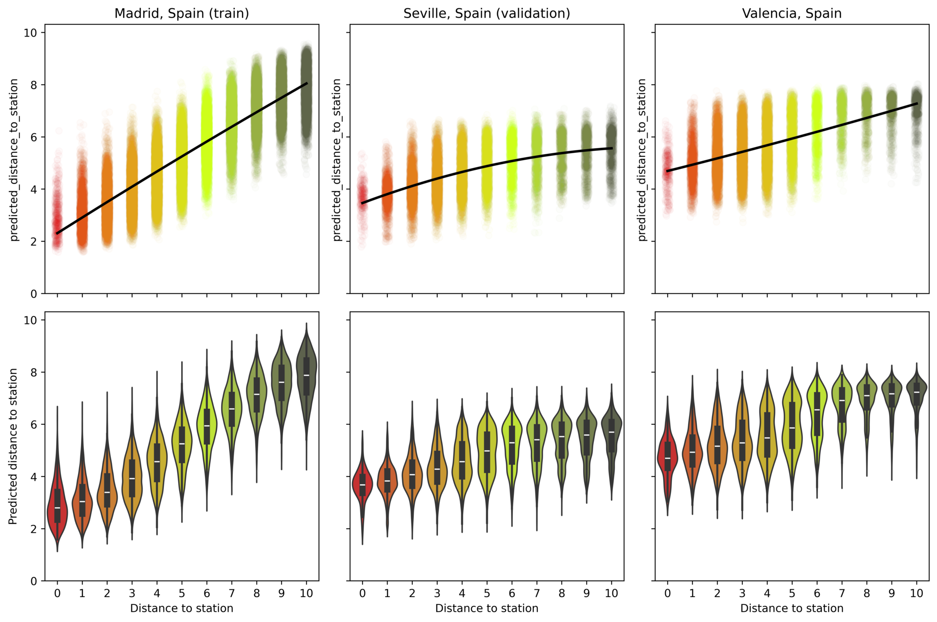
### Datasets
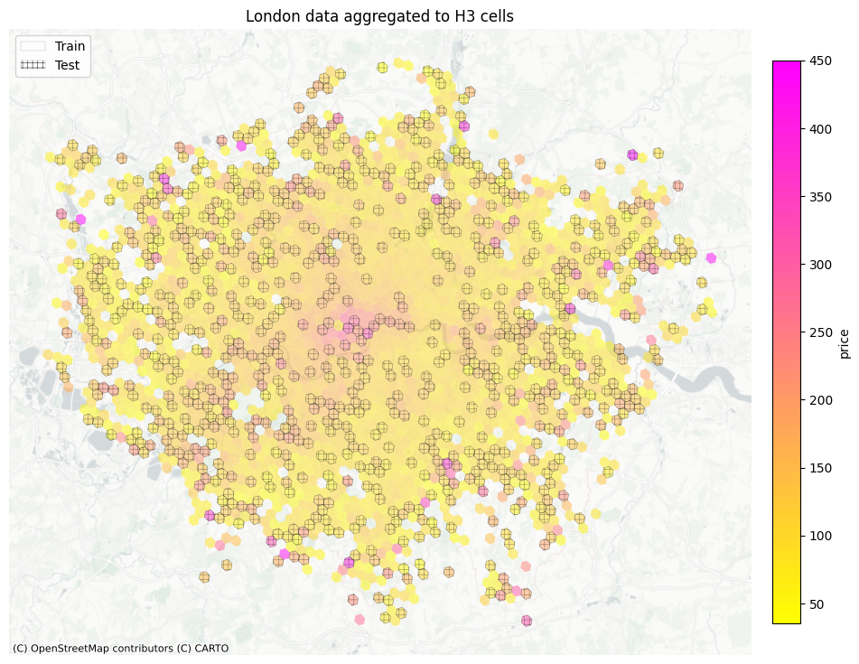
The library also includes a dedicated [`datasets`](https://kraina-ai.github.io/srai/latest/datasets/) and benchmark modules for downstream tasks based on public data.
## Installation
To install `srai` simply run:
```bash
pip install srai
```
This will install the `srai` package and dependencies required by most of the use cases. There are several optional dependencies that can be installed to enable additional functionality. These are listed in the [optional dependencies](#optional-dependencies) section.
### Optional dependencies
The following optional dependencies can be installed to enable additional functionality:
* `srai[all]` - all optional dependencies
* `srai[osm]` - dependencies required to download OpenStreetMap data
* `srai[overturemaps]` - dependencies required to download Overture Maps data
* `srai[datasets]` - dependencies required for downloading datasets
* `srai[voronoi]` - dependencies to use Voronoi-based regionalization method
* `srai[gtfs]` - dependencies to process GTFS data
* `srai[plotting]` - dependencies to plot graphs and maps
* `srai[torch]` - dependencies to use torch-based embedders
## Documentation
You can find the documentation for SRAI hosted on [Github Pages](https://kraina-ai.github.io/srai/).
It includes API documentation, contributing instructions and many [examples](https://kraina-ai.github.io/srai/latest/examples/). You can also check out our [paper](https://arxiv.org/abs/2310.13098).
## Tutorial
For a full tutorial on `srai` and geospatial data in general visit the [srai-tutorial](https://github.com/kraina-ai/srai-tutorial) repository. It contains easy to follow jupyter notebooks concentrating on every part of the library.
You can also see the recordings of the tutorials on YouTube:


## Usage
### Downloading OSM data
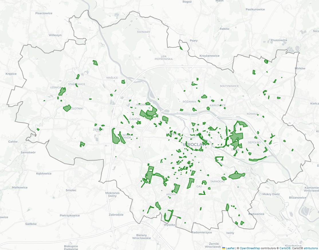
To download OSM data for a given area, using a set of tags use one of `OSMLoader` classes:
* `OSMOnlineLoader` - downloads data from OpenStreetMap API using [osmnx](https://github.com/gboeing/osmnx) - this is faster for smaller areas or tags counts
* `OSMPbfLoader` - loads data from automatically downloaded PBF file from [protomaps](https://protomaps.com/) - this is faster for larger areas or tags counts
Example with `OSMOnlineLoader`:
```python
from srai.loaders import OSMOnlineLoader
from srai.plotting import plot_regions
from srai.regionalizers import geocode_to_region_gdf
query = {"leisure": "park"}
area = geocode_to_region_gdf("Wrocław, Poland")
loader = OSMOnlineLoader()
parks_gdf = loader.load(area, query)
folium_map = plot_regions(area, colormap=["rgba(0,0,0,0)"], tiles_style="CartoDB positron")
parks_gdf.explore(m=folium_map, color="forestgreen")
```
### Downloading road network
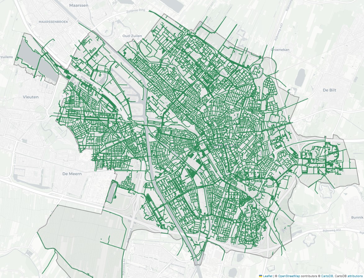
Road network downloading is a special case of OSM data downloading. To download road network for a given area, use `OSMWayLoader` class:
```python
from srai.loaders import OSMNetworkType, OSMWayLoader
from srai.plotting import plot_regions
from srai.regionalizers import geocode_to_region_gdf
area = geocode_to_region_gdf("Utrecht, Netherlands")
loader = OSMWayLoader(OSMNetworkType.BIKE)
nodes, edges = loader.load(area)
folium_map = plot_regions(area, colormap=["rgba(0,0,0,0.1)"], tiles_style="CartoDB positron")
edges[["geometry"]].explore(m=folium_map, color="seagreen")
```
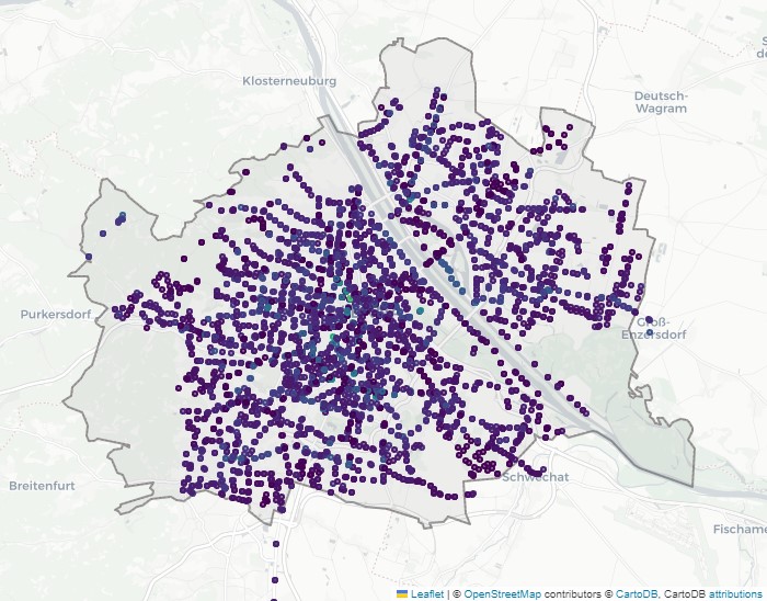
### Downloading GTFS data
To extract features from GTFS use `GTFSLoader`. It will extract trip count and available directions for each stop in 1h time windows.
```python
from pathlib import Path
from srai.loaders import GTFSLoader, download_file
from srai.plotting import plot_regions
from srai.regionalizers import geocode_to_region_gdf
area = geocode_to_region_gdf("Vienna, Austria")
gtfs_file = Path("vienna_gtfs.zip")
download_file("https://transitfeeds.com/p/stadt-wien/888/latest/download", gtfs_file.as_posix())
loader = GTFSLoader()
features = loader.load(gtfs_file)
folium_map = plot_regions(area, colormap=["rgba(0,0,0,0.1)"], tiles_style="CartoDB positron")
features[["trips_at_8", "geometry"]].explore("trips_at_8", m=folium_map)
```
### Regionalization
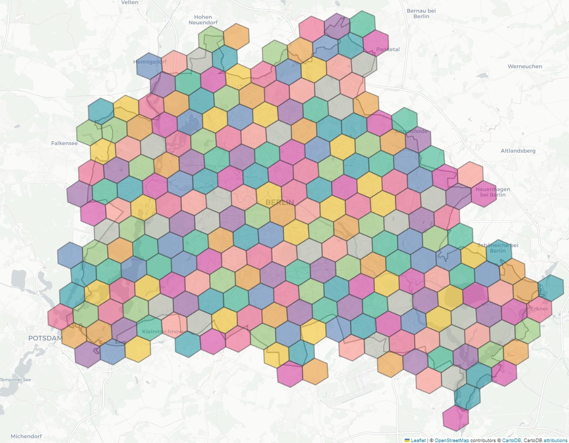
Regionalization is a process of dividing a given area into smaller regions. This can be done in a variety of ways:
* `H3Regionalizer` - regionalization using [Uber's H3 library](https://github.com/uber/h3)
* `S2Regionalizer` - regionalization using [Google's S2 library](https://github.com/google/s2geometry)
* `VoronoiRegionalizer` - regionalization using Voronoi diagram
* `AdministativeBoundaryRegionalizer` - regionalization using administrative boundaries
Example:
```python
from srai.regionalizers import H3Regionalizer, geocode_to_region_gdf
area = geocode_to_region_gdf("Berlin, Germany")
regionalizer = H3Regionalizer(resolution=7)
regions = regionalizer.transform(area)
folium_map = plot_regions(area, colormap=["rgba(0,0,0,0.1)"], tiles_style="CartoDB positron")
plot_regions(regions_gdf=regions, map=folium_map)
```
### Embedding
Embedding is a process of mapping regions into a vector space. This can be done in a variety of ways:
* `Hex2VecEmbedder` - embedding using hex2vec[1] algorithm
* `GTFS2VecEmbedder` - embedding using GTFS2Vec[2] algorithm
* `CountEmbedder` - embedding based on features counts
* `ContextualCountEmbedder` - embedding based on features counts with neighbourhood context (proposed in [3])
* `Highway2VecEmbedder` - embedding using Highway2Vec[4] algorithm
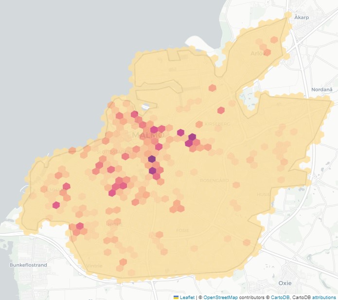
All of those methods share the same API. All of them require results from `Loader` (load features), `Regionalizer` (split area into regions) and `Joiner` (join features to regions) to work. An example using `CountEmbedder`:
```python
from srai.embedders import CountEmbedder
from srai.joiners import IntersectionJoiner
from srai.loaders import OSMOnlineLoader
from srai.plotting import plot_regions, plot_numeric_data
from srai.regionalizers import H3Regionalizer, geocode_to_region_gdf
loader = OSMOnlineLoader()
regionalizer = H3Regionalizer(resolution=9)
joiner = IntersectionJoiner()
query = {"amenity": "bicycle_parking"}
area = geocode_to_region_gdf("Malmö, Sweden")
features = loader.load(area, query)
regions = regionalizer.transform(area)
joint = joiner.transform(regions, features)
embedder = CountEmbedder()
embeddings = embedder.transform(regions, features, joint)
folium_map = plot_regions(area, colormap=["rgba(0,0,0,0.1)"], tiles_style="CartoDB positron")
plot_numeric_data(regions, "amenity_bicycle_parking", embeddings, map=folium_map)
```
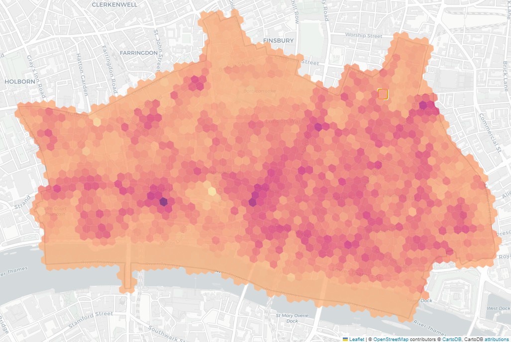
`CountEmbedder` is a simple method, which does not require fitting. Other methods, such as `Hex2VecEmbedder` or `GTFS2VecEmbedder` require fitting and can be used in a similar way to `scikit-learn` estimators:
```python
from srai.embedders import Hex2VecEmbedder
from srai.joiners import IntersectionJoiner
from srai.loaders import OSMPbfLoader
from srai.loaders.osm_loaders.filters import HEX2VEC_FILTER
from srai.neighbourhoods.h3_neighbourhood import H3Neighbourhood
from srai.regionalizers import H3Regionalizer, geocode_to_region_gdf
from srai.plotting import plot_regions, plot_numeric_data
loader = OSMPbfLoader()
regionalizer = H3Regionalizer(resolution=11)
joiner = IntersectionJoiner()
area = geocode_to_region_gdf("City of London")
features = loader.load(area, HEX2VEC_FILTER)
regions = regionalizer.transform(area)
joint = joiner.transform(regions, features)
embedder = Hex2VecEmbedder()
neighbourhood = H3Neighbourhood(regions_gdf=regions)
embedder = Hex2VecEmbedder([15, 10, 3])
# Option 1: fit and transform
# embedder.fit(regions, features, joint, neighbourhood, batch_size=128)
# embeddings = embedder.transform(regions, features, joint)
# Option 2: fit_transform
embeddings = embedder.fit_transform(regions, features, joint, neighbourhood, batch_size=128)
folium_map = plot_regions(area, colormap=["rgba(0,0,0,0.1)"], tiles_style="CartoDB positron")
plot_numeric_data(regions, 0, embeddings, map=folium_map)
```
### Pre-trained models usage
We provide pre-trained models for some of the embedding methods. To use them, simply download them from [here](https://drive.google.com/drive/folders/14sH33-kNxA0q1O1abPWTpuix8raR_XbD?usp=drive_link) and load them using `load` method:
```python
from srai.embedders import Hex2VecEmbedder
model_path = "path/to/model"
embedder = Hex2VecEmbedder.load(model_path)
```
### Plotting, utilities and more
We also provide utilities for different spatial operations and plotting functions adopted to data formats used in `srai` For a full list of available methods, please refer to the [documentation](https://kraina-ai.github.io/srai).
## Contributing
If you are willing to contribute to `srai`, feel free to do so! Visit [our contributing guide](./CONTRIBUTING.md) for more details.
## Publications
Some of the methods implemented in `srai` have been published in scientific journals and conferences.
1. Szymon Woźniak and Piotr Szymański. 2021. Hex2vec: Context-Aware Embedding H3 Hexagons with OpenStreetMap Tags. In Proceedings of the 4th ACM SIGSPATIAL International Workshop on AI for Geographic Knowledge Discovery (GEOAI '21). Association for Computing Machinery, New York, NY, USA, 61–71. [paper](https://doi.org/10.1145/3486635.3491076), [arXiv](https://arxiv.org/abs/2111.00970)
2. Piotr Gramacki, Szymon Woźniak, and Piotr Szymański. 2021. Gtfs2vec: Learning GTFS Embeddings for comparing Public Transport Offer in Microregions. In Proceedings of the 1st ACM SIGSPATIAL International Workshop on Searching and Mining Large Collections of Geospatial Data (GeoSearch'21). Association for Computing Machinery, New York, NY, USA, 5–12. [paper](https://doi.org/10.1145/3486640.3491392), [arXiv](https://arxiv.org/abs/2111.00960)
3. Kamil Raczycki and Piotr Szymański. 2021. Transfer learning approach to bicycle-sharing systems' station location planning using OpenStreetMap data. In Proceedings of the 4th ACM SIGSPATIAL International Workshop on Advances in Resilient and Intelligent Cities (ARIC '21). Association for Computing Machinery, New York, NY, USA, 1–12. [paper](https://doi.org/10.1145/3486626.3493434), [arXiv](https://arxiv.org/abs/2111.00990)
4. Kacper Leśniara and Piotr Szymański. 2022. Highway2vec: representing OpenStreetMap microregions with respect to their road network characteristics. In Proceedings of the 5th ACM SIGSPATIAL International Workshop on AI for Geographic Knowledge Discovery (GeoAI '22). Association for Computing Machinery, New York, NY, USA, 18–29. [paper](https://doi.org/10.1145/3557918.3565865), [arXiv](https://arxiv.org/abs/2304.13865)
5. Daniele Donghi and Anne Morvan. 2023. GeoVeX: Geospatial Vectors with Hexagonal Convolutional Autoencoders. In Proceedings of the 6th ACM SIGSPATIAL International Workshop on AI for Geographic Knowledge Discovery (GeoAI '23). Association for Computing Machinery, New York, NY, USA, 3–13. [paper](https://doi.org/10.1145/3615886.3627750)
6. Shushman Choudhury, Elad Aharoni, Chandrakumari Suvarna, Iveel Tsogsuren, Abdul Rahman Kreidieh, Chun-Ta Lu and Neha Arora. 2025. S2Vec: Self-Supervised Geospatial Embeddings (No. arXiv:2504.16942). [arXiv](https://arxiv.org/abs/2504.16942)
7. Julia Moska, Oleksii Furman, Kacper Kozaczko, Szymon Leszkiewicz, Jakub Polczyk, Piotr Gramacki and Piotr Szymański. 2025. OBSR: Open Benchmark for Spatial Representations. In Proceedings of the 33rd ACM SIGSPATIAL International Conference on Advances in Geographic Information Systems (ACM SIGSPATIAL 2025). [paper](https://doi.org/10.1145/3748636.3762783), [arxiv](https://arxiv.org/abs/2510.05879)
## Acknowledgements
We would like to thank Piotr Szymański PhD \([@niedakh](https://twitter.com/niedakh)\) for his invaluable guidance and support in the development of this library. His expertise and mentorship have been instrumental in shaping the library's design and functionality, and we are very grateful for his input.
## Citation
If you wish to cite the SRAI library, please use our [paper](https://arxiv.org/abs/2310.13098)
```bibtex
@inproceedings{
Gramacki_SRAI_Towards_Standardization_2023,
author = {
Gramacki, Piotr and
Leśniara, Kacper and
Raczycki, Kamil and
Woźniak, Szymon and
Przymus, Marcin and
Szymański, Piotr
},
booktitle = {Proceedings of the 6th ACM SIGSPATIAL International Workshop on AI for Geographic Knowledge Discovery},
month = nov,
publisher = {Association for Computing Machinery},
title = {{SRAI: Towards Standardization of Geospatial AI}},
url = {https://dl.acm.org/doi/10.1145/3615886.3627740},
year = {2023}
}
```
## License
This library is licensed under the [Apache License 2.0](https://github.com/kraina-ai/srai/blob/main/LICENSE.md).
The free [OpenStreetMap](https://www.openstreetmap.org/) data, which is used for the development of SRAI, is licensed under the [Open Data Commons Open Database License](https://opendatacommons.org/licenses/odbl/) (ODbL) by the [OpenStreetMap Foundation](https://osmfoundation.org/) (OSMF).