# The trackintel framework
[](https://badge.fury.io/py/trackintel)
[](https://anaconda.org/conda-forge/trackintel)
[](https://github.com/mie-lab/trackintel/actions?query=workflow%3ATests)
[](https://trackintel.readthedocs.io/en/latest/?badge=latest)
[](https://codecov.io/gh/mie-lab/trackintel)
[](https://github.com/psf/black)
[](https://mie-lab.github.io/trackintel/)
[](https://pepy.tech/project/trackintel)
*trackintel* is a library for the analysis of spatio-temporal tracking data with a focus on human mobility. The core of *trackintel* is the hierarchical data model for movement data that is used in GIS, transport planning and related fields. We provide functionalities for the full life-cycle of human mobility data analysis: import and export of tracking data of different types (e.g, trackpoints, check-ins, trajectories), preprocessing, data quality assessment, semantic enrichment, quantitative analysis and mining tasks, and visualization of data and results.
Trackintel is based on [Pandas](https://pandas.pydata.org/) and [GeoPandas](https://geopandas.org/#).
You can find the documentation on the [trackintel documentation page](https://trackintel.readthedocs.io/en/latest).
Try *trackintel* online in a MyBinder notebook: [](https://mybinder.org/v2/gh/mie-lab/trackintel/HEAD?filepath=%2Fexamples%2Ftrackintel_basic_tutorial.ipynb)
Please star this repo and [cite](#citelink) our paper if you find our work is helpful for you.
## Data model
An overview of the data model of *trackintel*:
* **positionfixes** (Raw tracking points, e.g., GPS recordings or check-ins)
* **staypoints** (Locations where a user spent time without moving, e.g., aggregations of positionfixes or check-ins). Staypoints can be classified into the following categories:
* **activity** staypoints. Staypoints with a purpose and a semantic label, e.g., stopping at a cafe to meet with friends or staying at the workplace.
* non-activity staypoints. Staypoints without an explicit purpose, e.g., waiting for a bus or stopping in a traffic jam.
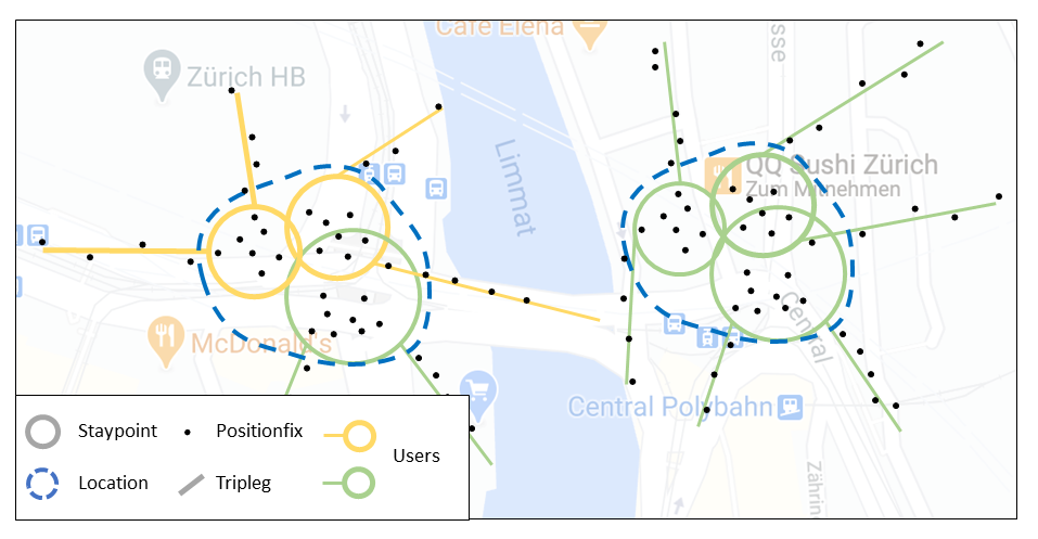
* **locations** (Important places that are visited more than once, e.g., home or work location)
* **triplegs** (or stages) (Continuous movement without changing mode, vehicle or stopping for too long, e.g., a taxi trip between pick-up and drop-off)
* **trips** (The sequence of all triplegs between two consecutive activity staypoints)
* **tours** (A collection of sequential trips that return to the same location)
An example plot showing the hierarchy of the *trackintel* data model can be found below:

The image below explicitly shows the definition of **locations** as clustered **staypoints**, generated by one or several users.
You can enter the *trackintel* framework if your data corresponds to any of the above mentioned movement data representation. Here are some of the functionalities that we provide:
* **Import**: Import from the following data formats is supported: `geopandas dataframes` (recommended), `csv files` in a specified format, `postGIS` databases. We also provide specific dataset readers for popular public datasets (e.g, geolife).
* **Aggregation**: We provide functionalities to aggregate into the next level of our data model. E.g., positionfixes→staypoints; positionfixes→triplegs; staypoints→locations; staypoints+triplegs→trips; trips→tours
* **Enrichment**: Activity semantics for staypoints; Mode of transport semantics for triplegs; High level semantics for locations
## How it works
*trackintel* provides support for the full life-cycle of human mobility data analysis.
**[1.]** Import data.
```python
import geopandas as gpd
import trackintel as ti
# read pfs from csv file
pfs = ti.io.read_positionfixes_csv(".\examples\data\pfs.csv", sep=";", index_col="id")
# or with predefined dataset readers (here geolife)
pfs, _ = ti.io.read_geolife(".\tests\data\geolife_long")
```
**[2.]** Data model generation.
```python
# generate staypoints and triplegs
pfs, sp = pfs.generate_staypoints(method='sliding')
pfs, tpls = pfs.generate_triplegs(sp, method='between_staypoints')
```
**[3.]** Visualization.
```python
# plot the generated tripleg result
ti.plot(positionfixes=pfs, staypoints=sp, triplegs=tpls, radius_sp=10)
```
**[4.]** Analysis.
```python
# e.g., predict travel mode labels based on travel speed
tpls = tpls.predict_transport_mode()
# or calculate the temporal tracking coverage of users
tracking_coverage = ti.analysis.temporal_tracking_quality(tpls, granularity='all')
```
**[5.]** Save results.
```python
# save the generated results as csv file
sp.to_csv(r'.\examples\data\sp.csv')
tpls.to_csv(r'.\examples\data\tpls.csv')
```
For example, the plot below shows the generated staypoints and triplegs from the imported raw positionfix data.

## Installation and Usage
*trackintel* is on [pypi.org](https://pypi.org/project/trackintel/) and [conda-forge](https://anaconda.org/conda-forge/trackintel). We recommend installing trackintel via conda-forge:
```{python}
conda install -c conda-forge trackintel
```
Alternatively, you can install it with pip in a `GeoPandas` available environment using:
```{python}
pip install trackintel
```
You should then be able to run the examples in the `examples` folder or import trackintel using:
```{python}
import trackintel as ti
ti.print_version()
```
## Requirements and dependencies
* Numpy
* GeoPandas
* Matplotlib
* GeoAlchemy2
* scikit-learn
* tqdm
* OSMnx
* similaritymeasures
## Development
You can find the development roadmap under `ROADMAP.md` and further development guidelines under `CONTRIBUTING.md`.
## Contributors
*trackintel* is primarily maintained by the Mobility Information Engineering Lab at ETH Zurich ([mie-lab.ethz.ch](http://mie-lab.ethz.ch)).
If you want to contribute, send a pull request and put yourself in the `AUTHORS.md` file.
## Citation
If you find this code useful for your work or use it in your project, please consider citing:
Martin, H., Hong, Y., Wiedemann, N., Bucher, D., & Raubal, M. (2023). [Trackintel: An open-source Python library for human mobility analysis](https://doi.org/10.1016/j.compenvurbsys.2023.101938). Computers, Environment and Urban Systems, 101, 101938.
```
@article{Martin_2023_trackintel,
doi = {10.1016/j.compenvurbsys.2023.101938},
volume = {101},
pages = {101938},
author = {Henry Martin and Ye Hong and Nina Wiedemann and Dominik Bucher and Martin Raubal},
keywords = {Human mobility analysis, Open-source software, Transport planning, Data mining, Python, Tracking studies},
title = {Trackintel: An open-source Python library for human mobility analysis},
journal = {Computers, Environment and Urban Systems},
year = {2023},
}
```