ablation
All processes that reduce the mass of a glacier, ice sheet, or snow cover.
The main processes are melting, and for glaciers also calving (or, when the glacier nourishes an ice shelf, discharge of ice across the grounding line), but other processes such as sublimation and loss of wind-blown snow can also contribute to ablation. Ablation also refers to the mass lost by any of these processes.

semanticClimate annotation
Translations
- DE: ablation
- HI: पृथक करना
abrupt change
A change in the system that is substantially faster than the typical rate of the changes in its history.
semanticClimate annotation
Translations
- HI: अचानक परिवर्तन
abrupt climate change
A large-scale abrupt change in the climate system that takes place over a few decades or less, persists (or is anticipated to persist) for at least a few decades and causes substantial impacts in human and/or natural systems.
semanticClimate annotation
.JPG)
From Wikipedia An abrupt climate change occurs when the climate system is forced to transition at a rate that is determined by the climate system energy-balance.
Translations
- HI: अचानक जलवायु परिवर्तन
acceptability of policy or system change
The extent to which a policy or system change is evaluated unfavourably or favourably, or rejected or supported, by members of the general public (public acceptability) or politicians or governments (political acceptability).
Acceptability may vary from totally unacceptable/fully rejected to totally acceptable/fully supported; individuals may differ in how acceptable policies or system changes are believed to be.
semanticClimate annotation
access to modern energy services
Access to clean, reliable and affordable energy services for cooking, heating, lighting, communications, and productive uses.
semanticClimate annotation
acclimatisation
A change in functional or morphological traits occurring once or repeatedly (e.g., seasonally) during the lifetime of an individual organism in its natural environment.
Through acclimatisation, the individual maintains performance across a range of environmental conditions. For a clear differentiation between findings in laboratory and field studies, the term ‘acclimation’ is used in ecophysiology for the respective phenomena when observed in well-defined experimental settings. The term ‘(adaptive) plasticity’ characterises the generally limited scope of changes in phenotype that an individual can reach through the process of acclimatisation.
semanticClimate annotation
Translations
- HI: पर्यनुकूलन
accumulation
All processes that add to the mass of a glacier, an ice sheet, or snow cover.
The main process of accumulation is snowfall. Accumulation also includes deposition of hoar, freezing rain, other types of solid precipitation, gain of wind-blown snow, avalanching, and basal accumulation (often beneath floating ice).
semanticClimate annotation
active layer
Layer of ground above permafrost subject to annual thawing and freezing.
.jpg)
semanticClimate annotation
Translations
- HI: सक्रिय परत
acute food insecurity
Acute food insecurity is a situation which can occur at any time with a severity that threatens lives, livelihoods or both, regardless of the causes,context or duration, as a result of shocks risking determinants of food security and nutrition, and used to assess the need for humanitarian action (IPC Global Partners, 2019).
semanticClimate annotation
Translations
- HI: तीव्र खाद्य असुरक्षा
adaptation
In human systems, the process of adjustment to actual or expected climate and its effects, in order to moderate harm or exploit beneficial opportunities. In natural systems, the process of adjustment to actual climate and its effects; human intervention may facilitate adjustment to expected climate and its effects.
Sub-terms
semanticClimate annotation
Translations
- HI: अनुकूलन
Adaptation Fund
A Fund established under the Kyoto Protocol in 2001 and officially launched in 2007.
The Fund finances adaptation projects and programmes in developing countries that are Parties to the Kyoto Protocol. Financing comes mainly from sales of Certified Emissions Reductions (CERs) and a share of proceeds amounting to 2 % of the value of CERs issued each year for Clean Development Mechanism (CDM) projects. The Adaptation Fund can also receive funds from governments, the private sector, and individuals.
semanticClimate annotation
From Wikipedia The Adaptation Fund is an international fund that finances projects and programs aimed at helping developing countries to adapt to the harmful effects of climate change. It is set up under the Kyoto Protocol of the United Nations Framework Convention on Climate Change (UNFCCC).
Translations
- HI: अनुकूलन कोष
adaptation behaviour
Human actions that directly or indirectly affect the risks of climate change impacts.
Parent-term
semanticClimate annotation
Translations
- HI: अनुकूलन व्यवहार
adaptation deficit
The gap between the current state of a system and a state that minimises adverse impacts from existing climate conditions and variability.
Parent-term
semanticClimate annotation
Translations
- HI: अनुकूलन घाटा
adaptation gap
The difference between actually implemented adaptation and a societally set goal, determined largely by preferences related to tolerated climate change impacts and reflecting resource limitations and competing priorities (UNEP, 2014; UNEP, 2018).
Parent-term
semanticClimate annotation
Translations
- HI: अनुकूलन अंतराल
adaptation limits
The point at which an actor’s objectives (or system needs) cannot be secured from intolerable risks through adaptive actions.
• Hard adaptation limit – No adaptive actions are possible to avoid intolerable risks.
• Soft adaptation limit – Options may exist but are currently not available to avoid intolerable risks through adaptive action.
Parent-term
semanticClimate annotation
Translations
- HI: अनुकूलन सीमा
adaptation needs
The circumstances requiring action to ensure the safety of populations and the security of assets in response to climate impacts.
Parent-term
semanticClimate annotation
adaptation opportunity
Factors that make it easier to plan and implement adaptation actions, that expand adaptation options, or that provide ancillary co-benefits.
semanticClimate annotation
adaptation options
The array of strategies and measures that are available and appropriate for addressing adaptation.
They include a wide range of actions that can be categorised as structural, institutional, ecological or behavioural.
Parent-term
semanticClimate annotation
adaptation pathways
A series of adaptation choices involving trade-offs between short-term and long-term goals and values.
These are processes of deliberation to identify solutions that are meaningful to people in the context of their daily lives and to avoid potential maladaptation.
Parent-term
semanticClimate annotation
adaptive capacity
The ability of systems, institutions, humans and other organisms to adjust to potential damage, to take advantage of opportunities or to respond to consequences (MA, 2005).
References
- MA, 2005: Appendix D: Glossary. In: Ecosystems and Human Well-being: Current States and Trends. Findings of the Condition and Trends Working Group [Hassan, R., R. Scholes, and N. Ash (eds.)]. Millennium Ecosystem Assessment (MEA). Island Press, Washington, DC, USA, pp. 893–900.semanticClimate annotation
From Wikipedia Adaptive capacity relates to the capacity of systems, institutions, humans and other organisms to adjust to potential damage, to take advantage of opportunities, or to respond to consequences. In the context of ecosystems, adaptive capacity is determined by genetic diversity of species, biodiversity of particular ecosystems in specific landscapes or biome regions.
adaptive governance
Adjusting to changing conditions, such as climate change, through governance interactions that seek to maintain a desired state in a social-ecological system.
Parent-term
semanticClimate annotation
adaptive management
A process of iteratively planning, implementing and modifying strategies for managing resources in the face of uncertainty and change.
Adaptive management involves adjusting approaches in response to observations of their effect on, and changes in, the system brought on by resulting feedback effects and other variables.
semanticClimate annotation
From Wikipedia Adaptive management, also known as adaptive resource management or adaptive environmental assessment and management, is a structured, iterative process of robust decision making in the face of uncertainty, with an aim to reducing uncertainty over time via system monitoring.
added value
Improvement of the representation of some climatic aspects by one methodology compared to another methodology.
For instance, downscaling a coarse resolution global climate model may improve the representation of regional climate in complex terrain.
semanticClimate annotation
additionality
The property of being additional.
Mitigation is additional if the greenhouse gas emission reductions or removals would not have occurred in the absence of the associated policy intervention or activity.
[Note: Additionality is one of several key criteria used to ensure the environmental integrity of Offsets (in climate change mitigation)].
semanticClimate annotation
From Wikipedia Adaptive management, also known as adaptive resource management or adaptive environmental assessment and management, is a structured, iterative process of robust decision making in the face of uncertainty, with an aim to reducing uncertainty over time via system monitoring.
adjustments
The response to an agent perturbing the climate system that is driven directly by the agent, independently of any change in global surface temperature.
For example, carbon dioxide and aerosols, by altering internal heating and cooling rates within the atmosphere, can each cause changes to cloud cover and other variables thereby producing an effective radiative forcing even in the absence of any surface warming or cooling. Adjustments are usually rapid in the sense that they begin to occur right away, before climate feedbacks which are driven by global surface warming (although some adjustments may still take significant time to proceed to completion, for example those involving vegetation or ice sheets).
semanticClimate annotation
advection
Transport of water or air along with its properties (e.g., temperature, chemical tracers) by winds or currents.
Regarding the general distinction between advection and convection, the former describes transport by large-scale motions of the atmosphere or ocean, while convection describes the predominantly vertical, locally induced motions.
semanticClimate annotation
From Wikipedia In the field of physics, engineering, and earth sciences, advection is the transport of a substance or quantity by bulk motion of a fluid. The properties of that substance are carried with it. Generally the majority of the advected substance is also a fluid. The properties that are carried with the advected substance are conserved properties such as energy.
adverse side-effect
A negative effect that a policy or measure aimed at one objective has on another objective, thereby potentially reducing the net benefit to society or the environment.
semanticClimate annotation
aerosol
A suspension of airborne solid or liquid particles, with typical particle size in the range of a few nanometres to several tens of micrometres and atmospheric lifetimes of up to several days in the troposphere and up to years in the stratosphere.
The term aerosol, which includes both the particles and the suspending gas, is often used in this report in its plural form to mean ‘aerosol particles’. Aerosols may be of either natural or anthropogenic origin in the troposphere; stratospheric aerosols mostly stem from volcanic eruptions. Aerosols can cause an effective radiative forcing directly through scattering and absorbing radiation (aerosol–radiation interaction), and indirectly by acting as cloud condensation nuclei or ice nucleating particles that affect the properties of clouds (aerosol–cloud interaction), and upon deposition on snow- or ice-covered surfaces. Atmospheric aerosols may be either emitted as primary particulate matter or formed within the atmosphere from gaseous precursors (secondary production). Aerosols may be composed of sea salt, organic carbon, black carbon (BC), mineral species (mainly desert dust), sulphate, nitrate and ammonium or their mixtures.
semanticClimate annotation

From Wikipedia An aerosol is a suspension of fine solid particles or liquid droplets in air or another gas.
Translations
- HI: वायु-विलय पात्र
aerosol–cloud interaction
A process by which a perturbation to aerosol affects the microphysical properties and evolution of clouds through the aerosol role as cloud condensation nuclei or ice nuclei, particularly in ways that affect radiation or precipitation; such processes can also include the effect of clouds and precipitation on aerosol.
The aerosol perturbation can be anthropogenic or come from some natural source. The radiative forcing from such interactions has traditionally been attributed to numerous indirect aerosol effects, but in this report, only two levels of radiative forcing (or effect) are distinguished:
Sub-terms
semanticClimate annotation
aerosol effective radiative forcing
The total effective radiative forcing due to both aerosol–cloud and aerosol–radiation interactions is denoted aerosol effective radiative forcing (ERFari+aci).
Parent-term
semanticClimate annotation
aerosol optical depth
Wavelength-dependent aerosol optical depth is a measure of the aerosol contribution to extinction of top-of-the-atmosphere solar intensity measured at the ground.
AOD is unitless.
Sub-terms
semanticClimate annotation
aerosol–radiation interaction
An interaction of aerosol directly with radiation produces radiative effects.
In this report, two levels of radiative forcing (or effect) are distinguished:
Sub-terms
semanticClimate annotation
afforestation
Conversion to forest of land that historically has not contained forests.
[Note: For a discussion of the term forest and related terms such as afforestation, reforestation and deforestation, see the 2006 IPCC Guidelines for National Greenhouse Gas Inventories and their 2019 Refinement, and information provided by the United Nations Framework Convention on Climate Change (IPCC 2006, 2019; UNFCCC 2021a, b).]
References
- UNFCCC, 2021: Reporting and accounting of LULUCF activities under the Kyoto Protocol. United Nations Framework Convention on Climate Change (UNFCCC), Bonn, Germany. Retrieved from: https://unfccc.int/topics/land-use/workstreams/land-use-land-use-change-and-forestry-lulucf/reporting-and-accounting-of-lulucf-activities-under-the-kyoto-protocol- UNFCCC, 2021: Reporting and Review under the Paris Agreement. United Nations Framework Convention on Climate Change (UNFCCC), Bonn, Germany. Retrieved from: https://unfccc.int/process-and-meetings/transparency-and-reporting/reporting-and-review-under-the-paris-agreement
semanticClimate annotation

From Wikipedia Afforestation is the establishment of a forest or stand of trees (forestation) in an area where there was no recent tree cover.
Translations
- HI: वनरोपण
agreement
In this report, the degree of agreement within the scientific body of knowledge on a particular finding is assessed based on multiple lines of evidence (e.g., mechanistic understanding, theory, data, models, expert judgement) and expressed qualitatively (Mastrandrea et al., 2010).
semanticClimate annotation
Translations
- HI: समझौता
agricultural and ecological drought
Depending on the affected biome: a period with abnormal soil moisture deficit, which results from combined shortage of precipitation and excess evapotranspiration, and during the growing season impinges on crop production or ecosystem function in general.
Parent-term
semanticClimate annotation
Agriculture, Forestry and Other Land Use
In the context of national greenhouse gas (GHG) inventories under the United Nations Framework Convention on Climate Change (UNFCCC), AFOLU is the sum of the GHG inventory sectors Agriculture and Land Use, Land-Use Change and Forestry (LULUCF); see the 2006 IPCC Guidelines for National GHG Inventories for details.
Given the difference in estimating the ‘anthropogenic’ carbon dioxide (CO2) removals between countries and the global modelling community, the land-related net GHG emissions from global models included in this report are not necessarily directly comparable with LULUCF estimates in national GHG Inventories.
semanticClimate annotation
agroecology
‘The science and practice of applying ecological concepts, principles and knowledge (i.e., the interactions of, and explanations for, the diversity, abundance and activities of organisms) to the study, design and management of sustainable agroecosystems.
It includes the roles of human beings as a central organism in agroecology by way of social and economic processes in farming systems. Agroecology examines the roles and interactions among all relevant biophysical, technical and socio-economic components of farming systems and their surrounding landscapes (IPBES, 2019).
semanticClimate annotation
From Wikipedia Agroecology is an academic discipline that studies ecological processes applied to agricultural production systems. Bringing ecological principles to bear can suggest new management approaches in agroecosystems.
Translations
- HI: कृषिपारिस्थितिकी
agroforestry
Collective name for land-use systems and technologies where woody perennials (trees, shrubs, palms, bamboos, etc.) are deliberately used on the same land-management units as agricultural crops and/or animals, in some form of spatial arrangement or temporal sequence.
In agroforestry systems there are both ecological and economical interactions between the different components. Agroforestry can also be defined as a dynamic, ecologically-based, natural resource management system that, through the integration of trees on farms and in the agricultural landscape, diversifies and sustains production for increased social, economic and environmental benefits for land users at all levels (FAO, 2015a).
References
- FAO, 2015a: Agroforestry. Food and Agriculture Organization of the United Nations (FAO).Retrieved from: http://www.fao.org/forestry/agroforestry/80338/en/.semanticClimate annotation
(2).jpg)
From Wikipedia Agroforestry (or agro-sylviculture) is a land use management system in which combinations of trees or shrubs are grown around or among crops or pastureland.
Translations
- HI: कृषि वानिकी
air mass
A widespread body of air, the approximately homogeneous properties of which (i) have been established while that air was situated over a particular region of the Earth’s surface, and (ii) undergo specific modifications while in transit away from the source region (AMS, 2021).
References
- AMS, 2021: Glossary of Meteorology. American Meteorological Society (AMS), Boston, MA, USA. Retrieved from: http://glossary.ametsoc.org.semanticClimate annotation

From Wikipedia In meteorology, an air mass is a volume of air defined by its temperature and humidity. Air masses cover many hundreds or thousands of square miles, and adapt to the characteristics of the surface below them.
Translations
- HI: हवा का द्रव्यमान
air pollution
Degradation of air quality with negative effects on human health or the natural or built environment due to the introduction, by natural processes or human activity, into the atmosphere of substances (gases, aerosols) which have a direct (primary pollutants) or indirect (secondary pollutants) harmful effect.
semanticClimate annotation

From Wikipedia Air pollution is the contamination of air due to the presence of substances in the atmosphere that are harmful to the health of humans and other living beings, or cause damage to the climate or to materials.
Translations
- HI: वायु प्रदूषण
airborne fraction
The fraction of total carbon dioxide (CO2) emissions (from fossil fuels and land-use change) remaining in the atmosphere.
semanticClimate annotation

From Wikipedia The airborne fraction is a scaling factor defined as the ratio of the annual increase in atmospheric CO 2 to the CO 2 emissions from human sources.
albedo
The proportion of sunlight (solar radiation) reflected by a surface or object, often expressed as a percentage.
Clouds, snow and ice usually have high albedo; soil surfaces cover the albedo range from high to low; vegetation in the dry season and/or in arid zones can have high albedo, whereas photosynthetically active vegetation and the ocean have low albedo. The Earth’s planetary albedo changes mainly through changes in cloudiness, snow, ice, leaf area and land cover.
semanticClimate annotation

From Wikipedia Albedo (from Latin albedo 'whiteness') is the fraction of sunlight that is diffusely reflected by a body. It is measured on a scale from 0 (corresponding to a black body that absorbs all incident radiation) to 1 (corresponding to a body that reflects all incident radiation).
Translations
- HI: प्रकाशानुपात

altimetry
A technique for measuring the height of the Earth’s surface with respect to the geocentre of the Earth within a defined terrestrial reference frame (geocentric sea level).
semanticClimate annotation
annular modes
Hemispheric scale patterns of atmospheric variability characterized by opposing and synchronous fluctuations in sea-level pressure between the polar caps and mid-latitudes, with a structure exhibiting a high degree of zonal symmetry, and with no real preferred time scales ranging from days to decades.
In each hemisphere, these fluctuations reflect changes in the latitudinal position and strength of the mid-latitude jets and associated storm tracks. Annular modes are defined as the leading mode of variability of extratropical sea-level pressure or geopotential heights and are known as the Northern Annular Mode (NAM) and Southern Annular Mode (SAM) in the two hemispheres, respectively.
semanticClimate annotation
anomaly
The deviation of a variable from its value averaged over a reference period.
semanticClimate annotation
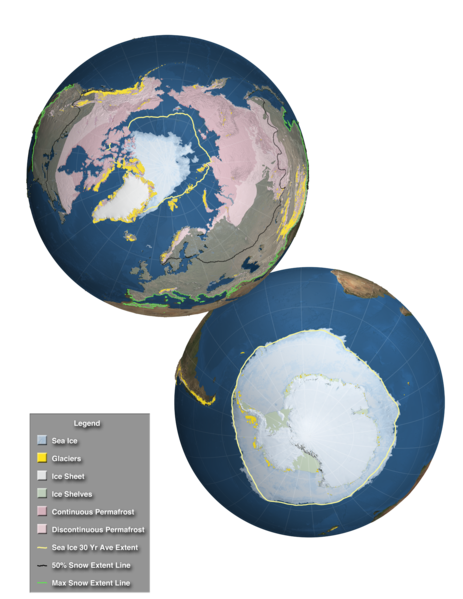
Antarctic Ice Sheet
There are only two ice sheets in the modern world, one on Greenland and one on Antarctica.
The latter is divided
into the East Antarctic Ice Sheet (EAIS), the West Antarctic Ice Sheet (WAIS) and the Antarctic Peninsula Ice Sheet. During glacial periods, there were other ice sheets.
semanticClimate annotation

From Wikipedia The Antarctic ice sheet is one of the two polar ice caps of Earth. It covers about 98% of the Antarctic continent and is the largest single mass of ice on Earth, with an average thickness of over 2 kilometers.
Translations
- HI: अंटार्कटिक बर्फ की चादर
anthropocene
A proposed new geological epoch resulting from significant human-driven changes to the structure and functioning of the Earth system, including the climate system.
Originally proposed in the Earth system science community in 2000, the proposed new epoch is undergoing a formalisation process within the geological community based on the stratigraphic evidence that human activities have changed the Earth system to the extent of forming geological deposits with a signature that is distinct from those of the Holocene, and which will remain in the geological record. Both the stratigraphic and Earth system approaches to defining the Anthropocene consider the mid-20th century to be the most appropriate starting date (Steffen et al., 2016), although others have been proposed and continue to be discussed. The Anthropocene concept has already been informally adopted by diverse disciplines and the public to denote the substantive influence of humans on the Earth system.
References
- Steffen, W., Leinfelder, R., Zalasiewicz, J., Waters, C.N., Williams, M., Summerhayes, C., Barnosky, A.D., Cearreta, A., Crutzen, P., Edgeworth, M., Ellis, E.C., Fairchild, I.J., Galuszka, A., Grinevald, J., Haywood, A., Ivar do Sul, J., Jeandel, C., McNeill, J., Odada, E., Oreskes, N., Revkin, A., Richter, D.d., Syvitski, J., Vidas, D., Wagreich, M., Wing, S.L., Wolfe, A.P. and Schellnhuber, H. (2016), Stratigraphic and Earth System approaches to defining the Anthropocene. Earth's Future, 4: 324-345.<br /> https://doi.org/10.1002/2016EF000379semanticClimate annotation
.jpg)
From Wikipedia The Anthropocene (/ˈænθrəpəˌsiːn, ænˈθrɒpə-/ AN-thrə-pə-seen, an-THROP-ə-)[1][2][3][failed verification] is a proposed geological epoch dating from the commencement of significant human impact on Earth's geology and ecosystems, including, but not limited to, human-caused climate change.
Translations
- HI: एंथ्रोपोसीन
anthropogenic
Resulting from or produced by human activities.
semanticClimate annotation
Translations
- HI: मानवजनित
anthropogenic emissions
Emissions of greenhouse gases (GHGs), precursors of GHGs and aerosols caused by human activities.
These activities include the burning of fossil fuels, deforestation, land use and land use changes (LULUC), livestock production, fertilisation, waste management, and industrial processes.
semanticClimate annotation
Translations
- HI: मानवजनित उत्सर्जन
anthropogenic removals
The withdrawal of greenhouse gases (GHGs) from the atmosphere as a result of deliberate human activities.
These include enhancing biological sinks of CO2 and using chemical engineering to achieve long term removal and storage. Carbon capture and storage (CCS), which alone does not remove CO2 from the atmosphere, can help reduce atmospheric CO2 from industrial and energy-related sources if it is combined with bioenergy production (BECCS), or if CO2 is captured from the air directly and stored (DACCS).
[Note: In the 2006 IPCC Guidelines for National GHG Inventories (IPCC, 2006), which are used in reporting of emissions to the UNFCCC, ‘anthropogenic’ land-related GHG fluxes are defined as all those occurring on ‘managed land’, i.e. ‘where human interventions and practices have been applied to perform production, ecological or social functions’. However, some removals (e.g. removals associated with CO2 fertilisation and N deposition) are not considered as ‘anthropogenic’, or are referred to as ‘indirect’ anthropogenic effects, in some of the scientific literature assessed in this report. As a consequence, the land-related net GHG emission estimates from global models included in this report are not necessarily directly comparable with Land Use, Land-Use Change and Forestry (LULUCF) estimates in national GHG Inventories.]
semanticClimate annotation
Translations
- HI: मानवजनित निष्कासन
anthropogenic subsidence
Downward motion of the land surface induced by anthropogenic drivers (e.g., loading, extraction of hydrocarbons and/or groundwater, drainage, mining activities) causing sediment compaction or subsidence/deformation of the sedimentary sequence, or oxidation of organic material, thereby leading to relative sea level rise.
semanticClimate annotation
Translations
- HI: मानवजनित अवतलन
apparent hydrological sensitivity
The change in global mean precipitation per degree Celsius of global mean surface air temperature (GSAT) change with units of % per °C, although it can also be calculated as Wm-2 per °C.
semanticClimate annotation
arctic oscillation
See Northern Annular Mode (NAM) (under Annular modes).
semanticClimate annotation

From Wikipedia The Arctic oscillation (AO) or Northern Annular Mode/Northern Hemisphere Annular Mode (NAM) is a weather phenomenon at the Arctic pole north of 20 degrees latitude. It is an important mode of climate variability for the Northern Hemisphere.
Translations
- HI: आर्कटिक दोलन
arid zone
Areas where vegetation growth is severely constrained due to limited water availability.
For the most part, the native vegetation of arid zones is sparse. There is high rainfall variability, with annual averages below 300 mm. Crop farming in arid zones requires irrigation.
semanticClimate annotation

From Wikipedia Drylands are defined by a scarcity of water. Drylands are zones where precipitation is balanced by evaporation from surfaces and by transpiration by plants (evapotranspiration).
Translations
- HI: शुष्कभूमि
aridity
The state of a long-term climatic feature characterised by low average precipitation or available water in a region.
Aridity generally arises from widespread persistent atmospheric subsidence or anticyclonic conditions, and from more localised subsidence in the lee side of mountains (adapted from Ogallo and Gbeckor-Kove, 1989; Türkeş, 1999).
semanticClimate annotation
Translations
- HI: शुष्कता
artificial ocean upwelling
A potential carbon dioxide removal (CDR) method that aims to artificially pump up cooler, nutrient-rich waters from deep in the ocean to the surface.
The aim is to stimulate phytoplankton activity and thereby increase ocean CO2 uptake.
semanticClimate annotation
Translations
- HI: कृत्रिम महासागर का उभार
assets
Natural or human-made resources that provide current or future utility, benefit, economic or intrinsic value to natural or human systems.
Atlantic Meridional Mode
The Atlantic Meridional Mode (AMM) refers to the interannual to decadal variability of the cross-equatorial sea surface temperature gradients and surface wind anomalies in the tropical Atlantic.
It modulates the strength and latitudinal shifts of the Inter-tropical Convergence Zone (ITCZ), which impacts regional rainfall over Northeast Brazil and Atlantic hurricane activity. See Section AIV.2.5 in Annex IV of the AR6 WGI report.
Parent-term
semanticClimate annotation
Atlantic Meridional Overturning Circulation
The main current system in the South and North Atlantic Oceans.
AMOC transports warm upper-ocean water northwards and cold, deep water southwards, as part of the global ocean circulation system. Changes in the strength of AMOC can affect other components of the climate system.
Parent-term
semanticClimate annotation

From Wikipedia The Atlantic meridional overturning circulation (AMOC) is part of a global thermohaline circulation in the oceans and is the zonally integrated component of surface and deep currents in the Atlantic Ocean.
Translations
- HI: अटलांटिक भूमध्यरेखीय प्रतिवर्ती परिसंचरण
Atlantic Multi-decadal Oscillation
A multi-decadal (65- to 75-year) fluctuation in the North Atlantic, in which sea surface temperatures showed warm phases during roughly 1860 to 1880 and 1930 to 1960 and cool phases during 1905 to 1925 and 1970 to 1990 with a range of approximately 0.4°C.
See AMO Index in WGI AR5 Box 2.5.
semanticClimate annotation
Translations
- HI: अटलांटिक बहु-दशकीय दोलन
Atlantic Multi-decadal Variability
Large-scale fluctuations observed from one decade to the next in a variety of instrumental records and proxy reconstructions over the entire North Atlantic ocean and surrounding continents.
Fingerprints of AMV can be found at the surface ocean, which is characterized by swings in basin-scale sea surface temperature anomalies reflecting the interaction with the atmosphere. The positive phase of the AMV is characterized by anomalous warming over the entire North Atlantic, with the strongest amplitude in the subpolar gyre and along sea-ice margin zones in the Labrador Sea and Greenland/Barents Sea and in the subtropical North Atlantic basin to a lower extent. In the AR6 WGI report, the term AMV is preferred to Atlantic Multi-decadal Oscillation (AMO) used in previous IPCC reports because there is no preferred time scale of decadal variability as the term oscillation would indirectly imply. See Section AIV.2.7 in Annex IV of the AR6 WGI report.
semanticClimate annotation
Translations
- HI: अटलांटिक बहु-दशकीय परिवर्तनशीलता
Atlantic Zonal Mode
An equatorial coupled mode in the Atlantic similar to El Niño–Southern Oscillation (ENSO) in the Pacific, and therefore sometimes referred to as the Atlantic Niño.
The AZM is associated with sea surface temperature anomalies near the equatorial Atlantic and rainfall disturbances over the African monsoon domain. Its variations are mostly observed in the interannual scale. It is called also Atlantic equatorial mode. See Section AIV.2.5 in Annex IV of the AR6 WGI report.
Parent-term
semanticClimate annotation
atmosphere
The gaseous envelope surrounding the Earth, divided into five layers – the troposphere which contains half of the Earth’s atmosphere, the stratosphere, the mesosphere, the thermosphere, and the exosphere, which is the outer limit of the atmosphere.
The dry atmosphere consists almost entirely of nitrogen (78.1% volume mixing ratio) and oxygen (20.9% volume mixing ratio), together with a number of trace gases, such as argon (0.93 % volume mixing ratio), helium and radiatively active greenhouse gases (GHGs) such as 2)carbon dioxide (CO (0.04% volume mixing ratio), 4)methane (CH, 2O)nitrous oxide (N and 3)ozone (O. In addition, the atmosphere contains the GHG water vapour (H2O), whose concentrations are highly variable (0–5% volume mixing ratio) as the sources (evapotranspiration) and sinks (precipitation) of water vapour show large spatio-temporal variations, and atmospheric temperature exerts a strong constraint on the amount of water vapour an air parcel can hold. The atmosphere also contains clouds and aerosols.
semanticClimate annotation

From Wikipedia An atmosphere (from Ancient Greek ἀτμός (atmós) 'vapour, steam', and σφαῖρα (sphaîra) 'sphere') is a layer of gas or layers of gases that envelop a planet, and is held in place by the gravity of the planetary body.
Translations
- HI: वायुमंडल
atmospheric boundary layer
The atmospheric layer adjacent to the Earth’s surface that is affected by friction against that boundary surface, and possibly by transport of heat and other variables across that surface (AMS, 2021).
The lowest 100 m of the boundary layer (about 10% of the boundary layer thickness), where mechanical generation of turbulence is dominant, is called the surface boundary layer or surface layer.
References
- AMS, 2021: Glossary of Meteorology. American Meteorological Society (AMS), Boston, MA, USA. Retrieved from: http://glossary.ametsoc.org.semanticClimate annotation
Translations
- HI: वायुमंडलीय सीमा परत
atmospheric rivers
Long, narrow (up to a few hundred km wide), shallow (up to a few km deep) and transient corridors of strong horizontal water vapour transport that are typically associated with a low-level jet stream ahead of the cold front of an extratropical cyclone (ETC) (Ralph et al., 2018).
References
- 10.1175/BAMS-D-17-0157.1semanticClimate annotation
Translations
- HI: वायुमंडलीय नदियाँ
attribution
Attribution is defined as the process of evaluating the relative contributions of multiple causal factors to a change or event with an assessment of confidence.
semanticClimate annotation
Australian and Maritime Continent monsoon
The Australian–Maritime Continent monsoon (AusMCM) occurs during December-January-February, with the large-scale shift of the Inter-tropical Convergence Zone into the Southern Hemisphere and covering northern Australia and the Maritime Continent up to 10°N.
The AusMCM is characterized by the seasonal reversal of prevailing easterly winds to westerly winds and the onset of periods of active convection and heavy rainfall. Over northern Australia, the monsoon season generally lasts from December to March and is associated with west to north-westerly inflow of moist winds, producing convection and heavy precipitation. Over the Maritime Continent, the main rainy season south of the equator is centred on December to February with north-westerly monsoon flow at low levels. Further details on how AusMCM is defined and used throughout the Report are provided in Annex V.
Parent-term
semanticClimate annotation
autonomous adaptation
Adaptation in response to experienced climate and its effects, without planning explicitly or consciously focused on addressing climate change.
Also referred to as spontaneous adaptation.
Parent-term
semanticClimate annotation
Translations
- HI: स्वायत्त अनुकूलन
autotrophic respiration
Respiration by photosynthetic (see photosynthesis) organisms (e.g., plants and algae).
semanticClimate annotation
Translations
- HI: स्वपोषी श्वसन
avalanche
A mass of snow, ice, earth or rocks, or a mixture of these, falling down a mountainside.
semanticClimate annotation

From Wikipedia An avalanche is a rapid flow of snow down a slope, such as a hill or mountain. Avalanches can be set off spontaneously, by factors such as increased precipitation or snowpack weakening, or by external means such as humans, other animals, and earthquakes.
Translations
- HI: हिमस्खलन
Avoid, Shift, Improve
Reducing greenhouse gas emissions by avoiding the use of an emissions-producing service entirely, shifting to the lowest-emission mode of providing the service, and/or improving the technologies and systems for providing the service in ways that reduce emissions.
semanticClimate annotation
Translations
- HI: बचें, बदलाव करें, सुधार करें


.jpg)


_no_borders.png)


.jpg)


.jpg)

.png#/media/File:EM_Spectrum_Properties_(Amplitude_Corrected,_Bitmap).png)


_in_2014.svg)


.jpg)


.jpg)


.jpg)


-_Good_pic.jpg)
.svg)


.jpg)


