# osmextract  [](https://github.com/ropensci/osmextract/actions)
[](https://app.codecov.io/gh/ropensci/osmextract?branch=master)
[](https://github.com/ropensci/software-review/issues/395)
[](https://www.repostatus.org/#active)
[](https://CRAN.R-project.org/package=osmextract)
The goal of `osmextract` is to make it easier for people to access
OpenStreetMap (OSM) data for reproducible research. OSM data is the
premier source of freely available, community created geographic data
worldwide. We aim to enable you to extract it for data-driven work in
the public interest.
`osmextract` matches, downloads, converts, and imports bulk OSM data
hosted by providers such as [Geofabrik
GmbH](http://download.geofabrik.de) and
[bbbike](https://download.bbbike.org/osm/). For information on
alternative providers and how to add them see the [providers
vignette](https://docs.ropensci.org/osmextract/articles/providers.html).
## Why osmextract?
The package answers a common question for researchers who use OSM data:
how to get it into a statistical environment, in an appropriate format,
as part of a computationally efficient and reproducible workflow? Other
packages answer parts of this question.
[`osmdata`](https://github.com/ropensci/osmdata), for example, is an R
package that provides an R interface to the [Overpass
API](https://wiki.openstreetmap.org/wiki/Overpass_API), which is ideal
for downloading small OSM datasets. However, the API is rate limited,
making it hard to download large datasets. As a case study, try to
download all cycleways in England using `osmdata`:
``` r
library(osmdata)
cycleways_england = opq("England") %>%
add_osm_feature(key = "highway", value = "cycleway") %>%
osmdata_sf()
# Error in check_for_error(doc) : General overpass server error; returned:
# The data included in this document is from www.openstreetmap.org. The data is made available under ODbL. runtime error: Query timed out in "query" at line 4 after 26 seconds.
```
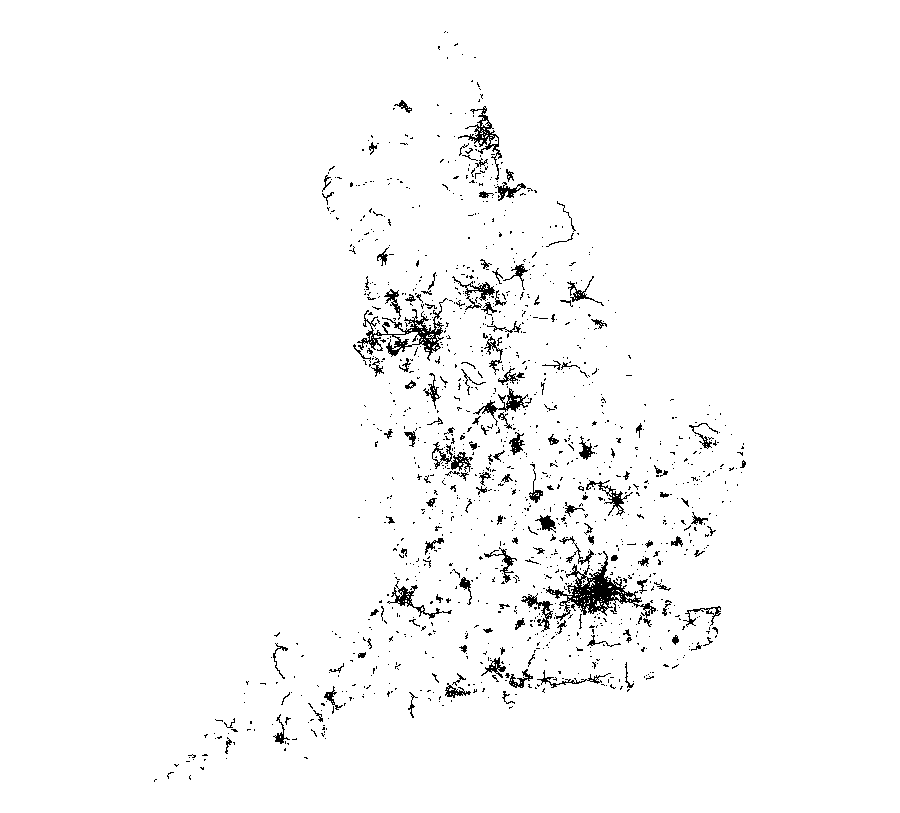
The query stops with an error message after around 30 seconds. The same
query can be made with `osmextract` as follows, which reads-in almost
100k linestrings in less than 10 seconds, after the data has been
downloaded in the compressed `.pbf` format and converted to the open
standard `.gpkg` format. The download-and-conversion operation of the
OSM extract associated to England takes approximately a few minutes, but
this operation must be executed only once. The following code chunk is
not evaluated.
``` r
library(osmextract)
cycleways_england = oe_get(
"England",
quiet = FALSE,
query = "SELECT * FROM 'lines' WHERE highway = 'cycleway'"
)
par(mar = rep(0.1, 4))
plot(sf::st_geometry(cycleways_england))
```
[](https://github.com/ropensci/osmextract/actions)
[](https://app.codecov.io/gh/ropensci/osmextract?branch=master)
[](https://github.com/ropensci/software-review/issues/395)
[](https://www.repostatus.org/#active)
[](https://CRAN.R-project.org/package=osmextract)
The goal of `osmextract` is to make it easier for people to access
OpenStreetMap (OSM) data for reproducible research. OSM data is the
premier source of freely available, community created geographic data
worldwide. We aim to enable you to extract it for data-driven work in
the public interest.
`osmextract` matches, downloads, converts, and imports bulk OSM data
hosted by providers such as [Geofabrik
GmbH](http://download.geofabrik.de) and
[bbbike](https://download.bbbike.org/osm/). For information on
alternative providers and how to add them see the [providers
vignette](https://docs.ropensci.org/osmextract/articles/providers.html).
## Why osmextract?
The package answers a common question for researchers who use OSM data:
how to get it into a statistical environment, in an appropriate format,
as part of a computationally efficient and reproducible workflow? Other
packages answer parts of this question.
[`osmdata`](https://github.com/ropensci/osmdata), for example, is an R
package that provides an R interface to the [Overpass
API](https://wiki.openstreetmap.org/wiki/Overpass_API), which is ideal
for downloading small OSM datasets. However, the API is rate limited,
making it hard to download large datasets. As a case study, try to
download all cycleways in England using `osmdata`:
``` r
library(osmdata)
cycleways_england = opq("England") %>%
add_osm_feature(key = "highway", value = "cycleway") %>%
osmdata_sf()
# Error in check_for_error(doc) : General overpass server error; returned:
# The data included in this document is from www.openstreetmap.org. The data is made available under ODbL. runtime error: Query timed out in "query" at line 4 after 26 seconds.
```
The query stops with an error message after around 30 seconds. The same
query can be made with `osmextract` as follows, which reads-in almost
100k linestrings in less than 10 seconds, after the data has been
downloaded in the compressed `.pbf` format and converted to the open
standard `.gpkg` format. The download-and-conversion operation of the
OSM extract associated to England takes approximately a few minutes, but
this operation must be executed only once. The following code chunk is
not evaluated.
``` r
library(osmextract)
cycleways_england = oe_get(
"England",
quiet = FALSE,
query = "SELECT * FROM 'lines' WHERE highway = 'cycleway'"
)
par(mar = rep(0.1, 4))
plot(sf::st_geometry(cycleways_england))
```
 The package is designed to complement `osmdata`, which has advantages
over `osmextract` for small datasets: `osmdata` is likely to be quicker
for datasets less than a few MB in size, provides up-to-date data and
has an intuitive interface. `osmdata` can provide data in a range of
formats, while `osmextract` only returns
[`sf`](https://github.com/r-spatial/sf) objects. `osmextract`’s niche is
that it provides a fast way to download large OSM datasets in the highly
compressed `pbf` format and read them in via the fast C library
[GDAL](https://gdal.org/en/stable/drivers/vector/osm.html) and the
popular R package for working with geographic data
[`sf`](https://github.com/r-spatial/sf).
## Installation
You can install the released version of `osmextract` from
[CRAN](https://cran.r-project.org/package=osmextract) with:
``` r
install.packages("osmextract")
```
You can install the development version from
[GitHub](https://github.com/ropensci/osmextract) with:
``` r
# install.packages("remotes")
remotes::install_github("ropensci/osmextract")
```
Load the package with:
``` r
library(osmextract)
#> Data (c) OpenStreetMap contributors, ODbL 1.0. https://www.openstreetmap.org/copyright.
#> Check the package website, https://docs.ropensci.org/osmextract/, for more details.
```
To use alongside functionality in the `sf` package, we also recommend
attaching this geographic data package as follows:
``` r
library(sf)
#> Linking to GEOS 3.13.0, GDAL 3.10.1, PROJ 9.5.1; sf_use_s2() is TRUE
```
### Warnings:
The functions defined in this package may return a warning message like
st_crs<- : replacing crs does not reproject data; use st_transform for that
if the user is running an old version of GDAL (\<= 3.0.0) or PROJ (\<=
6.0.0). See [here](https://github.com/r-spatial/sf/issues/1419) for more
details. Nevertheless, every function should still work correctly.
Please, raise [a new
issue](https://github.com/ropensci/osmextract/issues) if you find any
odd behaviour.
## Basic usage
Give `osmextract` a place name and it will try to find it in a list of
names in the specified provider
([Geofabrik](https://www.geofabrik.de/data/download.html) by default).
If the name you give it matches a place, it will download and import the
associated data into R. The function `oe_get()` downloads (if not
already downloaded) and reads-in data from OSM providers as `sf`
objects. By default `oe_get()` imports the `lines` layer, but any layer
can be read-in by changing the `layer` argument:
``` r
osm_lines = oe_get("Isle of Wight", stringsAsFactors = FALSE, quiet = TRUE)
osm_points = oe_get("Isle of Wight", layer = "points", stringsAsFactors = FALSE, quiet = TRUE)
nrow(osm_lines)
#> [1] 52151
nrow(osm_points)
#> [1] 68880
par(mar = rep(0, 4))
plot(st_geometry(osm_lines), xlim = c(-1.59, -1.1), ylim = c(50.5, 50.8))
plot(st_geometry(osm_points), xlim = c(-1.59, -1.1), ylim = c(50.5, 50.8))
```
The package is designed to complement `osmdata`, which has advantages
over `osmextract` for small datasets: `osmdata` is likely to be quicker
for datasets less than a few MB in size, provides up-to-date data and
has an intuitive interface. `osmdata` can provide data in a range of
formats, while `osmextract` only returns
[`sf`](https://github.com/r-spatial/sf) objects. `osmextract`’s niche is
that it provides a fast way to download large OSM datasets in the highly
compressed `pbf` format and read them in via the fast C library
[GDAL](https://gdal.org/en/stable/drivers/vector/osm.html) and the
popular R package for working with geographic data
[`sf`](https://github.com/r-spatial/sf).
## Installation
You can install the released version of `osmextract` from
[CRAN](https://cran.r-project.org/package=osmextract) with:
``` r
install.packages("osmextract")
```
You can install the development version from
[GitHub](https://github.com/ropensci/osmextract) with:
``` r
# install.packages("remotes")
remotes::install_github("ropensci/osmextract")
```
Load the package with:
``` r
library(osmextract)
#> Data (c) OpenStreetMap contributors, ODbL 1.0. https://www.openstreetmap.org/copyright.
#> Check the package website, https://docs.ropensci.org/osmextract/, for more details.
```
To use alongside functionality in the `sf` package, we also recommend
attaching this geographic data package as follows:
``` r
library(sf)
#> Linking to GEOS 3.13.0, GDAL 3.10.1, PROJ 9.5.1; sf_use_s2() is TRUE
```
### Warnings:
The functions defined in this package may return a warning message like
st_crs<- : replacing crs does not reproject data; use st_transform for that
if the user is running an old version of GDAL (\<= 3.0.0) or PROJ (\<=
6.0.0). See [here](https://github.com/r-spatial/sf/issues/1419) for more
details. Nevertheless, every function should still work correctly.
Please, raise [a new
issue](https://github.com/ropensci/osmextract/issues) if you find any
odd behaviour.
## Basic usage
Give `osmextract` a place name and it will try to find it in a list of
names in the specified provider
([Geofabrik](https://www.geofabrik.de/data/download.html) by default).
If the name you give it matches a place, it will download and import the
associated data into R. The function `oe_get()` downloads (if not
already downloaded) and reads-in data from OSM providers as `sf`
objects. By default `oe_get()` imports the `lines` layer, but any layer
can be read-in by changing the `layer` argument:
``` r
osm_lines = oe_get("Isle of Wight", stringsAsFactors = FALSE, quiet = TRUE)
osm_points = oe_get("Isle of Wight", layer = "points", stringsAsFactors = FALSE, quiet = TRUE)
nrow(osm_lines)
#> [1] 52151
nrow(osm_points)
#> [1] 68880
par(mar = rep(0, 4))
plot(st_geometry(osm_lines), xlim = c(-1.59, -1.1), ylim = c(50.5, 50.8))
plot(st_geometry(osm_points), xlim = c(-1.59, -1.1), ylim = c(50.5, 50.8))
```
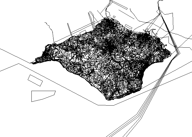
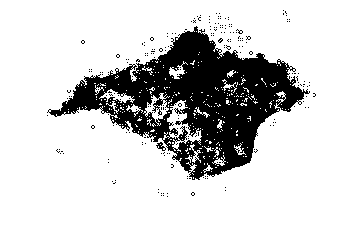 The figures above give an insight into the volume and richness of data
contained in OSM extracts. Even for a small island such as the Isle of
Wight, it contains over 50k features including ferry routes, shops and
roads. The column names in the `osm_lines` object are as follows:
``` r
names(osm_lines) # default variable names
#> [1] "osm_id" "name" "highway" "waterway" "aerialway"
#> [6] "barrier" "man_made" "railway" "z_order" "other_tags"
#> [11] "geometry"
```
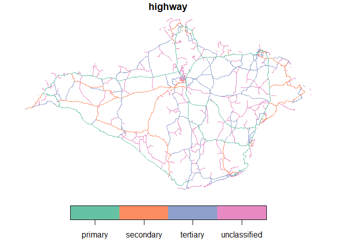
Once imported, you can use all functions for data frames in base R and
other packages. You can also use functions from the `sf` package for
spatial analysis and visualisation. Let’s plot all the major, secondary
and residential roads, for example:
``` r
ht = c("primary", "secondary", "tertiary", "unclassified") # highway types of interest
osm_major_roads = osm_lines[osm_lines$highway %in% ht, ]
plot(osm_major_roads["highway"], key.pos = 1)
```
The figures above give an insight into the volume and richness of data
contained in OSM extracts. Even for a small island such as the Isle of
Wight, it contains over 50k features including ferry routes, shops and
roads. The column names in the `osm_lines` object are as follows:
``` r
names(osm_lines) # default variable names
#> [1] "osm_id" "name" "highway" "waterway" "aerialway"
#> [6] "barrier" "man_made" "railway" "z_order" "other_tags"
#> [11] "geometry"
```
Once imported, you can use all functions for data frames in base R and
other packages. You can also use functions from the `sf` package for
spatial analysis and visualisation. Let’s plot all the major, secondary
and residential roads, for example:
``` r
ht = c("primary", "secondary", "tertiary", "unclassified") # highway types of interest
osm_major_roads = osm_lines[osm_lines$highway %in% ht, ]
plot(osm_major_roads["highway"], key.pos = 1)
```
 The same steps can be used to get other OSM datasets (examples not run):
``` r
malta = oe_get("Malta", quiet = TRUE)
andorra = oe_get("Andorra", extra_tags = "ref")
leeds = oe_get("Leeds")
goa = oe_get("Goa", query = "SELECT highway, geometry FROM 'lines'")
```
If the input place does not match any of the existing names in the
supported providers, then `oe_get()` will try to geocode it via
[Nominatim
API](https://nominatim.org/release-docs/develop/api/Overview/), and it
will select the smallest OSM extract intersecting the area. For example
(not run):
``` r
oe_get("Milan") # Warning: It will download more than 400MB of data
#> No exact match found for place = Milan and provider = geofabrik. Best match is Iran.
#> Checking the other providers.
#> No exact match found in any OSM provider data. Searching for the location online.
#> ... (extra messages here)
```
For further details on using the package, see the [Introducing
osmextract
vignette](https://docs.ropensci.org/osmextract/articles/osmextract.html).
## Changing the download directory
The default behaviour of `oe_get()` is to save all files in a package
specific directory located at `tools::R_user_dir("osmextract", "data")`.
If you prefer using any other persistent or temporary directory, you can
add `OSMEXT_DOWNLOAD_DIRECTORY=/path/for/osm/data` to your `.Renviron`
file, e.g. with:
``` r
usethis::edit_r_environ()
# Add a line containing: OSMEXT_DOWNLOAD_DIRECTORY=/path/where/to/save/files
```
You can always check the default `download_directory` used by this
package with:
``` r
oe_download_directory()
```
The `force_download` argument can be used to refresh OSM extracts
already present in the download directory. See also `oe_update()`and the
introductory vignette for more details.
## Next steps
We would love to see more providers added (see the [Add new
OpenStreetMap
providers](https://docs.ropensci.org/osmextract/articles/providers.html)
for details) and see what people can do with OSM datasets of the type
provided by this package in a reproducible and open statistical
programming environment for the greater good. Any contributions to
support this or any other improvements to the package are very welcome
via our issue tracker.
## Licence
We hope this package will provide easy access to OSM data for
reproducible research in the public interest, adhering to the condition
of the [OdBL licence](https://opendatacommons.org/licenses/odbl/) which
states that
> Any Derivative Database that You Publicly Use must be only under the
> terms of:
- 1. This License;
- 2. A later version of this License similar in spirit to this
See the [Introducing osmextract
vignette](https://docs.ropensci.org/osmextract/articles/osmextract.html)
for more details.
## Other approaches
- [osmdata](https://github.com/ropensci/osmdata) is an R package for
importing small datasets directly from OSM servers
- [osmapiR](https://docs.ropensci.org/osmapiR/) is an R interface to the
[OpenStreetMap API v0.6](https://wiki.openstreetmap.org/wiki/API_v0.6)
for fetching and saving raw from/to the OpenStreetMap database
including map data as well as map notes, GPS traces, changelogs, and
users data.
- [geofabrik](https://cran.r-project.org/package=geofabrik) is an R
package to download OSM data from
[Geofabrik](https://download.geofabrik.de/)
- [pyrosm](https://pyrosm.readthedocs.io/en/latest/) is a Python package
for reading .pbf files
- [pydriosm](https://pypi.org/project/pydriosm/) is a Python package to
download, read and import OSM extracts
- [osmium](https://pypi.org/project/osmium/) provides python bindings
for the Libosmium C++ library
- [OpenStreetMapX.jl](https://github.com/pszufe/OpenStreetMapX.jl) is a
Julia package for reading and analysing .osm files
- [PostGIS](https://www.bostongis.com/PrinterFriendly.aspx?content_name=loading_osm_postgis)
is an established spatial database that works well with large OSM
datasets
- Any others? Let us know!
## Contribution
We very much look forward to comments, questions and contributions. If
you have any question or if you want to suggest a new approach, feel
free to create a new discussion in the [github
repository](https://github.com/ropensci/osmextract/discussions). If you
found a bug, or if you want to add a new OSM extracts provider, create a
new issue in the [issue
tracker](https://github.com/ropensci/osmextract/issues) or a new [pull
request](https://github.com/ropensci/osmextract/pulls). We always try to
build the most intuitive user interface and write the most informative
error messages, but if you think that something is not clear and could
have been explained better, please let us know.
## Contributor Code of Conduct
Please note that this package is released with a [Contributor Code of
Conduct](https://ropensci.org/code-of-conduct/). By contributing to this
project, you agree to abide by its terms.
The same steps can be used to get other OSM datasets (examples not run):
``` r
malta = oe_get("Malta", quiet = TRUE)
andorra = oe_get("Andorra", extra_tags = "ref")
leeds = oe_get("Leeds")
goa = oe_get("Goa", query = "SELECT highway, geometry FROM 'lines'")
```
If the input place does not match any of the existing names in the
supported providers, then `oe_get()` will try to geocode it via
[Nominatim
API](https://nominatim.org/release-docs/develop/api/Overview/), and it
will select the smallest OSM extract intersecting the area. For example
(not run):
``` r
oe_get("Milan") # Warning: It will download more than 400MB of data
#> No exact match found for place = Milan and provider = geofabrik. Best match is Iran.
#> Checking the other providers.
#> No exact match found in any OSM provider data. Searching for the location online.
#> ... (extra messages here)
```
For further details on using the package, see the [Introducing
osmextract
vignette](https://docs.ropensci.org/osmextract/articles/osmextract.html).
## Changing the download directory
The default behaviour of `oe_get()` is to save all files in a package
specific directory located at `tools::R_user_dir("osmextract", "data")`.
If you prefer using any other persistent or temporary directory, you can
add `OSMEXT_DOWNLOAD_DIRECTORY=/path/for/osm/data` to your `.Renviron`
file, e.g. with:
``` r
usethis::edit_r_environ()
# Add a line containing: OSMEXT_DOWNLOAD_DIRECTORY=/path/where/to/save/files
```
You can always check the default `download_directory` used by this
package with:
``` r
oe_download_directory()
```
The `force_download` argument can be used to refresh OSM extracts
already present in the download directory. See also `oe_update()`and the
introductory vignette for more details.
## Next steps
We would love to see more providers added (see the [Add new
OpenStreetMap
providers](https://docs.ropensci.org/osmextract/articles/providers.html)
for details) and see what people can do with OSM datasets of the type
provided by this package in a reproducible and open statistical
programming environment for the greater good. Any contributions to
support this or any other improvements to the package are very welcome
via our issue tracker.
## Licence
We hope this package will provide easy access to OSM data for
reproducible research in the public interest, adhering to the condition
of the [OdBL licence](https://opendatacommons.org/licenses/odbl/) which
states that
> Any Derivative Database that You Publicly Use must be only under the
> terms of:
- 1. This License;
- 2. A later version of this License similar in spirit to this
See the [Introducing osmextract
vignette](https://docs.ropensci.org/osmextract/articles/osmextract.html)
for more details.
## Other approaches
- [osmdata](https://github.com/ropensci/osmdata) is an R package for
importing small datasets directly from OSM servers
- [osmapiR](https://docs.ropensci.org/osmapiR/) is an R interface to the
[OpenStreetMap API v0.6](https://wiki.openstreetmap.org/wiki/API_v0.6)
for fetching and saving raw from/to the OpenStreetMap database
including map data as well as map notes, GPS traces, changelogs, and
users data.
- [geofabrik](https://cran.r-project.org/package=geofabrik) is an R
package to download OSM data from
[Geofabrik](https://download.geofabrik.de/)
- [pyrosm](https://pyrosm.readthedocs.io/en/latest/) is a Python package
for reading .pbf files
- [pydriosm](https://pypi.org/project/pydriosm/) is a Python package to
download, read and import OSM extracts
- [osmium](https://pypi.org/project/osmium/) provides python bindings
for the Libosmium C++ library
- [OpenStreetMapX.jl](https://github.com/pszufe/OpenStreetMapX.jl) is a
Julia package for reading and analysing .osm files
- [PostGIS](https://www.bostongis.com/PrinterFriendly.aspx?content_name=loading_osm_postgis)
is an established spatial database that works well with large OSM
datasets
- Any others? Let us know!
## Contribution
We very much look forward to comments, questions and contributions. If
you have any question or if you want to suggest a new approach, feel
free to create a new discussion in the [github
repository](https://github.com/ropensci/osmextract/discussions). If you
found a bug, or if you want to add a new OSM extracts provider, create a
new issue in the [issue
tracker](https://github.com/ropensci/osmextract/issues) or a new [pull
request](https://github.com/ropensci/osmextract/pulls). We always try to
build the most intuitive user interface and write the most informative
error messages, but if you think that something is not clear and could
have been explained better, please let us know.
## Contributor Code of Conduct
Please note that this package is released with a [Contributor Code of
Conduct](https://ropensci.org/code-of-conduct/). By contributing to this
project, you agree to abide by its terms.