DESCRIPTION
r.in.usgs downloads and patches select USGS datsasets to
the current GRASS computational region and coordinate reference system.
Associated parameters are automatically passed to
The National Map Access API, downloaded to a user-specified
local directory, then imported and patched through GRASS GIS.
PARAMETERS
USGS Data Selection
'i' FLAG
If the 'i' flag is set, information about data meeting the input parameters
is displayed without downloading the data.
If the 'i' flag is NOT set, the returned information will display and then begin immediate download.
USGS data product:
ned (National Elevation Dataset)
nlcd (National Land Cover Dataset)
NED (National Elevation Dataset)
NED data are available at resolutions of 1 arc-second (about 30 meters) and 1/3 arc-second (about 10 meters), and in limited areas at 1/9 arc-second (about 3 meters).
NED dataset:
1 arc-second
1/3 arc-second (about 10 meters)
1/9 arc-second (about 3 meters)(in limited areas)
NLCD (National Land Cover Dataset)
NLCD data are available for years 2001, 2006, and 2011. NLCD 2011 land cover was created on a path/row basis and mosaicked to create a seamless national product. The data in NLCD 2011 are completely integrated with NLCD 2001 and NLCD 2006. As part of the NLCD 2011 project, the NLCD 2001 and 2006 land cover data products were revised and reissued to provide full compatibility with the new NLCD 2011 products. NLCD 2011 land cover was developed for the conterminous United States and Alaska.
NLCD dataset:
NLCD 2001
NLCD 2006
NLCD 2011
NLCD subset:
Percent Developed Imperviousness
Percent Tree Canopy
Land Cover
Download Options
'k' FLAG
By default the 'k' flag is NOT set. Only files closest to the original source data are
retained.
If the 'k' flag is set, extracted files from compressed archives are also kept within the
download directory after GRASS import.
Directory for USGS data download and processing:
Specify a local directory that r.in.usgs will use to store and process USGS data
Name for output raster map:
Specify a name for the composite raster map that will be created by the module
Resampling method to use:
"default" will use a hardcoded resampling method selected for the USGS dataset.
NED default is 'bilinear'
NLCD default is 'nearest'
EXAMPLE
Set example g.region:
g.region n=36.2718518358333 s=35.2981481325 e=-78.1339815488889 w=-79.1294445127778
r.in.usgs example parameters:
r.in.usgs product=ned ned_dataset=1/3 arc-second output_directory=/tmp output_name=ned_output
Mapset g.region output is automatically detected:
g.region -pg
projection=3
zone=0
n=36.2718518358333
s=35.2981481325
w=-79.1294445127778
e=-78.1339815488889
nsres=9.25925925573731e-05
ewres=9.25925926787154e-05
rows=10516
cols=10751
cells=113057516
Informational output:
USGS file(s) to download:
-------------------------
Total download size:	1.50 GB
Tile count:	4
USGS SRS:	wgs84
USGS tile titles:
USGS NED n36w079 1/3 arc-second 2013 1 x 1 degree IMG
USGS NED n37w079 1/3 arc-second 2013 1 x 1 degree IMG
USGS NED n36w080 1/3 arc-second 2013 1 x 1 degree IMG
USGS NED n37w080 1/3 arc-second 2013 1 x 1 degree IMG
-------------------------
GRASS GIS Output:
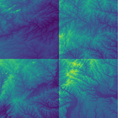 Figure: Individual tiles are automatically imported and reprojected into GRASS GIS
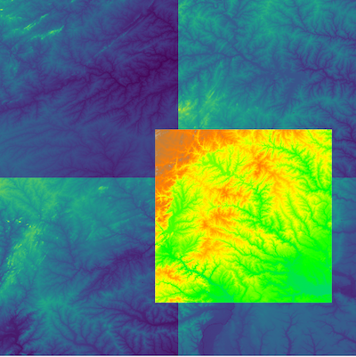 Figure: A composite patch layer matching the computational region is created from original NED imagery
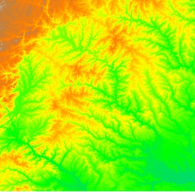 Figure: Source imagery is removed, leaving a single patched tile for the GRASS GIS computational region
REFERENCES
TNM Access API Guide
National Elevation Dataset
National Land Cover Dataset
SEE ALSO
g.region,
r.import,
r.patch,
r.colors
AUTHOR
Zechariah Krautwurst, 2017 MGIST Candidate, North Carolina State University
(Google Summer of Code 2017, mentors: Anna Petrasova, Vaclav Petras)