Recent Imagery
How Landsat Helps
ecosystems and biodiversity
The Landsat Program
This joint NASA/USGS program provides the longest continuous space-based record of Earth’s land in existence. Every day, Landsat satellites provide essential information to help land managers and policy makers make wise decisions about our resources and our environment. + Landsat Case Studies ebook
Landsat 9 Instrument Ready for Spacecraft Assembly
OLI-2 is now built, tested, and in place to be assembled onto the spacecraft.
+ details
New Landsat Infrared Instrument Ships from NASA
This month, TIRS-2 successfully passed the stringent 12-week testing process at NASA’s Goddard Space Flight Center and was shipped to Northrop [
…]
More than Naught: The “Z” of Where Land Meets Sea
Harnessing 30 years of Landsat data, a team of researchers from Australia has created the first 3D model of Australia’s entire coastline.[
…]
Geographia
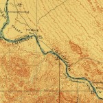
Journey with us into the cartographic past. Latest look: Creating an Oasis in the Desert: Lake Havasu City, Arizona, 1911 [
…]

“We are looking forward to new exciting data to complement Landsat observations and to collaborative research—especially because ESA followed USGS in its open data policy.”
“The Landsat satellites have also proved to be very useful, particularly for trying to do more detailed, finer-scale risk mapping.”
“When fighting broke out, the [New York Times] graphics team pulled up images from [the] Landsat 8 satellite to look for changes on the ground.”
“Landsat provides a very good coverage of Amazonia both spatially and temporally. We have known for some time already that the Landsat images can be used to identify ecologically relevant environmental and biotic variation in Amazonian rainforests, but this is the first time we use satellite images to actually predict species distributions.”
“I really believe that Landsat data made a change in how we perceive global change. All of the things we have done so far would not have been possible without the unique Landsat dataset”
“The primary archive available for reviewing the positions of coastlines and effects of sea-level rise is Landsat.”
“A recent industry report estimates that total annual value of $2.19 billion, far exceeding the multi-year total cost of building, launching, and managing Landsat satellites and sensors. The value is derived from consumer use of the data. There is no inherent value in idle data.”
“Without the free and open Landsat data policy, a lot of commercial applications wouldn’t be feasible and a lot of commercial companies—including GDA—would be very different than they are.”
“Without Landsat, ‘we would be flying blind. We need those eyes in the sky to complement our ground efforts.’”
“For our main aim of quantifying surface water extent dynamics during a period of high hydro-climatic variability, Landsat was the only satellite archive to meet all our criteria.”
“We have recognized for the first time that we’re not just going to do one more, then stop, but that Landsat is actually a long-term monitoring activity, like the weather satellites, that should go on in perpetuity.”
“This research was only possible thanks to the free and open Landsat data policy.”


