Imaging Saltwater Intrusion Along The Monterey Coast
Rosemary Knight (Stanford University), Adam Pidlisecky (University of Calgary), Tara Moran (Stanford University), Meredith Goebel (Stanford University)
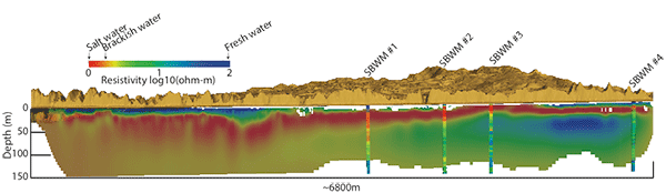
Cross-section as viewed from the Monterey Bay looking inland
Saltwater intrusion poses a high level of risk to agricultural communities along the California coast, where there is a dependence on coastal aquifers for irrigation. Saltwater intrusion is driven by withdrawal of groundwater from aquifers, and by rising sea level. While saltwater intrusion can occur gradually over decades, there is a critical point beyond which the dramatic change in salinity can be irreversible, resulting in the loss of a supply of freshwater. There is thus a compelling need to map and monitor the freshwater/saltwater interface in coastal areas so that appropriate water management strategies can be put in place. We are using a geophysical method - Electrical Resistivity Tomography - to see to depths of ~250 m along the Monterey coast, imaging the location of saltwater and freshwater.
Results From Pilot Project
We have acquired ERT data along a 7 km segment of beach between Seaside, CA and Marina, CA. The figure above is the cross-section as viewed from the Monterey Bay looking inland. What is clearly seen are regions of saltwater (warm colors, reds) and freshwater (cool colors, blue). Shown for comparison are the resistivity measurements made in four wells (SBWM 1, 2, 3, 4). There is close to perfect agreement between the geophysical data and the measurements in the wells. In addition to demonstrating the viability of this geophysical technology for this application, the data clearly show the value of the geophysical imaging for understanding the geologic controls on the distribution of salt water and fresh water from ground surface to 150 m (the depth of the shallowest local water supply aquifer).
To learn more about the pilot project, see a 10-minute talk by Rosemary Knight
October 2014
We're in the field, acquiring data along a 40 km stretch of the Monterey coast, imaging to a depth of ~300 m.