Heaphy Track
4-6 days 78.4km / 30.3mi Map
From forest to coast, the Heaphy Track combines all of New Zealand’s magical natural beauty into one walk. Pass through diverse landscapes from beautiful beech forest to expansive tussock grasslands, to lush forests, nikau palms and the roaring seas of the wild West Coast.

Don't miss


Offers


Before you go
It is important to plan and prepare so that you are well equipped to enjoy your Great Walk.
Before you go, know The Outdoor Safety Code - 5 simple rules to help you stay safe:
- Plan your trip
- Tell someone
- Be aware of the weather
- Know your limits
- Take sufficient supplies
Heaphy Track safety
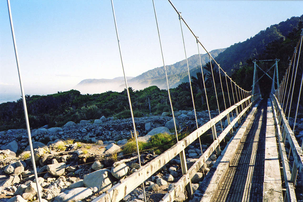
- Weather on the Heaphy Track is changeable with annual rainfall averaging over 4000 mm. Heavy rain can occur with little warning and even small streams are dangerous in flood. Be prepared for rain, snow and wind especially on the exposed sections of the track.
- Most major streams are bridged, but at Crayfish (Koura) Point the route can be impassable two hours either side of high tide when sea conditions are rough. Ensure you check the tide timetable when planning your trip.
- Sand flies can be present during your walk. It is recommended you take insect repellent.
- During winter, adverse weather can change the track significantly. These will be marked by signage and warning tape although you may want to check with the DOC Visitor Centre prior to your walk.
- Cell phone coverage on the track is limited.
Things to know before you go
- A good level of fitness and the right outdoor clothing and equipment will greatly improve the enjoyment of your trip.
- Safety is your responsibility - Cell phone coverage is limited and it is recommended that you leave your trip details with a trusted contact. Intention forms are available at adventuresmart.org.nz.
- Book your trip well in advance including your accommodation, transport and transfers to the start/end of the Great Walk.
- Pack all necessary equipment, your own food and drinks and any personal items for your trip including an extra day's supply of food and water.
- For a full list of equipment and preparation required for this walk, plus updates for the Heaphy Track, please visit the DOC website.
When to go
You can walk the Heaphy Track all year. The most popular period is during the summer from Christmas through to Easter (December - April), however walking the track in autumn can be a good option as there are fewer people on the track and the weather is often calm and settled. Mountain biking is being trialled on the Heaphy Track in the winter season only, 1 May to 30 September, until 2013.
What to bring
Your basic equipment needs to include
- Backpack
- Sleeping bag and liner
- Portable cooking stove
- Cooking utensils
- Food, incl. high-energy food
- Waterproof rain jacket and overtrousers
- Warm/thermal clothing
- Hiking boots
- Map and compass
- Lighter and matches
- Drink bottle & water
Add camping gear to your list if you’re staying at a campsite.
Travelling with children
For those with limited time or families with young children we recommend completing a day walk or staying overnight at a hut to experience some of the track and spend time exploring. A popular two-day, one-night trip starting from the western side of the track is from Kohaihai to Heaphy Hut, returning to Kohaihai. The longest of the Great Walks at 78.4km / 30.3mi, to walk the whole of the Heaphy Track you will need to be fit and have good equipment. We recommend that walkers start a fitness programme at least two months before departure and practise carrying a full pack (15kg / 33lbs) up and down stairs or hills. For a 4 day trip you can expect to walk up to 24km / 15mi per day or 21km / 13mi per day for a 5 day trip.
Nearest DOC visitor centre
DOC Nelson Regional Visitor Centre
79 Trafalgar Street
Nelson 7010
+64 3 546 9339
nelsonvc@doc.govt.nz
Hours
Open daily 8:30 am - 4:30 pm
Closed daily 12:00 pm - 1:00 pm
Services
Great Walks bookings and recreation information for the area.
Getting there
Nearest airports
- Nelson - 156km / 97mi, 2 hours 30 min
- Westport - 115km / 71mi, 1 hour 45 min
Flights to these airports typically connect from Auckland, Wellington and Christchurch. The above driving times are indicative only - always allow for extra time to get to your destination.
How to get to the trailhead
The Heaphy Track is not a circuit track; the start/end of the track at Brown Hut in Golden Bay and Kohaihai on the West Coast are 463km / 288mi apart by road.
Air New Zealand flies into Nelson, the closest regional airport to the Brown Hut, and into Westport, the closest regional airport to Kohaihai. Brown Hut is 156 km and a 2 hour 25 min drive from Nelson. Kohaihai is 110km / 68mi and a 1 hour 45 min drive from Westport.
Transport and accommodation
Guides and commercial tourism providers - find accommodation, transport, and activities in the area.
Where to stay
DOC provides seven huts and nine campsites on the Heaphy Track.
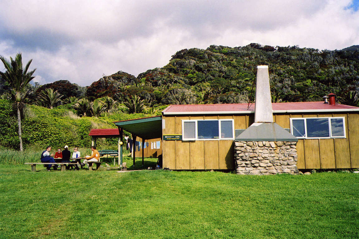
Huts
Heaphy Track huts have heating, toilets, bunks, mattresses and cold running water. Note: Huts do not provide lighting, pots and pans, cooking utensils, linen or food for purchase. Make sure you put these things on your checklist before you go.
- Brown Hut: 16 bunks
- Perry Saddle Hut: 28 bunks
- Gouland Downs Hut: 8 bunks
- Saxon Hut: 16 bunks
- James Mackay Hut: 26 bunks
- Lewis Hut: 20 bunks
- Heaphy Hut: 28 bunks
Campsites
Campsites can be found beside each of the huts except Lewis Hut. There are additional campsites at Aorere Shelter, Katipo Creek Shelter, Scotts Beach and Kohaihai. Campsites offer basic facilities including a water supply and toilets. Open fires are only permitted where fireplaces are provided.
Campers are not permitted to use the hut facilities
Cost and booking
Fees are charged per person, per night to stay in huts and campsites.
Bookings are essential! Use the DOC online booking system prior to travel or call 0800 NZ GREATWALKS.
On the track
Track description
You can start the track from the eastern or western end - either from Brown Hut, Golden Bay or from Kohaihai, West Coast. This track is not a circuit – the beginning and end of the track are 463km / 288mi apart by road. Bus and taxi services are available to reach either end of the track from nearby towns. The track takes 4-6 days to walk, and 2-3 days to mountain bike.
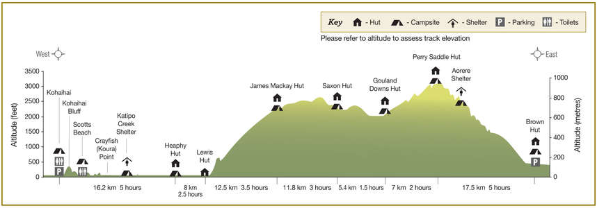
Elevation profile
From Brown Hut to Aorere Shelter the track climbs gradually. From here, the Aorere valley is seen extending northwards and on clear days it is possible to see Mt Taranaki / Egmont. 30 mins before reaching Perry Saddle Hut, 880m / 2887ft above sea level, a short track leads to a viewpoint at Flanagans Corner. At 915m / 3002ft above sea level, this is the highest point on the track.
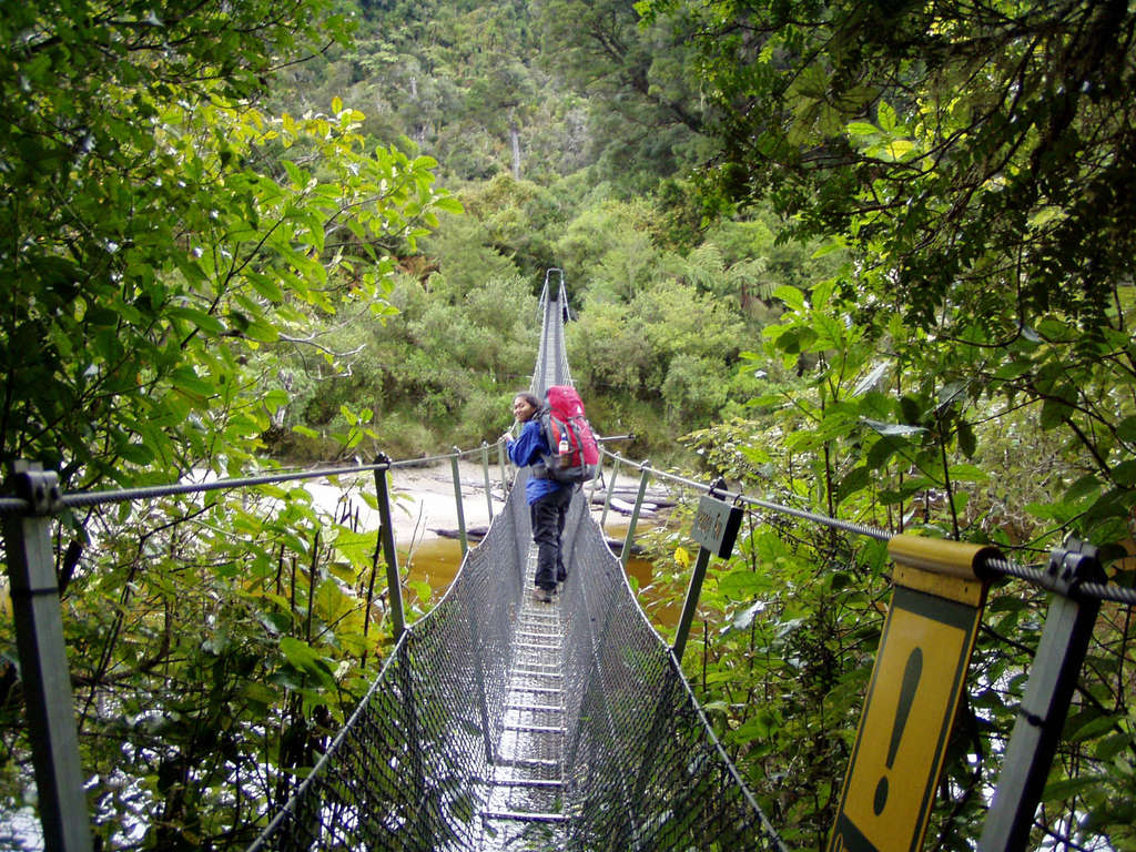
The track is suitable for walkers with moderate fitness and is mostly well-formed but some sections may be steep, rough or muddy. The track is well sign-posted and major stream and river crossings are bridged. Note the altitude when you view the elevation profile.
Walking guide
Day 1: Brown Hut to Perry Saddle Hut
5 hours, 17.5km / 6.8mi
Climbing gradually, here you will follow a route once surveyed for a road. Perry Hut Saddle is 880m / 2887ft above sea level. Near the hut in Gorge Creek is a deep and cold pool, popular for swimming.
Day 2: Perry Saddle Hut to Gouland Downs Hut
2 hours, 7km / 4mi
Passing through tussock clearings and patches of beech trees this track crosses one of several limestone arches which are the remnants of old caves.
Day 3: Gouland Downs Hut to Saxon Hut
1.5 hours, 5.4km / 2.1mi
Relatively level as it crosses the northern part of Gouland Downs, the tussock country and riverbeds make it great for exploring. Be careful when the mist lowers as the features can be confusing and it is easy to become disoriented.
Day 4: Saxon Hut to James Mackay Hut
3 hours, 11.8km / 4.6mi
Dropping slightly to grassy flats beside the Saxton River, a section of this track can flood. In wet conditions this can be potentially dangerous, and walkers should wait for the water to recede before continuing.
Day 5: James Mackay Hut to Lewis Hut
3.5 hours, 12.5km / 4.8mi
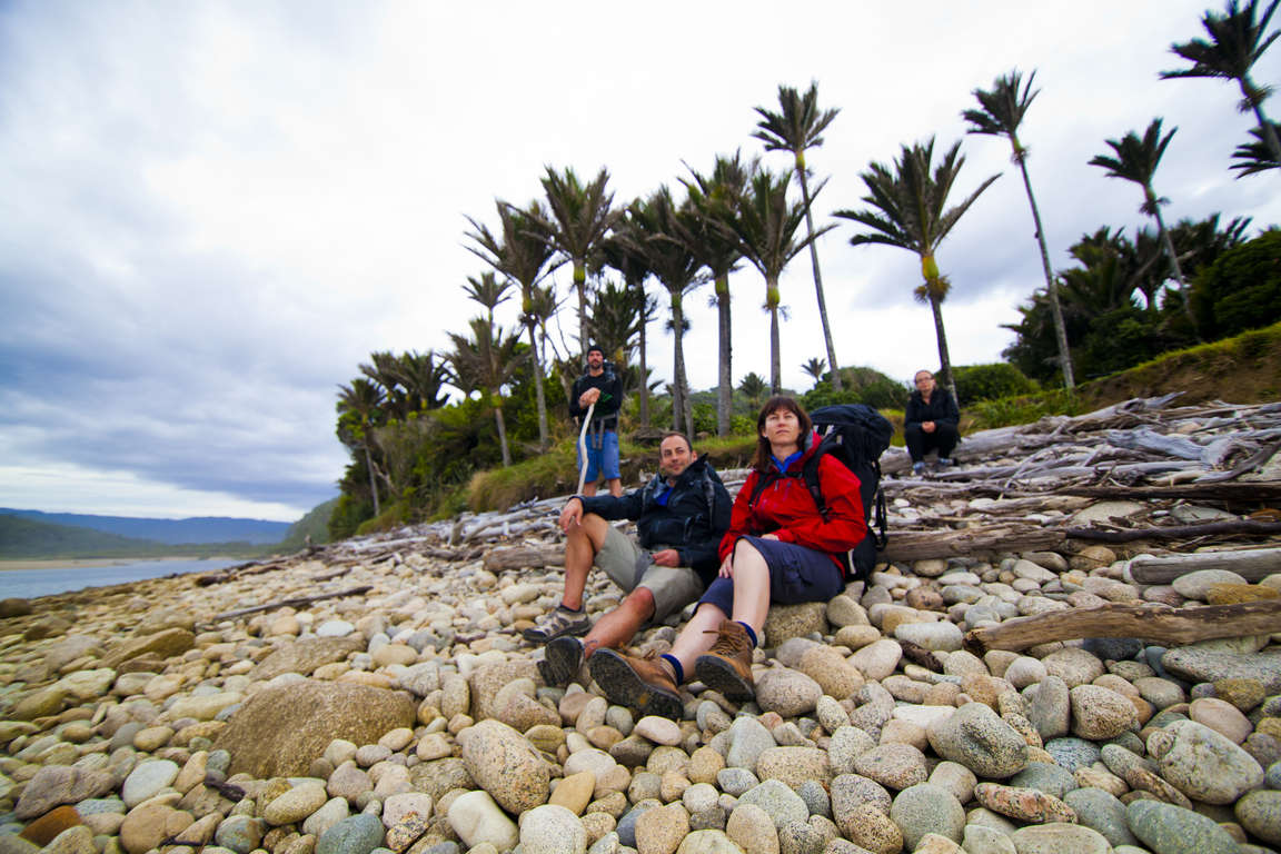
The track soon leads into the richer and taller forest typical of the West Coast. Glimpses of the Heaphy River can be spotted along the way. Be sure to apply the insect repellent as this is where the sand flies start to appear!
Day 6: Lewis Hut to Kohaihai
7.5 hours, 24.2km / 9.3mi
The track crosses the Heaphy River and continues through a forest of native kahikatea, rimu and rata. Be sure to listen out for the wildlife. The river mouth is at the junction of two pounamu (greenstone) trails with archaeological evidence that occupation from Māori extends back 500 years. At the Heaphy River mouth the river surges out through a narrow gap into the sea; the churning of fresh water with the sea water is spectacular! Crossing at Crayfish (Koura) Point can be impassable two hours either side of the high tide mark when conditions are rough. Check the tide timetable before you leave the hut.