Milford Track
4 days 53.5km / 20.7mi Map
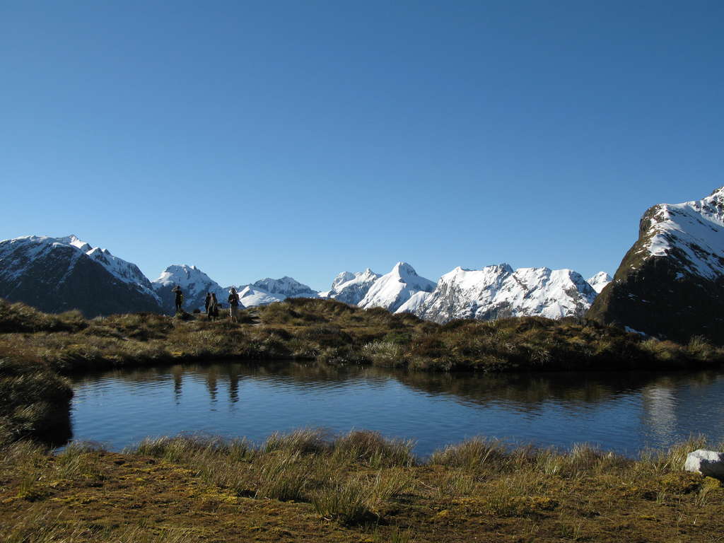
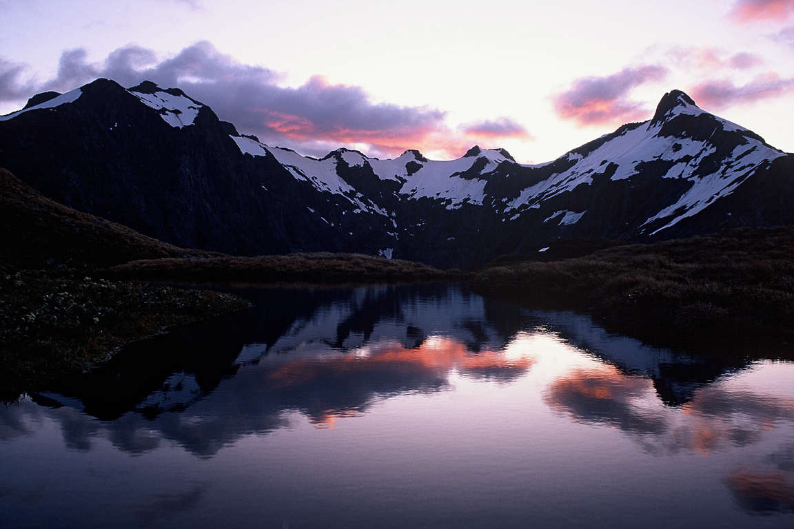
Experience the stunning grandeur of the Milford Track in beautiful Fiordland National Park. You'll be awed by natural wonders while walking in a spectacular, wild and beautiful part of New Zealand. There are sheer ice-carved valleys from a mountain pass, refreshing mountain rivers, peaceful forests and cascading waterfalls.

Don't miss


Offers


Before you go
It is important to plan and prepare so that you are well equipped to enjoy your Great Walk.
Before you go, know The Outdoor Safety Code - 5 simple rules to help you stay safe:
- Plan your trip
- Tell someone
- Be aware of the weather
- Know your limits
- Take sufficient supplies
Milford Track safety
- The track may need to be closed for safety reasons (e.g. avalanche danger, flooding or high winds). The Fiordland National Park Visitor Centre staff can keep you informed of all issues and options around these situations.
- This track is not recommended for children under the age of 10 due to the exposed mountainous environment and often adverse weather conditions.
- During the off-peak season (May to October) the track remains open but is subject to weather, track and avalanche conditions. Make sure you are fully prepared before you go. DOC rangers are not in residence at the huts during the off-peak season.
- Fiordland National Park lies in an area of predominantly westerly airstreams, which deliver high rainfall and changeable weather patterns to the area. Cold temperatures, snow, strong winds and heavy rain can occur at any time of the year.
- Cell phone coverage on the track is limited.
Things to know before you go
- A good level of fitness and the right outdoor clothing and equipment will greatly improve the enjoyment of your trip.
- Safety is your responsibility - leave your trip details with a trusted contact. Intention forms are available at adventuresmart.org.nz.
- Book your trip well in advance including your accommodation, transport and transfers to the start/end of the Great Walk.
- Pack all necessary equipment, your own food and drinks and any personal items for your trip including an extra day's supply of food and water.
- For a full list of equipment and preparation required for this walk, plus track updates for the Milford Track, please visit the DOC website.
When to go
The best time to walk the Milford Track is from late October to late April when the weather is warmer and there are more regular transport services to and from the start and end of the track. During the off-peak season (May to October) the Milford Track remains open but is subject to weather, track and avalanche conditions.
What to bring
Your basic equipment needs to include
- Backpack
- Sleeping bag and liner
- Portable cooking stove
- Cooking utensils
- Food, incl. high-energy food
- Waterproof rain jacket and overtrousers
- Warm/thermal clothing
- Hiking boots
- Map and compass
- Lighter and matches
- Drink bottle & water
Add camping gear to your list if you’re staying at a campsite.
Travelling with children
The Milford Track is not recommended for children under the age of 10 due to the exposed mountainous environment and often adverse weather conditions.
Nearest DOC visitor centre
Fiordland National Park Visitor Centre
Lakefront Drive
Te Anau
+64 3 249 8514
greatwalksbookings@doc.govt.nz
Hours
Open daily 8:00 am - 5:00 pm
Services
Great Walks booking and recreation information for the area.
Getting there
Nearest airports
- Queenstown - 174km / 108mi, 2 hours 30 min (to Te Anau)
- Invercargill - 159km / 99mi, 2 hours 30 min (to Te Anau)
Flights to these airports typically connect from Auckland, Wellington and Christchurch. The above driving times are indicative only - always allow for extra time to get to your destination.
How to get to the trailhead
The Milford Track is located in Fiordland National Park. Walking the Milford Track requires bus or private transport to Te Anau Downs, then a boat trip (1 hour 15 min) to Glade Wharf, the start of the track. Boat transport (15 min) is also required from Sandfly Point, at the end of the track, to Milford Sound/Piopiotahi.
Travelling by road: between Te Anau and Te Anau Downs (27km / 17mi), between Milford Sound and Te Anau (120km / 75mi) and between Te Anau and Queenstown (197km / 122mi)
From late October to late April, there are regular transport services to and from the Milford Track.
Transport and accommodation
Guides and commercial tourism providers - find accommodation, transport, and activities in the area.
Where to stay
DOC provides three huts on the Milford Track.
Huts
Milford Track huts have heating, toilets, bunks, mattresses, cooking facilities, solar powered lighting and cold running water. A DOC ranger is in residence during the Great Walks season (late October to late April). Note: Huts do not provide pots and pans, cooking utensils, hot showers, linen, toilet paper or food and drinks for purchase. Make sure you put these things on your checklist before you go.
- Clinton Hut: 40 bunks
- Mintaro Hut: 40 bunks
- Dumpling Hut: 40 bunks
Campsites
Camping is not allowed anywhere on the Milford Track.
Cost and booking
Fees are charged per person, per night to stay in huts.
Bookings are essential! Use the DOC online booking system prior to travel or call 0800 NZ GREATWALKS.
On the track
Track description
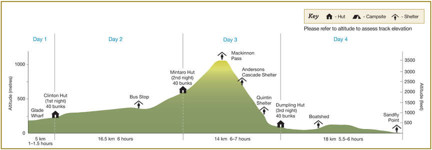
The Milford Track can only be walked in one direction. The track starts at the head of Lake Te Anau and finishes at Milford Sound/Piopiotahi. This guide describes the 4 day, 3 night trip for independent, non-guided walkers.
Elevation profile
Walking guide
Glade Wharf to Clinton Hut
1-1.5 hours, 5km / 3mi
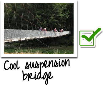
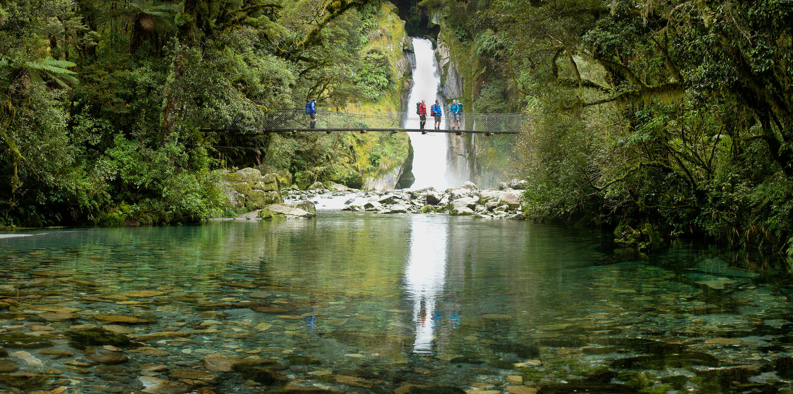
Head to the wharf at Te Anau downs for a leisurely 1 hour 25 minute cruise across the lake to the start of the Milford Track. 1km into your walk, you will come across the first and largest of several suspension bridges along the track. The well-graded track goes through beautiful beach forest and along the banks of the Clinton River. A short 10 minute side track just before the Clinton Hut, leads to a wetland area. There are great swimming holes near the hut.
Clinton Hut to Mintaro Hut
6 hours, 16.5km / 6.4mi
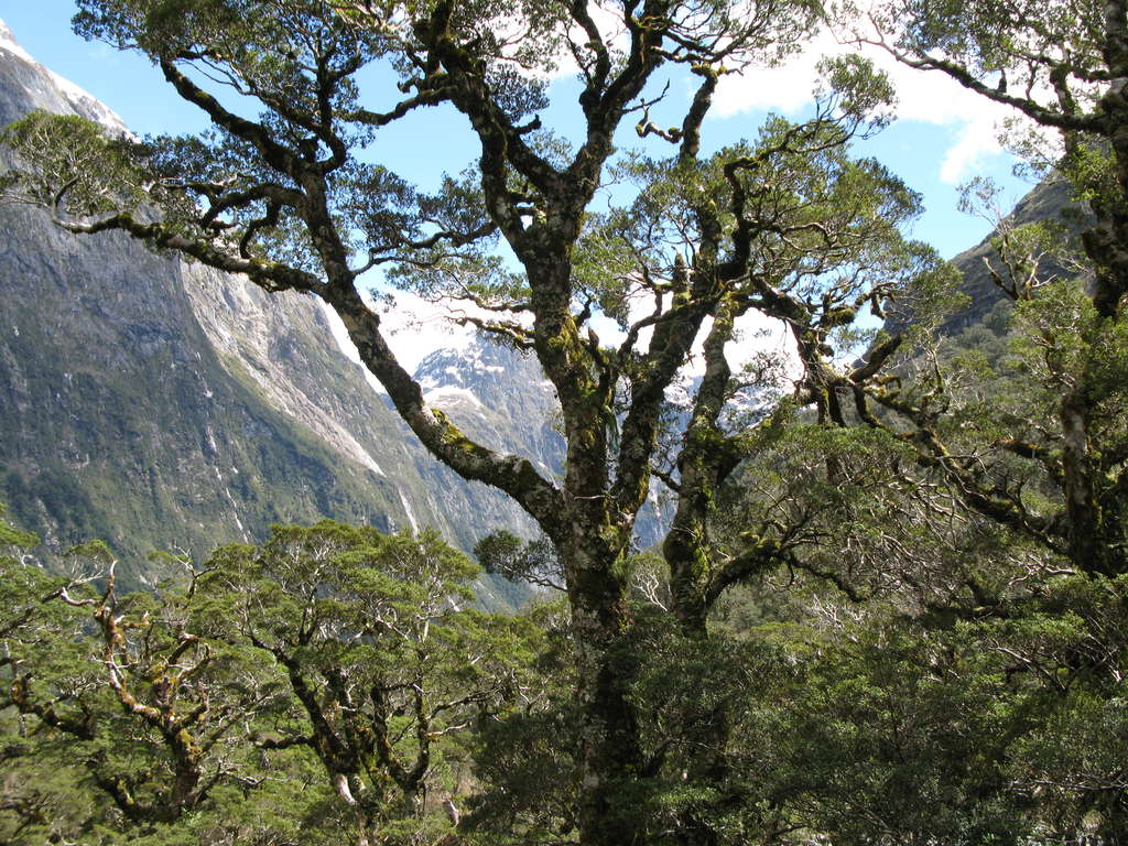
Following the Clinton River, you gradually climb towards its source Lake Mintaro at the base of Mackinnon Pass. Admire the lush forest as you head towards Clinton Forks – a prime spot for seeing the endangered whio (blue duck). Past the Hirere Falls, you get a first view of the Mackinnon Pass and the impressive Pompolona ice field. From here, you can take in the sheer scale of the rock walls towering above and notice the vegetation change as you reach higher altitudes.
Mintaro Hut to Dumpling Hut
6-7 hours, 14km / 9mi
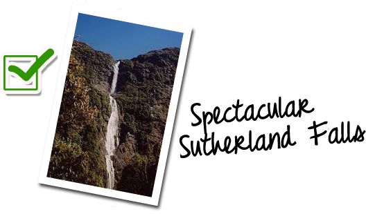
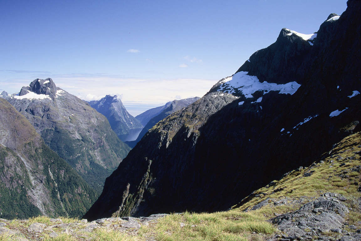
A zigzag climb leads to Mackinnon Pass and the memorial to Quintin Mackinnon which has inspiring views of Lake Mintaro and the Clinton Canyon. The track from here drops steadily, through an alpine garden and several waterfalls before arriving at the Bus Stop Shelter at Marlene’s Creek and the Sutherland Falls side track. Here you can opt to leave your pack at the shelter and take the track up to the magnificent Sutherland Falls, the highest in New Zealand. Allow an extra 1.5 hours walk time return.
Dumpling Hut to Sandfly Point
5.5-6 hours, 18km / 11mi
Follow the Arthur River to the historic boatshed, the impressive Mackay Falls and intriguing Bell Rock. Admire the rock cuttings alongside the Arthur River and Lake Ada, which were blasted and hand cut by contracted labourers. The final 3km / 2mi of the walk is an enjoyable, smooth, wide track constructed by a prison labour gang in the early 1890s. Pass the Giant Gate Falls before you take the short boat ride back to Te Anau.