Routeburn Track
2-4 days 32km / 20mi Map
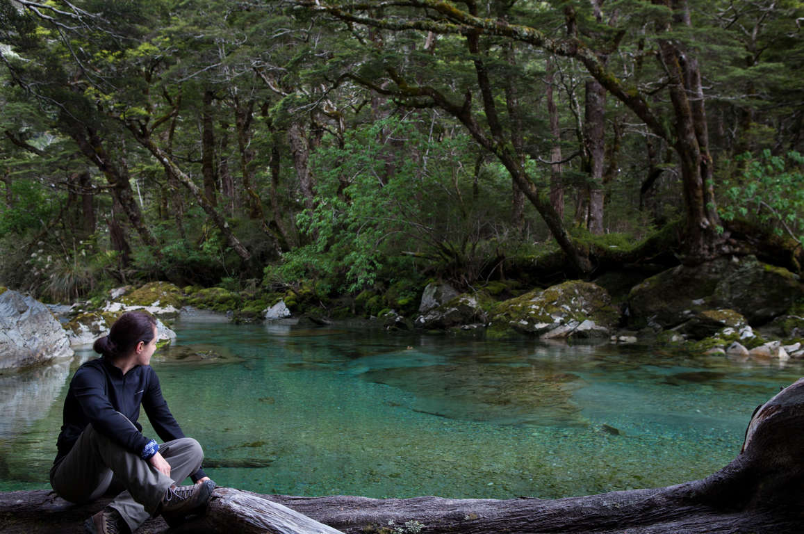
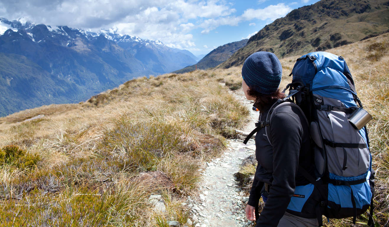
Weave through beech-forested valleys and alongside clear green rivers, glistening alpine lakes and breathtaking views from a mountain pass. Feel close to nature as you cross New Zealand’s spectacular Southern Alps and pass through the incredible landscapes of Mt Aspiring National Park and Fiordland National Park.

Don't miss


Offers


Before you go
It is important to plan and prepare so that you are well equipped to enjoy your Great Walk.
Before you go, know The Outdoor Safety Code - 5 simple rules to help you stay safe:
- Plan your trip
- Tell someone
- Be aware of the weather
- Know your limits
- Take sufficient supplies
Routeburn Track safety
- The track may need to be closed for safety reasons (e.g. avalanche danger, flooding or high winds). The Fiordland National Park Visitor Centre staff can keep you informed of all issues and options around these situations.
- This track is not recommended for children under the age of 10 due to the exposed mountainous environment and often adverse weather conditions. However, an overnight stay at Routeburn Flats, Routeburn Falls or Lake Howden huts is a great way for a family to experience part of the track.
- During the off-peak season (May - October) the track remains open but is subject to weather, track and avalanche conditions. Make sure you are fully prepared before you go. There are no DOC rangers in residence during the off-peak season.
- Fiordland and Mount Aspiring National Parks lies in an area of predominantly westerly airstreams, which delivers high rainfall and changeable weather patterns to the area. Cold temperatures, snow, strong winds and heavy rain can occur at any time of the year.
- Cell phone coverage on the track is limited.
Things to know before you go
- A good level of fitness and the right outdoor clothing and equipment will greatly improve the enjoyment of your trip.
- Safety is your responsibility - leave your trip details with a trusted contact. Intention forms are available at adventuresmart.org.nz.
- Book your trip well in advance including your accommodation, transport and transfers to the start/end of the Great Walk.
- Pack all necessary equipment, your own food and drinks and any personal items for your trip including an extra day's supply of food and water.
- For a full list of equipment and preparation required for this walk, plus track updates for the Routeburn Track, please visit the DOC website.
When to go
The best time to walk the Routeburn Track is from late October to late April when the weather is warmer and there are more regular transport services to and from the start and end of the track. During the off-peak season (May to October) the Routeburn Track remains open but is subject to weather, track and avalanche conditions.
What to bring
Your basic equipment needs to include
- Backpack
- Sleeping bag and liner
- Portable cooking stove
- Cooking utensils
- Food, including high-energy food
- Waterproof rain jacket and overtrousers
- Warm/thermal clothing
- Hiking boots
- Map and compass
- Lighter and matches
- Drink bottle & water
Add camping gear to your list if you’re staying at a campsite.
Travelling with children
The Routeburn Track is the perfect track for you, and your family and friends, if you love being amongst nature and want an exciting outdoors adventure on a track with excellent facilities. It also offers fantastic day walk opportunities for families or those with less time. However, the track is not recommended for children under the age of 10 due to the exposed mountainous environment and often adverse weather conditions. An excellent option for families keen to experience part of the track is an overnight stay at Routeburn Flats Hut, Routeburn Falls Hut or Lake Howden Hut.
Nearest DOC visitor centre
Fiordland National Park Visitor Centre
Lakefront Drive
Te Anau
+64 3 249 8514
Email Booking
Hours
Open daily 8:00 am - 5:00 pm
Services
Great Walks booking and recreation information for the area.
Getting there
Nearest airports
- Queenstown - 174km / 108mi, 2 hours 30 min
- Invercargill - 159km / 99mi, 2 hours 20 min
Flights to these airports typically connect from Auckland, Wellington and Christchurch. The above driving times are indicative only - always allow for extra time to get to your destination.
How to get to the trailhead
Access to the Routeburn Track is by road, with the track starting at either the Routeburn Shelter or The Divide. The road distance between each end of the track is 350km / 217mi. Return transport can be pre-arranged to reach either end of the track from nearby towns, Queenstown, Te Anau, Glenorchy and Milford Sound/Piopiotahi.
Transport and accommodation
Guides and commercial tourism providers - find accommodation, transport, and activities in the area.
Where to stay
DOC provides four huts and two campsites along the Routeburn Track.
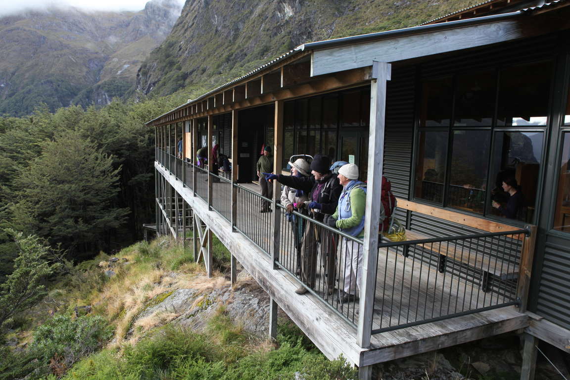
Huts
Routeburn Track huts have heating, toilets, bunks, mattresses, cold running water, cooking facilities and solar powered lighting. A DOC ranger is in residence during the Great Walks season (late October to late April). Note: Huts do not provide pots and pans, cooking utensils, hot showers, linen, toilet paper or food and drinks for purchase. Make sure you put these things on your checklist before you go.
- Routeburn Flats Hut: 20 bunks
- Routeburn Falls Hut: 48 bunks
- Lake Mackenzie Hut: 50 bunks
- Lake Howden Hut: 28 bunks
Campsites
The Routeburn Flats and Lake Mackenzie campsites offer basic facilities including a water supply, cooking shelter and toilets. Campers are not permitted to use the hut facilities.
Cost and booking
Fees are charged per person, per night to stay in huts and campsites.
Bookings are essential! Use the DOC online booking system prior to travel or call 0800 NZ GREATWALKS.
On the track
Track description
The Routeburn Track can be walked in either direction. This guide describes an east to west direction, starting the track at the Routeburn Shelter and ending the track at The Divide - the beginning and end of the track are 350km / 217mi apart by road. Return transport can be pre-arranged to reach either end of the track from nearby towns.
Elevation profile
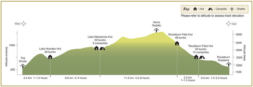
The Routeburn Track's highest point is Harris Saddle (1255m / 4117ft) and the lowest point is the Routeburn Shelter (start or finish point of the track) at 458m / 1503ft. At 532m / 1745ft, The Divide (start or finish point of the track) is at a similar altitude, so it’s often best to start your walk from the Routeburn Shelter so that the first part of your walk is uphill, which means you’ll get to enjoy going downhill on the last part of your walk! Note the altitude level when you view the elevation profile.
Walking guide
Routeburn Shelter to Routeburn Flats Hut
1.5-2.5 hours, 6.5km / 2.5mi
This journey begins at Routeburn Shelter, with a swing bridge crossing to a well-formed track that gently winds beside the crystal clear Route Burn. After passing Sugarloaf Stream, the track climbs to Bridal Veil Waterfall and continues above the gorge. A swing bridge leads to open, grassed flats and the Routeburn Flats Hut and Campsite.
Routeburn Flats Hut to Routeburn Falls Hut
1-1.5 hours, 2.3km / 0.9mi
From Routeburn Flats Hut, the track climbs steadily through stunning beech forest to Routeburn Falls Hut, situated on the edge of the bush line and close to the impressive Route Burn Falls cascade. Along the way, a recent slip provides an opportunity for views of the Routeburn Flats and the peaks of the Humboldt Mountains. Take care while crossing the slip, especially after heavy rains.
Routeburn Falls Hut to Lake Mackenzie Hut
4.5-6 hours, 11.3km / 4.4mi
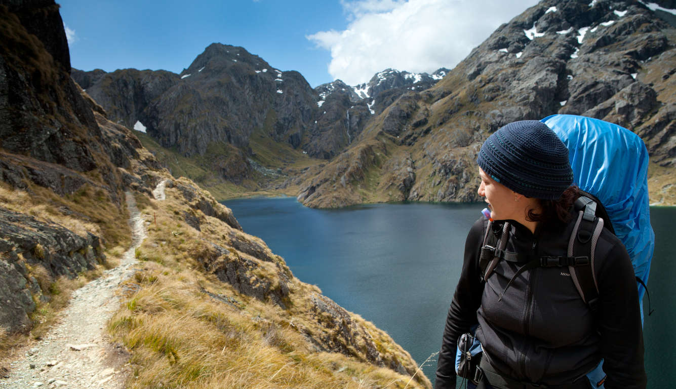
Venture above the bush line and walk amidst the rugged sub-alpine landscape. Climb steadily up the valley, through wetlands and tussock-covered flats, before sidling along the bluffs above Lake Harris to reach the highest point on the track at Tarahaka Whakatipu / Harris Saddle (1255 m). Here a short, steep climb up Conical Hill gives superb views of the Hollyford Valley through to Whakatipu Waitai / Lake McKerrow, Martins Bay and the Tasman Sea. Allow 1 - 2 hours for the return trip back to Harris Saddle. From the saddle, the Routeburn Track descends and traverses along the exposed Hollyford Face, with expansive views over the Darran Mountains and beyond to the Tasman Sea. This section of the track is well known for its impressive array of alpine plants. A steady descent leads to the enchanting Lake Mackenzie. A short distance around the lake is Lake Mackenzie Hut and Campsite.
Mackenzie Hut to Howden Hut
3-4 hours, 8.6km / 3.3mi
Leaving Lake Mackenzie Hut, the track crosses a small flat before climbing to the bush line. A gradual descent then leads past the ‘Orchard’, an open grassy area dotted with ribbonwood trees, to the impressive Earland Falls (174 m). The track continues its gradual descent through beech forest to Lake Howden Hut.
Lake Howden Hut to The Divide
1-1.5 hours, 3.4km / 1.3mi
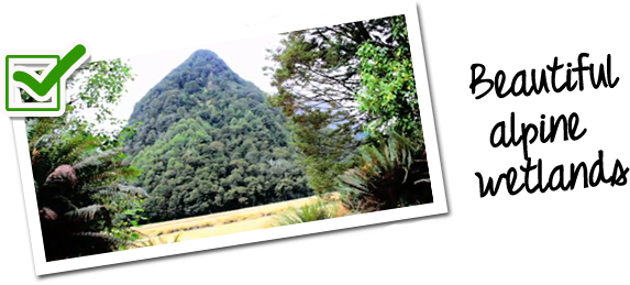
The track steadily climbs to meet with the Key Summit Track. Well worth the effort, the side trip to Key Summit heads above the bush line and meanders through an attractive alpine wetland. You will be rewarded with magnificent views of the Darran Mountains, Lake Marian and the Hollyford Valley. From the junction of the two tracks, the gradual downhill walk to The Divide is through charming silver beech forest.